title of dissertation - university of twente research information
TRANSCRIPT
COLLABORATIVE SPATIAL LEARNING FOR IMPROVING PUBLIC PARTICIPATION PRACTICE IN
INDONESIA
Aulia Akbar

COLLABORATIVE SPATIAL LEARNING FOR IMPROVING PUBLIC PARTICIPATION PRACTICE IN
INDONESIA
DISSERTATION
to obtain
the degree of doctor at the University of Twente, on the authority of the rector magnificus,
prof.dr.ir. A. Veldkamp on account of the decision of the Doctorate Board,
to be publicly defended on Thursday 11 November 2021 at 14.45 hrs
by
Aulia Akbar
born on 4th June 1981
in Binjai, Indonesia
This thesis has been approved by
Supervisor
prof. dr. ir. M.F.A.M van Maarseveen
Co-supervisors
dr. J. Flacke dr. J.A. Martinez
ITC dissertation number 405 ITC, P.O. Box 217, 7500 AE Enschede, The Netherlands
ISBN 978-90-365-5222-6 DOI 10.3990/1.9789036552226 Cover designed by Viriega Fauzia Rachmanda, Aulia Akbar Printed by CTRL-P Hengelo Copyright © 2021 by Aulia Akbar, The Netherlands. All rights reserved. No
parts of this thesis may be reproduced, stored in a retrieval system or transmitted in any form or by any means without permission of the author. Alle rechten voorbehouden. Niets uit deze uitgave mag worden vermenigvuldigd, in enige vorm of op enige wijze, zonder voorafgaande schriftelijke toestemming van de auteur.
Graduation committee:
Chairman/Secretary
prof.dr. F.D. van der Meer University of Twente
Supervisor
prof. dr. ir. M.F.A.M van Maarseveen University of Twente
Co-supervisors
dr. J. Flacke University of Twente dr. J.A. Martinez University of Twente
Committee Members
prof. dr. M.J. Kraak University of Twente prof. dr. K. Pfeffer University of Twente prof. dr. R.V. Sliuzas University of Twente prof. dr. R.L. Holzhacker University of Groningen prof. dr. ir. B. Setiawan Universitas Gadjah Mada

ii
Dedicated to my beloved parents, my lovely wife, and my beautiful children
i
Acknowledgements
In the name of Allah, The Most Gracious, The Most Merciful
Did We not expand for you, [O Muhammad], your breast?
And We removed from you your burden.
Which had weighed upon your back, and raised high for you your repute.
For indeed, with hardship [will be] ease [i.e., relief].
Indeed, with hardship [will be] ease.
So when you have finished [your duties], then stand up [for worship].
And to your Lord direct [your] longing.
(Al-Qur’an Chapter 94: Ash-Sharh [The Relief])
Alhamdulillah. My utmost thanks go to Allah the Almighty who provided
this PhD opportunity and made it possible for me to go through it
successfully.
I need to acknowledge and say thanks to many people who have
contributed to this research. I want to gratitude to the Indonesian
Government through the Indonesia Endowment Fund for Education
(LPDP (Lembaga Pengelola Dana Pendidikan)) scholarship for funding
my PhD study. This study would not have been possible without the
full support from LPDP from the beginning to the end of my study.
I am very grateful to my promotor, Prof. Martin van Maarseveen, for
dedicating his time to supervise my PhD study. His unparalleled
encouragement, support, and advice were very useful to shape my
ideas throughout the study period. I would also like to extend my
gratitude to my daily supervisor, Dr. Johannes Flacke, who has a
wonderful approach of dealing with students and particularly with me.
I benefited enormously from his intellectual input. His feedback on
many versions of texts, and his full support and encouragement had
made this academic journey less daunting and a memorable one. Also,
I would like to also thank my second daily supervisor, Dr. Javier
Martinez, for his theoretical and practical advice, especially on how to
design and apply diverse research methods. He encouraged me to
think critically and trained me to always reflect on various scholarly
work when working on my research.
ii
I am also indebted to the Embassy of the Republic of Indonesia, The
Hague-The Netherlands, Mr. Mayerfas and Mr. I Gusti Agung Wesaka
Puja (current and former Ambassador), Prof. Din Wahid, Prof.
Bambang Hari Wibisono (current and former Atdikbud), the
government of Sumatra Utara province, Mr. Edi Rahmayadi Nasution
and Mr. Tengku Erry Nuradi (current and former Governor), and to the
government of Deli Serdang district for supporting me in pursuing this
doctoral degree. For Mr. Ashari Tambunan (the Regent of Deli
Serdang), Mr. Irman and Mr. Abdul Haris Lubis (former Heads of
Bappeda of Deli Serdang), Mr. Remus H. Pardede (current Head of
Bappeda of Deli Serdang), bang Jeffrey Siregar, Sigit Pramulia, bang
Ismail, Rudi Akmal Tambunan, kak Aflah, kak Julyatin, Andriza, Nesfa,
Robet, Ardhianto, Arri Arvingko, Diah, Ika, Juwita, Yosi Sukmono,
Bisman Ritonga, and all staffs in various institutions, thank you for
always provided supports when I needed one.
Thanks to the all of the village officials and the citizens of Kramat
Gajah, Denai Lama, Kolam, Sidoharjo I Pasar Miring, and Tandem Hulu
II for allowing me to learn many things. Working with the villagers has
taught me many lessons. My previous assumptions that most villagers
are less educated or lack experiences changed after I had close
interactions with them during the study period. I was astonished at
how villagers could acquire various types of knowledge and life
experiences. The way they used their local knowledge was beyond my
expectations. I always admired their willingness to improve the quality
of life of their communities. They treated me very well with great
hospitality and were very helpful every time I came for a visit. I learned
much from their sincerity and knowledgeable responses during the
interviews and discussions.
Within the ITC campus, I want to thank to all academic staff for fruitful
discussions during many presentations, coffee breaks, or department
outings: Prof. Jaap Zevenbergen, Prof. Karin Pfeffer, Prof. Richard
Sliuzas, Prof. Yola Georgiadou, Mafalda M. Madureira, Sherif Amer, Luc
Boerboom, Cheryl de Boer, Frans van den Bosch, Mark Brussel, Ana
Bustamante, Andre da Silva Mano, Anna Grigolon, Divyani Kohli, Dimo
Todorovski, Mila Koeva, Monika Kuffer, Diana Reckien, Nina Schwarz,
Liza Groenendijk, Funda Atun Girgin, Jon Wang, and Fran Meissner.
Many thanks go to my office mates Rehana Shrestha, Alice Nikuze,
Mahmoud Abdelkader, Lilin Zhang, Claudia Stoecker, Sophia
Crommelink, and Brian Masinde. We shared and discussed a lot about
many things, from our research, concerns about the world, including
iii
our families. I would like to also thank my other colleagues and friends
in ITC for the support and encouragement, especially Rosa M. Aguilar,
who collaborated with me during my second fieldwork. Her intelligence
in programming and developing software and mapping applications
helped me a lot, especially her OGITO tool that we used in the village
participatory mapping workshops. I always said to her that the OGITO
was not only useful for the villagers to produce their village maps but
has also saved almost half of my PhD journey. For Abubakari Zaid, who
always asked about my progress and provided his time to read and
comment on my paper manuscripts. I also thank all my colleagues in
ITC building, Islam Fadel, Sergio Alvarado Vazquez, Fenna Hoefsloot,
Andres Morales, Simba Chereni, Deepshika Purwar, Abdullah Banger,
Akshay Anand, Christ Sven, Lydia Prieto Leon, Yang Chen, Ying Yue,
Yanwen Wang, Debbie Oyeku, Nestor, Evangelia Balla, Rachel Keeton,
Vidit Kundu, Angela, Giada Limongi, Vicky, Eli, Fardad Maghsoudi,
Jonathan Franco, Charis Chalkiadakis, Sameer, and many other ITC
colleagues and friends. Furthermore, to the professional and
administrative staff of ITC who made my PhD study smooth and
delightful; in particular to Petra Weber, Loes Colenbrander, Annelies
Klos, Esther Hondebrink, Lyande Eelderink, Tia Muharamiah den
Hartog, Marga Koelen, Emile Dopheide, Jeroen Verplanke, Katinka
A. Jager–Ringoir, Grietha de Jonge, Jorien M. Terlouw, Paul Oostrom,
Gerrit Polman, Aiko Mulder, Theresa van den Boogaard, Marie-Chantal,
Wendy Kremer-Stiksma, Roelof Schoppers, Roland Willink, Benno
Masselink, and Job Duim.
I also thanks to my colleagues in UGM, USU, UNIMED, and ITM, Pak
Trias Aditya, Pak Heri Sutanta, Bambang Kun Cahyono, Bu Latifah, Bu
Anita Zaitunah, Pak Samsuri, Ade Candra, Anthoni Veery Mardianta,
Bu Nina, M. Farouq Ghazali Matondang who gave full support, place,
and time for discussion during my study period. Special thanks for the
IndieMap crew, Ziki Wahyu Rinaldi, Faisal Andrean, Umar Hamdan
Hasibuan, Andrian Lozi, and DTM Damai Syahputra who helped a lot
during my second fieldtrip. Your full support during the mapping
workshops, map post-processing, and observations were really useful
to finish this study.
The Indonesian community in Enschede and the Netherlands has also
been very supportive. Lots of thanks to Jarot Mulyo Semedi, Astisiasari,
Aji Putra Perdana, Muhammad Aufaristama, Devara Prawira, Adityo
iv
Nugroho, Kartika Palupi Savitri, Iqbal Yulizar, Inon Aslam, Yan Restu
Freski, Viriega (for designing the cover of this thesis), Sari, Rahmat
Aris Pratomo, Pugo Sambodo, Endratno Budi, Fauzan Muzakki,
Raynouval, Ridwan Saptoto, Dwi Resty Andriani, Dhadhang Wahyu
Kurniawan, Pesi, Nova, Giri, Imam, Abdel, Wibi, Candra Herdianto,
Nisa, Syifa, Dennis, mbak Rani Meise, mbak Pipit, mbak Rani, kang
Deden, kang Lukman, pak Gun, Indra Tosri, Joko Sampurno, Ristiono,
and all of the Indonesians that I cannot mention one by one. Special
thanks to bu Dewi Nurhamad who always welcomes us to her lovely
house in Hengelo. Also, to all organisations (PPIE, PPI Belanda, UT
Muslims, ITC Muslims, IMEA, IVEO Enschede, SGB Utrecht, FORKOM-
NL, Tahsin Enschede, Gowespora), I thank everyone for the
companionship and love you have given me over the study period.
A final word of gratitude goes to my family and friends who provided
support in many capacities throughout this period, especially my lovely
wife Aisyatur Ridha who managed the affairs of the family alone in my
absence. To all my children, Ahmad Fursanul Akbar, Amrina Rasyada
Akbar, and Haniyya Mardhiyya Akbar who always prayed for me and
made me smile every single day. To my parents, Papa Agusnar bin
Abdul Rani (of blessed memory) and Mama Mulia Rita Susilawati, I
thank you for the love, encouragement, and prayers you have given
me. To my father in law, Bapak Muliadi, and my mother in law, Ibu
Nasiem Anas Salamah, for all the support and assistance especially for
taking care my children during my study abroad. To all my siblings,
mbak Yanti, bang Tika, mbak Devi, mas Antok, mas Amay, mbak Sri,
mbak Icut, mas Agus, Roy, Wita, Putra, Yani, Khanza, Dilla, Rahmat,
Ela, Edi, Taqim, Dilla and all my niece, nephews, and grandchildren,
thanks for the love, encouragement and support.
v
Table of contents
Acknowledgements ..................................................................... i
Table of contents ........................................................................ v
List of figures ........................................................................... vii
List of tables .............................................................................. x
Chapter 1: Introduction .............................................................. 1
1.1 Background ...................................................................... 4
1.2 Key concepts .................................................................... 7
1.3 Research problem ............................................................. 21
1.4 Research objectives and questions...................................... 22
1.5 Research methodology ...................................................... 25
1.6 Thesis outline................................................................... 28
Chapter 2: Participatory planning practice in rural Indonesia: A
sustainable development goals-based evaluation .......................... 31
2.1 Public participation process evaluation framework ................ 33
2.2 Research design and methods ............................................ 37
2.3 Analysis and results .......................................................... 39
2.4 Discussion and conclusions ................................................ 48
Chapter 3: Spatial knowledge: A potential to enhance public
participation? ........................................................................... 53
3.1 The relevance of spatial knowledge for public participation .... 55
3.2 Material and methods ....................................................... 61
3.3 Results ............................................................................ 68
3.4 Discussion ....................................................................... 81
3.5 Conclusions ..................................................................... 85
Chapter 4: Knowing my village from the sky: A collaborative spatial
learning framework to integrate spatial knowledge of stakeholders in
achieving Sustainable Development Goals.................................... 87
4.1 Eliciting spatial knowledge to achieve global goals ................ 91
vi
4.2 Implementation of the collaborative spatial learning framework
........................................................................................... 94
4.3 Insights from the participatory mapping workshops ............ 102
4.4 Discussion ..................................................................... 109
4.5 Conclusions ................................................................... 118
Chapter 5: The role of participatory village maps in strengthening
public participation practice ...................................................... 121
5.1 Participatory village maps for strengthening public participation
......................................................................................... 124
5.2 Methodology .................................................................. 128
5.3 Results .......................................................................... 133
5.4 Discussion and Conclusions .............................................. 149
Chapter 6: Synthesis ............................................................... 155
6.1 Summary of main findings ............................................... 157
6.2 Overall goals and general conclusions ............................... 164
6.3 Reflections and Main Contributions ................................... 166
6.4 Limitations of the study ................................................... 171
6.5 Recommendations for future research ............................... 173
Bibliography ........................................................................... 175
Appendices ............................................................................ 203
Summary .............................................................................. 245
Samenvatting ......................................................................... 251
About the author .................................................................... 257
vii
List of figures
Figure 1–1. Key concepts ............................................................ 8
Figure 1–2. The stages for preparing the annual village development
planning document .............................................................. 12
Figure 1–3. Regulatory framework to localise the SDGs and village
maps availability in Indonesia ............................................... 20
Figure 1–4. Conceptual framework .............................................. 23
Figure 1–5. Research methodology ............................................. 26
Figure 1–6. Location of case study areas ..................................... 27
Figure 2–1. SDGs based assessment framework for public participation
practice. ............................................................................ 36
Figure 2–2. Responses about knowledge sharing during the process.
........................................................................................ 43
Figure 2–3. Responses about defining problems ........................... 44
Figure 2–4. Responses about learning experiences. ....................... 45
Figure 2–5. Response about the domination of certain stakeholders.
........................................................................................ 46
Figure 2–6. Typical Musrenbang meeting at the village level using the
classroom setting ................................................................ 47
Figure 3–1. Types of spatial knowledge. ...................................... 58
Figure 3–2. Levels of spatial knowledge. ...................................... 58
Figure 3–3. Connection of spatial forms and social relations (types of
socio-spatial relationships). .................................................. 60
Figure 3–4. The cube framework to understand the utilisation of spatial
knowledge. ......................................................................... 62
Figure 3–5. A respondent in Kramat Gajah village drawing a sketch
map (left); focus group discussion in Sidoharjo I Pasar Miring
village (right). .................................................................... 67
Figure 3–6. Number of respondents in each stakeholder group with
particular types of spatial knowledge (percentages in brackets).68
Figure 3–7. Percentage of respondents in each stakeholder group who
own a certain level of spatial knowledge (counts in brackets). .. 71
viii
Figure 3–8. Sketch map of Kolam village is hanged on the wall of the
village office (left); map of neighbourhood XII in Kolam village,
showing detailed information about the neighbourhood (social
economy, facilities, housing, etc.) (right). .............................. 77
Figure 3–9. Percentage of respondents in each stakeholder group who
agree, partially agree, and do not agree with the potential use of
maps in the Musrenbang practice .......................................... 78
Figure 3-10. Percentage of respondents in each stakeholder group who
agree, partially agree, and do not agree to create maps through
participatory mapping exercise ............................................. 80
Figure 4–1. The collaborative spatial learning framework. .............. 93
Figure 4–2. The OGITO (Open Geospatial Interactive Tool) application
displayed on a maptable screen ............................................ 97
Figure 4–3. Digital participatory mapping workshop in the Denai Lama
village (a), and non-digital mapping workshop in the Kolam village
(b). ................................................................................... 98
Figure 4–4. The sequence of activities in the participatory mapping
workshops. ......................................................................... 99
Figure 4–5. Older-aged participants in Denai Lama were observing and
giving advice/additional information to the younger participants
(a); The older-aged participants actively engaged in the
participatory mapping of the Kolam village while giving additional
information that the younger participants might not know (b). 107
Figure 5–1. A conceptual framework to assess how village maps
produced during participatory mapping activities can strengthen
Musrenbang practice ......................................................... 126
Figure 5–2. The participatory village map-making process, from a
sketch map, created during digital or non-digital participatory
mapping workshops, to a (georeferenced) village map ........... 131
Figure 5–3. The helpfulness of village maps to the respondents for
knowing more about their villages ....................................... 134
Figure 5–4. The village map was used at the Musrenbang: (a) Denai
Lama, (b) Kramat Gajah, and (c) Kolam .............................. 135
Figure 5–5. The availability of data to support the Musrenbang process
...................................................................................... 137
Figure 5–6. The importance of having data to support the Musrenbang
...................................................................................... 139
Figure 5–7. The effective use of available data during the Musrenbang.
...................................................................................... 140

ix
Figure 5–8. The use of village maps to support the deliberative process
in the Musrenbang. ........................................................... 141
Figure 5–9. Domination of the Musrenbang deliberations by certain
participants. ..................................................................... 142
Figure 5–10. Participants’ satisfaction with the Musrenbang process.
...................................................................................... 148
x
List of tables
Table 1–1. Targets and indicators of SDGs Goal 11 and 16 ............ 10
Table 1–2. The division into intervention and control groups in the case
study areas ........................................................................ 28
Table 2–1. Targets and indicators of SDGs 11.3 and 16.7 .............. 35
Table 3–1. Criteria and means of verification of the types and levels of
the participants/respondents’ spatial knowledge ..................... 63
Table 3–2. Stakeholders interest and influence in utilising spatial
knowledge and spatial data in Musrenbang ............................. 75
Table 4–1. Assessment criteria and means of verification ............. 101
Table 4–2. Participants’ responses to the communication stage of the
workshops ........................................................................ 103
Table 4–3. Participants’ responses to the collaboration stage of the
workshops ........................................................................ 104
Table 4–4. Participants’ responses on knowledge co-production
processes during the workshops .......................................... 105
Table 4–5. Participants’ responses on social learning processes during
the workshops .................................................................. 106
Table 5–1. Information about participatory mapping workshop
participants, Musrenbang participants, and interviewees ........ 132

1
Chapter 1: Introduction
Introduction
2
I would like to start this chapter by reflecting on my own experiences
as a junior planner in the Regional Development Planning Agency
(BAPPEDA) of the Deli Serdang district, Indonesia, which motivated me
to carry out this research and inspired me in shaping the research
questions. After pursuing my bachelor’s degree in Geodetic Engineering
at Gadjah Mada University in 2004, I worked as a land surveyor at a
local consultant agency for a couple of months. I then applied for a civil
servant position in the Deli Serdang district and was accepted as a
junior planner at BAPPEDA. In 2005, during the first week of my job, I
was shocked to discover that all the maps in the spatial planning
documents were mere sketches without any geographical scale. At the
time, these unscaled sketch maps were attached to legal documents
that formed the basis for development and planning, including the
issuing of land use permits in the district. As a result, we often found
it difficult to identify exact locations or measure the length and width
of specific areas because the sketches were inaccurate and unreliable.
With some colleagues who had similar ideas about using geospatial
data, I started to convince my supervisors and co-workers about the
importance of having maps with scales to support our primary duty as
planners. It was not an easy task, but after ten years, we finally
transformed all the spatial planning maps from sketches into scale
maps, using geospatial data software such as AutoCAD and ArcGIS. At
the time, the upper government mandated us to work with reliable
geospatial data, so more civil servants in our district became familiar
and aware of maps’ benefits for many development and planning
purposes.
In Indonesia, one of the primary duties of the regional planning
agencies, as stated by law 25 of 2004 in the National System of
Development Planning and its regulations, is to organise the
Musrenbang, a public participatory planning forum held annually from
the village level to the national one. The Musrenbang takes place as a
public meeting involving various stakeholders who discuss and decide
on potential projects to be implemented in the following year. As a
district planning agency, it is our responsibility to organise the
Musrenbang at the district level and supervise the meeting at the sub-
district level. In 2005, I was very excited to attend my first sub-district
Musrenbang in Kutalimbaru, but when I saw a formal, monotonous
meeting, I felt disappointed. During the session, the participants
looked bored. Half of the time was spent listening to honourable guests
Chapter 1
3
giving their opening remarks. There was hardly any discussion during
the meeting, as some people dominated it. The meeting place and its
facilities were inconvenient, and a lack of data to support the process
also created problems. The Musrenbang became merely a ceremonial
meeting with little added value for its participants. It was implemented
only to fulfil regulatory requirements, not to help participants
communicate and collaborate to make better development decisions.
I found that the Musrenbang had similar problems at the district,
province and national levels. I soon realised that the higher the level
of the Musrenbang, the more formal the meeting was. In my opinion,
to strengthen public participation, improvements should begin at the
earliest planning stage. This prompted me to question the Musrenbang
at the village level, the lowest level mandated by the regulations.
Government officials ignored the critical role of the village Musrenbang
as the first step in a sequence of development planning schemes. At
the district level, there was no obligation for civil servants to supervise
or attend the Musrenbang at the village level; I did not attend it.
Therefore, I was curious to understand the implementation of the
village Musrenbang. Where and when did it take place? Did it have
similar problems as the upper-level Musrenbang? Who were the village
stakeholders attending it? Was it accessible to all the village’s citizens?
I observed that no geospatial data, such as maps, was used in the
Musrenbang at sub-district and district level, even though the
programs being discussed in the meetings were closely related to
specific geographical places. I thus wondered whether the village
Musrenbang experienced the same situation. What kind of geospatial
data did the villagers have? Did they use geospatial data during the
Musrenbang discussion? Furthermore, as villagers have local
knowledge of the village’s places and spatial surroundings, did they use
this knowledge during the discussion? If so, how?
If it appears that the village Musrenbang has similar problems to the
Musrenbang at upper levels, how can we improve its implementation?
How can we strengthen public participation? Can geospatial data be a
solution? What kind of geospatial data? Why does geospatial data not
exist in the village? How can we create geospatial data? Can we involve
village stakeholders in geospatial data creation? How can we capture
local knowledge to produce geospatial data? Would the produced
geospatial data benefit village stakeholders as primary beneficiaries or
Introduction
4
as outsiders? I was grappling with all these questions when I decided
to continue my studies.
Fortunately, I got an opportunity to seek the answers to these
questions. In 2014, when I participated in a two-month course at ITC-
University of Twente, I was impressed with the different participatory
mapping methods introduced by the lecturers. I used this opportunity
to briefly discuss with some lecturers potential research topics that
could address my questions about the village Musrenbang.
After the short course, I tried to develop a research proposal about the
village Musrenbang and the potential of geospatial data to strengthen
its implementation. I also applied for a Lembaga Pengelola Dana
Pendidikan (LPDP) scholarship, which I used to conduct my research at
ITC. This story forms the background of this study, which started from
my concern as a junior planner who tried to improve the
implementation of the Musrenbang. I then began my academic journey
and shifted my role and paradigms from a practitioner or professional
to a researcher. A researcher who would critically investigate and seek
answers to fill research gaps. A researcher who learnt how to conduct
ethical research on a real-life, local community problem: the public
participation practice of the Musrenbang.
1.1 Background
Public participation practice is an important aspect of the Sustainable
Development Goals (SDGs). The demand to have sustainable public
participation is mentioned in the SDGs target 11.3, which argues the
need to “enhance inclusive and sustainable urbanisation and the
capacity for participatory, integrated and sustainable human
settlement planning and management in all countries”; sustainable
public participation is also referred to in target 16.7, which stresses the
need to “ensure a responsive, inclusive, participatory and
representative decision-making at all levels” (The United Nations,
2016). These ambitious targets require contextualisation for each
country by deliberately localising the global goals into local, tangible
and operational targets and indicators (Pfeffer & Georgiadou, 2019;
UN-Habitat and UNDP, 2016). Local and regional governments should
define SDGs targets and indicators according to their data collection
capacities, including their human resources and technological facilities.
Chapter 1
5
Localisation would lead to better operationalisation of SDGs through
public participation practices at the local level, including the rural or
even the neighbourhood level (Pfeffer & Georgiadou, 2019). It is
important to note that SDGs implementation should be accompanied
by adequate and reliable data at all governance level. The data should
be usable for reaching SDGs targets and indicators, as well as for
tracking their progress (Koch & Krellenberg, 2018; UN-Habitat and
UNDP, 2016). Therefore, localisation should also consider the collection
of local data/information to ensure this data/information is relevant for
attaining SDGs targets at the local scale, especially targets 11.3 and
16.7, which are related to public participation practices.
In Indonesia, the Musrenbang public participation practice may provide
an opportunity to localise and achieve SDGs targets 11.3 and 16.7 at
different governance levels. The Musrenbang is firmly regulated by the
law as a mandatory procedure to involve citizens and relevant
stakeholders in the development planning process (Blair, 2013). From
the village to the national level, the government has implemented the
Musrenbang regularly to discuss development issues such as
infrastructure, public facilities, health, education, economy, human
settlements and other sectors that are relevant to local communities.
As a public meeting that involves multiple stakeholders, the
Musrenbang can provide a medium to facilitate social learning among
its participants (Aswad et al., 2012). The meeting can be understood
as an iterative process during a group activity where participants can
learn from each other and share their views, experiences, and
ideas(Flacke & de Boer, 2017). Furthermore, the Musrenbang has the
potential to support knowledge co-production among its participants as
the stakeholders attending it typically have competing values, goals
and information that must be recognised and negotiated (Butler,
Bohensky, Suadnya, et al., 2016).
Although held regularly, the Musrenbang is still far from ideal. Some
studies revealed similar problems to the ones I experienced on the
ground (see Introduction). Musrenbang meetings are often conducted
poorly; they represent a ‘ceremonial’ activity rather than a democratic,
participatory planning process for various stakeholders (Aswad et al.,
2012; Grillos, 2017; Purba, 2010; Sopanah, 2012). Decisions are
mostly made by local government elites who have more knowledge and
understanding about the planning procedures (Purba, 2010; Sopanah,
2012). Communication and collaboration among participants—two
Introduction
6
crucial factors to strengthen deliberation and public participation
(Fung, 2006)—are not optimal during the process (Aswad et al., 2012;
Feruglio & Rifai, 2017). Furthermore, participatory processes such as
the Musrenbang often fail to stimulate stakeholders to express their
knowledge explicitly during deliberation (Fung, 2015). The different
types of knowledge that stakeholders possess, such as tacit,
community, sectoral, expert and spatial knowledge (Elwood & Leitner,
2003; van Ewijk & Baud, 2009; Pfeffer et al., 2013), are often not
integrated or used effectively during the Musrenbang (Butler,
Bohensky, Darbas, et al., 2016; Feruglio & Rifai, 2017).
Scholars also found that there is a lack of data/information available to
support the deliberative processes of Musrenbang meetings (Aswad et
al., 2012; Sumarto, 2008). Feruglio and Rifai (2017) have listed two
common types of data/information that are often absent in the
Musrenbang practice: 1) data/information for identifying the needs and
priorities such as maps, public services and infrastructure,
socioeconomic indicators, and 2) data/information regarding planning
procedures, such as the laws/regulations to follow, including the
timeline and details of each planning stage. Despite differences in the
inhibiting factors mentioned, what these studies have in common is
that they show how the Musrenbang urgently needs to be strengthened
so that it can provide meaningful processes for its participants. Using
geo-information technology or geospatial data like maps during the
Musrenbang’s practices could be a feasible option to enhance its
implementation. Maps can help stakeholders to spatialise their
problems and needs so that they can formulate better decisions to be
implemented in their neighbourhoods (Feruglio & Rifai, 2017).
Additionally, maps can be produced locally in a collaborative and
participatory manner, which is aligned with the idea of localising the
SDGs through the availability of local data/information. Creating maps
through participatory mapping could allow the local stakeholders to
represent themselves spatially on their maps, while also enabling them
to be recognised and included in natural resource planning and
management (Corbett & Keller, 2005). The use of maps produced
through participatory mapping to strengthen the Musrenbang should
be closely considered.
This study explicitly seeks to incorporate this consideration across
various stages of the research. The aim is to understand the factors
that enable or hinder the success of the Musrenbang public
Chapter 1
7
participation practice and test our assumption that participatory maps
can have a role in strengthening the Musrenbang. We limit the scope
of this research to the Musrenbang at the village level to investigate
how the SDGs’ implementation, particularly of targets 11.3 and 16.7,
is localised at the rural level through the use of participatory village
maps. The village Musrenbang offers the opportunity to investigate this
question and is thus an ideal case for this type of inquiry.
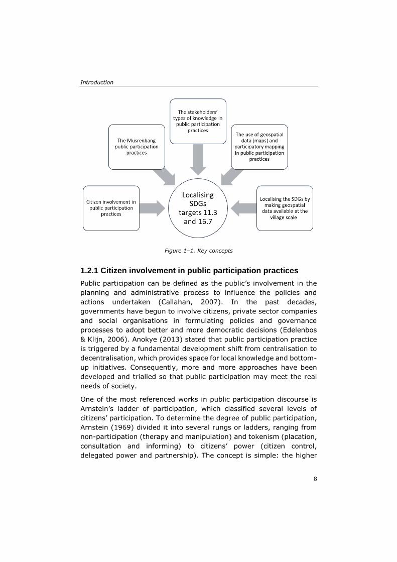
1.2 Key concepts
This section presents the key concepts built upon in this research to
provide a general understanding of the theoretical foundation used to
examine the case studies (Figure 1–1). To localise the SDGs targets
11.3 and 16.7 by achieving better public participation practices, it is
necessary to discuss five key concepts. It is crucial to understand why
it is important to involve citizens in public participation practices and
have an understanding of the context of the Musrenbang. Since public
participation usually involves various stakeholders, it is also essential
to distinguish the different types of knowledge used during
participation practices. Geospatial data can then be employed to
enhance public participation by involving local stakeholders in the
mapping activities. Map creation at the local village level could lead to
better localisation of SDGs, particularly targets 11.3 and 16.7, which
relate to public participation practices. Furthermore, the maps created
could be used to strengthen participation.
Introduction
8
Figure 1–1. Key concepts
1.2.1 Citizen involvement in public participation practices
Public participation can be defined as the public’s involvement in the
planning and administrative process to influence the policies and
actions undertaken (Callahan, 2007). In the past decades,
governments have begun to involve citizens, private sector companies
and social organisations in formulating policies and governance
processes to adopt better and more democratic decisions (Edelenbos
& Klijn, 2006). Anokye (2013) stated that public participation practice
is triggered by a fundamental development shift from centralisation to
decentralisation, which provides space for local knowledge and bottom-
up initiatives. Consequently, more and more approaches have been
developed and trialled so that public participation may meet the real
needs of society.
One of the most referenced works in public participation discourse is
Arnstein’s ladder of participation, which classified several levels of
citizens’ participation. To determine the degree of public participation,
Arnstein (1969) divided it into several rungs or ladders, ranging from
non-participation (therapy and manipulation) and tokenism (placation,
consultation and informing) to citizens’ power (citizen control,
delegated power and partnership). The concept is simple: the higher
Chapter 1
9
the ladder, the more participation in the processes (Coenen et al.,
1998). Based on Arnstein’s theory, other scholars developed various
approaches and innovations to strengthen the implementation of public
participation. The instruments used for participation have also been
expanded thanks to the development of citizen participation theories
and methods (Hordijk et al., 2015).
In the following decades, under the rubric of Participatory Learning and
Action (PLA), Chambers (1981) introduced an approach that
emphasised the learning processes in public participation activities and
recognised local people’s knowledge and active involvement. This
approach (see also Chambers, 1994a, 1994b) then inspired Healey
(1998b) to propose a more collaborative planning practice. Healey
argued that the collaborative planning initiative has three main
dimensions: knowledge resources, relational resources and
mobilisation capacity. These dimensions are crucial for building an
institutional capacity so that stakeholders may observe, listen and ask
questions about their real needs and aspirations. Therefore,
collaborative methods could facilitate communication and collaboration
among stakeholders and reduce conflicts when producing and
implementing development strategies. These methods are also helpful
for building shared knowledge and understanding among stakeholders,
as well as for working together locally and dealing with shared
problems (Healey, 1998).
Innes and Booher (2004) also suggested that collaborative
participation should support the deliberative processes of multiple
stakeholders in formal or informal ways to reach a consensus. All actors
must communicate and collaborate to develop mutual understandings
when formulating appropriate solutions. By doing so, collaborative
participation will encourage citizens to participate actively in the
governance process, exercise their citizenship and synergise the
relationship between the state and civil society (Hordijk, 2005).
Public participation is also an important aim of the SDGs, as stated in
targets 11.3 and 16.7. Specifically, public participation is mentioned in
indicators 11.3.2 and 16.7.2, which are classified in tier 3 (see Table
1–1). The Inter-Agency Expert Group on SDGs Indicator (IAEG-SDGs)
has classified the SDGs indicators into three tiers based on the
standards or methodologies of each listed indicator, as follows. Tier 1:
the concept, methodology and standards of the indicators are clear and
Introduction
10
at least 50 percent of countries in the world regularly produce the
necessary data; Tier 2: the methodology and standards are available
but countries do not regularly produce the data; Tier 3: an established
methodology or standards are not yet available (Kraak et al., 2018;
UN Statistics Division, 2018). This classification provides opportunities
for countries or scholars to contribute to the conceptualisation of SDGs
by localising the indicators and making them more operational and
tangible, especially those that are still classified in tier 3 (Koch &
Krellenberg, 2018; Kraak et al., 2018). Expert and scientific
contributions are urgently needed to localise the targets and indicators
to make them applicable and relevant at the local or regional level (Hák
et al., 2016; Pfeffer & Georgiadou, 2019).
Table 1–1. Targets and indicators of SDGs Goal 11 and 16
Targets Indicators
Goal 11: Sustainable Cities and
Communities
11.3 By 2030, enhance inclusive and
sustainable urbanisation and capacity for
participatory, integrated and sustainable
human settlement planning and management
in all countries
11.3.2 Proportion of cities with a direct
participation structure of civil society in urban
planning and management that operate regularly
and democratically
Goal 16: Peace, Justice, and Strong
Institutions
16.7 Ensure responsive, inclusive,
participatory and representative decision-
making at all levels
16.7.2 Proportion of population who believe
decision-making is inclusive and responsive, by
sex, age, disability and population group
1.2.2 The Musrenbang: participatory planning practice in Indonesia
The period of democratic reform in 1998 was critical in supporting
public participation practices in Indonesia. This period was
characterised by the decentralisation of power and political structures
and by the publication of new regulations to strengthen local
governments’ role in decision-making and financial autonomy (Antlöv,
2003; Widianingsih & Morrell, 2007). After several changes, the
planning and budgeting system is firmly regulated in law 25 of 2004 of
the National Development Planning Systems. The decentralisation of
planning and budgeting policy in Indonesia is implemented not only at

Chapter 1
11
the provincial and district/city level but also at the village level, after
the Village Law (law 6) was enacted in 2014. The Village Law
decentralised the tasks of planning, executing and monitoring rural
development to the village government (Sutiyo, 2013). It provides a
combination of better financial management systems, new institutional
arrangements and citizens’ empowerment that enables the village
government to be more responsive and capable of running the
governance process, and to collaborate with citizens (Antlöv et al.,
2016).
In general, the law regulates how to formulate the development
planning and budgeting document at different government levels in
Indonesia. One of the steps in acquiring the development plans is
holding a public meeting to discuss such plans, which is called
Musrenbang. The word Musrenbang stands for three Indonesian words:
“musyawarah (a community consensus-building meeting),
perencanaan (planning, but also understood as budgeting) and
pembangunan (development)” (Feruglio & Rifai, 2017, p. 5). The
meeting is implemented at each level of government structure: village
(desa)/kelurahan, sub-district (kecamatan), district (kabupaten)/city
(kota), province (provinsi) and nation (nasional). The Musrenbang is
considered the legal mechanism for citizens to actively participate in
local development planning and budgeting processes (Mahi, 2010).
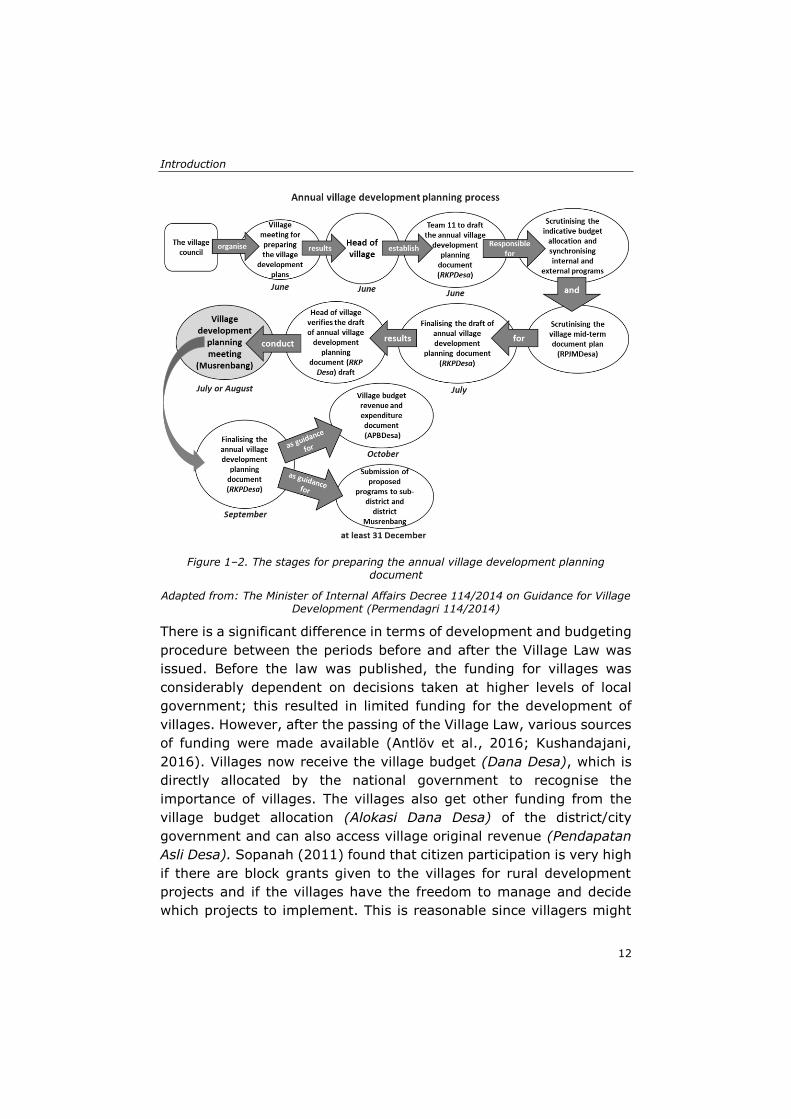
At the village level, the Musrenbang is conducted as an annual meeting
for various stakeholders to set the village priorities and plan for the
following year. Participation is implemented through a public meeting
with large audiences, including all the village’s stakeholders. The
village head usually leads the discussion. The meeting results take the
form of an agreement to a list of program priorities that will be
implemented in the village during the following year, as written down
in the village budget revenue and expenditure document (APBDesa)
and the programs proposed to the sub-district or district level of the
Musrenbang (Sopanah, 2012). The Minister of Internal Affairs Decree
114/2014 (Permendagri 114/2014) provides a comprehensive
summary of the annual development planning stages at the village
level (Figure 1–2). Although this decree regulates the annual
development planning process in detail, in practice, many villages still
conduct the Musrenbang in the middle of January, as regulated by the
Minister of Internal Affairs Decree 54/2010 (Permendagri 54/2010).
Introduction
12
Figure 1–2. The stages for preparing the annual village development planning
document
Adapted from: The Minister of Internal Affairs Decree 114/2014 on Guidance for Village Development (Permendagri 114/2014)
There is a significant difference in terms of development and budgeting
procedure between the periods before and after the Village Law was
issued. Before the law was published, the funding for villages was
considerably dependent on decisions taken at higher levels of local
government; this resulted in limited funding for the development of
villages. However, after the passing of the Village Law, various sources
of funding were made available (Antlöv et al., 2016; Kushandajani,
2016). Villages now receive the village budget (Dana Desa), which is
directly allocated by the national government to recognise the
importance of villages. The villages also get other funding from the
village budget allocation (Alokasi Dana Desa) of the district/city
government and can also access village original revenue (Pendapatan
Asli Desa). Sopanah (2011) found that citizen participation is very high
if there are block grants given to the villages for rural development
projects and if the villages have the freedom to manage and decide
which projects to implement. This is reasonable since villagers might
Chapter 1
13
consider that the projects decided upon and implemented will meet
their actual needs. Moreover, the village budget policy allows them to
contribute to discussions and decisions regarding budget allocation
through the Musrenbang.
Scholars have found some significant drawbacks in the Musrenbang’s
implementation, which have been discussed in the background section
of this study. These drawbacks highlight the need for the Musrenbang
to be strengthened so that the participatory process may become more
effective and provide better results for communities. Stakeholders’
knowledge might be a valuable source to address the shortcomings in
question. Diverse knowledge could stimulate a negotiation in the
participatory process that could lead to different types of knowledge
becoming substantial sources of decision-making (M. A. Hajer &
Wagenaar, 2003). Knowledge bridges the communication and
collaboration of various stakeholders as the individual interacts with
the organisation through knowledge and knowledge production occurs
at the individual, group and organisational level (Nonaka & Takeuchi,
1995). Therefore, it is necessary to have a comprehensive
understanding of the different kinds of knowledge that stakeholders
possess to ensure this diversity benefits public participation practices.
1.2.3 Stakeholders’ knowledge in public participation practice
Scholars have identified different types of knowledge. Polanyi (1967),
for example, described two types: tacit and explicit knowledge. Tacit
knowledge is constituted by informal knowledge based on intuition and
gained from individual experiences and practices, while explicit
knowledge is formal information based on data, scientific formulas,
principles and theories (Shrestha et al., 2014). Nonaka & Konno (1998)
proposed two further dimensions of tacit knowledge. The first one is
the ‘technical dimension’ related to individuals’ informal skills (know-
how). The second one is the ‘cognitive dimension’ related to the beliefs,
values and mental models embedded in each of us, which construct
our perception of the world.
In another study, van Ewijk and Baud (2009) classified knowledge into
four main types: tacit, community, sectoral and expert. They identified
tacit knowledge as uncodified information that is mastered through
individual practice and experience. Community knowledge is related to
the information that residents possess about their social and political
Introduction
14
situation and their spatial surroundings. Sectoral knowledge comes
from professionals and practitioners and is built through technical,
economic and political practices. Expert knowledge is codified
information owned by professional education organisations that are
widely accepted in the scientific system. Some scholars imply that the
production and exchange of different knowledge types link knowledge
through the dissemination and learning processes (King & McGrath,
2004; Verkoren, 2008). Each type of knowledge can be exchanged
through communication and collaboration among parties involved in
partnerships and provide mutual learning to stakeholders (van Ewijk &
Baud, 2009). Mutual learning tends to occur if the stakeholders
involved can identify the outcomes of the knowledge production
process.
Baud et al. (2011) pointed out the importance of space and place in
governance networks and processes, as both wield great influence in
structuring society. Different actors involved in these processes may
face complex life problems, such as housing, public services,
employment and consumption, which are related to geographical space
and place. Various spatial knowledge types will be produced, used and
exchanged by the stakeholders involved in governance processes
dealing with these problems (Pfeffer et al., 2013). In this study, spatial
knowledge is defined as the knowledge through which individuals,
social groups and institutions perceive particular places with their
characteristics and meanings (Elwood, 2006a). Spatial knowledge can
also be defined as a set of information that is related to geo-coded or
geo-referenced data, or as spatial relational facts and
interdependencies perceived by individuals or groups that can be
presented in maps (Pfeffer et al., 2013). Spatial knowledge can be a
valuable source to promote social learning and knowledge co-
production among diverse stakeholders (Natarajan, 2017).
Considering the importance of spatial knowledge in governance
processes, stakeholders’ knowledge needs to be spatialised. Doing so
“tak[es] place at two levels; that of the contributions that ‘mapping’
can make to a better understanding of particular situations, and more
specifically the methodologies of producing spatial information and
knowledge, which can contribute to our understanding of ‘uneven’
urban development” (Baud et al., 2011, p. 9). In Peru, Miranda Sara
et al. (2016) have found that the integration of stakeholders’ spatial
knowledge through spatial representations has resulted in social
Chapter 1
15
learning for different actors involved in the process. Miranda Sara et
al. applied collective and iterative mapping processes using the
technical, organisational and geographical knowledge of various
stakeholders in Lima. Linking the spatial knowledge of multiple
stakeholders, such as governments, experts and practitioner networks,
and using spatial tools like maps, helped the stakeholders in Lima
better understand the risks of water management and work
collaboratively to overcome the problems.
The use of different types of spatial knowledge requires suitable
methods that can accommodate diverse stakeholders. Public
participation practices and participatory mapping methods can be used
as a means to connect society to the environment, as well as deliberate
on the different forms of knowledge, practices and experiences of
stakeholders (Baud et al., 2011; Whatmore, 2009). Natarajan (2017)
noted that participatory planning practices can facilitate different
stakeholders to experience social learning processes. However, merely
gaining social learning in practice is not enough to achieve meaningful
participation. Natarajan argued that actors involved in community
practices might obtain a better result from the participatory process if
they also have a good understanding of space. However, this aspect is
still underexplored. The socio-spatial learning approach is relevant
since the public participation practice would also adopt knowledge as
“a factor of community empowerment, when lay knowledge reworks
planning knowledge in an arena of conceptual learning about space in
public participation” (Natarajan, 2017, p. 6). In short, socio-spatial
learning is an approach where spatial knowledge is reworked or
reframed upon community engagement. Thus, using visualisation or
spatial tools like maps and geoinformation technologies promises to
achieve a more meaningful public engagement in participatory
planning practices.
1.2.4 The use of geospatial data and participatory mapping in public participation practices
It is important to note that to participate effectively in a participatory
process, citizens need adequate information about their geographical
areas. This knowledge should be understandable and usable to support
deliberative processes. Providing geospatial data, such as maps, can
help make the participatory process more effective. Maps can store,
Introduction
16
portray and represent various types of information for different
stakeholders and can support the decision-making process in public
participation practices (Carton, 2007; Kraak, 2004; Perkins, 2013). In
addition, a map can also depict various interlinked objects and have
spatial characters that make the objects well-presented and
understandable by multiple stakeholders. The use of maps in public
decision-making practices is becoming more popular as the rapid
development of geoinformation technologies in the past few decades
has made the production of maps less expensive and more accessible
(Bednarz et al., 2006; Kraak, 2003; Parker, 2006; Rambaldi, 2005).
Carton and Thissen (2009) added that a map is also helpful in
promoting public participation by making map production and
utilisation as inclusive as possible. This inclusivity can be attained by
involving stakeholders in the mapping activities, such as data
collection, problem diagnosis, designing of alternatives and impact
assessment. An inclusive approach is also helpful to gain citizens’
opinion and views on issues and locations, providing valuable sources
for the governance process (Martinez et al., 2016).
Regarding map production, scholars have noted the need to emphasise
local issues and local knowledge (Sieber, 2000). Local spatial
knowledge is essential as an added value to enrich planners and
experts’ datasets and analyses, as well as cross-check the data
(McCall, 2008). Therefore, engaging local stakeholders in a
participatory mapping activity, understood as joint data/information
production or as a map-making process undertaken by a group of
people (typically non-experts) who are linked to one another based on
their common interest (Corbett, 2009), is a method that acknowledges
stakeholders’ local spatial knowledge. Participatory mapping can be
used to communicate lay people’s input to planners, policymakers and
scientists, thus producing better decisions. This method is widely used
in development contexts since it does not confine the maps produced
simply to geographic information but includes also local people’s social,
cultural and historical knowledge (Chambers, 2006). The participatory
mapping technique has been used for various purposes, such as forest
management (Beverly et al., 2008), ecosystem services (Ramirez-
Gomez et al., 2015), flood management (Cinderby & Forrester, 2016),
land-use changes (Lubis & Langston, 2015), countryside conservation
(Wood, 2005) and even social and cultural land recognition (Dewi,
2016).
Chapter 1
17
Corbett (2009) described six purposes of participatory mapping: help
the community to articulate and communicate their spatial knowledge
to other stakeholders, retrieve and preserve local knowledge, support
land-use planning and resource management, empower communities
to advocate their causes, improve communities’ capacity in problem
formulation or solving, and address conflicts among stakeholders.
These purposes can only be achieved if the mapping processes are
conducted inclusively, thus enabling various stakeholders to
communicate and work collaboratively to create the maps. Accordingly,
choosing the correct methods and tools is essential.
The methods and tools of participatory mapping are varied, from using
only traditional tools such as ground mapping or sketch mapping to
sophisticated computer-based mapping (Corbett, 2009; McCall &
Dunn, 2012). The widespread use of Geographical Information
Systems (GIS) and other geoinformation and technology tools has
increased the effectiveness of participatory mapping. However, relying
heavily on technology has also consequences. For example, web-based
participatory mapping might not be accessible to citizens with limited
knowledge and access to online platforms. Although such tools can
provide rich information in a high-quality format, they can remain
exclusive. As these tools are highly dependent on access to geo-
information technology and computer literacy, they might prevent
inclusive decision-making processes (Martinez et al., 2011). Chambers
(2006) has discussed the differences between ground maps, paper
maps and GIS maps in participatory mapping practices. He found that
each tool has its strengths and weaknesses, as certain tools may work
well for some stakeholders but not for others. Therefore, in addition to
choosing the right tools, good participatory mapping also requires
suitable methods. Chambers also suggested that the behaviours and
attitudes of facilitators who control the mapping process are essential.
They have to be able to use and manage the deliberative process as
well as the mapping tools to increase the locals’ participation and not
endanger their empowerment (Chambers, 2006).
Introduction
18
1.2.5 Localising the SDGs by making geospatial data available at the village level
For three decades now, global leaders have attempted to achieve
sustainable development when formulating, deciding and applying
their development policies. The concept has received multidisciplinary
attention as it encompasses three main pillars of development:
economy, society and environment (Shao et al., 2011). Sustainable
development has evolved globally and manifested in the launch of the
Millennium Development Goals (MDGs) 2015 and then of the
Sustainable Development Goals (SDGs) 2030. Since their launch in
2015, the SDGs have provided a roadmap for countries to achieve
sustainable development through 17 universal goals, 169 targets and
232 indicators (Kraak et al., 2018; The United Nations, 2016).
Operationalising global goals into local contexts is a daunting task for
policymakers; still, doing so is needed to prevent more significant gaps
between global indicators and local needs and understandings (Tan et
al., 2019). Most nations do not have the means, knowledge and
infrastructure to reach SDGs goals, especially at the local level
(Coonrod, 2015). Thus, it is important to ensure that operationalisation
is not trapped by ‘bean counting’ since the indicators may focus on the
indicator, not on attaining sustainability (Pogge & Sengupta, 2015).
Countries need to localise the SDGs into their local and regional
development contexts. The UNDP and UN-Habitat clearly stated the
importance of localising the SDGs in pursuing the 2030 agenda:
“Localisation relates both to how the SDGs can provide a framework
for local development policy and to how local and regional
governments can support the achievement of the SDGs through
action from the bottom up and to how the SDGs can provide a
framework for local development policy” (UN-Habitat and UNDP,
2016, p. 6).
Localising the SDGs also requires governments to have sufficient and
reliable data because lack of data availability at local scales may limit
their ability to use the global indicators (Klopp & Petretta, 2017; Koch
& Krellenberg, 2018; Patel et al., 2017). However, for many
governments, especially for national statistical offices, limited budgets
and resources to collect and produce reliable datasets are a
considerable challenge (MacFeely, 2018). The urgent need for data
provides opportunities for non-governmental actors to produce,
disseminate and access information for development purposes (Fisher
Chapter 1
19
& Fukuda-Parr, 2019). Localising data production through bottom-up
approaches could solve the data availability problem while enabling
stakeholders’ knowledge articulation at local scales (Tan et al., 2019).
However, it is crucial to ensure that the stakeholders involved can
access or use the data produced to prevent the risk that data
production becomes mere data extraction. Stakeholders should benefit
from their participation in data production activities. For instance, their
skills or knowledge should increase so that they may better participate
in public participation practices. To ensure the availability of geospatial
data for SDGs implementation, in 2018 the United Nations published
the Integrated Geospatial Information Framework (IGIF), which
supports, monitors and assesses the SDGs’ progress (UN-GGIM, 2018).
The IGIF framework aims to support the implementation of the SDGs
with sufficient and reliable geospatial data at different governance
levels, from the global to the local (Avtar et al., 2020).
In Indonesia, the government has published several regulations to
localise the SDGs. It has issued the Presidential Decree 59/2017 as the
legal framework for SDGs implementation (Morita et al., 2020), as can
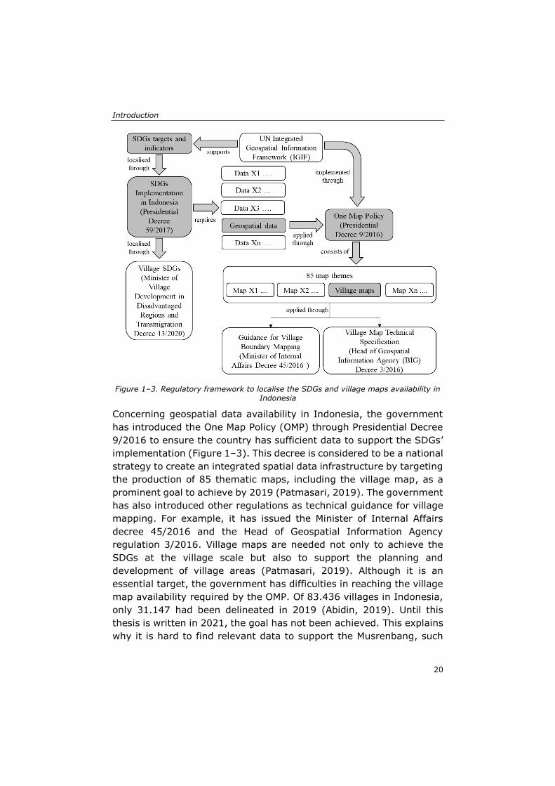
be seen in Figure 1–3. The decree mandates all government institutions
to adopt and apply the SDGs in their action plans. The Ministry of
Village Development in Disadvantaged Regions and Transmigration
followed up the Presidential Decree by launching the village SDGs
program through the Minister Decree 13/2020, which aims to achieve
the SDGs’ implementation at the village level. In Indonesia, the
achievement of the SDGs in villages through 18 goals is claimed to
account for up to 74 percent of national SDGs targets (Ministry of
Village Development in Disadvantaged Regions & Transmigration,
2020).
Introduction
20
Figure 1–3. Regulatory framework to localise the SDGs and village maps availability in
Indonesia
Concerning geospatial data availability in Indonesia, the government
has introduced the One Map Policy (OMP) through Presidential Decree
9/2016 to ensure the country has sufficient data to support the SDGs’
implementation (Figure 1–3). This decree is considered to be a national
strategy to create an integrated spatial data infrastructure by targeting
the production of 85 thematic maps, including the village map, as a
prominent goal to achieve by 2019 (Patmasari, 2019). The government
has also introduced other regulations as technical guidance for village
mapping. For example, it has issued the Minister of Internal Affairs
decree 45/2016 and the Head of Geospatial Information Agency
regulation 3/2016. Village maps are needed not only to achieve the
SDGs at the village scale but also to support the planning and
development of village areas (Patmasari, 2019). Although it is an
essential target, the government has difficulties in reaching the village
map availability required by the OMP. Of 83.436 villages in Indonesia,
only 31.147 had been delineated in 2019 (Abidin, 2019). Until this
thesis is written in 2021, the goal has not been achieved. This explains
why it is hard to find relevant data to support the Musrenbang, such
Chapter 1
21
as village maps. Because the central government has difficulties in
providing the village maps (Patmasari, 2019), localising map
production might be a feasible solution to solve this problem.
1.3 Research problem
Since the announcement of the SDGs in 2015, several attempts have
been made to localise the SDG concept at national and local levels
(Burford et al., 2013; Fisher & Fukuda-Parr, 2019; Klopp & Petretta,
2017; Koch & Krellenberg, 2018; Liu et al., 2019). However, these
studies examine the localisation of SDGs in urban areas where the
problems are considered to be more complex and have a greater
impact on national, regional and global development. Limited attention
has been paid to sustainable rural development, despite the vital role
of rural areas in supporting regional and national development
(Murdoch, 1993). Public participation practice at the rural level, which
has a crucial role in achieving sustainable development, has also
received little attention (Bednarska-Olejniczak et al., 2020).
Regarding the Musrenbang, various studies have explored and
reported different aspects of its implementation, but they have only
explained either the failure or the success of the practice (Aswad et al.,
2012; Feruglio & Rifai, 2017; Grillos, 2017; Purba, 2010; Sopanah,
2012). There are no studies that investigate the question of how to
strengthen the current practices. Similarly, no study has yet explored
the impact of a geospatial data intervention on the Musrenbang. There
is also a knowledge gap concerning the role of a local public
participation practice like the Musrenbang in achieving the SDGs
targets 11.3 and 16.7. Cabannes (2019), for example, said that
participatory planning and budgeting could be considered a relevant
SDGs indicator, particularly for targets 11.3 and 16.7.
Therefore, rather than working on the SDGs at a global scale, I wish to
work on them at a local-rural one by localising targets 11.3 and 16.7
and by evaluating and strengthening the Musrenbang with village
stakeholders. My research sets out to understand the factors that affect
the Musrenbang’s implementation and then considers incremental
ways to enhance the existing implementation. Unlike previous
research, this study uses a participatory research method to explore
and identify the reasons that underlie the impediments to the
Introduction
22
Musrenbang’s implementation, while observing the impact of the maps
intervention on the Musrenbang process. This approach requires a
comprehensive understanding of the problems underlying the
Musrenbang from the point of view of its participants and then
exploring options with them to formulate feasible solutions.
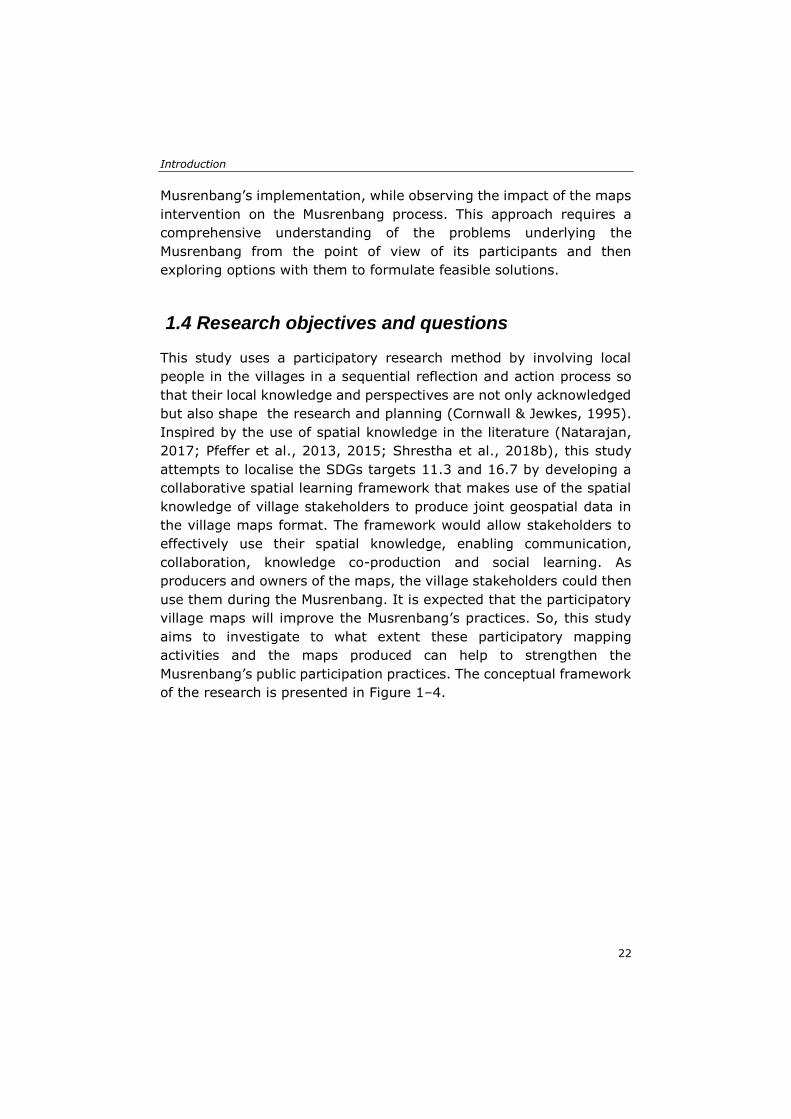
1.4 Research objectives and questions
This study uses a participatory research method by involving local
people in the villages in a sequential reflection and action process so
that their local knowledge and perspectives are not only acknowledged
but also shape the research and planning (Cornwall & Jewkes, 1995).
Inspired by the use of spatial knowledge in the literature (Natarajan,
2017; Pfeffer et al., 2013, 2015; Shrestha et al., 2018b), this study
attempts to localise the SDGs targets 11.3 and 16.7 by developing a
collaborative spatial learning framework that makes use of the spatial
knowledge of village stakeholders to produce joint geospatial data in
the village maps format. The framework would allow stakeholders to
effectively use their spatial knowledge, enabling communication,
collaboration, knowledge co-production and social learning. As
producers and owners of the maps, the village stakeholders could then
use them during the Musrenbang. It is expected that the participatory
village maps will improve the Musrenbang’s practices. So, this study
aims to investigate to what extent these participatory mapping
activities and the maps produced can help to strengthen the
Musrenbang’s public participation practices. The conceptual framework
of the research is presented in Figure 1–4.
Chapter 1
23
Figure 1–4. Conceptual framework
To achieve its main aim, this study is divided into four research
objectives.
Objective 1:
To evaluate the implementation of the Musrenbang at the village level
in Indonesia by using an SDG-based evaluation framework
• Who are the stakeholders involved in the Musrenbang
participatory planning and budgeting practice? What are their
interests and influences?
• What are the main factors that hinder the success of the
Musrenbang’s implementation?
Objective 2:
To examine the extent of spatial knowledge, the scale of its use in
formal public participation practice and its potential to enhance practice
• What spatial knowledge and geospatial data do villagers have
(and do not have)?
Introduction
24
• How are spatial knowledge and geospatial data used in the
Musrenbang practice (and how are they not used)?
• To what extent do spatial knowledge and geospatial data help
to support public participation?
Objective 3:
To develop a collaborative spatial learning framework that enables the
integration of stakeholders' spatial knowledge, facilitates their
communication and collaboration, and leads stakeholders in knowledge
co-production and social learning processes
• To what extent does the framework help in pursuing and
localising SDGs at the rural scale?
• To what extent does the collaborative spatial learning
framework enable village stakeholders to better understand
sustainable development issues at the local-rural level?
• To what extent does the collaborative spatial learning
framework help integrate village stakeholders’ spatial
knowledge?
• What challenges occur when participants from rural
communities engage in mapping tasks using non-digital and
digital mapping tools?
Objective 4:
To assess the extent to which village maps produced at participatory
mapping workshops help strengthen public participation practice at the
village level
• To what extent do the participatory village maps support the
Musrenbang by facilitating communication among participants?
• To what extent do the participatory village maps help the
Musrenbang by enabling collaboration among participants?
Chapter 1
25
1.5 Research methodology
The research problems and objectives above provide a pathway to the
approach, methodology and methods used in this research. Different
methods and techniques were adopted depending on specific
objectives and questions since no single approach can fulfil all the
research objectives. The case study research design and multiple
methods were used to access various data sources, which makes any
findings or conclusions more credible and robust (Yin, 2003). With
plentiful evidence collected during the research, the findings will be
validated using data triangulation. Triangulation allows different
information sources to converge, which will increase the research
accuracy and credibility (Hussein, 2009). The overview of the
methodology used in this research can be seen in Figure 1–5 below.
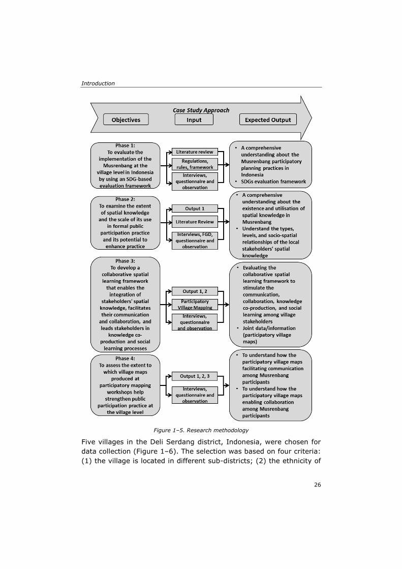
Introduction
26
Figure 1–5. Research methodology
Five villages in the Deli Serdang district, Indonesia, were chosen for
data collection (Figure 1–6). The selection was based on four criteria:
(1) the village is located in different sub-districts; (2) the ethnicity of
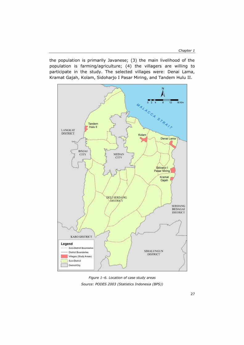
Chapter 1
27
the population is primarily Javanese; (3) the main livelihood of the
population is farming/agriculture; (4) the villagers are willing to
participate in the study. The selected villages were: Denai Lama,
Kramat Gajah, Kolam, Sidoharjo I Pasar Miring, and Tandem Hulu II.
Figure 1–6. Location of case study areas
Source: PODES 2003 (Statistics Indonesia (BPS))
Introduction
28
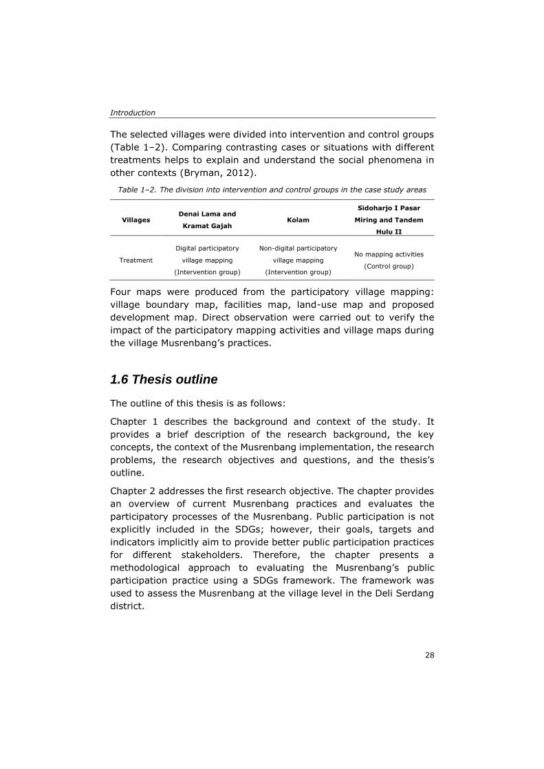
The selected villages were divided into intervention and control groups
(Table 1–2). Comparing contrasting cases or situations with different
treatments helps to explain and understand the social phenomena in
other contexts (Bryman, 2012).
Table 1–2. The division into intervention and control groups in the case study areas
Villages Denai Lama and
Kramat Gajah Kolam
Sidoharjo I Pasar
Miring and Tandem
Hulu II
Treatment
Digital participatory
village mapping
(Intervention group)
Non-digital participatory
village mapping
(Intervention group)
No mapping activities
(Control group)
Four maps were produced from the participatory village mapping:
village boundary map, facilities map, land-use map and proposed
development map. Direct observation were carried out to verify the
impact of the participatory mapping activities and village maps during
the village Musrenbang’s practices.
1.6 Thesis outline
The outline of this thesis is as follows:
Chapter 1 describes the background and context of the study. It
provides a brief description of the research background, the key
concepts, the context of the Musrenbang implementation, the research
problems, the research objectives and questions, and the thesis’s
outline.
Chapter 2 addresses the first research objective. The chapter provides
an overview of current Musrenbang practices and evaluates the
participatory processes of the Musrenbang. Public participation is not
explicitly included in the SDGs; however, their goals, targets and
indicators implicitly aim to provide better public participation practices
for different stakeholders. Therefore, the chapter presents a
methodological approach to evaluating the Musrenbang’s public
participation practice using a SDGs framework. The framework was
used to assess the Musrenbang at the village level in the Deli Serdang
district.
Chapter 1
29
Chapter 3 addresses the second research objective. The chapter
presents a methodological approach to examine the spatial knowledge
used during Musrenbang practices. The approach consists of three
main characteristics of spatial knowledge use: the types, levels and
socio-dynamics of spatial knowledge.
Chapter 4 addresses the third research objective. The chapter presents
a methodological approach to enable village stakeholders to use their
spatial knowledge. It discusses the development and testing of a
collaborative spatial learning framework through participatory mapping
workshops in three villages. This framework aims to support
communication and collaboration among stakeholders while integrating
their spatial knowledge through social learning experiences.
Chapter 5 addresses the fourth research objective. The chapter revisits
the villages of the case study and evaluates the impacts of the use of
participatory village maps on the strengthening of public participation
practices in the Musrenbang.
Chapter 6 provides a synthesis of the research, including a summary
of its main contributions and its relevance to contemporary scholarship.
The chapter also reflects on the study’s limitations and discusses
directions for future research.

Introduction
30
31
Chapter 2: Participatory planning practice in rural Indonesia: A sustainable development goals-based evaluation*
* This chapter is based on the published paper: Akbar, A., Flacke, J., Martinez, J., van
Maarseveen, M. F. A. M. (2020). Participatory planning practice in rural Indonesia: A
sustainable development goals-based evaluation. Community Development, 51(3), 243-260. https://doi.org/10.1080/15575330.2020.1765822
Participatory planning practice in rural Indonesia
32
Public participation has become the central issue of urban planning in
recent decades as a response to the inefficiency of dominant top-down
models and expert-driven approaches in planning practices (Tandon,
2008). The term refers to various activities that denote peoples’
involvement in the planning and administrative process to influence
policies and actions (Cornwall, 2008). It has been practiced in many
countries as a prerequisite for successful decentralisation, democracy,
and good governance (Fung, 2015; Tandon, 2008).
Manifold studies have discussed the goals and benefits of public
participation (Arnstein, 1969; Innes & Booher, 1999), the utilisation of
different approaches or methods (Chambers, 1981, 1994b; Healey,
1998a), and the factors that influence the success of public
participation (Beierle & Konisky, 2000; Irvin & Stansbury, 2004).
However, little attention has been given to the field of participation
evaluation. Laurian and Shaw (2008) noticed these gaps and argued
that planning practitioners and academics need firm definitions,
criteria, and methods to evaluate public participation practices.
Moreover, the limited literature on public participation evaluation
makes it difficult to determine the evaluation methods that fit the
specific context of public participation practice.
The idea of public participation has received enormous attention
through Sustainable Development Goals (SDGs), which were published
by the United Nations (UN) in 2015 (Ludwig, 2017). Furthermore, two
indicators put notions on public participation. Indicator 11.3.2 targets
the proportion of cities with a direct participation structure within civil
society, while indicator 16.7.2 targets a proper proportion of the
population to be actively involved in decision-making processes (The
United Nations, 2017). Both indicators are still in tier III, which
indicates that the settled concept, methodology, and standards of the
indicators are not yet available (UN Statistics Division, 2018).
Achieving these SDGs by 2030 requires immediate operationalisation.
Thus, conceptualising indicators into a more reliable and operational
evaluation framework is crucial. It would provide guidelines for many
nations to achieve sound public participation in their countries.
Furthermore, it would help them to evaluate their public participation
practices in achieving SDGs.
Chapter 2
33
Therefore, in this chapter, we aim to develop a framework of public
participation evaluation based on indicators 11.3.2 and 16.7.2 of the
SDGs. The framework is built upon our understanding of SDGs’
discourses and the existing evaluation criteria developed by various
scholars. Then, we used the framework to evaluate an annual public
participatory planning practice in Indonesia, called Musrenbang, as the
case study. The case study provides evidence of how well the SDGs
evaluation framework could measure the success or failure of
participatory processes in Musrenbang.
2.1 Public participation process evaluation framework
2.1.1 Relevance and limitations of public participation
Despite the rapid innovation of participatory methods to engage
citizens in the governance process, the dominant form of public
participation is commonly exercised through public meetings or public
hearings (Fung, 2015; UN-Desa, 2018)(Fung, 2015; UN-Desa, 2018).
This method is useful to disseminate information to large audiences
while providing a forum for people to raise their opinions or concerns
(Videira et al., 2006).
Nonetheless, public meetings can also have limitations. A public
meeting can cause conflict among participants or reach a deadlock
when discussing contentious issues (Videira et al., 2006), while an
inadequate deliberative process hinders a collaborative dialogue
among stakeholders, making their participation less intensive (Mostert,
2003; Rowe & Frewer, 2005). Furthermore, stakeholders who have
more time, better resources, or positions than the broader population
often have the opportunity to dominate the participatory process rather
than the disadvantaged groups who have a lack of power or the
necessary verbal skills to express their opinions (Fung, 2015). Many
governments have adopted policies to increase the participation of
marginalised groups, such as women, children, people with disabilities,
and those working in the informal sectors (Feruglio & Rifai, 2017).
However, power relations within these communities usually become
the main impediment for them to participate (Mosedale, 2005). The
citizens’ voices are considered merely as non-mandatory advice for the
government’s development proposals, while their participation is like a
Participatory planning practice in rural Indonesia
34
rubber stamp to fulfil the requirement of a participatory process
(Antlöv, 2003; Fung, 2015; Sutiyo, 2013).
This same situation has also taken place during the Musrenbang
process, as it is implemented through public meetings. Studies have
revealed that the Musrenbang is poorly implemented and is similar to
a ceremonial meeting (Sopanah, 2012). Thus, the role of the
Musrenbang tends to be limited to only administrative purposes to
produce plan documents at the expense of the quality of the process
and outcomes of the discussions (Aswad et al., 2012). Furthermore, in
2008, Indonesia passed the law 10/2008, which regulates a 30 percent
quota for women to participate in political activities; however, women
are still not fully involved in decision-making processes due to strong
patriarchal values within society (Rhoads, 2012). Therefore, unequal
power relations exist, as the decisions are mainly made by certain
actors who have more power and influence among those in society
(Grillos, 2017).
2.1.2 Evaluation criteria and framework
Due to the limitations of public participation practices, evaluating the
participatory process is necessary to improve its practice (Chess,
2000). As such, the evaluation needs a robust framework that meets
the specific goals, purposes, and local context of the participatory
practice (Asthana et al., 2002; Fung, 2015; Laurian & Shaw, 2008).
SDGs, as a global agenda, have had significant influences in steering
global policies and actions in public participation practices (Tebbutt et
al., 2016). Therefore, developing an SDGs’ evaluation framework is
relevant to provide a solid basis in participatory theory and practice.
From 232 indicators in the SDGs framework, there are two indicators
(11.3.2 and 16.7.2) that offer the notion of how public participation
should be applied. As can be seen in Table 2–1, public participation
should be implemented regularly and democratically, as well as in an
inclusive and responsive manner (UN-Desa, 2018).
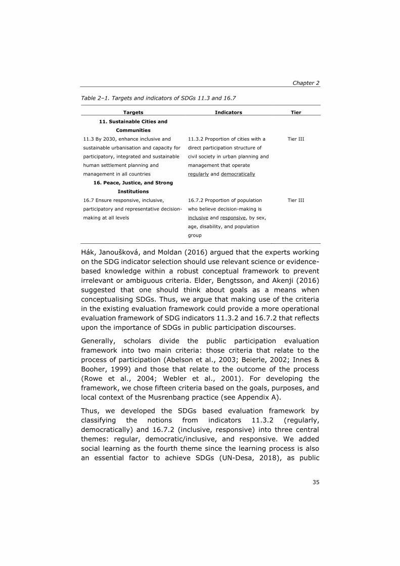
Chapter 2
35
Table 2–1. Targets and indicators of SDGs 11.3 and 16.7
Targets Indicators Tier
11. Sustainable Cities and
Communities
11.3 By 2030, enhance inclusive and
sustainable urbanisation and capacity for
participatory, integrated and sustainable
human settlement planning and
management in all countries
11.3.2 Proportion of cities with a
direct participation structure of
civil society in urban planning and
management that operate
regularly and democratically
Tier III
16. Peace, Justice, and Strong
Institutions
16.7 Ensure responsive, inclusive,
participatory and representative decision-
making at all levels
16.7.2 Proportion of population
who believe decision-making is
inclusive and responsive, by sex,
age, disability, and population
group
Tier III
Hák, Janoušková, and Moldan (2016) argued that the experts working
on the SDG indicator selection should use relevant science or evidence-
based knowledge within a robust conceptual framework to prevent
irrelevant or ambiguous criteria. Elder, Bengtsson, and Akenji (2016)
suggested that one should think about goals as a means when
conceptualising SDGs. Thus, we argue that making use of the criteria
in the existing evaluation framework could provide a more operational
evaluation framework of SDG indicators 11.3.2 and 16.7.2 that reflects
upon the importance of SDGs in public participation discourses.
Generally, scholars divide the public participation evaluation
framework into two main criteria: those criteria that relate to the
process of participation (Abelson et al., 2003; Beierle, 2002; Innes &
Booher, 1999) and those that relate to the outcome of the process
(Rowe et al., 2004; Webler et al., 2001). For developing the
framework, we chose fifteen criteria based on the goals, purposes, and
local context of the Musrenbang practice (see Appendix A).
Thus, we developed the SDGs based evaluation framework by
classifying the notions from indicators 11.3.2 (regularly,
democratically) and 16.7.2 (inclusive, responsive) into three central
themes: regular, democratic/inclusive, and responsive. We added
social learning as the fourth theme since the learning process is also
an essential factor to achieve SDGs (UN-Desa, 2018), as public
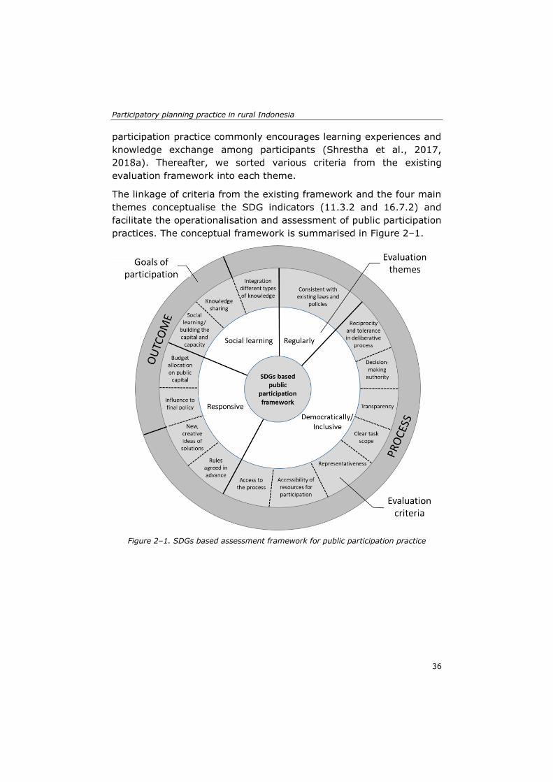
Participatory planning practice in rural Indonesia
36
participation practice commonly encourages learning experiences and
knowledge exchange among participants (Shrestha et al., 2017,
2018a). Thereafter, we sorted various criteria from the existing
evaluation framework into each theme.
The linkage of criteria from the existing framework and the four main
themes conceptualise the SDG indicators (11.3.2 and 16.7.2) and
facilitate the operationalisation and assessment of public participation
practices. The conceptual framework is summarised in Figure 2–1.
Figure 2–1. SDGs based assessment framework for public participation practice
Chapter 2
37
2.2 Research design and methods
2.2.1 The case study: The Musrenbang practice
Musrenbang is a participatory planning practice that provides a forum
for citizens to participate in the development planning processes.
According to Sutiyo (2013), after the Reformation Movement in 1998,
followed by the decentralisation policy in 1999, there was a need to
establish a development forum that involved the public in the planning
and decision-making process. This idea was then applied by enacting
the law 25/2004, which introduced Musrenbang as a form of public
participatory planning and budgeting practice at different levels of
government in Indonesia. As stated in the law, the Musrenbang process
is executed annually in a public meeting format at each level of
government structure, from the village (desa/kelurahan) level to the
national (nasional) level. This study focuses on the annual Musrenbang
at the village level as the first phase of the hierarchical planning stages
in Indonesia, which provides more opportunities for citizens to
participate in the processes.
At the village level, the annual Musrenbang is implemented through a
public meeting that involves various stakeholders, from government
officials, citizens, to other stakeholders, ranging from grass-roots
organisations, non-governmental organisations (NGOs), community
leaders, religious leaders, and private sectors. Two results are
expected from the meeting: the village’s policies and plans for
composing the village’s annual development planning document (called
RKPDesa) and the village’s revenue and spending budget (APBDesa).
The agreed upon development proposals are to be brought and
discussed at a higher level at Musrenbang (Sopanah, 2012).
2.2.2 Study area
The study area is the Deli Serdang district in North Sumatra, Indonesia.
The district covers an area of 2497,72 km2, with a population of around
2.155.625 persons, and consists of twenty-two sub-districts and 394
villages (BPS, 2018). In 2013, the Ministry of National Planning
awarded the Deli Serdang district the Anugerah Pangripta Nusantara
award. This award is given to the best district in Indonesia that
produces an outstanding and comprehensive local government work
plan document (RKPD). Winning this award indicates that Deli Serdang
Participatory planning practice in rural Indonesia
38
has implemented an excellent participatory planning process from the
village level to the district level. In this chapter, we are aiming to
understand how and why the implementation of Musrenbang in a
district won such a prestigious national award.
To understand the participatory process of Musrenbang, we selected
five villages according to the following criteria: (1) the village is located
in different sub-districts; (2) the ethnicity of the population is primarily
Javanese; (3) the primary livelihood of the population is farming and
agriculture; (4) the village officials are willing to participate in this
study. The villages where the Javanese ethnic population is dominant
were chosen because the Javanese have a consensus-seeking tradition
that profoundly influences decision-making and deliberative processes
in Indonesia (Boyle, 1998). Therefore, we assume that the Musrenbang
is implemented more successfully in the villages where the Javanese
are the majority. Based on the criteria, we chose the Denai Lama,
Kolam, Kramat Gajah, Sidoarjo I Pasar Miring, and Tandem Hulu II
villages as the locations of the case study.
2.2.3 Methods
Data collection included direct observation, questionnaires, and semi-
structured in-depth interviews. The data were collected from January
to May 2018. Using the participant as observer role in the observation
(Gold, 1958), the lead author made direct observations by attending
the public meetings. The observations were written in field notes and
recorded for further analysis.
For the questionnaire, we developed sixteen questions derived from
the evaluation framework with five different responses (Strongly
Agree, Agree, Neutral, Disagree, and Strongly Disagree). The
questionnaire was created for anonymous responses, while the
participants attending the Musrenbang (see profile in Appendix B) filled
out the self-questionnaire forms (Appendix C). The responses from the
questionnaires were then analysed using descriptive frequency
analysis.
We used semi-structured in-depth interviews to capture the
perceptions of stakeholders about the implementation of the
Musrenbang (see Appendix D and E). The respondents included village
officials, village council (BPD), village community resilience board
(LKMD), women representatives (PKK), youth representatives (Karang
Chapter 2
39
Taruna), community leaders or religious leaders, village supervisors,
the sub-district officials, district officials, and district parliament
members.
The lead author acted as the interviewer for the entire interview
process. The interviews were conducted in Bahasa, Indonesia and
recorded, while the responses were reviewed and cross-checked with
stakeholders in other interview sessions to produce reliable and robust
data (see Appendix F for detailed information about the interviewees).
The interviewees’ names have been kept anonymous. For the analysis,
we used qualitative content analysis to scrutinise 56 interviews. A
coding strategy was employed as a means to use specific labels to
categorise the interviewees’ responses. While we used an evaluation
framework to decide coding themes, we also conducted open coding to
ensure that the critical emerging aspects of the qualitative data were
not missing. The responses from the interviews were sorted according
to the framework outlined in sections using ATLAS.ti software.
For stakeholder analysis, we used the extended interest-influence
matrix to analyse the levels of interest and influence. This method is
useful and provides comprehensive reasons for the interest and
influence owned by each stakeholder (Raum, 2018).
2.3 Analysis and results
2.3.1 Stakeholder analysis
Various stakeholders were involved in the Musrenbang process in Deli
Serdang. We identified nineteen groups of stakeholders who directly or
indirectly affected the participatory process in Musrenbang (see
Appendix G for detail information). We classified them into four
different groups:
(1) The upper government, which includes the Regional
Development Planning Agency (Bappeda), Village Citizen
Empowerment Department (DPMD), District Council (DPRD),
head of sub-district (Camat), and the sub-district office staff.
They have significant influence but low interest toward the
village Musrenbang. The village supervisor (PD) can also be put
into this category. Even though they are not a government
employee,they work closely with the upper and village
Participatory planning practice in rural Indonesia
40
governments. In several villages, they play a significant role in
connecting the upper government and the village government
and have a significant influence on decision-making processes;
(2) Village elites, which include the village head, village secretary,
Village Council (BPD), Village Empowerment Board (LKMD), and
the head of the neighbourhood. These positions are usually
elected by the community and have strong influence and
interest in the Musrenbang processes. Among them, the village
head has the most considerable power in directing the meeting
to attain his/her interests. Most of the decisions made also are
derived from his/her final policies. However, the influence
owned by BPD, LKMD, and the head of the neighbourhood also
requires significant bargaining power in determining the
Musrenbang result. Thus, the group of village elites usually
become the organisers, which enables them to prepare and set
how the Musrenbang works;
(3) Village elite’ supporters, which include the village office staff,
the women group (PKK), and the youth group (Karang Taruna).
This group has a medium interest and influence on the process.
They tend to have similar point of views with the village elites
when discussing plans/programs. This group also has a close
relationship with the village elites. The chairwoman of the PKK
is the village head wife, while the committee usually consists of
the wives of the village secretary, village staff, and head of
neighbourhoods. The youth group seems reluctant to care about
Musrenbang discussion topics.
(4) Community-based organisations/ordinary citizens. This group
has high interest but low influence; however, the people in this
group are most affected by the policies decided at the
Musrenbang meeting. Their attendance at the meeting is highly
dependent more or less on the village elites, particularly the
village head and village staff, who have full authority to decide
who should or should not be invited to the meeting.
Chapter 2
41
2.3.2 Evaluation result
Based on the evaluation framework, we have identified three main
results that portray some gaps in the Musrenbang practice, including
problems in abiding the laws, integrating/sharing knowledge, and
managing power relations. The results also showed that the problems
are interrelated.
2.3.2.1 Musrenbang is implemented regularly, but not timely
The Musrenbang was implemented in all five villages regularly, as it is
obligatory, according to the laws. Interviewee F2, a district official, said
that the Musrenbang became more popular after law 6/2014 was
enacted. Before the law was published, many villages did not conduct
the Musrenbang, albeit it is compulsory. The villagers consider
Musrenbang to be a time-consuming procedure with less or no impact
on the villages. However, law 6/2014 requires the upper government
to decentralise the budgeting policy by allocating a village budget for
each village annually and in turn, the village must conduct the
Musrenbang to access and use the budget. Consequently, nowadays,
the Musrenbang is conducted more regularly in villages (F2, personal
communication, 26 March 2018).
Most interviewees expressed their confusion regarding the
laws/regulations that should be followed. The village planning
procedures in Indonesia are mainly regulated by two different laws
(laws 25/2004 and laws 6/2014), which are published by two different
ministries. The Bappeda, as the responsible institution at the district
level, published a guidebook about how the Musrenbang should be
conducted. It was written based on law 25/2004 and its derivative
regulations (F1, personal communication, 18 April 2018).
The guidebook mandated that the villages ensure that the programs
listed in the RKPDesa/APBDesa (annual) documents correspond with
the RPJMDesa (middle-term) document. One of our respondents
stated, “New programs can be accepted. If there is a new program
proposed, we can approve it. However, we have to revise our
RPJMDesa” (E7, personal communication, 6 April 2018). This revision
process takes time, as it requires the village to hold another
Musrenbang with the RPJMDesa revision as the main agenda. For that
reason, many village governments often bypass the procedures by only
revising the programs without any RPJMDesa Musrenbang. Thus, they
Participatory planning practice in rural Indonesia
42
“fulfill” all of the administrative documents by creating fabricated
meeting notes as if the revision had been through the RPJMDesa
Musrenbang process.
Moreover, the differences among laws/regulations also affect the
schedule. If we refer to Permendagri 114/2016, the village Musrenbang
should be implemented from July to August. However, based on
Permendagri 54/2010, which is referred to in Bappeda’s guidebook, it
is implemented in January. This situation leads to delays in
development implementation since APBDesa as the final product of the
planning process is typically finalised in April or May. This means that
the villagers only have six or seven months left to execute their
development plans.
Similarly, delays are not only caused by planning processes, but also
by the village government’s decision to submit their APBDesa late to
the upper government for verification. They do this because villages
who submit APBDesa early often become the object of prosecutors’
audits or gain NGOs/media attention (E4, personal communication, 6
April 2018). Thus, they tried to avoid such risks, although it causes
delays in executing their plans.
2.3.2.2 Musrenbang is not effective in supporting knowledge
integration and learning
From the participants’ profile (Appendix B), it is clear that the
participants have diverse knowledge and backgrounds. Unfortunately,
the Musrenbang does not support knowledge integration or exchange
among participants. The questionnaire revealed that around 90% of
the respondents from five villages indicated that they were unable to
acquire knowledge and share their knowledge with other participants
in the Musrenbang (Figure 2–2). The percentage consists of 116 out of
133 male respondents and 59 out of 61 female respondents (see profile
in Appendix B).
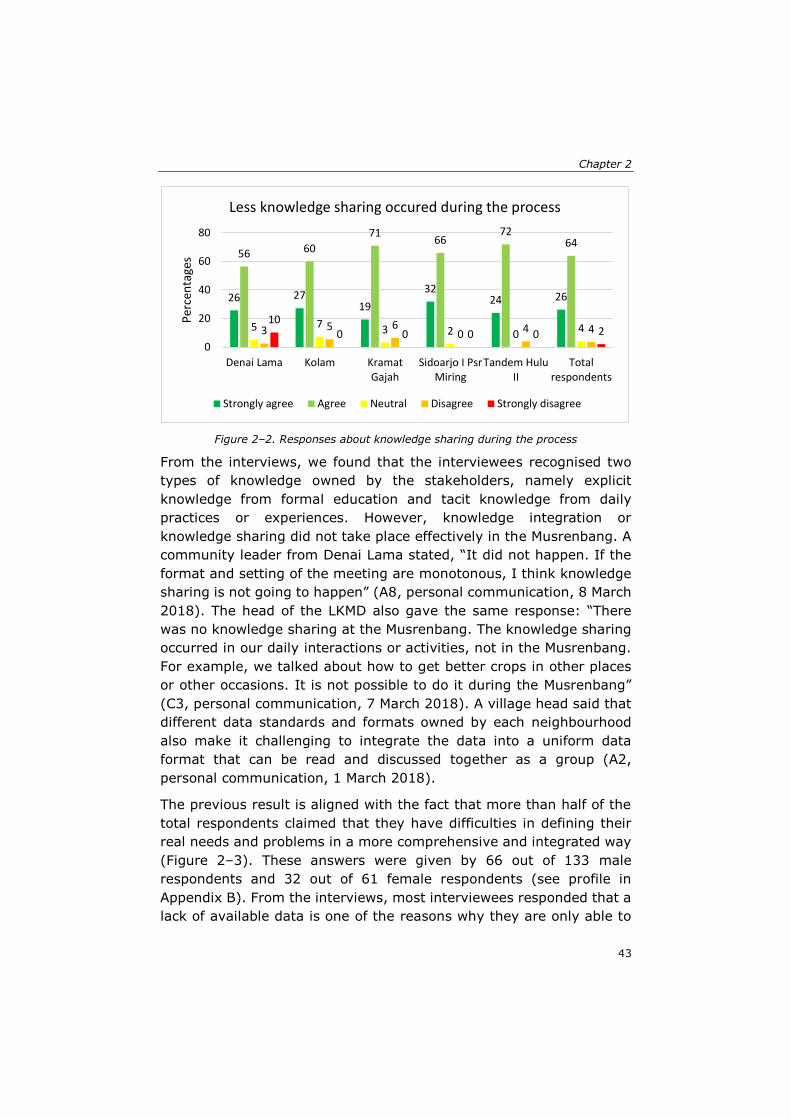
Chapter 2
43
Figure 2–2. Responses about knowledge sharing during the process
From the interviews, we found that the interviewees recognised two
types of knowledge owned by the stakeholders, namely explicit
knowledge from formal education and tacit knowledge from daily
practices or experiences. However, knowledge integration or
knowledge sharing did not take place effectively in the Musrenbang. A
community leader from Denai Lama stated, “It did not happen. If the
format and setting of the meeting are monotonous, I think knowledge
sharing is not going to happen” (A8, personal communication, 8 March
2018). The head of the LKMD also gave the same response: “There
was no knowledge sharing at the Musrenbang. The knowledge sharing
occurred in our daily interactions or activities, not in the Musrenbang.
For example, we talked about how to get better crops in other places
or other occasions. It is not possible to do it during the Musrenbang”
(C3, personal communication, 7 March 2018). A village head said that
different data standards and formats owned by each neighbourhood
also make it challenging to integrate the data into a uniform data
format that can be read and discussed together as a group (A2,
personal communication, 1 March 2018).
The previous result is aligned with the fact that more than half of the
total respondents claimed that they have difficulties in defining their
real needs and problems in a more comprehensive and integrated way
(Figure 2–3). These answers were given by 66 out of 133 male
respondents and 32 out of 61 female respondents (see profile in
Appendix B). From the interviews, most interviewees responded that a
lack of available data is one of the reasons why they are only able to
26 2719
3224 26
56 60
7166
7264
5 7 3 2 0 43 5 60 4 4
100 0 0 0 2
0
20
40
60
80
Denai Lama Kolam KramatGajah
Sidoarjo I PsrMiring
Tandem HuluII
Totalrespondents
Per
cen
tage
s
Less knowledge sharing occured during the process
Strongly agree Agree Neutral Disagree Strongly disagree
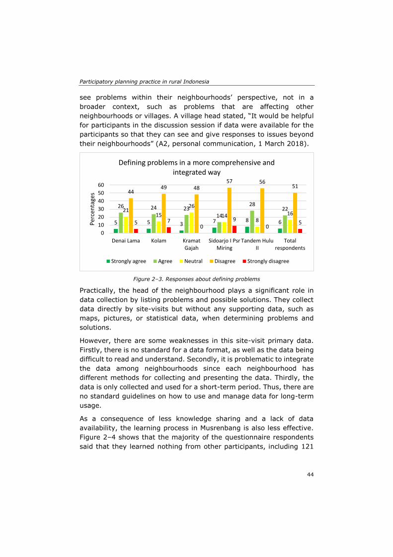
Participatory planning practice in rural Indonesia
44
see problems within their neighbourhoods’ perspective, not in a
broader context, such as problems that are affecting other
neighbourhoods or villages. A village head stated, “It would be helpful
for participants in the discussion session if data were available for the
participants so that they can see and give responses to issues beyond
their neighbourhoods” (A2, personal communication, 1 March 2018).
Figure 2–3. Responses about defining problems
Practically, the head of the neighbourhood plays a significant role in
data collection by listing problems and possible solutions. They collect
data directly by site-visits but without any supporting data, such as
maps, pictures, or statistical data, when determining problems and
solutions.
However, there are some weaknesses in this site-visit primary data.
Firstly, there is no standard for a data format, as well as the data being
difficult to read and understand. Secondly, it is problematic to integrate
the data among neighbourhoods since each neighbourhood has
different methods for collecting and presenting the data. Thirdly, the
data is only collected and used for a short-term period. Thus, there are
no standard guidelines on how to use and manage data for long-term
usage.
As a consequence of less knowledge sharing and a lack of data
availability, the learning process in Musrenbang is also less effective.
Figure 2–4 shows that the majority of the questionnaire respondents
said that they learned nothing from other participants, including 121
5 5 3 7 8 6
26 24 2314
282221
15
26
148
16
4449 48
57 5651
5 70
90
5
0
10
20
30
40
50
60
Denai Lama Kolam KramatGajah
Sidoarjo I PsrMiring
Tandem HuluII
Totalrespondents
Per
cen
tage
s
Defining problems in a more comprehensive and integrated way
Strongly agree Agree Neutral Disagree Strongly disagree
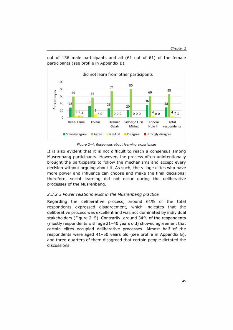
Chapter 2
45
out of 136 male participants and all (61 out of 61) of the female
participants (see profile in Appendix B).
Figure 2–4. Responses about learning experiences
It is also evident that it is not difficult to reach a consensus among
Musrenbang participants. However, the process often unintentionally
brought the participants to follow the mechanisms and accept every
decision without arguing about it. As such, the village elites who have
more power and influence can choose and make the final decisions;
therefore, social learning did not occur during the deliberative
processes of the Musrenbang.
2.3.2.3 Power relations exist in the Musrenbang practice
Regarding the deliberative process, around 61% of the total
respondents expressed disagreement, which indicates that the
deliberative process was excellent and was not dominated by individual
stakeholders (Figure 2–5). Contrarily, around 34% of the respondents
(mostly respondents with age 21–40 years old) showed agreement that
certain elites occupied deliberative processes. Almost half of the
respondents were aged 41–50 years old (see profile in Appendix B),
and three-quarters of them disagreed that certain people dictated the
discussions.
28 3326
20
3628
59 56
7480
6065
5 90 0 4 45 2 0 0 0 23 0 0 0 0 1
0
20
40
60
80
100
Denai Lama Kolam KramatGajah
Sidoarjo I PsrMiring
TandemHulu II
Totalrespondents
Per
cen
tage
s
I did not learn from other participants
Strongly agree Agree Neutral Disagree Strongly disagree
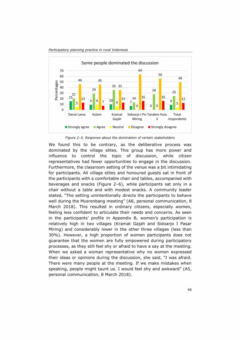
Participatory planning practice in rural Indonesia
46
Figure 2–5. Response about the domination of certain stakeholders
We found this to be contrary, as the deliberative process was
dominated by the village elites. This group has more power and
influence to control the topic of discussion, while citizen
representatives had fewer opportunities to engage in the discussion.
Furthermore, the classroom setting of the venue was a bit intimidating
for participants. All village elites and honoured guests sat in front of
the participants with a comfortable chair and tables, accompanied with
beverages and snacks (Figure 2–6), while participants sat only in a
chair without a table and with modest snacks. A community leader
stated, “The setting unintentionally directs the participants to behave
well during the Musrenbang meeting” (A8, personal communication, 8
March 2018). This resulted in ordinary citizens, especially women,
feeling less confident to articulate their needs and concerns. As seen
in the participants’ profile in Appendix B, women’s participation is
relatively high in two villages (Kramat Gajah and Sidoarjo I Pasar
Miring) and considerably lower in the other three villages (less than
30%). However, a high proportion of women participants does not
guarantee that the women are fully empowered during participatory
processes, as they still feel shy or afraid to have a say at the meeting.
When we asked a woman representative why no women expressed
their ideas or opinions during the discussion, she said, “I was afraid.
There were many people at the meeting. If we make mistakes when
speaking, people might taunt us. I would feel shy and awkward” (A5,
personal communication, 8 March 2018).
159 10 7
0
9
21
2935
14
2825
59 6
0 05
46 45
35
6456
49
137
13 16 1612
0
10
20
30
40
50
60
70
Denai Lama Kolam KramatGajah
Sidoarjo I PsrMiring
Tandem HuluII
Totalrespondents
Per
cen
tage
s
Some people dominated the discussion
Strongly agree Agree Neutral Disagree Strongly disagree
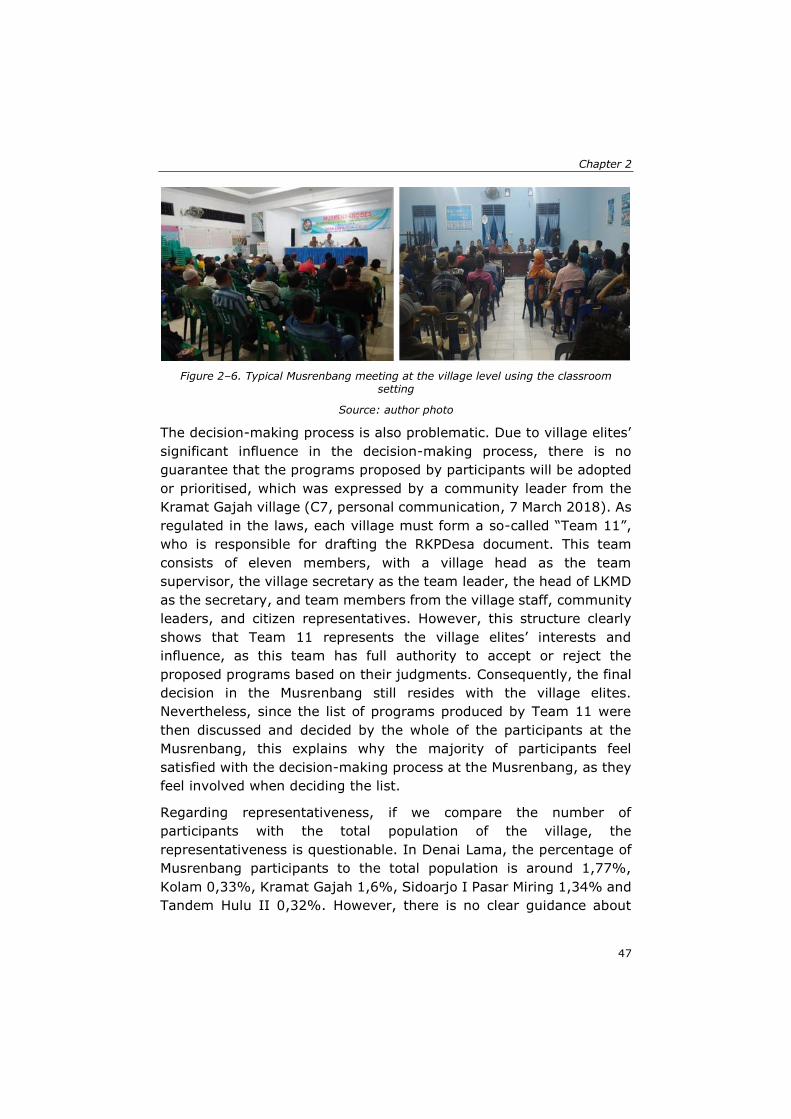
Chapter 2
47
Figure 2–6. Typical Musrenbang meeting at the village level using the classroom
setting
Source: author photo
The decision-making process is also problematic. Due to village elites’
significant influence in the decision-making process, there is no
guarantee that the programs proposed by participants will be adopted
or prioritised, which was expressed by a community leader from the
Kramat Gajah village (C7, personal communication, 7 March 2018). As
regulated in the laws, each village must form a so-called “Team 11”,
who is responsible for drafting the RKPDesa document. This team
consists of eleven members, with a village head as the team
supervisor, the village secretary as the team leader, the head of LKMD
as the secretary, and team members from the village staff, community
leaders, and citizen representatives. However, this structure clearly
shows that Team 11 represents the village elites’ interests and
influence, as this team has full authority to accept or reject the
proposed programs based on their judgments. Consequently, the final
decision in the Musrenbang still resides with the village elites.
Nevertheless, since the list of programs produced by Team 11 were
then discussed and decided by the whole of the participants at the
Musrenbang, this explains why the majority of participants feel
satisfied with the decision-making process at the Musrenbang, as they
feel involved when deciding the list.
Regarding representativeness, if we compare the number of
participants with the total population of the village, the
representativeness is questionable. In Denai Lama, the percentage of
Musrenbang participants to the total population is around 1,77%,
Kolam 0,33%, Kramat Gajah 1,6%, Sidoarjo I Pasar Miring 1,34% and
Tandem Hulu II 0,32%. However, there is no clear guidance about
Participatory planning practice in rural Indonesia
48
minimum attendees to ensure that the meeting is still considered
legitimate, even though it was attended by a small proportion of the
total village population. From this proportion, it was also found that the
number of participants were less than expected and dominated mostly
by the village elites and their supporters. A women representative said
that the village head has the authority to select the participants of the
meeting purposively. As such, he/she tends to invite people who have
the same vision as him/her rather than people who oppose him/her
(E3, personal communication, 2 May 2018). This situation explains why
most respondents agreed with the statement that the participants had
represented the whole society. The majority of respondents were pre-
selected by the elites, so there is a significant possibility that they have
the same views of the elites.
Our findings also show that some relevant stakeholders were
intentionally left out, particularly, marginalised groups, such as the
disabled and impoverished people in the community. This was exposed
by a village supervisor (K2, personal communication, 5 April 2018).
Another village supervisor (J2) also said that the village government
did not invite disabled citizens because it might not be easy for disabled
people to travel to the meeting venue. Furthermore, many facilities
and transportation in most villages are not disability friendly, while
poor citizens were also not invited due to unclear criteria and their lack
of influence within society. Consequently, no one spoke on their behalf
and in turn, the real needs of both groups were unintentionally
neglected (J2, personal communication, 4 April 2018).
2.4 Discussion and conclusions
As a global framework, SDGs tend to have standardised targets and
indicators. A solid understanding about a particular context of public
participation practice is crucial to translate the global targets or
indicators into actual actions and interventions that offer real impacts
to society (Howard & Wheeler, 2015). Thus, our evaluation framework
provides a practical way of assessing SDG 11.3.2 and 16.7.2
achievement in a particular public participation practice.
The core findings of this study show that the participatory process of
the village Musrenbang faces substantial challenges in practice to
match with the SDG goals. All four evaluation themes of the SDGs
Chapter 2
49
based assessment framework (regularly, democratically/inclusive,
responsive, and social learning) require further actions to achieve a
sound public participation practice. Moreover, the implementation of
the Musrenbang has severe problems in abiding by existing laws and
regulations, supporting knowledge integration and learning processes,
and minimising power gaps among stakeholders. Even though Deli
Serdang won the local government work plan in 2013, the
implementation of the Musrenbang at the village level to some extent
was not well executed. We observed that this happened because the
criteria used for the award were different from the criteria of our SDGs
framework.
The village Musrenbang has been implemented regularly, as the law
obliges it. Law 6/2014 has provided a combination of better financial
management systems, new institutional arrangements, and citizen
empowerment at the village level (Antlöv et al., 2016). However, the
law might be useful in theory but not easy in implementation. Different
laws that regulate the Musrenbang have caused confusion, resulting in
delays in planning and carrying out development programs. These
delays are not only caused by the contradictions among laws, but also
by the willingness of the villages to apply planning procedures and
submitting the results promptly. Therefore, the village governments
need to be assured that their timely submission is appreciated and has
no consequences toward the infringement of the law.
The participants also acknowledged that each participant has their own
kind of knowledge, tacitly or explicitly; however, they felt that the
Musrenbang was not a suitable place to exchange or integrate that
knowledge. Moreover, the formal setting of the public meeting
hindered lively discussions among participants, limiting knowledge
integration and exchange. The situation was further aggravated due to
limited time, strict schedules or agendas, as well as long speeches by
honoured guests, which unintentionally shaped the Musrenbang as a
formal meeting to legalise the proposed development proposals.
This study also revealed that most of the participants agreed that data
and information, such as planning area, population, facilities and
infrastructure, budget availability and so forth, are essential to
supporting participatory planning processes. They found it challenging
to identify their common problems due to limited data availability, as
the data collected by the head of the neighbourhoods is often too local,
Participatory planning practice in rural Indonesia
50
with different standards and formats. Thus, the villagers found
difficulties when compiling and using the data in an integrated way to
support the planning process in the Musrenbang.
Lack of knowledge sharing and integration, as well as a lack of data,
caused the learning process in the Musrenbang to be less effective. The
majority of the respondents felt that they learned nothing new from
the deliberative process. If we consider the Musrenbang as a regular
participatory process prescribed by the laws, it is promising to serve
as a social learning medium, leveling up the stakeholder’s interaction
into a learning process (Aswad et al., 2012). A village supervisor
stated, “Regarding social learning, I think that when people learn how
to articulate their opinions, how to make other people hear his
opinions, that is a social learning process. It is created naturally
through their participation at the Musrenbang” (K2, personal
communication, 5 April 2018). Understanding the levels of knowledge
and utilising the stakeholders’ knowledge will be necessary to improve
the knowledge integration and learning process in the Musrenbang.
The implementation of the Musrenbang is also prone to power
struggles. After the publication of law 6/2014, the village’s authority is
becoming more substantial as the new laws decentralised the tasks to
plan, execute, and monitor rural development for the village
government (Sutiyo, 2013). The opportunities provided by the laws
were used by the elites to control the entire participatory planning
process in the Musrenbang. Among the four different stakeholder
groups that we have identified, the domination of the village elites’
group is apparent to some extent. This group not only has the power
to decide who should be invited to the meeting but also has
considerable authority in decision-making processes. This situation is
quite similar to the findings of the Musrenbang implementation in Solo,
where elites have significant power to control final decisions (Grillos,
2017).
This finding contradicts the SDG indicators 11.3.2 and 16.7.2, which
explicitly emphasise the proportion of people who are actively involved
in participatory processes (UN Statistics Division, 2018). The
involvement should also consider sex, age, disability, and population
groups representing minorities. In other words, both indicators
demand not only more people but also a diversity of people to
participate in the process. In reality, only certain people were invited
Chapter 2
51
to the Musrenbang, and they were pre-selected by the village elites.
Women representatives still cannot fully participate in the process,
even though their participation is imposed by the laws, while
marginalised groups, such as people with disabilities, have limited
access and information to attend the meeting. New ways of thinking
and applying the public participation practice, which can facilitate
policy-making with local areas directly affected by the decisions made
is necessary (Flacke & de Boer, 2017). The involvement of most
affected groups, particularly the marginalised groups, in the
participatory process is essential to give them more opportunities to
sound their real needs and problems.
We also found that ordinary citizens did not find it convenient to
articulate their views in front of the public. Thus, the head of
neighbourhood or community leaders usually represented them at the
meeting. Similarly, it is not easy to facilitate a public meeting like the
Musrenbang because the public meeting is considered low on the scale
of public influence and empowerment (Fung, 2015). Furthermore, the
classroom setting at the venue inevitably splits the participants into
several groups, all with different powers and influences. The setting
benefits the village elites and allows them to control the discussion
topics and suggesting solutions while undermining new ideas or
solutions coming from the participants. Most of the decisions are
finalised by the village elites’ group through Team 11, who have full
authority in deciding prioritised programs. All of these problems
undermine the achievement of SDG indicators (11.3.2 and 16.7.2)
since the participants have a lack of representativeness while the
decision-making processes are still dominated by certain groups of
stakeholders.
In conclusion, this study clearly shows that the SDG indicators (11.3.2
and 16.7.2) can be a starting point to provide a relevant framework to
evaluate a current participatory planning practice. The developed
framework is useful to find gaps in the Musrenbang practice at the
village level and puts forth notions about aspects that need to be
improved to enhance current practices. The critical question of whether
the developed framework is applicable elsewhere always rests in where
public participation takes place, as well as what the local context is.
However, evaluating public participation is not a one-size-fits-all policy,
but must deal with the particularities of local circumstances (Antlöv,
2003). Therefore, it is crucial to note that both SDG indicators require
Participatory planning practice in rural Indonesia
52
proper conceptualisation and contextualisation before conducting an
evaluation. Conceptualisation is essential for both indicators to be more
tangible, understandable, and applicable, while contextualisation is
crucial to fit the context of the public participation practice being
evaluated.
This study also revealed that proper knowledge and procedures are not
available to achieve meaningful participation. Therefore,
understanding the knowledge owned by stakeholders, providing a
platform to integrate their knowledge, and supporting the learning
methodology to enhance the stakeholders’ knowledge to be used in the
planning process may become feasible solutions to improve current
Musrenbang practices. As power relations, knowledge integration, and
learning processes were some salient problems identified throughout
this study, we suggest investigating these issues for further research
so that the influence of these factors to improve the Musrenbang public
participation practice can be further explored.
53
Chapter 3: Spatial knowledge: A potential to enhance public participation?*
* This chapter is based on the published paper: Akbar, A., Flacke, J., Martinez, J., van Maarseveen, M. F. A. M. (2020). Spatial knowledge: A potential to enhance public participation? Sustainability, 12(12), 5025. https://doi.org/10.3390/su12125025
Spatial knowledge: A potential to enhance public participation?
54
Public participation is commonly applied in many countries to enable
citizens to participate in decision-making processes. Despite its
considerable utilisation, there has been an extensive amount of
literature that has discussed its shortcomings in implementation,
including frequently failing to adequately facilitate deliberative
processes among participants (Mostert, 2003; Rowe & Frewer, 2005)
and its proneness to elite capture (Fung, 2015; Grillos, 2017). Thus,
citizens’ participation is becoming like a rubber stamp to fulfill the
requirement of a participatory process (Antlöv, 2003; Fung, 2015).
Moreover, meetings often become ceremonial activities (Sopanah,
2012).
To overcome the shortcomings of public participation practice, some
scholars suggest the utilisation and improvement of spatial knowledge
owned by the stakeholders involved in the process (Baud et al., 2014;
Natarajan, 2017) as well as the use of geospatial data (Pfeffer et al.,
2015; Sieber et al., 2016). In public participation deliberative
processes, spatial knowledge, which is the knowledge of how
individuals, social groups, and institutions perceive particular places
and their characteristics and meanings (Elwood, 2006a), is commonly
used by people when illustrating specific locations to relate the
discussion topic into the context (Ghose, 2003). Information about
geographical space and place is frequently used, as individuals are
firmly attached to the places where they live and participate in their
activities (Healey, 1997). Spatial knowledge is of significant
importance because it carries not only information on geographic
locations (space), but also on the meanings and experiences that
people and communities have on those areas. Despite this growing
interest, the characteristics of spatial knowledge owned by the actors
in the public participation practice and how they use their spatial
knowledge are not well understood, or are often neglected by scholars.
This study aims to examine to what extent spatial knowledge exists
and is used in a formal public participation practice, as well as its
potential to enhance the public participation practice. We use a
participatory planning practice called Musrenbang in five villages
located in Indonesia as the case study. Musrenbang is a participatory
planning practice held annually to gain public inputs in the formulation
of the village’s annual development planning and budgeting documents
and proposals. The Musrenbang implementation commonly uses a
public meeting format that is attended by various actors; government
Chapter 3
55
officials and citizens, community or religious leaders, local NGOs, and
individuals from the private sector. During implementation, the
literature shows some problems with the Musrenbang practice, such as
limited knowledge sharing or integration among stakeholders (Antlöv,
2003; Sopanah, 2012), lack of data available to support the planning
process (Feruglio & Rifai, 2017), and power relations among
participants (Akbar, Flacke, Martinez, & van Maarseveen, 2020a;
Grillos, 2017).
This chapter is organised as follows: section 3.1 gives an overview of
the relevance of spatial knowledge in public participation practice.
Section 3.2 describes the methodology, case study, and framework
used for analysis in this chapter. Section 3.3 describes the results of
the study, while section 3.4 and 3.5 discuss the lessons learned and
conclusions of the study. Three main questions are expected to be
answered throughout this study: What are the spatial knowledge and
geospatial data that the villagers have (or do not have)? How are they
used in the Musrenbang practice (or how are they not used)? To what
extent do spatial knowledge and geospatial data help to support public
participation?
3.1 The relevance of spatial knowledge for public participation
During the discussion on public participation practice, spatial
knowledge is commonly used when referring to the location of a
particular object. This section elaborates on the relevance between
public participation practice and spatial knowledge to better
understand the critical role of spatial knowledge in public participation
practices.
3.1.1 Challenges in public participation
The implementation of public participation remains a challenge for
practitioners and scientists. Kahila-Tani, Kytta, and Geertman (2019)
point out three main problems in public participation practice, including
how to arrange effective public participation, how to engage more
people in the process, and how to produce and exchange the
knowledge effectively. First, arranging effective public participation is
problematic, as there is ‘no one size fits all’ method to overcome the
Spatial knowledge: A potential to enhance public participation?
56
complexity of urban problems (Innes & Booher, 2010). In the
Musrenbang practice, the organisers often formally set the public
meeting, with a tight schedule and limited topics of discussion (Akbar,
Flacke, Martinez, & van Maarseveen, 2020a; Sopanah, 2012).
Consequently, participation is not active. Furthermore, strict
arrangements with limited space for direct involvement could cause a
few people to engage in the process (Rowe & Frewer, 2005). Adjusting
the participatory method to suit the local context is needed, as it could
influence the participants’ motivation to engage in participatory
processes (Leino, 2012).
Second, any participatory methods aim to encourage more people to
participate. However, involvement is not always successful, as there
are always some people who are classified as the ‘silent majority’
among participants (Yanow, 2003). This silent majority mainly comes
from the disadvantaged groups, who need to be empowered during
participatory sessions (Albrechts, 2002). This situation also occurs in
the Musrenbang practices, where certain groups, particularly the elites
and their supporters, tend to control the process (Akbar, Flacke,
Martinez, & van Maarseveen, 2020a). Thus, it is vital to implement an
inclusive process that ensures that different actors, issues, and sectors
can work collaboratively to solve their common problems (Healey,
1998b; Quick & Feldman, 2011).
Third, scholars are often confronted with the question of how to
produce and exchange knowledge effectively in public participation
practices. As most human activities are situated in specific spatial
contexts, spatial knowledge owned by stakeholders could be useful to
enhance public participation practice (Eilola et al., 2015; Pfeffer et al.,
2013). At the same time, the geospatial data can help to gain optimum
benefits of spatial knowledge utilisation (Kahila-Tani et al., 2016;
Pfeffer et al., 2015; Shrestha et al., 2018a).
3.1.2 Spatial knowledge
Spatial knowledge is practical knowledge about how people perceive
the spatial concepts of interrelated facts, such as the identities of
places and landmarks, network connections, directions, or distances
between places (Hernández, 1994; Pfeffer et al., 2013). People use this
knowledge for many purposes, such as to get to destinations, to
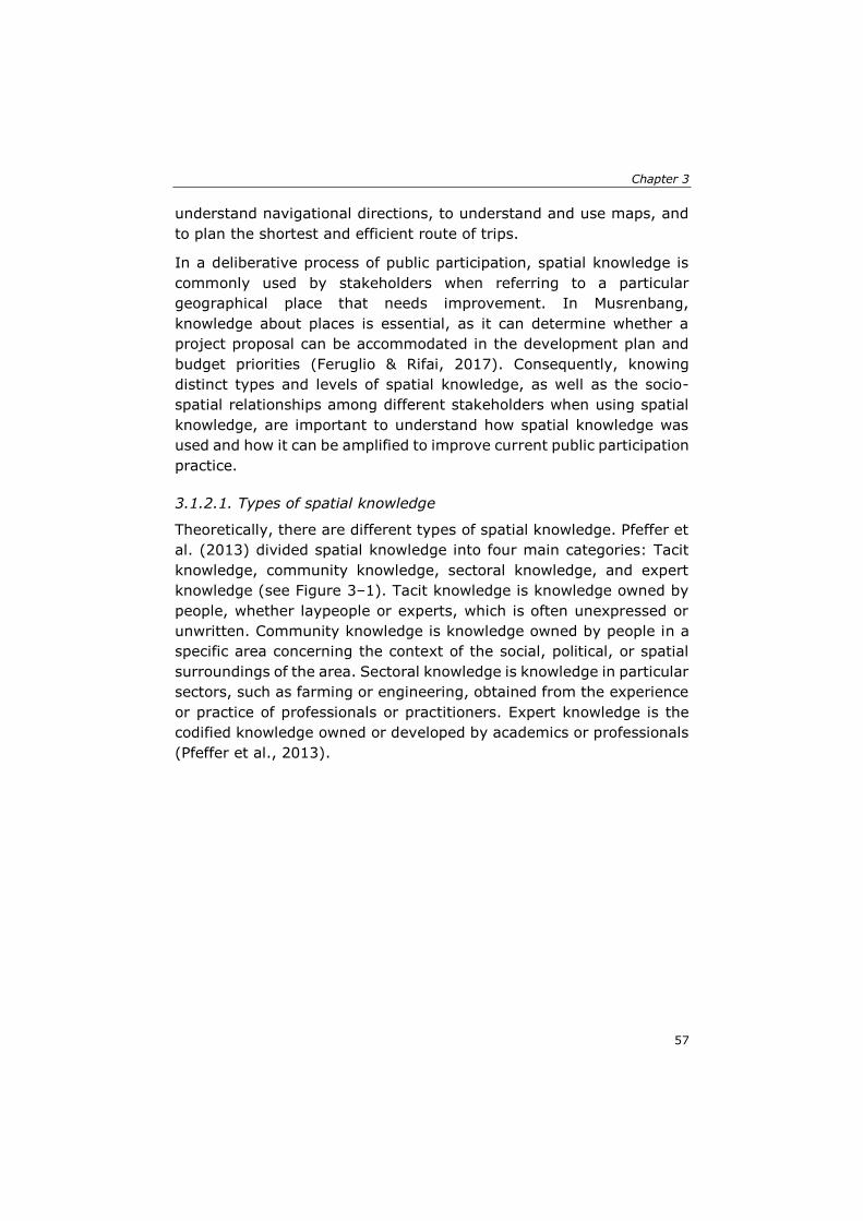
Chapter 3
57
understand navigational directions, to understand and use maps, and
to plan the shortest and efficient route of trips.
In a deliberative process of public participation, spatial knowledge is
commonly used by stakeholders when referring to a particular
geographical place that needs improvement. In Musrenbang,
knowledge about places is essential, as it can determine whether a
project proposal can be accommodated in the development plan and
budget priorities (Feruglio & Rifai, 2017). Consequently, knowing
distinct types and levels of spatial knowledge, as well as the socio-
spatial relationships among different stakeholders when using spatial
knowledge, are important to understand how spatial knowledge was
used and how it can be amplified to improve current public participation
practice.
3.1.2.1. Types of spatial knowledge
Theoretically, there are different types of spatial knowledge. Pfeffer et
al. (2013) divided spatial knowledge into four main categories: Tacit
knowledge, community knowledge, sectoral knowledge, and expert
knowledge (see Figure 3–1). Tacit knowledge is knowledge owned by
people, whether laypeople or experts, which is often unexpressed or
unwritten. Community knowledge is knowledge owned by people in a
specific area concerning the context of the social, political, or spatial
surroundings of the area. Sectoral knowledge is knowledge in particular
sectors, such as farming or engineering, obtained from the experience
or practice of professionals or practitioners. Expert knowledge is the
codified knowledge owned or developed by academics or professionals
(Pfeffer et al., 2013).
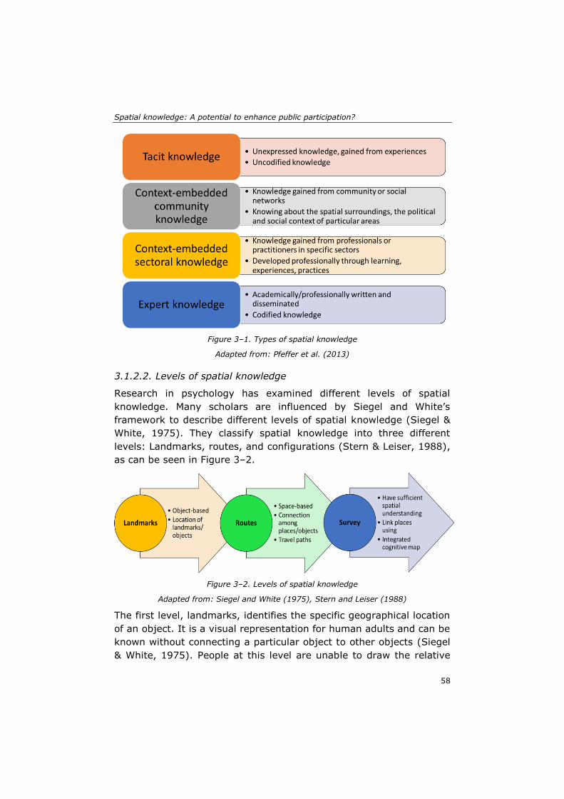
Spatial knowledge: A potential to enhance public participation?
58
Figure 3–1. Types of spatial knowledge
Adapted from: Pfeffer et al. (2013)
3.1.2.2. Levels of spatial knowledge
Research in psychology has examined different levels of spatial
knowledge. Many scholars are influenced by Siegel and White’s
framework to describe different levels of spatial knowledge (Siegel &
White, 1975). They classify spatial knowledge into three different
levels: Landmarks, routes, and configurations (Stern & Leiser, 1988),
as can be seen in Figure 3–2.
Figure 3–2. Levels of spatial knowledge
Adapted from: Siegel and White (1975), Stern and Leiser (1988)
The first level, landmarks, identifies the specific geographical location
of an object. It is a visual representation for human adults and can be
known without connecting a particular object to other objects (Siegel
& White, 1975). People at this level are unable to draw the relative
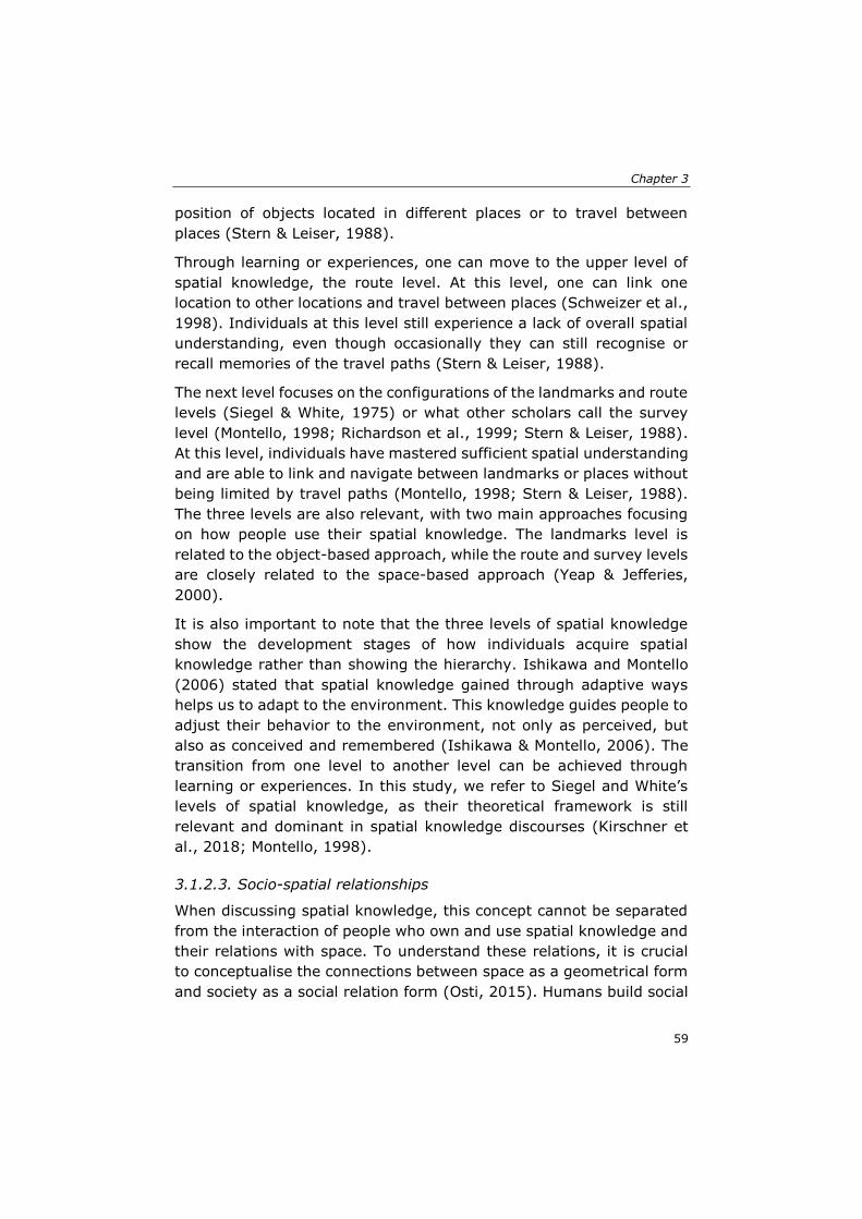
Chapter 3
59
position of objects located in different places or to travel between
places (Stern & Leiser, 1988).
Through learning or experiences, one can move to the upper level of
spatial knowledge, the route level. At this level, one can link one
location to other locations and travel between places (Schweizer et al.,
1998). Individuals at this level still experience a lack of overall spatial
understanding, even though occasionally they can still recognise or
recall memories of the travel paths (Stern & Leiser, 1988).
The next level focuses on the configurations of the landmarks and route
levels (Siegel & White, 1975) or what other scholars call the survey
level (Montello, 1998; Richardson et al., 1999; Stern & Leiser, 1988).
At this level, individuals have mastered sufficient spatial understanding
and are able to link and navigate between landmarks or places without
being limited by travel paths (Montello, 1998; Stern & Leiser, 1988).
The three levels are also relevant, with two main approaches focusing
on how people use their spatial knowledge. The landmarks level is
related to the object-based approach, while the route and survey levels
are closely related to the space-based approach (Yeap & Jefferies,
2000).
It is also important to note that the three levels of spatial knowledge
show the development stages of how individuals acquire spatial
knowledge rather than showing the hierarchy. Ishikawa and Montello
(2006) stated that spatial knowledge gained through adaptive ways
helps us to adapt to the environment. This knowledge guides people to
adjust their behavior to the environment, not only as perceived, but
also as conceived and remembered (Ishikawa & Montello, 2006). The
transition from one level to another level can be achieved through
learning or experiences. In this study, we refer to Siegel and White’s
levels of spatial knowledge, as their theoretical framework is still
relevant and dominant in spatial knowledge discourses (Kirschner et
al., 2018; Montello, 1998).
3.1.2.3. Socio-spatial relationships
When discussing spatial knowledge, this concept cannot be separated
from the interaction of people who own and use spatial knowledge and
their relations with space. To understand these relations, it is crucial
to conceptualise the connections between space as a geometrical form
and society as a social relation form (Osti, 2015). Humans build social
Spatial knowledge: A potential to enhance public participation?
60
relations in their everyday life, while space serves as a medium for
people to do activities and develop their social relations. Schatzki
(1991) proposed the concept of social space to illustrate the strong
relationship between space and people:
“Social space is a distribution of such items (objects, places, settings,
action-governing factors, and causal transactions) among places and
paths, which automatically happens along with interrelated lives and
which underlies both the objective dimensions of social spatiality and
the construction of the built environment” (Schatzki, 1991, p. 667).
To better understand the connection between space and society, Osti
(2015) elaborated on the concept of socio-spatial relations through
three dimensions: The spatial form, social relation, and the socio-
spatial relationship (Figure 3–3).
Figure 3–3. Connection of spatial forms and social relations (types of socio-spatial relationships)
Adapted from: Osti (2015)
To conceptualise the socio-spatial process, one cannot rely only on a
single dimension. Socio-spatial relations must be viewed from different
aspects, as they are mutually essential and interrelated with one and
another (Jessop et al., 2008). Spatial elements, such as spatial
proximity, accessibility, and connectivity, play a crucial role in
supporting the performance or development of a region (Murphy,
2007). Therefore, the structural framework proposed by Osti suggests
a clear distinction between three different but intertwined aspects that
explain how space can affect people’s relations. Understanding among
individuals who live distantly can be built through direct interactions
(Osti, 2015). The existence of borders can stimulate the exchange of
Chapter 3
61
knowledge and material flows, and strengthen the solidarity of the
communities who live in the same region (Daskalaki, 2018).
Dominance is commonly exercised through land use management to
manifest the municipal officials’ strong position in power relations. As
leaders, they must be able to examine the social form of their governed
area, identify social relations between the communities, and finally put
the policies and directions of the spatial forms that would bring positive
impacts to regions (Murphy, 2007).
3.2 Material and methods
3.2.1 The case study
Musrenbang is an annual participatory planning and budgeting process
implemented in different levels of governance, from the village level to
the national level. At the village level, Musrenbang is implemented
through a public meeting that involves various stakeholders with
various backgrounds, interests, influence, and knowledge. In our
previous study, we classified the stakeholders into four main groups,
namely the upper government, village elites, village elites’ supporters,
and ordinary citizens (Akbar, Flacke, Martinez, & van Maarseveen,
2020a). The planning process aims to produce the village’s annual
development planning document, the financial plans, and development
proposals for upper governments (Grillos, 2017; Sopanah, 2012).
This study aims to investigate the utilisation of spatial knowledge in
the Musrenbang practices, including its potential to improve the current
practice. To better understand the spatial knowledge of the village
stakeholders and how the knowledge is used during the Musrenbang
practice, we chose five villages in the Deli Serdang district in Indonesia.
We purposely chose the villages based on their similarities in four
different criteria: (1) The village is located in different sub-districts; (2)
the ethnicity of the population is primarily Javanese; (3) the primary
livelihood of the population is farming and agriculture; (4) the village
officials are willing to participate in this study. Based on these criteria,
the Denai Lama, Kolam, Kramat Gajah, Sidoharjo I Pasar Miring, and
Tandem Hulu II were chosen as the case study locations.
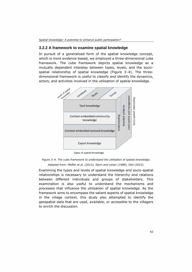
Spatial knowledge: A potential to enhance public participation?
62
3.2.2 A framework to examine spatial knowledge
In pursuit of a generalised form of the spatial knowledge concept,
which is more evidence-based, we employed a three-dimensional cube
framework. The cube framework depicts spatial knowledge as a
mutually dependent interplay between types, levels, and the socio-
spatial relationship of spatial knowledge (Figure 3–4). The three-
dimensional framework is useful to classify and identify the dynamics,
actors, and activities involved in the utilisation of spatial knowledge.
Figure 3–4. The cube framework to understand the utilisation of spatial knowledge.
Adapted from: Pfeffer et al. (2013), Stern and Leiser (1988), Osti (2015).
Examining the types and levels of spatial knowledge and socio-spatial
relationships is necessary to understand the hierarchy and relations
between different individuals and groups of stakeholders. This
examination is also useful to understand the mechanisms and
processes that influence the utilisation of spatial knowledge. As the
framework aims to encompass the salient aspects of spatial knowledge
in the village context, this study also attempted to identify the
geospatial data that are used, available, or accessible to the villagers
to enrich the discussion.
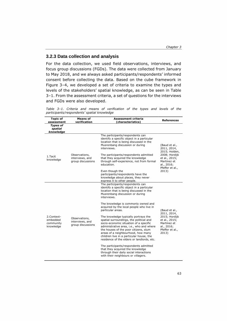
Chapter 3
63
3.2.3 Data collection and analysis
For the data collection, we used field observations, interviews, and
focus group discussions (FGDs). The data were collected from January
to May 2018, and we always asked participants/respondents’ informed
consent before collecting the data. Based on the cube framework in
Figure 3–4, we developed a set of criteria to examine the types and
levels of the stakeholders’ spatial knowledge, as can be seen in Table
3–1. From the assessment criteria, a set of questions for the interviews
and FGDs were also developed.
Table 3–1. Criteria and means of verification of the types and levels of the participants/respondents’ spatial knowledge
Topic of
assessment
Means of
verification
Assessment criteria
(characteristics) References
Types of
spatial
knowledge
1.Tacit knowledge
Observations,
interviews, and
group discussions
The participants/respondents can
identify a specific object in a particular
location that is being discussed in the Musrenbang discussion or during
interviews.
The participants/respondents admitted
that they acquired the knowledge
through self-experience, not from formal
education.
Even though the participants/respondents have the
knowledge about places, they never
express it to other people.
(Baud et al.,
2011, 2014,
2015; Holden,
2008; Hordijk
et al., 2015;
Martinez et
al., 2016;
Pfeffer et al.,
2013)
2.Context-
embedded
community
knowledge
Observations,
interviews, and
group discussions
The participants/respondents can
identify a specific object in a particular
location that is being discussed in the
Musrenbang discussion or during
interviews.
The knowledge is commonly owned and
acquired by the local people who live in particular areas.
The knowledge typically portrays the
spatial surroundings, the political and
socio-economic situation of a specific
administrative area, i.e., who and where
the houses of the poor citizens, slum
areas of a neighbourhood, how many
children live in a particular house, the
residence of the elders or landlords, etc.
The participants/respondents admitted
that they acquired the knowledge
through their daily social interactions
with their neighbours or villagers.
(Baud et al.,
2011, 2014,
2015; Hordijk
et al., 2015;
Martinez et
al., 2016;
Pfeffer et al.,
2013)
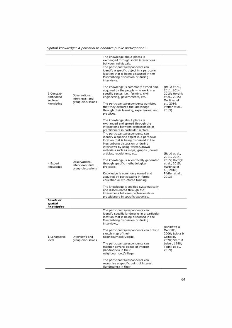
Spatial knowledge: A potential to enhance public participation?
64
The knowledge about places is
exchanged through social interactions
between individuals.
3.Context-
embedded
sectoral
knowledge
Observations,
interviews, and
group discussions
The participants/respondents can
identify a specific object in a particular
location that is being discussed in the
Musrenbang discussion or during
interviews.
The knowledge is commonly owned and
acquired by the people who work in a specific sector, i.e., farming, civil
engineering, governments, etc.
The participants/respondents admitted
that they acquired the knowledge
through their learning, experiences, and
practices.
The knowledge about places is
exchanged and spread through the interactions between professionals or
practitioners in particular sectors.
(Baud et al.,
2011, 2014, 2015; Hordijk
et al., 2015;
Martinez et
al., 2016;
Pfeffer et al.,
2013)
4.Expert
knowledge
Observations,
interviews, and
group discussions
The participants/respondents can
identify a specific object in a particular
location that is being discussed in the
Musrenbang discussion or during
interviews by using written/drawn
materials such as maps, graphs, journal
articles, regulations, etc.
The knowledge is scientifically generated through specific methodological
protocols.
Knowledge is commonly owned and
acquired by participating in formal
education or structured training.
The knowledge is codified systematically
and disseminated through the interactions between professionals or
practitioners in specific expertise.
(Baud et al.,
2011, 2014,
2015; Hordijk et al., 2015;
Martinez et
al., 2016;
Pfeffer et al.,
2013)
Levels of
spatial
knowledge
1.Landmarks
level
Interviews and
group discussions
The participants/respondents can
identify specific landmarks in a particular
location that is being discussed in the
Musrenbang discussion or during
interviews.
The participants/respondents can draw a
sketch map of their neighbourhood/village.
The participants/respondents can
mention several points of interest
(landmarks) in their
neighbourhood/village.
The participants/respondents can
recognise a specific point of interest (landmarks) in their
(Ishikawa &
Montello,
2006; Lokka & Çöltekin,
2020; Stern &
Leiser, 1988;
Teghil et al.,
2019)
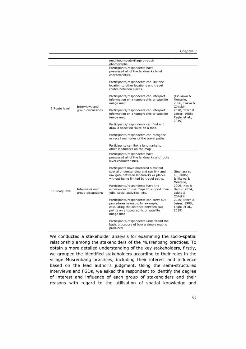
Chapter 3
65
neighbourhood/village through
photographs.
2.Route level Interviews and
group discussions
Participants/respondents have
possessed all of the landmarks level
characteristics.
Participants/respondents can link one
location to other locations and travel
routes between places.
Participants/respondents can interpret information on a topographic or satellite
image map.
Participants/respondents can interpret
information on a topographic or satellite
image map.
Participants/respondents can find and
draw a specified route on a map.
Participants/respondents can recognise
or recall memories of the travel paths.
Participants can link a landmarks to
other landmarks on the map.
(Ishikawa & Montello,
2006; Lokka &
Çöltekin,
2020; Stern &
Leiser, 1988;
Teghil et al.,
2019)
3.Survey level Interviews and
group discussions
Participants/respondents have
possessed all of the landmarks and route
level characteristics.
Participants have mastered sufficient
spatial understanding and can link and
navigate between landmarks or places without being limited by travel paths.
Participants/respondents have the
experiences to use maps to support their
jobs, social activities, etc.
Participants/respondents can carry out
procedures in maps, for example,
calculating the distance between two points on a topographic or satellite
image map.
Participants/respondents understand the
basic procedure of how a simple map is
produced.
(Bednarz et
al., 2006; Ishikawa &
Montello,
2006; Koç &
Demir, 2014;
Lokka &
Çöltekin,
2020; Stern &
Leiser, 1988;
Teghil et al., 2019)
We conducted a stakeholder analysis for examining the socio-spatial
relationship among the stakeholders of the Musrenbang practices. To
obtain a more detailed understanding of the key stakeholders, firstly,
we grouped the identified stakeholders according to their roles in the
village Musrenbang practices, including their interest and influence
based on the lead author’s judgment. Using the semi-structured
interviews and FGDs, we asked the respondent to identify the degree
of interest and influence of each group of stakeholders and their
reasons with regard to the utilisation of spatial knowledge and
Spatial knowledge: A potential to enhance public participation?
66
geospatial data in the Musrenbang practices. We used the extended
interest–influence matrix method to analyse the levels of interest and
influence of the stakeholder groups (Raum, 2018). The method is
useful to differentiate a number of key stakeholders and provides
comprehensive reasons for the interest and influence owned by each
stakeholder (Reed et al., 2009).
The lead author acted as the direct observer in the observations by
attending Musrenbang public meetings. The observations were written
in field notes and recorded for further analysis. When observing the
Musrenbang implementation, we also asked the participants to fill a
self-administered questionnaire to collect their responses and opinions
towards the Musrenbang implementation and the types of data used
during the Musrenbang process (Appendix C). From the self-
administered questionnaire, we gained the profile of the Musrenbang
participants, as can be seen in Appendix B. The design of the
questionnaire is based on previous research (Akbar, Flacke, Martinez,
& van Maarseveen, 2020a).
We conducted fifty-six semi-structured in-depth interviews and four
FGDs to understand how the village stakeholders perceived spatial
knowledge and how they used spatial knowledge in the Musrenbang
(list of questions can be seen in Appendix H and I). Open-ended
questions were used because this type of question allows respondents
to answer in their own terms and provide new or unprecedented
information that the researcher may not have contemplated (Bryman,
2012). The participants and respondents for FGDs and interviews were
mostly villagers who have never had any experiences with interviews.
Using the open-ended questions was helpful for the authors to
interview the respondents with a certain set of questions derived from
the case study design while keeping the respondents as comfortable as
possible, as the interviews will be more like a usual daily conversation
(Yin, 2003).
The participants/respondents were pre-selected by considering the
representativeness of each group of stakeholders. The FGD’s
participants consisted of village officials, a village council (BPD), the
village empowerment board (LKMD), women representatives (PKK),
youth representatives (Karang Taruna), community leaders, or
religious leaders, and village supervisors. For the interviews, we also
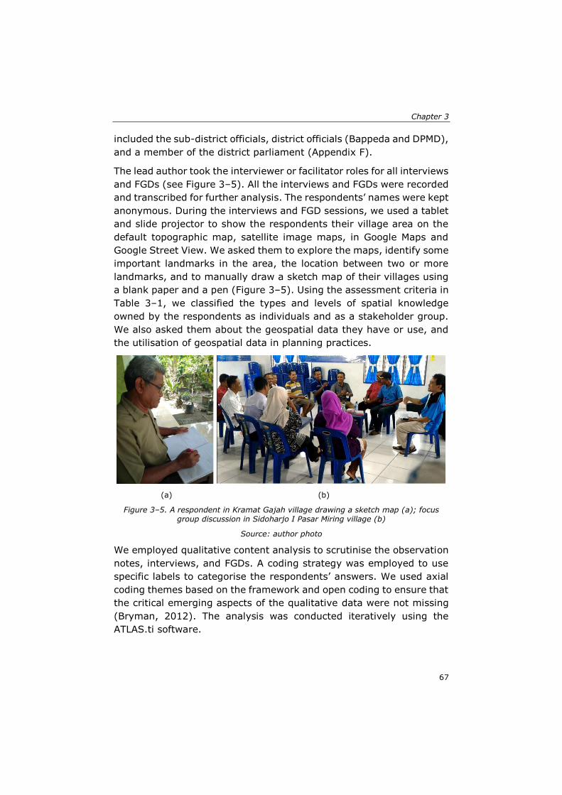
Chapter 3
67
included the sub-district officials, district officials (Bappeda and DPMD),
and a member of the district parliament (Appendix F).
The lead author took the interviewer or facilitator roles for all interviews
and FGDs (see Figure 3–5). All the interviews and FGDs were recorded
and transcribed for further analysis. The respondents’ names were kept
anonymous. During the interviews and FGD sessions, we used a tablet
and slide projector to show the respondents their village area on the
default topographic map, satellite image maps, in Google Maps and
Google Street View. We asked them to explore the maps, identify some
important landmarks in the area, the location between two or more
landmarks, and to manually draw a sketch map of their villages using
a blank paper and a pen (Figure 3–5). Using the assessment criteria in
Table 3–1, we classified the types and levels of spatial knowledge
owned by the respondents as individuals and as a stakeholder group.
We also asked them about the geospatial data they have or use, and
the utilisation of geospatial data in planning practices.
(a) (b)
Figure 3–5. A respondent in Kramat Gajah village drawing a sketch map (a); focus group discussion in Sidoharjo I Pasar Miring village (b)
Source: author photo
We employed qualitative content analysis to scrutinise the observation
notes, interviews, and FGDs. A coding strategy was employed to use
specific labels to categorise the respondents’ answers. We used axial
coding themes based on the framework and open coding to ensure that
the critical emerging aspects of the qualitative data were not missing
(Bryman, 2012). The analysis was conducted iteratively using the
ATLAS.ti software.
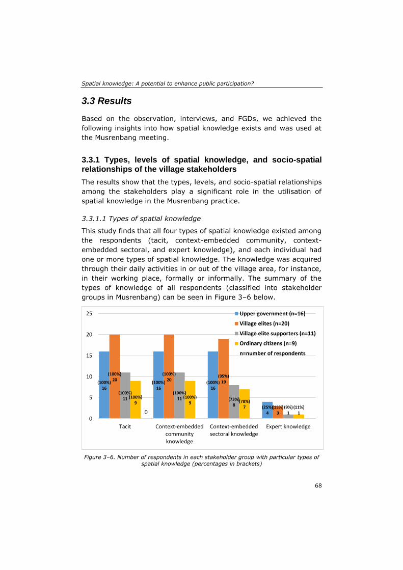
Spatial knowledge: A potential to enhance public participation?
68
3.3 Results
Based on the observation, interviews, and FGDs, we achieved the
following insights into how spatial knowledge exists and was used at
the Musrenbang meeting.
3.3.1 Types, levels of spatial knowledge, and socio-spatial relationships of the village stakeholders
The results show that the types, levels, and socio-spatial relationships
among the stakeholders play a significant role in the utilisation of
spatial knowledge in the Musrenbang practice.
3.3.1.1 Types of spatial knowledge
This study finds that all four types of spatial knowledge existed among
the respondents (tacit, context-embedded community, context-
embedded sectoral, and expert knowledge), and each individual had
one or more types of spatial knowledge. The knowledge was acquired
through their daily activities in or out of the village area, for instance,
in their working place, formally or informally. The summary of the
types of knowledge of all respondents (classified into stakeholder
groups in Musrenbang) can be seen in Figure 3–6 below.
Figure 3–6. Number of respondents in each stakeholder group with particular types of spatial knowledge (percentages in brackets)
(100%) 16
(100%) 16
(100%) 16
(25%) 4
(100%) 20
(100%) 20
(95%) 19
(15%) 3
(100%) 11
(100%) 11 (73%)
8 (9%) 1
(100%) 9
(100%) 9 (78%)
7 (11%) 10
0
5
10
15
20
25
Tacit Context-embeddedcommunityknowledge
Context-embeddedsectoral knowledge
Expert knowledge
Upper government (n=16)
Village elites (n=20)
Village elite supporters (n=11)
Ordinary citizens (n=9)
n=number of respondents

Chapter 3
69
Figure 3–6 shows that all respondents have tacit knowledge. Based on
the interviews and FGDs, it was evident that respondents often used
their tacit knowledge during the Musrenbang and daily activities. They
acquired and learned the knowledge through self-experience.
Respondent B7 said in the interview, “I know exactly each part of the
road heading to the Tembung area, which is in damaged condition. I
know all the holes here and there” (B7, 26 February 2018, personal
communication). Moreover, D1 responded:
“Yes, they [the participants] have it [spatial knowledge]. It is because
they often go there or pass by the area. I suppose that they know
how many turns [to reach a specific place in the village], how many
holes, where are the location of the mosque and the houses nearby
the mosque they also know” (D1, personal communication, 6 March
2018).
Examining the existence of tacit knowledge is a non-trivial task. Most
respondents used their tacit knowledge intuitively when referring to a
specific object in a particular location that was being discussed during
the Musrenbang discussion. The tacit knowledge is a knowledge that is
not easy to identify, as it is challenging to record, transfer, or
communicate to other people (Holden, 2008). The knowledge often
remains implicit and unspoken, even though the owners may use the
knowledge unwittingly in their daily activities.
The same phenomenon also occurred with context-embedded
community knowledge; all respondents used community knowledge in
their daily activities (see Figure 3–6). This knowledge is gained through
social networks and interactions. From these interactions, new
knowledge was transferred and exchanged, which eventually became
common facts or knowledge among society. In this study, the existence
of community knowledge can be found in the way our respondents
described a specific place by linking the place with the information of
ownership or the people who lived in nearby locations. For instance:
“From end to end of this neighbourhood, I am familiar with all the
houses, the owners, how many children in each house, I know” (C5,
personal communication, 7 March 2018). D4 gave the same response:
“We know who the owners of all the houses in this village are and the
inhabitants” (D4, personal communication, 6 March 2018).
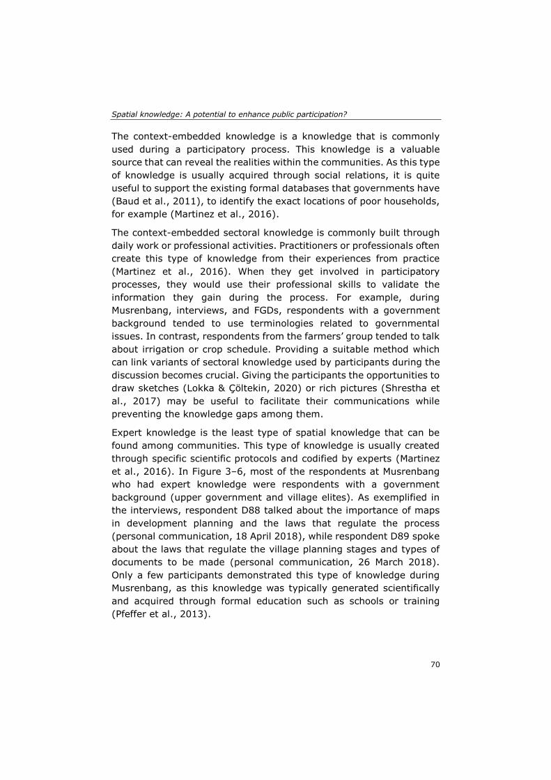
Spatial knowledge: A potential to enhance public participation?
70
The context-embedded knowledge is a knowledge that is commonly
used during a participatory process. This knowledge is a valuable
source that can reveal the realities within the communities. As this type
of knowledge is usually acquired through social relations, it is quite
useful to support the existing formal databases that governments have
(Baud et al., 2011), to identify the exact locations of poor households,
for example (Martinez et al., 2016).
The context-embedded sectoral knowledge is commonly built through
daily work or professional activities. Practitioners or professionals often
create this type of knowledge from their experiences from practice
(Martinez et al., 2016). When they get involved in participatory
processes, they would use their professional skills to validate the
information they gain during the process. For example, during
Musrenbang, interviews, and FGDs, respondents with a government
background tended to use terminologies related to governmental
issues. In contrast, respondents from the farmers’ group tended to talk
about irrigation or crop schedule. Providing a suitable method which
can link variants of sectoral knowledge used by participants during the
discussion becomes crucial. Giving the participants the opportunities to
draw sketches (Lokka & Çöltekin, 2020) or rich pictures (Shrestha et
al., 2017) may be useful to facilitate their communications while
preventing the knowledge gaps among them.
Expert knowledge is the least type of spatial knowledge that can be
found among communities. This type of knowledge is usually created
through specific scientific protocols and codified by experts (Martinez
et al., 2016). In Figure 3–6, most of the respondents at Musrenbang
who had expert knowledge were respondents with a government
background (upper government and village elites). As exemplified in
the interviews, respondent D88 talked about the importance of maps
in development planning and the laws that regulate the process
(personal communication, 18 April 2018), while respondent D89 spoke
about the laws that regulate the village planning stages and types of
documents to be made (personal communication, 26 March 2018).
Only a few participants demonstrated this type of knowledge during
Musrenbang, as this knowledge was typically generated scientifically
and acquired through formal education such as schools or training
(Pfeffer et al., 2013).
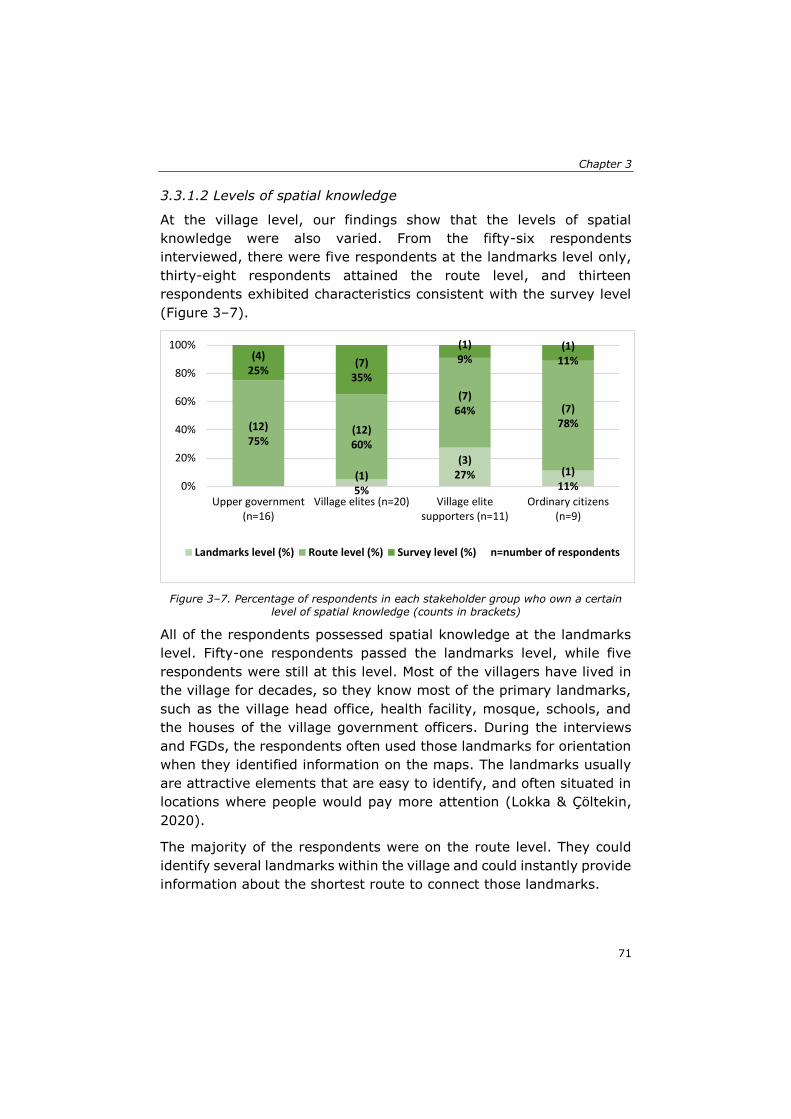
Chapter 3
71
3.3.1.2 Levels of spatial knowledge
At the village level, our findings show that the levels of spatial
knowledge were also varied. From the fifty-six respondents
interviewed, there were five respondents at the landmarks level only,
thirty-eight respondents attained the route level, and thirteen
respondents exhibited characteristics consistent with the survey level
(Figure 3–7).
Figure 3–7. Percentage of respondents in each stakeholder group who own a certain level of spatial knowledge (counts in brackets)
All of the respondents possessed spatial knowledge at the landmarks
level. Fifty-one respondents passed the landmarks level, while five
respondents were still at this level. Most of the villagers have lived in
the village for decades, so they know most of the primary landmarks,
such as the village head office, health facility, mosque, schools, and
the houses of the village government officers. During the interviews
and FGDs, the respondents often used those landmarks for orientation
when they identified information on the maps. The landmarks usually
are attractive elements that are easy to identify, and often situated in
locations where people would pay more attention (Lokka & Çöltekin,
2020).
The majority of the respondents were on the route level. They could
identify several landmarks within the village and could instantly provide
information about the shortest route to connect those landmarks.
(1)5%
(3)27% (1)
11%
(12)75%
(12)60%
(7)64% (7)
78%
(4)25%
(7)35%
(1)9%
(1)11%
0%
20%
40%
60%
80%
100%
Upper government(n=16)
Village elites (n=20) Village elitesupporters (n=11)
Ordinary citizens(n=9)
Landmarks level (%) Route level (%) Survey level (%) n=number of respondents
Spatial knowledge: A potential to enhance public participation?
72
“We know about every place in this village, as we have traveled or
passed by most of the areas. For example, if we want to go to
Neighbourhood 1, after passing by the village head office, we will find
a T-junction. If we turn right, we are heading to Neighbourhood 3. If
we turn left, we are heading to Neighbourhood 1, and it will end up
at the village border, which is the Denai Sarang Burung village, our
neighbour village” (A1, personal communication, 1 March 2018).
“This is Mawar Street, this is Balai Desa Street. This is the road
heading to Neighbourhood 4. If we go North, we will get
Neighbourhood 3, then this is the [village] border. This is the rice
mill” (A6, personal communication, 1 March 2018).
The statements above clearly show that most participants who
demonstrated characteristics of route level acquired the knowledge
when they regularly navigate along a specific travel path. They
memorise the information on the travel paths during the journeys
through an egocentric perspective. The egocentric perspective is useful
for acquiring the route spatial knowledge as it represents the location
of objects in space relative to the viewpoint of our eyes (Lokka &
Çöltekin, 2020).
While the route level is commonly obtained and used through an
egocentric perspective, the survey level is often practiced through the
allocentric view (Ishikawa & Montello, 2006). Individuals at the survey
level typically can interpret or use two-dimensional maps (Hernández,
1994), which are in line with our findings that show respondents at the
survey level are mostly government officials. Their duties as
government employees require them to be able to use and interpret
maps to support their jobs. When we asked them to read the digital
maps displayed on the tablet during the interviews, they can point out
several landmarks and explain the distance and travel paths that
connect different landmarks. As an example, A1 said, “Yes, I can read
the [Google] map. This is the village head office. This is the rice mill. I
was part of the team that made the first [sketch] map of this village
(A1, personal communication, 1 March 2018).
Our findings also revealed that participants reacted faster to identify
the landmarks or routes when we used the Google Street View than
the Google Maps in the interviews and FGDs. The Google Street View
supports the egocentric perspective, while the Google Map supports
the allocentric view, which is not easy to interpret. We also found that
age differences are crucial to executing the given tasks. Younger
Chapter 3
73
respondents have a better ability than older participants to understand
the maps provided in the Google Map platform. Younger respondents
have more opportunities to be exposed to the rapid development of
new technologies nowadays, enabling them to better interact with the
virtual geo-technology means (Lokka & Çöltekin, 2020).
3.3.1.3 Socio-spatial relationships of the village stakeholders
Most respondents are quite familiar with their village areas. However,
the village officials, head of neighbourhoods, and women respondents
demonstrated more knowledge about the village than other
respondents. The village officials and heads of neighbourhoods knew
about their areas because their duties force them to understand their
governing areas. When working on their duties, the head of the
neighbourhoods often goes to the neighbourhoods to identify and list
the programs needed by citizens, working with the land administration
and registration, to survey and measure the length, width, or depth of
a specific location in the village (B1, personal communication, 5 March
2018).
The women have more extensive knowledge of the area, as they spend
most of their time in the villages where they can exercise and extend
their social network with other village stakeholders (Akbar, Flacke,
Martinez, & van Maarseveen, 2020a). Respondent C5, for instance,
said that they know the exact location of each house in their
neighbourhoods, who the owners are, and who the individuals living in
the house are (C5, personal communication, 7 March 2018). Direct
face-to-face communication has a significant role in enabling
individuals or groups to have a better understanding of their living
space and its surroundings.
From the responses, it seems that the respondents often refer to the
village border when identifying landmarks or routes. Borders or
boundaries are essential for location orientation in the village. For
instance, when we asked a woman representative from the Denai Lama
village to explain the route from the village head office to her house,
she used the village border for orientating her route.
“So, from Denai Sarang Burung [village neighbour], this is the village
border. We are going straight. Only the main roads, right? We will
pass a mosque, then we simply follow the roads, we find a junction,
we turn right to the village head office, passing the office, then we
Spatial knowledge: A potential to enhance public participation?
74
turn right, go straight follow the road heading here, so here we are”
(A5, personal communication, 8 March 2018).
Borders are also essential to claim the existence of activities managed
by stakeholder groups. Farmer groups, for example, also have sketch
maps to illustrate the rice fields in the village (D8, personal
communication, 7 March 2018). This finding is aligned with Osti’s
framework, as the border can create bounded solidarity among the
people who live in a particular area (Osti, 2015). Some respondents
also stated administrative boundaries as an underlying problem that
can provoke conflicts between neighbourhoods, villages, or sub-
districts. In Denai Lama, disputes have arisen in the past, and until
now, the border problem with their neighbours still exists (A1, A2,
personal communication, 1 March 2018). Delineating boundaries is
essential to decide the scope of development planning as well as
reducing conflicts over administrative areas (Baud et al., 2015).
Regarding power relations, our findings show that various stakeholders
were involved in village Musrenbang practices. We classified them into
four main stakeholder groups, as can be seen in Table 3–2 below.
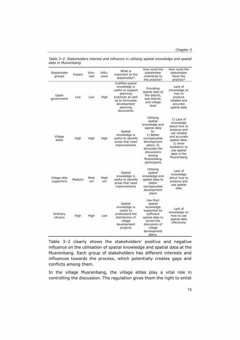
Chapter 3
75
Table 3–2. Stakeholders interest and influence in utilising spatial knowledge and spatial data in Musrenbang
Stakeholder
groups Impact
Inte-
rest
Influ-
ence
What is
important to the
stakeholder?
How could the stakeholder
contribute to
the practice?
How could the stakeholder
block the
practice?
Upper
government Low Low High
Codified spatial
knowledge is
useful to support
planning
practices as well
as to formulate
development
planning documents
Providing
spatial data at the district,
sub-district,
and village
level
Lack of
knowledge on
how to
produce
reliable and
accurate
spatial data
Village
elites High High High
Spatial
knowledge is
useful to identify areas that need
improvements
Utilising
spatial
knowledge and
spatial data
to:
1) Better
conceptualise development
plans; 2)
stimulate the
discussions
among
Musrenbang
participants
1) Lack of
knowledge about how to
produce and
use reliable
and accurate
spatial data;
2) show
hesitation to
use spatial
data in the Musrenbang
Village elite
supporters Medium
Medi
um
Medi
um
Spatial knowledge is
useful to identify
areas that need
improvements
Utilising
spatial knowledge and
spatial data to
better
conceptualise
development
plans
Lack of
knowledge
about how to
produce and
use spatial
data
Ordinary
citizens High High Low
Spatial knowledge is
useful to
understand the
distribution of
village
development
projects
Use their
spatial knowledge
supported by
sufficient
spatial data to
enrich the
discussion of
village
development
plans.
Lack of
knowledge on
how to use
spatial data effectively
Table 3–2 clearly shows the stakeholders’ positive and negative
influence on the utilisation of spatial knowledge and spatial data at the
Musrenbang. Each group of stakeholders has different interests and
influences towards the process, which potentially creates gaps and
conflicts among them.
In the village Musrenbang, the village elites play a vital role in
controlling the discussion. The regulation gives them the right to enlist
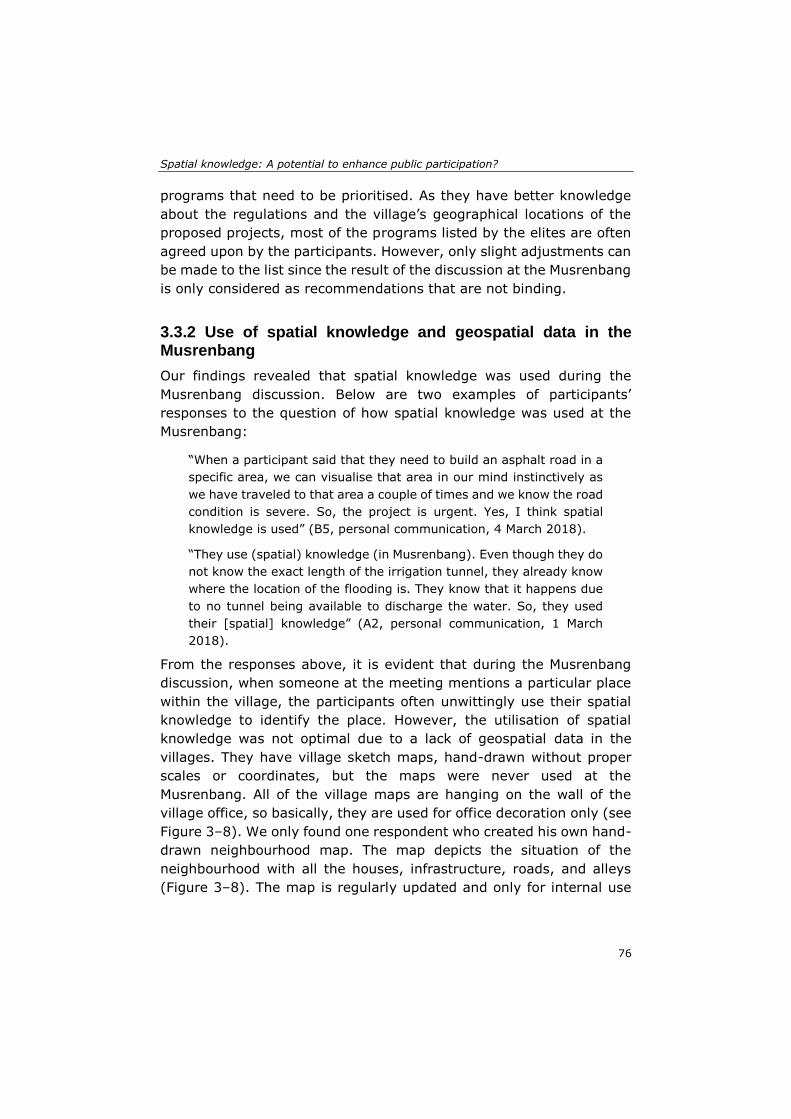
Spatial knowledge: A potential to enhance public participation?
76
programs that need to be prioritised. As they have better knowledge
about the regulations and the village’s geographical locations of the
proposed projects, most of the programs listed by the elites are often
agreed upon by the participants. However, only slight adjustments can
be made to the list since the result of the discussion at the Musrenbang
is only considered as recommendations that are not binding.
3.3.2 Use of spatial knowledge and geospatial data in the Musrenbang
Our findings revealed that spatial knowledge was used during the
Musrenbang discussion. Below are two examples of participants’
responses to the question of how spatial knowledge was used at the
Musrenbang:
“When a participant said that they need to build an asphalt road in a
specific area, we can visualise that area in our mind instinctively as
we have traveled to that area a couple of times and we know the road
condition is severe. So, the project is urgent. Yes, I think spatial
knowledge is used” (B5, personal communication, 4 March 2018).
“They use (spatial) knowledge (in Musrenbang). Even though they do
not know the exact length of the irrigation tunnel, they already know
where the location of the flooding is. They know that it happens due
to no tunnel being available to discharge the water. So, they used
their [spatial] knowledge” (A2, personal communication, 1 March
2018).
From the responses above, it is evident that during the Musrenbang
discussion, when someone at the meeting mentions a particular place
within the village, the participants often unwittingly use their spatial
knowledge to identify the place. However, the utilisation of spatial
knowledge was not optimal due to a lack of geospatial data in the
villages. They have village sketch maps, hand-drawn without proper
scales or coordinates, but the maps were never used at the
Musrenbang. All of the village maps are hanging on the wall of the
village office, so basically, they are used for office decoration only (see
Figure 3–8). We only found one respondent who created his own hand-
drawn neighbourhood map. The map depicts the situation of the
neighbourhood with all the houses, infrastructure, roads, and alleys
(Figure 3–8). The map is regularly updated and only for internal use
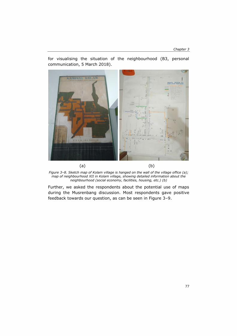
Chapter 3
77
for visualising the situation of the neighbourhood (B3, personal
communication, 5 March 2018).
(a) (b)
Figure 3–8. Sketch map of Kolam village is hanged on the wall of the village office (a); map of neighbourhood XII in Kolam village, showing detailed information about the
neighbourhood (social economy, facilities, housing, etc.) (b)
Further, we asked the respondents about the potential use of maps
during the Musrenbang discussion. Most respondents gave positive
feedback towards our question, as can be seen in Figure 3–9.
Spatial knowledge: A potential to enhance public participation?
78
Figure 3–9. Percentage of respondents in each stakeholder group who agree, partially agree, and do not agree with the potential use of maps in the Musrenbang practice
Some respondents described their reasons why they think using maps
would be useful to enhance Musrenbang implementation. Spatial data
like maps would be helpful to visualise the geographical locations of
the Musrenbang projects, which are being discussed (A8, personal
communication, 8 March 2018). The visualisation could stimulate the
discussion, as now participants can see the spatial distribution of the
project’s locations (B5, personal communication, 4 April 2018). A6
implied that by using maps, the discussion would be more productive.
Showing the village maps during the Musrenbang may result in
additional opinions to ensure the allocation of projects is to be more
equitably distributed and solve the most urgent problems that the
village may have (A6, personal communication, 1 March 2019).
Martinez et al. (2016) suggested that maps would be useful to
stimulate in-depth discussions while enriching the debates among
stakeholders.
19%5% 0% 0%
25%
25%18% 11%
56%70%
82% 89%
0%
10%
20%
30%
40%
50%
60%
70%
80%
90%
100%
Upper government(n=16)
Village elites (n=20) Village elitesupporters (n=11)
Ordinary citizens(n=9)
Do not agree Partially agree Agree n=number of respondents
Chapter 3
79
3.3.3 To what extent do spatial knowledge and geospatial data support the participatory processes?
Even though the stakeholders were often unconsciously using their
spatial knowledge during the discussions, the respondents admitted
that spatial knowledge is useful to help them in identifying particular
places during the Musrenbang discussion.
“For example, when someone said Masjid Street, our mind starts to
think about where it is. Oh, it is at the village border. The border is
around some kilometers away from here. So, it [the location] just
comes up. When somebody talks about that place, we can simply
imagine it. We do not see it physically, but we can see it through our
minds” (A9, personal communication, 8 March 2018).
C3 expressed that even without any supporting pictures or visiting the
area, they could imagine a particular place in the village because they
are very familiar with the area (personal communication, 7 March
2018). The same response was given by D1, who said that participants
could visualise a location even though they were not in that specific
place, as it is automatically visualised in their minds (personal
communication, 6 March 2018). However, their knowledge was not
acquired through formal learning; they gained this kind of knowledge
from their daily interaction with the other people in the village and
unintentionally memorised the information gained through these
interactions (B1, personal communication, 5 March 2018).
These responses show clear examples of how tacit knowledge is
transformed into community knowledge. A person tacitly knows a place
and the people who live nearby based on his/her experiences. When
they interact with other people, they express their tacit knowledge,
which then becomes explicit. As a result, the people with whom he/she
interacts gains new knowledge from the conversation. Thus, social
networks play an essential role in utilising and acquiring the
community’s spatial knowledge as well as transforming tacit knowledge
into becoming explicit.
When we asked the participants about their support towards the idea
to produce village maps through a participatory mapping exercise,
ordinary citizens showed high acceptance. In contrast, the upper
government, village elites, and their supporters showed hesitation
towards the idea to involve the citizens in the participatory mapping
activities (Figure 3–10).
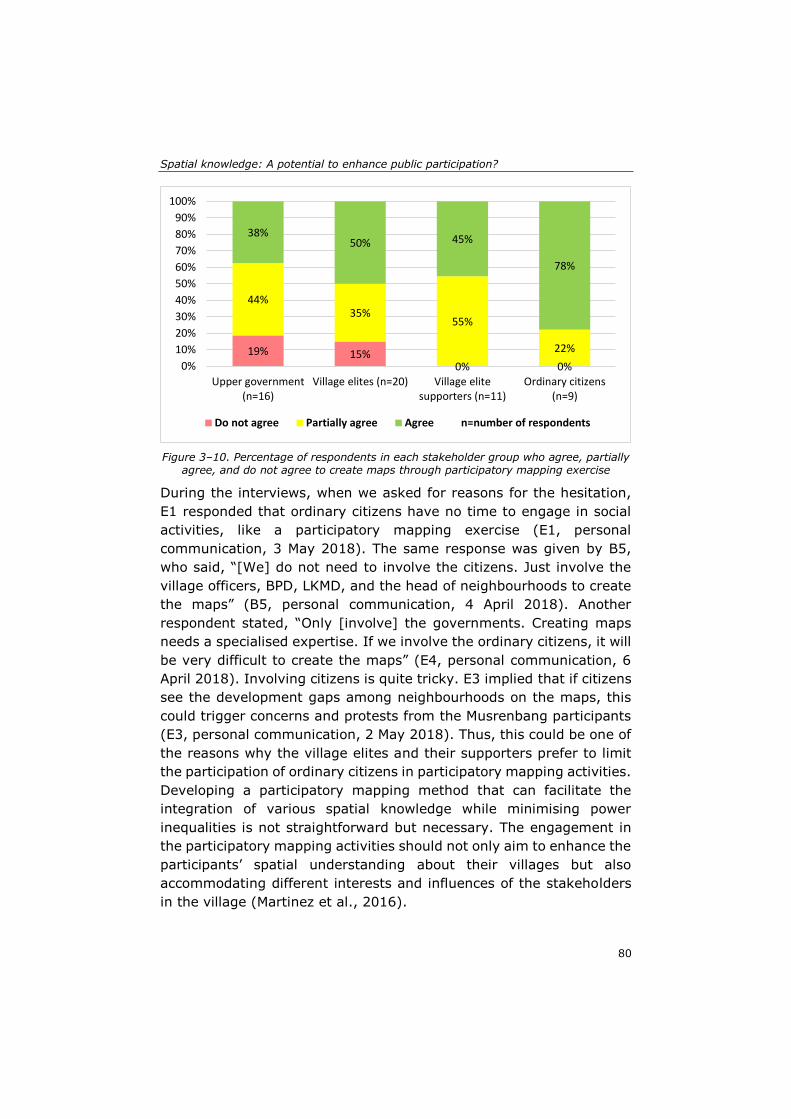
Spatial knowledge: A potential to enhance public participation?
80
Figure 3–10. Percentage of respondents in each stakeholder group who agree, partially agree, and do not agree to create maps through participatory mapping exercise
During the interviews, when we asked for reasons for the hesitation,
E1 responded that ordinary citizens have no time to engage in social
activities, like a participatory mapping exercise (E1, personal
communication, 3 May 2018). The same response was given by B5,
who said, “[We] do not need to involve the citizens. Just involve the
village officers, BPD, LKMD, and the head of neighbourhoods to create
the maps” (B5, personal communication, 4 April 2018). Another
respondent stated, “Only [involve] the governments. Creating maps
needs a specialised expertise. If we involve the ordinary citizens, it will
be very difficult to create the maps” (E4, personal communication, 6
April 2018). Involving citizens is quite tricky. E3 implied that if citizens
see the development gaps among neighbourhoods on the maps, this
could trigger concerns and protests from the Musrenbang participants
(E3, personal communication, 2 May 2018). Thus, this could be one of
the reasons why the village elites and their supporters prefer to limit
the participation of ordinary citizens in participatory mapping activities.
Developing a participatory mapping method that can facilitate the
integration of various spatial knowledge while minimising power
inequalities is not straightforward but necessary. The engagement in
the participatory mapping activities should not only aim to enhance the
participants’ spatial understanding about their villages but also
accommodating different interests and influences of the stakeholders
in the village (Martinez et al., 2016).
19% 15%0% 0%
44%35%
55%
22%
38%50% 45%
78%
0%
10%
20%
30%
40%
50%
60%
70%
80%
90%
100%
Upper government(n=16)
Village elites (n=20) Village elitesupporters (n=11)
Ordinary citizens(n=9)
Do not agree Partially agree Agree n=number of respondents
Chapter 3
81
It appears that the survey level moves beyond what is placed at a
certain location (landmarks level). Community members that operate
at the survey level, by understanding the landscape in a holistic
manner, are also able to know why and how changes in a specific
location may have an impact in some parts of the village. Involving the
people who are at the survey level would enrich a participatory
mapping exercise and make the mapping process more efficient (Eilola
et al., 2019). The selection of participants for the participatory mapping
exercise should not only consider the representativeness of the
stakeholders in the region, but also needs to consider the level of
spatial knowledge that an individual may have.
3.4 Discussion
In this research, we identified how various groups of stakeholders have
and make use of different types, levels of spatial knowledge, and socio-
spatial relations. These three different dimensions are mutually
connected and show the capability of each group of stakeholders in
perceiving and utilising their spatial knowledge. Three main challenges
need further actions to optimise the spatial knowledge used by the
village stakeholders.
3.4.1 Spatial knowledge is used in Musrenbang, but not properly
The participants of Musrenbang have distinct types and levels of spatial
knowledge, but they are not aware of its potential in helping them in
planning processes. The interviews and FGDs in this study were useful
to raise awareness of the valuable knowledge that could be used to
help them better participate in the Musrenbang practice.
As an annual public meeting prescribed by the laws 25/2004, the
participatory process in Musrenbang is still far from ideal. An ideal
public participation practice should allow participants to share their
ideas and opinions (Quick & Feldman, 2011; Yanow, 2003), as well as
supporting mutual communication and collaboration among them
(Healey, 1997; Innes & Booher, 2004). In the implementation, as
Indonesian villages have characteristics associated with stronger social
networks (Antlöv, 2003), the village elites typically have full control to
direct the conversation and make final decisions. The ‘silent majority’
Spatial knowledge: A potential to enhance public participation?
82
among the participants, mostly ordinary citizens from marginalised
groups, remains uninvolved (Albrechts, 2002; Grillos, 2017; Yanow,
2003).
However, this situation did not prevent village stakeholders from using
their spatial knowledge. As the topics of discussion in Musrenbang
cannot be separated from discussing specific geographical places, by
nature, discussion about places would contribute to stimulating the
participants to use their spatial knowledge, tacitly or explicitly. The
active usage of spatial knowledge provides the potential for the
knowledge co-production process. Previous studies have shown good
examples, such as the knowledge co-production to solve the pollution
issue in Durban (Pfeffer et al., 2013), to collect toponym information
in Indonesia (Perdana & Ostermann, 2018, 2019), or to tackle
environmental burdens in Dortmund urban areas (Shrestha et al.,
2017),
How to effectively use spatial knowledge is also a challenge. Our results
reveal that most of the participants in Musrenbang limited their focus
mainly on their own neighbourhoods, giving the impression that the
spatial boundaries have a significant influence on the formation of
bounded solidarity within a community. Consequently, they did not put
any attention to projects implemented in a broader context, such as in
other neighbourhoods or at the village scope. Redesigning the
participatory method that engages as many as participants as possible
(Flacke et al., 2020; Innes & Booher, 2010) and meets the local context
(Feng et al., 2020; Leino, 2012) could be a solution to achieving a
better participatory process. For example, the proposed method should
acknowledge the importance of borders for villagers, as borders have
complex social constructions with various implications for society, not
only simple lines/signs in space or on maps (Haselsberger, 2014).
Further, the design of the participatory method should also enable the
village stakeholders to think systematically to leverage their voices in
the decision-making process (Eilola et al., 2019). Thus, rather than
only knowing about where the location of a healthcare facility is, for
instance, the participants should also be able to use their spatial
knowledge to understand the impact of maps for other development
purposes. For example, they can use their spatial knowledge to identify
the best location for the new healthcare facility, or to assess how the
Chapter 3
83
relocation of a traditional market to a new site can affect the
transportation routes of their villages.
3.4.2 Codifying knowledge to integrate the local spatial knowledge and support the Musrenbang practice
Data availability is crucial to support public participation practices.
However, data availability is commonly limited (Shrestha et al., 2018a)
or inaccessible for users (Corbett & Keller, 2004). In Musrenbang, each
project discussed often has information about the name of the project,
quantity, and location of the project. Nevertheless, in all five villages,
there was no spatial data/information, such as maps, available to
support the discussion about the project.
Lack of codified knowledge, like maps, caused the participants to not
pay attention to the topics discussed, as they lost interest in the issues,
particularly as they put more concern on their own neighbourhoods’
issues. Eventually, the public meeting as a means of participation is
subverted in practice, as the elites could smoothly steer the decision-
making process more favorably for themselves (Feruglio & Rifai, 2017;
Grillos, 2017).
Most of the respondents gave positive responses to the utilisation of
geospatial data in the Musrenbang. However, they were confronted
with the fact that there is no or limited geospatial data available in the
villages. The question is now how to codify and make spatial data
available. Nowadays, the production and use of spatial data have
shifted from only an expert-driven process to a process where
organisations or citizens worldwide can get involved (Eilola et al.,
2015; Szyszka & Polko, 2020). For instance, the universal use of spatial
data applications, such as Google Maps and Open Street Map, allows
people to become an active contributor to spatial data (Haklay, 2010;
Perdana & Ostermann, 2018; Santos et al., 2011). Despite broader
access to various types of online geospatial data and information, we
found that the village stakeholders did not make use of the available
data to enhance the decision-making process. Age could be a primary
impediment to the use or manipulation of those types of online
geospatial data (Lokka & Çöltekin, 2020). Most of the village elites are
older people, while the youth citizens seldom have essential positions
at the elites’ level as well as rarely engage in public participation
practices. Lack of access to the internet is another problem. Many
Spatial knowledge: A potential to enhance public participation?
84
citizens in rural areas, especially the elderly, tend to show hesitation
to install internet connections at home or even use the internet on their
mobile phones. The internet connections in rural areas are often less
stable, while infrastructure needed to provide a stable internet
connection might be costly for most internet service providers.
Consequently, these circumstances hinder the optimal use of free-
available geospatial data to enhance the spatial knowledge of the
stakeholders and to improve the current Musrenbang practices.
Involving the stakeholders of Musrenbang in a co-production process
to produce their own spatial data into codified knowledge has the
potential to solve data availability problems. The co-production of
spatial knowledge to produce joint data/information could help enrich
public participation practices. Participants with different backgrounds
could contribute by solving common problems faced by communities
(Aguilar et al., 2020; Curşeu & Schruijer, 2020; Shrestha et al., 2017),
increasing trust (Innes & Booher, 2004), nurturing a sense of belonging
(Healey, 1998b), ensuring more sustainable land management
decisions (Eilola et al., 2015), and promoting the optimal use of spatial
knowledge (Pfeffer et al., 2013). Ultimately, the valuable tacit,
community, sectoral, and expert spatial knowledge owned by diverse
stakeholders could be transformed into codified knowledge.
3.4.3 Willingness to use spatial knowledge among stakeholders of Musrenbang
Further typical questions when initiating participatory processes, such
as knowledge co-production, are how significant the (upper)
government commitments to support the process of knowledge
exchange among stakeholders are. As prescribed by the law 6/2014,
each village must have three types of maps: The satellite image,
infrastructure/facilities, and land use/land cover maps. Although stated
by laws, the upper government typically put their attention to other
tangible developmental priorities, particularly for infrastructure
(Warburton, 2016), and did not take any actions to support the
production of village maps.
At the village level, the village elites gave positive responses to the use
of spatial data in the Musrenbang process. As discussed in the previous
section, spatial data can be produced through knowledge co-production
activities, such as participatory mapping (Eilola et al., 2019). However,
Chapter 3
85
our findings reveal that half of the respondents from the village elites’
group showed hesitation to involve many as participants in the
participatory mapping exercise. They preferred only to include the
village elites and their supporters. It seems that the elites are a bit
concerned about losing their control over ordinary citizens. Maps could
threaten the elites’ authority and raise citizens’ concerns towards the
policies made by elites, for instance, criticising the fairness of project
distributions in all neighbourhoods. There are many cases where
participatory mapping exercises lead to counter-mapping activities that
could challenge powerful elites (Corbett & Keller, 2004; McCall & Dunn,
2012). Moreover, there may be a concern for the elites that co-
production processes could sacrifice the provisions of the services
(Bovaird & Loeffler, 2012); in this case, the quality of the village map
produced may be lower than the expected standard.
On the other hand, ordinary citizens have the confidence to utilise
spatial data and information during the Musrenbang practice, as well
as to participate in the map-making process. However, their main
concern is how to produce maps without the capability of creating maps
with proper coordinates and projections. The availability of map
experts is essential for the sustainability of a participatory mapping
project (Corbett et al., 2006; Wästberg et al., 2020).
3.5 Conclusions
Our research introduces a feasible and straightforward framework to
better understand the stakeholders’ spatial knowledge and how they
use knowledge in a public participation practice. The developed
framework is universal, as it portrays spatial knowledge as a mutually
dependent interplay between types, levels, and the socio-spatial
relationship of spatial knowledge. The framework enables the authors
to examine the dynamics, actors, and activities involved in the
utilisation of spatial knowledge in public participation practices. The
framework has the potential to be used elsewhere, of course, by
adjusting or modifying certain aspects to meet the real context of other
localities. For example, when applying the framework in urban areas,
using an online assessment form is possible since the urban population
tends to be more adaptable and open to online and virtual
communication.
Spatial knowledge: A potential to enhance public participation?
86
We recognise that this study has limitations. When assessing the types
and levels of respondents’ spatial knowledge in the interviews, the
tools that we used were only a tablet to display the maps, and pens
and blank sheets of paper for respondents to draw a sketch map. As
the acquisition of spatial knowledge is highly related to the human
cognitive aspects (Schweizer et al., 1998; Yeap & Jefferies, 2000),
using a device that allows respondents to experience the navigational
experiences, such as mobile mapping tools, might be more powerful to
examine the respondents’ spatial knowledge (Aguilar et al., 2020;
Flacke et al., 2020; Lokka & Çöltekin, 2020).
This chapter confirms that most respondents agree that spatial
knowledge has the potential to enhance public participation,
particularly the current Musrenbang practice. The participants, with
better use of their spatial knowledge, can better engage in a fruitful
discussion during the Musrenbang, which leads to better decision-
making processes. For example, they can locate specific issues on the
maps, examining the impacts of particular projects in the village area,
or creating a more equitable funding allocation for all neighbourhoods.
Further, better use of spatial knowledge could stimulate more in-depth
discussions and collaboration between participants in other village
development projects, especially when supported with sufficient and
accurate geospatial data.
Knowing the types, levels, and socio-spatial relationships among
stakeholders provides a profound understanding of identifying better
methods to utilise and integrate stakeholders’ spatial knowledge.
Developing a suitable method, i.e., the participatory mapping, could
enable stakeholders to express their spatial knowledge while
stimulating collaboration between ordinary citizens and the elites. The
collaboration should put attention on the local context and consider the
characteristics of different stakeholders in using their spatial
knowledge. In the long run, the collaboration could also solve the
problem of a lack of geospatial data in the villages. This study calls for
further research to explore the most effective way to manage the
potential of spatial knowledge of stakeholders in codifying their
knowledge and utilising the knowledge in real practice, like public
participation processes.
87
Chapter 4: Knowing my village from the sky: A collaborative spatial learning framework to integrate spatial knowledge of stakeholders in achieving Sustainable Development Goals*
* This chapter is based on the published paper: Akbar, A., Flacke, J., Martinez, J., Aguilar,
R., van Maarseveen, M. F. A. M. (2020). Knowing my village from the sky: A collaborative
spatial learning framework to integrate spatial knowledge of stakeholders in achieving sustainable development goals. ISPRS International Journal of Geo-Information, 9(9), 515. https://doi.org/10.3390/ijgi9090515.
Knowing my village from the sky
88
Sustainable Development Goals (SDGs) target 11.3 and 16.7 aim to
“enhance inclusive and sustainable urbanisation and capacity for
participatory, integrated and sustainable human settlement planning
and management in all countries”, while “ensuring responsive,
inclusive, participatory and representative decision-making at all
levels” (The United Nations, 2016). The achievement and monitoring
of SDGs require vast geospatial data and the integration of knowledge
from different development actors. The United Nations initiative on
Global Geospatial Information Management (UN-GGIM) emphasises
this notion by strengthening the institutional arrangements of countries
on geospatial information management through integrated geospatial
data, particularly georeferenced maps (UN-GGIM, 2018). However, as
the SDGs are not legally binding, states should take the responsibility
to establish a national framework to achieve the SDGs (Janoušková et
al., 2018). They should be able to adapt and localise the targets and
indicators of SDGs into their country policies, from the national level to
the rural or community levels, including to ensure the availability of
geospatial data to support the implementation of SDGs at different
levels of governmental structures (Kent et al., 2020; Scott &
Rajabifard, 2017).
For many countries, localising SDGs could be troublesome as it requires
operationalised indicator frameworks, which should be applicable in a
specific context (Janoušková et al., 2018). The same challenge can also
be found in making geospatial data available at the local level,
especially in a rural context. Mapmaking is still considered an
expensive project. Complex geographical terrain, lack of knowledge
and technologies and weak coordination among institutions are issues
that restrict governments from producing maps (Ambarwulan et al.,
2018; Patmasari, 2019). Consequently, many countries in the global
south are still experiencing a lack of spatial data that visualise the
landscape, socio-economic and resource characteristics that are
needed for supporting rural development processes, including public
participation practices (Akbar, Flacke, Martinez, & van Maarseveen,
2020a; Eilola et al., 2019).
In public participation practices, scholars are still confronted with how
to better integrate various spatial knowledge owned by diverse
stakeholders (Akbar, Flacke, Martinez, & van Maarseveen, 2020b;
Bradley, 2018; Natarajan, 2017). Scholars suggest the utilisation of
visualised geospatial data, such as maps, to integrate the diverse
Chapter 4
89
spatial knowledge of stakeholders, as they are useful in facilitating
communication and collaboration among diverse participants with
different backgrounds, interests, influence and knowledge (McCall,
2003; McCall & Dunn, 2012; Pfeffer et al., 2015). Over the past
decades, the rapid advancement of geo-technologies, referring to geo-
information technologies or the tools that we use to obtain or process
the geospatial data, e.g., a maptable, GIS software (Pfeffer et al.,
2015), has made the production of maps more accessible and reliable.
However, operational approaches to optimise stakeholders’ spatial
knowledge in mapmaking processes are often lacking (Akbar, Flacke,
Martinez, & van Maarseveen, 2020b; Kahila-Tani et al., 2019;
Manrique-Sancho et al., 2018).
Chambers (1994a) proposed a Participatory Rural Appraisal (PRA)
approach that involves rural stakeholders in the data collection and
mapmaking processes. The involvement of stakeholders by means of
participatory mapping could help to integrate their spatial knowledge
while also enabling them to use their spatial knowledge properly in
decision-making processes (Burdon et al., 2019; Corbett et al., 2016;
McCall et al., 2015). Participatory mapping methods have been widely
used in various development contexts, as they do not confine the maps
produced to geographic information, but also include the social,
cultural and historical knowledge of the local people (Chambers, 2006).
The approach is powerful to solve data scarcity problems and to map
rural issues or resources, for mapping rural poverty-prone areas
(Ahamed et al., 2009), for mapping flood-prone areas (Kienberger,
2014) or mapping the hunting yields of indigenous people (Smith,
2003), as examples.
Satellite images are often used to involve participants in participatory
mapping approaches. Several case studies reported that satellite
images helped in visualising a specific area from a sky view in the
photomap format and enabled the participants to explore their
territories. Kienberger (2014) used satellite images in Mozambique to
guide participants to orientate themselves on the maps and to draw
and highlight potential flood hazards in their living area. Satellite
images were also helpful in engaging the participants in mapping the
land cover in Panama (Vergara-Asenjo et al., 2015). In Ethiopia, a
participatory mapping workshop used satellite images to map the
mental models of shepherds, choosing their grazing areas (Wario et
al., 2015). In spatial planning, satellite images were used to map a
Knowing my village from the sky
90
neighbourhood in Yogyakarta to gain better geospatial data, which
supports neighbourhood planning practices (Aditya, 2010). These
examples show that satellite images were beneficial in helping
stakeholders better understand the mapped areas while allowing
stakeholders to use their spatial knowledge properly during
mapmaking processes.
Producing maps collaboratively could trigger knowledge co-production
and social learning among involved workshop participants (Miranda
Sara et al., 2016; Shrestha et al., 2017). A participatory approach that
provides spatial data and information support would accommodate a
dynamic deliberative process, allowing stakeholders to communicate
and collaborate effectively while eliciting and integrating their tacit and
explicit knowledge (Perdana & Ostermann, 2019; Shrestha et al.,
2018b; Sutanta et al., 2013). As participatory mapping is considered a
renowned approach to obtaining and managing different knowledge
sources to produce maps (Martinez et al., 2016), developing an
applicable participatory mapping method that can better integrate
various types of knowledge owned by stakeholders, as well as meeting
the local context, is urgently needed.
Despite the fact participatory mapping has been widely discussed in
various studies, there remains a gap as to how to develop a
collaborative framework to operationalise the production of geospatial
data implied by SDGs’ agenda into a local implementation. This chapter
addressed this gap by moving beyond the global theoretical framework
of SDGs into a localised operationalisation at the rural scale. We
developed a novel collaborative spatial learning framework, which was
contextualised from the SDGs agenda into a local-rural context. We
applied the framework through participatory mapping workshops in
three villages in the Deli Serdang district, Indonesia. The workshops
would not only produce georeferenced village maps but also fulfil the
SDGs’ specific emphasis in the participatory process to create
geospatial data in a participatory manner. Therefore, we conducted
mapping workshops that enable the integration of stakeholders’ spatial
knowledge, facilitate their communication and collaboration and lead
stakeholders in knowledge co-production and social learning
processes. We used different participatory mapping approaches—
digital and non-digital—to compare the strengths and limitations of
both approaches in engaging participants in a mapmaking process.
Based on the above arguments, this chapter aimed to investigate to
Chapter 4
91
what extent our collaborative spatial learning framework helps in
pursuing SDGs and localising SDGs at the rural scale. To reach this
goal, we established three main questions:
• To what extent does the collaborative spatial learning framework
enable village stakeholders to better understand sustainable
development issues at the local-rural level?
• To what extent does the collaborative spatial learning framework
help to integrate the spatial knowledge of the village stakeholders?
• What challenges do occur when participants from rural communities
are engaging in mapping tasks using non-digital mapping tools and
digital ones?
This chapter is organised as follows: Section 4.1 gives an overview of
the relevance of spatial knowledge integration in achieving SDGs.
Section 4.2 describes a case study and the implementation of the
participatory mapping workshops. Section 4.3 describes the results,
whereas Sections 4.4 and 4.5 discuss the lessons learned and the
conclusions of the study.
4.1 Eliciting spatial knowledge to achieve global goals
Most sustainable development challenges are highly related to places
and geographical locations and involve various stakeholders in nature
(Scott & Rajabifard, 2017). Therefore, UN-GGIM has established nine
main strategies to achieve an integrated geospatial information
framework to support countries in reaching global goals (UN-GGIM,
2018). One of the key strategies is community and engagement, which
emphasises the importance of public participation in reaching global
goals.
In public participation practices, the stakeholders involved commonly
have different types and levels of spatial knowledge (Akbar, Flacke,
Martinez, & van Maarseveen, 2020b; Ishikawa & Montello, 2006;
Pfeffer et al., 2013). They are also diverse in terms of their background,
influence and interests when engaging in participatory processes and
using their spatial knowledge (Mostert, 2003; Osti, 2015). This
diversity provides opportunities for them to learn together while
utilising and exchanging their spatial knowledge (Natarajan, 2017).
Participating in a collaborative mapping activity might help them to
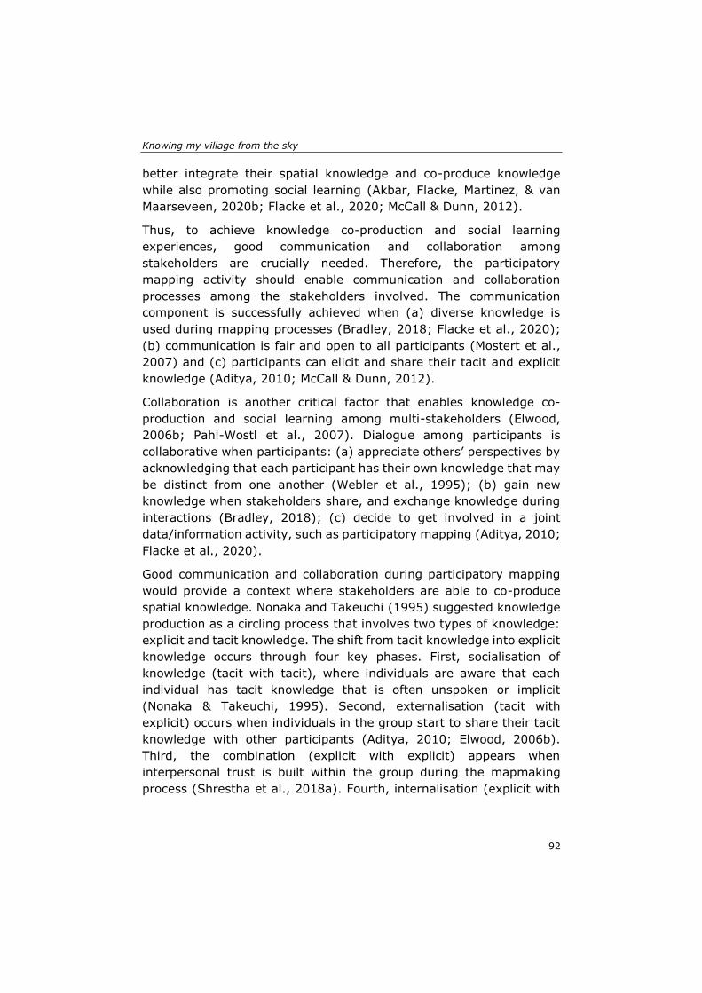
Knowing my village from the sky
92
better integrate their spatial knowledge and co-produce knowledge
while also promoting social learning (Akbar, Flacke, Martinez, & van
Maarseveen, 2020b; Flacke et al., 2020; McCall & Dunn, 2012).
Thus, to achieve knowledge co-production and social learning
experiences, good communication and collaboration among
stakeholders are crucially needed. Therefore, the participatory
mapping activity should enable communication and collaboration
processes among the stakeholders involved. The communication
component is successfully achieved when (a) diverse knowledge is
used during mapping processes (Bradley, 2018; Flacke et al., 2020);
(b) communication is fair and open to all participants (Mostert et al.,
2007) and (c) participants can elicit and share their tacit and explicit
knowledge (Aditya, 2010; McCall & Dunn, 2012).
Collaboration is another critical factor that enables knowledge co-
production and social learning among multi-stakeholders (Elwood,
2006b; Pahl-Wostl et al., 2007). Dialogue among participants is
collaborative when participants: (a) appreciate others’ perspectives by
acknowledging that each participant has their own knowledge that may
be distinct from one another (Webler et al., 1995); (b) gain new
knowledge when stakeholders share, and exchange knowledge during
interactions (Bradley, 2018); (c) decide to get involved in a joint
data/information activity, such as participatory mapping (Aditya, 2010;
Flacke et al., 2020).
Good communication and collaboration during participatory mapping
would provide a context where stakeholders are able to co-produce
spatial knowledge. Nonaka and Takeuchi (1995) suggested knowledge
production as a circling process that involves two types of knowledge:
explicit and tacit knowledge. The shift from tacit knowledge into explicit
knowledge occurs through four key phases. First, socialisation of
knowledge (tacit with tacit), where individuals are aware that each
individual has tacit knowledge that is often unspoken or implicit
(Nonaka & Takeuchi, 1995). Second, externalisation (tacit with
explicit) occurs when individuals in the group start to share their tacit
knowledge with other participants (Aditya, 2010; Elwood, 2006b).
Third, the combination (explicit with explicit) appears when
interpersonal trust is built within the group during the mapmaking
process (Shrestha et al., 2018a). Fourth, internalisation (explicit with
Chapter 4
93
tacit) is achieved when participants are ready to take collective actions
during and after codifying their knowledge (Kahila-Tani et al., 2019).
Another output of the participatory mapping activity is the social
learning experience. This occurs whenever multi-stakeholders with
different interests, influences and perspectives acknowledge their
differences, sit together in a dialogue and then deal with their disputes
and conflicts to achieve a common purpose (Mostert et al., 2007).
Thus, at this stage, participants are expected to gain learning
experiences individually and within a group. Through the learning
environment, participants begin to think systematically and holistically
(Dana & Nelson, 2012; Johnson et al., 2012; Shrestha et al., 2018a),
create collaborative relationships (Schusler et al., 2003; Webler et al.,
1995) and develop a common understanding within the group (Eilola
et al., 2019; Schusler et al., 2003).
To better conceptualise a collaborative spatial learning framework to
support SDGs’ operationalisation, we proposed a framework that would
integrate the spatial knowledge of the stakeholders, as can be seen in
Figure 4–1 below.
Figure 4–1. The collaborative spatial learning framework
The framework is divided into four main stages. Diverse stakeholders
with different types and levels of spatial knowledge and socio-spatial
relationships will work collaboratively in a participatory mapping
workshop. The process stage would allow diverse stakeholders with
distinct spatial knowledge to elicit their spatial knowledge,
communicate and collaborate to produce joint maps in a participatory
Knowing my village from the sky
94
manner. In the next stage, it is expected that stakeholders could
integrate their spatial knowledge through knowledge co-production
and social learning experiences. Therefore, the involvement of relevant
stakeholders as the primary users and beneficiaries of the maps during
the mapmaking process is fundamental. These created maps should fit
the local context (Schlossberg & Shuford, 2005), and mapping activity
should be doable, particularly for participants with little or no
experience with mapping technologies (Eilola et al., 2019). For these
purposes, satellite images will be used in the mapping workshops
because it could help different stakeholders to better understand the
mapped areas while allowing them to use their spatial knowledge
effectively during mapmaking processes (Kienberger, 2014).
4.2 Implementation of the collaborative spatial learning framework
4.2.1 Context
This research was developed in the context of public participation
practices in rural Indonesia, which is known as the Musrenbang. The
Musrenbang is a participatory planning and budgeting practice held
annually to formulate and produce the planning and budgeting
documents (Akbar, Flacke, Martinez, & van Maarseveen, 2020a).
Problems of the Musrenbang include limited knowledge sharing or
integration among stakeholders (Akbar, Flacke, Martinez, & van
Maarseveen, 2020a; Antlöv, 2003), power relations among
participants (Grillos, 2017) and lack of data availability, particularly
visualised geospatial data to support Musrenbang participatory
planning practices (Feruglio & Rifai, 2017).
In Indonesia, the laws 6-year 2014 stated that each village must have
at least three maps, namely, a satellite image map,
facilities/infrastructure map and land-use map. The government needs
these maps for determining legal boundaries, supporting village
development, deciding on village allocation funds (Patmasari, 2019)
and supporting Musrenbang practices (Feruglio & Rifai, 2017). Until
2019, there were only 31,147 villages out of 83,436 villages in
Indonesia that have been delineated in the village boundary map
format (Abidin, 2019). Consequently, in the Musrenbang
Chapter 4
95
implementation, it is hard to find such data used to support the
stakeholders’ discussions. Limited funding for mapping the whole
village, diverse geographical terrain, a lack of expertise and
technologies for producing maps and a lack of coordination among
institutions are the main limitations that inhibit governments from
producing village maps (Ambarwulan et al., 2018).
The framework of this study was implemented by applying
participatory mapping workshops in three villages in the Deli Serdang
district, Indonesia, namely, the Kramat Gajah, Kolam and the Denai
Lama villages. All three villages did not have village maps, only a
village sketch map hanging on the wall of each village office that was
produced between the 1970s–1990s. Since the upper governments
were unable to provide the villages with maps that had an accurate
scale and coordinates, the current sketch village maps were useless to
support decision-making processes in the villages.
4.2.2 Workshop design and implementation
This chapter followed a participatory design approach by involving the
Musrenbang village stakeholders in the design phase and the
implementation of the mapping workshops (Moore & Elliott, 2016;
Vaughn & Jacquez, 2020). In previous steps, activities, such as focus
group discussion, questionnaire and semi-structured interviews with
the village stakeholders, were conducted to elicit their opinions and
ideas about the Musrenbang and the potential of spatial knowledge and
geospatial data to improve the current village Musrenbang practices
(Aguilar et al., 2021; Akbar, Flacke, Martinez, & van Maarseveen,
2020a, 2020b). This involvement allowed the researcher to construct
the collaborative spatial learning framework and to create the design
of the participatory mapping workshops. Based on the results and
findings of the previous work, we decided to capture the local
knowledge of the stakeholders by applying image interpretation
techniques through photo-mapping, supported with a sketch mapping
method. The participants of the workshop drew their knowledge on
existing satellite images using two different methods. They could draw
the maps digitally by using a computer touchscreen and non-digitally
by using analogue, traditional tools, such as transparent layers,
markers and stickers.
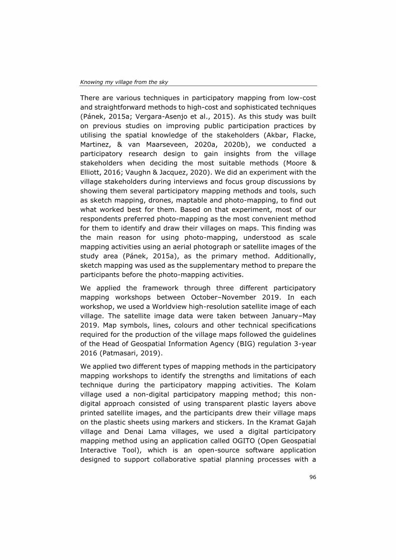
Knowing my village from the sky
96
There are various techniques in participatory mapping from low-cost
and straightforward methods to high-cost and sophisticated techniques
(Pánek, 2015a; Vergara-Asenjo et al., 2015). As this study was built
on previous studies on improving public participation practices by
utilising the spatial knowledge of the stakeholders (Akbar, Flacke,
Martinez, & van Maarseveen, 2020a, 2020b), we conducted a
participatory research design to gain insights from the village
stakeholders when deciding the most suitable methods (Moore &
Elliott, 2016; Vaughn & Jacquez, 2020). We did an experiment with the
village stakeholders during interviews and focus group discussions by
showing them several participatory mapping methods and tools, such
as sketch mapping, drones, maptable and photo-mapping, to find out
what worked best for them. Based on that experiment, most of our
respondents preferred photo-mapping as the most convenient method
for them to identify and draw their villages on maps. This finding was
the main reason for using photo-mapping, understood as scale
mapping activities using an aerial photograph or satellite images of the
study area (Pánek, 2015a), as the primary method. Additionally,
sketch mapping was used as the supplementary method to prepare the
participants before the photo-mapping activities.
We applied the framework through three different participatory
mapping workshops between October–November 2019. In each
workshop, we used a Worldview high-resolution satellite image of each
village. The satellite image data were taken between January–May
2019. Map symbols, lines, colours and other technical specifications
required for the production of the village maps followed the guidelines
of the Head of Geospatial Information Agency (BIG) regulation 3-year
2016 (Patmasari, 2019).
We applied two different types of mapping methods in the participatory
mapping workshops to identify the strengths and limitations of each
technique during the participatory mapping activities. The Kolam
village used a non-digital participatory mapping method; this non-
digital approach consisted of using transparent plastic layers above
printed satellite images, and the participants drew their village maps
on the plastic sheets using markers and stickers. In the Kramat Gajah
village and Denai Lama villages, we used a digital participatory
mapping method using an application called OGITO (Open Geospatial
Interactive Tool), which is an open-source software application
designed to support collaborative spatial planning processes with a
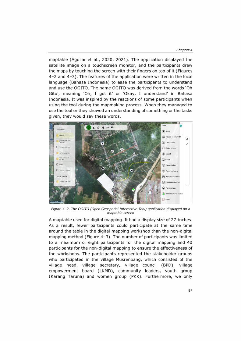
Chapter 4
97
maptable (Aguilar et al., 2020, 2021). The application displayed the
satellite image on a touchscreen monitor, and the participants drew
the maps by touching the screen with their fingers on top of it (Figures
4–2 and 4–3). The features of the application were written in the local
language (Bahasa Indonesia) to ease the participants to understand
and use the OGITO. The name OGITO was derived from the words ‘Oh
Gitu’, meaning ‘Oh, I got it’ or ‘Okay, I understand’ in Bahasa
Indonesia. It was inspired by the reactions of some participants when
using the tool during the mapmaking process. When they managed to
use the tool or they showed an understanding of something or the tasks
given, they would say these words.
Figure 4–2. The OGITO (Open Geospatial Interactive Tool) application displayed on a maptable screen
A maptable used for digital mapping. It had a display size of 27-inches.
As a result, fewer participants could participate at the same time
around the table in the digital mapping workshop than the non-digital
mapping method (Figure 4–3). The number of participants was limited
to a maximum of eight participants for the digital mapping and 40
participants for the non-digital mapping to ensure the effectiveness of
the workshops. The participants represented the stakeholder groups
who participated in the village Musrenbang, which consisted of the
village head, village secretary, village council (BPD), village
empowerment board (LKMD), community leaders, youth group
(Karang Taruna) and women group (PKK). Furthermore, we only
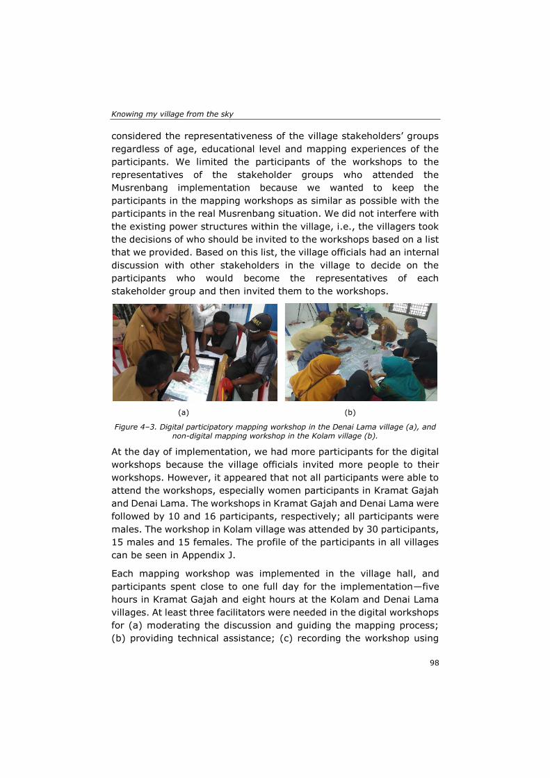
Knowing my village from the sky
98
considered the representativeness of the village stakeholders’ groups
regardless of age, educational level and mapping experiences of the
participants. We limited the participants of the workshops to the
representatives of the stakeholder groups who attended the
Musrenbang implementation because we wanted to keep the
participants in the mapping workshops as similar as possible with the
participants in the real Musrenbang situation. We did not interfere with
the existing power structures within the village, i.e., the villagers took
the decisions of who should be invited to the workshops based on a list
that we provided. Based on this list, the village officials had an internal
discussion with other stakeholders in the village to decide on the
participants who would become the representatives of each
stakeholder group and then invited them to the workshops.
(a) (b)
Figure 4–3. Digital participatory mapping workshop in the Denai Lama village (a), and non-digital mapping workshop in the Kolam village (b).
At the day of implementation, we had more participants for the digital
workshops because the village officials invited more people to their
workshops. However, it appeared that not all participants were able to
attend the workshops, especially women participants in Kramat Gajah
and Denai Lama. The workshops in Kramat Gajah and Denai Lama were
followed by 10 and 16 participants, respectively; all participants were
males. The workshop in Kolam village was attended by 30 participants,
15 males and 15 females. The profile of the participants in all villages
can be seen in Appendix J.
Each mapping workshop was implemented in the village hall, and
participants spent close to one full day for the implementation—five
hours in Kramat Gajah and eight hours at the Kolam and Denai Lama
villages. At least three facilitators were needed in the digital workshops
for (a) moderating the discussion and guiding the mapping process;
(b) providing technical assistance; (c) recording the workshop using
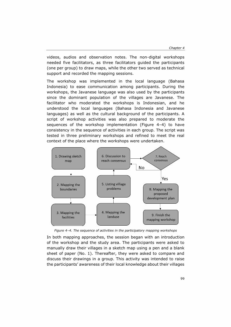
Chapter 4
99
videos, audios and observation notes. The non-digital workshops
needed five facilitators, as three facilitators guided the participants
(one per group) to draw maps, while the other two served as technical
support and recorded the mapping sessions.
The workshop was implemented in the local language (Bahasa
Indonesia) to ease communication among participants. During the
workshops, the Javanese language was also used by the participants
since the dominant population of the villages are Javanese. The
facilitator who moderated the workshops is Indonesian, and he
understood the local languages (Bahasa Indonesia and Javanese
languages) as well as the cultural background of the participants. A
script of workshop activities was also prepared to moderate the
sequences of the workshop implementation (Figure 4–4) to have
consistency in the sequence of activities in each group. The script was
tested in three preliminary workshops and refined to meet the real
context of the place where the workshops were undertaken.
Figure 4–4. The sequence of activities in the participatory mapping workshops
In both mapping approaches, the session began with an introduction
of the workshop and the study area. The participants were asked to
manually draw their villages in a sketch map using a pen and a blank
sheet of paper (No. 1). Thereafter, they were asked to compare and
discuss their drawings in a group. This activity was intended to raise
the participants’ awareness of their local knowledge about their villages
Knowing my village from the sky
100
so they would be more prepared when doing the real drawing using the
mapping tools. The moderator gave a short explanation about the steps
and mapping tools and then guided the participants in each mapping
session (No. 2–4). Again, we asked the participants to identify and
write down three main village problems individually (No. 5), followed
by a group discussion to formulate possible development plans to solve
the problems (No. 6). Thereafter, there was a group discussion to reach
a consensus on five to ten proposed development plans (No. 6–7).
Then, they were asked to draw the proposed development plans into
the map (No. 8). At the end of the session, a short group discussion
was conducted to reflect on their learning experiences and to complete
a questionnaire (Appendix K).
4.2.3 Workshop analysis
We used a list of assessment criteria and means of verification to
evaluate the implementation of mapping workshops in integrating the
participants’ spatial knowledge by enabling communication,
collaboration, knowledge co-production and social learning among the
participants (Table 4–1). Data for analysis were collected from four
sources, namely, the village maps produced during the mapping
session, observations (through voice recording, video recording and
observation notes), a short-group discussion immediately after the
workshop, a post-session questionnaire and semi-structured interviews
with selected participants after the workshops.
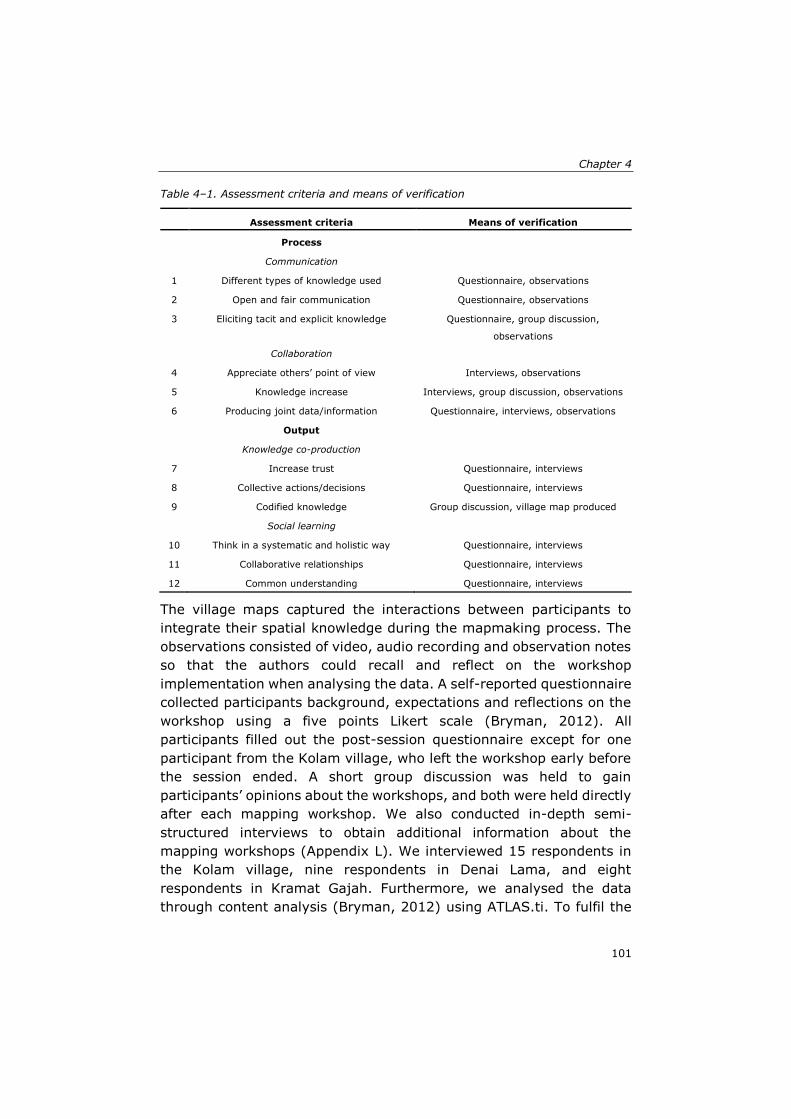
Chapter 4
101
Table 4–1. Assessment criteria and means of verification
Assessment criteria Means of verification
Process
Communication
1 Different types of knowledge used Questionnaire, observations
2 Open and fair communication Questionnaire, observations
3 Eliciting tacit and explicit knowledge Questionnaire, group discussion,
observations
Collaboration
4 Appreciate others’ point of view Interviews, observations
5 Knowledge increase Interviews, group discussion, observations
6 Producing joint data/information Questionnaire, interviews, observations
Output
Knowledge co-production
7 Increase trust Questionnaire, interviews
8 Collective actions/decisions Questionnaire, interviews
9 Codified knowledge Group discussion, village map produced
Social learning
10 Think in a systematic and holistic way Questionnaire, interviews
11 Collaborative relationships Questionnaire, interviews
12 Common understanding Questionnaire, interviews
The village maps captured the interactions between participants to
integrate their spatial knowledge during the mapmaking process. The
observations consisted of video, audio recording and observation notes
so that the authors could recall and reflect on the workshop
implementation when analysing the data. A self-reported questionnaire
collected participants background, expectations and reflections on the
workshop using a five points Likert scale (Bryman, 2012). All
participants filled out the post-session questionnaire except for one
participant from the Kolam village, who left the workshop early before
the session ended. A short group discussion was held to gain
participants’ opinions about the workshops, and both were held directly
after each mapping workshop. We also conducted in-depth semi-
structured interviews to obtain additional information about the
mapping workshops (Appendix L). We interviewed 15 respondents in
the Kolam village, nine respondents in Denai Lama, and eight
respondents in Kramat Gajah. Furthermore, we analysed the data
through content analysis (Bryman, 2012) using ATLAS.ti. To fulfil the
Knowing my village from the sky
102
European General Data Protection Regulation-GDPR (https://gdpr-
info.eu/), we always asked participants for their informed consent for
using the audios, videos, pictures and questionnaire for research and
publications before the data collection (Aguilar et al., 2020).
4.3 Insights from the participatory mapping workshops
The presentation of the results has been divided into two parts. First,
in the process stage, we discussed communication and collaboration
among stakeholders. Second, we discussed knowledge co-production
and social learning processes in the output stage.
4.3.1 Process stage: Enabling communication and collaboration
Our findings showed that both approaches—the digital and non-digital
workshops—supported communication and collaboration among the
participants. The sketch mapping technique conducted at the beginning
of the workshops was useful to prepare the participants before
engaging in the scale mapping activity. It allowed participants to freely
draw sketches of their village and to compare their drawings with their
peers, and thus triggered communication and collaboration among
them. The participants enthusiastically tried to combine their sketch
maps to form their village, which brought positive influence to the next
stage when they started to draw on the satellite images. The sketch
map built their awareness about their local knowledge and prepared
them mentally when engaging with the photomap activities.
The satellite images used in both workshops functioned as a platform
for the participants to explore and navigate themselves in their
villages. They were helpful by stimulating communication among
participants, particularly when exploring or clarifying specific places
around the villages. The results of the questionnaire indicated that both
workshops (digital and non-digital methods) were quite useful to
provide fair and open communication among participants (Table 4–2).
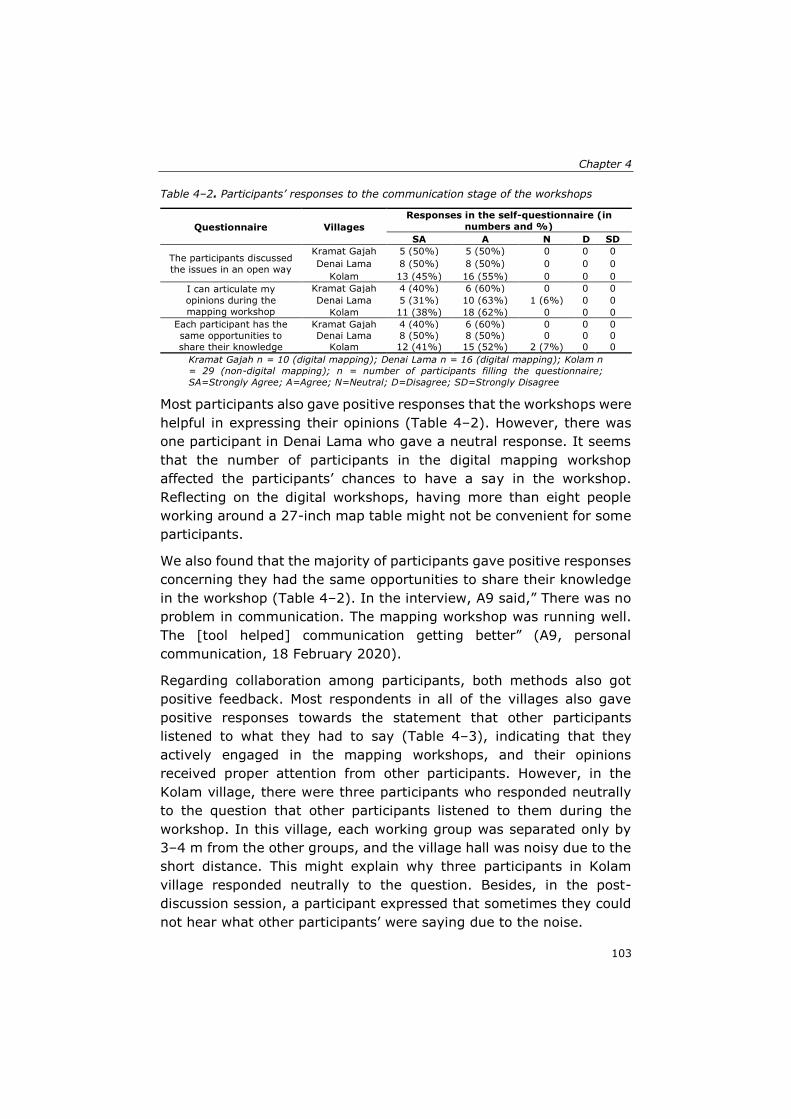
Chapter 4
103
Table 4–2. Participants’ responses to the communication stage of the workshops
Questionnaire Villages
Responses in the self-questionnaire (in
numbers and %)
SA A N D SD
The participants discussed
the issues in an open way
Kramat Gajah 5 (50%) 5 (50%) 0 0 0
Denai Lama 8 (50%) 8 (50%) 0 0 0
Kolam 13 (45%) 16 (55%) 0 0 0
I can articulate my
opinions during the
mapping workshop
Kramat Gajah 4 (40%) 6 (60%) 0 0 0
Denai Lama 5 (31%) 10 (63%) 1 (6%) 0 0
Kolam 11 (38%) 18 (62%) 0 0 0
Each participant has the
same opportunities to
share their knowledge
Kramat Gajah 4 (40%) 6 (60%) 0 0 0
Denai Lama 8 (50%) 8 (50%) 0 0 0
Kolam 12 (41%) 15 (52%) 2 (7%) 0 0
Kramat Gajah n = 10 (digital mapping); Denai Lama n = 16 (digital mapping); Kolam n
= 29 (non-digital mapping); n = number of participants filling the questionnaire;
SA=Strongly Agree; A=Agree; N=Neutral; D=Disagree; SD=Strongly Disagree
Most participants also gave positive responses that the workshops were
helpful in expressing their opinions (Table 4–2). However, there was
one participant in Denai Lama who gave a neutral response. It seems
that the number of participants in the digital mapping workshop
affected the participants’ chances to have a say in the workshop.
Reflecting on the digital workshops, having more than eight people
working around a 27-inch map table might not be convenient for some
participants.
We also found that the majority of participants gave positive responses
concerning they had the same opportunities to share their knowledge
in the workshop (Table 4–2). In the interview, A9 said,” There was no
problem in communication. The mapping workshop was running well.
The [tool helped] communication getting better” (A9, personal
communication, 18 February 2020).
Regarding collaboration among participants, both methods also got
positive feedback. Most respondents in all of the villages also gave
positive responses towards the statement that other participants
listened to what they had to say (Table 4–3), indicating that they
actively engaged in the mapping workshops, and their opinions
received proper attention from other participants. However, in the
Kolam village, there were three participants who responded neutrally
to the question that other participants listened to them during the
workshop. In this village, each working group was separated only by
3–4 m from the other groups, and the village hall was noisy due to the
short distance. This might explain why three participants in Kolam
village responded neutrally to the question. Besides, in the post-
discussion session, a participant expressed that sometimes they could
not hear what other participants’ were saying due to the noise.
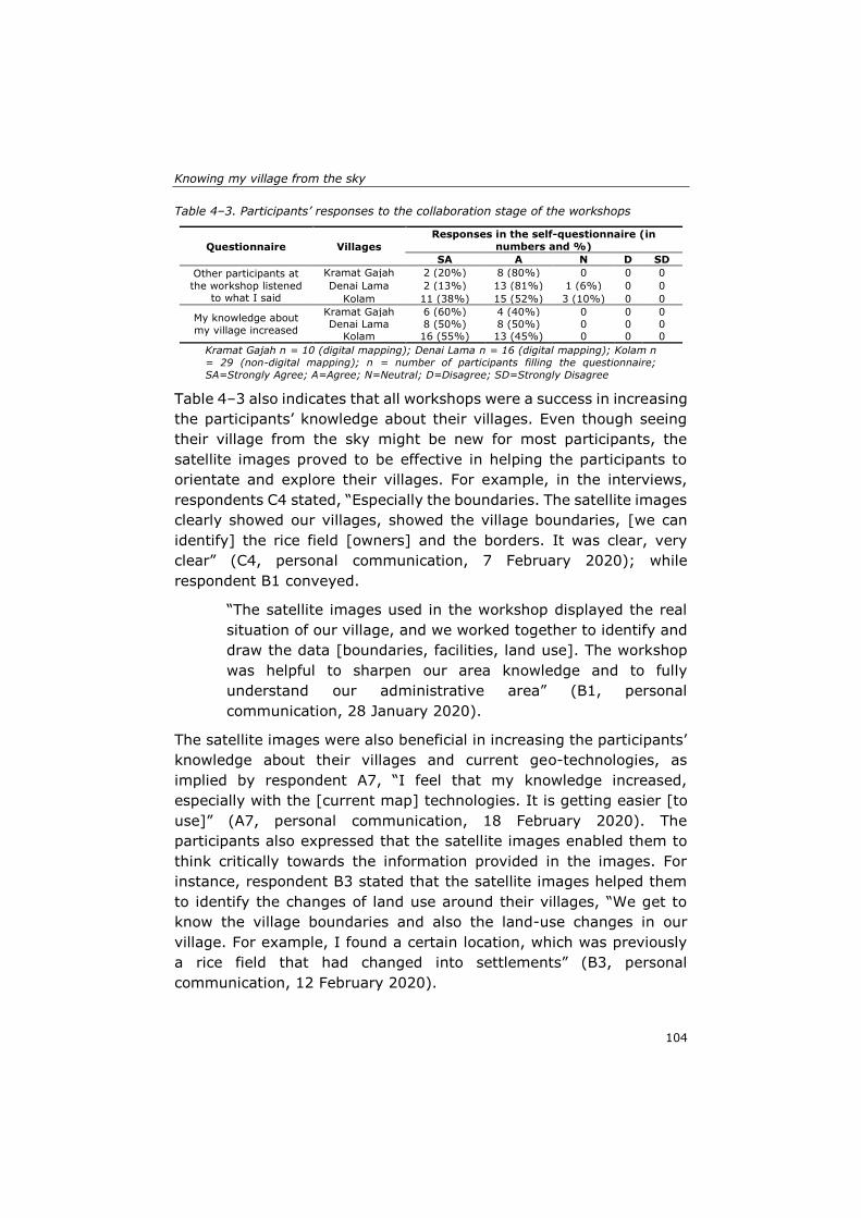
Knowing my village from the sky
104
Table 4–3. Participants’ responses to the collaboration stage of the workshops
Questionnaire Villages
Responses in the self-questionnaire (in
numbers and %)
SA A N D SD
Other participants at
the workshop listened to what I said
Kramat Gajah 2 (20%) 8 (80%) 0 0 0
Denai Lama 2 (13%) 13 (81%) 1 (6%) 0 0
Kolam 11 (38%) 15 (52%) 3 (10%) 0 0
My knowledge about
my village increased
Kramat Gajah 6 (60%) 4 (40%) 0 0 0
Denai Lama 8 (50%) 8 (50%) 0 0 0 Kolam 16 (55%) 13 (45%) 0 0 0
Kramat Gajah n = 10 (digital mapping); Denai Lama n = 16 (digital mapping); Kolam n
= 29 (non-digital mapping); n = number of participants filling the questionnaire;
SA=Strongly Agree; A=Agree; N=Neutral; D=Disagree; SD=Strongly Disagree
Table 4–3 also indicates that all workshops were a success in increasing
the participants’ knowledge about their villages. Even though seeing
their village from the sky might be new for most participants, the
satellite images proved to be effective in helping the participants to
orientate and explore their villages. For example, in the interviews,
respondents C4 stated, “Especially the boundaries. The satellite images
clearly showed our villages, showed the village boundaries, [we can
identify] the rice field [owners] and the borders. It was clear, very
clear” (C4, personal communication, 7 February 2020); while
respondent B1 conveyed.
“The satellite images used in the workshop displayed the real
situation of our village, and we worked together to identify and
draw the data [boundaries, facilities, land use]. The workshop
was helpful to sharpen our area knowledge and to fully
understand our administrative area” (B1, personal
communication, 28 January 2020).
The satellite images were also beneficial in increasing the participants’
knowledge about their villages and current geo-technologies, as
implied by respondent A7, “I feel that my knowledge increased,
especially with the [current map] technologies. It is getting easier [to
use]” (A7, personal communication, 18 February 2020). The
participants also expressed that the satellite images enabled them to
think critically towards the information provided in the images. For
instance, respondent B3 stated that the satellite images helped them
to identify the changes of land use around their villages, “We get to
know the village boundaries and also the land-use changes in our
village. For example, I found a certain location, which was previously
a rice field that had changed into settlements” (B3, personal
communication, 12 February 2020).
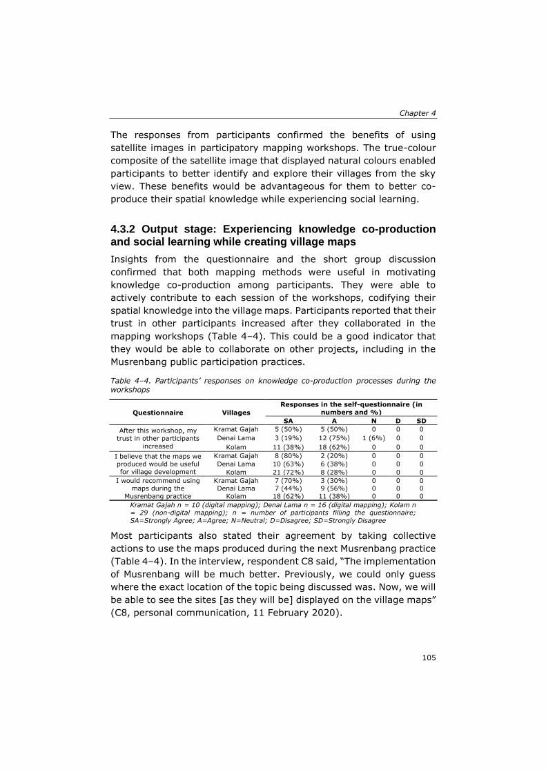
Chapter 4
105
The responses from participants confirmed the benefits of using
satellite images in participatory mapping workshops. The true-colour
composite of the satellite image that displayed natural colours enabled
participants to better identify and explore their villages from the sky
view. These benefits would be advantageous for them to better co-
produce their spatial knowledge while experiencing social learning.
4.3.2 Output stage: Experiencing knowledge co-production and social learning while creating village maps
Insights from the questionnaire and the short group discussion
confirmed that both mapping methods were useful in motivating
knowledge co-production among participants. They were able to
actively contribute to each session of the workshops, codifying their
spatial knowledge into the village maps. Participants reported that their
trust in other participants increased after they collaborated in the
mapping workshops (Table 4–4). This could be a good indicator that
they would be able to collaborate on other projects, including in the
Musrenbang public participation practices.
Table 4–4. Participants’ responses on knowledge co-production processes during the workshops
Questionnaire Villages
Responses in the self-questionnaire (in
numbers and %)
SA A N D SD
After this workshop, my
trust in other participants
increased
Kramat Gajah 5 (50%) 5 (50%) 0 0 0
Denai Lama 3 (19%) 12 (75%) 1 (6%) 0 0
Kolam 11 (38%) 18 (62%) 0 0 0
I believe that the maps we produced would be useful
for village development
Kramat Gajah 8 (80%) 2 (20%) 0 0 0
Denai Lama 10 (63%) 6 (38%) 0 0 0
Kolam 21 (72%) 8 (28%) 0 0 0
I would recommend using maps during the
Musrenbang practice
Kramat Gajah 7 (70%) 3 (30%) 0 0 0 Denai Lama 7 (44%) 9 (56%) 0 0 0
Kolam 18 (62%) 11 (38%) 0 0 0
Kramat Gajah n = 10 (digital mapping); Denai Lama n = 16 (digital mapping); Kolam n = 29 (non-digital mapping); n = number of participants filling the questionnaire;
SA=Strongly Agree; A=Agree; N=Neutral; D=Disagree; SD=Strongly Disagree
Most participants also stated their agreement by taking collective
actions to use the maps produced during the next Musrenbang practice
(Table 4–4). In the interview, respondent C8 said, “The implementation
of Musrenbang will be much better. Previously, we could only guess
where the exact location of the topic being discussed was. Now, we will
be able to see the sites [as they will be] displayed on the village maps”
(C8, personal communication, 11 February 2020).
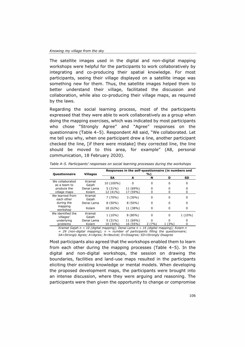
Knowing my village from the sky
106
The satellite images used in the digital and non-digital mapping
workshops were helpful for the participants to work collaboratively by
integrating and co-producing their spatial knowledge. For most
participants, seeing their village displayed on a satellite image was
something new for them. Thus, the satellite images helped them to
better understand their village, facilitated the discussion and
collaboration, while also co-producing their village maps, as required
by the laws.
Regarding the social learning process, most of the participants
expressed that they were able to work collaboratively as a group when
doing the mapping exercises, which was indicated by most participants
who chose “Strongly Agree” and “Agree” responses on the
questionnaire (Table 4–5). Respondent A8 said, “We collaborated. Let
me tell you why, when one participant drew a line, another participant
checked the line, [if there were mistake] they corrected line, the line
should be moved to this area, for example” (A8, personal
communication, 18 February 2020).
Table 4–5. Participants’ responses on social learning processes during the workshops
Questionnaire Villages
Responses in the self-questionnaire (in numbers and
%)
SA A N D SD
We collaborated
as a team to
produce the
village maps
Kramat
Gajah 10 (100%) 0 0 0 0
Denai Lama 5 (31%) 11 (69%) 0 0 0
Kolam 12 (41%) 17 (59%) 0 0 0
We learned from
each other
during the
mapping workshop
Kramat
Gajah 7 (70%) 3 (30%) 0 0 0
Denai Lama 8 (50%) 8 (50%) 0 0 0
Kolam 18 (62%) 11 (38%) 0 0 0
We identified the villages’
underlying
problems
Kramat Gajah
1 (10%) 8 (80%) 0 0 1 (10%)
Denai Lama 5 (31%) 11 (69%) 0 0 0
Kolam 10 (34%) 16 (55%) 2 (7%) 1 (3%) 0
Kramat Gajah n = 10 (digital mapping); Denai Lama n = 16 (digital mapping); Kolam n
= 29 (non-digital mapping); n = number of participants filling the questionnaire;
SA=Strongly Agree; A=Agree; N=Neutral; D=Disagree; SD=Strongly Disagree
Most participants also agreed that the workshops enabled them to learn
from each other during the mapping processes (Table 4–5). In the
digital and non-digital workshops, the session on drawing the
boundaries, facilities and land-use maps resulted in the participants
eliciting their existing knowledge or mental models. When developing
the proposed development maps, the participants were brought into
an intense discussion, where they were arguing and reasoning. The
participants were then given the opportunity to change or compromise
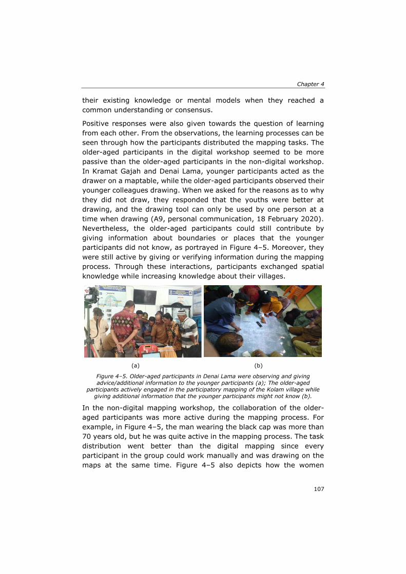
Chapter 4
107
their existing knowledge or mental models when they reached a
common understanding or consensus.
Positive responses were also given towards the question of learning
from each other. From the observations, the learning processes can be
seen through how the participants distributed the mapping tasks. The
older-aged participants in the digital workshop seemed to be more
passive than the older-aged participants in the non-digital workshop.
In Kramat Gajah and Denai Lama, younger participants acted as the
drawer on a maptable, while the older-aged participants observed their
younger colleagues drawing. When we asked for the reasons as to why
they did not draw, they responded that the youths were better at
drawing, and the drawing tool can only be used by one person at a
time when drawing (A9, personal communication, 18 February 2020).
Nevertheless, the older-aged participants could still contribute by
giving information about boundaries or places that the younger
participants did not know, as portrayed in Figure 4–5. Moreover, they
were still active by giving or verifying information during the mapping
process. Through these interactions, participants exchanged spatial
knowledge while increasing knowledge about their villages.
(a) (b)
Figure 4–5. Older-aged participants in Denai Lama were observing and giving advice/additional information to the younger participants (a); The older-aged
participants actively engaged in the participatory mapping of the Kolam village while giving additional information that the younger participants might not know (b).
In the non-digital mapping workshop, the collaboration of the older-
aged participants was more active during the mapping process. For
example, in Figure 4–5, the man wearing the black cap was more than
70 years old, but he was quite active in the mapping process. The task
distribution went better than the digital mapping since every
participant in the group could work manually and was drawing on the
maps at the same time. Figure 4–5 also depicts how the women
Knowing my village from the sky
108
participants actively engaged in the mapping process of the Kolam
village, while in the other two villages with digital mapping workshops,
women’s involvement could not be investigated due to no women
participants attending the workshops.
The questionnaire also revealed that most participants agreed that the
workshops were helpful in assisting them in identifying the villages’
main problems (Table 4–5). However, there were four participants who
did not show agreement—one participant in Kramat Gajah and three
participants in the Kolam village. In the discussion and interviews, it
was revealed that participants were in disagreement because they
were confused about the administrative village boundaries. In Kramat
Gajah, participants had an intense discussion about the vast plantation
area along the river bank. Even though the area is located in the
Kramat Gajah village, the village has no rights because the river and
the banks are under the control of the central government, as stated
in the laws. In the Kolam village, the participants discussed the legal
boundaries of a neighbourhood. The area is out of their administration,
but all the citizens who live in the area are administratively registered
as citizens of the Kolam village. They cannot make decisions about the
boundaries, as they have to consult with external parties who were not
involved in the workshops, such as the upper government and the
adjacent villages. Even when facing confusion, these findings showed
that the administrative boundaries play a critical part in assisting the
participants in identifying their villages’ underlying problems. The
discussions that arose from the village boundaries also indicated that
the workshops helped participants think systematically beyond the
tasks that we provided. The information displayed on the satellite
image was powerful in triggering discussions among the stakeholders.
Moreover, the mapping workshops were helpful to encourage
participants to critically reflect on sustainable development agenda
when thinking and acting at the local-village scale.
Chapter 4
109
4.4 Discussion
Proper geospatial data is urgently needed to achieve and monitor the
SDGs implementation (Scott & Rajabifard, 2017). The UN-GGIM
promotes this urgent need by encouraging countries to improve their
geospatial management strategies and to provide accurate and reliable
geospatial data for supporting the development processes (UN-GGIM,
2018). Maps, as the visualised spatial data, play an essential role to
address the complex and interlinked issues of SDGs implementation
(Kent et al., 2020). However, the application of SDGs is often
confronted with problems of contextualisation, concerning global goals,
targets and indicators. The operationalisation at the national level is
quite challenging, while at the local level, including rural areas,
localising the SDGs concept into actions is more challenging (Giuliani
et al., 2020; Saner et al., 2019; Scott & Rajabifard, 2017).
Indonesia, as a country adopting the SDGs in its national policies, faces
the same circumstances. The government has launched the One Map
Policy aiming to fulfil the geospatial data availability at the national,
regional, district/cities and rural levels while supporting the SDGs
implementation in Indonesia (Abidin, 2019). Even though village maps
are mandated by the laws, up to 2019, there was only about 37 per
cent of the village boundaries, which have been delineated (Patmasari,
2019). This percentage should be a warning for the governments to
take substantial actions to accelerate the village map production, as
time is ticking, and SDGs will end in a few years.
The government, through the Geospatial Information Agency (BIG),
has published regulation 3-year 2016 as the guidelines for the village
map production. Moreover, the government has also encouraged
citizens to contribute actively in the mapmaking processes by
launching an application of PetaKita (https://petakita.big.go.id/) to
enable citizens to participate in mapping their areas. The utilisation of
the app was less successful in engaging citizens due to sophisticated
map features, low intuitivity and user-friendliness as it needed to be
connected to the internet when using it (Perdana & Ostermann, 2019).
In contrast, other participatory mapping initiatives, which facilitate
people to have direct interactions in the mapmaking processes, have
better results to engage people to contribute (Aditya, 2010; Corbett,
2009; Corbett & Keller, 2005). As the SDGs place a specific emphasis
on the participatory process, thus encouraging the production of
Knowing my village from the sky
110
geospatial data in a participatory manner, the contextualisation of
global and national geospatial data targets into a local-rural scale is
necessary. Developing a collaborative spatial learning framework,
which has an impact on SDGs, notably on target 11.3 and 16.7, is
urgently needed. For this reason, the participatory mapping workshops
used in this chapter emphasised on the process of communication,
collaboration, knowledge co-production and social learning during the
mapmaking processes.
Our findings showed that the mapping workshops gave significant
positive outputs to pursue the SDGs operationalisation at the rural
scale while achieving the SDGs and national targets to have proper
village maps aiming for sustainable development processes. The
workshops also helped village stakeholders to better understand
sustainable development issues in the local context. Discussion about
waste management, for instance, occurred during the mapmaking
processes, although this was not listed in the mapping tasks. Some
participants also became aware of the land-use changes in their
villages. They criticised the changes by discussing the significant
conversion of agricultural areas into settlement areas, which could
endanger their main livelihood and thus increase poverty (SDG 1).
They also had an intense discussion about the water allocation for their
rice fields that might affect not only the farmers in their villages but
also farmers in other villages, which used the same water resources
(SDG 6). All these topics of discussions might seem simple and with
moderate impacts for reaching the SDGs agenda. Still, in reality, it
clearly shows how the grass-root citizens react to the SDGs issues, and
how they gain awareness about the SDGs, and why it is crucial to apply
village development in a sustainable way at the local context. By
putting this information and knowledge on maps, the villagers, as the
smallest social structure within the governmental hierarchies, have
made their contribution to achieving the SDGs agenda (Kent et al.,
2020).
Our findings also showed that in the local context, such as rural areas,
the digital and non-digital participatory mapping approaches facilitated
communication and collaboration among the participants. Moreover,
the methods were also useful in integrating the spatial knowledge of
the stakeholders while also supporting knowledge co-production and
social learning processes. Our results were similar to other studies that
showed how the non-digital and digital media of mapping were helpful
Chapter 4
111
in increasing the spatial understanding of the participants (Collins,
2018; Cunningham, 2005; Rambaldi et al., 2006).
Each mapping method has its own strengths and limitations. Non-
digital mapping was powerful in engaging more people to participate,
as people with less or no prior experience with digital geo-technologies
were able to engage in the process (Eilola et al., 2019). The materials
needed for the workshops were less expensive and easy to prepare.
However, this method was complicated during the post-processing
stage because the researcher needed to work harder to manually
convert all the drawn objects from the transparent plastic layer into
the digital map format. This method also required a large room for
implementation and more facilitators to guide the processes.
In contrast, digital mapping was easy for the map post-processing
stage. Fewer mistakes were made because the objects drawn by
participants were more comfortable to interpret by the researcher. This
method only required a small room and fewer facilitators for
implementation. The drawbacks were that fewer people were able to
engage due to the size limitations of the computer screen. The
development of the mapping application needed particular expertise
and was not easy to handle. The technology barrier could also be
challenging, particularly for participants with a lack of knowledge or
experience with geo-technologies. We should acknowledge that the
potential strengths and limitations of using specific mapping
approaches are highly context-dependent, beneficial in one situation,
but maybe not as helpful in other contexts (Flacke et al., 2020; Kahila-
Tani et al., 2019; Sutanta et al., 2013). Despite the successful
implementation of the mapping workshops in this study, some issues
need to be adequately managed to achieve excellent participatory
mapping workshops.
When selecting a participatory mapping method to use, Corbett (2009)
recommended certain factors to be considered, namely, how accurate
the final product needs to be; how it will be utilised; the available
resources for the mapmaking process. In this study, we chose to use
the photo-mapping method by drawing the maps on high-resolution
satellite images. The use of high-resolution satellite images for the
mapping workshops helped the participants to better engage in the
mapping processes while ensuring the maps were produced accurately.
The satellite images use a true-colour composite that can display
Knowing my village from the sky
112
objects in the same, natural colours that human eyes would typically
see them. Thus, the natural colours helped the participants interpret
the information provided on the satellite images (Aditya, 2010;
Kienberger, 2014). Using a georeferenced image, such as a satellite
image in the participatory mapping workshops, offers more details of
the landscape of the villages; therefore, it enhances the participants’
spatial and functional understanding of their village areas, even for
participants with no previous mapping experiences (Eilola et al., 2019;
Giuliani et al., 2020; Pánek, 2015a). In this study, the satellite images
increased the participants’ understanding of their village, the village
boundaries, existing land use and the village infrastructure/facilities.
It is also essential to use the most suitable map scale during the
workshops since it might affect the participants’ engagement in
mapping processes. For digital mapping, the participants can apply the
zooming in-out feature to get the most suitable scale when drawing;
however, this is not possible in the non-digital mapping workshop. In
the non-digital workshop, 1:2500 printed satellite images were used.
Using the scale maps drawn on existing scaled satellite images helped
the participants interpret the objects more accurately and oriented
themselves while viewing the satellite images (Vergara-Asenjo et al.,
2015). The scale map drawing was also helpful for post-processing to
transform the manual hand-drawing maps into digital maps.
The requirements imposed by the regulations, to some extent, could
inhibit the participants from expressing their tacit knowledge. The strict
technical specifications required by regulation 3-year 2016, published
by the Geospatial Information Agency (BIG), often created confusion
for the participants. For instance, when they wanted to draw a specific
object on the satellite images, they had to choose the standard lines,
symbols and colours imposed by the regulation. The participants often
used their local spatial knowledge by expressing uncertain boundaries,
shapes or symbolic interpretations when describing the village
landscapes (McCall & Dunn, 2012). By only allowing them to use the
standard guidelines, we may lose diverse, valuable, local knowledge
and the original information owned by the local people (Rambaldi et
al., 2006). Therefore, the mapping method should provide support for
the participants to express local knowledge in their own way or even
in their own local language. Wartmann and Purves (2017) underlined
this issue. They argued that participatory mapping approaches should
enable communities to use their local language during the mapmaking
Chapter 4
113
process. Further, the map produced should also adopt the local
language of the communities to better represent the localness of the
information captured on the maps. We were also confronted with this
issue. Translating or capturing the tacit knowledge into spatial
knowledge depicted on a map was also a tricky part in each workshop.
Our digital and non-digital mapping workshops applied sketch mapping
to enable participants to better elicit their tacit knowledge. The sketch
mapping was useful for facilitating participants to draw a rich picture
that might not be available in the mapping tool features (Shrestha et
al., 2017). Sketch mapping method provides participants with free
choices to draw and visualise their desired spatial objects
(Cunningham, 2005; Manrique-Sancho et al., 2018). Rambaldi (2005)
stated that the selection of features used in mapmaking processes is a
crucial success of participatory mapping approaches since it would
determine how the local knowledge is captured or drawn, and
stimulating the sense of ownership and the benefits of maps among
the communities. As a result, the maps produced by the communities
would be more useful for the local use and understandable to the local
communities. Thus, an amendment of current government regulations
that allows local communities to draw their tacit knowledge into
participatory maps should be a priority for governments, especially
when they are aiming at reaching the SDGs targets in public
participation practices.
The success of participatory mapping during the digital and non-digital
workshops requires excellent facilitation. The facilitator should guide
and create an inclusive workshop while inviting all participants to
actively engage in each mapping session. The facilitator needs to
provide an inclusive mapping process, where diverse participants with
little or no mapping experiences are involved. To reach an inclusive
process, the facilitator needs to use proper instructions with
terminologies that are understandable for all participants (Eilola et al.,
2019; Mostert et al., 2007). The number of participants also influences
the implementation of the participatory mapping process. The more
participants engaged in a workshop, the more complex the process
could become. The number of participants highly depends on the
context and the methods used for the mapping workshops. Moreover,
the purpose of the mapping workshop, types of spatial data to be
produced and the level of accuracy of the expected results have to be
clear when selecting the participants (Brown & Kyttä, 2014; Chambers,
Knowing my village from the sky
114
2006). It is important to note that in a participatory mapping process,
the representativeness of key stakeholders as participants is
indispensable (Aditya, 2010). However, involving all relevant
stakeholders in the village area does not guarantee that the quality of
the maps produced will increase. In this study, there were many
participants, especially younger participants, who had a lack of
knowledge about their villages before the workshop, indicating less
local knowledge that could be captured during the mapping process.
They acquired new knowledge about the village area from the older-
aged participants who were more passive during the mapping process.
Although the elders tended to be more passive during the mapping
process, they were knowledgeable and became the primary source of
knowledge about the village areas. Conversely, the elders learned how
to use the mapping tool from the younger participants. This mutual
learning experience among the younger and older participants clearly
showed how knowledge co-production and social learning occurred
during the mapping process.
The knowledge co-production process was also evident when
participants worked collaboratively to codify their spatial knowledge
into village maps. If we refer to Nonaka and Takeuchi’s knowledge co-
production process (1995), the participants were actively using their
tacit and explicit spatial knowledge. The participants discussed their
tacit knowledge to other participants when they started to
communicate during the initial stage of the workshop. They
externalised their tacit spatial knowledge through a sketch mapping
exercise. The combination was evident when they compared their
sketch drawing results and started to draw on the satellite images.
Furthermore, they internalised their spatial knowledge by coming to a
consensus and learning new knowledge during the discussions. Their
trust for the other participants increased when they took collective
action and reached an agreement over the proposed development
map. This finding proved that a stakeholder-driven approach, such as
participatory mapping, is useful to better understand the region and
stimulate the co-production of knowledge (Burdon et al., 2019).
The social learning process was also evident when the participants
started to understand that they could work collaboratively to produce
their own village maps. The experience enabled them to collaborate on
other future projects. Single-loop and double-loop learning were also
evident when the participants gradually acquired new knowledge while
Chapter 4
115
transforming their initial values or views (Muro & Jeffrey, 2012;
Shrestha et al., 2018a). For instance, single-loop learning occurred
when participants felt a common understanding of needing to use maps
when discussing village problems. The participants started to think
systematically and holistically beyond the tasks given during the
mapping workshops. In the Kolam village, participants discussed the
solid-waste management problem during the mapping process, even
though waste management was not listed in the task sequences
prepared by the facilitators. Some participants also expressed their
satisfaction in the interview, where the exact width of the area for each
land use could now be measured accurately in their new village maps.
Again, these findings clearly showed that participants had started to
reflect on sustainability issues when discussing the development
processes in their villages. The learning experiences are an example of
how rural citizens could also contribute to the upper or central
governments’ efforts to achieve the SDGs.
Double-loop learning occurred when the participants started to realise
that the maps could be used for other developmental purposes. Instead
of having only three categories of maps required by regulations, they
co-created other maps that they needed. The Kolam village made the
neighbourhood maps and distributed the maps to each head of the
neighbourhood. The head of the neighbourhoods was now responsible
for updating the maps with data, such as the names of family members
in each household, new or broken facilities or distribution of social
safety nets in the neighbourhoods. The Denai Lama village created a
farmers’ group map to display the distribution of land allocation for
each group. Thus, the visualised geospatial data and learning
experiences enabled the stakeholders to better formulate their
decisions and actions (Eilola et al., 2019).
In this study, the method was implemented in one full day, reducing
the field day and cost of implementing a participatory mapping
workshop. It is important to note that an all-day workshop requires
careful preparation, skilful facilitation, suitable methodologies,
sufficient allocated time and manageable tasks (Corbett, 2009; Corbett
et al., 2016). However, the applicability of the participatory mapping
method in different contexts should consider the livelihood of the
participants, cultural settings, as well as the landscape environments
where the participants live and do their activities. For example, in a
village where most citizens do pastoral and grazing activities, a mobile
Knowing my village from the sky
116
mapping tool should be more reliable to get better map results (Wario
et al., 2015), or planning the schedule properly to suit the available
time of the participants to contribute on the mapmaking process
(Corbett, 2009).
In this study, we also discovered that an unequal power relation among
participants became a major impediment in the participatory
processes. The fact that in two out of three villages, no females were
involved in the mapping workshops contradicts the SDGs target 11.3
and 16.7, which emphasise the representativeness of people in
participatory processes based on sex, age, disability and minority
groups (UN Statistics Division, 2018). The strict patriarchal values
within the social structure could be a reason why less or no women
were involved (Rhoads, 2012). Most of the prominent positions in the
villages are held by men. In the village structure, the women group
was only represented by the PKK organisation, while the PKK is often
chaired and organised by the wives of the village government officials.
Moreover, the village officials often have more power to decide who
should be invited into a meeting or workshop (Akbar, Flacke, Martinez,
& van Maarseveen, 2020a). These circumstances eventually limit
options for women groups in the villages to participate actively in the
public participation practices, including in the participatory mapping
workshops.
Hence, some methods could be useful to overcome this shortcoming,
for example, by choosing the most suitable time for the targeted
participants to attend the workshop (Corbett, 2009). Other alternatives
might be by providing visualised mapping tools, which can engage
more participants (Chambers, 1994a), visiting the households (Smith,
2003) or using online mapping (McCall et al., 2015). However, even
though all of these requirements are fulfilled, it would not guarantee
that the participatory mapping activities are free from power gaps.
Therefore, the facilitator plays an essential role in moderating the
interaction of the participants. As facilitators are often confronted with
power relations among participants, designing and facilitating a
workshop that can accommodate different groups of stakeholders,
particularly marginalised groups, is crucial (Burdon et al., 2019;
Corbett, 2009; Corbett & Keller, 2004). A combination of internal and
external facilitators might help to reduce the biases caused by the
community power structures towards the workshop implementation
(Corbett, 2009).
Chapter 4
117
This study was more than just an extractive approach for gathering
data because, during the mapping workshops, the participants also had
an intense discussion to identify main problems that need to be
addressed in their village. They also made suggestions and took
decisions about possible solutions or potential projects that should be
done to solve the problems, for example, by proposing to build new
schools, to renovate a bridge or to build a dam. Then they put the
project priorities into a village proposed development plan map, so that
the map can be used during the Musrenbang discussion sessions or to
submit proposals for funding allocations to upper governments.
However, the final decisions, whether the project priorities would be
implemented or not are beyond the scope of this chapter because they
will be discussed and decided in the Musrenbang practices. If we refer
to Arnstein’s ladder of citizen participation (Arnstein, 1969), the
participatory process occurred in this participatory mapping workshop
could be classified at the partnership level. The workshops helped
participants to generate localised knowledge. Furthermore,
participants’ opinions or suggestions were taken into account during
the mapmaking process. These two examples indicated that the
participatory process at the partnership level occurred during the
workshops.
We acknowledge that the mapping workshops had some limitations.
First, the composition of the participants was still far from ideal; for
instance, there were no female participants at the Kramat Gajah and
Denai Lama workshops. Ideally, the composition should not only
consider the representativeness of the stakeholder groups but also
include the gender, education level and other socio-economic
characteristics, as prescribed by the principles of SDGs - leaving no
one behind (The United Nations, 2016). For future research on
participatory mapping approaches, it is crucial to include more women
and, in general, more participants in the mapping activities. The
representativeness of relevant stakeholders would ensure the
participatory mapping activities to achieve a higher degree of
participation, capture more knowledge to gain more reliable results and
prevent participation into a small-group elitist activity (Kahila-Tani et
al., 2019; Smith, 2003). Second, the cultural background of the
participants, which tended to be polite and not very open to criticism,
might influence the participants’ feedback. Therefore, having different
sources, such as observations and in-depth interviews, was helpful to
Knowing my village from the sky
118
crosscheck the responses given on the questionnaire. Third, technical
issues, such as the computer screen size and quantity, should also
need further consideration. Having larger computer screens, providing
more displays or developing an online mapping platform might be
useful in engaging more participants. The more participants engaged,
the more knowledge can be captured during the participatory mapping
processes.
It is also important to note that the rapid changes in the world situation
might require immediate adaptation towards the participatory mapping
practices. During the implementation of the workshops, gathering lots
of people in a participatory mapping activity was not a problem.
However, after the Covid-19 pandemic started, it appears that we need
to change the participatory mapping methods, which have less direct
contact or interactions due to physical distancing policies. Maceachren
and Brewer (2004) in their paper mentioned that collaborative mapping
could be implemented in four space-time situations: same time-same
place; same time-different place; different time-same place; different
time-different place. In this current pandemic situation, applying a
participatory mapping workshop that facilitates group collaboration in
different places but at the same or different time might be a better
option to keep everyone safe during the mapmaking process.
4.5 Conclusions
In this study, we sought to develop a suitable approach to achieve the
SDGs in terms of providing geospatial data to support decision-making
processes at the local level. We developed a collaborative spatial
learning framework to integrate the spatial knowledge of the
stakeholders by building upon their communication and collaboration
and facilitating knowledge co-production and social learning
experiences. Through three participatory mapping workshops in the
case study areas, this study clearly showed that the workshops helped
to increase the participants’ awareness to understand and apply
sustainable development at the rural scale while helping them to
produce accurate and georeferenced village maps. The photo-mapping
method by using satellite images was useful to support the
stakeholders’ communication and collaboration and eventually,
integrated the stakeholders’ spatial knowledge through knowledge co-
Chapter 4
119
production and social learning processes. Working with satellite images
was helpful to capture local spatial knowledge, increase the knowledge
of the participants, support the collaboration of diverse stakeholders,
and assist the co-production of reliable and accurate geospatial data.
To be successful, having a clear and direct task sequence and skilful
facilitators are necessary to actively engage the participants during a
participatory mapping process. Yet, how the outcomes of such mapping
experiences would affect the behaviour of the participants in a real
public participation practice is still uncertain. In the long run, the
impact of this initiative to achieve the SDGs also needs further
investigation. Therefore, further studies may be worthwhile on how
such mapping experiences and co-produced geospatial data could
enhance public participation practices in villages, while also
contributing to the achievement of SDG targets.

Knowing my village from the sky
120
121
Chapter 5: The role of participatory village maps in strengthening public participation practice*
* This chapter is based on the published paper: Akbar, A., Flacke, J., Martinez, J., van
Maarseveen, M. F. A. M. (2021). The role of participatory village maps in strengthening public participation practice. ISPRS International Journal of Geo-Information,10(8), 512. https://doi.org/10.3390/ijgi10080512
The role of participatory village maps in strengthening public participation practice
122
Numerous studies have reported the benefits of participatory maps in
helping stakeholders to solve diverse development problems.
Participatory maps allow stakeholders to communicate and collaborate
effectively, while eliciting and integrating their spatial knowledge
during the deliberative process (Shrestha et al., 2018b), visualise
spatial inequalities (Martinez, 2009), raise citizens’ awareness of
protecting their environment (Damastuti & de Groot, 2019; Ramirez-
Gomez et al., 2015), and increase the decision-making capacity of local
stakeholders (Eilola et al., 2019). Although advances in the
technologies for collecting and producing maps have made the map-
making process faster and more accessible, in the Global South, the
situation might be challenging due to limited resources and capacity to
obtain or produce maps (Aguilar et al., 2020; Akbar, Flacke, Martinez,
Aguilar, & van Maarseveen, 2020; Falco, 2016; Patel et al., 2017). For
these countries, making maps available can be a complex endeavour
that requires a great deal of effort, cost, and expertise.
Indonesia has a strong interest in making geospatial data, such as
maps, available to support the decision-making process at different
levels of government, from national, provincial, and district/city to the
village. The government launched the One Map Policy (OMP) through
Presidential Decree 9 of 2016 to reach a target of 85 thematic maps
produced by 2019 (Patmasari, 2019). However, by 2019, the only
mandated thematic map yet to be accomplished by the government
was the village map. Only one-third of Indonesia’s villages have been
delineated but merely in village boundary map format (Abidin, 2019;
Ambarwulan et al., 2018). The village map, which outlines the village
boundary, facilities, and land use or land cover of the village area
(Abidin, 2019), is needed to support spatial planning and claim the
villages’ boundaries (de Vos, 2018; Shahab, 2016). It is also essential
for the village planning and development process (Akbar, Flacke,
Martinez, Aguilar, & van Maarseveen, 2020), notably for supporting the
Musrenbang (in the Indonesian language, the word ‘musrenbang’
stands for ‘musyawarah perencanaan pembangunan’, which can be
translated literally as ‘community consensus building for budgeting,
planning, and development’), the public participation practice held
annually in villages (Feruglio & Rifai, 2017).
Chapter 5
123
A bottom-up approach, such as participatory mapping, may be a
feasible solution to deal with such a situation, particularly to address
and support the collection and production of geospatial data at local
scales (Solís et al., 2018). Localising map production at the grassroots
scale by employing participatory mapping might be a practical option
to accelerate the availability of maps (Solís et al., 2018). Involving
village stakeholders in participatory mapping workshops would address
the problem of unavailability of village maps and, at the same time,
enable participants to communicate (Engen et al., 2018; Rambaldi et
al., 2006) and collaborate on map making (Falco et al., 2019; Pánek,
2015b) and, in doing so, experience social learning (Brown & Kyttä,
2014; Eilola et al., 2015) and integrate their local spatial knowledge
into the village maps (Akbar, Flacke, Martinez, Aguilar, & van
Maarseveen, 2020; Cinderby & Forrester, 2016; McCall, 2021).
Participatory mapping activities allow village stakeholders to
conceptualise their local knowledge, which may benefit the
management of the village’s local resources and spatial planning
(Burdon et al., 2019; Wartmann & Purves, 2017). Consequently, the
maps produced may be of value to the Musrenbang public participation
process at the village level.
This study tested this hypothesis by scrutinising how village maps
produced by village stakeholders through participatory mapping
workshops enhance Indonesia’s Musrenbang public participation
practice. Fox (2002) argued that a participatory mapping exercise may
be regarded as successful if villagers not only participate in the map-
making process but also claim and use the maps produced. Thus,
following our previous Musrenbang evaluation in 2018 (Akbar, Flacke,
Martinez, & van Maarseveen, 2020a), and the participatory mapping
workshops in 2019 (Akbar, Flacke, Martinez, Aguilar, & van
Maarseveen, 2020), we revisited the case study areas to evaluate the
Musrenbang meeting in 2020 and observe the difference in
implementation after they had village maps to hand. We aimed to
answer the central question: To what extent do the participatory village
maps produced from participatory mapping workshops help to
strengthen public participation practice at the village level? We
answered this question using the following two further questions: (1)
To what extent do the participatory village maps support the
Musrenbang by facilitating communication between participants? (2)
The role of participatory village maps in strengthening public participation practice
124
To what extent do the participatory village maps help the Musrenbang
by enabling collaboration between participants?
5.1 Participatory village maps for strengthening public participation
The production of village maps for all villages is a challenging task for
the Indonesian government. Of the 83,436 villages in Indonesia, only
31,147 have been delineated by the central government (Patmasari,
2019). The rest do not have maps or have only sketch maps.
Ambarwulan et al. (2018) found that most of the village sketch maps
do not follow cartographic rules. The maps typically have no
coordinates, are unclear about the sources of data, are unscaled, and
are only drawn with modest drawing tools, such as pens or markers.
Consequently, the village sketch map cannot be used for measuring
the size of the village area or to calculate the distance of the village
from other cartographic objects (such as main roads, rivers, or the sub-
district capital). The villagers never use sketch maps for any decision-
making processes; consequently, the maps are usually displayed in the
village head office only as decoration (Akbar, Flacke, Martinez, & van
Maarseveen, 2020b).
Some scholars have begun to work with villagers to produce village
maps using cartographic rules, from conventional participatory
mapping methods to sophisticated methods, such as the Geographic
Information System (GIS), or a combination of both (Aditya, 2010;
Corbett, 2003; Corbett & Keller, 2004; Eilola et al., 2019; Pánek,
2015a). The village maps thus produced have been used for different
purposes, such as counter-mapping (de Vos, 2018; Sirait et al., 1994),
ecosystem service mapping (Brown & Fagerholm, 2015; Burdon et al.,
2019; Ramirez-Gomez et al., 2015, 2016), neighbourhood land-use
planning (Aditya, 2010; Simão et al., 2009), and delineation of village
administrative areas (Ambarwulan et al., 2018; Patmasari, 2019).
Despite many studies in this field, there is a lack of empirical
investigations addressing the role of such participatory village maps in
supporting public participation practice. Examination of the
Musrenbang may fill this gap as the topics of discussion in the process
are closely linked to geographical locations, although maps are rarely
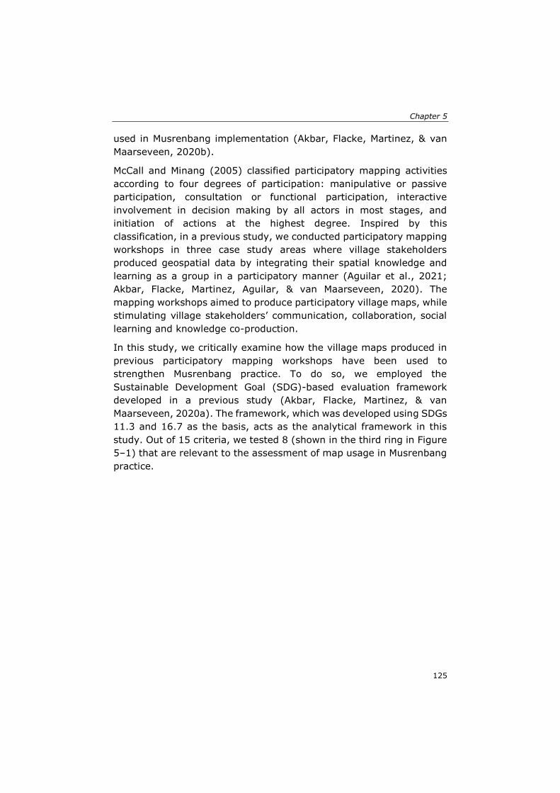
Chapter 5
125
used in Musrenbang implementation (Akbar, Flacke, Martinez, & van
Maarseveen, 2020b).
McCall and Minang (2005) classified participatory mapping activities
according to four degrees of participation: manipulative or passive
participation, consultation or functional participation, interactive
involvement in decision making by all actors in most stages, and
initiation of actions at the highest degree. Inspired by this
classification, in a previous study, we conducted participatory mapping
workshops in three case study areas where village stakeholders
produced geospatial data by integrating their spatial knowledge and
learning as a group in a participatory manner (Aguilar et al., 2021;
Akbar, Flacke, Martinez, Aguilar, & van Maarseveen, 2020). The
mapping workshops aimed to produce participatory village maps, while
stimulating village stakeholders’ communication, collaboration, social
learning and knowledge co-production.
In this study, we critically examine how the village maps produced in
previous participatory mapping workshops have been used to
strengthen Musrenbang practice. To do so, we employed the
Sustainable Development Goal (SDG)-based evaluation framework
developed in a previous study (Akbar, Flacke, Martinez, & van
Maarseveen, 2020a). The framework, which was developed using SDGs
11.3 and 16.7 as the basis, acts as the analytical framework in this
study. Out of 15 criteria, we tested 8 (shown in the third ring in Figure
5–1) that are relevant to the assessment of map usage in Musrenbang
practice.
The role of participatory village maps in strengthening public participation practice
126
Figure 5–1. A conceptual framework to assess how village maps produced during
participatory mapping activities can strengthen Musrenbang practice
Facilitation of communication between participants is an essential
factor for strengthening the public participation process. Public
participation should be a democratic and inclusive process for the
participants so that it is accessible to the wider community and is not
restricted to an elite or privileged group (Haklay, 2013). Engagement
in creating participatory village maps has the potential to achieve this
purpose by facilitating communication between participants (Akbar,
Flacke, Martinez, Aguilar, & van Maarseveen, 2020). The maps provide
a clear indication of the scope of the task (Innes & Booher, 1999; Rowe
et al., 2004) that enables participants to identify the spatial extent of
the village administrative area that needs to be addressed in the
Musrenbang. The participatory process is more transparent (Rowe &
Frewer, 2000), since the village maps, as the data needed to support
the deliberative process, are available and accessible (Rowe et al.,
2004; Rowe & Frewer, 2000). The use of maps may stimulate a
reciprocal and tolerant deliberative process that enables open and fair
communication between participants (Agger & Löfgren, 2008; Laurian
& Shaw, 2008). Furthermore, participants can use the maps to
formulate creative ideas or solutions for better results or decisions
(Beierle, 2002; Innes & Booher, 1999).
Chapter 5
127
Public participation should also be responsive to development issues
(Swapan, 2016), while promoting the social learning of participants
(Flacke et al., 2020). Thus, enabling participant collaboration is also
crucial to strengthen the outcomes of public participation practice. The
participatory village maps used in public participation practice should
be able to stimulate collaboration and knowledge sharing (Akbar,
Flacke, Martinez, Aguilar, & van Maarseveen, 2020; Innes & Booher,
1999). The maps should support social learning and increase the
villagers’ capacity to learn and work collaboratively to solve the
community’s problems (Flacke et al., 2020; Perdana & Ostermann,
2019). Such public participation practice may raise the participants’
satisfaction as their opinions can influence the final policy outcomes
(Agger & Löfgren, 2008; Webler et al., 2001).
Despite the various potential benefits of using participatory maps in
public participation practice, it is important to keep in mind that the
maps may also have some negative impacts on local communities—
what Fox et al. (Fox et al., 2006) called ‘the ironic effects’ of
participatory mapping. Some information regarded by local
communities as sensitive, such as religious or sacred places, can be
exposed to external actors (McCall, 2006). The map-making process
can become ‘a small-group elitist activity’ involving a few stakeholders
who have greater knowledge and access to the maps (Kahila-Tani et
al., 2019). The technology gaps between different groups in the
community can maintain the existing power disparities between local
stakeholders (Chapin et al., 2005). The information presented on maps
may provoke conflicts among stakeholders because of boundary
disputes or competition for land (Reyes-García et al., 2012; Sirait et
al., 1994), have repercussions on gender inequalities (Catacutan et al.,
2014; Gilbert & Masucci, 2006), and trigger land grabbing (Shahab,
2016). Therefore, this study attempts to objectively examine the
positive and negative impacts of participatory village maps using the
criteria listed in Figure 5–1.
The role of participatory village maps in strengthening public participation practice
128
5.2 Methodology
5.2.1 The case study
We studied the Musrenbang in five villages in Deli Serdang District,
Indonesia. The Musrenbang functions as a legal mechanism for citizens
to participate actively in the local development planning and budgeting
processes while aligning top-down and bottom-up planning
programmes (Butler, Bohensky, Suadnya, et al., 2016; Sutiyo, 2015).
It is implemented annually in public meeting format at several
hierarchical levels, from the village, sub-district, and provincial to the
national. Various stakeholders are involved in the meeting, including
government officials, the private sector, and citizen representatives,
such as women’s groups, religious or community leaders, and youth
groups (Akbar, Flacke, Martinez, & van Maarseveen, 2020a). The
Musrenbang plays an essential role in discussing, clarifying,
harmonising, and building a consensus on development priorities at
each level of the process (Indika & Vonika, 2019; Sutiyo, 2013). At the
village level, the Musrenbang is crucial as the first phase of the
hierarchical participatory planning process and is a medium for rural
citizens to share their views or aspirations and propose specific
programmes to solve various development problems in the village
(Grillos, 2017).
Five villages were chosen for the case study based on four major
criteria: (1) the villages were located in different sub-districts, (2) the
ethnicity of the population was primarily Javanese, (3) the main
livelihood of the population was farming/agriculture, and (4) the
villagers were willing to participate in the study. The selected villages
were Denai Lama, Kramat Gajah, Kolam, Sidoharjo I Pasar Miring, and
Tandem Hulu II. We divided the villages into an intervention group,
which included Denai Lama, Kramat Gajah, and Kolam, and a control
group, which included Sidoharjo I Pasar Miring and Tandem Hulu. The
division of villages into two groups is useful for comparing contrasting
cases or situations under different treatments to seek explanations and
gain an understanding of the social phenomena in different contexts
(Bryman, 2012). This method allows the researcher to compare the
impact of an intervention with what would have happened if there had
been no intervention or to compare the impacts of different kinds of
intervention (Banerjee & Duflo, 2009; Bryman, 2012). Similar to a
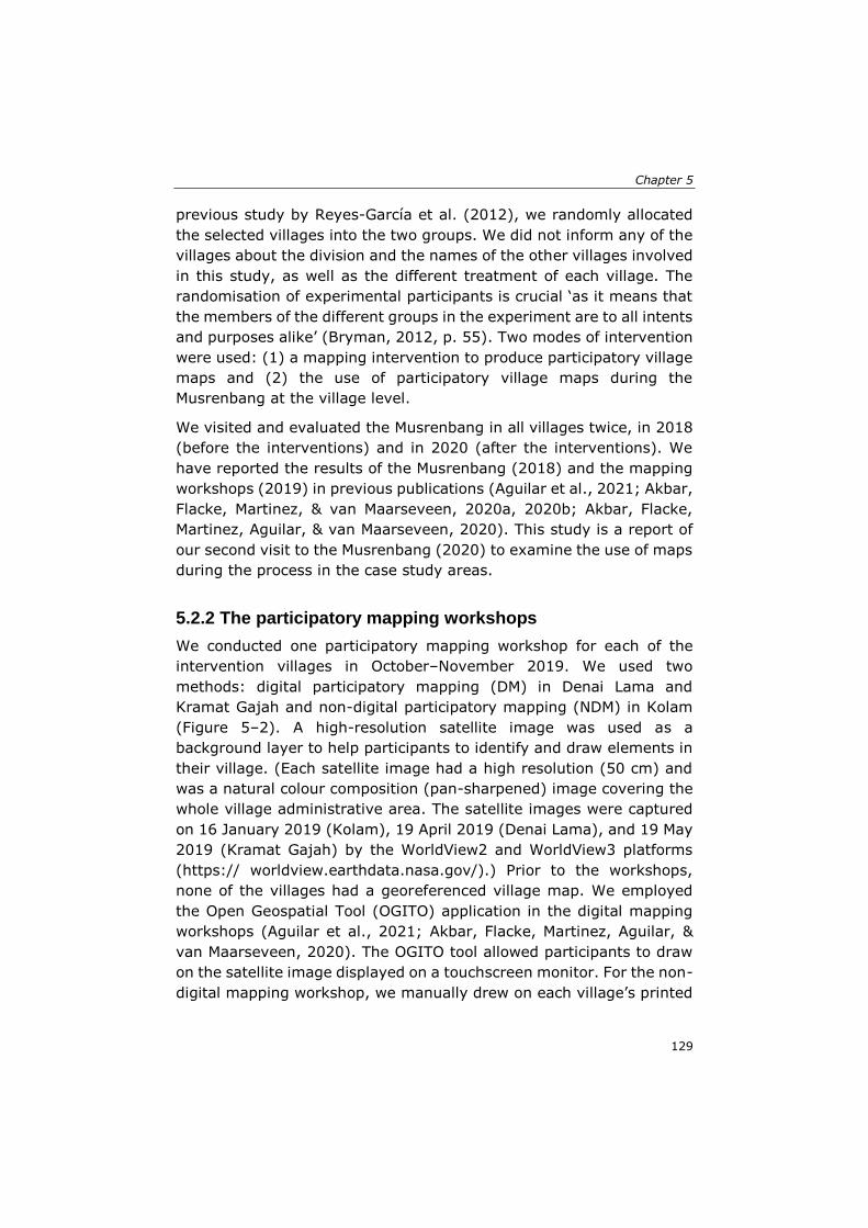
Chapter 5
129
previous study by Reyes-García et al. (2012), we randomly allocated
the selected villages into the two groups. We did not inform any of the
villages about the division and the names of the other villages involved
in this study, as well as the different treatment of each village. The
randomisation of experimental participants is crucial ‘as it means that
the members of the different groups in the experiment are to all intents
and purposes alike’ (Bryman, 2012, p. 55). Two modes of intervention
were used: (1) a mapping intervention to produce participatory village
maps and (2) the use of participatory village maps during the
Musrenbang at the village level.
We visited and evaluated the Musrenbang in all villages twice, in 2018
(before the interventions) and in 2020 (after the interventions). We
have reported the results of the Musrenbang (2018) and the mapping
workshops (2019) in previous publications (Aguilar et al., 2021; Akbar,
Flacke, Martinez, & van Maarseveen, 2020a, 2020b; Akbar, Flacke,
Martinez, Aguilar, & van Maarseveen, 2020). This study is a report of
our second visit to the Musrenbang (2020) to examine the use of maps
during the process in the case study areas.
5.2.2 The participatory mapping workshops
We conducted one participatory mapping workshop for each of the
intervention villages in October–November 2019. We used two
methods: digital participatory mapping (DM) in Denai Lama and
Kramat Gajah and non-digital participatory mapping (NDM) in Kolam
(Figure 5–2). A high-resolution satellite image was used as a
background layer to help participants to identify and draw elements in
their village. (Each satellite image had a high resolution (50 cm) and
was a natural colour composition (pan-sharpened) image covering the
whole village administrative area. The satellite images were captured
on 16 January 2019 (Kolam), 19 April 2019 (Denai Lama), and 19 May
2019 (Kramat Gajah) by the WorldView2 and WorldView3 platforms
(https:// worldview.earthdata.nasa.gov/).) Prior to the workshops,
none of the villages had a georeferenced village map. We employed
the Open Geospatial Tool (OGITO) application in the digital mapping
workshops (Aguilar et al., 2021; Akbar, Flacke, Martinez, Aguilar, &
van Maarseveen, 2020). The OGITO tool allowed participants to draw
on the satellite image displayed on a touchscreen monitor. For the non-
digital mapping workshop, we manually drew on each village’s printed
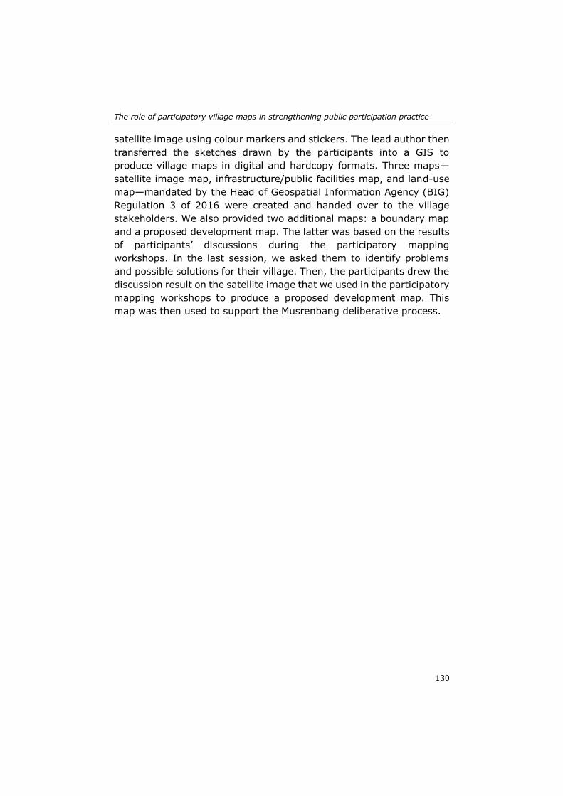
The role of participatory village maps in strengthening public participation practice
130
satellite image using colour markers and stickers. The lead author then
transferred the sketches drawn by the participants into a GIS to
produce village maps in digital and hardcopy formats. Three maps—
satellite image map, infrastructure/public facilities map, and land-use
map—mandated by the Head of Geospatial Information Agency (BIG)
Regulation 3 of 2016 were created and handed over to the village
stakeholders. We also provided two additional maps: a boundary map
and a proposed development map. The latter was based on the results
of participants’ discussions during the participatory mapping
workshops. In the last session, we asked them to identify problems
and possible solutions for their village. Then, the participants drew the
discussion result on the satellite image that we used in the participatory
mapping workshops to produce a proposed development map. This
map was then used to support the Musrenbang deliberative process.
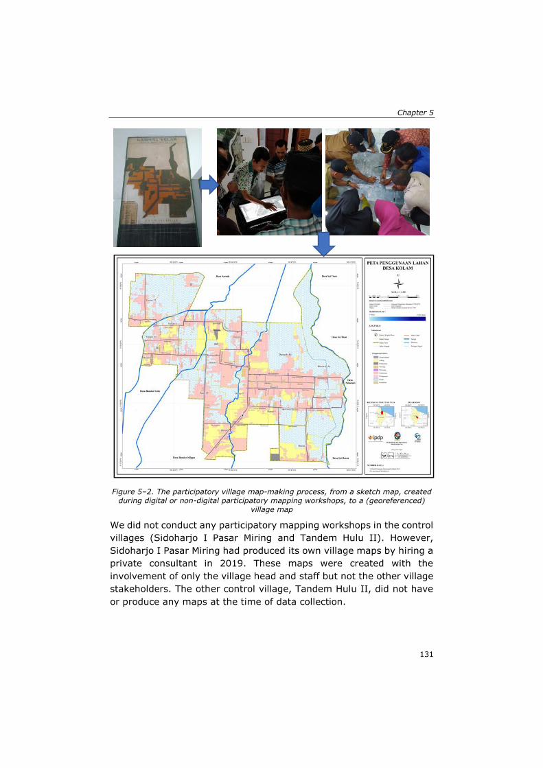
Chapter 5
131
Figure 5–2. The participatory village map-making process, from a sketch map, created during digital or non-digital participatory mapping workshops, to a (georeferenced)
village map
We did not conduct any participatory mapping workshops in the control
villages (Sidoharjo I Pasar Miring and Tandem Hulu II). However,
Sidoharjo I Pasar Miring had produced its own village maps by hiring a
private consultant in 2019. These maps were created with the
involvement of only the village head and staff but not the other village
stakeholders. The other control village, Tandem Hulu II, did not have
or produce any maps at the time of data collection.
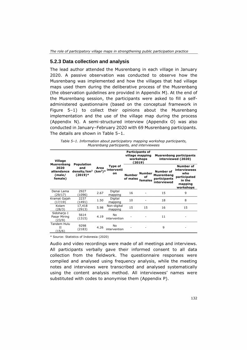
The role of participatory village maps in strengthening public participation practice
132
5.2.3 Data collection and analysis
The lead author attended the Musrenbang in each village in January
2020. A passive observation was conducted to observe how the
Musrenbang was implemented and how the villages that had village
maps used them during the deliberative process of the Musrenbang
(the observation guidelines are provided in Appendix M). At the end of
the Musrenbang session, the participants were asked to fill a self-
administered questionnaire (based on the conceptual framework in
Figure 5–1) to collect their opinions about the Musrenbang
implementation and the use of the village map during the process
(Appendix N). A semi-structured interview (Appendix O) was also
conducted in January–February 2020 with 69 Musrenbang participants.
The details are shown in Table 5–1.
Table 5–1. Information about participatory mapping workshop participants, Musrenbang participants, and interviewees
Village
Musrenbang
2020
attendance
(male/
female)
Population
and
density/km2
(2019)*
Area
(km2)*
Type of
interventi
on
Participants of
village mapping
workshops
(2019)
Musrenbang participants
interviewed (2020)
Number
of males
Number
of females
Number of
Musrenbang
participants
interviewed
Number of
interviewees
who
participated in the
mapping
workshops
Denai Lama
(29/17)
2927
(1096) 2.67
Digital
mapping 16 - 15 9
Kramat Gajah
(17/19)
2237
(1491) 1.50
Digital
mapping 10 - 18 8
Kolam
(28/3)
17,418
(2913) 5.98
Non-digital
mapping 15 15 16 15
Sidoharjo I
Pasar Miring
(23/9)
5614
(1315) 4.19
No
intervention - - 11 -
Tandem Hulu
II
(15/6)
9298
(2183) 4.26
No
intervention - - 9 -
* Source: Statistics of Indonesia (2020)
Audio and video recordings were made of all meetings and interviews.
All participants verbally gave their informed consent to all data
collection from the fieldwork. The questionnaire responses were
compiled and analysed using frequency analysis, while the meeting
notes and interviews were transcribed and analysed systematically
using the content analysis method. All interviewees’ names were
substituted with codes to anonymise them (Appendix P).
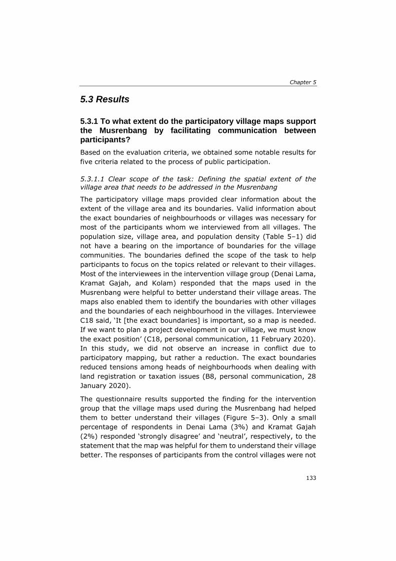
Chapter 5
133
5.3 Results
5.3.1 To what extent do the participatory village maps support the Musrenbang by facilitating communication between participants?
Based on the evaluation criteria, we obtained some notable results for
five criteria related to the process of public participation.
5.3.1.1 Clear scope of the task: Defining the spatial extent of the
village area that needs to be addressed in the Musrenbang
The participatory village maps provided clear information about the
extent of the village area and its boundaries. Valid information about
the exact boundaries of neighbourhoods or villages was necessary for
most of the participants whom we interviewed from all villages. The
population size, village area, and population density (Table 5–1) did
not have a bearing on the importance of boundaries for the village
communities. The boundaries defined the scope of the task to help
participants to focus on the topics related or relevant to their villages.
Most of the interviewees in the intervention village group (Denai Lama,
Kramat Gajah, and Kolam) responded that the maps used in the
Musrenbang were helpful to better understand their village areas. The
maps also enabled them to identify the boundaries with other villages
and the boundaries of each neighbourhood in the villages. Interviewee
C18 said, ‘It [the exact boundaries] is important, so a map is needed.
If we want to plan a project development in our village, we must know
the exact position’ (C18, personal communication, 11 February 2020).
In this study, we did not observe an increase in conflict due to
participatory mapping, but rather a reduction. The exact boundaries
reduced tensions among heads of neighbourhoods when dealing with
land registration or taxation issues (B8, personal communication, 28
January 2020).
The questionnaire results supported the finding for the intervention
group that the village maps used during the Musrenbang had helped
them to better understand their villages (Figure 5–3). Only a small
percentage of respondents in Denai Lama (3%) and Kramat Gajah
(2%) responded ‘strongly disagree’ and ‘neutral’, respectively, to the
statement that the map was helpful for them to understand their village
better. The responses of participants from the control villages were not
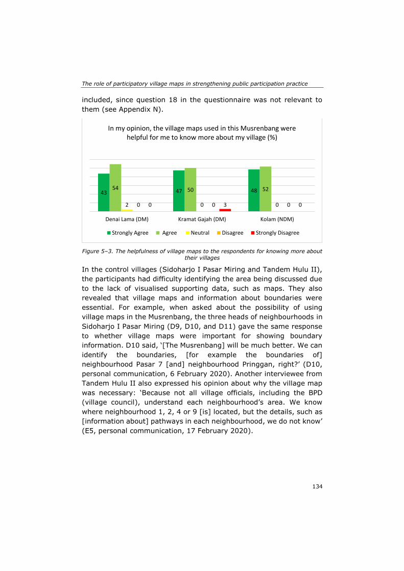
The role of participatory village maps in strengthening public participation practice
134
included, since question 18 in the questionnaire was not relevant to
them (see Appendix N).
Figure 5–3. The helpfulness of village maps to the respondents for knowing more about
their villages
In the control villages (Sidoharjo I Pasar Miring and Tandem Hulu II),
the participants had difficulty identifying the area being discussed due
to the lack of visualised supporting data, such as maps. They also
revealed that village maps and information about boundaries were
essential. For example, when asked about the possibility of using
village maps in the Musrenbang, the three heads of neighbourhoods in
Sidoharjo I Pasar Miring (D9, D10, and D11) gave the same response
to whether village maps were important for showing boundary
information. D10 said, ‘[The Musrenbang] will be much better. We can
identify the boundaries, [for example the boundaries of]
neighbourhood Pasar 7 [and] neighbourhood Pringgan, right?’ (D10,
personal communication, 6 February 2020). Another interviewee from
Tandem Hulu II also expressed his opinion about why the village map
was necessary: ‘Because not all village officials, including the BPD
(village council), understand each neighbourhood’s area. We know
where neighbourhood 1, 2, 4 or 9 [is] located, but the details, such as
[information about] pathways in each neighbourhood, we do not know’
(E5, personal communication, 17 February 2020).
43 47 4854 50 52
2 0 00 0 00 3 0
Denai Lama (DM) Kramat Gajah (DM) Kolam (NDM)
In my opinion, the village maps used in this Musrenbang were helpful for me to know more about my village (%)
Strongly Agree Agree Neutral Disagree Strongly Disagree
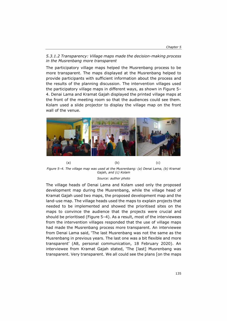
Chapter 5
135
5.3.1.2 Transparency: Village maps made the decision-making process
in the Musrenbang more transparent
The participatory village maps helped the Musrenbang process to be
more transparent. The maps displayed at the Musrenbang helped to
provide participants with sufficient information about the process and
the results of the planning discussion. The intervention villages used
the participatory village maps in different ways, as shown in Figure 5–
4. Denai Lama and Kramat Gajah displayed the printed village maps at
the front of the meeting room so that the audiences could see them.
Kolam used a slide projector to display the village map on the front
wall of the venue.
(a) (b) (c)
Figure 5–4. The village map was used at the Musrenbang: (a) Denai Lama, (b) Kramat Gajah, and (c) Kolam
Source: author photo
The village heads of Denai Lama and Kolam used only the proposed
development map during the Musrenbang, while the village head of
Kramat Gajah used two maps, the proposed development map and the
land-use map. The village heads used the maps to explain projects that
needed to be implemented and showed the prioritised sites on the
maps to convince the audience that the projects were crucial and
should be prioritised (Figure 5–4). As a result, most of the interviewees
from the intervention villages responded that the use of village maps
had made the Musrenbang process more transparent. An interviewee
from Denai Lama said, ‘The last Musrenbang was not the same as the
Musrenbang in previous years. The last one was a bit flexible and more
transparent’ (A8, personal communication, 18 February 2020). An
interviewee from Kramat Gajah stated, ‘The [last] Musrenbang was
transparent. Very transparent. We all could see the plans [on the maps

The role of participatory village maps in strengthening public participation practice
136
presented]. All of them were transparent’ (C18, personal
communication, 11 February 2020).
The use of the maps also made the discussion about budget allocation
more transparent. An interviewee from Denai Lama said, ‘At least we
knew, with all the presented data [all became clear]. The communities
were constantly asking for information about the budget allocation and
the sources. Those [kinds of information] were necessary. The village
government should be open and transparent to the communities’ (A6,
personal communication, 5 February 2020). C2 also stated that the
maps made the Musrenbang process more transparent, ‘[The process
was] transparent and more open. All participants could know that the
budget allocation will be used for financing this [project] or that
[project]’ (C2, personal communication, 7 February 2020).
The villages in the control group, Sidoharjo I Pasar Miring and Tandem
Hulu II, did not use maps during the Musrenbang, although the former
already had village maps. Interviewees D1 and D8 from Sidoharjo I
Pasar Miring said that only the village head and secretary could access
the maps. They also noted that the maps still contained some disputed
village and neighbourhood boundaries. The village head decided not to
make the maps public, because the boundaries were a sensitive issue
that could provoke conflicts between citizens or with neighbouring
villages (D8, personal communication, 11 February 2020).
Many interviewees from the control villages expressed their concerns
about the lack of transparency during Musrenbang deliberations.
Decisions about development priorities or budget allocation plans were
made without any data or tools to support the discussion. Such a
situation led to the participants wondering about the exact locations of
the topics being discussed or why a budget needed to be allocated to
a particular project. An interviewee from Tandem Hulu II said, ‘Well,
you were there and saw it yourself. In the last Musrenbang, we only
talked, without presenting any data [during the discussion]’ (E9,
personal communication, 26 February 2020).
Chapter 5
137
5.3.1.3 Accessibility of resources for participation: Data are essential
for public participation practice
The participants’ responses to the questionnaire show that the use of
village maps had a positive influence on Musrenbang implementation.
Previously, hardly any geographical data were used in the Musrenbang.
The data used were often only a list of proposed programmes prepared
by heads of neighbourhoods. They were handwritten on a sheet of
paper and presented orally by each head of neighbourhood without
supporting tools, such as a whiteboard or a slide projector. The heads
of neighbourhoods rarely updated the lists, so they remained the same
for years (D4, personal communication, 6 February 2020). However,
in the 2020 Musrenbang, there was a substantial difference as villagers
from Denai Lama, Kramat Gajah, and Kolam used village maps for the
first time during the Musrenbang. As shown in Figure 5–5, most
participants in the intervention group agreed that appropriate data
were available to support the Musrenbang process.
Figure 5–5. The availability of data to support the Musrenbang process
This finding indicates that the participants in the intervention villages
were aware that the village maps shown during the meeting made the
latest Musrenbang different from previous ones. Respondent A9
considered the 2020 Musrenbang to be better than those in previous
years. He said that the maps enhanced the deliberative process of the
Musrenbang; the discussion was more constructive and faster because
participants could directly identify, see, and point to the locations being
4836 32
9 19
4864 65
78
294 0 3 13 100 0 0 038
0 0 0 0 5
Denai Lama (DM) Kramat Gajah(DM)
Kolam (NDM) Sidoharjo I PasarMiring
Tandem Hulu II
Data or information (i.e. maps, graphs, pictures, audio, etc.) to support the Musrenbang discussion was available (%)
Strongly Agree Agree Neutral Disagree Strongly Disagree
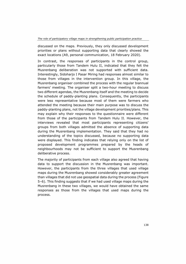
The role of participatory village maps in strengthening public participation practice
138
discussed on the maps. Previously, they only discussed development
priorities or plans without supporting data that clearly showed the
exact locations (A9, personal communication, 18 February 2020).
In contrast, the responses of participants in the control group,
particularly those from Tandem Hulu II, indicated that they felt the
Musrenbang deliberation was not supported with sufficient data.
Interestingly, Sidoharjo I Pasar Miring had responses almost similar to
those from villages in the intervention group. In this village, the
Musrenbang organiser combined the process with the regular biannual
farmers’ meeting. The organiser split a two-hour meeting to discuss
two different agendas, the Musrenbang itself and the meeting to decide
the schedule of paddy-planting plans. Consequently, the participants
were less representative because most of them were farmers who
attended the meeting because their main purpose was to discuss the
paddy-planting plans, not the village development priorities/plans. This
may explain why their responses to the questionnaire were different
from those of the participants from Tandem Hulu II. However, the
interviews revealed that most participants representing citizens’
groups from both villages admitted the absence of supporting data
during the Musrenbang implementation. They said that they had no
understanding of the topics discussed, because no supporting data
were displayed. This finding indicates that relying only on the list of
proposed development programmes prepared by the heads of
neighbourhoods may not be sufficient to support the Musrenbang
deliberative process.
The majority of participants from each village also agreed that having
data to support the discussion in the Musrenbang was important.
However, the participants from the three villages that used village
maps during the Musrenbang showed considerably greater agreement
than villages that did not use geospatial data during the process (Figure
5–6). This finding suggests that if we had used village maps during the
Musrenbang in these two villages, we would have obtained the same
responses as those from the villages that used maps during the
process.
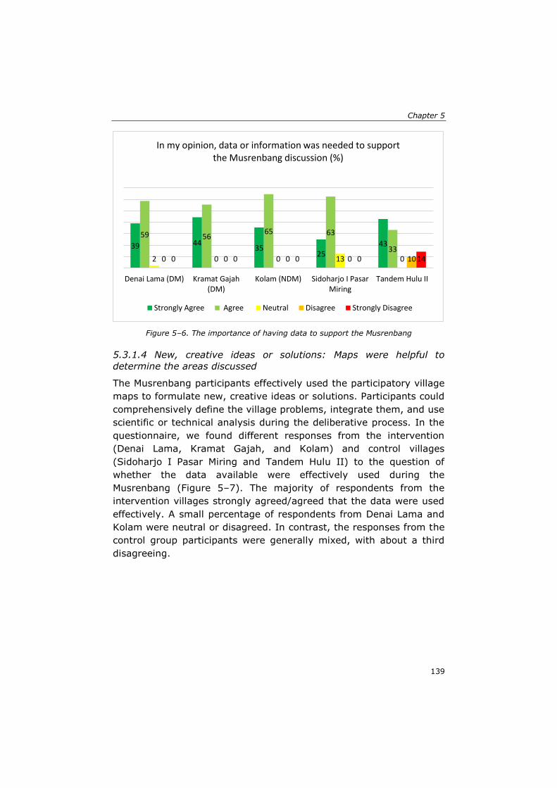
Chapter 5
139
Figure 5–6. The importance of having data to support the Musrenbang
5.3.1.4 New, creative ideas or solutions: Maps were helpful to
determine the areas discussed
The Musrenbang participants effectively used the participatory village
maps to formulate new, creative ideas or solutions. Participants could
comprehensively define the village problems, integrate them, and use
scientific or technical analysis during the deliberative process. In the
questionnaire, we found different responses from the intervention
(Denai Lama, Kramat Gajah, and Kolam) and control villages
(Sidoharjo I Pasar Miring and Tandem Hulu II) to the question of
whether the data available were effectively used during the
Musrenbang (Figure 5–7). The majority of respondents from the
intervention villages strongly agreed/agreed that the data were used
effectively. A small percentage of respondents from Denai Lama and
Kolam were neutral or disagreed. In contrast, the responses from the
control group participants were generally mixed, with about a third
disagreeing.
39 4435
2543
59 5665 63
332 0 0 13 00 0 0 0 100 0 0 0 14
Denai Lama (DM) Kramat Gajah(DM)
Kolam (NDM) Sidoharjo I PasarMiring
Tandem Hulu II
In my opinion, data or information was needed to support the Musrenbang discussion (%)
Strongly Agree Agree Neutral Disagree Strongly Disagree
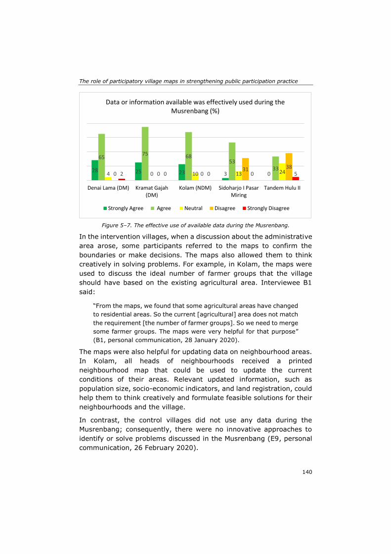
The role of participatory village maps in strengthening public participation practice
140
Figure 5–7. The effective use of available data during the Musrenbang.
In the intervention villages, when a discussion about the administrative
area arose, some participants referred to the maps to confirm the
boundaries or make decisions. The maps also allowed them to think
creatively in solving problems. For example, in Kolam, the maps were
used to discuss the ideal number of farmer groups that the village
should have based on the existing agricultural area. Interviewee B1
said:
“From the maps, we found that some agricultural areas have changed
to residential areas. So the current [agricultural] area does not match
the requirement [the number of farmer groups]. So we need to merge
some farmer groups. The maps were very helpful for that purpose”
(B1, personal communication, 28 January 2020).
The maps were also helpful for updating data on neighbourhood areas.
In Kolam, all heads of neighbourhoods received a printed
neighbourhood map that could be used to update the current
conditions of their areas. Relevant updated information, such as
population size, socio-economic indicators, and land registration, could
help them to think creatively and formulate feasible solutions for their
neighbourhoods and the village.
In contrast, the control villages did not use any data during the
Musrenbang; consequently, there were no innovative approaches to
identify or solve problems discussed in the Musrenbang (E9, personal
communication, 26 February 2020).
28 25 23 3 0
6575 68
5333
4 0 10 13 240 0 031 38
2 0 0 0 5
Denai Lama (DM) Kramat Gajah(DM)
Kolam (NDM) Sidoharjo I PasarMiring
Tandem Hulu II
Data or information available was effectively used during the Musrenbang (%)
Strongly Agree Agree Neutral Disagree Strongly Disagree
Chapter 5
141
5.3.1.5 Deliberative processes characterised by reciprocity and
tolerance: They continue to be dominated by certain elites
The participatory village maps were also helpful for supporting the
deliberative process in the Musrenbang. Open and fair communication
between participants was established during the Musrenbang in the
intervention villages. More than 90% of the respondents in the three
villages agreed that maps could help the Musrenbang deliberation
(Figure 5–8). Only a small percentage was neutral about the
helpfulness of maps in this regard. The responses from control villages
were not included, since question 19 in the questionnaire was not
relevant to these villages (see Appendix N).
Figure 5–8. The use of village maps to support the deliberative process in the
Musrenbang.
The interviews also revealed that the use of maps increased the
citizens’ trust in the village government. Interviewee A10 said that the
maps were crucial to understand which particular topic was being
discussed or needed to be prioritised. This kind of information is
important to inform decision making in the Musrenbang process.
Moreover, the visualisation of the village area on the maps facilitated
the participants’ engagement with the topics of discussion (A10,
personal communication, 5 February 2020). In the control villages that
did not use maps, we found the ambiance of the Musrenbang
deliberation in 2020 almost similar to that of the Musrenbang in 2018.
The discussion was tedious and boring, and most participants kept
5944
5539
5642
2 0 30 0 00 0 0
Denai Lama (DM) Kramat Gajah (DM) Kolam (NDM)
In my opinion, the village maps used were helpful for supporting the deliberative process in the Musrenbang (%)
Strongly Agree Agree Neutral Disagree Strongly Disagree
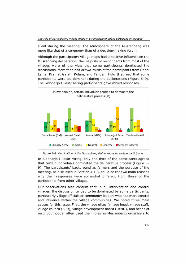
The role of participatory village maps in strengthening public participation practice
142
silent during the meeting. The atmosphere of the Musrenbang was
more like that of a ceremony than of a decision-making forum.
Although the participatory village maps had a positive influence on the
Musrenbang deliberation, the majority of respondents from most of the
villages were of the view that some participants dominated the
discussions. More than half or two-thirds of the participants from Denai
Lama, Kramat Gajah, Kolam, and Tandem Hulu II agreed that some
participants were too dominant during the deliberations (Figure 5–9).
The Sidoharjo I Pasar Miring participants gave mixed responses.
Figure 5–9. Domination of the Musrenbang deliberations by certain participants.
In Sidoharjo I Pasar Miring, only one-third of the participants agreed
that certain individuals dominated the deliberative process (Figure 5–
9). The participants’ background as farmers and the purpose of the
meeting, as discussed in Section 4.1.3, could be the two main reasons
why their responses were somewhat different from those of the
participants from other villages.
Our observations also confirm that in all intervention and control
villages, the discussion tended to be dominated by some participants,
particularly village officials or community leaders who had more control
and influence within the village communities. We noted three main
causes for this issue. First, the village elites (village head, village staff,
village council (BPD), village development board (LKMD), and heads of
neighbourhoods) often used their roles as Musrenbang organisers to
20 19 236 5
3747
39
22
48
13 826
19 192414 10
50
247 11 3 3 5
Denai Lama (DM) Kramat Gajah(DM)
Kolam (NDM) Sidoharjo I PasarMiring
Tandem Hulu II
In my opinion, certain individuals tended to dominate the deliberative process (%)
Strongly Agree Agree Neutral Disagree Strongly Disagree
Chapter 5
143
pre-select the attendees. The elites preferred to invite participants,
from their circles or kinship groups, who would not oppose their ideas
or development proposals. Interviewee A4 said that ideally, the
participants from the intervention villages could use the participatory
village maps to critically discuss the development proposal. However,
since many of the Musrenbang attendees were related to individuals in
the elite circles, only a few participants used the maps to oppose or
criticise the proposals (A4, personal communication, 5 February 2020).
Second, some participants did not feel comfortable enough to have
their say at the meeting, because the meeting arrangements were too
formal and ceremonial. The schedule was also tight. The organisers
only provided two to three hours for a Musrenbang meeting. The tight
schedule was exacerbated by bad time management habits. All the
meetings we attended always started late, by half to one hour from the
time stated in the invitation, which significantly reduced the
opportunity for detailed discussion among participants. Agenda items
were too many and included opening remarks from the village council,
officials of the sub-district government, and honoured guests from
different institutions. Such arrangements led to participants having less
time for fruitful discussion with other attendees. Moreover, this
situation caused public speaking anxiety in some participants about
articulating their opinions during the deliberative process. Interviewee
B10 said, ‘If we are not used to speaking in front of many people, it
would feel awkward. We could not express our opinion’ (B10, personal
communication, 28 January 2020).
The meeting arrangement also led to fewer females participating in the
Musrenbang, particularly in Kolam, Tandem Hulu II, and Sidoharjo I
Pasar Miring (see Table 5–1). However, high female participation in the
Musrenbang, as was seen in Denai Lama and Kramat Gajah, also did
not guarantee that the female participants could contribute more
during the deliberative process. The meeting arrangements also drove
female participants to feel shy and less confident in conveying their
views. A woman participant, A5, from Denai Lama said, ‘They have
[different] opinions, but do not have bravery [to convey their opinions].
That is the main problem. Not all people can speak in front of lots of
people. Nervous. Sometimes it makes us remain silent, and just
listening’ (A5, personal communication, 5 February 2020). We also
observed that female participants simply agreed with the males’
opinions during the deliberative processes. Interviewee A6 said that
The role of participatory village maps in strengthening public participation practice
144
female participants remained silent during the meeting because they
typically had the same opinions or ideas. Therefore, normally, one
person talked on their behalf (A6, personal communication, 5 February
2020).
Third, the meeting venue brought another problem to Musrenbang
implementation. Typically, it was the village meeting hall, which was
often too small to accommodate a large group of people. The venue
could be too noisy and crowded, and the meeting leaders could not
efficiently control the crowds. Interviewee B4 said that while someone
was speaking in the forum, others did not listen as they talked with the
persons who sat next to them (B4, personal communication, 28
January 2020).
These findings indicate that the use of participatory village maps could
not fully overcome the domination of the discussion by some
individuals, primarily because the elites were not willing to create a
democratic and inclusive participatory process for all citizens.
Moreover, the maps were less effective when the meeting leaders or
the organisers could not satisfactorily manage the deliberative process.
5.3.2 To what extent do the participatory village maps support the Musrenbang outcomes by enabling collaboration between participants?
The evaluation resulted in significant findings for three criteria related
to the outcomes of public participation, as described below.
5.3.2.1 Knowledge sharing: Maps were helpful for sharing development
issues in the villages
The participatory village maps enabled participants to share their
knowledge with other participants. We observed that the discussion
among participants from the intervention villages (Denai Lama, Kramat
Gajah, Kolam) became quite intense when someone referred to the
maps. Interviewee B2 said, ‘When a citizen shared his/her opinion, we
gained new information about the current condition that previously we
did not know’ (B2, personal communication, 28 January 2020). A
woman interviewee from Kolam said, ‘Knowledge sharing occurred,
among the heads of neighbourhoods, among community leaders, the
youth club. In the past, their opinions were less considered. Now, they

Chapter 5
145
can share with each other’ (B5, personal communication, 28 January
2020).
The participatory village maps were also helpful for clarifying or
informing the development plans displayed on the map. For example,
when a participant from Denai Lama asked why the street lamps had
not been installed yet in his neighbourhood, the village head answered
by pointing out the plan for street lamp instalment listed on the
proposed development plan map. Interviewee A15 was of the same
view: ‘In the last [Musrenbang] meeting, several participants were
discussing some issues in a small group. The issues discussed in the
small group were then shared with other participants [using the
available maps]’ (A15, personal communication, 5 February 2020).
We also observed that people who attended the participatory mapping
workshops were more active in the discussion. They had a better
understanding of the maps because they were involved in creating
them. Therefore, they could share their knowledge while relating the
issues with the aid of the displayed maps. They were better able than
the other participants to refer to the maps and relate the maps to the
discussed topics. They also felt more confident in the Musrenbang after
participating in the mapping workshops. Respondent A7 from Denai
Lama said, ‘For me, receiving the knowledge [of how to produce village
maps in a participatory manner] has made me more confident in the
Musrenbang’ (A7, personal communication, 18 February 2020). A
respondent from Kolam, B4, said that he became a source of
information for other Musrenbang participants, who did not take part
in the mapping workshops, when they had difficulties identifying the
area discussed on the displayed maps (B4, personal communication,
28 January 2020).
In the control villages, the situation was different. Knowledge sharing
occurred, but participants had difficulty identifying the objects or
locations mentioned in the Musrenbang. They relied heavily on their
mental maps of the village area. Therefore, sharing knowledge was
challenging since no visual data, such as maps, were available.
The role of participatory village maps in strengthening public participation practice
146
5.3.2.2 Social learning/building institutional capital and capacity
The results also imply that the participatory village maps allowed
participants in the intervention villages to experience social learning.
The maps enhanced the capacity of the participants to handle issues
or conflicts and allowed them to collaborate in solving their common
problems. We observed that at least three stages of social learning
occurred in the Musrenbang. The participants from the intervention
villages experienced all three stages, while participants from control
villages only experienced the first stage of social learning. First, the
questionnaire showed the rise in awareness of participants from all
villages that participatory village maps or other supporting data should
be available for the Musrenbang process. The interviews also
discovered that data availability continued to be challenging,
particularly for interviewees from the control villages. The maps could
also stimulate participants to learn and work collaboratively to solve
their problems. Interviewee C9 from Kramat Gajah said, ‘I finally
understand that the Musrenbang could be the [right] place to discuss
and solve the village problems. The citizens can share their concerns
in the Musrenbang meeting, so I learned that we need to discuss [to
solve our common problems]. The process was transparent’ (C9,
personal communication, 11 February 2020).
Second, participants from the intervention villages showed behavioural
changes when addressing village issues. The participants began to
understand the benefits of maps in Musrenbang practice. For example,
they finally understood that they could visualise almost everything on
a map, as demonstrated by the proposed development map they used
during the Musrenbang. The maps also changed their way of perceiving
and handling problems. Interviewee C4 said, ‘By using the map, we
can clearly see the village boundaries. We can also measure the length,
distance [between two places], and the area directly on the maps’ (C4,
personal communication, 7 February 2020).
Several interviewees from the intervention villages also revealed that
the participatory village maps had been used several times before the
Musrenbang. The village head of Kolam took the initiative to print
copies of the village maps at a neighbourhood scale and then
distributed them to each neighbourhood. Consequently, the heads of
neighbourhoods could use the maps for updating socio-economic and
population data for their neighbourhoods. Similarly, in Denai Lama,
Chapter 5
147
given the importance of the agricultural sector as the main livelihood,
a thematic map displaying the working areas of farmers’ groups was
produced to measure each group’s exact area, estimate the production
in each area, and decide on the allocation of subsidised fertilisers for
each group. In the past, they had never used a map to calculate or
make such decisions. They learned how geospatial data, such as maps,
can be a useful tool to visualise problems spatially and formulate
solutions in a short period.
Third, the participants began to challenge underlying assumptions or
values. For example, we found that discussion about sustainable
development and land-use changes was quite intense in Kolam and
Denai Lama. During the discussion, the participatory village maps
became a valuable source for identifying the area. They discussed
some profound challenges of the rapid land-use changes in their
village, while also proposing alternatives or solutions. A respondent
from Kolam said that the maps enabled him to recognise the village’s
land-use changes. He stated, ‘I noticed the land-use changes in our
village area [on the map]. For example, I found a site that used to be
a paddy field area which has now changed into residential areas’ (B3,
personal communication, 12 February 2020). He questioned their
previous assumption that residential areas can bring more economic
benefits than agricultural areas. This old assumption had triggered
rapid land-use changes in the village. This kind of awareness would be
helpful for the better management of spatial planning in villages, for
example, for identifying which parts of the villages could be planned
for built-up areas and for thinking critically about land-use changes
that might endanger the sustainability of the agricultural sector, the
main livelihood of village communities.
5.3.2.3 Influence on final policy: Participants’ opinions were heard and
taken into account
Participants feel satisfied when their views are heard and taken into
account. Their involvement in the participatory process is more
meaningful if their opinions can influence the final policy or decisions.
Our interviews showed that most participants in the intervention and
control villages felt that they had influence over the final policy or
decisions. Interviewee A13 from Denai Lama said, ‘Although the village
head has the authority to take the final decision, he may not know
what [developments] are needed in each neighbourhood. That is why
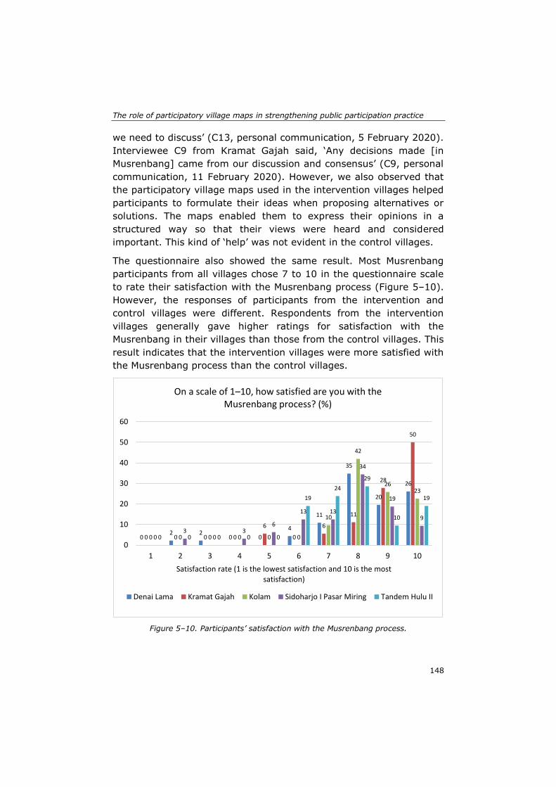
The role of participatory village maps in strengthening public participation practice
148
we need to discuss’ (C13, personal communication, 5 February 2020).
Interviewee C9 from Kramat Gajah said, ‘Any decisions made [in
Musrenbang] came from our discussion and consensus’ (C9, personal
communication, 11 February 2020). However, we also observed that
the participatory village maps used in the intervention villages helped
participants to formulate their ideas when proposing alternatives or
solutions. The maps enabled them to express their opinions in a
structured way so that their views were heard and considered
important. This kind of ‘help’ was not evident in the control villages.
The questionnaire also showed the same result. Most Musrenbang
participants from all villages chose 7 to 10 in the questionnaire scale
to rate their satisfaction with the Musrenbang process (Figure 5–10).
However, the responses of participants from the intervention and
control villages were different. Respondents from the intervention
villages generally gave higher ratings for satisfaction with the
Musrenbang in their villages than those from the control villages. This
result indicates that the intervention villages were more satisfied with
the Musrenbang process than the control villages.
Figure 5–10. Participants’ satisfaction with the Musrenbang process.
02 2
0 0
4
11
35
20
26
0 0 0 0
6
0
6
11
28
50
0 0 0 0 0 0
10
42
2623
03
03
6
13 13
34
19
9
0 0 0 0 0
19
24
29
10
19
0
10
20
30
40
50
60
1 2 3 4 5 6 7 8 9 10
Satisfaction rate (1 is the lowest satisfaction and 10 is the most satisfaction)
On a scale of 1–10, how satisfied are you with the Musrenbang process? (%)
Denai Lama Kramat Gajah Kolam Sidoharjo I Pasar Miring Tandem Hulu II
Chapter 5
149
5.4 Discussion and Conclusions
The empirical results of our case study indicate several vital issues
related to the use of participatory village maps in Musrenbang public
participation practice at the village level. First, the findings reveal that
the use of participatory village maps in the Musrenbang strengthened
its implementation. Most of the participants in the intervention villages
agreed that the last Musrenbang, which used the participatory village
maps, was much better than the previous Musrenbang. The maps
enhanced communication between participants in the Musrenbang by
providing a clear definition of the village area, geospatial data as
resources for participation, transparency, new and creative solutions,
and a dynamic deliberative process. The findings also show that the
participatory village maps received positive responses from most of the
Musrenbang participants. Their knowledge of the village area
improved, enabling them to relate the discussion topics to the village
maps used in the Musrenbang. They found that supporting data, such
as maps, made the process more transparent and enhanced the
Musrenbang deliberative process.
The participatory village maps also enabled collaboration between
participants to achieve common goals in the Musrenbang. The
visualisation of geospatial data helped the users to easily interpret the
information displayed on the maps and acquire knowledge (Kraak,
2003). Knowledge sharing was evident as participants could effectively
convey their concerns using the maps. Various levels of social learning
were also apparent as some participants started to question previous
land-use policy that might endanger the sustainability of the villagers’
main livelihood. The maps helped participants to convey their ideas or
concerns, which were heard or adopted in the village development
plans and eventually raised their satisfaction in the Musrenbang
implementation.
The situation in the control villages was different. There was almost no
difference between the Musrenbang in 2020 and that in previous years.
The discussion was boring and ceremonial. The process lacked
transparency. Data were not available to support the discussion.
Participants also had difficulty identifying the objects or locations of the
topics being discussed. The division of villages into intervention and
control groups led to different results and experiences for the
Musrenbang process as well as for the Musrenbang participants.
The role of participatory village maps in strengthening public participation practice
150
However, despite the maps enhancing the Musrenbang deliberations in
the intervention villages, the potential of the participatory village maps
appears not to have been fully realised. Participatory village maps
could not completely overcome the power disparities between
participants in the Musrenbang. Certain actors, particularly the village
head and village officials, still dominated the deliberative process,
indicating that it is still highly influenced by local political elites and
government officials (Aswad et al., 2012; Purba, 2011, 2010; Sutiyo,
2015). Their participation in map making enabled them to acquire
greater knowledge and access to the maps than the other Musrenbang
participants, thereby turning the process into a ‘small-group elitist
activity’, as mentioned by Kahila-Tani et al. (2019). The village head
and community leaders usually play an important role in the
community, especially by controlling the local decision forums in the
village (Sullivan, 2019). They can use their influence wisely to drive
the community to engage actively in achieving common interests.
Conversely, they can also manipulate the community to support their
ideas or interests; for example, they could use the maps to persuade
and convince Musrenbang participants to support their development
proposals, which may not reflect the real demands and needs of the
community.
The situation is exacerbated when the village head and officials often
intentionally pre-select and invite participants who would not oppose
their ideas or development proposals. Consequently, although the
Musrenbang public meeting is supposed to be open to and inclusive of
all citizens, in reality, only specific individuals can attend the meeting.
Thus, the agenda and final decisions are often in the hands of the elites.
The pre-selection of participants may prevent individuals or marginal
groups from accessing or attending the Musrenbang, which eventually
perpetuates the power disparities between participants. These power
disparities may weaken the Musrenbang implementation as well as
prevent the optimal use of participatory village maps. Therefore, a
comprehensive understanding of the local context and actors is crucial
to minimise and mitigate unexpected factors, such as power
disparities. More importantly, however, the village elites’ political will
to make the public participation process more inclusive and accessible
to all citizens is also a prerequisite to its success (Bednarska-Olejniczak
et al., 2020) as well as to an increase in the effective use of maps in
public participation practice (Reyes-García et al., 2012).
Chapter 5
151
This study also revealed that female participants show a great interest
in exploring or using participatory village maps. However, they do not
feel confident enough to engage in the Musrenbang deliberations. The
local cultural context and strong patriarchal values within society may
be crucial factors that hinder women from contributing to the
Musrenbang process (Rhoads, 2012; Taylor et al., 2006). Some studies
have shown that women have extensive knowledge of their locality.
For example, Corbett and Keller found that women have valuable
cultural and historical information that might not otherwise have been
gathered or included if they were not involved in participatory mapping
workshops (Corbett & Keller, 2006). In the Brazilian Amazon, the
women of Moikarakô are able to recognise important places and objects
displayed on satellite images, especially gardens and domestic spaces
(The inhabitants of Moikarakô et al., 2006). Such knowledge deriving
from their mental maps (Pánek, 2016) and ‘a view from below’
experience from their daily activities (Gilbert & Masucci, 2006)
indicates that women could optimally use village maps if they had more
space or opportunities to explore them during the Musrenbang.
The optimal use of participatory village maps was also highly influenced
by the meeting arrangements for public participation. Poor
arrangements can lead to elite domination (Kahila-Tani et al., 2019)
as well as prevent participants from conveying their opinions due to
public-speaking anxiety (Falco, 2016). Organisers should provide
convenient settings more conducive to the discussion. The leader of
the meeting should also manage the meeting professionally to create
a democratic and pleasant atmosphere for all participants. Effective
arrangements for public participation would prevent elite domination,
while stimulating participants to engage actively during deliberations.
Public acceptance of participatory maps is also crucial to ensure that
they are optimally used in public participation practice. We can learn
from the control village that used a private consultant to produce
village maps without involving all village stakeholders. The outcome of
this exercise was less accurate results, with much important
information, especially the boundaries, being unclear; consequently,
the village head preferred not to use the maps for any purpose,
including for the Musrenbang process. The village head had predicted
that the community would question the information displayed on the
maps, or worse, completely reject them.
The role of participatory village maps in strengthening public participation practice
152
By reflecting on the participatory village maps used in the intervention
villages, we may conclude that the process of the participatory
mapping workshops in these villages attained the third-level
‘interactive involvement’ in participatory mapping suggested by McCall
and Minang (2005). At this level, the participants are actively involved
in the map-making process, decide on what kind of maps they want to
produce, and use the maps to help them in the participatory planning
process (McCall & Minang, 2005). Many scholars have suggested that
it is important to ensure that the village communities are involved in
the map-making process (Brown & Fagerholm, 2015; Corbett & Keller,
2004; McCall, 2021; Pánek, 2015b). Local stakeholders with their local
spatial knowledge are reliable sources of data to produce local maps.
They should be invited to be involved from the initial phase of the map-
making process since they know the village area well (Kahila-Tani et
al., 2019; McCall & Dunn, 2012). The involvement would not only
acknowledge their local spatial knowledge but also increase the
community’s acceptance of the participatory maps (McCall, 2003,
2021; Verplanke et al., 2016). Active involvement could also determine
users’ acceptance of the maps produced in the participatory mapping
exercise since they would feel more included, engaged, and valued
(McCall, 2021). The involvement could also build their trust in the
researcher (McCall & Dunn, 2012) and boost the community’s sense of
ownership of the mapping results (Pánek, 2015b). This may explain
why the maps produced by stakeholders in the intervention villages
had greater acceptance within the communities compared to the maps
produced by a consultant for one of the control villages.
The use of participatory village maps in the Musrenbang also shows
that discussion about boundaries is important for village stakeholders.
The question of the certainty and precision of maps produced in
participatory mapping exercises was raised by McCall (2006). He
implied that the information displayed on maps, for instance,
information about valuable resources or sacred places and boundaries,
could be sensitive for the local communities and could even provoke
conflicts. Unclear boundaries could provoke land grabbing by other
parties (Shahab, 2016) or conflicts with other villages (Ambarwulan et
al., 2018; Reyes-García et al., 2012). Therefore, the determination and
affirmation of village boundaries are crucial for clarifying the village
administrative area’s precision and legal certainty (Ambarwulan et al.,
2018). Our case study also suggests that boundary information is
Chapter 5
153
helpful for easing conflicts between heads of neighbourhoods when
dealing with land registration and taxation issues.
However, it is important to note that in the Indonesian context, the
legal basis of the village maps produced by participatory mapping
initiatives of non-governmental institutions is still uncertain. Although
the Village Law 6/2014 and the Head of Geospatial Information Agency
(BIG) Regulation 3 of 2016 regulate village mapping and village spatial
planning, there is no guarantee that the products of participatory
mapping activities would be acknowledged by upper levels of the
government or integrated with formal (national and district) spatial
planning (de Vos, 2018). As a result, the village boundaries drawn on
village maps are still considered tentative. The government often
considers mapping as a complex process that requires legitimate and
skilful mappers and proper methodologies and techniques, with
standard cartographic rules. Therefore, it is important to inform or
consult with the upper levels of the government before participatory
mapping takes place. The consultation could initiate constructive
discussion or negotiation between governmental and non-
governmental actors; this may eventually raise the bargaining position
of the maps produced by communities to obtain formal governmental
recognition.
This study also showed that all intervention villages used the proposed
development map during the Musrenbang. This map displayed all the
identified development issues and proposed projects based on the
discussion in the mapping workshops. This map differed mainly from
the other four maps (the satellite image, infrastructure/public facilities,
land-use, and boundary maps) produced in the mapping workshops in
that it did not fully follow the strict layout prescribed in existing
regulation, such as the Head of Geospatial Information Agency (BIG)
Regulation 3 of 2016. The proposed development map allowed
mapping workshop participants to create or use their own symbols
when drawing the identified village problems and suggested solutions.
As a result, the proposed development map was useful for supporting
the Musrenbang deliberation in the intervention villages for two
reasons. First, the map presented the real needs and development
priorities of the village communities; therefore, the displayed
information was a neat fit with the main purpose of the meeting.
Second, the map was easy to use and understandable to the village
The role of participatory village maps in strengthening public participation practice
154
community since the symbols were originally made by the community
itself.
This study had some limitations. First, not all Musrenbang participants
were involved in our digital and non-digital participatory mapping
workshops; this may mean that some participants did not understand
the maps used in the Musrenbang. Improving the mapping methods is
necessary. For example, an online application that can accommodate
the engagement of more people could be a solution; it may attract
diverse stakeholders and outreach groups to participate in the map-
making process (Brown & Kyttä, 2014; Jankowski et al., 2019; Kraak,
2004). Second, although the Musrenbang has a critical role in
identifying and listing projects with the highest priority for villages, this
study did not investigate the final budget allocation as well as project
implementation. The Musrenbang is merely one part of the whole
planning process, and the finalisation of the plan can take several
months after the Musrenbang. An in-depth analysis of the final budget
allocation and project implementation is beyond the scope of this study
but could be an interesting future research topic.
Despite these limitations, this study clearly indicates the importance of
participatory village maps in strengthening public participation practice
at the village level. The analysis contributes to the discussion on
solutions acceptable to different countries in the field of participatory
planning in rural areas. Our results also contribute empirically to the
research on participatory mapping methods and use of maps in public
participation practice.

155
Chapter 6: Synthesis
Synthesis
156
The Sustainable Development Goals (SDGs), adopted by all United
Nations Member States in 2015, provide a shared pathway for
countries to reach peace and prosperity for their people through
sustainable development. To be successful, the global goals and
targets specified in the SDGs must be localised appropriately so that
they are applicable at different governance levels, from the national
and regional to the local urban and rural scale (Pfeffer & Georgiadou,
2019; Ulbrich et al., 2018).
Public participation plays an essential role in the implementation and
localisation of the SDGs, particularly for reaching targets 11.3 and
16.7. Both targets explicitly state that public participation should
support sustainable human settlement planning and management by
enabling relevant stakeholders to be directly involved in the decision-
making process. The localisation of the two SDG targets through public
participation requires suitable methods and tools to accommodate
diverse stakeholders (Fisher & Fukuda-Parr, 2019) and evaluate their
achievements (Janoušková et al., 2018; Yonehara et al., 2017). Since
social, economic, and environmental development is almost entirely
geographically based (Scott & Rajabifard, 2017), geospatial data, such
as satellite images, aerial photographs, and maps, can play an
important role in the planning, execution, measurement and evaluation
of SDG implementation (Avtar et al., 2020; Kraak et al., 2018).
Various scholars have focused on the localisation of SDGs and
strengthening of public participation practice (Fisher & Fukuda-Parr,
2019; Flacke et al., 2020; Klopp & Petretta, 2017; Koch & Krellenberg,
2018; Liu et al., 2019). However, most studies have concentrated on
urban areas. The issues of sustainable development and public
participation practice in rural areas are still understudied (Bednarska-
Olejniczak et al., 2020; Murdoch, 1993). This thesis fills this gap by
seeking to understand how public participation at the rural level can
contribute to the localisation of SDGs while attaining sustainable
development in villages. Furthermore, this study also attempts to
investigate to what extent geospatial data could help localise the SDGs
while strengthening public participation practice in rural areas.
Chapter 6
157
This broader objective is divided into four sub-objectives:
1. To evaluate the implementation of the Musrenbang at the
village level in Indonesia by using an SDG-based evaluation
framework.
2. To examine the extent of spatial knowledge and the scale of its
use in formal public participation practice and its potential to
enhance practice.
3. To develop a collaborative spatial learning framework that
enables the integration of stakeholders' spatial knowledge,
facilitates their communication and collaboration, and leads
stakeholders in knowledge co-production and social learning
processes.
4. To assess the extent to which village maps produced at
participatory mapping workshops help strengthen public
participation practice at the village level.
Section 6.1 presents a summary of the main findings for each sub-
objective. Section 6.2 provides the overall goals and the general
conclusion. Section 6.3 presents a reflection on the contributions of the
study. Section 6.4 presents the limitations of this study. Section 6.5
provides recommendations for future research.
6.1 Summary of main findings
6.1.1 Objective 1: To evaluate the implementation of the Musrenbang at the village level in Indonesia by using an SDG-based evaluation framework
This sub-objective provides an understanding of the implementation of
the Musrenbang within the study areas. This sub-objective also
contextualises the SDG concept by developing a public participation
evaluation framework with the SDG indicators 11.3.2 and 16.7.2. In
addition, this chapter discusses the evaluation of Musrenbang practice
and highlights some factors that may impede its implementation (see
Chapter 2 for details).
The Musrenbang is regulated firmly in Law Number 25 of 2004 on the
System of National Development Planning and its derivative
regulations. The legal framework provides guidance for the local
governments to conduct the Musrenbang regularly each year at all
Synthesis
158
governance levels, from the village to the country. According to the
law, as a bottom-up approach, the Musrenbang should be implemented
in compliance with the existing regulations and involve citizens and
relevant stakeholders in the decision-making process. The Musrenbang
should be responsive to the resolution of development problems while
facilitating democratic and inclusive public participation of
communities.
In the study areas, the Musrenbang was generally implemented at the
village level through public meetings. Various stakeholders were
invited to participate in the meetings to identify the major problems
faced by the villages and discuss possible projects or programmes to
solve them. The village head or the village council acted as the meeting
leader whose main responsibility was to facilitate the discussion to
reach a consensus on village development plans, including budget
estimation.
An SDG evaluation framework with the SDG indicators 11.3.2 and
16.7.2 was developed to assess the implementation of the Musrenbang
in villages in the study areas. Various public participation criteria
suggested by scholars were carefully selected to correspond with the
indicators. Based on the evaluation results, three main problems in
implementing the village Musrenbang were identified. First, the process
did not comply with the existing regulations. Different laws have
caused confusion among villagers, resulting in delays in the planning
and execution of development programmes. Second, meeting
participants lacked knowledge integration and learning processes.
Limited or no data to support the discussion and formal setting of the
Musrenbang inhibited the participants from expressing their opinions
or knowledge. Consequently, less local knowledge was captured during
the deliberative processes of the Musrenbang. Third, the power
relations among the stakeholders also undermined the implementation
of the Musrenbang. Four stakeholder groups could be identified in the
village Musrenbang: the upper government (officials from higher
administrative divisions of government), village elite, supporters of the
village elite, and community-based organisations/ordinary citizens.
The village elite and their supporters often dominated the whole
process, while community-based organisations/ordinary citizens had
less power to influence the discussion and the final decision. The upper
government, with more power to influence, had little interest in
strengthening the decision-making process in the Musrenbang or
Chapter 6
159
minimising the domination of certain stakeholder groups (see Chapter
2 for details).
This study concludes that the contextualisation of SDG indicators
11.3.2 and 16.7.2 can be a good starting point for public participation
practice. The framework was beneficial to finding the misalignments in
the implementation of the village Musrenbang and highlighted several
crucial factors that need further improvement. The developed
evaluation framework can be applied elsewhere; however, it requires
proper conceptualisation and contextualisation to fit the local context
where public participation takes place. This study also concludes that
a comprehensive understanding of the stakeholders' knowledge,
including how to integrate and exchange the knowledge, could be a
useful medium to improve the current Musrenbang practice while
minimising the power gaps between participants in the process.
6.1.2 Objective 2: To examine the extent of spatial knowledge and the scale of its use in formal public participation practice and its potential to enhance practice
This sub-objective explores the spatial knowledge and geospatial data
present during the implementation of the Musrenbang. Specifically, this
chapter aims to identify the spatial knowledge of villagers, how this
knowledge was used in the Musrenbang, and the potential of spatial
knowledge and geospatial data to enhance the public participation
practice of the Musrenbang (see Chapter 3 for details).
To achieve this sub-objective, a three-dimensional cube framework
was developed to understand the utilisation of spatial knowledge in
public participation practice. The framework consisted of three
mutually dependent aspects: the types, levels, and socio-spatial
relationships of spatial knowledge. The framework was used to classify
and identify the dynamics, actors, and activities involved in utilising
spatial knowledge in implementing the Musrenbang.
The findings show that all four types of spatial knowledge – tacit,
context-embedded community, context-embedded sectoral, and
expert – were present and that the respondents possessed at least one
type of knowledge. They acquired spatial knowledge through their
formal or informal daily activities, social interactions or professional
practice. The respondents in the study areas also possessed all three
levels of spatial knowledge – landmark, route, and survey. The three
Synthesis
160
levels show the developmental phases of how individuals acquire
spatial knowledge; thus, transition from one level to another is attained
through learning or experience. All respondents passed the landmark
level as they could identify the particular location of an object in the
village, such as the village office, mosques, or primary schools.
However, individuals who remained at this level could not draw the
relative positions of objects located in different places or travel
between places. The majority of the respondents attained the route
level. They could identify landmarks in the village and link or travel
between these landmarks using the shortest route; for example, they
could show the shortest route from the mosque to the village office.
Only a few respondents, most of whom worked as government officials,
attained the survey level. Individuals at this level could interpret
information displayed in a two-dimensional map. They could measure
the distance between landmarks directly on the map, and they were,
therefore, able to link and navigate between places without being
limited by travel paths.
The socio-spatial relationships – understanding, bounded solidarity,
and power or dominance to control land management – between the
villagers in the study areas also showed interesting results. Although
most respondents had a sufficient understanding of their village areas,
this study found that village officials, heads of neighbourhoods, and
women had greater knowledge of their village than other respondents.
The village officials and heads of neighbourhoods had greater
knowledge because they had to understand the administrative areas of
the village as part of their duties as public officials. The women had
more knowledge of the village because they spent most of their time
there. Therefore, their daily activities and social interactions with
neighbours enabled them to better understand the village area. For
example, some women respondents said that they could identify the
exact location of each house in their neighbourhoods, the owner, and
each individual who lived in the house. This study also found that the
neighbourhood or village borders became a crucial topic for the
villagers. Borders not only define the scope of an area, but also create
bounded solidarity between the people who live in that area. During
the FGDs and interviews, the respondents often used the village border
to orientate themselves or to position particular landmarks in the
village. The border is also crucial for claiming the existence of activities
of certain stakeholder groups; for example farmer groups in all our
Chapter 6
161
case study villages knew the boundaries of the agricultural areas, and
even made a sketch map that illustrated the agricultural areas and the
infrastructure that supported agricultural activities. Furthermore, the
border is a sensitive issue that can lead to conflicts between villages or
neighbourhoods. Thus, defining the exact boundaries between villages
and neighbourhoods is important to guarantee the exact administrative
areas of each village as well as to minimise border conflicts between
neighbours. This study also found power disparities among the
Musrenbang participants. The village elite had more power to control
the meeting, including to take the final decisions. With such power
gaps, they could manipulate the utilisation of spatial knowledge to
favour their interests and influence.
The Musrenbang participants utilised their spatial knowledge intuitively
during the meeting. They admitted that their spatial knowledge was
valuable for identifying places within their villages, but they were
unaware of its potential to strengthen the implementation of the
Musrenbang. This study also found that the villages had geospatial
data, such as the village map that was manually drawn, unscaled and
without any geographical coordinates, using pens or markers on paper
or whiteboard. The map was only used for village office decoration. The
villagers never used the map for any development purposes, including
for supporting the Musrenbang implementation.
The study concludes that comprehending the types, levels, and socio-
spatial relationships of the spatial knowledge of stakeholders could be
helpful for understanding and identifying suitable methods for using or
integrating the knowledge. The use and integration of spatial
knowledge should fully consider the local context and characteristics of
the stakeholders and ensure that different groups of stakeholders with
distinct interests and influence can express their spatial knowledge and
collaborate to achieve common goals in public participation practice.
Synthesis
162
6.1.3 Objective 3: To develop a collaborative spatial learning framework that enables the integration of stakeholders' spatial knowledge, facilitates their communication and collaboration, and leads stakeholders in knowledge co-production and social learning processes
This sub-objective aims to develop and test a suitable method that
uses geospatial data to support the decision-making processes at the
village level and helps achieve the SDGs. A collaborative spatial
learning framework was developed to integrate the spatial knowledge
of the stakeholders by building on their communication and
collaboration and to facilitate knowledge co-production and social
learning of the stakeholders.
The framework was applied in three participatory mapping workshops
held in the case study areas. The workshops included two digital
participatory mapping exercises: one used the OGITO (Open
Geospatial Interactive Tool) application; and the other was a non-
digital conventional exercise using transparent plastic layers, markers,
and stickers. A photo-mapping method using a high-resolution satellite
image was employed to help the selected village stakeholders to
identify and sketch the map objects. The participants were pre-selected
by the village elite, particularly the village head, head of the village
council (BPD), and head of the village empowerment board (LKMD).
The composition of the participants represented the stakeholder groups
that participated in the village Musrenbang, namely the village head,
village secretary, BPD, LKMD, community leaders, youth group
(Karang Taruna) and women’s group (PKK). The participants sketched
four village maps (a boundary map, facilities map, land use map, and
proposed development map) during the participatory mapping
workshops.
This study concludes that the participatory mapping workshops helped
the stakeholders to produce georeferenced village maps. The
workshops also helped to increase the participants' awareness of
sustainable development at the rural scale and to sustainably
implement the village development plans (see Chapter 4 for details).
Chapter 6
163
6.1.4 Objective 4: To assess the extent to which village maps produced at participatory mapping workshops help strengthen public participation practice at the village level
This sub-objective attempts to investigate the role of the village maps
produced at the participatory mapping workshops in enhancing the
Musrenbang processes. Using various criteria from the SDG evaluation
framework as discussed in Chapter 2, the implementation of the
Musrenbang in five villages in the study areas was evaluated. The
evaluation aims to understand how the participatory village maps can
facilitate communication and collaboration among Musrenbang
participants in the case study areas. Three of the five villages were
classified as the intervention group because they took part in the
participatory village mapping workshops. The other two villages were
in the control group since they did not undertake any mapping
exercises (see Chapter 5 for details).
The comparison of the two groups shows that the implementation of
the Musrenbang in the intervention group, which used participatory
village maps, was better than that in the control group, which did not
use any maps during the application of the Musrenbang. The use of
participatory village maps in the Musrenbang process strengthened its
implementation. Most of the participants in the intervention group
responded positively that after using the maps, the last Musrenbang
was much better than the previous one. The maps facilitated
communication among Musrenbang participants; the Musrenbang was
more transparent and the deliberative process more vibrant. The maps
visualised the exact boundaries of the village areas to the Musrenbang
participants, making the scope of the task clearer. They also stimulated
new or creative inputs from the participants to enrich the discussion in
the Musrenbang. In addition, the maps enabled collaboration between
participants during the Musrenbang. They experienced knowledge
sharing and social learning, which built their capacity to solve common
problems. They were also more satisfied with the Musrenbang
processes because the maps allowed their views or opinions to be
heard or taken into account.
Despite much evidence of the positive outcomes of using participatory
village maps in Musrenbang implementation, the findings also show
that the potential of the maps was not fully realised. The participatory
village maps could not entirely eliminate the power disparities among
Synthesis
164
the stakeholder groups in Musrenbang implementation. Certain actors
still dominated the deliberative process. As the most dominant group,
the village elite often intentionally pre-selected participants who would
not oppose them as invitees to the Musrenbang. Pre-selection of
participants may prevent individuals or marginal groups from accessing
or attending the Musrenbang, although the process is supposed to be
open to and inclusive of all citizens.
6.2 Overall goals and general conclusions
This study can be located in the ongoing discourses on better methods
to localise the SDGs, particularly in public participation practice. As a
regular public participation exercise held at each governance level in
Indonesia, the Musrenbang has the potential to localise the SDGs while
improving the quality of the decision-making process. Thus, this study
attempts to localise the SDG targets 11.3 and 16.7, while evaluating
and strengthening the implementation of the Musrenbang in
collaboration with village stakeholders. This study tested the
fundamental assumption that localisation could strengthen the
participatory process in the Musrenbang by means of spatial knowledge
and geospatial data interventions.
The insights from this study highlight new perspectives and show
whether or not the assumption holds. The comparison of Musrenbang
implementation between the intervention and control villages showed
that participatory village maps had a positive influence by
strengthening the implementation of the Musrenbang in the
intervention villages. The villages in the intervention group
implemented the Musrenbang better than the villages in the control
group. The maps produced at the participatory mapping workshops and
the mapping experience helped to stimulate Musrenbang participants
to better use their spatial knowledge. Visualisation of the village from
the sky was useful for relating the participants’ spatial knowledge with
the village area discussed at the Musrenbang meeting.
It is also important to note that the participatory research method
(Cornwall & Jewkes, 1995) employed in this study was successful in
facilitating the stakeholders involved in the Musrenbang to become
active respondents that shaped the design and direction of the study.
This method requires careful preparation, as well as close
Chapter 6
165
communication and interaction with the respondents. The Musrenbang
stakeholders were involved in this study from the first to the last phase
through various data collection activities, i.e. focus group discussion,
questionnaire, interviews, and direct observation. Their involvement
provided a sharing and learning environment for all parties. Building
the trust of communities and having fair mutual connections are
prerequisites for applying participatory research methods. The
research design should acknowledge and adopt the local knowledge
and local context of the case study areas. Therefore, the design of the
research intervention approaches, such as the participatory mapping
method and the options for the maps produced, were also derived from
the inputs of the villagers as the main respondents in this study.
Although the participatory village maps were beneficial, this study
found that their potential was not fully realised due to the power
disparities among participants. Musrenbang participants were mostly
pre-selected by the village elite, particularly by the village head and
village officials. As organisers, they had the privilege of setting the
meeting, including choosing the attendees. The village elite preferred
to only invite participants who would not have opposed them during
Musrenbang deliberations; consequently, the agenda was set and the
final decisions were made often by the village elite. This practice clearly
does not comply with the SDG targets 11.3 and 16.7 which promote
public participation practice inclusive of all individuals in the
community.
This situation of power gaps could be an impediment to SDG
implementation at the local scale. SDGs were formulated to be action-
oriented and universally applicable (Hák et al., 2016), which make SDG
targets and indicators often too ‘technical, managerial and measurable’
for framing development (Fisher & Fukuda-Parr, 2019). As a result,
power and structural inequalities are often neglected in SDGs, although
these problems exist within local communities (Ulbrich et al., 2018).
Localisation of the SDGs compels a comprehensive understanding of
the local context so that unexpected factors such as power disparities
can be minimised or mitigated. The participatory mapping workshops
and the village maps produced in this study certainly enhanced the
Musrenbang process; however, making the process more inclusive and
accessible to all citizens was beyond the reach of the participatory
mapping workshops and the village maps. The decision eventually
resided with the village stakeholders, particularly the elite. Their
Synthesis
166
political will to involve citizens in the whole process is a prerequisite to
the success of public participation practice (Bednarska-Olejniczak et
al., 2020).
Overall, the findings of this study clearly show that geospatial data and
spatial knowledge could serve as important media to localise the SDGs
to be more tangible and operational. Furthermore, this study makes an
empirical contribution to the research on participatory mapping
methods and the use of maps in public participation practice. This
contribution should renew the debate as well as amplify the calls for
other studies to examine the localisation of SDGs in public participation
practice in rural areas which would be quite relevant for other contexts.
6.3 Reflections and Main Contributions
This section presents the main contributions of this study to scientific
research and its input to the strengthening of the Musrenbang public
participatory planning process as well as to the case study areas.
6.3.1 Contributions to scientific research
This study serves as a starting point for a new discourse on the need
to reformulate the localisation of SDGs, particularly in public
participation practice at the local-rural level which is highly influential
yet relatively understudied by scholars. Public participation practice
should have policy impacts on citizens so that it ‘can actually upscale
to meet at scale existing challenges and contribute at scale to SDGs’
(Cabannes, 2019, p. 9). Therefore, the localisation of SDGs should
promote a bottom-up rather than a top-up approach that considers the
local context and local stakeholders (UCLG, 2018). A profound
understanding of how public participation at the rural governance level
is implemented is valuable for better localising the SDGs at the
operational level.
As a useful start to developing better and usable frameworks in
different contexts, this study provides three conceptual frameworks:
the SDG public participation evaluation framework (Chapter 2); the
cube framework (Chapter 3); and the collaborative spatial learning
framework (Chapter 4). These three frameworks could broaden the
scope of solution-finding as the factors that play roles in public
Chapter 6
167
participation practice are diverse in nature and overlapping in extent.
The SDG public participation evaluation framework could serve as a
starting point for assessing public participation practice in other
contexts. The cube framework could help to identify and examine the
spatial knowledge used in an activity that involves diverse actors. The
collaborative spatial learning framework, which was applied in
participatory mapping workshops, could be used to help a group of
communities or stakeholders to utilise their spatial knowledge to
communicate, collaborate, co-produce knowledge, and experience
social learning. When employing these frameworks, it is important to
consider the local context of the case study. For example, in defining
the criteria for evaluating public participation practice, it is important
to have a basic understanding of the procedures, mechanisms, and the
cultural context of the society. The chosen criteria should meet these
aspects appropriately for optimal evaluation.
The localisation of SDG targets through public participation practice
requires suitable methods and tools to accommodate diverse
stakeholders (Fisher & Fukuda-Parr, 2019) and evaluate their
achievement (Janoušková et al., 2018; Yonehara et al., 2017). Thus,
this study provides an innovative approach to assessing public
participation practice by using the SDG indicators 11.3.2 and 16.7.2 as
the basis of evaluation. The framework was developed using the global
indicators of SDGs and the criteria suggested by various scholars in the
public participation knowledge domain (see Chapter 2 for details).
Therefore, this SDG evaluation framework would not only be helpful
for assessing Musrenbang implementation in villages in the case study
areas but also be useful for appraising public participation practice in
different countries or contexts.
Citizens' spatial knowledge and sufficiently developed spatial skills are
necessary for modern society because our daily activities cannot be
separated from spatial and geographical components (Goodchild,
2006). The second framework – the cube framework (see Chapter 3
for details) – could facilitate a better understanding of how the
stakeholders involved in public participation practice acquire and utilise
their spatial knowledge. In this study, the cube framework was used to
identify and classify the spatial knowledge possessed by the
Musrenbang stakeholders. The classification of spatial knowledge into
types, levels, and socio-spatial relationships of people who own and
Synthesis
168
use the knowledge could provide a theoretical foundation to enrich
scholarly discourses on spatial knowledge.
Many studies have shown the benefits of using geospatial data to
strengthen public participation practice. Geospatial data allow
evidence-based decision-making (Eilola et al., 2019), facilitate the
exchange of spatial knowledge among stakeholders (McCall & Dunn,
2012), and support knowledge co-production and social learning
(Shrestha et al., 2018b). This study also contributes a third framework.
The collaborative spatial learning framework enables communication,
collaboration, social learning and knowledge co-production of
stakeholders creating and using geospatial data (see Chapter 4 for
details). The framework adds valuable insights to the discourses on
geospatial data use in public participation practice. The framework was
implemented by conducting participatory mapping workshops in three
villages as the case study areas; the workshops acted as an empirical
study comparing digital and non-digital participatory mapping
approaches to facilitating spatial knowledge integration. In addition,
the study also explored the role of participatory mapping workshops in
raising village stakeholders’ awareness of sustainable development
issues in their villages, thus contributing to the achievement of SDGs
at the local-rural level and context.
Participatory mapping can facilitate knowledge production while linking
national initiatives and data with local people’s knowledge (Burdon et
al., 2019). Therefore, the participatory village maps produced during
this study can contribute to the One Map Policy (OMP) regulated by
legislation.
This study involves empirical research that employs a participatory
research method that ‘focuses on a process of sequential reflection and
action, earned out with and by local people rather than on them’
(Cornwall & Jewkes, 1995, p. 1667). The research design and
implementation of this study attempt to acknowledge the local
knowledge and perspectives of the villagers in the case study areas.
Their roles and knowledge are acknowledged and form the basis of
study and planning of all the research stages. Participatory mapping
method is used to ensure the local people can fully engage during the
study period. Participatory mapping can facilitate knowledge
production while linking national initiatives and data with local people’s
knowledge (Burdon et al., 2019). Therefore, in Indonesian context, this
Chapter 6
169
study is not only useful for engage local people in the research process,
but also produce participatory village maps that can contribute to the
One Map Policy (OMP) regulated by legislation.
This study divided the case study villages into an intervention group
(three villages) and a control group (two villages). The division allowed
the researcher to critically examine the assumptions, test the
framework, and compare the impact of the interventions on the
implementation of the Musrenbang in the villages (see Chapter 5 for
details). Therefore, this study may provide valuable inputs for future
studies that use this experimental design in their research applications.
6.3.2 Contributions to the Musrenbang public participation practice
The Musrenbang has an important role in development planning as a
phase in which various actors can participate in deliberations on
development and budgeting priorities. Therefore, the practice should
be evaluated regularly to improve its processes and results. The SDG
evaluation framework can be a useful tool to assess the
implementation of Musrenbang in other villages in Indonesia and at
higher administrative divisions (sub-district, district, city, province,
and national).
The findings of this study indicate that the participatory village maps
created in the workshops helped to strengthen the Musrenbang public
participation practice in villages in the study areas. The Musrenbang
became a more effective process to address the diverse problems of
the villages. The discussion became more fruitful and transparent. The
maps also allowed participants to communicate, collaborate, and
exchange new information and knowledge. The respondents of this
study also suggested some potential uses of the maps for other
development purposes arising out of the Musrenbang. For example,
villagers were able to provide spatial information about an urgent task
by adding it to the map, with accurate geographical coordinates for the
location, i.e. broken irrigation tunnels or roads that needed repair. This
kind of information could make the higher administrative divisions act
quickly and effectively to identify and solve problems.
The improvement of the Musrenbang process achieved in this study
can be duplicated in other villages in Indonesia, for example in the
83,436 villages that conduct the Musrenbang annually. The use of
Synthesis
170
geospatial data in Musrenbang implementation would greatly enhance
the quality of the process.
6.3.3 Contributions to the case study areas
The Indonesian government launched the Village SDGs through the
Ministerial Decree 13/2020 and the Ministry of Village Development of
Disadvantaged Regions and Transmigration to implement the Goals at
the village level. Clearly, the implementation of the Village SDGs
requires comprehensive efforts, multiple actors, and sufficient data.
Participatory village maps could be one form of data useful for the
implementation. In addition, this study raised villagers' awareness of
sustainable development issues relevant to them. This would benefit
the villagers because they are more prepared for the Village SDGs
implementation prescribed by decree.
The participatory village maps created during this study were useful
for preserving and documenting the local spatial knowledge of the
villagers. The participatory mapping workshops enabled the current
generation of villagers to codify their tacit knowledge into village maps.
These maps would be a valuable source of knowledge for future
generations of villagers.
The villages now have georeferenced village maps created by
stakeholders through the participatory mapping workshops that
facilitated the integration of their spatial knowledge. The participatory
mapping activity has built their sense of ownership of the maps, which
strengthens their bounded solidarity as the inhabitants of the villages.
The villagers have actively contributed to the creation of the maps;
therefore, in principle, they are the main owners of the maps as well
as the main beneficiaries. To maintain the sustainability of this project
for the future, all the raw data and the village maps, in printed and
digital formats, have been delivered to the villages (in the intervention
group), so that they can use the data for other purposes. Regular
communication with the villagers is maintained to discuss or share
experiences of how to optimally use the village maps.
Maps created in the participatory mapping workshops can be used for
other village development projects. The maps have moved beyond
their previous function as village office decoration to become a source
of knowledge for many citizens who visit the village office. In Kramat
Gajah, the maps displayed in the office have attracted many visitors to
Chapter 6
171
ask about and discuss some issues within the village area. The maps
facilitated discussion and knowledge exchange among village officials
and citizens. Furthermore, the data were also shared with the sub-
district and district governments, to ensure that they were notified that
the villages already have village maps which can be used to support
any development projects.
The activities during this research have taught the researcher and the
villagers that they should build their communication and collaboration
to tackle any problems they may have. They can learn as a group and
co-produce knowledge. With these experiences, they have begun to
appreciate other views and gain new knowledge from other individuals.
6.4 Limitations of the study
The results of this study show that it has some limitations which should
be addressed to improve future studies. First, the cultural context of
this study was a limitation. As Indonesian people, the respondents in
this study were always friendly and tended to avoid saying no or giving
negative responses; however, this might also have affected the
reliability of the results of the study. Therefore, complementary
methods for data collection were used in the study to triangulate
different sources of data, which makes findings or conclusions more
credible (Yin, 2003). Before data collection, a comprehensive review of
the literature on the Musrenbang was conducted. Direct observation of
a Musrenbang meeting was also made to examine the practice directly
and to record essential findings in the meeting notes. The participants
were asked to complete a self-administered questionnaire to examine
their opinions about the Musrenbang process before they left the
meeting venue. A frequency analysis of the questionnaire data was
performed, and then the data were cross-checked using the
observation notes and interviews to validate the findings. In-depth
semi-structured interviews were used to ensure that the interviews
could validate the findings, as well as to explore new data or
information not covered in the observations and the questionnaire. For
content analysis, a basic coding process was implemented to categorise
large amounts of text in the data collected. The coding was performed
iteratively to ensure important findings were not missed. Then the
relationships between categories were identified through iterative
Synthesis
172
analysis. The performance of these activities consistently for the data
was expected to justify and validate the findings and results of this
study.
Second, this study may attract the criticism that it has a conflict of
interest since the researcher is an Indonesian national who resides in
Indonesia. To mitigate this issue, the research was planned and
performed carefully in an ethical manner. The ‘participant-as-observer’
role was used when carrying out direct observations so that the results
were objective while preventing the researcher going ‘native’ (Bryman,
2012; Yin, 2003). As trust is a critical issue in participatory approaches
(Corbett, 2009; Cornwall & Jewkes, 1995), communication and direct
interactions with the villagers began in 2016 which were successful in
gradually building their trust in the researcher. The researcher spoke
in the local language and visited the villages regularly to build
relationships with the communities. For the mapping tools used in the
participatory mapping workshops, free resources, which can be easily
accessed and used (i.e. open-source software), were used. The free
software used in the digital mapping workshops and low-cost tools
used in the non-digital mapping workshops present opportunities for
the villagers to replicate the mapping activity in the future. After data
processing, both the maps generated and the raw data were delivered
to the villagers. Regular communication with the villagers is ongoing to
keep them updated about the results and progress of this study. Such
approaches may be useful for conducting participatory research and
even for modifying or inventing innovative methods for participatory
research in future studies.
Third, although the participatory mapping workshops were useful for
capturing and codifying local knowledge into maps, the low number of
participants might have influenced the quality of the results. Not all
valuable local perspectives and knowledge were captured due to the
limited number of participants engaged in the workshops. Thus, the
maps produced may not reflect the richness of knowledge of the whole
village community. In addition, in this study, the participatory mapping
workshops were conducted during one full day. Although useful for
reducing the days spent in the field and the cost of implementation, a
one-day workshop may not be sufficient to expect a significant change
in behaviour of the village stakeholders. A longer time span may be
useful to examine the further impacts of the workshops on village
stakeholders’ behaviour.
Chapter 6
173
6.5 Recommendations for future research
This study regarded the localisation of SDGs as an important attempt
to achieve the global goals by 2030 and in particular as an effort to
apply inclusive and democratic public participation practice as stated
in targets 11.3 and 16.7. As the many targets and indicators of SDGs
are universal and created through a global perspective, further
research could explore the localisation of other targets or indicators so
that the Goals can be more operational and applicable in diverse local
contexts.
This study used the Musrenbang public participation practice in
Indonesia as a case study. Therefore, the study may not precisely
reflect the situations in other countries in the global South. Further
studies should explore multiple cases from different countries to enable
a broader understanding of the impact of public participation practice
on localisation of SDGs, especially in rural areas. A variety of case
studies in different contexts would contribute diverse ideas and
perspectives that can enrich the discourse on public participation
practice.
This study also provides initial insights into the benefits of a
collaborative spatial learning framework for improving public
participation practice in Indonesia. However, it is important to note
that the framework requires intensive engagement of stakeholders to
build communication and collaboration as well as for social learning and
knowledge co-production. Such engagement often extends over a
longer timescale and is highly influenced by institutional and political
contexts. Therefore, the framework developed in this study still needs
to be explored in practice in other contexts. Further research could
provide answers to the question whether such a framework could foster
or constrain communication, collaboration, social learning and
knowledge co-production during collaborative endeavours of
stakeholders under various institutional, social, and political conditions.
Although it is important to engage more people in the collaborative
process to gain more outcomes that are positive, some extraordinary
situations, such as the COVID-19 pandemic, also force scholars and
practitioners to think of other innovative ways to design participatory
research, such as participatory mapping workshops in compliance with
health protocols. A pandemic could be an entry point to critically
Synthesis
174
redesign conventional research data collection methods that require
direct communication or interaction between the researcher and the
respondents. Future research could also focus on this issue, for
example by exploring the possibilities of a participatory mapping
workshop design that facilitates group collaboration in different places
but at the same or a different time to keep everyone safe during the
mapmaking process.
This study involved the village stakeholders from the initial phase of
the collaborative spatial learning framework to the application of the
framework through participatory mapping workshops. The regular
interactions and involvement eventually raised the villagers’ awareness
of the usefulness of the maps they produced. During data collection,
the villagers themselves generated some ideas for the potential use of
the participatory village maps for purposes other than public
participation practice. For example, the maps may be used to model
water distribution for crop production or to simulate the impact of the
village budget allocation on changes in land use. These ideas have the
potential to be exciting research topics, and the participatory village
maps created during this study could provide baseline data for such
studies.
In 2020, the government of Indonesia launched the Village SDGs
programme to localise SDG values in the rural Indonesian context.
Furthermore, in 2021, the central government required every village
to adopt the Village SDGs programme in its development planning
documents. Consequently, the Musrenbang plays an important role in
the synchronisation of village development targets and priorities with
the SDGs. This situation is a challenge to scholars and policymakers to
conduct a comprehensive investigation on whether the Village SDGs
programme would help or hinder villagers in their efforts to solve their
local problems and meet their real needs.
Although the Musrenbang has a critical role in the identification and
listing of the development priorities of villages, this study did not
investigate how the participatory village maps could influence the final
budget allocation, including project implementation. An in-depth
analysis of the influence of village maps on the final budget allocation
and implementation may be an interesting future research
development.
175
Bibliography
Abelson, J., Forest, P., Eyles, J., Smith, P., Martin, E., & Gauvin, F.
(2003). Deliberations about deliberative methods: Issues in the
design and evaluation of public participation processes. Social
Science and Medicine, 57(2), 239–251.
https://doi.org/10.1016/S0277-9536(02)00343-X
Abidin, H. Z. (2019). Status and Future Plans One Map Policy
Indonesia (Issue August). Geospatial Information Agency of
Indonesia (BIG). https://doi.org/10.13140/RG.2.2.13395.73762
Aditya, T. (2010). Usability issues in applying participatory mapping
for neighborhood infrastructure planning. Transactions in GIS,
14(SUPPL. 1), 119–147. https://doi.org/10.1111/j.1467-
9671.2010.01206.x
Agger, A., & Löfgren, K. (2008). Democratic Assessment of
Collaborative Planning Processes. Planning Theory, 7(2), 145–
164. https://doi.org/10.1177/1473095208090432
Aguilar, R., Calisto, L., Flacke, J., Akbar, A., & Pfeffer, K. (2021).
OGITO, an Open Geospatial Interactive Tool to support
collaborative spatial planning with a maptable. Computers,
Environment and Urban Systems, 86, 101591.
https://doi.org/10.1016/j.compenvurbsys.2020.101591
Aguilar, R., Flacke, J., & Pfeffer, K. (2020). Towards supporting
collaborative spatial planning: Conceptualization of a maptable
tool through user stories. ISPRS International Journal of Geo-
Information, 9(1). https://doi.org/10.3390/ijgi9010029
Ahamed, T., Khan, M. I. N., Takigawa, T., Koike, M., Tasnim, F., &
Zaman, J. M. Q. (2009). Resource management for sustainable
development: A community- and GIS-based approach.
Environment, Development and Sustainability, 11(5), 933–954.
https://doi.org/10.1007/s10668-008-9159-y
Akbar, A., Flacke, J., Martinez, J., Aguilar, R., & van Maarseveen, M.
(2020). Knowing My Village from the Sky: A Collaborative Spatial
Learning Framework to Integrate Spatial Knowledge of
Stakeholders in Achieving Sustainable Development Goals.
ISPRS International Journal of Geo-Information, 9(9), 515.
https://doi.org/10.3390/ijgi9090515
Akbar, A., Flacke, J., Martinez, J., & van Maarseveen, M. (2020a).
Participatory planning practice in rural Indonesia: A sustainable
development goals-based evaluation. Community Development,
Bibliography
176
51(3), 243–260.
https://doi.org/10.1080/15575330.2020.1765822
Akbar, A., Flacke, J., Martinez, J., & van Maarseveen, M. (2020b).
Spatial Knowledge: A Potential to Enhance Public Participation?
Sustainability, 12(12), 5025.
https://doi.org/10.3390/su12125025
Akbar, A., Flacke, J., Martinez, J., & van Maarseveen, M. (2021). The
Role of Participatory Village Maps in Strengthening Public
Participation Practice. ISPRS International Journal of Geo-
Information, 10(8), 512. https://doi.org/10.3390/ijgi10080512
Albrechts, L. (2002). The planning community reflects on enhancing
public involvement. Views from academics and reflective
practitioners. Planning Theory & Practice, 3(3), 331–347.
https://doi.org/10.1080/1464935022000019563
Ambarwulan, W., Wulan, T. R., Lestari, S., Patmasari, T., &
Suparwati, T. (2018). Application of Remotely Sensed Satellite
Imagery for Village Boundary Mapping in Indonesia : Case study
in Hulu Sungai Tengah Regency, South Kalimantan, Indonesia.
FIG Congress 2018.
Anokye, N. A. (2013). Stakeholder Participation in Water Resources
Management : The Case of Densu Basin in Ghana. In PhD Thesis.
VU University.
Antlöv, H. (2003). Village government and rural development in
Indonesia: The new democratic framework. Bulletin of
Indonesian Economic Studies, 39(2), 193–214.
https://doi.org/10.1080/00074910302013
Antlöv, H., Wetterberg, A., & Dharmawan, L. (2016). Village
Governance, Community Life, and the 2014 Village Law in
Indonesia. Bulletin of Indonesian Economic Studies, 52(2), 161–
183. https://doi.org/10.1080/00074918.2015.1129047
Arnstein, S. (1969). A Ladder Of Citizen Participation. Journal of the
American Institute of Planners, 35(4), 216–224.
https://doi.org/10.1080/01944366908977225
Asthana, S., Richardson, S., & Halliday, J. (2002). Partnership
Working in Public Policy Provision: A Framework for Evaluation.
Social Policy and Administration, 36(7), 780–795.
https://doi.org/10.1111/1467-9515.00317
Aswad, S., Heywood, P., & Susilawati, C. (2012). The roles of
procedural justice and social learning in improving self
organizing capabilities of local communities for sustainable
development in decentralized Indonesia. OIDA International
Bibliography
177
Journal of Sustainable Development, 3(10), 73–90.
https://papers.ssrn.com/sol3/papers.cfm?abstract_id=2047740
Avtar, R., Aggarwal, R., Kharrazi, A., Kumar, P., & Kurniawan, T. A.
(2020). Utilizing geospatial information to implement SDGs and
monitor their Progress. Environmental Monitoring and
Assessment, 192(35).
https://doi.org/https://doi.org/10.1007/s10661-019-7996-9
Banerjee, A. V, & Duflo, E. (2009). The experimental approach to
development economics. Annual Review of Economics, 1, 151–
178.
https://doi.org/10.1146/annurev.economics.050708.143235
Baud, I., Pfeffer, K., Scott, D., Denis, E., & Sydenstricker, J. (2014).
Participatory “spatial” knowledge management configurations in
metropolitan governance networks for SD.
http://dare.uva.nl/record/1/461814
Baud, I., Pfeffer, K., Sydenstricker, J., & Scott, D. (2011). Developing
participatory “spatial” knowledge models in metropolitan
governance networks for sustainable development: literature
review. http://dare.uva.nl/record/1/349502
Baud, I., Scott, D., Pfeffer, K., Sydenstricker-Neto, J., & Denis, E.
(2015). Reprint of: Digital and spatial knowledge management in
urban governance: Emerging issues in India, Brazil, South Africa,
and Peru. Habitat International, 46, 225–233.
https://doi.org/10.1016/j.habitatint.2015.01.018
Bednarska-Olejniczak, D., Olejniczak, J., & Svobodová, L. (2020).
How a Participatory Budget Can Support Sustainable Rural
Development—Lessons From Poland. Sustainability, 12(7), 2620.
https://doi.org/10.3390/su12072620
Bednarz, S. W., Acheson, G., & Bednarz, R. S. (2006). Maps and map
learning in social studies. Social Education, 70(7), 398–404, 432.
http://www.literacyinlearningexchange.org/sites/default/files/be
dnarz_socialeducation.pdf
Beierle, T. C. (2002). The quality of stakeholder-based decisions. Risk
Analysis, 22(4), 739–749. https://doi.org/10.1111/0272-
4332.00065
Beierle, T. C., & Konisky, D. M. (2000). Values, Conflict, and Trust in
Participatory Environmental Planning. Journal of Policy Analysis
and Management, 19(4), 587–602.
https://doi.org/10.1002/1520-6688(200023)19:4<587::AID-
PAM4>3.0.CO;2-Q
Beverly, J. L., Uto, K., Wilkes, J., & Bothwell, P. (2008). Assessing
Bibliography
178
spatial attributes of forest landscape values: an internet-based
participatory mapping approach. Canadian Journal of Forest
Research, 38(2), 289–303. https://doi.org/10.1139/X07-149
Blair, H. (2013). Participatory budgeting and local governance (No.
10; Vol. 10). http://www.icld.se/eng/pdf/icld-workingpaper_10-
tryck-low.pdf
Bovaird, T., & Loeffler, E. (2012). From Engagement to Co-
production : The Contribution of Users and Communities to
Outcomes and Public Value. Voluntas: International Journal of
Voluntary and Nonprofit Organizations, 23(4), 1119–1138.
https://doi.org/10.1007/s11266-012-9309-6
BPS. (2018). Deli Serdang Regency in Figures 2016. BPS-Statistics of
Deli Serdang Agency.
Bradley, Q. (2018). Neighbourhood planning and the production of
spatial knowledge. Town Planning Review, 89(1), 23–42.
https://doi.org/10.3828/tpr.2018.2
Brown, G., & Fagerholm, N. (2015). Empirical PPGIS/PGIS mapping
of ecosystem services: a review and evaluation. Ecosystem
Services, 13, 119–133.
https://doi.org/10.1016/j.ecoser.2014.10.007
Brown, G., & Kyttä, M. (2014). Key issues and research priorities for
public participation GIS (PPGIS): A synthesis based on empirical
research. Applied Geography, 46, 122–136.
https://doi.org/10.1016/j.apgeog.2013.11.004
Bryman, A. (2012). Social research methods (4th ed.). Oxford
University Press.
Burdon, D., Potts, T., McKinley, E., Lew, S., Shilland, R., Gormley, K.,
Thomson, S., & Forster, R. (2019). Expanding the role of
participatory mapping to assess ecosystem service provision in
local coastal environments. Ecosystem Services, 39, 101009.
https://doi.org/10.1016/j.ecoser.2019.101009
Burford, G., Hoover, E., Velasco, I., Janoušková, S., Jimenez, A.,
Piggot, G., Podger, D., & Harder, M. K. (2013). Bringing the
“Missing Pillar” into sustainable development goals: Towards
intersubjective values-based indicators. Sustainability, 5(7),
3035–3059. https://doi.org/10.3390/su5073035
Butler, J. R. A., Bohensky, E. L., Darbas, T., Kirono, D. G. C., Wise,
R. M., & Sutaryono, Y. (2016). Building capacity for adaptation
pathways in eastern Indonesian islands: Synthesis and lessons
learned. Climate Risk Management, 12, A1–A10.
https://doi.org/10.1016/j.crm.2016.05.002
Bibliography
179
Butler, J. R. A., Bohensky, E. L., Suadnya, W., Yanuartati, Y.,
Handayani, T., Habibi, P., Puspadi, K., Skewes, T. D., Wise, R.
M., Suharto, I., Park, S. E., & Sutaryono, Y. (2016). Scenario
planning to leap-frog the Sustainable Development Goals: An
adaptation pathways approach. Climate Risk Management, 12,
83–99. https://doi.org/10.1016/j.crm.2015.11.003
Cabannes, Y. (2019). Participatory Budgeting: a powerful and
expanding contribution to the achievement of SDGs and
primarily SDG 16.7 (Vol. 30, Issue 9).
https://participate.oidp.net/uploads/decidim/attachment/file/212
/CABANNES_FINAL_FOR_UCLG_MARCH_2019.pdf
Callahan, K. (2007). Citizen participation: Models and methods.
International Journal of Public Administration, 30(11), 1179–
1196. https://doi.org/10.1080/01900690701225366
Carton, L. J. (2007). Map making and map use in a multi-actor
context: Spatial visualizations and frame conflicts in regional
policymaking in the Netherlands [TU Delft]. In PhD Thesis.
http://repository.tudelft.nl/view/ir/uuid:f5821d4b-5299-4af9-
baad-176dbf1daabb/
Carton, L. J., & Thissen, W. A. H. (2009). Emerging conflict in
collaborative mapping: Towards a deeper understanding? Journal
of Environmental Management, 90(6), 1991–2001.
https://doi.org/10.1016/j.jenvman.2007.08.033
Catacutan, D., McGaw, E., & Llanza (eds.), M. (2014). In Equal
Measure: A User Guide to Gender Analysis in Agroforestry. In D.
Catacutan, E. McGaw, & M. Llanza (Eds.), In Equal Measure: A
User Guide to Gender Analysis in Agroforestry. World
Agroforestry Centre (ICRAF) Southeast Asia Regional Program.
Chambers, R. (1981). Rapid rural appraisal: rationale and repertoire.
Public Administration and Development, 1(2), 95–106.
https://doi.org/10.1002/pad.4230010202
Chambers, R. (1994a). Participatory rural appraisal (PRA): Analysis of
experience. World Development, 22(9), 1253–1268.
https://doi.org/10.1016/0305-750X(94)90003-5
Chambers, R. (1994b). Participatory rural appraisal (PRA):
Challenges, potentials and paradigm. World Development,
22(10), 1437–1454. https://doi.org/10.1016/0305-
750X(94)90030-2
Chambers, R. (1994c). The origins and practice of participatory rural
appraisal. World Development, 22(7), 953–969.
https://doi.org/10.1016/0305-750X(94)90141-4
Bibliography
180
Chambers, R. (2006). Participatory Mapping and Geographic
Information Systems: Whose Map? Who is Empowered and Who
Disempowered? Who Gains and Who Loses? The Electronic
Journal of Information Systems in Developing Countries, 25(2),
1–11. https://doi.org/10.1002/j.1681-4835.2006.tb00163.x
Chapin, M., Lamb, Z., & Threlkeld, B. (2005). Mapping indigenous
lands. Annual Review of Anthropology, 34, 619–638.
https://doi.org/10.1146/annurev.anthro.34.081804.120429
Chess, C. (2000). Evaluating environmental public participation:
Methodological questions. Journal of Environmental Planning and
Management, 43(6), 769–784.
https://doi.org/10.1080/09640560020001674
Cinderby, S., & Forrester, J. M. (2016). Co-designing Possible
Flooding Solutions: Participatory Mapping Methods to Identify
Flood Management Options from a UK Borders Case Study.
Journal for Geographic Information Science, 1, 149–156.
https://doi.org/10.1553/giscience2016_01_s149 Steve
Coenen, F. H. J. M., Hofman, P. S., & Huitema, D. (1998). Green
participation? Public participation and its effects on the quality of
environmental decision making. International Congress of
Administrative Sciences, 1–27.
http://doc.utwente.nl/5203/1/Green_participation_Coenen.pdf
Collins, L. (2018). The Impact of Paper Versus Digital Map
Technology on Students’ Spatial Thinking Skill Acquisition.
Journal of Geography, 117(4), 137–152.
https://doi.org/10.1080/00221341.2017.1374990
Coonrod, J. (2015). Participatory Local Democracy: Key to
community-led rural development. Development, 58(2–3), 333–
340. https://doi.org/10.1057/s41301-016-0008-2
Corbett, J. M. (2003). Empowering technologies? Introducing
participatory geographic information and multimedia systems in
two Indonesian communities [University of Victoria]. In ProQuest
Dissertations and Theses.
https://search.proquest.com/dissertations-theses/empowering-
technologies-introducing-participatory/docview/305299013/se-
2?accountid=41849
Corbett, J. M. (2009). Good practices in participatory mapping: a
review prepared for the International Fund for Agricultural
Development (IFAD). International Fund for Agricultural
Development (IFAD). http://www.popline.org/node/213092
Corbett, J. M., Cochrane, L., & Gill, M. (2016). Powering Up:
Bibliography
181
Revisiting Participatory GIS and Empowerment. The Cartographic
Journal, 53(4), 335–340.
https://doi.org/10.1080/00087041.2016.1209624
Corbett, J. M., & Keller, C. P. (2004). Empowerment and Participatory
Geographic Information and Multimedia Systems : Observations
from Two Communities in Indonesia. Information Technologies &
International Development, 2(2), 25–44.
Corbett, J. M., & Keller, C. P. (2005). An Analytical Framework to
Examine Empowerment Associated with Participatory Geographic
Information Systems (PGIS). Cartographica: The International
Journal for Geographic Information and Geovisualization, 40(4),
91–102. https://doi.org/10.3138/J590-6354-P38V-4269
Corbett, J. M., & Keller, C. P. (2006). Using Community Information
Systems to express traditional knowledge embedded in the
landscape. Participatory Learning and Action, 54(1), 21–27.
Corbett, J. M., Rambaldi, G., Kyem, P., & Weiner, D. (2006).
Overview: mapping for change–the emergence of a new
practice. Participatory Learning and Action, 54(1), 13–19.
Cornwall, A. (2008). Unpacking “Participation” Models, meanings and
practices. Community Development Journal, 43(3), 269–283.
https://doi.org/10.1093/cdj/bsn010
Cornwall, A., & Jewkes, R. (1995). What is participatory research?
Social Science & Medicine, 41(12), 1667–1676.
https://doi.org/10.1016/0277-9536(95)00127-S
Cunningham, M. A. (2005). Why Geography Still Needs Pen and Ink
Cartography. Journal of Geography, 104(3), 119–126.
https://doi.org/10.1080/00221340508978625
Curşeu, P. L., & Schruijer, S. G. L. (2020). Participation and goal
achievement of multiparty collaborative systems dealing with
complex problems: A natural experiment. Sustainability, 12(3),
987. https://doi.org/10.3390/su12030987
Damastuti, E., & de Groot, R. (2019). Participatory ecosystem service
mapping to enhance community-based mangrove rehabilitation
and management in Demak, Indonesia. Regional Environmental
Change, 19(1), 65–78. https://doi.org/10.1007/s10113-018-
1378-7
Dana, G. V, & Nelson, K. C. (2012). Social Learning Through
Environmental Risk Analysis of Biodiversity and GM Maize in
South Africa. Environmental Policy and Governance, 22(4), 238–
252. https://doi.org/10.1002/eet.1587
Bibliography
182
Daskalaki, M. (2018). Alternative organizing in times of crisis:
Resistance assemblages and socio-spatial solidarity. European
Urban and Regional Studies, 25(2), 155–170.
https://doi.org/10.1177/0969776416683001
de Vos, R. (2018). Counter-Mapping against oil palm plantations:
reclaiming village territory in Indonesia with the 2014 Village
Law. Critical Asian Studies, 50(4), 615–633.
https://doi.org/10.1080/14672715.2018.1522595
Dewi, R. (2016). Recognition Through Participatory Mapping? The
Role of Adat Land in the Implementation of the Merauke
Integrated Food and Energy Estate in Papua, Indonesia. Austrian
Journal of South-East Asian Studies, 9(1), 87–106.
https://doi.org/10.14764/10.ASEAS-2016.1-6
Edelenbos, J., & Klijn, E. (2006). Managing stakeholder involvement
in decision making: A comparative analysis of six interactive
processes in the Netherlands. Journal of Public Administration
Research and Theory, 16(3), 417–446.
https://doi.org/10.1093/jopart/mui049
Eilola, S., Fagerholm, N., Mäki, S., & Khamis, M. (2015). Realization
of participation and spatiality in participatory forest
management–a policy–practice analysis from Zanzibar,
Tanzania. Journal of Environmental Planning and Management,
58(7), 1242–1269.
https://doi.org/10.1080/09640568.2014.921142
Eilola, S., Käyhkö, N., Ferdinands, A., & Fagerholm, N. (2019).
Landscape and Urban Planning A bird ’ s eye view of my village –
Developing participatory geospatial methodology for local level
land use planning in the Southern Highlands of Tanzania.
Landscape and Urban Planning, 190, 103596.
https://doi.org/10.1016/j.landurbplan.2019.103596
Elder, M., Bengtsson, M., & Akenji, L. (2016). An optimistic analysis
of the means of implementation for sustainable development
goals: Thinking about goals as means. Sustainability, 8(9), 962.
https://doi.org/10.3390/su8090962
Elwood, S. (2006a). Beyond cooptation or resistance: Urban spatial
politics, community organizations, and GIS-based spatial
narratives. Annals of the Association of American Geographers,
96(2), 323–341. https://doi.org/10.1111/j.1467-
8306.2006.00480.x
Elwood, S. (2006b). Negotiating Knowledge Production: The Everyday
Inclusions, Exclusions, and Contradictions of Participatory GIS
Bibliography
183
Research. The Professional Geographer, 58(2), 197–208.
https://doi.org/https://doi.org/10.1111/j.1467-
9272.2006.00526.x
Elwood, S., & Leitner, H. (2003). GIS and spatial knowledge
production for neighborhood revitalization: Negotiating state
priorities and neighborhood visions. Journal of Urban Affairs,
25(2), 139–157. https://doi.org/10.1111/1467-9906.t01-1-
00003
Engen, S., Runge, C., Brown, G., Fauchald, P., Nilsen, L., & Hausner,
V. (2018). Assessing local acceptance of protected area
management using public participation GIS (PPGIS). Journal for
Nature Conservation, 43, 27–34.
https://doi.org/10.1016/j.jnc.2017.12.002
Falco, E. (2016). Digital Community Planning: The Open Source Way
to the Top of Arnstein’s Ladder. International Journal of E-
Planning Research, 5(2), 1–22.
https://doi.org/10.4018/IJEPR.2016040101
Falco, E., Zambrano-Verratti, J., & Kleinhans, R. (2019). Web-based
participatory mapping in informal settlements: The slums of
Caracas, Venezuela. Habitat International, 94, 102038.
https://doi.org/10.1016/j.habitatint.2019.102038
Feng, L., Wu, Q., Wu, W., & Liao, W. (2020). Decision-Maker-
Oriented VS . Collaboration : China ’ s Public Participation in
Environmental Decision-Making. Sustainability, 12, 1334.
https://doi.org/10.3390/su12041334
Feruglio, F., & Rifai, A. (2017). Participatory budgeting in Indonesia:
past, present and future. Institute of Development Studies.
https://opendocs.ids.ac.uk/opendocs/handle/123456789/12733
Fisher, A., & Fukuda-Parr, S. (2019). Introduction—Data, Knowledge,
Politics and Localizing the SDGs. Journal of Human Development
and Capabilities, 20(4), 375–385.
https://doi.org/10.1080/19452829.2019.1669144
Flacke, J., & de Boer, C. (2017). An interactive planning support tool
for addressing social acceptance of renewable energy projects in
the Netherlands. ISPRS International Journal of Geo-Information,
6(10), 313. https://doi.org/10.3390/ijgi6100313
Flacke, J., Shrestha, R., & Aguilar, R. (2020). Strengthening
participation using interactive planning support systems: A
systematic review. ISPRS International Journal of Geo-
Information, 9(1), 1–34. https://doi.org/10.3390/ijgi9010049
Fox, J. (2002). Siam mapped and mapping in Cambodia: Boundaries,
Bibliography
184
sovereignty, and indigenous conceptions of space. Society and
Natural Resources, 15(1), 65–78.
https://doi.org/10.1080/089419202317174020
Fox, J., Suryanata, K., Hershock, P., & Pramono, A. H. (2006).
Mapping power: ironic effects of spatial information technology.
Participatory Learning and Action, 54(1), 98–105.
http://www.iapad.org/wp-content/uploads/2015/07/pla54-full-
en.pdf#page=99
Fung, A. (2006). Varieties of participation in complex governance.
Public Administration Review, 66(s1), 66–75.
https://doi.org/10.1111/j.1540-6210.2006.00667.x
Fung, A. (2015). Putting the Public Back into Governance: The
Challenges of Citizen Participation and Its Future. Public
Administration Review, 75(4), 513–522.
https://doi.org/10.1111/puar.12361
Ghose, R. (2003). Community participation, spatial knowledge
production, and GIS use in inner-city revitalization. Journal of
Urban Technology, 10(1), 39–60.
https://doi.org/10.1080/1063073032000086326
Gilbert, M. R., & Masucci, M. (2006). The implications of including
women’s daily lives in a feminist GIScience. Transactions in GIS,
10(5), 751–761. https://doi.org/10.1111/j.1467-
9671.2006.01026.x
Giuliani, G., Mazzetti, P., Santoro, M., Nativi, S., van Bemmelen, J.,
Colangeli, G., & Lehmann, A. (2020). Knowledge generation
using satellite earth observations to support sustainable
development goals (SDG): A use case on Land degradation.
International Journal of Applied Earth Observation and
Geoinformation, 88, 102068.
https://doi.org/10.1016/j.jag.2020.102068
Gold, R. (1958). Roles in Sociological Field Observations. Social
Forces, 36(3), 217–223. https://doi.org/10.2307/2573808
Goodchild, M. F. (2006). The Fourth R? Rethinking GIS Education.
ESRI ArcNews.
http://www.esri.com/news/arcnews/fall06articles/the-fourth-
r.html
Grillos, T. (2017). Participatory Budgeting and the Poor: Tracing Bias
in a Multi-Staged Process in Solo, Indonesia. World
Development, 96, 343–358.
https://doi.org/10.1016/j.worlddev.2017.03.019
Hajer, M. A., & Wagenaar, H. (2003). Deliberative Policy Analysis:
Bibliography
185
Understanding Governance in the Network Society. In M. Hajer &
H. Wagenaar (Eds.), Cambridge University Press (1st ed.).
Cambridge University Press.
https://pdfs.semanticscholar.org/33bc/8666d1fbef9e07ddef1dee
1cce41c8534deb.pdf
Hák, T., Janoušková, S., & Moldan, B. (2016). Sustainable
Development Goals: A need for relevant indicators. Ecological
Indicators, 60, 565–573.
https://doi.org/10.1016/j.ecolind.2015.08.003
Haklay, M. (2010). How good is volunteered geographical
information? A comparative study of OpenStreetMap and
ordnance survey datasets. Environment and Planning B, 37(4),
682–703. https://doi.org/10.1068/b35097
Haklay, M. (2013). Neogeography and the delusion of
democratisation. Environment and Planning A, 45(1), 55–69.
https://doi.org/10.1068/a45184
Haselsberger, B. (2014). Decoding borders. Appreciating border
impacts on space and people. Planning Theory and Practice,
15(4), 505–526.
https://doi.org/10.1080/14649357.2014.963652
Healey, P. (1997). Collaborative planning: Shaping places in
fragmented societies (Y. Rydin & A. Thornley (eds.)). Macmillan
Press Ltd. https://doi.org/10.1007/978-1-349-25538-2
Healey, P. (1998a). Building institutional capacity through
collaborative approaches to urban planning. Environment and
Planning A, 30(9), 1531–1546. https://doi.org/10.1068/a301531
Healey, P. (1998b). Collaborative Planning in a Stakeholder Society.
Town Planning Review, 69(1), 1–21.
https://doi.org/10.3828/tpr.69.1.h651u2327m86326p
Hernández, D. (1994). Qualitative Representation of Spatial
Knowledge (J. Carbonell & J. Siekmann (eds.)). Springer-Verlag.
Holden, M. (2008). Social learning in planning: Seattle’s sustainable
development codebooks. Progress in Planning, 69(1), 1–40.
https://doi.org/10.1016/j.progress.2007.12.001
Hordijk, M. (2005). Participatory governance in Peru: exercising
citizenship. Environment and Urbanization, 17(1), 219–236.
https://doi.org/10.1177/095624780501700111
Hordijk, M., Miranda Sara, L., Sutherland, C., & Scott, D. (2015).
Participatory instruments and practices in urban governance. In
J. Gupta, K. Pfeffer, H. Verrest, & M. Ros-Tonen (Eds.),
Bibliography
186
Geographies of Urban Governance (pp. 127–146). Springer.
https://doi.org/10.1007/978-3-319-21272-2_7
Howard, J., & Wheeler, J. (2015). What community development and
citizen participation should contribute to the new global
framework for sustainable development. Community
Development Journal, 50(4), 552–570.
https://doi.org/10.1093/cdj/bsv033
Hussein, A. (2009). The use of triangulation in social sciences
research: Can qualitative and quantitative methods be
combined? Journal of Comparative Social Work, 4(1), 106–117.
https://doi.org/10.31265/jcsw.v4i1.48
Indika, D. R., & Vonika, N. (2019). Increasing Transparency and
Community Participation through the Open Government
Partnership in Bojonegoro Regency. Achieving and Sustaining
SDGs 2018 Conference: Harnessing the Power of Frontier
Technology to Achieve the Sustainable Development Goals
(ASSDG 2018), 216, 41–51. https://doi.org/10.2991/assdg-
18.2019.
Innes, J. E., & Booher, D. E. (1999). Consensus building and complex
adaptive systems: A framework for evaluating collaborative
planning. Journal of the American Planning Association, 65(4),
412–423. https://doi.org/10.1080/01944369908976031
Innes, J. E., & Booher, D. E. (2004). Reframing public participation:
strategies for the 21st century. Planning Theory & Practice, 5(4),
419–436. https://doi.org/10.1080/1464935042000293170
Innes, J. E., & Booher, D. E. (2010). Planning with complexity: an
introduction to collaborative rationality for public policy.
Routledge.
Irvin, R., & Stansbury, J. (2004). Citizen participation in decision
making: is it worth the effort? Public Administration Review,
64(1), 55–65. https://doi.org/10.1111/j.1540-
6210.2004.00346.x
Ishikawa, T., & Montello, D. R. (2006). Spatial knowledge acquisition
from direct experience in the environment: Individual differences
in the development of metric knowledge and the integration of
separately learned places. Cognitive Psychology, 52(2), 93–129.
https://doi.org/https://doi.org/10.1016/j.cogpsych.2005.08.003
Jankowski, P., Czepkiewicz, M., Młodkowski, M., Zwoliński, Z., &
Wójcicki, M. (2019). Evaluating the scalability of public
participation in urban land use planning: A comparison of
Geoweb methods with face-to-face meetings. Environment and
Bibliography
187
Planning B, 46(3), 511–533.
https://doi.org/10.1177/2399808317719709
Janoušková, S., Hák, T., & Moldan, B. (2018). Global SDGs
assessments: Helping or confusing indicators? Sustainability,
10(5), 1–14. https://doi.org/10.3390/su10051540
Jessop, B., Brenner, N., & Jones, M. (2008). Theorizing sociospatial
relations. Environment and Planning D, 26(3), 389–401.
https://doi.org/10.1068/d9107
Johnson, K. A., Dana, G. V, Jordan, N. R., Draeger, K. J., Kapuscinski,
A., Olabisi, L. K. S., & Reich, P. B. (2012). Using Participatory
Scenarios to Stimulate Social Learning for Collaborative
Sustainable Development. Ecology and Society, 17(2), art9.
https://doi.org/10.5751/ES-04780-170209
Kahila-Tani, M., Broberg, A., & Kyttä, M. (2016). Let the Citizens
Map—Public Participation GIS as a Planning Support System in
the Helsinki Master Plan Process. Planning Practice & Research,
31(2), 195–214.
https://doi.org/10.1080/02697459.2015.1104203
Kahila-Tani, M., Kytta, M., & Geertman, S. (2019). Does mapping
improve public participation ? Exploring the pros and cons of
using public participation GIS in urban planning practices.
Landscape and Urban Planning, 186, 45–55.
https://doi.org/10.1016/j.landurbplan.2019.02.019
Kent, A. J., Vujakovic, P., Eades, G., & Davis, M. (2020). Putting the
UN SDGs on the Map: The Role of Cartography in Sustainability
Education. Cartographic Journal, 57(2), 93–96.
https://doi.org/10.1080/00087041.2020.1770424
Kienberger, S. (2014). Participatory mapping of flood hazard risk in
Munamicua, District of Búzi, Mozambique. Journal of Maps,
10(2), 269–275.
https://doi.org/https://doi.org/10.1080/17445647.2014.891265
King, K., & McGrath, S. (2004). Knowledge for Development?:
Comparing British, Japanese, Swedish and World Bank Aid. Zed
Books.
Kirschner, P. A., Sweller, J., Kirschner, F., & Zambrano, J. R. (2018).
From Cognitive Load Theory to Collaborative Cognitive Load
Theory. International Journal of Computer-Supported
Collaborative Learning, 13(2), 213–233.
https://doi.org/10.1007/s11412-018-9277-y
Klopp, J. M., & Petretta, D. L. (2017). The urban sustainable
development goal: Indicators, complexity and the politics of
Bibliography
188
measuring cities. Cities, 63, 92–97.
https://doi.org/10.1016/j.cities.2016.12.019
Koç, H., & Demir, S. B. (2014). Developing Valid and Reliable Map
Literacy Scale. Review of International Geographical Education
Online, 4(2), 120–137.
http://www.academia.edu/download/36045199/RIGEO-V4-N2-
3.pdf
Koch, F., & Krellenberg, K. (2018). How to contextualize SDG 11?
Looking at indicators for sustainable urban development in
Germany. ISPRS International Journal of Geo-Information,
7(12), 464. https://doi.org/10.3390/ijgi7120464
Kraak, M. J. (2003). Geovisualization illustrated. ISPRS Journal of
Photogrammetry and Remote Sensing, 57(5–6), 390–399.
https://doi.org/10.1016/S0924-2716(02)00167-3
Kraak, M. J. (2004). The role of the map in a Web-GIS environment.
Journal of Geographical Systems, 6(2), 83–93.
https://doi.org/10.1007/s10109-004-0127-2
Kraak, M. J., Ricker, B., & Engelhardt, Y. (2018). Challenges of
mapping sustainable development goals indicators data. ISPRS
International Journal of Geo-Information, 7(12), 482.
https://doi.org/10.3390/ijgi7120482
Kushandajani, K. (2016). Village Authority based on Indigenous Right
and Local Scale Authority: Implications of Law No.6/2014 toward
Village Authority. In M. Griffith, T. Warsito, Z. Bin Ahmad, K.
Hubacek, D. Trinidad, J. Weiss, A. Nurmandi, J. Choi, S. Kim, E.
P. Purnomo, D. Holmes, A. Tamronglak, S. Roengtam, T.
Rahman, T. Purwaningsih, Nurazizah, A. N. Rasyid, R. Ramdani,
D. S. Kencono, & A. Handoyo (Eds.), International Conference on
Social Politics (pp. 111–119). Jusuf Kalla School of Government
(JKSG).
Laurian, L., & Shaw, M. M. (2008). Evaluation of public participation:
The practices of certified planners. Journal of Planning Education
and Research, 28(3), 293–309.
https://doi.org/10.1177/0739456X08326532
Leino, H. (2012). Boundary Interaction in Emerging Scenes: Two
Participatory Planning Cases from Finland. Planning Theory and
Practice, 13(3), 383–396.
https://doi.org/10.1080/14649357.2012.706629
Liu, S., Bai, J., & Chen, J. (2019). Measuring SDG 15 at the County
Scale: Localization and Practice of SDGs Indicators Based on
Geospatial Information. ISPRS International Journal of Geo-
Bibliography
189
Information, 8(11), 515. https://doi.org/10.3390/ijgi8110515
Lokka, I. E., & Çöltekin, A. (2020). Perspective switch and spatial
knowledge acquisition: effects of age, mental rotation ability and
visuospatial memory capacity on route learning in virtual
environments with different levels of realism. Cartography and
Geographic Information Science, 47(1), 14–27.
https://doi.org/10.1080/15230406.2019.1595151
Lubis, M. I., & Langston, J. D. (2015). Understanding landscape
change using participatory mapping and geographic information
systems: case study in North Sulawesi, Indonesia. The 1st
International Symposium on LAPAN-IPB Satellite for Food
Security and Environmental Monitoring, 206 – 214.
http://www.sciencedirect.com/science/article/pii/S18780296150
0095X
Ludwig, T. (2017). The Key to Engaging with the SDGs: Utilizing Rio
Principle 10 to Succeessfully Implement the U.N. Sustainable
Development Goals. Sustainable Development Law & Policy,
16(2), 26–48.
http://digitalcommons.wcl.american.edu/sdlp/vol16/iss2/7
Maceachren, A. M., & Brewer, I. (2004). Developing a conceptual
framework for visually-enabled geocollaboration. International
Journal of Geographical Information Science, 18(1), 1–34.
https://doi.org/10.1080/13658810310001596094
MacFeely, S. (2018). The 2030 Agenda: An Unprecedented Statistical
Challenge. Berlin: Friedrich Ebert Stiftung.
http://library.fes.de/pdf-files/iez/14796.pdf
Mahi, B. R. (2010). Intergovernmental relations and decentralization
in Indonesia: new arrangements and their impacts on local
welfare. Economics and Finance Indonesia, 58(2), 49–72.
http://www3.grips.ac.jp/coslog/public_html/activity/02/symposi
um_h21/file/symposium-21.pdf#page=59
Manrique-Sancho, M. T., Avelar, S., Iturrioz-Aguirre, T., & Manso-
Callejo, M. A. (2018). Using the Spatial Knowledge of Map Users
to Personalize City Maps: A Case Study with Tourists in Madrid,
Spain. ISPRS International Journal of Geo-Information, 7(8),
332. https://doi.org/10.3390/ijgi7080332
Martinez, J. (2009). The use of GIS and indicators to monitor intra-
urban inequalities. A case study in Rosario, Argentina. Habitat
International, 33(4), 387–396.
https://doi.org/10.1016/j.habitatint.2008.12.003
Martinez, J., Pfeffer, K., & Baud, I. (2016). Factors shaping
Bibliography
190
cartographic representations of inequalities. Maps as products
and processes. Habitat International, 51, 90–102.
https://doi.org/https://doi.org/10.1016/j.habitatint.2015.10.010
Martinez, J., Pfeffer, K., & van Dijk, T. (2011). E-government Tools,
Claimed Potentials/Unnamed Limitations The Case of Kalyan–
Dombivli. Environment and Urbanization Asia, 2(2), 223–234.
https://doi.org/10.1177/097542531100200206
McCall, M. K. (2003). Seeking good governance in participatory-GIS:
a review of processes and governance dimensions in applying
GIS to participatory spatial planning. Habitat International, 27,
549–573. https://doi.org/https://doi.org/10.1016/S0197-
3975(03)00005-5
McCall, M. K. (2006). Precision for whom? Mapping ambiguity and
certainty in (Participatory) GIS. Participatory Learning and
Action, 54(1), 114–119.
McCall, M. K. (2008). Participatory Mapping and Participatory GIS
(PGIS) for CRA, Community DRR and Hazard Assessment.
ProVention Consortium, CRA Toolkit, Participation.
http://drm.cenn.ge/Trainings/Multi Hazard Risk
Assessment/Lectures_ENG/Session 04 Elements at
risk/Background/PGIS for Disaster Risk Assessment.pdf
McCall, M. K. (2021). Participatory Mapping and PGIS: Secerning
Facts and Values, Representation and Representativity.
International Journal of E-Planning Research, 10(3), 105–123.
https://doi.org/10.4018/IJEPR.20210701.oa7
McCall, M. K., & Dunn, C. E. (2012). Geo-information tools for
participatory spatial planning: Fulfilling the criteria for
’good’governance? Geoforum, 43(1), 81–94.
https://doi.org/10.1016/j.geoforum.2011.07.007
McCall, M. K., Martinez, J., & Verplanke, J. (2015). Shifting
boundaries of volunteered geographic information systems and
modalities: learning from PGIS. ACME: An International E-
Journal for Critical Geographies, 14(3), 791–826.
http://ojs.unbc.ca/index.php/acme/article/view/1234
McCall, M. K., & Minang, P. A. (2005). Assesing Participatory GIS for
Community-Based Natural Resource Management: Claiming
Community Forests in Cameroon. The Geographic Journal,
171(4), 340–356. https://doi.org/10.1111/j.1475-
4959.2005.00173.x
Ministry of Village Development in Disadvantaged Regions &
Transmigration. (2020). SDGs Desa Berkontribusi 74 Persen atas
Bibliography
191
Pencapaian Nasional.
https://kemendesa.go.id/berita/view/detil/3486/sdgs-desa-
berkontribusi-74-persen-atas-pencapaian-nasional
Miranda Sara, L., Jameson, S., Pfeffer, K., & Baud, I. (2016). Risk
perception: The social construction of spatial knowledge around
climate change-related scenarios in Lima. Habitat International,
54, 136–149. https://doi.org/10.1016/j.habitatint.2015.12.025
Montello, D. R. (1998). A new framework for understanding the
acquisition of spatial knowledge in large-scale environments. In
M. Egenhofer & R. Golledge (Eds.), Spatial and temporal
reasoning in geographic information systems (pp. 143–154).
Oxford University Press.
Moore, K. R., & Elliott, T. J. (2016). From participatory design to a
listening infrastructure: A case of urban planning and
participation. Journal of Business and Technical Communication,
30(1), 59–84. https://doi.org/10.1177/1050651915602294
Morita, K., Okitasari, M., & Masuda, H. (2020). Analysis of national
and local governance systems to achieve the sustainable
development goals: case studies of Japan and Indonesia.
Sustainability Science, 15(1), 179–202.
https://doi.org/10.1007/s11625-019-00739-z
Mosedale, S. (2005). Assessing women’s empowerment: Towards a
conceptual framework. Journal of International Development,
17(2), 243–257. https://doi.org/10.1002/jid.1212
Mostert, E. (2003). The challenge of public participation. Water
Policy, 5(2), 179–197.
https://doi.org/10.1017/CBO9781107415324.004
Mostert, E., Pahl-Wostl, C., Rees, Y., Searle, B., Tàbara, D., &
Tippett, J. (2007). Social Learning in European River-Basin
Management : Barriers and Fostering Mechanisms from 10 River
Basins. Ecology and Society, 12(1), 19.
http://www.ecologyandsociety.org/vol12/iss1/art19/
Murdoch, J. (1993). Sustainable rural development: towards a
research agenda. Geoforum, 24(3), 225–241.
https://doi.org/10.1016/0016-7185(93)90018-D
Muro, M., & Jeffrey, P. (2012). Time to Talk? How the Structure of
Dialog Processes Shapes Stakeholder Learning in Participatory
Water Resources Management. Ecology and Society, 17(1), 3.
https://doi.org/10.5751/ES-04476-170103
Murphy, J. T. (2007). The Challenge of Upgrading in African
Industries: Socio-Spatial Factors and the Urban Environment in
Bibliography
192
Mwanza, Tanzania. World Development, 35(10), 1754–1778.
https://doi.org/10.1016/j.worlddev.2007.06.003
Natarajan, L. (2017). Socio-spatial learning: A case study of
community knowledge in participatory spatial planning. Progress
in Planning, 111, 1–23.
https://doi.org/https://doi.org/10.1016/j.progress.2015.06.002
Nonaka, I., & Konno, N. (1998). The Concept of “Ba”: Building a
Foundation for Knowledge Creation. California Management
Review, 40(3), 40–54.
http://cmr.ucpress.edu/content/ucpcmr/40/3/40.full.pdf
Nonaka, I., & Takeuchi, H. (1995). The knowledge-creating company:
how Japanese companies create the dynamics of innovation.
Oxford University Press.
Osti, G. (2015). Socio-spatial relations: an attempt to move space
near society. In Polyarchies: DiSPeS Studies and Researchers
(Vol. 4, Issue April).
https://arts.units.it/retrieve/handle/11368/2846171/49524/Soci
o-spatialrelationsanattempttomovespacenearsociety.pdf
Pahl-Wostl, C., Craps, M., Dewulf, A., Mostert, E., Tabara, D., &
Taillieu, T. (2007). Social Learning and Water Resources
Management. Ecology and Society, 12(2), 5.
http://www.ecologyandsociety.org/
vol12/iss2/art5/%0AResearch,
Pánek, J. (2015a). Aramani – Decision-support tool for selecting
optimal participatory mapping method. Cartographic Journal,
52(2), 107–113.
https://doi.org/10.1080/00087041.2015.1119473
Pánek, J. (2015b). How participatory mapping can drive community
empowerment - A case study of Koffiekraal, South Africa. South
African Geographical Journal, 97(1), 18–30.
https://doi.org/10.1080/03736245.2014.924866
Pánek, J. (2016). From Mental Maps to GeoParticipation. Cartographic
Journal, 53(4), 300–307.
https://doi.org/10.1080/00087041.2016.1243862
Parker, B. (2006). Constructing community through maps? Power and
praxis in community mapping. Professional Geographer, 58(4),
470–484. https://doi.org/10.1111/j.1467-9272.2006.00583.x
Patel, Z., Greyling, S., Simon, D., Arfvidsson, H., Moodley, N., Primo,
N., & Wright, C. (2017). Local responses to global sustainability
agendas: learning from experimenting with the urban
sustainable development goal in Cape Town. Sustainability
Bibliography
193
Science, 12(5), 785–797. https://doi.org/10.1007/s11625-017-
0500-y
Patmasari, T. (2019). The Role of Geospatial Information for
Accelerating the Delineation of Village Boundaries in Indonesia
using Cartometric Method. International Journal of Advanced
Engineering Research and Science, 6(7), 46–58.
https://doi.org/10.22161/ijaers.677
Perdana, A. P., & Ostermann, F. O. (2018). A Citizen Science
Approach for Toponyms Collecting Toponyms. ISPRS
International Journal of Geo-Information, 7(222).
https://doi.org/10.3390/ijgi7060222
Perdana, A. P., & Ostermann, F. O. (2019). Eliciting Knowledge on
Technical and Legal Aspects of Participatory Toponym Handling.
ISPRS International Journal of Geo-Information, 8(11), 500.
https://doi.org/10.3390/ijgi8110500
Perkins, C. (2013). Cultures of map use. The Cartographic Journal,
45(2), 150–158. https://doi.org/10.1179/174327708X305076
Pfeffer, K., Baud, I., Denis, E., Scott, D., & Sydenstricker-Neto, J.
(2013). Participatory spatial knowledge management tools:
empowerment and upscaling or exclusion? Information,
Communication & Society, 16(2), 258–285.
https://doi.org/10.1080/1369118X.2012.687393
Pfeffer, K., & Georgiadou, Y. (2019). Global Ambitions, Local
Contexts: Alternative Ways of Knowing the World. ISPRS
International Journal of Geo-Information, 8(11), 516.
https://doi.org/10.3390/ijgi8110516
Pfeffer, K., Martinez, J., O’Sullivan, D., & Scott, D. (2015). Geo-
technologies for spatial knowledge: challenges for inclusive and
sustainable urban development. In J. Gupta, K. Pfeffer, H.
Verrest, & M. Ros-Tonen (Eds.), Geographies of Urban
Governance (pp. 147–173). Springer.
http://link.springer.com/chapter/10.1007/978-3-319-21272-2_8
Pogge, T., & Sengupta, M. (2015). The Sustainable Development
Goals as drafted: Nice idea, poor execution. Washington
International Law Journal Association, 24(3), 1–17.
https://doi.org/10.3366/ajicl.2011.0005
Polanyi, M. (1967). The tacit dimension. Anchor.
http://library.wur.nl/WebQuery/clc/363268
Purba, R. (2011). Public Participation in Development Planning: A
Case Study of Indonesian Musrenbang. International Journal of
Interdisciplinary Social Sciences, 5(12), 265–277.
Bibliography
194
Purba, R. (2010). Decentralization and public participation: Learning
from Indonesia. 18th Biennial Conference of the Asian Studies
Association of Australia: Crises and Opportunities: Past, Present
and Future, 1–11.
Quick, K. S., & Feldman, M. S. (2011). Distinguishing participation
and inclusion. Journal of Planning Education and Research,
31(3), 272–290. https://doi.org/10.1177/0739456X11410979
Rambaldi, G. (2005). Who owns the map legend? URISA Journal,
17(1), 5–13.
http://citeseerx.ist.psu.edu/viewdoc/download?doi=10.1.1.113.8
89&rep=rep1&type=pdf#page=5
Rambaldi, G., Chambers, R., McCall, M. K., & Fox, J. (2006). Practical
ethics for PGIS practitioners, facilitators, technology
intermediaries and researchers. Participatory Learning and
Action, 54(1), 106–113.
Ramirez-Gomez, S. O. I., Brown, G., Verweij, P. A., & Boot, R.
(2016). Participatory mapping to identify indigenous community
use zones: Implications for conservation planning in southern
Suriname. Journal for Nature Conservation, 29, 69–78.
https://doi.org/10.1016/j.jnc.2015.11.004
Ramirez-Gomez, S. O. I., Torres-Vitolas, C. A., Schreckenberg, K.,
Honzák, M., Cruz-Garcia, G. S., Willcock, S., Palacios, E., Pérez-
Miñana, E., Verweij, P. A., & Poppy, G. M. (2015). Analysis of
ecosystem services provision in the Colombian Amazon using
participatory research and mapping techniques. Ecosystem
Services, 13(1), 93–107.
https://doi.org/10.1016/j.ecoser.2014.12.009
Raum, S. (2018). A framework for integrating systematic stakeholder
analysis in ecosystem services research: Stakeholder mapping
for forest ecosystem services in the UK. Ecosystem Services, 29,
170–184. https://doi.org/10.1016/j.ecoser.2018.01.001
Reed, M. S., Graves, A., Dandy, N., Posthumus, H., Hubacek, K.,
Morris, J., Prell, C., Quinn, C. H., & Stringer, L. C. (2009). Who’s
in and why? A typology of stakeholder analysis methods for
natural resource management. Journal of Environmental
Management, 90(5), 1933–1949.
https://doi.org/10.1016/j.jenvman.2009.01.001
Reyes-García, V., Orta-Martínez, M., Gueze, M., Luz, A. C., Paneque-
Gálvez, J., Macía, M. J., Pino, J., & TAPS Bolivian Study Team.
(2012). Does participatory mapping increase conflicts? A
randomized evaluation in the Bolivian Amazon. Applied
Bibliography
195
Geography, 34, 650–658.
https://doi.org/10.1016/j.apgeog.2012.04.007
Rhoads, E. (2012). Women’s Political Participation in Indonesia:
Decentralisation, Money Politics and Collective Memory in Bali.
Journal of Current Southeast Asian Affairs, 31(2), 35–56.
https://doi.org/10.1177/186810341203100202
Richardson, A. E., Montello, D. R., & Hegarty, M. (1999). Spatial
knowledge acquisition from maps and from navigation in real
and virtual environments. Memory & Cognition, 27(4), 741–750.
http://link.springer.com/article/10.3758/BF03211566
Rowe, G., & Frewer, L. J. (2000). Public Participation Methods: A
Framework for Evaluation. Science, Technology & Human Values,
25(1), 3–29. https://doi.org/10.1177/016224390002500101
Rowe, G., & Frewer, L. J. (2005). A typology of public engagement
mechanisms. Science Technology and Human Values, 30(2),
251–290. https://doi.org/10.1177/0162243904271724
Rowe, G., Marsh, R., & Frewer, L. J. (2004). Evaluation of a
Deliberative Conference. Science, Technology, & Human Values,
29(1), 88–121. https://doi.org/10.1177/0162243903259194
Saner, R., Yiu, L., & Nguyen, M. (2019). Monitoring the SDGs: Digital
and Social Technologies to Ensure Citizen Participation,
Inclusiveness and Transparency. Development Policy Review,
38(4), 483–500. https://doi.org/10.1111/dpr.12433
Santos, L., Coutinho-Rodrigues, J., & Antunes, C. H. (2011). A web
spatial decision support system for vehicle routing using Google
Maps. Decision Support Systems, 51(1), 1–9.
https://doi.org/10.1016/j.dss.2010.11.008
Schatzki, T. R. (1991). Spatial Ontology and Explanation. Annals of
the Association of American Geographers, 81(4), 650–670.
https://doi.org/10.1111/j.1467-8306.1991.tb01713.x
Schlossberg, M., & Shuford, E. (2005). Delineating “Public” and
“Participation” in PPGIS. URISA Journal, 16(2), 15–26.
https://scholarsbank.uoregon.edu/xmlui/handle/1794/1343
Schusler, T. M., Decker, D. J., & Pfeffer, M. J. (2003). Social Learning
for Collaborative Natural Resource Management. Society &
Natural Resources, 16(4), 309–326.
https://doi.org/10.1080/08941920390178874
Schweizer, K., Herrmann, T., Janzen, G., & Katz, S. (1998). The
route direction effect and its constraints. In C. Freksa, C. Habel,
& K. Wender (Eds.), Spatial Cognition: An Interdisciplinary
Bibliography
196
Approach to Representing and Processing Spatial Knowledge (pp.
19–38). Springer.
Scott, G., & Rajabifard, A. (2017). Sustainable development and
geospatial information: a strategic framework for integrating a
global policy agenda into national geospatial capabilities. Geo-
Spatial Information Science, 20(2), 59–76.
https://doi.org/10.1080/10095020.2017.1325594
Shahab, N. (2016). Indonesia: One Map Policy. Open Government
Partnership. https://www.opengovpartnership.org/wp-
content/uploads/2001/01/case-study_Indonesia_One-Map-
Policy.pdf
Shao, G., Li, F., & Tang, L. (2011). Multidisciplinary perspectives on
sustainable development. International Journal of Sustainable
Development and World Ecology, 18(3), 187–189.
https://doi.org/10.1080/13504509.2011.572304
Shrestha, R., Flacke, J., Martinez, J., & van Maarseveen, M. (2014).
SUSS Revisited: An Interactive Spatial Understanding Support
System (ISUSS) for Collaborative Spatial Problem Structuring.
AESOP Conference From Control to Co‐evolution.
http://www.jufo-
salus.de/cms/Medienpool/Veroeffentlichung_Ressourcen_Bilder/
Shrestha-et-al-2014-ISUSS.pdf
Shrestha, R., Flacke, J., Martinez, J., & van Maarseveen, M. (2018a).
Interactive cumulative burden assessment: Engaging
stakeholders in an adaptive, participatory and transdisciplinary
approach. International Journal of Environmental Research and
Public Health, 15(2), 260.
https://doi.org/10.3390/ijerph15020260
Shrestha, R., Flacke, J., Martinez, J., & van Maarseveen, M. (2018b).
Knowledge Co-Production and Social Learning on Environmental
Health Issues: A Role for Interactive GIS-Based Approaches. In
M. van Maarseveen, J. Flacke, & J. Martinez (Eds.), GIS in
Sustainable Urban Planning and Management: A Global
Perspective (pp. 83–102). Taylor & Francis.
https://research.utwente.nl/en/publications/knowledge-co-
production-and-social-learning-on-environmental-heal
Shrestha, R., Köckler, H., Flacke, J., Martinez, J., & van Maarseveen,
M. (2017). Interactive Knowledge Co-Production and Integration
for Healthy Urban Development. Sustainability, 9(11), 1945.
https://doi.org/10.3390/su9111945
Sieber, R. E. (2000). Conforming (to) the opposition: the social
Bibliography
197
construction of geographical information systems in social
movements. International Journal of Geographical Information,
14(8), 775–793. https://doi.org/10.1080/136588100750022787
Sieber, R. E., Robinson, P. J., Johnson, P. A., & Corbett, J. M. (2016).
Doing public participation on the geospatial web. Annals of the
American Association of Geographers, 106(5), 1030–1046.
https://doi.org/10.1080/24694452.2016.1191325
Siegel, A. W., & White, S. H. (1975). The Development of Spatial
Representations of Large-Scale Environments. Advances in Child
Development and Behavior, 10, 9–55.
https://doi.org/https://doi.org/10.1016/S0065-2407(08)60007-
5
Simão, A., Densham, P. J., & Haklay, M. M. (2009). Web-based GIS
for collaborative planning and public participation: An application
to the strategic planning of wind farm sites. Journal of
Environmental Management, 90(6), 2027–2040.
https://doi.org/10.1016/j.jenvman.2007.08.032
Sirait, M., Prasodjo, S., Podger, N., Flavelle, A., & Fox, J. (1994).
Mapping customary land in East Kalimantan, Indonesia: A tool
for forest management. Ambio, 23(7), 411–417.
https://doi.org/10.2307/4314246
Smith, D. A. (2003). Participatory mapping of community lands and
hunting yields among the Buglé of western Panama. Human
Organization, 62(4), 332–343.
https://doi.org/10.17730/humo.62.4.cye51kbmmjkc168k
Solís, P., McCusker, B., Menkiti, N., Cowan, N., & Blevins, C. (2018).
Engaging global youth in participatory spatial data creation for
the UN sustainable development goals: The case of open
mapping for malaria prevention. Applied Geography, 98, 143–
155. https://doi.org/10.1016/j.apgeog.2018.07.013
Sopanah, A. (2011). Refusal of a local goverment budgeting: an
interpretive case study. Asia Pacific Journal of Accounting and
Finance, 1(2), 165–177.
http://accounting.feb.ui.ac.id/apjaf/pub/pub2/6
Sopanah, A. (2012). Ceremonial Budgeting: Public Participation in
Development Planning at an Indonesian Local Government
Authority. Journal of Applied Management Accounting Research,
10(2), 73–84.
http://ezproxy2.utwente.nl/login?url=http://search.ebscohost.co
m/login.aspx?direct=true&db=bsh&AN=84370043&site=ehost-
live
Bibliography
198
Stern, E., & Leiser, D. (1988). Levels of Spatial Knowledge and Urban
Travel Modeling. Geographical Analysis, 20(2), 140–155.
https://doi.org/10.1111/j.1538-4632.1988.tb00172.x
Sullivan, L. (2019). Conservation in Context: Toward a Systems
Framing of Decentralized Governance and Public Participation in
Wildlife Management. Review of Policy Research, 36(2), 242–
261. https://doi.org/10.1111/ropr.12326
Sumarto, H. S. (2008). Promoting Citizen Participation in Local
Governance in Indonesia: Practices, Policies, and Agenda.
http://unpan1.un.org/intradoc/groups/public/documents/apcity/
unpan049827.pdf
Sutanta, H., Rajabifard, A., & Bishop, I. D. (2013). Disaster risk
reduction using acceptable risk measures for spatial planning.
Journal of Environmental Planning and Management, 56(6), 761–
785. https://doi.org/10.1080/09640568.2012.702314
Sutiyo, S. (2013). A Study on Implementation of Decentralized Rural
Development in Indonesia: Case of Three Villages in Purbalingga
District, Central Java Province (Issue September) [Hiroshima
University]. https://doi.org/10.1007/978-4-431-54774-7_10
Sutiyo, S. (2015). Roles of Neighborhood Group to Promote
Participatory Development in Indonesia: Case of Three Villages
in Purbalingga District, Central Java Province. Journal of
Government and Politics, 6(1), 125–135.
https://doi.org/10.18196/jgp.2015.0010
Swapan, M. S. H. (2016). Who participates and who doesn’t?
Adapting community participation model for developing
countries. Cities, 53, 70–77.
https://doi.org/10.1016/j.cities.2016.01.013
Szyszka, M., & Polko, P. (2020). Interactive maps of social problems
and security threats illustrated with an example of solutions
currently used in Upper Silesia. Sustainability, 12(3), 1229.
https://doi.org/10.3390/su12031229
Tan, D. T., Siri, J. G., Gong, Y., Ong, B., Lim, S. C., MacGillivray, B.
H., & Marsden, T. (2019). Systems approaches for localising the
SDGs: Co-production of place-based case studies. Globalization
and Health, 15(1), 1–10. https://doi.org/10.1186/s12992-019-
0527-1
Tandon, R. (2008). Participation, citizenship and democracy:
Reflections on 25 years’ of PRIA. Community Development
Journal, 43(3), 284–296. https://doi.org/10.1093/cdj/bsn019
Taylor, J., Murphy, C., Mayes, S., Mwilima, E., Nuulimba, N., &
Bibliography
199
Slater-Jones, S. (2006). Land and natural resource mapping by
San communities and NGOs: experiences from Namibia.
Participatory Learning and Action, 54(1), 79–84.
Tebbutt, E., Brodmann, R., Borg, J., MacLachlan, M., Khasnabis, C., &
Horvath, R. (2016). Assistive products and the Sustainable
Development Goals (SDGs). Globalization and Health, 12(79), 1–
6. https://doi.org/10.1186/s12992-016-0220-6
Teghil, A., Boccia, M., Bonavita, A., & Guariglia, C. (2019). Temporal
features of spatial knowledge: Representing order and duration
of topographical information. Behavioural Brain Research, 376,
112218. https://doi.org/10.1016/j.bbr.2019.112218
The inhabitants of Moikarakô, de Robert, P., Faure, J., & Laques, A.
(2006). The power of maps: cartography with indigenous people
in the Brazilian Amazon. Participatory Learning and Action,
54(1), 74–78.
The United Nations. (2016). The Sustainable Development Agenda.
https://www.un.org/sustainabledevelopment/development-
agenda/
The United Nations. (2017). Resolution adopted by the General
Assembly on 6 July 2017. https://undocs.org/A/RES/71/313
UCLG. (2018). Sustainable Development Through Local Action:
Sustainable Development Goals and Local Government
Associations (Issue December).
https://www.local2030.org/library/705/Sustainable-
Development-through-Local-Action.pdf
Ulbrich, P., de Albuquerque, J. P., & Coaffee, J. (2018). The impact of
urban inequalities on monitoring progress towards the
sustainable development goals: Methodological considerations.
ISPRS International Journal of Geo-Information, 8(1), 6.
https://doi.org/10.3390/ijgi8010006
UN-Desa. (2018). Accelerating SDG 11 achievement: Policy brief in
support of the first SDG 11 review at the UN high-level political
forum 2018.
https://sustainabledevelopment.un.org/content/documents/1944
52018_HLPF_Thematic_Review_of_SDG_11_UNHabitat_12_June
_2018_original.pdf
UN-GGIM. (2018). Integrated Geospatial Information Framework: A
Strategic Guide to Develop and Strengthen National Geospatial
Information Management. https://ggim.un.org/meetings/GGIM-
committee/8th-Session/documents/Part 1-IGIF-Overarching-
Strategic-Framework-24July2018.pdf
Bibliography
200
UN-Habitat and UNDP. (2016). Roadmap for localizing the SDGs:
Implementation and monitoring at subnational level.
https://unhabitat.org/sites/default/files/download-manager-
files/Roadmap Localising SDG FINAL.pdf
UN Statistics Division. (2018). IAEG-SDGs Tier Classification for
Global SDG Indicators. https://unstats.un.org/sdgs/iaeg-
sdgs/tier-classification/
van Ewijk, E., & Baud, I. (2009). Partnerships between Dutch
municipalities and municipalities in countries of migration to the
Netherlands; knowledge exchange and mutuality. Habitat
International, 33, 218–226.
https://doi.org/10.1016/j.habitatint.2008.10.014
Vaughn, L., & Jacquez, F. (2020). Participatory Research Methods –
Choice Points in the Research Process. Journal of Participatory
Research Methods, 1(1), 13244.
https://doi.org/10.35844/001c.13244
Vergara-Asenjo, G., Sharma, D., & Potvin, C. (2015). Engaging
Stakeholders: Assessing Accuracy of Participatory Mapping of
Land Cover in Panama. Conservation Letters, 8(6), 432–439.
https://doi.org/10.1111/conl.12161
Verkoren, W. (2008). The owl and the dove: knowledge strategies to
improve the peacebuilding practice of local non-governmental
organisations. University of Amsterdam.
Verplanke, J., McCall, M. K., Uberhuaga, C., Rambaldi, B., & Haklay,
M. (2016). A Shared Perspective for PGIS and VGI. The
Cartographic Journal, 53(4), 308–317.
https://doi.org/10.1080/00087041.2016.1227552
Videira, N., Antunes, P., Santos, R., & Lobo, G. (2006). Public and
Stakeholder Participation in European Water Policy: a Critical
Review of Project Evaluation Processes. European Environment,
16, 19–31. https://doi.org/10.1002/eet.401
Warburton, E. (2016). Jokowi and the New Developmentalism.
Bulletin of Indonesian Economic Studies, 52(3), 297–320.
https://doi.org/10.1080/00074918.2016.1249262
Wario, H., Roba, H., & Kaufmann, B. (2015). Shaping the Herders’
“Mental Maps”: Participatory Mapping with Pastoralists’ to
Understand Their Grazing Area Differentiation and
Characterization. Environmental Management, 56(3), 721–737.
https://doi.org/10.1007/s00267-015-0532-y
Wartmann, F. M., & Purves, R. S. (2017). What’s (not) on the map:
Landscape features from participatory sketch mapping differ
Bibliography
201
from local categories used in language. Land, 6(4), 79.
https://doi.org/10.3390/land6040079
Wästberg, B. S., Billger, M., & Adelfio, M. (2020). A user-based look
at visualization tools for environmental data and suggestions for
improvement - An inventory among city planners in Gothenburg.
Sustainability, 12(7), 2282.
https://doi.org/10.3390/su12072882
Webler, T., Kastenholz, H., & Renn, O. (1995). Public participation in
impact assessment: a social learning perspective. Environmental
Impact Assessment Review, 15(5), 443–463.
https://doi.org/https://doi.org/10.1016/0195-9255(95)00043-E
Webler, T., Tuler, S., & Krueger, R. (2001). What is a good public
participation process? Five perspectives from the public.
Environmental Management, 27(3), 435–450.
https://doi.org/10.1007/s002670010160
Whatmore, S. J. (2009). Mapping knowledge controversies: science,
democracy and the redistribution of expertise. Progress in
Human Geography, 33(5), 587–598.
http://journals.sagepub.com/doi/abs/10.1177/03091325093398
41
Widianingsih, I., & Morrell, E. (2007). Participatory planning in
Indonesia: seeking a new path to democracy. Policy Studies,
28(1), 1–15. https://doi.org/10.1080/01442870601121320
Wood, J. (2005). “How green is my valley?” Desktop geographic
information systems as a community-based participatory
mapping tool. Area, 37(2), 159–170.
https://doi.org/10.1111/j.1475-4762.2005.00618.x
Yanow, D. (2003). Accessing Local Knowledge. In M. Hajer & H.
Wagenaar (Eds.), Deliberative Policy Analysis: Understanding
Governance in the Network Society (pp. 228–246). Cambridge
University Press.
Yeap, W. K., & Jefferies, M. E. (2000). On early cognitive mapping.
Spatial Cognition and Computation, 2(2), 85–116.
https://doi.org/10.1023/A:1011447309938
Yin, R. K. (2003). Case Study Research: Design and Methods (3rd
ed.). SAGE Publications.
Yonehara, A., Saito, O., Hayashi, K., Nagao, M., Yanagisawa, R., &
Matsuyama, K. (2017). The role of evaluation in achieving the
SDGs. Sustainability Science, 12(6), 969–973.
https://doi.org/10.1007/s11625-017-0479-4

Bibliography
202

203
Appendices
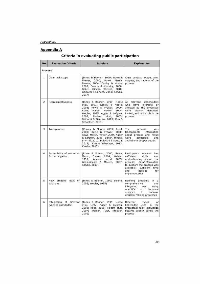
Appendices
204
Appendix A
Criteria in evaluating public participation
No Evaluation Criteria Scholars Explanation
Process
1 Clear task scope (Innes & Booher, 1999; Rowe &
Frewer, 2000; Rowe, Marsh,
Frewer, 2004; Conley & Moote,
2003; Beierle & Konisky, 2000;
Baker, Hincks, Sherriff, 2010; Baiocchi & Ganuza, 2013; Kasdin,
2017)
Clear context, scope, aim,
outputs, and rational of the
process
2 Representativeness (Innes & Booher, 1999; Moote
et.al, 1997; Conley & Moote,
2003; Rowe & Frewer, 2000;
Rowe, Marsh, Frewer, 2004;
Webler, 1995, Agger & Lofgren,
2008; Abelson et.al, 2003;
Baiocchi & Ganuza, 2013; Kim &
Schachter, 2013)
All relevant stakeholders
who have interests or
affected by the processes
were clearly identified,
invited, and had a role in the
process
3 Transparency (Conley & Moote, 2003; Reed,
2008; Rowe & Frewer, 2000;
Rowe, Marsh, Frewer, 2004, Agger & Lofgren, 2008; Baker, Hincks,
Sherriff, 2010; Baiocchi & Ganuza,
2013; Kim & Schachter, 2013;
Kasdin, 2017)
The process was
transparent; information
about process and result were accessible and
available in proper details
4 Accessibility of resources
for participation
(Rowe & Frewer, 2000; Rowe,
Marsh, Frewer, 2004; Webler,
1995; Abelson et.al 2003;
Widianingsih & Morrell, 2007;
Kasdin, 2017)
Participants involved had
sufficient skills and
understanding about the
process; data/information
to support the process was
available; sufficient time
and facilities for
implementation
5 New, creative ideas or
solutions
(Innes & Booher, 1999; Beierle,
2002; Webler, 1995)
Defining problems in a
comprehensive and
integrated way; using
scientific or technical
analyses to improve
decision-making processes
6 Integration of different
types of knowledge
(Innes & Booher, 1999; Moote
et.al, 1997; Agger & Lofgren,
2008; Reed, 2008; Tippett et.al,
2007; Webler, Tuler, Krueger,
2001)
Different types of
knowledge used in the
processes; tacit knowledge
became explicit during the
process
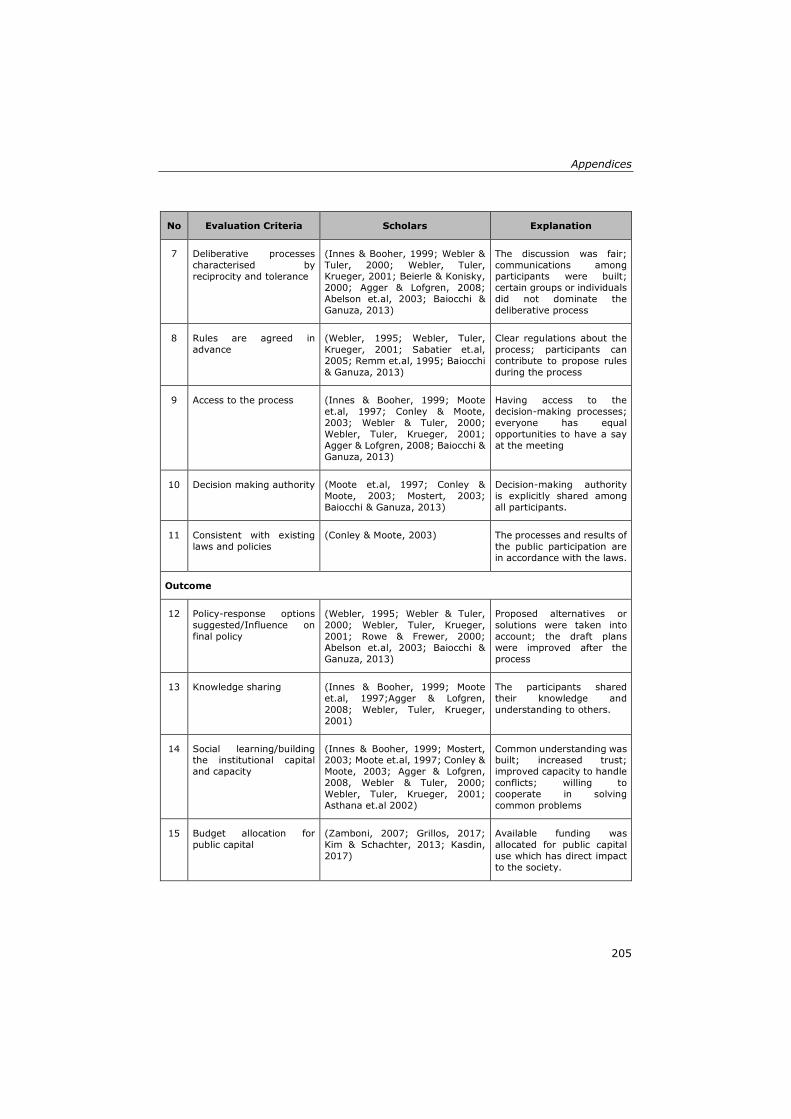
Appendices
205
No Evaluation Criteria Scholars Explanation
7 Deliberative processes
characterised by
reciprocity and tolerance
(Innes & Booher, 1999; Webler &
Tuler, 2000; Webler, Tuler, Krueger, 2001; Beierle & Konisky,
2000; Agger & Lofgren, 2008;
Abelson et.al, 2003; Baiocchi &
Ganuza, 2013)
The discussion was fair;
communications among participants were built;
certain groups or individuals
did not dominate the
deliberative process
8 Rules are agreed in
advance
(Webler, 1995; Webler, Tuler,
Krueger, 2001; Sabatier et.al,
2005; Remm et.al, 1995; Baiocchi
& Ganuza, 2013)
Clear regulations about the
process; participants can
contribute to propose rules
during the process
9 Access to the process (Innes & Booher, 1999; Moote
et.al, 1997; Conley & Moote,
2003; Webler & Tuler, 2000;
Webler, Tuler, Krueger, 2001;
Agger & Lofgren, 2008; Baiocchi &
Ganuza, 2013)
Having access to the
decision-making processes;
everyone has equal
opportunities to have a say
at the meeting
10 Decision making authority (Moote et.al, 1997; Conley &
Moote, 2003; Mostert, 2003;
Baiocchi & Ganuza, 2013)
Decision-making authority
is explicitly shared among
all participants.
11 Consistent with existing
laws and policies
(Conley & Moote, 2003) The processes and results of
the public participation are
in accordance with the laws.
Outcome
12 Policy-response options
suggested/Influence on
final policy
(Webler, 1995; Webler & Tuler,
2000; Webler, Tuler, Krueger,
2001; Rowe & Frewer, 2000;
Abelson et.al, 2003; Baiocchi &
Ganuza, 2013)
Proposed alternatives or
solutions were taken into
account; the draft plans
were improved after the
process
13 Knowledge sharing (Innes & Booher, 1999; Moote
et.al, 1997;Agger & Lofgren,
2008; Webler, Tuler, Krueger,
2001)
The participants shared
their knowledge and
understanding to others.
14 Social learning/building the institutional capital
and capacity
(Innes & Booher, 1999; Mostert, 2003; Moote et.al, 1997; Conley &
Moote, 2003; Agger & Lofgren,
2008, Webler & Tuler, 2000;
Webler, Tuler, Krueger, 2001;
Asthana et.al 2002)
Common understanding was built; increased trust;
improved capacity to handle
conflicts; willing to
cooperate in solving
common problems
15 Budget allocation for
public capital
(Zamboni, 2007; Grillos, 2017;
Kim & Schachter, 2013; Kasdin,
2017)
Available funding was
allocated for public capital
use which has direct impact
to the society.
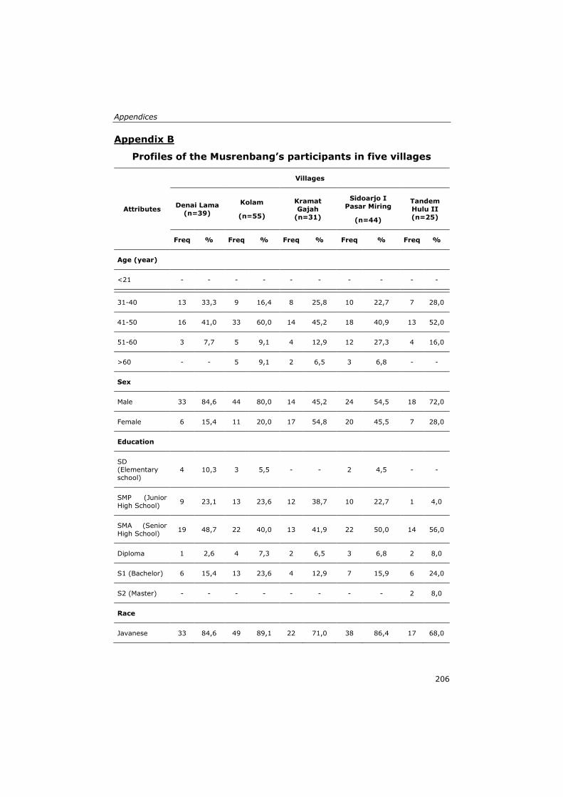
Appendices
206
Appendix B
Profiles of the Musrenbang’s participants in five villages
Attributes
Villages
Denai Lama
(n=39)
Kolam
(n=55)
Kramat
Gajah
(n=31)
Sidoarjo I
Pasar Miring
(n=44)
Tandem
Hulu II
(n=25)
Freq % Freq % Freq % Freq % Freq %
Age (year)
<21 - - - - - - - - - -
21-30 7 17,9 3 5,5 3 9,7 1 2,3 1 4,0 31-40 13 33,3 9 16,4 8 25,8 10 22,7 7 28,0
41-50 16 41,0 33 60,0 14 45,2 18 40,9 13 52,0
51-60 3 7,7 5 9,1 4 12,9 12 27,3 4 16,0
>60 - - 5 9,1 2 6,5 3 6,8 - -
Sex
Male 33 84,6 44 80,0 14 45,2 24 54,5 18 72,0
Female 6 15,4 11 20,0 17 54,8 20 45,5 7 28,0
Education
SD (Elementary
school) 4 10,3 3 5,5 - - 2 4,5 - -
SMP (Junior
High School) 9 23,1 13 23,6 12 38,7 10 22,7 1 4,0
SMA (Senior
High School) 19 48,7 22 40,0 13 41,9 22 50,0 14 56,0
Diploma 1 2,6 4 7,3 2 6,5 3 6,8 2 8,0
S1 (Bachelor) 6 15,4 13 23,6 4 12,9 7 15,9 6 24,0
S2 (Master) - - - - - - - - 2 8,0
Race
Javanese 33 84,6 49 89,1 22 71,0 38 86,4 17 68,0
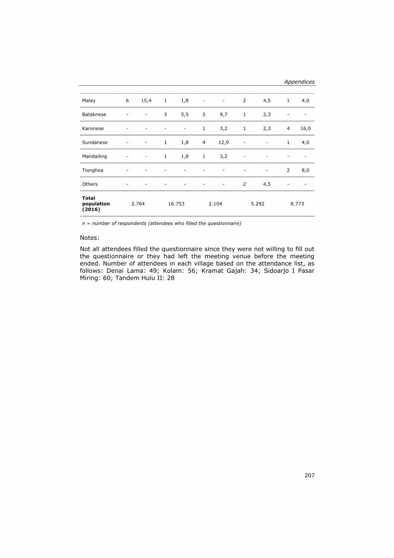
Appendices
207
Notes:
Not all attendees filled the questionnaire since they were not willing to fill out the questionnaire or they had left the meeting venue before the meeting ended. Number of attendees in each village based on the attendance list, as follows: Denai Lama: 49; Kolam: 56; Kramat Gajah: 34; Sidoarjo I Pasar Miring: 60; Tandem Hulu II: 28
Malay 6 15,4 1 1,8 - - 2 4,5 1 4,0
Bataknese - - 3 5,5 3 9,7 1 2,3 - -
Karonese - - - - 1 3,2 1 2,3 4 16,0
Sundanese - - 1 1,8 4 12,9 - - 1 4,0
Mandailing - - 1 1,8 1 3,2 - - - -
Tionghoa - - - - - - - - 2 8,0
Others - - - - - - 2 4,5 - -
Total
population
(2016)
2.764 16.753 2.104 5.292 8.773
n = number of respondents (attendees who filled the questionnaire)
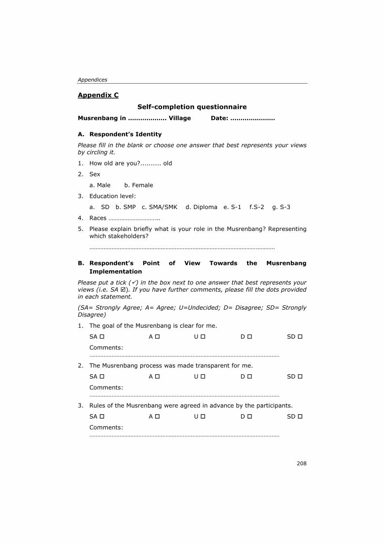
Appendices
208
Appendix C
Self-completion questionnaire
Musrenbang in ………………. Village Date: ………….………
A. Respondent’s Identity
Please fill in the blank or choose one answer that best represents your views by circling it.
1. How old are you?.......... old
2. Sex
a. Male b. Female
3. Education level:
a. SD b. SMP c. SMA/SMK d. Diploma e. S-1 f.S-2 g. S-3
4. Races …………………………..
5. Please explain briefly what is your role in the Musrenbang? Representing
which stakeholders?
………………………………………………………………………………………………………
B. Respondent’s Point of View Towards the Musrenbang
Implementation
Please put a tick (✓) in the box next to one answer that best represents your views (i.e. SA ). If you have further comments, please fill the dots provided in each statement.
(SA= Strongly Agree; A= Agree; U=Undecided; D= Disagree; SD= Strongly Disagree)
1. The goal of the Musrenbang is clear for me.
SA A U D SD
Comments: …………………………………………………………………………………………………………
2. The Musrenbang process was made transparent for me.
SA A U D SD
Comments: …………………………………………………………………………………………………………
3. Rules of the Musrenbang were agreed in advance by the participants.
SA A U D SD
Comments: …………………………………………………………………………………………………………
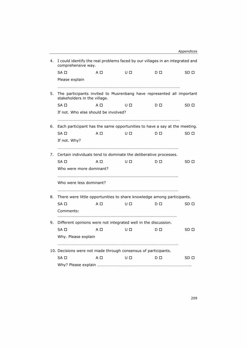
Appendices
209
4. I could identify the real problems faced by our villages in an integrated and comprehensive way.
SA A U D SD
Please explain
…………………………………………………………………………………………………………
5. The participants invited to Musrenbang have represented all important stakeholders in the village.
SA A U D SD
If not. Who else should be involved?
..........................................................................................
6. Each participant has the same opportunities to have a say at the meeting.
SA A U D SD
If not. Why?
……………………………………………………………………………………………………….
7. Certain individuals tend to dominate the deliberative processes.
SA A U D SD
Who were more dominant?
……………………………………………………………………………………………………….
Who were less dominant?
……………………………………………………………………………………………………….
8. There were little opportunities to share knowledge among participants.
SA A U D SD
Comments: ………………………………………………………………………………………………………
9. Different opinions were not integrated well in the discussion.
SA A U D SD
Why. Please explain
……………………………………………………………………………………………………….
10. Decisions were not made through consensus of participants.
SA A U D SD
Why? Please explain ………………………………………………………………………………..
Appendices
210
11. Data/information (i.e. maps, graphs, pictures, audio etc) to support the deliberative and decision making processes was not available.
SA A U D SD
If available. What kind of data/information provided?
…………………………………………………………………………………………………………..
If NOT available. What kind of data/information that should be available to support the process?
……………….…………………………………………………………………………………………..
12. Data/information is needed to support the deliberative processes and
decision making.
SA A U D SD
Please explain
…………………………………………………………………………………………………………..
13. I learn nothing from other Musrenbang participants.
SA A U D SD
Please explain
………………………………………………………………………………………………………….
14. Common understanding was built among participants.
SA A U D SD
Please explain
………………………………………………………………………………………………………….
15. Budget allocation for public capital is still limited.
SA A U D SD
Why? Please explain
…………………………………………………………………………………………………………..
Appendices
211
Appendix D
Interview List for Participants (non-government)
Interviews with Stakeholders:
Name :
Village :
Sub-district :
Date of Data Collection
Date Month Time
(start)
Time (finish)
Result of the interview :
[ 1 ] Complete the interview
[ 2 ] Rejecting to be interviewed
[ 3 ] Rejecting during the interview.
[ 4 ] Others (…………………………........................................)
Introduction
Hello, my name is Aulia Akbar. I am here on behalf of the Universiteit of Twente
as a researcher about the Musrenbang practice. We recently attended the
Musrenbang in your village, and we had announced that we would be approach
you for an interview. Do you have some time to participate and answer some
questions for us? The interview should take about an hour.
Before we start I want to shortly tell you what we would like to talk to you
about today. We would like ask you some questions about your opinions and
experiences about the village Musrenbang implementation. We try to
investigate more about how the governance processes in the Musrenbang and
how the participants’ knowledge were used at the discussion. You attended the
Musrenbang, followed the processes from the beginning until the end, and filled
the questionnaire. So I would like to get further information about the
Musrenbang process.
We also want to know more about the knowledge used in the Musrenbang. I
believe that as a citizen of this village, you know very well about your
neighbourhood. That means that you have the local knowledge that the
outsiders might not know. Of course, for everyone this is different. Each people
Appendices
212
has their own knowledge and they may use, integrate, exchange, with other
participants at the Musrenbang meeting. Thus, we are interested to get more
information about these issues.
In answering our questions there are no right or wrong answers; we are
interested in your own experience. Of course your name will remain secret and
everything we talk about will be anonymous. If you have any questions during
the interview or our questions are not clear, please let me know. Do you have
any questions before we begin?
Background of the Interviewee
1. Do you live in ……. Village? 2. From which neighbourhood? 3. How long have you lived in …………. Village?
4. What are you doing for a living? What is your position? How long have you been working in that position?
Representativeness in Musrenbang (not applicable for Musrenbang
organiser)
5. Could you tell me how did you get the invitation for attending the Musrenbang? When did you receive the invitation?
6. What is your role when you are invited to the last Musrenbang? To represent which groups?
7. How many times have you ever attended a Musrenbang practice with that role?
8. Did you ever have other roles? If yes, please explain.
9. Which stakeholders are invited to the meeting? Who is responsible to
decide which stakeholders to be invited to the meeting? 10. Do you think the participants have represented all important stakeholders
in the village? If NOT, who else should be invited?
Awareness of the scope and process of Musrenbang
11. What do you think about the aims of the Musrenbang? 12. Do you think that the scope of the Musrenbang is clear and appropriate
for participants? 13. Can you explain what do your constituents expect from your participation
in the Musrenbang?
Data/information availability
14. Did you receive any data/information (i.e. maps, diagrams, pictures, etc) from the Musrenbang organiser at the meeting?
15. If yes, what kind of data/information did you get at the meeting? 16. If no, what kind of data/information that you think needs to be provided
at the meeting? 17. If the organiser give you data/information, do you prefer to receive before
or during the meeting? Why?
Appendices
213
18. Why do you think it is important to have available data/information at the meeting?
Facilities of the Musrenbang
19. What was good and not so good about the facilities provided at the meeting? What needs to be improved?
20. What do you think about the time allocation of the meeting? 21. What do you think about the hall used for the meeting?
Rules are agreed in advance
22. Were the rules of the meeting well-informed to the participants at the
beginning of the meeting? 23. If yes, what were the rules agreed before the discussion? 24. If no, do you think it is important to agree the rules prior the discussion?
What are the rules that need to be agreed?
Deliberative processes
25. How well do you know other stakeholders? 26. Have you ever worked with other stakeholders invited to the meeting? Tell
me your experience? 27. What do you think about the opportunities for participants to have a say
at the meeting?
28. Did you think there were certain stakeholders dominating the discussion? 29. Who did have more domination in the process? Who did have less
domination? 30. What are the factors that make certain people more dominant or less
dominant?
31. What do you think the solution to minimise the domination and make the
process more equal for all?
Decision making processes
32. How can you reach consensus about the plans and budget priorities? 33. Were your ideas, opinions, suggestions taken into consideration by other
participants? 34. Did you learn something from others ideas, opinions, suggestions’?
35. If there is dispute among stakeholders, what are the actions to resolve the dispute?
36. In general, do you think such participatory planning and budgeting practice can be helpful in making better plans for your neighbourhood?
37. To what extent does the village government and village councils give their effort to inform people about ongoing projects and events in your village?
38. To what extent new, creative ideas or solutions from participants can influence the first draft proposed by the village government?
Appendices
214
Public capital spending plan
39. Was the amount of money to spend on public capital discussed in the meeting? How much is the percentage of the money will be spent in public capital?
40. What do you think about the amount of the money allocated on public capital projects/programs?
Knowledge used and Social learning experiences
41. To what extent did you share your knowledge to other participants? Did other stakeholders also share their knowledge?
42. Did you find common understanding among stakeholders?
43. Did the deliberative processes allow you to understand other participants’ point of view?
Spatial knowledge
44. Have you ever worked with a map? For what purpose do you ever work with a map?
45. What kind of maps have you ever worked with? 46. Can you interpret the information provided in the map? 47. Let me show you a map, the digital and the analog map. This map shows
the area of your village. Do you know your neighbourhood well? Can you
show me where are the locations of some points of interests in your village?
48. With the knowledge about the space and location that you have, to what extent did you use the knowledge in the Musrenbang discussion?
Village map
49. Are you aware that according to the laws, each village must have a village map?
50. If you are asked to draw a sketch map of your neighbourhood, what do you think?
51. What do you think if the maps are used to support the Musrenbang deliberative processes?
52. What do you think if each stakeholder involved in the Musrenbang
contribute to produce a village map? 53. Which stakeholders do you think need to be involved in producing the
village maps? Why?
Transparency
54. How can you access the result of the Musrenbang?
55. How can you make sure that your contributions at the Musrenbang were taken into account?
Appendices
215
Respondent Identity
1. How old are you? .......... years old 2. Education level :
SD [1] SMP [2] SMU [3] Diploma [4] S1 [5]
S2 [6] 3. Sex:
Male [1] Female [2]
4. Races: Malay [1]
Java [2] Karo [3] Mandailing [4] Simalungun [5] Toba [6] Sunda [7] Banten [8]
Others (………………………..) [9] Thank you for your answers and cooperation.
Interviewer,
Aulia Akbar
Appendices
216
Appendix E
Interview List for Organisers/Governments
Interviews with Stakeholders:
Name :
Village :
Sub-district :
Date of Data Collection
Date Month Time
(start)
Time (finish)
Result of the interview :
[ 1 ] Complete the interview
[ 2 ] Rejecting to be interviewed
[ 3 ] Rejecting during the interview.
[ 4 ] Others (…………………………........................................)
Introduction
Hello, my name is Aulia Akbar. I am here on behalf of the Universiteit of Twente
as a researcher about the Musrenbang practice. We recently attended the
Musrenbang in your village, and we had informed you few times ago that we
would have an interview with you. Do you have some time to participate and
answer some questions for us? The interview should take about an hour.
Before we start I want to shortly tell you what we would like to discuss with
you today. We would like ask you some questions about your opinions and
experiences about the village Musrenbang implementation. We try to
investigate more about how the governance processes in the Musrenbang and
how the participants’ knowledge were used at the discussion. Basically, I would
like to get further information about the Musrenbang process from the
government’s perspective, especially the organiser.
We also want to know more about the knowledge used in the Musrenbang. It
is common that local people have their own local knowledge that the outsiders
might not know. Of course, for everyone this is different. Each people has their
own knowledge and they may use, integrate, exchange, with other participants
Appendices
217
at the Musrenbang meeting. Thus, we are interested to get more information
about these issues.
In answering our questions there are no right or wrong answers; we are
interested in your own experience. Of course your name will remain secret and
everything we talk about will be anonymous. If you have any questions during
the interview or our questions are not clear, please let me know. Do you have
any questions before we begin?
Background of the Interviewee
1. Could you tell me a bit about your background? Origins, education,
previous positions?
2. How long have you been working for this position? 3. How long have you been working to organise the Musrenbang?
Representativeness in Musrenbang
4. Could you tell me are there any criteria to be a participant of Musrenbang? 5. Which stakeholders are invited to the meeting? Who is responsible to
decide which stakeholders to be invited to the meeting? 6. What do you think about the composition of the participants of
Musrenbang? Do you think it is already appropriate with the purpose of Musrenbang? If yes. Why? If no. Who else should be invited?
Awareness of the scope and process of Musrenbang
7. Could you give me information about the aims of the Musrenbang? 8. Do you think that the scope of the Musrenbang is clear and appropriate
for participants?
9. Can you explain what do your constituents expect from Musrenbang? 10. Were there any actions from the local government to disseminate the
importance of Musrenbang?
Data/information availability
11. Did you provide any data/information for the Musrenbang participants? 12. If yes, what kind of data/information did you give at the meeting? Why 13. If no, what kind of data/information that you think needs to be provided
at the meeting? Why? 14. What do you think the importance of having sufficient data/information at
the meeting?
Facilities of the Musrenbang
15. What was good and not so good about the facilities provided at the meeting? What needs to be improved?
16. What do you think about the time allocation of the meeting? 17. What do you think about the hall used for the meeting?

Appendices
218
Rules are agreed in advance
18. Were the rules of the meeting well-informed to the participants at the beginning of the meeting?
19. If yes, what were the rules agreed before the discussion? 20. If no, do you think it is important to agree the rules prior the discussion?
What are the rules that need to be agreed?
Deliberative processes
21. How well do you know other stakeholders? 22. Have you ever worked with other stakeholders invited to the meeting? Tell
me your experience?
23. What do you think about the opportunities for participants to have a say at the meeting?
24. Did you think there were certain stakeholders dominating the discussion?
25. Who did have more domination in the process? Who did have less domination?
26. What are the factors that make certain people more dominant or less dominant?
27. What do you think the solution to minimise the domination and make the process more equal for all?
Decision making processes
28. Could you describe how the consensus about the plans and budget priorities can be reached?
29. Were new ideas, opinions, suggestions taken into consideration in the meeting?
30. Did you learn something from others ideas, opinions, suggestions’?
31. If there are disputes among stakeholders. What are the actions to achieve consensus?
32. In general, do you think such participatory planning and budgeting practice can be helpful in making better plans for your neighbourhood? Is it effective to make better plans?
33. To what extent does the village government and village councils give their effort to inform people about ongoing projects and events in the village?
34. To what extent new, creative ideas or solutions from participants can influence the first draft proposed by the village government?
Public capital spending plan
35. Could you tell me the proportion of money that must be spent into public capital projects?
36. Was the amount of money to spend on public capital discussed in the meeting? How much is the percentage of the money will be spent in public capital?
Appendices
219
Knowledge used and Social learning experiences
37. To what extent did you share your knowledge to other participants? Did other stakeholders also share their knowledge?
38. Did you find common understanding among stakeholders? 39. Did the deliberative processes allow all participants to understand other
participants’ point of view?
Respondent Identity
1. How old are you? .......... years old
2. Education level :
SD [1] SMP [2] SMU [3] Diploma [4]
S1 [5] S2 [6]
3. Sex: Male [1]
Female [2] 4. Races:
Malay [1]
Java [2] Karo [3] Mandailing [4] Simalungun [5] Toba [6] Sunda [7]
Banten [8]
Others (………………………..) [9]
Thank you for your answers and cooperation.
Interviewer,
Aulia Akbar
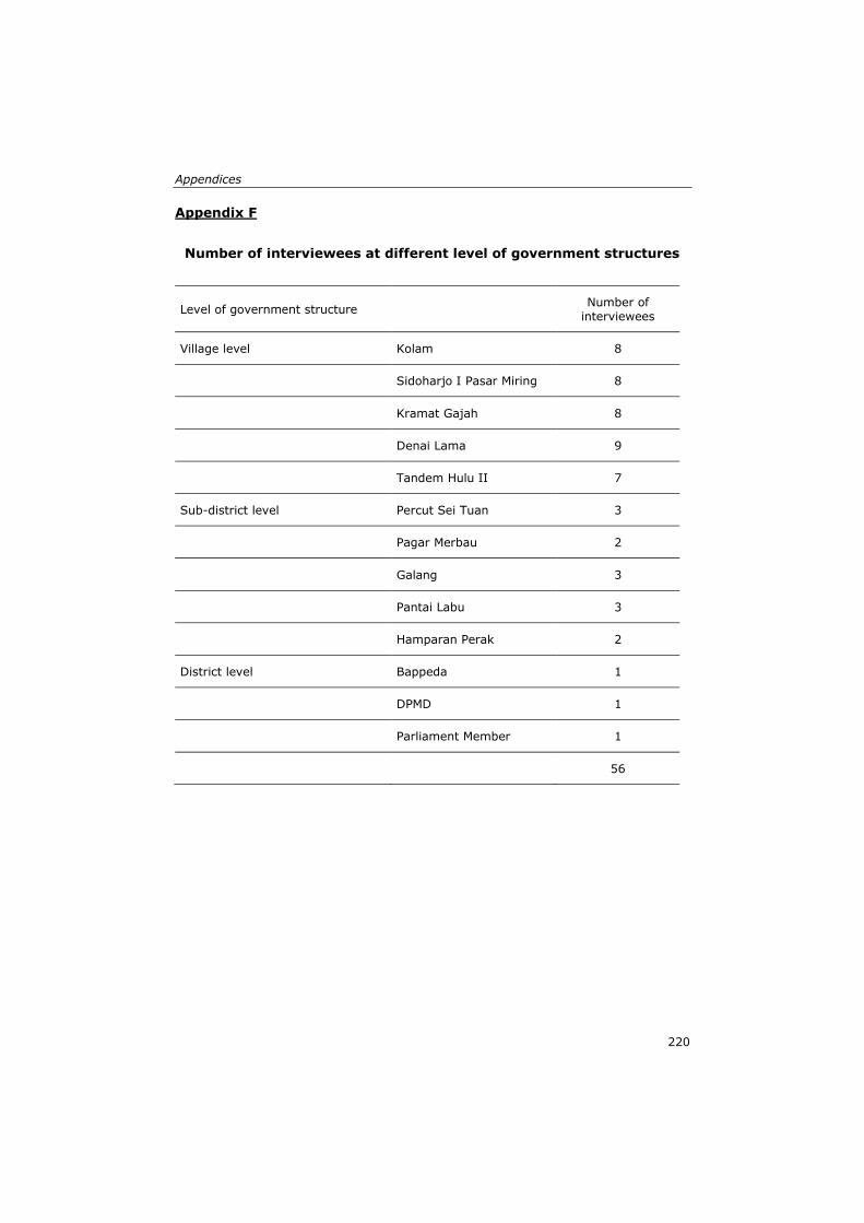
Appendices
220
Appendix F
Number of interviewees at different level of government structures
Level of government structure Number of
interviewees
Village level Kolam 8
Sidoharjo I Pasar Miring 8
Kramat Gajah 8
Denai Lama 9
Tandem Hulu II 7
Sub-district level Percut Sei Tuan 3
Pagar Merbau 2
Galang 3
Pantai Labu 3
Hamparan Perak 2
District level Bappeda 1
DPMD 1
Parliament Member 1
56
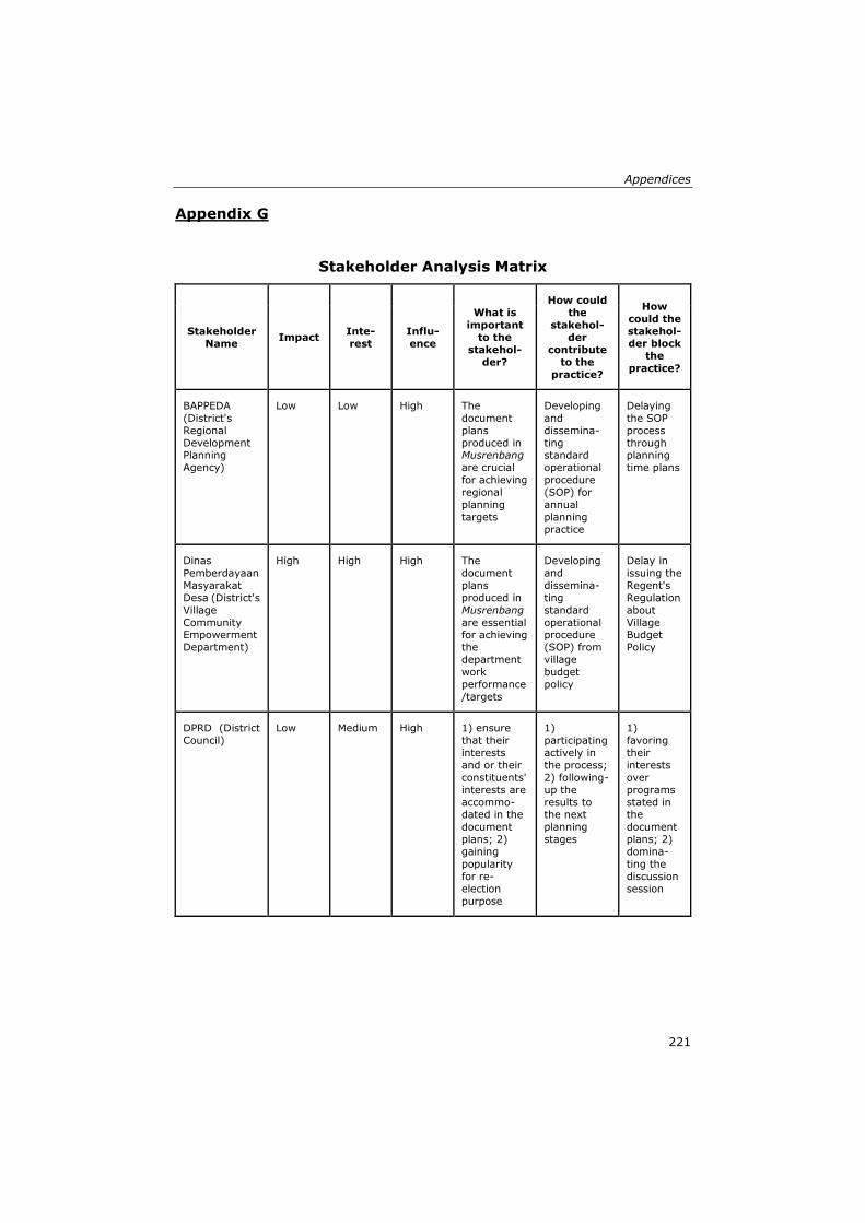
Appendices
221
Appendix G
Stakeholder Analysis Matrix
Stakeholder
Name Impact
Inte-
rest
Influ-
ence
What is
important
to the
stakehol-
der?
How could
the
stakehol-
der
contribute
to the
practice?
How
could the
stakehol-der block
the
practice?
BAPPEDA
(District's
Regional
Development Planning
Agency)
Low Low High The
document
plans
produced in Musrenbang
are crucial
for achieving
regional
planning
targets
Developing
and
dissemina-
ting standard
operational
procedure
(SOP) for
annual
planning
practice
Delaying
the SOP
process
through planning
time plans
Dinas
Pemberdayaan
Masyarakat
Desa (District's
Village
Community Empowerment
Department)
High High High The
document
plans
produced in
Musrenbang
are essential for achieving
the
department
work
performance
/targets
Developing
and
dissemina-
ting
standard
operational procedure
(SOP) from
village
budget
policy
Delay in
issuing the
Regent's
Regulation
about
Village Budget
Policy
DPRD (District
Council)
Low Medium High 1) ensure
that their
interests
and or their
constituents'
interests are
accommo-dated in the
document
plans; 2)
gaining
popularity
for re-
election
purpose
1)
participating
actively in
the process;
2) following-
up the
results to the next
planning
stages
1)
favoring
their
interests
over
programs
stated in the
document
plans; 2)
domina-
ting the
discussion
session
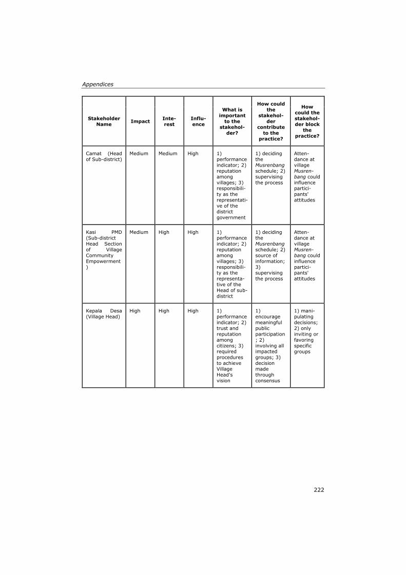
Appendices
222
Stakeholder
Name Impact
Inte-
rest
Influ-
ence
What is
important
to the
stakehol-
der?
How could
the
stakehol-
der
contribute
to the
practice?
How
could the
stakehol-
der block
the
practice?
Camat (Head
of Sub-district)
Medium Medium High 1)
performance
indicator; 2)
reputation
among
villages; 3) responsibili-
ty as the
representati-
ve of the
district
government
1) deciding
the
Musrenbang
schedule; 2)
supervising
the process
Atten-
dance at
village
Musren-
bang could
influence partici-
pants'
attitudes
Kasi PMD
(Sub-district
Head Section
of Village
Community
Empowerment
)
Medium High High 1)
performance
indicator; 2)
reputation
among
villages; 3)
responsibili-ty as the
representa-
tive of the
Head of sub-
district
1) deciding
the
Musrenbang
schedule; 2)
source of
information;
3) supervising
the process
Atten-
dance at
village
Musren-
bang could
influence
partici-pants'
attitudes
Kepala Desa
(Village Head)
High High High 1)
performance
indicator; 2)
trust and
reputation
among
citizens; 3) required
procedures
to achieve
Village
Head's
vision
1)
encourage
meaningful
public
participation
; 2)
involving all impacted
groups; 3)
decision
made
through
consensus
1) mani-
pulating
decisions;
2) only
inviting or
favoring
specific
groups
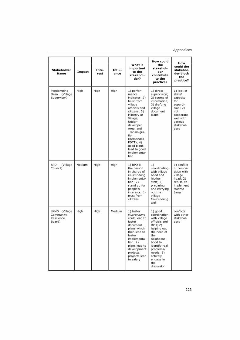
Appendices
223
Stakeholder
Name Impact
Inte-
rest
Influ-
ence
What is
important
to the
stakehol-
der?
How could
the
stakehol-
der
contribute
to the
practice?
How
could the
stakehol-
der block
the
practice?
Pendamping
Desa (Village
Supervisor)
High High High 1) perfor-
mance
indicator; 2)
trust from
village
officials and citizens; 3)
Ministry of
Village,
Under-
developed
Area, and
Transmigra-
tion
(Kemendes PDTT); 4)
good plans
lead to good
implementa-
tion
1) direct
supervision;
2) source of
information;
3) drafting
village document
plans
1) lack of
skills/
capacity
for
supervi-
sion; 2) not
cooperate
well with
various
stakehol-
ders
BPD (Village
Council)
Medium High High 1) BPD is
the person
in charge of
Musrenbang
implementa-
tion; 2)
stand up for
people's interests; 3)
trust from
citizens
1)
coordinating
with village
head and
his/her
staff; 2)
preparing
and carrying out the
village
Musrenbang
well
1) conflict
or compe-
tition with
village
head; 2)
refusal to
implement
Musren-
bang
LKMD (Village
Community
Resilience
Board)
High High Medium 1) faster
Musrenbang
could lead to
faster
document
plans which
then lead to
faster
implementa-tion; 2)
plans lead to
development
projects,
projects lead
to salary
1) good
coordination
with village
officials and
BPD; 2)
helping out
the head of
the
neighbour-hood to
identify real
problems/
needs; 3)
actively
engage in
the
discussion
conflicts
with other
stakehol-
ders
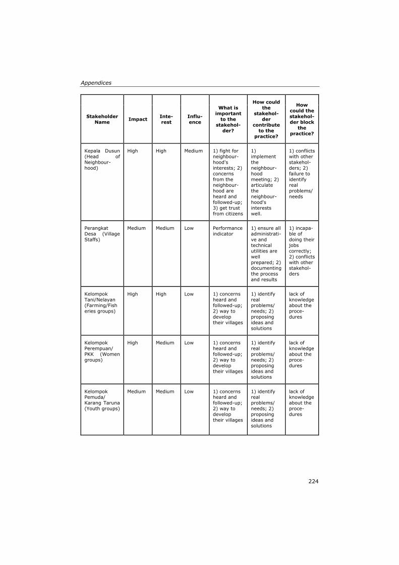
Appendices
224
Stakeholder
Name Impact
Inte-
rest
Influ-
ence
What is
important
to the
stakehol-
der?
How could
the
stakehol-
der
contribute
to the
practice?
How
could the
stakehol-
der block
the
practice?
Kepala Dusun
(Head of
Neighbour-
hood)
High High Medium 1) fight for
neighbour-
hood's
interests; 2)
concerns
from the neighbour-
hood are
heard and
followed-up;
3) get trust
from citizens
1)
implement
the
neighbour-
hood
meeting; 2) articulate
the
neighbour-
hood's
interests
well.
1) conflicts
with other
stakehol-
ders; 2)
failure to
identify real
problems/
needs
Perangkat
Desa (Village
Staffs)
Medium Medium Low Performance
indicator
1) ensure all
administrati-
ve and
technical
utilities are
well
prepared; 2) documenting
the process
and results
1) incapa-
ble of
doing their
jobs
correctly;
2) conflicts
with other stakehol-
ders
Kelompok
Tani/Nelayan
(Farming/Fish
eries groups)
High High Low 1) concerns
heard and
followed-up;
2) way to
develop
their villages
1) identify
real
problems/
needs; 2)
proposing
ideas and
solutions
lack of
knowledge
about the
proce-
dures
Kelompok
Perempuan/
PKK (Women
groups)
High Medium Low 1) concerns
heard and
followed-up;
2) way to
develop
their villages
1) identify
real
problems/
needs; 2)
proposing ideas and
solutions
lack of
knowledge
about the
proce-
dures
Kelompok Pemuda/
Karang Taruna
(Youth groups)
Medium Medium Low 1) concerns heard and
followed-up;
2) way to
develop
their villages
1) identify real
problems/
needs; 2)
proposing
ideas and
solutions
lack of knowledge
about the
proce-
dures
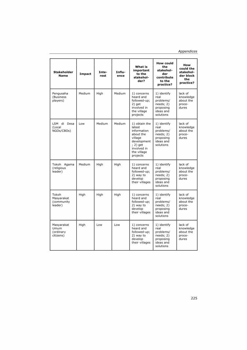
Appendices
225
Stakeholder
Name Impact
Inte-
rest
Influ-
ence
What is
important
to the
stakehol-
der?
How could
the
stakehol-
der
contribute
to the
practice?
How
could the
stakehol-
der block
the
practice?
Pengusaha
(Business
players)
Medium High Medium 1) concerns
heard and
followed-up;
2) get
involved in
the village
projects
1) identify
real
problems/
needs; 2)
proposing
ideas and
solutions
lack of
knowledge
about the
proce-
dures
LSM di Desa
(Local
NGOs/CBOs)
Low Medium Medium 1) obtain the
latest information
about the
village
development
; 2) get
involved in
the village
projects
1) identify
real problems/
needs; 2)
proposing
ideas and
solutions
lack of
knowledge about the
proce-
dures
Tokoh Agama
(religious
leader)
Medium High High 1) concerns
heard and
followed-up;
2) way to
develop
their villages
1) identify
real
problems/
needs; 2)
proposing ideas and
solutions
lack of
knowledge
about the
proce-
dures
Tokoh Masyarakat
(community
leader)
High High High 1) concerns heard and
followed-up;
2) way to
develop
their villages
1) identify real
problems/
needs; 2)
proposing
ideas and
solutions
lack of knowledge
about the
proce-
dures
Masyarakat
Umum
(ordinary
citizens)
High Low Low 1) concerns
heard and
followed-up;
2) way to
develop
their villages
1) identify
real
problems/
needs; 2)
proposing
ideas and
solutions
lack of
knowledge
about the
proce-
dures
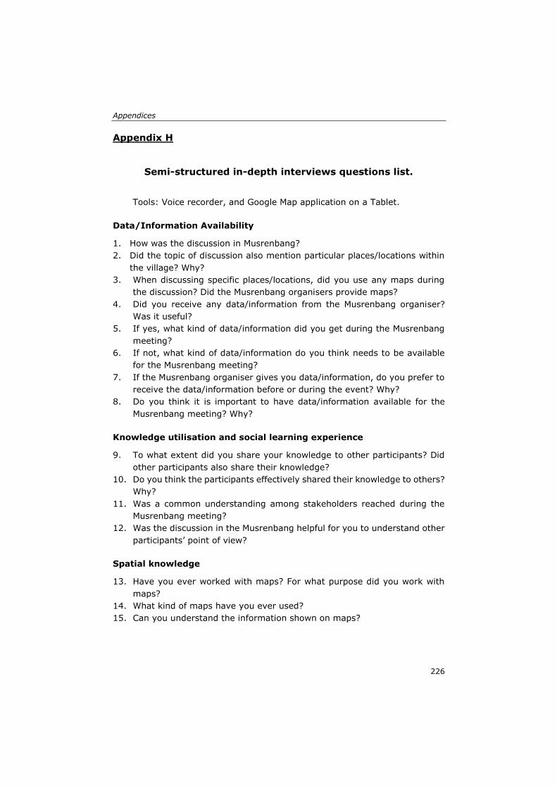
Appendices
226
Appendix H
Semi-structured in-depth interviews questions list.
Tools: Voice recorder, and Google Map application on a Tablet.
Data/Information Availability
1. How was the discussion in Musrenbang?
2. Did the topic of discussion also mention particular places/locations within
the village? Why?
3. When discussing specific places/locations, did you use any maps during
the discussion? Did the Musrenbang organisers provide maps?
4. Did you receive any data/information from the Musrenbang organiser?
Was it useful?
5. If yes, what kind of data/information did you get during the Musrenbang
meeting?
6. If not, what kind of data/information do you think needs to be available
for the Musrenbang meeting?
7. If the Musrenbang organiser gives you data/information, do you prefer to
receive the data/information before or during the event? Why?
8. Do you think it is important to have data/information available for the
Musrenbang meeting? Why?
Knowledge utilisation and social learning experience
9. To what extent did you share your knowledge to other participants? Did
other participants also share their knowledge?
10. Do you think the participants effectively shared their knowledge to others?
Why?
11. Was a common understanding among stakeholders reached during the
Musrenbang meeting?
12. Was the discussion in the Musrenbang helpful for you to understand other
participants’ point of view?
Spatial knowledge
13. Have you ever worked with maps? For what purpose did you work with
maps?
14. What kind of maps have you ever used?
15. Can you understand the information shown on maps?
Appendices
227
16. Let me show you a map showing your village area (in digital format and
analogue). Can you identify your neighbourhoods or living place? Can you
point at some primary objects/places (such as village head office, mosque,
etc.) in your village?
17. Using this map (in digital format and analogue), do you know what the
distance is between primary objects/places A and B? How can you
measure the distance between A and B?
18. In the field, do you know what the distance is between primary
objects/places A and B? How can you measure the distance between A
and B? Can we produce maps using the data between A and B? How can
we draw the positions and the distances into maps?
19. Do you know your village well? If I ask you a specific place in your village,
can you imagine the place in your mind?
20. Based on previous questions, it seems that you have spatial knowledge.
This is a knowledge about space and place. Did you recognise it?
21. Were discussions about name of places or geographical locations included
in the deliberative processes of Musrenbang? How?
22. Were the participants using their spatial knowledge that they have during
the Musrenbang deliberative processes?
23. To what extent did you use your spatial knowledge during the Musrenbang
discussion?
Village Maps
24. Does the village have maps? What kind of maps? How and when were the
maps produced?
25. Did you use the maps during the Musrenbang? How?
26. Why did you use the maps during the Musrenbang?
27. Did you use the maps for other development purposes out of Musrenbang?
28. Did you know that based on the laws, each village must have village
maps?
29. Please draw the sketch map showing your village in this blank sheet. Can
you do that?
30. What is your opinion if we use maps during the Musrenbang meeting?
31. What is your opinion if we involve each stakeholder who attended the
Musrenbang to create the maps in a participatory manner?
32. If you think it is possible, who are the stakeholders that need to be
involved for the participatory mapping workshop? Why?
Appendices
228
Appendix I
Focus Group Discussion
Purpose
To gain information about the development of collaborative spatial
learning methodology that can integrate different types of spatial
knowledge and facilitate social learning (Objective 2).
Participants
The focus group discussion invited diverse stakeholders who were
involved in the Musrenbang meeting.
• Head of the village (Kepala Desa)
• Head of the village parliament board (Ketua BPD)
• Head of the village empowerment board (Ketua LPMD)
• Staff of the village office (Staf Kantor Desa) who is responsible to conduct
the Musrenbang
• Head of the neighbourhood (Kepala Dusun)—2 people per village
• Head of the youth club (Ketua Karang Taruna)
• Head of the women club (Ketua PKK)
• Village companion (Pendamping Desa)
• Religious leaders
• Village prominent person
Tools
Voice recorder, video recorder, sticky notes, pens, projector, and
laptop.
Q.1. Let us reflect to the Musrenbang implementation few weeks ago. What do
you think some positive aspect of the Musrenbang implementation? Please
write down your thoughts on the sticky notes provided.
After all participants wrote on the sticky notes. The moderator asks the
participants to put the sticky notes on the wall. Moderator leads the discussion
while rearranging the order of the sticky notes based on the topics of
discussion. During the discussion, moderator can trigger some additional
questions to raise the discussion among participants.
1. Are you familiar with the Village Law?
2. Can you tell us about the impact of the issuance of Village Law to the local
governance processes?
3. What are the impacts of the new law to the Musrenbang processes?

Appendices
229
4. Did you find that the current Musrenbang practices effective to discuss the
plans? Why?
5. What do you think that needs to be added to increase the effectiveness?
6. What do you think about data availability? Is it important? Why?
Q.2. Now, please write down some negative aspects that need to be improved
in the Musrenbang implementation?
The procedure is the same as the previous question. Moderator puts the sticky
notes and categorises the answers based on the discussion. Moderator then
asks some additional questions to stimulate the discussion among participants.
1. Do you think that sufficient data/information available could help the
processes?
2. Have you ever worked with a map? What kind of maps? For what purpose?
3. Did you find it is useful to work with a map?
4. What do you think if we also use maps in the Musrenbang processes?
5. Are you aware that the new law obliges each village to have village maps?
6. If I show you a satellite image, can you identify your point of interest in
the village? (by showing a satellite image map with several points of
interests).
Q.3. Based on our discussion today, it seemed that each of us has their own
spatial knowledge, which is the knowledge about how you perceive the
geographical location and place around you. What do you think about
producing village maps by integrating all the spatial knowledge that you have
into maps?
Additional questions to stimulate the discussion.
1. Do you think that the opinions and knowledge from the local people are
necessary in the mapping processes? Why and how?
2. Considering that each village must have village maps., do you prefer to
produce the maps in a participatory way or just ‘given’ from the upper
government? Why?
Q.4. Please allow me to give you a slight presentation about some methods
used to produce maps in a participatory manner (give a Power Point
presentation (around 5 min) about digital and non-digital participatory
mapping method; alternatively, watch short videos about the participatory
mapping in other places). After presentation, discuss!
Additional questions to stimulate the discussion.
1. If we would like to develop a participatory mapping methodology, which
one do you prefer, drawing the maps in a digital or non-digital procedure?
Appendices
230
2. What things do you think need to be consider when developing the
participatory mapping methodology?
3. Do you think the workshop should be facilitated with a mapping expert?
Why?
4. Do we need to do site-visit when mapping? Why?
5. Do you think that we can make use of the maps we have produced to
improve the current Musrenbang practices? Why and how?
Q.5. In terms of stakeholders that need to be involved in the participatory
mapping processes. Who are the stakeholders that should be involved in the
participatory mapping workshop? Why do we need to involve them?
Additional questions to stimulate the discussion.
1. Do you think that with the composition of the stakeholders involved would
increase the effectiveness of the participatory mapping workshop?
2. Do you think that the map making could enhance the communication and
collaboration among stakeholders?
3. Who are the stakeholders that you think have more power and influence
in the processes? What ways do you think could minimise the power and
influence imbalance? How?
Thank you for your cooperation to participate participating in this focus group
discussion.
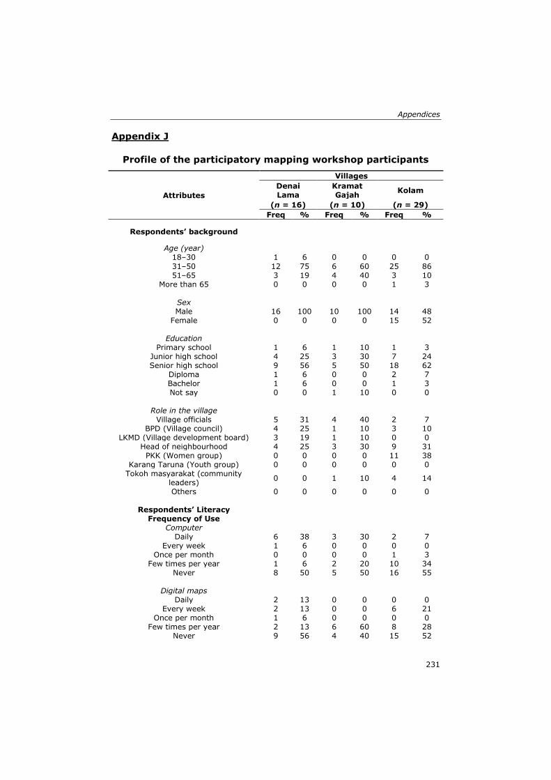
Appendices
231
Appendix J
Profile of the participatory mapping workshop participants
Attributes
Villages
Denai Lama
Kramat Gajah
Kolam
(n = 16) (n = 10) (n = 29)
Freq % Freq % Freq %
Respondents’ background
Age (year)
18–30 1 6 0 0 0 0
31–50 12 75 6 60 25 86 51–65 3 19 4 40 3 10
More than 65 0 0 0 0 1 3
Sex
Male 16 100 10 100 14 48 Female 0 0 0 0 15 52
Education
Primary school 1 6 1 10 1 3 Junior high school 4 25 3 30 7 24 Senior high school 9 56 5 50 18 62
Diploma 1 6 0 0 2 7 Bachelor 1 6 0 0 1 3 Not say 0 0 1 10 0 0
Role in the village
Village officials 5 31 4 40 2 7 BPD (Village council) 4 25 1 10 3 10
LKMD (Village development board) 3 19 1 10 0 0 Head of neighbourhood 4 25 3 30 9 31
PKK (Women group) 0 0 0 0 11 38 Karang Taruna (Youth group) 0 0 0 0 0 0
Tokoh masyarakat (community leaders)
0 0 1 10 4 14
Others 0 0 0 0 0 0
Respondents’ Literacy
Frequency of Use
Computer
Daily 6 38 3 30 2 7 Every week 1 6 0 0 0 0
Once per month 0 0 0 0 1 3 Few times per year 1 6 2 20 10 34
Never 8 50 5 50 16 55
Digital maps
Daily 2 13 0 0 0 0 Every week 2 13 0 0 6 21
Once per month 1 6 0 0 0 0 Few times per year 2 13 6 60 8 28
Never 9 56 4 40 15 52

Appendices
232
Paper maps
Daily 2 13 0 0 0 0 Every week 2 13 1 10 1 3
Once per month 0 0 3 30 1 3 Few times per year 11 69 6 60 11 38
Never 1 6 0 0 16 55
Participation in a group mapping activity
Never 3 19 3 30 11 38 1–2 times 11 69 6 60 16 55
3–5 times 1 6 1 10 2 7 More than 5 times 1 6 0 0 0 0
n = number of respondents (attendees who filled the questionnaire).
In Kolam village, from thirty participants, there was one participant who left the
workshop early and did not fill the questionnaire.
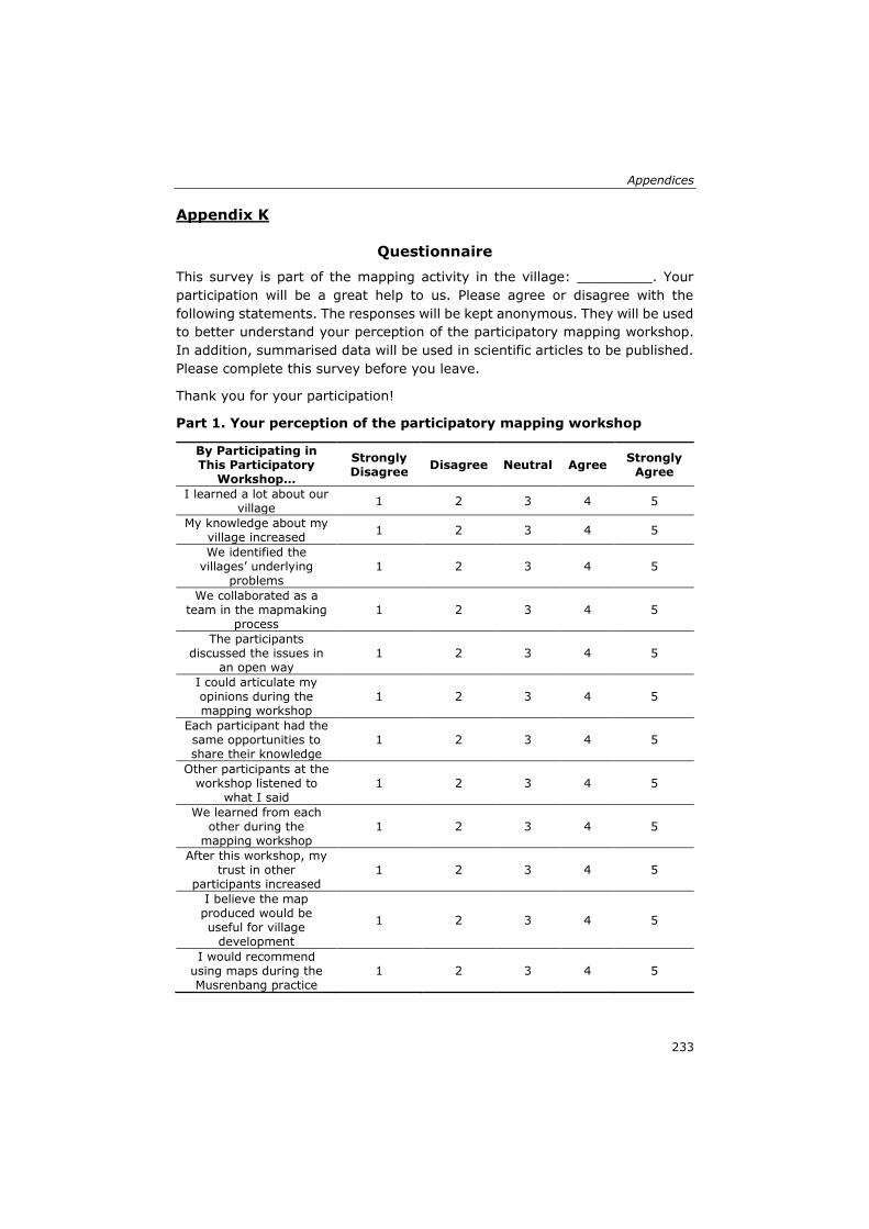
Appendices
233
Appendix K
Questionnaire
This survey is part of the mapping activity in the village: _________. Your
participation will be a great help to us. Please agree or disagree with the
following statements. The responses will be kept anonymous. They will be used
to better understand your perception of the participatory mapping workshop.
In addition, summarised data will be used in scientific articles to be published.
Please complete this survey before you leave.
Thank you for your participation!
Part 1. Your perception of the participatory mapping workshop
By Participating in This Participatory
Workshop…
Strongly Disagree
Disagree Neutral Agree Strongly
Agree
I learned a lot about our village
1 2 3 4 5
My knowledge about my village increased
1 2 3 4 5
We identified the villages’ underlying
problems 1 2 3 4 5
We collaborated as a team in the mapmaking
process 1 2 3 4 5
The participants discussed the issues in
an open way 1 2 3 4 5
I could articulate my opinions during the mapping workshop
1 2 3 4 5
Each participant had the same opportunities to share their knowledge
1 2 3 4 5
Other participants at the workshop listened to
what I said 1 2 3 4 5
We learned from each other during the
mapping workshop 1 2 3 4 5
After this workshop, my trust in other
participants increased 1 2 3 4 5
I believe the map produced would be useful for village
development
1 2 3 4 5
I would recommend using maps during the Musrenbang practice
1 2 3 4 5
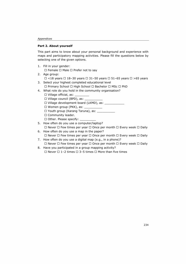
Appendices
234
Part 2. About yourself
This part aims to know about your personal background and experience with
maps and participatory mapping activities. Please fill the questions below by
selecting one of the given options.
1. Fill in your gender:
Female Male Prefer not to say
2. Age group:
<18 years 18–30 years 31–50 years 51–65 years >65 years
3. Select your highest completed educational level
Primary School High School Bachelor MSc PhD
4. What role do you hold in the community organisation?
Village official, as: ________
Village council (BPD), as: __________
Village development board (LKMD), as: ___________
Women group (PKK), as: __________
Youth group (Karang Taruna), as: __________
Community leader.
Other. Please specify: _________
5. How often do you use a computer/laptop?
Never Few times per year Once per month Every week Daily
6. How often do you use a map in the paper?
Never Few times per year Once per month Every week Daily
7. How often do you use a digital map (e.g., in a phone)?
Never Few times per year Once per month Every week Daily
8. Have you participated in a group mapping activity?
Never 1–2 times 3–5 times More than five times
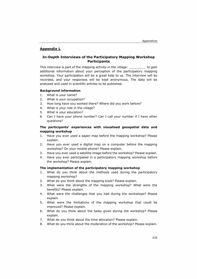
Appendices
235
Appendix L
In-Depth Interviews of the Participatory Mapping Workshop
Participants
This interview is part of the mapping activity in the village: _________ to gain
additional information about your perception of the participatory mapping
workshop. Your participation will be a great help to us. The interview will be
recorded, and your responses will be kept anonymous. The data will be
analysed and used in scientific articles to be published.
Background information
1. What is your name?
2. What is your occupation?
3. How long have you worked there? Where did you work before?
4. What is your role in the village?
5. What is your education?
6. Can I have your phone number? Can I call your number if I have other
questions?
The participants’ experiences with visualised geospatial data and
mapping workshop
1. Have you ever used a paper map before the mapping workshop? Please
explain.
2. Have you ever used a digital map on a computer before the mapping
workshop? On your mobile phone? Please explain.
3. Have you ever used a satellite image before the workshop? Please explain.
4. Have you ever participated in a participatory mapping workshop before
the workshop? Please explain.
The implementation of the participatory mapping workshop
1. What do you think about the methods used during the participatory
mapping workshop?
2. What do you think about the mapping tools? Please explain.
3. What were the strengths of the mapping workshop? What were the
benefits? Please explain.
4. What were the challenges that you had during the workshops? Please
explain.
5. What were the limitations of the mapping workshop that could be
improved? Please explain.
6. What do you think about the tasks given during the workshop? Please
explain.
7. What do you think about the time allocation? Please explain.
8. What do you think about the moderation of the workshop? Please explain.
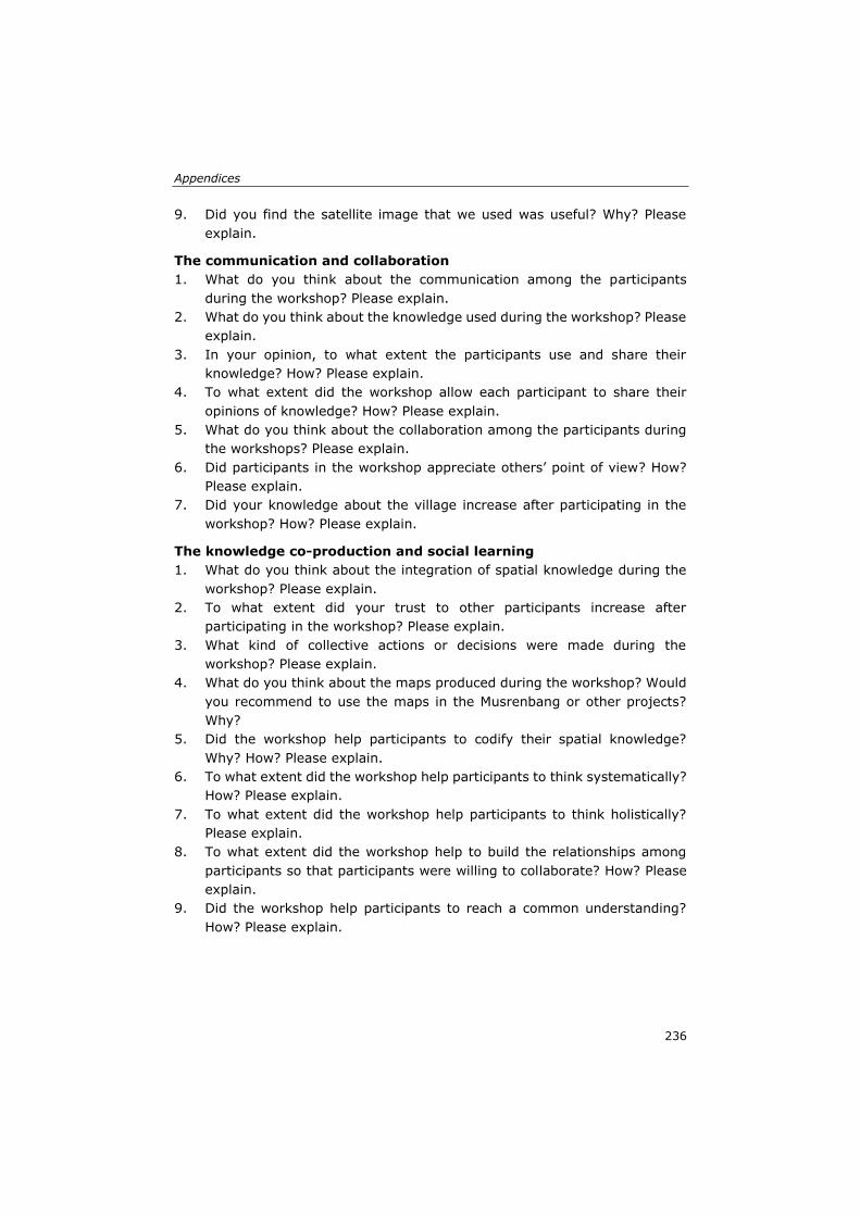
Appendices
236
9. Did you find the satellite image that we used was useful? Why? Please
explain.
The communication and collaboration
1. What do you think about the communication among the participants
during the workshop? Please explain.
2. What do you think about the knowledge used during the workshop? Please
explain.
3. In your opinion, to what extent the participants use and share their
knowledge? How? Please explain.
4. To what extent did the workshop allow each participant to share their
opinions of knowledge? How? Please explain.
5. What do you think about the collaboration among the participants during
the workshops? Please explain.
6. Did participants in the workshop appreciate others’ point of view? How?
Please explain.
7. Did your knowledge about the village increase after participating in the
workshop? How? Please explain.
The knowledge co-production and social learning
1. What do you think about the integration of spatial knowledge during the
workshop? Please explain.
2. To what extent did your trust to other participants increase after
participating in the workshop? Please explain.
3. What kind of collective actions or decisions were made during the
workshop? Please explain.
4. What do you think about the maps produced during the workshop? Would
you recommend to use the maps in the Musrenbang or other projects?
Why?
5. Did the workshop help participants to codify their spatial knowledge?
Why? How? Please explain.
6. To what extent did the workshop help participants to think systematically?
How? Please explain.
7. To what extent did the workshop help participants to think holistically?
Please explain.
8. To what extent did the workshop help to build the relationships among
participants so that participants were willing to collaborate? How? Please
explain.
9. Did the workshop help participants to reach a common understanding?
How? Please explain.
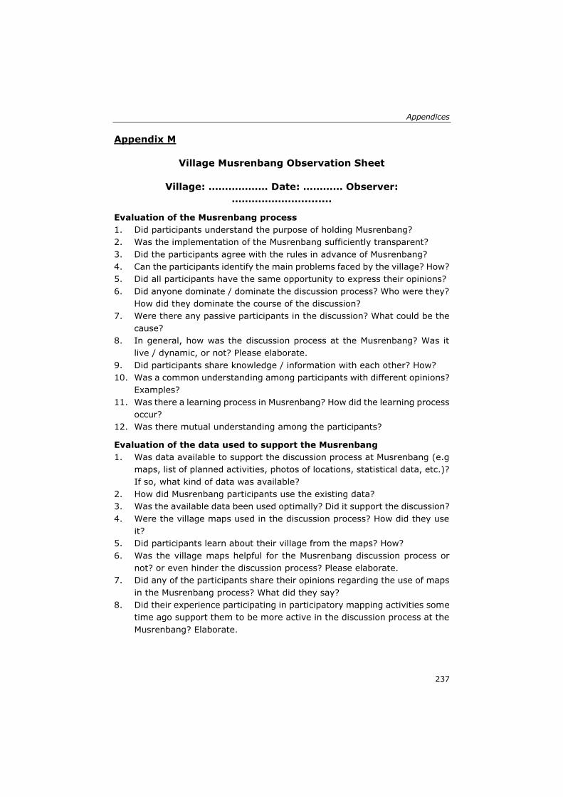
Appendices
237
Appendix M
Village Musrenbang Observation Sheet
Village: ……………… Date: ………… Observer:
………………….........
Evaluation of the Musrenbang process
1. Did participants understand the purpose of holding Musrenbang?
2. Was the implementation of the Musrenbang sufficiently transparent?
3. Did the participants agree with the rules in advance of Musrenbang?
4. Can the participants identify the main problems faced by the village? How?
5. Did all participants have the same opportunity to express their opinions?
6. Did anyone dominate / dominate the discussion process? Who were they?
How did they dominate the course of the discussion?
7. Were there any passive participants in the discussion? What could be the
cause?
8. In general, how was the discussion process at the Musrenbang? Was it
live / dynamic, or not? Please elaborate.
9. Did participants share knowledge / information with each other? How?
10. Was a common understanding among participants with different opinions?
Examples?
11. Was there a learning process in Musrenbang? How did the learning process
occur?
12. Was there mutual understanding among the participants?
Evaluation of the data used to support the Musrenbang
1. Was data available to support the discussion process at Musrenbang (e.g
maps, list of planned activities, photos of locations, statistical data, etc.)?
If so, what kind of data was available?
2. How did Musrenbang participants use the existing data?
3. Was the available data been used optimally? Did it support the discussion?
4. Were the village maps used in the discussion process? How did they use
it?
5. Did participants learn about their village from the maps? How?
6. Was the village maps helpful for the Musrenbang discussion process or
not? or even hinder the discussion process? Please elaborate.
7. Did any of the participants share their opinions regarding the use of maps
in the Musrenbang process? What did they say?
8. Did their experience participating in participatory mapping activities some
time ago support them to be more active in the discussion process at the
Musrenbang? Elaborate.
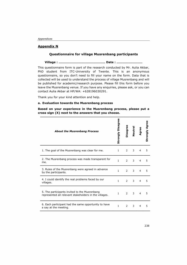
Appendices
238
Appendix N
Questionnaire for village Musrenbang participants
Village : ……………………………………….. Date : ……………………..
This questionnaire form is part of the research conducted by Mr. Aulia Akbar,
PhD student from ITC-University of Twente. This is an anonymous
questionnaire, so you don’t need to fill your name on the form. Data that is
collected will be used to understand the process of village Musrenbang and will
be published for academic/research purpose. Please fill this form before you
leave the Musrenbang venue. If you have any enquiries, please ask, or you can
contact Aulia Akbar at HP/WA: +628196030291.
Thank you for your kind attention and help.
a. Evaluation towards the Musrenbang process
Based on your experience in the Musrenbang process, please put a
cross sign (X) next to the answers that you choose.
About the Musrenbang Process
Str
on
gly
Dis
ag
ree
Dis
ag
ree
Neu
tral
Ag
ree
Str
on
gly
Ag
ree
1. The goal of the Musrenbang was clear for me. 1 2 3 4 5
2. The Musrenbang process was made transparent for me.
1 2 3 4 5
3. Rules of the Musrenbang were agreed in advance by the participants.
1 2 3 4 5
4. I could identify the real problems faced by our villages.
1 2 3 4 5
5. The participants invited to the Musrenbang represented all relevant stakeholders in the villages.
1 2 3 4 5
6. Each participant had the same opportunity to have a say at the meeting.
1 2 3 4 5
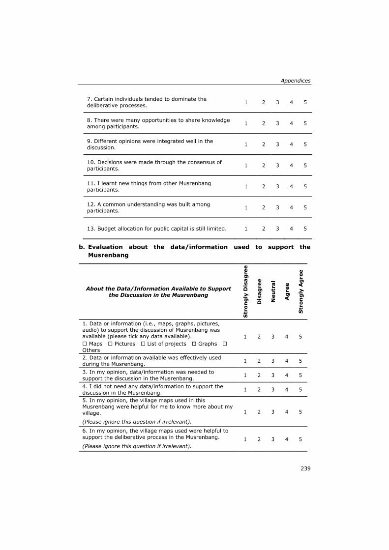
Appendices
239
7. Certain individuals tended to dominate the deliberative processes.
1 2 3 4 5
8. There were many opportunities to share knowledge among participants.
1 2 3 4 5
9. Different opinions were integrated well in the discussion.
1 2 3 4 5
10. Decisions were made through the consensus of participants.
1 2 3 4 5
11. I learnt new things from other Musrenbang participants.
1 2 3 4 5
12. A common understanding was built among participants.
1 2 3 4 5
13. Budget allocation for public capital is still limited. 1 2 3 4 5
b. Evaluation about the data/information used to support the
Musrenbang
About the Data/Information Available to Support the Discussion in the Musrenbang
Str
on
gly
Dis
ag
ree
Dis
ag
ree
Neu
tral
Ag
ree
Str
on
gly
Ag
ree
1. Data or information (i.e., maps, graphs, pictures, audio) to support the discussion of Musrenbang was available (please tick any data available). 1 2 3 4 5
Maps Pictures List of projects Graphs Others
2. Data or information available was effectively used during the Musrenbang.
1 2 3 4 5
3. In my opinion, data/information was needed to
support the discussion in the Musrenbang. 1 2 3 4 5
4. I did not need any data/information to support the discussion in the Musrenbang.
1 2 3 4 5
5. In my opinion, the village maps used in this Musrenbang were helpful for me to know more about my village. 1 2 3 4 5
(Please ignore this question if irrelevant).
6. In my opinion, the village maps used were helpful to support the deliberative process in the Musrenbang. 1 2 3 4 5
(Please ignore this question if irrelevant).
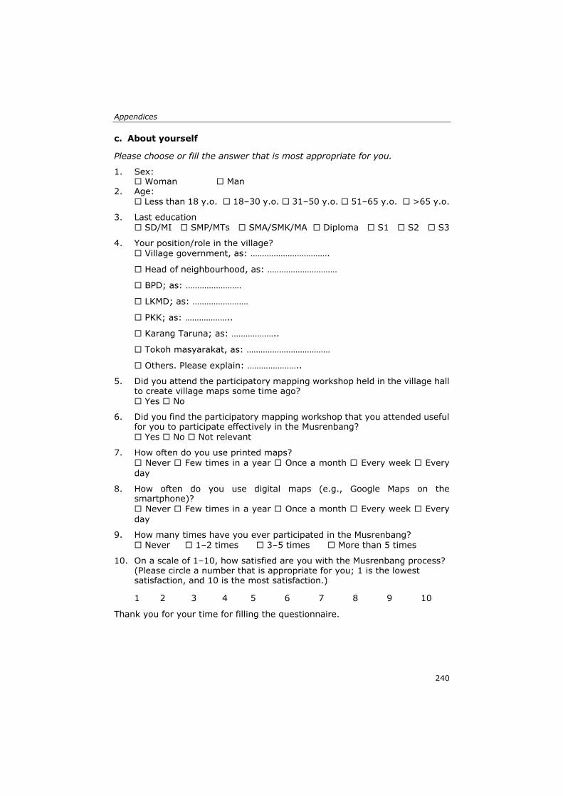
Appendices
240
c. About yourself
Please choose or fill the answer that is most appropriate for you.
1. Sex: Woman Man
2. Age: Less than 18 y.o. 18–30 y.o. 31–50 y.o. 51–65 y.o. >65 y.o.
3. Last education SD/MI SMP/MTs SMA/SMK/MA Diploma S1 S2 S3
4. Your position/role in the village? Village government, as: …………………………….
Head of neighbourhood, as: …………………………
BPD; as: ……………………
LKMD; as: ……………………
PKK; as: ………………..
Karang Taruna; as: ………………..
Tokoh masyarakat, as: ………………………………
Others. Please explain: …………………..
5. Did you attend the participatory mapping workshop held in the village hall to create village maps some time ago? Yes No
6. Did you find the participatory mapping workshop that you attended useful for you to participate effectively in the Musrenbang? Yes No Not relevant
7. How often do you use printed maps? Never Few times in a year Once a month Every week Every day
8. How often do you use digital maps (e.g., Google Maps on the smartphone)? Never Few times in a year Once a month Every week Every
day
9. How many times have you ever participated in the Musrenbang? Never 1–2 times 3–5 times More than 5 times
10. On a scale of 1–10, how satisfied are you with the Musrenbang process? (Please circle a number that is appropriate for you; 1 is the lowest satisfaction, and 10 is the most satisfaction.)
1 2 3 4 5 6 7 8 9 10
Thank you for your time for filling the questionnaire.
Appendices
241
Appendix O
Semi-Structured Interview for Musrenbang Participants
Interviews with Stakeholders:
Name :
Village :
Sub-district :
Date of Data Collection
Date Month Time (start)
Time (finish)
Introduction
Dear Sir/Madam, my name is Aulia Akbar. I am here on behalf of the
Universiteit of Twente as a researcher about the Musrenbang practice. We
would like ask you some questions about your opinions and experiences about
the previous village Musrenbang implementation.
In answering our questions there are no right or wrong answers; we are
interested in your own experience. Your name will remain secret and
everything we talk about will be anonymous. If you have any questions during
the interview or our questions are not clear, please let us know.
Background of the Interviewee
1. Could you tell me your full name?
2. From which neighbourhood?
3. How long have you lived in …………. Village?
4. What are you doing for a living? What is your position? How long have you
been working in that position?
Representativeness in Musrenbang
1. What was your role when you attended the last Musrenbang? To represent
which groups?
2. How many times have you ever attended a Musrenbang practice with that
role?
3. Did you ever have other roles? If yes, please explain.
4. Do you think the participants have represented all important stakeholders
in the village? If NOT, who else should be invited?
Appendices
242
Awareness of the scope and process of Musrenbang
1. How many times have you ever participated in the Musrenbang?
2. What do you think about the aims of the Musrenbang?
3. Do you think that the scope of the Musrenbang is clear and appropriate
for participants?
The deliberation process
1. What do you think about the transparency in Musrenbang process?
2. In general, what do you think about the discussion process in
Musrenbang?
3. What do you about the opportunities for participants to have a say at the
meeting?
4. Did you think there were certain stakeholders dominating the discussion?
5. Who did have more domination in the process? Who did have less
domination?
6. What are the factors that make certain people more dominant or less
dominant?
7. About the discussion process, was it dynamic, lively, or maybe too formal?
Why?
Decision making processes
1. What do you think about the decision-making process in Musrenbang?
2. How can you reach consensus about the plans and budget priorities?
Knowledge used and Social learning experiences
1. To what extent did you share your knowledge to other participants? Did
other stakeholders also share their knowledge?
2. How did the deliberative processes allow you to understand other
participants’ point of view?
Data/information availability
1. Did the Musrenbang organiser provide any data/information (i.e. maps,
diagrams, pictures, etc)?
2. If yes, what kind of data/information did you get at the meeting?
3. If no, what kind of data/information that you think needs to be provided
at the meeting?
4. Do you think it is important to have available data/information at the
meeting? Why?
Appendices
243
Village map utilisation in Musrenbang
1. Was there any village map used during the Musrenbang? (If the answer is
NO, then go to questions 29 and 30, then finish the interview)
2. If yes, could you explain how the maps were used during the Musrenbang?
3. Did the Musrenbang in previous years ever use a village map?
4. What do you think about the utilisation of maps during the Musrenbang?
5. Did you think the maps helpful to know more about your village? How?
6. Did you find the maps useful to support the deliberation of Musrenbang?
How?
Participation in participatory mapping workshops
1. Did you participate in the participatory mapping workshop some time ago?
(If the answer is NO, then finish the interview).
2. If yes, did you find the workshop useful for you? How?
3. Could you elaborate the effect of participating in the workshops towards
your involvement in Musrenbang?
4. Thank you for your answers and support for this research.
Interviewer,
Aulia Akbar
Appendices
244
Appendix P
All of the interviewees’ name were kept anonymous by using codes as below:
A1, A2, A3,… = codes for interviewees from Denai Lama village
B1, B2, B3,… = codes for interviewees from Kolam village
C1, C2, C3,… = codes for interviewees from Kramat Gajah village
D1, D2, D3,… = codes for interviewees from Sidoharjo I Pasar Miring village
E1, E2, E3,… = codes for interviewees from Tandem Hulu II village
245
Summary
Localising the Sustainable Development Goals (SDGs) is crucial for
their achievement by 2030. Being a global framework, the SDGs
targets and indicators need to be conceptualised and contextualised to
be applicable in the local context. This research explores the
localisation of SDGs targets 11.3 and 16.7 for improved public
participation by studying the public participation practice in Indonesia,
called Musrenbang. As an annual participatory planning meeting in
Indonesia, Musrenbang provides a forum for various stakeholders to
make decisions about development planning and budgeting priorities.
Despite its essential role, the Musrenbang meeting is often conducted
poorly, like a ‘ceremonial’ activity favouring certain groups while
limiting citizens involvement in the planning processes. As a result, the
diverse types of knowledge of the stakeholders are not utilised
optimally, affecting the communication and collaboration among them.
The participatory processes often fail to stimulate the stakeholders to
express their knowledge explicitly and limit its integration among
stakeholders. Although discussions about particular locations or places
are common in public participation practices, spatial knowledge, i.e.
the knowledge of how the individuals, social groups, and institutions
perceive particular places into their characteristics and meanings, is
often underutilised in the Musrenbang practices.
This limited integration of knowledge is further exacerbated by the fact
that only limited data and information are available to support the
deliberative processes of Musrenbang, particularly geospatial data such
as village maps. Although current laws, e.g. Village Law No.6/2014,
implies that each village must have village maps to support the
development and local decision-making, the utilisation of maps is
rarely found in the Musrenbang at village level. The central government
cannot afford to make the village maps available due to limited funding,
diverse geographical terrains, and lacking coordination among
institutions. Likewise, the village government cannot produce the maps
due to a lack of mapping knowledge and technologies and the strict
regulations imposed by the upper government in terms of maps
production.
While a large body of research has studied the localisation of SDGs and
the strengthening of public participation practices, most studies focus
Summary
246
on urban areas. There is less research on how the localisation of SDGs
and public participation can take place in rural areas. This study fills
this gap by understanding how public participation in rural areas may
contribute to the localisation of SDGs by examining the role of
geospatial data in localising the SDGs and strengthening public
participation in rural areas. The study was conducted in five villages in
Deli Serdang district, Indonesia, divided into three villages with
interventions and two villages as the control group. In the intervention
group, the villages participated in a digital or non-digital participatory
mapping workshop to produce their village maps. In the control group,
no mapping workshops were conducted to create village maps.
The study has four objectives. For the first objective, an SDGs
evaluation framework was developed based on indicators 11.3.2 and
16.7.2, and then the framework was used to evaluate the Musrenbang
implementation in all case study areas. The focus of the evaluation was
to identify the underlying problems from the villagers' perspective and
explore options to formulate feasible solutions in order to enhance and
strengthen the participatory process in the Musrenbang
implementation (see Chapter 2 for details).
Based on the evaluation result, three main problems that impeded the
Musrenbang at village level were identified. First, the Musrenbang
process did not comply with existing regulations. Different laws
published by various ministries have caused confusion among the
village stakeholders about which laws should be followed. Second, a
lack of available data hampers the Musrenbang implementation,
resulting in a lack of knowledge integration and learning processes
among the participants during the deliberation process. Third, power
gaps among stakeholder groups in Musrenbang impede the
implementation. There were four stakeholder groups in the village
Musrenbang, the upper government, village elites, village elites'
supporters, and community-based organisations/ordinary citizens.
Among these groups, the village elites and the village elites’ supporters
had more power and influence than the community-based
organisations/ordinary citizens during the decision-making process in
Musrenbang. The upper government, which has more ability to
influence, showed little interest in mitigating the domination of certain
stakeholder groups or improving the deliberation process in
Musrenbang. This study concluded that a comprehensive
understanding of the Musrenbang stakeholders' knowledge and a
Summary
247
suitable method to integrate and exchange the stakeholders'
knowledge is urgently needed to strengthen the Musrenbang practices
while minimising the power gaps among the Musrenbang participants.
For the second objective, this study aimed at understanding the spatial
knowledge of the stakeholders involved. The analysis was used to
foresee the potential of spatial knowledge in strengthening the
participatory process of the Musrenbang as well as to fill the geospatial
data gaps in the case study areas. A three-dimensional cube framework
was developed to understand better the utilisation of spatial knowledge
in public participation practices. The framework consists of three
mutually dependent aspects: the types, levels, and socio-spatial
relationships of spatial knowledge. The framework was used to classify
and identify the dynamics, actors, and activities involved in the spatial
knowledge utilisation during the Musrenbang process (see Chapter 3
for details).
The findings of this study revealed that spatial knowledge has the
potential to enhance the Musrenbang public participation practice. The
participants confirmed that they could better engage in the deliberation
process of Musrenbang if they can contribute their spatial knowledge.
Therefore, the utilisation of spatial knowledge should be accompanied
by sufficient and reliable geospatial data such as maps. Musrenbang
participants can bring in their spatial knowledge and maps for various
purposes, such as deciding the most accessible location for public
health facilities, examining the impacts of a project to the surrounding
area, or analysing the distribution of projects or budgets in all
neighbourhoods. Better use of spatial knowledge could also stimulate
intense communication and collaboration between participants, not
only during the Musrenbang implementation but also in other village
development projects. Therefore, this study recommends developing a
suitable participatory mapping method that enables stakeholders to
express their spatial knowledge. Such a participatory method would
help village stakeholders to use their spatial knowledge to produce
geospatial data of their areas, which can then be used to support public
participation practices like Musrenbang.
For the third objective, a collaborative spatial learning framework was
developed to strengthen the Musrenbang implementation and tested
the framework in three villages included in the intervention group of
the case study areas. The framework was implemented through digital
Summary
248
and non-digital participatory mapping workshops. The digital
participatory mapping workshop used the OGITO (Open Geospatial
Interactive Tool) application through a maptable. The non-digital
participatory mapping workshop used conventional mapping exercises
with transparent plastic layers showing markers and stickers. A high-
resolution satellite image of the villages was used to help the
participants identify, sketch, and draw the village maps. The
composition of the participants represented the stakeholder groups
who participated in the village Musrenbang. The sketch maps were
later finalised and transformed into the GIS format by the researcher
(see Chapter 4 for details).
This study concludes that the digital and non-digital participatory
mapping workshops were practical to help the village stakeholders to
produce georeferenced village maps. The mapping workshops were
helpful to accelerate the village map production at the village level and
stimulated village stakeholders to learn collaboratively to utilise their
spatial knowledge. The mapping workshops were also valuable for
stimulating communication and collaboration among stakeholders,
integrating the stakeholders' spatial knowledge through knowledge co-
production, and facilitating social learning for stakeholders to better
engage in the Musrenbang practices. Furthermore, the mapping
workshops were also helpful to localise the SDGs by raising awareness
of village stakeholders to better understand and contextualise the
SDGs concepts at the local village level.
For the fourth objective, the focus was to investigate how the
participatory village maps produced from the mapping workshops in
Chapter 4, could strengthen the Musrenbang implementation,
particularly in enabling communication and collaboration among the
participants. Using criteria from the SDGs evaluation framework
discussed in Chapter 2, the Musrenbang implementation in five villages
in the study areas was evaluated (see Chapter 5 for details).
The comparison result of the Musrenbang in the intervention and the
control groups showed a better Musrenbang implementation in the
intervention group, which used participatory village maps, than in the
control group, which did not use any maps during the Musrenbang.
Most of the participants in the intervention villages reacted positively
to the utilisation of the maps during the Musrenbang. The maps
facilitated the communication among participants in Musrenbang,
Summary
249
made the deliberation process more transparent and tolerant. The
exact village boundaries on the maps gave clear task scope to the
participants. The maps enabled participants to provide new or creative
inputs to enrich the discussion.
Additionally, the maps were also helpful for enabling participants to
collaborate, share their knowledge, and experience social learning.
Participants were satisfied with the Musrenbang processes because the
maps allow their views or opinions to be heard or taken into account.
In contrast, the Musrenbang in the control villages remained the same
as in the previous observation. The process was too formal and
ceremonial. Lack of discussion occurred as no supporting data available
during the deliberation process.
Although the improvement of Musrenbang implementation was evident
in all intervention villages, the findings also reveal that the potential of
the participatory village maps was not fully utilised. Power gaps among
stakeholder groups could not be entirely eliminated during the
Musrenbang implementation. Certain actors, particularly the village
elites, still dominated the deliberation process. They often intentionally
pre-selected the participants who would not oppose the elites as the
invitees of the Musrenbang. Consequently, the Musrenbang was not
accessible for all individuals or marginal groups in the villages,
although Musrenbang should be accessible for all citizens. This
situation may impede the achievement of SDGs targets 11.3. and 16.7
that emphasises the openness and inclusiveness of public participation
practices for all community members.
Overall, this study concludes that geospatial data and spatial
knowledge could serve as an essential medium to localise the SDGs to
be more tangible and operational in the local context. Formulating
suitable methods that can optimally make use of the spatial knowledge
of the stakeholders while ensuring geospatial data availability is
necessary. The method should engage stakeholders to communicate,
collaborate, and experience social learning and knowledge co-
production. Geospatial data produced from such activities could
strengthen the public participation practices and raise the awareness
of local communities to better understand and apply the SDGs at the
local level. This study contributes to the discourse on the drivers of
public participation practices in the global south. This study also
informs scholars and policymakers to invent and take innovative

Summary
250
approaches such as collaborative spatial learning to strengthen public
participation practices and achieve the SDGs in the local, rural
contexts.
251
Samenvatting
Voor het halen van de Sustainable Development Goals (SDG) in 2030
is het cruciaal om deze doelstellingen te vertalen naar de lokale schaal.
Omdat de SDG doelen en indicatoren in een wereldwijd kader zijn
geformuleerd moeten ze eerst worden geconceptualiseerd en in de
juiste context geplaatst voor ze toepasbaar zijn op lokale schaal. Dit
onderzoek verkent het naar de lokale situatie vertalen van SDG doelen
11.3 en 16.7 ten behoeve van een verbeterde publieke participatie
door deze te bestuderen in de publieke participatie praktijk van
Indonesië, Musrenbang genaamd. De Musrenbang, een jaarlijkse
publieke participatie bijeenkomst in Indonesië, biedt een forum voor
diverse belanghebbenden voor het nemen van besluiten over
ontwikkelingsplanning en prioritering van budgetten. Ondanks het
wezenlijke belang wordt de Musrenbang bijeenkomst vaak pover
uitgevoerd en wel als een ‘ceremoniële’ activiteit ten gunste van
bepaalde groepen met inperking van de inspraak van burgers in de
planning processen. Dientengevolge wordt allerlei kennis van
belanghebbenden niet optimaal gebruikt met nadelige gevolgen voor
de onderlinge communicatie en samenwerking. De participatie
processen mislukken vaak doordat belanghebbenden niet worden
gestimuleerd om hun kennis expliciet te maken en beperken als
zodanig de integratie van de kennis van stakeholders. Hoewel
discussies over bepaalde locaties en plaatsen niet ongebruikelijk zijn in
de publieke participatie praktijk, wordt met name de ruimtelijke
kennis, d.w.z. de kennis over hoe individuen, maatschappelijke
groeperingen en instituties bepaalde plaatsen in betekenis en
karakteristieken ervaren, onderbenut in de Musrenbang praktijk.
Deze beperkte integratie van kennis wordt verder versterkt door het
feit dat slechts beperkte gegevens en informatie, in het bijzonder
georuimtelijke gegevens zoals dorpskaarten, beschikbaar zijn om het
proces van beraadslaging binnen de Musrenbang te ondersteunen.
Hoewel de huidige wetgeving, bijvoorbeeld Village Law No.6/2014,
voorschrijven dat elk dorp dorpskaarten moet hebben om de planning
en de lokale besluitvorming te ondersteunen, worden kaarten zelden
gebruikt in de Musrenbang op dorpsniveau. De centrale overheid kan
het zich niet veroorloven dorpskaarten beschikbaar te maken vanwege
beperkte financiële middelen, diversiteiten in geografisch terrein, en
Samenvatting
252
een gebrek aan coördinatie tussen instituties. Dorpsoverheden kunnen
eveneens geen kaarten produceren vanwege ontbrekende
cartografische kennis en technologieën, en de strikte regels opgelegd
door hogere autoriteiten ten aanzien van de productie van kaarten.
Hoewel veel onderzoek is gedaan naar de vertaling van de SDG naar
de lokale schaal en naar de versterking van de praktijk van publieke
participatie, hebben de meeste studies betrekking op stedelijke
gebieden. Minder onderzoeken zijn gedaan naar hoe beide
onderwerpen aan te pakken in rurale gebieden. Deze studie voorziet in
deze lacune door te begrijpen hoe publieke participatie in rurale
gebieden kan bijdragen aan het naar lokale schaal vertalen van de SDG
door de rol te onderzoeken die georuimtelijke data hierbij kunnen
spelen. Het onderzoek is uitgevoerd in vijf dorpen in het Deli Serdang
district, Indonesië, waarbij drie dorpen fungeerden als interventie
groep en twee dorpen als controle groep. In de interventiegroep namen
de dorpen deel aan een digitale of niet-digitale participatieve kartering
workshop waarbij hun dorpskaart werd geproduceerd. Voor de dorpen
in de controle groep gebeurde dit niet.
De studie had vier onderzoeksdoeleinden. Het eerste doel was de
ontwikkeling van een SDG evaluatie kader gebaseerd op de indicatoren
11.3.2 en 16.7.2, waarbij dit kader is gebruikt om de Musrenbang
implementatie te evalueren in alle case studie gebieden. De focus van
de evaluatie lag bij het identificeren van onderliggende problemen
vanuit het perspectief van de dorpsbewoners en bij het verkennen van
opties voor het formuleren van haalbare oplossingen om het
participatieve karakter van de Musrenbang implementatie te
verbeteren en versterken (zie hoofdstuk 2 voor de details).
Uit de evaluatie komen drie belangrijke problemen naar voren die de
Musrenbang op dorpsniveau negatief beïnvloeden. Ten eerste: het
proces van de Musrenbang voldeed niet aan bestaande regelgeving.
Verschillende wetten uitgevaardigd door meerdere ministeries hebben
verwarring gezaaid onder de belanghebbenden uit de dorpen over
welke wetten te volgen. Ten tweede wordt de Musrenbang
implementatie gehinderd door een tekort aan beschikbare data,
waardoor kennisintegratie en leerprocessen tussen de deelnemers
gedurende het proces van beraadslaging moeilijk van de grond komen.
Ten derde vormen machtsverschillen tussen stakeholder groeperingen
een belemmering voor de Musrenbang implementatie. Er zijn vier
Samenvatting
253
categorieën stakeholders in de Musrenbang op dorpsniveau: de hogere
overheid, de dorpselite, de volgers van de dorpselite, en
gemeenschapsorganisaties/gewone burgers. Van deze groeperingen
hadden de dorpselite en de volgers van de dorpselite meer macht en
invloed gedurende het proces van besluitvorming in de Musrenbang
dan de gemeenschapsorganisaties/gewone burgers. De hogere
overheid, die meer mogelijkheden heeft om invloed uit te oefenen,
toonde weinig belangstelling voor het terugdringen van de dominantie
van bepaalde groeperingen en voor het verbetering van het proces van
beraadslaging. De studie concludeerde dat een meer uitgebreid begrip
voor de kennis van de stakeholders in de Musrenbang en een passende
methode om de kennis van de stakeholders te integreren en uit te
wisselen dringend gewenst zijn om de praktijk van de Musrenbang te
versterken en tegelijkertijd de machtsverschillen tussen de deelnemers
te verkleinen.
Het tweede onderzoeksdoel was gericht op het begrijpen van de
ruimtelijke kennis van de betrokken stakeholders. De analyse is
uitgevoerd om het potentieel van de ruimtelijke kennis in het
versterken van het participatieve proces van de Musrenbang te
verkennen, alsmede om de georuimtelijke data lacunes in de case
studie gebieden te reduceren. Een driedimensionaal kubus kader is
ontwikkeld om te begrijpen hoe beter gebruik kan worden gemaakt van
de ruimtelijke kennis in de publieke participatie praktijk. Het kader
bestaat uit drie wederzijds afhankelijke aspecten: de typen, de niveaus
en de sociaal-ruimtelijke relaties van ruimtelijke kennis. Het kader is
gebruikt voor het classificeren en identificeren van de dynamiek, de
actoren en de activiteiten bij het benutten van de ruimtelijke kennis
tijdens het proces van de Musrenbang (zie hoofdstuk 3 voor de details).
De studie heeft aangetoond dat de ruimtelijke kennis in potentie de
publieke participatie in de Musrenbang praktijk kan verbeteren. De
deelnemers bevestigden dat zij beter in het overleg binnen de
Musrenbang tot hun recht zouden komen als ze hun ruimtelijke kennis
konden inbrengen. Daarom moet het gebruik van deze ruimtelijke
kennis vergezeld gaan van voldoende en betrouwbare georuimtelijke
data zoals kaarten. De deelnemers aan de Musrenbang kunnen hun
ruimtelijke kennis en kaarten inzetten voor verschillende doelen, zoals
de besluitvorming over de meest toegankelijke locatie voor
volksgezondheidsvoorzieningen, het onderzoeken van de gevolgen van
een project op de omgeving, of het analyseren van de verdeling van
Samenvatting
254
projecten en budgetten over alle buurten/wijken. Beter gebruik van
ruimtelijke informatie zou ook de communicatie en samenwerking
tussen deelnemers kunnen intensiveren, niet alleen gedurende de
Musrenbang maar ook bij andere ontwikkelingsprojecten in de dorpen.
Daarom adviseert deze studie een passende participatieve
karteringsmethode te ontwikkelen die belanghebbenden in staat stelt
hun ruimtelijke kennis te uiten. Zo’n participatieve methode zou
stakeholders in de dorpen helpen om hun ruimtelijke kennis om te
zetten in georuimtelijke data van hun gebieden ten behoeve van
publieke participatieve Musrenbang praktijk.
Het derde onderzoeksdoel betrof de ontwikkeling van een gezamenlijk
ruimtelijk leerkader ter versterking van de Musrenbang implementatie
en het testen van dit kader in de drie case studie dorpen van de
interventiegroep. Het leerkader is toegepast in digitale en niet-digitale
participatieve kartering workshops. De digitale participatieve kartering
workshop gebruikte de OGITO (Open Geospatial Interactive Tool)
applicatie met behulp van een Map Table. De niet-digitale
participatieve kartering workshop maakte gebruik van conventionele
kartering exercities met behulp van transparante plastic vellen met
markeringen en stickers. Een hoge resolutie satelliet beeld van de
dorpen stelde de deelnemers in staat om dorpskaarten te identificeren,
schetsen en tekenen. De samenstelling van de deelnemers was
representatief voor de stakeholder groeperingen die betrokken waren
bij de Musrenbang van het betreffende dorp. In een later stadium zijn
de schetsen gecompleteerd en getransformeerd naar GIS formaat door
de onderzoeker (zie hoofdstuk 4 voor de details).
De studie concludeert dat de digitale en niet-digitale participatieve
kartering workshops van praktisch nut bij het produceren door de
belanghebbende dorpsbewoners van dorpskaarten met gereferenties.
De workshops zorgde voor een versnelling van de productie van
dorpskaarten en stimuleerden de belanghebbende dorpsbewoners om
gezamenlijk te leren hun ruimtelijke kennis te benutten. De kartering
workshops waren ook waardevol ten aanzien van de communicatie en
samenwerking tussen de stakeholders, de integratie van de ruimtelijke
kennis via kennis co-productie en het faciliteren van sociale
leerprocessen bij stakeholders tijdens het overleg in de Musrenbang
praktijk. Bovendien hielpen de workshops bij de vertaalslag van de
SDG naar lokaal niveau door de bewustwording van de
Samenvatting
255
belanghebbende dorpsbewoners te versterken bij het begrijpen en
contextualiseren van de SDG concepten op lokaal niveau.
Bij het vierde onderzoeksdoel lag de focus van het onderzoek op het
onderzoeken of en hoe de participatieve dorpskaarten geproduceerd
gedurende de kartering workshops als beschreven in hoofdstuk 4 de
implementatie van de Musrenbang zouden kunnen verbeteren in het
bijzonder ten aanzien van de communicatie en samenwerking tussen
de deelnemers. Met gebruikmaking van de criteria afkomstig van het
SDG evaluatie kader uit hoofdstuk 2 is de Musrenbang implementatie
in de vijf geselecteerde dorpen geëvalueerd (zie hoofdstuk 5 voor de
details).
Het resultaat van het vergelijkend onderzoek van de Musrenbang
tussen de interventie groep en de controle groep liet zien dat tijdens
de implementatie van de Musrenbang gebruik werd gemaakt van de
participatieve dorpskaarten bij de interventiegroep met positieve
gevolgen voor het proces, maar dat geen enkele kaart werd gebruikt
bij de controle groep. De meeste deelnemers van de dorpen uit de
interventiegroep reageerden positief op het gebruik van de kaarten
gedurende de Musrenbang. De kaarten faciliteerden de communicatie
tussen de deelnemers tijdens de Musrenbang, en maakten het overleg
transparanter en beter te accepteren. De exacte dorpsgrenzen op de
kaarten gaven beter inzicht in de scope van de taak voor de
deelnemers. De kaarten stelden de deelnemers in staat nieuwe
inzichten te verwerven en creatieve input te leveren hetgeen de
discussie verrijkt heeft.
Daarnaast stelde de kaarten de deelnemers in staat om samen te
werken, de kennis te delen en sociale leerprocessen te ervaren.
Deelnemers toonden tevredenheid over het verloop van het
Musrenbang proces omdat de kaarten het mogelijk maakten hun
ideeën en meningen kenbaar te maken en een rol te laten spelen.
Daarentegen verliep het Musrenbang proces in de dorpen in de controle
groep als voorheen was waargenomen. Het proces was zeer formeel
en ceremonieel. Discussies waren zeer beperkt tot afwezig mede
omdat geen ondersteunende data beschikbaar waren tijdens het
overleg.
Hoewel de versterking van het Musrenbang proces in alle dorpen van
de interventiegroep evident was, tonen de bevindingen ook aan dat het
potentieel van de participatieve dorpskaarten nog niet volledig benut
Samenvatting
256
is. Machtsverschillen tussen stakeholder groeperingen konden niet
volledig worden geëlimineerd in de Musrenbang. Bepaalde actoren, in
het bijzonder de dorpselite, domineerden nog altijd het overleg. Zij
selecteerden vooraf doelbewust deelnemers als genodigden bij de
Musrenbang waarvan ze wisten dat ze niet zouden opponeren tegen de
dorpselite. Als gevolg hiervan was de Musrenbang niet toegankelijk
voor alle individuen en marginale groepen uit de dorpen, hoewel de
Musrenbang toegang zou moeten geven tot alle burgers. Deze
omstandigheid vormt een belemmering voor het halen van de SDG
doelen 11.3 en 16.7 die de nadruk leggen op openheid en inclusiviteit
van de praktijk van publieke participatie voor alle leden van de
gemeenschap.
De algehele conclusie van dit onderzoek is dat georuimtelijke data en
ruimtelijke kennis kunnen dienen als een essentieel hulpmiddel om de
vertaalslag van de SDG naar lokaal niveau meer tastbaar en
operationeel te maken. Het formuleren van passende methoden om
optimaal gebruik te maken van de ruimtelijke kennis van stakeholders
en daarmee het zeker stellen van de beschikbaarheid van
georuimtelijke data is noodzakelijk. De methode moet stakeholders
overhalen om te communiceren, samen te werken, sociale
leerprocessen en kennis co-productie te ervaren. Georuimtelijke data
die geproduceerd worden tijdens zulke activiteiten kunnen de publieke
participatie praktijk versterken en de bewustwording bij lokale
gemeenschappen vergroten om de SDG beter te begrijpen en toe te
passen op lokaal niveau. Dit onderzoek draagt bij aan het discours over
de drijfveren van de publieke participatieve praktijken in de Global
South. Deze studie levert ook belangrijke informatie voor
wetenschappers en beleidsmakers bij het bedenken en toepassen van
innovatieve benaderingen zoals ruimtelijke sociale leerprocessen met
het oog op het versterken van de publieke participatie praktijk en het
bereiken van de SDG in lokale rurale contexten.
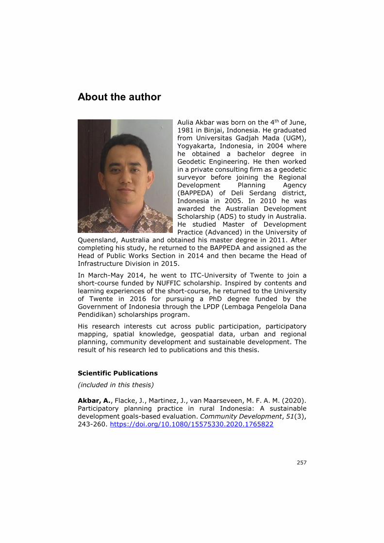
257
About the author
Aulia Akbar was born on the 4th of June,
1981 in Binjai, Indonesia. He graduated
from Universitas Gadjah Mada (UGM),
Yogyakarta, Indonesia, in 2004 where
he obtained a bachelor degree in
Geodetic Engineering. He then worked
in a private consulting firm as a geodetic
surveyor before joining the Regional
Development Planning Agency
(BAPPEDA) of Deli Serdang district,
Indonesia in 2005. In 2010 he was
awarded the Australian Development
Scholarship (ADS) to study in Australia.
He studied Master of Development
Practice (Advanced) in the University of
Queensland, Australia and obtained his master degree in 2011. After
completing his study, he returned to the BAPPEDA and assigned as the
Head of Public Works Section in 2014 and then became the Head of
Infrastructure Division in 2015.
In March-May 2014, he went to ITC-University of Twente to join a
short-course funded by NUFFIC scholarship. Inspired by contents and
learning experiences of the short-course, he returned to the University
of Twente in 2016 for pursuing a PhD degree funded by the
Government of Indonesia through the LPDP (Lembaga Pengelola Dana
Pendidikan) scholarships program.
His research interests cut across public participation, participatory
mapping, spatial knowledge, geospatial data, urban and regional
planning, community development and sustainable development. The
result of his research led to publications and this thesis.
Scientific Publications
(included in this thesis)
Akbar, A., Flacke, J., Martinez, J., van Maarseveen, M. F. A. M. (2020).
Participatory planning practice in rural Indonesia: A sustainable
development goals-based evaluation. Community Development, 51(3),
243-260. https://doi.org/10.1080/15575330.2020.1765822
258
Akbar, A., Flacke, J., Martinez, J., van Maarseveen, M. F. A. M. (2020).
Spatial knowledge: A potential to enhance public
participation? Sustainability, 12(12), 5025.
https://doi.org/10.3390/su12125025
Akbar, A., Flacke, J., Martinez, J., Aguilar, R., van Maarseveen, M. F.
A. M. (2020). Knowing my village from the sky: A collaborative spatial
learning framework to integrate spatial knowledge of stakeholders in
achieving sustainable development goals. ISPRS International Journal
of Geo-Information, 9(9), 515. https://doi.org/10.3390/ijgi9090515
Akbar, A., Flacke, J., Martinez, J., van Maarseveen, M. F. A. M. (2021).
The Role of Participatory Village Maps in Strengthening Public
Participation Practice. ISPRS International Journal of Geo-
Information,10(8), 512. https://doi.org/10.3390/ijgi10080512
(other scientific publications)
Aguilar, R., Calisto, L., Flacke, J., Akbar, A., Pfeffer, K. (2021). OGITO,
an Open Geospatial Interactive Tool to support collaborative spatial
planning with a maptable. Computers, Environment and Urban
Systems, 86, 101591.
https://doi.org/10.1016/j.compenvurbsys.2020.101591
Conference papers and presentations
Akbar, A., Flacke, J., Martinez, J., van Maarseveen, M. F. A. M. (2019).
Participatory Village Mapping to Improve Public Participation Practice
in Indonesia. In International Society of Participatory Mapping (ISPM)
Conference, 17-19 June 2019, Espoo, Finland.
https://doi.org/10.13140/RG.2.2.26336.51208
Akbar, A., Flacke, J., Martinez, J., van Maarseveen, M. F. A. M. (2020).
A Collaborative Framework to Improve Public Participation Practice. In
Proceedings of the 16th Participatory Design Conference 2020-
Participation (s) Otherwise-Volume 2 (pp. 133-137). 15-19 June 2020,
Manizales, Colombia. https://doi.org/10.1145/3384772.3385126