thesis abstracts 83 obituaries
TRANSCRIPT
number 66 June 2008
EditorialSean Ulm & Annie Ross iiARTICLESThe Upihoi Find: Wrecked Wooden Bevaia (Lagatoi) Hulls of Epemeavo Village, Gulf Province, Papua New GuineaBruno David, Nick Araho, Alois Kuaso, Ian Moffat & Nigel Tapper 1Tigershark Rockshelter (Baidamau Mudh): Seascape and Settlement Reconfi gurations on the Sacred Islet of Pulu, Western Zenadh Kes (Torres Strait)Ian J. McNiven, Joe Crouch, Marshall Weisler, Noel Kemp, Lucía Clayton Martínez, John Stanisic, Meredith Orr, Liam Brady, Scott Hocknull & Walter Boles 15Dating of Bush Turkey Rockshelter 3 in the Calvert Ranges establishes Early Holocene Occupation of the Little Sandy Desert, Western AustraliaPeter Veth, Jo McDonald & Beth White 33Glen Thirsty: The History and Archaeology of a Desert WellM.A. Smith & J. Ross 45
SHORT REPORTSTrialing Geophysical Techniques in the Identifi cation of Open Indigenous Sites in Australia: A Case Study from Inland Northwest QueenslandIan Moffat, Lynley A. Wallis, Alice Beale & Darren Kynuna 60
BOOK REVIEWSRenewing Women’s Business: A Documentary by Julie Drew & Wardaman Aboriginal CorporationReviewed by Sally Babidge 64Coastal Themes: An Archaeology of the Southern Curtis Coast, Queensland by Sean UlmReviewed by Bryce Barker 65The Social Archaeology of Australian Indigenous Societies edited by Bruno David, Bryce Barker & Ian J. McNivenReviewed by Richard Cosgrove 67Neolithic by Susan Foster McCarterReviewed by Phillip C. Edwards 68Archaeology of Ancient Australia by Peter HiscockReviewed by Brian Fagan 69Artifact Classifi cation: A Conceptual and Methodological Approach by Dwight W. ReadReviewed by David Frankel 71Whalers and Free Men: Life on Tasmania’s Colonial Whaling Stations by Susan LawenceReviewed by Martin Gibbs 72Inauthentic Archaeologies: Public Uses and Abuses of the Past by Troy LovataReviewed by Denis Gojak 72Lithics in the Land of the Lightning Brothers: The Archaeology of Wardaman Country, Northern Territory by Chris Clarkson Reviewed by Richard A. Gould 74Box Offi ce Archaeology: Refi ning Hollywood’s Portrayals of the Past edited by Julie M. SchablitskyReviewed by Peter Hiscock 75Salvage Excavation of Six Sites Along Caddies, Seconds Ponds, Smalls and Cattai Creeks in the Rouse Hill Development Area, NSW by Jo McDonald Cultural Heritage Management Pty LtdReviewed by Fiona Hook 76Archaeological Theory and the Politics of Cultural Heritage by Laurajane SmithReviewed by Thomas F. King 77The Archaeologist’s Fieldwork Companion by Barbara Ann KipferReviewed by Ian J. McNiven 78Landscapes, Rock-Art and the Dreaming: An Archaeology of Preunderstanding by Bruno DavidReviewed by Tim Murray 79A Companion to Social Archaeology edited by Lynn Meskell & Robert W. Preucel Reviewed by Alistair Paterson 81
In this issue
nu
mb
er 66 2008
THESIS ABSTRACTS 83
OBITUARIESLester Richard Hiatt (1931–2008) 86
BACKFILLMinutes of the 2007 Annual General Meeting of the Australian Archaeological Association Inc. 87
2007 AAA Conference Awards 94
Letters to the Editors 98
AustArch1: A Database of 14C and Luminescence Ages from Archaeological Sites in the Australian Arid ZoneA.N. Williams, M.A. Smith, C.S.M Turney and M.L Cupper 99The Australian Academy of the Humanities: 2007 Fellows 99
Lectures 100
Conferences 100
NOTES TO CONTRIBUTORS 101
ISSN 0312-2417
AUSTRALIAN ARCHAEOLOGICAL ASSOCIATION INC.Offi ce Bearers for 2008
Position Name Address
Executive
President Ian McNiven School of Geography & Environmental Science, Monash University,
Clayton, VIC 3800
Secretary Tim Denham School of Geography & Environmental Science, Monash University,
Clayton, VIC 3800
Treasurer Bruno David School of Geography & Environmental Science, Monash University,
Clayton, VIC 3800
Membership Secretary Jeremy Ash School of Geography & Environmental Science, Monash University,
Clayton, VIC 3800
Assistant Membership
Secretary
Liam Brady Centre for Australian Indigenous Studies, Monash University, Clayton,
VIC 3800
Public Offi cer Sally Brockwell Centre for Archaeological Research, Research School of Pacifi c & Asian
Studies, Australian National University, Canberra, ACT 0200
Webmaster Samantha Bolton Archaeology, M405, University of Western Australia, 35 Stirling Highway,
Crawley, WA 6009
Media Liaison Offi cer Peter Veth National Centre for Indigenous Studies, Australian National University,
Canberra, ACT 0200
Media Liaison Offi cer Wayne Brennan PO Box 217, Katoomba, NSW 2780
Australian Archaeology Editors
Editor Sean Ulm Aboriginal & Torres Strait Islander Studies Unit, University of Queensland,
Brisbane, QLD 4072
Editor Annie Ross School of Social Science, University of Queensland, Brisbane, QLD 4072
Editorial Assistant Linda Terry School of Social Science, University of Queensland, Brisbane, QLD 4072
Short Reports Editor Catherine Westcott Department of Main Roads, GPO Box 1412, Brisbane, QLD 4001
Short Reports Editor Lara Lamb School of Humanities & Communications, University of Southern
Queensland, Toowoomba, QLD 4350
Review Editor Chris Clarkson School of Social Science, University of Queensland, Brisbane, QLD 4072
Review Editor Jill Reid Department of Main Roads, GPO Box 1412, Brisbane, QLD 4001
Thesis Abstract Editor Stephen Nichols School of Social Science, University of Queensland, Brisbane QLD 4072
State Representatives
Australian Capital Territory Kyle Turner 22 Donaldson Street, Braddon, ACT 2620
New South Wales Jodie Benton OzArk Environmental & Heritage Management Pty Ltd, PO Box 2069,
Dubbo, NSW 2830
Northern Territory Daryl Guse School of Archaeology & Anthropology, Australian National University,
Canberra, ACT 0200
Queensland Lara Lamb School of Humanities & Communications, University of Southern
Queensland, Toowoomba, QLD 4350
South Australia Lynley Wallis Department of Archaeology, Flinders University, GPO Box 2100, Adelaide,
SA 5001
Tasmania Denise Gaughwin Forest Practices Authority, PO Box 180, Kings Meadows, TAS 7249
Victoria Nicola Stern Department of Archaeology, La Trobe University, Bundoora, VIC 3086
Western Australia Stuart Rapley Archae-aus Pty Ltd, PO Box 177, South Fremantle, WA 6162
Australian Archaeology, the offi cial publication of the
Australian Archaeological Association Inc., is a refereed
journal published since 1974. It accepts original articles
in all fi elds of archaeology and other subjects relevant to
archaeological research and practice in Australia and nearby
areas. Contributions are accepted in six sections: Articles
(5000-8000 words), Short Reports (1000-3000), Obituaries
(500-2000), Thesis Abstracts (200-500), Book Reviews
(500-2000) and Backfi ll (which includes letters, conference
details, announcements and other material of interest to
members). Australian Archaeology is published twice a year,
in June and December.
Subscriptions are available to individuals through
membership of the Australian Archaeological Association
Inc. or to organisations through institutional subscription.
Subscription application/renewal forms are available at
http://www.australianarchaeologicalassociation.com.au.
Graphic Design: Lovehate Design
Printing: Screen Offset Printing
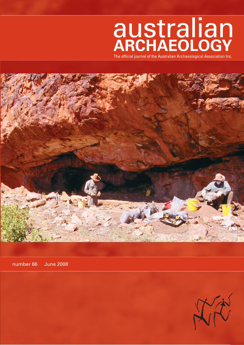
Cover: Excavations at Glen Thirsty 1, August 2004, looking
southeast (L to R: Mike Smith and Sharon Overend)
(Photograph: M.A. Smith).
All correspondence and submissions should be addressed to:
Australian Archaeology
PO Box 6088
St Lucia QLD 4067
AUSTRALIA
Email: [email protected]
URL: http://www.australianarchaeologicalassociation.com.au
The views expressed in this journal are not necessarily those of
the Australian Archaeological Association Inc. or the Editors.
© Australian Archaeological Association Inc., 2008
ISSN 0312-2417
Editors
Sean Ulm University of Queensland
Annie Ross University of Queensland
Editorial Advisory Board
Val Attenbrow Australian Museum
Margaret Conkey University of California, Berkeley
Bruno David Monash University
Andrew Fairbairn University of Queensland
Richard Fullagar Scarp Archaeology
Martin Gibbs University of Sydney
Luke Godwin Central Queensland Cultural Heritage
Management Pty Ltd
Simon Holdaway University of Auckland
Susan Lawrence La Trobe University
Jo McDonald JMcD CHM Pty Ltd
& Australian National University
Tim Murray La Trobe University
Jim O’Connell University of Utah
Fiona Petchey University of Waikato
Paul Rainbird University of Wales
Lynette Russell Monash University
Robin Torrence Australian Museum
Peter Veth Australian National University
Editorial Assistant
Linda Terry University of Queensland
Short Report Editors
Lara Lamb University of Southern Queensland
Catherine Westcott Department of Main Roads (Qld)
Book Review Editors
Chris Clarkson University of Queensland
Jill Reid Department of Main Roads (Qld)
Thesis Abstract EditorStephen Nichols University of Queensland
iNumber 66, June 2008
EditorialSean Ulm & Annie Ross ii
ARTICLESThe Upihoi Find: Wrecked Wooden Bevaia (Lagatoi) Hulls of Epemeavo Village, Gulf Province, Papua New GuineaBruno David, Nick Araho, Alois Kuaso, Ian Moffat & Nigel Tapper 1
Tigershark Rockshelter (Baidamau Mudh): Seascape and Settlement Reconfi gurations on the Sacred Islet of Pulu, Western Zenadh Kes (Torres Strait)Ian J. McNiven, Joe Crouch, Marshall Weisler, Noel Kemp, Lucía Clayton Martínez, John Stanisic, Meredith Orr, Liam Brady, Scott Hocknull & Walter Boles 15
Dating of Bush Turkey Rockshelter 3 in the Calvert Ranges establishes Early Holocene Occupation of the Little Sandy Desert, Western AustraliaPeter Veth, Jo McDonald & Beth White 33
Glen Thirsty: The History and Archaeology of a Desert WellM.A. Smith & J. Ross 45
SHORT REPORTSTrialing Geophysical Techniques in the Identifi cation of Open Indigenous Sites in Australia: A Case Study from Inland Northwest QueenslandIan Moffat, Lynley A. Wallis, Alice Beale & Darren Kynuna 60
BOOK REVIEWSRenewing Women’s Business: A Documentary by Julie Drew & Wardaman Aboriginal CorporationReviewed by Sally Babidge 64
Coastal Themes: An Archaeology of the Southern Curtis Coast, Queensland by Sean UlmReviewed by Bryce Barker 65
The Social Archaeology of Australian Indigenous Societies edited by Bruno David, Bryce Barker & Ian J. McNivenReviewed by Richard Cosgrove 67
Neolithic by Susan Foster McCarterReviewed by Phillip C. Edwards 68
Archaeology of Ancient Australia by Peter HiscockReviewed by Brian Fagan 69
Artifact Classifi cation: A Conceptual and Methodological Approach by Dwight W. ReadReviewed by David Frankel 71
Whalers and Free Men: Life on Tasmania’s Colonial Whaling Stations by Susan LawenceReviewed by Martin Gibbs 72
Inauthentic Archaeologies: Public Uses and Abuses of the Past by Troy LovataReviewed by Denis Gojak 72
Lithics in the Land of the Lightning Brothers: The Archaeology of Wardaman Country, Northern Territory by Chris Clarkson Reviewed by Richard A. Gould 74
Box Offi ce Archaeology: Refi ning Hollywood’s Portrayals of the Past edited by Julie M. SchablitskyReviewed by Peter Hiscock 75
Salvage Excavation of Six Sites Along Caddies, Seconds Ponds, Smalls and Cattai Creeks in the Rouse Hill Development Area, NSW by Jo McDonald Cultural Heritage Management Pty LtdReviewed by Fiona Hook 76
Archaeological Theory and the Politics of Cultural Heritage by Laurajane SmithReviewed by Thomas F. King 77
The Archaeologist’s Fieldwork Companion by Barbara Ann KipferReviewed by Ian J. McNiven 78
Landscapes, Rock-Art and the Dreaming: An Archaeology of Preunderstanding by Bruno DavidReviewed by Tim Murray 79
A Companion to Social Archaeology edited by Lynn Meskell & Robert W. Preucel Reviewed by Alistair Paterson 81
THESIS ABSTRACTS 83
OBITUARIESLester Richard Hiatt (1931–2008) 86BACKFILLMinutes of the 2007 Annual General Meeting of the Australian Archaeological Association Inc. 87
2007 AAA Conference Awards 94
Letters to the Editors 98
AustArch1: A Database of 14C and Luminescence Ages from Archaeological Sites in the Australian Arid ZoneA.N. Williams, M.A. Smith, C.S.M Turney and M.L Cupper 99
The Australian Academy of the Humanities: 2007 Fellows 99
Lectures 100
Conferences 100
NOTES TO CONTRIBUTORS 101
TABLE OF CONTENTS
ii Number 66, June 2008
Welcome to the fi rst issue of AA for 2008. In this issue we have
four articles: two papers on coastal archaeology in northern
Australasia and two on the arid zone. Bruno David et al. document
the exciting discovery of a trading canoe from coastal Papua New
Guinea and place this fi nd in both ancient (archaeological) and
modern (anthropological) contexts. Continuing the theme of
recent change in the Torres Strait region, Ian McNiven et al. report
on excavations of a rockshelter in Western Torres Strait that
demonstrate marked variation in use during the late Holocene,
supporting wider arguments for restructuring of land-use in the
region in the recent past. Moving to the arid zone, Peter Veth et
al. analyse results from a rockshelter on the Canning Stock Route
that fi lls the early Holocene temporal gap in much arid zone
archaeology. Mike Smith and June Ross also examine an arid
zone rockshelter and demonstrate once again the importance of
the late Holocene in Australian arid zone archaeology. There is
only one short report and we are keen to see an increase in these
short comments in the journal.
Even before opening the cover of AA66 readers will notice
the expanded size of this volume. This issue is even bigger,
however, than it might fi rst appear – not only is it over 100 pages,
but a further six pages of detailed supplementary information
relating to the articles is available online on the AAA website at
www.australianarchaeologicalassociation.com.au
We have taken the initiative of placing supplementary material
online for several reasons. For some time we have been grappling
with the problem of publishing large datasets and large numbers
of tables and fi gures in AA. We recognise the value of publishing
such data and realise that few venues are willing to publish
such detailed information. Conventionally, such information is
published in monograph form in series such as Terra Australis
and British Archaeological Reports. In an ideal world all of this
material should be published in hard copy. However, this is just
not practical anymore for AA. It simply costs too much money
to make the journal much bigger than it is already.
Another concern with publishing only a few data-rich papers
within the page limits and budget available for each issue of the
journal is that this would impact on the diversity of content and,
therefore, the broad appeal of the journal.
These issues came to a head in preparing copy for the current
issue with several data-rich papers included. We saw no viable
alternative other than to place some of this material as online-only
supplementary information to be published on the AAA website
at the same time as the print issue is circulated. Supplementary
information relating to articles may be accepted for online
publication where such materials are directly relevant to the
arguments presented in a paper. Such additional information
may include, for example, detailed data tables where there is only
space for a summary table in the printed version. Supplementary
material will normally be restricted to tables and fi gures, but may
also include video or audio fi les. All supplementary information
will be peer-reviewed, at the same time as the normal refereeing
process for the paper.
Critically, we feel that a paper in its printed form has to retain
its own integrity, meaning that anything published as online
supplementary information is exactly that, supplementary data.
The hard copy version of papers published in AA must stand
alone and the conclusions able to be comprehensible on the basis
of the data printed with the paper itself.
Another new initiative launched with AA66 is a Referee
Mentoring Programme which aims to increase AA reviewer
expertise by allowing referees to view the other assessments
of papers they review. If reviewers choose to participate in the
programme, their reports are deidentifi ed and forwarded to the
other reviewers of the manuscript who elect to take part in the
programme, on a strictly confi dential basis. We feel that this
programme will be of particular benefi t to junior referees and
others wishing to build their effectiveness as a reviewer.
In another milestone for AA, the Australian Archaeological
Association Inc., as publisher of AA, has been awarded a ‘Green’
rating by the OAK (Open Access to Knowledge) List Project,
part of the broader OAK Law Project based at the Queensland
University of Technology, Brisbane. This rating is in recognition
of the journal’s policies of allowing authors to retain copyright in
their work and allowing them to self-archive both pre-print and
post-print versions of work published in AA. See more details at
www.oaklaw.qut.edu.au
In recognition of the increasingly strong fl ow of manuscripts
to AA, particularly in the areas of historical archaeology and
cultural heritage management, we are pleased to welcome Susan
Lawrence and Luke Godwin to the Editorial Advisory Board.
We extend our congratulations to Sue O’Connor (Australian
National University) who was elected as a Fellow of the
Australian Academy of the Humanities and Ian McNiven
(Monash University), Sue O’Connor (again!), Rainer Grun
(Australian National University), Mike Smith (National Museum
of Australia) and Gocha Tsetskhladze (University of Melbourne)
who have been elected to The Society of Antiquaries of London.
Congratulations also to Meg Conkey, Editorial Advisory Board
member, who was recently elected as Society for American
Archaeology President for 2009.
We note with sadness the recent passing of Les Hiatt and
extend our condolences to his family and friends. Aboriginal
and Torres Strait Islander readers are warned that a photograph
of Les and the late Frank Gurrmanamana accompanies Les’
obituary as well as a photograph of the late Syd Coulthard in
Mike Smith and June Ross’ article in this issue. The photograph
of Frank Gurrmanamana is reproduced with the permission of
his daughter Betty Ngurrabangurraba.
In bringing AA66 to print we thank contributors, referees,
Editorial Committee, Editorial Advisory Board and John
Reid (Lovehate Design). Clair Harris, Michelle Langley and
Jo Bowman provided support in the Editorial Offi ces. The
Aboriginal and Torres Strait Islander Studies Unit and the School
of Social Science at the University of Queensland provided funds
to employ Linda Terry as an Editorial Assistant.
Sean Ulm and Annie Ross
EDITORIAL
1Number 66, June 2008
THE UPIHOI FIND: Wrecked Wooden Bevaia (Lagatoi) Hulls of Epemeavo Village, Gulf Province, Papua New GuineaBruno David1, Nick Araho2, Alois Kuaso2, Ian Moffat3,4 and Nigel Tapper5
1 Programme for Australian Indigenous Archaeology, School of Geography and Environmental Science, Monash University, Clayton, VIC 3800, Australia
2 Papua New Guinea National Museum and Art Gallery, PO Box 5560, Boroko, NCD, Papua New Guinea
3 Research School of Earth Sciences, Australian National University, Canberra, ACT 0200, Australia
4 Department of Archaeology, Flinders University, GPO Box 2100, Adelaide, SA 5001, Australia
5 Atmospheric Science Programme, School of Geography and Environmental Science, Monash University, Clayton, VIC 3800, Australia
Lagatoi dug up on Gulf beach
Two lagatoi hulls, believed to be from the popular Hiri
Moale trade between the coastal villages of Central and Gulf
provinces, have been dug up along the coast of Kerema, Gulf
Province. The canoe hulls, believed to be the oldest and used
during the Hiri trade, were discovered by villagers of Keakea
and Epemeamo. The villagers dug out the canoes from the
sandy beach, buried more than two metres under ground. The
hulls, forming a lagatoi, were located about 20 metres from
the sea and still in good shape. Also discovered in the canoes
were claypot pieces believed to be from the popular Hiri trade.
National Broadcasting Commission Kerema manager Timothy
Akia said the villagers discovered the lagatoi canoe hulls in
July and managed to dig them up early this month. Mr Akia
said the lagatoi was very old and elders said it was one of those
used during the Hiri Moale trade many years ago.
They said the lagatoi was ‘one of those two that didn’t make
it back after bad weather’ from its Hiri Moale trade trip back
from Central Province. ‘Locals believe that while the lagatoi
found was one that didn’t make it back, the other one arrived
safely but this one didn’t return home after bad weather
caught up with it out at sea,’ Mr Akia said. The canoe hulls,
with all the features of a lagatoi, measured 30 metres in length
(Anon. 2007).
AbstractOn 20 August 2007, Epemeavo and Kea Kea villagers from
the eastern end of the Gulf Province of Papua New Guinea
reported fi nding two lagatoi hulls deeply buried in beach
sands at Upihoi, near Epemeavo village, parts of a trading
vessel associated with the renowned Motu hiri trade of
former times. This paper presents results of an emergency
investigation of these fi nds by staff of the Papua New Guinea
National Museum and Art Gallery and Monash University,
describing the fi nd, its environmental, cultural and social
settings and contexts of discovery, radiocarbon dating,
historical assessments, and signifi cance.
IntroductionOn 20 August 2007, six days after Timothy Akia of Radio Gulf
announced the news on the local radio station, the Post-Courier
– one of Papua New Guinea’s leading newspapers – reported
the fi nding of two wooden lagatoi hulls by Epemeavo and Kea
Kea villagers, between the Vailala River and Kerema in the Gulf
Province of Papua New Guinea (PNG). These were fi ndings of
no small concern to the PNG National Museum and Art Gallery
that administers the National Cultural Property (Preservation)
Act 1965 (No.26 of 1965), as amended by the Act of 1967 (No.65
of 1967) (later Chapter No.156 of the laws of the Independent
State of Papua New Guinea). This Act aims to protect cultural
property in PNG. No formerly active, historical lagatoi ships are
known to exist. The lagatoi and the hiri trade with which they
are associated are iconic traditions of southern PNG culture and
continue to be commemorated today in the Hiri Moale cultural
festivals associated with the annual 16 September Independence
Day national celebrations.
The hiri is an ethnographically-reported trade system involving
Austronesian-speaking (Motu) ceramic pot manufacturers and
traders journeying annually to coastal villages of the Gulf of
Papua in fl eets of lagatoi sailing ships. Formal trade transactions
were made between long-standing and often hereditary trade
partners. These villages then served as redistribution centres
for inland villages of nearby river systems (e.g. Chester 1878:9;
Dutton 1982; Herbert 1917; Oram 1977, 1982). The hiri trade
journeys are well-documented in late nineteenth and early
twentieth century literature (e.g. Barton 1910; Chalmers 1895;
Chester 1878; see Oram 1982 for a review). Trade voyagers set off
in fl eets of double- or multihulled lagatoi from Central Province
pottery-manufacturing villages when the southeast trade winds
blew, typically in October or November, and returned with the
monsoons around January in poorly manoeuvrable multihulled
vessels (see Chalmers 1895:74-92 for a fi rst-hand account of a
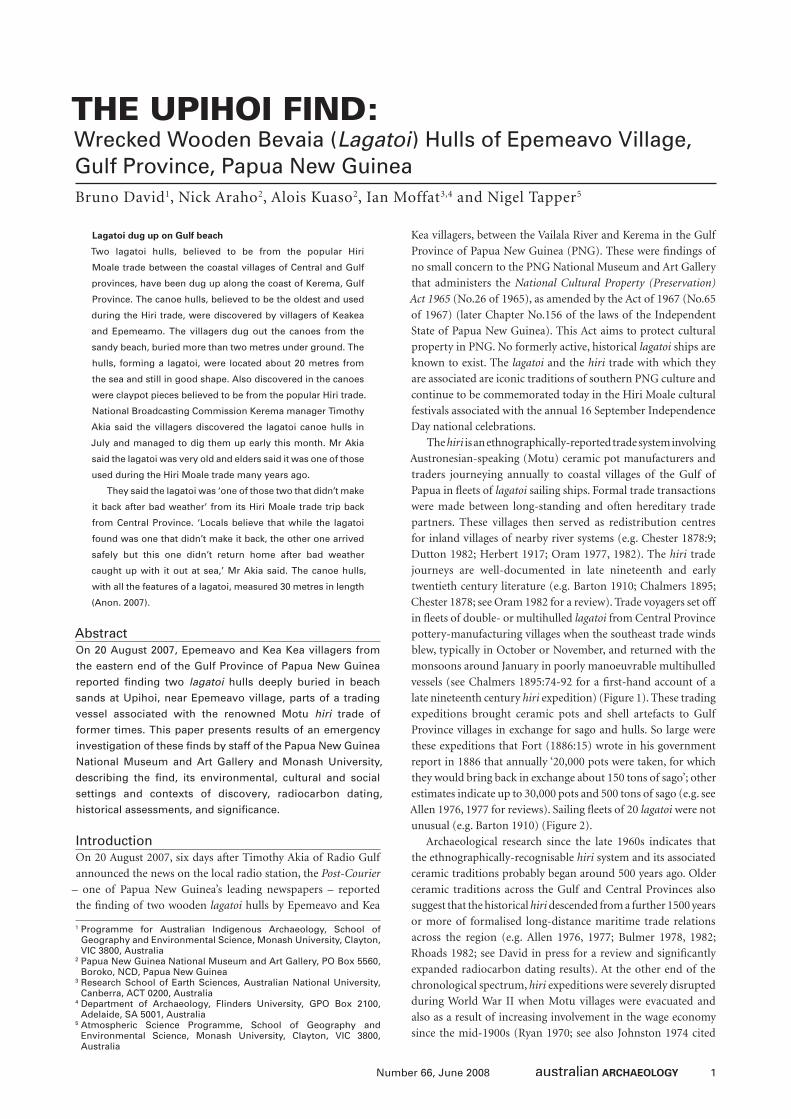
late nineteenth century hiri expedition) (Figure 1). These trading
expeditions brought ceramic pots and shell artefacts to Gulf
Province villages in exchange for sago and hulls. So large were
these expeditions that Fort (1886:15) wrote in his government
report in 1886 that annually ‘20,000 pots were taken, for which
they would bring back in exchange about 150 tons of sago’; other
estimates indicate up to 30,000 pots and 500 tons of sago (e.g. see
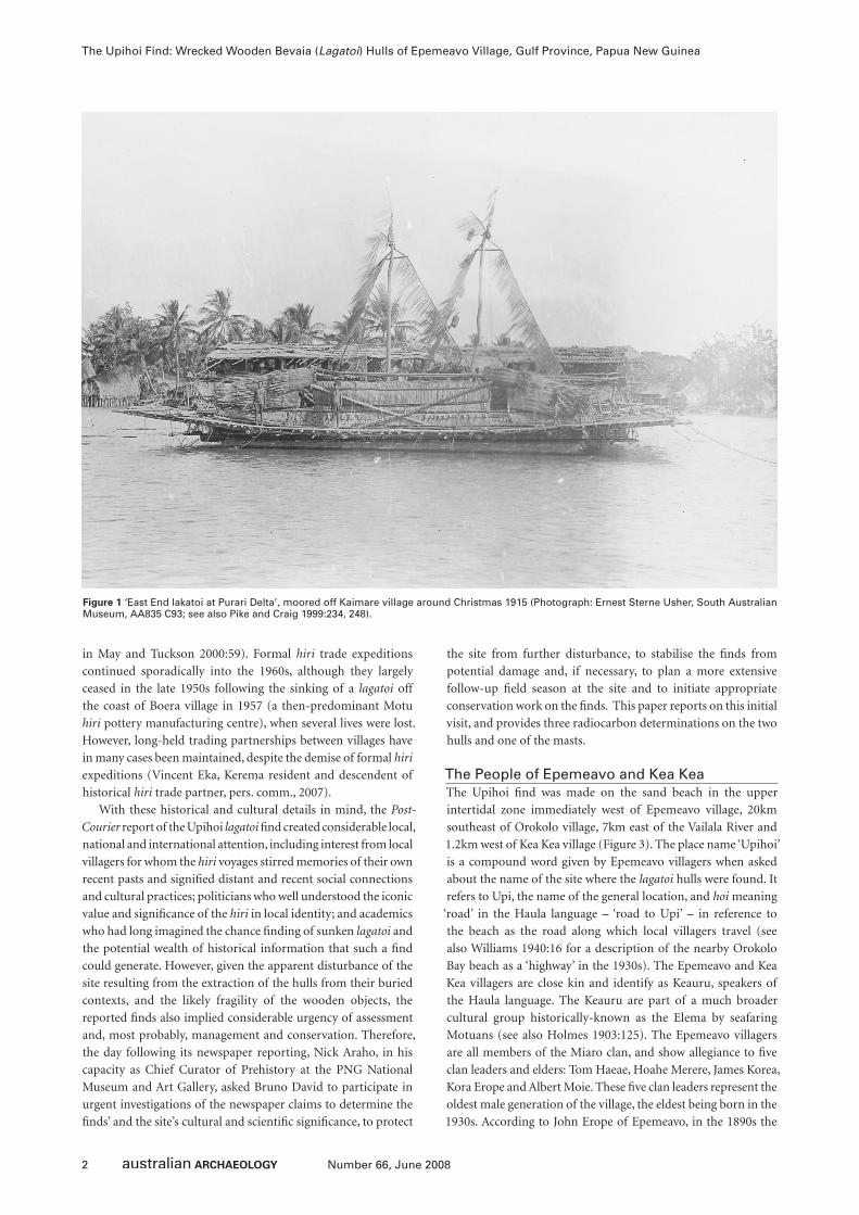
Allen 1976, 1977 for reviews). Sailing fl eets of 20 lagatoi were not
unusual (e.g. Barton 1910) (Figure 2).
Archaeological research since the late 1960s indicates that
the ethnographically-recognisable hiri system and its associated
ceramic traditions probably began around 500 years ago. Older
ceramic traditions across the Gulf and Central Provinces also
suggest that the historical hiri descended from a further 1500 years
or more of formalised long-distance maritime trade relations
across the region (e.g. Allen 1976, 1977; Bulmer 1978, 1982;
Rhoads 1982; see David in press for a review and signifi cantly
expanded radiocarbon dating results). At the other end of the
chronological spectrum, hiri expeditions were severely disrupted
during World War II when Motu villages were evacuated and
also as a result of increasing involvement in the wage economy
since the mid-1900s (Ryan 1970; see also Johnston 1974 cited
2 Number 66, June 2008
The Upihoi Find: Wrecked Wooden Bevaia (Lagatoi) Hulls of Epemeavo Village, Gulf Province, Papua New Guinea
in May and Tuckson 2000:59). Formal hiri trade expeditions
continued sporadically into the 1960s, although they largely
ceased in the late 1950s following the sinking of a lagatoi off
the coast of Boera village in 1957 (a then-predominant Motu
hiri pottery manufacturing centre), when several lives were lost.
However, long-held trading partnerships between villages have
in many cases been maintained, despite the demise of formal hiri
expeditions (Vincent Eka, Kerema resident and descendent of
historical hiri trade partner, pers. comm., 2007).
With these historical and cultural details in mind, the Post-
Courier report of the Upihoi lagatoi fi nd created considerable local,
national and international attention, including interest from local
villagers for whom the hiri voyages stirred memories of their own
recent pasts and signifi ed distant and recent social connections
and cultural practices; politicians who well understood the iconic
value and signifi cance of the hiri in local identity; and academics
who had long imagined the chance fi nding of sunken lagatoi and
the potential wealth of historical information that such a fi nd
could generate. However, given the apparent disturbance of the
site resulting from the extraction of the hulls from their buried
contexts, and the likely fragility of the wooden objects, the
reported fi nds also implied considerable urgency of assessment
and, most probably, management and conservation. Therefore,
the day following its newspaper reporting, Nick Araho, in his
capacity as Chief Curator of Prehistory at the PNG National
Museum and Art Gallery, asked Bruno David to participate in
urgent investigations of the newspaper claims to determine the
fi nds’ and the site’s cultural and scientifi c signifi cance, to protect
the site from further disturbance, to stabilise the fi nds from
potential damage and, if necessary, to plan a more extensive
follow-up fi eld season at the site and to initiate appropriate
conservation work on the fi nds. This paper reports on this initial
visit, and provides three radiocarbon determinations on the two
hulls and one of the masts.
The People of Epemeavo and Kea KeaThe Upihoi fi nd was made on the sand beach in the upper
intertidal zone immediately west of Epemeavo village, 20km
southeast of Orokolo village, 7km east of the Vailala River and
1.2km west of Kea Kea village (Figure 3). The place name ‘Upihoi’
is a compound word given by Epemeavo villagers when asked
about the name of the site where the lagatoi hulls were found. It
refers to Upi, the name of the general location, and hoi meaning
‘road’ in the Haula language – ‘road to Upi’ – in reference to
the beach as the road along which local villagers travel (see
also Williams 1940:16 for a description of the nearby Orokolo
Bay beach as a ‘highway’ in the 1930s). The Epemeavo and Kea
Kea villagers are close kin and identify as Keauru, speakers of
the Haula language. The Keauru are part of a much broader
cultural group historically-known as the Elema by seafaring
Motuans (see also Holmes 1903:125). The Epemeavo villagers
are all members of the Miaro clan, and show allegiance to fi ve
clan leaders and elders: Tom Haeae, Hoahe Merere, James Korea,
Kora Erope and Albert Moie. These fi ve clan leaders represent the
oldest male generation of the village, the eldest being born in the
1930s. According to John Erope of Epemeavo, in the 1890s the
Figure 1 ‘East End lakatoi at Purari Delta’, moored off Kaimare village around Christmas 1915 (Photograph: Ernest Sterne Usher, South Australian Museum, AA835 C93; see also Pike and Craig 1999:234, 248).
3Number 66, June 2008
Bruno David, Nick Araho, Alois Kuaso, Ian Moffat and Nigel Tapper
ancestors of Epemeavo travelled south from inland locations to
establish the original Epemeavo village along the coast. Kea Kea
River which now fronts Epemeavo village in those days fl owed
further to the east than its present position. Epemeavo villagers
generally trace their recent history back to Kaveharo, an inland
village beyond a sago swamp near the mission village of Belepa,
5km inland and immediately north of Epemeavo (in 1928 John
Korea, John Erope’s grandfather, became a missionary at Belepa).
From Kaveharo, the ancestors moved to Helau near the present-
day small village of Poiva, and from Helau to Epemeavo. Sam
Nao points out that the old people used to say that the present
coastline, including today’s coastal villages eastward to ‘The
Bluff ’ (17km east of Kea Kea village), were in the past located
under the sea, the old coastline being located immediately south
of Belepa some 5km inland (see Rhoads 1994:53 for similar
claims of a sand ridge representing an ancient shoreline at Popo
2.5km inland, 22.5km to the northwest of Epemeavo). Based
on fi eldwork undertaken between 1923 and 1937, Williams
(1940:28) reports that:
the coast of Orokolo Bay has evidently been making ground in
recent times, and the population, who are so attached to beach
life, have moved forward with it. Indeed the sites of the present
villages were mostly, within living memory, under the sea.
Today, Kea Kea villagers commonly expose these buried ancient
shorelines during gardening and swamp drainage channelling
a few tens of centimetres below the ground surface. However,
the present Epemeavo village is the fourth village of that name,
the previous three being 100–200m south of the present village,
under the sea as a result of now-north-migrating shorelines and
a shifting Kea Kea River mouth.
Similarly, the Kea Kea villagers also trace their ancestry
to inland villages. Sam Nao of Kea Kea states that local oral
traditions indicate that the ancestors of today’s village came
from the inland village of Popo (for discussion of the ancestral
Popo site, see Williams 1940:28 for regional oral traditions and
Rhoads 1994 for archaeological investigations). According to
Sam Nao, in ancient times some Popo villagers went inland
travelling east to establish the ancestral village of Ahia
immediately to the west of the Vailala River; others went south
to establish Orokolo and nearby villages along the coast. Ahia
villagers then followed the Vailala River to the coast, where
some people then followed the coastline westward, and others
eastward to establish what is now Kea Kea village. Present-
day Kea Kea villagers explain that the ancestors divided from
Popo to follow different migration routes – some going inland
while others southwards directly to the coast. Today, numerous
languages are spoken across the region, including Haula by the
people of Kea Kea and Orokolo by those of Orokolo. According
to Kea Kea villagers, this is a consequence of the fi ssioned
migration history from Popo. Bastard (1922:70-79 cited in
Haddon 1937:210), writes that the ‘Keuru [Keauru] group of
villages, 7 miles east of Vailala ... has made its appearance on
the coast only within the past few years’. Holmes (1903:132)
similarly notes that:
The Haura [Keauru, who speak Haula language] tribe has only
made its appearance at the coast, with the intention of making a
claim on the coast line for future settlement, within the past few
years. The representatives of this tribe, now on the coast and in
its immediate vicinity, are all located between the east bank of
the Vailala river, and the spur of the Albert Range, known as the
‘Cupola,’ the east boundary of Kerema Bay. These communities
are known in every-day parlance, by the names of the respective
localities in which they live, as Helau, a village near Vailala, Keakea,
another village a few miles east of Vailala.
He further notes that ‘By occasional visits to the tribes living on
the east bank of this [Vailala] river, and a casual acquaintance
with their movements, [Holmes] has observed for many years
a marked tendency to migrate coastward’; and ‘From time
immemorial, there has been a tendency among these tribes
to migrate southwardly, wittingly or otherwise, toward the
coast’ (Holmes 1903:132, 133). Holmes makes no mention of
Epemeavo village in his 1903 paper, despite listing the coastal
village names for this region (but he does mention Helau, the
village from which the people of Epemeavo came according
to present-day oral traditions), implying its likely more recent
origins (see Holmes 1903 for details of origin stories).
In recounting ancestral migrations from inland locations, Kea
Kea villagers also noted that oral traditions identifi ed hilltops as
the locations of ancestral villages for reasons of defence in the
case of attack by hostile groups.
The Upihoi FindThe Upihoi fi nd was exposed after the collapse of large coconut
trees revealed the tops of the hulls in the sandy uppermost
reaches of the intertidal zone (Figures 4-5). Here the subcoastal
zone is of very fl at gradient and thickly vegetated by an expansive
coconut grove of great height. The shoreline edge of the grove is
marked by a 1.2m-high erosion face of thickly-matted coconut
palm roots marking the limits of high tide. South of this gully,
and below the base of the matted coconut palm roots, sediments
consist of the uniform dark mineral sands of the intertidal zone.
The hulls were found just below the base of this matted layer
of coconut roots, signalling that the lagatoi wreck predates the
growth of the coconut grove.
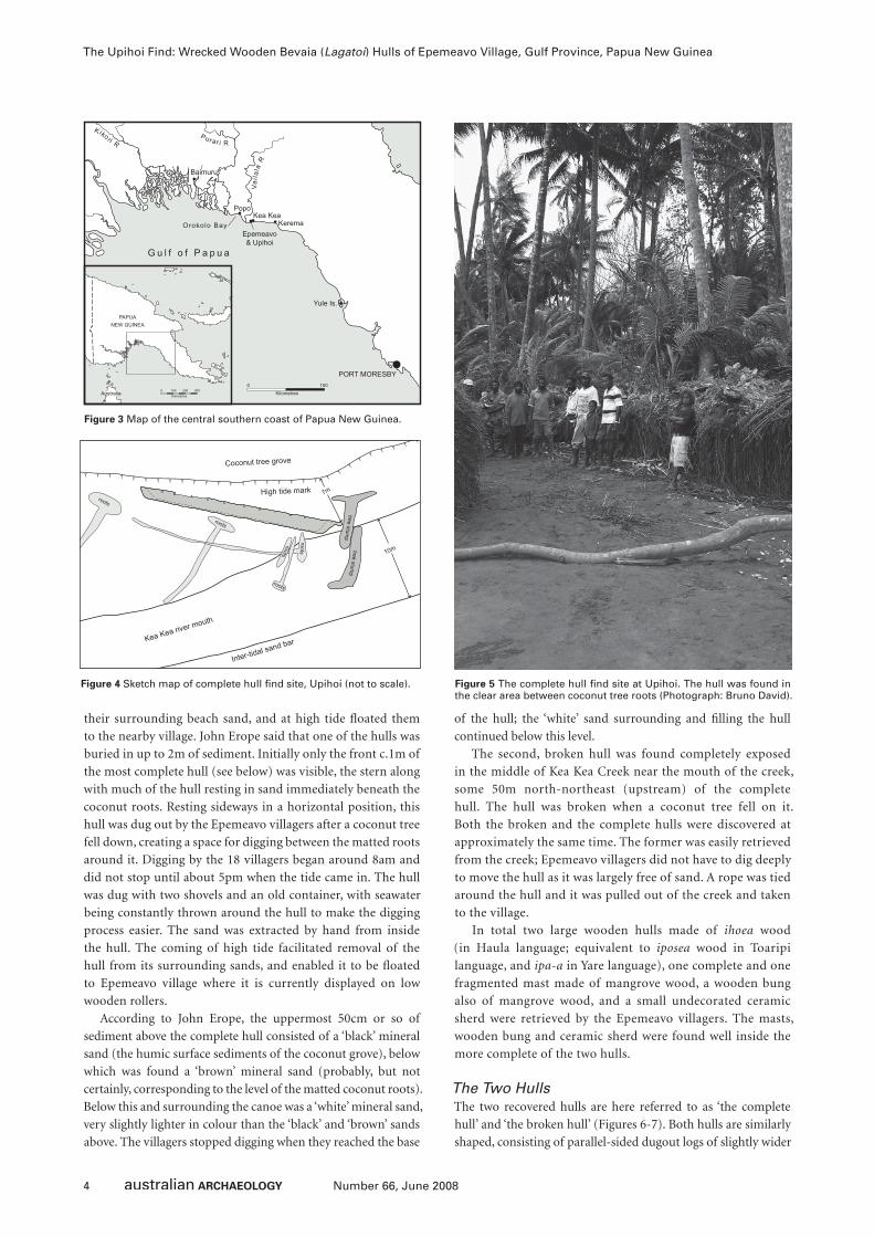
It is not clear exactly when in July 2007 the canoe hulls were
fi rst discovered by John Erope and Moisen Iavi of Epemeavo
village. However, in early August, shortly after discovery, a
group of 18 local villagers dug up and emptied the hulls of
Figure 2 ‘Fleet of lakatois starting for the west’ (Chalmers 1895:75).
4 Number 66, June 2008
The Upihoi Find: Wrecked Wooden Bevaia (Lagatoi) Hulls of Epemeavo Village, Gulf Province, Papua New Guinea
their surrounding beach sand, and at high tide fl oated them
to the nearby village. John Erope said that one of the hulls was
buried in up to 2m of sediment. Initially only the front c.1m of
the most complete hull (see below) was visible, the stern along
with much of the hull resting in sand immediately beneath the
coconut roots. Resting sideways in a horizontal position, this
hull was dug out by the Epemeavo villagers after a coconut tree
fell down, creating a space for digging between the matted roots
around it. Digging by the 18 villagers began around 8am and
did not stop until about 5pm when the tide came in. The hull
was dug with two shovels and an old container, with seawater
being constantly thrown around the hull to make the digging
process easier. The sand was extracted by hand from inside
the hull. The coming of high tide facilitated removal of the
hull from its surrounding sands, and enabled it to be fl oated
to Epemeavo village where it is currently displayed on low
wooden rollers.
According to John Erope, the uppermost 50cm or so of
sediment above the complete hull consisted of a ‘black’ mineral
sand (the humic surface sediments of the coconut grove), below
which was found a ‘brown’ mineral sand (probably, but not
certainly, corresponding to the level of the matted coconut roots).
Below this and surrounding the canoe was a ‘white’ mineral sand,
very slightly lighter in colour than the ‘black’ and ‘brown’ sands
above. The villagers stopped digging when they reached the base
of the hull; the ‘white’ sand surrounding and fi lling the hull
continued below this level.
The second, broken hull was found completely exposed
in the middle of Kea Kea Creek near the mouth of the creek,
some 50m north-northeast (upstream) of the complete
hull. The hull was broken when a coconut tree fell on it.
Both the broken and the complete hulls were discovered at
approximately the same time. The former was easily retrieved
from the creek; Epemeavo villagers did not have to dig deeply
to move the hull as it was largely free of sand. A rope was tied
around the hull and it was pulled out of the creek and taken
to the village.
In total two large wooden hulls made of ihoea wood
(in Haula language; equivalent to iposea wood in Toaripi
language, and ipa-a in Yare language), one complete and one
fragmented mast made of mangrove wood, a wooden bung
also of mangrove wood, and a small undecorated ceramic
sherd were retrieved by the Epemeavo villagers. The masts,
wooden bung and ceramic sherd were found well inside the
more complete of the two hulls.
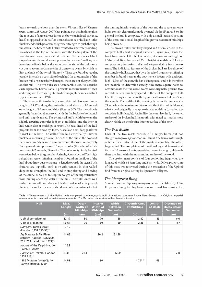
The Two HullsThe two recovered hulls are here referred to as ‘the complete
hull’ and ‘the broken hull’ (Figures 6-7). Both hulls are similarly
shaped, consisting of parallel-sided dugout logs of slightly wider
Figure 3 Map of the central southern coast of Papua New Guinea.
Figure 4 Sketch map of complete hull fi nd site, Upihoi (not to scale). Figure 5 The complete hull fi nd site at Upihoi. The hull was found in the clear area between coconut tree roots (Photograph: Bruno David).
5Number 66, June 2008
Bruno David, Nick Araho, Alois Kuaso, Ian Moffat and Nigel Tapper
beam towards the bow than the stern. Vincent Eka of Kerema
(pers. comm., 28 August 2007) has pointed out that in this region
the root end of a tree always forms the bow (or, in local parlance,
‘head’, as opposed to the ‘tail’ or stern) of a canoe or hull as it is the
thickest end which possesses the greater strength to push through
the waves. The bow of both hulls is fronted by a narrow projecting
beak-head at the top of the hulls, with the leading stem of the
bow sloping forward over a short distance. The stern of each hull
slopes backwards and does not possess decoration. Small, square
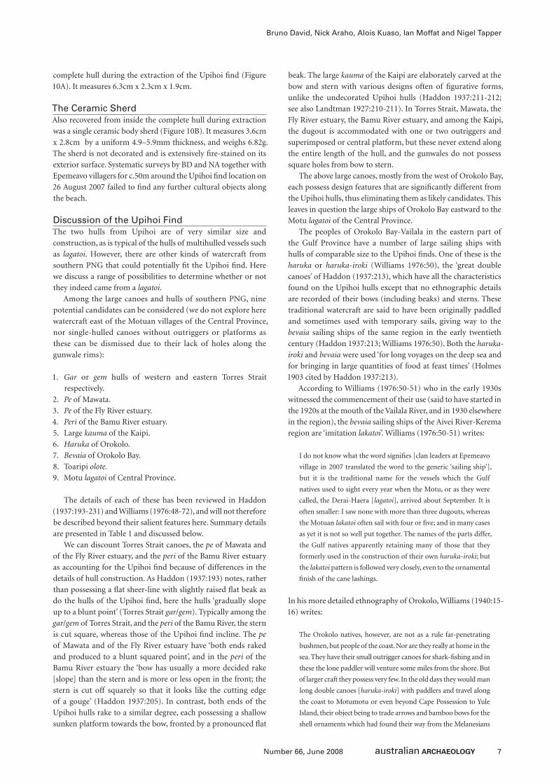
holes immediately below the gunwales (the rim of the hull) were
cut out to accommodate a series of transverse beams by which to
link the hulls of the vessel (Figure 8). These are found at regular,
parallel intervals on each side of each hull (as the gunwales of the
broken hull are extensively damaged, these are not always visible
on this hull). The two hulls are of comparable size. We describe
each separately below. Table 1 presents measurements of each
and compares them with published ethnographic canoe and hull
types from southern PNG.
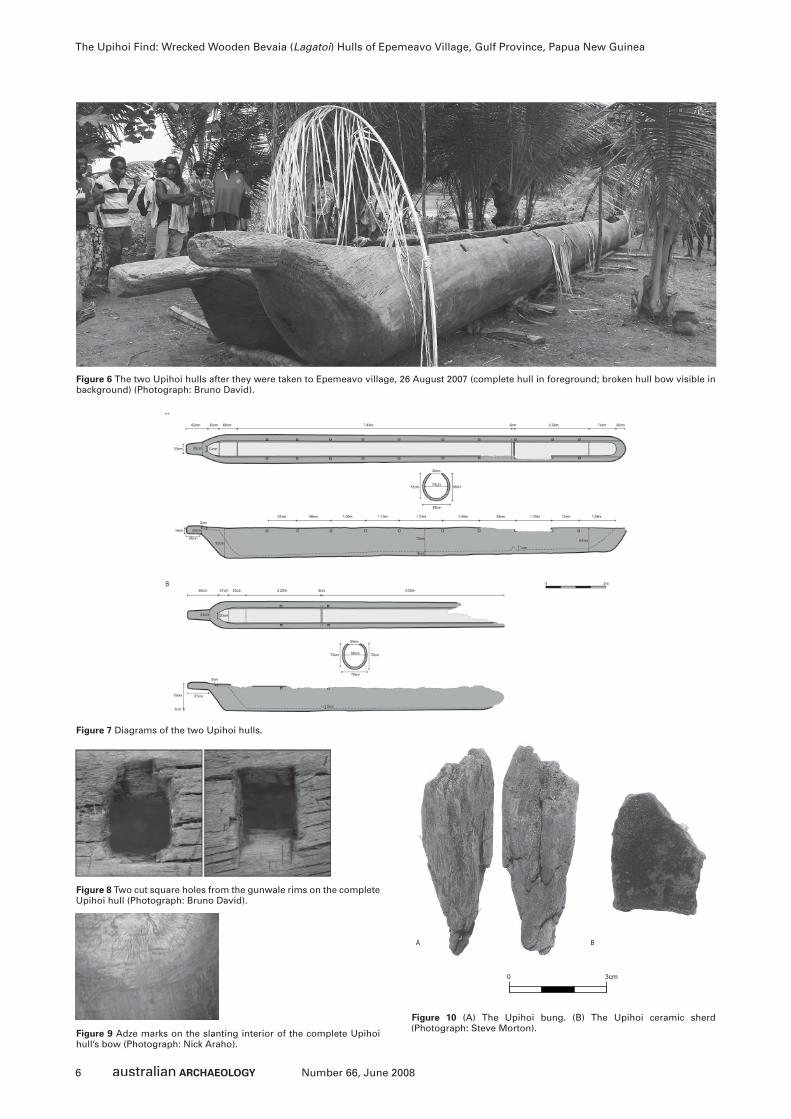
The larger of the two hulls (the complete hull) has a maximum
length of 13.17m along the centre-line, and a beam of 80cm and
outer height of 80cm at midships (Figures 6-7). The sheer-line is
generally fl at rather than curved, with the fl at beak also horizontal
and only slightly raised. The cylindrical hull’s width between the
slightly tapering gunwales is 38cm at midships, and the interior
hull width also at midships is 70cm. The beak-head of the hull
projects from the bow by 45cm. A shallow, 5cm-deep platform
is inset in the bow. The walls of the hull are of fairly uniform
thickness, measuring c.5cm. The ends of the hull at the bow and
stern measure 52cm and 35cm maximum thickness respectively.
Each gunwale rim possesses 10 square holes (the sides of which
measures 5–7cm each; Figure 8). The holes are typically located
some 6cm below the gunwales. A single, 9cm-wide and 7cm-high
raised transverse stiffening member is found on the fl oor of the
hull about three-quarters along its length towards the stern. Such
features are typically used as re-enforcement in thin-walled
dugouts to strengthen the hull and to stop fl exing and bowing
of the canoe, as well as to stop the weight of the superstructure
from pulling apart the walls of the hull. The hull’s outer wall
surface is smooth and does not feature cut-marks; in general,
the interior wall surfaces are also devoid of clear cut-marks, but
the slanting interior surface of the bow and the square gunwale
holes contain clear marks made by metal blades (Figures 8-9). In
general the hull is complete, with only a small localised section
of the stern, and a small length of the gunwale astern of midships
being broken.
The broken hull is similarly shaped and of similar size to the
complete hull, albeit marginally smaller (Figures 6-7). Only the
front two-thirds of this hull is present, at a maximum length of
9.51m, and 70cm beam and 75cm height at midships. Like the
complete hull, the broken hull’s profi le tapers slightly from bow to
stern. The individual features of the broken hull are like those of
the complete hull, except that here the raised transverse stiffening
member is found closer to the bow (here it is 6cm-wide and 5cm-
high). Most of the gunwale has disintegrated, and it is therefore
not possible to determine exactly how many square holes to
accommodate the transverse beams were originally present; two
can still be seen, similarly spaced to those of the complete hull.
Like the complete hull also, the cylindrical broken hull has 5cm-
thick walls. The width of the opening between the gunwales is
39cm, while the maximum interior width of the hull is 60cm at
what would originally have approximated midships (based on the
complete hull’s length). Again, like the complete hull, the outer
surface of the broken hull is smooth, with metal cut-marks most
clearly visible on the sloping interior surface of the bow.
The Two MastsEach of the two masts consists of a single, linear but not
straight mangrove (poro wood in Haula) tree trunk with rough,
outer surfaces intact. One of the masts is complete, the other
fragmented. The complete mast is 4.68m-long and 9cm-wide at
its base. Numerous knots are evident along its length, although
these are fl ush with the surrounding surface of the wood.
The broken mast consists of four conjoining fragments, the
longest of which is 88cm-long and 9cm-wide. Only a proportion
of this mast was recovered during the extraction of the Upihoi
fi nd from its original setting by Epemeavo villagers.
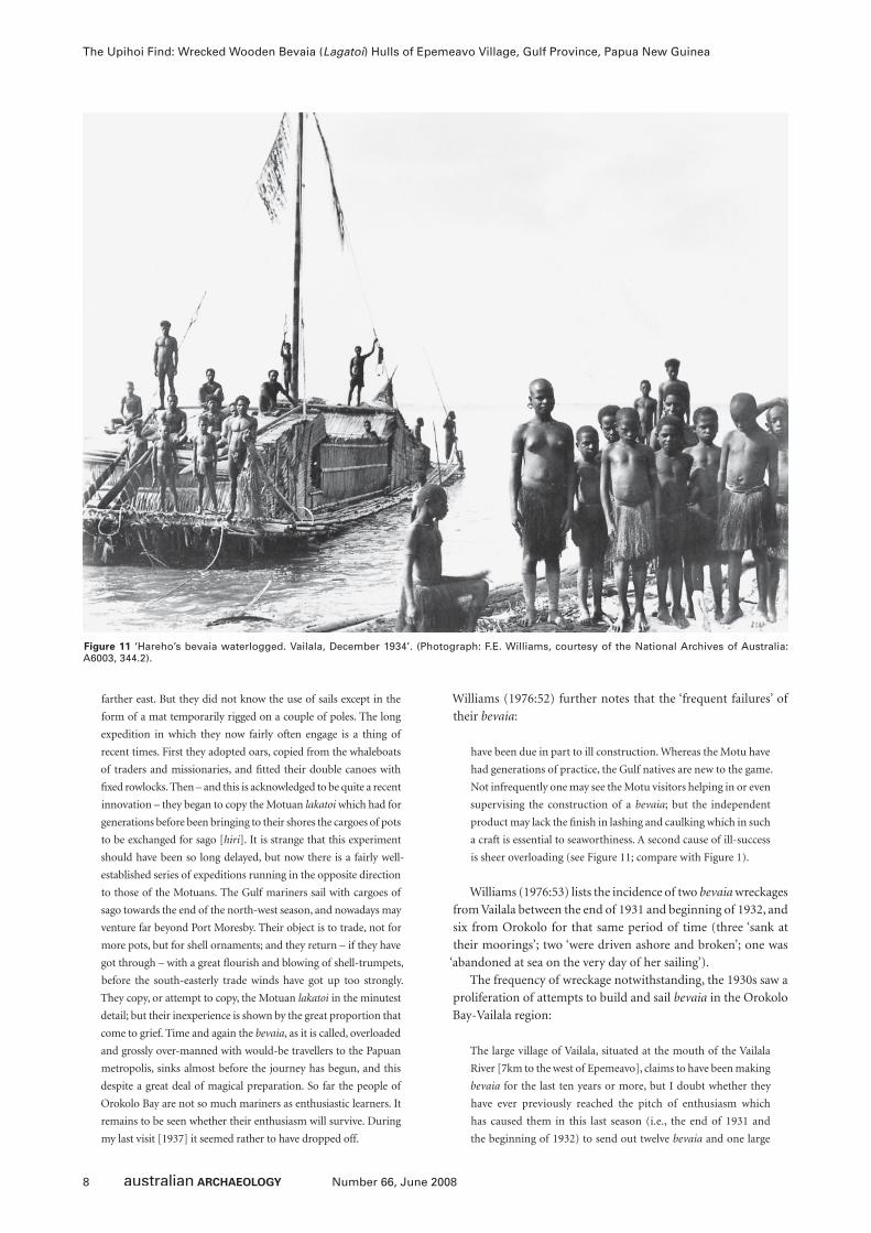
The Mangrove BungA small piece of tapering mangrove wood identifi ed by John
Erope as a bung to plug leaks was recovered from inside the
Hull Max. Length
Outer Width at Midships
Interior Width at Midships
Width between
Gunwales
Circumference at Midships
Length of Beak
Distance of Holes Below Gunwales
(m) (cm) (cm) (cm) (m) (cm) (cm)Upihoi complete hull 13.17 80 70 38 2.80 45 c.6
Upihoi broken hull >9.51 70 60 39 2.35 67 c.7
Gar/gem, Torres Strait (Haddon 1937:193-98)*
9-19
Pe, Mawata & Fly River estuary (Haddon 1937:200-201, 203; Landtman 1927)*
14.68 96.2 81.28
Kauma of the Kaipi (Haddon 1937:211-212)*
12.2
Haruka of Orokolo (Haddon 1937:213)*
15.06 71.1 55.9 7-8
1886 Motuan lagatoi (after Barton 1910:96-120)*
14.53 80 4.75** 69
Table 1 Measurements of the Upihoi hulls compared to ethnographic hull dimensions, southern Papua New Guinea. * = Original imperial measurements converted to metric measurements. ** = Maximum dimension, rather than at midships.
6 Number 66, June 2008
The Upihoi Find: Wrecked Wooden Bevaia (Lagatoi) Hulls of Epemeavo Village, Gulf Province, Papua New Guinea
Figure 7 Diagrams of the two Upihoi hulls.
Figure 9 Adze marks on the slanting interior of the complete Upihoi hull’s bow (Photograph: Nick Araho).
Figure 10 (A) The Upihoi bung. (B) The Upihoi ceramic sherd (Photograph: Steve Morton).
Figure 6 The two Upihoi hulls after they were taken to Epemeavo village, 26 August 2007 (complete hull in foreground; broken hull bow visible in background) (Photograph: Bruno David).
Figure 8 Two cut square holes from the gunwale rims on the complete Upihoi hull (Photograph: Bruno David).
7Number 66, June 2008
Bruno David, Nick Araho, Alois Kuaso, Ian Moffat and Nigel Tapper
complete hull during the extraction of the Upihoi fi nd (Figure
10A). It measures 6.3cm x 2.3cm x 1.9cm.
The Ceramic SherdAlso recovered from inside the complete hull during extraction
was a single ceramic body sherd (Figure 10B). It measures 3.6cm
x 2.8cm by a uniform 4.9–5.9mm thickness, and weighs 6.82g.
The sherd is not decorated and is extensively fi re-stained on its
exterior surface. Systematic surveys by BD and NA together with
Epemeavo villagers for c.50m around the Upihoi fi nd location on
26 August 2007 failed to fi nd any further cultural objects along
the beach.
Discussion of the Upihoi FindThe two hulls from Upihoi are of very similar size and
construction, as is typical of the hulls of multihulled vessels such
as lagatoi. However, there are other kinds of watercraft from
southern PNG that could potentially fi t the Upihoi fi nd. Here
we discuss a range of possibilities to determine whether or not
they indeed came from a lagatoi.
Among the large canoes and hulls of southern PNG, nine
potential candidates can be considered (we do not explore here
watercraft east of the Motuan villages of the Central Province,
nor single-hulled canoes without outriggers or platforms as
these can be dismissed due to their lack of holes along the
gunwale rims):
1. Gar or gem hulls of western and eastern Torres Strait
respectively.
2. Pe of Mawata.
3. Pe of the Fly River estuary.
4. Peri of the Bamu River estuary.
5. Large kauma of the Kaipi.
6. Haruka of Orokolo.
7. Bevaia of Orokolo Bay.
8. Toaripi olote.
9. Motu lagatoi of Central Province.
The details of each of these has been reviewed in Haddon
(1937:193-231) and Williams (1976:48-72), and will not therefore
be described beyond their salient features here. Summary details
are presented in Table 1 and discussed below.
We can discount Torres Strait canoes, the pe of Mawata and
of the Fly River estuary, and the peri of the Bamu River estuary
as accounting for the Upihoi fi nd because of differences in the
details of hull construction. As Haddon (1937:193) notes, rather
than possessing a fl at sheer-line with slightly raised fl at beak as
do the hulls of the Upihoi fi nd, here the hulls ‘gradually slope
up to a blunt point’ (Torres Strait gar/gem). Typically among the
gar/gem of Torres Strait, and the peri of the Bamu River, the stern
is cut square, whereas those of the Upihoi fi nd incline. The pe
of Mawata and of the Fly River estuary have ‘both ends raked
and produced to a blunt squared point’, and in the peri of the
Bamu River estuary the ‘bow has usually a more decided rake
[slope] than the stern and is more or less open in the front; the
stern is cut off squarely so that it looks like the cutting edge
of a gouge’ (Haddon 1937:205). In contrast, both ends of the
Upihoi hulls rake to a similar degree, each possessing a shallow
sunken platform towards the bow, fronted by a pronounced fl at
beak. The large kauma of the Kaipi are elaborately carved at the
bow and stern with various designs often of fi gurative forms,
unlike the undecorated Upihoi hulls (Haddon 1937:211-212;
see also Landtman 1927:210-211). In Torres Strait, Mawata, the
Fly River estuary, the Bamu River estuary, and among the Kaipi,
the dugout is accommodated with one or two outriggers and
superimposed or central platform, but these never extend along
the entire length of the hull, and the gunwales do not possess
square holes from bow to stern.
The above large canoes, mostly from the west of Orokolo Bay,
each possess design features that are signifi cantly different from
the Upihoi hulls, thus eliminating them as likely candidates. This
leaves in question the large ships of Orokolo Bay eastward to the
Motu lagatoi of the Central Province.
The peoples of Orokolo Bay-Vailala in the eastern part of
the Gulf Province have a number of large sailing ships with
hulls of comparable size to the Upihoi fi nds. One of these is the
haruka or haruka-iroki (Williams 1976:50), the ‘great double
canoes’ of Haddon (1937:213), which have all the characteristics
found on the Upihoi hulls except that no ethnographic details
are recorded of their bows (including beaks) and sterns. These
traditional watercraft are said to have been originally paddled
and sometimes used with temporary sails, giving way to the
bevaia sailing ships of the same region in the early twentieth
century (Haddon 1937:213; Williams 1976:50). Both the haruka-
iroki and bevaia were used ‘for long voyages on the deep sea and
for bringing in large quantities of food at feast times’ (Holmes
1903 cited by Haddon 1937:213).
According to Williams (1976:50-51) who in the early 1930s
witnessed the commencement of their use (said to have started in
the 1920s at the mouth of the Vailala River, and in 1930 elsewhere
in the region), the bevaia sailing ships of the Aivei River-Kerema
region are ‘imitation lakatoi’. Williams (1976:50-51) writes:
I do not know what the word signifi es [clan leaders at Epemeavo
village in 2007 translated the word to the generic ‘sailing ship’],
but it is the traditional name for the vessels which the Gulf
natives used to sight every year when the Motu, or as they were
called, the Derai-Haera [lagatoi], arrived about September. It is
often smaller: I saw none with more than three dugouts, whereas
the Motuan lakatoi often sail with four or fi ve; and in many cases
as yet it is not so well put together. The names of the parts differ,
the Gulf natives apparently retaining many of those that they
formerly used in the construction of their own haruka-iroki; but
the lakatoi pattern is followed very closely, even to the ornamental
fi nish of the cane lashings.
In his more detailed ethnography of Orokolo, Williams (1940:15-
16) writes:
The Orokolo natives, however, are not as a rule far-penetrating
bushmen, but people of the coast. Nor are they really at home in the
sea. They have their small outrigger canoes for shark-fi shing and in
these the lone paddler will venture some miles from the shore. But
of larger craft they possess very few. In the old days they would man
long double canoes [haruka-iroki] with paddlers and travel along
the coast to Motumotu or even beyond Cape Possession to Yule
Island, their object being to trade arrows and bamboo bows for the
shell ornaments which had found their way from the Melanesians
8 Number 66, June 2008
The Upihoi Find: Wrecked Wooden Bevaia (Lagatoi) Hulls of Epemeavo Village, Gulf Province, Papua New Guinea
farther east. But they did not know the use of sails except in the
form of a mat temporarily rigged on a couple of poles. The long
expedition in which they now fairly often engage is a thing of
recent times. First they adopted oars, copied from the whaleboats
of traders and missionaries, and fi tted their double canoes with
fi xed rowlocks. Then – and this is acknowledged to be quite a recent
innovation – they began to copy the Motuan lakatoi which had for
generations before been bringing to their shores the cargoes of pots
to be exchanged for sago [hiri]. It is strange that this experiment
should have been so long delayed, but now there is a fairly well-
established series of expeditions running in the opposite direction
to those of the Motuans. The Gulf mariners sail with cargoes of
sago towards the end of the north-west season, and nowadays may
venture far beyond Port Moresby. Their object is to trade, not for
more pots, but for shell ornaments; and they return – if they have
got through – with a great fl ourish and blowing of shell-trumpets,
before the south-easterly trade winds have got up too strongly.
They copy, or attempt to copy, the Motuan lakatoi in the minutest
detail; but their inexperience is shown by the great proportion that
come to grief. Time and again the bevaia, as it is called, overloaded
and grossly over-manned with would-be travellers to the Papuan
metropolis, sinks almost before the journey has begun, and this
despite a great deal of magical preparation. So far the people of
Orokolo Bay are not so much mariners as enthusiastic learners. It
remains to be seen whether their enthusiasm will survive. During
my last visit [1937] it seemed rather to have dropped off.
Williams (1976:52) further notes that the ‘frequent failures’ of
their bevaia:
have been due in part to ill construction. Whereas the Motu have
had generations of practice, the Gulf natives are new to the game.
Not infrequently one may see the Motu visitors helping in or even
supervising the construction of a bevaia; but the independent
product may lack the fi nish in lashing and caulking which in such
a craft is essential to seaworthiness. A second cause of ill-success
is sheer overloading (see Figure 11; compare with Figure 1).
Williams (1976:53) lists the incidence of two bevaia wreckages
from Vailala between the end of 1931 and beginning of 1932, and
six from Orokolo for that same period of time (three ‘sank at
their moorings’; two ‘were driven ashore and broken’; one was
‘abandoned at sea on the very day of her sailing’).
The frequency of wreckage notwithstanding, the 1930s saw a
proliferation of attempts to build and sail bevaia in the Orokolo
Bay-Vailala region:
The large village of Vailala, situated at the mouth of the Vailala
River [7km to the west of Epemeavo], claims to have been making
bevaia for the last ten years or more, but I doubt whether they
have ever previously reached the pitch of enthusiasm which
has caused them in this last season (i.e., the end of 1931 and
the beginning of 1932) to send out twelve bevaia and one large
Figure 11 ‘Hareho’s bevaia waterlogged. Vailala, December 1934’. (Photograph: F.E. Williams, courtesy of the National Archives of Australia:A6003, 344.2).
9Number 66, June 2008
Bruno David, Nick Araho, Alois Kuaso, Ian Moffat and Nigel Tapper
haruka-iroki. Beyond Vailala, the fi rst experiments were made
only in the previous season, 1930-31, when three were equipped.
But during last season, while I was in the neighbourhood, three
were fi tted out at Orokolo and four at the neighbouring village
of Arihava (Williams 1976:51).
The famous Motuan lagatoi upon which the bevaia were based
have been well-described by late nineteenth and early-to-mid
twentieth century commentators. The classic and most detailed
account is by Barton (1910:96-120) which is paraphrased by
Haddon (1937:227) in the following way:
A lakatoi is composed of three or more asi, which are made of a
soft-wood tree (ilimo) of great size that grows close by rivers in
their low alluvial reaches in the Papuan Gulf district. The Gulf
natives fell the trees and fl oat them to the lakatoi that have arrived
on a trading expedition (hiri). The trunks are hauled on to the
bank of the river, where the visitors hollow them out and shape
them. Fire is not employed in this operation. An asi is a clumsy
dugout with rounded or squared ends prolonged above into a
projecting fl at beak ...
The asi are secured together by numerous cross beams which
are tied by lashings that pass through square holes cut in their
gunwales. Over these beams a large platform or deck (ilaha) is
constructed; this must be made very strong as it has to stand
the strain of the great waves of the Gulf. The platform extends
beyond the asi especially fore and aft. In 1884 the largest lakatoi
which arrived at Port Moresby from the Gulf consisted of 14 asi
and measured 59 by 51 feet [18.0m x 15.5m]; two smaller ones
measured 54 by 37 feet [16.5m x 11.3m].
Lagatoi typically have two masts ‘made of the stem of a
sapling of a species of mangrove’ (Pratt 1906:72; see also
Chalmers 1895:76), although single-masted and various
confi gurations of multimasted vessels are known (e.g. Haddon
1937:227-231).
From these details, and given the dimensions presented in
Table 1, it is not possible to distinguish the Upihoi hulls from
the haruka-iroki, bevaia and lagatoi, as insuffi cient structural
details have been published of the former to allow for this, and
the bevaia were modelled precisely on the lagatoi, at times with
direct Motuan advice and involvement during the construction
process. Similarly, Haddon (1937:216, following Chalmers
1898:327), Holmes (1903) and Abel (1902:72-79), note that the
large, multihulled olote sailing ships of the Toaripi (‘Motumotu’)
towards the eastern end of the Gulf Province are also ‘the same
as the Motu lakatoi’. On metrical and design characteristics
alone, the Upihoi fi nd could thus relate to any of these types.
However, we suggest below that other details allow a narrowing
of possibilities.
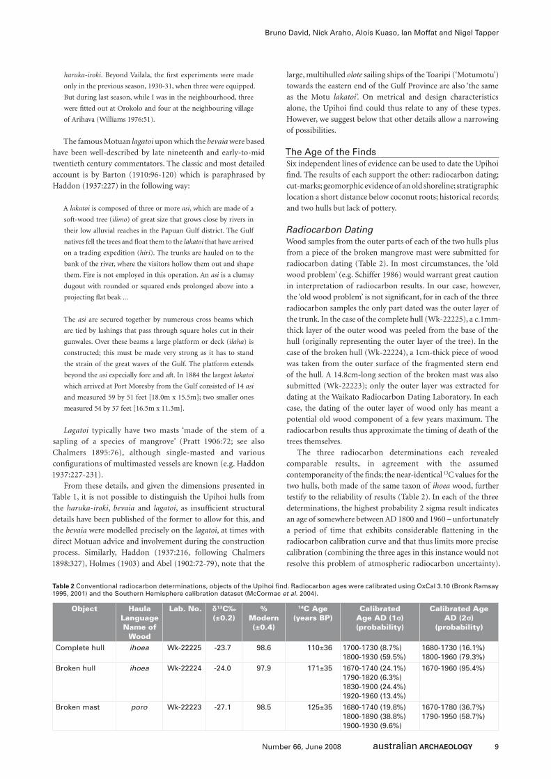
The Age of the FindsSix independent lines of evidence can be used to date the Upihoi
fi nd. The results of each support the other: radiocarbon dating;
cut-marks; geomorphic evidence of an old shoreline; stratigraphic
location a short distance below coconut roots; historical records;
and two hulls but lack of pottery.
Radiocarbon DatingWood samples from the outer parts of each of the two hulls plus
from a piece of the broken mangrove mast were submitted for
radiocarbon dating (Table 2). In most circumstances, the ‘old
wood problem’ (e.g. Schiffer 1986) would warrant great caution
in interpretation of radiocarbon results. In our case, however,
the ‘old wood problem’ is not signifi cant, for in each of the three
radiocarbon samples the only part dated was the outer layer of
the trunk. In the case of the complete hull (Wk-22225), a c.1mm-
thick layer of the outer wood was peeled from the base of the
hull (originally representing the outer layer of the tree). In the
case of the broken hull (Wk-22224), a 1cm-thick piece of wood
was taken from the outer surface of the fragmented stern end
of the hull. A 14.8cm-long section of the broken mast was also
submitted (Wk-22223); only the outer layer was extracted for
dating at the Waikato Radiocarbon Dating Laboratory. In each
case, the dating of the outer layer of wood only has meant a
potential old wood component of a few years maximum. The
radiocarbon results thus approximate the timing of death of the
trees themselves.
The three radiocarbon determinations each revealed
comparable results, in agreement with the assumed
contemporaneity of the fi nds; the near-identical 13C values for the
two hulls, both made of the same taxon of ihoea wood, further
testify to the reliability of results (Table 2). In each of the three
determinations, the highest probability 2 sigma result indicates
an age of somewhere between AD 1800 and 1960 – unfortunately
a period of time that exhibits considerable fl attening in the
radiocarbon calibration curve and that thus limits more precise
calibration (combining the three ages in this instance would not
resolve this problem of atmospheric radiocarbon uncertainty).
Object Haula Language Name of
Wood
Lab. No. δ13C‰ (±0.2)
% Modern (±0.4)
14C Age (years BP)
Calibrated Age AD (1σ) (probability)
Calibrated Age AD (2σ)
(probability)
Complete hull ihoea Wk-22225 -23.7 98.6 110±36 1700-1730 (8.7%) 1800-1930 (59.5%)
1680-1730 (16.1%)1800-1960 (79.3%)
Broken hull ihoea Wk-22224 -24.0 97.9 171±35 1670-1740 (24.1%)1790-1820 (6.3%)1830-1900 (24.4%)1920-1960 (13.4%)
1670-1960 (95.4%)
Broken mast poro Wk-22223 -27.1 98.5 125±35 1680-1740 (19.8%)1800-1890 (38.8%)1900-1930 (9.6%)
1670-1780 (36.7%)1790-1950 (58.7%)
Table 2 Conventional radiocarbon determinations, objects of the Upihoi fi nd. Radiocarbon ages were calibrated using OxCal 3.10 (Bronk Ramsay 1995, 2001) and the Southern Hemisphere calibration dataset (McCormac et al. 2004).
10 Number 66, June 2008
The Upihoi Find: Wrecked Wooden Bevaia (Lagatoi) Hulls of Epemeavo Village, Gulf Province, Papua New Guinea
However, the absence of a bomb pulse signal indicates that these
samples all pre-date the period of atomic testing in the 1950s.
Cut-MarksNeither of the hulls exhibits any obvious cut-marks on its exterior
surface, but the slanting interior surfaces of both bows, and the
square holes below the gunwales have clear marks made by metal
adze and axe blades (Figures 8-9). To the immediate west of
Orokolo Bay, at Ukiravi village in the Purari River delta, Williams
(in Young and Clark 2001:68) captioned a photograph of a canoe
hull being shaped with a metal adze in 1922 in the following way:
‘The rough work of hollowing is done with a trade axe ... When
the canoe had been roughly hollowed, the fi nishing touches
are put to the interior with an adze’. Metal became available in
southern PNG well before European settlement in 1873, through
trade with passing ships and internal exchange networks (e.g.
Swadling 1996; see also Hughes 1977). However, metal axes and
adzes did not replace stone tools along the Gulf Province coastline
until the late 1800s into the early 1900s, when a proliferation of
new Western administrative centres, government patrols and
missionary stations saw the onset of sustained availability (e.g.
Bevan 1890; Chalmers 1895; see also Salisbury 1962; Young and
Clark 2001:68, 121, 192, cf. Young and Clark 2001:235, 240, 242,
245, 248, 263, 273). The Upihoi hulls, manufactured by metal axe
and adze blades, were thus most probably fashioned sometime
after the late 1800s.
Geomorphic Evidence of Old ShorelineThe coastline along which the Upihoi fi nd was made is today, as
in the recent past, geomorphologically active, as evidenced by
inland relic shorelines (some of which have been radiocarbon
dated) and oral traditions. In particular, past villages containing
rich ceramic sherd assemblages are evident along relic shorelines
located well inland (e.g. at Popo, Keveoki). At Popo, a radiocarbon
determination of 410±80 BP (ANU-2181) indicates the presence
of the shoreline 2.5km inland in the very recent past (Rhoads
1994:53-55). Oral traditions of the coastline shifting ‘within living
memory’, some discussed by Williams (1940:28) for the 1920s-
1930s and others presented by Kea Kea and Epemeavo villagers
in 2007 (see above), testify to the rapid southward migration of
the coast during the late nineteenth into the twentieth century.
In such actively aggrading coastal settings, the settling of a lagatoi
wreck on or very near the present shoreline indicates a relatively
recent event measurable in decades rather than centuries.
Stratigraphic Location a Short Distance Below Coconut RootsThe complete Upihoi hull was exposed following the collapse
of large coconut palms on the presently surviving edge of an
expansive coconut grove a short distance to the west of Epemeavo
village. The roots of the collapsed palm trees – then-level with
those of the presently standing trees nearby – lay just above the
complete hull. The implication of shallow sediment build-up
between the base of the coconut palm roots and the top of the
hull is that the latter came to rest in its buried position shortly
before establishment of the coconut grove. Lewis (1996:96)
notes that coconut plantations began to be established a few
kilometres away after 1908 by ‘Donald McDonald at Vaiviri
[c.10km northwest of Epemeavo]; Robert Mawson, father of the
Antarctic explorer, at Orokolo [c.20km northwest of Epemeavo]
... Mrs Ashton at Huiva on the Ie Inlet [c.6km east of Epemeavo]’,
and Maira on the Vailala River ‘above Vaiviri’, 6.5km north of
Epemeavo. In 1937, the Vaiviri plantation was the most extensive
at 350 acres. However, no coconut plantations are known near
Epemeavo, the palms adjacent to Upihoi being ‘natural’ and
locally planted growths.
We can estimate the likely age of the trees by reference to
their great height and plant ecology. Tall palms typically grow
for 60–80 years, reaching heights of 20–30m, although some
are known to grow longer and taller. With these general points
in mind, Epemeavo’s coconut trees near Upihoi appear to have
commenced growing in the 1940s or slightly earlier. Therefore,
we suggest that the Upihoi fi nd predates the 1940s given its
location below the coconut palm roots.
Historical RecordsHistorical records do not reveal direct evidence of the antiquity
of this particular fi nd. However, two points are pertinent. First,
it is clear from late nineteenth and early twentieth century
historical documents, ethnographic writings and present-day
oral traditions that all seafaring in this region was hazardous due
to the rough seas and considerable swell. Stories of hazardous
seas are regularly made in the historical literature – especially
when discussing bevaia and lagatoi expeditions – while those
of shipwrecks abound, particularly with respect to bevaia (e.g.
Chalmers 1895; Williams 1940, 1976). The bevaia of the 1930s
saw particularly high rates of wreckage as a result of poor
construction and insuffi cient handling skill (Williams 1976).
Based on these accounts, a large number of bevaia are known to
have foundered along the Orokolo to Kerema coast in the 1930s,
and therefore represent the most likely candidates for the Upihoi
fi nd, although in itself this does not exclude Motuan lagatoi
from consideration.
Two Hulls but Lack of PotteryThe Upihoi fi nd contains two hulls but a paucity of ceramics.
If it represents a west-bound, storm-wrecked lagatoi, we would
expect large quantities of ceramic sherds to have been found
by the Epemeavo villagers as they dug out the hulls, and also
evidence of broken ceramics in the sand below the coconut
palm roots. With the single exception of the small sherd found
in the complete hull, no other evidence of pottery was found
at the site. The implication is that the ship was probably not
laden with pots but rather with degradable materials such as is
the case with east-bound trading vessels carrying sago. However,
such latter ships tend to contain multiple hulls rather than two,
for on their arrival in recipient villages the lagatoi are refi tted
with extra hulls for the return journey (as suitable trees do not
grow in the Motuan homelands). We suggest that either more,
yet-undiscovered hulls are buried nearby, or, more probably, the
Upihoi fi nd represents an east-bound vessel with two or slightly
more hulls laden with sago for trade. In the latter case, a locally-
manufactured haruka-iroki or bevaia is implicated. However, the
presence of two masts in the Upihoi fi nd would suggest a bevaia
is more likely than a haruka-iroki. As bevaia began to be made in
the 1920s to early 1930s, such an interpretation would suggest a
vessel dating to sometime after the mid-1920s, most likely 1930s
during their peak production, use and wreckage. The presence
11Number 66, June 2008
Bruno David, Nick Araho, Alois Kuaso, Ian Moffat and Nigel Tapper
of metal cut- marks also supports the interpretation as a bevaia
rather than the earlier haruka-iroki.
Meteorological ConsiderationsThe Gulf region of Papua New Guinea lies within the region
of infl uence of the Asian-Australian monsoon characterised by
the seasonal alternation of trade wind easterlies with monsoon
westerlies. However the northwest monsoon fl ow across eastern
Papua New Guinea is rather weaker than it is further west over
the Banda and Arafura Seas (Tapper 2002). Despite this, the
coastline of the eastern Gulf is one of atmospheric convergence
under northwest fl ow conditions (McAlpine et al. 1983),
convergence that is exacerbated by a land breeze/katabatic fl ow
regime associated with the high country to the north and east of
Kerema. The eastern Gulf region is therefore one of four areas
of atmospheric convergence and storminess around Papua New
Guinea identifi ed to be associated with monsoon northwest fl ow
(McAlpine et al. 1983:48). Interaction of airfl ows in the eastern
Gulf is known to produce quite severe squalls (short-lived bursts
of high winds accompanied by thunder, lightning and intense
precipitation). The ‘Guba’ is a well-known monsoon season
squall that occurs in the Gulf area, especially around Kerema
(McAlpine et al. 1983). These squalls mainly occur in the early
hours of the day and are associated with northwest winds that
have been recorded up to 170km/h, with strong winds lasting
for up to 30 minutes. The squalls are frequently associated with
very heavy rainfall. It is likely that one of these squall events was
linked to the wreck of the canoe found at Epemeavo.
Discussion of AntiquitySix independent lines of evidence conclusively indicate that the
Upihoi fi nd dates to sometime between the nineteenth and mid-
twentieth century. The presence of metal cut marks, and the
highest probability radiocarbon calibrations narrow down the
fi nd’s most likely age to some time between the late 1800s (when
metal tools became readily available) and 1950. The location of
the hulls a short distance below the coconut roots suggests a pre-
1940s antiquity. The two most likely vessel types are bevaia and
lagatoi, of identical hull construction; the Toaripi olote can be
discounted as these east-bound vessels are found some 60km to
the east of Upihoi, and are not known to have ventured this far
westward. The haruka-iroki are possible candidates based on size,
except for the presence of two long masts, in this region most
typical of lagatoi and bevaia, and that the distinctive fl at beaks
of the lagatoi (and presumably lagatoi-derived bevaia) have not
been recorded from this region on other kinds of watercraft.
We are thus left with lagatoi and bevaia as the two most likely
candidates for the Upihoi fi nd.
The presence of two masts, and probably also the distinctive
beaks on the Upihoi hulls, thus point to a late-nineteenth to early-
twentieth century lagatoi or bevaia as the likely ship represented
by the Upihoi fi nd. The great frequency of shipwrecked bevaia
along the coastline between Orokolo and Kerema during the
1930s, precisely in the region of Upihoi, strongly suggests that
the Upihoi fi nd is one of the wrecked bevaia documented by
Williams (1976) for the 1930s. We note in this regard that present-
day Epemeavo and Kea Kea villagers, including the clan leaders
(who are also the elders, the eldest born in the 1930s), were during
our visit entirely unaware of the 1930s bevaia ‘experiments’ and
wreckages discussed by Williams (1976). Nor do they recognise
the Upihoi hull designs, indicating likely foreign infl uence or
manufacture (as applies to historical bevaia and lagatoi alike,
both of Motuan design; in contrast, the two-hulled haruka-iroki
are of local design).
Future WorkThe likelihood of further cultural materials associated with the
Upihoi fi nd remaining in situ is uncertain. However, given the
signifi cance of the site, its rarity, and the stratigraphically intact
nature of the fi nd spot’s immediate surroundings, geophysical
survey will be undertaken in November 2007 to investigate
the area surrounding the Upihoi fi nd location and a recently
discovered nearby archaeological village site to locate subsurface
items of material culture and provide further locations for
direct investigation.
DiscussionThe Upihoi fi nd represents the only known remains of once-
active historical bevaia or lagatoi (of identical design). Based on
morphological and metrical characteristics and historical details,
the hulls and associated paraphernalia are almost certainly from
a Gulf Province bevaia that aimed to copy the classic lagatoi, in
either case of Motuan design. Six independent lines of evidence
have been used to determine the fi nd’s antiquity, each in close
agreement with the other and together indicating that the ship
was most likely built, used and wrecked in the 1930s.
The Upihoi fi nd is an unprecedented archaeological discovery
of an important aspect of PNG’s cultural history. However, the
major signifi cance of this fi nd would be lost were it simply
couched in terms of its ‘archaeological’ or ‘scientifi c’ criteria.
Rather, to understand the value of the Upihoi hulls, masts, bung
and ceramic sherd requires a broader consideration of the
social contexts of trade across the Central and Gulf Provinces
and an understanding of Indigenous transcultural networks,
in relation to PNG’s colonial history. Such canoe hulls are
known from ethnography but have never previously been
found archaeologically. As such the Upihoi fi nd represents an
opportunity to further explore social and cultural contexts of
long-distance maritime (hiri) trade in southern PNG during
the early colonial period, including a consideration of social
relationships between trading partners, acculturation processes,
and traditional navigation.
Based on contemporary interviews and personal
observations, Williams (1976:52) suggested that the peoples
of Orokolo Bay-Kerema began building bevaia and sailing
them to the Motuan homelands – and in doing so mimicking
their own hiri expeditions in reverse – to access the new wage
market economies of the colonial centres, in particular Port
Moresby. Williams (1976:52) speculates that ‘There are two
fairly obvious reasons’ as to why the Elema embarked on such
a new entrepreneurial enterprise:
One is that of the tax. This may drive him afi eld to seek money,
and it should be noted that the purpose of the hahi expedition
[the eastward trading voyages originally undertaken on haruka-
iroki but subsequently those of the bevaia] is not so much to
collect pots (the lakatoi from the east bring enough of them) as to
seek shell ornaments, trade goods and money. The other reason
12 Number 66, June 2008
The Upihoi Find: Wrecked Wooden Bevaia (Lagatoi) Hulls of Epemeavo Village, Gulf Province, Papua New Guinea
is found in the after effects of the Vailala Madness, that startling
religious movement which, temporarily in some parts, and (it
may be) permanently in others, involved the destruction of the
ceremonies. This reason applies especially to Vailala itself, which
remains strangely obdurate against a revival of the old customs,
though the surrounding villages have been gradually taking
them up again. A number of informants at Vailala spoke with
enthusiasm of the present state of affairs. Formerly they were
always busy in preparation for some ceremony or festival; now
they have ample time for enterprises of a more profi table nature
– at least commercially. As one man literally put it, it was their ‘one
thought’ nowadays to make money. Others did not lay so much
stress on the money as on the actual bevaia. Previously they were
peraia, ‘glad’ with hevehe, kovave, and so on (i.e. the really fi ne
mask ceremonies of the Gulf); now they were peraia with their
bevaia. And it is a truly surprising thing to see this thriving village
continually at work in shaping the enormous dugouts, in lashing
them together, in building the superstructures, and in rigging
the masts, all with meticulous attention to detail, or engaged in
the making of sago, collecting betel, or the manufacture of dyed
sago-leaf skirts for cargo. Nowadays, indeed, Vailala is more a
port of native trade than any Motu village. Its inhabitants have
discovered, unassisted, a substitute for the interest of the old
ceremonies: they are quite mad on bevaia.
The 1930s followed a period of destruction of traditional
ceremonial paraphernalia and a cessation of the ceremonies
themselves during that keenly followed socio-religious and
economic movement known as the ‘Vailala Madness’, when in
1919 the peoples of the broader Vailala region began to expect
the return of their deceased relatives and more distant ancestors
‘in a large steamer, which was to be loaded with cases of gifts
– tobacco, calico, knives, axes, food-stuffs, and the like’ (Williams
1976:341). ‘In some early versions of the belief the steamer was
to have on board a consignment of rifl es, which would be used
in driving the present white inhabitants of Papua, out of the
country ... it seems that vague ideas of Papua for the Papuans
were current at the time’ (Williams 1976:342). A core aspect of
the Vailala Madness was a conviction ‘that the old customs are
no good’ and ‘the condemnation of the old customs’ by local
community members, resulting in a destruction of previously
important ceremonies and ritual objects (see Williams 1976:331-
395 for detailed descriptions of the Vailala Madness). ‘The main
teaching’, writes Williams (1976:386), ‘was that the old customs
and ceremonies must be done away with ... There can be no
doubt that misunderstood Mission teaching had something to
do with this aspect of the Madness’.
The bevaia movement of Orokolo Bay-Kerema came in the
aftermath of the Vailala Madness, when soon after the destruction
of the ceremonial objects, and in the failure of the living to catch
the spirits of the dead which, they said, fl ashed past them, came
‘a defi nite move to reinstate some of the ceremonies’ (Williams
1976:385). Yet many of the masks and other paraphernalia
had been destroyed. The new bevaia ventures focused local
communities onto a promising social endeavour that both
required concerted communal efforts (the construction of the
bevaia and accumulation of associated trade goods) and brought
anticipated returns (Motuan objects of value, Western goods,
money) to the Gulf communities. In this sense these new socio-
commercial ventures can be understood only in relation to their
contemporary social contexts as historical momentum. The new
bevaia movement was a response to colonial period forces that
at once disrupted customary ceremonial and socio-economic
practices while offering the prospect of new socio-economic
opportunities. They are, in this sense, an example of transcultural
dynamics of the early-to-mid-colonial period in PNG, and an
assertion of active Indigenous voice and agency in the face of
missionary activity, colonial economics and customary socio-
cosmological practices. The Upihoi fi nd represents this Indigenous
response to colonial period disruption as a manifestation of
Indigenous agency, and is an important symbol of cultural
survival with change through a period of colonial rule into the
post-independence period. It is an instance of what Nakata
(2007) has called the ‘cultural interface’, necessitating locating
Indigenous innovation and practice within local aspirations and
local processes of social engagement. The Upihoi fi nd does more
than intimate cultural change and survival across a temporal
frontier that was the colonial period. Rather, it highlights also
the entrepreneurial and agenda-setting initiatives of local Gulf
communities together with their Motuan lagatoi craftsmen,
advisors in bevaia construction and trade partners – the latter
arguably PNG’s most marginalised group at the proximal end of
the colonial power base, Port Moresby – and for this reason its
symbolic value cannot be underestimated.
Objects call on us to think and behave in certain ways.
They materially connect the observer as an embodied being
to an engaged world; they allow biographies to be had: cars
give birth to drivers, cricket bats to cricket players, cameras to
photographers. In this sense the Upihoi fi nd is more than the
material remains of an ancient ship: through navigation and
the lagatoi (Motuan)-inspired bevaia experiments of the 1920s–
1930s, this Gulf Province trade vessel intimates to the world a
connected Elema and Motuan past, and in doing so nuances
and (re)affi rms the region’s history as it relates to its present-day
Indigenous communities. For, after all, it is through history that
we come to know ourselves and our relationships with others
– our achievements, our mistakes as much as our rights. The
Upihoi fi nd presents Gulf Province as well as Motuan history not
as fi xed in a past glory forever changed by colonial circumstances,
nor as geographically atomised, but as rich in local endeavours
and actively shifting and connected in relation to the changing
world. The Upihoi fi nd couples the present with the past not
simply through the static object, but more importantly through
its connections with past bevaia enterprises made possible in
networks of transcultural relations.
On a broader geographical and historical note, the Upihoi fi nd
and the bevaia experiments of the 1920s–1930s also allow us to
better understand processes of social interaction and cultural and
technological innovation and adoption between linguistic groups
across Island Melanesia. The last 20 years in particular have seen
complex debates between researchers attempting to understand
the mechanics of the spread of long-distance ‘maritime’
(especially Lapita ceramic) industries across the Western Pacifi c
(e.g. Bedford and Clark 2001; Bellwood 1991; Kirch 2000; Spriggs
2003; Terrell et al. 2001). The bevaia experiments of the Orokolo
Bay-Kerema region illustrate well the culturally dynamic nature
of recent transcultural practices between Austronesian and non-
Austronesian speaking long-distance maritime trade partners in
13Number 66, June 2008
Bruno David, Nick Araho, Alois Kuaso, Ian Moffat and Nigel Tapper
this region, with implications for longer-term dynamics. While
Motuan (Austronesian-speaking) ceramic manufacturers by all
accounts appear to have initiated through their seafaring prowess
long-distance maritime trade with non-Austronesian sago
producers of the Gulf Province, in time the latter came to adopt
the Motuan seafaring technology that so signifi cantly infl uenced
their lives through the annual hiri trade and the associated
establishment of ongoing long-distance trade partnerships. In
this instance it is neither pottery-making nor the manufacture
of shell valuables that came to be adopted by the Gulf Province
recipients of the maritime Motuan hiri traders – these fi nished
products remained important trade imports – but the sailing
vessels themselves, imitations of which they began to construct
(as an Indigenous enterprise but with Motuan advice) and sail in
a ‘reverse hiri’, demonstrating the selective nature of transcultural
impacts and adoptive practices across the Austronesian/non-
Austronesian divide. There are other examples in southern PNG
of non-Austronesian shipbuilders, most of whom were involved
in maritime trade and who perhaps learnt their shipbuilding
skills from Austronesian speaking peoples (e.g. Kiwai, Mailu,
Murik Lakes). Historical considerations of these promise to shed
important insights into processes of information transmission
across communities, regions and language groups.
As a fi nal note, the Upihoi fi nd is part of a collection of
national icons, and in this sense resonates with Mandui’s (2006)
notion that archaeology – and by extension material culture –
can play an important part in nation-building. Often in PNG (as
elsewhere) items of material culture attain national signifi cance
and status as a result of their scarcity, ingenuity of manufacture
or creativity. However, in PNG, widespread agreement about
national signifi cance can be a diffi cult process given the presence
of 800 linguistic groupings each of which differentially prioritises
what is important to their heritage. Historically, items regarded
as National Cultural Property have been defi ned, listed and are
protected under national law by the National Cultural Property
Preservation Act 1967, a piece of legislation administered by
the PNG National Museum and Art Gallery. The Upihoi fi nd
is a symbol not of a common history nor of a ‘shared history’,
but rather of social connectivities and social responses within
and across local communities that testify to PNG’s position in
local and global, and pre-colonial to post-colonial contexts. The
materiality of such connections and of responses to colonialism
are found in objects such as the Upihoi fi nd, and in this lies their
power to symbolise and communicate key dimensions of PNG’s
history. With these concerns in mind, the PNG National Museum
and Art Gallery is currently in negotiation with the people of
Epemeavo for the acquisition, preservation and display of the
Upihoi fi nd.
AcknowledgementsWe thank the people of Epemeavo and Kea Kea villages for
reporting the fi nd and for their warm welcome. At Epemeavo,
we thank in particular: John Erope, Moisen Iavi, Ouku Kora,
Koivi Opu, Ouhu Jim, Michael Martin, Haikoro Kora, Ivan
John, George Iavi, Hari Iavi, Haihe Hoa, Auri Hoahe, Mukari
Kouri, Auri Sam, Hearo Koivi, Jack Poi, Ken Moie, Kora Erope;
the Miaro clan elders Tom Haeae, Hoahe Merere, James Korea,
Kora Erope and Albert Moie; Eau Saropa, and Ivan Oree and
Bethy Oree for their hospitality and ailave and bilum gifts. At
Kea Kea, thanks to Sam Nao and the people of Kea Kea. Many
thanks also to Francis Bafmatuk, Acting Deputy Director of
the PNG National Museum and Art Gallery, for support for
this project; Timothy Akia of Radio Gulf for useful discussions
and friendship, and the Deputy Provincial Administrator ‘Mac’
Orisuru Avai at Kerema; Tim Denham of Monash University for
forwarding the Post-Courier announcement of the Upihoi fi nd
to BD; the School of Geography and Environmental Science,
Professor Rae Francis and the Faculty of Arts, and Professor
Edwina Cornish (DVC of Research) at Monash University, and
the Australian Research Council for grant and QEII Fellowship
DP0877782 to BD for funding this project; Kara Rasmanis for
drafting the Figures; Steve Morton for photography (Figure 10);
Brad Duncan and Mike Green for advice; the staff of the PNG
National Museum and Art Gallery for support; Alan Hogg at the
Waikato Radiocarbon Dating Laboratory for urgent radiocarbon
dating and discussions; Judith Powell, Andrew Viduka and Vicki
Richards for conservation advice; Barry Craig and the South
Australian Museum for permission to reproduce Figure 1 and
the National Archives of Australia for Figure 11; and Barry Craig,
Michael Quinnell and Paul Rainbird for insightful comments of
an earlier draft.
ReferencesAbel, C.W. 1902 Savage Life in New Guinea. London: London Missionary Society.
Allen, J.F. 1976 Fishing for wallabies: Trade as a mechanism for social interaction,
integration and elaboration on the central Papuan coast. In J. Friedman and
M.J. Rowlands (eds), The Evolution of Social Systems, pp.419-455. London:
Duckworth.
Allen, J.F. 1977 Sea traffi c, trade and expanding horizons. In J.F. Allen, J. Golson
and R. Jones (eds), Sunda and Sahul: Prehistoric Studies in Southeast Asia,
Melanesia and Australia, pp.387-417. London: Academic Press.
Anon. 2007 Lagatoi dug up on Gulf beach. Post-Courier 20 August 2007. Retrieved
18 March 2008 from http://www.postcourier.com.pg/20070820/news09.htm.
Barton, F.R. 1910 Trading voyages to the Gulf of Papua. In C.E. Seligman, The
Melanesians of British New Guinea, pp.96-120. Cambridge: Cambridge
University Press.
Bedford, S. and G. Clark 2001 The rise and rise of the incised and applied relief
tradition: A review and reassessment. In G.R. Clark, A.J. Anderson and T.
Vunidilo (eds), The Archaeology of Lapita Dispersal in Oceania, pp.69-82.
Terra Australis 17. Canberra: Pandanus Books.
Bellwood, P. 1991 The Austronesian dispersal and the origin of languages. Scientifi c
American 265:70.
Bevan, T. 1890 Toil, Travel and Discovery in British New Guinea. London: Kegan
Paul, Trench, Trübner and Co.
Bronk Ramsey, C. 1995 Radiocarbon calibration and analysis of stratigraphy: The
OxCal program. Radiocarbon 37(2):425-430.
Bronk Ramsey, C. 2001 Development of the radiocarbon calibration program
OxCal. Radiocarbon 43(2A):355-363.
Bulmer, S. 1978 Prehistoric Culture Change in the Port Moresby Region. Unpublished
PhD thesis, University of Papua New Guinea, Port Moresby.
Bulmer, S. 1982 West of Bootless Inlet: Archaeological evidence for prehistoric
trade in the Port Moresby area and the origins of the Hiri. In T.E. Dutton (ed.),
The Hiri in History: Further Aspects of Long Distance Motu Trade in Central
Papua, pp.117-130. Pacifi c Research Monograph 8. Canberra: Research School
of Pacifi c Studies, Australian National University.
Chalmers, J. 1895 Pioneer Life and Work in New Guinea 1877-1894. London:
Religious Tract Society.
Chalmers, J. 1898 Toaripi. Journal of the Royal Anthropological Institute 27:326-334.
14 Number 66, June 2008
The Upihoi Find: Wrecked Wooden Bevaia (Lagatoi) Hulls of Epemeavo Village, Gulf Province, Papua New Guinea
Chester, H.M. 1878 Narrative of Expedition to New Guinea. Brisbane: Government
Printer.
David, B. in press. Rethinking cultural chronologies and past landscape
engagement in the Kopi region, Gulf Province, Papua New Guinea: 100 new
AMS radiocarbon dates. The Holocene.
Dutton, T. (ed.). 1982 The Hiri in History: Further Aspects of Long-Distance Motu
Trade in Central Papua. Pacifi c Research Monograph 8. Canberra: Research
School of Pacifi c Studies, Australian National University.
Fort, G.S. 1886 Report. British New Guinea: Report on British New Guinea,
from Data and Notes by the Late Sir Peter Scratchley, Her Majesty’s Special
Commissioner, pp.1-27. Melbourne: Government Printer.
Haddon, A.C. 1937 Canoes of Oceania: Volume 2 – The Canoes of Melanesia,
Queensland, and New Guinea. Honolulu: Bernice P. Bishop Museum Special
Publication 28.
Herbert, C.L. 1917 Delta Division. In Papua Annual Report for the Year 1914-15,
pp.86-89. Melbourne: Government Printer.
Holmes, J.H. 1903 Notes on the Elema tribe of the Papuan Gulf. Journal of the Royal
Anthropological Institute 33:125-134.
Hughes, I. 1977 New Guinea Stone Age Trade. Terra Australis 3. Canberra: Research
School of Pacifi c Studies, Australian National University.
Kirch, P. 2000 On the Road of the Winds: An Archaeological History of the Pacifi c
Islands Before European Contact. Berkeley: University of California Press.
Landtman, G. 1927 The Kiwai Papuans of British New Guinea. London: Macmillan
and Co.
Lewis, D.C. 1996 The Plantation Dream: Developing British New Guinea and Papua,
1884-1942. Canberra: The Journal of Pacifi c History.
Mandui, H. 2006 What is the future of our past? Papua New Guineans and cultural
heritage. In I. Lilley (ed.), Archaeology of Oceania: Australia and the Pacifi c
Islands, pp.379-82. Oxford: Blackwell.
May, P. and M. Tuckson 2000 The Traditional Pottery of Papua New Guinea.
Honolulu: University of Hawai‘i Press.
McAlpine, J.R., G. Keig and R. Falls 1983 Climate of Papua New Guinea. Canberra:
CSIRO and Australian National University Press.
McCormac, F.G., A.G. Hogg, P.G. Blackwell, C.E. Buck, T.F.G. Higham and P.J.
Reimer 2004 SHCal04 Southern Hemisphere calibration 11.0 cal kyr cal BP.
Radiocarbon 46:1087-1092.
Nakata, M. 2007 Disciplining the Savages: Savaging the Disciplines. Canberra:
Aboriginal Studies Press.
Oram, N. 1977 Environment, migration and site selection in the Port Moresby
coastal area. In J. Winslow (ed.), The Melanesian Environment, pp.74-99.
Canberra: Australian National University.
Oram, N.D. 1982 Pots for sago: The hiri trading network. In T.E. Dutton (ed.), The
Hiri in History: Further Aspects of Long Distance Motu Trade in Central Papua,
pp.1-33. Pacifi c Research Monograph 8. Canberra: Research School of Pacifi c
Studies, Australian National University.
Pike, G.R. and B. Craig 1999 The Usher photographic collection from the south-
west Pacifi c. Records of the South Australian Museum 31(2):215-253.
Pratt, A.E. 1906 Two Years among New Guinea Cannibals. London: Seeley and Co.
Rhoads, J.W. 1982 Prehistoric Papuan exchange systems: The hiri and its antecedents.
In T.E. Dutton (ed.), The Hiri in History: Further Aspects of Long Distance Motu
Trade in Central Papua, pp.131-151. Pacifi c Research Monograph 8. Canberra:
Research School of Pacifi c Studies, Australian National University.
Rhoads, J.W. 1994 The Popo site. In D. Frankel and J.W. Rhoads (eds), Archaeology
of a Coastal Exchange System: Sites and Ceramics of the Papuan Gulf, pp.51-69.
Research Papers in Archaeology and Natural History 25. Canberra: Research
School of Pacifi c and Asian Studies, Australian National University.
Ryan, D. 1970 Rural and urban villages: A bi-local social system in Papua.
Unpublished PhD thesis, University of Hawai‘i, Honolulu.
Salisbury, R.F. 1962 From Stone to Steel: Economic Consequences of a Technological
Change in New Guinea. Parkville: Melbourne University Press.
Schiffer, M.B. 1986 Radiocarbon dating and the ‘old wood’ problem: The case of the
Hohokam chronology. Journal of Archaeological Science 13:13-30.
Spriggs, M.J.T. 2003 Post-Lapita evolutions in Island Melanesia. In C. Sand (ed.),
Pacifi c Archaeology: Assessments and Prospects, pp.205-212. Les Cahiers de
l’Archéologie en Nouvelle-Calédonie 15. Nouméa: Départment Archéologie,
Service des Musées et du Patrimoine de Nouvelle-Calédonie.
Swadling, P. 1996 Plumes from Paradise. Boroko and Coorparoo: Papua New Guinea
National Museum and Robert Brown and Associates Pty Ltd.
Tapper, N.J. 2002 Climate, climatic variability and atmospheric circulation patterns
in the maritime continent region. In P. Kershaw, B. David, N. Tapper, D. Penny
and J. Brown (eds), Bridging Wallace’s Line: The Environmental and Cultural
History and Dynamics of the SE Asian-Australian Region, pp.5-28. Advances
in Geoecology 34. Reiskirchen: Catena Verlag.
Terrell, J.E., K.M. Kelly and P. Rainbird 2001 Foregone conclusions: In search of
‘Papuans’ and ‘Austronesians’. Current Anthropology 41(1):97-124.
Williams, F.E. 1940 Drama of Orokolo. Oxford: Oxford University Press.
Williams, F.E. 1976 ‘The Vailala Madness’ and Other Essays. St Lucia: University
of Queensland Press.
Young, M.W. and J. Clark 2001 An Anthropologist in Papua: The Photography of F.E.
Williams, 1922-39. Adelaide: Crawford House Publishing.
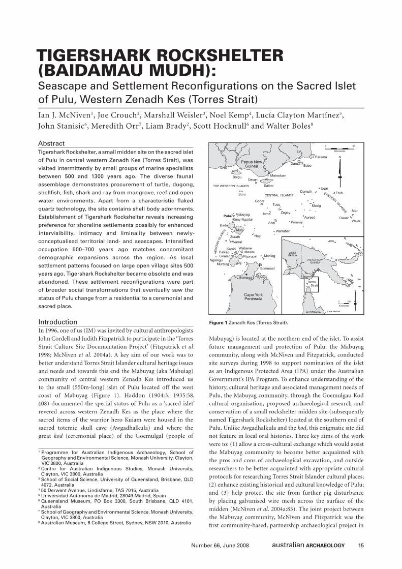
15Number 66, June 2008
TIGERSHARK ROCKSHELTER (BAIDAMAU MUDH): Seascape and Settlement Reconfi gurations on the Sacred Islet of Pulu, Western Zenadh Kes (Torres Strait)Ian J. McNiven1, Joe Crouch2, Marshall Weisler3, Noel Kemp4, Lucía Clayton Martínez5,
John Stanisic6, Meredith Orr7, Liam Brady2, Scott Hocknull6 and Walter Boles8
1 Programme for Australian Indigenous Archaeology, School of Geography and Environmental Science, Monash University, Clayton, VIC 3800, Australia
² Centre for Australian Indigenous Studies, Monash University, Clayton, VIC 3800, Australia
3 School of Social Science, University of Queensland, Brisbane, QLD 4072, Australia
4 50 Derwent Avenue, Lindisfarne, TAS 7015, Australia5 Universidad Autónoma de Madrid, 28049 Madrid, Spain6 Queensland Museum, PO Box 3300, South Brisbane, QLD 4101,
Australia7 School of Geography and Environmental Science, Monash University,
Clayton, VIC 3800, Australia8 Australian Museum, 6 College Street, Sydney, NSW 2010, Australia
AbstractTigershark Rockshelter, a small midden site on the sacred islet
of Pulu in central western Zenadh Kes (Torres Strait), was
visited intermittently by small groups of marine specialists
between 500 and 1300 years ago. The diverse faunal
assemblage demonstrates procurement of turtle, dugong,
shellfi sh, fi sh, shark and ray from mangrove, reef and open
water environments. Apart from a characteristic fl aked
quartz technology, the site contains shell body adornments.
Establishment of Tigershark Rockshelter reveals increasing
preference for shoreline settlements possibly for enhanced
intervisibility, intimacy and liminality between newly-
conceptualised territorial land- and seascapes. Intensifi ed
occupation 500–700 years ago matches concomitant
demographic expansions across the region. As local
settlement patterns focused on large open village sites 500
years ago, Tigershark Rockshelter became obsolete and was
abandoned. These settlement reconfi gurations were part
of broader social transformations that eventually saw the
status of Pulu change from a residential to a ceremonial and
sacred place.
IntroductionIn 1996, one of us (IM) was invited by cultural anthropologists
John Cordell and Judith Fitzpatrick to participate in the ‘Torres
Strait Culture Site Documentation Project’ (Fitzpatrick et al.
1998; McNiven et al. 2004a). A key aim of our work was to
better understand Torres Strait Islander cultural heritage issues
and needs and towards this end the Mabuyag (aka Mabuiag)
community of central western Zenadh Kes introduced us
to the small (550m-long) islet of Pulu located off the west
coast of Mabuyag (Figure 1). Haddon (1904:3, 1935:58,
408) documented the special status of Pulu as a ‘sacred islet’
revered across western Zenadh Kes as the place where the
sacred items of the warrior hero Kuiam were housed in the
sacred totemic skull cave (Awgadhalkula) and where the
great kod (ceremonial place) of the Goemulgal (people of
Mabuyag) is located at the northern end of the islet. To assist
future management and protection of Pulu, the Mabuyag
community, along with McNiven and Fitzpatrick, conducted
site surveys during 1998 to support nomination of the islet
as an Indigenous Protected Area (IPA) under the Australian
Government’s IPA Program. To enhance understanding of the
history, cultural heritage and associated management needs of
Pulu, the Mabuyag community, through the Goemulgau Kod
cultural organisation, proposed archaeological research and
conservation of a small rockshelter midden site (subsequently
named Tigershark Rockshelter) located at the southern end of
Pulu. Unlike Awgadhalkula and the kod, this enigmatic site did
not feature in local oral histories. Three key aims of the work
were to: (1) allow a cross-cultural exchange which would assist
the Mabuyag community to become better acquainted with
the pros and cons of archaeological excavation, and outside
researchers to be better acquainted with appropriate cultural
protocols for researching Torres Strait Islander cultural places;
(2) enhance existing historical and cultural knowledge of Pulu;
and (3) help protect the site from further pig disturbance
by placing galvanised wire mesh across the surface of the
midden (McNiven et al. 2004a:83). The joint project between
the Mabuyag community, McNiven and Fitzpatrick was the
fi rst community-based, partnership archaeological project in
Figure 1 Zenadh Kes (Torres Strait).
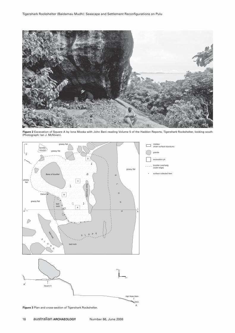
16 Number 66, June 2008
Tigershark Rockshelter (Baidamau Mudh): Seascape and Settlement Reconfi gurations on Pulu
N
01m
Base of boulder
Base of boulder
C
A
B
bedrock
Datum
bed rock
bed rock
SL
OP
E
S L O P E
4
grassy flat
SL
OP
E
grassy flat
grassy flat
grassy flat
grassy flat
termitemound
A¹
2
3
1
D
A
excavation pit
granite
midden(main surface exposure)
boulder overhang(outer edge)
surface collected item
Figure 3 Plan and cross-section of Tigershark Rockshelter.
Figure 2 Excavation of Square A by Iona Mooka with John Bani reading Volume 5 of the Haddon Reports, Tigershark Rockshelter, looking south (Photograph: Ian J. McNiven).
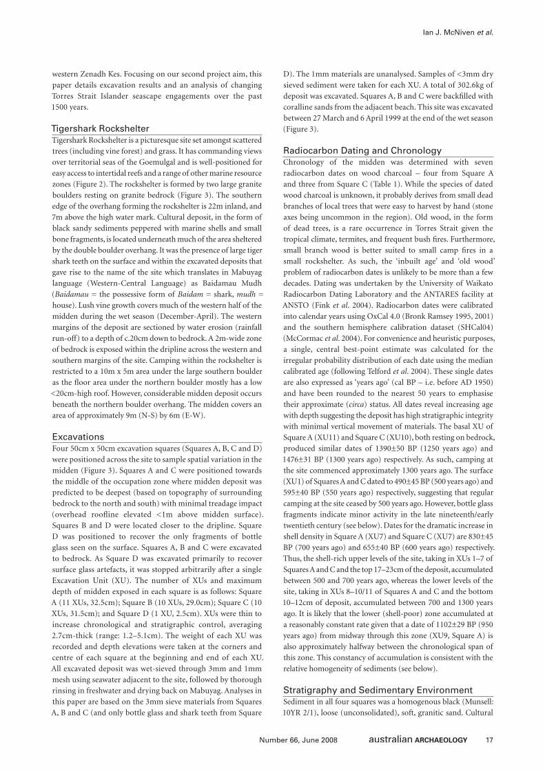
17Number 66, June 2008
Ian J. McNiven et al.
western Zenadh Kes. Focusing on our second project aim, this
paper details excavation results and an analysis of changing
Torres Strait Islander seascape engagements over the past
1500 years.
Tigershark RockshelterTigershark Rockshelter is a picturesque site set amongst scattered
trees (including vine forest) and grass. It has commanding views
over territorial seas of the Goemulgal and is well-positioned for
easy access to intertidal reefs and a range of other marine resource
zones (Figure 2). The rockshelter is formed by two large granite
boulders resting on granite bedrock (Figure 3). The southern
edge of the overhang forming the rockshelter is 22m inland, and
7m above the high water mark. Cultural deposit, in the form of
black sandy sediments peppered with marine shells and small
bone fragments, is located underneath much of the area sheltered
by the double boulder overhang. It was the presence of large tiger
shark teeth on the surface and within the excavated deposits that
gave rise to the name of the site which translates in Mabuyag
language (Western-Central Language) as Baidamau Mudh
(Baidamau = the possessive form of Baidam = shark, mudh =
house). Lush vine growth covers much of the western half of the
midden during the wet season (December-April). The western
margins of the deposit are sectioned by water erosion (rainfall
run-off) to a depth of c.20cm down to bedrock. A 2m-wide zone
of bedrock is exposed within the dripline across the western and
southern margins of the site. Camping within the rockshelter is
restricted to a 10m x 5m area under the large southern boulder
as the fl oor area under the northern boulder mostly has a low
<20cm-high roof. However, considerable midden deposit occurs
beneath the northern boulder overhang. The midden covers an
area of approximately 9m (N-S) by 6m (E-W).
ExcavationsFour 50cm x 50cm excavation squares (Squares A, B, C and D)
were positioned across the site to sample spatial variation in the
midden (Figure 3). Squares A and C were positioned towards
the middle of the occupation zone where midden deposit was
predicted to be deepest (based on topography of surrounding
bedrock to the north and south) with minimal treadage impact
(overhead roofl ine elevated <1m above midden surface).
Squares B and D were located closer to the dripline. Square
D was positioned to recover the only fragments of bottle
glass seen on the surface. Squares A, B and C were excavated
to bedrock. As Square D was excavated primarily to recover
surface glass artefacts, it was stopped arbitrarily after a single
Excavation Unit (XU). The number of XUs and maximum
depth of midden exposed in each square is as follows: Square
A (11 XUs, 32.5cm); Square B (10 XUs, 29.0cm); Square C (10
XUs, 31.5cm); and Square D (1 XU, 2.5cm). XUs were thin to
increase chronological and stratigraphic control, averaging
2.7cm-thick (range: 1.2–5.1cm). The weight of each XU was
recorded and depth elevations were taken at the corners and
centre of each square at the beginning and end of each XU.
All excavated deposit was wet-sieved through 3mm and 1mm
mesh using seawater adjacent to the site, followed by thorough
rinsing in freshwater and drying back on Mabuyag. Analyses in
this paper are based on the 3mm sieve materials from Squares
A, B and C (and only bottle glass and shark teeth from Square
D). The 1mm materials are unanalysed. Samples of <3mm dry
sieved sediment were taken for each XU. A total of 302.6kg of
deposit was excavated. Squares A, B and C were backfi lled with
coralline sands from the adjacent beach. This site was excavated
between 27 March and 6 April 1999 at the end of the wet season
(Figure 3).
Radiocarbon Dating and ChronologyChronology of the midden was determined with seven
radiocarbon dates on wood charcoal – four from Square A
and three from Square C (Table 1). While the species of dated
wood charcoal is unknown, it probably derives from small dead
branches of local trees that were easy to harvest by hand (stone
axes being uncommon in the region). Old wood, in the form
of dead trees, is a rare occurrence in Torres Strait given the
tropical climate, termites, and frequent bush fi res. Furthermore,
small branch wood is better suited to small camp fi res in a
small rockshelter. As such, the ‘inbuilt age’ and ‘old wood’
problem of radiocarbon dates is unlikely to be more than a few
decades. Dating was undertaken by the University of Waikato
Radiocarbon Dating Laboratory and the ANTARES facility at
ANSTO (Fink et al. 2004). Radiocarbon dates were calibrated
into calendar years using OxCal 4.0 (Bronk Ramsey 1995, 2001)
and the southern hemisphere calibration dataset (SHCal04)
(McCormac et al. 2004). For convenience and heuristic purposes,
a single, central best-point estimate was calculated for the
irregular probability distribution of each date using the median
calibrated age (following Telford et al. 2004). These single dates
are also expressed as ‘years ago’ (cal BP – i.e. before AD 1950)
and have been rounded to the nearest 50 years to emphasise
their approximate (circa) status. All dates reveal increasing age
with depth suggesting the deposit has high stratigraphic integrity
with minimal vertical movement of materials. The basal XU of
Square A (XU11) and Square C (XU10), both resting on bedrock,
produced similar dates of 1390±50 BP (1250 years ago) and
1476±31 BP (1300 years ago) respectively. As such, camping at
the site commenced approximately 1300 years ago. The surface
(XU1) of Squares A and C dated to 490±45 BP (500 years ago) and
595±40 BP (550 years ago) respectively, suggesting that regular
camping at the site ceased by 500 years ago. However, bottle glass
fragments indicate minor activity in the late nineteenth/early
twentieth century (see below). Dates for the dramatic increase in
shell density in Square A (XU7) and Square C (XU7) are 830±45
BP (700 years ago) and 655±40 BP (600 years ago) respectively.
Thus, the shell-rich upper levels of the site, taking in XUs 1–7 of
Squares A and C and the top 17–23cm of the deposit, accumulated
between 500 and 700 years ago, whereas the lower levels of the
site, taking in XUs 8–10/11 of Squares A and C and the bottom
10–12cm of deposit, accumulated between 700 and 1300 years
ago. It is likely that the lower (shell-poor) zone accumulated at
a reasonably constant rate given that a date of 1102±29 BP (950
years ago) from midway through this zone (XU9, Square A) is
also approximately halfway between the chronological span of
this zone. This constancy of accumulation is consistent with the
relative homogeneity of sediments (see below).
Stratigraphy and Sedimentary EnvironmentSediment in all four squares was a homogenous black (Munsell:
10YR 2/1), loose (unconsolidated), soft, granitic sand. Cultural
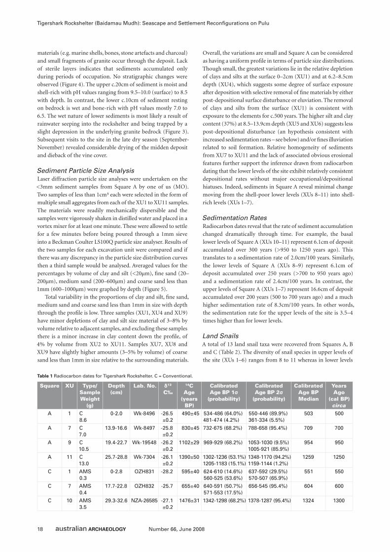
18 Number 66, June 2008
Tigershark Rockshelter (Baidamau Mudh): Seascape and Settlement Reconfi gurations on Pulu
materials (e.g. marine shells, bones, stone artefacts and charcoal)
and small fragments of granite occur through the deposit. Lack
of sterile layers indicates that sediments accumulated only
during periods of occupation. No stratigraphic changes were
observed (Figure 4). The upper c.20cm of sediment is moist and
shell-rich with pH values ranging from 9.5–10.0 (surface) to 8.5
with depth. In contrast, the lower c.10cm of sediment resting
on bedrock is wet and bone-rich with pH values mostly 7.0 to
6.5. The wet nature of lower sediments is most likely a result of
rainwater seeping into the rockshelter and being trapped by a
slight depression in the underlying granite bedrock (Figure 3).
Subsequent visits to the site in the late dry season (September-
November) revealed considerable drying of the midden deposit
and dieback of the vine cover.
Sediment Particle Size AnalysisLaser diffraction particle size analyses were undertaken on the
<3mm sediment samples from Square A by one of us (MO).
Two samples of less than 1cm³ each were selected in the form of
multiple small aggregates from each of the XU1 to XU11 samples.
The materials were readily mechanically dispersible and the
samples were vigorously shaken in distilled water and placed in a
vortex mixer for at least one minute. These were allowed to settle
for a few minutes before being poured through a 1mm sieve
into a Beckman Coulter LS100Q particle size analyser. Results of
the two samples for each excavation unit were compared and if
there was any discrepancy in the particle size distribution curves
then a third sample would be analysed. Averaged values for the
percentages by volume of clay and silt (<20µm), fi ne sand (20–
200µm), medium sand (200–600µm) and coarse sand less than
1mm (600–1000µm) were graphed by depth (Figure 5).
Total variability in the proportions of clay and silt, fi ne sand,
medium sand and coarse sand less than 1mm in size with depth
through the profi le is low. Three samples (XU1, XU4 and XU9)
have minor depletions of clay and silt size material of 3–8% by
volume relative to adjacent samples, and excluding these samples
there is a minor increase in clay content down the profi le, of
4% by volume from XU2 to XU11. Samples XU7, XU8 and
XU9 have slightly higher amounts (3–5% by volume) of coarse
sand less than 1mm in size relative to the surrounding materials.
Overall, the variations are small and Square A can be considered
as having a uniform profi le in terms of particle size distributions.
Though small, the greatest variations lie in the relative depletion
of clays and silts at the surface 0–2cm (XU1) and at 6.2–8.5cm
depth (XU4), which suggests some degree of surface exposure
after deposition with selective removal of fi ne materials by either
post-depositional surface disturbance or eluviation. The removal
of clays and silts from the surface (XU1) is consistent with
exposure to the elements for c.500 years. The higher silt and clay
content (37%) at 8.5–13.9cm depth (XU5 and XU6) suggests less
post-depositional disturbance (an hypothesis consistent with
increased sedimentation rates – see below) and/or fi nes illuviation
related to soil formation. Relative homogeneity of sediments
from XU7 to XU11 and the lack of associated obvious erosional
features further support the inference drawn from radiocarbon
dating that the lower levels of the site exhibit relatively consistent
depositional rates without major occupational/depositional
hiatuses. Indeed, sediments in Square A reveal minimal change
moving from the shell-poor lower levels (XUs 8–11) into shell-
rich levels (XUs 1–7).
Sedimentation RatesRadiocarbon dates reveal that the rate of sediment accumulation
changed dramatically through time. For example, the basal
lower levels of Square A (XUs 10–11) represent 6.1cm of deposit
accumulated over 300 years (>950 to 1250 years ago). This
translates to a sedimentation rate of 2.0cm/100 years. Similarly,
the lower levels of Square A (XUs 8–9) represent 6.1cm of
deposit accumulated over 250 years (>700 to 950 years ago)
and a sedimentation rate of 2.4cm/100 years. In contrast, the
upper levels of Square A (XUs 1–7) represent 16.6cm of deposit
accumulated over 200 years (500 to 700 years ago) and a much
higher sedimentation rate of 8.3cm/100 years. In other words,
the sedimentation rate for the upper levels of the site is 3.5–4
times higher than for lower levels.
Land SnailsA total of 13 land snail taxa were recovered from Squares A, B
and C (Table 2). The diversity of snail species in upper levels of
the site (XUs 1–6) ranges from 8 to 11 whereas in lower levels
Square XU Type/Sample Weight
(g)
Depth (cm)
Lab. No. δ13
C‰
14C Age
(years BP)
Calibrated Age BP 1σ
(probability)
Calibrated Age BP 2σ
(probability)
Calibrated Age BP Median
Years Ago
(cal BP) circa
A 1 C8.6
0-2.0 Wk-8496 -26.5±0.2
490±45 534-486 (64.0%) 481-474 (4.2%)
550-446 (89.9%) 361-334 (5.5%)
503 500
A 7 C 7.0
13.9-16.6 Wk-8497 -25.8±0.2
830±45 732-675 (68.2%) 788-658 (95.4%) 709 700
A 9 C 10.5
19.4-22.7 Wk-19548 -26.2±0.2
1102±29 969-929 (68.2%) 1053-1030 (9.5%)1005-921 (85.9%)
954 950
A 11 C 13.0
25.7-28.8 Wk-7304 -26.1±0.2
1390±50 1302-1236 (53.1%)1205-1183 (15.1%)
1348-1170 (94.2%)1159-1144 (1.2%)
1259 1250
C 1 AMS0.3
0-2.8 OZH831 -28.2 595±40 624-610 (14.6%)560-525 (53.6%)
637-592 (29.5%)570-507 (65.9%)
551 550
C 7 AMS 0.4
17.7-22.8 OZH832 -25.7 655±40 640-591 (50.7%)571-553 (17.5%)
656-545 (95.4%) 604 600
C 10 AMS 3.5
29.3-32.6 NZA-26585 -27.1 ±0.2
1476±31 1342-1298 (68.2%) 1378-1287 (95.4%) 1324 1300
Table 1 Radiocarbon dates for Tigershark Rockshelter. C = Conventional.
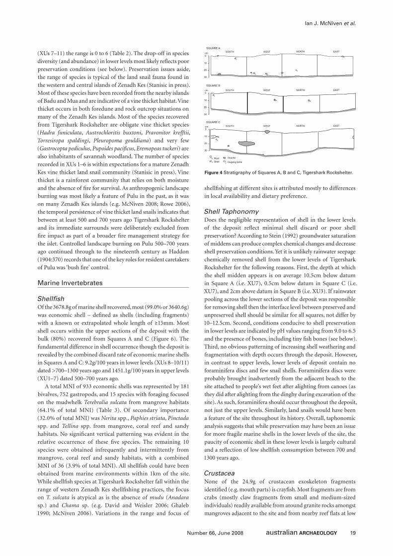
19Number 66, June 2008
Ian J. McNiven et al.
(XUs 7–11) the range is 0 to 6 (Table 2). The drop-off in species
diversity (and abundance) in lower levels most likely refl ects poor
preservation conditions (see below). Preservation issues aside,
the range of species is typical of the land snail fauna found in
the western and central islands of Zenadh Kes (Stanisic in press).
Most of these species have been recorded from the nearby islands
of Badu and Mua and are indicative of a vine thicket habitat. Vine
thicket occurs in both foredune and rock outcrop situations on
many of the Zenadh Kes islands. Most of the species recovered
from Tigershark Rockshelter are obligate vine thicket species
(Hadra funiculata, Austrochloritis buxtoni, Pravonitor krefftii,
Torresiropa spaldingi, Pleuropoma gouldiana) and very few
(Gastrocopta pediculus, Pupoides pacifi cus, Eremopeas tuckeri) are
also inhabitants of savannah woodland. The number of species
recorded in XUs 1–6 is within expectations for a mature Zenadh
Kes vine thicket land snail community (Stanisic in press). Vine
thicket is a rainforest community that relies on both moisture
and the absence of fi re for survival. As anthropogenic landscape
burning was most likely a feature of Pulu in the past, as it was
on many Zenadh Kes islands (e.g. McNiven 2008; Rowe 2006),
the temporal persistence of vine thicket land snails indicates that
between at least 500 and 700 years ago Tigershark Rockshelter
and its immediate surrounds were deliberately excluded from
fi re impact as part of a broader fi re management strategy for
the islet. Controlled landscape burning on Pulu 500–700 years
ago continued through to the nineteenth century as Haddon
(1904:370) records that one of the key roles for resident caretakers
of Pulu was ‘bush fi re’ control.
Marine Invertebrates
Shellfi shOf the 3678.8g of marine shell recovered, most (99.0% or 3640.6g)
was economic shell – defi ned as shells (including fragments)
with a known or extrapolated whole length of ≥15mm. Most
shell occurs within the upper sections of the deposit with the
bulk (80%) recovered from Squares A and C (Figure 6). The
fundamental difference in shell occurrence though the deposit is
revealed by the combined discard rate of economic marine shells
in Squares A and C: 9.2g/100 years in lower levels (XUs 8–10/11)
dated >700–1300 years ago and 1451.1g/100 years in upper levels
(XU1–7) dated 500–700 years ago.
A total MNI of 933 economic shells was represented by 181
bivalves, 752 gastropods, and 15 species with foraging focused
on the mudwhelk Terebralia sulcata from mangrove habitats
(64.1% of total MNI) (Table 3). Of secondary importance
(32.0% of total MNI) was Nerita spp., Paphies striata, Pinctada
spp. and Tellina spp. from mangrove, coral reef and sandy
habitats. No signifi cant vertical patterning was evident in the
relative occurrence of these fi ve species. The remaining 10
species were obtained infrequently and intermittently from
mangrove, coral reef and sandy habitats, with a combined
MNI of 36 (3.9% of total MNI). All shellfi sh could have been
obtained from marine environments within 1km of the site.
While shellfi sh species at Tigershark Rockshelter fall within the
range of western Zenadh Kes shellfi shing practices, the focus
on T. sulcata is atypical as is the absence of mudu (Anadara
sp.) and Chama sp. (e.g. David and Weisler 2006; Ghaleb
1990; McNiven 2006). Variations in the range and focus of
shellfi shing at different sites is attributed mostly to differences
in local availability and dietary preference.
Shell TaphonomyDoes the negligible representation of shell in the lower levels
of the deposit refl ect minimal shell discard or poor shell
preservation? According to Stein (1992) groundwater saturation
of middens can produce complex chemical changes and decrease
shell preservation conditions. Yet it is unlikely rainwater seepage
chemically removed shell from the lower levels of Tigershark
Rockshelter for the following reasons. First, the depth at which
the shell midden appears is on average 10.5cm below datum
in Square A (i.e. XU7), 0.5cm below datum in Square C (i.e.
XU7), and 2cm above datum in Square B (i.e. XU3). If rainwater
pooling across the lower sections of the deposit was responsible
for removing shell then the interface level between preserved and
unpreserved shell should be similar for all squares, not differ by
10–12.5cm. Second, conditions conducive to shell preservation
in lower levels are indicated by pH values ranging from 9.0 to 6.5
and the presence of bones, including tiny fi sh bones (see below).
Third, no obvious patterning of increasing shell weathering and
fragmentation with depth occurs through the deposit. However,
in contrast to upper levels, lower levels of deposit contain no
foraminifera discs and few snail shells. Foraminifera discs were
probably brought inadvertently from the adjacent beach to the
site attached to people’s wet feet after alighting from canoes (as
they did after alighting from the dinghy during excavation of the
site). As such, foraminifera should occur throughout the deposit,
not just the upper levels. Similarly, land snails would have been
a feature of the site throughout its history. Overall, taphonomic
analysis suggests that while preservation may have been an issue
for more fragile marine shells in the lower levels of the site, the
paucity of economic shell in these lower levels is largely cultural
and a refl ection of low shellfi sh consumption between 700 and
1300 years ago.
CrustaceaNone of the 24.9g of crustacean exoskeleton fragments
identifi ed (e.g. mouth parts) is crayfi sh. Most fragments are from
crabs (mostly claw fragments from small and medium-sized
individuals) readily available from around granite rocks amongst
mangroves adjacent to the site and from nearby reef fl ats at low
Figure 4 Stratigraphy of Squares A, B and C, Tigershark Rockshelter.
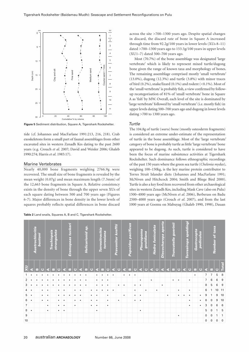
20 Number 66, June 2008
Tigershark Rockshelter (Baidamau Mudh): Seascape and Settlement Reconfi gurations on Pulu
tide (cf. Johannes and MacFarlane 1991:213, 216, 218). Crab
exoskeletons form a small part of faunal assemblages from other
excavated sites in western Zenadh Kes dating to the past 2600
years (e.g. Crouch et al. 2007; David and Weisler 2006; Ghaleb
1990:274; Harris et al. 1985:17).
Marine VertebratesNearly 40,000 bone fragments weighing 2766.9g were
recovered. The small size of bone fragments is revealed by the
mean weight (0.07g) and mean maximum length (7.3mm) of
the 12,663 bone fragments in Square A. Relative consistency
exists in the density of bone through the upper seven XUs of
each square dating between 500 and 700 years ago (Figures
6-7). Major differences in bone density in the lower levels of
squares probably reflects spatial differences in bone discard
across the site >700–1300 years ago. Despite spatial changes
in discard, the discard rate of bone in Square A increased
through time from 92.2g/100 years in lower levels (XUs 8–11)
dated >700–1300 years ago to 153.5g/100 years in upper levels
(XU1–7) dated 500–700 years ago.
Most (70.7%) of the bone assemblage was designated ‘large
vertebrate’ which is likely to represent mixed turtle/dugong
bone given the range of known taxa and morphology of bones.
The remaining assemblage comprised mostly ‘small vertebrate’
(13.0%), dugong (12.3%) and turtle (3.8%) with minor traces
of bird (0.2%), snake/lizard (0.1%) and rodent (<0.1%). Most of
the ‘small vertebrate’ is probably fi sh, a view confi rmed by follow-
up recategorisation of 81% of ‘small vertebrate’ bone in Square
A as ‘fi sh’ by MW. Overall, each level of the site is dominated by
‘large vertebrate’ followed by ‘small vertebrate’ (i.e. mostly fi sh) in
upper levels dating 500–700 years ago and dugong in lower levels
dating >700 to 1300 years ago.
TurtleThe 104.8g of turtle (waru) bone (mostly osteoderm fragments)
is considered an extreme under-estimate of the representation
of turtle in the bone assemblage. Most of the ‘large vertebrate’
category of bone is probably turtle as little ‘large vertebrate’ bone
appeared to be dugong. As such, turtle is considered to have
been the focus of marine subsistence activities at Tigershark
Rockshelter. Such dominance follows ethnographic recordings
of the past 150 years where the green sea turtle (Chelonia mydas),
weighing 100–150kg, is the key marine protein contributor to
Torres Strait Islander diets (Johannes and MacFarlane 1991;
McNiven and Hitchcock 2004; Smith and Bliege Bird 2000).
Turtle is also a key food item recovered from other archaeological
sites in western Zenadh Kes, including Mask Cave (also on Pulu)
1500–4000 years ago (McNiven et al. 2006), Berberass on Badu
2500–4000 years ago (Crouch et al. 2007), and from the last
1000 years at Goemu on Mabuyag (Ghaleb 1990, 1998), Dauan
Figure 5 Sediment distribution, Square A, Tigershark Rockshelter.
Au
stro
chlo
riti
s b
uxt
on
i
Trac
hio
psi
s st
ran
gu
lata
Ere
mo
pea
s tu
cker
i
Hel
icar
ion
id s
p.
Torr
esit
rach
ia
torr
esia
na
Pra
von
ito
r k
reff
ti
Pu
po
ides
pac
ifi c
us
Ple
uro
po
ma
go
uld
ian
a
Had
ra f
un
icu
lata
Dis
coch
aro
pa
aper
ta
Tru
nca
tell
a g
uer
inii
Torr
esir
op
a sp
ald
ing
i
Gas
tro
cop
ta
ped
icu
lus
Nu
mb
er o
f ta
xa
XU
A B C A B C A B C A B C A B C A C A B C A C A C A A B C A C B C A B C Tota
l
1 • • • • • • • • • • • • • • • • • • • 7 7 5 8
2 • • • • • • • • • • • • • • • • • • • 7 6 6 9
3 • • • • • • • • • • • • • • • • • • • 8 5 6 9
4 • • • • • • • • • • • • • • • • • 6 1 10 11
5 • • • • • • • • • • • • • • • • • • • 9 1 9 10
6 • • • • • • • • • • • • • • • 6 0 9 10
7 • • • • • • • • • 3 0 6 6
8 • • • • • • 5 0 1 5
9 • 0 0 1 1
10 0 0 0 0
Table 2 Land snails, Squares A, B and C, Tigershark Rockshelter.
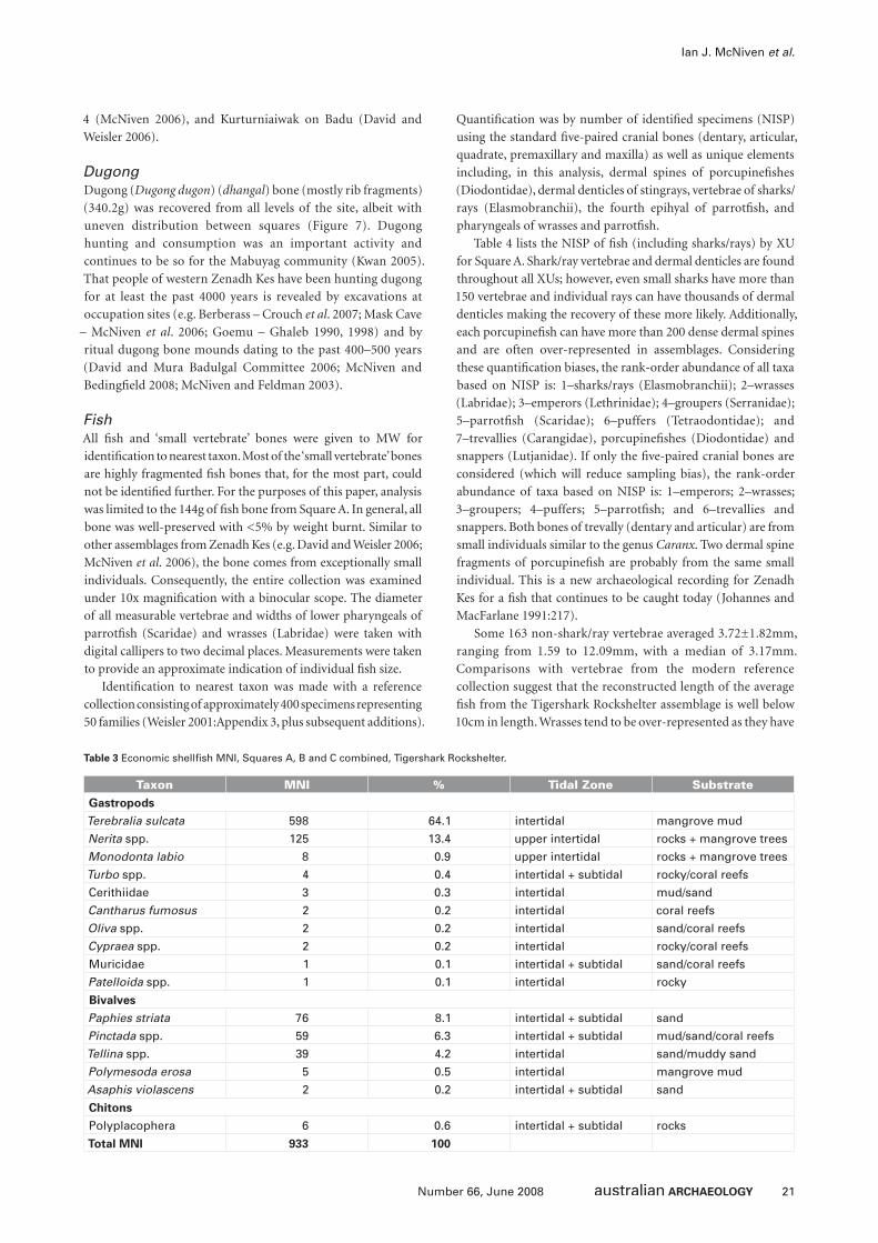
21Number 66, June 2008
Ian J. McNiven et al.
4 (McNiven 2006), and Kurturniaiwak on Badu (David and
Weisler 2006).
DugongDugong (Dugong dugon) (dhangal) bone (mostly rib fragments)
(340.2g) was recovered from all levels of the site, albeit with
uneven distribution between squares (Figure 7). Dugong
hunting and consumption was an important activity and
continues to be so for the Mabuyag community (Kwan 2005).
That people of western Zenadh Kes have been hunting dugong
for at least the past 4000 years is revealed by excavations at
occupation sites (e.g. Berberass – Crouch et al. 2007; Mask Cave
– McNiven et al. 2006; Goemu – Ghaleb 1990, 1998) and by
ritual dugong bone mounds dating to the past 400–500 years
(David and Mura Badulgal Committee 2006; McNiven and
Bedingfi eld 2008; McNiven and Feldman 2003).
FishAll fi sh and ‘small vertebrate’ bones were given to MW for
identifi cation to nearest taxon. Most of the ‘small vertebrate’ bones
are highly fragmented fi sh bones that, for the most part, could
not be identifi ed further. For the purposes of this paper, analysis
was limited to the 144g of fi sh bone from Square A. In general, all
bone was well-preserved with <5% by weight burnt. Similar to
other assemblages from Zenadh Kes (e.g. David and Weisler 2006;
McNiven et al. 2006), the bone comes from exceptionally small
individuals. Consequently, the entire collection was examined
under 10x magnifi cation with a binocular scope. The diameter
of all measurable vertebrae and widths of lower pharyngeals of
parrotfi sh (Scaridae) and wrasses (Labridae) were taken with
digital callipers to two decimal places. Measurements were taken
to provide an approximate indication of individual fi sh size.
Identifi cation to nearest taxon was made with a reference
collection consisting of approximately 400 specimens representing
50 families (Weisler 2001:Appendix 3, plus subsequent additions).
Quantifi cation was by number of identifi ed specimens (NISP)
using the standard fi ve-paired cranial bones (dentary, articular,
quadrate, premaxillary and maxilla) as well as unique elements
including, in this analysis, dermal spines of porcupinefi shes
(Diodontidae), dermal denticles of stingrays, vertebrae of sharks/
rays (Elasmobranchii), the fourth epihyal of parrotfi sh, and
pharyngeals of wrasses and parrotfi sh.
Table 4 lists the NISP of fi sh (including sharks/rays) by XU
for Square A. Shark/ray vertebrae and dermal denticles are found
throughout all XUs; however, even small sharks have more than
150 vertebrae and individual rays can have thousands of dermal
denticles making the recovery of these more likely. Additionally,
each porcupinefi sh can have more than 200 dense dermal spines
and are often over-represented in assemblages. Considering
these quantifi cation biases, the rank-order abundance of all taxa
based on NISP is: 1–sharks/rays (Elasmobranchii); 2–wrasses
(Labridae); 3–emperors (Lethrinidae); 4–groupers (Serranidae);
5–parrotfi sh (Scaridae); 6–puffers (Tetraodontidae); and
7–trevallies (Carangidae), porcupinefi shes (Diodontidae) and
snappers (Lutjanidae). If only the fi ve-paired cranial bones are
considered (which will reduce sampling bias), the rank-order
abundance of taxa based on NISP is: 1–emperors; 2–wrasses;
3–groupers; 4–puffers; 5–parrotfi sh; and 6–trevallies and
snappers. Both bones of trevally (dentary and articular) are from
small individuals similar to the genus Caranx. Two dermal spine
fragments of porcupinefi sh are probably from the same small
individual. This is a new archaeological recording for Zenadh
Kes for a fi sh that continues to be caught today (Johannes and
MacFarlane 1991:217).
Some 163 non-shark/ray vertebrae averaged 3.72±1.82mm,
ranging from 1.59 to 12.09mm, with a median of 3.17mm.
Comparisons with vertebrae from the modern reference
collection suggest that the reconstructed length of the average
fi sh from the Tigershark Rockshelter assemblage is well below
10cm in length. Wrasses tend to be over-represented as they have
Taxon MNI % Tidal Zone SubstrateGastropods
Terebralia sulcata 598 64.1 intertidal mangrove mud
Nerita spp. 125 13.4 upper intertidal rocks + mangrove trees
Monodonta labio 8 0.9 upper intertidal rocks + mangrove trees
Turbo spp. 4 0.4 intertidal + subtidal rocky/coral reefs
Cerithiidae 3 0.3 intertidal mud/sand
Cantharus fumosus 2 0.2 intertidal coral reefs
Oliva spp. 2 0.2 intertidal sand/coral reefs
Cypraea spp. 2 0.2 intertidal rocky/coral reefs
Muricidae 1 0.1 intertidal + subtidal sand/coral reefs
Patelloida spp. 1 0.1 intertidal rocky
Bivalves
Paphies striata 76 8.1 intertidal + subtidal sand
Pinctada spp. 59 6.3 intertidal + subtidal mud/sand/coral reefs
Tellina spp. 39 4.2 intertidal sand/muddy sand
Polymesoda erosa 5 0.5 intertidal mangrove mud
Asaphis violascens 2 0.2 intertidal + subtidal sand
Chitons
Polyplacophera 6 0.6 intertidal + subtidal rocks
Total MNI 933 100
Table 3 Economic shellfi sh MNI, Squares A, B and C combined, Tigershark Rockshelter.
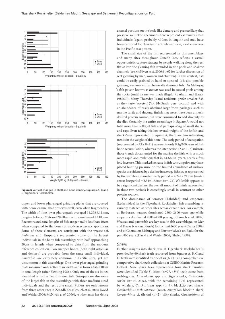
22 Number 66, June 2008
Tigershark Rockshelter (Baidamau Mudh): Seascape and Settlement Reconfi gurations on Pulu
upper and lower pharyngeal grinding plates that are covered
with dense enamel that preserves well, even when fragmentary.
The width of nine lower pharyngeals averaged 14.27±6.11mm,
ranging between 9.76 and 28.68mm with a median of 13.01mm.
Reconstructed total lengths of fi sh are generally less than 10cm
when compared to the bones of modern reference specimens.
Some of these elements are consistent with the wrasse (cf.
Bodianus sp.). Emperors represented some of the largest
individuals in the bony fi sh assemblage with half approaching
20cm in length when compared to data from the modern
reference collection. Two snapper bones (both right articular
and dentary) are probably from the same small individual.
Parrotfi sh are extremely common in Pacifi c sites, yet are
uncommon in this assemblage. One lower pharyngeal grinding
plate measured only 4.96mm in width and is from a fi sh <10cm
in total length (after Fleming 1986). Only one of the six bones
identifi ed is from a medium-sized fi sh. Groupers are also some
of the larger fi sh in the assemblage with three medium-sized
individuals and the rest quite small. Puffers are only known
from three other sites in Zenadh Kes (Crouch et al. 2007; David
and Weisler 2006; McNiven et al. 2006), yet the taxon has dense
enamel portions on the beak-like dentary and premaxillary that
preserve well. The specimens here represent extremely small
individuals (again, probably <10cm in length) and may have
been captured for their toxic entrails and skin, used elsewhere
in the Pacifi c as a poison.
The small size of the fi sh represented in this assemblage,
and many sites throughout Zenadh Kes, refl ects a casual,
opportunistic capture strategy by people walking along the reef
fl at at low tide gleaning fi sh stranded in tide pools and shallow
channels (see McNiven et al. 2006:61-62 for further discussion of
reef gleaning by men, women and children). In this context, fi sh
could be easily grabbed by hand or speared. It is also possible
gleaning was assisted by chemically stunning fi sh. On Mabuyag,
‘a fi sh poison known as itamar was used in coastal pools among
the rocks (until its use was made illegal)’ (Barham and Harris
1987:30). Many Thursday Island residents prefer smaller fi sh
as they taste ‘sweeter’ (Vic McGrath, pers. comm.) and with
an abundance of easily obtained large ‘meat packages’ such as
marine turtle and dugong, fi nfi sh may never have been a much-
desired protein source, but were consumed to add diversity to
the diet. Certainly the entire assemblage in Square A would not
total more than ~1kg of fi sh and perhaps ~5kg of small sharks
and rays. Even taking this low overall weight of the fi nfi sh and
sharks/rays represented in Square A, there are two interesting
trends in the weight of this bone. The early period of occupation
(represented by XUs 8–11) represents only 9.1g/100 years of fi sh
bone accumulation, whereas the later period (XUs 1–7) mirrors
those trends documented for the marine shellfi sh with a much
more rapid accumulation; that is, 44.6g/100 years, nearly a fi ve-
fold increase. This marked increase in fi sh consumption may have
placed hunting pressure on the limited abundance of inshore
species as evidenced by a decline in average fi sh size as represented
by the vertebrae diameter: early period = 4.24±2.21mm (n=42)
versus late period = 3.54±1.63mm (n=121). While this appears to
be a signifi cant decline, the overall amount of fi nfi sh represented
in these two periods is exceedingly small in contrast to other
protein sources.
The dominance of wrasses (Labridae) and emperors
(Lethrinidae) in the Tigershark Rockshelter fi sh assemblage is
variably matched at other sites across Zenadh Kes. For example,
at Berberass, wrasses dominated 2500–2600 years ago while
emperors dominated 2600–4000 year ago (Crouch et al. 2007).
Wrasses and parrotfi sh are key taxa in fi sh assemblages on Mer
and Dauar (eastern islands) for the past 2600 years (Carter 2004)
and at Goemu on Mabuyag and Kurturniaiwak on Badu for the
past 800 years (David and Weisler 2006; Ghaleb 1998).
SharkFurther insights into shark taxa at Tigershark Rockshelter is
provided by 60 shark teeth recovered from Squares A, B, C and
D. Teeth were identifi ed by one of us (NK) using comprehensive
comparative shark teeth collections at CSIRO Marine Research,
Hobart. Nine shark taxa representing four shark families
were identifi ed (Table 5). Most (n=27, 45%) teeth came from
wobbegongs, Orectolobus spp. and tiger sharks, Caleocerdo
cuvier (n=14, 23%), with the remaining 32% represented
by whalers, Carcharhinus spp. (n=7), blacktip reef sharks,
Carcharhinus melanopterus (n=2), Australian blacktip shark,
Carcharhinus cf. tilstoni (n=2), silky sharks, Carcharhinus cf.
Figure 6 Vertical changes in shell and bone density, Squares A, B and C, Tigershark Rockshelter.
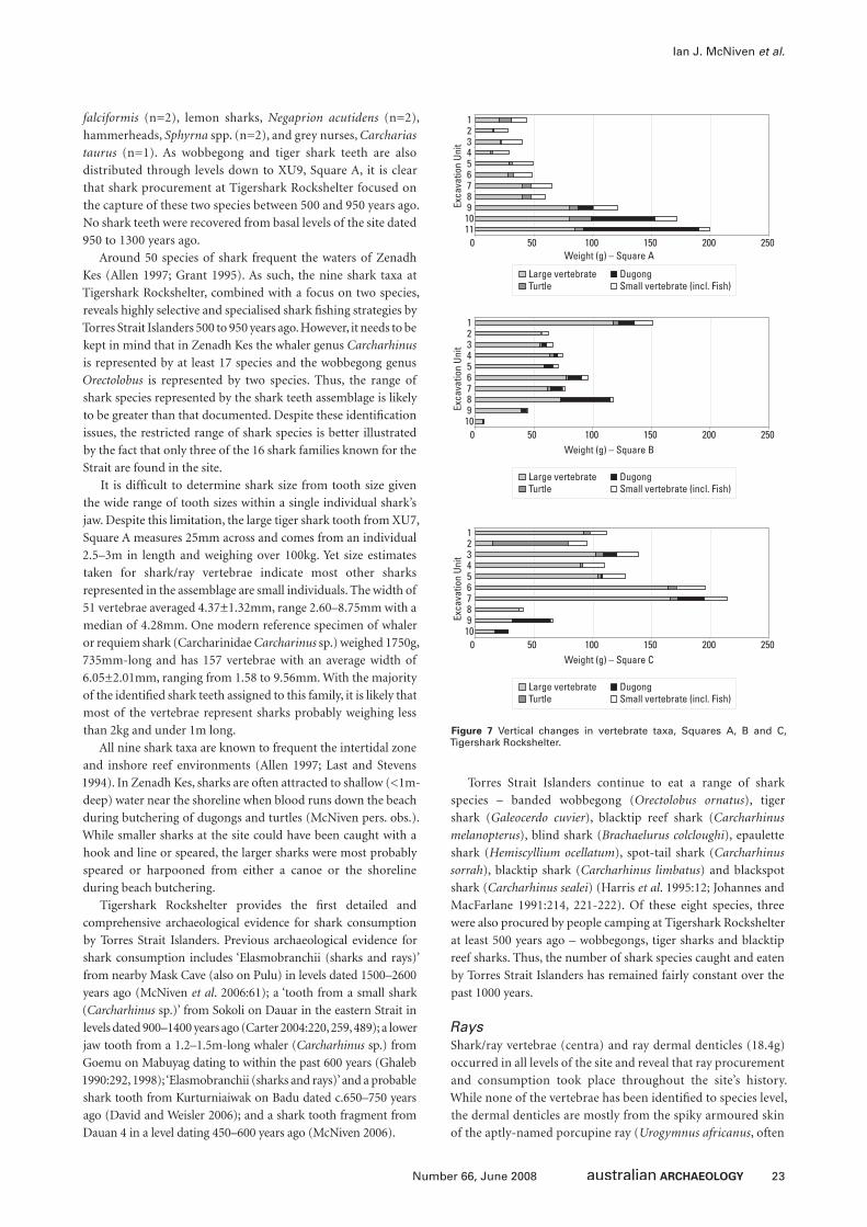
23Number 66, June 2008
Ian J. McNiven et al.
falciformis (n=2), lemon sharks, Negaprion acutidens (n=2),
hammerheads, Sphyrna spp. (n=2), and grey nurses, Carcharias
taurus (n=1). As wobbegong and tiger shark teeth are also
distributed through levels down to XU9, Square A, it is clear
that shark procurement at Tigershark Rockshelter focused on
the capture of these two species between 500 and 950 years ago.
No shark teeth were recovered from basal levels of the site dated
950 to 1300 years ago.
Around 50 species of shark frequent the waters of Zenadh
Kes (Allen 1997; Grant 1995). As such, the nine shark taxa at
Tigershark Rockshelter, combined with a focus on two species,
reveals highly selective and specialised shark fi shing strategies by
Torres Strait Islanders 500 to 950 years ago. However, it needs to be
kept in mind that in Zenadh Kes the whaler genus Carcharhinus
is represented by at least 17 species and the wobbegong genus
Orectolobus is represented by two species. Thus, the range of
shark species represented by the shark teeth assemblage is likely
to be greater than that documented. Despite these identifi cation
issues, the restricted range of shark species is better illustrated
by the fact that only three of the 16 shark families known for the
Strait are found in the site.
It is diffi cult to determine shark size from tooth size given
the wide range of tooth sizes within a single individual shark’s
jaw. Despite this limitation, the large tiger shark tooth from XU7,
Square A measures 25mm across and comes from an individual
2.5–3m in length and weighing over 100kg. Yet size estimates
taken for shark/ray vertebrae indicate most other sharks
represented in the assemblage are small individuals. The width of
51 vertebrae averaged 4.37±1.32mm, range 2.60–8.75mm with a
median of 4.28mm. One modern reference specimen of whaler
or requiem shark (Carcharinidae Carcharinus sp.) weighed 1750g,
735mm-long and has 157 vertebrae with an average width of
6.05±2.01mm, ranging from 1.58 to 9.56mm. With the majority
of the identifi ed shark teeth assigned to this family, it is likely that
most of the vertebrae represent sharks probably weighing less
than 2kg and under 1m long.
All nine shark taxa are known to frequent the intertidal zone
and inshore reef environments (Allen 1997; Last and Stevens
1994). In Zenadh Kes, sharks are often attracted to shallow (<1m-
deep) water near the shoreline when blood runs down the beach
during butchering of dugongs and turtles (McNiven pers. obs.).
While smaller sharks at the site could have been caught with a
hook and line or speared, the larger sharks were most probably
speared or harpooned from either a canoe or the shoreline
during beach butchering.
Tigershark Rockshelter provides the fi rst detailed and
comprehensive archaeological evidence for shark consumption
by Torres Strait Islanders. Previous archaeological evidence for
shark consumption includes ‘Elasmobranchii (sharks and rays)’
from nearby Mask Cave (also on Pulu) in levels dated 1500–2600
years ago (McNiven et al. 2006:61); a ‘tooth from a small shark
(Carcharhinus sp.)’ from Sokoli on Dauar in the eastern Strait in
levels dated 900–1400 years ago (Carter 2004:220, 259, 489); a lower
jaw tooth from a 1.2–1.5m-long whaler (Carcharhinus sp.) from
Goemu on Mabuyag dating to within the past 600 years (Ghaleb
1990:292, 1998); ‘Elasmobranchii (sharks and rays)’ and a probable
shark tooth from Kurturniaiwak on Badu dated c.650–750 years
ago (David and Weisler 2006); and a shark tooth fragment from
Dauan 4 in a level dating 450–600 years ago (McNiven 2006).
Torres Strait Islanders continue to eat a range of shark
species – banded wobbegong (Orectolobus ornatus), tiger
shark (Galeocerdo cuvier), blacktip reef shark (Carcharhinus
melanopterus), blind shark (Brachaelurus colcloughi), epaulette
shark (Hemiscyllium ocellatum), spot-tail shark (Carcharhinus
sorrah), blacktip shark (Carcharhinus limbatus) and blackspot
shark (Carcharhinus sealei) (Harris et al. 1995:12; Johannes and
MacFarlane 1991:214, 221-222). Of these eight species, three
were also procured by people camping at Tigershark Rockshelter
at least 500 years ago – wobbegongs, tiger sharks and blacktip
reef sharks. Thus, the number of shark species caught and eaten
by Torres Strait Islanders has remained fairly constant over the
past 1000 years.
RaysShark/ray vertebrae (centra) and ray dermal denticles (18.4g)
occurred in all levels of the site and reveal that ray procurement
and consumption took place throughout the site’s history.
While none of the vertebrae has been identifi ed to species level,
the dermal denticles are mostly from the spiky armoured skin
of the aptly-named porcupine ray (Urogymnus africanus, often
Figure 7 Vertical changes in vertebrate taxa, Squares A, B and C, Tigershark Rockshelter.
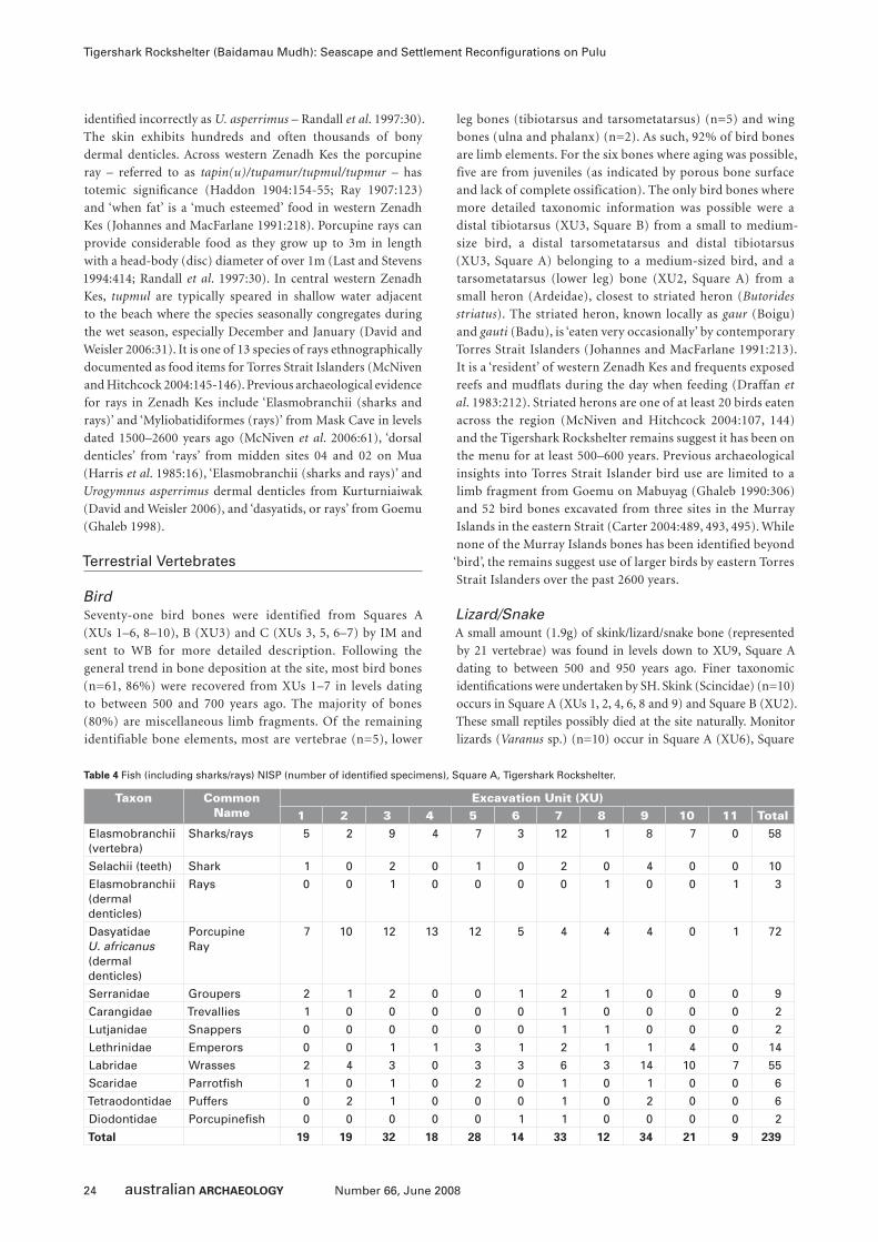
24 Number 66, June 2008
Tigershark Rockshelter (Baidamau Mudh): Seascape and Settlement Reconfi gurations on Pulu
identifi ed incorrectly as U. asperrimus – Randall et al. 1997:30).
The skin exhibits hundreds and often thousands of bony
dermal denticles. Across western Zenadh Kes the porcupine
ray – referred to as tapin(u)/tupamur/tupmul/tupmur – has
totemic signifi cance (Haddon 1904:154-55; Ray 1907:123)
and ‘when fat’ is a ‘much esteemed’ food in western Zenadh
Kes (Johannes and MacFarlane 1991:218). Porcupine rays can
provide considerable food as they grow up to 3m in length
with a head-body (disc) diameter of over 1m (Last and Stevens
1994:414; Randall et al. 1997:30). In central western Zenadh
Kes, tupmul are typically speared in shallow water adjacent
to the beach where the species seasonally congregates during
the wet season, especially December and January (David and
Weisler 2006:31). It is one of 13 species of rays ethnographically
documented as food items for Torres Strait Islanders (McNiven
and Hitchcock 2004:145-146). Previous archaeological evidence
for rays in Zenadh Kes include ‘Elasmobranchii (sharks and
rays)’ and ‘Myliobatidiformes (rays)’ from Mask Cave in levels
dated 1500–2600 years ago (McNiven et al. 2006:61), ‘dorsal
denticles’ from ‘rays’ from midden sites 04 and 02 on Mua
(Harris et al. 1985:16), ‘Elasmobranchii (sharks and rays)’ and
Urogymnus asperrimus dermal denticles from Kurturniaiwak
(David and Weisler 2006), and ‘dasyatids, or rays’ from Goemu
(Ghaleb 1998).
Terrestrial Vertebrates
BirdSeventy-one bird bones were identified from Squares A
(XUs 1–6, 8–10), B (XU3) and C (XUs 3, 5, 6–7) by IM and
sent to WB for more detailed description. Following the
general trend in bone deposition at the site, most bird bones
(n=61, 86%) were recovered from XUs 1–7 in levels dating
to between 500 and 700 years ago. The majority of bones
(80%) are miscellaneous limb fragments. Of the remaining
identifiable bone elements, most are vertebrae (n=5), lower
leg bones (tibiotarsus and tarsometatarsus) (n=5) and wing
bones (ulna and phalanx) (n=2). As such, 92% of bird bones
are limb elements. For the six bones where aging was possible,
five are from juveniles (as indicated by porous bone surface
and lack of complete ossification). The only bird bones where
more detailed taxonomic information was possible were a
distal tibiotarsus (XU3, Square B) from a small to medium-
size bird, a distal tarsometatarsus and distal tibiotarsus
(XU3, Square A) belonging to a medium-sized bird, and a
tarsometatarsus (lower leg) bone (XU2, Square A) from a
small heron (Ardeidae), closest to striated heron (Butorides
striatus). The striated heron, known locally as gaur (Boigu)
and gauti (Badu), is ‘eaten very occasionally’ by contemporary
Torres Strait Islanders (Johannes and MacFarlane 1991:213).
It is a ‘resident’ of western Zenadh Kes and frequents exposed
reefs and mudflats during the day when feeding (Draffan et
al. 1983:212). Striated herons are one of at least 20 birds eaten
across the region (McNiven and Hitchcock 2004:107, 144)
and the Tigershark Rockshelter remains suggest it has been on
the menu for at least 500–600 years. Previous archaeological
insights into Torres Strait Islander bird use are limited to a
limb fragment from Goemu on Mabuyag (Ghaleb 1990:306)
and 52 bird bones excavated from three sites in the Murray
Islands in the eastern Strait (Carter 2004:489, 493, 495). While
none of the Murray Islands bones has been identified beyond
‘bird’, the remains suggest use of larger birds by eastern Torres
Strait Islanders over the past 2600 years.
Lizard/SnakeA small amount (1.9g) of skink/lizard/snake bone (represented
by 21 vertebrae) was found in levels down to XU9, Square A
dating to between 500 and 950 years ago. Finer taxonomic
identifi cations were undertaken by SH. Skink (Scincidae) (n=10)
occurs in Square A (XUs 1, 2, 4, 6, 8 and 9) and Square B (XU2).
These small reptiles possibly died at the site naturally. Monitor
lizards (Varanus sp.) (n=10) occur in Square A (XU6), Square
Taxon Common Name
Excavation Unit (XU)1 2 3 4 5 6 7 8 9 10 11 Total
Elasmobranchii (vertebra)
Sharks/rays 5 2 9 4 7 3 12 1 8 7 0 58
Selachii (teeth) Shark 1 0 2 0 1 0 2 0 4 0 0 10
Elasmobranchii (dermal denticles)
Rays 0 0 1 0 0 0 0 1 0 0 1 3
Dasyatidae U. africanus (dermal denticles)
Porcupine Ray
7 10 12 13 12 5 4 4 4 0 1 72
Serranidae Groupers 2 1 2 0 0 1 2 1 0 0 0 9
Carangidae Trevallies 1 0 0 0 0 0 1 0 0 0 0 2
Lutjanidae Snappers 0 0 0 0 0 0 1 1 0 0 0 2
Lethrinidae Emperors 0 0 1 1 3 1 2 1 1 4 0 14
Labridae Wrasses 2 4 3 0 3 3 6 3 14 10 7 55
Scaridae Parrotfi sh 1 0 1 0 2 0 1 0 1 0 0 6
Tetraodontidae Puffers 0 2 1 0 0 0 1 0 2 0 0 6
Diodontidae Porcupinefi sh 0 0 0 0 0 1 1 0 0 0 0 2
Total 19 19 32 18 28 14 33 12 34 21 9 239
Table 4 Fish (including sharks/rays) NISP (number of identifi ed specimens), Square A, Tigershark Rockshelter.
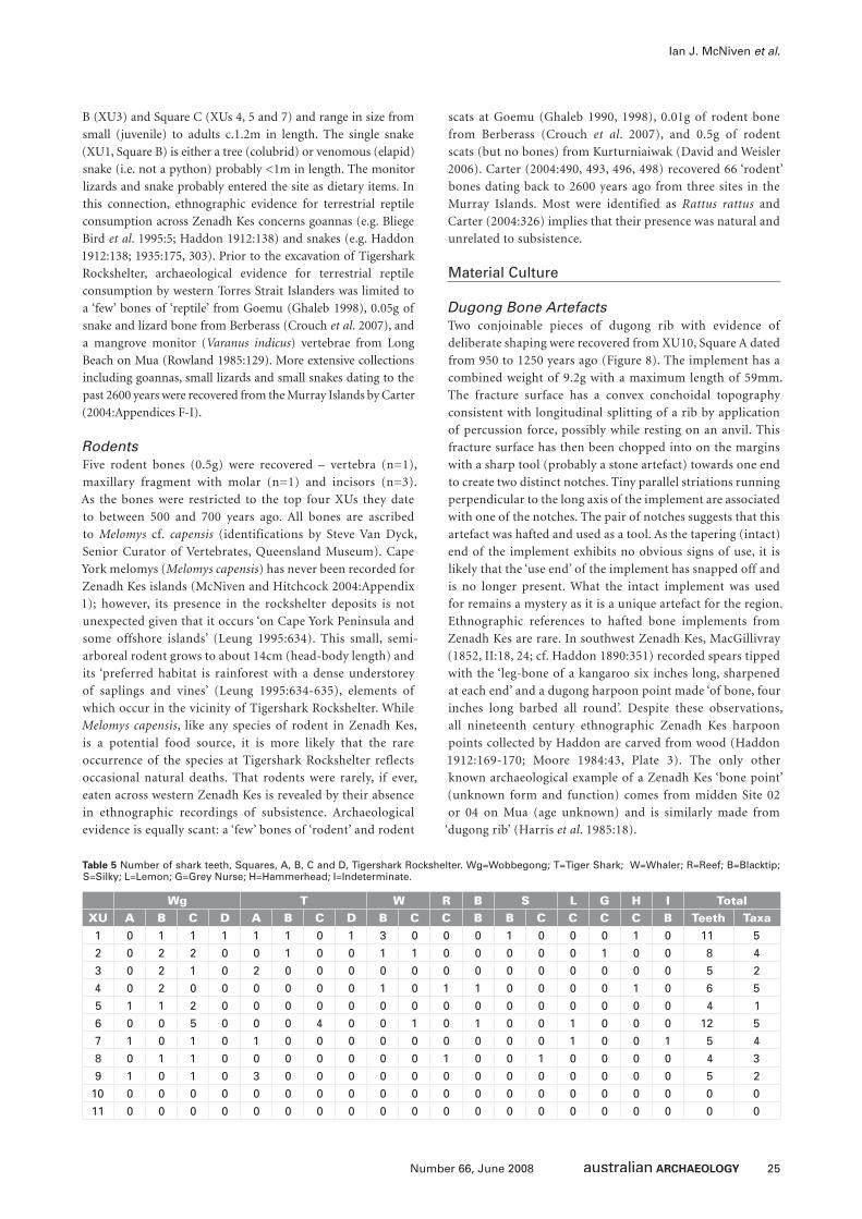
25Number 66, June 2008
Ian J. McNiven et al.
B (XU3) and Square C (XUs 4, 5 and 7) and range in size from
small (juvenile) to adults c.1.2m in length. The single snake
(XU1, Square B) is either a tree (colubrid) or venomous (elapid)
snake (i.e. not a python) probably <1m in length. The monitor
lizards and snake probably entered the site as dietary items. In
this connection, ethnographic evidence for terrestrial reptile
consumption across Zenadh Kes concerns goannas (e.g. Bliege
Bird et al. 1995:5; Haddon 1912:138) and snakes (e.g. Haddon
1912:138; 1935:175, 303). Prior to the excavation of Tigershark
Rockshelter, archaeological evidence for terrestrial reptile
consumption by western Torres Strait Islanders was limited to
a ‘few’ bones of ‘reptile’ from Goemu (Ghaleb 1998), 0.05g of
snake and lizard bone from Berberass (Crouch et al. 2007), and
a mangrove monitor (Varanus indicus) vertebrae from Long
Beach on Mua (Rowland 1985:129). More extensive collections
including goannas, small lizards and small snakes dating to the
past 2600 years were recovered from the Murray Islands by Carter
(2004:Appendices F-I).
RodentsFive rodent bones (0.5g) were recovered – vertebra (n=1),
maxillary fragment with molar (n=1) and incisors (n=3).
As the bones were restricted to the top four XUs they date
to between 500 and 700 years ago. All bones are ascribed
to Melomys cf. capensis (identifications by Steve Van Dyck,
Senior Curator of Vertebrates, Queensland Museum). Cape
York melomys (Melomys capensis) has never been recorded for
Zenadh Kes islands (McNiven and Hitchcock 2004:Appendix
1); however, its presence in the rockshelter deposits is not
unexpected given that it occurs ‘on Cape York Peninsula and
some offshore islands’ (Leung 1995:634). This small, semi-
arboreal rodent grows to about 14cm (head-body length) and
its ‘preferred habitat is rainforest with a dense understorey
of saplings and vines’ (Leung 1995:634-635), elements of
which occur in the vicinity of Tigershark Rockshelter. While
Melomys capensis, like any species of rodent in Zenadh Kes,
is a potential food source, it is more likely that the rare
occurrence of the species at Tigershark Rockshelter reflects
occasional natural deaths. That rodents were rarely, if ever,
eaten across western Zenadh Kes is revealed by their absence
in ethnographic recordings of subsistence. Archaeological
evidence is equally scant: a ‘few’ bones of ‘rodent’ and rodent
scats at Goemu (Ghaleb 1990, 1998), 0.01g of rodent bone
from Berberass (Crouch et al. 2007), and 0.5g of rodent
scats (but no bones) from Kurturniaiwak (David and Weisler
2006). Carter (2004:490, 493, 496, 498) recovered 66 ‘rodent’
bones dating back to 2600 years ago from three sites in the
Murray Islands. Most were identified as Rattus rattus and
Carter (2004:326) implies that their presence was natural and
unrelated to subsistence.
Material Culture
Dugong Bone ArtefactsTwo conjoinable pieces of dugong rib with evidence of
deliberate shaping were recovered from XU10, Square A dated
from 950 to 1250 years ago (Figure 8). The implement has a
combined weight of 9.2g with a maximum length of 59mm.
The fracture surface has a convex conchoidal topography
consistent with longitudinal splitting of a rib by application
of percussion force, possibly while resting on an anvil. This
fracture surface has then been chopped into on the margins
with a sharp tool (probably a stone artefact) towards one end
to create two distinct notches. Tiny parallel striations running
perpendicular to the long axis of the implement are associated
with one of the notches. The pair of notches suggests that this
artefact was hafted and used as a tool. As the tapering (intact)
end of the implement exhibits no obvious signs of use, it is
likely that the ‘use end’ of the implement has snapped off and
is no longer present. What the intact implement was used
for remains a mystery as it is a unique artefact for the region.
Ethnographic references to hafted bone implements from
Zenadh Kes are rare. In southwest Zenadh Kes, MacGillivray
(1852, II:18, 24; cf. Haddon 1890:351) recorded spears tipped
with the ‘leg-bone of a kangaroo six inches long, sharpened
at each end’ and a dugong harpoon point made ‘of bone, four
inches long barbed all round’. Despite these observations,
all nineteenth century ethnographic Zenadh Kes harpoon
points collected by Haddon are carved from wood (Haddon
1912:169-170; Moore 1984:43, Plate 3). The only other
known archaeological example of a Zenadh Kes ‘bone point’
(unknown form and function) comes from midden Site 02
or 04 on Mua (age unknown) and is similarly made from
‘dugong rib’ (Harris et al. 1985:18).
Wg T W R B S L G H I TotalXU A B C D A B C D B C C B B C C C C B Teeth Taxa1 0 1 1 1 1 1 0 1 3 0 0 0 1 0 0 0 1 0 11 5
2 0 2 2 0 0 1 0 0 1 1 0 0 0 0 0 1 0 0 8 4
3 0 2 1 0 2 0 0 0 0 0 0 0 0 0 0 0 0 0 5 2
4 0 2 0 0 0 0 0 0 1 0 1 1 0 0 0 0 1 0 6 5
5 1 1 2 0 0 0 0 0 0 0 0 0 0 0 0 0 0 0 4 1
6 0 0 5 0 0 0 4 0 0 1 0 1 0 0 1 0 0 0 12 5
7 1 0 1 0 1 0 0 0 0 0 0 0 0 0 1 0 0 1 5 4
8 0 1 1 0 0 0 0 0 0 0 1 0 0 1 0 0 0 0 4 3
9 1 0 1 0 3 0 0 0 0 0 0 0 0 0 0 0 0 0 5 2
10 0 0 0 0 0 0 0 0 0 0 0 0 0 0 0 0 0 0 0 0
11 0 0 0 0 0 0 0 0 0 0 0 0 0 0 0 0 0 0 0 0
Table 5 Number of shark teeth, Squares, A, B, C and D, Tigershark Rockshelter. Wg=Wobbegong; T=Tiger Shark; W=Whaler; R=Reef; B=Blacktip; S=Silky; L=Lemon; G=Grey Nurse; H=Hammerhead; I=Indeterminate.
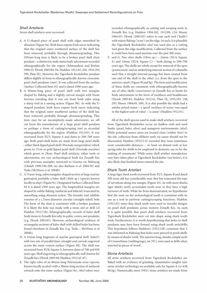
26 Number 66, June 2008
Tigershark Rockshelter (Baidamau Mudh): Seascape and Settlement Reconfi gurations on Pulu
Shell ArtefactsSeven shell artefacts were recovered:
A. A U-shaped piece of pearl shell with edges smoothed by
abrasion (Figure 9a). Both faces expose fresh nacre indicating
that the original outer weathered surface of the shell has
been removed, probably through abrasion/grinding. This
105mm-long item is likely to be a broken pearl shell chest
pendant – a distinctive male status body adornment recorded
ethnographically for the region (Edmundson and Boylan
1999:25; Florek 2005:80, 94; Haddon 1912:43, 204, 1935:293,
399, Plate IX). However, the Tigershark Rockshelter pendant
differs slightly in form to ethnographically-known crescentic
pearl shell pendants (mai). It was collected from the surface
(Surface Collected Item #2) and is dated ≤500 years ago.
B. A 60mm-long piece of pearl shell with two margins
shaped by fl aking and a slightly curved margin with linear
furrows revealing that it was cut from both sides using
a sharp tool in a sawing action (Figure 9b). As with the U-
shaped pendant, both faces expose fresh nacre indicating
that the original outer weathered surface of the shell has
been removed, probably through abrasion/grinding. This
item may be an incompletely-made adornment, an off-
cut from the manufacture of a large pearl shell pendant,
or perhaps a form of cutting/scraping tool as recorded
ethnographically for the region (Haddon 1912:65). It was
recovered from XU3, Square A and dates to 500–700 years
ago. Both pearl shell items are made from large pearl shells
– either black lipped pearl shell (Pinctada margaritifera) which
grows to 17cm or gold lipped pearl shell (Pinctada maxima)
which grows to 28cm. Pearl shell artefacts, either tools or
adornments, are rare archaeological fi nds for Zenadh Kes
with previous examples restricted to Goemu on Mabuyag
(Ghaleb 1990:196-208; see also Barham et al. 2004:30) and
Tudu (McNiven et al. 2004b).
C. A 71mm-long, subrectangular-shaped section of large marine
gastropod, probably a baler shell (Melo sp.) (species known
locally as alup) (Figure 9c). Designated Surface Collected Item
#4 it is dated ≤500 years ago. The longitudinal margins are
shaped by subtle fl aking (unifacial and bifacial) truncated by
smoothing using abrasion action. The broader end exhibits
remains of a c.7mm-diameter circular (straight-sided) hole.
The form of the item is consistent with a broken pendant.
It is likely the hole was made with a stone awl or drill (cf.
Haddon 1912:128). Ethnographically, records of baler shell
body items in Zenadh Kes refer to pubic covers, not pendants
(e.g. Florek 2005:83). However, archaeological evidence of
rectangular sections of baler shell with drilled holes has been
found elsewhere in Zenadh Kes (e.g. Tudu – McNiven et al.
2004b).
D. A 41mm-long fragment of marine gastropod shell (baler?)
with two sets of parallel lines (straight and curved) engraved
across the outer convex surface (Figure 9d). The shell was
recovered from XU8, Square A, between dates of 700 and 950
years ago. Shell engraving is ethnographically well-known for
Zenadh Kes (Florek 2005:94; Haddon 1912:43-47).
E. The right valve of an 86mm-long Polymesoda erosa (species
known locally as akul) with a 38mm-long section of unifacial
retouch onto the outer surface (Figure 9e). Akul valves were
recorded ethnographically as cutting and scraping tools in
Zenadh Kes (e.g. Haddon 1904:262, 1912:89, 124; Moore
1984:43). Florek (2005:92) refers to one such tool (‘knife’)
with minor fl aking (‘scars’) on the edge. As such, it is plausible
the Tigershark Rockshelter akul was used also as a cutting
tool given the edge modifi cation. Collected from the surface
it could have been used anytime over the past 500 years.
F. and G. Two olive shells (Oliva sp.) – 24mm (XU4, Square
A) and 14mm (XU4, Square C) – both dating to 500–700
years ago. The shells are whole except for removal of the apex
(protoconch) and an underlying internal section of columella
such that a straight internal passage has been created from
one end of the shell to the other (i.e. from the apex to the
anterior canal) (Figure 9f and 9g). The form and modifi cation
of these shells are consistent with ethnographically-known
use of olive shells (uraz/waraz) in Zenadh Kes as beads for
body adornments in the form of necklaces and headdresses
(Florek 2005:83; Haddon 1912:41, Plate IX, 1935:183, 198,
295; Moore 1984:69, 100). It is also possible the shells had a
similar prized status – a ‘good’ necklace of waraz ‘was equal
to the highest unit of value’ – ‘a canoe’ (Haddon 1912:41).
All of the shell species used to make shell artefacts recovered
from Tigershark Rockshelter occur on shallow reefs and sand
banks (pearl, baler, olive) and mangrove environments (akul).
While potential source areas are located close (within 1km) to
the site, collection from offshore reefs via canoe should not be
discounted. Haddon (1912:3-4) recorded that ‘men sometimes
went considerable distances ... to hunt on distant reefs at low
spring tides for shells to be employed in domestic use or for the
making of ornaments’. While some shell artefact manufacture
may have taken place at Tigershark Rockshelter (see below), it is
also likely that fi nished items entered the site.
Shark Tooth ArtefactA large tiger shark tooth recovered from XU1, Square B and dated
500 years old has considerable wear that has truncated the tops
of serrations along one margin (Figure 10). As with most sharks,
tiger sharks rarely accumulate tooth wear as they have a high
turnover of teeth. While far from demonstrated, we hypothesise
that the wear on the archaeological tooth is consistent with its
use as a tool to perform cutting/scraping functions. Haddon
(1912:43) notes that shark teeth were used to inscribe designs
on pearl shell pendants across western Zenadh Kes. As such,
it is quite possible that pearl shell artefacts recovered from
Tigershark Rockshelter were cut into shape using shark tooth
tools. Furthermore, it is worth hypothesising that holes in shell
pendants may have been formed using shark tooth awls/drills.
This hypothesis follows Haddon’s (1912:128) comment that ‘I
was informed in Mabuiag that holes were pierced in pearl-shells
by means of sharks’ teeth. The anterior long, slender, simple teeth
of Crossorhinus [wobbegongs], im (W.), were used as drills when
inserted in pieces of wood’.
Stone ArtefactsAll stone artefacts recovered from Tigershark Rockshelter are
fl aked with no evidence of grinding. Quantitative insights into
stone artefact technology are available only for Square A (n=638,
88.0g). Numerically, most (94%) stone artefacts are made from
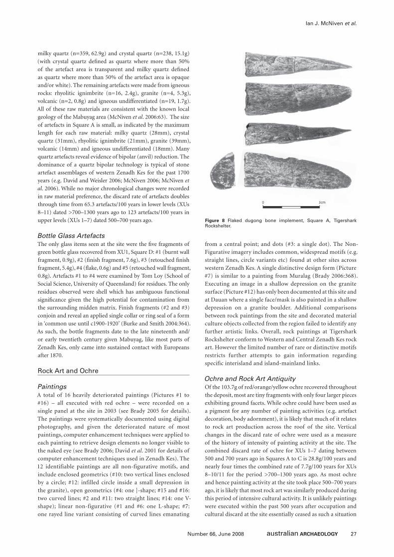
27Number 66, June 2008
Ian J. McNiven et al.
milky quartz (n=359, 62.9g) and crystal quartz (n=238, 15.1g)
(with crystal quartz defi ned as quartz where more than 50%
of the artefact area is transparent and milky quartz defi ned
as quartz where more than 50% of the artefact area is opaque
and/or white). The remaining artefacts were made from igneous
rocks: rhyolitic ignimbrite (n=16, 2.4g), granite (n=4, 5.3g),
volcanic (n=2, 0.8g) and igneous undifferentiated (n=19, 1.7g).
All of these raw materials are consistent with the known local
geology of the Mabuyag area (McNiven et al. 2006:63). The size
of artefacts in Square A is small, as indicated by the maximum
length for each raw material: milky quartz (28mm), crystal
quartz (31mm), rhyolitic ignimbrite (21mm), granite (39mm),
volcanic (14mm) and igneous undifferentiated (18mm). Many
quartz artefacts reveal evidence of bipolar (anvil) reduction. The
dominance of a quartz bipolar technology is typical of stone
artefact assemblages of western Zenadh Kes for the past 1700
years (e.g. David and Weisler 2006; McNiven 2006; McNiven et
al. 2006). While no major chronological changes were recorded
in raw material preference, the discard rate of artefacts doubles
through time from 65.3 artefacts/100 years in lower levels (XUs
8–11) dated >700–1300 years ago to 123 artefacts/100 years in
upper levels (XUs 1–7) dated 500–700 years ago.
Bottle Glass ArtefactsThe only glass items seen at the site were the fi ve fragments of
green bottle glass recovered from XU1, Square D: #1 (burnt wall
fragment, 0.9g), #2 (fi nish fragment, 7.6g), #3 (retouched fi nish
fragment, 5.4g), #4 (fl ake, 0.6g) and #5 (retouched wall fragment,
0.8g). Artefacts #1 to #4 were examined by Tom Loy (School of
Social Science, University of Queensland) for residues. The only
residues observed were shell which has ambiguous functional
signifi cance given the high potential for contamination from
the surrounding midden matrix. Finish fragments (#2 and #3)
conjoin and reveal an applied single collar or ring seal of a form
in ‘common use until c1900-1920’ (Burke and Smith 2004:364).
As such, the bottle fragments date to the late nineteenth and/
or early twentieth century given Mabuyag, like most parts of
Zenadh Kes, only came into sustained contact with Europeans
after 1870.
Rock Art and Ochre
PaintingsA total of 16 heavily deteriorated paintings (Pictures #1 to
#16) – all executed with red ochre – were recorded on a
single panel at the site in 2003 (see Brady 2005 for details).
The paintings were systematically documented using digital
photography, and given the deteriorated nature of most
paintings, computer enhancement techniques were applied to
each painting to retrieve design elements no longer visible to
the naked eye (see Brady 2006; David et al. 2001 for details of
computer enhancement techniques used in Zenadh Kes). The
12 identifiable paintings are all non-figurative motifs, and
include enclosed geometrics (#10: two vertical lines enclosed
by a circle; #12: infilled circle inside a small depression in
the granite), open geometrics (#4: one ]-shape; #15 and #16:
two curved lines; #2 and #11: two straight lines; #14: one V-
shape); linear non-figurative (#1 and #6: one L-shape; #7:
one rayed line variant consisting of curved lines emanating
from a central point; and dots (#3: a single dot). The Non-
Figurative imagery includes common, widespread motifs (e.g.
straight lines, circle variants etc) found at other sites across
western Zenadh Kes. A single distinctive design form (Picture
#7) is similar to a painting from Muralag (Brady 2006:368).
Executing an image in a shallow depression on the granite
surface (Picture #12) has only been documented at this site and
at Dauan where a single face/mask is also painted in a shallow
depression on a granite boulder. Additional comparisons
between rock paintings from the site and decorated material
culture objects collected from the region failed to identify any
further artistic links. Overall, rock paintings at Tigershark
Rockshelter conform to Western and Central Zenadh Kes rock
art. However the limited number of rare or distinctive motifs
restricts further attempts to gain information regarding
specific interisland and island-mainland links.
Ochre and Rock Art AntiquityOf the 103.7g of red/orange/yellow ochre recovered throughout
the deposit, most are tiny fragments with only four larger pieces
exhibiting ground facets. While ochre could have been used as
a pigment for any number of painting activities (e.g. artefact
decoration, body adornment), it is likely that much of it relates
to rock art production across the roof of the site. Vertical
changes in the discard rate of ochre were used as a measure
of the history of intensity of painting activity at the site. The
combined discard rate of ochre for XUs 1–7 dating between
500 and 700 years ago in Squares A to C is 28.8g/100 years and
nearly four times the combined rate of 7.7g/100 years for XUs
8–10/11 for the period >700–1300 years ago. As most ochre
and hence painting activity at the site took place 500–700 years
ago, it is likely that most rock art was similarly produced during
this period of intensive cultural activity. It is unlikely paintings
were executed within the past 500 years after occupation and
cultural discard at the site essentially ceased as such a situation
Figure 8 Flaked dugong bone implement, Square A, Tigershark Rockshelter.
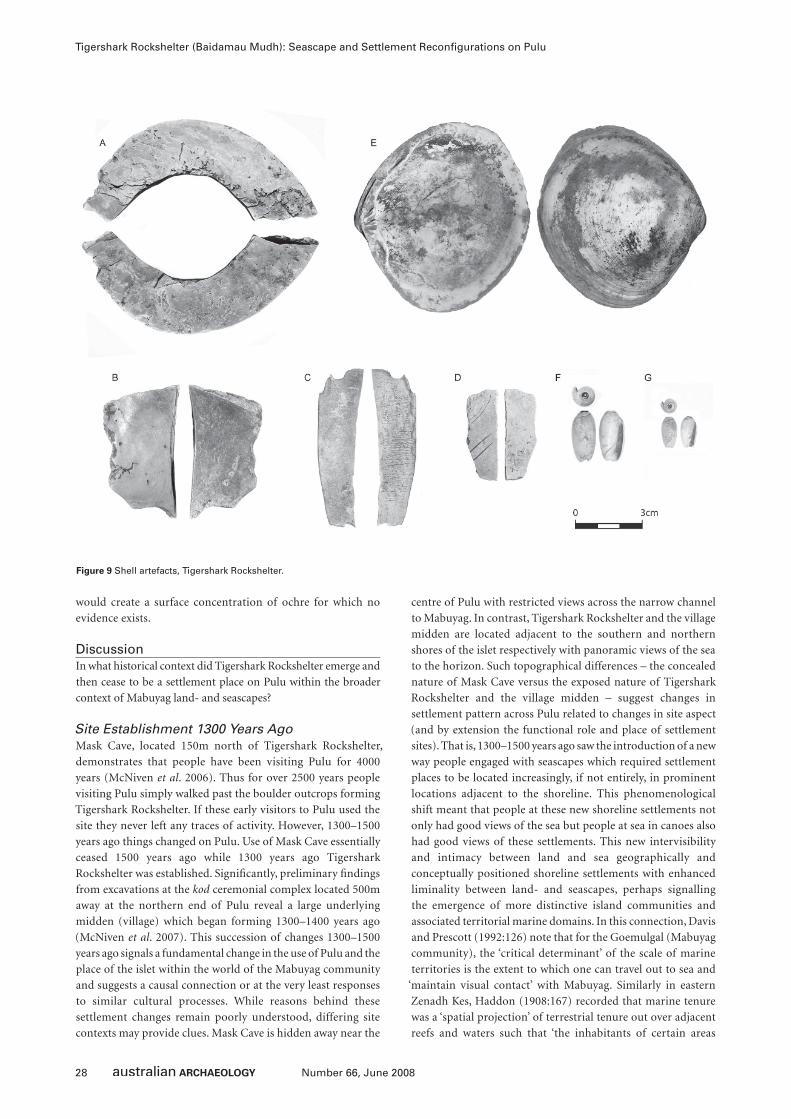
28 Number 66, June 2008
Tigershark Rockshelter (Baidamau Mudh): Seascape and Settlement Reconfi gurations on Pulu
would create a surface concentration of ochre for which no
evidence exists.
DiscussionIn what historical context did Tigershark Rockshelter emerge and
then cease to be a settlement place on Pulu within the broader
context of Mabuyag land- and seascapes?
Site Establishment 1300 Years AgoMask Cave, located 150m north of Tigershark Rockshelter,
demonstrates that people have been visiting Pulu for 4000
years (McNiven et al. 2006). Thus for over 2500 years people
visiting Pulu simply walked past the boulder outcrops forming
Tigershark Rockshelter. If these early visitors to Pulu used the
site they never left any traces of activity. However, 1300–1500
years ago things changed on Pulu. Use of Mask Cave essentially
ceased 1500 years ago while 1300 years ago Tigershark
Rockshelter was established. Signifi cantly, preliminary fi ndings
from excavations at the kod ceremonial complex located 500m
away at the northern end of Pulu reveal a large underlying
midden (village) which began forming 1300–1400 years ago
(McNiven et al. 2007). This succession of changes 1300–1500
years ago signals a fundamental change in the use of Pulu and the
place of the islet within the world of the Mabuyag community
and suggests a causal connection or at the very least responses
to similar cultural processes. While reasons behind these
settlement changes remain poorly understood, differing site
contexts may provide clues. Mask Cave is hidden away near the
centre of Pulu with restricted views across the narrow channel
to Mabuyag. In contrast, Tigershark Rockshelter and the village
midden are located adjacent to the southern and northern
shores of the islet respectively with panoramic views of the sea
to the horizon. Such topographical differences – the concealed
nature of Mask Cave versus the exposed nature of Tigershark
Rockshelter and the village midden – suggest changes in
settlement pattern across Pulu related to changes in site aspect
(and by extension the functional role and place of settlement
sites). That is, 1300–1500 years ago saw the introduction of a new
way people engaged with seascapes which required settlement
places to be located increasingly, if not entirely, in prominent
locations adjacent to the shoreline. This phenomenological
shift meant that people at these new shoreline settlements not
only had good views of the sea but people at sea in canoes also
had good views of these settlements. This new intervisibility
and intimacy between land and sea geographically and
conceptually positioned shoreline settlements with enhanced
liminality between land- and seascapes, perhaps signalling
the emergence of more distinctive island communities and
associated territorial marine domains. In this connection, Davis
and Prescott (1992:126) note that for the Goemulgal (Mabuyag
community), the ‘critical determinant’ of the scale of marine
territories is the extent to which one can travel out to sea and
‘maintain visual contact’ with Mabuyag. Similarly in eastern
Zenadh Kes, Haddon (1908:167) recorded that marine tenure
was a ‘spatial projection’ of terrestrial tenure out over adjacent
reefs and waters such that ‘the inhabitants of certain areas
Figure 9 Shell artefacts, Tigershark Rockshelter.
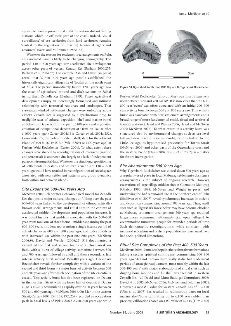
29Number 66, June 2008
Ian J. McNiven et al.
appear to have a pre-emptial right to certain distant fi shing
stations which lie off their part of the coast’. Indeed, ‘visual
surveillance’ of sea territories from land territories remains
‘central to the regulation of [marine] territorial rights and
resources’ (Scott and Mulrennan 1999:155).
Whatever the reasons for settlement rearrangements on Pulu,
an associated issue is likely to be changing demography. The
period 1300–1500 years ago saw accelerated site development
across other parts of western Zenadh Kes (Barham 2000:275;
Barham et al. 2004:37). For example, Ash and David (in press)
reveal that ‘c.1300-1400 years ago people established’ the
historically-signifi cant village site of Totalai on the north coast
of Mua. The period immediately before 1200 years ago saw
the onset of agricultural mound-and-ditch systems on Saibai
in northern Zenadh Kes (Barham 1999). These agricultural
developments imply an increasingly formalised and intimate
relationship with terrestrial resources and landscapes. That
systemically-linked settlement changes were unfolding across
eastern Zenadh Kes is suggested by a synchronous drop to
negligible rates of cultural deposition (shell and marine bone)
at Sokoli on Dauar within the past c.1400 years and a possible
cessation of occupational deposition at Ormi on Dauar after
c.1600 years ago (Carter 2004:191; Carter et al. 2004a:252).
Concomitantly, the earliest midden (shell) date for the adjacent
island of Mer is 1623±38 BP (Wk-13369) (c.1300 years ago) at
Kurkur Weid Rockshelter (Carter 2004). To what extent these
changes were shaped by reconfi gurations of resources (marine
and terrestrial) is unknown due largely to a lack of independent
palaeoenvironmental data. Whatever the situation, repositioning
of settlements in eastern and western Zenadh Kes 1300–1500
years ago would have resulted in reconfi gurations of social space
associated with new settlement patterns and group dynamics
both within and between islands.
Site Expansion 500–700 Years AgoMcNiven (2006) elaborates a chronological model for Zenadh
Kes that posits major cultural changes unfolding over the past
600–800 years linked to the development of ethnographically-
known social arrangements and ritual sites in the context of
accelerated midden development and population increase. It
was noted further that middens associated with the 600–800
year event took one of three forms – middens spanning the past
600–800 years, middens representing a single intense period of
activity between 600 and 800 years ago, and older middens
with increased use within the past 600–800 years (McNiven
2006:9). David and Weisler (2006:27, 31) documented a
variant of the fi rst and second forms at Kurturniaiwak on
Badu with a ‘burst of village activity’ sometime between 500
and 700 years ago followed by a lull and then a secondary, less
intense activity burst around 350–400 years ago. Tigershark
Rockshelter reveals further complexity with a variant of the
second and third forms – a major burst of activity between 500
and 700 years ago after which occupation of the site essentially
ceased. This activity burst has also been registered on Dauan
in the northern Strait with the lower half of deposit at Dauan
4 (XUs 10–20) accumulating rapidly over c.100 years between
500 and 600 years ago (McNiven 2006). On Mer in the eastern
Strait, Carter (2004:154, 158, 192, 257) recorded an occupation
peak in basal levels of Pitkik dated c.700–800 years ago while
Kurkur Weid Rockshelter (also on Mer) was ‘most intensively
used between 520 and 780 cal BP’. It is now clear that the 600–
800 year ‘event’ was often associated with an initial 200–300
year activity burst between 500 and 800 years ago. This activity
burst was associated with new settlement arrangements and a
broad range of more fundamental social, ritual and territorial
transformations (David and Weisler 2006; David and McNiven
2005; McNiven 2006). To what extent this activity burst was
structured also by environmental changes such as sea level
fall and new marine resource confi gurations linked to the
Little Ice Age, as hypothesised previously for Torres Strait
(McNiven 2006) and other parts of the Queensland coast and
the western Pacifi c (Nunn 2007; Nunn et al. 2007), is a matter
for future investigation.
Site Abandonment 500 Years AgoWhy Tigershark Rockshelter was closed down 500 years ago as
a regularly-used place in local Mabuyag settlement-subsistence
arrangements is the subject of ongoing research. However,
excavations of large village midden sites at Goemu on Mabuyag
(Ghaleb 1990, 1998; McNiven and Wright in press) and
underlying the kod ceremonial site at the northern end of Pulu
(McNiven et al. 2007) reveal synchronous increases in activity
and deposition commencing around 500 years ago. Thus, small
sites such as Tigershark Rockshelter may have become obsolete
as Mabuyag settlement arrangements 500 years ago required
larger more communal settlements (i.e. open villages) to
accommodate numerous people for extended periods of time.
Such demographic reconfi gurations, while consistent with
increased sedentism and perhaps population increase, must have
had socio-political dimensions.
Ritual Site Complexes of the Past 400–500 YearsMcNiven (2006:10) makes the point that cultural transformations
(along a secular-spiritual continuum) commencing 600–800
years ago ‘did not remain historically static but underwent
periods of strategic readjustment, most notably within the last
300-400 years’ with major elaborations of ritual sites such as
dugong bone mounds and bu shell arrangement in western
Zenadh Kes (cf. David and Mura Badulgal Committee 2006;
David et al. 2005; McNiven 2006; McNiven and Feldman 2003).
However, a new ∆R value for western Zenadh Kes of −32±20
(Ulm et al. 2007) has resulted in radiocarbon dates on local
marine shell/bone calibrating up to c.100 years older than
previous calibrations based on a ∆R value of 49±45 (Ulm 2002)
Figure 10 Tiger shark tooth tool, XU1 Square B, Tigershark Rockshelter.
30 Number 66, June 2008
Tigershark Rockshelter (Baidamau Mudh): Seascape and Settlement Reconfi gurations on Pulu
or 50±47 (Ulm 2006). As such, ritual site transformations of
300−400 years ago associated with construction of dugong bone
mounds can now be extended back to around 400−500 years ago
(e.g. compare McNiven and Feldman 2003 with McNiven and
Bedingfi eld 2008). Certainly, David et al.’s (2005:88) conclusion
for ‘the apparent beginnings of bu shell arrangements 500-400
years ago’ remains pertinent. As dates for major elaborations of
ritual sites (dugong bone mounds and bu shell arrangements)
are pushed back to 400−500 years ago, causal relationships with
suggested demographic expansions registered at midden sites
500 years ago may well be implicated. That is, demographic
changes across western Zenadh Kes around 500 years ago may
have involved new social arrangements (e.g. clan, totemic
and territorial) that within a few generations were managed
by new communal socio-ceremonial structures incorporating
ritual installations in the form of dugong bone mounds and bu
shell arrangements (see McNiven et al. 2007 for details). These
communal socio-ceremonial structures and associated ritual
practices were a key to maintaining social cohesion and broader
shared identities in a society that ethnographically was largely
egalitarian and ‘lacked centralised authority’ (Beckett 1972:320)
as hereditary clan chiefs had no ‘marked social or political
status’ (Haddon 1904:265; cf. Lilley 1985). It is in this context
that the Goemulgal (people of Mabuyag) chose to establish the
ceremonial kod site with dugong bone mounds and bu shell
arrangements at the northern end of Pulu around 300–400
years ago (see McNiven et al. 2007), while the possible kod site
with dugong bone mounds was established on Koey Ngurtai
islet located between Mabuyag and Badu around 400–500
years ago (David and McNiven 2005). As the kod on Pulu was
located on top of a large midden that simultaneously registers
a dramatic decrease in use around 300–400 years ago (McNiven
et al. 2007), kod establishment was probably associated with the
transformation of the islet from a place of regular residential
occupation to a restricted, formalised and highly controlled
sacred landscape, as it remains today.
ConclusionTigershark Rockshelter demonstrates that the ancestors of
the Goemulgal were marine specialists just as they are today
and just as Alfred Haddon found when he undertook detailed
anthropological work on Mabuyag in 1888 and 1898 (Haddon
1901, 1904, 1935). In this sense, excavations cement an
archaeological and ethnographic pattern of marine subsistence
specialisation seen across Zenadh Kes for at least the past 4000
years (e.g. Carter et al. 2004b; Crouch et al. 2007; David and
Weisler 2006; McNiven and Hitchcock 2004; McNiven et al.
2006). Signifi cantly, Tigershark Rockshelter extends insights into
ancient fi shing practices and reveals the most diverse shark and
ray assemblages yet recovered from an Australian Indigenous
midden. While ochre at previously-excavated middens across
western Zenadh Kes indicates that people undertook a range of
decorative activities, Tigershark Rockshelter adds an embodied
dimension to such artistic pursuits with engraved shells, shell
pendants and shell beads. Using ethnographic observations as
a guide, these multifunctional shell adornments communicate
to us across time the social realities of status, prestige, gender,
aesthetics and exchange relationships. In short, the small
groups of men and women (and possibly children) camping at
Tigershark Rockshelter from time to time between 500 and 1300
years ago had broader social connections and belonged to a larger
community, the most obvious being the Mabuyag community.
The excavations also reveal that Mabuyag/Pulu society is the
result of a series of dynamic social transformations over the past
millennium. And after 500 years of site abandonment, during
which time use of Pulu focused on the ceremonial and the
sacred, archaeological research has provided an opportunity for
members of the Mabuyag community to reacquaint themselves
with Tigershark Rockshelter and to experience some familiar
and not so familiar aspects of their dynamic past.
AcknowledgementsKaima esso to the people of Mabuyag for their hospitality and
for providing the special opportunity to visit and research the
history of Pulu and for logistical support that made excavations at
Tigershark Rockshelter possible. Thanks to John Mooka, Terrence
Whap, John Bani, Harold Bani, Martha Paipai, Bessie Whap and
Tyson Gizu from Mabuyag for assistance with excavations. For
support and guidance we thank members of the Goemulgau Kod
cultural organisation, in particular Cygnet Repu, Terrence Whap,
Sophie Luffman, Holly Banasa, and Brian Whap. Special thanks
to Judith Fitzpatrick for assistance with excavations and Bruno
David for assistance with drawing the site cross-section. The
Mabuiag State Primary School kindly helped with sieving and
drying of excavated materials. For general support we thank the
Mabuiag Island Council and then chairman Fr. Bani. Vic McGrath
(Thursday Island) kindly provided information on fi shing. Steve
Van Dyck (Senior Curator of Vertebrates, Queensland Museum)
identifi ed rodent bones. The late Tom Loy (School of Social
Science, University of Queensland) examined glass artefacts for
blood residues. Steve Morton (Photography, Monash University)
and Kara Rasmanis and Gary Swinton (School of Geography and
Environmental Science, Monash University) created the fi gures.
This research was supported in part by ARC Discovery-Projects
Grant DP0344070 and AINSE grant 05/119. Helpful comments
on earlier drafts of this paper were kindly provided by Jeremy
Ash, Bruno David, Fiona Petchey, Mike Rowland, Duncan Wright
and anonymous referees.
ReferencesAllen, G. 1997 Marine Fishes of Tropical Australia and South-East Asia. Perth:
Western Australian Museum.
Ash, J. and B. David in press Mua 22: Archaeology at the old village site of Totalai. In
B. David, D. Tomsana and M. Quinnell (eds), Gelam’s Homeland: Cultural and
Natural History on the Island of Mua, Torres Strait. Memoirs of the Queensland
Museum, Cultural Heritage Series. Brisbane: Queensland Museum.
Barham, A.J. 1999 The local environmental impact of prehistoric populations
on Saibai Island, northern Torres Strait, Australia: Enigmatic evidence from
Holocene swamp lithostratigraphic records. Quaternary International 59:71-
105.
Barham, A.J. 2000 Late Holocene maritime societies in the Torres Strait Islands,
northern Australia – Cultural arrival or cultural emergence? In S. O’Connor
and P. Veth (eds), East of Wallace’s Line: Studies of Past and Present Maritime
Cultures of the Indo-Pacifi c Region, pp. 223-314. Modern Quaternary Research
in Southeast Asia 16. Rotterdam: A.A. Balkema.
Barham, A.J. and D.R. Harris 1987 Archaeological and Palaeoenvironmental
Investigations in Western Torres Strait, Northern Australia. Unpublished report
to the Research and Exploration Committee, National Geographic Society.
31Number 66, June 2008
Ian J. McNiven et al.
Barham, A.J., M.J. Rowland and G. Hitchcock 2004 Torres Strait bepotaim: An
overview of archaeological and ethnoarchaeological investigations and
research. In I.J. McNiven and M. Quinnell (eds), Torres Strait Archaeology
and Material Culture, pp.1-72 Memoirs of the Queensland Museum, Cultural
Heritage Series 3(1). Brisbane: Queensland Museum.
Beckett, J. 1972 The Torres Strait Islanders. In D. Walker (ed.), Bridge and Barrier:
The Natural and Cultural History of Torres Strait, pp.307-326. Canberra:
Australian National University Press.
Bliege Bird, R., D.W. Bird and J.M. Beaton 1995 Children and traditional subsistence
on Mer (Murray Island), Torres Strait. Australian Aboriginal Studies 1:2-17.
Brady, L.M. 2005 Painting Patterns: Torres Strait Region Rock-Art, NE Australia.
Unpublished PhD thesis, Monash University, Clayton.
Brady, L.M. 2006 Documenting and analyzing rock paintings from Torres Strait,
NE Australia, with digital photography and computer image enhancement.
Journal of Field Archaeology 31(4):363-379.
Bronk Ramsey, C. 1995 Radiocarbon calibration and analysis of stratigraphy: The
OxCal program. Radiocarbon 37(2):425-430.
Bronk Ramsey, C. 2001 Development of the radiocarbon calibration program
OxCal. Radiocarbon 43(2A):355-363.
Burke, H. and C. Smith 2004 The Archaeologist’s Field Handbook. Crows Nest: Allen
& Unwin.
Carter, M.J. 2004 North of the Cape and South of the Fly: The Archaeology of
Settlement and Subsistence on the Murray Islands, Eastern Torres Strait.
Unpublished PhD thesis, School of Anthropology, Archaeology and Sociology,
James Cook University, Townsville.
Carter, M., P. Veth, A. Barham, D. Bird, S. O’Connor and R. Bird 2004a Archaeology
of the Murray Islands, eastern Torres Strait: Implications for a regional
prehistory. In R. Davis (ed.), Woven Histories Dancing Lives: Torres Strait
Islander Identity, Culture and History, pp.234-258. Canberra: Aboriginal
Studies Press.
Carter, M., A.J. Barham, P. Veth, D.W. Bird, S. O’Connor and R.B. Bird. 2004b The
Murray Islands Archaeological Project: Preliminary results of excavations on
Mer and Dauar eastern Torres Strait. In I.J. McNiven and M. Quinnell (eds),
Torres Strait Archaeology and Material Culture, pp.163-182 Memoirs of the
Queensland Museum, Cultural Heritage Series 3(1). Brisbane: Queensland
Museum.
Crouch, J., I.J. McNiven, B. David, C. Rowe and M. Weisler 2007 Berberass: Marine
resource specialisation and environmental change in Torres Strait over the
past 4000 years. Archaeology in Oceania 42(2):49-64.
David, B., J. Crouch and U. Zoppi 2005 Historicizing the spiritual: bu shell
arrangements on the Island of Badu, Torres Strait. Cambridge Archaeological
Journal 15(1):71-91.
David, B. and I.J. McNiven 2005 Archaeological Survey and Salvage Programme
of Koey Ngurtai, Torres Strait (Stage 2): Final Report. Unpublished Cultural
Heritage Report Series 9. Clayton: Programme for Australian Indigenous
Archaeology, School of Geography and Environmental Science, Monash
University.
David, B., I.J. McNiven, J. Brayer and A. Watchman 2001 Why digital enhancement
of rock-art works: Rescaling and saturating colours. Antiquity 75:781-792.
David, B. and Mura Badulgal Committee 2006 What happened in Torres Strait 400
years ago? Ritual transformation in an island seascape. Journal of Island and
Coastal Archaeology 1:123-143.
David, B. and M.I. Weisler 2006 Kurturniaiwak (Badu) and archaeological evidence
of villages in Torres Strait. Australian Archaeology 63:21-34.
Davis, S.L. and J.R.V. Prescott 1992 Aboriginal Frontiers and Boundaries in
Australia. Carlton: Melbourne University Press.
Draffan, R.D.W., S.T. Garnett and G.J. Malone 1983 Birds of Torres Strait: An
annotated list and biogeographical analysis. The Emu 83(4):207-234.
Edmundson, A. and C. Boylan 1999 Adorned: Traditional Jewellery and Body
Decoration from Australia and the Pacifi c. Sydney: University of Sydney.
Fink, D., M. Hotchkis, Q. Hua, G. Jacobsen, A.M. Smith, U. Zoppi, D. Child, C.
Mifsud, H. van der Gaast, A. Williams and M. Williams 2004 The ANTARES
AMS facility at ANSTO. Nuclear Instruments and Methods in Physics
Research Section B: Beam Interactions with Materials and Atoms 223-
224:109-115.
Fitzpatrick, J., J. Cordell and I.J. McNiven 1998 Torres Strait Culture Site
Documentation Project. Unpublished report to the Island Coordinating
Council, Thursday Island.
Fleming, M.A. 1986 The Scaridae Family in Pacifi c Prehistory. Unpublished M.A.
thesis, Department of Anthropology, University of Otago, Dunedin.
Florek, S. 2005 The Torres Strait Islands Collection at the Australian Museum.
Technical Reports of the Australian Museum 19. Sydney: Australian Museum.
Ghaleb, B. 1990 An Ethnoarchaeological Study of Mabuiag Island, Torres Strait,
Northern Australia. Unpublished PhD thesis, Institute of Archaeology,
University College London, London.
Ghaleb, B. 1998 Fish and fi shing on a western Torres Strait Island, northern
Australia: Ethnographic and archaeological perspectives. In A.K.G. Jones
and R. Nicholson (eds), Fish Remains and Humankind: Part Two. Internet
Archaeology 4. http://intarch.ac.uk/journal/issue4/ghaleb_index.html
Grant, E. 1995 Fishes of Australia. Redcliffe, QLD: E.M. Grant P/L Publishers.
Haddon, A.C. 1890 The ethnography of the western tribe of Torres Straits. Journal
of the Anthropological Institute of Great Britain and Ireland 19:297-446.
Haddon, A.C. 1901 Head-Hunters: Black, White and Brown. London: Methuen.
Haddon, A.C. (ed.) 1904 Reports of the Cambridge Anthropological Expedition to
Torres Straits: Sociology, Magic and Religion of the Western Islanders. Vol. 5.
Cambridge: Cambridge University Press.
Haddon, A.C. (ed.) 1908 Reports of the Cambridge Anthropological Expedition to
Torres Straits: Sociology, Magic and Religion of the Eastern Islanders. Vol. 6.
Cambridge: Cambridge University Press.
Haddon, A.C. (ed.) 1912 Reports of the Cambridge Anthropological Expedition to
Torres Straits: Arts and Crafts. Vol. 4. Cambridge: Cambridge University Press.
Haddon, A.C. 1935 Reports of the Cambridge Anthropological Expedition
to Torres Straits: General Ethnography. Vol. 1. Cambridge: Cambridge
University Press.
Harris, A., G. Dews, J. Kerr and I. Poiner 1995 Monitoring the Traditional and
Island-Based Catch of the Torres Strait Protected Zone: Report on CSIRO
Research 1991-1993. Brisbane: CSIRO Division of Fisheries.
Harris, D.R., A.J. Barham and B. Ghaleb 1985 Archaeology and Recent
Palaeoenvironmental History of Torres Strait, Northern Australia. Unpublished
report to the Research and Exploration Committee, National Geographic
Society.
Johannes, R.E. and J.W. MacFarlane 1991 Traditional Fishing in the Torres Strait
Islands. Hobart: CSIRO Division of Fisheries.
Kwan, D. 2005 Traditional use in contemporary Ailan (Island) ways: The
management challenge of a sustainable dugong fi shery in Torres Strait. In
N. Kishigami and J.M. Savelle (eds), Indigenous Use and Management of
Marine Resources, pp.281-302. Senri Ethnological Studies 67. Osaka: National
Museum of Ethnology.
Last, P.R. and J.D. Stevens 1994 Sharks and Rays of Australia. Melbourne: CSIRO.
Leung, L.K-P. 1995 Cape York Melomys. In R. Strahan (ed.), The Mammals of
Australia, pp.634-635. Sydney: Reed New Holland.
Lilley, I. 1985 Chiefs without chiefdoms: Comments on prehistoric socio-political
organisation in western Melanesia. Archaeology in Oceania 20(2):60-65.
MacGillivray, J. 1852 Narrative of the Voyage of H.M.S. Rattlesnake. 2 vols. London:
T. & W. Boone.
McCormac, F.G., A.G. Hogg, P.G. Blackwell, C.E. Buck, T.F.G. Higham and P.J.
Reimer 2004 SHCAL04 southern hemisphere calibration, 0-11.0 cal kyr BP.
Radiocarbon 46:1087-1092.
32 Number 66, June 2008
Tigershark Rockshelter (Baidamau Mudh): Seascape and Settlement Reconfi gurations on Pulu
McNiven, I.J. 2006 Dauan 4 and the emergence of ethnographically-known social
arrangements across Torres Strait during the last 600-800 years. Australian
Archaeology 62:1-12.
McNiven, I.J. 2008 Inclusions, exclusions and transitions: Torres Strait Islander
constructed landscapes over the past 4000 years, northeast Australia. The
Holocene 18(3):449-462.
McNiven, I.J. and A.C. Bedingfi eld 2008 Past and present marine mammal hunting
rates and abundances: Dugong (Dugong dugon) evidence from Dabangai Bone
Mound, Torres Strait. Journal of Archaeological Science 35:505-515.
McNiven, I.J., J. Crouch and M. David 2004b Tudu (Warrior Island), Torres
Strait: Historical and Archaeological Survey. Unpublished Cultural
Heritage Report Series, 4. Clayton: Programme for Australian Indigenous
Archaeology, School of Geography and Environmental Science, Monash
University, Australia.
McNiven, I.J., B. David, Goemulgau Kod and L.M. Brady 2007 The Great Kod of
Pulu: Emergence of a Sacred Totemic Ceremonial Complex in Western Zenadh
Kes (Torres Strait). Manuscript on fi le, Programme for Australian Indigenous
Archaeology, School of Geography and Environmental Science, Monash
University.
McNiven, I.J., W.R. Dickinson, B. David, M. Weisler, F. von Gnielinski, M. Carter and
U. Zoppi 2006 Mask Cave: Red-slipped pottery and the Australian-Papuan
settlement of Zenadh Kes (Torres Strait). Archaeology in Oceania 41(2):49-81.
McNiven, I.J. and R. Feldman 2003 Ritually orchestrated seascapes: Bone
mounds and dugong hunting magic in Torres Strait, NE Australia. Cambridge
Archaeological Journal 13(2):169-194.
McNiven, I.J., J. Fitzpatrick and J. Cordell 2004a An Islander world: Managing the
archaeological heritage of Torres Strait. In I.J. McNiven and M. Quinnell (eds),
Torres Strait: Archaeology and Material Culture, pp.73-91. Memoirs of the
Queensland Museum, Cultural Heritage Series 3(1). Brisbane: Queensland
Museum.
McNiven, I.J. and G. Hitchcock 2004 Torres Strait marine subsistence specialisation
and terrestrial animal translocation. In I.J. McNiven and M. Quinnell (eds),
Torres Strait: Archaeology and Material Culture, pp.105-162. Memoirs of the
Queensland Museum, Cultural Heritage Series 3(1). Brisbane: Queensland
Museum.
McNiven, I.J. and D. Wright in press Ritualised marine midden formation in
Western Zenadh Kes (Torres Strait). In G. Clark, F. Leach and S. O’Connor (eds),
Islands of Inquiry: Colonisation, Seafaring and the Archaeology of Maritime
Landscapes. Terra Australis. Canberra: ANU E Press.
Moore, D.R. 1984 The Torres Strait Collections of A.C. Haddon. London: British
Museum Publications Ltd.
Nunn, P.D. 2007 Climate, Environment and Society in the Pacifi c during the Last
Millennium. Developments in Earth and Environmental Science 6. Elsevier:
Amsterdam.
Nunn, P.D., R. Hunter-Anderson, M.T. Carson, F. Thomas, S. Ulm and M.J. Rowland
2007 Times of plenty, times of less: Last-millennium societal disruption in the
Pacifi c basin. Human Ecology 35:385-401.
Randell, J.E., G.R. Allen and R.C. Steene 1997 Fishes of the Great Barrier Reef and
Coral Sea. Bathurst: Crawford House Publishing.
Ray, S.H. 1907 Reports of the Cambridge Anthropological Expedition to Torres
Straits: Linguistics. Vol. 3. Cambridge: Cambridge University Press.
Rowe, C. 2006 Landscapes in Torres Strait prehistory. In B. David, B. Barker, and
I.J. McNiven (eds), The Social Archaeology of Indigenous Societies, pp.270-286.
Canberra: Aboriginal Studies Press.
Rowland, M.J. 1985 Archaeological investigations on Moa and Naghi Islands,
western Torres Strait. Australian Archaeology 21:119-132.
Scott, C. and M. Mulrennan 1999 Land and sea tenure at Erub, Torres Strait:
Property, sovereignty and the adjudication of cultural continuity. Oceania
70:146-176.
Smith, E.A. and R.L. Bliege Bird 2000 Turtle hunting and tombstone opening: Public
generosity as costly signalling. Evolution and Human Behavior 21:245-261.
Stanisic, J. in press Land snails of Mua Island, Torres Strait. In B. David, D. Tomsana
and M. Quinnell (eds), Gelam’s Homeland: Cultural and Natural History on
the Island of Mua, Torres Strait. Memoirs of the Queensland Museum, Cultural
Heritage Series. Brisbane: Queensland Museum.
Stein, J.K. (ed.) 1992 Deciphering a Shell Midden. San Diego: Academic Press.
Telford, R.J., E. Heegaard and H.J.B. Birks 2004 The intercept is a poor estimate of
a calibrated radiocarbon age. The Holocene 14(2):296-298.
Ulm, S. 2002. Calibrating marine radiocarbon dates: A guide to Australian ∆R
values. AACAI Newsletter 89:10-14.
Ulm, S. 2006 Australian marine reservoir effects: A guide to Australian ∆R values.
Australian Archaeology 63:57-60.
Ulm, S., A.J. Barham, B. David, G. Jacobsen, I.J. McNiven, F. Petchey and M. Rowland
2007 Marine carbon reservoir variability in Torres Strait: Preliminary results
of AMS dating of live-collected shell specimens. Quaternary International
167-168:426.
Weisler, M.I. 2001 On the Margins of Sustainability: Prehistoric Settlement of
Utrok Atoll, Northern Marshall Islands. BAR International Series 967. Oxford:
Archeopress.
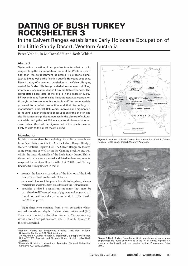
33Number 66, June 2008
DATING OF BUSH TURKEY ROCKSHELTER 3 in the Calvert Ranges establishes Early Holocene Occupation of the Little Sandy Desert, Western AustraliaPeter Veth1,3, Jo McDonald2,3 and Beth White2
1 National Centre for Indigenous Studies, Australian National University, Canberra, ACT 0200, Australia
2 Jo McDonald Cultural Heritage Management, 6 Supply Place, Red Hill, ACT 2603, Australia and 77 Justin Street, Lilyfi eld, NSW 2040, Australia
3 Research School of Humanities, Australian National University, Canberra, ACT 0200, Australia
AbstractSystematic excavation of occupied rockshelters that occur in
ranges along the Canning Stock Route of the Western Desert
has seen the establishment of both a Pleistocene signal
(c.24ka BP) as well as the fl eshing out of a Holocene sequence.
Recent dating of a perched rockshelter in the Calvert Ranges,
east of the Durba Hills, has provided a Holocene record fi lling
in previous occupational gaps from the Calvert Ranges. The
extrapolated basal date of the site is in the order of 12,000
BP. Assemblages from this site illustrate repeated occupation
through the Holocene with a notable shift in raw materials
procured for artefact production and their technology of
manufacture in the last 1000 years. Engraved and pigment art
is thought to span the length of occupation of the shelter. The
site illustrates a signifi cant increase in the discard of cultural
materials during the last 800 years, a trend observed at other
desert sites. Much of the pigment art in this shelter seems
likely to date to this most recent period.
IntroductionIn this paper we describe the dating of a cultural assemblage
from Bush Turkey Rockshelter 3 in the Calvert Ranges (Kaalpi),
Western Australia (Figures 1-2). The Calvert Ranges are located
some 80km east of Well 15 on the Canning Stock Route, well
within the linear dunefi elds of the Little Sandy Desert. This is
the second rockshelter excavated and dated in these very remote
ranges of the Western Desert (Veth et al. 2001). Bush Turkey
Rockshelter 3 is signifi cant in that it:
• extends the known occupation of the interior of the Little
Sandy Desert back to the early Holocene;
• has several phases of lithic production illustrating changes in raw
material use and implement types through the Holocene; and
• provides a dated occupation sequence that may be
correlated to different phases of pigment and engraved art
found both within and adjacent to the shelter (McDonald
and Veth in press).
Eight dates were obtained from a test excavation which
reached a maximum depth of 86cm below surface level (bsl).
These dates, combined with evidence for recent Martu occupancy,
reveal repeated occupations from 8202–8414 cal BP through to
the contact period.
Figure 1 Location of Bush Turkey Rockshelter 3 at Kaalpi (Calvert Ranges), Little Sandy Desert, Western Australia.
Figure 2 Bush Turkey Rockshelter 3 at completion of excavation. Engravings are found on the slabs to the left of frame. Pigment art covers the back wall and overhanging ceiling (Photograph: Peter Veth).
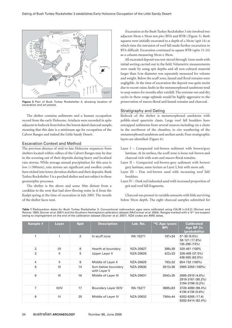
34 Number 66, June 2008
Dating of Bush Turkey Rockshelter 3 establishes Early Holocene Occupation of the Little Sandy Desert
The shelter contains sediments and a human occupation
record from the early Holocene. Artefacts were recorded in spits
adjacent to bedrock from below the lowest dated charcoal sample,
meaning that this date is a minimum age for occupation of the
Calvert Ranges and indeed the Little Sandy Desert.
Excavation Context and MethodThe previous absence of mid-to-late Holocene sequences from
shelters located within valleys of the Calvert Ranges may be due
to the scouring out of their deposits during heavy and localised
rain storms. While average annual precipitation for this area is
low (<300mm), rain storms are signifi cant and swollen creeks
have etched into lower elevation shelters and their deposits. Bush
Turkey Rockshelter 3 is a perched shelter and not subject to these
geomorphic processes.
The shelter is 8m above and some 30m distant from a
creekline to the west that had slow-fl owing water in it from the
Kaalpi spring at the time of excavation in July 2005. The mouth
of the shelter faces west.
Excavation at the Bush Turkey Rockshelter 3 site involved two
adjacent 50cm x 50cm test pits (BTA and BTB) (Figure 3). Both
squares were initially excavated to a depth of c.50cm (spit 14) at
which time the intrusion of roof fall made further excavation in
BTA diffi cult. Excavation continued in square BTB (spits 15-24)
as a column measuring 50cm x 30cm.
All excavated deposit was wet-sieved through 1mm mesh with
initial sorting carried out in the fi eld. Volumetric measurements
were made by using spit depths and all non-cultural material
larger than 5cm diameter was separately measured for volume
and weight. Below the scuff zone, faunal and fl oral remains were
negligible. At the time of excavation the deposit was quite moist
due to recent rains; faults in the metamorphosed sandstone tend
to seep waters for months after rainfall. The extreme wet and dry
cycles in these range uplands would be highly aggressive to the
preservation of macro-fl oral and faunal remains and charcoal.
Stratigraphy and DatingBedrock of the shelter is metamorphosed sandstone with
pebble-sized quartzite clasts. Large roof fall boulders have
entrapped sediments from several sources including via a chute
in the northwest of the chamber, in situ weathering of the
metamorphosed sandstone and aeolian sands. Four stratigraphic
layers are identifi ed (Figure 4):
Layer I – Compacted red-brown sediment with brown/grey
laminae. At its surface, the scuff zone is loose red-brown and
charcoal-rich with scats and macro-fl oral remains.
Layer II – Compacted red-brown-grey sediment with brown/
grey laminae, same texture as Layer I, but with more ash.
Layer III – Fine red-brown sand with increasing roof fall/
boulders.
Layer IV – Dark red indurated sand with increased proportion of
grit and roof fall fragments.
Charcoal was present in variable amounts with little surviving
below 50cm depth. The eight charcoal samples submitted for
Figure 3 Plan of Bush Turkey Rockshelter 3, showing location of excavation and art panels.
Sample # Layer Spit Description Lab. No. 14C Age (years BP)
Calibrated Age BP 2σ
(probability)1 I 2 In scuff zone Wk-15271 197±34 0*-30 (9.5%)
58-121 (17.6%)135-296 (73%)
2 I/II 8 Hearth at boundary NZA-20627 386±39 320-491 (100%
3 II 5 Upper Layer II NZA-20626 422±33 326-409 (37.5%)436-505 (62.5%)
4 II 9 Middle of Layer II NZA-20629 793±32 654-732 (100%)
5 III 14 5cm below boundary with Layer II
NZA-20630 3013±36 2985-3259 (100%)
6 III 16 Middle of Layer III NZA-20631 2942±35 2880-2910 (4.6%)2919-3161 (95.2%)3194-3196 (0.2%)
7 III/IV 17 Boundary Layer III/IV Wk-15277 3665±63 3720-4090 (99.4%)4130-4138 (0.6%)
8 IV 20 Middle of Layer IV NZA-20632 7584±44 8202-8265 (17.6)8282-8414 (82.4%)
Table 1 Radiocarbon dates for Bush Turkey Rockshelter 3. Conventional radiocarbon ages were calibrated using CALIB (v.5.0.2) (Stuiver and Reimer 1993; Stuiver et al. 2007) and the Southern Hemisphere calibration dataset (McCormac et al. 2004). Ranges marked with a ‘0*’ are suspect owing to impingement on the end of the calibration dataset (Stuiver et al. 2007). NZA-codes are AMS dates.
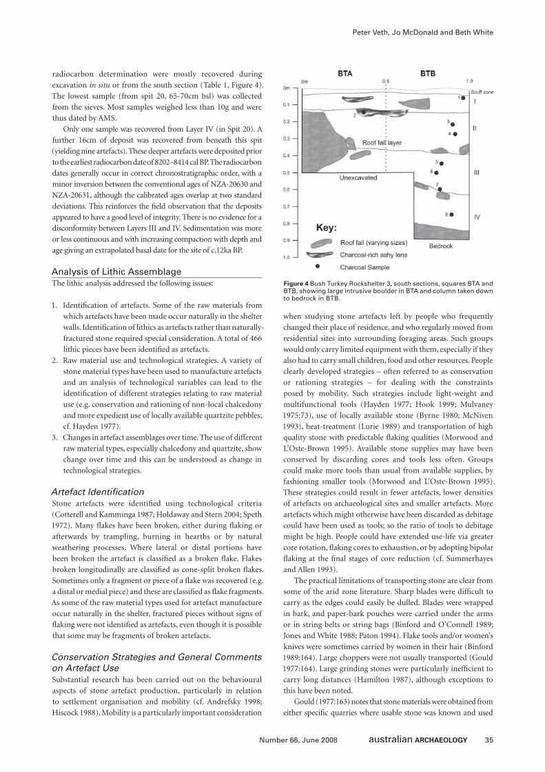
35Number 66, June 2008
Peter Veth, Jo McDonald and Beth White
radiocarbon determination were mostly recovered during
excavation in situ or from the south section (Table 1, Figure 4).
The lowest sample (from spit 20, 65-70cm bsl) was collected
from the sieves. Most samples weighed less than 10g and were
thus dated by AMS.
Only one sample was recovered from Layer IV (in Spit 20). A
further 16cm of deposit was recovered from beneath this spit
(yielding nine artefacts). These deeper artefacts were deposited prior
to the earliest radiocarbon date of 8202–8414 cal BP. The radiocarbon
dates generally occur in correct chronostratigraphic order, with a
minor inversion between the conventional ages of NZA-20630 and
NZA-20631, although the calibrated ages overlap at two standard
deviations. This reinforces the fi eld observation that the deposits
appeared to have a good level of integrity. There is no evidence for a
disconformity between Layers III and IV. Sedimentation was more
or less continuous and with increasing compaction with depth and
age giving an extrapolated basal date for the site of c.12ka BP.
Analysis of Lithic AssemblageThe lithic analysis addressed the following issues:
1. Identifi cation of artefacts. Some of the raw materials from
which artefacts have been made occur naturally in the shelter
walls. Identifi cation of lithics as artefacts rather than naturally-
fractured stone required special consideration. A total of 466
lithic pieces have been identifi ed as artefacts.
2. Raw material use and technological strategies. A variety of
stone material types have been used to manufacture artefacts
and an analysis of technological variables can lead to the
identifi cation of different strategies relating to raw material
use (e.g. conservation and rationing of non-local chalcedony
and more expedient use of locally available quartzite pebbles;
cf. Hayden 1977).
3. Changes in artefact assemblages over time. The use of different
raw material types, especially chalcedony and quartzite, show
change over time and this can be understood as change in
technological strategies.
Artefact Identifi cationStone artefacts were identifi ed using technological criteria
(Cotterell and Kamminga 1987; Holdaway and Stern 2004; Speth
1972). Many fl akes have been broken, either during fl aking or
afterwards by trampling, burning in hearths or by natural
weathering processes. Where lateral or distal portions have
been broken the artefact is classifi ed as a broken fl ake. Flakes
broken longitudinally are classifi ed as cone-split broken fl akes.
Sometimes only a fragment or piece of a fl ake was recovered (e.g.
a distal or medial piece) and these are classifi ed as fl ake fragments.
As some of the raw material types used for artefact manufacture
occur naturally in the shelter, fractured pieces without signs of
fl aking were not identifi ed as artefacts, even though it is possible
that some may be fragments of broken artefacts.
Conservation Strategies and General Comments on Artefact UseSubstantial research has been carried out on the behavioural
aspects of stone artefact production, particularly in relation
to settlement organisation and mobility (cf. Andrefsky 1998;
Hiscock 1988). Mobility is a particularly important consideration
when studying stone artefacts left by people who frequently
changed their place of residence, and who regularly moved from
residential sites into surrounding foraging areas. Such groups
would only carry limited equipment with them, especially if they
also had to carry small children, food and other resources. People
clearly developed strategies – often referred to as conservation
or rationing strategies – for dealing with the constraints
posed by mobility. Such strategies include light-weight and
multifunctional tools (Hayden 1977; Hook 1999; Mulvaney
1975:73), use of locally available stone (Byrne 1980; McNiven
1993), heat-treatment (Lurie 1989) and transportation of high
quality stone with predictable fl aking qualities (Morwood and
L’Oste-Brown 1995). Available stone supplies may have been
conserved by discarding cores and tools less often. Groups
could make more tools than usual from available supplies, by
fashioning smaller tools (Morwood and L’Oste-Brown 1995).
These strategies could result in fewer artefacts, lower densities
of artefacts on archaeological sites and smaller artefacts. More
artefacts which might otherwise have been discarded as debitage
could have been used as tools; so the ratio of tools to debitage
might be high. People could have extended use-life via greater
core rotation, fl aking cores to exhaustion, or by adopting bipolar
fl aking at the fi nal stages of core reduction (cf. Summerhayes
and Allen 1993).
The practical limitations of transporting stone are clear from
some of the arid zone literature. Sharp blades were diffi cult to
carry as the edges could easily be dulled. Blades were wrapped
in bark, and paper-bark pouches were carried under the arms
or in string belts or string bags (Binford and O’Connell 1989;
Jones and White 1988; Paton 1994). Flake tools and/or women’s
knives were sometimes carried by women in their hair (Binford
1989:164). Large choppers were not usually transported (Gould
1977:164). Large grinding stones were particularly ineffi cient to
carry long distances (Hamilton 1987), although exceptions to
this have been noted.
Gould (1977:163) notes that stone materials were obtained from
either specifi c quarries where usable stone was known and used
Figure 4 Bush Turkey Rockshelter 3, south sections, squares BTA and BTB, showing large intrusive boulder in BTA and column taken down to bedrock in BTB.
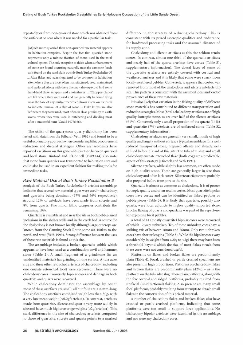
36 Number 66, June 2008
Dating of Bush Turkey Rockshelter 3 establishes Early Holocene Occupation of the Little Sandy Desert
repeatedly, or from non-quarried stone which was obtained from
the surface at or near where it was needed for a particular task:
[M]uch more quarried than non-quarried raw material appears
in habitation campsites, despite the fact that quarried stone
represents only a minute fraction of stone used in the total
cultural system. The only exception to this is when surface scatters
of stone are found occurring naturally near the campsite [such
as is found on the sand plain outside Bush Turkey Rockshelter 3]
... Adze fl akes and adze slugs tend to be common in habitation
sites, where they are most often manufactured, used, maintained,
and replaced. Along with these one may also expect to fi nd some
hand-held fl ake scrapers and spokeshaves ... ‘Chopper-planes’
are left where they were used and can generally be found lying
near the base of any mulga tree which shows a scar on its trunk
to indicate removal of a slab of wood ... Flake knives are also
left where they were used, most often in close proximity to earth
ovens, where they were used in butchering and dividing meat
after a successful hunt (Gould 1977:166).
The utility of the quarry/non-quarry dichotomy has been
tested with data from the Pilbara (Veth 1982) and found to be a
useful explanatory approach when considering lithic procurement,
reduction and discard strategies. Other archaeologists have
reported variations on this general distinction between quarried
and local stone. Binford and O’Connell (1989:144) also note
that stone from quarries was transported to habitation sites and
could also be used in an expedient fashion for making tools for
immediate tasks.
Raw Material Use at Bush Turkey Rockshelter 3Analysis of the Bush Turkey Rockshelter 3 artefact assemblage
indicates that several raw material types were used − chalcedony
and quartzite being dominant (37% and 36% respectively).
Around 12% of artefacts have been made from silcrete and
8% from quartz. Five minor lithic categories contribute the
remaining 10%.
Quartzite is available at and near the site as both pebble-sized
inclusions in the shelter walls and in the creek bed. A source for
the chalcedony is not known locally although large outcrops are
known from the Canning Stock Route some 80–100km to the
north and west (Veth 1993). Strong difference between the uses
of these raw materials is found at this site.
The assemblage includes a broken quartzite cobble which
appears to have been used as a combination anvil and hammer
stone (Table 2). A small fragment of a grindstone (in an
unidentifi ed material) has grinding on one surface. A tula adze
slug and three other retouched artefacts of chalcedony (including
one cuspate retouched tool) were recovered. There were no
chalcedony cores. Conversely, bipolar cores and debitage in both
quartzite and quartz were recovered.
While chalcedony dominates the assemblage by count,
most of these artefacts are small: all but four are <20mm-long.
The chalcedony artefacts combined weigh less than 30g, with
a very low mean weight (<0.2g/artefact). In contrast, artefacts
made from quartzite, silcrete and quartz vary more widely in
size and have much higher average weights (≥2g/artefact). This
stark difference in the size of chalcedony artefacts compared
to those of quartzite, silcrete and quartz points to a marked
difference in the strategy of reducing chalcedony. This is
consistent with its prized isotropic qualities and endurance
for hardwood processing tasks and the assumed distance of
its supply zone.
Chalcedony and silcrete artefacts at this site seldom retain
cortex. In contrast, almost one-third of the quartzite artefacts
and nearly half of the quartz artefacts have cortex (Table S1,
supplementary information). The dorsal faces of some of
the quartzite artefacts are entirely covered with cortical and
weathered surfaces and it is likely that some were struck from
locally weathered pebbles. Conversely, it appears that cortex was
removed from most of the chalcedony and silcrete artefacts off-
site. This pattern is consistent with the assumed local and ‘exotic’
provenience of these raw materials.
It is also likely that variation in the fl aking quality of different
stone materials has contributed to different transportation and
reduction strategies. Most (86%) chalcedony artefacts are of high
quality isotropic stone, as are over half of the silcrete artefacts
(61%). Conversely only a small proportion of the quartz (14%)
and quartzite (7%) artefacts are of unfl awed stone (Table S2,
supplementary information).
Chalcedony artefacts are generally very small, mostly of high
quality and largely without cortex: a typical assemblage for a well-
reduced transported stone, prepared off-site and already well-
utilised before discard at this site. The tula adze slug and small
chalcedony cuspate retouched fl ake (both <5g) are a predictable
aspect of this strategy (Hiscock and Veth 1991).
Silcrete artefacts, while slightly less common, are often made
on high quality stone. These are generally larger in size than
chalcedony and often lack cortex. Silcrete artefacts were probably
also prepared before transport to the site.
Quartzite is almost as common as chalcedony. It is of poorer
isotropic quality and often retains cortex. Most quartzite bipolar
cores have cortex and can be identifi ed as fl aked pebbles or
pebble pieces (Table 3). It is likely that quartzite, possibly also
quartz, were local adjuncts to higher quality imported stone.
Bipolar fl aking of quartz and quartzite was part of the repertoire
for exploiting local pebbles.
A total of 14 (mostly quartzite) bipolar cores were recovered,
of which 12 were unbroken. Ten of these unbroken cores have a
striking axis of between 18mm and 26mm. Only two unbroken
cores have shorter lengths (Table 3). While the bipolar cores vary
considerably in weight (from c.20g to <2g) there may have been
a threshold beyond which the size of most fl akes struck from
these cores were not considered useful.
Platforms on fl akes and broken fl akes are predominantly
plain (Table 4). Focal, crushed or partly crushed specimens are
also present in high proportions. Platforms on chalcedony fl akes
and broken fl akes are predominantly plain (42%) – as is the
platform on the tula adze slug. These plain platforms, along with
the few cortical and ridged platforms, probably resulted from
unifacial (unidirectional) fl aking. Also present are many small
focal platforms, probably resulting from attempts to detach small
fl akes in the conservation of this prized material.
A number of chalcedony fl akes and broken fl akes also have
crushed or partly crushed platforms, indicating that some
platforms were too small to support force applications. No
chalcedony bipolar artefacts were identifi ed in the assemblage,
and nor were any chalcedony cores.
37Number 66, June 2008
Peter Veth, Jo McDonald and Beth White
Mat
eria
l
An
vil-
Ham
mer
Gro
un
d F
rag
men
t
Tula
Slu
g
Ret
ou
ch/ U
se-W
ear
Po
ssib
le U
se-W
ear
Co
re
Bip
ola
r C
ore
Bip
ola
r D
ebit
age
Deb
itag
e
Tota
l
Tota
l W
eig
ht
(g)
Mea
n W
eig
ht
(g)
Chalcedony 0 0 1 3 0 0 0 0 168 172 26.5 0.15
Quartzite 1 0 0 1 1 0 7 9 147 166 474.6 2.86
Silcrete 0 0 0 1 1 0 0 0 52 54 106.7 1.98
Quartz 0 0 0 1 1 0 5 1 29 37 94.2 2.55
FGS 0 0 0 0 0 0 0 0 11 11 5.4 0.49
Chert 0 0 0 0 0 1 2 0 7 10 35.4 3.54
Sandstone 0 0 0 0 0 0 0 0 4 4 3.6 0.90
Silicifi ed Wood 0 0 0 0 0 0 0 0 1 1 2.6 2.60
Unidentifi ed 0 1 0 1 0 0 0 0 9 11 219.4 19.95
Total 1 1 1 7 3 1 14 10 428 466 968.4 2.08
Table 2 Bush Turkey Rockshelter 3: Raw materials and artefact types. FGS = Fine-grained siliceous.
Table 3 Bush Turkey Rockshelter 3: Bipolar cores.
Spit Material Quality Size (mm) Weight (g) Body Cortex Comments8 Chert Medium-high 21-25 6.7 Indeterminate <30% Striking axis = 18mm
8 Chert High 21-25 5.2 Pebble 31-69% Striking axis = 23mm
9 Quartzite Poor-medium 26-30 9.3 Pebble frag. 31-69% Striking axis = 20mm
9 Quartzite Medium 21-25 6.8 Pebble frag. 31-69% Striking axis = 19mm
9 Quartzite Medium 21-25 4.8 Pebble frag. 31-69% Striking axis = 21mm
9 Quartz Poor-medium 26-30 7.9 Indeterminate <30% Broken. Heavy battering along ridge
10 Quartzite Poor-medium 31-35 19.8 Indeterminate <30% Blocky core with bipolar fl aking. Striking axis = 26mm
10 Quartz Medium-high 31-35 14.2 Pebble 31-69% Striking axis = 26mm
10 Quartz Medium-high 26-30 4.1 Indeterminate 0 Broken. Striking axis = 27mm
11 Quartzite Medium-high 21-25 7.5 Pebble >70% Striking axis = 23mm
11 Quartzite Medium-high 21-25 3.0 Indeterminate <30% Striking axis = 22mm
11 Quartzite Medium-high 16-20 2.0 Indeterminate <30% Striking axis = 13mm
11 Quartz Poor-medium 25-30 7.3 Pebble >70% Striking axis = 24mm
20 Quartz Medium-high 16-20 1.4 Indeterminate 31-69% Striking axis = 14mm
Material Cortex Plain Ridged Scars Focal Bipolar Crushed & Partly Crushed
Total Ind.
Chalcedony
Debitage 5 40 3 0 32 0 15 95 1
Tula adze 0 1 0 0 0 0 0 1 0
Retouched Flake
0 0 1 0 0 0 0 1 0
Quartzite 5 16 2 2 3 4+3* 16 51 0
Silcrete 0 10 1 1 2 0 8 22 1
Quartz 0 2 0 0 1 1 1 5 0
Others 0 6 1 0 1 0 4 12 2
Total 10 75 8 3 39 8 44 187 4
Table 4 Bush Turkey Rockshelter 3: Platforms on fl akes and broken fl akes >5mm in size. * Three quartzite bipolar platforms have been fl aked directly from cortical surfaces. Ind.=Indeterminate.
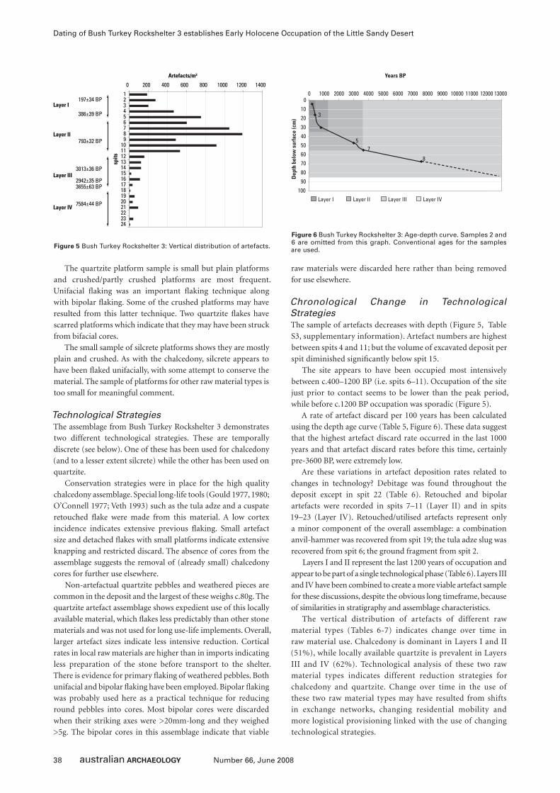
38 Number 66, June 2008
Dating of Bush Turkey Rockshelter 3 establishes Early Holocene Occupation of the Little Sandy Desert
The quartzite platform sample is small but plain platforms
and crushed/partly crushed platforms are most frequent.
Unifacial fl aking was an important fl aking technique along
with bipolar fl aking. Some of the crushed platforms may have
resulted from this latter technique. Two quartzite fl akes have
scarred platforms which indicate that they may have been struck
from bifacial cores.
The small sample of silcrete platforms shows they are mostly
plain and crushed. As with the chalcedony, silcrete appears to
have been fl aked unifacially, with some attempt to conserve the
material. The sample of platforms for other raw material types is
too small for meaningful comment.
Technological StrategiesThe assemblage from Bush Turkey Rockshelter 3 demonstrates
two different technological strategies. These are temporally
discrete (see below). One of these has been used for chalcedony
(and to a lesser extent silcrete) while the other has been used on
quartzite.
Conservation strategies were in place for the high quality
chalcedony assemblage. Special long-life tools (Gould 1977, 1980;
O’Connell 1977; Veth 1993) such as the tula adze and a cuspate
retouched fl ake were made from this material. A low cortex
incidence indicates extensive previous fl aking. Small artefact
size and detached fl akes with small platforms indicate extensive
knapping and restricted discard. The absence of cores from the
assemblage suggests the removal of (already small) chalcedony
cores for further use elsewhere.
Non-artefactual quartzite pebbles and weathered pieces are
common in the deposit and the largest of these weighs c.80g. The
quartzite artefact assemblage shows expedient use of this locally
available material, which fl akes less predictably than other stone
materials and was not used for long use-life implements. Overall,
larger artefact sizes indicate less intensive reduction. Cortical
rates in local raw materials are higher than in imports indicating
less preparation of the stone before transport to the shelter.
There is evidence for primary fl aking of weathered pebbles. Both
unifacial and bipolar fl aking have been employed. Bipolar fl aking
was probably used here as a practical technique for reducing
round pebbles into cores. Most bipolar cores were discarded
when their striking axes were >20mm-long and they weighed
>5g. The bipolar cores in this assemblage indicate that viable
raw materials were discarded here rather than being removed
for use elsewhere.
Chronological Change in Technological StrategiesThe sample of artefacts decreases with depth (Figure 5, Table
S3, supplementary information). Artefact numbers are highest
between spits 4 and 11; but the volume of excavated deposit per
spit diminished signifi cantly below spit 15.
The site appears to have been occupied most intensively
between c.400–1200 BP (i.e. spits 6–11). Occupation of the site
just prior to contact seems to be lower than the peak period,
while before c.1200 BP occupation was sporadic (Figure 5).
A rate of artefact discard per 100 years has been calculated
using the depth age curve (Table 5, Figure 6). These data suggest
that the highest artefact discard rate occurred in the last 1000
years and that artefact discard rates before this time, certainly
pre-3600 BP, were extremely low.
Are these variations in artefact deposition rates related to
changes in technology? Debitage was found throughout the
deposit except in spit 22 (Table 6). Retouched and bipolar
artefacts were recorded in spits 7–11 (Layer II) and in spits
19–23 (Layer IV). Retouched/utilised artefacts represent only
a minor component of the overall assemblage: a combination
anvil-hammer was recovered from spit 19; the tula adze slug was
recovered from spit 6; the ground fragment from spit 2.
Layers I and II represent the last 1200 years of occupation and
appear to be part of a single technological phase (Table 6). Layers III
and IV have been combined to create a more viable artefact sample
for these discussions, despite the obvious long timeframe, because
of similarities in stratigraphy and assemblage characteristics.
The vertical distribution of artefacts of different raw
material types (Tables 6-7) indicates change over time in
raw material use. Chalcedony is dominant in Layers I and II
(51%), while locally available quartzite is prevalent in Layers
III and IV (62%). Technological analysis of these two raw
material types indicates different reduction strategies for
chalcedony and quartzite. Change over time in the use of
these two raw material types may have resulted from shifts
in exchange networks, changing residential mobility and
more logistical provisioning linked with the use of changing
technological strategies.
Figure 5 Bush Turkey Rockshelter 3: Vertical distribution of artefacts.
0 200 400 600 800 1000 1200 1400
123456789
101112131415161718192021222324
spits
Artefacts/m³
Layer I
Layer II
Layer III
Layer IV
197±34 BP
386±39 BP
793±32 BP
3013±36 BP
2942±35 BP3655±63 BP
7584±44 BP
Figure 6 Bush Turkey Rockshelter 3: Age-depth curve. Samples 2 and 6 are omitted from this graph. Conventional ages for the samples are used.
0
10
20
30
40
50
60
70
80
90
100
Years BP
Dep
th b
elow
sur
face
(cm
)
0 1000
3
57
8
2000 3000 4000 5000 6000 7000 8000 9000 10000 11000 12000 13000
Layer I Layer II Layer III Layer IV
39Number 66, June 2008
Peter Veth, Jo McDonald and Beth White
Layer Total Artefacts Years Accumulated Years Artefacts/100 yearsI 109 170-400 BP 270 18.8
II 306 400-1200 BP 800 47.8
III 33 1200-3600 BP 2400 5.9
IV 18 3600-12000 BP 8400 2.9
Table 5 Bush Turkey Rockshelter 3: Calculated artefacts per 100 years based on the age-depth curve and calculated volume of artefacts retrieved from each layer. NB: Layer IV may have taken even longer to accumulate.
Laye
r
Sp
its
An
vil-
Ham
mer
Gro
un
d F
rag
men
t
Tula
Slu
g
Ret
ou
ched
/Use
-Wea
r
Po
ssib
le U
se-W
ear
Co
re
Bip
ola
r C
ore
Bip
ola
r D
ebit
age
Deb
itag
e
# % # % # % # % # % # % # % # % # %I 1-5 0 0 1 0.9 0 0 0 0 0 0 0 0 0 0 0 0 108 99.1
II 6-11 0 0 0 0 1 0.3 6 1.9 2 0.7 1 0.3 13 4.2 7 2.3 276 90.2
III 12-17 0 0 0 0 0 0 0 0 0 0 0 0 0 0 0 0 33 100
IV 18-24 1 5.6 0 0 0 0 1 5.6 1 5.6 0 0 1 5.6 3 16.7 11 61.1
Table 6 Bush Turkey Rockshelter 3: Summary distribution of artefact types.
Layer Spits Chalcedony Quartzite Silcrete Quartz Others TotalI 1-5 51 35 8 6 9 109
II 6-11 116 99 38 26 27 306
III 12-17 2 21 6 3 1 33
IV 18-24 3 11 2 2 0 18
Table 7 Bush Turkey Rockshelter 3: Summary distribution of raw materials.
Laye
r
Sp
its
0.0
-0.5
0.6
-1.0
1.1
-1.5
1.6
-2.0
2.1
-2.5
2.6
-3.0
3.0
-3.5
3.6
-4.0
4.1
-4.5
4.6
-5.0
5.1
-5.5
5.6
-6.0
6.1
-6.5
6.6
-7.0
Tota
l N
o.
Tota
l W
eig
ht
Mea
n
Wei
gh
tI 1-5 5 67 29 6 2 0 0 0 0 0 0 0 0 0 109 15.7 0.1
II 6-11 7 112 80 41 26 22 7 5 2 1 2 0 0 1 306 674.3 2.2
III 12-17 0 2 10 11 3 2 3 0 0 0 1 1 0 0 33 109.9 3.3
IV 18-24 0 1 4 5 2 2 0 2 0 1 0 0 1 0 18 168.5 9.4
Table 8 Bush Turkey Rockshelter 3: Artefact weight (g) by layer.
Layer Spits 0% <30% 40-60% >70% Total % Artefacts with Cortex
I 1-5 103 3 1 2 109 5.5
II 6-11 237 30 18 21 306 22.5
III 12-17 24 2 3 4 33 27.3
IV 18-24 10 3 1 4 18 44.4
Table 9 Bush Turkey Rockshelter 3: Proportion of artefacts with cortex.
Layer Spits Poor Poor-Medium
Medium Medium-Good
Good Poor-Good
Total N/A % Good Quality
I 1-5 1 5 15 28 57 1 107 2 53.3
II 6-11 8 27 51 72 142 5 305 1 46.6
III 12-17 0 8 12 10 3 0 33 0 9.1
IV 18-24 0 2 3 9 3 0 17 1 17.6
Table 10 Bush Turkey Rockshelter 3: Flaking quality.

40 Number 66, June 2008
Dating of Bush Turkey Rockshelter 3 establishes Early Holocene Occupation of the Little Sandy Desert
Change over time in artefact size is also indicated. In Layer
I, all artefacts are <25mm in size and have a very low average
weight (Table 8). While artefact size in these upper spits may be
infl uenced by the small size of chalcedony artefacts, artefacts of
other raw material types are also relatively small in these spits.
In Layer II the modal artefact size is larger (11–15mm)
than in Layer I, and almost the full range of size categories are
represented by this larger sample of artefacts. Average artefact
weight is signifi cantly greater than in Layer I (2.2g/artefact). In
Layers III and IV there are very few artefacts <10mm in size.
Modal size increases to 11–20mm, and average artefact weight
exceeds 3g/artefact in Layer III and 9g/artefact in Layer IV. The
larger number of small artefacts in the upper layers indicates
more intensive fl aking of lithic materials in the past 800 years
or so.
The proportion of artefacts with cortex is lowest in Layer I in
all raw material types (Table 9). In both Layers II and III slightly
less than a third of all artefacts have cortex. Here, the higher
numbers of artefacts with cortex correlate with the increased use
of local quartzite pebbles.
Analysis of the fl aking quality of artefact stone indicates a
greater reliance on high quality stone in Layers I and II, while
local materials which dominate the earlier two layers, generally
have a lower fl aking quality (Table 10).
The vertical distribution of artefact types (Table 6) illustrates
increased use of bipolar reduction below spit 12 with greater
reliance on plain and focal platforms in the upper layers (Tables
11-12). Plain platforms possibly relate to tula technology and the
production of fl akes with wide broad platforms.
Summary of Assemblage CharacterisationOn the assumptions that the chalcedony recovered from Bush
Turkey Rockshelter 3 was procured from a distant quarry source
(such as Kaalpa at Well 23 on the Canning Stock Route) and that
quartzite is an abundant local stone found within the shelter
wall and the local creek, then the observed shift through time
in raw material use and reduction strategies suggests changes in
the way the site was occupied though time. Occupation from
the early Holocene to just before the last millennium refl ects
longer duration occupations and lower mobility at Bush Turkey
Rockshelter 3 and the Calvert Ranges, during which time local
stone was used predominantly for a range of tasks. Within the last
millennium, site usage changed exhibiting a greater proportion
of exotic lithics and increased reduction of all raw material classes.
During this time quarried stone was procured elsewhere, curated,
rejuvenated and then discarded here in much greater proportions.
A chalcedony tula adze slug and an arenaceous grindstone
fragment were discarded during this more recent time period.
The presumed strategic importance of the Calvert Ranges as an
aggregation centre with reliable water might explain this increase
in the proportion of exotics, higher discard rates and increased
reduction of all lithics. A shift from an embedded to a logistical
procurement strategy is suggested as is the greater frequency
of occupation visits (of shorter duration) especially during the
last millennia (cf. Holdaway and Stern 2004; Sellet et al. 2006).
The later signal suggests an increased use of the ranges as an
aggregation locale (sensu Conkey 1980), with various groups of
people coming from afar for a range of domestic and ceremonial
activities and focusing on this landscape more intensively. This
pattern is supported by the Calvert Ranges rock art which reveals
increasing complexity in its most recent art phases. While our
rock art analyses are still only preliminary, both the occupation
and art evidence supports increasing and repeated use of the
dunefi elds and the resource-rich ranges in the recent past (see
McDonald et al. 2008; Veth 1995).
The Rock ArtOn bedrock at the front of the shelter and on large boulders
outside the shelter (site P14) a series of Panaramitee-style
(sensu Maynard 1977) and more recent fi gurative engravings
are present. These are mostly heavily weathered and patinated
engravings of tracks, circles, complex non-fi gurative and
geometric motifs as well as fi gurative motifs such as life-size
bush turkeys and a human. These clearly post-date the shelter’s
formation through roof collapse, but pre-date the smaller
roof fall event(s) documented in the excavation. On its back
wall and ceiling are c.100 motifs, mostly monochrome (87%)
and bichrome (11%) paintings. There is also one red hand
print. The pigment assemblage comprises several phases of
production and includes anthropomorphs, concentric circles
and other geometric motifs (Table 13). A single faded red and
white anthropomorph with distinctive headdress is painted
in isolation high on the wall at the north of the shelter. The
pigment art includes black (charcoal), red, white, orange and
pink coloured ochres: white and red are the most common
(Table 14).
Layer Spits Cortex Plain Ridged Scars Focal Bipolar Crushed & Partly Crushed
Total Indeterminate
I 1-5 2 24 4 0 17 0 6 53 1
II 6-11 8 48 2 3 21 6 30 118 2
III 12-17 0 3 1 0 1 0 4 9 0
IV 18-24 0 0 1 0 0 2 5 8 1
Table 11 Bush Turkey Rockshelter 3: Type of platforms on fl akes and broken fl akes.
Layer Spits Cortex Plain Ridged Scars Focal Bipolar Crushed & Partly Crushed
Total
I 1-5 3.8 45.3 7.5 0 32.1 0 11.3 53
II 6-11 6.8 40.7 1.7 2.5 17.8 5.1 25.4 118
III/IV 12-24 0 17.6 11.8 0 5.9 11.8 52.9 17
Table 12 Bush Turkey Rockshelter 3: Type of platforms on fl akes and broken fl akes (% frequency).
41Number 66, June 2008
Peter Veth, Jo McDonald and Beth White
A superimposition sequence has been identifi ed in this
pigment art assemblage which starts with a fi ne (brush-
painted) cherry-red set of motifs (including phytomorphs
and complex pole designs and concludes with an assemblage
of thickly painted (fi nger application) motifs in orange and
white of anthropomorphs, lizards, tracks and concentric circles
(Table 15). Not all art components within the shelter occur in
superimposition relationships, meaning that these cannot be
placed in this relative sequence. A bichrome headdress fi gure,
located in isolation high on the shelter’s back wall is one such
example. Its style and general condition (and superimpositions
noted elsewhere in the Calvert Ranges) suggest that this could be
amongst some of the older art in the pigment assemblage (but
possibly not as old as the defi ned Phase I which has been painted
with a fi ne brush/twig).
Intuitively we would propose that the majority of the
pigment art’s production (Art Phases 2–4 in Table 15) correlates
with the major phase of shelter occupation (i.e. within the last
millennium). The oldest pigment art is relatively sparse and
much more weathered. It seems reasonable to suggest that this
art pre-dates the site’s main occupation period, and could be
correlated with either the early or late Holocene occupation
of the site. The engravings could have been produced at any
time in the shelter’s occupation: unfortunately, no engraved
art is directly or indirectly dateable in this site. Samples from
several of the site’s red motifs have been collected (McDonald
and Veth 2006a) but dating results for these motifs are not
yet available. The dating techniques being employed are
reported elsewhere (McDonald and Veth in press; McDonald
et al. 2008).
Motif Monochrome Bichrome Print Engraved TotalAbraded Grooves 0 0 0 1 1
Bird Track 1 0 0 1 2
Complex-Non-Figurative 0 2 0 1 3
Scats 0 0 0 1 1
Oval 2 0 0 2 4
Anthropomorph 8 0 0 0 8
Arc 1 0 0 0 1
Barred Circle 1 0 0 0 1
Barred Oval 2 0 0 0 2
Circle 1 0 0 0 1
Concentric Circle 5 0 0 0 5
Fern 0 1 0 0 1
Hand 0 0 1 0 1
Headdress Figure 0 1 0 0 1
Lizard 1 0 0 0 1
Lizard Man 1 0 0 0 1
Phytomorph 1 0 0 0 1
Macropod Track Trail 1 0 0 0 1
Snake 1 0 0 0 1
Simple-Non-Figurative 5 1 0 0 6
Solid Unidentifi ed 7 0 0 1 8
Unidentifi ed Line 3 0 0 50 53
% Pigment Assemblage 87.2 10.6 2.1 0 100
Total 41 5 1 57 104
Table 13 Bush Turkey Rockshelter 3: Motif and technique information.
Black Orange Pink Red Red/White White TotalMotifs 3 6 7 12 5 14 47
% 6.4 12.8 14.9 25.5 10.6 29.8 100
Table 14 Bush Turkey Rockshelter 3: Proportions of different coloured pigments used in the pigment art assemblage (note, the site’s other motifs are engraved).
Phase Technique Motifs1 (Oldest) Fine cherry-red painted (brush) outline and
infi ll (including geometric infi ll)Phytomorph, complex pole design, concentric circles
2 White (and pink) painted outline Anthropomorph, simple-non-fi gurative
3 Black washy painted outline Simple-non-fi gurative, circle
4 (Most recent) Orange and red thick painted outline (fi nger) Anthropomorph, lizard man, bird track, concentric circle
Table 15 Bush Turkey Rockshelter 3: Superimposition sequence for pigment art.
42 Number 66, June 2008
Dating of Bush Turkey Rockshelter 3 establishes Early Holocene Occupation of the Little Sandy Desert
Discussion and Conclusions
Research Problems in the Sandy DesertsThe initial occupation of the Western Desert has been placed at
c.24,000 BP at Serpents Glen (Katjarra) in the Carnarvon Ranges
to the southwest of the Calvert Ranges (O’Connor et al. 1998;
Veth 2000, 2005; Veth et al. 2000). Serpents Glen is located on
the margin of the Little Sandy Desert dunefi elds and contains
a major multiphase painted art corpus. There were no cultural
materials registered at Serpents Glen for most of the duration
of the Last Glacial Maximum (after Lambeck and Chappell
2001). Reoccupation occurred during the mid-Holocene with
low discard rates until the last several hundred years, when
occupational intensity increased signifi cantly: nearly 97% of
the artefacts deposited at Serpents Glen date to the last several
hundred years. A similar pattern of intensive occupation with
higher implement diversity was noted at Kaalpi Rockshelter
(Veth et al. 2001).
Kaalpi Rockshelter is located in a major valley southeast
of Bush Turkey Rockshelter 3. This site registered a signifi cant
increase in its discard rates of fl aked and ground artefacts
during the last millennium and a shift towards ‘formal’ wet-
milling grindstones made in arenaceous sandstone from an
earlier assemblage of amorphous basal grindstones fashioned
from quartzite (Veth et al. 2001). At this time there was also an
increase in ochre fragments. This pattern is essentially the same
as found in another seven shelters excavated in the wider region
including the Rudall River, Mackay Range and the Durba Hills
in the Little Sandy Desert (Veth 1993). Signifi cantly, Bush Turkey
Rockshelter 3 fi lls a chronological ‘gap’ by providing well-dated
cultural materials spanning the Holocene while reinforcing the
wider trend of an increase in the discard rates of artefacts and
sedimentation during the last millennium.
In a recent paper on the artefact assemblages from Puritjarra
Rockshelter, at the eastern margin of the Western Desert, Smith
(2006:406) makes two conclusions regarding changes occurring
there during the last 800 years. He identifi es a major increase
in the use of the rockshelter with increased artefact discard
rates, more features and ochre, more formal grindstones, and
the highest indices for the diversity and richness of tools. This
is interpreted as the archaeological expression of Puritjarra
becoming a core residential site linked to improved summer
rainfall between 1000 to 1500 years ago. During this period
Smith posits that there was a dual pattern of occupation with
frequent cycling of people through the site intercalated with
extended periods of occupation at the site.
A switch in provisioning strategies, from embedded
procurement (for both stone and ochre) to a logistical pattern
of direct procurement is also suggested as use of the shelter
intensifi ed (Binford 1989; Holdaway and Stern 2004; Smith
2006:404; Veth 1993). Smith favours an explanation whereby
a ‘dual’ system of occupation occurs during the emic cycle:
with core habitation sites being the focus of more extended
occupation as well as being frequently visited outside of these
‘aggregation’ events (Veth 1993). By calculating rank order scores
for residential mobility at the Puritjarra sequence, Smith (2006:
Table 19) illustrates a steady decrease in mobility in the last 800
years. While we believe a similar dual system operated in the
Calvert Ranges, a combination of increased exotics, their heavy
reduction and increased discard rates argue for an increase in
mobility and likely more frequent site visits.
The Contribution of Bush Turkey Rockshelter 3Our recent excavation of Bush Turkey Rockshelter 3 has
filled a major gap by establishing a record of early Holocene
occupation in the Little Sandy Desert and resolving a long
debate about the antiquity of occupation in this region. As
well as demonstrating occupation at 8202–8414 cal BP, the
major occupation phase here is older than the main phase
at Katjarra (98% of the artefacts at Bush Turkey Rockshelter
3 were deposited in the last 1200 years but only 24% were
deposited in the last 500 years or so). It has also refined and
extended the sequence found earlier at the Kaalpi Rockshelter
located around 5km south in a separate valley of the Calvert
Ranges (Veth et al. 2001).
Bush Turkey Rockshelter 3 has two distinct phases of
lithic production which illustrate changing raw material use
and technological organisation through time. Changes in
residential mobility patterns and the nature of site occupation
are predicted to correlate with different phases of pigment
art production.
We propose that from c.8400–1200 cal BP (effectively
Layers III and IV) this rockshelter was used for longer periods
of time by small groups exploiting an extensive territory. The
majority of stone used throughout this time is local quartzite.
There is no evidence for core exhaustion or intensive stone
curation/rejuvenation. Non-local materials such as chalcedony
are present but only in very low proportions. In Layer II, post-
dating 1200 cal BP and peaking around 735 cal BP, there is
evidence for curation and increased conservation strategies
with an appreciable shift towards:
• predominant use of chalcedony and other non-local high
quality raw materials;
• a signifi cant decrease in mean size and weight of artefacts;
• a major decrease in the proportion of artefacts with cortex;
• a high proportion of plain and small focal platforms on
chalcedony fl akes;
• the presence of a hafted artefact; and
• a signifi cant increase in artefact deposition rates.
These changes reinforce the fi ndings made earlier at Kaalpi,
where there was a notable infl ux in ochre and formal grindstones
and mullers in the deposit after 1300 cal BP. Interestingly at
that site, the artefact discard rate halved in the most recent
millennium (Veth et al. 2001:13). We believe that these combined
changes over time refl ect shifts in exchange networks, increased
artistic activity, increasing residential mobility patterns and more
logistical provisioning of tool kits.
The nine sites excavated within and adjacent to the Little Sandy
Desert over the last 20 years (Kaalpi Rockshelter, Calvert Range
Rockshelter, Durba Hills Rockshelter, Karlamili Rockshelter,
Yulpul Rockshelter, Jalpiyari Rockshelter, Winakurijuna Cave,
Serpents Glen (Katjarra) Rockshelter and Katampul Rockshelter)
display a broadly similar trend with a greater proportion of exotic
lithics and increasing conservation strategies for all raw materials
over time (cf. Smith 1989, 2006; Smith et al. 1997, 1998). This
inter-regional pattern is best explained by:
43Number 66, June 2008
Peter Veth, Jo McDonald and Beth White
• establishment of homelands and relative circumscription
of territory (with a narrowing of ochre catchments and the
development of regionally distinct graphic vocabularies in
the pigment art);
• intensifying trade/exchange networks refl ecting increasingly
complex social relations (with ramifi ed kinship systems
underwriting reciprocity and exchange networks both as a
social lubricant and a risk-minimising strategy);
• a shift from an embedded to a logistical pattern of direct
procurement of stone and ochres (as estates and their resource
zones became socially proscribed);
• higher residential mobility with lower duration of
occupations;
• a dual system of land-use embracing frequent domestic visits
by bands as well as aggregation events including multidialect
meetings; and
• economising of lithics as these took on multivalent values
(long use-life, multifunctionality, standardisation and sacred
elements linked with the Jukurrpa).
Western Desert rock art provides evidence that the widely
ramifi ed open social networks functioning at contact, have
changed through time (McDonald 2005). Arid art systems
appear to have functioned to provide broad-scale intergroup
cohesion over vast periods of time as well as demonstrating,
more recently, distinctive group-identifying and bounding
behaviour. We have argued elsewhere (McDonald and Veth
2006b) that the high degree of stylistic variability displayed
in the Calvert Ranges art province strongly suggests that this
place has acted as an aggregation locale over a considerable
period of time.
At Bush Turkey Rockshelter 3 we have demonstrated a
changing pattern of site use from the early Holocene through
to a time just before contact. This reinforces the patterning
found at Kaalpi, while showing a slightly different signature of
lithic behaviour (i.e. only one ground fragment was retrieved
from the top layer of Bush Turkey Rockshelter 3 compared
with the c.50 grindstones found in Kaalpi; see Haley 1999).
Interestingly the rock art assemblages in these two shelters
also are widely dissimilar, while sharing broad stylistic traits.
The Kaalpi Rockshelter contains a complex assemblage of
370 (mostly pigment) motifs (cf. Table 13). No doubt the two
sites represent different nodes in a complex local occupation
pattern. Both would appear to have represented residential
bases, especially after c.1300 BP – although the intensity and
nature of occupation in these two shelters in this time period
varies. Our dating work on the Calvert Ranges art phases has
involved the collection of samples from Kaalpi as well as Bush
Turkey Rockshelter 3 (McDonald and Veth in press; McDonald
et al. 2008). These rock art assemblages, with their complex
graphic vocabularies in the recent past, add to this picture of
increased dynamism.
The arid landscapes of the Western Desert provide a strong
archaeological signature for intensifying social relations in
the recent past. It is perhaps ironic that the strongest case for
an archaeological expression of intensification (Lourandos
1985; Veth 2006) comes not from the fertile plains or tropical
seascapes of eastern Australia, but rather Australia’s arid
zone, where effective social strategies for successful survival
were crucial. The stone-working strategies and highly
diverse graphic vocabularies in these isolated but resource-
rich ranges continue to demonstrate the complexities of
these strategies.
Supplementary InformationSupplementary information for this article is available online at
www.australianarchaeologicalassociation.com.au.
AcknowledgmentsThis fi eldwork was done in association with the Birrilibulu Native
Title claim, coordinated by Dr Bill Kruse of the Ngaanyatjarra
Land Council. Drs Kathryn Przywolnik and June Ross assisted
JM recording rock art. The site was excavated by PV with
occasional assistance from KP and JM (under a Section 16
permit granted by DIA). The artefact analysis was done by BW.
The radiocarbon dates were paid for by Jo McDonald Cultural
Heritage Management Pty Ltd.
ReferencesAndrefsky, W. 1998 Lithics: Macroscopic Approaches to Analysis. Cambridge:
Cambridge University Press.
Binford, L.R. 1989 An Alyawara day: Flour, spinifex gum, and shifting perspectives.
In L.R. Binford (ed.), Debating Archaeology, pp.147-171. San Diego: Academic
Press.
Binford, L.R. and J.F. O’Connell 1989 An Alyawarra day: The stone quarry. In L.R.
Binford (ed.), Debating Archaeology, pp.121-146. San Diego: Academic Press.
Byrne, D. 1980 Dynamics of dispersion: The place of silcrete in archaeological
assemblages from the lower Murchison, Western Australia. Archaeology and
Physical Anthropology in Oceania 15:110-119.
Conkey, M.W. 1980 The identifi cation of prehistoric hunter-gatherer aggregation
sites: The case of Altamira. Current Anthropology 21:609-630.
Cotterell, B. and J. Kamminga 1987 The formation of fl akes. American Antiquity
52(4):675-708.
Gould, R.A. 1977 Ethno-archaeology; or, where do models come from? In R.V.S.
Wright (ed.), Stone Tools as Cultural Markers: Change, Evolution and
Complexity, pp.162-168. Canberra: Australian Institute of Aboriginal Studies.
Gould, R.A. 1980 Living Archaeology. Cambridge: Cambridge University Press.
Haley, M. 1999 Kaalpi: Investigation of Archaeological Assemblages from the
Calvert Ranges Western Desert, Western Australia. Unpublished BA (Hons)
thesis, Department of Anthropology and Archaeology, James Cook University,
Townsville.
Hamilton, A. 1987 Dual social system: Technology, labour and women’s secret rites
in the eastern Western Desert of Australia. In W.H. Edwards (ed.), Traditional
Aboriginal Society: A Reader, pp.34-52. South Melbourne: MacMillan.
Hayden, B. 1977 Stone tool functions in the Western Desert. In R.V.S. Wright (ed.),
Stone Tools as Cultural Markers: Change, Evolution and Complexity, pp.178-
188. Canberra: Australian Institute of Aboriginal Studies.
Hiscock, P. 1988 Prehistoric Settlement Patterns and Artefact Manufacture at
Lawn Hill, Northwest Queensland. Unpublished PhD thesis, Department of
Anthropology and Sociology, University of Queensland, Brisbane.
Hiscock, P. and P. Veth 1991 Change in the Australian desert culture: A reanalysis of
tulas from Puntutjarpa Rockshelter. World Archaeology 22(3):332-345.
Holdaway, S. and N. Stern 2004 A Record in Stone: The Study of Australia’s Flaked
Stone Artefacts. Melbourne: Museum Victoria and Canberra: Aboriginal
Studies Press.
Hook, F. 1999 An Aboriginal Archaeological Heritage Assessment of Proposed Road
Alignments Along the Great Central Road, East of Laverton, Western Australia.
Unpublished report to Ngaanyatjarra Council (Aboriginal Corporation).
44 Number 66, June 2008
Dating of Bush Turkey Rockshelter 3 establishes Early Holocene Occupation of the Little Sandy Desert
Jones, R. and N. White 1988 Point blank: Stone manufacture at the Ngilipitji
quarry, Arnhem Land, 1981. In B. Meehan and R. Jones (eds), Archaeology
with Ethnography: An Australian Perspective, pp.51-87. Canberra:
Department of Prehistory, Research School of Pacifi c Studies, Australian
National University.
Lambeck, K. and J. Chappell 2001 Sea level change throughout the Last Glacial
cycle. Science 292:679-686.
Lourandos, H. 1985 Intensifi cation and Australian prehistory. In T.D. Price and
J.A. Brown (eds), Prehistoric Hunter-Gatherers: The Emergence of Cultural
Complexity, pp.385-423. New York: Academic Press.
Lurie, R. 1989 Lithic technology and mobility strategies: The Koster site Middle
Archaic. In R. Torrence (ed.), Time, Energy and Stone Tools, pp.46-55.
Cambridge: Cambridge University Press.
Maynard, L. 1977 Classifi cation and terminology in Australian rock art. In P.J. Ucko
(ed.), Form in Indigenous Art, pp.387-402. Canberra: Australian Institute of
Aboriginal Studies.
McCormac, F.G., A.G. Hogg, P.G. Blackwell, C.E. Buck, T.F.G. Higham and P.J. Reimer
2004 SHCal04 southern hemisphere calibration 0-11.0 cal kyr BP. Radiocarbon
46(3):1087-1092.
McDonald, J.J. 2005 Archaic faces to headdresses: The changing role of the rock
art across the arid zone. In P.M. Veth, M. Smith and P. Hiscock (eds), Desert
Peoples: Archaeological Perspectives, pp.116-141. Boston: Blackwell.
McDonald, J.J., K. Steelman and P.M. Veth 2008 Radiocarbon Dating of Western
Desert Pigment Samples: Dating Rock Art in the Calvert and Carnarvon
Ranges. Report to AIATSIS and DIA in support of Section 16 Permit and
AIATSIS Research Grant.
McDonald, J.J. and P.M. Veth 2006a S16 Report: Rock Art Dating Work in the Calvert
and Carnarvon Ranges, Western Desert. Unpublished report to Western
Australian Department of Indigenous Affairs, Perth.
McDonald, J.J. and P. Veth 2006b Rock art and social identity: A comparison of
graphic systems operating in arid and fertile environments in the Holocene. In
I. Lilley (ed.), Archaeology of Oceania: Australia and the Pacifi c Islands, pp.96-
115. Oxford: Blackwell.
McDonald, J.J. and P.M. Veth in press Stylistic variability in the art of the Western
Desert and Pilbara: New perspectives on the role of art in the Australian arid
zone. Australian Aboriginal Studies.
McNiven, I. 1993 Raw material proximity and bevel-edged tool use, Teewah Beach,
southeast Queensland. Archaeology in Oceania 28(3):138-143.
Morwood, M.J. and S. L’Oste-Brown 1995 Chronological changes in stone artefact
technology. In M.J. Morwood and D.R. Hobbs (eds), Quinkan Prehistory: The
Archaeology of Aboriginal Art in S.E. Cape York Peninsula, Australia, pp.161-
177. Tempus 3. St Lucia: Anthropology Museum, University of Queensland.
Mulvaney, D.J. 1975 The Prehistory of Australia. Middlesex, England: Penguin
Books.
O’Connell, J.F. 1977 Aspects of variation in central Australian lithic assemblages.
In R.V.S. Wright (ed.), Stone Tools as Cultural Markers: Change, Evolution and
Complexity, pp.269-281. Canberra: Australian Institute of Aboriginal Studies.
O’Connor, S., P. Veth and C. Campbell 1998 Serpent’s Glen: A Pleistocene
archaeological sequence from the Western Desert. Australian Archaeology
46:12-22.
Paton, R. 1994 Speaking through stones: A study from northern Australia. World
Archaeology 26(2):172-184.
Sellet, F., R. Greaves and P-L. Yu 2006 (eds) Archaeology and Ethnoarchaeology of
Mobility. Tallahassee, FL: University Press of Florida.
Smith, M.A. 1989 The case for a resident human population in the central Australian
Ranges during full glacial aridity. Archaeology in Oceania 24(3):93-105.
Smith, M. 2006 Characterising late Pleistocene and Holocene stone artefact
assemblages from Puritjarra Rock Shelter: A long sequence from the Australian
desert. Records of the Australian Museum 58:371-410.
Smith, M.A., B. Fankhauser and M. Jercher 1998 The changing provenance of red
ochre at Puritjarra rockshelter, central Australia: Late Pleistocene to present.
Proceedings of the Prehistoric Society 64:275-292.
Smith, M.A., J.R. Prescott and M.J. Head 1997 Comparison of 14C and luminescence
chronologies at Puritjarra rock shelter, Central Australia. Quaternary Science
Reviews 16(3-5):299-320.
Speth, P. 1972 Mechanical basis of percussion fl aking. American Antiquity 37(1):34-
60.
Stuiver, M. and P.J. Reimer 1993 Extended 14C data base and revised CALIB 3.0 14C
age calibration program. Radiocarbon 35(1):215-230.
Stuiver, M., P.J. Reimer and R. Reimer 2007 CALIB Manual. Retrieved 24 March
2008 from http://calib.qub.ac.uk/calib/manual/.
Summerhayes, G.R. and J. Allen 1993 The transport of Mopir obsidian to Late
Pleistocene New Ireland. Archaeology in Oceania 28(3):144-148.
Veth, P. 1982 Testing the Behavioural Model: The Use of Open Site Data.
Unpublished BA (Hons) thesis, Department of Anthropology, University of
Western Australia, Perth.
Veth, P.M. 1993 Islands in the Interior: The Dynamics of Prehistoric Adaptations
within the Arid Zone of Australia. Archaeology Series 3. Ann Arbor, MI:
International Monographs in Prehistory.
Veth, P. 1995 Aridity and settlement of northwest Australia. Antiquity 69:733-746.
Veth, P. 2000 Origins of the Western Desert language: Convergence in linguistic and
archaeological space and time models. Archaeology in Oceania 35(1):11-19.
Veth, P. 2005 Cycles of aridity and human mobility: Risk-minimization amongst
late Pleistocene foragers of the Western Desert, Australia. In P. Veth, M.A. Smith
and P. Hiscock (eds), Desert Peoples: Archaeological Perspectives, pp.100-115.
Oxford: Blackwell Publishing.
Veth, P. 2006 Social dynamism in the archaeology of the Western Desert. In B.
David, I.J. McNiven and B. Barker (eds), The Social Archaeology of Indigenous
Societies, pp.242-253. Canberra: Australian Aboriginal Studies Press.
Veth, P., S. O’Connor and L.A. Wallis 2000 Perspectives on ecological approaches in
Australian archaeology. Australian Archaeology 50:54-66.
Veth, P., M. Smith and M. Haley 2001 Kaalpi: The archaeology of a sandstone outlier
in the Western Desert. Australian Archaeology 52:9-17.
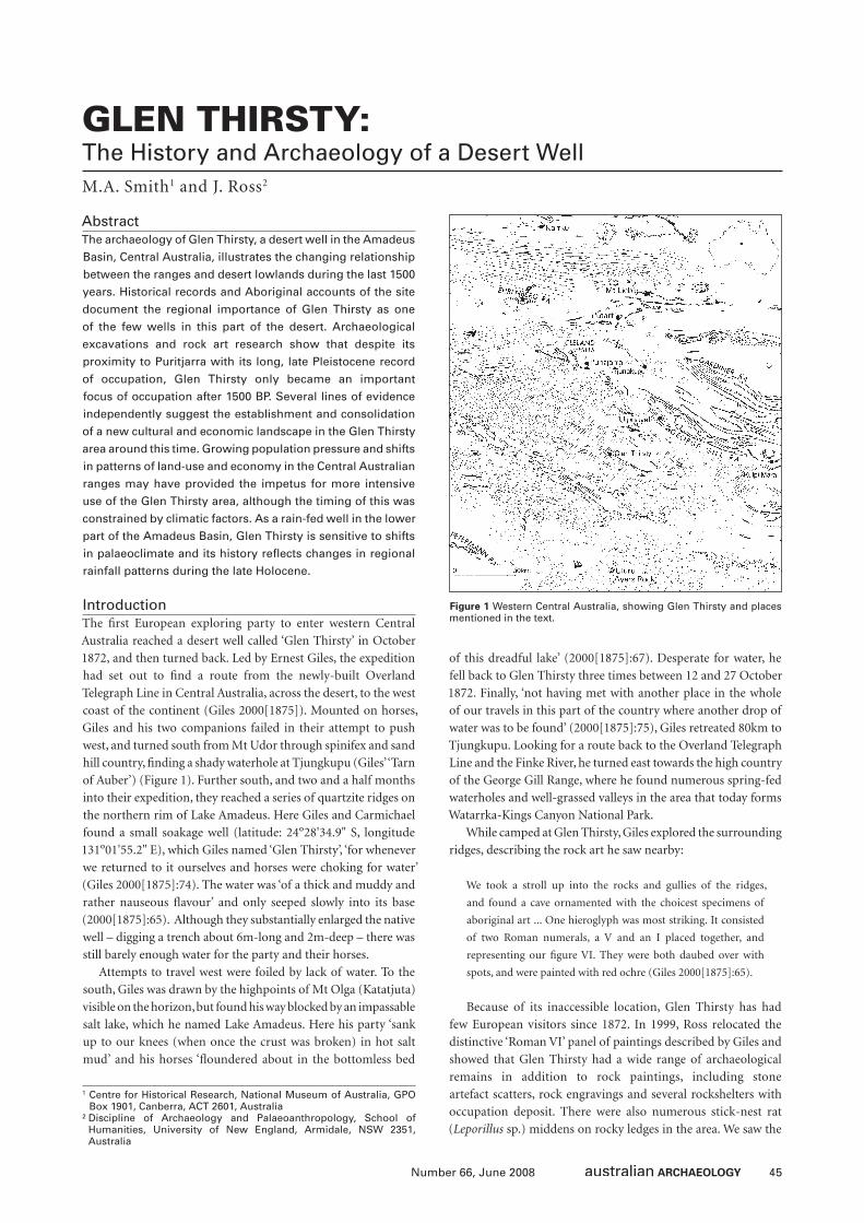
45Number 66, June 2008
GLEN THIRSTY: The History and Archaeology of a Desert WellM.A. Smith1 and J. Ross2
AbstractThe archaeology of Glen Thirsty, a desert well in the Amadeus
Basin, Central Australia, illustrates the changing relationship
between the ranges and desert lowlands during the last 1500
years. Historical records and Aboriginal accounts of the site
document the regional importance of Glen Thirsty as one
of the few wells in this part of the desert. Archaeological
excavations and rock art research show that despite its
proximity to Puritjarra with its long, late Pleistocene record
of occupation, Glen Thirsty only became an important
focus of occupation after 1500 BP. Several lines of evidence
independently suggest the establishment and consolidation
of a new cultural and economic landscape in the Glen Thirsty
area around this time. Growing population pressure and shifts
in patterns of land-use and economy in the Central Australian
ranges may have provided the impetus for more intensive
use of the Glen Thirsty area, although the timing of this was
constrained by climatic factors. As a rain-fed well in the lower
part of the Amadeus Basin, Glen Thirsty is sensitive to shifts
in palaeoclimate and its history refl ects changes in regional
rainfall patterns during the late Holocene.
IntroductionThe fi rst European exploring party to enter western Central
Australia reached a desert well called ‘Glen Thirsty’ in October
1872, and then turned back. Led by Ernest Giles, the expedition
had set out to fi nd a route from the newly-built Overland
Telegraph Line in Central Australia, across the desert, to the west
coast of the continent (Giles 2000[1875]). Mounted on horses,
Giles and his two companions failed in their attempt to push
west, and turned south from Mt Udor through spinifex and sand
hill country, fi nding a shady waterhole at Tjungkupu (Giles’ ‘Tarn
of Auber’) (Figure 1). Further south, and two and a half months
into their expedition, they reached a series of quartzite ridges on
the northern rim of Lake Amadeus. Here Giles and Carmichael
found a small soakage well (latitude: 24º28'34.9" S, longitude
131º01'55.2" E), which Giles named ‘Glen Thirsty’, ‘for whenever
we returned to it ourselves and horses were choking for water’
(Giles 2000[1875]:74). The water was ‘of a thick and muddy and
rather nauseous fl avour’ and only seeped slowly into its base
(2000[1875]:65). Although they substantially enlarged the native
well – digging a trench about 6m-long and 2m-deep – there was
still barely enough water for the party and their horses.
Attempts to travel west were foiled by lack of water. To the
south, Giles was drawn by the highpoints of Mt Olga (Katatjuta)
visible on the horizon, but found his way blocked by an impassable
salt lake, which he named Lake Amadeus. Here his party ‘sank
up to our knees (when once the crust was broken) in hot salt
mud’ and his horses ‘fl oundered about in the bottomless bed
of this dreadful lake’ (2000[1875]:67). Desperate for water, he
fell back to Glen Thirsty three times between 12 and 27 October
1872. Finally, ‘not having met with another place in the whole
of our travels in this part of the country where another drop of
water was to be found’ (2000[1875]:75), Giles retreated 80km to
Tjungkupu. Looking for a route back to the Overland Telegraph
Line and the Finke River, he turned east towards the high country
of the George Gill Range, where he found numerous spring-fed
waterholes and well-grassed valleys in the area that today forms
Watarrka-Kings Canyon National Park.
While camped at Glen Thirsty, Giles explored the surrounding
ridges, describing the rock art he saw nearby:
We took a stroll up into the rocks and gullies of the ridges,
and found a cave ornamented with the choicest specimens of
aboriginal art ... One hieroglyph was most striking. It consisted
of two Roman numerals, a V and an I placed together, and
representing our fi gure VI. They were both daubed over with
spots, and were painted with red ochre (Giles 2000[1875]:65).
Because of its inaccessible location, Glen Thirsty has had
few European visitors since 1872. In 1999, Ross relocated the
distinctive ‘Roman VI’ panel of paintings described by Giles and
showed that Glen Thirsty had a wide range of archaeological
remains in addition to rock paintings, including stone
artefact scatters, rock engravings and several rockshelters with
occupation deposit. There were also numerous stick-nest rat
(Leporillus sp.) middens on rocky ledges in the area. We saw the
1 Centre for Historical Research, National Museum of Australia, GPO Box 1901, Canberra, ACT 2601, Australia
² Discipline of Archaeology and Palaeoanthropology, School of Humanities, University of New England, Armidale, NSW 2351, Australia
Figure 1 Western Central Australia, showing Glen Thirsty and places mentioned in the text.
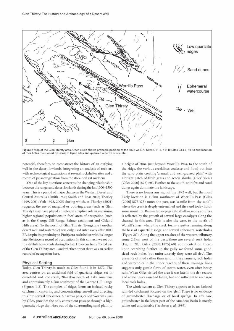
46 Number 66, June 2008
Glen Thirsty: The History and Archaeology of a Desert Well
potential, therefore, to reconstruct the history of an outlying
well in the desert lowlands, integrating an analysis of rock art
with archaeological excavations at several rockshelter sites and a
record of palaeovegetation from the stick-nest rat middens.
One of the key questions concerns the changing relationship
between the ranges and desert lowlands during the last 1000–1500
years. This is a period of major change in the Western Desert and
Central Australia (Smith 1996; Smith and Ross 2008; Thorley
1999, 2001; Veth 1993, 2005) during which, as Thorley (2001)
suggests, the use of marginal or outlying areas (such as Glen
Thirsty) may have played an integral adaptive role in sustaining
higher regional populations in focal areas of occupation (such
as in the George Gill Range, Palmer catchment and Cleland
Hills areas). To the north of Glen Thirsty, Tjungkupu (another
desert well and waterhole) was only used intensively after 1000
BP, despite its proximity to Puritjarra rockshelter with its longer,
late Pleistocene record of occupation. In this context, we set out
to establish how events during the late Holocene had affected use
of the Glen Thirsty area – and whether or not there was an earlier
record of occupation here.
Physical SettingToday, Glen Thirsty is much as Giles found it in 1872. The
area centres on an anticlinal fold of quartzite ridges set in
dunefi eld and low scrub, 20–25km north of Lake Amadeus
and approximately 60km southwest of the George Gill Range
(Figures 1-2). The complex of ridges forms an isolated rocky
catchment, capturing and concentrating run-off and directing
this into several creeklines. A narrow pass, called ‘Worrill’s Pass’
by Giles, provides the only convenient passage through a high
quartzite ridge that rises out of the surrounding sand plain to
a height of 20m. Just beyond Worrill’s Pass, to the south of
the ridge, the various creeklines coalesce and fl ood out into
the sand plain creating ‘a small and well-grassed plain’ with
a bright patch of fresh grass and acacia shrubs (Giles’ ‘glen’)
(Giles 2000[1875]:60). Further to the south, spinifex and sand
dunes again dominate the landscape.
There is no longer any sign of the 1872 well, but the most
likely location is 1.6km southwest of Worrill’s Pass (Giles
(2000[1875]:75) notes the pass was ‘a mile from the tank’),
where the creek is deeply entrenched and the sand today holds
some moisture. Rainwater seepage into shallow sandy aquifers
is reflected by the growth of several large eucalpyts along the
channel in this area. This is also the case, to the north of
Worrill’s Pass, where the creek forms a gutter running along
the base of a quartzite ridge, and several ephemeral waterholes
(Figure 2C). Along the upper reaches of the western tributary,
some 2.6km west of the pass, there are several rock holes
(Figure 2B). Giles (2000[1875]:60) commented on these:
‘upon searching further up the gully we found some good-
sized rock holes, but unfortunately they were all dry’. The
presence of mud rather than sand in the channels, rock holes
and waterholes in the upper reaches of these drainage lines
suggests only gentle flows of storm water, even after heavy
rain. When Giles visited the area it was late in the dry season
and some heavy rain had fallen, but not sufficient to recharge
local rock holes.
The whole system at Glen Thirsty appears to be an isolated
rain-fed catchment focused on the ‘glen’. There is no evidence
of groundwater discharge or of local springs. In any case,
groundwater in the lower part of the Amadeus Basin is mostly
saline and undrinkable (Jacobson et al. 1989).
Figure 2 Map of the Glen Thirsty area. Open circle shows probable position of the 1872 well. A: Sites GT1-3, 7-9; B: Sites GT4-6, 10-13 and location of rock holes mentioned by Giles; C: Open sites and quarried outcrop of silcrete.
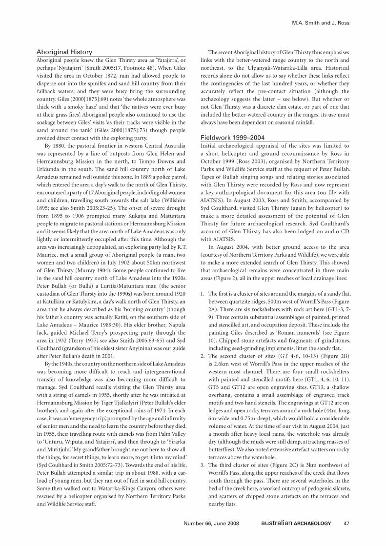
47Number 66, June 2008
M.A. Smith and J. Ross
Aboriginal HistoryAboriginal people knew the Glen Thirsty area as ‘Yatajirra’, or
perhaps ‘Nyatajirri’ (Smith 2005:17, Footnote 48). When Giles
visited the area in October 1872, rain had allowed people to
disperse out into the spinifex and sand hill country from their
fallback waters, and they were busy fi ring the surrounding
country. Giles (2000[1875]:69) notes ‘the whole atmosphere was
thick with a smoky haze’ and that ‘the natives were ever busy
at their grass fi res’. Aboriginal people also continued to use the
soakage between Giles’ visits ‘as their tracks were visible in the
sand around the tank’ (Giles 2000[1875]:73) though people
avoided direct contact with the exploring party.
By 1880, the pastoral frontier in western Central Australia
was represented by a line of outposts from Glen Helen and
Hermannsburg Mission in the north, to Tempe Downs and
Erldunda in the south. The sand hill country north of Lake
Amadeus remained well outside this zone. In 1889 a police patrol,
which entered the area a day’s walk to the north of Glen Thirsty,
encountered a party of 17 Aboriginal people, including old women
and children, travelling south towards the salt lake (Willshire
1895; see also Smith 2005:23-25). The onset of severe drought
from 1895 to 1906 prompted many Kukatja and Matuntara
people to migrate to pastoral stations or Hermannsburg Mission
and it seems likely that the area north of Lake Amadeus was only
lightly or intermittently occupied after this time. Although the
area was increasingly depopulated, an exploring party led by R.T.
Maurice, met a small group of Aboriginal people (a man, two
women and two children) in July 1902 about 50km northwest
of Glen Thirsty (Murray 1904). Some people continued to live
in the sand hill country north of Lake Amadeus into the 1920s.
Peter Bullah (or Bulla) a Luritja/Matuntara man (the senior
custodian of Glen Thirsty into the 1990s) was born around 1920
at Katulkira or Katulykira, a day’s walk north of Glen Thirsty, an
area that he always described as his ‘borning country’ (though
his father’s country was actually Katiti, on the southern side of
Lake Amadeus – Maurice 1989:30). His elder brother, Napula
Jack, guided Michael Terry’s prospecting party through the
area in 1932 (Terry 1937; see also Smith 2005:63-65) and Syd
Coulthard (grandson of his eldest sister Anyinina) was our guide
after Peter Bullah’s death in 2001.
By the 1940s, the country on the northern side of Lake Amadeus
was becoming more diffi cult to reach and intergenerational
transfer of knowledge was also becoming more diffi cult to
manage. Syd Coulthard recalls visiting the Glen Thirsty area
with a string of camels in 1955, shortly after he was initiated at
Hermannsburg Mission by Tiger Tjalkalyiri (Peter Bullah’s elder
brother), and again after the exceptional rains of 1974. In each
case, it was an ‘emergency trip’, prompted by the age and infi rmity
of senior men and the need to learn the country before they died.
In 1955, their travelling route with camels was from Palm Valley
to ‘Unturu, Wiputa, and Yatajirri’, and then through to ‘Yirarka
and Mutitjulu’. ‘My grandfather brought me out here to show all
the things, for secret things, to learn more, to get it into my mind’
(Syd Coulthard in Smith 2005:72-73). Towards the end of his life,
Peter Bullah attempted a similar trip in about 1988, with a car-
load of young men, but they ran out of fuel in sand hill country.
Some then walked out to Watarrka-Kings Canyon; others were
rescued by a helicopter organised by Northern Territory Parks
and Wildlife Service staff.
The recent Aboriginal history of Glen Thirsty thus emphasises
links with the better-watered range country to the north and
northeast, to the Ulpanyali-Watarrka-Lilla area. Historical
records alone do not allow us to say whether these links refl ect
the contingencies of the last hundred years, or whether they
accurately refl ect the pre-contact situation (although the
archaeology suggests the latter – see below). But whether or
not Glen Thirsty was a discrete clan estate, or part of one that
included the better-watered country in the ranges, its use must
always have been dependent on seasonal rainfall.
Fieldwork 1999–2004Initial archaeological appraisal of the sites was limited to
a short helicopter and ground reconnaissance by Ross in
October 1999 (Ross 2003), organised by Northern Territory
Parks and Wildlife Service staff at the request of Peter Bullah.
Tapes of Bullah singing songs and relating stories associated
with Glen Thirsty were recorded by Ross and now represent
a key anthropological document for this area (on file with
AIATSIS). In August 2003, Ross and Smith, accompanied by
Syd Coulthard, visited Glen Thirsty (again by helicopter) to
make a more detailed assessment of the potential of Glen
Thirsty for future archaeological research. Syd Coulthard’s
account of Glen Thirsty has also been lodged on audio CD
with AIATSIS.
In August 2004, with better ground access to the area
(courtesy of Northern Territory Parks and Wildlife), we were able
to make a more extended search of Glen Thirsty. This showed
that archaeological remains were concentrated in three main
areas (Figure 2), all in the upper reaches of local drainage lines:
1. The fi rst is a cluster of sites around the margins of a sandy fl at,
between quartzite ridges, 500m west of Worrill’s Pass (Figure
2A). There are six rockshelters with rock art here (GT1-3, 7-
9). Three contain substantial assemblages of painted, printed
and stencilled art, and occupation deposit. These include the
painting Giles described as ‘Roman numerals’ (see Figure
10). Chipped stone artefacts and fragments of grindstones,
including seed-grinding implements, litter the sandy fl at.
2. The second cluster of sites (GT 4-6, 10-13) (Figure 2B)
is 2.6km west of Worrill’s Pass in the upper reaches of the
western-most channel. There are four small rockshelters
with painted and stencilled motifs here (GT1, 4, 6, 10, 11).
GT5 and GT12 are open engraving sites. GT13, a shallow
overhang, contains a small assemblage of engraved track
motifs and two hand stencils. The engravings at GT12 are on
ledges and open rocky terraces around a rock hole (44m-long,
6m-wide and 0.75m-deep), which would hold a considerable
volume of water. At the time of our visit in August 2004, just
a month after heavy local rains, the waterhole was already
dry (although the muds were still damp, attracting masses of
butterfl ies). We also noted extensive artefact scatters on rocky
terraces above the waterhole.
3. The third cluster of sites (Figure 2C) is 3km northwest of
Worrill’s Pass, along the upper reaches of the creek that fl ows
south through the pass. There are several waterholes in the
bed of the creek here, a worked outcrop of pedogenic silcrete,
and scatters of chipped stone artefacts on the terraces and
nearby fl ats.
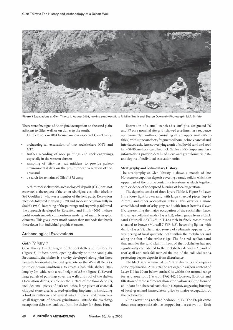
48 Number 66, June 2008
Glen Thirsty: The History and Archaeology of a Desert Well
There were few signs of Aboriginal occupation on the sand plain
adjacent to Giles’ well, or on dunes to the south.
Our fi eldwork in 2004 focused on four aspects of Glen Thirsty:
• archaeological excavation of two rockshelters (GT1 and
GT3);
• further recording of rock paintings and rock engravings,
especially in the western cluster;
• sampling of stick-nest rat middens to provide palaeo-
environmental data on the pre-European vegetation of the
area; and
• a search for remains of Giles’ 1872 camp.
A third rockshelter with archaeological deposit (GT2) was not
excavated at the request of the senior Aboriginal custodian (the late
Syd Coulthard) who was a member of the fi eld party. Excavation
methods followed Johnson (1979) and are described more fully in
Smith (1988). Recording of the paintings and engravings followed
the approach developed by Rosenfeld and Smith (2002), where
motif counts include compositions made up of multiple graphic
elements. This gives lower motif counts than methods that break
these down into individual graphic elements.
Archaeological Excavations
Glen Thirsty 1Glen Thirsty 1 is the largest of the rockshelters in this locality
(Figure 3). It faces north, opening directly onto the sand plain.
Structurally, the shelter is a cavity developed along joint lines
beneath horizontally bedded quartzite in the Winnall Beds (a
white or brown sandstone), to create a habitable shelter 10m-
long by 7m-wide, with a roof height of 2.5m (Figure 4). Several
large panels of paintings cover the walls and roof of the shelter.
Occupation debris, visible on the surface of the fl oor deposits,
includes small pieces of dark red ochre, large pieces of charcoal,
chipped stone artefacts, seed-grinding implements (including
a broken millstone and several intact mullers) and numerous
small fragments of broken grindstones. Outside the overhang,
occupation debris extends out from the shelter for about 10m.
Excavation of a small trench (2 x 1m² pits, designated F6
and F7 on a nominal site grid) showed a sedimentary sequence
approximately 1m-thick, consisting of an upper unit (20cm-
thick) with stone artefacts, fragmented bone, ochre, charcoal and
interleaved ashy lenses, overlying a unit of colluvial sand and roof
fall (60-80cm-thick), and bedrock. Tables S1-S3 (supplementary
information) provide details of sieve and granulometric data,
and depths of individual excavation units.
Stratigraphy and Sedimentary HistoryThe stratigraphy at Glen Thirsty 1 shows a mantle of late
Holocene occupation deposit covering a sandy soil, in which the
upper part of the profi le contains a few stone artefacts together
with evidence of widespread burning of local vegetation.
The deposits consist of three layers (Table 1, Figure 5). Layer
I is a loose light brown sand with large charcoal pieces (up to
20mm) and other occupation debris. This overlies a more
consolidated unit of ashy grey sand with intact hearths (Layer
II), representing the major occupation of the rockshelter. Layer
II overlays colluvial sands (Layer III), which grade from a black
sand (Munsell 7.5YR 2/3, pH 4.5) rich in fi nely comminuted
charcoal to brown (Munsell 7.5YR 3/3), becoming lighter with
depth (Layer V). The major source of sediments appears to be
weathering of local quartzite, both within the rockshelter and
along the foot of the strike ridge. The fi ne red aeolian sand
that mantles the sand plain in front of the rockshelter has not
signifi cantly contributed to the rockshelter deposits. A band of
roof spall and rock fall marked the top of the colluvial sands,
protecting deeper deposits from disturbance.
The black sand is unusual in Central Australia and requires
some explanation. At 0.35% the net organic carbon content of
Layer III (at 30cm below surface) is within the normal range
for arid zone soils (Jackson 1962:44). However, fl otation and
fi ltration of these sediments shows the carbon is in the form of
abundant fi ne charcoal particles (<100µm), suggesting burning
of local grassland immediately prior to major occupation of
the rockshelter.
Our excavations reached bedrock in F7. The F6 pit came
down on a large rock slab that stopped further excavation. Both
Figure 3 Excavations at Glen Thirsty 1, August 2004, looking southeast (L to R: Mike Smith and Sharon Overend) (Photograph: M.A. Smith).
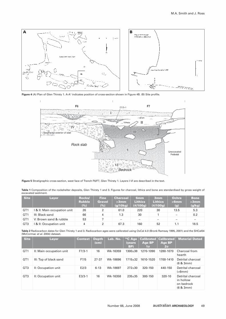
49Number 66, June 2008
M.A. Smith and J. Ross
Figure 4 (A) Plan of Glen Thirsty 1. A-A1 indicates position of cross-section shown in Figure 4B. (B) Site profi le.
A B
Site Layer Rocks/Rubble
(%)
Fine Gravel
(%)
Charcoal >3mm
(g/10kg)
6mm Lithics
(#/100g)
3mm Lithics
(#/100g)
Ochre >6mm
(g)
Bone >3mm (g/kg)
GT1 I & II: Main occupation unit 26 2 61.0 220 30 13.5 5.3
GT1 III: Black sand 66 4 1.3 30 1 – 0.2
GT1 V: Brown sand & rubble 53 7 – – – – –
GT3 I & II: Occupation unit 4 2 67.3 160 52 1.1 18.5
Table 1 Composition of the rockshelter deposits, Glen Thirsty 1 and 3. Figures for charcoal, lithics and bone are standardised by gross weight of excavated sediment.
Figure 5 Stratigraphic cross-section, west face of Trench F6/F7, Glen Thirsty 1. Layers I-VI are described in the text.
Site Layer Context Depth(cm)
Lab. No. 14C Age (years
BP)
Calibrated Age BP
1σ
Calibrated Age BP
2σ
Material Dated
GT1 II: Main occupation unit F7/3-1 16 Wk-16359 1300±38 1270-1090 1280-1070 Charcoal from hearth
GT1 III: Top of black sand F7/5 27-37 Wk-18696 1715±32 1610-1520 1700-1410 Detrital charcoal (6 & 3mm)
GT3 II: Occupation unit E2/3 6-13 Wk-18697 272±30 320-150 440-150 Detrital charcoal (>6mm)
GT3 II: Occupation unit E3/3-1 16 Wk-16358 235±35 300-150 320-10 Detrital charcoal in hollow on bedrock (6 & 3mm)
Table 2 Radiocarbon dates for Glen Thirsty 1 and 3. Radiocarbon ages were calibrated using OxCal 4.0 (Bronk Ramsay 1995, 2001) and the SHCal04 (McCormac et al. 2004) dataset.
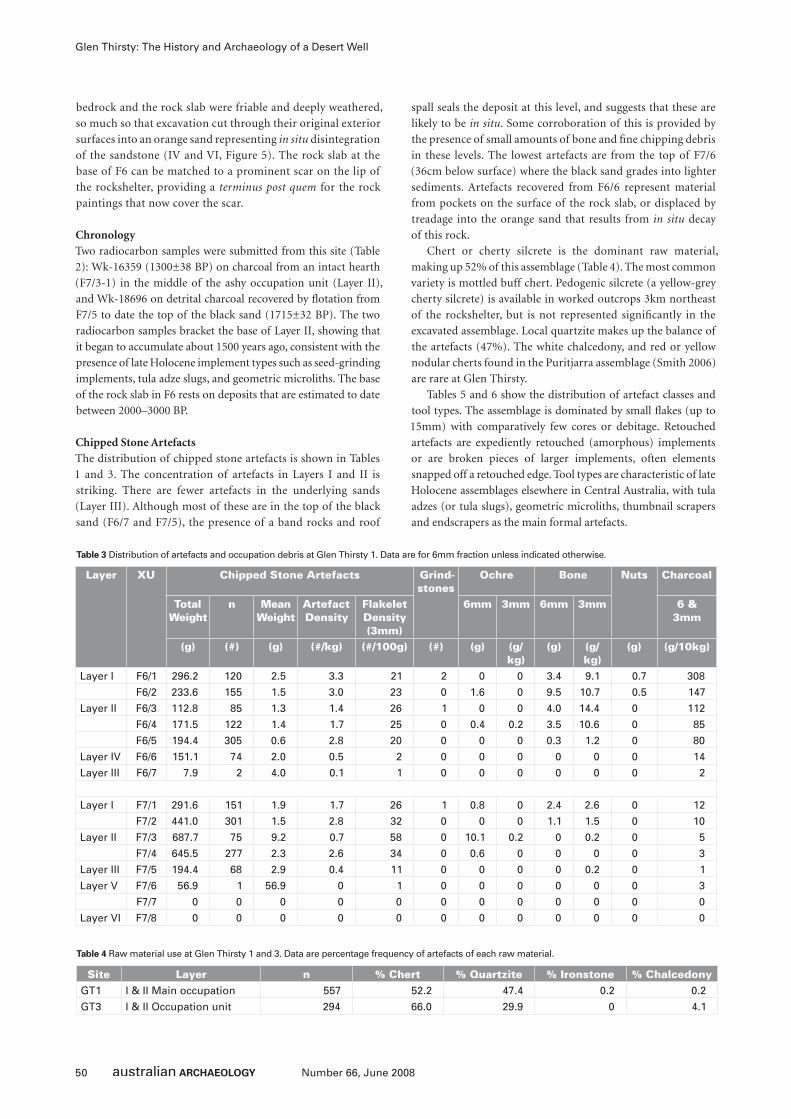
50 Number 66, June 2008
Glen Thirsty: The History and Archaeology of a Desert Well
bedrock and the rock slab were friable and deeply weathered,
so much so that excavation cut through their original exterior
surfaces into an orange sand representing in situ disintegration
of the sandstone (IV and VI, Figure 5). The rock slab at the
base of F6 can be matched to a prominent scar on the lip of
the rockshelter, providing a terminus post quem for the rock
paintings that now cover the scar.
ChronologyTwo radiocarbon samples were submitted from this site (Table
2): Wk-16359 (1300±38 BP) on charcoal from an intact hearth
(F7/3-1) in the middle of the ashy occupation unit (Layer II),
and Wk-18696 on detrital charcoal recovered by fl otation from
F7/5 to date the top of the black sand (1715±32 BP). The two
radiocarbon samples bracket the base of Layer II, showing that
it began to accumulate about 1500 years ago, consistent with the
presence of late Holocene implement types such as seed-grinding
implements, tula adze slugs, and geometric microliths. The base
of the rock slab in F6 rests on deposits that are estimated to date
between 2000–3000 BP.
Chipped Stone ArtefactsThe distribution of chipped stone artefacts is shown in Tables
1 and 3. The concentration of artefacts in Layers I and II is
striking. There are fewer artefacts in the underlying sands
(Layer III). Although most of these are in the top of the black
sand (F6/7 and F7/5), the presence of a band rocks and roof
spall seals the deposit at this level, and suggests that these are
likely to be in situ. Some corroboration of this is provided by
the presence of small amounts of bone and fi ne chipping debris
in these levels. The lowest artefacts are from the top of F7/6
(36cm below surface) where the black sand grades into lighter
sediments. Artefacts recovered from F6/6 represent material
from pockets on the surface of the rock slab, or displaced by
treadage into the orange sand that results from in situ decay
of this rock.
Chert or cherty silcrete is the dominant raw material,
making up 52% of this assemblage (Table 4). The most common
variety is mottled buff chert. Pedogenic silcrete (a yellow-grey
cherty silcrete) is available in worked outcrops 3km northeast
of the rockshelter, but is not represented signifi cantly in the
excavated assemblage. Local quartzite makes up the balance of
the artefacts (47%). The white chalcedony, and red or yellow
nodular cherts found in the Puritjarra assemblage (Smith 2006)
are rare at Glen Thirsty.
Tables 5 and 6 show the distribution of artefact classes and
tool types. The assemblage is dominated by small fl akes (up to
15mm) with comparatively few cores or debitage. Retouched
artefacts are expediently retouched (amorphous) implements
or are broken pieces of larger implements, often elements
snapped off a retouched edge. Tool types are characteristic of late
Holocene assemblages elsewhere in Central Australia, with tula
adzes (or tula slugs), geometric microliths, thumbnail scrapers
and endscrapers as the main formal artefacts.
Layer XU Chipped Stone Artefacts Grind-stones
Ochre Bone Nuts Charcoal
Total Weight
n Mean Weight
Artefact Density
Flakelet Density (3mm)
6mm 3mm 6mm 3mm 6 & 3mm
(g) (#) (g) (#/kg) (#/100g) (#) (g) (g/kg)
(g) (g/kg)
(g) (g/10kg)
Layer I F6/1 296.2 120 2.5 3.3 21 2 0 0 3.4 9.1 0.7 308
F6/2 233.6 155 1.5 3.0 23 0 1.6 0 9.5 10.7 0.5 147
Layer II F6/3 112.8 85 1.3 1.4 26 1 0 0 4.0 14.4 0 112
F6/4 171.5 122 1.4 1.7 25 0 0.4 0.2 3.5 10.6 0 85
F6/5 194.4 305 0.6 2.8 20 0 0 0 0.3 1.2 0 80
Layer IV F6/6 151.1 74 2.0 0.5 2 0 0 0 0 0 0 14
Layer III F6/7 7.9 2 4.0 0.1 1 0 0 0 0 0 0 2
Layer I F7/1 291.6 151 1.9 1.7 26 1 0.8 0 2.4 2.6 0 12
F7/2 441.0 301 1.5 2.8 32 0 0 0 1.1 1.5 0 10
Layer II F7/3 687.7 75 9.2 0.7 58 0 10.1 0.2 0 0.2 0 5
F7/4 645.5 277 2.3 2.6 34 0 0.6 0 0 0 0 3
Layer III F7/5 194.4 68 2.9 0.4 11 0 0 0 0 0.2 0 1
Layer V F7/6 56.9 1 56.9 0 1 0 0 0 0 0 0 3
F7/7 0 0 0 0 0 0 0 0 0 0 0 0
Layer VI F7/8 0 0 0 0 0 0 0 0 0 0 0 0
Table 3 Distribution of artefacts and occupation debris at Glen Thirsty 1. Data are for 6mm fraction unless indicated otherwise.
Site Layer n % Chert % Quartzite % Ironstone % ChalcedonyGT1 I & II Main occupation 557 52.2 47.4 0.2 0.2
GT3 I & II Occupation unit 294 66.0 29.9 0 4.1
Table 4 Raw material use at Glen Thirsty 1 and 3. Data are percentage frequency of artefacts of each raw material.
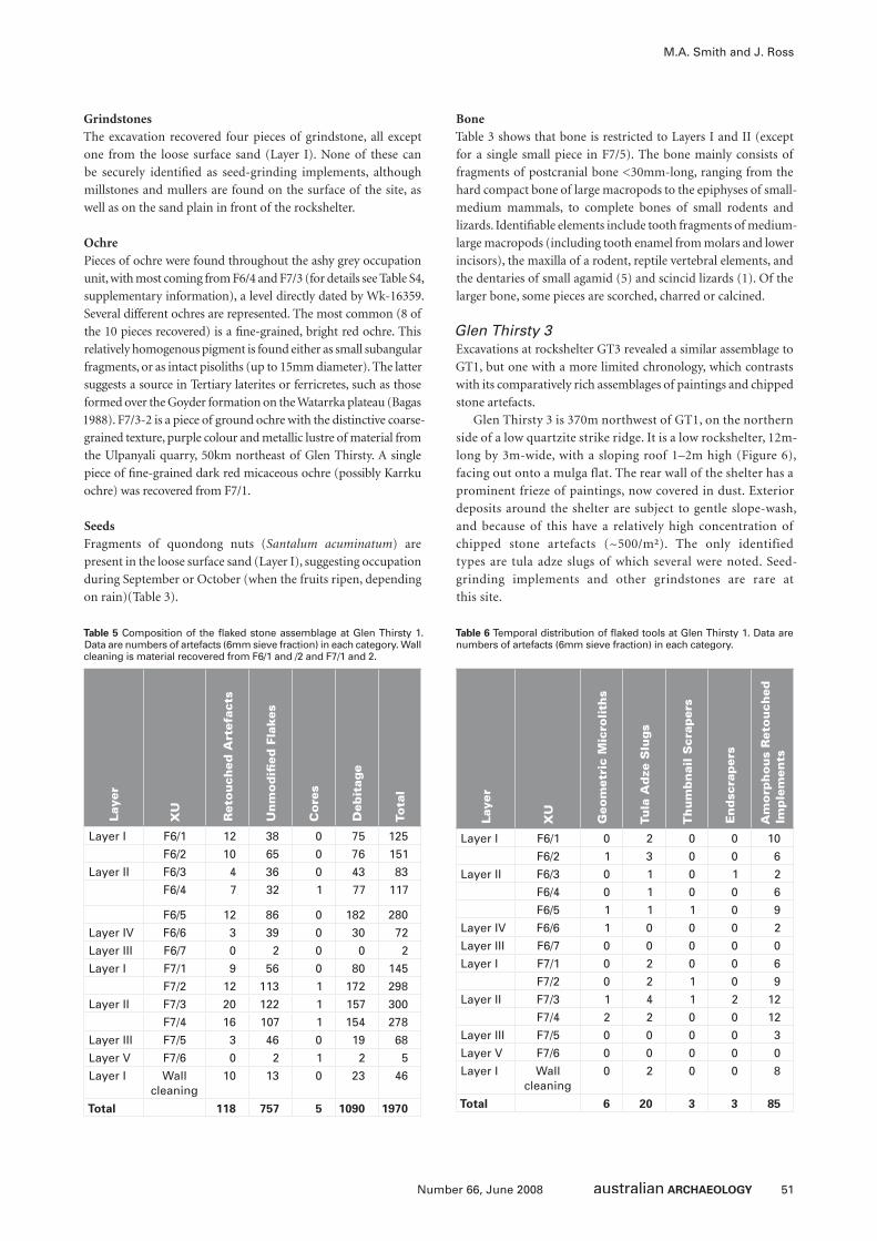
51Number 66, June 2008
M.A. Smith and J. Ross
GrindstonesThe excavation recovered four pieces of grindstone, all except
one from the loose surface sand (Layer I). None of these can
be securely identifi ed as seed-grinding implements, although
millstones and mullers are found on the surface of the site, as
well as on the sand plain in front of the rockshelter.
OchrePieces of ochre were found throughout the ashy grey occupation
unit, with most coming from F6/4 and F7/3 (for details see Table S4,
supplementary information), a level directly dated by Wk-16359.
Several different ochres are represented. The most common (8 of
the 10 pieces recovered) is a fi ne-grained, bright red ochre. This
relatively homogenous pigment is found either as small subangular
fragments, or as intact pisoliths (up to 15mm diameter). The latter
suggests a source in Tertiary laterites or ferricretes, such as those
formed over the Goyder formation on the Watarrka plateau (Bagas
1988). F7/3-2 is a piece of ground ochre with the distinctive coarse-
grained texture, purple colour and metallic lustre of material from
the Ulpanyali quarry, 50km northeast of Glen Thirsty. A single
piece of fi ne-grained dark red micaceous ochre (possibly Karrku
ochre) was recovered from F7/1.
SeedsFragments of quondong nuts (Santalum acuminatum) are
present in the loose surface sand (Layer I), suggesting occupation
during September or October (when the fruits ripen, depending
on rain)(Table 3).
BoneTable 3 shows that bone is restricted to Layers I and II (except
for a single small piece in F7/5). The bone mainly consists of
fragments of postcranial bone <30mm-long, ranging from the
hard compact bone of large macropods to the epiphyses of small-
medium mammals, to complete bones of small rodents and
lizards. Identifi able elements include tooth fragments of medium-
large macropods (including tooth enamel from molars and lower
incisors), the maxilla of a rodent, reptile vertebral elements, and
the dentaries of small agamid (5) and scincid lizards (1). Of the
larger bone, some pieces are scorched, charred or calcined.
Glen Thirsty 3Excavations at rockshelter GT3 revealed a similar assemblage to
GT1, but one with a more limited chronology, which contrasts
with its comparatively rich assemblages of paintings and chipped
stone artefacts.
Glen Thirsty 3 is 370m northwest of GT1, on the northern
side of a low quartzite strike ridge. It is a low rockshelter, 12m-
long by 3m-wide, with a sloping roof 1–2m high (Figure 6),
facing out onto a mulga flat. The rear wall of the shelter has a
prominent frieze of paintings, now covered in dust. Exterior
deposits around the shelter are subject to gentle slope-wash,
and because of this have a relatively high concentration of
chipped stone artefacts (~500/m²). The only identified
types are tula adze slugs of which several were noted. Seed-
grinding implements and other grindstones are rare at
this site.
Table 5 Composition of the fl aked stone assemblage at Glen Thirsty 1. Data are numbers of artefacts (6mm sieve fraction) in each category. Wall cleaning is material recovered from F6/1 and /2 and F7/1 and 2.
Laye
r
XU
Geo
met
ric
Mic
roli
ths
Tula
Ad
ze S
lug
s
Th
um
bn
ail
Scr
aper
s
En
dsc
rap
ers
Am
orp
ho
us
Ret
ou
ched
Im
ple
men
ts
Layer I F6/1 0 2 0 0 10
F6/2 1 3 0 0 6
Layer II F6/3 0 1 0 1 2
F6/4 0 1 0 0 6
F6/5 1 1 1 0 9
Layer IV F6/6 1 0 0 0 2
Layer III F6/7 0 0 0 0 0
Layer I F7/1 0 2 0 0 6
F7/2 0 2 1 0 9
Layer II F7/3 1 4 1 2 12
F7/4 2 2 0 0 12
Layer III F7/5 0 0 0 0 3
Layer V F7/6 0 0 0 0 0
Layer I Wall cleaning
0 2 0 0 8
Total 6 20 3 3 85
Table 6 Temporal distribution of fl aked tools at Glen Thirsty 1. Data are numbers of artefacts (6mm sieve fraction) in each category.
Laye
r
XU
Ret
ou
ched
Art
efac
ts
Un
mo
difi
ed
Fla
kes
Co
res
Deb
itag
e
Tota
l
Layer I F6/1 12 38 0 75 125
F6/2 10 65 0 76 151
Layer II F6/3 4 36 0 43 83
F6/4 7 32 1 77 117
F6/5 12 86 0 182 280
Layer IV F6/6 3 39 0 30 72
Layer III F6/7 0 2 0 0 2
Layer I F7/1 9 56 0 80 145
F7/2 12 113 1 172 298
Layer II F7/3 20 122 1 157 300
F7/4 16 107 1 154 278
Layer III F7/5 3 46 0 19 68
Layer V F7/6 0 2 1 2 5
Layer I Wall cleaning
10 13 0 23 46
Total 118 757 5 1090 1970
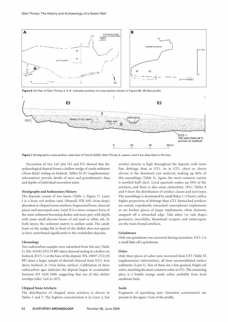
52 Number 66, June 2008
Glen Thirsty: The History and Archaeology of a Desert Well
Excavation of two 1m² pits (E2 and E3) showed that the
archaeological deposit forms a shallow wedge of sandy sediment
(20cm-thick) resting on bedrock. Tables S5-S7 (supplementary
information) provide details of sieve and granulometric data,
and depths of individual excavation units.
Stratigraphy and Sedimentary HistoryThe deposits consist of two layers (Table 1, Figure 7). Layer
I is a loose red aeolian sand (Munsell 5YR 4/8) (6cm-deep),
abundant in chipped stone artefacts, fragmented bone, charcoal
pieces and macropod scats. Layer II is a more compact form of
the same sediment becoming darker and more grey with depth,
with some small discrete lenses of red sand or white ash. In
both layers, the sediment matrix is aeolian sand. The sandy
loam on the mulga fl at in front of the shelter does not appear
to have contributed signifi cantly to the rockshelter deposits.
ChronologyTwo radiocarbon samples were submitted from this site (Table
2). Wk-16358 (235±35 BP) dates charcoal resting in a hollow on
bedrock (E3/3-1) at the base of the deposit. Wk-18697 (272±30
BP) dates a larger sample of detrital charcoal from E2/3, 4cm
above bedrock (6-13cm below surface). Calibration of these
radiocarbon ages indicates the deposit began to accumulate
between AD 1630-1800, suggesting that use of this shelter
overlaps Giles’ visit in 1872.
Chipped Stone ArtefactsThe distribution of chipped stone artefacts is shown in
Tables 1 and 7. The highest concentration is in Layer I, but
artefact density is high throughout the deposit, with more
fine debitage than at GT1. As at GT1, chert or cherty
silcrete is the dominant raw material, making up 66% of
this assemblage (Table 4). Again, the most common variety
is mottled buff chert. Local quartzite makes up 30% of the
artefacts, and there is also some chalcedony (4%). Tables 8
and 9 show the distribution of artefact classes and tool types.
The assemblage is dominated by small flakes (>15mm), with a
higher proportion of debitage than GT1. Retouched artefacts
are mainly expediently retouched (amorphous) implements
or are broken pieces of larger implements, often elements
snapped off a retouched edge. Tula adzes (or tula slugs),
geometric microliths, thumbnail scrapers and endscrapers
are the main formal artefacts.
GrindstonesOnly one grindstone was recovered during excavation. E3/1-1 is
a small fl ake off a grindstone.
OchreOnly three pieces of ochre were recovered from GT3 (Table S7,
supplementary information), all from unconsolidated surface
sediments (Layer I). Two of these are a fi ne-grained, bright red
ochre, matching the most common ochre at GT1. The remaining
piece is a friable orange sandy ochre, probably from local
sandstone beds.
SeedsFragments of quondong nuts (Santalum acuminatum) are
present in the upper 13cm of the profi le.
Figure 7 Stratigraphic cross-section, west face of Trench E2/E3, Glen Thirsty 3. Layers I and II are described in the text.
A B
Figure 6 (A) Plan of Glen Thirsty 3. A-A¹ indicates position of cross-section shown in Figure 6B. (B) Site profi le.
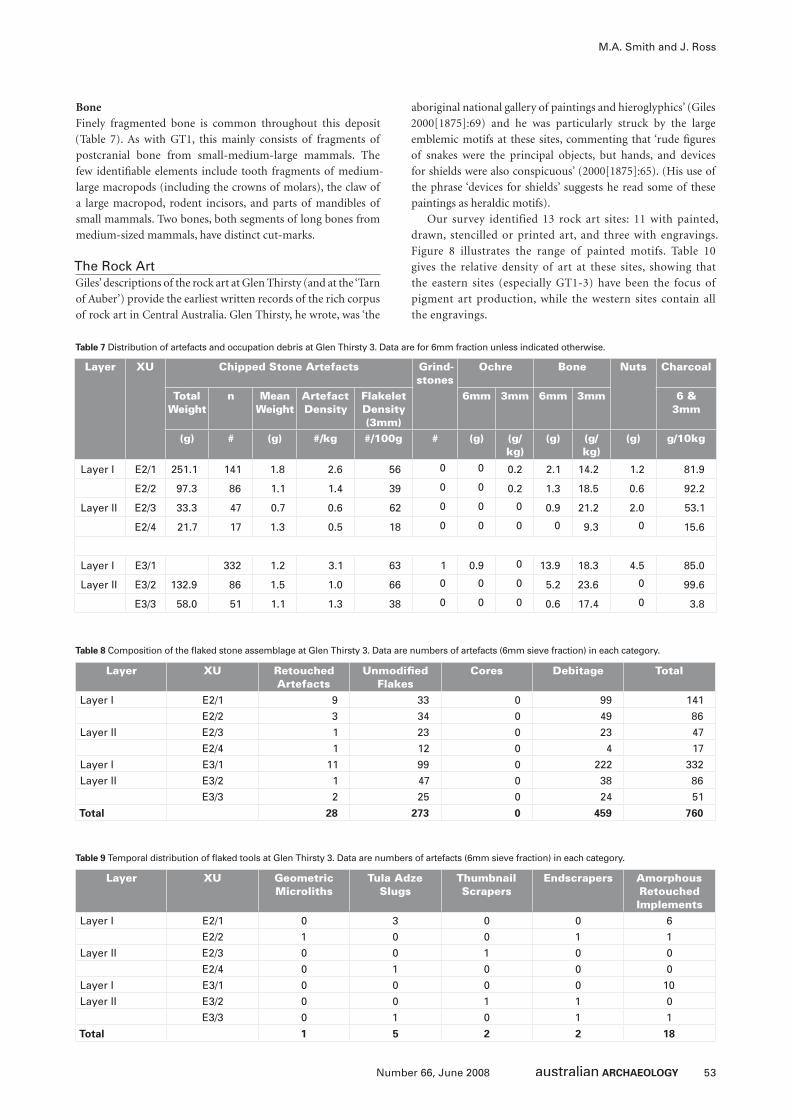
53Number 66, June 2008
M.A. Smith and J. Ross
BoneFinely fragmented bone is common throughout this deposit
(Table 7). As with GT1, this mainly consists of fragments of
postcranial bone from small-medium-large mammals. The
few identifi able elements include tooth fragments of medium-
large macropods (including the crowns of molars), the claw of
a large macropod, rodent incisors, and parts of mandibles of
small mammals. Two bones, both segments of long bones from
medium-sized mammals, have distinct cut-marks.
The Rock ArtGiles’ descriptions of the rock art at Glen Thirsty (and at the ‘Tarn
of Auber’) provide the earliest written records of the rich corpus
of rock art in Central Australia. Glen Thirsty, he wrote, was ‘the
aboriginal national gallery of paintings and hieroglyphics’ (Giles
2000[1875]:69) and he was particularly struck by the large
emblemic motifs at these sites, commenting that ‘rude fi gures
of snakes were the principal objects, but hands, and devices
for shields were also conspicuous’ (2000[1875]:65). (His use of
the phrase ‘devices for shields’ suggests he read some of these
paintings as heraldic motifs).
Our survey identified 13 rock art sites: 11 with painted,
drawn, stencilled or printed art, and three with engravings.
Figure 8 illustrates the range of painted motifs. Table 10
gives the relative density of art at these sites, showing that
the eastern sites (especially GT1-3) have been the focus of
pigment art production, while the western sites contain all
the engravings.
Layer XU Chipped Stone Artefacts Grind-stones
Ochre Bone Nuts Charcoal
Total Weight
n Mean Weight
Artefact Density
Flakelet Density (3mm)
6mm 3mm 6mm 3mm 6 & 3mm
(g) # (g) #/kg #/100g # (g) (g/kg)
(g) (g/kg)
(g) g/10kg
Layer I E2/1 251.1 141 1.8 2.6 56 0 0 0.2 2.1 14.2 1.2 81.9
E2/2 97.3 86 1.1 1.4 39 0 0 0.2 1.3 18.5 0.6 92.2
Layer II E2/3 33.3 47 0.7 0.6 62 0 0 0 0.9 21.2 2.0 53.1
E2/4 21.7 17 1.3 0.5 18 0 0 0 0 9.3 0 15.6
Layer I E3/1 332 1.2 3.1 63 1 0.9 0 13.9 18.3 4.5 85.0
Layer II E3/2 132.9 86 1.5 1.0 66 0 0 0 5.2 23.6 0 99.6
E3/3 58.0 51 1.1 1.3 38 0 0 0 0.6 17.4 0 3.8
Table 7 Distribution of artefacts and occupation debris at Glen Thirsty 3. Data are for 6mm fraction unless indicated otherwise.
Layer XU Retouched Artefacts
Unmodifi ed Flakes
Cores Debitage Total
Layer I E2/1 9 33 0 99 141
E2/2 3 34 0 49 86
Layer II E2/3 1 23 0 23 47
E2/4 1 12 0 4 17
Layer I E3/1 11 99 0 222 332
Layer II E3/2 1 47 0 38 86
E3/3 2 25 0 24 51
Total 28 273 0 459 760
Table 8 Composition of the fl aked stone assemblage at Glen Thirsty 3. Data are numbers of artefacts (6mm sieve fraction) in each category.
Layer XU Geometric Microliths
Tula Adze Slugs
Thumbnail Scrapers
Endscrapers Amorphous Retouched Implements
Layer I E2/1 0 3 0 0 6
E2/2 1 0 0 1 1
Layer II E2/3 0 0 1 0 0
E2/4 0 1 0 0 0
Layer I E3/1 0 0 0 0 10
Layer II E3/2 0 0 1 1 0
E3/3 0 1 0 1 1
Total 1 5 2 2 18
Table 9 Temporal distribution of fl aked tools at Glen Thirsty 3. Data are numbers of artefacts (6mm sieve fraction) in each category.
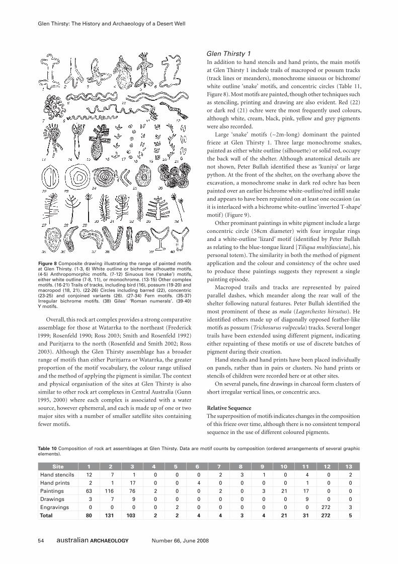
54 Number 66, June 2008
Glen Thirsty: The History and Archaeology of a Desert Well
Overall, this rock art complex provides a strong comparative
assemblage for those at Watarrka to the northeast (Frederick
1999; Rosenfeld 1990; Ross 2003; Smith and Rosenfeld 1992)
and Puritjarra to the north (Rosenfeld and Smith 2002; Ross
2003). Although the Glen Thirsty assemblage has a broader
range of motifs than either Puritjarra or Watarrka, the greater
proportion of the motif vocabulary, the colour range utilised
and the method of applying the pigment is similar. The context
and physical organisation of the sites at Glen Thirsty is also
similar to other rock art complexes in Central Australia (Gunn
1995, 2000) where each complex is associated with a water
source, however ephemeral, and each is made up of one or two
major sites with a number of smaller satellite sites containing
fewer motifs.
Glen Thirsty 1In addition to hand stencils and hand prints, the main motifs
at Glen Thirsty 1 include trails of macropod or possum tracks
(track lines or meanders), monochrome sinuous or bichrome/
white outline ‘snake’ motifs, and concentric circles (Table 11,
Figure 8). Most motifs are painted, though other techniques such
as stenciling, printing and drawing are also evident. Red (22)
or dark red (21) ochre were the most frequently used colours,
although white, cream, black, pink, yellow and grey pigments
were also recorded.
Large ‘snake’ motifs (~2m-long) dominant the painted
frieze at Glen Thirsty 1. Three large monochrome snakes,
painted as either white outline (silhouette) or solid red, occupy
the back wall of the shelter. Although anatomical details are
not shown, Peter Bullah identifi ed these as ‘kuniya’ or large
python. At the front of the shelter, on the overhang above the
excavation, a monochrome snake in dark red ochre has been
painted over an earlier bichrome white-outline/red infi ll snake
and appears to have been repainted on at least one occasion (as
it is interlaced with a bichrome white-outline ‘inverted T-shape’
motif) (Figure 9).
Other prominant paintings in white pigment include a large
concentric circle (58cm diameter) with four irregular rings
and a white-outline ‘lizard’ motif (identifi ed by Peter Bullah
as relating to the blue-tongue lizard [Tiliqua multifasciata], his
personal totem). The similarity in both the method of pigment
application and the colour and consistency of the ochre used
to produce these paintings suggests they represent a single
painting episode.
Macropod trails and tracks are represented by paired
parallel dashes, which meander along the rear wall of the
shelter following natural features. Peter Bullah identifi ed the
most prominent of these as mala (Lagorchestes hirsutus). He
identifi ed others made up of diagonally opposed feather-like
motifs as possum (Trichosurus vulpecula) tracks. Several longer
trails have been extended using different pigment, indicating
either repainting of these motifs or use of discrete batches of
pigment during their creation.
Hand stencils and hand prints have been placed individually
on panels, rather than in pairs or clusters. No hand prints or
stencils of children were recorded here or at other sites.
On several panels, fi ne drawings in charcoal form clusters of
short irregular vertical lines, or concentric arcs.
Relative SequenceThe superposition of motifs indicates changes in the composition
of this frieze over time, although there is no consistent temporal
sequence in the use of different coloured pigments.
Figure 8 Composite drawing illustrating the range of painted motifs at Glen Thirsty. (1-3, 6) White outline or bichrome silhouette motifs. (4-5) Anthropomorphic motifs. (7-12) Sinuous line (‘snake’) motifs, either white outline (7-8, 11), or monochrome. (13-15) Other complex motifs. (16-21) Trails of tracks, including bird (16), possum (19-20) and macropod (18, 21). (22-26) Circles including barred (22), concentric (23-25) and conjoined variants (26). (27-34) Fern motifs. (35-37) Irregular bichrome motifs. (38) Giles’ ‘Roman numerals’. (39-40) Y motifs.
Site 1 2 3 4 5 6 7 8 9 10 11 12 13Hand stencils 12 7 1 0 0 0 2 3 1 0 4 0 2
Hand prints 2 1 17 0 0 4 0 0 0 0 1 0 0
Paintings 63 116 76 2 0 0 2 0 3 21 17 0 0
Drawings 3 7 9 0 0 0 0 0 0 0 9 0 0
Engravings 0 0 0 0 2 0 0 0 0 0 0 272 3
Total 80 131 103 2 2 4 4 3 4 21 31 272 5
Table 10 Composition of rock art assemblages at Glen Thirsty. Data are motif counts by composition (ordered arrangements of several graphic elements).
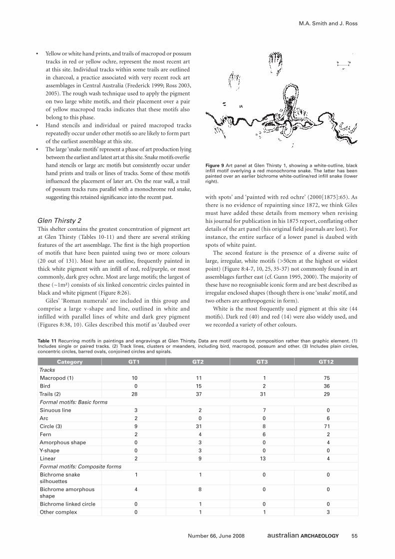
55Number 66, June 2008
M.A. Smith and J. Ross
• Yellow or white hand prints, and trails of macropod or possum
tracks in red or yellow ochre, represent the most recent art
at this site. Individual tracks within some trails are outlined
in charcoal, a practice associated with very recent rock art
assemblages in Central Australia (Frederick 1999; Ross 2003,
2005). The rough wash technique used to apply the pigment
on two large white motifs, and their placement over a pair
of yellow macropod tracks indicates that these motifs also
belong to this phase.
• Hand stencils and individual or paired macropod tracks
repeatedly occur under other motifs so are likely to form part
of the earliest assemblage at this site.
• The large ‘snake motifs’ represent a phase of art production lying
between the earliest and latest art at this site. Snake motifs overlie
hand stencils or large arc motifs but consistently occur under
hand prints and trails or lines of tracks. Some of these motifs
infl uenced the placement of later art. On the rear wall, a trail
of possum tracks runs parallel with a monochrome red snake,
suggesting this retained signifi cance into the recent past.
Glen Thirsty 2This shelter contains the greatest concentration of pigment art
at Glen Thirsty (Tables 10-11) and there are several striking
features of the art assemblage. The fi rst is the high proportion
of motifs that have been painted using two or more colours
(20 out of 131). Most have an outline, frequently painted in
thick white pigment with an infi ll of red, red/purple, or most
commonly, dark grey ochre. Most are large motifs; the largest of
these (~1m²) consists of six linked concentric circles painted in
black and white pigment (Figure 8:26).
Giles’ ‘Roman numerals’ are included in this group and
comprise a large v-shape and line, outlined in white and
infilled with parallel lines of white and dark grey pigment
(Figures 8:38, 10). Giles described this motif as ‘daubed over
with spots’ and ‘painted with red ochre’ (2000[1875]:65). As
there is no evidence of repainting since 1872, we think Giles
must have added these details from memory when revising
his journal for publication in his 1875 report, conflating other
details of the art panel (his original field journals are lost). For
instance, the entire surface of a lower panel is daubed with
spots of white paint.
The second feature is the presence of a diverse suite of
large, irregular, white motifs (>50cm at the highest or widest
point) (Figure 8:4-7, 10, 25, 35-37) not commonly found in art
assemblages further east (cf. Gunn 1995, 2000). The majority of
these have no recognisable iconic form and are best described as
irregular enclosed shapes (though there is one ‘snake’ motif, and
two others are anthropogenic in form).
White is the most frequently used pigment at this site (44
motifs). Dark red (40) and red (14) were also widely used, and
we recorded a variety of other colours.
Figure 9 Art panel at Glen Thirsty 1, showing a white-outline, black infi ll motif overlying a red monochrome snake. The latter has been painted over an earlier bichrome white-outline/red infi ll snake (lower right).
Category GT1 GT2 GT3 GT12Tracks
Macropod (1) 10 11 1 75
Bird 0 15 2 36
Trails (2) 28 37 31 29
Formal motifs: Basic forms
Sinuous line 3 2 7 0
Arc 2 0 0 6
Circle (3) 9 31 8 71
Fern 2 4 6 2
Amorphous shape 0 3 0 4
Y-shape 0 3 0 0
Linear 2 9 13 4
Formal motifs: Composite forms
Bichrome snake silhouettes
1 1 0 0
Bichrome amorphous shape
4 8 0 0
Bichrome linked circle 0 1 0 0
Other complex 0 1 1 3
Table 11 Recurring motifs in paintings and engravings at Glen Thirsty. Data are motif counts by composition rather than graphic element. (1) Includes single or paired tracks. (2) Track lines, clusters or meanders, including bird, macropod, possum and other. (3) Includes plain circles, concentric circles, barred ovals, conjoined circles and spirals.
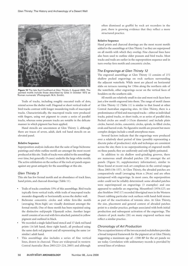
56 Number 66, June 2008
Glen Thirsty: The History and Archaeology of a Desert Well
Trails of tracks, including roughly executed trails of dots,
extend across the shelter wall. Diagonal or short vertical trails of
bird tracks contrast with longer meandering trails of macropod
tracks. Characteristically, the macropod tracks were produced
with fi ngers, using wet pigment to create a series of parallel
tracks, whereas some possum tracks are notable in the delicate
manner in which pigment has been applied.
Hand stencils are uncommon at Glen Thirsty 2, although
there are traces of seven, adult, dark red hand stencils on an
elevated panel.
Relative SequenceSuperposition analysis indicates that the suite of large bichrome
paintings and white outline motifs are amongst the most recent
produced at this site. Trails of tracks were added to the assemblage
over time, but generally (9 cases) underlie the large white motifs.
The active exfoliation on the surface of the rock art panels argues
against any great antiquity for the assemblage at this site.
Glen Thirsty 3This site has few formal motifs and an abundance of track lines,
hand prints, and charcoal drawings (Table 11).
• Trails of tracks constitute 33% of this assemblage. Bird tracks
typically form vertical trails, while trails of macropod tracks
meander diagonally or horizontally across the shelter wall.
• Bichrome concentric circles and white fern-like motifs
(averaging 30cm-high) are visually dominant amongst the
formal motifs. One of these motifs has been repainted using
the distinctive red/purple Ulpanyali ochre. Another larger
motif consists of an oval with fern attached, painted in yellow
pigment and outlined in black.
• We recorded a single faded hand stencil and 17 dark red hand
prints (14 left hand, three right hand), all produced using
the same dark red pigment and all representing the same (or
similar) adult hand.
• This assemblage also includes a series of fine vertical
lines, drawn in charcoal. These are widespread in western
Central Australia (Ross 2003:223-224, 2005) and although
often dismissed as graffiti by rock art recorders in the
past, there is growing evidence that they reflect a more
structured practice.
Relative SequenceHand prints and charcoal drawings are the most recent motifs
added to the assemblage at Glen Thirsty 3 as they are superposed
on all motifs with which they overlap. Fine charcoal lines have
also been used to outline older possum and bird tracks. Most
tracks and trails are earlier in the superposition sequence and in
turn overlay fern motifs and concentric circles.
The Engravings at Glen Thirsty 12The engraved assemblage at Glen Thirsty 12 consists of 272
shallow pecked engravings on rock surfaces surrounding
the adjacent waterhole. While most are placed on horizontal
slabs on terraces running for 150m along the northern side of
the waterhole, other engravings occur on the vertical faces of
boulders on the southern side.
All motifs are relatively small in size and most rock faces have
just a few motifs engraved into them. The range of motif classes
at Glen Thirsty 12 (Table 11) is similar to that found at other
Central Australian engraving sites. At Glen Thirsty, there is a
predominance of bird and macropod tracks – either as individual
tracks, paired tracks, or short trails, or as series of parallel dots.
Pecked circles are small (<15cm diameter) and include plain
circles, barred circles, concentric circles, spirals, in-fi lled circles,
ovals and barred ovals. No fi gurative motifs are present but more
complex designs include a small amorphous maze.
Several factors indicate that the engravings were produced
over a relatively short period of time (possibly representing a
discrete pulse of production): style and technique are consistent
across the site; there is no superpositioning of engraved motifs
on these panels; they are uniformly and only lightly patinated.
In addition to six shallow seed-grinding grooves, there
are numerous small abraded patches (28) amongst the art
panels (Figure S1, supplementary information), similar to
those found at recent rock art complexes in the central ranges
(Ross 2003:156-157). At Glen Thirsty, the abraded patches are
comparatively small (averaging 44cm x 29cm) and are often
juxtaposed with engravings. In most cases, the superposition
order could not be reliably determined: some abraded patches
were superimposed on engravings (3 examples) and one
appeared to underlie an engraving. Mountford (1976:127; see
also Strehlow 1947:17) recorded Aboriginal men in the Western
Desert rubbing particular rock surfaces with hand-held stones
as part of the reactivation of totemic sites. At Glen Thirsty,
the size, placement and general context of abraded patches
point to a similar practice, perhaps associated with both initial
production and subsequent activation of the engravings. The
clusters of peck marks (20) on many engraved surfaces may
refl ect a similar practice.
Chronology of Art ProductionThe occupation history of the two excavated rockshelters provides
a broad temporal framework for the pigment art at Glen Thirsty,
suggesting a maximum age of ~1500 BP for the art panels we
see today. Correlation with sedimentary records is provided by
several lines of evidence:
Figure 10 The late Syd Coulthard at Glen Thirsty 2, August 2003. The painted motifs include those described by Giles in October 1872 as
‘Roman numerals’ (Photograph: M.A. Smith).
57Number 66, June 2008
M.A. Smith and J. Ross
• Fragments of red or dark red, or Ulpanyali ochre, similar to
the pigments used in the paintings and stencils are found
throughout the occupation deposit at GT1 and 3.
• The fallen rock slab exposed in the excavations at GT1
provides an estimated terminus post quem of 2000–3000 BP
for paintings and stencils on the related scar on the overhang.
These include hand stencils that are amongst the earliest
motifs produced at the site.
• There is broad agreement regarding the relative age of the sites,
comparing occupation histories and phases of art production.
For example, the rock art frieze at GT1 has the greatest
intrinsic time depth of any of the 11 sites we examined – and
this site also has the longest 14C chronology.
Within the last 1500 years, the Glen Thirsty sites show an
internally-consistent series of changes in style and composition
in the pigment art. Hand stencils and trails (mainly track lines
or meanders) appear to have been the earliest compositions.
These were followed by production of large emblemic motifs,
including the white-outline silhouette designs at Glen Thirsty
1 and 2. The latest phase of art production at the Glen Thirsty
sites consists of hand prints, charcoal drawings and paintings
in white ochre. This sequence parallels similar changes
at Puritjarra (to the north) during the last millennium
(Rosenfeld and Smith 2002), especially the shift towards large
emblemic motifs.
The engravings at Glen Thirsty are of no great antiquity
and may be contemporary with the pigment art. The circles
and tracks use the same stylistic conventions as the pigment
art at Glen Thirsty. The shallow pecking technique used to
produce motifs at Glen Thirsty 12 is similar to that used to
produce many of the more recent engraved motifs across
Central Australia (Ross 2002, 2003). Similarly, the range of
motif classes recorded, the lack of patination, the absence of
pecked pits, and the abundance of abraded areas, all suggest a
recent age for this assemblage.
Historical ArchaeologyNo surviving trace of Giles’ 1872 encampment was located.
There are few trees of suffi cient age and size to carry an old blaze.
Extensive transects with a metal detector in the area south and
southwest of Worrill’s Pass, and on the fl at south of the rock
holes, failed to locate any metal items. It seems likely that Giles’
use of Glen Thirsty was so light that little repair or discard of non-
perishable objects such as horseshoes, or nails occurred. No metal
objects were detected in the sandy fl oors of local rockshelters.
Vegetation HistoryDirect palaeoenvironmental evidence for the region is sparse
(especially for the last few millennia). The phytolith record at
Puritjarra (Bowdery 1995, 1998) shows that the mid-Holocene
saw a decline in regional grass levels after 5000 BP, which only
recovered again after about 1500 BP as the modern vegetation
took shape. Assuming that periods of high representation of
Poaceae in the phytolith record refl ect better summer rainfall
(which is likely), the last millennium was a comparatively
favourable period for human settlement in Central Australia
(Bowdery 1995:Figure 6.1). This is supported by a study of
palaeofl oods on the Todd River, Central Australia, which shows
frequent high-magnitude fl oods during the last 1500 years, with
identifi ed fl ood phases at 400 BP, 600 BP, 1000 BP and 2100 BP
(Bourke 1998:131-134).
In Central Australia, stick-nest rat (Leporillus sp.) middens
have also been used as a source of palaeoecological data. Berry
(1991) sampled a midden at Kathleen Springs in Watarrka-Kings
Canyon National Park, with results indicating little local vegetation
change between 3500–1700 BP. Other Leporillus sp. middens, in
the eastern MacDonnell Ranges show a marked late Holocene
increase in tree and shrub taxa beginning sometime between
2510 and 850 BP, at the expense of herbs and grasses (Webeck
and Pearson 2005). To test if there were comparable changes at
Glen Thirsty, Webeck sampled four local Leporillus sp. middens
in 2004. This work has yet to be completed, but preliminary
results indicate that none of these middens date earlier than 430
BP and that over this period there is little apparent change in
local vegetation.
Discussion and Interpretation
The History of Glen ThirstyOur archaeological investigations give a picture of people using
a small soakage well on the northern rim of Lake Amadeus.
Despite our initial expectation that there would be several
phases of major occupation at a site in this location, separated
by periods of intermittent use or abandonment, we found that
substantive occupation of Glen Thirsty only took place during
the last 1500 years.
The presence of chipped stone artefacts in earlier deposits
points to intermittent use of the area prior to this, but as visitation
rather than colonisation. Some early use of the Glen Thirsty
locale would be expected given its proximity to the George Gill
Range with its springs and waterholes, and to Puritjarra with its
long record of late Pleistocene occupation to the north. But Glen
Thirsty itself only appears to have become an important focus of
occupation after 1500 BP.
Analysis of the rock art assemblage – both engravings and
paintings – leads us to similar conclusions: the rock engravings
surrounding the waterhole are uniformly late prehistoric in their
style and condition. There are no older weathered engravings to
suggest that an earlier pulse of occupation in the Glen Thirsty
area has been missed in the excavations. Other evidence supports
an association between the paintings at Glen Thirsty 1 and 3 and
the dated occupation deposits at these sites.
Several lines of evidence independently suggest establishment
of a new cultural and economic landscape at Glen Thirsty around
1500 BP, although much necessarily remains speculative:
• Major use of Glen Thirsty 1 is preceded by widespread burning
of local vegetation, coinciding with the fi rst appearance of
stone artefacts in these deposits. We have no data on whether
this refl ects human fi ring of local grassland (as Giles saw in
1872), or whether it represents large wildfi res associated with
increased fuel build up during years of exceptional rainfall (as
Central Australia experienced in 2002-2003). But increased
wildfi res and increased occupation of Glen Thirsty would
both be consequences of stronger summer rainfall.
• The rock engravings appear to represent a short-lived pulse of
art production, consistent with the establishment of a more
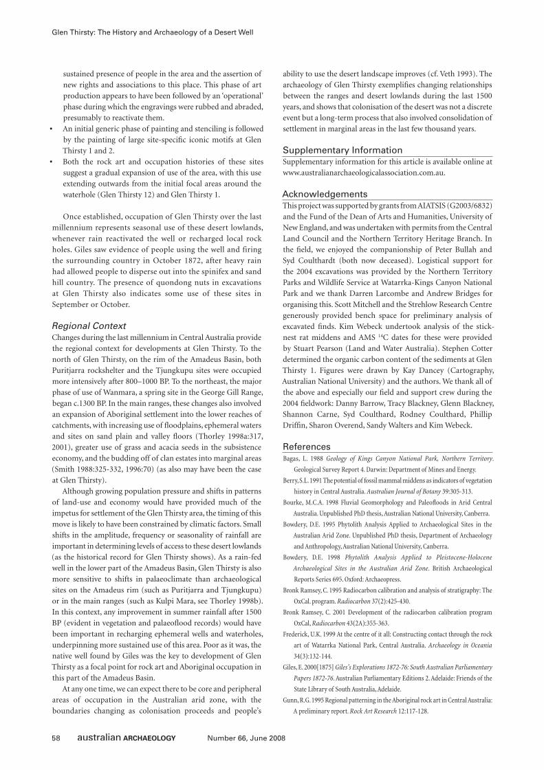
58 Number 66, June 2008
Glen Thirsty: The History and Archaeology of a Desert Well
sustained presence of people in the area and the assertion of
new rights and associations to this place. This phase of art
production appears to have been followed by an ‘operational’
phase during which the engravings were rubbed and abraded,
presumably to reactivate them.
• An initial generic phase of painting and stenciling is followed
by the painting of large site-specifi c iconic motifs at Glen
Thirsty 1 and 2.
• Both the rock art and occupation histories of these sites
suggest a gradual expansion of use of the area, with this use
extending outwards from the initial focal areas around the
waterhole (Glen Thirsty 12) and Glen Thirsty 1.
Once established, occupation of Glen Thirsty over the last
millennium represents seasonal use of these desert lowlands,
whenever rain reactivated the well or recharged local rock
holes. Giles saw evidence of people using the well and firing
the surrounding country in October 1872, after heavy rain
had allowed people to disperse out into the spinifex and sand
hill country. The presence of quondong nuts in excavations
at Glen Thirsty also indicates some use of these sites in
September or October.
Regional ContextChanges during the last millennium in Central Australia provide
the regional context for developments at Glen Thirsty. To the
north of Glen Thirsty, on the rim of the Amadeus Basin, both
Puritjarra rockshelter and the Tjungkupu sites were occupied
more intensively after 800–1000 BP. To the northeast, the major
phase of use of Wanmara, a spring site in the George Gill Range,
began c.1300 BP. In the main ranges, these changes also involved
an expansion of Aboriginal settlement into the lower reaches of
catchments, with increasing use of fl oodplains, ephemeral waters
and sites on sand plain and valley fl oors (Thorley 1998a:317,
2001), greater use of grass and acacia seeds in the subsistence
economy, and the budding off of clan estates into marginal areas
(Smith 1988:325-332, 1996:70) (as also may have been the case
at Glen Thirsty).
Although growing population pressure and shifts in patterns
of land-use and economy would have provided much of the
impetus for settlement of the Glen Thirsty area, the timing of this
move is likely to have been constrained by climatic factors. Small
shifts in the amplitude, frequency or seasonality of rainfall are
important in determining levels of access to these desert lowlands
(as the historical record for Glen Thirsty shows). As a rain-fed
well in the lower part of the Amadeus Basin, Glen Thirsty is also
more sensitive to shifts in palaeoclimate than archaeological
sites on the Amadeus rim (such as Puritjarra and Tjungkupu)
or in the main ranges (such as Kulpi Mara, see Thorley 1998b).
In this context, any improvement in summer rainfall after 1500
BP (evident in vegetation and palaeofl ood records) would have
been important in recharging ephemeral wells and waterholes,
underpinning more sustained use of this area. Poor as it was, the
native well found by Giles was the key to development of Glen
Thirsty as a focal point for rock art and Aboriginal occupation in
this part of the Amadeus Basin.
At any one time, we can expect there to be core and peripheral
areas of occupation in the Australian arid zone, with the
boundaries changing as colonisation proceeds and people’s
ability to use the desert landscape improves (cf. Veth 1993). The
archaeology of Glen Thirsty exemplifi es changing relationships
between the ranges and desert lowlands during the last 1500
years, and shows that colonisation of the desert was not a discrete
event but a long-term process that also involved consolidation of
settlement in marginal areas in the last few thousand years.
Supplementary InformationSupplementary information for this article is available online at
www.australianarchaeologicalassociation.com.au.
AcknowledgementsThis project was supported by grants from AIATSIS (G2003/6832)
and the Fund of the Dean of Arts and Humanities, University of
New England, and was undertaken with permits from the Central
Land Council and the Northern Territory Heritage Branch. In
the fi eld, we enjoyed the companionship of Peter Bullah and
Syd Coulthardt (both now deceased). Logistical support for
the 2004 excavations was provided by the Northern Territory
Parks and Wildlife Service at Watarrka-Kings Canyon National
Park and we thank Darren Larcombe and Andrew Bridges for
organising this. Scott Mitchell and the Strehlow Research Centre
generously provided bench space for preliminary analysis of
excavated fi nds. Kim Webeck undertook analysis of the stick-
nest rat middens and AMS 14C dates for these were provided
by Stuart Pearson (Land and Water Australia). Stephen Cotter
determined the organic carbon content of the sediments at Glen
Thirsty 1. Figures were drawn by Kay Dancey (Cartography,
Australian National University) and the authors. We thank all of
the above and especially our fi eld and support crew during the
2004 fi eldwork: Danny Barrow, Tracy Blackney, Glenn Blackney,
Shannon Carne, Syd Coulthard, Rodney Coulthard, Phillip
Driffi n, Sharon Overend, Sandy Walters and Kim Webeck.
ReferencesBagas, L. 1988 Geology of Kings Canyon National Park, Northern Territory.
Geological Survey Report 4. Darwin: Department of Mines and Energy.
Berry, S.L. 1991 The potential of fossil mammal middens as indicators of vegetation
history in Central Australia. Australian Journal of Botany 39:305-313.
Bourke, M.C.A. 1998 Fluvial Geomorphology and Paleofl oods in Arid Central
Australia. Unpublished PhD thesis, Australian National University, Canberra.
Bowdery, D.E. 1995 Phytolith Analysis Applied to Archaeological Sites in the
Australian Arid Zone. Unpublished PhD thesis, Department of Archaeology
and Anthropology, Australian National University, Canberra.
Bowdery, D.E. 1998 Phytolith Analysis Applied to Pleistocene-Holocene
Archaeological Sites in the Australian Arid Zone. British Archaeological
Reports Series 695. Oxford: Archaeopress.
Bronk Ramsey, C. 1995 Radiocarbon calibration and analysis of stratigraphy: The
OxCal. program. Radiocarbon 37(2):425-430.
Bronk Ramsey, C. 2001 Development of the radiocarbon calibration program
OxCal, Radiocarbon 43(2A):355-363.
Frederick, U.K. 1999 At the centre of it all: Constructing contact through the rock
art of Watarrka National Park, Central Australia. Archaeology in Oceania
34(3):132-144.
Giles, E. 2000[1875] Giles’s Explorations 1872-76: South Australian Parliamentary
Papers 1872-76. Australian Parliamentary Editions 2. Adelaide: Friends of the
State Library of South Australia, Adelaide.
Gunn, R.G. 1995 Regional patterning in the Aboriginal rock art in Central Australia:
A preliminary report. Rock Art Research 12:117-128.
59Number 66, June 2008
M.A. Smith and J. Ross
Gunn, R.G. 2000 Central Australian rock art: A second report. Rock Art Research
17:111-126.
Jacobson, G., G.C. Lau, P.S. McDonald and J. Jankowski 1989 Hydrogeology and
Groundwater Resources of the Lake Amadeus and Ayers Rock Region, Northern
Territory. Bureau of Mineral Resources, Geology and Geophysics Bulletin 230.
Canberra: Australian Government Publishing Service.
Jackson, E.A. 1962 Soil Studies in Central Australia: Alice Springs-Hermannsburg-
Rodinga Areas. Melbourne: CSIRO.
Johnson, I. 1979 The Getting of Data: A Case Study from the Recent Industries of
Australia. Unpublished PhD thesis, Department of Prehistory, Research School
of Pacifi c Studies, Australian National University, Canberra.
Maurice, Justice 1989 Lake Amadeus Land Claim, Report by the Aboriginal Land
Commissioner to the Minister of Aboriginal Affairs and the Administrator of
the Northern Territory. Canberra: Australian Government Publishing Service.
McCormac, F.G., A.G. Hogg, P.G. Blackwell, C.E. Buck, T.F.G. Higham and P.J.
Reimer 2004 SHCAL04 southern hemisphere calibration, 0-11.0 cal kyr BP.
Radiocarbon 46(3):1087-1092.
Mountford, C.P. 1976 Nomads of the Australian Desert. Adelaide: Rigby Limited.
Murray, W.R. 1904 Explorations by R. T. Maurice – Fowlers Bay to Cambridge Gulf.
South Australian Parliamentary Paper 43.
Rosenfeld, A. 1990 Rock Art in Watarrka National Park. Unpublished report to the
Conservation Commission of the Northern Territory, Alice Springs.
Rosenfeld, A. and M.A. Smith 2002 Rock-art and the history of Puritjarra rock
shelter, Cleland Hills, Central Australia. Proceedings of the Prehistoric Society
68:103-124.
Ross, J. 2002 Rocking the boundaries, scratching the surface: An analysis of the
relationship between paintings and engravings in the Central Australian
arid zone. In S. Ulm, C. Westcott, J. Reid, A. Ross, I. Lilley, J. Prangnell and
L. Kirkwood (eds), Barriers Borders Boundaries: Proceedings of the 2001
Australian Archaeological Association Annual Conference, pp.83-90. Tempus
7. Brisbane: Anthropology Museum, University of Queensland.
Ross, J. 2003 Rock Art, Ritual and Relationships: An Archaeological Analysis of
Rock Art from the Central Australian Arid Zone. Unpublished PhD thesis,
School of Human and Environmental Studies, University of New England,
Armidale.
Ross, J. 2005 Rock art of the Red Centre. In M.A. Smith and P. Hesse (eds), 23°
South: Archaeology and Environmental History of the Southern Deserts, pp.217-
230. Canberra: National Museum of Australia Press.
Smith, M.A. 1988 The Pattern and Timing of Prehistoric Settlement in Central
Australia. Unpublished PhD thesis, Department of Prehistory and Archaeology,
University of New England, Armidale.
Smith, M.A. 1996 Prehistory and human ecology in Central Australia: An
archaeological perspective. In S.R. Morton and D.J. Mulvaney (eds), Exploring
Central Australia: Society, the Environment and the 1894 Horn Expedition,
pp.61-73. Chipping Norton, NSW: Surrey Beatty and Sons.
Smith, M.A. 2005 ‘Peopling’ the Cleland Hills: Aboriginal History in Western
Central Australia, 1850-1980. Aboriginal History Monograph 12. Canberra:
Aboriginal History Inc.
Smith, M.A. 2006 Characterising late Pleistocene and Holocene stone artefact
assemblages from Puritjarra rock shelter: A long sequence from the Australian
desert. Records of the Australian Museum 58:371-410.
Smith, M.A. and A. Rosenfeld 1992 Archaeological Sites in Watarrka National Park:
The Northern Sector of the Plateau. Unpublished report to the Conservation
Commission of the Northern Territory, Alice Springs.
Smith, M.A. and J. Ross 2008 What happened at 1500-1000 BP in Central Australia?
Timing, impact, and archaeological signatures. The Holocene 18(3):387-396.
Strehlow, T.G.H. 1947 Aranda Traditions. Melbourne: Melbourne University Press.
Terry, M. 1937 Sand and Sun: Two Gold-Hunting Expeditions with Camels in Dry
Lands of Central Australia. London: Michael Joseph.
Thorley, P.B. 1998a Shifting Location, Shifting Scale: Towards an Archaeology of
Place in the Palmer River Catchment, Central Australia. Unpublished PhD
thesis, Northern Territory University, Darwin.
Thorley, P.B. 1998b Pleistocene settlement in the Australian arid zone: Occupation
of an inland riverine landscape in the central Australian ranges. Antiquity
72:34-45.
Thorley, P.B. 1999 Regional archaeological research in the Palmer River catchment.
Australian Aboriginal Studies 2:62-68.
Thorley, P.B. 2001 Uncertain supplies: Water availability and regional archaeological
structure in the Palmer River catchment, Central Australia. Archaeology in
Oceania 36(1):1-14.
Veth, P.M. 1993 Islands in the Interior: The Dynamics of Prehistoric Adaptations
within the Arid Zone of Australia. Archaeology Series 3. Ann Arbor, MI:
International Monographs in Prehistory.
Veth, P. 2005 Between the desert and the sea: Archaeologies of the Western
Desert and Pilbara regions, Australia. In M.A. Smith and P. Hesse (eds) 23°S:
Archaeology and Environmental History of the Southern Deserts, pp.132-141.
Canberra: National Museum of Australia Press.
Webeck, K. and S.G. Pearson 2005 Stick-nest rat middens and a late-Holocene
record of White Range, Central Australia. The Holocene 15:466-471.
Willshire, W.H. 1895 A Thrilling Tale of Real Life in the Wilds of Australia by
Mounted Constable, First-Class, Offi cer in Charge of Native Police. Adelaide:
Frearson and Brother.
60 Number 66, June 2008
IntroductionThe use of geophysical techniques as an aid to archaeological
investigations has become common-place, however these methods
have only occasionally been applied in Indigenous Australian
archaeology. This is despite recognition (and recommendations)
since the 1970s that such approaches have the potential to yield
positive results in such contexts (e.g. Connah et al. 1976; Stanley
1983; Stanley and Green 1976). Australian archaeologists have
perhaps been reluctant to embrace these techniques because of their
perceived high cost (both of equipment and specialist staff) and the
subtle nature of subsurface Indigenous sites as geophysical targets.
Nevertheless, there have been a number of recent applications of
these techniques in Australia, particularly in relation to burial and
hearth sites. We report the results of a pilot study conducted in
northwest Queensland. This study aimed to test the applicability of
geophysical methods being routinely employed to locate a variety
of open site features (particularly hearths and middens) as part of
reconnaissance surveys. While not being entirely successful, this
study demonstrated that certain archaeological features can be
readily identifi ed using geophysical techniques, though further
research and trials should be carried out to refi ne the uses of these
techniques to allow their more widespread applicability.
Characteristics of Hearth and Midden SitesHeat retainer hearths are ubiquitous in many parts of Australia,
typically appearing in surface exposures as small mounded
features with a locally available raw material – typically stone, clay
or termite mound – used as the heat retaining source. While the
majority of dated hearths have proved to be Holocene in age (e.g.
Holdaway et al. 2005; Robins 1996; Wallis et al. 2004) hearths of
greater age have been dated (e.g. Allen 1998; Smith et al. 1991; Veth
et al. 1990). Their widespread occurrence and ease of dating means
that hearths can be extremely useful for establishing chronologies
in parts of Australia where few other such possibilities exist.
Unfortunately, many decades of cattle and sheep grazing have had
a negative effect on the integrity of hearths, with heat retainers
sometimes so dispersed that the primary site location can no
longer be ascertained. Increased erosion rates caused by ungulates
have also accelerated exposure of such sites.
Historical documents reveal that middens composed
predominantly of freshwater mussel shells were once another
relatively common site type along watercourses in inland Australia.
Such sites also afford archaeologists abundant opportunities to
establish regional chronologies, as well as to examine questions
related to subsistence strategies, seasonality and resource use. Like
hearths, middens exposed at the ground surface are vulnerable
to physical destruction through stock treadage, and the chances
of fi nding such sites intact is therefore substantially reduced
even when other extensive evidence of Indigenous occupation
occurs (e.g. Crothers 1997; Wallis 2007; Wallis et al. 2004). Where
middens are found, their surface expression is often minimal,
with the shell being highly fragmented and dispersed and only
the subsurface shell material appearing to be intact (e.g. Wallis
2007). Consequently, such sites are often diffi cult to identify
using standard surface survey methods.
Both hearths and middens are important components of the
inland archaeological record, but both site types are prone to
destruction when exposed at the ground surface. This ongoing
destruction means they are an urgent contemporary heritage
management concern. The ability to identify such sites in an intact
subsurface context before they have been exposed and disturbed
or destroyed would greatly assist archaeologists and heritage
managers. Geophysical techniques such as electromagnetic
induction (EMI) and magnetometry provide a possible means
of accomplishing this.
EMI and Magnetometry TechniquesMagnetometry has a long history of use in European and
North American archaeology. It measures local perturbations in
the earth’s magnetic fi eld caused by accumulations of ferrous
material which may be from an anthropogenic or a geological
origin (Reynolds 1997). There are a variety of sensor types, sensor
confi gurations and survey methodologies for magnetometry
which are variously employed depending on the target material
and survey budget.
Electromagnetic induction (EMI) typically measures two
components of an induced magnetic fi eld: the quadrature
phase, which is linearly related to the ground conductivity, and
the in-phase component of the induced magnetic fi eld, which
measures magnetic susceptibility. Because each measurement
is not solely dependent on ferrous material, EMI is capable of
detecting a wide range of features including soil type, sediment
type, bedrock location or presence of cultural material, and has
been applied with success at archaeological sites for a variety of
tasks (Kvamme 2003). Furthermore, EMI can identify changes to
soil conductivity caused by both buried objects and associated
sedimentary disturbance (Nobes 2000:716; Nobes and Tyndall
1995:266).
SHORT REPORTS
Trialing Geophysical Techniques in the Identifi cation of Open Indigenous Sites in Australia: A Case Study from Inland Northwest QueenslandIan Moffat1,2, Lynley A. Wallis2, Alice Beale3 and Darren Kynuna4
1 Research School of Earth Sciences, Australian National University, Canberra, ACT 0200, Australia
2 Department of Archaeology, Flinders University, GPO Box 2100, Adelaide, SA 5001, Australia
3 Department of Anthropology, Western Australian Museum, Perth Cultural Centre, James Street, Perth, WA 6000, Australia
4 Woolgar Valley Aboriginal Corporation, c/- 11 Harris Street, Richmond, QLD 4822, Australia
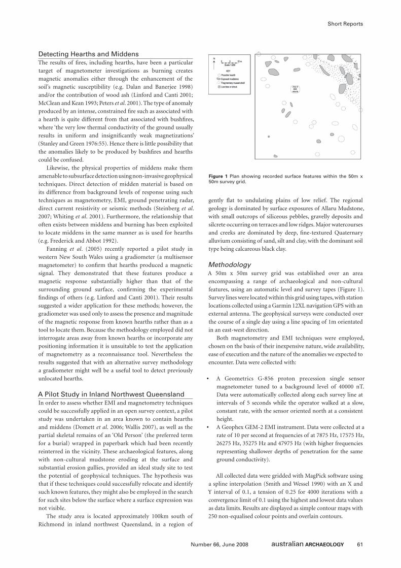
61Number 66, June 2008
Short Reports
Detecting Hearths and MiddensThe results of fi res, including hearths, have been a particular
target of magnetometer investigations as burning creates
magnetic anomalies either through the enhancement of the
soil’s magnetic susceptibility (e.g. Dalan and Banerjee 1998)
and/or the contribution of wood ash (Linford and Canti 2001;
McClean and Kean 1993; Peters et al. 2001). The type of anomaly
produced by an intense, constrained fi re such as associated with
a hearth is quite different from that associated with bushfi res,
where ‘the very low thermal conductivity of the ground usually
results in uniform and insignifi cantly weak magnetizations’
(Stanley and Green 1976:55). Hence there is little possibility that
the anomalies likely to be produced by bushfi res and hearths
could be confused.
Likewise, the physical properties of middens make them
amenable to subsurface detection using non-invasive geophysical
techniques. Direct detection of midden material is based on
its difference from background levels of response using such
techniques as magnetometry, EMI, ground penetrating radar,
direct current resistivity or seismic methods (Steinberg et al.
2007; Whiting et al. 2001). Furthermore, the relationship that
often exists between middens and burning has been exploited
to locate middens in the same manner as is used for hearths
(e.g. Frederick and Abbot 1992).
Fanning et al. (2005) recently reported a pilot study in
western New South Wales using a gradiometer (a multisensor
magnetometer) to confi rm that hearths produced a magnetic
signal. They demonstrated that these features produce a
magnetic response substantially higher than that of the
surrounding ground surface, confi rming the experimental
fi ndings of others (e.g. Linford and Canti 2001). Their results
suggested a wider application for these methods; however, the
gradiometer was used only to assess the presence and magnitude
of the magnetic response from known hearths rather than as a
tool to locate them. Because the methodology employed did not
interrogate areas away from known hearths or incorporate any
positioning information it is unsuitable to test the application
of magnetometry as a reconnaissance tool. Nevertheless the
results suggested that with an alternative survey methodology
a gradiometer might well be a useful tool to detect previously
unlocated hearths.
A Pilot Study in Inland Northwest QueenslandIn order to assess whether EMI and magnetometry techniques
could be successfully applied in an open survey context, a pilot
study was undertaken in an area known to contain hearths
and middens (Domett et al. 2006; Wallis 2007), as well as the
partial skeletal remains of an ‘Old Person’ (the preferred term
for a burial) wrapped in paperbark which had been recently
reinterred in the vicinity. These archaeological features, along
with non-cultural mudstone eroding at the surface and
substantial erosion gullies, provided an ideal study site to test
the potential of geophysical techniques. The hypothesis was
that if these techniques could successfully relocate and identify
such known features, they might also be employed in the search
for such sites below the surface where a surface expression was
not visible.
The study area is located approximately 100km south of
Richmond in inland northwest Queensland, in a region of
gently fl at to undulating plains of low relief. The regional
geology is dominated by surface exposures of Allaru Mudstone,
with small outcrops of siliceous pebbles, gravelly deposits and
silcrete occurring on terraces and low ridges. Major watercourses
and creeks are dominated by deep, fi ne-textured Quaternary
alluvium consisting of sand, silt and clay, with the dominant soil
type being calcareous black clay.
MethodologyA 50m x 50m survey grid was established over an area
encompassing a range of archaeological and non-cultural
features, using an automatic level and survey tapes (Figure 1).
Survey lines were located within this grid using tapes, with station
locations collected using a Garmin 12XL navigation GPS with an
external antenna. The geophysical surveys were conducted over
the course of a single day using a line spacing of 1m orientated
in an east-west direction.
Both magnetometry and EMI techniques were employed,
chosen on the basis of their inexpensive nature, wide availability,
ease of execution and the nature of the anomalies we expected to
encounter. Data were collected with:
• A Geometrics G-856 proton precession single sensor
magnetometer tuned to a background level of 40000 nT.
Data were automatically collected along each survey line at
intervals of 5 seconds while the operator walked at a slow,
constant rate, with the sensor oriented north at a consistent
height.
• A Geophex GEM-2 EMI instrument. Data were collected at a
rate of 10 per second at frequencies of at 7875 Hz, 17575 Hz,
26275 Hz, 35275 Hz and 47975 Hz (with higher frequencies
representing shallower depths of penetration for the same
ground conductivity).
All collected data were gridded with MagPick software using
a spline interpolation (Smith and Wessel 1990) with an X and
Y interval of 0.1, a tension of 0.25 for 4000 iterations with a
convergence limit of 0.1 using the highest and lowest data values
as data limits. Results are displayed as simple contour maps with
250 non-equalised colour points and overlain contours.
Figure 1 Plan showing recorded surface features within the 50m x 50m survey grid.
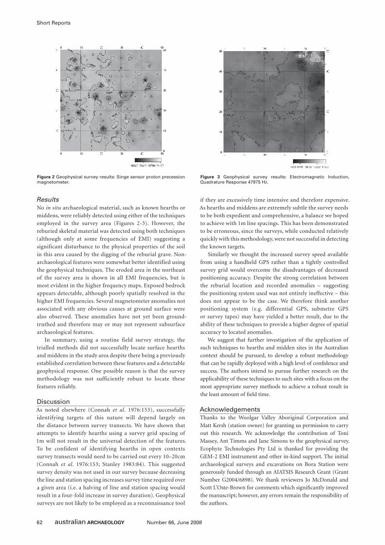
62 Number 66, June 2008
Short Reports
ResultsNo in situ archaeological material, such as known hearths or
middens, were reliably detected using either of the techniques
employed in the survey area (Figures 2-3). However, the
reburied skeletal material was detected using both techniques
(although only at some frequencies of EMI) suggesting a
significant disturbance to the physical properties of the soil
in this area caused by the digging of the reburial grave. Non-
archaeological features were somewhat better identified using
the geophysical techniques. The eroded area in the northeast
of the survey area is shown in all EMI frequencies, but is
most evident in the higher frequency maps. Exposed bedrock
appears detectable, although poorly spatially resolved in the
higher EMI frequencies. Several magnetometer anomalies not
associated with any obvious causes at ground surface were
also observed. These anomalies have not yet been ground-
truthed and therefore may or may not represent subsurface
archaeological features.
In summary, using a routine field survey strategy, the
trialled methods did not successfully locate surface hearths
and middens in the study area despite there being a previously
established correlation between these features and a detectable
geophysical response. One possible reason is that the survey
methodology was not sufficiently robust to locate these
features reliably.
DiscussionAs noted elsewhere (Connah et al. 1976:153), successfully
identifying targets of this nature will depend largely on
the distance between survey transects. We have shown that
attempts to identify hearths using a survey grid spacing of
1m will not result in the universal detection of the features.
To be confident of identifying hearths in open contexts
survey transects would need to be carried out every 10–20cm
(Connah et al. 1976:153; Stanley 1983:84). This suggested
survey density was not used in our survey because decreasing
the line and station spacing increases survey time required over
a given area (i.e. a halving of line and station spacing would
result in a four-fold increase in survey duration). Geophysical
surveys are not likely to be employed as a reconnaissance tool
if they are excessively time intensive and therefore expensive.
As hearths and middens are extremely subtle the survey needs
to be both expedient and comprehensive, a balance we hoped
to achieve with 1m line spacings. This has been demonstrated
to be erroneous, since the surveys, while conducted relatively
quickly with this methodology, were not successful in detecting
the known targets.
Similarly we thought the increased survey speed available
from using a handheld GPS rather than a tightly controlled
survey grid would overcome the disadvantages of decreased
positioning accuracy. Despite the strong correlation between
the reburial location and recorded anomalies – suggesting
the positioning system used was not entirely ineffective – this
does not appear to be the case. We therefore think another
positioning system (e.g. differential GPS, submetre GPS
or survey tapes) may have yielded a better result, due to the
ability of these techniques to provide a higher degree of spatial
accuracy to located anomalies.
We suggest that further investigation of the application of
such techniques to hearths and midden sites in the Australian
context should be pursued, to develop a robust methodology
that can be rapidly deployed with a high level of confi dence and
success. The authors intend to pursue further research on the
applicability of these techniques to such sites with a focus on the
most appropriate survey methods to achieve a robust result in
the least amount of fi eld time.
AcknowledgementsThanks to the Woolgar Valley Aboriginal Corporation and
Matt Kersh (station owner) for granting us permission to carry
out this research. We acknowledge the contribution of Toni
Massey, Ant Timms and Jane Simons to the geophysical survey.
Ecophyte Technologies Pty Ltd is thanked for providing the
GEM-2 EMI instrument and other in-kind support. The initial
archaeological surveys and excavations on Bora Station were
generously funded through an AIATSIS Research Grant (Grant
Number G2004/6898). We thank reviewers Jo McDonald and
Scott L’Oste-Brown for comments which signifi cantly improved
the manuscript; however, any errors remain the responsibility of
the authors.
Figure 2 Geophysical survey results: Singe sensor proton precession magnetometer.
Figure 3 Geophysical survey results: Electromagnetic Induction, Quadrature Response 47975 Hz.
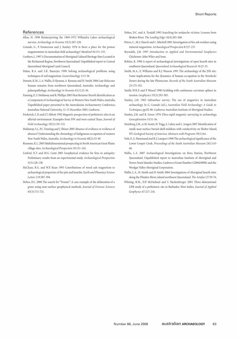
63Number 66, June 2008
Short Reports
ReferencesAllen, H. 1998 Reinterpreting the 1969-1972 Willandra Lakes archaeological
surveys. Archaeology in Oceania 33(3):207-220.
Connah, G., P. Emmerson and J. Stanley 1976 Is there a place for the proton
magnetometer in Australian fi eld archaeology? Mankind 10:151-155.
Crothers, L. 1997 A Documentation of Aboriginal Cultural Heritage Sites Located in
the Richmond Region, Northwest Queensland. Unpublished report to Central
Queensland Aboriginal Land Council.
Dalan, R.A. and S.K. Banerjee 1998 Solving archaeological problems using
techniques of soil magnetism. Geoarchaeology 13:3-36.
Domett, K.M., L.A. Wallis, D. Kynuna, A. Kynuna and H. Smith 2006 Late Holocene
human remains from northwest Queensland, Australia: Archaeology and
palaeopathology. Archaeology in Oceania 41(1):25-36.
Fanning, P., S. Holdaway and R. Phillips 2005 Heat Retainer Hearth Identifi cation as
a Component of Archaeological Survey in Western New South Wales, Australia.
Unpublished paper presented to the Australasian Archaeometry Conference,
Australian National University, 12-15 December 2005, Canberra.
Frederick, C.D. and J.T. Abbott 1992 Magnetic prospection of prehistoric sites in an
alluvial environment: Examples from NW and west-central Texas. Journal of
Field Archaeology 19(2):139-153.
Holdaway, S.J., P.C. Fanning and J. Shiner 2005 Absence of evidence or evidence of
absence? Understanding the chronology of Indigenous occupation of western
New South Wales, Australia. Archaeology in Oceania 40(2):33-49.
Kvamme, K.L. 2003 Multidimensional prospecting in North American Great Plains
village sites. Archaeological Prospection 10:131-142.
Linford, N.T. and M.G. Canti 2001 Geophysical evidence for fi res in antiquity:
Preliminary results from an experimental study. Archaeological Prospection
5(3):128-138.
McClean, R.G. and W.F. Kean 1993 Contributions of wood ash magnetism to
archaeological properties of fi re pits and hearths. Earth and Planetary Science
Letters 119:387-394.
Nobes, D.C. 2000 The search for “Yvonne”: A case example of the delineation of a
grave using near-surface geophysical methods. Journal of Forensic Sciences
45(3):715-721.
Nobes, D.C. and A. Tyndall 1995 Searching for avalanche victims: Lessons from
Broken River. The Leading Edge 14(4):265-268.
Peters, C., M.J. Church and C. Mitchell 2001 Investigation of fi re ash residues using
mineral magnetism. Archaeological Prospection 8:227-237.
Reynolds, J.M. 1997 Introduction to Applied and Environmental Geophysics.
Chichester: John Wiley and Sons.
Robins, R. 1996 A report of archaeological investigations of open hearth sites in
southwest Queensland. Queensland Archaeological Research 10:25-35.
Smith, M.A., E. Williams and R.J. Wasson 1991 The archaeology of the JSN site:
Some implications for the dynamics of human occupation in the Strezlecki
Desert during the late Pleistocene. Records of the South Australian Museum
25:175-192.
Smith, W.H.F. and P. Wessel 1990 Gridding with continuous curvature splines in
tension. Geophysics 55(3):293-305.
Stanley, J.M. 1983 Subsurface survey: The use of magnetics in Australian
archaeology. In G. Connah (ed.), Australian Field Archaeology: A Guide to
Techniques, pp.82-86. Canberra: Australian Institute of Aboriginal Studies.
Stanley, J.M. and R. Green 1976 Ultra-rapid magnetic surveying in archaeology.
Geoexploration 14:51-56.
Steinberg, J.M., A.M. Gontz, H. Trigg, A. Lahey and L. Aragon 2007 Identifi cation of
small, near-surface buried shell middens with conductivity on Shelter Island,
NY. Geological Society of America: Abstracts with Programs 39(1):64.
Veth, P., G. Hammand and R.J. Lampert 1990 The archaeological signifi cance of the
Lower Cooper Creek. Proceedings of the South Australian Museum 24(1):43-
66.
Wallis, L.A. 2007 Archaeological Investigations on Bora Station, Northwest
Queensland. Unpublished report to Australian Institute of Aboriginal and
Torres Strait Islander Studies, Canberra (Grant Number G2004/6898) and the
Woolgar Valley Aboriginal Corporation.
Wallis, L.A., H. Smith and D. Smith 2004 Investigations of Aboriginal hearth sites
along the Flinders River, inland northwest Queensland. The Artefact 27:59-76.
Whiting, B.M., D.P. McFarland and S. Hackenberger 2001 Three-dimensional
GPR study of a prehistoric site in Barbados, West Indies. Journal of Applied
Geophysics 47:217-216.
64 Number 66, June 2008
BOOK REVIEWS
RENEWING WOMEN’S BUSINESS: A DOCUMENTARY
Julie Drew & Wardaman Aboriginal CorporationJulie Drew & Burbank Production Services, Crow’s Nest, NSW,
2005, 57mins, DVD
Reviewed by Sally BabidgeSchool of Social Science, University of Queensland, Brisbane,
QLD 4072, Australia
Renewing Women’s Business is a documentary fi lm that follows
Lily Gin.gina Burdum, an elderly Wardaman woman from the
Victoria River District (referred to throughout the narrative
as Lily), and Julie Drew, an archaeologist from the University
of Sydney, on a camping trip. Lily is one of the few women of
her generation who was taken through initiation rites, and the
accompaniment and attention of her younger relatives on the
trip is central to the narrative. We see Lily, with the assistance
of Drew, teaching the younger women aspects of ‘women’s
business’ and ‘culture’ through viewing rock art, learning dances,
visiting waterholes and other places, and recounting ‘Dreamings’,
associated mythic beings, and the social regulations associated
with these. The DVD includes the fi lm itself as well as a ‘Picture
Gallery’ with many images of the group’s camping trip, rock art,
scenery and fi shing, as well as the fi lm crew and other ‘behind
the scenes’ images.
Spatial orientation is provided with a still of a good map of
the Northern Territory and Victoria River District, as well as the
location of the Wardaman community and Innesvale/Menngen
Station. The introduction to the fi lm also includes footage of
preparations for the bush trip: adolescent girls having a telephone
conversation with their teacher from Katherine School of the Air
explaining their coming absence in terms of going camping to
‘learn about culture’ (Chapter 2); loading a vehicle with swags and
supplies; and narrated introductions to the elder women central
to the fi lm as they warm themselves around a fi re next to their
house. This includes Lily’s sister (Queenie Nabijiji Morgan) who,
it is pointed out, was not initiated in her youth due to having
lived far away from the area from a young age with her ‘promise
husband’. Both older women worked on cattle stations, but Lily
grew up close to her family and country.
Drew’s personal depth of experience and knowledge of the
women, the region and the topic plays a prominent role in the
documentary, including as scriptwriter. The narration swaps
between Drew and May Rosas (who Drew introduces as the
narrator and ‘Lily’s niece’). They have apparently pitched the
fi lm at both a local and national audience. For example, we are
told that ‘elders must share their knowledge ... so that all young
Australians can value it’; and that ‘Lily is happy to share these
stories to help build a better understanding and respect for
Wardaman woman’s business’ (Chapter 12). Given the audience
they seek, I thought that the sparse use of subtitles was a tactic
that may annoy some who like every word uttered on screen
translated to text. However, I personally found satisfying the
resultant requirement that the viewer focus on the central fi gures’
movements and non-verbal communication in conjunction with
the spoken Aboriginal English.
The structure of the fi lm and steady camera work is easy to
follow and good to watch. As a subject, Lily seems comfortable
with the lens turned upon her, although Drew less so. In contrast,
the young girls interact directly with the lens, acutely aware of
its gaze. The girls – with their solemn expressions and sidelong
glances at the camera as they listen to Lily’s interpretations of
the fi gures in the rock art galleries; their raucousness as they are
taught to dance; and their hands cupped over their mouths as
they giggle (and are heard being told to ‘shush’) at the discussion
between Lily and Drew of fi rst menstruation rituals – lend a lively
presence to the fi lm that this reviewer appreciated. My favourite
scenes in the documentary were of the group of girls and women
sitting in a waterhole digging out the oily mud to smear on
themselves as ‘love magic’ (jirri) (Chapters 5-6); and later, the
conversation among a handful of adolescent and teenage girls
sitting on the riverbank telling the camera about the power of the
love magic, and about ‘skin’ laws in terms of who each of them can
and can’t ‘go with’. The girls’ preoccupation with sexual and social
relationships was telling of their gender and age. More than this,
these scenes demonstrate their lived social realities. On camera,
they engage in gender and generational-specifi c interpretations of
cultural knowledge in recounting ‘skin’ regulations. They convey
a sense of the contemporary-mythic when they tell a story about
a woman who successfully wielded love magic over her man, and
his later attempt at ‘breaking that spell’ (Chapter 12). Such scenes
demonstrate their lived social realities.
These scenes contrasted with the rather staged presentation and
representations of cultural knowledge in questioning and response
between Drew and Lily in the rock art galleries. The narrator
informs us that knowing connections between ‘Dreaming’, law,
and person means being a businesswoman, and respect for Lily’s
depth of knowledge is made plain. Nonetheless, I found Drew’s
constant interjection with questions and comment, a hindrance in
an appreciation of symbolic representation and myth that might
be seen in the rock art.
While in many ways an interesting fi lm, the production of
Renewing Women’s Business needs some fi nessing. The cover
provides only very basic information and the inside cover only
lists the images in the DVD’s ‘Picture Gallery’. Furthermore,
it would seem to make sense to indicate on the cover of the
DVD that there is a detailed website associated with the fi lm
(www.wardamanwomensbusiness.com), including teacher’s
notes, and other useful information. As with the DVD itself,
the information on the website would seem to me most useful
as a record of one woman’s knowledge for the local community,
but I feel it needs further refi nement if it is to be used by the
wider public or university educators. Perhaps the most obvious
lacunae in production detail was that nowhere could I fi nd
information around the issue of secrecy or gender sensitivity,
except for a brief warning to Aboriginal men at the very
beginning of the fi lm. Apparently it is suitable and appropriate
to be shown to non-Aboriginal men (given there is no warning
65Number 66, June 2008
Book Reviews
to the contrary), but given the obvious question, I feel this
could have been addressed explicitly.
It is worth making some critique of the way in which Drew
(who is referred to as an ‘ethnographic archaeologist’) applies the
culture concept in the scripting and narration. To take the most
obvious example, the young girls are said to ‘live in two worlds’
(Chapter 2). Firstly, Lily herself (and her sister), as well as the
young girls’ mother’s generations, and the young girls themselves,
all live (currently and apparently have done so throughout their
lives) in a complex social and cultural context that cannot be
characterised as simply Aboriginal or non-Aboriginal. From an
ethnographic perspective, the whole of their social reality, from
which they draw meaning, and which they take for granted, is
their cultural world. In the way they engage with the cameras, it
is clear that the youngest take for granted the role of multimedia
and its power as a representational tool. At the same time, they
emphasise to their school teacher (over the phone) that they must
be absent for camping and ‘culture’, and they express their respect
for their grandmothers’ knowledge. All of these things and more
are part of their world, rather than necessarily belonging to one
of two separable ‘cultural spheres’.
A further comment on the use of the concept of ‘culture’
must be made. The narrator states: ‘Today the girls have lost
the knowledge of their ancestors’ traditions’ (Chapter 2). The
premise of the documentary, or perhaps simply what underlies
the narration of the fi lm, is the pretence that one documented
camping and education trip with a knowledgeable woman and an
inquisitive archaeologist will ‘renew women’s business’. Perhaps
the activities recorded on fi lm are a minor part in other processes
of cultural renewal and this fi lm documents only a fraction of
a larger picture. Perhaps it is the case that the documentary
represents only one excursion in a series; or perhaps much more
work is being done by Wardaman women to ‘renew women’s
business’. However, minimal information on the context of
cultural renewal is emphasised in the fi lm. I argue that in a fi lm
showing living people engaged in recording and representing
aspects of their culture, more must be done to develop a clear
language of the present in all of its complexity. By this, I mean
there needs to be an awareness of the politics of performance,
and greater sophistication in both the representation of the
process of salvaging an old person’s knowledge and young
peoples’ apparent interest in this knowledge renewal and what
they may do with it.
COASTAL THEMES: AN ARCHAEOLOGY OF THE SOUTHERN CURTIS COAST, QUEENSLAND
Sean UlmTerra Australis 24, ANU E Press, Canberra, 2006, xxviii+314pp,
ISBN 1-920942-93-9
Reviewed by Bryce BarkerSchool of Humanities and Communication, University of
Southern Queensland, Toowoomba, QLD 4350, Australia
Coastal Themes: An Archaeology of the Southern Curtis Coast,
Queensland by Sean Ulm is another in the long-standing Terra
Australis monograph series, which has had a new lease of life
in recent times. One of the strengths of Terra Australis is that
it is one of the few publications that allow the full presentation
of archaeological data in the form of site reports – something
that is increasingly diffi cult to access in published form. The
research outlined in this monograph is the culmination of
Ulm’s PhD research and continues a long line of regional coastal
research projects emanating from the University of Queensland’s
Department of Anthropology and Sociology (now School of
Social Science). This work is also the latest of a series of intensive
regional coastal studies on the east coast of Queensland spanning
some three decades, including Moreton Bay, the Cooloola Coast
and Fraser Island, the Keppel Islands, the Whitsunday Islands
and Princess Charlotte Bay.
The study aims to combine a broad regional archaeological
characterisation of the southern Curtis Coast, addressing issues
emerging out of archaeological studies in southeast Queensland,
with more specifi c methodological issues relating to chronology,
taphonomy and sampling.
In broad terms the research in this monograph attempts a
critique of the mid-late Holocene archaeological signature, by
arguing that more fi ne-grained regional analyses show that there
was no pan-continental uniformity of mid-late Holocene change,
and that rather there was considerable variation across the
continent. Ulm specifi cally questions Lourandos’ pan-continental
model of late Holocene change by making the case that his
use of supraregional trajectories as a primary locus of change,
amalgamating diverse sequences from widely separated regions to
defi ne overarching patterns, actually masks the regional diversity
of Holocene change. Ulm argues that intensive localised regional
studies, focusing on specifi c methodological issues such as fi ne-
grained chronologies will ultimately challenge the archaeological
signature of mid-late Holocene change. The author argues that
‘fundamental elements of our understanding of the mid-to-late
Holocene have been challenged in recent years’ (p.4) citing, for
example, that eel traps and swamp management ‘may date to the
early Holocene’ (p.4) and that backing technology is found to be
much earlier than a mid-late Holocene innovation (even though
it is clear that it was not a commonly adopted technology until
the mid-late Holocene). These challenges are all to be welcomed,
and intensive fi ner-grained regional studies will no doubt change
aspects of how we view the mid-late Holocene.
However, one issue that is not addressed in the author’s
critique of pan-continental models is that of scale. As Lourandos
(Lourandos et al. 2006:35) has stated
the question of scale is central to questions of intensifi cation
and complexity – the debate [keeps] slipping between scalar
levels – between big picture, to more nitty-gritty middle range.
It [is] a case of comparing apples to oranges. The two levels need
to be kept separate as they have different logic and data ... the
long-term archaeological trends [are] often criticised as not
including enough middle-range information; as if fi ner-grained
analysis would reveal further variation in the general trend itself.
But the two sets of data are quite different. Finer-grained data
would not necessarily alter the general trend, but just provide
more information; in this case, at fi ner temporal levels. It’s a bit
like saying, for example, that while population in Great Britain
generally has continued to increase over the last 150 years or
since the Industrial Revolution, when one looks at fi ner-grained
66 Number 66, June 2008
Book Reviews
regional British data the patterns are varied. Both may be correct,
and data from one level doesn’t necessarily alter the information
or pattern from the other.
While the fi ne-grained research outlined in this volume
highlights considerable regional and local temporal and spatial
variation, it still broadly supports a mid-late Holocene change;
such as evidence of increasing intensity of dynamic site and
landscape use over time, and an accumulative increase in the
establishment of new sites in the late Holocene on the central
Queensland coast.
As part of the more fi ne-grained regional study, Ulm
advocates a focus on refi ning regional chronologies, stating that
‘establishing secure regional chronologies remains a fundamental
key to building meaningful accounts of intra- and inter-regional
sequences in Australia’ (p.5). In particular, he critiques the
way in which some sites are dated, specifi cally the common
procedure of obtaining basal dates and subsequent assumptions
made as to continuity of use, with the surface being treated as
analogous to the contact period. Ulm’s meticulous collation of
radiocarbon dates in all Queensland archaeological sites has
shown that Holocene sites in Queensland have an average of
2.41 dates per site which he sees as being clearly inadequate to
properly address the complexity of regional variation across the
continent, especially in regard to assumptions about continuity
of site use. There can be no doubt that it is certainly preferable
to obtain as many dates as possible for a site. However, in many
cases the decision not to date anything other than the basal XU
and identifi able stratigraphic changes relate almost wholly to
cost. In regard to surface or upper-most XUs many sites have
post-contact artefactual material such as glass etc, and thus can
be relatively dated.
The other chronological issue raised in this volume relates
to environmental factors such as the uneven distribution of 14C
in the biosphere, which impact directly on samples selected for
dating. These factors lead to distinct regional differences which
can impact on the accuracy of radiocarbon determinations
measured on charcoal as well as marine samples. Ulm’s work on
obtaining a more fi ne-grained analysis in relation to chronology
is meticulous and breaks new ground in conclusively establishing
the degree of variation in marine reservoir effect; particularly
between samples taken from estuarine environments and the
routinely applied ∆R value for northeast Queensland. The
differences of up to 300 years can certainly be crucial when
dealing with sites of short occupation. However, for many
research models – depending on what questions are being asked
and the scale involved – a couple of hundred years difference may
not radically alter regional interpretations.
Other sampling issues Ulm addresses are the rockshelter
versus open site bias – where Ulm (p.7) states that ‘even in coastal
Australia, where the recent archaeological record is dominated by
shell middens, accounts remain based on rockshelter sequences’.
He states that ‘several studies have demonstrated that a high
degree of post-depositional movement of cultural material
between stratigraphic units can occur without damaging the
physical appearance of strata or strata boundaries ... calling into
question basic assumptions about the integrity of the rockshelter
deposits which form the basis of our understanding of the
archaeology of Australia’ (p.9). Taking a leaf from the author’s
localised regional approach, I would argue that this greatly
depends on local conditions relating to specifi c rockshelter sites
and that no assumption should be made that, because conjoin
analysis at Kenniff Cave showed downward movement, the
same conditions relate to other shelters in completely different
contexts with completely different geological sediments and
deposition histories. In any case, I am not sure too many
Australian archaeologists assume that rockshelter sites have total
stratigraphic integrity, but I am reasonably sure, based on a wide
body of research including my own, that relative to rockshelter
sites, open sites on the tropical coast are more problematic in
terms of post-depositional integrity. I am surprised that this is
still seen as an issue as a lot has been written about the reasons
for a preference for rockshelters – especially on the Queensland
tropical coast.
As an example of rockshelter sampling bias the author states
that ‘accounts of the regional archaeology of the Whitsunday
Islands on the central Queensland coast are based almost entirely
on evidence from small excavations conducted on rockshelters
despite open sites featuring in the ethnohistoric and archaeological
record’ (p.7). This statement is as baffl ing as it is misleading. There
are simply no known open sites of stratigraphic integrity in the
Whitsunday Islands. The reality is that the majority (not all) open
sites north of the tropic of Capricorn are disturbed, redeposited or
occur in problematic contexts.
Assessing site integrity through conjoin analysis of shell is one
of the methodological approaches taken by the author to provide
a sturdier framework for determining the degree of integrity of
open sites (Chapter 5). As Ulm points out, it is strange, given
‘explicit and implicit reference to this site type [i.e. open sites] as
stratigraphically problematic’ (p. 65) that further work has not
been done in regard to taphonomy of open midden sites. Ulm
states that ‘[i]n certain circumstances, bivalve conjoining may
be a useful adjunct to conventional approaches to shell midden
analyses involving very basic characterisation of assemblage
composition, with the potential to contribute an independent
form of evidence to our understanding of site integrity and
resolution, discard patterns and periodicity of occupation’
(p.77). If we are to have greater confi dence in the integrity of
open midden sites, it is clear that a much more sophisticated
and refi ned methodology such as that presented here, needs
to be applied. Methods such as conjoin analysis on bivalves,
coupled with recent developments in foraminiferal analysis in
middens and analysis of non-cultural shell deposits, can lead to
archaeologists being able to sample a broader range of site types
in future analyses.
Overall, the call made in this volume for a more fi ne-grained
regional approach to archaeological models is timely and to be
applauded. After some three decades of pioneering research
directly to the south and north of the Curtis Coast it is possible
to start focusing on a more refi ned and sophisticated regional
perspective. Inevitably the more work carried out in a region
relating to questions and problems already posed by prior
research will reveal a greater degree of detail and complexity than
the models that preceded it. This is certainly to be welcomed. In
this volume the author has demonstrated meticulous attention
to detail in what amounts to an almost fl awless presentation and
he has set the methodological standard for a more meticulous
and fi ne-grained analysis of sites in the future. Ulm concludes
67Number 66, June 2008
Book Reviews
by stating that ‘[t]he major task ahead therefore remains a
basic one: to construct and compare detailed individual site
sequences from a range of site types, at the local and regional
level, to establish the existence of trends independent of site-
specifi c taphonomic and/or environmental factors’ (p.255). I
have no doubt that future research can and will focus on these
tasks; however, whether it will change how we view mid-to-late
Holocene change in Australia remains to be seen.
ReferencesLourandos, H., B. David, B. Barker and I.J. McNiven 2006 An interview with
Harry Lourandos. In B. David, B. Barker and I.J. McNiven (eds), The
Social Archaeology of Australian Indigenous Societies, pp. 21-39. Canberra:
Aboriginal Studies Press.
THE SOCIAL ARCHAEOLOGY OF AUSTRALIAN INDIGENOUS SOCIETIES
Bruno David, Bryce Barker & Ian J. McNiven (eds)Aboriginal Studies Press, Canberra, 2006, xiv+382pp,
ISBN 0-85575-499-0
Reviewed by Richard CosgroveArchaeology Program, School of Historical and European Studies,
La Trobe University, VIC 3086, Australia
This book is dedicated to Harry Lourandos and edited by
three of his ex-students from the University of Queensland. It
is divided into fi ve sections and each deals with an aspect of
‘social archaeology’, its emergence, development, application,
achievements and theoretical underpinning. Part 5 seems out
of place somewhat with a lone chapter by Barbara Bender
that may have been better placed in Part 1. It is generally well-
produced although there are a few typographical errors and one
clanger in Lourandos’ bibliographic references; his erroneously
titled 1968 paper.
Lourandos’ work had an archaeological and political impact
on his students and other followers as evidenced by this volume.
He generated vigorous debates about the changes recorded in the
Australian late Holocene archaeological record. He is generally
credited with introducing the concept of ‘intensifi cation’ into
Australian archaeology and, as argued by some throughout the
book, refocused thinking on the trajectories of past change.
He emphasised the need to move away from the ecological/
environmental deterministic explanations that he saw as
generally powerful in explanting change in the late Pleistocene
but not so in the late Holocene. The book illustrates how
dependent social archaeology is on the availability of good
ethnography and history as frameworks for explanation in late
Holocene change.
The fi rst part of the book investigates the tension that
Lourandos saw between the ecological approach and the
need to bring ‘people’ into archaeological explanations to
create a social archaeology. The fi rst chapter by McNiven et
al. is devoted to rehearsing the history of those changes and
referencing much of the work of Lourandos and others with
an interest in promoting the social explanatory agenda. There
is an interview with Harry Lourandos that repeats many of
the arguments made in his papers throughout his career and
claims that his most ardent critics simply misunderstood his
writings are peppered throughout the interview. The chapter
by Sandra Bowdler is a personal view on the achievements
of Lourandos and his background, putting into a particular
context the driving force behind his development of the social
archaeological agenda.
Part 2 of the book deals with the infl uence of earlier writings
on the perception of Aboriginal people, particularly the way
hunter-gatherers were characterised as separate entities from
agriculturalists and horticulturalists. This is the theme developed
by Bruno David and Tim Denham from the static/dynamic
dichotomy with clear links to Lourandos’ previous work strongly
articulated in his 1985 paper, ‘Intensifi cation and Australian
prehistory’. Ironically the latter term, ‘prehistory’, identifi ed by
David and Denham as ‘prejudicial’ (p.57) was used by Lourandos
throughout his 1985 paper. Bryce Barker’s chapter distinguishes
the early ethnographic observations of Roth and Tindale with
the archaeological results from his Whitsunday Islands work. It
is a cautionary tale of the over-reliance on historical writings,
where errors of fact become compounded by future writers
unable or unwilling to establish the archaeological veracity of
the observations.
Ian McNiven explores the exogenous and endogenous
infl uence on Aboriginal peoples using the appearance of
microlithic stone artefacts, canoes and the dingo as examples.
He challenges the view that change has only come from inside,
particularly through his work in the Torres Strait, and makes
the point that the dingo was probably introduced from New
Guinea. Recent genetic research by Hudjashov et al. (2007),
however, importantly suggests quite limited physical contact
during the Holocene. Material items and ideas can be quite
fl uid between separate populations, a point made by McNiven,
and recent microlithic technology dated to 15,000–13,000 BP
identifi ed in Queensland would suggest an earlier invention/
introduction not associated with the dingo. McNiven sees
outrigger canoe technology as a way that coastal Aborigines
increased their use of marine resources due to demands of
higher populations through social imperatives, although we are
not told what the specifi c catalysts for increasing populations
were. This is a general problem with Lourandos’ late Holocene
intensifi cation stance because of the inherent circularity of the
argument. Large populations generate social complexity; social
complexity brings about increased demand for productivity,
which leads to larger populations.
The intensity with which some of the writers defend
Lourandos’ contribution to Australian archaeology is evident
in the book. The ‘call to arms’ chapter by Deborah Brain
attempts to shore up his legacy by advocating a more tenacious
use of the undiluted ‘intensifi cation’ concept before it slips
away due to ‘a kind of creeping ambiguity’. She argues that
critics have not only misrepresented Lourandos’ work but also
his ideal by necessarily aligning it with so-called ‘traditionalists’,
a contamination no less. She states that Lourandos made
people (Australian archaeologists?) uncomfortable because he
saw Holocene Aboriginal societies deviating from traditional
notions of ‘hunter-gatherer cultures’ in the late Holocene. It
is also true that some were uncomfortable for other reasons,
particularly the lack of clearly stated archaeological correlates
of social complexity that delineated the late Holocene from
68 Number 66, June 2008
Book Reviews
other periods. Indeed some argued that the changes could be
explained in other ways and that the generalised continental
pattern did not stand up to scrutiny when regional signatures
were closely examined. The presence of rock art, body
adornment, composite hafted tools, raw material movement,
maritime technology, patterned land-use, resource management,
symbolic behaviour, increased site use, ritual burial of the dead
and the conquest of marginal environments were hall marks of
late Pleistocene and early Holocene regional archaeologies, not
just of the late Holocene.
Part 3, Anthropological Approaches and the chapters therein
more clearly demonstrate the links between ethnography and
understandings of past cultural complexity. We see through the
eyes of the seven anthropologists – Luke Godwin and James
Weiner; Marcia Langton; John Bradley; Amanda Kearney and
John Bradley; Franca Tamisari and James Wallace – the attempt
to integrate the social aspects of peoples’ lives with their material
remains as well as their landscapes. Views of people’s pasts are
couched in terms of the Dreaming, where stone artefacts, water
bodies, symbolic landscapes delineated by cycad patches and
processing stones, for example, take on different meanings from
those of the archaeologists. Armed with these insights it is not
surprising that a richer and more multilayered understanding of
the mundane material remains and resource zones can be had.
The ‘tyranny of the ethnographic record’ fi rst expressed by Wobst
always limits archaeologists delving into the deeper past because
the behavioural strands of ethnographic connection become ever
more tenuous, and the scale and resolution of the archaeological
record becomes coarser.
In Part 4 archaeological data and its relevance to explaining
the social aspects of past lives are discussed. Donald Pate’s
chapter is instructive in the use of scientifi c analyses to untangle
the threads of social connections. Using stable isotope analysis,
palaeopathology, non-metrical cranial measurements and
observed mortuary practices identifi ed at Roonka Flat, Pate
challenges the notion of egalitarian Aboriginal society. He makes
the point that these Murray River societies were chronologically
distinguished along lines of gender where males appear to be
common in the early Holocene burials whereas females are
increasingly interned, with grave goods differentially distributed
between older males and females. These he saw as providing
evidence of social stratifi cation through time, particularly male
authoritarianism.
Peter Veth provides a model for understanding the occupation
and settlement of the Western Desert using both archaeology and
historical documents. He suggests a six-phase occupation pattern
linked to the evidence for environmental change, associated
archaeological variability and possible language diffusion into
the region. He suggests that the tempo of occupation increased
with the establishment of territory based on the diversity of late
Holocene art in the arid zone.
Environmental change in southwestern Victoria at fi ne scales
are discussed by John Tibby, Peter Kershaw, Heather Bilth, Aline
Philibert and Christopher White. Their analysis of a sediment
core from Lake Surprise reveals that beginning about 3700 years
ago high levels of climatic variability are seen in the core. They
suggest that this instability may have been a catalyst for the
social changes identifi ed by a number of archaeologists working
in the region. This runs counter to the arguments for socially-
driven change within Aboriginal society in this area at this time,
although separating the competing arguments of the reasons for
change is diffi cult because there are no clear correlates to provide
primacy of one over the other.
Work by Cassandra Rowe and Melissa Carter discuss the
archaeology of the Torres Strait region where pre- and post-
sea-level change are identifi ed in relation to the changing
settlement patterns on Badu, Mer, Dauar and Waier Islands.
Both environmental data and ethnohistorical evidence are
used to compliment the archaeology of the region. Changes
in subsistence practices are identifi ed that depart signifi cantly
from the pre-2000 BP occupation period and challenge earlier
formulations of subsistence practise.
This book covers a lot of ground within the ‘intensifi cation’
gambit. However, those expecting a critical analysis from authors
who have taken different views on the ‘intensifi cation’ debate
will be disappointed and this remains one of the limitations of
the book. However, it will be of interest to students as well as to
a general archaeological audience interested in the origin and
development of ideas fi rst formulated by Harry Lourandos. It
can be said that he made a signifi cant and lively contribution
to an understanding of Indigenous Australian cultures. His
legacy will continue to endure within the archaeological
literature and broader debates on the nature of late Holocene
cultural changes.
ReferencesHudjashova, G., T. Kivisild, P.A. Underhill, P. Endicott, J.J. Sanchez, A.A. Lin, P. Shen,
P. Oefner, C. Renfrew, R. Villems and P. Forster 2007 Revealing the prehistoric
settlement of Australia by Y chromosome and mtDNA analysis. Proceedings of
the National Academy of Sciences 104(21):8726-8730.
NEOLITHIC
Susan Foster McCarterRoutledge, New York, 2007, xviii+221pp, ISBN 978-0-415-36414-0
Reviewed by Phillip C. EdwardsArchaeology Program, School of Historical and European Studies,
La Trobe University, VIC 3086, Australia
I imagine that Australian archaeologists fl ip through a new book
on early farming to see what it says about Melanesia. They will
be disappointed in the case of Susan McCarter’s Neolithic. The
region is ignored in the review of the world’s natural hearths
of farming and left off the map of them completely. Rather,
evidence is cherry-picked from the literature in support of
general points, mainly from the regions of Southwest Asia and
also Europe, with others used less often. The reader should not
expect an up-to-date summary of recent research. McCarter’s
book is intended as an introduction to Neolithic cultures and the
world of fi rst farming, and it does contain much useful material.
There are quite authoritative sections on biological evolution,
and the processes of plant and animal domestication, and there
is a nicely balanced treatment of past theoretical approaches to
early agriculture.
Perhaps because the pitch is intentionally general, the reader
can expect to encounter generalised appeals to authority, such
as ‘what most archaeologists think’ and ‘what they all believe’;
69Number 66, June 2008
Book Reviews
for example, ‘Neolithic bowls held the same things as what
they do now’ (p.6), and ‘In all known societies people work
hard to make a living, love their families, worry about the
health ...’ (p.6). Therefore, the book is not positioned well as a
university text. It is pitched at a reasonable level for secondary
school students, but I think it will still struggle even to attract
support in that arena. Mimicking the web-screen, school texts
nowadays are packed with colourful, overlapping frames which
jostle for attention, whereas Neolithic is illustrated by black-
and-white ink sketches reminiscent of a 1950s production.
The illustrations, like the text, are determinedly generic. They
include images of unnamed mounds, ruined houses, mud-
brick houses, thatched houses, the wooden frames of houses,
mice, cats, dogs and men leading camels. Most arresting is the
tableau of a grey wolf standing protectively over a tiny Yorkshire
terrier, complete with a bow tied around its forehead (p.18).
Such a combination of elements lends the work a distinct air
of quaintness. Likewise, the glossary includes basic terms such
as ‘gender’, ‘grain’, ‘taming’, ‘tool’ and ‘war’, while ignoring some
fairly unusual features such as the food plants ‘black gram’ and
‘green gram’.
In some places the author lacks authority over the material
she employs. There is frequent reference made to the Jomon
culture of Japan with its precocious pottery and edge-ground
axes. Claiming that pottery in Japan occurred 8000 years before
anywhere else (p.103), the author ignores the even older late
Pleistocene ceramic traditions of Siberia and China, from which
the Jomon tradition may have emerged (neither is consideration
given to Greater Australia in terms of the prior antiquity of edge-
grinding). There is an appendix defi ning the geographical regions
of the world, which is also a little misleading. The Levant is not a
separate region to Southwest Asia, but a subregion of it; neither
should it be excluded from a defi nition of the Mediterranean
borderlands. Only a single archaeological site is placed on a
map in the entire book. This comes in the form of a large star
denoting Abu Hureyra in Syria, placed on an otherwise empty
map of Southwest Asia.
Given that the book foregrounds the term ‘Neolithic’ in its
single-word title (lacking the usual clarifi cations after the colon),
I would have expected it to pay a little more attention to the
development of the concept. Mention is made of Lubbock’s
original defi nition based on the advent of edge-grinding
technology, and there is a further brief description of how the
term became extended to denote farming people in general, but
no discussion of the contradiction inherent in this latter use. It is
unconvincing to see the Mississippian-period inhabitants of the
Southeast United States described as a ‘Neolithic’ people (p.8),
without further elaboration.
It is notable that Routledge released Neolithic in the same
year as its more authoritative text on early food production
(Denham and White 2007). Neolithic will not serve as an
advanced text, but it would prepare the general reader for
tackling the more complex papers to be found in its more
sophisticated 2007 stable-mate.
ReferencesDenham, T. and P. White (eds) 2007 The Emergence of Agriculture: A Global View.
London: Routledge.
ARCHAEOLOGY OF ANCIENT AUSTRALIA
Peter HiscockRoutledge, London, 2008, xviii+338pp, ISBN 978-0-415-33811-0
Reviewed by Brian FaganDepartment of Anthropology, University of California, Santa
Barbara, CA 93106, USA
The tyranny of the ethnographic record has dogged Australian
archaeology for generations. This is hardly surprising, given the
often exiguous archaeological signature, a long preoccupation
with chronology, culture history, and the Dreamtime, and
the availability of numerous, albeit often fractured, historical
accounts dating to the past two centuries. Other assumptions
have bedeviled research as well, notably a persistent notion that
ancient Aboriginal societies were conservative and changed little
over thousands of years. However, the past quarter century has
seen a dramatic fl owering of multidisciplinary research, notably
into climatic and environmental change, in which archaeology
has played an important part. Australian researchers have
both benefi ted from, and contributed importantly to, a new
generation of hunter-gatherer studies that have transformed
many of our perceptions of such societies, ancient and modern.
Fortunately, the days of preoccupation, nay obsession, with the
San of Southern Africa’s Kalahari Desert as a model hunter-
gatherer society are now history. Peter Hiscock’s introduction
to a now very complex subject refl ects the dramatically changed
face of Australian archaeology.
Some people still denigrate the writing of what Hiscock calls
‘popular texts’, but they are, in fact, among the hardest books of all
to write. The author has to navigate between different viewpoints,
write in an easily intelligible, jargon-free style, and make hard
decisions about what to include and what to omit. Hiscock has
faced these problems head-on, in a book that is aimed, he says, at
the next generation of researchers. He has written a synthesis that
focuses on key questions and examines them by using carefully
selected examples, or case studies as he calls them, of which Lake
Mungo is one instance. His concern is to balance science and
the humanities, teetering on the fi ne knife edge between oceans
of technological detail and the need both to entertain and to
explain the ambiguities of the archaeological record. The result
is a fascinating, state-of-the-art journey through Australia’s past,
which is certainly not aimed at freshmen or the general public,
but at students and readers with a serious interest in the subject,
and probably some previous knowledge of the subject.
Chapter 1 peers through what the author calls ‘the veil’ of
Antipodean history. Here we face the tyranny of the ethnographic
record, of analogy, which has coloured interpretations of
ancient Aboriginal society. Hiscock guides us through diverse
interpretations of Lake Mungo, using as a starting point a well-
known Giovanni Caselli painting, which shows the people using
artefacts that did not exist in their day. He discusses the effects of
smallpox on Aboriginal society, and advocates a ‘methodological
uniformitarianism’ that assumes that regularities in how the
world operated structured the processes of human behaviour.
These regularities also allow us to identify ancient physical
environments. This approach allows one to escape undue reliance
on analogy and ethnography.
70 Number 66, June 2008
Book Reviews
The remainder of the book focuses on key questions, starting
with fi ve chapters on the issue of fi rst settlement, which receives
welcome, critical treatment. Chapter 2 surveys some of the major
approaches – the environmental, demographic, genetic, and
cultural dimensions of the problem. Interestingly, this is the fi rst
synthesis I have read which considers the potential impact of
the epochal Mt Toba explosion between 75,000 and 71,000 years
ago. We are treated, also, to a probing analysis of dating methods,
which effectively debunks luminescence chronologies and places
fi rst settlement to somewhere before about 45,000 years ago
(there is an appendix on Radiocarbon Dating). Chapter 3 builds
on this assessment by examining the evidence for early settlement
across Australia. Did Aboriginal groups fi rst settle the coast or
both coast and interior? Inland settlement in fact unfolded very
early on indeed. Hiscock makes a strong case for the importance
of climatic shifts, and especially droughts during the Last Glacial
Maximum. Herein lies one of the central arguments of the book
– ancient societies throughout Australia changed constantly in
response to environmental and other factors and bore little
resemblance to historical groups.
From early settlement, the author moves on to other
fundamental questions. Here, as in the Americas, megafaunal
extinctions (Chapter 4) occurred after the Ice Age, triggered
in this case by climatic shifts not human intervention. Two
chapters discuss the first Australians themselves, and life in
Pleistocene Australia. A multidisciplinary perspective stresses
not successive migrations from outside but the diversity
of ancient human populations. These evolved in different
directions as a result of dynamic adjustments by a founder
population to varied social and material environments over
long periods of time. The hunter-gatherers who colonised
Australia were accustomed to diverse and harsh landscapes.
They adapted to them with elaborate technologies and
material expressions of ritual and symbolic practices. Such
societies were not simplified versions of later cultures, but an
intricate tapestry of constantly changing local and regional
groups, where social institutions were as important as material
culture in shaping human existence.
Hiscock devotes Chapter 7 to Tasmania and its isolation,
long the subject of theorising about the effects of rising sea-
levels about 14,000 years ago. Again, he argues that the complex
interplay of economy, environment, social institutions and
technology, produced ever-changing societies. The Tasmanians
moved inland and adapted to drier, more variable climates some
4000 to 5000 years ago, at about the time when El Niño events
became more commonplace in distant Peru.
From fi rst settlement and isolation, Hiscock moves on to
technology, not with a dreary catalogue of artefacts and culture
history, but with an adaptive perspective. Were there major
changes some fi ve millennia ago that resulted from a new package
of ideological, social, technological, and economic behaviours?
Chapter 8 argues that technological changes resulted from
shifting adaptations in different areas that stemmed from highly
varied responses to the abundance of food resources that tried to
minimise risk. In other words, what happened in general terms
in Tasmania also occurred on the mainland.
Hiscock then devotes three chapters to coastal, inland, and
arid economies respectively. Again, he eschews linear culture
history and looks at the constant economic, technological, and
subsistence changes over the millennia. On the coast, he stresses
both the essential continuity of basic food getting practices and
the major changes in emphasis that kicked in over long periods
of time. Arid environments saw ever-shifting cycles of hunter-
gatherer mobility and of culture as groups adjusted to periods
of drought and higher rainfall. This approach is invaluable for
beginning students, for it turns the archaeological record from
a mind-numbing recital of artefacts into a story of dynamic,
ingenious change and opportunism that was the mark of
Aboriginal societies from the beginning. The same adaptive
approach informs Chapter 12, which discusses population
growth and mobility. Hiscock argues convincingly that there was
never a unidirectional growth trend, but a constant fl uctuation
that refl ected the harsh realities of local environments.
Chapter 13 extends these arguments into the social realm, and
covers issues of interaction through time. Here, the emphasis is
on the close entanglement of environment, economy, ideology
and social life, well illustrated by the example of Rainbow
Serpent images and other paintings. The physical and social
realms engaged with one another in complex ways over long
periods of time.
Finally, Hiscock confronts that he calls ‘the ethnographic
challenge’, studying societies of the past millennium by using
carefully selected examples. He discusses remembered landscapes
like Ngarrabullgan on Cape York in the far north, unraveling a
mosaic of archaeology, oral tradition, and remembered history.
There are issues of contact, between northern groups and
Macassan trepang collectors, which began in about 1720, and the
effects of such interactions on local societies. He argues that the
diversity and rapidity of culture change over the past thousand
years supports a portrait of ancient Australian societies as part
of a changing, varied cultural system. Archaeology reveals a
dynamic, vibrant past when ancient Aboriginal people constantly
reorganised not only their economies, but their social lives and
worldviews as well. This dynamic reality of constant change and
opportunistic adaptation is a cause for celebration and is the
death knell of earlier theories that thought of the Australian past
as conservative and unchanging.
Ancient Australia is one of those books that many of us will
return to again and again, not only for its insights into local
archaeology, but as a fi ne example of how new generations
of archaeologists are transforming our discipline into a truly
multidisciplinary enterprise. Hiscock has written a nice
primer on the perils of ethnographic analogy and brought a
formidable critical intelligence to bear on such issues as fi rst
settlement. I would not necessarily describe this clearly written
book as an easy read and it is certainly not a popular book
and the entertainment quotient is fairly low. Instead, and
more importantly, this is a serious and defi nitive synthesis
of Australian archaeology, with an excellent and up-to-
date bibliography that will appeal to a broad readership of
archaeologists, both local and international, and to generations
of serious students. I suspect that ‘read Hiscock’ will become
a regular part of the litany of many university curricula. And
so it should. Hiscock has written a potential classic, which is
perceptive, provocative, and right on the cutting edge. And,
at this stage in research, that’s as important as any number
of entertaining books, especially for anyone interested in
world prehistory.
71Number 66, June 2008
Book Reviews
ARTIFACT CLASSIFICATION: A CONCEPTUAL AND METHODOLOGICAL APPROACH
Dwight W. ReadLeft Coast Press, Walnut Creek, CA, 2007, 363pp,
ISBN 9781598741025
Reviewed by David FrankelArchaeology Program, School of Historical and European Studies,
La Trobe University, VIC 3086, Australia
This important contribution summarises a lifetime involvement
with teaching, developing and debating approaches to artefact
classifi cation. Dwight Read brings to this task his own varied
contributions and highly-developed logical and mathematical
skills. Classifi cation can take several forms and have different
aims. While pragmatic classifi cations help organise masses of
material, aiding information retrieval, Read is more concerned
with the deeper issues underlying the ways in which we
structure artefacts and analyse our data and how these affect
the questions we ask. His work is situated fi rmly within the
Americanist tradition of archaeology as anthropology, implicitly
favouring a processual agenda and with an underlying principle
that our classifi cations should in some sense mirror the emic
classifi cations and concepts of their makers and users. Running
through the book is a concern for the compatibility of the
ideational and the material or phenomenological – that is how
to relate ‘ideal’ forms with the varied and diverse examples
found in the real world.
The initial literature review deals with the classic systems
of typological analysis which have characterised American
archaeology over several generations, from Rouse, Brew and
Krieger in the 1930s and 1940s to Ford in the 1950s and on
to Adams and Adams’ 1990s arguments for multiple, special-
purpose, rather than universal typologies and Dennell’s
‘systematics’. The fundamental concepts, logic and structures of
these varied approaches are summarised and critically evaluated,
providing a basis for establishing key principles and defi nitions.
Read appears most critical of the Adams and Adams utilitarian
approach, although both he and they are concerned with
problem-oriented approaches. While it is diffi cult in a study
of principles such as this to situate general ideas in specifi cs,
nevertheless some greater consideration could have been given
to the ways in which aims and problems affect – or are affected
by – approaches to classifi cation. A longer discussion of pottery
typologies, built on an analysis of the infl uential type-variety
system as developed in the 1950s, follows. As with much
American archaeology, methods and ideas developed elsewhere
in the world receive relatively little attention. It is a pity that
other formal approaches to defi nition and analysis were not
also addressed in a similar fashion. The work of David Clarke
in Analytical Archaeology (1968), for example, deals explicitly
with many similar issues, situating defi nitions of attributes
and of types within a set of structured spatial, temporal and
cultural frameworks, and developing systems leading directly
to explanation.
Having attacked and developed some key principles in
discussing these approaches, Read moves on to consider ‘objective’
approaches to classifi cation. A strong critique of Spaulding’s early
statistical techniques provides a starting point for drawing out
and clarifying additional concepts, such the nature of attributes
and how their association or combination should be used and
understood – in part a consideration of patterning on individual
objects and patterning of groups of objects. This sets the scene
for a further critique of other techniques, such as numerical
taxonomy. Once again, summary and critique allow a discussion
of related issues: here problems and sometimes confusions in the
use of different types of variables and dimensions of variation
are dealt with.
This leads directly on to a consideration of measurement.
Here, as elsewhere, Read is concerned that the techniques used
and attributes selected should have some cultural saliency, and
be useful for or relevant to understanding past behaviour. The
discussion then moves to a more technical consideration of
particular ways of measuring and defi ning artefact shape. Two
issues come to the fore: whether it is possible to defi ne artefact
classes that are internally homogenous and externally isolated;
and a belief that objects are artefacts by virtue of the way they
are conceived by their makers and/or users. Aspects of such
‘conceptualisations’ are then explored in a brief discussion of
production sequences and chaîne-opératoire.
In developing methodologies of quantitative classification
Read reconsiders what he has previously identified as ‘the
double bind problem’, where the identification of culturally
salient artefact types depends on comparisons of individual
artefacts with others of the same type, although obviously we
cannot know what that type is in advance. He resolves this
problem by a comparison of measurements of individual items
with a group of other items, in order to identify aggregate
patterning as the basis for class definition. Appropriate
statistical procedures are described in detail with case
studies of stone tools and pottery vessels. Further qualitative
methods are then presented which look at patterning based
on type frequency counts, leading to productive insights into
behavioural patterns.
While earlier discussions and examples tend to concentrate
on functional or ‘usage’ types, the fi nal section deals with the
vexed question of style and function. Here an approach is set
up which separates traits as functional, isochestic, truncated
and neutral. This forms the basis for considering aspects of
cultural transmission, development and selection, set within
a discussion of evolutionary archaeology. Here more reference
could have been made to the literature on learning and cultural
reproduction: considering those aspects which go to defi ne
groups in the present and, more problematically, in the past.
These issues, as with others, involve the nature and degree
of variability in attributes, artefacts and assemblages. However,
there could have been some greater recognition that variability
is not so much a problem to be overcome, as a problem to
be addressed. This necessitates clearer defi nitions of context,
assemblage defi nition and scale. While relationships and
traditions may be seen as shifting modes of individual or sets of
attributes through time or across space, the degree of variability
within cultural systems can give different insights, into, for
example, how inclusive or exclusive a community might be,
or the degree to which individuality may be expressed. The
measurement of variability, of course, presupposes equivalent
72 Number 66, June 2008
Book Reviews
units of observation, for variation is likely to increase with
duration and distance – often themselves dependent on
understanding degrees of depositional and taphonomic
integrity. These issues of context, scale and integrity are not
clearly addressed by Read, although his views on the nature
and impact of natural or artifi cial assemblage boundaries
would be of interest, and would expose additional structures
in the archaeological record which constrain or defi ne research
problems and the identifi cation of patterns within and between
different datasets.
How relevant is this book to Australian readers? On the
one hand, it is a valuable study of some key issues in and
approaches to archaeological practice. On the other, its
relatively limited scope, its focus on material which falls
more readily into different classes and its failure to address
the inherent complexities in the archaeological record limit
direct application to the generally more amorphous local
assemblages of stone tools, all too often from contexts of low
temporal definition.
WHALERS AND FREE MEN: LIFE ON TASMANIA’S COLONIAL WHALING STATIONS
Susan LawrenceAustralian Scholarly Publishing, North Melbourne, 2006,
viii+211pp, ISBN 1 74097 087 X
Reviewed by Martin GibbsDepartment of Archaeology, School of Philosophical and
Historical Inquiry, University of Sydney, NSW 2006, Australia
One of the great tragedies of Australian historical archaeology
has been our failure to translate the results of our research into
stories which are accessible to the public. Remote industrial
frontiers, urban slums, convicts, graveyards – most of us have
undertaken or are aware of any number of projects which would
make for riveting books that would get across our contributions
to history and knowledge. However, the volumes produced over
the last 10 years which have been aimed at the public could
probably be numbered on two hands.
With Whalers and Free Men, Susan Lawrence has produced her
second book which translates her academic research into a form
which should satisfy both the public wanting a good story and
archaeologists wanting information on a major archaeological
project. The nineteenth century shore-based whaling industry
has been a popular theme for historical and maritime
archaeologists since the 1980s, with regional and site-specifi c
studies undertaken throughout all southern Australian states
and New Zealand. Lawrence’s work focuses on the Tasmanian
shore whalers of the 1820–1840s period, examining several sites
associated with Hobart entrepreneur James Kelly.
Chapter 1 ‘Kelly’s People’ provides the historical context for the
whaling industry, James Kelly’s involvement and the operations of
his Adventure Bay and Lagoon Bay stations. One of the pleasing
elements of this book is that Lawrence manages to humanise
the history of the Tasmanian whaling industry by introducing a
range of individuals associated with Kelly’s operation, including
the Aboriginal men and women who established working and
domestic relationships with the whalers during what would
prove to be a period of tragic change and loss.
Chapter 2 ‘Building a Station’ details the industrial and
domestic operations associated with shore stations and shifts
into a description of the archaeological investigation of the
two whaling sites. The chapter takes on a narrative form which
includes not only a description of the results of the surveys
and excavations, but an explanation of the investigative
processes and insights into how Lawrence and others reached
their interpretations. What might otherwise have been tedious
technical detail becomes surprisingly readable and would give
both general readers and students a better idea of how projects
of this type proceed.
Chapter 3 ‘Whalers Rubbish’ is a discussion of the artefacts
recovered, divided into major functional categories. This section
sticks to identifi cation and broad historical context, with some
comparison to other archaeological sites. For those requiring a
more detailed dataset, there are extensive appendices.
Chapters 4 and 5, ‘Life at the Stations’ and ‘After the Whalers
Left’ draw together the archaeological and historical stories. Not
surprisingly, the subtheme of these chapters is the relationship
between what the documentary record tells us of the life of the
whalers, versus what is provided by the archaeological record.
Life on the maritime industrial frontier was hard and often
violent, but at the same time regulated by a well-established set
of contracts and traditions. Whaling especially was linked into
a wider international set of structures and hierarchies based in
part upon an individual’s performance with oar or harpoon,
often over-riding the divisions of race and class seen in ‘normal’
settlements. Once again Lawrence includes the questions which
drove the analysis, while being honest about the limits inherent
in the structural and artefact evidence (and about where her
questions simply couldn’t be answered), but still manages to
weave together a fair idea of what life may have been like. The
fi nal section on what is likely to have happened to the sites after
the whaling era fi nished, as indicated by the artefacts of later
timber-getters, bushwalkers, fi shermen and tourists, brings the
reader back to the present.
Whalers and Free Men is an easy read, with suffi cient
illustrations of site plans and artefacts that the lay reader should
come away with a good sense of the contribution that the
archaeological research has made. Production of this volume is
mostly good, with the exception that some of the photographs
have reproduced a little dark and are hard to make out.
Presumably the absence of plates on glossy paper (which might
have made these easier to see), is also one of the reasons why this
book is a very reasonable price.
INAUTHENTIC ARCHAEOLOGIES: PUBLIC USES AND ABUSES OF THE PAST
Troy LovataLeft Coast Press, Walnut Creek, CA, 2007, 168pp,
ISBN 978-1-59874-011-0
Reviewed by Denis GojakBanksia Heritage + Archaeology, PO Box 457, Newtown, NSW
2042, Australia
73Number 66, June 2008
Book Reviews
Most archaeologists have their own favourite inauthentic
archaeology, whether it is Indiana Jones’s or Lara Croft’s exploits,
sewer vents shaped like ancient Egyptian obelisks, Stonehenges
made from Cadillacs or a secret fascination with claims for
Egyptian pyramids in Queensland. Part of our assimilation into
a professional culture involves becoming intuitively aware of
what is ‘IN’ and what is ‘OUT’ as far as archaeology goes. Most
of us are clear-cut on what constitutes legitimate archaeology
and therefore we should not have much of a problem deciding
what is not legitimate or authentic. In this useful book Troy
Lovata challenges the idea that such a demarcation between
authentic and inauthentic archaeology is straightforward and
a simple matter of crossing a threshold. He further argues that
the professional archaeology community needs to become more
involved in understanding what happens with the many uses of
archaeology that are not directly controlled by archaeologists.
The book is written for undergraduates as an introduction
to the idea that archaeology also exists outside the boundary of
the professional domain. Each chapter is self-contained, with a
bibliography and a page of critical questions and class exercises.
The case studies are broad-ranging – the Piltdown fake (which
is told in cartoon form), a modern recreation of an Anasazi
cliff-dwelling, torreons (cylindrical Spanish towers) in the
American southwest, the work of three artists who incorporate
archaeology into their work and a fi nal chapter on fake henges
and Easter Island moai. Each case study looks at one or more
aspects of the boundary issue, and the case studies present
increasingly complicated situations. The deliberate hoax of
Piltdown presents an initial clear-cut demarcation between
real and fake archaeology, but as the case studies proceed
Lovata introduces more complex situations. The Manitou
Springs site in his next case study is an Anasazi cliff-dwelling
of the same type as Mesa Verde, but built about a century ago,
outside the prehistoric Anasazi area, but using remains from
an authentic ruin transported to the site. Still clearly fake
but, like excursions to Old Sydney Town and Sovereign Hill,
affording an opportunity to access and interact with the past
that is not possible with whatever is left of the ‘real thing’. The
interpretation of the site stresses the support of pioneering
archaeologists in creating an accessible and generally accurate
facsimile, but also underplays the fact that it is not a real ruin.
Lovata explores the consequences of this approach and how the
public and professional communities respond.
The Manitou Springs case study introduces the idea that
archaeology is not just what archaeologists regard as authentic.
There are other audiences, including the public, Indigenous
and ethnic groups who use the past in ways that are different
to those of the professional heritage community. The torreon
chapter brings home the idea of ethnic identifi cation being
reinforced by the use of buildings and motifs from the past. In
this case torreons, cylindrical defensive towers built in Spain
and then a feature of Spanish settlement in the US southwest,
mark a specifi c ethnic affi nity. Modern forms of the torreon
are now included in advertising, fast food joints and public
art. Are these fake or just the most recent phase of the long
history of that building type? The chapter also makes the point
that use of motifs of the past is not passive but also ideological
and have different readings through time and to different
audiences. This is reinforced in the fi nal chapter, a fun look at
the construction of fake Stonehenges and Easter Island moai in
the United States.
Inauthentic Archaeology covers two related but distinct
issues – appropriation and use of the past and appropriation of
archaeology. Appropriating the past is nothing new – it is one
of the ways that power is legitimised or authority undermined.
With Piltdown, Manitou Springs and torreons Lovata examined
how images of the past were used in modern contexts. In his
next chapter, focusing on three artists, he looks at how these
artists use archaeological methodology. Artist Mark Dion, for
example, stages art performances that have involved the creation
of archaeology-style digs where ‘sites’ such as the banks of the
Thames are gridded-out, collected, the artefacts analysed and
classifi ed and ultimately displayed. In effect, he is parodying the
sort of archaeology that we do, and subverting it by showing
that it is possible to go through the motions of survey, recovery
and classifi cation without being an archaeologist at all. This
has sometimes provoked a surprising degree of criticism from
archaeologists, based on Dion’s own comments in his interview
with Lovata and online discussion group comments. While
some of this is possibly philistinism, at least some of it must
be from the discomfi ture of archaeologists being shown up as
‘performing’ a role.
In the study notes Lovata asks ‘Is archaeology a set of
artifacts? Is it a series of stories about the past? Or is it a certain
way of acting, dressing, and looking at the world?’ (p.134).
These questions come to the core of Lovata’s argument. While
most archaeology is unarguably authentic, there is a grey area
that brings us into the realm of different uses for the past (e.g.
torreons and carhenges), and in using archaeology as a means
of reaffi rming an object’s authenticity or worth (e.g. Manitou
Springs or Mark Dion’s work). The case studies bring out the
issues involved in these situations, and the commentary and study
notes set them into a broader context, and provide guidance for
discussion or further enquiry.
Why is any of this important? Lovata’s argument is that as the
creators of the knowledge of the past we have a responsibility to at
least know to what uses that information is put by others. He also
argues strongly that archaeologists have public stewardship roles
in not only discovering stuff, but also telling the stories of the past
as an ethical obligation. To do this successfully sometimes means
using other tools – hence the Piltdown cartoon, understanding
how artists tell archaeological stories, the use of fake ruins to
make the past come alive and so on. Underpinning all of these
is a concern that unless archaeologists understand what is going
on and take some ownership of the process by which their data
is used, then they will lose the ability to create enduring benefi ts
for public knowledge and heritage conservation. Archaeologists
have lost their position as the main voice of authority about
the past, if they ever had it, and now contend with many other
groups to be heard.
I think the book certainly succeeds as a primer on the subject,
although the exclusive focus on the US, apart from Piltdown,
may serve to reinforce a prejudice that it is something that
only foreigners do. That would be disappointing, as the lessons
are directly applicable to an Australian context. Australian
archaeologists have had decades of trying to negotiate and
maintain a professional culture that is constantly being challenged
by Indigenous people, and has learned the hard way that it cannot
74 Number 66, June 2008
Book Reviews
maintain the sole authoritative voice about the past. Inauthentic
archaeologies abound here as much as anywhere, from claims
for secret visitors to Australia (the Gympie pyramid, Stradbroke
Island shipwreck, the Mahogany Ship), use of historical imagery
for ideological purposes (Eureka fl ags waved by everyone from
neo-Nazis to the far Left), pretend heritage from the educational
to the surreal (Kryal Castle) and a continuing debate about
whether there is such a thing as a single national history and a
question of what place material evidence has in it.
The book is a good introduction to identifying and defi ning
inauthentic archaeology. As an introductory text, Lovata
portions his argument and evidence out in small self-contained
chunks that reinforce one point at a time. I would recommend
it to anyone interested in the broader role of archaeology and
the use of archaeological information in society. While it is a
primer, it provides one of the few book-length treatments of
the subject and raises questions that are relevant to current
professional archaeological practice in Australia. What is
valuable about this book is that it does not shy away from
engaging with inauthentic archaeologies. They do not have to
be our secret pleasures or shames.
LITHICS IN THE LAND OF THE LIGHTNING BROTHERS: THE ARCHAEOLOGY OF WARDAMAN COUNTRY, NORTHERN TERRITORY
Chris ClarksonTerra Australis 25, ANU E Press, Canberra, 2007, xvii+221pp,
ISBN 9781921313288
Reviewed by Richard A. GouldDepartment of Anthropology, Brown University, Providence, RI
02912, USA
In northern Australia much of what we know about prehistory
is derived from stone tools and tool-making debris, mainly
because of the durability of lithic materials in the archaeological
record. How much of the totality of past human behaviour can
archaeologists reclaim through this body of evidence? The author
has made a rigorous and commendable effort to probe the limits
of inference based on lithic technology. This study centers on the
lithic reduction process as an analytical platform for two goals:
(1) characterising changes and variability in stone technology
in the interior of northern Australia about 120km southwest of
Katherine, Northern Territory, from the late Pleistocene until
around 1500 BP, and (2) drawing inferences about changes in
adaptive behaviour linked to climatic changes that affected the
resources required for Aborigines living directly off the land.
The author does a fi ne job of analysing lithic technology
in relation to strato-chronological evidence. His analysis
conforms to what I have referred to elsewhere as ‘Crabtree’s
First Law of Lithic Reduction’ which highlights how the last
step in producing a stone artefact can obliterate all or most
preceding steps. This observation provided a rationale for
studying quarries and workshops in order to fi nd evidence of
steps in the production process (including unfi nished, broken,
and rejected pieces) and did much to redirect attention by
archaeologists in North America away from an over concern
for fi nished bifaces, like fl uted points. The concept of the
lithic reduction process followed from this assumption and
continues to be applied effectively and refi ned to account for
local and regional variations in prehistoric stone tool-making
– as demonstrated in this volume.
Clarkson’s analysis identifi es some important points about the
culture-historical sequence of lithic technology in the study area.
The lithic reduction sequences there reveal a dendritic model of
changes that is non-linear, and they also reveal variable rates of
change in different components of the lithic assemblages. While
lithic reduction is linear in the sense that it is always a subtractive
process – involving removal of material from a piece without
any way of building the piece back up – it is non-linear in the
way some variables like discard rates peak, dip, and peak again
through time. These fi ndings should not surprise archaeologists,
but it is helpful to see them worked out in detail with reference
to the chronology of site assemblages at four stratigraphically-
excavated rockshelters; Nimji (a.k.a. Ingaladdi), Garnawala 2,
Gordolya, and Jagoliya. For example, the ‘event tree’ in Figure
6.3 encapsulates changes in core forms resulting from different
modes of reduction and the relative frequencies of each stage in
these excavated assemblages. This is followed by a discussion of
shifts in tool-making strategies and the technical and behavioural
factors that may account for these shifts.
Given the careful attention to lithic reduction sequences and
stratigraphic relationships throughout this volume, it seems
odd that more detailed attention was not paid to the matter
of performance as defi ned by Schiffer and Skibo (1987, 1997)
and cited by Clarkson. The author presents good evidence for
the relative use-lives of different kind of tools, but the physical
basis of this performance relative to the types of lithic raw
materials used is hardly discussed. Similarly, the author’s ‘start-
up costs’ in producing certain tools like tulas and points take
in obvious factors like manufacture, hafting, and the objects
to which they were hafted, but only partially explore the effort
(cost) of obtaining the lithic materials, especially if the source
was not local to the site area. The question of local versus non-
local sources is never fully defi ned or analysed, and the lithic
landscape is not treated in detail. In short, the direction of the
lithic analysis is clear and convincing, but the conclusions are
still somewhat incomplete.
Another anomaly worth mentioning here is the relative
scarcity of ground-stone pieces. Only three were reported
from Nimji, one from Garnawala 2, two at Jagoliya, and none
from Gordolya. So for all practical purposes, ‘stone artefacts’
in this monograph means only fl aked stone tools and debris.
This raises the question of direct versus indirect indicators of
economic activities, especially in relation to ecological stressors
like prolonged drought. In Chapter 2 the author launches into
a review of optimal foraging theory as it pertains to human
hunter-gatherers by examining variables such as dietary
breadth, central place versus fi eld-processing of resources,
encounter rates and patch choice, mobility and settlement
patterning, and other factors that have fi gured prominently in
a growing body of literature on the subject that was adapted
originally from the biological sciences. Taken by itself, this is an
excellent critical and concise review of this subject, and its best
feature is the way it addresses risk. This factor was neglected at
fi rst in some biological models that emphasised optimality over
75Number 66, June 2008
Book Reviews
risk mitigation. Today’s optimal foraging theorists, however,
have become much better at integrating risk into their models.
Clarkson’s treatment refl ects this modifi ed view of optimality,
which archaeologists and anthropologists working in Australia’s
arid and semi-arid zones have come to appreciate.
Taking this amended optimal foraging model along with
different archaeologists’ commentaries, the author offers
predictions (test implications) that should apply to changes in the
lithic assemblages within the study area from the late Pleistocene
onward. This kind of hypothesis-testing approach has its place
in studies of this kind and can serve as a useful framework for
considering alternative kinds of behaviour by mobile hunter-
gatherers under ever-changing ecological conditions. But this
kind of reasoning sometimes requires piling assumptions on
top of each other, and care is needed to avoid exceeding the
reasonable limits imposed by limited physical evidence, in this
case fl aked stone tool technology. The author explores these
hypotheses and their test implications in a rigorous and detailed
manner, but the question remains: Are there more convincing
ways to infer changes in past economic and adaptive behavior
more directly, with fewer assumptions?
When Clarkson states, ‘the study of stone artefact assemblages
has the potential to contribute a vital and unique perspective
on the past because they provide a tangible record of human
behaviour intimately linked to the means by which people
extracted a living from their environment’ (pp.162-163), he
takes the position that, however indirect and inferential they
may be, there are predictable linkages between lithic technology
and adaptive behaviour among marginal hunter-gatherers. What
about more direct sources of information about how the physical
evidence of archaeology connects with ancient adaptive behaviour,
such as faunal studies, residue analysis, bone and soil chemistry,
and phytoliths? Direct approaches like these are becoming
increasingly important in archaeology and are providing
alternative pathways for hypothesis-testing that require simpler
hypotheses and fewer assumptions. To his credit, Clarkson is
always careful to note how lithic reduction and archaeological
sequences only suggest, but do not demonstrate or prove, the
validity of his hypotheses. There is, in fact, empirical evidence
from ethnographic studies of Aboriginal Australians to suggest
that some of these hypotheses may not be borne out as predicted,
although this in no way negates their value as a framework for
evaluating adaptive behaviour. So let the testing proceed ...
From a regional perspective, Australian archaeologists will
fi nd Clarkson’s volume a useful guide to comparative analysis
of lithic assemblages in other areas. For now, however, they
will probably fi nd the author’s conclusions on technological
changes more compelling than his further inferences about
palaeoecological and economic adaptations. Clarkson’s
monograph defi nitely raises the bar for the controlled analysis
of lithic technologies in Australian prehistory and represents
a positive contribution that other Australian archaeologists
should consider seriously in relation to their own studies.
ReferencesSchiffer, M.B. and J.M. Skibo 1987 Theory and experiment in the study of
technological change. Current Anthropology 28:595-622.
Schiffer, M.B. and J.M. Skibo 1997 The explanation of artifact variability.
American Antiquity 62:27-50.
BOX OFFICE ARCHAEOLOGY: REFINING HOLLYWOOD’S PORTRAYALS OF THE PAST
Julie M. Schablitsky (ed.)Left Coast Press, Walnut Creek, CA, 2007, 256pp,
ISBN 978-1-59874-056-1
Reviewed by Peter HiscockSchool of Archaeology and Anthropology, Australian National
University, Canberra, ACT 0200, Australia
This curious book will appeal to archaeologists who are annoyed
when Hollywood constructs fi lm plots that do not conform to
their understanding of the evidences and, far more importantly,
to teachers who intend to teach history through a commentary
on fi lmic representations. Containing 13 chapters, this edited
volume brings together a number of authors who comment on
the historical reality of fi lm depictions and the archaeological
evidence for events displayed in movies. The collection emerged
from papers given at a conference of the Society for Historical
and Underwater Archaeology held in New York, and the fi lms
discussed refl ect the maritime, historical, and very American
focus of the participants. Hence, with the exception of chapters
on the way Hollywood represents mummies and Vikings, the
chapters focus entirely on historical events in America or on the
way there. Hence the book offers considerations of Pocahontas,
Amerindians, African Americans, the Wild West, the gangs
of New York, historic Chinatowns, Confederate submarine
battles, and American pirates as well as the Titanic. These
are undoubtedly worthy and interesting topics, but this focus
seems parochial, and may not be central to the needs of history
teachers elsewhere in the world. Subjects well-represented
in American cinema are not explored: the crusades, building
pyramids, Alexander the Great, Roman politics and battles,
Palaeolithic life, land battles of the American revolution and
civil war, the bombing of Pearl Harbour and so on. Of course
this observation does not diminish the value of the book,
but it may well limit its value for non-American readers and
teachers. For those searching for wider coverage other books
may be worth considering (e.g. Jon Solomon’s The Ancient
World in the Cinema, Tony Barta’s Screening the Past, or Hughes-
Warrington’s History Goes to the Movies). However, what Box
Offi ce Archaeology provides is a focus on the archaeological
material, written by archaeologists, and perhaps this is just
what some readers are looking for.
More critically I note the existence of a tension in
almost every chapter, between recognising that Hollywood
productions have a very different objective to archaeological
research and the temptation to complain about historical
inaccuracies. The goal of many contributors, either implicitly
or explicitly expressed, is to correct misunderstandings of
the past purveyed by film-makers, an agenda reflected in
the subtitle of the book. The editor, Julie Schablitsky, frames
this in terms of the capacity of archaeologists to contradict
popular myths expressed on celluloid (p.12). The list of
corrections offered by the archaeologists in this volume is
very lengthy, ranging from the pertinent observation that
magical incantations found with mummies were meant to
revive them in the afterlife (not to physically reanimate them
76 Number 66, June 2008
Book Reviews
in this life), to the quirky complaint that films about Vikings
do not accurately depict sex with slaves about to be sacrificed.
Of course even observations of the most trivial ‘errors’ add
to the realisation that films do not offer us the kinds of
representations of the past that professional archaeologists
and historians would present in texts. Even academics
such as Robert Rosenstone (in History on Film/Film on
History), who encourage the expectation that history can be
communicated through cinematic representations, argue that
film is a radically different medium for delivering history and
cannot be bound by the previous rules of academic historical
analysis. Yet who could expect otherwise? Hollywood makes
films for entertainment and profit, not only to convey some
sense of historical events. Those films may reveal much about
contemporary stereotypes and mythologies, but historical
accuracy is not the central (or even the secondary) concern
of most directors. Whining about historical faults, minor or
major, in non-documentary movies is not only unlikely to
alter the way Hollywood operates but is an approach which
obscures the fundamental difference between movie-making
and archaeology. In an exceptional final chapter, Vergil Noble
embraces the reality that films about the past reflect mythic
imperatives rather than archaeological evidence, that this has
always been so, and that this is appropriate and laudable. He
sagely advises that archaeologists would be well-advised to
focus on how they can improve their own discipline rather
than attempt to remake Hollywood in their own image. Of
course we can all be fascinated by film representations of our
discipline, but ultimately technical critiques such as those
found throughout Box Office Archaeology must been seen as
statements about archaeology rather than about cinema.
SALVAGE EXCAVATION OF SIX SITES ALONG CADDIES, SECONDS PONDS, SMALLS AND CATTAI CREEKS IN THE ROUSE HILL DEVELOPMENT AREA, NSW
Jo McDonald Cultural Heritage Management Pty LtdAustralian Archaeological Consultancy Monograph Series 1,
Australian Association of Consulting Archaeologists Inc.,
St Lucia, 2005, xxx+488pp, ISBN 0 9590310 1 4
Reviewed by Fiona HookArchae-aus Pty Ltd, PO Box 177, South Fremantle, WA 6162,
Australia
The publishing of grey literature has long been a talking point in
Australian cultural resource management (CRM) archaeology
and this book is the fi rst in the Australian Association
of Consulting Archaeologists Inc.’s (AACAI) Australian
Archaeological Consultancy Monograph Series with the aim of
‘providing examples of best practice consultancy reports in
archaeology and cultural heritage management’ (p.ii). The
volume is a small but heftily edited version of Jo McDonald
and Beth White’s (2001) consulting report prepared for the
Rouse Hill Infrastructure Consortium. Set out as 13 chapters,
the book details the results of the salvage excavation of six
sites with the main research aim of investigating landscape
and material culture relationships. Additional research aims
included relating results to other studies in the Rouse Hill
area as well as the wider Cumberland Plain and investigating
technological organisation of specifi c identifi ed activities such
as knapping fl oors. The excavation programme was the result
of a series of surveys and test-pitting excavations.
The first three chapters place the project and the Rouse
Hill Development Area into context, including a discussion
of the Indigenous involvement in the project. Chapters 4
and 5 outline the field, laboratory and analytical methods, as
well detailing the rationale behind the flaked stone artefact
investigation. While one of the aims of publishing grey
literature is to provide the wider archaeological public with
the results of CRM projects, Chapters 1 to 5 provide both
students and CRM practitioners with examples of why and
how such analyses are conducted in the first place. The lack
of discussion concerning the design of the testing phase prior
to detailed open area excavation is disappointing. A section
on the design of the testing phase was included in the original
report as part of Appendix 5, but no appendices are included
in the published form.
The results of the excavation programme for each site are
presented in Chapters 7 to 11. These chapters detail the soils
and stratigraphy within each excavation. In all sites the only
cultural material recovered were fl aked stone artefacts, hence
the heavy emphasis on technological analysis. The recovered
artefact assemblage was analysed in terms of raw material and
reduction technology. I was surprised at the lack of detailed,
scaled technical plans for the excavations. Site plans do not show
topography, nor is it shown how the stratigraphy of the more
complex sites relates to topography, nor how topography relates
to artefact distribution.
The excavated artefact assemblages are then discussed
collectively in terms of: artefact densities and landscape, raw
material uses and inter- and intra-site spatial patterning,
technological strategies, and settlement organisation. The fi nal
chapter discusses the results of the excavations in relation to the
wider eastern Sydney region. The project results fi t within the
temporal, spatial and technological aspects of the eastern Sydney
regional sequence and allow the reader to fully comprehend the
depth of research conducted at Rouse Hill.
While I understand the cost imperatives involved in
reducing a large A4 technical report into a B5 book, the size
of the text and illustrations is sometimes frustratingly small.
Particularly difficult are the black-and-white graphs. Either
size reduction or the conversion from colour or greyscale
to black-and-white makes many graphs impossible to read
(see for example Figure 0.6). However, many of these issues
are mitigated by the availability of the monograph as a free
downloadable file on the AACAI website (www.aacai.com.
au). It is also problematic that the appendices have not been
included, presumably for reasons of space, since they are
referred to in the text. Notwithstanding these small matters,
this book provides a long-awaited example of detailed
research focused CRM project, and should become standard
reading for CRM practitioners and students.
77Number 66, June 2008
Book Reviews
ARCHAEOLOGICAL THEORY AND THE POLITICS OF CULTURAL HERITAGE
Laurajane SmithRoutledge, Oxford, 2004, xi+260pp, ISBN 978-0-415-31833-4
Reviewed by Thomas F. KingSWCA Environmental Consultants, PO Box 14515, Silver Spring,
MD 20911, USA
This book purports to be about archaeology and cultural resource
management (CRM) in Australia and the United States, but it is
really only about archaeology. The introduction frames Smith’s
argument – which seems to be that through CRM-as-expression-
of-processual-positivism, archaeologists have provided
government with a tool for the oppression of Indigenous people.
Chapter 2, ‘The Cultural Politics of Identity’, elaborates on
this theme based on the history of archaeological/Indigenous
relations over the last 40 years. Chapter 3, titled ‘Archaeological
Theory and the ‘Politics’ of the Past’, asks whether ‘contemporary
archaeological theory (can) make sense of what archaeology ‘does’
within the context of CRM?’ (p.33). Smith doesn’t tell us why
this question is worth asking and I for one haven’t a clue. The
chapter is largely given over to a critique of processualism, and
a milder one of post-processualism, offering the unremarkable
observation that both ‘explain the construction of archaeological
knowledge and discourse with little or no reference to infl uences
external to the academy’ (p.56).
Ironically, Chapter 4, ‘Archaeology and the Context of
Governance’, offers ‘state theory’ as a remedy to this defi ciency,
but goes on to discuss abstract notions of governance with
practically no reference itself to anything ‘external to the
academy’. As an archaeologist who has spent the last 40+ years in
‘the context of governance’, I would have liked to have seen some
attempt to connect with the real world.
Chapter 5, ‘Archaeological Stewardship’, casts a jaundiced eye
on the claims of archaeologists to be ‘stewards’ of archaeological
resources, as these claims have informed the development of
CRM since the 1970s. Chapter 6, on ‘Signifi cance Concepts and
the Embedding of Processual Discourse in Cultural Resource
Management’, explains how archaeologists have tended to value
sites on the basis of their research potential, and suggests that
by doing so they have seized a position of dominance in CRM.
Chapter 7, ‘The Role of Legislation in the Governance of Material
Culture in America [sic: the United States] and Australia’,
discusses the development of the archaeological parts of United
States and Australian heritage legislation. The last two chapters
before a short conclusion are case studies – Kennewick Man in
the United States, Franklin Dam and related cases in Australia.
Throughout the book, Smith castigates archaeologists for
failing to respect and include interests in the past other than those
derived from the positivist scientifi c tradition. Unfortunately,
Smith’s treatise exemplifi es the narrow-mindedness she deplores.
Smith criticises archaeology for being ‘overly self-referential’,
but her book is a perfect example of self-reference. Consider,
for example, how Smith defi nes CRM. On page 1 she states
it means ‘the process and procedures, often underpinned by
public policy and legislation, used to protect, preserve and/or
conserve cultural heritage items, sites, places and monuments’.
Then, she defi nes it as ‘the processes, informed by public policy
and heritage legislation, that manage and protect Indigenous
cultural heritage, and in doing so, construct and defi ne relations
between archaeologists, Indigenous interests and government’
(p.9). CRM is again later defi ned as ‘the process concerned
with the management of material or tangible cultural heritage’
(p.195). These are pretty fair expressions of what archaeologists
in the southwestern United States, who more or less coined the
term in the 1970s, took (and generally still take) CRM to mean.
However, would any non-archaeologist defi ne it this way? Are
‘cultural resources’ really only tangible things? Are they really ever
tangible things? Is a dance form not a cultural resource? A song,
a story, a traditional belief? What about a community’s feeling of
identity, and an individual’s feeling of membership in a culture?
What about religion?
But, you protest, Smith is an archaeologist writing for other
archaeologists. Why should she not conceptualise CRM as other
archaeologists do? I see that there are three reasons. First, Smith’s
distaste for the infl uence of scientifi c positivism on CRM would
make no sense if she didn’t believe that other points of view, other
realities, should have access to and roles to play in the enterprise
of CRM. By failing to even consider broader-than-archaeological
defi nitions of the term, she displays as narrow an understanding
of the fi eld as do those she criticises. Second, by viewing CRM
through an archaeological lens, Smith fails to acknowledge the
roles played by innumerable other interests – for instance those of
taxpayers, property owners, practitioners of non-archaeological
heritage professions, government agencies (except as neocolonial
stereotypes) and local (non-Indigenous) communities. This
results in a portrait of CRM that is very incomplete and hence
misleading. Third, the appropriation of CRM by archaeologists
in the United States has caused government operations, notably
environmental impact assessment (EIA), to effectively ignore
those portions of the cultural universe that don’t happen to be
archaeological sites. This is rather a problem for people who
practice and value non-tangible aspects of culture – presumably
the kinds of people whose perspectives Smith would like to see
CRM accommodate. But Smith, like the archaeologists who
invented CRM, doesn’t seem to relate well either to living cultures
or to government operations. It is indicative that she manages
only two brief references to EIA despite its absolute centrality to
CRM and the opportunities it offers to involve and respect the
non-archaeological interests Smith says CRM ought to engage.
To Smith, CRM is all about archaeology – Indigenous
archaeology, that is. Smith never acknowledges the existence
of the historical archaeology of non-Indigenous populations,
any more than she does such companion CRM disciplines as
architectural history, historical architecture, and history. She
also gives strangely short shrift to the government agencies that
actually do CRM or cause it to be done. They are alluded to, but
only as shadowy abstractions somewhere in the background,
manipulating archaeologists and being manipulated by the
deus ex machina of ‘archaeological theory’. Nor do the regulated
industries and private development interests that mostly fi nance
CRM play much of a role in Smith’s worldview, and she seems
uninterested in the effects of the fi eld’s increasing domination
by profi t-making consulting fi rms. To Smith, the character of
the CRM enterprise, and its ills, result from the dominance
of processual archaeology in the 1980s when the fi eld was
78 Number 66, June 2008
Book Reviews
developing. Processualists are portrayed as allowing, or making,
archaeology become a ‘technology of government’ at the expense
of Indigenous interests. The world of politics and bureaucracy
within which CRM actually exists is of as little relevance to
Smith as it is to the unengaged archaeologists she criticises. And
the possibility that government might have some reason for its
use of ‘technologies’ like archaeology other than the colonialist
oppression of Indigenous populations appears foreign to her.
This book is very much a study by, for, and about academic
archaeology, and it describes a CRM that I at least don’t recognise.
Perhaps it’s an accurate portrayal of how things are in Australia,
but its image of the United States is a fantasy. Indicative of this
fantastical quality is that in Smith’s discussion of CRM in the
United States, Smith devotes only about two pages of badly
outdated description to the National Historic Preservation Act
1966 (NHPA) – the primary driver of the whole enterprise.
She gives much more attention to the Native American Graves
Protection and Repatriation Act 1990 (NAGPRA), including a
chapter-long discussion of the Kennewick Man case. This is an
interesting and fairly accurate discussion, but rather marginal to
the overall practice and challenges of CRM in the United States.
And yet, one of the most maddening things about this
book is that on some very basic points I think Smith is
right, and she expresses some useful notions, albeit buried
in convoluted prose. The implicit dominance of positivism
among archaeologists in the 1970s and thereafter (whether
processualists or culture historians) did help put archaeology
on a collision course with the rising tide of Indigenous
awareness and demand for respect. Archaeological ‘science’ is
widely assumed in government to represent truth, in contrast
with Indigenous ‘myth’. Archaeologists dominate the CRM
enterprise, and do impose their worldviews on its practice,
to the detriment of all others. Notions of the pre-eminence
of ‘scientifi c’ thinking are embedded in government policies
and procedures, biasing decision-making against Indigenous
values. Indigenous interests and values are now gaining
broadened political understanding and acceptance, however,
and many archaeologists are struggling to deal with their
relatively diminished authority. These are real issues, which
– among many others – could benefi t from serious exploration.
Unfortunately, Smith doesn’t provide it in this book.
Smith’s failure to connect with the world beyond the academy
also deprives her of some analytical opportunities. For example,
United States National Park Service’s insistence that all Tribal
Historic Preservation Offi cers who receive its grant support
maintain archaeologists on staff is an expression of archaeology’s
dominance of governmental thinking in CRM, but it has
created a context in which archaeologists are learning to respect
tribal views and values, and tribes are coming to understand
and appropriate archaeology. This sort of thing is apparently
unknown to Smith; aside from a few approving (and entirely
merited) references to the work of Larry Zimmerman, she seems
unaware that archaeologists in the United States are even working
with Indigenous communities, much less for them.
I could go on and on, but let me end with a more technical
quibble. As I worked my way through Smith’s book, I kept
thinking, with apologies to Lerner, Lowe and Henry Higgins,
‘Why didn’t the processualists teach their children how to write?’ A
minor irritant is Smith’s consistent use of the word ‘subsequently’
when she means ‘consequently’, but more generally, her style is
turgid, pedantic, and impenetrable – which seems strange in
someone who argues for inclusiveness.
THE ARCHAEOLOGIST’S FIELDWORK COMPANION
Barbara Ann KipferBlackwell Publishing, Malden, 2007, xvi+467pp, ISBN 1-4051-
1886-5
Reviewed by Ian J. McNivenProgramme for Australian Indigenous Archaeology, School
of Geography and Environmental Science, Monash University,
Clayton, VIC 3800, Australia
Students sometimes ask me: What is the golden rule of taking
field notes? Usually I answer saying your notes should stand
on their own such that another person could read them and
understand exactly what you did and be able to take all of
the materials you surface collected or excavated and relocate
these back in the landscape with 3D precision. As such, your
notes must relate clearly with your labelled materials. In the
case of excavation, obviously other issues are important such
as making sure your excavation units or spits are not too big
and that they do not cut across stratigraphic units. Where
do archaeologists learn such information? As students, much
can be learnt in university classes augmented by jumping at
every opportunity for practical experience helping out on
site surveys and excavations. In addition to social and ethical
issues, two key things you gain from practical experience are
physical familiarity with the realities of the archaeological
record and how to do fieldwork by doing it and watching
and quizzing the fieldwork director and other experienced
fieldworkers. However, all professionals know that a broad
range of skill levels exist amongst practitioners – some
archaeologists have extraordinary skills in deciphering
sedimentary changes and identifying stratigraphic units,
some don’t. How many archaeologists have the confidence
to publish backplots of spits onto stratigraphic section
drawings? For archaeology students, the learning experience
on fieldwork is increased greatly by being aware of the broad
range of issues and recording techniques associated with best-
practice fieldwork. This is where field method guidebooks can
be of enormous value.
Barbara Kipfer’s The Archaeologist’s Fieldwork Companion
is fi lled with technical and practical information on how
archaeologist’s record, excavate and to some extent analyse
sites (mostly terrestrial). It draws heavily on The Crow Canyon
Archaeological Centre Field Manual (2001) and as such has a strong
American slant. The volume is structured such that it functions
best as a reference guide to archaeological fi eld techniques. The
seven chapters are arranged alphabetically to emphasise the guide
function of the volume; 1. Classifi cation and Typology, 2. Forms
and Records, 3. Lists and Checklists, 4. Mapping, Drawing and
Photographing, 5. Measurement and Conservation, 6. Planning
Help, and 7. Resources. In other words, the volume is not a step-by-
step manual on how to undertake fi eldwork. Individual chapters
have hundreds of entries arranged in alphabetical order to assist
79Number 66, June 2008
Book Reviews
easy and quick access to technical information. This encyclopedia-
like format is a good idea, but it does take some time to become
familiar with the categorisation of information.
As with any archaeology fi eld guide, deciding what
information to include and at what level of detail is a balancing
act. Some readers of Kipfer’s volume will wish more was said on
some topics and less on others. For example, while I appreciate
the volume is not a guide to archaeological excavation, more
examples of best-practice in terms of how to excavate a broader
range of different types of sites would have been useful. On
the other hand, the detail in some conversion tables can only
be described as overkill. As the volume has been written to
appeal also to ‘enthusiasts’, professionals will fi nd some of the
lists of animal species and stone tool types a little rudimentary.
Yet nearly 100 mock recording forms provide a wealth of ideas
for designing your own project-specifi c recording forms. And
in a sense, this is the strength of the volume – it provides a
broad range of technical detail on the types of information that
could be recorded in the fi eld and standardised techniques for
recording such information. There is something for everyone in
this volume. The wire spiral binding gives the added advantage
of being easy to use in the fi eld.
Recommendations on best-practice field techniques
generally translate well to the Australian context. I liked the
recommendation that ‘you can never have too many photographs’
(p.275) when it comes to recording excavations. With digital
photography, it is easy to run off 5–10 images for each spit.
The recommendation to sieve onto plastic (e.g. plastic tarps) is
excellent, as is the suggestion to locate the sieve area well away
from potential areas of excavation. How many photos have we
seen in publications of the sieve spoil heap located adjacent to
the excavation pit! In terms of sieve size, Kipfer points out that
the ‘standard screen size for archaeology is 1⁄4-inch [6mm] mesh’
(p.219). For most Indigenous archaeological sites in Australia,
6mm is too large as considerable proportions of stone artefact
and faunal assemblages would be missed. In Australia, most
skilled practitioners would recommend that 2 to 3mm should
be considered the standard screen size, supplemented by 1mm
mesh sieves where required and samples of sediment that pass
through the fi nal sieve for each spit.
For Australian archaeologists, the American slant of The
Archaeologist’s Fieldwork Companion should not dampen
your enthusiasm to purchase the volume. Indeed, such a slant
provides an opportunity for Australian practitioners to consider
the distinctiveness of Australian archaeology. In some cases, the
slant provides a few amusing asides – I now know how to treat
severe frostbite! And fi rst on the list of ‘fi eld etiquette’ is ‘no
obscene language or behavior’ (p.191) – if such was the case, then
90% of my fi eld crews would have been dismissed in the fi rst fi ve
minutes! For Australian archaeologists, I recommend this volume
as a useful companion to the core volume The Archaeologist’s
Field Handbook by Heather Burke and Claire Smith (2004).
ReferencesCrow Canyon Archaeological Center 2001 The Crow Canyon Archaeological
Center Field Manual. Retrieved 10 March 2008 from http://www.crowcanyon.
org/fi eldmanual.
Burke, H. and C. Smith 2004 The Archaeologist’s Field Handbook. Crow’s Nest,
NSW: Allen & Unwin.
LANDSCAPES, ROCK-ART AND THE DREAMING: AN ARCHAEOLOGY OF PREUNDERSTANDING
Bruno David Leicester University Press, London, 2002, xiii+235pp, ISBN
07185-0243-4
Reviewed by Tim MurrayArchaeology Program, School of Historical and European Studies,
La Trobe University, VIC 3086, Australia
Landscapes, Rock-Art and the Dreaming: An Archaeology of
Preunderstanding (LRD) seeks to encapsulate David’s views
about the social archaeology of Holocene pre-European
Australia, while situating itself within a stream of discourse about
history, anthropology and the Other. In seeking to undertake
an archaeology of the Dreaming, David gives us his take on
a range of issues that were core to post-processualism during
the late 1990s when that approach began to morph into more
generalised post-colonialist (as distinct from generally post-
modern) discourse. Along the way LRD imparts information
about rock art (especially arguments about its regionalisation
in Cape York), the archaeology of Ngarrabullgan and adjacent
sites, the archaeology of Dreaming rituals among the Arrente,
the antiquity of seed-grinding in Australia, and a rehearsal of
now quite conventional arguments for the development of more
complex social relations in late Holocene Australia that span the
scalar gamut from the pan-continental to the micro-regional.
All of this adds up to an ambitious agenda, made all the more
so by David’s attempts to move discussion of core aspects of
how Aboriginal people and their lives are understood away from
timeless essences towards conceptual frameworks that stress
dynamism, contingency, heterogeneity, and agency. Calls for
‘history’ and attacks on essentialism in Australian archaeology are
not novel, but the linking of such perspectives with arguments
about trends towards social complexity in late Holocene Australia
is a new twist. The bulk of the conceptual apparatus is derived
from standard post-processual positions of the 1990s with a
few idiosyncratic elaborations, especially Gadamer’s reading of
‘preunderstanding’.
LRD is not an easy read. It is densely written: repetitive,
discursive, and much concerned with self-conscious ‘internal’
dialogue. Its philosophical and methodological apparatus
(especially its focus on landscapes) is expounded with more
passion than clarity, and there is a strong tendency to discuss
complex conceptual matters in terms of big monolithic blocks
of discourse as if they are philosophically unambiguous – when
precisely the opposite is the case. When linked with David’s
method of working from present to past, and seeking in the past
states that explain the present (by virtue of their being antecedent
to it), this leads to a strong logical circularity, especially the fallacy
of affi rming the consequent. Nowhere is this more apparent than
in David’s discussion of the Dreaming.
For David, LRD is about using the archaeology of the
Dreaming as a vehicle for exploring Western constructions of
Aboriginality, and of continuing arguments against what he
(and others) has identifi ed as a damaging focus in Australian
archaeology on matters environmental and ecological.
80 Number 66, June 2008
Book Reviews
Broadening focus to a concern with the lives of people in all
their complexity has the potential to consider archaeological
phenomena not just as evidence of subsistence or of
environmental change, but as key documents for writing social
history. Another element of the story is an attack on the ‘timeless
Aborigine’, of the ethnographic present being retrodicted
millennia into the human history of Australia, so that social
archaeologists might populate its past with ‘real’ people. The
pitfalls of this type of analogical reasoning have been as widely
canvassed as its potential to enhance understanding.
David is at pains to stress his desire to tell a different story, one
of heterogeneity and dynamism. Of course, ever since Mulvaney,
even archaeologists of a positivist or environmental bent have
accepted the reality of change during the human history of
Australia, whether it be in technological or environmental
contexts, or geographical distribution. By the same token they
have also had to grapple with the power of the present as setting the
exemplar of how the Aboriginal past is to be understood, thereby
establishing the inferential power of the ‘timeless Aborigine’.
Signifi cantly, creating an image of what pre-European Aboriginal
societies were like that does not privilege those images created
by ethnography in the nineteenth and twentieth centuries, poses
very diffi cult problems for Australian archaeologists of whatever
persuasion. The reality of dynamism and transformation, of
heterogeneity as distinct from homogeneity, and of change
resulting from a wide range of variables (whether or not they
are classed as social or environmental), requires us to develop
plausible frameworks for demonstrating the social history of pre-
European Australia that embrace the instability of the concepts
and categories we use to understand the present.
LRD, despite its constant hype about undermining of ways of
looking at the world, does not succeed in doing this. Of course
making an argument that everything (even the Dreamtime) has
a history requires more than simple assertion. While we might
be sympathetic to the idea that worldviews change and that those
in any part of Australia were not homogenous at contact, nor
were they unchanging since the fi rst settlement of Sahul tens of
millennia ago, developing this perspective into something we can
get our theoretical teeth into requires more than frankly risible
notions of preunderstanding. This entirely begs the question of the
archaeological content of a concept like the Dreaming (or indeed
of ‘preunderstanding’), which is most assuredly not answered by
comments such as: ‘Aboriginal knowledge was always founded
on a prior truth steeped in the Dreaming’ (p.4).
In David’s hands, the Dreaming begins to look like it has all
the archaeological virtues and vices of a concept like culture,
perhaps the grand-daddy of all usefully ambiguous concepts.
David has this to say: ‘Because things are meaningful, people
engage with their world in culturally patterned ways. Objects are
engaged through historically and culturally ordered behaviour,
resulting in an ordered archaeological signature that is the mark
of preunderstanding’ (p.7).
But if all is in fl ux, what can be identifi ed, what can be analysed?
David appreciates that there is a signifi cant problem here:
The way in which interpretation and understanding are mediated
by preunderstanding is thus an expression of specifi c relations
between the engaging object in an already meaningful world,
and the interpreting subject. These relations are never fi xed; they
are continuously in a state of becoming. As human identity is
constructed through engagement, so too is human identity in a
continual state of change. As a result, both interpretation and
preunderstanding are in constant state of fl ux, being redefi ned
by the co-engagement of experiencing and communicating
agents and objects through time. It is in the nature of such
relations between people and their engaged material world that
an archaeology of preunderstanding, ‘mind’ and human identity
can take place (p.8).
Though this is tricked up as habitus in David’s exposition,
it is still culture, and it still requires us to freeze a dynamic set
of interactions between people, things and the world in which
they live into something that can be observed and analysed in
cultural terms.
Thus the goal of capturing dynamism in this way requires
David to make things static. And we haven’t even got to the point
of discussing the ways in which this kind of approach can be
plausibly operationalised archaeologically, where signifi cant issues
related to the structural properties of archaeological records as
records of human action exist. If archaeological sites (especially
those of the pre-European past in Australia) are frequently
palimpsests of aggregations of samples of human action, then it
requires us to be properly sceptical of approaches that read back
from an ethnographic present as if this warranted the assumption
of there being pretty straightforward correspondences between
archaeological and ethnographic observables.
Thus establishing the antiquity of the Dreaming is a far more
problematic business than asserting that all cultural data of the
last 1500 years or so were the product of a cultural context glossed
as ‘the Dreaming’, and that cultural data from periods antecedent
to that were the products of ‘preunderstanding’. I don’t want to
labour this point for too much longer, but the circularity (and
inherent instability) of this kind of reasoning should at least be
recognised. But this does not seem to concern David:
Sometimes the Dreaming as we know it today will be implicated
in the material products of past human behaviour in Australia; at
other times it will not be. Whether or not the Dreaming we know
from ethnography will be implicated in more ancient times will
depend on whether or not past behavioural conventions and their
operative contexts are recognized to have been akin to those of
recent times. My objective is not to retrieve the experience of past
meaningful landscapes, but to track back in time the antiquity of
the recent Dreaming’s ordered material expressions to identify its
historical emergence (p.8-9, original emphasis).
I have no doubt that that there will be archaeologists,
anthropologists and historians who will be attracted by LRD
and its attempts to historicise a conceptual will-o-the-wisp like
the Dreaming. Certainly the notion that the Aboriginal world of
the ethnographies cannot be assumed to have been the product
of timeless, unchanging, essences is worth rehearsing again. But
dealing with the consequences of this invocation of dynamism
and change (both for archaeology and anthropology) requires
a great deal more theoretical development and philosophical
clarity than we see here. The proposal that we track back from
present to past is as old as the earliest prehistories of Lubbock and
John Evans. The fear that by doing this we run the risk of making
81Number 66, June 2008
Book Reviews
the past an eternal ethnographic present is of similar antiquity.
In this sense it does not advance us by simply asserting that the
Dreaming was a conceptual milieu that ordered the material
things recovered by archaeologists. While this might have some
limited validity in the analysis of rock art, it is highly dubious
when applied to other archaeological manifestations.
A COMPANION TO SOCIAL ARCHAEOLOGY
Lynn Meskell & Robert W. Preucel (eds)Blackwell Publishing, Malden, 2004, xi+430pp,
ISBN 978-14051-5678-3
Reviewed by Alistair PatersonArchaeology, M405, University of Western Australia, 35 Stirling
Highway, Crawley, WA 6009, Australia
The idea of a social archaeology has a long pedigree, and is
reinvented for each generation of archaeologists. It is a term that
has gained currency in recent years, with a journal badged in that
name in press since 2001. A Companion to Social Archaeology is
a solid compendium of both past and cutting-edge research into
social archaeology. What is meant by ‘social archaeology’ today?
The editors tackle this from a historical perspective in their
introduction to Part I, settling fi rst upon Hall’s (2001) defi nition
that ‘Social archaeology refers to the ways in which we express
ourselves through the things we make and use, collect and
discard, value or take for granted, and seek to be remembered by’
(p.3), before highlighting that ‘every form of political economy
requires its own history and past narrative’ (p.3), and arguing
for a greater infl uence of archaeology in modern societies.
The introduction is worth mulling over, for it provides some
historical depth to the issue. Meskell and Preucel see the origins
of a social archaeology in the 1930s with V. Gordon Childe’s
attempt to direct the attention of archaeologists to the study of
past societies, and in Grahame Clarke’s (1939) Archaeology and
Society. They highlight how Childe, Clarke and others, such as
K.C. Chang, were aware that the practice of archaeology was
linked in part to modern social and political interests, a self-
awareness central to today’s social archaeology. The arrival of
processual approaches saw social aspects of past people relegated
to a subset of a cultural system, and the authors refl ect on the
work of Lewis Binford, and Colin Renfrew’s characterisation
of social archaeology as interested in the social unit and its
relationship to the material record available to archaeologists.
The postprocessual era, deriving from Ian Hodder’s critique of
processual archaeology and later the work of Michael Shanks
and Christopher Tilley, saw a general rejection of the focus on
economic aspects of past societies in favour of the social and
political aspects as well as a renewed self-awareness regarding
archaeology as a practice conducted in the present and thus
socially and politically ‘embedded’. With a potted history behind
them the editors and their contributors move on to consider
the last quarter century. Some contributors in this volume meet
the challenge of bridging the concerns of processual and post-
processual archaeology in contemporary practice. Others raise
issues that have grown in importance in recent times, such as the
importance of non-Anglo-American approaches to archaeology,
Indigenous approaches to the past, and the relationship between
the practice of archaeology and modern communities.
I have read edited volumes recently which while well-
intentioned did not have the quality and scope of content to
tackle the intended topic – that is not the case in this volume. It is
thorough, with 17 chapters by experts in their respective areas. The
quantity of chapters makes a thorough description unattractive,
and instead I will briefl y detail the four sections of the book:
Knowledges, Identities, Places and Politics.
The topic of ‘Knowledges’ requires reviewing differences in
archaeological thought, with the most signifi cant distinction being
between processual and post-processual approaches. Ian Hodder’s
and Bruce Trigger’s chapters take this issue to task, with Hodder
expanding on the editors’ introduction to explore ‘the social in
archaeology’, and Trigger reviewing cross-cultural comparisons in
studies of the origin of state societies. Thomas Patterson’s review
of the infl uence of Marxist thinking on archaeologists provides
a comprehensive literature survey well beyond the boundary of
archaeology. Issues of embodiment, gender, sexuality and age
are considered by Rosemary Joyce who provides a useful review
of the last decade of work on these topics in archaeology. Clive
Gamble and Erica Gittins argue there is no social archaeology
without an understanding of the Palaeolithic, and go on to explore
approaches to a social archaeology of the Palaeolithic, arguing that
such approaches ‘would signifi cantly alter not only the Paleolithic’s
relationship with the rest of archaeology, but also the relationship
the West has with its own identity and past’ (p.113).
The section on ‘Identities’ brings together contributions
concerned with the historicity of the archaeological study of
identity, and recent trends in the area, including within gender
and feminist archaeologies, and in studies of race, class and
embodiment. Roberta Gilchrist reviews the recent increased focus
on age and aging, from studies of childhood to the culturally and
historically contingent understandings of the life experiences of
women and men. Chris Gosden reviews how archaeological and
anthropological constructions of self and other, and the present
and past, have been shaped by their colonial and post-colonial
context. He considers the relevance and potential of recent
anthropological and other theory informed by post-colonial
thought regarding personal and group relationships with the
material world. Victor Buchli reports on the construction of the
capital of Kazakhstan and how architectural styles refl ect the
complexity of the construction of identity, even in the recent past
let alone in prehistory. Paul R. Mullins reviews an area of core
relevance to historical archaeology, namely the archaeological
study of consumption over time.
In ‘Places’, Emma Blake provides a useful overview of recent
theories of space in the social sciences, predominantly geography,
as well as archaeology. Additionally, she considers archaeological
studies of urban contexts and of border/contact zones before
providing a case study of spatiality of the ancient Phoenician colony
of Motya (Sicily). Wendy Ashmore provides a very comprehensive
review of recent archaeological studies of landscape with a focus
on social archaeological perspectives. Julia A. Hendon argues for
the study of household production and social relations with a focus
on individual agency, daily practice, and economic production at a
household level. Ian Lilley’s chapter is about diaspora theories; he
explores the archaeological potential of these against the evidence
of Lapita-using people.
82 Number 66, June 2008
Book Reviews
The recent politicisation of archaeology and heritage by events
such as the looting of the Baghdad Museum and the destruction of
heritage in the Bamiyan Valley serves to introduce the fi nal section
on ‘Politics’. Reinhard Bernbeck and Susan Pollock examine
archaeology in the Middle East: who is involved, how they are
involved, and archaeology’s links to contemporary trends such
as globalisation and the breakdown of nation states. Gustavo C.
Politis and José Antonio Pérez Gollán consider the situation in
Latin America, and the sociopolitical contexts in which archaeology
has developed in this diverse region. Randall H. McGuire provides
a historical review of two North American competing histories
– (1) Native American histories sustained despite colonial and
nation state contexts; and (2) archaeologically-informed and, until
recently, largely non-Indigenous explanations of the past. Finally,
Koji Mizoguchi considers the history of archaeology in Japan and
the role of archaeology during the formation of the nation.
The strengths of the volume are clear to me. The volume works:
the four sections at fi rst seemed like an unnecessary contrivance,
yet they have presented a clear – yet not singular – argument for
what social archaeology is today. On the whole each contributor
has made a serious contribution in their chapters, and has provided
a guide to further reading. Both professionals and students will
fi nd the volume a very useful reference.
In this archaeological pilgrimage A Companion to Social
Archaeology has been a well-met companion on the road.
ReferencesClarke, G. 1939 Archaeology and Society. London: Methuen.
Hall, M. 2001 Social archaeology and the theatres of memory. Journal of Social
Archaeology 1:50-61.
83Number 66, June 2008
RE-EVALUATING THE AUSTRALIAN SMALL-TOOL TRADITION: A PERSPECTIVE FROM HAZELWOOD, VICTORIA
Joseph Alexander BrookeB. Archaeology (Hons), Archaeology Program, School of
Historical and European Studies, La Trobe University, October
2006
This thesis presents the analysis and interpretation of mid-
Holocene stone artefact assemblages from the Driffi eld/
Hazelwood area, eastern Victoria. Investigations were designed
to generate information about the relationships between stone
technology, subsistence activities and mobility patterns. It is
argued that during the mid-Holocene, tool types, technologies,
raw material use and reduction strategies indicate that people
practised relatively mobile foraging strategies and that there was
some form of change more recently, during the late Holocene,
when people were less mobile.
Results from Driffi eld/Hazelwood were compared to studies
of temporally comparable stone artefact assemblages from other
parts of southeastern Australia, including Gariwerd/Grampians,
Wilson’s Promontory, Capertee Valley and the southern coast of
New South Wales. Similarities and differences in the composition
and characteristics of mid-Holocene stone artefact assemblages
in southeastern Australia refl ect a relatively unifi ed technology.
Some variations in assemblage composition north and south
of the Murray River are evident and some possible infl uencing
factors for these discussed.
These discussions provide the basis for assessing the different
classifi catory schemes used to describe mid-Holocene changes
in stone technology. It is suggested that the characteristics and
signifi cance of the concept of the Australian small-tool tradition
need to be re-evaluated. Toward this goal, consideration is given
to the explanations that have been offered for the introduction
of microlithic industries in other parts of the world. It is argued
that rejection of the Australian small-tool tradition, as some
have suggested, is premature and more consideration should
be given to the causes of regional and temporal variation in the
characteristics of these assemblages, as Gould fi rst advocated
when he introduced the concept of the small-tool tradition to
Australian archaeologists in 1969.
AN ANALYSIS OF FLAKED STONE ARTEFACTS FROM KUTIKINA CAVE, SOUTHWEST TASMANIA, AUSTRALIA
Jennifer BurchB. Archaeology (Hons), Archaeology Program, School of Historical
and European Studies, La Trobe University, October 2007
It has long been argued that the late Pleistocene archaeological
records of southwest Tasmanian sites are highly patterned and
refl ect a long-lasting and regionally restricted behavioural
‘system’. In a recent analysis of fl aked stone artefacts at Bone
Cave, Holdaway (2004) concluded that there was little evidence
for technological or typological change over a period of some
20,000 years. Although changes in patterns of raw material use
are linked by Holdaway (2004) to shifts in mobility patterns, the
results of the Bone Cave analysis encouraged retention of the
concept of a distinctive southwest Tasmanian ‘archaeological
signature’. However, the impact of scale, resolution, and
sampling on the behavioural information that can be generated
from these assemblages has received little attention. It is
possible that rather than refl ecting behaviour, the uniformity
seen at Bone Cave is simply the result of shallow, confl ated
deposits, the use of large analytical units representing long
time spans, and the analysis of small assemblages excavated
from spatially restricted deposits. To examine these issues, this
project investigated late Pleistocene fl aked stone artefacts from
Kutikina Cave (previously Fraser Cave) and compared these
with the stone assemblages from Bone Cave.
The thesis presents a systematic analysis of a portion of
the Kutikina Cave stone assemblage, investigating patterns
of change and continuity through time in raw material use,
technology and the types of artefacts produced. Results indicate
that there were changes over time in the way that raw materials
were used, the way cores were reduced and in the types of tools
produced. Stone assemblages dating to between c.17,000 BP and
c.15,000 BP at Kutikina Cave are compared to those excavated
from chronologically commensurate deposits at Bone Cave to
examine regional variability within the southwest system. The
thesis concludes that the differences between the Kutikina Cave
and Bone Cave stone assemblages are likely to be a function of
the ‘telephone box’ style excavations necessitated by the extreme
richness of archaeological deposits in southwest Tasmanian
cave sites. The analysis of the Kutikina Cave stone assemblage
indicates that the archaeological record of southwest Tasmania
is highly variable.
ReferencesHoldaway, S. 2004 Report of the Southern Forests Archaeological Project: Continuity
and Change: An Investigation of the Flaked Stone Artefacts from the Pleistocene
Deposits at Bone Cave, Southwest Tasmania, Australia. Volume 2. Bundoora:
Archaeology Program, School of Historical and European Studies, La Trobe
University.
WALKING BETWEEN TWO PARADIGMS
Bettyann DoyleBA (Hons), School of Social Science, University of Queensland,
June 2007
In this thesis I examine Barada people’s dilemma of ‘walking
between two paradigms’ when recording and documenting their
cultural landscapes. Owing to legislative requirements, Barada
are forced to identify with and embrace Western processes of
recording cultural landscapes (rigid lines marking individual
ownership) as opposed to their Indigenous concepts of
boundaries (fl uid and identifi ed by Dreaming tracks). Barada
Barna Kabalbara Yetimarla (BBKY) is a Geographical Information
System tool used by Barada in Central Queensland. I examine
THESIS ABSTRACTS
84 Number 66, June 2008
whether the BBKY GIS software differs from generic Western-
designed and operated GIS software and whether BBKY meets
the needs of its Indigenous users and, if so, who holds control and
power over these mapping processes. Semi-structured interviews
with Barada are used to explore tensions in recording Barada
cultural landscapes and are analysed in the context of recent
debates about Indigenous knowledge and Indigenous cultural
heritage management. A pattern emerges demonstrating that
although archaeologists and researchers from other disciplines
use GIS for recording landscape boundaries, there are problems
in this approach for Barada owing to the fact that it is diffi cult to
digitise narrative and the fact that Indigenous landscapes do not
exhibit rigid boundaries. I discuss the continuum of control that
Barada have in mapping their cultural landscape and argue that
BBKY sits at the intersection between two knowledge systems.
Finally, I argue that BBKY as a tool enhances Barada’s control
and power over their cultural heritage.
ARCHAEOLOGICAL RESIDUE AND STARCH ANALYSIS: INTERPRETATION AND TAPHONOMY
Michael HaslamPhD, School of Social Science, University of Queensland,
November 2006
Microscopic analyses of artefact residues and sediment
microfossils follow a sequence of sample selection, observation,
description, identifi cation and interpretation. Each of these stages
requires separate, but inter-related, methodologies contributing
to the eventual published or disseminated results. Archaeologists
are increasingly using residue and microfossil identifi cations and
interpretations to discuss artefact function and site development,
making inferences about past subsistence and other activities
that in turn impact on broader debates about past economic and
social practices. It is the contention of this thesis that the stages
of archaeological microscopic analysis themselves require closer
examination, as a means of assessing and progressing the viability
of reconstructions drawn by residue and microfossil analysts.
In particular, three components are examined: identifi cation,
taphonomy, and the underlying theoretical framework of
residue and microfossil interpretation. These components are
investigated using light microscopic analysis of ancient starch
and stone tool residues, with a focus on research conducted, and
by researchers based, in the Australasian region.
A selection of published peer-reviewed papers forms
the central chapters of the thesis. These studies investigate
archaeological starch identifi cation and misidentifi cation,
ancient starch taphonomy (including decomposition,
preservation and movement through sediments) and the value
of social archaeological theory in archaeological stone tool
residue analysis. The roles of analytical scale and narrative
presentation are explored as one way of coming to terms
with, and communicating the fi ndings of, typically small-scale
analyses that record the results of very specifi c past actions.
Original introductory and concluding chapters contextualise the
research within current and past trends in microscopic residue
and microfossil interpretation. This discussion includes the
infl uence of sample sizes over the validity of stone tool residue
analyses and the place of quantitative and qualitative approaches
to archaeological sediment starch studies. Outcomes of the
project include an emphasis on understanding taphonomic
transformation of recovered residue and microfossil assemblages,
recognition of the role played by identifi cation in subsequent
interpretation, and the contribution of an alternate theoretical
and methodological framework for interpreting microscopic
residues on stone artefacts.
GOLD FEVER: DISEASE AND ITS CULTURAL RELATIONSHIP: A CASE STUDY ON THE DEVELOPMENT OF THE COLONY OF VICTORIA, 1850 TO 1900
Phil RobertsMA, School of Archaeology and Anthropology, Australian
National University, June 2006
This thesis is a study of the use of disease and disease terminology
as a tool for the reconstruction of cultural environments in
historical archaeological studies. This is achieved through
exploring disease behaviour in the colony of Victoria, experienced
by European, Asian and Aboriginal groups, from 1850 to 1900,
during and in the aftermath of the socio-economic phenomenon
of the Victorian Gold Rush. The data for this thesis derive, for the
most part, from government registers of mortality in the colony.
The aims of this study were explored in the context of several
key questions: (1) how does disease change with the socio-
economic developments of Victoria 1850-1900?; (2) given a
common geography and historical events, how do disease rates
differ between the Asian, European and Aboriginal groups and
what are the potential causes for this?; (3) using this data, is it
possible to differentially diagnose particular diseases through the
examination of terminological usage?; and (4) in answering these
questions, how useful are indicators of disease in archaeological,
anthropological and epidemiological investigations when
attempting to determine the environments in which people lived
and are living?
The key fi ndings were that when the terms ‘quinsy’ and
‘laryngitis’ were used to describe death they most commonly
refer to diphtheria infection. The term ‘puerperal fever’ refers to
group A streptococci bacterial infection of the vagina and uterus
following childbirth. The terms describing liver disease most
commonly refer to alcoholic diseases of the liver.
In terms of disease change with the socio-economic
developments of Victoria from 1850 to 1900, alcohol abuse
behaviour changed from binge-drinking in the 1850s to long-
term alcoholism in the 1870s. Diet changed throughout the
study period and patterns of fertility were refl ected in disease
patterns. Between the minority groups the use of the mortality
term ‘unknown’ differs markedly, potentially showing changes
in racial prejudice with economic success. The different ethnic
groups also had very different rates of accidents, potentially
indicating employment levels and risk of suicide.
It was demonstrated that mortality in Victoria throughout the
period of study changed markedly. Variation was found between
the rates of listed causes of mortality in different socio-economic
environments and in different ethnic groups, demonstrating the
utility of disease in reconstructing past cultural environments.
Thesis Abstracts
85Number 66, June 2008
Thesis Abstracts
Further, it is shown that different diseases have varying levels of
value in reconstructing cultural change. Finally, it is clear that
different causes of mortality need to be considered on a disease-
by-disease basis in ascertaining how sensitive the behaviour
of the disease is in communicating information about human
behaviour in the past.
THE RISE AND DEMISE OF PATENT MEDICINE ABORTIFACIENTS AND THEIR INFLUENCE ON THE AGENCY OF VICTORIAN WOMEN
Noel SprengerBA (Hons), School of Social Science, University of Queensland,
October 2007
Details of abortifacient patent medicines and a study of the
social history of their use by women to terminate unwanted
pregnancies during the Victorian era are presented. Many
commentators have theorised as to causes for the decrease in
births throughout the Western world from the mid-nineteenth
century and consideration must be given to factors such as the
economy, growing secularism, the rise in feminism and the use
of contraceptive methods. However, little attention has been
given to patented chemical abortifacients as one of these causal
factors and it is contended that the rise of patent medicines in the
‘golden age’ (1865–1907) matched the fall in the birth rate and
was, in part, responsible for this decline. The story that unfolds
is complex. Its primary focus lies in ascertaining the effects of
abortifacients on the agency of Victorian women. Pregnancy
and birth, the realm of female healers and midwives throughout
history had become a subject of public accountability, and the
body of a woman (a permissible topic in polite conversation
only in terms of nurturing) was subjected to medical and state
intervention. While juridical authorities commenced the task
of the management of pregnancy by the introduction of laws
making abortion illegal, irrespective of the considerations of
women, an orchestrated campaign by the male-dominated
medical profession insured that doctors successfully replaced
midwives in pre- and post-natal matters. This disruption to
female networks previously used to disseminate knowledge of
tried and tested chemical abortifacients to terminate unwanted
pregnancies should have resulted in the loss of reproductive
control for Victorian women, but apparently this did not occur.
The manufacturers of patent medicines intervened to provide
a range of abortifacient products of varying toxicity and result.
The demise of patent medicines, including abortifacients, early in
the twentieth century, through the demonstrated power of white,
Anglo-Saxon males in the law-making and medical professions,
evidently resulted in a reduction in women’s reproductive options.
For archaeology, the presence of abortifacient containers, as a
component of assemblages in Victorian-era sites, can provide
signifi cant insights into life (or death) choices of individuals
from that period, as well as a good indication of the dating of
historical archaeological sites.
UNFINISHED BUSINESS: THE LOWER MURRAY LAKES ARCHAEOLOGICAL STUDY WITHIN AN HISTORICAL AND POLITICAL CONTEXT
Kelly Denise WiltshireB. Archaeology (Hons), Department of Archaeology, Flinders
University, October 2006
Once the site of Australia’s fi rst systematic excavation at Devon
Downs, South Australia has seen a dynamic shift in the conduct
of archaeological work in the past 20 years, from a concentration
on archaeological research to a preoccupation with heritage
management. This thesis explores the relationship between
archaeological research and Indigenous heritage legislation by
considering their political contexts and how this has infl uenced
the practice of archaeology in South Australia. The premise of
this thesis is set within the context of a case study, the Lower
Murray Lakes Archaeological Study (LMLAS), conducted by
archaeologist Roger Luebbers during the mid-1980s along the
shores of Lake Alexandrina. This case study is considered within
an historical context to examine how issues and debates within
Australian archaeology infl uenced Luebbers’ research agenda.
Additionally, this case study is used as a specifi c example to
illustrate the outcomes of its political context. Finally, this study
explores contemporary issues faced by the Ngarrindjeri Nation
as a result of the context in which the LMLAS was conducted.
By retrospectively examining Aboriginal heritage protection
in South Australia, with a focus on the Aboriginal and Historic
Relics Preservation Act 1965, the Aboriginal Heritage Act 1979
and the Aboriginal Heritage Act 1988, this research contributes
an in-depth written account exploring the history of Indigenous
heritage legislation in South Australia, while demonstrating how
a lack of government will and poor administration policies have
lead to the insuffi cient management of Indigenous heritage.
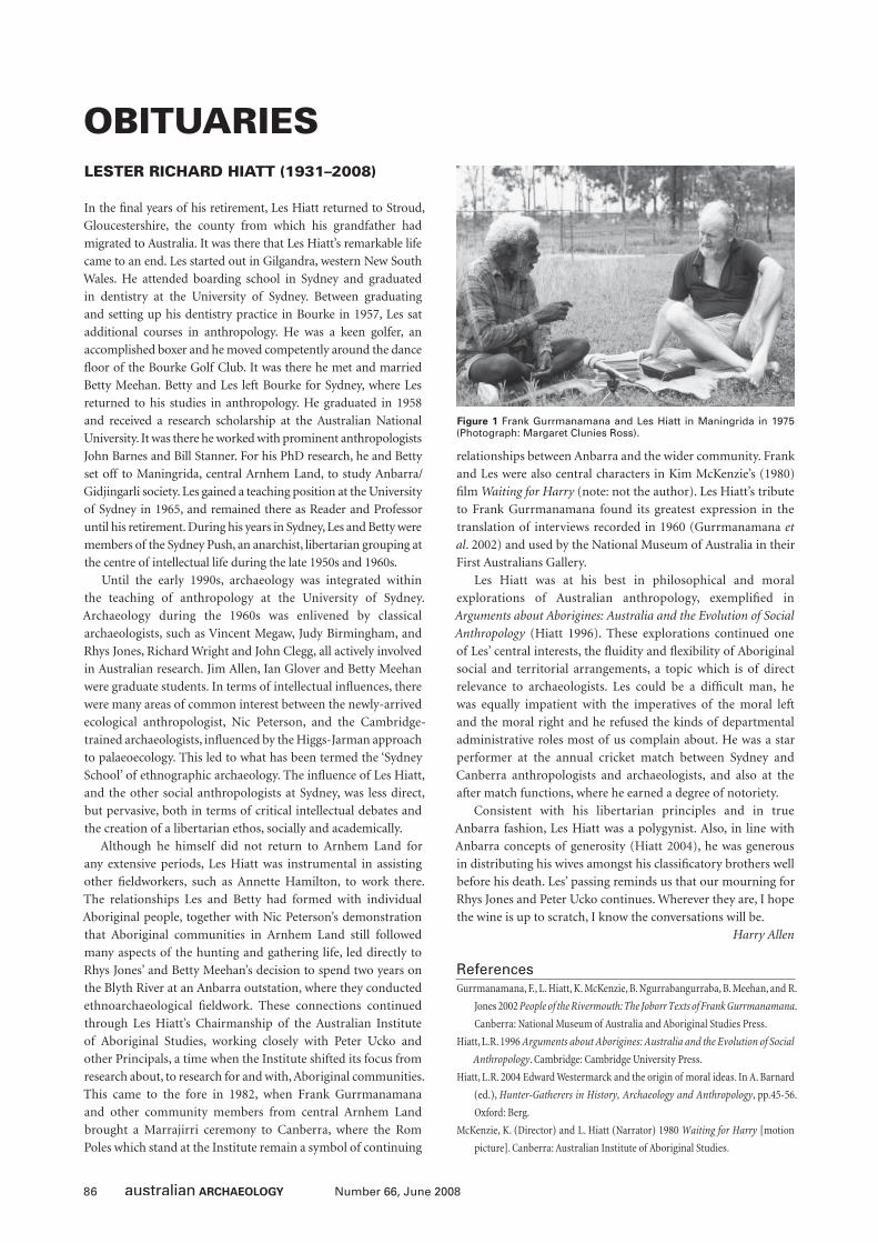
86 Number 66, June 2008
OBITUARIESLESTER RICHARD HIATT (1931–2008)
In the fi nal years of his retirement, Les Hiatt returned to Stroud,
Gloucestershire, the county from which his grandfather had
migrated to Australia. It was there that Les Hiatt’s remarkable life
came to an end. Les started out in Gilgandra, western New South
Wales. He attended boarding school in Sydney and graduated
in dentistry at the University of Sydney. Between graduating
and setting up his dentistry practice in Bourke in 1957, Les sat
additional courses in anthropology. He was a keen golfer, an
accomplished boxer and he moved competently around the dance
fl oor of the Bourke Golf Club. It was there he met and married
Betty Meehan. Betty and Les left Bourke for Sydney, where Les
returned to his studies in anthropology. He graduated in 1958
and received a research scholarship at the Australian National
University. It was there he worked with prominent anthropologists
John Barnes and Bill Stanner. For his PhD research, he and Betty
set off to Maningrida, central Arnhem Land, to study Anbarra/
Gidjingarli society. Les gained a teaching position at the University
of Sydney in 1965, and remained there as Reader and Professor
until his retirement. During his years in Sydney, Les and Betty were
members of the Sydney Push, an anarchist, libertarian grouping at
the centre of intellectual life during the late 1950s and 1960s.
Until the early 1990s, archaeology was integrated within
the teaching of anthropology at the University of Sydney.
Archaeology during the 1960s was enlivened by classical
archaeologists, such as Vincent Megaw, Judy Birmingham, and
Rhys Jones, Richard Wright and John Clegg, all actively involved
in Australian research. Jim Allen, Ian Glover and Betty Meehan
were graduate students. In terms of intellectual infl uences, there
were many areas of common interest between the newly-arrived
ecological anthropologist, Nic Peterson, and the Cambridge-
trained archaeologists, infl uenced by the Higgs-Jarman approach
to palaeoecology. This led to what has been termed the ‘Sydney
School’ of ethnographic archaeology. The infl uence of Les Hiatt,
and the other social anthropologists at Sydney, was less direct,
but pervasive, both in terms of critical intellectual debates and
the creation of a libertarian ethos, socially and academically.
Although he himself did not return to Arnhem Land for
any extensive periods, Les Hiatt was instrumental in assisting
other fi eldworkers, such as Annette Hamilton, to work there.
The relationships Les and Betty had formed with individual
Aboriginal people, together with Nic Peterson’s demonstration
that Aboriginal communities in Arnhem Land still followed
many aspects of the hunting and gathering life, led directly to
Rhys Jones’ and Betty Meehan’s decision to spend two years on
the Blyth River at an Anbarra outstation, where they conducted
ethnoarchaeological fi eldwork. These connections continued
through Les Hiatt’s Chairmanship of the Australian Institute
of Aboriginal Studies, working closely with Peter Ucko and
other Principals, a time when the Institute shifted its focus from
research about, to research for and with, Aboriginal communities.
This came to the fore in 1982, when Frank Gurrmanamana
and other community members from central Arnhem Land
brought a Marrajirri ceremony to Canberra, where the Rom
Poles which stand at the Institute remain a symbol of continuing
relationships between Anbarra and the wider community. Frank
and Les were also central characters in Kim McKenzie’s (1980)
fi lm Waiting for Harry (note: not the author). Les Hiatt’s tribute
to Frank Gurrmanamana found its greatest expression in the
translation of interviews recorded in 1960 (Gurrmanamana et
al. 2002) and used by the National Museum of Australia in their
First Australians Gallery.
Les Hiatt was at his best in philosophical and moral
explorations of Australian anthropology, exemplifi ed in
Arguments about Aborigines: Australia and the Evolution of Social
Anthropology (Hiatt 1996). These explorations continued one
of Les’ central interests, the fl uidity and fl exibility of Aboriginal
social and territorial arrangements, a topic which is of direct
relevance to archaeologists. Les could be a diffi cult man, he
was equally impatient with the imperatives of the moral left
and the moral right and he refused the kinds of departmental
administrative roles most of us complain about. He was a star
performer at the annual cricket match between Sydney and
Canberra anthropologists and archaeologists, and also at the
after match functions, where he earned a degree of notoriety.
Consistent with his libertarian principles and in true
Anbarra fashion, Les Hiatt was a polygynist. Also, in line with
Anbarra concepts of generosity (Hiatt 2004), he was generous
in distributing his wives amongst his classifi catory brothers well
before his death. Les’ passing reminds us that our mourning for
Rhys Jones and Peter Ucko continues. Wherever they are, I hope
the wine is up to scratch, I know the conversations will be.
Harry Allen
ReferencesGurrmanamana, F., L. Hiatt, K. McKenzie, B. Ngurrabangurraba, B. Meehan, and R.
Jones 2002 People of the Rivermouth: The Joborr Texts of Frank Gurrmanamana.
Canberra: National Museum of Australia and Aboriginal Studies Press.
Hiatt, L.R. 1996 Arguments about Aborigines: Australia and the Evolution of Social
Anthropology. Cambridge: Cambridge University Press.
Hiatt, L.R. 2004 Edward Westermarck and the origin of moral ideas. In A. Barnard
(ed.), Hunter-Gatherers in History, Archaeology and Anthropology, pp.45-56.
Oxford: Berg.
McKenzie, K. (Director) and L. Hiatt (Narrator) 1980 Waiting for Harry [motion
picture]. Canberra: Australian Institute of Aboriginal Studies.
Figure 1 Frank Gurrmanamana and Les Hiatt in Maningrida in 1975 (Photograph: Margaret Clunies Ross).
87Number 66, June 2008
BACKFILLMinutes of the 2007 Annual General Meeting of the Australian Archaeological Association Inc.Sydney University, New South Wales
22 September 2007
1. WelcomeThe 2007 AGM commenced at 5:45pm. The President welcomed
everyone to the conference and the AGM with a special welcome
to Professor Mike Parker-Pearson, Professor Stephen Shennan
and Associate Professor Diana di Zerega Wall.
The President commenced proceedings by acknowledging
the Eora (Cadigal) nation as Traditional Owners of the land.
The President thanked the organisers of the New Ground
Conference.
2. ApologiesApologies were received from Tim Denham, Judith Field, Pat
Gaynor, Paul Greenfeld, Ian Lilley, Angela McGowan, John
Mulvaney, John Sherwood, Michael Strong and Sylvia Yates.
3. Confi rmation of the Minutes of the 2006 AAA AGMThe minutes of the 2006 AAA AGM held at Beechworth Victoria
on 9 December 2006 were published in Australian Archaeology
(64:64-73). Motion: ‘That the minutes of the 2006 Annual
General Meeting of the Australian Archaeological Association
Inc. as circulated, be taken as read and confi rmed’. Moved: Stuart
Rapley. Seconded: Val Attenbrow. Motion carried nem. con.
4. Business Arising from Previous AGM
4.1 Northern Territory ArchaeologyNorthern Territory representative Daryl Guse raised concerns at
the 2006 AGM about the treatment of cultural resources in the
Northern Territory and the fact that archaeology was no longer
taught at Charles Darwin University. The Executive contacted
a number of agencies and the university and now has some
support for a future forum on the state of archaeology in the
Northern Territory. The Executive proposed this be initiated
by AAA, although other agencies will no doubt be interested
in being involved. The incoming Executive will be briefed on
this matter.
5. ReportsThe President noted that hard copies of all Executive reports had
been pre-circulated during the conference with only summaries
to be presented at the AGM (full reports reproduced below).
5.1 President’s Report (Alistair Paterson)Welcome to the 2007 Annual General Meeting of the Australian
Archaeological Association Incorporated. I would like to
commence proceedings by acknowledging the Eora (Cadigal)
nation as Traditional Owners of this land. I thank the organisers
of the New Ground Conference and particularly Sydney
University for organising this conference.
I acknowledge the Executive and the respective subcommittee
chairs:
• Samantha Bolton, Chair, Information Technology
Subcommittee
• Richard Fullagar, Chair, Code of Ethics Review
Subcommittee
• Sean Ulm, Chair, Prizes and Awards Subcommittee
• Sean Ulm, Chair, Editorial Subcommittee
• Stephen Free, Chair, Indigenous Subsidies Subcommittee
• Jane Balme, Chair, Australian National Committee for
Archaeology Teaching and Learning (ANCATL)
• Michael Westaway, Chair, National Archaeology Week
Subcommittee
This is my fi nal report to AAA as I am standing down with the
remainder of the Western Australian Executive at this meeting,
having served two terms. I would like to thank my team during
this time, the Executive, the editors of Australian Archaeology,
the subcommittees, the state representatives, and the numerous
members of AAA who assist in the running of the organisation.
I have learned that there are some very dedicated people in the
organisation who are willing to give freely of their valuable time
and expertise. This is a vitally important Association, and as
archaeological resources face many challenges in the years ahead
I urge members to become involved in whatever way they can.
We are run only by the actions of those who volunteer.
When we were elected we had specifi c aims to improve
membership numbers and the fi nancial position, and to improve
some of the internal functions of AAA. Tonight your Membership
Secretary and Treasurer will report that our membership levels
and fi nances are healthy. I have been particularly appreciative
of the signifi cant efforts made to relocate, redesign, rebuild and
improve the AAA website which was relaunched in January. I
urge members to help make the members-only section a resource
for Australian archaeologists. I will briefl y report on some of our
activities since the last AGM.
Northern Territory representative Daryl Guse raised concerns
at the 2006 AGM about the treatment of cultural resources in the
Northern Territory and the fact that archaeology was no longer
taught at Charles Darwin University. We contacted a number
of agencies and the university and now have some support for
a future forum on the state of archaeology in the Northern
Territory. We propose this be initiated by AAA, although other
agencies will no doubt be interested in being involved. We will
brief the incoming Executive on this and other matters in our
handover.
We have committed fi nancial support to the Australian
National Committee for Archaeology Teaching and Learning
(ANCATL) for meetings and promotional material given their
88 Number 66, June 2008
Backfi ll
important initiatives, particularly since securing funding by the
Carrick Institute.
AAA has maintained close contact with the ASHA and AIMA
Presidents during the year, normally in the form of regular
informal phone calls and email messages. We have been able to
work together on several submissions. Joint submissions, where
appropriate, are a direct benefi t to members of the archaeological
community. A joint meeting of all three Executives will be held
during this conference.
In September 2007, working collaboratively with the
World Archaeological Congress, AAA tendered a submission ‘A
past for all Australians: Archaeology and Australia’s National
History Curriculum’ to The Hon. Julie Bishop MP, Minister
for Education, Science and Training. This proposal was written
to encourage the Australian government to develop a new
national curriculum that includes archaeological knowledge
and methods for understanding the past. Claire Smith, Iain
Davidson, Heather Burke, Sean Ulm, Steve Nichols, and others
are to be commended for their efforts in preparing this lengthy
and detailed submission.
In January 2007, a joint submission was made with ASHA and
AIMA regarding ‘The inclusion of archaeology in the Cossack
(WA) Management Plan’ to the Project Steering Committee,
Cossack Management Plan.
In March 2007, a joint submission was made with ASHA and
AIMA regarding ‘Greater protection for the Burrup Peninsula
and Dampier Archipelago Rock Art Sites’ to the Hon. Malcolm
Turnbull MP, Minister for Environment and Water.
In March 2007 a joint submission was made with ASHA and
AIMA regarding ‘Support for consideration of archaeology in the
WA Heritage Review’ to the Hon. Michelle Roberts, Minister for
Heritage, Western Australian Government.
I congratulate past and present editors of Australian
Archaeology as the journal has been awarded the highest quality
rating possible in the initial listing of the European Reference
Index for the Humanities. Other journals that achieved an ‘A’
ranking include World Archaeology, Antiquity and the Journal of
Archaeological Science.
Finally, I will outline plans for future AAA conferences.
The University of Queensland has indicated they will host the
2008 conference; it will be organised by Chris Clarkson, Pat
Faulkner and Andy Fairbairn. The venue will most likely be
in or close to Brisbane. Flinders University has indicated that
they can host the 2009 conference. ANU has indicated they
will host the 2010 conference.
5.2 Secretary’s Report (Fiona Hook)Further to the matters described in the President’s report, the
Executive held fi ve meetings over the year where procedural
matters and the issues already outlined by the President were
discussed. In between meetings members of the Executive
generally communicated by email with 561 emails received by
the Secretary.
CorrespondenceThe Secretary received 75 emails and 16 letters during 2007 from
members and the public. The main themes to emerge from the
correspondence are the same as 2006, including:
• Requests for information from prospective archaeology
students.
• Amateurs/students looking for volunteer excavation
experience.
• International and Australian archaeologists looking for
work.
• Membership and Australian Archaeology queries.
• Scientifi c and alternative archaeology enquiries.
The vast majority of the correspondence relates to the fi rst
three themes; however, with the introduction of the members-
only webpage requests for employment information have
reduced in the last three months.
Telephone CallsThe Secretary received 12 telephone calls from amateur
archaeologists and prospective students.
5.3 Treasurer’s Report (Adam Dias)
OverviewThe AAA fi nancial year ending 31 August 2007 saw a substantial
profi t, largely due to the infl ux of new members and a reduction
in conference costs. The fi nancial year also saw the successful
distribution of a $20,000 grant from the Department of
Environment and Heritage (DEH) to increase Indigenous
participation at the Beechworth conference.
Unfortunately, the AGM fell too close to the end of the
fi nancial year to allow for the accounts to be audited. As such, the
fi gures presented in this report should be considered provisional
pending the fi nal audit (Editors’ Note: The 2006–2007 audit
was completed on 14 November 2007 and the fi gures presented
below found to be accurate).
The year saw a substantial increase in both expenses and
income. Certain costs were carried over from the previous
fi nancial year, which artifi cially infl ated 2006–2007 costs,
including printing and insurance. Additional costs were also
incurred with the formation of the University of Western
Australia account to handle online transactions and to transfer
and update the website. It should also be noted that both the
income and expenses fi gures include the $20,000 DEH grant.
Despite the rise in costs, 2006–2007 saw a profi t largely due to
a substantial rise in real income (Table 1).
IncomeThe breakdown of income for the year is detailed in Table 2. As
with previous years, subscriptions remain the primary source
of income for the Association. A sizable proportion (30.8%)
of the 2006–2007 income was in the form of a DEH grant to
aid in Indigenous participation in the Beechworth conference.
This fi gure infl ates the total, and should not be considered true
income as it was reserved, and exhausted, fulfi lling the terms of
the grant.
The combined income from the savings accounts and two
investment accounts amounted to $2430.60, a rise of $1039. As
with the previous year, the Treasurer was unable to investigate
the potential for higher returns on the investment accounts due
to the demands of fi eldwork, and the investments renewed at the
default rate.
89Number 66, June 2008
Backfi ll
A small amount of profi ts ($382.60) is a carryover from GST
erroneously removed by the University of Western Australia
account on subscriptions taken in 2005–2006. These funds were
transferred in September 2006, and should be considered part of
the 2005–2006 income.
ExpenditureAs outlined in Table 3, 2006–2007 saw a substantial increase
in expenditure. It should be noted that this initial fi gure is
misleading, with $20,000 coming from DEH funding received
expressly for Indigenous conference participation, and a further
$12,000 in costs carried over from the previous year. Removal
of these amounts reduced expenditure to $27,277. This still saw
a rise in real expenses of approximately $6000 from 2005–2006
largely due to increases in printing costs, bank charges, prizes
and charges related to the website.
Expected Expenditure 2007–2008In the coming 2007–2008 fi nancial year, no new major costs
are anticipated. A small amount of costs ($700) associated
with the 2006–2007 audit were delayed and will appear in the
2007–2008 accounts.
Summary of AssetsAs of 31 August 2007 the AAA assets totalled $77,457.76 (Table
4). This does not include $554.50 in unpresented cheques, or the
contents of the Bruce Veitch Award fund. The memorial fund
grew during 2006–2007 due to interest accrued and a generous
anonymous donation of $500.
The details of the two long-term accounts held by the
Commonwealth Bank are detailed in Table 5. As mentioned above,
due to fi eldwork constraints it was not possible to reinvest the term
deposit at higher rates of return. Hopefully, this situation will be
remedied by the incoming Treasurer. The contents of the long-
term accounts continue to represent approximately two years of
journal printing, which was the intended purpose of the funds.
5.4 Membership Secretary’s Report (Annie Carson)The 2007 membership year began with a fantastic infl ux of
subscriptions to AAA, refl ecting a positive response to the early-
bird renewal notices sent to members in December 2006. This
procedure was implemented for the fi rst time last year and allows
for other targeted mail outs to be arranged in March/April of the
New Year to maximise renewals.
As of 6 September 2007 AAA had a total of 547 members, 86
of whom joined for the fi rst time this year (Tables 1-2). This is a
2005–2006$
2006–2007$
Assets
Current Assets
36,878.87 CBA Cheque Account 35,199.97
23,436.61 CBA Term Deposit 24,303.89
18,118.29 CBA Cash Management Trust 19,109.41
3826.89 UWA EFT Account 10,613.92
82,260.66 Total Current Assets 89,227.19
Liabilities
Current Liabilities
10,483.83 Bruce Veitch Award 11,214.93
0 Unpresented Cheques 554.50
10,483.83 Total Current Liabilities 11,769.43
71,776.83 Net Assets 77,457.76
Equity
46,822.23 Retained Earnings 71,776.83
24,954.60 Operating Profi t 5,680.93
71,776.83 Total Equity 77,457.76
Table 4 Balance Sheet, 31 August 2007.
Statement Date
Particulars Amount Invested
Maturity Paid
30/06/2007 CBA Term Deposit 24,303.89 867.28
30/06/2007 CBA Cash Management Trust
19,109.41 997.12
Table 5 Investment Register.
2005-2006$
2006-2007$
34,625.22 Total Income 64,958.20
9670.62 Total Expenses 59,277.27
24,954.60 Operating Profi t 5680.93
46,822.23 Retained Earnings 71,776.83
71,776.83 Total Equity 77,457.76
Table 1 Profi t and Loss – Summary.
2005–2006$
Income 2005–2006$
630.70 Copyright fees 0.00
8541.13 Conference profi ts 1600.00
1910.00 DVD/Back issue sales 2785.00
1391.50 Interest received 2430.60
19,296.89 Subscriptions 37,632.58
0.00 Other Income 0.00
2855.00 Donations 500.00
0.00 DEH funding 20,000.00
0.00 Bank alterations 10.02
34,625.22 Total Income 64,958.20
Table 2 Profi t and Loss – Income.
2005–2006$
Expenditure 2006–2007$
750.00 Auditor’s fees 627.00
454.49 Bank charges 923.71
1179.81 DVD production 0
3300.00 Journal printing 25,075.34
400.00 Sundries 684.50
0 Insurance 1732.50
0 Internet fees 1018.40
1092.95 Printing, stationaryand postage
6928.56
513.00 Prizes 2250.00
1980.37 Conference 0
0 DEH funding 20,007.26
9670.62 Total Expenditure 59277.27
Table 3 Profi t and Loss – Expenditure.
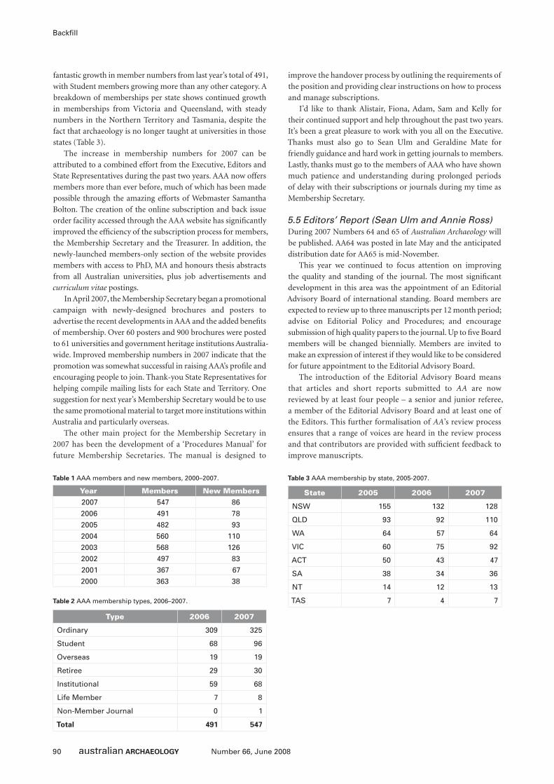
90 Number 66, June 2008
Backfi ll
fantastic growth in member numbers from last year’s total of 491,
with Student members growing more than any other category. A
breakdown of memberships per state shows continued growth
in memberships from Victoria and Queensland, with steady
numbers in the Northern Territory and Tasmania, despite the
fact that archaeology is no longer taught at universities in those
states (Table 3).
The increase in membership numbers for 2007 can be
attributed to a combined effort from the Executive, Editors and
State Representatives during the past two years. AAA now offers
members more than ever before, much of which has been made
possible through the amazing efforts of Webmaster Samantha
Bolton. The creation of the online subscription and back issue
order facility accessed through the AAA website has signifi cantly
improved the effi ciency of the subscription process for members,
the Membership Secretary and the Treasurer. In addition, the
newly-launched members-only section of the website provides
members with access to PhD, MA and honours thesis abstracts
from all Australian universities, plus job advertisements and
curriculum vitae postings.
In April 2007, the Membership Secretary began a promotional
campaign with newly-designed brochures and posters to
advertise the recent developments in AAA and the added benefi ts
of membership. Over 60 posters and 900 brochures were posted
to 61 universities and government heritage institutions Australia-
wide. Improved membership numbers in 2007 indicate that the
promotion was somewhat successful in raising AAA’s profi le and
encouraging people to join. Thank-you State Representatives for
helping compile mailing lists for each State and Territory. One
suggestion for next year’s Membership Secretary would be to use
the same promotional material to target more institutions within
Australia and particularly overseas.
The other main project for the Membership Secretary in
2007 has been the development of a ‘Procedures Manual’ for
future Membership Secretaries. The manual is designed to
improve the handover process by outlining the requirements of
the position and providing clear instructions on how to process
and manage subscriptions.
I’d like to thank Alistair, Fiona, Adam, Sam and Kelly for
their continued support and help throughout the past two years.
It’s been a great pleasure to work with you all on the Executive.
Thanks must also go to Sean Ulm and Geraldine Mate for
friendly guidance and hard work in getting journals to members.
Lastly, thanks must go to the members of AAA who have shown
much patience and understanding during prolonged periods
of delay with their subscriptions or journals during my time as
Membership Secretary.
5.5 Editors’ Report (Sean Ulm and Annie Ross)During 2007 Numbers 64 and 65 of Australian Archaeology will
be published. AA64 was posted in late May and the anticipated
distribution date for AA65 is mid-November.
This year we continued to focus attention on improving
the quality and standing of the journal. The most signifi cant
development in this area was the appointment of an Editorial
Advisory Board of international standing. Board members are
expected to review up to three manuscripts per 12 month period;
advise on Editorial Policy and Procedures; and encourage
submission of high quality papers to the journal. Up to fi ve Board
members will be changed biennially. Members are invited to
make an expression of interest if they would like to be considered
for future appointment to the Editorial Advisory Board.
The introduction of the Editorial Advisory Board means
that articles and short reports submitted to AA are now
reviewed by at least four people – a senior and junior referee,
a member of the Editorial Advisory Board and at least one of
the Editors. This further formalisation of AA’s review process
ensures that a range of voices are heard in the review process
and that contributors are provided with suffi cient feedback to
improve manuscripts.
Year Members New Members2007 547 86
2006 491 78
2005 482 93
2004 560 110
2003 568 126
2002 497 83
2001 367 67
2000 363 38
Table 1 AAA members and new members, 2000–2007.
Type 2006 2007
Ordinary 309 325
Student 68 96
Overseas 19 19
Retiree 29 30
Institutional 59 68
Life Member 7 8
Non-Member Journal 0 1
Total 491 547
Table 2 AAA membership types, 2006–2007.
State 2005 2006 2007
NSW 155 132 128
QLD 93 92 110
WA 64 57 64
VIC 60 75 92
ACT 50 43 47
SA 38 34 36
NT 14 12 13
TAS 7 4 7
Table 3 AAA membership by state, 2005-2007.
91Number 66, June 2008
Backfi ll
The quality of AA was recently recognised in its ranking in
the top band of journals in the initial listing of the European
Reference Index for the Humanities. The journal was awarded
an ‘A’ category listing by a panel of experts chaired by Lin Foxhall
(University of Leicester) and jointly sponsored by the European
Science Foundation and the European Commission ERA-NET
‘Humanities in the European Research Area’ (HERA) project.
Other journals that achieved an ‘A’ ranking include World
Archaeology, Antiquity and the Journal of Archaeological Science.
This is a signifi cant achievement for the journal.
The June 2007 issue of AA was the fi rst of three consecutive
issues to be submitted for evaluation to Thomson Scientifi c
(formerly ISI) for possible inclusion in the Web of Knowledge.
If successful, inclusion of AA in the Web of Knowledge will
signifi cantly increase the visibility of the journal and allow
tracking of citation rates and impact factors.
During the year we also continued to investigate a range of
online options for AA. The key issues of concern are affordability
and visibility, combined with a commitment to making at least
some of AA’s content open access. We hope to have online
arrangements in place in the near future.
During the year we promoted AA at various conferences and
workshops and entered into reciprocal promotion arrangements
with Antiquity and The Artefact. These initiatives, along with
the more substantial efforts of the Membership Secretary and
AAA Executive to increase membership levels, will require us
to increase our print run in future. Such increases will require
a modest increase in the budget allocated to the production
of AA.
We take this opportunity to acknowledge the hard work of
the other members of the 2007 Editorial Committee consisting
of Geraldine Mate (Editorial Assistant), Chris Clarkson, Lara
Lamb and Catherine Westcott (Short Reports Editors), Ian Lilley
and Jill Reid (Book Review Editors) and Stephen Nichols (Thesis
Abstract Editor).
There will be several changes in the composition of the
Editorial Committee for 2008. Ian Lilley is standing down as
Book Review Editor. He will be replaced by Chris Clarkson who
will move sideways from his current position as Short Reports
Editor. Editorial Assistant Geraldine Mate, who has been the
glue keeping the AA roadshow together for the past two years,
has reluctantly had to redirect her energies elsewhere. We thank
Geraldine for her hard work, energy and enthusiasm in helping
get the journal settled in its new home. Geraldine will be replaced
as Editorial Assistant in the near future.
In closing, we would like to thank contributors, referees,
the Editorial Advisory Committee and the AAA Executive for
their support.
5.6 Media Liaison Offi cer’s Report (Kelly Fleming)There was limited movement on the media front for 2007.
The following is a list of media releases, and other activities,
for 2007.
Media Releases 200726 April – National Archaeology WeekUWA Media Offi ce released a statement of activities taking place
and the details of the national website which was picked up by a
few WA news sources.
27 August – Archaeology Education in the SpotlightUWA Media Offi ce released a statement about the two-year
project set up by the Australian National Committee for
Archaeology Teaching and Learning (funded by a grant from the
Carrick Institute for Learning and Teaching in Higher Education)
to develop national benchmarks for archaeology degrees. Also
posted on AUSARCH-L, ASHA and AACAI listservers.
Other Activities 200727 April – Call for Media ItemsDue to the completion and launch of the new website and media
statement page a message was posted on AUSARCH-L, ASHA
and AACAI listservers calling for media items to be sent to the
AAA media offi cer.
22 June – Media Links on AAA WebsiteThe potential for creating a media links page on the AAA website
was discussed with the AAA Webmaster. This would allow links
to media items, and other stories of interest to the organisation,
to be added to the site on a regular basis. Work is ongoing.
27 June – AAA Award NominationsDetails and calls for nominations sent to UWA Media Offi ce but
unfortunately it was not picked up. Also posted on AUSARCH-L
and ASHA listservers.
5.7 Webmaster’s Report (Samantha Bolton)The new website, hosted at the University of Western Australia
(UWA) was launched on 6 February 2007. It has the same basic
structure as the previous website, with an updated look and a
few new features.
The new features include the Register of Archaeology Work
Experience Partners, an initiative of the Australian National
Committee for Archaeology Teaching and Learning (ANCATL),
a members-only area, and access for the AAA Executive to view
the membership database and add media releases.
The members-only area was launched on 29 June 2007. The
features include:
• latest news and announcements for members;
• jobs currently available in archaeology;
• list of current cvs of people looking for work in archaeology;
• list of honours and postgraduate theses in archaeology
submitted to Australian universities; and
• volunteer opportunities currently available.
There is also a facility to allow members to update their
membership details, submit a job advertisement, post their cv,
and advertise volunteer positions in archaeology. There are plans
to add a discussion board at a later date.
Usage of this area, in particular the jobs page, has been a little
disappointing. Members are strongly encouraged to advertise
jobs here, and help build this page and make it a major resource
for archaeology in Australia. There will be more active promotion
of this section of the website over the next 12 months.
Other plans for the website are to improve the layout of the
front page, in particular the news section, and continue adding
features, so that the website is current and relevant, and visitors,
particularly members, have reason to keep visiting the site.
92 Number 66, June 2008
Backfi ll
The other major addition to the website is an area allowing
Executive access. This is mainly used by the Membership
Secretary who is able to manage the membership database
through the website and the Media Offi cer who can add media
releases as required.
Viewing statistics apply from 24 May 2007, when Google
Analytics was applied to the website, until 30 August 2007.
During this 3 month period, which included the launch of the
members-only area, there have been 6900 visits, at an average of
33 visits/day. 48% of these viewed the front page only. 68.60% are
fi rst time visitors, and the average time spent on the site is seven
seconds, at an average of fi ve pages per visit. After the front page,
the next four most popular pages are Australian Archaeology,
member pages, study options and the work experience register.
The total hits on the National Archaeology Week website
since December 2006 was 527,000, peaking in May, just before
and during National Archaeology Week, with an average of 4000
hits a day. The new NAW website, also to be hosted at UWA, will
be launched in time for NAW 2008.
The transfer of the website to UWA caused problems for
the email addresses [email protected], as the
university does not have the capability to successfully manage
and forward a number of email aliases. As a result, the email
addresses are now being managed through our domain name
hosts, MelbourneIT. We have increased the number of email
aliases, with all State Representatives having their own addresses,
as well as the Executive. Thus as the people in the positions
change, the email addresses will remain the same.
The launch of the new-look AAA website has been very
successful, with the addition of new features and facilities for
members. I am constantly aiming to make this resource useful
and relevant to members and non-members alike, and am open
to any suggestions as to how to improve the site.
5.8 Australian National Committee for Archaeology Teaching and Learning Report (Jane Balme)As it is clear from recent postings on email groups that some
members are not aware of the origins or previous work of this
subcommittee, I thought that I would start this year’s report by
briefl y outlining its history and previous activities. I will then
turn to our activities over the last year.
ANCATL stands for the Australian National Committee for
Archaeology Teaching and Learning and it is a subcommittee
of the Australian Archaeological Association Inc. Originally
called JISCATL, it formed in 2002 at the Townsville joint
conference with ASHA, AIMA and AACAI. The role of the
committee is to provide a forum for discussion of archaeology
teaching and learning and related issues, and to provide a
conduit for involvement in these issues for other archaeological
associations and interest groups. The main direction for the
activities of this subcommittee was provided by a workshop
held in Redfern, Sydney, in 2003 that was attended by a variety
of archaeologists from all major associations, universities and
industry. At this workshop a charter (known as the Redfern
Charter) of purpose for the committee was created consisting
of five items:
i. Better coordination of opportunities for students and early
career graduates to gain vocational experience.
ii. Accept the principles of the UK benchmarks for teaching and
learning as a step towards the development of a model for
Australian undergraduate archaeology degree structures.
iii. Support for greater interaction and exchange in teaching and
learning between universities on the one hand and regulatory
authorities and industry on the other.
iv. A commitment to gathering reliable data for benchmarking
of a variety of archaeology activities similar to UK survey
instrument.
v. Develop mechanisms to tell the archaeological story to the
publics that own and relate to that archaeology.
Various members of the committee separately and together
have undertaken a variety of activities to fulfi l our charter. One
of the fi rst of these was the study ‘Australian Archaeology in
Profi le: A Survey of Working Archaeologists 2005’. This was
based on 301 responses from Australian archaeologists in a
variety of professions to document the kinds of work done by
archaeologists in Australia as well as the skill areas that these
archaeologists identifi ed were important in their profession
and that they believed were important in training students. The
results of this survey were published in a special teaching and
learning volume (61) of Australian Archaeology and we have
drawn on this survey to identify skill gaps in university teaching
and think about how students might obtain these skills.
In 2006, Wendy Beck, with the help of Catherine Clarke and
ANCATL, applied for and received a Carrick Institute grant to
investigate benchmarking of honours degrees in archaeology. The
purpose of this project is to produce a document that will make
explicit learning criteria, levels of achievement and assessment
practices in archaeology honours programmes. We began work
on the project this year by creating an advisory committee and
surveying university teachers about current practice in Australian
universities. A workshop attended by a group representing all the
relevant universities was held in Melbourne to discuss the results
of the survey and to devise a set of draft benchmarks based on
these results, the United Kingdom benchmark document, the
results of an updated version of the 2005 working archaeologists
survey and the results of discussions at the Redfern workshop.
The benchmark project is not due for completion until the end
of 2008 but will continue to draw on a variety of sources of
information in the production of the fi nal document, including
broad consultation across the discipline.
The other major project this year directed at the fi rst of
the Redfern Charter objectives was the creation of the Register
of Archaeology Work Experience Partners. This is a list of
organisations willing to consider placement of students and
graduates and is available through the AAA website. The list
has been available since March this year and so far we have
been receiving very positive feedback from both employers
and students. We have just begun to advertise this register with
posters and bookmarks. We will shortly be sending posters to
all university archaeology departments and encourage members
to draw students’ attention to the list as an important source of
practical training.
There have been other smaller projects (such as providing
comments on the new K-6 NSW Science and Technology
syllabus) as well as continuing projects (such as Sean Ulm’s
constant update on the profession’s profi le in Australia).
93Number 66, June 2008
Backfi ll
Most of these activities of ANCATL are organised by a very
few people and anyone that would like to have input in the work
of this subcommittee is most welcome.
5.9 Prizes and Awards Subcommittee Report (Sean Ulm, Val Attenbrow, Fiona Hook and Ken Mulvaney)The Prizes and Awards Subcommittee was formed in 2005 to
manage the awards offered by the Association. In total, there are
10 awards in seven categories, including the Rhys Jones Medal
for Outstanding Contribution to Australian Archaeology, John
Mulvaney Book Award, Bruce Veitch Award for Excellence in
Indigenous Engagement, Life Membership for Outstanding
Contribution to the Australian Archaeological Association Inc.,
and conference paper and poster prizes. The subcommittee also
manages the Laila Haglund Prize for Excellence in Consultancy on
behalf of the Australian Association of Consulting Archaeologists
Inc. In 2007, nominations were received for all award categories.
During 2007 the subcommittee reviewed descriptions and
selection criteria for the assessment of each award and added
to entries of previous awardees on the website. We also liaised
with the New Ground Conference organising committee to
establish paper and poster judging procedures for the joint
conference format.
The subcommittee would like to thank President Alistair
Paterson for active participation in the committee. In 2008, Sean
Ulm will stand down as the chair of the subcommittee and be
replaced by Val Attenbrow.
5.10 Code of Ethics Review Subcommittee (Richard Fullagar)The review process for the Code of Ethics is complete, however,
the role of the subcommittee has changed to encompass the
complaints process of the Association. Thanks to Sean Ulm for
his advice. The President suggests the rewording of subcommittee
title to take into account role of the ethics subcommittee in
assisting the President with Code of Ethics complaints.
Motion: ‘That AAA change name of the Code of Ethics
Review Subcommittee to the Code of Ethics Subcommittee.
Moved: Chair. Motion carried nem. con.
5.11 State Representatives’ Reports
5.11.1 Queensland Report (Lara Lamb)During the past year, there were no issues brought to me as State
Representative by any of our members.
As State Representative I did act in a minor capacity to assist
in the bolstering of our Association numbers, by providing our
Membership Secretary with the contact details of several state and
educational institutions for mail-out purposes. At an individual
level, I distributed several dozen membership pamphlets to my
fi rst year introductory archaeology course, and I believe there
were several resulting applications for membership as a result.
I would like to suggest to the incoming Executive that the role
of State Representative be more clearly defi ned and communicated
to both incoming and incumbent State Representatives.
5.11.2 New South Wales Report (Val Attenbrow)My report is the same as Lara’s for New South Wales.
5.11.3 Northern Territory Report (Daryl Guse)I would like to thank the Executive for their assistance through
the year and, as outlined by President Paterson, the proposed
meeting in the Northern Territory to discuss archaeological issues
with the University, Government and Indigenous organisations.
5.11.4 Western Australia Report (Stuart Rapley)My report is the same as Lara’s for Western Australia.
Motion: ‘That the reports as presented are accepted as read’.
Moved: President. Motion carried nem. con.
6. Appointment of AuditorAddition Bookkeeping Services was appointed as the auditor
for the 2006–2007 fi nancial year. However, given the change of
Executive, the incoming Executive will appoint an auditor for
2007–2008 as per Item 9.4 of the Constitution.
7. Other Business
7.1 Review of NSW Heritage ActVal Attenbrow raised the issue of the proposed review of this Act
and requested that the Executive prepare a submission on behalf
of AAA with assistance from the NSW State Representative. The
President suggested that it should be a joint submission with
ASHA. Marilyn Truscott advises that she is willing to assist in
this submission.
7.2 Council for Australian ArchaeologySean Ulm discussed the proposed establishment of a peak
disciplinary body comprising the Presidents of AAA, ASHA,
AIMA and AACAI. He noted that AAA is always supportive of
joint submissions given their larger impact. Sean proposed two
motions:
1. ‘That AAA support the establishment of a Council for
Australian Archaeology’; and
2. ‘That AAA provide annual contribution to assist in the
running of the Council’.
Peter Veth strongly supported the fi rst motion, arguing that
such a body will increase the lobbying power of the individual
associations and formalise the process of joint submissions that
already exists.
Annie Ross suggested that the Council have the power to coopt
members to assist the Council to allow for specifi c expertise. Ken
Mulvaney suggested that the membership of the Council needs
to be broadened to include the Presidents of AURA, AIATSIS
and the archaeology section of the Australian Academy of the
Humanities to increase the lobby base. Josephine Flood reiterated
the need for the involvement of AURA.
Luke Godwin asked what the basis for the establishment
membership of the Council was, such as the percentage of
membership base, and what mechanisms would be used for each
group’s participation? Sean Ulm indicated that the organisation
and operation of the Council was yet to be discussed. Luke asked
what were ASHA’s and AIMA’s thoughts on the establishment of
the Council? Phil Bowman indicated that AIMA had given its
in-principle support. Luke suggested that we don’t provide our
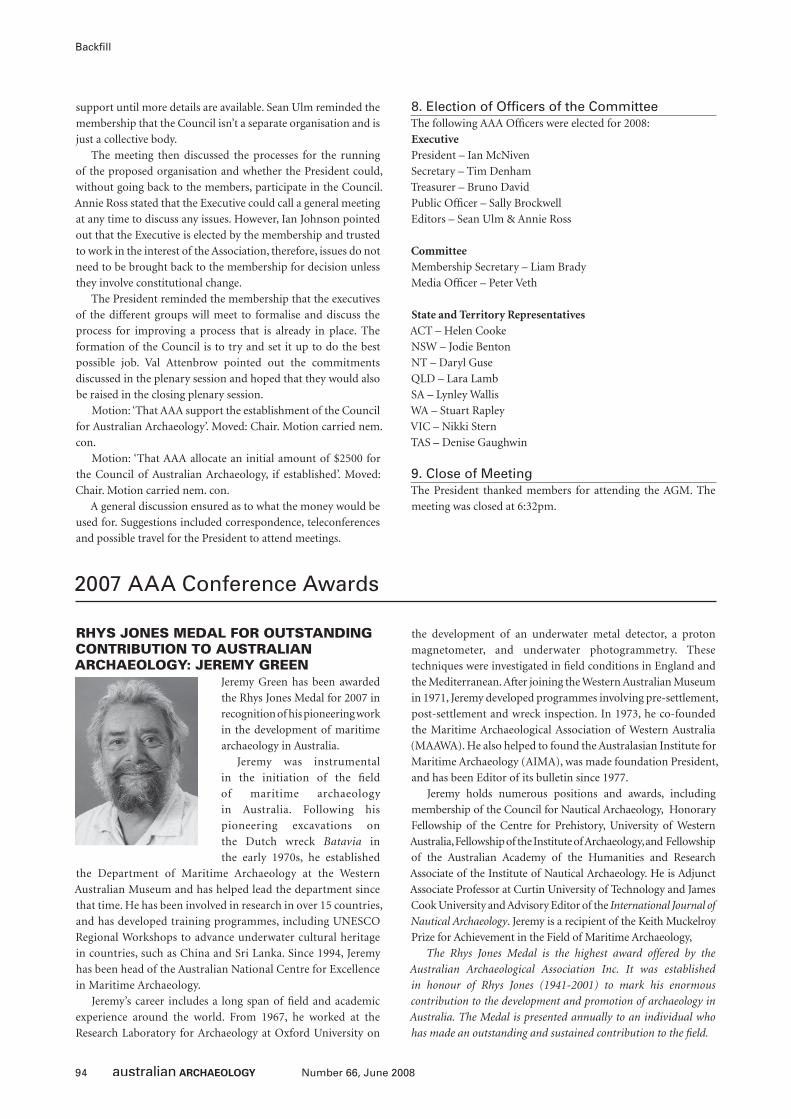
94 Number 66, June 2008
Backfi ll
support until more details are available. Sean Ulm reminded the
membership that the Council isn’t a separate organisation and is
just a collective body.
The meeting then discussed the processes for the running
of the proposed organisation and whether the President could,
without going back to the members, participate in the Council.
Annie Ross stated that the Executive could call a general meeting
at any time to discuss any issues. However, Ian Johnson pointed
out that the Executive is elected by the membership and trusted
to work in the interest of the Association, therefore, issues do not
need to be brought back to the membership for decision unless
they involve constitutional change.
The President reminded the membership that the executives
of the different groups will meet to formalise and discuss the
process for improving a process that is already in place. The
formation of the Council is to try and set it up to do the best
possible job. Val Attenbrow pointed out the commitments
discussed in the plenary session and hoped that they would also
be raised in the closing plenary session.
Motion: ‘That AAA support the establishment of the Council
for Australian Archaeology’. Moved: Chair. Motion carried nem.
con.
Motion: ‘That AAA allocate an initial amount of $2500 for
the Council of Australian Archaeology, if established’. Moved:
Chair. Motion carried nem. con.
A general discussion ensured as to what the money would be
used for. Suggestions included correspondence, teleconferences
and possible travel for the President to attend meetings.
8. Election of Offi cers of the CommitteeThe following AAA Offi cers were elected for 2008:
ExecutivePresident – Ian McNiven
Secretary – Tim Denham
Treasurer – Bruno David
Public Offi cer – Sally Brockwell
Editors – Sean Ulm & Annie Ross
CommitteeMembership Secretary – Liam Brady
Media Offi cer – Peter Veth
State and Territory RepresentativesACT – Helen Cooke
NSW – Jodie Benton
NT – Daryl Guse
QLD – Lara Lamb
SA – Lynley Wallis
WA – Stuart Rapley
VIC – Nikki Stern
TAS – Denise Gaughwin
9. Close of MeetingThe President thanked members for attending the AGM. The
meeting was closed at 6:32pm.
RHYS JONES MEDAL FOR OUTSTANDING CONTRIBUTION TO AUSTRALIAN ARCHAEOLOGY: JEREMY GREEN
Jeremy Green has been awarded
the Rhys Jones Medal for 2007 in
recognition of his pioneering work
in the development of maritime
archaeology in Australia.
Jeremy was instrumental
in the initiation of the fi eld
of maritime archaeology
in Australia. Following his
pioneering excavations on
the Dutch wreck Batavia in
the early 1970s, he established
the Department of Maritime Archaeology at the Western
Australian Museum and has helped lead the department since
that time. He has been involved in research in over 15 countries,
and has developed training programmes, including UNESCO
Regional Workshops to advance underwater cultural heritage
in countries, such as China and Sri Lanka. Since 1994, Jeremy
has been head of the Australian National Centre for Excellence
in Maritime Archaeology.
Jeremy’s career includes a long span of fi eld and academic
experience around the world. From 1967, he worked at the
Research Laboratory for Archaeology at Oxford University on
the development of an underwater metal detector, a proton
magnetometer, and underwater photogrammetry. These
techniques were investigated in fi eld conditions in England and
the Mediterranean. After joining the Western Australian Museum
in 1971, Jeremy developed programmes involving pre-settlement,
post-settlement and wreck inspection. In 1973, he co-founded
the Maritime Archaeological Association of Western Australia
(MAAWA). He also helped to found the Australasian Institute for
Maritime Archaeology (AIMA), was made foundation President,
and has been Editor of its bulletin since 1977.
Jeremy holds numerous positions and awards, including
membership of the Council for Nautical Archaeology, Honorary
Fellowship of the Centre for Prehistory, University of Western
Australia, Fellowship of the Institute of Archaeology, and Fellowship
of the Australian Academy of the Humanities and Research
Associate of the Institute of Nautical Archaeology. He is Adjunct
Associate Professor at Curtin University of Technology and James
Cook University and Advisory Editor of the International Journal of
Nautical Archaeology. Jeremy is a recipient of the Keith Muckelroy
Prize for Achievement in the Field of Maritime Archaeology,
The Rhys Jones Medal is the highest award offered by the
Australian Archaeological Association Inc. It was established
in honour of Rhys Jones (1941-2001) to mark his enormous
contribution to the development and promotion of archaeology in
Australia. The Medal is presented annually to an individual who
has made an outstanding and sustained contribution to the fi eld.
2007 AAA Conference Awards
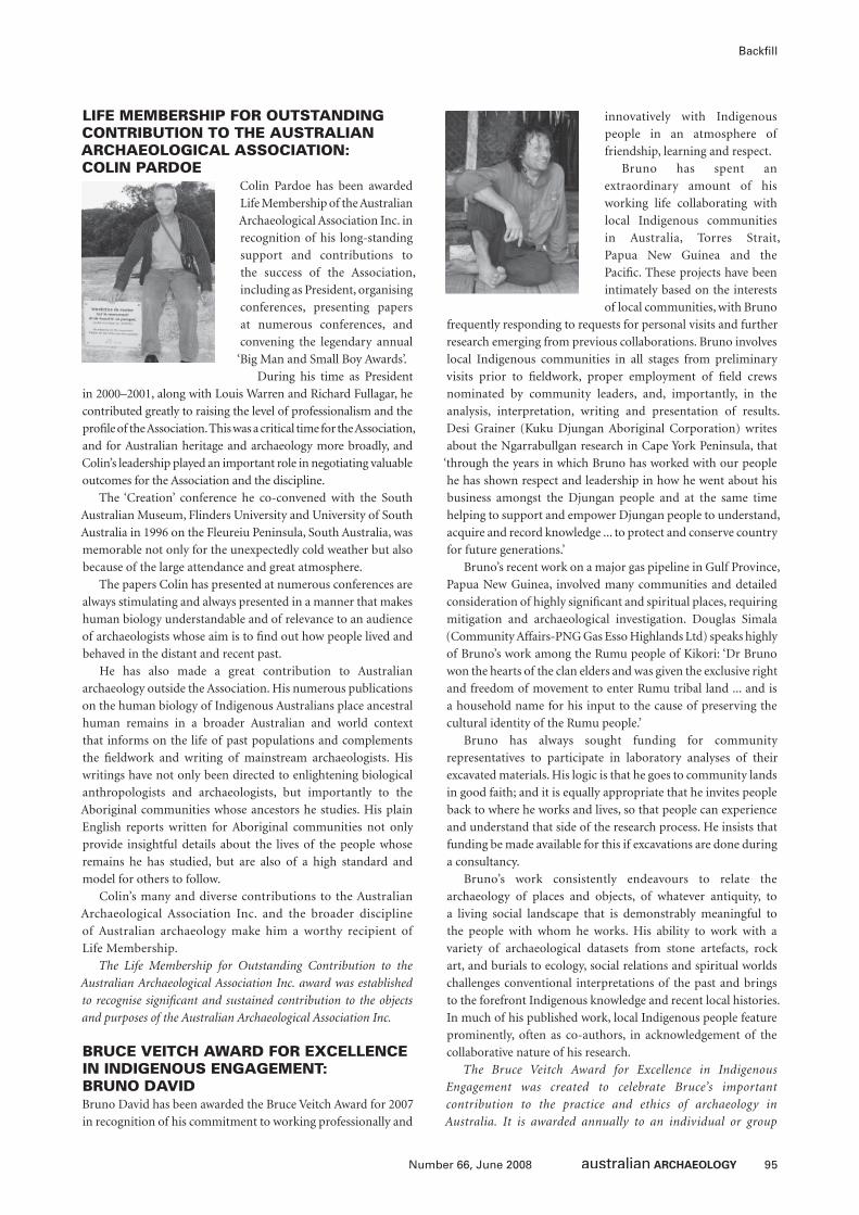
95Number 66, June 2008
Backfi ll
LIFE MEMBERSHIP FOR OUTSTANDING CONTRIBUTION TO THE AUSTRALIAN ARCHAEOLOGICAL ASSOCIATION: COLIN PARDOE
Colin Pardoe has been awarded
Life Membership of the Australian
Archaeological Association Inc. in
recognition of his long-standing
support and contributions to
the success of the Association,
including as President, organising
conferences, presenting papers
at numerous conferences, and
convening the legendary annual
‘Big Man and Small Boy Awards’.
During his time as President
in 2000–2001, along with Louis Warren and Richard Fullagar, he
contributed greatly to raising the level of professionalism and the
profi le of the Association. This was a critical time for the Association,
and for Australian heritage and archaeology more broadly, and
Colin’s leadership played an important role in negotiating valuable
outcomes for the Association and the discipline.
The ‘Creation’ conference he co-convened with the South
Australian Museum, Flinders University and University of South
Australia in 1996 on the Fleureiu Peninsula, South Australia, was
memorable not only for the unexpectedly cold weather but also
because of the large attendance and great atmosphere.
The papers Colin has presented at numerous conferences are
always stimulating and always presented in a manner that makes
human biology understandable and of relevance to an audience
of archaeologists whose aim is to fi nd out how people lived and
behaved in the distant and recent past.
He has also made a great contribution to Australian
archaeology outside the Association. His numerous publications
on the human biology of Indigenous Australians place ancestral
human remains in a broader Australian and world context
that informs on the life of past populations and complements
the fi eldwork and writing of mainstream archaeologists. His
writings have not only been directed to enlightening biological
anthropologists and archaeologists, but importantly to the
Aboriginal communities whose ancestors he studies. His plain
English reports written for Aboriginal communities not only
provide insightful details about the lives of the people whose
remains he has studied, but are also of a high standard and
model for others to follow.
Colin’s many and diverse contributions to the Australian
Archaeological Association Inc. and the broader discipline
of Australian archaeology make him a worthy recipient of
Life Membership.
The Life Membership for Outstanding Contribution to the
Australian Archaeological Association Inc. award was established
to recognise signifi cant and sustained contribution to the objects
and purposes of the Australian Archaeological Association Inc.
BRUCE VEITCH AWARD FOR EXCELLENCE IN INDIGENOUS ENGAGEMENT: BRUNO DAVIDBruno David has been awarded the Bruce Veitch Award for 2007
in recognition of his commitment to working professionally and
innovatively with Indigenous
people in an atmosphere of
friendship, learning and respect.
Bruno has spent an
extraordinary amount of his
working life collaborating with
local Indigenous communities
in Australia, Torres Strait,
Papua New Guinea and the
Pacifi c. These projects have been
intimately based on the interests
of local communities, with Bruno
frequently responding to requests for personal visits and further
research emerging from previous collaborations. Bruno involves
local Indigenous communities in all stages from preliminary
visits prior to fi eldwork, proper employment of fi eld crews
nominated by community leaders, and, importantly, in the
analysis, interpretation, writing and presentation of results.
Desi Grainer (Kuku Djungan Aboriginal Corporation) writes
about the Ngarrabullgan research in Cape York Peninsula, that
‘through the years in which Bruno has worked with our people
he has shown respect and leadership in how he went about his
business amongst the Djungan people and at the same time
helping to support and empower Djungan people to understand,
acquire and record knowledge ... to protect and conserve country
for future generations.’
Bruno’s recent work on a major gas pipeline in Gulf Province,
Papua New Guinea, involved many communities and detailed
consideration of highly signifi cant and spiritual places, requiring
mitigation and archaeological investigation. Douglas Simala
(Community Affairs-PNG Gas Esso Highlands Ltd) speaks highly
of Bruno’s work among the Rumu people of Kikori: ‘Dr Bruno
won the hearts of the clan elders and was given the exclusive right
and freedom of movement to enter Rumu tribal land ... and is
a household name for his input to the cause of preserving the
cultural identity of the Rumu people.’
Bruno has always sought funding for community
representatives to participate in laboratory analyses of their
excavated materials. His logic is that he goes to community lands
in good faith; and it is equally appropriate that he invites people
back to where he works and lives, so that people can experience
and understand that side of the research process. He insists that
funding be made available for this if excavations are done during
a consultancy.
Bruno’s work consistently endeavours to relate the
archaeology of places and objects, of whatever antiquity, to
a living social landscape that is demonstrably meaningful to
the people with whom he works. His ability to work with a
variety of archaeological datasets from stone artefacts, rock
art, and burials to ecology, social relations and spiritual worlds
challenges conventional interpretations of the past and brings
to the forefront Indigenous knowledge and recent local histories.
In much of his published work, local Indigenous people feature
prominently, often as co-authors, in acknowledgement of the
collaborative nature of his research.
The Bruce Veitch Award for Excellence in Indigenous
Engagement was created to celebrate Bruce’s important
contribution to the practice and ethics of archaeology in
Australia. It is awarded annually to an individual or group
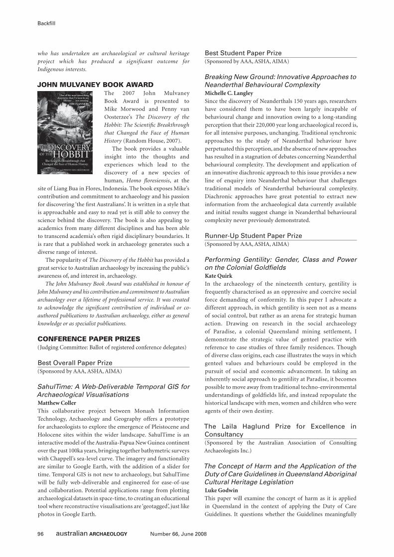
96 Number 66, June 2008
Backfi ll
who has undertaken an archaeological or cultural heritage
project which has produced a significant outcome for
Indigenous interests.
JOHN MULVANEY BOOK AWARDThe 2007 John Mulvaney
Book Award is presented to
Mike Morwood and Penny van
Oosterzee’s The Discovery of the
Hobbit: The Scientifi c Breakthrough
that Changed the Face of Human
History (Random House, 2007).
The book provides a valuable
insight into the thoughts and
experiences which lead to the
discovery of a new species of
human, Homo fl oresiensis, at the
site of Liang Bua in Flores, Indonesia. The book exposes Mike’s
contribution and commitment to archaeology and his passion
for discovering ‘the fi rst Australians’. It is written in a style that
is approachable and easy to read yet is still able to convey the
science behind the discovery. The book is also appealing to
academics from many different disciplines and has been able
to transcend academia’s often rigid disciplinary boundaries. It
is rare that a published work in archaeology generates such a
diverse range of interest.
The popularity of The Discovery of the Hobbit has provided a
great service to Australian archaeology by increasing the public’s
awareness of, and interest in, archaeology.
The John Mulvaney Book Award was established in honour of
John Mulvaney and his contribution and commitment to Australian
archaeology over a lifetime of professional service. It was created
to acknowledge the signifi cant contribution of individual or co-
authored publications to Australian archaeology, either as general
knowledge or as specialist publications.
CONFERENCE PAPER PRIZES(Judging Committee: Ballot of registered conference delegates)
Best Overall Paper Prize(Sponsored by AAA, ASHA, AIMA)
SahulTime: A Web-Deliverable Temporal GIS for Archaeological VisualisationsMatthew CollerThis collaborative project between Monash Information
Technology, Archaeology and Geography offers a prototype
for archaeologists to explore the emergence of Pleistocene and
Holocene sites within the wider landscape. SahulTime is an
interactive model of the Australia-Papua New Guinea continent
over the past 100ka years, bringing together bathymetric surveys
with Chappell’s sea-level curve. The imagery and functionality
are similar to Google Earth, with the addition of a slider for
time. Temporal GIS is not new to archaeology, but SahulTime
will be fully web-deliverable and engineered for ease-of-use
and collaboration. Potential applications range from plotting
archaeological datasets in space-time, to creating an educational
tool where reconstructive visualisations are ‘geotagged’, just like
photos in Google Earth.
Best Student Paper Prize(Sponsored by AAA, ASHA, AIMA)
Breaking New Ground: Innovative Approaches to Neanderthal Behavioural ComplexityMichelle C. LangleySince the discovery of Neanderthals 150 years ago, researchers
have considered them to have been largely incapable of
behavioural change and innovation owing to a long-standing
perception that their 220,000 year long archaeological record is,
for all intensive purposes, unchanging. Traditional synchronic
approaches to the study of Neanderthal behaviour have
perpetuated this perception, and the absence of new approaches
has resulted in a stagnation of debates concerning Neanderthal
behavioural complexity. The development and application of
an innovative diachronic approach to this issue provides a new
line of enquiry into Neanderthal behaviour that challenges
traditional models of Neanderthal behavioural complexity.
Diachronic approaches have great potential to extract new
information from the archaeological data currently available
and initial results suggest change in Neanderthal behavioural
complexity never previously demonstrated.
Runner-Up Student Paper Prize(Sponsored by AAA, ASHA, AIMA)
Performing Gentility: Gender, Class and Power on the Colonial Goldfi eldsKate QuirkIn the archaeology of the nineteenth century, gentility is
frequently characterised as an oppressive and coercive social
force demanding of conformity. In this paper I advocate a
different approach, in which gentility is seen not as a means
of social control, but rather as an arena for strategic human
action. Drawing on research in the social archaeology
of Paradise, a colonial Queensland mining settlement, I
demonstrate the strategic value of genteel practice with
reference to case studies of three family residences. Though
of diverse class origins, each case illustrates the ways in which
genteel values and behaviours could be employed in the
pursuit of social and economic advancement. In taking an
inherently social approach to gentility at Paradise, it becomes
possible to move away from traditional techno-environmental
understandings of goldfields life, and instead repopulate the
historical landscape with men, women and children who were
agents of their own destiny.
The Laila Haglund Prize for Excellence in Consultancy(Sponsored by the Australian Association of Consulting
Archaeologists Inc.)
The Concept of Harm and the Application of the Duty of Care Guidelines in Queensland Aboriginal Cultural Heritage LegislationLuke GodwinThis paper will examine the concept of harm as it is applied
in Queensland in the context of applying the Duty of Care
Guidelines. It questions whether the Guidelines meaningfully
97Number 66, June 2008
Backfi ll
address the conservation and management of cultural heritage
or merely provide a self-assessed and unregulated mechanism
to assist development proponents. The apparent disjunction
between the purpose of the Aboriginal Cultural Heritage Act 2003,
the Queensland Government’s claim of ownership of Aboriginal
cultural heritage (except in limited circumstances) and their
inability to audit the application of their own Guidelines is
explored. An example from central Queensland is presented
to demonstrate how these Guidelines can be applied with little
regard to the archaeological consequences.
CONFERENCE POSTER PRIZES(Judging Committee: Jessica Berry, Sean Ulm, Andrew Wilson)
Best Overall Poster Prize(Sponsored by AAA, ASHA, AIMA)
Injalak Hill Rock Art Recording ProjectSally K. May and Melissa JohnsonThis poster focuses on the Injalak Hill Rock Art Recording
Project in western Arnhem Land and the associated rock art
recording fi eld school. This recording project aims to develop
a baseline record of the rock art from Injalak Hill, to monitor
changes in the rock art for the purposes of conservation, to
develop a detailed chronology for rock art from Injalak Hill,
and to assist in the interpretation of this rock art for a wide
audience. Since 2004 international and Australian students have
visited Kunbarlanja (Oenpelli) as part of a fi eld school to learn
practical archaeological skills and to develop other practical and
personal skills necessary to conduct archaeological research with
Aboriginal communities. In particular, the aim was to provide
a space for students to learn about rock art in its present-day
cultural context. This poster focuses on the successes, the
surprises and the academic outcomes of the rock art recording
project and the fi eld school.
Best Student Poster Prize(Sponsored by AAA, ASHA, AIMA)
The Historic Shipwrecks Amnesty Collections: A Resource for the Study of Human Impact on Shipwreck SitesJennifer RodriguesIn 1993, a nation-wide amnesty was declared in Australia
calling for members of the public, who were in possession of
historic shipwreck relics, to declare their collections without
fear of prosecution. The amnesty was declared in response
to an amendment in the Historic Shipwrecks Act 1976, which
provided automatic blanket protection for all shipwrecks in
Commonwealth waters that were at least 75 years old, whether
or not located. In response to the amnesty, thousands of
shipwreck artefacts were declared by divers, private collectors,
coin dealers, fi shermen, schools, and small regional museums,
which had accepted donated objects from divers over the
years. The amnesty enabled authorities to inventory these
artefacts and enhance information already recorded. The poster
presents the background to the amnesty; the results of a recent
preliminary assessment of the collections, which refl ect the
level of early looting on Australia’s shipwreck sites; and outlines
the benefi ts and implications of such collections. It provides
an illustration of some of the objects found in the collections,
both privately held as well as those held by the State cultural
heritage management agencies and museums, and presents
some basic statistics on the degree of human impact on those
shipwreck sites affected.
Runner-Up Student Poster Prize(Sponsored by AAA, ASHA, AIMA)
Blinded by Bungwall: A Review of Bevel-Edged Artefact Research from Southeast QueenslandAmy Tabrett and Sean UlmBevel-edged artefacts found in southeast Queensland are
conventionally linked with processing of the root of the
bungwall fern (Blechnum indicum). This association is based on
ethnohistoric accounts by early European observers in southeast
Queensland. The validity of the link between bevel-edged
artefacts and B. indicum is central to models of increasing socio-
economic productivity in southeast Queensland. B. indicum
has been argued to be a dietary staple and the appearance of
bevel-edged artefacts in the archaeological record has been
equated with the emergence of B. indicum processing. However,
review of the few use-wear and residue studies conducted on
bevel-edged tools, in conjunction with an examination of the
ethnohistoric literature, reveals that bevel-edged tools were
probably used to process a number of plant foods. This fi nding
suggests that, in the past, archaeologists have given excessive
authority to written sources of evidence about these tools,
resulting in narrowly targeted laboratory studies and leading
to inaccurate models of Aboriginal subsistence behaviours.
Now that use-wear and residue analyses are becoming more
feasible for larger sample sizes, it is recommended that a
thorough investigation of bevel-edged tool use be conducted
in order to create an improved understanding of their use and
signifi cance.
BIG MAN AND SMALL BOY AWARDS(Judging Committee: Cos Coroneos, Steve Free, Jo McDonald,
David Nutley, Cassandra Phillippou, Kathryn Przywolnik, Annie
Ross, Katrina Stankowski, Peter Veth)
When you Wish Upon a Star AwardAnnie Clarke: For saying at the plenary ‘Mike Parker-Pearson
made three good points last night – and two of them were Rachel
Welsh ... I lost interest after that ...’
The Penal Servitude AwardElle Casella: For saying in her paper on proto-convicts that ‘idle
hands lead to unnatural sex crimes’.
The Bluebottle Sword of Honour AwardChris Clarkson: For talking about the Goons Index of Artefact
Reduction (only the lithic jocks noticed this slip of the tongue).
The Jamie Drury Data Makeover AwardMichael Westway: For spicing up his presentation by showing a
picture of a dead tree – and saying ‘this tree is rooted’.
98 Number 66, June 2008
Backfi ll
The Noel Coward Rough Guide to Bali AwardDenis Byrne: For worrying about the de-eroticisation of Gay
Heritage – and saying – ‘what would be the point of that?!’
The Surgeon of Crowthorne AwardCos Coroneos: For wrongly suggesting that the Wingicarribee
fl ows through the Berrima River.
The Back Crack and Sack AwardAndrew Sneddon: For saying in his paper ‘testosterone-driven
moments shouldn’t shape government policy’.
The Elle Macpherson AwardDavid Rose: For answering a question by Peter Veth – by saying
that ‘you should read that article by Peter Veth ...’
The Keira Knightly OscarPeta Knott: For saying (while dressed as a pirate) that ‘Tasmanian
children were very imaginative in their methods of dying’.
The Professor Trelawny Divination AwardJeremy Ash: For showing slides in his presentation which were
date stamped October and November 2007.
The Raymond Dart Drop-Bear AwardMichelle Langley: For stating in her abstract that she had studied
Neanderthal behaviour in the UQ Department in 2006.
The Lonely New Zealander AwardRoss Anderson: For taking a blow-up sheep on fi eldwork with
him – as evidenced in his slides ...
The Malcolm Turnbull Pulp Fiction AwardAngie McGowan: For wrestling with the issue of calculating
heritage potential in Tasmania – and describing this as the
slippery slide ...
The Mr Incredible AwardEoghan Kieran: For having ‘over 100% coverage of mussels on
the river bed’ and for missing his paper by half an hour ...
Shrek Donkey AwardJustin Shiner: For asking (in the paper presented on behalf of
him and Simon Holdaway) ‘Are we there yet?’
Two Holes in One AwardMike McCarthy: For talking about Shipwreck Graveyards and
saying that, ‘only organised folk can turn their own knobs [Ed:
presumably on their tanks] – they must all play golf!’
BIG MAN AWARDMary Casey: Who said at the closure of the Parramatta session
‘Now everyone, before you go, I want you all to come down the
front and look at my lovely jugs’.
PS: The ad hoc committee would also like to extend their
congratulations to Tim Owen who turned 30 this year – and
promptly retired!!!
The Big Man and Small Boy Awards are designed to provide
maximum embarrassment and humiliation at the annual
Australian Archaeological Association conference. All submissions
must have been made in public, preferably during a presentation.
The ad hoc committee accepts nominations from attendees. The
committee does not appear to be bound by any rules, guidelines or
ethics statements – we do what we want.
On Receiving Life MembershipDear Editors,
During the presentation of the Big Man Awards a few years
ago, I let slip that the AAA conference was the biggest part of my
social life. This appeared to shock many people, who dutifully
advised me during the course of the evening that I should go
out more. The eventful life of the Australian Archaeological
Association Inc. has been witness to major changes in the way
we do archaeology, both in the practical sense and in the social. I
am proud to be associated with AAA.
With the general merriment of so many people attending
the annual conference dinner last year (and with bloody Ken
Mulvaney screaming in my ear during the announcement of
the award), I missed what President Alistair said. I was unsure
whether this was an award for a lifetime spent, or for the
unused portion. In either case, it comes at the cusp of a personal
celebration, when I will have spent half my life in Australia.
I want to thank each and every one of you for this award. I
hope that the unused portion will prove as enjoyable and fun as
the portion that I have spent with you all so far.
Unfortunately, I was unable to attend the 2007 conference,
except for the dinner, on account of the drought and the need
for water supply pipelines. Nevertheless, you may rest assured
the ad hoc committee of the Big Man Awards is relentless.
You needn’t think, however, that sucking up to me with this
award will protect any of you from potential humiliation and
embarrassment at future AAA conferences.
This is darned near the greatest honour I’ve had, certainly in
archaeology and biological anthropology.
As always,
Colin PardoeColin Pardoe Bio-Anthropology & Archaeology
Turner, Australian Capital Territory
Letters to the Editors
99Number 66, June 2008
Backfi ll
AustArch1: A Database of 14C and Luminescence Ages from Archaeological Sites in the Australian Arid ZoneA.N. Williams1, M.A. Smith,1,2 C.S.M Turney3 and M.L Cupper4
IntroductionAustArch1 is a Microsoft® Excel® database listing radiocarbon,
luminescence and uranium series ages from archaeological sites
in the Australian arid zone. It was originally compiled to support
analysis of time-series trends by the authors (Smith et al. 2008;
Williams et al. in press) and is now available online at http://
palaeoworks.anu.edu.au/databases.html. The database is intended
as a resource for archaeologists working in the arid zone. It
provides a ready checklist of dated sites as well as a comprehensive
listing of radiocarbon, luminescence and uranium series age
determinations, and in conjunction with calibration programs
such as OxCal or Calib, can be used to generate radiocarbon
density plots for analysis of trends in occupation. Research in the
arid zone has grown over the past decade, making this central
listing of chronometric data particularly relevant, and we expect
that AustArch1 will become a useful tool for both consultant and
academic archaeologists.
FormatAustArch1 is a Microsoft® Excel® fi le, listing ages (rows) by site,
location and biogeographic region. The latter are based on the
Interim Biogeographic Regionalisation of Australia (IBRA) 6.1
divisions (Thackway and Cresswell 1995). Longitude and latitude
are compiled from published sources, or estimated from locality
maps. All 14C ages are given as conventional (uncalibrated) ages.
The fi le includes a bibliography of published and unpublished
sources for 14C, TL/OSL and U/Th data.
Geographic ScopeAustArch1 covers the entire arid zone, including the following
IBRA regions: BHC, BRT, CAR, CHC, COO, CR, DMR, FIN, FLB
(northern section only), GAS, GAW, GD, GS (Shark Bay area
only), GSD, GVD, HAM, LSD, MAC, MGD, ML, MUR, NUL,
PIL, SSD, STP, TAN, YAL (http://en.wikipedia.org/wiki/Interim_
Biogeographic_Regionalisation_for_Australia). The Murray-
Darling Basin (MDB) is included for comparison.
CoverageAustArch1 is currently the most comprehensive listing of
radiocarbon ages for the Australian arid zone. We estimate that
the database includes >97% of available 14C ages – totalling 971
ages from 286 sites – derived from published and unpublished
research over the past 40 years. In addition to radiocarbon data,
there are 115 TL/OSL or U/Th ages available for arid zone sites (97
dating occupation sediments or hearths). Major gaps in coverage
are the Great Victoria Desert, Nullarbor Plain, Tanami Desert and
the northern (subtropical) margins of the arid zone, refl ecting
the paucity of archaeological work in these areas. We have not
attempted to audit the database for technical and archaeological
validity of the ages, preferring to leave this to users.
Updates and ErrorsWe intend to maintain and periodically update the database and
would appreciate hearing of new 14C, TL/OSL or U/Th results as
they become available. We also ask users to notify us of any errors
(on email: [email protected] or [email protected]).
AcknowledgementsAustArch1 incorporates material from published or private
databases by Matt Cupper, Fiona Hook, Mike Smith, Sean
Ulm and Peter Veth. We thank colleagues who have supplied
unpublished data: Neale Draper, Giles Hamm, Fiona Hook, Roger
Luebbers, June Ross, Kathryn Przywolnik and Esmee Webb.
ReferencesSmith, M.A., A.N. Williams, C.S.M. Turney and M.L. Cupper 2008 Human-
environment interactions in Australian drylands: Exploratory time-series
analysis of archaeological records. The Holocene 18(3):397-409.
Thackway, R. and I.D. Cresswell (eds) 1995 An Interim Biogeographic
Regionalisation for Australia: A Framework for Establishing the National
System of Reserves. Canberra: Australian Nature Conservation Agency.
Williams, A.N., C.M. Santoro, M.A. Smith and C. Latorre in press The impact of ENSO
in the Atacama Desert and Australian arid zone: Exploratory time-series analysis
of archaeological records. Chungara: Revista de Antropología Chilena 40.
1 Fenner School of Environment and Society, Australian National University, Canberra, ACT 0200, Australia
² Centre for Historical Research, National Museum of Australia, GPO Box 1901, Canberra, ACT 2601, Australia
3 School of Geography, Archaeology and Earth Resources, University of Exeter, Exeter, Devon, EX4 4RJ, United Kingdom
4 School of Earth Sciences, University of Melbourne, VIC 3010, Australia
The Australian Academy of the Humanities: 2007 Fellows(Source: http://www.humanities.org.au)
At the Annual General Meeting of the Australian Academy of the
Humanities on 17 November 2007, an outstanding scholar in
archaeology was elected Fellow: Sue O’Connor. Fellows elected
to the Academy are residents of Australia who have achieved the
highest distinction in scholarship in the humanities.
Dr Susan O’Connor is Head of the Department of Archaeology
and Natural History at the Research School of Pacifi c and Asian
Studies at the Australian National University. She is currently
conducting a major archaeological research project in East
Timor investigating the cultural and environmental changes
that took place across the Neolithic transition and into the
Metal Age. This project complements and builds on previous
research in the eastern Maluku region and Wallacea and current
research in Papua New Guinea which is investigating Pleistocene
colonisation in Island Southeast Asia and Greater Australia and
subsequent patterns of migration, interaction and exchange.
Her publications include various papers in Terra Australis,
Archaeology in Oceania and Antiquity.
100 Number 66, June 2008
Backfi ll
Lectures
TERCENTENARY OF THE SOCIETY OF ANTIQUARIES OF LONDON LECTURES/GOLSON LECTURE 2008
Merlin’s Magic Circles: Stonehenge and the Use of the Preseli Bluestones
Professor Tim DarvillSchool of Conservation Sciences and Centre for Archaeology,
Anthropology and Heritage, Bournemouth University
6:30pm, Tuesday 13 May 2008, Sydney Grammar School, College
Street, Sydney
7:30pm, Thursday 15 May 2008, Manning Clark Centre, Union
Court, Australian National University (Golson Lecture 2008)
4pm, Monday 19 May 2008, Age Theatre, Melbourne Museum
Thursday 22 May 2008, University of Auckland, Auckland
Friday 23 May 2008, University of Otago
Stonehenge in central southern England is known the world over
as an iconic symbol of Europe’s prehistoric past. In this lecture
Professor Timothy Darvill of Bournemouth University, will show
that while Stonehenge’s origins as a ceremonial monument were
conventional enough, its later history was exceptional. Key to the
transformation was the arrival of about 80 pillars of Bluestone
rock brought a distance of around 250km from the Preseli Hills
of southwest Wales to Salisbury Plain. But why were these stones
important? And what did they mean to Neolithic people? Using
archaeological evidence from Stonehenge itself and from recent
work in the Preseli Hills, and folklore and oral tradition dating
back to the thirteenth century AD, a new picture of Stonehenge
is emerging in which the stones themselves can be seen to have
perceived magical properties connected with healing. Their reuse
in later and ever more elaborate structures at Stonehenge show
something of their power and signifi cance and illustrate how
the landscape of the Preseli Hills is constructed in microcosm at
Stonehenge. People were attracted to the area from continental
Europe, and what started out as a local focus became a celebrated
place for prehistoric pilgrimage.
On 5 December 1707 three men met at the Bear Tavern (or some
say the Young Devils Tavern) in the Strand in London to discuss
matters related to antiquity and British history; thus was founded
the Society of Antiquaries of London, the second Royal Society in
Britain. By 1717 there were 23 members and the Society has a
continuous history from that date as the oldest learned society in the
world concerned with the study of the material past. As part of the
Tercentenary celebrations there was an exhibition of artefacts from
the Society’s collections, held at the Royal Academy, a book ‘Visions
of Antiquity: The Society of Antiquaries of London 1707-2007’
edited by Susan Pearce, and a series of distinguished lectures that
continue through much of 2008. The Australasian Fellows (currently
28 in Australia and 6 in New Zealand) constitute the largest group
of Fellows of the Society beyond Europe after the United States, and
so Fellow Matthew Spriggs has coordinated the organisation of a
lecture tour in Australia and New Zealand by Professor Tim Darvill
of Bournemouth University as our contribution to the Tercentenary
celebrations.
The biennial Jack Golson Lecture honours Emeritus Professor
Jack Golson, Foundation Professor of Prehistory in the Research
School of Pacifi c Studies. Jack Golson came to the Australian
National University in 1961, following a brief period of outstanding
research in the archaeology of New Zealand. In 1969 he became
the Foundation Professor of Prehistory. His research on the nature
of Lapita culture and on the origins and spread of agriculture,
especially in Papua New Guinea, has brought these matters to
worldwide attention. Amongst various honours, he holds an
honorary doctorate from the University of Papua New Guinea and
is an Offi cer in the Order of Australia.
Conferences
AUSTRALIAN ARCHAEOLOGICAL ASSOCIATION ANNUAL CONFERENCE 2008
3–6 December 2008Noosa, QueenslandAAA2008 will be held over three days at the Australis Noosa
Lakes Resort in Noosaville, Queensland. A welcome evening will
be held on Wednesday 3 December, and a post-conference tour
is planned for Sunday 7 December. Noosa is home to some of
the best beaches in Australia, so bring your togs. Noosa is also
known for excellent dining and its natural beauty, including
the nearby Fraser Island World Heritage Area and Great Sandy
Region. Sessions are invited on current issues and research
in Australian archaeology, as well as sessions of interest and
relevance to Australian archaeologists more generally. This may
include overseas work being undertaken by Australia-based
archaeologists.
Details: http://www.socialscience.uq.edu.au/index.
html?page=74856
101Number 66, June 2008
1. GeneralAustralian Archaeology, the official publication of the
Australian Archaeological Association Inc., is a refereed
journal published since 1974. It accepts original articles
in all fields of archaeology and other subjects relevant to
archaeological research and practice in Australia and nearby
areas. Contributions are accepted in six sections: Articles
(5000–8000 words), Short Reports (1000–3000), Obituaries
(500–2000), Thesis Abstracts (200–500), Book Reviews (500–
2000) and Backfill (which includes letters, conference details,
announcements and other material of interest to members).
Australian Archaeology is published twice a year, in June
and December.
2. Submission of ContributionsSubmissions that do not conform to these Notes to Contributors
may be returned to authors for correction before they are
processed. All contributions must be typed, double line spaced,
using 12 point Times New Roman font or similar. Do not use
more than three heading levels. Do not use footnotes. Do not
use double spaces after full stops at the end of sentences. Number
all pages submitted consecutively. For further guidance on style
refer to the most recent issue of Australian Archaeology. A 150–
200 word abstract must be included for articles. The abstract
should be a complete, concise summary of the paper. A cover
page must be included listing contribution title and full names,
affi liations and postal addresses for correspondence (including
email) of all authors. Do not include author names on pages
other than the cover page.
3. Processing of ContributionsThe Editors will acknowledge receipt of all contributions. The
Editors and external peer reviewers will review all contributions
submitted as articles and short reports. As for any refereed
journal, authors may be asked to make revisions to their
manuscript. If substantial revision is required manuscripts
may be rereviewed before a decision to publish is made. Once
a paper is accepted in its final form, page-proofs will be sent
to the senior author for checking. Proof Approval and Author
Agreement forms will be sent with the page-proofs and must
be completed and returned before publication can proceed.
Final acceptance of manuscripts for publication is at the
discretion of the Editors. For paper submission instructions
see below.
4. CitationsReferences should be cited in text by author’s surname,
publication year and page (e.g. Smith 1988:45). For three or
more authors ‘et al.’ (with italics) should be used after the fi rst
surname (e.g. David et al. 1994). If multiple references are cited
they should be ordered alphabetically and then by publication
year, with authors’ names separated by a semicolon (e.g. Appleby
1990:19-25; Childe 1952; David 1988; David and Chant 1995;
David et al. 1994, 1999; White and O’Connell 1982:42, 50).
5. ReferencesType the References starting on a new page. Include all and
only those references cited in the paper. Do not cite papers in
preparation. Papers may be cited as ‘in press’ where they have
been accepted for publication. For general publication categories
the format should follow the examples below. Please pay
particular attention to capitalisation, punctuation and spacing.
Submissions that do not conform to these referencing guidelines
will be returned to authors for correction.
Journal ArticlesBird, C.F.M. and D. Frankel 1991 Problems in constructing a prehistoric regional
sequence: Holocene south-east Australia. World Archaeology 23(2):179-192.
Book ChaptersCraib, J.L. and G.R. Mangold 1999 Storm in a test pit: Effects of cyclonic storms
on coastal archaeological sites in western Micronesia. In J. Hall and I.J.
McNiven (eds), Australian Coastal Archaeology, pp.299-306. Research
Papers in Archaeology and Natural History 31. Canberra: ANH Publications,
Department of Archaeology and Natural History, Research School of Pacifi c
and Asian Studies, Australian National University.
BooksLourandos, H. 1997 Continent of Hunter-Gatherers: New Perspectives in Australian
Prehistory. Cambridge: Cambridge University Press.
Edited BooksHall, J. and I.J. McNiven (eds) 1999 Australian Coastal Archaeology. Research
Papers in Archaeology and Natural History 31. Canberra: ANH Publications,
Department of Archaeology and Natural History, Research School of Pacifi c
and Asian Studies, Australian National University.
MonographsWickler, S. 2001 The Prehistory of Buka: A Stepping Stone Island in the Northern
Solomons. Terra Australis 16. Canberra: Department of Archaeology and Natural
History and Centre for Archaeological Research, Australian National University.
ThesesDavid, B. 1994 A Space-Time Odyssey: Rock Art and Regionalisation in North
Queensland Prehistory. Unpublished PhD thesis, Department of Anthropology
and Sociology, University of Queensland, Brisbane.
Unpublished ReportsSmith, J.R. and H.J. Hall 1996 Beaudesert Shire Regional Archaeological Project.
Unpublished report to the Australian Heritage Commission, Canberra.
Internet ResourcesAustralian Bureau of Statistics 1996 Education: Participation in Education: The
Education of Indigenous People. Retrieved 6 November 2003 from http://www.
abs.gov.au/ausstats.
Listserver CommunicationsRoss, A. 2004 Useless Australian archaeology graduates. Message posted to the
AUSARCH-L listserver, 31 May 2004, archived at http://mailman.anu.edu.au/
mailman/listinfo/ausarch-l.
NOTES TO CONTRIBUTORS
102 Number 66, June 2008
6. Initial SubmissionIn the fi rst instance, papers should be submitted by email with
the contribution as a single attachment, including text, fi gures and
tables, using Microsoft® WORD (.doc), Rich Text Format (.rtf)
or Adobe® Portable Document Format (.pdf). Specifi cations for
tables and fi gures should follow the guidelines below.
7. Final Paper Submission InstructionsOnce accepted for publication, fi nal versions of papers
(including fi gures and tables) should be submitted as email
attachments or on clearly labelled CDs or DVDs in PC or
Macintosh format. Specifi cations for tables and fi gures should
follow the guidelines below.
8. TextText should be submitted using Microsoft® WORD (.doc) or
Rich Text Format (.rtf).
9. TablesType each table (including a caption) on a separate page at the
end of the manuscript, not in the body of the text. Number and
refer to tables in the text with Arabic numerals (i.e. Table 1 etc).
Tables should be submitted using Microsoft® WORD (.doc) or
Rich Text Format (.rtf).
10. Figures (Line Drawings and Photographs)Line drawings and photographs should both be referred to as
Figures, and numbered consecutively with Arabic numerals
(i.e. Figure 1 etc). Figures should be submitted on separate
pages at the end of the manuscript, not in the body of the text.
Figure captions should be typed on a separate page, not on
the fi gures. For fi nal submission, fi gures should be submitted
electronically as separate fi les as TIFF, JPEG (maximum quality)
or EPS (with preview) fi les. If fi gures cannot be submitted as
computer fi les, please submit as black-and-white line drawings
or as high contrast, glossy black-and-white prints. All fi gures
will be printed as greyscale images. Figures should be submitted
at fi nal size, ready for the printing process. Figures should be
submitted at resolutions of 600 dpi at fi nal size. That is, the fi gure
and its caption should be sized to fi t either within the margins of
a double columned page (170mm) or a single column (81mm).
The available space within margins for the full length of a page is
250mm (this leaves room for a one line caption). Please choose
appropriate letter size, line thickness and shading/stippling.
Photocopies of drawings are not acceptable. If not your own
work, you must acknowledge the origin of all fi gures and, where
applicable, it is the author’s responsibility to obtain written
unfettered permission to publish from the copyright owner of
the original.
11. Supplementary InformationSupplementary information relating to articles may be accepted
for online publication where such materials are directly
relevant to the arguments presented in a paper. Such additional
information may include, for example, detailed data tables where
there is only space for a summary table in the printed version.
At the initial submission stage authors should clearly identify
material as supplementary information. Supplementary material
will normally be restricted to tables and fi gures, but may also
include video or audio fi les. Supplementary tables and fi gures
should be numbered consecutively in the form Table S1, Figure
S1 etc. All supplementary information will be peer-reviewed, at
the same time as the normal refereeing process for the paper.
12. Reporting Radiocarbon Ages and CalibrationConventional radiocarbon ages should be reported as ‘BP’ and
calibrated ages as ‘cal BP’. Report laboratory number, material
dated, calibration method used and any corrections made (e.g.
marine reservoir correction).
13. CopyrightAuthors are responsible for ensuring that any material that
has infl uenced the research or writing has been properly
cited and credited both in the text and in the list of references.
Contributors are responsible for gaining copyright clearance
on fi gures, photographs or lengthy quotes used in their
manuscript that have been published elsewhere. Once accepted
for publication in Australian Archaeology, the author retains
copyright in the work and may publish or authorise others
to publish the entire work or any part thereof, provided that
due acknowledgement is made in any further publication that
the work was originally published in Australian Archaeology.
An article will not be published until the signed Author
Agreement has been completed and returned to the Editors by
the contributor.
14. OtherContributors are encouraged to contact the Editors if they have
any questions or concerns about the submission process.
15. Correspondence and SubmissionsAll correspondence and submissions should be addressed to:
Australian Archaeology
PO Box 6088
St Lucia QLD 4067
AUSTRALIA
Email: [email protected]
Notes to Contributors
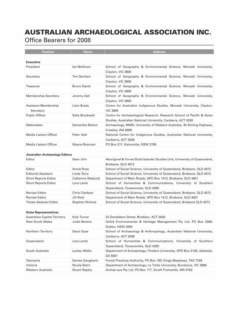
AUSTRALIAN ARCHAEOLOGICAL ASSOCIATION INC.Offi ce Bearers for 2008
Position Name Address
Executive
President Ian McNiven School of Geography & Environmental Science, Monash University,
Clayton, VIC 3800
Secretary Tim Denham School of Geography & Environmental Science, Monash University,
Clayton, VIC 3800
Treasurer Bruno David School of Geography & Environmental Science, Monash University,
Clayton, VIC 3800
Membership Secretary Jeremy Ash School of Geography & Environmental Science, Monash University,
Clayton, VIC 3800
Assistant Membership
Secretary
Liam Brady Centre for Australian Indigenous Studies, Monash University, Clayton,
VIC 3800
Public Offi cer Sally Brockwell Centre for Archaeological Research, Research School of Pacifi c & Asian
Studies, Australian National University, Canberra, ACT 0200
Webmaster Samantha Bolton Archaeology, M405, University of Western Australia, 35 Stirling Highway,
Crawley, WA 6009
Media Liaison Offi cer Peter Veth National Centre for Indigenous Studies, Australian National University,
Canberra, ACT 0200
Media Liaison Offi cer Wayne Brennan PO Box 217, Katoomba, NSW 2780
Australian Archaeology Editors
Editor Sean Ulm Aboriginal & Torres Strait Islander Studies Unit, University of Queensland,
Brisbane, QLD 4072
Editor Annie Ross School of Social Science, University of Queensland, Brisbane, QLD 4072
Editorial Assistant Linda Terry School of Social Science, University of Queensland, Brisbane, QLD 4072
Short Reports Editor Catherine Westcott Department of Main Roads, GPO Box 1412, Brisbane, QLD 4001
Short Reports Editor Lara Lamb School of Humanities & Communications, University of Southern
Queensland, Toowoomba, QLD 4350
Review Editor Chris Clarkson School of Social Science, University of Queensland, Brisbane, QLD 4072
Review Editor Jill Reid Department of Main Roads, GPO Box 1412, Brisbane, QLD 4001
Thesis Abstract Editor Stephen Nichols School of Social Science, University of Queensland, Brisbane QLD 4072
State Representatives
Australian Capital Territory Kyle Turner 22 Donaldson Street, Braddon, ACT 2620
New South Wales Jodie Benton OzArk Environmental & Heritage Management Pty Ltd, PO Box 2069,
Dubbo, NSW 2830
Northern Territory Daryl Guse School of Archaeology & Anthropology, Australian National University,
Canberra, ACT 0200
Queensland Lara Lamb School of Humanities & Communications, University of Southern
Queensland, Toowoomba, QLD 4350
South Australia Lynley Wallis Department of Archaeology, Flinders University, GPO Box 2100, Adelaide,
SA 5001
Tasmania Denise Gaughwin Forest Practices Authority, PO Box 180, Kings Meadows, TAS 7249
Victoria Nicola Stern Department of Archaeology, La Trobe University, Bundoora, VIC 3086
Western Australia Stuart Rapley Archae-aus Pty Ltd, PO Box 177, South Fremantle, WA 6162
Australian Archaeology, the offi cial publication of the
Australian Archaeological Association Inc., is a refereed
journal published since 1974. It accepts original articles
in all fi elds of archaeology and other subjects relevant to
archaeological research and practice in Australia and nearby
areas. Contributions are accepted in six sections: Articles
(5000-8000 words), Short Reports (1000-3000), Obituaries
(500-2000), Thesis Abstracts (200-500), Book Reviews
(500-2000) and Backfi ll (which includes letters, conference
details, announcements and other material of interest to
members). Australian Archaeology is published twice a year,
in June and December.
Subscriptions are available to individuals through
membership of the Australian Archaeological Association
Inc. or to organisations through institutional subscription.
Subscription application/renewal forms are available at
http://www.australianarchaeologicalassociation.com.au.
Graphic Design: Lovehate Design
Printing: Screen Offset Printing
Cover: Excavations at Glen Thirsty 1, August 2004, looking
southeast (L to R: Mike Smith and Sharon Overend)
(Photograph: M.A. Smith).
All correspondence and submissions should be addressed to:
Australian Archaeology
PO Box 6088
St Lucia QLD 4067
AUSTRALIA
Email: [email protected]
URL: http://www.australianarchaeologicalassociation.com.au
The views expressed in this journal are not necessarily those of
the Australian Archaeological Association Inc. or the Editors.
© Australian Archaeological Association Inc., 2008
ISSN 0312-2417
Editors
Sean Ulm University of Queensland
Annie Ross University of Queensland
Editorial Advisory Board
Val Attenbrow Australian Museum
Margaret Conkey University of California, Berkeley
Bruno David Monash University
Andrew Fairbairn University of Queensland
Richard Fullagar Scarp Archaeology
Martin Gibbs University of Sydney
Luke Godwin Central Queensland Cultural Heritage
Management Pty Ltd
Simon Holdaway University of Auckland
Susan Lawrence La Trobe University
Jo McDonald JMcD CHM Pty Ltd
& Australian National University
Tim Murray La Trobe University
Jim O’Connell University of Utah
Fiona Petchey University of Waikato
Paul Rainbird University of Wales
Lynette Russell Monash University
Robin Torrence Australian Museum
Peter Veth Australian National University
Editorial Assistant
Linda Terry University of Queensland
Short Report Editors
Lara Lamb University of Southern Queensland
Catherine Westcott Department of Main Roads (Qld)
Book Review Editors
Chris Clarkson University of Queensland
Jill Reid Department of Main Roads (Qld)
Thesis Abstract EditorStephen Nichols University of Queensland
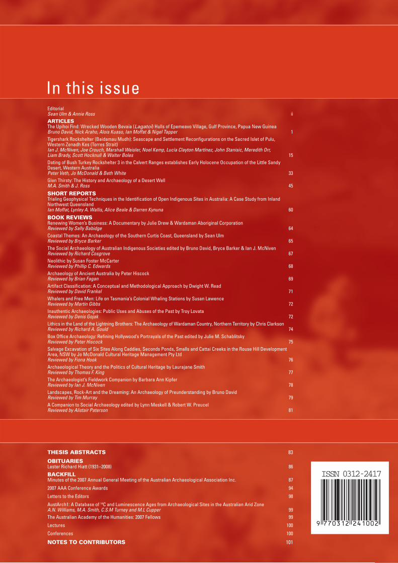
number 66 June 2008
EditorialSean Ulm & Annie Ross iiARTICLESThe Upihoi Find: Wrecked Wooden Bevaia (Lagatoi) Hulls of Epemeavo Village, Gulf Province, Papua New GuineaBruno David, Nick Araho, Alois Kuaso, Ian Moffat & Nigel Tapper 1Tigershark Rockshelter (Baidamau Mudh): Seascape and Settlement Reconfi gurations on the Sacred Islet of Pulu, Western Zenadh Kes (Torres Strait)Ian J. McNiven, Joe Crouch, Marshall Weisler, Noel Kemp, Lucía Clayton Martínez, John Stanisic, Meredith Orr, Liam Brady, Scott Hocknull & Walter Boles 15Dating of Bush Turkey Rockshelter 3 in the Calvert Ranges establishes Early Holocene Occupation of the Little Sandy Desert, Western AustraliaPeter Veth, Jo McDonald & Beth White 33Glen Thirsty: The History and Archaeology of a Desert WellM.A. Smith & J. Ross 45
SHORT REPORTSTrialing Geophysical Techniques in the Identifi cation of Open Indigenous Sites in Australia: A Case Study from Inland Northwest QueenslandIan Moffat, Lynley A. Wallis, Alice Beale & Darren Kynuna 60
BOOK REVIEWSRenewing Women’s Business: A Documentary by Julie Drew & Wardaman Aboriginal CorporationReviewed by Sally Babidge 64Coastal Themes: An Archaeology of the Southern Curtis Coast, Queensland by Sean UlmReviewed by Bryce Barker 65The Social Archaeology of Australian Indigenous Societies edited by Bruno David, Bryce Barker & Ian J. McNivenReviewed by Richard Cosgrove 67Neolithic by Susan Foster McCarterReviewed by Phillip C. Edwards 68Archaeology of Ancient Australia by Peter HiscockReviewed by Brian Fagan 69Artifact Classifi cation: A Conceptual and Methodological Approach by Dwight W. ReadReviewed by David Frankel 71Whalers and Free Men: Life on Tasmania’s Colonial Whaling Stations by Susan LawenceReviewed by Martin Gibbs 72Inauthentic Archaeologies: Public Uses and Abuses of the Past by Troy LovataReviewed by Denis Gojak 72Lithics in the Land of the Lightning Brothers: The Archaeology of Wardaman Country, Northern Territory by Chris Clarkson Reviewed by Richard A. Gould 74Box Offi ce Archaeology: Refi ning Hollywood’s Portrayals of the Past edited by Julie M. SchablitskyReviewed by Peter Hiscock 75Salvage Excavation of Six Sites Along Caddies, Seconds Ponds, Smalls and Cattai Creeks in the Rouse Hill Development Area, NSW by Jo McDonald Cultural Heritage Management Pty LtdReviewed by Fiona Hook 76Archaeological Theory and the Politics of Cultural Heritage by Laurajane SmithReviewed by Thomas F. King 77The Archaeologist’s Fieldwork Companion by Barbara Ann KipferReviewed by Ian J. McNiven 78Landscapes, Rock-Art and the Dreaming: An Archaeology of Preunderstanding by Bruno DavidReviewed by Tim Murray 79A Companion to Social Archaeology edited by Lynn Meskell & Robert W. Preucel Reviewed by Alistair Paterson 81
In this issue
nu
mb
er 66 2008
THESIS ABSTRACTS 83
OBITUARIESLester Richard Hiatt (1931–2008) 86
BACKFILLMinutes of the 2007 Annual General Meeting of the Australian Archaeological Association Inc. 87
2007 AAA Conference Awards 94
Letters to the Editors 98
AustArch1: A Database of 14C and Luminescence Ages from Archaeological Sites in the Australian Arid ZoneA.N. Williams, M.A. Smith, C.S.M Turney and M.L Cupper 99The Australian Academy of the Humanities: 2007 Fellows 99
Lectures 100
Conferences 100
NOTES TO CONTRIBUTORS 101
ISSN 0312-2417