the summit - wagisa
TRANSCRIPT

THE SUMMIT News From and For The Washington GIS Community WAURISA The Washington State Chapter of URISA – The Association for GIS Professionals
WINTER 2012 WWW.WAURISA.ORG ISSUE 26
ALSO IN THIS ISSUE: Using GIS for Next generation 911 …………………...………….... p. 4 URISA / NENA Addressing Conference ……….…………...……… p. 5 KCGIS Decade of Education ………………………..…………..……. p. 6 URISA GMCM Released for Public Comment ……………..……. p. 7 Upcoming URISA Events in 2012 ..……………………………….. p. 8 WAURISA ‘Making Beautiful Maps’ Workshop …………..……. p. 9 2012 Washington GIS Conference News ……………..……….. p. 11 Opinion and Features Page ………..…….……….……..….…….. p. 13
PRESIDENT’S COLUMN Hello WAURISA members!
Spring is arriving in my Bellingham neighborhood. Snowdrops and witch hazel are blooming. The daffodils in the sunny library garden next to the warm bricks are nearly open. And the hazelnuts have burst open their catkins. I love this time of the year. It’s invigorating to see things bloom, open, stretch, and grow after a long, dark and rainy winter.
Speaking of blooming and growing now is the time for you to BLOOM your way into the next level of participating in your GIS community. Did you know that 2012 Washington GIS Conference planning is underway? It’s only 4 months until our May conference and we are actively seeking workshops and presenters. Perhaps you see those announcements and think “Well someone else will do it”, or “I’m not doing anything that’s worth a presentation”. Not true, I tell you! You are exactly the someone we are counting on. We need ALL levels of presentations from beginner to advanced. There are always new people entering the field and they benefit from the “starter” presentation to help them GROW. And there is nothing like an advanced presentation to STRETCH your mind into new directions you never thought of or never even knew existed. And how about you? Time to OPEN yourself to new opportunities? Washington GIS Conference audiences are the friendliest sort to learn your presentation skills with. There have been absolutely zero instances of the audience revolting (or even heckling, really) on a presenter at a WAURISA event. Have I convinced you yet that I’m talking to you? STRETCH your mind to just consider the possibility. Give it five minutes to roll around your head and see what you can come up with. THEN see if you can include a colleague to do the same thing.
We are in need of a few politically minded volunteers who might be interested in being involved in drafting WAURISA’s position on endorsing the GISP. We have an effort underway to bring this issue to the attention of the state level folks and are just getting started. Are you interested in getting involved? Let us know!
See you at the conference in May! -Ann Stark, [email protected] @StarkAnn
_____________________________________________________
DRAFT GMCM RELEASED FOR PUBLIC COMMENT On February 22, URISA released the Draft Geospatial
Management Competency Model (GMCM) for 60 day public review. For more information see the article on p. 7 or visit www.urisa.org/gmcm_review.
TECH LESSONS FROM THE SEATTLE SNOWSTORM By Bill Schrier
The Seattle area and I went through a four day snow/ice storm event this past January. The City of Seattle’s emergency operations center (EOC) was activated and coordinated the City government’s response. That response received high marks from the public and media for a variety of reasons, including the leadership of Mayor Michael McGinn.
I was able to personally observe that response and lead the technology support of it. Information technology materially contributed to the improved response, nevertheless I see a number of further potential enhancements using technology. And that’s the purpose of this article.
Every city, county and state is all about geography and maps. Maps are the way we deploy resources (think “snowplows”). Maps are the way we understand what’s happening in our jurisdiction. Everyone who has lived and traveled inside a city can look on a map and instantly visualize locations – what the West Seattle bridge or any other street, infrastructure or geographical feature (think “hill”) looks like.
Every city, county and state is all about geography and maps
For this storm, we have some great mapping tools in place, especially a map which showed which streets had been recently plowed and de-iced. This map used GPS technology attached to the snowplow trucks. That same map had links to over 162 real-time traffic cameras so people could see the street conditions and traffic. (Other cities, like Chicago, have similar maps.)
Another useful map is the electrical utility’s system status map, which shows the exact locations of electrical system outages, the number of outages, the number of customers affected and the estimated restoration times. This is really useful if you are a customer who is affected – at least you know we’ve received your problem and a crew will be on the way.
See: Seattle Snowstorm Tech Lessons, Page 2
THE SUMMIT 2 WINTER 2012
SEATTLE SNOWSTORM TECH LESSONS Continued from page 1
What could we do better? We could put GPS on every City government vehicle and with every City crew and display all that information on a map. That way we’d immediately know the location of all our resources. If there was a significant problem – let’s say a downed tree blocking a road or trapping people – we could immediately dispatch the closest resources. In that case we’d typically dispatch a transportation department tree-clearing crew. But that crew might have to travel across the City when a parks department crew with the proper equipment might be a block away.
This same sort of map could show a variety of other information – the location of police and fire units, which streets are closed due to steep hills and ice, where flooding is occurring, blocked storm drains, as well as water system and electrical outages. This “common operating picture”, across departments, would be enormously useful – as just one example, the fire department needs water to fight fires, and it needs good routes to get its apparatus to the fire and perhaps it would need a snowplow to clear a street as well.
Obviously we wouldn’t want to show all of this information to the public – criminals would have a field day if they knew the location of police units! But a filtered view certainly could be presented to show the City government in action. Perceptions and Citizen Contact
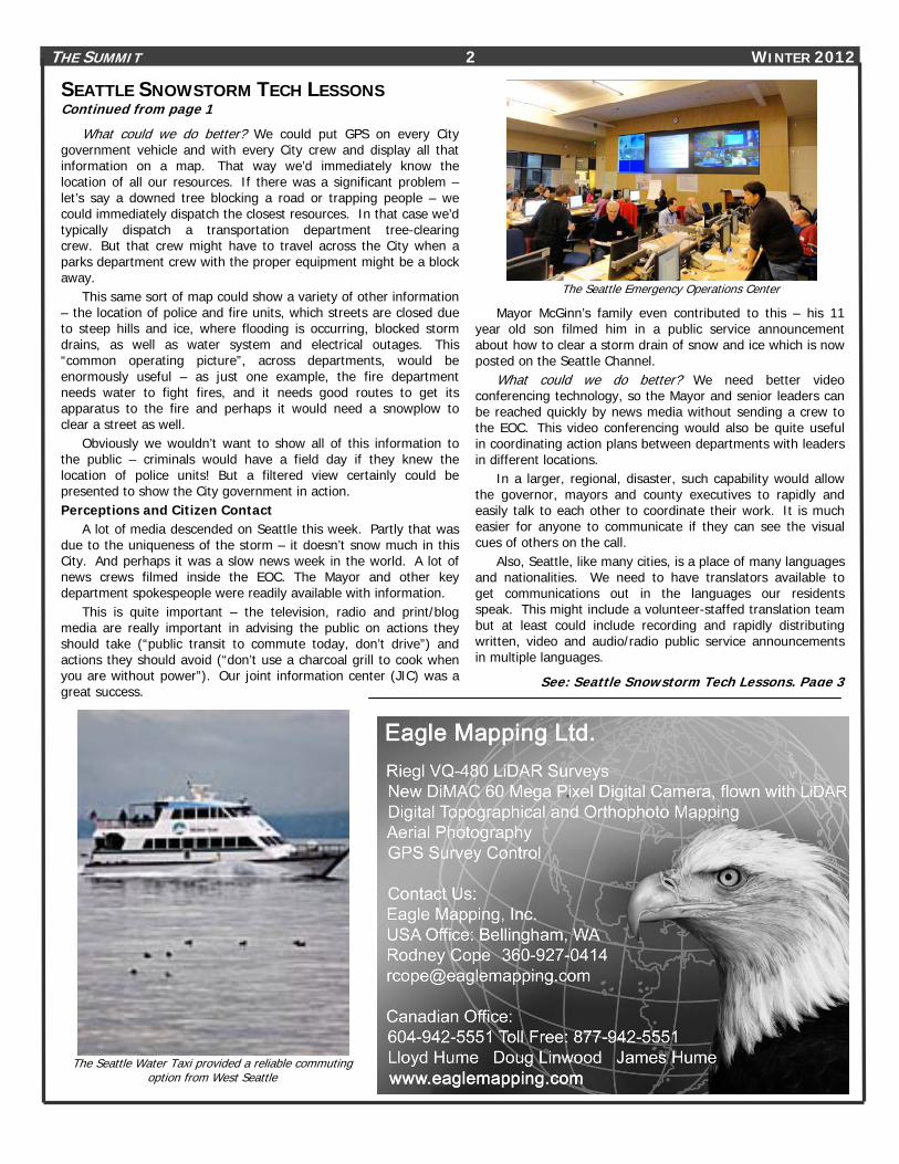
A lot of media descended on Seattle this week. Partly that was due to the uniqueness of the storm – it doesn’t snow much in this City. And perhaps it was a slow news week in the world. A lot of news crews filmed inside the EOC. The Mayor and other key department spokespeople were readily available with information.
This is quite important – the television, radio and print/blog media are really important in advising the public on actions they should take (“public transit to commute today, don’t drive”) and actions they should avoid (“don’t use a charcoal grill to cook when you are without power”). Our joint information center (JIC) was a great success.
The Seattle Emergency Operations Center
Mayor McGinn’s family even contributed to this – his 11 year old son filmed him in a public service announcement about how to clear a storm drain of snow and ice which is now posted on the Seattle Channel.
What could we do better? We need better video conferencing technology, so the Mayor and senior leaders can be reached quickly by news media without sending a crew to the EOC. This video conferencing would also be quite useful in coordinating action plans between departments with leaders in different locations.
In a larger, regional, disaster, such capability would allow the governor, mayors and county executives to rapidly and easily talk to each other to coordinate their work. It is much easier for anyone to communicate if they can see the visual cues of others on the call.
Also, Seattle, like many cities, is a place of many languages and nationalities. We need to have translators available to get communications out in the languages our residents speak. This might include a volunteer-staffed translation team but at least could include recording and rapidly distributing written, video and audio/radio public service announcements in multiple languages.
See: Seattle Snowstorm Tech Lessons, Page 3
The Seattle Water Taxi provided a reliable commuting
option from West Seattle

THE SUMMIT 3 WINTER 2012
SEATTLE SNOWSTORM TECH RESPONSE Continued from page 2
Commuting; Telecommuting In these emergencies, many people elect to use public transit
– buses and trains for commuting. (I actually took my “boat” – the water taxi - to work twice this week.) Yet snowstorms are also the times when buses jackknife or get stuck in snowdrifts and going up hills.
In this emergency, the coordination between the transit agency (King County Metro) and the City was quite improved, because we had people – liaisons – from each agency embedded with the other. This allowed snowplows to help keep bus routes clear and help clear streets near trapped buses.
Seattle Snow Status Map
And, with recent technology advances and sorta-broadband networks, many workers can now telecommute. Seattle had few outages of Internet service this week, although in suburban areas trees and snow brought down not just power lines, but telephone and cable lines as well causing more widespread Internet issues.
What could we do better? The easiest and most useful advance, I think, would be GPS on every bus and train and water taxi boat. That, combined with real-time mapping, would allow people to see the location of their rides right on their smartphones. If we deployed it right, such technology might also show how full the bus is and the locations of stuck buses. This sort of technology would be useful every day for public transit users – but is especially important during snow emergencies.
Another huge necessity – which I’ve advocated often and loudly – is very high speed fiber broadband networks. With fiber broadband – and Gigabit (a billion bits per second), two way, telecommuting and tele-education becomes really possible. Kids could continue their school day with video classes even when schools are closed, you could visit your doctor, and of course citizens would have access to all that emergency information and maps described above, real time and two-way. Crowdsourcing and Two-Way Communications, Cell Phones
This area is the most ripe for improved technology to “weather the storm”.
In any emergency – even a minor disaster like a major fire or a pile-up collision – just obtaining and distributing information early and often will have a significant result in managing the problem.
On-duty at any time, the City of Seattle may have 200 firefighters, 350 police officers and several hundred to several thousand other employees. Yet we also have 600,000 people in the City, each one of which is a possible source of information.
How could we get many of them, for example, to tell us thesnow and ice conditions in their neighborhoods? Or perhaps totell us of problems such as clogged storm drains or stuckvehicles? The Seattle Times actually did this a bit,crowdsourcing snow depths from Facebook.
How can we “crowd source” such information? I’m not exactlysure. Perhaps we could use Facebook apps or Twitter (althoughnot a lot of people use Twitter). Two-way text messages arepossible.
Any one of these solutions would present a whole mass of datawhich needs to be processed, tagged for reliability, and thenpresented as useful analytics. Eventually, of course, there will bewhole armies of remote sensors (“the Internet of things”) to collectand report the information. Perhaps everyone’s cell phone mighteventually be a data collector (yes, yes, I’m well aware of privacyconcerns).
In the meantime, we should have some way citizens can signup for alerts about weather or other problems.
Many such systems exist, such as the GovDelivery-poweredone used by King County Transportation. I’m not aware of such asystem being used two-way, to crowd-source information fromcitizens.
There are also plenty of community-notification or “Reverse911” systems on the market. The Federal government isdeveloping CMAS, which would automatically alert every cell phone/ mobile device in a certain geographical area about an impendingproblem or disaster.
See: Seattle Snowstorm Tech Lessons, Page 6
THE SUMMIT 4 WINTER 2012
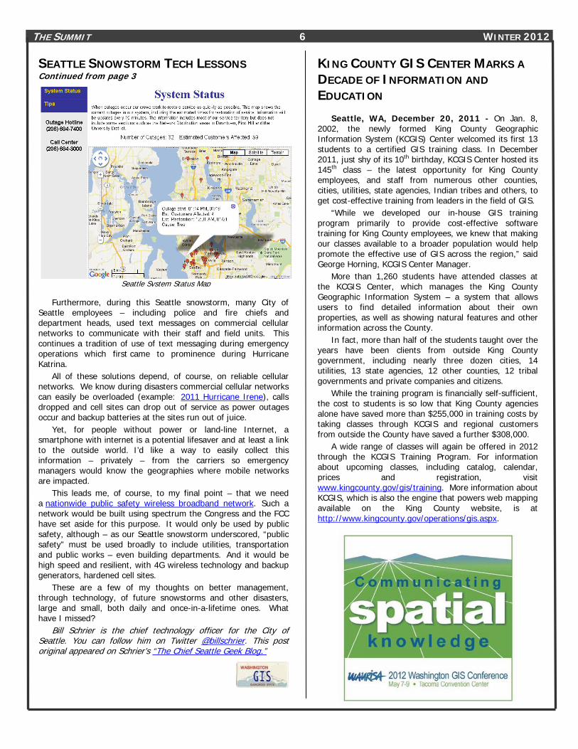
Conceptual handling of 911 calls with GIS
USING GIS TO PREPARE DATA FOR NEXT GENERATION 911 By Miranda Hett
With all of the advances in cellular phone technology that the United States has seen over the past few decades, one would think that you could text to 911. But it’s not possible. Not yet, anyway. Right now, 911 communication centers are not equipped to receive text messages, picture messages, or video from cellular phones and other devices. Falling under the umbrella of Next Generation 911 (NG911), these capabilities are on their way to call centers but there are a few hurdles that need to be cleared first. Updated standards and mandates for wireless phone carriers and jurisdictions must be solidified and money must be channeled toward the project. But another major issue is the text message itself.
Text messages and other data do not come attached with location information in the same way voice calls do. This means that while your voice call is automatically routed to the correct 911 communication center based on your location, a text message wouldn’t be, therefore prohibiting speedy assistance during an emergency. In order for communication centers to be NG911 ready, they must install infrastructure and synchronize databases. This is where GIS plays a role.
Currently 911 calls are routed based on the Master Street Address Guide (MSAG). It’s a database of house numbers and street names within associated service zones and numbers. However, static street address ranges are not applicable to wireless and IP-based devices in NG911.
See: Using GIS for Next Generation 911, Page 5

THE SUMMIT 5 WINTER 2012
Local addressing preferences may vary from authority to
authority, but it’s critical that standardization take place in 911 databases to allow interoperability between agencies, both at local and federal levels. It is also strongly recommended for general data sharing purposes and as a way to monitor gap and overlap between jurisdictions.
Once the latest version of the MSAG has been obtained, it is recommended that the synchronization is carried out in three phases: First compare the GIS street centerline data to the MSAG, then reverse the comparison, and finally join the two tables together using GIS software. Any discrepancies found should be reported to the addressing authority for correction. The ALI (Automatic Location Identification) data can then be geocoded against the completed GIS data to ensure that all ALI information will be properly transmitted to the call receiver’s computer screen. All of the verification processes can be done manually or with the aid of third party software.
A future consideration is to create a national street network for routing 911 calls with latitude and longitude information. One challenge to this is that not all agencies use the same Computer Aided Dispatch, or CAD, systems and therefore the technical requirements vary widely. Another is that each agency has addressing situations that are unique to their region and probably do not apply to an agency across the country. It’s up to expert 911 professionals and phone technicians to work through these challenges so that every 911 communication center will be ready to receive text and photo data from wireless devices in the coming years.
USING GIS FOR NEXT GENERATION 911 Continued from page 4
Wireless calls account for over half of the thousands of calls received by the King County 911 Communication Center in Renton each year. So, it is important to be able to handle the calls accurately.
Latitude and longitude coordinates describe a caller’s wireless location, and because GIS can be used to graphically display coordinates on a map, the MSAG data must be synchronized with GIS data. Plotting coordinates using GIS with other reference data, such as jurisdictional boundaries, water bodies, and landmarks, allows for better interpretation of relative location by call receivers.
Wireless calls account for over half of the thousands of calls received by the King
County 911 Communication Center According to the National Emergency Number Association
(NENA) standard 71-501, Version 1.1, “Comparing the MSAG and GIS databases will identify inconsistent naming conventions, inaccurate address information, improper ESN assignments to MSAG records, improper community assignments, improper exchange designations, and other discrepancies.” For complete text of the Synchronizing GIS with MSAG & ALI standard, visit http://www.nena.org/?page=Standards (please note this is an informational working document and subject to revision.) Basing synchronization on a uniform standard is the key to minimizing discrepancies and response delays. Rules to follow include avoiding punctuation, removing special characters, and using standard street suffixes according to UPSP Publication Number 28, among others.
Example of Street Suffix Standardization Original Standardized
PD STREET SUFFIX SD PD STREET SUFFIX SD East Fir St E Fir St
W Lake Sammamish Parkway NE W Lake Sammamish Pkwy NE Vineyard Crest Vineyard Crst South Langston Rd S Langston Rd 9 Av. 9th Ave Union Union St Oak Place Oak Pl 178th Lp SE 178th Loop SE Rt 2 Route 2 W 6 W 6th
NW Madrona Lane NW Madrona Ln Westside Highway SW Westside Hwy SW
Miranda J. Hett is a Geographical Information Systems Specialist with the King County Sheriff's Office - Communications Center, [email protected]
LEARN MORE ABOUT STREET ADDRESSING AND GIS – ATTEND THE URISA / NENA ADDRESSING CONFERENCE
http://urisa.org/conferences/Addressing/Info
About NENA – The National Emergency Number Association (NENA) is The Voice of 9-1-1 ™. Now celebrating its 25th Year, NENA was established to promote implementation and awareness of 9-1-1 as North America’s universal emergency number. NENA has grown to become the leading professional non-profit organization dedicated solely to 9-1-1 emergency communications issues. For more information, visit www.nena.org
THE SUMMIT 6 WINTER 2012
SEATTLE SNOWSTORM TECH LESSONS Continued from page 3
Seattle System Status Map
Furthermore, during this Seattle snowstorm, many City of Seattle employees – including police and fire chiefs and department heads, used text messages on commercial cellular networks to communicate with their staff and field units. This continues a tradition of use of text messaging during emergency operations which first came to prominence during Hurricane Katrina.
All of these solutions depend, of course, on reliable cellular networks. We know during disasters commercial cellular networks can easily be overloaded (example: 2011 Hurricane Irene), calls dropped and cell sites can drop out of service as power outages occur and backup batteries at the sites run out of juice.
Yet, for people without power or land-line Internet, a smartphone with internet is a potential lifesaver and at least a link to the outside world. I’d like a way to easily collect this information – privately – from the carriers so emergency managers would know the geographies where mobile networks are impacted.
This leads me, of course, to my final point – that we need a nationwide public safety wireless broadband network. Such a network would be built using spectrum the Congress and the FCC have set aside for this purpose. It would only be used by public safety, although – as our Seattle snowstorm underscored, “public safety” must be used broadly to include utilities, transportation and public works – even building departments. And it would be high speed and resilient, with 4G wireless technology and backup generators, hardened cell sites.
These are a few of my thoughts on better management, through technology, of future snowstorms and other disasters, large and small, both daily and once-in-a-lifetime ones. What have I missed?
Bill Schrier is the chief technology officer for the City of Seattle. You can follow him on Twitter @billschrier. This post original appeared on Schrier’s “The Chief Seattle Geek Blog.”
KING COUNTY GIS CENTER MARKS A DECADE OF INFORMATION AND EDUCATION
Seattle, WA, December 20, 2011 - On Jan. 8, 2002, the newly formed King County Geographic Information System (KCGIS) Center welcomed its first 13 students to a certified GIS training class. In December 2011, just shy of its 10th birthday, KCGIS Center hosted its 145th class – the latest opportunity for King County employees, and staff from numerous other counties, cities, utilities, state agencies, Indian tribes and others, to get cost-effective training from leaders in the field of GIS.
“While we developed our in-house GIS training program primarily to provide cost-effective software training for King County employees, we knew that making our classes available to a broader population would help promote the effective use of GIS across the region,” said George Horning, KCGIS Center Manager.
More than 1,260 students have attended classes at the KCGIS Center, which manages the King County Geographic Information System – a system that allows users to find detailed information about their own properties, as well as showing natural features and other information across the County.
In fact, more than half of the students taught over the years have been clients from outside King County government, including nearly three dozen cities, 14 utilities, 13 state agencies, 12 other counties, 12 tribal governments and private companies and citizens.
While the training program is financially self-sufficient, the cost to students is so low that King County agencies alone have saved more than $255,000 in training costs by taking classes through KCGIS and regional customers from outside the County have saved a further $308,000.
A wide range of classes will again be offered in 2012 through the KCGIS Training Program. For information about upcoming classes, including catalog, calendar, prices and registration, visit www.kingcounty.gov/gis/training. More information about KCGIS, which is also the engine that powers web mapping available on the King County website, is at http://www.kingcounty.gov/operations/gis.aspx.

THE SUMMIT 7 WINTER 2012 URISA RELEASES DRAFT GMCM FOR
PUBLIC COMMENT URISA’s proposed Geospatial Management Competency Model
(GMCM) is an element of the U.S. Department of Labor Employment and Training Administration’s (DOLETA’s) Competency Modeling Initiative (http://www.careeronestop.org/competencymodel/).
In 2010, DOLETA issued a Geospatial Technology Competency Model (GTCM) that specifies the foundational characteristic of the various occupations that comprise the geospatial industry. The GMCM corresponds to the uncompleted Tier 9 of the GTCM.
Practicing geospatial managers developed the current version of the GMCM, with input from workforce development experts at DOLETA and in light of comparable models produced for kindred fields. URISA Board member Greg Babinski organized a day-long work session at the Washington State GIS Conference in May, 2011 to prepare a preliminary “strawman” draft GMCM. Then in November, 2011, during its annual GIS-Pro conference in Indianapolis, IN, URISA conducted a day-long workshop to refine and validate the strawman draft. Session organizers David DiBiase, Pat Kennelly, and Babinski identified a Task Force of twelve experienced geospatial managers and one facilitator (DiBiase) to produce a revised draft GMCM suitable for public review.
For more information about the GMCM, the 60 day public review process, visit: www.urisa.org/gmcm_review.
THE SUMMIT 8 WINTER 2012
SUMMIT EDITORIAL: BE DISRUPTIVE!
Continued from page 13
Creative disruptors will face challenges. New technology, data, or processes likely require more investment. Be persistent. URISA can help as it becomes the source for new GIS ROI methodologies. New geospatial technology may lead to organizational change – maybe even job loss for some. But we need to realize that internal change is not always disruptive to customers and when it is, it ‘disrupts’ in a positive way. One example is the elimination of public agency map counter staff resulting from web mapping services. URISA can be your source for other successful examples.
Change can be stressful if we are the agents of change. As you take advantage of URISA events and publications look for ideas you can propose or implement. Don’t be afraid to share what you’ve learned and seek the OK to put new ideas into practice. URISA can be your source for both big disruptive ideas and for your posse of mentors and supporters.
Of course ‘disruptive’ has some negative connotations too. Know your audience, including stakeholders, decision makers, and end users. You’ll need diplomacy, insight, empathy, allies, and a strategy to accomplish your goals. Master all aspects of your proposal. How does it work, what will it cost, who will benefit, how long will it take, who’s done it before, what are the risks, and are you willing to put your reputation on the line for it? And be persistent. Your goal should be to build on small successes and develop within your organization both your personal reputation and an understanding of geospatial technology as agents of change.
Many successful careers are built upon being somewhat disruptive, by being seen as agents of change. Plan to be an agent of positive disruption. And plan now to come to in Portland in October for GIS-Pro 2012 – URISA’s Fiftieth Annual Conference – to share our challenges and successes as disruptors.
GIS IN ACTION 2012
www.orurisa.org/GIS_In_Action
UPCOMING URISA EVENTS IN 2012 2012 GIS/CAMA Technologies Conference - The 16th Annual Conference for Professionals in Property Assessment, Tax Administration, Mapping and Information Technology March 12-15, 2012 San Antonio, Texas Presented in partnership with the International Association of Assessing Officers (IAAO)
URISA Leadership Academy June 11-15, 2012 Savannah, Georgia
URISA/NENA Addressing Conference August 6-9, 2012 Memphis, Tennessee Presented in partnership with the National Emergency Number Association (NENA)
GIS-Pro 2012: URISA’s 50th Annual Conference for GIS Professionals October 1-4, 2012 Portland, Oregon
URISA’s 6th Caribbean GIS Conference November 12-16, 2012 Montego Bay, Jamaica
For updates and details about participation, sponsorship and registration, visit the
URISA website, www.urisa.org. __________________________________________
The Northwest GIS Users' Group is co-hosting its 27th annual conference with URISA's GIS Pro 2012, Portland - Sept. 30 - Oct. 4 This is your conference!; it is jointly happening with GIS-Pro 2012 and offers you an incredible opportunity for learning and networking that doesn't happen often in the Northwest. Don't pass on this opportunity to experience a local/national conference. All abstracts and registrations will be handled by URISA, but rest assured, this is a Northwest GIS User Conference as well and we are working hard for you.

THE SUMMIT 9 WINTER 2012
THE SUMMIT 10 WINTER 2012
THE SUMMIT 11 WINTER 2012
THE SUMMIT 12 WINTER 2012
HWWW.ESRI.COMUH
HUWWW.KINGCOUNTY.GOV/GIS UH
HUWWW.ELECDATA.COMUH
HUWWW.GEOLINE.COMUH
HU WWW.SKAGITCOUNTY.NET/GIS UH
HUWWW.PACIFICAD.COM UH
WWW.ENERGOV.COM
HTTP://WWW.AERIALS-GIS.COM/
HTTP://WWW.EAGLEMAPPING.COM/
In addition to the paid sponsors listed on this page, WAURISA acknowledges support from the following agencies that provide chapter board members:
• City of Bellingham
• Critigen
• City of Seattle
• ESRI
• Padilla Bay
• Pierce County
• Wendt GIS
UWAURISA SPONSORS WAURISA thanks the following sponsors for their generous support….
THE SUMMIT 13 WINTER 2012
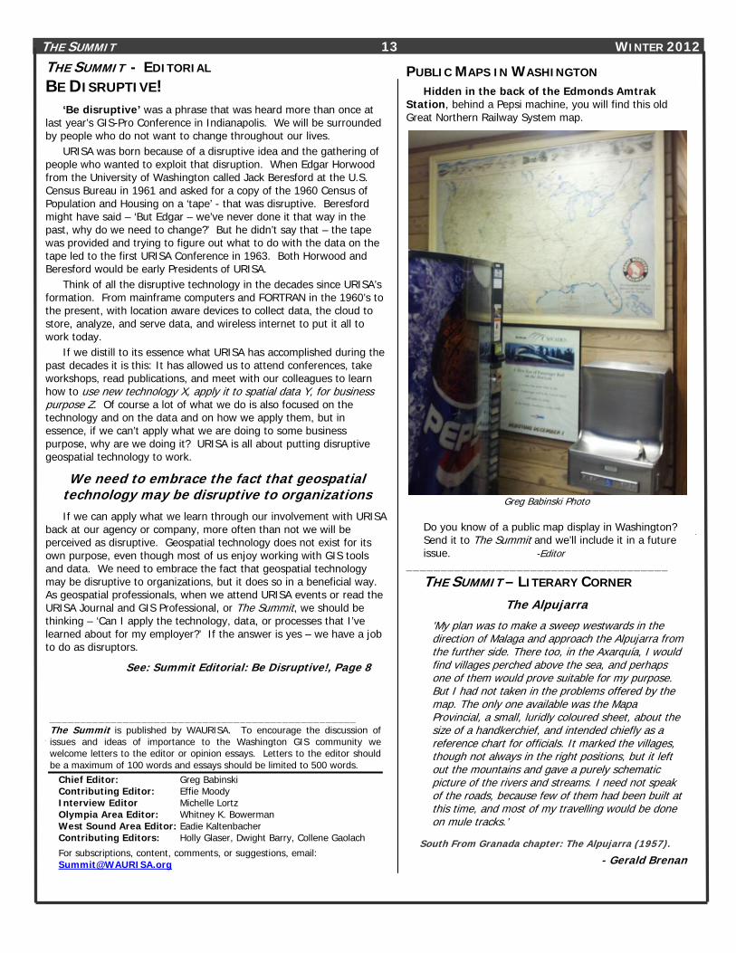
PUBLIC MAPS IN WASHINGTON Hidden in the back of the Edmonds Amtrak
Station, behind a Pepsi machine, you will find this old Great Northern Railway System map.
Greg Babinski Photo
Do you know of a public map display in Washington? Send it to The Summit and we’ll include it in a future issue. -Editor
______________________________________ THE SUMMIT – LITERARY CORNER
The Alpujarra
'My plan was to make a sweep westwards in the direction of Malaga and approach the Alpujarra from the further side. There too, in the Axarquía, I would find villages perched above the sea, and perhaps one of them would prove suitable for my purpose. But I had not taken in the problems offered by the map. The only one available was the Mapa Provincial, a small, luridly coloured sheet, about the size of a handkerchief, and intended chiefly as a reference chart for officials. It marked the villages, though not always in the right positions, but it left out the mountains and gave a purely schematic picture of the rivers and streams. I need not speak of the roads, because few of them had been built at this time, and most of my travelling would be done on mule tracks.'
South From Granada chapter: The Alpujarra (1957). - Gerald Brenan
THE SUMMIT - EDITORIAL BE DISRUPTIVE!
‘Be disruptive’ was a phrase that was heard more than once at last year’s GIS-Pro Conference in Indianapolis. We will be surrounded by people who do not want to change throughout our lives.
URISA was born because of a disruptive idea and the gathering of people who wanted to exploit that disruption. When Edgar Horwood from the University of Washington called Jack Beresford at the U.S. Census Bureau in 1961 and asked for a copy of the 1960 Census of Population and Housing on a ‘tape’ - that was disruptive. Beresford might have said – ‘But Edgar – we’ve never done it that way in the past, why do we need to change?’ But he didn’t say that – the tape was provided and trying to figure out what to do with the data on the tape led to the first URISA Conference in 1963. Both Horwood and Beresford would be early Presidents of URISA.
Think of all the disruptive technology in the decades since URISA’s formation. From mainframe computers and FORTRAN in the 1960’s to the present, with location aware devices to collect data, the cloud to store, analyze, and serve data, and wireless internet to put it all to work today.
If we distill to its essence what URISA has accomplished during the past decades it is this: It has allowed us to attend conferences, take workshops, read publications, and meet with our colleagues to learn how to use new technology X, apply it to spatial data Y, for business purpose Z. Of course a lot of what we do is also focused on the technology and on the data and on how we apply them, but in essence, if we can’t apply what we are doing to some business purpose, why are we doing it? URISA is all about putting disruptive geospatial technology to work.
We need to embrace the fact that geospatial technology may be disruptive to organizations If we can apply what we learn through our involvement with URISA
back at our agency or company, more often than not we will be perceived as disruptive. Geospatial technology does not exist for its own purpose, even though most of us enjoy working with GIS tools and data. We need to embrace the fact that geospatial technology may be disruptive to organizations, but it does so in a beneficial way. As geospatial professionals, when we attend URISA events or read the URISA Journal and GIS Professional, or The Summit, we should be thinking – ‘Can I apply the technology, data, or processes that I’ve learned about for my employer?’ If the answer is yes – we have a job to do as disruptors.
See: Summit Editorial: Be Disruptive!, Page 8
__________________________________________________ The Summit is published by WAURISA. To encourage the discussion of issues and ideas of importance to the Washington GIS community we welcome letters to the editor or opinion essays. Letters to the editor should be a maximum of 100 words and essays should be limited to 500 words.
Chief Editor: Greg Babinski Contributing Editor: Effie Moody Interview Editor Michelle Lortz Olympia Area Editor: Whitney K. Bowerman West Sound Area Editor: Eadie Kaltenbacher Contributing Editors: Holly Glaser, Dwight Barry, Collene Gaolach
For subscriptions, content, comments, or suggestions, email: [email protected]
THE SUMMIT 14 WINTER 2012 WAURISA BOARD OF DIRECTORS President: Ann Stark [email protected] Vice President Heather Glock: [email protected] U H Secretary Amanda Taub HU [email protected] U Treasurer Tonya Elliott: [email protected] Past President Don Burdick: [email protected] U Board Members At-Large:
Neil Berry: [email protected] U Cort Daniel: [email protected] UH Donna Wendt: [email protected] Joe Brentin: [email protected] Suzanne Shull: [email protected] Dana Trethewy: [email protected]
WAURISA COMMITTEE VOLUNTEERS Greg Babinski: [email protected] Marty Balikov: [email protected] Whitney Bowerman: [email protected] Randy Bracket [email protected] Daryn Brown: [email protected] Dave Brown: [email protected] Chuck Buzzard: [email protected] Jaime Crawford: [email protected] Jennifer Cutler [email protected] Starla DeLory: [email protected] Mike Dana: [email protected] Melissa Faga: [email protected] Bryan Fiedor [email protected] Byron Gessel: [email protected] Holly Glaser: [email protected] Tami Griffin: [email protected] Tony Hartrich: [email protected] Eadie Kaltenbacher: [email protected] Tom Kimpel [email protected] Jitka Kotelenska: [email protected] Rick Lortz: [email protected] Michelle Lortz: [email protected] Reily Love: [email protected] Effie Moody: [email protected] Jill Oliver: [email protected] Chris Owen: [email protected] Steve Schunzel: [email protected] Heather Spates: [email protected] Lurleen Smith: [email protected] Matt Stull: [email protected] Cathy Walker [email protected] Bob Wendt: [email protected] Walker Willingham [email protected]
GIS USER GROUPS IN WASHINGTON UACSM – Washington State Section http://www.wss-acsm.org/
UASPRS Puget Sound Region http://www.photogrammetry.com/ASPRS-PSR/
UCCascadia Users of Geospatial Open Source http://groups.google.com/group/cugos/ Contact Karsten Venneman at: [email protected]
Central Puget Sound GIS User Group http://waurisa.org/phpBB2/viewforum.php?f=24 Contact Nora Gierloff at: [email protected]
CCentral Washington GIS User Group Meets the 2nd Wednesday of each month. For information contact Amanda Taub at: H [email protected]
UKing County GIS User Group http://www.kingcounty.gov/operations/GIS/UserGroups.aspx Meets 1st Wednesday every other month at 11:00am at the KCGIS Center, 201 S. Jackson Street, Seattle WA, Conf Room 7044/7045.
UNorthwest Washington GIS User Group http://www.acadweb.wwu.edu/gis/nwgis_mtgs.htm
Southeast Washington/Northwest Oregon GIS User Group For more information, contact Chris Owen: [email protected]
Washington Geographic Information Council (WAGIC) Hhttp://wagic.wa.gov/ H Join Listserve at: http://listserv.wa.gov/archives/wagic.html
Washington Hazus Users Group http://www.usehazus.com/wahug Contact Cathy Walker at: [email protected]
To have your GIS related group or event listed in future issues of The Summit, notify the editor at: [email protected]. _________________________________________________________________________________________
To be added to The Summit mailing list, contact: [email protected] Back issues of The Summit are available at: HUhttp://waurisa.org/thesummit/ U Interested in volunteering your time to help WAURISA? Contact Don Burdick or any Board member listed to the right.
WAURISA 1402 AUBURN WAY NORTH PBN 158 AUBURN WA 98002