the nordic geodetic observing system (ngos): an nkg plan for the contribution from an absolute
TRANSCRIPT

The Nordic Geodetic Observing System(NGOS):
An NKG plan for the contribution from an absolutegravimetry network (NGOS/AG)
Hans-Georg Scherneck, Martin Vermeer,Rene Forsberg, Klaus-Erich Schmidt
Jaakko Mäkinen, Matti Ollikainen, Markku Poutanen,Hannu Ruotsalainen, Heikki Virtanen
Christof Völksen,Hans-Peter Plag,
Martin Lidberg, Anders Olsson
June 21, 2005
Document update information:
Previous version:
http://www.oso.chalmers.se/∼/NKGWG/Docs/01.2Abs_Grav_Plan.pdf,
date 2001-02-02
http://www.oso.chalmers.se/∼/NKGWG/Docs/02Abs_Grav_Plan.pdf,
date 2002-03-18
This version:
http://www.oso.chalmers.se/∼/NKGWG/Docs/Abs_Grav_Plan.pdf,
date 2003-04-16
Update:1) From “NGOS ... Geodynamics” to ”NGGOS, ... Geodetic andGeodynamic”2) Renewed section 4.1.2 Denmark3) “Jakobshavn” changed to “Ilulissat”4) Maps (Figures 1, 2 and 3) added5) Figure 1 improved (April 16, 2003)6) Back from “NGGOS” to “NGOS, ... Geodetic” (April, 2004)
1

1 Foreword
For some time now, there have been activities in the various Nordic coun-tries in the field of absolute, or ballistic, gravimetry. Uses for such measure-ments include primarily geodynamic studies, but may be useful in supportof gravimetric survey as well, being one way to calibrate survey data to anabsolute level.
With these things in mind, the Presidium of NKG has turned to the NKGWorking Group for Geodynamics and requested a draft for an NKG Geody-namics plan for Absolute Gravimetry.
2 Introduction
This proposal contemplates the continuation of research work in gravime-try and concentration on absolute gravimetry as the prevailing method.Inter-Nordic coordination through the Nordic Geodetic Commission and itsworking group for geodynamics has led to a concerted multi-decade effortto observe gravity change in conjunction with crustal dynamics and post-glacial land uplift. This effort using relative (spring-) gravimeters alongthe lad-uplift gravity lines has attracted international attention (Ekmanand Mäkinen, 1996; Ekman 1991; Mäkinen et al. 1986).
In the last decade, absolute gravimetry measurements have been added atkey points in the area, especially at locations where space geodetic obser-vations and/or sea level observations are carried out. The NKG WorkingGroup for Geodynamics has not been coordinating these efforts. However,the group would provide a suitable forum for coordination in the future,and most of its members have been involved in various ways in these mea-surements.
Continuation, concentration and future coordination of efforts in absolutegravimetry is to be seen with respect to the scientific merit that monitoringand studying the long-term temporal change of gravity as a geodetic andgeophysical parameter can bear out. The scope of this work comprises ap-plications in planetary geodesy as a method to contribute to and corroborateglobal geodetic reference systems. It reaches out into related disciplines asit can provide parameters for geophysical research on the rheology of man-tle and crust, constraints for hazard analysis, and, perhaps most impor-tantly, can help constrain parameters that relate to global climatic change.Being aware of the potential of the monitoring work, this group wants topoint out the necessity to obtain an observing system with sufficient stabil-ity and observing plans with sufficient feasibility to last through a coupleof decades.
2

Absolute gravity determinations take advantage from close relations to fun-damental units in physics. Gravity is seen as a physical earth parameterwith local, regional and global implications. Combined with precise, space-geodetic determinations of position measurements can sense the effect ofmass changes in the surrounding of the surveyed locations and discrimi-nate the effects due to the vertical movement of the surface. Records ofAbsolute gravity determinations provide a valuable source of informationwhich can be used and referred to by future scientists. However, this groupsees the major strength of the proposal in its potential synergy, contribut-ing to ongoing activities in geodesy and physical earth sciences. Withingeodesy, absolute gravity integrates as a fundamental technique into themonitoring of changes of position, reference surfaces and reference frames.
Notion of the relations of absolute gravimetry with the other geodetic tech-niques provided the motivation to set the headline as to emphasise its in-tegration into a Nordic Geodetic Observing System. A number of activ-ities represented in the working groups of NKG are already fitting intothis framework, and documents produced by these groups in the future willstrengthen the ties between the activities, the groups and their members.
The efforts detailed below should be seen as primarily a joint effort ingeodesy shared by the geodetic institutes and research facilities in the Nordiccountries. Absolute gravimetry is considered as one technique of a hand-full others by which geodetic reference is maintained and changes are mon-itored. Related techniques are mostly found in space geodesy, but alsoterrestrial, as used in sea-level monitoring, and for height-system main-tenance. Relations with space geodesy are manifold. Gravity change andsite motion determined by e.g. GPS and VLBI have bearing on large-scalemantle and crust parameters. Gravity change will in the future also bestudied by means of effects on satellite orbits. Satellite altimetry of the sealevel provides parameters that can be tested with gravimetry. In some casesgravimetry takes the role of an independent test method, an augmentationof observations, a provider of constraints for parameter inversion etc.
In this draft, we will first take inventory of existing activities in the Nordiccountries; then, we will formulate a possible common philosophy for thechoice of absolute gravimetric measurement stations, the requirements theyshould meet, and their locations.
3 Current status
The Fennoscandian land uplift gravity lines and their stations are shownin Figure 1. A few of these stations coincide with points where absolutegravity has been determined, see Figures 2 and 3.
3

5˚ 10˚
15˚ 20˚
25˚
56˚
58˚
60˚
62˚
64˚
66˚
68˚
70˚
Korgen Umbukta
Stensele
Lycksele
Sävar
Kalajoki Haapavesi
RistijärviKuhmo
VågstrandaMeldal
Kopperå Föllinge
Stugun Kramfors
Vaasa Kuortane
Alajärvi
ÄänekoskiJoensuu
Bergen
Hafslo
Gjövik
Älvdalen
Hofors
Östhammar Kemiö
SiuntioPernaja
Virolahti
Ølgod Skanderborg
Helsingør Höör
Sölvesborg
Korgen Umbukta
Stensele
Lycksele
Sävar
Kalajoki Haapavesi
RistijärviKuhmo
VågstrandaMeldal
Kopperå Föllinge
Stugun Kramfors
Vaasa Kuortane
Alajärvi
ÄänekoskiJoensuu
Bergen
Hafslo
Gjövik
Älvdalen
Hofors
Östhammar Kemiö
SiuntioPernaja
Virolahti
Ølgod Skanderborg
Helsingør Höör
Sölvesborg
Korgen Umbukta
Stensele
Lycksele
Sävar
Kalajoki Haapavesi
RistijärviKuhmo
VågstrandaMeldal
Kopperå Föllinge
Stugun Kramfors
Vaasa Kuortane
Alajärvi
ÄänekoskiJoensuu
Bergen
Hafslo
Gjövik
Älvdalen
Hofors
Östhammar Kemiö
SiuntioPernaja
Virolahti
Ølgod Skanderborg
Helsingør Höör
Sölvesborg
Korgen Umbukta
Stensele
Lycksele
Sävar
Kalajoki Haapavesi
RistijärviKuhmo
VågstrandaMeldal
Kopperå Föllinge
Stugun Kramfors
Vaasa Kuortane
Alajärvi
ÄänekoskiJoensuu
Bergen
Hafslo
Gjövik
Älvdalen
Hofors
Östhammar Kemiö
SiuntioPernaja
Virolahti
Ølgod Skanderborg
Helsingør Höör
Sölvesborg
Korgen Umbukta
Stensele
Lycksele
Sävar
Kalajoki Haapavesi
RistijärviKuhmo
VågstrandaMeldal
Kopperå Föllinge
Stugun Kramfors
Vaasa Kuortane
Alajärvi
ÄänekoskiJoensuu
Bergen
Hafslo
Gjövik
Älvdalen
Hofors
Östhammar Kemiö
SiuntioPernaja
Virolahti
Ølgod Skanderborg
Helsingør Höör
Sölvesborg
Land uplift lines
Figure
1:The
Fennoscandianland
upliftgravity
lines.
4

3.1 Denmark / Færø Islands / Greenland
Current situation: The following absolute gravity points exist:
Tebstrup, København, ElsinoreTorshavnThule, Nuuk, Ilulissat
Thule is co-located with permanent GPS.
Existing measurements in Denmark were done in 1987 with HannoverJILA-3, on Færø Islands in 1987, and in Greenland 1988.
Future plans:
◦ Repeat measurements at 10 years interval
◦ Co-location with permanent GPS – resources permitting.
3.2 Finland
Current situation: The following absolute gravity stations exist:
◦ Metsähovi* (1979-)
◦ 63◦ land uplift gravity line:
Vaasa* AA (1979-), Vaasa AB (1995), Joensuu* (1999),
◦ Others:Sodankylä* (1976-), Virolahti* (1999), Masala, Ilomantsi, Vihti
Explanation: (*) means co-location with GPS; (19xx-) means: operatingfrom: [name] means: selected or “either-or” alternatives, no measurementsyet. Metsähovi is also co-located with GPS, GLONASS, SLR, DORIS, andsuperconducting gravimeter.
It is intended that all stations will be used both for geodynamics (land up-lift, solid Earth tides) and for gravity reference.
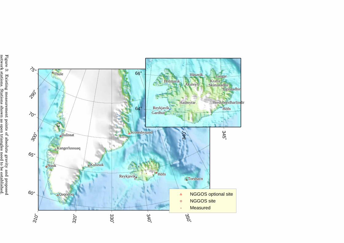
3.3 Iceland
Current situation: The following absolute gravity points exist:
5
Höfn*, Egilstaðir, Akureyri, Holmavík, Reykjavík*, Haumyrar,Herdubreiðarlindir, Gardur+, Húsavík+, Krafla+, Laugar+, andSkútustaðir+.
Stations with a * are co-located with permanent GPS. Höfn is near a tidegauge. Reykjavík* is also co-located with a DORIS beacon. Stations with a+ are located along a levelling line from Akueiri to Vofnafjördur. Observa-tion teams involved in the measurements so far were from BKG (Germany),FGI (Finland) and University of Hannover (Germany).
3.4 Norway
Current situation: The following absolute gravity points exist:
Hønefoss, Stavanger, Trysil, Trondheim, Tromsø, Ny-Ålesund,Kolsnes, and Troll.
Most of these sites have several (up to three) measurement points. AtAndøya, a pier for absolute measurements is available. Ny-Ålesund andTromsø are directly co-located with permanent GPS, VLBI, DORIS andother space geodetic techniques, while tide gauges are nearby. At Sta-vanger and Trondheim, permanent GPS and tide gauges are within a 10km radius. At Andøya, a permanent GPS receiver is running next to theabsolute gravity pier while a tide gauge is within 10 km as well.
Most sites (except Andøya) have been involved in repeated absolute mea-surements, although not always on the same measurement point. The twolargest campaigns were in 1992-93 and 1995 (see Roland, 1998). TheseNordic campaigns involved instruments from Finland (FGI), United States(NOAA) and Germany (IfAG).
In 1998, four points in Norway and two points in Sweden were revisitedwith the German instrument (BKG, formerly IfAG). Ny-Ålesund was mea-sured for the second time in 2000 with the instrument of the University ofStrasbourg.
3.5 Sweden
Current situation: The following absolute gravity points exist:
Onsala, Göteborg, Mårtsbo, Skellefteå (a.k.a. Furuögrund), Kiruna(a.k.a. Esrange).
6

Onsala is co-located with GPS and VLBI has been measured with JILA andFG5 instruments from NOAA and BKG.
Gothenburg has been measured in 1976 by the Italian group’s IMGC (Mar-son) instrument and with a JILA instrument.
Mårtsbo, co-located with permanent GPS, has been measured with IMGC,JILA and two FG5.
Furuögrund = Skellefteå, is co-located with permanent GPS and has beenmeasured with JILA and FG5.
Esrange = Kiruna, is co-located with permanent GPS and has been mea-sured with FG5.
4 A proposal
It is generally felt that
1. Absolute gravimetry in geodynamically interesting locations throughout the whole area contains high scientific merit.
2. Absolute gravimetric measurements should be repeated at regular in-tervals of a few years.
3. Co-location of absolute gravimetry with permanent GPS and/or tidegauges, is highly desirable and in fact essential for most geodynamicstudies. Combination of different measurement techniques, detectingboth surface displacements and gravity changes, are necessary for acomplete understanding of the dynamics of the underlying processes.Co-location with superconducting gravimeters (SG) again allows ac-curate monitoring of very long term trends, albeit at a high cost.The principle of co-location reflects the nature of the absolute gravime-try network as a subnetwork in the larger scheme of the Nordic Geode-tic Observing System, which again belongs to similar systems on aglobal scale geared to gaining an understanding of global change andits consequences. We refer to documents detailing the concepts andaims of co-location, Bevis (2000) and Plag et al. (2000).
4. The concept of a Nordic absolute gravimetry network makes sense sci-entifically and practically only if it is designed as a multipurpose net-work, i.e. a gravity base network in conjunction with geodynamicsand global change research.
5. The number of stations chosen to be part of such a network should belimited, which will make it more likely that
7

(a) effective co-location with often expensive equipment (e.g., super-conducting gravimeter, SG) can be considered, and
(b) limited resources will be directed effectively and the necessaryinstrumentation and sufficiently frequent re-occupation (5 yearsmax) will actually take place.
Therefore, it is proposed to establish a Nordic absolute gravimetry network(NGOS/AG) of stations meeting most or all of the following requirements:
1. The stations have to be of geodynamic interest:
(a) a major geodynamic interest consists of the 63◦ gravity uplift line,
which has the longest history of measurement, and where by co-location, the relative gravimetry time series could be extendedusing absolute instruments.It would be of the utmost scientific interest to have absolute sta-tions spanning the full range of the 63
◦ line, i.e. on both sides ofthe Gulf of Bothnia. We call upon all to co-operate to make this areality.
(b) Solid Earth tides could be another area of interest, especiallyocean loading. This would favour choice of location close to coasts.
2. The stations should provide a sufficient (but very thin) coverage ofall the Nordic national territories, and offer sufficient spatial sam-pling for studying phenomena of interest. Given limited economic re-sources, it is clear that this requires a very careful selection of thesites.
3. The stations should be technically suitable for absolute (ballistic) gravime-try; this means preferably on flat bedrock, or on a concrete platformsolidly anchored either to the bedrock or deeply rooted (neutral-buoyancy)into sedimentary soil. Lightweight weather protection to allow thesensitive instrument to occupy the site.
4. The station locations should be safe from future development and con-struction projects (roads, city expansion, ...).
5. The stations should be occupied at regular (but sufficiently dense)temporal intervals. One would think of a time interval similar to thatwith which the 63
◦ line has been occupied with relative instruments,i.e. several years.
6. This is not to say that there should be two levels: the “super-stations”to be included in the network, and the “other” category of stationswhich are only nationally maintained; on the contrary, all stationsof sufficient geodynamic interest for which regular re-occupation is
8

planned should belong to the NGOS/AG network. However, beingable to make the necessary commitment ought in itself to limit thenumber of stations proposed.
4.1 Proposal for the future
It is proposed that countries participating in the work of the Nordic Geode-tic Commission propose stations to be included in the NGOS/AG network.It is further proposed that the host countries of these stations put themin good shape, maintain them and document them, so scientists from allNordic countries, and others, can include them in their measurement pro-grams.
The proposed network is shown in Figures 2 and 3 along with the points atwhich earlier observations have been made. Stations that still need to beestablished are shown with a special symbol.
4.1.1 Publication policy
It is important that countries participating in the project will make suf-ficient resources available also for the processing and publication of themeasurements obtained within a reasonable time frame.
A framework should be agreed upon which allows the data collectors ade-quate time to analyse their data and publish scientific results themselves.After that, the data should be made available to project participants in or-der to jointly publish project results. Following this, the data should beavailable for use by the scientific community at large. Existing frameworksfor publishing gravimetric data, such as the Bureau Gravimétrique Inter-national (BGI), should be used.
4.1.2 Denmark
Repeated measurements on the sites Tebstrup, Copenhagen, Elsinoreare planned. Aiming for a 10 year repeat interval, these should be under-taken in the near future.
The same applies to Thule, Nuuk, and Ilulissat in Greenland and Tor-shavn on the Færø islands.
KMS plans—when the economy permits—to reobserve the exisiting sta-tions ideally at a 10 yr interval and add new absolute gravity sites in
9
Qaqortoq and Scoresbysund at the new locations of the permanent GPSsites.
KMS will also liase with the NOAA/John Wahr group who repeat on ayearly basis observations at two absolute gravity sites at Kangerlussuaqand Kulusuk, using an FG-5 instrument. It is not known at present howlong time in the future the NOAA measurements will be continued.
4.1.3 Iceland
Höfn and Reykjavík are obvious choices. Selection is due to co-locationwith GPS and tide gauge at Höfn.
4.1.4 Finland
Finland proposes that the following four stations are chosen, Metsähovi,Vaasa, Joensuu and Sodankylä.
Of these stations, one (Metsähovi) is massively co-located, two (Joensuuand Vaasa) are co-located with 63
◦ gravity profile points, and all four areco-located with GPS.
Metsähovi is proposed to serve as a fundamental station for the Nordicnetwork. The purpose of the fundamental station is that instruments canbe intercompared, and temporal behaviour can be studied by coimparisonwith the superconducting gravimeter.
4.1.5 Norway
Norway is at this point in time not ready to propose a final site list. Currentlimitations in funds have led to a stop of activities related to absolute grav-ity measurements. It is not clear whether these activities will be taken upagain in the future. However, a priority of sites may be deduced from the in-clusion of four sites in the 1998 campaign. Thus, Ny-Ålesund, Trysil, andTromsø are likely to have high priority, if there are any future absolutegravity measurements.
In Stavanger, the tide gauge has been moved and no decision has beenmade concerning a new gravity point. In Trondheim, a new building wasconstructed since April 1998 right next to one of the two gravimetric points.Kolsnes was measured for Statoil and may be considered as a potentialcandidate.
10

It has been suggested to establish an absolute point at Vågstranda due toits location on the 63◦ line. However, this would require the possibility forco-location with a permanent GPS station.
4.1.6 Sweden
By agreement and compatibility with Finland also in Sweden continuingthe occupation of the 63
◦ gravity line is important. Therefore future effortsto observe with profile will comprise absolute gravimetry. The set of ab-solute gravity stations will therefore consist of Kramfors and Norderåsen.The latter site, near Östersund, is colocated with GPS and is to replace Stu-gun. The other stations where absolute gravimetry is to continue compriseSkellefteå (in the land uplift centre, co-located with GPS and within 10km distance from the Furuögrund tide gauge), Mårtsbo (permanent GPS,tide gauge within 10 km distance), Onsala (massively co-located, two tidegauges within 30 km distance), and Kiruna-Esrange (colocated with per-manent GPS).
5 Requirements to reach the goal
Observing the change of gravity in the Nordic region involves a long time-scale. The scope of this proposal is therefore until further reconsideration.The number of locations that participate in this plan has been limited to areasonably small size, trading off the necessary spatial resolution neededto sample the postglacial rebound signal, obtain the necessary redundancyto study systematic influences e.g. from oceanic and hydrological loadingeffects, and utilising co-location with existing permanent GPS stations andtide gauges.
The coordinated operation of absolute gravity measurements needs to reacha steady state of activities. This is only possible with a stable availabilityof instruments and personnel. The present level of support is insufficientto provide neither of them. The aim of this document is to show the level ofactivities necessary for a minimum level of scientific merit. The relativelysmall number of stations allows that each one can be reobserved at leastonce every second year. With increased levels of funding an expanded planwould primarily propose the same amount of stations to be reobserved moredensely in time before additional stations would be considered. On a two-year reobservation scheme the current plan considers twelve stations to bemeasured per year.
Because of changing of scope of BKG, future activities headed by this insti-tute will most probably not be possible. The role of BKG would rather be to
11

10˚ 20˚
55˚
60˚
65˚
70˚
Metsähovi
Vaasa Joensuu
Sodankylä
Virolahti
Ilomantsi
MasalaVihti
Tebstrup
København
Elsinore
Hönefoss
Stavanger
Trysil
Trondheim
Tromsö
TrollKolsnes
Onsala
Göteborg
Mårtsbo
Skellefteå
Kiruna
Metsähovi
Vaasa Joensuu
Sodankylä
Virolahti
Ilomantsi
MasalaVihti
Tebstrup
København
Elsinore
Hönefoss
Stavanger
Trysil
Trondheim
Tromsö
TrollKolsnes
Onsala
Göteborg
Mårtsbo
Skellefteå
Kiruna
Metsähovi
Vaasa Joensuu
Sodankylä
Virolahti
Ilomantsi
MasalaVihti
Tebstrup
København
Elsinore
Hönefoss
Stavanger
Trysil
Trondheim
Tromsö
TrollKolsnes
Onsala
Göteborg
Mårtsbo
Skellefteå
Kiruna
Metsähovi
Vaasa Joensuu
Sodankylä
Virolahti
Ilomantsi
MasalaVihti
Tebstrup
København
Elsinore
Hönefoss
Stavanger
Trysil
Trondheim
Tromsö
TrollKolsnes
Onsala
Göteborg
Mårtsbo
Skellefteå
Kiruna
Metsähovi
Vaasa Joensuu
Sodankylä
Virolahti
Ilomantsi
MasalaVihti
Tebstrup
København
Elsinore
Hönefoss
Stavanger
Trysil
Trondheim
Tromsö
TrollKolsnes
Onsala
Göteborg
Mårtsbo
Skellefteå
Kiruna
x
x x
x
x
x
x
x
x
x
x
x
x
x
x
x
x
x
x
x
x
x
x
Tebstrup
København
Elsinore
Metsähovi
Vaasa Joensuu
Sodankylä
Trysil
Trondheim
Tromsö
Kolsnes
Onsala
Mårtsbo
Skellefteå
Kiruna
Tebstrup
København
Elsinore
Metsähovi
Vaasa Joensuu
Sodankylä
Trysil
Trondheim
Tromsö
Kolsnes
Onsala
Mårtsbo
Skellefteå
Kiruna
Tebstrup
København
Elsinore
Metsähovi
Vaasa Joensuu
Sodankylä
Trysil
Trondheim
Tromsö
Kolsnes
Onsala
Mårtsbo
Skellefteå
Kiruna
Tebstrup
København
Elsinore
Metsähovi
Vaasa Joensuu
Sodankylä
Trysil
Trondheim
Tromsö
Kolsnes
Onsala
Mårtsbo
Skellefteå
Kiruna
Tebstrup
København
Elsinore
Metsähovi
Vaasa Joensuu
Sodankylä
Trysil
Trondheim
Tromsö
Kolsnes
Onsala
Mårtsbo
Skellefteå
Kiruna
Kramfors Kramfors Kramfors Kramfors Kramfors
Figure 2: Existing measurement points of absolute gravity and proposednetwork stations. Stations shown as open triangles need to be established.
12
290˚
300˚
310˚
320˚
330˚
340˚
350˚
60˚
65˚
70˚
75˚
HöfnReykjavík
Thule
Ilulissat
Nuuk
TorshavnHöfnReykjavík
Thule
Ilulissat
Nuuk
TorshavnHöfnReykjavík
Thule
Ilulissat
Nuuk
TorshavnHöfnReykjavík
Thule
Ilulissat
Nuuk
TorshavnHöfnReykjavík
Thule
Ilulissat
Nuuk
Torshavn
x
x
x
xx x
x x
x
x
x
x
x
x
x
x
Thule
Ilulissat
Kangerlussuaq
Nuuk Kulusuk
TorshavnHöfnReykjavík
Thule
Ilulissat
Kangerlussuaq
Nuuk Kulusuk
TorshavnHöfnReykjavík
Thule
Ilulissat
Kangerlussuaq
Nuuk Kulusuk
TorshavnHöfnReykjavík
Thule
Ilulissat
Kangerlussuaq
Nuuk Kulusuk
TorshavnHöfnReykjavík
Thule
Ilulissat
Kangerlussuaq
Nuuk Kulusuk
TorshavnHöfnReykjavík
Qaqortoq
Scoresbysund
Qaqortoq
Scoresbysund
Qaqortoq
Scoresbysund
Qaqortoq
Scoresbysund
Qaqortoq
Scoresbysund
340˚
345˚
64˚
66˚
Herdubreidharlindir
KraflaAkureyri
Egilstadhir
Hólmavík Skùtustadhir
Hùsavík
Haumyrar
Gardhur
Laugar
HöfnReykjavík Herdubreidharlindir
KraflaAkureyri
Egilstadhir
Hólmavík Skùtustadhir
Hùsavík
Haumyrar
Gardhur
Laugar
HöfnReykjavík Herdubreidharlindir
KraflaAkureyri
Egilstadhir
Hólmavík Skùtustadhir
Hùsavík
Haumyrar
Gardhur
Laugar
HöfnReykjavík Herdubreidharlindir
KraflaAkureyri
Egilstadhir
Hólmavík Skùtustadhir
Hùsavík
Haumyrar
Gardhur
Laugar
HöfnReykjavík
Herdubreidharlindir
KraflaAkureyri
Egilstadhir
Hólmavík Skùtustadhir
Hùsavík
Haumyrar
Gardhur
Laugar
HöfnReykjavík HöfnReykjavík HöfnReykjavík HöfnReykjavík HöfnReykjavík HöfnReykjavík
Measuredx
NGGOS site
NGGOS optional site
Figure
3:E
xistingm
easurement
pointsof
absolutegravity
andproposed
network
stations.Stationsshow
nas
opentriangles
needto
beestablished.
13

train observers and, to a limited extent, provided instruments on loan. Theextent needs to be negotiated.
In all, at least one absolute gravimeter in addition to the currently existinginstruments at the Finnish Geodetic Institute should be available for thework outlined above. Acknowledging the high level of activity and alloca-tion of resources that the Finnish Geodetic Institute has been spending, itappears necessary that agencies or institutes of the other countries considerto contribute to the resources.
The authors of this report look foreward to the approval of the absolutegravimetry plan by the presidium of the NKG. We also look beyond the ap-proval and anticipate the studies of all NKG working groups in the frame-work of a Nordic Geodetic Observing System. Plans and frameworks thusclear-cut will certainly facilitate decisions of research financing bodies.
Acknowledgments
The authors wish to thank Martin Ekman for many valuable points of viewin discussions and contribution of facts to the foundation of this document.
Martin Vermeer has served as the coordinator of this work until early 2000.
ReferencesBevis, M., 2000: Continuous GPS Positioning of Tide Gauges: Some Prelim-
inary Considerations, http://www.pol.ac.uk/psmsl/gb6/bevis.html;last visited 2000-12-17.
Ekman, M., 1991: Gravity change, geoid change and remaining postglacialuplift of Fennoscandia, Terra Nova, 3, 390–392.
Ekman, M., and Mäkinen, J., 1996: Recent postglacial rebound, gravitychange and mantle flow. Geophys. J. Int., 126, 229-234.
Mäkinen, J., Ekman, M., Midtsundstad, Å., Remmer, O., 1986: The Fennoscan-dian Uplift Gravity Lines 1966–1984. Reports of the Finnish GeodeticInstitute, No. 85:4, 238pp.
Plag, H.-P., Axe, P., Knudsen, P., Richter, B., and Verstraeten, J. (eds.),2000: European Sea Level Observing System (EOSS): Status and FutureDevelopments, Office for Official Publication of the European Communi-ties, Luxembourg, EUR 19682, 72pp.
Roland, E., 1998: Absolutt tyngdemålinger i Fennoskandia og Svalbard.Technical Report, Geodetic Institute, Norwegian Mapping Authority, Høne-foss, Norway.
14