the mesoamerican rain forest environmental history. livestock and landscape biodiversity at los...
TRANSCRIPT
PASTOS 2012. ISSN: 0210-1270 219
Bases de datos: http://polired.upm.es/index.php/pastos (España), AGRIS (Italia), CAB Abstracts (Reino Unido), CABI Full Text (Reino Unido), Catálogo LATINDEX (México), DIALNET (España), ICYT Ciencia y Tecnología (España)
PASTOS, 42 (2), 219 - 248
THE MESOAMERICAN RAIN FOREST ENVIRONMENTAL HISTORY. LIVESTOCK AND LANDSCAPE BIODIVERSITY AT
LOS TUXTLAS, MEXICO
S. GUEVARA S.* AND J. LABORDE
Instituto de Ecología, A.C.. Red de Ecología Funcional. Carretera antigua a Coatepec 351. El Haya. Xalapa 91070. Veracruz
(México). *Author for correspondence: [email protected]
SUMMARY
The current landscape of the Mesoamerican rain forest has been shaped by the migration of plant and animal species, natural events, and human intervention. This current reflection on the effects of livestock ranching in this region focuses on the impact to both the structure and the functioning of the landscape. Los Tuxtlas, Veracruz, Mexico, is both a case study and a reflection of the larger Mesoamerican landscape, where cattle livestock were first introduced in the 16th century and subsequently replaced with a new variety of cattle in the 19th century.
Thus, Los Tuxtlas is an enclave of tropical rain forest in southeastern Mexico and illustrative of the environmental history of Mesoamerica as a whole, representing a landscape of flora and fauna that have resisted climatic changes, intense volcanic activity, and frequent hurricanes and tropical storms that have continuously occurred across time. More recently, human activities, such as hunting, gathering, and agriculture, have also formed the landscape beginning with the Olmecs, considered to be the mother culture of Mesoamerica.
In the 16th century the European colonizers introduced on the northern tip of the volcanic range of San Martin in Los Tuxtlas several cattle varieties of Bos taurus, imported from the region of Guadalquivir, Spain. These cattle rapidly adapted to free-range grazing, probably due to the absence of large native herbivores that had disappeared in Mesoamerica by the end of the Holocene, as well as due to the considerable extensions of secondary vegetation of abandoned agricultural fields, resulting from the disappearance of the indigenous farmers after the arrival of the Spanish.
The cattle grazed on “grama” grasses, which proliferated during this time and emerged as part of the process of secondary succession, in addition to other plants and
PASTOS 2012. ISSN: 0210-1270PASTOS, 42 (2), 219 - 248220S. Guevara and J. Laborde Livestock and landscape biodiversity
shrubs found within the rain forest. The livestock were adapted to this form of grazing for over 500 years, dispersing trees and bushes and enriching the process of secondary succession.
In the 20th century, Bos taurus was substituted for Bos indicus, a variety of cattle coming from Asia and raised only in pasturelands sown with African grasses, resulting in a lack of herbivorous activity compatible with the local ecosystems, as in the case of Bos taurus. A resulting defaunation and deterioration of the secondary vegetation has since occurred, and many “grama” grasses have since disappeared. In addition, the management practices associated with Bos indicus have stimulated an increase in deforestation and fragmentation of the rain forest, signifying a threat to regional biodiversity.
However, numerous individuals and species of rain forest trees still persist in open fields across the landscape, mitigating, as they have throughout history, the impact of deforestation. The trees that are left behind are an element of the historical landscape management practices, implemented by the very first inhabitants of the region. These isolated trees form in many instances “living fences” that help to maintain the ecological connectivity between the remaining fragments of vegetation, in addition to sustaining processes of secondary succession and regeneration of the rain forest.
The main objective of this essay is to demonstrate that by understanding the environmental history of the rain forest landscape of Mesoamerica, new possibilities may be presented for its design and management with the explicit goals of conserving biodiversity, preserving environmental services, and innovating productive and agricultural systems. Our objective is illuminated by examining historical landscape practices surrounding the introduction of cattle livestock in the region of Los Tuxtlas in southeastern Mexico and considering the relevance that they may hold for contemporary landscape management and the natural regeneration of the rain forest.
Key words: Veracruz, secondary succession, defaunation, landscape connectivity.
PASTOS 2012. ISSN: 0210-1270 PASTOS, 42 (2), 219 - 248 221S. Guevara and J. Laborde Livestock and landscape biodiversity
INTRODUCTION
The landscape is continuously shaped by natural events and human activities, reflected in changes in climate and soil conditions, as well as movements of flora and fauna. Every landscape has a history that may be interpreted by examining its spatial array, structure, and the relationship between its elements, including its ecological processes. Understanding the environmental history of a landscape involves an awareness of the context and region in which it is situated, as well as a consideration of the state of surrounding ecosystems and their biodiversity. This essay is concerned with the landscape of Mesoamerica, an extensive region that includes the southern half of Mexico and Central America, as well as Guatemala, El Salvador, Belize, and the western parts of Honduras, Nicaragua, and Costa Rica. The area is delimited by the shared cultural elements of the Mesoamerican peoples that inhabited the region prior to the arrival of the Spanish, and whom in many cases continue to carry out traditional landscape management practices (Kirchoff, 1960).
Mesoamerica is one of the most fascinating regions to study of the environmental history of the landscape, due to its rich cultural and physical background. Within this history we may discover details that are applicable and useful for the contemporary landscape management of the rain forest. The region has been extensively disturbed by natural events, including the displacement of the continental and insular masses that gave form to the American continent and the Caribbean and extreme climatic changes during the Glacial period, in addition to other perturbations caused by hurricanes and frequent tropical storms. Various human groups have settled across the territory from a very early date, forming the Mesoamerican civilization, a culture that developed in distinct ecogeographic regions and that held a relatively high population density over an extended period of time. Afterwards, Mesoamerica was witness to one of the first experiments of European colonization, followed by the subsequent industrial and rural development of Mexico in the 20th century as an independent nation. Thus, the Mesoamerican landscapes owe in large part their structure and function to the productive activities carried out by humans during these distinct geo-political scenarios (Guevara et al., 2006; Guevara, 2011).
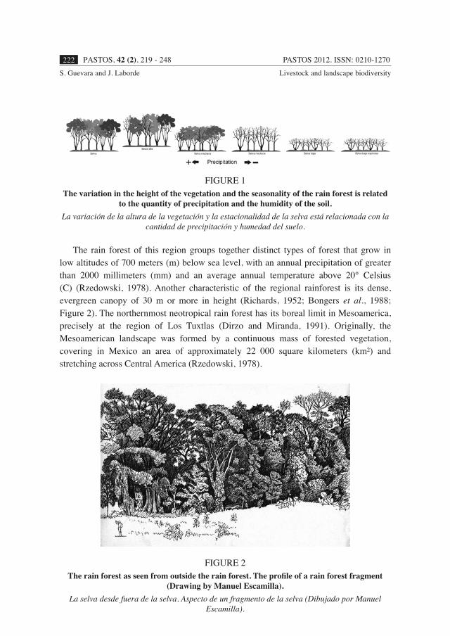
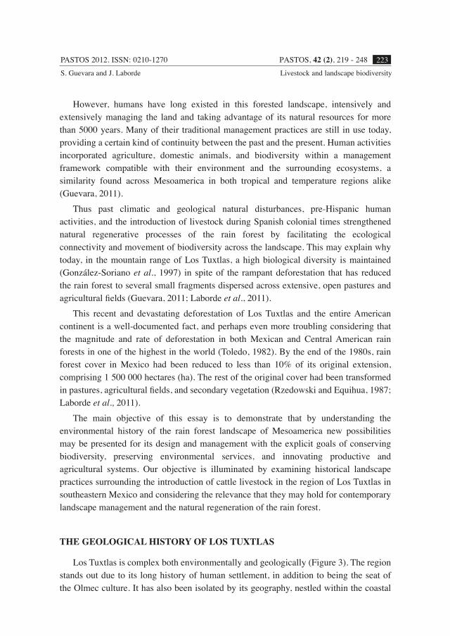
Among the abundant ecosystems that thrive in Mesoamerica, the rain forest is one of the most alluring, due to its attractive aspect and its abundance and richness of species. The term “tropical forests” integrates several forest formations, including both dense and wet tropical forest as well as those that are dry and sparse (Figure 1). The rain forest has always attracted human settlements owing to the large quantity of fauna and flora and the apparent fertility of the soil. Such was true throughout the Spanish colonial period and well after the independence of Mexico and remains true presently.
PASTOS 2012. ISSN: 0210-1270PASTOS, 42 (2), 219 - 248222S. Guevara and J. Laborde Livestock and landscape biodiversity
The rain forest of this region groups together distinct types of forest that grow in low altitudes of 700 meters (m) below sea level, with an annual precipitation of greater than 2000 millimeters (mm) and an average annual temperature above 20° Celsius (C) (Rzedowski, 1978). Another characteristic of the regional rainforest is its dense, evergreen canopy of 30 m or more in height (Richards, 1952; Bongers et al., 1988; Figure 2). The northernmost neotropical rain forest has its boreal limit in Mesoamerica, precisely at the region of Los Tuxtlas (Dirzo and Miranda, 1991). Originally, the Mesoamerican landscape was formed by a continuous mass of forested vegetation, covering in Mexico an area of approximately 22 000 square kilometers (km²) and stretching across Central America (Rzedowski, 1978).
FIGURE 1The variation in the height of the vegetation and the seasonality of the rain forest is related
to the quantity of precipitation and the humidity of the soil.La variación de la altura de la vegetación y la estacionalidad de la selva está relacionada con la
cantidad de precipitación y humedad del suelo.
FIGURE 2The rain forest as seen from outside the rain forest. The profile of a rain forest fragment
(Drawing by Manuel Escamilla).La selva desde fuera de la selva. Aspecto de un fragmento de la selva (Dibujado por Manuel
Escamilla).
PASTOS 2012. ISSN: 0210-1270 PASTOS, 42 (2), 219 - 248 223S. Guevara and J. Laborde Livestock and landscape biodiversity
However, humans have long existed in this forested landscape, intensively and extensively managing the land and taking advantage of its natural resources for more than 5000 years. Many of their traditional management practices are still in use today, providing a certain kind of continuity between the past and the present. Human activities incorporated agriculture, domestic animals, and biodiversity within a management framework compatible with their environment and the surrounding ecosystems, a similarity found across Mesoamerica in both tropical and temperature regions alike (Guevara, 2011).
Thus past climatic and geological natural disturbances, pre-Hispanic human activities, and the introduction of livestock during Spanish colonial times strengthened natural regenerative processes of the rain forest by facilitating the ecological connectivity and movement of biodiversity across the landscape. This may explain why today, in the mountain range of Los Tuxtlas, a high biological diversity is maintained (González-Soriano et al., 1997) in spite of the rampant deforestation that has reduced the rain forest to several small fragments dispersed across extensive, open pastures and agricultural fields (Guevara, 2011; Laborde et al., 2011).
This recent and devastating deforestation of Los Tuxtlas and the entire American continent is a well-documented fact, and perhaps even more troubling considering that the magnitude and rate of deforestation in both Mexican and Central American rain forests in one of the highest in the world (Toledo, 1982). By the end of the 1980s, rain forest cover in Mexico had been reduced to less than 10% of its original extension, comprising 1 500 000 hectares (ha). The rest of the original cover had been transformed in pastures, agricultural fields, and secondary vegetation (Rzedowski and Equihua, 1987; Laborde et al., 2011).
The main objective of this essay is to demonstrate that by understanding the environmental history of the rain forest landscape of Mesoamerica new possibilities may be presented for its design and management with the explicit goals of conserving biodiversity, preserving environmental services, and innovating productive and agricultural systems. Our objective is illuminated by examining historical landscape practices surrounding the introduction of cattle livestock in the region of Los Tuxtlas in southeastern Mexico and considering the relevance that they may hold for contemporary landscape management and the natural regeneration of the rain forest.
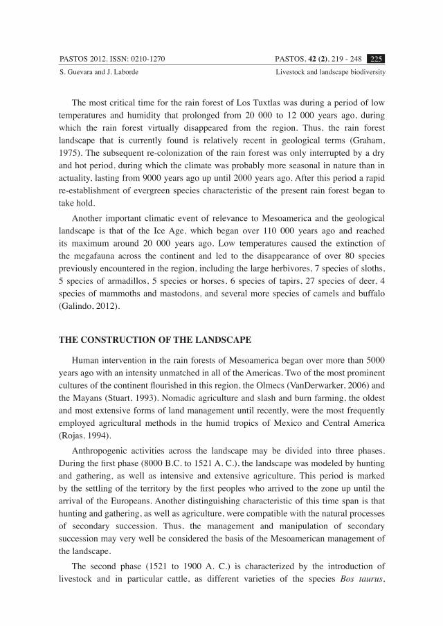
THE GEOLOGICAL HISTORY OF LOS TUXTLAS
Los Tuxtlas is complex both environmentally and geologically (Figure 3). The region stands out due to its long history of human settlement, in addition to being the seat of the Olmec culture. It has also been isolated by its geography, nestled within the coastal
PASTOS 2012. ISSN: 0210-1270PASTOS, 42 (2), 219 - 248224S. Guevara and J. Laborde Livestock and landscape biodiversity
plains of the Gulf of Mexico along a volcanic belt 95 km long and 50 km wide, between 18° 05’ and 18° 43’ N and 94° 35’ and 95° 25’ W. The area is characterized by two large volcanic masses, the volcano of San Martin Tuxtla (1,650 m above sea level) to the northwest and Santa Marta (1700 m above sea level) to the southeast, along with several associated cinder cones (Mayer, 1962; Geissert, 2006). The region was formed by volcanic activity during the Miocene, Pleistocene, and Holocene epochs, and remains volcanically active today with a temporal sequence of volcanic activity dating back more than 50 000 years. At least 10 volcanic eruptions have taken place in the past 5300 years, the two most recent occurring in 1793 and 1859. Volcanic ash and sediment deposits have maintained the fertility of the soil, explaining the desirability of the zone and its high population density (Santley, 2007). The climate is warm and tropical, with an average annual temperature of 20° C and a minimum temperature of 18° C.
FIGURE 3The rain forest of Los Tuxtlas is located in the southeastern portion of Mexico along the
Gulf Coast, in the once metropolitan area of the Olmec culture.La Sierra de los Tuxtlas está en el sureste de México sobre la costa del Golfo de México, en el
área metropolitana de la cultura Olmeca.
During the Pleistocene, the mountain range of Los Tuxtlas was a secondary refuge for the flora and fauna of the rain forest, forming a favorable climate due to the geomorphology of the zone and the resulting humidity that it trapped due to its positioning along the Gulf of Mexico. Species flourished in Los Tuxtlas during this period of scarce precipitation and extreme temperatures (Toledo, 1982).
PASTOS 2012. ISSN: 0210-1270 PASTOS, 42 (2), 219 - 248 225S. Guevara and J. Laborde Livestock and landscape biodiversity
The most critical time for the rain forest of Los Tuxtlas was during a period of low temperatures and humidity that prolonged from 20 000 to 12 000 years ago, during which the rain forest virtually disappeared from the region. Thus, the rain forest landscape that is currently found is relatively recent in geological terms (Graham, 1975). The subsequent re-colonization of the rain forest was only interrupted by a dry and hot period, during which the climate was probably more seasonal in nature than in actuality, lasting from 9000 years ago up until 2000 years ago. After this period a rapid re-establishment of evergreen species characteristic of the present rain forest began to take hold.
Another important climatic event of relevance to Mesoamerica and the geological landscape is that of the Ice Age, which began over 110 000 years ago and reached its maximum around 20 000 years ago. Low temperatures caused the extinction of the megafauna across the continent and led to the disappearance of over 80 species previously encountered in the region, including the large herbivores, 7 species of sloths, 5 species of armadillos, 5 species or horses, 6 species of tapirs, 27 species of deer, 4 species of mammoths and mastodons, and several more species of camels and buffalo (Galindo, 2012).
THE CONSTRUCTION OF THE LANDSCAPE
Human intervention in the rain forests of Mesoamerica began over more than 5000 years ago with an intensity unmatched in all of the Americas. Two of the most prominent cultures of the continent flourished in this region, the Olmecs (VanDerwarker, 2006) and the Mayans (Stuart, 1993). Nomadic agriculture and slash and burn farming, the oldest and most extensive forms of land management until recently, were the most frequently employed agricultural methods in the humid tropics of Mexico and Central America (Rojas, 1994).
Anthropogenic activities across the landscape may be divided into three phases. During the first phase (8000 B.C. to 1521 A. C.), the landscape was modeled by hunting and gathering, as well as intensive and extensive agriculture. This period is marked by the settling of the territory by the first peoples who arrived to the zone up until the arrival of the Europeans. Another distinguishing characteristic of this time span is that hunting and gathering, as well as agriculture, were compatible with the natural processes of secondary succession. Thus, the management and manipulation of secondary succession may very well be considered the basis of the Mesoamerican management of the landscape.
The second phase (1521 to 1900 A. C.) is characterized by the introduction of livestock and in particular cattle, as different varieties of the species Bos taurus,
PASTOS 2012. ISSN: 0210-1270PASTOS, 42 (2), 219 - 248226S. Guevara and J. Laborde Livestock and landscape biodiversity
originating in the lowlands of the region of Guadalquivir, Spain, were allowed to roam free across the American landscape (Jordan, 1993). At the beginning of this time period in the 16th century, cattle were introduced to Los Tuxtlas atop the northern edge of the volcanic mass of San Martin (Guevara and Lira-Noriega, 2004). The livestock were rapidly adapted to free-range grazing, probably due to the absence of large, native herbivores that had disappeared by the end of the Holocene (Janzen, 1984), in addition to the large extensions of secondary vegetation that covered the agricultural fields that were abandoned by the indigenous population. The cattle grazed and trampled in the rain forest and secondary vegetation, during 500 years, allowing for the dispersion of seeds, trees, and plants, thereby richening the process of secondary succession. One example of this is the proliferation of native grasses, or “grama,” upon which the cows grazed.
The third phase (1900 to present) is marked by the substitution of B. taurus for B. indicus, a livestock variety that in America is only raised in pastures planted with African grasses. As a consequence, the presence of herbivores, diminished. The dissemination of tree and bush species decreased, once aided by the herbivorous activity of the cattle (Hillary et al., 2013). As a result, pasturelands were impoverished, “grama” grasses diminished, and the processes of deforestation and fragmentation of the rain forest accelerated, thereby threatening the biodiversity of the landscape (Wilcove et al., 1986).
Historical palynological studies, or those which examine pollen and its spores, have shown that since 2000 B. C. corn has been cultivated in Los Tuxtlas (Goman, 1992). By examining archaeological evidence, the first human settlements were confirmed as early as 1150 B. C. (Santley, 2007; Santley and Arnold, 1996). The patterns of settlement (Pool, 2007; Stark and Arnold, 1997) were concentrated to the northwestern and western edge of the Lake of Catemaco, along its coastline, and throughout the watershed of the Catemaco River, crossing diagonally the mountain range of Los Tuxtlas (Santley and Arnold, 1996; Stanley, 2007). Along the Atlantic coastline a large quantity of settlements were distinguished at the base of the mountain range in the flat plains, and many were linked to the hydrological infrastructure for managing water as well as sites for defense (Siemens, 2002, 2009).
Although the pre-Hispanic occupation was continous, it is distinguished by two periods of marked population increase. The first occurred around 1000 B. C., when population density reached 8.5 inhabitants per km2. This popluation increase coincides with the apex of two pre-Hispanic cities, located at the base of Los Tuxtlas mountain range – Tres Zapotes to the west and Laguna de los Cerros to the south. Both are among the first urban-ceremonial centers of Mesoamerica and were constructed by the Olmec culture (Coe, 1965; Stuart, 1993), whose peak began in 1000 B. C. and extended for over 800 years until the Preclassic period (1200 B. C. to 400 B. C.). The population density subsequently declined to 4 inhabitants per km2, remaining at this level for approximatley 1000 years.
PASTOS 2012. ISSN: 0210-1270 PASTOS, 42 (2), 219 - 248 227S. Guevara and J. Laborde Livestock and landscape biodiversity
Another notable increase in population followed at around 500 A. C., leading to a maximum density of 133 inhabitants per km2. The second increment coincides with the rise and growth of the city of Matacapan at the centre of the mountain range of Los Tuxtlas, founded as early as 300 A. C. Located to the northeast of the Lake of Catemaco, the site demonstrated clear Teotihuacan influence (Coe, 1965). Around the year 500 A. C. this city arrived at a maximum population of between 35 000 to 40 000 inhabitants in a urban surface area of 7 ha, concentrating approximately 85% of the estimated population for this period, including across the numerous settlements identified for this region, which totaled up to 107 sites (Santley and Arnold, 1996). Archeoalogical remains found in Matacapan and other settlements along the mountain range demonstrate that Los Tuxtlas was a zone of crucial importance in the commercial route along the Mexican high plains between zones of Teotihuacan domination and those of Mayan influence, especially during the Classic period (250 to 900 A. C.) (Coe, 1965; Santley and Arnold, 1996; Siemens, 2002, 2009). This peak in population was followed by another dramatic decline, which led to a density of less than 30 inhabitants per km2 (Gooman, 1992; Santley and Arnold, 1996).
Palynolgical studies demonstrated that during both population peaks a corresponding decrease in tree pollen is found, paralleling an increase in pollen spores found from corn and other weeds associated with agricultural activities. Both cycles of deforestation, corresponding with population densities, are followed by a rapid recuperation of the rain forest vegetation due to decreases in human population. Particularly notable is the deforestation that occurred from 200 to 700 A. C., corresponding with the pinnacle of the city of Matacapan.
Most recently and shortly before the arrival of the Spanish to the Mexican coasts, the Mexicas dominated an area extending from Tenochtitlan towards a large area of the watershed of the Papaloapan, located in southern Veracruz. The tributary area of Tuxtepec extended from the eastern part of the state of Oaxaca until the Papaloapan and Tuxtlas (San Juan) Rivers in southern Veracruz (Scholes and Warren, 1965), of which Los Tuxtlas formed a part.
THE INTRODUCTION OF LARGE HERBIVORES
Upon their arrival, the Europeans brought with them horses, donkeys, cows, and other livestock. In addition to offering the brute force needed for construction, agriculture, and transport, they were also raised for leather, meat and dairy products, some in corrals and others purposely left to roam free across the rural landscape and agricultural fields. The majority of the livestock were cattle, belonging to the variety of Bos taurus, which originated in the southern Iberian peninsula and in the north of Africa. In both regions
PASTOS 2012. ISSN: 0210-1270PASTOS, 42 (2), 219 - 248228S. Guevara and J. Laborde Livestock and landscape biodiversity
the cow was raised in pasturelands, as well as left to graze freely in open areas, forest clearings, and wetlands. The number of heads increased remarkably in a short period of time, some proliferating more than others and often surpassing the growth witnessed in their zones of origin (Guevara and Lira-Noriega, 2004). Many cattle ranching operations were consolidated farily quickly, as witnessed at the end of the colonial period when only seven large cattle ranches existed between Acayucan and Santiago Tuxtla, Veracruz, with property extensions reaching up to 270 350 ha. The herds in each site ranged in size from 1000 heads to up to 30 000 (Aguirre-Beltrán, 1992).
The first regions on the American continent that witnessed cattle were the wet and dry forests of the coastal plains in the central region of the state of Veracruz (Barrera-Bassols, 1992), the outskirts of the city of Veracruz, and the southeastern region of Los Tuxtlas. In the rain forest of Los Tuxtlas the first cow was introduced around 1525, and three types would later become common in the region: 1) “chichihua lechero,” raised in swamps, 2) “rodeano,” raised in open spaces, and 3) “montaraz,” which roamed freely in the rain forest (González-Sierra, 1991; Aguirre-Beltrán, 1992).
The cows became an integral part of the colonial landscape that was already finding itself in a process of change due to the massive abandonment of land once dedicated to permanent and temporal agricultural cropping. These lands were previously farmed by indigenous people who emigrated or died due to diseases such as smallpox and typhus, brought to the Americas by the Spanish. After a massive decrease in the indigenous population, the deforestation of the rain forest was halted, fields were abandoned, and secondary succession began to rejuvenate the clearings and open lands with rain forest vegetation. The result was a landscape mosaic that offered a large quantity of diverse resources for the livestock to graze.
The herds diminished the populations of some rain forest species, but dispersed many others along the edges of the rain forest, beside waterways, and in regenerating pastures, favoring the proliferation of native “grama” grasses. The cattle flourished in areas of secondary growth, which previously had been integrated into the farming systems of the indigenous inhabitants. A large quantity of tree and bush species were disseminated within these areas by the cattle, enriching the secondary vegetation and possibly shortening the time span required for secondary succession (Purata, 1986). In many instances, the landscape formed a favorable environment in which the cattle could thrive. The cows faced little competition, as large herbivores had already disappeared almost entirely during the end of Pleistocene. The livestock co-existed with other smaller herbivore species, such as the tapirs and agoutis that moved through the forest undergrowth. Predators were only a minor threat to the cattle, which faced the coyote in open areas or jaguars in the rain forest.
PASTOS 2012. ISSN: 0210-1270 PASTOS, 42 (2), 219 - 248 229S. Guevara and J. Laborde Livestock and landscape biodiversity
THE FIRST SUBSTITUTION OF LIVESTOCK
The most dramatic change to the landscape transpired recently, at the end of the 19th century and beginning of the 20th. The Bos taurus variety of cattle, who roamed free across the landscape mosaic, was violently substituted for the livestock variety of Bos indicus, only raised in stabled pastures. The expansion of this mode of cattle ranching has occurred at the cost of rain forest, transforming a largely forested and dynamic mosaic into a less varied and more static patchwork of cropfields, pastures, scrubland, and remnants of rain forest, with a clear dominance in extension by open and permanent pastures.
After the decade of the 1920’s, cattle ranching in Los Tuxtlas, as well as in the entire state of Veracruz and humid tropics of Mexico and Central America, underwent various transformations. The introduction of humped or Brahman cattle (Bos indicus), improved and adapted to the humid tropics, were brought from Brazil and quickly favored over varieties of Bos taurus. New technologies emerged in the management of grasses and tropical fodder, originating in Australia and Africa (Reveal-Mouroz, 1980). The first registration of Bos indicus, was in Acayucan in 1923 (Attolini, 1948). By the end of the 1940’s numerous herds of different varieties of livestock existed in the lowlands of Veracruz, including guzerat, gir, nelore, and indubrasil (Melgarejo-Vivanco, 1980), aiding in the eventual disappearance of Bos taurus whom had prospered in the warm tropics of Veracruz for over 400 years (Guevara and Lira-Noriega, 2004).
The introduction of new humped cattle breeds and fodder techniques, the burgeoning demand in the large nearby cities for both meat and dairy products, and the economic support and stimulus offered for cattle ranching by governments and distinct institutions have formed the basis for a recent and accelerated expansion of livestock in the humid tropics of Latin America (Melgarejo-Vivanco, 1980; Reveal-Mouroz, 1980). During the decade of the 1950’s cattle ranching continued its dramatic expansion, principally on behalf of large private ranches. Over the next three decades the precedence of cattle ranching continued to take hold in the region until it was eventually transformed into the primary productive activity of the ejidos, or communal lands, often at the expense of agricultural production.
Therefore, contemporary livestock ranching that is practiced in the humid tropics of Veracruz and in the Neotropics is categorically different from that which was practiced from the time of the Spanish conquest and up until the first two decades of the 20th century. As a consequence, the scenario has changed drastically. The criollo livestock of Bos taurus roamed the landscape freely, causing considerable damage to agricultural fields, while the humped cattle of Bos indicus was limited to pasturelands, having little interaction with the surrounding rain forest or agricultural fields. Knowledge of the complexity, structure, and functioning of this young, 100-year old landscape is
PASTOS 2012. ISSN: 0210-1270PASTOS, 42 (2), 219 - 248230S. Guevara and J. Laborde Livestock and landscape biodiversity
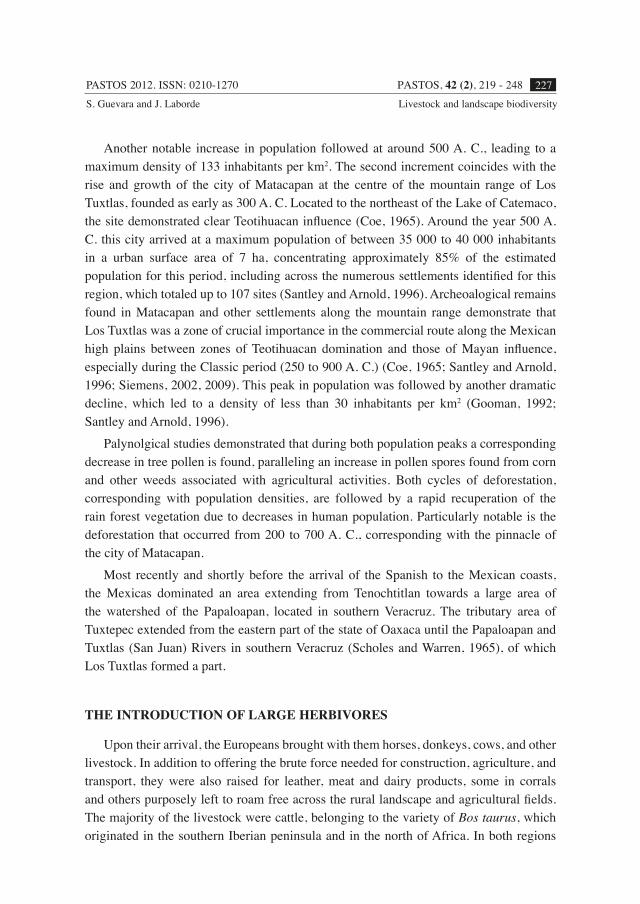
key to maintaining biodiversity and natural regenerative processes of the rain forest, considering that it is also the most commonly found landscape scenario in Los Tuxtlas and much of the Neotropical humid tropics (Figure 4).
FIGURE 4The current landscape in the region of Los Tuxtlas is a complicated mosaic, where small fragments of rain forest are dispersed throughout large extensions of pastures used for
cattle ranching and where trees are found along waterways or exist in the form of remnants, isolated patches, or living fences (Drawing by Manuel Escamilla).
El paisaje actual en la región de Los Tuxtlas es un complicado mosaico, en el que se destacan pequeños fragmentos de la selva y una gran extensión de pastos para la ganadería salpicados
de árboles remanentes, solitarios o en pequeños grupos a lo largo de los cursos de agua y en las cercas vivas (Dibujado por Manuel Escamilla).
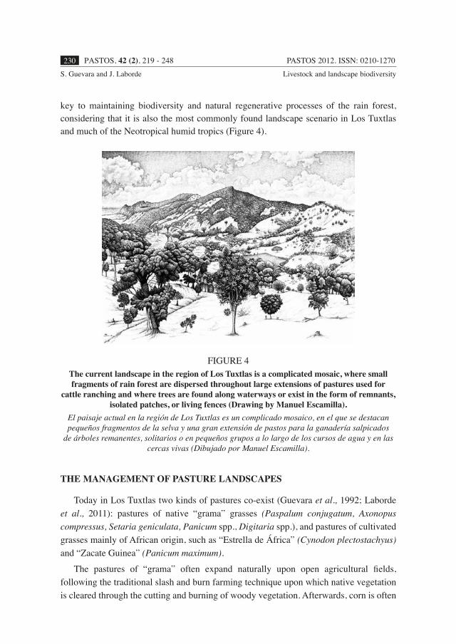
THE MANAGEMENT OF PASTURE LANDSCAPES
Today in Los Tuxtlas two kinds of pastures co-exist (Guevara et al., 1992; Laborde et al., 2011): pastures of native “grama” grasses (Paspalum conjugatum, Axonopus compressus, Setaria geniculata, Panicum spp., Digitaria spp.), and pastures of cultivated grasses mainly of African origin, such as “Estrella de África” (Cynodon plectostachyus) and “Zacate Guinea” (Panicum maximum).
The pastures of “grama” often expand naturally upon open agricultural fields, following the traditional slash and burn farming technique upon which native vegetation is cleared through the cutting and burning of woody vegetation. Afterwards, corn is often
PASTOS 2012. ISSN: 0210-1270 PASTOS, 42 (2), 219 - 248 231S. Guevara and J. Laborde Livestock and landscape biodiversity
cultivated for two to four seasons of harvest, although the growing cycle is commonly extended with one or two harvests of beans, rice, chilies, peanuts, or pineapple. Once the agricultural field is left fallow the pastureland phase begins, where either native “grama” grasses take over or “estrella” African grasses are sown to convert the field for livestock. The “grama” grass is induced immediately after harvest, simultaneously accompanied by the livestock, so that trampling may eliminate the herbs and grasses that may sprout from the previous harvest, thereby facilitating the establishment of native grasses (Lira-Noriega, 2003).
The “estrella” grass is spread by burying sections of stolons in the soil, thus giving it a branched-out appearance, and may be planted at the moment in which corn plants reach a height of at least 40 centimeters or when they are beginning to flower. The grass is sown in furrows between the rows of corn (Martinez, 1980; Barrera-Laez, 1995). Therefore, a pasture of “estrella” grass can be established immediately after the one seasonal harvest of corn and even after slashing and burning, when it is sown directly into the ground. In comparison, a pasture with “grama” grass requires several agricultural cycles, during which seeds from plants of the families of Gramineae and Leguminosae begin to accumulate in the soil seed bank, eventually dominating the pasture floristically and structurally.
THE RESILIENCE OF THE LANDSCAPE
In the current landscape, biodiversity has been maintained through the natural regeneration and secondary succession of once modified landscapes, resulting from a regimen of ancient disturbances and an intense management carried out by indigenous peoples throughout the history of the region. The management of this landscape has been based on conserving the connectivity of the system that permits the movement of biodiversity, as well as the potential for species regeneration in abandoned sites. Thus, the historical management of the landscape can be largely described as the management of its connectivity.
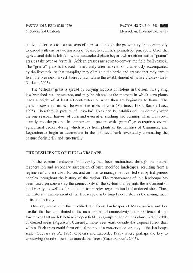
One key element in the modified rain forest landscapes of Mesoamerica and Los Tuxtlas that has contributed to the management of connectivity is the existence of rain forest trees that are left behind in open fields, in groups or sometimes alone in the middle of cleared areas (Figure 5). Currently, more trees exist outside the tropical forest than within. Such trees could form critical points of a conservation strategy at the landscape scale (Guevara et al., 1986; Guevara and Laborde, 1993) where perhaps the key to conserving the rain forest lies outside the forest (Guevara et al., 2005).
PASTOS 2012. ISSN: 0210-1270PASTOS, 42 (2), 219 - 248232S. Guevara and J. Laborde Livestock and landscape biodiversity
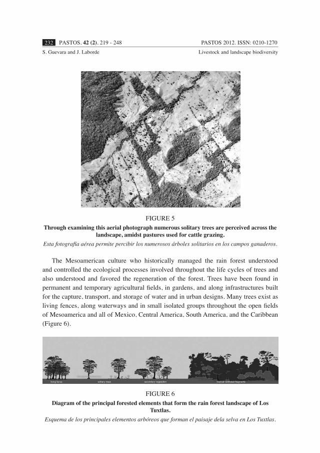
The Mesoamerican culture who historically managed the rain forest understood and controlled the ecological processes involved throughout the life cycles of trees and also understood and favored the regeneration of the forest. Trees have been found in permanent and temporary agricultural fields, in gardens, and along infrastructures built for the capture, transport, and storage of water and in urban designs. Many trees exist as living fences, along waterways and in small isolated groups throughout the open fields of Mesoamerica and all of Mexico, Central America, South America, and the Caribbean (Figure 6).
FIGURE 5Through examining this aerial photograph numerous solitary trees are perceived across the
landscape, amidst pastures used for cattle grazing.Esta fotografía aérea permite percibir los numerosos árboles solitarios en los campos ganaderos.
FIGURE 6Diagram of the principal forested elements that form the rain forest landscape of Los
Tuxtlas.Esquema de los principales elementos arbóreos que forman el paisaje dela selva en Los Tuxtlas.
PASTOS 2012. ISSN: 0210-1270 PASTOS, 42 (2), 219 - 248 233S. Guevara and J. Laborde Livestock and landscape biodiversity
The trees in open fields maintain a close relationship with the diverse species in the rain forest landscape and other open sites. For example, epiphytic species and flying vertebrates, such as birds and bats, are dependent upon such residual trees. Thus, the remaining biodiversity and its movement across the landscape depends upon the existence of isolated trees, where the movements and defecation of seeds by these flying animals beneath the crowns of these trees promotes the regeneration of the rain forest (Guevara et al., 2004).
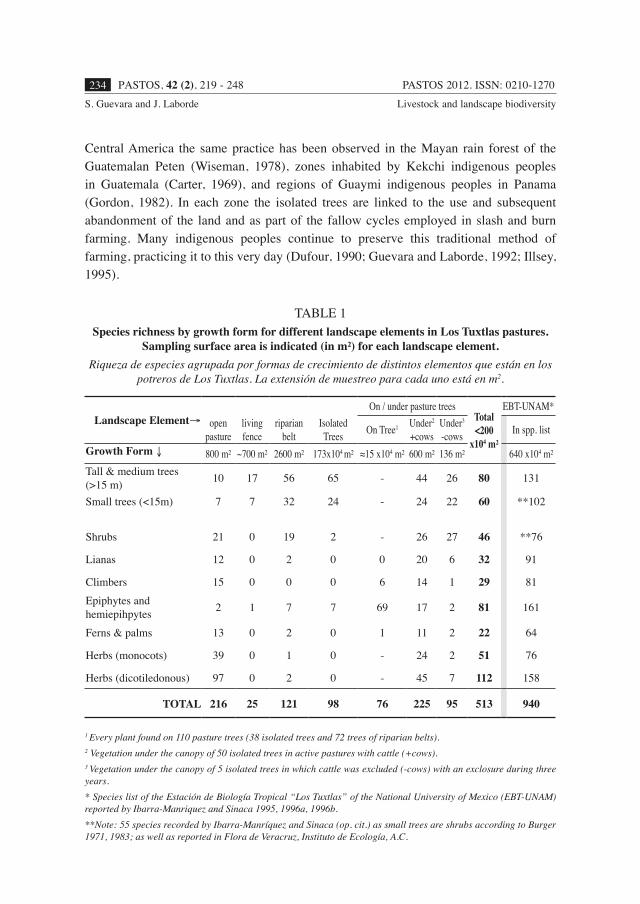
Currently, the notion that the landscape of the humid tropics is principally dominated by livestock bare pastures is widely accepted. The conceived landscape is one formed by small and diminishing fragments of rain forest surrounded by deforested areas, completely stripped of trees and poor in plant and animal species. However, thin forested strips still exist, often left along river ways and agricultural fields. These, riparian forested belts, treed living fences, together with isolated patches of trees that are left behind, are the forgotten elements of these deforested landscapes. Despite the extensive deforestation and transformation of the original forest into crop-fields and pastures, there is a remarkable diversity of plants present in current pastures, which is closely related to the profuse presence of trees and arboreal elements within the pastures (Table 1). Thus, a full understanding of the scenario in Los Tuxtlas and other fragmented rain forest regions is impeded, as through the historical management of the landscape its connectivity and diversity have been maintained by trees in the open, in spite of intense use and modification (Guevara et al., 1998).
The practice of leaving trees behind in open fields originated in the traditional management of the landscape by Mesoamerican peoples and diverse ethnic groups around the world, including in regions of Central and South America, Asia, and Africa, and appears to be linked to agricultural practices (Guevara, 1986). In the case of nomadic agriculture, the fallow cycle allows old-fields and vegetation associated with secondary succession to develop as the field is let to rest and recovers its fertility. Thus upon cutting down the rain forest or forested secondary vegetation, trees are often left behind with the express goal of later accelerating the process of regeneration and establishment of forest species during fallow cycles or when fields are cyclically interchanged. These remaining trees are important seed sources, allowing for the dispersal and accumulation of rain forest seeds in their vicinity (Kelly and Palerm, 1952; Gordon 1982; Van Dorp, 1985; Howe and Smallwood, 1982; Alcorn, 1984), provided that dispersal agents are present.
In Mexico the practice of leaving behind trees in corn fields has been observed in the Gulf of Mexico, the Huasteca region (Alcorn, 1984), the Totonac territory of central Veracruz (Kelly and Palerm, 1952), the Mayan region of the peninsula of Yucatan (Hernández, 1959; Redfield and Villa Rojas, 1962; Sanabria, 1986; Zizumbo and Sima, 1988; Gómez-Pompa and Kauss, 1990), and in Chiapas (Nations and Nigh, 1980). In
PASTOS 2012. ISSN: 0210-1270PASTOS, 42 (2), 219 - 248234S. Guevara and J. Laborde Livestock and landscape biodiversity
Central America the same practice has been observed in the Mayan rain forest of the Guatemalan Peten (Wiseman, 1978), zones inhabited by Kekchi indigenous peoples in Guatemala (Carter, 1969), and regions of Guaymi indigenous peoples in Panama (Gordon, 1982). In each zone the isolated trees are linked to the use and subsequent abandonment of the land and as part of the fallow cycles employed in slash and burn farming. Many indigenous peoples continue to preserve this traditional method of farming, practicing it to this very day (Dufour, 1990; Guevara and Laborde, 1992; Illsey, 1995).
TABLE 1Species richness by growth form for different landscape elements in Los Tuxtlas pastures.
Sampling surface area is indicated (in m²) for each landscape element.Riqueza de especies agrupada por formas de crecimiento de distintos elementos que están en los
potreros de Los Tuxtlas. La extensión de muestreo para cada uno está en m2.
Landscape Element→ open pasture
livingfence
riparianbelt
Isolated Trees
On / under pasture treesTotal<200
x104 m²
EBT-UNAM*
On Tree1 Under2
+cowsUnder3
-cows In spp. list
Growth Form ↓ 800 m² ~700 m² 2600 m² 173x104 m² ≈15 x104 m² 600 m² 136 m² 640 x104 m²Tall & medium trees (>15 m) 10 17 56 65 - 44 26 80 131
Small trees (<15m) 7 7 32 24 - 24 22 60 **102
Shrubs 21 0 19 2 - 26 27 46 **76
Lianas 12 0 2 0 0 20 6 32 91
Climbers 15 0 0 0 6 14 1 29 81Epiphytes and hemiepihpytes 2 1 7 7 69 17 2 81 161
Ferns & palms 13 0 2 0 1 11 2 22 64
Herbs (monocots) 39 0 1 0 - 24 2 51 76
Herbs (dicotiledonous) 97 0 2 0 - 45 7 112 158
TOTAL 216 25 121 98 76 225 95 513 940
1 Every plant found on 110 pasture trees (38 isolated trees and 72 trees of riparian belts).2 Vegetation under the canopy of 50 isolated trees in active pastures with cattle (+cows).3 Vegetation under the canopy of 5 isolated trees in which cattle was excluded (-cows) with an exclosure during three years.* Species list of the Estación de Biología Tropical “Los Tuxtlas” of the National University of Mexico (EBT-UNAM) reported by Ibarra-Manriquez and Sinaca 1995, 1996a, 1996b. **Note: 55 species recorded by Ibarra-Manríquez and Sinaca (op. cit.) as small trees are shrubs according to Burger 1971, 1983; as well as reported in Flora de Veracruz, Instituto de Ecología, A.C.
PASTOS 2012. ISSN: 0210-1270 PASTOS, 42 (2), 219 - 248 235S. Guevara and J. Laborde Livestock and landscape biodiversity
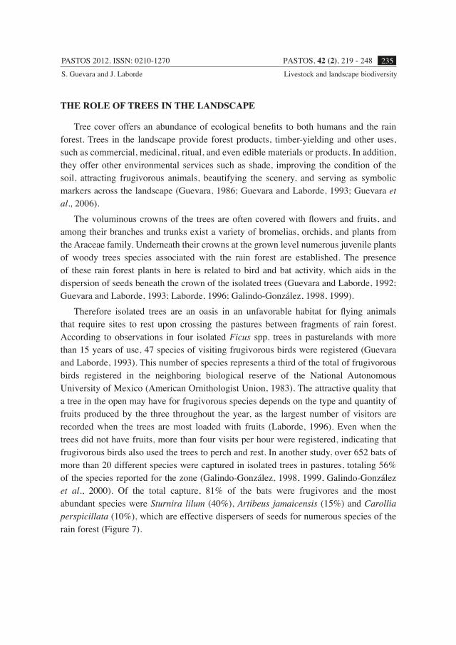
THE ROLE OF TREES IN THE LANDSCAPE
Tree cover offers an abundance of ecological benefits to both humans and the rain forest. Trees in the landscape provide forest products, timber-yielding and other uses, such as commercial, medicinal, ritual, and even edible materials or products. In addition, they offer other environmental services such as shade, improving the condition of the soil, attracting frugivorous animals, beautifying the scenery, and serving as symbolic markers across the landscape (Guevara, 1986; Guevara and Laborde, 1993; Guevara et al., 2006).
The voluminous crowns of the trees are often covered with flowers and fruits, and among their branches and trunks exist a variety of bromelias, orchids, and plants from the Araceae family. Underneath their crowns at the grown level numerous juvenile plants of woody trees species associated with the rain forest are established. The presence of these rain forest plants in here is related to bird and bat activity, which aids in the dispersion of seeds beneath the crown of the isolated trees (Guevara and Laborde, 1992; Guevara and Laborde, 1993; Laborde, 1996; Galindo-González, 1998, 1999).
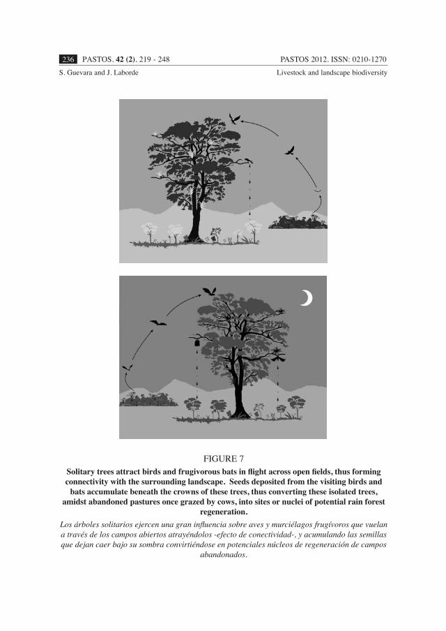
Therefore isolated trees are an oasis in an unfavorable habitat for flying animals that require sites to rest upon crossing the pastures between fragments of rain forest. According to observations in four isolated Ficus spp. trees in pasturelands with more than 15 years of use, 47 species of visiting frugivorous birds were registered (Guevara and Laborde, 1993). This number of species represents a third of the total of frugivorous birds registered in the neighboring biological reserve of the National Autonomous University of Mexico (American Ornithologist Union, 1983). The attractive quality that a tree in the open may have for frugivorous species depends on the type and quantity of fruits produced by the three throughout the year, as the largest number of visitors are recorded when the trees are most loaded with fruits (Laborde, 1996). Even when the trees did not have fruits, more than four visits per hour were registered, indicating that frugivorous birds also used the trees to perch and rest. In another study, over 652 bats of more than 20 different species were captured in isolated trees in pastures, totaling 56% of the species reported for the zone (Galindo-González, 1998, 1999, Galindo-González et al., 2000). Of the total capture, 81% of the bats were frugivores and the most abundant species were Sturnira lilum (40%), Artibeus jamaicensis (15%) and Carollia perspicillata (10%), which are effective dispersers of seeds for numerous species of the rain forest (Figure 7).
PASTOS 2012. ISSN: 0210-1270PASTOS, 42 (2), 219 - 248236S. Guevara and J. Laborde Livestock and landscape biodiversity
FIGURE 7Solitary trees attract birds and frugivorous bats in flight across open fields, thus forming connectivity with the surrounding landscape. Seeds deposited from the visiting birds and
bats accumulate beneath the crowns of these trees, thus converting these isolated trees, amidst abandoned pastures once grazed by cows, into sites or nuclei of potential rain forest
regeneration.Los árboles solitarios ejercen una gran influencia sobre aves y murciélagos frugívoros que vuelan a través de los campos abiertos atrayéndolos -efecto de conectividad-, y acumulando las semillas que dejan caer bajo su sombra convirtiéndose en potenciales núcleos de regeneración de campos
abandonados.
PASTOS 2012. ISSN: 0210-1270 PASTOS, 42 (2), 219 - 248 237S. Guevara and J. Laborde Livestock and landscape biodiversity
TREES ARE CENTERS OF REGENERATION
When cattle are excluded from the vicinity of trees in the open and the effects of their grazing and trampling are stopped beneath the shade of isolated trees, along with halting the clearing of vegetation and the application of herbicides, interesting changes occur in the composition of species and in the structure of the plant communities that grow beneath the canopy of the trees (Guevara et al., 2004). In a study to assess the effect of removing cattle, the abandonment of a pasture during three years was simulated by fencing off five isolated trees of Ficus spp. (Guevara et al., 2006). At the end of the experiment 96 species of plants were found growing beneath the crowns of the trees, with an average density of 4.6 plants per m2. During this lapse an arboreal and closed canopy was formed, with more than 4 m in height, dominated by secondary and pioneer woody species whose individuals varied in size from small seedlings of 10 cm in height up to juvenile trees of more than 6 m in height. Underneath this canopy the ruderal species typical of open grasslands disappeared almost completely, while 46 tree and shrub species characteristic of the rain forest were successfully established (Guevara et al., 2005; Table 1).
The main obstacles for the regeneration of the rain forest in grasslands has been attributed to the absence of seeds from rain forest plants (Guevara, 1986) in addition to the adverse conditions for seed germination and seedling establishment of rain forest species (Nepstad et al., 1990; Holl, 1999; Holl et al., 2000). The low or almost null immigration of seeds from woody species into the open grasslands is explained by the low availability of propagule sources in and around these sites, as well as the unattractive nature of these sites for frugivores that disperse the seeds of woody plants. The few seeds of woody plants that manage to arrive to the grassland face adverse conditions for their germination and establishment, such as compacted soil due to its trampling by cattle, as well as extreme oscillations of humidity and temperature of both the air and soil in open areas. In addition, other unfavorable biotic factors exist for the tree species of the rain forest, such as competition with grasses and heliophilous or sun-demanding weeds that grow rapidly, intense depredation of seeds, and herbivory of its plants by organisms that thrive in crop-fields or pastures.
The findings of Los Tuxtlas shown that trees change favorably in response to certain conditions, since they attract to pastures frugivorous animals that disperse seeds of rain forest species (Guevara and Laborde, 1993; Galindo-González et al., 2000) by creating in their shade favorable microclimatic and edaphic conditions for the establishment of rain forest plants (Williams-Linera et al., 1998) through abating the competition from heliophilous species, but only when livestock is excluded and associated management practices are put to a halt. The isolated trees in pastures of Los Tuxtlas act as “regeneration nuclei” (sensu Guevara et al., 1986) and are determinant in the successful
PASTOS 2012. ISSN: 0210-1270PASTOS, 42 (2), 219 - 248238S. Guevara and J. Laborde Livestock and landscape biodiversity
establishment of rain forest plants in the interior of the pastures. After three years of interrupting livestock practices, the effect of the crown of the isolated trees combined with that of the secondary canopy that forms below makes a more attractive setting for birds and frugivore bats and creates microclimatic conditions that are increasingly favorable for the establishment of rain forest plant species, further excluding ruderal plants from the pastures.
However, the appeal of isolated trees to frugivores that disperse seeds depends directly on the presence and abundance of dispersing frugivores and on the existence of propagule sources in the area (Aguirre, 1976; Arriaga and Lozano, 1980). This is at the same time a function of the extension, form, and floristic composition of the tree and forest elements that are left in the landscape (Laborde,1996). Due to this, the effect of isolated trees, in particular their efficiency as “centers of regeneration” of the rain forest, obey the spatial pattern of the landscape and its floristic composition. This is to say that regenerative activity is dependent upon the spatial distribution of forested elements that have not been eliminated by deforestation, since these represent the habitat of the frugivores that disperse seeds and are the principal sources of propagules of rain forest plants in fragmented landscapes.
CONCLUSION
Landscape Design and Management
Understanding the history of a fragmented landscape is important in order to recommend measures for the management of its natural resources and biodiversity, and in this case the goal of ultimately contributing to the natural regeneration of the rain forest. In the case of Los Tuxtlas and many sites in Mesoamerica, maintaining the connectivity of the landscape is crucial for natural regeneration of the forest to occur. Such a vision is only enlightened by understanding the historical management practiced by indigenous populations, at times corresponding with contemporary management, by which secondary succession is manipulated by the practice of leaving behind forested elements in agricultural fields.
Enhancing the connectivity of a landscape may be considered as the opposite of isolating the elements within the landscape. Thus, connectivity has a structural component that refers to the quantity of physical contacts, for example, between remnants of rain forest, as well as the magnitude of the distances by which fragments are separated. While the functional aspect of connectivity, deals with the frequency or intensity of the flow of organisms, nutrients, materials, or energy across the landscape (Forman and Godron, 1986). In the case of forested, fragmented landscapes,
PASTOS 2012. ISSN: 0210-1270 PASTOS, 42 (2), 219 - 248 239S. Guevara and J. Laborde Livestock and landscape biodiversity
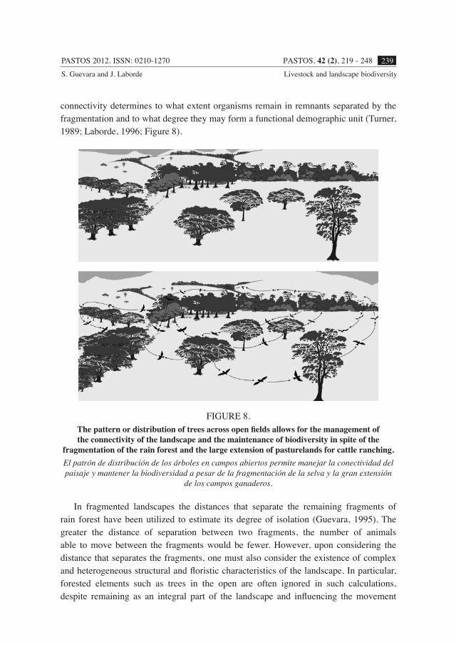
connectivity determines to what extent organisms remain in remnants separated by the fragmentation and to what degree they may form a functional demographic unit (Turner, 1989; Laborde, 1996; Figure 8).
FIGURE 8.The pattern or distribution of trees across open fields allows for the management of the connectivity of the landscape and the maintenance of biodiversity in spite of the
fragmentation of the rain forest and the large extension of pasturelands for cattle ranching.El patrón de distribución de los árboles en campos abiertos permite manejar la conectividad del paisaje y mantener la biodiversidad a pesar de la fragmentación de la selva y la gran extensión
de los campos ganaderos.
In fragmented landscapes the distances that separate the remaining fragments of rain forest have been utilized to estimate its degree of isolation (Guevara, 1995). The greater the distance of separation between two fragments, the number of animals able to move between the fragments would be fewer. However, upon considering the distance that separates the fragments, one must also consider the existence of complex and heterogeneous structural and floristic characteristics of the landscape. In particular, forested elements such as trees in the open are often ignored in such calculations, despite remaining as an integral part of the landscape and influencing the movement
PASTOS 2012. ISSN: 0210-1270PASTOS, 42 (2), 219 - 248240S. Guevara and J. Laborde Livestock and landscape biodiversity
of organisms across it. From this perspective, the remaining fragments of rain forest may only be problematically described as “islands of rain forests” immersed in a “sea of grasses”. A more accurate assessment would acknowledge the connectivity of the landscape by recognizing the existence of numerous and varied tree elements that are still found in pastures and other open and agricultural sites which are used by forest organisms as stepping stones while crossing open areas. These arboreal elements offer temporal refuge, rest, or even food to the native fauna of the rain forest that ventures outside the rain forest fragments (Laborde, 1996; Guevara et al., 1998; Galindo-González, 1999; Graham, 2001).
The Future Landscape of Los Tuxtlas
The future landscape of Los Tuxtlas could witness two extreme scenarios. The first would represent a landscape constituted by a disintegrated group of elements, dominated by extensive pasturelands and lacking in connectivity. In this scenario, the native populations of rain forest species that survived the clearing of trees would remain confined and restricted to the interior of the fragments, totally isolated from the surviving individuals in other fragments. Given the severe current fragmentation of Los Tuxtlas forest, the previous situation would provoke in the long run a local extinction of a large number of species and a decrease in biodiversity. The second scenario is a landscape of interconnected elements of rain forest fragments, pastures, agricultural fields, and secondary vegetation, integrated due to elements that maintain connectivity across the landscape such as isolated trees, riparian corridors, living fences, among others, that would contribute to the maintenance of rain forest species and their accessibility between sites. This interconnected landscape could sustain itself long-term and shelter a high and representative percentage of the original native biodiversity of Los Tuxtlas by allowing for a natural regeneration of the rain forest without the need to limit agricultural and livestock activities.
The re-placement or maintenance of pastures with tree cover is easily-carried out in practice and may be accomplished by controlling the clearing of vegetation and the spraying of herbicides beneath the crown of the trees, in addition to excluding cattle from grazing for relatively short periods of time. The rich and diverse forest vegetation that regenerates under these conditions allows rain forest species to be naturally selected and to replace trees of the original canopy. For the maintenance of the native biodiversity of Los Tuxtlas, the conservation of the most extensive and remaining rain forest fragments is indispensable, for which it is necessary to halt the current clearing of vegetation and deforestation.
The decree of the Biosphere Reserves of Los Tuxtlas (see Guevara et al., 2006) was a promising step towards strategic management at the landscape level, where management
PASTOS 2012. ISSN: 0210-1270 PASTOS, 42 (2), 219 - 248 241S. Guevara and J. Laborde Livestock and landscape biodiversity
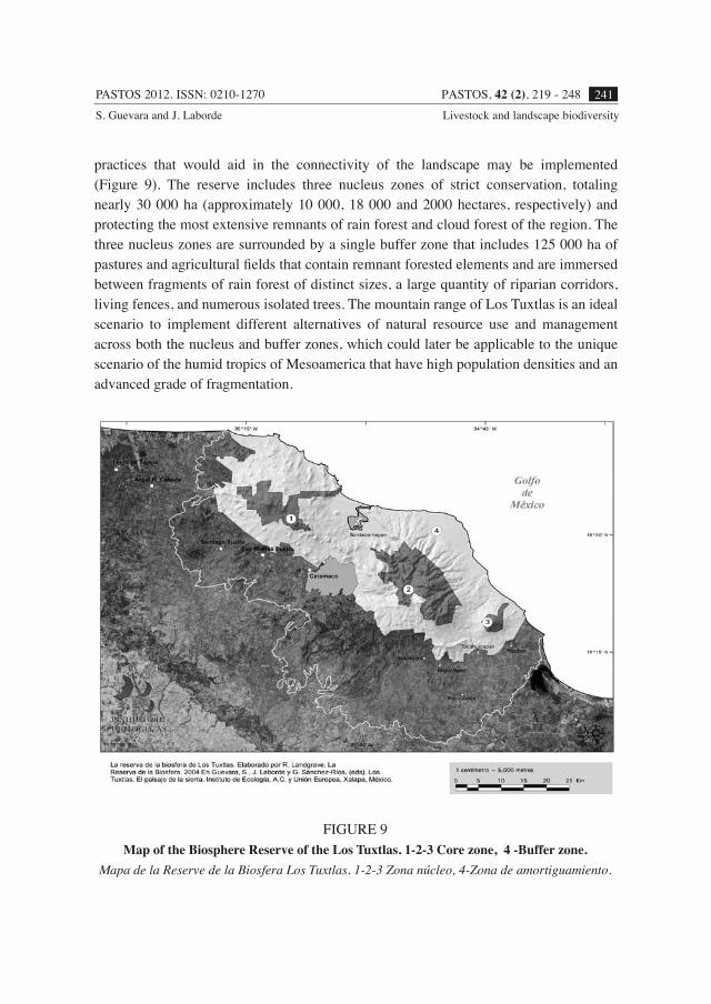
practices that would aid in the connectivity of the landscape may be implemented (Figure 9). The reserve includes three nucleus zones of strict conservation, totaling nearly 30 000 ha (approximately 10 000, 18 000 and 2000 hectares, respectively) and protecting the most extensive remnants of rain forest and cloud forest of the region. The three nucleus zones are surrounded by a single buffer zone that includes 125 000 ha of pastures and agricultural fields that contain remnant forested elements and are immersed between fragments of rain forest of distinct sizes, a large quantity of riparian corridors, living fences, and numerous isolated trees. The mountain range of Los Tuxtlas is an ideal scenario to implement different alternatives of natural resource use and management across both the nucleus and buffer zones, which could later be applicable to the unique scenario of the humid tropics of Mesoamerica that have high population densities and an advanced grade of fragmentation.
FIGURE 9Map of the Biosphere Reserve of the Los Tuxtlas. 1-2-3 Core zone, 4 -Buffer zone.
Mapa de la Reserve de la Biosfera Los Tuxtlas. 1-2-3 Zona núcleo, 4-Zona de amortiguamiento.
PASTOS 2012. ISSN: 0210-1270PASTOS, 42 (2), 219 - 248242S. Guevara and J. Laborde Livestock and landscape biodiversity
REFERENCES
AGUIRRE-BELTRAN, G., 1992. Pobladores del Papaloapan: biografía de una hoya. Centro de Investigaciones y Estudios Superiores en Antropología Social (CIESAS Golfo). D.F. (México).
AGUIRRE, L., 1976. El papel de algunas aves en la dinámica que se establece entre las zonas abiertas al cultivo y a la ganadería y la selva alta perennifolia en Balzapote, Veracruz. Tesis Licenciatura. Facultad de Ciencias. UNAM. D.F. (México).
ALCORN, J.B., 1984. Huastec Mayan ethnobotany. University of Texas Press, 982 pp. Austin (TX USA)..
AMERICAN ORNITHOLOGISTS’ UNION, 1983. Check-list of North American Birds, 6th edition. Allen Press. Lawrence (Kansas, USA).
ARRIAGA, S.F.; LOZANO, F., 1980. El papel de algunas aves en la ecología de las zonas abiertas a la agricultura en Balzapote, Veracruz, México. Tesis Licenciatura, Facultad de Ciencias. UNAM. D.F. (México).
ATTOLINI, J., 1948. La ganadería en la cuenca del Papaloapan. Investigación Económica, 4, 375-417.
BARRERA-BASSOLS, N., 1992. El impacto ecológico y socioeconómico de la ganadería bovina en Veracruz. In: Desarrollo y medio ambiente en Veracruz, 79-114. Eds. E. BOEGE, H. RODRIGUEZ. CIESAS-Golfo. Instituto de Ecología A.C., Fundación Friedrich Ebert. Xalapa (Veracruz, México).
BARRERA-LAEZ, O., 1995. Uso y manejo de árboles en potreros de Los Tuxtlas, Veracruz. Tesis Facultad de Agronomía. Universidad Veracruzana. Xalapa (Veracruz,México).
BONGERS, F.; POPMA, J; MEAVE DEL CASTILLO, J; CARABIAS, J., 1988. Structure and floristic composition of the lowland rain forest of Los Tuxtlas, México. Vegetatio, 74, 55-80.
CARTER, W. E., 1969. New lands and old traditions; Kekchi cultivators in the Guatemalan low lands. University of Florida Press, 153 pp. Gainesville (FL, USA).
COATES-ESTRADA, R.; ESTRADA, A., 1985. Lista de las aves de la Estación de Biología Los Tuxtlas. Instituto de Biología, UNAM, D.F. (México).
COATES-ESTRADA, R.; ESTRADA, A., 1986. Fruiting and frugivores at a strangler fig in the tropical rain forest of Los Tuxtlas, Mexico. J. Trop. Ecol., 2, 349-357.
COATES-ESTRADA, R.; ESTRADA, A., 1988. Frugivory and seed dispersal in Cymbopetalum baillonii (Annonaceae) at Los Tuxtlas, Mexico. J. Trop. Ecol., 4, 157-172.
COE, M. D., 1965. Archeological sythesis of southern Veracuz and Tabasco. In Handbook of middle American Indians. Vol. III, 679-715. Ed. R. WAUCHOPE. University of Texas Press. Austin (USA).
CHÁZARO, M.J., 1977. El huizache, Acacia pennatula (Schlecht. & Cham.) Benth., Especie invasora del centro de Veracruz. Biotica, 2, 1-17.
DIRZO, R.; MIRANDA, A. 1991. El límite boreal de la selva tropical húmeda en el continente americano: contracción de la vegetación y solución de una controversia. Interciencia, 16, 240-247.
DUFOUR, D. L., 1990. Use of tropical rainforests by native amazonians. BioScience, 40, 652-659.
ESTRADA, A.; COATES-ESTRADA R.; VÁZQUEZ-YANES, C., 1984. Observations on fruiting and dispersers of Cecropia obtusifolia at Los Tuxtlas, Mexico. Biotropica, 16, 315-318.
FORMAN, R.T.T.; GODRON, M., 1986. Landscape Ecology. John Wiley & Sons. New York (USA).
GALINDO-GONZÁLEZ, J., 1998. Dispersión de semillas por murciélagos: su importancia en la conservación y regeneración del bosque tropical. Acta Zool. Mex., 73, 57-74.
GALINDO-GONZÁLEZ, J., 1999. Los murciélagos frugívoros en la regeneración de la vegetación del paisaje pastizal-selva de Los Tuxtlas, Veracruz. Tesis doctoral. Instituto de Ecología, A.C., 156 pp. Xalapa (Veracruz, México).
PASTOS 2012. ISSN: 0210-1270 PASTOS, 42 (2), 219 - 248 243S. Guevara and J. Laborde Livestock and landscape biodiversity
GALINDO-GONZÁLEZ, J.; GUEVARA, S.; SOSA, V., 2000. Bat and bird generated seed rains at isolated trees in pastures in a tropical rain forest. Conservation Biology, 14, 1693-1703.
GALINDO, C. L., 2012. La edad de hielo en México. National Geographic en español, 31, 56-87.
GEISSERT, D. K., 2006. La geomorfología. In:. Los Tuxtlas. El paisaje de la sierra. Eds. S. GUEVARA, J. LABORDE, G. SÁNCHEZ-RIOS. Unión Europea e Instituto de Ecología, A.C., , 287 pp. México.
GOMAN, M., 1992. Paleoecological evidence for prehistoric agriculture and tropical forest clearance in the Sierra de Los Tuxtlas, Veracruz, Mexico. Master of Arts in Geography. University of California. Berkeley (USA).
GÓMEZ-POMPA, A.; KAUSS, A.; 1990. Traditional management of tropical forest in México. In: Alternatives to deforestation: steps toward to sustainable use of the Amazon rain forest, 45-64. Ed. ANDERSON, A.B. Columbia Univ. Press. N.Y. (USA).
GONZÁLEZ-SIERRA, J., 1991. Los Tuxtlas. In: Veracruz: imágenes de su historia. Archivo General del Estado de Veracruz (México).
GONZÁLEZ-SORIANO, E.; DIRZO, R.; VOGT, R., 1997. Historia Natural de Los Tuxtlas. CONABIO- UNAM, 447 pp. México.
GORDON, B.L., 1982 A Panama forest and shore natural history and amerindian culture in Bocas del Toro. The Boxwood Press. Pacific Grove. California (USA).
GRAHAM, C., 2001. Factors influencing movement patterns of keel-billed toucans in a frag- mented tropical landscape in southern Mexico. Cons. Biol., 15, 1789-1798.
GRAHAM, A., 1975. Late Cenozoic evolution of tropical lowland vegetation in Veracruz, Mexico. Evolution, 29, 723-35.
GUEVARA, S., 1986. Plant species availability and regeneration in mexican tropical rain forest. Tesis Doctoral. Uppsala (Suecia).
GUEVARA, S., 1995. Connectivity: key in maintaining tropical rain forest landscape diversity. A case study in Los Tuxtlas, Mexico. Ed: HALLADAY, P., ; GILMOUR, D., A. Conserving Biodiversity Outside Protected Areas. The role of traditional agro-systems. IUCN, Gland (SWITZERLAND) ; Cambrige, (U.K.)
GUEVARA, S., 2011. Los Tuxtlas. Tierra Mítica. Secretaría de Educación del Gobierno del Estado de Veracruz y Universidad Veracruzana, 272 pp. México.
GUEVARA S.; PURATA, S.; VAN DER MAAREL, E., 1986. The role of remnant forest trees in tropical secondary succession. Vegetatio, 66, 77-84.
GUEVARA, S.; MEAVE, J.; MORENO-CASASOLA, P.; LABORDE, J., 1992. Floristic composition and structure of vegetation under isolated trees in neotropical pastures. Journal of Vegetation Science, 3, 655-664.
GUEVARA, S.; MEAVE, J.; MORENO-CASASOLA, P.; LABORDE, J.; CASTILLO, S., 1994. Vegetación y flora de potreros en la Sierra de Los Tuxtlas, México. Acta Botánica Mexicana, 28, 1- 27.
GUEVARA, S.; LABORDE, J., 1992. Uso de árboles aislados para el manejo de pastizales tropicales: su contribución al mantenimiento de la diversidad de especies de la selva. In: Atelier sur l’aménagement et la conservation de l’écosysteme forestier tropical humide. Études de cas (Cayena, Guyana Francesa, 12-16 de marzo de 1990.) MAB UNESCO, FRANCE, IUFRO-FAO.
GUEVARA, S.; LABORDE, J., 1993. Monitoring seed dispersal at isolated standing trees in tropical pastures: consequences for local species availability. Vegetatio, 107/108, 319- 338.
GUEVARA, S.; MEAVE, J.; MORENO.CASASOLA, P.: LABORDE, J; CASTILLO, S., 1994. Vegetación y flora de potreros en la Sierra de Los Tuxtlas, México. Acta Botánica Mexicana, 28, 1-27.
PASTOS 2012. ISSN: 0210-1270PASTOS, 42 (2), 219 - 248244S. Guevara and J. Laborde Livestock and landscape biodiversity
GUEVARA, S.; LABORDE, J.; SANCHEZ-RIOS, G., 1998. Are isolated remnant trees in pastures a fragmented canopy? Selbyana, 19, 34-43.
GUEVARA, S.; LABORDE, J.; SANCHEZ-RIOS, G., 2004. Rain forest regeneration beneath the canopy trees isolated in pastures of Los Tuxtlas Mexico. Biotropica, 36, 99-108.
GUEVARA, S.; LABORDE, J.; SÁNCHEZ-RÍOS, G., 2005. Los árboles que la selva dejó atrás. Interciencia, 30, 595-601
GUEVARA, S.; LIRA-NORIEGA, A., 2004. De los pastos de la selva a la selva de los pastos: La introducción de la ganadería en México. PASTOS, 2, 109-150.
GUEVARA, S.; LABORDE, J.; SANCHEZ-RIOS, G., 2006. Los Tuxtlas. El paisaje de la sierra. Unión Europea e Instituto de Ecología, A.C., D.F. (México).
HAVARD-DUCLOS, B., 1975. Las plantas forrajeras tropicales: técnicas agrícolas y producciones Tropicales. Ed. Blume. Barcelona (España).
HERNÁNDEZ-X., 1959. La agricultura. In: Los recursos naturales renovables del sureste y su aprovechamiento, 357 pp. Ed. BELTRAN. Instituto Mexicano de Recursos Naturales Renovables A.C. (México).
HILLARY, S.; YOUNG, D.; MCCAULEY, J.; KRISTOFER, M.; HELGEN, J.; GOHEEN, R.; OTÁROLA-CASTILLO, E.; PALMER, T., M.; PRINGLE, R., M.; YOUNG, T., P.;
DIRZO, R., 2013. Effects of
mammalian herbivore declines on plant communities: observations and experiments in an African savanna. Journal of Ecology, 101, 1030–1041.
HOLL, K.D., 1999. Factors limiting tropical rain forest regeneration in abandoned pasture: seed rain, seed germination, microclimate and soil. Biotropica; 31, 229-242.
HOLL, K.D.; LOIK, E.; LIN, V.; SAMUELS, A., 2000. Tropical montane forest restoration in Costa Rica: overcoming barriers to dispersal and establishment. Restor. Ecol., 8, 339-349.
HOWE, H.F.; SMALLWOOD. J., 1982. Ecology of seed dispersal. Annu. Rev. of Ecol. and Syst., 13. 201-228.
ILLSEY, G., 1995. Vegetación y milpa en el ejido de Yaxcabá, Yucatán. In: La milpa en Yucatán. Un sistema de producción agrícola tradicional. Tomos I y II., 125 pp. Eds. E. HERNÁNDEZ, E. BELLO, S. LEVY. Colegio de Postgraduados. Texcoco (México).
JANZEN, D., 1984. Dispersal of small seeds by big herbivores: foliage is the fruit. Ame. Nat.; 123, 338-353.
JORDAN, T.G., 1993. North American Cattle-Ranching Frontiers: Origins, Diffusion and Differentiation. University of New Mexico Press, 439 pp. University of Texas. USA.
KELLY, I; PALERM, A., 1952. The Tajin Totonac, Part I: History, subsistence, shelter and technology. Smithsonian Institution, 369 pp. Washington, DC. (USA).
KIRCHOFF, P., 1960. Mesoamérica. Sus Límites Geográficos, Composición Étnica y Caracteres Culturales. Suplemento de la Revista Tlatoani. Escuela Nacional de Antropología e Historia. México.
LABORDE, J., 1996. Patrones de vuelo de aves frugívoras en relación a los árboles en pie de los pastizales. Tesis profesional. Facultad de Ciencias. UNAM. D.F. (México).
LABORDE, J.; GUEVARA, S.; SANCHEZ-RIOS, G., 2011. Diversidad florísticaen potreros de Los Tuxtlas. In: La Diversidad Biológica en Veracruz. Estudio de Estado. Tomo I. Contexto actual del Estado y perspectivas de conservación de su biodiversidad. Ed. A. CRUZ. Comisión Nacional para Conocimiento y Uso de la Biodiversidad. Gobierno del Estado de Veracruz. Universidad Veracruzana e Instituto de Ecología, A.C., México.
LIRA-NORIEGA, A., 2003. La vegetación de los potreros del norte de la sierra de Los Tuxtlas. Tesis. Universidad Nacional Autónoma de México. 98 pp. México.
PASTOS 2012. ISSN: 0210-1270 PASTOS, 42 (2), 219 - 248 245S. Guevara and J. Laborde Livestock and landscape biodiversity
LOVEJOY, T.E.; BIERREGAARD, B.O.; RYLANDS, A.B.; MALCOM, J.R.; QUINTELA, C.E.; HARPER, L.H.; BROWN Jr., K.S.; POWELL, A.H.; POWEL, G.V.N.; SCHUBART, H.O.R; HAYS, M.B., 1986. Edge and other effects of isolation on Amazon forest fragments. In: Conservation biology: the science of scarcity and diversity, 257-285. Ed. M.E. SOULE. Sinauer Associates. Sunderland (Massachusetts, USA).
MARTÍNEZ, J., 1980. Prácticas tradicionales de establecimiento y uso de los potreros en una región cálido-húmeda (Bal zapote, Veracruz). Tesis profesional. Facultad de Ciencias, UNAM. D.F. (México).
MAYER, R.F., 1962. Estudio vulcanológico de la región de Los Tuxtlas, Veracruz. Tesis licenciatura. Fac. de Ingeniería, UNAM. México.
MELGAREJO-VIVANCO, J.L., 1980. Historia de la ganadería en Veracruz. Xalapa (Veracruz, México).
NATIONS, J.D.; NIGH, R.B., 1980. The evolutionary potential of Lacandon maya sustained-yield tropical rain forest agriculture. J. Anthropol. Res., 36, 1-33.
NEPSTAD, D.; UHL, C.; SERRAO. E.A.S., 1990. Surmounting barriers to forest regeneration in abandoned, highly degraded pastures: a case study from Paragominas, Pará, Brazil. In: Alternatives to deforestation: steps toward sustainable use of the Amazon rain forest, 215-229. Ed. ANDERSON, AB. Columbia University Press. Nueva York (USA).
OPDAM, P.; RIJSDIJKY, G.; HUSTINGS, F., 1985. Bird communities in small woods in an agricultural landscape: effects of area and isolation. Biol. Cons. 34:333-352.
POOL, C.A., 2007. Olmec archeology and Early mesoamerica. Cambridge University Press. New York (USA).
PURATA, S. E., 1986. Floristic and structural changes during old-field succession in the Mexican tropics in relation to site history and species availability. J. Trop. Ecol., 2, 257-276.
REDFIELD, R.; VILLA-ROJAS, A,. 1962. Chan Kom: a Maya village. 3rd printing.University of Chicago Press, 236 pp. Chicago (IL, USA).
REVEAL-MOUROZ, J., 1980. Aprovechamiento y colonización del trópico húmedo mexicano, la vertiente del Golfo y del Caribe. FCE. D.F. (México).
RICHARDS, P.W., 1952. The tropical rain forest. Cambridge Univ. Press, 454 pp. Cambridge (UK).
ROJAS, R.T., 1994. Formación histórica de la agricultura campesina novohispana, In: Semillas de industria: Transformaciones de la tecnología indígena de las Américas, 167-194. Ed. M. RUZ. CIESAS-Smithsonian Institution. D.F. (México).
RZEDOWSKI, J., 1978. Vegetación de México. Ed. Limusa. México.
RZEDOWSKI, J.; EQUIHUA, M., 1987. Atlas Cultural de México: Flora. SEP-INAH. Planeta. México.
SAAB, V.A.; PETIT, D.R., 1992, Impact of pasture development on winter bird communities in Belize, Central America. Condor, 94, 66-71.
SANABRIA, O. L., 1986. El uso y manejo forestal en la comunidad de Xul, en el sur de Yucatán. Etnoflora Yucatanense, Fasc. 2. INIREB, 191 pp. Xalapa (México).
SANTLEY, R. S., 2007. The prehistory of Los Tuxtlas. University of New Mexico Press. Albuquerque (USA).
SANTLEY, R.S.; Arnold, P.J., 1996 Prehispanic settlements patterns in Los tuxtlas mountains, southern Veracruz, Mexico. Journal of Field Archaeology, 23, 225-249.
SCHOLES, F.V.; WARREN, D., 1965. The Olmec region al Spanish contact. In: Handbook of middle American Indians, Vol. III, 679-715. Ed. M. WAUCHOPE. University of Texas Press. Austin (USA).
PASTOS 2012. ISSN: 0210-1270PASTOS, 42 (2), 219 - 248246S. Guevara and J. Laborde Livestock and landscape biodiversity
SIEMENS, A.H., 2002. El “Rub al-Kahili” prehispánico de Los Tuxtlas: una interpretación del paisaje. In: Estudios sobre historia y ambiente en América II, 161–202. Comps. B.B. GARCÍA, M- PRIETO. El Colegio de México. D.F. (México).
SIEMENS, A.H., 2009. Una manera de ver Los Tuxtlas. Paisaje de Mesoamérica. 135 pp. Comisión Nacional para el Conocimiento y Uso de la Biodiversidad y Corredor Biológico Mesoamericano. México.
SKERRIT, D., 1992. La ganadería en el centro del estado de Veracruz. In: Desarrollo y medio ambiente en Veracruz, 125-130. Eds. E. BOEGE, H. RODRIGUEZ. CIESAS-Golfo. Instituto de Ecologia A.C. Fundación Friedrich Ebert. Xalapa (Veracruz, México).
STARK, B.L.; ARNOLD P.J., 1997. Olmec To Aztec: settlement patterns in the ancient Gulf lowlands. University of Arizona Press. Tucson (Arizona,USA).
STUART, G.E., 1993. New light on the Olmec. National Geographic, 184 (5), 88-115.
TOLEDO, V.M., 1982. Pleistocene changes of vegetation in tropical Mexico. In: Biological diversification in the tropics, 93-111. Ed. G.T. PRANCE. Columbia University Press. New York (USA).
TURNER, M.G., 1989. Landscape ecology: the effect ofpattern on process. Ann. Rev. Ecol. Syst, 20, 171-197.
VANDERWARKER, A. M., 2006. Farming, hunting and fishing in the Olmec world. University of Texas Press. Austin (Texas, USA).
VAN DORP, D., 1985. Frugivoría y dispersión de semillas por aves. In: Investigaciones sobre la regeneración de selvas altas en Veracruz, México. Vol. II A, 333-363. Eds. A. GOMEZ-POMPA, S. DEL AMO. Editorial Alhambra Mexicana. D.F. (México).
WILCOVE, D.S.; McLELLAN, C.H.; DOBSON, A.P., 1986. Habitat fragmentation in the temperate zone. In: Conservation Biology: the science of scarcity and diversity, 273-256. Ed. M.E. SOULE. Sinauer Associates. Sunderland (Massachusetts, USA).
WILLIAMS-LINERA, G.; DOMÍNGEZ-GASTELU, V.; GARCÍA, M., 1998. Microenvironment and floristics of different edges in a fragmented tropical rain forest. Cons. Biol., 12, 1091- 1102.
WISEMAN, F.M., 1978. Agricultural and historical ecology of the Maya lowlands. In: Pre-Hispanic Maya agriculture, 63-115. Eds. P.D. HARRISON, B.L. TURNER. University of New Mexico Press. Albuquerque (NM, USA).
ZIZUMBO, D.; SIMA, P., 1988. Las prácticas de roza-tumba-quema en la agricultura maya- yucateca y su papel en la regeneración de la selva. In: Medio ambiente y comunidades indígenas del sureste, 85-103. Ed. R. URIBE. UNESCO-Gobierno de Tabasco. Villahermosa (Tabasco, México).
PASTOS 2012. ISSN: 0210-1270 PASTOS, 42 (2), 219 - 248 247S. Guevara and J. Laborde Livestock and landscape biodiversity
HISTORIA ECOLÓGICA DE LA SELVA HÚMEDA EN MESOAMÉRICA. EL GANADO Y LA BIODIVERSIDAD DEL
PAISAJE EN LOS TUXTLAS, MÉXICO
RESUMEN
El paisaje de la selva en el territorio de Mesoamérica se ha construido con las especies de plantas y animales, que han estado sujetas al impacto de eventos naturales y a la selección de la intervención humana. Este trabajo se enfoca en el efecto que pudo haber tenido el ganado vacuno, introducido en el siglo XVI y en el siglo XX, en la composición y el funcionamiento del paisaje en la región de Los Tuxtlas, Veracruz, México.
La sierra de Los Tuxtlas es un enclave del paisaje del sureste mexicano, dominado por la selva húmeda que se formó con especies de flora y fauna provenientes del neártico y del neotrópico, que se adaptaron a los intensos cambios climáticos, a la violenta actividad volcánica y a las frecuentes tormentas tropicales que azotan la región de manera continua. También fue modelado por el manejo del suelo y la selección de especies vinculadas con la caza, recolección y cultivo, llevados a cabo por el pueblo Olmeca, la civilización más antigua de Mesoamérica.
Entre los eventos más recientes e influyentes en la construcción del paisaje, se destaca la llegada del ganado durante la Colonia. En el siglo XVI se introdujeron razas de Bos taurus, provenientes de la cuenca del Guadalquivir. En Los Tuxtlas, las vacas se adaptaron a la vida libre, probablemente debido a la ausencia de los grandes herbívoros nativos que desaparecieron a fines del Holoceno y a la gran extensión de vegetación secundaria en los campos agrícolas abandonados por los cultivadores indígenas.
Las vacas ramonearon y pacieron en la selva y la vegetación secundaria durante 500 años, dispersando árboles, arbustos y hierbas, con lo cual se enriqueció el proceso de sucesión secundaria. Un ejemplo de ello es el desarrollo de los pastizales nativos o de grama, donde pacieron hasta principios del siglo XX. Fue entonces cuando se substituyeron con razas de B. indicus, originarias de Asia y Brasil, que se criaban en potreros sembrados con especies de pastos africanos, lo cual provocó un déficit repentino de la herbivoría, una defaunación muy intensa, que empobreció la vegetación secundaria (actualmente casi desaparecen los pastizales de grama) y aumentó la deforestación y la fragmentación de la selva, que ahora son las principales amenazas para la biodiversidad regional.
La sierra tiene todavía una gran diversidad biológica. Probablemente debido a las constantes e intensas perturbaciones de pequeña y gran escala ocasionadas por
PASTOS 2012. ISSN: 0210-1270PASTOS, 42 (2), 219 - 248248S. Guevara and J. Laborde Livestock and landscape biodiversity
los eventos naturales y por la intervención humana, cuyos asentamientos ocuparon profusamente la comarca con altas densidades de población, una influencia que se inició hace más de 5000 años.
Una prueba de ese manejo son los numerosos individuos y especies de árboles de la selva que se ven en los campos abiertos. Hoy están incorporados al paisaje por costumbre o tradición, mitigando como lo hicieron desde que se asentaron los primeros pobladores en la región, el efecto negativo de la deforestación y atenuando las condiciones provocadas por la presencia y ausencia de herbívoros nativos y exóticos. Estos árboles son determinantes para la conectividad ecológica, que contraresta el aislamiento de los fragmentos de la selva y para sostener el proceso de sucesión secundaria y de regeneración de la selva.
El reconocimiento que el paisaje está cambiando constantemente como efecto de los factores naturales y humanos y que algunos de ellos, como la agricultura vernácula y la llegada del ganado han dejado memoria, como es el caso de los árboles solitarios, plantea nuevas alternativas para mantener la biodiversidad e impulsar el desarrollo racional, empleando elementos remanentes en el paisaje.
Palabras clave: Veracruz, sucesión secundaria, defaunación, conectividad del paisaje.