the journal of the soil conservation service of nsw volume 7
TRANSCRIPT
FOREWORD BY
E ~ CLAY TO N HDA Commissioner
rl~HREl S the ~rea French P~ime Minisshyter once sltml- The soil 1s the wet
nurse of all the industries He was unshydoubtedly correct lans hi story has shown that cimiddotilisations are built on the produce of the country behind them Destroy the city and t1 e back country will rebuild it but despOil the back country and the city will di sappeal
_Nothing has e er succeeded over a period ot t1me on a poor and worn-out soil Our welfare both as individuals and as a nation depends irrevocaby upon maintaining pro~ ducttve surface sot The lessons of history and of our own experience up to date are ritally important to Australia This country t now at a very unportant period of her development Population and industry are expanding rapidly and it is inevitable that much heav ier demands are going to be made on our soi ls for local requirements
In the past the cream has been skimmed off the topsoil for export We have lost enough good soil through faulty agricultural methods to reali se that good lands are not indestructible that they can be washed or blown away completelv that crop yields can go down on soils that have lost even only a few inches of the surface and that farminO ~
1s uneconomical on lands that have lost their productivity
If this lesson has been learned there is st ill time to hold the productivity of our 1middotemaining good lands before they deteriorate any furth er -n increasing proportion of our produce ill be consumed in Australia and in a few years e will need every acre of good farming land to feed our people and our industries
Alth ough Australia has an area approach~ ing that of the Un ited States of America the latter is incomparably better placed than Australia in the matter of area and fertility of good farming land in good rainfall zones
Ve have not the resources of land-plusshyrainfall to produce comparable quantities of maize wheat cotton potatoes egetables middottnd other fatm produce and will 1ot be also to support such a large poPulatwn as the U nited tates of A men ca Ne thereshyfore have to conserve and wisely use what we have e cannot afford to lose a11y land bv faultv methods Conservation methods sl1oulcl be applied to all our various types of land O ur arable country can be contour iannecl the rang-e lands can be wrapped up in Orass before they blo or wash away anc the steep mountain lands can be slelshytered from the stonns under the protectton of the forest This is also the best way to sa e our rivers and the alluvial lands whl~~ border them From now on the way which we use our land is OOing- to detenmne our destiny
The bulk of the lands are range country The effects of grazing management are hiOhly important not only on the amount and qu~lity of the food produced but also on t1e density and condition ltgtf the sward ald lts effectiveness or othenvlse as a protectiOn to the so il against erosion Some types ltgtf passhytures are rrreatly benefited by restmg at
middotmiddottmiddot 1 staes of Orowth Such treatmentCll Ca d has restored plant cover wh1ch re uces runshyoff and erosion It has resul ted m more effective use of the rainfall and 1mproved the stock-carryin g- capacit~ of the range More thought should be gwen to manag~shyment of pastures parttcularly to systemat1c restinO and to rotati onal grazing-
Soil conservation does not consist only
of the eye-catching- earthworks which Ie often necessary for the control of run-off Yater It beg-ins at home on the individual farm In fact this is the most important aspect of eros i ~n prev~ntion ald correction Special mechamcal eqt11pment 1s often necesshysary to correct the worst damage but the ftmction of such mechanical means is to
73
supplement the widespread application of wise land utili sat ion and more effectiYe use of yegetati ve cover to protect the soi l
These two general principles can be applied to individual properties The lands should be used in accordance with their slope The steep lands should not be cultishyYated but should be under permanent grass Lands too steep even for grass should be lept under timber with fire and stock excluded Good management plays a very import~nt part in obtaining ancl maintaining Yegetatlve cover to protect the soil Crops leys pastnres and stock should and can be managed to nurture and care for the soil and to n~ake it eYen more productiYe and to keep It permanently in po ~ iti o n in the
+ +
7+
fields lore ot the rainfa ll can be made to go into the so il for the use of crops and pastures instead of allowing it to run harmshyfully OYer tl~ e surface
Th is is the basis of soil conen middotat iun It is not the spectacular porti on but it is efiec shytimiddote and it is applicable on the inclimiddotidual farm ery often it is only applied cominqnshysense
To reclaim land that hamiddotc lJee ii Yirtuallmiddot destroyed uy erosion is of COtllmiddotse expens ilt bu t the ma in Ork is and should be ith th e lands that hamiddote not Yet been r uined but lJich middotill be if not ca~ed for T hi s is not ex pensimiddote and it is middotithin the n1eans of the average fanner and it ill pay both him and Australia h a ncl ~ome c] imiddotidcnds
+
BODANGORA SOIL CONSERVATION DEL10NSTRATION
BY
H T NICHOLAS HD r ACIV District Soil Conservationi st
IT is of considerable interest to review a soi l conservation demonstration after a
period of four years One is then able to indicate in a practical manner the results of the early design establishment and subseshyquent working of the land Bodangora demonstration area now gives us this va luable opportunity
This demonstration is located on the Central estem Slopes on the 1 ellingtonshyIIudgee road adjacent to Bodangora The farm compri sing some 400 acres of very rich land is utilised for farming and wool groYing purposes The farming programme as planned has been mamiddotintainecl on the demonstration areas and the land was
II J V C
-LEGEND
C ha n ~ 0ia5==i10==1c =5
~ d ARABLE LAND AFTER PASTURE FURROW L ANl
CONSERVATION OPERATIONS 20
Chain s
BODAN GORA DEMONSTRAI~ON
Fig r
75
Bank Xo Length of B ank
Ch a nnel Gradient
Vertical IntervaL I
I
Capacity Cusecs f
Estima ted lIaxim um Velocity
Fig 2- T he d em onstra tion site wa s badly eroded in 1946 prior t o soil conserva tio n w o rk
cropped to grain in 1948 and agai n in 1950 T he stubble was not burned after the 1948 crop but the stubble paddocks were grazed to stock prior to poundallowing operations The land was poundallowed during late 1949 and sown in the autumn of 1950 very good crop is again in evidence during spring of 1950
The waterway on this area is now very well establi shed and carrying a dense sward of lucerne w ith patches of Rhodes Grass and K ikuyu grass adj acent to the small dams
RUN-OFF FULLY CONTROLLED In this demonstration absorption of
mo isture was one of the outstanding features in th e des ign and it is _ interesting at this staOe to record that clun ng the past twelve mo71ths the rainfall in this area has been an
all time record and only in one instance has th e main clam at the bottom of the area in the north-west corner overflowmiddoted
The small dams strategically located on the southern end of Bank 9 and the southern end of Bank 7 and three silt tanks on the south-eastern porti on of the culti vation have over a period of four years acted effi ciently as steadying agents reducing the flow from severe storms thus allowing run-off to gradually move along th ese g raded banks before entering the watenmiddotay
T he vegetative g rowth on a ll these banks has provided remarkable feed for the small number of sheep carried on this property T hese banks were constructed with a chanshynel ~radi en t of o per cent throughout the length of the respective banks can be found in Table r
TABLE I
D efails of Gmded Ba-nks
significant feature in this table is the diffe rent banks this is much hig-her than e r t i ~a l interval between manY opound the banks usually adopted but suitable to the condishyconst ructed it will be seen tlat the interva l t ions prevailing on this particular area n ri ecl from Ss ft to r7 ft vertical beteen
feet p er sec gI 15 rS 13 rs 10 I)
ss 7middot8 rs ss 1 0 15
r S 14 1 2 14 15 17 10 15 12 2 15 12 1 2 15 ro 10 Ij 1 0 1 0 I j J O IO lj
I fee t I
I
2 3 4 5 0
7 ii 9
10 l l
I 2
1265 300
I 150
943 no 355 550
1300 r S 15 l OO OjI 1675 I O j
l jl O O j
I 356 O j
I
p er cent os os os os 0 ) os os os O j
-~middot-- --- - j
Fig 3-The lower corner of t he dem onstra tion a rea on completion of m ech a nical w ork in D ecember I 9J6 T he m ain wat erway h as been s traw mulched
77
bull bull
CAPACITY OF STRUCTURES An examination of the various banks to
ascertain the results has revealed in this instance that in every case the banks were capable of carrying the water flowing from the area immediately above the bank being in effect the actual drainage catchment for each bank this is a most important factor
The graded bank No 7 with a vertical interval of 17 ft had a small dam constructed at the southern end to increase absorption and r educe the immediate catchment fl ow thus delaying run-off
In the ea rly stages of establishment severe storms caused rilling in the watenvay but this was attended to mechanically and by careful management and vety light stocking this waterway has not only proved to he entirely satisfactory but has provided suitshyable feed for the house cow and a n odd saddle horse or two
The large clam in the main gully at the head of thi s catchment with a capacity of 2200 cubic ya rd s has held water throughshyout this period and only overflowed on very ocld occasions The catchment area is small being only 35 acres but adequate to mainshytain a good Yatcr supply in this pa clcl ock
T A ilLIO II Details of Da Ill S
Capacit y IDam -lo Dra inage Area cubic ya rd s I
Approximately 90 acresA Approx imate ly 25 ac res B Approximately If 1c rcsc Ovcrflow o f Dams os A B
and C and c ulti va ted la nds D
E (silt tank) F (s ilt t an k) ( (si lt t a n k) H A pp rox ima tel y 35 acres co nshy
s truc ted by moving 6oo ya rd5 o f so il in a natural depression
Fi(J 4-Complete vegetative stabilsat ion achieved by the end of 1948
8
The oYertlow has continued dOnl the main creek and after passing the three silt tanks has nm mt0 the main dam From t hi s clam it has seldom flowed onto the waterway at_Jd with a thick mat of vegetative cover on th1s waterway does not progress a very great distance but has supplied a thorough soaking for the lucerne and other vegetation gromiddotwing on the area
The two small clams hold water for loner b
pen ods and overflow along graded banks No 9 and No 7 to the main Yatenvmmiddot finally reaching the dam in the north-west corner H ere the silt from the whole area will lodge It is of importance to note that after four years very little silt has b~en collected indicatin g- little loss of soil from this experimental ciemonstration area
WOODLOTS AND SHADE TREES The shade trees planted on this area
during construction in 1946 and 1947 have no- reached a height of some 7 ft or 8 ft
The original pasture furrows constructed m 1943 and I944 by the owner using a
79 C6535 - 2
road plough and horses on those the south above the cultivation novv so well grassed as ro haYe disappeared atter baYing stnmiddotecl valuable purpose
The larger pasture furrows on
lands to area are -irtualhshya very
the high country to the east constructed with a grader and of much larger capacity in 1945 and r946 are still very much in evidence and have contributed a g reat deal to the satisfactory soil conservat ion positi on on the lower lands
CONCLUSION This was one of the earlie~r demonstra shy
tion s of the Service in he Central -est or indeed in New South Walesmiddot a severely trocling area of low productimiddot ity has been transfo rmed into a stable portion of the farm showing very high productivity -11 opera shyt ions designed to mi tigate erosion han been thoroughly tested during the four-year period by storms and contmuous ram of hi crher intensitY and longer durat10n than u ~~1al Results- can he rt~arded as entirely -atisfactory
bull
THE CONTROL OF EROSION IN NSW BY
R E 0RR AST C AMIE ( Aust) Engineer
T HER~ is nothing new about soil erostuh vVhat is known as geological
eros10n has been taking place ever since the world began In a natural undisturbed enYironme_nt th~ dense cover of vegetation retards sorl eros1on to such a pace that new soil i~ generally formed from the parent matenals be~elttth the top soil as rapidlyyen ~he top soil 1s carried away from above ~1S more or kss natural removal of top
sOi l IS known as geological erosion and can b~ rega~ded as a normal process This type0f t~ros1 o_n does not affect the productivity 0 1
middot e so11 so that except from an academic pomt of v1ew
tl middot we are not v1tally conerned Wt 1 tts processes
V hen the t 1 middot _ 11a ura vegetattonal cover 1sremoved tor s middot 1becomes d ~ec1a purposes the soil then action of thtrect Y exposed to the abrasive o11dt e elements iVhen in this exposedC 1 1011 transp t middot
extremely r middot d or atton processes of an Thi acc-eleraptId order are set in motion
a e rate of middot middot hcommonly k eros10n rs t e type unless steas ~~wn to-day as s_oil erosion it becomes th e taken to chec~ 1ts progress the deteriorat~ mosft potent _smgle factor in10n o productive land
EARLy ATTEMPTS AT EROSION CONTROL
Some erosion ploYed even i thcontro_l methods were em-lee( the old ~ Id ~arhest times Phoenicia cultivation or 11 the construction and Romans recom rr~gated terraces The furrows and c~et ed bthe use of contour lopes Peru it~1 S~~t anks ~n the steep
cradle of agricultt h Amenca was the carefully p lam1 ed1Ie m the new world The
system of t tbuilt by the Inca ff s one erraces on the steep slops e edcttvely held the soil
an thousands of acres of t I1ese terraces are still cttlt t d d1va e to- ay
The current erosion cris1middots N th d fi 1 m or ~ mer_JCa can e mte Y be attributed to the explOitatiOn of land following European settlement Farming on the North European
type was introduced by colonist along tblt Atlantic se1 board and spread westward In the west cattle were introduced f rom Spain via Mexico and the cattle g razing area was extended northward and eastward The two systems met in the Great P lai_ns r egion Farming overgrazing and low ramfall conshyspired t~ create the American dust bowl National concern for soil erosion in America dates from an extraordinary occurrence on I 2th May 1934 when a single widespread duststorm carried away more than 300 million tons of soi l from the dust bowl and blotted out the sun over about middot twoshythirds of the continent The United States Congress passed various Acts which set up the Soil Conservation Service
EROSION IN NEW SOUTH WALES Land exploitation in Australia and the
consequent erosion a re comparatively recent The lirst settlers attacked the forests with fire and axe to open farms and pastures and to supply the markets with eucalyptus a timber vvhich was hard enough to be used by British shipyards for making cog wheels vVith the cutting of the forests the flow of rivers became less regular sediment blocked the channels and floods increased
From about 1860 settlement of the area west of the Mountains was stimulated by the discovery of gold Cultivation was comshymenced and new crops and animals were introduced From there on the same old story can be told The land was overworked and in many cases unwisely used Serious soil erosion has been the result
By 1938 the New South iVales Govern shyment realised that the position had become very serious and in that year the Soil Conservation Act was passed
This a rticl e form s the basis of an address deliver ed by th e author to the Institute of E ngineers ( Aust ) Sydney Division Highways a nd Local Government Branch June 1950
So
EROSION SURVEY OF NEW SOUTH WALES de~ail ed sm vey middotwas made during 1941shy
Ilt)-J-3 ot the Eastern and Central Divisions in order to ascertain the extent and severity of so il erosion These tO Divisions emshybrace virtually the whole of the States agriculture and some 90 per cent of the livestock The area of these two Dimiddotisions is about r2ooooooo acres
It became apparent in planning operations that the s ale of mapping must be sufficiently broad to allow the survey to be completed in a reasonable time yet sufficiently narrow to ga in precise informati on as to erosion and land uti li sation on incl iYiclual properties
scale of two miles to the inch was ltlccidccl upon anc~ the s~anda rcl county map 1ras 11 eel The mnety-erght counties of the Eas tern and Central Divisions formed conshyYenient units for mapping
For mapping purpo middotes eight erosion classes were usedmiddot shy
- ery badly gulli ecl production vitally affected
B Seriou sly gullied production serishyously affected
C Shallow gullies sheet erosion serishyous
D Bottom lands badly gullied sheet erosion only on the uplands (J typical tableland erosion class)
E Sheet erosion only F Moderate wind erosion G Senre wind erosion H No appreciab le erosion
T he boundaries of all these classes were plotted on the maps in the field with the ass istance _of a one inch square grid which was supenmposed over the map Particular care was exercised in regard to the bounshydaries of the very severely eroded areas Yiz classes A B and G -
In addition to mapping the whole area m to these erosion classes certain special aspects of erosion could not be mapped on the scale used These included river bank erosio_n siltation of streams detrital deposits roa cls1de and stock route erosion and any
mti j or ero ion control scheme Special notes Yere taken of all these in each county and included in the county reports
Significance of Survey
As can be imagined the information which was recorded was rather e-lttensive but a very broad summary can be stated as follows shy
I 882 sq miles or os per cent of the total area of the two Divisions is suffering severe and exten ive gully erosion
2 30171 sq miles or 166 per cent 1s suffering moderate gully erosion
3middot 36888 sq miles or 20-4 per cent moderate sheet erosion
4middot r86so sq miles or 103 per cent moderate wind erosiOn
Smiddot 97-l- sq miles or o per cent senre wind erosion
6 93666 sq miles o_r 517 per cent no appreciable eros1on
Most of the area of 882 square miles suffering severe and extensive _gully erosion is beyond economic reclamation althou~h treatment may be essential to stop the rap1d spread to other adjoining lansmiddot From an economic production point of v1ew however an area of over half a million acres of once fe rtile land has been lost to 1 ew So~tth middotwales If the 3017I square miles suff~nrg moderate auly erosion is not treated wrthm the near f~1ture there is a grave danger of a large portion of the States land joinng the half a million acres beyond reclamat10n
The 20-4 per cent of sheet eroding ~o~mshyt ry and ro3 per cent of land suffenng moderate wind erosion are not as a whole in immed iate clanomiddoter but the present land utili sation practice~ are rendering tl-~e counshytry unstable and the early clanger srgns are everywhere apparent
The 974 square miles _or o_s per cent sufferina sever wind eros10n 1s also probshyably beJond economic reclamation but here again drastic action is urgent to pr~vent the rapid spread of this type of erodmg land to ad joining areas Only 517 per cent or a li tt le more than half the total area of the Eastern and Central Divisions bows no visible signs of erosion but these may appear soon if due care is not taken
8r
Fig I- Pasture furrows in the Scone district
tTnen these tindings a re considered in relation to the fact that the whole of the agriculture and 90 per cent of the livestock of New South vVales are located in these two Divisions the imperative necessity for rapid stabilisation of huge areas of land should be apparent
ROADSIDE EROSION SURVEY D uring 1946 a questionnaire was sent out
to each Local Government A uthority which it was conside red would be vitally concerned with erosion along- the sides of roads The majority of the m unicipalities were not cirshyculated but those whose areas extended out into agricul t ura l lands were asked to fill in th is questionnaire
It wi ll of course be admitted that this was not tke best method of obtaining the overall p ictu re of the p roblem as various
councils had different conceptions of the seriousness of soil erosion but with all its fau lts it did give a reasonably satisfactory overall picture of the extent and seriousness of roadside erosion R eplies to the questionshynaire were received frmn I 3 r shires and fo rty municipalities
Generally speaking those shire a reas which a re located on the Vl estern Slopes are experiencing the g reatest amount of diffi shyculty in controll ing er osion A very conshydensed summary of the result of this survey is set out belowshy
Classifi cation
La in and Trunk RoaH ighways All other roads
d s lt) 192
4345 76003
89 )40 miles
82
TABL E I E vten t of E1-osion
T otal PercentageIISerious I Slightly Class Erodedmiddot E roded ofE rodedJl[ics Miles Total
High ways Trunk a ud Main
rog 279 388 per cent
8middotg
Roads All o ther roads
4 12 2679
Bz o 679 9
123 2 9478
133 1 25
Totals 320 0 7898 rr ogS 124
TABLE II M ain Causes of E rosmiddotion
Cause Miles E roded Percen tage
r Road drainage entirelr 2 Partl y road aud partly
adjacent laud drainage 3middot Adj acent laud drainage
entirely 4middot R iver and stream encro achshy
m ent 5shy Other causes
3217
4440
3219
Il2 IIO
per cent 29
40
29
Totals rrogS IOO
Causes of Roadside Erosion It can be seen from the above figures that
the cause of roadside erosion can be subshydivided into four main groups The first of these and a lso the most important cause is due to a combination of run-off from adjacent private property and the road This usually takes two mamiddotin forms Surface drainshyage middotflows in an uncontrolled manner finds its way into natural drainage lines and eventually scours out a gully which either follows alongside the road or cuts directly across necessitating a culvert or bridge If the road is located on comparatively level country then the deposi tion of silt on the road surface often becomes a costly proposition
As this paper is addressed in the main to a body of H ighway E ngineers the methods of combating soil erosion in general and roadside erosion in particular will be dealt with more from the point of view of the Highway E ngineer than otherwise
MECHANICAL CONTROL METHODS ON PRIVATE PROPERTY
There is only one successful way of corshyrecting soil erosion The water must be properlymiddot controlled right from th e top of
the catchment The use to which the parti cular cal chment is put has a very important bearing on soil erosion and this very freshyquently requires modification to correspond with the mechanical works contemplated
The devices which have proved successful for controlling this problem are daily becomshying better known and increasingly employed by farmers Pasture furrows are constructed on the higher sloped country graded banks and waterways are adopted for the lower sloped ground Other mechanical devices are used in special circumstances such as drop inlets diversion banks absorption banks dams and gully checks Thes_e deshyvices must really be regarded as bemg a means to an end The ultimate aim must be to establish and maintain an adequate vegetational cover The mechanical works have the effect of increasing the time of concentration and decreasing the run-off The increase in moisture content of the soil together with a modification of the land u_se will giYe the req uired natural protect10n against soil erosion
The whole aim of mechanical works is to increase as much as possible the time vvhich surface water will take to flow from an area Many works already undertaken have been so successful in this respect that under norshymal rainfall intensities no run-off has been observed
tVhen gullies a re encountered 0n private lands these are usually graded down and can again be used for productive purposes If the gullies are too la rge they a~e left in their ex isting state A waterway IS conshystructed to carry any surplus run-off and as the flow has been cut off from the gully it naturally sloughs in and heals up with natural vegetative cover
Details of Mechanical Control Measures
Of the various mechanical devices which are used the pasture furrow is the least expensive and has proved extremely effecshytive This consists of a furrow which is conshystructed as nearly as possible on a contour If clue to obstructions such as t rees or boulders the furrow departs from a contour then small earth checks are placed at intershyvals along the futTO to p reYent water from
Fig 2-A ser ies of graded banks in the Tamworth-Manilla a rea Cultiv ation takes place over the ban ks
moving along it The cross-sectiolal capashycity of the furrow usually approximates I 0 sq feet but this is frequently varied due to circumstances The distance between furshyrows is also a variable but usually never exceeds 30 feet or is less than I2 feet Overshytopping of the furrows certainly does occur but maintenance has not proved to be an tXpensive problem
As mentioned earlier most of the mechanishytal devices which are used to combat soil erosion are aimed at retaining the run-off on the land as Ion~middot as possible so that a greater proportion of the rain will infiltrate into the soil This is the effect which pasture furshyrows have They also have another verY important fun ction Pasture seeds whid 1 might otherw ise be washed or b~own away are caucrht in th e furrow and tht s fact toshygether ~ith the acld itiona~ moisture whic~1 is available causes very raptd pasture germmashyt1on Usuall y a very dense pasture sward
8
g rows in the furrow very soon after conshystruction This grassing effect has ca-used thi s type of furrow to be known as a pasture furrow
Pasture fnrrowing is usually u sed on the higher sloped grazing lands T he slopes on which these would nonnally be used vary from 10 per cent to 25 per cent
Since the size and shape of a funomiddot a re determined by the machinery used the spacshying is designed to correspond with the es tishymated run-off The spacing can be conshyveniently estimated from the following equashytion based on intensity formula in the Instishytution of E ngineers Stormwater Stanrla rcl s Committee report
I 452a feet for the In general S
CPFT 0 middot 31 west ern section
of N S V
I452a feet for the or S - coastal section
C PFT 0 4 of N S W
In prac tice th e following approx imations middotould sufficeshy
6s6a S = feet for western NSyen
P F 40oa
or S feet for coastal NSW P F
wh t- re s = horizontal spacing between furrows
a cross sectional area of furrow in square feet
c = Co-efficient of run-off (usually omiddots)
p = Constant of Locality F - Frequency factor T Time of duration in minutes of
rain giving a maximum volume of run-off One hundred and twenty minutes is considered a suitable limiting value forT
Absorption Banks
vVhere the rugged nature of slopes preshyvents the economical construction of pasture furrows absorption banks are usually conshystructed The size and capacity of an ahsorpmiddot tion banmiddotk depends on the run-off volume to be expected from the slopes above it Someshytimes it may be necessary to construct several lines of banks if the catchment areas are too large These banks like pasture furrows are constructed on the contour In practice it is not possible to construct these perfectly level so that earth checks are usually proshyvided at intervals to- prevent water fl crwing along the bank The ends of the banks are blocked up to prevent water escaping
The cross-sectional area of an absorption bank channel required to protect a given area can be estimated from the following formula
30 CPFAT 0 bull31 for the a = secshywestern
L tion of NSW 30 CPFAT 0 middot40 for the
or a coastal section L of NSW
wh ere L = Length of bank in feet a = cross sectional water carrying
capacity of bank in sq feet
c = Co-efficient of run-off volume (usually omiddot5)
p = Constant of -locality F = Frequency factor A = Area of bank catchment area T Time of duration of rain giving
the greatest volume of run-off One hundred and twenty minutes is considered suitshyable
Absorption-Diversion and Diversion Banks
It often happens in practice that ordinary absorption banks which are designed to pond Yater cannot be conveniently built or it may happen that the size required is too large and costly In such cases an absorpshytion-diversion bank or a pure diversion bank may be used
The so-called absorption-diversion bank is built with a level grade but differs iiorc a true absorption bank in that the water i ~gt allowed to flow out from either or both ends If one of these banks is built with a slight grade of say I in 1000 then it is known as a diversion bank Where the batters of the channel section of these banks approxin2te 1 in 3 then the depth of channel required catt
be estimated from the following formula
AnsoRPTION -DIVERSION BANK
CFAP I 5 for the_ western H = - - - - section of
rzf0middot69 J NSW
CFAP s for the coastal or H = section of
r zToso NSW
where H Maximum depth in bank chanshynel in feet
C = Co-efficient of run~ofpound F = Frequency factor A = Area of bank catchment T = Time of duration in minutes oi
rainfall which produces a maximum volume of run-off_ One hundred and twenty minutes is considered a suitshyable limiting value for T
DIVERSION BANKS
Yith a grade of I in IOOO the depth of channel required can be estimated as follows
CFAP i for western see-R = tion of NS W
30Tosg
CFAP i for coastal secshyor H = tion of NSW
30Toso
vmiddothere H C F A P and T have the sam e m eanings as b efore
Graded Banks
Graded banks are in effect a series of small diversion banks constructed on cul t ishyvated areas Pasture furrows are not suit shyable fo r use on a rable land so it has been necessary to develop a different type of m echanical control The land must rema in so that cultivation can be continued the number of obstructions or banks must thereshy
fore be kept to a mmtmum T hese d ev ices simply consist of a bank middotith a r ela ti1middotely large cross-sectional area and usually not longer than 2000 feet - s n o overtopping can be permitted w ithin p ractical and econ o shymical limits on cultivation land the banks are constructed with a slight g rade
These graded banks have been th e subj ect of a great deal of experimentation in New South Vales to determine th e m ost sui t shyable cross-sectional shape capacity maxishymum length spacing as well as th e m ost su it shyable grades Cultivation n ormally takes place right over the banks so t ha t th ey mu t be capable of allowin g- farm m achinery inclu d shying a header to pass oYer th em This m ean s that the cross section mu st consist of a se ries of vertical curves of ra the r la rge r adi u s It has been found that di scha rge velociti es of more than IS feet per second cause an excess of soil m ovem ent so that when the
Fig 3-A view looking along a newly constructed waterway in the Tamworth area ~ote straw mulch in foreground
86
banks are fl cJ11middoting to capacity the g rade must be such tha t thi s velocity 1s not exshycee~I ecl The g rade of these banks usually 1middotan es between r in 200 and I in rooo The 1middoterti ca l intenmiddota] bet 11middoteen banks does not as a r ule e-cee cl C) feet and the catchment area of each bank does not nom1allv exceed IO ac res
G iven ltt cen a in cross-sectional area for the bank th e length and the spacinomiddot the
~ b reqtured g rade can be est imated from the follow ing formula
2C FAP I for the western s
~ section of aKTo s9 J N SW
C F AP 2 for the coastal or s section of a rcro Go N SvV
where s g rade of bank in feet p er foot a cr~ss sectional a rea of channel
111 sq feet (usually about 7 sq ft)
rmiddot486r~- from Mannings Velo-K --- c1ty formula where
n
r hydra ulic radius of channel (usually about omiddot6 times the depth in feet)
n = roughness co-efficient of channel bed
C F A P and T have the same meaninas as in prev ious formulae 0
Waterways
he genera l purpose of ~ waterway is t o sately convey the water ch scha rged into it and from g raded banks or diversion banks down to a lower level middothere it can be safe allowed to sp read over the ground They a re also constructed for specml purposes such as a bye-wash from a clam
The e devices are simply a wide-grassed c ha nn el w1th level-cross section They a re constructed to a ny clesired wid~h depending ~pon the water-carryn~g capac1ty required ~mall banks a re provided on each side of the waterway to con fi ne the fl ows Level checks or spreaders are usually placed across th e waterway a little belovv t he outlet of each g raded bank These maintain an even depth of fl ow across the full width of the middotaterway A layer of straw held clown by
87
wire netting is quite suitable Other devices such as thin boards or galvanised iron strips let into the g round are also u sed on occasions In order to prevent flows of water from damag ing the waterway until veaetation has blteiZ n middotell establish d s tranmiddot mukhing 1s irequen -y re~orted to This consists of spreading straw mulch to a depth of I inch to 2 inches _over the IY~tershywaY after OIYinomiddot appropnate Yegetatlon Th-e straw is u -l~ly hed in place by Yire netting which is subsequently removed for re-u se
Apart from the location the most i~Dporshytant point to be considered in ~he des1g~1 of an artificial waterway 1s the w1dth reqlllred to ensure that the velocity of fl ow will not often reach a dangerous figure The width should be sufficient to ensure that the veloshycity of fl o11middot 1Yill not exceed 5 f~et per second more often than once in ten years If the a rass cover is rrood velocities of 8 feet per
~econd can be c~rriecl fo r short periods withshyout damage
The depth of fl o11middot sh uld 1ot exceed ~he depth obtained by solut~on ot the followmg equation based on Mannmg s fo rmula
6 middotr7n~ d = middot-shy
s = depth of flow in feet
n = co-efficient of roughness of grassed waterwas
s = grade of watenvay feet p er foot
where cl
The time of concentration of the waterway fo r purposes of cle ~_ign should not be more than the time ohtam ecl by solut iOn of the follOmiddoting eq uation
LB Lw T = - +
45 ISO
where T = Time of concen tration 111
minutes
Length of longest bank in feetLB = discharging into the waterway
Length of wat erway in feet Lw =
hen the maximum velocity depth and time of concentrat ion a re known the required w idth of middotaterway can be estim ated by the following fo rmula
2 CFPA for the western w section of
dV(3middot6+T) 0 bull9s NSW
2 CFPA for the coastal orW section of
60dV(2middotI +T) 0 bull N SiV where iV Width of waterway in feet
c Co-efficient of run-off (usually omiddots)
F = Frequency factor P = Constant of locality A = Total catchment area emptying
into waterway d = depth of flow in waterway
(usually 5 ft per second) V = Maximum velocity of flow T = Time of concentration at end
of waterway in minutes
Coefficient of Run-off For soil conservation design purposes in
New South Wales a coefficient of run-off
of 05 has been generally adopted It of course must be remembered that the use of this value for the co-effic ien t is r estricted to areas upon which -soil consenmiddotation meashysures are to be adopted Soil consenation practices have a very definite effect on the proportion of r ainfall which actually runs off an area In practice it has been found that the adoption of a co-efficient of 05 is quite conservative for soil conservation deshysign purposes
Other Mechanical Measures
V-e have now briefly dealt with th e m a in mechanical devices which are used to help combat soil erosion There are of course many other devices which are used but the broad scope of this paper does not permit of more than a passing mention of some o f these There is the erosion control dam which is designed to reduce the intensity and frequency of destructive discharge down a
iig 4- General view o f a n erosion control demonstration showing wa t e rways graded banks pasture fur rows and da m The nld gull y in centre is no long r actively eroding
ss
Fig j-An experimental brush type roadside gully control structure in the Tamworth district
gully There are also many varieties of drop inlets and outlets These are frequently used where a waterway discharges into a dam or creek For special reasons small soil check dam s are sometimes used
Land Use The construction of mechanical control
nJ easu res ill not as a rule prevent so il erosiun In nea rly all cases it is necessary to alter the method of farming Cultivation must be restricted to slopes which are not excessive A n enormous amount of valushyable top soil has been lost simply because the fa rmer had cultivated on slopes which should have been used entirely for grazing purposes Very frequently g razing has been too intensive or clearing and graz ing has been permitted on very steep hills which sh o ~1lcl n_ever have been cleared of the proshytectlve timber In order to control erosion
nn this Yery steep land it is usually necesshysary to exclude all stock and reafforest the area The practice of contour strip croppi ng is st rongl y recommended as beingshya very effective method of retarding soil movement
Generally speaking the adoption of a wiser land-use policy by the farmers has a more important bearing on the control of soil movement than pure mechanical measures However I do not propose to dwell on this aspect as engineers are generally more intershyested in the mechanical side of control meashysures hich are adopted middot
Roadside Erosion 11 of the above control techniques are
being applied to the private lands throughshyout th e middotort-affected areas of the State as 1u ickhmiddot as plant and personnel are m~de
amiddotai lah le Tt is therefore only a CJnestJOn
8g
of time before the effec t of run-off from these lands on roadside erosion wi ll be greatly reduced In order to keep pace withmiddot this development it behoves the road engineer to accept the challenge and develop more satisfactory and safer water disposal technishyques on the roads I suppose one of the most troublesome problems which engineers have to face part1cularly in country areas is how to dispose of run-off from the road area without causing erosion on adjacent lands As the farmer becomes more soil conservation conscious this disposal problem will become more embarrassing to the engineer unless something is done
According to Table II approximately 29 per cent of all roadside erosion troubles an~ caused by the surface run-off from the road crea itself I mean by road here the full w1dth from fence to fence Roadside erosioJ- usually takes the form of gullies alon_gs1de the road In many cases these gul11es are threatening to undercut the road for~ation Road authorities usually become actively concerned when this happens and there is evidence all over the country where attempts have been made to stabilise a gully which has become dangerous
These attempts to reclaim a gully usually take the form of small check dams It must be admitted that a large number of these structures have not been successful The reasons fo r these fai lures have been investishyg-ated in many instances and in most cases the failure can be attributed to an insufficient ntch _o r spil~way capacity From an enshygmeermg pomt of view these individual st ructures are quite small but if failures are to ~e avoided it is essential that they be des1gned and constructed alonrr sound lines
bull bull b
A seconaary form of stab ilisa ti on consistinrr of the planting of gra s hould also b~ considered
+
There are many road side erosion problems which the highway engineer has yet to solve It is obvious that a costly concrete stone or even bitumen paving of all areas which are subject to soil erosion would be beyond the financial resources of the comshymunity It seems then that the highway engineer will have to turn to some of the cheaper mechanical devices which are used on arable or grazing lands In many cases the construction of pasture furrows will prove very effective Broad grassed watershyways will possibly have to be provided next to the road to safely carry run-off All open drains will possibly have to be graded so that dangerous velocities will not be reached In the future it is possible that a better culshyvert design may be developed The prinshyciple of spread rather than concentrate wi ll have to be more widely applied
CONCLUSION T he successful eontrol of soil erosion
whether on the roads or on the adjacent private lands depends very largely on the co-operation which is achieved between the parties concerned Soil conservation works certainly increase the amount of rainfall which is directly absorbed into the ground but there will always be surplus water which must be passed from one area to another Sound soil conservation measures are now being increasingly adopted on the private lands and if corresponding control technishyques are adopted on the roads th en we will be well on the way towards successfullY conserving for posterity the nations mot vital resource-the soi l
References
r Soil Conse rvation-H H Bennett 2 The Journal of the Soil Conservation Service
of New South Wales 3 R eports of th e Sto rmwater Standards Comshy
mittee of the Institution of Engineers ( Aust)
+ +
ROLE OF MINOR DEMONSTRATIONS AND PLANT HIRE IN KEEPIT
CATCHMENT AREA BY
E T CLARK H DA Soil Conservationist
the discussion of the main ManillaI middot and N amoi River Catchments in the article Protection of Keepit Catchment --rea in Vol 5 No 3 T F Mau menshytoned that Nlajor Demonstrations will be linked by a series of minor demonstrations and extensive hire work in the manner adopted for the treatment of creek catch shyments
It is the purpose of this article to enshylarge on this statement and emphasise d1e part played by the landholders in their ilshylingness to co-operate in carryina out soil
conservat1on work under the Plant Hirt Scheme
Soil conservation in co-operation with the lanclholders is now progressing rapidly throughout the Lower Slopes area as a reshysult of the early work underta1lten by the Soil Conservation Service This has been brought about following the Services own work of foreshores protection and major demonstrations which together are playing a large part in the control of erosion both in the foreshore and creek catchment areas
MINOR DEMONSTRATIONS To connect up these valuable early workgt
and to stabilise each creek catchment in turn minor demonstrations are being carried out They are proving their value mainly because they form focal areas of small sections which if left would result in extensive damage to other areas For this reason their part ii of great importance in completing the conshytrol of the catchment areas As these minor demonstrations are limited in size not all the work necessary to make the area completely stable can middotbe carried out in most instances
qr
PLANT HIRE WORK It is at this point that the landholders
co-operation in carrying out further work under t11e Hire Scheme is of untold value This further section of the work has been made possible by shy
I The introduction of the _middotmendment to the Soil Conservation Act I947middot
2 Availability of Soil Conservation Service machinery for hire to landshyholders
technical3middot Provision of increased work andassistance to design the
supervise installation
-J The landholders providing where necessary seed to sow waterways labour fo~ sundry duties fencing materials altering fence lines etc to conform to the overall pattern ot soil conservation land usage
RESULTS OF UNWISE LAND USE There is very little land remainingund~r
timber even on the steepest country 111 th1s - lopes area of the Catchment
In mos~ instances these lands show ex shycessive run-off clue to the following practices of unwise land use
(a) In the early colonizing days of the district timber cl e~truction was carshyried out indiscriminately extending in most instances to the summits of the hill s cleprivin~ the land of sufficient natural timber cover There has been no thought of reforestation
(b) Overstocking of t he already sparse pastures with sheep and cattle
INGLEWOOD MINOR DEMONSTRATION
AND HIRE WORK
MINOR
IfRE
II
--=--LEGEND---=shyAbsorpton banks mlersperseoWJh pasture furrows Stir dams Gully blocKs ampilliilil
(6rassed depressions
Road culverts 11 Cuilies
F i g r
Fmiddotig 2-Gullies on gra zing la nd in the Manilla district
Fittmiddot 3-Run-off from a ra ble land prior t o the esta blishment of a minor demonstra tion on this area
93
(c) O nrcropping of all available arable land very little considerashytion being given to rotational cropshyping or protection afforded by r_otational grazing of idle cultivashytiOn land
Due to the undulat in middotmiddot and in parts steep nature of the upper lopes run-off has had ~ chance to accumulate over large areas and mcrea e to excessiYe proportions due ~o the poor absorptive capacity of the surshytace soil e pecially on scalded area this poor a_bsorJ tive capacity is accentuated by lack of urtace cover causing untold damshyage to the arable land in the lower areas Because of th is sheet and o-ulhmiddot erosion has occurred which in ome c~ses ha diYiclecl the paddocks into isolated areas making these impossible or unprofitable t~ farm
RECLAMATION To regai n the middote areas and restore them
to ~ middotorkable size the landholders are anx1ou to adopt soil conservation measures and it mainly is in the-e ea e that work
under the Hi re Scheme is both popu lar and profitable When linked with work carshyried out as a Minor Demonstruction it form a safe means of cont rol and an effecshyti-e measure in the control of siltati on middotithshy111 the Keepit Catchment A rea
AN EXAMPLE OF CO-OPERATION Vi thin the Keepit Catchment rrea a typishy
ca l example of landholder and Service coshyoperation can be found in the case of lIr A G Doring Inglewood Manilla
Th is landholder has a property of I -+40 ac re made up of approximately -+OO acres ot cul tivation on slopes under 8 per cent and over r ooo acres of grazing land on lopes from 6 to 6o per cent The upper
portions fo rm part of the steep and preshycipitous Baldwin Range which in thi s pa r tishycular section rises 940 feet above the g razshying land below
0ing to its steep slope rocky outcrops and absence of sufficient cover th is range forms a catchment on which the run-off
Fig 5-A typical _bsorption bank following heavy rain The ou t let is in the foreground
F ilmiddot ~ - 11 t he ra infa ll retained on the Ja ncl after mech a nical works h ave been undertaken
94
IOttlcl Le nearly 100 per cent being inshycreased by the fact that all dead timber both standing and fallen was cleared many years ago to minimise rabbit harbour
Consideration of these conditions coupled with th e fact that this area rece i1middotes thun dershystorms IYhich at times have an intensit1middot of 4 inches per hour gives some idea ofmiddot the damage done to th e cultivation land and the Shire road which trave rses the area Thi s road has in the past become impass ible clue to the excessive run-off fro m these a reas
Being very anxious to stabili se this area Mr Doring approached the ~enmiddot i ce for assistance in the form of a Minor demonstrashytion and to extend the Ork under the Hire Scheme
PLAN OF CONTROL A n intensive plan of control as clra n
11 p consisting ofshy
(a) Control of rabbit judic ious stockshying and wise land use practices on steep slopes by th e lancl holder in
95
order to restore as much as pos-middot sible of the natural cover The area as too steep for any mechanical measures to be used to assist vegeshytative control of erosion
(b ) GullY blocks in the main o-ullies to checi~ the accumulated run-off mainly from ( a )
(c) Minor demonstration area on lesser slope 11middothere mechanicaf measures could be used
( d ) Cultivati on land to be grade 1 banked by landholder after estabshylishment of the Yaterways by themiddot Service
MINOR DEMONSTRATIONS Having the objectin to conserve as much
11middotater a possible on the land on which it falls an intensive system of absorption banks in terspersed 11middotith pa ture furrows was carried out in conjunction with careshyfully chosen grassed outlet on which to allow any ove rAo to flncl its 11middotay eventuall)r to the silt clam
Pasture furrows were installell wher~ _conshywenient on the adjacent areas not stabtbsed by absorption banks
A waterway was constructed to act as a safe disposal area for the oyerflow of the dam mentioned and to recetve the graded banks constructed by the landholder in the cultivation land at a later date
CONTROL BY HIRE WORK A small proportion of the necessary soil
c onservation mea ures were installed by the Service under the Minor demonstration middotscheme and further areas were then treated under the Hire Scheme by the landholder These areas linked up with the minor -demonstration being mainly grazing land i rom which the run-off as before had caused sheet and gully erosion through the cultishyvation land below
In this area intensive run-off had caused the formation of large gullies necessitating t he construction of gully blocks with graded outlet to convey surplus water to safe disposal centres Control by absorption banks interspersed with pasture furrows was again carried out linking up with a silt dam A second grassed waterway on the Dther side of the cultivation paddock was constructed to serve as an outlet for any lt0middoterAOY from the clam and banks
bull
s this -ork could not lJe carried Olll U_ the landholder ith ordinary farm machl11shyery the benefits of the ~ire Scheme co~l_d Le take advantage of bemg supplementu to the previous work
CONCLUSION Taking the situation generally two con shy
clusions can be arrived at
r Very difiicult and extensive problems of erosion and consequent stream siltation can be ~added successshyfully where there ts full co-opera_shyt ion betmiddoteen landholder and S01l Conservation Service and Yhere all measures available are brought into play These measures include c~mshyplete vegetative and ne~han1~al operations under the adnnustra_tlve set-up of the Demonstrat10~1 ~1mor demonstration Plant Htre and design and supervision under the General Extension Service Scheme
2 N umerous landholders haYe under shytaken Hire work in the K eepit Catchment Area under similar cir shycumstances realising the yalue of the control work for their own parshyticular problems as well as linking up with the major wor_ks already undertaken hy the Serv1ce
+ +
INVESTIGATIONS WITHIN BURRENDONG CATCHMENT AREA
L A H McCAFFREY BSc Soil Conservationist
rl _middotKING the shape of an elougated oval whose major and minor axes measure
T30 and 90 miles approximately Burrenclong ca tchment comprises 5360 square miles o[ the Central Highlands of New South ales The proposed dam ith its recently increased middota ll height is planned to impound about cgtooooo acre feet of water contributed by two major rivers the 1Iacquarie and the Cudg-egong (Fig r)
T he catchments of these rivers contain much land having undergone more prolonged use by agriculture grazing and mining than any other in the State wth the exception of the coastal riverine lands This fact conshysidered with the many Yariations of microshyclimate soil and landfonn the basic raw materials used in primary production preshysents many problems requiring critical examinations by the Soil Conservationist
In this article an attempt will be made to descr ibe how the physical aspects of these data are being resolved into terms sufficiently acc urate to serve as a basis for the consershyYation of farming and grazing lands and to prolong the effective lifetime of Burrendong Dam by reducing the suspended silt load of the catchment streams
OBJECTS AND SCOPE OF THE INVESTIGATIONS
The immediate aim is to produce a map of erosion-hazard classes each class of middotwhich will have its own combination of soil-losing facto rs Soil erosion is a phenomenon which in a g-iven climate reacts regarding its qualishyt ies to the naturally occurrinltT association of slopes soils and veg-etation supershyimposed upon which is mans use ie cultishy-Jtion of all types and the seasonal practices assnciated therewith grazing by stock and it character istics from place to place road maing and mining Before mapping hazard
then it is ncce- ary to haYe reasonaiJly acnmiddot ~middotate knowledge of slopes soils land-use a nd vegetation
Of these factors slopes soils and land shyuse are being mapped upon parish _m~p together with existi~1g ero~10n Ex1s~mg erosion and its matuntY are Important smce clues are given to the n1agnit~lde and natur~ of control work by its varymg degrees of seriousness and its qualities are a s~mmmg up of the hazard factors producmg 1t both physical and human
VeltTetation is beincr mapped upon the land shy middotf of the-use survey as regards the compos1 10n
viro-in and other timbered classes but theshy~ middot middot such are not vanous assoc1at1ons as
recorded upon the erosion hazard ma~ Rainfalls are being analysed for rehabilny
via the Dispersion Diagram syste~ used c 1middot h workwith success _by P R rowe ~ IS S temiddot~ upon the ramfalls of the Uruted ta middot Great Plains and the Indian monsoon lands
GENERAL DESCRIPTION OF CATCHMENT FACTORS
Ceo morpl10logj - The iIacquarie and C~1clgegong Riversshy
and their tributaries a rc reJ uv enated stream which si nce ImiddotIiocene tillle - have been steadily dissecting the ~middotestet~ll ~1al ~ of theshyCentral Eastern monoclme ot )Jev South iTales Burrendong catchment then cnshysisted of a gently rolling to slightly htl~y peneplain in which the n vers flo middotecl m broad mature valleys Contemporaneous vulcanism resulted in basalt and allied eru~shytive rock flows upon large area of th1 s surface and into many of its valleys The re juvenated streams have subsequently cut steep-sided valleys through this ~urface l~aYshying hardened valley flows overlymg old nver gravel upon the shoulder of the ne valley
97
~
il lrf
-shy
LEGEND Ralways Sho ~n thus --~-Radways under constructon do - -shy -Ca1chment Ana Boundary do lfa3ard Class Boundary do
r1 _
F ig I
middot ormal erosion associated with the rejuvenashytion has removed much of these flows the river valleys particularly that of the Macshyquarie fo r some so miles from the dam site shows a mutilated valley-in-valley structure w ith remnant basalt flat-tops perched some 400 to 500 feet above the rivers present level
The Cudgegong river valley opens out in the neighbourhood of Gulgong particularly to the north and east owing to the presence
of a large area of granite a less resistant rock than the general slate-diorite complex which fo rms the basement rock over the greater part of the catchment Granite al o occurs extensively along the Macquarie valley in the neighbourhood of Bathurst with the similar result of undulating plain land
A ll of the ancient Niiocene surface is by no means consumed and large areas of flattish to strongly undulating upland exist at for
OBERON BATHURST ORANGE -
6
) 5 ~
4 -1shy- r--1shy
f-r-shy
3
1shy - 1shy- - bull - 1shy
- -r- f- rshy
-shy- z
-shy - fshy~ 1shy - 1shy
1shy - r-shy
1shy 1shy - -1-shy -1shy -
middotrshy - shy Ishy -
rshy 1shy- rshy1shy 1shy- fshy - r- r-shy-- -shy
J F M A M J J A 50 N 0 J F A M J J A 5 0 N 0 J f M A M J J A 50 N 0
Fig 2 Fig 3 Fig 4
HILL END CULGONG MUDGEE
5
--- - _Ishy44
- -shy-- -- -shy --shy - ~ -shy
1shy-~ ---1shy- -
3
- 2 1shy
- 1shy~1-fshy
- -~rshy - 1- 1- 1-shy
1-1-rshy
- 1shy rshy - - -
1-Ishy
J F M A M J J A so N D J F M A M J J A 0 N D J F MA M J J A 5 0 N 0
Fig 5 Fig 6 Fig 7
RAINFALL DISPERSION Diagrams for Catchment Area Weather Stat1ons
99
Fig R-Mocterate to severe sheet erosion in associa tion wi th freq uent gullies Erosion h azard cl a - ~ 11
ll1
example Hargraves at an elevation of from 2700 to 3000 feet east of the Canobolas Mountains at Orange at an elevation of 3000 feet north and east of Oberon at elevations from 3000 to 3600 feet and in the Meadow Flat-Sunny Corner district at an elevation of 36oo feet All of these areas or as they might be better termed plateau remnants a re drained by small consequent streams whose gradients steepen markedly as they approach a major stream P recipitous valleys are the rule in their lower courses
The included map of the catchment (Fig 1) depict - the approximate extent of these various types of landform and represents a basal map of hazard as far as pure landfonn can indicate Detailed definition of such regions is p roceeding in the mapping of hazard
Cli11latic Investigations
Vith only two limited stretches of extenshysive lowland i e Bathurst Plains and the 1Iudgee-Gulgong district amid much roughshyland who e high points average 3000 feet the general climate is a highland one a rm summers and cool to cold winters are the rule with snow fall s common on land of 3000 feet and more
Rainfall analysis shO in the higher southern country a tendency to winter incidence with sporadic summer convectional fa lls of middotarying volume The only two stashytions with long record are the lowland ones of ~1udgee and Guhong and they sh w a tendency to even distribution Diagrams and de criptions are furn ished to show the e t rend fo r the whole catchment
Detailed accurate climatic investigations a re u ually difficult in A ustralia 0~ing to the ca rcity of stations recording all necesshy a ry elements for any length of time In Hnr rendong catchment onl y Bathnrst is fully equipped wh il st only five record temshype ra ture in add ition to rainfal l 11 other ta tions record only ra mfall and these a re
often some di tance a part vVith these facts in m ind climatic investigation s hltgtY e heen dimiddoticlecl in to two sections shy
( r ) Consist ing in the establi hment of a clo e network of land holder reshyco rding da ta fo r the SC S ome
roo
of these landholders are alrea thmiddot furnishing reports for the Conishymonwealth Bureau of Meteorolugy but many are recording purdy for their own information
( z ) Consisting in the analysis of all possible records collected irom official and priYate sources uf oYec thirty-five years middot duration u1 on rainfall disper sion diagrams This technique developed IJy Crowe in his American an ~ lndian studies enables firstly the rainfall regimemiddot of a station to be summarised grap shyhically and secondly immediat emiddot Yisual estimation can be made fol shyreliability The method is such that mathematical indices can also bemiddot easihmiddot calculated for the reliabil it v Constructional technique is to pl ~1t each months fall in its appropriatemiddot column so that values appear in order of magnitude The mid shypoint a long the line of values is that of the median and the uppelshyand lower quartiles bisect themiddot divided column above and beiOshythis value
In the following paragraphs the sali ent features of some of the catchment stati 1n- are pointed T heir accompanying numeral indicate their number of wet claysshy
(a) Oberon (89) (fig 2) T his ve ry southerly station is at 3oocr
feet upon the exposed Oberon platen1 and is urrounded by broken lancl at 10Yer el emiddotations The incidence of la r cl falls in middotinter is shown which tendenc~ exi sts on to late summer utu1nr drourrht continues but ith mo re reliability than any other highlanltf station Condensation of spring values is res tricted to cugust a n d September
(b ) Bathurst (85) (fig 3) Thi s station is situated upon themiddot
middotestern margin of the zooo-feet Bathurst Plains which are of undula tshying land flanked on all sides by plateaumiddot highlands averaging 3000 feet but ri s shying to -tzoo feet some 16 miles to th emiddot east Even with its southern situation no winter max ima a re apparent the tendency is rather towards a summcoc
maximum Interquartile ranaes are rcstri_cted _in winter and earl spring showmg tavourable reliabilit) Deshyp ressed values are shown for autumn
( c ) O range (96) (fig 4) Situated at an elevation of approxishy
mately 3000 feet on the western edge of the Orange plateau Gently slopina land at a similar elevation extends fo~ 30 miles to the south-east and east Both west and north are well dissected plateau edges whilst on the immedishyate west are the Canobolas Mountains reaching to a height of 4570 feet Vinter incidence of rainfall is immedi shyately apJarent and the February drot~ght hkeWlse Reliability in any particular season IS not emphatic as to amount but low volumes a re infreshyquent September shows the close grouping of median falls (d) Hill End (8z) (fig 5)
Topographically situated on the exshyposed plateau remnants divide between
the Turon River and Pyramul Creek The combination of height and exposshyure to westerly weather influence toshygether with a more southerly situation are reflected in the increased YOlumes in every season and a peaking of the winter incidence These facts are emphasised by the continuation of low yalues in February Condensation of values approaching the median as farther north is shown in early spring
(c) Gulgong (63) (fig 6)
Topographic situation is along the northern slopes of a low hill with surshyrounding flat to gently sloping land to the east south and north for approxishymately 15 miles In the west and south the land is hilly to steep The diagram indicates no well defined seasonal inshycidence as indicated by the monthly medians v inter interquartile ranges are smaller than summer ones with the amplitudes of the ranges in July and ugust the least This indicates a
middot--
more constant mean dispersion in these months Summer and autumn intershyquartile ranges are significantly larger indicating a less constant mean dispershysion clue to sporadic convectional rainshyfall
( f) Mudgee (70) (fig 7)
Situated in the broad middle Cudgeshygong valley shielded to the south east and west by mountainous highlands approximately 3 000 feet only some few miles from the town The medium pattern is similar to that of Gulgong r8 miles to the north with the smallest amplitudes in the winter months and the least pronounced seasonal incishydence of any catchment station A simishylar depression of values is evident for the months of February March and April Comparing the lower quartiles for the late-autumn-early winter perird the diagram shows the marked transishytion to frequent high falls in the winter
SOILS CLASSIFICATION It is not possible in the short time availshy
able for survey of each parish to produce a soil classification embracing the delineashytion of soils and types A system has been developed which is based upon the common lithic characteristics of the soil-forming materials Soil s are then classified accordshying to group ie podsols and podsolic soils red brown earths etc Thus a sequence of podsols for example may be mapped as developed from metamorphic granitic sedishymentary or volcanic materials Mature and ub-mature oi ls are mapped together and
distinguished from skeletal The scheme of cla sifi cati on is as followsshy
(A ) M abwe and Sub-mature Soils
(a) R ed-bOWn earths and aty pical redshybrown eaths
( i ) Developed upon volcanic materials especially diorite toshygether with basalt andesite and small areas of limestone They are typically red to re -brown clay Ioams with usually slight elu viati on of the A horizon and
102
well structured B horizon Carshybonate accumulation is absent or in very tiny nodules Theshymajority of the soils of this class show atypical profiles and areshyconfined to land of gentle tomiddot moderate gradients
( ii ) Developed upon granite or granodiorite Textually they are gritty clay loams of hght tomiddot medium red-brown colour Disshytribution is very restricted
(b) Podsols and podsolic Soils ( i) Developed upon material derived
from metamorphic rocks themiddot principal one of which is Silurian slate with interbedded rocks of similar age grits flints cherts conglomerates and quartzites Devonian sandstones also makemiddot a contribution Profiles show A horizons ranging from the grey brown of the podsolic to the ash arey of the mature podsol B horizons are either pale yellow or light yellow brown
( ii) Developed upon granitic-materials A horizons may be arey or grey-brown whilst B horizons are very variable Northern catchment granites are characterised by stiff clay subshysoils which set very hard when dry but become like jelly when saturated Their colour is mottled yellov grey Uplancl aranites upon the southern catchshy~lent show the usual podsolic B horizons with frequent nodulalshyto massive laterite ironstone present Such soils are difshyferently characteri sed in mappingmiddot by an appropriate symbol
(iii) Developed upon material from sanclstones grit and conglomershyates of the Hawkesbury stage of the Triassic sediments and the upper Permian Newcastle coal measures Characteristically they are sands sanely Ioams gritt loams etc grey in colour overshylying yellow sanely clays of low cohesive chara1=ter
( iv) DeYeloped upon igneous matershyials such as elierite basalt and andesite They are confined to the high rainfall areas of the catchment (30 inches and over) or to limited lowlands receiving much run-off from neighbouring slopes They are particularly well shown in the bottomlands at Orange Oberon Hargraves Tallawang and other localities A horizons are light grey to light grey-bromiddotwn silt loams underlain by deep yellow to oranomiddote B horizons with frequent enrichment of nodular to masshysive laterite ironstone especially where swampy conditions preshyvi ously obtained
B) Slw leta Soils ( i ) R ed-brown eatlzs
Developed on slopes exceeding 12
per cent to I 5 per cent from igneotts material and limestone They are dark
red to red-bromiddotn clays and clay Ioams mingled with much broken rock rubble middot and often weathering spheroids
( ii) Podsols a11d podsolic soils Developed on metamorphic debris
these are grey to grey-brown silt loams only a few inches deep and mixed with much angular rocky fragments and traversed by angular reefs of rock or quartz
Such a classification as this has proved it elf easi ly usable in the field and it gives an accurate picture of oil character from pia e to place and the ystem is sufficien~ly Aexible to allow for additional oil clas fi shycation to be added
From time to time soils of unusual proshyfiles are met as for example podsol pro shyfi les in some alluvial materials with large calcium carbonate concretions in the yellow clay sub-soil elsewhere soils (as at Orange Mumbil and Tallawang) are formed upon material which may be fossil in character
IOJ
F-ig 10-Frequent gully erosion on over-cultivated red soil paddock Erosion hazard class 4middot
resulting from the erosional morphology of a different climate from that of the present da~ Such soils as these are mapped with thetr nearest congeners
LAND USE T ypes of land use in the Burrendong
Catchment are being distinguished accordshying to the following legendshy
( i) Cultivation Land
This class includes all land which is regularly tilled or where the surface may be in an exposed condition fo r some time and in which the soil strucshyture has been disturbed A large proshyportion of such land lies in a weedy condition for some part of its lifetime It has been shown by Research Station investigations to have higher run-off coefficient and greater soil loss than any other land use type
104
I I
(ii) Improved Pasture
Includes land sown to non-indigenshyous grasses and herbs such as ryemiddot grasses phalaris and Rhodes grasses lucerne and clovers It is a class whereshyerosion hazard is usually low
( iii ) Orchards and Vineyards
Land producing apples pears chershyries and grapes with smaller areas de-shyvoted to other fruits Erosion hazard has been pronounced in the past but is being reduced by wiser husbandry methods
(iv) Natural Pasture
Land upon which natural grasses have been allowed to spread following the removal of thick timber Principai associations observed are pure Danshythoniamiddot Danthonia-Stipa and StipashyA ristida associations Under optimum
g razing conditions hazard is low especishya lly upon Danthonia lane The erosion hazard is pronounced with the associashytio~1 of steep sl~pes high rabbit popushylatiOn and mecmm to heavy grazing
(v) Tiwb cred Pasture Land not middothaving been imprO eel
as much as natural pasture and still growing more green timber than is needed for shade purposes Very often the timber remaining is of vaiue for milling purposes Much standino- or fallen dead timber may be present ~vith g~od grass growth and hazard is usually slight
( vi) Timb ered Land Land either untouched by human
hand or with thick second or third growth iVhere stock have been denied entry the ground is well littered with dead leaves twigs fallen branches etc iVhere stock have free access to a belt of timber the litter is absent or sparse and on steep slopes sheet rill and o-ully erosion is often severe middot
In the study of erosion hazard then land ~tse map_Ping is va~uable as a provider of mformat10n regarchng the type of surface expo~ed In addition to fi eld mapping stockmg dat~ ts bemg collected (from Passhyture ProtectiOn Boards) to show the intenshys ities of grazing on catchment properties
SLOPE CLASSIFICATION Land slopes are being mapped from a
~eld survey and from contour interpreta shyt10ns of the I 6~360 1nilitary maps and four classes are dtstmgmshecl viz shy
(a) Level to gently sloping land 0-3 per cent
(b) Undulating intermediate land 3-IO per cent
(c) Moderate to steep land 20- 25 per cent
( d) Very steep land 25 per cent and over
The IO per cent limit of class (b) may be middotconsidered the arable limit under any cirshymiddotcumstances of conservation and erosion Tesistant soils Arable land whose slopes
approximate to this limit have been observed to have suffered considerable soil moveshyment especially where slopes are long and backed by steeper slopes
SOIL EROSION MAPPING Mapping of actual erosion is carried out
upon Lands Departme~t Parish maps upon which are placed markmgs correspondmg to every gully and rill These features are t~en distributed into frequency classes With respect to large gullies (deeper t~1an 3 fee~ ) small gullies (I to 3 middotfeet) mmor gultes ( up to I foot deep) and nlls ( transtent scour channels) Since most f the areas 5ttffering frequent gully erosiOn both ~n pastoral and agricultural land are small 111
area it is difficult to show them as preCise areas upon small scale county map~ T he) are therefore indicated by a filled-m black circle with appended script indicating the class of gully present
The infrequent gully classes are defined in relation to combinatiOns of parts or all of the watershed systems affected
SEDIMENT LOAD STUDIES T he two major streams the Macquarie
and the Cudgegong are und~rgomg systemshyatic silt samplino- at such sttes as Departshymental officers are stationed Research Station staff are collecting samples from the Macquarie at vVellington Samples are only collected upon the arrival of an above usual flo w and are analysed subsequently ~or stlt content at iVellington Research Station
APPENDIX A Legend for Preliminary Erosion Hazard Classes
( r) Steep rugged immatllre ridge and valle~ topography with skeletal sotls and slopes f _2) per cent and ov~r Very ra~ely a1y possbtlIty of erosionally signi ficant agncultm e HtllIde ril1ing- gully and sheet e~oston proceed rapidly once middotbeo-un and are very diffi~ult to control Most land in thi s class is still t imbered and hghlty grazed middot 1 d middot (2) Hilly to occas ionally mountan10u an with broadened sub-mature valleys Sod s sequenshytia l clownslope fr om skel~tal to deep_ mature Slopes most frequcntly mecI~un to short m length T hi s class contains mtenmt tent large areas o f land close to the arable lim it with much of thi s cu ltiva ted eg orc)1arcling land Thick ti mber mostly removed wtth g rass cltv~nng non-a rable land Erosion types characten st1c are moderate to sli crht sheet erosion with small watercour se and hillside gullies ( F igure 8)
105
bull bull
(3) Broad near-flat floored valleys with hilly catchment divides and abrupt breaks of slope at their bases Soils are deep mature to sub-mature except at the break of stope where rocky pedishyments exist giving skeletal soils Sheet erosion evidenced upon slopes often with patchy scalded areas where slope run-off water meets the flatter land Main watercourses frequently gullied (Figure g)
(4) Long gentle convex slopes rising gradually to frequent isolated hills soils uniformlv mature apart from hill country Erosion hazard i1eightens
bull
since most of the areas in thi class are plateau uplands with high rainfall a_nd _extensive row c~op agriculture eg Oberon dtstnct Sheet erosiOn seasonally moderate to slight Linear erosion forms are watercourse gullies and very often rills and minor gullies (Figure 10)
(S) Flat to gently rolling la1_1d with interlockig concave convex slopes medium to long wtth occasionally undulating abrupt rises Extens~ve agriculture for oats and such crops Eroston hazard probably the lowest of any class with small infrequent watercourse gullies a dominant form sheet erosion slight to moderate
MANAGEMENT AND LAND USE IN RELATION TO EROSION CONTROL
BY
A R TEWKSBURY HDA 0 fficer-in -charge
yarcls to water at the south-western end of 1V middot erosion control essentially as a the paddock mechanical measure
middot1ANY people are inclined to v1ew
In hot periods stock ere losing condition The more we are in contact with erosion and would not water regularly because of
problems however the more we realise the travelling having travelled to water this is not necessarily so but rather that the they were inclined to stay there fo_r two or asis of soil_ conservation in many instances three days in preference to graz~ng back 1s one of w1se land use and management in late in the afternoon It was obv1ous that preference to the use of the bulldozer the stock were creatino- well defined tracks
down to the water fr~m the higher backIn this article it is the writers intention country and these tracks were fast becoming
to discuss three aspects of land management minor gullies if continually used th~sewhich are of considerable importance in VOuld ttventually produce a senous eroswn erosion control particulaiily in hilly grazing
problemcountry It was decided that a bore should be putAll three are projects that a landholder
down on the lower sandstone country where may put into effect on his own initiative boring was easier than on the higher basaltic without resort to mechanical works requirshycountry and the water table would be tapped ing the use of large earth-moving units at a more reasonable depth
The measures are shyA bore 350 feet deep Yas suxk a~d ~ 10
I Decentralisation of stock watering hp Diesel-driven pump Jack w1th I0 mch facilities delivery was installed Water _was t~1en
pumped to an Sooo-gallon tank w1t~1 comcal2 Contour roads cover to do this 2200 yards of p1pe we~e
3middot egregating steeply sloping areas by laid The lift from the pump to the reservorr additional fencing Yas 300 feet
The 8 ooo-o-allon tank now providedDECENTRALISATION OF WATERING water centrall in this pa~ock and senedPOINTS an adjacent one the subdlVlSlOn f_ence bemg
To illustrate this point an actual project only approximately 200 yards d1stantalready in operation will be discussed
Separate troughino- was erected in eachOn vVyndham a grazing holding in the paddock rather tha~ use the subdivisionMerriwa district the Manager has decided fence as a common watering point a proshyto decentralise the stock watering points cedure commonly used One section has already been completed and
this is the forerunner of an overall proshy The 2200 yards of delivery pipe when ~aid gramme to be carried out were provided with T -pieces at appropnate
Formerly stock watering in one paddock intervals for purposes that will be discussed were forced to walk two or three thousand later
TO
Splendid results have been obtained from this project and over a short period it has been noted that-
I Owing to the dispersal of the troughshying stock have not concentrated and caused sheet eroded areas
2 There has been a big improvement in the condition of the stock beshycause of less distancemiddot to travel to water especially in hot weather
3middot Where stock would formerly travel in large numbers over a great disshytance on well defined tracks they are now visiting the water points more often in smaller numbers and on no specific track This minishymises the chances of tracks being made up and down the steeper slopes finally causing erosion Moving in smaller numbers and with greater regularity prevents homing rushing and subsequent damage to troughing
4middot Vlith the introduction of T -pieces on the main delivery line the owner has at his disposal points
where he can take off further water for additional troughing
)middot The T-pieces provide water points for bush and grass fire control
6 The reservoir of 8ooo gallons being on the higher ground in the padshydock provides adequate water by gravity for a large-scale tree plantshying scheme which will be put into effect at a later date
In selecting trough and tank sites special attention has been given to using hard ridgy ground in preference to the heavier semishyself-mulching types
7middot heep having less distance to travel to wate1middot and concentration on dusty tracks having been eliminshyated the absorption of dust into the wool has been minimised
8 Ewes with newly born weak lambs which cannot travel very far are not absent from the lamb very long while watering and consequently mortality from crows hawks ancl foxes is less
P ig r- cont our track on Scone R esearch Station constructed imme diately telow a bank suppor t in g a dense cover of Rhodes grass
roS
Fig 2-A dam on sheep country on Scone Soil Conservation Research Station
Since the introduction of this scheme on Vyndham erosion problems have diminshyished Although many of the results obtained from the foregoing are obvious to any competent stockman especially in reshygard to animal management it is interesting to note that other lanclholders are following on these lines with erosion control as their pri mar object
CONTOUR ROADS O n Scone Soil Conservation Station on
hilly grazing lands a system of contour tracks has been located
The reasons for constructing these tracks are as followsshy
I To minimise erosion by wheeled vehicles travelling up and down steep grades
2 To afford safe access to watering points mills troughing salt troughs buildings and experimental apparatus
3middot Provision of fire breaks
4middot To educate the stock to travel OPJ
the contour instead of up and down1 the slopes
Construction of Tracks
This is relatively simple Having decided the point at which access is to terminate ltl
level line is pegged out at convenient intershyvals using the dumpy level this line wilT eventually emerge at or near the required point of origin If the line arrives somemiddot distance away from the required point it i then necessary at some point in the proshyposed track to either drop or add elevation This is done by making use of spurs prefershyably of hard formation rather than a soif type that is inclined to mulch or break down in structure after vegetation has beenmiddot removed
The track when defined may be left iiT grass and by constant use resolve itself into two wheel tracks with a grass buffer strip in the centre or it may be graclecl off and formect if the side slope is steep enough toshyprnhibit Yehicular traffic
109
Where graded tracks are constructed a larger area is stripped of ves-etation and conshysequently run-off is greater and at some -future time a table drainage system may have to be introduced
This involves costs and a constant mainshytenance programme
Vhen surveying the tracks it is often necessary to a void gully crossings if they a re precipitous and active and by making use of hard spurs these gullies may often be l)y-passed above their heads
In the writer s opinion the advantages of contour roads more than justify their construction
In addition to providing safe access th rough properties they also provide excelshylent fire breaks especially where graded and always give a contour line that can be ploughed either side for additional fire break width if necessary and still remain reasonably safe from wash in the event of
heavy rain These tracks in emergency proshyvide quick access for vehicles carrying- fireshyfighting personnelmiddot water-carts etc and also lead to water points and generally speed up and facilitate fire-fighting procedure
Fi nally in constructing these tracks an attempt is being made to educate stock to travel on the contour and not up and clown slopes to eventually cause erosion by virtue of the tracks made by them
T he heaYier so ils in th e H unter Valley support a dense growth of P lains grass (Stipa aristiglumpounds) and sheep fi nd it diffishycult in a Rush season to finil their way to water
The stock soon learn by contacting a contour road they can travel in the clear and without effort they commence looking for these tracks on finding that they lead to water or salt troughs and make an effort at a ll times to use such tracks
It is obvious that stock w ill not use contour tracks only but up to elate r esults
Fig_ 3--Water is p rovid ed for the fen ced-out steeper co untry by the construction of dams at the change of grade
II O
have been enconraging and if the construcshyti on of these tracks and their sitin o- be explored a little more it is reasonable to expect that the procedure may have o-reat possibilities
On Scone Resea rch Station the introducshyti on of contour tracks will provide safe access to six paddocks fo ur clams two water reservoirs all buildings and field experimental equipment
SEGREGATING STEEP SLOPES In the U pper Hunter Valley and elseshy
middotwhere it often occurs especially on river country that fertile valuable flats are backed up by very steep and even precipishytous back country
Vhere this occurs and both flat s and high country are being used as one paddock middotery severe erosion often occurs
In one instance known to the writer a river Rat of some r 50 acres is backed by steep land ri sing suddenly several hundreds of feet This is bein o- used as one paddock to support sheep T he owner is stocking this a rea at the rate of 075 sheep to the acre
The fl ats are heavily grassed now aft~r several good seasons and the country IS
can-ying th stock comfortab1y
T his however has not been the case in th e past
S tock grazing in thi s paddock naturally have concentrated on the lowe r alluvial country where feed was heavy and succushylent disregarding the light country in the rear except to camp in the foot-h ills Actushyally thi s lanclholcler vvas stockin o- his fl at at
It 1e rate ot two sheep to the acre as the stock did not use the steeper slopes
middot s d rought periods came round and feed became scarce the stock having eaten the Rat- out naturally moved to the higher country to graze Yhat dry feed was there
Thi s in tum was eaten off and the whole paddock was then in a highly erodible state
After heavy rain the denuded steep cOllllshytry shed water freely gullies ran deep and
+
fast and deposited rubble and silt on the more fertile flats
Eventually after a number of years the ru bble and silt fans became gullies and to-day these flats haYe gullies through them to the river and adjacent paddocks up to eight feet deep
This can be avoided by treating the steep light carrying country which has very little topsoil and is erodible even middothen grassed as an entirely different land use proposishytion
~There the flats may carry 075 or r sheep comfortably over long periods the back country may not support a sheep to 3 acres at any time It may not be sheep country at all cattle might do better and cause less damage
If then this country were fenced out leavshying a little rising ground on the flats for stock camps and a balance of feed and treated as a separate area it could be conshytrolled in such a manner that the flats below would not be damaged
This of course necessitates water supply and fencing Dams can be constnKted at the change opound grade for water supply for the higher country
This would also provide additional Yater on the a s _yy g-ra--1 a-on an~ ~- -chem~ similar to that n o)era 10 n on )ndham would be in operation
In this manner the lanclholder could always control the stock on his high _country and so ensure that the valuable grazmg l~nd beneath would not be destroyed by eroswn shy
CONCLUSION It is reali sed that these projects present
difficulties Shortao-e of materials labour problems and ec~nomic considerations inRuence landholders
I-Iovvever it is gratifying to know that many lanclomers in the Hunter Valley are now adopting these principles of wise land_use and sound management on the1r holdings
+ +
III
GRAZING LANDS OF THE GOULBURN DISTRICT-EROSION AND SOil
CONSERVATION BY
C G McMAHON H DA Soil
Conservationist
GRAZING lands form a substantial porshytion of the Southern Tablelands region
of New South Vales of which Goulburn is the main centre The topography is mainly undulating to hilly with timbered slopes which in manv instances have been rung or cleared injudiciously resulting in large volumes of run-off
There is a wide variation in soil types thruamphout the region soils varying in the ma onty of cases as the topography of the country alters
In t~e vicinity of Goulburn soils originshyate mamly from Devonian slate and shalemiddot they vary considerably and are light-gre~ colou ~ed shallow loams overlying a clay subsoil Towards Crookwell and Taralga red and red-brown clayey soils developed on basalt and lighter soils orio-inatino- from slate and granite predomina~ the latter are relatively low in fertility and these soil s a re ~11 ost susceptible to varying degrees of ero 10n Reel and brown soils derived from basalt and light coloured podsolised soils opound shale origin are also to be found in the Moss Vale an d Robertson districts F urther south towards Queanbeyan and north of Canberra light-coloured podsols of slate origin occur these are of m_eclium fertility with fair depth on the hrgher countrv with fertile stri ps of al luvial soil to be middot fo und in the valleys and along creeks A t Gunning soils of medi um fertility of slate origin and loams derived f rom g ranite occur
The incidence and reliability of the rainshyfa ll is also ma rked and the climate gener shyally is cha racterised by long bleak winters and short cool summers T he average annual rainfall varies from 24 inches at Goulshyburn to 29 inches at Crookwell where m
I1 2
contrast to Goulburn the autumn wint ermiddot and spring incidence is almost ideal for pasture impromiddotement middotorllt
The annual average at Robertson is oYer 6o inches with heavier falls during the late summer and autumn whilst at Moss Vale the average is about 39 inches and it is a well-knovn local contention that the rainshyfall decreases an inch per mile from east to west in thi s district Towards the south ern boundary at Braicl~vood Queanbeyan and Bungendore the_rainfall is fairly evenly disshytributed and smtable for pasture lmproveshyment work this appl-ies particularly at Braidwood where the average is al)out 27 middot inches per annum Monthly rainfall figures are shown in Table I
Native perennial grasses eg vVallaby or White Top (Danthon-ia sp) provide good grazing during winter and summer Spear grass ( Stipa sp) middotwire grass (ATmiddotistida sp) and Tussocky Poa (Poa wespitosa) prevail over the greater portion of Tableshyland grazing areas
Valuable fertility building work is beingshycarried out with pasture improvement methods using introduced species viz rye grasses Subterranean clover and Phafamiddotris tnberosa which not only improve soil fershytility and help to reduce run-off and erosion by improving the pasture sward but also increases production by providing heavy grazi ng Subterranean clover has proved itself in practically all areas with the excepshytion of some unfavourable soil types such as the hard compacted clay soils and it is now indispensable both as a pasture ingreshydient and soil improver for providing vigorous vegetative cover to rapidly stabilise denuded areas and reduce run-off
Fig I-T he effects of gu lly e rosion on the Southern Tablelands
-- middot - -- shy
Fig 2-The ve rsatile grader ditcher a useful impleme nt for mechanica l soil conse rvat ion work
II3
-t Crookwell where the rainfall during the April-October period is 22 inches conshyditions are ideal for development of Subshyterranean clover Here due to suitable soil and rainfall outstanding results have been obtained
REMOVAL OF TIMBER Timber destruction in key areas and the
malpractice of over-stocking combined with the depredations of rabbits and effects of drought have contributed mainly to the destruction or removal of valuable grass cover This removal of grass cover with further soil deterioration and loss of fershyti lity has brought about a set of conditions most favourable to soil erosion
Incessant trampling of stock on denuded ridges and at heads of natural depressions results in the desiccation of the soil with harmful effects to both texture and strucshyture volumes of run-off concentrating in such depressions commence rilling eventushyally developing into major gullying so prevashylent in natural watercourses
CONTOUR FURROWING ON GRAZING AREAS
hereas on the eroded a rable lands of the State effective soi l conservation tech shy
nique involves mechanical vvork with heavy earth-moving machinery it ha been found from experience that on the Tableland grazshying areas in so far as the -nechanical aspect middot of erosion control is concerned a system of contour furrowing with lighter equipshyment has proved most effectiYe in reducing run-off and assisting in the stabilisation or 1middoteclamation of severely eroded areas
Close attention is now being directed by the majority of Tableland graziers to this particular aspect of soil conservation work and the fact that a number have demonshystrated their keen interest in the progress and success of the work by purchasingshyuitable machinery is significant
Reduction of run-off and the effects of soil and moisture conservation have been most marked particularly on grassland areas where soil cover has been seriously depleted clue to the ravages of over-stocking rabbits and drought Contour furrow work has been most effective m the following instancesshy
I There protective timber cover has been rung or removed run-off water that would otherwise cause serious scouring of gully ing has
been arrested and encouraged to soak into the soil by a series of 1eYe furrows ea refull v constructed ac ross the slope shy
2 Control of gully erosion the existshyence of which is so prevalent in natural depressions is facilitated as the greater bulk of the run-off which previously found its way into depression s and ultimately cascaded over gully-heads is now held on the catchment where final absorption takes place
3middot O n large catchments of say roo acres or more this factor of water absorption has special significance as it renders the construction of holding dams and diversion banks around gully-heads a much more efFective and safer proposition With the protection afforded by contour furrow work the amount of run-off concentrating on lower lands is considerably reduced and the tendency towards overtaxing the capacity of a holding dam is therefore not so great
Flow of middotater to the g ully itself is cut off or reduced which allows for natural healing ith easier subsequent stabilisation by yegetative or mechanical means
USE OF MACHINERY The landholder in many cases has been
in the position to carry out the work using his 011 plant whilst the Soil Conservation Service co-operated with the necessary technical assistance planning and advice Machinery found most suitable for the work consists of a farm tractor and a N o 69 road plough or ~ractor with hydraulic mouldshyboard attachment the front mouldboard oa the attachment being first removed
Generallv it has been found that the work done by tle plough can be improved upon by the use of a farm grader ditcher and such Ork paid dividends in the Crookwell di strict during the phenomenal rainfall period of 1950 By the use of this impleshyment the absorption capacity of the furro can be increased considerably and run-off reduced
This machine must be used with discreshytion howeYer on certain soil types as it
Fig 3-Soi conserved g razing land on Pomeroy Goulburn~ where pasture furrowing t op dressing and sowing introduced spec1es has been earned out on the contour
IT
Fiu 4- d uable graz ing la nu d issected by gully erosion in the Bungend ore distric t The erosion is the res ult o f oYerclearin g overstocking and rabbtt mfes tat10n
IIS
Fig 5-Contour furrows on e roded areas ad jacent to the country killing works Goulburn
F f 6- A stra tegicall y placed holding darn on u ndulating grazing country with we ll constructed stabilised sptllway
rr6
has been found to have caused a hard comshypact surface which hinders water absorption and consequently adversely affects the estabshyli shment of stabilising grass cover
STABILISATION OF MECHANICALLYshyTREATED CATCHMENTS
In order to complete the programme of soil conservation work on grazing land and expedite grassing up of the treated area the establishment of a supplementary vegeshytative cover to support the actual mechanical work is of paramount importance
As a result of demonstrational acttvttv emphasising this aspect of the work landshyholders arrange to topdress and sow the treated areas usually in early autumn providing soi l and seasonal conditions are favourable
Sowings of Subterranean clover at a rate of 3-4 lb per acre and iVimmera rye 2-3 lb per acre are usually made the seed being mixed with the fertiliser and broadshycast with the aiel of a combine or spreader
A broadcaster mounted on a jeep has been used to sow Subterranean clover seed on mechanically treated grazing land the actual sowing being carried out on the conshytour Another grazier carried out the comshyplete liming of a treated area using the same
method of broadcasting and working conshytinually on the contour
It has been found that combining the seed and superphosphate direct into the soil has given satisfactory results as the workshying tends to conserve moisture and gives protection to the seed until it germinates and becomes established On the lighter soils where fertility is low it has been found that the estaglishment of the hardy vigorous Subterranean clover is a necessary prelude to the later development of a first-class pasture which dematids a higher soi l fershytility for its establishment This is due to its soi l fertility building habits and its ability to increase the nitrogen content of the soil
CONTOUR CULTIVATION IN THE ESTABLISHMENT OF PASTURE
On many grazing areas the uncurbed inshyfluence of rabbits in association with overshystocking and over-clearing has destroyed vegetative cover leaving denuded and sheet eroded areas
As a means of reclaiming such areas landshyholders are now adopting a programme of sowing pastures and sound pasture man ~ge shyment using the system of contour cultivashytion in the initial preparation for sown pasture
Fig 7-Contour furrows decrease run-off in the Crookwell district and improve pasture grow th
Recently in the Queanbeyan district the preparatory ploughing and scarifying _for sowing of improved pasture grases v1z Subterranean clover and Phalans on 400 acres of undulating to hilly slate country was carried out on the contour
The normal cultivation followed surveyed lines which were maintained at intervals of I -2 chainsmiddot the horizontal distance being altered to give greater uniformity in accordshyance with variations in degree of slope
No difficulty was experienced in subseshyquent sowing operations and during the process of cultivation all grassed drainage areas were left unploughed to prevent any erosion occurring on the lower areas and drainage lines
The system of contour layout does not involve the use of expensive plant and once survey is completed and contour lines marked the landholder can complete ploughshying operations using his own machinery
In addition to the contour preparation of land and establishment of sown pasture of appropriate species the foll owing factors are important in the soil conservation and wise land-use programmeshy
J Judicious stocking-Considerable harm will result if stocking of the pastures is permitted before proper establishment After establishment proper management involving judicious stocking will be necessary to maintain the pasture at a high level of production
2 Regulation of stocking until such time as carrying capacity can be
increased with prudence-Regular topdressings of superphosphate are required by all pastures and an annual application at least of I cwt superphosphate per acre is essenshyt ial
3middot Construction of dams at strateg ic points in naturally g rassed depres shysions fo r well-planned stock water shying purposes and to act as buffers against surplus run-off which might ultimately cause rilling or gullying on lower lands
The actual contour preparation entails comparatively little monetary outlay In the mitigation of erosion it has been both effecshytive and economical and is a plan which could be gainfully applied to g raz ing areas where successful pasture improvement work 1s contemplated
CONCLUSION On grazing land on the Southern Tableshy
lands effective and adequate soil conserving measures and sound pasture improvement work go hand in hand resulting in the conservation of the soil and increase in its productive capacity
This latter consideration has now special s ignificance in view of the proposed early opening of the country killing centre at Goulburn where an in creased demand wil exi st for a continued supply of prime quality stock which cannot be produced from pas~ l tures that have been allowed to cletenorate or from lands that have suffered from erosion
fABrr I - h nwing monthlv ra infa ll aYc r a~ls
Avcra~e Rm middotmiddot talJ an Feb Mar Apr May June J u ly Att~ S e pt Oc t ~ov Dcr A p r to Oct
Pomcroy
Goulbum
Queenbeyan
Bu ngendore
Braidwood
Gunning
C rook well
T a ra lga
raquofoss Vale
R obcrtson
2middot35 r middotRs zmiddot r 2 I C) 2 z middotnB 2middotfl2 2middot5 t zmiddott ~~ 2middot2R 2) zmiddot2fi -vCrage annual rainfall for 49 yc1 rS-z7middot2r inches
25 middotl 2middotr7 2middot08 rmiddot77 tmiddotI)G r middotg8 1middot73 1middot87 rmiddotgr 2middot 18 2middot0 A verage annnal r ai nfall for So yean-21middotfiL inche
IC) 1middot72 194shy r middot68 I middot7tl r bull8q r middot53 rmiddot(iA rmiddot7 CJ middotxerage anuuaJ rai_nfall for 7-J ycarS-22-1() inches
2middot 1 7 1 middot10
2 middot4~ rmiddoto7 rmiddot8o I75 rmiddot83 2middotro rmiddot 88 r middot95 rmiddot 8 7 2middot rr r middot8 7 Average annual rain fall for 55 year -=3middot30 inth s
22 1) 2 middot5+ rmiddot 99 2middot53 2 middotro 2middot0 2 rmiddot 8 1 t middot)o -eragc annual rainfall for 55 ycars-6 middotsr inche
2middot rg
I 7 rmiddot8 ) rmiddot 8 7 1middot89 2middotp 2middot09 2middot25 z middotr C) Axcrage annual rain fall for 59 years-2 -tmiddot6s inches
1middot r 6
omiddot61 Imiddot7~ 2middot38 2middot35 257 392 345 3middot36 2middot90 2middot8 3 Avcrage unnual rainfall for 61 ycar5-J2middot9R inc hes
2l5 ~ot availablt
-middot( ry]8 ineh es
2middot0~ r 1middot5fi
2middot03 1 3middot6~
25middot1 1455
bull58 2 13 2
2middot r -z 2middot3n 2middot n 2middot3l 2middot93 middot 75 2middot p Amiddotera~e an uual raiufall for 6o ycars -19shyP
2 middot3n i nrlu~
2middot35
35 7 3middot36 3middot6o 3middot35 353 34 5 372 2middot4 2 omiddots r - Pragc annu a l rainfall for 72 ~-car -JS middot o8 in ches
2middot87 3middotos umiddot6g
smiddot+8 nmiddotn umiddoto9 49 6middot53 GmiddotMi 4middot27 J middotbullbull5 3middot73 vCra~c annu al raiufa ll for J) ycars - ftmiddotJ8 inrlws
FOREWORD BY
E ~ CLAYTO N HD- Commissioner
ALL types of land users in New South vi ales are becoming more conscious of
erosion damage and are interested in t aking steps to prevent such damage Any land that is intensivelv used is vulnerable to erosion It is part icular so if deprived of the protection of vegetative cover for long periods Frequent and perhaps unnecessary cultivations also have a bad effect on the soil structure It is for these reasons that some of the most serious losses of soil are occurring- on the lands middotdevoted to orchards
N ot only is production being- lowered on the sloping lands but the lands themselves are being destroyed The damage can be seen at its worst on some of the once deep rich volcanic soils on the North Coast which were d evoted to banana growing The di sshyastrous combination of clean cultivation on ~teep slopes and heavy rains have in some mstances finally taken bananas soil and subshysoil until only bare rock remains
L osses occur however in all tvpes of orchard s and in all districts where the land is sloping and clean cultivation is practised Sloping areas are generally chosen_ for orchards because of better water dramag-e and good natural air drainage for the avoidshyance of frost damage The position at preshysent is that in many orchards yields health and v igor of trees a re visibly affected by losses of surface soil A lso as the best sites were generally chosen in ~h e first inshyst~nce only steeper or less suitabl e lands still remain for new plantings in many districts
In earli er yea rs before the clanger of erosion was recognised most old orchards were planted on the sq uare This of course hastened th eir deterioration vVith new plantings the position is different Soil Conshyservationi sts introducing safe water disposal
I 2 I
and contour planting on a practical sca_le surveyed and laid out many new areas m New South vVales to guide and assist orchardists in this type of erosion control
Growers have been very quick to adopt the new methods advocated and many new orchards on sloping land have been laid out and planted on the contour w1th up-to-clat~ provision for safe disposal of the run-oft water This method is giving good results not only preventing loss of soil but llso conser vincr water for the trees A senous problem however is sti~l presented by old orchards which were ongmally planted on the square and which are seriously ~roded O ne of the best means of overcommg the loss is to reduce cultivation and make as much use as possible of vegetative cover
T here has fortunately been a clevelopme~t which may have most important effects m thi s connection It is the use of permanent clover or o-rass sod in orchards and th_e abolition olpractically all cultivation Credit is due to those orchardists who ~On~erecl this important development The1r VlS10I1 increnuitv and ability have paved the middotay fo~ great possibilities
Mr H T Braund of Griffith successfully developed sod cultme on citrus under irrigashytion ML V Pascoe of Orange pioneered permanent sod culture on apple middot and pears with verv great success M r L Cumch of Orange ~did the same with cherries The achi evements of these two orcharchsts of O range are very important because th~ reshysults were obtained under natural ramfalt conditions no irrigation water being avail shyable
The possibilities of eliminating all culti shyvation and covering the soil w ith a l) rotecshytive coat of clover or gTass are worth close study by all those interested in growing fruit
trees The clover or grass will protect the soil from erosion and the absence of cultivashytion will reduce the loss of humus and assist t he recovery of the soil structure On the o ther hand the sod will compete with the trees for moisture and plant food If irrigashytion water is available the position is much safer The climate should be carefully studied Many di stricts will be found too
Idry and too uncertain Jut in rainfall zones )that compare with say Batlow the prospects are most promising In this district where subterranean clover thrives many orchardists are already experimenting thei r way towards the permanent sod culture that will protect their orchards and keep them productive even though they are unfortunately planted on the square
THE PERENNIAL SALTBUSH Atriplex vesicarium-Heward
BY
G H KiOWLES BSc oil Conservationist and R V CormoN BScAgr
Resea rch Officer and Botanist
Q F the pa~ture plants of e tern Ne~ South ales particularly the Hay P lam
and environs the most important plant from the graziers point of view is the perennial or bladder saltbush This is also true for large areas of level or gently undulating country surrounding the mountain rai1ge systems in the West Darling district Before settlement by white man it can be safely assumed that the perennial saltbush occurred in thick stands O er the whole of these areas To-day d ue to over-grazing and to some extent cltmiddotought good stands of perennial saltbush are a comparative Imiddotarity it having been replaced by plants of much lower value such as the copperburrs and annual saltbushes and grasses
In many ways the perennial saltbush is a remarkab)e plant and as such it has been the subject of close study by research workshyers This article is in the nature of a reshyview of much of the information so ga ined and is written with the view to giving the grazier an adequate picture of the plant so that he may appreciate its real value and so preserve and protect it wherever possible and encourage its re-establishment where this is taking place
The perennial saltbush belongs to the fami ly Chenopocliaceae members of which occur all over the world for the most part on soils containing a high percentage _of salt O ther plants of this family and which mmiddote therefore closely related to the saltbu hes and which are also very important componshyents of our western vegetation include the IJuebushes ( [(ochia spn) and the l a r~e group of copperburrs (Bassia spp ) It IS
also intended to cli cuss these latter group
of plants in fo llowing issues of this Journal together with the important species of ann ual sa ltbushes
BOTANICAL DESCRIPTION n erect bushy shrub r0 to 2 feet high
almost white with a scaly covering on the leaves Leaves 0 to r inch long oval or rounded flat and rather thick with a thick stalk Flowers dicecious (male and female flowers on separate plants) the male flovers in small clusters forminomiddot rather dense spikes the female flomiddotwers solitary or very few m the axils of the leaves The seed occurs beshytween rounded spongy appendages wh_ich may be absent in some types this fnut bemg0 inch in diameter The plant presents a very twirrgy bush its most important feature
tbeing its perenniality it r esistance o drought and its palatability
It is often confused by the grazier with two other saltbushes which will be discussed in a later article These areshy
( i) Flat-topped Saltbush (A vrmiddotipfpx Lindleyi)
This is a low moncecious plant ( male and female flowers in the sa~1 e plant) and differs from the perenmal saltbush in its longevity middoti e it i an annual For fruit see Fig r
(ii ) Pop Saltbush (Atriple1 spongeoshystttn)
This is also a low monoecious annual and mealy-white in appearance as in the case of the other two species of Atripf(r The ripe d ry frnit has the atpearance of a sponge For fruit ee F g I
22
S1de View From Above
5 T
ATRIPLEX VESICARIUM
5 I
ATRIPLEX LINDLEYI
5 I
ATRIPLEX SPONGEOSUM
Fig I
124
OCCURRENCE The perennial saltbush forms what is
known as an Association which broadly speaking may be regarded as a community of_ p lants which are in equilibrimn with the chmate the soil and ith each other In New South Vales the Atrmiddotiplez vesicarium _(b ladder or perennial saltbush) Association IS found predomi nantly on flat or undulating country The fo remost example of this is found on the Aat country included in the Hay P la in and environs extending from ~Ioulamein to I van hoe where this Chenopod ~ s found a t its best The stands on undulatshymg country a re found west of the Darling on th ose a reas surrounding the mountain mnge systems often in conjunction with the bluebushes ( where the limestone layer comes close to the surface) Stands also occur on level heavy soils in scattered areas ~etween the Bogan and Macquarie Rivers m the north-middotest portion of the State The
soi l types on which it is found are predomshyinantly heavy varying from grey clays through clay loams to sandy loams overlayshying clays
In New South ales it is found middotest of the 16 inch isohyet but in South Australia the 12 inch isohyet is its limitation The bush forms an open community the plants being separated by areas of bare soil on which annual and ephemeral species wi ll flourish after good rains Thus a continushyou cover is not formed but the individual clumps may be separated by bare patches of soil which are equal to or greater than the diameter of the bushes The saltbush is gregarious and often three to four plants occur in the one clump This may be due to the fact that the bases of the bushes accumulate sand and in so doing provide seedbeds in which seedlin ltYs of various plants including the saltbush it~elf mamiddot germinate and flourish shy
- 1
-Photo N C W BeadleF ig 2-General view of Atmiddotriplex vesicaiwn Association near Mossgiel
77547-2 I 25
In true bush country trees and shrubs are relatively unimportant components of the vegetation However they do appear eg along creeks and swamps (black box) and along sandy ridges-yarran (Acacia homophylla) and needlewood (Halwa le1kcoptera) The only tree which is found dotted over the Association without any apparent partiality to soil type is the miljee or umbrella tree (Acacia Oswaldii) and this is indeed a rarity
Beadle regards the Association as an edaphic climax ie a climax which is govshyerned by the soil conditions Light sandy soils part with their water much more readily than heavy clay soils and where the rainfall is scanty as is it in vVestern New South iVales light and heavy soils consequently support different types of vegetation (eg mulga scrub on sandy soils) whereas in areas where high rainfall is experienced light and heavy soils generally support a similar tyle of vegetation and any changes in vegeshytatwn are controlled by climatic rather than soil conditions
In many instances the perennial saltbush occurs in Associations other than the pure stand For instance it occurs on heavy river soils timbered by black box (E11c uicolor) on heavy soils timbered by gidgee scrub (Acacia Cambagei) and according to old hands once occurred in level flats beshytween sand dunes in the mulga scrub counshytry Within the Association itselpound Beadl e considers that the1middote are three main types as followsshy
(a) The perennial saltbush-cotton bush ( Kochia a-phylla) type
This type occuned originally Vithin the pure stand on the very heaY _v soil in slightly depressed areas Excessive grazing has led to the elimination of the perennial saltbush over extensive areas and its replacement by the cotton bush and associated species This type is found mainly east of the Darling River
J
Iig 4- A good stand of A triplex vesicmmiddotium showing typical spacing of the bushes
F ig 3-A Imiddotiplex vesiampetllWZ Association on the gibber plains near Tibooburra -Poto NCvVBeadle
rzG
(b) The old man saltbush type (Atnshylex nmn-mularium)
This type is most frequently seen on the Hay Plains and almost entirely lacking in other areas of the Associa shytion though it is probable that its scarcity is due to elimination by the i_ntrocluction of stock It shows no preshylerence for soil type being found on heavy grey soils and also on the reel sanclier types but always where there is accumulation oE water
(c) Perennial saltbush - bluebush ( Kocliia sedifolia)
The soils in the areas supportina this type are of lighter texture tha~ the preceding types and contain a much high er percentage of lime throug-hout the profile Country west of the Darlshying River on the gibber plains and on the foothills of the Barrier Range supports this type
As a result of overgrazing and to some extent drought the perennial salt shy
-Photo NC W Beadle
bush Association differs consiclerablv from its original state it having bee~ replaced by a low-grade pasture of annual saltbushes copperburrs pershyennial grasses or a mixture of these three groups The stages in the degenshyeration of the perennial saltbush counshytry are discussed in more detail below
HABIT AND GROWTH
The perennial saltbush is an exceed in av bull b
vanable species It IS common knowledae that the forms associated with different DP~S of soil not only differ in their degree of resistance to drought and to grazing but have distinctive characteristics in their growth and in the shape and size of the fruits and vegetative components As far as can be ascertained there are three definite ecotypes with others known to exist An ecotype is a sub-unit of the ecospecies (a species modified to fit its locality) resulting from the conditions of its environment
I27
(a) On Trmertine ( or Lim estone) Soils In this case the perennial saltbush takes
the form of an erect twiggy bush with an average height of one foo t a~1d with a diashymeter slightly larger than this figure The leaf form is variable in outline and the bladders on the frui ting calyx are small and sometimes absent
(b) On Silty Soils This is a robust rounded bush a li tt le
under 2 feet high and with very stout stems T he bladders on the frui ting calyx in this case a re large and well developed This is the fo rm met with on the Hay P lain
(c) On Silty and also Sandmiddoty S oils T his also is a ve ry twiggy bush about
rYl fee t high and with narrow lanceolate leaves The bladders in thi s case are genshyerally lacking
Other ecotypes are known to ex ist eg those found around saltlakes but these are not sufficiently well-defined as yet
T he perennial saltbush is an erect shrub which rarely exceeds two feet in height however the shrub does appear to increase in diameter considerably under complete protection from grazing for fi ve years some plants have reached five feet in diameter T he stems are rarely more than 13rd of an inch in diameter and at all stages the wood is br ittle and consequently very liable to mechanical damage The maj ority of plants show a number of slender freely branching stems rising from the bale which is usually urrounded by a mound of fine soil and
sand deposited by the wind the very young plants only show anything like a main stem Vhile most plants of a perennial nature in arid regions have a deep root system the root system of A vesicarium is fo und to be hallow never penetrating the limestone
layer and being contained mostly in the middoturface twelve inches However surface extension eems to be extensive middot some of the lonlter roots being recorded a 6 fee t in length T here is middotno tap root but a numshyber of spread ing laterals which branch at intervals T hese branch roots produce large numbers of hart- lived feed ing roots whi ch are cl ciduous during drought and a re reshynewed at t he onset of rains D uring drought they probablv play very lit tle part in the absorption of water
LONGEVITY
T he I ife oi a plant of ~1 Iri pi ex middotuesicari zun is generally ten to twelve ~middotea rs Stuci~s on the K oonamore Vegetation Rese rYe 111 South A ustralia revealed this figure and these studies were conducted during a drought period Accor ding to Beadle th e seed of A vesicarium was foun d to have a life of five to six vears However as the seed is generally destroyed by summer rans (see below ) it cannot be expected to sn~v1 ve for this period under normal cond it ions T he bushes are therefore comparatively short-lived and the perpetuati on or main shytenance of a stand of saltbush is dependent upon the germination and establishment of seedlings to r eplace the parent bushes unshyless allowance is made fo r thi s fac t th e bush will die out under continuous stockin g
PALATABILITY
Over considerable areas of a ri d A ust ra lia the perennial saltbush s the n_wst valuabl e plant from a fodder pomt of view Vhe ~middote other forage (grasses and herbage) IS avltu shyable during good seasons the saltbush IS taken by sheep only in the way of a brOyse and is not consistently grazed T he h1gh salt content makes it comparatively un shypalatable
I n time of d rought it is the only plant available by vir tue of it extreme drought resistance Sheep will keep healthy grow good wool and even lan~b on an ex~lus i ve diet of salt bush though It may be cl ffi cult if not impossible to fatten stock on it A chemical analysis reveals that it di ffe rs con shysiderably from most plants in that its proshyte in and salt conten t a re high whilst the re pirable carbohydrates and crude fib r e are excepti onally low Thus if stock were rrrazed ent irelv on saltbush it woul d be middotfound that the addition of feed supplying roughage is necessary As it is thi s roughshyaae is suppli ed by the presence of grasses a~d annuals which are found throughout most of th e pa ture The high percentage of protein make the saltbush a relati vely r ich pasture The saltbush is not pala table to rabbits which may however k ill y ung seedlings by nibbli ng through the stem
1 28
DROUGHT RESISTANCE T he perennial saltbush is noted fo r its
drough ~ r esistance and it is this factor which ~nake~ It a plant_ of considerable importance m a n d Au~t raha lts drought res istance can be a t t n~uted_ to a number of factors
nde r the climat ic cond it ions of arid Ausshytra lia th e incidence of rainfall is ven middot e ~middotra tic am genera ll in~requent Coupl e~ ~middot Ith the low and unreliable rain fall there IS a very high evapora tion rate To survi e under such conditions plants must have some n_1eans of adapting th emselves to the con cl ishytl o r~ s ~rofessor J G ood of Adelaide ~mvers 1ty has sh~wn that the perennial saltbush toomiddot~the r with some other members of the Famdy Chenopocliaceae are abl e to absorb water through the leaves Other dro_ught-res isting plants lose wa ter throuah the1~ leaves E xamination of the leaves of ~ trzplex spec i~s has shown that they contain abno1~mally h1gh concentrations of soluble salts 111 comparison with other species with the result that the cells within the leaves hae a particula rly high osmotic pressure wh1ch enales them to absorb wate r from a ~e~middoty hmmd atmosphere from light fall s of1atn and clew In ad di tion to the above I~rop~rty the structure of the leaf is such t 1at It IS able to assist in the absorption of ~rater The l~aves of most plants have a ery th1~k coating of wax over the leaf surshyface Yh1ch serves to prevent excessive loss of moisture _from the leaves It also prevents any absorptiOn of water T he leaves of sa ltshybush on t he other hand are covered with very fi ne ~airs which enables the leaves to ~bsorb Inoisture from the atmosphere D ur- middot 111g pen~ds of low humidi ty the hairs lose t h_eumiddot ~o 1 sture and collapse and so form a Pl otect1ve covenng which prevents the escape of water f rom the leaf t issues
R~t~t rn ing to a considerat ion of climatic conditions it is considered that a fall of rain f less tlan 25 points woul d not be effect ive 111 dry times to plants rel ing on their root systems as a means of obtain ing moisture Althou~h the evaporation in such areas is rery _high there is uch a wide fl uctuation 111 dmly temperature that even duri ngmiddot the hot summer months the aumiddot at some time of the clay is almost saturated with moisture T hus by_ r eason of their high salt content and partl cula r stru cture the leaves are able
r zg
to take adYantage of moisture from liaht showers dew and high humidity which would not be available to it were the plant to depend solely on its root system
Other factors which assist its drouaht b
resistance are the tenacity middotwith middothich the leaves hole~ their Vater by reason of high water-holdl1g capacity of the chemical comshypounds stored in the leaves and the very low water requirement of the plant Even with its low water requirement it is capable of producing greater amounts of fo rage than plants with a high water requi rement Thus the perennial saltbush will continue to proshyduce feed under conditions dry enough to kill most plants
In addition to the structure of the leans the shallow root system contributes to the plants drought resistance in that it produces fee ding roots immediately fo lio ing good rains If severe drought continue for a long period the plant is capable of hedd ing its wilted leaves and finally the typical black sticks so often seen during droughts result the plants are not dead but merely in a condition by which they can minimise water Ios I t is possible that thi s shedding of leaves is accompanied by a sealing of the ti ssues as occurs in annually deciduous pl ants 1hen the bushes are stripped of their leaves by stock instead of being allowed to defoliate naturally some degree of bleedina is bound to result an d the plants will ot be in a condition to withstand a prolonged d rought Regeneration in good seasons is effected by the growth of new shoots from the base of the stems
REACTION TO GRAZING T he first effect of grazing the saltbush
pasture is the removal of the sticks of the dead bushes T his is brought about by the t ramplina of the stock The next effect i the re ul t of pruning and a marked improveshyment is seen in th e vigor of the bush duemiddot to the constant removal of the terminal bud wi th the conseq uent development of lateral ~h oots so that the resul t is a more compact and vigorous bush U ngrazed country exshyhibits sparse and twiggy bushes T hus it middotoul d eem and experience has shown that heavy grazin ~ is beneficial to the matnre saltbush However sheep are selecti e g razers and the seedlings of the bush rank
high in selection From t~is it can be see~ that heavy intermittent grazmg w~uld appeal to be the most beneficial form ot treat~ent of the pasture with periods free from ~tockshyina to enable seedlings to become established E~periments carried out on the Koon~~1ore Vegetation Reserve have shown t~1at light o-razino- of saltbush is more harmtul to ~he ~irror ~f the community than heavy stockmg
kin ll))orb no stoc g at a Heavy stocking must not b~ confused with
over stocking which is the pnmary cause of clegeneration
According to vVood three sta~es of deaeneration as a result of overstockmg can
b
be distinguished shy( r ) The bush is killed but the dead
sticks are not removed The bush is removed but the soil is still held by comparatively shortshylived perennial plants
(3) There is a total removal of all plant cover so that the soil drifts and the bare subsoil is exposed
Generally overstocking l_eads to the reshymoval of the palatable spec~es and the conshysequent introduction of relat1vely un~alatable species such as poverty bush an~ roly-poly (Bassia sp) Further overstock1~1g results in the obliteration of all perenmal Jlanb or alternatively the baring of the s01_l _and the formation of a ~cald Thus JUclClO~ls o-razina becomes increasingly i~nportant m ~onju1~cti on with spelling wh1ch to b~ of any use must not b~ confin~d to lenods of drought or a pen od clunng lllch no effective rain may have fallen
REGENERATION S uccessful seeding (and approaching death
acts as a stimulus to seeding) and the s~lrshyvival of resultant seedlings are the v1tal factors in the perpetuation of _a stmd of saltbush A cool wet season 1s opt1mum for a-ermination the optimum temperaturC being in the vicinity of 6o deg Fahr lo~ve1 temperatures decreasmg the rate of genmna_shytion Experiments have shown that a sml saturation of something in the nature of
Flg -Youncr plants of perennial saltbush regenerating from seed on the Mundi Mundi plain5 0 D ecember 1949
130
6o per cent is the optimum A t a lower moisture content the water-absorbing capa shycity o f the spongy tissue of the bracts serishyously competes with that of the seeds Thus after a good rain it is expected that a good germination wi ll result but it has been noted that such a gen11ination does not occur after middotummer rain It has been found that high temperatm es inhibit germination and thus hig h temperatures following summer rains are responsible for a considerable amount of dam age to the seed reserves in the soil
It is not certain that saltbushes which have been defoliated and appear as black sticks during a drought are capable of 1middotegeneration from the base However it is possible that this is so though it is quite certain that young seedlings grow from around the base of the bush clue to the favourable conditions brought about by this seed bed It is pos ible t hat both these forms of regenera tion are correct
Hegenera tion on a scalded surface is conshys ider ed rare unless aided by memiddot~hanical means that is the d isturbing of the hard scale surface so that seed and water mav be held The light winged fruit of th~ AtTiplex sp cannot rema in stationary on the bare windswept surface but it is possible that here the Basspounda spp and their litter play a twofold role in the regeneration of saltbu sh Firstly they prevent soi l drift and secondly they hold mechanically the seed of saltbush and it is not uncommon to ee pure stands of Bassilt~ spp with youn~
seed lings of perennial saltbush throughout
CONCLUSION The pr eservation of the perennial altshy
bu h is a problem for the grazier-for should it die oilt then he shall bear the loss but if it should flouri sh then he will reap the benefit of his good management The preshyservation of ex isting stands and the encourshyagement of newly r egenerating stands is essentia l Unwise managemen t either throu~h ignorance or otherwise has in the past led to the destruction of millions of
acres of good saltbush country with conseshyquent substantial reduction in the producshyt ive capacity of the pastures not only through the degeneration of the pastures but also through the loss of th~ valuable topshysoil upon which the grazier depends I~ tle productive capacity of the western plam JS
to be maintained at anything like its present level the vegetation whether saltbush grass or scrub must be protected and encouraged t the fi rst signs of degeneration the passhyture should be spelled and so presen _e a national asset
B ibliorrapliy The Veo-etation and Pastures of Vestshy
ernNew South i ales-N C - Beadle Soil Conservation Service publication
Soil Drift in Arid Pastoral Areas of South A ustralia-F N Radcliffe CS IR Pamphlet To 64
R eaeneration of the Vegetation on the V oonamore Vegetation Reserve
1926-1 936- -] G W ood Trans ltoy Soc S A ust LX 1936
Gennination Studies of A ustralian Chenopodiaceae with Special R efershyence to the Conditions necessary for Reaeneration ( I ) A trip eC
T B bn middotc1ltrsirarimn N ur ge Trans Roy Soc of South -ust Vol L X I X (r) I945middot
On the Growth and Reaction to Grazing of the Perennial Saltbush Atriple- vesicarium A n Ecological stud of the Biotic Factor-T G B Osbom and J G ood and T B Paltriclge Proc Linn Soc oi N SW Vol LV II Parts = -6 1932
Flora of South Australia Part II-J M Black
The Absorption of water by the leaves in the aen us Atriple__ J G Wood A ust Tourn Exp Biol amp Med Sci 7ol Il p 45shy
131
bull
WATER CONSERVATION ON THE INDIVIDUAL FARM
BY
D L LAMY HDA Officer-in-charge
HYDROLOGY
T HIS subject of water conservation popularly envisages those great feats Falling rain coming in contact with the
of engineering by which man has in many land either enters the soil or runs off That parts of the globe harnessed rivers to proshy part which enters the soil may be partly v ide stored water for irrigation for electrishy retained where it is evaporated directly or city generation and more recently for flood through plants while the remainder gradttshycontrol In New South Wales it has been ally passes down into lower horizons to particularly exemplified by Burrinjuck Dam emerge perhapsmiddot months later in the form of which has made possible the highly producshy springs and seepage thereby maintaining tive M urrumidgee Irrigation Areas over a stream flow On the other hand run-off hundred miles to the west Similarly the may develop into a most destructive force H ume Dam has resulted in the growth of being responsible for the removal of valushyIrrigation settlements all along the Murray able soil the siltation of clams and streams
and the primary cause of floods Considerable development of irrigation
It appears perfectly logical then thatprojects has taken place since the turn of the century but it is generally recognised reduction of run-off and the encouragement that if Australia is to increase its populashy of water to soak i~t6 t~1e soil is of major tion the necessary agricultural expansion importance to the mdtvtdual landholder as will make more and more demands on water well as to the nation as a whole and if full resources W ater may eventually prove to development of our water resources is to be the limiting factor in Australian be attained it is essential that recognition
be aiven to the middot soil as the great naturaldevelopment rese~voir A further point to be recoashy
By comparison with many other well nised is that virtually every farm regardle~s vater ed countries where rainfall is ample of location or size forms a part of some and reli able and rivers are large and numershy reservoir or stnmiddotam catchment so that all ous or where snow-melts result in strong lrndholders have a vital part to play in the tlows durin g the warmer periods of the year conservation of water resources This A ustralia with its low variable rainfall is article is intended to outline the precautions ext remely limited insofar as its Yater reshy which thev can take to the benefit of themshysources are concerned selves their neighbours and the State
I n Nevv South iVales our dependence on INCREASING INFILTRATION irrigati on is em phasised when we consider The most important factor in conservingthat 45 per cent of the State has a growing
rainfall relates to the ability of the soil to middotseason of o-4 months with a further 19 per take in water as it fal ls Soil which is well cen t of 5-8 month s only ilhile tl~e rapid protected with vigorous vegetation is in andeteri ora tion of catchments by eroswn has ideal condition to absorb moisture Veaetashyl ntil com parati vely r ecently not been reco~shy
tion improYes th emiddot soil structure upon ~hichnised it is insepa rably bound up with the in fi ltration is la rgely dependent IVith
t reatment our land r eceives
F i g I-Excessive run-off from this poorly protected soi l has resulted in the formation of the gully shmvn in Fig 2
~oils of good structure and adequate humus mfiltrati on is at a maximum and so is wate1
storage Vigorous vegetation then provides the
key to water and erosion problems and all cltmservation practices aim directly or inshydirectly a t promoting such growth for ex ample vigorous pasture and overgrazina hardly go hand in hand vigorous g rowth can only take place where the soil is able to absorb an optimum amount of water middot ta king an example of a mechanical control a pasture furrow not only ponds water fo1
use by vegetation but also retains valuable topsoil by reducing run-off velocities
Even on agricultural land pasture is an essential It is being more and more realised tha t if the fertility of arable areas is to be middotmaintain ed rotations to include pasture must be adopted In many parts of th e wheat belt the deterioration of soil structure folshylowing the loss of organic matter middot has resulted in serious loss of soil by erosion and a consequmiddotent reduction in yields In 1950
vvheat sown in the Riverina resulted in manv clt-ses of poor crops associated with such Igorous skeleton weed growth that harvestshymg was not only difflcult but also uneconoshymic O n the other middothand crops grown in clover ley rotati ons or on old lucerne stands dominated the skeleton weed and yielded well
LAND USE w middotith vegetation then as the ever-recur shy
ring theme of land protection it becomes ~1 ecessary to devise lan9 use programmes m~orporating those types of vegetation most smted to the climatic and physical charactershyistics of each area Timber and permanent pasture will always remain the best fo rm s of land use in some areas particularly where the country is too steep for cultivation on tll e more gentle slopes pasture-crop rota~ t1 ons will be adopted in widely va rying forms The pasture will be r esponsible for ferti li ty main tenance and in1provement while the cropping will promote sward rejuvenation
CONTROL OF RUN-OFF Vhile soil conservation practice aims at
encouraging a maximum of absorption of water by the soil it is not always possible to completely prevent run-off At Vagga Soil Conservation Station a 300-acre catchshyment exceptionally eroded during the years prior to 1946 was of necessity treated with contour furrows and banks with the aim Qf improving vegetative cover as well as altershying the slopes characteristic ofmiddot the land so that the amount and velocity of run-off would be reduced to a minimum As a result the catchment has not contributed any water to the 6000 yard dam at its lower extremity for over three years although rainfall was each year above aver-middot age The dam has however been kept full by collecting run-off from 34 acres of adjacent roads and denuded stock reserve At the same time it is possible that there will be times when this 300-acre catchment il_l lose some rainfall as run-off but proshyvisJOr has been made fo_r such occasions by ensunng that the run-off will be controlled
f- middot--shy
Run-off where properly controlled can serve useful purposes In fact in this State the watering of stock is widely effected by a system which encourages run-off and there does exist in the minds of many fanners an unwarranted fear that conservation of water in the soil jeopardises the proper function shying of farm water supplies It can be safely said however that balanced conservation design with safe provision for water-supply catchments is possib le and much to be preshyferred to a system of indiscriminate run-off with all its attendant evils
RUN-OFF INVESTIGATIONS
To control and u tilise run-off from agrishycultural and grazing areas it is necessary to find out how much run-off takes place and how fast it flows Run-off is affected by both rainfall characteristics and watershed characteristics and unti l recently difficulties were experienced in developing equipment and instruments capable of deal ing with the
F ig 2-A severe gully on an overgraz ed stock reserve adjacent to ltVagga R esearch Station
134
Fig 3- R egenerated hillsides on the middotwagga Station result in protected soil minimum run-off and increased carrying capacity
complicated process of run-off measurement The Soil Conservation Service of New South Wales has now developed weirs and flumes fitted with suitable water stage recorders capable of accurate stream flow measurement These are being installed qn catchments particularly where it is possible to institute comparative studies of land usage The information which these investishygations yield is of particular value
The Service has for several years now been investigating run-off under plot condishytions and in Volume 5 No r of this Journal the writer drew attention to excesshysive run-off and soil loss which occurred during abnormally severe storms experishyenced during the summer of 1947-1948 It wi ll be recalled that from rst December 1947 to r sth February 1948 1JII inches of rain were recorded which resulted in the following losses
Treatment Run-off
Percen tage of Rain
Soil Loss lbsj acre
Wheat stubble 51 10790 Fallow 42 22 323 Pasture 25 438
Now it is of interest to compare these results with the wet year of 1950 during the first eleven months of which 2933 inches of rain were recorded shy
Run-off Soil Loss Treatment P ercentage lbsjacre of Rain
Fallow-ltVheat 602 0 Pasture Imiddotmiddotmiddot 7- 7
vVhile the I950 rainfall was more than double that of the 1947-1948 summer losses were slight due in the main to the
135
a 3 0 J 0
wi gtoa cow lta_
()
w~ Il shy0lt( za
Cl
20
_J ul I Q
~ttO z f-1)
V) w Cl
a 3 0 J 0
w i gt Oa cow ~ a
Ul LLIW I f shy0lt( z O
0 _J uJ
20
~ I- 10
0~ 1-()
()
tJ a
1middot 03 J-40
2 middot00 1middot 75
5middot89 6 middotB r
2 middot0 0 1middot75
JAN- NOV 1950
10 middotltgt 4
5 middot95 4middot 45
3 middot 81
2 middot25 2 middot55 I
l II 1middot 50 1middot2 5 1middot00 0 middot75 0 middot50 0 middot2 5
I NCH ES PER HOU R
DEC i947 FEB 194 8
9 middot45 7middot5 2 7middot69 7middot9 2 8 middot27
1middot 5 0 1middot2 5 1middot00 0 middot75 0middot50 0middot25
IN C H ES PER HOUR
2 9 middot33
0 middot00
13 middot 11 --shy-f
0 middot00
f entirely different characteristics of the rain (Fig 4) While the high summer intensishyties were ausent in the 1950 rains their reshycurrence is unpredictable so that v igilance is necessary at all times to ensure that th e ]md is prepared for emergencies
-though the 19 50 run-off results r ecorded under good farming practices middotere slight it is interest ing to compare them ith maximum flow recording-s made on a 6ooshyacre catchment close to Vagga This catchshyment is badly deteriorated as seen in Figs I and 2 and whi le di scharges were relatiYely high with every fall of rain throughout the yea r a peak middotas reached on 14th NoYember
middoth en a maximum discharge in excess of 208 cusecs resulted from a rain of I inch most of which fell at low intensities
CONCLUSION Records of water losses under A ustralian
conditions are very few but the Soil Con shyservation Service is steadily amassing infor shymation on surface run-off and its related factors and the more adequate this informashytion becomes the better position ie vvill be in to define more precise measures to ensure maximum infiltration on the individual farms where Yater conservation really begins
F ig 4 -Histogmm of 1middotelative mi 11ja 1l in tensities lV agga Wagga Resea1middotch S tati01t
137
0bullE SCA LE IN MILE~
Catchment Area boundary ---~x Soil Conservation ServiceWorks in Upper Cafchmenf bull
Fmiddotig I
139
THE EROSION CONTROL PROGRAMME IN THE UPPER GLENBA WN
CATCHMENT AREA BY
D D H GoDFREY HDA Resident Soil Conservationist
A D~SCRIPTION of the topography 2 Rabbit contTol Damage caused by climate land use and erosion in the rabbits is of course closely allied
Glenbawn Catchment Area was criven by but worse than that caused bmiddot Secombe in this journal Vol 4~ No 2 injudicious stocking T he more 1~48 In this article a study is made of rabbits an area is running the wise land usage and mechanical soil conshy fevve r stock can be safely carried servation measures now being practised on that a rea l t has been demonshy
st rated by many landholders that WISE LAND USAGE over a period the rabbit can be
controll edThere are thousands of acres within thi s catchment area of soo square miles on which
J YimbeT conserltat-ion and middotegcnerashyit is impossible to util ise mechanical measshytion There are many areas whichures of erosion control A survey has shown never supported very dense standsthat 482 square miles have slopes in excess of natural timber at the same timeof 20 per cent and whilst mechanical measshythere are also many areas of ex~ures can be utilise~ on slopes up to 35 per cessive slopes on which too muchcent the only possi~J le method of stabilising of the natural timber has middotbeenthe steeper slopes IS the adoption of land killed In some cases this pracshyusage measures designed to increase the tice has been ve ry hard to followvegetative cover these include shyas the slopes cleared are too steep even fo r reasonable grazing and ther Wise stockinq There are many timber obtained from them veryacres that have been and unforshyinferior In other cases the timbertunately sti ll are being injudicishyhas been r emoved for buildin orously stocked Deterioration reshy
sulting from this practice has beell purposes or killed fo r grazing~ Nhatever the r eason the r esultsstres~ed time and again by this h2ve been tragic The excessiveService There are also many run-off fro m these slopes adverselv areas vvhich are being- used for affects the lower and one-timegrazing by sheep when thev are stable slopes and eroshymore suited for the less selective flats and
grazing by cattle s ional debris from these areas is contributing heavily to the siltati on
Many landholcl ers have realised the of the Hunter Riverserious results to be expected from inshyjudicious stocking and havf limi ted The selective ki lling or removing of their stock numbers whi lst others are some of the trees is often necessary a nd changing from sheep to cattle w ith good even desirable and sometimes more results grass will r esult a nd a better close
G P R
ground cover will be obtained U nforshytunately however the indiscriminate grazier has an additional flock of hungry sheep or mob of cattle waiting to eat the extra grass and so the necessary protection offered to the soil by t11e individual tree has been lost the protection given by the new grass cover is non-existent and in a very short time the topsoil is moving downshyhill gullies form and the clearing pracshytice results in a drop in production rather than a rise and incalculable damage is done to lower and better lands flood peaks river bank erosion and harbour siltation are all magnified many times
This unwise destruction of timber at the headvaters of the Hunter is still proceeding and r epresents a menace to the Valley The only safe land usage fo r mountainous catchment area lands is virgin timber
MECHANICAL MEASURES Apart from the above there are mechanishy
cal measures being carried out to assist in eros ion control It is stressed that these measures only assist in the control of soil erosion and are useless without the adopshytion of middotwise land use practices by the landholder Remedial measures in the form of an altered land-use programme and ea re of ground cover will in many g razing areas retard soil erosion considerably mechshyanical measures such as pasture furrows diversion banks gully stabili sation silt traps etc accelerate the r ate of regenerati on a nd assist nature to correct the man-111acle damshyage the soil has suffered
There is very little cultivat ion land in the upper catchment and so the use of g raded banks and waterways is limited In some areas efforts have been made to cui ti vate land having too steep a slope with disastrous results Fortunately the iclea of turning this too steep cultivation into improved pasture is spreading and excellent results are being obtained
Fig 2-A Glenbawn minor demonstration
Fig ]- Severe gully erosion on road and stock route south of Moonan
The mechanical measures adopted all have the object of holding up excessive runshyoff and allowing this more time to soak into the soil and so become available to plants The surplus that cannot be absorbed can be conveyed along gradual flow lines at a speed vhich will not cause the soil to erode To this end use is made of silt traps pasture furrows absorption banks diversion banks graded banks and grassed waterways
It is necessary that all new works be sown and fertili ser alJplied Sowin~ has heen carried nut with seed made up from mixtures including some of the fol shylowing species --Lucerne rye-corn Rhodes grass liverseecl grass vVimmera rye perenshynial rye subterranean clover an-1 hall clover Kikuyu grass is especia lly valuable in some situations The applicttion of superphosphate in these upper areas of the catchmen t has proved very beneficial and in special circumstances sulphate of amm onia has been used to advantage -also
Assistance is provided to landholders in thi s area on the following basisshy
Demonstrations - Mechanical works are undertaken by the Soil Conservation Service with the full co-operation of the landholder who contributes labour fencing material use of any plant or eq uipment at ~1i s disshyposal seed fe rtili ser and adopts a w1se land use programme
T hese works are carried out on areas of land that are either vi sible from roads or stock routes or well-known to other lan dshyholders the obj ect being to show the landshyholders what can be clone and the result~ that can be expected from soil conservation works
Demonstrati ons have been completed on six properties in the area The size of the demonstrations averaged approximately 350 ltcres
In addition a further three demonstra-middot tmiddotions are now being undertaken These demon strations are primarily educational in
qr
function and introduce proven soil conservashytion measures into each section of the catchment
Glenbaw n il1inor Demonstrations-These comprise small works carried out with the object of initiating catchment area landshyholders into their own soil conservation progranunes They are extended in size u the landholder hiring the Services pt lL
and operators At the end of December r950 22 of these minor demonstrations had been completed in the Catchment area
A further nine of these minor demonshystrations are now being carried out
Plant Himiddotre Scheme-This is a scheme whereby the landholder can hire at a very moderate middot rate plant or plant and operators to undertake soil conservation work which he is unable to carry out with his own equipment
The plant available includes erawler tractors of from 35 to 90 draw-bar horseshypower fitted with dozer units grader
terracers grader ditchers rippers and road ploughs together with the necessary operashytors
All design and layout is done by Service staff free of charge to the landholder
Many landholders have shown their satisshyfaction with regard to this scheme by applyshying for a second and third plant hire
All funds expended on soil conservation works are ltL deduction for income tax purshyposes and work undertaken under the plant hire scheme fall s within this definition
General Assistm1a -General advice on soil erosion problems is always available from the SCS staff On application to the District Soil Conservationist inspections of properties will be made and the lanclholder has the opportunity of di scussing his erosion problems in the field with experienced officers who will explain what can and should be clone and indicate what assistance this Service can give
F ig 4-Severe sheet and gully erosion
Fig j -Portion of a
In addition if any landholder desires to undertake soil conservation works with his own plant and labour arrangements will be made to assist him with any designs necesshysary and to have the work checked and inshyspected as it progresses if desired
Several landholders in the Catchment have taken advantage of this service
Plant in Use-At the present time there are three tractors with bulldozer equipment attached and the necessary subshysidiary equipment in daily use in this upper section of Glenbawn Catchment
D emonstra tion Ar ea
GENERAL A Kikuyu sod nursery has been estabshy
li shed near the junction of Stewarts Brook and the Hunter River This grass has been found extremely valuable for the treatment of overfalls in gullies danger spots in dam and bank outlets etc
Many examples of work carried out and advocated by the Service are available for inspection by interested persons throughout the area Considerable progress has been made in the last three years in the obj ective of interesting- all landholdters within the catchment in undertaking- necessary soil conservation measures to preserve their properties and mitigate the silt menace in this upper section of the Hunter River
V
MONTHLY AVERAGE RAINFALL IN INCHES FOR YEARS 1930 - 1949
3 middot24 1middot7 t2middot11 1middot3 3 1middot89 2 middot38 2 middot 17 1middot25 1middot83 1middot58 2 middot 11 2 middot 66
J an Feb Mar ApMl May June July Au g Sep Oct Nov Dec
MONTHLY AVERAGE RAINFALL IN INCHES FOR 1950
2middot01 4 middot82
4 middot07 0 middot65 1bull2 7 7middot8 3
o-somiddotl4 middot55 1middot92 4 middot3 7
1middot 12 Smiddote l
J an Feb Mar April May June July Aug Sep Oct Nov Dec
SOME OBSERVATIONS ON CREEK AND RIVER BANK EROSION IN THE
MANILLA DISTRICT
by
L J DVRJmiddotIA~r BScAgr Soil Conservationi t
THE purpose of this article is to set out the effects and to attempt to outline the
causes of stream bank erosion in this area over the past twelve months
t hilst the severity of the erosion is not to be compared middotith that of the Hunter Iiver valley for example sufficient evidence of the advance of th is form of erosion during the period mentioned is available to cause concern to those engaged in soil conservashytion work in connection with the mitigation of siltation in the N amoi River
Unlike the H unter River valley and many other large expanses of fertile river and creek flats are not a feature of the upper
Tamoi River and its many tributaries withshyin Keepit Catchment A rea Early recognishytion of the damage in the past and possible damage in the future in relation to the limited lengths of alluvium i ll help safeshyo-uard valuable land and materially enhance the life of Keepit storage
THE CYCLE OF EVENTS
In order to demonstrate the siltation potential from erosion of this nature and to outline the many difficulties associated with its treatment let us examine the effect of individual gull activity
In the first processes of gully formation which can be called primary erosion for the purpo es of this article lateral ~oncentr~shytion of water is u ually respons1ble for 1t arriving at a point where it is s_ubject to a drop in level bull s a result of th1s over-fall
the head of the gully is enlarged and undershymined with a consequent eating-back of th e gully in the direction of flow of the water The second stage in the process is reached when a gully once started begins to scour at a rate dependent on the volume of water reaching it and carry large volumes of silt to lower areas and streams Except in odd cases erosion is usually confined to one to several major gullies in one paddock with the intermediate areas relatively stable except for possible sheeting and from which water concentrates to further the activity of the gullies
The third stage is reached with concentrashytion of all water from the gullies into the main drainage line for the catchment be it a small or large creek or finally a river carryshying the whole of the run-off from the total catchment area
It wi ll be appreciated that mitigat ion of the fir st two stages by wise land usage and mechanical measures involves the infi ltrashytion into the soil or reduction of erosive velocity of local and therefore limited quanshytities of water and it is this form of work vhich is at present being undertaken exten shysively throughout Keepit Catchment Area
Once having entered the third stage howshyever entirely different methods of control have to be uti lised on individual eroded areas to obtain the desired effect Upon the incishydence of gene1al heavy rains over most of a large catchment area the volume of water to be carried by the main drainage of a local catchment or the total catchment is likelv to be huge J
144 Fig r- Manilla R amiddotinfall Station
F ig 2-General view of the eroded river bank of the Namoi R iver adjacent to the vlanill a weir
Occurrences of this nature were many in conservation treatment and contribute large number during 1950 in Keepit Catchment volumes of surface run-off to the Namoi Area Even though soil conservation works River system have been installed progressively for periods
To quote one rainfall example reco rds forof up to three years in the lower regions of one property in the Glen Morrison a rea inthe catchment around lVIanilla and Barraba
much of this area and large tracts of country the head regions of the catchment for 1930
in the tablelands still require effective soil are as follows
STATION BENDEE GLEN MORRISON-YEAR r9so
Month I J an IFeb IiIarl Aprll layJunel July Aug IScptl Oct I rov Dec I Total
R a in points middotmiddotmiddot1544540 I r9s l 675 1 3deg21 r639172 2 1 4or 1 2259 171769 1 1 6r I 709deg
These fi gures indicate the volume of water li kely to enter the upper reaches of th e Namoi llivcr from areas not yet subjected to oil conservation control meas urec One hcartenimr feature to be m entioned is the relatively li ght gtilt load carried from the tableland areas but it is the volu me of water which more concerns us at the moment
CONTRIBUTING CAUSES TO THE Soil T ype EROSION Generally speaking the main soil type
foun d in most areas around Manilla is theFor any one area these are likely to vary deep reel to red-brown self-mulching soil and to be many in number So fa r as the of a highl y erodible natureproblem ex ists in the Manilla d_ist ri ct~ soil
type and the influence of excessive ramfall These so ils in general are of a very deep over the past twelve months have been nature Often reaching 20- )0 feet in depth responsible they are particularly noted for the sloughing
q6
Fig 3 shy An extension of the area shown in Fig 2 rso yards downstream from the weir
Fig 4- Further recent erosion soo yards below the weir adjacent to the racecourse
147
effect in gully sides by which process many tons of soil may be lost in one place at one time
B ecause of this characteristic it is not surprising to find gullies in the area which have enlarged to depths and widths of 20
feet or more in the space of ten years or less
It is not hard to imagine therefore the effect of large volumes of water during flood fl ows upon unstable secti ons of creek and r iver bank
I nfiu ence of Rainfall During 1950 and particularly the latter
six month s as shown above very heavy rains were recorded on many occasions throughout Keepit Catchment Area
T o appreciate the unusual rainfall experishyenced during 1950 monthly falls are shown in histogram form on the same scale as monthly averages at Manilla PO for the twenty yea rs period 1930-49 (Fig I )
Other stations throughout the catchment area show the same result The station Bendee mentioned earli er for a thirty shyone year period 1917-47 had an annual average of 38 I I inches The yearly total for 1950 was almost double this figure being 7090 inches A s a r esult several minor and three major fl oodings occuned in the lVIanshyilla and Namoi R iver s
The most serious of these occurred on 22nd and 23rd July 1950 when the N amoi River at K eepit Dam site r eached a max ishymum height of 34 feet 8 inch es T wo later Hoodings occurred on 22nd and 25th Novemshyber 1950 wh en heights r ec01middotcled a t Keepit Dam site were 2) feet 6 inches a nd 27 feet 6 inches respectively
Damage resulting from these fl oods whilst not of signi fi cance compared with tha t in many other areas for the same per iod doe tell a story when translated in fi gures fo r siltation
F ig - A change in t he course of H a lls Cre_ek a t high flow brought about the damage t o the banks shown m the background
F ig 6-Huge quantities of soil were los t from this section of H all s Creek adj acent to its junction witlthe Namoi River
- siltation f-igure of approximately 05 Tremendous quantities of soil have been per cent fru m the Namoi Hiver just below removed over the last twelve months with it s junction middotith the Manilla River at a the r esult that this section of the river bank fl ow in the vicinity of 40000 cusecs on has now become completely unstable 22nd July 1950 represents 20 000 tons of Observations show that this area of silt per hour moving down the river erosion originally began with the over-fall
of water from a small swamp some tvvo or There is little vistml evidence of extensive three chains back from the weir wallsheet eros ion during the past twelve months
F ollowing the proces es outlined above it owing to the prolific cover over the area was not long before quite a sizeable cutshyfoll owing three or fo ur favo urable seasons back occurred in the rather steep and fairl v ] n additi on it is the considered opinion of high bank Being a well-gras se~ bank t offi cers constantly engaged on the Manilla remained in much the same cond ition until lands that the contribution to oil tation by early last year when heavy rans a_ndsheeting during this period wac small and periodic floodina occurred Excessive rams that practically all silt carried by the Namoi caused further cutting-back at the over-fall T- ive r was the direct result of gully activ ity into the river and whirlpool effect duringcreek and river bank erosion flood flows rapidly undermined the bank and enlarged the damaged area
DAMAGE NEAR MANILLA A t the present time the damaged area ex tends for a distance of about r 50 yardsBy far the most serious case of river bank (rom the weir wall and back from the edge erosion exists on the N amoi River immedshyof the water at low levels for a distance of iately below the weir from which M anilla
town water supply is drawn some 40 ya rds
149
5
The exact amount of soil which has been removed would run into many thousands of tons but apart from the present damage the potential source of silt to the storage is high In addition having increased in extent in such a short period it is likely that the area may become a menace to the weir wall since it has encroached to within 10-15 yards of the wall at its easternmost point
Another serious area of bank erosion exists some 500 yards below the spot just mentioned and is doing much to menace a fence line oa the Racecourse and a pipeline drawing water from the river
Several other serious examples are to be seen in close proximity to Manilla along Wongo Creek Halls Creek Yarramanbully Creek and the Manilla and Namoi Rivers
vVongo Creek has been particularly menaced by this form of erosion owing to the many high intensity storms received in that area with resultant flash run-off over large areas More exact measures are being used
to combat the erosion and sil tatiot1 hazard in Wongo Creek catchment than in other local catchments i ith the aid of -everal large silt dams of which two have been conshystructed to date in conj unction with the usual soi l conservation measures adopted on the catchment area lands it is hoped to conshysiderably lengthen the time of concentration of run-off in the many branches of Vongo Creek
CONCLUSION
It is certain that considerable quantities of soil will continue to be lost from the banks of Vongo Creek and the many other creeks before soil conservation programmes for individual catchments can be completed
The hazard of creek and ri ver bank erosion in the stabilisation of the erodina lands of K eepit Catchment area and th~ diminution of silta tion of the Keepit storaae is one which may assume increasing impo~t~ ance if fu rther rainfall ya rs of the nature of I9SO occur middot
KIIZUYU IN THE EROSION CONTROL PROGRAMME
by
1( G ECO)IBE middot 1-lDA Resident Soil Conservationist
Firstly however I nust remin~ read~r~ recent times fr equent reference ha YeI 1 that this article has sml consen atOn as lbbeen made to K ikuyu gras (P e1111isctum
caldcstillwn) some in favour of it and pri~nary purpose Consequent_~) ~vl~~tmiddot ~ wn tten here does not necessa1 Ily Pl )ome much against it However in this lawns crardens etc from the 0 ners ofarticle it i middot not intended to join in any of whicl ~ost of the criticism of thiS gra~sthese controversies but to present some facts arises It is agreed that Ki~my~1 can ein the light ot recent experiences in the H unshycli fficult to eradicate from cultnratOn areas ter Valley
ft t J sodding with Iltikuyu gr as F-ig 1-A farm d a m spillway t en weel~s a e r s rq f 1 ho urs safely
has carried a twelve mch overflow or se era
I ) I
Basically Kikuyu is a spnng and summer grower but in areas where frots a re not excessively severe some growt h is made in winter Consequently it can safely be stated that Kikuyu produces more iodcl er in winter than does paspalum
FOOD VALUE
r s an indication of th e fodder value of Kikuyu the follovving table se ts out comparashytrmiddote figures of thi s and other common
F ig 2-A former gully overfa ll now Kikuyu sodded This forms the inlet for the d am shown in F ig r
I)2
EARLY HISTORY There are several opinions as to the exact
details of K ikuyus introduction into Ausshytralia but all agree that it was about I9I9shy
I920 The country of origin is also variously quoted as Kenya and the Belgian Congo in Africa both of which are situated on the Equator The seed initially procured was planted in the Botanic Gardens Sydney and from there cuttings were sent to H avvkesbury Agricultural College Richshymond Trials at th ese centres were very encouraging and di stribution of cutti ngs (or stolons) to various localities was made
CLIMATE AND SOILS This grass has proved itself very adaptshy
able in respect of both soi l and climatic requirements However maximum developshyment is achieved on sandy and reel loamy soils-poorest results being on stiff clays Higher rainfalls or moist locations assist in gaining optimum results but then again this grass is considered drought tolerant and grows qui te well in many areas where rainshyfa ll is little in excess of 20 inches per annum
Fig 3-Runners from an area of strip sodding in a waterway
THE ROLE OF KIKUYU IN SOIL CONSERVATION
Having established the value of this grass as a fodder plant I propose to go one step further and illustrate the most important role that this grass is playing in soil consershyvation
Those familiar middotith soil conservation activities will be aware of such structures as graded banks diversion banks silt traps grassed water~Yays etc In the construction of each of these measures there is a place for Kikuyu
The critical point in all mechanically conshystructed soil conservation measures is the outlet It is at this point middotthat the max imum amount of water flows and often at the maxishymum velocity
In many cases th~ most satisfactory rnethocl of stab ili sation of th es~ critical points is by use of Kikuyu socl A lthough the area
thus treated is small the benefit resulting is reflected over a far greater area and this type of treatment is an insurance against damage to mechanical struc~ures ~t woucl be short-si~hted policy to n sk possible fai lshyure of a valuable asset for the sake of a small additional outlav A few square yards of sod at a critical-point coul l often prevent a spillway from sc~uring out thereby involvshying either costly repairs to or total loss of a farm dam
In view of the rapid rate of growth and the stolon-forming habit of Kikuyu strip soddin a can often be employed where comshyplete ~clding is impracticable for ran ous
seasons If stnps arereasons In llorllal placed 3 feet apart in spriJg the runne_rs irom one strip will usually J 0111 those o_f ~~s neighbour within -+ to 5 weeks and W lt~ J~1
a COITIJ)lete cover can be ant1oshyl tl t1ree mon 1s pated
153
fodcle rs shy
1foisturc per cent
Ash E ther Extract Crude fibre Carbohydrates Crude protein
TABLE r
Kikuyu 2 1 Oa ts I Phalari middot 1 Perennial mon ths grow th
R1middot25
40
47 s middotgB s-S9 J OI
Feccling t u h~r~s Rye off st age
82 middotoo 7500 75 20
z middotoo 3 0 0 omiddot 6o middotso middot6o 70
3 20 middot100 j middotJO
940 10middot6o t 150 omiddotgo Gz o 290
bull After Vhittet J N SW Department o f Agri culture pamphle t- lltilwyu grass Hallsworth E G Unpublished d a ta
GULLY RECLAMATION Here is another instance where Kikuyu
can be used to maximum advantage There are various ways in which this grass can be employed in this workshy
(a) The planting of sprigs or sods at intervals along gully floors As moisture is usually present in such places rapid growth can be anticishypatecl T his growth catches silt in times of run-off-producing rains then grows up through the silt thus binding it and raising the floor of the gully
( b) W here it is practicable or conshyvenient to fill gullies or at least to shape the sides to a reasonable batter (and this is seldom to be recommended unless the run-off from the catchment has been conshytrolled) Kikuyu can then be utilshyised to give quick growth and conshyseltuential protection against further scouring to the depth of the original gully
r
(c) Overfa ll erosion is both frequent and senous Because of the characteristic habit of eating back the magnitude of the soil loss is very considerable Specshytacula r resul ts have been achieved in stabilis ing overfal ls in the H unshyter alley by the judicious use of Kikuyu sod
In these circumstances the overshyfall is shaped as well as possible so as to give a uniform spilling effect Naturally the flatter the gradient the better but slopes of I I have been successfully treated If after shaping the whole disturbed area is sodded there is little or no danshyger of any damage occurring in the event of run-off-pr0ducimg rains All Kikuyu amiddotreas iUus shytrated have carried large volumes of water without damage The most damage that can be anticipated is the dislodgment of a few seds which can be easily replaced If
F-ig s- Gully head stabilisation by Kikuyu grass
F ig 4-A n absorption ba nk ou t let comple te ly vegetated 3 months afte r strip sodd ing with Kikuyu
154
desired additional protection for new works can be gained by pegshyging down the sod with strips of old netting
SUPPLIES OF KIKUYU
Due to the fact that this grass rarely set seed in Australia all plantings must be from either sods or stolons Little difficulty should be experienced in getting supplies of either Many town folk are anxious to gie away K ikuyu lawns on account of th e rapid and vigorous growth and sods from lawns are ideal for th is type of work The most conven ient sized sods from a handling point
of view are about 1 2 to 15 inches square and 4 inches thick Sprigs or stolons can be of almost any size and should be buried for about of their ienOth
CONCLUSION
This valuable grass middotarrants a Yide usage in the erosion control programme particushylarly in the central and northern areas of the State where warm temperatures and reasonable pr ing and summer rain may be expected In such area Kikuyu an be used with grea t advantage in the safe ater disposal system as an ad junct and safeguard to mechanical soil conservation measures
SOIL CONSERVATION IN THE BARRABA bull DISTRICT
by
] M PATTERSON H DA Soil Conservationist
D URING the last two years the operations of the Soil Conservation Service have
been extended to that portion of the Keepit Catchment A rea comprising the Barraba district (Fig r)
The Manilla River and numerous tribushytaries rise in this area and the district generally is of a mountainous nature especially on the northern side on the southern and western sides the country opens out into undulating and in some places fairly flat fertile valleys Timber has been cleared extensively to allow growth of natural grasses but in the northern section of the d istrict large areas still remain under forest
LAND USAGE
Sheep grazing is the main occupation fine woolled Merinos being the most popular breed and it mie-ht be added that some of the best fine woolled fleeces in the S tate have been grown in d1is district Beef cattle also p lay an important part in the pastoral proshygramme and several fi ne cattle studs are located in the district In recent years wheat growing has gained in popularity the cultivation pra t ice fo llows the u~uallattem of summer cultivation and sowmg 111 late autumn Stubble burning is far too extenshysively practised with the result that many of the wheat paddocks are showi~1g signs of erosion and some are very senously damshyaged A contributing factor to thi s eros ion is the prevalence of summer storms fo ur inches in an hour being not uncommon torm rains strike wheat lands at about the
time stubble is burn t resulting in maximum run-off and soil loss It is on these areas that most of the recent erosion contro l work has been carried out
EROSION PREVALENCE
The heavy silt loads carried by the Manilla T)iver indicate the extent of erosion in the district although during the last four favourable climatic years the erosion on the grazing lands is masked to some extent The most serious erosion damage occurs on wheat paddocks and on the steeper grazing country A practice which increases the erosion ri sk in this area is that of burning the tall coarse spring growing grasses after they have dried off usually about Xmas or New Year thus laying the steeper slopes open to damage from maximum run-off durshying severe summer storms
WORKS UNDERTAKEN
T wo major demonstrations have been carshyried out and minor demonstrations are being undertaken in this portion of Keepit catchshyment area followed by erosion control work undertaken under the Services Plant Hire Scheme Up to the present time forty-one landholclers are co-operating with the Sershyvice in this district
MINOR DEMONSTRATION AND HIRE
The first erosion control work undertaken in the Barraba D ist rict was on Mr F J Bowmans property at Red Hill where he was faced with a problem on one of his cul shytivation paddocks This area had been culshytivated for a number of years and advanced stages of erosion we re evident fertility had declined and numerous gullies dissected the area Mr Bom11an proved to be an enthusishy
astic co-operator and the work has been most successful The general pattern of work followed that used on most agricultural land viz graded banks discharging into a conshystructed waterway A n area of So acres was treated under one system of discharge and a further 75 acres adjacent treated under
another Run-off from adjacent hills was prevented from flowing onto the cultivation area by direction into the main waterway by diversion banks and dams (Fig 2) The waterway containing banks were conshystructed with a dozer and the water carrying surface was levelled with a grader terracer
ae t
~ E
KEEPIT CATCHMENT AREA ~ ~Showing LocatiOil
of Barraba Distrid
Catchment Area boundary ---gtlt x -shyRailway Line ~
Barraha District ~
F~g I
A grass mixture was sown on this surface containing per acre shy
lb Liverseed 3 Rhodes grass r2
Paspalum 3 Sudan grass 5 Oats 10
grasses are Rhodes grass paspalum livershyseed and couch T he natural couch grass growth is remarkable the good seasm_s probably being responsible
T he graded banks flowing into the water shyway were given a grade of 02 per cent and were constructed with a dozer The first two banks were constructed so that they
middotshy
10 5 0 10 --- shymiddot-shy -Scale of Chains Disposal
Graded Banks ---+shyBanks ~-----~shy
Waterways ~~~ ~
Diversion Grassed Dams L
Fig z-R ed Hill D emonstration and Plant Hire work
Sowing wa middot carried out in early Septemshyber and vvas preceded by a thorough workshying with a combine and light barrovvs seed then bein a broadcast in front of the combine A good germination middota~ obtained and in the fi rst season all van et1es of grasses sown were evident but at the present time eighteen months after OYing the dominant
vere crossable with agricultural machinery but the remaining banks were constructed vv ith two pushes of the dozer and crossings for machinery were incorporated at either end
The waterway discharges into a small clam of soo cubic yards to act as a sil t dam and
158
Fig 3- Graded banks and 1atenvays on the R ed HiJI Minor D emonstration
it in turn discharges into a much larger dam of 3000 cubic yards built across a natural depression wi1ich acts as a water storage dam and also protects the road below by reducing the rush of run-off experienced in semiddotere storms It might be added that the roadway below this area was practically impassable during wet weather but since Ork Yas carried out no trouble has been experienced
- further 75 acres were treated below the road by constructing similar graded banks flowing into a natural waterway the banks of which were pushed up from the outside and the natural grass cover utilised Banks were also constructed emptying onto a well g rassed gradual slope providing a safe disshyposal area Since this work was completed it was thoroughly tested by a storm in which 5 inches ere recorded in 30 hours and all phases of work ere satisfactory
Mr Bowman has since further extended the above work u11cler the plant hire scheme and plans to re11cler all his cultivation areas
safe from erosion In addition to the abOmiddote mechani sed ero ion control work Mr Bowshyman has revised his cultural programme to include stubble mulching and rotations sui t shyable to maintain soil stabi lity and fertility
MAJOR DEMONSTRATION
The first lIaj or Demonstration to be comshypleted in the Barraba disfrict was on the property of Messrs G E Bowman amp Sons Tarpoly W ork fo llowed the pattern outshylin ed in Fig 4 and was designed to p rotect Yaluable lucerne paddocks used at lambing and shearing time These paddoc~s middotere showing severe erosion both sheetmg ar~ d deep gullies being evident ~-I ere agam damage was caused by run-off from Yery steep hillsides and diversion banks middotere used to direct run-off into safe cl i po al area
Natural middotaterways and shallOmiddot depresshysions were used to direct run-off mto T arshypoly Creek and stock have been excluded
rsg
shy
gtle I~ ~
~ )
~ Q ~
~ ~ ~bull~ t
11
TARPOLY DEMONSTRATION
Scale CHAIN~ S~li~liiiiilsect~~~5
Absorption Banks tgtiverslon 8anJa
iiiiiiiiiiiiiiiiiiiiiiliiiiizo~~~IS CHAINS
~ ________
Pig 4middot
r6o
Fig 5 -Silt dam and storage for water disposal on Tarpoly D emonstration
from these discharge areas so that sufficient natural surface cover has developed to prevent damage from run-off during severe storms The banks emptying into these waterways were constructed with no grade to obtain maxi mum absorption and irrigatshying effect on lucerne stands
S ilt and storage dams were constructed to perform the functions of catching silt and arresting the flow of run-off and also to provide water storage for dry seasons
CONCLUSION Soil conservation has gained in popularity
among Barraba landowners during the past two years in gtvhich the Service has been active in this district So much is this the case that the number of landholders initiatshying soil conservation work have overtaxed the faci li ties of the Service immediatelv available However this is a good sig~ and by the mutual co-operative efforts of both parties a steady diminution in both the erosion of productive lands and the potential siltation of Keepit storage may be expected
I 6 I
bull bull
CAPACITY OF STRUCTURES An examination of the various banks to
ascertain the results has revealed in this instance that in every case the banks were capable of carrying the water flowing from the area immediately above the bank being in effect the actual drainage catchment for each bank this is a most important factor
The graded bank No 7 with a vertical interval of 17 ft had a small dam constructed at the southern end to increase absorption and r educe the immediate catchment fl ow thus delaying run-off
In the ea rly stages of establishment severe storms caused rilling in the watenvay but this was attended to mechanically and by careful management and vety light stocking this waterway has not only proved to he entirely satisfactory but has provided suitshyable feed for the house cow and a n odd saddle horse or two
The large clam in the main gully at the head of thi s catchment with a capacity of 2200 cubic ya rd s has held water throughshyout this period and only overflowed on very ocld occasions The catchment area is small being only 35 acres but adequate to mainshytain a good Yatcr supply in this pa clcl ock
T A ilLIO II Details of Da Ill S
Capacit y IDam -lo Dra inage Area cubic ya rd s I
Approximately 90 acresA Approx imate ly 25 ac res B Approximately If 1c rcsc Ovcrflow o f Dams os A B
and C and c ulti va ted la nds D
E (silt tank) F (s ilt t an k) ( (si lt t a n k) H A pp rox ima tel y 35 acres co nshy
s truc ted by moving 6oo ya rd5 o f so il in a natural depression
Fi(J 4-Complete vegetative stabilsat ion achieved by the end of 1948
8
The oYertlow has continued dOnl the main creek and after passing the three silt tanks has nm mt0 the main dam From t hi s clam it has seldom flowed onto the waterway at_Jd with a thick mat of vegetative cover on th1s waterway does not progress a very great distance but has supplied a thorough soaking for the lucerne and other vegetation gromiddotwing on the area
The two small clams hold water for loner b
pen ods and overflow along graded banks No 9 and No 7 to the main Yatenvmmiddot finally reaching the dam in the north-west corner H ere the silt from the whole area will lodge It is of importance to note that after four years very little silt has b~en collected indicatin g- little loss of soil from this experimental ciemonstration area
WOODLOTS AND SHADE TREES The shade trees planted on this area
during construction in 1946 and 1947 have no- reached a height of some 7 ft or 8 ft
The original pasture furrows constructed m 1943 and I944 by the owner using a
79 C6535 - 2
road plough and horses on those the south above the cultivation novv so well grassed as ro haYe disappeared atter baYing stnmiddotecl valuable purpose
The larger pasture furrows on
lands to area are -irtualhshya very
the high country to the east constructed with a grader and of much larger capacity in 1945 and r946 are still very much in evidence and have contributed a g reat deal to the satisfactory soil conservat ion positi on on the lower lands
CONCLUSION This was one of the earlie~r demonstra shy
tion s of the Service in he Central -est or indeed in New South Walesmiddot a severely trocling area of low productimiddot ity has been transfo rmed into a stable portion of the farm showing very high productivity -11 opera shyt ions designed to mi tigate erosion han been thoroughly tested during the four-year period by storms and contmuous ram of hi crher intensitY and longer durat10n than u ~~1al Results- can he rt~arded as entirely -atisfactory
bull
THE CONTROL OF EROSION IN NSW BY
R E 0RR AST C AMIE ( Aust) Engineer
T HER~ is nothing new about soil erostuh vVhat is known as geological
eros10n has been taking place ever since the world began In a natural undisturbed enYironme_nt th~ dense cover of vegetation retards sorl eros1on to such a pace that new soil i~ generally formed from the parent matenals be~elttth the top soil as rapidlyyen ~he top soil 1s carried away from above ~1S more or kss natural removal of top
sOi l IS known as geological erosion and can b~ rega~ded as a normal process This type0f t~ros1 o_n does not affect the productivity 0 1
middot e so11 so that except from an academic pomt of v1ew
tl middot we are not v1tally conerned Wt 1 tts processes
V hen the t 1 middot _ 11a ura vegetattonal cover 1sremoved tor s middot 1becomes d ~ec1a purposes the soil then action of thtrect Y exposed to the abrasive o11dt e elements iVhen in this exposedC 1 1011 transp t middot
extremely r middot d or atton processes of an Thi acc-eleraptId order are set in motion
a e rate of middot middot hcommonly k eros10n rs t e type unless steas ~~wn to-day as s_oil erosion it becomes th e taken to chec~ 1ts progress the deteriorat~ mosft potent _smgle factor in10n o productive land
EARLy ATTEMPTS AT EROSION CONTROL
Some erosion ploYed even i thcontro_l methods were em-lee( the old ~ Id ~arhest times Phoenicia cultivation or 11 the construction and Romans recom rr~gated terraces The furrows and c~et ed bthe use of contour lopes Peru it~1 S~~t anks ~n the steep
cradle of agricultt h Amenca was the carefully p lam1 ed1Ie m the new world The
system of t tbuilt by the Inca ff s one erraces on the steep slops e edcttvely held the soil
an thousands of acres of t I1ese terraces are still cttlt t d d1va e to- ay
The current erosion cris1middots N th d fi 1 m or ~ mer_JCa can e mte Y be attributed to the explOitatiOn of land following European settlement Farming on the North European
type was introduced by colonist along tblt Atlantic se1 board and spread westward In the west cattle were introduced f rom Spain via Mexico and the cattle g razing area was extended northward and eastward The two systems met in the Great P lai_ns r egion Farming overgrazing and low ramfall conshyspired t~ create the American dust bowl National concern for soil erosion in America dates from an extraordinary occurrence on I 2th May 1934 when a single widespread duststorm carried away more than 300 million tons of soi l from the dust bowl and blotted out the sun over about middot twoshythirds of the continent The United States Congress passed various Acts which set up the Soil Conservation Service
EROSION IN NEW SOUTH WALES Land exploitation in Australia and the
consequent erosion a re comparatively recent The lirst settlers attacked the forests with fire and axe to open farms and pastures and to supply the markets with eucalyptus a timber vvhich was hard enough to be used by British shipyards for making cog wheels vVith the cutting of the forests the flow of rivers became less regular sediment blocked the channels and floods increased
From about 1860 settlement of the area west of the Mountains was stimulated by the discovery of gold Cultivation was comshymenced and new crops and animals were introduced From there on the same old story can be told The land was overworked and in many cases unwisely used Serious soil erosion has been the result
By 1938 the New South iVales Govern shyment realised that the position had become very serious and in that year the Soil Conservation Act was passed
This a rticl e form s the basis of an address deliver ed by th e author to the Institute of E ngineers ( Aust ) Sydney Division Highways a nd Local Government Branch June 1950
So
EROSION SURVEY OF NEW SOUTH WALES de~ail ed sm vey middotwas made during 1941shy
Ilt)-J-3 ot the Eastern and Central Divisions in order to ascertain the extent and severity of so il erosion These tO Divisions emshybrace virtually the whole of the States agriculture and some 90 per cent of the livestock The area of these two Dimiddotisions is about r2ooooooo acres
It became apparent in planning operations that the s ale of mapping must be sufficiently broad to allow the survey to be completed in a reasonable time yet sufficiently narrow to ga in precise informati on as to erosion and land uti li sation on incl iYiclual properties
scale of two miles to the inch was ltlccidccl upon anc~ the s~anda rcl county map 1ras 11 eel The mnety-erght counties of the Eas tern and Central Divisions formed conshyYenient units for mapping
For mapping purpo middotes eight erosion classes were usedmiddot shy
- ery badly gulli ecl production vitally affected
B Seriou sly gullied production serishyously affected
C Shallow gullies sheet erosion serishyous
D Bottom lands badly gullied sheet erosion only on the uplands (J typical tableland erosion class)
E Sheet erosion only F Moderate wind erosion G Senre wind erosion H No appreciab le erosion
T he boundaries of all these classes were plotted on the maps in the field with the ass istance _of a one inch square grid which was supenmposed over the map Particular care was exercised in regard to the bounshydaries of the very severely eroded areas Yiz classes A B and G -
In addition to mapping the whole area m to these erosion classes certain special aspects of erosion could not be mapped on the scale used These included river bank erosio_n siltation of streams detrital deposits roa cls1de and stock route erosion and any
mti j or ero ion control scheme Special notes Yere taken of all these in each county and included in the county reports
Significance of Survey
As can be imagined the information which was recorded was rather e-lttensive but a very broad summary can be stated as follows shy
I 882 sq miles or os per cent of the total area of the two Divisions is suffering severe and exten ive gully erosion
2 30171 sq miles or 166 per cent 1s suffering moderate gully erosion
3middot 36888 sq miles or 20-4 per cent moderate sheet erosion
4middot r86so sq miles or 103 per cent moderate wind erosiOn
Smiddot 97-l- sq miles or o per cent senre wind erosion
6 93666 sq miles o_r 517 per cent no appreciable eros1on
Most of the area of 882 square miles suffering severe and extensive _gully erosion is beyond economic reclamation althou~h treatment may be essential to stop the rap1d spread to other adjoining lansmiddot From an economic production point of v1ew however an area of over half a million acres of once fe rtile land has been lost to 1 ew So~tth middotwales If the 3017I square miles suff~nrg moderate auly erosion is not treated wrthm the near f~1ture there is a grave danger of a large portion of the States land joinng the half a million acres beyond reclamat10n
The 20-4 per cent of sheet eroding ~o~mshyt ry and ro3 per cent of land suffenng moderate wind erosion are not as a whole in immed iate clanomiddoter but the present land utili sation practice~ are rendering tl-~e counshytry unstable and the early clanger srgns are everywhere apparent
The 974 square miles _or o_s per cent sufferina sever wind eros10n 1s also probshyably beJond economic reclamation but here again drastic action is urgent to pr~vent the rapid spread of this type of erodmg land to ad joining areas Only 517 per cent or a li tt le more than half the total area of the Eastern and Central Divisions bows no visible signs of erosion but these may appear soon if due care is not taken
8r
Fig I- Pasture furrows in the Scone district
tTnen these tindings a re considered in relation to the fact that the whole of the agriculture and 90 per cent of the livestock of New South vVales are located in these two Divisions the imperative necessity for rapid stabilisation of huge areas of land should be apparent
ROADSIDE EROSION SURVEY D uring 1946 a questionnaire was sent out
to each Local Government A uthority which it was conside red would be vitally concerned with erosion along- the sides of roads The majority of the m unicipalities were not cirshyculated but those whose areas extended out into agricul t ura l lands were asked to fill in th is questionnaire
It wi ll of course be admitted that this was not tke best method of obtaining the overall p ictu re of the p roblem as various
councils had different conceptions of the seriousness of soil erosion but with all its fau lts it did give a reasonably satisfactory overall picture of the extent and seriousness of roadside erosion R eplies to the questionshynaire were received frmn I 3 r shires and fo rty municipalities
Generally speaking those shire a reas which a re located on the Vl estern Slopes are experiencing the g reatest amount of diffi shyculty in controll ing er osion A very conshydensed summary of the result of this survey is set out belowshy
Classifi cation
La in and Trunk RoaH ighways All other roads
d s lt) 192
4345 76003
89 )40 miles
82
TABL E I E vten t of E1-osion
T otal PercentageIISerious I Slightly Class Erodedmiddot E roded ofE rodedJl[ics Miles Total
High ways Trunk a ud Main
rog 279 388 per cent
8middotg
Roads All o ther roads
4 12 2679
Bz o 679 9
123 2 9478
133 1 25
Totals 320 0 7898 rr ogS 124
TABLE II M ain Causes of E rosmiddotion
Cause Miles E roded Percen tage
r Road drainage entirelr 2 Partl y road aud partly
adjacent laud drainage 3middot Adj acent laud drainage
entirely 4middot R iver and stream encro achshy
m ent 5shy Other causes
3217
4440
3219
Il2 IIO
per cent 29
40
29
Totals rrogS IOO
Causes of Roadside Erosion It can be seen from the above figures that
the cause of roadside erosion can be subshydivided into four main groups The first of these and a lso the most important cause is due to a combination of run-off from adjacent private property and the road This usually takes two mamiddotin forms Surface drainshyage middotflows in an uncontrolled manner finds its way into natural drainage lines and eventually scours out a gully which either follows alongside the road or cuts directly across necessitating a culvert or bridge If the road is located on comparatively level country then the deposi tion of silt on the road surface often becomes a costly proposition
As this paper is addressed in the main to a body of H ighway E ngineers the methods of combating soil erosion in general and roadside erosion in particular will be dealt with more from the point of view of the Highway E ngineer than otherwise
MECHANICAL CONTROL METHODS ON PRIVATE PROPERTY
There is only one successful way of corshyrecting soil erosion The water must be properlymiddot controlled right from th e top of
the catchment The use to which the parti cular cal chment is put has a very important bearing on soil erosion and this very freshyquently requires modification to correspond with the mechanical works contemplated
The devices which have proved successful for controlling this problem are daily becomshying better known and increasingly employed by farmers Pasture furrows are constructed on the higher sloped country graded banks and waterways are adopted for the lower sloped ground Other mechanical devices are used in special circumstances such as drop inlets diversion banks absorption banks dams and gully checks Thes_e deshyvices must really be regarded as bemg a means to an end The ultimate aim must be to establish and maintain an adequate vegetational cover The mechanical works have the effect of increasing the time of concentration and decreasing the run-off The increase in moisture content of the soil together with a modification of the land u_se will giYe the req uired natural protect10n against soil erosion
The whole aim of mechanical works is to increase as much as possible the time vvhich surface water will take to flow from an area Many works already undertaken have been so successful in this respect that under norshymal rainfall intensities no run-off has been observed
tVhen gullies a re encountered 0n private lands these are usually graded down and can again be used for productive purposes If the gullies are too la rge they a~e left in their ex isting state A waterway IS conshystructed to carry any surplus run-off and as the flow has been cut off from the gully it naturally sloughs in and heals up with natural vegetative cover
Details of Mechanical Control Measures
Of the various mechanical devices which are used the pasture furrow is the least expensive and has proved extremely effecshytive This consists of a furrow which is conshystructed as nearly as possible on a contour If clue to obstructions such as t rees or boulders the furrow departs from a contour then small earth checks are placed at intershyvals along the futTO to p reYent water from
Fig 2-A ser ies of graded banks in the Tamworth-Manilla a rea Cultiv ation takes place over the ban ks
moving along it The cross-sectiolal capashycity of the furrow usually approximates I 0 sq feet but this is frequently varied due to circumstances The distance between furshyrows is also a variable but usually never exceeds 30 feet or is less than I2 feet Overshytopping of the furrows certainly does occur but maintenance has not proved to be an tXpensive problem
As mentioned earlier most of the mechanishytal devices which are used to combat soil erosion are aimed at retaining the run-off on the land as Ion~middot as possible so that a greater proportion of the rain will infiltrate into the soil This is the effect which pasture furshyrows have They also have another verY important fun ction Pasture seeds whid 1 might otherw ise be washed or b~own away are caucrht in th e furrow and tht s fact toshygether ~ith the acld itiona~ moisture whic~1 is available causes very raptd pasture germmashyt1on Usuall y a very dense pasture sward
8
g rows in the furrow very soon after conshystruction This grassing effect has ca-used thi s type of furrow to be known as a pasture furrow
Pasture fnrrowing is usually u sed on the higher sloped grazing lands T he slopes on which these would nonnally be used vary from 10 per cent to 25 per cent
Since the size and shape of a funomiddot a re determined by the machinery used the spacshying is designed to correspond with the es tishymated run-off The spacing can be conshyveniently estimated from the following equashytion based on intensity formula in the Instishytution of E ngineers Stormwater Stanrla rcl s Committee report
I 452a feet for the In general S
CPFT 0 middot 31 west ern section
of N S V
I452a feet for the or S - coastal section
C PFT 0 4 of N S W
In prac tice th e following approx imations middotould sufficeshy
6s6a S = feet for western NSyen
P F 40oa
or S feet for coastal NSW P F
wh t- re s = horizontal spacing between furrows
a cross sectional area of furrow in square feet
c = Co-efficient of run-off (usually omiddots)
p = Constant of Locality F - Frequency factor T Time of duration in minutes of
rain giving a maximum volume of run-off One hundred and twenty minutes is considered a suitable limiting value forT
Absorption Banks
vVhere the rugged nature of slopes preshyvents the economical construction of pasture furrows absorption banks are usually conshystructed The size and capacity of an ahsorpmiddot tion banmiddotk depends on the run-off volume to be expected from the slopes above it Someshytimes it may be necessary to construct several lines of banks if the catchment areas are too large These banks like pasture furrows are constructed on the contour In practice it is not possible to construct these perfectly level so that earth checks are usually proshyvided at intervals to- prevent water fl crwing along the bank The ends of the banks are blocked up to prevent water escaping
The cross-sectional area of an absorption bank channel required to protect a given area can be estimated from the following formula
30 CPFAT 0 bull31 for the a = secshywestern
L tion of NSW 30 CPFAT 0 middot40 for the
or a coastal section L of NSW
wh ere L = Length of bank in feet a = cross sectional water carrying
capacity of bank in sq feet
c = Co-efficient of run-off volume (usually omiddot5)
p = Constant of -locality F = Frequency factor A = Area of bank catchment area T Time of duration of rain giving
the greatest volume of run-off One hundred and twenty minutes is considered suitshyable
Absorption-Diversion and Diversion Banks
It often happens in practice that ordinary absorption banks which are designed to pond Yater cannot be conveniently built or it may happen that the size required is too large and costly In such cases an absorpshytion-diversion bank or a pure diversion bank may be used
The so-called absorption-diversion bank is built with a level grade but differs iiorc a true absorption bank in that the water i ~gt allowed to flow out from either or both ends If one of these banks is built with a slight grade of say I in 1000 then it is known as a diversion bank Where the batters of the channel section of these banks approxin2te 1 in 3 then the depth of channel required catt
be estimated from the following formula
AnsoRPTION -DIVERSION BANK
CFAP I 5 for the_ western H = - - - - section of
rzf0middot69 J NSW
CFAP s for the coastal or H = section of
r zToso NSW
where H Maximum depth in bank chanshynel in feet
C = Co-efficient of run~ofpound F = Frequency factor A = Area of bank catchment T = Time of duration in minutes oi
rainfall which produces a maximum volume of run-off_ One hundred and twenty minutes is considered a suitshyable limiting value for T
DIVERSION BANKS
Yith a grade of I in IOOO the depth of channel required can be estimated as follows
CFAP i for western see-R = tion of NS W
30Tosg
CFAP i for coastal secshyor H = tion of NSW
30Toso
vmiddothere H C F A P and T have the sam e m eanings as b efore
Graded Banks
Graded banks are in effect a series of small diversion banks constructed on cul t ishyvated areas Pasture furrows are not suit shyable fo r use on a rable land so it has been necessary to develop a different type of m echanical control The land must rema in so that cultivation can be continued the number of obstructions or banks must thereshy
fore be kept to a mmtmum T hese d ev ices simply consist of a bank middotith a r ela ti1middotely large cross-sectional area and usually not longer than 2000 feet - s n o overtopping can be permitted w ithin p ractical and econ o shymical limits on cultivation land the banks are constructed with a slight g rade
These graded banks have been th e subj ect of a great deal of experimentation in New South Vales to determine th e m ost sui t shyable cross-sectional shape capacity maxishymum length spacing as well as th e m ost su it shyable grades Cultivation n ormally takes place right over the banks so t ha t th ey mu t be capable of allowin g- farm m achinery inclu d shying a header to pass oYer th em This m ean s that the cross section mu st consist of a se ries of vertical curves of ra the r la rge r adi u s It has been found that di scha rge velociti es of more than IS feet per second cause an excess of soil m ovem ent so that when the
Fig 3-A view looking along a newly constructed waterway in the Tamworth area ~ote straw mulch in foreground
86
banks are fl cJ11middoting to capacity the g rade must be such tha t thi s velocity 1s not exshycee~I ecl The g rade of these banks usually 1middotan es between r in 200 and I in rooo The 1middoterti ca l intenmiddota] bet 11middoteen banks does not as a r ule e-cee cl C) feet and the catchment area of each bank does not nom1allv exceed IO ac res
G iven ltt cen a in cross-sectional area for the bank th e length and the spacinomiddot the
~ b reqtured g rade can be est imated from the follow ing formula
2C FAP I for the western s
~ section of aKTo s9 J N SW
C F AP 2 for the coastal or s section of a rcro Go N SvV
where s g rade of bank in feet p er foot a cr~ss sectional a rea of channel
111 sq feet (usually about 7 sq ft)
rmiddot486r~- from Mannings Velo-K --- c1ty formula where
n
r hydra ulic radius of channel (usually about omiddot6 times the depth in feet)
n = roughness co-efficient of channel bed
C F A P and T have the same meaninas as in prev ious formulae 0
Waterways
he genera l purpose of ~ waterway is t o sately convey the water ch scha rged into it and from g raded banks or diversion banks down to a lower level middothere it can be safe allowed to sp read over the ground They a re also constructed for specml purposes such as a bye-wash from a clam
The e devices are simply a wide-grassed c ha nn el w1th level-cross section They a re constructed to a ny clesired wid~h depending ~pon the water-carryn~g capac1ty required ~mall banks a re provided on each side of the waterway to con fi ne the fl ows Level checks or spreaders are usually placed across th e waterway a little belovv t he outlet of each g raded bank These maintain an even depth of fl ow across the full width of the middotaterway A layer of straw held clown by
87
wire netting is quite suitable Other devices such as thin boards or galvanised iron strips let into the g round are also u sed on occasions In order to prevent flows of water from damag ing the waterway until veaetation has blteiZ n middotell establish d s tranmiddot mukhing 1s irequen -y re~orted to This consists of spreading straw mulch to a depth of I inch to 2 inches _over the IY~tershywaY after OIYinomiddot appropnate Yegetatlon Th-e straw is u -l~ly hed in place by Yire netting which is subsequently removed for re-u se
Apart from the location the most i~Dporshytant point to be considered in ~he des1g~1 of an artificial waterway 1s the w1dth reqlllred to ensure that the velocity of fl ow will not often reach a dangerous figure The width should be sufficient to ensure that the veloshycity of fl o11middot 1Yill not exceed 5 f~et per second more often than once in ten years If the a rass cover is rrood velocities of 8 feet per
~econd can be c~rriecl fo r short periods withshyout damage
The depth of fl o11middot sh uld 1ot exceed ~he depth obtained by solut~on ot the followmg equation based on Mannmg s fo rmula
6 middotr7n~ d = middot-shy
s = depth of flow in feet
n = co-efficient of roughness of grassed waterwas
s = grade of watenvay feet p er foot
where cl
The time of concentration of the waterway fo r purposes of cle ~_ign should not be more than the time ohtam ecl by solut iOn of the follOmiddoting eq uation
LB Lw T = - +
45 ISO
where T = Time of concen tration 111
minutes
Length of longest bank in feetLB = discharging into the waterway
Length of wat erway in feet Lw =
hen the maximum velocity depth and time of concentrat ion a re known the required w idth of middotaterway can be estim ated by the following fo rmula
2 CFPA for the western w section of
dV(3middot6+T) 0 bull9s NSW
2 CFPA for the coastal orW section of
60dV(2middotI +T) 0 bull N SiV where iV Width of waterway in feet
c Co-efficient of run-off (usually omiddots)
F = Frequency factor P = Constant of locality A = Total catchment area emptying
into waterway d = depth of flow in waterway
(usually 5 ft per second) V = Maximum velocity of flow T = Time of concentration at end
of waterway in minutes
Coefficient of Run-off For soil conservation design purposes in
New South Wales a coefficient of run-off
of 05 has been generally adopted It of course must be remembered that the use of this value for the co-effic ien t is r estricted to areas upon which -soil consenmiddotation meashysures are to be adopted Soil consenation practices have a very definite effect on the proportion of r ainfall which actually runs off an area In practice it has been found that the adoption of a co-efficient of 05 is quite conservative for soil conservation deshysign purposes
Other Mechanical Measures
V-e have now briefly dealt with th e m a in mechanical devices which are used to help combat soil erosion There are of course many other devices which are used but the broad scope of this paper does not permit of more than a passing mention of some o f these There is the erosion control dam which is designed to reduce the intensity and frequency of destructive discharge down a
iig 4- General view o f a n erosion control demonstration showing wa t e rways graded banks pasture fur rows and da m The nld gull y in centre is no long r actively eroding
ss
Fig j-An experimental brush type roadside gully control structure in the Tamworth district
gully There are also many varieties of drop inlets and outlets These are frequently used where a waterway discharges into a dam or creek For special reasons small soil check dam s are sometimes used
Land Use The construction of mechanical control
nJ easu res ill not as a rule prevent so il erosiun In nea rly all cases it is necessary to alter the method of farming Cultivation must be restricted to slopes which are not excessive A n enormous amount of valushyable top soil has been lost simply because the fa rmer had cultivated on slopes which should have been used entirely for grazing purposes Very frequently g razing has been too intensive or clearing and graz ing has been permitted on very steep hills which sh o ~1lcl n_ever have been cleared of the proshytectlve timber In order to control erosion
nn this Yery steep land it is usually necesshysary to exclude all stock and reafforest the area The practice of contour strip croppi ng is st rongl y recommended as beingshya very effective method of retarding soil movement
Generally speaking the adoption of a wiser land-use policy by the farmers has a more important bearing on the control of soil movement than pure mechanical measures However I do not propose to dwell on this aspect as engineers are generally more intershyested in the mechanical side of control meashysures hich are adopted middot
Roadside Erosion 11 of the above control techniques are
being applied to the private lands throughshyout th e middotort-affected areas of the State as 1u ickhmiddot as plant and personnel are m~de
amiddotai lah le Tt is therefore only a CJnestJOn
8g
of time before the effec t of run-off from these lands on roadside erosion wi ll be greatly reduced In order to keep pace withmiddot this development it behoves the road engineer to accept the challenge and develop more satisfactory and safer water disposal technishyques on the roads I suppose one of the most troublesome problems which engineers have to face part1cularly in country areas is how to dispose of run-off from the road area without causing erosion on adjacent lands As the farmer becomes more soil conservation conscious this disposal problem will become more embarrassing to the engineer unless something is done
According to Table II approximately 29 per cent of all roadside erosion troubles an~ caused by the surface run-off from the road crea itself I mean by road here the full w1dth from fence to fence Roadside erosioJ- usually takes the form of gullies alon_gs1de the road In many cases these gul11es are threatening to undercut the road for~ation Road authorities usually become actively concerned when this happens and there is evidence all over the country where attempts have been made to stabilise a gully which has become dangerous
These attempts to reclaim a gully usually take the form of small check dams It must be admitted that a large number of these structures have not been successful The reasons fo r these fai lures have been investishyg-ated in many instances and in most cases the failure can be attributed to an insufficient ntch _o r spil~way capacity From an enshygmeermg pomt of view these individual st ructures are quite small but if failures are to ~e avoided it is essential that they be des1gned and constructed alonrr sound lines
bull bull b
A seconaary form of stab ilisa ti on consistinrr of the planting of gra s hould also b~ considered
+
There are many road side erosion problems which the highway engineer has yet to solve It is obvious that a costly concrete stone or even bitumen paving of all areas which are subject to soil erosion would be beyond the financial resources of the comshymunity It seems then that the highway engineer will have to turn to some of the cheaper mechanical devices which are used on arable or grazing lands In many cases the construction of pasture furrows will prove very effective Broad grassed watershyways will possibly have to be provided next to the road to safely carry run-off All open drains will possibly have to be graded so that dangerous velocities will not be reached In the future it is possible that a better culshyvert design may be developed The prinshyciple of spread rather than concentrate wi ll have to be more widely applied
CONCLUSION T he successful eontrol of soil erosion
whether on the roads or on the adjacent private lands depends very largely on the co-operation which is achieved between the parties concerned Soil conservation works certainly increase the amount of rainfall which is directly absorbed into the ground but there will always be surplus water which must be passed from one area to another Sound soil conservation measures are now being increasingly adopted on the private lands and if corresponding control technishyques are adopted on the roads th en we will be well on the way towards successfullY conserving for posterity the nations mot vital resource-the soi l
References
r Soil Conse rvation-H H Bennett 2 The Journal of the Soil Conservation Service
of New South Wales 3 R eports of th e Sto rmwater Standards Comshy
mittee of the Institution of Engineers ( Aust)
+ +
ROLE OF MINOR DEMONSTRATIONS AND PLANT HIRE IN KEEPIT
CATCHMENT AREA BY
E T CLARK H DA Soil Conservationist
the discussion of the main ManillaI middot and N amoi River Catchments in the article Protection of Keepit Catchment --rea in Vol 5 No 3 T F Mau menshytoned that Nlajor Demonstrations will be linked by a series of minor demonstrations and extensive hire work in the manner adopted for the treatment of creek catch shyments
It is the purpose of this article to enshylarge on this statement and emphasise d1e part played by the landholders in their ilshylingness to co-operate in carryina out soil
conservat1on work under the Plant Hirt Scheme
Soil conservation in co-operation with the lanclholders is now progressing rapidly throughout the Lower Slopes area as a reshysult of the early work underta1lten by the Soil Conservation Service This has been brought about following the Services own work of foreshores protection and major demonstrations which together are playing a large part in the control of erosion both in the foreshore and creek catchment areas
MINOR DEMONSTRATIONS To connect up these valuable early workgt
and to stabilise each creek catchment in turn minor demonstrations are being carried out They are proving their value mainly because they form focal areas of small sections which if left would result in extensive damage to other areas For this reason their part ii of great importance in completing the conshytrol of the catchment areas As these minor demonstrations are limited in size not all the work necessary to make the area completely stable can middotbe carried out in most instances
qr
PLANT HIRE WORK It is at this point that the landholders
co-operation in carrying out further work under t11e Hire Scheme is of untold value This further section of the work has been made possible by shy
I The introduction of the _middotmendment to the Soil Conservation Act I947middot
2 Availability of Soil Conservation Service machinery for hire to landshyholders
technical3middot Provision of increased work andassistance to design the
supervise installation
-J The landholders providing where necessary seed to sow waterways labour fo~ sundry duties fencing materials altering fence lines etc to conform to the overall pattern ot soil conservation land usage
RESULTS OF UNWISE LAND USE There is very little land remainingund~r
timber even on the steepest country 111 th1s - lopes area of the Catchment
In mos~ instances these lands show ex shycessive run-off clue to the following practices of unwise land use
(a) In the early colonizing days of the district timber cl e~truction was carshyried out indiscriminately extending in most instances to the summits of the hill s cleprivin~ the land of sufficient natural timber cover There has been no thought of reforestation
(b) Overstocking of t he already sparse pastures with sheep and cattle
INGLEWOOD MINOR DEMONSTRATION
AND HIRE WORK
MINOR
IfRE
II
--=--LEGEND---=shyAbsorpton banks mlersperseoWJh pasture furrows Stir dams Gully blocKs ampilliilil
(6rassed depressions
Road culverts 11 Cuilies
F i g r
Fmiddotig 2-Gullies on gra zing la nd in the Manilla district
Fittmiddot 3-Run-off from a ra ble land prior t o the esta blishment of a minor demonstra tion on this area
93
(c) O nrcropping of all available arable land very little considerashytion being given to rotational cropshyping or protection afforded by r_otational grazing of idle cultivashytiOn land
Due to the undulat in middotmiddot and in parts steep nature of the upper lopes run-off has had ~ chance to accumulate over large areas and mcrea e to excessiYe proportions due ~o the poor absorptive capacity of the surshytace soil e pecially on scalded area this poor a_bsorJ tive capacity is accentuated by lack of urtace cover causing untold damshyage to the arable land in the lower areas Because of th is sheet and o-ulhmiddot erosion has occurred which in ome c~ses ha diYiclecl the paddocks into isolated areas making these impossible or unprofitable t~ farm
RECLAMATION To regai n the middote areas and restore them
to ~ middotorkable size the landholders are anx1ou to adopt soil conservation measures and it mainly is in the-e ea e that work
under the Hi re Scheme is both popu lar and profitable When linked with work carshyried out as a Minor Demonstruction it form a safe means of cont rol and an effecshyti-e measure in the control of siltati on middotithshy111 the Keepit Catchment A rea
AN EXAMPLE OF CO-OPERATION Vi thin the Keepit Catchment rrea a typishy
ca l example of landholder and Service coshyoperation can be found in the case of lIr A G Doring Inglewood Manilla
Th is landholder has a property of I -+40 ac re made up of approximately -+OO acres ot cul tivation on slopes under 8 per cent and over r ooo acres of grazing land on lopes from 6 to 6o per cent The upper
portions fo rm part of the steep and preshycipitous Baldwin Range which in thi s pa r tishycular section rises 940 feet above the g razshying land below
0ing to its steep slope rocky outcrops and absence of sufficient cover th is range forms a catchment on which the run-off
Fig 5-A typical _bsorption bank following heavy rain The ou t let is in the foreground
F ilmiddot ~ - 11 t he ra infa ll retained on the Ja ncl after mech a nical works h ave been undertaken
94
IOttlcl Le nearly 100 per cent being inshycreased by the fact that all dead timber both standing and fallen was cleared many years ago to minimise rabbit harbour
Consideration of these conditions coupled with th e fact that this area rece i1middotes thun dershystorms IYhich at times have an intensit1middot of 4 inches per hour gives some idea ofmiddot the damage done to th e cultivation land and the Shire road which trave rses the area Thi s road has in the past become impass ible clue to the excessive run-off fro m these a reas
Being very anxious to stabili se this area Mr Doring approached the ~enmiddot i ce for assistance in the form of a Minor demonstrashytion and to extend the Ork under the Hire Scheme
PLAN OF CONTROL A n intensive plan of control as clra n
11 p consisting ofshy
(a) Control of rabbit judic ious stockshying and wise land use practices on steep slopes by th e lancl holder in
95
order to restore as much as pos-middot sible of the natural cover The area as too steep for any mechanical measures to be used to assist vegeshytative control of erosion
(b ) GullY blocks in the main o-ullies to checi~ the accumulated run-off mainly from ( a )
(c) Minor demonstration area on lesser slope 11middothere mechanicaf measures could be used
( d ) Cultivati on land to be grade 1 banked by landholder after estabshylishment of the Yaterways by themiddot Service
MINOR DEMONSTRATIONS Having the objectin to conserve as much
11middotater a possible on the land on which it falls an intensive system of absorption banks in terspersed 11middotith pa ture furrows was carried out in conjunction with careshyfully chosen grassed outlet on which to allow any ove rAo to flncl its 11middotay eventuall)r to the silt clam
Pasture furrows were installell wher~ _conshywenient on the adjacent areas not stabtbsed by absorption banks
A waterway was constructed to act as a safe disposal area for the oyerflow of the dam mentioned and to recetve the graded banks constructed by the landholder in the cultivation land at a later date
CONTROL BY HIRE WORK A small proportion of the necessary soil
c onservation mea ures were installed by the Service under the Minor demonstration middotscheme and further areas were then treated under the Hire Scheme by the landholder These areas linked up with the minor -demonstration being mainly grazing land i rom which the run-off as before had caused sheet and gully erosion through the cultishyvation land below
In this area intensive run-off had caused the formation of large gullies necessitating t he construction of gully blocks with graded outlet to convey surplus water to safe disposal centres Control by absorption banks interspersed with pasture furrows was again carried out linking up with a silt dam A second grassed waterway on the Dther side of the cultivation paddock was constructed to serve as an outlet for any lt0middoterAOY from the clam and banks
bull
s this -ork could not lJe carried Olll U_ the landholder ith ordinary farm machl11shyery the benefits of the ~ire Scheme co~l_d Le take advantage of bemg supplementu to the previous work
CONCLUSION Taking the situation generally two con shy
clusions can be arrived at
r Very difiicult and extensive problems of erosion and consequent stream siltation can be ~added successshyfully where there ts full co-opera_shyt ion betmiddoteen landholder and S01l Conservation Service and Yhere all measures available are brought into play These measures include c~mshyplete vegetative and ne~han1~al operations under the adnnustra_tlve set-up of the Demonstrat10~1 ~1mor demonstration Plant Htre and design and supervision under the General Extension Service Scheme
2 N umerous landholders haYe under shytaken Hire work in the K eepit Catchment Area under similar cir shycumstances realising the yalue of the control work for their own parshyticular problems as well as linking up with the major wor_ks already undertaken hy the Serv1ce
+ +
INVESTIGATIONS WITHIN BURRENDONG CATCHMENT AREA
L A H McCAFFREY BSc Soil Conservationist
rl _middotKING the shape of an elougated oval whose major and minor axes measure
T30 and 90 miles approximately Burrenclong ca tchment comprises 5360 square miles o[ the Central Highlands of New South ales The proposed dam ith its recently increased middota ll height is planned to impound about cgtooooo acre feet of water contributed by two major rivers the 1Iacquarie and the Cudg-egong (Fig r)
T he catchments of these rivers contain much land having undergone more prolonged use by agriculture grazing and mining than any other in the State wth the exception of the coastal riverine lands This fact conshysidered with the many Yariations of microshyclimate soil and landfonn the basic raw materials used in primary production preshysents many problems requiring critical examinations by the Soil Conservationist
In this article an attempt will be made to descr ibe how the physical aspects of these data are being resolved into terms sufficiently acc urate to serve as a basis for the consershyYation of farming and grazing lands and to prolong the effective lifetime of Burrendong Dam by reducing the suspended silt load of the catchment streams
OBJECTS AND SCOPE OF THE INVESTIGATIONS
The immediate aim is to produce a map of erosion-hazard classes each class of middotwhich will have its own combination of soil-losing facto rs Soil erosion is a phenomenon which in a g-iven climate reacts regarding its qualishyt ies to the naturally occurrinltT association of slopes soils and veg-etation supershyimposed upon which is mans use ie cultishy-Jtion of all types and the seasonal practices assnciated therewith grazing by stock and it character istics from place to place road maing and mining Before mapping hazard
then it is ncce- ary to haYe reasonaiJly acnmiddot ~middotate knowledge of slopes soils land-use a nd vegetation
Of these factors slopes soils and land shyuse are being mapped upon parish _m~p together with existi~1g ero~10n Ex1s~mg erosion and its matuntY are Important smce clues are given to the n1agnit~lde and natur~ of control work by its varymg degrees of seriousness and its qualities are a s~mmmg up of the hazard factors producmg 1t both physical and human
VeltTetation is beincr mapped upon the land shy middotf of the-use survey as regards the compos1 10n
viro-in and other timbered classes but theshy~ middot middot such are not vanous assoc1at1ons as
recorded upon the erosion hazard ma~ Rainfalls are being analysed for rehabilny
via the Dispersion Diagram syste~ used c 1middot h workwith success _by P R rowe ~ IS S temiddot~ upon the ramfalls of the Uruted ta middot Great Plains and the Indian monsoon lands
GENERAL DESCRIPTION OF CATCHMENT FACTORS
Ceo morpl10logj - The iIacquarie and C~1clgegong Riversshy
and their tributaries a rc reJ uv enated stream which si nce ImiddotIiocene tillle - have been steadily dissecting the ~middotestet~ll ~1al ~ of theshyCentral Eastern monoclme ot )Jev South iTales Burrendong catchment then cnshysisted of a gently rolling to slightly htl~y peneplain in which the n vers flo middotecl m broad mature valleys Contemporaneous vulcanism resulted in basalt and allied eru~shytive rock flows upon large area of th1 s surface and into many of its valleys The re juvenated streams have subsequently cut steep-sided valleys through this ~urface l~aYshying hardened valley flows overlymg old nver gravel upon the shoulder of the ne valley
97
~
il lrf
-shy
LEGEND Ralways Sho ~n thus --~-Radways under constructon do - -shy -Ca1chment Ana Boundary do lfa3ard Class Boundary do
r1 _
F ig I
middot ormal erosion associated with the rejuvenashytion has removed much of these flows the river valleys particularly that of the Macshyquarie fo r some so miles from the dam site shows a mutilated valley-in-valley structure w ith remnant basalt flat-tops perched some 400 to 500 feet above the rivers present level
The Cudgegong river valley opens out in the neighbourhood of Gulgong particularly to the north and east owing to the presence
of a large area of granite a less resistant rock than the general slate-diorite complex which fo rms the basement rock over the greater part of the catchment Granite al o occurs extensively along the Macquarie valley in the neighbourhood of Bathurst with the similar result of undulating plain land
A ll of the ancient Niiocene surface is by no means consumed and large areas of flattish to strongly undulating upland exist at for
OBERON BATHURST ORANGE -
6
) 5 ~
4 -1shy- r--1shy
f-r-shy
3
1shy - 1shy- - bull - 1shy
- -r- f- rshy
-shy- z
-shy - fshy~ 1shy - 1shy
1shy - r-shy
1shy 1shy - -1-shy -1shy -
middotrshy - shy Ishy -
rshy 1shy- rshy1shy 1shy- fshy - r- r-shy-- -shy
J F M A M J J A 50 N 0 J F A M J J A 5 0 N 0 J f M A M J J A 50 N 0
Fig 2 Fig 3 Fig 4
HILL END CULGONG MUDGEE
5
--- - _Ishy44
- -shy-- -- -shy --shy - ~ -shy
1shy-~ ---1shy- -
3
- 2 1shy
- 1shy~1-fshy
- -~rshy - 1- 1- 1-shy
1-1-rshy
- 1shy rshy - - -
1-Ishy
J F M A M J J A so N D J F M A M J J A 0 N D J F MA M J J A 5 0 N 0
Fig 5 Fig 6 Fig 7
RAINFALL DISPERSION Diagrams for Catchment Area Weather Stat1ons
99
Fig R-Mocterate to severe sheet erosion in associa tion wi th freq uent gullies Erosion h azard cl a - ~ 11
ll1
example Hargraves at an elevation of from 2700 to 3000 feet east of the Canobolas Mountains at Orange at an elevation of 3000 feet north and east of Oberon at elevations from 3000 to 3600 feet and in the Meadow Flat-Sunny Corner district at an elevation of 36oo feet All of these areas or as they might be better termed plateau remnants a re drained by small consequent streams whose gradients steepen markedly as they approach a major stream P recipitous valleys are the rule in their lower courses
The included map of the catchment (Fig 1) depict - the approximate extent of these various types of landform and represents a basal map of hazard as far as pure landfonn can indicate Detailed definition of such regions is p roceeding in the mapping of hazard
Cli11latic Investigations
Vith only two limited stretches of extenshysive lowland i e Bathurst Plains and the 1Iudgee-Gulgong district amid much roughshyland who e high points average 3000 feet the general climate is a highland one a rm summers and cool to cold winters are the rule with snow fall s common on land of 3000 feet and more
Rainfall analysis shO in the higher southern country a tendency to winter incidence with sporadic summer convectional fa lls of middotarying volume The only two stashytions with long record are the lowland ones of ~1udgee and Guhong and they sh w a tendency to even distribution Diagrams and de criptions are furn ished to show the e t rend fo r the whole catchment
Detailed accurate climatic investigations a re u ually difficult in A ustralia 0~ing to the ca rcity of stations recording all necesshy a ry elements for any length of time In Hnr rendong catchment onl y Bathnrst is fully equipped wh il st only five record temshype ra ture in add ition to rainfal l 11 other ta tions record only ra mfall and these a re
often some di tance a part vVith these facts in m ind climatic investigation s hltgtY e heen dimiddoticlecl in to two sections shy
( r ) Consist ing in the establi hment of a clo e network of land holder reshyco rding da ta fo r the SC S ome
roo
of these landholders are alrea thmiddot furnishing reports for the Conishymonwealth Bureau of Meteorolugy but many are recording purdy for their own information
( z ) Consisting in the analysis of all possible records collected irom official and priYate sources uf oYec thirty-five years middot duration u1 on rainfall disper sion diagrams This technique developed IJy Crowe in his American an ~ lndian studies enables firstly the rainfall regimemiddot of a station to be summarised grap shyhically and secondly immediat emiddot Yisual estimation can be made fol shyreliability The method is such that mathematical indices can also bemiddot easihmiddot calculated for the reliabil it v Constructional technique is to pl ~1t each months fall in its appropriatemiddot column so that values appear in order of magnitude The mid shypoint a long the line of values is that of the median and the uppelshyand lower quartiles bisect themiddot divided column above and beiOshythis value
In the following paragraphs the sali ent features of some of the catchment stati 1n- are pointed T heir accompanying numeral indicate their number of wet claysshy
(a) Oberon (89) (fig 2) T his ve ry southerly station is at 3oocr
feet upon the exposed Oberon platen1 and is urrounded by broken lancl at 10Yer el emiddotations The incidence of la r cl falls in middotinter is shown which tendenc~ exi sts on to late summer utu1nr drourrht continues but ith mo re reliability than any other highlanltf station Condensation of spring values is res tricted to cugust a n d September
(b ) Bathurst (85) (fig 3) Thi s station is situated upon themiddot
middotestern margin of the zooo-feet Bathurst Plains which are of undula tshying land flanked on all sides by plateaumiddot highlands averaging 3000 feet but ri s shying to -tzoo feet some 16 miles to th emiddot east Even with its southern situation no winter max ima a re apparent the tendency is rather towards a summcoc
maximum Interquartile ranaes are rcstri_cted _in winter and earl spring showmg tavourable reliabilit) Deshyp ressed values are shown for autumn
( c ) O range (96) (fig 4) Situated at an elevation of approxishy
mately 3000 feet on the western edge of the Orange plateau Gently slopina land at a similar elevation extends fo~ 30 miles to the south-east and east Both west and north are well dissected plateau edges whilst on the immedishyate west are the Canobolas Mountains reaching to a height of 4570 feet Vinter incidence of rainfall is immedi shyately apJarent and the February drot~ght hkeWlse Reliability in any particular season IS not emphatic as to amount but low volumes a re infreshyquent September shows the close grouping of median falls (d) Hill End (8z) (fig 5)
Topographically situated on the exshyposed plateau remnants divide between
the Turon River and Pyramul Creek The combination of height and exposshyure to westerly weather influence toshygether with a more southerly situation are reflected in the increased YOlumes in every season and a peaking of the winter incidence These facts are emphasised by the continuation of low yalues in February Condensation of values approaching the median as farther north is shown in early spring
(c) Gulgong (63) (fig 6)
Topographic situation is along the northern slopes of a low hill with surshyrounding flat to gently sloping land to the east south and north for approxishymately 15 miles In the west and south the land is hilly to steep The diagram indicates no well defined seasonal inshycidence as indicated by the monthly medians v inter interquartile ranges are smaller than summer ones with the amplitudes of the ranges in July and ugust the least This indicates a
middot--
more constant mean dispersion in these months Summer and autumn intershyquartile ranges are significantly larger indicating a less constant mean dispershysion clue to sporadic convectional rainshyfall
( f) Mudgee (70) (fig 7)
Situated in the broad middle Cudgeshygong valley shielded to the south east and west by mountainous highlands approximately 3 000 feet only some few miles from the town The medium pattern is similar to that of Gulgong r8 miles to the north with the smallest amplitudes in the winter months and the least pronounced seasonal incishydence of any catchment station A simishylar depression of values is evident for the months of February March and April Comparing the lower quartiles for the late-autumn-early winter perird the diagram shows the marked transishytion to frequent high falls in the winter
SOILS CLASSIFICATION It is not possible in the short time availshy
able for survey of each parish to produce a soil classification embracing the delineashytion of soils and types A system has been developed which is based upon the common lithic characteristics of the soil-forming materials Soil s are then classified accordshying to group ie podsols and podsolic soils red brown earths etc Thus a sequence of podsols for example may be mapped as developed from metamorphic granitic sedishymentary or volcanic materials Mature and ub-mature oi ls are mapped together and
distinguished from skeletal The scheme of cla sifi cati on is as followsshy
(A ) M abwe and Sub-mature Soils
(a) R ed-bOWn earths and aty pical redshybrown eaths
( i ) Developed upon volcanic materials especially diorite toshygether with basalt andesite and small areas of limestone They are typically red to re -brown clay Ioams with usually slight elu viati on of the A horizon and
102
well structured B horizon Carshybonate accumulation is absent or in very tiny nodules Theshymajority of the soils of this class show atypical profiles and areshyconfined to land of gentle tomiddot moderate gradients
( ii ) Developed upon granite or granodiorite Textually they are gritty clay loams of hght tomiddot medium red-brown colour Disshytribution is very restricted
(b) Podsols and podsolic Soils ( i) Developed upon material derived
from metamorphic rocks themiddot principal one of which is Silurian slate with interbedded rocks of similar age grits flints cherts conglomerates and quartzites Devonian sandstones also makemiddot a contribution Profiles show A horizons ranging from the grey brown of the podsolic to the ash arey of the mature podsol B horizons are either pale yellow or light yellow brown
( ii) Developed upon granitic-materials A horizons may be arey or grey-brown whilst B horizons are very variable Northern catchment granites are characterised by stiff clay subshysoils which set very hard when dry but become like jelly when saturated Their colour is mottled yellov grey Uplancl aranites upon the southern catchshy~lent show the usual podsolic B horizons with frequent nodulalshyto massive laterite ironstone present Such soils are difshyferently characteri sed in mappingmiddot by an appropriate symbol
(iii) Developed upon material from sanclstones grit and conglomershyates of the Hawkesbury stage of the Triassic sediments and the upper Permian Newcastle coal measures Characteristically they are sands sanely Ioams gritt loams etc grey in colour overshylying yellow sanely clays of low cohesive chara1=ter
( iv) DeYeloped upon igneous matershyials such as elierite basalt and andesite They are confined to the high rainfall areas of the catchment (30 inches and over) or to limited lowlands receiving much run-off from neighbouring slopes They are particularly well shown in the bottomlands at Orange Oberon Hargraves Tallawang and other localities A horizons are light grey to light grey-bromiddotwn silt loams underlain by deep yellow to oranomiddote B horizons with frequent enrichment of nodular to masshysive laterite ironstone especially where swampy conditions preshyvi ously obtained
B) Slw leta Soils ( i ) R ed-brown eatlzs
Developed on slopes exceeding 12
per cent to I 5 per cent from igneotts material and limestone They are dark
red to red-bromiddotn clays and clay Ioams mingled with much broken rock rubble middot and often weathering spheroids
( ii) Podsols a11d podsolic soils Developed on metamorphic debris
these are grey to grey-brown silt loams only a few inches deep and mixed with much angular rocky fragments and traversed by angular reefs of rock or quartz
Such a classification as this has proved it elf easi ly usable in the field and it gives an accurate picture of oil character from pia e to place and the ystem is sufficien~ly Aexible to allow for additional oil clas fi shycation to be added
From time to time soils of unusual proshyfiles are met as for example podsol pro shyfi les in some alluvial materials with large calcium carbonate concretions in the yellow clay sub-soil elsewhere soils (as at Orange Mumbil and Tallawang) are formed upon material which may be fossil in character
IOJ
F-ig 10-Frequent gully erosion on over-cultivated red soil paddock Erosion hazard class 4middot
resulting from the erosional morphology of a different climate from that of the present da~ Such soils as these are mapped with thetr nearest congeners
LAND USE T ypes of land use in the Burrendong
Catchment are being distinguished accordshying to the following legendshy
( i) Cultivation Land
This class includes all land which is regularly tilled or where the surface may be in an exposed condition fo r some time and in which the soil strucshyture has been disturbed A large proshyportion of such land lies in a weedy condition for some part of its lifetime It has been shown by Research Station investigations to have higher run-off coefficient and greater soil loss than any other land use type
104
I I
(ii) Improved Pasture
Includes land sown to non-indigenshyous grasses and herbs such as ryemiddot grasses phalaris and Rhodes grasses lucerne and clovers It is a class whereshyerosion hazard is usually low
( iii ) Orchards and Vineyards
Land producing apples pears chershyries and grapes with smaller areas de-shyvoted to other fruits Erosion hazard has been pronounced in the past but is being reduced by wiser husbandry methods
(iv) Natural Pasture
Land upon which natural grasses have been allowed to spread following the removal of thick timber Principai associations observed are pure Danshythoniamiddot Danthonia-Stipa and StipashyA ristida associations Under optimum
g razing conditions hazard is low especishya lly upon Danthonia lane The erosion hazard is pronounced with the associashytio~1 of steep sl~pes high rabbit popushylatiOn and mecmm to heavy grazing
(v) Tiwb cred Pasture Land not middothaving been imprO eel
as much as natural pasture and still growing more green timber than is needed for shade purposes Very often the timber remaining is of vaiue for milling purposes Much standino- or fallen dead timber may be present ~vith g~od grass growth and hazard is usually slight
( vi) Timb ered Land Land either untouched by human
hand or with thick second or third growth iVhere stock have been denied entry the ground is well littered with dead leaves twigs fallen branches etc iVhere stock have free access to a belt of timber the litter is absent or sparse and on steep slopes sheet rill and o-ully erosion is often severe middot
In the study of erosion hazard then land ~tse map_Ping is va~uable as a provider of mformat10n regarchng the type of surface expo~ed In addition to fi eld mapping stockmg dat~ ts bemg collected (from Passhyture ProtectiOn Boards) to show the intenshys ities of grazing on catchment properties
SLOPE CLASSIFICATION Land slopes are being mapped from a
~eld survey and from contour interpreta shyt10ns of the I 6~360 1nilitary maps and four classes are dtstmgmshecl viz shy
(a) Level to gently sloping land 0-3 per cent
(b) Undulating intermediate land 3-IO per cent
(c) Moderate to steep land 20- 25 per cent
( d) Very steep land 25 per cent and over
The IO per cent limit of class (b) may be middotconsidered the arable limit under any cirshymiddotcumstances of conservation and erosion Tesistant soils Arable land whose slopes
approximate to this limit have been observed to have suffered considerable soil moveshyment especially where slopes are long and backed by steeper slopes
SOIL EROSION MAPPING Mapping of actual erosion is carried out
upon Lands Departme~t Parish maps upon which are placed markmgs correspondmg to every gully and rill These features are t~en distributed into frequency classes With respect to large gullies (deeper t~1an 3 fee~ ) small gullies (I to 3 middotfeet) mmor gultes ( up to I foot deep) and nlls ( transtent scour channels) Since most f the areas 5ttffering frequent gully erosiOn both ~n pastoral and agricultural land are small 111
area it is difficult to show them as preCise areas upon small scale county map~ T he) are therefore indicated by a filled-m black circle with appended script indicating the class of gully present
The infrequent gully classes are defined in relation to combinatiOns of parts or all of the watershed systems affected
SEDIMENT LOAD STUDIES T he two major streams the Macquarie
and the Cudgegong are und~rgomg systemshyatic silt samplino- at such sttes as Departshymental officers are stationed Research Station staff are collecting samples from the Macquarie at vVellington Samples are only collected upon the arrival of an above usual flo w and are analysed subsequently ~or stlt content at iVellington Research Station
APPENDIX A Legend for Preliminary Erosion Hazard Classes
( r) Steep rugged immatllre ridge and valle~ topography with skeletal sotls and slopes f _2) per cent and ov~r Very ra~ely a1y possbtlIty of erosionally signi ficant agncultm e HtllIde ril1ing- gully and sheet e~oston proceed rapidly once middotbeo-un and are very diffi~ult to control Most land in thi s class is still t imbered and hghlty grazed middot 1 d middot (2) Hilly to occas ionally mountan10u an with broadened sub-mature valleys Sod s sequenshytia l clownslope fr om skel~tal to deep_ mature Slopes most frequcntly mecI~un to short m length T hi s class contains mtenmt tent large areas o f land close to the arable lim it with much of thi s cu ltiva ted eg orc)1arcling land Thick ti mber mostly removed wtth g rass cltv~nng non-a rable land Erosion types characten st1c are moderate to sli crht sheet erosion with small watercour se and hillside gullies ( F igure 8)
105
bull bull
(3) Broad near-flat floored valleys with hilly catchment divides and abrupt breaks of slope at their bases Soils are deep mature to sub-mature except at the break of stope where rocky pedishyments exist giving skeletal soils Sheet erosion evidenced upon slopes often with patchy scalded areas where slope run-off water meets the flatter land Main watercourses frequently gullied (Figure g)
(4) Long gentle convex slopes rising gradually to frequent isolated hills soils uniformlv mature apart from hill country Erosion hazard i1eightens
bull
since most of the areas in thi class are plateau uplands with high rainfall a_nd _extensive row c~op agriculture eg Oberon dtstnct Sheet erosiOn seasonally moderate to slight Linear erosion forms are watercourse gullies and very often rills and minor gullies (Figure 10)
(S) Flat to gently rolling la1_1d with interlockig concave convex slopes medium to long wtth occasionally undulating abrupt rises Extens~ve agriculture for oats and such crops Eroston hazard probably the lowest of any class with small infrequent watercourse gullies a dominant form sheet erosion slight to moderate
MANAGEMENT AND LAND USE IN RELATION TO EROSION CONTROL
BY
A R TEWKSBURY HDA 0 fficer-in -charge
yarcls to water at the south-western end of 1V middot erosion control essentially as a the paddock mechanical measure
middot1ANY people are inclined to v1ew
In hot periods stock ere losing condition The more we are in contact with erosion and would not water regularly because of
problems however the more we realise the travelling having travelled to water this is not necessarily so but rather that the they were inclined to stay there fo_r two or asis of soil_ conservation in many instances three days in preference to graz~ng back 1s one of w1se land use and management in late in the afternoon It was obv1ous that preference to the use of the bulldozer the stock were creatino- well defined tracks
down to the water fr~m the higher backIn this article it is the writers intention country and these tracks were fast becoming
to discuss three aspects of land management minor gullies if continually used th~sewhich are of considerable importance in VOuld ttventually produce a senous eroswn erosion control particulaiily in hilly grazing
problemcountry It was decided that a bore should be putAll three are projects that a landholder
down on the lower sandstone country where may put into effect on his own initiative boring was easier than on the higher basaltic without resort to mechanical works requirshycountry and the water table would be tapped ing the use of large earth-moving units at a more reasonable depth
The measures are shyA bore 350 feet deep Yas suxk a~d ~ 10
I Decentralisation of stock watering hp Diesel-driven pump Jack w1th I0 mch facilities delivery was installed Water _was t~1en
pumped to an Sooo-gallon tank w1t~1 comcal2 Contour roads cover to do this 2200 yards of p1pe we~e
3middot egregating steeply sloping areas by laid The lift from the pump to the reservorr additional fencing Yas 300 feet
The 8 ooo-o-allon tank now providedDECENTRALISATION OF WATERING water centrall in this pa~ock and senedPOINTS an adjacent one the subdlVlSlOn f_ence bemg
To illustrate this point an actual project only approximately 200 yards d1stantalready in operation will be discussed
Separate troughino- was erected in eachOn vVyndham a grazing holding in the paddock rather tha~ use the subdivisionMerriwa district the Manager has decided fence as a common watering point a proshyto decentralise the stock watering points cedure commonly used One section has already been completed and
this is the forerunner of an overall proshy The 2200 yards of delivery pipe when ~aid gramme to be carried out were provided with T -pieces at appropnate
Formerly stock watering in one paddock intervals for purposes that will be discussed were forced to walk two or three thousand later
TO
Splendid results have been obtained from this project and over a short period it has been noted that-
I Owing to the dispersal of the troughshying stock have not concentrated and caused sheet eroded areas
2 There has been a big improvement in the condition of the stock beshycause of less distancemiddot to travel to water especially in hot weather
3middot Where stock would formerly travel in large numbers over a great disshytance on well defined tracks they are now visiting the water points more often in smaller numbers and on no specific track This minishymises the chances of tracks being made up and down the steeper slopes finally causing erosion Moving in smaller numbers and with greater regularity prevents homing rushing and subsequent damage to troughing
4middot Vlith the introduction of T -pieces on the main delivery line the owner has at his disposal points
where he can take off further water for additional troughing
)middot The T-pieces provide water points for bush and grass fire control
6 The reservoir of 8ooo gallons being on the higher ground in the padshydock provides adequate water by gravity for a large-scale tree plantshying scheme which will be put into effect at a later date
In selecting trough and tank sites special attention has been given to using hard ridgy ground in preference to the heavier semishyself-mulching types
7middot heep having less distance to travel to wate1middot and concentration on dusty tracks having been eliminshyated the absorption of dust into the wool has been minimised
8 Ewes with newly born weak lambs which cannot travel very far are not absent from the lamb very long while watering and consequently mortality from crows hawks ancl foxes is less
P ig r- cont our track on Scone R esearch Station constructed imme diately telow a bank suppor t in g a dense cover of Rhodes grass
roS
Fig 2-A dam on sheep country on Scone Soil Conservation Research Station
Since the introduction of this scheme on Vyndham erosion problems have diminshyished Although many of the results obtained from the foregoing are obvious to any competent stockman especially in reshygard to animal management it is interesting to note that other lanclholders are following on these lines with erosion control as their pri mar object
CONTOUR ROADS O n Scone Soil Conservation Station on
hilly grazing lands a system of contour tracks has been located
The reasons for constructing these tracks are as followsshy
I To minimise erosion by wheeled vehicles travelling up and down steep grades
2 To afford safe access to watering points mills troughing salt troughs buildings and experimental apparatus
3middot Provision of fire breaks
4middot To educate the stock to travel OPJ
the contour instead of up and down1 the slopes
Construction of Tracks
This is relatively simple Having decided the point at which access is to terminate ltl
level line is pegged out at convenient intershyvals using the dumpy level this line wilT eventually emerge at or near the required point of origin If the line arrives somemiddot distance away from the required point it i then necessary at some point in the proshyposed track to either drop or add elevation This is done by making use of spurs prefershyably of hard formation rather than a soif type that is inclined to mulch or break down in structure after vegetation has beenmiddot removed
The track when defined may be left iiT grass and by constant use resolve itself into two wheel tracks with a grass buffer strip in the centre or it may be graclecl off and formect if the side slope is steep enough toshyprnhibit Yehicular traffic
109
Where graded tracks are constructed a larger area is stripped of ves-etation and conshysequently run-off is greater and at some -future time a table drainage system may have to be introduced
This involves costs and a constant mainshytenance programme
Vhen surveying the tracks it is often necessary to a void gully crossings if they a re precipitous and active and by making use of hard spurs these gullies may often be l)y-passed above their heads
In the writer s opinion the advantages of contour roads more than justify their construction
In addition to providing safe access th rough properties they also provide excelshylent fire breaks especially where graded and always give a contour line that can be ploughed either side for additional fire break width if necessary and still remain reasonably safe from wash in the event of
heavy rain These tracks in emergency proshyvide quick access for vehicles carrying- fireshyfighting personnelmiddot water-carts etc and also lead to water points and generally speed up and facilitate fire-fighting procedure
Fi nally in constructing these tracks an attempt is being made to educate stock to travel on the contour and not up and clown slopes to eventually cause erosion by virtue of the tracks made by them
T he heaYier so ils in th e H unter Valley support a dense growth of P lains grass (Stipa aristiglumpounds) and sheep fi nd it diffishycult in a Rush season to finil their way to water
The stock soon learn by contacting a contour road they can travel in the clear and without effort they commence looking for these tracks on finding that they lead to water or salt troughs and make an effort at a ll times to use such tracks
It is obvious that stock w ill not use contour tracks only but up to elate r esults
Fig_ 3--Water is p rovid ed for the fen ced-out steeper co untry by the construction of dams at the change of grade
II O
have been enconraging and if the construcshyti on of these tracks and their sitin o- be explored a little more it is reasonable to expect that the procedure may have o-reat possibilities
On Scone Resea rch Station the introducshyti on of contour tracks will provide safe access to six paddocks fo ur clams two water reservoirs all buildings and field experimental equipment
SEGREGATING STEEP SLOPES In the U pper Hunter Valley and elseshy
middotwhere it often occurs especially on river country that fertile valuable flats are backed up by very steep and even precipishytous back country
Vhere this occurs and both flat s and high country are being used as one paddock middotery severe erosion often occurs
In one instance known to the writer a river Rat of some r 50 acres is backed by steep land ri sing suddenly several hundreds of feet This is bein o- used as one paddock to support sheep T he owner is stocking this a rea at the rate of 075 sheep to the acre
The fl ats are heavily grassed now aft~r several good seasons and the country IS
can-ying th stock comfortab1y
T his however has not been the case in th e past
S tock grazing in thi s paddock naturally have concentrated on the lowe r alluvial country where feed was heavy and succushylent disregarding the light country in the rear except to camp in the foot-h ills Actushyally thi s lanclholcler vvas stockin o- his fl at at
It 1e rate ot two sheep to the acre as the stock did not use the steeper slopes
middot s d rought periods came round and feed became scarce the stock having eaten the Rat- out naturally moved to the higher country to graze Yhat dry feed was there
Thi s in tum was eaten off and the whole paddock was then in a highly erodible state
After heavy rain the denuded steep cOllllshytry shed water freely gullies ran deep and
+
fast and deposited rubble and silt on the more fertile flats
Eventually after a number of years the ru bble and silt fans became gullies and to-day these flats haYe gullies through them to the river and adjacent paddocks up to eight feet deep
This can be avoided by treating the steep light carrying country which has very little topsoil and is erodible even middothen grassed as an entirely different land use proposishytion
~There the flats may carry 075 or r sheep comfortably over long periods the back country may not support a sheep to 3 acres at any time It may not be sheep country at all cattle might do better and cause less damage
If then this country were fenced out leavshying a little rising ground on the flats for stock camps and a balance of feed and treated as a separate area it could be conshytrolled in such a manner that the flats below would not be damaged
This of course necessitates water supply and fencing Dams can be constnKted at the change opound grade for water supply for the higher country
This would also provide additional Yater on the a s _yy g-ra--1 a-on an~ ~- -chem~ similar to that n o)era 10 n on )ndham would be in operation
In this manner the lanclholder could always control the stock on his high _country and so ensure that the valuable grazmg l~nd beneath would not be destroyed by eroswn shy
CONCLUSION It is reali sed that these projects present
difficulties Shortao-e of materials labour problems and ec~nomic considerations inRuence landholders
I-Iovvever it is gratifying to know that many lanclomers in the Hunter Valley are now adopting these principles of wise land_use and sound management on the1r holdings
+ +
III
GRAZING LANDS OF THE GOULBURN DISTRICT-EROSION AND SOil
CONSERVATION BY
C G McMAHON H DA Soil
Conservationist
GRAZING lands form a substantial porshytion of the Southern Tablelands region
of New South Vales of which Goulburn is the main centre The topography is mainly undulating to hilly with timbered slopes which in manv instances have been rung or cleared injudiciously resulting in large volumes of run-off
There is a wide variation in soil types thruamphout the region soils varying in the ma onty of cases as the topography of the country alters
In t~e vicinity of Goulburn soils originshyate mamly from Devonian slate and shalemiddot they vary considerably and are light-gre~ colou ~ed shallow loams overlying a clay subsoil Towards Crookwell and Taralga red and red-brown clayey soils developed on basalt and lighter soils orio-inatino- from slate and granite predomina~ the latter are relatively low in fertility and these soil s a re ~11 ost susceptible to varying degrees of ero 10n Reel and brown soils derived from basalt and light coloured podsolised soils opound shale origin are also to be found in the Moss Vale an d Robertson districts F urther south towards Queanbeyan and north of Canberra light-coloured podsols of slate origin occur these are of m_eclium fertility with fair depth on the hrgher countrv with fertile stri ps of al luvial soil to be middot fo und in the valleys and along creeks A t Gunning soils of medi um fertility of slate origin and loams derived f rom g ranite occur
The incidence and reliability of the rainshyfa ll is also ma rked and the climate gener shyally is cha racterised by long bleak winters and short cool summers T he average annual rainfall varies from 24 inches at Goulshyburn to 29 inches at Crookwell where m
I1 2
contrast to Goulburn the autumn wint ermiddot and spring incidence is almost ideal for pasture impromiddotement middotorllt
The annual average at Robertson is oYer 6o inches with heavier falls during the late summer and autumn whilst at Moss Vale the average is about 39 inches and it is a well-knovn local contention that the rainshyfall decreases an inch per mile from east to west in thi s district Towards the south ern boundary at Braicl~vood Queanbeyan and Bungendore the_rainfall is fairly evenly disshytributed and smtable for pasture lmproveshyment work this appl-ies particularly at Braidwood where the average is al)out 27 middot inches per annum Monthly rainfall figures are shown in Table I
Native perennial grasses eg vVallaby or White Top (Danthon-ia sp) provide good grazing during winter and summer Spear grass ( Stipa sp) middotwire grass (ATmiddotistida sp) and Tussocky Poa (Poa wespitosa) prevail over the greater portion of Tableshyland grazing areas
Valuable fertility building work is beingshycarried out with pasture improvement methods using introduced species viz rye grasses Subterranean clover and Phafamiddotris tnberosa which not only improve soil fershytility and help to reduce run-off and erosion by improving the pasture sward but also increases production by providing heavy grazi ng Subterranean clover has proved itself in practically all areas with the excepshytion of some unfavourable soil types such as the hard compacted clay soils and it is now indispensable both as a pasture ingreshydient and soil improver for providing vigorous vegetative cover to rapidly stabilise denuded areas and reduce run-off
Fig I-T he effects of gu lly e rosion on the Southern Tablelands
-- middot - -- shy
Fig 2-The ve rsatile grader ditcher a useful impleme nt for mechanica l soil conse rvat ion work
II3
-t Crookwell where the rainfall during the April-October period is 22 inches conshyditions are ideal for development of Subshyterranean clover Here due to suitable soil and rainfall outstanding results have been obtained
REMOVAL OF TIMBER Timber destruction in key areas and the
malpractice of over-stocking combined with the depredations of rabbits and effects of drought have contributed mainly to the destruction or removal of valuable grass cover This removal of grass cover with further soil deterioration and loss of fershyti lity has brought about a set of conditions most favourable to soil erosion
Incessant trampling of stock on denuded ridges and at heads of natural depressions results in the desiccation of the soil with harmful effects to both texture and strucshyture volumes of run-off concentrating in such depressions commence rilling eventushyally developing into major gullying so prevashylent in natural watercourses
CONTOUR FURROWING ON GRAZING AREAS
hereas on the eroded a rable lands of the State effective soi l conservation tech shy
nique involves mechanical vvork with heavy earth-moving machinery it ha been found from experience that on the Tableland grazshying areas in so far as the -nechanical aspect middot of erosion control is concerned a system of contour furrowing with lighter equipshyment has proved most effectiYe in reducing run-off and assisting in the stabilisation or 1middoteclamation of severely eroded areas
Close attention is now being directed by the majority of Tableland graziers to this particular aspect of soil conservation work and the fact that a number have demonshystrated their keen interest in the progress and success of the work by purchasingshyuitable machinery is significant
Reduction of run-off and the effects of soil and moisture conservation have been most marked particularly on grassland areas where soil cover has been seriously depleted clue to the ravages of over-stocking rabbits and drought Contour furrow work has been most effective m the following instancesshy
I There protective timber cover has been rung or removed run-off water that would otherwise cause serious scouring of gully ing has
been arrested and encouraged to soak into the soil by a series of 1eYe furrows ea refull v constructed ac ross the slope shy
2 Control of gully erosion the existshyence of which is so prevalent in natural depressions is facilitated as the greater bulk of the run-off which previously found its way into depression s and ultimately cascaded over gully-heads is now held on the catchment where final absorption takes place
3middot O n large catchments of say roo acres or more this factor of water absorption has special significance as it renders the construction of holding dams and diversion banks around gully-heads a much more efFective and safer proposition With the protection afforded by contour furrow work the amount of run-off concentrating on lower lands is considerably reduced and the tendency towards overtaxing the capacity of a holding dam is therefore not so great
Flow of middotater to the g ully itself is cut off or reduced which allows for natural healing ith easier subsequent stabilisation by yegetative or mechanical means
USE OF MACHINERY The landholder in many cases has been
in the position to carry out the work using his 011 plant whilst the Soil Conservation Service co-operated with the necessary technical assistance planning and advice Machinery found most suitable for the work consists of a farm tractor and a N o 69 road plough or ~ractor with hydraulic mouldshyboard attachment the front mouldboard oa the attachment being first removed
Generallv it has been found that the work done by tle plough can be improved upon by the use of a farm grader ditcher and such Ork paid dividends in the Crookwell di strict during the phenomenal rainfall period of 1950 By the use of this impleshyment the absorption capacity of the furro can be increased considerably and run-off reduced
This machine must be used with discreshytion howeYer on certain soil types as it
Fig 3-Soi conserved g razing land on Pomeroy Goulburn~ where pasture furrowing t op dressing and sowing introduced spec1es has been earned out on the contour
IT
Fiu 4- d uable graz ing la nu d issected by gully erosion in the Bungend ore distric t The erosion is the res ult o f oYerclearin g overstocking and rabbtt mfes tat10n
IIS
Fig 5-Contour furrows on e roded areas ad jacent to the country killing works Goulburn
F f 6- A stra tegicall y placed holding darn on u ndulating grazing country with we ll constructed stabilised sptllway
rr6
has been found to have caused a hard comshypact surface which hinders water absorption and consequently adversely affects the estabshyli shment of stabilising grass cover
STABILISATION OF MECHANICALLYshyTREATED CATCHMENTS
In order to complete the programme of soil conservation work on grazing land and expedite grassing up of the treated area the establishment of a supplementary vegeshytative cover to support the actual mechanical work is of paramount importance
As a result of demonstrational acttvttv emphasising this aspect of the work landshyholders arrange to topdress and sow the treated areas usually in early autumn providing soi l and seasonal conditions are favourable
Sowings of Subterranean clover at a rate of 3-4 lb per acre and iVimmera rye 2-3 lb per acre are usually made the seed being mixed with the fertiliser and broadshycast with the aiel of a combine or spreader
A broadcaster mounted on a jeep has been used to sow Subterranean clover seed on mechanically treated grazing land the actual sowing being carried out on the conshytour Another grazier carried out the comshyplete liming of a treated area using the same
method of broadcasting and working conshytinually on the contour
It has been found that combining the seed and superphosphate direct into the soil has given satisfactory results as the workshying tends to conserve moisture and gives protection to the seed until it germinates and becomes established On the lighter soils where fertility is low it has been found that the estaglishment of the hardy vigorous Subterranean clover is a necessary prelude to the later development of a first-class pasture which dematids a higher soi l fershytility for its establishment This is due to its soi l fertility building habits and its ability to increase the nitrogen content of the soil
CONTOUR CULTIVATION IN THE ESTABLISHMENT OF PASTURE
On many grazing areas the uncurbed inshyfluence of rabbits in association with overshystocking and over-clearing has destroyed vegetative cover leaving denuded and sheet eroded areas
As a means of reclaiming such areas landshyholders are now adopting a programme of sowing pastures and sound pasture man ~ge shyment using the system of contour cultivashytion in the initial preparation for sown pasture
Fig 7-Contour furrows decrease run-off in the Crookwell district and improve pasture grow th
Recently in the Queanbeyan district the preparatory ploughing and scarifying _for sowing of improved pasture grases v1z Subterranean clover and Phalans on 400 acres of undulating to hilly slate country was carried out on the contour
The normal cultivation followed surveyed lines which were maintained at intervals of I -2 chainsmiddot the horizontal distance being altered to give greater uniformity in accordshyance with variations in degree of slope
No difficulty was experienced in subseshyquent sowing operations and during the process of cultivation all grassed drainage areas were left unploughed to prevent any erosion occurring on the lower areas and drainage lines
The system of contour layout does not involve the use of expensive plant and once survey is completed and contour lines marked the landholder can complete ploughshying operations using his own machinery
In addition to the contour preparation of land and establishment of sown pasture of appropriate species the foll owing factors are important in the soil conservation and wise land-use programmeshy
J Judicious stocking-Considerable harm will result if stocking of the pastures is permitted before proper establishment After establishment proper management involving judicious stocking will be necessary to maintain the pasture at a high level of production
2 Regulation of stocking until such time as carrying capacity can be
increased with prudence-Regular topdressings of superphosphate are required by all pastures and an annual application at least of I cwt superphosphate per acre is essenshyt ial
3middot Construction of dams at strateg ic points in naturally g rassed depres shysions fo r well-planned stock water shying purposes and to act as buffers against surplus run-off which might ultimately cause rilling or gullying on lower lands
The actual contour preparation entails comparatively little monetary outlay In the mitigation of erosion it has been both effecshytive and economical and is a plan which could be gainfully applied to g raz ing areas where successful pasture improvement work 1s contemplated
CONCLUSION On grazing land on the Southern Tableshy
lands effective and adequate soil conserving measures and sound pasture improvement work go hand in hand resulting in the conservation of the soil and increase in its productive capacity
This latter consideration has now special s ignificance in view of the proposed early opening of the country killing centre at Goulburn where an in creased demand wil exi st for a continued supply of prime quality stock which cannot be produced from pas~ l tures that have been allowed to cletenorate or from lands that have suffered from erosion
fABrr I - h nwing monthlv ra infa ll aYc r a~ls
Avcra~e Rm middotmiddot talJ an Feb Mar Apr May June J u ly Att~ S e pt Oc t ~ov Dcr A p r to Oct
Pomcroy
Goulbum
Queenbeyan
Bu ngendore
Braidwood
Gunning
C rook well
T a ra lga
raquofoss Vale
R obcrtson
2middot35 r middotRs zmiddot r 2 I C) 2 z middotnB 2middotfl2 2middot5 t zmiddott ~~ 2middot2R 2) zmiddot2fi -vCrage annual rainfall for 49 yc1 rS-z7middot2r inches
25 middotl 2middotr7 2middot08 rmiddot77 tmiddotI)G r middotg8 1middot73 1middot87 rmiddotgr 2middot 18 2middot0 A verage annnal r ai nfall for So yean-21middotfiL inche
IC) 1middot72 194shy r middot68 I middot7tl r bull8q r middot53 rmiddot(iA rmiddot7 CJ middotxerage anuuaJ rai_nfall for 7-J ycarS-22-1() inches
2middot 1 7 1 middot10
2 middot4~ rmiddoto7 rmiddot8o I75 rmiddot83 2middotro rmiddot 88 r middot95 rmiddot 8 7 2middot rr r middot8 7 Average annual rain fall for 55 year -=3middot30 inth s
22 1) 2 middot5+ rmiddot 99 2middot53 2 middotro 2middot0 2 rmiddot 8 1 t middot)o -eragc annual rainfall for 55 ycars-6 middotsr inche
2middot rg
I 7 rmiddot8 ) rmiddot 8 7 1middot89 2middotp 2middot09 2middot25 z middotr C) Axcrage annual rain fall for 59 years-2 -tmiddot6s inches
1middot r 6
omiddot61 Imiddot7~ 2middot38 2middot35 257 392 345 3middot36 2middot90 2middot8 3 Avcrage unnual rainfall for 61 ycar5-J2middot9R inc hes
2l5 ~ot availablt
-middot( ry]8 ineh es
2middot0~ r 1middot5fi
2middot03 1 3middot6~
25middot1 1455
bull58 2 13 2
2middot r -z 2middot3n 2middot n 2middot3l 2middot93 middot 75 2middot p Amiddotera~e an uual raiufall for 6o ycars -19shyP
2 middot3n i nrlu~
2middot35
35 7 3middot36 3middot6o 3middot35 353 34 5 372 2middot4 2 omiddots r - Pragc annu a l rainfall for 72 ~-car -JS middot o8 in ches
2middot87 3middotos umiddot6g
smiddot+8 nmiddotn umiddoto9 49 6middot53 GmiddotMi 4middot27 J middotbullbull5 3middot73 vCra~c annu al raiufa ll for J) ycars - ftmiddotJ8 inrlws
FOREWORD BY
E ~ CLAYTO N HD- Commissioner
ALL types of land users in New South vi ales are becoming more conscious of
erosion damage and are interested in t aking steps to prevent such damage Any land that is intensivelv used is vulnerable to erosion It is part icular so if deprived of the protection of vegetative cover for long periods Frequent and perhaps unnecessary cultivations also have a bad effect on the soil structure It is for these reasons that some of the most serious losses of soil are occurring- on the lands middotdevoted to orchards
N ot only is production being- lowered on the sloping lands but the lands themselves are being destroyed The damage can be seen at its worst on some of the once deep rich volcanic soils on the North Coast which were d evoted to banana growing The di sshyastrous combination of clean cultivation on ~teep slopes and heavy rains have in some mstances finally taken bananas soil and subshysoil until only bare rock remains
L osses occur however in all tvpes of orchard s and in all districts where the land is sloping and clean cultivation is practised Sloping areas are generally chosen_ for orchards because of better water dramag-e and good natural air drainage for the avoidshyance of frost damage The position at preshysent is that in many orchards yields health and v igor of trees a re visibly affected by losses of surface soil A lso as the best sites were generally chosen in ~h e first inshyst~nce only steeper or less suitabl e lands still remain for new plantings in many districts
In earli er yea rs before the clanger of erosion was recognised most old orchards were planted on the sq uare This of course hastened th eir deterioration vVith new plantings the position is different Soil Conshyservationi sts introducing safe water disposal
I 2 I
and contour planting on a practical sca_le surveyed and laid out many new areas m New South vVales to guide and assist orchardists in this type of erosion control
Growers have been very quick to adopt the new methods advocated and many new orchards on sloping land have been laid out and planted on the contour w1th up-to-clat~ provision for safe disposal of the run-oft water This method is giving good results not only preventing loss of soil but llso conser vincr water for the trees A senous problem however is sti~l presented by old orchards which were ongmally planted on the square and which are seriously ~roded O ne of the best means of overcommg the loss is to reduce cultivation and make as much use as possible of vegetative cover
T here has fortunately been a clevelopme~t which may have most important effects m thi s connection It is the use of permanent clover or o-rass sod in orchards and th_e abolition olpractically all cultivation Credit is due to those orchardists who ~On~erecl this important development The1r VlS10I1 increnuitv and ability have paved the middotay fo~ great possibilities
Mr H T Braund of Griffith successfully developed sod cultme on citrus under irrigashytion ML V Pascoe of Orange pioneered permanent sod culture on apple middot and pears with verv great success M r L Cumch of Orange ~did the same with cherries The achi evements of these two orcharchsts of O range are very important because th~ reshysults were obtained under natural ramfalt conditions no irrigation water being avail shyable
The possibilities of eliminating all culti shyvation and covering the soil w ith a l) rotecshytive coat of clover or gTass are worth close study by all those interested in growing fruit
trees The clover or grass will protect the soil from erosion and the absence of cultivashytion will reduce the loss of humus and assist t he recovery of the soil structure On the o ther hand the sod will compete with the trees for moisture and plant food If irrigashytion water is available the position is much safer The climate should be carefully studied Many di stricts will be found too
Idry and too uncertain Jut in rainfall zones )that compare with say Batlow the prospects are most promising In this district where subterranean clover thrives many orchardists are already experimenting thei r way towards the permanent sod culture that will protect their orchards and keep them productive even though they are unfortunately planted on the square
THE PERENNIAL SALTBUSH Atriplex vesicarium-Heward
BY
G H KiOWLES BSc oil Conservationist and R V CormoN BScAgr
Resea rch Officer and Botanist
Q F the pa~ture plants of e tern Ne~ South ales particularly the Hay P lam
and environs the most important plant from the graziers point of view is the perennial or bladder saltbush This is also true for large areas of level or gently undulating country surrounding the mountain rai1ge systems in the West Darling district Before settlement by white man it can be safely assumed that the perennial saltbush occurred in thick stands O er the whole of these areas To-day d ue to over-grazing and to some extent cltmiddotought good stands of perennial saltbush are a comparative Imiddotarity it having been replaced by plants of much lower value such as the copperburrs and annual saltbushes and grasses
In many ways the perennial saltbush is a remarkab)e plant and as such it has been the subject of close study by research workshyers This article is in the nature of a reshyview of much of the information so ga ined and is written with the view to giving the grazier an adequate picture of the plant so that he may appreciate its real value and so preserve and protect it wherever possible and encourage its re-establishment where this is taking place
The perennial saltbush belongs to the fami ly Chenopocliaceae members of which occur all over the world for the most part on soils containing a high percentage _of salt O ther plants of this family and which mmiddote therefore closely related to the saltbu hes and which are also very important componshyents of our western vegetation include the IJuebushes ( [(ochia spn) and the l a r~e group of copperburrs (Bassia spp ) It IS
also intended to cli cuss these latter group
of plants in fo llowing issues of this Journal together with the important species of ann ual sa ltbushes
BOTANICAL DESCRIPTION n erect bushy shrub r0 to 2 feet high
almost white with a scaly covering on the leaves Leaves 0 to r inch long oval or rounded flat and rather thick with a thick stalk Flowers dicecious (male and female flowers on separate plants) the male flovers in small clusters forminomiddot rather dense spikes the female flomiddotwers solitary or very few m the axils of the leaves The seed occurs beshytween rounded spongy appendages wh_ich may be absent in some types this fnut bemg0 inch in diameter The plant presents a very twirrgy bush its most important feature
tbeing its perenniality it r esistance o drought and its palatability
It is often confused by the grazier with two other saltbushes which will be discussed in a later article These areshy
( i) Flat-topped Saltbush (A vrmiddotipfpx Lindleyi)
This is a low moncecious plant ( male and female flowers in the sa~1 e plant) and differs from the perenmal saltbush in its longevity middoti e it i an annual For fruit see Fig r
(ii ) Pop Saltbush (Atriple1 spongeoshystttn)
This is also a low monoecious annual and mealy-white in appearance as in the case of the other two species of Atripf(r The ripe d ry frnit has the atpearance of a sponge For fruit ee F g I
22
S1de View From Above
5 T
ATRIPLEX VESICARIUM
5 I
ATRIPLEX LINDLEYI
5 I
ATRIPLEX SPONGEOSUM
Fig I
124
OCCURRENCE The perennial saltbush forms what is
known as an Association which broadly speaking may be regarded as a community of_ p lants which are in equilibrimn with the chmate the soil and ith each other In New South Vales the Atrmiddotiplez vesicarium _(b ladder or perennial saltbush) Association IS found predomi nantly on flat or undulating country The fo remost example of this is found on the Aat country included in the Hay P la in and environs extending from ~Ioulamein to I van hoe where this Chenopod ~ s found a t its best The stands on undulatshymg country a re found west of the Darling on th ose a reas surrounding the mountain mnge systems often in conjunction with the bluebushes ( where the limestone layer comes close to the surface) Stands also occur on level heavy soils in scattered areas ~etween the Bogan and Macquarie Rivers m the north-middotest portion of the State The
soi l types on which it is found are predomshyinantly heavy varying from grey clays through clay loams to sandy loams overlayshying clays
In New South ales it is found middotest of the 16 inch isohyet but in South Australia the 12 inch isohyet is its limitation The bush forms an open community the plants being separated by areas of bare soil on which annual and ephemeral species wi ll flourish after good rains Thus a continushyou cover is not formed but the individual clumps may be separated by bare patches of soil which are equal to or greater than the diameter of the bushes The saltbush is gregarious and often three to four plants occur in the one clump This may be due to the fact that the bases of the bushes accumulate sand and in so doing provide seedbeds in which seedlin ltYs of various plants including the saltbush it~elf mamiddot germinate and flourish shy
- 1
-Photo N C W BeadleF ig 2-General view of Atmiddotriplex vesicaiwn Association near Mossgiel
77547-2 I 25
In true bush country trees and shrubs are relatively unimportant components of the vegetation However they do appear eg along creeks and swamps (black box) and along sandy ridges-yarran (Acacia homophylla) and needlewood (Halwa le1kcoptera) The only tree which is found dotted over the Association without any apparent partiality to soil type is the miljee or umbrella tree (Acacia Oswaldii) and this is indeed a rarity
Beadle regards the Association as an edaphic climax ie a climax which is govshyerned by the soil conditions Light sandy soils part with their water much more readily than heavy clay soils and where the rainfall is scanty as is it in vVestern New South iVales light and heavy soils consequently support different types of vegetation (eg mulga scrub on sandy soils) whereas in areas where high rainfall is experienced light and heavy soils generally support a similar tyle of vegetation and any changes in vegeshytatwn are controlled by climatic rather than soil conditions
In many instances the perennial saltbush occurs in Associations other than the pure stand For instance it occurs on heavy river soils timbered by black box (E11c uicolor) on heavy soils timbered by gidgee scrub (Acacia Cambagei) and according to old hands once occurred in level flats beshytween sand dunes in the mulga scrub counshytry Within the Association itselpound Beadl e considers that the1middote are three main types as followsshy
(a) The perennial saltbush-cotton bush ( Kochia a-phylla) type
This type occuned originally Vithin the pure stand on the very heaY _v soil in slightly depressed areas Excessive grazing has led to the elimination of the perennial saltbush over extensive areas and its replacement by the cotton bush and associated species This type is found mainly east of the Darling River
J
Iig 4- A good stand of A triplex vesicmmiddotium showing typical spacing of the bushes
F ig 3-A Imiddotiplex vesiampetllWZ Association on the gibber plains near Tibooburra -Poto NCvVBeadle
rzG
(b) The old man saltbush type (Atnshylex nmn-mularium)
This type is most frequently seen on the Hay Plains and almost entirely lacking in other areas of the Associa shytion though it is probable that its scarcity is due to elimination by the i_ntrocluction of stock It shows no preshylerence for soil type being found on heavy grey soils and also on the reel sanclier types but always where there is accumulation oE water
(c) Perennial saltbush - bluebush ( Kocliia sedifolia)
The soils in the areas supportina this type are of lighter texture tha~ the preceding types and contain a much high er percentage of lime throug-hout the profile Country west of the Darlshying River on the gibber plains and on the foothills of the Barrier Range supports this type
As a result of overgrazing and to some extent drought the perennial salt shy
-Photo NC W Beadle
bush Association differs consiclerablv from its original state it having bee~ replaced by a low-grade pasture of annual saltbushes copperburrs pershyennial grasses or a mixture of these three groups The stages in the degenshyeration of the perennial saltbush counshytry are discussed in more detail below
HABIT AND GROWTH
The perennial saltbush is an exceed in av bull b
vanable species It IS common knowledae that the forms associated with different DP~S of soil not only differ in their degree of resistance to drought and to grazing but have distinctive characteristics in their growth and in the shape and size of the fruits and vegetative components As far as can be ascertained there are three definite ecotypes with others known to exist An ecotype is a sub-unit of the ecospecies (a species modified to fit its locality) resulting from the conditions of its environment
I27
(a) On Trmertine ( or Lim estone) Soils In this case the perennial saltbush takes
the form of an erect twiggy bush with an average height of one foo t a~1d with a diashymeter slightly larger than this figure The leaf form is variable in outline and the bladders on the frui ting calyx are small and sometimes absent
(b) On Silty Soils This is a robust rounded bush a li tt le
under 2 feet high and with very stout stems T he bladders on the frui ting calyx in this case a re large and well developed This is the fo rm met with on the Hay P lain
(c) On Silty and also Sandmiddoty S oils T his also is a ve ry twiggy bush about
rYl fee t high and with narrow lanceolate leaves The bladders in thi s case are genshyerally lacking
Other ecotypes are known to ex ist eg those found around saltlakes but these are not sufficiently well-defined as yet
T he perennial saltbush is an erect shrub which rarely exceeds two feet in height however the shrub does appear to increase in diameter considerably under complete protection from grazing for fi ve years some plants have reached five feet in diameter T he stems are rarely more than 13rd of an inch in diameter and at all stages the wood is br ittle and consequently very liable to mechanical damage The maj ority of plants show a number of slender freely branching stems rising from the bale which is usually urrounded by a mound of fine soil and
sand deposited by the wind the very young plants only show anything like a main stem Vhile most plants of a perennial nature in arid regions have a deep root system the root system of A vesicarium is fo und to be hallow never penetrating the limestone
layer and being contained mostly in the middoturface twelve inches However surface extension eems to be extensive middot some of the lonlter roots being recorded a 6 fee t in length T here is middotno tap root but a numshyber of spread ing laterals which branch at intervals T hese branch roots produce large numbers of hart- lived feed ing roots whi ch are cl ciduous during drought and a re reshynewed at t he onset of rains D uring drought they probablv play very lit tle part in the absorption of water
LONGEVITY
T he I ife oi a plant of ~1 Iri pi ex middotuesicari zun is generally ten to twelve ~middotea rs Stuci~s on the K oonamore Vegetation Rese rYe 111 South A ustralia revealed this figure and these studies were conducted during a drought period Accor ding to Beadle th e seed of A vesicarium was foun d to have a life of five to six vears However as the seed is generally destroyed by summer rans (see below ) it cannot be expected to sn~v1 ve for this period under normal cond it ions T he bushes are therefore comparatively short-lived and the perpetuati on or main shytenance of a stand of saltbush is dependent upon the germination and establishment of seedlings to r eplace the parent bushes unshyless allowance is made fo r thi s fac t th e bush will die out under continuous stockin g
PALATABILITY
Over considerable areas of a ri d A ust ra lia the perennial saltbush s the n_wst valuabl e plant from a fodder pomt of view Vhe ~middote other forage (grasses and herbage) IS avltu shyable during good seasons the saltbush IS taken by sheep only in the way of a brOyse and is not consistently grazed T he h1gh salt content makes it comparatively un shypalatable
I n time of d rought it is the only plant available by vir tue of it extreme drought resistance Sheep will keep healthy grow good wool and even lan~b on an ex~lus i ve diet of salt bush though It may be cl ffi cult if not impossible to fatten stock on it A chemical analysis reveals that it di ffe rs con shysiderably from most plants in that its proshyte in and salt conten t a re high whilst the re pirable carbohydrates and crude fib r e are excepti onally low Thus if stock were rrrazed ent irelv on saltbush it woul d be middotfound that the addition of feed supplying roughage is necessary As it is thi s roughshyaae is suppli ed by the presence of grasses a~d annuals which are found throughout most of th e pa ture The high percentage of protein make the saltbush a relati vely r ich pasture The saltbush is not pala table to rabbits which may however k ill y ung seedlings by nibbli ng through the stem
1 28
DROUGHT RESISTANCE T he perennial saltbush is noted fo r its
drough ~ r esistance and it is this factor which ~nake~ It a plant_ of considerable importance m a n d Au~t raha lts drought res istance can be a t t n~uted_ to a number of factors
nde r the climat ic cond it ions of arid Ausshytra lia th e incidence of rainfall is ven middot e ~middotra tic am genera ll in~requent Coupl e~ ~middot Ith the low and unreliable rain fall there IS a very high evapora tion rate To survi e under such conditions plants must have some n_1eans of adapting th emselves to the con cl ishytl o r~ s ~rofessor J G ood of Adelaide ~mvers 1ty has sh~wn that the perennial saltbush toomiddot~the r with some other members of the Famdy Chenopocliaceae are abl e to absorb water through the leaves Other dro_ught-res isting plants lose wa ter throuah the1~ leaves E xamination of the leaves of ~ trzplex spec i~s has shown that they contain abno1~mally h1gh concentrations of soluble salts 111 comparison with other species with the result that the cells within the leaves hae a particula rly high osmotic pressure wh1ch enales them to absorb wate r from a ~e~middoty hmmd atmosphere from light fall s of1atn and clew In ad di tion to the above I~rop~rty the structure of the leaf is such t 1at It IS able to assist in the absorption of ~rater The l~aves of most plants have a ery th1~k coating of wax over the leaf surshyface Yh1ch serves to prevent excessive loss of moisture _from the leaves It also prevents any absorptiOn of water T he leaves of sa ltshybush on t he other hand are covered with very fi ne ~airs which enables the leaves to ~bsorb Inoisture from the atmosphere D ur- middot 111g pen~ds of low humidi ty the hairs lose t h_eumiddot ~o 1 sture and collapse and so form a Pl otect1ve covenng which prevents the escape of water f rom the leaf t issues
R~t~t rn ing to a considerat ion of climatic conditions it is considered that a fall of rain f less tlan 25 points woul d not be effect ive 111 dry times to plants rel ing on their root systems as a means of obtain ing moisture Althou~h the evaporation in such areas is rery _high there is uch a wide fl uctuation 111 dmly temperature that even duri ngmiddot the hot summer months the aumiddot at some time of the clay is almost saturated with moisture T hus by_ r eason of their high salt content and partl cula r stru cture the leaves are able
r zg
to take adYantage of moisture from liaht showers dew and high humidity which would not be available to it were the plant to depend solely on its root system
Other factors which assist its drouaht b
resistance are the tenacity middotwith middothich the leaves hole~ their Vater by reason of high water-holdl1g capacity of the chemical comshypounds stored in the leaves and the very low water requirement of the plant Even with its low water requirement it is capable of producing greater amounts of fo rage than plants with a high water requi rement Thus the perennial saltbush will continue to proshyduce feed under conditions dry enough to kill most plants
In addition to the structure of the leans the shallow root system contributes to the plants drought resistance in that it produces fee ding roots immediately fo lio ing good rains If severe drought continue for a long period the plant is capable of hedd ing its wilted leaves and finally the typical black sticks so often seen during droughts result the plants are not dead but merely in a condition by which they can minimise water Ios I t is possible that thi s shedding of leaves is accompanied by a sealing of the ti ssues as occurs in annually deciduous pl ants 1hen the bushes are stripped of their leaves by stock instead of being allowed to defoliate naturally some degree of bleedina is bound to result an d the plants will ot be in a condition to withstand a prolonged d rought Regeneration in good seasons is effected by the growth of new shoots from the base of the stems
REACTION TO GRAZING T he first effect of grazing the saltbush
pasture is the removal of the sticks of the dead bushes T his is brought about by the t ramplina of the stock The next effect i the re ul t of pruning and a marked improveshyment is seen in th e vigor of the bush duemiddot to the constant removal of the terminal bud wi th the conseq uent development of lateral ~h oots so that the resul t is a more compact and vigorous bush U ngrazed country exshyhibits sparse and twiggy bushes T hus it middotoul d eem and experience has shown that heavy grazin ~ is beneficial to the matnre saltbush However sheep are selecti e g razers and the seedlings of the bush rank
high in selection From t~is it can be see~ that heavy intermittent grazmg w~uld appeal to be the most beneficial form ot treat~ent of the pasture with periods free from ~tockshyina to enable seedlings to become established E~periments carried out on the Koon~~1ore Vegetation Reserve have shown t~1at light o-razino- of saltbush is more harmtul to ~he ~irror ~f the community than heavy stockmg
kin ll))orb no stoc g at a Heavy stocking must not b~ confused with
over stocking which is the pnmary cause of clegeneration
According to vVood three sta~es of deaeneration as a result of overstockmg can
b
be distinguished shy( r ) The bush is killed but the dead
sticks are not removed The bush is removed but the soil is still held by comparatively shortshylived perennial plants
(3) There is a total removal of all plant cover so that the soil drifts and the bare subsoil is exposed
Generally overstocking l_eads to the reshymoval of the palatable spec~es and the conshysequent introduction of relat1vely un~alatable species such as poverty bush an~ roly-poly (Bassia sp) Further overstock1~1g results in the obliteration of all perenmal Jlanb or alternatively the baring of the s01_l _and the formation of a ~cald Thus JUclClO~ls o-razina becomes increasingly i~nportant m ~onju1~cti on with spelling wh1ch to b~ of any use must not b~ confin~d to lenods of drought or a pen od clunng lllch no effective rain may have fallen
REGENERATION S uccessful seeding (and approaching death
acts as a stimulus to seeding) and the s~lrshyvival of resultant seedlings are the v1tal factors in the perpetuation of _a stmd of saltbush A cool wet season 1s opt1mum for a-ermination the optimum temperaturC being in the vicinity of 6o deg Fahr lo~ve1 temperatures decreasmg the rate of genmna_shytion Experiments have shown that a sml saturation of something in the nature of
Flg -Youncr plants of perennial saltbush regenerating from seed on the Mundi Mundi plain5 0 D ecember 1949
130
6o per cent is the optimum A t a lower moisture content the water-absorbing capa shycity o f the spongy tissue of the bracts serishyously competes with that of the seeds Thus after a good rain it is expected that a good germination wi ll result but it has been noted that such a gen11ination does not occur after middotummer rain It has been found that high temperatm es inhibit germination and thus hig h temperatures following summer rains are responsible for a considerable amount of dam age to the seed reserves in the soil
It is not certain that saltbushes which have been defoliated and appear as black sticks during a drought are capable of 1middotegeneration from the base However it is possible that this is so though it is quite certain that young seedlings grow from around the base of the bush clue to the favourable conditions brought about by this seed bed It is pos ible t hat both these forms of regenera tion are correct
Hegenera tion on a scalded surface is conshys ider ed rare unless aided by memiddot~hanical means that is the d isturbing of the hard scale surface so that seed and water mav be held The light winged fruit of th~ AtTiplex sp cannot rema in stationary on the bare windswept surface but it is possible that here the Basspounda spp and their litter play a twofold role in the regeneration of saltbu sh Firstly they prevent soi l drift and secondly they hold mechanically the seed of saltbush and it is not uncommon to ee pure stands of Bassilt~ spp with youn~
seed lings of perennial saltbush throughout
CONCLUSION The pr eservation of the perennial altshy
bu h is a problem for the grazier-for should it die oilt then he shall bear the loss but if it should flouri sh then he will reap the benefit of his good management The preshyservation of ex isting stands and the encourshyagement of newly r egenerating stands is essentia l Unwise managemen t either throu~h ignorance or otherwise has in the past led to the destruction of millions of
acres of good saltbush country with conseshyquent substantial reduction in the producshyt ive capacity of the pastures not only through the degeneration of the pastures but also through the loss of th~ valuable topshysoil upon which the grazier depends I~ tle productive capacity of the western plam JS
to be maintained at anything like its present level the vegetation whether saltbush grass or scrub must be protected and encouraged t the fi rst signs of degeneration the passhyture should be spelled and so presen _e a national asset
B ibliorrapliy The Veo-etation and Pastures of Vestshy
ernNew South i ales-N C - Beadle Soil Conservation Service publication
Soil Drift in Arid Pastoral Areas of South A ustralia-F N Radcliffe CS IR Pamphlet To 64
R eaeneration of the Vegetation on the V oonamore Vegetation Reserve
1926-1 936- -] G W ood Trans ltoy Soc S A ust LX 1936
Gennination Studies of A ustralian Chenopodiaceae with Special R efershyence to the Conditions necessary for Reaeneration ( I ) A trip eC
T B bn middotc1ltrsirarimn N ur ge Trans Roy Soc of South -ust Vol L X I X (r) I945middot
On the Growth and Reaction to Grazing of the Perennial Saltbush Atriple- vesicarium A n Ecological stud of the Biotic Factor-T G B Osbom and J G ood and T B Paltriclge Proc Linn Soc oi N SW Vol LV II Parts = -6 1932
Flora of South Australia Part II-J M Black
The Absorption of water by the leaves in the aen us Atriple__ J G Wood A ust Tourn Exp Biol amp Med Sci 7ol Il p 45shy
131
bull
WATER CONSERVATION ON THE INDIVIDUAL FARM
BY
D L LAMY HDA Officer-in-charge
HYDROLOGY
T HIS subject of water conservation popularly envisages those great feats Falling rain coming in contact with the
of engineering by which man has in many land either enters the soil or runs off That parts of the globe harnessed rivers to proshy part which enters the soil may be partly v ide stored water for irrigation for electrishy retained where it is evaporated directly or city generation and more recently for flood through plants while the remainder gradttshycontrol In New South Wales it has been ally passes down into lower horizons to particularly exemplified by Burrinjuck Dam emerge perhapsmiddot months later in the form of which has made possible the highly producshy springs and seepage thereby maintaining tive M urrumidgee Irrigation Areas over a stream flow On the other hand run-off hundred miles to the west Similarly the may develop into a most destructive force H ume Dam has resulted in the growth of being responsible for the removal of valushyIrrigation settlements all along the Murray able soil the siltation of clams and streams
and the primary cause of floods Considerable development of irrigation
It appears perfectly logical then thatprojects has taken place since the turn of the century but it is generally recognised reduction of run-off and the encouragement that if Australia is to increase its populashy of water to soak i~t6 t~1e soil is of major tion the necessary agricultural expansion importance to the mdtvtdual landholder as will make more and more demands on water well as to the nation as a whole and if full resources W ater may eventually prove to development of our water resources is to be the limiting factor in Australian be attained it is essential that recognition
be aiven to the middot soil as the great naturaldevelopment rese~voir A further point to be recoashy
By comparison with many other well nised is that virtually every farm regardle~s vater ed countries where rainfall is ample of location or size forms a part of some and reli able and rivers are large and numershy reservoir or stnmiddotam catchment so that all ous or where snow-melts result in strong lrndholders have a vital part to play in the tlows durin g the warmer periods of the year conservation of water resources This A ustralia with its low variable rainfall is article is intended to outline the precautions ext remely limited insofar as its Yater reshy which thev can take to the benefit of themshysources are concerned selves their neighbours and the State
I n Nevv South iVales our dependence on INCREASING INFILTRATION irrigati on is em phasised when we consider The most important factor in conservingthat 45 per cent of the State has a growing
rainfall relates to the ability of the soil to middotseason of o-4 months with a further 19 per take in water as it fal ls Soil which is well cen t of 5-8 month s only ilhile tl~e rapid protected with vigorous vegetation is in andeteri ora tion of catchments by eroswn has ideal condition to absorb moisture Veaetashyl ntil com parati vely r ecently not been reco~shy
tion improYes th emiddot soil structure upon ~hichnised it is insepa rably bound up with the in fi ltration is la rgely dependent IVith
t reatment our land r eceives
F i g I-Excessive run-off from this poorly protected soi l has resulted in the formation of the gully shmvn in Fig 2
~oils of good structure and adequate humus mfiltrati on is at a maximum and so is wate1
storage Vigorous vegetation then provides the
key to water and erosion problems and all cltmservation practices aim directly or inshydirectly a t promoting such growth for ex ample vigorous pasture and overgrazina hardly go hand in hand vigorous g rowth can only take place where the soil is able to absorb an optimum amount of water middot ta king an example of a mechanical control a pasture furrow not only ponds water fo1
use by vegetation but also retains valuable topsoil by reducing run-off velocities
Even on agricultural land pasture is an essential It is being more and more realised tha t if the fertility of arable areas is to be middotmaintain ed rotations to include pasture must be adopted In many parts of th e wheat belt the deterioration of soil structure folshylowing the loss of organic matter middot has resulted in serious loss of soil by erosion and a consequmiddotent reduction in yields In 1950
vvheat sown in the Riverina resulted in manv clt-ses of poor crops associated with such Igorous skeleton weed growth that harvestshymg was not only difflcult but also uneconoshymic O n the other middothand crops grown in clover ley rotati ons or on old lucerne stands dominated the skeleton weed and yielded well
LAND USE w middotith vegetation then as the ever-recur shy
ring theme of land protection it becomes ~1 ecessary to devise lan9 use programmes m~orporating those types of vegetation most smted to the climatic and physical charactershyistics of each area Timber and permanent pasture will always remain the best fo rm s of land use in some areas particularly where the country is too steep for cultivation on tll e more gentle slopes pasture-crop rota~ t1 ons will be adopted in widely va rying forms The pasture will be r esponsible for ferti li ty main tenance and in1provement while the cropping will promote sward rejuvenation
CONTROL OF RUN-OFF Vhile soil conservation practice aims at
encouraging a maximum of absorption of water by the soil it is not always possible to completely prevent run-off At Vagga Soil Conservation Station a 300-acre catchshyment exceptionally eroded during the years prior to 1946 was of necessity treated with contour furrows and banks with the aim Qf improving vegetative cover as well as altershying the slopes characteristic ofmiddot the land so that the amount and velocity of run-off would be reduced to a minimum As a result the catchment has not contributed any water to the 6000 yard dam at its lower extremity for over three years although rainfall was each year above aver-middot age The dam has however been kept full by collecting run-off from 34 acres of adjacent roads and denuded stock reserve At the same time it is possible that there will be times when this 300-acre catchment il_l lose some rainfall as run-off but proshyvisJOr has been made fo_r such occasions by ensunng that the run-off will be controlled
f- middot--shy
Run-off where properly controlled can serve useful purposes In fact in this State the watering of stock is widely effected by a system which encourages run-off and there does exist in the minds of many fanners an unwarranted fear that conservation of water in the soil jeopardises the proper function shying of farm water supplies It can be safely said however that balanced conservation design with safe provision for water-supply catchments is possib le and much to be preshyferred to a system of indiscriminate run-off with all its attendant evils
RUN-OFF INVESTIGATIONS
To control and u tilise run-off from agrishycultural and grazing areas it is necessary to find out how much run-off takes place and how fast it flows Run-off is affected by both rainfall characteristics and watershed characteristics and unti l recently difficulties were experienced in developing equipment and instruments capable of deal ing with the
F ig 2-A severe gully on an overgraz ed stock reserve adjacent to ltVagga R esearch Station
134
Fig 3- R egenerated hillsides on the middotwagga Station result in protected soil minimum run-off and increased carrying capacity
complicated process of run-off measurement The Soil Conservation Service of New South Wales has now developed weirs and flumes fitted with suitable water stage recorders capable of accurate stream flow measurement These are being installed qn catchments particularly where it is possible to institute comparative studies of land usage The information which these investishygations yield is of particular value
The Service has for several years now been investigating run-off under plot condishytions and in Volume 5 No r of this Journal the writer drew attention to excesshysive run-off and soil loss which occurred during abnormally severe storms experishyenced during the summer of 1947-1948 It wi ll be recalled that from rst December 1947 to r sth February 1948 1JII inches of rain were recorded which resulted in the following losses
Treatment Run-off
Percen tage of Rain
Soil Loss lbsj acre
Wheat stubble 51 10790 Fallow 42 22 323 Pasture 25 438
Now it is of interest to compare these results with the wet year of 1950 during the first eleven months of which 2933 inches of rain were recorded shy
Run-off Soil Loss Treatment P ercentage lbsjacre of Rain
Fallow-ltVheat 602 0 Pasture Imiddotmiddotmiddot 7- 7
vVhile the I950 rainfall was more than double that of the 1947-1948 summer losses were slight due in the main to the
135
a 3 0 J 0
wi gtoa cow lta_
()
w~ Il shy0lt( za
Cl
20
_J ul I Q
~ttO z f-1)
V) w Cl
a 3 0 J 0
w i gt Oa cow ~ a
Ul LLIW I f shy0lt( z O
0 _J uJ
20
~ I- 10
0~ 1-()
()
tJ a
1middot 03 J-40
2 middot00 1middot 75
5middot89 6 middotB r
2 middot0 0 1middot75
JAN- NOV 1950
10 middotltgt 4
5 middot95 4middot 45
3 middot 81
2 middot25 2 middot55 I
l II 1middot 50 1middot2 5 1middot00 0 middot75 0 middot50 0 middot2 5
I NCH ES PER HOU R
DEC i947 FEB 194 8
9 middot45 7middot5 2 7middot69 7middot9 2 8 middot27
1middot 5 0 1middot2 5 1middot00 0 middot75 0middot50 0middot25
IN C H ES PER HOUR
2 9 middot33
0 middot00
13 middot 11 --shy-f
0 middot00
f entirely different characteristics of the rain (Fig 4) While the high summer intensishyties were ausent in the 1950 rains their reshycurrence is unpredictable so that v igilance is necessary at all times to ensure that th e ]md is prepared for emergencies
-though the 19 50 run-off results r ecorded under good farming practices middotere slight it is interest ing to compare them ith maximum flow recording-s made on a 6ooshyacre catchment close to Vagga This catchshyment is badly deteriorated as seen in Figs I and 2 and whi le di scharges were relatiYely high with every fall of rain throughout the yea r a peak middotas reached on 14th NoYember
middoth en a maximum discharge in excess of 208 cusecs resulted from a rain of I inch most of which fell at low intensities
CONCLUSION Records of water losses under A ustralian
conditions are very few but the Soil Con shyservation Service is steadily amassing infor shymation on surface run-off and its related factors and the more adequate this informashytion becomes the better position ie vvill be in to define more precise measures to ensure maximum infiltration on the individual farms where Yater conservation really begins
F ig 4 -Histogmm of 1middotelative mi 11ja 1l in tensities lV agga Wagga Resea1middotch S tati01t
137
0bullE SCA LE IN MILE~
Catchment Area boundary ---~x Soil Conservation ServiceWorks in Upper Cafchmenf bull
Fmiddotig I
139
THE EROSION CONTROL PROGRAMME IN THE UPPER GLENBA WN
CATCHMENT AREA BY
D D H GoDFREY HDA Resident Soil Conservationist
A D~SCRIPTION of the topography 2 Rabbit contTol Damage caused by climate land use and erosion in the rabbits is of course closely allied
Glenbawn Catchment Area was criven by but worse than that caused bmiddot Secombe in this journal Vol 4~ No 2 injudicious stocking T he more 1~48 In this article a study is made of rabbits an area is running the wise land usage and mechanical soil conshy fevve r stock can be safely carried servation measures now being practised on that a rea l t has been demonshy
st rated by many landholders that WISE LAND USAGE over a period the rabbit can be
controll edThere are thousands of acres within thi s catchment area of soo square miles on which
J YimbeT conserltat-ion and middotegcnerashyit is impossible to util ise mechanical measshytion There are many areas whichures of erosion control A survey has shown never supported very dense standsthat 482 square miles have slopes in excess of natural timber at the same timeof 20 per cent and whilst mechanical measshythere are also many areas of ex~ures can be utilise~ on slopes up to 35 per cessive slopes on which too muchcent the only possi~J le method of stabilising of the natural timber has middotbeenthe steeper slopes IS the adoption of land killed In some cases this pracshyusage measures designed to increase the tice has been ve ry hard to followvegetative cover these include shyas the slopes cleared are too steep even fo r reasonable grazing and ther Wise stockinq There are many timber obtained from them veryacres that have been and unforshyinferior In other cases the timbertunately sti ll are being injudicishyhas been r emoved for buildin orously stocked Deterioration reshy
sulting from this practice has beell purposes or killed fo r grazing~ Nhatever the r eason the r esultsstres~ed time and again by this h2ve been tragic The excessiveService There are also many run-off fro m these slopes adverselv areas vvhich are being- used for affects the lower and one-timegrazing by sheep when thev are stable slopes and eroshymore suited for the less selective flats and
grazing by cattle s ional debris from these areas is contributing heavily to the siltati on
Many landholcl ers have realised the of the Hunter Riverserious results to be expected from inshyjudicious stocking and havf limi ted The selective ki lling or removing of their stock numbers whi lst others are some of the trees is often necessary a nd changing from sheep to cattle w ith good even desirable and sometimes more results grass will r esult a nd a better close
G P R
ground cover will be obtained U nforshytunately however the indiscriminate grazier has an additional flock of hungry sheep or mob of cattle waiting to eat the extra grass and so the necessary protection offered to the soil by t11e individual tree has been lost the protection given by the new grass cover is non-existent and in a very short time the topsoil is moving downshyhill gullies form and the clearing pracshytice results in a drop in production rather than a rise and incalculable damage is done to lower and better lands flood peaks river bank erosion and harbour siltation are all magnified many times
This unwise destruction of timber at the headvaters of the Hunter is still proceeding and r epresents a menace to the Valley The only safe land usage fo r mountainous catchment area lands is virgin timber
MECHANICAL MEASURES Apart from the above there are mechanishy
cal measures being carried out to assist in eros ion control It is stressed that these measures only assist in the control of soil erosion and are useless without the adopshytion of middotwise land use practices by the landholder Remedial measures in the form of an altered land-use programme and ea re of ground cover will in many g razing areas retard soil erosion considerably mechshyanical measures such as pasture furrows diversion banks gully stabili sation silt traps etc accelerate the r ate of regenerati on a nd assist nature to correct the man-111acle damshyage the soil has suffered
There is very little cultivat ion land in the upper catchment and so the use of g raded banks and waterways is limited In some areas efforts have been made to cui ti vate land having too steep a slope with disastrous results Fortunately the iclea of turning this too steep cultivation into improved pasture is spreading and excellent results are being obtained
Fig 2-A Glenbawn minor demonstration
Fig ]- Severe gully erosion on road and stock route south of Moonan
The mechanical measures adopted all have the object of holding up excessive runshyoff and allowing this more time to soak into the soil and so become available to plants The surplus that cannot be absorbed can be conveyed along gradual flow lines at a speed vhich will not cause the soil to erode To this end use is made of silt traps pasture furrows absorption banks diversion banks graded banks and grassed waterways
It is necessary that all new works be sown and fertili ser alJplied Sowin~ has heen carried nut with seed made up from mixtures including some of the fol shylowing species --Lucerne rye-corn Rhodes grass liverseecl grass vVimmera rye perenshynial rye subterranean clover an-1 hall clover Kikuyu grass is especia lly valuable in some situations The applicttion of superphosphate in these upper areas of the catchmen t has proved very beneficial and in special circumstances sulphate of amm onia has been used to advantage -also
Assistance is provided to landholders in thi s area on the following basisshy
Demonstrations - Mechanical works are undertaken by the Soil Conservation Service with the full co-operation of the landholder who contributes labour fencing material use of any plant or eq uipment at ~1i s disshyposal seed fe rtili ser and adopts a w1se land use programme
T hese works are carried out on areas of land that are either vi sible from roads or stock routes or well-known to other lan dshyholders the obj ect being to show the landshyholders what can be clone and the result~ that can be expected from soil conservation works
Demonstrati ons have been completed on six properties in the area The size of the demonstrations averaged approximately 350 ltcres
In addition a further three demonstra-middot tmiddotions are now being undertaken These demon strations are primarily educational in
qr
function and introduce proven soil conservashytion measures into each section of the catchment
Glenbaw n il1inor Demonstrations-These comprise small works carried out with the object of initiating catchment area landshyholders into their own soil conservation progranunes They are extended in size u the landholder hiring the Services pt lL
and operators At the end of December r950 22 of these minor demonstrations had been completed in the Catchment area
A further nine of these minor demonshystrations are now being carried out
Plant Himiddotre Scheme-This is a scheme whereby the landholder can hire at a very moderate middot rate plant or plant and operators to undertake soil conservation work which he is unable to carry out with his own equipment
The plant available includes erawler tractors of from 35 to 90 draw-bar horseshypower fitted with dozer units grader
terracers grader ditchers rippers and road ploughs together with the necessary operashytors
All design and layout is done by Service staff free of charge to the landholder
Many landholders have shown their satisshyfaction with regard to this scheme by applyshying for a second and third plant hire
All funds expended on soil conservation works are ltL deduction for income tax purshyposes and work undertaken under the plant hire scheme fall s within this definition
General Assistm1a -General advice on soil erosion problems is always available from the SCS staff On application to the District Soil Conservationist inspections of properties will be made and the lanclholder has the opportunity of di scussing his erosion problems in the field with experienced officers who will explain what can and should be clone and indicate what assistance this Service can give
F ig 4-Severe sheet and gully erosion
Fig j -Portion of a
In addition if any landholder desires to undertake soil conservation works with his own plant and labour arrangements will be made to assist him with any designs necesshysary and to have the work checked and inshyspected as it progresses if desired
Several landholders in the Catchment have taken advantage of this service
Plant in Use-At the present time there are three tractors with bulldozer equipment attached and the necessary subshysidiary equipment in daily use in this upper section of Glenbawn Catchment
D emonstra tion Ar ea
GENERAL A Kikuyu sod nursery has been estabshy
li shed near the junction of Stewarts Brook and the Hunter River This grass has been found extremely valuable for the treatment of overfalls in gullies danger spots in dam and bank outlets etc
Many examples of work carried out and advocated by the Service are available for inspection by interested persons throughout the area Considerable progress has been made in the last three years in the obj ective of interesting- all landholdters within the catchment in undertaking- necessary soil conservation measures to preserve their properties and mitigate the silt menace in this upper section of the Hunter River
V
MONTHLY AVERAGE RAINFALL IN INCHES FOR YEARS 1930 - 1949
3 middot24 1middot7 t2middot11 1middot3 3 1middot89 2 middot38 2 middot 17 1middot25 1middot83 1middot58 2 middot 11 2 middot 66
J an Feb Mar ApMl May June July Au g Sep Oct Nov Dec
MONTHLY AVERAGE RAINFALL IN INCHES FOR 1950
2middot01 4 middot82
4 middot07 0 middot65 1bull2 7 7middot8 3
o-somiddotl4 middot55 1middot92 4 middot3 7
1middot 12 Smiddote l
J an Feb Mar April May June July Aug Sep Oct Nov Dec
SOME OBSERVATIONS ON CREEK AND RIVER BANK EROSION IN THE
MANILLA DISTRICT
by
L J DVRJmiddotIA~r BScAgr Soil Conservationi t
THE purpose of this article is to set out the effects and to attempt to outline the
causes of stream bank erosion in this area over the past twelve months
t hilst the severity of the erosion is not to be compared middotith that of the Hunter Iiver valley for example sufficient evidence of the advance of th is form of erosion during the period mentioned is available to cause concern to those engaged in soil conservashytion work in connection with the mitigation of siltation in the N amoi River
Unlike the H unter River valley and many other large expanses of fertile river and creek flats are not a feature of the upper
Tamoi River and its many tributaries withshyin Keepit Catchment A rea Early recognishytion of the damage in the past and possible damage in the future in relation to the limited lengths of alluvium i ll help safeshyo-uard valuable land and materially enhance the life of Keepit storage
THE CYCLE OF EVENTS
In order to demonstrate the siltation potential from erosion of this nature and to outline the many difficulties associated with its treatment let us examine the effect of individual gull activity
In the first processes of gully formation which can be called primary erosion for the purpo es of this article lateral ~oncentr~shytion of water is u ually respons1ble for 1t arriving at a point where it is s_ubject to a drop in level bull s a result of th1s over-fall
the head of the gully is enlarged and undershymined with a consequent eating-back of th e gully in the direction of flow of the water The second stage in the process is reached when a gully once started begins to scour at a rate dependent on the volume of water reaching it and carry large volumes of silt to lower areas and streams Except in odd cases erosion is usually confined to one to several major gullies in one paddock with the intermediate areas relatively stable except for possible sheeting and from which water concentrates to further the activity of the gullies
The third stage is reached with concentrashytion of all water from the gullies into the main drainage line for the catchment be it a small or large creek or finally a river carryshying the whole of the run-off from the total catchment area
It wi ll be appreciated that mitigat ion of the fir st two stages by wise land usage and mechanical measures involves the infi ltrashytion into the soil or reduction of erosive velocity of local and therefore limited quanshytities of water and it is this form of work vhich is at present being undertaken exten shysively throughout Keepit Catchment Area
Once having entered the third stage howshyever entirely different methods of control have to be uti lised on individual eroded areas to obtain the desired effect Upon the incishydence of gene1al heavy rains over most of a large catchment area the volume of water to be carried by the main drainage of a local catchment or the total catchment is likelv to be huge J
144 Fig r- Manilla R amiddotinfall Station
F ig 2-General view of the eroded river bank of the Namoi R iver adjacent to the vlanill a weir
Occurrences of this nature were many in conservation treatment and contribute large number during 1950 in Keepit Catchment volumes of surface run-off to the Namoi Area Even though soil conservation works River system have been installed progressively for periods
To quote one rainfall example reco rds forof up to three years in the lower regions of one property in the Glen Morrison a rea inthe catchment around lVIanilla and Barraba
much of this area and large tracts of country the head regions of the catchment for 1930
in the tablelands still require effective soil are as follows
STATION BENDEE GLEN MORRISON-YEAR r9so
Month I J an IFeb IiIarl Aprll layJunel July Aug IScptl Oct I rov Dec I Total
R a in points middotmiddotmiddot1544540 I r9s l 675 1 3deg21 r639172 2 1 4or 1 2259 171769 1 1 6r I 709deg
These fi gures indicate the volume of water li kely to enter the upper reaches of th e Namoi llivcr from areas not yet subjected to oil conservation control meas urec One hcartenimr feature to be m entioned is the relatively li ght gtilt load carried from the tableland areas but it is the volu me of water which more concerns us at the moment
CONTRIBUTING CAUSES TO THE Soil T ype EROSION Generally speaking the main soil type
foun d in most areas around Manilla is theFor any one area these are likely to vary deep reel to red-brown self-mulching soil and to be many in number So fa r as the of a highl y erodible natureproblem ex ists in the Manilla d_ist ri ct~ soil
type and the influence of excessive ramfall These so ils in general are of a very deep over the past twelve months have been nature Often reaching 20- )0 feet in depth responsible they are particularly noted for the sloughing
q6
Fig 3 shy An extension of the area shown in Fig 2 rso yards downstream from the weir
Fig 4- Further recent erosion soo yards below the weir adjacent to the racecourse
147
effect in gully sides by which process many tons of soil may be lost in one place at one time
B ecause of this characteristic it is not surprising to find gullies in the area which have enlarged to depths and widths of 20
feet or more in the space of ten years or less
It is not hard to imagine therefore the effect of large volumes of water during flood fl ows upon unstable secti ons of creek and r iver bank
I nfiu ence of Rainfall During 1950 and particularly the latter
six month s as shown above very heavy rains were recorded on many occasions throughout Keepit Catchment Area
T o appreciate the unusual rainfall experishyenced during 1950 monthly falls are shown in histogram form on the same scale as monthly averages at Manilla PO for the twenty yea rs period 1930-49 (Fig I )
Other stations throughout the catchment area show the same result The station Bendee mentioned earli er for a thirty shyone year period 1917-47 had an annual average of 38 I I inches The yearly total for 1950 was almost double this figure being 7090 inches A s a r esult several minor and three major fl oodings occuned in the lVIanshyilla and Namoi R iver s
The most serious of these occurred on 22nd and 23rd July 1950 when the N amoi River at K eepit Dam site r eached a max ishymum height of 34 feet 8 inch es T wo later Hoodings occurred on 22nd and 25th Novemshyber 1950 wh en heights r ec01middotcled a t Keepit Dam site were 2) feet 6 inches a nd 27 feet 6 inches respectively
Damage resulting from these fl oods whilst not of signi fi cance compared with tha t in many other areas for the same per iod doe tell a story when translated in fi gures fo r siltation
F ig - A change in t he course of H a lls Cre_ek a t high flow brought about the damage t o the banks shown m the background
F ig 6-Huge quantities of soil were los t from this section of H all s Creek adj acent to its junction witlthe Namoi River
- siltation f-igure of approximately 05 Tremendous quantities of soil have been per cent fru m the Namoi Hiver just below removed over the last twelve months with it s junction middotith the Manilla River at a the r esult that this section of the river bank fl ow in the vicinity of 40000 cusecs on has now become completely unstable 22nd July 1950 represents 20 000 tons of Observations show that this area of silt per hour moving down the river erosion originally began with the over-fall
of water from a small swamp some tvvo or There is little vistml evidence of extensive three chains back from the weir wallsheet eros ion during the past twelve months
F ollowing the proces es outlined above it owing to the prolific cover over the area was not long before quite a sizeable cutshyfoll owing three or fo ur favo urable seasons back occurred in the rather steep and fairl v ] n additi on it is the considered opinion of high bank Being a well-gras se~ bank t offi cers constantly engaged on the Manilla remained in much the same cond ition until lands that the contribution to oil tation by early last year when heavy rans a_ndsheeting during this period wac small and periodic floodina occurred Excessive rams that practically all silt carried by the Namoi caused further cutting-back at the over-fall T- ive r was the direct result of gully activ ity into the river and whirlpool effect duringcreek and river bank erosion flood flows rapidly undermined the bank and enlarged the damaged area
DAMAGE NEAR MANILLA A t the present time the damaged area ex tends for a distance of about r 50 yardsBy far the most serious case of river bank (rom the weir wall and back from the edge erosion exists on the N amoi River immedshyof the water at low levels for a distance of iately below the weir from which M anilla
town water supply is drawn some 40 ya rds
149
5
The exact amount of soil which has been removed would run into many thousands of tons but apart from the present damage the potential source of silt to the storage is high In addition having increased in extent in such a short period it is likely that the area may become a menace to the weir wall since it has encroached to within 10-15 yards of the wall at its easternmost point
Another serious area of bank erosion exists some 500 yards below the spot just mentioned and is doing much to menace a fence line oa the Racecourse and a pipeline drawing water from the river
Several other serious examples are to be seen in close proximity to Manilla along Wongo Creek Halls Creek Yarramanbully Creek and the Manilla and Namoi Rivers
vVongo Creek has been particularly menaced by this form of erosion owing to the many high intensity storms received in that area with resultant flash run-off over large areas More exact measures are being used
to combat the erosion and sil tatiot1 hazard in Wongo Creek catchment than in other local catchments i ith the aid of -everal large silt dams of which two have been conshystructed to date in conj unction with the usual soi l conservation measures adopted on the catchment area lands it is hoped to conshysiderably lengthen the time of concentration of run-off in the many branches of Vongo Creek
CONCLUSION
It is certain that considerable quantities of soil will continue to be lost from the banks of Vongo Creek and the many other creeks before soil conservation programmes for individual catchments can be completed
The hazard of creek and ri ver bank erosion in the stabilisation of the erodina lands of K eepit Catchment area and th~ diminution of silta tion of the Keepit storaae is one which may assume increasing impo~t~ ance if fu rther rainfall ya rs of the nature of I9SO occur middot
KIIZUYU IN THE EROSION CONTROL PROGRAMME
by
1( G ECO)IBE middot 1-lDA Resident Soil Conservationist
Firstly however I nust remin~ read~r~ recent times fr equent reference ha YeI 1 that this article has sml consen atOn as lbbeen made to K ikuyu gras (P e1111isctum
caldcstillwn) some in favour of it and pri~nary purpose Consequent_~) ~vl~~tmiddot ~ wn tten here does not necessa1 Ily Pl )ome much against it However in this lawns crardens etc from the 0 ners ofarticle it i middot not intended to join in any of whicl ~ost of the criticism of thiS gra~sthese controversies but to present some facts arises It is agreed that Ki~my~1 can ein the light ot recent experiences in the H unshycli fficult to eradicate from cultnratOn areas ter Valley
ft t J sodding with Iltikuyu gr as F-ig 1-A farm d a m spillway t en weel~s a e r s rq f 1 ho urs safely
has carried a twelve mch overflow or se era
I ) I
Basically Kikuyu is a spnng and summer grower but in areas where frots a re not excessively severe some growt h is made in winter Consequently it can safely be stated that Kikuyu produces more iodcl er in winter than does paspalum
FOOD VALUE
r s an indication of th e fodder value of Kikuyu the follovving table se ts out comparashytrmiddote figures of thi s and other common
F ig 2-A former gully overfa ll now Kikuyu sodded This forms the inlet for the d am shown in F ig r
I)2
EARLY HISTORY There are several opinions as to the exact
details of K ikuyus introduction into Ausshytralia but all agree that it was about I9I9shy
I920 The country of origin is also variously quoted as Kenya and the Belgian Congo in Africa both of which are situated on the Equator The seed initially procured was planted in the Botanic Gardens Sydney and from there cuttings were sent to H avvkesbury Agricultural College Richshymond Trials at th ese centres were very encouraging and di stribution of cutti ngs (or stolons) to various localities was made
CLIMATE AND SOILS This grass has proved itself very adaptshy
able in respect of both soi l and climatic requirements However maximum developshyment is achieved on sandy and reel loamy soils-poorest results being on stiff clays Higher rainfalls or moist locations assist in gaining optimum results but then again this grass is considered drought tolerant and grows qui te well in many areas where rainshyfa ll is little in excess of 20 inches per annum
Fig 3-Runners from an area of strip sodding in a waterway
THE ROLE OF KIKUYU IN SOIL CONSERVATION
Having established the value of this grass as a fodder plant I propose to go one step further and illustrate the most important role that this grass is playing in soil consershyvation
Those familiar middotith soil conservation activities will be aware of such structures as graded banks diversion banks silt traps grassed water~Yays etc In the construction of each of these measures there is a place for Kikuyu
The critical point in all mechanically conshystructed soil conservation measures is the outlet It is at this point middotthat the max imum amount of water flows and often at the maxishymum velocity
In many cases th~ most satisfactory rnethocl of stab ili sation of th es~ critical points is by use of Kikuyu socl A lthough the area
thus treated is small the benefit resulting is reflected over a far greater area and this type of treatment is an insurance against damage to mechanical struc~ures ~t woucl be short-si~hted policy to n sk possible fai lshyure of a valuable asset for the sake of a small additional outlav A few square yards of sod at a critical-point coul l often prevent a spillway from sc~uring out thereby involvshying either costly repairs to or total loss of a farm dam
In view of the rapid rate of growth and the stolon-forming habit of Kikuyu strip soddin a can often be employed where comshyplete ~clding is impracticable for ran ous
seasons If stnps arereasons In llorllal placed 3 feet apart in spriJg the runne_rs irom one strip will usually J 0111 those o_f ~~s neighbour within -+ to 5 weeks and W lt~ J~1
a COITIJ)lete cover can be ant1oshyl tl t1ree mon 1s pated
153
fodcle rs shy
1foisturc per cent
Ash E ther Extract Crude fibre Carbohydrates Crude protein
TABLE r
Kikuyu 2 1 Oa ts I Phalari middot 1 Perennial mon ths grow th
R1middot25
40
47 s middotgB s-S9 J OI
Feccling t u h~r~s Rye off st age
82 middotoo 7500 75 20
z middotoo 3 0 0 omiddot 6o middotso middot6o 70
3 20 middot100 j middotJO
940 10middot6o t 150 omiddotgo Gz o 290
bull After Vhittet J N SW Department o f Agri culture pamphle t- lltilwyu grass Hallsworth E G Unpublished d a ta
GULLY RECLAMATION Here is another instance where Kikuyu
can be used to maximum advantage There are various ways in which this grass can be employed in this workshy
(a) The planting of sprigs or sods at intervals along gully floors As moisture is usually present in such places rapid growth can be anticishypatecl T his growth catches silt in times of run-off-producing rains then grows up through the silt thus binding it and raising the floor of the gully
( b) W here it is practicable or conshyvenient to fill gullies or at least to shape the sides to a reasonable batter (and this is seldom to be recommended unless the run-off from the catchment has been conshytrolled) Kikuyu can then be utilshyised to give quick growth and conshyseltuential protection against further scouring to the depth of the original gully
r
(c) Overfa ll erosion is both frequent and senous Because of the characteristic habit of eating back the magnitude of the soil loss is very considerable Specshytacula r resul ts have been achieved in stabilis ing overfal ls in the H unshyter alley by the judicious use of Kikuyu sod
In these circumstances the overshyfall is shaped as well as possible so as to give a uniform spilling effect Naturally the flatter the gradient the better but slopes of I I have been successfully treated If after shaping the whole disturbed area is sodded there is little or no danshyger of any damage occurring in the event of run-off-pr0ducimg rains All Kikuyu amiddotreas iUus shytrated have carried large volumes of water without damage The most damage that can be anticipated is the dislodgment of a few seds which can be easily replaced If
F-ig s- Gully head stabilisation by Kikuyu grass
F ig 4-A n absorption ba nk ou t let comple te ly vegetated 3 months afte r strip sodd ing with Kikuyu
154
desired additional protection for new works can be gained by pegshyging down the sod with strips of old netting
SUPPLIES OF KIKUYU
Due to the fact that this grass rarely set seed in Australia all plantings must be from either sods or stolons Little difficulty should be experienced in getting supplies of either Many town folk are anxious to gie away K ikuyu lawns on account of th e rapid and vigorous growth and sods from lawns are ideal for th is type of work The most conven ient sized sods from a handling point
of view are about 1 2 to 15 inches square and 4 inches thick Sprigs or stolons can be of almost any size and should be buried for about of their ienOth
CONCLUSION
This valuable grass middotarrants a Yide usage in the erosion control programme particushylarly in the central and northern areas of the State where warm temperatures and reasonable pr ing and summer rain may be expected In such area Kikuyu an be used with grea t advantage in the safe ater disposal system as an ad junct and safeguard to mechanical soil conservation measures
SOIL CONSERVATION IN THE BARRABA bull DISTRICT
by
] M PATTERSON H DA Soil Conservationist
D URING the last two years the operations of the Soil Conservation Service have
been extended to that portion of the Keepit Catchment A rea comprising the Barraba district (Fig r)
The Manilla River and numerous tribushytaries rise in this area and the district generally is of a mountainous nature especially on the northern side on the southern and western sides the country opens out into undulating and in some places fairly flat fertile valleys Timber has been cleared extensively to allow growth of natural grasses but in the northern section of the d istrict large areas still remain under forest
LAND USAGE
Sheep grazing is the main occupation fine woolled Merinos being the most popular breed and it mie-ht be added that some of the best fine woolled fleeces in the S tate have been grown in d1is district Beef cattle also p lay an important part in the pastoral proshygramme and several fi ne cattle studs are located in the district In recent years wheat growing has gained in popularity the cultivation pra t ice fo llows the u~uallattem of summer cultivation and sowmg 111 late autumn Stubble burning is far too extenshysively practised with the result that many of the wheat paddocks are showi~1g signs of erosion and some are very senously damshyaged A contributing factor to thi s eros ion is the prevalence of summer storms fo ur inches in an hour being not uncommon torm rains strike wheat lands at about the
time stubble is burn t resulting in maximum run-off and soil loss It is on these areas that most of the recent erosion contro l work has been carried out
EROSION PREVALENCE
The heavy silt loads carried by the Manilla T)iver indicate the extent of erosion in the district although during the last four favourable climatic years the erosion on the grazing lands is masked to some extent The most serious erosion damage occurs on wheat paddocks and on the steeper grazing country A practice which increases the erosion ri sk in this area is that of burning the tall coarse spring growing grasses after they have dried off usually about Xmas or New Year thus laying the steeper slopes open to damage from maximum run-off durshying severe summer storms
WORKS UNDERTAKEN
T wo major demonstrations have been carshyried out and minor demonstrations are being undertaken in this portion of Keepit catchshyment area followed by erosion control work undertaken under the Services Plant Hire Scheme Up to the present time forty-one landholclers are co-operating with the Sershyvice in this district
MINOR DEMONSTRATION AND HIRE
The first erosion control work undertaken in the Barraba D ist rict was on Mr F J Bowmans property at Red Hill where he was faced with a problem on one of his cul shytivation paddocks This area had been culshytivated for a number of years and advanced stages of erosion we re evident fertility had declined and numerous gullies dissected the area Mr Bom11an proved to be an enthusishy
astic co-operator and the work has been most successful The general pattern of work followed that used on most agricultural land viz graded banks discharging into a conshystructed waterway A n area of So acres was treated under one system of discharge and a further 75 acres adjacent treated under
another Run-off from adjacent hills was prevented from flowing onto the cultivation area by direction into the main waterway by diversion banks and dams (Fig 2) The waterway containing banks were conshystructed with a dozer and the water carrying surface was levelled with a grader terracer
ae t
~ E
KEEPIT CATCHMENT AREA ~ ~Showing LocatiOil
of Barraba Distrid
Catchment Area boundary ---gtlt x -shyRailway Line ~
Barraha District ~
F~g I
A grass mixture was sown on this surface containing per acre shy
lb Liverseed 3 Rhodes grass r2
Paspalum 3 Sudan grass 5 Oats 10
grasses are Rhodes grass paspalum livershyseed and couch T he natural couch grass growth is remarkable the good seasm_s probably being responsible
T he graded banks flowing into the water shyway were given a grade of 02 per cent and were constructed with a dozer The first two banks were constructed so that they
middotshy
10 5 0 10 --- shymiddot-shy -Scale of Chains Disposal
Graded Banks ---+shyBanks ~-----~shy
Waterways ~~~ ~
Diversion Grassed Dams L
Fig z-R ed Hill D emonstration and Plant Hire work
Sowing wa middot carried out in early Septemshyber and vvas preceded by a thorough workshying with a combine and light barrovvs seed then bein a broadcast in front of the combine A good germination middota~ obtained and in the fi rst season all van et1es of grasses sown were evident but at the present time eighteen months after OYing the dominant
vere crossable with agricultural machinery but the remaining banks were constructed vv ith two pushes of the dozer and crossings for machinery were incorporated at either end
The waterway discharges into a small clam of soo cubic yards to act as a sil t dam and
158
Fig 3- Graded banks and 1atenvays on the R ed HiJI Minor D emonstration
it in turn discharges into a much larger dam of 3000 cubic yards built across a natural depression wi1ich acts as a water storage dam and also protects the road below by reducing the rush of run-off experienced in semiddotere storms It might be added that the roadway below this area was practically impassable during wet weather but since Ork Yas carried out no trouble has been experienced
- further 75 acres were treated below the road by constructing similar graded banks flowing into a natural waterway the banks of which were pushed up from the outside and the natural grass cover utilised Banks were also constructed emptying onto a well g rassed gradual slope providing a safe disshyposal area Since this work was completed it was thoroughly tested by a storm in which 5 inches ere recorded in 30 hours and all phases of work ere satisfactory
Mr Bowman has since further extended the above work u11cler the plant hire scheme and plans to re11cler all his cultivation areas
safe from erosion In addition to the abOmiddote mechani sed ero ion control work Mr Bowshyman has revised his cultural programme to include stubble mulching and rotations sui t shyable to maintain soil stabi lity and fertility
MAJOR DEMONSTRATION
The first lIaj or Demonstration to be comshypleted in the Barraba disfrict was on the property of Messrs G E Bowman amp Sons Tarpoly W ork fo llowed the pattern outshylin ed in Fig 4 and was designed to p rotect Yaluable lucerne paddocks used at lambing and shearing time These paddoc~s middotere showing severe erosion both sheetmg ar~ d deep gullies being evident ~-I ere agam damage was caused by run-off from Yery steep hillsides and diversion banks middotere used to direct run-off into safe cl i po al area
Natural middotaterways and shallOmiddot depresshysions were used to direct run-off mto T arshypoly Creek and stock have been excluded
rsg
shy
gtle I~ ~
~ )
~ Q ~
~ ~ ~bull~ t
11
TARPOLY DEMONSTRATION
Scale CHAIN~ S~li~liiiiilsect~~~5
Absorption Banks tgtiverslon 8anJa
iiiiiiiiiiiiiiiiiiiiiiliiiiizo~~~IS CHAINS
~ ________
Pig 4middot
r6o
Fig 5 -Silt dam and storage for water disposal on Tarpoly D emonstration
from these discharge areas so that sufficient natural surface cover has developed to prevent damage from run-off during severe storms The banks emptying into these waterways were constructed with no grade to obtain maxi mum absorption and irrigatshying effect on lucerne stands
S ilt and storage dams were constructed to perform the functions of catching silt and arresting the flow of run-off and also to provide water storage for dry seasons
CONCLUSION Soil conservation has gained in popularity
among Barraba landowners during the past two years in gtvhich the Service has been active in this district So much is this the case that the number of landholders initiatshying soil conservation work have overtaxed the faci li ties of the Service immediatelv available However this is a good sig~ and by the mutual co-operative efforts of both parties a steady diminution in both the erosion of productive lands and the potential siltation of Keepit storage may be expected
I 6 I
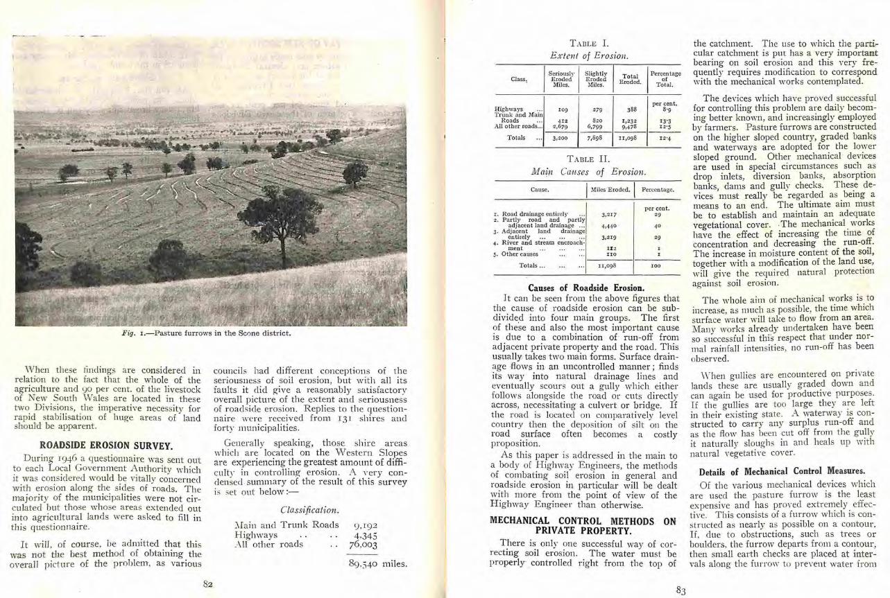
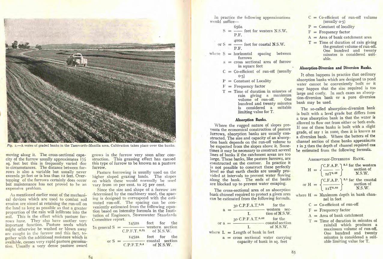
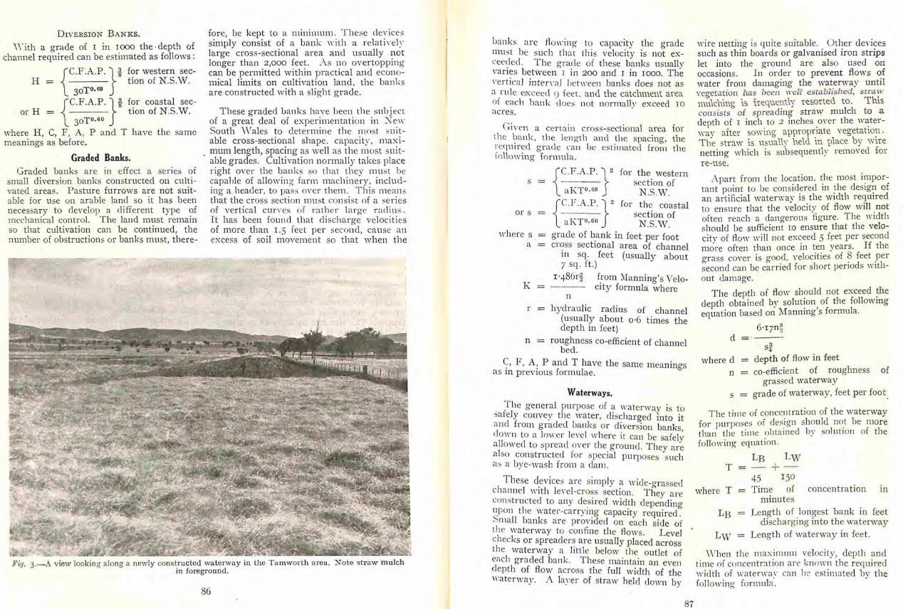
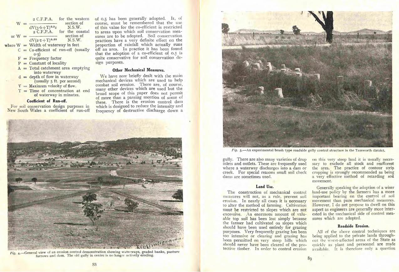
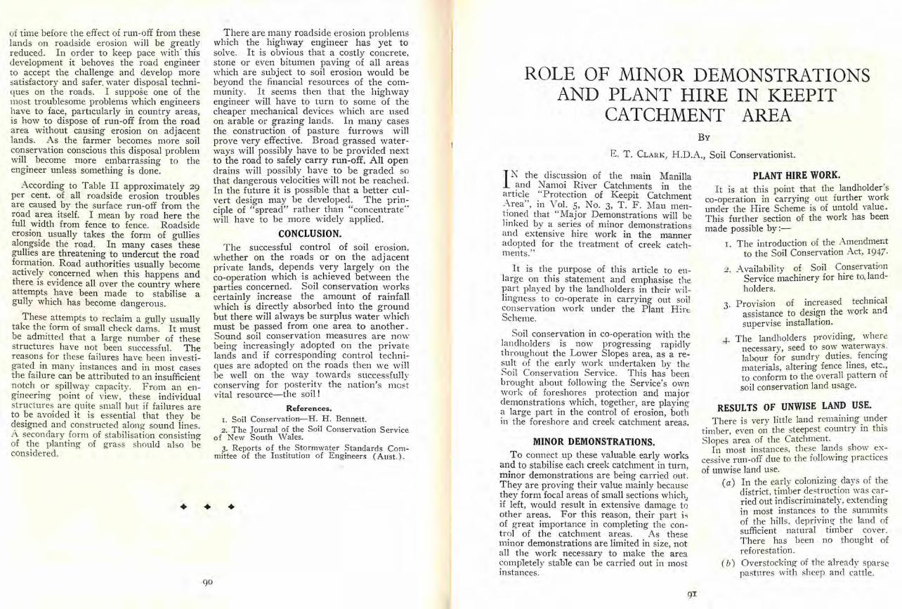
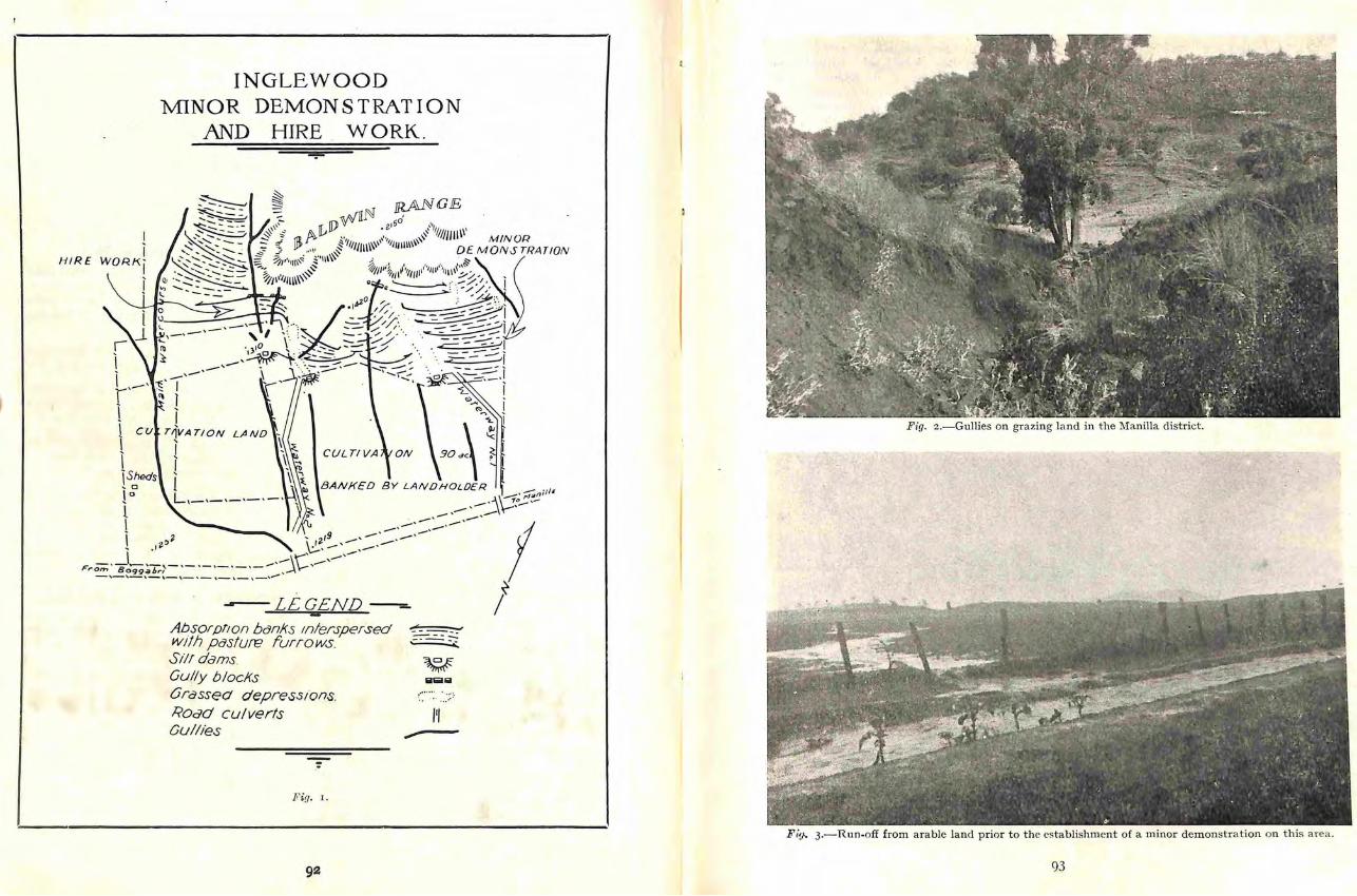
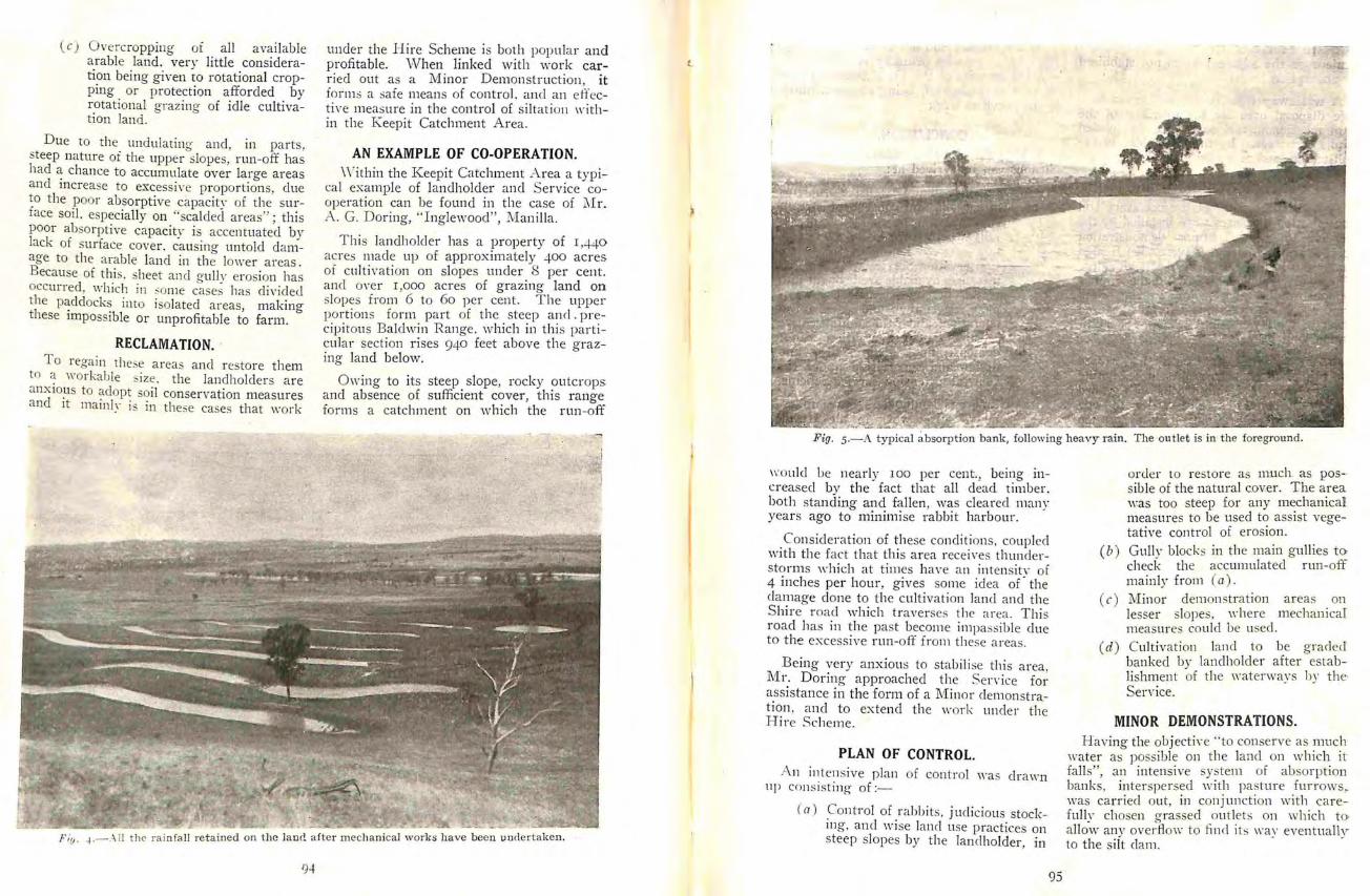
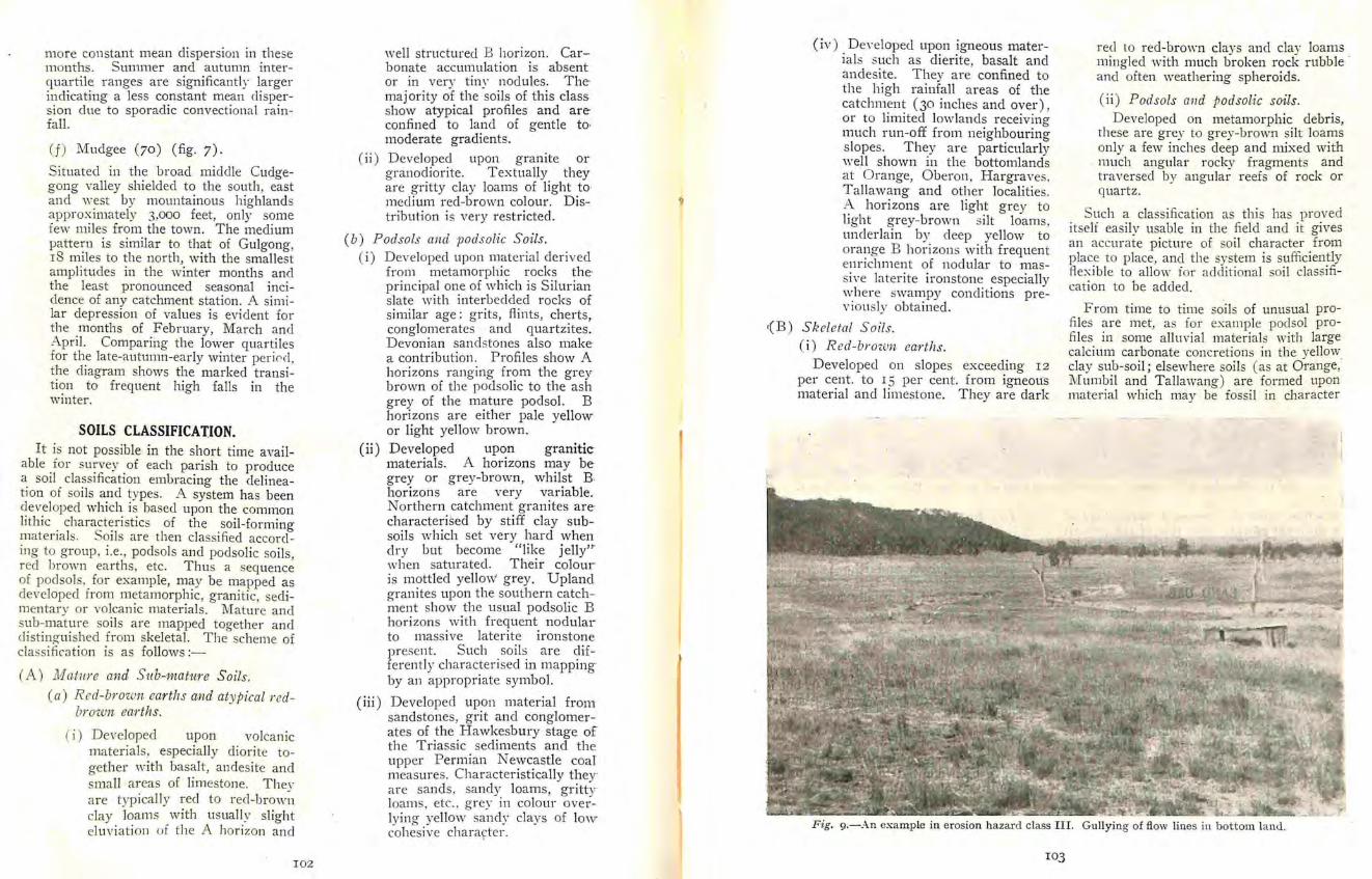
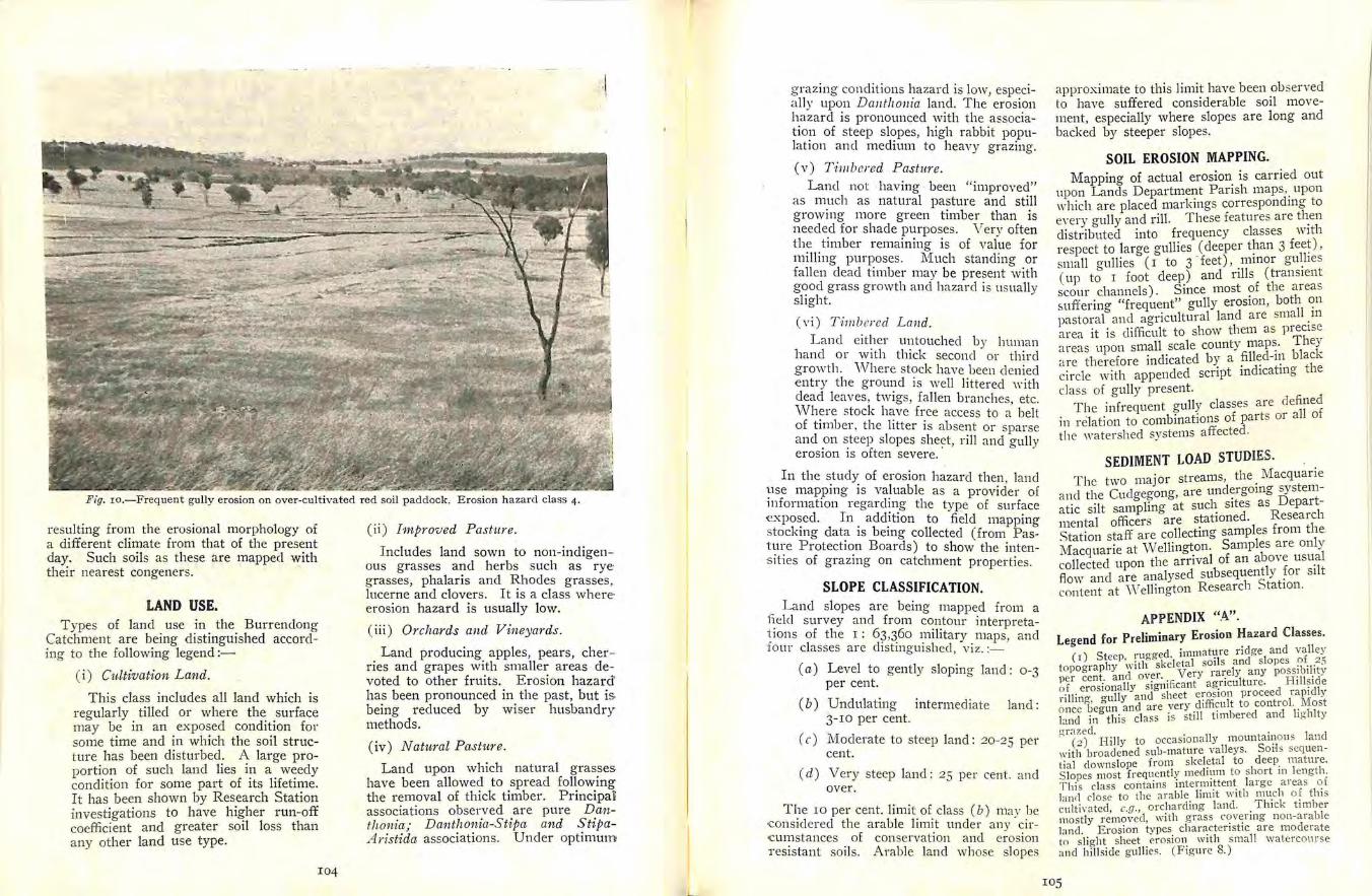
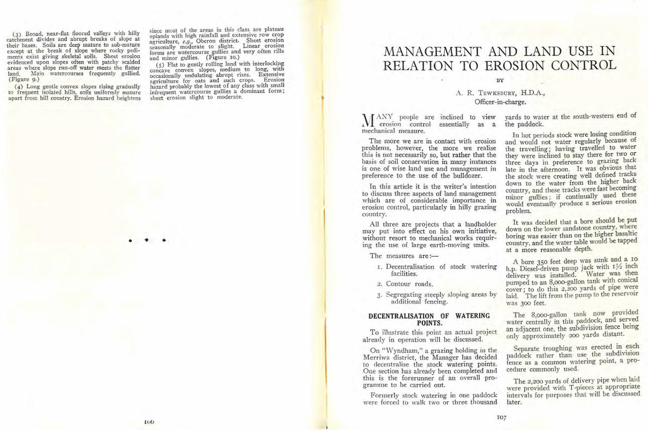
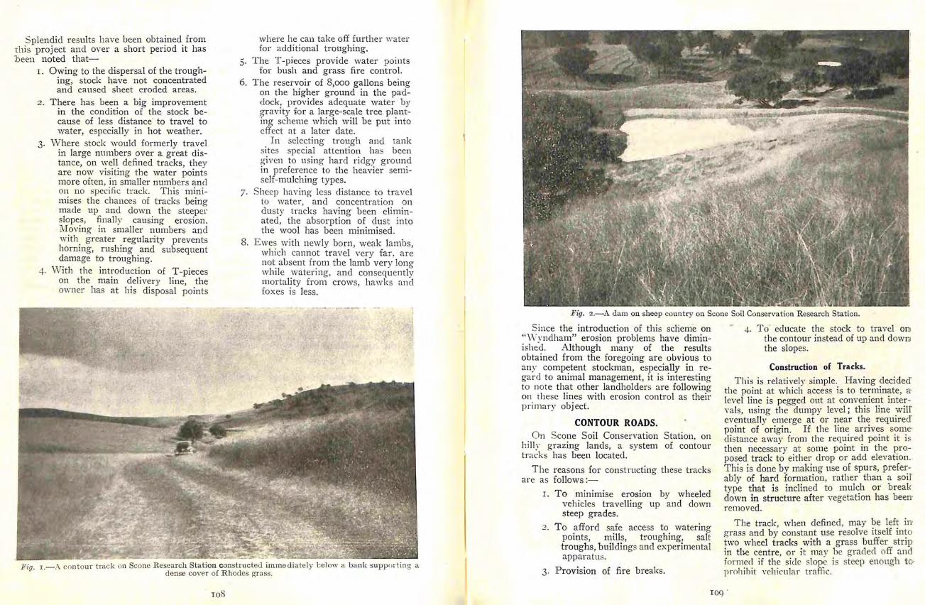
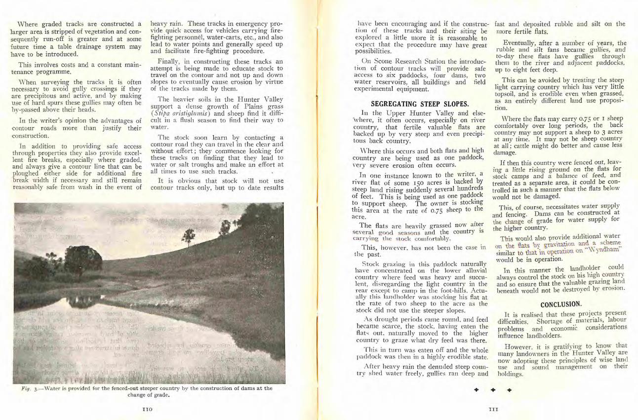
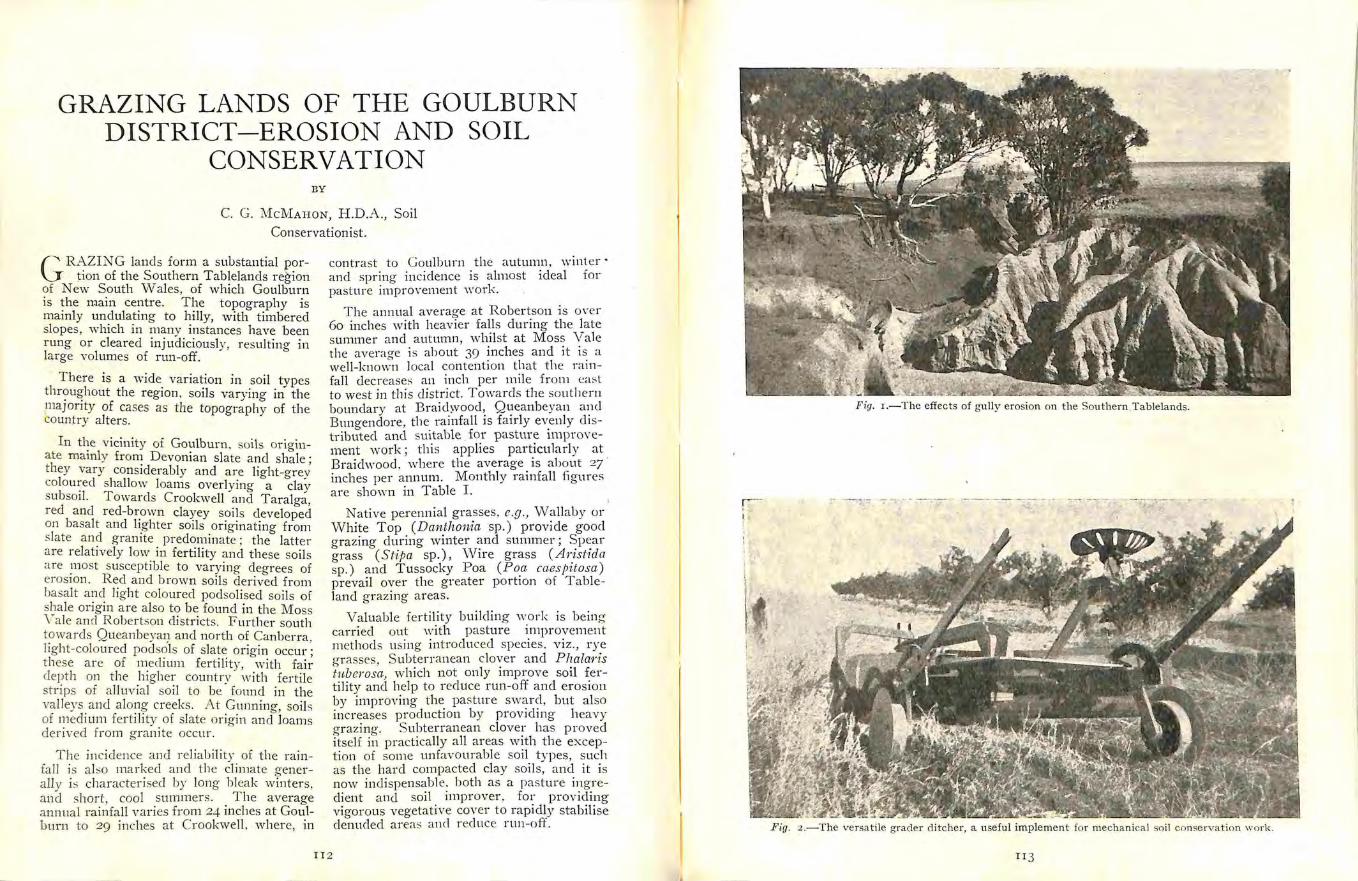
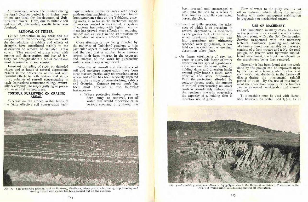
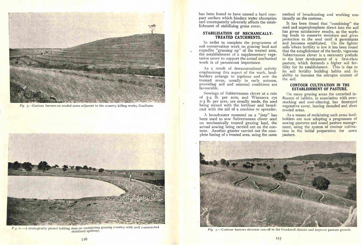
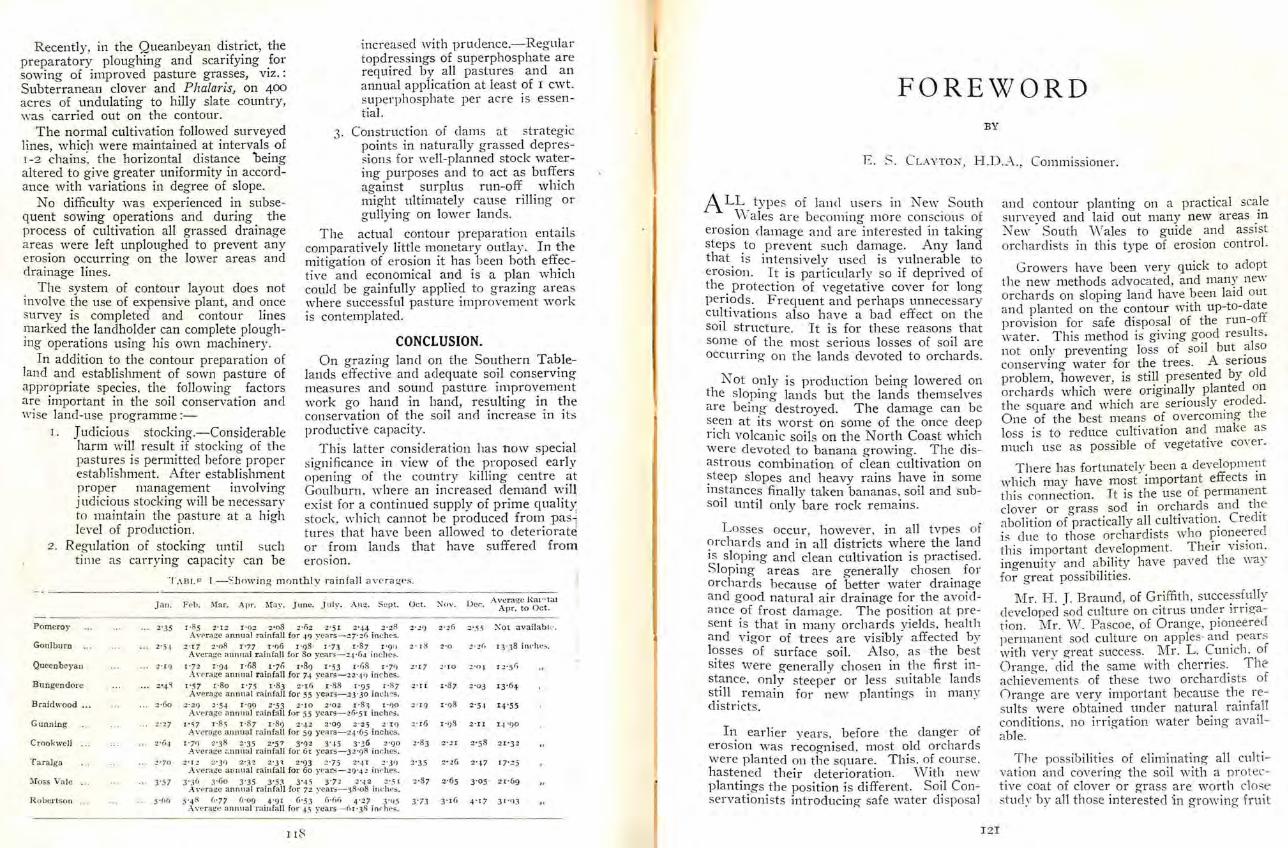
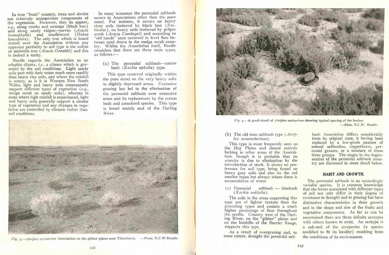
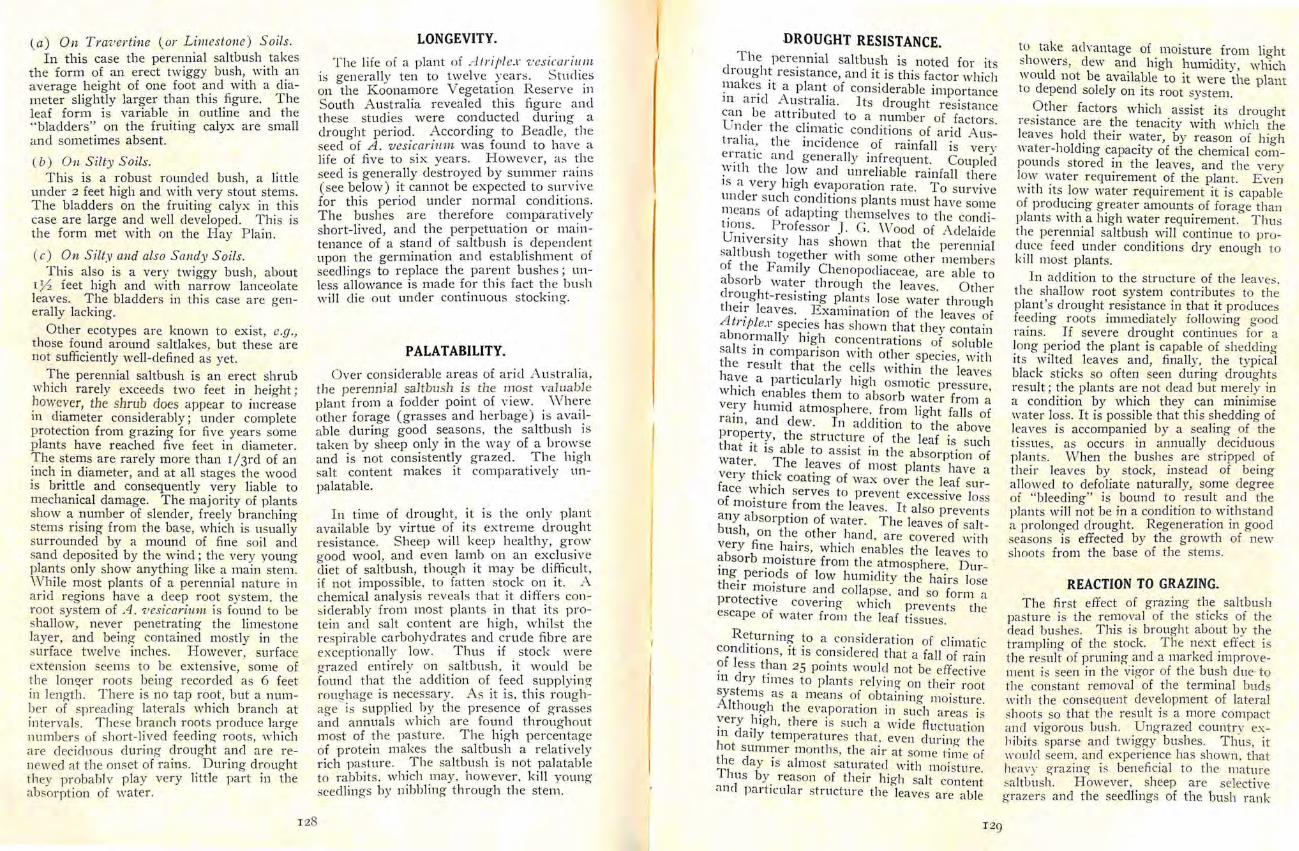
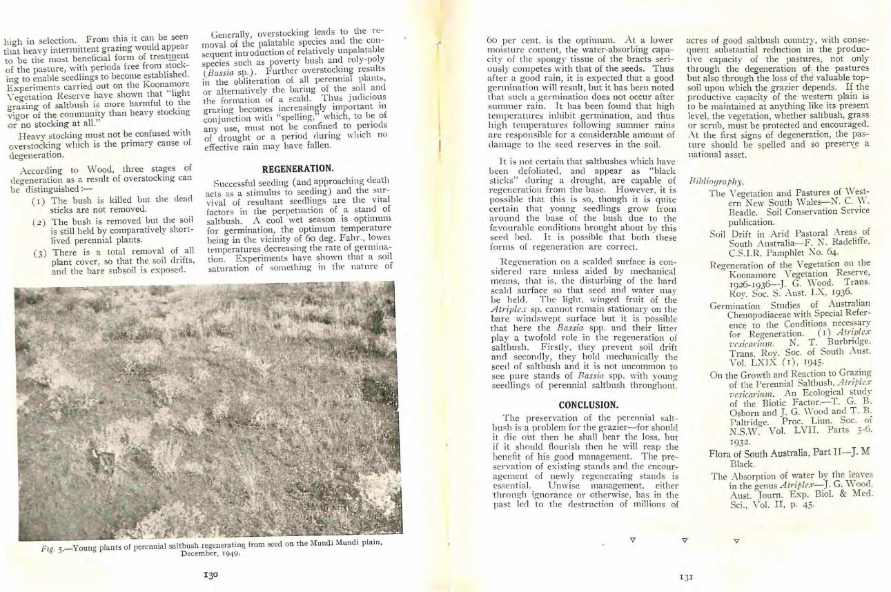
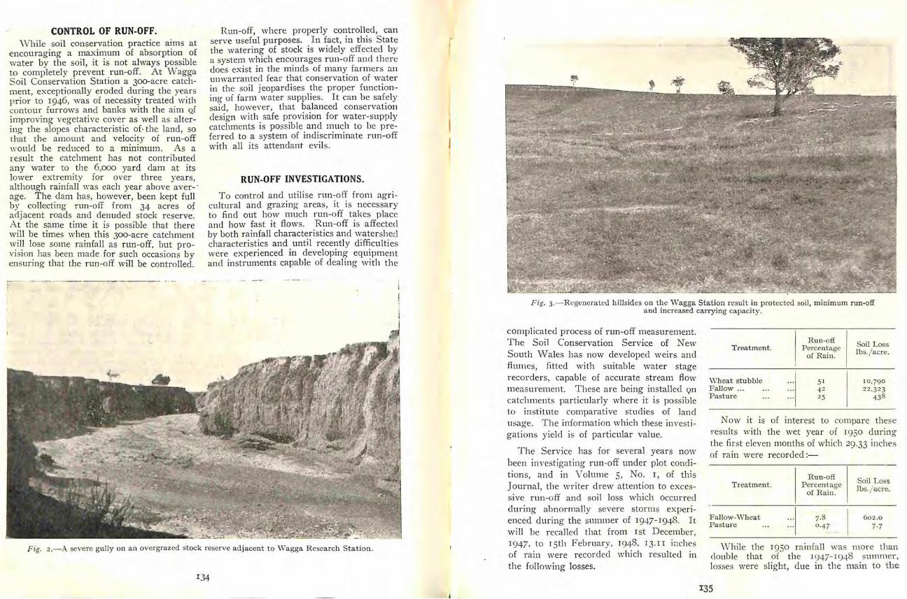
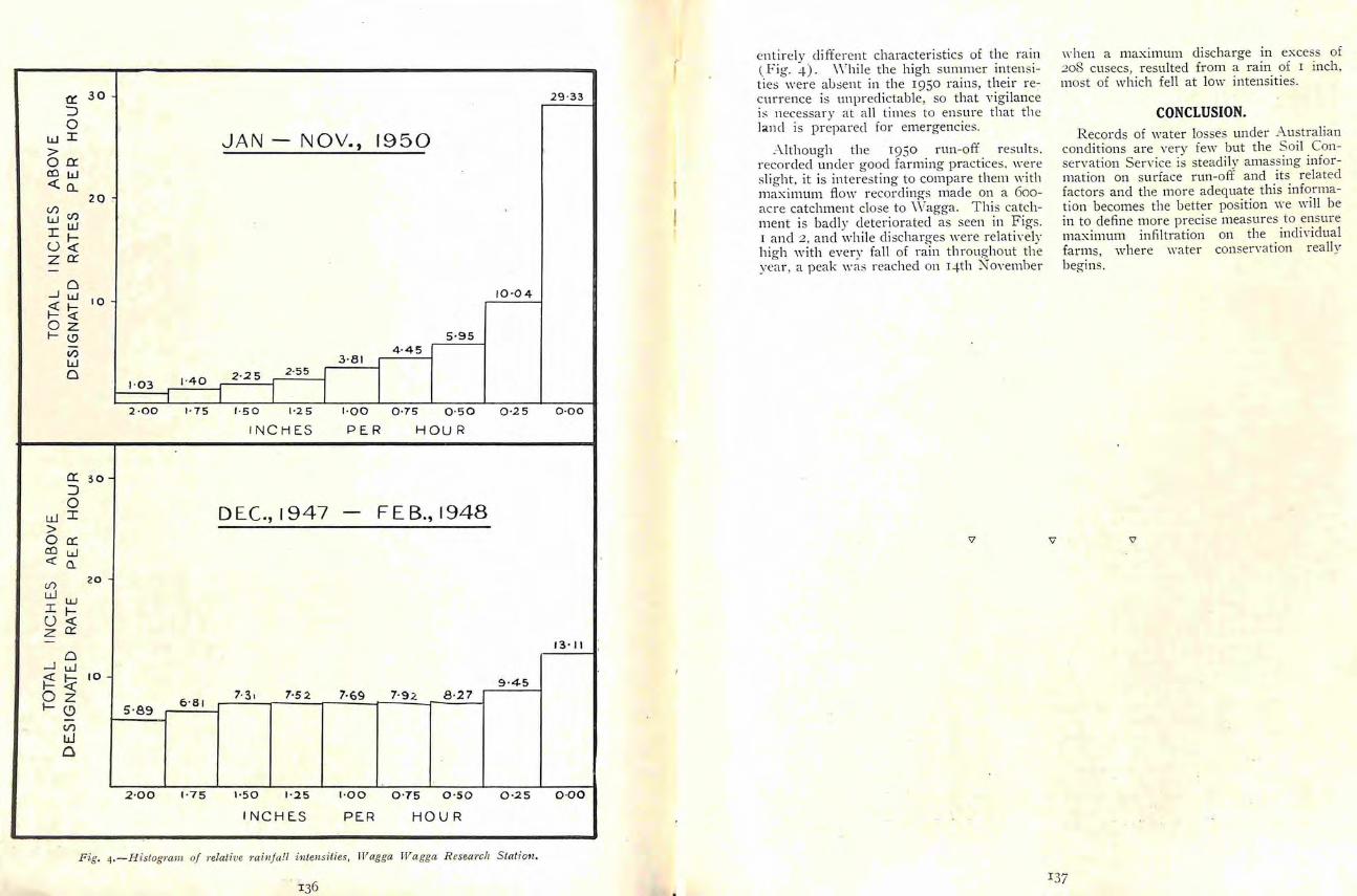
a 3 0 J 0
wi gtoa cow lta_
()
w~ Il shy0lt( za
Cl
20
_J ul I Q
~ttO z f-1)
V) w Cl
a 3 0 J 0
w i gt Oa cow ~ a
Ul LLIW I f shy0lt( z O
0 _J uJ
20
~ I- 10
0~ 1-()
()
tJ a
1middot 03 J-40
2 middot00 1middot 75
5middot89 6 middotB r
2 middot0 0 1middot75
JAN- NOV 1950
10 middotltgt 4
5 middot95 4middot 45
3 middot 81
2 middot25 2 middot55 I
l II 1middot 50 1middot2 5 1middot00 0 middot75 0 middot50 0 middot2 5
I NCH ES PER HOU R
DEC i947 FEB 194 8
9 middot45 7middot5 2 7middot69 7middot9 2 8 middot27
1middot 5 0 1middot2 5 1middot00 0 middot75 0middot50 0middot25
IN C H ES PER HOUR
2 9 middot33
0 middot00
13 middot 11 --shy-f
0 middot00
f entirely different characteristics of the rain (Fig 4) While the high summer intensishyties were ausent in the 1950 rains their reshycurrence is unpredictable so that v igilance is necessary at all times to ensure that th e ]md is prepared for emergencies
-though the 19 50 run-off results r ecorded under good farming practices middotere slight it is interest ing to compare them ith maximum flow recording-s made on a 6ooshyacre catchment close to Vagga This catchshyment is badly deteriorated as seen in Figs I and 2 and whi le di scharges were relatiYely high with every fall of rain throughout the yea r a peak middotas reached on 14th NoYember
middoth en a maximum discharge in excess of 208 cusecs resulted from a rain of I inch most of which fell at low intensities
CONCLUSION Records of water losses under A ustralian
conditions are very few but the Soil Con shyservation Service is steadily amassing infor shymation on surface run-off and its related factors and the more adequate this informashytion becomes the better position ie vvill be in to define more precise measures to ensure maximum infiltration on the individual farms where Yater conservation really begins
F ig 4 -Histogmm of 1middotelative mi 11ja 1l in tensities lV agga Wagga Resea1middotch S tati01t
137
0bullE SCA LE IN MILE~
Catchment Area boundary ---~x Soil Conservation ServiceWorks in Upper Cafchmenf bull
Fmiddotig I
139
THE EROSION CONTROL PROGRAMME IN THE UPPER GLENBA WN
CATCHMENT AREA BY
D D H GoDFREY HDA Resident Soil Conservationist
A D~SCRIPTION of the topography 2 Rabbit contTol Damage caused by climate land use and erosion in the rabbits is of course closely allied
Glenbawn Catchment Area was criven by but worse than that caused bmiddot Secombe in this journal Vol 4~ No 2 injudicious stocking T he more 1~48 In this article a study is made of rabbits an area is running the wise land usage and mechanical soil conshy fevve r stock can be safely carried servation measures now being practised on that a rea l t has been demonshy
st rated by many landholders that WISE LAND USAGE over a period the rabbit can be
controll edThere are thousands of acres within thi s catchment area of soo square miles on which
J YimbeT conserltat-ion and middotegcnerashyit is impossible to util ise mechanical measshytion There are many areas whichures of erosion control A survey has shown never supported very dense standsthat 482 square miles have slopes in excess of natural timber at the same timeof 20 per cent and whilst mechanical measshythere are also many areas of ex~ures can be utilise~ on slopes up to 35 per cessive slopes on which too muchcent the only possi~J le method of stabilising of the natural timber has middotbeenthe steeper slopes IS the adoption of land killed In some cases this pracshyusage measures designed to increase the tice has been ve ry hard to followvegetative cover these include shyas the slopes cleared are too steep even fo r reasonable grazing and ther Wise stockinq There are many timber obtained from them veryacres that have been and unforshyinferior In other cases the timbertunately sti ll are being injudicishyhas been r emoved for buildin orously stocked Deterioration reshy
sulting from this practice has beell purposes or killed fo r grazing~ Nhatever the r eason the r esultsstres~ed time and again by this h2ve been tragic The excessiveService There are also many run-off fro m these slopes adverselv areas vvhich are being- used for affects the lower and one-timegrazing by sheep when thev are stable slopes and eroshymore suited for the less selective flats and
grazing by cattle s ional debris from these areas is contributing heavily to the siltati on
Many landholcl ers have realised the of the Hunter Riverserious results to be expected from inshyjudicious stocking and havf limi ted The selective ki lling or removing of their stock numbers whi lst others are some of the trees is often necessary a nd changing from sheep to cattle w ith good even desirable and sometimes more results grass will r esult a nd a better close
G P R
ground cover will be obtained U nforshytunately however the indiscriminate grazier has an additional flock of hungry sheep or mob of cattle waiting to eat the extra grass and so the necessary protection offered to the soil by t11e individual tree has been lost the protection given by the new grass cover is non-existent and in a very short time the topsoil is moving downshyhill gullies form and the clearing pracshytice results in a drop in production rather than a rise and incalculable damage is done to lower and better lands flood peaks river bank erosion and harbour siltation are all magnified many times
This unwise destruction of timber at the headvaters of the Hunter is still proceeding and r epresents a menace to the Valley The only safe land usage fo r mountainous catchment area lands is virgin timber
MECHANICAL MEASURES Apart from the above there are mechanishy
cal measures being carried out to assist in eros ion control It is stressed that these measures only assist in the control of soil erosion and are useless without the adopshytion of middotwise land use practices by the landholder Remedial measures in the form of an altered land-use programme and ea re of ground cover will in many g razing areas retard soil erosion considerably mechshyanical measures such as pasture furrows diversion banks gully stabili sation silt traps etc accelerate the r ate of regenerati on a nd assist nature to correct the man-111acle damshyage the soil has suffered
There is very little cultivat ion land in the upper catchment and so the use of g raded banks and waterways is limited In some areas efforts have been made to cui ti vate land having too steep a slope with disastrous results Fortunately the iclea of turning this too steep cultivation into improved pasture is spreading and excellent results are being obtained
Fig 2-A Glenbawn minor demonstration
Fig ]- Severe gully erosion on road and stock route south of Moonan
The mechanical measures adopted all have the object of holding up excessive runshyoff and allowing this more time to soak into the soil and so become available to plants The surplus that cannot be absorbed can be conveyed along gradual flow lines at a speed vhich will not cause the soil to erode To this end use is made of silt traps pasture furrows absorption banks diversion banks graded banks and grassed waterways
It is necessary that all new works be sown and fertili ser alJplied Sowin~ has heen carried nut with seed made up from mixtures including some of the fol shylowing species --Lucerne rye-corn Rhodes grass liverseecl grass vVimmera rye perenshynial rye subterranean clover an-1 hall clover Kikuyu grass is especia lly valuable in some situations The applicttion of superphosphate in these upper areas of the catchmen t has proved very beneficial and in special circumstances sulphate of amm onia has been used to advantage -also
Assistance is provided to landholders in thi s area on the following basisshy
Demonstrations - Mechanical works are undertaken by the Soil Conservation Service with the full co-operation of the landholder who contributes labour fencing material use of any plant or eq uipment at ~1i s disshyposal seed fe rtili ser and adopts a w1se land use programme
T hese works are carried out on areas of land that are either vi sible from roads or stock routes or well-known to other lan dshyholders the obj ect being to show the landshyholders what can be clone and the result~ that can be expected from soil conservation works
Demonstrati ons have been completed on six properties in the area The size of the demonstrations averaged approximately 350 ltcres
In addition a further three demonstra-middot tmiddotions are now being undertaken These demon strations are primarily educational in
qr
function and introduce proven soil conservashytion measures into each section of the catchment
Glenbaw n il1inor Demonstrations-These comprise small works carried out with the object of initiating catchment area landshyholders into their own soil conservation progranunes They are extended in size u the landholder hiring the Services pt lL
and operators At the end of December r950 22 of these minor demonstrations had been completed in the Catchment area
A further nine of these minor demonshystrations are now being carried out
Plant Himiddotre Scheme-This is a scheme whereby the landholder can hire at a very moderate middot rate plant or plant and operators to undertake soil conservation work which he is unable to carry out with his own equipment
The plant available includes erawler tractors of from 35 to 90 draw-bar horseshypower fitted with dozer units grader
terracers grader ditchers rippers and road ploughs together with the necessary operashytors
All design and layout is done by Service staff free of charge to the landholder
Many landholders have shown their satisshyfaction with regard to this scheme by applyshying for a second and third plant hire
All funds expended on soil conservation works are ltL deduction for income tax purshyposes and work undertaken under the plant hire scheme fall s within this definition
General Assistm1a -General advice on soil erosion problems is always available from the SCS staff On application to the District Soil Conservationist inspections of properties will be made and the lanclholder has the opportunity of di scussing his erosion problems in the field with experienced officers who will explain what can and should be clone and indicate what assistance this Service can give
F ig 4-Severe sheet and gully erosion
Fig j -Portion of a
In addition if any landholder desires to undertake soil conservation works with his own plant and labour arrangements will be made to assist him with any designs necesshysary and to have the work checked and inshyspected as it progresses if desired
Several landholders in the Catchment have taken advantage of this service
Plant in Use-At the present time there are three tractors with bulldozer equipment attached and the necessary subshysidiary equipment in daily use in this upper section of Glenbawn Catchment
D emonstra tion Ar ea
GENERAL A Kikuyu sod nursery has been estabshy
li shed near the junction of Stewarts Brook and the Hunter River This grass has been found extremely valuable for the treatment of overfalls in gullies danger spots in dam and bank outlets etc
Many examples of work carried out and advocated by the Service are available for inspection by interested persons throughout the area Considerable progress has been made in the last three years in the obj ective of interesting- all landholdters within the catchment in undertaking- necessary soil conservation measures to preserve their properties and mitigate the silt menace in this upper section of the Hunter River
V
MONTHLY AVERAGE RAINFALL IN INCHES FOR YEARS 1930 - 1949
3 middot24 1middot7 t2middot11 1middot3 3 1middot89 2 middot38 2 middot 17 1middot25 1middot83 1middot58 2 middot 11 2 middot 66
J an Feb Mar ApMl May June July Au g Sep Oct Nov Dec
MONTHLY AVERAGE RAINFALL IN INCHES FOR 1950
2middot01 4 middot82
4 middot07 0 middot65 1bull2 7 7middot8 3
o-somiddotl4 middot55 1middot92 4 middot3 7
1middot 12 Smiddote l
J an Feb Mar April May June July Aug Sep Oct Nov Dec
SOME OBSERVATIONS ON CREEK AND RIVER BANK EROSION IN THE
MANILLA DISTRICT
by
L J DVRJmiddotIA~r BScAgr Soil Conservationi t
THE purpose of this article is to set out the effects and to attempt to outline the
causes of stream bank erosion in this area over the past twelve months
t hilst the severity of the erosion is not to be compared middotith that of the Hunter Iiver valley for example sufficient evidence of the advance of th is form of erosion during the period mentioned is available to cause concern to those engaged in soil conservashytion work in connection with the mitigation of siltation in the N amoi River
Unlike the H unter River valley and many other large expanses of fertile river and creek flats are not a feature of the upper
Tamoi River and its many tributaries withshyin Keepit Catchment A rea Early recognishytion of the damage in the past and possible damage in the future in relation to the limited lengths of alluvium i ll help safeshyo-uard valuable land and materially enhance the life of Keepit storage
THE CYCLE OF EVENTS
In order to demonstrate the siltation potential from erosion of this nature and to outline the many difficulties associated with its treatment let us examine the effect of individual gull activity
In the first processes of gully formation which can be called primary erosion for the purpo es of this article lateral ~oncentr~shytion of water is u ually respons1ble for 1t arriving at a point where it is s_ubject to a drop in level bull s a result of th1s over-fall
the head of the gully is enlarged and undershymined with a consequent eating-back of th e gully in the direction of flow of the water The second stage in the process is reached when a gully once started begins to scour at a rate dependent on the volume of water reaching it and carry large volumes of silt to lower areas and streams Except in odd cases erosion is usually confined to one to several major gullies in one paddock with the intermediate areas relatively stable except for possible sheeting and from which water concentrates to further the activity of the gullies
The third stage is reached with concentrashytion of all water from the gullies into the main drainage line for the catchment be it a small or large creek or finally a river carryshying the whole of the run-off from the total catchment area
It wi ll be appreciated that mitigat ion of the fir st two stages by wise land usage and mechanical measures involves the infi ltrashytion into the soil or reduction of erosive velocity of local and therefore limited quanshytities of water and it is this form of work vhich is at present being undertaken exten shysively throughout Keepit Catchment Area
Once having entered the third stage howshyever entirely different methods of control have to be uti lised on individual eroded areas to obtain the desired effect Upon the incishydence of gene1al heavy rains over most of a large catchment area the volume of water to be carried by the main drainage of a local catchment or the total catchment is likelv to be huge J
144 Fig r- Manilla R amiddotinfall Station
F ig 2-General view of the eroded river bank of the Namoi R iver adjacent to the vlanill a weir
Occurrences of this nature were many in conservation treatment and contribute large number during 1950 in Keepit Catchment volumes of surface run-off to the Namoi Area Even though soil conservation works River system have been installed progressively for periods
To quote one rainfall example reco rds forof up to three years in the lower regions of one property in the Glen Morrison a rea inthe catchment around lVIanilla and Barraba
much of this area and large tracts of country the head regions of the catchment for 1930
in the tablelands still require effective soil are as follows
STATION BENDEE GLEN MORRISON-YEAR r9so
Month I J an IFeb IiIarl Aprll layJunel July Aug IScptl Oct I rov Dec I Total
R a in points middotmiddotmiddot1544540 I r9s l 675 1 3deg21 r639172 2 1 4or 1 2259 171769 1 1 6r I 709deg
These fi gures indicate the volume of water li kely to enter the upper reaches of th e Namoi llivcr from areas not yet subjected to oil conservation control meas urec One hcartenimr feature to be m entioned is the relatively li ght gtilt load carried from the tableland areas but it is the volu me of water which more concerns us at the moment
CONTRIBUTING CAUSES TO THE Soil T ype EROSION Generally speaking the main soil type
foun d in most areas around Manilla is theFor any one area these are likely to vary deep reel to red-brown self-mulching soil and to be many in number So fa r as the of a highl y erodible natureproblem ex ists in the Manilla d_ist ri ct~ soil
type and the influence of excessive ramfall These so ils in general are of a very deep over the past twelve months have been nature Often reaching 20- )0 feet in depth responsible they are particularly noted for the sloughing
q6
Fig 3 shy An extension of the area shown in Fig 2 rso yards downstream from the weir
Fig 4- Further recent erosion soo yards below the weir adjacent to the racecourse
147
effect in gully sides by which process many tons of soil may be lost in one place at one time
B ecause of this characteristic it is not surprising to find gullies in the area which have enlarged to depths and widths of 20
feet or more in the space of ten years or less
It is not hard to imagine therefore the effect of large volumes of water during flood fl ows upon unstable secti ons of creek and r iver bank
I nfiu ence of Rainfall During 1950 and particularly the latter
six month s as shown above very heavy rains were recorded on many occasions throughout Keepit Catchment Area
T o appreciate the unusual rainfall experishyenced during 1950 monthly falls are shown in histogram form on the same scale as monthly averages at Manilla PO for the twenty yea rs period 1930-49 (Fig I )
Other stations throughout the catchment area show the same result The station Bendee mentioned earli er for a thirty shyone year period 1917-47 had an annual average of 38 I I inches The yearly total for 1950 was almost double this figure being 7090 inches A s a r esult several minor and three major fl oodings occuned in the lVIanshyilla and Namoi R iver s
The most serious of these occurred on 22nd and 23rd July 1950 when the N amoi River at K eepit Dam site r eached a max ishymum height of 34 feet 8 inch es T wo later Hoodings occurred on 22nd and 25th Novemshyber 1950 wh en heights r ec01middotcled a t Keepit Dam site were 2) feet 6 inches a nd 27 feet 6 inches respectively
Damage resulting from these fl oods whilst not of signi fi cance compared with tha t in many other areas for the same per iod doe tell a story when translated in fi gures fo r siltation
F ig - A change in t he course of H a lls Cre_ek a t high flow brought about the damage t o the banks shown m the background
F ig 6-Huge quantities of soil were los t from this section of H all s Creek adj acent to its junction witlthe Namoi River
- siltation f-igure of approximately 05 Tremendous quantities of soil have been per cent fru m the Namoi Hiver just below removed over the last twelve months with it s junction middotith the Manilla River at a the r esult that this section of the river bank fl ow in the vicinity of 40000 cusecs on has now become completely unstable 22nd July 1950 represents 20 000 tons of Observations show that this area of silt per hour moving down the river erosion originally began with the over-fall
of water from a small swamp some tvvo or There is little vistml evidence of extensive three chains back from the weir wallsheet eros ion during the past twelve months
F ollowing the proces es outlined above it owing to the prolific cover over the area was not long before quite a sizeable cutshyfoll owing three or fo ur favo urable seasons back occurred in the rather steep and fairl v ] n additi on it is the considered opinion of high bank Being a well-gras se~ bank t offi cers constantly engaged on the Manilla remained in much the same cond ition until lands that the contribution to oil tation by early last year when heavy rans a_ndsheeting during this period wac small and periodic floodina occurred Excessive rams that practically all silt carried by the Namoi caused further cutting-back at the over-fall T- ive r was the direct result of gully activ ity into the river and whirlpool effect duringcreek and river bank erosion flood flows rapidly undermined the bank and enlarged the damaged area
DAMAGE NEAR MANILLA A t the present time the damaged area ex tends for a distance of about r 50 yardsBy far the most serious case of river bank (rom the weir wall and back from the edge erosion exists on the N amoi River immedshyof the water at low levels for a distance of iately below the weir from which M anilla
town water supply is drawn some 40 ya rds
149
5
The exact amount of soil which has been removed would run into many thousands of tons but apart from the present damage the potential source of silt to the storage is high In addition having increased in extent in such a short period it is likely that the area may become a menace to the weir wall since it has encroached to within 10-15 yards of the wall at its easternmost point
Another serious area of bank erosion exists some 500 yards below the spot just mentioned and is doing much to menace a fence line oa the Racecourse and a pipeline drawing water from the river
Several other serious examples are to be seen in close proximity to Manilla along Wongo Creek Halls Creek Yarramanbully Creek and the Manilla and Namoi Rivers
vVongo Creek has been particularly menaced by this form of erosion owing to the many high intensity storms received in that area with resultant flash run-off over large areas More exact measures are being used
to combat the erosion and sil tatiot1 hazard in Wongo Creek catchment than in other local catchments i ith the aid of -everal large silt dams of which two have been conshystructed to date in conj unction with the usual soi l conservation measures adopted on the catchment area lands it is hoped to conshysiderably lengthen the time of concentration of run-off in the many branches of Vongo Creek
CONCLUSION
It is certain that considerable quantities of soil will continue to be lost from the banks of Vongo Creek and the many other creeks before soil conservation programmes for individual catchments can be completed
The hazard of creek and ri ver bank erosion in the stabilisation of the erodina lands of K eepit Catchment area and th~ diminution of silta tion of the Keepit storaae is one which may assume increasing impo~t~ ance if fu rther rainfall ya rs of the nature of I9SO occur middot
KIIZUYU IN THE EROSION CONTROL PROGRAMME
by
1( G ECO)IBE middot 1-lDA Resident Soil Conservationist
Firstly however I nust remin~ read~r~ recent times fr equent reference ha YeI 1 that this article has sml consen atOn as lbbeen made to K ikuyu gras (P e1111isctum
caldcstillwn) some in favour of it and pri~nary purpose Consequent_~) ~vl~~tmiddot ~ wn tten here does not necessa1 Ily Pl )ome much against it However in this lawns crardens etc from the 0 ners ofarticle it i middot not intended to join in any of whicl ~ost of the criticism of thiS gra~sthese controversies but to present some facts arises It is agreed that Ki~my~1 can ein the light ot recent experiences in the H unshycli fficult to eradicate from cultnratOn areas ter Valley
ft t J sodding with Iltikuyu gr as F-ig 1-A farm d a m spillway t en weel~s a e r s rq f 1 ho urs safely
has carried a twelve mch overflow or se era
I ) I
Basically Kikuyu is a spnng and summer grower but in areas where frots a re not excessively severe some growt h is made in winter Consequently it can safely be stated that Kikuyu produces more iodcl er in winter than does paspalum
FOOD VALUE
r s an indication of th e fodder value of Kikuyu the follovving table se ts out comparashytrmiddote figures of thi s and other common
F ig 2-A former gully overfa ll now Kikuyu sodded This forms the inlet for the d am shown in F ig r
I)2
EARLY HISTORY There are several opinions as to the exact
details of K ikuyus introduction into Ausshytralia but all agree that it was about I9I9shy
I920 The country of origin is also variously quoted as Kenya and the Belgian Congo in Africa both of which are situated on the Equator The seed initially procured was planted in the Botanic Gardens Sydney and from there cuttings were sent to H avvkesbury Agricultural College Richshymond Trials at th ese centres were very encouraging and di stribution of cutti ngs (or stolons) to various localities was made
CLIMATE AND SOILS This grass has proved itself very adaptshy
able in respect of both soi l and climatic requirements However maximum developshyment is achieved on sandy and reel loamy soils-poorest results being on stiff clays Higher rainfalls or moist locations assist in gaining optimum results but then again this grass is considered drought tolerant and grows qui te well in many areas where rainshyfa ll is little in excess of 20 inches per annum
Fig 3-Runners from an area of strip sodding in a waterway
THE ROLE OF KIKUYU IN SOIL CONSERVATION
Having established the value of this grass as a fodder plant I propose to go one step further and illustrate the most important role that this grass is playing in soil consershyvation
Those familiar middotith soil conservation activities will be aware of such structures as graded banks diversion banks silt traps grassed water~Yays etc In the construction of each of these measures there is a place for Kikuyu
The critical point in all mechanically conshystructed soil conservation measures is the outlet It is at this point middotthat the max imum amount of water flows and often at the maxishymum velocity
In many cases th~ most satisfactory rnethocl of stab ili sation of th es~ critical points is by use of Kikuyu socl A lthough the area
thus treated is small the benefit resulting is reflected over a far greater area and this type of treatment is an insurance against damage to mechanical struc~ures ~t woucl be short-si~hted policy to n sk possible fai lshyure of a valuable asset for the sake of a small additional outlav A few square yards of sod at a critical-point coul l often prevent a spillway from sc~uring out thereby involvshying either costly repairs to or total loss of a farm dam
In view of the rapid rate of growth and the stolon-forming habit of Kikuyu strip soddin a can often be employed where comshyplete ~clding is impracticable for ran ous
seasons If stnps arereasons In llorllal placed 3 feet apart in spriJg the runne_rs irom one strip will usually J 0111 those o_f ~~s neighbour within -+ to 5 weeks and W lt~ J~1
a COITIJ)lete cover can be ant1oshyl tl t1ree mon 1s pated
153
fodcle rs shy
1foisturc per cent
Ash E ther Extract Crude fibre Carbohydrates Crude protein
TABLE r
Kikuyu 2 1 Oa ts I Phalari middot 1 Perennial mon ths grow th
R1middot25
40
47 s middotgB s-S9 J OI
Feccling t u h~r~s Rye off st age
82 middotoo 7500 75 20
z middotoo 3 0 0 omiddot 6o middotso middot6o 70
3 20 middot100 j middotJO
940 10middot6o t 150 omiddotgo Gz o 290
bull After Vhittet J N SW Department o f Agri culture pamphle t- lltilwyu grass Hallsworth E G Unpublished d a ta
GULLY RECLAMATION Here is another instance where Kikuyu
can be used to maximum advantage There are various ways in which this grass can be employed in this workshy
(a) The planting of sprigs or sods at intervals along gully floors As moisture is usually present in such places rapid growth can be anticishypatecl T his growth catches silt in times of run-off-producing rains then grows up through the silt thus binding it and raising the floor of the gully
( b) W here it is practicable or conshyvenient to fill gullies or at least to shape the sides to a reasonable batter (and this is seldom to be recommended unless the run-off from the catchment has been conshytrolled) Kikuyu can then be utilshyised to give quick growth and conshyseltuential protection against further scouring to the depth of the original gully
r
(c) Overfa ll erosion is both frequent and senous Because of the characteristic habit of eating back the magnitude of the soil loss is very considerable Specshytacula r resul ts have been achieved in stabilis ing overfal ls in the H unshyter alley by the judicious use of Kikuyu sod
In these circumstances the overshyfall is shaped as well as possible so as to give a uniform spilling effect Naturally the flatter the gradient the better but slopes of I I have been successfully treated If after shaping the whole disturbed area is sodded there is little or no danshyger of any damage occurring in the event of run-off-pr0ducimg rains All Kikuyu amiddotreas iUus shytrated have carried large volumes of water without damage The most damage that can be anticipated is the dislodgment of a few seds which can be easily replaced If
F-ig s- Gully head stabilisation by Kikuyu grass
F ig 4-A n absorption ba nk ou t let comple te ly vegetated 3 months afte r strip sodd ing with Kikuyu
154
desired additional protection for new works can be gained by pegshyging down the sod with strips of old netting
SUPPLIES OF KIKUYU
Due to the fact that this grass rarely set seed in Australia all plantings must be from either sods or stolons Little difficulty should be experienced in getting supplies of either Many town folk are anxious to gie away K ikuyu lawns on account of th e rapid and vigorous growth and sods from lawns are ideal for th is type of work The most conven ient sized sods from a handling point
of view are about 1 2 to 15 inches square and 4 inches thick Sprigs or stolons can be of almost any size and should be buried for about of their ienOth
CONCLUSION
This valuable grass middotarrants a Yide usage in the erosion control programme particushylarly in the central and northern areas of the State where warm temperatures and reasonable pr ing and summer rain may be expected In such area Kikuyu an be used with grea t advantage in the safe ater disposal system as an ad junct and safeguard to mechanical soil conservation measures
SOIL CONSERVATION IN THE BARRABA bull DISTRICT
by
] M PATTERSON H DA Soil Conservationist
D URING the last two years the operations of the Soil Conservation Service have
been extended to that portion of the Keepit Catchment A rea comprising the Barraba district (Fig r)
The Manilla River and numerous tribushytaries rise in this area and the district generally is of a mountainous nature especially on the northern side on the southern and western sides the country opens out into undulating and in some places fairly flat fertile valleys Timber has been cleared extensively to allow growth of natural grasses but in the northern section of the d istrict large areas still remain under forest
LAND USAGE
Sheep grazing is the main occupation fine woolled Merinos being the most popular breed and it mie-ht be added that some of the best fine woolled fleeces in the S tate have been grown in d1is district Beef cattle also p lay an important part in the pastoral proshygramme and several fi ne cattle studs are located in the district In recent years wheat growing has gained in popularity the cultivation pra t ice fo llows the u~uallattem of summer cultivation and sowmg 111 late autumn Stubble burning is far too extenshysively practised with the result that many of the wheat paddocks are showi~1g signs of erosion and some are very senously damshyaged A contributing factor to thi s eros ion is the prevalence of summer storms fo ur inches in an hour being not uncommon torm rains strike wheat lands at about the
time stubble is burn t resulting in maximum run-off and soil loss It is on these areas that most of the recent erosion contro l work has been carried out
EROSION PREVALENCE
The heavy silt loads carried by the Manilla T)iver indicate the extent of erosion in the district although during the last four favourable climatic years the erosion on the grazing lands is masked to some extent The most serious erosion damage occurs on wheat paddocks and on the steeper grazing country A practice which increases the erosion ri sk in this area is that of burning the tall coarse spring growing grasses after they have dried off usually about Xmas or New Year thus laying the steeper slopes open to damage from maximum run-off durshying severe summer storms
WORKS UNDERTAKEN
T wo major demonstrations have been carshyried out and minor demonstrations are being undertaken in this portion of Keepit catchshyment area followed by erosion control work undertaken under the Services Plant Hire Scheme Up to the present time forty-one landholclers are co-operating with the Sershyvice in this district
MINOR DEMONSTRATION AND HIRE
The first erosion control work undertaken in the Barraba D ist rict was on Mr F J Bowmans property at Red Hill where he was faced with a problem on one of his cul shytivation paddocks This area had been culshytivated for a number of years and advanced stages of erosion we re evident fertility had declined and numerous gullies dissected the area Mr Bom11an proved to be an enthusishy
astic co-operator and the work has been most successful The general pattern of work followed that used on most agricultural land viz graded banks discharging into a conshystructed waterway A n area of So acres was treated under one system of discharge and a further 75 acres adjacent treated under
another Run-off from adjacent hills was prevented from flowing onto the cultivation area by direction into the main waterway by diversion banks and dams (Fig 2) The waterway containing banks were conshystructed with a dozer and the water carrying surface was levelled with a grader terracer
ae t
~ E
KEEPIT CATCHMENT AREA ~ ~Showing LocatiOil
of Barraba Distrid
Catchment Area boundary ---gtlt x -shyRailway Line ~
Barraha District ~
F~g I
A grass mixture was sown on this surface containing per acre shy
lb Liverseed 3 Rhodes grass r2
Paspalum 3 Sudan grass 5 Oats 10
grasses are Rhodes grass paspalum livershyseed and couch T he natural couch grass growth is remarkable the good seasm_s probably being responsible
T he graded banks flowing into the water shyway were given a grade of 02 per cent and were constructed with a dozer The first two banks were constructed so that they
middotshy
10 5 0 10 --- shymiddot-shy -Scale of Chains Disposal
Graded Banks ---+shyBanks ~-----~shy
Waterways ~~~ ~
Diversion Grassed Dams L
Fig z-R ed Hill D emonstration and Plant Hire work
Sowing wa middot carried out in early Septemshyber and vvas preceded by a thorough workshying with a combine and light barrovvs seed then bein a broadcast in front of the combine A good germination middota~ obtained and in the fi rst season all van et1es of grasses sown were evident but at the present time eighteen months after OYing the dominant
vere crossable with agricultural machinery but the remaining banks were constructed vv ith two pushes of the dozer and crossings for machinery were incorporated at either end
The waterway discharges into a small clam of soo cubic yards to act as a sil t dam and
158
Fig 3- Graded banks and 1atenvays on the R ed HiJI Minor D emonstration
it in turn discharges into a much larger dam of 3000 cubic yards built across a natural depression wi1ich acts as a water storage dam and also protects the road below by reducing the rush of run-off experienced in semiddotere storms It might be added that the roadway below this area was practically impassable during wet weather but since Ork Yas carried out no trouble has been experienced
- further 75 acres were treated below the road by constructing similar graded banks flowing into a natural waterway the banks of which were pushed up from the outside and the natural grass cover utilised Banks were also constructed emptying onto a well g rassed gradual slope providing a safe disshyposal area Since this work was completed it was thoroughly tested by a storm in which 5 inches ere recorded in 30 hours and all phases of work ere satisfactory
Mr Bowman has since further extended the above work u11cler the plant hire scheme and plans to re11cler all his cultivation areas
safe from erosion In addition to the abOmiddote mechani sed ero ion control work Mr Bowshyman has revised his cultural programme to include stubble mulching and rotations sui t shyable to maintain soil stabi lity and fertility
MAJOR DEMONSTRATION
The first lIaj or Demonstration to be comshypleted in the Barraba disfrict was on the property of Messrs G E Bowman amp Sons Tarpoly W ork fo llowed the pattern outshylin ed in Fig 4 and was designed to p rotect Yaluable lucerne paddocks used at lambing and shearing time These paddoc~s middotere showing severe erosion both sheetmg ar~ d deep gullies being evident ~-I ere agam damage was caused by run-off from Yery steep hillsides and diversion banks middotere used to direct run-off into safe cl i po al area
Natural middotaterways and shallOmiddot depresshysions were used to direct run-off mto T arshypoly Creek and stock have been excluded
rsg
shy
gtle I~ ~
~ )
~ Q ~
~ ~ ~bull~ t
11
TARPOLY DEMONSTRATION
Scale CHAIN~ S~li~liiiiilsect~~~5
Absorption Banks tgtiverslon 8anJa
iiiiiiiiiiiiiiiiiiiiiiliiiiizo~~~IS CHAINS
~ ________
Pig 4middot
r6o
Fig 5 -Silt dam and storage for water disposal on Tarpoly D emonstration
from these discharge areas so that sufficient natural surface cover has developed to prevent damage from run-off during severe storms The banks emptying into these waterways were constructed with no grade to obtain maxi mum absorption and irrigatshying effect on lucerne stands
S ilt and storage dams were constructed to perform the functions of catching silt and arresting the flow of run-off and also to provide water storage for dry seasons
CONCLUSION Soil conservation has gained in popularity
among Barraba landowners during the past two years in gtvhich the Service has been active in this district So much is this the case that the number of landholders initiatshying soil conservation work have overtaxed the faci li ties of the Service immediatelv available However this is a good sig~ and by the mutual co-operative efforts of both parties a steady diminution in both the erosion of productive lands and the potential siltation of Keepit storage may be expected
I 6 I
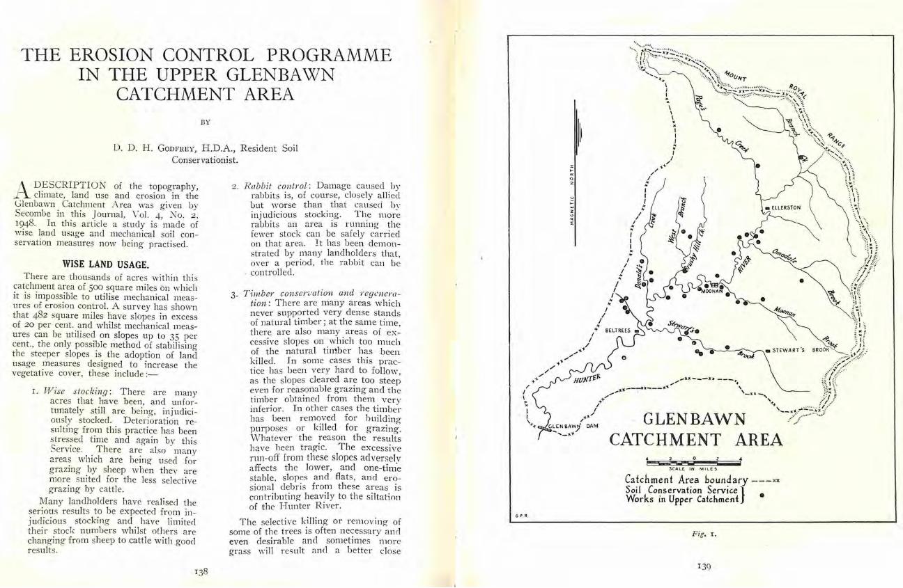
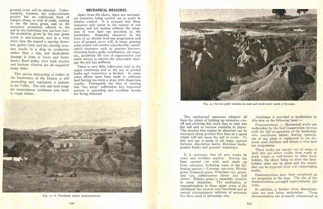
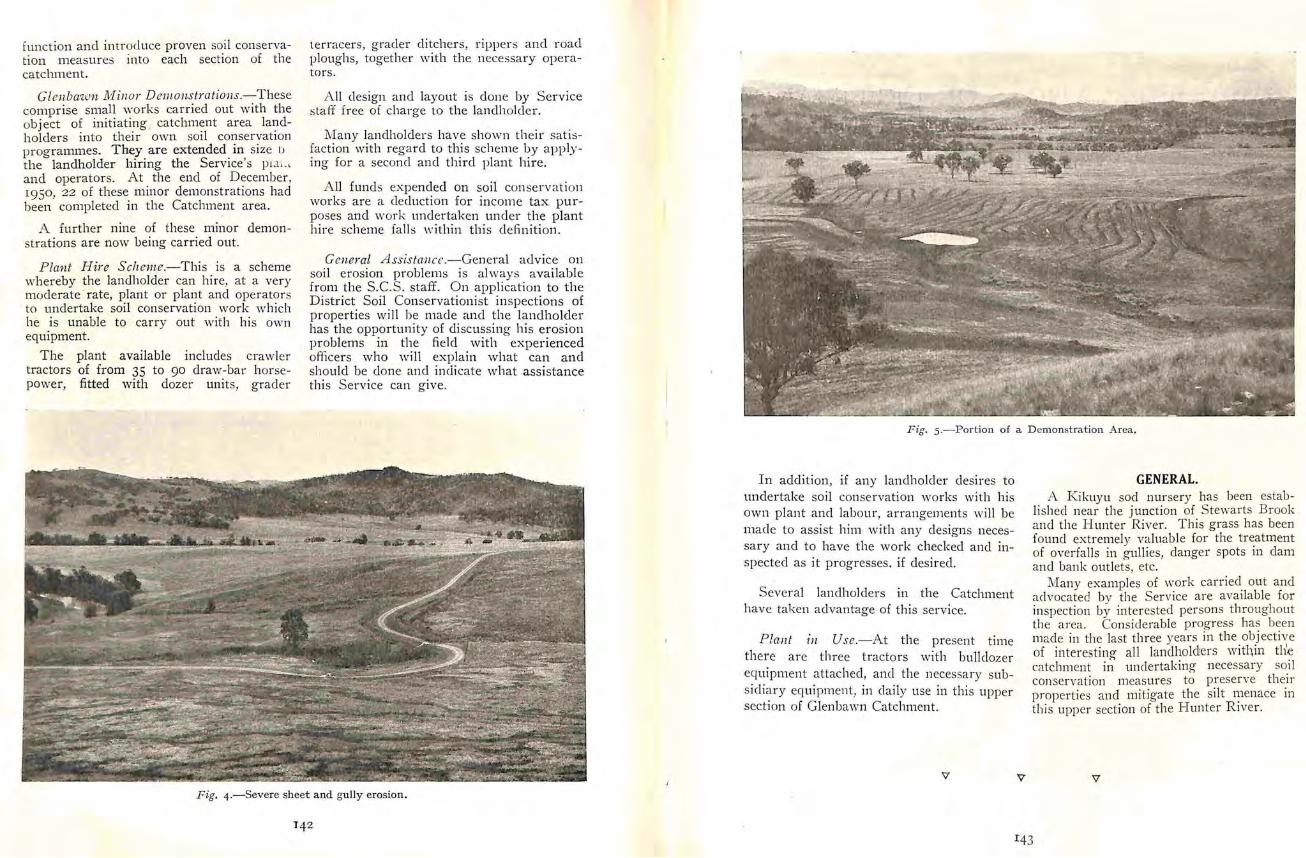
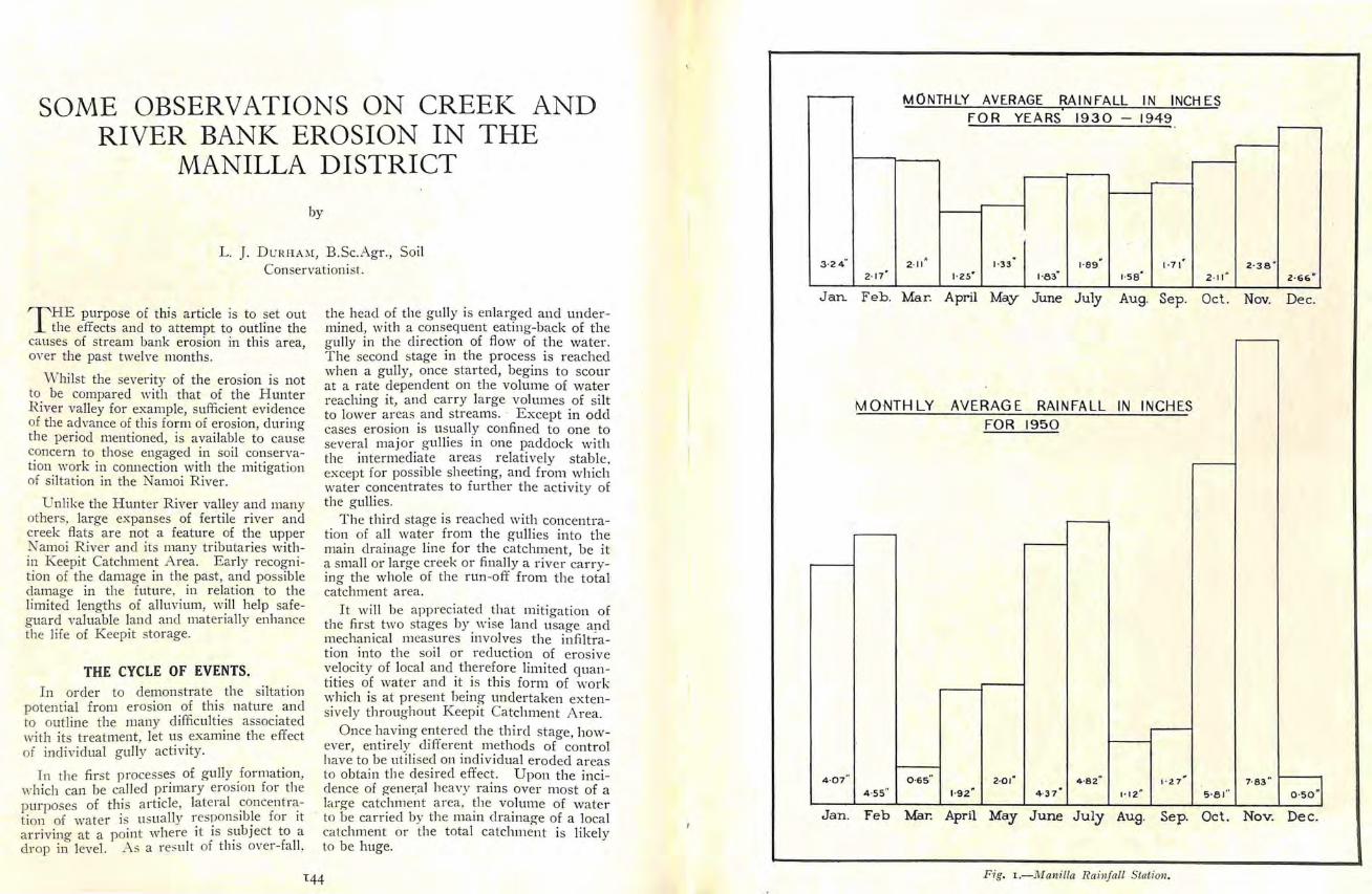
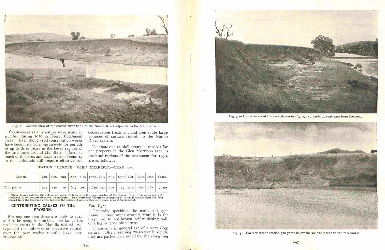
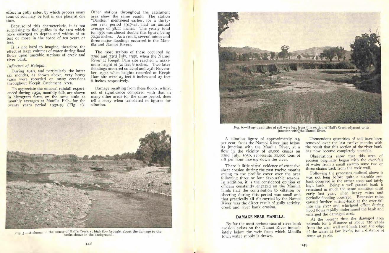
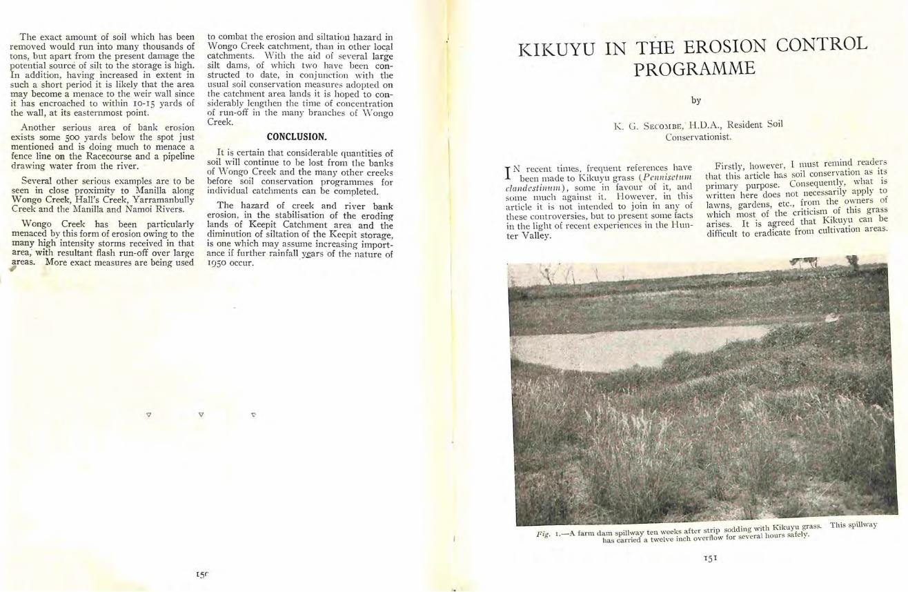
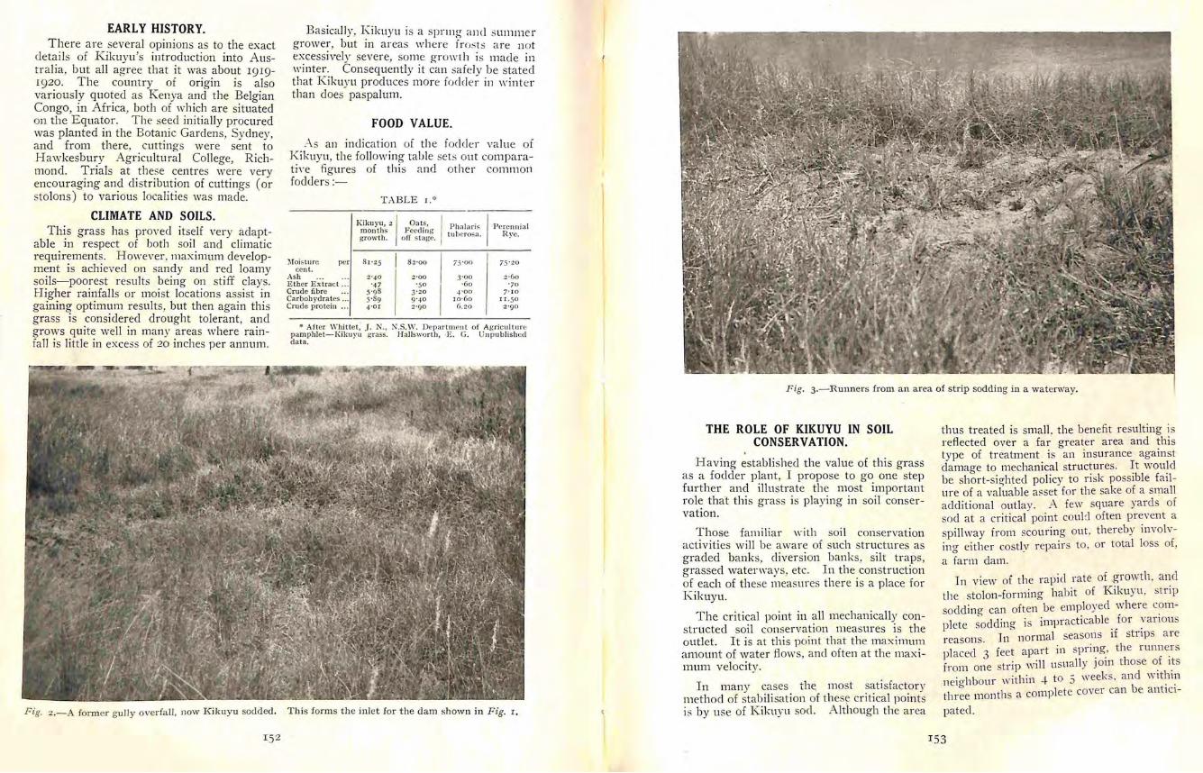
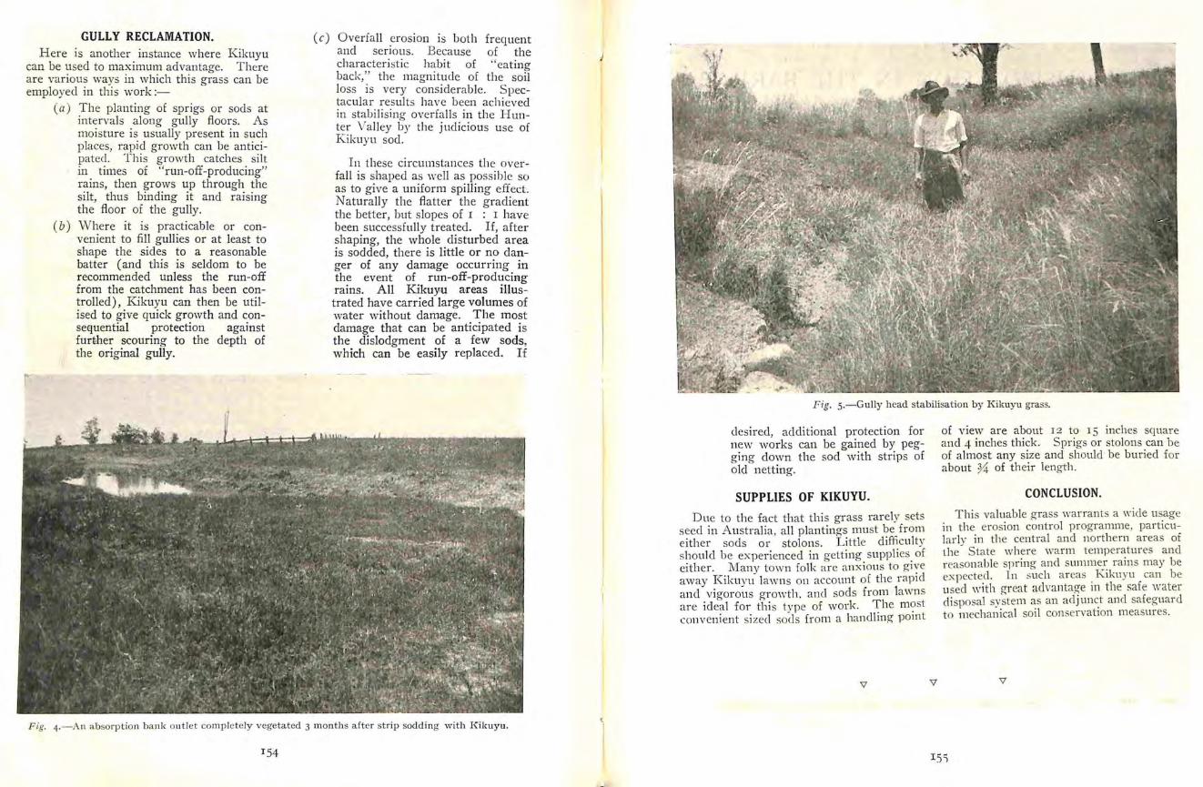
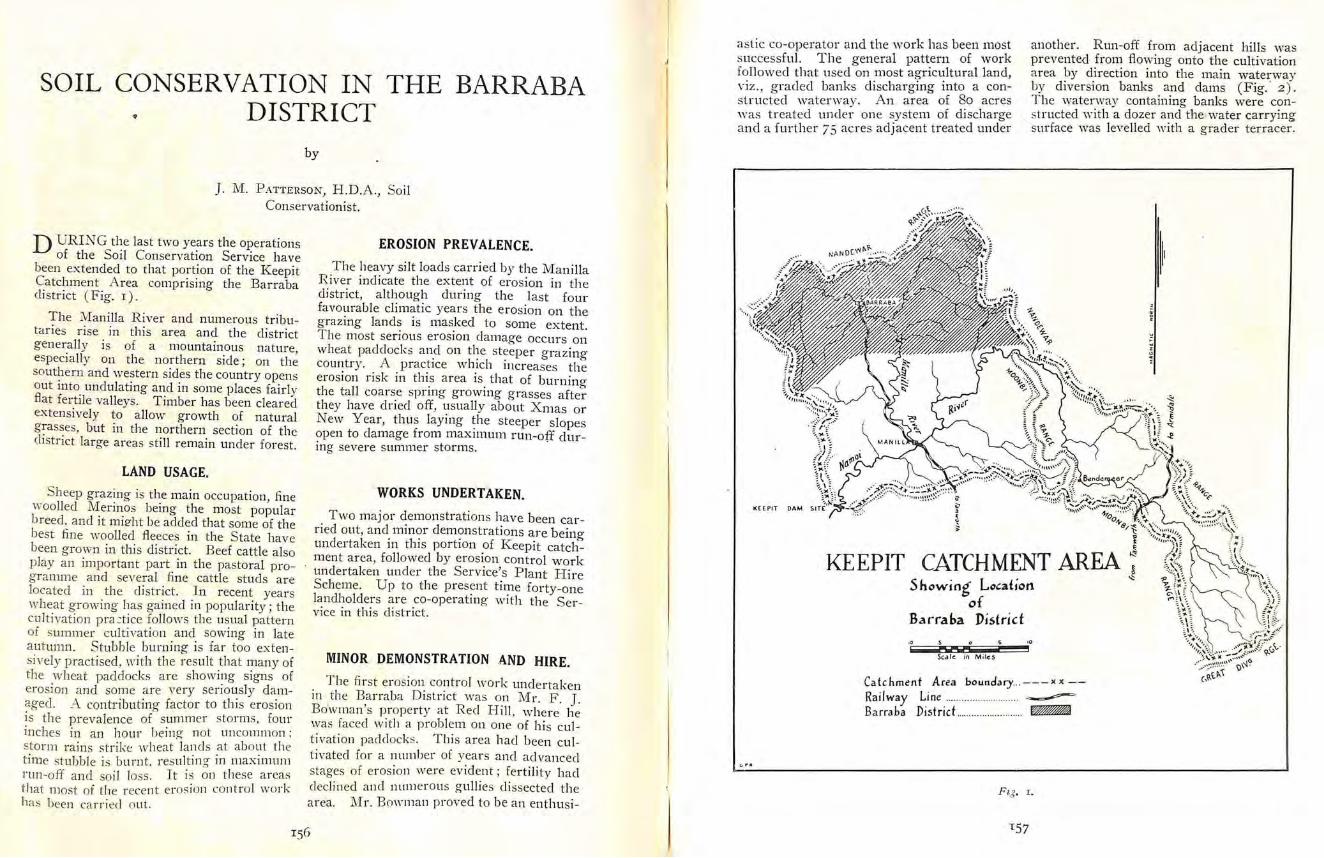
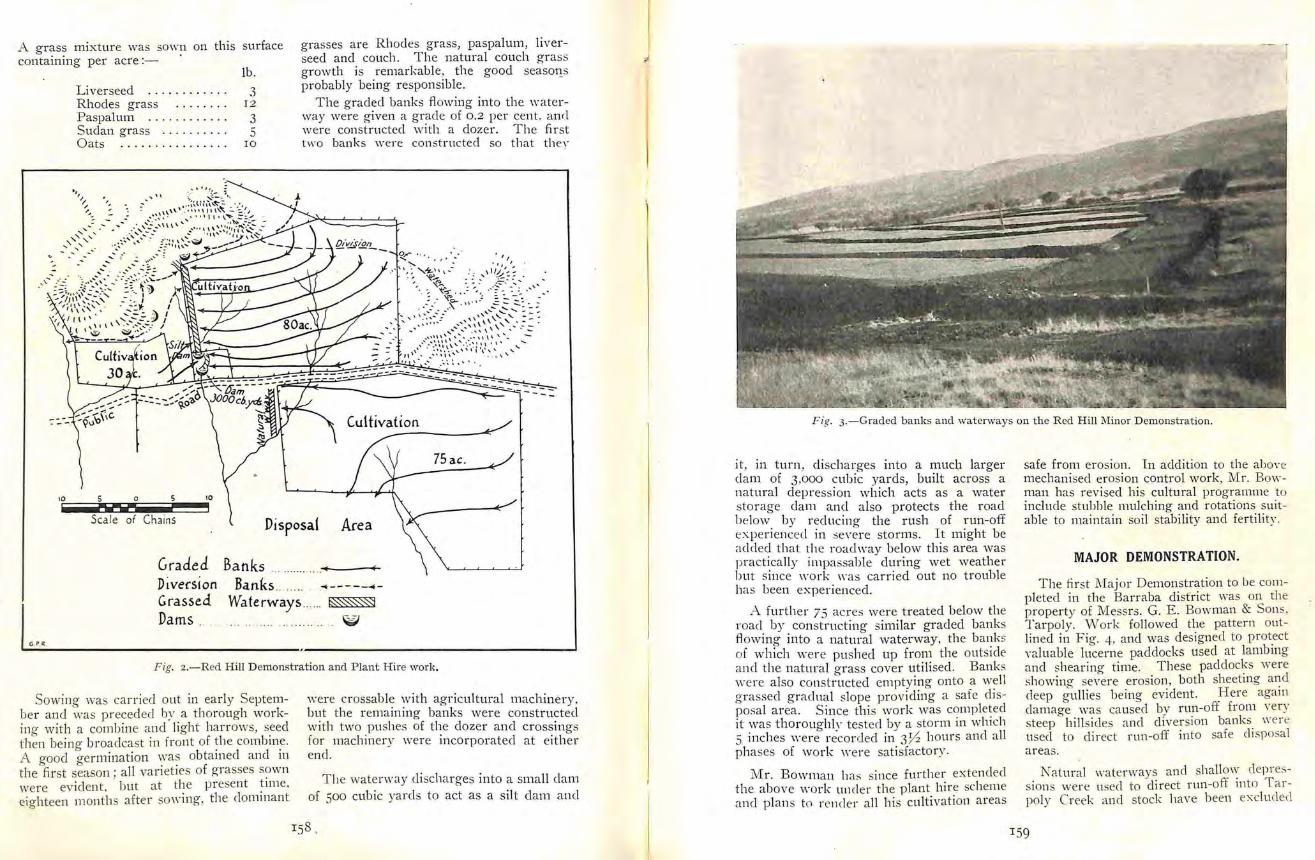
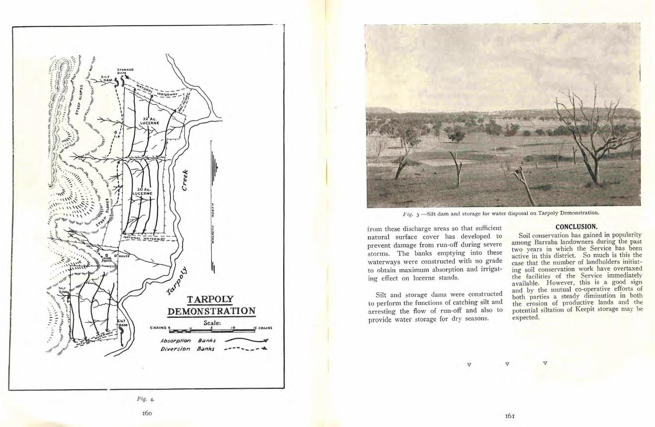