the gilgilchay long defensive wall: new investigations
TRANSCRIPT
1 Kulakovskiy 1913, 227–28.
THE GHILGHILCHAY DEFENSIVE LONG WALL: NEW INVESTIGATIONS
ASKER A. ALIEV, MURTAZALI S. GADJIEV, M. GAYE GAITHER,PHILIP L. KOHL, RABADAN M. MAGOMEDOV AND
IDRIS N. ALIEV
Abstract
In the 2002 field season, the Azerbaijani-Daghestani-American archaeological expe-dition carried out careful visual investigations and mapping of portions of theGhilghilchay Sasanian fortification wall that was built in the 6th century AD on theCaspian coastal plain. Among the recorded features of the wall were over 300 tower-buttresses spaced regularly along it, five towers with interior depressed cultural deposits,three military garrisons or forts (two of which were not previously recorded), and oneapparently fortified Sasanian settlement. These collaborative new investigations revealprime areas for future excavation.
Historical Summary
The appearance of the Huns on the historical arena of Europe at the endof the 4th century AD opened a new page in the history of many lands andpeoples and initiated the great period of the Migration of Peoples and thebeginning of the Middle Ages. In AD 395–396 the Huns made their firstwhirlwind campaign through the Caucasus range to Transcaucasia and theNear East, an incursion which resulted in great devastations to the popula-tions of the entire area. Contemporaries of these events wrote about them inparticular: ‘. . . from the extreme limits of Meotida, between the icy Tanais andthe furious peoples of Massagetes, where Alexander’s bolted locks constrainthe wild tribes of the Caucasus, the hosts of Huns escaped . . .’ (EusebiusHieronym Epist. 77. 8); ‘along an unexpected way through the Caspian Gatesand Armenian snows’ (Claudius Claudianus In Ruf. 2. 22–30). The Huns’ inva-sion inflicted an appreciable blow on Iran and Byzantium and showed the forceand power of the new nomads.
As a result of these invasions, the protection of the Caucasian borders becameimportant to the Sasanians. This problem was especially troubling for Ctesiphon,since after AD 387 almost all of Transcaucasia was incorporated within theSasanian empire. An Iran-Byzantium treaty was signed already in AD 408.Shahanshah Yazdegerd I (399–421) entered into negotiation with the Byzan-tine court and, as a result, took up legal trusteeship of the young emperorTheodosius II (408–450) and signed a treaty regarding the shared responsi-bilities for the protection of the Caucasian passes.1 As these passes were within
TSETS awe5_f8_143-177 7/3/06 4:09 PM Page 143

the territory of the Iranian state (or Iranshahr), their protection was carriedout by the Persian forces, and Constantinople undertook to pay half of thenecessary expenses of the Sasanians. Under the treaty, this sum for Byzantiumtotalled 500 litres (160 kg) of gold annually (Theoph. Chron. 245. 13–26).
About AD 424, a new treaty between Iran and Byzantium confirmed theobligation of Constantinople to carry half of the charges for the protection ofthe Caucasian passes (Theoph. Byz. Fr. 68). According to Priscus (Fr. 8) andEgishe,2 in AD 441 the Huns, commanded by Basikh and Cursikh, and alsoby Attila’s youngest son Ernah (in Egishe—Heran), conducted another dev-astating invasion into the provinces of Transcaucasia and Asia Minor throughthe Daryal pass and Derbent Gate.3 In the same year, Ctesiphon and Con-stantinople concluded an armistice, and in AD 442 signed the long-term peacetreaty confirming the obligation of Byzantium to pay Iran annual sums ofgold for the protection of the Caucasian passes, in amounts stipulated by thetreaty of AD 424 (Marc. Comit. Chron. 2. 80).
After this, in the mid-440s, Shahanshah Yazdegerd II (439–457) began thecreation of a defensive system on the western Caspian coast. At first Iranerected a solid mud-brick wall in the Derbent pass, which partitioned off anarrow (3.5 km) seaside plain and a citadel atop a mountain spur.4 Between AD447 and 450, a stronghold was constructed near Beliji, 20 km to the southof Derbent, which has been reliably identified as the city of Shahristan-iYazdegerd,5 consisting of a huge fortified settlement (approximately 100 ha)called Torpakh-kala.6
The emperor Marcianus (450–457) ascended the throne in AD 450 andconcluded the union with Shahanshah Yazdegerd II, confirming fidelity to thebilateral treaty signed in AD 442. Byzantium regularly paid to Iran a shareof the charges for the protection of the Caucasian passes; the Armenian writerof the 8th century, Gevond (22), states that in AD 717 (‘in the second year’ ofthe caliph Sulayman) the Arabs, having seized Derbent, discovered a plate inthe masonry of the wall with the following inscription: ‘Marcianus, Autocrat,Caesar has constructed this city, this tower with a great quantity of talentsfrom his own treasury . . .’.7 Apparently, Marcianus’ expenses, which are referredto in the inscription, were connected with the restoration of the Chor fortificationthat was damaged during the revolt of AD 450–51. The information contained
144 A. ALIEV, ET AL.
2 Egishe: O Vardane i voyne armyanskoy. Translated by I.A. Orbeli, with notes by K.N. Yuzbashyan(Yerevan 1971), 121.
3 Semenov 2002, 15–17.4 Kudryavtsev 1978, 243–57; 1979, 31–43; Gadjiev 1989, 61–76.5 Hoffmann 1880, S. 50.6 Gadjiev 1980, 144–52; 2001, 32–40.7 Gevond.: Istoriya khalifov vardapeta Gevonda, pisatelya VIII veka. Translated by K. Patkanov
(St Petersburg 1862).
TSETS awe5_f8_143-177 7/3/06 4:09 PM Page 144

THE GHILGHILCHAY DEFENSIVE LONG WALL 145
in it finds indirect confirmation in Michael the Syrian’s (12th century) refer-ence to John of Ephesus’ (6th century) statement that ‘the Gate of Turaiè’(i.e. Derbent) 8 is a city constructed by the Romans (Byzantines) (Chron. d.1199).
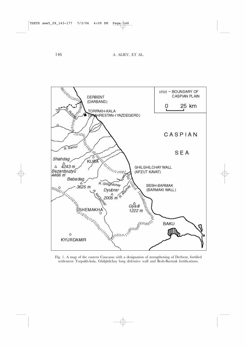
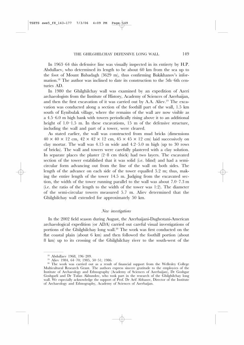
Subsequently, the written sources (Ieshu Stylit, Procopius) report that dur-ing the reigns of the Shahanshahs Peroz, Kavad I and Khusraw I Byzantiumgave financial support under the treaty (in fact, not continuously, but underpressure) to Sasanian Iran for the struggle with the nomads, including moniesfor the construction and service of the defensive structures. Among them inaddition to the mud-brick fortifications at Derbent and Torpakh-kala, theGhilghilchay long wall, Besh-Barmak fortification, military camps and fortresses,and fortified cities and settlements were built (Fig. 1). The Derbent stonedefensive complex, dating to the middle of the 6th century AD, replaced themud-brick fortification and included the city fortification and a 40 km moun-tain wall (Dagh bari ). This complex became a model of defensive architectureand a crowning achievement in the system of Limes Caspius. The cordonedlong walls on the eastern and western shores of the Caspian Sea served as theborder between the settled agricultural and the nomadic stockbreeding worlds.
Historiography
The first mention of the Ghilghilchay defensive long wall dates to the 7thcentury AD: Ananias of Shirak (Pseudo-Moses of Khorene) in his Geography
(Armenian: Ashkharatsuyts) mentions not only ‘the wall of Darband,’ but also‘the long wall Apzut Kavat up to the Alminon marshes and to the sea’ (MoïseCorène; Ananias of Shirak).9 The identification of the Apzut Kavat wall (intranslation from the Middle Persian, ‘Kavat is exalted’) with the Ghilghilchaywall was first made by S.T. Yeremyan,10 who attributed its construction to thereign of Shahanshah Kavad, and that opinion is now widely accepted and doesnot cause disagreements among scholars. It is indirectly confirmed by the pres-ence of extensive marshlands now known under the Azeri name Akh-zybyr nearthe sea in an area close to the eastern end of the Ghilghilchay wall. In the10th century AD, al-Mas"udi (§ 30, 74)11 described the building activity ofShahanshah Kavad in the eastern Caucasus and referred to ‘the walls, which
8 ‘Gate of Turaiè’ is a borrowed translation from Armenian. Durn ’oray (Altheim andStiehl 1958, S. 110). On the identification of Chor and Derbent, see Kuznetsov 1893, 423;Marguart 1901, S. 96–100; 1903, S. 489; Artamonov 1962, 120–21; Kudryavtsev 1978; 1979;Gadjiev 2002, 10, 46–48.
9 Moïse Corène: Géographie de Moïse Corène d’après Ptolémée. Edited and translated by A. Soukry(Venice 1881), 27; Ananias of Shirak: The Geography of Ananias of Shirak (Aaxaracoiz). Translationand commentary by R.H. Hewsen (Wiesbaden 1992), 2. 12–13.
10 Yeremyan 1941, 35.11 al-Mas'udìi: 'Abu’l-Hasan 'Alì Ibn al-Husayn al-Mas'udi [Maçoudi]’. Les Prairies d’or. Edited
and translated by C. Barbier de Meynard and Pavet de Courteille II (Paris 1863).
TSETS awe5_f8_143-177 7/3/06 4:09 PM Page 145
146 A. ALIEV, ET AL.
Fig. 1. A map of the eastern Caucasus with a designation of strengthening of Derbent, fortifiedsettlement Torpakh-kala, Ghilghilchay long defensive wall and Besh-Barmak fortifications.
TSETS awe5_f8_143-177 7/3/06 4:09 PM Page 146
THE GHILGHILCHAY DEFENSIVE LONG WALL 147
he had constructed in Shirwan, known as Sur at-tin (from the Arabic—“wallof clay”) and about the stone wall Barmaki’. It is possible to interpret theBarmaki wall as the fortification near the Besh-Barmak Rock (from the AzeriTurkish—‘five fingers’; compare with the Lesgian barmak—‘tall sheepskinhat/papakha’), and the Sur at-tin/‘Wall of Clay’ as the Ghilghilchay long wall.
In the middle of the 13th century AD, the ruins of the Ghilghilchay wall wereseen by Wilhelm Rubrouck, the ambassador of King Louis IX (1214–1270). Heobserved (chapter 50) both the plain and mountain portions of this long wall:
Two days away from here [i.e. from Derbent] we have found another city,named Samaron [i.e. Shabran/Shabiran],12 in which many Jews live; when wepassed through it, we saw the walls descend from the mountains to the sea. Andhaving left a road through these mountain walls, as it turned off there to theeast, we rose on mountains in a southerly direction. The next day we passedthrough a certain valley, on which the bases of these walls were visible extend-ing from one mountain to another, and on top of the mountains there was noroad. They were Alexander’s fortifications that held back the wild tribes—thatis, herders from the desert—from advancing to the cultivated grounds and cities.
In 1770–1773 the Russian scientist-naturalist and member of the St PetersburgAcademy of Sciences, Samuel Gottlib Gmelin (1745–1774), travelled in Iranalong the western Caspian coast. One of his companions later issued a briefdescription of the journey, and in particular, provided information on theGhilghilchay wall. This unknown author noted:
Sur sa rive gauche, près d’un vallon réserré, d’où il sort, on voit une espèce dedigue longue de 8 Verstes [ca. 8.5 km], qui traverse la plaine en droite ligne,jusqu’au rivage de la mer. D’après sa forme et sa position, l’on seroit tenté dela prendre pour un retranchement, surtout si l’on prête l’oreille à nombre derelations vulgaires, qui rapportent au fameux Eskander, notre Alexandre le grand,les restes de tous les édifices et autres ouvrages semblables, qui attestent la puis-sance, sans conserver le nom de leurs fondateurs.13
In 1796 Colonel F. Simonovich (1760–1815) compiled his ‘Description ofSouthern Daghestan’, in which he lists interesting information about theGhilghilchay wall and one more name for it:
. . . extending from the foothills from the left bank of the Gil’geni river for adistance of seven versts [ca. 7.5 km], the ancient raised earthen wall named Algunibaru, stretches to the sea and is set against northern Daghestan The ruins of aformer fortress are visible from the left end of this bank near the foothills wherethere is a large road; on the right bank of the Gil’geni river there is an ancienttower on Mount Saadon with a commanding view over the surrounding placesand opposite Chirakh-kala to noon [i.e. directly to the north].14
12 See Gadjiev 1995, 7–8.13 Tableau . . . 1798, 17.14 Description 1958, 148.
TSETS awe5_f8_143-177 7/3/06 4:09 PM Page 147
This name Algun ibaru is rather interesting, but it is written incorrectly. It ismore correctly rendered as Alguni baru, in which the second word is the Persian‘wall’.
This description is confirmed by the data of the Azerbaijani historian,philosopher and poet Abbas-Kuliaga Bakikhanov (1794–1846), who in his‘Gyulistan-i Iram’ kept the information on this wall and used its name Algonwall (Algon baru):
In the Shabran magal of Kuba district, the remains of a wall and the gate of anancient city on the left bank of the Gil’gin river and a fortress on a mountainon the right bank of this river are visible today. The wall goes from the seabehind the Alkhanlu village (possibly Algonlu) to the fortress Chirag, and fromthere to the ruins of a city on Mount Ata and continues further above the vil-lage of Konakhkend village up to Mount Babadagh.15
The given correspondence of the name of the wall to the place name Alkhanlu
// Alikhanlu seems justified—the name Algon //Algoni appears to be the expectedTati variant (a dialect of Persian) of the Turkish name. Note that in this areaTati-Persian toponyms are widespread. For example, the name of the medi-aeval fortified settlement of Shehergyah, which is located near the village ofAlkhanlu, means ‘place of the city’ in Tati.
The first visual observations of this wall were carried out in 1931–32 byE.A. Pakhomov, who incorrectly identified it with ‘the stone Barmaki wall’,mentioned by al-Mas’udi.16 Later, K.V. Trever, who believed that the con-struction of the Ghilghilchay wall (and also of the fortified Besh-Barmak Rock)had been begun by Shahanshah Yazdegerd II and finished during the reignof Shahanshah Peroz, supported this opinion. Pakhomov gave a brief descrip-tion of the Ghilghilchay long wall from the sea up to the Chirakh-kala fortress,where he believed it ended. Pakhomov established some specific features ofthe building materials and the engineering construction of the wall and alsoprovided one more local name of its coastal section—Iskender samti. He alsofirst put forward the idea about the stages of the construction of the longwalls (from south to north) along the western coast of the Caspian Sea, amovement which followed the gradual advance of the northern border of the Sasanian empire. At present, this hypothesis has been rejected by A.A.Kudryavtsev who established that the earliest defensive structure which blocked the seaside plain is the mud-brick fortification of Derbent built duringYazdegerd II’s reign.17
148 A. ALIEV, ET AL.
15 Bakikhanov: Gulistan-I Iram. Translation, notes and commentaries by Z.M. Buniyavo (Baku1991), 18, 44.
16 Pakhomov 1933, 40–43.17 Kudryavtsev 1979, 31–43.
TSETS awe5_f8_143-177 7/3/06 4:09 PM Page 148
THE GHILGHILCHAY DEFENSIVE LONG WALL 149
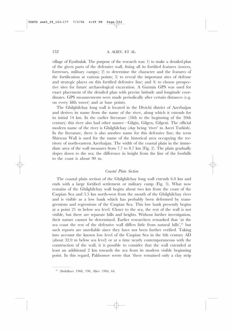
In 1963–64 this defensive line was visually inspected in its entirety by H.P.Abdullaev, who determined its length to be about 60 km from the sea up tothe foot of Mount Babadagh (3629 m), thus confirming Bakikhanov’s infor-mation.18 The author was inclined to date its construction to the 5th–6th cen-turies AD.
In 1980 the Ghilghilchay wall was examined by an expedition of Azeriarchaeologists from the Institute of History, Academy of Sciences of Azerbaijan,and then the first excavation of it was carried out by A.A. Aliev.19 The exca-vation was conducted along a section of the foothill part of the wall, 1.5 kmsouth of Eynibulak village, where the remains of the wall are now visible asa 4.5–6.0 m high bank with towers periodically rising above it to an additionalheight of 1.0–1.5 m. In these excavations, 15 m of the defensive structure,including the wall and part of a tower, were cleared.
As stated earlier, the wall was constructed from mud bricks (dimensions 40 × 40 × 12 cm, 42 × 42 × 12 cm, 45 × 45 × 12 cm) laid successively onclay mortar. The wall was 4.15 m wide and 4.2–5.0 m high (up to 30 rowsof bricks). The wall and towers were carefully plastered with a clay solution.In separate places the plaster (2–8 cm thick) had two layers. The excavatedsection of the tower established that it was solid (i.e. blind) and had a semi-circular form advancing out from the line of the wall on both sides. Thelength of the advance on each side of the tower equalled 5.2 m; thus, mak-ing the entire length of the tower 14.5 m. Judging from the excavated sec-tion, the width of the tower running parallel to the wall was about 7.0–7.3 m(i.e. the ratio of the length to the width of the tower was 1:2). The diameterof the semi-circular towers measured 5.7 m. Aliev determined that theGhilghilchay wall extended for approximately 50 km.
New investigations
In the 2002 field season during August, the Azerbaijani-Daghestani-Americanarchaeological expedition (or ADA) carried out careful visual investigations ofportions of the Ghilghilchay long wall.20 The work was first conducted on theflat coastal plain (about 6 km) and then followed the foothill portion (about8 km) up to its crossing of the Ghilghilchay river to the south-west of the
18 Abdullaev 1968, 196–209.19 Aliev 1984, 64–70; 1985, 50–51; 1986.20 The work was carried out as a result of financial support from the Wellesley College
Multicultural Research Grant. The authors express sincere gratitude to the employees of theInstitute of Archaeology and Ethnography (Academy of Sciences of Azerbaijan), Dr GoshgarGoshgarli and Dr Tufan Akhundov, who took part in the research of the Ghilghilchay longwall. We especially acknowledge the support of Prof. Dr Arif Abbasov, Director of the Instituteof Archaeology and Ethnography, Academy of Sciences of Azerbaijan.
TSETS awe5_f8_143-177 7/3/06 4:09 PM Page 149
150 A. ALIEV, ET AL.
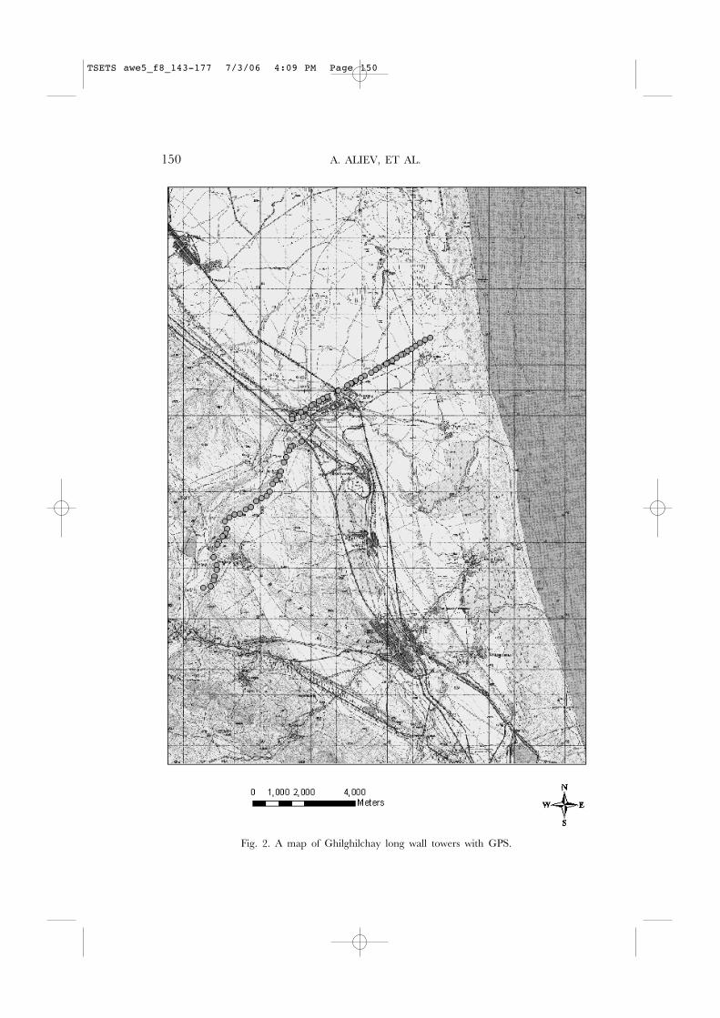
Fig. 2. A map of Ghilghilchay long wall towers with GPS.
TSETS awe5_f8_143-177 7/3/06 4:09 PM Page 150
THE GHILGHILCHAY DEFENSIVE LONG WALL 151
Coastal Plain Section of Wall:
T 1: N 41 11.178’ T 55: N 41 10.604’E 49 07.456’ E 49 06.231’Elev: –21m Elev: 2m
T 7: N 41 11.124’ T 60: N 41 10.513’E 49 07.307’ E 49 06.029’Elev: –18m Elev: –2m
T 12: N 41 11.055’ T 63: N 41 10.468’E 49 07.165’ E 49 05.932’Elev: –13m Elev: 0m
T 17: N 41 10.996’ T 70: N 41 10.408’E 49 07.046’ E 49 05.809’Elev: –17m Elev: 9m
T 22: N 41 10.937’ T 75: N 41 10.337’E 49 06.937’ E 49 05.635’Elev: –12m Elev: 3m
T 27: N 41 10.80’ T 80: N 41 10.283’E 49 06.816’ E 49 05.517’Elev: –6m Elev: 11m
T 32: N 41 10.821’ T 85: N 41 10.222’E 49 06.701’ E 49 05.379’Elev: –5m Elev: 9m
T 34: N 41 10.796’ T 90: N 41 10.164’E 49 06.651’ E 49 05.266’Elev: 0m Elev: 14m
T 40: N 41 10.728’ T 94: N 41 10.164’E 49 06.514’ E 49 05.263’Elev: –12m Elev: 9m
T 45: N 41 10.674’ T 100: N 41 10.114’E 49 06.398’ E 49 05.149’Elev: 2m Elev: 15m
T 50: N 41 10.619’ T 103: N 41 10.006’E 49 06.275’ E 49 04.889’Elev: 6m Elev: 21m
T 106: N 41 10.010’E 49 04.897’ Foothill or Piedmont Section of Wall:Elev: 16m T P1: N 41 08.904’
E 49 03.908’Elev: 101m
T 110: N 41 09.879’E 49 04.599’ T P6: N 41 08.836’Elev: 50m(?) E 49 03.785’
Elev: 113mT 117: N 41 09.817’
E 49 04.454’ T P10: N 41 08.806’Elev: 39m E 49 03.647’
Elev: 120mT 120: N 41 09.775’
E 49 04.360’ T P12: N 41 08.798’Elev: 21m E 49 03.581’
Elev: 124m
T 125: N 41 09.705’ T P16: N 41 08.707’E 49 04.212’ E 49 03.545’Elev: 12m Elev: 105m
T 130: N 41 09.674’ T P19: N 41 08.563’E 49 04.151’ E 49 03.472’Elev: 9m Elev: 145m
T 135: N 41 09.597’ T P23: N 41 08.450’E 49 03.995’ E 49 03.420’Elev: 43m Elev: 158m
Fortress:
F1: N 41 09.533’ T P30: N 41 08.266’E 49 03.863’ E 49 03.329’Elev: 9m Elev: 174m
F10: N 41 09.473’ T P31: N 41 08.172’E 49 03.664’ E 49 03.287’Elev: 40m Elev: 186m
F14: N 41 09.450’ T P35: N 41 08.065’E 49 03.605’ E 49 03.208’Elev: 48m Elev: 212m
T P40: N 41 07.986’E 49 03.112’Elev: 197m
T P46: N 41 07.832’ T P100: N 41 06.925’E 49 03.022 E 49 01.813’Elev: 219m Elev: 268m
T P50: N 41 0.728’ T P105: N 41 06.850’E 49 02.955’ E 49 01.735’Elev: 230m Elev: 344m
T P55: N 41 07.688’ T P108: N 41 06.747’E 49 02.806’ E 49 01.640’Elev: 241m Elev: 272m
T P60: N 41 07.611’ T P110: N 41 06.673’E 49 02.665 E 49 01.590’Elev: 248m Elev: 243m
T P67: N 41 07.493’ T P111: N 41 06.399’E 49 02.507’ E 49 01.501’Elev: 257m Elev: 227m
T P71: N 41 07.429’ T P116: N 41 06.235’E 49 02.365’ E 49 01.579’Elev: 273m Elev: 248m
T P77: N 41 07.344’ T P120: N 41 06.134’E 49 02.195’ E 49 01.579’Elev: 291m Elev: 257m
T P81: N 41 07.322’ T P126: N 41 05.995’E 49 02.062’ E 49 01.531’Elev: 290m Elev: 264m
T P86: N 41 07.253’ T P129: N 41 05.918’E 49 01.918’ E 49 01.508’Elev: 295m Elev: 264m
T P90: N 41 07.168’ T P135: N 41 05.790’E 49 01.794’ E 49 01.431’Elev: 177m Elev: 259m
T P96: N 41 07.021’ T P140: N 41 05.743’E 49 01.861’ E 49 01.228’Elev: 272m Elev: 190m
GPS Coordinates
TSETS awe5_f8_143-177 7/3/06 4:09 PM Page 151
village of Eynibulak. The purpose of the research was: 1) to make a detailed planof the given parts of the defensive wall, fixing all its fortified features (towers,fortresses, military camps); 2) to determine the character and the features ofthe fortification at various points; 3) to reveal the important sites of defenseand strategic places on this fortified defensive line; and 4) to choose prospec-tive sites for future archaeological excavation. A Garmin GPS was used forexact placement of the detailed plan with precise latitude and longitude coor-dinates. GPS measurements were made periodically after certain distances (e.g.on every fifth tower) and at base points.
The Ghilghilchay long wall is located in the Divichi district of Azerbaijanand derives its name from the name of the river, along which it extends forits initial 14 km. In the earlier literature (18th to the beginning of the 20thcentury) this river also had other names—Gilgin, Gilgen, Gilgeni. The officialmodern name of the river is Ghilghilchay (chay being ‘river’ in Azeri Turkish).In the literature, there is also another name for this defensive line; the termShirwan Wall is used for the name of the historical area occupying the ter-ritory of north-eastern Azerbaijan. The width of the coastal plain in the imme-diate area of the wall measures from 7.7 to 8.7 km (Fig. 2). The plain graduallyslopes down to the sea; the difference in height from the line of the foothillsto the coast is about 90 m.
Coastal Plain Section
The coastal plain section of the Ghilghilchay long wall extends 6.0 km andends with a large fortified settlement or military camp (Fig. 3). What nowremains of the Ghilghilchay wall begins about two km from the coast of theCaspian Sea and 5.5 km north-west from the mouth of the Ghilghilchay riverand is visible as a low bank which has probably been deformed by trans-gressions and regressions of the Caspian Sea. This low bank presently beginsat a point 21 m below sea level. Closer to the sea, the rest of the wall is notvisible, but there are separate hills and heights. Without further investigation,their nature cannot be determined. Earlier researchers remarked that ‘at thesea coast the rest of the defensive wall differs little from natural hills’,21 butsuch reports are unreliable since they have not been further verified. Takinginto account the known low level of the Caspian Sea in the 6th century AD(about 32.0 m below sea level) or at a time nearly contemporaneous with theconstruction of the wall, it is possible to consider that the wall extended atleast an additional 2 km towards the sea from its modern visible beginningpoint. In this regard, Pakhomov wrote that ‘there remained only a clay strip
21 Abdullaev 1968, 196; Aliev 1984, 64.
152 A. ALIEV, ET AL.
TSETS awe5_f8_143-177 7/3/06 4:09 PM Page 152
THE GHILGHILCHAY DEFENSIVE LONG WALL 153
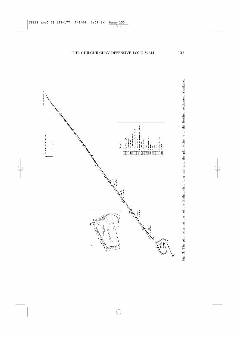
Fig.
3.
The
pla
n of
a fl
at p
art
of t
he G
hilg
hilc
hay
long
wal
l an
d th
e pl
an/s
chem
e of
the
for
tified
set
tlem
ent
Yen
iken
d.
TSETS awe5_f8_143-177 7/3/06 4:09 PM Page 153
[of the bank] which barely rose several centimetres from the ground but whichcould be sharply distinguished from the dunes and coastal plain’.22 The pre-sent extent of the remaining coastal plain section of the wall measures approx-imately 5890 m. The wall follows a direct south-west line (azimuth approx.235 degrees, with insignificant changes in direction in several places) thatblocks the coastal plain and comes to an end at the north-east corner towerof the fortified settlement located on the plain closer to the foothills.
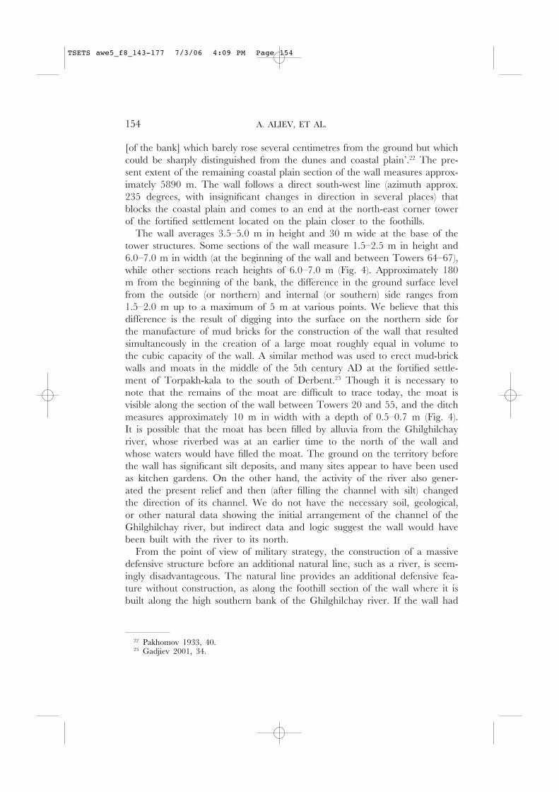
The wall averages 3.5–5.0 m in height and 30 m wide at the base of thetower structures. Some sections of the wall measure 1.5–2.5 m in height and6.0–7.0 m in width (at the beginning of the wall and between Towers 64–67),while other sections reach heights of 6.0–7.0 m (Fig. 4). Approximately 180m from the beginning of the bank, the difference in the ground surface levelfrom the outside (or northern) and internal (or southern) side ranges from1.5–2.0 m up to a maximum of 5 m at various points. We believe that thisdifference is the result of digging into the surface on the northern side forthe manufacture of mud bricks for the construction of the wall that resultedsimultaneously in the creation of a large moat roughly equal in volume tothe cubic capacity of the wall. A similar method was used to erect mud-brickwalls and moats in the middle of the 5th century AD at the fortified settle-ment of Torpakh-kala to the south of Derbent.23 Though it is necessary tonote that the remains of the moat are difficult to trace today, the moat isvisible along the section of the wall between Towers 20 and 55, and the ditchmeasures approximately 10 m in width with a depth of 0.5–0.7 m (Fig. 4).It is possible that the moat has been filled by alluvia from the Ghilghilchayriver, whose riverbed was at an earlier time to the north of the wall andwhose waters would have filled the moat. The ground on the territory beforethe wall has significant silt deposits, and many sites appear to have been usedas kitchen gardens. On the other hand, the activity of the river also gener-ated the present relief and then (after filling the channel with silt) changedthe direction of its channel. We do not have the necessary soil, geological,or other natural data showing the initial arrangement of the channel of theGhilghilchay river, but indirect data and logic suggest the wall would havebeen built with the river to its north.
From the point of view of military strategy, the construction of a massivedefensive structure before an additional natural line, such as a river, is seem-ingly disadvantageous. The natural line provides an additional defensive fea-ture without construction, as along the foothill section of the wall where it isbuilt along the high southern bank of the Ghilghilchay river. If the wall had
154 A. ALIEV, ET AL.
22 Pakhomov 1933, 40.23 Gadjiev 2001, 34.
TSETS awe5_f8_143-177 7/3/06 4:09 PM Page 154
THE GHILGHILCHAY DEFENSIVE LONG WALL 155
Fig. 4. A site of the flat part of the Ghilghilchay long wall. A view from the north.
Fig. 5. Break in the Ghilghilchay long wall near to Tower 29. A view from the north.
TSETS awe5_f8_143-177 7/3/06 4:09 PM Page 155
been built on the coastal plain north of the river, this placement would havemade it necessary for the wall to cross the riverbed, requiring special fortificationsand defence. As a final argument, the choice to set the construction of thewall behind (i.e. to the south of ) the natural line of the river required thatthe flat plain section of the wall be located, not in the bottleneck where thefoothills reached closest to the sea, but instead in an approximately 1 kmwider section of the plain farther north where larger expenditures of labourwere necessary. There is no other apparent explanation for why they wouldhave undertaken this extra work. The river then must have run north ofwhere they built the wall.
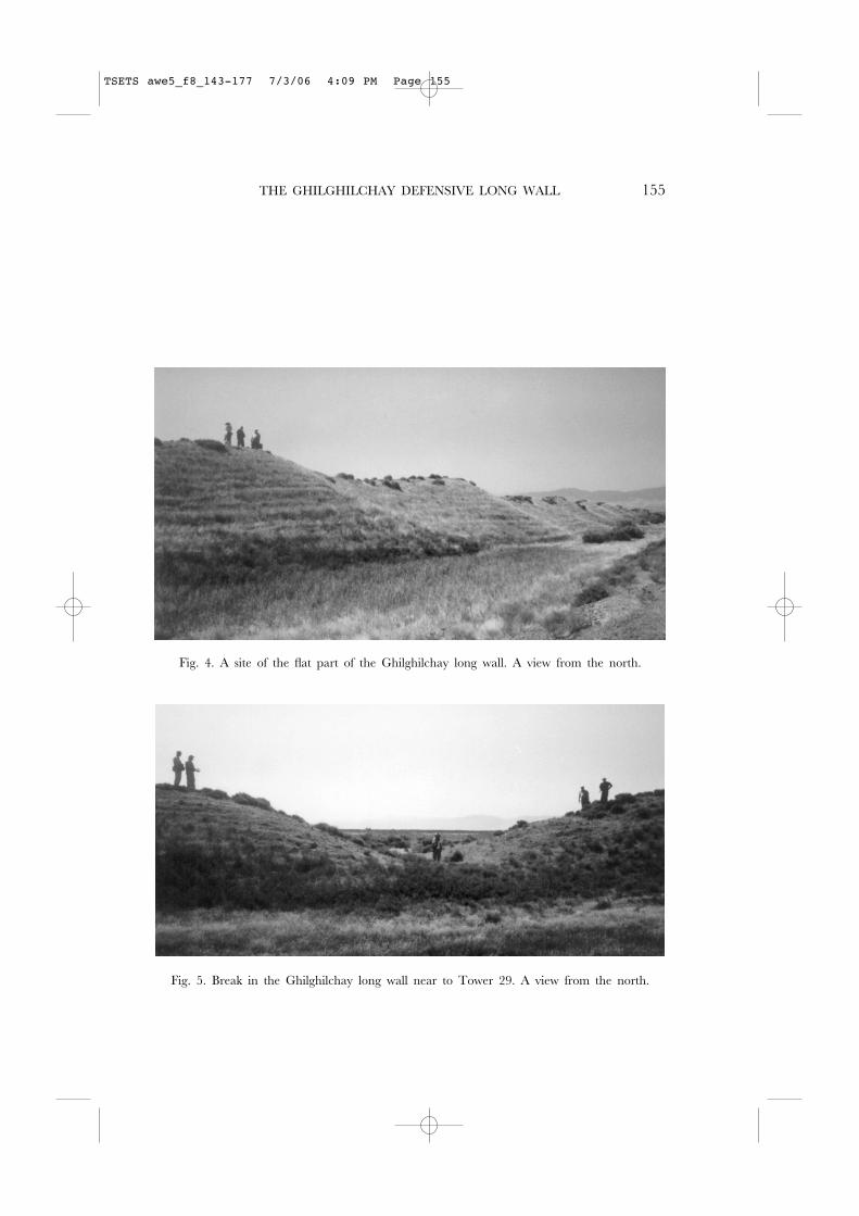
There are breaks (Fig. 3) at several places along the wall, the majority ofwhich resulted from the modern construction of roads. There are, however,ancient breaks in the wall, the nature of which is no longer clear. After Tower29 there is a break measuring approximately 3.5 m in width, with the wallcontinuing directly after the break (Fig. 5). It is possible to assume that therewas an ancient opening in the wall, a gate that was flanked only from oneside. On the other hand, between Towers 40 and 41 (which are set 43 mapart), a 22 m wide break is present with no traces of remaining wall, mak-ing it difficult or impossible to determine its purpose or use. In other loca-tions (between Towers 54–55, 57–58, 76–80), there is a trench running alongthe wall between the towers and measuring 1.0–1.5 m wide and 0.3–0.4 m.Between Towers 54–55 and 57–58, this trench leads around the tower onthe northern side of the wall. Scholars have assumed that these trenches rep-resent the remains of internal corridors.24 This interpretation, however, is prob-lematic without excavation. Further investigation is needed to determine thenature of the ancient breaks and the so-called ‘corridors’ in the Ghilghilchaylong wall.
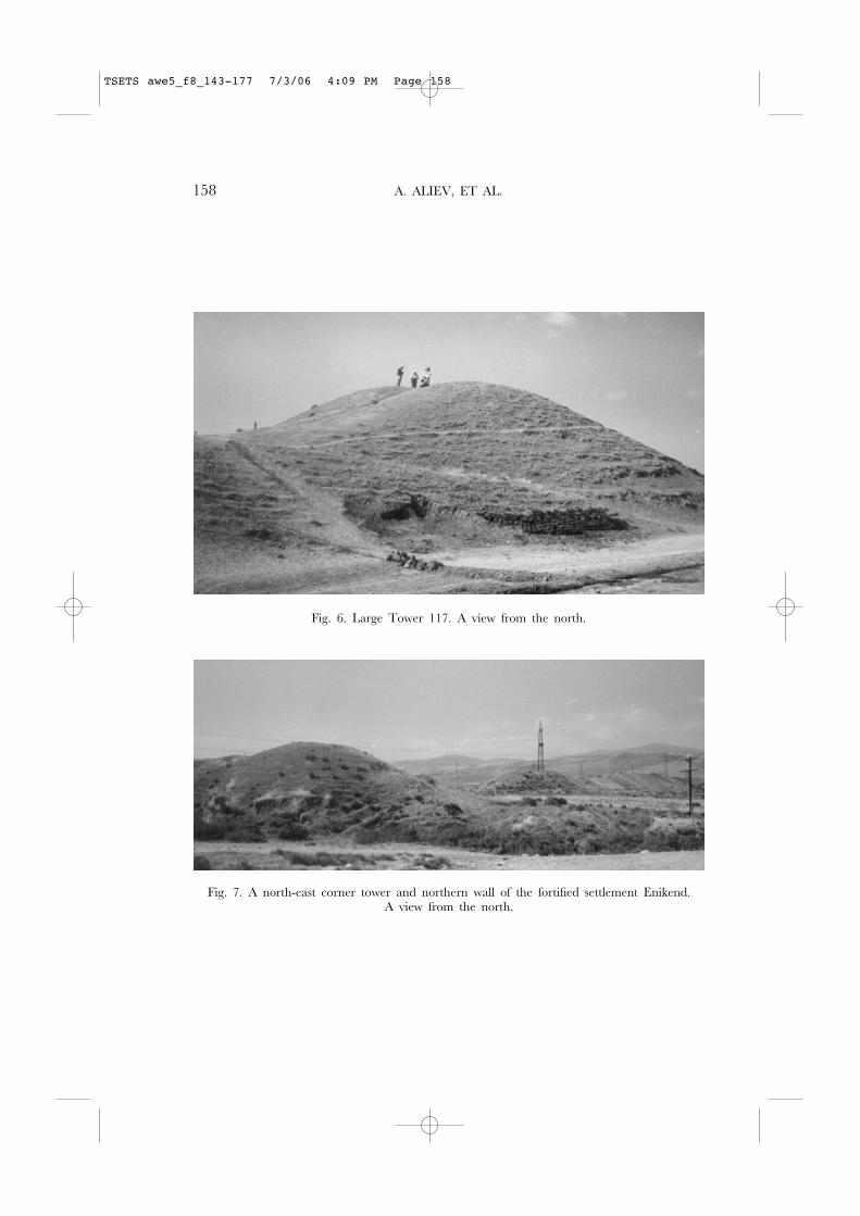
The remains of towers regularly arranged in the wall are easily distinguished(Fig. 4). The remains of the towers rise above the wall 1.0–2.0 m and jut outfrom its line on both sides as semicircular outcrops with diameters rangingfrom 10–14 m. The diameter of the large towers (e.g. Towers 94, 129–133)reaches up to 25 m. The largest tower on the flat coastal plain, Tower 117,has a height of about 10 m and a diameter at its base of approximately 40 m(Fig. 6). This tower rises above the adjoining wall 2.5 m and, obviously, rep-resented an important strategic point. Note that the towers immediately beforeand after Tower 117 (Towers 116 and 118) are located a distance of 45–46 mfrom it, whereas the usual distance between towers on this site is 36–40 m.
On the flat coastal plain, the remains of 135 towers are clearly visible(Fig. 3). In several places, however, the towers and wall are destroyed. More
156 A. ALIEV, ET AL.
24 Abdullaev 1968, 196; Aliev 1984, 64.
TSETS awe5_f8_143-177 7/3/06 4:09 PM Page 156
THE GHILGHILCHAY DEFENSIVE LONG WALL 157
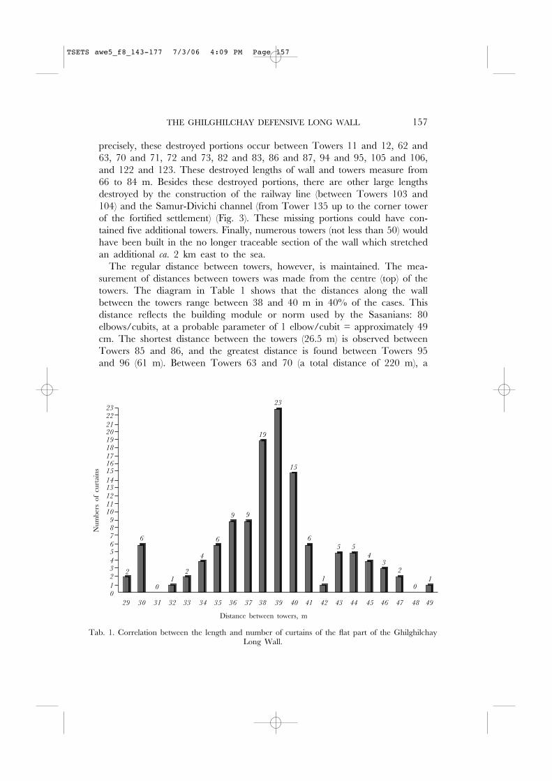
precisely, these destroyed portions occur between Towers 11 and 12, 62 and63, 70 and 71, 72 and 73, 82 and 83, 86 and 87, 94 and 95, 105 and 106,and 122 and 123. These destroyed lengths of wall and towers measure from66 to 84 m. Besides these destroyed portions, there are other large lengthsdestroyed by the construction of the railway line (between Towers 103 and104) and the Samur-Divichi channel (from Tower 135 up to the corner towerof the fortified settlement) (Fig. 3). These missing portions could have con-tained five additional towers. Finally, numerous towers (not less than 50) wouldhave been built in the no longer traceable section of the wall which stretchedan additional ca. 2 km east to the sea.
The regular distance between towers, however, is maintained. The mea-surement of distances between towers was made from the centre (top) of thetowers. The diagram in Table 1 shows that the distances along the wallbetween the towers range between 38 and 40 m in 40% of the cases. Thisdistance reflects the building module or norm used by the Sasanians: 80elbows/cubits, at a probable parameter of 1 elbow/cubit = approximately 49cm. The shortest distance between the towers (26.5 m) is observed betweenTowers 85 and 86, and the greatest distance is found between Towers 95and 96 (61 m). Between Towers 63 and 70 (a total distance of 220 m), a
Tab. 1. Correlation between the length and number of curtains of the flat part of the GhilghilchayLong Wall.
2322
21201918
7
2
1
34
56
0
89
101112
1314
151617
29 39 49484746454443424140383736353433323130
2
6
01
2
4
6
9 9
19
23
15
6
5
1
5
43
2
01
Distance between towers, m
Num
bers
of
curtai
ns
TSETS awe5_f8_143-177 7/3/06 4:09 PM Page 157
158 A. ALIEV, ET AL.
Fig. 6. Large Tower 117. A view from the north.
Fig. 7. A north-east corner tower and northern wall of the fortified settlement Enikend. A view from the north.
TSETS awe5_f8_143-177 7/3/06 4:09 PM Page 158
THE GHILGHILCHAY DEFENSIVE LONG WALL 159
shorter distance between towers (or, more precisely, the distance from the topcentre of the towers) was used and ranges between 29.5 to 34 m (Fig. 3).Note that this portion of the wall is located in the central part of the defen-sive wall and probably is one of the strategically important points in thedefence system. It is possible to assume, for example, that this location rep-resented a most convenient and shallow point to cross the river.
The defensive wall appears to be entirely constructed of mud bricks. Thethickness of the wall on the flat coastal plain measures approximately 8 m.The heavily destroyed Tower 128 revealed in section bricks measuring 42–43× 42–43 × 12–13 cm with outside plaster measuring 2.5–3.0 cm thick. Similarly,the partially destroyed Tower 133 revealed 16 rows of such bricks laid suc-cessively in line on a 2 cm-thick clay mortar. Pakhomov also noted the sameformation of bricks, thick mortar and outside plaster coating.25
Burnt bricks and cobblestones were also used in limited quantity in theconstruction of the wall. Large fragments of burnt brick measuring 37 × 37× 7–8 cm and 37 × 37 × 10 cm were found near Towers 41 and 63. Bricksof the same size were visible near the base and higher in the destroyed por-tions of Towers 66 and 70 and also in the wall between Towers 88 and 89.Finally, a row of cobblestones was visible in the body of Tower 85. Note thata similar method—belt stones in the body of the defensive wall—has beendocumented for the Derbent mud-brick fortification that was built in the mid-dle of the 5th century AD.26 Mud bricks of the same size and the same meth-ods of masonry—solid masonry laid successively in line on a 2-cm thick claybed of mortar—were used at Derbent and also for the construction of thecontemporaneous fortification at Torpakh-kala.27
We are not certain whether the coastal plain section of the Ghilghilchaywall was built on a pisé platform, but at the beginning of the wall (betweenTowers 7–12) step buttresses of the towers and wall are observed, forming aberm or ledge which was probably the original platform on which the wallswere constructed. Pakhomov also remarked that ‘the base of the wall is pisé’.28
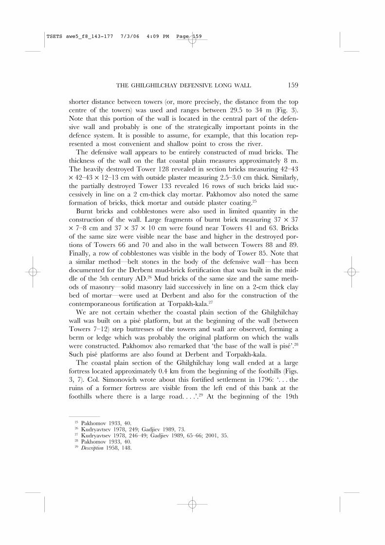
Such pisé platforms are also found at Derbent and Torpakh-kala.The coastal plain section of the Ghilghilchay long wall ended at a large
fortress located approximately 0.4 km from the beginning of the foothills (Figs.3, 7). Col. Simonovich wrote about this fortified settlement in 1796: ‘. . . theruins of a former fortress are visible from the left end of this bank at thefoothills where there is a large road. . . .’.29 At the beginning of the 19th
25 Pakhomov 1933, 40.26 Kudryavtsev 1978, 249; Gadjiev 1989, 73.27 Kudryavtsev 1978, 246–49; Gadjiev 1989, 65–66; 2001, 35.28 Pakhomov 1933, 40.29 Description 1958, 148.
TSETS awe5_f8_143-177 7/3/06 4:09 PM Page 159
century, A.-K. Bakikhanov also noted: ‘the remains of a wall and the gate ofan ancient city on the left coast of the Gilgin (Ghilghil) river are visible nowa-days . . .’.30 The original name for this fortified settlement is unknown, but theinhabitants of the nearby village of Yenikend call this place Turk. Uch ayak(‘three legs/support’) after three support poles for a high-voltage line that arepresent on the site. This fortified settlement can be called Yenikend for thenearby village.
Judging from the small remains of the Ghilghilchay wall near the settle-ment, it is probable that the wall approached the north-east corner tower ofthis base military camp (Figs. 3, 3A, 7). The settlement has a trapezoidalshape, and its northern wall extends as if it is a continuation of the Ghilghilchaylong wall. The size of the settlement is approximately 420 × 210 m, occu-pying an area of about 8.8 ha. The earthen banks that cover the remains ofthe impressive defensive walls reach 5.0–7.0 m in height and measure 30–36m in width at their base. The northern and western walls provide the bestsecurity, and the remains of towers on these sections appear as semicircularoutcrops (with diameters of 10–12 m) rising above the wall 0.5–1.5 m. Thetowers on the north-east and north-west corners are visible as large hills reach-ing heights of about 10 m with diameters at their bases of about 35 m.
The northern wall of the settlement is the most heavily fortified. Here, 14towers are located along a 396 m long wall. There were once obviously moretowers (15–17) since the wall between Towers 1 (north-east corner tower) and2 is considerably destroyed. The distance between towers is not regular andchanges from 12.5–13.5 m between Towers 2–4 up to 36 m between Towers4 and 5. Between Towers 4 and 5, there is a break or opening that is approx-imately 6 m wide, which probably was the ancient gate of the fortified set-tlement. At the top and on the slopes of the wall, small fragments of burntbrick were found that measured 7–9 cm in thickness.
The western wall of the settlement measures 115 m in length, and exceptfor the north-west corner tower, there are three towers located at regularintervals (at distances of 27–30 m). The southern end of this western wall hasbeen destroyed, but it obviously extended 15 to 20 m to join the southernwall. From this corner, the Ghilghilchay long wall may have continued fur-ther ca. 800 m.
The southern wall provided little or no security. The height on its westernend measured 1.5–2.5 m with a width of up to 30 m. At the central part ofthe southern wall, its height measures only 0.5–0.8 m, and after that it isalmost disappears completely. Taking into account that the southern wall didnot play a role in the defensive system of the settlement or in the whole
160 A. ALIEV, ET AL.
30 Bakikhanov: Gulistan-I Iram. Translation, notes and commentaries by Z.M. Buniyavo (Baku1991), 18.
TSETS awe5_f8_143-177 7/3/06 4:09 PM Page 160
THE GHILGHILCHAY DEFENSIVE LONG WALL 161
complex of the Ghilghilchay long wall, it is possible that it originally had verylittle height or even may not have been completed.
The eastern wall of the fortified settlement measures approximately 240 mand has been heavily destroyed. Despite its poor preservation, it appears asthough several towers stood along this wall, and exposed sections reveal mudbricks (40–44 × 40–44 × 11–13 cm) stacked by the same successive end toend method on a firm clay mortar. There is also a ravine measuring 10–15m wide and 2.0–2.5 m deep with steep sides. We could not determine whetheror not it represents the remains of a defensive moat.
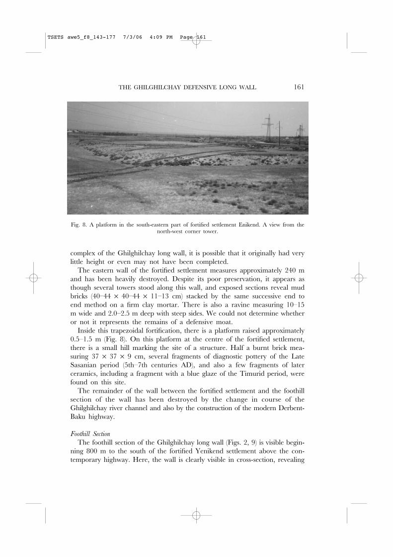
Inside this trapezoidal fortification, there is a platform raised approximately0.5–1.5 m (Fig. 8). On this platform at the centre of the fortified settlement,there is a small hill marking the site of a structure. Half a burnt brick mea-suring 37 × 37 × 9 cm, several fragments of diagnostic pottery of the LateSasanian period (5th–7th centuries AD), and also a few fragments of laterceramics, including a fragment with a blue glaze of the Timurid period, werefound on this site.
The remainder of the wall between the fortified settlement and the foothillsection of the wall has been destroyed by the change in course of theGhilghilchay river channel and also by the construction of the modern Derbent-Baku highway.
Foothill Section
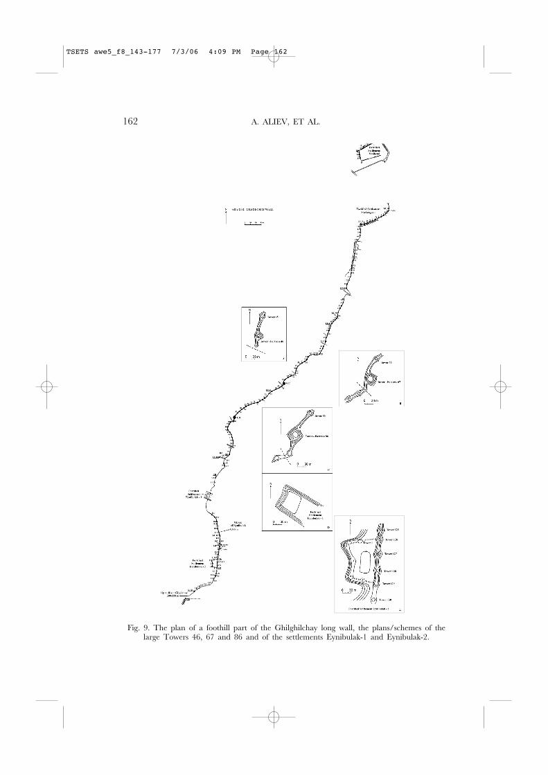
The foothill section of the Ghilghilchay long wall (Figs. 2, 9) is visible begin-ning 800 m to the south of the fortified Yenikend settlement above the con-temporary highway. Here, the wall is clearly visible in cross-section, revealing
Fig. 8. A platform in the south-eastern part of fortified settlement Enikend. A view from thenorth-west corner tower.
TSETS awe5_f8_143-177 7/3/06 4:09 PM Page 161
162 A. ALIEV, ET AL.
Fig. 9. The plan of a foothill part of the Ghilghilchay long wall, the plans/schemes of thelarge Towers 46, 67 and 86 and of the settlements Eynibulak-1 and Eynibulak-2.
TSETS awe5_f8_143-177 7/3/06 4:09 PM Page 162
THE GHILGHILCHAY DEFENSIVE LONG WALL 163
its construction entirely of mud bricks (40–43 × 40–43 × 12 cm) laid succes-sively in line on a 1.5–2.0 cm thick bed of clay mortar. The thickness of thewall here measures approximately 6 m with a remaining height of approxi-mately 2.3 m (17–18 rows of bricks). Also present here are cobbled pavingson both sides of the wall, which appear to prevent the collapse of the wallthat is built on the steep hillside.
From its beginning atop the mountain spur, the foothill section of theGhilghilchay long wall follows the steep slope (about 45 degrees) of the nat-ural ridge above the right bank of the Ghilghilchay river (approximately 110m above sea level). On the whole, the foothill section of the wall follows asouth-southwest trajectory, but it changes direction sharply at various pointsas it conforms to the course of the high river terrace (Figs. 2, 9). The foothillor piedmont stretch of the wall appears as a partially collapsed raised earthenbank. Its dimensions are significantly smaller than the coastal plain section ofthe wall, and it is obvious that this difference in size is not so much a ques-tion of the wall’s preservation along this section, as it is of its real dimen-sions. That is, the foothill section of the mud-brick wall was smaller than thatbuilt on the coastal plain. The foothill section of the wall was additionallystrengthened by sitting on top of the natural terrace ridge.
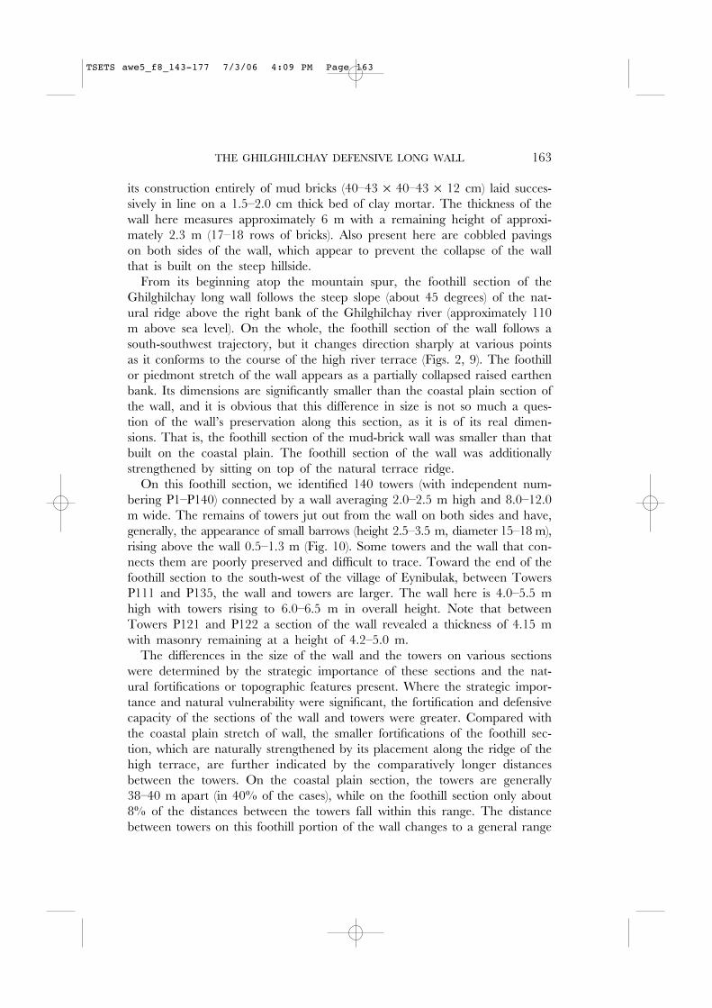
On this foothill section, we identified 140 towers (with independent num-bering P1–P140) connected by a wall averaging 2.0–2.5 m high and 8.0–12.0m wide. The remains of towers jut out from the wall on both sides and have,generally, the appearance of small barrows (height 2.5–3.5 m, diameter 15–18 m),rising above the wall 0.5–1.3 m (Fig. 10). Some towers and the wall that con-nects them are poorly preserved and difficult to trace. Toward the end of thefoothill section to the south-west of the village of Eynibulak, between TowersP111 and P135, the wall and towers are larger. The wall here is 4.0–5.5 mhigh with towers rising to 6.0–6.5 m in overall height. Note that betweenTowers P121 and P122 a section of the wall revealed a thickness of 4.15 mwith masonry remaining at a height of 4.2–5.0 m.
The differences in the size of the wall and the towers on various sectionswere determined by the strategic importance of these sections and the nat-ural fortifications or topographic features present. Where the strategic impor-tance and natural vulnerability were significant, the fortification and defensivecapacity of the sections of the wall and towers were greater. Compared withthe coastal plain stretch of wall, the smaller fortifications of the foothill sec-tion, which are naturally strengthened by its placement along the ridge of thehigh terrace, are further indicated by the comparatively longer distancesbetween the towers. On the coastal plain section, the towers are generally38–40 m apart (in 40% of the cases), while on the foothill section only about8% of the distances between the towers fall within this range. The distancebetween towers on this foothill portion of the wall changes to a general range
TSETS awe5_f8_143-177 7/3/06 4:09 PM Page 163

of 37–52 m (in about 60% of the cases), with three characteristic distances:40–41 m (more than 9%), 44–46 m (more than 15%), and 49–50 m (11.5%)(Tabl. 2). It may be that these parameters represent a certain norm or mod-ule (cubit) used in architecture—these distances can correspond to 89, 90 and100 cubits. Another group (more than 9%) was characterised by distancesbetween 58–61 m (120 cubits) (Tabl. 2).
Several large towers (P1, P12 and P30) stand out as strategically importantamong the towers of the foothill section of the Ghilghilchay long wall. Firstof all, Tower P1 is located at the beginning of this section of the wall on thecape of the mountain spur overlooking the coastal plain. This tower has adiameter at its base of approximately 20 m and a height of ca. 5 m. Thenext large tower is located about 530 m from Tower P1 and is designatedTower P12. It is 7 m tall with a diameter at its base of approximately 25m. The wall changes direction at Tower P12 and extends further south, mak-ing another turn to the south-west between Towers P16 and P17 (Fig. 9).Towers P2–P11 are smaller and range in height 3.0–3.5 m with diametersaround 15 m (Fig. 10).
A pipeline passes through Tower P2, revealing mud bricks of the usual sizeand cobblestone masonry on the external side of the wall. At a later time thewall assumed a different defensive role between Towers P1 and P12 wherethe mediaeval settlement of Shehergyah (from Tati/Persian ‘place of city’)31
was situated. This settlement is not to the south or behind the defensive wallas would be expected, but instead lies to the north between the wall and theGhilghilchay river.
164 A. ALIEV, ET AL.
31 Khalilov, Koshkarli and Arazova 1991, 30.
9
8
0
1
2
3
4
5
6
7
Num
ber
of c
urta
ins
Distance between towers, m
1
3
2
3
6
7
4
5
7
6
8
5
4
7
9
4
3
1 1111
5
3
2
3
0
2
1
36 56 64626058545250484644424038
Tab. 2. Correlation between the length and number of curtains of the foothill part of theGhilghilchay Long Wall.
TSETS awe5_f8_143-177 7/3/06 4:09 PM Page 164
THE GHILGHILCHAY DEFENSIVE LONG WALL 165
Fig. 10. An initial site of a foothill part of the Ghilghilchay long wall (Towers 1–11). A viewfrom Tower 12. On the right a moat is seen.
Fig. 11. Large Tower 46. A view from the north-west.
TSETS awe5_f8_143-177 7/3/06 4:09 PM Page 165
A moat is located on the southern side of the wall (Fig. 10) that extendsapproximately 500 m, coming to an end near Tower P12. The moat mea-sures 2.0–2.5 m deep and a width of approximately 15 m. To the west ofthe moat, there is an opening in the wall incorporating the moat with thesettlement and leading to the river. It appears the moat is not chronologi-cally connected to the wall and should be dated to a later time, a time whenthere was danger from the south. Logically, the moat would have been locatedon the northern side of the wall. These facts suggest that the settlement ofShehergyah was built much later than the defensive wall, which had origi-nally been designed as a barrier against a threat from the north. Danger fromthe south arose at the time of the first Arab campaigns and existed up to theMongol invasion. In addition, the pottery recovered from the territory of theShehergyah settlement was monochrome and polychrome glazed pottery (whiteslip painted under green transparent glaze and slip and manganese paintingunder a colourless transparent glaze, etc.).32 These finds support its relativedating within the 8th–13th centuries AD.
The next opening or pass leading to the Ghilghilchay river is located afterthe next large tower, Tower P30. Here the wall makes a sharp bend besidea channel or hollow cutting gently down into the plateau on the side facingthe river. Tower P30 is well placed with a clear view of the wide river chan-nel to the north, the coastal plain and the fortified settlement at the Besh-Barmak Rock to the south, and the mountain fortress of Chirakh-kala to thewest including the adjoining stretch of the high mountain portion of theGhilghilchay long wall. The more powerfully fortified towers were built nextto the natural passes that led down to the river providing water to the gar-risons stationed along the wall.
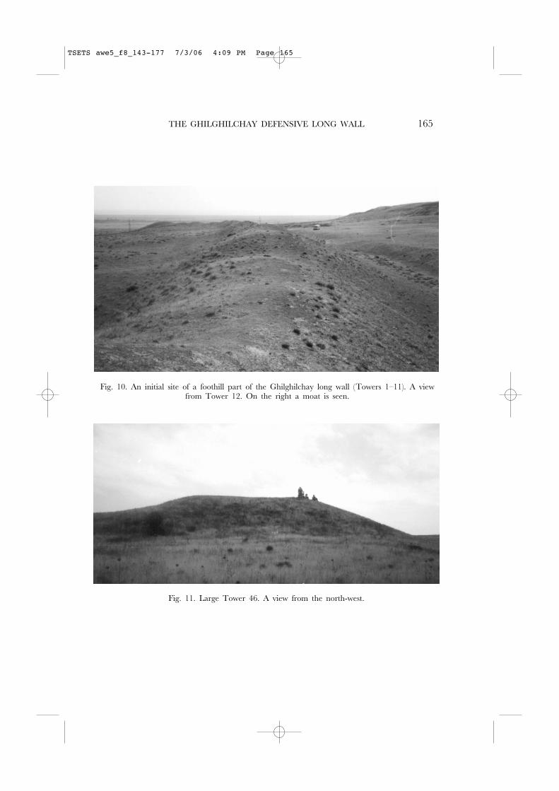
The next descent to the river through a pass in the wall is located justafter and to the south-west of the tower-garrison P46 (Figs. 9, 9A, 11, 12).Tower P46 is a very large dominating tower having the shape of a truncatedcone. It measures 3.8 m in height with a flat top measuring 13.5 m in diam-eter at the crest. There is a 1 m depression in its centre, indicating that thistower was hollow. The diameter of the tower at its base is approximately 35m, and this tower does not jut out from the defensive line of the wall. TowerP46 is one of three discovered hollow towers in the foothill portion of theGhilghilchay wall; all the other towers were obviously solid blind structures.
The next such tower-garrison, Tower P67 (Figs. 9, 9B, 13), also controlledthe pass and the descent to the river that was located to its south-west. Thistower has a rectangular shape and measures 3.8 m in height. The approxi-mate dimensions at the base are 33 × 33 m, with the dimensions on top
166 A. ALIEV, ET AL.
32 Khalilov, Koshkarli and Arazova 1991, 30.
TSETS awe5_f8_143-177 7/3/06 4:09 PM Page 166

THE GHILGHILCHAY DEFENSIVE LONG WALL 167
Fig. 12. Large Tower 46 and an adjoined site of a wall. A view from south-west (from tower 49). In background—Tower 35.
Fig. 13. Large Tower 67. A view from the south-east.
TSETS awe5_f8_143-177 7/3/06 4:09 PM Page 167
18.5–19 × 13.5–15 m. Again, on the top of this tower there is a round depres-sion 1.5–2.1 m deep, indicating the presence of an internal room. Like TowerP46, this tower does not jut out from the northern line of the wall; that is,it did not actually play a flanking role for protecting the face of the wall.
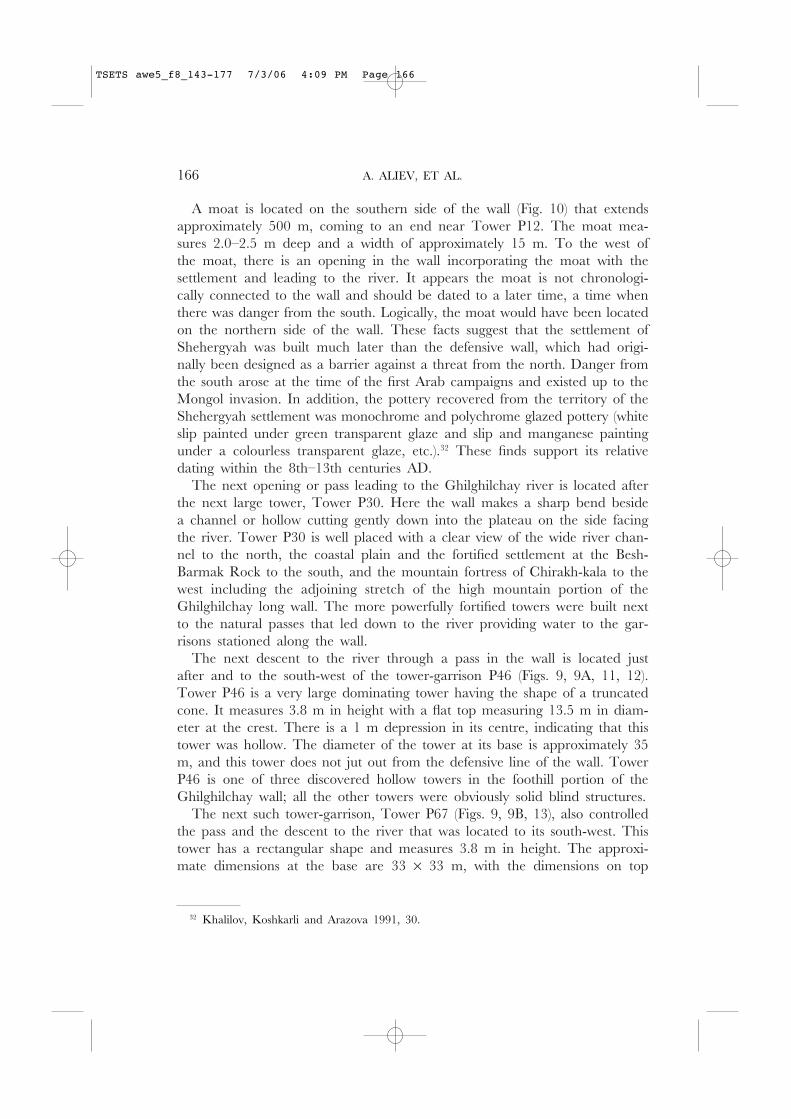
The third hollow tower-garrison, Tower P86 (Figs. 9, 9C, 14), is similar toTower P67 in size and shape. There is also a hollow and descent to the riverto its south-west. Here, the wall makes a deep bend on the edge of the gen-tly descending hollow; in the centre of the bend stands Tower P87, and therewas probably a passage through the wall at this point. The rectangular TowerP86 measures 38 × 36 m at its base and 11 × 18 m at its top that rises toa height of 4 m. On the top of the tower is a depression 1 m deep. Unlikethe other two hollow towers that were located behind the line of the defen-sive wall, the south-western side of this tower was directed towards the hol-low and flanked the corresponding section of the defensive wall. The fortificationwall approached the northern corner of Tower P86 from its north-easternside. Consequently the north-eastern side of the tower appeared as if it werea continuation of the wall that extended from the tower not from its west-ern, but from its southern corner. Thus, a projection was created on the lineof the defensive wall approximately 38 m in length. Tower P87 is located 58m from the southern corner of Tower P86. In addition to these large tower-garrisons, Towers P35 (height: 3.0–3.2 m; diameter: 16–18 m) and P71 (height:3.6 m, diameter: ca. 20 m) are distinguished by their dimensions from theirneighbouring towers.
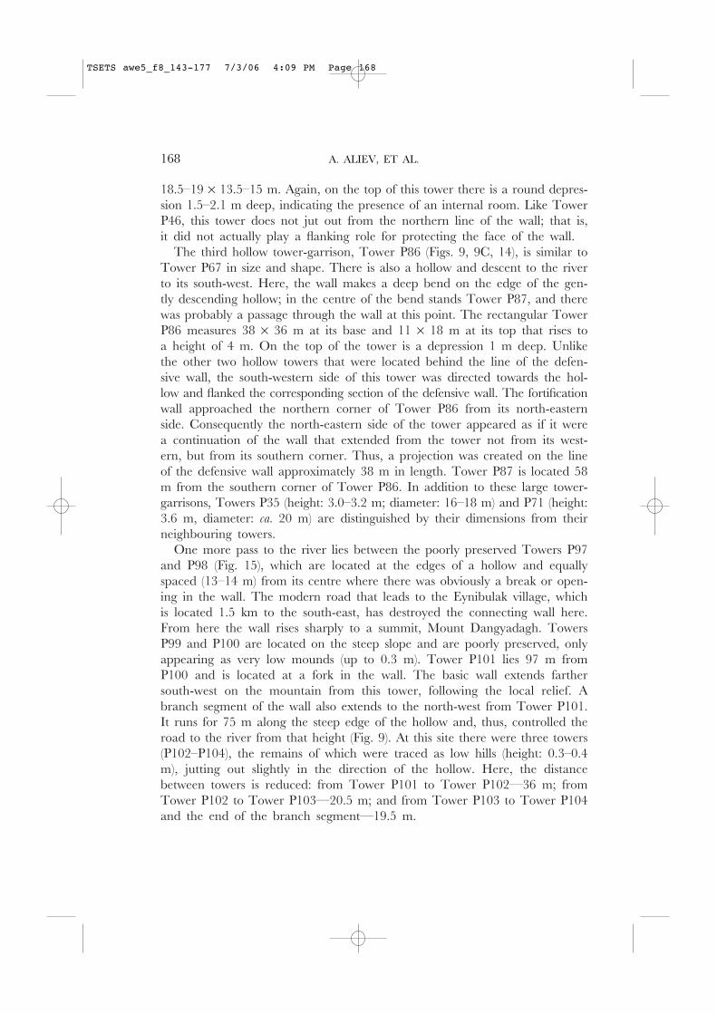
One more pass to the river lies between the poorly preserved Towers P97and P98 (Fig. 15), which are located at the edges of a hollow and equallyspaced (13–14 m) from its centre where there was obviously a break or open-ing in the wall. The modern road that leads to the Eynibulak village, whichis located 1.5 km to the south-east, has destroyed the connecting wall here.From here the wall rises sharply to a summit, Mount Dangyadagh. TowersP99 and P100 are located on the steep slope and are poorly preserved, onlyappearing as very low mounds (up to 0.3 m). Tower P101 lies 97 m fromP100 and is located at a fork in the wall. The basic wall extends farthersouth-west on the mountain from this tower, following the local relief. Abranch segment of the wall also extends to the north-west from Tower P101.It runs for 75 m along the steep edge of the hollow and, thus, controlled theroad to the river from that height (Fig. 9). At this site there were three towers(P102–P104), the remains of which were traced as low hills (height: 0.3–0.4m), jutting out slightly in the direction of the hollow. Here, the distancebetween towers is reduced: from Tower P101 to Tower P102—36 m; fromTower P102 to Tower P103—20.5 m; and from Tower P103 to Tower P104and the end of the branch segment—19.5 m.
168 A. ALIEV, ET AL.
TSETS awe5_f8_143-177 7/3/06 4:09 PM Page 168
THE GHILGHILCHAY DEFENSIVE LONG WALL 169
Fig. 14. Large Tower 86. A view from the south-west.
Fig. 15. A view from the south (from remote Tower 104) on the previous site of theGhilghilchay long wall and descent to the river between Towers 97 and 98.
TSETS awe5_f8_143-177 7/3/06 4:09 PM Page 169
Tower P105 is located 55 m from Tower P101 on a line following thebasic direction of the wall along the longitudinally stretched summit of MountDangyadagh. The remains of Tower P106 lie 25.5 m south-southeast fromTower P105 also on top of the mountain, and the remains of Tower P107lie 16.5 m to the south-east of P106. This is the highest point on the foothillsection of the Ghilghilchay long wall (about 344 m above sea level). Thepoorly preserved remains of the wall extend sharply down the slope from thisridge toward the south-west to the poorly preserved Tower P108. The wallcan be traced an additional 33 m before it disappears on the steep slopedown from the mountain.
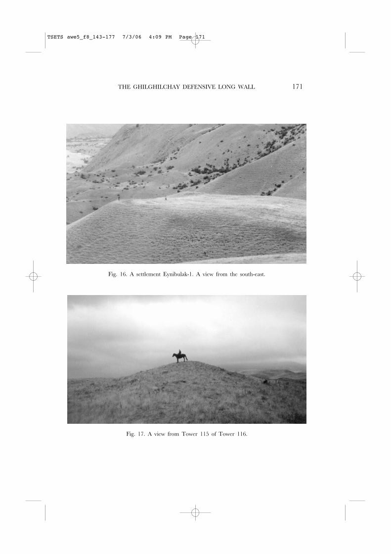
A dirt road that stretches from the Eynibulak village across the Ghilghilchayriver to the Kozaga (or Kozagadji) village is set near the foot of the moun-tain where the hollow broadens into a comparatively wide and flat basin.Here, a rectangular settlement sits above the right bank of the Ghilghilchayriver 0.8 km west of the Eynibulak village and 0.5 km south-southwest fromTower P108. This settlement was designated Eynibulak-1 (Figs. 9, 16). It occu-pies the top of a flat cape or promontory facing the river.
The settlement was naturally protected on its northern, western, and south-ern sides by the steep slopes (up to 45–50 degrees) of the cape. On its openeastern side, the territory of the settlement is raised 0.5–0.8 m. The settle-ment is rectangular in shape, measuring ca. 45 × 60 m (Fig. 9D). It was prob-ably protected along its perimeter by a defensive wall with four corner towers.The remains of two towers, preserved as low, rounded hills, are readily vis-ible, almost jutting out towards the river, at the north-western and south-western corners of the settlement. Fragments of burnt brick (32 × ? × 7 cm)and fragments of red-clay white-slip pottery of the Late Sasanian period(5th–7th centuries AD) were collected from the surface of the site.
The remains of the Ghilghilchay wall were not found immediately adja-cent to the settlement, but it is not possible to doubt that the Ghilghilchaywall continued here and included the fortified settlement of Eynibulak-1 inits defensive line for controlling the most convenient passage into and acrossthe river. The passage here is low and most convenient for connecting theriverbed with the plateau located to the west. This fortified settlement withits adjoining defensive wall would protect this pass against the possible advanceof an enemy who might use the wide river channel as a possible detouraround the coastal plain.
The final stretch of the foothill portion of the Ghilghilchay long wall beginsto be visible 200 m to the south of the Eynibulak-1 settlement on the oppo-site crest of the hollow. The wall extends to the south along the high, steep,and in some places abrupt, right southern bank of the Ghilghilchay river.Thirty towers (P111–P140) are arranged on this 1.5 km stretch, set 21 m to75 m apart (the usual distance 43–50 m) (Fig. 9). As already noted, it is here,
170 A. ALIEV, ET AL.
TSETS awe5_f8_143-177 7/3/06 4:09 PM Page 170
THE GHILGHILCHAY DEFENSIVE LONG WALL 171
Fig. 17. A view from Tower 115 of Tower 116.
Fig. 16. A settlement Eynibulak-1. A view from the south-east.
TSETS awe5_f8_143-177 7/3/06 4:09 PM Page 171
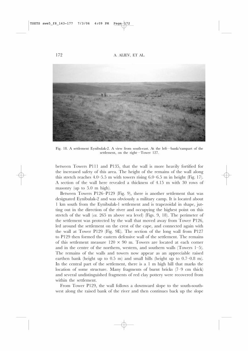
between Towers P111 and P135, that the wall is more heavily fortified forthe increased safety of this area. The height of the remains of the wall alongthis stretch reaches 4.0–5.5 m with towers rising 6.0–6.5 m in height (Fig. 17).A section of the wall here revealed a thickness of 4.15 m with 30 rows ofmasonry (up to 5.0 m high).
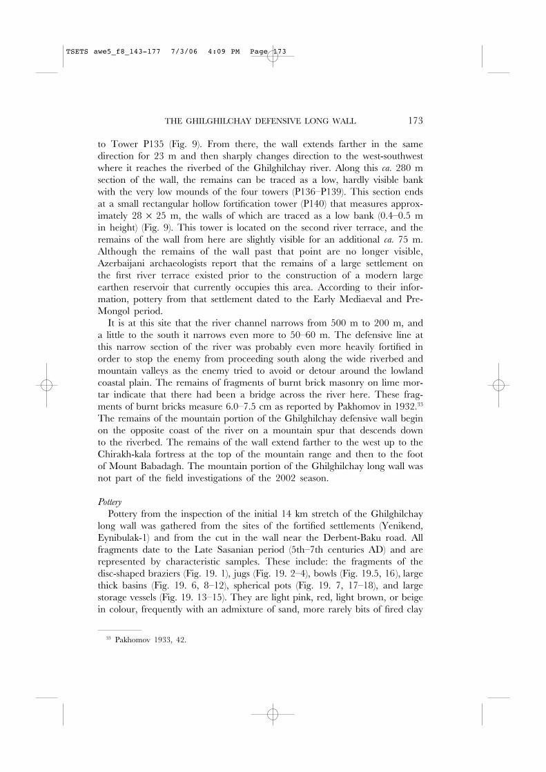
Between Towers P126–P129 (Fig. 9), there is another settlement that wasdesignated Eynibulak-2 and was obviously a military camp. It is located about1 km south from the Eynibulak-1 settlement and is trapezoidal in shape, jut-ting out in the direction of the river and occupying the highest point on thisstretch of the wall (ca. 265 m above sea level) (Figs. 9, 18). The perimeter ofthe settlement was protected by the wall that moved away from Tower P126,led around the settlement on the crest of the cape, and connected again withthe wall at Tower P129 (Fig. 9E). The section of the long wall from P127to P129 then formed the eastern defensive wall of the settlement. The remainsof this settlement measure 120 × 90 m. Towers are located at each cornerand in the centre of the northern, western, and southern walls (Towers 1–5).The remains of the walls and towers now appear as an appreciable raisedearthen bank (height up to 0.5 m) and small hills (height up to 0.7–0.8 m).In the central part of the settlement, there is a 1 m high hill that marks thelocation of some structure. Many fragments of burnt bricks (7–9 cm thick)and several undistinguished fragments of red clay pottery were recovered fromwithin the settlement.
From Tower P129, the wall follows a downward slope to the south-south-west along the raised bank of the river and then continues back up the slope
172 A. ALIEV, ET AL.
Fig. 18. A settlement Eynibulak-2. A view from south-east. At the left—bank/rampart of thesettlement, on the right—Tower 127.
TSETS awe5_f8_143-177 7/3/06 4:09 PM Page 172
THE GHILGHILCHAY DEFENSIVE LONG WALL 173
to Tower P135 (Fig. 9). From there, the wall extends farther in the samedirection for 23 m and then sharply changes direction to the west-southwestwhere it reaches the riverbed of the Ghilghilchay river. Along this ca. 280 msection of the wall, the remains can be traced as a low, hardly visible bankwith the very low mounds of the four towers (P136–P139). This section endsat a small rectangular hollow fortification tower (P140) that measures approx-imately 28 × 25 m, the walls of which are traced as a low bank (0.4–0.5 min height) (Fig. 9). This tower is located on the second river terrace, and theremains of the wall from here are slightly visible for an additional ca. 75 m.Although the remains of the wall past that point are no longer visible,Azerbaijani archaeologists report that the remains of a large settlement onthe first river terrace existed prior to the construction of a modern largeearthen reservoir that currently occupies this area. According to their infor-mation, pottery from that settlement dated to the Early Mediaeval and Pre-Mongol period.
It is at this site that the river channel narrows from 500 m to 200 m, anda little to the south it narrows even more to 50–60 m. The defensive line atthis narrow section of the river was probably even more heavily fortified inorder to stop the enemy from proceeding south along the wide riverbed andmountain valleys as the enemy tried to avoid or detour around the lowlandcoastal plain. The remains of fragments of burnt brick masonry on lime mor-tar indicate that there had been a bridge across the river here. These frag-ments of burnt bricks measure 6.0–7.5 cm as reported by Pakhomov in 1932.33
The remains of the mountain portion of the Ghilghilchay defensive wall beginon the opposite coast of the river on a mountain spur that descends downto the riverbed. The remains of the wall extend farther to the west up to theChirakh-kala fortress at the top of the mountain range and then to the footof Mount Babadagh. The mountain portion of the Ghilghilchay long wall wasnot part of the field investigations of the 2002 season.
Pottery
Pottery from the inspection of the initial 14 km stretch of the Ghilghilchaylong wall was gathered from the sites of the fortified settlements (Yenikend,Eynibulak-1) and from the cut in the wall near the Derbent-Baku road. Allfragments date to the Late Sasanian period (5th–7th centuries AD) and arerepresented by characteristic samples. These include: the fragments of thedisc-shaped braziers (Fig. 19. 1), jugs (Fig. 19. 2–4), bowls (Fig. 19.5, 16), largethick basins (Fig. 19. 6, 8–12), spherical pots (Fig. 19. 7, 17–18), and largestorage vessels (Fig. 19. 13–15). They are light pink, red, light brown, or beigein colour, frequently with an admixture of sand, more rarely bits of fired clay
33 Pakhomov 1933, 42.
TSETS awe5_f8_143-177 7/3/06 4:09 PM Page 173

174 A. ALIEV, ET AL.
Fig. 19. Pottery of the Ghilghilchay long wall.
TSETS awe5_f8_143-177 7/3/06 4:09 PM Page 174
THE GHILGHILCHAY DEFENSIVE LONG WALL 175
(chamotte). Many fragments have the white slip coating that is very character-istic for the pottery of this period. Most typical and chronologically diagnos-tic are the vessels with strongly pronounced rim profiles (Fig. 19. 4–7, 11, 12,15, 18). The same types of pottery, with the same technological indices (struc-ture, colour of paste) are present in the levels of the Sasanian period (5th–7thcenturies AD) at Derbent,34 among the pottery from the fortified settlementof Torpakh-kala,35 and at other archaeological sites of this period in the region(Besh-Barmak, Gadjmitepelyari, Sandiktepe, etc.).36 Parallels for this potterycan also be found on sites of the Sasanian period in Iran37 and south-westernTurkmenistan.38
Conclusion
These parallels for the collected ceramic assemblage of the fortifications ofthe Ghilghilchay long wall, as well as the parallels in building materials andengineering features of this defensive system with the mud-brick fortificationsof Derbent and Torpakh-kala that date from the middle to the second halfof the 5th century AD, gives a possible date for the construction of theGhilghilchay wall to the 5th–6th centuries AD. The Ghilghilchay long wallthen would have been constructed prior to the Derbent stone defensive com-plex, which was built during the reign of Shahanshah Khusraw I in the mid-dle of the 6th century AD. Additionally, the identification of this defensiveline with the long wall Apzut Kavat, mentioned by Ananias of Shirak (Pseudo-Moses of Khorene),39 which received its name in honour of the reigningmonarch, is sufficiently reliable. This enables us to attribute the constructionof the Ghilghilchay wall to the time of the reign of Shahanshah Kavad(488–531), or, more exactly, to the time of his second reign (beginning 498).
A more exact time of construction can be determined by considering thepolitical situation in the Caucasus and the Near East. Without undertaking adetailed analysis here of the situation, we specify that the most favourableconditions for the construction of such an extensive defensive system existedin the period between AD 508 and 522 when Iran had peace with Byzantiumand had established allied relations with the northern Caucasian Huns-Sabirsand had returned control of the eastern Caucasus and Derbent corridor.
34 Gadjiev 1989, 68–71, figs. 4–5; Gadjiev and Magomedov 2000, 235, fig. 5.35 Gadjiev 2001, 36, 40, fig. 2. 19–46.36 Khalilov, Koshkarli and Arazova 1991, 56–58, 105–106, tabls. XXI, XXIIIa, XLII;
Akhundov 1987, tabls. XL, XLI.37 See, for example, Keal and Keal 1981, figs. 8–20.38 Gubaev 1968, figs. 19. 1–3, 6; 20. 2, 5; Gubaev and Koshelenko 1970, 98, 102, figs. 34.
10, 19, 21; 37. 10, 12, 14).39 Moïse Corène, Géographie de Moïse Corène d’après Ptolémée, 27; Ananias of Shirak, The Geography
of Ananias of Shirak (Aaxaracoiz), 2. 12–13. As in n. 9 above.
TSETS awe5_f8_143-177 7/3/06 4:09 PM Page 175
The Ghilghilchay defensive wall maximised the use of the difficult mountainrelief and incorporated the methods of the fortification techniques of SasanianIran. It became a prototype for the stone defensive complex erected ca. 50years later at Derbent against its new powerful rival, the Turkish Khanate.
Asker A. Aliev and Idris N. AlievInstitute of Archaeology and EthnographyNational Academy of Sciences of Republic of AzerbaijanDjavid Prospect, 31BakuAzerbaijan
Murtazali S. Gadjiev and Rabadan M. MagomedovDepartment of ArchaeologyInstitute of History, Archaeology and EthnographyDaghestan Branch of the Russian Academy of Sciencesul. Muhammad Yaraghi, 75Makhachkala, 367030Daghestan, [email protected]@yandex.ru
M. Gaye GaitherDepartment of AnthropologyUniversity of Chicago1126 East 59th StreetChicago, IL [email protected]
Philip L. KohlDepartment of AnthropologyWellesley CollegeWellesley, MA [email protected]
BIBLIOGRAPHY
Abdullaev, H.P. 1968: ‘Gil’gil’chayskaya oboronitel’naya stena i krepost’ Chirakh-kala’. SA 2,196–209.
Akhundov, T.I. 1987: Istoricheskaya topografiya poselenii i sistema rasseleniya v Severo-Vostochnom Azerbayjane(seredina III tis. do n.e.—seredina I tis. n.e.) (text of dissertation) (Leningrad).
176 A. ALIEV, ET AL.
TSETS awe5_f8_143-177 7/3/06 4:09 PM Page 176
THE GHILGHILCHAY DEFENSIVE LONG WALL 177
Aliev, A.A. 1984: ‘Arheologicheskie raskopki Gil’gil’chayskogo oboronitel’nogo sooruzheniya’.In Izvestiya Akademii nauk Azerbayjanskoi SSR. Seriya istorii, filosofii i prava 3 (Baku), 64–70.
——. 1985: ‘Ob oboronitel’nikh sooruzheniyakh Kavkazskoi Albani’. In Vsesoyuznaya arkheo-logicheskaya konferentsiya. Tezisi dokladov (Baku), 50–51.
——. 1986: Gil’gil’chayskoe oboronitel’noe sooruzhenie (Baku).Altheim, F. and Stiehl, R. 1958: ‘Michael der Syrer über das erste Aufreten der Bulgaren und
Chazaren’. Byzantion 28, 105–18.Artamonov, M.I. 1962: Istoriya khazarov (Leningrad).Description 1958: ‘Opisanie Yuzhnogo Dagestana. 1796 god’. In Kosven, M.O. and Khashaev,
K.-M. (eds.), Istoriya, geografiya i etnografiya Dagestana XVIII–XIX vekov. Arhivnye materialy (Moscow),138–56.
Gadjiev, M.S. 1980: ‘K voprosu o mestopolozhenii sasanidskogo goroda Shahristan-i Yezdegerd’.In Drevnie i srednevekovie pamyatniki Dagestana (Makhachkala), 144–52.
——. 1989: ‘Issledovaniya sirtsevoi fortifikatsii tsitadeli Derbenta sasanidskogo vremeni (pomaterialam raskopov R-XI i R-XIII)’. In Drevnyaya i srednevekovaya arkhitektura Dagestana(Makhachkala), 61–76.
——. 1995: ‘K lokalizatsii Samarona’. In Tezisi dokladov regional’noy nauchnoy konferentsii, posvyashchen-noi gumanitarnim issledovaniyam (Makhachkala), 7–8.
——. 2001: ‘Gorodische Torpakh-kala’. In Arkheologiya vostochnoevropeyskoi lesostepi. No. 15. Srednevekoviedrevnosti evraziiskikh stepei (Voronezh), 32–40.
——. 2002: Drevnii gorod Dagestana. Opyt istoriko-topograficheskogo i sotsial’no-economicheskogo analiza(Moscow).
Gadjiev, M.S. and Magomedov, A.R. 2000: ‘Raskopki forta Gornoy steny (sezony 1996, 1998godov)’. In Kavkaz i stepnoi mir v drevnosti i srednie veka (Makhachkala), 213–35.
Gubaev, A. 1968: ‘Izuchenie rannesrednevekovkih pamyatnikov v raione Artika’. In Karakumskiedrevnosti II (Ashkhabad), 81–83.
Gubaev, A. and Koshelenko, G.A. 1970: ‘Issledovanie parfyanskogo svyatilishcha Mansur-depei rannesrednevekovogo zamka Ak-depe’. In Karakumskie drevnosti III (Ashkhabad), 89–104.
Hoffmann, G. 1880: ‘Auszüge aus syrischen Akten Persischer Martyrer’. In Abhandlungen für dieKunde des Morgenlandes: Excurse. B.VII. no. 3 (Leipzig), 325.
Keal, E.J and Keal, M.J. 1981: ‘The Qal‘eh Yazdigird Pottery: A Statistical Approach’. IranXIX, 33–80.
Khalilov, J.A., Koshkarli, K.O. and Arazova, R.B. 1991: Arkheologicheskie pamyatniki Severo-VostochnogoAzerbaijana (Baku).
Kudryavtsev, A.A. 1978: ‘O datirovke pervikh sasanidskikh ukreplenii v Derbente’. SA 3, 243–57.——. 1979: ‘Dlinnie steni na Vostochnom Kavkaze’. Voprosi istorii 11, 31–43.Kulakovskiy, Y. 1913: Istoriya Vizantii vol. 1 (Kiev).Kuznetsov, N. 1893: ‘Derbent’. In Brokgauz, F.A. and Efron, I.A. (eds.), Entsiklopedicheskii slo-
var’ vol. 19 (St Petersburg), 423.Marguart, J. 1901: Eran“ahr nach der Geographie des Ps. Moses Xorenaci. Mit historisch-kritischen Kommentar
und historischen und topographischen Excursen (Berlin).——. 1903: Osteuropäische und ostasiatische Streifsüge. Ethnologische und historisch-topograpische Studien zur
Geschichte des 9 und 10. Jahrhunderts (ca 840–940) (Leipzig).Pakhomov, E.A. 1933: ‘Krupneishie pamyatniki sasanidskogo stroitel’stva v Zakavkaz’e’. In
Problemi istorii material’noi kul’turi 9–10 (Moscow), 40–43.Semenov, I.G. 2002: Etnopoliticheskaya istoriya Vostochnogo Kavkaza III–VI vekov (summary of dis-
sertation) (Makhachkala), 15–17.Tableau . . . 1798: Tableau des provinces cituées sur la côte occidentale de la Mer Caspienne entre les Fleuuves
Terek et Kour (St Petersburg).Trever, K.V. 1959: Ocherki po istorii i kul’ture Kavkazskoi Albanii (Moscow/Leningrad).Yeremyan, S.T. 1941: ‘Syunia i oborona Sasanidami kavkazskikh prohodov’. In Izvestiya
Armyanskogo filiala Akademii nauk SSSR 7 (Yerevan), 33–40.
TSETS awe5_f8_143-177 7/3/06 4:09 PM Page 177