the diocese of portsmouth parish boundaries 2018
TRANSCRIPT
TheDioceseofPortsmouthParishBoundaries
2018
DioceseofPortsmouthParishboundaries2018
Page2of119
DioceseofPortsmouthParishboundaries2018
Page3of119
This document describes the boundaries of each parish in the Diocese ofPortsmouth in 2018. The parishes are listed in alphabetical order by Deanery(numerical order) and Pastoral Area (alphabetical order). Each description isfollowed by a screen shot from the version of Googlemaps onto which theboundaries were marked in 2015 and 2018. In the event of any discrepancybetween the narrative and the screen shot (or Googlemaps original), thisnarrativetakesprecedence.FrPhilCarrollBishop’sSecretary23rdApril2018TheMemorialofOurLadyofMountCarmel
DioceseofPortsmouthParishboundaries2018
Page4of119
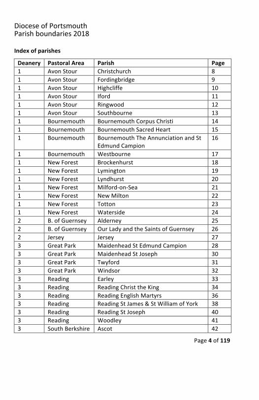
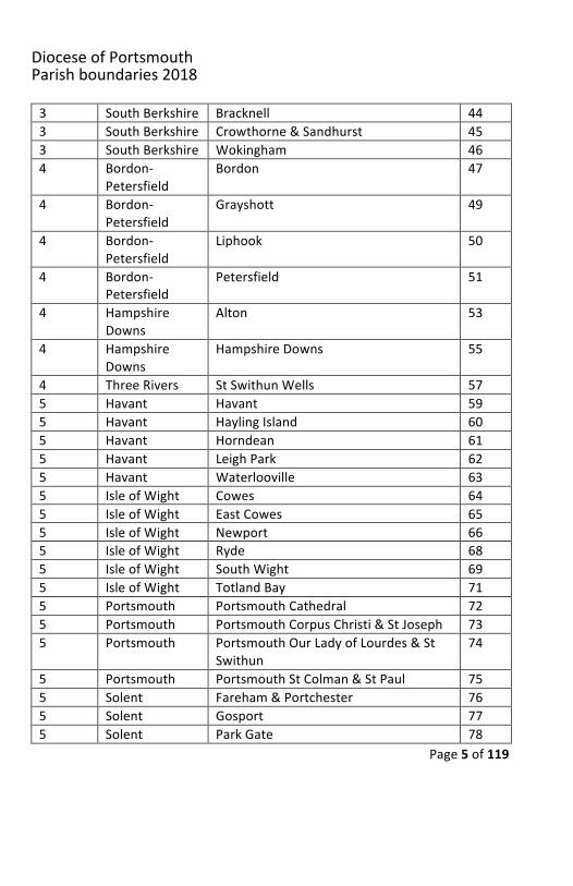
Indexofparishes
Deanery PastoralArea Parish Page1 AvonStour Christchurch 81 AvonStour Fordingbridge 91 AvonStour Highcliffe 101 AvonStour Iford 111 AvonStour Ringwood 121 AvonStour Southbourne 131 Bournemouth BournemouthCorpusChristi 141 Bournemouth BournemouthSacredHeart 151 Bournemouth BournemouthTheAnnunciationandSt
EdmundCampion16
1 Bournemouth Westbourne 171 NewForest Brockenhurst 181 NewForest Lymington 191 NewForest Lyndhurst 201 NewForest Milford-on-Sea 211 NewForest NewMilton 221 NewForest Totton 231 NewForest Waterside 242 B.ofGuernsey Alderney 252 B.ofGuernsey OurLadyandtheSaintsofGuernsey 262 Jersey Jersey 273 GreatPark MaidenheadStEdmundCampion 283 GreatPark MaidenheadStJoseph 303 GreatPark Twyford 313 GreatPark Windsor 323 Reading Earley 333 Reading ReadingChristtheKing 343 Reading ReadingEnglishMartyrs 363 Reading ReadingStJames&StWilliamofYork 383 Reading ReadingStJoseph 403 Reading Woodley 413 SouthBerkshire Ascot 42
DioceseofPortsmouthParishboundaries2018
Page5of119
3 SouthBerkshire Bracknell 443 SouthBerkshire Crowthorne&Sandhurst 453 SouthBerkshire Wokingham 464 Bordon-
PetersfieldBordon 47
4 Bordon-Petersfield
Grayshott 49
4 Bordon-Petersfield
Liphook 50
4 Bordon-Petersfield
Petersfield 51
4 HampshireDowns
Alton 53
4 HampshireDowns
HampshireDowns 55
4 ThreeRivers StSwithunWells 575 Havant Havant 595 Havant HaylingIsland 605 Havant Horndean 615 Havant LeighPark 625 Havant Waterlooville 635 IsleofWight Cowes 645 IsleofWight EastCowes 655 IsleofWight Newport 665 IsleofWight Ryde 685 IsleofWight SouthWight 695 IsleofWight TotlandBay 715 Portsmouth PortsmouthCathedral 725 Portsmouth PortsmouthCorpusChristi&StJoseph 735 Portsmouth PortsmouthOurLadyofLourdes&St
Swithun74
5 Portsmouth PortsmouthStColman&StPaul 755 Solent Fareham&Portchester 765 Solent Gosport 775 Solent ParkGate 78
DioceseofPortsmouthParishboundaries2018
Page6of119
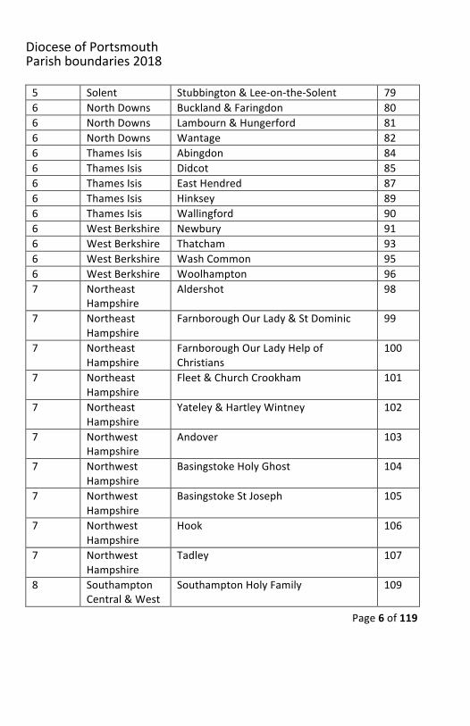
5 Solent Stubbington&Lee-on-the-Solent 796 NorthDowns Buckland&Faringdon 806 NorthDowns Lambourn&Hungerford 816 NorthDowns Wantage 826 ThamesIsis Abingdon 846 ThamesIsis Didcot 856 ThamesIsis EastHendred 876 ThamesIsis Hinksey 896 ThamesIsis Wallingford 906 WestBerkshire Newbury 916 WestBerkshire Thatcham 936 WestBerkshire WashCommon 956 WestBerkshire Woolhampton 967 Northeast
HampshireAldershot 98
7 NortheastHampshire
FarnboroughOurLady&StDominic 99
7 NortheastHampshire
FarnboroughOurLadyHelpofChristians
100
7 NortheastHampshire
Fleet&ChurchCrookham 101
7 NortheastHampshire
Yateley&HartleyWintney 102
7 NorthwestHampshire
Andover 103
7 NorthwestHampshire
BasingstokeHolyGhost 104
7 NorthwestHampshire
BasingstokeStJoseph 105
7 NorthwestHampshire
Hook 106
7 NorthwestHampshire
Tadley 107
8 SouthamptonCentral&West
SouthamptonHolyFamily 109
DioceseofPortsmouthParishboundaries2018
Page7of119
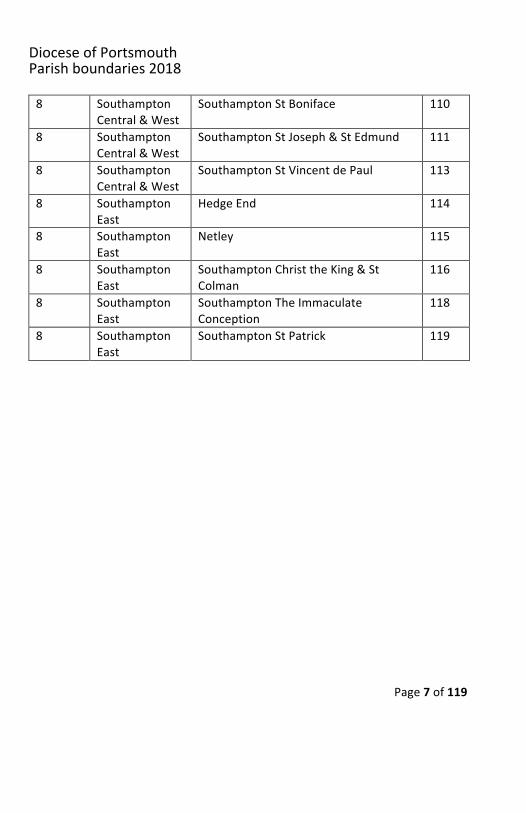
8 SouthamptonCentral&West
SouthamptonStBoniface 110
8 SouthamptonCentral&West
SouthamptonStJoseph&StEdmund 111
8 SouthamptonCentral&West
SouthamptonStVincentdePaul 113
8 SouthamptonEast
HedgeEnd 114
8 SouthamptonEast
Netley 115
8 SouthamptonEast
SouthamptonChristtheKing&StColman
116
8 SouthamptonEast
SouthamptonTheImmaculateConception
118
8 SouthamptonEast
SouthamptonStPatrick 119
DioceseofPortsmouthParishboundaries2018
Page8of119
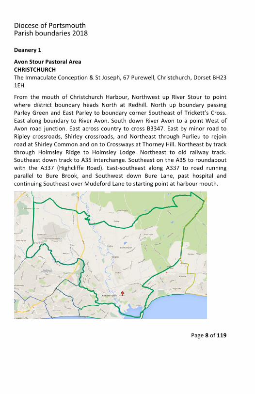
Deanery1AvonStourPastoralAreaCHRISTCHURCHTheImmaculateConception&StJoseph,67Purewell,Christchurch,DorsetBH231EH
From the mouth of Christchurch Harbour, Northwest up River Stour to pointwhere district boundary heads North at Redhill. North up boundary passingParleyGreenandEastParley toboundarycornerSoutheastofTrickett’sCross.Eastalongboundary toRiverAvon.SouthdownRiverAvon toapointWestofAvon road junction. East across country to crossB3347. Eastbyminor road toRipley crossroads, Shirley crossroads, and Northeast through Purlieu to rejoinroadatShirleyCommonandontoCrosswaysatThorneyHill.Northeastbytrackthrough Holmsley Ridge to Holmsley Lodge. Northeast to old railway track.SoutheastdowntracktoA35interchange.SoutheastontheA35toroundaboutwith the A337 (Highcliffe Road). East-southeast along A337 to road runningparallel to Bure Brook, and Southwest down Bure Lane, past hospital andcontinuingSoutheastoverMudefordLanetostartingpointatharbourmouth.
DioceseofPortsmouthParishboundaries2018
Page9of119
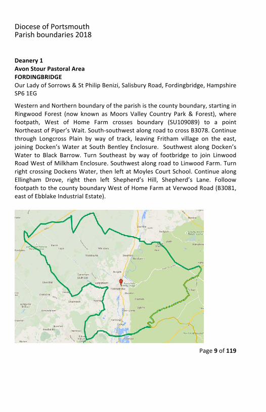
Deanery1AvonStourPastoralAreaFORDINGBRIDGEOurLadyofSorrows&StPhilipBenizi,SalisburyRoad,Fordingbridge,HampshireSP61EGWesternandNorthernboundaryoftheparishisthecountyboundary,startinginRingwood Forest (now known asMoors Valley Country Park & Forest), wherefootpath, West of Home Farm crosses boundary (SU109089) to a pointNortheastofPiper’sWait.South-southwestalongroadtocrossB3078.Continuethrough Longcross Plain by way of track, leaving Fritham village on the east,joiningDocken’sWateratSouthBentleyEnclosure. SouthwestalongDocken’sWater to Black Barrow. Turn Southeast by way of footbridge to join LinwoodRoadWestofMilkhamEnclosure.SouthwestalongroadtoLinwoodFarm.TurnrightcrossingDockensWater,thenleftatMoylesCourtSchool.ContinuealongEllingham Drove, right then left Shepherd’s Hill, Shepherd’s Lane. FolloowfootpathtothecountyboundaryWestofHomeFarmatVerwoodRoad(B3081,eastofEbblakeIndustrialEstate).
DioceseofPortsmouthParishboundaries2018
Page10of119
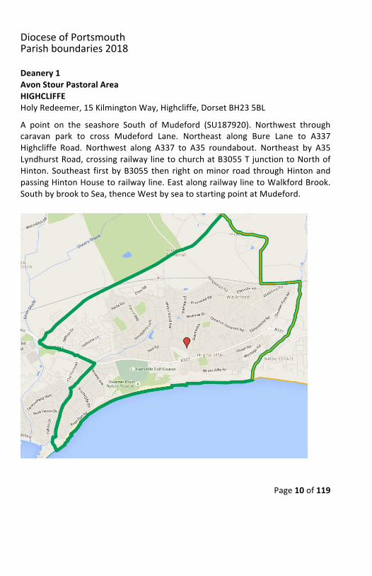
Deanery1AvonStourPastoralAreaHIGHCLIFFEHolyRedeemer,15KilmingtonWay,Highcliffe,DorsetBH235BLA point on the seashore South of Mudeford (SU187920). Northwest throughcaravan park to cross Mudeford Lane. Northeast along Bure Lane to A337Highcliffe Road. Northwest along A337 to A35 roundabout. Northeast by A35LyndhurstRoad,crossingrailwaylinetochurchatB3055TjunctiontoNorthofHinton.Southeast firstbyB3055 then rightonminor road throughHintonandpassingHintonHousetorailwayline.EastalongrailwaylinetoWalkfordBrook.SouthbybrooktoSea,thenceWestbyseatostartingpointatMudeford.
DioceseofPortsmouthParishboundaries2018
Page11of119
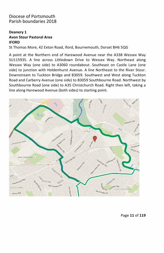
Deanery1AvonStourPastoralAreaIFORDStThomasMore,42ExtonRoad,Iford,Bournemouth,DorsetBH65QGApoint at theNorthernendofHarewoodAvenuenear theA338WessexWaySU115935. A line across Littledown Drive to Wessex Way. Northeast alongWessexWay (one side) to A3060 roundabout. Southeast on Castle Lane (oneside)to junctionwithHoldenhurstAvenue.A lineNortheasttotheRiverStour.DownstreamtoTucktonBridgeandB3059.SouthwestandWestalongTucktonRoadandCarberryAvenue(oneside)toB3059SouthbourneRoad.NorthwestbySouthbourneRoad(oneside)toA35ChristchurchRoad.Rightthenleft,takingalinealongHarewoodAvenue(bothsides)tostartingpoint.
DioceseofPortsmouthParishboundaries2018
Page12of119
Deanery1AvonStourPastoralAreaRINGWOODSacredHeartandStThereseofLisieux,TheClose,Ringwood,HampshireBH241L
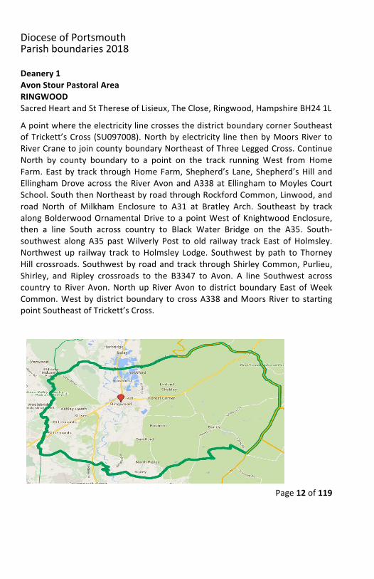
ApointwheretheelectricitylinecrossesthedistrictboundarycornerSoutheastofTrickett’sCross (SU097008).Northbyelectricity line thenbyMoorsRiver toRiverCranetojoincountyboundaryNortheastofThreeLeggedCross.ContinueNorth by county boundary to a point on the track running West from HomeFarm. Eastby track throughHomeFarm, Shepherd’s Lane, Shepherd’sHill andEllinghamDroveacross theRiverAvonandA338atEllinghamtoMoylesCourtSchool.SouththenNortheastbyroadthroughRockfordCommon,Linwood,androad North of Milkham Enclosure to A31 at Bratley Arch. Southeast by trackalongBolderwoodOrnamentalDrive toapointWestofKnightwoodEnclosure,then a line South across country to Black Water Bridge on the A35. South-southwest along A35 pastWilverly Post to old railway track East of Holmsley.Northwest up railway track toHolmsley Lodge. Southwest by path to ThorneyHill crossroads.Southwestby roadandtrack throughShirleyCommon,Purlieu,Shirley, and Ripley crossroads to the B3347 to Avon. A line Southwest acrosscountry toRiverAvon.NorthupRiverAvon todistrict boundary East ofWeekCommon.Westbydistrictboundary tocrossA338andMoorsRiver tostartingpointSoutheastofTrickett’sCross.
DioceseofPortsmouthParishboundaries2018
Page13of119
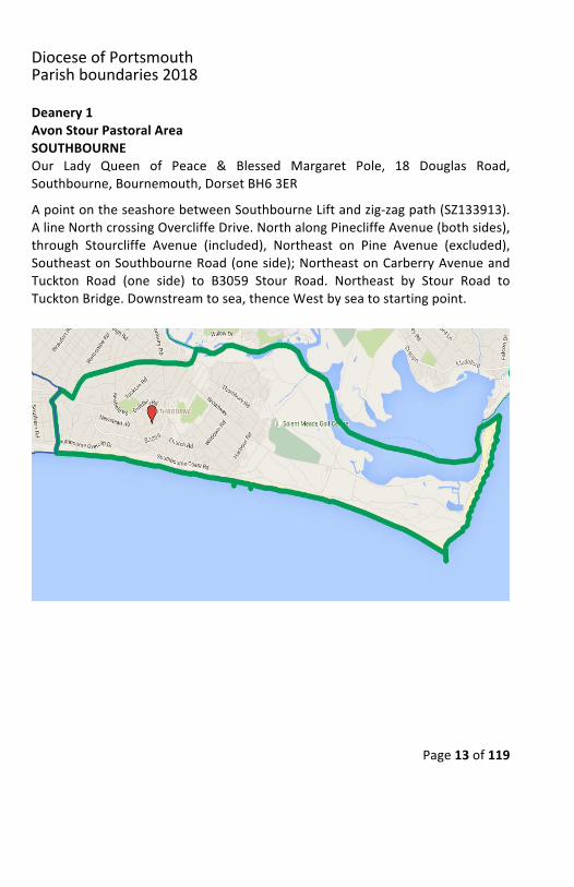
Deanery1AvonStourPastoralAreaSOUTHBOURNEOur Lady Queen of Peace & Blessed Margaret Pole, 18 Douglas Road,Southbourne,Bournemouth,DorsetBH63ERApointontheseashorebetweenSouthbourneLiftandzig-zagpath(SZ133913).AlineNorthcrossingOvercliffeDrive.NorthalongPinecliffeAvenue(bothsides),through Stourcliffe Avenue (included), Northeast on Pine Avenue (excluded),SoutheastonSouthbourneRoad(oneside);NortheastonCarberryAvenueandTuckton Road (one side) to B3059 Stour Road. Northeast by Stour Road toTucktonBridge.Downstreamtosea,thenceWestbyseatostartingpoint.
DioceseofPortsmouthParishboundaries2018
Page14of119
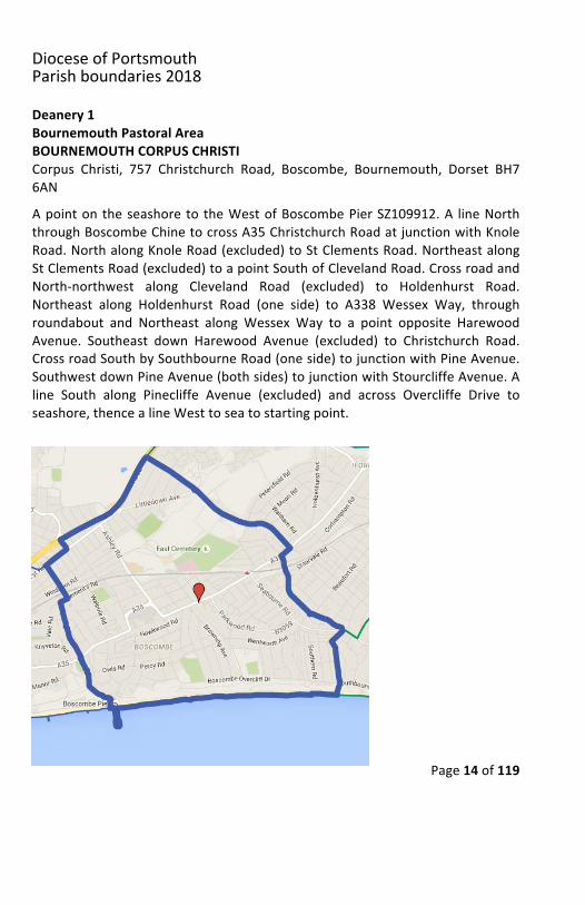
Deanery1BournemouthPastoralAreaBOURNEMOUTHCORPUSCHRISTICorpus Christi, 757 Christchurch Road, Boscombe, Bournemouth, Dorset BH76ANApointontheseashore to theWestofBoscombePierSZ109912.A lineNorththroughBoscombeChinetocrossA35ChristchurchRoadatjunctionwithKnoleRoad.NorthalongKnoleRoad(excluded)toStClementsRoad.NortheastalongStClementsRoad(excluded)toapointSouthofClevelandRoad.CrossroadandNorth-northwest along Cleveland Road (excluded) to Holdenhurst Road.Northeast along Holdenhurst Road (one side) to A338 Wessex Way, throughroundabout and Northeast along Wessex Way to a point opposite HarewoodAvenue. Southeast down Harewood Avenue (excluded) to Christchurch Road.CrossroadSouthbySouthbourneRoad(oneside)tojunctionwithPineAvenue.SouthwestdownPineAvenue(bothsides)tojunctionwithStourcliffeAvenue.Aline South along Pinecliffe Avenue (excluded) and across Overcliffe Drive toseashore,thencealineWesttoseatostartingpoint.
DioceseofPortsmouthParishboundaries2018
Page15of119
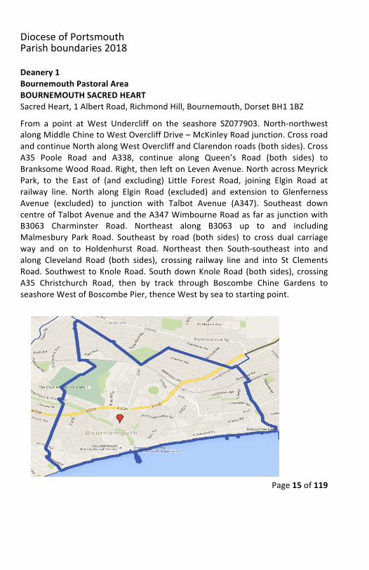
Deanery1BournemouthPastoralAreaBOURNEMOUTHSACREDHEARTSacredHeart,1AlbertRoad,RichmondHill,Bournemouth,DorsetBH11BZFrom a point at West Undercliff on the seashore SZ077903. North-northwestalongMiddleChinetoWestOvercliffDrive–McKinleyRoadjunction.CrossroadandcontinueNorthalongWestOvercliffandClarendonroads(bothsides).CrossA35 Poole Road and A338, continue along Queen’s Road (both sides) toBranksomeWoodRoad.Right,thenleftonLevenAvenue.NorthacrossMeyrickPark, to the East of (and excluding) Little Forest Road, joining Elgin Road atrailway line. North along Elgin Road (excluded) and extension to GlenfernessAvenue (excluded) to junction with Talbot Avenue (A347). Southeast downcentreofTalbotAvenueandtheA347WimbourneRoadasfarasjunctionwithB3063 Charminster Road. Northeast along B3063 up to and includingMalmesbury Park Road. Southeast by road (both sides) to cross dual carriageway and on to Holdenhurst Road. Northeast then South-southeast into andalong Cleveland Road (both sides), crossing railway line and into St ClementsRoad. Southwest toKnoleRoad. SouthdownKnoleRoad (both sides), crossingA35 Christchurch Road, then by track through Boscombe Chine Gardens toseashoreWestofBoscombePier,thenceWestbyseatostartingpoint.
DioceseofPortsmouthParishboundaries2018
Page16of119
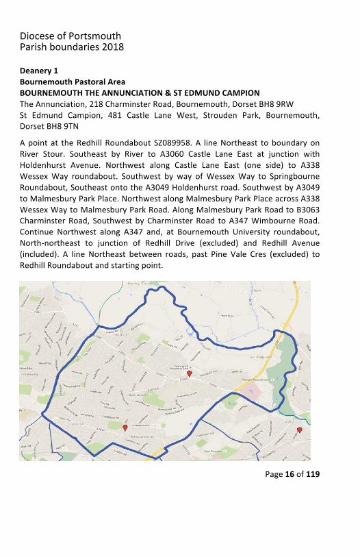
Deanery1BournemouthPastoralAreaBOURNEMOUTHTHEANNUNCIATION&STEDMUNDCAMPIONTheAnnunciation,218CharminsterRoad,Bournemouth,DorsetBH89RWSt Edmund Campion, 481 Castle Lane West, Strouden Park, Bournemouth,DorsetBH89TNApoint at theRedhill Roundabout SZ089958.A lineNortheast toboundaryonRiver Stour. Southeast by River to A3060 Castle Lane East at junction withHoldenhurst Avenue. Northwest along Castle Lane East (one side) to A338WessexWay roundabout. Southwest by way ofWessexWay to SpringbourneRoundabout,SoutheastontotheA3049Holdenhurstroad.SouthwestbyA3049toMalmesburyParkPlace.NorthwestalongMalmesburyParkPlaceacrossA338WessexWaytoMalmesburyParkRoad.AlongMalmesburyParkRoadtoB3063CharminsterRoad, SouthwestbyCharminsterRoad toA347WimbourneRoad.Continue Northwest along A347 and, at Bournemouth University roundabout,North-northeast to junction of Redhill Drive (excluded) and Redhill Avenue(included). A line Northeast between roads, past Pine Vale Cres (excluded) toRedhillRoundaboutandstartingpoint.
DioceseofPortsmouthParishboundaries2018
Page17of119
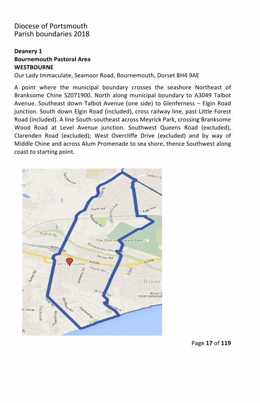
Deanery1BournemouthPastoralAreaWESTBOURNEOurLadyImmaculate,SeamoorRoad,Bournemouth,DorsetBH49AEA point where the municipal boundary crosses the seashore Northeast ofBranksome Chine SZ071900. North alongmunicipal boundary to A3049 TalbotAvenue.SoutheastdownTalbotAvenue (oneside) toGlenferness–ElginRoadjunction.SouthdownElginRoad(included),crossrailwayline,pastLittleForestRoad(included).AlineSouth-southeastacrossMeyrickPark,crossingBranksomeWood Road at Level Avenue junction. Southwest Queens Road (excluded),Clarenden Road (excluded); West Overcliffe Drive (excluded) and by way ofMiddleChineandacrossAlumPromenadetoseashore,thenceSouthwestalongcoasttostartingpoint.
DioceseofPortsmouthParishboundaries2018
Page18of119
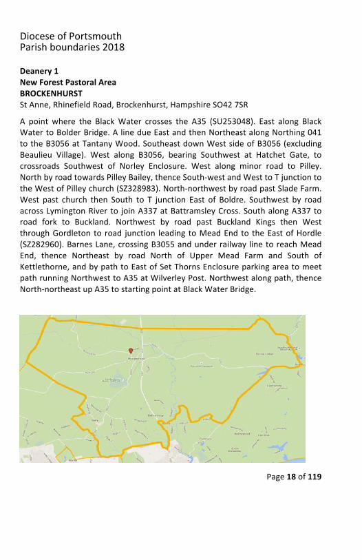
Deanery1NewForestPastoralAreaBROCKENHURSTStAnne,RhinefieldRoad,Brockenhurst,HampshireSO427SRA point where the BlackWater crosses the A35 (SU253048). East along BlackWatertoBolderBridge.AlinedueEastandthenNortheastalongNorthing041totheB3056atTantanyWood.SoutheastdownWestsideofB3056(excludingBeaulieu Village). West along B3056, bearing Southwest at Hatchet Gate, tocrossroads Southwest of Norley Enclosure. West along minor road to Pilley.NorthbyroadtowardsPilleyBailey,thenceSouth-westandWesttoTjunctiontotheWestofPilleychurch(SZ328983).North-northwestbyroadpastSladeFarm.West past church then South to T junction East of Boldre. Southwest by roadacrossLymingtonRiver to joinA337atBattramsleyCross.SouthalongA337toroad fork to Buckland. Northwest by road past Buckland Kings then WestthroughGordleton to road junction leading toMeadEnd to theEastofHordle(SZ282960).BarnesLane,crossingB3055andunderrailway linetoreachMeadEnd, thence Northeast by road North of Upper Mead Farm and South ofKettlethorne,andbypathtoEastofSetThornsEnclosureparkingareatomeetpathrunningNorthwesttoA35atWilverleyPost.Northwestalongpath,thenceNorth-northeastupA35tostartingpointatBlackWaterBridge.
DioceseofPortsmouthParishboundaries2018
Page19of119
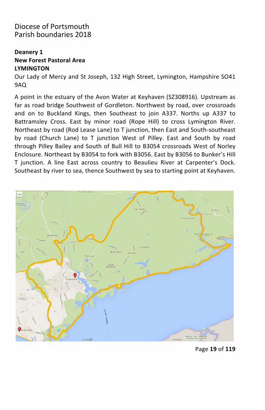
Deanery1NewForestPastoralAreaLYMINGTONOurLadyofMercyandStJoseph,132HighStreet,Lymington,HampshireSO419AQApointintheestuaryoftheAvonWateratKeyhaven(SZ308916).UpstreamasfarasroadbridgeSouthwestofGordleton.Northwestbyroad,overcrossroadsand on to Buckland Kings, then Southeast to join A337. Norths up A337 toBattramsley Cross. East by minor road (Rope Hill) to cross Lymington River.Northeastbyroad(RodLeaseLane)toTjunction,thenEastandSouth-southeastby road (Church Lane) to T junction West of Pilley. East and South by roadthroughPilleyBaileyandSouthofBullHill toB3054crossroadsWestofNorleyEnclosure.NortheastbyB3054toforkwithB3056.EastbyB3056toBunker’sHillT junction. A line East across country to Beaulieu River at Carpenter’s Dock.Southeastbyrivertosea,thenceSouthwestbyseatostartingpointatKeyhaven.
DioceseofPortsmouthParishboundaries2018
Page20of119
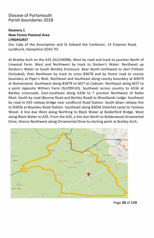
Deanery1NewForestPastoralAreaLYNDHURSTOur Lady of the Assumption and St Edward the Confessor, 14 Empress Road,Lyndhurst,HampshireSO437FLAtBratleyArchontheA31(SU234098).WestbyroadandtracktojunctionNorthofLinwood Farm. West and Northwest by track to Docken’s Water. Northeast upDocken’sWater to SouthBentley Enclosure.BearNorth-northwest to skirt Fritham(included), then Northeast by track to cross B3078 and by forest road to countyboundaryatPiper’sWait.NortheastandSoutheastalongcountyboundaryatB3079atNomansland.SouthwestalongB3079toM27atCadnam.NortheastalongM27toa point opposite Withers Farm (SU299143). Southeast across country to A336 atBartley crossroads. East-southeast along A336 to T junction Northwest of RadioMast.Southbyroad(BourneRoadandBartleyRoad)toWoodlandsLodge.SoutheastbyroadtoA35railwaybridgenearLyndhurstRoadStation.SouthdownrailwaylinetoB3056atBeaulieuRoadStation.SoutheastalongB3056(HatchetLane)toTantanyWood. A line dueWest alongNorthing to BlackWater at Bolderford Bridge.WestalongBlackWatertoA35.FromtheA35,alinedueNorthtoBolderwoodOrnamentalDrive,thenceNorthwestalongOrnamentalDrivetostartingpointatBratleyArch.
DioceseofPortsmouthParishboundaries2018
Page21of119
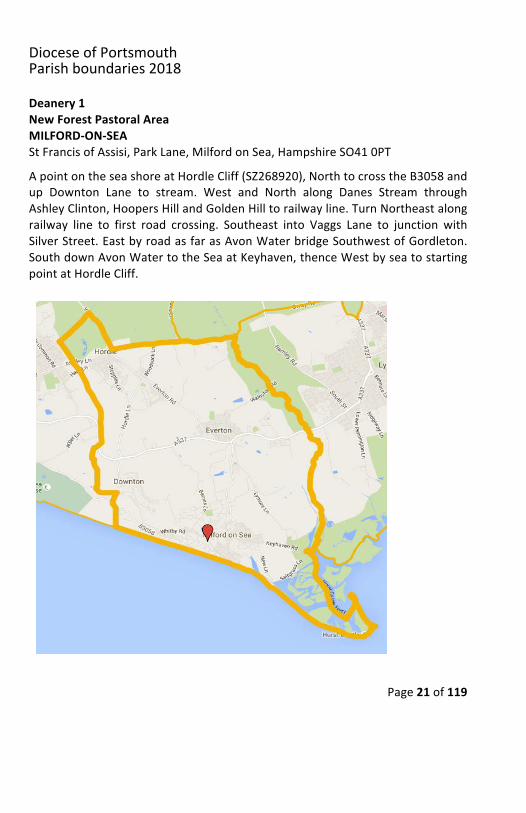
Deanery1NewForestPastoralAreaMILFORD-ON-SEAStFrancisofAssisi,ParkLane,MilfordonSea,HampshireSO410PTApointontheseashoreatHordleCliff(SZ268920),NorthtocrosstheB3058andup Downton Lane to stream. West and North along Danes Stream throughAshleyClinton,HoopersHillandGoldenHilltorailwayline.TurnNortheastalongrailway line to first road crossing. Southeast into Vaggs Lane to junction withSilverStreet.EastbyroadasfarasAvonWaterbridgeSouthwestofGordleton.SouthdownAvonWatertotheSeaatKeyhaven,thenceWestbyseatostartingpointatHordleCliff.
DioceseofPortsmouthParishboundaries2018
Page22of119
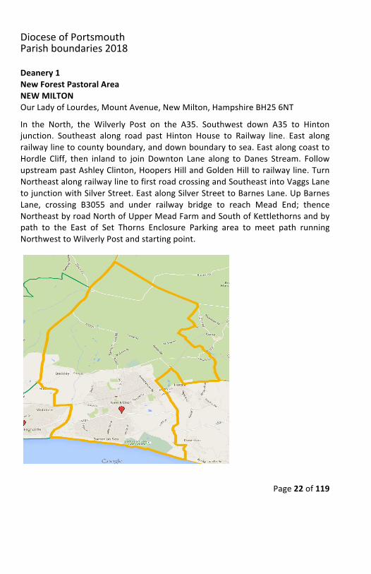
Deanery1NewForestPastoralAreaNEWMILTONOurLadyofLourdes,MountAvenue,NewMilton,HampshireBH256NTIn the North, the Wilverly Post on the A35. Southwest down A35 to Hintonjunction. Southeast along road past Hinton House to Railway line. East alongrailwaylinetocountyboundary,anddownboundarytosea.EastalongcoasttoHordle Cliff, then inland to join Downton Lane along to Danes Stream. FollowupstreampastAshleyClinton,HoopersHillandGoldenHilltorailwayline.TurnNortheastalongrailwaylinetofirstroadcrossingandSoutheastintoVaggsLanetojunctionwithSilverStreet.EastalongSilverStreettoBarnesLane.UpBarnesLane, crossing B3055 and under railway bridge to reach Mead End; thenceNortheastbyroadNorthofUpperMeadFarmandSouthofKettlethornsandbypath to the East of Set Thorns Enclosure Parking area to meet path runningNorthwesttoWilverlyPostandstartingpoint.
DioceseofPortsmouthParishboundaries2018
Page23of119
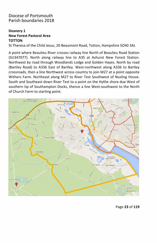
Deanery1NewForestPastoralAreaTOTTONStTheresaoftheChildJesus,20BeaumontRoad,Totton,HampshireSO403ALApointwhereBeaulieuRivercrossesrailwaylineNorthofBeaulieuRoadStation(SU347077). North along railway line to A35 at Ashurst New Forest Station.NorthwestbyroadthroughWoodlandsLodgeandGoldenHayes.Northbyroad(Bartley Road) to A336 East of Bartley.West-northwest along A336 to Bartleycrossroads,thenalineNorthwestacrosscountrytojoinM27atapointoppositeWithersFarm.NortheastalongM27 toRiverTestSouthwestofNuslingHouse.SouthandSoutheastdownRiverTesttoapointontheHytheshoredueWestofsoutherntipofSouthamptonDocks,thencealineWest-southwesttotheNorthofChurchFarmtostartingpoint.
DioceseofPortsmouthParishboundaries2018
Page24of119
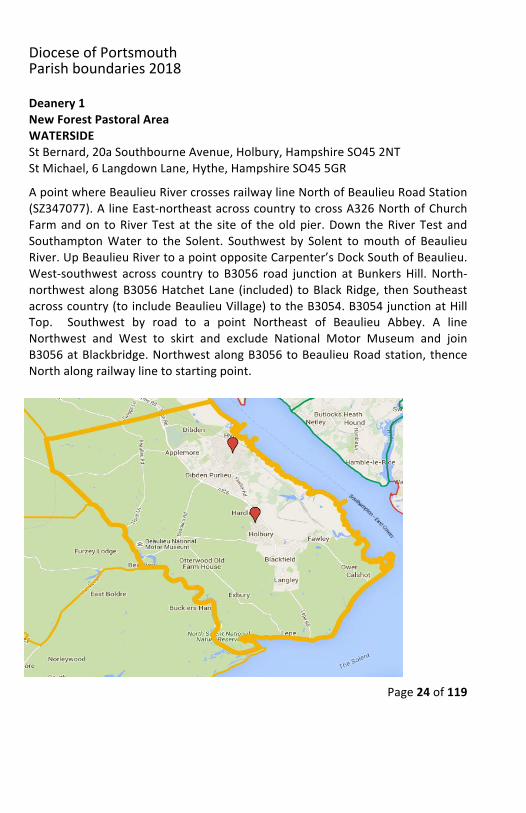
Deanery1NewForestPastoralAreaWATERSIDEStBernard,20aSouthbourneAvenue,Holbury,HampshireSO452NTStMichael,6LangdownLane,Hythe,HampshireSO455GRApointwhereBeaulieuRivercrossesrailwaylineNorthofBeaulieuRoadStation(SZ347077).AlineEast-northeastacrosscountrytocrossA326NorthofChurchFarmandon toRiverTestat the siteof theoldpier.Down theRiverTestandSouthamptonWater to the Solent. Southwest by Solent tomouth of BeaulieuRiver.UpBeaulieuRivertoapointoppositeCarpenter’sDockSouthofBeaulieu.West-southwest across country to B3056 road junction at Bunkers Hill. North-northwestalongB3056HatchetLane (included) toBlackRidge, thenSoutheastacrosscountry(toincludeBeaulieuVillage)totheB3054.B3054junctionatHillTop. Southwest by road to a point Northeast of Beaulieu Abbey. A lineNorthwest and West to skirt and exclude National Motor Museum and joinB3056atBlackbridge.NorthwestalongB3056toBeaulieuRoadstation,thenceNorthalongrailwaylinetostartingpoint.
DioceseofPortsmouthParishboundaries2018
Page25of119
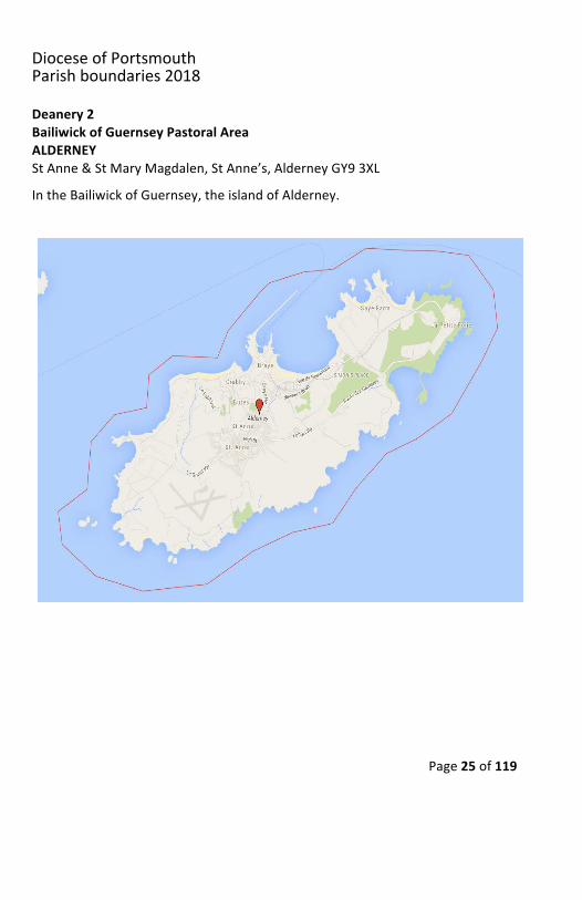
Deanery2BailiwickofGuernseyPastoralAreaALDERNEYStAnne&StMaryMagdalen,StAnne’s,AlderneyGY93XL
IntheBailiwickofGuernsey,theislandofAlderney.
DioceseofPortsmouthParishboundaries2018
Page26of119
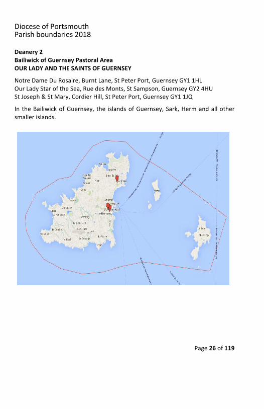
Deanery2BailiwickofGuernseyPastoralAreaOURLADYANDTHESAINTSOFGUERNSEYNotreDameDuRosaire,BurntLane,StPeterPort,GuernseyGY11HLOurLadyStaroftheSea,RuedesMonts,StSampson,GuernseyGY24HUStJoseph&StMary,CordierHill,StPeterPort,GuernseyGY11JQIn theBailiwickofGuernsey, the islandsofGuernsey,Sark,Hermandallothersmallerislands.
DioceseofPortsmouthParishboundaries2018
Page27of119
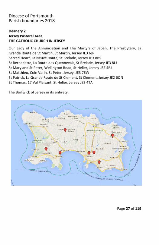
Deanery2JerseyPastoralAreaTHECATHOLICCHURCHINJERSEY
Our Lady of the Annunciation and The Martyrs of Japan, The Presbytery, LaGrandeRoutedeStMartin,StMartin,JerseyJE36JRSacredHeart,LaNeuveRoute,StBrelade,JerseyJE38BSStBernadette,LaRoutedesQuennevais,StBrelade,JerseyJE38LJStMaryandStPeter,WellingtonRoad,StHelier,JerseyJE24RJStMatthieu,CoinVarin,StPeter,Jersey,JE37EWStPatrick,LaGrandeRoutedeStClement,StClement,JerseyJE26QNStThomas,17ValPlaisant,StHelier,JerseyJE24TATheBailiwickofJerseyinitsentirety.
DioceseofPortsmouthParishboundaries2018
Page28of119
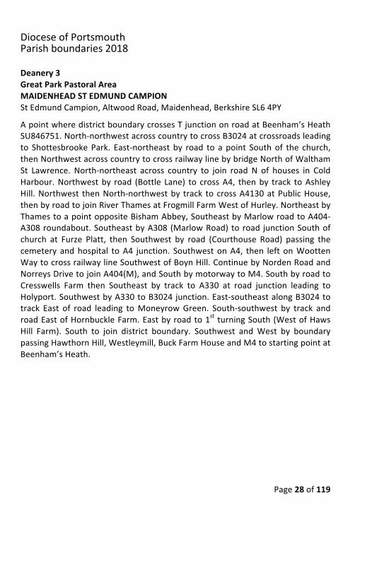
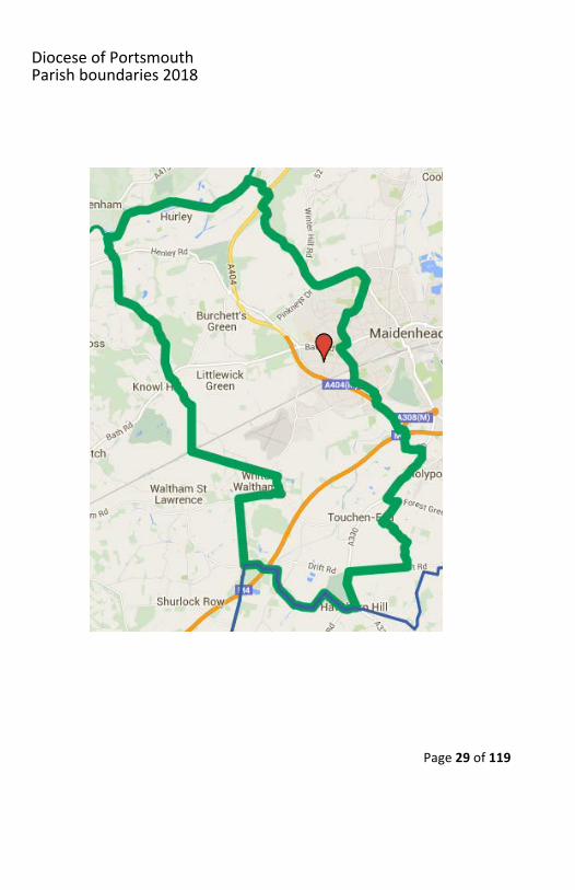
Deanery3GreatParkPastoralAreaMAIDENHEADSTEDMUNDCAMPIONStEdmundCampion,AltwoodRoad,Maidenhead,BerkshireSL64PYApointwheredistrictboundarycrossesTjunctiononroadatBeenham’sHeathSU846751.North-northwestacrosscountrytocrossB3024atcrossroadsleadingto Shottesbrooke Park. East-northeast by road to a point Southof the church,thenNorthwestacrosscountrytocrossrailwaylinebybridgeNorthofWalthamSt Lawrence. North-northeast across country to join road N of houses in ColdHarbour.Northwestby road (Bottle Lane) to crossA4, thenby track toAshleyHill.Northwest thenNorth-northwestby track to crossA4130atPublicHouse,thenbyroadtojoinRiverThamesatFrogmillFarmWestofHurley.NortheastbyThamestoapointoppositeBishamAbbey,SoutheastbyMarlowroadtoA404-A308roundabout.SoutheastbyA308(MarlowRoad)toroad junctionSouthofchurch at Furze Platt, then Southwest by road (Courthouse Road) passing thecemetery andhospital toA4 junction. Southwest onA4, then left onWoottenWaytocrossrailwaylineSouthwestofBoynHill.ContinuebyNordenRoadandNorreysDrivetojoinA404(M),andSouthbymotorwaytoM4.SouthbyroadtoCresswells Farm then Southeast by track to A330 at road junction leading toHolyport.SouthwestbyA330toB3024junction.East-southeastalongB3024totrack East of road leading toMoneyrowGreen. South-southwest by track androadEastofHornbuckleFarm.Eastbyroadto1st turningSouth(WestofHawsHill Farm). South to join district boundary. Southwest andWest by boundarypassingHawthornHill,Westleymill,BuckFarmHouseandM4tostartingpointatBeenham’sHeath.
DioceseofPortsmouthParishboundaries2018
Page29of119
DioceseofPortsmouthParishboundaries2018
Page30of119
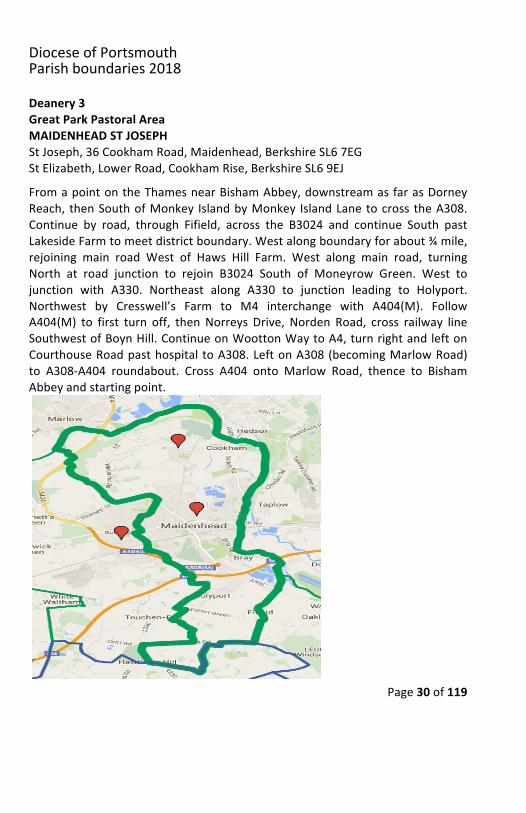
Deanery3GreatParkPastoralAreaMAIDENHEADSTJOSEPHStJoseph,36CookhamRoad,Maidenhead,BerkshireSL67EGStElizabeth,LowerRoad,CookhamRise,BerkshireSL69EJFromapointontheThamesnearBishamAbbey,downstreamasfarasDorneyReach, thenSouthofMonkey IslandbyMonkey IslandLanetocross theA308.Continue by road, through Fifield, across the B3024 and continue South pastLakesideFarmtomeetdistrictboundary.Westalongboundaryforabout¾mile,rejoining main road West of Haws Hill Farm. West along main road, turningNorth at road junction to rejoin B3024 South of Moneyrow Green. West tojunction with A330. Northeast along A330 to junction leading to Holyport.Northwest by Cresswell’s Farm to M4 interchange with A404(M). FollowA404(M) to first turn off, then Norreys Drive, Norden Road, cross railway lineSouthwestofBoynHill.ContinueonWoottonWaytoA4,turnrightandleftonCourthouseRoadpasthospitaltoA308.LeftonA308(becomingMarlowRoad)to A308-A404 roundabout. Cross A404 onto Marlow Road, thence to BishamAbbeyandstartingpoint.
DioceseofPortsmouthParishboundaries2018
Page31of119
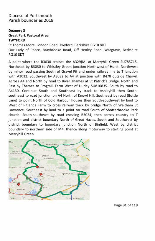
Deanery3GreatParkPastoralAreaTWYFORDStThomasMore,LondonRoad,Twyford,BerkshireRG108DTOur Lady of Peace, Braybrooke Road, Off Henley Road, Wargrave, BerkshireRG108DTA point where the B3030 crosses the A329(M) at Merryhill Green SU785715.NortheastbyB3030toWhistleyGreen junctionNorthwestofHurst.Northwestbyminor roadpassingSouthofGravelPit andunder railway line toT junctionwith A3032. Southwest by A3032 to A4 at junctionwith B478 outside Charvil.AcrossA4andNorthby roadtoRiverThamesatStPatrick’sBridge.NorthandEast by Thames to Frogmill FarmWest of Hurley SU810835. South by road toA4130. Continue South and Southeast by track to Ashleyhill then South-southeasttoroadjunctiononA4NorthofKnowlHill.Southeastbyroad(BottleLane) topointNorthofColdHarbourhouses thenSouth-southwestby land toWest of Pitlands Farm to cross railway track by bridge North of Waltham StLawrence. Southeast by land to a point on road South of Shotterbrooke Parkchurch. South-southeast by road crossing B3024, then across country to Tjunction and district boundary North of Great Hazes. South and Southwest bydistrict boundary to boundary junction North of Binfield. West by districtboundary to northern side ofM4, thence alongmotorway to starting point atMerryhillGreen.
DioceseofPortsmouthParishboundaries2018
Page32of119
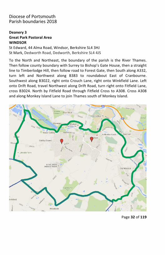
Deanery3GreatParkPastoralAreaWINDSORStEdward,44AlmaRoad,Windsor,BerkshireSL43HJStMark,DedworthRoad,Dedworth,BerkshireSL44JSTo the North and Northeast, the boundary of the parish is the River Thames.ThenfollowcountyboundarywithSurreytoBishop’sGateHouse,thenastraightlinetoTimberlodgeHill,thenfollowroadtoForestGate,thenSouthalongA332,turn left and Northwest along B383 to roundabout East of Cranbourne.SouthwestalongB3022,rightontoCrouchLane,rightontoWinkfieldLane.LeftontoDriftRoad,travelNorthwestalongDriftRoad,turnrightontoFitfieldLane,crossB3024.NorthbyFitfieldRoad throughFitfieldCross toA308.CrossA308andalongMonkeyIslandLanetojoinThamessouthofMonkeyIsland.
DioceseofPortsmouthParishboundaries2018
Page33of119
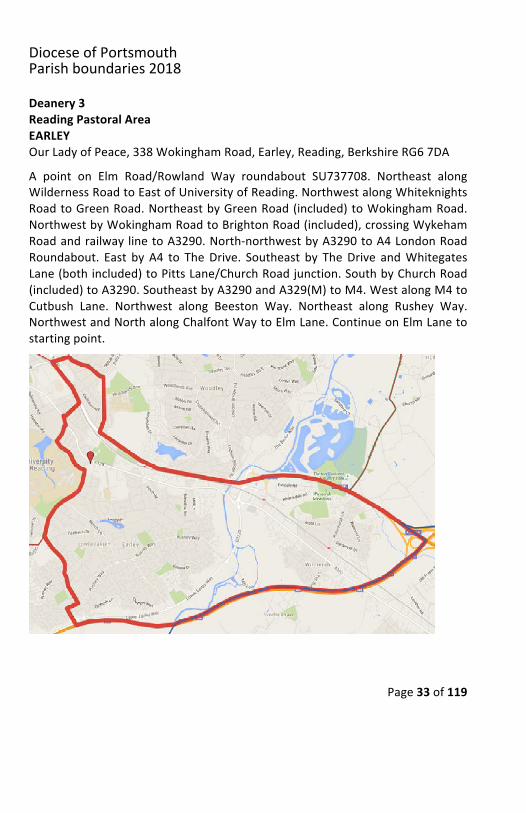
Deanery3ReadingPastoralAreaEARLEYOurLadyofPeace,338WokinghamRoad,Earley,Reading,BerkshireRG67DAA point on Elm Road/Rowland Way roundabout SU737708. Northeast alongWildernessRoadtoEastofUniversityofReading.NorthwestalongWhiteknightsRoadtoGreenRoad.NortheastbyGreenRoad(included)toWokinghamRoad.NorthwestbyWokinghamRoadtoBrightonRoad(included),crossingWykehamRoadandrailwaylinetoA3290.North-northwestbyA3290toA4LondonRoadRoundabout. East byA4 to TheDrive. Southeast by TheDrive andWhitegatesLane(bothincluded)toPittsLane/ChurchRoadjunction.SouthbyChurchRoad(included)toA3290.SoutheastbyA3290andA329(M)toM4.WestalongM4toCutbush Lane. Northwest along Beeston Way. Northeast along Rushey Way.NorthwestandNorthalongChalfontWaytoElmLane.ContinueonElmLanetostartingpoint.

DioceseofPortsmouthParishboundaries2018
Page34of119
Deanery3ReadingPastoralAreaREADINGCHRISTTHEKINGChristtheKing,408NorthumberlandAvenue,Reading,BerkshireRG28NRApointwhereminorroadmakesTjunctionwithRomanroad/countyboundaryWestofFairCrossSU692627.NorthuproadtotrackbearingNortheasttoroadand Public House Southeast of Beech Hill. Northeast along track to road.Southwestalongroadto road fork (theroadpreviously followed).A lineNorthacrosscountrycrossingFoudryBrooktoapointEastofBloomfieldHatchBridge.Westtojoinrailwayline.North-northeastuprailwaylinetodistrictboundaryatThurley Farm. North along boundary to M4. East along M4 to Foudry Brook.Northeast along Brook into River Kennet. A short distance North along RiverKennet to the southern end ofWaterlooMeadows. East to junction of B3031andElgarRoadSouth.NorthonB3031tooppositeShenstoneRoad.Eastacrosscountry, crossing Northumberland Avenue and South of Recreation Ground(Cintra Park), thenNortheast excludingWhitley Park Lane to join ChristchurchRoad.RightonChristchurchAvenue (A327),andon intoShinfieldRoad.South-southeast down Shinfield Road to Elm Road. Northeast along Elm Road tojunctionwithElmLane. SoutheastdownElmLane, (excluded), continuingontoChalfontWay, SouthwestontoRusheyWay, SoutheastontoBeestonWay toapoint on the M4 South of roundabout at the Southern end of Beeston Way.NortheastbyM4toRiverLoddon.SouthbyRiverLoddonandBlackwaterRiverto county boundary East of Riseley, thence West along county boundary tostartingpointWestofFairCross.
DioceseofPortsmouthParishboundaries2018
Page35of119
DioceseofPortsmouthParishboundaries2018
Page36of119
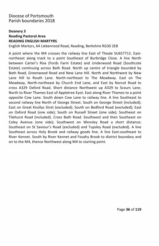
Deanery3ReadingPastoralAreaREADINGENGLISHMARTYRSEnglishMartyrs,64LiebenroodRoad,Reading,BerkshireRG302EBApointwhere theM4 crosses the railway line East of Theale SU657712. East-northeast along track to a point Southeast of Burbridge Close. A line Northbetween Carter’s Rise (Fords Farm Estate) and Underwood Road (SouthcoteEstate) continuing across Bath Road. North up centre of triangle bounded byBathRoad,GreenwoodRoadandNewLaneHill.NorthandNorthwestbyNewLane Hill to Routh Lane. North-northeast to The Meadway. East on TheMeadway, North-northeast by Church End Lane, and East by Norcot Road tocross A329 Oxford Road. Short distance Northwest up A329 to Scours Lane.NorthtoRiverThamesEastofAppletreeEyot.EastalongRiverThamestoapointopposite Cow Lane. SouthdownCow Lane to railway line. A line Southeast tosecondrailway lineNorthofGeorgeStreet.SouthonGeorgeStreet (included);EastonGreatKnollysStret (excluded);SouthonBedfordRoad (excluded);Easton Oxford Road (one side); South on Russell Street (one side); Southeast onTilehurst Road (included). Cross Bath Road. Southwest and then Southeast onColey Avenue (one side); Southwest on Wensley Road a short distance;SoutheastonSt Saviour’sRoad (excluded) andTupsleyRoad (excluded).A lineSoutheast across Holy Brook and railway goods line. A line East-southeast toRiverKennet.SouthbyRiverKennetandFoudryBrooktodistrictboundaryandontotheM4,thenceNorthwestalongM4tostartingpoint.
DioceseofPortsmouthParishboundaries2018
Page37of119
DioceseofPortsmouthParishboundaries2018
Page38of119
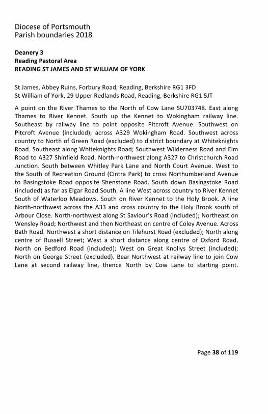
Deanery3ReadingPastoralAreaREADINGSTJAMESANDSTWILLIAMOFYORKStJames,AbbeyRuins,ForburyRoad,Reading,BerkshireRG13FDStWilliamofYork,29UpperRedlandsRoad,Reading,BerkshireRG15JTA point on the River Thames to theNorth of Cow Lane SU703748. East alongThames to River Kennet. South up the Kennet to Wokingham railway line.Southeast by railway line to point opposite Pitcroft Avenue. Southwest onPitcroft Avenue (included); across A329 Wokingham Road. Southwest acrosscountrytoNorthofGreenRoad(excluded)todistrictboundaryatWhiteknightsRoad.SoutheastalongWhiteknightsRoad;SouthwestWildernessRoadandElmRoadtoA327ShinfieldRoad.North-northwestalongA327toChristchurchRoadJunction. South betweenWhitley Park Lane andNorth Court Avenue.West totheSouthofRecreationGround(CintraPark) tocrossNorthumberlandAvenueto Basingstoke Road opposite Shenstone Road. South down Basingstoke Road(included)asfarasElgarRoadSouth.AlineWestacrosscountrytoRiverKennetSouthofWaterlooMeadows. SouthonRiver Kennet to theHolyBrook.A lineNorth-northwest across theA33 and cross country to theHoly Brook south ofArbourClose.North-northwestalongStSaviour’sRoad(included);NortheastonWensleyRoad;NorthwestandthenNortheastoncentreofColeyAvenue.AcrossBathRoad.NorthwestashortdistanceonTilehurstRoad(excluded);Northalongcentre of Russell Street; West a short distance along centre of Oxford Road,North on Bedford Road (included); West on Great Knollys Street (included);NorthonGeorgeStreet (excluded).BearNorthwestat railway line to joinCowLane at second railway line, thence North by Cow Lane to starting point.
DioceseofPortsmouthParishboundaries2018
Page39of119
DioceseofPortsmouthParishboundaries2018
Page40of119
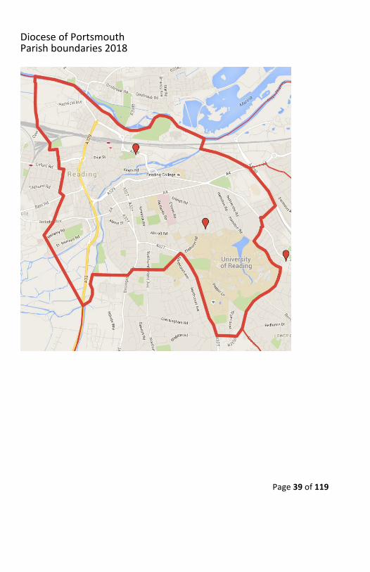
Deanery3ReadingPastoralAreaREADINGSTJOSEPHStJoseph,ThePresbytery,BerkshireDrive,Tilehurst,Reading,BerkshireRG315JJA point on M4 Theale interchange SU651717. North across country throughSulham House (excluded); Stoneham Farm (included); Purley Hall (included);crossingA329andunderrailwaythroughbridgetotrack,thenWestandNorthto reach River Thames East of Pangbourne. East by Thames to a point East ofAppletreeEyot.South throughScours toA329OxfordRoadroundabout.Southalong centre of Norcot Road; Churchend Lane; West along The Meadway toRouth Lane; SouthbyRouth LaneandNewLaneHill. Across centreof triangleboundedbyBathRoad,NewLaneHill andGreenwoodRoad.CrossBathRoad.South between Carters Rise (Fords Farm Estate) and Underwood Road(Southcote Estate) to railway Southeast of Burbridge Close. West by railwaytracktoM4,thenceNorthwestalongM4tostartingpoint.
DioceseofPortsmouthParishboundaries2018
Page41of119
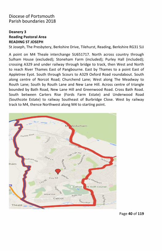
Deanery3ReadingPastoralAreaWOODLEYStJohnBosco,56WesternAvenue,Woodley,Reading,BerkshireRG53BHApointwheretherailwaylinecrossestheRiverLoddon.NortheastalongRiversLoddon and Thames to St Patrick’s Bridge. Southeast by road to cross A4 atCharvil. Northeast along A3032 and Southeast byminor road at join B3030 atWhistley Green. South by B3030 to A329(M) at Merryhill Green. West alongA329(M)toChurchRoadBridge.NorthbyChurchRoad(excluded)tojoinCulverLane. Cross Culver Lane. Northwest by Whitegates Lane and The Drive (bothexcluded) to A4 Loddon Road. Southwest by A4 to A329(M) roundabout andrailwayline,thenceNorthwestbyrailwaylinetoRiverKennetatstartingpoint.
DioceseofPortsmouthParishboundaries2018
Page42of119
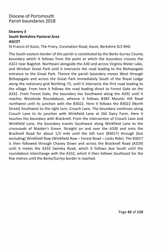
Deanery3SouthBerkshirePastoralAreaASCOTStFrancisofAssisi,TheFriary,CoronationRoad,Ascot,BerkshireSL59HGTheSouth-easternborderoftheparishisconstitutedbytheBerks-SurreyCountyboundary which it follows from the point at which the boundary crosses theA322nearBagshot.NortheastalongsidetheA30andacrossVirginiaWaterLake,andWindsorGreat Park until it intersects the road leading to theBishopsgateentrance to theGreat Park. Thence the parish boundarymovesWest throughBishopsgate and across the Great Park immediately South of the Royal LodgealongthenotionarygridNorthing72,until it intersectsthefirstroadleadingtothe village. Fromhere it follows the road leading direct to ForestGate on theA332. From Forest Gate, the boundary lies Southwest along the A332 until itreaches Woodside Roundabout, whence it follows B383 Mounts Hill Roadnorthwest until its junction with the B3022. Here it follows the B3022 (NorthStreet)Southwesttotherightturn,CrouchLane.TheboundarycontinuesalongCrouch Lane to its junction with Winkfield Lane at Old Dairy Farm. Here ittouchestheboundarywithBracknell.FromtheintersectionofCrouchLaneandWinkfield Lane, the boundary travels Southwest along Winkfield Lane to thecrossroads of Maiden’s Green. Straight on and over the A330 and onto theBracknell Road for about 1/3 mile until the left turn (B3017) through (butexcluding)WinkfieldRow(WinkfieldRow–ForestRoad–LocksRide).TheB3017is then followed through Chavey Down and across the Bracknell Road (A329)until it meets the A332 Swinley Road, which it follows due South until theroundabout interchangewiththeA332,whichitthenfollowsSoutheastforthefewmetresuntiltheBerks/Surreyborderisreached.
DioceseofPortsmouthParishboundaries2018
Page43of119
DioceseofPortsmouthParishboundaries2018
Page44of119
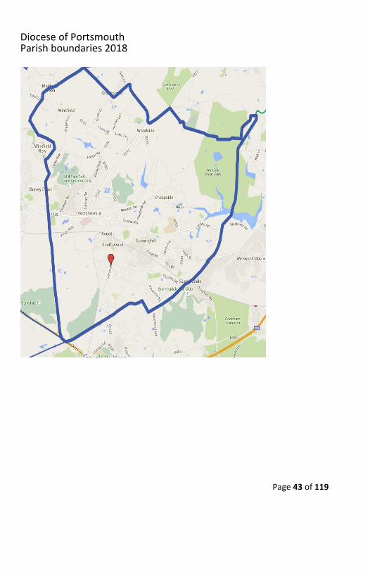
Deanery3SouthBerkshirePastoralAreaBRACKNELLSTJOSEPHANDSTMARGARETCLITHEROWStJoseph,StanleyWalk,TownCentre,Bracknell,BerkshireRG121HAFrom the point where the district boundary crosses the railway line at AmenCorner,NorthalongboundarytominorroadjunctionatGreatHazes.Eastalongboundary, crossing motorway. South bordering Buck Farm House (excluded),thenfollowboundaryEasttoWinkfieldPlace.SouthwestalongWinkfieldLanetocrossroads atMaiden’sGreen. Straight over theA330 and onto the B3022 forabout1/3mileuntiltheleftturn(B3017)through(andincluding)WinkfieldRow(LocksRide–ForestRoad–WinkfieldRow).TheB3017isthenfollowedthroughChavey Down and across the Bracknell Road until it meets the A332 SwinleyRoad,which it follows South-southeast until the roundabout interchangewiththeA322, thenNorthwest up theA322 as far as roundaboutwithB3430NineMileRide.WestalongB3430NineMileRidetoOldWokinghamRoad.NorthupOld Wokingham Road to point South of Holly Cottage Equestrian. From thatpoint north including pond to railway line. East along railway line to startingpoint.
DioceseofPortsmouthParishboundaries2018
Page45of119
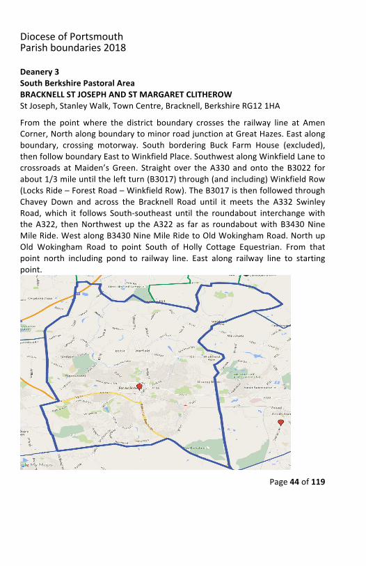
Deanery3SouthBerkshirePastoralAreaCROWTHORNE&SANDHURSTHolyGhost,51NewWokinghamRoad,Crowthorne,BerksRG456JGTheImmaculateConception,63/67YorktownRoad,Sandhurst,BerksGU479BSAt theA327 road bridge on the Blackwater River,where the county boundarycrossestheroadNorthofEversley(SU775625),NorthwestbytheA327(ReadingRoad) as far as the crossroads leading to Lea Fam. Northeast by road to thecontinuationofB3430 (ParkLane,FinchhamsteadandNineMileRide)crossingB3016,A321, railway lineandtheA3095to joinA322NorthwestofPennyHill.SoutheastdownA322tocountyboundaryEastofRapleyLake.Southwestdowncountyboundary toBlackwaterRiver, thenupstream to startingpoint atA327roadbridge.
DioceseofPortsmouthParishboundaries2018
Page46of119
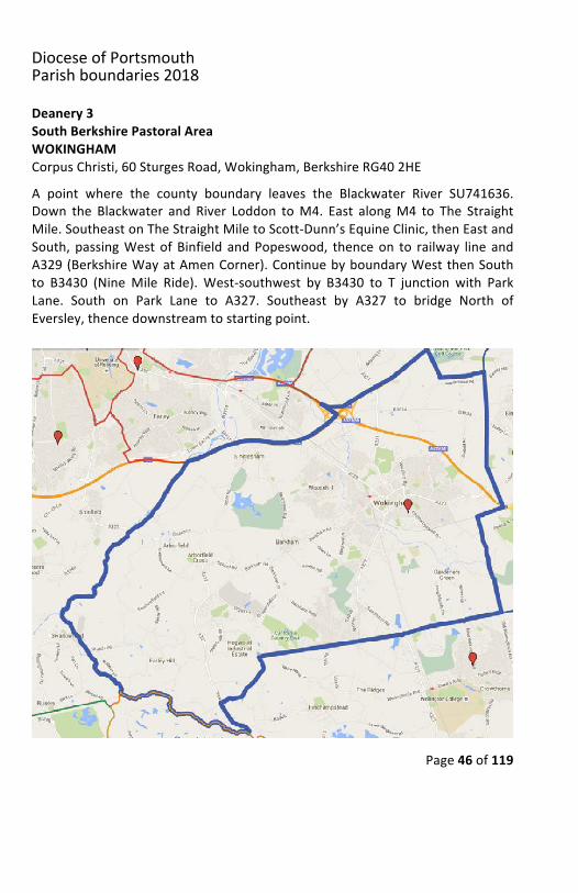
Deanery3SouthBerkshirePastoralAreaWOKINGHAMCorpusChristi,60SturgesRoad,Wokingham,BerkshireRG402HEA point where the county boundary leaves the Blackwater River SU741636.Down the Blackwater and River Loddon toM4. East alongM4 to The StraightMile.SoutheastonTheStraightMiletoScott-Dunn’sEquineClinic,thenEastandSouth,passingWestofBinfield andPopeswood, thenceon to railway line andA329(BerkshireWayatAmenCorner).ContinuebyboundaryWestthenSouthto B3430 (NineMile Ride).West-southwest by B3430 to T junction with ParkLane. South on Park Lane to A327. Southeast by A327 to bridge North ofEversley,thencedownstreamtostartingpoint.
DioceseofPortsmouthParishboundaries2018
Page47of119
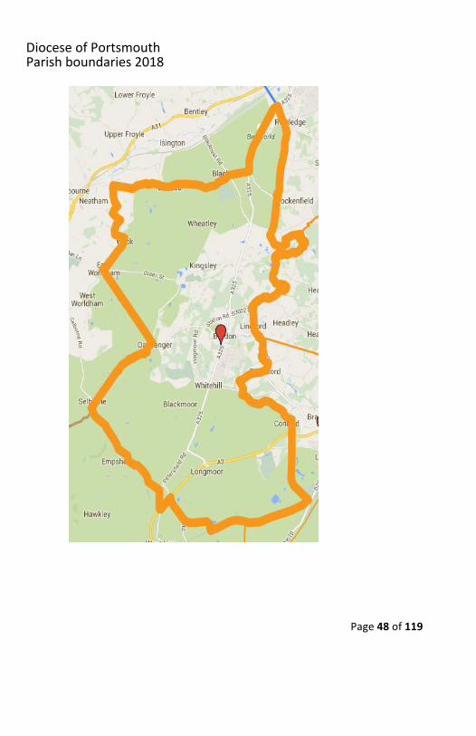
Deanery4Bordon-PetersfieldPastoralAreaBORDONSacredHeart,HighStreet,Bordon,HampshireGU350AUAtthejunctionoftheB3006andEastTistedRoadatSelbourne,NortheastacrosscountrytoOakhangerStreamatPrioryFarm.NortheastdownstreamtoroadatOakhanger, then Northwest across country to B3004 to East Worldham roadjunction with West Worldham. Northeast by road (Wyck Lane) through andincluding Wyck. At T junction 752401 turn Northwest and follow road (WyckLaneandClays Lane) to crossroadsat SU752412, thenEast throughBinsted toA325 at and including Bucks HornOak. North up A325 to county boundary atHoltPound.SouthalongcountyboundarytoRiverWeyatSU828395.Southwestup River Wey to B3002 (Lindford Road) North of Lindford. South by road(Liphook Road) to junction with Mill Lane. Southwest short distance to RiverWey.UpstreamtoStandford,thenSouthontheB3004toWhitehillturn-off.Byroad West-southwest past crossroads at Hollywater to join stream. Followstream Southeast, South of Conford at SU825328, continuing South to crossB2131, then on to small lake South of Folly Manor and Southwest to countyboundary.FollowboundarySouthwest to railway lineatLangley.AlongrailwaytobridgeatMangers,thenNorthwestbyroad(WarrenRoadandForestRoad)tojoin A3 Southwest of Greatham. Southwest to junction with B3006, thenNorthwestalongB3006tostartingpointatSelbourne.
DioceseofPortsmouthParishboundaries2018
Page48of119
DioceseofPortsmouthParishboundaries2018
Page49of119
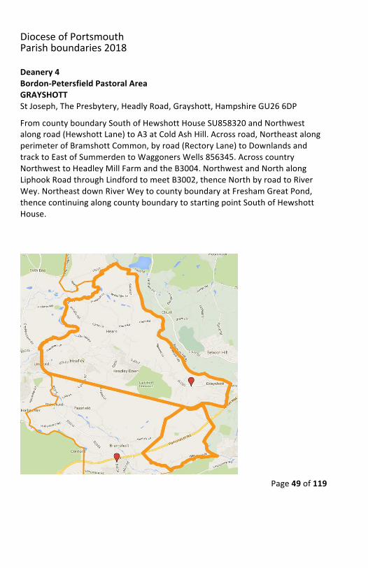
Deanery4Bordon-PetersfieldPastoralAreaGRAYSHOTTStJoseph,ThePresbytery,HeadlyRoad,Grayshott,HampshireGU266DPFromcountyboundarySouthofHewshottHouseSU858320andNorthwestalongroad(HewshottLane)toA3atColdAshHill.Acrossroad,NortheastalongperimeterofBramshottCommon,byroad(RectoryLane)toDownlandsandtracktoEastofSummerdentoWaggonersWells856345.AcrosscountryNorthwesttoHeadleyMillFarmandtheB3004.NorthwestandNorthalongLiphookRoadthroughLindfordtomeetB3002,thenceNorthbyroadtoRiverWey.NortheastdownRiverWeytocountyboundaryatFreshamGreatPond,thencecontinuingalongcountyboundarytostartingpointSouthofHewshottHouse.
DioceseofPortsmouthParishboundaries2018
Page50of119
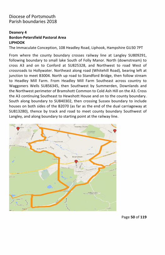
Deanery4Bordon-PetersfieldPastoralAreaLIPHOOKTheImmaculateConception,108HeadleyRoad,Liphook,HampshireGU307PTFrom where the county boundary crosses railway line at Langley SU809291,followingboundary tosmall lakeSouthofFollyManor.North (downstream) tocross A3 and on to Conford at SU825328, and Northwest to road West ofcrossroadstoHollywater.Northeastalongroad(WhitehillRoad),bearingleftatjunctiontomeetB3004.NorthuproadtoStandfordBridge,thenfollowstreamto Headley Mill Farm. From Headley Mill Farm Southeast across country toWaggoners Wells SU856345, then Southwest by Summerden, Downlands andtheNorthwestperimeterofBramshottCommontoColdAshHillontheA3.CrosstheA3continuingSoutheasttoHewshottHouseandontothecountyboundary.South along boundary to SU840302, then crossing Sussex boundary to includehousesonbothsidesoftheB2070(asfarastheendofthedualcarriagewayatSU813280), thence by track and road tomeet county boundary Southwest ofLangley,andalongboundarytostartingpointattherailwayline.
DioceseofPortsmouthParishboundaries2018
Page51of119
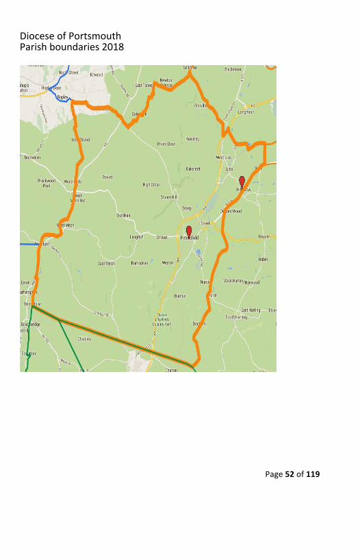
Deanery4Bordon-PetersfieldPastoralAreaPETERSFIELDStAgnes,PlantationRoad,Liss,HampshireGU337QBStLaurence,12StationRoad,Petersfield,HampshireGU323EDStartingintheSoutheastcornerontheHants/Sussexboundary,atapointwheretheboundarycrossesatracktoWoodcroftFarmSU745165,astraightlineacrosscountry, West-northwest to SU616202, at crossroads East of the dismantledrailway atMeonstoke, thence North to East of Shavards Farm, joining A32 atRiverMeonbridge.AlongA32, includingvillagesofWarnfordandWestMeon,about½mileNorthofWestMeonHutPub to junction leading toWestMeonWoodlands.Byroad (ThreeHorseshoesLaneandPunsholtLane) throughWestTisted to Ropley junction. East by road (Petersfield Road) to and includingMonkwood,continuetocrossA32andcontinueSoutheasttojunctionSouthofBecksteddle Farm. Turn Northeast along road to Colemore, thence North-northeastbyroadandacrosscountrytojoinEastTisted–SelbourneroadWestof Heards Farm. Along road to Selbourne. Southeast along B3006 to junctionwithA3.Northeasttoincludeparishchurch,thencetoLissForestbyroad(ForestRoadandWarrenRoad),bearinglefttomeetrailwaylineatMangers.Eastalongrailway tocountyboundaryatLangley.Southalongcountyboundary toB2070North of Rake. Southwest along B2070 to include both sides of road (wherenecessarycrossingintoSussex)asfarasintersectionwithB3006,thencontinuebycountyboundarytostartingpointatWoodcroftFarmtrack.
DioceseofPortsmouthParishboundaries2018
Page52of119
DioceseofPortsmouthParishboundaries2018
Page53of119
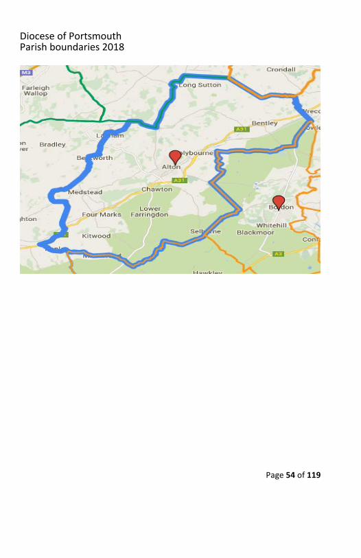
Deanery4HampshireDownsPastoralAreaALTONStMary,ThePriest’sHouse,59NormandySt,Alton,HampshireGU341DNFrom a point at the crossroads leading to Ropley on the A31 SU634323;Northeast along the A31 to North Street. North up road (Rookwood Lane) todistrictboundarySouthwestofStancombFarm.NortheastacrosscountrytojoinroadNorth of Stancomb Farm and on to Goatacre Farm at Northing 360, andWesttojoindistrictboundaryatcrossroads.FollowboundaryandroadtoHeathGreenandNortheast toT junctionpastHattingley.Continue in samedirectionacrosscountrytojoinMinstead/BentworthRoad.NortheastalongroadthroughHolt End, including Bentworth Village and across the A339 to and includingLasham.FollowroadSoutheastofairfieldtodistrictboundary.SouthofWestonCommontomeetroad.Southeastalongroad(TheAvenue)toB3349atGoldenPot. North along B3349 to Northing 461 junction. Continue in same direction,butincludingSouthWarnborough,meetingB3349atFourLanesEndcrossroads.A lineEast to theSouthofOdihamAirfield to includeStapelyFarmSU759489,thenSoutheasttocrossroadsNorthofGladeFarmSU782463.ThenceEastalongdistrict boundary to county boundary at SU805464. Southeast down countyboundary, crossing the A31, to A325 at Holt Pound. Southwest along A325 toand excluding Bucks Horn Oak. West-southwest by road (Binsted Road) toBlacknest crossroads, continuing through Binsted to crossroads at SU752412.South down road (Clays Lane) to T junction. Turn Southeast by road toWyck,continueSouthwesttoroadjunctionwithEastWorldham,thenSoutheastacrosscountry tomeet road (but excluding village) atOakhanger tomeetOakhangerstream. Upstream to Priory Farm, then Southwest across country to includeSelbourneVillage.ContinueSouthwestalongEastTistedRoadpastHeardsFarmturn-offatSU723322,thenSouthwestacrosscountrytomeetroadatSU711315.FollowroadSouthwesttojunctionatColemoreCommon.NorthwestalongroadPetersfieldRoad)excludingMonkwood,butincludingRopleytostartingpointonA31.
DioceseofPortsmouthParishboundaries2018
Page54of119
DioceseofPortsmouthParishboundaries2018
Page55of119
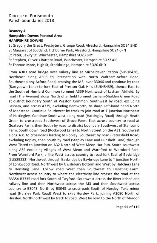
Deanery4HampshireDownsPastoralAreaHAMPSHIREDOWNSStGregorytheGreat,Presbytery,GrangeRoad,Alresford,HampshireSO249HDStMargaretofScotland,TichbornePark,Alresford,HampshireSO240PNStPeter,JewrySt,Winchester,HampshireSO238RYStStephen,Oliver’sBatteryRoad,Winchester,HampshireSO224JBStThomasMore,HighSt,Stockbridge,HampshireSO206HDFrom A303 road bridge over railway line at Micheldever Station (SU518438),Northeast along A303 to intersection with North Waltham-Axford Road.SoutheastalongAxfordRoad,crossingtheM3,overB3046andcontinuebyroad(Barrydown Lane) to fork East of PrestonOakHills (SU645439), thenceEast totheSouthofHerriardCommontomeetA339NorthwestofLashamAirfield.Byroad(TheAvenue)alongNorthofairfieldtomeetLasham-ShaldenGreenRoadat district boundary South ofWeston Common. Southwest by road, excludingLasham,andacrossA339,excludingBentworth, tosharpLeft-handbendNorthofMedstead.ContinueSouthwestbytrackto joinroadatT junctionNortheastofHattingley.ContinueSouthwestalong road (HattingleyRoad) throughHeathGreen to crossroads Southwest of Grove Farm. East across country to road atGoatacreFarm,thenSouthbyroadtodistrictboundarySouthwestofStancombFarm.Southdownroad(RockwoodLane)toNorthStreetontheA31.SouthwestalongA31tocrossroadsleadingtoRopley.Southeastbyroad(PetersfieldRoad)excludingRopley,thenSouthbyroad(StapleyLaneandPunsholtLane)throughWestTistedtojunctiononA32NorthofWestMeonHutPub.South-southwestalong A32 excluding villages of West Meon and Warnford to Warnford Park.FromWarnfordPark,a lineWestacrosscountrytoroadforkEastofBaybridge(SU529232).NorthwestthroughBaybridgebyBaybridgeLanetoTjunctionNorthofLongwoodRoad.NorthwestbyOwsleburyBottomandWestbyHatchersLaneto Hensting Lane. Follow road West then Southwest to Hensting Farm.Northwest across country towhere the electricity line crosses the road at theB3354-B3335roadforkSouthofTwyford.SouthwestacrosstheRiverItchenandrailway line and then Northwest across the M3 and then Southwest acrosscountry toB3043.NorthbyB3043 to crossroads SouthofHursley. Takeminorroad (Hursley Park Road) West to skirt Hursley Park, joining A3090 North ofHursley.North-northwestbytracktoroad.WestbyroadtotheNorthofMerdon
DioceseofPortsmouthParishboundaries2018
Page56of119
Castle.BytrackNorththenNorthwesttowardsVioletHill.NorthbyroadtotheWest of South Lynch, then by road and track North to Roman road North ofTumulus in Farley Mount Park, thence West-northwest along Roman road toAshleyroadfork.NorthwestalongChalkVale.NorthbyChalkHilltoT-Junction.Northwest by road to crossroads South of Little Somborne. Northeast alongWhitehallRoadtoNorthing330.DueWestacrosscountryalongNorthing330tocrossRiverTestSouthofHoughtonLodge;thenWest-northwestacrosscountryto T junction at Manor Farm North of Broughton, and on to B3084 South ofWaterlooFarm.North-northwestupB3084tocrossroadswithA30.WestalongA30 to countyboundary East of LopcombeCorner, thenceNorth along countyboundary to railway line. Follow railway line East to Cholderton Road bridge.SouthbyCholdertonRoadto fork.FollowOldStockbridgeRoadEast-southeastto T junction with Salisbury Road. Follow Northeast Civil Parish Boundary toSouthern cornerofGoodworthClatfordCivil Parish. Follow southernboundaryofGoodworth Clatford Civil Parish to Eastern corner of Civil Parish. South andEastalongLongparishCivilParishsouthernboundary.Thenbywayofsouthernboundaries of Hurstbourne Priors,Whitchurch and Laverstoke civil parishes toroadbridgeoverrailwaylineatMicheldeverStation.
DioceseofPortsmouthParishboundaries2018
Page57of119
Deanery4ThreeRiversPastoralAreaSTSWITHUNWELLSHolyCross,53LeighRoad,Eastleigh,HampshireSO509DFOurLady,QueenofApostles,MartinStreet,Bishop’sWaltham,HampshireSO321DNStAndrew,FlemingAvenue,NorthBaddesley,HampshireSO529EPSt Edward the Confessor, 191 Winchester Road, Chandlers Ford, HampshireSO532DUStJoseph,AbbeyHouseDrive,Romsey,HampshireSO518YBStSwithunWells,AllingtonLane,FairOak,HampshireSo507DB
Apointwhere theA30 crosses the countyboundary Eastof LopcombeCornerSU262353, East-southeast down the A30 to crossroads with B3084. South-southeastdownB3084 toapointNorthof theT junctionNorthofBroughton.East-southeast across country to road fork SouthofManor Fm.ContinueEast-southeasttoSouthofEveleyFarmontheRiverTestSouthofHoughtonLodge.Continue due East to a point onWhitehall roadNortheast of Little Somborne.Southwest byWhitehall Road to crossroads South of Little Somborne, thenbyroad Southeast to T junction Northeast of Chalkvale. Southwest by road tocrossroadsNorthwestofAshley, skirting South toexcludeAshleyand continueSouth-east to Roman road. East-southeast along Roman road to North ofTumulus in FarleyMount Country Park SU414294. South-southwest by East ofcopse to road. East then South by road to the West of South Lynch, thenSoutheastbytrackSouthofSouthlynchPlantationtojoinroadNorthofMerdonCastle.EasterlythenSouth-southeastbytracktotouchA3090NorthofHursley.ByminorroadaroundWestsideofHursleytorejoinA3090atcrossroadsSouthof Hursley. Continue South to electricity pylons East of Potter’s HeronMotel.Follow electricity pylons to A333 North of road fork at SU479236. SoutheastacrosscountrycrossingtheM3toroadSoutheastofHenstingFarm(SU497225).North-northeastbyroad(HenstingLane),acrosscrossroad,thenbyrightforktoBottom Farm. Southeast by road to T junction Northeast of Owlsebury.Northeast then Southeast by road to road fork Southeast of Baybridge. EastacrosscountrythroughHoltHouseandPreshawDowntoWarnfordParkontheA32. South on A32 to River Meon Road Bridge. South-east direction East ofShavard’sFarm,thenSouth-southwesttocrossroadsEastofdismantledrailway
DioceseofPortsmouthParishboundaries2018
Page58of119
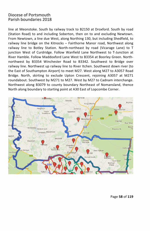
lineatMeonstoke.SouthbyrailwaytracktoB2150atDroxford.Southbyroad(Station Road) to and including Soberton, then on to and excludingNewtown.FromNewtown,alinedueWest,alongNorthing130,butincludingShedfield,torailway line bridge on the Kitnocks – FairthorneManor road,Northwest alongrailway line to Botley Station. North-northeast by road (Vicarage Lane) to TjunctionWest of Curdridge. FollowWanfield Lane Northwest to T-Junction atRiverHamble.FollowMaddoxfordLaneWesttoB3354atBoorleyGreen.North-northwest by B3354 Winchester Road to B3342. Southwest to Bridge overrailwayline.NorthwestuprailwaylinetoRiverItchen.Southwestdownriver(totheEastofSouthamptonAirport)tomeetM27.WestalongM27toA3057RoadBridge. North, skirting to exclude Upton Crescent, rejoining A3057 at M271roundabout.SouthwestbyM271toM27.WestbyM27toCadnaminterchange.Northwest along B3079 to county boundaryNortheast ofNomansland, thenceNorthalongboundarytostartingpointatA30EastofLopcombeCorner.
DioceseofPortsmouthParishboundaries2018
Page59of119
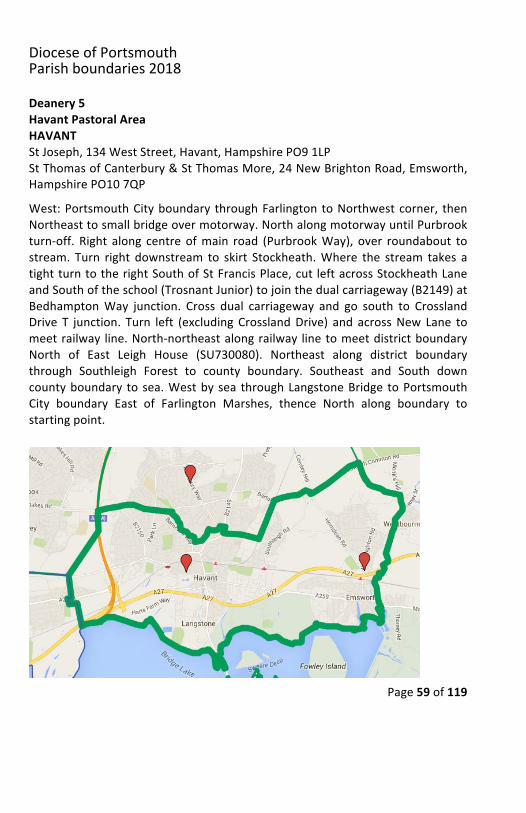
Deanery5HavantPastoralAreaHAVANTStJoseph,134WestStreet,Havant,HampshirePO91LPStThomasofCanterbury&StThomasMore,24NewBrightonRoad,Emsworth,HampshirePO107QPWest:PortsmouthCityboundary throughFarlingtontoNorthwestcorner, thenNortheasttosmallbridgeovermotorway.NorthalongmotorwayuntilPurbrookturn-off. Right along centre ofmain road (PurbrookWay), over roundabout tostream. Turn right downstream to skirt Stockheath.Where the stream takes atightturntotherightSouthofStFrancisPlace,cut leftacrossStockheathLaneandSouthoftheschool(TrosnantJunior)tojointhedualcarriageway(B2149)atBedhamptonWay junction. Cross dual carriageway and go south to CrosslandDrive T junction. Turn left (excluding CrosslandDrive) and acrossNew Lane tomeetrailway line.North-northeastalongrailway linetomeetdistrictboundaryNorth of East Leigh House (SU730080). Northeast along district boundarythrough Southleigh Forest to county boundary. Southeast and South downcountyboundary tosea.Westbysea throughLangstoneBridge toPortsmouthCity boundary East of Farlington Marshes, thence North along boundary tostartingpoint.
DioceseofPortsmouthParishboundaries2018
Page60of119
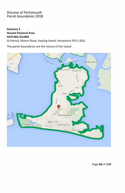
Deanery5HavantPastoralAreaHAYLINGISLANDStPatrick,ManorRoad,HaylingIsland,HampshirePO110QUTheparishboundariesaretheshoresoftheisland.
DioceseofPortsmouthParishboundaries2018
Page61of119
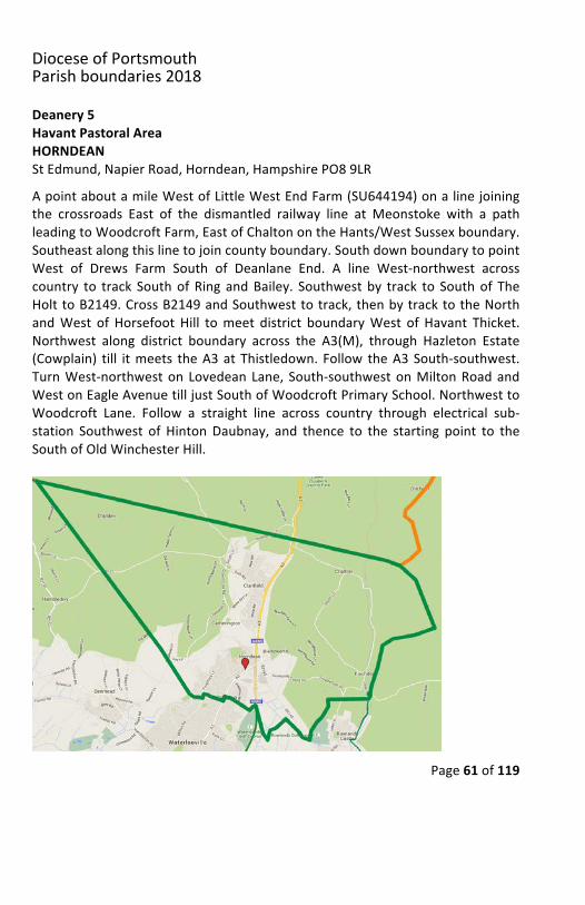
Deanery5HavantPastoralAreaHORNDEANStEdmund,NapierRoad,Horndean,HampshirePO89LRApointaboutamileWestofLittleWestEndFarm(SU644194)onalinejoiningthe crossroads East of the dismantled railway line at Meonstoke with a pathleadingtoWoodcroftFarm,EastofChaltonontheHants/WestSussexboundary.Southeastalongthislinetojoincountyboundary.SouthdownboundarytopointWest of Drews Farm South of Deanlane End. A line West-northwest acrosscountry to track SouthofRing andBailey. Southwestby track to Southof TheHolttoB2149.CrossB2149andSouthwesttotrack,thenbytracktotheNorthandWest of Horsefoot Hill tomeet district boundaryWest of Havant Thicket.Northwest along district boundary across the A3(M), through Hazleton Estate(Cowplain) till itmeets theA3atThistledown.Follow theA3South-southwest.TurnWest-northweston LovedeanLane, South-southwestonMiltonRoadandWestonEagleAvenuetilljustSouthofWoodcroftPrimarySchool.NorthwesttoWoodcroft Lane. Follow a straight line across country through electrical sub-station Southwest of HintonDaubnay, and thence to the starting point to theSouthofOldWinchesterHill.
DioceseofPortsmouthParishboundaries2018
Page62of119
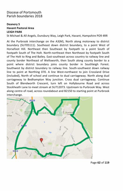
Deanery5HavantPastoralAreaLEIGHPARKStMichael&AllAngels,DunsburyWay,LeighPark,Havant,HampshirePO94RRAt the Purbrook interchange on the A3(M), North along motorway to districtboundary (SU705111). Southeast down district boundary, to a point West ofHorsefoot Hill. Northeast then Southeast by footpath to a point South offootpathSouthofTheHolt.North-northeast thenNortheastby footpathSouthofTheHolttoRingandBailey.East-southeastacrosscountrytorailwaylineandcounty border Northeast ofWellsworth, then South along county border to apoint where district boundary joins county border in Southleigh Forest.Southwest by district boundary to railway line. South-southwest down railwayline to point at Northing 070. A line West-northwest to join Crossland Drive(included),Northofschoolandcontinuetodualcarriageway.Northalongdualcarriageway to Bedhampton Way junction. Cross dual carriageway. ContinueSouth of Blendworth Crescent, turn left on Hollybourne Road and acrossStockheathLanetomeetstreamatSU712073.UpstreamtoPurbrookWay.Westalongcentreofroad,acrossroundaboutandB2150tostartingpointatPurbrookinterchange.
DioceseofPortsmouthParishboundaries2018
Page63of119
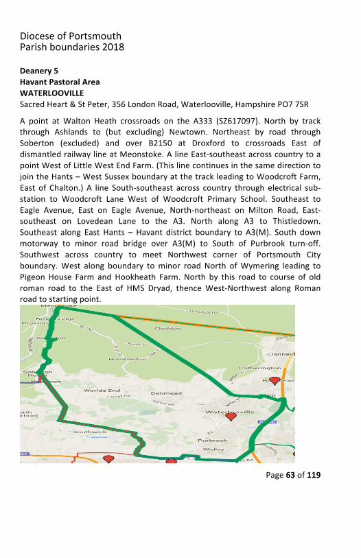
Deanery5HavantPastoralAreaWATERLOOVILLESacredHeart&StPeter,356LondonRoad,Waterlooville,HampshirePO77SRA point at Walton Heath crossroads on the A333 (SZ617097). North by trackthrough Ashlands to (but excluding) Newtown. Northeast by road throughSoberton (excluded) and over B2150 at Droxford to crossroads East ofdismantledrailwaylineatMeonstoke.AlineEast-southeastacrosscountrytoapointWestofLittleWestEndFarm.(ThislinecontinuesinthesamedirectiontojointheHants–WestSussexboundaryatthetrackleadingtoWoodcroftFarm,East of Chalton.) A line South-southeast across country through electrical sub-station to Woodcroft Lane West of Woodcroft Primary School. Southeast toEagle Avenue, East on Eagle Avenue, North-northeast on Milton Road, East-southeast on Lovedean Lane to the A3. North along A3 to Thistledown.Southeast along East Hants – Havant district boundary to A3(M). South downmotorway to minor road bridge over A3(M) to South of Purbrook turn-off.Southwest across country to meet Northwest corner of Portsmouth Cityboundary.West along boundary tominor road North ofWymering leading toPigeonHouse Farm andHookheath Farm. North by this road to course of oldroman road to the East of HMS Dryad, thenceWest-Northwest along Romanroadtostartingpoint.
DioceseofPortsmouthParishboundaries2018
Page64of119
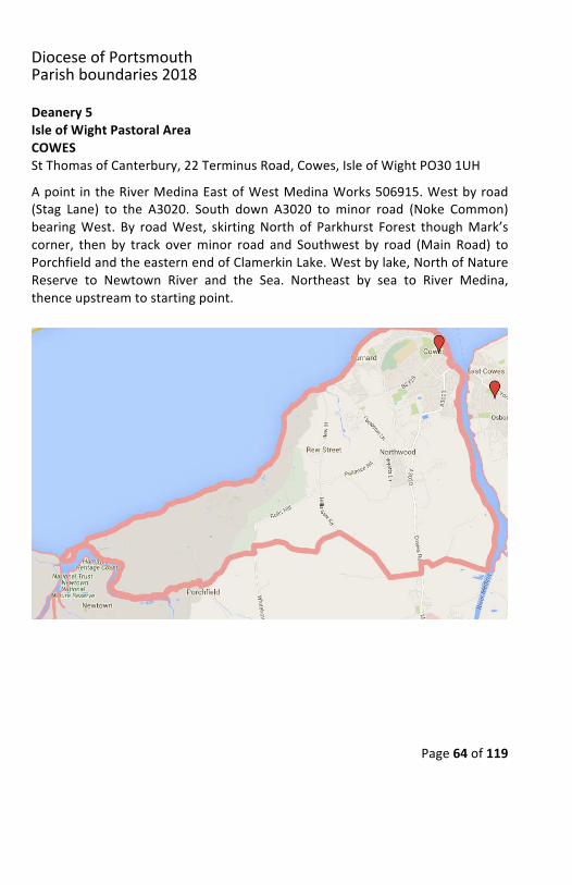
Deanery5IsleofWightPastoralAreaCOWESStThomasofCanterbury,22TerminusRoad,Cowes,IsleofWightPO301UHApoint intheRiverMedinaEastofWestMedinaWorks506915.Westbyroad(Stag Lane) to the A3020. South down A3020 to minor road (Noke Common)bearingWest. By roadWest, skirtingNorth of Parkhurst Forest thoughMark’scorner, then by track overminor road and Southwest by road (Main Road) toPorchfieldandtheeasternendofClamerkinLake.Westbylake,NorthofNatureReserve to Newtown River and the Sea. Northeast by sea to River Medina,thenceupstreamtostartingpoint.
DioceseofPortsmouthParishboundaries2018
Page65of119
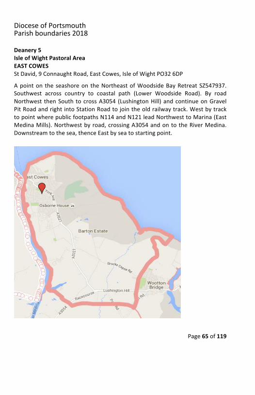
Deanery5IsleofWightPastoralAreaEASTCOWESStDavid,9ConnaughtRoad,EastCowes,IsleofWightPO326DPApointon the seashoreon theNortheastofWoodsideBayRetreatSZ547937.Southwest across country to coastal path (Lower Woodside Road). By roadNorthwest thenSouth tocrossA3054 (LushingtonHill) andcontinueonGravelPitRoadandrightintoStationRoadtojointheoldrailwaytrack.WestbytracktopointwherepublicfootpathsN114andN121leadNorthwesttoMarina(EastMedinaMills).Northwestbyroad,crossingA3054andontotheRiverMedina.Downstreamtothesea,thenceEastbyseatostartingpoint.
DioceseofPortsmouthParishboundaries2018
Page66of119
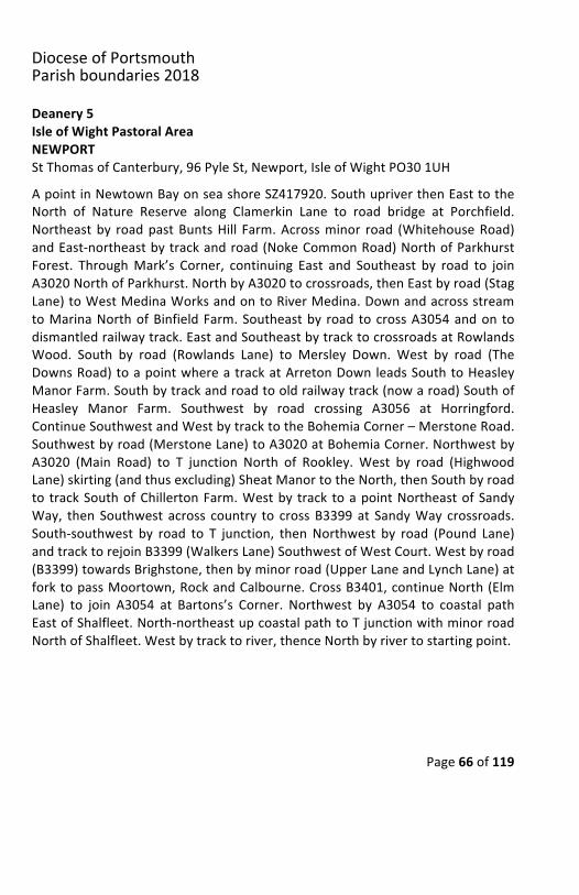
Deanery5IsleofWightPastoralAreaNEWPORTStThomasofCanterbury,96PyleSt,Newport,IsleofWightPO301UHApointinNewtownBayonseashoreSZ417920.SouthupriverthenEasttotheNorth of Nature Reserve along Clamerkin Lane to road bridge at Porchfield.Northeastby roadpastBuntsHill Farm.Acrossminor road (WhitehouseRoad)andEast-northeastbytrackandroad(NokeCommonRoad)NorthofParkhurstForest. ThroughMark’s Corner, continuing East and Southeast by road to joinA3020NorthofParkhurst.NorthbyA3020tocrossroads,thenEastbyroad(StagLane)toWestMedinaWorksandontoRiverMedina.DownandacrossstreamtoMarinaNorthofBinfieldFarm.Southeastby road tocrossA3054andon todismantledrailwaytrack.EastandSoutheastbytracktocrossroadsatRowlandsWood. South by road (Rowlands Lane) to Mersley Down. West by road (TheDownsRoad)toapointwhereatrackatArretonDownleadsSouthtoHeasleyManorFarm.Southbytrackandroadtooldrailwaytrack(nowaroad)SouthofHeasley Manor Farm. Southwest by road crossing A3056 at Horringford.ContinueSouthwestandWestbytracktotheBohemiaCorner–MerstoneRoad.Southwestbyroad(MerstoneLane)toA3020atBohemiaCorner.NorthwestbyA3020 (Main Road) to T junction North of Rookley. West by road (HighwoodLane)skirting(andthusexcluding)SheatManortotheNorth,thenSouthbyroadto trackSouthofChillertonFarm.Westby track toapointNortheastofSandyWay, then Southwest across country to crossB3399at SandyWay crossroads.South-southwest by road to T junction, thenNorthwest by road (Pound Lane)andtracktorejoinB3399(WalkersLane)SouthwestofWestCourt.Westbyroad(B3399)towardsBrighstone,thenbyminorroad(UpperLaneandLynchLane)atforktopassMoortown,RockandCalbourne.CrossB3401,continueNorth(ElmLane) to join A3054 at Bartons’s Corner. Northwest by A3054 to coastal pathEastofShalfleet.North-northeastupcoastalpathtoTjunctionwithminorroadNorthofShalfleet.Westbytracktoriver,thenceNorthbyrivertostartingpoint.
DioceseofPortsmouthParishboundaries2018
Page67of119
DioceseofPortsmouthParishboundaries2018
Page68of119
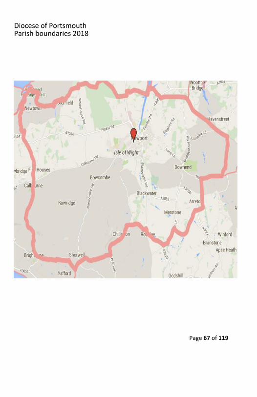
Deanery5IsleofWightPastoralAreaRYDESorrowful and ImmaculateHeartofMary, 55High Street, IsleofWight, IsleofWightPO332REInWhitecliffBaySZ639861,West-northwestalongroadbycaravansitetoroadjunction. TurnNortheast andNorthby road leading toHillwayonB3395. Turnright on B3395, then left. Then Northwest across country through BembridgeAirport tomeet railway lineNorth of Brading. Southwest along road (VicarageLane)NorthofBrading church toA3055crossroads.ContinueWestby road toEastAsheycrossroads.Southwestbyroad(AsheyRoad)throughAsheyDowntocrossroadsatMersleyDown.Northby road (RowlandsLane)passingRowlandsFarm to old railway track at RowlandsWood. Northwest by track toWoottonCommon-Wootton Bridge road. North-northeast by road (Station Road) takingleftfork(GravelPitRoad)tocrossA5054andalongcoastalpath,(Palmer’sRoad,Farm Lane & Lower Woodside Road) to a point just West of Woodside BayRetreat,thenNortheastacrosscountrytoseaatSZ547937,thenceEastbyseatostartingpointinWhitecliffBay.
DioceseofPortsmouthParishboundaries2018
Page69of119
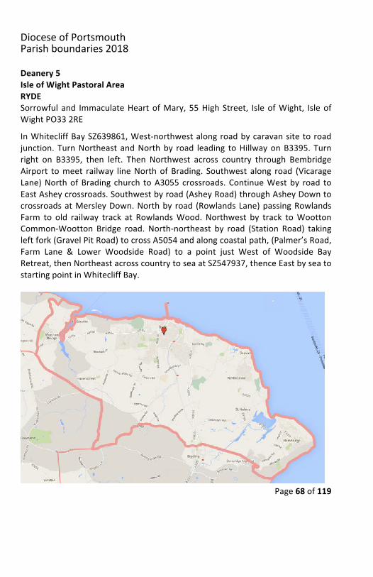
Deanery5IsleofWightPastoralAreaSOUTHWIGHTOurLady&StWilfrid,TrinityRoad,Ventnor,IsleofWightPO381NLSacredHeart,7AtherlyRoad,Shanklin,IsleofWightPO377ATStPatrick,GrangeRoad,Sandown,IsleofWightPO368NEA point on the seashore opposite Coast Guard Lookout at Atherfield PointSZ452790.NortheasttocrossA3055thencebytracktoAtherfieldGreen.Northby road (Atherfield Road) through Little Atherfield to B3399 at Sandy Way.Northeast across country to track crossing Chillerton Down. East by track tominor road. Northeast by road (Berry Shute Road) passing North of Chillertonandbyroad(HighwoodLane)passingWestofSheatManor(included).BearEastandcrossminorroadandontoA3020NorthofRookley.NortheastbyMerstoneLane to old railway track. Southeast by railway track to old railway junctionNorthwest of Little Budbridge Farm. East on the Sandown railway track to theA3056bridgeatHorringford.East-northeastbyroad(theformertrack)toapointSouthofHeasleyManorFarm.NorthbyroadtoHeasleyManorFarm.ContinueNorth by track to Arreton Down. East along road (The Downs Road) to AsheyDown.Northeastby road (AsheyRoad) to EastAshey crossroads, thenEastbyroad(WestLane)tocrossroadsNorthofBradingchurch.CrossA3055,continueEastbyroad (VicarageLane)andtrack torailway line, thenceSoutheastacrosscountrythroughBembridgeAirporttoHillwayonB3395.South-southeastdownminor road, turningWest at junction. Turn left (South) along road leading toCulverCliff, thenEast-southeastby road toWhitecliffBay.FromWhitecliffBaybyseatostartingpointatAtherfieldPoint.
DioceseofPortsmouthParishboundaries2018
Page70of119
DioceseofPortsmouthParishboundaries2018
Page71of119
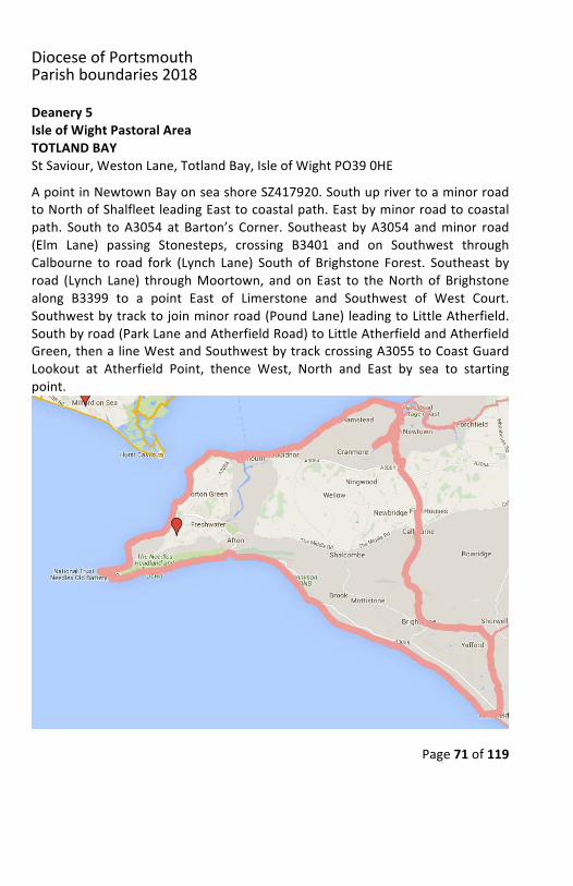
Deanery5IsleofWightPastoralAreaTOTLANDBAYStSaviour,WestonLane,TotlandBay,IsleofWightPO390HEApointinNewtownBayonseashoreSZ417920.SouthuprivertoaminorroadtoNorthofShalfleetleadingEasttocoastalpath.Eastbyminorroadtocoastalpath. South toA3054 at Barton’s Corner. Southeast byA3054 andminor road(Elm Lane) passing Stonesteps, crossing B3401 and on Southwest throughCalbourne to road fork (Lynch Lane) South of Brighstone Forest. Southeast byroad (Lynch Lane) throughMoortown, and on East to theNorth of Brighstonealong B3399 to a point East of Limerstone and Southwest of West Court.Southwestbytracktojoinminorroad(PoundLane)leadingtoLittleAtherfield.Southbyroad(ParkLaneandAtherfieldRoad)toLittleAtherfieldandAtherfieldGreen,thenalineWestandSouthwestbytrackcrossingA3055toCoastGuardLookout at Atherfield Point, thence West, North and East by sea to startingpoint.
DioceseofPortsmouthParishboundaries2018
Page72of119
Deanery5PortsmouthPastoralAreaPORTSMOUTHTHECATHEDRALOFSAINTJOHNTHEEVANGELISTBishopCrispianWay,Portsmouth,HampshirePO13HG
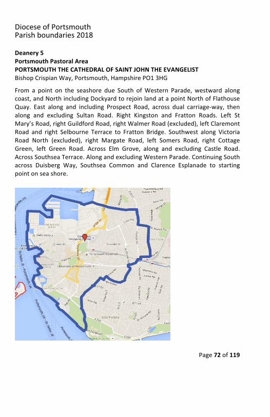
From a point on the seashore due South ofWestern Parade, westward alongcoast,andNorthincludingDockyardtorejoinlandatapointNorthofFlathouseQuay. East along and including Prospect Road, across dual carriage-way, thenalong and excluding Sultan Road. Right Kingston and Fratton Roads. Left StMary’sRoad,rightGuildfordRoad,rightWalmerRoad(excluded),leftClaremontRoad and right Selbourne Terrace to Fratton Bridge. Southwest along VictoriaRoad North (excluded), right Margate Road, left Somers Road, right CottageGreen, left Green Road. Across Elm Grove, along and excluding Castle Road.AcrossSouthseaTerrace.AlongandexcludingWesternParade.ContinuingSouthacross Duisberg Way, Southsea Common and Clarence Esplanade to startingpointonseashore.
DioceseofPortsmouthParishboundaries2018
Page73of119
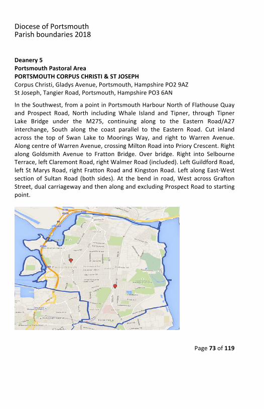
Deanery5PortsmouthPastoralAreaPORTSMOUTHCORPUSCHRISTI&STJOSEPHCorpusChristi,GladysAvenue,Portsmouth,HampshirePO29AZStJoseph,TangierRoad,Portsmouth,HampshirePO36ANIntheSouthwest,fromapointinPortsmouthHarbourNorthofFlathouseQuayand Prospect Road, North including Whale Island and Tipner, through TipnerLake Bridge under the M275, continuing along to the Eastern Road/A27interchange, South along the coast parallel to the Eastern Road. Cut inlandacross the top of Swan Lake to Moorings Way, and right to Warren Avenue.AlongcentreofWarrenAvenue,crossingMiltonRoadintoPrioryCrescent.Rightalong Goldsmith Avenue to Fratton Bridge. Over bridge. Right into SelbourneTerrace,leftClaremontRoad,rightWalmerRoad(included).LeftGuildfordRoad,leftStMarysRoad,rightFrattonRoadandKingstonRoad.LeftalongEast-Westsection of Sultan Road (both sides). At the bend in road,West across GraftonStreet,dualcarriagewayandthenalongandexcludingProspectRoadtostartingpoint.
DioceseofPortsmouthParishboundaries2018
Page74of119
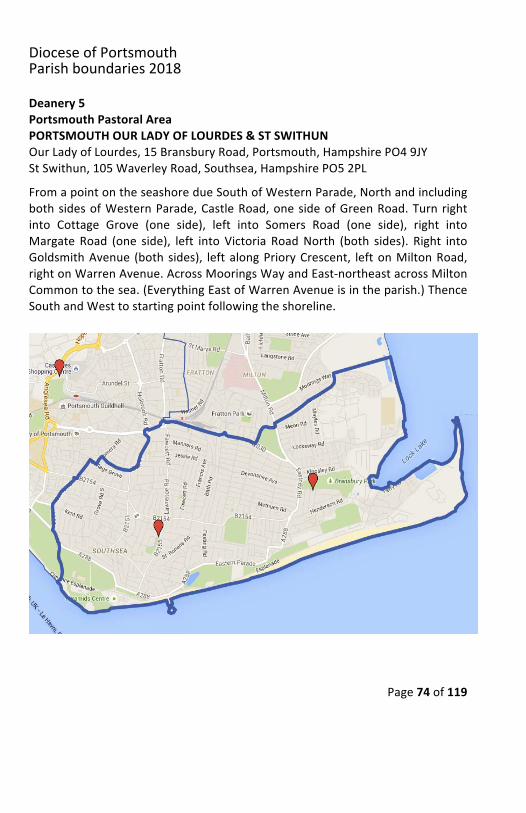
Deanery5PortsmouthPastoralAreaPORTSMOUTHOURLADYOFLOURDES&STSWITHUNOurLadyofLourdes,15BransburyRoad,Portsmouth,HampshirePO49JYStSwithun,105WaverleyRoad,Southsea,HampshirePO52PLFromapointontheseashoredueSouthofWesternParade,NorthandincludingbothsidesofWesternParade,CastleRoad,onesideofGreenRoad.Turnrightinto Cottage Grove (one side), left into Somers Road (one side), right intoMargate Road (one side), left into Victoria RoadNorth (both sides). Right intoGoldsmithAvenue (bothsides), leftalongPrioryCrescent, leftonMiltonRoad,rightonWarrenAvenue.AcrossMooringsWayandEast-northeastacrossMiltonCommontothesea.(EverythingEastofWarrenAvenueisintheparish.)ThenceSouthandWesttostartingpointfollowingtheshoreline.
DioceseofPortsmouthParishboundaries2018
Page75of119
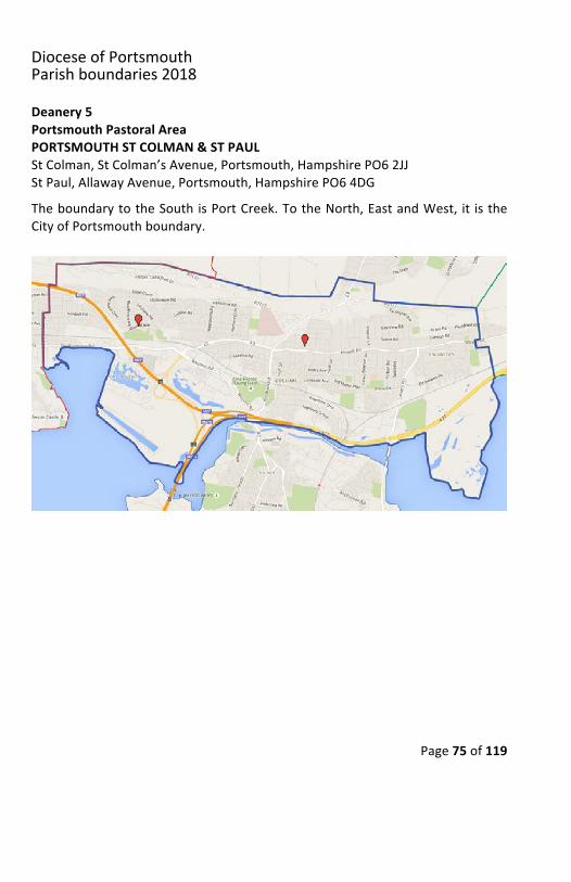
Deanery5PortsmouthPastoralAreaPORTSMOUTHSTCOLMAN&STPAULStColman,StColman’sAvenue,Portsmouth,HampshirePO62JJStPaul,AllawayAvenue,Portsmouth,HampshirePO64DGTheboundarytotheSouthisPortCreek.TotheNorth,EastandWest, it istheCityofPortsmouthboundary.
DioceseofPortsmouthParishboundaries2018
Page76of119
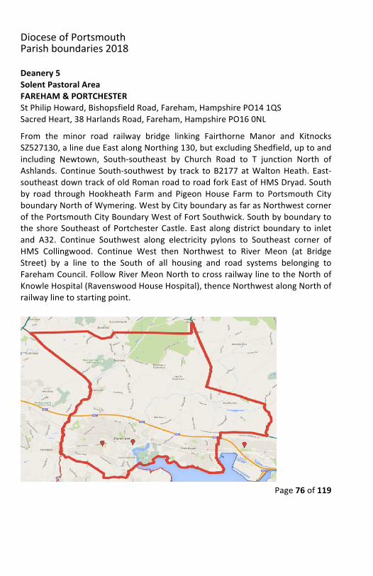
Deanery5SolentPastoralAreaFAREHAM&PORTCHESTERStPhilipHoward,BishopsfieldRoad,Fareham,HampshirePO141QSSacredHeart,38HarlandsRoad,Fareham,HampshirePO160NLFrom the minor road railway bridge linking Fairthorne Manor and KitnocksSZ527130,alinedueEastalongNorthing130,butexcludingShedfield,uptoandincluding Newtown, South-southeast by Church Road to T junction North ofAshlands. Continue South-southwest by track toB2177 atWaltonHeath. East-southeastdowntrackofoldRomanroadtoroadforkEastofHMSDryad.Southby road through Hookheath Farm and Pigeon House Farm to Portsmouth CityboundaryNorthofWymering.WestbyCityboundaryasfarasNorthwestcornerofthePortsmouthCityBoundaryWestofFortSouthwick.SouthbyboundarytotheshoreSoutheastofPortchesterCastle.Eastalongdistrictboundary to inletand A32. Continue Southwest along electricity pylons to Southeast corner ofHMS Collingwood. Continue West then Northwest to River Meon (at BridgeStreet) by a line to the South of all housing and road systems belonging toFarehamCouncil.FollowRiverMeonNorthtocrossrailwaylinetotheNorthofKnowleHospital(RavenswoodHouseHospital),thenceNorthwestalongNorthofrailwaylinetostartingpoint.
DioceseofPortsmouthParishboundaries2018
Page77of119
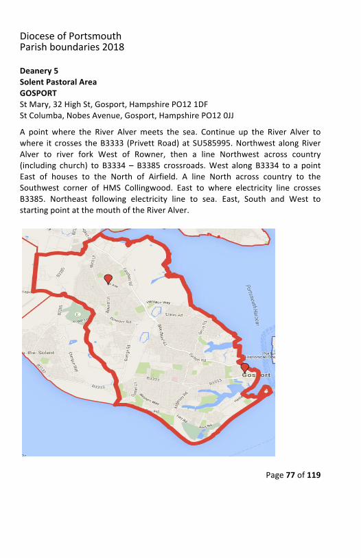
Deanery5SolentPastoralAreaGOSPORTStMary,32HighSt,Gosport,HampshirePO121DFStColumba,NobesAvenue,Gosport,HampshirePO120JJA point where the River Alver meets the sea. Continue up the River Alver towhere it crosses theB3333 (PrivettRoad)at SU585995.NorthwestalongRiverAlver to river fork West of Rowner, then a line Northwest across country(including church) to B3334 – B3385 crossroads.West along B3334 to a pointEast of houses to the North of Airfield. A line North across country to theSouthwest corner of HMS Collingwood. East to where electricity line crossesB3385. Northeast following electricity line to sea. East, South and West tostartingpointatthemouthoftheRiverAlver.
DioceseofPortsmouthParishboundaries2018
Page78of119
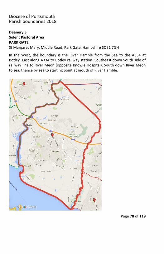
Deanery5SolentPastoralAreaPARKGATEStMargaretMary,MiddleRoad,ParkGate,HampshireSO317GHIn the West, the boundary is the River Hamble from the Sea to the A334 atBotley.EastalongA334toBotleyrailwaystation.SoutheastdownSouthsideofrailwaylinetoRiverMeon(oppositeKnowleHospital).SouthdownRiverMeontosea,thencebyseatostartingpointatmouthofRiverHamble.
DioceseofPortsmouthParishboundaries2018
Page79of119
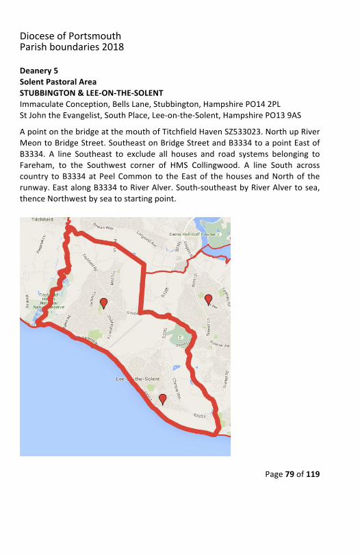
Deanery5SolentPastoralAreaSTUBBINGTON&LEE-ON-THE-SOLENTImmaculateConception,BellsLane,Stubbington,HampshirePO142PLStJohntheEvangelist,SouthPlace,Lee-on-the-Solent,HampshirePO139ASApointonthebridgeatthemouthofTitchfieldHavenSZ533023.NorthupRiverMeontoBridgeStreet.SoutheastonBridgeStreetandB3334toapointEastofB3334. A line Southeast to exclude all houses and road systems belonging toFareham, to the Southwest corner of HMS Collingwood. A line South acrosscountry toB3334atPeelCommon to theEastof thehousesandNorthof therunway.EastalongB3334toRiverAlver.South-southeastbyRiverAlvertosea,thenceNorthwestbyseatostartingpoint.
DioceseofPortsmouthParishboundaries2018
Page80of119
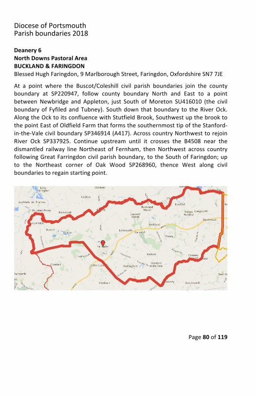
Deanery6NorthDownsPastoralAreaBUCKLAND&FARINGDONBlessedHughFaringdon,9MarlboroughStreet,Faringdon,OxfordshireSN77JEAt a point where the Buscot/Coleshill civil parish boundaries join the countyboundary at SP220947, follow county boundary North and East to a pointbetweenNewbridge and Appleton, just South ofMoreton SU416010 (the civilboundaryof FyfiledandTubney). Southdown thatboundary to theRiverOck.AlongtheOcktoitsconfluencewithStutfieldBrook,SouthwestupthebrooktothepointEastofOldfieldFarmthatformsthesouthernmosttipoftheStanford-in-the-ValecivilboundarySP346914(A417).AcrosscountryNorthwesttorejoinRiver Ock SP337925. Continue upstream until it crosses the B4508 near thedismantled railway line Northeast of Fernham, thenNorthwest across countryfollowingGreatFarringdoncivilparishboundary,totheSouthofFaringdon;upto the Northeast corner of Oak Wood SP268960, thence West along civilboundariestoregainstartingpoint.
DioceseofPortsmouthParishboundaries2018
Page81of119
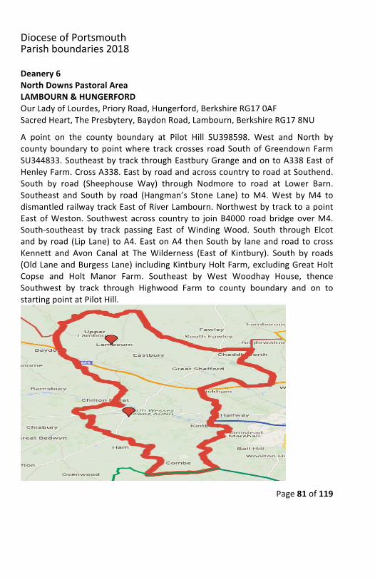
Deanery6NorthDownsPastoralAreaLAMBOURN&HUNGERFORDOurLadyofLourdes,PrioryRoad,Hungerford,BerkshireRG170AFSacredHeart,ThePresbytery,BaydonRoad,Lambourn,BerkshireRG178NUA point on the county boundary at Pilot Hill SU398598. West and North bycountyboundary topointwhere track crosses roadSouthofGreendownFarmSU344833.SoutheastbytrackthroughEastburyGrangeandontoA338EastofHenleyFarm.CrossA338.EastbyroadandacrosscountrytoroadatSouthend.South by road (Sheephouse Way) through Nodmore to road at Lower Barn.Southeast and South by road (Hangman’s Stone Lane) toM4.West byM4 todismantledrailwaytrackEastofRiverLambourn.NorthwestbytracktoapointEast ofWeston. Southwest across country to joinB4000 roadbridgeoverM4.South-southeast by track passing East of WindingWood. South through Elcotandby road (LipLane) toA4.EastonA4 thenSouthby laneandroad tocrossKennett and Avon Canal at TheWilderness (East of Kintbury). South by roads(OldLaneandBurgessLane)includingKintburyHoltFarm,excludingGreatHoltCopse and Holt Manor Farm. Southeast by West Woodhay House, thenceSouthwest by track through Highwood Farm to county boundary and on tostartingpointatPilotHill.
DioceseofPortsmouthParishboundaries2018
Page82of119
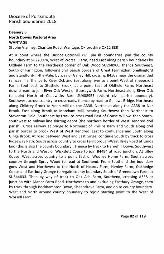
Deanery6NorthDownsPastoralAreaWANTAGEStJohnVianney,CharltonRoad,Wantage,OxfordshireOX128ERAt a point where the Buscot–Coteshill civil parish boundaries join the countyboundaryatSU220974,WestofWorsellFarm,headEastalongparishboundariesbyOldfield Farm to theNortheast corner of OakWood SU268960, thence Southeast,Southof Faringdon, following civil parish borders ofGreat Farringdon, ShellingfordandStandford-in-the-Vale,bywayofGalleyHill,crossingB4508nearthedismantledrailwayline,thencetoRiverOckandEastalongrivertoapointWestofSheepcroftFarm. Southeast to Stutfield Brook, at a point East of Oldfield Farm. NortheastdownstreamtojoinRiverOckWestofGooseywickFarm.NortheastalongRiverOckto point North of Chadwicks Barn SU408955 (Lyford civil parish boundary).Southwestacrosscountrytocrossroads,thencebyroadtoGallowsBridge.Northeastalong Childrey Brook to VennMill on the A338. Northeast along the A338 to NorBrook. East along Brook to Marcham Mill, bearing Southwest then Northeast toSteventonField.SoutheastbytracktocrossroadEastofGooseWillow,thenSouth-southwesttorailway lineskirtingdepot(thenorthernborderofWestHendredcivilparish). Cross railway at bridge to Northeast of Phillips Barn and South along civilparishborder tobrookWestofWestHendred.East toconfluenceandSouthalongGingeBrook.AtroadbetweenWestandEastGinge,continueSouthbytracktocrossRidgewayPath.SouthacrosscountrytocrossFarnborough-WestIlsleyRoadatLandsEnd(thisisalsothecountyboundary).ThencebytracktoHernehillDown.Southwestto theNorth andWestofWickslett Copse to joinB4494at road junction.At LilleyCopse,West across country to a point East ofWoolley Home Farm. South acrosscountry through Spray Wood to road at Southend. From Southend the boundarygoes West and Northwest to the North of Heards Farm, Henley Farm, OakhedgeCopseandEastburyGrangetoregaincountyboundarySouthofGreendownFarmatSU344833. Then by way of track to Oak Ash Farm, Southend, crossing A338 atjunctionwithManorFarmRoad.NorthwesttoandexcludingEastburyGrange,thenbytrackthroughBockhamptonDown,SheepdroveFarm,andontocountyboundary.West and North around county boundary to rejoin starting point to the West ofWorsellFarm.
DioceseofPortsmouthParishboundaries2018
Page83of119
DioceseofPortsmouthParishboundaries2018
Page84of119
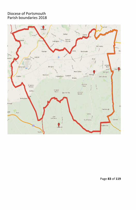
Deanery6ThamesIsisPastoralAreaABINGDONOurLady&StEdmundofAbingdon,1RadleyRoad,Abingdon,OxonOX143PLTo the East the boundary is the River Thames. At a point on the ThamesSU532007westtoSugworthLane,acrosstheA34toSunningwellChurch(villageonchurchside).SouthwesttoWoottonRoad.TurnrightNorth-northwestalongWhitecross, left to Honeybottom Road and Cothill Road. Turn right (West-northwest) on Faringdon Road. Cross the A338 on to Abingdon Road. South-southwestandwestthroughthegolflinkstojoinFrilfordParishboundaryontheleft, across to the A415 (the Kingston Road). Northwest along A415. South bywayoftrackandstreamtojoinRiverOcknearGarford.Southwest(upstream)toNorth of Chadwick’s Barn. Southwest across country to crossroads, thence byroad to Gallows Bridge. Northeast along Childrey Brook to Venn Mill on theA338.NortheastalongA338toNorBrook.EastalongBrooktoMarchamMillontheRiverOck.BearSouthwestthenEasttoincludeDraytonCopseandDraytonMill,thenfollowtheDraytoncivilboundarytoAbingdon,joiningtheThamesatSU500957.
DioceseofPortsmouthParishboundaries2018
Page85of119
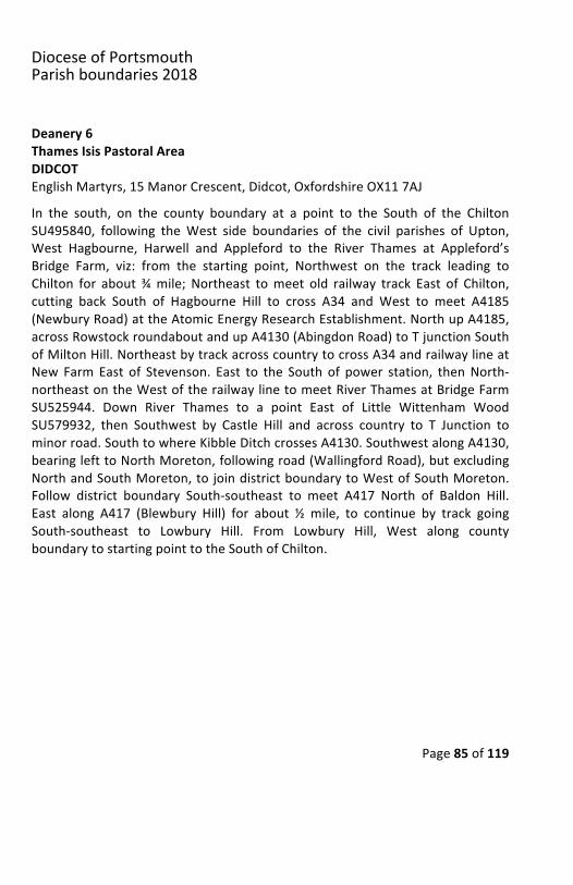
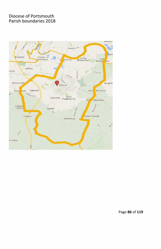
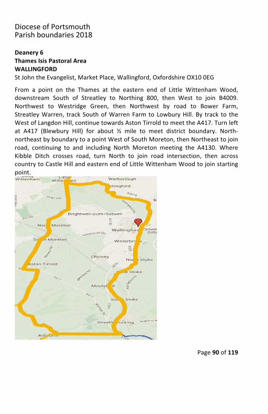
Deanery6ThamesIsisPastoralAreaDIDCOTEnglishMartyrs,15ManorCrescent,Didcot,OxfordshireOX117AJIn the south, on the county boundary at a point to the South of the ChiltonSU495840, following theWest side boundaries of the civil parishes of Upton,West Hagbourne, Harwell and Appleford to the River Thames at Appleford’sBridge Farm, viz: from the starting point, Northwest on the track leading toChilton for about¾mile; Northeast tomeet old railway track East of Chilton,cutting back South of Hagbourne Hill to cross A34 and West to meet A4185(NewburyRoad)attheAtomicEnergyResearchEstablishment.NorthupA4185,acrossRowstockroundaboutandupA4130(AbingdonRoad)toTjunctionSouthofMiltonHill.NortheastbytrackacrosscountrytocrossA34andrailwaylineatNew Farm East of Stevenson. East to the South of power station, thenNorth-northeastontheWestoftherailwaylinetomeetRiverThamesatBridgeFarmSU525944. Down River Thames to a point East of Little Wittenham WoodSU579932, then Southwest by Castle Hill and across country to T Junction tominorroad.SouthtowhereKibbleDitchcrossesA4130.SouthwestalongA4130,bearinglefttoNorthMoreton,followingroad(WallingfordRoad),butexcludingNorthandSouthMoreton,tojoindistrictboundarytoWestofSouthMoreton.Follow district boundary South-southeast to meet A417 North of Baldon Hill.East along A417 (Blewbury Hill) for about ½ mile, to continue by track goingSouth-southeast to Lowbury Hill. From Lowbury Hill, West along countyboundarytostartingpointtotheSouthofChilton.
DioceseofPortsmouthParishboundaries2018
Page86of119
DioceseofPortsmouthParishboundaries2018
Page87of119
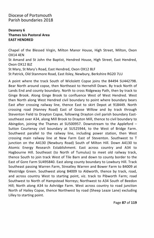
Deanery6ThamesIsisPastoralAreaEASTHENDREDChapel of the Blessed Virgin, MiltonManor House, High Street, Milton, OxonOX144ENStAmand and St John theBaptist,HendredHouse,High Street, EastHendred,OxonOX128JZStMary,StMary’sRoad,EastHendred,OxonOX128LFStPatrick,OldStanmoreRoad,EastIlsley,Newbury,BerkshireRG207LUA point where the track South ofWickslett Copse joins the B4494 SU442798.BearNortharoundcopse,thenNortheasttoHernehillDown.BytrackNorthofLandsEndandcountyboundary.NorthtocrossRidgewayPath,thenbytracktoGinge Brook. Along Ginge Brook to confluence West of West Hendred. WestthenNorthalongWestHendredcivilboundary topointwhereboundarybearsEast after crossing railway line, thence East to skirt Depot at 918449. Northcrossing road (Hanney Road) East of Goose Willow and by track throughSteventonFieldtoDraytonCopse,followingDraytoncivilparishboundaryEast-southeastoverA34,alongMillBrooktoDraytonMill,thencetocivilboundarytoAbingdon, joining the Thames at SU500957. Downstream to the Appleford –Sutton Courtenay civil boundary at SU525944, to the West of Bridge Farm.Southwest parallel to the railway line, including power station, then Westcrossing main railway line at New Farm East of Steventon. Southwest to Tjunction on the A4130 (Newbury Road) South of Milton Hill. Down A4130 toAtomic Energy Research Establishment. East across country and A34 toHagbourne Hill. Southeast (to North of Tumulus) to meet old railway track,thenceSouthto jointrackWestofTileBarnanddowntocountybordertotheEastofGoreFarmSU495840.EastalongcountyboundarytoLowburyHill.TrackSoutheastpassingWarrenFarm,StreatleyWarrenandBowerFarmtoB4009atWestridge Green. Southwest along B4009 to Aldworth, thence by track, road,and across country West to starting point, viz. track to Pibworth Farm; roadSouthwesttoNorthofHampsteadNorreys;NorthwesttoA34SouthofBeedonHill; North along A34 to Ashridge Farm.West across country to road junctionNorthofHaileyCopse,thenceNorthwestbyroad(SheepLeazeLane)excludingLilleytostartingpoint.
DioceseofPortsmouthParishboundaries2018
Page88of119
Continued
DioceseofPortsmouthParishboundaries2018
Page89of119
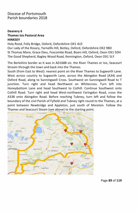
Deanery6ThamesIsisPastoralAreaHINKSEYHolyRood,FollyBridge,Oxford,OxfordshireOX14LDOurLadyoftheRosary,YarnelllsHill,Botley,Oxford,OxfordshireOX29BDStThomasMore,GraceDieu,FoxcombeRoad,BoarsHill,Oxford,OxonOX15DHTheGoodShepherd,BagleyWoodRoad,Kennington,Oxford,OxonOX15LYTheBerkshireborderasitwasinAD1688viz.theRiverThamesorIsis,SeacourtStreamthroughthetownandbackintotheThames.South(fromEasttoWest):nearestpointontheRiverThamestoSugworthLane.West across country to Sugworth Lane, across the Abingdon Road (A34) andOxfordRoad,along toSunningwellCross. SouthwestonSunningwellRoad toTjunction. Turn right and head Northwest on Whitecross. Turn left intoHoneybottom Lane and head Southwest to Cothill. Continue Southwest ontoCothill Road. Turn right and head West-northwest Faringdon Road, cross theA338 onto Abingdon Road. Before reaching Tubney, turn left and follow theboundaryofthecivilParishofFyfieldandTubneyrightroundtotheThames,atapoint between Newbridge and Appleton, just south of Moreton. Follow theThamesandSeacourtSteam(seeabove)tothestartingpoint.
DioceseofPortsmouthParishboundaries2018
Page90of119
Deanery6ThamesIsisPastoralAreaWALLINGFORDStJohntheEvangelist,MarketPlace,Wallingford,OxfordshireOX100EGFrom a point on the Thames at the eastern end of Little Wittenham Wood,downstream South of Streatley to Northing 800, then West to join B4009.Northwest to Westridge Green, then Northwest by road to Bower Farm,StreatleyWarren, trackSouthofWarrenFarm to LowburyHill.By track to theWestofLangdonHill,continuetowardsAstonTirroldtomeettheA417.Turnleftat A417 (Blewbury Hill) for about ½ mile to meet district boundary. North-northeastbyboundarytoapointWestofSouthMoreton,thenNortheasttojoinroad, continuing to and including North Moreton meeting the A4130. WhereKibble Ditch crosses road, turn North to join road intersection, then acrosscountrytoCastleHillandeasternendofLittleWittenhamWoodtojoinstartingpoint.
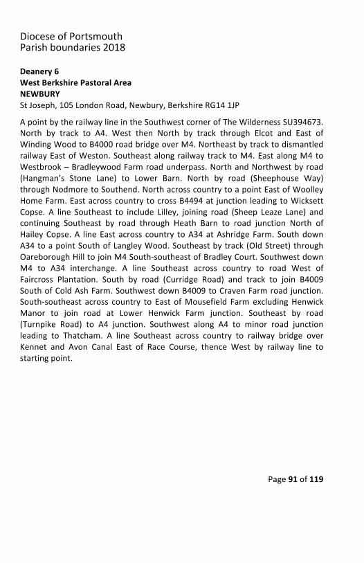
DioceseofPortsmouthParishboundaries2018
Page91of119
Deanery6WestBerkshirePastoralAreaNEWBURYStJoseph,105LondonRoad,Newbury,BerkshireRG141JPApointbytherailwaylineintheSouthwestcornerofTheWildernessSU394673.North by track to A4. West then North by track through Elcot and East ofWindingWoodtoB4000roadbridgeoverM4.NortheastbytracktodismantledrailwayEastofWeston.Southeastalongrailwaytrack toM4.EastalongM4toWestbrook–BradleywoodFarmroadunderpass.NorthandNorthwestbyroad(Hangman’s Stone Lane) to Lower Barn. North by road (Sheephouse Way)throughNodmoretoSouthend.NorthacrosscountrytoapointEastofWoolleyHomeFarm.EastacrosscountrytocrossB4494at junction leadingtoWicksettCopse. A line Southeast to include Lilley, joining road (Sheep Leaze Lane) andcontinuing Southeast by road through Heath Barn to road junction North ofHaileyCopse.A lineEast across country toA34atAshridgeFarm. SouthdownA34toapointSouthofLangleyWood.Southeastbytrack(OldStreet)throughOareboroughHilltojoinM4South-southeastofBradleyCourt.SouthwestdownM4 to A34 interchange. A line Southeast across country to road West ofFaircross Plantation. South by road (Curridge Road) and track to join B4009SouthofColdAshFarm.SouthwestdownB4009toCravenFarmroadjunction.South-southeast across country to East ofMousefield FarmexcludingHenwickManor to join road at Lower Henwick Farm junction. Southeast by road(Turnpike Road) to A4 junction. Southwest along A4 to minor road junctionleading to Thatcham. A line Southeast across country to railway bridge overKennet and Avon Canal East of Race Course, thence West by railway line tostartingpoint.
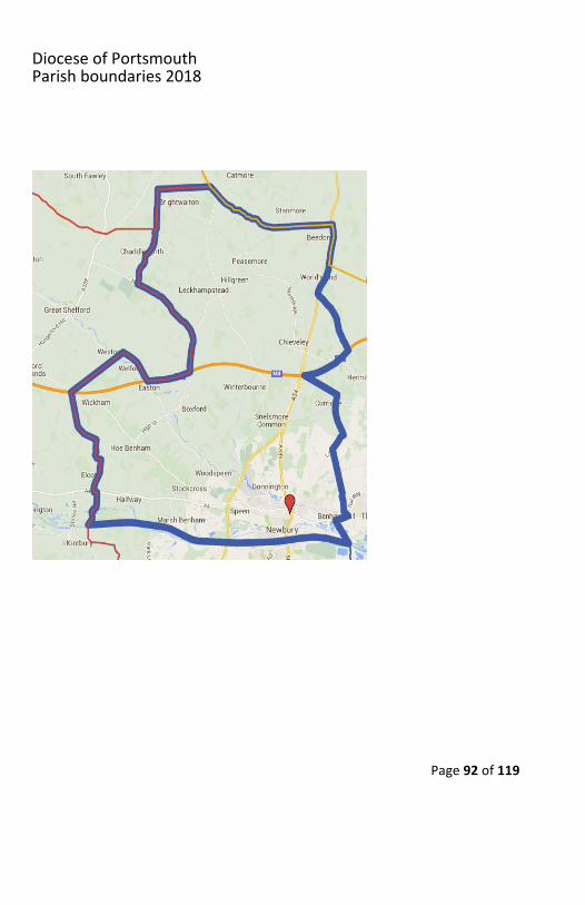
DioceseofPortsmouthParishboundaries2018
Page92of119
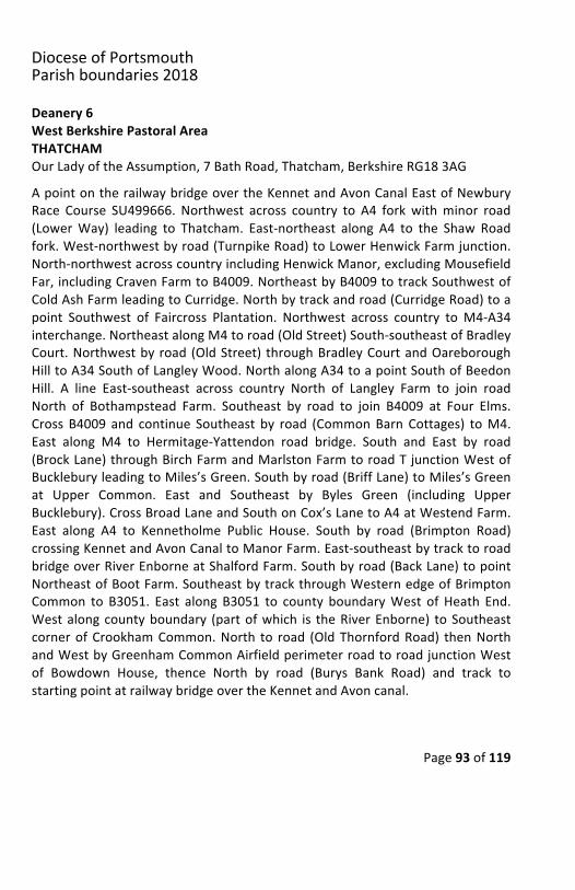
DioceseofPortsmouthParishboundaries2018
Page93of119
Deanery6WestBerkshirePastoralAreaTHATCHAMOurLadyoftheAssumption,7BathRoad,Thatcham,BerkshireRG183AGApointontherailwaybridgeovertheKennetandAvonCanalEastofNewburyRace Course SU499666. Northwest across country to A4 forkwithminor road(LowerWay) leading to Thatcham. East-northeast along A4 to the Shaw Roadfork.West-northwestbyroad(TurnpikeRoad)toLowerHenwickFarmjunction.North-northwestacrosscountryincludingHenwickManor,excludingMousefieldFar,includingCravenFarmtoB4009.NortheastbyB4009totrackSouthwestofColdAshFarmleadingtoCurridge.Northbytrackandroad(CurridgeRoad)toapoint Southwest of Faircross Plantation. Northwest across country toM4-A34interchange.NortheastalongM4toroad(OldStreet)South-southeastofBradleyCourt.Northwestbyroad(OldStreet) throughBradleyCourtandOareboroughHilltoA34SouthofLangleyWood.NorthalongA34toapointSouthofBeedonHill. A line East-southeast across country North of Langley Farm to join roadNorth of Bothampstead Farm. Southeast by road to join B4009 at Four Elms.Cross B4009 and continue Southeast by road (CommonBarn Cottages) toM4.East along M4 to Hermitage-Yattendon road bridge. South and East by road(BrockLane)throughBirchFarmandMarlstonFarmtoroadTjunctionWestofBuckleburyleadingtoMiles’sGreen.Southbyroad(BriffLane)toMiles’sGreenat Upper Common. East and Southeast by Byles Green (including UpperBucklebury).CrossBroadLaneandSouthonCox’sLanetoA4atWestendFarm.East along A4 to Kennetholme Public House. South by road (Brimpton Road)crossingKennetandAvonCanaltoManorFarm.East-southeastbytracktoroadbridgeoverRiverEnborneatShalfordFarm.Southbyroad(BackLane)topointNortheastofBootFarm.SoutheastbytrackthroughWesternedgeofBrimptonCommon to B3051. East along B3051 to county boundaryWest of Heath End.Westalongcountyboundary (partofwhich is theRiverEnborne) toSoutheastcornerofCrookhamCommon.North to road (OldThornfordRoad) thenNorthandWestbyGreenhamCommonAirfieldperimeterroadtoroadjunctionWestof Bowdown House, thence North by road (Burys Bank Road) and track tostartingpointatrailwaybridgeovertheKennetandAvoncanal.
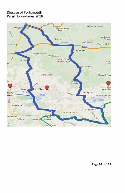
DioceseofPortsmouthParishboundaries2018
Page94of119
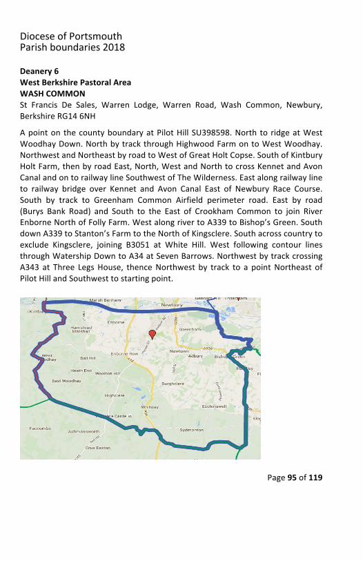
DioceseofPortsmouthParishboundaries2018
Page95of119
Deanery6WestBerkshirePastoralAreaWASHCOMMONSt Francis De Sales, Warren Lodge, Warren Road, Wash Common, Newbury,BerkshireRG146NHApointon thecountyboundaryatPilotHillSU398598.North to ridgeatWestWoodhayDown.NorthbytrackthroughHighwoodFarmontoWestWoodhay.NorthwestandNortheastbyroadtoWestofGreatHoltCopse.SouthofKintburyHoltFarm,thenbyroadEast,North,WestandNorthtocrossKennetandAvonCanalandontorailwaylineSouthwestofTheWilderness.Eastalongrailwaylineto railway bridge over Kennet and Avon Canal East of Newbury Race Course.South by track to Greenham Common Airfield perimeter road. East by road(Burys Bank Road) and South to the East of Crookham Common to join RiverEnborneNorthofFollyFarm.WestalongrivertoA339toBishop’sGreen.SouthdownA339toStanton’sFarmtotheNorthofKingsclere.Southacrosscountrytoexclude Kingsclere, joining B3051 at White Hill. West following contour linesthroughWatershipDowntoA34atSevenBarrows.NorthwestbytrackcrossingA343 at Three LegsHouse, thenceNorthwest by track to a pointNortheast ofPilotHillandSouthwesttostartingpoint.
DioceseofPortsmouthParishboundaries2018
Page96of119
Deanery6WestBerkshirePastoralAreaWOOLHAMPTONOurLady&StBernadette,HorseshoeRoad,Pangbourne,BerkshireRG87JLStLuke,EnglefieldRoad,Theale,BerkshireRG75ASStMary,DouaiAbbey,UpperWoolhampton,BerkshireRG75TQFromapointontheA4SouthofWestendFarmSU544668,North-northeastbyroad(Cox’sLane)toUpperBucklebury.Northwesttoroad(BylesGreen)EastofUpper Common. North by road (Briff Lane) to T junction South of River PangWestofBucklebury.Northwestbyroad (BrocksLane).PastBirchFarmbyroadand on bridge on Hermitage-Yattenden road over M4. West along M4 toCommon Barn Cotts Road. Northwest by road crossing B4009 at Four Elms.Northwest to Bothamstead Farm. Bear North then East by track to join roadNorthofHampsteadNorreys.Northby road tobridgeoverdismantled railwayEastofMilkhillFarm.NortheastbyroadtoB4009atAldworth.NortheastalongB4009toapointEastofWestridgeGreen,thenlineEastalongNorthing800toRiverThamesandcountyboundarySouthofStreatley.SoutheastalongThamestoapointEastofPangbourneSU646773, thenSouthbytrack,pathandacrosscountry, passing Purley Hall (excluded), Stoneham Farm (excluded), SulhamHouse (included) toM4 interchange12atTheale.SoutheastalongM4toRiverKennet. Southwest along River Kennet to confluence with the River Enborne.TaketheRiverEnborneSouthwesttoroadbridgeatBackLane.Northwestacrosscountry and then by track to meet road (Brimpton Road) at Manor Farm.Northwestbyroad(BrimptonRoad)crossingKennetandAvonCanalandrailwaylinetomeetA4oppositeChurchHill.ThenceWestalongA4tostartingpointatWestendFarm.
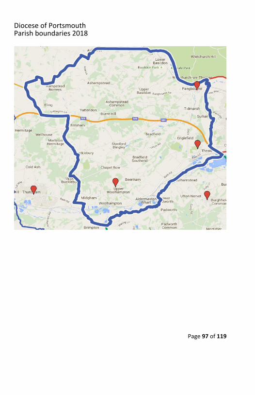
DioceseofPortsmouthParishboundaries2018
Page97of119
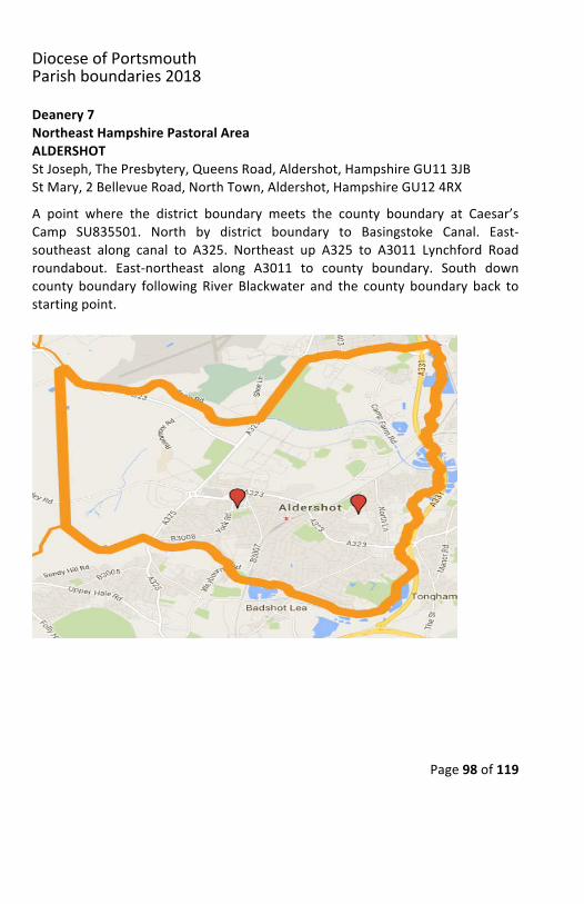
DioceseofPortsmouthParishboundaries2018
Page98of119
Deanery7NortheastHampshirePastoralAreaALDERSHOTStJoseph,ThePresbytery,QueensRoad,Aldershot,HampshireGU113JBStMary,2BellevueRoad,NorthTown,Aldershot,HampshireGU124RXA point where the district boundary meets the county boundary at Caesar’sCamp SU835501. North by district boundary to Basingstoke Canal. East-southeast along canal to A325. Northeast up A325 to A3011 Lynchford Roadroundabout. East-northeast along A3011 to county boundary. South downcounty boundary following River Blackwater and the county boundary back tostartingpoint.
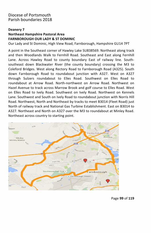
DioceseofPortsmouthParishboundaries2018
Page99of119
Deanery7NortheastHampshirePastoralAreaFARNBOROUGHOURLADY&STDOMINICOurLadyandStDominic,HighViewRoad,Farnborough,HampshireGU147PTApointintheSoutheastcornerofHawleyLakeSU838569.Northeastalongtrackand thenWoodlandsWalk to Fernhill Road. Southeast and East along FernhillLane. Across Hawley Road to county boundary East of railway line. South-southeast down Blackwater River (the county boundary) crossing the M3 toColefordBridges.WestalongRectoryRoadtoFarnboroughRoad(A325).Southdown Farnborough Road to roundabout junction with A327. West on A327through Sulzers roundabout to Elles Road. Southwest on Elles Road toroundabout at Arrow Road. North-northwest on Arrow Road. Northwest onHazelAvenuetotrackacrossMarrowBrookandgolfcoursetoEllesRoad.Weston Elles Road to Ively Road. Southwest on Ively Road. Northwest on KennelsLane.SouthwestandSouthonIvelyRoadtoroundaboutjunctionwithNorrisHillRoad.Northwest,NorthandNortheastbytrackstomeetB3014(FleetRoad)justNorthofrailwaytrackandNationalGasTurbineEstablishment.EastonB3014toA327.NortheastandNorthonA327overtheM3toroundaboutatMinleyRoad.Northeastacrosscountrytostartingpoint.

DioceseofPortsmouthParishboundaries2018
Page100of119
Deanery7NortheastHampshirePastoralAreaFARNBOROUGHOURLADYHELPOFCHRISTIANSOurLadyHelpofChristians,ThePresbytery,1ASherborneRoad,Farnborough,HampshireGU146JRA point on the Basingstoke Canal at Norris Bridge SU833536. Northeast alongIvely Road, Southeast on Kennels Lane, thenNortheast on Ively Road to trackcrossing golf course. Northeast along track to Hazel Avenue. Southeast downHazel Avenue to roundabout with Arrow Road. South on Arrow Road toroundaboutandNortheastonEllesRoadtoSulzersroundabout.EastonA327toroundabout junctionwithA325 FarnboroughRoad atNorthGate.North alongA325toRectoryRoad.EastalongRectoryRoadtocountyboundary(BlackwaterRiver). Southdown county boundary toB3166 LynchfordRoad. East-southeastby B3166 to A325 roundabout. Southwest along A325 to Basingstoke Canal,thenceNorthwestalongcanaltostartingpoint.
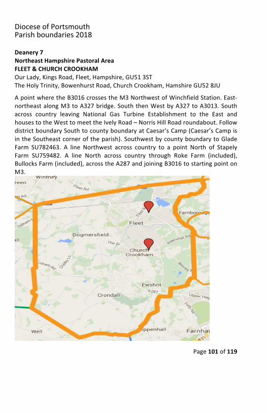
DioceseofPortsmouthParishboundaries2018
Page101of119
Deanery7NortheastHampshirePastoralAreaFLEET&CHURCHCROOKHAMOurLady,KingsRoad,Fleet,Hampshire,GU513STTheHolyTrinity,BowenhurstRoad,ChurchCrookham,HamshireGU528JUApointwheretheB3016crossestheM3NorthwestofWinchfieldStation.East-northeastalongM3toA327bridge.SouththenWestbyA327toA3013.Southacross country leaving National Gas Turbine Establishment to the East andhousestotheWesttomeettheIvelyRoad–NorrisHillRoadroundabout.FollowdistrictboundarySouthtocountyboundaryatCaesar’sCamp(Caesar’sCampisintheSoutheastcorneroftheparish).SouthwestbycountyboundarytoGladeFarm SU782463. A line Northwest across country to a point North of StapelyFarm SU759482. A line North across country through Roke Farm (included),BullocksFarm(included),acrosstheA287andjoiningB3016tostartingpointonM3.
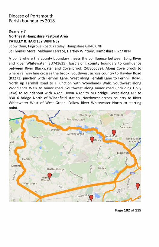
DioceseofPortsmouthParishboundaries2018
Page102of119
Deanery7NortheastHampshirePastoralAreaYATELEY&HARTLEYWINTNEYStSwithun,FirgroveRoad,Yateley,HampshireGU466NHStThomasMore,MildmayTerrace,HartleyWintney,HampshireRG278PNApointwhere thecountyboundarymeets theconfluencebetweenLongRiverand RiverWhitewater (SU741635). East along county boundary to confluencebetween River Blackwater and Cove Brook (SU860589). Along Cove Brook towhererailwaylinecrossesthebrook.SouthwestacrosscountrytoHawleyRoad(B3272) junctionwith Fernhill Lane.West along Fernhill Lane to Fernhill Road.North up Fernhill Road to T junction with Woodlands Walk. Southwest alongWoodlandsWalk to minor road. Southwest along minor road (including HollyLake) to roundaboutwith A327. Down A327 toM3 bridge.West alongM3 toB3016 bridge North of Winchfield station. Northwest across country to RiverWhitewater West of West Green. Follow River Whitewater North to startingpoint.
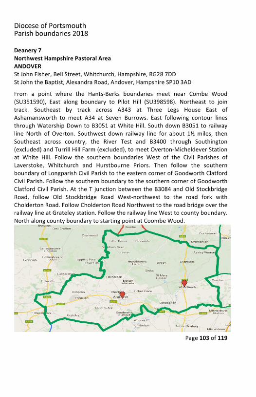
DioceseofPortsmouthParishboundaries2018
Page103of119
Deanery7NorthwestHampshirePastoralAreaANDOVERStJohnFisher,BellStreet,Whitchurch,Hampshire,RG287DDStJohntheBaptist,AlexandraRoad,Andover,HampshireSP103ADFrom a point where the Hants-Berks boundaries meet near Combe Wood(SU351590), East along boundary to Pilot Hill (SU398598). Northeast to jointrack. Southeast by track across A343 at Three Legs House East ofAshamansworth to meet A34 at Seven Burrows. East following contour linesthroughWatershipDowntoB3051atWhiteHill.SouthdownB3051torailwayline North of Overton. Southwest down railway line for about 1½miles, thenSoutheast across country, the River Test and B3400 through Southington(excluded)andTurrillHillFarm(excluded),tomeetOverton-MicheldeverStationat White Hill. Follow the southern boundaries West of the Civil Parishes ofLaverstoke, Whitchurch and Hurstbourne Priors. Then follow the southernboundaryofLongparishCivilParishtotheeasterncornerofGoodworthClatfordCivilParish.FollowthesouthernboundarytothesoutherncornerofGoodworthClatfordCivilParish.At theT junctionbetweentheB3084andOldStockbridgeRoad, follow Old Stockbridge Road West-northwest to the road fork withCholdertonRoad.FollowCholdertonRoadNorthwesttotheroadbridgeovertherailwaylineatGrateleystation.FollowtherailwaylineWesttocountyboundary.NorthalongcountyboundarytostartingpointatCoombeWood.
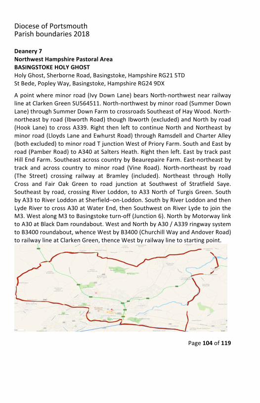
DioceseofPortsmouthParishboundaries2018
Page104of119
Deanery7NorthwestHampshirePastoralAreaBASINGSTOKEHOLYGHOSTHolyGhost,SherborneRoad,Basingstoke,HampshireRG215TDStBede,PopleyWay,Basingstoke,HampshireRG249DXApointwhereminorroad(IvyDownLane)bearsNorth-northwestnearrailwaylineatClarkenGreenSU564511.North-northwestbyminorroad(SummerDownLane)throughSummerDownFarmtocrossroadsSoutheastofHayWood.North-northeastbyroad(IbworthRoad)thoughIbworth(excluded)andNorthbyroad(HookLane) tocrossA339.Right then left tocontinueNorthandNortheastbyminorroad(LloydsLaneandEwhurstRoad)throughRamsdellandCharterAlley(bothexcluded)tominorroadTjunctionWestofPrioryFarm.SouthandEastbyroad(PamberRoad)toA340atSaltersHeath.Rightthenleft.EastbytrackpastHillEndFarm.SoutheastacrosscountrybyBeaurepaireFarm.East-northeastbytrack and across country tominor road (Vine Road). North-northeast by road(The Street) crossing railway at Bramley (included). Northeast through HollyCross and Fair Oak Green to road junction at Southwest of Stratfield Saye.Southeastbyroad,crossingRiverLoddon, toA33NorthofTurgisGreen.SouthbyA33toRiverLoddonatSherfield–on-Loddon.SouthbyRiverLoddonandthenLydeRivertocrossA30atWaterEnd,thenSouthwestonRiverLydetojointheM3.WestalongM3toBasingstoketurn-off(Junction6).NorthbyMotorwaylinktoA30atBlackDamroundabout.WestandNorthbyA30/A339ringwaysystemtoB3400roundabout,whenceWestbyB3400(ChurchillWayandAndoverRoad)torailwaylineatClarkenGreen,thenceWestbyrailwaylinetostartingpoint.
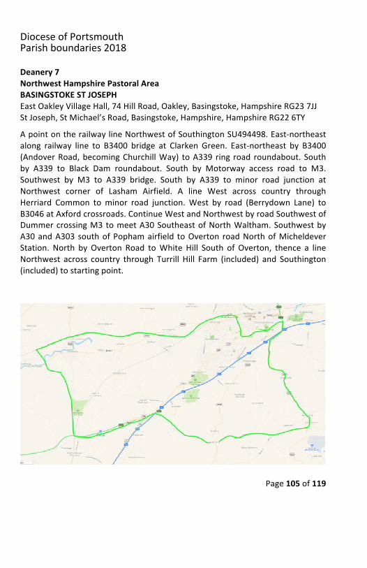
DioceseofPortsmouthParishboundaries2018
Page105of119
Deanery7NorthwestHampshirePastoralAreaBASINGSTOKESTJOSEPHEastOakleyVillageHall,74HillRoad,Oakley,Basingstoke,HampshireRG237JJStJoseph,StMichael’sRoad,Basingstoke,Hampshire,HampshireRG226TYApointontherailwaylineNorthwestofSouthingtonSU494498.East-northeastalong railway line to B3400 bridge at Clarken Green. East-northeast by B3400(AndoverRoad,becomingChurchillWay) toA339 ring road roundabout.Southby A339 to Black Dam roundabout. South by Motorway access road to M3.Southwest by M3 to A339 bridge. South by A339 to minor road junction atNorthwest corner of Lasham Airfield. A line West across country throughHerriard Common tominor road junction.West by road (Berrydown Lane) toB3046atAxfordcrossroads.ContinueWestandNorthwestbyroadSouthwestofDummercrossingM3tomeetA30SoutheastofNorthWaltham.SouthwestbyA30andA303 southofPophamairfield toOverton roadNorthofMicheldeverStation. North by Overton Road toWhite Hill South of Overton, thence a lineNorthwest across country through Turrill Hill Farm (included) and Southington(included)tostartingpoint.
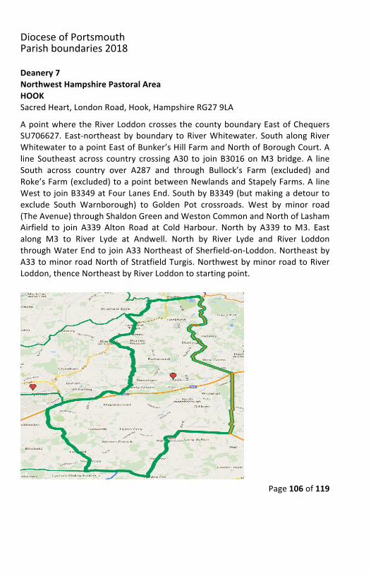
DioceseofPortsmouthParishboundaries2018
Page106of119
Deanery7NorthwestHampshirePastoralAreaHOOKSacredHeart,LondonRoad,Hook,HampshireRG279LAApointwheretheRiverLoddoncrossesthecountyboundaryEastofChequersSU706627.East-northeastbyboundary toRiverWhitewater. SouthalongRiverWhitewatertoapointEastofBunker’sHillFarmandNorthofBoroughCourt.Aline Southeast across country crossingA30 to joinB3016onM3bridge.A lineSouth across country over A287 and through Bullock’s Farm (excluded) andRoke’sFarm(excluded)toapointbetweenNewlandsandStapelyFarms.AlineWesttojoinB3349atFourLanesEnd.SouthbyB3349(butmakingadetourtoexclude South Warnborough) to Golden Pot crossroads. West by minor road(TheAvenue)throughShaldonGreenandWestonCommonandNorthofLashamAirfield to join A339 Alton Road at Cold Harbour. North by A339 toM3. Eastalong M3 to River Lyde at Andwell. North by River Lyde and River LoddonthroughWaterEndto joinA33NortheastofSherfield-on-Loddon.NortheastbyA33tominorroadNorthofStratfieldTurgis.NorthwestbyminorroadtoRiverLoddon,thenceNortheastbyRiverLoddontostartingpoint.
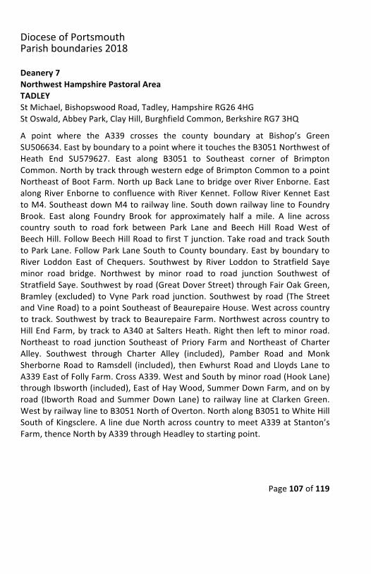
DioceseofPortsmouthParishboundaries2018
Page107of119
Deanery7NorthwestHampshirePastoralAreaTADLEYStMichael,BishopswoodRoad,Tadley,HampshireRG264HGStOswald,AbbeyPark,ClayHill,BurghfieldCommon,BerkshireRG73HQA point where the A339 crosses the county boundary at Bishop’s GreenSU506634.EastbyboundarytoapointwhereittouchestheB3051NorthwestofHeath End SU579627. East along B3051 to Southeast corner of BrimptonCommon.NorthbytrackthroughwesternedgeofBrimptonCommontoapointNortheastofBootFarm.NorthupBackLanetobridgeoverRiverEnborne.EastalongRiverEnbornetoconfluencewithRiverKennet.FollowRiverKennetEasttoM4.SoutheastdownM4torailwayline.SouthdownrailwaylinetoFoundryBrook. East along Foundry Brook for approximately half a mile. A line acrosscountry south to road fork between Park Lane and Beech Hill Road West ofBeechHill.FollowBeechHillRoadtofirstTjunction.TakeroadandtrackSouthtoParkLane.FollowParkLaneSouthtoCountyboundary.EastbyboundarytoRiver Loddon East of Chequers. Southwest by River Loddon to Stratfield Sayeminor road bridge. Northwest by minor road to road junction Southwest ofStratfieldSaye.Southwestbyroad(GreatDoverStreet)throughFairOakGreen,Bramley (excluded) toVynePark road junction. Southwestby road (TheStreetandVineRoad)toapointSoutheastofBeaurepaireHouse.Westacrosscountrytotrack.SouthwestbytracktoBeaurepaireFarm.NorthwestacrosscountrytoHillEndFarm,bytracktoA340atSaltersHeath.Rightthen left tominorroad.Northeast to road junction Southeast of Priory FarmandNortheast of CharterAlley. Southwest through Charter Alley (included), Pamber Road and MonkSherborneRoad toRamsdell (included), thenEwhurstRoadandLloydsLane toA339EastofFollyFarm.CrossA339.WestandSouthbyminorroad(HookLane)throughIbsworth(included),EastofHayWood,SummerDownFarm,andonbyroad (IbworthRoadandSummerDownLane) to railway lineatClarkenGreen.WestbyrailwaylinetoB3051NorthofOverton.NorthalongB3051toWhiteHillSouthofKingsclere.A linedueNorthacrosscountrytomeetA339atStanton’sFarm,thenceNorthbyA339throughHeadleytostartingpoint.
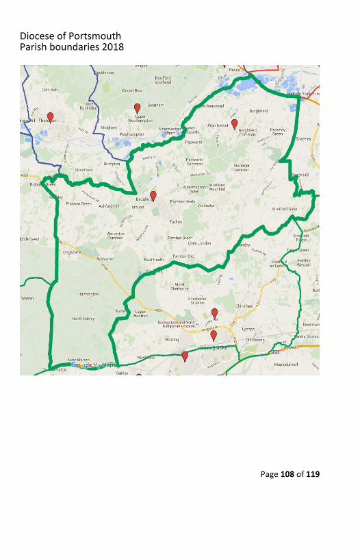
DioceseofPortsmouthParishboundaries2018
Page108of119
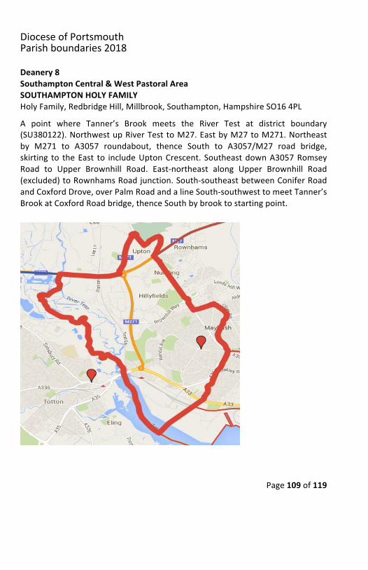
DioceseofPortsmouthParishboundaries2018
Page109of119
Deanery8SouthamptonCentral&WestPastoralAreaSOUTHAMPTONHOLYFAMILYHolyFamily,RedbridgeHill,Millbrook,Southampton,HampshireSO164PLA point where Tanner’s Brook meets the River Test at district boundary(SU380122).NorthwestupRiverTesttoM27.EastbyM27toM271.Northeastby M271 to A3057 roundabout, thence South to A3057/M27 road bridge,skirting to theEast to includeUptonCrescent. SoutheastdownA3057RomseyRoad to Upper Brownhill Road. East-northeast along Upper Brownhill Road(excluded)toRownhamsRoadjunction.South-southeastbetweenConiferRoadandCoxfordDrove,overPalmRoadandalineSouth-southwesttomeetTanner’sBrookatCoxfordRoadbridge,thenceSouthbybrooktostartingpoint.
DioceseofPortsmouthParishboundaries2018
Page110of119
Deanery8SouthamptonCentral&WestPastoralAreaSOUTHAMPTONSTBONIFACEStBoniface,413ShirleyRoad,Southampton,HampshireSO153JDA point on the Central Station Bridge. West along Western Approach(MountbattenWay)toRailwayBridge.WestalongrailwaylinetoTanner’sCreek.North up Tanner’s Creek to A3057 Romsey Road. Northeast along A3067Winchester Road (east side) to junction with Burgess Road. Northeast alongBurgessRoad toHill Lane. SouthdownHill Lane (excluded) toRaymondRoad.West along Raymond Road (both sides). South down Grenville and AtherleyRoads (excluded), Southwest along LanguardRoad (excluded). Southeast alongShirleyRoadA3057 (bothsides)andacrossMillbrookRoad to startingpointatBridge.
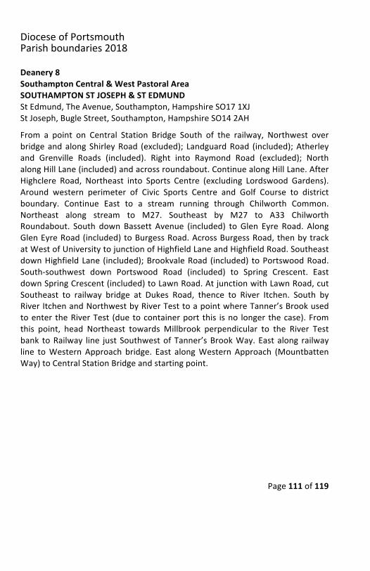
DioceseofPortsmouthParishboundaries2018
Page111of119
Deanery8SouthamptonCentral&WestPastoralAreaSOUTHAMPTONSTJOSEPH&STEDMUNDStEdmund,TheAvenue,Southampton,HampshireSO171XJStJoseph,BugleStreet,Southampton,HampshireSO142AHFrom a point on Central Station Bridge South of the railway, Northwest overbridgeandalongShirleyRoad (excluded); LandguardRoad (included);Atherleyand Grenville Roads (included). Right into Raymond Road (excluded); NorthalongHillLane(included)andacrossroundabout.ContinuealongHillLane.AfterHighclere Road, Northeast into Sports Centre (excluding Lordswood Gardens).Around western perimeter of Civic Sports Centre and Golf Course to districtboundary. Continue East to a stream running through Chilworth Common.Northeast along stream to M27. Southeast by M27 to A33 ChilworthRoundabout. South down Bassett Avenue (included) to Glen Eyre Road. AlongGlenEyreRoad(included)toBurgessRoad.AcrossBurgessRoad,thenbytrackatWestofUniversitytojunctionofHighfieldLaneandHighfieldRoad.SoutheastdownHighfieldLane (included);BrookvaleRoad (included) toPortswoodRoad.South-southwest down Portswood Road (included) to Spring Crescent. EastdownSpringCrescent(included)toLawnRoad.AtjunctionwithLawnRoad,cutSoutheast to railway bridge at Dukes Road, thence to River Itchen. South byRiverItchenandNorthwestbyRiverTesttoapointwhereTanner’sBrookusedtoenter theRiverTest (duetocontainerport this isno longer thecase).Fromthis point, head Northeast towards Millbrook perpendicular to the River Testbank toRailway line just SouthwestofTanner’sBrookWay.Eastalong railwayline toWestern Approach bridge. East alongWestern Approach (MountbattenWay)toCentralStationBridgeandstartingpoint.
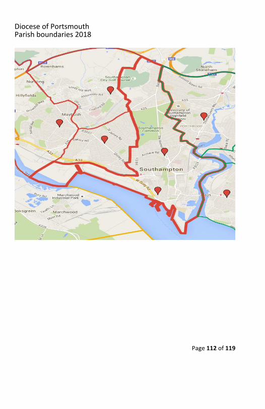
DioceseofPortsmouthParishboundaries2018
Page112of119
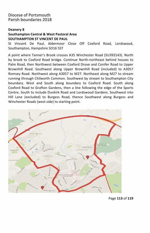
DioceseofPortsmouthParishboundaries2018
Page113of119
Deanery8SouthamptonCentral&WestPastoralAreaSOUTHAMPTONSTVINCENTDEPAULSt Vincent De Paul, Aldermoor Close Off Coxford Road, Lordswood,Southampton,HampshireSO165STApointwhereTanner’sBrookcrossesA35WinchesterRoad(SU393143).Northby brook to Coxford Road bridge. Continue North-northeast behind houses toPalmRoad,thenNorthwestbetweenCoxfordDroveandConiferRoadtoUpperBrownhill Road. Southwest along Upper Brownhill Road (included) to A3057RomseyRoad.NorthwestalongA3057toM27.NortheastalongM27tostreamrunningthroughChilworthCommon.SouthwestbystreamtoSouthamptonCityboundary. West and South along boundary to Coxford Road. South alongCoxfordRoad toGraftonGardens, thena line following theedgeof theSportsCentre.SouthtoincludeDunkirkRoadandLordswoodGardens.SouthwestintoHill Lane (excluded) to Burgess Road, thence Southwest along Burgess andWinchesterRoads(westside)tostartingpoint.
DioceseofPortsmouthParishboundaries2018
Page114of119
Deanery8SouthamptonEastPastoralAreaHEDGEENDOurLadyoftheAssumption,3FreegroundsRoad,HedgeEnd,HampshireSO300HGStBrigid,WoodleaGardens,WestEnd,Southampton,HampshireSO303GAAttheA27-A3024WindhoverroundaboutNorthofLowford (SU479110),NorthalongA27asfarasMansBridge.NortheastupRiverItchenasfarasrailwayline.Southeast down railway line to B3342 (SU490156). Northeast by B3342 toroundabout at junction with B3354. Southeast down B3354 to Maddox Lanefork. Bear East-southeast by Maddox Lane towards Curdridge. At T junctionNorthofCurdridge, Southwestby road (VicarageLane) tomeetA334NorthofBotleyStation.ByA334toRiverHamble.DownstreamtoM27.NorthwestalongM27 to interchange 8 South of Hedge End, thence Southwest by A3024 tostartingpoint.
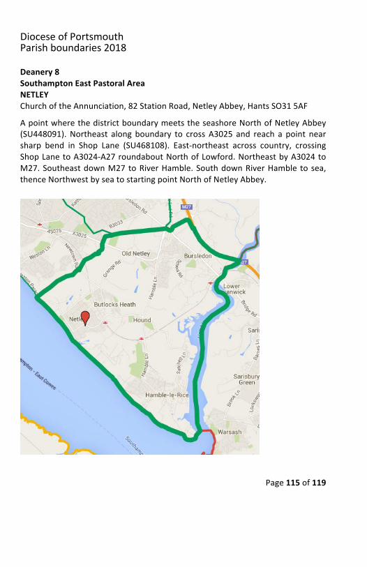
DioceseofPortsmouthParishboundaries2018
Page115of119
Deanery8SouthamptonEastPastoralAreaNETLEYChurchoftheAnnunciation,82StationRoad,NetleyAbbey,HantsSO315AFApointwherethedistrictboundarymeetstheseashoreNorthofNetleyAbbey(SU448091).Northeast along boundary to cross A3025 and reach a point nearsharp bend in Shop Lane (SU468108). East-northeast across country, crossingShopLanetoA3024-A27roundaboutNorthofLowford.NortheastbyA3024toM27.SoutheastdownM27toRiverHamble.SouthdownRiverHamble tosea,thenceNorthwestbyseatostartingpointNorthofNetleyAbbey.
DioceseofPortsmouthParishboundaries2018
Page116of119
Deanery8SouthamptonEastPastoralAreaSOUTHAMPTONCHRISTTHEKING&STCOLMANChristTheKing&StColman,BitterneRoadEast,Southampton,HantsSO186APIntheWest,apointonNorthamBridge.EastalongBitterneRoadtoMidanburyLane. North along Midanbury Lane (both sides) to junction with Dell Road.North-northeast behind houses to T junction atWoodmill Lane with CornwallRoad. Northeast across Frogs Copse. Continue Northeast across MeggesonAvenue to join Cutbush Lane North of The Gregg School. Northeast alongCutbushLanetoA27.SoutheastbyA27ChurchHill,MoorhillRoadandKanesHilltoWindhover roundabout.West across Bursledon Common to a point on thedistrict boundary at the Northwest corner of Portsmouth Road sports ground(SU463108). A line Northwest to Botley Road. Southwest along Botley Road(included) to a point South of Gainsborough Close junction. North-northwestthroughcemetery toButtsRoadat SouthEastRoad junction.NorthwestalongSouthEastRoadtoSholingCommonstream.NorthwestcrossingMiddleRoadatjunctionwithHeathRoad.ContinueNorthwest(includingschool)toSpringRoadat junction with Pycroft Close. Northwest along Spring Road (included) toFreemantle Common at junction with Freemantle Common Road. DueSouthwest across Freemantle Common to Pear Tree Avenue junction withAthelstanRoad, thenNorthwest to the Itchen, includingChineAvenue, thenceupRiverItchentostartingpointatNorthamBridge.
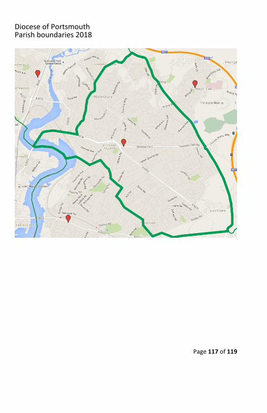
DioceseofPortsmouthParishboundaries2018
Page117of119
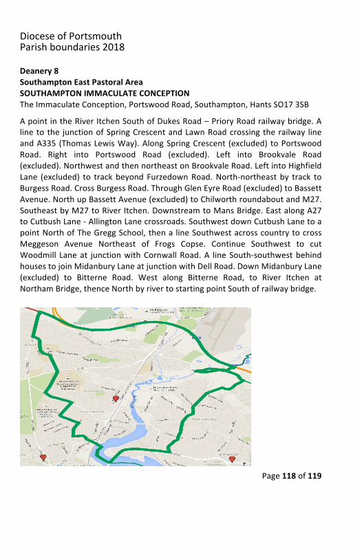
DioceseofPortsmouthParishboundaries2018
Page118of119
Deanery8SouthamptonEastPastoralAreaSOUTHAMPTONIMMACULATECONCEPTIONTheImmaculateConception,PortswoodRoad,Southampton,HantsSO173SBApointintheRiverItchenSouthofDukesRoad–PrioryRoadrailwaybridge.Alineto the junctionofSpringCrescentandLawnRoadcrossingtherailway lineandA335 (ThomasLewisWay).AlongSpringCrescent (excluded) toPortswoodRoad. Right into Portswood Road (excluded). Left into Brookvale Road(excluded).NorthwestandthennortheastonBrookvaleRoad.LeftintoHighfieldLane (excluded) to trackbeyondFurzedownRoad.North-northeast by track toBurgessRoad.CrossBurgessRoad.ThroughGlenEyreRoad(excluded)toBassettAvenue.NorthupBassettAvenue(excluded)toChilworthroundaboutandM27.SoutheastbyM27toRiverItchen.DownstreamtoMansBridge.EastalongA27toCutbushLane-AllingtonLanecrossroads.SouthwestdownCutbushLanetoapointNorthofTheGreggSchool,thena lineSouthwestacrosscountrytocrossMeggeson Avenue Northeast of Frogs Copse. Continue Southwest to cutWoodmill Laneat junctionwithCornwallRoad.A line South-southwestbehindhousestojoinMidanburyLaneatjunctionwithDellRoad.DownMidanburyLane(excluded) to Bitterne Road. West along Bitterne Road, to River Itchen atNorthamBridge,thenceNorthbyrivertostartingpointSouthofrailwaybridge.
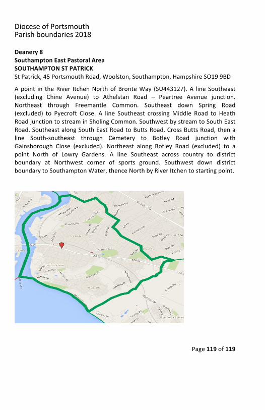
DioceseofPortsmouthParishboundaries2018
Page119of119
Deanery8SouthamptonEastPastoralAreaSOUTHAMPTONSTPATRICKStPatrick,45PortsmouthRoad,Woolston,Southampton,HampshireSO199BDApoint in theRiver ItchenNorth of BronteWay (SU443127). A line Southeast(excluding Chine Avenue) to Athelstan Road – Peartree Avenue junction.Northeast through Freemantle Common. Southeast down Spring Road(excluded) to Pyecroft Close. A line Southeast crossingMiddle Road to HeathRoadjunctiontostreaminSholingCommon.SouthwestbystreamtoSouthEastRoad.SoutheastalongSouthEastRoadtoButtsRoad.CrossButtsRoad,thenaline South-southeast through Cemetery to Botley Road junction withGainsborough Close (excluded). Northeast along Botley Road (excluded) to apoint North of Lowry Gardens. A line Southeast across country to districtboundary at Northwest corner of sports ground. Southwest down districtboundarytoSouthamptonWater,thenceNorthbyRiverItchentostartingpoint.