the corps of engineers' national regional sediment management demonstration program
TRANSCRIPT

ERDC/CHL CHETN-XIV-1 June 2001 (rev. January 2004)
Approved for public release; distribution is unlimited. Destroy when no longer needed; do not return to the originator.
The Corps of Engineers National Regional Sediment Management
Demonstration Program
by Julie D. Rosati, Bruce D. Carlson, Jack E. Davis, and Thomas D. Smith
PURPOSE. This Coastal and Hydraulics Engineering Technical Note (CHETN) summarizes and updates the progress of the US Army Corps of Engineers National Regional Sediment Management (RSM) Demonstration Program (DP) implemented in Fiscal Year 2000 (FY00). Sediment management at the regional scale is discussed, followed by information on each of the demonstration projects cur-rently underway with informative sections regarding regional economics and benefits of RSM.
BACKGROUND. Regional sediment management, in a very general sense, fits sediment man-agement actions into the context of a regional plan. Sediment management actions are activities that affect the erosion or removal, transport, and deposition of sediment. Common actions include: (1) dredging and placement, (2) building structures that divert or trap sediment, and (3) creating ero-sion protection for banks, shorelines, seabeds, and channel bottoms. A region is a defined area over which the sediment management actions will have a cumulative impact within the given time period of interest and with regard to the objectives of the plan (Figure 1). The plan is an accepted set of goals and objectives compiled by a region’s stakeholders to be accomplished by the set of sediment management actions. The regional plan’s objectives can include physical, environmental, social, and political needs. The larger spatial and temporal frameworks of regional sediment management, as well as the range of disciplines required in most regional planning, result in numerous stakeholders with varied interests.
Figure 1. Schematic of sediment transport within a regional system.

ERDC/CHL CHETN-XIV-1 June 2001 (rev. January 2004)
2
The Corps’ navigation mission is to maintain the Nation’s waterborne transportations systems for movement of commerce, national security needs, and recreation. These systems include harbors, wa-terways, and channels. Channels are located in and along coasts, bays, estuaries, and rivers, and are dredged to maintain depths needed for safe passage of vessels. Sediment enters the channels from upland regions, agricultural lands, streams, and through erosion of adjacent banks and shorelines.
Historically, dredged sediment was placed in the most economical locations which often were on the banks of rivers or alongside the channel in rivers, bays, and estuaries, resulting in submerged features and island formations. More recently, environmental concerns over the effects of open water or uncon-fined placement resulted in sediment being put in confined areas either upland or in the water. Along coastal inlets, the sediment was put in deeper offshore waters. These practices, new and old, do not necessarily consider regional sediment processes. For example, taking coastal sediments to deep water removed it from the littoral zone where it may have been needed for sustaining beaches. The result may be an optimized, least-cost project (e.g., low channel maintenance cost) for the local area, but pos-sibly not the best solution for the region. Regional sediment management is the practice of making the best local project decisions within the context of a regional plan that maximizes regional benefits and/or reduces regional cost.
In 2000, the Corps initiated a National RSM Demonstration Program. Initially, six Corps District offices were tasked with implementing regional sediment management concepts as a part of their District projects. The program was originally designed as a series of coastal regional sediment man-agement demonstrations, but the individual District offices have extended the range of their projects up into the river systems. In 2003, District offices that had one or more demonstration projects were Jacksonville, Philadelphia, New York, Detroit, Los Angeles, Galveston, and Mobile (which com-pleted those projects in 2003), and the Northwestern Division (Portland and Seattle Districts). By implementing regional sediment management as a part of their business management practices, each District has documented challenges they encountered. These challenges have included how to use present technologies (tools and models) to predict regional consequences of local sediment manage-ment actions, policy constraints within the existing organizational structure, and institutional hin-drances (Martin 2002 [revised 2003]). As challenges are noted, they are acted upon and resolved by Corps Headquarters managers.
USACE RSM DEMONSTRATION PROJECTS. The goals of the RSM projects are to: ● improve sediment management practice within the Corps (as necessary) ● highlight and document unique elements of RSM, and provide guidance for future imple-
mentation of specific RSM actions as appropriate ● foster state and local partnerships for RSM, resulting in a unified vision, cost-sharing, and
co-leadership of RSM actions ● engage cross-mission objectives of the Corps (i.e., more projects will be designed and con-
structed with the deliberate intent of achieving cross-mission benefits e.g., storm protection, navigation, and environmental restoration)
● define environmental and economic benefits for RSM ● improve decision-support technology for RSM (i.e., conceptual, analytical, and numerical
models will be adapted and improved to support RSM).

ERDC/CHL CHETN-XIV-1 June 2001 (rev. January 2004)
3
To help meet these goals, RSM demonstration projects within the Corps are presently being con-ducted in the Divisions and Districts shown in Figure 2. The following sections highlight individual demonstration projects, and describe how each demonstration project is working towards the goals of the National RSM Demonstration Program.
Mobile District. The Northern Gulf of Mexico (NGOM) RSM demonstration project concluded in 2003, and the South Atlantic Division, Mobile District (SAM), continues to implement RSM into District practice. The project region (Figure 3) covered 603.5 km (375 miles) of coastal shoreline bounded to the east by St. Marks River, FL, and Pearl River, MS, to the west. In their 3-year demon-stration, the District began six initiatives of which two were completed. A regional sediment budget was developed over the entire regional shoreline by using the Sediment Budget Analysis System for ArcView® application (SBAS-A) (Dopsovic et al. 2002 [revised 2003]), and a Geographic Infor-mation System (GIS).
Figure 2. USACE Divisions and Districts having FY03 RSM demonstration projects.
Figure 3. Mobile District, Northern Gulf of Mexico (NGOM) Regional Sediment Management domain.

ERDC/CHL CHETN-XIV-1 June 2001 (rev. January 2004)
4
This sediment budget provided the first regional effort to develop engineering alternatives and assess potential regional impacts. It also identified where little or no data existed prior to RSM. The GIS was upgraded to Spatial Data Standards for Corps-wide implementation as an Enterprise GIS. The SAM ongoing workshops continue to transfer the RSM GIS to Corps offices and, because of their success, serve as an RSM resource team. The Florida Department of Environmental Protection and city of Destin also completed and adopted the East Pass Inlet Management Plan (IMP) which rec-ommended bypassing dredged material from the navigation channel to the downdrift beaches and placing the material on Eglin Air Force Base property. Before this, most of the material was placed on Norriego Point for stabilization. IMP implementation yielded a cost saving of $370,000.
One of the initiatives was located at Perdido Pass, FL. Historically, sediment dredged from the naviga-tion channels at Perdido Pass was mostly placed at six disposal sites in and around the Pass. Sand from these sites was slow to return to the littoral system due to the location of the placement sites. Moreo-ver, for hurricane restoration, locals mined dredged material stockpiled west of the west jetty. This ac-tion permanently removed the sand from the littoral zone. The RSM demonstration project began in March 2003, and is bypassing the sand further downdrift to achieve a wider use of the sediment in the system. Annual cost savings are estimated at $15,000-$40,000.
Navigable waterways in the Pensacola Pass, FL, vicinity have been maintained by periodic dredging of the Gulf Intracoastal Waterway (GIWW). Some of the dredged material is stockpiled at Fort McRae, a 161,873 sq m (40 acre) diked upland site created on an island near the eastern end of Perdido Key. This disposal practice prevents this beach quality sand from reaching the local littoral system for shoreline stabilization and preservation of critical habitats. This second RSM initiative investigated use of stockpiled sand for beach replenishment.
Another demonstration site was conducted at St. Andrews Inlet, FL (Gator Lake). Traditionally, most of the beach-suitable dredged material is bypassed to the western downdrift beaches for beach restoration. However, some is placed along the western interior shoreline of the inlet fronting Gator Lake. The mate-rial is placed at Gator Lake to prevent the inlet from breaching into the environmentally sensitive fresh-water habitat of marine turtles, beach mice, and shorebirds. This material does not return to the littoral system. Alternative RSM techniques for protecting Gator Lake would allow more beach quality material to be available for bypassing to the downdrift beaches.
Finally, the Corps is responsible for maintaining the navigation channels of the Alabama, Black Warrior Tombigbee (BWT), and Apalachicola River systems. Maintenance procedures require that material dredged from these channels be placed in upland disposal sites. Because the dredged mate-rial may be beach quality sand, RSM efforts explored the beneficial uses for the material along the coast. Subsequently, this would increase the capacity and life of the disposal sites and eliminate costs to acquire new sites. Additional information about the SAM-RSM demonstration project can be ob-tained from the web site for the demonstration project at http://rsm.sam.usace.army.mil/about/index.asp
Jacksonville District. The South Atlantic Division, Jacksonville District (SAJ), has three RSM regions (northeast, central, and southwest Florida). Northeast Florida was chosen as a demonstration re-gion based on the number of navigation projects, shore protection projects, US Naval bases, and public parks located in the counties of Nassau, Duval, and St. Johns. Two initiatives have been completed, one at St. Augustine, and a second at the Matanzas Inlet disposal site.

ERDC/CHL CHETN-XIV-1 June 2001 (rev. January 2004)
5
To reduce the downdrift impacts at St. Augustine Inlet, the ebb shoal and channel footprint of St. Augustine Inlet were used as a borrow area for St. Johns County, FL. This provided maintenance for the channel, placed beach-quality sand on the downdrift barrier island, and achieved natural bypass-ing at the inlet. By coordinating the two different projects, an estimate cost savings on the order of $1 million was achieved.
At Matanzas Inlet, a bayside disposal site had reached capacity, and sediment was needed for erod-ing downdrift shorelines. Sediment in the disposal site was removed and placed on downdrift beach-es, thus reintroducing sand into the littoral system and renewing the capacity of the disposal site. This project also had a cost savings of $1 million.
Ongoing initiatives in the northeast region include: (1) stabilizing the south end of Amelia Island, (2) bypassing sand at St. Mary’s Entrance, (3) backpassing/bypassing at Fort George and St. John Entrance, and (4) offloading sand onto Summer Haven shoreline.
At Ameila Island, located updrift of the Nassau Sound Entrance, the southern tip of the barrier was ex-periencing chronic erosion. A short-term effort to stabilize the south end has been phased in by placing beach quality material from operations and maintenance (O&M) dredging of the Atlantic Intracoastal Waterway (IWW), and by building geotextile shoreline stabilization tubes. Phase I characterized the existing condition. Phase II evaluated impacts of past engineering actions (offshore borrow site, non-Federal shore protection project, and geotextile groin field). Phase III evaluated stabilization alterna-tives (no action, tidal channel stabilization through dredging, and T-head groin field). Tidal circulation modeling and evaluation of tidal channel oscillation have been completed. Phase IV is presently ongo-ing (wave transformation modeling, final evaluation, and reporting results). The Florida Inland Navi-gation District has been a valuable partner in this endeavor.
Needs for RSM in southwest Florida exist in the counties of Pinellas, Manatee, Sarasota, Charlotte, Lee, and Collier. Due to its physical size, numerous initiatives have been identified through work-shops involving all regional interest organizations. Some potential demonstration projects are: (1) relocate Stump Pass, (2) use New Pass as borrow source for shore protection projects, (3) use dredged material from the GIWW for ecosystem restoration, (4) use side-cast sand bars in Tampa Harbor (Figure 4) as a source for beach fill, (5) place marginal dredged material offshore and moni-tor its sediment quality evolution, and (6) develop an outreach program for improving public percep-tion of beach restoration. Immediate addressable issues will be the development of a regional sedi-ment budget and GIS database.
The Central Florida Regional Sediment Management Demonstration Program (CFL RSMDP) region extends along the Atlantic coast of Florida from Flagler County through Martin County. During the remainder of FY03, Taylor Engineering and the Mobile and Jacksonville Districts will develop a GIS database for the coast of Florida. Once it is operational, the GIS will be an integral part of CFL RSMDP and will be continually updated as new data become available.
In FY04, two workshops with Federal, State, and local stakeholders will be conducted to identify RSM needs and best practices for Central Florida. The workshop process is intended to refine and prioritize the Potential Demonstration Projects (PDPs), and to discuss the implementation of those projects.

ERDC/CHL CHETN-XIV-1 June 2001 (rev. January 2004)
6
Figure 4. Jacksonville District, Tampa Harbor, FL.
RSM work in the Northeast and Southwest Florida Demonstration Projects have illuminated the challenges of implementing a regional plan such as funding restrictions, limited Federal authority, and the large size of the regions. These experiences will be vital to the refinement of the RSM pro-cess in Central Florida.
An RSM web site has been developed as part of the agreement to facilitate coordination with other Federal and non-Federal agencies, and with the public: http://rsm.saj.usace.army.mil/index2.html
Philadelphia District. The New Jersey shoreline extends from Sandy Hook on the north to Cape May (mouth of the Delaware Bay) on the south, covering a range of approximately 209.2 km (130 miles). The Philadelphia District’s RSM demonstration project includes beaches east and west of Cape May Inlet (Figure 5).
These beaches experience problems related to both excess (Wildwood Beaches located updrift of Cape May Inlet), and deficit (Cape May City beaches located downdrift of the inlet) of sediment. Accretion along the updrift beaches is believed to be caused primarily by the construction of jetties at Cape May Inlet in 1911. The excess of sediment supply has resulted in at least two problems at Wildwood: (1) clogged storm water outlets, and (2) excessive beach widths that make recreational access problematic.

ERDC/CHL CHETN-XIV-1 June 2001 (rev. January 2004)
7
Figure 5. Philadelphia District, Cape May Inlet, NJ.
The primary goals of this RSM demonstration project are to identify and document an environmen-tally, economically, and technically feasible method of borrowing sand from Wildwood beaches (surplus of sand) for use in the next (FY05) nourishment cycle of the Cape May City (deficit of sand) project. Several alternatives for supplying the sand have been identified, such as: (1) continuous low-volume sand bypassing with sand stockpiling, (2) periodic large-volume sand bypassing with sand stockpiling, and (3) direct borrow from Wildwood with no sand stockpiling. Coordination meetings with the US Fish and Wildlife Service, and State, local, and other Federal agencies were initiated in April 2003.
Other RSM activities include: (1) development of a GIS database, (2) use of rapidly deployed all-terrain-vehicle for mapping shorelines statewide, and (3) implementation of a broader feasibility study of the lower 160.9 km (100 miles) of coastal New Jersey (Alternative Long-term Nourishment Study).
New York District. The New York District has four initiatives within the National RSM Demonstration Program, one of which was construction of a bird habitat on East Inlet Island in Moriches Bay. The remaining three initiatives are: (1) assessment of sediment needs along Long Island, (2) development of an accretion/erosion management plan for the problematic area in the town of Hempstead, NY, and (3) development of guidance for using wave gage data to design six projects within a regional system.

ERDC/CHL CHETN-XIV-1 June 2001 (rev. January 2004)
8
The Atlantic Coast of Long Island, NY, in-cludes 209.2 km (130 miles) of ocean shoreline, with over 128.7 km (80 miles) of shoreline area comprised of a barrier island system spanning from Breezy Point, Queens, to Shinnecock Inlet in Southamp-ton. A range of endangered shore birds in-cluding the piping plover (Figure 6) and the least tern, and their required early succes-sional habitats, have become scarce. Shore-birds require un-vegetated sand-flats from the supra-tidal to intertidal elevations for nesting and foraging. On barrier islands, this type of habitat is available on the ocean and bay shorelines. It is formed and main-tained when higher water levels and waves occurring during storms wash over the is-land and transport sediment towards the bay or estuary. The development of Long Island’s south shore and stabilization with sand dunes has min-imized overwash except in catastrophic storms, resulting in the rarity of this bayside habitat (Rosati and Davis 2003).
The New York District, along with other State, local, and Federal agencies decided that the sediment routinely dredged as part of operation and maintenance of the Intracoastal Waterway navigation channel would be placed on East Inlet Island to enhance the habitat for several endangered shorebird species. This concept was a combination of the Baltimore and Mobile District’s successful use of dredged material. The sediment was pumped onto the island and shaped to achieve the proper slope and texture, and nest boxes were built to replicate the habitat needs of these threatened and endan-gered shorebirds. To ensure project success, a predator control program was developed in the event land predators (foxes, raccoons, etc.) are identified onsite (Castagna 2003).
Additionally, a second shorebird restoration site has been undertaken at Warner’s Island. This site was chosen based on its proximity to the Intracoastal Waterway maintenance dredging operation, historic usage, topography, erosion rates, and vegetation changes. Historically, Warner’s Island has been a viable tern colony, but in recent years vegetation changes have resulted in dramatically lower usage of the island. The New York District Operations Division is presently completing the design and permitting necessary to proceed with construction at the site in fall 2003. The proposed place-ment of sand will be similar to the work done at East Inlet Island. Post-placement monitoring will be undertaken by the US Fish and Wildlife Service to identify relative success, and make recommenda-tions for improving future operations.
A regional sediment budget (RSB) will be developed for use as a management tool in the handling of sediment resources within the south Atlantic shore region of Long Island, NY. This region includes six inlets, six barrier islands or spits, 15 navigation projects, non-barrier island beaches, bluffs, and extensive back bays. Multiple goals for sediment-related issues include shore protection, storm dam-age reduction, efficient navigation, maintaining a viable environment, commerce, and recreation. An
Figure 6. New York District, Piping Plover (Charadrius melodus).

ERDC/CHL CHETN-XIV-1 June 2001 (rev. January 2004)
9
RSB will provide: (1) a visualization tool for forming connections between “nearest neighbor” sedi-ment needs, (2) a base calculation of sediment sources, sinks, and transport volumes, and (3) an ar-chive of known sediment movement data within the region for each year.
The town of Hempstead, NY, is located downdrift of Jones Inlet. The inlet has reached a stage of maturity where its ebb shoal is well formed, and impoundment at the updrift inlet jetty is essentially complete. At this stage, there is both significant sediment bypassing at the inlet and transport on-shore via the ebb shoal bridge and shore attachment, coupled with high erosion rates inside the ebb shoal due to inlet processes and isolation from sand supply. Hempstead recreation beach, located downdrift of Jones Inlet and within the inlet ebb shoal, has historically experienced beach erosion. Although the placement of sediment dredged from Jones Inlet is an anticipated future practice, the lengthy time intervals between the dredging operations result in beach erosion. Ongoing loss of the beach in this area has reduced storm damage protection and has affected recreation beach use.
By contrast, 914.4 m (3,000 ft) to the west of the erosional area is an accretionary buildup of sand at the point of the ebb shoal attachment which has grown markedly within the last 5 years. The town of Hempstead used the ebb shoal attachment as the primary borrow source of sand to replenish the high-erosion area along the beachfront. Placement of backpassed sand will extend the storm damage protection capability of the beach by rebuilding eroded dune and sand berm. Existing park facilities will be protected from undermining by erosion, and from wave attack. In addition to developing an accretion/erosion management plan, this RSM demonstration project will document the innovative approaches used by the town of Hempstead for sediment management because many inlets in the US share the same downdrift features of Jones Inlet (Kraus and Galgano 2001).
Finally, the New York District attempts to keep enough gages in the water off Long Island so pre-sent-day data can be available whenever needed. The gage funded by RSM in 2002 is now located off East Rockaway Inlet, and is acquiring the first part of what will hopefully be a 5-year record of waves off the East Rockaway Peninsula. This portion of Long Island is being investigated by a re-formulation study with design work that started in FY03. The study will look at all possible alterna-tives for shore protection, and will end with a Recommended Plan for the study reach. Gage data will also be used during the construction of a renourishment operation along the East Rockaway shore-line that will place beach fill starting in the early calendar year of 2004, under the East Rockaway Section 934 project. The gage data are used in construction management to help determine when dredges must stop operation due to severe wave conditions. Also, the data obtained from the gages in 2002-2003 will be applicable for any design work on Long Beach Island.
Detroit District. A Great Lakes region (Ludington, MI, to Michigan City, IN) (Figure 7) was chosen for the RSM Demonstration Program because of its many and large navigation structures, diverse shoreline consisting of sandy beaches and high glacial till bluffs, current erosion issues, large number of private shore protection efforts, and considerable amount of available dredging data for the 12 harbors. Beach quality sediment available to nourish eroding beaches is scarce. The clay bluffs can erode rapidly when unprotected by a sandy beach and nearshore profile.

ERDC/CHL CHETN-XIV-1 June 2001 (rev. January 2004)
10
As part of the National RSM Demonstration Program, the Detroit District will develop an ero-sion management plan for the unprotected fragile clay bluffs of the region while also exploring the feasibility of implementing a “sand bank” policy where concerned stakeholders may contribute funds for large-scale beach nourishment projects. This RSM effort is being conducted to accom-plish the following initiatives: (1) develop a sed-iment budget, (2) incorporate data into a GIS da-tabase, (3) develop Dredged Material Placement Policy (DMPP) to maximize nearshore benefits from sediment placement and a monitoring pro-gram to supply scientific reasoning for the selec-tion of the dredged material placement, and (4) initiate a feasibility study for the bypassing program at New Buffalo Harbor, MI. A sediment budget has been completed for half of the RSM region (St. Joseph, MI, to Michigan City, IN), and the District is presently exploring an alterna-tive beach nourishment source by using dredged material from New Buffalo Harbor.
Los Angeles District. Historically, the dominant sources for sediment transport along the southern California coast have been rivers and streams that moved sediment from the mountains and uplands to the lowland basins and nearshore system. However, over the span of 30-40 years, constructions of large dams (more than 1,200) have trapped all but the finest sediments from being transported downstream. Damming rivers has decreased the sand supply by more than 50%, thus causing the California beaches to erode sub-stantial. Only in northern California is there a constant supply of sediments to the nearshore, and cur-rently they are protected under the Wild and Scenic Rivers Act of 1972. The goal of this RSM demonstration project, encompassing approximately 1,770.3 km (1,100 miles) of Pacific Ocean shoreline, is to develop a comprehensive master plan that uses a regional systematic approach to re-solving coastal sediment management issues. The combined partnership of the Los Angeles District, and State and local agencies, formed the California Coastal Sediment Management Working Group. Through collaborative efforts, several initiatives have been implemented to achieve the RSM goal.
The first initiative, the development of a GIS database that focuses on the ecological function of Cal-ifornia’s coastal watersheds, wetlands, and beaches, allows sediment management needs to be evalu-ated and prioritized. Leveraging the GIS to develop an Incremental Cost Analysis real-time GIS will provide a tool to evaluate cost and time for projects and, therefore, maximize the RSM net benefits. Items considered for inclusion in the real-time GIS applications are: (1) dredge and placement plat-forms, (2) physical sediment quality, (3) nourishment requirements, (4) distance to be moved, (5) erosion hot spot benefits, and (6) hot spot shoreline contours.
Figure 7. Detroit District, Southeast Lake Michigan region.

ERDC/CHL CHETN-XIV-1 June 2001 (rev. January 2004)
11
The second initiative will evaluate the feasibility of capturing alongshore drift sediments prior to reach-ing submarine canyons such as Newport Beach Canyon, Redondo Beach Canyon (Figure 8), or La Jolla Canyon. Also, efforts are underway to couple RSM with the Section 227 Program (National Shoreline Erosion Control Development and Demonstration Program). The focus will be to leverage these pro-grams and develop a plan for harbors and projects where beneficial use of material can be achieved.
Third initiative studies are being conducted on the removal of dams as an alternative to sediment trapping. Types of dam removal considered include: (1) full dam removal with mechanical sediment removal (trucking, conveyor, and/or slurry line), (2) incremental dam removal with natural sediment transport, (3) full dam removal with stabilization of sediments onsite, (4) full dam removal with nat-ural sediment transport, and (5) a pool and riffle system. Two problem dams investigated were the Rindge (Figure 9) and Matilija dams. An assessment of the costs, benefits, and mechanism for re-moval and transport of trapped sediments to the coast will also be performed.
Northwestern Division. Sedimentation at the confluence of the Clearwater and Snake Riv-ers, Lewiston-Clarkston, WA, occurs when sediment (primarily in the Clearwater River) falls out of suspension. This shoaling causes a navigation hazard that historically has been alleviated through yearly dredging. However, this is a local-level project solution that does not fully encompass the re-gional system. A regional-level solution would be to reduce sediment suspension in the Clearwater River before the sediment ever reaches the confluence. In addition to yearly dredging at the conflu-ence site, other regional sediment management actions affecting the project would include soil con-servation efforts within upland properties, and stability of the riverbanks.
Figure 8. Los Angeles District, Redondo Beach Canyon, CA.

ERDC/CHL CHETN-XIV-1 June 2001 (rev. January 2004)
12
Figure 9. Los Angeles District, Rindge Dam, CA.
The Northwestern Division Portland and Washington Districts have initiated plans to demonstrate RSM concepts along the Upstream Reach of the Columbia River from Bonneville to the Mouth of the Snake River. Soil conservation in upland properties possibly could be increased (e.g., placing culverts to reduce gullying, planting to stabilize erosive lands). Bank erosion of both the Clearwater and Snake Rivers might be reduced through placement of engineering structures (e.g., revetments, bendway weirs). These upstream sediment-stabilization treatments would decrease sediment deposi-tion at the confluence of the Clearwater and Snake Rivers, thereby possibly reducing project costs at Lewiston-Clarkston and reducing sedimentation at the downstream dams. Also, any sediment that does accumulate at the confluence could be used in ways that benefit either or both river systems.
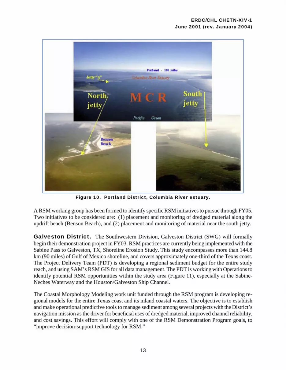
Portland District. The Mouth of Columbia River (MCR) is the ocean gateway for navigation ac-cess to and from the Columbia-Snake River navigation system which is the boundary between Washing-ton and Oregon states. Each year the Portland District dredges 4 million cu yd of sand at the MCR to maintain a 8-km- (5-mile)-long deepdraft navigation channel. The sand has been placed in open water disposal sites, and at times the actual disposal of the sand has been a more challenging issue than the dredging itself. The goal of this RSM demonstration project is to implement a proactive and consensus-based decisionmaking process for optimally managing dredged material disposal at MCR.
However, immediate attention will be given to addressing the beach erosion problem north of MCR (Figure 10), and the possible instability of the jetty structures. Construction of jetties (1885-1917) has altered sediment supply to adjacent shorelines, resulting in rapid accretion near the entrance. The jet-ties were built on a tidal shoal that is now eroding such that stability is now being compromised due to scour-based failure. Between the years of 1993-2000, the ebb-tidal shoal was receding at an accelerat-ed rate. In an effort to protect the north jetty, the Portland District has transported sediment (from north, onshore, and offshore) to Peacock Spit, and has placed dredged sand within the nearshore area.
ERDC/CHL CHETN-XIV-1 June 2001 (rev. January 2004)
13
Figure 10. Portland District, Columbia River estuary.
A RSM working group has been formed to identify specific RSM initiatives to pursue through FY05. Two initiatives to be considered are: (1) placement and monitoring of dredged material along the updrift beach (Benson Beach), and (2) placement and monitoring of material near the south jetty.
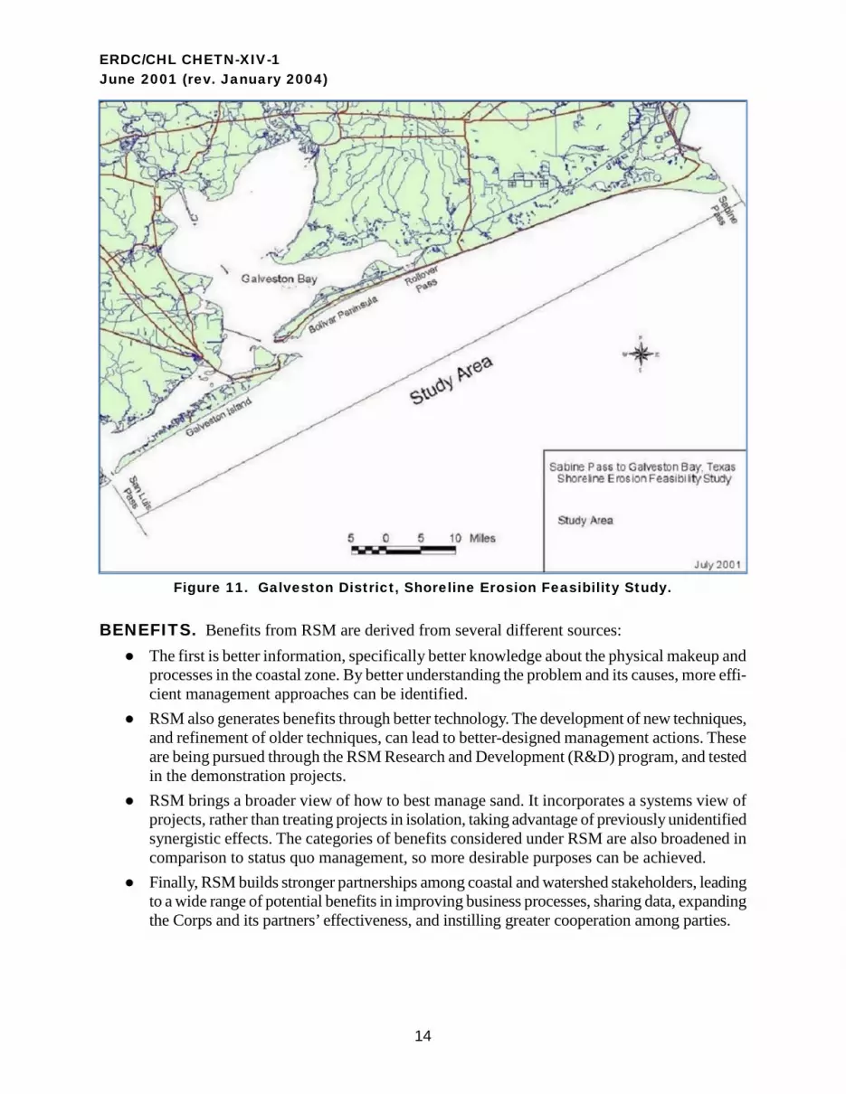
Galveston District. The Southwestern Division, Galveston District (SWG) will formally begin their demonstration project in FY03. RSM practices are currently being implemented with the Sabine Pass to Galveston, TX, Shoreline Erosion Study. This study encompasses more than 144.8 km (90 miles) of Gulf of Mexico shoreline, and covers approximately one-third of the Texas coast. The Project Delivery Team (PDT) is developing a regional sediment budget for the entire study reach, and using SAM’s RSM GIS for all data management. The PDT is working with Operations to identify potential RSM opportunities within the study area (Figure 11), especially at the Sabine-Neches Waterway and the Houston/Galveston Ship Channel.
The Coastal Morphology Modeling work unit funded through the RSM program is developing re-gional models for the entire Texas coast and its inland coastal waters. The objective is to establish and make operational predictive tools to manage sediment among several projects with the District’s navigation mission as the driver for beneficial uses of dredged material, improved channel reliability, and cost savings. This effort will comply with one of the RSM Demonstration Program goals, to “improve decision-support technology for RSM.”
ERDC/CHL CHETN-XIV-1 June 2001 (rev. January 2004)
14
Figure 11. Galveston District, Shoreline Erosion Feasibility Study.
BENEFITS. Benefits from RSM are derived from several different sources: ● The first is better information, specifically better knowledge about the physical makeup and
processes in the coastal zone. By better understanding the problem and its causes, more effi-cient management approaches can be identified.
● RSM also generates benefits through better technology. The development of new techniques, and refinement of older techniques, can lead to better-designed management actions. These are being pursued through the RSM Research and Development (R&D) program, and tested in the demonstration projects.
● RSM brings a broader view of how to best manage sand. It incorporates a systems view of projects, rather than treating projects in isolation, taking advantage of previously unidentified synergistic effects. The categories of benefits considered under RSM are also broadened in comparison to status quo management, so more desirable purposes can be achieved.
● Finally, RSM builds stronger partnerships among coastal and watershed stakeholders, leading to a wide range of potential benefits in improving business processes, sharing data, expanding the Corps and its partners’ effectiveness, and instilling greater cooperation among parties.
ERDC/CHL CHETN-XIV-1 June 2001 (rev. January 2004)
15
Historically, projects within the Corps have been optimized by the least-cost means of delivering the desired performance and benefits. Frequently this local project policy resulted in actions that re-moved sediment from the littoral system through upland, isolated, or offshore placement. Additional-ly, each site or project was treated in isolation, rather than as part of an integrated watershed system. Offsite and unintended effects were not generally recognized nor considered.
Under RSM, the economic effects of evaluating alternative sediment management activities can be considered under two “tracks”: (1) cost savings, and (2) best management of resources. Cost savings can most easily be thought of as achieving the same results or benefits from a project through more efficient methods. Cost savings are realized by identifying production efficiencies such as combining dredging actions, or by minimizing sediment rehandling such as adjacent dredging and beach nour-ishment projects. Better management of sediment resources can be achieved by expanding the scope of beneficial effects considered for alternative approaches to project operations and maintenance. It recognizes the value of sediment as a resource. For example, keeping sediment in the system may be slightly more expensive than disposing material offshore but it may reduce costs at an eroding beach, thereby realizing overall net benefits by not requiring an erosion control or beach-fill project. Anoth-er possibility is that dredged material can be put to a beneficial use rather than simply being placed in a disposal area that may or may not have storage costs.
Anticipated benefit categories organized by the system of four “accounts” established in the Principles and Guidelines for Determining Economic Benefits (US Water Resources Council 1983) include:
● National Economic Development ■ Storm damage reduction
Commercial, residential structures Undeveloped land Infrastructure
■ Recreation Domestic International tourism attraction
■ Navigation Better performing projects Reduced operations and maintenance outlays
● Environmental Quality ■ Ecosystem protection and restoration
Beach habitats, dunes, freshwater wetlands Endangered species
■ Aesthetics ■ Cultural resources

ERDC/CHL CHETN-XIV-1 June 2001 (rev. January 2004)
16
● Regional Economic Development ■ Income ■ Employment ■ Tax receipts
● Other Social Effects ■ Urban and community impacts ■ Life, health, safety ■ Environmental justice
Note that policy, authorization, and appropriation laws give different priorities to different benefit categories under various circumstances, but all are potentially important in making RSM investment decisions.
THE SIX-STEP PLANNING PROCESS. The Corps typically employs a six-step process to take projects from conceptualization to implementation. These steps, and a review of RSM activities that relate to these six steps, are:
● Specify Problems and Opportunities: Expand the scope of the problems and opportunities to other resource categories, and expand the scope of space and time considerations.
● Inventory and Forecast Conditions: Inventory categories of interest such as buildings, de-velopment, or significant environmental resources.
● Formulate Alternative Plans: Assess the efficiencies of approaches, including different methods, and temporal and spatial scales for approaching the problem.
● Evaluate Consequences of Alternative Plans: Note that it may be difficult to distinguish between alternative plans with and without project conditions, and to evaluate incremental impacts.
● Compare Alternative Plans: Measures of “success” must be able to distinguish between plans.
● Select Recommended Plan: Criteria will differ depending on authorities, partnerships, and plans incorporating issues concerning the entire watershed.
Benefits of RSM actions can be realized in reduced costs, increased revenues, and new benefits. They can be realized in the short term as well as over the long term. Demonstration proposals that highlighted management actions to realize cost savings in the short term received highest priority within the RSM program. While all benefits across these variables are important, those actions demonstrating short-term cost savings will rapidly show the best of what RSM can achieve. Actions providing other benefits have been included in the Demonstration Program to round out the range of experience that can be captured under the program.
The proposed RSM actions include a fairly wide range of measures that will be beneficially em-ployed. These actions can be grouped into categories. The first broad area can be described as accre-tion/erosion management. In these cases, the natural flow of sediment may be disrupted. Measures to balance the sediment movement include various means of bypassing and/or backpassing sediment artificially, as well as restoring natural flows that have been impeded. Both accretion and erosion can

ERDC/CHL CHETN-XIV-1 June 2001 (rev. January 2004)
17
be problematic with, for example, too much accretion clogging channels and storm water outflow systems and/or erosion threatening property, sensitive environmental habitat, or infrastructure.
Environmental or ecosystem restoration is another category of activity present in the initial demon-stration projects. Reinforcing natural berms that protect freshwater lakes or wetlands from saltwater intrusion is one example. Placing sediment behind an island to mimic historic natural overwash and sediment dynamics (early successional habitat for nesting shorebirds) is another. There are a number of threatened and endangered species in the areas of the demonstration studies that will benefit from restored habitat under RSM.
Demonstration studies are also identifying new efficiencies in dredging for existing coastal projects. These efficiencies may result from: (1) scheduling maintenance for adjacent projects to share costs, (2) better understanding sediment flows to avoid rehandling, and (3) employing more refined tech-nologies such as pinpoint dredging systems.
Recognizing sediment as a valuable resource (and expensive liability, depending on circumstances) accounts for another area where savings are foreseen. Dredged material may be put to beneficial uses rather than dumped or placed in disposal areas. This results in positive benefits where the material is wisely used, and may be less expensive than finding other beach quality material. Additionally, there are savings that result from reduced costs in disposal areas which can be especially important as ex-isting areas reach capacity. Sediments trapped behind dams starve beaches of material that would be expensive to replace, and accumulation reduces both the volume and effectiveness of the dam’s orig-inal purposes. Stockpiling sand for emergency recovery from major storms is also being considered to reduce recovery costs and improve readiness to alleviate the emergency.
The approach taken to implement RSM involves substantial participation across many levels and agencies of government. Some overarching goals and benefits of working with partners include:
● Identify common goals: ■ Need for wider beaches, more protection, less maintenance. ■ Keep sand in the system (e.g., beneficial use of dredged material).
● Align actions across agencies: ■ Identify programs that are working at cross-purposes (e.g., trucking sand away from an
area that needs sand). ■ Identify opportunities to align programs at the Federal, State, and local levels.
● Improve understanding of physical processes: ■ Apply regional sediment budget to identify areas of erosion/accretion and assist in modi-
fying sediment management practices. ■ Develop better models and understanding of the physical system.
● Develop efficient business process: ■ Develop shared baseline data to make future studies faster and cheaper. ■ Build a common database for all agencies to use. ■ Solve datum problems, which are currently costly to fix, but more costly to ignore if er-
rors lead to bad or inefficient decisions.

ERDC/CHL CHETN-XIV-1 June 2001 (rev. January 2004)
18
● Collaborate with stakeholders: ■ Improve communication between Federal, State, and local governments. ■ RSM is a catalyst for realizing the importance of managing the coastal resources. ■ Understand states’ goals for sediment management and existing policies.
● Prepare for future: ■ Identify future problem areas, and act now (e.g., expected concentrations in population
growth, related development, recreational use). ■ Identify where data collection is needed.
CONCLUSIONS. The National RSM Demonstration Program continues through 2005 with the ultimate goal being to integrate Regional Sediment Management throughout all Corps business man-agement practices. It is noteworthy that the National RSM Demonstration Program has already reaped benefits for the Corps. New technology, actual cost savings, and development of new busi-ness practices are some of the benefits already derived. Additionally, the Demonstration Program has also shown that extensive and intensive partnerships, and stakeholder involvement, are necessary for successful regional sediment management.
ADDITIONAL INFORMATION. This CHETN was written by Drs. Julie D. Rosati and Jack E. Davis, Coastal and Hydraulics Laboratory, US Army Engineer Research and Development Cen-ter, Vicksburg, MS; Thomas D. Smith, US Army Engineer District, Jacksonville, FL; and Bruce D. Carlson, US Army Corps of Engineers, Water Resources Institute, Fort Belvoir, VA.
Appreciation is extended to Linda Lillycrop, Larry Parson, and Dr. Susan Rees, USACE Mobile Dis-trict; Phillip Ross, USACE Detroit District; Diane Rahoy, Stephen Couch, and Lynn Bocamazo, USACE New York District; Monica Chasten and Keith Watson, USACE Philadelphia District; Bradd Schwichtenberg, John Zediak, and Jason Engle, USACE Jacksonville District; Heather Sumerell, Heidi Moritz, Rod Moritz, and Doris McKillip, USACE Portland District; Paul Peloquin, USACE Northwestern Division; Susan Ming, USACE Los Angeles District; and Jeffrey Waters, USACE Galveston District, for information regarding their respective demonstration projects. Addi-tional information pertaining to the RSM can be found at the RSM web site http://rsm.usace.army.mil
Questions regarding this CHETN may be addressed to: Dr. Julie D. Rosati [email protected] Linda S. Lillycrop (RSM Program Manager)

ERDC/CHL CHETN-XIV-1 June 2001 (rev. January 2004)
19
ERDC/CHL CHETN-XIV-1 should be cited as follows:
Rosati, J. D., B. D. Carlson, J. E. Davis, and T. D. Smith. 2001 (rev. 2004). The Corps of Engineers national regional sediment management demonstration program. Coastal and Hydraulics Engineering Technical Note ERDC/CHL CHETN-XIV-1. Vicksburg, MS: US Army Engineer Research and Development Center, Coastal and Hydraulics Laboratory. http://chl.erdc.usace.army.mil/library/publications/chetn/pdf/chetn-xiv-1.pdf
REFERENCES. Castagna, J. 2003. Multi-agency effort ensures safety of endangered birds. RSM Information Exchange
Bulletin, Winter/Spring 2003, http://www.wes.army.mil/rsm/news
Dopsovic, R., L. Hardegree, and J. D. Rosati. 2002 (revised 2003). SBAS-A: SBAS for ArcView® application. Coastal and Hydraulics Engineering Technical Note ERDC/CHL CHETN-XIV-7. Vicksburg, MS: US Army Engineer Research and Development Center, Coastal and Hydraulics Laboratory. http://chl.erdc.usace.army.mil/library/publications/chetn/pdf/chetn-xiv-7.pdf
Kraus, N. C. and F. A. Galgano. 2001. Beach erosional hot spots: Types, causes, and solutions. Coastal and Hydraulics Engineering Technical Note ERDC/CHL CHETN-II-44. Vicksburg, MS: US Army Engineer Research and Development Center, Coastal and Hydraulics Laboratory. http://chl.erdc.usace.army.mil/library/publications/chetn/pdf/chetn-ii-44.pdf
Martin, L. R. 2002 (revised 2003). Authorities and policies supporting implementation of regional sediment management. Coastal and Hydraulics Engineering Technical Note ERDC/CHL CHETN-XIV-8. Vicksburg, MS: US Army Engineer Research and Development Center, Coastal and Hydraulics Laboratory. http://chl.erdc.usace.army.mil/library/publications/chetn/pdf/chetn-xiv-8.pdf
Rosati, J. D.. and J. E. Davis. 2003. Regional sediment management: Concept and application. Proceedings, Coastal Sediments ‘03. Clearwater, FL: American Society of Civil Engineers.
US Water Resources Council. 1983. Principles and Guidelines for Determining Economic Benefits.
ERDC/CHL CHETN-XIV-1 June 2001 (rev. January 2004)
NOTE: The contents of this technical note are not to be used for advertising, publication, or promotional purposes. Citation of trade names does not constitute an official en-
dorsement or approval of the use of such products.
ACRONYMS AND ABBREVIATIONS.
Term Definition ASCE American Society of Civil Engineers BWT Black Warrior Tombigbee CFL RSMDP Central Florida Regional Sediment Management Demonstration Program CHL Coastal and Hydraulics Laboratory DMPP Dredged Material Placement Policy DP Demonstration Program ERDC Engineer Research and Development Center GIS Geographic Information System GIWW Gulf Intracoastal Waterway IMP Inlet Management Plan IWW Intracoastal Waterway NGOM Northern Gulf of Mexico O&M Operations And Maintenance PDT Project Delivery Team R&D Research and Development RSB Regional Sediment Budget RSM Regional Sediment Management SAJ (US Army Corps of Engineers) South Atlantic Division, Jacksonville District SAM (US Army Corps of Engineers) South Atlantic Division, Mobile District SBAS-A Sediment Budget Analysis System for ArcView® (application) SWG (US Army Corps of Engineers) Southwestern Division, Galveston District USACE US Army Corps of Engineers