the cenozoic evolution of the roer valley rift system integrated at a european scale
TRANSCRIPT

Seediscussions,stats,andauthorprofilesforthispublicationat:https://www.researchgate.net/publication/232375825
TheCenozoicevolutionoftheRoerValleyGrabenintegratedataEuropeanScale
ArticleinTectonophysics·May2003
DOI:10.1016/S0040-1951(03)00132-X
CITATIONS
73
READS
176
4authors:
Someoftheauthorsofthispublicationarealsoworkingontheserelatedprojects:
AleaVolcanoViewproject
RHUM-RUMViewproject
LaurentMichon
UniversityofLaRéunion
70PUBLICATIONS923CITATIONS
SEEPROFILE
RonaldVanBalen
VUUniversityAmsterdam
122PUBLICATIONS2,120CITATIONS
SEEPROFILE
OlivierMerle
UniversitéBlaisePascal-Clermont-Fer…
101PUBLICATIONS3,480CITATIONS
SEEPROFILE
HenkPagnier
DeGeologicalSurveyoftheNetherlands
37PUBLICATIONS846CITATIONS
SEEPROFILE
AllcontentfollowingthispagewasuploadedbyLaurentMichonon03December2016.
Theuserhasrequestedenhancementofthedownloadedfile.Allin-textreferencesunderlinedinblueareaddedtotheoriginaldocument
andarelinkedtopublicationsonResearchGate,lettingyouaccessandreadthemimmediately.
www.elsevier.com/locate/tecto
Tectonophysics 367 (2003) 101–126
The Cenozoic evolution of the Roer Valley Rift System
integrated at a European scale
Laurent Michona,*, Ronald T. Van Balenb, Olivier Merlec, Henk Pagniera
aDepartment of Geo-Energy, TNO-NITG, PO Box 80015, 3508 TA Utrecht, The NetherlandsbDepartment of Quaternary Geology, Vrije Universiteit Amsterdam, De Boelelaan 1085, 1081 HV Amsterdam, The Netherlands
cLaboratoire Magmas et Volcans, OPGC, Universite Blaise Pascal, 5 rue Kessler, 63038 Clermont-Ferrand, France
Received 19 September 2002; accepted 18 March 2003
Abstract
The Roer Valley Rift System (RVRS) is located between the West European rift and the North Sea rift system. During the
Cenozoic, the RVRS was characterized by several periods of subsidence and inversion, which are linked to the evolution of the
adjacent rift systems. Combination of subsidence analysis and results from the analysis of thickness distributions and fault
systems allows the determination of the Cenozoic evolution and quantification of the subsidence. During the Early Paleocene,
the RVRS was inverted (Laramide phase). The backstripping method shows that the RVRS was subsequently mainly affected
by two periods of subsidence, during the Late Paleocene and the Oligocene–Quaternary time intervals, separated by an
inversion phase during the Late Eocene. During the Oligocene and Miocene periods, the thickness of the sediments and the
distribution of the active faults reveal a radical rotation of the direction of extension by about 70–80j (counter clockwise).
Integration of these results at a European scale indicates that the Late Paleocene subsidence was related to the evolution of the
North Sea basins, whereas the Oligocene–Quaternary subsidence is connected to the West European rift evolution. The
distribution of the inverted provinces also shows that the Early Paleocene inversion (Laramide phase) has affected the whole
European crust, whereas the Late Eocene inversion was restricted to the southern North Sea basins and the Channel area.
Finally, comparison of these deformations in the European crust with the evolution of the Alpine chain suggests that the
formation of the Alps has controlled the evolution of the European crust since the beginning of the Cenozoic.
D 2003 Elsevier Science B.V. All rights reserved.
Keywords: Roer Valley Rift System; Western Europe; Rift; Cenozoic; Subsidence; Inversion
1. Introduction
North of the Upper Rhine Graben (URG), the Roer
Valley Rift System (RVRS) corresponds to the north-
ern segment of the European Cenozoic rift system
described by Ziegler (1988) (Fig. 1a). The Cenozoic
RVRS developed upon pre-existing basins of Carbon-
0040-1951/03/$ - see front matter D 2003 Elsevier Science B.V. All right
doi:10.1016/S0040-1951(03)00132-X
* Corresponding author. Fax: +31-30-256-46-05.
E-mail address: [email protected] (L. Michon).
iferous (Campine foreland basin) and Mesozoic (rift)
age. It is structurally closely related to the Mesozoic
basin. During the Mesozoic, the area was character-
ized by several periods of subsidence and inversion,
which have reactivated the Variscan structural trends
(Ziegler, 1990; Zijerveld et al., 1992; Winstanley,
1993; Geluk et al., 1994). During the Cenozoic, the
RVRS was affected by two periods of inversion
named the Laramide phase (Earliest Tertiary) and
the Pyrenean phase (Late Eocene–Early Oligocene)
s reserved.
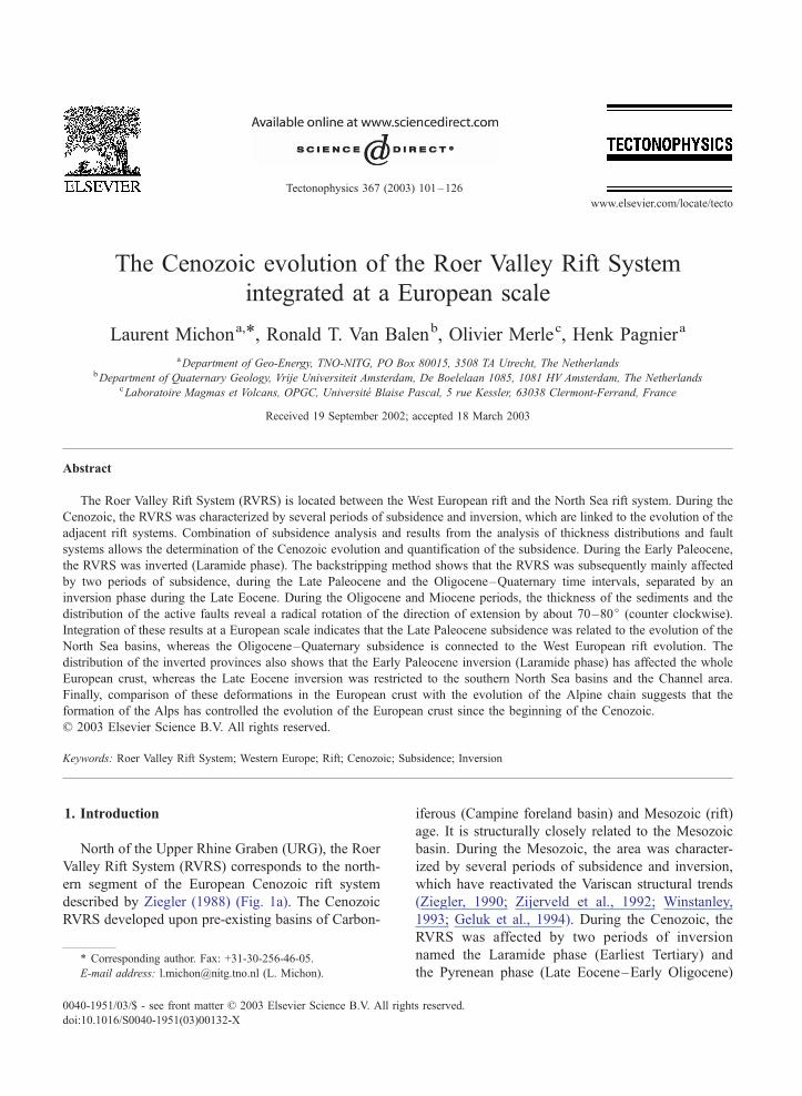
Fig. 1. (a) Location map of the Roer Valley rift system (RVRS) in northwestern Europe. (b) Tectonic features of the Lower Rhine Embayment
and the RVRS. The insert corresponds to the studied area covered by the seismic interpretation. (c) Location map of the deep wells used for the
subsidence analysis and the additional wells. The background image is a seismic interpretation of the thickness of the Tertiary sediments. See
Appendix A for the name of the wells.
L. Michon et al. / Tectonophysics 367 (2003) 101–126102
and by continuous subsidence since the beginning of
the Oligocene (Geluk et al., 1994; Houtgast and Van
Balen, 2000). Preserved Late Oligocene–Early Mio-
cene marine sediments on the Rhenish Massif dem-
onstrate that the Roer Valley Graben (RVG) was
connected to the URG (Murawski et al., 1983; Sis-
singh, 1998), indicating a common evolution during at
least this period. A close relationship between these
two grabens is also suggested by the distribution of
the earthquake focal mechanisms in the northern part
of the URG and the RVG which indicate a present-day
NE–SW extension in both areas (Plenefisch and
Bonjer, 1997).
Structurally, the RVRS is part of the Lower Rhine
Embayment and consists from southwest to northeast
of the Campine Block, the RVG and the Peel Block
(Fig. 1b). The graben, which is 20 km wide and 130
km long, has been controlled by the multi-stage
activity of several major fault zones (Peel Boundary
fault zone, Veldhoven fault zone, Rijen fault zone and
Feldbiss fault zone) of Mesozoic or (probably) older
age. The different activity of these fault zones has
induced the formation of a present-day asymmetric
structure with the main offsets located along the Peel
Boundary fault zone.
The aim of this paper is to determine precisely the
Cenozoic evolution of the RVG and the paleo-stress
fields that have caused the reactivation of this struc-
ture. This study is based (1) on subsidence analysis
inferred from deep wells situated in the graben and on
its shoulders and (2) on inspection of maps (depth of
base Late Cretaceous, base Tertiary and base Miocene
sedimentation) resulting from mainly 2D and 3D
seismic interpretation. The combination of these two
approaches allows the quantification of the tectonic
subsidence and determination of fault activity during
the different Cenozoic time periods. For each period
of sedimentation (or erosion), the characteristics of
L. Michon et al. / Tectonophysics 367 (2003) 101–126 103
subsidence and the paleo-stress field can be deduced.
Nevertheless, the density of seismic lines is not high
enough to allow observation of small-scale tectonic
structures (e.g., en echelon folds), which could pro-
vide additional information on the paleo-stress field.
Comparison with the Cenozoic evolution of the sur-
rounding rift systems (i.e., European Cenozoic rift
system and the southern North Sea rift) allows to
integrate the RVG evolution at a European scale. Our
results are partly in agreement with the paleo-stress
field orientations inferred from microtectonic data
(e.g., Villemin and Bergerat, 1987). We discuss in a
later section the potential origin of the differences
found for the Late Eocene and Oligocene periods.
Subsidence analysis determines the tectonic sub-
sidence apart from the total subsidence by applying the
backstripping method (e.g., Van Hinte, 1978; Zijerveld
et al., 1992). The other components of evolution are,
for example, isostasy and compaction. The subsidence
analysis is based on the analysis of 16 deep wells
distributed in the graben and on its shoulders (Fig. 1c
and Appendix A). Six of these wells have already been
studied by Zijerveld et al. (1992). However, the large
time frame studied in their work (250 Ma) does not
provide detailed information concerning the Cenozoic
evolution of the RVRS. In this paper, the tectonic
subsidence of the Cenozoic time interval is studied
in more detail and it is supplemented by the results for
10 additional wells, in order to determine the subsi-
dence distribution and to assess the development of
depocentres through time.
Although subsidence analysis provides fundamen-
tal information concerning the quantification of tec-
tonic subsidence, the spatial distribution is poorly
constrained. To close this gap of information, we have
studied 25 additional deep wells for which the strati-
graphic data are not detailed enough for backstripping
analyses, but can still help to define the dynamics of
each block and the tectonic activity for each period
(Late Cretaceous–Early Paleocene, Late Paleocene,
Early Oligocene, Late Oligocene and Miocene–Qua-
ternary). Thus, altogether 41 wells are used to con-
strain the spatio-temporal distribution of the subsi-
dence during the Cenozoic.
The Netherlands Institute of Applied Geoscience
TNO-National Geological Survey has recently pub-
lished the map sheets XIII and XIV of the Geological
Atlas of the Subsurface of the Netherlands (NITG-
TNO, 2001). These maps, which represent the depth
and the thickness of several horizons, have been
inferred from 2D and 3D seismic interpretation. For
the Cenozoic period, maps corresponding to the ‘‘base
Tertiary’’ (base Late Paleocene) and base Miocene
(Breda Formation) horizons were created, allowing
the thicknesses of the Paleogene and Neogene sedi-
ments to be determined. An additional map corre-
sponding to the thickness of the Chalk deposits (Late
Cretaceous–Early Paleocene) has been used in the
present study in order to determine the deformation
caused by the Laramide phase in the beginning of the
Cenozoic.
2. Geological setting and fault system
The RVRS is the southwestern part of the Lower
Rhine Embayment. Located in Belgium, Germany
and the Netherlands, it consists of, from southwest
to northeast, the Campine Block, the Roer Valley
Graben and the Peel Block (the Campine and Peel
Blocks corresponding to the RVG shoulders). The
southeastern end of the RVRS is formed by the Erft
Block, which is not in the prolongation of the RVG
but shifted towards the northeast (Fig. 1b). In the
northwest, the West Netherlands Basin is the contin-
uation of the Mesozoic RVRS. The transition area
between these two Mesozoic structures is character-
ized by a sedimentation and a fault pattern which has
similarities with both grabens.
During the Mesozoic, the RVRS was affected by
several periods of subsidence. Between the Late
Permian and Early Triassic, the RVRS was character-
ized by thermal subsidence and minor fault activity as
attested by a thick homogeneous sedimentation in the
RVG, on the Peel Block and on the Campine Block
(Zijerveld et al., 1992; Winstanley, 1993). Contrary to
this period, the Late Jurassic–Early Cretaceous evo-
lution corresponds to a major rifting event during
which the RVG has strongly subsided, and the Peel
and Campine Blocks were uplifted (Zijerveld et al.,
1992; Geluk et al., 1994). Subsidence was controlled
by the reactivation of the main Variscan faults in a
normal faulting mode (the Peel Boundary fault zone,
the Rijen fault zone and the Veldhoven fault zone).
Most of the sediments deposited during this period
have been later eroded during the first Late Creta-
L. Michon et al. / Tectonophysics 367 (2003) 101–126104
ceous inversion event (Winstanley, 1993). A second
phase of inversion, characterized by two pulses,
occurred during the latest Late Cretaceous and the
earliest Tertiary, contemporaneous with a general
transgression. In the RVRS, the erosion or the lack
of sedimentation of Chalk (Cenomanian–Danian)
deposits renders the distinction between these two
pulses of inversion impossible. The resulting sedi-
mentation is characterized by a very thin sediment
deposit in the RVG and an important subsidence of
the Peel Block (Gras and Geluk, 1999).
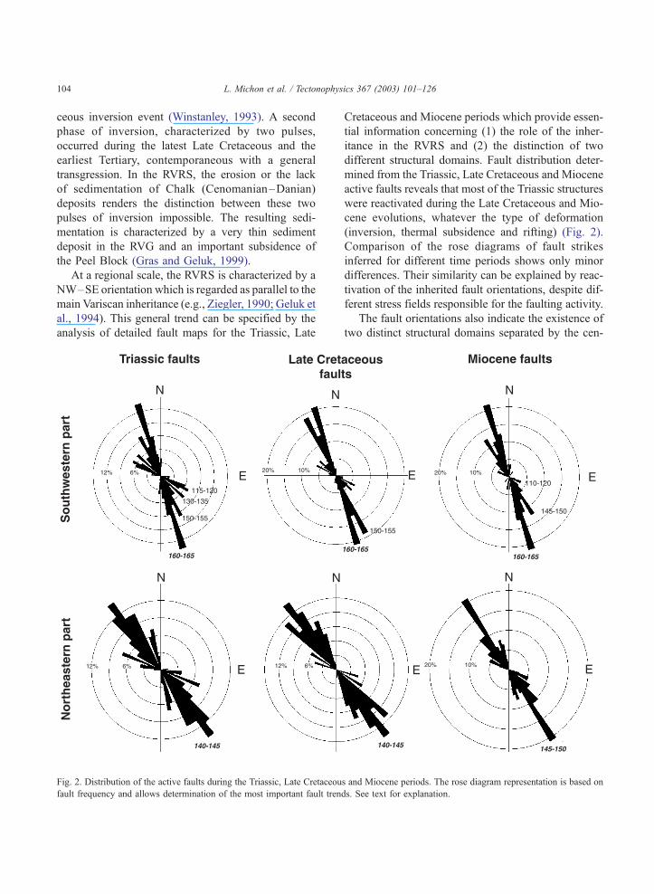
At a regional scale, the RVRS is characterized by a
NW–SE orientation which is regarded as parallel to the
main Variscan inheritance (e.g., Ziegler, 1990; Geluk et
al., 1994). This general trend can be specified by the
analysis of detailed fault maps for the Triassic, Late
Fig. 2. Distribution of the active faults during the Triassic, Late Cretaceou
fault frequency and allows determination of the most important fault tren
Cretaceous and Miocene periods which provide essen-
tial information concerning (1) the role of the inher-
itance in the RVRS and (2) the distinction of two
different structural domains. Fault distribution deter-
mined from the Triassic, Late Cretaceous and Miocene
active faults reveals that most of the Triassic structures
were reactivated during the Late Cretaceous and Mio-
cene evolutions, whatever the type of deformation
(inversion, thermal subsidence and rifting) (Fig. 2).
Comparison of the rose diagrams of fault strikes
inferred for different time periods shows only minor
differences. Their similarity can be explained by reac-
tivation of the inherited fault orientations, despite dif-
ferent stress fields responsible for the faulting activity.
The fault orientations also indicate the existence of
two distinct structural domains separated by the cen-
s and Miocene periods. The rose diagram representation is based on
ds. See text for explanation.
L. Michon et al. / Tectonophysics 367 (2003) 101–126 105
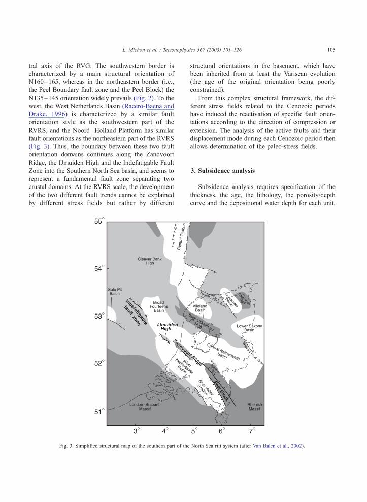
tral axis of the RVG. The southwestern border is
characterized by a main structural orientation of
N160–165, whereas in the northeastern border (i.e.,
the Peel Boundary fault zone and the Peel Block) the
N135–145 orientation widely prevails (Fig. 2). To the
west, the West Netherlands Basin (Racero-Baena and
Drake, 1996) is characterized by a similar fault
orientation style as the southwestern part of the
RVRS, and the Noord–Holland Platform has similar
fault orientations as the northeastern part of the RVRS
(Fig. 3). Thus, the boundary between these two fault
orientation domains continues along the Zandvoort
Ridge, the IJmuiden High and the Indefatigable Fault
Zone into the Southern North Sea basin, and seems to
represent a fundamental fault zone separating two
crustal domains. At the RVRS scale, the development
of the two different fault trends cannot be explained
by different stress fields but rather by different
Fig. 3. Simplified structural map of the southern part of the
structural orientations in the basement, which have
been inherited from at least the Variscan evolution
(the age of the original orientation being poorly
constrained).
From this complex structural framework, the dif-
ferent stress fields related to the Cenozoic periods
have induced the reactivation of specific fault orien-
tations according to the direction of compression or
extension. The analysis of the active faults and their
displacement mode during each Cenozoic period then
allows determination of the paleo-stress fields.
3. Subsidence analysis
Subsidence analysis requires specification of the
thickness, the age, the lithology, the porosity/depth
curve and the depositional water depth for each unit.
North Sea rift system (after Van Balen et al., 2002).
L. Michon et al. / Tectonophysics 367 (2003) 101–126106
In the RVRS, the stratigraphy has been derived from
the Stratigraphic Nomenclature of the Netherlands
(Nederlandse Aardolie Maatschappij BV and Rijks
Geologische Dienst, 1980). We have used standard
exponential curves for the porosity–depth relationship
corrections taking into account the different litholo-
gies for each wells (e.g., Sclater and Christie, 1980).
Paleobathymetry may have a strong influence on the
backstripping results. Nevertheless, the RVRS was
located on the peripheral margin of the North Sea
basin and the paleogeographic interpretations suggest
that paleobathymetry never exceeded 50–100 m
(Zagwijn, 1989). Geohistory evolutions determined
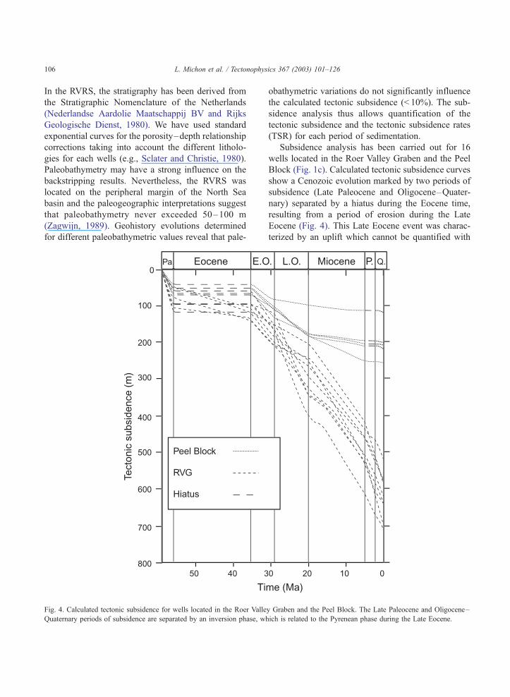
for different paleobathymetric values reveal that pale-
Fig. 4. Calculated tectonic subsidence for wells located in the Roer Valle
Quaternary periods of subsidence are separated by an inversion phase, wh
obathymetric variations do not significantly influence
the calculated tectonic subsidence (< 10%). The sub-
sidence analysis thus allows quantification of the
tectonic subsidence and the tectonic subsidence rates
(TSR) for each period of sedimentation.
Subsidence analysis has been carried out for 16
wells located in the Roer Valley Graben and the Peel
Block (Fig. 1c). Calculated tectonic subsidence curves
show a Cenozoic evolution marked by two periods of
subsidence (Late Paleocene and Oligocene–Quater-
nary) separated by a hiatus during the Eocene time,
resulting from a period of erosion during the Late
Eocene (Fig. 4). This Late Eocene event was charac-
terized by an uplift which cannot be quantified with
y Graben and the Peel Block. The Late Paleocene and Oligocene–
ich is related to the Pyrenean phase during the Late Eocene.
L. Michon et al. / Tectonophysics 367 (2003) 101–126 107
the available data. Models from apatite-fission track
analyses indicate that the uplift in the western part of
the RVRS varies between 200 and 600 m. (Van Balen
et al., 2002). A second minor hiatus is visible for four
wells located on the Peel Block during the start of the
Pliocene. Although this hiatus could be interpreted in
terms of tectonic inversion (uplift and erosion), it can
be considered as the result of a lack of sedimentation
related to the Late Miocene marine regression.
The first phase of subsidence (Late Paleocene) was
characterized by the widespread sedimentation of the
Landen Formation in the RVG and on the Peel Block
(see below). For this period, tectonic subsidence rates
indicate a different evolution between the southeastern
part of the RVG, and the Peel Block and the north-
western part of the RVG. From southeast to northwest,
the tectonic subsidence rates in the RVG decrease
from 38–47 to 20–22 mm/ky. This feature could
suggest a tectonic activity mainly concentrated in
the southeastern part of the graben. However, it has
been shown that the West Netherlands Basin, which
corresponds to the northwest continuation of the
RVG, was strongly inverted during the early Tertiary
phase creating an important relief (Van Balen et al.,
2000). The persistence of this relief during the first
stage of the Late Paleocene evolution may explain the
weak thickness of the Landen formation in the north-
western part of the RVG. In that case, the TSR low
Fig. 5. (a) NW–SE cross section established from eight wells located into t
Quaternary depocentres is suggested by the amount of tectonic subsidence
section. As.: Asten-1 and Asten-2; H.: Heeswijk; M.: Molenbeersel; N.: N
values in the northwestern part likely represent an
underestimation of the real tectonic subsidence. In
contrast, the difference between the tectonic subsi-
dence rates inferred from the wells located on the
southeastern part of the Peel Block (21–25 mm/ky)
and those located in the graben (38–47 mm/ky)
clearly suggests a tectonic activity with a fault-con-
trolled tectonic subsidence mainly restricted to the
graben.
The second period of subsidence began in the
Early Oligocene and is still active during the Quater-
nary. After the Late Eocene inversion, the RVG and
the Peel Block started to subside with similar tectonic
subsidence rates (18–19 mm/ky), inducing the depo-
sition of the Rupel formation. This common evolution
stopped at the beginning of the Late Oligocene, when
the tectonic subsidence decreased in the northwestern
part of the RVG and the Peel Block (TSR around 10
mm/ky), whereas it strongly accelerated in the south-
eastern part of the graben (TSR between 20 and 34
mm/ky). The Late Oligocene period was then charac-
terized by a concentration of the deformation mainly
located in the northeastern side of the southeastern
part of the RVG, where the maximum TSR values are
recorded. After the regressive phase at the Oligo-
cene–Miocene transition, the evolution of the north-
western and the southeastern parts became similar
with a constant TSR around 19 mm/ky. This Miocene
he RVG. The development of the Late Oligocene and the Miocene–
along the cross section. (b) Location of the wells used for the cross
ederweert; V.: Veldhoven; Wa.: Waalwijk; W.: Werkendam.
L. Michon et al. / Tectonophysics 367 (2003) 101–126108
subsidence was also characterized by the development
of a large depocentre in the northwestern part, indicat-
ing a northwestward migration of the depocentre
between the Late Oligocene and the Miocene (Fig.
5). On the Peel Block, the tectonic subsidence
decreases drastically (TSR< 5 mm/ky) suggesting a
change in the general evolution of the RVRS with a
subsidence restricted to the graben. As it has been
already observed (Zijerveld et al., 1992), tectonic
subsidence curves reveal an increase of the TSR in
the RVG ( + 40%) at the Miocene–Pliocene transition.
Thus, since the Pliocene, the subsidence led to the
deposition of a 300–400 m thick Plio-Quaternary
sedimentation outside the depocentre and more than
500 m of sediments within the depocentre.
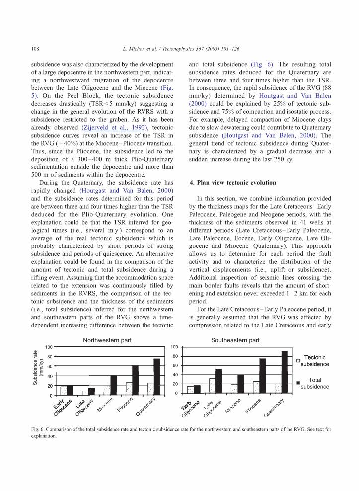
During the Quaternary, the subsidence rate has
rapidly changed (Houtgast and Van Balen, 2000)
and the subsidence rates determined for this period
are between three and four times higher than the TSR
deduced for the Plio-Quaternary evolution. One
explanation could be that the TSR inferred for geo-
logical times (i.e., several m.y.) correspond to an
average of the real tectonic subsidence which is
probably characterized by short periods of strong
subsidence and periods of quiescence. An alternative
explanation could be found in the comparison of the
amount of tectonic and total subsidence during a
rifting event. Assuming that the accommodation space
related to the extension was continuously filled by
sediments in the RVRS, the comparison of the tec-
tonic subsidence and the thickness of the sediments
(i.e., total subsidence) inferred for the northwestern
and southeastern parts of the RVG shows a time-
dependent increasing difference between the tectonic
Fig. 6. Comparison of the total subsidence rate and tectonic subsidence rate
explanation.
and total subsidence (Fig. 6). The resulting total
subsidence rates deduced for the Quaternary are
between three and four times higher than the TSR.
In consequence, the rapid subsidence of the RVG (88
mm/ky) determined by Houtgast and Van Balen
(2000) could be explained by 25% of tectonic sub-
sidence and 75% of compaction and isostatic process.
For example, delayed compaction of Miocene clays
due to slow dewatering could contribute to Quaternary
subsidence (Houtgast and Van Balen, 2000). The
general trend of tectonic subsidence during Quater-
nary is characterized by a gradual decrease and a
sudden increase during the last 250 ky.
4. Plan view tectonic evolution
In this section, we combine information provided
by the thickness maps for the Late Cretaceous–Early
Paleocene, Paleogene and Neogene periods, with the
thickness of the sediments observed in 41 wells at
different periods (Late Cretaceous–Early Paleocene,
Late Paleocene, Eocene, Early Oligocene, Late Oli-
gocene and Miocene–Quaternary). This approach
allows us to determine for each period the fault
activity and to characterize the distribution of the
vertical displacements (i.e., uplift or subsidence).
Additional inspection of seismic lines crossing the
main border faults reveals that the amount of short-
ening and extension never exceeded 1–2 km for each
period.
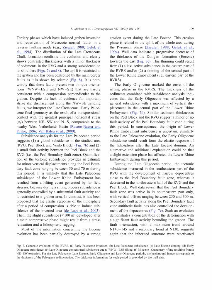
For the Late Cretaceous–Early Paleocene period, it
is generally assumed that the RVG was affected by
compression related to the Late Cretaceous and early
for the northwestern and southeastern parts of the RVG. See text for
L. Michon et al. / Tectonophysics 367 (2003) 101–126 109
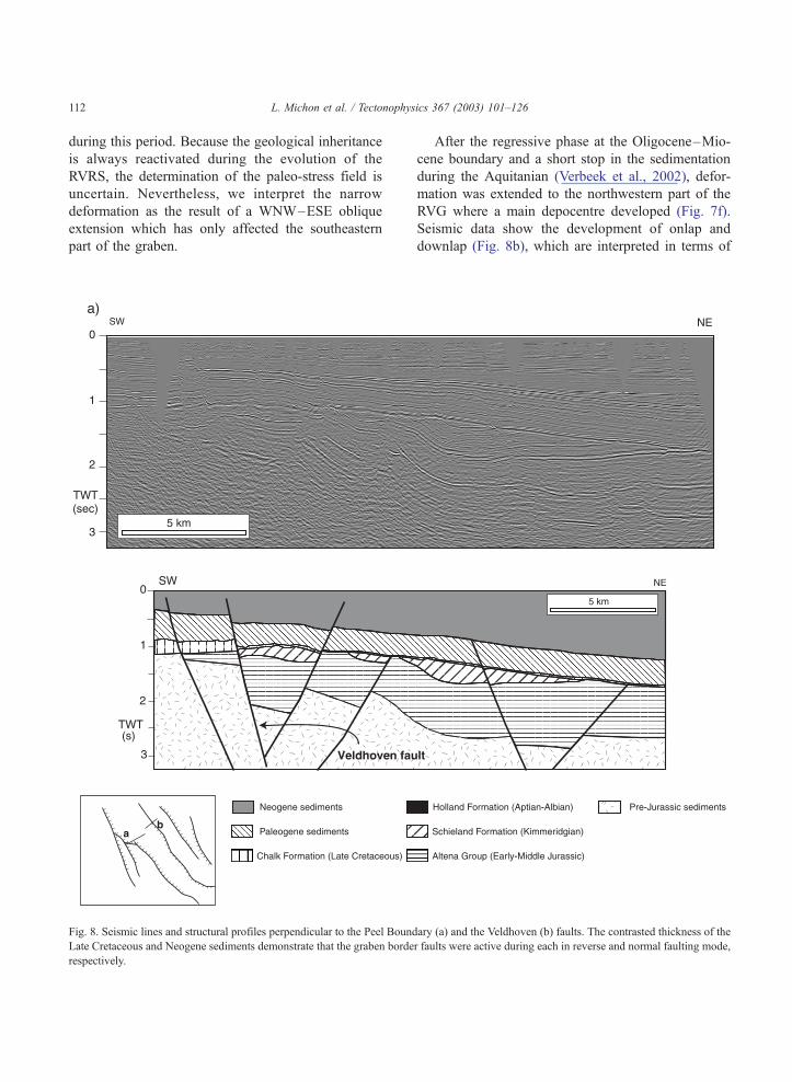
Tertiary phases which have induced graben inversion
and reactivation of Mesozoic normal faults in a
reverse faulting mode (e.g., Ziegler, 1988; Geluk et
al., 1994). The distribution of the Late Cretaceous
Chalk formation confirms this evolution and clearly
shows contrasted thicknesses with a minor thickness
of sediments in the RVG and a strong subsidence on
its shoulders (Figs. 7a and 8). The uplift is restricted to
the graben and has been controlled by the main border
faults as it is shown by seismic (Fig. 8). It is note-
worthy that these faults present two oblique orienta-
tions (WNW–ESE and NW–SE) that are hardly
consistent with a compression perpendicular to the
graben. Despite the lack of evidence for important
strike slip displacement along the NW–SE trending
faults, we interpret the Late Cretaceous–Early Paleo-
cene final geometry as the result of a transpressional
context with the greatest principal horizontal stress
(r1) between NE–SW and N–S, comparable to the
nearby West Netherlands Basin (Racero-Baena and
Drake, 1996; Van Balen et al., 2000).
Subsidence analysis for the Late Paleocene period
suggests (1) a global subsidence in the studied area
(RVG, Peel Block and Venlo Block) (Fig. 7b) and (2)
a small fault activity between the Peel Block and the
RVG (i.e., the Peel Boundary fault zone). Quantifica-
tion of the tectonic subsidence provides an estimate
for minor vertical displacements along the Peel Boun-
dary fault zone ranging between 50 and 70 m during
this period. It is unlikely that the Late Paleocene
subsidence of the Lower Rhine Embayment has
resulted from a rifting event generated by far field
stresses, because during a rifting process subsidence is
generally controlled by a substantial fault activity and
is restricted to a graben area. In contrast, it has been
proposed that the elastic response of the lithosphere
after a period of compression is able to induce sub-
sidence of the inverted area (de Lugt et al., 2003).
Then, the slight subsidence (< 100 m) developed after
a main compressive phase might result from a stress
relaxation and a lithospheric sagging.
Most of the information concerning the Eocene
evolution has been partially destroyed by a strong
Fig. 7. Cenozoic evolution of the RVRS. (a) Early Paleocene inversion.
Oligocene subsidence. (e) Late Oligocene concentrated subsidence due to W
NE–SW extension. For the Late Paleocene, Late Eocene, Early Oligocene
the thickness of the Paleogene sedimentation. The thickness information f
erosion event during the Late Eocene. This erosion
phase is related to the uplift of the whole area during
the Pyrenean phase (Ziegler, 1988; Geluk et al.,
1994). Well data indicate a progressive decrease of
the thickness of the Dongen formation (Eocene)
towards the east (Fig. 7c). This thinning could result
from (1) a less active subsidence in the eastern part of
the RVRS and/or (2) a doming of the central part of
the Lower Rhine Embayment (i.e., eastern part of the
RVRS).
The Early Oligocene marked the onset of the
rifting phase in the RVRS. The thickness of the
sediments combined with subsidence analysis indi-
cates that the Early Oligocene was affected by a
general subsidence with a maximum of vertical dis-
placement in the central part of the Lower Rhine
Embayment (Fig. 7d). Similar sediment thicknesses
on the Peel Block and the RVG suggest a minor or no
fault activity of the Peel Boundary fault zone during
this period. In consequence, the origin of Lower
Rhine Embayment subsidence is uncertain. Similarly
to the Late Paleocene evolution, the Early Oligocene
subsidence could result form the elastic response of
the lithosphere after the Late Eocene doming. An
alternative and additional explanation could be that
a slight extension phase has affected the Lower Rhine
Embayment during this period.
During the Late Oligocene period, the tectonic
subsidence increased in the southeastern part of the
RVG with the development of narrow depocentres
close to the Peel Boundary fault zone, whereas it
decreased in the northwestern half of the RVG and the
Peel Block. Well data reveal that the Peel Boundary
fault zone was active in its southeastern part only,
with vertical offsets ranging between 250 and 300 m.
Secondary fault activity along the Peel Boundary fault
zone antithetic faults has also controlled the develop-
ment of the depocentres (Fig. 7e). Such an evolution
demonstrates a concentration of the deformation with
a significant fault activity bounding the graben. The
fault orientation, with a maximum trend around
N140–145 and a secondary trend at N130, suggests
again that the inherited structure were reactivated
(b) Late Paleocene subsidence. (c) Late Eocene doming. (d) Early
NW–ESE rifting. (f) Miocene–Quaternary rifting resulting from a
and Late Oligocene periods, the background image corresponds to
or each period is provided by the well data.
L. Michon et al. / Tectonophysics 367 (2003) 101–126110
Fig. 7 (continued).
L. Michon et al. / Tectonophysics 367 (2003) 101–126 111
L. Michon et al. / Tectonophysics 367 (2003) 101–126112
during this period. Because the geological inheritance
is always reactivated during the evolution of the
RVRS, the determination of the paleo-stress field is
uncertain. Nevertheless, we interpret the narrow
deformation as the result of a WNW–ESE oblique
extension which has only affected the southeastern
part of the graben.
Fig. 8. Seismic lines and structural profiles perpendicular to the Peel Bound
Late Cretaceous and Neogene sediments demonstrate that the graben borde
respectively.
After the regressive phase at the Oligocene–Mio-
cene boundary and a short stop in the sedimentation
during the Aquitanian (Verbeek et al., 2002), defor-
mation was extended to the northwestern part of the
RVG where a main depocentre developed (Fig. 7f).
Seismic data show the development of onlap and
downlap (Fig. 8b), which are interpreted in terms of
ary (a) and the Veldhoven (b) faults. The contrasted thickness of the
r faults were active during each in reverse and normal faulting mode,
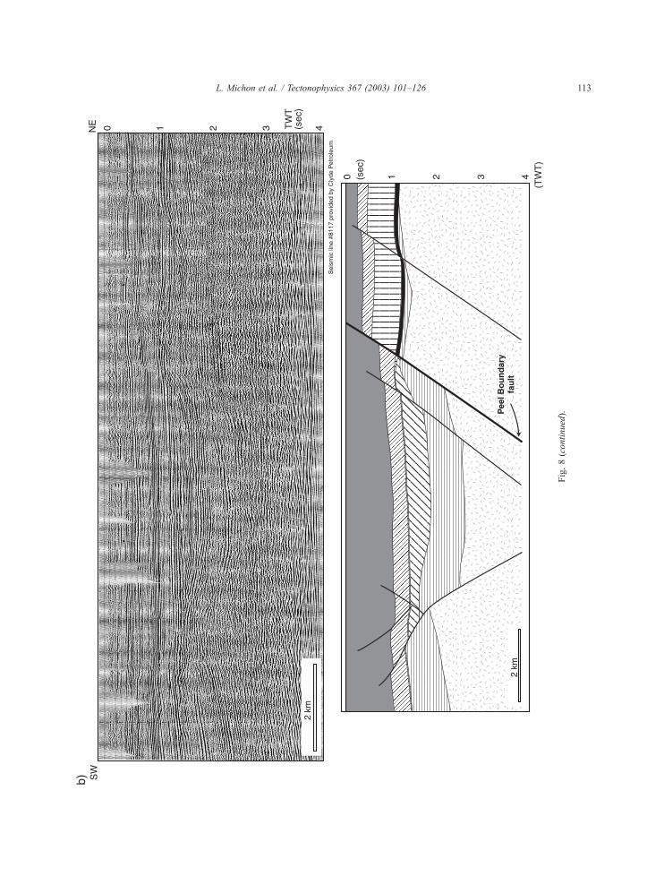
Fig.8(continued).
L. Michon et al. / Tectonophysics 367 (2003) 101–126 113
L. Michon et al. / Tectonophysics 367 (2003) 101–126114
sea-level variations and an increase of the subsidence
during the Burdigalian (Verbeek et al., 2002). A
similar increase of the subsidence occurred contem-
poraneously in the northern part of the URG (Sis-
singh, 1998). Contrary to the Late Oligocene evolu-
tion, the oblique orientation was strongly reactivated
especially along the Veldhoven fault zone. The result-
ing distribution is characterized by two main trends:
the N145–160 trend corresponding to the general
orientation of the graben, and the N110–120 oblique
orientation. It is noteworthy that the offsets resulting
from the N110–120 and N145–160 faults in the
northwestern part of the Peel Boundary fault zone
are similar. This indicates a direction of extension
corresponding to the bissectrix of these two orienta-
tions (i.e., NE–SW). Extension has also induced the
formation of two depocentres: a main depocentre in
the northwestern part of the RVG and a minor one in
the southeastern part. The western limit of the main
depocentre is parallel to the N150 trend represented
by the Feldbiss fault zone. In the south, the depocentre
boundary is superimposed on the Jurassic Veldhoven
fault zone. Seismic profiles which cross-cut this
Mesozoic fault show that the southeastern prolonga-
tion of the Miocene Veldhoven fault zone controls the
deformation, inducing a flexure of the Miocene sedi-
ments. To sum up, the Miocene subsidence of the
RVG was controlled by two oblique orientations
(N145–160 and N110–120). The orientation of the
active faults and the development of the main depo-
centre at the intersection of two oblique main faults
can be interpreted as the result of a NE–SW exten-
sion. In addition, the superimposition of the Miocene
and Pleistocene depocentres (Houtgast and Van Balen,
2000) suggests a continuous extension with the same
stress field. Analysis of the earthquake focal mecha-
nism data also shows that the RVRS is affected by a
present-day NE–SW extension related to a nearly
vertical greatest principal stress (r1) (Plenefisch and
Bonjer, 1997).
5. Discussion and conclusions
One aim of our study is to integrate the evolution
of the RVRS at the European scale. Nevertheless, it is
beyond the scope of this paper to describe in detail the
evolution of the different provinces and grabens of the
North Sea and West European rift (WER), which have
been extensively studied during the past decades (e.g.,
Ziegler, 1988, 1992a,b; Merle et al., 1998; Sissingh,
1998; Michon, 2001). The southern limit of the
considered area corresponds to the southern part of
the Massif Central. South of this province (south-
eastern France), the extension related to the formation
the WER has only induced a very weak subsidence
(Hippolyte et al., 1993), whereas the area was mainly
affected by the strong extension generated by the
rotation of the Corsica–Sardinia block since the Late
Oligocene (e.g., Seranne, 1999). In the north, the
studied area is limited to the southern part of the
North Sea where the deformation was influenced by
both the rifting stage linked to the Atlantic rifting and
the compressive stress generated by the Europe–
Africa collision (Ziegler, 1990). In our restricted area,
we distinguish six successive periods during the
Cenozoic evolution with analogy with the periods
determined in the RVRS (only the distinction for the
Eocene and Oligocene periods present minor differ-
ences).
5.1. Early Paleocene
The Early Paleocene evolution of the RVRS was
characterized by graben inversion and the reactivation
of the Mesozoic faults in a reverse faulting mode (Fig.
7a). The southern North Sea basins (the West Nether-
lands Basin, the Broad Fourteens Basin, the Sole Pit
Basin and the southern part of the Central graben)
were also affected by an inversion phase regarded as
the result of a main N–S compression (Ziegler,
1992a; Oudmayer and De Jager, 1993; Brun and
Nalpas, 1996; Van Balen et al., 2000; de Lugt et al.,
2003). During this period, a Late Cretaceous–Paleo-
cene late-rifting stage linked to the Faroe–Norwe-
gian–Greenland Sea rift system induced extension in
the northern and central North Sea (Ziegler, 1992a)
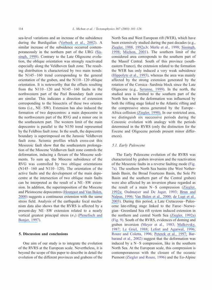
(Fig. 9). South of the RVRS, evidences of doming and
graben inversion (Meyer et al., 1983; Malkovsky,
1987; Le Griel, 1988; Lefort and Agarwal, 1996;
Roure and Coletta, 1996; Peterek et al., 1997; Bar-
barand et al., 2002) suggest that the deformation was
induced by a N–S compression, like in the southern
North Sea. At the European scale, this compression is
contemporaneous with the closure of the oceanic
Piemont (Ziegler and Roure, 1996) and the Eo-Alpine
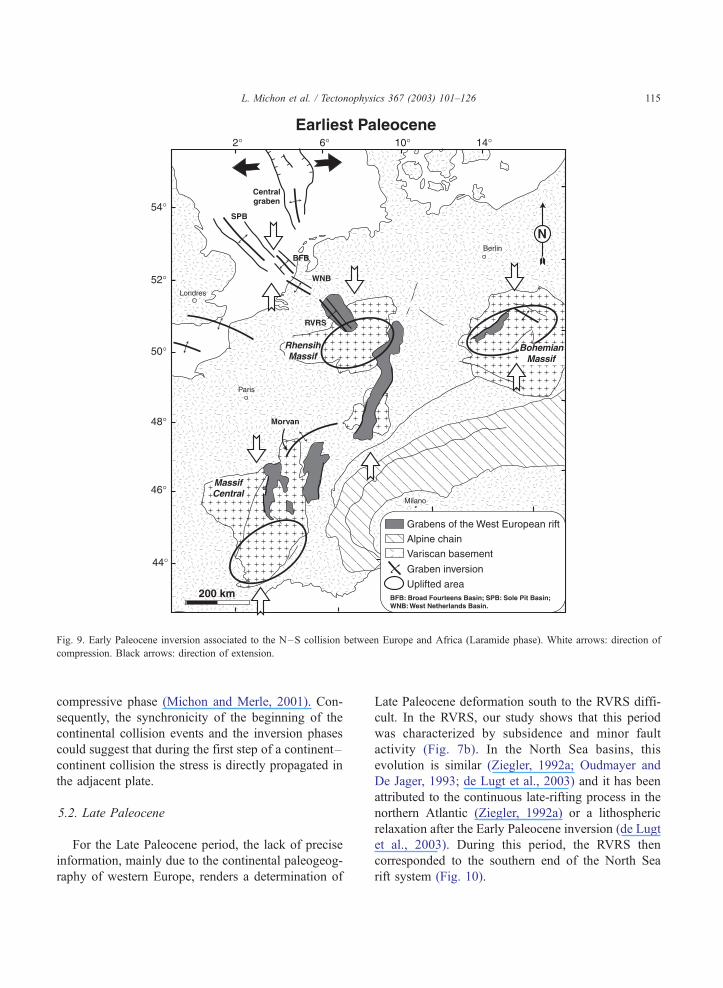
Fig. 9. Early Paleocene inversion associated to the N–S collision between Europe and Africa (Laramide phase). White arrows: direction of
compression. Black arrows: direction of extension.
L. Michon et al. / Tectonophysics 367 (2003) 101–126 115
compressive phase (Michon and Merle, 2001). Con-
sequently, the synchronicity of the beginning of the
continental collision events and the inversion phases
could suggest that during the first step of a continent–
continent collision the stress is directly propagated in
the adjacent plate.
5.2. Late Paleocene
For the Late Paleocene period, the lack of precise
information, mainly due to the continental paleogeog-
raphy of western Europe, renders a determination of
Late Paleocene deformation south to the RVRS diffi-
cult. In the RVRS, our study shows that this period
was characterized by subsidence and minor fault
activity (Fig. 7b). In the North Sea basins, this
evolution is similar (Ziegler, 1992a; Oudmayer and
De Jager, 1993; de Lugt et al., 2003) and it has been
attributed to the continuous late-rifting process in the
northern Atlantic (Ziegler, 1992a) or a lithospheric
relaxation after the Early Paleocene inversion (de Lugt
et al., 2003). During this period, the RVRS then
corresponded to the southern end of the North Sea
rift system (Fig. 10).
Fig. 10. Late Paleocene subsidence of the southern North Sea basins generated by lithosphere relaxation after the Laramide inversion (de Lugt et
al., 2003) and/or by a late-rifting stage related to the rifting in North Atlantic between Greenland and the Fareoe Islands (Ziegler, 1992a,b).
L. Michon et al. / Tectonophysics 367 (2003) 101–126116
5.3. Early Eocene
The Early Eocene sedimentation was probably
partly eroded in the RVRS during the Late Eocene
doming. In the southern North Sea, subsidence has
induced an important sedimentation with minor fault
activity (de Lugt et al., 2003), suggesting a thermal
subsidence after the late-rifting stage or continued
sagging due to stress relaxation, which ended at the
end of the Paleocene (Ziegler, 1992a). In southwestern
Europe, in the larger WER area, two sediment facies
are attributed to the Early Eocene period: the Side-
rolithic formation and the Lutetian continental sedi-
mentation (e.g., Rat, 1974; Sissingh, 1998). The
Siderolithic formation, which results from the in-situ
erosion of the outcropping rock has a widespread
distribution from the Upper Rhine Graben area up to
the Massif Central (Sissingh, 1998; Michon, 2001).
The Lutetian continental sedimentation outcrops in
the northern Upper Rhine Graben and the Massif
Central or outside the grabens (Fig. 11). This spatial
distribution suggests that the Lutetian sedimentation
did not result from a period of subsidence linked to
the Late Eocene–Oligocene rifting phase but rather
from the development of local lakes in a peneplain
domain. To sum up, these data suggest that the Early
Eocene period corresponds to a tectonically quiet
period in the North Sea and the WER.
5.4. Late Eocene
Compared to the Early Eocene evolution, the Late
Eocene period was characterized by intensive and
opposite deformation in the southern North Sea and
the WER. The southern North Sea basins were
affected by a second phase of inversion, whereas
this period corresponds to the onset of the rifting
event in the WER (Fig. 12). In the southern North
Sea and the Channel area, reactivation of the Meso-
zoic and Cenozoic faults in a reverse faulting mode
(Oudmayer and De Jager, 1993; Van Balen et al.,
2000; de Lugt et al., 2003) has been interpreted as
resulting from a nearly N–S compression related to
the Pyrenees formation (Ziegler, 1990). In contrast,
the Late Eocene sedimentation in the Massif Central
graben (Merle et al., 1998), the central part of the
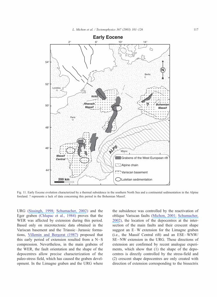
Fig. 11. Early Eocene evolution characterized by a thermal subsidence in the southern North Sea and a continental sedimentation in the Alpine
foreland. ? represents a lack of data concerning this period in the Bohemian Massif.
L. Michon et al. / Tectonophysics 367 (2003) 101–126 117
URG (Sissingh, 1998; Schumacher, 2002) and the
Eger graben (Chlupac et al., 1984) proves that the
WER was affected by extension during this period.
Based only on microtectonic data obtained in the
Variscan basement and the Triassic–Jurassic forma-
tions, Villemin and Bergerat (1987) proposed that
this early period of extension resulted from a N–S
compression. Nevertheless, in the main grabens of
the WER, the fault orientation and the shape of the
depocentres allow precise characterization of the
paleo-stress field, which has caused the graben devel-
opment. In the Limagne graben and the URG where
the subsidence was controlled by the reactivation of
oblique Variscan faults (Michon, 2001; Schumacher,
2002), the location of the depocentres at the inter-
section of the main faults and their crescent shape
suggest an E–W extension for the Limagne graben
(i.e., the Massif Central rift) and an ESE–WNW/
SE–NW extension in the URG. These directions of
extension are confirmed by recent analogue experi-
ments, which show that (1) the shape of the depo-
centres is directly controlled by the stress-field and
(2) crescent shape depocentres are only created with
direction of extension corresponding to the bissectrix
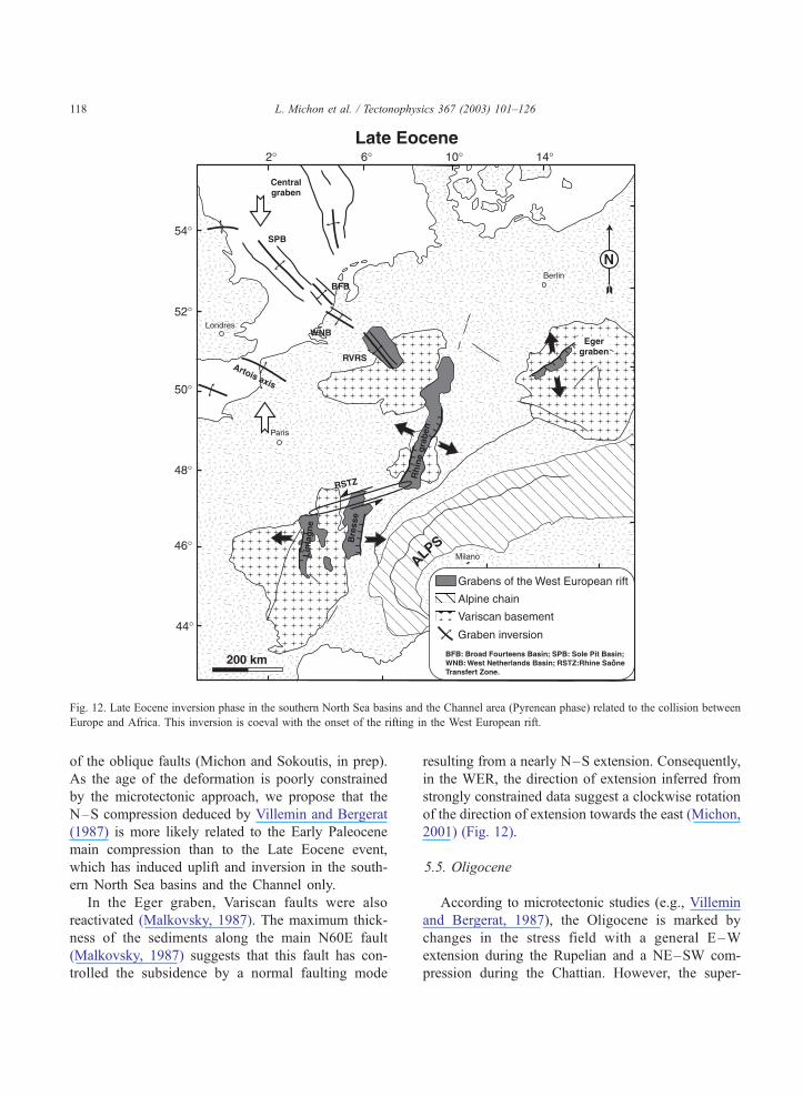
Fig. 12. Late Eocene inversion phase in the southern North Sea basins and the Channel area (Pyrenean phase) related to the collision between
Europe and Africa. This inversion is coeval with the onset of the rifting in the West European rift.
L. Michon et al. / Tectonophysics 367 (2003) 101–126118
of the oblique faults (Michon and Sokoutis, in prep).
As the age of the deformation is poorly constrained
by the microtectonic approach, we propose that the
N–S compression deduced by Villemin and Bergerat
(1987) is more likely related to the Early Paleocene
main compression than to the Late Eocene event,
which has induced uplift and inversion in the south-
ern North Sea basins and the Channel only.
In the Eger graben, Variscan faults were also
reactivated (Malkovsky, 1987). The maximum thick-
ness of the sediments along the main N60E fault
(Malkovsky, 1987) suggests that this fault has con-
trolled the subsidence by a normal faulting mode
resulting from a nearly N–S extension. Consequently,
in the WER, the direction of extension inferred from
strongly constrained data suggest a clockwise rotation
of the direction of extension towards the east (Michon,
2001) (Fig. 12).
5.5. Oligocene
According to microtectonic studies (e.g., Villemin
and Bergerat, 1987), the Oligocene is marked by
changes in the stress field with a general E–W
extension during the Rupelian and a NE–SW com-
pression during the Chattian. However, the super-
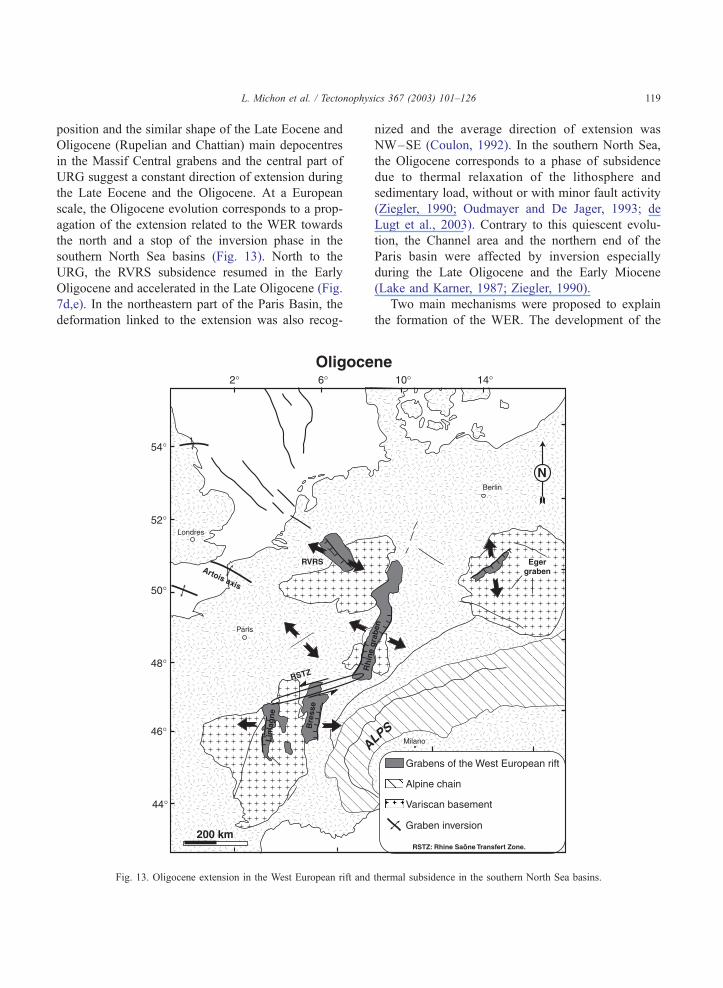
L. Michon et al. / Tectonophysics 367 (2003) 101–126 119
position and the similar shape of the Late Eocene and
Oligocene (Rupelian and Chattian) main depocentres
in the Massif Central grabens and the central part of
URG suggest a constant direction of extension during
the Late Eocene and the Oligocene. At a European
scale, the Oligocene evolution corresponds to a prop-
agation of the extension related to the WER towards
the north and a stop of the inversion phase in the
southern North Sea basins (Fig. 13). North to the
URG, the RVRS subsidence resumed in the Early
Oligocene and accelerated in the Late Oligocene (Fig.
7d,e). In the northeastern part of the Paris Basin, the
deformation linked to the extension was also recog-
Fig. 13. Oligocene extension in the West European rift and
nized and the average direction of extension was
NW–SE (Coulon, 1992). In the southern North Sea,
the Oligocene corresponds to a phase of subsidence
due to thermal relaxation of the lithosphere and
sedimentary load, without or with minor fault activity
(Ziegler, 1990; Oudmayer and De Jager, 1993; de
Lugt et al., 2003). Contrary to this quiescent evolu-
tion, the Channel area and the northern end of the
Paris basin were affected by inversion especially
during the Late Oligocene and the Early Miocene
(Lake and Karner, 1987; Ziegler, 1990).
Two main mechanisms were proposed to explain
the formation of the WER. The development of the
thermal subsidence in the southern North Sea basins.
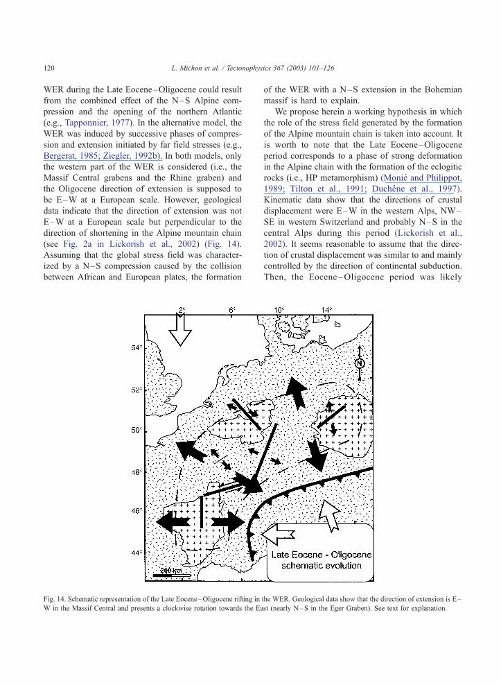
L. Michon et al. / Tectonophysics 367 (2003) 101–126120
WER during the Late Eocene–Oligocene could result
from the combined effect of the N–S Alpine com-
pression and the opening of the northern Atlantic
(e.g., Tapponnier, 1977). In the alternative model, the
WER was induced by successive phases of compres-
sion and extension initiated by far field stresses (e.g.,
Bergerat, 1985; Ziegler, 1992b). In both models, only
the western part of the WER is considered (i.e., the
Massif Central grabens and the Rhine graben) and
the Oligocene direction of extension is supposed to
be E–W at a European scale. However, geological
data indicate that the direction of extension was not
E–W at a European scale but perpendicular to the
direction of shortening in the Alpine mountain chain
(see Fig. 2a in Lickorish et al., 2002) (Fig. 14).
Assuming that the global stress field was character-
ized by a N–S compression caused by the collision
between African and European plates, the formation
Fig. 14. Schematic representation of the Late Eocene–Oligocene rifting in
W in the Massif Central and presents a clockwise rotation towards the Ea
of the WER with a N–S extension in the Bohemian
massif is hard to explain.
We propose herein a working hypothesis in which
the role of the stress field generated by the formation
of the Alpine mountain chain is taken into account. It
is worth to note that the Late Eocene–Oligocene
period corresponds to a phase of strong deformation
in the Alpine chain with the formation of the eclogitic
rocks (i.e., HP metamorphism) (Monie and Philippot,
1989; Tilton et al., 1991; Duchene et al., 1997).
Kinematic data show that the directions of crustal
displacement were E–W in the western Alps, NW–
SE in western Switzerland and probably N–S in the
central Alps during this period (Lickorish et al.,
2002). It seems reasonable to assume that the direc-
tion of crustal displacement was similar to and mainly
controlled by the direction of continental subduction.
Then, the Eocene–Oligocene period was likely
the WER. Geological data show that the direction of extension is E–
st (nearly N–S in the Eger Graben). See text for explanation.
L. Michon et al. / Tectonophysics 367 (2003) 101–126 121
marked by the development of a N–S deep litho-
spheric root in the western Alps and a E–W litho-
spheric root in the central Alps, similar to the present-
day geometry of the Alpine lithospheric root (Babuska
et al., 1990). It has been shown that the formation of a
deep lithospheric root can produce a downward grav-
itational force, which may induce extension in the
adjacent lithosphere (Fleitout, 1984). In such a model,
the direction of extension is perpendicular to the
lithospheric root. In consequence, we speculate that
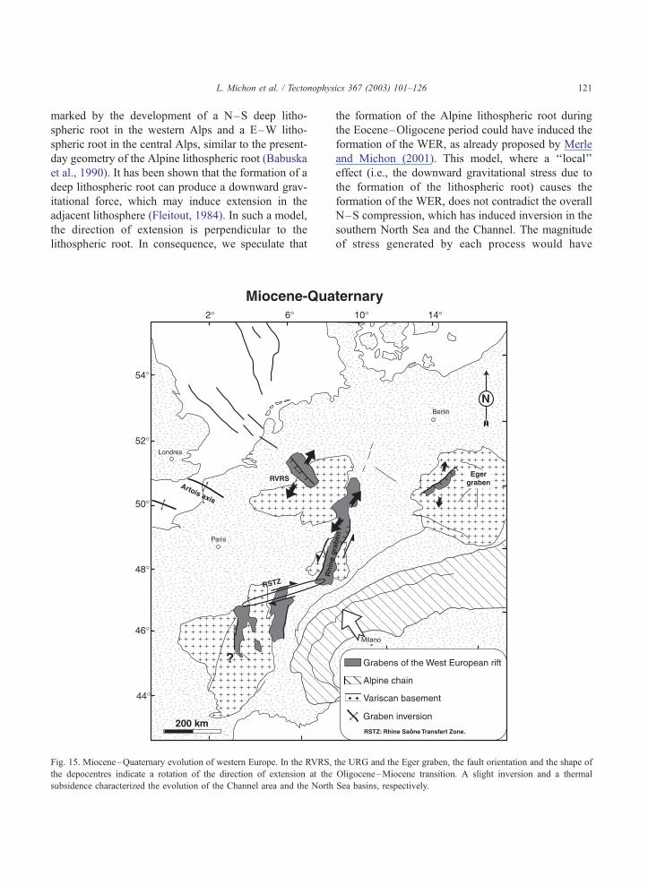
Fig. 15. Miocene–Quaternary evolution of western Europe. In the RVRS,
the depocentres indicate a rotation of the direction of extension at the
subsidence characterized the evolution of the Channel area and the North
the formation of the Alpine lithospheric root during
the Eocene–Oligocene period could have induced the
formation of the WER, as already proposed by Merle
and Michon (2001). This model, where a ‘‘local’’
effect (i.e., the downward gravitational stress due to
the formation of the lithospheric root) causes the
formation of the WER, does not contradict the overall
N–S compression, which has induced inversion in the
southern North Sea and the Channel. The magnitude
of stress generated by each process would have
the URG and the Eger graben, the fault orientation and the shape of
Oligocene–Miocene transition. A slight inversion and a thermal
Sea basins, respectively.
L. Michon et al. / Tectonophysics 367 (2003) 101–126122
controlled the location of the areas affected by com-
pression or extension.
5.6. Miocene–Quaternary
The RVRS, the Eger graben and the URG sub-
sided more or less continuously during the Oligo-
cene–Quaternary evolution. However, the Oligo-
cene–Miocene transition was marked by a radical
change in the European geodynamics. In the RVRS,
the northwestward migration of the depocentre and
the orientation of the most active faults indicate a
counter clockwise rotation of 70–80j of the direc-
tion of extension (i.e., NE–SW extension) (Fig. 15).
A similar rotation has been described for the north-
ern part of the URG where new depocentres devel-
oped (Meier and Eisbacher, 1991; Schumacher,
2002). These new depocentres are interpreted in
terms of pull-apart basins resulting from sinistral
strike slip faulting (Illies, 1981). In the Eger graben,
the depocentre shapes in the Cheb sub-basin, which
are different for the Late Oligocene–Earliest Mio-
cene and Miocene–Pliocene periods (Spicakova et
al., 2000), suggest a change of the stress field
around the Oligocene–Miocene transition and an
identical stress field for the Middle Miocene and
Late Pliocene periods. In the Massif Central, the
Miocene–Quaternary evolution was characterized by
a strong uplift of the whole area, which makes a
determination of the regional stress field in this
province difficult. Preservation of Miocene sedi-
ments below lava flows shows that the complete
Miocene sedimentation was very thin and restricted
to elongated narrow lakes parallel to the grabens
(Hugueney et al., 1999). In the Bresse graben,
although sedimentation developed during the Mio-
cene–Quaternary evolution, a westward propagation
of the Alpine flexural basin was proposed to explain
this subsidence (Merle et al., 1998). Finally, the
displacement along the Rhine–Saone transfer zone,
which was a left lateral fault zone during the Late
Eocene and the Oligocene, has changed at the
Oligocene–Miocene transition and became right lat-
eral (Laubscher, 2001).
In the north, the southern North Sea basins con-
tinued to subside during this period. Seismic data
reveals that minor fault activity has affected the Neo-
gene sediments (Brun and Nalpas, 1996; Van Balen et
al., 2000), suggesting a continuous thermal subsi-
dence. Nevertheless, the acceleration of the subsi-
dence from the Pliocene could be explained by an
accentuation of the thermal subsidence by a NW–SE
in-plane force (Van Balen et al., 1998). Whatever the
origin of this subsidence increase, geological and
geophysical data clearly show that the tectonic activ-
ity related to the evolution of the WER stops in the
northern end of the RVRS (Fig. 1). In the Channel
area, inversion was maximum during Early Miocene
but is still ongoing during the Quaternary (Ziegler,
1990).
Geological and geophysical data indicate that the
present-day stress field in western Europe is charac-
terized by a NW–SE to NNW–SSE maximum com-
pressive stress (Muller et al., 1992; Plenefisch and
Bonjer, 1997). Analysis of the earthquake focal
mechanism data in the UGR and the RVRS shows
that this maximum compressive stress induces left
lateral displacement in the southern and central URG,
whereas it causes NE–SW extension in the northern
end of the URG and in the RVRS (Plenefisch and
Bonjer, 1997).
In consequence, we interpret the general evolution
of western Europe during the Miocene–Quaternary
period as the result of the NW–SE collision between
Europe and Africa (Fig. 16). In this model, the URG
and the RVRS concentrate the main deformation.
Due to the NW–SE compression, the URG is reac-
tivated as a strike slip structure, which induced rifting
in its northern ending and in the RVRS. This leads to
the individualization of two crustal domains. Al-
though the NE–SW relative motion of these crustal
domains is assessable, the lack of precise and reliable
geodetic data does not allow determination of the
absolute motion of each domain. One can speculate
that the Baltic shield, situated east of the northeastern
domain, probably prevents the northeastern motion of
this block. Consequently, the southwestern crustal
domain was forced to migrate toward the southwest.
The subsidence in the North Sea basins could result
from the northward prolongation of a diffuse exten-
sion.
One fundamental feature is the change of the
global deformation of the European lithosphere at
the Oligocene–Miocene transition. Assuming that
the Late Eocene–Oligocene extension was induced
by the formation of a deep Alpine lithospheric root,
Fig. 16. Schematic evolution during the Neogene. The direction of extension could be explained by the NW–SE compression related to the
Alpine collision. See text for explanation.
L. Michon et al. / Tectonophysics 367 (2003) 101–126 123
we propose that the Alpine chain was proned to a slab
break-off at the Oligocene–Miocene transition. Such
a slab break-off was already invoked by Von Blanck-
enburg and Davies (1995) to explain the development
of the Tertiary magmatism in the central and eastern
Alps between 42 and 25 Ma. However, they dated it at
around 40 Ma. In the western Alps, geological data
not show either magmatism or a radical change in the
Alpine kinematics at this time. In contrast, the Oligo-
cene–Miocene transition (25 Ma) corresponds to the
beginning of thrusting of the external crystalline
massifs and the reactivation of the Brianc�onnais frontin normal faulting mode (Tricart et al., 2001). Then,
we consider that the coeval change in the Alpine chain
and western Europe could result from a slab detach-
ment below the western Alps. This slab break-off at
the Oligocene–Miocene transition could explain the
stop of the Late Eocene–Oligocene extension and the
development of the NW–SE maximum compres-
sional stress, which controls the European deforma-
tion since the beginning of the Miocene.
Acknowledgements
This publication is a contribution of the Environ-
mental Tectonic (ENTEC) European Project funded
by EU (RTN-1999-00003) and the INSU IT Project
‘‘Deformations lithospheriques grande longueur
d’onde cenozoıques de l’Europe de l’Ouest’’. P.A.
Ziegler and Iwan de Lugt are thanked for interesting
discussions. With the courtesy of Clyde Petroleum BV
to publish several wells. Thanks are also given to
Francois Roure, Jean-Pierre Burg and an anonymous
reviewer who helped in the improvement of the
manuscript.
Appendix A (continued)
Number Name Date Total
depth
L. Michon et al. / Tectonophysics 367 (2003) 101–126124
Appendix A
ROvD: Dienst der Rijksopsporing van Delfstoffen.
Number Name Date Total
depth
(m)
1 Werkendam-1
(WED-01)
1958 2275 Zijerveld et al.
(1992)
2 Waalwijk-1
(WWK-01)
1987 3802 NITG-TNO (2001)
3 Oisterwijk-1
(OIW-01)
1967 2496 Zijerveld et al.
(1992)
4 St-Michielsgestel-1
(SMG-01)
1969 3338 Zijerveld et al.
(1992)
5 Heeswijk-1
(HSW-01)
1992 2544 Clyde Petroleum
6 Keldonk-1
(KDK-01)
1992 2330 Clyde Petroleum
7 Veldhoven-1
(VEH-01)
1967 2124 Zijerveld et al.
(1992)
8 Asten-1
(AST-01)
1967 2664 Zijerveld et al.
(1992)
9 Asten-2
(AST-02)
1992 1673 NITG-TNO (2001)
10 Nederweert-1
(NDW-01)
1965 2943 Zijerveld et al.
(1992)
11 Molenbeersel-198 1988 1773 Demyttenaere and
Laga (1988)
12 Oploo-16
(OPL-16)
1913 1150 Zijerveld et al.
(1992)
13 America-11
(ACA-11)
1910 1201 Zijerveld et al.
(1992)
14 Neer-71
(NER-71)
1953 1293 DSM Energie
15 Elmpt-77
(EPT-77)
1958 1215 DSM Energie
16 Melick-
Herkenbosch-70
(MHB-70)
1955 524 NITG-TNO (2001)
17 Arcen-1
(ARC-01)
1987 888 Rijks Geologische
Dienst
18 Beesel-72
(BEE-72)
1954 1234 DSM Energie
19 Belfeld-14
(BFD-74)
1911 1202 Zijerveld et al.
(1992)
20 Broekzijde-1
(BKZ-01)
1989 2703 Clyde Petroleum
21 Cornelishof-4
(CNH-04)
1905 679 ROvD
22 Dongen-1
(DON-01)
1997 1542 Zijerveld et al.
(1992)
23 Dorothea-1 1907 309 Krusch and
Wunstorf (1907)
(m)
24 Emmerich-1 1962 1449 Elberskirch and
Wolburg (1962)
25 Helden-75
(HDN-75)
1955 1353 NITG-TNO (2001)
26 Helenaveen-7
(HEL-07)
1907 1155 ROvD
27 Hilvarenbeek-1
(HVB-01)
1995 2621 Clyde Petroleum
28 Kerkwijk-1
(KWK-01)
1988 3281 NITG-TNO (2001)
29 Liessel-22
(LIE-22)
1915 1332 Zijerveld et al.
(1992)
30 Loon op Zand-1
(LOZ-01)
1953 3062 Zijerveld et al.
(1992)
31 Maasbommel-2
(MSB-02)
1966 1278 Zijerveld et al.
(1992)
32 Maasniel-74
(MAN-74)
1955 1367 DSM Energie
33 Nijmegen-
Valburg-1
(NVG-01)
1968 1277 Zijerveld et al.
(1992)
34 Reuver-76
(RVR-76)
1956 1105 DSM Energie
35 Rijsbergen-1
(RSB-01)
1970 4645 NITG-TNO (2001)
36 Sanadome-1
(SNM-499)
1994 759
37 Steelhoven-1
(STH-01)
1987 2798 NITG-TNO (2001)
38 Strijen-1
(STR-01)
1964 2779 American Overseas
Petroluem
39 Vlodrop-1
(VDP-01)
1906 790 ROvD
40 Waspik-1
(WAP-01)
1959 2600 Zijerveld et al.
(1992)
41 Almerk-1
(ALM-01)
1970 2370 Zijerveld et al.
(1992)
References
Babuska, V., Plomerova, J., Granet, M., 1990. The deep lithosphere
in the Alps: a model inferred from P residuals. Tectonophysics
176, 137–165
Barbarand, J., Carter, A., Pagel, M., 2002. Histoire thermotectoni-
que mesocenozoıque du Massif Central—Consequence sur la
deformation de la lithosphere de l’Europe de l’Ouest. 19eme
RST, Nantes, pp. 55–56.
Bergerat, F., 1985. Deformations cassantes et champs de contraintes
tertiaires dans la plate-forme europeenne. Thesis, P.M. Curie
Univ. 315 pp.
L. Michon et al. / Tectonophysics 367 (2003) 101–126 125
Brun, J.P., Nalpas, T., 1996. Graben inversion in nature and experi-
ments. Tectonics 15, 677–687.
Chlupac, I., Kodym, O., Suk, M., Holub, V., Elias, M., Cicha, I.,
Malkowsky, M., Tyracek, J., Mencik, E., Buday, T., 1984.
Stratigraphic development of the units. In: Suk, M., et al.,
(Eds.), Geological History of the Territory of the Czech Socialist
Republic. Geological survey, Prague, pp. 87–200.
Coulon, M., 1992. La distension oligocene dans le nord-est du
bassin de Paris (perturbation des directions d’extension et dis-
tribution des stylolites). Bull. Soc. Geol. Fr. 163, 531–540.
de Lugt, I.R., van Wees, J.D., Wong, Th.E., 2003. The tectonic
evolution of the southern Dutch North Sea during the Paleo-
gene: a case study for basin inversion in pulses. Tectonophysics.
Demyttenaere, R., Laga, P., 1988. Breuken en isohypsenkaarten van
het Belgische gedeelte van de Roerdal Slenk. Belgische Geo-
logische Dienst Professional Paper, 1988/4, 234, 20 pp.
Duchene, S., Blichert-Toft, J., Luais, B., Telouk, P., Lardeaux, J.M.,
Albarede, F., 1997. The Lu–Hf dating of garnets and the ages of
the alpine high-pressure metamorphism. Nature 387, 586–589.
Elberskirch, W., Wolburg, J., 1962. Zur Tektonik des Karbons am
linken Niederrhein im Profil der Bohrungen Wachtendonk 1-
Emmerich 1. Fortschr. Geol. Rheinld. u. Westf. 6, 407–432.
Fleitout, L., 1984. Modelisation des contraintes tectoniques et des
instabilites thermomecaniques dans la lithosphere. Thesis, Orsay
University. 433 pp.
Geluk, M.C., Duin, E.J., Dusar, M., Rijkers, R.H, van den Berg,
M.W., van Rooijen, P., 1994. Stratigraphy and tectonics of the
Roer Valley Graben. Geol. Mijnb. 73, 129–141.
Gras, R., Geluk, M., 1999. Late Cretaceous–Early Tertiary sedi-
mentation and tectonic inversion in the southern Netherlands.
Geol. Mijnb. 78, 1–19.
Hippolyte, J.C., Angelier, J., Bergerat, F., Nury, D., Guieu, G.,
1993. Tectonic– stratigraphic record of paleostress time changes
in the Oligocene basins of the Provence, southern France. Tec-
tonophysics 226, 15–35.
Houtgast, R.F., Van Balen, R.T., 2000. Neotectonics of the Roer
Valley Rift System, the Netherlands. Global Planet. Change 27,
131–146.
Hugueney, M., Poidevin, J.L., Bodergat, A.M., Caron, J.B., Guerin,
C., 1999. Des mammiferes de l’Aquitanien inferieur a La
Roche-Banche-Gergovie (Puy-de-Dome, France), revelateurs
de l’activite post-oligocene du rift en Limagne de Clermont.
C. R. Acad. Sci. Paris 328, 847–852.
Illies, J.H., 1981. Mechanism of graben formation. Tectonophysics,
249–266.
Krusch, P., Wunstorf, W., 1907. Das Steinkohlengebiet nordostlich
der Roer nach den Ergebnisse der Tiefbohrungen und verglichen
mit dem Cardiff-District. Gluckauf 43, 425–436.
Lake, S.D., Karner, G.D., 1987. The structure and the evolution of
the Wessex Basin, southern England: an example of inversion
tectonics. Tectonophysics 137, 347–378.
Laubscher, H., 2001. Plate interactions at the southern end of the
Rhine graben. Tectonophysics 343, 1–19.
Lefort, J.P., Agarwal, B.N.P., 1996. Gravity evidence for Alpine
buckling of the crust beneath the Paris Basin. Tectonophysics
258, 1–14.
Le Griel, A., 1988. L’evolution geomorphologique du Massif Cen-
tral franc�ais. Essai sur la genese d’un relief. Thesis, Lyon II
Univ. 569 pp.
Lickorish, W.H., Ford, M., Burgisser, J., Cobbold, P.R., 2002. Arc-
uate thrust systems in sandbox experiments: a comparison to the
external arcs of the Western Alps. Geol. Soc. Am. Bull. 114,
1089–1107.
Malkovsky, M., 1987. The Mesozoic and Tertiary basins of the
Bohemian Massif and their evolution. Tectonophysics 137,
31–42.
Meier, L., Eisbacher, G.H., 1991. Crustal kinematics and deep
structures of the northern Rhine Graben, Germany. Tectonics
10, 621–630.
Merle, O., Michon, L., 2001. The formation of the West European
rift: a new model as exemplified by the Massif Central area.
Bull. Soc. Geol. Fr. 172 (2), 213–221.
Merle, O., Michon, L., Camus, G., de Goer, A., 1998. L’extension
oligocene sur la transversale septentrionale du rift du Massif
Central. Bull. Soc. Geol. Fr. 169, 615–626.
Meyer, W., Albers, H.J., Berners, H.P., Gehlen, K., Glatthaar, D.,
Lohnertz, W., Pfeffer, K.H., Schnutgen, K., Wienecke, K., Za-
kosek, H., 1983. Pre-Quaternary uplift in the Central part of the
Rhenish Shield. In: Fuchs, K., Von Gelhen, K., Malzer, H.,
Murawski, H., Semmel, A. (Eds.), Plateau Uplift. The Renish
Shield—A Case History. Springer-Verlag, Berlin, pp. 39–46.
Michon, L., 2001. Dynamique de l’extension continentale—appli-
cation au Rift Ouest Europeen par l’etude de la province du
Massif Central. Mem. Geosci. Rennes 99, 266 pp.
Michon, L., Merle, O., 2001. The evolution of the Massif Central
rift: spatio-temporal distribution of the volcanism. Bull. Soc.
Geol. Fr. 172, 201–211.
Monie, P., Philippot, P., 1989. Mise en evidence de l’age Eocene
moyen du metamorphisme de haute-pression dans la nappe
ophiolitique du Monviso (Alpes occidentales) par la methode39Ar–40Ar. C. R. Acad. Sci. Paris 309, 245–251.
Muller, B., Zoback, M.L., Fuchs, K., Mastin, L., Gregersen, S.,
et al., 1992. Regional patterns of tectonics stress in Europe. J.
Geophys. Res. 97, 11783–11803.
Murawski, H., Albers, H.J., Bender, P., Berners, H.P., Durr, St.,
Huckriede, R., Kauffmann, G., Kowalczyk, G., Meiburg, P.,
Muller, R., Ritzkowski, S., Schwab, K., Semmel, A., Stapf,
K., Walter, R., Winter, K.P., Zankl, H., 1983. Regional tec-
tonic setting and geological structure of the Rhenish Massif.
In: Fuchs, K., von Gelhen, K., Malzer, H., Murawski, H.,
Semmel, A. (Eds.), Plateau Uplift. The Renish Shield—A
Case History. Springer-Verlag, Berlin, pp. 9–38.
Nederlandse Aardolie Maatschappij BV, Rijks Geologische Dienst,
1980. Stratigraphic nomenclature of the Netherlands. Verh. K.
Ned. Geol. Mijnbouwkd. Genoot. 32, 77 pp.
NITG-TNO, 2001. Geological Atlas of the Subsurface of the Neth-
erlands: Explanation of map sheet XIII and XIV Breda-Valkens-
waard and Oss-Roermond. NITG-TNO, Utrecht. 149 pp.
Oudmayer, B., De Jager, J., 1993. Fault reactivation and oblique-
slip in the Southern North Sea. In: Parker, J.R. (Ed.), Petroleum
Geology of Northwest Europe. Proceedings of the 4th Confer-
ence Geol. Soc., London, pp. 1281–1290.
Peterek, A., Rauche, H., Schroder, B., Franzke, H.-J., Bankwitz, P.,
Bankwitz, E., 1997. The late- and post-Variscan tectonic evolu-
L. Michon et al. / Tectonophysics 367 (2003) 101–126126
tion of the Western Border fault zone of the Bohemian massif
(WBZ). Geol. Rundsch. 86, 191–202.
Plenefisch, T., Bonjer, K.P., 1997. The stress field in the Rhine
Graben area inferred from earthquake focal mechanisms and
estimation of frictional parameters. Tectonophysics 275,
71–97.
Racero-Baena, A., Drake, J., 1996. Structural style and reservoir
development in the West Netherlands oil province. In: Rondeel,
H.E., Batjes, D.A.J., Nieuwenhuijs, W.H. (Eds.), Geology of Gas
and Oil Under the Netherlands. Kluwer Academic Publishing,
Dordrecht, pp. 211–227.
Rat, P., 1974. Le systeme Bourgogne–Morvan–Bresse (articula-
tion entre le bassin parisien et le domaine peri-alpin). In: De-
belmas, J. (Ed.), Geologie de la France; les chaınes plissees du
cycle alpin et leur avant-pays. Doin, Paris, pp. 480–500.
Roure, F., Coletta, B., 1996. Cenozoic inversion structures in the
foreland of the Pyrenees and Alps. In: Ziegler, P.A., Horvath, F.
(Eds.), Peri-Tethys Memoir 2: Structure and Prospects of Alpine
Basins and Forelands. Mem. Mus. Natn. Hist. Nat., vol. 170,
pp. 173–209.
Schumacher, M.E., 2002. Upper Rhine Graben: role of preexisting
structures during rift evolution. Tectonics 21, 6.1–6.17.
Sclater, J.G., Christie, P.A.F., 1980. Continental stretching: an ex-
planation of post-mid-Cretaceous subsidence of the North Sea
Basin. J. Geophys. Res. 85, 3711–3739.
Seranne, M., 1999. The Gulf of Lion continental margin (NW
Mediterranean) revisited by IBS: an overview. In: Durand, B.,
Jolivet, L., Horvath, F., Seranne, M. (Eds.), The Mediterranean
Basins: Tertiary Extension within the Alpine Orogen. Geol. Soc.
Lond. Spec. Publ., vol. 156, pp. 15–36.
Sissingh, W., 1998. Comparative Tertiary stratigraphy of the Rhine
Graben, Bresse Graben and Molasse Basin: correlation of Al-
pine foreland events. Tectonophysics 300, 249–284.
Spicakova, L., Ulicny, D., Koudelkova, G., 2000. Tectonosedimen-
tary evolution of the Cheb basin (NWBohemia, Czech Republic)
between Late Oligocene and Pliocene: a preliminary note. Stud.
Geophys. Geod. 44, 556–580.
Tapponnier, P., 1977. Evolution tectonique du systeme alpin en
Mediterranee: poinc�onnement et ecrasement rigide-plastique.
Bull. Soc. Geol. Fr. 19, 437–460.
Tilton, G.R., Schreyer, W., Schertl, H.P., 1991. Pb–Sr–Nd iso-
topic behavior of deeply subducted crustal rocks from the Dora
Maira Massif, Western Alps, Italy: II. What is the age of the
ultrahigh-pressure metamorphism? Contrib. Mineral. Petrol.
108, 22–33.
Tricart, P., Schwartz, S., Sue, C., Poupeau, G., Lardeaux, J.M.,
2001. La denudation tectonique de la zone ultradauphinoise et
l’inversion du front brianc�onnais au sud-est du Pelvoux (Alpes
occidentales): une dynamique miocene a actuelle. Bull. Soc.
Geol. Fr. 172, 49–58.
Van Balen, R.T., Podladchikov, Y.Y., Cloetingh, S.A.P.L., 1998. A
new multilayered model for intraplate stress-induced differential
subsidence of faulted lithosphere, applied to rifted basins. Tec-
tonics 17, 938–954.
Van Balen, R.T., Van Bergen, F., de Leeuw, C., Pagnier, H.,
Simmelink, H., Van Wees, J.D., Verweij, J.M., 2000. Model-
ling the hydrocarbon generation and migration in the West
Netherlands Basin, the Netherlands. Geol. Mijnb., Neth. J.
Geosci. 79, 29–44.
Van Balen, R.T., Verweij, J.M., Van Wees, J.D., Simmelink, H., Van
Bergen, F., Pagnier, H., 2002. Deep subsurface temperatures in
the Roer Valley Graben and the Peel Block, the Netherlands—
new results. Neth. J. Geosci., Geol. Mijnb. 81, 19–26.
Van Hinte, J.E., 1978. Geohistory analysis—application of micro-
paleontology. Am. Assoc. Pet. Geol. Bull. 62, 201–222.
Verbeek, J.W., de Leeuw, C.S., Parker, N., Wong, Th.E., 2002.
Characterisation and correlation of Tertiary seismostratigraphic
units in the Roer Valley Graben. Geol. Mijnb., Neth. J. Geosci.
81, 159–166.
Villemin, T., Bergerat, F., 1987. L’evolution structurale du fosse
rhenan au cours du Cenozoıque: un bilan de la deformation et
des effets thermiques de l’extension. Bull. Soc. Geol. Fr. 3,
245–255.
Von Blanckenburg, F., Davies, J.H., 1995. Slab breakoff: a model
for syncollisional magmatism and tectonics in the Alps. Tecton-
ics 14, 120–131.
Winstanley, A.M., 1993. A review of the Triassic play in the Roer
Valley Graben, SE onshore Netherlands. In: Parker, J.R. (Ed.),
Petroleum Geology of Northwest Europe. Proceedings of the 4th
Conference Geol. Soc., London, pp. 595–607.
Zagwijn, W.H., 1989. The Netherlands during the Tertiary and the
Quaternary: a case history of coastal lowland evolution. Geol.
Mijnb. 68, 107–120.
Ziegler, P.A., 1988. Evolution of the Artic North Atlantic and the
western Tethys. Am. Assoc. Pet. Geol. Mem. 43, 198 pp.
Ziegler, P.A., 1990. Geological atlas of western and central Europe,
2nd ed. Shell Internationale Petroleum Mij., distributed by Geol.
Soc., London, Publ. House, Bath. 238 pp., 56 encl.
Ziegler, P.A., 1992a. North Sea rift system. In: Ziegler, P.A. (Ed.),
Geodynamics of Rifting, Volume I. Case History Studies on
Rifts: Europe and Asia. Tectonophysics, vol. 208, pp. 55–75.
Ziegler, P.A., 1992b. European Cenozoic rift system. In: Ziegler,
P.A. (Ed.), Geodynamics of Rifting, Volume I. Case History
Studies on Rifts: Europe and Asia. Tectonophysics, vol. 208,
pp. 91–111.
Ziegler, P.A., Roure, F., 1996. Architecture and petroleum systems
of the Alpine orogen and associated basins. In: Ziegler, P.A.,
Horvath, F. (Eds.), Peri-Tethys Memoir 2: Structure and Pros-
pects of Alpine Basins and Forelands. Mem. Mus. Natn. Hist.
Nat., vol. 170, pp. 15–45.
Zijerveld, L., Stephenson, R., Cloetingh, S., Duin, E., Van den
Berg, M.W., 1992. Subsidence analysis and modelling of the
Roer Valley Graben (SE Netherland). Tectonophysics 208,
159–171.