the cretaceous and cenozoic tectonic evolution of southeast
TRANSCRIPT
Solid Earth Discuss., 5, 1335–1422, 2013www.solid-earth-discuss.net/5/1335/2013/doi:10.5194/sed-5-1335-2013© Author(s) 2013. CC Attribution 3.0 License.
EGU Journal Logos (RGB)
Advances in Geosciences
Open A
ccess
Natural Hazards and Earth System
Sciences
Open A
ccess
Annales Geophysicae
Open A
ccess
Nonlinear Processes in Geophysics
Open A
ccess
Atmospheric Chemistry
and Physics
Open A
ccess
Atmospheric Chemistry
and Physics
Open A
ccess
Discussions
Atmospheric Measurement
Techniques
Open A
ccess
Atmospheric Measurement
Techniques
Open A
ccess
Discussions
Biogeosciences
Open A
ccess
Open A
ccess
BiogeosciencesDiscussions
Climate of the Past
Open A
ccess
Open A
ccess
Climate of the Past
Discussions
Earth System Dynamics
Open A
ccess
Open A
ccess
Earth System Dynamics
Discussions
GeoscientificInstrumentation
Methods andData Systems
Open A
ccess
GeoscientificInstrumentation
Methods andData Systems
Open A
ccess
Discussions
GeoscientificModel Development
Open A
ccess
Open A
ccess
GeoscientificModel Development
Discussions
Hydrology and Earth System
Sciences
Open A
ccess
Hydrology and Earth System
Sciences
Open A
ccess
Discussions
Ocean Science
Open A
ccess
Open A
ccess
Ocean ScienceDiscussions
Solid Earth
Open A
ccess
Open A
ccess
Solid EarthDiscussions
The Cryosphere
Open A
ccess
Open A
ccess
The CryosphereDiscussions
Natural Hazards and Earth System
Sciences
Open A
ccess
Discussions
This discussion paper is/has been under review for the journal Solid Earth (SE).Please refer to the corresponding final paper in SE if available.
The Cretaceous and Cenozoic tectonicevolution of Southeast AsiaS. Zahirovic, M. Seton, and R. D. Müller
EarthByte Group, School of Geosciences, The University of Sydney, Sydney, NSW 2006,Australia
Received: 2 August 2013 – Accepted: 11 August 2013 – Published: 21 August 2013
Correspondence to: S. Zahirovic ([email protected])
Published by Copernicus Publications on behalf of the European Geosciences Union.
1335
Abstract
Tectonic reconstructions of Southeast Asia have given rise to numerous controversieswhich include the accretionary history of Sundaland and the enigmatic tectonic origin ofthe Proto South China Sea. We assimilate a diversity of geological and geophysical ob-servations into a new regional plate model, coupled to a global model, to address these5
debates. Our approach takes into account terrane suturing and accretion histories, thelocation of subducted slabs imaged in mantle tomography in order to constrain theopening and closure history of paleo-ocean basins, as well as plausible absolute andrelative plate velocities and tectonic driving mechanisms. We propose a scenario of rift-ing from northern Gondwana in the Late Jurassic, driven by northward slab pull, to de-10
tach East Java, Mangkalihat, southeast Borneo and West Sulawesi blocks that collidedwith a Tethyan intra-oceanic subduction zone in the mid Cretaceous and subsequentlyaccreted to the Sunda margin (i.e. southwest Borneo core) in the Late Cretaceous. Inaccounting for the evolution of plate boundaries, we propose that the Philippine SeaPlate originated on the periphery of Tethyan crust forming this northward conveyor. We15
implement a revised model for the Tethyan intra-oceanic subduction zones to recon-cile convergence rates, changes in volcanism and the obduction of ophiolites. In ourmodel the northward margin of Greater India collides with the Kohistan-Ladakh intra-oceanic arc at ∼ 53 Ma, followed by continent-continent collision closing the Shyok andIndus-Tsangpo suture zones between ∼42 and 34 Ma.20
We also account for the back-arc opening of the Proto South China Sea from∼65 Ma, consistent with extension along east Asia and the emplacement of supra-subduction zone ophiolites presently found on the island of Mindoro. The related riftinglikely detached the Semitau continental fragment from east China, which accreted tonorthern Borneo in the mid Eocene, to account for the Sarawak Orogeny. Rifting then25
re-initiated along southeast China by 37 Ma to open the South China Sea, resulting inthe complete consumption of Proto South China Sea by ∼17 Ma when the collision ofthe Dangerous Grounds and northern Palawan blocks with northern Borneo choked
1336
the subduction zone to result in the Sabah Orogeny and the obduction of ophiolites inPalawan and Mindoro. We conclude that the counterclockwise rotation of Borneo wasaccommodated by oroclinal bending consistent with paleomagnetic constraints, thecurved lithospheric lineaments observed in gravity anomalies of the Java Sea and thecurvature of the Cretaceous Natuna paleo-subduction zone. We complete our model5
by constructing a time-dependent network of continuously closing plate boundariesand gridded paleo-ages of oceanic basins, allowing us to test our plate model evo-lution against seismic tomography. In particular, slabs observed at depths shallowerthan ∼1000 km beneath northern Borneo and the South China Sea are likely to beremnants of the Proto South China Sea basin.10
1 Introduction
Southeast Asia is an accretionary mosaic of continental fragments, seamounts, ex-otic terranes and intra-oceanic island arcs that were welded to the Asian continent,presently delineated by suture zones and remnants of ancient Tethyan and proto-Pacific ocean basins that once separated them (Şengör et al., 1988; Metcalfe, 2011;15
Veevers, 2004; Stauffer, 1983) (Fig. 1). The tectonic framework of Southeast Asia isinherited from the long-term convergence between the Australian, (proto-) Pacific andEurasian plates and the cyclical Gondwana-derived terrane detachment and subse-quent accretion onto Eurasia and the Sundaland core (Acharyya, 1998; Golonka, 2004;Stampfli and Borel, 2002; Hall, 2002; Metcalfe, 2006; Veevers et al., 1991). The north-20
ern Gondwana margin, as the origin for many of the Asian continental fragments, wasa passive boundary for much of the Mesozoic, with periodic rifting events that carriedcontinental slivers on the Tethyan conveyors to be accreted to the Eurasian margin(Audley-Charles, 1988; Veevers et al., 1991; Seton et al., 2012).
The Sundaland core, forming much of the Sunda shelf and continental promontory in25
Southeast Asia (Fig. 2), is largely comprised of the Cimmerian terranes that rifted fromGondwana at early Permian times (Metcalfe, 2011) and accreted diachronously along
1337
the Eurasian margin during the Triassic and Jurassic (Golonka, 2007; Metcalfe, 1999;Seton et al., 2012; Stampfli and Borel, 2002) to open the MesoTethys at the expenseof the PaleoTethys (Table 1). A Late Jurassic rifting episode along northern Gondwanalikely detached continental fragments including West Sulawesi, Mangkalihat, East Java,parts of Borneo (Hall, 2011; Metcalfe, 2011; Wakita, 2000) and other potential micro-5
continents such as Sikuleh, Natal, Lolotoi and Bengkulu (Acharyya, 1998; Metcalfe,1996), to open the NeoTethys. However, the origin of these blocks on the northernGondwana margin is controversial, in particular whether they all originated from theArgo Abyssal Plain, hence the “Argoland” name applied to blocks originating here,on the northwest Australian shelf, or whether some of these blocks originated from the10
New Guinea or even Greater Indian passive margin. In addition, the nature of the micro-continents on Sumatra has been disputed and recent studies have argued that theseare more likely to be accreted intra-oceanic island arcs with no continental basementor affinity (Barber, 2000; Barber and Crow, 2003, 2009).
Although oceanic crust adjacent to the northwest Australian shelf records15
NeoTethyan seafloor spreading, only dismembered fragments of obducted oceaniccrust in suture zones gives a glimpse of the older Meso- and Paleo- Tethyan oceanicdomains (Seton et al., 2012). For example, the only remnant of the latest Jurassicseafloor spreading is contained in the obducted basement of the Irian ophiolite, likelypreserved in an embayment along New Guinea (Hill and Hall, 2003). The lack of20
preserved seafloor spreading histories results in uncertain origins of many terranespresently found in Southeast Asia. As a result, we flag instances where alternative tec-tonic scenarios can explain the piecemeal data coverage in the absence of conclusivepre-breakup fits. This region, as the link between the Tethys and (proto-) Pacific, iscomplex also because of the uncertain nature of plate boundaries that accommodated25
generally westward subduction of (proto-) Pacific oceanic crust beneath east Asia andthe overall northward subduction of Tethyan seafloor beneath southern Eurasia. Muchof the accretionary events and convergence histories between the Indo-Australian, Pa-cific and Eurasian plates are recorded in the tectonic fabric of Sundaland. In addition,
1338
a large portion of Sundaland is submerged and remote (Fig. 2), resulting in uncer-tain tectonic histories of accreted blocks – including their origin, tectonic stability andaccretionary chronology. In particular, the development of Borneo since the Late Cre-taceous is intricately linked to the opening and closure of the Proto South China Seaand its successor, the South China Sea (Hutchison, 1996), as well as the collision of5
micro-continental fragments and island arcs from the south and east.We present a plate motion model of the evolution of Sundaland in the context of ter-
rane accretions, island arc collisions and the opening and closure of marginal seas. Weassimilate a diverse range of geological and geophysical data, and draw on previously-published kinematic models, to reconcile the chronology and tectonic evolution of the10
latest Jurassic rifting event from northern Gondwana and the subsequent accretionand growth of Sundaland since the Cretaceous. In addition, we use seismic tomo-graphic constraints to estimate paleo-locations of subduction zones in the region. Themodel we present invokes long-lived north-dipping subduction along Eurasia duringthe Jurassic and Cretaceous, with micro-continental slivers detaching from northern15
Gondwana and accreting to Sundaland. We provide the digital files (rotations, tec-tonic elements including digitized ophiolite belts, volcanic and tectonic features) andtools in order to test and improve the model (plate reconstruction software, GPlates,http://www.gplates.org).
2 Methodology20
We assimilate geological data and previously-published models of extensional tec-tonic settings, shallow marine paleobiogeography, basaltic volcanism and the emplace-ment (crystallization) of ophiolites to constrain rifting events along northern Gondwana.Proxies of convergence including subduction-related volcanics and metamorphic belts(Fig. 3) are used to infer subduction polarities, and collisional events are inferred25
from the spatio-temporal distribution of ophiolite obduction episodes, high pressure-temperature metamorphism and orogenies. Our base global plate motion model in-
1339
cludes relative plate motions for Southeast Asia based on the syntheses of Lee andLawver (1994, 1995), Hall (1996, 2002, 2012), Metcalfe (1994, 1996, 1999, 2011),Golonka (2004, 2007), Golonka et al. (2006) and other data and models described inSeton et al. (2012). We incorporate a range of datasets and models specific to South-east Asia, and in particular the development of evolution of Sundaland, the South China5
Sea, the Philippine arcs and the accretionary history of northern New Guinea (Table 2).We supplement geological evidence and previously-published models with additional
criteria of convergence rate thresholds, geometric rules of triple junction closure andevolving plate boundaries (Fig. 4). Firstly, no part of a plate is allowed to have veloci-ties exceeding 25 cmyr−1, following the velocity threshold used by Stampfli and Borel10
(2002). Secondly, mid-ocean ridge triple junctions in an RRR configuration (as in oureastern Tethys model) must accommodate seafloor spreading on all three arms fol-lowing McKenzie and Morgan (1969). Thirdly, changes in relative plate motions canalter the type of plate boundary, for example, the predecessor to the (Proto) Izu-Bonin-Mariana Arc is a transform that eventually becomes a west-dipping subduction zone15
consuming Pacific crust, following the model of Casey and Dewey (1984) and Stern andBloomer (1992). In the eastern Tethys we invoke the conversion of transform boundaryto a spreading center following a change in relative plate motions from strike-slip toextensional, following the analogue of the San Andreas strike-slip boundary in the Gulfof California between ∼ 6 and 2 Ma to an oblique extensional plate boundary, resulting20
in seafloor spreading and the transfer of the Baja Peninsula from North America to thePacific (Karig and Jensky, 1972). Lastly, plate boundary configurations must be consis-tent with relative plate motions – for example, convergence between two plates mustbe accommodated by subduction or orogenesis, extension along rifts or mid-oceanicridges, and conservation of crust along transforms.25
We implement a new model for the intra-oceanic subduction in the NeoTethys, basedon the models of Ali and Aitchison (2008), Zahirovic et al. (2012), Burg (2011) andrecent data and interpretations from Bouilhol et al. (2013) to link the intra-oceanic sub-duction in the central NeoTethys involving the Kohistan-Ladakh arc system (i.e. ac-
1340
commodating India–Eurasia convergence) eastward to the Woyla back-arc along WestBurma and Sumatra (Fig. 1). The Late Jurassic age of shallow marine sandstones fromthe Bantimala Complex on Western Sulawesi (Fig. 3), along with the Late Jurassic-Early Cretaceous (158–137 Ma) mafics on Western Sulawesi (Polvé et al., 1997), areassumed to indicate rifting from the Gondwana margin and the emplacement of ophio-5
lites (i.e. crystallization ages). Accretion events are interpreted from the onset of ultrahigh pressure and temperature metamorphism indicative of collision, changes in thestyle of volcanism and the obduction of ophiolites (i.e. metamorphic ages). For Sunda-land, the Meratus Suture in southeast Borneo and the Luk-Ulo Suture on Java (Fig. 3)record a mid- to late-Cretaceous accretion event, accompanied by ophiolite obduction10
and high pressure-temperature metamorphism (Wakita, 2000). The present-day ge-ometry of this suture zone is delineated regionally using the distribution of ophiolites,previously-identified suture zone outcrops, gravity anomalies and high vertical gravitygradients that represent lithospheric-scale structures, mapped from the 1 min Sandwelland Smith (2009) gravity model (Figs. 5 and 6).15
To determine the biogeographic affinity of Borneo with either Gondwana or Asia, weuse the global open-access community Paleobiology Database, and extract all fossiloccurrences in the Triassic and Jurassic. The sampled fossil collections are situatedapproximately within the Semitau block as described by Metcalfe (1996) (Figs. 2 and7). A simplified oroclinal bending model of Sundaland was constructed interactively in20
GPlates (Fig. 8) by approximately reversing the opening of the Java Sea, following the50 Ma onset of Makassar Strait rifting (Lee and Lawver, 1994), and assuming this riftingpropagated westward to open the Java Sea (Doust and Sumner, 2007). The counter-clockwise rotation of Borneo ceases by 10 Ma as determined by the paleomagneticstudy undertaken by Fuller et al. (1999). Although we acknowledge that there was a25
larger Cretaceous rotation of Sundaland, we confine our oroclinal bending between 50and 10 Ma to produce the curved lineaments observed in the gravity anomalies of theregion (Figs. 5 and 6). Present-day reference points are digitized where the curvedlineaments intersect the Borneo coastline and assigned the motions of Borneo while
1341
Sumatra is held fixed. Borneo is then rotated so that the reference points follow thecurvature of the lineaments to take the effects of crustal stretching during the openingof the Java Sea into consideration. Although such an approach utilizes the geometricconstraints from the onshore structural fabric, future work would benefit from estimatingstretching factors and numerical modeling of crustal deformation.5
Our plate motion model, using the Seton et al. (2012) global model as a startingpoint, is constructed interactively in open-source and cross-platform plate reconstruc-tion software, GPlates (http://www.gplates.org). The absolute reference frame under-lying our global plate motions is a combination of a true-polar wander-corrected refer-ence frame from 200 to 100 Ma and a moving Indo–Atlantic hotspot reference frame10
since 100 Ma. Tethyan spreading history has been revised following a re-interpretationof magnetic anomalies off the northwest Australian shelf (Gibbons et al., 2012) and theincorporation of rotations that account for full-fit reconstructions and continental defor-mation during rifting of Australia from Antarctica from ∼ 160 to 83 Ma (Williams et al.,2011). Intersecting plate boundaries are created following Gurnis et al. (2012) at 1 Ma15
intervals to model the continuous evolution of the plate boundary system and enableglobal sampling of plate velocities. Resolved topological plate boundaries, block out-lines and model rotation files, along with animations of a hemispherical and regionalview and digitized regional geological features are included in the Supplement (Ap-pendix B).20
Subduction polarities are inferred from subduction-related volcanism on the over-riding plate. Additionally, seismic tomographic models of the mantle are used to in-fer subduction histories for the Philippine Sea Plate and the New Guinea margin forthe Cenozoic, due to the ambiguities in the geological data and the dominant influ-ence of subduction on these margins during this time. Depth slices of slab material25
are age-coded using constant sinking velocities following Hafkenscheid et al. (2006)and Zahirovic et al. (2012), and assuming near-vertical sinking of slabs following VanDer Meer et al. (2010). Two end-member slab sinking scenarios are applied, with astratified mantle with 3 and 1.2 cmyr−1 sinking rates in the upper and lower mantle,
1342
respectively, compared to a whole mantle sinking rate of 1.4 cmyr−1 (Fig. 9). Althoughthe assumptions of constant sinking velocity and vertical sinking of slabs are an over-simplification, the age-coding technique offers a first-order insight to the subductionhistory, which we limit to the Cenozoic due to the complexity of slab sinking and ad-vection in the mantle. The P wave model of Li et al. (2008) incorporates stations from5
the Chinese Seismograph Network with global data collated by Engdahl et al. (1998),resulting in well-resolved slabs related to circum-Asian subduction zones. In addition,the GyPSuM S wave model from (Simmons et al., 2009) was used to aid observa-tions of 3-D mantle structure and vertical cross-sections due to the better sampling ofthe mantle beneath oceanic regions and the Southern Hemisphere in order to avoid10
the land-coverage bias of P wave models (Figs. 10 and 11). Positive seismic velocityanomalies exceeding 0.2 % in P wave models are assumed to represent thermally-perturbed mantle resulting from subducted slabs following Van der Voo et al. (1999).
3 Plate tectonic model
Major terrane boundaries in southern Eurasia and SE Asia are marked by sutures15
(Fig. 1) where consecutive Tethyan ocean basins were consumed (see reviews byŞengör et al., 1988; Acharyya, 1998; Hutchison, 1989 and Metcalfe, 1994). The cyclic-ity of Gondwana terrane detachment is complemented by the cyclicity of intra-oceanicsubduction preceding many of the accretion events, including the Permian back-arcbasin forming the Sukhothai Zone (Metcalfe, 2011; Sone et al., 2012) associated with20
the closure of the PaleoTethys, and the Kohistan-Ladakh (Burg, 2011) intra-oceanicsubduction systems of the Meso- and Neo-Tethys (Aitchison et al., 2000). That is whythe present-day intra-oceanic subduction systems in the west Pacific (including theIzu-Bonin-Mariana and Tonga-Kermadec arcs) are often invoked as analogues for theintra-oceanic history of the Tethyan realm. On the Sundaland continental promontory,25
the Borneo core has previously been invoked as an extension of the Sibumasu andSumatran terranes with Paleozoic and Mesozoic metamorphosed basement intruded
1343
by melts derived from subduction originating from the proto-Pacific in the Cretaceous(Katili, 1981; Charvet et al., 1994). However, the recent models of Metcalfe (2011) andHall (2011, 2012) argue for a Late Jurassic–Early Cretaceous origin of the Borneo corefrom northwest Australia. We present an alternative scenario for the evolution of theSundaland core in the context of plate reconstructions linking the transfer of terranes5
and the evolution of intra-oceanic subduction zones in the Tethyan and proto-Pacificdomains.
3.1 Latest Jurassic rifting of terranes from northern Gondwana
Both Metcalfe (2011) and Hall (2012) propose that the latest Jurassic–Early Creta-ceous rifting from northern Australia and New Guinea consisted of the Southwest Bor-10
neo core, East Java and West Sulawesi (i.e. Argoland), with the NeoTethys openingthrough back-arc spreading along northern Gondwana. The models invoke a north-dipping intra-oceanic subduction zone in the India–Eurasia segment as the “IncertusArc” with simultaneous south-dipping subduction to form a back-arc along northernGondwana that initiated the latest Jurassic rifting event that detached Argoland from15
the NW Australian shelf (Hall, 2012). In these models, and the model of Morley (2012),the Southwest Borneo core docks to Sundaland along a transform margin, presentlythe Billiton Depression (Figs. 2 and 5), to the east of Sumatra by ∼ 110 Ma. The drivingmechanism for anchoring Southwest Borneo to Sunda along a transform rather thanaccreting to eastern South China is not explained. In these models, East Java–West20
Sulawesi accrete to the Southwest Borneo core by ∼ 90 Ma through short-lived south-dipping subduction along northern West Sulawesi. In the models of Metcalfe (2011) andHall (2012), the Luconia–Dangerous Grounds continental block (presently underlyingthe Sarawak Basin) accretes to northern Borneo soon afterwards in the Cretaceous,which is disputed by Morley (2012).25
Our preferred scenario invokes the onset of rifting along northern Gondwana in thelatest Jurassic to Early Cretaceous, to open the NeoTethys and the Proto Molucca Sea(Table 1, Fig. 13b), propagating westward along New Guinea and into the NW Aus-
1344
tralian shelf (Figs. 12, 13 and 14). South Sulawesi, easternmost Borneo, Mangkalihatand portions of East Java are considered to be fragments that likely originated on theNew Guinea or Argo Abyssal Plain margin. We model seafloor spreading along north-ern Gondwana (New Guinea and Northwest Australian shelf) from ∼ 155 Ma (Fig. 13),as supported by a basaltic dyke and microgabbro associated with nearby pillow basalts5
on West Sulawesi (Figs. 1–3) that have an age range of 158–137 Ma (Polvé et al.,1997). Shallow marine sandstones of Late Jurassic age in the Bantimala Complex onWest Sulawesi (Wakita, 2000), along with Jurassic-age ammonites, gastropods andbrachiopods (Fig. 14) in the Paremba Sandstone (Sukamoto and Westermann, 1992;Wakita, 2000), indicate that West Sulawesi was an allochthon with Gondwana affinity.10
We acknowledge that the rifting may have initiated as early as 187 Ma along northernNew Guinea (Cullen and Pigott, 1989), determined from the oldest passive-margin sed-iments, however, we rely on the West Sulawesi mafics that are likely direct indicators ofthe onset of seafloor spreading. East Java and Borneo are treated as a continuation ofthis continental fragment, as indicated by the present-day geometry of the Meratus and15
Luk-Ulo sutures on Sundaland. We infer that the rifting was initiated by the northwardslab-pull of the Meso-Tethyan seafloor subducting northward along the Sundaland coreleading to micro-continent detachment from northern Gondwana, following the mecha-nisms described by Müller et al. (2001).
As the strike of the NW Australian shelf and the New Guinea margin are approxi-20
mately 120◦ to one another, we infer that a triple junction is likely necessary to accom-modate the rifting westward into the Argo Abyssal Plain. It is difficult to determine thelongevity and exact nature of this triple junction as the seafloor has been completelysubducted. However, we invoke the simplest tectonic scenario to propagate rifting fromthe New Guinea to the NW Australian margin. We model the eastern boundary of the25
MesoTethys as a transform that accommodates extension and progresses to seafloorspreading to become the third arm of the NeoTethyan triple junction (Fig. 13). Insteadof the West Burma block rifting to open to Argo Abyssal Plain as portrayed in the Setonet al. (2012) model, we invoke the separation of micro-continental fragments (poten-
1345
tially now in the Mawgyi and Woyla Nappes) using the seafloor spreading model ofGibbons et al. (2012). Although the Mawgyi Nappe obscures the basement rock, weassume that a Gondwana-derived terrane that supplied Timor with sediment from thenorthwest as interpreted by Metcalfe (1996) underlies this sedimentary cover, and is awestward extension of the contemporaneous, although controversial, micro-continental5
fragments found in the Sikuleh, Natal and Bengkulu areas on the Sumatra margin (Bar-ber and Crow, 2003; Morley, 2012). We follow the model of Gibbons et al. (2012) that in-vokes continental block detachment in the Argo Abyssal Plain at ∼ 155 Ma (Figs. 12 and13), and we assume that these blocks collide with the Woyla intra-oceanic arc to drivethe closure of the associated back-arc basin by the Late Cretaceous (Metcalfe, 2006).10
However, we acknowledge that East Java, West Sulawesi and Mangkalihat may haveoriginated from the NW Australian margin rather than northern New Guinea (Fig. 13),as discussed in more detail below. Our kinematic model implies largely continuoussubduction along the Sumatra and Java–Sunda trenches, with a ∼ 10 Ma magmaticgap between ∼ 75 and 65 Ma that can be accounted for assuming impeded subduc-15
tion during the accretion of the Woyla arc and obduction of ophiolites onto Sumatra(Fig. 13b).
Perhaps through their shared pedigree, the models of Metcalfe (2011), Hall (2012)and Morley (2012) argue for a leaky transform plate boundary (i.e. “I-A Transform”)approximately coincident with the continuation of the Ninetyeast Ridge (Fig. 1) in the20
NeoTethys to accommodate India–Eurasia convergence between 90 and 45 Ma with-out requiring subduction of the Australian plate along the Java–Sunda margin, whichthey argue does not record any significant volcanism during this time interval. Impor-tantly, Hall (2012) rejects the possibility of any ridge intersections (namely the WhartonRidge, Figs. 1 and 13b) with the Java–Sunda subduction zone and rejects the pos-25
sibility of subduction along the eastern segment in the NeoTethys between 90 and45 Ma. Instead, the model of Hall (2012) requires that up to 500 km of the Australianplate subducts beneath the Indian plate, or vice versa, between 75 and 55 Ma. This islikely a result of the choice of Euler rotations representing Australia–India–Antarctica
1346
breakup, as well as the effects of plate circuits and absolute reference frames. TheHall (2012) model uses motions of India and Australia based on the model of Royerand Sandwell (1989) that did not have the benefit of marine magnetic anomaly datacollected over the last two decades, while our model is based on compilations of moremodern data and re-interpretations of magnetic anomalies (Gibbons et al., 2013; Müller5
et al., 2008) and the consideration of continental stretching and deformation during ini-tial Australia-Antarctica rifting (Williams et al., 2011). As a result, our model does notrequire any convergence between the Indian and Australian plates between 75 and55 Ma, and instead seafloor spreading is accommodated on the now-extinct WhartonRidge rather than convergence as required by the Hall (2012) model along the leaky10
I-A Transform that cuts across the pre-existing tectonic grain of oceanic lithosphere.The model of Seton et al. (2012) and earlier incarnations such as those presentedby Gurnis et al. (2012) and Whittaker et al. (2007) portray continuous subduction ofNeoTethyan oceanic crust along Java–Sunda, with the Wharton Ridge intersecting thismargin in the early Eocene (Fig. 13b). Volcanic arc rocks on Sumatra have been doc-15
umented by Cobbing (2005) with an age-range of 264 to 75 Ma (namely the SibolgaBatholith in north Sumatra), with a subsequent population with an age range of ∼ 65 Mato recent by Bellon et al. (2004), consistent with the synthesis of Sumatran volcanicsby McCourt et al. (1996) when taking into account the errors in the radiometric ages.Such data suggests that a magmatic gap along the Sumatra and Java–Sunda margin20
may have existed between ∼ 75 and 65 Ma (Fig. 14), but not for the entire duration be-tween 90 and 45 Ma as argued by Hall (2012). Post-Cretaceous subduction along theJava–Sunda trench has established a volcanic arc, leading to the accretionary growthof eastern Java since the Eocene (Smyth et al., 2007).
3.2 Cretaceous plate boundary configurations linking the Tethys and25
proto-Pacific
Reconstructing the proto-Pacific is notoriously difficult due to the lack of preservedseafloor with reconstructions relying on assumptions of symmetrical seafloor spread-
1347
ing where single flanks of the spreading system are preserved (Seton et al., 2012)or evidence of compression or extension that may be recorded in the geology of theoverriding plate (Hilde et al., 1977; Johnston and Borel, 2007; Li et al., 2012; Rubanet al., 2010). Linking the motions of the Pacific plate to the remaining plate circuit hasalso been a considerable challenge due to the added complexity of moving hotspots5
(O’Neill et al., 2005), ridge capture of plumes and the deflection of plume conduits re-sulting from mantle advection (Christensen, 1998; Tarduno et al., 2009), and the lack ofpreserved seafloor spreading linking the Pacific to the Indo–Atlantic plate circuit (Setonet al., 2012).
Two end-member scenarios exist that describe the link between the easternmost10
Tethys and western Panthalassa. The model of Seton and Müller (2008) and Setonet al. (2012) requires a westward-dipping subduction zone that defines the boundarybetween Panthalassa and the Junction Plate, an isolated seafloor spreading systemforming the easternmost Tethyan domain. Alternative scenarios propose a continua-tion of the proto-Pacific mid-ocean ridge system (Audley-Charles, 1988; Hilde et al.,15
1977; Ben-Avraham, 1978). However, the westward-dipping subduction in the Creta-ceous along eastern Asia (Seton et al., 2012; Hall, 2002; Hilde et al., 1977), imply-ing westward motion of the Panthalassan seafloor, is kinematically-incompatible withnorthward-directed subduction of Tethyan seafloor along southern Eurasia without re-quiring a stable mid-oceanic ridge triple junction or a convergent boundary between20
the two tectonic domains. A mid-oceanic ridge triple junction would require numeroussouthward ridge jumps to maintain seafloor spreading across the Panthalassa–Tethysoceanic gateway. We follow the model of Seton et al. (2012) where convergence be-tween the proto-Pacific and the MesoTethys is accommodated largely by westward dip-ping subduction along the Late Jurassic Junction Plate in the eastern Tethys (Fig. 13).25
Our Meso-Tethyan triple junction in the easternmost Tethys remains active between155 and 115 Ma, with the north-south striking spreading arm abandoned when theWest Sulawesi–East Java terrane collide with the fore-arc of an eastward continuationof the intra-oceanic Woyla subduction zone. This collision timing is determined from the
1348
onset of high P/T metamorphism related to the closure of the Barito Sea (Wakita, 2000)(BAS, Fig. 13b). Rather than invoking the accretion of the Southwest Borneo core toSundaland at this time as argued by Hall (2012), we prefer the accretion of eastern-most Borneo, South Sulawesi, Mangkhalihat and East Java following the K–Ar dated∼ 120–110 Ma metamorphic belts, associated with dismembered ophiolites, stretching5
along the southern Cretaceous paleo-margin of Sundaland (Parkinson et al., 1998)that outcrop in the Luk-Ulo and Meratus sutures (Figs. 1 and 2). The Meratus Ophio-lite was likely obducted between ∼ 100 and 93 Ma, in the Cenomanian (Yuwono et al.,1988), and final closure and suturing of the Barito Sea along the southeastern mar-gin of the Borneo core occurs by 80 Ma based on the U–Pb dated zircons in fore-arc10
sandstones (Clements and Hall, 2011; Wakita, 2000). The collision of the Gondwana-derived terranes with the Southeast Asia margin is asynchronous, with progressiveaccretions westward. Intra-oceanic collisions occur by 100 Ma in the Woyla (Fig. 13b),associated with the obduction of the Chin Hills and Naga Ophiolites (Morley, 2012), withrenewed subduction and forearc emplacement likely forming the Andaman Ophiolite at15
95±2 Ma in a supra-subduction zone setting (Pedersen et al., 2010). We invoke con-tinuous north-dipping subduction of Tethyan oceanic crust following Guntoro (1999),to produce the large mid-mantle slabs observed in tomography (M/N-T, Figs. 10 and11a and b) and previously described by Van der Voo et al. (1999). However, Morley(2012) invokes south-dipping subduction of Woyla back-arc beneath Tethyan oceanic20
crust prior to collision of the continental fragments. We prefer continued north-dippingsubduction of Tethyan crust resulting in slab-pull necessary for the northward motionof the Indo-Australian plates, following the trend of subduction polarities in the centralMeso- and Neo-Tethys (Aitchison et al., 2000; Ali and Aitchison, 2008; Van der Vooet al., 1999).25
3.3 Intra-oceanic subduction in the Meso- and Neo-Tethys
The evolution of the NeoTethyan subduction zone along southern Eurasia has been asource of continued controversy as to whether this margin was a long-lived Andean-
1349
type margin or whether it included back-arc opening and intra-oceanic subductionepisodes (Aitchison et al., 2000, 2007; Zahirovic et al., 2012). Recent fieldwork hasrevealed remnants of Cretaceous intra-oceanic subduction in the Indus-Tsangpo su-ture zone (Aitchison et al., 2000; Davis et al., 2002; Ziabrev et al., 2004). However,plate motion models tend to differ in key areas, including (1) the subduction polari-5
ties, (2) the number of active subduction zones bounding southern Eurasia, and (3)the tectonic driving forces related to the opening and closure of the proposed back-arcbasins. Previous studies argued for Shyok Suture (Karakoram-Kohistan) closure in theLate Cretaceous, between 102 and 75 Ma, well before the approach of India to theEurasian margin (Molnar and Tapponnier, 1975; Petterson and Windley, 1985; Beck10
et al., 1995; Rowley, 1996; Bignold and Treloar, 2003) based on the review of Rehmanet al. (2011). Subduction beneath Kohistan was interrupted between ∼ 95 and 85 Ma,and was replaced by arc rifting (Burg, 2011), suggestive of a new pulse of back-arc gen-eration in the NeoTethys at this time, much like the multi-phase back-arc generationsin the Mariana arc system on the eastern margin of the Philippine Sea Plate (Sdrolias15
and Müller, 2006; Sdrolias et al., 2004). The cessation of magmatism by ∼ 61 Ma andpaleo-latitude estimates from paleomagnetic data on Kohistan led Khan et al. (2009) toconclude that India first collided with the Kohistan arc. Such a scenario would requirethe Shyok Suture to be closed sometime in the Early Eocene (Burg, 2011; Heubergeret al., 2007), much later than the established argument for Late Cretaceous suturing.20
A recent isotopic study by Bouilhol et al. (2013) of granitoids on Kohistan and Ladakhindicate that the leading edge of Greater India likely collided with this island arc at50.2±1.5 Ma, while the Shyok Suture closed much later than previous estimates at40.4±1.3 Ma rather than Cretaceous times.
The ∼ 85 Ma event in the central NeoTethys is contemporaneous with other colli-25
sional events in the eastern Tethys, namely the collisions of Argoland (Mawgyi, Sikulehand related blocks?) with the Woyla intra-oceanic arc, and the accretion of Eastern Javaand West Sulawesi terranes to Sundaland (Hall, 2011, 2012; Metcalfe, 2011; Morley,2012). The Woyla terranes (Fig. 13b), which sutured to Sumatra in the Late Creta-
1350
ceous displays both intra-oceanic subduction (Wajzer et al., 1991; Barber and Crow,2003) and Gondwana-derived affinities (Metcalfe, 1996) and therefore suggests thatintra-oceanic subduction extended further east of the India–Eurasia convergence zonein the Meso- and Neo-Tethys. It has previously been suggested that the intra-oceanicsubduction and related back-arc were closed as a result of the collision of a num-5
ber of micro-continents, including the Sikuleh, Natal, Lolotoi and Bengkulu blocks, withsubsequent suturing to Sumatra (Acharyya, 1998; Metcalfe, 1996). However, the con-tinental nature of these blocks has been disputed to instead suggest an intra-oceanicisland arc origin for these blocks (Barber and Crow, 2003; Wajzer et al., 1991). Existingmodels of northern Gondwana rifting episodes depict the detachment of Argoland in10
the Late Jurassic to close the Woyla (or Incertus) back-arcs in the Late Cretaceous(Hall, 2012; Heine et al., 2004; Metcalfe, 2011). However, these models disagree bothon the block’s origin and destination (Table 3), with contrasting present-day candidatesincluding West Burma (Heine and Müller, 2005) or Southwest Borneo and East Java(Hall, 2012; Metcalfe, 2011). Although it is possible that West Burma originated from15
the NW Australian shelf, we prefer that it accretes to Eurasia in the Triassic (Metcalfe,2011). Following the model of Gibbons et al. (2012), we implement the detachment ofArgoland micro-continental fragments that result in accretion along the West Burmaand Sumatra portion of the Woyla intra-oceanic arc. However, as discussed below,East Java and easternmost Borneo may be alternative candidates for the enigmatic20
Argoland block.
3.4 The evolution of the Philippine Archipelago and Philippine Sea Plate
The east and west Philippine Archipelago (EPA and WPA, Fig. 13a), forming the west-ern boundary of the Philippine Sea Plate, is a mosaic of ophiolite exposures (Encar-nación, 2004; Pubellier et al., 2004), active and extinct volcanic arcs and is dissected25
by a lithospheric-scale sinistral wrench Philippine Fault (Fig. 2) that has been activesince at least ∼ 4 Ma (Barrier et al., 1991). However, evidence for wrench faulting in theLate Cretaceous also exists, suggesting an older pre-existing feature (Encarnación,
1351
2004). To the east of the Philippine Fault, the archipelago and its northward contin-uation into eastern Luzon forms the active volcanic arc at which the West PhilippineBasin is subducted along a west-dipping subduction zone (Lee and Lawver, 1995). Tothe west of the Philippine Fault, dismembered ophiolites show supra-subduction zoneaffinities in the south, while in the area of Mindoro and Palawan, the ophiolites indicate5
more-precisely Eurasian supra-subduction zone affinities (Encarnación, 2004). There-fore, the archipelago holds vital clues on the geodynamic evolution of the east Asianmargin and western proto-Pacific, and their link to the Tethyan tectonic domain.
The synthesis of Philippine and Luzon ophiolites by Encarnación (2004) suggeststhat much of the archipelago is underlain by supra-subduction ophiolites emplaced10
in the latest Jurassic and Early Cretaceous (Fig. 15), with the Lagonoy Ophioliteyielding the oldest ages derived from a meta-leucodiabase of 156±2 Ma amphibole40Ar/39Ar plateau age and a meta-gabbro yielding a 151±3 Ma age (Geary et al., 1988;Geary and Kay, 1989), representing the oldest rocks sampled from the PhilippinesArchipelago. The Calaguas Ophiolite is slightly younger, but the 40Ar/39Ar isochron15
age of ∼ 100±7 Ma represents a minimum age (Geary et al., 1988), with pillow basaltsof mid-oceanic ridge and back-arc basin affinities that may have formed as a back-arcto the Lagonoy Ophiolite (Encarnación, 2004). Further south, dolerite dykes found onHalmahera record a K–Ar age of 142±4 Ma on Gag Island, wile arc rocks on Obi Islandyield K–Ar ages of 100±4 Ma, suggestive of continuous arc activity in the Early Creta-20
ceous (Hall et al., 1995b), leading Encarnación (2004) to suggest that the archipelagoformed through successive ophiolite emplacements through back-arc spreading alongpre-existing Late Jurassic crust.
Other Late Cretaceous ophiolites, including the Dibut Bay (minimum age of 92±0.5 Ma; plateau age of amphibolite metamorphism), Casiguran (87±6 Ma; K–Ar) and25
Montalban (Late Cretaceous; biostratigraphy) ophiolites are comparable (Billedo et al.,1996) and may have formed as a result of subduction initiation and back-arc creationalong the Calaguas ophiolitic crust (Encarnación, 2004). The Late Cretaceous agesof some Philippine ophiolites mark the onset of volcanism associated with the Daito
1352
Ridge, Minami-Daito Basin and the Oki-Daito Ridge with an age range of ∼ 85 to 49 Maand rocks in the vicinity of the Amami Plateau yield ages of ∼ 85 to 60 Ma (Honza andFujioka, 2004). Geochemical analyses of the rocks indicate that the Daito Ridge is asubduction-related arc feature, while the Oki-Daito Ridge has closer mid-ocean ridgebasalt and seamount affinities (Honza and Fujioka, 2004; Matsuda, 1985; Tokuyama,5
1995).We follow the interpretation of Encarnación (2004) that eastern Luzon, the eastern
Philippine Archipelago and at least Obi and Gag islands near Halmahera formed ina supra-subduction setting (i.e. back-arc) initiating in the latest Jurassic. We imple-ment the origin of these fragments near the northeastern Gondwana margin, related to10
the northward transfer of eastern Borneo, Mangkalihat, West Sulawesi and East Java(Fig. 12). This “proto” Philippine Plate forms a back-arc resulting from proto-Pacific slabrollback, opening between ∼ 155 and 115 Ma (Fig. 13b). The collision of the West Su-lawesi continental fragments with an intra-oceanic subduction zone at 115 Ma ceasesspreading in the proto Philippine Plate. By 85 Ma, the west-dipping subduction polarity15
reverses, resulting in the subduction of the proto Molucca and Philippine plates, result-ing in the transfer of the embryonic fragments of Luzon, eastern Philippine Archipelagoand Halmahera onto the Pacific Plate. North-east dipping subduction along this mar-gin produces the Daito Ridge and Amami Plateau crust, and progresses to back-arcopening to produce the crust older than Anomaly 24 (∼ 53 Ma) in the West Philippine20
Basin (Fig. 2), largely following the model proposed by Honza and Fujioka (2004) andQueano et al. (2007).
Intricately linked to the Cretaceous plate boundary between the Tethys and the Pa-cific is the subsequent formation of the West Philippine Basin in the earliest Ceno-zoic. Seafloor spreading in the Central Philippine Basin initiated at Anomaly 24 (Fig. 2,25
∼ 53 Ma), with a significant change in seafloor spreading direction at Anomaly 20(∼ 44 Ma) in the West Philippine Basin with active spreading continuing until ∼ 35 Ma(Hilde and Chao-Shing, 1984). Seafloor spreading ceased in the West Philippine Basinat this time, and west-dipping subduction along its eastern margin initiated back-arc
1353
rifting in the Parece Vela and Shikoku basins along the Izu-Bonin-Marianas arc from∼ 30 Ma (Sdrolias and Müller, 2006). Whether Luzon moved with and developed onthe Philippine Sea Plate has been controversial, with Hall (2002) implying an au-tochthonous origin on the east Asian margin while Deschamps and Lallemand (2002),Queano et al. (2007), Lee and Lawver (1995) and Milsom et al. (2006) prefer an al-5
lochthonous origin along a continuous Eastern Philippine Arc, growing on the south-ern margin of the West Philippine Basin resulting from northward-dipping NeoTethyansubduction. Onset of magmatism on Luzon is synchronous to magmatic episodes onHalmahera in the early Cenozoic (Queano et al., 2007), suggesting that Luzon was al-lochthonous to the east Asian margin. Although not entirely conclusive, paleo-latitudinal10
estimates suggest north-eastern Luzon was slightly south of the equator between ∼ 50and 30 Ma (Queano et al., 2007). In contrast, Mindoro and portions of Luzon and thewestern Philippine Arc indicate east Asian affinities and a formation autochthonous tothe east Asian margin (Rangin et al., 1985; Yumul Jr et al., 2003).
We largely follow the model of Queano et al. (2007), Deschamps and Lallemand15
(2002) and Seton et al. (2012) for the evolution of the Philippine Sea Plate, with bothnorth-dipping subduction consuming the Australian Plate and southwest-dipping sub-duction consuming the Pacific Plate, to open the West Philippine Basin between ∼ 55and 33 Ma. We invoke that a pre-existing transform fault on the eastern margin of thePhilippine Sea Plate converts to a subduction zone resulting from a change in relative20
plate motions, triggering the onset of southwest-dipping subduction of Pacific crust at∼ 55 Ma. The initiation of this subduction zone (i.e. the Proto Izu-Bonin-Mariana Arc)may result in a plate reorganization event that is observed in the bends of volcanicisland chains, notably the contemporaneous Louisville and Hawaiian-Emperor bends(Hall et al., 2003). Northeastern Luzon forms on the Philippines southern intra-oceanic25
arc, while westernmost Luzon develops on the east Asian margin in the vicinity of Min-doro. The relative positions of the Philippine Sea Plate with the Eurasian, Pacific andAustralian plates is notoriously difficult to constrain resulting from the long-lived Ceno-zoic subduction on the margins of the Philippine Sea Plate (Hall et al., 1995b). Fuller
1354
et al. (1983), Haston and Fuller (1991) and Hall et al. (1995b) have used paleomag-netic data to constrain the latitudinal and rotational motion of the Philippine Sea Plate.However, the rotational history derived from scarce paleomagnetic data can indicatethe rotation of individual blocks rather than whole-plate rotation, as is exemplified bythe conflicting rotation histories from Luzon (Fuller et al., 1991). The study of Haston5
and Fuller (1991) suggested up to 80◦ of clockwise (CW) rotation of the Philippine SeaPlate since the Eocene, while the Hall et al. (1995b) model requires a whole-plate 50◦
CW rotation between ∼ 50 and 40 Ma, no rotation between ∼ 40 and 25 Ma, followedby 35◦ CW rotation between ∼ 25 and 5 Ma. Additionally, the paleomagnetic data indi-cates largely Southern Hemisphere low latitudes in the Cenozoic (Hall et al., 1995a,10
b), however the data is confined to the southwestern extremity of the Philippine SeaPlate in the vicinity of Halmahera. It is questionable whether Halmahera and nearbyIndonesian islands are part of the Philippine Sea Plate and therefore represent the ro-tational history of the entire plate. The synthesis of present-day plate boundaries usingseismological evidence by Bird (2003) indicates active subduction zone west and east15
of Halmahera, isolating Halmahera from the Philippine Sea Plate. The eastern subduc-tion zone along Halmahera (as the continuation of the Philippine Trench) likely initiatedin the late Miocene (Lee and Lawver, 1995) and propagated southward to consumePhilippine Sea crust, resulting in a west-dipping slab (PSP, Fig. 11f and g). In additionto the conflicting rotation histories, paleomagnetic data cannot be used to infer the lon-20
gitudinal position of the Philippine Sea Plate due to the radially-symmetrical magneticfield (see Torsvik et al., 2008).
We use the paleomagnetic estimates from Hall et al. (1995b) and the seafloorspreading histories within the Philippine Sea Plate from Müller et al. (2008) and Sdro-lias et al. (2004), and then calibrate the subduction zone locations on the periphery25
of the Philippine Sea Plate with age-coded slab material for the Cenozoic (Fig. 9).We age-code slab material based on an assumption of constant sinking velocities,as a first-order estimate, in the upper and lower mantle, of 3 and 1.2 cmyr−1 verticalsinking, respectively, following Hafkenscheid et al. (2006) and Zahirovic et al. (2012).
1355
This method is appropriate because the Philippine Sea Plate cannot be linked to theEurasian, Indo-Australian or Pacific plate circuits as it is almost entirely bound by sub-duction zones during the Cenozoic. However, we acknowledge that age-coding of slabsis likely an oversimplification assuming vertical and constant sinking rates, where slabsinking rates are likely variable along-strike due to the oblique convergence vectors in5
this region (Sdrolias and Müller, 2006). We prefer the stratified mantle sinking scenario,with 3 and 1.2 cmyr−1 sinking in the upper and lower mantle, respectively, comparedto a whole-mantle sinking rate of 1.4 cmyr−1 based on the reconstructed position ofthe Java–Sunda trench that we did not fine-tune using seismic tomography. In fine-tuning the absolute motion of the Philippine Sea Plate, we attempted to preserve the10
convergence with the Indo-Australian Plate, while simultaneously accommodating theopening of the Parece Vela and Shikoku basins from the rollback of the Pacific slab,resulting in a west-dipping slab observable in seismic tomography (PAC, Fig. 11d–g).Our resulting model invokes CW rotation of the Philippine Sea Plate between ∼ 45 and35 Ma, followed by little to no rotation between ∼ 35 and 25 Ma. Our reconstructions15
invoke CCW rotation between ∼ 25 and 15 Ma, followed by CW rotation to present-day,which is differs from the estimates from Hall et al. (1995b). Testing alternative rota-tion histories of the Philippine Sea Plate and the assumption of constant and verticalsinking rates can be achieved with global numerical models of subduction, where thepresent-day prediction of slab material can be validated using observations from a suite20
of seismic tomographic models.
3.5 The origin of the Caroline Plate
An independent Caroline Plate was first suggested by Weissel and Anderson (1978),with Bird (2003) identifying the nature of the plate boundaries using more recent data toinfer relative plate velocities from seafloor spreading histories and present-day moment25
tensor solutions. To the west, the Caroline Plate is bound by the Ayu Trough (Figs. 1and 15), representing a seafloor spreading system between the Philippine Sea andCaroline plates (Bird, 2003; Weissel and Anderson, 1978). The Sorol Trough, largely a
1356
transform boundary at present-day (Bird, 2003), accommodates the east-west relativemotion with the Pacific and embryonic east-dipping subduction of the Caroline Platealong the Mussau Trench (Figs. 1 and 15). Interpretations of magnetic lineations in theEastern Caroline Basin suggest active seafloor spreading occurred on the KiilsgaardTrough between Anomalies 13 and 9 (∼ 33.5 and ∼ 27 Ma, respectively) based on the5
model of Weissel and Anderson (1978). Reinterpretation of the magnetic anomaliesby Gaina and Müller (2007) identified Anomalies 8n to 15r (35 to 26 Ma, respectively)in the East Caroline Basin, and Anomalies 8r to 16n (36 to 26 Ma, respectively) inthe West Caroline Basins, separated by the hotspot-modified Eauripik Ridge (Altis,1999) that acted as a transform boundary between the eastern and western spreading10
systems. The model of Hall (2002) invokes Caroline Plate origin from rollback inducedback-arc formation along the Palau-Kyushu Ridge (proto-Izu-Bonin-Mariana Arc) on theeastern boundary of the Philippine Sea Plate from ∼ 40 Ma, while the model proposedby Altis (1999) suggests a Pacific origin. The Pacific origin model assumes that theSorol Trough was originally a fracture zone (Altis, 1999), with slab-pull related tensile15
forces acting on the plate resulting in a tear of the Pacific plate and initiating seafloorspreading to accommodate Caroline Plate formation. The initial necking that led torifting has also been suggested to be hotspot-related, resulting in the gravitational andtopographic anomalies of the Sorol Trough and the Caroline Ridge. The initiation ofCaroline Plate subduction in the north-west along the Palau Trench and Yap Trough20
(Figs. 1 and 15), bounding the Philippine Sea Plate, and the approach of the CarolinePlate with the leading edge of the Australian plate resulted in the counter-clockwiserotation of the Caroline Plate and the onset of seafloor spreading in the Ayu Troughfrom ∼ 15 Ma (Gaina and Müller, 2007).
We largely follow the Hall (2002) and Gaina and Müller (2007) models for the Car-25
oline Plate formation on the eastern boundary of the Philippine Sea Plate, but ac-knowledge that the Caroline Plate may have had a Pacific origin as proposed by Altis(1999). The Mussau Trench was originally a transform, accommodating the rollbackand seafloor spreading within the Caroline Plate from ∼ 45 Ma, and became a west-
1357
dipping subduction zone consuming Pacific crust from ∼ 25 to 4 Ma to accommodateconvergence between the Pacific and Caroline seafloor (PAC, Fig. 11e). In the last1 Ma, the Mussau Trench reversed subduction polarity to consume Caroline Plate crustat an east-dipping subduction zone (Fig. 1, MUS in Fig. 11e). We model the origin ofthe intra-oceanic Torricelli-Finisterre arc on the southern margin of the Caroline Plate5
that collides progressively with northern New Guinea from ∼ 6 Ma.
3.6 Post-Late Cretaceous accretion and rift histories of the north New Guineamargin
The New Guinea margin, as the leading edge of the Australian continent, has under-gone collisional and extensional episodes related to the complex convergence of Aus-10
tralian, Eurasian and (proto-) Pacific plates. The arc-continent collisions and accretedterranes on northern New Guinea have uplifted margin-parallel mountain chains andobducted ophiolite belts (Baldwin et al., 2012; Abbott et al., 1994) (Figs. 1 and 15).Although no seafloor spreading history exists between the core of New Guinea andthe accreted terranes, a number of Cretaceous and Eocene sedimentary units record15
oscillations between a convergent setting to an extensional passive margin, terminatedby ophiolite obduction events (Cullen et al., 2012; Baldwin et al., 2012; Pigram et al.,1989). The youngest accretionary event is related to the arc-continent collision of theFinisterre–Torricelli terranes (Figs. 1, 13 and 15) with the New Guinean continentalcrust, beginning at ∼ 3.7 Ma in the northwest Finisterre Ranges and propagating to-20
wards the southeast (Abbott et al., 1994). The Ramu-Markham Fault (Fig. 15) thatis the remnant of the north-dipping subduction zone between the accreted arcs andmainland is largely a strike-slip system on land, while its oceanward continuation tothe east forms the active New Britain Trench along which the (proto-) Solomon Plateis being subducted (Baldwin et al., 2012; Cullen and Pigott, 1989). The Finisterre–25
Torricelli arc likely formed at an intra-oceanic subduction setting on the southern marginof the Caroline Plate, with the Finisterre Volcanics yielding Oligocene to Early Mioceneages (Baldwin et al., 2012). In addition, Cretaceous-age plutons found in the Torricelli
1358
Mountains suggest that the arc system may be much older and overprinted by youngersubduction-related volcanics (Cullen and Pigott, 1989). The Torricelli Intrusive Complexyields ages of 75 to 70 Ma based on K–Ar methods, followed by an Eocene episodeof emplacement from between 42 and 18 Ma (Klootwijk et al., 2003). South of theTorricelli-Finisterre terranes, the Sepik terrane is the single largest accreted block rep-5
resenting an older collisional system with both continental and intra-oceanic island arcaffinities (Klootwijk et al., 2003). Cooling histories derived from K–Ar thermochronol-ogy indicates that the Sepik terrane accreted to northern New Guinea between 27 and18 Ma, while a later peak at 6 Ma likely represents the arrival of the Torricelli-Finisterrearc terrane onto the margin (Crowhurst et al., 1996). The paleomagnetic model from10
Klootwijk et al. (2003) suggests that the Sepik terrane was at ∼ 20◦ S during the Mid–Late Eocene, along which Australian oceanic floor was subducting at a north-dippingsubduction zone.
We model the rifting of embryonic portions of Sepik from New Guinea in the LateCretaceous (from ∼ 80 Ma), consistent with the Campanian–Maastrichtian (83.6 to15
72.1 Ma) timing proposed by Hill and Hall (2003). The mechanism for this rifting is un-certain, with either slab-pull from north-dipping subduction of the Proto Molucca Plateat an Asia-Pacific subduction zone or south-dipping subduction along Sepik resultingin back-arc opening and detachment of continental material. We prefer north-dippingsubduction of the Proto Molucca Plate (Fig. 13b and PMOL in Fig. 11d and e), consis-20
tent with the contemporaneous northward subduction of the NeoTethyan oceanic crust.We propose that the ophiolitic basement underlying the Sula Spur (east Sulawesi) mayhave originated from the Late Cretaceous seafloor spreading adjacent to the west ofBird’s Head that connected the Sepik Plate mid-oceanic ridge to the NeoTethyan Whar-ton Ridge (Fig. 13b).25
Our scenario requires that the Maastrichtian (72.1 to 66 Ma) Emo volcanics (Wor-thing and Crawford, 1996), and potentially the Late Cretaceous Torricelli Intrusive Com-plex, to be emplaced in a Pacific-derived back-arc (Fig. 16), southeast of the PhilippineArc, rather than a back-arc along Sepik. The northward advance of New Guinea and
1359
the southward rollback of Proto Molucca crust results in eventual accretion of the Emovolcanics and associated ophiolites onto the leading edge of New Guinea, which issupported by the north-dipping Owen Stanley Fault on the southern margin of the Emometamorphics and volcanics. Published 39Ar/40Ar amphibolite ages for the Emo meta-morphics of 35 to 31 Ma have been linked to a collision and the emplacement of the5
Papuan ophiolite (Worthing and Crawford, 1996) onto New Guinea. The seafloor sepa-rating Sepik from New Guinea is consumed along a north-dipping subduction zone from∼ 50 Ma (Baldwin et al., 2012; Ryburn, 1980), with collision and suturing to New Guineaoccurring diachronously from 27 Ma in the west and 16 Ma in the east based on cool-ing histories of exhumed blocks (Crowhurst et al., 1996). The obducted seafloor forms10
part of the April Ultramafic Belt in New Guinea (Baldwin et al., 2012). However, thisnorth-dipping subduction polarity is also disputed, and may have been south-dipping.We implement north-dipping subduction in order to provide the necessary northwardslab-pull on the Australian plate during this time to drive Antarctica–Australia seafloorspreading (Williams et al., 2011). By 23 Ma the leading edge of the Australian plate was15
interacting with the Sundaland margin, with the collision of Southeast Sulawesi and theSula Spur with the Sunda trench and West Sulawesi (Hall, 2002, 2012). The Finisterre-Torriceli Arc is generated through Pacific slab-rollback along the Caroline trench dur-ing the Eocene. The intervening seafloor between the Sepik and Finisterre-Torriceliterranes, the westward portion of Solomon Plate (SOL, Fig. 13b), is consumed at a20
north-dipping subduction zone, with arc-continent collision propagating eastward from6 to 3 Ma based on another peak in collision-related exhumation (Baldwin et al., 2012;Crowhurst et al., 1996). The Banda Embayment develops through slab-rollback to con-sume the Jurassic crust from 9 Ma (Hall, 2012; Hinschberger et al., 2005), leading tothe present-day configuration of plate boundaries accommodating continued conver-25
gence between Eurasia, Australia and the Pacific.
1360
3.7 The evolution of northern Sundaland and the opening of theSouth China Sea
The origin of the Borneo core, namely Southwest Borneo is disputed, with some stud-ies proposing a South China autochthonous origin (Ben-Avraham and Uyeda, 1973),while more recent studies argue for an Early Cretaceous origin of the Borneo core5
from northern Gondwana (Hall, 2012; Metcalfe, 2011) to dock with Sundaland in theLate Cretaceous along the Billiton Depression (Figs. 2 and 5). However, neither Met-calfe (2011) or Hall (2012) present any paleomagnetic evidence to support a SouthernHemisphere origin of the Borneo core in the Early Cretaceous. Instead, the continuityof the Fukien–Reinan volcanic belt and the Danau Formation along the South China10
margin (Fig. 7) and inside the Borneo core has been invoked to represent a continu-ous Andean-style Proto Pacific subduction zone in the Mesozoic (Charvet et al., 1994;Honza and Fujioka, 2004), and the tectonic affinity of Borneo with South China (Ben-Avraham and Uyeda, 1973). Paleomagnetic analysis of Schwaner zone plutonic rocksby Haile et al. (1977) indicates that Borneo was largely fixed to the Malay Peninsula at15
near-equatorial latitudes as part of Sundaland with a counterclockwise rotation of 50◦
since the mid Cretaceous. The mostly-granitic rocks analyzed had age ranges from theMiddle Jurassic to the Late Cretaceous, with the Schwaner granitoids largely yieldingages ranging between 116 and 76 Ma (Haile et al., 1977), based on whole-rock K–Ar methods. Similar ages ranging between 112 and 77 Ma have been reported from20
islands in the vicinity of the Natuna paleo-subduction zone (Bignell, 1972; Haile andBignell, 1971; Haile et al., 1977; Kirk, 1968), indicating continuity of the magmatic arcalong Borneo and into the Indochinese continental margin. A Jurassic pole, correctedfor structural tilt, from Tiong Cihan sediments, within the synthesis of Fuller et al. (1991),with an inclination of 2.4◦ indicates a paleo-latitude of ∼ 0.43◦ (N/S) following van Hilten25
(1962) and suggests a near-equatorial position of the southwest Borneo core ratherthan high southern latitude position on the Gondwana margin.
1361
The Late Cretaceous is a time of considerable change along the east Asian margin,with the cessation of magmatism and the onset of extension along southeast China by∼ 90 Ma (Li, 2000). This event has previously been linked to the intersection of Izanagi-Pacific mid-oceanic ridge with the east Asian subduction zone (Ben-Avraham, 1978),leading to a hiatus in subduction due to the buoyancy of young crust on the eastern5
flank of the mid-oceanic ridge. However, the model of Seton et al. (2012) prefers theintersection of this ridge with the east Asian trench in the Eocene, between 55 and50 Ma, to account for the plate reorganization in the Pacific. Therefore, the Late Creta-ceous onset of extension along the east Asian margin is likely a result of Izanagi plateslab-rollback (Li et al., 2012) rather than ridge intersection with the margin.10
The South China Sea plays an important role in recording the evolution of Sunda-land, and is well studied due to its hydrocarbon potential. A number of NNE–NE trend-ing basins adjacent to the South China margin (Fig. 17a) record at least two majorphases of rifting (Fig. 18) – with an early rift phase during the Late Cretaceous–EarlyEocene followed by another phase from the Middle Eocene to Early Oligocene (Ren15
et al., 2002; Hayes and Nissen, 2005). The earliest phase has been linked to the open-ing of the Proto South China Sea in either a back-arc setting (Honza and Fujioka, 2004;Li, 2000; Zhou et al., 2008) or slab-pull induced microcontinent detachment from sub-duction along northern Borneo (Deschamps and Lallemand, 2002; Doust and Sumner,2007). The Late Cretaceous east Asian margin records a significant shift from conver-20
gent to extensional setting with cessation of volcanism at the continental Andean-stylemargin by ∼ 90 Ma (Jahn et al., 1976), marking the switch from Andean-style subduc-tion to resemble the modern western Pacific setting (Li, 2000; Li et al., 2012). Northernand central Mindoro in the Philippine Archipelago records metamorphism that is olderthan Late Cretaceous based on the ages of units overlying the metamorphic basement25
(Sarewitz and Karig, 1986; Yumul et al., 2009), and as old as Late Paleozoic based onSr compositions found in marble samples (Knittel and Daniels, 1987). The ZambalesOphiolite on westernmost Luzon, comprised of arc and back-arc assemblages, indi-cates Eocene ages (based on the sediments overlying the ophiolitic basement) and
1362
quartz-rich schists that are not found elsewhere on Luzon, suggesting an exotic originwith a metamorphosed continental protolith originating from the South China marginand affinities with continental rocks from Mindanao, Panay and Palawan (Hawkins andEvans, 1983). The Amnay Ophiolite on Mindoro has an emplacement age of 59 Mafrom K–Ar dating of hornblende separates (Faure et al., 1989) while the nearby corre-5
latable Sibuyan Ophiolite shows back-arc affinities (Dimalanta et al., 2006; Yumul et al.,2009), suggesting that they likely formed in a Paleocene back-arc setting and adjacentto Paleozoic basement, likely on the South China continental margin. The Semitau con-tinental fragment in Borneo, located between the Boyan and Lupar sutures, may be acandidate for a continental fragment originating on the South China continental margin10
(Metcalfe, 1996) that is detached by back-arc rifting with continued rollback transfer-ring it to northern Borneo to open the Proto South China Sea in the latest Cretaceous,analogous to the mechanism proposed for the Apennines–Tyrrhenian system in theMediterranean (Doglioni, 1991; Rehault et al., 1987). For the successor of the ProtoSouth China Sea, the models of Doust and Sumner (2007) and Tongkul (1994) imply15
south-dipping subduction along northern Borneo by the Eocene that triggers rifting andrenewed micro-continent detachment from the South China margin to open the SouthChina Sea. Alternatively, the model of Schlüter et al. (1996) invokes back-arc riftingand extension of the Dangerous Grounds, Reed Bank, Palawan and West Mindorocontinental blocks that rifted from mainland China in the Late Cretaceous–Eocene.20
We implement the opening of the Proto South China Sea from ∼ 65 Ma (Figs. 13band 17b), with back-arc rifting along South China to separate the Semitau Block fromthe mainland and account for the incipient opening of the Beibu Gulf (Beibuwan Basin,Fig. 17b) in the Maastrichtian (∼ 72.1 to 66 Ma) (Clift and Lin, 2001). The back-arcscenario is consistent with the onset of an extensional east Asian margin in the Late25
Cretaceous (Li, 2000) and the back-arc affinity of ophiolites emplaced at ∼ 59 Ma foundon Mindoro (Yumul et al., 2009). The onset of tectonic subsidence on the east Asianbasins from ∼ 65 Ma (Lin et al., 2003; Yang et al., 2004) is used as a proxy for the on-set of back-arc rifting (Fig. 18). We propose that Mindoro and Palawan were rifted from
1363
mainland South China in the latest Cretaceous, with seafloor spreading being estab-lished in the back-arc by 59 Ma to emplace the Sibuyan and Amnay ophiolites, whichwere later obducted and accreted to Luzon (Fig. 15). We model the detachment of theSemitau Block from the South China margin at this time through back-arc rifting, basedon the biological affinities between Triassic and Jurassic fossil assemblages on Semi-5
tau with the South China (Fig. 7). This scenario is consistent with the interpretation ofMetcalfe (1999) that the Semitau Block shows Cathaysian biological affinities and de-tached from South China or Indochina in the Cretaceous or Cenozoic. Thus the BoyanSuture is likely Eocene in age, related to the Sarawak Orogeny on Borneo and the ac-cretion of Semitau, while the Lupar Line is related to the south-dipping subduction and10
closure of the Proto South China Sea accompanied with the northward-younging Ra-jang Accretionary Complex on Sarawak (Hutchison, 1996). The collision and incipientsubduction of Dangerous Grounds–Reed Bank microcontinents and suturing occurredat ∼ 16 Ma to close the Proto South China Sea and result in the cessation of seafloorspreading in the South China Sea (Briais et al., 1993), based on collisional unconfor-15
mity and regional deformation (Hutchison, 2004). We interpret that a slab at depthsshallower than ∼ 1000 km beneath the South China Sea represents the south-dippingsubduction of the Proto South China Sea (PSCS, Fig. 11e–g). Our scenario requiresthat the Dangerous Grounds, and associated Reed Bank and northern Palawan, con-tinental blocks to collide with Borneo in the Miocene rather than the Cretaceous age20
proposed by Hall (2012). A younger age for this event is supported by seismic studiesof these continental fragments (Schlüter et al., 1996), derived from South China dur-ing the opening of the South China Sea, and previously-proposed kinematic modelsof the region (Clift et al., 2008; Sarewitz and Karig, 1986; Soeria-Atmadja et al., 1999;Tongkul, 1994).25
Sundaland played an important role in the extrusion tectonics of SE Asia resultingfrom the northward impingement of Eurasia by India (Tapponnier et al., 1982). Thestability of Sundaland during post-collisional times has been investigated using paleo-magnetic evidence suggesting distributed block rotations (Hall et al., 2008; Fuller et al.,
1364
1999) along a complex network of strike-slip and oblique faults in the region. Muchof the extrusion was accommodated along large shear zones and strike-slip zones in-cluding the Red River Fault (Hall, 2002; Lee and Lawver, 1995; Leloup et al., 1995),bounding Indochina to the north, and to the southwest along the Sagaing, Three Pago-das, Ranong and associated fault zones that partition the lateral extrusion of Indochina5
(Morley, 2007; Fyhn et al., 2010b). The dominant NW–SE trending Red River–AilaoShan shear zone, as the boundary between Indochina and South China, has accom-modated anywhere between 200 km (Hall, 2002) and in excess of 500 km (Lee andLawver, 1995; Tapponnier et al., 1982, 1990) of left-lateral strike slip motion with anonset in extrusion tectonics as early as 35 Ma (Leloup et al., 2001, 2007). The motion10
along the shear zone reversed during the latest Early Miocene (Morley, 2007), witha smaller dextral offset of ∼ 25 km since 19 Ma (Replumaz et al., 2001). Much of theextrusion of Indochina was partitioned and absorbed along smaller NE–SW trendingstrike slip faults in western Indochina, in particular in Myanmar, Thailand and Laos(Hall, 2002). The magnitude of motion along these faults have been estimated from15
river offsets, deformed geological units (striations) and other morphological markers ofslip, ranging from 10 km of motion along the Mae Chan Fault to 50 km along the NantingFault in the Cenozoic (Lacassin et al., 1998; Morley, 2007). Internal deformation of In-dochina played an important role along with the wholesale lithospheric-scale expulsionof the Indochina block in absorbing the forces propagated from the India–Eurasia col-20
lision zone (Hall, 2002; Hall et al., 2008; Leloup et al., 2001; Tapponnier et al., 1982).Another far-field effect of the collision and the rollback of the Indian subducting slabis the opening of the Gulf of Thailand (Fig. 17), accommodated largely along the Ra-nong, Three Pagodas and Khlong Marui fault zones that tectonically isolated the MalayPeninsula from mainland Indochina (Watkinson et al., 2008). The eastward extrusion25
of Indochina (Leloup et al., 2001, 2007; Tapponnier et al., 1990), has been linked to theopening of the South China Sea from 32 Ma at the expense of the Proto South ChinaSea (Briais et al., 1993). The opening of South China Sea was complex, and includeda number of abandoned incipient rifts from ∼ 37 Ma, initiation of seafloor spreading
1365
by 32 Ma and a sequence of southward ridge jumps (Fig. 17b). Coinciding with theend of sinistral motion along the Red River Fault at ∼ 17 Ma (Leloup et al., 1995),spreading in the South China Sea ceased (Briais et al., 1993), likely due to the dockingof the Dangerous Grounds–Reed Bank continental fragment on northern Sundaland(Hutchison, 2004; Hutchison et al., 2000). The cessation of subduction culminated in5
the obduction of ophiolites on Palawan by 17 Ma (Lee and Lawver, 1994). Recent workby Cullen et al. (2012) indicates a strong counterclockwise rotation of Borneo between30 and 10 Ma, who acknowledge that an earlier counterclockwise rotation was likelyoverprinted by a ∼ 35 Ma remagnetisation event.
We implement the ∼ 500 km total displacement along the Red River shear zone fol-10
lowing Lee and Lawver (1995), partitioned along splayed faults and internal block defor-mation south of the Red River Fault (Hall, 2002). The Makassar Strait opens from ∼ 50to 17 Ma (Lee and Lawver, 1994) (Fig. 17b), and Borneo begins to rotate counterclock-wise relative to Sundaland from ∼ 50 to 10 Ma due to oroclinal bending (Hutchison,2010). Our preferred model invokes collision of the Semitau continental fragment to15
northern Borneo in the mid-Eocene to induce the ∼ 37 Ma Sarawak Orogeny (Hutchi-son, 2010) and a potential metamorphic-induced remagnetisation event on Borneo at∼ 35 Ma (Cullen et al., 2012). Northern Palawan accretes to South Palawan, leading toan ophiolite obduction episode and final closure of the Proto South China Sea with thearrival of the Dangerous Grounds and Reed Bank continental blocks by 17 Ma (Hutchi-20
son, 1996; Hutchison et al., 2000). These continental fragments choke the subductionzone, resulting in cessation of seafloor spreading in the South China Sea, the obduc-tion of ophiolites on Palawan and Mindoro and the onset of the Sabah Orogeny inBorneo by 15 Ma (Fig. 14).
The dominant tectonic regime was age-coded for present-day basin geometries in25
the vicinity of Sundaland following the synthesis of Doust and Sumner (2007) (Fig. 17)along with volcanics on Borneo from Soeria-Atmadja et al. (1999) in order to link theirevolution to the regional tectonic setting through time. Our model suggests that theSarawak, Ketungau and Melawi basins were in the vicinity of the Semitau Block on the
1366
South China margin, with depositional styles indicative of an arc or back-arc setting(Doust and Sumner, 2007) resulting from the subduction of Izanagi oceanic crust from∼ 65 Ma. The Pearl River Mouth Basin experienced extension from ∼ 63 Ma, while ex-tension in the Beibuwan Basin (Beibu Gulf) and the proto Southwest Palawan basinsinitiated by 59 Ma related to the opening of the Proto South China Sea. Compression5
dominated the Ketungau and Melawi basins between ∼ 58 and 50 Ma, followed by aquiescent period in a fore-arc setting until 39 Ma. Compression from ∼ 39 Ma in theMelawi Basin is interpreted as the onset of collision of the Semitau Block, and theinitiation of south-dipping subduction of Proto South China Sea crust. This is consis-tent with contemporaneous widespread volcanism along northern Borneo. More basins10
experienced extension on the South China margin from ∼ 45 Ma associated with theembryonic rifting of the South China Sea leading to progressive detachment of the Dan-gerous Grounds–Reed Bank continental block. Extension also propagates to basinsassociated with the Red River Fault from ∼ 32 Ma, including the Hue, Qui Nohn andEast Vietnam basins, coinciding with the onset of seafloor spreading in the South China15
Sea at the expense of its predecessor, resulting with compressional regimes in the Lu-conia, Sarawak, Baram, Sabah, Ketungau and Melawi basins. Widespread extensionalong the Java–Sunda and Sumatra back-arc and the Gulf of Thailand basins is wellestablished by ∼ 34 Ma, suggesting a period of slab-rollback of Indian Ocean crust.Most of these basins experience quiescence by ∼ 22 Ma, followed by a period of basin20
inversion from ∼ 13 Ma. Basins north and west of the Makassar Straits undergo com-pression from ∼ 18 Ma, indicating the arrival of the Sula Spur and initial contact withthe northern Australian continental blocks. These compressional regimes continue topresent day due to the continued convergence and collision of the Indian and Australianplates.25
1367
4 Discussion
4.1 Comparison to other published models
There has been a renewed effort to produce more detailed post-Cretaceous tectonicreconstructions of Southeast Asia, including those of Metcalfe (2011), Hall (2012) andMorley (2012). Our model draws upon such work and many others, cited within. Al-5
though there is general agreement that continental fragments detached from northernGondwana in the latest Jurassic–Early Cretaceous, the pre-rift configuration and des-tination onto the southern Asian margin varies across the models. We have chosen anapproach to invoke the simplest geodynamic scenario required to transfer these blocksonto the Asian active margin. Hall (2012) and Metcalfe (2011) argue southwest Borneo10
(SWB) was a Cretaceous Gondwana-derived allochthon. We treat southwest Borneoas the core of the block that developed on Paleozoic metasediments as an eastwardextension of east Sumatra and Malaya, with the Schwaner Mountains I-type plutonsdeveloping from generally westward-dipping subduction of Izanagi oceanic crust in theCretaceous (Hutchison, 1996; Parkinson et al., 1998). We propose that southeast Bor-15
neo, East Java and West Sulawesi block formed a continental sliver that detached inthe latest Jurassic–Early Cretaceous from northern New Guinea (Veevers, 1991; Veev-ers et al., 1991; Audley-Charles et al., 1988). We acknowledge that West Sulawesi andEast Java may have origins on the NW Australian shelf, but prefer that the southwestBorneo core does not originate from this region in the Late Jurassic or Early Creta-20
ceous. In order to account for the mechanism to also close the Woyla back-arc alongWest Burma and Sumatra in the Late Cretaceous, we suggest the possible collisionof Gondwana-derived micro-continents sourced from the Argo segment on the NWAustralian shelf.
Hall (2012) and Metcalfe (2011) invoke the Billiton Depression on the Sunda Shelf25
as a paleo- transform boundary, originally proposed by Ben-Avraham (1978), alongwhich the southwest Borneo docked with Sundaland in the Cretaceous. No evidenceof flower structures representing the Billiton Depression as a transform boundary in
1368
seismic studies have been published, and we suggest that the mid Cretaceous sutureon Sundaland instead passes through Luk-Ulo on Java and the Meratus Mountainson Borneo, following Smyth et al. (2007) and Parkinson et al. (1998), whose contin-uation across the Java Sea is highlighted in gravity anomalies and gravity gradients(Fig. 6). However, it is important to note that we agree that the Borneo core is likely5
Gondwana-derived, but we believe it rifted from Gondwana much earlier (i.e. Triassictimes) rather than the latest Jurassic–earliest Cretaceous rifting event. In the region ofthe Billiton Depression, we prefer the interpretations that the curved lineaments in theSunda Shelf and Java Sea support the oroclinal bending model proposed by Hutchi-son (2010), and suggests that the western core of Borneo was an eastward extension10
of the Cretaceous Natuna subduction zone. The Cretaceous age subduction-relatedvolcanic chain is presently-found in an east-west orientation within the Borneo core.However, when taking into account a counter-clockwise rotation (CCW) that exceeds50◦ since the Cretaceous (Hartono, 1985), then the volcanic chain would better cor-respond to a generally north-south striking subduction zone, with westward dipping15
proto-Pacific slabs along eastern mainland Asia. The paleomagnetic-derived rotationsof Borneo from the study of Fuller et al. (1999) are consistent with such an orienta-tion of Borneo, suggesting up to 90◦ CCW rotation since ∼ 80 Ma, of which up to 50◦
CCW rotation occurred since ∼ 30 Ma. The lithospheric structure observed in potentialfield data (Fig. 6) also supports the notion of a pole of rotation very close to west-20
ern Borneo, resulting in curved structures and oroclinal bending in the Java Sea andthe Sunda platform (Hutchison, 2010). As little data exists to constrain the timing ofJava Sea rifting, we assume that it was contemporaneous to Makassar Strait openingbetween 50 and 17 Ma (Lee and Lawver, 1994), consistent with the age of syn-rift sed-iments (Doust and Sumner, 2007). The lack of continuous transform faults bounding25
Borneo to accommodate relative rotation to Sundaland require some other mecha-nism to account for independent rotation of Borneo. The model of Hutchison (2010)invokes oroclinal bending of Sundaland, to accommodate the counterclockwise rota-tion of Borneo, and is supported by the presence of arcuate lineaments in the tectonic
1369
fabric of the Java Sea observed in gravity anomalies (Figs. 5, 6 and 8). In addition theCretaceous-age Natuna subduction zone and associated volcanic arc, accommodatingwestward dipping subduction of proto-Pacific crust, is presently curved and can be re-stored by undoing the Cenozoic CCW rotation of Borneo. Although paleomagnetic datafrom Fuller et al. (1999) suggests up to ∼ 50◦ CCW rotation of Borneo between ∼ 255
and 10 Ma, we assume that the curved tectonic fabric in the Java Sea was the resultof a smaller ∼ 30◦ CCW rotation of Borneo between ∼ 50 and 10 Ma. The remaining20◦ of CCW rotation derived from Borneo may be due to the wholesale rotation of theremaining Sunda Block terranes with Borneo, including the Malaysian Peninsula wheresimilar CCW rotation trends are observed (Fuller et al., 1999; Hall et al., 2008) and ac-10
commodated along major regional strike-slip faults and shear zones including the RedRiver and Three Pagodas fault zones. We postulate that the oroclinal bending of Sun-daland may be related to the changing stress regimes along the Java–Sunda trenchto the south and the Proto South China Sea subduction to the north, and the couplingbetween the subducting and overriding plates in periods of slab rollback.15
The paleobiological data from northwest Borneo, north of the Schwaner Mountainsand the Borneo core, suggests tectonic affinity with the South China block (Fig. 7).Since the accretion of the North Palawan block closed the Proto South China Sea inthe Miocene as proposed by Hutchison et al. (2000) and demonstrated by the seafloorspreading model of Briais et al. (1993), then the accretion of the Semitau block to20
Borneo may be a result of an earlier accretion event as we have implemented. Sucha scenario is supported by multiple and temporally discrete ophiolite belts in north-ern Borneo (Hutchison, 1975, 1996). The generalized volcano-stratigraphic column forWest Borneo by Williams et al. (1988) indicates that the granitoid and dacite intrusivesin northwest Borneo are distinct from the semi-contemporaneous andesitic volcanics25
and fluvial and marginal marine sediments in the Schwaner Mountains in the latest Cre-taceous. The lack of similar stratigraphic units between northwest Borneo (Kalimantan)and the nearby Schwaner Mountains led the authors to conclude that the regions were
1370
tectonically distinct. We suggest that the granitoid and dacite intrusives in northwestBorneo may be related to the Semitau volcanic arc.
The model proposed by Hall (2011) suggests that northwest Borneo and southwestBorneo core are derived from the collision of a Pacific-derived Dangerous Groundsblock, the “Banda Block” and “Argoland” by the mid Cretaceous. This leads to an east-5
ward jump in the location of subduction and a reversal to eastward-directed subductionpolarity, to initiate intra-oceanic subduction in the proto Pacific. However, DangerousGrounds is typically not assumed to be a continuation of the Luconia–Balingian conti-nental fragment that likely docked to northern Borneo sometime in the Eocene (Fyhnet al., 2010a; Hutchison, 1996). We interpret that the Luconia–Balingian continental10
fragment is part of the Semitau block docking to Borneo in the Eocene, and that theDangerous Grounds–Reed Bank continental fragment was a separate block that col-lided to northern Borneo much later, likely in the Miocene (Hutchison, 1996; Hutchisonet al., 2000; Lee and Lawver, 1994). In addition, a scenario with an eastward jump insubduction is incompatible with continuous westward directed subduction of the Izanagi15
Plate in the Cretaceous along eastern mainland Asia (Seton et al., 2012). The detri-tal zircon provenance and geochemical study by Li et al. (2012) suggests that duringthis time the east Asian margin was likely dominated by Andean-style subduction from∼ 190 to 90 Ma, followed by slab rollback and associated continental extension from∼ 65 Ma to produce a margin analogous to the present-day West Pacific. We prefer20
an Izanagi slab rollback induced rifting of east Asian continental crust from ∼ 65 Ma,contemporaneous with the onset of basin formation and tectonic subsidence on theSouth China margin (Lin et al., 2003; Yang et al., 2004) (Fig. 18), and the progres-sion to seafloor spreading in a back-arc spreading documented by the emplacement ofsupra-subduction zone ophiolites on the Mindoro block.25
1371
4.2 Controversies in tectonic affinities and onset of rifting from northernGondwana in the latest Jurassic
Most, if not all, of the seafloor documenting the transfer of the Java, east Borneoand West Sulawesi blocks to Sundaland has now been subducted as a result of thelong-term northward subduction of the Australian plate. We speculate that the remnant5
preserved crust of this seafloor spreading system is presently the Molucca Sea Plate(Figs. 1 and 2), as suggested by Wu et al. (2012) who unfolded slabs from positive seis-mic velocity anomaly contours to determine their paleo-surface extent, which is similarto the study by Richards et al. (2007) in unfolding the Indo–Australian slab and linkingit to the tectonic evolution of the region. In the absence of preserved seafloor, we rely10
on geological evidence for rifting events from the Gondwana margin and the subse-quent collisional event on the Asian margin, assuming generally-northward transfer ofTethyan terranes. A critical ambiguity exists in such scenarios, as the pre-rift position ofterranes is inherently uncertain due to the lack of preserved conjugate margins (Setonet al., 2012), coupled with uncertain sedimentary correlations and biogeographic affini-15
ties (Fortey and Cocks, 1998). Paleo-latitude estimates from paleomagnetic data canhave errors of ±10◦ (e.g. paleo-latitude of Lhasa prior to collision with Greater India,see Zahirovic et al., 2012) and provide no constraints of paleo-longitudes (Torsvik et al.,2008). Recent work using Hafnium (Hf) isotope affinities by Zhu et al. (2011) indicatesthat the Lhasa terrane (South Tibet) shows strong affinities to coeval detrital zircons20
from northwest Australia, rather than Greater India, highlighting a robust and meaning-ful technique to help determine tectonic affinities. However, there are no such studiesthat can be used to link the pre-rift positions of East Java, east Borneo, Mangkalihatand West Sulawesi to the northwest (NW) Australian shelf (i.e. Argo Abyssal Plain), theNew Guinea margin or elsewhere in the Phanerozoic.25
The Archean to pre-Cambrian zircon study by Smyth et al. (2007) indicate similari-ties in relative probability peaks between data from East Java and sediments from thePerth Basin. A more robust conclusion of tectonic affinity would require the additional
1372
comparison of inherited zircons from New Guinea and other potential source regions.Hall (2012) and Metcalfe (2011) argue that the alluvial diamonds found on Borneo, in-dicating an Archean age, can be used to infer the origin of Southwest Borneo from theArgo Abyssal Plain on the northwest Australian shelf in the Jurassic. Alluvial diamondson Kalimantan (Borneo) have an Archean age (∼ 3.1 Ga) and are derived from sub-5
lithospheric continental mantle similar to that of African and Yakutian cratons (Smithet al., 2009). Using Nitrogen-defect aggregation characteristics, Bergman et al. (1988)suggest a potential source for Borneo alluvial diamonds to be the Fitzroy Basin in Aus-tralia, Coc Pia in Vietnam, Chelima in India or another local unidentified source due tothe lack of nearby lamproites. Taylor et al. (1990) and Smith et al. (2009) acknowledge10
that diamonds from Borneo may have formed in similar thermal conditions as diamondsfrom Ellendale (western WA) and Copeton (northeast NSW) in Australia. In addition,Smith et al. (2009) notes that the morphology and “primary etch features of the Kali-mantan diamonds are quite different from any lamproite, kimberlite or alluvial diamondsknown from the Kimberley Region of Western Australia”. Housh and McMahon (2000)15
identified a continental mantle reservoir source for rocks on New Guinea that has sim-ilarities with the reservoirs responsible for the kimberlite and lamproite emplacementsin Western Australia, with a likely Proterozoic or Archean age, indicating that the di-amonds on Borneo may have formed adjacent to Central and Western New Guinea.As a result, purely relying on alluvial diamonds to place Borneo adjacent to the Argo20
Abyssal Plain at pre-rift times is inadequate. An Archean age for these diamonds doesnot help identify the age of rifting from Gondwana, and can only provide a maximumage, while the geographic affinities may link Borneo diamonds to anywhere from Sun-daland (Vietnam), India, Western Australia (Ellendale), Eastern Australia (Copeton),Africa, Siberia (Yakutian craton), New Guinea or another location. We argue that the25
southwest Borneo core was already on the Asian margin by the latest Jurassic andlikely did not originate adjacent to the NW Australian shelf due to the contrasting di-amond provenances with those in the Kimberley Region. However, it likely originatedelsewhere on the Gondwana margin and formed the easternmost portion of the Cim-
1373
merian terrane that rifted in the early Permian (Metcalfe, 2011). West Sulawesi, EastJava, Mangkalihat and easternmost Borneo likely originated from the northern Gond-wana margin in the latest Jurassic. Although we place these blocks on the New Guineamargin, we acknowledge that they are equally likely to have originated from the ArgoAbyssal Plain and the NW Australian shelf as proposed by Hall (2012) to become can-5
didates for the elusive Argoland terrane (Fig. 12).Basaltic rocks as old as 158 Ma on Sulawesi (Polvé et al., 1997) may be inconsis-
tent with the initiation of seafloor spreading in the Argo Abyssal Plain of M24 anomalyidentification of Robb et al. (2005) (∼ 153 Ma using Gradstein et al., 1994, or ∼ 155 Mausing Gradstein et al., 2012) or M26 identified by Gibbons et al. (2012) (∼ 156 Ma us-10
ing Gradstein et al., 1994, or ∼ 157 using Gradstein et al., 2012). However, the oldestseafloor in the Argo Abyssal Plain from ODP Leg 123, Site 765, yields a K–Ar age of155±3.4 Ma (Gradstein and Ludden, 1992), suggesting that the mafics on West Su-lawesi may in fact represent the earliest seafloor. The bulk-rock K–Ar ages of a basalticdyke (∼ 158 Ma) and that of a diorite intruding a microgabbro (∼ 137 Ma) derived from15
localities on West Sulawesi by Polvé et al. (1997) have been used in this study to in-fer the onset of seafloor spreading and separation of West Sulawesi and associatedblocks from Gondwana in the latest Jurassic. However, this assumes that the basalticdyke and microgabbro are associated with seafloor spreading, especially since the pil-low basalts found on West Sulawesi indicate an Eocene age and younger (Polvé et al.,20
1997). Polvé et al. (1997) acknowledge that their samples seem to contain two popula-tions of ages, where the latest Jurassic and Early Cretaceous ages consistent with the137–121 Ma age range described by Bergman et al. (1996) using 39Ar–40Ar on rocksfrom the same formation. The Luk Ulo–Meratus Suture is also interpreted as contain-ing Jurassic and Early Cretaceous ophiolites and pillow basalts by Metcalfe (2006).25
The younger post-Eocene population of basalts may be related to ophiolite obductionor deformation as suggested by Polvé et al. (1997) and Yuwono and Maury (1988). Theolder age range can therefore be attributed to seafloor spreading, and may itself repre-sent a minimum age due to the nature of K–Ar geochronology. The bulk-rock analysis of
1374
the K-rich basaltic dyke and diorite may have undergone significant 40Ar losses, whereup to 60 % of argon may be missing from K-feldspars (orthoclase) in such rocks dueto perthitization, deformation, significant exhumation (change in overburden pressure,leading to re-equilibration of orthoclase crystal – resulting in perthitization) or seawaterinteraction (York and Farquhar, 1972). Since the samples are K-rich, it may indicate5
a higher proportion of orthoclase which is more likely to leak argon than plagioclase(York and Farquhar, 1972), yielding ages that are much younger. The loss of argonresults in minimum ages determined from whole-rock K–Ar geochronology, indicatingthat the ∼ 158 Ma age may be a minimum rather than a maximum age. Such a scenariowould require placing West Sulawesi on the New Guinea margin as seafloor spreading10
initiated earlier and propagated westward in the latest Jurassic (Metcalfe, 2011).Therefore, when combining the uncertainties in ages of mafic rock fragments and the
ambiguities in the alluvial diamond provenance, it can be concluded that the southwestBorneo core likely did not originate on the NW Australian shelf. However, it is entirelypossible that East Java and West Sulawesi rifted from this margin in the latest Jurassic,15
and therefore can be classified as the elusive “Argoland” (Fig. 12). A revised model forthe MesoTethys would allow for the transfer of these Argoland fragments to Sunda-land, requiring faster spreading rates in the western NeoTethys in order to transfer theArgoland fragments northeastward onto the Southeast Asian margin. Detrital zirconprovenance studies that compare the accreted blocks with possible Gondwana margin20
sources such as Greater India, the NW Australian shelf and New Guinea may help testthe end-member scenarios for pre-rift positions of the blocks. Such an approach wouldalso help validate the South China origin for the Semitau block that is presently foundin northwest Borneo.
4.3 Future work25
In order to better understand the convergence history between the Indo–Australian,Eurasian and Pacific plates, it will be necessary to test plate reconstruction scenarios
1375
using workflows that link plate kinematics on the surface with computational modelsof mantle convection (or at least, subduction) whose predictions can be compared toand validated using P and S wave tomography. In particular, regions with ambiguitiesin subduction polarities and relative plate motions, such as the Philippine Sea Plateand the northern margin of New Guinea, would benefit from such testing of subduction5
scenarios, similar to the workflow used in Zahirovic et al. (2012) for testing alternativescenarios of India–Eurasia convergence. For continental regions, developing crustaldeformation models resulting from rifting and accretion events would help account forcrustal thickening and thinning histories. In particular, testing alternative models of Bor-neo and Sundaland oroclinal bending using deforming plate models would help test and10
constrain the evolution of Java Sea basins since the Eocene.
5 Conclusions
We present a new plate motion model that describes the tectonic evolution of north-ern Gondwana and Southeast Asia since the latest Jurassic, embedded in a globalplate reconstruction framework. By providing the digital model, it may become a start-15
ing point for an improved understanding of the geodynamic evolution of this complextectonic domain that links the Tethyan and proto-Pacific realms. We propose rifting ofa continental fragment, consisting of West Sulawesi, East Java, and Mangkalihat, fromnorthern Gondwana at ∼ 155 Ma. The pre-rift position is uncertain, and likely origins in-clude the Argo Abyssal Plain and the New Guinea margin. The southwest Borneo core20
likely did not have a latest Jurassic origin from the NW Australian shelf, and the con-tinuation of the Fukien–Reinan massif from east Asian and into Borneo suggests thatthe southwest Borneo core was already at the Asian margin in the Early Cretaceous.As a result, we prefer an accretion of West Sulawesi, East Java and Mangkalihat to thesouthwest Borneo core in the Late Cretaceous. We link this accretion event to the con-25
temporaneous closure of back-arc basins along southern Eurasia, notably the Woylaback-arc, along West Burma and Sumatra.
1376
The Late Cretaceous also records a significant change in the character of the margin,from an Andean-style margin to an extensional setting. The onset of rift-related tectonicsubsidence from ∼ 65 Ma can be linked to the emplacement of supra-subduction zoneophiolites on Mindoro and the opening of the Proto South China Sea. This back-arclikely detached the Semitau continental fragment from South China and transferred it5
to northern Borneo in the Eocene due to Izanagi rollback, culminating in the SarawakOrogeny in the mid- to late-Eocene (∼ 37 Ma following Hutchison, 2010). Subductionpolarity reversal began to consume the Proto South China Sea, resulting in the openingof the South China Sea from ∼ 32 Ma which rifted the Dangerous Grounds–Reed Bankcontinental fragment. The south-dipping subduction at the Palawan Trench ceased10
at ∼ 17 Ma when these continental fragments choked subduction and resulted in theobduction of the Palawan ophiolites and the Sabah Orogeny on Borneo. Our modelattempts to reconcile the latest Jurassic–Early Cretaceous rocks on the PhilippineArchipelago with a possible slab-rollback and supra-subduction origin on the easternperiphery of Tethyan seafloor. We account for the formation of the Daito and Oki-Daito15
Ridges from 85 Ma as subduction-related rollback, and the onset of subduction alongthe eastern boundary of the Philippine Sea Plate at ∼ 55 Ma, to account for the slab-pullrelated plate reorganization in the Pacific, as observed in contemporaneous bends inhotspot island chains. We implement a slab rollback model for the origin of the CarolinePlate on the eastern margin of the Philippine Sea Plate, with the Torricelli-Finisterre arc20
forming on the southern boundary of the Caroline Plate. The Sepik terrane first dockswith northern New Guinea by ∼ 27 Ma, with the Torricelli-Finisterre arc colliding with theleading margin from 6 Ma. Our model attempts to reconcile multiple lines of evidence– from surface geology to deep Earth seismic tomographic constraints, and rules ofplate tectonics with evolving plate boundaries that are consistent with the relative plate25
motions. Such models are extendable and open to improvement, and can be testedusing numerical models of subduction that can be validated using seismic tomographyof the mantle and observations from surface geology.
1377
Supplementary material related to this article is available online athttp://www.solid-earth.net/5/1335/2013/sed-5-1335-2013-supplement.zip.
Acknowledgements. Sabin Zahirovic was supported by an Australian Postgraduate Award(APA) and a University of Sydney Vice Chancellor’s Research Scholarship (VCRS), while MariaSeton and R. Dietmar Müller were supported by ARC grants FL0992245 and DP0987713.5
Figures were constructed using Generic Mapping Tools (Wessel and Smith, 1998), GPlates,ArcGIS, GeoMapApp and TimeScale Creator. Fossil data was sourced from the PaleobiologyDatabase (http://www.paleodb.org). We would like to acknowledge useful discussions with Se-bastien Meffre and Nick Mortimer.
References10
Abbott, L., Silver, E., and Galawesky, J.: Structural evolution of a modern arc-continent collisionin Papua New Guinea, Tectonics, 13, 1007–1034, 1994.
Acharyya, S.: Break-up of the greater Indo–Australian continent and accretion of blocks framingsouth and east Asia, J. Geodyn., 26, 149–170, 1998.
Aitchison, J., Davis, A., Liu, J., Luo, H., Malpas, J., McDermid, I., Wu, H., Ziabrev, S., and15
Zhou, M.: Remnants of a Cretaceous intra-oceanic subduction system within the Yarlung-Zangbo suture (southern Tibet), Earth Planet. Sc. Lett., 183, 231–244, 2000.
Aitchison, J., Ali, J., and Davis, A.: When and where did India and Asia collide?, J. Geophys.Res., 112, 1–19, 2007.
Ali, J. and Aitchison, J.: Gondwana to Asia: Plate tectonics, paleogeography and the biological20
connectivity of the Indian sub-continent from the Middle Jurassic through latest Eocene (166–35 Ma), Earth-Sci. Rev., 88, 145–166, doi:10.1016/j.earscirev.2008.01.007, 2008.
Altis, S.: Origin and tectonic evolution of the Caroline Ridge and the Sorol Trough, westerntropical Pacific, from admittance and a tectonic modeling analysis, Tectonophysics, 313, 271–292, 1999.25
Amante, C., Eakins, B., and Boulder, C.: ETOPO1 1 arc-minute global relief model: procedures,data sources and analysis, NOAA Technical Memorandum, 2009.
1378
Audley-Charles, M. G.: Evolution of the southern margin of Tethys (North Australian region)from early Permian to late Cretaceous, Geological Society, London, Special Publications,37, 79–100, 1988.
Audley-Charles, M., Ballantyne, P., and Hall, R.: Mesozoic–Cenozoic rift-drift sequence of Asianfragments from Gondwanaland, Tectonophysics, 155, 317–330, 1988.5
Baldwin, S., Fitzgerald, P., and Webb, E.: Tectonics of the New Guinea Region, Annu. Rev.Earth Pl. Sc., 40, 495–520, 2012.
Barber, A.: The origin of the Woyla Terranes in Sumatra and the late Mesozoic evolution of theSundaland margin, J. Asian Earth Sci., 18, 713–738, 2000.
Barber, A. and Crow, M.: An evaluation of plate tectonic models for the development of Sumatra,10
Gondwana Res., 6, 1–28, 2003.Barber, A. and Crow, M.: Pre-Tertiary stratigraphy, Geological Society, London, Memoirs, 31,
24–53, 2005.Barber, A. J. and Crow, M. J.: Structure of Sumatra and its implications for the tectonic assembly
of Southeast Asia and the destruction of Paleotethys, Isl. Arc, 18, 3–20, 2009.15
Barrier, E., Huchon, P., and Aurelio, M.: Philippine fault: a key for Philippine kinematics, Geology,19, 32–35, 1991.
Beck, R. A., Burbank, D. W., Sercombe, W. J., Riley, G. W., Barndt, J. K., Berry, J. R., Afzal, J.,Khan, A. M., Jurgen, H., and Metje, J.: Stratigraphic evidence for an early collision betweennorthwest India and Asia, Nature, 373, 55–58, 1995.20
Bellon, H., Maury, R. C., Soeria-Atmadja, R., Cotten, J., and Polvé, M.: 65 my-long magmaticactivity in Sumatra (Indonesia), from Paleocene to Present, B. Soc. Geol. Fr., 175, 61–72,2004.
Ben-Avraham, Z.: The evolution of marginal basins and adjacent shelves in East and SoutheastAsia, Tectonophysics, 45, 269–288, 1978.25
Ben-Avraham, Z. and Uyeda, S.: The evolution of the China Basin and the Mesozoic paleo-geography of Borneo, Earth Planet. Sc. Lett., 18, 365–376, 1973.
Bergman, S. C., Dunn, D. P., and Krol, L. G.: Rock and mineral chemistry of the LinhaisaiMinette, Central Kalimantan, Indonesia, and the origin of Borneo diamonds, Can. Mineral.,26, 23–43, 1988.30
Bergman, S. C., Coffield, D. Q., Talbot, J. P., and Garrard, R. A.: Tertiary tectonic and magmaticevolution of western Sulawesi and the Makassar Strait, Indonesia: evidence for a Miocene
1379
continent-continent collision, Geological Society, London, Special Publications, 106, 391–429, 1996.
Bignell, J.: The Geochronology of the Malayan Granites, University of Oxford, Oxford, 1972.Bignold, S. and Treloar, P.: Northward subduction of the Indian Plate beneath the Kohistan
island arc, Pakistan Himalaya: new evidence from isotopic data, J. Geol. Soc. London, 160,5
377–384, 2003.Billedo, E., Stephan, J., Delteil, J., Bellon, H., Sajona, F., and Feraud, G.: The pre-Tertiary
ophiolitic complex of northeastern Luzon and the Polillo group of islands, Philippines, Journalof the Geological Society of the Philippines, 51, 95–114, 1996.
Bird, P.: An updated digital model of plate boundaries, Geochem. Geophy. Geosy., 4, 1027,10
doi:10.1029/2001GC000252, 2003.Bouilhol, P., Jagoutz, O., Hanchar, J. M., and Dudas, F. O.: Dating the India–Eurasia collision
through arc magmatic records, Earth Planet. Sc. Lett., 366, 163–175, 2013.Briais, A., Patriat, P., and Tapponnier, P.: Updated interpretation of magnetic anomalies and
seafloor spreading stages in the South China Sea: implications for the Tertiary tectonics of15
Southeast Asia, J. Geophys. Res., 98, 6299–6328, 1993.Burg, J. P.: The Asia–Kohistan–India collision: review and discussion, in: Arc-Continent Colli-
sion, edited by: Brown, D. and Ryan, P., Frontiers in Earth Sciences, Springer, Berlin, 279–309, 2011.
Casey, J. and Dewey, J.: Initiation of subduction zones along transform and accreting plate20
boundaries, triple-junction evolution, and forearc spreading centres – implications for ophi-olitic geology and obduction, Geological Society, London, Special Publications, 13, 269–290,1984.
Charvet, J., Lapierre, H., and Yu, Y.: Geodynamic significance of the Mesozoic volcanism ofSoutheastern China, J. Southe. Asian Earth, 9, 387–396, 1994.25
Christensen, U.: Fixed hotspots gone with the wind, Nature, 391, 739–740, 1998.Clements, B. and Hall, R.: A record of continental collision and regional sediment flux for the
Cretaceous and Palaeogene core of SE Asia: implications for early Cenozoic palaeogeogra-phy, J. Geol. Soc. London, 168, 1187–1200, doi:10.1144/0016-76492011-004, 2011.
Clift, P., Lee, G. H., Duc, N. A., Barckhausen, U., Van Long, H., and Zhen, S.: Seismic reflection30
evidence for a Dangerous Grounds miniplate: no extrusion origin for the South China Sea,Tectonics, 27, TC3008, doi:10.1029/2007TC002216, 2008.
1380
Clift, P. D. and Lin, J.: Patterns of extension and magmatism along the continent-ocean bound-ary, South China margin, Geological Society, London, Special Publications, 187, 489–510,2001.
Cobbing, E.: Granites, Geological Society, London, Memoirs, 31, 54–62, 2005.Crowhurst, P., Hill, K., Foster, D., and Bennett, A.: Thermochronological and geochemical con-5
straints on the tectonic evolution of northern Papua New Guinea, Geol. Soc. Spec. Publ.,106, 525–537, 1996.
Cullen, A. B. and Pigott, J. D.: Post-jurassic tectonic evolution of Papua New Guinea, Tectono-physics, 162, 291–302, 1989.
Cullen, A. B., Zechmeister, M., Elmore, R., and Pannalal, S.: Paleomagnetism of the Crocker10
Formation, northwest Borneo: implications for late Cenozoic tectonics, Geosphere, 8, 1146–1169, 2012.
Davies, H. and Jaques, A.: Emplacement of ophiolite in Papua New Guinea, Geological Society,London, Special Publications, 13, 341–349, 1984.
Davis, A., Aitchison, J., Luo, H., and Zyabrev, S.: Paleogene island arc collision-related con-15
glomerates, Yarlung-Tsangpo suture zone, Tibet, Sediment. Geol., 150, 247–273, 2002.De Smet, M. and Barber, A.: Tertiary stratigraphy, Geological Society, London, Memoirs, 31,
86–97, 2005.Deschamps, A. and Lallemand, S.: The West Philippine Basin: An Eocene to early Oligocene
back arc basin opened between two opposed subduction zones, J. Geophys. Res., 107,20
2322, doi:10.1029/2001JB001706, 2002.Dimalanta, C. B., Tamayo Jr., R. A., Ramos, E. G. L., Ramos, N. T., Yumul, G. P. J., Tam
II I., T. A., Payot, B. D., and Marquez, E. J.: Delineation of an arc-continent collision zone: ev-idence from the Romblon, Tablas and Sibuyan Islands, Romblon Province, in: The 8th FieldWise Seminar on Geological Engineering Field and the 3rd International Symposium and Ex-25
hibition on Earth Resources and Geological Engineering Education Proceedings, Indonesia,202–206, 2006.
Doglioni, C.: A proposal for the kinematic modelling of W dipping subductions possible applica-tions to the Tyrrhenian Apennines system, Terra Nova, 3, 423–434, 1991.
Doust, H. and Sumner, H. S.: Petroleum systems in rift basins–a collective approach in South-30
east Asian basins, Petrol. Geosci., 13, 127–144, 2007.Encarnación, J.: Multiple ophiolite generation preserved in the northern Philippines and the
growth of an island arc complex, Tectonophysics, 392, 103–130, 2004.
1381
Engdahl, E., van der Hilst, R., and Buland, R.: Global teleseismic earthquake relocation withimproved travel times and procedures for depth determination, Bull. Seismol. Soc. Am., 88,722–743, 1998.
Faure, M., Marchadier, Y., and Rangin, C.: Pre-Eocene synmetamorphic structure in theMindoro-Romblon-Palawan area, West Philippines, and implications for the history of South-5
east Asia, Tectonics, 8, 963–979, 1989.Fortey, R. and Cocks, L.: Biogeography and palaeogeography of the Sibumasu terrane in the
Ordovician: a review, in: Biogeography and Geological Evolution of SE Asia, 43–56, 1998.Fuller, M., McCabe, R., Williams, I., Almasco, J., Encina, R., Zanoria, A., and Wolfe, J.: Paleo-
magnetism of Luzon, Geoph. Monog. Series, 27, 79–94, 1983.10
Fuller, M., Haston, R., Lin, J.-L., Richter, B., Schmidtke, E., and Almasco, J.: Tertiary paleo-magnetism of regions around the South China Sea, J. Southe. Asian Earth, 6, 161–184,1991.
Fuller, M., Ali, J., Moss, S., Frost, G., Richter, B., and Mahfi, A.: Paleomagnetism of Borneo, J.Asian Earth Sci., 17, 3–24, 1999.15
Fyhn, M. B., Pedersen, S. A., Boldreel, L. O., Nielsen, L. H., Green, P. F., Dien, P. T., Huyen, L. T.,and Frei, D.: Palaeocene–Early Eocene inversion of the Phuquoc–Kampot Som Basin: SEAsian deformation associated with the suturing of Luconia, J. Geol. Soc. London, 167, 281–295, 2010a.
Fyhn, M. B. W., Boldreel, L. O., and Nielsen, L. H.: Escape tectonism in the Gulf of Thailand:20
Paleogene left-lateral pull-apart rifting in the Vietnamese part of the Malay Basin, Tectono-physics, 483, 365–376, 2010b.
Gaina, C. and Müller, R.: Cenozoic tectonic and depth/age evolution of the Indonesian gatewayand associated back-arc basins, Earth-Sci. Rev., 83, 177–203, 2007.
Geary, E. and Kay, R.: Identification of an early cretaceous ophiolite in the Camarines Norte-25
Calaguas Islands basement complex, eastern Luzon, Philippines, Tectonophysics, 168, 109–126, 1989.
Geary, E., Harrison, T. M., and Heizler, M.: Diverse ages and origins of basement complexes,Luzon, Philippines, Geology, 16, 341–344, 1988.
Gibbons, A., Barckhausen, U., van den Bogaard, P., Hoernle, K., Werner, R., Whittaker, J., and30
Müller, R.: Constraining the Jurassic extent of Greater India: tectonic evolution of the WestAustralian margin, Geochem. Geophy. Geosy., 13, Q05W13, doi:10.1029/2011GC003919,2012.
1382
Gibbons, A. D., Whittaker, J. M., and Müller, R. D.: The breakup of East Gondwana: assimilatingconstraints from Cretaceous ocean basins around India into a best fit tectonic model, J.Geophys. Res.-Sol. Ea., 5, Q05W13, doi:10.1002/jgrb.50079, 2013.
Golonka, J.: Plate tectonic evolution of the southern margin of Eurasia in the Mesozoic andCenozoic, Tectonophysics, 381, 235–273, 2004.5
Golonka, J.: Late Triassic and Early Jurassic palaeogeography of the world, Palaeogeogr.Palaeocl., 244, 297–307, 2007.
Gradstein, F. and Ludden, J.: Radiometric age determinations for basement from Sites 765and 766, Argo Abyssal Plain and northwestern Australian margin, Proceedings of the oceandrilling program, Scientific Results, 557–559, 1992.10
Gradstein, F., Ogg, J. G., Schmitz, M., and Ogg, G.: The Geologic Time Scale 2012, Elsevier,Oxford, UK, 2012.
Gradstein, F. M., Agterberg, F. P., Ogg, J. G., Hardenbol, J., van Veen, P., Thierry, J., andHuang, Z.: A Mesozoic time scale, J. Geophys. Res., 99, 24051–24074, 1994.
Guntoro, A.: The formation of the Makassar Strait and the separation between SE Kalimantan15
and SW Sulawesi, J. Asian Earth Sci., 17, 79–98, 1999.Gurnis, M., Turner, M., Zahirovic, S., DiCaprio, L., Spasojevic, S., Müller, R., Boyden, J., Se-
ton, M., Manea, V., and Bower, D.: Plate tectonic reconstructions with continuously closingplates, Comput. Geosci., 38, 35–42, doi:10.1016/j.cageo.2011.04.014, 2012.
Hafkenscheid, E., Wortel, M., and Spakman, W.: Subduction history of the Tethyan region de-20
rived from seismic tomography and tectonic reconstructions, J. Geophys. Res.-Sol. Ea., 111,B08401, doi:10.1002/jgrb.50079, 2006.
Haile, N., and Bignell, J.: Late Cretaceous age based on K/Ar dates of granitic rock fromthe Tambelan and Bunguran Islands, Sunda Shelf, Indonesia, Netherlands Journal of Geo-sciences (Geologie en Mijnbouw), 50, 687–690, 1971.25
Haile, N., McElhinny, M., and McDougall, I.: Palaeomagnetic data and radiometric ages fromthe Cretaceous of West Kalimantan (Borneo), and their significance in interpreting regionalstructure, J. Geol. Soc. London, 133, 133–144, 1977.
Hall, C. E., Gurnis, M., Sdrolias, M., Lavier, L. L., and Müller, R. D.: Catastrophic initiation ofsubduction following forced convergence across fracture zones, Earth Planet. Sc. Lett., 212,30
15–30, 2003.
1383
Hall, R.: Cenozoic geological and plate tectonic evolution of SE Asia and the SW Pacific:computer-based reconstructions, model and animations, J. Asian Earth Sci., 20, 353–431,2002.
Hall, R.: Australia–SE Asia collision: plate tectonics and crustal flow, Geological Society, Lon-don, Special Publications, 355, 75–109, 2011.5
Hall, R.: Late Jurassic–Cenozoic reconstructions of the Indonesian region and the IndianOcean, Tectonophysics, 570–571, 1–41, doi:10.1016/j.tecto.2012.04.021, 2012.
Hall, R., Ali, J. R., and Anderson, C. D.: Cenozoic motion of the Philippine Sea Plate – paleo-magnetic evidence from Eastern Indonesia, Tectonics, 14, 1117–1132, 1995a.
Hall, R., Ali, J. R., Anderson, C. D., and Baker, S. J.: Origin and motion history of the Philippine10
Sea Plate, Tectonophysics, 251, 229–250, 1995b.Hall, R., van Hattum, M. W. A., and Spakman, W.: Impact of India–Asia collision on SE Asia:
the record in Borneo, Tectonophysics, 451, 366–389, 2008.Hartono, H.: Summary of tectonic development of Kalimantan and adjacent areas, Energy, 10,
341–352, 1985.15
Haston, R. B. and Fuller, M.: Paleomagnetic data from the Philippine Sea plate and their tec-tonic significance, J. Geophys. Res.-Sol. Ea., 96, 6073–6098, 1991.
Hawkins, J. W. and Evans, C. A.: Geology of the Zambales Range, Luzon, Philippine Islands:Ophiolite derived from an island arc-back arc basin pair, Geophy. Monog. Series, 27, 95–123, 1983.20
Hayes, D. E. and Nissen, S. S.: The South China sea margins: implications for rifting contrasts,Earth Planet. Sc. Lett., 237, 601–616, 2005.
Hearn, P., Hare, T., Schruben, P., Sherrill, D., LaMar, C., and Tsushima, P.: Global GIS, GlobalCoverage DVD (USGS), American Geological Institute, Alexandria, Virginia, USA, 2003.
Heine, C. and Müller, R.: Late Jurassic rifting along the Australian North West Shelf: margin25
geometry and spreading ridge configuration, Aust. J. Earth Sci., 52, 27–39, 2005.Heine, C., Müller, R., and Gaina, C.: Reconstructing the lost Eastern Tethys Ocean Basin:
convergence history of the SE Asian margin and marine gateways, Geophysical Monograph,149, 37–54, doi:10.1029/149GM03, 2004.
Heuberger, S., Schaltegger, U., Burd, J., Villa, I., Frank, M., Dawood, H., Hussain, S., and30
Zanchi, A.: Age and isotopic constraints on magmatism along the Karakoram–Kohistan Su-ture Zone, NW Pakistan: evidence for subduction and continued convergence after India–Asia collision, Swiss J. Geosci., 100, 85–107, doi:10.1007/s00015-007-1203-7, 2007.
1384
Hilde, T. W. C. and Chao-Shing, L.: Origin and evolution of the West Philippine Basin: a newinterpretation, Tectonophysics, 102, 85–104, 1984.
Hilde, T. W. C., Uyeda, S., and Kroenke, L.: Evolution of the western Pacific and its margin,Tectonophysics, 38, 145–152, 155–165, 1977.
Hill, K. and Hall, R.: Mesozoic–Cenozoic evolution of Australia’s New Guinea margin in a west5
Pacific context, Geol. Soc. Australia Spec. Publ., 22, 265–289, 2003.Hinschberger, F., Malod, J., Réhault, J., Villeneuve, M., Royer, J., and Burhanuddin, S.:
Late Cenozoic geodynamic evolution of eastern Indonesia, Tectonophysics, 404, 91–118,doi:10.1016/j.tecto.2005.05.005, 2005.
Honza, E. and Fujioka, K.: Formation of arcs and backarc basins inferred from the tectonic10
evolution of Southeast Asia since the Late Cretaceous, Tectonophysics, 384, 23–53, 2004.Housh, T. and McMahon, T. P.: Ancient isotopic characteristics of Neogene potassic magmatism
in western New Guinea (Irian Jaya, Indonesia), Lithos, 50, 217–239, 2000.Hutchison, C. S.: Ophiolite in southeast Asia, Geol. Soc. Am. Bull., 86, 797–806, 1975.Hutchison, C. S.: Geological Evolution of South-East Asia, Clarendon Press, Oxford, 1989.15
Hutchison, C. S.: The “Rajang accretionary prism” and “Lupar Line” problem of Borneo, Geo-logical Society, London, Special Publications, 106, 247–261, 1996.
Hutchison, C. S.: Marginal basin evolution: the southern South China Sea, Mar. Petrol. Geol.,21, 1129–1148, 2004.
Hutchison, C. S.: Oroclines and paleomagnetism in Borneo and South-East Asia, Tectono-20
physics, 496, 53–67, 2010.Hutchison, C. S., Bergman, S. C., Swauger, D. A., and Graves, J. E.: A Miocene collisional belt
in north Borneo: uplift mechanism and isostatic adjustment quantified by thermochronology,J. Geol. Soc. London, 157, 783–793, 2000.
Jahn, B.-M., Chen, P., and Yen, T.: Rb–Sr ages of granitic rocks in southeastern China and their25
tectonic significance, Geol. Soc. Am. Bull., 87, 763–776, 1976.Johnston, S. T. and Borel, G. D.: The odyssey of the Cache Creek terrane, Canadian Cordillera:
implications for accretionary orogens, tectonic setting of Panthalassa, the Pacific superwell,and break-up of Pangea, Earth Planet. Sc. Lett., 253, 415–428, 2007.
Karig, D. E. and Jensky, W.: The proto-gulf of California, Earth Planet. Sc. Lett., 17, 169–174,30
1972.Katili, J.: Geology of Southeast Asia with particular reference to the South China Sea, Energy,
6, 1075, 1077–1091, 1981.
1385
Khan, S., Walker, D., Hall, S., Burke, K., Shah, M., and Stockli, L.: Did the Kohistan–Ladakhisland arc collide first with India?, Geol. Soc. Am. Bull., 121, 366, doi:10.1007/s00015-007-1203-7, 2009.
Kirk, H.: The igneous rocks of Sarawak and Sabah, 5, Government Printing Office, VincentKiew Fah San, 1968.5
Klootwijk, C., Giddings, J., Pigram, C., Loxton, C., Davies, H., Rogerson, R., and Falvey, D.:North Sepik region of Papua New Guinea: palaeomagnetic constraints on arc accretion anddeformation, Tectonophysics, 362, 273–301, 2003.
Knittel, U. and Daniels, U.: Sr-isotopic composition of marbles from the Puerto Galera area(Mindoro, Philippines): additional evidence for a Paleozoic age of a metamorphic complex in10
the Philippine island arc, Geology, 15, 136–138, 1987.Lacassin, R., Replumaz, A., and Leloup, P. H.: Hairpin river loops and slip-sense inversion on
southeast Asian strike-slip faults, Geology, 26, 703–706, 1998.Lee, T.-Y. and Lawver, L. A.: Cenozoic plate reconstruction of the South China Sea region,
Tectonophysics, 235, 149–180, 1994.15
Lee, T.-Y. and Lawver, L. A.: Cenozoic plate reconstruction of Southeast Asia, Tectonophysics,251, 85–138, 1995.
Leloup, P. H., Lacassin, R., Tapponnier, P., Schärer, U., Dalai, Z., Xiaohan, L., Liangshang, Z.,Shaocheng, J., and Trinh, P. T.: The Ailao Shan–Red River shear zone (Yunnan, China),Tertiary transform boundary of Indochina, Tectonophysics, 251, 3–10, 1995.20
Leloup, P. H., Arnaud, N., Lacassin, R., Kienast, J., Harrison, T., Trong, T. T. P., Replumaz, A.,and Tapponnier, P.: New constraints on the structure, thermochronology, and timing of theAilao Shan–Red River shear zone, SE Asia, J. Geophys. Res., 106, 6683–6732, 2001.
Leloup, P. H., Tapponnier, P., and Lacassin, R.: Discussion on the role of the Red River shearzone, Yunnan and Vietnam, in the continental extrusion of SE Asia, J. Geol. Soc. London,25
164, 1253–1260, 2007.Li, C., van der Hilst, R., Engdahl, E., and Burdick, S.: A new global model for P
wave speed variations in Earth’s mantle, Geochem. Geophy. Geosy., 9, Q05018,doi:10.1029/2007GC001806, 2008.
Li, X.: Cretaceous magmatism and lithospheric extension in Southeast China, J. Asian Earth30
Sci., 18, 293–305, 2000.Li, Z. X., Li, X. H., Chung, S. L., Lo, C. H., Xu, X., and Li, W. X.: Magmatic switch-on and
switch-off along the South China continental margin since the Permian: transition from an
1386
Andean-type to a Western Pacific-type plate boundary, Tectonophysics, 532–535, 271–290,2012.
Lin, A., Watts, A., and Hesselbo, S.: Cenozoic stratigraphy and subsidence history of the SouthChina Sea margin in the Taiwan region, Basin Res., 15, 453–478, 2003.
Matsuda, J.: Sr isotope studies of rocks from Philippine Sea and some implication for the mantle5
material, in: Geology of the Northern Philippine Sea, edited by: Shiki, T., Tokai UniversityPress, Shimizu, 63–78, 1985.
McCourt, W., Crow, M., Cobbing, E., and Amin, T.: Mesozoic and Cenozoic plutonic evolutionof SE Asia: evidence from Sumatra, Indonesia, Geological Society, London, Special Publica-tions, 106, 321–335, 1996.10
McKenzie, D. and Morgan, W.: Evolution of triple junctions, Nature, 224, 125–133,doi:10.1038/224125a0, 1969.
Metcalfe, I.: Gondwanaland origin, dispersion, and accretion of East and Southeast Asian con-tinental terranes, J. S. Am. Earth Sci., 7, 333–347, 1994.
Metcalfe, I.: Pre-Cretaceous evolution of SE Asian terranes, Geological Society, London, Spe-15
cial Publications, 106, 97–122, 1996.Metcalfe, I.: Gondwana dispersion and Asian accretion: an overview, in: Gondwana Dispersion
and Asian Accretion, edited by: Metcalfe, I., A. A. Balkema, Rotterdam, 9–28, 1999.Metcalfe, I.: Palaeozoic and Mesozoic tectonic evolution and palaeogeography of East Asian
crustal fragments: the Korean Peninsula in context, Gondwana Res., 9, 24–46, 2006.20
Metcalfe, I.: Tectonic framework and Phanerozoic evolution of Sundaland, Gondwana Res., 19,3–21, 2011.
Milsom, J., Ali, J. R., and Queano, K. L.: Peculiar geometry of northern Luzon, Philippines:implications for regional tectonics of new gravity and paleomagnetic data, Tectonics, 25,TC4017, doi:10.1029/2005TC001930, 2006.25
Mitchell, A.: Cretaceous–Cenozoic tectonic events in the western Myanmar (Burma)–Assamregion, J. Geol. Soc. London, 150, 1089–1102, 1993.
Molnar, P. and Tapponnier, P.: Cenozoic tectonics of Asia: effects of a continental collision,Science, 189, 419–426, 1975.
Morley, C.: Variations in Late Cenozoic–Recent strike-slip and oblique-extensional geometries,30
within Indochina: the influence of pre-existing fabrics, J. Struct. Geol., 29, 36–58, 2007.Morley, C.: Late cretaceous-early Palaeogene tectonic development of SE Asia, Earth-Sci.
Rev., 115, 37–75, 2012.
1387
Müller, R., Gaina, C., Roest, W., and Hansen, D.: A recipe for microcontinent formation, Geol-ogy, 29, 203–206, 2001.
Müller, R., Sdrolias, M., Gaina, C., and Roest, W.: Age, spreading rates, and spread-ing asymmetry of the world’s ocean crust, Geochem. Geophy. Geosy., 9, Q04006,doi:10.1029/2007GC001743, 2008.5
O’Neill, C., Müller, R., and Steinberger, B.: On the uncertainties in hot spot reconstructions andthe significance of moving hot spot reference frames, Geochem. Geophy. Geosy., 6, Q04003,doi:10.1029/2004GC000784, 2005.
Parkinson, C., Miyazaki, K., Wakita, K., Barber, A., and Carswell, D.: An overview and tectonicsynthesis of the pre Tertiary very high pressure metamorphic and associated rocks of Java,10
Sulawesi and Kalimantan, Indonesia, Isl. Arc, 7, 184–200, 1998.Pedersen, R., Searle, M., Carter, A., and Bandopadhyay, P.: U–Pb zircon age of the Andaman
ophiolite: implications for the beginning of subduction beneath the Andaman–Sumatra arc,J. Geol. Soc. London, 167, 1105–1112, 2010.
Petterson, M. G. and Windley, B. F.: RbSr dating of the Kohistan arc-batholith in the Trans-15
Himalaya of north Pakistan, and tectonic implications, Earth Planet. Sc. Lett., 74, 45–57,1985.
Pigram, C. and Symonds, P.: A review of the timing of the major tectonic events in the NewGuinea Orogen, J. Southe. Asian Earth, 6, 307–318, 1991.
Pigram, C., Davies, P., Feary, D., and Symonds, P.: Tectonic controls on carbonate platform20
evolution in southern Papua New Guinea: passive margin to foreland basin, Geology, 17,199–202, 1989.
Polvé, M., Maury, R., Bellon, H., Rangin, C., Priadi, B., Yuwono, S., Joron, J., and At-madja, R. S.: Magmatic evolution of Sulawesi (Indonesia): constraints on the Cenozoic geo-dynamic history of the Sundaland active margin, Tectonophysics, 272, 69–92, 1997.25
Pubellier, M., Monnier, C., Maury, R., and Tamayo, R.: Plate kinematics, origin and tectonicemplacement of supra-subduction ophiolites in SE Asia, Tectonophysics, 392, 9–36, 2004.
Queano, K. L., Ali, J. R., Milsom, J., Aitchison, J. C., and Pubellier, M.: North Luzon and thePhilippine Sea Plate motion model: insights following paleomagnetic, structural, and age-dating investigations, J. Geophys. Res., 112, B05101, doi:10.1029/2006JB004506, 2007.30
Rangin, C., Stephan, J., and Müller, C.: Middle Oligocene oceanic crust of South China Seajammed into Mindoro collision zone (Philippines), Geology, 13, 425–428, 1985.
1388
Rehault, J., Moussat, E., and Fabbri, A.: Structural evolution of the Tyrrhenian back-arc basin,Mar. Geol., 74, 123–150, 1987.
Rehman, H. U. R., Seno, T., Yamamoto, H., and Khan, T.: Timing of collision of the Kohistan–Ladakh Arc with India and Asia: debate, Isl. Arc, 20, 308–328, 2011.
Ren, J., Tamaki, K., Li, S., and Junxia, Z.: Late Mesozoic and Cenozoic rifting and its dynamic5
setting in Eastern China and adjacent areas, Tectonophysics, 344, 175–205, 2002.Replumaz, A., Lacassin, R., Tapponnier, P., and Leloup, P. H.: Large river offsets and Plio-
Quaternary dextral slip rate on the Red River fault (Yunnan, China), J. Geophys. Res., 106,819–836, 2001.
Richards, S., Lister, G., and Kennett, B.: A slab in depth: three-dimensional geome-10
try and evolution of the Indo–Australian plate, Geochem. Geophy. Geosy., 8, Q12003,doi:10.1029/2007GC001657, 2007.
Robb, M. S., Taylor, B., and Goodliffe, A. M.: Re examination of the magnetic lineations of theGascoyne and Cuvier Abyssal Plains, off NW Australia, Geophys. J. Int., 163, 42–55, 2005.
Rowley, D. B.: Age of initiation of collision between India and Asia: a review of stratigraphic15
data, Earth Planet. Sc. Lett., 145, 1–13, 1996.Royer, J. Y. and Sandwell, D. T.: Evolution of the eastern Indian Ocean since the Late Cre-
taceous: constraints from Geosat altimetry, J. Geophys. Res.-Sol. Ea., 94, 13755–13782,1989.
Ruban, D. A., Conrad, C. P., and van Loon, A. J. T.: The challenge of reconstructing the20
Phanerozoic sea level and the Pacific Basin tectonics, Geologos, 16, 235–243, 2010.Ryan, W. B., Carbotte, S. M., Coplan, J. O., O’Hara, S., Melkonian, A., Arko, R., Weissel, R. A.,
Ferrini, V., Goodwillie, A., and Nitsche, F.: Global multi-resolution topography synthesis,Geochem. Geophy. Geosy., 10, Q03014, doi:10.1029/2008GC002332, 2009.
Ryburn, R.: Blueschists and associated rocks in the south Sepik region, Papua New Guinea;25
field relations, petrology, mineralogy, metamorphism and tectonic setting, Univ. Auckland,Auckland, New Zealand, 1980.
Sandwell, D. and Smith, W.: Global marine gravity from retracked Geosat and ERS-1altimetry: ridge segmentation versus spreading rate, J. Geophys. Res, 114, B01411,doi:10.1029/2008JB006008, 2009.30
Sarewitz, D. R. and Karig, D. E.: Geologic evolution of western Mindoro Island and the Mindorosuture zone, Philippines, J. Southe. Asian Earth, 1, 117–141, 1986.
1389
Schlüter, H., Hinz, K., and Block, M.: Tectono-stratigraphic terranes and detachment faulting ofthe South China Sea and Sulu Sea, Mar. Geol., 130, 39–78, 1996.
Sdrolias, M. and Müller, R. D.: Controls on back-arc basin formation, Geochem. Geophy.Geosy., 7, Q04016, doi:10.1029/2005GC001090, 2006.
Sdrolias, M., Roest, W. R., and Müller, R. D.: An expression of Philippine Sea plate rotation: the5
Parece Vela and Shikoku basins, Tectonophysics, 394, 69–86, 2004.Şengör, A., Altıner, D., Cin, A., Ustaömer, T., and Hsü, K.: Origin and assembly of the Tethyside
orogenic collage at the expense of Gondwana Land, Geological Society, London, SpecialPublications, 37, 119–181, 1988.
Seton, M. and Müller, R.: Reconstructing the junction between Panthalassa and Tethys since10
the Early Cretaceous, Eastern Australasian Basins III. Petroleum Exploration Society of Aus-tralia, Special Publications, 263–266, 2008.
Seton, M., Müller, R., Zahirovic, S., Gaina, C., Torsvik, T., Shephard, G., Talsma, A., Gurnis, M.,Turner, M., Maus, S., and Chandler, M.: Global continental and ocean basin reconstructionssince 200 Ma, Earth-Sci. Rev., 113, 212–270, doi:10.1016/j.earscirev.2012.03.002, 2012.15
Sharp, W. D. and Clague, D. A.: 50-Ma initiation of Hawaiian-Emperor Bend records majorchange in Pacific Plate motion, Science, 313, 1281–1284, doi:10.1126/science.1128489,2006.
Simmons, N., Forte, A., and Grand, S.: Joint seismic, geodynamic and mineral physical con-straints on three-dimensional mantle heterogeneity: implications for the relative importance20
of thermal versus compositional heterogeneity, Geophys. J. Int., 177, 1284–1304, 2009.Smith, C. B., Bulanova, G. P., Kohn, S. C., Milledge, H. J., Hall, A. E., Griffin, B. J., and Pear-
son, D. G.: Nature and genesis of Kalimantan diamonds, Lithos, 112, 822–832, 2009.Smyth, H. R., Hamilton, P. J., Hall, R., and Kinny, P. D.: The deep crust beneath island arcs:
inherited zircons reveal a Gondwana continental fragment beneath East Java, Indonesia,25
Earth Planet. Sc. Lett., 258, 269–282, doi:10.1016/J.Epsl.2007.03.044, 2007.Soeria-Atmadja, R., Noeradi, D., and Priadi, B.: Cenozoic magmatism in Kalimantan and its
related geodynamic evolution, J. Asian Earth Sci., 17, 25–45, 1999.Sone, M., Metcalfe, I., and Chaodumrong, P.: The Chanthaburi terrane of southeastern Thai-
land: stratigraphic confirmation as a disrupted segment of the Sukhothai Arc, J. Asian Earth30
Sci., 61, 16–32, 2012.
1390
Stampfli, G. M. and Borel, G. D.: A plate tectonic model for the Paleozoic and Mesozoicconstrained by dynamic plate boundaries and restored synthetic oceanic isochrons, EarthPlanet. Sc. Lett., 196, 17–33, 2002.
Stauffer, P. H.: Unraveling the mosaic of Paleozoic crustal blocks in Southeast Asia, Geol.Rundsch., 72, 1061–1080, 1983.5
Stern, R. J. and Bloomer, S. H.: Subduction zone infancy: examples from the Eocene Izu-Bonin-Mariana and Jurassic California arcs, Geol. Soc. Am. Bull., 104, 1621–1636, 1992.
Sukamoto, R. and Westermann, G.: The Jurassic of the Circum-Pacific, Indonesia and PapuaNew Guinea, edited by: Westermann, G., Cambridge University Press, Cambridge, 1992.
Tapponnier, P., Peltzer, G., Le Dain, A. Y., Armijo, R., and Cobbold, P.: Propagating extrusion10
tectonics in Asia: new insights from simple experiments with plasticine, Geology, 10, 611–616, 1982.
Tapponnier, P., Lacassin, R., Leloup, P. H., Scharer, U., Dalai, Z., Haiwei, W., Xiaohan, L.,Shaocheng, J., Lianshang, Z., and Jiayou, Z.: The Ailao Shan/Red River metamorphic belt:tertiary left-lateral shear between Indochina and South China, Nature, 343, 431–437, 1990.15
Tarduno, J., Bunge, H. P., Sleep, N., and Hansen, U.: The bent Hawaiian-Emperor hotspot track:inheriting the mantle wind, Science, 324, 50–53, 2009.
Taylor, W. R., Jaques, A. L., and Ridd, M.: Nitrogen-defect aggregation characteristics of someAustralasian diamonds: time-temperature constraints on the source regions of pipe and allu-vial diamonds, Am. Mineral., 75, 1290–1310, 1990.20
Tokuyama, H.: Origin and development of the Philippine Sea, in: Geology and Geophysics ofthe Philippine Sea, 155–163, 1995.
Tongkul, F.: The geology of Northern Sabah, Malaysia: its relationship to the opening of theSouth China Sea Basin, Tectonophysics, 235, 131–147, 1994.
Torsvik, T., Steinberger, B., Cocks, L., and Burke, K.: Longitude: linking Earth’s ancient surface25
to its deep interior, Earth Planet. Sc. Lett., 276, 273–282, 2008.Van Der Meer, D., Spakman, W., van Hinsbergen, D., Amaru, M., and Torsvik, T.: Towards
absolute plate motions constrained by lower-mantle slab remnants, Nat. Geosci., 3, 36–40,doi:10.1038/NGEO708, 2010.
Van der Voo, R., Spakman, W., and Bijwaard, H.: Tethyan subducted slabs under India, Earth30
Planet. Sc. Lett., 171, 7–20, 1999.van Hilten, D.: Presentation of paleomagnetic data, polar wandering, and continental drift, Am.
J. Sci., 260, 401–426, 1962.
1391
Veevers, J.: Phanerozoic Australia in the changing configuration of Proto-Pangea throughGondwanaland and Pangea to the present dispersed continents, Aust. Syst. Bot., 4, 1–11,1991.
Veevers, J.: Gondwanaland from 650–500 Ma assembly through 320 Ma merger in Pangeato 185–100 Ma breakup: supercontinental tectonics via stratigraphy and radiometric dating,5
Earth-Sci. Rev., 68, 1–132, 2004.Veevers, J., Powell, C., and Roots, S.: Review of seafloor spreading around Australia. I. Syn-
thesis of the patterns of spreading, Aust. J. Earth Sci., 38, 373–389, 1991.Wajzer, M., Barber, A., and Hidayat, S.: Accretion, collision and strike-slip faulting: the Woyla
group as a key to the tectonic evolution of North Sumatra, J. Southe. Asian Earth, 6, 447–10
461, 1991.Wakita, K.: Cretaceous accretionary–collision complexes in central Indonesia, J. Asian Earth
Sci., 18, 739–749, 2000.Watkinson, I., Elders, C., and Hall, R.: The kinematic history of the Khlong Marui and Ranong
Faults, southern Thailand, J. Struct. Geol., 30, 1554–1571, 2008.15
Weissel, J. K. and Anderson, R. N.: Is there a Caroline plate?, Earth Planet. Sc. Lett., 41, 143–158, 1978.
Wessel, P. and Smith, W. H.: New, improved version of Generic Mapping Tools released, EosT. AGU, 79, 579–579, 1998.
Whittaker, J., Müller, R., Sdrolias, M., and Heine, C.: Sunda-Java trench kinematics, slab win-20
dow formation and overriding plate deformation since the Cretaceous, Earth Planet. Sc. Lett.,255, 445–457, 2007.
Williams, P., Johnston, C., Almond, R., and Simamora, W.: Late Cretaceous to early Tertiarystructural elements of West Kalimantan, Tectonophysics, 148, 279–297, 1988.
Williams, S., Whittaker, J., and Müller, R.: Full fit, palinspastic reconstruction of the conjugate25
Australian Antarctic margins, Tectonics, 30, TC6012, doi:10.1029/2011TC002912, 2011.Worthing, M. and Crawford, A.: The igneous geochemistry and tectonic setting of metabasites
from the Emo Metamorphics, Papua New Guinea; a record of the evolution and destructionof a backarc basin, Miner. Petrol., 58, 79–100, 1996.
Wu, J., Suppe, J., and Kanda, R.: Cenozoic East Asia plate tectonic reconstructions using con-30
straints of mapped and unfolded slabs from mantle seismic tomography, 2012 Fall Meeting,AGU, San Francisco, Calif., 3–7 December, T41F-07, 2012.
1392
Yang, S., Hu, S., Cai, D., Feng, X., Chen, L., and Gao, L.: Present-day heat flow, thermal historyand tectonic subsidence of the East China Sea Basin, Mar. Petrol. Geol., 21, 1095–1105,2004.
York, D. and Farquhar, R.: The Earth’s Age and Geochronology, Pergamon Press, 178 pp.,1972.5
Yumul Jr., G. P., Dimalanta, C. B., Tamayo Jr, R. A., and Maury, R. C.: Collision, subduction andaccretion events in the Philippines: a synthesis, Isl. Arc, 12, 77–91, 2003.
Yumul Jr., G. P., Dimalanta, C. B., Marquez, E. J., and Queaño, K. L.: Onland signatures ofthe Palawan microcontinental block and Philippine mobile belt collision and crustal growthprocess: a review, J. Asian Earth Sci., 34, 610–623, 2009.10
Yuwono, Y. and Maury, R.: Tertiary and quaternary geodynamic evolution of South Sulawesi:constraints from the study of volcanic units, Geol. Indonesia, 13, 15–22, 1988.
Yuwono, Y., Priyomarsono, S., Maury, R., Rampnoux, J., Soeria-Atmadja, R., Bellon, H., andChotin, P.: Petrology of the Cretaceous magmatic rocks from Meratus Range, southeastKalimantan, J. Southe. Asian Earth, 2, 15–22, 1988.15
Zahirovic, S., Müller, R. D., Seton, M., Flament, N., Gurnis, M., and Whittaker, J.: Insights onthe kinematics of the India–Eurasia collision from global geodynamic models, Geochem.Geophy. Geosy., 13, Q04W11, doi:10.1029/2011gc003883, 2012.
Zhou, D., Sun, Z., Chen, H., Xu, H., Wang, W., Pang, X., Cai, D., and Hu, D.: Mesozoic pale-ogeography and tectonic evolution of South China Sea and adjacent areas in the context of20
Tethyan and Paleo Pacific interconnections, Isl. Arc, 17, 186–207, 2008.Zhu, D.-C., Zhao, Z.-D., Niu, Y., Dilek, Y., and Mo, X.-X.: Lhasa terrane in southern Tibet came
from Australia, Geology, 39, 727–730, 2011.Ziabrev, S., Aitchison, J., and Abrajevitch, A.: Bainang Terrane, Yarlung–Tsangpo suture, south-
ern Tibet (Xizang, China): a record of intra-Neotethyan subduction–accretion processes pre-25
served on the roof of the world, J. Geol. Soc. London, 161, 523, doi:10.1144/0016-764903-099, 2004.
1393
Table 1. Summary of the terrane accretions and nomenclature for the Tethyan oceanic domainsused in this study following Seton et al. (2012).
Region Central Tethys Eastern Tethys Eastern Tethys(present-day (present-day West (present-dayIndia–Lhasa) Burma and Sumatra) Sundaland)
Eurasia Qiangtang Indochina Indochina
PaleoTethys
Cimmerian Blocks Lhasa Sibumasu, Malay Peninsula,(Sundaland core) West Sumatra Southwest Borneorifted from northern coreGondwanaland
MesoTethys
Latest Jurassic Argoland? West Sulawesi,rifted blocks Mawgyi? Mangkalihat,from northern Sikuleh? East Java,Gondwanaland easternmost Borneo
NeoTethys Proto Molucca Sea
Gondwana breakup India Sula Spurin Early Cretaceous
Indian Ocean
1394
Table 2. Data and interpretations used for constructing plate motion model.
Region Feature Timing Dating Method Interpretations basedon data and modelsfrom:
Australian NW Shelf Onset of seafloor spread-ing
155±3.4 Ma K–Ar of basaltic basement Gradstein and Ludden(1992)
West Sulawesi, EastJava, Mangkalihatand easternmostBorneo
Late Jurassic rifting Shallow marine sand-stones in BantimalaComplex
Late Jurassic ammonites,gastropods and brachio-pods in Paremba Sand-stone
Sukamoto and West-ermann (1992)Wakita (2000)
Onset of seafloor spread-ing
∼ 158 Ma K–Ar of diorite, microgab-bro and basaltic dyke
Polvé et al. (1997)
Collision with intra-oceanicarc
∼ 120 to 105 Ma (Peak at∼ 115 to 11 Ma)
K–Ar from greenschists,blueschists and eclogites
Parkinson et al. (1998)
Suturing to southwest Bor-neo core
Late Cretaceous(∼ 80 Ma)
Stratigraphy, K–Ar and U–Pb of metamorphics, syn-thesis of previous studies
Wakita (2000)Clements and Hall(2011)
New Guinea Rifting on northern NewGuinea (Sepik)
Late Cretaceous Stratigraphicinterpretations
Hill and Hall (2003)Pigram and Symonds(1991)
Papuan Ultramafic Beltcrystallisation (Emovolcanics?)
Late Cretaceous (Maas-trichtian)
Papuan Ophiolite emplace-ment interpretation fromsurface geology
Davies and Jaques(1984)
Emo metamorphics accre-tion, obduction and onsetof north-dipping subductionalong Sepik
∼ 35 to 31 Ma 40Ar/39Ar Worthing and Craw-ford (1996)
Sepik accretion to NewGuinea
27 to 18 Ma K–Ar thermochronology Crowhurst et al. (1996)
Torricelli-Finisterre Arc ac-cretion to northern NewGuinea
6 Ma to present K–Ar thermochronology Crowhurst et al. (1996)
Sumatra and Sundaactive margin
Woyla Group includingoceanic plate, arc andcarbonate assemblages
Late Jurassic to EarlyCretaceous
Litho- and bio- stratigra-phy, K–Ar ages of SikulehBatholith intruding WoylaGroup (97.7±0.7 Ma)
Barber and Crow(2005)
Pre-Cenozoic subduction-related magmatic arc
264 to 75 Ma (e.g. Si-bolga Batholith)
K–Ar, 40Ar/39Ar Cobbing (2005)McCourt et al. (1996)
Cenozoic subduction-related magmatic arc
65 Ma to present K–Ar Bellon et al. (2004)McCourt et al. (1996)
Eocene carbonate plat-forms
Eocene to EarlyOligocene (Pre-riftstage)
Stratigraphy De Smet and Barber(2005)
1395
Table 2. Continued.
Region Feature Timing Dating Method Interpretations basedon data and modelsfrom:
South China Sea Change from compres-sional to extensionalmargin indicated by em-placement of A-typegranites
Cretaceous, ∼ 90 Ma 40Ar/39Ar of ductile shearzones, U–Pb zircon agesof deformed plutons, Rb–Sr, K–Ar
Li (2000)
Onset of Proto South Chinarifting
∼ 65 Ma Onset of tectonic subsi-dence on South China mar-gin
Lin et al. (2003)Yang et al. (2004)
Onset of Proto South ChinaSea seafloor spreading
∼ 59 Ma Supra-subduction zoneophiolites on MindoroK–Ar dating of hornblendeseparates
Faure et al. (1989)
Back-arc formation of ProtoSouth China Sea
Paleocene Affinity of Sibuyan Ophioliteto Mindoro ophiolites
Dimalanta et al. (2006)Yumul et al. (2009)
Semitau affinity with SouthChina
Jurassic and Triassic Paleobiology Metcalfe (1996)This Study
Semitau (and Luconia-Balingian continent?)collision with northernBorneo
Eocene Inversion of regional basins Fyhn et al. (2010a)
Eocene (∼ 37 Ma) Sarawak Orogeny relatedto Sibu Zone uplift
Hutchison (2004)
Onset of rifting in the SouthChina Sea
Eocene (∼ 37 Ma) Interpretations of seismicsections, stratigraphy andtectonic subsidence
Hutchison (2004)Briais et al. (1993)Lin et al. (2003)Yang et al. (2004)
Onset of Seafloor Spread-ing
∼ 32 Ma Magnetic anomaly identifi-cations in the South ChinaSea
Briais et al. (1993)
Collision and attemptedsubduction of DangerousGrounds–Reed Bank alongnorthern Borneo (orig-inating on South Chinamargin)
∼ 17 Ma Sabah Orogeny Hutchison (1996)Hutchison et al. (2000)
Collision of NorthernPalawan and obduction ofophiolites
Early Miocene Interpretations from stratig-raphy and surface geology
Yumul Jr et al. (2003)
1396
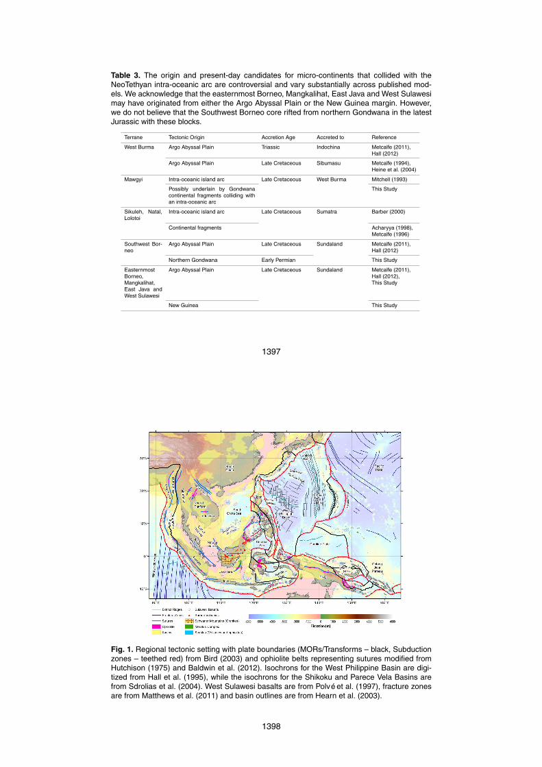
Table 3. The origin and present-day candidates for micro-continents that collided with theNeoTethyan intra-oceanic arc are controversial and vary substantially across published mod-els. We acknowledge that the easternmost Borneo, Mangkalihat, East Java and West Sulawesimay have originated from either the Argo Abyssal Plain or the New Guinea margin. However,we do not believe that the Southwest Borneo core rifted from northern Gondwana in the latestJurassic with these blocks.
Terrane Tectonic Origin Accretion Age Accreted to Reference
West Burma Argo Abyssal Plain Triassic Indochina Metcalfe (2011),Hall (2012)
Argo Abyssal Plain Late Cretaceous Sibumasu Metcalfe (1994),Heine et al. (2004)
Mawgyi Intra-oceanic island arc Late Cretaceous West Burma Mitchell (1993)
Possibly underlain by Gondwanacontinental fragments colliding withan intra-oceanic arc
This Study
Sikuleh, Natal,Lolotoi
Intra-oceanic island arc Late Cretaceous Sumatra Barber (2000)
Continental fragments Acharyya (1998),Metcalfe (1996)
Southwest Bor-neo
Argo Abyssal Plain Late Cretaceous Sundaland Metcalfe (2011),Hall (2012)
Northern Gondwana Early Permian This Study
EasternmostBorneo,Mangkalihat,East Java andWest Sulawesi
Argo Abyssal Plain Late Cretaceous Sundaland Metcalfe (2011),Hall (2012),This Study
New Guinea This Study
1397
Fig. 1. Regional tectonic setting with plate boundaries (MORs/Transforms – black, Subductionzones – teethed red) from Bird (2003) and ophiolite belts representing sutures modified fromHutchison (1975) and Baldwin et al. (2012). Isochrons for the West Philippine Basin are digi-tized from Hall et al. (1995), while the isochrons for the Shikoku and Parece Vela Basins arefrom Sdrolias et al. (2004). West Sulawesi basalts are from Polvé et al. (1997), fracture zonesare from Matthews et al. (2011) and basin outlines are from Hearn et al. (2003).
1398
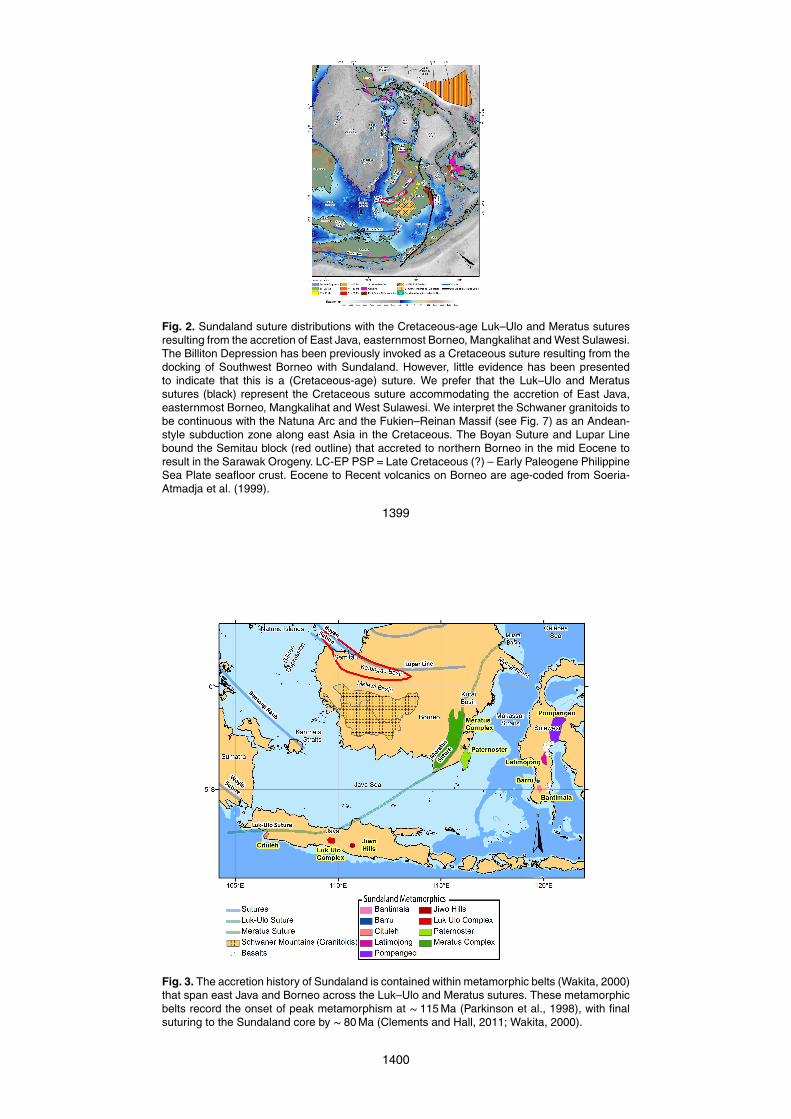
Fig. 2. Sundaland suture distributions with the Cretaceous-age Luk–Ulo and Meratus suturesresulting from the accretion of East Java, easternmost Borneo, Mangkalihat and West Sulawesi.The Billiton Depression has been previously invoked as a Cretaceous suture resulting from thedocking of Southwest Borneo with Sundaland. However, little evidence has been presentedto indicate that this is a (Cretaceous-age) suture. We prefer that the Luk–Ulo and Meratussutures (black) represent the Cretaceous suture accommodating the accretion of East Java,easternmost Borneo, Mangkalihat and West Sulawesi. We interpret the Schwaner granitoids tobe continuous with the Natuna Arc and the Fukien–Reinan Massif (see Fig. 7) as an Andean-style subduction zone along east Asia in the Cretaceous. The Boyan Suture and Lupar Linebound the Semitau block (red outline) that accreted to northern Borneo in the mid Eocene toresult in the Sarawak Orogeny. LC-EP PSP=Late Cretaceous (?) – Early Paleogene PhilippineSea Plate seafloor crust. Eocene to Recent volcanics on Borneo are age-coded from Soeria-Atmadja et al. (1999).
1399
Fig. 3. The accretion history of Sundaland is contained within metamorphic belts (Wakita, 2000)that span east Java and Borneo across the Luk–Ulo and Meratus sutures. These metamorphicbelts record the onset of peak metamorphism at ∼ 115 Ma (Parkinson et al., 1998), with finalsuturing to the Sundaland core by ∼ 80 Ma (Clements and Hall, 2011; Wakita, 2000).
1400
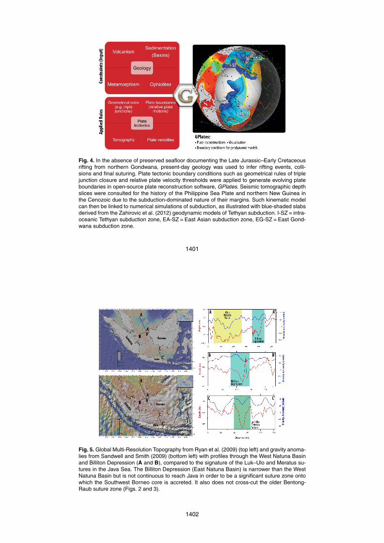
Fig. 4. In the absence of preserved seafloor documenting the Late Jurassic–Early Cretaceousrifting from northern Gondwana, present-day geology was used to infer rifting events, colli-sions and final suturing. Plate tectonic boundary conditions such as geometrical rules of triplejunction closure and relative plate velocity thresholds were applied to generate evolving plateboundaries in open-source plate reconstruction software, GPlates. Seismic tomographic depthslices were consulted for the history of the Philippine Sea Plate and northern New Guinea inthe Cenozoic due to the subduction-dominated nature of their margins. Such kinematic modelcan then be linked to numerical simulations of subduction, as illustrated with blue-shaded slabsderived from the Zahirovic et al. (2012) geodynamic models of Tethyan subduction. I-SZ= intra-oceanic Tethyan subduction zone, EA-SZ=East Asian subduction zone, EG-SZ=East Gond-wana subduction zone.
1401
Fig. 5. Global Multi-Resolution Topography from Ryan et al. (2009) (top left) and gravity anoma-lies from Sandwell and Smith (2009) (bottom left) with profiles through the West Natuna Basinand Billiton Depression (A and B), compared to the signature of the Luk–Ulo and Meratus su-tures in the Java Sea. The Billiton Depression (East Natuna Basin) is narrower than the WestNatuna Basin but is not continuous to reach Java in order to be a significant suture zone ontowhich the Southwest Borneo core is accreted. It also does not cross-cut the older Bentong-Raub suture zone (Figs. 2 and 3).
1402
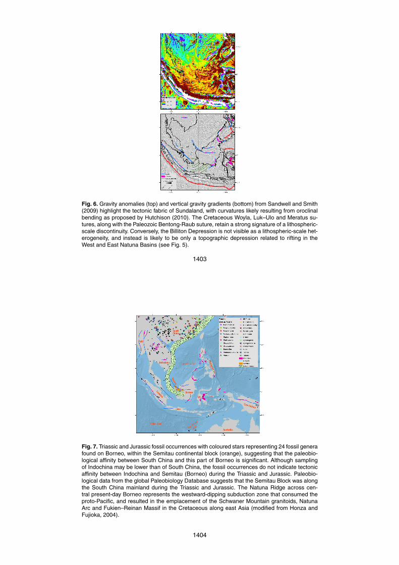
Fig. 6. Gravity anomalies (top) and vertical gravity gradients (bottom) from Sandwell and Smith(2009) highlight the tectonic fabric of Sundaland, with curvatures likely resulting from oroclinalbending as proposed by Hutchison (2010). The Cretaceous Woyla, Luk–Ulo and Meratus su-tures, along with the Paleozoic Bentong-Raub suture, retain a strong signature of a lithospheric-scale discontinuity. Conversely, the Billiton Depression is not visible as a lithospheric-scale het-erogeneity, and instead is likely to be only a topographic depression related to rifting in theWest and East Natuna Basins (see Fig. 5).
1403
Fig. 7. Triassic and Jurassic fossil occurrences with coloured stars representing 24 fossil generafound on Borneo, within the Semitau continental block (orange), suggesting that the paleobio-logical affinity between South China and this part of Borneo is significant. Although samplingof Indochina may be lower than of South China, the fossil occurrences do not indicate tectonicaffinity between Indochina and Semitau (Borneo) during the Triassic and Jurassic. Paleobio-logical data from the global Paleobiology Database suggests that the Semitau Block was alongthe South China mainland during the Triassic and Jurassic. The Natuna Ridge across cen-tral present-day Borneo represents the westward-dipping subduction zone that consumed theproto-Pacific, and resulted in the emplacement of the Schwaner Mountain granitoids, NatunaArc and Fukien–Reinan Massif in the Cretaceous along east Asia (modified from Honza andFujioka, 2004).
1404
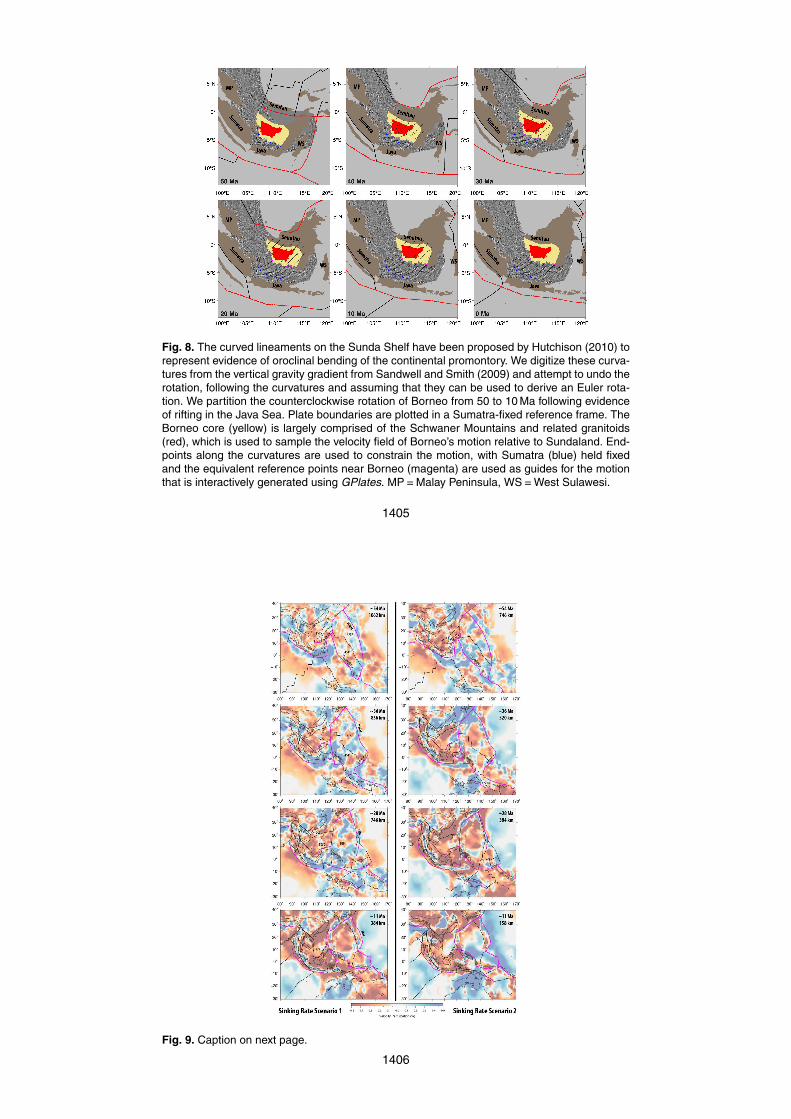
Fig. 8. The curved lineaments on the Sunda Shelf have been proposed by Hutchison (2010) torepresent evidence of oroclinal bending of the continental promontory. We digitize these curva-tures from the vertical gravity gradient from Sandwell and Smith (2009) and attempt to undo therotation, following the curvatures and assuming that they can be used to derive an Euler rota-tion. We partition the counterclockwise rotation of Borneo from 50 to 10 Ma following evidenceof rifting in the Java Sea. Plate boundaries are plotted in a Sumatra-fixed reference frame. TheBorneo core (yellow) is largely comprised of the Schwaner Mountains and related granitoids(red), which is used to sample the velocity field of Borneo’s motion relative to Sundaland. End-points along the curvatures are used to constrain the motion, with Sumatra (blue) held fixedand the equivalent reference points near Borneo (magenta) are used as guides for the motionthat is interactively generated using GPlates. MP=Malay Peninsula, WS=West Sulawesi.
1405
Fig. 9. Caption on next page.
1406
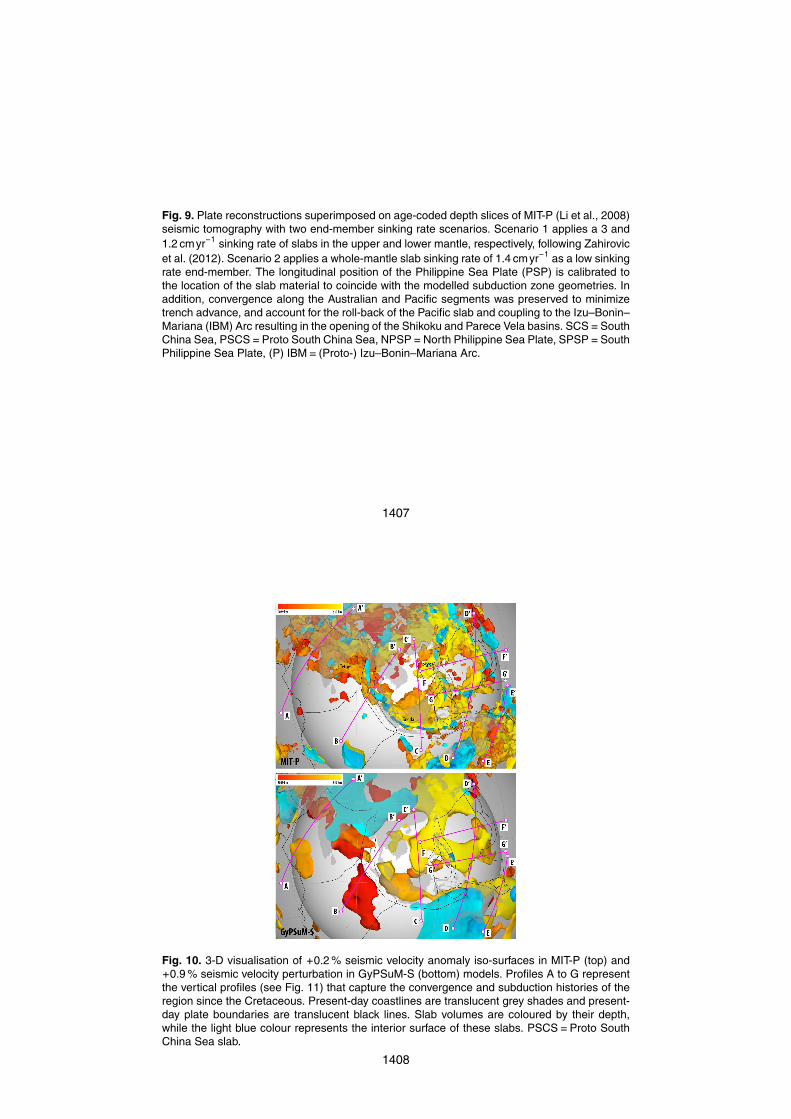
Fig. 9. Plate reconstructions superimposed on age-coded depth slices of MIT-P (Li et al., 2008)seismic tomography with two end-member sinking rate scenarios. Scenario 1 applies a 3 and1.2 cmyr−1 sinking rate of slabs in the upper and lower mantle, respectively, following Zahirovicet al. (2012). Scenario 2 applies a whole-mantle slab sinking rate of 1.4 cmyr−1 as a low sinkingrate end-member. The longitudinal position of the Philippine Sea Plate (PSP) is calibrated tothe location of the slab material to coincide with the modelled subduction zone geometries. Inaddition, convergence along the Australian and Pacific segments was preserved to minimizetrench advance, and account for the roll-back of the Pacific slab and coupling to the Izu–Bonin–Mariana (IBM) Arc resulting in the opening of the Shikoku and Parece Vela basins. SCS=SouthChina Sea, PSCS=Proto South China Sea, NPSP=North Philippine Sea Plate, SPSP=SouthPhilippine Sea Plate, (P) IBM= (Proto-) Izu–Bonin–Mariana Arc.
1407
Fig. 10. 3-D visualisation of +0.2 % seismic velocity anomaly iso-surfaces in MIT-P (top) and+0.9 % seismic velocity perturbation in GyPSuM-S (bottom) models. Profiles A to G representthe vertical profiles (see Fig. 11) that capture the convergence and subduction histories of theregion since the Cretaceous. Present-day coastlines are translucent grey shades and present-day plate boundaries are translucent black lines. Slab volumes are coloured by their depth,while the light blue colour represents the interior surface of these slabs. PSCS=Proto SouthChina Sea slab.
1408
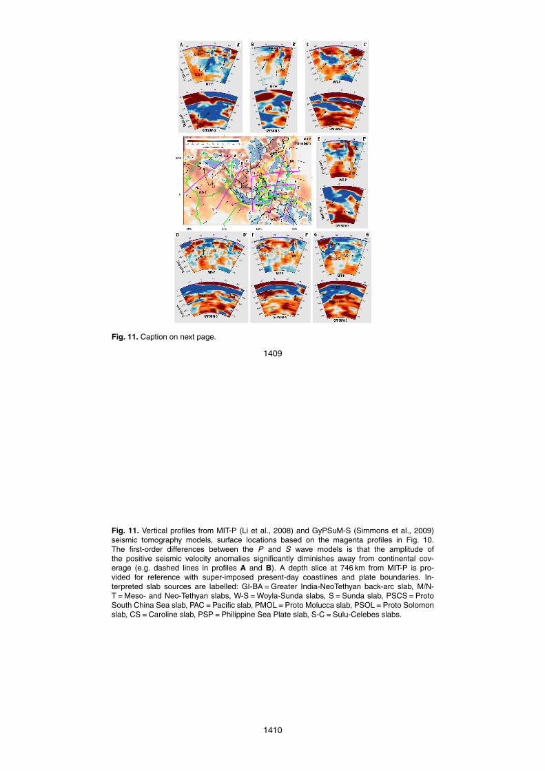
Fig. 11. Caption on next page.
1409
Fig. 11. Vertical profiles from MIT-P (Li et al., 2008) and GyPSuM-S (Simmons et al., 2009)seismic tomography models, surface locations based on the magenta profiles in Fig. 10.The first-order differences between the P and S wave models is that the amplitude ofthe positive seismic velocity anomalies significantly diminishes away from continental cov-erage (e.g. dashed lines in profiles A and B). A depth slice at 746 km from MIT-P is pro-vided for reference with super-imposed present-day coastlines and plate boundaries. In-terpreted slab sources are labelled: GI-BA=Greater India-NeoTethyan back-arc slab, M/N-T=Meso- and Neo-Tethyan slabs, W-S=Woyla-Sunda slabs, S=Sunda slab, PSCS=ProtoSouth China Sea slab, PAC=Pacific slab, PMOL=Proto Molucca slab, PSOL=Proto Solomonslab, CS=Caroline slab, PSP=Philippine Sea Plate slab, S-C=Sulu-Celebes slabs.
1410
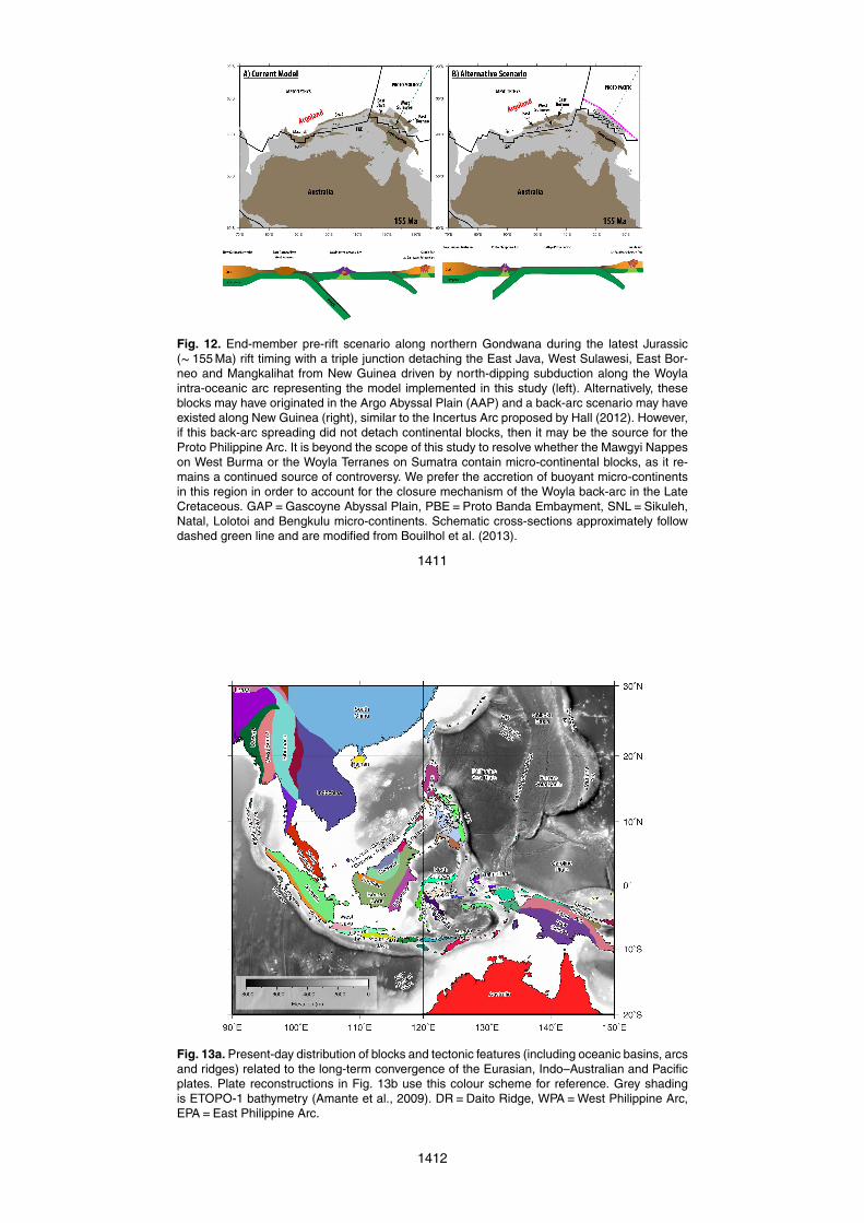
Fig. 12. End-member pre-rift scenario along northern Gondwana during the latest Jurassic(∼ 155 Ma) rift timing with a triple junction detaching the East Java, West Sulawesi, East Bor-neo and Mangkalihat from New Guinea driven by north-dipping subduction along the Woylaintra-oceanic arc representing the model implemented in this study (left). Alternatively, theseblocks may have originated in the Argo Abyssal Plain (AAP) and a back-arc scenario may haveexisted along New Guinea (right), similar to the Incertus Arc proposed by Hall (2012). However,if this back-arc spreading did not detach continental blocks, then it may be the source for theProto Philippine Arc. It is beyond the scope of this study to resolve whether the Mawgyi Nappeson West Burma or the Woyla Terranes on Sumatra contain micro-continental blocks, as it re-mains a continued source of controversy. We prefer the accretion of buoyant micro-continentsin this region in order to account for the closure mechanism of the Woyla back-arc in the LateCretaceous. GAP=Gascoyne Abyssal Plain, PBE=Proto Banda Embayment, SNL=Sikuleh,Natal, Lolotoi and Bengkulu micro-continents. Schematic cross-sections approximately followdashed green line and are modified from Bouilhol et al. (2013).
1411
Fig. 13a. Present-day distribution of blocks and tectonic features (including oceanic basins, arcsand ridges) related to the long-term convergence of the Eurasian, Indo–Australian and Pacificplates. Plate reconstructions in Fig. 13b use this colour scheme for reference. Grey shadingis ETOPO-1 bathymetry (Amante et al., 2009). DR=Daito Ridge, WPA=West Philippine Arc,EPA=East Philippine Arc.
1412
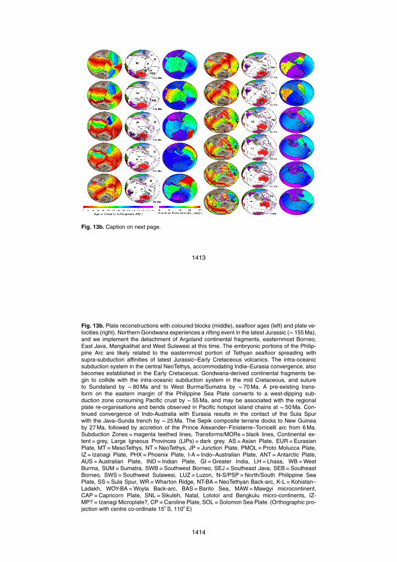
Fig. 13b. Caption on next page.
1413
Fig. 13b. Plate reconstructions with coloured blocks (middle), seafloor ages (left) and plate ve-locities (right). Northern Gondwana experiences a rifting event in the latest Jurassic (∼ 155 Ma),and we implement the detachment of Argoland continental fragments, easternmost Borneo,East Java, Mangkalihat and West Sulawesi at this time. The embryonic portions of the Philip-pine Arc are likely related to the easternmost portion of Tethyan seafloor spreading withsupra-subduction affinities of latest Jurassic–Early Cretaceous volcanics. The intra-oceanicsubduction system in the central NeoTethys, accommodating India–Eurasia convergence, alsobecomes established in the Early Cretaceous. Gondwana-derived continental fragments be-gin to collide with the intra-oceanic subduction system in the mid Cretaceous, and sutureto Sundaland by ∼ 80 Ma and to West Burma/Sumatra by ∼ 70 Ma. A pre-existing trans-form on the eastern margin of the Philippine Sea Plate converts to a west-dipping sub-duction zone consuming Pacific crust by ∼ 55 Ma, and may be associated with the regionalplate re-organisations and bends observed in Pacific hotspot island chains at ∼ 50 Ma. Con-tinued convergence of Indo-Australia with Eurasia results in the contact of the Sula Spurwith the Java–Sunda trench by ∼ 25 Ma. The Sepik composite terrane docks to New Guineaby 27 Ma, followed by accretion of the Prince Alexander–Finisterre–Torricelli arc from 6 Ma.Subduction Zones=magenta teethed lines, Transforms/MORs=black lines, Continental ex-tent=grey, Large Igneous Provinces (LIPs)=dark grey. AS=Asian Plate, EUR=EurasianPlate, MT=MesoTethys, NT=NeoTethys, JP= Junction Plate, PMOL=Proto Molucca Plate,IZ= Izanagi Plate, PHX=Phoenix Plate, I-A= Indo–Australian Plate, ANT=Antarctic Plate,AUS=Australian Plate, IND= Indian Plate, GI=Greater India, LH=Lhasa, WB=WestBurma, SUM=Sumatra, SWB=Southwest Borneo, SEJ=Southeast Java, SEB=SoutheastBorneo, SWS=Southwest Sulawesi, LUZ=Luzon, N-S/PSP=North/South Philippine SeaPlate, SS=Sula Spur, WR=Wharton Ridge, NT-BA=NeoTethyan Back-arc, K-L=Kohistan–Ladakh, WOY-BA=Woyla Back-arc, BAS=Barito Sea, MAW=Mawgyi microcontinent,CAP=Capricorn Plate, SNL=Sikuleh, Natal, Lolotoi and Bengkulu micro-continents, IZ-MP?= Izanagi Microplate?, CP=Caroline Plate, SOL=Solomon Sea Plate. (Orthographic pro-jection with centre co-ordinate 15◦ S, 110◦ E)
1414
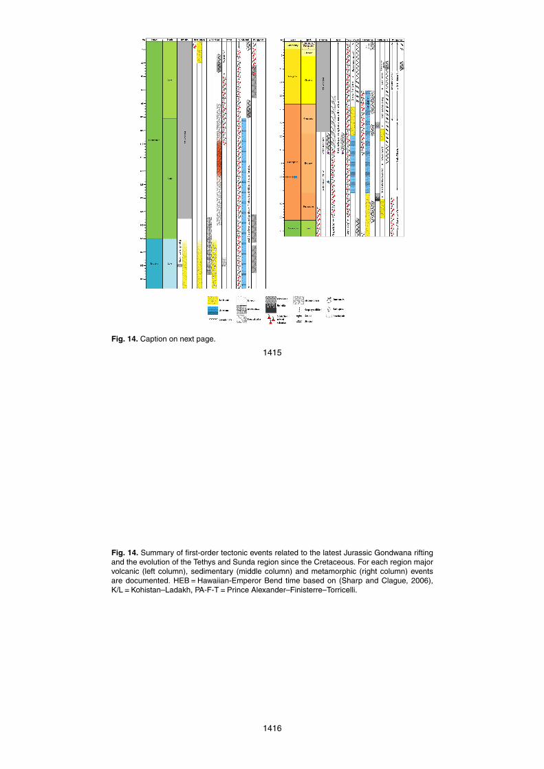
Fig. 14. Caption on next page.
1415
Fig. 14. Summary of first-order tectonic events related to the latest Jurassic Gondwana riftingand the evolution of the Tethys and Sunda region since the Cretaceous. For each region majorvolcanic (left column), sedimentary (middle column) and metamorphic (right column) eventsare documented. HEB=Hawaiian-Emperor Bend time based on (Sharp and Clague, 2006),K/L=Kohistan–Ladakh, PA-F-T=Prince Alexander–Finisterre–Torricelli.
1416
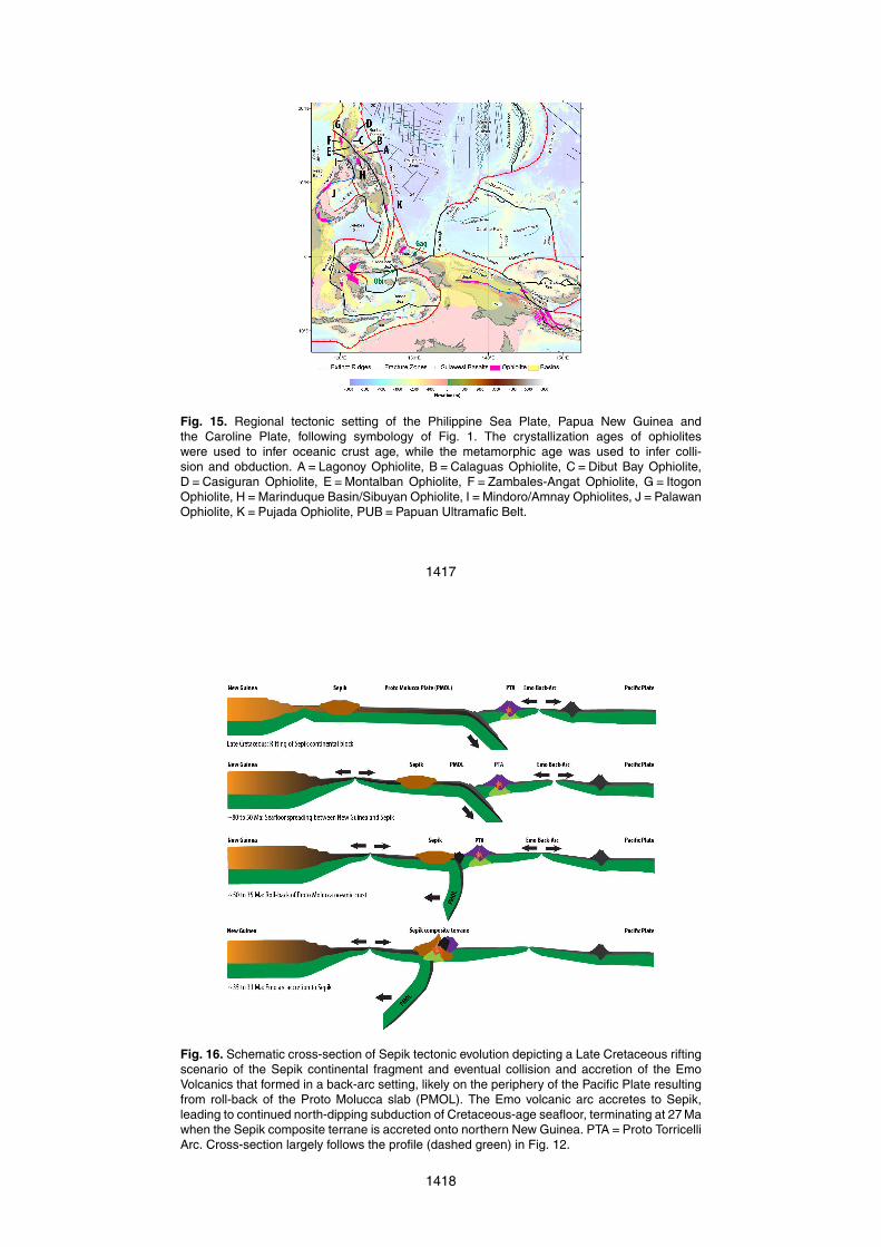
Fig. 15. Regional tectonic setting of the Philippine Sea Plate, Papua New Guinea andthe Caroline Plate, following symbology of Fig. 1. The crystallization ages of ophioliteswere used to infer oceanic crust age, while the metamorphic age was used to infer colli-sion and obduction. A=Lagonoy Ophiolite, B=Calaguas Ophiolite, C=Dibut Bay Ophiolite,D=Casiguran Ophiolite, E=Montalban Ophiolite, F=Zambales-Angat Ophiolite, G= ItogonOphiolite, H=Marinduque Basin/Sibuyan Ophiolite, I=Mindoro/Amnay Ophiolites, J=PalawanOphiolite, K=Pujada Ophiolite, PUB=Papuan Ultramafic Belt.
1417
Fig. 16. Schematic cross-section of Sepik tectonic evolution depicting a Late Cretaceous riftingscenario of the Sepik continental fragment and eventual collision and accretion of the EmoVolcanics that formed in a back-arc setting, likely on the periphery of the Pacific Plate resultingfrom roll-back of the Proto Molucca slab (PMOL). The Emo volcanic arc accretes to Sepik,leading to continued north-dipping subduction of Cretaceous-age seafloor, terminating at 27 Mawhen the Sepik composite terrane is accreted onto northern New Guinea. PTA=Proto TorricelliArc. Cross-section largely follows the profile (dashed green) in Fig. 12.
1418
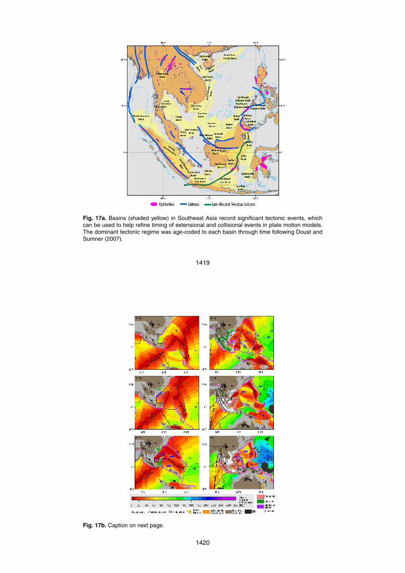
Fig. 17a. Basins (shaded yellow) in Southeast Asia record significant tectonic events, whichcan be used to help refine timing of extensional and collisional events in plate motion models.The dominant tectonic regime was age-coded to each basin through time following Doust andSumner (2007).
1419
Fig. 17b. Caption on next page.
1420
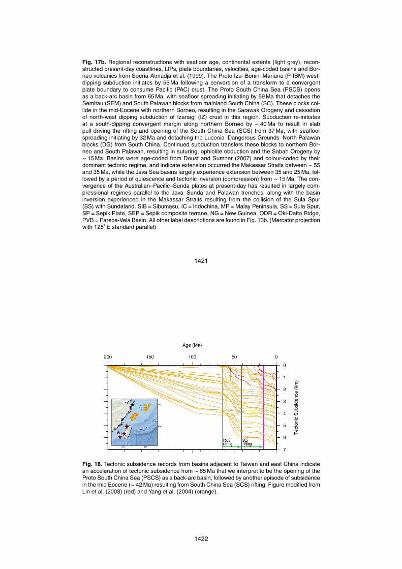
Fig. 17b. Regional reconstructions with seafloor age, continental extents (light grey), recon-structed present-day coastlines, LIPs, plate boundaries, velocities, age-coded basins and Bor-neo volcanics from Soeria-Atmadja et al. (1999). The Proto Izu–Bonin–Mariana (P-IBM) west-dipping subduction initiates by 55 Ma following a conversion of a transform to a convergentplate boundary to consume Pacific (PAC) crust. The Proto South China Sea (PSCS) opensas a back-arc basin from 65 Ma, with seafloor spreading initiating by 59 Ma that detaches theSemitau (SEM) and South Palawan blocks from mainland South China (SC). These blocks col-lide in the mid-Eocene with northern Borneo, resulting in the Sarawak Orogeny and cessationof north-west dipping subduction of Izanagi (IZ) crust in this region. Subduction re-initiatesat a south-dipping convergent margin along northern Borneo by ∼ 40 Ma to result in slabpull driving the rifting and opening of the South China Sea (SCS) from 37 Ma, with seafloorspreading initiating by 32 Ma and detaching the Luconia–Dangerous Grounds–North Palawanblocks (DG) from South China. Continued subduction transfers these blocks to northern Bor-neo and South Palawan, resulting in suturing, ophiolite obduction and the Sabah Orogeny by∼ 15 Ma. Basins were age-coded from Doust and Sumner (2007) and colour-coded by theirdominant tectonic regime, and indicate extension occurred the Makassar Straits between ∼ 55and 35 Ma, while the Java Sea basins largely experience extension between 35 and 25 Ma, fol-lowed by a period of quiescence and tectonic inversion (compression) from ∼ 15 Ma. The con-vergence of the Australian–Pacific–Sunda plates at present-day has resulted in largely com-pressional regimes parallel to the Java–Sunda and Palawan trenches, along with the basininversion experienced in the Makassar Straits resulting from the collision of the Sula Spur(SS) with Sundaland. SIB=Sibumasu, IC= Indochina, MP=Malay Peninsula, SS=Sula Spur,SP=Sepik Plate, SEP=Sepik composite terrane, NG=New Guinea, ODR=Oki-Daito Ridge,PVB=Parece-Vela Basin. All other label descriptions are found in Fig. 13b. (Mercator projectionwith 125◦ E standard parallel)
1421
Fig. 18. Tectonic subsidence records from basins adjacent to Taiwan and east China indicatean acceleration of tectonic subsidence from ∼ 65 Ma that we interpret to be the opening of theProto South China Sea (PSCS) as a back-arc basin, followed by another episode of subsidencein the mid Eocene (∼ 42 Ma) resulting from South China Sea (SCS) rifting. Figure modified fromLin et al. (2003) (red) and Yang et al. (2004) (orange).
1422