the calabrian arc subduction complex in the ionian sea
TRANSCRIPT

The Calabrian Arc subduction complex in the Ionian Sea:Regional architecture, active deformation, and seismic hazard
A. Polonia,1 L. Torelli,2 P. Mussoni,2 L. Gasperini,1 A. Artoni,2 and D. Klaeschen3
Received 21 October 2010; revised 9 July 2011; accepted 16 August 2011; published 28 October 2011.
[1] We analyzed the structure and evolution of the external Calabrian Arc (CA)subduction complex through an integrated geophysical approach involving multichanneland single‐channel seismic data at different scales. Pre‐stack depth migrated crustal‐scaleseismic profiles have been used to reconstruct the overall geometry of the subductioncomplex, i.e., depth of the basal detachment, geometry and structural style of differenttectonic domains, and location and geometry of major faults. High‐resolution multichannelseismic (MCS) and sub‐bottom CHIRP profiles acquired in key areas during a recentcruise, as well as multibeam data, integrate deep data and constrain the fine structure ofthe accretionary wedge as well as the activity of individual fault strands. We identifiedfour main morpho‐structural domains in the subduction complex: 1) the post‐Messinianaccretionary wedge; 2) a slope terrace; 3) the pre‐Messinian accretionary wedge and 4)the inner plateau. Variation of structural style and seafloor morphology in these domainsare related to different tectonic processes, such as frontal accretion, out‐of‐sequencethrusting, underplating and complex faulting. The CA subduction complex is segmentedlongitudinally into two different lobes characterized by different structural style,deformation rates and basal detachment depths. They are delimited by a NW/SEdeformation zone that accommodates differential movements of the Calabrian and thePeloritan portions of CA and represent a recent phase of plate re‐organization in the centralMediterranean. Although shallow thrust‐type seismicity along the CA is lacking, weidentified active deformation of the shallowest sedimentary units at the wedge front andin the inner portions of the subduction complex. This implies that subduction could beactive but aseismic or with a locked fault plane. On the other hand, if underthrusting ofthe African plate has stopped recently, active shortening may be accommodated throughmore distributed deformation. Our findings have consequences on seismic hazard,since we identified tectonic structures likely to have caused large earthquakes in thepast and to be the source regions for future events.
Citation: Polonia, A., L. Torelli, P. Mussoni, L. Gasperini, A. Artoni, and D. Klaeschen (2011), The Calabrian Arc subductioncomplex in the Ionian Sea: Regional architecture, active deformation, and seismic hazard, Tectonics, 30, TC5018,doi:10.1029/2010TC002821.
1. Introduction
[2] The CA is part of the most active seismic belt in Italy,and the Ionian Sea has been described as the last remainingsegment of oceanic crust subduction in the central Mediter-ranean [de Voogd et al., 1992; Faccenna et al., 2001, 2004;D’Agostino et al., 2008]. The thick sedimentary section ofthe African plate, at the toe of the CA (Figure 1), has beenscraped off from the descending plate, and piled up alongthrust faults resulting in the emplacement of a thick (up to10 km) and about 200–300 km wide accretionary complex.
The regional geometry of the subduction complex has beendescribed from seismic data [Rossi and Sartori, 1981;Finetti, 1982; Cernobori et al., 1996; Doglioni et al., 1999;Minelli and Faccenna, 2010], but the fine‐scale structure ofthe accretionary wedge, i.e., location of the plate boundary,depth of the basal detachment, geometry and structural style,is still poorly constrained. There is little consensus regardingthe location and geometry of the major faults absorbing platemotion, as well as the exact position of the outer deformationfront of the accretionary wedge. In particular, one majorquestion remains unanswered: is the Calabria subductionzone still active? The lack of seismicity with a characteristicshallow dipping thrust‐type focal mechanism along thesubduction fault plane can be interpreted in three ways: 1)subduction has ceased [Wortel and Spakman, 2000; Goeset al., 2004]; 2) subduction is active but aseismic; 3) sub-duction is active but with a large locked fault plane
1Institute of Marine Sciences, ISMAR‐Bo, CNR, Bologna, Italy.2Dipartimento di Scienze della Terra, University of Parma, Parma, Italy.3Leibniz‐Institut für Meereswissenschaften (IFM‐GEOMAR), Kiel,
Germany.
Copyright 2011 by the American Geophysical Union.0278‐7407/11/2010TC002821
TECTONICS, VOL. 30, TC5018, doi:10.1029/2010TC002821, 2011
TC5018 1 of 28

[Chiarabba et al., 2005; Gutscher et al., 2006]. The moreexternal and recently deformed sector of the accretionarywedge, located south of the so‐called “external CA” [Rossiand Sartori, 1981], shows fold‐like structures whosegeometry and evolution are driven by shortening and/or salt‐tectonic processes due to the presence of Messinian eva-porites. Some authors have speculated that the accretionarywedge is presently inactive, and that shortening and large‐scale deformation of the wedge could result from passivegravity‐driven processes, leading to a collapse of post‐Messinian sediments over the evaporites [Chamot‐Rookeet al., 2005a]. Others suggest that, despite the slow conver-gence rate, the CA is the last region in the Central Medi-terranean Sea where subduction is still active [Gutscheret al., 2006; D’Agostino et al., 2008]. However, only fewstudies [Chamot‐Rooke et al., 2005a; Gutscher et al., 2006]have focused on the fine structure of the outermost part of theCA system. In fact, high‐resolution geophysical data werelacking in this key region of transition between the accre-tionary wedge and the Ionian abyssal plain.
[3] In the present work we addressed major tectonicissues of the CA, through an integrated approach involvinganalysis of already available crustal MCS and sparker pro-files, multibeam data, and newly acquired high‐resolutionMCS and CHIRP‐sonar profiles in key areas (Figure 2) ofthe subduction complex. This multiscale integrated approachallowed us to map the fine‐scale geometry of the plateboundary, obtain the geological constraints to quantify recentdeformation in the outer subduction complex and reconstructlocation and geometry of regional active faults absorbingplate motion.
2. Geological Setting
[4] The CA (Figure 1) is part of the eastward migratingApennine subduction system and connects the NW trendingApennine with the E‐W oriented Maghrebian thrust belt[Patacca and Scandone, 2004]. It is located above a 300 kmwide subduction zone, dipping toward NW characterized bythe presence of an active volcanic arc (the Aeolian Islands)and a well defined Wadati‐Benioff zone [Wortel and
Figure 1. Geodynamic setting of the study area. The geological model is modified from Morelli et al.[2004]. Slip vector in the African reference frame is indicated by a red arrow. In green GPS vectors inthe Apulian fixed reference frame in which the motion of Calabria is parallel to the slip vector suggestingthe existence of active crustal compression as a result of subduction of the Ionian lithosphere beneath theCalabrian Arc [D’Agostino et al., 2008]. The northwest‐ward dipping subducting slab of the African plateis represented by the yellow isodepth lines in the Tyrrhenian Sea spacing from 100 to 450 km depth[Selvaggi and Chiarabba, 1995]. Eu: Europe, Afr: Africa.
POLONIA ET AL.: THE CALABRIAN ARC SUBDUCTION COMPLEX TC5018TC5018
2 of 28

Spakman, 2000], with earthquakes descending to nearly500 km of depth [Selvaggi and Chiarabba, 1995]. TheNeogene and Quaternary evolution of the CA is controlledby the southeastward retreat of the Apennine‐Calabriansubduction zone, that caused rifting and lithospheric thin-ning culminating in the opening of the Tyrrhenian Seastarting from the upper Miocene [Malinverno and Ryan,1986; Jolivet and Faccenna, 2000; Faccenna et al., 2001;Sartori, 2003]. Since that time, Calabria has migratedtoward SE due to the rapid roll‐back of the Ionian‐Tyrrhenianslab and trench retreat [Faccenna et al., 2001, 2004]. Thehigh heat flow and the formation of young oceanic litho-sphere in the deep Tyrrhenian Sea basins (Vavilov andMarsili) are the result of associated back‐arc extension[Marani and Trua, 2002; Zito et al., 2003; Pasquale et al.,2005]. Trench retreat was particularly fast over the Neo-gene and early Quaternary [Patacca et al., 1990] as indicatedby high extension rates (50–70 mm/yr) recorded in theVavilov (Neogene) and Marsili (Early Middle Pleistocene)oceanic seamounts [Marani and Trua, 2002; Mattei et al.,2002] and rapid migration of the trench [Faccenna et al.,2001]. On the other hand, vertical axis rotations responsiblefor the arcuate shape of the CA occurred during Miocene toQuaternary but were almost finished 1 Ma [Mattei et al.,
2007] as confirmed by GPS results showing no active back‐arc extension in the Southern Tyrrhenian Sea [D’Agostinoet al., 2008].[5] The external part of the arc (Figure 1) is represented
by a subduction complex that reaches both the Ionianabyssal plain and the Mediterranean Ridge and is borderedby two major structural features, the Malta escarpment tothe southwest and the Apulia escarpment to the northeast.The CA accretionary wedge developed due to the SE‐NWAfrica/Eurasia convergence, presently occurring at a veryslow rate (5 mm/yr or even <5 mm/yr), as reported by recentGPS studies [Calais et al., 2003; Reilinger et al., 2006;Serpelloni et al., 2007; D’Agostino et al., 2008; Devotiet al., 2008]. On the other hand, geodetic investigations ofcrustal motion in the central Mediterranean have shownsignificant deviations from the direction of relative motionbetween the Eurasia and Africa plates [D’Agostino andSelvaggi, 2004; Serpelloni et al., 2007; Devoti et al.,2008; D’Agostino et al., 2008]. A significant change incrustal motion occurs between Sicily and the CalabrianArc [Pondrelli et al., 2004] across the region near theMessina strait [D’Agostino and Selvaggi, 2004]. Crustalmotion in Southern Sicily is clockwise rotated relative to thepredicted motion of Africa and some of the Africa/Eurasia
Figure 2. Location of geological and geophysical data available in the working area (morphobathymetryfrom GEBCO database). Newly acquired data (MCS and CHIRP seismic data) are indicated by red andgreen lines. Thick lines mark location of seismic profiles described in this work.
POLONIA ET AL.: THE CALABRIAN ARC SUBDUCTION COMPLEX TC5018TC5018
3 of 28
convergence is probably accommodated offshore northernSicily [Hollenstein et al., 2003; Goes et al., 2004; Billi et al.,2007] in the southern Tyrrhenian Sea.[6] Recently, D’Agostino et al. [2008], through GPS ob-
servations and earthquake slip vectors, suggested that theAdriatic microplate is limited to the South by a newlydefined microplate which includes the Apulian promontory,the Ionian Sea and, possibly, the Hyblean region in southernSicily. This reconstruction describes well the deformation inthe Apennines, southern Tyrrhenian Sea and Sicily Channeleven though the southern boundary of the newly proposedmicroplate is not well defined. In this framework the motionof Africa relative to Eurasia is no longer rigidly transferred butrather is accommodated by the opposite rotations of the twoproposed microplates (Adria and Apulian/Ionian/Hyblean).[7] Despite the very slow modern‐day plate convergence
rates observed by GPS, subduction may still be active in theCA, and subduction rate will depend both on the conver-gence rate and the velocity of the subduction hinge[Doglioni et al., 2006, 2007]. GPS sites in Calabria (relativeto Apulia) show systematic residuals directed toward theIonian Sea, suggesting active crustal compression and anoutward motion of the CA as a result of still active sub-duction that accounts for the shortening taken up in theaccretionary wedge, eventually accommodated by long‐termslip on the subduction interface [Gutscher et al., 2006;D’Agostino et al., 2008].[8] Previous studies have outlined the overall geometry of
the subduction complex in the Ionian Sea through theanalysis of crustal‐scale seismic data [Finetti, 1982;Cernobori et al., 1996; Doglioni et al., 1999; Catalanoet al., 2001; Finetti, 2005], while geological field studieson land have described the inner continental basement rockassemblage made of a nappe pile of metamorphic rockscomprising Tertiary ophiolitic units overlain by a large sheetof pre‐alpine continental‐derived metamorphic basementwith local remnants of Mesozoic‐Cenozoic sedimentarycover [Bonardi et al., 2001; Rossetti et al., 2004]. DuringOligocene‐early Miocene, the metamorphic basement unitswere affected by crustal extension during Tortonian times[Mattei et al., 2007] while during Pleistocene it experiencedhigh uplift rates, up to 1 mm/yr [Westaway, 1993;Gvirtzman and Nur, 2001]. These latest tectonic phasesaffected the inner part of the CA and generated extensionalfault systems both parallel and oblique to the coastline [DelBen et al., 2008]. They are the major tectonic features of theinner portion of the CA that dismember all the older tectoniclineaments.[9] The submerged portion of the CA consists of a
northwestward thickening wedge of deformed sediments[Finetti, 1982; Cernobori et al., 1996; Minelli andFaccenna, 2010] overlying, in the most external portion,northwestward dipping sediments and the basement. This isstructurally consistent with the presence of a SE‐vergingaccretionary wedge [Cernobori et al., 1996]. The widerportion of the slope, named “external CA” [Rossi andSartori, 1981], hosts thrust systems, chaotic units and aprovince of mud volcanoes [Praeg et al., 2009] that mayindicate dewatering of the Calabrian prism due to com-pressional deformation.[10] The CA subduction complex is part of the most active
seismic belt in the Central Mediterranean region and faces
the highly populated regions of Southern Italy, NE Sicilyand Calabria that were struck by strong earthquakes in therecent past [Bottari et al., 1989; Piatanesi and Tinti, 1998;Jacques et al., 2001; Galli and Bosi, 2003; Gutscher et al.,2006; Jenny et al., 2006]. It is therefore vital to unravel thetectonic processes in the submerged portion of the subduc-tion complex that may contribute to seismic and tsunamihazards affecting the region.
3. Crustal‐Scale Multichannel Seismic DataInterpretation
[11] We reconstructed the regional architecture of theaccretionary complex from MCS data (the CNR_ENI DeepCrust Seismic Profiles ‐ CROP and Mediterranean Sea ‐MSdata sets) acquired during 70s and 90s (Figure 2). Were‐processed seismic data at ISMAR‐Bo, through asequence that involves preliminary velocity analysis, DipMove Out (DMO), velocity analysis after DMO, stack andtime migration. CROP seismic profiles were also processedat the Marine Geodynamics Department of the IfM‐Geomar(Kiel) within the frame of the EC‐IHP (EC‐Access toResearch Infrastructure) project. We obtained full pre‐stackdepth‐migrated (PSDM) seismic sections, through an itera-tive migration procedure (the SIRIUS/GXT, Migpack soft-ware package), that uses seismic velocities constrained byfocusing analysis and common reflection point gathers[MacKay and Abma, 1993]. We obtained a very accuratevelocity model that includes both lateral and verticalvelocity variations in agreement with interpreted geologicalsections.
3.1. Large‐Scale Architecture of the CA SubductionComplex
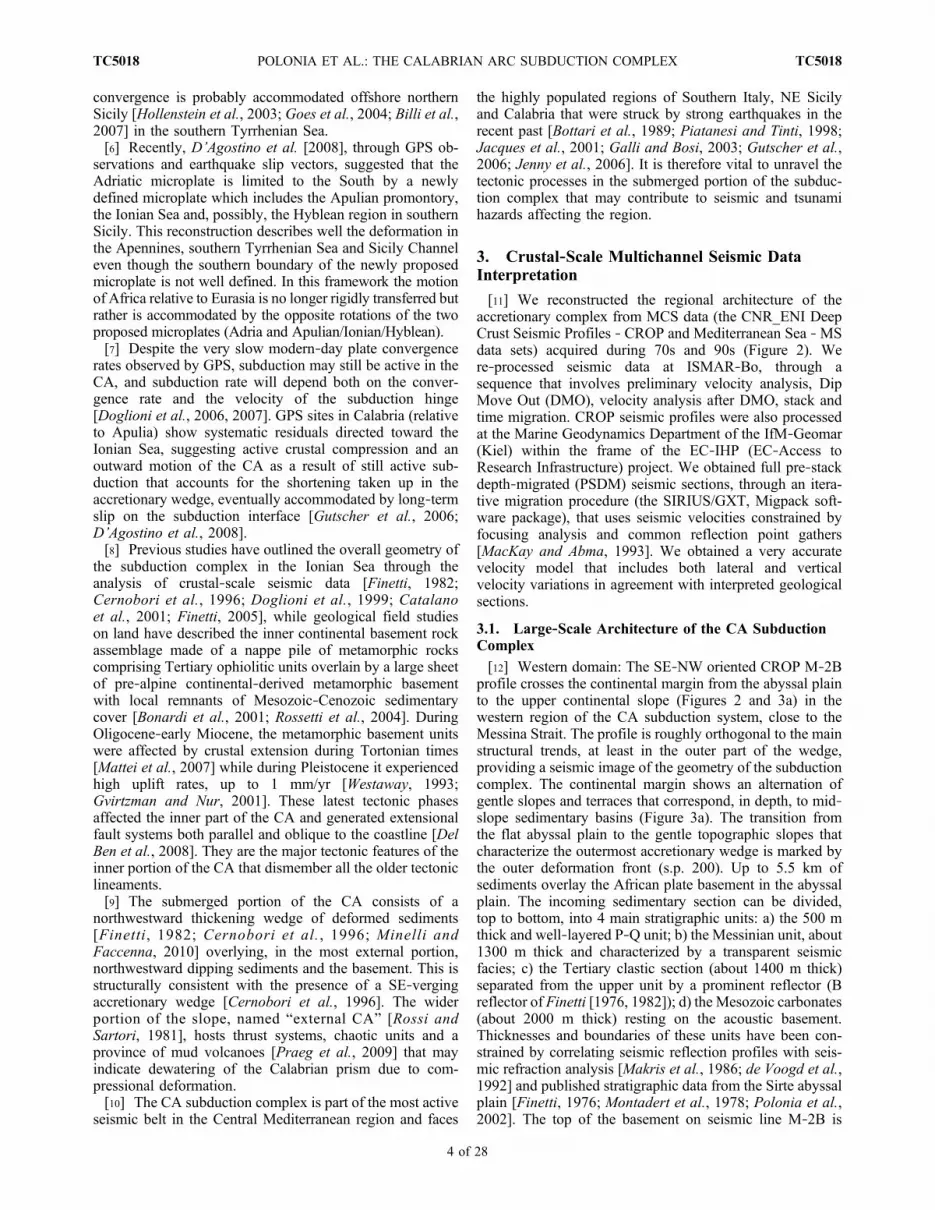
[12] Western domain: The SE‐NW oriented CROP M‐2Bprofile crosses the continental margin from the abyssal plainto the upper continental slope (Figures 2 and 3a) in thewestern region of the CA subduction system, close to theMessina Strait. The profile is roughly orthogonal to the mainstructural trends, at least in the outer part of the wedge,providing a seismic image of the geometry of the subductioncomplex. The continental margin shows an alternation ofgentle slopes and terraces that correspond, in depth, to mid‐slope sedimentary basins (Figure 3a). The transition fromthe flat abyssal plain to the gentle topographic slopes thatcharacterize the outermost accretionary wedge is marked bythe outer deformation front (s.p. 200). Up to 5.5 km ofsediments overlay the African plate basement in the abyssalplain. The incoming sedimentary section can be divided,top to bottom, into 4 main stratigraphic units: a) the 500 mthick and well‐layered P‐Q unit; b) the Messinian unit, about1300 m thick and characterized by a transparent seismicfacies; c) the Tertiary clastic section (about 1400 m thick)separated from the upper unit by a prominent reflector (Breflector of Finetti [1976, 1982]); d) the Mesozoic carbonates(about 2000 m thick) resting on the acoustic basement.Thicknesses and boundaries of these units have been con-strained by correlating seismic reflection profiles with seis-mic refraction analysis [Makris et al., 1986; de Voogd et al.,1992] and published stratigraphic data from the Sirte abyssalplain [Finetti, 1976; Montadert et al., 1978; Polonia et al.,2002]. The top of the basement on seismic line M‐2B is
POLONIA ET AL.: THE CALABRIAN ARC SUBDUCTION COMPLEX TC5018TC5018
4 of 28
Figure
3a.
(top)PSDM
(Pre
Stack
Depth
Migrated)
MCSlin
eCROPM‐2B(see
Figure2forits
locatio
n).(middle)
Line
draw
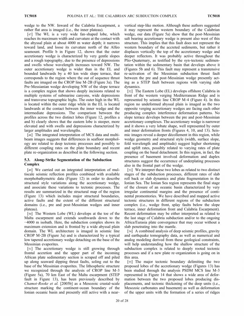
ing.
(bottom)Color‐coded
seismic
velocitiesderivedfrom
pre‐stackseismic
data
migratio
n.The
post‐M
essinian
accretionary
complex
isclearlyevidencedby
high
seismic
velocities(orangeandyello
warea)at
thetoeof
thecontinental
margin.
The
saltbearingcomplex
liesabovethebasaldetachmentrepresentedby
thebase
oftheMessinian
evaporites,
whilethewelllayered
Tertiary
andMesozoicAfrican
platesedimentsareattached
tothelowerplateandmoves
towardNW.
POLONIA ET AL.: THE CALABRIAN ARC SUBDUCTION COMPLEX TC5018TC5018
5 of 28

between 9 and 10 km deep, in agreement with seismicrefraction data that image the top of what has been inter-preted as oceanic crust (reflector 2a of de Voogd et al.[1992]) about 9 km below the sea level in the abyssal plain.[13] The outermost accretionary wedge (s.p. 200–2000) is
represented by a salt‐bearing complex, with a characteristicacoustically transparent seismic facies, very low surfaceangle (0.6°) and high seismic velocities, ranging from 4000to 5000 m/sec (Figure 3a). The basal detachment of thepost‐Messinian wedge is located along the base of theMessinian evaporites which dips about 0.8° toward NWproducing a taper of about 1.5°. From s.p. 200 to s.p. 700very short wavelength folding affects the top of the Messi-nian evaporites resulting in an hummocky seafloor mor-phology that has been termed “cobblestone topography”[Hersey, 1965; Kastens, 1981; Kastens and Cita, 1981;Rossi and Sartori, 1981] and interpreted as due to collapsestructures driven by karst processes [Hinz, 1972; Ryan et al.,1973] or by a combined effect of tectonics and salt diapirism[Kastens, 1981; Camerlenghi and Cita, 1987]. On the otherhand, low‐amplitude and very short wavelength foldingobserved in the outermost part of the wedge may suggest asecondary shallower décollement possibly constituted by aninfra‐Messinian level (Figure 3a). As for the MediterraneanRidge, the Messinian lower evaporites act as the maindetachment level while the upper evaporites may operate asa disharmonic layer below thin Plio‐Quaternary sediments[Chaumillon et al., 1996].[14] In the abyssal plain and in the outermost wedge
seaward of s.p.1000, the Tertiary and Mesozoic sedimentarysequences show evidence of faulting and folding. Sedimentdeformation is related to thrust faults that reactivate pre‐existing normal fault planes bounding rotated blocks. Theseblocks are delimited by steep landward dipping reflectorsthat displace pre‐Messinian seismic units and slightlydeform the base of the Messinian unit. These tectonic fea-tures are well imaged in the Prismed data set [Chamot Rookeet al., 2005b] as well as in seismic line MS‐27 [Finetti,1982] where the deformation clearly involved growthdeposits of Tortonian age. This suggests it probably devel-oped during Tortonian and Serravallian times as proposedby Chamot‐Rooke et al. [2005b]. During this tectonic phasethis segment of the incoming plate was far from the outerdeformation front; thus this deformation may not be relatedto subduction processes but rather to a contractional tectonicphase affecting the African plate margins during Serra-vallian/Tortonian and Messinian times.[15] In seismic line CROP M‐2B (Figure 3a), at s.p. 700
and 1050 we observe two major sub‐vertical deformationzones in the Tertiary and Mesozoic sequences over whichlayering of the sediments terminates abruptly. We interpretthese discontinuities as major tectonic features markingthe boundary between two different tectonic and paleogeo-
graphic Mesozoic domains. The structures may have beenactive throughout the Plio‐Quaternary, as the upper unitshows abrupt thickness variations along vertical structures(Figure 3a).[16] The most recent accretionary wedge is bounded
toward the NW by a slope terrace that is the seafloorexpression of a sedimentary basin showing a rather flatmorphology and some depocenters separated by structuralhighs (Figures 3a and 3b, s.p. 1900–2450). This basindevelops above a region where the basal detachment anddeeper reflectors abruptly change their dip from 0.8° to theSE to 3.5° to the NW. PSDM seismic velocities confirm thatMessinian evaporites are present seaward and below thisbasin, while landward the wedge is made of rocks charac-terized by slower seismic velocities (in the range of 2500–3000 m/s) that we interpret as pre‐Messinian clastic sedi-ments. This might indicate that the sedimentary thrust topbasin formed during Messinian times. The observed transi-tion from evaporitic to clastic assemblages is reflected bythe different structural architecture of the innermost wedge,that shows a series of 5 topographic scarps (Figure 3a, s.p.2400, 2850, 3200, 3800, 4000) separated by sedimentarybasins and mid‐slope terraces. The scarps are controlled atdepth by a series of high angle landward dipping reflectorsthat we interpret as out of sequence thrust faults (sometimesalso referred to as “splay” faults). The out of sequence thrustfaults affecting the thrust top basin at s.p. 2450 and 2100(Figure 3b) are located at the transition between the salt‐bearing complex to the SE, and the clastic pre‐Messinianwedge to the NW. These faults reflect the structural contrastbetween a shallow décollement (Messinian evaporites) inthe frontal wedge, and a deeper basal detachment within thepre‐Messinian sediments, due primarily to differences inrheology, as shown by velocity changes in the PSDMvelocity model (Figure 3a). In Figure 3b, we compare thePSDM seismic section across the thrust top basin with thetime migrated (center) and the stacked (bottom) sections, tounderline that the out of sequence thrust faults at the rear ofthe Messininan accretionary wedge are not artifacts relatedto lateral velocity changes along these features in the PSDMvelocity model, but indeed produced by real seismic dis-continuities.[17] At the rear of the wedge, the subduction system is
bounded by a seaward dipping reflector representing the topof the continental basement that intercepts the basal detach-ment at s.p. 3500. Above the continental basement a ratherflat and relatively less deformed domain (Inner Plateau) ispresent.[18] Eastern domain: CROP MCS seismic line M‐4
(Figure 4) has been acquired in the region offshore Calabriaorthogonal to the main structural trends (Figure 2). Unfor-tunately, this line does not reach the outer deformation frontas its acquisition has been stopped in a region still belonging
Figure 3b. Close‐up view of MCS line CROP M‐2B across the slope terrace (see Figures 2 and 3a for location). (top) Pre‐stack depth migrated 36 fold MCS line CROP M‐2B across the slope terrace at the transition between the post‐Messiniansalt bearing complex and pre‐Messinian wedge. The basal detachment cuts through deeper layers as s.p. 2000 isapproached; two out‐of‐sequence (splay) faults develop to accommodate differences in rheology between the two wedges andbasal detachment depth variation. (middle) Time migrated seismic section where landward dipping thrust faults are clearlyimaged below the sedimentary basin; this implies that splay faults are not artifacts related to lateral variations in the velocitymodel used for pre‐stack depth migration. (bottom) Stacked section; splay faults are masked by multiple diffractions.
POLONIA ET AL.: THE CALABRIAN ARC SUBDUCTION COMPLEX TC5018TC5018
6 of 28

Figure 3b
POLONIA ET AL.: THE CALABRIAN ARC SUBDUCTION COMPLEX TC5018TC5018
7 of 28

Figure
4.(top)Pre‐stack
depthmigrated36
fold
MCSlin
eCROPM‐4
and(bottom)its
line‐draw
ing.
Locationof
seismic
profile
isshow
nin
Figure2.
Thisprofile
hasbeen
collected
intheeasternregion
oftheCalabrian
Arc
subductio
ncomplex.
Deformationisrelatedto
thepresence
ofduplex
structures
andan
imbricatefandevelops
toaccommodatebasald
etachm
ent
depthvariations
occurringwith
inthepost‐M
essinian
accretionary
wedge.Structuralstyleandbasementinvolved
tectonics
suggestthat
thisregion
ischaracterizedby
higher
shortening
andupliftrates.
POLONIA ET AL.: THE CALABRIAN ARC SUBDUCTION COMPLEX TC5018TC5018
8 of 28
to the outer accretionary wedge. Despite this major limit,this is a key profile to unravel structural style variations inthe CA subduction complex. Pre‐stack depth migratedCROP‐M4 seismic profile, in fact, images a completelydifferent structure of the accretionary wedge relative to thewestern region described above. To the SSE (from s.p. 100to s.p. 240), the basal detachment is located at the base ofthe evaporites while it abruptly deepens at s.p. 240 where asuccession of duplex structures and an imbricate fan developto accommodate basal detachment depth variation. Thrustfaults between duplexes control small‐scale basin formationat the seafloor and displacements of the upper reflectorssuggesting recent tectonic activity. From s.p. 240 to s.p. 800the detachment cuts through progressively deeper levelsdown to the basement below the Mesozoic succession andprogressively thicker sediment packages are involved indeformation. In this region, despite the presence of eva-porites, deformation affects the whole sedimentary section,including the Tertiary and Mesozoic units, and highershortening and uplift rates are expected. The extent of thesalt bearing post‐Messinian accretionary wedge can bededuced by the presence of a prominent, high amplitude, butnot continuous, reflector at the base of the Plio‐Quaternarysediments (top of Messinian evaporites), which is inter-preted as related to fluid migration and the presence of freegas. The same reflector and seismic facies at the top of theMessinian evaporites is visible in the profile CROP M‐2B(Figure 3a).[19] The post‐Messinian accretionary wedge is bounded
toward NNW by a landward dipping thrust fault (splay‐1),which produces a scarp along which the seafloor is uplifted ofabout 250 m. This structural feature represents the transitionbetween the salt‐bearing complex to the South, and the pre‐Messinian, well layered and highly deformed clastic wedgemade of Tertiary and possibly Mesozoic deposits, to theNorth. Major thrust faults have been correlated to thosedescribed in the Eastern domain and named splay‐1, ‐2 and ‐3.[20] Splay‐3, in particular is marked by a major topo-
graphic scarp (“Calabria Escarpment”) with about 600–700 m offset, bounding two different tectonic domains. Tothe South of the Calabria Escarpment, the seafloor is char-acterized by a very rough topography related to highamplitude and large wavelength folds that produce km‐scalesedimentary basins (intermediate depressions of Rossi andSartori [1981]). This region appears to be depressed rela-tive to North and South bounding blocks. Landward of theCalabria Escarpment, a less deformed and rather flat terraceis present (Inner plateau). Here, seaward and landwarddipping normal faults contribute to the development ofmultiple slope basins separated by structural highs. TheInner plateau is bounded toward NNW by the Squillaceforearc basin that is a NNW‐SSE trending (Figures 1 and 2)forearc basin filled by a 5 km thick sedimentary section.
3.2. The Western Lateral Boundary of the CAat the Toe of the Malta Escarpment
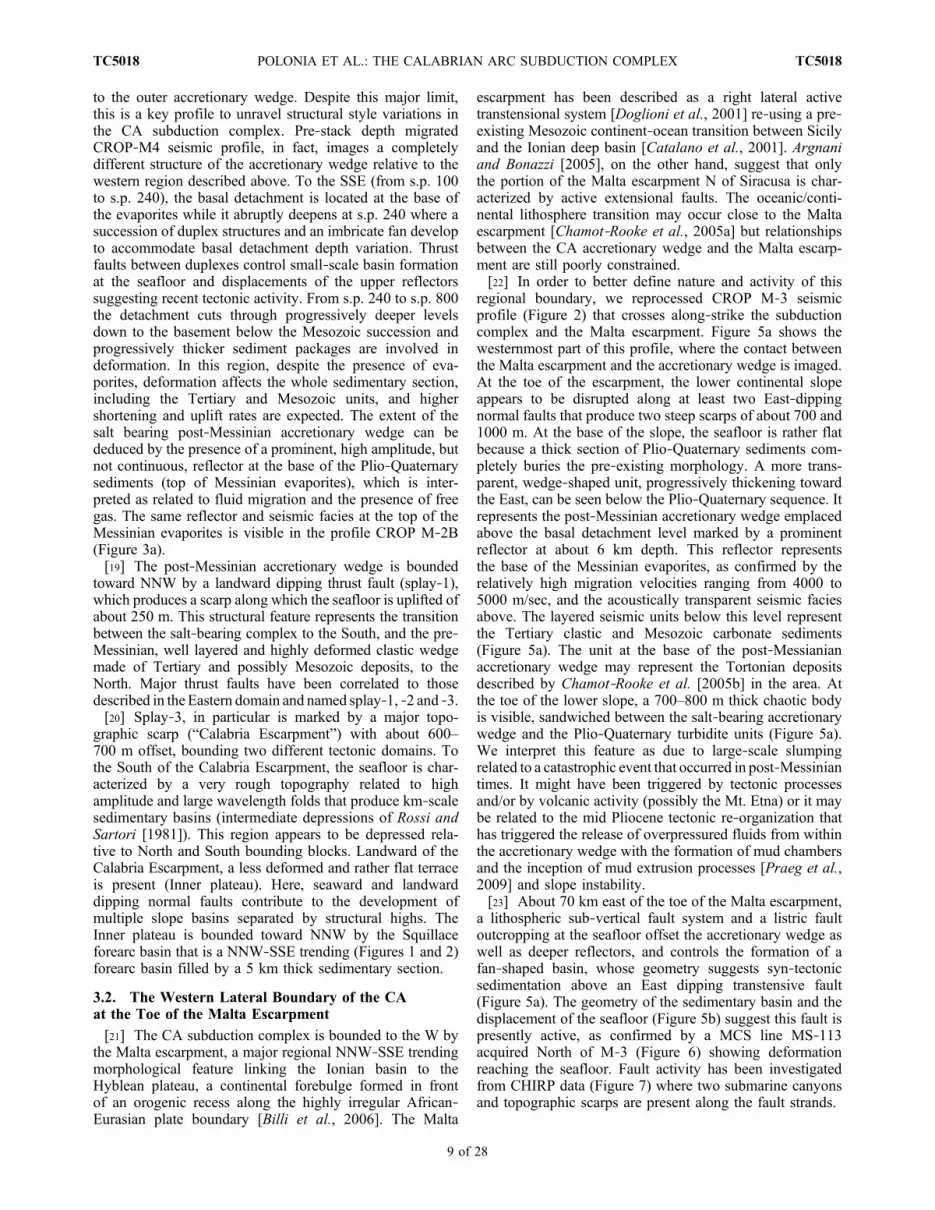
[21] The CA subduction complex is bounded to the W bythe Malta escarpment, a major regional NNW‐SSE trendingmorphological feature linking the Ionian basin to theHyblean plateau, a continental forebulge formed in frontof an orogenic recess along the highly irregular African‐Eurasian plate boundary [Billi et al., 2006]. The Malta
escarpment has been described as a right lateral activetranstensional system [Doglioni et al., 2001] re‐using a pre‐existing Mesozoic continent‐ocean transition between Sicilyand the Ionian deep basin [Catalano et al., 2001]. Argnaniand Bonazzi [2005], on the other hand, suggest that onlythe portion of the Malta escarpment N of Siracusa is char-acterized by active extensional faults. The oceanic/conti-nental lithosphere transition may occur close to the Maltaescarpment [Chamot‐Rooke et al., 2005a] but relationshipsbetween the CA accretionary wedge and the Malta escarp-ment are still poorly constrained.[22] In order to better define nature and activity of this
regional boundary, we reprocessed CROP M‐3 seismicprofile (Figure 2) that crosses along‐strike the subductioncomplex and the Malta escarpment. Figure 5a shows thewesternmost part of this profile, where the contact betweenthe Malta escarpment and the accretionary wedge is imaged.At the toe of the escarpment, the lower continental slopeappears to be disrupted along at least two East‐dippingnormal faults that produce two steep scarps of about 700 and1000 m. At the base of the slope, the seafloor is rather flatbecause a thick section of Plio‐Quaternary sediments com-pletely buries the pre‐existing morphology. A more trans-parent, wedge‐shaped unit, progressively thickening towardthe East, can be seen below the Plio‐Quaternary sequence. Itrepresents the post‐Messinian accretionary wedge emplacedabove the basal detachment level marked by a prominentreflector at about 6 km depth. This reflector representsthe base of the Messinian evaporites, as confirmed by therelatively high migration velocities ranging from 4000 to5000 m/sec, and the acoustically transparent seismic faciesabove. The layered seismic units below this level representthe Tertiary clastic and Mesozoic carbonate sediments(Figure 5a). The unit at the base of the post‐Messianianaccretionary wedge may represent the Tortonian depositsdescribed by Chamot‐Rooke et al. [2005b] in the area. Atthe toe of the lower slope, a 700–800 m thick chaotic bodyis visible, sandwiched between the salt‐bearing accretionarywedge and the Plio‐Quaternary turbidite units (Figure 5a).We interpret this feature as due to large‐scale slumpingrelated to a catastrophic event that occurred in post‐Messiniantimes. It might have been triggered by tectonic processesand/or by volcanic activity (possibly the Mt. Etna) or it maybe related to the mid Pliocene tectonic re‐organization thathas triggered the release of overpressured fluids from withinthe accretionary wedge with the formation of mud chambersand the inception of mud extrusion processes [Praeg et al.,2009] and slope instability.[23] About 70 km east of the toe of the Malta escarpment,
a lithospheric sub‐vertical fault system and a listric faultoutcropping at the seafloor offset the accretionary wedge aswell as deeper reflectors, and controls the formation of afan‐shaped basin, whose geometry suggests syn‐tectonicsedimentation above an East dipping transtensive fault(Figure 5a). The geometry of the sedimentary basin and thedisplacement of the seafloor (Figure 5b) suggest this fault ispresently active, as confirmed by a MCS line MS‐113acquired North of M‐3 (Figure 6) showing deformationreaching the seafloor. Fault activity has been investigatedfrom CHIRP data (Figure 7) where two submarine canyonsand topographic scarps are present along the fault strands.
POLONIA ET AL.: THE CALABRIAN ARC SUBDUCTION COMPLEX TC5018TC5018
9 of 28

[24] We interpret this fault system as a major lithosphericstructure that segments the subduction complex close to acontinental corner; it may be described as the shallowexpression of a “STEP” (Slab Transfer Edge Propagator)fault [Govers and Wortel, 2005] accommodating differentrates of slab roll back and may result in substantial defor-mation, rotation, topography and sedimentary basins. Adifferential rollback between the retreating Ionian litho-sphere and a “stationary” Sicilian lithosphere has also beenconsidered by Doglioni et al. [2001]. The described fault
represents also the boundary between the salt‐bearing post‐Messinian complex and the pre‐Messinian clastic wedge,and is located in a region where the basal detachment cuts todeeper levels (Figure 5a). The structural features observedby Argnani and Bonazzi [2005] to the North support theoccurrence of a lithospheric tear between the Ionian oceanicbasin and the Hyblean plateau that in our opinion is re-presented by the lithospheric fault located at about 70 kmfrom the Malta escarpment imaged in seismic profile M‐3(Figure 5a).
Figure 5a. Pre‐stack depth migrated 36 foldMCS line CROPM‐3 across the transition between theMaltaescarpment and CA accretionary wedge (see Figure 2 for its location). At the toe of the Malta escarpment,the post‐Messinian salt bearing complex lies on the basal detachment and is covered by a 800 m thickchaotic body representing a lower Pliocene olistostrome. At trace number 1, a lithospheric‐scale faultsystem is imaged; this is the shallow expression of a “STEP” fault [Govers and Wortel, 2005]. Along thisfault, large offset vertical displacement of seismic reflectors is present and a fan shaped sedimentary basindevelops.
POLONIA ET AL.: THE CALABRIAN ARC SUBDUCTION COMPLEX TC5018TC5018
10 of 28

[25] This structure plays an important role in controllingsubduction processes and margin segmentation, and mayrepresent a seismogenic feature likely to have generatedmajor earthquakes in the past such as the 1908 Messina and1963 Catania earthquakes. In fact, this structure is active, islarge (100 km) and is deeply rooted. Moreover it boundssectors of the margin characterized by different slip‐vectorsand deformation rates, and connects the plate boundary ofN‐Sicily to the subduction thrust of the Ionian Sea.
4. High‐Resolution Seismic Reflection DataInterpretation
[26] We acquired high‐resolution MCS and sub‐bottomCHIRP‐sonar data across the deformation front (Calamare08survey in Figure 2); these two data sets led us to map location,geometry and nature of active structures in the outermostregion of the accretionary wedge. MCS profiles were col-lected using an array of 2 Sodera G.I. guns as seismic source,and a 48 channels, 1200 m‐long streamer as receiver. Chirp‐sonar profiles were collected using a Benthos Chirp II systemequipped with 15 transducers. We used these data to relaterecent deformation observed at the seafloor (or in the shallowsub‐surface) to deeply rooted structures, and verify whetherthe outer deformation front is still moving outwards as aconsequence of offscraping, shortening and uplift of Africanplate sediments.[27] The morpho‐tectonic domains that characterize the
eastern CA have also been analyzed through interpretationof a set of SPARKER seismic data (Figure 2) acquiredby IGM (now ISMAR‐Bo) in the Ionian Sea during the 70s[Rossi and Sartori, 1981]. These data, available only inhardcopies, have been digitized, processed and geo‐
referenced using the open‐source software Seisprho[Gasperini and Stanghellini, 2009].
4.1. The Transition From the Ionian Abyssal Plain tothe Outer Deformation Front
[28] The outermost accretionary wedge is bounded towardSE by the outer deformation front (Africa/Eurasia plateboundary in the Ionian Sea). The high resolution MCS andthe CHIRP sub‐bottom CALA‐15 profiles (Figures 8 and 9,respectively) have been acquired close to CROP line M‐2B(Figure 2), in the central part of the outermost accretionarywedge. Figures 8 and 9 show the external part of the pro-files, crossing the transition between the flat Ionian AbyssalPlain domain to SE, and the outermost Calabrian wedge toNW. This is the ideal site to study active deformation drivenby subduction processes. The deformation front (s.p. 1670on the MCS profile in Figure 8 and ping 8000 on the CHIRPprofile in Figure 9) marks the boundary between these twodomains and is the site where the first fold affecting theseafloor is visible. A description of the observed structuraldomains follows.4.1.1. The Proto‐Thrust Area Under the Flat IonianAbyssal Plain[29] SE of the deformation front the seafloor of the Ionian
abyssal plain is rather flat while P‐Q and Messinian sedi-ments are folded and deformed (Figure 8). An incipient foldis forming at about s.p. 1750, but it does not affect theseafloor, probably because the sedimentation rate is higherthan uplift rate. This area belongs to the proto‐thrust domainthat develops at the toe of the wedge, where African platesediments undergo the first phase of ductile deformation.Deeper reflectors show a higher degree of folding while foldamplitude progressively decreases toward SE. Folding in theproto‐thrust area is related both to shortening and to halo-kinetic processes (i.e., salt cored folds, as fold shown at s.p.1670 in Figure 8) driven by the differential load of thegrowing accretionary wedge.[30] CHIRP sub‐bottom line CALA‐15 (Figure 9) col-
lected in the abyssal plain in correspondence of the MCSprofile described above, shows that incipient folds along thetoe of the wedge (ping 8700 and 11300) affect the seafloor.This suggests that part of the abyssal plain deformed byincipient folding is about to be included in the accretionarywedge. We consider this region to be related to the proto‐thrust domain because the seafloor appears to be onlyslightly undulated. Fold amplitude of deep reflectors pro-gressively decreases from the toe of the wedge (40–50 m) tothe end of the CHIRP section (10 m). Fold wavelength israther constant, i.e., about 3 km. The relatively lessdeformed sediments in the proto‐thrust domain are abruptlyuplifted along the outer deformation front, represented bythe first fold clearly disrupting the seafloor at ping 8000(Figure 9). Deformation of the uppermost transparent layer,identified as the 3500 BP Augias Turbidite (Figure 9,ping 11000), indicates active shortening at the toe of thewedge, implying that frontal accretion is active at the wedgefront.[31] An integrated interpretation of chirp and MCS pro-
files shows that incipient folds in the proto‐thrust domainare related to thrust faults at depth, as imaged by MCSseismic data CALA‐15 at s.p. 1760 in Figure 8, where a
Figure 5b. Close‐up view of pre‐stack depth migrated 36fold MCS line CROP M‐3 seismic lien across the sedimen-tary basin that develops above the STEP fault. Location ofseismic profile is shown in Figure 2. A series of E dip-ping normal faults and antithetic structures are well imaged.The seafloor appears displaced along the shallow expressionof the deeply rooted lithospheric STEP fault imaged inFigure 5a.
POLONIA ET AL.: THE CALABRIAN ARC SUBDUCTION COMPLEX TC5018TC5018
11 of 28

landward dipping reflector soling out on the base of theMessinian evaporites appears to control the observed foldingprocesses. Thrusting appears to be limited to the Messinianunit and to the base of the Plio‐Quaternary. For this reason,we consider this part of the abyssal plain not yet fullyincluded in the accretionary wedge. Progression of plateconvergence will possibly produce a shift of the deformationfront from its present position to about 4 km forward wherethe blind thrust fault is present (s.p. 1760 in Figure 8).[32] Below the Messinian evaporites, a well layered sed-
imentary section is imaged down to 8 s TWT (Figure 8).Correlation with CROP line M‐2B allow us to interpret theunconformity visible at about 7 s TWT as the base of theTertiary section, and the prominent reflector at about 8 sTWT as the base of the Mesozoic carbonate unit.4.1.2. The Outer Calabrian Accretionary Wedge[33] Landward of the deformation front, the African plate
sediments are deformed, uplifted and piled up to form theaccretionary wedge (Figure 8), that shows the peculiar geom-etry (very low taper angle) of salt bearing complexes like theMediterranean Ridge [Chaumillon et al., 1996;Chaumillon andMascle, 1997; Mascle and Chaumillon, 1998; Reston et al.,
2002]. The basal detachment is located at the base of theMessinian evaporites, as major thrust faults sole out on thisstrong amplitude reflector. This reflector appears undulated,but this is an artifact due to a seismic velocity pull‐up effect.Thrust faults are mainly interpreted based on the presence oflandward dipping reflectors soling out on the basal detach-ment, seismic reflectors offsets and small scarps at the seafloor.Thrust spacing is variable (Figure 8): it is less than 2 kmlandward of s.p. 1520, while seaward of this point it increasesand deformation is spread over a wider area. In this weaklydeformed region surface angle is about 0.5°, while the surfaceangle averaged from s.p. 1200 to s.p. 1680 is about 1°. Seismicresolution is poor within the accretionary wedge due to thehigh backscatter caused by the heavy deformation pattern.[34] The CHIRP profile CALA‐15 (Figure 9) better ima-
ges the progression of folds that uplift the seafloor movingtoward the inner parts of the wedge. The outermost part ofthe accretionary wedge (Figure 9 from ping 8000 to 14000)is characterized by a series of folds separated by perchedsedimentary basins. Separation between folds and relatedsedimentary basin, show a characteristic 2.5 km wavelength,while the fold’s amplitude, estimated considering the top
Figure 6. Post‐stack time migrated MCS line MS‐113 and its interpretation. This seismic profile belongto the MCS MS‐ data set collected by OGS (National Institute of Oceanography and ExperimentalGeophysics) in 1980 with a 24 traces, 2400‐m‐long streamer. Shot interval of 100 m provided a 12‐foldcoverage. Location of seismic profile is indicated in Figure 2. In this profile, the shallow expression of the“STEP” fault [Govers and Wortel, 2005] is particularly evident due to sedimentation rate lower thantectonic deformation rates.
Figure 7. CHIRP sonar sub‐bottom profile across the tear fault system (see Figure 2 for location). Steeptopographic scarps, seafloor displacement and the presence of slumps and chaotic bodies on the flanks ofthe uplifted structural high to the ENE suggest that fault system is active.
POLONIA ET AL.: THE CALABRIAN ARC SUBDUCTION COMPLEX TC5018TC5018
12 of 28
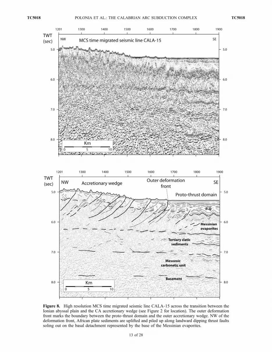
Figure 8. High resolution MCS time migrated seismic line CALA‐15 across the transition between theIonian abyssal plain and the CA accretionary wedge (see Figure 2 for location). The outer deformationfront marks the boundary between the proto‐thrust domain and the outer accretionary wedge. NW of thedeformation front, African plate sediments are uplifted and piled up along landward dipping thrust faultssoling out on the basal detachment represented by the base of the Messinian evaporites.
POLONIA ET AL.: THE CALABRIAN ARC SUBDUCTION COMPLEX TC5018TC5018
13 of 28

Figure
9.CHIRPsonarsub‐botto
mprofile
acquired
simultaneouslyto
theMCSprofile
show
nin
Figure8(see
Figure2
forlocatio
n).Thisprofile
clearlyshow
sactiv
edeform
ationat
theseafloor
relatedto
foldingandthrusting.
Deformationof
theupperm
osttransparentlayersuggeststhat
shortening
isactiv
eat
thetoeof
thewedge.Tow
ardNW,deform
ationrate
andfold
amplitu
deincrease,while
fold
wavelengthprogressivelydecreases.
The
roughmorphologyof
theouteraccre-
tionary
wedge
isknow
nas
“cobblestone
topography
”andisrelatedto
tectonic
processespossibly
drivingsaltdissolution.
POLONIA ET AL.: THE CALABRIAN ARC SUBDUCTION COMPLEX TC5018TC5018
14 of 28

of the Messinian evaporites on the MCS profile (Figure 8), isabout 100m.MovingNW(Figure 9), fold spacing decreases toabout 1.3–1.5 kmand sedimentary basins becomevery narrow.
4.2. The Eastern CA and the Interference Withthe Mediterranean Ridge Accretionary Wedge
[35] Figure 10 shows sparker profile J‐08 that crossesthe continental margin from the upper slope down to about3500m of depth, in a regionwhere the CA is facing directly theMediterranean Ridge (see Figure 2 for location). It cutsorthogonally the main structures, imaging a progression ofdomains characterized by different seafloor morphologies andstructural styles (from NW to SE, the inner plateau, the pre‐Messinian wedge and the outer wedge) that have been previ-ously described through the interpretation of CROP profileM4(Figure 4), close to SPARKER line J‐08, but not reaching theouter deformation front of the subduction system.4.2.1. Inner Plateau: Wide Slope Terrace With a WellDeveloped Plio‐Quaternary Sedimentary Basin[36] It is a rather flat area dipping slightly toward SE, with
large wavelength (50 km) undulations of the seafloor thatdevelops between 1300 and 1600 m water depth. A thicksection (about 1 s TWT) of Plio‐Quaternary sediments ispresent below the terrace over Messinian deposits whose topis located at about 2.3 s TWT at fix 85 (Figure 10), asconfirmed by well‐log data (Floriana borehole). Sedimentsappear folded and locally disrupted along sub‐verticaldeformation zones that bound sedimentary units character-ized by transparent seismic facies (fix 83 and 84) corre-sponding on the seafloor to small (about 1 km wide) sub‐circular swells, probably of diapiric origin. The nature andcomposition of the diapiric material (mud or evaporites) isnot determined through seismic data, but correlation with anexploration borehole well log (Floriana, Figure 2 for loca-tion) suggests they might be evaporite‐cored diapirs as thewell log has sampled the Gessoso Solfifera Formation(crystalline white gypsum, anhydrite, clay layers with salt).The source region of these diapirs is in fact located atabout 2.2–2.3 s TWT, where the Messinian unit is visible(Figure 10). Interestingly, the Messinian unit appears tothin toward the diapiric structure, possibly as a result oflateral flows. Immediately SE of fix 70 and close to the sub‐vertical fault described at fix 71, another mound is present. Itsgeometry and location suggests it might be an argilo‐kineticstructure, since it develops in a region where the Messiniansalt or gypsum are absent. Diapiric processes observed in thisregion might be related to the presence of transtensive faultssegmenting the continental margin [Del Ben et al., 2008],similar to those controlling development of the SquillaceBasin. Sparker section J‐03 crossing this basin images a NEdipping master fault outcropping at the seafloor at fix 21,which appears to drive diapiric processes (Figure 11). Theexternal part of the inner plateau is site of a 300 m deepsedimentary basin (Figure 10, fix 61–63) that shows a flatbottom and a sub‐horizontal Plio‐Quaternary infill.4.2.2. Inner Wedge[37] This is a region characterized by a progression of
long wavelength (about 10 km) and high amplitude (about250–300 m) undulations of the seafloor. In sparker line J‐08,between fix 53 and fix 39 (Figure 10) a depressed area belowthe regional topographic profile is present, with two deepsedimentary basins separated by structural highs. The
depressed area is bounded to the NW by a seaward dippingtopographic scarp (Calabrian Escarpment), along whichthe seafloor deepens of about 1 s TWT (750 m). In the bathy-metric map (Figure 1) this scarp corresponds to a NNE‐SSWtrending sub‐rectilinear feature that separates longitudinallythe pre‐Messinian wedge from the rather flat inner plateau tothe NW. The pre‐Messinian wedge is bounded to SE by theinner deformation front (Figure 10) separating the pre‐ andpost‐Messinian accretionary wedges. This part of the sub-duction complex has been described by Rossi and Sartori[1981] as the “external CA.” In our reconstruction, the so‐called “external CA” represents the inner accretionary wedgeemplaced during pre‐Messinian times.4.2.3. Outer Wedge and Transitionto the Mediterranean Ridge[38] The outer wedge is characterized by a very poor
seismic penetration on the sparker data (Figure 10). A roughseafloor morphology is related to the presence of close‐spaced folds superimposed over large wavelength undula-tions that produce several kilometers wide alternatingdepressions and highs. This seafloor texture appears differ-ent from the post‐Messinian wedge morphology typical ofthe western CA, where fold spacing is very narrow andno large basins are present. The integrated interpretationof SPARKER line J‐08 (Figure 10) and MCS line CROPM‐4 (Figure 4) suggests that the depressions imaged inSPARKER profile J‐08 are the morphological expression ofthe duplex structures that involve the whole sedimentarysection in this portion of the subduction complex (Figure 4).Sparker profile J‐08 (Figure 10) images the area where theCA connects to the Mediterranean Ridge accretionarycomplex. This transition is located at about 3000 m waterdepth: no undeformed abyssal plain is present, and the twoaccretionary wedges connect, suggesting that incipient col-lision is occurring between the two subduction complexes.The SPARKER profile has no penetration; thus, this seismicline does not unravel interference patterns of the two col-liding subduction complexes.
5. Discussion
5.1. Across Strike Regional Architecture and ActiveFaults
[39] The frontal region of the CA complex is formed by apost‐Messinian accretionary wedge made of Messinianevaporites overlain by Plio‐Quaternary, extensively folded,hemipelagites and turbidites. The basal detachment of thewedge occurs at the base of the Messinian evaporites: abovethe basal detachment sediments have been offscraped andpiled up in the accretionary wedge through frontal accretionwhile the pre‐Messinian sediments are attached to theunderlying African plate. The salt‐bearing accretionarywedge in the western CA is bounded toward the NW by aslope terrace located at about 3000 m water depth. This flatarea has been interpreted by many authors as the seawardboundary of the CA subduction complex and the outerdeformation front has been often reported along the land-ward edge of this terrace [Rossi and Sartori, 1981; Frepoliet al., 1996; Catalano et al., 2001; Faccenna et al., 2001;Bigi et al., 2003; Goes et al., 2004; Chiarabba et al., 2005;Govers and Wortel, 2005; Lucente et al., 2006; Minelli and
POLONIA ET AL.: THE CALABRIAN ARC SUBDUCTION COMPLEX TC5018TC5018
15 of 28

Figure
10.
Sparker
seismicprofile
J‐08
across
thecontinentalm
arginsouthof
Calabria(see
Figure2forits
locatio
n).T
his
profile
highlig
htsthedifferentseafloormorphologyrelatedto
theprogressionof
structuraldomains
thatcharacterize
theCA
subductio
ncomplex
inthisregion.T
herather
flatinnerplateauisboundedtowardSby
theroughmorphologyof
theinner
accretionary
wedge,andby
agently
folded
outeraccretionary
wedge
facing
directly
theMediterraneanRidge
accretionary
complex.Correlatio
nbetweenseismic
andborehole
data
allow
toidentifyanddate
mainseismostratigraphic
units.
POLONIA ET AL.: THE CALABRIAN ARC SUBDUCTION COMPLEX TC5018TC5018
16 of 28

Figure
11.
Sparker
seismicprofile
J‐03
paralleltotheCalabrian
continentalm
argin(see
Figure2forlocatio
n).T
heprofile
clearlyshow
sasub‐vertical
norm
almasterfaultcontrolling
thedevelopm
entof
theSquillacebasinto
theSW,andthe
reversefaultb
oundingthesedimentary
basinto
theNE.D
iapiricstructures
arepresentw
ithin
thehangingwallo
fthenorm
alfault.
POLONIA ET AL.: THE CALABRIAN ARC SUBDUCTION COMPLEX TC5018TC5018
17 of 28

Faccenna, 2010] or even within the post‐Messinian wedge[Guillaume et al., 2010].[40] The integrated interpretation of our multiscale data
set has clearly shown that the frontal thrust is located indeedat the transition with the abyssal plain. Moreover, the verylow tapered salt‐bearing wedge landward of the deformationfront is still growing thanks to frontal tectonic accretionoccurring at the base of the lower Messinian evaporites(Figures 3a, 8, and 9). The flat area at the rear of the salt‐bearing complex in the western region (Figures 3a and 3b)corresponds to a thrust top Messinian basin developing atthe transition between the salt bearing complex and pre‐Messinian wedge. Below the sedimentary basin, the basaldetachment cuts to deeper levels. This may lead to thedevelopment of duplex structures, subcretion and under-plating of pre‐Messinian sediments, similarly to what hasbeen described for the Mediterranean Ridge to the East[Reston et al., 2002]. Moving from SE to NE in this region,the subduction thrust changes its dip from a rather flatgeometry to about 4° of slope, and CROP seismic linesimage out‐of sequence thrusts, that propagate down to thetop of the subducting plate (Figures 3a and 3b). In theEastern region (Figure 4) detachment level variations occurin a front‐most area, within the salt bearing accretionarywedge, and also in this region where the detachment getsdeeper a number of out of sequence thrust faults (splay)develop to accommodate depth variations.[41] These faults reflect, on one hand the structural con-
trast between a shallow décollement (base of the Messinianevaporites) in the frontal wedge and a deep décollementwithin the innermost accreted sediment; on the other hand,they may be expression of underplating occurring at depth,where the thick Tertiary and Mesozoic sediments areincorporated at the base of the accretionary wedge. Anaccurate knowledge of geometry and degree of activity ofthese faults is important to estimate more accurately seismicand tsunami hazard. In fact, splay faults have been proposedas pathways for co‐seismic slip, which can potentiallyincrease the amplitude of an associated tsunami [Cumminsand Kaneda, 2000; Park et al., 2002; Satake et al., 2003;Sibuet et al., 2007]. IODP drilling results along the Nankaimargin, for example, highlight that, despite the westernportion of the splay fault has been inactivated since 1.24 Maby the collision with a seamount [Kimura et al., 2011], theeastern portion of the splay fault has remained active since theinception of faulting (shortening rate 1 m/kyr) and the authorsconclude that branches of the megasplay fault may slip anddeform coseismically [Kimura et al., 2011] and orientationand geometry of the fault are keys to evaluate the activity.[42] The pre‐collisional tectonic setting of the Ionian Sea is
characterized by a strong geological complexity mainlyrelated to the irregular plate boundary, different rates ofdeformation and variations in the structure and nature of theincoming African lithosphere. In this pre‐collisional settingthe described splay faults may represent active fault absorb-ing plate motion even though deep‐towed geophysical data,well targeted sediment samples, ROV observations anddrilling are crucial to evaluate splay fault activity. If sub-duction in the CA is still active theymay represent subductionmegathrusts and may slip and deform coseismically, espe-cially those branches in the eastern area offshore Calabria
(Figure 4) where the subducting lithosphere remainsundetached as deduced by local earthquake tomography [Neriet al., 2009]. If subduction is already ceased and the prism isnot deforming by underthrusting of an oceanic plate but,rather, by a more distributed deformation, the proposed splayfaults may represent reactivated thrust faults absorbing ongo-ing plate convergence in an overall plate re‐organization tec-tonic phase. As in the case of other active margins, forearcbasins and slope terraces like the one present in the CA abovethe splay faults, are often linked to changes in the dip of thesubduction thrust and related syn‐tectonic sedimentation; asobserved in several regions including Nankai, Aleutians andCascadia, gravity lows and deep sea basins may representregions more prone to seismic risk [Wells et al., 2003; Fulleret al., 2006].[43] The boundary between the pre‐Messinian wedge and
the inner plateau in the eastern region occurs along theCalabrian Escarpment present at about s.p. 2500 in Figure 4that corresponds to splay‐3 described on the high penetra-tion MCS data. This feature shows all the characters of atranspressive fault accommodating strain partitioning at thecontact between the wedge and the inner plateau. A similarsetting is observed in the Mediterranean Ridge accretionarycomplex, where the accretionary wedge/backstop contact isrepresented by major strike slip faults [Chaumillon andMascle, 1997; Mascle and Chaumillon, 1998; Chamot‐Rooke et al., 2005b]. These structures are often associatedwith fluid venting because they represent conduits alongwhich material coming from the wedge interior can beextruded to the seafloor forming argilo‐kinetic structures.The lack of the evaporitic impermeable cap, active faultingalong the inner deformation front and transverse structuressegmenting the subduction complex, are all elements thatfavor rising of fluids from the wedge interior and formationof diapiric features [Chamot‐Rooke et al., 2005a]. Therecently discovered Pythagoras mud diapir [Praeg et al.,2009] is located along the wedge/inner plateau tectoniccontact, confirming that this boundary represents a favorablepathway for rising fluids.
5.2. Seafloor Morphology of the CA as DeducedFrom Multibeam Data
[44] If on one hand, the CA has always been described as asingle arc developed between the Malta escarpment andApulia foredeep, MCS data analysis has shown that thegeometry of the subduction complex (width, thickness, ele-vation, depth of the basal detachment) and its structural stylestrongly vary along strike. Analysis of the morphobathy-metric data collected during different cruises carried out inthe Ionian Sea and provided by the CIESM/Ifremer Medimapgroup [Loubrieu et al., 2008] confirms that major morpho-tectonic style variations occur between the western and theeastern sectors of the CA (Figure 12), suggesting segmen-tation of the subduction complex into two separate domains,we call Eastern Lobe (EL) and Western Lobe (WL).[45] The EL has a very arcuate shape that progressively
narrows to the SE where it impinges against the Mediter-ranean Ridge and no abyssal plain is present (Figure 12,profile a). A very complex seafloor morphology developsat the contact between the CA and MR subduction com-plexes (between 4000 and 3750 m water depth) where short
POLONIA ET AL.: THE CALABRIAN ARC SUBDUCTION COMPLEX TC5018TC5018
18 of 28

(≈1 km) wavelength depressions and swells develop, pos-sibly related to small‐scale, tectonically triggered haloki-netic processes. The outermost accretionary wedge in thisregion shows a rough morphology with ridges and troughswith few km wavelength (Figure 12, profile a). To the rearof the 3000 m isobath topographic slopes get steeper, up tothe upper part of the wedge (outer high) while backward adepressed area is present (intermediate depressions of Rossiand Sartori [1981]). These depressions belong to the innerwedge that corresponds to the pre‐Messinian clastic accre-
tionary wedge as deduced from the interpretation of seismicline CROP M4 (Figure 4).[46] The intermediate depressions are bounded to the NW
by the Calabria Escarpment, a prominent feature segmentinglongitudinally the subduction complex, previously describedon the basis of MCS data. The geometry of the CalabrianEscarpment, as deduced from the multibeam data (i.e., aseries of short and overlapping left stepping scarps) suggestsit represent a transpressive feature bounding the accretionary
Figure 12. Shaded relief morphobathymetric map compiled using data collected during different cruisesby the CIESM/Ifremer Medimap group [Loubrieu et al., 2008]. Major morphotectonic domains areindicated. The margin is segmented into two lobes (WL and EL). The boundary between the two lobes(black arrows) is marked by a diffuse area of deformation related to scarps, ridges and troughs. Twobathymetric profiles (a and b) across the two lobes highlight morphological differences.
POLONIA ET AL.: THE CALABRIAN ARC SUBDUCTION COMPLEX TC5018TC5018
19 of 28
wedge to the NW. Inward of the Calabria Escarpment, arather flat area is imaged (i.e., the inner plateau).[47] The WL is a very wide fan‐shaped lobe, which
reaches its maximum width and curvature at the contact withthe abyssal plain at about 4000 m water depth; it narrowstoward land, and loose its curvature north of the Alfeoseamount. Profile b in Figure 12, shows that the outeraccretionary wedge is characterized by very gentle slopesand a rough topography, due to the presence of depressionsand swells whose wavelength increases toward NW. Theouter accretionary wedge is wider than in the EL andbounded landwards by a 40 km wide slope terrace, thatcorresponds to the region where the out of sequence thrustfaults are imaged on the CROP line M‐2B (Figure 3a). ThePre‐Messianian wedge developing NW of the slope terraceis a complex region that shows deeply incisions related tomultiple systems of submarine canyons, wide depressionsand transverse topographic highs. The outer high in the WLis located within the outer ridge while in the EL is locatedlandwards at the contact between the inner wedge and theintermediate depressions. The comparison between theprofiles across the two distinct lobes (Figure 12, profiles aand b) clearly shows that the eastern lobe is steeper, moreelevated and with swells and depressions characterized bylarger amplitudes and wavelengths.[48] The integrated interpretation of MCS data and multi-
beam images suggests that differences in seafloor morphol-ogy are related to deep tectonic processes and possibly todifferent coupling rates on the plate boundary and recentplate re‐organization as described in the following section.
5.3. Along‐Strike Segmentation of the SubductionComplex
[49] We carried out an integrated interpretation of mul-tiscale seismic reflection profiles combined with availablemorphobathymetric data (Figure 12) in order to describestructural style variations along the accretionary wedge,and associate these variations to tectonic processes. Theresults are summarized in the structural map of the region(Figure 13) which includes major structural boundaries,active faults and the extent of the different structuraldomains (i.e., pre and post‐Messinian wedges and innerplateau).[50] The Western Lobe (WL) develops at the toe of the
Malta escarpment and extends southwards down to the−4000 m isobath. Here, the subduction complex shows itsmaximum extension and is fronted by a wide abyssal plaindomain. The WL architecture is imaged in seismic lineCROP M‐2B (Figure 3a) and is characterized by a typicallow tapered accretionary wedge detaching on the base of theMessinian evaporites.[51] The accretionary wedge is still growing through
frontal accretion and the upper part of the incomingAfrican plate sedimentary section is scraped off and piledup along seaward dipping thrust faults, soling out to thebase of the Messinian evaporites. The lithospheric structurewe recognized through the analysis of CROP line M‐3(Figure 5a), 70 km East of the Malta escarpment (STEPfault in Figure 13), has been previously described byChamot‐Rooke et al. [2005b] as a Mesozoic crustal‐scalestructure marking the continent‐ocean boundary of theIonian oceanic basin and presently still active with a near‐
vertical step‐like motion. Although these authors suggestedit may represent the western boundary of the Calabrianwedge, our data (Figure 5a) show that the post‐Messiniansalt bearing accretionary wedge is present also west of thisstructure. This implies that this fault does not represent thewestern boundary of the accreted sediments, but rather itdisplaces vertically the top of the accretionary wedge anddeeper reflectors. It was probably active throughout thePlio‐Quaternary, as testified by the syn‐tectonic sedimen-tation within the sedimentary basin that develops above it(Figures 5b and 6). This fault may represent a transtensivere‐activation of the Messinian subduction thrust faultbetween the pre and post‐Messinian wedge presently act-ing as a STEP fault between regions with varying slabdynamics.[52] The Eastern Lobe (EL) develops offshore Calabria in
front of the western verging Mediterranean Ridge and isrepresented by seismic line CROP M‐4 (Figure 4). In thisregion no undeformed abyssal plain is imaged as the twoopposite verging accretionary wedges are facing each otherproducing complex interference deformation patterns. Noslope terrace develops between the pre and post‐Messinianaccretionary complexes. The accretionary wedge is narrowerand it shows a very lobate shape, well represented by outerand inner deformation fronts (Figures 4, 10, and 13). Seis-mic images reveal a deeper décollement in this region, whilewedge geometry and structural style (width, surface slope,fold wavelength and amplitude) suggest higher shorteningand uplift rates, possibly related to varying rates of platecoupling on the basal detachment. In this region, in fact, thepresence of basement involved deformation and duplexstructures suggest the occurrence of underplating processesalso in the frontal part of the wedge.[53] We interpret these two lobes as related to two distinct
stages of the subduction processes, different rates of slabroll back or slab dynamics and plate fragmentation in theIonian Sea. The Ionian Sea region represents the final stageof the closure of an oceanic basin characterized by veryirregular continental margins and the presence of conti-nental promontories. We have described and mapped activetectonic structures in different regions of the subductioncomplex (i.e., wedge front, splay faults below the slopeterrace, inner deformation front and Calabria Escarpment).Recent deformation may be either interpreted as related tothe last stage of Calabria subduction and/or to the ongoingAfrica/Eurasia plate convergence that may occur without aslab penetrating into the mantle.[54] A combined analysis of deep seismic profiles, gravity
and earthquake tomography data, as well as numerical andanalog modeling derived from these geological constraints,will help understanding how the shallow structure of thesubduction complex is related to deeply rooted tectonicprocesses and if a new plate re‐organization is going on inthis area.[55] The major tectonic boundary delimiting the two
proposed lobes of the accretionary wedge (Figures 13) hasbeen studied through the analysis PSDM MCS line M‐3represented in Figure 14 that shows a wide area of defor-mation between the two proposed lobes producing dis-placements, and tectonic thickening of the deep units (i.e.,Mesozoic carbonates and basement) as well as deformationof the upper units with the formation of a series of ridges
POLONIA ET AL.: THE CALABRIAN ARC SUBDUCTION COMPLEX TC5018TC5018
20 of 28

and troughs at the seafloor well visible on the multibeammap of the study area (Figure 12). The diffuse area ofdeformation is related to low angle, eastward dipping faultsalong which the eastern lobe is overriding the westerndomain. To the North, close to the Messina strait thisstructural boundary is more likely represented by the set oftranstensive faults well described at the toe of the Maltaescarpment by Chamot‐Rooke et al. [2005b]. This trans-tensive fault system, displaces longitudinally the subductioncomplex and create a depressed area East of Sicily, alsovisible in the satellite‐derived free‐air gravity map of theregion (Figure 15) that shows two different patterns in theEL and the WL, separated by a linear gravity minimumcorresponding to the deformed region between the two lobesimaged in Figures 13 and 14.[56] Along this structural system relevant changes in
direction of GPS velocities are imaged between sites inSicily with respect to those in Calabria [Devoti et al., 2008;D’Agostino et al., 2008]. This suggests that the boundary wepropose between the WL and EL represents the expression
of a differential advance between the “true Calabrian” andPeloritan portions of the CA, explaining both the NW‐SEextension in the straits of Messina [D’Agostino andSelvaggi, 2004] as well as why Calabria is a bit offset (itappears to have advanced further SE) from NE Sicily. Thisdifferential offset would require a lithospheric scale faultbetween Calabria and NE Sicily while its primary expres-sion within the wedge would be a sort of transfer fault.[57] Major structural heterogeneities described in seismic
profiles, and the overall segmentation of the subductioncomplex in two lobes, may represent the shallow signatureof deeply rooted process and plate fragmentation in anincipient collisional setting at the end of the subductionphase. In fact, the distributed deformation described in theregion between the two lobes corresponds to the transitionbetween segments of the plate boundary where the slab isalready detached (northeastern Sicily) and the 100‐km‐longsegment of southern Calabria where the subducting litho-sphere remains undetached as deduced by local earthquaketomography [Neri et al., 2009].
Figure 13. Structural map of the CA region derived from integrated interpretation of available seismicdata and multibeam bathymetry provided by the CIESM/Ifremer Medimap group [Loubrieu et al., 2008]superposed over a gray levels bathymetric slope map. Major structural boundaries, active faults and theextent of the structural domains (i.e., pre and post‐Messinian wedges and inner plateau) are indicated. Thecontinental margin is segmented both across and along strike. The STEP fault located at about 70 km eastof the Malta Escarpment and the splay faults (splay 1, 2 and 3) are considered active features likely tohave generated major earthquakes in the past. The diffuse structural boundary between EL and WLaccommodates different rates of shortening, slab rollback and subduction dynamics in the differentsegments of the CA subduction zone.
POLONIA ET AL.: THE CALABRIAN ARC SUBDUCTION COMPLEX TC5018TC5018
21 of 28
5.4. Post‐Messinian Kinematics and ComparisonWith the Mediterranean Ridge
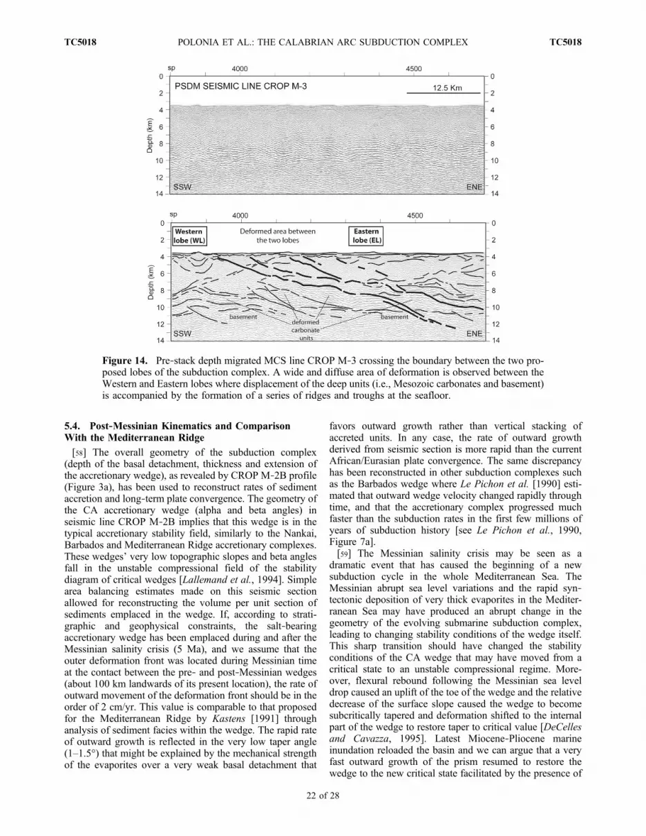
[58] The overall geometry of the subduction complex(depth of the basal detachment, thickness and extension ofthe accretionary wedge), as revealed by CROP M‐2B profile(Figure 3a), has been used to reconstruct rates of sedimentaccretion and long‐term plate convergence. The geometry ofthe CA accretionary wedge (alpha and beta angles) inseismic line CROP M‐2B implies that this wedge is in thetypical accretionary stability field, similarly to the Nankai,Barbados and Mediterranean Ridge accretionary complexes.These wedges’ very low topographic slopes and beta anglesfall in the unstable compressional field of the stabilitydiagram of critical wedges [Lallemand et al., 1994]. Simplearea balancing estimates made on this seismic sectionallowed for reconstructing the volume per unit section ofsediments emplaced in the wedge. If, according to strati-graphic and geophysical constraints, the salt‐bearingaccretionary wedge has been emplaced during and after theMessinian salinity crisis (5 Ma), and we assume that theouter deformation front was located during Messinian timeat the contact between the pre‐ and post‐Messinian wedges(about 100 km landwards of its present location), the rate ofoutward movement of the deformation front should be in theorder of 2 cm/yr. This value is comparable to that proposedfor the Mediterranean Ridge by Kastens [1991] throughanalysis of sediment facies within the wedge. The rapid rateof outward growth is reflected in the very low taper angle(1–1.5°) that might be explained by the mechanical strengthof the evaporites over a very weak basal detachment that
favors outward growth rather than vertical stacking ofaccreted units. In any case, the rate of outward growthderived from seismic section is more rapid than the currentAfrican/Eurasian plate convergence. The same discrepancyhas been reconstructed in other subduction complexes suchas the Barbados wedge where Le Pichon et al. [1990] esti-mated that outward wedge velocity changed rapidly throughtime, and that the accretionary complex progressed muchfaster than the subduction rates in the first few millions ofyears of subduction history [see Le Pichon et al., 1990,Figure 7a].[59] The Messinian salinity crisis may be seen as a
dramatic event that has caused the beginning of a newsubduction cycle in the whole Mediterranean Sea. TheMessinian abrupt sea level variations and the rapid syn‐tectonic deposition of very thick evaporites in the Mediter-ranean Sea may have produced an abrupt change in thegeometry of the evolving submarine subduction complex,leading to changing stability conditions of the wedge itself.This sharp transition should have changed the stabilityconditions of the CA wedge that may have moved from acritical state to an unstable compressional regime. More-over, flexural rebound following the Messinian sea leveldrop caused an uplift of the toe of the wedge and the relativedecrease of the surface slope caused the wedge to becomesubcritically tapered and deformation shifted to the internalpart of the wedge to restore taper to critical value [DeCellesand Cavazza, 1995]. Latest Miocene‐Pliocene marineinundation reloaded the basin and we can argue that a veryfast outward growth of the prism resumed to restore thewedge to the new critical state facilitated by the presence of
Figure 14. Pre‐stack depth migrated MCS line CROP M‐3 crossing the boundary between the two pro-posed lobes of the subduction complex. A wide and diffuse area of deformation is observed between theWestern and Eastern lobes where displacement of the deep units (i.e., Mesozoic carbonates and basement)is accompanied by the formation of a series of ridges and troughs at the seafloor.
POLONIA ET AL.: THE CALABRIAN ARC SUBDUCTION COMPLEX TC5018TC5018
22 of 28

the very weak basal detachment on the Messinian evapor-ites. If this reconstruction is correct, a very intense phase ofaccretion resumed during Messinian times aiming atreaching again the stability curve. In this reconstructionwedge building is not a linear process and a large part of theCA post‐Messinian accretionary wedge may have beenemplaced during or immediately after Messinian times.[60] To better analyze relationships between frontal
accretion and convergence rate we carried out a cross‐sectional area balancing on the depth‐converted seismicsection CROP M‐2B (Figure 16a). The long‐term accre-tionary history can be estimated comparing the volume perunit section of the post‐Messinian wedge (its area on theseismic profiles) and the sediment input in the trench duringthe last 5 Ma (i.e., the product of the integrated amount oforthogonal convergence during the post‐Messinian wedgebuilding and the thickness of sediment entering the sub-duction zone). Sediment input S is
S ¼ CV * T * TH ð1Þ
where CV = convergence velocity, T = time = 5 Ma andTH = thickness of the sedimentary section above the basaldetachment. Substituting real values in (1) gives 32 km2
of sediments available for accretion during the last 5 Mawithin those stratigraphic and kinematic constraints.
[61] The area (A) of the post‐Messinian wedge on seismicline CROP M‐2B, is given by
A ¼1=2 Hþ hð Þ * L
where L is the width of the salt bearing wedge (about100 km), and h and H its thickness in the abyssal plain(about 1.5 km) and in its landward boundary (about 3.5 km).This gives a volume per unit section (area) of about 250 km2
(Figure 16a).[62] As a consequence, the estimated volume per unit
section of the salt bearing accretionary complex in ourseismic line is about 7 times larger than the volume ofsediments entering the trench at the given convergence rate(0.5 cm/yr). This simple estimate assumes a constantthickness of Messinian evaporites in the abyssal plain, novariation in basal detachment depth and no volume lossduring accretion. On the other hand, the volume per unitsection of the CA post‐Messinian wedge is comparable tothat of the Mediterranean Ridge where convergence rate ison the order of 3–4 cm/yr [Chaumillon et al., 1996; Mascleand Chaumillon, 1998; Reston et al., 2002].[63] This discrepancy may be explained by different
causes that are not mutually exclusive.[64] 1. Convergence rate slowed down in the CA only in
the past one or two million years. This explanation is in
Figure 15. Free‐air satellite‐derived gravity map of the working area. Eastern and Western lobes (EL andWL) are characterized by the presence of two bulges separated by a NW‐SE trending gravity minimum(black arrows) corresponding to the wide deformed area between the two lobes imaged in seismic reflec-tion (Figure 14) and morphobathymetric data (Figures 12 and 13). Average difference in the gravity fieldbetween the two lobes exceeds 100 mgal.
POLONIA ET AL.: THE CALABRIAN ARC SUBDUCTION COMPLEX TC5018TC5018
23 of 28

agreement with Mattei et al. [2007] who suggested thatvertical axis rotations in the CA ceased in the uppermostpart of the Lower Pleistocene (about 1 Ma ago); this is inter-preted as a decreased efficiency of the tectonic processesrelated to the Ionian slab that caused on one hand a halting ofthe back‐arc opening in the Southern Tyrrhenian Sea and onthe other the decrease in convergence rate along the Ioniantrench;[65] 2. Sediment thickness in the abyssal plain during the
last 4–5 Ma might be larger. This is unlikely because thethickness of the evaporites is rather constant in the centralMediterranean Sea.
[66] 3. Wedge building process is independent on con-vergence rate.[67] According to (1), and assuming that during the last
5 Ma the entire sedimentary section above the basal detach-ment has been frontally accreted, we can derive a long‐termconvergence rate of 3.7 cm/yr. This value is very high ifcompared to the present‐day GPS estimated rate, but com-parable to the slab retreat velocity for the last 5 Ma proposedby Gueguen et al. [1998]. Trench migration during the last40 Myr as reconstructed by Faccenna et al. [2001] is notlinear but rather related to a succession of tectonic phaseslinked to the opening and extension in the Tyrrhenian
Figure 16. (a) Pre‐stack depth migrated MCS line CROP M‐2B with color‐code seismic velocitiesderived from seismic data migration. Location of seismic profile is shown in Figure 2. (b) Simplifiedline drawing of the time migrated seismic line CROP M‐2B. The post‐Messinian wedge has beenhighlighted with a gray pattern. (c) Simplified line drawing of a time migrated seismic section across theMediterranean Ridge (modified from Reston et al. [2002]). The two accretionary wedges have similar sizedespite the Mediterranean Ridge is growing ten times faster than the Calabrian Arc.
POLONIA ET AL.: THE CALABRIAN ARC SUBDUCTION COMPLEX TC5018TC5018
24 of 28

basin. From 15 to 10 Ma a decrease in subduction velocity(1–2 cm/yr) is related to a slow trench roll back before theonset of the main phases of Tyrrhenian extension. After-wards, between 5 and 3 Ma, subduction velocity increasedproducing a fast outer wedge growth while recently trenchroll back has slowed again [Minelli and Faccenna, 2010].The size of the outer accretionary wedge as reconstructedthrough our work is the result of this nonlinear trenchretreat averaged over 5 Ma.[68] Thermal modeling of the Calabrian subduction pro-
vides elements to constrain long‐term subduction velocities[Gutscher et al., 2006]. Indeed, the high heat flow (150–200 mW/m2) observed in the SE Tyrrhenian basin indicatesvigorous mantle convection below. High subductionvelocity (1 cm/yr or more) supplied to numerical models ledto a better agreement between observed and predicted heatflow [Gutscher et al., 2006]. However, these relatively highvelocities represent an average over the past few millionyears, and may not be indicative of the present‐day regime.[69] To better understand the apparent discrepancy
between the convergence rate and the amount of accretedsediments during the last 5 Ma, we have compared the sizeand geometry of the CA accretionary wedge to the Medi-terranean Ridge. The Mediterranean Ridge accretionaryhistory is similar to that of the CA because it is a salt bearingaccretionary wedge emplaced in two distinct phases sepa-rated by the deposition of the Messinian evaporites[Chaumillon and Mascle, 1997] that has strongly affectedthe structural style and the wedge building. Figure 16bshows a line drawing of the time section of MCS lineCROP M‐2B across the western CA while Figure 16c is aschematic line drawing of the Mediterranean Ridge afterReston et al. [2002]. The two wedges have comparablewidth and thickness; thus the volume per unit section ofaccreted material during post‐Messinian times is roughly thesame despite the very different convergence rates. Thiscomparison suggests that wedge growth may be nonlinearand/or independent on convergence velocity, as proposedfor the Barbados wedge by Le Pichon et al. [1990]. In thisreconstruction variations in the rate of slab roll‐back and/orthe dramatic Messinian salinity crisis play a fundamentalrole in driving wedge building processes.
6. Conclusion
[70] We used an integrated interpretation of a multiscaleseismic reflection data set to describe the tectonic setting ofthe Calabrian Arc, along the African‐Eurasian plateboundary in the Ionian Sea. Several tectonic domains weredescribed, and a kinematic reconstruction based on struc-tural and stratigraphic constraints provided by the analysisof depth‐migrated crustal sections. High resolution multiand single‐channel seismic reflection profiles were usedto map active, potentially seismogenic features that couldhave caused the historical destructive earthquakes of theregion. We found the following.[71] 1. The emplacement of the Messinian evaporites in
the sedimentary section produced an abrupt change inwedge building processes marked by variations in topo-graphic slope angles, basal detachment depths, as wellas variations in structural style and deformation rates. Thevery low tapered post‐Messinian accretionary wedge in the
western region of the CA is a salt bearing accretionarycomplex where frontal accretion of the Messinian and Plio‐Quaternary units do actually occur along a basal detachmentlocated at the base of the Messinian evaporites. The pre‐Messinian accretionary wedge is constituted by Tertiary andMesozoic sediments; here the basal detachment is located atthe top of the Mesozoic carbonates or oceanic basement.Underplating processes and duplex formation are active inthis region. The transition between the post and pre‐ Mes-sinian accretionary wedges is the locus of complex faultingthat enhances fluid flow and mud diapirism.[72] 2. The CA subduction complex is segmented longi-
tudinally into two different lobes delimited by a NW/SEdeformation zone that accommodates differential move-ments of the Calabrian and the Peloritan portions of CA.This can explain the NW‐SE extension observed in thestraits of Messina as well as why Calabria has advancedfurther SE relative to NE Sicily. The formation of the twolobes and their evolution may be driven by additional fac-tors, such as tectonic rotations related to different rates ofcollision with the Mediterranean Ridge along the irregularAfrica/Eurasia plate boundary and generally by plate frag-mentation during the terminal stages of subduction. Struc-tural style variations, such as taper angles, uplift rates andseafloor morphologies within the two lobes, suggest dif-ferent rates of plate coupling on the subduction thrust withthose in the Eastern lobe facing Calabria being higher. Wepropose these two lobes represent two distinct domains ofthe subduction complex, characterized by different stages ofsubduction and/or plate fragmentation in the Ionian Sea. Inparticular, the WL corresponds to areas where the slab isalready detached, while the EL corresponds to the region ofthe CA where local earthquake tomographic maps image ain depth continuous slab penetrating into the mantle.[73] 3. The post‐Messinian CA subduction complex has
structural style, width and geometries similar to the recentWestern Mediterranean Ridge, suggesting it is growing at asimilar rate despite the very different convergence velocitiesreported by GPS data. Simple cross‐sectional area balancingmade on the depth seismic section imply that the CA long‐term subduction velocity, averaged over the last 5 Ma, is inthe order of 3.5 cm/yr, about 10 times higher than GPScurrent motion. This suggests that convergence rate hasslowed down significantly in recent times (1 Ma) or that theoutward wedge velocity changed through time, being muchfaster than the subduction rate during the emplacement ofthe evaporites. The Messinian times may thus be seen as anew cycle in the accretion, possibly characterized by highgrowth rates of the accretionary wedge.[74] 4. Seismic data reveal the existence of both com-
pressive and transtensive active faults in the subductioncomplex. We propose a lithospheric NW/SE trendingtranstensive fault at about 70 km E of the toe of the Maltaescarpment as the shallow expression of a STEP fault. Inour interpretation, this structure, together with the boundarybetween the two lobes and a set of out‐of‐sequence thrustfaults (SPLAYS) at the transition between the pre‐ andpost‐Messinian wedges, represents seismogenic featureslikely to have generated major earthquakes in the past. Infact, these structures are active, are large (100 km), aredeeply rooted, and bounds sectors of the margin charac-terized by different deformation rates. In particular, the
POLONIA ET AL.: THE CALABRIAN ARC SUBDUCTION COMPLEX TC5018TC5018
25 of 28

observed out‐of‐sequence thrust faults reflect the structuralcontrast between a shallow décollement (Messinian eva-porites) in the frontal wedge and a deeper basal detachmentwithin the pre‐Messinian sediments, primarily due to dif-ferences in rheology. The out‐of‐sequence thrust faults inthe Eastern lobe (offshore Calabria) should be taken intoaccount for any reliable seismic risk assessment becausethis subduction lobe is characterized by higher deformationrates and steeper structures in depth.[75] Finally, we suggest that the proposed lithospheric
structure between the two lobes of the CA plays a funda-mental role in controlling subduction processes and marginsegmentation. The lack of thrust‐type seismicity along theCA complex may indicate that subduction is active butaseismic or that plate motion is expressed by large earth-quakes with long recurrence time intervals. If subduction hasstopped recently the prism is deforming not by underthrustingof an oceanic plate but, rather, by a more distributed defor-mation related to the still ongoing plate convergence. Inthis latter case, the proposed structure between the EL andWL may represent a recent boundary in a overall platere‐organization tectonic phase.[76] The segmented geometry of the CA subduction
complex, the very old African subducting oceanic crust andthe slow convergence rates should, however, prevent theoccurrence of earthquakes with M > 7.5.
[77] Acknowledgments. The CALAMARE scientific party(G. Bortoluzzi, C. Carmisciano, G. Carrara, M. Cuffaro, F. D’Oriano,M. Gambetta, M. Ligi, X. Locritani, L. Minelli, F. Muccino, D. Oppo,and I. Viola), Captain Lubrano, and the Urania shipboard and SOPROMARparties are greatly acknowledged for their important contribution in dataacquisition during the Urania cruise. We greatly acknowledge theCIESM/Ifremer Medimap group [Loubrieu et al., 2008] for having pro-vided us with the multibeam grid of the study area. Most maps were gen-erated using the GMT software [Wessel and Smith, 1991], while structuralmapping was performed with the SeisPrho software [Gasperini andStanghellini, 2009]. We thank Enrico Bonatti, Claudio Faccenna, Salva-tore Barba, and Carlo Doglioni for useful discussions. This work hasbeen supported by MIUR‐PRIN, 2006 (L. Torelli and R. Capozzi) andTOPOMED projects and has benefited from funding provided by the ItalianPresidenza del Consiglio dei Ministri ‐ Dipartimento della Protezione Civile(DPC). We acknowledge the Editor, Onno Oncken; Cesar Ranero; and twoanonymous reviewers for their suggestions and comments that have con-tributed to the improvement of the original version of the manuscript. Onespecial thought is addressed to Davide, for all he shared and transmitted tothe first author and L. Gasperini during his very short life. This is ISMARpaper 1718.
ReferencesArgnani, A., and C. Bonazzi (2005), Malta Escarpment fault zone offshoreeastern Sicily: Plio‐Quaternary tectonic evolution based on new multi‐channel seismic data, Tectonics , 24 , TC4009, doi :10.1029/2004TC001656.
Bigi, S., F. Lenci, C. Doglioni, J. C. Moore, E. Carminati, and D. Scrocca(2003), Décollement depth versus accretionary prism dimension in theApennines and the Barbados, Tectonics, 22(2), 1010, doi:10.1029/2002TC001410.
Billi, A., G. Barberi, C. Faccenna, G. Neri, F. Pepe, and A. Sulli (2006),Tectonics and seismicity of the Tindari Fault System, southern Italy:Crustal deformation at the transition between ongoing contractionaland extensional domains located above the edge of a subducting slab,Tectonics, 25, TC2006, doi:10.1029/2004TC001763.
Billi, A., D. Presti, C. Faccenna, N. Neri, and B. Orecchio (2007), Seismo-tectonics of the Nubia plate compressive margin in the south Tyrrhenianregion, Italy: Clues for subduction inception, J. Geophys. Res., 112,B08302, doi:10.1029/2006JB004837.
Bonardi, G., W. Cavazza, V. Peruarone, and S. Rossi (2001), Calabria‐Peloritani terrane and northern Ionian Sea, in Anatomy of an Orogen:
The Apennines and Adjacent Mediterranean Basins, edited by G. B. Vaiand I. P. Martini, pp. 286–306, Kluwer Acad., Dordrecht, Netherlands.
Bottari, A., P. Capuano, G. De Natale, P. Gasparini, G. Neri, F. Pingue,and R. Scarpa (1989), Source parameters of earthquakes in the Straitof Messina, Italy, during this century, Tectonophysics, 166, 221–234,doi:10.1016/0040-1951(89)90215-1.
Calais, E., C. DeMets, and J. M. Nocquet (2003), Evidence for a post‐3.16Ma change in Nubia–Eurasia–North America plate motions?, EarthPlanet. Sci. Lett., 216, 81–92, doi:10.1016/S0012-821X(03)00482-5.
Camerlenghi, A., and M. B. Cita (1987), Setting and tectonic evolutionof some eastern Mediterranean deep‐sea basins, Mar. Chem., 75, 31–56,doi:10.1016/0025-3227(87)90095-8.
Catalano, R., C. Doglioni, and S. Merlini (2001), On the Mesozoic IonianBasin, Geophys. J. Int., 144, 49–64, doi:10.1046/j.0956-540X.2000.01287.x.
Cernobori, L., A.Hirn, J. H.McBride, R. Nicolich, L. Petronio,M. Romanelli,and Streamers/Profiles Working Groups (1996), Crustal image of theIonian basin and its Calabrian margins, Tectonophysics, 264, 175–189,doi:10.1016/S0040-1951(96)00125-4.
Chamot‐Rooke, N., A. Rabaute, and C. Kreemer (2005a), Western Medi-terranean Ridge mud belt correlates with active shear strain at theprism‐backstop geological contact, Geology, 33, 861–864, doi:10.1130/G21469.1.
Chamot‐Rooke, N., C. Rangin, X. Le Pichon, and DOTMED WorkingGroup (2005b), DOTMED–Deep Offshore Tectonics of the Mediterranean:A synthesis of deepmarine data in easternMediterranean [CD‐ROM],Mem.Soc. Geol. Fr., 177, 64 pp.
Chaumillon, E., and J. Mascle (1997), From foreland to forearc domains:New multichannel seismic reflection survey of the MediterraneanRidge accretionary complex (eastern Mediterranean), Mar. Geol., 138,237–259, doi:10.1016/S0025-3227(97)00002-9.
Chaumillon, E., J. Mascle, and H. J. Hoffmann (1996), Deformation ofthe western Mediterranean Ridge: Importance of Messinian evaporiticformations, Tectonophysics, 263, 163–190, doi:10.1016/S0040-1951(96)00035-2.
Chiarabba, C., L. Jovane, and R. DiStefano (2005), A new view of Italianseismicity using 20 years of instrumental recording, Tectonophysics, 395,251–268, doi:10.1016/j.tecto.2004.09.013.
Cummins, P. R., and Y. Kaneda (2000), Possible splay fault slip during the1946 Nankai earthquake, Geophys. Res. Lett., 27, 2725–2728,doi:10.1029/1999GL011139.
D’Agostino, N., and G. Selvaggi (2004), Crustal motion along the Eurasia‐Nubia plate boundary in the Calabrian Arc and Sicily and active exten-sion in the Messina Straits from GPS measurements, J. Geophys. Res.,109, B11402, doi:10.1029/2004JB002998.
D’Agostino, N., A. Avallone, D. Cheloni, E. D’Anastasio, S. Mantenuto,and G. Selvaggi (2008), Active tectonics of the Adriatic region fromGPS and earthquake slip vectors, J. Geophys. Res., 113, B12413,doi:10.1029/2008JB005860.
de Voogd, B., C. Truffert, N. Chamot‐Rooke, P. Huchon, S. Lallemant, andX. Le Pichon (1992), Two‐ship deep seismic soundings in the basins ofthe eastern Mediterranean Sea (Pasiphae cruise), Geophys. J. Int., 109,536–552, doi:10.1111/j.1365-246X.1992.tb00116.x.
DeCelles, P. G., and W. Cavazza (1995), Upper Messinian conglomeratesin Calabria, southern Italy: Response to orogenic wedge adjustment fol-lowing Mediterranean sea‐level changes, Geology, 23(9), 775–778,doi:10.1130/0091-7613(1995)023<0775:UMCICS>2.3.CO;2.
Del Ben, A., C. Barnaba, and A. Taboga (2008), Strike‐slip systems as themain tectonic features in the Plio‐Quaternary kinematics of the CalabrianArc, Mar. Geophys. Res., 29, 1–12, doi:10.1007/s11001-007-9041-6.
Devoti, R., F. Riguzzi, M. Cuffaro, and C. Doglioni (2008), New GPS con-straints on the kinematics of the Apennines subduction, Earth Planet. Sci.Lett., 273, 163–174, doi:10.1016/j.epsl.2008.06.031.
Doglioni, C., S. Merlini, and G. Cantarella (1999), Foredeep geometries atthe front of the Apennines in the Ionian Sea (central Mediterranean),Earth Planet. Sci. Lett., 168, 243–254, doi:10.1016/S0012-821X(99)00059-X.
Doglioni, C., F. Innocenti, and G. Mariotti (2001), Why Mt Etna?, TerraNova, 13(1), 25–31, doi:10.1046/j.1365-3121.2001.00301.x.
Doglioni, C., E. Carminati, and M. Cuffaro (2006), Simple kinematics ofsubduction zones, Int. Geol. Rev., 48, 479–493, doi:10.2747/0020-6814.48.6.479.
Doglioni, C., E. Carminati, M. Cuffaro, and D. Scrocca (2007), Subductionkinematics and dynamic constraints, Earth Sci. Rev., 83, 125–175,doi:10.1016/j.earscirev.2007.04.001.
Faccenna, C., T. W. Becker, F. P. Lucente, L. Jolivet, and F. Rossetti(2001), History of subduction and back‐arc extension in the central Med-iterranean, Geophys. J. Int., 145, 809–820, doi:10.1046/j.0956-540x.2001.01435.x.
POLONIA ET AL.: THE CALABRIAN ARC SUBDUCTION COMPLEX TC5018TC5018
26 of 28

Faccenna, C., C. Piromallo, A. Crespo‐Blanc, L. Jolivet, and F. Rossetti(2004), Lateral slab deformation and the origin of the western Mediterra-nean arcs, Tectonics, 23, TC1012, doi:10.1029/2002TC001488.
Finetti, I. (1976), Mediterranean Ridge: A young submerged chain associ-ated with the Hellenic Arc, Boll. Geofis. Teor. Appl., 13, 31–65.
Finetti, I. (1982), Structure, stratigraphy, and evolution of central Mediter-ranean, Boll. Geofis. Teor. Appl., 24, 247–312.
Finetti, I. (2005), CROP Project: Deep Seismic Exploration of the CentralMediterranean and Italy, Atlases Geosci., vol. 1, Elsevier, Amsterdam.
Frepoli, A., G. Selvaggi, C. Chiarabba, andA.Amato (1996), State of stress inthe southern Tyrrhenian subduction zone from fault‐plane solutions, Geo-phys. J. Int., 125, 879–891, doi:10.1111/j.1365-246X.1996.tb06031.x.
Fuller, C. W., S. D. Willett, and M. T. Brandon (2006), Formation of fore-arc basins and their influence on subduction zone earthquakes, Geology,34, 65–68, doi:10.1130/G21828.1.
Galli, P., and V. Bosi (2003), Catastrophic 1638 earthquakes in Calabria(southern Italy): New insights from paleoseismological investigation,J. Geophys. Res., 108(B1), 2004, doi:10.1029/2001JB001713.
Gasperini, L., and G. Stanghellini (2009), SeisPrho: An interactive com-puter program for processing and interpretation of high‐resolution seis-mic reflection profiles, Comput. Geosci., 35, 1497–1507, doi:10.1016/j.cageo.2008.04.014.
Goes, S., D. Giardini, S. Jenny, C. Hollenstein, H.‐G. Kahle, and A. Geiger(2004), A recent tectonic reorganization in the south‐central Mediterra-nean, Earth Planet. Sci. Lett., 226, 335–345, doi:10.1016/j.epsl.2004.07.038.
Govers, R., and M. J. R. Wortel (2005), Lithosphere tearing at STEP faults:Response to edges of subduction zones, Earth Planet. Sci. Lett., 236,505–523, doi:10.1016/j.epsl.2005.03.022.
Gueguen, E., C. Doglioni, and M. Fernandez (1998), On the post‐25 Mageodynamic evolution of the western Mediterranean, Tectonophysics,298, 259–269, doi:10.1016/S0040-1951(98)00189-9.
Guillaume, B., F. Funiciello, C. Faccenna, J. Martinod, and V. Olivetti(2010), Spreading pulses of the Tyrrhenian Sea during the narrowingof the Calabrian slab, Geology, 38, 819–822, doi:10.1130/G31038.1.
Gutscher, M.‐A., J. Roger, M.‐A. Baptista, J. M. Miranda, and S. Tinti(2006), Source of the 1693 Catania earthquake and tsunami (southernItaly): New evidence from tsunami modeling of a locked subduction faultplane, Geophys. Res. Lett., 33, L08309, doi:10.1029/2005GL025442.
Gvirtzman, Z., and A. Nur (2001), Residual topography, lithospheric struc-ture and sunken slabs in the central Mediterranean, Earth Planet. Sci.Lett., 187, 117–130, doi:10.1016/S0012-821X(01)00272-2.
Hersey, J. B. (1965), Sedimentary basins of the Mediterranean Sea, in Sub-marine Geology and Geophysics: Proceedings of the 17th Symposium,Held in the University of Bristol, 5–9 April, edited by W. F. Whitardand W. Bradshaw, pp. 75–91, Butterworths, London.
Hinz, K. (1972), Zum Diapirismus im westlichen Mittelmeer, Geol. Jahrb.,90, 389–396.
Hollenstein, C., H.‐G. Kahle, A. Geiger, S. Jenny, S. Goes, and D. Giardini(2003), New GPS constraints on the Africa‐Eurasia plate boundary zonein southern Italy, Geophys. Res. Lett., 30(18), 1935, doi:10.1029/2003GL017554.
Jacques, E., C. Monaco, P. Tapponnier, L. Tortorici, and T. Winter (2001),Faulting and earthquake triggering during the 1783 Calabria seismicsequence, Geophys. J. Int., 147, 499–516, doi:10.1046/j.0956-540x.2001.01518.x.
Jenny, S., S. Goes, D. Giardini, and H.‐G. Kahle (2006), Seismic potentialof southern Italy, Tectonophysics, 415, 81–101, doi:10.1016/j.tecto.2005.12.003.
Jolivet, L., and C. Faccenna (2000), Mediterranean extension and the Africa‐Eurasia collision, Tectonics, 19, 1095–1106, doi:10.1029/2000TC900018.
Kastens, K. A. (1981), Structural causes and sedimentological effects of“cobblestone” topography in the eastern Mediterranean Sea, Ph.D. thesis,Scripps Inst. of Oceanogr., La Jolla, Calif.
Kastens, K. A. (1991), Rate of outward growth of the Mediterranean Ridgeaccretionary complex, Tectonophysics, 199, 25–50, doi:10.1016/0040-1951(91)90117-B.
Kastens, K. A., and M. B. Cita (1981), Tsunami‐induced sediment transportin the abyssal Mediterranean Sea, Geol. Soc. Am. Bull., 92, 845–857,doi:10.1130/0016-7606(1981)92<845:TSTITA>2.0.CO;2.
Kimura, G., G. F. Moore, M. Strasser, E. Screaton, D. Curewitz, C. Streiff,and H. Tobin (2011), Spatial and temporal evolution of the megasplayfault in the Nankai Trough, Geochem. Geophys. Geosyst., 12, Q0A008,doi:10.1029/2010GC003335.
Lallemand, S. E., P. Schnürle, and J. Malavieille (1994), Coulomb theoryapplied to accretionary and nonaccretionary wedges: Possible causesfor tectonic erosion and/or frontal accretion, J. Geophys. Res., 99,12,033–12,055, doi:10.1029/94JB00124.
Le Pichon, X., P. Henry, and S. Lallemant (1990), Water flow in theBarbados accretionary complex, J. Geophys. Res., 95, 8945–8967,doi:10.1029/JB095iB06p08945.
Loubrieu, B., et al. (2008), Morpho‐bathymetry of the Mediterranean Sea,special publication, Int. Comm. for Sci. Explor. of the Mediterr. Sea,Monaco.
Lucente, F. P., L. Margheriti, C. Piromallo, and G. Barruol (2006), Seismicanisotropy reveals the long route of the slab through the western‐centralMediterranean mantle, Earth Planet. Sci. Lett., 241, 517–529,doi:10.1016/j.epsl.2005.10.041.
MacKay, S., and R. Abma (1993), Depth‐focusing analysis using a wave-front‐curvature criterion, Geophysics, 58, 1148–1156, doi:10.1190/1.1443498.
Makris, J., R. Nicolich, and W. Weigel (1986), A seismic study in the west-ern Ionian Sea, Ann. Geophys., Ser. B, 6, 665–678.
Malinverno, A., and W. B. F. Ryan (1986), Extension in the TyrrhenianSea and shortening in the Apennines as result of arc migration drivenby sinking of the lithosphere, Tectonics, 5, 227–245, doi:10.1029/TC005i002p00227.
Marani, M. P., and T. Trua (2002), Thermal constriction and slab tearing atthe origin of a superinflated spreading ridge: Marsili volcano (TyrrhenianSea), J. Geophys. Res., 107(B9), 2188, doi:10.1029/2001JB000285.
Mascle, J., and E. Chaumillon (1998), An overview of MediterraneanRidge collisional accretionary complex as deduced from multichannelseismic data, Geo Mar. Lett., 18, 81–89, doi:10.1007/s003670050056.
Mattei, M., P. Cipollari, D. Cosentino, A. Argentieri, F. Rossetti, F. Speranza,and L. Di Bella (2002), The Miocene tectono‐sedimentary evolution of thesouthern Tyrrhenian Sea: Stratigraphy, structural and paleomagnetic datafrom the on‐shore Amantea basin (Calabrian Arc, Italy), Basin Res., 14,147–168, doi:10.1046/j.1365-2117.2002.00173.x.
Mattei, M., F. Cifelli, and N. D’Agostino (2007), The evolution of theCalabrian Arc: Evidence from paleomagnetic and GPS observations,Earth Planet. Sci. Lett., 263, 259–274, doi:10.1016/j.epsl.2007.08.034.
Minelli, L., and C. Faccenna (2010), Evolution of the Calabrian accretion-ary wedge (central Mediterranean), Tectonics, 29, TC4004, doi:10.1029/2009TC002562.
Montadert, L., J. Letouzey, and A. Mauffret (1978), Messinian event: Seis-mic evidence, Initial Rep. Deep Sea Drill. Proj., 42, 1021–1040,doi:10.2973/dsdp.proc.42-1.154.1978.
Morelli, A., et al. (2004), Geodynamic maps of the Mediterranean—Sheet2: Seismicity and tectonics, 1:13,000,000 scale, Comm. for the Geol.Maps of the World, Paris.
Neri, G., B. Orecchio, C. Totaro, G. Falcone, and D. Presti (2009), Subduc-tion beneath southern Italy close the ending: Results from seismic tomog-raphy, Seismol. Res. Lett., 80, 63–70, doi:10.1785/gssrl.80.1.63.
Park, J.‐O., T. Tsuru, S. Kodaira, P. R. Cummins, and Y. Kaneda (2002),Splay fault branching along the Nankai subduction zone, Science, 297,1157–1160, doi:10.1126/science.1074111.
Pasquale, V., M. Verdoya, and P. Chiozzi (2005), Thermal structure of theIonian slab, Pure Appl. Geophys., 162, 967–986, doi:10.1007/s00024-004-2651-x.
Patacca, E., and P. Scandone (2004), The Plio‐Pleistocene thrust belt‐fore-deep system in the southern Apennines and Sicily (Italy), in Geology ofItaly: Special Volume of the Italian Geological Society for the IGC 32Florence 2004, edited by S. Crescenti et al., pp. 93–129, Soc. Geol.It., Rome.
Patacca, E., R. Sartori, and P. Scandone (1990), Tyrrhenian basin andApenninic arcs: Kinematic relation since Late Tortonian times, Mem.Soc. Geol. Ital., 45, 425–451.
Piatanesi, A., and S. Tinti (1998), A revision of the 1693 eastern Sicilyearthquake and tsunami, J. Geophys. Res. , 103 , 2749–2758,doi:10.1029/97JB03403.
Polonia, A., A. Camerlenghi, F. Davey, and F. Storti (2002), Accretion,structural style, and syn‐contractional sedimentation in the eastern Med-iterranean Sea, Mar. Geol., 186, 127–144, doi:10.1016/S0025-3227(02)00176-7.
Pondrelli, S., C. Piromallo, and E. Serpelloni (2004), Convergence vs.retreat in southern Tyrrhenian Sea: Insights from kinematics, Geophys.Res. Lett., 31, L06611, doi:10.1029/2003GL019223.
Praeg, D., S. Ceramicola, R. Barbieri, V. Unnithan, and N. Wardell (2009),Tectonically‐driven mud volcanism since the late Pliocene on the Calab-rian accretionary prism, central Mediterranean Sea, Mar. Pet. Geol., 26,1849–1865, doi:10.1016/j.marpetgeo.2009.03.008.
Reilinger, R., et al. (2006), GPS constraints on continental deformation inthe Africa‐Arabia‐Eurasia continental collision zone and implications forthe dynamics of plate interactions, J. Geophys. Res., 111, B05411,doi:10.1029/2005JB004051.
Reston, T. J., R. von Huene, T. Dickmann, D. Klaeschen, and H. Kopp(2002), Frontal accretion along the western Mediterranean Ridge: The
POLONIA ET AL.: THE CALABRIAN ARC SUBDUCTION COMPLEX TC5018TC5018
27 of 28

effect of the Messinian evaporites on wedge mechanics and structuralstyle, Mar. Geol., 186, 59–82, doi:10.1016/S0025-3227(02)00173-1.
Rossetti, F., B. Goffe, P. Monie, C. Faccenna, and G. Vignaroli (2004),Alpine orogenic P‐T‐t deformation history of the Catena Costiera areaand surrounding regions (Calabrian Arc, southern Italy): The nappe edi-fice of north Calabria revised with insights on the Tyrrhenian‐Apenninesystem formation, Tectonics, 23, TC6011, doi:10.1029/2003TC001560.
Rossi, S., and R. Sartori (1981), A seismic reflection study of the externalCalabrian arc in the northern Ionian Sea (eastern Mediterranean), Mar.Geophys. Res., 4, 403–426, doi:10.1007/BF00286036.
Ryan,W.B. F., et al. (Eds.) (1973), Initial Reports of theDeep SeaDrillingProj-ect, Leg 13, vol. 13, 1447 pp., U.S. Gov. Print. Off., Washington, D. C.,doi:10.2973/dsdp.proc.13.1973.
Sartori, R. (2003), The Tyrrhenian back‐arc basin and subduction of theIonian lithoshere, Episodes, 26, 217–221.
Satake, K., K. L. Wang, and B. F. Atwater (2003), Fault slip and seismicmoment of the 1700 Cascadia earthquake inferred from Japanese tsunamidescriptions, J. Geophys. Res., 108(B11), 2535, doi:10.1029/2003JB002521.
Selvaggi, G., and C. Chiarabba (1995), Seismicity and P‐wave velocityimage of the southern Tyrrhenian subduction zone, Geophys. J. Int.,121, 818–826, doi:10.1111/j.1365-246X.1995.tb06441.x.
Serpelloni, E., G. Vannucci, S. Pondrelli, A. Argnani, G. Casula, M. Anzidei,P. Baldi, and P. Gasperini (2007), Kinematics of the western Africa‐Eurasiaplate boundary from focal mechanisms and GPS data, Geophys. J. Int.,169, 1180–1200, doi:10.1111/j.1365-246X.2007.03367.x.
Sibuet, J. C., et al. (2007), 26 December 2004 great Sumatra‐Andamanearthquake: Co‐seismic and post‐seismic motions in northern Sumatra,Earth Planet. Sci. Lett., 263, 88–103, doi:10.1016/j.epsl.2007.09.005.
Wells, R. E., R. J. Blakely, Y. Sugiyama, D. S. Scholl, and A. Dinterman(2003), Basin‐centered asperities in great subduction zone earthquakes:A link between slip, subsidence, and subduction erosion?, J. Geophys.Res., 108(B10), 2507, doi:10.1029/2002JB002072.
Wessel, P., and W. H. F. Smith (1991), Free software helps map and dis-play data, Eos Trans. AGU, 72, 441, doi:10.1029/90EO00319.
Westaway, R. (1993), Quaternary uplift of southern Italy, J. Geophys. Res.,98, 21,741–21,772, doi:10.1029/93JB01566.
Wortel, M. J. R., and W. Spakman (2000), Subduction and slab detachmentin the Mediterranean‐Carpathian region, Science, 290, 1910–1917,doi:10.1126/science.290.5498.1910.
Zito, G., F. Mongelli, S. De Lorenzo, and C. Doglioni (2003), Heat flowand geodynamics in the Tyrrhenian Sea, Terra Nova, 15, 425–432,doi:10.1046/j.1365-3121.2003.00507.x.
A. Artoni, P. Mussoni, and L. Torelli, Dipartimento di Scienze dellaTerra, University of Parma, Parco Area delle Scienze 157/A, I‐43100Parma, Italy. ([email protected]; [email protected]; [email protected])L. Gasperini and A. Polonia, Institute of Marine Sciences, ISMAR‐Bo,
CNR, Via Gobetti 101, I‐40129 Bologna, Italy. ([email protected]; [email protected])D. Klaeschen, Leibniz‐Institut für Meereswissenschaften (IFM‐
GEOMAR), Wischhofstr. 1‐3, D‐24148 Kiel, Germany. (dklaeschen@ifm‐geomar.de)
POLONIA ET AL.: THE CALABRIAN ARC SUBDUCTION COMPLEX TC5018TC5018
28 of 28