the archaeological project of bassein's portuguese settlement a new appraisal
TRANSCRIPT

Not For C
ommercial U
seC H A P T E R 1 4
The Archaeological Project of Bassein’s Portuguese Settlement A New Appraisal
Dejanirah Couto
In retracing the history of the port of Bassein under Portuguese rule (1534‒1739), this essay aims to draw attention to the need of launching
archaeological work in one of the most important possessions of the Estado da Índia, which played a key role in the economic life of the western Indian Ocean in the sixteenth and seventeenth centuries, and was a no less significant issue in the political games between the colonial and Maratha powers in the eighteenth century. Admittedly, some urban centres and coastal fortifications of the Indian Ocean have already been excavated1 and the results of archaeological campaigns published. Yet cities and ports which have experienced a long period of Portuguese rule in the Indian Ocean have never been excavated,2 which was not without effect on the historiographical production. In fact, publications, both in Portugal and elsewhere, are largely based on textual or sometimes epigraphic data: the archaeology of the Portuguese or Luso-Asian possessions has not yet emerged.
A glance at a map of India—which assesses the geographical location of Bassein—helps to understand why the Portuguese had such a strong interest in it. Belonging to the modern state of Maharashtra, the urban centre, currently a ‘ghost town’, is located on the west coast of the Indian subcontinent, on the Konkan coast, specifically on one of 25 islands of the Mumbai archipelago, between Bassein/Vasai and Khanderi, about 70 km. north of Mumbai.
Unlike other ports of Gujarat, Bassein, founded on the north shore of the Ulhoa (or Bahayandar), a river with deep water on a peninsula south of

Not For C
ommercial U
se
236 Dejanirah Couto
the island of Vasai, enjoyed excellent conditions for defence. The island was separated from the mainland along a north-south axis by a channel linking the Ulhoa River to the Vaitarna, north. The Ulhoa bathes a large area of saline lands and swamps flooded at high tide and during the monsoon. The port town of Bassein and its basin were thus limited to the south-west by the sea, to the south-east by the Ulhoa River,3 and to the north-east by a river (formed by an arm of the Ulhoa to which the Portuguese gave the name of esteiro) that protected its north/north-west front. Due to deposits of the river and sand carried by tides, the creek experienced a gradual silting, causing, as in many other coastal landscapes in the Indian Ocean, the decline of the port.
Marshlands still surround the ruins of the city and fortress in the north-east but alluvial fields have replaced the site of the former branch of the Ulhoa; they offer a landscape of diverse cultures, however, marked by the ubiquitous rice fields.
The history of the area is complex and the etymology of the name ‘Bassein’ controversial. The port, commonly known under the name of Vasai (from the Sanskrit word meaning ‘home’ or from varsa, meaning flock)4 remained unrecognized for an extended period. References we have, as well as some archaeological remains, mention the port of Kalyan, which is now far from the coast and the port of Supara,5 further east, on the shore of one of the bends of the Ulhoa. Kalyan and Supara are mentioned in the inscriptions of the Kanheri caves occupied by Buddhist monks from the first century ad.6
Kalyan remained a dynamic port in contact with the Mediterranean during the Gupta period under the reigns of Samudra Gupta (335–75) and Chandra Gupta II (375–415). Cosmas Indicopleustes (sixth century) mentions the port of Kalyan in connection with the trade of wood and fabrics. It was prosperous during the reign of the Chalukya rulers (who disappeared in the eighth century to be replaced by the Rashtrakutas) whose power was the result of trade relations with the ports of the Arabian Sea and especially the Persian Gulf. This period, during which many trading communities, Jains, Buddhists and Muslims, settled in the region, also consecrated Gujarat as an economic power.7 Port Thana, further south, near a branch of the Ulhas River that separated the Salcete island from the mainland also experienced a boom. Its privileged position allowed it to develop trade links with the hinterland, including Malwa.
Thus, it is possible to deduce how in this region of Gujarat, the emergence of new ports was closely linked to the silting of certain waterways. Of course, the technological changes in shipbuilding, shifts in the patterns

Not For C
ommercial U
se
The Archaeological Project of Bassein’s Portuguese Settlement 237
of maritime trade and impact of coastal piracy played their part, but the geographical conditions have no doubt played a decisive role in the decline of Supara and Kalyan. During the medieval period, it is Thana8 which is noted as the major port of the region. Deep-watered, it also enjoyed a fertile agricultural hinterland and exported leather goods, cotton and metals.9
As there were no archaeological excavations, dating when people settled at Bassein is uncertain, but the region was incorporated in the Sultanate of Delhi in the second decade of the fourteenth century, after the annexations by Muhammad bin Tughluq and the creation of Daulatabad, the ancient capital of the Yadava dynasty.10 In the fourteenth century, new political powers, such as the Bahmani Sultanate of Deccan born on the ruins of the Sultanate of Delhi, upset the balance of the region. The Bahmanids were supplanted in their turn by the Nizam Châhi of Ahmadnagar, who claimed ownership of the island of Salcete, Mumbai and Chaul.11
Regardless, the Livro of Duarte Barbosa, the most important European treatise on commercial geography of the Indian Ocean in the early sixteenth century, already mentions the port of Bassein.12 Compared to Kalyan, Thana’s advantage of its geographical position has quickly been taken into account by Muslim merchants: located just south of Supara, near the coast, it was deported further west. Merchants who settled there consolidated their position by marrying low-caste women from the coastal cities, belonging to families of fishermen and artisans working in shipbuilding. These social dynamics favoured the Muslim groups related to maritime trade. Their commercial dynamism has made famous the Sultanate of Gujarat in all the ports of the Indian Ocean as far as the East Indies.13
The hinterland of Bassein was rich with dense forest areas, producing high quality wood, including teak, prized in shipbuilding.14 Sites built boats for coastal navigation but also offshore, which probably influenced the further development of the port.15 Cultivated areas produced opium, areca nut, betel leaf,16 rice,17 wheat, anil (indigo plant) and sugarcane.18 Bassein also exported salt, fish, cotton (which was redistributed by the Portuguese as far as the Bay of Bengal under the name of panos de Cambaia) and horses, although it could not compete with Chaul, Dabhol, Goa or Bhatkal, true hubs of a trade that made the fortune of cities in Oman and the Persian Gulf.19
In the early sixteenth century, and more specifically after the founding of the Estado da Índia in 1505, the Portuguese renewed their interest towards Gujarat, especially the port of Diu, whose ships swarmed across the Indian Ocean. Very quickly, their goal was to dismantle and replace the Gujarati networks in maritime trade.20 This marketing strategy was

Not For C
ommercial U
se
238 Dejanirah Couto
based on political reasons: because of its relations with Qânsûh al-Ghûrî, the Mamluk Sultan of Cairo, enemy of the Portuguese Crown, the Gujarati Sultanate was an opponent of the Portuguese.21
However, despite their efforts (as evidenced by a succession of maritime expeditions, culminating with the one commanded by the governor of the Estado da Índia Nuno da Cunha in 1531)22 the Portuguese could not lay hold of Diu. Therefore, turning to another tactic they began weakening the Sultan of Gujarat by a war of attrition (while breaking no diplomatic contacts with him). This strategy eventually paid off: in 1513, the Portuguese managed to open a factory in Diu, and left as its director Fernão Martins Evangelho. However, it was closed in 1521 due to pressure by Gujaratis.23
Regardless, the idea to build a fort there, as part of a more ambitious goal, that of building (from 1519) forts at Chaul, in the Maldives, in Sumatra and the Moluccas continued to make its way.24
Like other ports of the Konkan Coast, economically linked to Diu, Bassein was also looted and destroyed by the Portuguese. Out of the eleven Portuguese expeditions launched in the region in the first half of the sixteenth century, seven were directed against Bassein.25 Moreover, some of the pages of the Décadas written by the chronicler Diogo do Couto provide particularly objective descriptions of the ferocity of the Portuguese.26
Forwarded to the Viceroy D. Francisco de Almeida when he attacked Dabul in 1509, information about the prosperity of Bassein and its strategic importance explains the Viceroy's intention to attack the port.27 Under the mandate of the Governor Nuno da Cunha (1529–38)28 the Portuguese wanted to avoid at all costs Bassein being transformed into a ‘second Diu’.29
As already mentioned, the port was destroyed by Heitor da Silveira in 1529, in the wake of the attack against Surat and Reynel.30 On 20 January 1533, the city and port facilities, which had been rebuilt in the meantime, were destroyed again by Nuno da Cunha, who razed the fortifications. However, the Portuguese failed to settle despite the importance of the military assets carried out. If they managed to settle in Bassein in 1534 and built the fortress at Diu in 1536 it was through diplomatic negotiations, which led to the first concession of Bassein—the first jurisdiction in the Estado da Índia to have a considerable area (about 2000 sq. km)31—by Sultan Qutb-ud-Din Bahadur of Gujarat (1526–37), son of Shams-ud-Din Muzaffar Châh II on 23 December 1534.32 Circumstances are well known: caught between the Portuguese who regularly besieged his ports, the progress of the Mughals and his own military campaigns against the Rajput states (Malwa and Chitor) Bahadur resigned himself to give Bassein to Nuno da Cunha as a means of defusing conflict with the Portuguese, removing them away from Diu and saving time concerning Humayun.33

Not For C
ommercial U
se
The Archaeological Project of Bassein’s Portuguese Settlement 239
The first phase of the Portuguese presence in Bassein was disrupted by the volte-face of Bahadur, who annulled several provisions of the concession agreement on freedom of maritime trade, which had been validated during the signing of the Treaty of 25 October 1535, treaty allowing the Portuguese to settle in Diu.34 Deciding to contest the supremacy of the latter, the Portuguese had first demanded that merchant ships pay fees at Bassein; Bahadur (who had accepted this clause in the first place) in turn demanded that rights were paid again at Diu, in accordance with the customs of maritime trade in the Indian Ocean. But Bahadur Châh was assassinated in 1537 under unclear circumstances, where we discern—if we believe the Lusitanian and Indo-Persian chroniclers—the hands of the Portuguese.35
Between 1538 and 1540, the Gujaratis maintained military pressure on Bassein as testified by incursions headed by Malik Ilias (Melique Acem) and by Burhân-ul-Mulk (Bramaluco), former governor of the territory and his nephew Nasir Malik-ud-Din (Melique Naçaruto).36
However, despite such instability, the Portuguese were able to complete an administrative reorganization of the territory along the lines of traditional agrarian system. Lands were distributed according to the prazos system, a hybrid form of territorial organization inspired by the iqtas, the feudal system existing in Muslim India. Insofar as all Muslim recipients did not abandon their plots, it was only very gradually that fidalgos Portuguese (and some Brahmins of Goa) received land under the new system. Over time, the system evolved: the recipients, who were required to reside first intra muros, were allowed to stay three months in their villages, which allowed them to better explore the land that had been allocated.37 The territory was first divided into administrative units—14 in total—called praganas (when they incorporated settlements of some importance with the lands around them, usually suburban lands called pacarias) and caçabés (when they embodied predominantly rural regions).38 What was this territory in geographical terms? A discontinuous space with a 75-km. long coastline stretching between islands and peninsulas, 30 km. wide, flatter in the south mountainous when going north, dotted with about 350 villages.39 With the territories incorporated in 1556, the surface slightly increased: it reached 2,100 sq. km. and 115 km. in length, although the width of the rectangle has not changed substantially.
In a few decades, Bassein became the seat of a powerful landed aristocracy formed by a few large families, to the point of deserving the epithet ‘D. Baçaim’ and ‘Northern Capital’ and competing from this viewpoint with Goa, political and administrative capital of the Estado da Índia.40 The urban tissue, where beautiful private homes were reported by travellers

Not For C
ommercial U
se
240 Dejanirah Couto
of the seventeenth century, was structured around public buildings (the Misericórdia was founded in 1540)41 and several churches, showing which mission the Crown of Portugal wanted to assign its new territory, enclosed in a region dominated by a Muslim power. The missionaries were agents of this policy and they often played a more important role, particularly the Franciscans and Jesuits, than the agents of the king. Indeed, members of these orders have even managed Bassein, and their action was crucial in the expansion of the territory to rural areas, especially in caçabés of Bassein and Agaçaim, as well as the island of Salcete.42
The results of the arrival of the first monks at Bassein were the construction of places of worship, like the chapel of Nossa Senhora da Vida (1535). We do not know exactly when work started at the church of S. José (initiated in 1547 and continued in the decade of 1550?), but it certainly existed in 1554.43 Led by Frei António do Porto, the Franciscans settled there from 1546,44 first in a College of modest size they shared with the Jesuits. A little later the work of the church and convent S.António began in 1547 and 1552 respectively45 (Plate 14.1).
The visit of St. Francis Xavier in March 1548 (followed a few months later by the installation of pe Melchior Gonçalves) prefigured the establishment of the Jesuits, who began converting people in 1548–9.46 However, the college and the church of the Society (called Sagrado Nome de Jesus in 1568) were probably built between 1549 and 1636, the primitive structures
Plate 14.1: Franciscans Cloister. Courtesy: The author, in Couto 1994: 265.

Not For C
ommercial U
se
The Archaeological Project of Bassein’s Portuguese Settlement 241
of the college years probably dating from 1552 to 1555. Around 1564, it was the turn of the Dominicans to establish themselves in the north-east of the main square of the city, bounded by the municipality (Câmara), the Misericórdia Hospital and the church of the same name, and later (this is an assumption) the residence of the Northern General. As has been noted, the architectural complex of the Dominicans was the only one to be built ‘far from defensive structures’, i.e. the primitive citadel.47
Indeed, the context for conversions was not very favourable and there were few of them until 1565.48 The 1534 treaty stipulated some amount of religious freedom (part of the income of Bassein was assigned to the maintenance of mosques), but the Portuguese power intentionally kept a ‘carrot and stick’ policy according to the political and religious orientations advocated by the Crown (and sometimes governors).
Actually, as the century progressed, similar to concurrent events at Goa (where the inquisitorial court with jurisdiction in all the territories of the Estado da Índia was founded in 1560), the climate of the Counter-Reformation was felt also at Bassein: mosques and Hindu temples were razed in 1549. On 2 August 1549, Governor Jorge Cabral issued an alvará prohibiting their rebuilding, finalizing the hardening process of the religious policy. Finally, after some rather violent actions—as the coating of the temples ponds steps with fresh cow blood49—they were banned in 1566, as well as public demonstrations of Hindu cults and practices.50
In this context, Franciscans and Jesuits assumed enormous economic power, competing with each other for donations of land, buildings, and revenue taken from the villages of Bassein. For example, that of the income from Mandapeshvar (Manapacer) on the island of Salcete, granted to the Franciscans, while the Jesuits received land and houses to finance the construction of their college.51 In addition, the Society also received donations from land recipients (foreiros); for instance, Inês Aguiar sold them the revenues of several villages in the island of Salcete (1560) amounting to 600 pardaus, as did Isabel Francisca (1567). The island of Salcete thus counted among the areas of the Bassein territory where Jesuit Estates have increased substantially.52 One also appreciates how much weight Bassein had in the economy of the Society of Jesus—to serve its expansionist policy in Asia—if one knows, for example, that around 1621, the Mission to Japan was funded with the revenues from the Condoti village on the island of Salcete, with those of Sargi, Mori, Curlem (between 1560 and 1590), to which were added the revenues from the villages of Mulgão, Poinser and those of the caçabé Caranja (between 1590 and 1621). The economic weight of Bassein within the Society, helps to understand, at least in part, the visit of Alexander Valignano in 1576.53

Not For C
ommercial U
se
242 Dejanirah Couto
Dominicans, and Augustinians as well were not as fond of land as the Jesuits, and to a lesser extent, the Franciscans (Plate 14.2). However, the Augustinians tried to compete with the Jesuits, as soon as opportunity arose, which was the case at the time of D. Frei Aleixo de Meneses, the Archbishop of Goa and governor of the Estado da Índia which belonged to the Congregation.54 But the Crown watched, eager to control privileges and property held by religious orders.
In any case this allows us to better understand why different congregations built their churches in Bassein. Besides the great college, convent and church of the Jesuits,55 the Dominicans erected in their turn S.Gonçalo (1564) and the Augustinians Nossa Senhora da Anunciada (1596). Therefore Bassein in 1674 had six churches (including four belonging to convents) two colleges and four convents.56 This frenzy of constructing religious buildings spread elsewhere throughout the territory, which was dotted with a large number of churches: in 1615 there were 52 buildings of Christian worship, most of which—located along the coast—belonged to the Franciscans, followed closely by the Jesuits.57 Such an effort of evangelization, however, did not hide, as indicated, the growing difficulties for getting new conversions. Given by some authors, the number of converts in 1613 (20,000) seems excessive to say the least.58
Plate 14.2: Church of S. António (Franciscans). Courtesy: José Manuel Fernandes, in Couto 1994: 264.

Not For C
ommercial U
se
The Archaeological Project of Bassein’s Portuguese Settlement 243
Shipbuilding, facilitated by the quality of the different types of local wood, greatly contributed to the growth of the urban centre and several sources of the sixteenth century praise it, among them the famous naturalist doctor Garcia da Orta59 or the intendant of finances Simão Botelho.60
The tradition of shipbuilding in teak and exporting this material had been maintained in the village of Agashi, in the northern territory of Bassein. According to the chronicler Gaspar Correia, in the first half of the sixteenth century this wood species was ‘transported to Mecca’, that is the ports of the Red Sea (Jeddah and Aden), where it was adjudicated by the Ottomans for the construction of their ships.61 In 1540, the Portuguese of Bassein launched an expedition against Agashi to seize a vessel of large tonnage which had just been built. The confiscated ship was assigned to the travels of the Carreira da Índia to Portugal.62 In 1555 a fire in the shipyards (Ribeira) in Goa63 led the authorities of the Estado da Índia to seek assistance from Bassein.64 Portuguese law prohibited wood cutting without prior approval and the obtention of a royal licence.65 Having this privilege, masters of Bassein sometimes supplemented their fees by selling teak wood to several individuals; complaints also indicate fraudulent transactions.
Shipbuilding grew in the late sixteenth century, with the creation of the North Fleet (Armada do Norte) to prevent the raids of Indian pirates, but also to protect ports and convoys of merchant ships sailing to (or from) Saudi ports. These boats at the beginning had a modest tonnage and Asian type, as the Portuguese did not hesitate to ‘orientalize’ their fleets in order to make their war navy more powerful in the Indian Ocean.66 Bassein thus had a ‘master of galleys and galleasses’ (mestre das galés e galeaças), and in 1564, a man in charge of the shipyards (mestre da Ribeira) who coordinated the activity of caulkers.67
In the early seventeenth century, the French Pyrard de Laval boasted the quality of shipbuilding in Bassein and compared it to Biscay.68 Around 1663, Father Manuel Godinho stressed the importance of its shipyards, where, he said, ‘are built all the galliots of the rowing fleets the king has in the seas of India; galleons, pataches and very beautiful and strong galliots are also built’.69
The Portuguese first urban centre developed around the dock. This area was also where the Gujarati city grew. It stretched from the pier to the interior in an east-west direction, parallel to the river Ulhoa in an extension which was estimated at 400 m.70 Artisans and traders held their stalls there, and the toponymy of the Portuguese city has also kept the memory of trades (goldsmiths, shoemakers) traditionally exercised in this sector.71

Not For C
ommercial U
se
244 Dejanirah Couto
It is worth quoting that the religious complexes (churches and monasteries) were built much farther, outside this axis, with the exception of the church of S. José, built around the dock and the factory that it served. Indeed, in 1534, after Bassein was conceded to the Portuguese, a small customs house was built in this area near the mouth of the esteiro. To this Mandovi was added in 1535, a little further south, a factory (feitoria), a building prolonged by a long canopy that opened onto a large esplanade slightly elevated, surrounded by a palisade; warehouses allocated to the storage of bundles of goods were subsequently added. It is around the factory that were built—thanks to existing quarries inland—the homes of the first hundred men,72 and later, the church of S. José, a building with a rectangular nave, rather long with axial façade built on narthex, like the church of Nossa Senhora do Rosário in Goa (1543).73 Within the perimeter of the pier was later built the imposing Porta do Mar ‘Sea Gate’.
It is somewhere in this area that once stood a Muslim fortress. It should be remembered that Bassein was attacked by Heitor da Silveira in 1529 (during the incursion against Surat and Reynel) that the city was burned, and the gardens and plantations of sugarcane were destroyed. Portuguese sources that relate the episode only mention a fence for protecting the pier, with 60 pieces of artillery protected by moats.74 As da Silveira did not linger on the scene, the inhabitants fortified Bassein after his departure, probably between 1529 and 1532 or 1533; the command was given to Malik Tughan (Melique Tocão), Captain of Bahadur Châh of Gujarat and son of Malik Ayaz, one of the Governors of Diu.75
When Nuno da Cunha in his turn attacked Bassein in 1533, he found a Muslim fortification along the esteiro near the dock, in the area where the factory (feitoria) would be built later. Well furnished with artillery, the fort had a square plan, two floors, with corner towers surmounted by turrets. The walls were broad and masoned. Iron cannons of large calibre (about thirty) were arranged in good order on the ground floor. The upper floor housed the containers (panelas) for powder and wicks. In the centre of the fortress, one could observe a half-buried building, whose interior was lined with wooden planks to preserve from moisture. There were stored wood tanks filled with powder. The surroundings of the fortress on the banks of the esteiro were equipped with small turrets formed with baskets filled with earth.76 The defensive device was completed by a masoned bastion placed further toward the interior of the esteiro but at the waterfront, also provided, according to the same system (two floors), of artillery; a catapult (trabuco) was placed between the bastion and the fort. Waters licked the walls of the two fortifications at high tide. Low tide uncovered sharpened stakes buried

Not For C
ommercial U
se
The Archaeological Project of Bassein’s Portuguese Settlement 245
in the sand, designed to prevent landings.77 Finally, a number of artificial canals filled with water (cavas) made the crossing of the wetlands near the fortress even more uncertain. The limits of this extension were defended by many wooden fences equipped with artillery. A little further, on a small hill, was a mosque with its well and its stone basin carved. The fortress was visible from this elevation.78
According to the testimony of two Portuguese sources (Gaspar Correia and Fernão Lopes de Castanheda), Nuno da Cunha blew up the Gujarati fortress to its foundations.79 However, the account, albeit later, of António Bocarro deserves our attention. The author of Livro das Plantas das Fortalezas, Cidades e Povoações do Estado da Índia Oriental visited Bassein in 1634 and left a fairly complete description of the city. He reported the existence of a fortified wall (serca) near the original Portuguese fort, also known as the ‘citadel’, built in 1536. According to him, ‘. . . the city of Bassein has buildings where the captain lives, adjoining the church of Mercy, which incorporate an old brick enclosure, where it seems that Muslims, to whom it belonged, took refuge, and a round stone bastion that is on the pillory, a small building that has not been restored and is in ruins.’80 The identification of the ‘residence of the Captain’ (which we know would have been located close to the wall of the Gujarati fortification) has not been formally established, as the identification of some buildings is quite uncertain—incidentally an additional reason to explore Bassein.
In any event, most authors consider that the residence of the Captain, situated, as it was customary, inside the Portuguese fortress, is still visible in the sketch drawn by Gaspar Correia on its north-east corner.81 This residence, which would have two floors, rises slightly beyond the line of walls and extends about 80 metres.82 However, in later illustrations, but essentially of the same time (seventeenth century) such as the one by Pedro Barreto de Resende annexed to the report of António Bocarro, Livro das Plantas de todas as Fortalezas, Cidades e Povoações do Estado da Índia Oriental (Goa, 1635)83 or by António Mariz Carneiro in its Descripção da Fortaleza de Sofala, e das mais da Índia, com uma Relaçam das Religiões todas, que há no mesmo Estado, these constructions are no longer represented there. However, some buildings reported in these illustrations south-east inside the citadel, were identified as the early prison of the sixteenth century (tronco). As for the manuscript No. 1471 of the Ducal Palace of Vila Viçosa, (Portugal) edited by Luís da Silveira, it does no longer show buildings at the north-east corner, but at the north-west corner inside the fort84 (Plate 14.3).

Not For C
ommercial U
se
246 Dejanirah Couto
Plate 14.3: Pedro Barreto de Resende in Livro das Plantas de todas as Fortalezas (1634–1635) of António Bocarro, Biblioteca Pública de Évora, Ms. CXV/2-1.
According to Bocarro, the Captain lived ‘next to the Church of Mercy’ (igreja da Misericórdia). We know that it was adjacent to the Misericórdia Hospital, built around 1540 near the north-west corner of the walls of the citadel. Finally, a report of the Archaeological Survey of India in 1907 reported the existence of two quite distinct layers of masonry visible on some walls of the fort; the lower, judging by its quality would be ‘Indian’. Thus, the cylindrical bastion that divides the two walls of the north face, and a part of these walls adjoining the embedded igreja de Nossa Senhora da Vida would be of pre-Portuguese origin.85
These converging data suggest that the primitive Portuguese fortress was therefore more or less built on the site of the Gujarati fortifications, which would not have been completely destroyed by the Governor Nuno da Cunha. This assumption is quite likely considering how little material resources the Portuguese had in 1536 to build their own fortifications.
The threat of an attack by Malik Tughan gave a boost to the construction plan of the Portuguese fort. The ceremony of setting the foundation stone took place on 26 March 1536 in the presence of the governor; a mass was said in honour of S. Sebastião (to whom the fortress was dedicated) in memory of the day when Nuno da Cunha attacked Bassein (20 January 1533). Gold coins were placed under the foundation stone while fidalgos dug the foundations trenches.86 An inscription in loco, sealed in the south-western wall of the fort testifies to the event indicating that the citadel was built in 1536 by Captain Garcia de Sá under the orders of Governor

Not For C
ommercial U
se
The Archaeological Project of Bassein’s Portuguese Settlement 247
Nuno da Cunha.87 In 1537, much of the walls had already been built. In 1538 it lacked only slots (ameias); but Captain Garcia de Sá, brother in law of Nuno da Cunha,88 a victim of intrigues, was arrested and sent to Portugal. His property was confiscated. His successors, António da Silveira and João de Mendonça finished the citadel in three months. In 1539 it was practically over89 (Plate 14.4).
The geo-political context explains why the work was performed so fast. Fearing an Ottoman intervention in the Indian Ocean—which eventually came to pass with the expedition led by Hadım Süleyman Pacha against Diu in 153890—the Portuguese were committed to hastily strengthening the major Indian ports they administered. To this threat was added another, far more palpable: the troops of Malik Ilias (Meliqueacem) launched a series of attacks on Bassein in February 1539. Wooden palisades were erected and ditches dug in the streets, but the Portuguese population—about 300 men—had to take refuge near the Portuguese citadel.91
The sketch already mentioned, drawn by Gaspar Correia, gives a hint of what it looked like, and its ruins are still visible in the centre of Bassein. An irregular polygonal structure punctuated by two round bastions at its north-west and south-west corners; a third bastion of the same type divided the north curtain into two portions; a rectangular redoubt—with a wall on which was the inscription of the foundation of the citadel—included the
Plate 14.4: From Gaspar Correia, Lendas da Índia, Arquivos Nacionais da Torre do Tombo, Lisbon.

Not For C
ommercial U
se
248 Dejanirah Couto
main entrance to the south-east (from which the staircase lead up the wall) and an angle (north-east) without bastion (which was probably, as we have indicated, the area of the residence of the captain). Contiguous to the north wall can be seen today overgrown ruins of the church of Nossa Senhora da Vida,92 which had a direct access from the nave to the citadel. The church overlooked the site of the pillory, where were the city hall (câmara) and the charitable institution of Misericórdia with its church.
As the fort was somewhat unable to face the rapid Gujarati attacks, and it was necessary to cope with the increase of the Christian population (with consequences on the development of urban area),93 the growing of the town,94 and the Crown decided to build much larger fortifications around the S.Sebastião fort.95 The construction of the new rampart was initiated in 1552 or 1554,96 and the work was continued until the Maratha conquest of 1739.97 This imposing defensive structure, providing compromise in a time of transition between tradition and new formalism in military engineering98 was designed by the Milanese Giovanni Battista Cairati, military engineer in the service of the Portuguese Crown, Chief-Architect (arquitecto-mor) of the Estado da Índia since 1583, who also designed, among others, the fortifications of Daman (1590) and Fort Jesus in Mombasa (1593).99 The structure is formed by an enclosure whose walls are on average 9‒10 m. high (twice the citadel S. Sebastião) dotted with ten polygonal bastions.100
Although these new structures underwent repairs and modifications at later periods (some made by the Marathas in the strongholds of Elefante and S. João), strategic concerns are patent in the ways walls were fortified and bastions strengthened: the front line along the Ulhoa River between that of S. Sebastião (probably the first to be built),101 and that of the Madre de Deus, including bastions of S.Paulo, S. Pedro, Elefante (later of S. Francisco Xavier when he became the saint patron of Bassein instead of S. Sebastião) and S. João, could be defended by the Portuguese squadron (twenty boats fitted with artillery) which monitored the river and the coast washed by the Arabian Sea. The walls are one face and the walkway narrow.
On the other hand, the northern bastions—those of Reis Magos, Santiago, S.Gonçalo to that of the Madre de Deus—in front of the esteiro and marshy areas which could be swept by artillery from a distance were powerfully fortified with interior buttresses but without double curtain and without obscuring the buttresses. The area most exposed to enemy attacks, and therefore more vulnerable, was located at the west, inland (where the Marathas gave the final assault against Bassein in 1739). Hence, the wall between the bastions of Reis Magos, Nossa Senhora dos Remédios, Cavaleiro (in which is located the ‘Land Gate’, Porta da Terra) and S. Sebastião was

Not For C
ommercial U
se
The Archaeological Project of Bassein’s Portuguese Settlement 249
reinforced with a double facing and filled with mortar of at least four metres wide102 (Plate 14.5).
In the seventeenth century, António de Mariz Carneiro (following António Bocarro, who visited Bassein in 1634) states that the bastions were ‘three fathoms, or three fathoms and a half high, while the edges were three to five cubits thick’.103
According to several testimonies, the construction of bastions, typical of ‘geometricism Mannerist’, to maximize crossings fire and defend the corners of the structure,104 lasted until 1582. The ultimate goal was to push the fortified line to the natural boundaries (the river, the esteiro and the sea), enclosing the urban areas that had developed to the north and west. This allowed putting in the protected area major religious buildings that were built later on the periphery of the urban centre.105
The rampart was pierced by two main gates, already mentioned: that ‘of the Sea’ (integrated into the bastion of S. João), near the wharf, described in 1726 as ‘lying on the beach on the shore of an arm of the river’, by the bishop of the Cathedral of Goa, Henrique Bravo de Morais in his Notícias do Arcebispado de Goa,106 and, opposite, that of the ‘Earth’ or the ‘Land’ (da Terra or do Campo) incorporated into the stronghold of Cavaleiros in the vicinity of the Franciscan convent.
Like the one that gives access to the interior of the citadel, these doors are double, following the classic ‘angled’ or ‘siphon’ types, also implemented in the fortress of Chaul (Fort Revdanda).107 Some elements of their classic
Plate 14.5: Walls. Courtesy: José Manuel Fernandes, in Couto 1996: 115.

Not For C
ommercial U
se
250 Dejanirah Couto
Plate 14.6: Entrance of ‘Gate of the Land’ (Porta da Terra). Courtesy: Dejanirah Couto, in Couto 1994: 260.
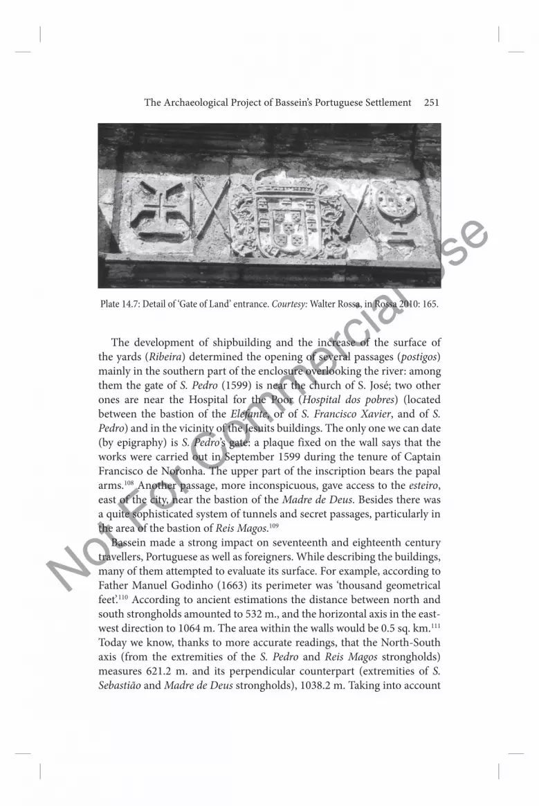
design, such as columns, pilasters, niches and ‘Roman’ low reliefs at the inner and outer ridges are the result of later restorations (Plates 14.6–7).
Not For C
ommercial U
se
The Archaeological Project of Bassein’s Portuguese Settlement 251
The development of shipbuilding and the increase of the surface of the yards (Ribeira) determined the opening of several passages (postigos) mainly in the southern part of the enclosure overlooking the river: among them the gate of S. Pedro (1599) is near the church of S. José; two other ones are near the Hospital for the Poor (Hospital dos pobres) (located between the bastion of the Elefante, or of S. Francisco Xavier, and of S. Pedro) and in the vicinity of the Jesuits buildings. The only one we can date (by epigraphy) is S. Pedro’s gate: a plaque fixed on the wall says that the works were carried out in September 1599 during the tenure of Captain Francisco de Noronha. The upper part of the inscription bears the papal arms.108 Another passage, more inconspicuous, gave access to the esteiro, east of the city, near the bastion of the Madre de Deus. Besides there was a quite sophisticated system of tunnels and secret passages, particularly in the area of the bastion of Reis Magos.109
Bassein made a strong impact on seventeenth and eighteenth century travellers, Portuguese as well as foreigners. While describing the buildings, many of them attempted to evaluate its surface. For example, according to Father Manuel Godinho (1663) its perimeter was ‘thousand geometrical feet’.110 According to ancient estimations the distance between north and south strongholds amounted to 532 m., and the horizontal axis in the east-west direction to 1064 m. The area within the walls would be 0.5 sq. km.111 Today we know, thanks to more accurate readings, that the North-South axis (from the extremities of the S. Pedro and Reis Magos strongholds) measures 621.2 m. and its perpendicular counterpart (extremities of S. Sebastião and Madre de Deus strongholds), 1038.2 m. Taking into account
Plate 14.7: Detail of ‘Gate of Land’ entrance. Courtesy: Walter Rossa, in Rossa 2010: 165.

Not For C
ommercial U
se
252 Dejanirah Couto
the outside perimeter of about 3204.9 m., the area is 41 ha., although the overall perimeter without the outline of the bastions is 2,496 m., that is to say, a little more than 39 ha.112
On 17 May 1618, Bassein was hit by an earthquake of great proportions, followed by a tsunami (maremoto). Most of the buildings were destroyed or badly damaged and casualties were significant. However, reconstruction, carried out quickly enough, gave a new character to the urban tissue from an architectural point of view. Provided with buildings 8‒10 m. high, churches with cornices from 12‒15 m., and towers of 20‒30 m., which rose above the ramparts (which were, as said earlier, 9‒10 m. high) the impressive urban complex impressed travellers and could be seen from afar.
Grouped in the north-west of Fort S. Sebastião the Câmara, the new prison (1639), provided with an arched façade on the ground floor,113 the Misericórdia with its church and hospital of the same name, as well as the pillory, surrounded the main square (praça) which served as a crossroads, and the starting point for the alignment of streets.114 These, with a line drawn in the east-west direction, show a clear intention to rationalize urban space:115 alternating with some perpendicular paths (travessas) they form a dense network. Three of them, in the east-west direction, were particularly important: the main artery of the city called, as in all Portuguese colonial cities from Brazil to Macao, ‘Main Street’ (Rua Direita) linked the main square (praça) with the Franciscan monastery situated at the extreme western edge of the city. To the east, the street of goldsmiths (rua dos ourives) articulated the Customs (alfândega) with the square, as did the S. Paulo street, which, further south, connected the shipyards area (ribeira) with the large buildings of the Jesuits; it was the same with its parallel, the shoemakers street (rua dos sapateiros).
North of the square, a long street, ‘the street of married men’ (rua dos casados)116 ended nearby the Porta da Terra. It was a parallel to the ‘street of the nobles’ (rua dos nobres). Both crossed the residential district, with the great mansions of fidalgos, built in the beautiful stone of Bassein, equipped with deep balconies, arcades and large windows embellished with panes formed (in the fashion of Goa) by translucent sheets of oyster shells mounted on wooden frames (carepas). These main streets were paved, which seems unique among Portuguese cities in Asia. Three tanks, probably dating from the period of construction of walls, supplied water (from extramural sources located on the other side of the river), as well as two wells located, the first near the ‘Gate of the Sea’ (Porta do Mar) and the second West of the Customs.
It is not the scope of this essay to detail the history of Portuguese Bassein, including that of the seventeenth and eighteenth centuries,117 until

Not For C
ommercial U
se
The Archaeological Project of Bassein’s Portuguese Settlement 253
the Maratha victory, 16 May 1739, won by Chimnaji Apta, one of the best generals of Peshwa Bajirao I, nor beyond: it suffices to recall that Bassein, called Bîjâpûr, was at the heart of the Anglo-Maratha war. In 1774, the Portuguese, then under the government of Sabastiao de Carvalhoe Melo, the Marquess of Pombal (the builder of Lisbon after the great earthquake of 1755), armed a fleet in the hopes of regaining Bassein, but the British East India Company had taken the lead, and it was impossible to compete with the English. Bassein was recovered in 1780, but the Marathas took it over in 1782 (Treaty of Salbai)118 and Elphinstone took it again only in 1818.
The granting of a sugar refinery (whose furnaces were installed inside the church and hospital of the Misericordia)119 in 1852 to Major Littlewood accelerated the ruin of Bassein. The square was dug in the hope of finding enough water to feed the furnaces. What we see today is a collapsed basin, with muddy and stagnant waters, surrounded by dense vegetation. The factory went bankrupt, but outside of this initiative, the English have contributed much to the destruction of the city: they transformed it into a military depot (1818‒30) and dynamited some buildings.120 The site opened to the public in 1830, was then the victim of other lootings, for reasons related to treasure hunts or search for materials for domestic purposes. Due to these vicissitudes, some inscriptions (out of which are still preserved 100 dated to the sixteenth and seventeenth centuries), were lost. Three of them were important for dating some significant buildings and events related to city life. Unfortunately epigraphic readings leave much to be desired.121
In fact, the city was virtually deserted by the Portuguese after the Maratha conquest but had been weakened well before for various reasons, geopolitical as well as military and economic. The wars against the Nizam Shâh (1570‒1) and the Sultanate of Ahmadnagar (1593‒4 and 1613‒15); the raids conducted by the troops of the small kingdom of Mahaved Kolis; the weakening of the network of defensive outposts (Manora, Asserim, among others) which is in the hinterland, protected the territory of Bassein;122 the onslaught by Omanites, who burned and looted the city in 1661; and finally the successive Maratha attacks (the sardar Moro Pant besieged Bassein in 1674, and Shivaji in 1676 and 1690).123 This decline culminated with the loss of the port of Kalyan in 1719‒20, and got worse with the transfer of the island of Bombay to the British Crown in 1661 who gave it to the East India Company in 1665.124
Devastating epidemics (such as in 1719‒20) also contributed greatly to its demographic decline. The figures given by some historians being certainly exaggerated, it seems reasonable to estimate its population, in

Not For C
ommercial U
se
254 Dejanirah Couto
the seventeenth century, as a little over a thousand people, distributed among families of Indo-Portuguese origin, Hindu population, foreigners and slaves. The tombstones unearthed with inscriptions recording distinguished Bassein families confirm this hypothesis.125
Despite the many vicissitudes that have marked its history (the last being the 1993 earthquake), which have been briefly mentioned, Bassein survived. Churches, though badly damaged, are still standing, as the citadel of S. Sebastião, walls and tanks. However, other threats are hanging over it. The first is probably the exploitation of offshore gas deposits, which feed the fertilizer industrial complex of the Mumbai megalopolis, the endless coming and going of trucks transporting this gas between Vasai and Mumbai have devastating effects on the foundations of these historic buildings, which will not long withstand exhaust and vibrations caused by the incessant passage of trucks. As such, the parking in front of the Porta do Mar is, to say the least, highly questionable.
Moreover, the geographical position of Bassein, at a short distance from Mumbai, will make it a suburb of the city in the near future, with consequences easy to imagine. Although under the auspices of the Archaeological Survey of India, interventions in terms of urban planning, aimed at promoting its attractiveness to tourists (especially since 2007) remain controversial. The opening of an east-west highway in the northern part inside the ramparts led to the destruction of parts of the walls, the construction of two buildings inhabited by customs officials along this way clashes with the coherence of the historical complex, as well as two small temples located in the city centre, and a third one that obstructs the drain of the Porta da Terra.126
It is vital that authorities urgently launch a campaign of excavations at the site, given the importance of the architectural heritage, essential to understand both the history of modern India and its relationship with colonial powers, as well as the urbanism of colonial cities in Asia and the political, economic and cultural interactions between Europe and Asia in the modern era.
The site has attracted since the nineteenth century some Indian, Portuguese and English scholars, including J. Gerson da Cunha,127 Joaquim Heliodoro da Cunha Rivara, A. Bragança Pereira,128 Amâncio Gracias,129 James Campbell, and especially the engineer Brás A. Fernandes (1881‒1951) who published a few guides and studies on Bassein.130 In 1924, he also drew the first map of the ramparts and the city centre131 and carried out the epigraphical study of the Bassein inscriptions in the book Armas e Inscrições do Forte de Baçaim (1957, re-edited in 1998).

Not For C
ommercial U
se
The Archaeological Project of Bassein’s Portuguese Settlement 255
Unfortunately, this ancient literature, sometimes taken uncritically by more recent studies,132 continues to be a source of errors and has greatly complicated current research; for this reason some assertions are questionable in the absence of an archaeological intervention.
This intervention supported by the building of a local museum for the conservation and exhibition of materials excavated, would have a significant cultural and educational function; it could effectively contribute to regional revitalization focusing on the valorization of the historical and architectural Luso-Indian and Indian heritage.
Notes
1. See for instance the case of Bahrein, excavated under the direction of Monik Kervran: Kervran, Hiebert, Rougeulle 2005.
2. Except for Fort Jesus in Kenya: Kirkman 1974. 3. The riverine beach has become a village of fishermen of the Koli caste, called
Vasai Koliwada. See Rossa 2010: 160 (an earlier version of this text was also published under the title ‘Baçaim. Sete Alegações para uma Aproximação ao Espaço Físico’: Rossa 1999a: 105–23, with a proposed restitution of the plan of Bassein, pp. 122–3).
4. See Teixeira 2010: 20. The etymology of the word has been studied by several Indian authors without any convincing result. See da Cunha 1993: 117 (first edition [1876]); David 1987: 91; De Barros 1995: 41.
5. Deloche 1980: 65, referring to an Asoka edict mentioning it as a dynamic harbour during the Mauryan empire. It is called Sûbâra by Al-Istahirî Ibn Hawqal, Sufâra by Al-Mas‘ûdî, Sûfâra by Al-Bîrûnî, Subâra by Al-Idrîsî (see Jean-Charles Ducène in this volume).
6. As in Kondevati (Mahakali), Jogeshwari, Mandapeshwar and Magathan, this big monastic complex located in the island of Salsete is composed of numerous viharas cut in the rock. It is mentioned by the Portuguese chronicler Diogo do Couto and by the naturalist Garcia da Orta. The first speaks of 3.000 cells and of the water containment system; the other mentions only 300: do Couto [1788-] 1973-: Década VII, Liv.III, chap.X, pp. 238–9; da Orta [1891] 1987: 341. Teaeira 2010: 21.
7. About the political powers that controlled the region, see Teixeira 2010: 22–3.
8. ‘Tana’ according to Al-Mas‘adi, Al-Bîrûnî and Al-Idrîsî: see Jean-Charles Ducène in this volume.
9. Da Cunha 1993 [1876]: 171–8. On Thana urbanism, its mosques and temples see Teixeira 2010: 25. Testimonies in Barbosa 1996: 229–30.
10. Teixeira 2010: 25. 11. Teixeira 2010: 26. 12. Barbosa 1996: 229–30. 13. See Bouchon 1999: 215–25; also her review of Michael N. Pearson, Merchants
and Rulers in Gujarat. The Response to the Portuguese in the Sixteenth Century,

Not For C
ommercial U
se
256 Dejanirah Couto
New Delhi: University of California Press, 1976: Bouchon 1980: 145–58; Wink 2002: 267–8 and for the case of Gujarat, pp. 269–75.
14. About the technical capacities of the boats built at Bassein see Barata 2003: 117–18. According to the governor D. João Castro, the gains from wood trade were an argument for the conquest of Bassein: Letter from D. João de Castro to the Infante D. Luís, [Goa, 30.X.1540], in Obras Completas de D. João de Castro III, 1968-1981: 26–30.
15. D’Silva 1997: 94. 16. Betel consumed, at least in the Indian west coast, partly came from the port
of Vijayadurg North of Goa, and was sent to Gujarat: Loureiro 2005: 10. 17. The export of rice was particularly important: Teixeira 2010: 343–4. 18. Correia 1975, III, chap.VIII, p. 277. 19. Couto 1994: 259. About horses see Loureiro 2009: 139. 20. About these networks and their trade patterns in general, see Pearson 1976:
7–29; Mathew 1995: 187–95. 21. Aubin 2006: 465–79; Couto 1999: 181–200. 22. In addition to the expedition by Nuno da Cunha, it is worth mentioning
that of Diogo Lopes de Sequeira in 1526, of Heitor da Silveira in 1529—also directed against Surat and Reynel—of Lopo Vaz de Sampaio first and António da Silveira later in 1530. See details in Teixeira 2010: 28–9; Couto 1995: 119.
23. Aubin 1971: 4 and Couto 1995: 118. 24. Costa 1991: 131. For the projects concerning Diu see also Subrahmanyam
1999: 54–7 (fn.56 to book V, I. 22). 25. Teixeira 2010: 29. 26. The paradigm is the destruction of the island of Beth, near Diu: Do Couto,
1973- [1788-]. I.Book VII, chap. III, pp. 358–60. 27. Couto 1995: 117 fn. 9. 28. Concerning Nuno da Cunha, see Carvalho 2005: 117–27; Garcia 1999: 123. 29. Teixeira 2010: 30. 30. de Castanheda 1979, II, Book VII, chap. XCVII, pp. 540‒2. 31. It should be reminded that the Portuguese settled between 1534 and 1739 in
the greater part of what is now the ‘Greater Mumbai’, except for the island of Mumbai ceded to the British in 1661‒5 (on the issue see the last section of this essay).
32. Couto 1995 : 120–2; Couto 1994: 258–66; Couto 1996: 106–18. On the content of the treaty, see de Castanheda 1979, II, Book VIII, chap. C, pp. 734‒5; the letter sent by Bahadur to Nuno da Cunha (29 September 1535), which accompanied the treaty has been edited by Alam and Subrahmanyam 2002: 256–7 [Arquivos Nacionais da Torre do Tombo (thereafter AN/TT), Cartas Orientais, 31 (Rabi II), 942 h /29 September 1535]. On the circumstances of the treaty see also Alam and Subrahmanyam 2002: 248–50.
33. Couto 1995: 119; Mathew 1985: 133–4 (following Portuguese chronicles); Alam & Subrahmanyam 2002: 245–7. On the campaigns of Bahadur, see as well Medieval Gujarat 1987; Chaube 1975; Nay 1965. On the conflict against

Not For C
ommercial U
se
The Archaeological Project of Bassein’s Portuguese Settlement 257
Silhadi, see Kolff 1990. Description of Humayun progress in Do Couto 1788 [1973], Liv. IX, chap. V, pp. 335–43.
34. Couto 1995: 121. 35. Events related by Do Couto 1788 [1973], Liv. I, chap. IX, p. 101 and by Gaspar
Correia (in Almeida 1975: 781, chap. XCV). See as well Subrahmanyam 1998: 147 (exhibition catalogue): according to the chronogram of the Gujarati Wazîr Ikhtiyar Khan (943 h), the ‘Sultan al-Bar, Shahîd al-Bahr, reigned during 11 years and 3 months before being murdered by the Portuguese.’ The murder is also related by Mullah ‘Abd-ul-Qadir Bada’uni in the first volume of his Muntakhab-ut-Tawârîkh (choice of chronicles) written around 1595, and by the Hadrami chronicler Ibn al-Fakih.
36. On the raids against Bassein at this time, Teixeira 1994: 78–82; on the attacks by Burhân-ul-Mulk, Couto 1993: 89–96. The raid of Burhân-ul-Mulk may correspond to an attempt by Mahmud II (1537–54), the successor of Bahadûr Shâh after the short reign of Mirza Muhammad Zaman, to recover the revenue of the villages of Bassein.
37. The first inventory of lands was done by Simão Botelho between 1546 and 1554. For more detail, see Teixeira 1994: 36–7.
38. Pragana or parganá may come from Marathe parganâ, ‘district’ (Dalgado 1919–21, II, p. 177). Caçabé or cassabé is from Arabic qasba; pacaria or pacari may come from Marathi pakhâdî denoting the suburban part of an urban area (Dalgado 1919–21, I, pp. 223–4, and II, p. 126). For the subdivisions in general, see the carefully prepared and detailed topography by Teixeira 1994: 38–52. Its districts included roughly Thana (with 3 fortresses) and the island of Salcete. The latter encompassed the islands of Mumbai, Bandra, Mazagan, Elefanta, Caraja and Mahim. In 1537, Agacim, Supara and Sanedivan, Vanguarana and the fortresses of Canguaça and Carnala were added. In 1542, other places in the island of Salcete were appended. Manora and Asserim were transferred in 1556. Couto 1995: 121.
39. In 1663, according to pe. Manuel Godinho, there were about 2,000 villages in the territory of Bassein, an exaggeration. The agricultural area spanned some 60 km. See Costa 1994: 109. On Godinho, Loureiro 1989: 3–27; Afonso 1990.
40. Teixeira 1994: 318–9; see Godinho 1974: 28. 41. Pinto 2003: 25; more generally on the institution, Sá 1997. 42. Teixeira 1994: 320. 43. D. João III gave orders in that sense to Vigário-Geral de Goa Miguel Vaz by
a diploma dated to 5 March 1546: Couto 1994: 261. Contrary to our first thoughts on the matter (Couto 1994: 261–2, and 1996: 114) the church did not exist yet in 1546. See the letter of the assembly (cabido) of the Misericórdia of Bassein, renewing its request to the king for its construction on 30 October 1548 (in Documentação para a História das Missões do Padroado Português do Oriente, IV, p. 23). Following the visit to Bassein of archbishop D.Aleixo de Meneses in 1598, the church was restored in 1601. Description of the church in Rossa 2010: 167–8 and Rossa 1997: 61–2.
44. See da Trindade 1964: 100–1, fn. 1. 45. Couto 1994: 261; da Trindade 1964: 104, fn. 1.

Not For C
ommercial U
se
258 Dejanirah Couto
46. According to Schurhammer 1992: 252–6, he travelled to Bassein driven by the need to address issues related to the mission of the Moluccas, the mission at Malacca, and the travel to China of his friend Diogo Pereira.
47. Rossa 2010: 161. 48. See the letter of Frei António do Porto to the king (Bassein, 7.IX.1548), in
Documentação, IV, pp. 60‒1. 49. See the letter of Padre Emanuel Teixeira to the brothers in Portugal and
Europe [Baçaim, 1.XII.1561] in Documenta Indica 1958: 299 (doc.45): ‘e pera que ao lavatorio não tornacem mais os gentios, lhe emficionarão todos os degraos e luguares dele com o samgue e emtranhas de huma vaqua que ali matarão pera lhe comtaminar aquelle luguar.’
50. Documenta Indica X, p. 45 (letter of Gomes Vaz to the General of the Society of Jesus [Goa, 14.XI.1576]).
51. On this point, see ‘Tombo da Índia’ (1554), edited in Subsídios para a História da Índia Portuguesa 1868: 27; Teixeira 1994: 322. On private donation and Jesuit economic interests in Bassein, see Borges 1995: 49–55.
52. Teixeira 1994: 323–4. 53. Teixeira 1994: 326. See table 2, p. 331: ‘Rendas jesuítas no território de Baçaim
em 1621 em pardaus de Baçaim’. 54. Teixeira 1994: 325. 55. The church Nossa Senhora da Graça as well was built by the Jesuits. In
the correspondence of Valignano, one can find precise information on the construction of the monastic complex. See Sumarium Indicum (Documenta Indica, XIII, p.1) [08.XII.1577]: ‘Il collegio è bem situato vicino al mare et tiene una buona traccia, anchorché non sai finita di fabricare, perché non sonno fatti se non doi quarti, et il 3º com la sua clausura sta anchora per farsi, et dal altro tiene una chiesa molto commoda, grande et capace di una nave, di molto buona architettura, la quale già, sta del tutto finita. . . ’. For political aspects, see Alden 1996.
56. Couto 1994: 262. The church Nossa Senhora da Saúde was built by the Hospitallers of S. João de Deus apparently in 1685.
57. See the map of localization of the buildings in Teixeira 1994: 187, fig.31; Couto 1994: 262.
58. Teixeira 1994: 185. 59. Garcia da Orta praises the faufel (areca wood), which was exported to Ormuz.
The best one came from Mumbai, but faufel was found on the whole territory of Bassein. It was exported as well to Deccan: da Orta 1987, I, p. 326 (col. 22).
60. See the letter of Simão Botelho to the king [Bassein, 24.XII.1548] (AN/TT, CC, I-81-125, edited in Subsídios para a História, pp. 4‒18).
61. Mathew 1984: 11–20; D’Silva 1997: 94–7. 62. D’Silva 1997: 96. 63. On shipbuilding in Goa, de Carvalho 2008: 123–7. 64. See the letter of Francisco Barreto to the king (Bassein, 6.I.1557)
(Documentação, VI, p. 26). 65. Documentação, VI, p. 95. 66. See Rodrigues 1995: 247–8.

Not For C
ommercial U
se
The Archaeological Project of Bassein’s Portuguese Settlement 259
67. Teixeira 1994: 365. 68. Voyage de Pyrard de Laval aux Indes orientales (1601-1611), ed. Castro and
Bouchon 1998: 588 and 757. The shipbuilding peak in Bassein occurred in the seventeenth century. Despite the high price of ships, demand was high. The dockyard of the two brothers Rui and Fernão Viegas had a staff of 340 men, Portugueses, Muslims and Hindus: Couto 1994: 265. On the period, see Teixeira 1994: 375–8.
69. Godinho 1974: 29–30. On the diverse types of ships, see Domingues 2004: 252–8 (galleons) and 274 (galliots).
70. Rossa 1997: 64 71. Schurhammer 1992: 253, fn. 203, for the name of some groups in Bassein
(from Garcia da Orta 1563): Naitias, Curumbis (Khumbis: peasants), Malis (horticulturists), Parus (Prabhus: writers), Baneanes (Banyans: traders), Deres (Dhers: sweepers).
72. Correia 1975, III, chap. XV, p. 586 (figure of the factory, from the hand of Gaspar Correia, between pp. 688–9). Couto 1994: 262; 1995: 123–4. The factory was abandoned, then later used as a public granary.
73. On the building, beautiful witness of Catholic architecture in Asia, and an inspiration for Daman cathedral (end of 1603) and other churches in Gujarat (Nossa Senhora do Amparo in Thana, 1630) see Moreira 1995: 404 ; Rossa 2010: 160 and 167–8 (description of the church restored in 1601 by the vicar Pedro Galvão Pereira, according to an inscription on the portal, now missing).
74. De Castanheda 1979, II, liv. VII, chap. XCVII, pp. 541–2: the fortifications were not well known in 1529. Heitor da Silveira who had encountered the fleet of Ali Shâh, captain of Bassein, near Thana, had sent one of his men, Cristovão Correia, to assess the defences of the port, before attack. Detailed description of the battle in Correia 1975, III, chap.VIII, p. 277.
75. Malik Tughân, the son of Malik Ayâz, was the brother of Malik Ishaq, both governors of Diu. The Mirât-I Sikandarî of Sikandar Ibn Manjhu relates the conflict with his brother. In 1531, he rebelled at Thana after falling from grace. He was however in the service of Bahadur Châh in 1533 and in 1534–5, as captain of Diu garrison (do Couto 1788 [1973] II, p. 273).
76. De Castanheda 1979, II, liv. VIII, chap. LIC, p. 664; Correia 1975, III, chap.XXXVI, p. 465.
77. Correia 1975, III, chap. XXXVI, p. 465. Stakes buried in the sand, with the same purpose, can still be seen around the Portuguese fortress of Fort Jesus, in Mombasa, Kenya.
78. Correia 1975, III, chap. XXXVI, p. 465. 79. Correia 1975, III, chap. XXXVI, p. 474; Couto 1996: 109. According to
Castanheda, the mining process took about eight days. Correia does not give information on the duration, but insists on the technics used.
80. Bocarro 1992: 109. ‘Esta cidade de Baçaim tem dentro, pegado com a Igreja da Mizericordia, huas cazas onde vive o capitão, com hua serca de ladrilho velha, onde parece que os mouros, cuja foi, se agazalhavão, com hum baluarte

Not For C
ommercial U
se
260 Dejanirah Couto
redondo de pedra, que fica sobre [sic] o pilourinho, couza pequena e que, por nao ser de momento, se não fas reparar do tempo, que a vay ja arruinando.’
81. One has to emphasize that the chronicler Gaspar Correia was part of the expedition of Nuno da Cunha in December 1531. He was thus witness of the first Portuguese settlement in Bassein. On his biography see, de Carvalho 2009: 44–5. Fernão Lopes de Castanheda and Gaspar Correia were part of the expedition of the governor to Diu as well (February 1531).
82. Rossa 2010: 164. 83. Arquivo Distrital of Évora, Inv. Nr. CXV-2-1. 84. The prison (cadeia) of the seventeenth century was built, as the city hall
(câmara) around 1639: Rossa 1997: 161. 85. Mendiratta, in Mattoso 2010: 165, does not give references for the
Archaeological Survey of India report he mentions. See above the description of Bocarro, fn 80.
86. Correia 1975, III, chap. LXXVII, p.689. 87. See Fernandes 1957: 115–16. 88. Garcia de Sá arrived to India with governor Nuno da Cunha’s fleet, which
had left Portugal on 18 April 1528; do Couto 1973- (Década Quarta da Ásia, II, p.308, with fn.57 by Paulo Guinote to Liv.V, I, 46).
89. Correia 1975, III, chap. CVI, p.837; de Castanheda 1979, II Liv.VIII, chap.CXXXIX, pp.795‒6; Couto 1996: 111.
90. Couto 1999: 181–200; 1998: 491–500; 2010: 77–96. The Ottoman threat was taken very seriously in 1546 (second siege of Diu) and in the 1550s (attack against Ormuz): see Couto 2011: 145–66 (and documents on pp. 166–75).
91. Those attacks, under the direction of Malik Nasir-ud-Din (Melique Naçaruto), continued in 1540, as mentioned in the instruction of the trial of the Ormuz judge (ouvidor) Jerónimo Rodrigues, who had been sent to Bassein at the end of 1540 (AN/TT, CCI, I, 74, 4 and CCI, 68, 70 [letter of Sebastião Garcês to the king, from Goa, on 3.II.1540]): Couto 1993: 89 with fn. 6–16. In 1546, rumour had it that Burhân-ul-Mulk (Bramaluco) intended to attack Bassein: Schurhammer 1992: 253 and 265.
92. And not the ‘church of Mercy’(igreja da Misericórdia), on the other side of the square, as in Mendiratta, in Rossa 2010: 165. The description of Bocarro may lead to a confusion between igreja da Misericordia and igreja Nossa Senhora da Vida. See above.
93. D.João de Castro granted land revenues to the nobles who took part in the second siege of Diu in 1546: Couto 1995: 122; Thomaz 1985: 536.
94. On this, see Teixeira 1995: 337–65. 95. Letters to D.João in the years 1545–6 emphasized the need to improve the
defence of Bassein: Couto 1996:111–12. Capitain D. Jerónimo de Noronha had a fence and a trench built in 1546 while expecting Burhân-ul-Mulk to attack.
96. Rossa 2010 gives the date as 1554. A letter sent by D. Afonso de Noronha to D.João III [on 16 January 1551] shows that the defences of Bassein were deemed at the time very inadequate (AN/TT, CCII, 242, 44).
97. As in Mazagan (Marocco), the second wall of Bassein was built without a

Not For C
ommercial U
se
The Archaeological Project of Bassein’s Portuguese Settlement 261
previous outline: see Rossa 2010: 163 and 1997: 64–5. On the detail for the financial support to the construction by the Crown (and then by Jesuits), see Teixeira 1010: 125–30; Dias 2009: 82–6 makes mention of the letter of Filipe II of Spain (first of Portugal) to the viceroy D. Duarte de Menezes (1586) expressing concern because of the slow progress (p. 82).
98. Rossa 2010: 163. 99. Moreira 1994: 129. 100. Couto 1996: 114; Rossa 2010: 164 draws attention to the fact that the eleven
bastions of the documentation (Bocarro) are actually ten, as the bastion Cavaleiro is an inside tower, defending to the East, the ‘Gate of the Land’ (Porta da Terra).
101. Couto 1996: 112. 102. Rossa 2010: 164 103. Carneiro 1990: 29. Dias 2009: 83 draws attention to the fact that the bastions
had various dimensions: the bastion of Nossa Senhora dos Remédios was 3.5 fathoms high, that of Reis Magos 3 fathoms.
104. Couto 1996: 114. Compared to previous studies, the identification of bastions was modified according to the documentation. Such is the case for the bastion of S. Paulo, which was destroyed by the tide and then restored (‘perdido e quebrado do mar bater nele’).
105. Couto 1996: 112. The progress of the construction (first phase) is stressed by the correspondence of viceroy D. Francisco Coutinho addressed to royal secretary Pedro de Alcáçova Carneiro (AN/TT, CCI,105, 79, letter of 20.XII.1561), as edited by Wicki 1959: 36–89. D. Francisco relates the completion of the wall. The increase of the perimeter of about a hundred cubits was needed to incorporate a lake—in view of supplying the city with fish in case of a long siege. On the phasis of the construction and its progress during the seventeenth century, see Teixeira 2010: 126–32.
106. Couto 1994: 262. 107. On Chaul, Rossa ‘Chaul [Revdanda Fort]’, Património, pp. 92‒3 and 96;
Mittelwallner 1964. 108. Couto 1996: 112; Fernandes 1954: 88–9 and 22 (nr.120). 109. Rossa 2010: 165. According to the author, it is related to the relocation in this
area (where ruins remain) of the second captain’s residence. However, in the absence of excavations, it is impossible to determine whether this is indeed the second captain’s residence. It does not seem logical that the captain would come to live in this very remote area, far from the city centre and the citadel of S. Sebastião (symbolically very important), even though this sector was adjacent to the vulnerable area (facing the fields). It is also doubtful that the building identified as the residence of the ‘General of the North’ (two floors with nine gates, arches on the second floor above a large balcony) slightly north of the citadel was the second residence of the captain as stated by other authors.
110. Pe Manuel Godinho, 1974: 27. Among the foreigners were John Fryer and Gemelli Carreri.
111. Couto 1996: 114.

Not For C
ommercial U
se
262 Dejanirah Couto
112. Rossa 2010: 164. 113. The location of the ‘Money House’ has yet to be identified. It was built in
1611. 114. The fishmarket (Bazar do peixe) was in the same area, most probably with its
own building (still not identified). 115. See da Silveira 1956: 319–28. 116. It took its name from the settlers who were at the basis of the demographic
growth of the Portuguese Oriental Empire, established by Afonso de Albuquerque after the conquest of Goa in 1510. The casados were at the origin of the Luso-Asiatic society.
117. Generally see Ames 2008: 129–48. 118. In the Salbai treaty signed by Mahaji Sindhia, the Salcete Island was fully
given to the EIC. Its possession was confirmed by the Bassein treaty (31 December 1802: Couto 1994: 266; Couto 1996: 116).
119. Fernandes 1954 relates that tombstones were destroyed and a tomb unsealed, with the remains of a man and a horse, separated by a sword. Such information may well be legendary.
120. Couto 1994: 266–7; Couto 1996: 118. In 1921, a report of the Archeological Survey of India (Western Circle) makes mention of this. Rossa 2010: 163.
121. The loss of eight tombstones was mentioned between 1876 and 1905. Among the three most important of them, one was close to the Porta da Terra, and two in the vicinity of the Câmara. Despite corrections by António Machado de Faria, in the volume edited by Brás A. Fernandes, readings are very inaccurate. Albuquerque 1995: 311–20 did not correct the readings and added some new mistakes. New readings and a proper scientific edition are needed.
122. On these two outposts conquered in 1556, Rodrigues 1995: 254–6. 123. Kulkarni 1985: 957–69. 124. On the context, see Couto 1952; Macedo n.d.: 158–93; Teixeira 2010: 193–
202 and 218–25; on the transfer Keay 1991: 131; Santos 1996: 267–78; Dossal 2000: 403–18; Dossal 2000: 855–66; Gomes and Rossa 2000: 210–24; Nobre 2008.
125. According to J. Gerson da Cunha, in 1720, there were 60,000 inhabitants: among them 2,000 were Europeans and 58,000 christianized Hindus. Pe Manuel Godinho had an evaluation of 3,400 souls. Couto 1996: 117. Other sources have between 100 and 400 families, c. 1635, and 1,000 Christians, including 300 Europeans, c. 1662.
126. Rossa 2010: 164. 127. Da Cunha 1993. 128. Pereira 1935: 97–315. 129. Gracias 1905: 256–65. 130. Among them, ‘Os Portugueses em Baçaim’, O Oriente Português 7-9 (1934‒5),
pp. 97‒315; ‘The Last Days of Bassein’, The Indo-Portuguese Review III (1924‒5), pp. 56‒9.
131. Brás A. Fernandes, ‘Planta da Antiga Cidade e Fortaleza de Baçaim Fundada por Nuno da Cunha em 1536. Conquistada e destruida pelos Maratas em 1739’,

Not For C
ommercial U
se
The Archaeological Project of Bassein’s Portuguese Settlement 263
92 × 59 cm., scale 46 mm., Lisbon, Geographical Society, Inv. Nr. Cartografia 3-G-36. See the commentary by Rossa 1999: 140–1. The map has been edited in ‘Antiquities of Chaul and Bassein’, The Mission Field, Daman, 1925, pp. 511–32.
132. One example in David 1987: 89–103.

Not For C
ommercial U
se
264 Dejanirah Couto
Plate 14.8: Model of Bassein, in Rossa 1999b: 140.
Appendix
The seminar held on 26‒8 February 1987, at Girij, Vasai, on the initiative of the Heras Institute of Indian History and Culture, Mumbai, in collaboration with the Indian Council of Historical Research (ICHR), with the presence of the Governor of Maharashtra and researchers from Mumbai, Pune, Goa and Hyderabad, reflected a renewed interest in the historical site. The publication of a selection of papers (Heras Institute Magazine, vols. 45‒6, September 1987) provided some insights, but also showed doubts about the reliability of some information. In 1994, the VII Seminar of Indo-Portuguese History, which was held in Goa, helped to systematize some of the information, promoting first thoughts on how to restore the monuments and save the site, which, despite having been listed in 1904, has continued to deteriorate. The necessity to start an archaeological intervention, initiative which does not contradict any restorations of monuments, already underway in 1994 (on the apse of the church of S. António) was then highlighted. Contacts were made on this occasion by the author of this article with INTACH and ICHR.
In 1997, following a proposal by Walter Rossa, the Committee for commemorating Portuguese Discoveries (CNCDP) commissioned Indian architects for a model of Bassein, under the direction of this architect. After some preliminary work in situ, the model was started in February 1998 and completed in April of the same year; it was eventually featured in the exhibition Os Espaços de um Império (1999)1 (Plate 14.8).
In 2002, following the publication in Portugal of three articles specifically devoted to Bassein, attention was drawn to the importance of the architectural complex.2 The Foundation for Science and Technology of Portugal (FCT, Portuguese Ministry of Higher Education and Research) has funded a three-year research project submitted by the Centro de História de Além-Mar of the New University of Lisbon, in partnership with the Oriente Foundation (Lisbon and

Not For C
ommercial U
se
The Archaeological Project of Bassein’s Portuguese Settlement 265
Macao) and the Centre for studies of architectural history at the University of Coimbra, entitled ‘Baçaim antes dos Ingleses. A Marca Portuguesa no Território da Península de Bombaim’ (POCTI/HAR/47225/2002) (‘Baçaim before the English: Portuguese footprint on the territory of the peninsula of Mumbai’). This project, led by the architect Walter Rossa, was at the origin of several studies reported in the bibliography of this essay. We shall mention, out of the importance of the documentation he collected and the strength of his study, the doctoral thesis submitted by the archaeologist André Teixeira in 2010, which focuses on economic and politico-administrative aspects of the management of the city and the territory.3
Beyond the restoration and consolidation of existing buildings, (based on the inventory of visible structures and on a diagnosis about their state of conservation), an excavation of the site might concern (schematically) five areas:
1. The port area, including the shipyards sector (Ribeira), the ‘Sea Gate’ (Porta do Mar), the factory, the customs and the church of S. José.
2. The north and north-east sector inside the citadel of S. Sebastião, its northern bastion and the church of Nossa Senhora da Vida, in the hope of finding, perhaps, traces of the Muslim fortification.
3. The urban centre (praça) in the area of the Misericórdia and Câmara likely to provide more information about the city life, trade, movement of goods, aspects of material culture.
4. The interior of the Franciscan church, whose nave, lined with inscribed Portuguese tombstones, could provide anthropological data on aristocratic elements of the population of the city.
5. One of the dwellings (or more) of the Rua des Casados or Rua des Nobres would give information about habitat and home furnishings (Fig. 14.1 with legends, 267)
Notes 1. Scale: 1:1500, 18,6 × 151 × 222 cm.; drawing: João Pedro Paiva; direction:
Manuel Luciano; executive director and coordinator: The Bombay Collaborative (David Cardoz, Rahul Mehrotra and Sandhya Savant); topography and drawing: G.G. Hukkerikar Surveyors and Engineers (Sageer Muckba, Ramola Naik, Kalpesh Solanki and Vandana Agrawal).
2. See Couto and the above-mentioned references. 3. Two studies are forthcoming: Rossa and Mendiratta (in press); Teixeira (in
press).
Not For C
ommercial U
se

Not For C
ommercial U
se
The Archaeological Project of Bassein’s Portuguese Settlement 267
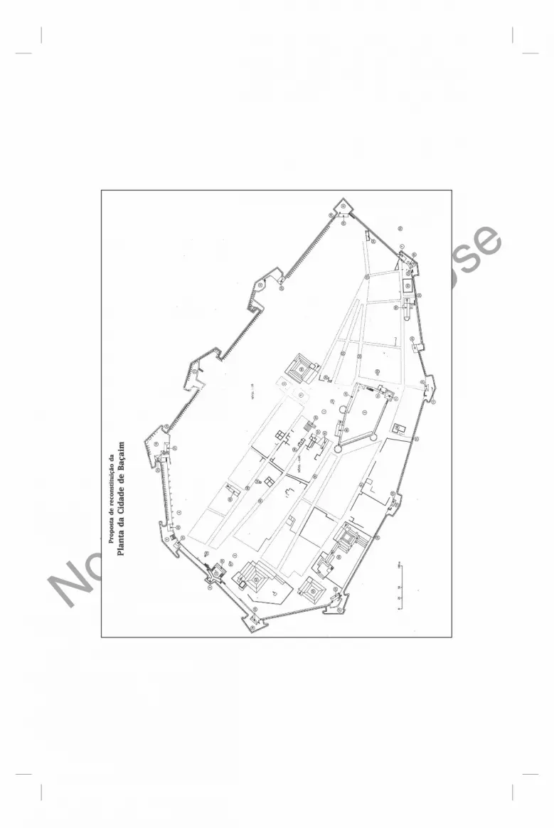
Fig. 14.1: Plan of Bassein, in Rossa 1999a: 122–123.
1. Main square 2. Citadel of S. Sebastião 3. Courtyard of S. Francisco 4. Ball play 5. Market 6. Fish Bazar 7. Gate of the Sea (Porta do Mar) 8. Gate of the Land (Porta da Terra or do
Campo) 9. Bastion of Remédios10. Bastion of Reis Magos11. Bastion of Santiago12. Bastion of S.Gonçalo13. Bastion of Madre de Deus14. Bastion of S. João15. Bastion of Elefante, later of S. Francisco
Xavier16. Bastion of S. Pedro17. Bastion of S. Paulo18. Bastion of S. Sebastião19. Bastion Cavaleiro20 and 21. Passages (postigos)22. Passage of S. Pedro23 and 24. Passages (postigos)25. Casemates (or bunkers)26. First residence of the Captain of Bassein27. Second residence of the Captain of Bassein28. Palace of the ‘General of the North’29. Town Hall (Câmara) and Prison (1639)
(Cadeia)
30. Pillory31. Former prison (Tronco)32. Shell’s fountain (Fonte das Conchas)33. Well34. Customs house35. Factory and later Public Granery36. Salt house (Casa do Sal)37. Hospital of Misericórdia38. Hospital for the Poor (Hospital dos pobres)39. Church of S. José40. Church of Nossa Senhora da Vida41. Church of Misericórdia42. Monastery of S. António (Franciscans)43. Monastery of Nossa Senhora da Anunciada
(Augustinians)44. College of Sagrado Nome de Jesus (Jesuits)45. Monastery of Nossa Senhora da Saúde
(Hospitaller Order of S. João de Deus)46. Church of S. Gonçalo (Dominicans)47. Cross of Stone (cruzeiro)48. Street of married man (rua dos casados)49. Street of the nobles (rua dos nobres)50. Main street (Rua Direita)51. Street of S. Paulo (rua de S. Paulo)52. Goldsmiths street (rua dos ourives)53. Shoemakers Street (rua dos sapateiros)54. Gate of the citadel (fort) of S. Sebastião55. Shipyards (Ribeira)

Not For C
ommercial U
se
268 Dejanirah Couto
References
Afonso, John Correia (1990), Intrepid Itinerant. Manuel Godinho and his Journey from India to Portugal in 1663, Mumbai: Oxford University Press.
Alam, Muzzafar & Subrahmanyam, Sanjay (2002), ‘Letters from a Sinking Sultan’, in Aquém e Além da Taprobana.Estudos Luso-Orientais à Memória de Jean Aubin e Denys Lombard, ed. Thomaz, Luís Filipe F.R., Lisbon: Centro de História de Além-Mar, pp. 239‒69.
Albuquerque,Teresa (1995), ‘Epigraphy of Bassein’, Mare Liberum, vol. 9, pp. 311–20.
Alden, Dauril (1996), The making of an Enterprise. The Society of Jesus in Portugal, Its Empire, and Beyond 1540–1750, Stanford: Stanford University Press.
Ames, Glenn J. (2008), ‘The Province of the North: Continuity and Change in an Age of Decline and Rebirth, c.1571-1680’, in Portuguese Colonial Cities in the Early Modern World, ed. Brockey and Liam Matthew, Londres: Ashgate Publishers, pp. 129–48.
Aubin, Jean (1971), ‘Albuquerque et les négociations de Cambaye’, Mare Luso-Indicum, vol. I, no. 2, pp. 3–63.
——— (2006), in Flores, Maria da Conceição, Thomaz, Luís Filipe, Aubin, Françoise, eds., Le latin et l’astrolabe. Études inédites sur le règne de D. Manuel, 1495-1521, vol. III. Paris: Centre culturel Calouste Gulbenkian.
Barata, José Alberto Leitão (2003), Os Senhores da Navegação. O Domínio Português dos Mares da Ásia por Meados do Século XVI, Cascais: Câmara Municipal de Cascais.
Barbosa, Duarte (1996), O Livro de Duarte Barbosa (edição crítica e anotada), Maria Augusta Veiga e Sousa (éd.), I, Lisbon: Instituto de Investigação Científica Tropical.
Barros, Joseph de (1995), ‘A Presença Portuguesa em Baçaim: sua Génese Geo-Histórica’, Mare Liberum, vol. 9, pp. 41–7.
Bocarro, António (1992), Livro das Plantas das Fortalezas, Cidades e Povoações do Estado da India Oriental, II.Transcrição, Isabel CID (transcrip.), Lisbon: Imprensa Nacional-Casa da Moeda.
Borges, Charles J. (1995), ‘Jesuit Economic Interests in the Portuguese Province of the North till the mid-18th century’, Mare Liberum, vol. 9, pp. 49–58.
Bouchon, Geneviève (1980), ‘Pour une histoire du Gujarat du xve au xviie siècle’, Mare Luso-Indicum, vol. IV, pp. 145–58.
——— (1999), ‘Quelques aspects de l’islamisation des régions maritimes de l’Inde à l’époque médiévale (xiie-xvie siècles)’, in Inde Découverte, Inde Retrouvée 1498-1630. Études d’histoire indo-portugaise. Lisbon/Paris: Fundação Calouste Gulbenkian/Comissão Nacional para as Comemorações dos Descobrimentos Portugueses, pp. 215–25.
Carneiro, António de Mariz (1990), Descrição da Fortaleza de Sofala e das mais da India (rep. of the illuminated codes 149 of the National Library of Lisbon), Pedro DIAS (éd.), Lisbon: Fundação Oriente.
de Trinidade, Frei Paulo, Conquisto Espiritual do Oriede, Lopes, F. Fetix, ed. (1964), II Parte, Lisbon: Centrode Estudos Hist. ricos Ultramarinos.

Not For C
ommercial U
se
The Archaeological Project of Bassein’s Portuguese Settlement 269
de Carvalho, Andreia Martins (2005), ‘The King’s Agent in the East: the Choice of Nuno da Cunha, Governor of Portuguese India’, in Gracias, Fátima da Silva, Pinto, Celsa, Borges, Charles, eds. Indo-Portuguese History—Global Trends. Panjim: s/ed., pp.117–27.
de Carvalho, Maria João Loução (2009), Gaspar Correia e dois Perfis de Governador: Lopo Soares de Albergaria e Diogo Lopes e Sequeira: em busca de uma Causalidade, MA Dissertation in History Lisbon: Universidade Aberta of Lisbon.
de Carvalho, Patrícia Catarina Sanches (2008), Os Estaleiros na Índia Portuguesa (1595-1630), MA Dissertation in History and Archaeology, Lisbon: Universidade Nova.
de Castanheda, Fernão Lopes (1979), História do Descobrimento e Conquista da India pelos Portugueses, Manuel Lopes de Almeida (éd.), 2 vols., Porto: Lello & Irmão.
Chaube, Jharkhande (1975), History of the Gujarat Kingdom, 1458–1537, New Delhi: Munshiram Manoharlal.
Correia, Gaspar Lendas da India (1975), de Almeida, M. Lopes, éd., III. Porto: Lello & Irmão.
Costa, João Paulo Oliveira e (1991), ‘Do Sonho Manuelino ao Realismo Joanino. Novos Documentos sobre as Relações Luso-Chinesas na Terceira Década do Século XVI’, Studia, vol. 50, pp. 121–55.
——— (1994), entry ‘Baçaim’, in Dicionário de História dos Descobrimentos Portugueses, ed. de Albuquerque, Luís, I. Lisbon: Caminho, p.109.
Couto, Adriano José Ernesto (1952), A Cessão de Bombaim à Inglaterra, BA dissertation, Lisbon: Faculdade de Letras, Universidade de Lisbon.
Couto, Dejanirah (1993), ‘Jerónimo Rodrigues—ébauche d’une carrière orientale’, (Série From Biography to History: Essays in the Social History of Portuguese Asia 1500-1800) Mare Liberum, vol. 6, pp. 89‒96.
——— (1994), ‘Baçaim, a Capital do Norte’, Oceanos, vol. 19, no.20, pp. 258‒66.——— (1995), ‘Em Torno da Concessão e da Fortaleza de Baçaim (1529‒1546)’,
Mare Liberum, vol. 9, pp. 117–32.——— (1996), ‘A Fortaleza de Baçaim’, Oceanos, vol. 28, pp. 105–18.——— (1998), ‘No Rasto de Hadım Suleimão Pacha: alguns aspectos do Comércio
no Mar Vermelho’, A Carreira da India e a Rota dos Estreitos, Angra do Heroísmo: Universidade Católica Portuguesa, pp. 483‒508.
——— (1999), ‘Les Ottomans et l’Inde portugaise’, in Vasco da Gama e a Índia: Conferência International/Vasco da Gama et l’Inde: conférence internationale/ Vasco da Gama and India: International Conference, de Souza, Teotónio R. and Garcia, José Manuel, eds., I. Lisbon: Fundação Calouste Gulbenkian, pp. 181–200.
——— (2010), ‘Le Viaggio scritto per un comito veneziano et la descriptio peregrinationis Georgii Huzti: quelques témoignages sur les équipages de l’expédition de Hadim Süleyman Pasa dans l’océan Indien (1538)’, in Bernardini, Michele and Taddei, Alessandro, eds. Études en l’honneur de Jean-Louis Bacqué Grammont, Eurasian Studies, vol. VIII, pp. 77–96.

Not For C
ommercial U
se
270 Dejanirah Couto
——— (2011), ‘Portuguese-Ottoman Rivalry in the Persian Gulf in the Mid-Sixteenth Century: the Siege of Ormuz, 1552’, in Acta Iranica. Portugal, The Persian Gulf and Safavid Persia, Mathee, Rudi and Flores, Jorge, eds., pp. 145–66 (and pp. 166–75: documents). Louvain: Peeters, 2011.
do Couto, Diogo (1973-), Da Asia de Diogo do Couto. Dos feitos que os Portugueses fizeram na Conquista e Descubrimento das Terras e Mares do Oriente, (Décadas IV-XII), Lisbon: Livraria Sam Carlos (from the edition Na Regia Officina Typografica, 1788- ) .
da Cunha, J. Gerson (1993), Notes on the History and Antiquities of Chaul and Bassein. New Delhi: Asian Educational Services (first edition, Bombay: Thacker Vining & Co., 1876).
Dalgado, Sebastião Rodolfo (1919‒21), Glossário Luso-Asiático, 2 vols., Coimbra: Imprensa da Universidade.
David, M.D. (1987), ‘Historic Bassein’, Indica, vol. 24, no. 2, pp. 89–103.Day, Upendra Nath (1965), Medieval Malwa: A Political and Cultural History,
1401-1562, New Delhi: Munshiram Manoharlal.Dias, Pedro (2009), Arte de Portugal no Mundo. India. Urbanização e Fortificação.
Lisbon: Público.D’Silva, R.D. (1997), ‘Ship-building in Portuguese Baçaim, 1534-1739’, in Ship-
building and navigation in the Indian Ocean Region A.D. 1400-1800, ed. K.S. Mathew, New Delhi: Munshiram Manoharlal, pp. 94–7.
Deloche, Jean (1980), La Circulation en Inde avant la Révolution des Transports, vol. II, La Voie d’Eau, Paris: École Française d’Extrême-Orient.
Documenta Indica, Wicki, José s. J., ed. (1958), vol.V, Roma: Monumenta Historica Societatis Iesu.
Documentação para a História das Missões do Padroado Português do Oriente, Índia, Rego, António da Silva, ed. (1992), vol. IV. Lisbon: Fundação Oriente, Comissão Nacional para as Comemorações dos Descobrimentos Portugueses.
Domingues, Francisco Contente (2004), Os Navios do Mar Oceano. Teoria e Empiria na Arquitectura Naval Portuguesa dos Séculos XVI e XVII, Lisbon: Centro de História da Universidade de Lisboa.
Dossal, Mariam (2000), ‘Continuity and Change: the Portuguese Presence in British Bombay, c. 1660-1860’, in Vasco da Gama and the linking of Europe and Asia, Disney, Anthony R. and Booth, Emily, eds., Delhi, Oxford: Oxford University Press, pp. 403–18.
——— (2001), ‘From Bassein to Bombay: Territory, Colony and Property’, in Universo Urbanístico Português 1415-1822. Actas do Congresso Internacional, Rossa, Walter, Araujo, Renata and Carita, Hélder, eds., Lisbon: Comissão Nacional para as Comemorações dos Descobrimentos Portugueses, pp. 855–66.
Ducène, Jean-Charles (2015), contribution ‘The Ports of the Western Coast of India according to the Arabic Geographers’, (in this volume).
Fernandes, Brás A. (1924‒5), ‘The Last Days of Bassein’, The Indo-Portuguese Review, vol. III, pp. 56–9.

Not For C
ommercial U
se
The Archaeological Project of Bassein’s Portuguese Settlement 271
——— (1925), ‘Planta da Antiga Cidade e Fortaleza de Baçaim Fundada por Nuno da Cunha em 1536. Conquistada e destruida pelos Maratas em 1739’, 92x59 cm., scale 46 mm. Lisbon: Société de Géographie, n° Inv. Cartografia 3-G-36. (Map published in « Antiquities of Chaul and Bassein », The Mission Field, Daman [1925], pp. 511–32).
——— (1934‒5), ‘Os Portugueses em Baçaim’, O Oriente Português, vols. 7‒9, pp. 97‒315.
——— (1954; re-ed.1998), Armas e Inscrições do Forte de Baçaim, de Faria, António Machado, ed. Lisbon: Academia Portuguesa de História.
Garcia, José Manuel (1999), ‘Os Governadores do Estado da India’, Vasco da Gama e a India, I. Lisbon: Fondation Calouste Gulbenkian, pp. 121–3.
Godinho, Pe Manuel (1974), Relaçãodo Novo Caminho (que fez por Terra e Mar vindo) da India para Portugal (no Ano de 1663) ed. Guerreiro, A. Machado, Lisbon : Imprensa Nacional-Casa da Moeda.
Gomes, Paulo Varela and Rossa, Walter (2000), ‘O primeiro território: Bombaim e os Portugueses’, Oceanos, vol. 41, pp. 210–24.
Gracias, João Baptista Amâncio (1905), ‘Antiguidades Portuguezas em Baçaim’, O Oriente Português, vol. 2, pp. 256–65.
Keay, John (1991), The Honourable Company. A History of the English East India Company, New York: Macmillan Publishing Company.
Kervran, Monik, Hiebert, Frederik, Rougeulle, Axelle (2005), Qal’at al-Bahrein: a trading and Militay Outpost 3rd Millenium B.C.-17th Century A.D., Turnhout: Brepols.
Kirkman, James. S. (1974), Fort Jesus: a Portuguese Fortress on the East African Coast. Oxford: Oxford University Press.
Kolff, Dirk H.A. (1990), Naukar, Rajput, and Sepoy: the Ethnohistory of the Military Labour Market in Hindustan,1450-1850, Cambridge: Cambridge University Press.
Kulkarni, A.R. (1985), ‘Shivaji and the Portuguese’, in II Seminário Internacional de História Indo-Portuguesa.Actas, de Albuquerque, Luís and Guerreiro, Inácio, eds., Lisbon: Instituto de Investigação Científica Tropical, Centro de Estudos de História e Cartografia Antiga, pp. 957–69.
Loureiro, Rui Manuel (1989), ‘Para uma Nova Leitura da “Relação do Novo Caminho” do Padre Manuel Godinho’ (1989), Ler História, vol. 15, pp. 3–27.
——— (2005), ‘A Verde Folha da Erva Ardente’: o Consumo do Bétele nas Fontes Europeias Quinhentistas’, in Mirabilia Asiatica. Produtos Raros no Comércio Marítimo/Produits rares dans le commerce maritime/Seltene Waren im Seehandel, Alves, Jorge M. dos Santos, Guillot, Claude, Ptak, Roderich, eds., vol. II. Wiesbaden: Harrassowitz Verlag, Fundação Oriente, pp.1–20.
——— (2009), ‘Portuguese Involvement in Sixteenth Century Horse Trade through the Arabian Sea’, in Pferde in Asien: Geschichte, Handel und Kultur. Horses in Asia: History, Trade and Culture, Fragner, Bert G., Kauz, Ralph, Ptak, Roderich, Schottenhammer, Angela, eds., Wien: Verlag der Österreichischen Akademie der Wissenschaftende , pp. 137–43.
Macedo, Jorge Borges (s/d), História Diplomática Portuguesa. Constantes e Linhas de Força. Estudo de Geopolítica. Lisbon: Instituto da Defesa Nacional.

Not For C
ommercial U
se
272 Dejanirah Couto
Mathew, K.S. (1984), ‘Portuguese Shipbuilding in India’, Quarterly Review of Historical Studies,vol. 23, no. 4, pp. 11–20.
——— (1985), Portuguese and the Sultanate of Gujarat, New Delhi: Mittal Publication.
——— (1995), ‘Maritime Trade of Gujarat and the Portuguese in the Sixteenth Century’, Mare Liberum, vol. 9, pp. 187–95.
Medieval Gujarat. Its Political and Statistical History based on Mohammed Ali Khan’s Mirat-i-Amadi transcribed in 1822 by Narsain Dass of the Kait Tribe at Ahmedabad (English transl. by James Bird) (1987). Delhi: Indian Bibliographies Bureau, Balaji Enterp.
Mendiratta, Sidh (2010), ‘Forte de S. Sebastião’, in Ásia Oceania: Património de Origem Portuguesa no Mundo. Arquitectura e Urbanismo, Mattoso, José, ed., pp. 165–6.
Mittelwallner, Grittli von (1964), Chaul. Eine Unerforschte Stadt an der Westküste Indiens. Berlin: Gruyter.
Moreira, Rafael (1994), ‘Fortalezas do Renascimento’, A Arquitectura Militar na Expansão Portuguesa, Lisbon: Comissão Nacional para as Comemorações dos Descobrimentos Portugueses, pp. 143‒58.
——— (1995), ‘From Manueline to Renaissance in Portuguese India’, Mare Liberum, vol. 9, pp. 401–7.
Obras completas de D. João de Castro, Cortesão, Armando and de Albuquerque, Luís, eds. (1968‒81), vol. III, Coimbra: Academia Internacional da Cultura Portuguesa.
Nobre, Pedro (2008), A Entrega de Bombaim ao Reino Unido (1661-1668)—um processo político-diplomático, MA in History of the Universidade Nova of Lisbon.
da Orta, Garcia (1987), Colóquios dos Simples e Drogas da Índia (reprodução em fac-símile da edição de 1891 dirigida e anotada pelo Conde de Ficalho), vol. II, Lisbon: Imprensa Nacional–Casa da Moeda.
Pearson, Michael N. (1976), Merchants and Rulers in Gujarat. The Response to the Portuguese in the Sixteenth Century, New Delhi: University of California Press.
Pereira, A.B. Bragança (1935), ‘Os Portugueses em Baçaim’, O Oriente Português, vols. 7‒9, pp. 97–315.
Pinto, Carla Alferes (2003), ‘A Misericórdia de Baçaim (1540‒1739)’, Ler História, vol. 44, pp. 25–43.
Rodrigues, Vítor Luís Gaspar (1995), ‘A Organização Militar da “Província do Norte” durante o Século XVI e Princípios do XVII’, Mare Liberum, vol. 9, pp. 247–65.
Rossa, Walter (1997), Cidades Indo-Portuguesas. Indo-Portuguese Cities, Contribuições para o Estudo do Urbanismo Português no Hindustão Ocidental/A Contribution to the Study of Portuguese Urbanism in the Western Hindustan, Lisbon: Comissão Nacional para as Comemorações dos Descobrimentos Portugueses, pp. 61–7.

Not For C
ommercial U
se
The Archaeological Project of Bassein’s Portuguese Settlement 273
——— (1999a), ‘Baçaim. Sete Alegações para uma Aproximação ao Espaço Físico’, Os Espaços de um Império.Estudos, pp. 105–23 (with a proposal for the restitution of the plan of Bassein, pp. 122–3), Lisbon: Comissão Nacional para as Comemorações dos Descobrimentos Portugueses.
——— (1999b), Os Espaços de um Império, Catalogue, Lisbon: Comissão Nacional para as Comemorações dos Descobrimentos Portugueses, pp.140–1.
——— (2010), ‘Vasai Fort (Baçaim/Baçaím/Bassaim/Bassein (India)’, in Ásia Oceania: Património de Origem Portuguesa no Mundo. Arquitectura e Urbanismo, Mattoso, José, éd., Lisbon: Fundação Calouste Gulbenkian, pp. 158–65.
——— (2010), ‘Chaul [Revdanda Fort] (Índia)’, in Ásia Oceania: Património de Origem Portuguesa no Mundo. Arquitectura e Urbanismo, Mattoso, José, ed., pp. 92–6.
——— and Mendiratta, Sidh (in press), ‘Ghost Towns. Ruined and disappeared Portuguese Colonial Settlements in Coastal Maharashtra, India: New Research Results’, communication at the 61st Annual Meeting of the Society of Architectural Historians (Cincinnati, 23‒7 April 2008) .
Sá, Isabel dos Guimarães (1997), Quando o Rico se faz Pobre: Misericórdias, Caridade e Poder no Império Português 1500-1800, Lisbon: Comissão Nacional para as Comemorações dos Descobrimentos Portugueses.
Santos, Esaú (1996), ‘A Cedência de Bombaim aos Ingleses’, Mare Liberum, vol. 9, pp. 267–90.
da Silveira, Luís (1956), ‘A Cidade Ideal do Renascimento e as Cidades Portuguesas da India’, Garcia de Horta, Revista das Missões Geográficas e de Investigação do Ultramar (numéro special), pp. 319–28.
Schurhammer, Georg S.J. (1992), Francisco Javier. Su vida y su Tiempo, India, 1547-1549, vol. III, Gobierno de Navarra, Compañia de Jesus, Arzopispado de Pamplona.
Subrahmanyam, Sanjay (1999), ‘O interesse e os projectos da conquista de Diu’, in Diogo do Couto, Década Quarta da Ásia, Edição Crítica e Anotada, Cruz, Maria Augusta Lima, éd., II, Lisbon: Comissão Nacional para as Comemorações dos Descobrimentos Portugueses, Fundação Oriente, Imprensa Nacional-Casa da Moeda, pp. 54–7.
——— (1998), ‘A Crónica dos Reis de Bisnaga e a Crónica do Guzerate: dois Textos Indo-Portugueses do século XVI’, in Os Construtores do Oriente Português, Flores, Jorge, éd., Porto: Commissão Nacional para a Comemoração dos Descobrimentos Portugueses (catalogue of the exhibition), p. 147.
Subsídios para a História da Índia Portuguesa, Felner, Rodrigo José de Lima, éd. (1868). Lisbon: Typographia da Academia Real das Sciencias.
Teixeira, André (2004), ‘Os Primórdios da Presença Portuguesa em Baçaim— 1534-1554: notas sobre a situação financeira e político-militar do primeiro “território” do Estado da Índia’, D. João III e o Império. Actas do Congresso Internacional Comemorativo do Nascimento de D. João III (2004), Lisbon: Centro de História de Além-Mar, Centro de Estudos os Povos e Culturas de Expressão Portuguesa, pp. 337–65.

Not For C
ommercial U
se
274 Dejanirah Couto
Teixeira, André Pinto de Sousa Dias (2010), Baçaim e o seu Território: Política e Economia, 1539-1665 (Ph.D Thesis), Lisbon: Centro de História de Além-Mar, Universidade Nova de Lisboa.
——— (in press), ‘Baçaim, the city and its Hintherland’, International Seminar on ‘Cities in Medieval India’, Delhi: Centre for Historical Studies/Jawaharlal Nehru University.
Thomaz, Luís Filipe F.R. (1985), ‘Estrutura Política e Administrativa do Estado da India no Século XVI’, Actas do II Seminário de História Indo-Portuguesa, Lisbon: Centro de Estudos de História e de Cartografia Antiga, pp. 515–40.
Voyage de Pyrard de Laval aux Indes orientales (1601-1611), de Castro, Xavier and Bouchon, Geneviève, eds. (1998), 2 vols., Paris: Éditions Chandeigne.
Wicki, Joseph (1959), ‘Duas Cartas Oficiais de Vice-reis da India, escritas em 1561 e 1564’, Studia, vol. 3, pp. 36–89.
Wink, André (2002), Al-Hind: The Making of the Indo-Islamic World, vol. II, Boston, Leiden: Brill.