tectonically controlled fan delta and submarine fan
TRANSCRIPT
Tectonically Controlled Fan Delta and Submarine Fan Sedimentation of Late Miocene Age, Southern Temblor Range, California
U.S. GEOLOGICAL SURVEY PROFESSIONAL PAPER 1442
QE
.U58p No.1442
75
1989

LIBRARY
NOVO 6'89 Bureau of
Denver. Coknoo

BUREAU OF RECLAMATION DENVER MARY
141111111111
14j31.453/1 /
vo PRk,,(46'
"14V vYk
TECTONICALLY CONTROLLED FAN DELTA AND SUBMARINE FAN SEDIMENTATION
OF LATE MIOCENE AGE, SOUTHERN TEMBLOR RANGE, CALIFORNIA
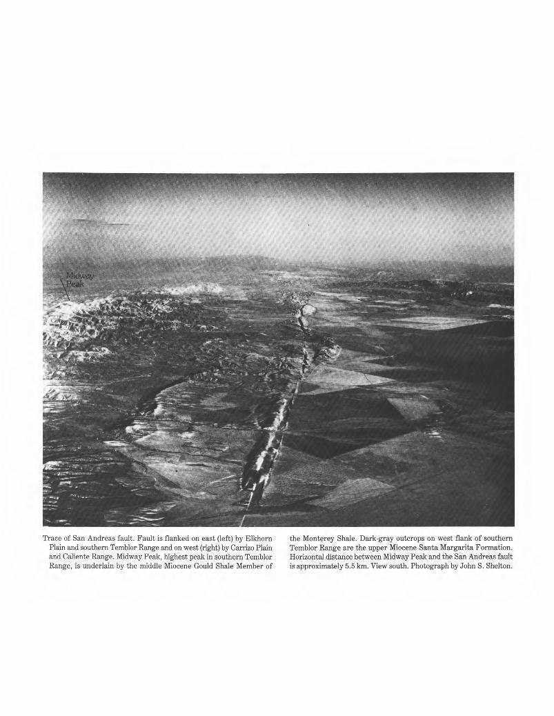
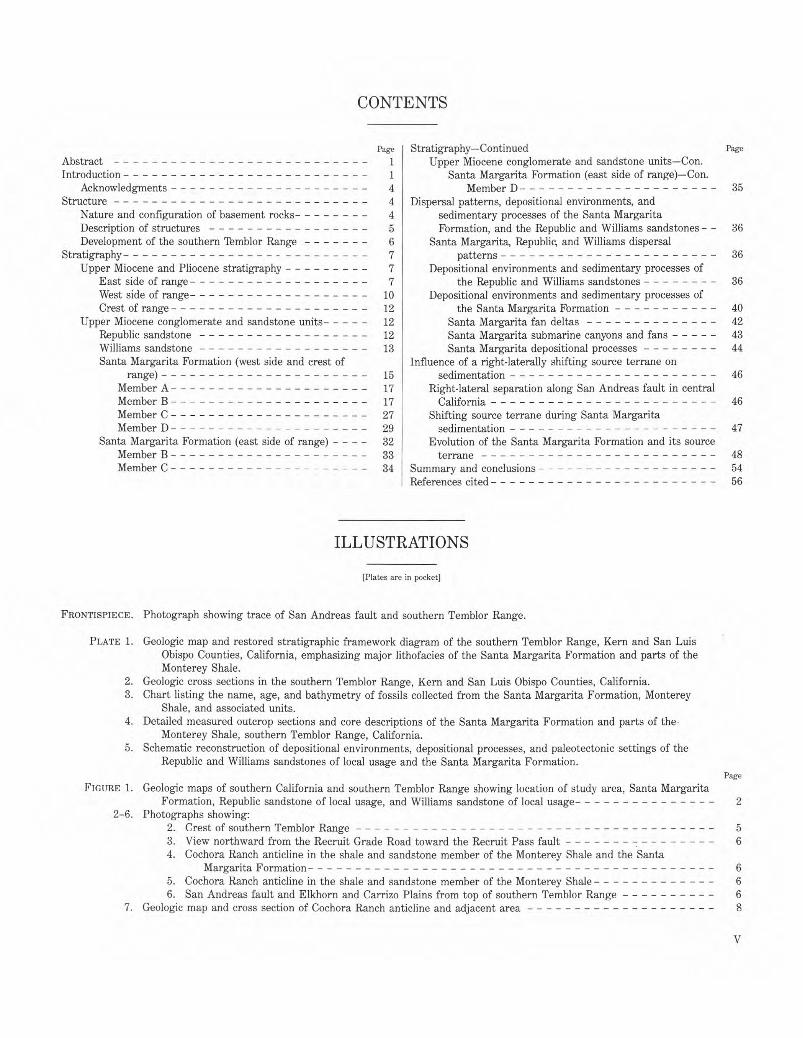
Trace of San Andreas fault. Fault is flanked on east (left) by Elkhorn the Monterey Shale. Dark-gray outcrops on west flank of southern Plain and southern Temblor Range and on west (right) by Carrizo Plain Temblor Range are the upper Miocene Santa Margarita Formation. and Caliente Range. Midway Peak, highest peak in southern Temblor Horizontal distance between Midway Peak and the San Andreas fault Range, is underlain by the middle Miocene Gould Shale Member of is approximately 5.5 km. View south. Photograph by John S. Shelton.
Tectonically Controlled Fan Delta and Submarine Fan Sedimentation of Late Miocene Age, Southern Temblor Range, California
By ROBERT T. RYDER and ALAN THOMSON
U.S. GEOLOGICAL SURVEY PROFESSIONAL PAPER 1442
Sedimentation of conglomerate and subordinate sandstone of the Santa Margarita Formation was intimately associated with the tectonic history of the San Andreas fault and the southern Temblor Range anticlinorium
UNITED STATES GOVERNMENT PRINTING OFFICE, WASHINGTON : 1989
DEPARTMENT OF THE INTERIOR
DONALD PAUL HODEL, Secretary
U.S. GEOLOGICAL SURVEY
Dallas L. Peck, Director
Library of Congress Cataloging in Publication Data
Ryder, Robert T. Tectonically controlled fan delta and submarine fan sedimentation of late Miocene age, southern Temblor Range, California.
(U.S. Geological Survey professional paper ; 1442) Bibliography: p. Supt. of Does. no.: I 19.16:1442 1. Sedimentation and deposition--California--Temblor Range. 2. Santa Margarita Formation (Calif.) 3. Geology, Stratigraphic-
-Miocene. I. Thomson, Alan, 1928—�. II. Title. III. Series: Geological Survey professional paper ; 1442. QE694.R93�1988� 551.7'87� 88-600477
For sale by the Books and Open-File Reports Section, U.S. Geological Survey, Federal Center, Box 25425, Denver, CO 80225
CONTENTS
Page Stratigraphy—Continued Page
Abstract � 1 Upper Miocene conglomerate and sandstone units—Con. Introduction � 1 Santa Margarita Formation (east side of range)—Con.
Acknowledgments � 4 Member D � 35 Structure � 4 Dispersal patterns, depositional environments, and
Nature and configuration of basement rocks� 4 sedimentary processes of the Santa Margarita Description of structures � 5 Formation, and the Republic and Williams sandstones - - 36 Development of the southern Temblor Range � 6 Santa Margarita, Republic, and Williams dispersal
Stratigraphy � 7 patterns � 36 Upper Miocene and Pliocene stratigraphy � 7 Depositional environments and sedimentary processes of
East side of range � 7 the Republic and Williams sandstones � 36 West side of range� 10 Depositional environments and sedimentary processes of Crest of range � 12 the Santa Margarita Formation � 40
Upper Miocene conglomerate and sandstone units�12 Santa Margarita fan deltas � 42 Republic sandstone � 12 Santa Margarita submarine canyons and fans �43 Williams sandstone � 13 Santa Margarita depositional processes � 44 Santa Margarita Formation (west side and crest of Influence of a right-laterally shifting source terrane on
range) � 15 sedimentation � 46 Member A � 17 Right-lateral separation along San Andreas fault in central Member B � 17 California � 46 Member C � 27 Shifting source terrane during Santa Margarita Member D � 29 sedimentation � 47
Santa Margarita Formation (east side of range) - - - - 32 Evolution of the Santa Margarita Formation and its source Member B � 33 terrane � 48 Member C � 34 Summary and conclusions � 54
References cited � 56
ILLUSTRATIONS
[Plates are in pocket]
FRONTISPIECE. Photograph showing trace of San Andreas fault and southern Temblor Range.
PLATE 1. Geologic map and restored stratigraphic framework diagram of the southern Temblor Range, Kern and San Luis Obispo Counties, California, emphasizing major lithofacies of the Santa Margarita Formation and parts of the Monterey Shale.
2. Geologic cross sections in the southern Temblor Range, Kern and San Luis Obispo Counties, California. 3. Chart listing the name, age, and bathymetry of fossils collected from the Santa Margarita Formation, Monterey
Shale, and associated units. 4. Detailed measured outcrop sections and core descriptions of the Santa Margarita Formation and parts of the
Monterey Shale, southern Temblor Range, California. 5. Schematic reconstruction of depositional environments, depositional processes, and paleotectonic settings of the
Republic and Williams sandstones of local usage and the Santa Margarita Formation. Page
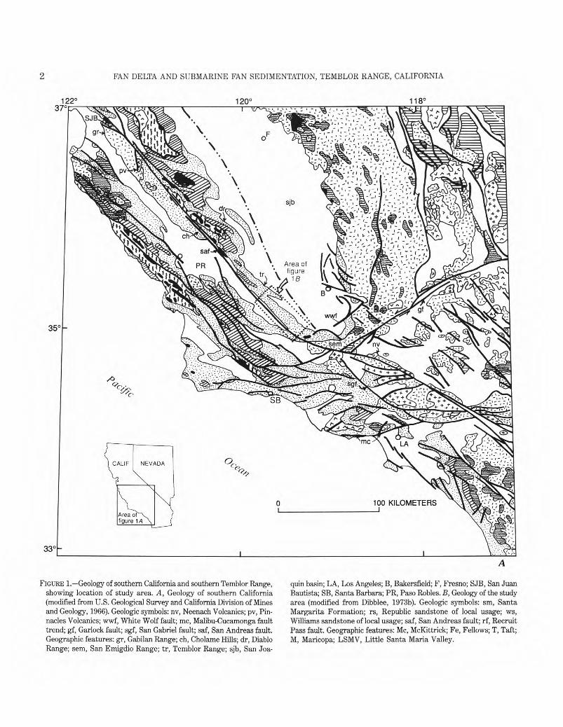
FIGURE 1. Geologic maps of southern California and southern Temblor Range showing location of study area, Santa Margarita Formation, Republic sandstone of local usage, and Williams sandstone of local usage �2
2-6. Photographs showing: 2. Crest of southern Temblor Range �5 3. View northward from the Recruit Grade Road toward the Recruit Pass fault �6 4. Cochora Ranch anticline in the shale and sandstone member of the Monterey Shale and the Santa
Margarita Formation �6 5. Cochora Ranch anticline in the shale and sandstone member of the Monterey Shale �6 6. San Andreas fault and Elkhorn and Carrizo Plains from top of southern Temblor Range �6
7. Geologic map and cross section of Cochora Ranch anticline and adjacent area �8
V
VI CONTENTS
8-15. Photographs showing:� Page
8. Unnamed sandstone unit of the Bitterwater Creek Shale � 12 9. First-order sandstone pod (northwest limb) in the Republic sandstone of local usage� 12
10. Normally graded bed in the Republic sandstone of local usage showing divisions Ta and Tb of Bouma sequence � 13
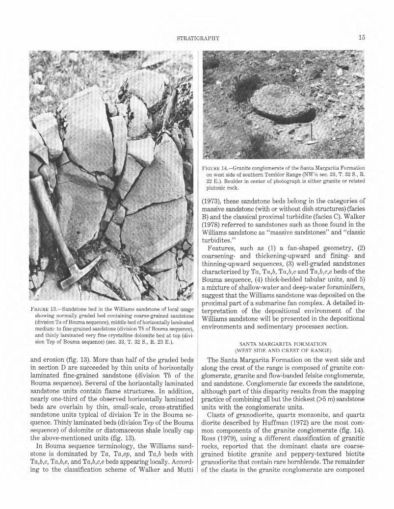
11. Normally graded bed in the Republic sandstone of local usage with a fragment of an Ostrea valve �14 12. Dish structures in a sandstone bed of the Williams sandstone of local usage � 14 13. Sandstone bed in the Williams sandstone of local usage showing divisions Ta, Tb, and Tep of Bouma
sequence � 15 14. Granite conglomerate of the Santa Margarita Formation on west side of southern Temblor Range �15 15. Granite and flow-banded felsite conglomerate of the Santa Margarita Formation on west side of southern
Temblor Range � 16 16. Diagram showing the important relations among lithofacies, members (A,B,C,D) and depositional environments of
the Santa Margarita Formation � 18 17-19. Geologic maps and cross sections of:
17. Bitterwater Creek anticline and adjacent area � 20 18. Northern and southern prongs of Cochora Ranch anticline and adjacent area � 22 19. Lone Tree anticline and adjacent area � 23
20. Photograph showing granite conglomerate with sandy matrix in member B of the Santa Margarita Formation, east flank of Cochora Ranch anticline � 24
21. Photograph showing isolated boulder from the granite conglomerate with sandy matrix in member B of the Santa Margarita Formation, east flank of Cochora Ranch anticline � 24
22. Grain-size distribution curves from selected conglomerate matrix and sandstone samples in the Santa Margarita Formation� 25
23-26. Photographs of the sandstone in member B of the Santa Margarita Formation, east flank of Cochora Ranch anticline, showing: 23. Thick parallel beds � 26 24. Thick parallel beds and Pecten and Ostrea shell fragments � 26 25. Normally graded pebbly sandstone beds � 26 26. Pecten shells � 27
27-31. Photographs showing: 27. Very thin bedded to laminated silty sandstone in member B of the Santa Margarita Formation, east flank
of Cochora Ranch anticline � 27 28. Lens of granite conglomerate with sandy matrix containing very well rounded clasts, near base of silty
sandstone of member B of the Santa Margarita Formation � 28 29. Granite conglomerate with argillaceous sandy matrix in member B of the Santa Margarita Formation, west
flank of Cochora Ranch anticline � 28 30. Granite and flow-banded felsite conglomerate with argillaceous sandy matrix in member C of the Santa
Margarita Formation faulted against sandstone beds of the Bitterwater Creek Shale � 28 31. Granite and flow-banded felsite conglomerate with sandy matrix in member C of the Santa Margarita
Formation in fault block adjacent to Elkhorn Plain � 28 32-34. Photographs of granite and flow-banded felsite conglomerate with argillaceous sandy matrix in member C of the
Santa Margarita Formation, west side of southern Temblor Range, showing: 32. Massive deposit and matrix-supported clasts � 29 33. Moderately stratified thick parallel beds � 29 34. Matrix- and clast-supported conglomerate � 29
35-37. Photographs showing: 35. Part of a thick section of granite conglomerate with sandy matrix and sandstone in member D of the Santa
Margarita Formation � 30 36. Sandstone in member D of the Santa Margarita Formation, west side of southern Temblor Range, showing
thick to very thick parallel beds � 30 37. Massive, unstratified part of the granite conglomerate with argillaceous sandy matrix in member D of the
Santa Margarita Formation, west side of the southern Temblor Range � 30 38-40. Photographs of granite conglomerate with sandy matrix in member D of the Santa Margarita Formation, west side
of southern Temblor Range, showing: 38. Normally graded bed � 31 39. Massive deposit and matrix-supported clasts � 31 40. Massive conglomerate deposit and matrix-supported clasts� 31
41-48. Photographs showing: 41. Granite conglomerate with argillaceous sandy matrix of member D of the Santa Margarita Formation, west
side of southern Temblor Range, showing massive deposit and matrix-supported clasts � 32 42. Granite conglomerate with argillaceous sandy matrix of member D of the Santa Margarita Formation, west
side of the southern Temblor Range, showing massive deposit and matrix-supported clasts � 32
� CONTENTS VII
FIGURES 43-48.—Photographs showing:� Page 43. Granite conglomerate with sandy matrix in member B of the Santa Margarita Formation, resting on
diatomite beds lithologically equivalent to the Belridge Diatomite Member of the Monterey Shale, east side of southern Temblor Range � 33
44. Channel-form conglomerate in member B of the Santa Margarita Formation pinching out into diatomite - - 33 45. Granite conglomerate with sandy matrix in member B of the Santa Margarita Formation, east side of
southern Temblor Range, showing thick, parallel beds� 34 46. Normally graded bed in granite and flow-banded felsite conglomerate with sandy matrix in member C of
the Santa Margarita Formation, east side of southern Temblor Range � 34 47. Inverse-graded bed in granite and flow-banded felsite conglomerate with sandy matrix in member C of the
Santa Margarita Formation, east side of southern Temblor Range � 35 48. Massive sandstone in member C of the Santa Margarita Formation, east side of southern Temblor
Range � 35 49. Measured sections of members B, C, and D of the Santa Margarita Formation on east and west sides of southern
Temblor Range showing general lithologic character, clast composition, and average maximum clast size - - - - 38 50. Summary diagram of paleocurrent measurements in the Santa Margarita Formation, Republic sandstone of local
usage, and Williams sandstone of local usage � 40 51. Sequence of tectonic events controlling sedimentation of the Santa Margarita Formation, unnamed sandstone unit
of the Bitterwater Creek Shale, and unnamed marine and nonmarine sedimentary rocks unit � 50
TABLE
Page TABLE 1. List of selected drill holes from the southern Temblor Range and vicinity 11

TECTONICALLY CONTROLLED FAN DELTA AND SUBMARINE FAN SEDIMENTATION OF LATE MIOCENE AGE,
SOUTHERN TEMBLOR RANGE, CALIFORNIA
By ROBERT T. RYDER and ALAN THOMSON1
ABSTRACT water foraminifers, and a fan-shaped geometry in the subsurface, are
The Santa Margarita Formation in the southern Temblor Range, composed of conglomerate and subordinate sandstone, evolved as a large complex of fan deltas and submarine fans in late Miocene time. An 80to 90-m.y.-old granitic basement of the Salinian block and an accompanying 23.5-m.y.-old volcanic field now located in the northern Gabilan Range and the Pinnacles area, respectively, were the primary source terranes. In general, the fan deltas crop out along the west side of the southern Temblor Range, whereas the proximal parts of the submarine fans crop out along the east side of the range. The fan deltas consist of subaerial topset beds and low-angle basinward-dipping subaqueous foreset beds. Strata interpreted to be topset beds are composed largely of conglomerate with thick to very thick horizontal beds and matrix-supported clasts. Most of the thick to very thick conglomerate beds are internally massive and disorganized. Strata interpreted as foreset beds are composed of thick-bedded, large-scale, low-angle, cross-stratified conglomerate and sandstone units which commonly are internally massive. Abundant molluskan macrofossils such as Ostrea and Pecten are present in the subaqueous foreset beds; many have been displaced downslope from their original site of deposition. Conglomerate- and sandstone-filled submarine canyons, through which coarse-grained detritus was transported to the adjacent submarine fans, locally have cut into the foreset beds of the fan deltas. These submarine canyon deposits are generally better stratified than adjacent foreset-bed deposits, and they consist of thick horizontal beds, internally massive or normally graded, arranged in fining- and thinning-upward sequences. Isolated and composite conglomerate- and sandstone-filled channels, which crop out on the east flank of the southern Temblor Range, are interpreted as proximal submarine-fan channel deposits. These channel-form conglomerate and sandstone deposits are characterized by thick, horizontal beds which are internally massive or normally graded containing division Ta, and locally Tb, of the Bouma sequence. Sparse calcareous foraminifers collected from diatomaceous interbeds suggest that these fan channels were deposited in upper bathyal water depths. Subaerial and regenerated subaqueous debris flows probably formed the bulk of the Santa Margarita fan delta and submarine fan system. Santa Margarita debris flows ranged from the mudflow variety to the cataclysmic debris-avalanche variety.
The cogenetic Republic and Williams sandstones of local usage, located on the east side of the southern Temblor Range, are slightly older and finer grained than the Santa Margarita Formation. These units, containing well-graded sandstones, fining- and thinning-upward and coarsening- and thickening-upward sandstone sequences, thick-bedded tabular and channel-shaped sandstones, a mixture of shallow- and deep-
'Shell Oil Company, Box 60775, New Orleans, Louisiana 70160
interpreted as submarine fan deposits. Sedimentation associated with the Santa Margarita Formation was
intimately related to the growing southern Temblor Range anticlinorium and the right-laterally shifting Salinian block along the San Andreas fault. Examples of control exerted on Santa Margarita sedimentation by the southern Temblor Range anticlinorium include the preferential accumulation of sediments along the flanks of the anticlinorium, thickening of strata on the downthrown side of the Recruit Pass fault and on flanks of selected anticlines, intraformational unconformities, and possible partial blockage of the eastward-prograding fan deltas by the Recruit Pass fault. East of the growing southern Temblor Range anticlinorium, the distal ends of the Santa Margarita submarine fans were deflected northwestward by the growing Buena Vista Hills anticline. Several examples of well-defined diachronous sedimentation, where conglomerates and sandstones of the Santa Margarita Formation occupy progressively higher stratigraphic levels in a northwest direction subparallel to the trace of the San Andreas fault, strongly imply that the Salinian basement terrane was shifting in a right-lateral sense during Santa Margarita sedimentation.
Regional factors of importance in focusing conglomerate sedimentation on the southern Temblor Range locale for a 2- to 3-m.y. period in the late Mohnian were right-lateral oblique slip on the San Andreas fault, formation of the "big bend" in the San Andreas fault by left-lateral slip along the Garlock and White Wolf faults, and the partial overlap of the Salinian and Franciscan assemblage basement rocks.
INTRODUCTION
The southern San Joaquin basin in California was the site of extensive conglomerate and sandstone deposition in late Miocene (late Mohnian) time. Granitic source ter-ranes on the east, south, and west flanks of the basin contributed detritus to the deep-water Stevens sandstone of local usage in the basin center and to shallow-marine sandstone units of the Santa Margarita Formation along the basin margins (Webb, 1981). Along the southwest perim-eter of the basin, where the shelf was very narrow, a Cretaceous (80-90 Ma) high-relief granitic terrane was emplaced by the San Andreas fault either at or within several kilometers of the shoreline. Conglomerate and sandstone deposits that resulted from the erosion of uplifted granitic basement now crop out along the west and east sides of the southern Temblor Range. These deposits were mapped as the Santa Margarita Formation
1
2 FAN DELTA AND SUBMARINE FAN SEDIMENTATION, TEMBLOR RANGE, CALIFORNIA
122° 120° 118° 37°
3 50
3 30
FIGURE 1.—Geology of southern California and southern Temblor Range, showing location of study area. A, Geology of southern California (modified from U.S. Geological Survey and California Division of Mines and Geology, 1966). Geologic symbols: nv, Neenach Volcanics; pv, Pinnacles Volcanics; wwf, White Wolf fault; mc, Malibu-Cucamonga fault trend; gf, Garlock fault; sgf, San Gabriel fault; saf, San Andreas fault. Geographic features: gr, Gabilan Range; ch, Cholame Hills; dr, Diablo Range; sem, San Emigdio Range; tr, Temblor Range; sjb, San Joa-
A
quin basin; LA, Los Angeles; B, Bakersfield; F, Fresno; SJB, San Juan Bautista; SB, Santa Barbara; PR, Paso Robles. B, Geology of the study area (modified from Dibblee, 1973b). Geologic symbols: sm, Santa Margarita Formation; rs, Republic sandstone of local usage; ws, Williams sandstone of local usage; saf, San Andreas fault; rf, Recruit Pass fault. Geographic features: Mc, McKittrick; Fe, Fellows; T, Taft; M, Maricopa; LSMV, Little Santa Maria Valley.
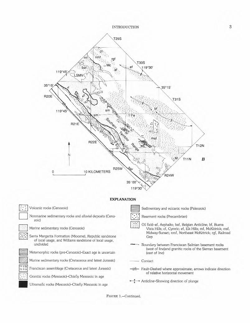
3 INTRODUCTION
R25W 10 KILOMETERS
EXPLANATION
Volcanic rocks (Cenozoic)
Nonmarine sedimentary rocks and alluvial deposits (Cenozoic)
Marine sedimentary rocks (Cenozoic)
Santa Margarita Formation (Miocene), Republic sandstone of local usage, and Williams sandstone of local usage, undivided
Metamorphic rocks (pre-Cenozoic)—Exact age is uncertain
A Marine sedimentary rocks (Cretaceous and latest Jurassic)
if III If III Franciscan assemblage (Cretaceous and latest Jurassic)
Granitic rocks (Mesozoic)—Chiefly Mesozoic in age
■ Ultramafic rocks (Mesozoic)—Chiefly Mesozoic in age
Sedimentary and volcanic rocks (Paleozoic)
Basement rocks (Precambrian)
Oil field—af, Asphalto; baf, Belgian Anticline; bf, Buena Vista Hills; cf, Cymric; ef, Elk Hills; mf, McKittrick; msf, Midway-Sunset; nmf, Northeast McKittrick; rgf, Railroad Gap
Boundary between Franciscan Salinian basement rocks (west of line)and granitic rocks of the Sierran basement (east of line)
Contact
Fault—Dashed where approximate; arrows indicate direction of relative horizontal movement
�Anticline—Showing direction of plunge
FIGURE 1.—Continue d.

4� FAN DELTA AND SUBMARINE FAN SEDIMENTATION, TEMBLOR RANGE, CALIFORNIA
by Simonson and Krueger (1942) and Dibblee (1973b) (fig. 1); such usage is retained, and slightly broadened, in this report. Slightly older, but clearly cogenetic, sandstone bodies exposed along the east side of the southern Temblor Range and in the adjacent subsurface are herein recognized as informal units: the Republic, Williams, and Leutholtz sandstones of local usage .
The Santa Margarita Formation, Republic sandstone, Williams sandstone, and Leutholtz sandstone, and their correlative units are significant reservoir rocks in the Midway-Sunset and adjacent oil fields (fig. 1).
The en echelon outcrop pattern of the Santa Margarita Formation, Republic sandstone, and Williams sandstone found along the east side of the southern Temblor Range suggested to Berry and others (1968) and Huffman (1972) that the sedimentation of these units was accompanied by right-lateral shifting of the source terrane along the San Andreas fault. Post-Mohnian right-lateral movement along the San Andreas fault appears to have displaced the source terrane of the Santa Margarita conglomerates approximately 200-250 km to its present position in the northern Gabilan Range and Pinnacles Volcanics (fig. 1; Fletcher, 1967; Berry and others, 1968; Turner and others, 1970; Huffman, 1972; and Matthews, 1976).
The objectives of this report are to (1) document the stratigraphic framework of the Santa Margarita Formation and part of the Monterey Shale in the southern Temblor Range, (2) interpret the environments of deposition and depositional processes of the above units, and (3) evaluate the influence of tectonism on Santa Margarita sedimentation, with special attention given to testing the hypothesis of Berry and others (1968).
Many of the interpretations offered here are based on a geologic map (1:30,000) of the southern Temblor Range made by the authors that emphasizes the lithofacies of the Santa Margarita and part of the Monterey Shale. This geologic map is a significant contribution because, other than regional reconnaissance maps by Dibblee (1968, 1973b) and a quadrangle map by Vedder (1970), no published geologic maps are presently available for the west side of the southern Temblor Range. Additional new data that have contributed significantly to this investigation include detailed measured outcrop sections, clast-size measurements, and microfossil and macrofossil identifications.
The study area is approximately 500 km2. It is bounded on the southwest by the San Andreas fault and on the northeast by the San Joaquin basin. The northwest and southeast borders are located near the Little Santa Maria Valley and the town of Maricopa (fig. 1), respectively. Smooth, grass- and shrub-covered hills and intervening canyons and gullies characterize the study area. Topographic relief between the crest of the southern Temblor Range and the adjacent Carrizo and Elkhorn Plains and
the San Joaquin basin ranges from 250 to 450 m. Good outcrops generally are located near the crest of the southern Temblor Range and in deeply dissected gullies and canyons that cut its flanks.
ACKNOWLEDGMENTS
We are grateful to James H. Elison, Walter M. Winfrey, Jr., and the late Barney W. Wilson for introducing us to the geology of the San Joaquin basin and encouraging us to study the depositional history of the Santa Margarita Formation. O.F. Huffman and R.L. Phillips critically reviewed the paper and made significant improvements in its scientific content and organization. E.H. Stinemeyer, R.H. Steinert, and G.C. Lutz identified the foraminifers used in this study and assigned them appropriate age and bathymetric limits. Similar data were provided by U.S. Armstrong for diatom and silicoflagellate assemblages and by Alex Clark, Ellen J. Moore, and E.H. Steinmeyer for macrofossil assemblages. Grain-orientation measurements were completed by C.F. Blankenhorn. Able field and laboratory assistance was provided by Donald E. Watson. We also thank Marcus U. and Richard Rudnick, and their foreman, Tom Thorns-berry, for giving us access and guidance to the land of the MU outfit. At least half of the data used in this investigation were collected and synthesized while the authors were employed by the Shell Development Company; we thank the management of the company for granting us permission to publish these data.
STRUCTURE
The following brief discussion of basement rocks, structures, and structural development establishes the structural setting in which the Santa Margarita Formation and correlative units originated and thereby prepares the reader for conclusions regarding tectonism and Santa Margarita sedimentation.
NATURE AND CONFIGURATION OF BASEMENT ROCKS
The Temblor Range, similar to the Diablo Range farther north, is a broad southeast-plunging anticlinorium tangential north of the study area with the San Andreas fault. The Franciscan assemblage (Jurassic and(or) Cretaceous), composed of metamorphosed deep-water marine sandstone, claystone and chert, volcanic rocks, and mafic rocks (Bailey and others, 1964), forms the basement in the Diablo Range anticlinorium (Dibblee, 1973b; Cady, 1975) and extends southward beneath the Tertiary sandstone and shale units of the southern Temblor Range (fig. 1). In map view, the Franciscan basement rocks east of the San Andreas fault form a southward-tapering wedge bounded by granitic rocks approximately 80 to 90 m.y. old (Armstrong and Suppe, 1973); on the east side of the
5 STRUCTURE�
wedge of Franciscan rocks the granitic rocks constitute the Sierran block, and on the west side, across the San Andreas fault, the Salinian block (fig. 1). The Franciscan basement rocks probably evolved near a subduction zone that was later offset, in a right-lateral sense, along a tectonically "softened" zone between the Pacific and the North American plates (Hamilton, 1969, 1978; Suppe, 1970; Atwater, 1970). The Salinian block was probably derived from between the Mojave block and the Peninsular Range in southern California (Hamilton, 1978; Dickinson, 1983; Ross, 1984) or from the west coast of Mexico and(or) Central America (Howell and others, 1980; Page, 1982).
DESCRIPTION OF STRUCTURES
The structure of the southern Temblor Range is characterized by a series of northwest-trending tight folds commonly overturned to the northeast (pls. 1 and 2; Fletcher, 1962; Vedder, 1970; Dibblee, 1973b). These folds form the southern Temblor Range anticlinorium that is cut on the east side by thrust faults with northeast transport and on the west side by down-to-the-west normal faults. The trace of the easternmost thrust fault is difficult to map because diatomaceous shale of the hanging-wall block is juxtaposed against diatomaceous shale of the footwall block. Thus, the location of the thrust fault on plate 1 is inferred, aided in part by disrupted strata such as those recognized by Vedder (1970, sheet 2). The degree of overturning and eastward transport along the thrust faults diminishes from north to south in the study area as illustrated by the following: the nearly recumbent anticlinorium and associated low-angle thrust fault with a dip separation of over 1,000 m near Crocker Canyon (pls. 1, 2, sec. A-A' ; Fletcher, 1962); the slightly overturned anticlinorium and associated high-angle thrust fault with a dip separation of about 300 m near Midway Peak (pls. 1 and 2, sec. B-B'); and large upright folds associated with high-angle thrust faults having dip separations of about 400 m in the southern part of the study area (pls. 1 and 2, sec. C-C' ; Vedder, 1970). Despite the general southward change in the style of deformation, about 25 percent (1.6 km) lateral shortening—based on the three balanced cross sections in plate 2—is maintained across the study area.
Several thin sheets of lower and middle Miocene shale and sandstone units, covering as much as 6 km2, rest discordantly on fold axes of the southern Temblor Range anticlinorium near the range crest (pl. 1; T. 31 S., R. 21 E.). Many of the sheets are internally disrupted and contain foraminiferal assemblages similar to those in underlying rocks (Simonson and Krueger, 1942). Conglomerate and sandstone of the Santa Margarita Formation (upper Miocene) unconformably overlie the sheets.
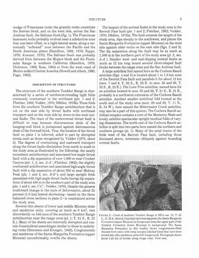
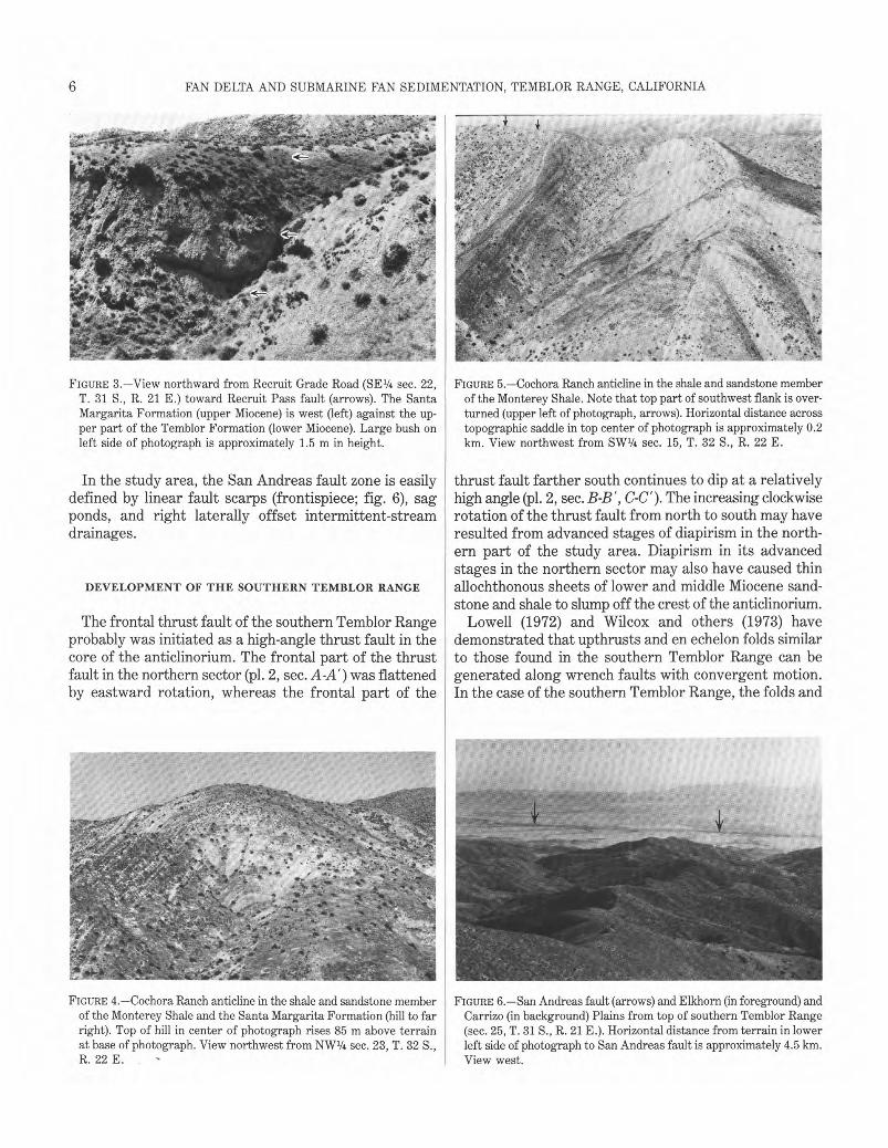
The largest of the normal faults in the study area is the Recruit Pass fault (pls. 1 and 2; Fletcher, 1962; Vedder, 1970; Dibblee, 1973a). The fault extends the length of the study area, dips steeply to the southwest, and places the Santa Margarita Formation (upper Miocene) on the west side against older rocks on the east side (figs. 2 and 3). The dip separation along the fault may be as much as 1,500 m in the northern part of the study area (pl. 2, sec. A-A'). Smaller west- and east-dipping normal faults as much as 12 km long bound several sliver-shaped fault blocks between the range crest and the San Andreas fault.
A large anticlinal fold named here as the Cochora Ranch anticline (figs. 4 and 5) is located about 1 to 1.6 km west of the Recruit Pass fault and parallels it for about 12 km (secs. 7 and 8, T. 32 S., R. 22 E. to secs. 25 and 36, T. 32 S., R. 22 E.). The Lone Tree anticline, named here for an anticline located in secs. 35 and 36, T. 31 S., R. 21 E., probably is a northwest extension of the Cochora Ranch anticline. Another smaller anticlinal fold located at the south end of the study area (secs. 29 and 30, T. 11 N., R. 24 W.), here named the Bitterwater Creek anticline, may also be a part of this system. The Cochora Ranch anticlinal complex contains a core of the Monterey Shale and locally exhibits spectacular upright isoclinal folds of varying dimensions. The north end of the Cochora Ranch anticline is split into two parts here named the northern and southern prongs (pl. 1). Many of the axial traces of the folds west of the Recruit Pass fault, including those discussed above, terminate obliquely against bounding normal faults.
FIGURE 2.—Crest of southern Temblor Range in NE1/4 sec. 15, T. 32 S., R. 22 E. Recruit Pass fault (arrows) separates the Santa Margarita Formation (upper Miocene) in foreground from the upper part of the Temblor Formation (lower Miocene) in background. The Santa Margarita Formation at this locality shows conglomerate-filled channel-form units with steep margins (dashed lines) that have been eroded into silty sandstone units (left foreground). Photograph shows about 0.45 km of terrain along range crest. View east.
6 �
FAN DELTA AND SUBMARINE FAN SEDIMENTATION, TEMBLOR RANGE, CALIFORNIA
FIGURE 3.—View northward from Recruit Grade Road (SE1/4 sec. 22, T. 31 S., R. 21 E.) toward Recruit Pass fault (arrows). The Santa Margarita Formation (upper Miocene) is west (left) against the upper part of the Temblor Formation (lower Miocene). Large bush on left side of photograph is approximately 1.5 m in height.
In the study area, the San Andreas fault zone is easily defined by linear fault scarps (frontispiece; fig. 6), sag ponds, and right laterally offset intermittent-stream drainages.
DEVELOPMENT OF THE SOUTHERN TEMBLOR RANGE
The frontal thrust fault of the southern Temblor Range probably was initiated as a high-angle thrust fault in the core of the anticlinorium. The frontal part of the thrust fault in the northern sector (pl. 2, sec. A-A') was flattened by eastward rotation, whereas the frontal part of the
FIGURE 5.—Cochora Ranch anticline in the shale and sandstone member of the Monterey Shale. Note that top part of southwest flank is overturned (upper left of photograph, arrows). Horizontal distance across topographic saddle in top center of photograph is approximately 0.2 km. View northwest from SW1/4 sec. 15, T. 32 S., R. 22 E.
thrust fault farther south continues to dip at a relatively high angle (pl. 2, sec. B-B' , C-C'). The increasing clockwise rotation of the thrust fault from north to south may have resulted from advanced stages of diapirism in the northern part of the study area. Diapirism in its advanced stages in the northern sector may also have caused thin allochthonous sheets of lower and middle Miocene sandstone and shale to slump off the crest of the anticlinorium.
Lowell (1972) and Wilcox and others (1973) have demonstrated that upthrusts and en echelon folds similar to those found in the southern Temblor Range can be generated along wrench faults with convergent motion. In the case of the southern Temblor Range, the folds and
FIGURE 4.—Cochora Ranch anticline in the shale and sandstone member FIGURE 6.—San Andreas fault (arrows) and Elkhorn (in foreground) and of the Monterey Shale and the Santa Margarita Formation (hill to far Carrizo (in background) Plains from top of southern Temblor Range right). Top of hill in center of photograph rises 85 m above terrain (sec. 25, T. 31 S., R. 21 E.). Horizontal distance from terrain in lower at base of photograph. View northwest from NW1/4 sec. 23, T. 32 S., left side of photograph to San Andreas fault is approximately 4.5 km. R. 22 E. View west.
7 STRATIGRAPHY�
associated faults probably originated during episodes of convergent right-lateral slip along the San Andreas fault. During these episodes, the mobile Franciscan basement rocks probably were constricted between the more rigid, right laterally shifting Salinian and Sierran basement blocks, bulged upward, and deformed the overlying Tertiary sedimentary cover.
As suggested by J.L. Livingston (written commun., 1970), the Recruit Pass fault and other west-dipping normal faults along the west flank of the southern Temblor Range may have developed when the tightly constricted core of the anticlinorium was displaced upward by diapirism with respect to the flanking strata. Possibly, the mobile core of the anticlinorium, bound by major thrust faults, moved upward and basinward into a northeast-verging hinge zone, until the core ruptured near the crest of the anticlinorium where the overburden was minimal and was displaced upward with respect to the flanks of the anticlinorium. Thus, the faults on the west side of the southern Temblor Range anticlinorium may be normal faults only in a geometric sense. Some (or all) of these normal faults initially may have been thrust faults that later reversed their sense of motion owing to constriction and diapirism at the core of the anticlinorium.
Harding (1976, fig. 3c) has demonstrated that the major anticlinal structures in the subsurface east of the southern Temblor Range began to form in Mohnian and Delmontian time (Mohnian of this paper) and continued into the Pleistocene. Structures within the southern Temblor Range appear to have had about the same timing because: first, the Santa Margarita Formation (late Mohnian) rests unconformably on the southern Temblor anticlinorium; second, the pre-Santa Margarita offset in a normal sense along the Recruit Pass fault is much greater than the post-Santa Margarita offset; third, the allochthonous sheets of lower and middle Miocene shales that were probably derived from the growing anticlinorium are also overlain unconformably by the Santa Margarita; and finally, the shale and sandstone member of the Monterey Shale (early Mohnian) is the youngest unit in the anticlinorium overlain by the Santa Margarita Formation. Therefore, the southern Temblor Range anticlinorium had developed to an advanced stage either during or soon after the deposition of the shale and sandstone member of the Monterey Shale and before the deposition of the Santa Margarita Formation. The initial stages of the anticlinorium must have begun earlier than Mohnian time, as indicated by the hiatuses associated with the pre-early Mohnian rocks (pl. 1). The post-Santa Margarita offset along the Recruit Pass fault (and additional outcrop evidence presented in the stratigraphy section) clearly indicates that the anticlinorium continued to expand during the deposition of the Santa Margarita Formation (late Miocene) and into the early Pliocene.
STRATIGRAPHY
UPPER MIOCENE AND PLIOCENE STRATIGRAPHY
The upper Miocene and Pliocene sequence of the southern Temblor Range is composed of granite conglomerate, sandstone, diatomite, and diatomaceous shale, largely of marine origin and having an aggregate thickness of as much as 2,500 m. A granite conglomerate is defined here as a conglomerate having at least 50 percent of its clasts composed of granite and(or) related rock such as granodiorite, quartz diorite, and quartz monzonite. Several major unconformities punctuate the sequence. The schematic stratigraphic framework diagram in plate 1 illustrates the distribution of the rock units of the southern Temblor Range and the approximate position and duration of intervening unconformities. Aside from the authors' work, the stratigraphic framework diagram is based on Simonson and Krueger (1942), Fletcher (1962, 1967), Callaway (1962), Pacific Section of AAPG-SEGSEPM (1968), Vedder (1970), and Dibblee (1962, 1968, 1973a, 1973b). The stratigraphic nomenclature is adopted largely from Dibblee (1973a). The correlation of the provincial foraminiferal stages of Kleinpell (1938) and the provincial molluskan stages of Addicott (1972) with the standard geologic time scale is taken from Poore and others (1981) (pl. 1). Additional potassium-argon age dates for the foraminiferal stages are from Turner (1970), Obradovich (in Huffman, 1972), and Obradovich and Naeser (1981) (pl. 1). The Mohnian Stage is subdivided into four informal foraminiferal substages used by the Shell Oil Company (unpub. data, 1948) (pl. 1). By adopting the standard time scale instead of the provincial time scale, Poore and others (1981) have changed the Miocene-Pliocene boundary in California from about 9.0 Ma (Evernden and others, 1964; Bandy and Ingle, 1970) to about 5.0 Ma (Van Couvering, 1972; 1978). This change in the age of the Miocene-Pliocene boundary requires slight alterations in the ages of some rock units defined by Dibblee (1973a).
EAST SIDE OF RANGE
The middle and upper Miocene sequences exposed on the east flank of the southern Temblor Range consists of the McLure Shale Member of the Monterey Shale and the overlying Santa Margarita Formation. The McLure Shale Member continues unchanged northeastward into the adjacent subsurface, whereas the Santa Margarita Formation is replaced, several kilometers basinward, by the Belridge Diatomite Member of the Monterey Shale. The Reef Ridge Shale, youngest of the upper Miocene rock units, is confined to the subsurface and overlies both the Santa Margarita Formation and the Belridge Diatomite Member (see Dibblee, 1973a, for additional inf?rmation).
LIBRARY
NOV 0 6 '89
..:;urado
8� FAN DELTA AND SUBMARINE FAN SEDIMENTATION, TEMBLOR RANGE, CALIFORNIA
0
SW
A METERS 1000- Richfield Temblor Hills No. 21
(projected from NE1/4SE1/4, sec. 27, T. 32 S., R. 22 E.) Tsmb
500
SEA LEVEL Extends to approximately
-500 m MEAN SEA LEVEL
0;5 1 KILOMETER
COCHORA RANCH ANTICLINE NE
Neaves Petroleum
Elkhorn No. 3
RECRUIT PASS FAULT Tsmb Tsmb
A'
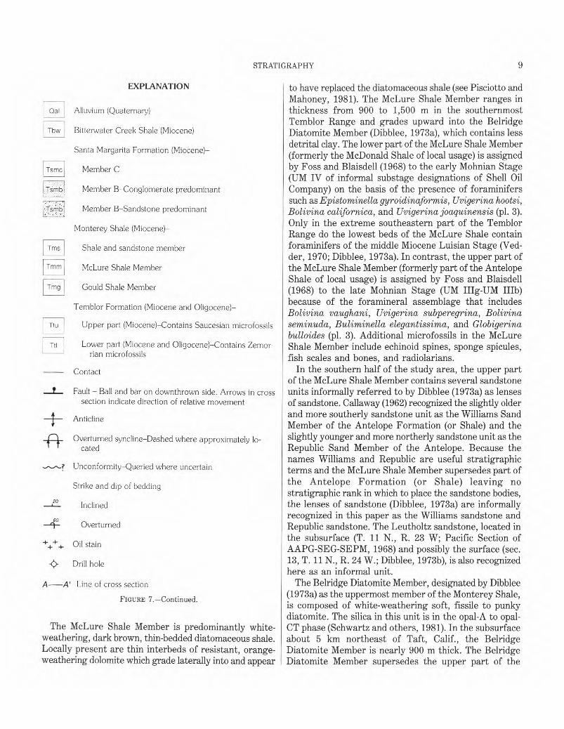
FIGURE 7.—Geologic map and cross section (A-A') of Cochora Ranch anticline and adjacent area.
9 STRATIGRAPHY�
EXPLANATION
Qal Alluvium (Quaternary)
Tbw Bitterwater Creek Shale (Miocene)
Santa Margarita Formation (Miocene)—
Tsmc Member C
Tsmb, Member B—Conglomerate predominant
: : • (•Tsmb Member B—Sandstone predominant
Monterey Shale (Miocene)—
Tms Shale and sandstone member
Tmm McLure Shale Member
Tmg Gould Shale Member
Temblor Formation (Miocene and Oligocene)—
Ttu Upper part (Miocene)—Contains Saucesian microfossils
Ttl Lower part (Miocene and Oligocene)—Contains Zemorrian microfossils
Contact
Fault — Ball and bar on downthrown side. Arrows in cross section indicate direction of relative movement
Anticline
Overturned syncline—Dashed where approximately located
Unconformity—Queried where uncertain
Strike and dip of bedding
20 Inclined
60 Overturned
+++ Oil stain
<)-�Drill hole
A—A' Line of cross section
FIGURE 7.—Continued.
The McLure Shale Member is predominantly white-weathering, dark brown, thin-bedded diatomaceous shale. Locally present are thin interbeds of resistant, orange-weathering dolomite which grade laterally into and appear
to have replaced the diatomaceous shale (see Pisciotto and Mahoney, 1981). The McLure Shale Member ranges in thickness from 900 to 1,500 m in the southernmost Temblor Range and grades upward into the Belridge Diatomite Member (Dibblee, 1973a), which contains less detrital clay. The lower part of the McLure Shale Member (formerly the McDonald Shale of local usage) is assigned by Foss and Blaisdell (1968) to the early Mohnian Stage (UM IV of informal substage designations of Shell Oil Company) on the basis of the presence of foraminifers such as Epistominella gyroidinaformis, Uvigerina hootsi, Bolivina californica, and Uvigerina joaquinensis (pl. 3). Only in the extreme southeastern part of the Temblor Range do the lowest beds of the McLure Shale contain foraminifers of the middle Miocene Luisian Stage (Vedder, 1970; Dibblee, 1973a). In contrast, the upper part of the McLure Shale Member (formerly part of the Antelope Shale of local usage) is assigned by Foss and Blaisdell (1968) to the late Mohnian Stage (UM IIIg-UM IIIb) because of the foramineral assemblage that includes Bolivina vaughani, Uvigerina subperegrina, Bolivina seminuda, Buliminella elegantissima, and Globigerina bulloides (pl. 3). Additional microfossils in the McLure Shale Member include echinoid spines, sponge spicules, fish scales and bones, and radiolarians.
In the southern half of the study area, the upper part of the McLure Shale Member contains several sandstone units informally referred to by Dibblee (1973a) as lenses of sandstone. Callaway (1962) recognized the slightly older and more southerly sandstone unit as the Williams Sand Member of the Antelope Formation (or Shale) and the slightly younger and more northerly sandstone unit as the Republic Sand Member of the Antelope. Because the names Williams and Republic are useful stratigraphic terms and the McLure Shale Member supersedes part of the Antelope Formation (or Shale) leaving no stratigraphic rank in which to place the sandstone bodies, the lenses of sandstone (Dibblee, 1973a) are informally recognized in this paper as the Williams sandstone and Republic sandstone. The Leutholtz sandstone, located in the subsurface (T. 11 N., R. 23 W; Pacific Section of AAPG-SEG-SEPM, 1968) and possibly the surface (sec. 13, T. 11 N., R. 24 W.; Dibblee, 1973b), is also recognized here as an informal unit.
The Belridge Diatomite Member, designated by Dibblee (1973a) as the uppermost member of the Monterey Shale, is composed of white-weathering soft, fissile to punky diatomite. The silica in this unit is in the opal-A to opal-CT phase (Schwartz and others, 1981). In the subsurface about 5 km northeast of Taft, Calif., the Belridge Diatomite Member is nearly 900 m thick. The Belridge Diatomite Member supersedes the upper part of the
10� FAN DELTA AND SUBMARINE FAN SEDIMENTATION, TEMBLOR RANGE, CALIFORNIA
Antelope Formation (or Shale) recognized by Callaway (1962) and the punky shale unit of the Santa Margarita Formation of Simonson and Krueger (1942). Sparse foraminifers such as Uvigerina subperegrina and Bolivina vaughani (pl. 3) suggest that the Belridge Diatomite Member belongs to the late Mohnian Stage (UM Ina).
Sandstone and conglomerate, formerly recognized by Callaway (1962) as the Spellacy Sand Member of the Antelope Formation (or Shale), are here assigned to the Santa Margarita Formation (Dibblee, 1973a) because they are lithologically similar to and approximately in the same stratigraphic position as the Santa Margarita Formation recognized by Simonson and Krueger (1942) on the west flank of the southern Temblor Range. Dibblee's usage of the Santa Margarita Formation is herein retained but broadened to include rocks in the Crocker Canyon-Dabney Canyon area previously mapped as the Potter Sand Member of the Reef Ridge Shale of Callaway (1962). Moreover, rocks in the subsurface previously assigned to the Potter Sand Member by Callaway (1962) are herein assigned to the Santa Margarita Formation. Diatomite tongues previously assigned to the Belridge Diatomite Member of the Monterey Shale, which accompany the sandstone and conglomerate in outcrop, are likewise included in the Santa Margarita Formation (pl. 1). In the subsurface, an arbitrary cutoff is drawn between the Santa Margarita Formation and the Belridge Diatomite Member. The term Belridge Diatomite Member is retained where diatomite predominates over the sandstone and conglomerate tongues (pl. 1). The total thickness of the Santa Margarita Formation, including the Potter Sand Member of Callaway (1962), is about 800 m in outcrop and about 1,500 m in the subsurface (Callaway, 1962).
The Reef Ridge Shale of Callaway (1962) in the vicinity of the southern Temblor Range is a 45- to 275-m-thick brown diatomaceous shale that is present only in the subsurface (Callaway, 1962; Pacific Section of AAPG-SEGSEPM, 1968). This unit rests conformably on the Belridge Diatomite Member and Santa Margarita Formation and is unconformably overlain by the Etchegoin Formation (pl. 1). Kleinpell (1938) assigned a latest Miocene age (UMI-II) to the Reef Ridge Shale at its type locality (Dibblee, 1973a), about 90 km northwest of the study area, and this age seems to apply to the Reef Ridge Shale as mapped by Callaway (1962) in the study area. Dibblee (1973a) suggested that the uppermost part of the Reef Ridge Shale could be early Pliocene in age; however this suggestion was based on a 9-m.y. Miocene-Pliocene boundary instead of the presently accepted 5-m.y. date (pl. 1).
The Etchegoin Formation (Miocene and Pliocene) comprises interbedded shallow marine sandstone, siltstone, claystone, and minor pebble conglomerate, rests unconformably on the Reef Ridge Shale and the Santa Mar-
garita Formation, and is overlain unconformably by the San Joaquin and Tulare Formations. The Etchegoin Formation is confined to the subsurface in the study area (pl. 2, sec. C-C' ). The maximum thickness of the Etchegoin Formation in the study area is about 400 m.
The San Joaquin Formation (Pliocene), consisting of marine gray claystone, siltstone, and fine-grained sandstone, unconformably overlies the Etchegoin Formation. In the vicinity of the southern Temblor Range, the San Joaquin Formation is confined to the subsurface (pl. 2) and has a maximum thickness of about 400 m. Thick valley-fill deposits of the Tulare Formation (Pliocene and Pleistocene) rest unconformably on rock units ranging from the San Joaquin Formation in the subsurface to the McLure Shale Member on the eastern flank of the southern Temblor Range (pl. 1, pl. 2, sec. C-C' ).
WEST SIDE OF RANGE
The upper Miocene and Pliocene rocks on the west side of the range consist of, from oldest to youngest, the shale and sandstone member of the Monterey Shale, Santa Margarita Formation, Bitterwater Creek Shale, and the unnamed marine and nonmarine sedimentary rocks unit (pl. 1). All of the above units, except for the unnamed marine and nonmarine sedimentary rocks unit, are recognized by Dibblee (1973a).
The shale and sandstone member of the Monterey Shale is a 450-m-thick unit of interbedded white partly siliceous shale and light-gray, fine- to medium-grained sandstone. The Santa Margarita Formation uncomformably overlies the shale and sandstone member (Vedder, 1970; Dibblee, 1973a,b) which unconformably overlies the Temblor Formation. These unconformities are best shown along the Cochora Ranch anticline (fig. 7).
The unconformity between the Santa Margarita Formation and the shale and sandstone member of the Monterey Shale is marked by an angular discordance of as much as 40° along the flanks of the Cochora Ranch anticline (pl. 1; fig. 7). Presumably, this unconformity extends to the east side of the range and separates the uppermost part of the McLure Shale Member from the Santa Margarita Formation (pl. 1). The allochthonous sheets of lower and middle Miocene shale were probably emplaced during this hiatus.
The unconformity between the shale and sandstone member and the Temblor Formation is identified in the Neaves Petroleum Elkhorn No. 3 drill hole where the shale and sandstone member (early Mohnian Stage) rests within 35 m of rocks containing fauna of late Oligocene (Zemorrian Stage) age (pl. 1; table 1; fig. 7). The Gould Shale Member of the Monterey Shale (lower and middle Miocene) and the upper part of the Temblor Formation (lower Miocene) on the west side of the range seem to have been removed by erosion. This unconformity is probably
11 STRATIGRAPHY�
TABLE 1.—List of selected drill holes from southern Temblor Range and vicinity [See plate 1 for locations of drill holes]
Total Map Year depth Location No. Drill hole� drilled (meters) Section Township Range
1 Getty Oil Co. USL No.� 1962 3(SE1/4 SW1/4) 31S 21E1 2195 2 British American Oil Co. Richfield-Dodds-Thomas No.�1952 10(NW1/4 NW1/4) 31S 21E1 1512 3 Getty Oil Co. Dodds-Thomas No.� 1951 9(SW1/4 SE1/4) 31S 21E3 2545
deepened 1961 and 1963 4 Shell Oil Co. Weir No.�- 1968 357 22(SW1/4 SW1/4) 22E30 6L 31S 5 Chanslor-Canfield Midway Oil Co. No.�1933 35(SW1/4 SW1/4) 31S 22E14 1151 6 Chanslor-Canfield Midway Oil Co�16 882 35(SW1/4 SE1/4) 31S 22ENo.�1942
Chanslor-Canfield Midway Oil Co� 32S 22E7 No. 25-1 1942 1683 1(5441/4 NE1/4) 8 Continental Oil Co. Munsey USL-1 1950 2768 4(NE1/4 SE1/4) 32S 22E 9 Shell Oil Co.�1-A 1930 2498 15(SW1/4 NE1/4) 32S 235Perris No.�10 Superior Oil Co. CWOD No.� 1957 4421 21(SW1/4 SE1/4) 32S 23E58-21 11 Richfield Oil Corp.� 3486 31(5E1/4 SE1/4) 32S 23EGonyer U.S. No. 78-31 1953 12 Ohio Oil Co. Porter No.� 1951 3O(NE1/4 NE1/4) 11N 24W1 1145 13 Richfield Oil Corp. Temblor Hills Unit No.�1944 32(NE1/4 NE1/4) 12N 25W2-2 930 14 Neaves Petroleum Developments Neaves-Elkhorn No. 3 1954 683 23(NW1/4 SW1/4) 32S 22E 15 Burrhus Munsey No.� 1939 17(NE1/4 NE1/4) 32S 22E1 46 16 Colquitt Drilling Co.�1 280 7(NW1/4 SE1/4) 32S 22EColquitt No.� 1951 17 United and Foreign Oil Co.�2 739 32SPanorama No.�1936 2(5441/4 NEl/4) 21E 18 Richfield Oil Corp.� 215Temblor Hills Unit 1, No.��1 1945 2883 36(SW1/4 NE1/4) 31S 19 Temblor Oil Co. No.� 1939 22(NE1/4 SE1/4) 31S 2151 1209 20 Richfield Oil Corp.� 1 1944-45 1362 32S 22ETemblor Hills Unit 2, No.��� 27(NE1/4 SE1/4)
equivalent to the unconformities which bound the Gould grained sandstone and granite conglomerate units ex-Shale Member on the east side of the range (pl. 1). posed along the crest and west flank of the southern
According to Vedder (1970), the shale and sandstone Temblor Range. The usage of Simonson and Krueger member contains foraminifers diagnostic of the Relizian (1942) is retained by Dibblee (1973a). Shale and sandstone (early Miocene) and Luisian Stages (middle Miocene), beds in the Santa Margarita Formation contain arena-therefore making it correlative with the Gould Shale ceous foraminifers, such as Cibicides conoideus, Discor-Member on the east side of the range. However, based bis versiformis, Elphidium advenum, and Elphidium on the common occurrence of the foraminifers Episto- crispum (fax), and marine macrofauna, such as Ostrea minella gyroidinaformis and Valvulineria grandis in titan, Pecten crassicardo, Lyropecten estrellanus (Con-samples from the Neaves Petroleum Elkhorn No. 3 drill rad), Pecten raymondi, and Astrodapsus margaritanus, hole (table 1; sec. 23, T. 32 S., R. 22 E.) and in several that suggest a late Miocene age ("Margaritan" Provinoutcrop localities, the authors interpret the shale and cial Molluscan Stage) (pl. 3). The maximum thickness of sandstone member to be early Mohnian in age (UM IV) the Santa Margarita Formation is about 550 m. (pls. 1 and 3). The latter interpretation suggests that the The Bitterwater Creek Shale (Dibblee, 1962; 1973a) is shale and sandstone member of the Monterey Shale is cor- a white- to gray-weathering, silty, siliceous shale of marine relative with the lower part of the McLure Shale Member origin with local interbeds of sandstone and shale-pebble (formerly the McDonald Shale) on the east side of the conglomerate. According to Vedder (1970) and Dibblee range and that the reported early and middle Miocene (1973a), the Bitterwater Creek Shale is probably correlforaminifers are reworked from older rocks (pl. 1). Fur- ative with the Reef Ridge Shale (late Miocene) in the subthermore this interpretation implies that equivalent units surface east of the range. At its type locality at the of the upper part of the McLure Shale Member and the southernmost end of the study area (T. 11 N., R. 24 W.), interbedded Williams, Republic, and Leutholtz sandstones the Bitterwater Creek Shale is as much as 70 m thick. were either never deposited on the west side of the range A coarse-grained white-weathering arkosic sandstone or have been removed by pre-Santa Margarita erosion (pl. with marine macrofauna, referred to in this report as an 1). Although improbable, the possibility exists that the unnamed sandstone unit in the Bitterwater Creek Shale, shale and sandstone member is early through late Miocene intertongues with and replaces the white-weathering shale in age and thus correlates with both the Gould Shale of the Bitterwater Creek Shale toward the northwest (pl. Member and the lower part of the McLure Shale Member. 1; fig. 8). The presence of Lyropecten cerrosensis Gabb
Simonson and Krueger (1942) assigned the name Santa suggests a late Miocene and Pliocene(?) age for the un-Margarita Formation to the thick sequence of coarse- named sandstone unit in the Bitterwater Creek Shale (pl.
12� FAN DELTA AND SUBMARINE FAN SEDIMENTATION, TEMBLOR RANGE, CALIFORNIA
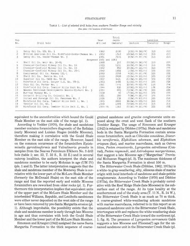
FIGURE 8.—Unnamed sandstone unit of the Bitterwater Creek Shale (NW1/4 sec. 7, T. 32 S., R. 22 E.) that is in fault contact with the Santa Margarita Formation on east (just outside left side of photograph). Numerous concretions (arrows) in sandstone beds are 0.25 to 0.5 m in diameter. View south.
3). The Bitterwater Creek Shale and its unnamed sandstone unit rest unconformably on the Santa Margarita Formation (fig. 7; pl. 1) and are overlain unconformably by the unnamed marine and nonmarine sedimentary rocks unit (late Miocene) and the Paso Robles Formation (Pliocene (?) and Pleistocene) (pl. 1).
The next highest stratigraphic unit combines two units mapped by Dibblee (1962, 1968): (1) the interbedded sandstone and shale part of the now-abandoned Panorama Hills Formation of Dibblee (1962) with local marine mega-fauna indicative of a late Miocene age ("Jacalitos" Provincial Molluscan Stage; Addicott, 1972; pl. 3) and (2) the nonmarine part of the Panorama Hills Formation which comprises green shale, coarse-grained sandstone, and granite conglomerate with local flow-banded felsite clasts (pls. 1 and 3). The marine part of the Panorama Hills Formation crops out primarily in the northeastern part of T. 32 S., R. 21 E. (pl. 1). Northwestward, the the marine part of the Panorama Hills Formation intertongues with, and is gradually replaced by, as much as 800 m of the non-marine part of the Panorama Hills Formation. Additional mapping is required to establish the detailed facies relations of the marine and nonmarine parts of the Panorama Hills Formation. The combined marine and nonmarine parts of the Panorama Hills Formation—the unnamed marine and nonmarine sedimentary rocks unit of this paper—rests unconformably on the Bitterwater Creek Shale, the shale and sandstone member of the Monterey Shale, and the Santa Margarita Formation. Thick valley-fill deposits of the Paso Robles Formation (Pliocene (?) and Pleistocene) unconformably rest on the unnamed marine and nonmarine sedimentary rocks unit (pl. 1).
CREST OF RANGE
Patches of granite- and marble-bearing conglomerate units assigned by Simonson and Krueger (1942) and Dibblee (1973b) to the Santa Margarita Formation unconformably overlie allochthonous sheets of lower and middle Miocene rocks and steeply dipping beds of the Gould Shale Member and the Temblor Formation along the crest of the southern Temblor Range. A small patch of conglomerate, which comprises basalt boulders (SE1/4 sec. 23, T. 31 S., R. 21 E.), also belongs to the Santa Margarita Formation. Marine macrofossils associated with the Santa Margarita Formation on the crest of the range indicate a late Miocene age (pl. 3; Simonson and Krueger, 1942).
UPPER MIOCENE CONGLOMERATE AND SANDSTONE UNITS
REPUBLIC SANDSTONE
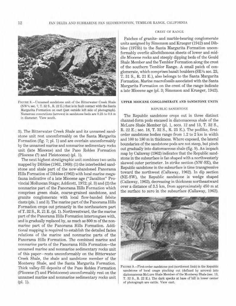
The Republic sandstone crops out in three distinct channel-form pods encased in diatomaceous shale of the McLure Shale Member (pl. 1, secs. 12 and 13, T. 32 S., R. 22 E.; sec. 18, T. 32 S., R. 23 E.). The podlike, first-order sandstone bodies range from 1.2 to 2 km in width and 100 to 180 m in thickness. Where exposed, the lateral boundaries of the sandstone pods are not steep, but pinch out gradually into diatomaceous shale (fig. 9). An isopach map by Callaway (1962) indicates that the Republic sandstone in the subsurface is fan shaped with a northwesterly skewed outer perimeter. In strike section (NW-SE), the Republic sandstone in the subsurface is time transgressive toward the northwest (Callaway, 1962). In dip section (NE-SW), the Republic sandstone is wedge shaped (Callaway, 1962), decreasing in thickness northeastward over a distance of 3.5 km, from approximately 450 m at the surface to zero in the subsurface (Callaway, 1962).
FIGURE 9.—First-order sandstone pod (northwest limb) in the Republic sandstone of local usage pinching out (defined by arrows) into diatomaceous McLure Shale Member of the Monterey Shale (sec. 13, T. 32 S., R. 22 E.). The dark specks at base of hill in lower center of photograph are cattle. View east.
13 �
STRATIGRAPHY
FIGURE 10.—Normally graded bed of coarse-grained sandstone with granules and pebbles (division Ta of Bouma sequence) in the Republic sandstone of local usage overlain by horizontally laminated bed of medium- and coarse-grained sandstone (division Tb of Bouma sequence) (SE1/4 sec. 13, T. 32 S., R. 22 E.).
Foraminiferal assemblages, recovered from interbedded and equivalent shale units, indicate a mixture of deepwater (upper bathyal) and shallow-water (middle to inner neritic) forms (pl. 3).
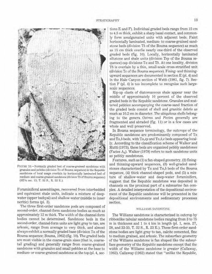
The three first-order sandstone pods are composed of second-order, channel-form sandstone bodies as much as approximately 12 m thick. The width of the channel-form bodies cannot be determined. Sandstone beds in the second-order, channel-form units are light gray to tan, are arkosic, range from average to very thick, and almost always exhibit a normally graded base (division Ta of the Bouma sequence; Bouma, 1962) (fig. 10). The graded beds are most visible in the coarse-grain sizes (that is, coarse-tail grading) and generally range from coarse-grained sandstone with granules and small pebbles at the base to medium- or coarse-grained sandstone at the top (pl. 4, sec-
tions E and F). Individual graded beds range from 15 cm to 4.5 m thick, exhibit a sharp basal contact, and commonly form amalgamated units with adjacent beds. Faint horizontally laminated, medium- to coarse-grained sandstone beds (division Tb of the Bouma sequence) as much as 15 cm thick overlie nearly one-third of the observed graded beds (fig. 10). Locally, horizontally laminated siltstone and shale units (division Tep of the Bouma sequence) cap divisions Ta and Tb. At one locality, division Tb is overlain by a thin, small-scale cross-stratified unit (division Tc of the Bouma sequence). Fining- and thinning-upward sequences are documented in section E (pl. 4) and in the Hale Canyon section of Webb (1981, fig. 7). Section F (pl. 4) is too incomplete to recognize such large-scale sequences.
Rip-up clasts of diatomaceous shale appear near the middle of approximately 10 percent of the observed graded beds in the Republic sandstone. Granules and scattered pebbles accompanying the coarse-sand fraction of the graded beds consist of shell and granitic debris as much as 10.2 cm in diameter. The ubiquitous shells belonging to the genera Ostrea and Pecten generally are fragmented and abraded (fig. 11) or in a few cases are whole and well preserved.
In Bouma sequence terminology, the outcrops of the Republic sandstone are predominantly composed of Ta and Ta,b beds, with Ta,ep and Ta,b,e beds appearing locally. According to the classification scheme of Walker and Mutti (1973), these beds are organized pebbly sandstones (Facies A4). Walker (1978) refers to such sandstone units as pebbly sandstones.
Features, such as (1) a fan-shaped geometry, (2) fining-and thinning-upward sequences, (3) well-graded sandstones characterized by Ta and Ta,b beds of the Bouma sequence, (4) thick channel-shaped pods, and (5) a mixture of shallow-water and deep-water foraminifers, suggest that the Republic sandstone was deposited in channels on the proximal part of a submarine fan complex. A detailed interpretation of the depositional environment of the Republic sandstone will be presented in the depositional environments and sedimentary processes section.
WILLIAMS SANDSTONE
The Williams sandstone is characterized in outcrop by ribbonlike tabular sandstone bodies ranging from 3 to 75 m in thickness and 1 to 4 km in length (pl. 1, secs. 27, 28, and 33-35, T. 32 S., R. 23 E.). These first-order sandstone bodies are light gray to tan, calcite cemented, fine to medium grained, and arkosic. The subsurface geometry of the Williams sandstone is fan shaped like the subsurface geometry of the Republic sandstone except that the width of the Williams sandstone is greater (Callaway, 1962). Callaway (1962) stated that "unlike the Republic,
14� FAN DELTA AND SUBMARINE FAN SEDIMENTATION, TEMBLOR RANGE, CALIFORNIA
FIGURE 11.—Normally graded bed in the Republic sandstone of local usage with a fragment of an Ostrea valve (SE1/4 sec. 13, T. 32 S., R. 22 E.).
FIGURE 12.—Dish structures in a sandstone bed of the Williams sandstone of local usage (sec. 34, T. 32 S., R. 23 E.).
the Williams sandstone is not time transgressive." However, judging from the outcrop pattern on Callaway's figure 5 (1962) and plate 1 of this report, it appears that the younger first-order sandstone beds of the Williams are partly offset to the northwest with respect to the older first-order sandstone beds and thus are at least partly time transgressive. As in the Republic sandstone, associated shale in the Williams sandstone contains a mixture of microfauna indicative of upper bathyal to inner neritic water depths (pl. 3).
Detailed measured sections in the Williams sandstone (pl. 4, sections C and D) indicate that several of the first-order, ribbonlike sandstone bodies consist of 13- to 26-mthick sequences in which second-order sandstone beds progressively thicken upsection. For example, second-order sandstone beds in the 13-m-thick sequence 2 (section C, pl. 4) progressively increase in thickness from about 0.1 m near the base to approximately 1.2 m at the top. Also, in measured section C (pl. 4), each upward-thickening sequence has thicker beds than the preceding sequence. Sequence 4 in section C and sequence 1 in section D have sandstone beds which become progressively coarser grained upsection (pl. 4). One fining- and thinning-upward sequence was recorded in the middle of section D (pl. 4).
The second-order sandstone beds in the Williams sandstone are horizontally bedded, range in thickness from very thin to very thick, and internally are either massive or normally graded (pl. 4). The internally massive second-order sandstone beds tend to be concentrated near the pinched-out edges of the first-order sandstone bodies, whereas the graded beds appear to occupy the thicker parts of the first-order sandstone bodies (compare sections C and D in pls. 1 and 4).
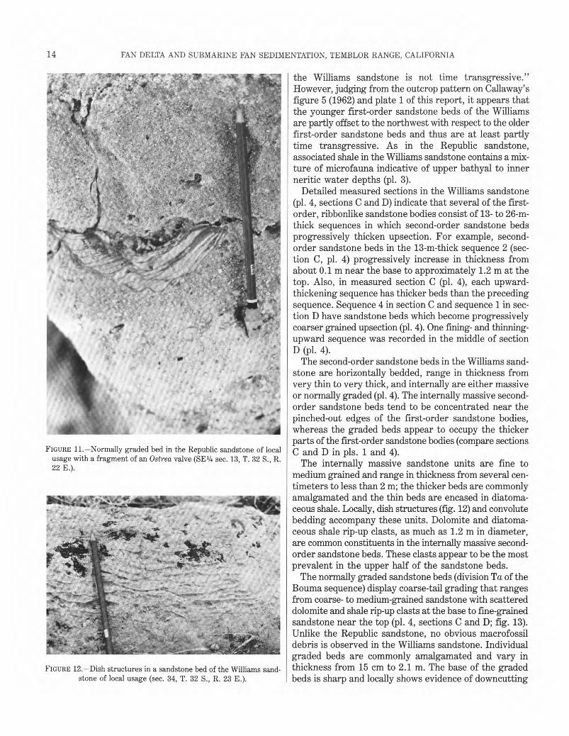
The internally massive sandstone units are fine to medium grained and range in thickness from several centimeters to less than 2 m; the thicker beds are commonly amalgamated and the thin beds are encased in diatomaceous shale. Locally, dish structures (fig. 12) and convolute bedding accompany these units. Dolomite and diatomaceous shale rip-up clasts, as much as 1.2 m in diameter, are common constituents in the internally massive second-order sandstone beds. These clasts appear to be the most prevalent in the upper half of the sandstone beds.
The normally graded sandstone beds (division Ta of the Bouma sequence) display coarse-tail grading that ranges from coarse- to medium-grained sandstone with scattered dolomite and shale rip-up clasts at the base to fine-grained sandstone near the top (pl. 4, sections C and D; fig. 13). Unlike the Republic sandstone, no obvious macrofossil debris is observed in the Williams sandstone. Individual graded beds are commonly amalgamated and vary in thickness from 15 cm to 2.1 m. The base of the graded beds is sharp and locally shows evidence of downcutting
15 �
STRATIGRAPHY
FIGURE 13.—Sandstone bed in the Williams sandstone of local usage showing normally graded bed containing coarse-grained sandstone (division Ta of Bouma sequence), middle bed of horizontally laminated medium- to fine-grained sandstone (division Tb of Bouma sequence), and thinly laminated very fine crystalline dolomite bed at top (division Tep of Bouma sequence) (sec. 33, T. 32 S., R. 23 E.).
and erosion (fig. 13). More than half of the graded beds in section D are succeeded by thin units of horizontally laminated fine-grained sandstone (division Tb of the Bouma sequence). Several of the horizontally laminated sandstone units contain flame structures. In addition, nearly one-third of the observed horizontally laminated beds are overlain by thin, small-scale, cross-stratified sandstone units typical of division Tc in the Bouma sequence. Thinly laminated beds (division Tep of the Bouma sequence) of dolomite or diatomaceous shale locally cap the above-mentioned units (fig. 13).
In Bouma sequence terminology, the Williams sandstone is dominated by Ta, Ta,ep, and Ta,b beds with Ta,b,c, Ta,b,e, and Ta,b,c,e beds appearing locally. According to the classification scheme of Walker and Mutti
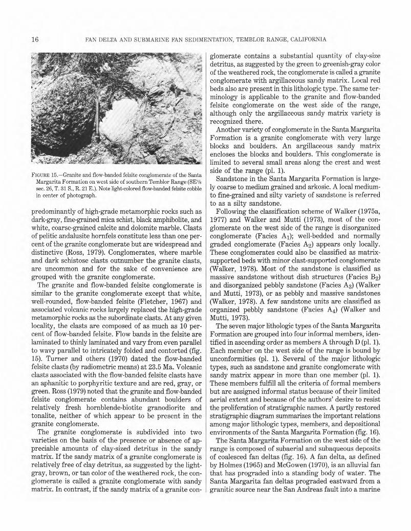
FIGURE 14.—Granite conglomerate of the Santa Margarita Formation on west side of southern Temblor Range (NW1/4 sec. 23, T. 32 S., R. 22 E.). Boulder in center of photograph is either granite or related plutonic rock.
(1973), these sandstone beds belong in the categories of massive sandstone (with or without dish structures) (facies B) and the classical proximal turbidite (facies C). Walker (1978) referred to sandstones such as those found in the Williams sandstone as "massive sandstones" and "classic turbidites."
Features, such as (1) a fan-shaped geometry, (2) coarsening- and thickening-upward and fining- and thinning-upward sequences, (3) well-graded sandstones characterized by Ta, Ta,b, Ta,b,c and Ta,b,c,e beds of the Bouma sequence, (4) thick-bedded tabular units, and 5) a mixture of shallow-water and deep-water foraminifers, suggest that the Williams sandstone was deposited on the proximal part of a submarine fan complex. A detailed interpretation of the depositional environment of the Williams sandstone will be presented in the depositional environments and sedimentary processes section.
SANTA MARGARITA FORMATION (WEST SIDE AND CREST OF RANGE)
The Santa Margarita Formation on the west side and along the crest of the range is composed of granite conglomerate, granite and flow-banded felsite conglomerate, and sandstone. Conglomerate far exceeds the sandstone, although part of this disparity results from the mapping practice of combining all but the thickest (>5 m) sandstone units with the conglomerate units.
Clasts of granodiorite, quartz monzonite, and quartz diorite described by Huffman (1972) are the most common components of the granite conglomerate (fig. 14). Ross (1979), using a different classification of granitic rocks, reported that the dominant clasts are coarse-grained biotite granite and peppery-textured biotite granodiorite that contain rare hornblende. The remainder of the clasts in the granite conglomerate are composed
16� FAN DELTA AND SUBMARINE FAN SEDIMENTATION, TEMBLOR RANGE, CALIFORNIA
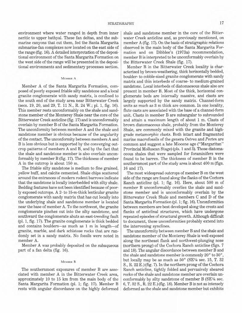
FIGURE 15.—Granite and flow-banded felsite conglomerate of the Santa Margarita Formation on west side of southern Temblor Range (SE1/4 sec. 26, T. 31 S., R. 21 E.). Note light-colored flow-banded felsite cobble in center of photograph.
predominantly of high-grade metamorphic rocks such as dark-gray, fine-grained mica schist, black amphibolite, and white, coarse-grained calcite and dolomite marble. Clasts of pelitic andalusite hornfels constitute less than one percent of the granite conglomerate but are widespread and distinctive (Ross, 1979). Conglomerates, where marble and dark schistose clasts outnumber the granite clasts, are uncommon and for the sake of convenience are grouped with the granite conglomerate.
The granite and flow-banded felsite conglomerate is similar to the granite conglomerate except that white, well-rounded, flow-banded felsite (Fletcher, 1967) and associated volcanic rocks largely replaced the high-grade metamorphic rocks as the subordinate clasts. At any given locality, the clasts are composed of as much as 10 percent of flow-banded felsite. Flow bands in the felsite are laminated to thinly laminated and vary from even parallel to wavy parallel to intricately folded and contorted (fig. 15). Turner and others (1970) dated the flow-banded felsite clasts (by radiometric means) at 23.5 Ma. Volcanic clasts associated with the flow-banded felsite clasts have an aphanitic to porphyritic texture and are red, gray, or green. Ross (1979) noted that the granite and flow-banded felsite conglomerate contains abundant boulders of relatively fresh hornblende-biotite granodiorite and tonalite, neither of which appear to be present in the granite conglomerate.
The granite conglomerate is subdivided into two varieties on the basis of the presence or absence of appreciable amounts of clay-sized detritus in the sandy matrix. If the sandy matrix of a granite conglomerate is relatively free of clay detritus, as suggested by the light-gray, brown, or tan color of the weathered rock, the conglomerate is called a granite conglomerate with sandy matrix. In contrast, if the sandy matrix of a granite con-
glomerate contains a substantial quantity of clay-size detritus, as suggested by the green to greenish-gray color of the weathered rock, the conglomerate is called a granite conglomerate with argillaceous sandy matrix. Local red beds also are present in this lithologic type. The same terminology is applicable to the granite and flow-banded felsite conglomerate on the west side of the range, although only the argillaceous sandy matrix variety is recognized there.
Another variety of conglomerate in the Santa Margarita Formation is a granite conglomerate with very large blocks and boulders. An argillaceous sandy matrix encloses the blocks and boulders. This conglomerate is limited to several small areas along the crest and west side of the range (pl. 1).
Sandstone in the Santa Margarita Formation is largely coarse to medium grained and arkosic. A local medium-to fine-grained and silty variety of sandstone is referred to as a silty sandstone.
Following the classification scheme of Walker (1975a, 1977) and Walker and Mutti (1973), most of the conglomerate on the west side of the range is disorganized conglomerate (Facies A1); well-bedded and normally graded conglomerate (Facies A2) appears only locally. These conglomerates could also be classified as matrix-supported beds with minor clast-supported conglomerate (Walker, 1978). Most of the sandstone is classified as massive sandstone without dish structures (Facies B2) and disorganized pebbly sandstone (Facies A3) (Walker and Mutti, 1973), or as pebbly and massive sandstones (Walker, 1978). A few sandstone units are classified as organized pebbly sandstone (Facies A4) (Walker and Mutti, 1973).
The seven major lithologic types of the Santa Margarita Formation are grouped into four informal members, identified in ascending order as members A through D (pl. 1). Each member on the west side of the range is bound by unconformities (pl. 1). Several of the major lithologic types, such as sandstone and granite conglomerate with sandy matrix appear in more than one member (pl. 1). These members fulfill all the criteria of formal members but are assigned informal status because of their limited aerial extent and because of the authors' desire to resist the proliferation of stratigraphic names. A partly restored stratigraphic diagram summarizes the important relations among major lithologic types, members, and depositional environments of the Santa Margarita Formation (fig. 16).
The Santa Margarita Formation on the west side of the range is composed of subaerial and subaqueous deposits of coalesced fan deltas (fig. 16). A fan delta, as defined by Holmes (1965) and McGowen (1970), is an alluvial fan that has prograded into a standing body of water. The Santa Margarita fan deltas prograded eastward from a granitic source near the San Andreas fault into a marine
17 STRATIGRAPHY�
environment where water ranged in depth from inner neritic to upper bathyal. These fan deltas, and the submarine canyons that cut them, fed the Santa Margarita submarine-fan complexes now located on the east side of the range (fig. 16). A detailed interpretation of the depositional environment of the Santa Margarita Formation on the west side of the range will be presented in the depositional environments and sedimentary processes section.
MEMBER A
Member A of the Santa Margarita Formation, composed of poorly exposed friable silty sandstone and a local granite conglomerate with sandy matrix, is confined to the south end of the study area near Bitterwater Creek (secs. 19, 20, and 29, T. 11 N., R. 24 W.; pl. 1, fig. 16). This member rests unconformably on the shale and sandstone member of the Monterey Shale near the core of the Bitterwater Creek anticline (fig. 17) and is unconformably overlain by member B of the Santa Margarita Formation. The unconformity between member A and the shale and sandstone member is obvious because of the angularity of the contact. The unconformity between members A and B is less obvious but is supported by the converging outcrop patterns of members A and B, and by the fact that the shale and sandstone member is also overlain unconformably by member B (fig. 17). The thickness of member A in the outcrop is about 150 m.
The friable silty sandstone is medium to fine grained, yellow buff, and calcite cemented. Shale chips scattered around the entrances of modern rodent burrows indicate that the sandstone is locally interbedded with silty shale. Bedding features have not been identified because of poorly exposed outcrops. A 2- to 15-m-thick lenticular granite conglomerate with sandy matrix that has cut locally into the underlying shale and sandstone member is located near the base of member A. To the northwest, the granite conglomerate pinches out into the silty sandstone, and southward the conglomerate abuts an east-trending fault (pl. 1, fig. 17). The granite conglomerate is thick bedded and contains boulders—as much as 1 m in length—of granite, marble, and dark schistose rocks that are randomly set in a sandy matrix. No fossils were noted in member A.
Member A was probably deposited on the subaqueous part of a fan delta (fig. 16).
MEMBER B
The southernmost exposures of member B are associated with member A in the Bitterwater Creek area, approximately 10 to 15 km from the main body of the Santa Margarita Formation (pl. 1; fig. 17). Member B rests with angular discordance on the highly deformed
shale and sandstone member in the core of the Bitter-water Creek anticline and, as previously mentioned, on member A (fig. 17). On the basis of stratigraphic relations observed in the main body of the Santa Margarita Formation and on Dibblee's (1973a) recommendation, member B is interpreted to be unconformably overlain by the Bitterwater Creek Shale (fig. 17).
Member B in the Bitterwater Creek locality is characterized by brown-weathering, thick horizontally bedded, boulder- to cobble-sized granite conglomerate with sandy matrix and thin interbeds of coarse- to medium-grained sandstone. Local interbeds of diatomaceous shale also are present in member B. Most of the thick, horizontal conglomerate beds are internally massive, and clasts are largely supported by the sandy matrix. Channel-form units as much as 3 m thick are common. In one locality, flute casts are associated with the base of a channel-form unit. Clasts in member B are subangular to subrounded and attain a maximum length of about 1 m. Clasts of brown diatomaceous shale, probably from the Monterey Shale, are commonly mixed with the granite and high-grade metamorphic clasts. Both intact and fragmented marine macrofossils of the genera Ostrea and Pecten are common and suggest a late Miocene age ("Margaritan" Provincial Molluscan Stage) (pls. 1 and 3). Those diatomaceous shales that were sampled for foraminifers were found to be barren. The thickness of member B in the southernmost part of the study area is about 400 m (figs. 16 and 17).
The most widespread outcrops of member B on the west side of the range are found along the flanks of the Cochora Ranch anticline (pl. 1; fig. 16). Here, about 500 m of member B unconformably overlies the shale and sandstone member and is unconformably overlain by the Bitterwater Creek Shale and members C and D of the Santa Margarita Formation (pl. 1; fig. 16). Unconformities between members are best developed along the crests and flanks of anticlinal structures, which have undergone repeated episodes of structural growth. Although difficult to document, these unconformities probably extend into the intervening synclines.
The unconformity between member B and the shale and sandstone member of the Monterey Shale is well exposed along the northeast flank and northwest-plunging nose (northern prong) of the Cochora Ranch anticline (figs. 7 and 18). The angular discordance between member B and the shale and sandstone member is commonly 20° to 30°, but locally may be as much as 50° (SE1/4 sec. 15, T. 32 S., R. 22 E.) (fig. 7). In the northern prong of the Cochora Ranch anticline, tightly folded and pervasively sheared rocks of the shale and sandstone member are overlain unconformably by silty sandstone of member B (SE1/4 sec. 6, T. 32 S., R. 22 E.) (fig. 18). Member B is not as intensely deformed as the shale and sandstone member but exhibits
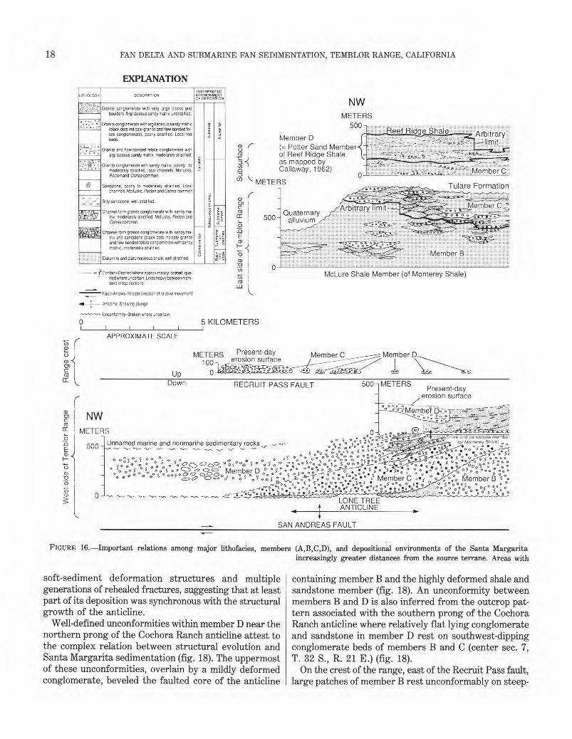
18� FAN DELTA AND SUBMARINE FAN SEDIMENTATION, TEMBLOR RANGE, CALIFORNIA
EXPLANATION INTERPRETED
LITHOLOGV DESCRIPTION ENVIRONMENT OF DEPOSITION
o , . NW %S S Granite conglomerate with very large blocks and
o .oo boulders. Argillaceous sandy rnatrix, unstratified. METERS . • . ,, • Granite conglomerate with argillaceous sandy matrix
(black dots indicate granite and flow-banded fel- :?; . 500-
L„....Reef Ridge Shale site conglomerate), poorly stratified. Local red S beds. Member D
(= Potter Sand Member ° ° ° ° argillaceous sandy matrix, moderately stratified. 03 of Reef Ridge Shale _, ° 2 as mapped by
. .Granite and flow-banded felsite conglomerate with
. • Granite conglomerate with sandy matrix, poorly to ° * ° moderately stratified, local channels. Mollusks,
S _o Callaway, 1962) C::::Pecten and Ostrea common. 0U) METERS0 Sandstone, poorly to moderately stratified. Local Tulare Formation
channels. Mollusks,Pecten andOstrea common.
--- — Silty sandstone, well-stratified. E. .•:•HMember-Arbitrary limit,r,H,.., Channel-form granite conglomerate with sandy ma-) S ,; . QuaternaryTr7.. °.V tn x, moderately stratified. Mollusks. Pecten and E5 Ao 500
Ostrea common. 2 „; ‘-, alluvium ,%,
i',.. Channel-form granite conglomerate with sandy ma- 2 1,.% . • • : - 2=trix and sandstone (black dots indicate granite us E R
and flow-banded felsite conglomerate with sandy 2 = matrix), moderately stratified.
'FS' Member B Diatomite and diatomaceous shale, well-stratified. gc 31
— ? Contact-Dashed where approximately located: due- McLure Shale Member (of Monterey Shale)' ried where uncertain. Lines heavy between mem-
bers in top sections.
Fault-Arrows indicate direction of relative movement
Anticline-Showing plunge
Unconformity-Broken where uncertain
0 5 KILOMETERS
APPROXIMATE SCALE
METERS Present-day Member C Member D 100 _erosion surface-i
0 Up
Down RECRUIT PASS FAULT 500] METERS Present-day
erosion surfaceI _
Te
m b lo
r R
ange
NW ,tt::' ,.:'.r7
a 0 .0 0 0.5„..., :,..'-: +,:,-,.,.t:...,Shale an: sandstone member 0 ,H; , 4. : ;: :: ''''METERS .9 _:_e-' - . °,:1 --'-'7
6 (of Monterey Shale, .500 - Unnamed marine and nonmarine sedimentary rocks -..r- -,-,-- a o ° S. ° . ,,,-...- 0 . o_vs o. ::%,;:S% S° 5° `,,,,„ .
0 0:5%5 .0, °, . c . . • 5- °. ' ' ° ° c° c.0 aor5°‘',:: 7. ' acg ''. a : ° %o•0 •3-1°o_
0 • 5: •o0 c .o..
o 0 ° 0 ° -"o ' . 'o C , Q, 0 c)C2o ° O (°°: 6 ° c.o iv . ° : Z -0 0 5 00 ,,,' oo s 0 S 0 o g o'f--..° •o 3 '5 0 : • ' ; :', a'' .e 0 S 0 $ 0 o 5 .. ,S::,D,,,57,„<=3 :se, . *av s . . O °:,.. .c=- 6 .,,,:„*.c_. 0.5.5.: % °Q : 4:6.51..° '1,5 ° o ° ° : * 000",_, Member D Z, ' i-'„-------
''' oe ' o'D° ° 0 ,:" 5 ° 0° 5 ' `.- p c)c5,`5,-°,2 . c:, 5 (so 5 0 0 5 Z o 5 -Z-o'-'-o *r. . o a : 0oC0. a • ° 0) Member C 0•,‘ ' 00 Member B '5°. o o S o •0 a. •o 5.5 05 00 o 0. • 5°. 0 05 a N c o c,,.° °° ° 0 % o 0: % tac o: oo . So g • o p •
° • •• • • .0 .3.0 05 °O 0 '0 '0- 0 -,,,, D:0° a) 0 -LONE TREE ANTICLINE
SAN ANDREAS FAULT
FIGURE 16.—Important relations among major lithofacies, members (A,B,C,D), and depositional environments of the Santa Margarita
soft-sediment deformation structures and multiple generations of rehealed fractures, suggesting that at least part of its deposition was synchronous with the structural growth of the anticline.
Well-defined unconformities within member D near the northern prong of the Cochora Ranch anticline attest to the complex relation between structural evolution and Santa Margarita sedimentation (fig. 18). The uppermost of these unconformities, overlain by a mildly deformed conglomerate, beveled the faulted core of the anticline
increasingly greater distances from the source terrane. Areas with
containing member B and the highly deformed shale and sandstone member (fig. 18). An unconformity between members B and D is also inferred from the outcrop pattern associated with the southern prong of the Cochora Ranch anticline where relatively flat lying conglomerate and sandstone in member D rest on southwest-dipping conglomerate beds of members B and C (center sec. 7, T. 32 S., R. 21 E.) (fig. 18).
On the crest of the range, east of the Recruit Pass fault, large patches of member B rest unconformably on steep-
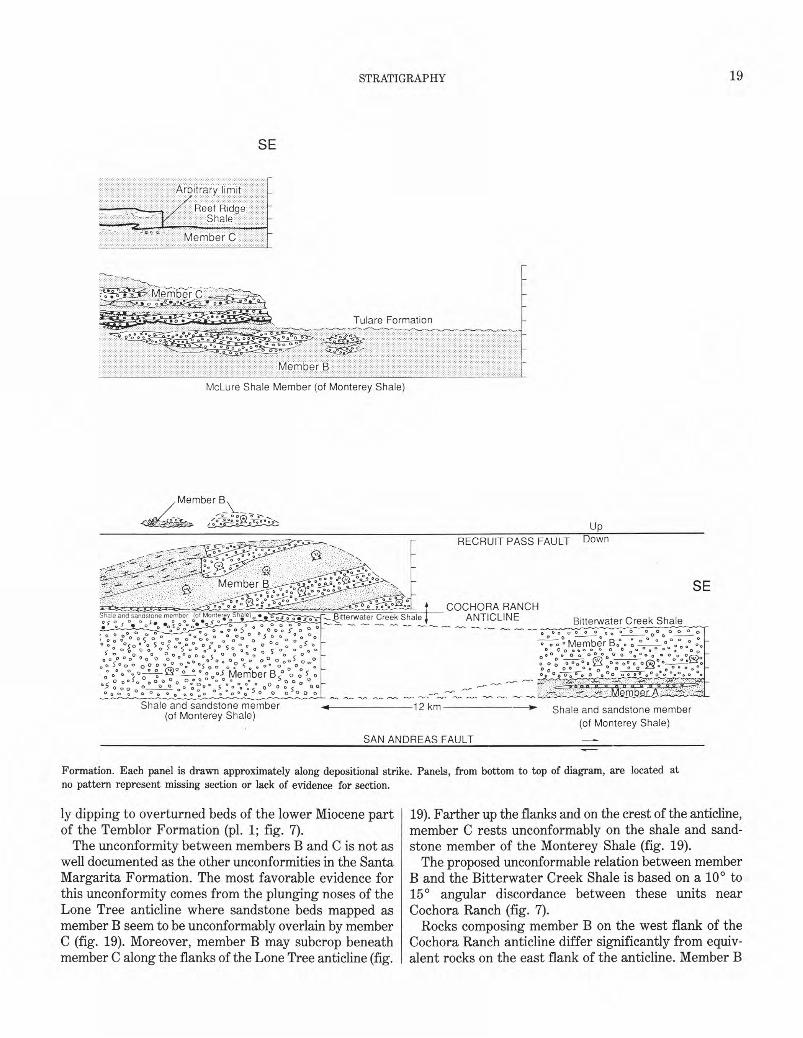
19 �
STRATIGRAPHY
SE
Arbitrary limit
Reef Ridge Shale
Member C
Tulare Formation
•• • • '' • • ',CT'.
McLure Shale Member (of Monterey Shale)
Member 13,
Mtergy Shile10 •Shale and sandstone member pt on os oos o o 'o S o°
c,:o o s 0°00: o00 o".0%. o °„ 5 :5 0.?„°0 °,s s 0 %,,° o s °. 0 0s 0 „ o „ Q .() %Do
O °s°,, c, 8, .° oo s
s -
5 o ° ° „° ("0 o :0 5 ° ° °0 0 0 o o c.o ° ° ° s Wleniber B (̀' 5 o .0 ' 01 :o°. ° °°. ° ° „° ° 0 0 0 "" °5 0 .c° 0 o
o o 0 ° o 0 o 0 0 0o 0° a 00 ° 0°;000
50 0 °
Bitterwater Creek Shale ANTICLINE
Shale and sandstone member 4 12 km (of Monterey Shale)
SAN ANDREAS FAULT
Up
RECRUIT PASS FAULT Down
SE COCHORA RANCH
Bitterwater Creek Shale 0 0 0 0 0 0 0 0 Q 000
c> 0 . °Member B:. ; .°0°0
0 0
o000°00 0O a .00 0 0 00. 0 0° 0 o o oo 0. o .000 000
o 0 o: oo0°.° 0 D o 0 • 0—,-- o 0 o° o ° o°0* °.°0)O-b-0
mb r
Shale and sandstone member (of Monterey Shale)
Formation. Each panel is drawn approximately along depositional strike. Panels, from bottom to top of diagram, are located at no pattern represent missing section or lack of evidence for section.
ly dipping to overturned beds of the lower Miocene part of the Temblor Formation (pl. 1; fig. 7).
The unconformity between members B and C is not as well documented as the other unconformities in the Santa Margarita Formation. The most favorable evidence for this unconformity comes from the plunging noses of the Lone Tree anticline where sandstone beds mapped as member B seem to be unconformably overlain by member C (fig. 19). Moreover, member B may subcrop beneath member C along the flanks of the Lone Tree anticline (fig.
19). Farther up the flanks and on the crest of the anticline, member C rests unconformably on the shale and sandstone member of the Monterey Shale (fig. 19).
The proposed unconformable relation between member B and the Bitterwater Creek Shale is based on a 10° to 15° angular discordance between these units near Cochora Ranch (fig. 7).
Rocks composing member B on the west flank of the Cochora Ranch anticline differ significantly from equivalent rocks on the east flank of the anticline. Member B
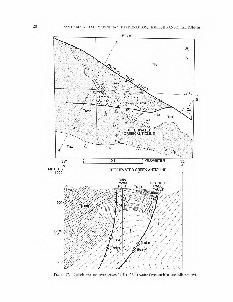
20� FAN DELTA AND SUBMARINE FAN SEDIMENTATION, TEMBLOR RANGE, CALIFORNIA
R24W
T 11 S
SW �
0
A �
METERS�
0;5 �
1 KILOMETER�
NE A'
BITTERWATER CREEK ANTICLINE 1000
Ohio Porter� RECRUIT No. 1�Tsma�PASS
FAULT ,or
500
2 1110
Ttu
SEA Ttl LEVEL
I, (Late)
ij (Early)
500
FIGURE 17.—Geologic map and cross section (A-A') of Bitterwater Creek anticline and adjacent area.
21STRATIGRAPHY�
EXPLANATION FOR FIGURES 17-19 (Not all geologic units and symbols are included on each figure)
Qal Alluvium (Quaternary)
Tu Unnamed marine and nonmarine sedimentary rocks (Pliocene)
Tbw Bitterwater Creek Shale (Miocene)—
Tbws Unnamed sandstone unit
Santa Margarita Formation (Miocene)—
TsMd Member D
Tsm Unit 4—Predominantly conglomerate
Unit 3—
TSmd': Sandstone and subordinate conglomerate
Tsr-nd, Conglomerate and subordinate sandstone
TSMd:2 Unit 2—Predominantly conglomerate
Unit 1—
TSrsc Sandstone and subordinate conglomerate
Tsmd Conglomerate and subordinate sandstone
Tsmc Member C
Tsmb. Member B
ITsthb Unit 2—Predominantly conglomerate2
Unit 1— 4.41,:„
Tsmti Silty sandstone and subordinate conglomerate
rr smb Conglomerate and subordinate silty sandstone
on the west side of the anticline consists almost entirely of granite conglomerate with argillaceous sandy matrix, contains no mappable sandstone units, and lacks silty sandstone units (figs. 7, 16, and 18; pl. 1). In contrast, member B on the east side of the anticline consists of granite conglomerate with sandy matrix, sandstone, and silty sandstone.
The granite conglomerate with sandy matrix, sandstone, and silty sandstone of member B on the east side of the anticline are arranged in thick northwest-facing in-
Tsma Member A—Predominantly sandstone
Tsnia Member A—Predominantly conglomerate
Monterey Shale (Miocene)—
Tms Shale and sandstone member
Temblor Formation (Miocene and Oligocene)
Ttu Upper part (Miocene)—Contains Saucesian micro-fossils
TtI Lower part (Miocene and Oligocene)—Contains Zemorrian microfossils
Contact—Dashed where approximately located
Fault—Bar and ball on downthrown side; dashed where approximately located; dotted where concealed. Barb on upthrown side of thrust fault. Arrows in cross section indicate direction of relative movement
Anticline
Syncline
Unconformity—Queried where uncertain
Strike and dip of beds
40 Inclined
7 -9-5�Overturned
- Oil stain
<}-�Drill hole
A�A' Line of cross section
dined packets that resemble large-scale, low-angle cross-stratification (pl. 1; fig. 16). In NE1/4 sec. 15, T. 32 S., R. 22 E., a 100- to 200-m-thick channel-form unit containing conglomerate and sandstone has cut into the large-scale cross-stratified units (pl. 1; figs. 2 and 16). The channel-form unit terminates abruptly to the northwest against silty shale. The resultant channel margin is steep, northeasterly oriented, and, owing to the composite nature of the channel fill, shaped like large stair steps (figs. 2 and 16). Much of the granite conglomerate and
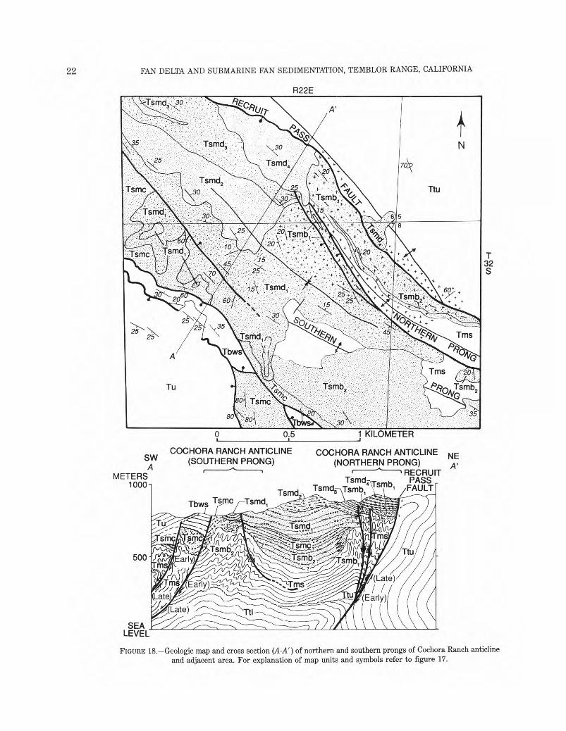
22� FAN DELTA AND SUBMARINE FAN SEDIMENTATION, TEMBLOR RANGE, CALIFORNIA
R22E
T 32 S
0.5 1KILOMETER9 4
COCHORA RANCH ANTICLINE COCHORA RANCH ANTICLINE NESW (SOUTHERN PRONG) (NORTHERN PRONG)A A'
r---̀"--1RECRUITMETERS Tsmcii\Tsmb PASS _1000 Tsmcl, Tsmb \ i /FAULT
Tbws Tsmc Tsmdi
FIGURE 18.—Geologic map and cross section (A-A') of northern and southern prongs of Cochora Ranch anticline and adjacent area. For explanation of map units and symbols refer to figure 17.
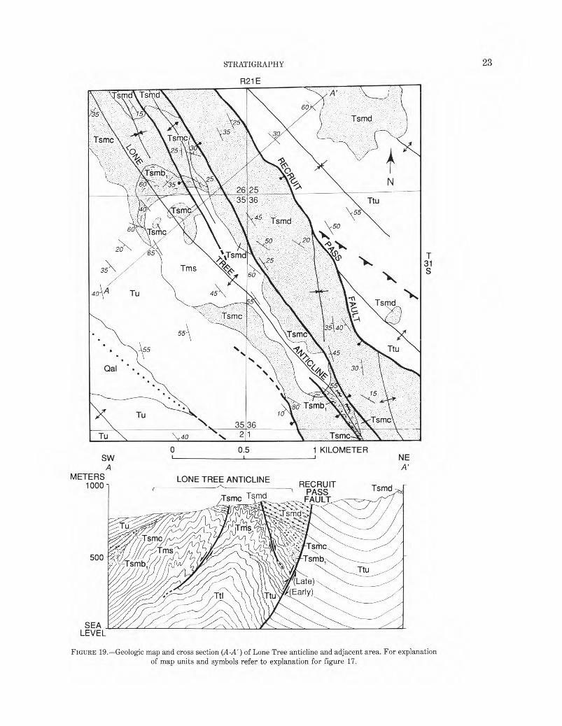
23 �
STRATIGRAPHY
R21E
T 31 S
0 0.5 1 KILOMETER SW NE
A A' METERS LONE TREE ANTICLINE
1000 RECRUIT r TsmdPASSys mc Tsmd FAULT
500
(Late) ,(Early)
SEA LEVEL
FIGURE 19.—Geologic map and cross section (A-A') of Lone Tree anticline and adjacent area. For explanation of map units and symbols refer to explanation for figure 17.
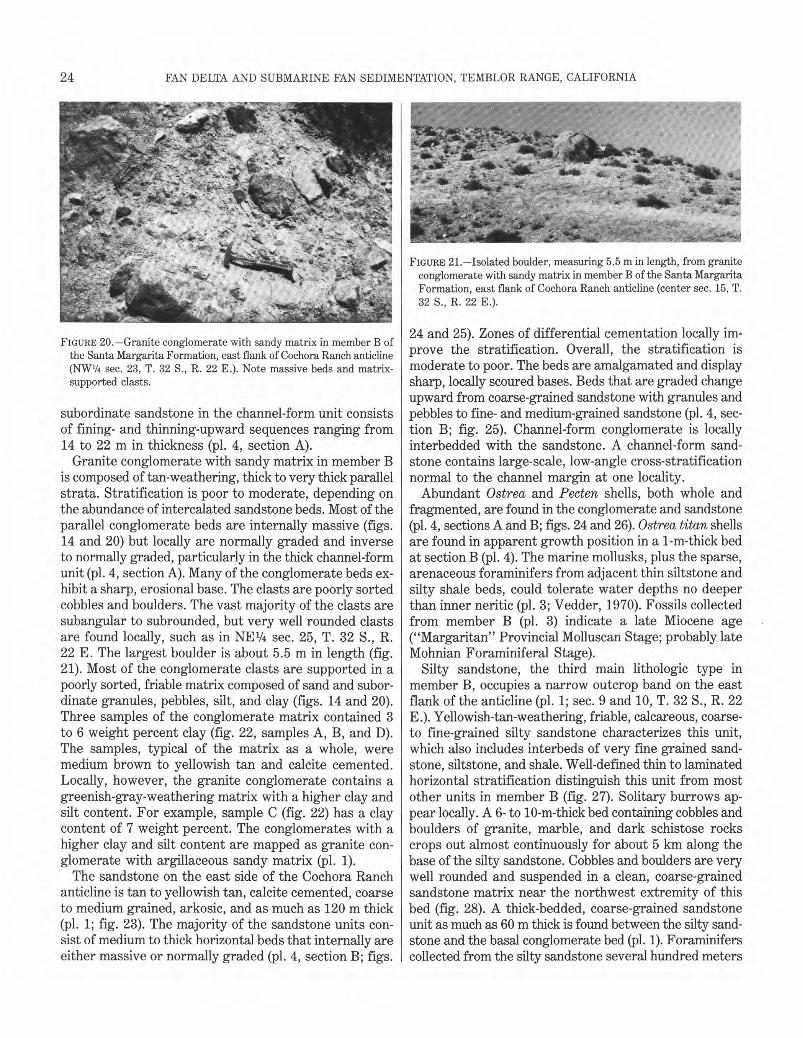
24� FAN DELTA AND SUBMARINE FAN SEDIMENTATION, TEMBLOR RANGE, CALIFORNIA
FIGURE 20.—Granite conglomerate with sandy matrix in member B of the Santa Margarita Formation, east flank of Cochora Ranch anticline (NW1/4 sec. 23, T. 32 S., R. 22 E.). Note massive beds and matrix-supported clasts.
subordinate sandstone in the channel-form unit consists of fining- and thinning-upward sequences ranging from 14 to 22 m in thickness (pl. 4, section A).
Granite conglomerate with sandy matrix in member B is composed of tan-weathering, thick to very thick parallel strata. Stratification is poor to moderate, depending on the abundance of intercalated sandstone beds. Most of the parallel conglomerate beds are internally massive (figs. 14 and 20) but locally are normally graded and inverse to normally graded, particularly in the thick channel-form unit (pl. 4, section A). Many of the conglomerate beds exhibit a sharp, erosional base. The clasts are poorly sorted cobbles and boulders. The vast majority of the clasts are subangular to subrounded, but very well rounded clasts are found locally, such as in NE1/4 sec. 25, T. 32 S., R. 22 E . The largest boulder is about 5.5 m in length (fig. 21). Most of the conglomerate clasts are supported in a poorly sorted, friable matrix composed of sand and subordinate granules, pebbles, silt, and clay (figs. 14 and 20). Three samples of the conglomerate matrix contained 3 to 6 weight percent clay (fig. 22, samples A, B, and D). The samples, typical of the matrix as a whole, were medium brown to yellowish tan and calcite cemented. Locally, however, the granite conglomerate contains a greenish-gray-weathering matrix with a higher clay and silt content. For example, sample C (fig. 22) has a clay content of 7 weight percent. The conglomerates with a higher clay and silt content are mapped as granite conglomerate with argillaceous sandy matrix (pl. 1).
The sandstone on the east side of the Cochora Ranch anticline is tan to yellowish tan, calcite cemented, coarse to medium grained, arkosic, and as much as 120 m thick (pl. 1; fig. 23). The majority of the sandstone units consist of medium to thick horizontal beds that internally are either massive or normally graded (pl. 4, section B; figs.
FIGURE 21.—Isolated boulder, measuring 5.5 m in length, from granite conglomerate with sandy matrix in member B of the Santa Margarita Formation, east flank of Cochora Ranch anticline (center sec. 15, T. 32 S., R. 22 E.).
24 and 25). Zones of differential cementation locally improve the stratification. Overall, the stratification is moderate to poor. The beds are amalgamated and display sharp, locally scoured bases. Beds that are graded change upward from coarse-grained sandstone with granules and pebbles to fine- and medium-grained sandstone (pl. 4, section B; fig. 25). Channel-form conglomerate is locally interbedded with the sandstone. A channel-form sandstone contains large-scale, low-angle cross-stratification normal to the channel margin at one locality.
Abundant Ostrea and Pecten shells, both whole and fragmented, are found in the conglomerate and sandstone (pl. 4, sections A and B; figs. 24 and 26). Ostrea titan shells are found in apparent growth position in a 1-m-thick bed at section B (pl. 4). The marine mollusks, plus the sparse, arenaceous foraminifers from adjacent thin siltstone and silty shale beds, could tolerate water depths no deeper than inner neritic (pl. 3; Vedder, 1970). Fossils collected from member B (pl. 3) indicate a late Miocene age ("Margaritan" Provincial Molluscan Stage; probably late Mohnian Foraminiferal Stage).
Silty sandstone, the third main lithologic type in member B, occupies a narrow outcrop band on the east flank of the anticline (pl. 1; sec. 9 and 10, T. 32 S., R. 22 E.). Yellowish-tan-weathering, friable, calcareous, coarse-to fine-grained silty sandstone characterizes this unit, which also includes interbeds of very fine grained sandstone, siltstone, and shale. Well-defined thin to laminated horizontal stratification distinguish this unit from most other units in member B (fig. 27). Solitary burrows appear locally. A 6- to 10-m-thick bed containing cobbles and boulders of granite, marble, and dark schistose rocks crops out almost continuously for about 5 km along the base of the silty sandstone. Cobbles and boulders are very well rounded and suspended in a clean, coarse-grained sandstone matrix near the northwest extremity of this bed (fig. 28). A thick-bedded, coarse-grained sandstone unit as much as 60 m thick is found between the silty sandstone and the basal conglomerate bed (pl. 1). Foraminifers collected from the silty sandstone several hundred meters
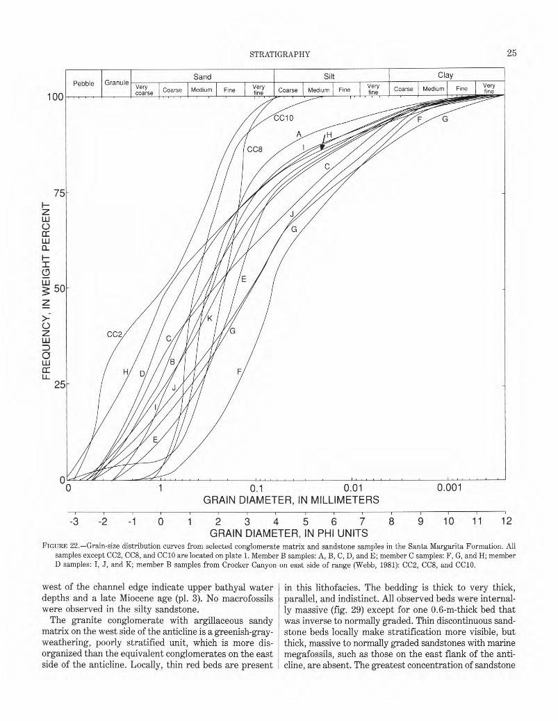
25 �
STRATIGRAPHY
75 H z iii 0 tr w a_ HI 0 Cu
50 z
>: 0 z iii D 0 Lli CCLL.
25
0.1� 0.01 GRAIN DIAMETER, IN MILLIMETERS
- -�-1-i�O�-i� ,Iti� 6 ; ,E1 3 9 10 11 12 GRAIN DIAMETER, IN PHI UNITS
FIGURE 22.—Grain-size distribution curves from selected conglomerate matrix and sandstone samples in the Santa Margarita Formation. All samples except CC2, CC8, and CC10 are located on plate 1. Member B samples: A, B, C, D, and E; member C samples: F, G, and H; member D samples: I, J, and K; member B samples from Crocker Canyon on east side of range (Webb, 1981): CC2, CC8, and CC10.
west of the channel edge indicate upper bathyal water in this lithofacies. The bedding is thick to very thick, depths and a late Miocene age (pl. 3). No macrofossils parallel, and indistinct. All observed beds were internal-were observed in the silty sandstone. ly massive (fig. 29) except for one 0.6-m-thick bed that
The granite conglomerate with argillaceous sandy was inverse to normally graded. Thin discontinuous sand-matrix on the west side of the anticline is a greenish-gray- stone beds locally make stratification more visible, but weathering, poorly stratified unit, which is more dis- thick, massive to normally graded sandstones with marine organized than the equivalent conglomerates on the east megafossils, such as those on the east flank of the anti-side of the anticline. Locally, thin red beds are present cline, are absent. The greatest concentration of sandstone
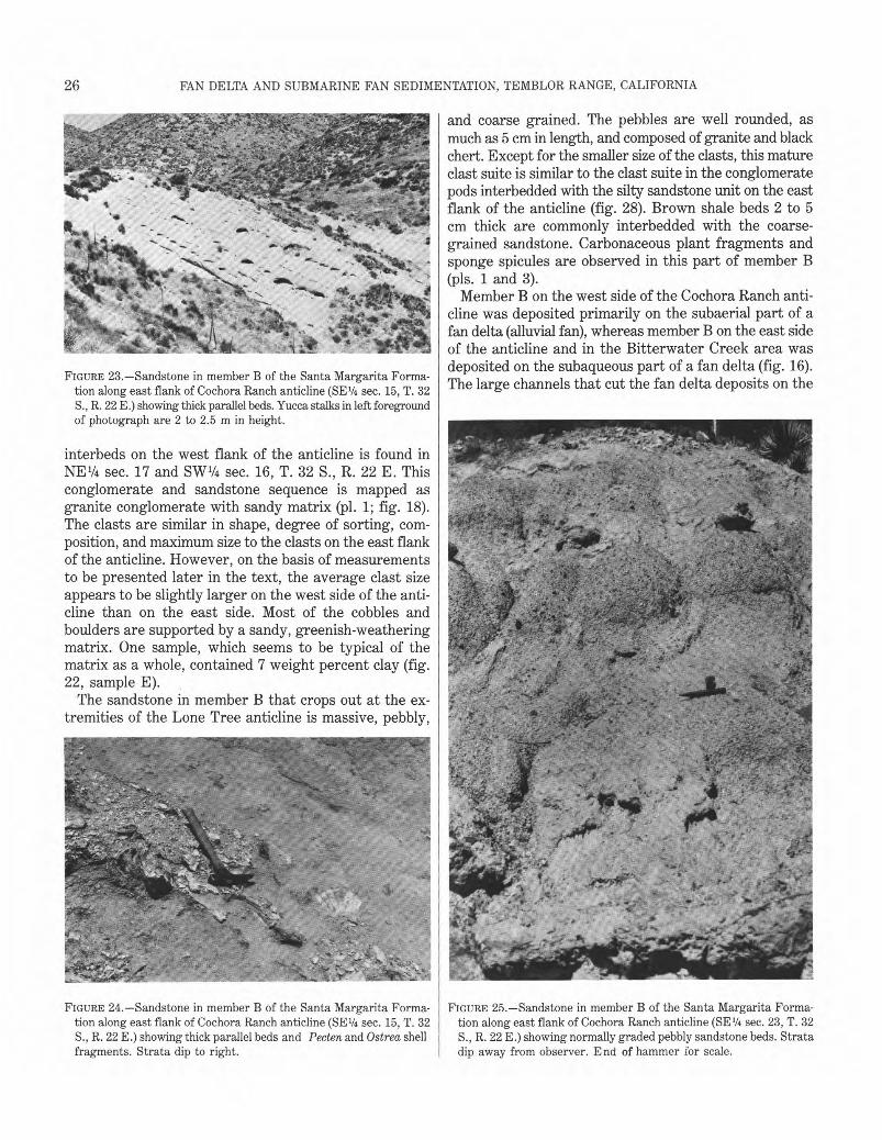
26� FAN DELTA AND SUBMARINE FAN SEDIMENTATION, TEMBLOR RANGE, CALIFORNIA
FIGURE 23.—Sandstone in member B of the Santa Margarita Formation along east flank of Cochora Ranch anticline (SE1/4 sec. 15, T. 32 S., R. 22 E.) showing thick parallel beds. Yucca stalks in left foreground of photograph are 2 to 2.5 m in height.
interbeds on the west flank of the anticline is found in NE1/4 sec. 17 and SW1/4 sec. 16, T. 32 S., R. 22 E. This conglomerate and sandstone sequence is mapped as granite conglomerate with sandy matrix (pl. 1; fig. 18). The clasts are similar in shape, degree of sorting, composition, and maximum size to the clasts on the east flank of the anticline. However, on the basis of measurements to be presented later in the text, the average clast size appears to be slightly larger on the west side of the anticline than on the east side. Most of the cobbles and boulders are supported by a sandy, greenish-weathering matrix. One sample, which seems to be typical of the matrix as a whole, contained 7 weight percent clay (fig. 22, sample E).
The sandstone in member B that crops out at the extremities of the Lone Tree anticline is massive, pebbly,
and coarse grained. The pebbles are well rounded, as much as 5 cm in length, and composed of granite and black chert. Except for the smaller size of the clasts, this mature clast suite is similar to the clast suite in the conglomerate pods interbedded with the silty sandstone unit on the east flank of the anticline (fig. 28). Brown shale beds 2 to 5 cm thick are commonly interbedded with the coarse-grained sandstone. Carbonaceous plant fragments and sponge spicules are observed in this part of member B (pls. 1 and 3).
Member B on the west side of the Cochora Ranch anticline was deposited primarily on the subaerial part of a fan delta (alluvial fan), whereas member B on the east side of the anticline and in the Bitterwater Creek area was deposited on the subaqueous part of a fan delta (fig. 16). The large channels that cut the fan delta deposits on the
FIGURE 24.—Sandstone in member B of the Santa Margarita Forma- FIGURE 25.—Sandstone in member B of the Santa Margarita Formation along east flank of Cochora Ranch anticline (SE1/4 sec. 15, T. 32 tion along east flank of Cochora Ranch anticline (SE1/4 sec. 23, T. 32 S., R. 22 E.) showing thick parallel beds and Pecten and Ostrea shell S., R. 22 E.) showing normally graded pebbly sandstone beds. Strata fragments. Strata dip to right. dip away from observer. End of hammer for scale.
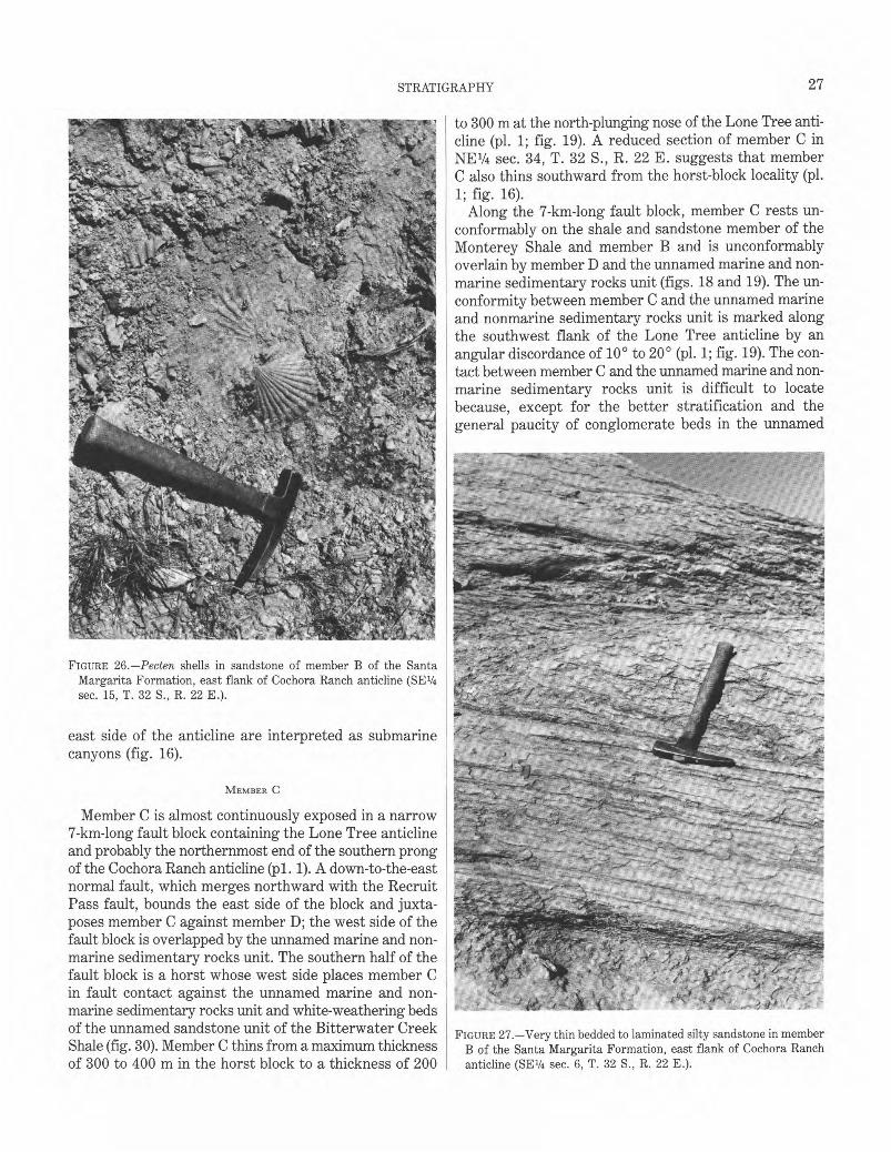
27 �
STRATIGRAPHY
to 300 m at the north-plunging nose of the Lone Tree anticline (pl. 1; fig. 19). A reduced section of member C in NE1/4 sec. 34, T. 32 S., R. 22 E. suggests that member C also thins southward from the horst-block locality (pl. 1; fig. 16).
Along the 7-km-long fault block, member C rests unconformably on the shale and sandstone member of the Monterey Shale and member B and is unconformably overlain by member D and the unnamed marine and non-marine sedimentary rocks unit (figs. 18 and 19). The unconformity between member C and the unnamed marine and nonmarine sedimentary rocks unit is marked along the southwest flank of the Lone Tree anticline by an angular discordance of 10° to 20° (pl. 1; fig. 19). The contact between member C and the unnamed marine and non-marine sedimentary rocks unit is difficult to locate because, except for the better stratification and the general paucity of conglomerate beds in the unnamed
FIGURE 26.—Pecten shells in sandstone of member B of the Santa Margarita Formation, east flank of Cochora Ranch anticline (5E1/4 sec. 15, T. 32 S., R. 22 E.).
east side of the anticline are interpreted as submarine canyons (fig. 16).
MEMBER C
Member C is almost continuously exposed in a narrow 7-km-long fault block containing the Lone Tree anticline and probably the northernmost end of the southern prong of the Cochora Ranch anticline (pl. 1). A down-to-the-east normal fault, which merges northward with the Recruit Pass fault, bounds the east side of the block and juxtaposes member C against member D; the west side of the fault block is overlapped by the unnamed marine and non-marine sedimentary rocks unit. The southern half of the fault block is a horst whose west side places member C in fault contact against the unnamed marine and non-marine sedimentary rocks unit and white-weathering beds of the unnamed sandstone unit of the Bitterwater Creek FIGURE 27.—Very thin bedded to laminated silty sandstone in memberShale (fig. 30). Member C thins from a maximum thickness B of the Santa Margarita Formation, east flank of Cochora Ranch of 300 to 400 m in the horst block to a thickness of 200 anticline (SE1/4 sec. 6, T. 32 S., R. 22 E.).
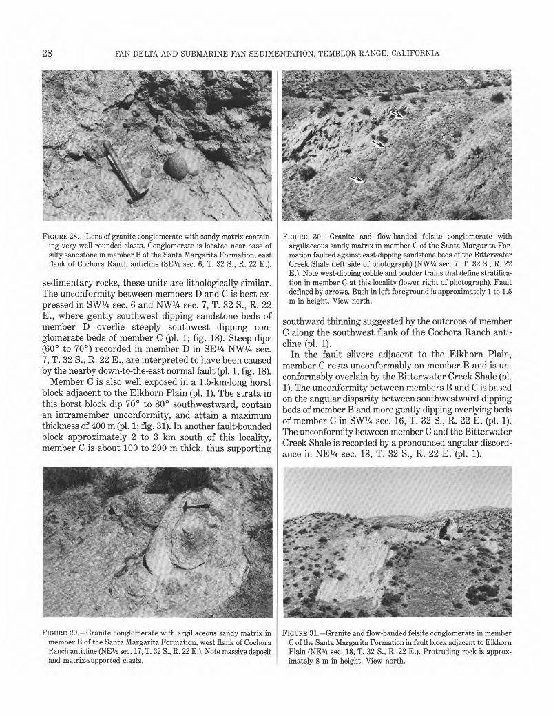
28� FAN DELTA AND SUBMARINE FAN SEDIMENTATION, TEMBLOR RANGE, CALIFORNIA
FIGURE 28.—Lens of granite conglomerate with sandy matrix containing very well rounded clasts. Conglomerate is located near base of silty sandstone in member B of the Santa Margarita Formation, east flank of Cochora Ranch anticline (SE1/4 sec. 6, T. 32 S., R. 22 E.).
sedimentary rocks, these units are lithologically similar. The unconformity between members D and C is best expressed in SW1/4 sec. 6 and NW1/4 sec. 7, T. 32 S., R. 22 E., where gently southwest dipping sandstone beds of member D overlie steeply southwest dipping conglomerate beds of member C (pl. 1; fig. 18). Steep dips (60° to 70°) recorded in member D in SE1/4 NW1/4 sec. 7, T. 32 S., R. 22 E., are interpreted to have been caused by the nearby down-to-the-east normal fault (pl. 1; fig. 18).
Member C is also well exposed in a 1.5-km-long horst block adjacent to the Elkhorn Plain (pl. 1). The strata in this horst block dip 70° to 80° southwestward, contain an intramember unconformity, and attain a maximum thickness of 400 m (pl. 1; fig. 31). In another fault-bounded block approximately 2 to 3 km south of this locality, member C is about 100 to 200 m thick, thus supporting
FIGURE 30.—Granite and flow-banded felsite conglomerate with argillaceous sandy matrix in member C of the Santa Margarita Formation faulted against east-dipping sandstone beds of the Bitterwater Creek Shale (left side of photograph) (NW1/4 sec. 7, T. 32 S., R. 22 E.). Note west-dipping cobble and boulder trains that define stratification in member C at this locality (lower right of photograph). Fault defined by arrows. Bush in left foreground is approximately 1 to 1.5 m in height. View north.
southward thinning suggested by the outcrops of member C along the southwest flank of the Cochora Ranch anticline (pl. 1).
In the fault slivers adjacent to the Elkhorn Plain, member C rests unconformably on member B and is unconformably overlain by the Bitterwater Creek Shale (pl. 1). The unconformity between members B and C is based on the angular disparity between southwestward-dipping beds of member B and more gently dipping overlying beds of member C in SW1/4 sec. 16, T. 32 S., R. 22 E. (pl. 1). The unconformity between member C and the Bitterwater Creek Shale is recorded by a pronounced angular discordance in NE1/4 sec. 18, T. 32 S., R. 22 E. (pl. 1).
FIGURE 29.—Granite conglomerate with argillaceous sandy matrix in FIGURE 31.—Granite and flow-banded felsite conglomerate in member member B of the Santa Margarita Formation, west flank of Cochora C of the Santa Margarita Formation in fault block adjacent to Elkhorn Ranch anticline (NE1/4 sec. 17, T. 32 S., R. 22 E.). Note massive deposit Plain (NE1/4 sec. 18, T. 32 S., R. 22 E.). Protruding rock is approxand matrix-supported clasts. imately 8 m in height. View north.
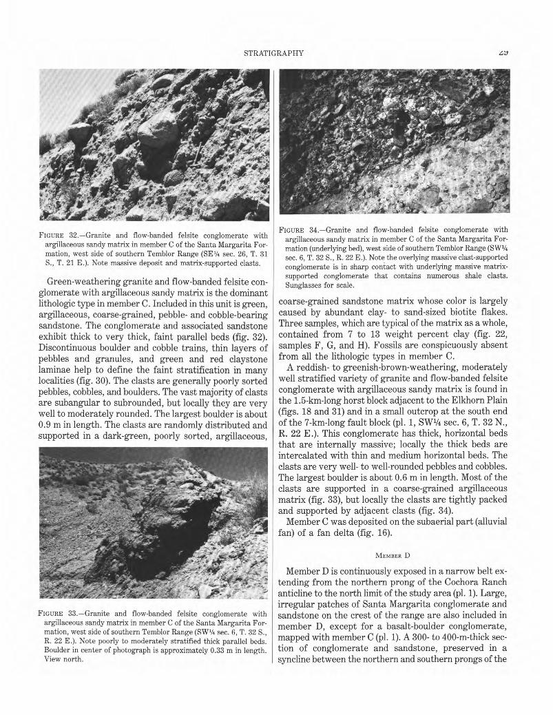
STRATIGRAPHY
FIGURE 32.—Granite and flow-banded felsite conglomerate with argillaceous sandy matrix in member C of the Santa Margarita Formation, west side of southern Temblor Range (SE1/4 sec. 26, T. 31 S., T. 21 E.). Note massive deposit and matrix-supported clasts.
Green-weathering granite and flow-banded felsite conglomerate with argillaceous sandy matrix is the dominant lithologic type in member C. Included in this unit is green, argillaceous, coarse-grained, pebble- and cobble-bearing sandstone. The conglomerate and associated sandstone exhibit thick to very thick, faint parallel beds (fig. 32). Discontinuous boulder and cobble trains, thin layers of pebbles and granules, and green and red claystone laminae help to define the faint stratification in many localities (fig. 30). The clasts are generally poorly sorted pebbles, cobbles, and boulders. The vast majority of clasts are subangular to subrounded, but locally they are very well to moderately rounded. The largest boulder is about 0.9 m in length. The clasts are randomly distributed and supported in a dark-green, poorly sorted, argillaceous,
FIGURE 33.—Granite and flow-banded felsite conglomerate with argillaceous sandy matrix in member C of the Santa Margarita Formation, west side of southern Temblor Range (SW1/4 sec. 6, T. 32 S., R. 22 E.). Note poorly to moderately stratified thick parallel beds. Boulder in center of photograph is approximately 0.33 m in length. View north.
FIGURE 34.—Granite and flow-banded felsite conglomerate with argillaceous sandy matrix in member C of the Santa Margarita Formation (underlying bed), west side of southern Temblor Range (SW1/4 sec. 6, T. 32 S., R. 22 E.). Note the overlying massive clast-supported conglomerate is in sharp contact with underlying massive matrix-supported conglomerate that contains numerous shale clasts. Sunglasses for scale.
coarse-grained sandstone matrix whose color is largely caused by abundant clay- to sand-sized biotite flakes. Three samples, which are typical of the matrix as a whole, contained from 7 to 13 weight percent clay (fig. 22, samples F, G, and H). Fossils are conspicuously absent from all the lithologic types in member C.
A reddish- to greenish-brown-weathering, moderately well stratified variety of granite and flow-banded felsite conglomerate with argillaceous sandy matrix is found in the 1.5-km-long horst block adjacent to the Elkhorn Plain (figs. 18 and 31) and in a small outcrop at the south end of the 7-km-long fault block (pl. 1, SW1/4 sec. 6, T. 32 N., R. 22 E.). This conglomerate has thick, horizontal beds that are internally massive; locally the thick beds are intercalated with thin and medium horizontal beds. The clasts are very well- to well-rounded pebbles and cobbles. The largest boulder is about 0.6 m in length. Most of the clasts are supported in a coarse-grained argillaceous matrix (fig. 33), but locally the clasts are tightly packed and supported by adjacent clasts (fig. 34).
Member C was deposited on the subaerial part (alluvial fan) of a fan delta (fig. 16).
MEMBER D
Member D is continuously exposed in a narrow belt extending from the northern prong of the Cochora Ranch anticline to the north limit of the study area @1. 1). Large, irregular patches of Santa Margarita conglomerate and sandstone on the crest of the range are also included in member D, except for a basalt-boulder conglomerate, mapped with member C (pl. 1). A 300- to 400-m-thick section of conglomerate and sandstone, preserved in a syncline between the northern and southern prongs of the
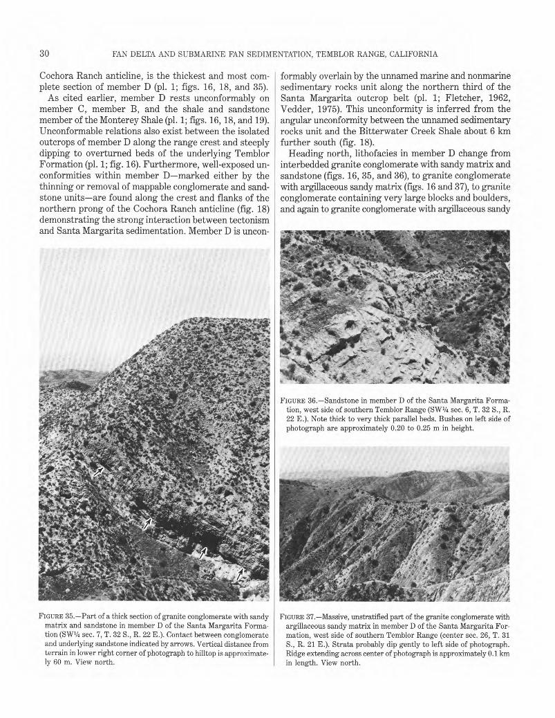
30� FAN DELTA AND SUBMARINE FAN SEDIMENTATION, TEMBLOR RANGE, CALIFORNIA
Cochora Ranch anticline, is the thickest and most complete section of member D (pl. 1; figs. 16, 18, and 35).
As cited earlier, member D rests unconformably on member C, member B, and the shale and sandstone member of the Monterey Shale (pl. 1; figs. 16, 18, and 19). Unconformable relations also exist between the isolated outcrops of member D along the range crest and steeply dipping to overturned beds of the underlying Temblor Formation (pl. 1; fig. 16). Furthermore, well-exposed unconformities within member D—marked either by the thinning or removal of mappable conglomerate and sandstone units—are found along the crest and flanks of the northern prong of the Cochora Ranch anticline (fig. 18) demonstrating the strong interaction between tectonism and Santa Margarita sedimentation. Member D is uncon-
formably overlain by the unnamed marine and nonmarine sedimentary rocks unit along the northern third of the Santa Margarita outcrop belt (pl. 1; Fletcher, 1962, Vedder, 1975). This unconformity is inferred from the angular unconformity between the unnamed sedimentary rocks unit and the Bitterwater Creek Shale about 6 km further south (fig. 18).
Heading north, lithofacies in member D change from interbedded granite conglomerate with sandy matrix and sandstone (figs. 16, 35, and 36), to granite conglomerate with argillaceous sandy matrix (figs. 16 and 37), to granite conglomerate containing very large blocks and boulders, and again to granite conglomerate with argillaceous sandy
FIGURE 36.—Sandstone in member D of the Santa Margarita Formation, west side of southern Temblor Range (SW1/4 sec. 6, T. 32 S., R. 22 E.). Note thick to very thick parallel beds. Bushes on left side of photograph are approximately 0.20 to 0.25 m in height.
FIGURE 35.—Part of a thick section of granite conglomerate with sandy FIGURE 37.—Massive, unstratified part of the granite conglomerate with matrix and sandstone in member D of the Santa Margarita Forma- argillaceous sandy matrix in member D of the Santa Margarita Fortion (SW1/4 sec. 7, T. 32 S., R. 22 E.). Contact between conglomerate mation, west side of southern Temblor Range (center sec. 26, T. 31 and underlying sandstone indicated by arrows. Vertical distance from S., R. 21 E.). Strata probably dip gently to left side of photograph. terrain in lower right corner of photograph to hilltop is approximate- Ridge extending across center of photograph is approximately 0.1 km ly 60 m. View north. in length. View north.
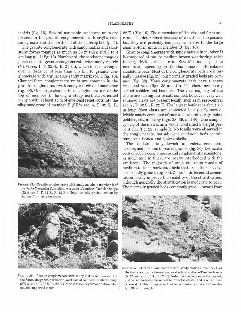
31 STRATIGRAPHY�
matrix (fig. 16). Several mappable sandstone units are present in the granite conglomerate with argillaceous sandy matrix at the north end of the outcrop belt (pl. 1).
The granite conglomerate with sandy matrix and sandstone forms tongues as much as 65 m thick and 3 to 4 km long (pl. 1; fig. 16). Northward, the sandstone tongues pinch out into granite conglomerate with sandy matrix (NE1/4 sec. 1, T. 32 S., R. 21 E.), which in turn changes over a distance of less than 0.5 km to granite conglomerate with argillaceous sandy matrix (pl. 1; fig. 16). Channel-form conglomerate units are common in the granite conglomerate with sandy matrix and sandstone (fig. 38). One large channel-form conglomerate near the top of member D, having a steep northeast-oriented margin with at least 15 m of erosional relief, cuts into the silty sandstone of member B (SE1/4 sec. 6, T. 32 S., R.
FIGURE 38.—Granite conglomerate with sandy matrix in member D of the Santa Margarita Formation, west side of southern Temblor Range (NE1/4 sec. 7, T. 32 S., R. 22 E.). Note normally graded bed cut by channel-form conglomerate.
22 E.) (fig. 16). The dimensions of this channel-form unit cannot be determined because of insufficient exposure, but they are probably comparable in size to the large channel-form units in member B (fig. 16).
Granite conglomerate with sandy matrix in member D is composed of tan- to medium-brown-weathering, thick to very thick parallel strata. Stratification is poor to moderate, depending on the abundance of intercalated sandstone beds. Most of the conglomerate beds are internally massive (fig. 39), but normally graded beds are common (fig. 38). Many conglomerate beds have a sharp erosional base (figs. 38 and 40). The clasts are poorly sorted cobbles and boulders. The vast majority of the clasts are subangular to subrounded; however, very well rounded clasts are present locally such as in east-central sec. 7, T. 32 S., R. 22 E. The largest boulder is about 1.5 m long. Most clasts are supported in a poorly sorted, friable matrix composed of sand and subordinate granules, pebbles, silt, and clay (figs. 38, 39, and 40). One sample, typical of the matrix as a whole, contained 5 weight percent clay (fig. 22, sample I). No fossils were observed in the conglomerate, but adjacent sandstone beds contain numerous Pecten and Ostrea shells.
The sandstone is yellowish tan, calcite cemented, arkosic, and medium to coarse grained (fig. 36). Lenticular beds of cobble conglomerate and conglomeratic sandstone, as much as 5 m thick, are locally interbedded with the sandstone. The majority of sandstone units consist of medium to thick horizontal beds that are either massive or normally graded (fig. 36). Zones of differential cementation locally improve the visibility of the stratification, although generally the stratification is moderate to poor. The normally graded beds commonly grade upward from
FIGURE 40.—Granite conglomerate with sandy matrix in member D of the Santa Margarita Formation, west side of southern Temblor Range
FIGURE 39.—Granite conglomerate with sandy matrix in member D of (NE1/4 sec. 7, T. 32 S., R. 22 E.). Note massive conglomerate deposit, the Santa Margarita Formation, west side of southern Temblor Range matrix-supported subrounded to rounded clasts, and scoured base (SW1/4 sec. 6, T. 32 S., R. 22 E.). Note massive deposit and subrounded (arrows). Boulder in upper left corner of photograph is approximate-matrix-supported clasts. ly 0.30 m in length.
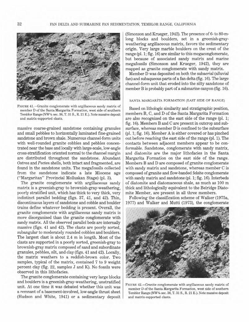
32� FAN DELTA AND SUBMARINE FAN SEDIMENTATION, TEMBLOR RANGE, CALIFORNIA
FIGURE 41.—Granite conglomerate with argillaceous sandy matrix of member D of the Santa Margarita Formation, west side of southern Temblor Range (NW1/4 sec. 36, T. 31 S., R. 21 E.). Note massive deposit and matrix-supported clasts.
massive coarse-grained sandstone containing granules and small pebbles to horizontally laminated fine-grained sandstone and brown shale. Numerous channel-form units with well-rounded granite cobbles and pebbles concentrated near the base and locally with large-scale, low-angle cross-stratification oriented normal to the channel margin are distributed throughout the sandstone. Abundant Ostrea and Pecten shells, both intact and fragmented, are found in the sandstone units. The megafossils collected from the sandstone indicate a late Miocene age ("Margaritan" Provincial Molluskan Stage) (pl. 3).
The granite conglomerate with argillaceous sandy matrix is a greenish-gray to brownish-gray-weathering, poorly stratified unit, which has thick to very thick, very indistinct parallel bedding (figs. 37, 41, and 42). Thin, discontinuous layers of sandstone and cobble and boulder trains define whatever bedding is present. Overall, the granite conglomerate with argillaceous sandy matrix is more disorganized than the granite conglomerate with sandy matrix. All the observed parallel beds are internally massive (figs. 41 and 42). The clasts are poorly sorted, subangular to moderately rounded cobbles and boulders. The largest clast is about 2.4 m in length. Most of the clasts are supported in a poorly sorted, greenish-gray to brownish-gray matrix composed of sand and subordinate granules, pebbles, silt, and clay (figs. 41 and 42). Locally, the matrix weathers to a reddish-brown color. Two samples, typical of the matrix, contained 7 to 9 weight percent clay (fig. 22, samples J and K). No fossils were observed in this lithofacies.
The granite conglomerate containing very large blocks and boulders is a greenish-gray-weathering, unstratified unit. At one time it was debated whether this unit was a remnant of a basement-involved, low-angle thrust sheet (Hudson and White, 1941) or a sedimentary deposit
(Simonson and Krueger, 1942). The presence of 6- to 80-mlong blocks and boulders, set in a greenish-grayweathering argillaceous matrix, favors the sedimentary origin. Very large marble boulders on the crest of the range (pl. 1; fig. 16) are similar to this megaconglomerate, but because of associated sandy matrix and marine megafossils (Simonson and Krueger, 1942), they are mapped as granite conglomerate with sandy matrix.
Member D was deposited on both the subaerial (alluvial fan) and subaqueous parts of a fan delta (fig. 16). The large channel-form unit that eroded into the silty sandstone of member B is probably part of a submarine canyon (fig. 16).
SANTA MARGARITA FORMATION (EAST SIDE OF RANGE)
Based on lithologic similarity and stratigraphic position, members B, C, and D of the Santa Margarita Formation are also recognized on the east side of the range (pl. 1; fig. 16). Members B and C are present in outcrop and subsurface, whereas member D is confined to the subsurface (pl. 1; fig. 16). Member A is either covered or has pinched out before reaching the east side of the range (pl. 1). The contacts between adjacent members appear to be conformable. Sandstone, conglomerate with sandy matrix, and diatomite are the major lithofacies in the Santa Margarita Formation on the east side of the range. Members B and D are composed of granite conglomerate with sandy matrix and sandstone, whereas member C is composed of granite and flow-banded felsite conglomerate with sandy matrix and sandstone (pl. 1; fig. 16). Interbeds of diatomite and diatomaceous shale, as much as 100 m thick and lithologically equivalent to the Belridge Diatomite Member, are present in all three members.
Following the classification scheme of Walker (1975a, 1977) and Walker and Mutti (1973), the conglomerate
FIGURE 42.—Granite conglomerate with argillaceous sandy matrix of member D of the Santa Margarita Formation, west side of southern Temblor Range (NW1/4 sec. 36, T. 31 S., R. 21 E.). Note massive deposit and matrix-supported clasts.
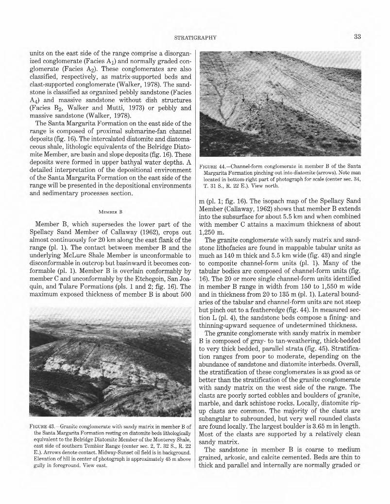
33 STRATIGRAPHY
units on the east side of the range comprise a disorganized conglomerate (Facies A1) and normally graded conglomerate (Facies A2). These conglomerates are also classified, respectively, as matrix-supported beds and clast-supported conglomerate (Walker, 1978). The sandstone is classified as organized pebbly sandstone (Facies A4) and massive sandstone without dish structures (Facies B2, Walker and Mutti, 1973) or pebbly and massive sandstone (Walker, 1978).
The Santa Margarita Formation on the east side of the range is composed of proximal submarine-fan channel deposits (fig. 16). The intercalated diatomite and diatomaceous shale, lithologic equivalents of the Belridge Diatomite Member, are basin and slope deposits (fig. 16). These deposits were formed in upper bathyal water depths. A detailed interpretation of the depositional environment of the Santa Margarita Formation on the east side of the range will be presented in the depositional environments and sedimentary processes section.
MEMBER B
Member B, which supersedes the lower part of the Spellacy Sand Member of Callaway (1962), crops out almost continuously for 20 km along the east flank of the range (pl. 1). The contact between member B and the underlying McLure Shale Member is unconformable to disconformable in outcrop but basinward it becomes conformable (pl. 1). Member B is overlain conformably by member C and unconformably by the Etchegoin, San Joaquin, and Tulare Formations (pls. 1 and 2; fig. 16). The maximum exposed thickness of member B is about 500
FIGURE 43.—Granite conglomerate with sandy matrix in member B of the Santa Margarita Formation resting on diatomite beds lithologically equivalent to the Belridge Diatomite Member of the Monterey Shale, east side of southern Temblor Range (center sec. 2, T. 32 S., R. 22 E.). Arrows denote contact. Midway-Sunset oil field is in background. Elevation of hill in center of photograph is approximately 45 m above gully in foreground. View east.
FIGURE 44.—Channel-form conglomerate in member B of the Santa Margarita Formation pinching out into diatomite (arrows). Note man located in bottom-right part of photograph for scale (center sec. 34, T. 31 S., R. 22 E.). View north.
m (pl. 1; fig. 16). The isopach map of the Spellacy Sand Member (Callaway, 1962) shows that member B extends into the subsurface for about 5.5 km and when combined with member C attains a maximum thickness of about 1,250 m.
The granite conglomerate with sandy matrix and sandstone lithofacies are found in mappable tabular units as much as 140 m thick and 5.5 km wide (fig. 43) and single to composite channel-form units (pl. 1). Many of the tabular bodies are composed of channel-form units (fig. 16). The 20 or more single channel-form units identified in member B range in width from 150 to 1,550 m wide and in thickness from 20 to 135 m (pl. 1). Lateral boundaries of the tabular and channel-form units are not steep but pinch out to a featheredge (fig. 44). In measured section L (pl. 4), the sandstone beds compose a fining- and thinning-upward sequence of undetermined thickness.
The granite conglomerate with sandy matrix in member B is composed of gray- to tan-weathering, thick-bedded to very thick bedded, parallel strata (fig. 45). Stratification ranges from poor to moderate, depending on the abundance of sandstone and diatomite interbeds. Overall, the stratification of these conglomerates is as good as or better than the stratification of the granite conglomerate with sandy matrix on the west side of the range. The clasts are poorly sorted cobbles and boulders of granite, marble, and dark schistose rocks. Locally, diatomite rip-up clasts are common. The majority of the clasts are subangular to subrounded, but very well rounded clasts are found locally. The largest boulder is 3.65 m in length. Most of the clasts are supported by a relatively clean sandy matrix.
The sandstone in member B is coarse to medium grained, arkosic, and calcite cemented. Beds are thin to thick and parallel and internally are normally graded or
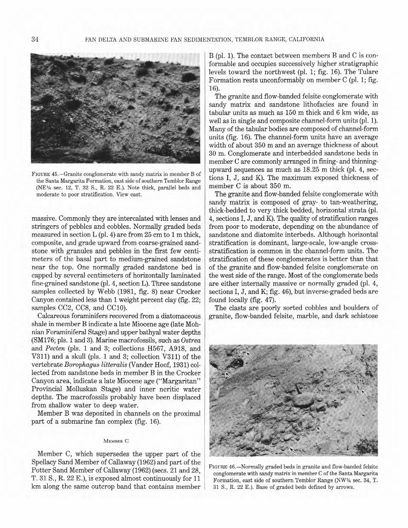
34� FAN DELTA AND SUBMARINE FAN SEDIMENTATION, TEMBLOR RANGE, CALIFORNIA
FIGURE 45.—Granite conglomerate with sandy matrix in member B of the Santa Margarita Formation, east side of southern Temblor Range (NE1/4 sec. 12, T. 32 S., R. 22 E.). Note thick, parallel beds and moderate to poor stratification. View east.
massive. Commonly they are intercalated with lenses and stringers of pebbles and cobbles. Normally graded beds measured in section L (pl. 4) are from 25 cm to 1 m thick, composite, and grade upward from coarse-grained sandstone with granules and pebbles in the first few centimeters of the basal part to medium-grained sandstone near the top. One normally graded sandstone bed is capped by several centimeters of horizontally laminated fine-grained sandstone (pl. 4, section L). Three sandstone samples collected by Webb (1981, fig. 8) near Crocker Canyon contained less than 1 weight percent clay (fig. 22; samples CC2, CC8, and CC10).
Calcareous foraminifers recovered from a diatomaceous shale in member B indicate a late Miocene age (late Mohnian Foraminiferal Stage) and upper bathyal water depths (SM176; pls. 1 and 3). Marine macrofossils, such as Ostrea and Pecten (pls. 1 and 3; collections 11567, A918, and V311) and a skull (pls. 1 and 3; collection V311) of the vertebrate Borophagus litteralis (Vander Hoof, 1931) collected from sandstone beds in member B in the Crocker Canyon area, indicate a late Miocene age ("Margaritan" Provincial Molluskan Stage) and inner neritic water depths. The macrofossils probably have been displaced from shallow water to deep water.
Member B was deposited in channels on the proximal part of a submarine fan complex (fig. 16).
MEMBER C
Member C, which supersedes the upper part of the Spellacy Sand Member of Callaway (1962) and part of the Potter Sand Member of Callaway (1962) (secs. 21 and 28, T. 31 S., R. 22 E.), is exposed almost continuously for 11 km along the same outcrop band that contains member
B (pl. 1). The contact between members B and C is conformable and occupies successively higher stratigraphic levels toward the northwest (pl. 1; fig. 16). The Tulare Formation rests unconformably on member C (pl. 1; fig. 16).
The granite and flow-banded felsite conglomerate with sandy matrix and sandstone lithofacies are found in tabular units as much as 150 m thick and 6 km wide, as well as in single and composite channel-form units (pl. 1). Many of the tabular bodies are composed of channel-form units (fig. 16). The channel-form units have an average width of about 350 m and an average thickness of about 30 m. Conglomerate and interbedded sandstone beds in member C are commonly arranged in fining- and thinning-upward sequences as much as 18.25 m thick (pl. 4, sections I, J, and K). The maximum exposed thickness of member C is about 350 m.
The granite and flow-banded felsite conglomerate with sandy matrix is composed of gray- to tan-weathering, thick-bedded to very thick bedded, horizontal strata (pl. 4, sections I, J, and K). The quality of stratification ranges from poor to moderate, depending on the abundance of sandstone and diatomite interbeds. Although horizontal stratification is dominant, large-scale, low-angle cross-stratification is common in the channel-form units. The stratification of these conglomerates is better than that of the granite and flow-banded felsite conglomerate on the west side of the range. Most of the conglomerate beds are either internally massive or normally graded (pl. 4, sections I, J, and K; fig. 46), but inverse-graded beds are found locally (fig. 47).
The clasts are poorly sorted cobbles and boulders of granite, flow-banded felsite, marble, and dark schistose
FIGURE 46.—Normally graded beds in granite and flow-banded felsite conglomerate with sandy matrix in member C of the Santa Margarita Formation, east side of southern Temblor Range (NW1/4 sec. 34, T. 31 S., R. 22 E.). Base of graded beds defined by arrows.
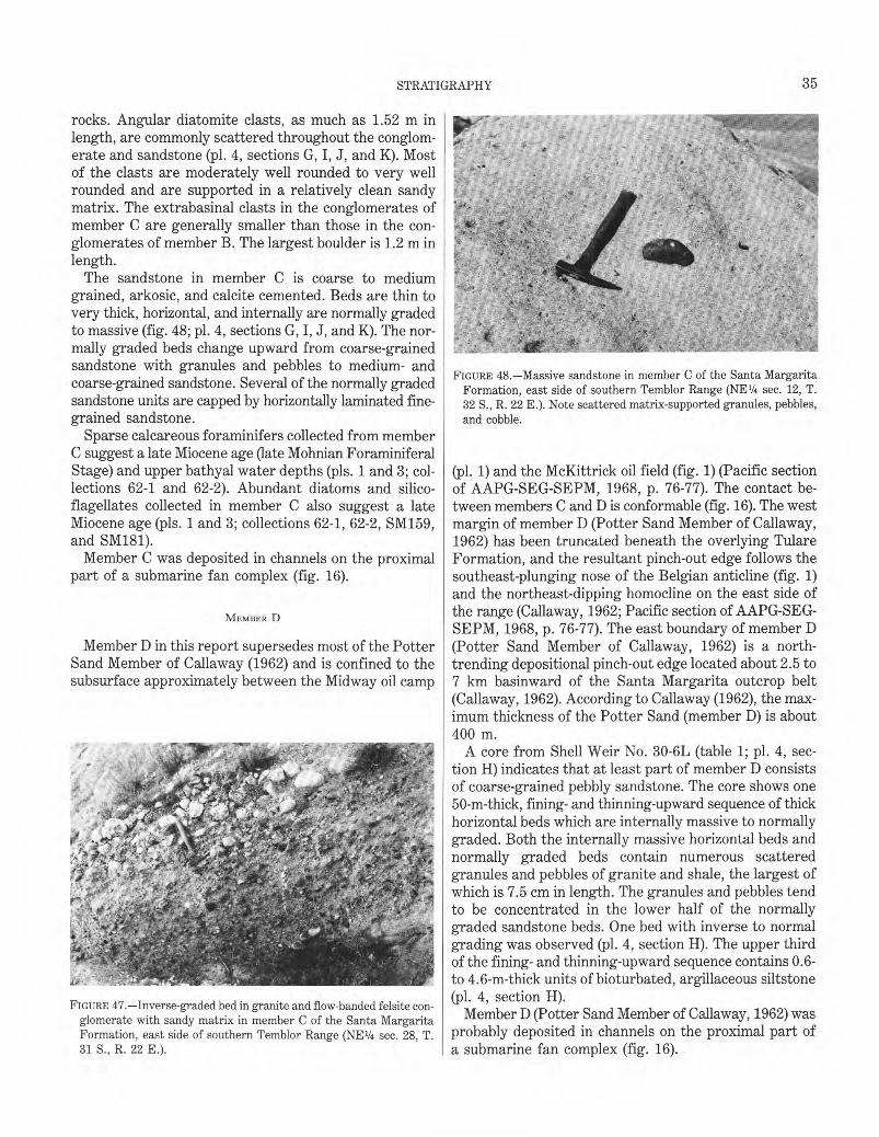
35 �
STRATIGRAPHY
rocks. Angular diatomite clasts, as much as 1.52 m in length, are commonly scattered throughout the conglomerate and sandstone (pl. 4, sections G, I, J, and K). Most of the clasts are moderately well rounded to very well rounded and are supported in a relatively clean sandy matrix. The extrabasinal clasts in the conglomerates of member C are generally smaller than those in the conglomerates of member B. The largest boulder is 1.2 m in length.
The sandstone in member C is coarse to medium grained, arkosic, and calcite cemented. Beds are thin to very thick, horizontal, and internally are normally graded to massive (fig. 48; pl. 4, sections G, I, J, and K). The normally graded beds change upward from coarse-grained sandstone with granules and pebbles to medium- and coarse-grained sandstone. Several of the normally graded sandstone units are capped by horizontally laminated fine-grained sandstone.
Sparse calcareous foraminifers collected from member C suggest a late Miocene age (late Mohnian Foraminiferal Stage) and upper bathyal water depths (pls. 1 and 3; collections 62-1 and 62-2). Abundant diatoms and silicoflagellates collected in member C also suggest a late Miocene age (pls. 1 and 3; collections 62-1, 62-2, SM159, and SM181).
Member C was deposited in channels on the proximal part of a submarine fan complex (fig. 16).
MEMBER D
Member D in this report supersedes most of the Potter Sand Member of Callaway (1962) and is confined to the subsurface approximately between the Midway oil camp
FIGURE 47.—Inverse-graded bed in granite and flow-banded felsite conglomerate with sandy matrix in member C of the Santa Margarita Formation, east side of southern Temblor Range (NE1/4 sec. 28, T. 31 S., R. 22 E.).
FIGURE 48.—Massive sandstone in member C of the Santa Margarita Formation, east side of southern Temblor Range (NE1/4 sec. 12, T. 32 S., R. 22 E.). Note scattered matrix-supported granules, pebbles, and cobble.
(pl. 1) and the McKittrick oil field (fig. 1) (Pacific section of AAPG-SEG-SEPM, 1968, p. 76-77). The contact between members C and D is conformable (fig. 16). The west margin of member D (Potter Sand Member of Callaway, 1962) has been truncated beneath the overlying Tulare Formation, and the resultant pinch-out edge follows the southeast-plunging nose of the Belgian anticline (fig. 1) and the northeast-dipping homocline on the east side of the range (Callaway, 1962; Pacific section of AAPG-SEGSEPM, 1968, p. 76-77). The east boundary of member D (Potter Sand Member of Callaway, 1962) is a north-trending depositional pinch-out edge located about 2.5 to 7 km basinward of the Santa Margarita outcrop belt (Callaway, 1962). According to Callaway (1962), the maximum thickness of the Potter Sand (member D) is about 400 m.
A core from Shell Weir No. 30-6L (table 1; pl. 4, section H) indicates that at least part of member D consists of coarse-grained pebbly sandstone. The core shows one 50-m-thick, fining- and thinning-upward sequence of thick horizontal beds which are internally massive to normally graded. Both the internally massive horizontal beds and normally graded beds contain numerous scattered granules and pebbles of granite and shale, the largest of which is 7.5 cm in length. The granules and pebbles tend to be concentrated in the lower half of the normally graded sandstone beds. One bed with inverse to normal grading was observed (pl. 4, section H). The upper third of the fining- and thinning-upward sequence contains 0.6to 4.6-m-thick units of bioturbated, argillaceous siltstone (pl. 4, section H).
Member D (Potter Sand Member of Callaway, 1962) was probably deposited in channels on the proximal part of a submarine fan complex (fig. 16).
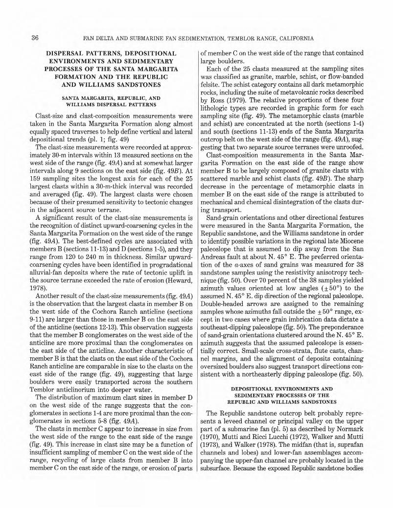
36 �
FAN DELTA AND SUBMARINE FAN SEDIMENTATION, TEMBLOR RANGE, CALIFORNIA
DISPERSAL PATTERNS, DEPOSITIONAL ENVIRONMENTS AND SEDIMENTARY
PROCESSES OF THE SANTA MARGARITA FORMATION AND THE REPUBLIC
AND WILLIAMS SANDSTONES
SANTA MARGARITA, REPUBLIC, AND WILLIAMS DISPERSAL PATTERNS
Clast-size and clast-composition measurements were taken in the Santa Margarita Formation along almost equally spaced traverses to help define vertical and lateral depositional trends (pl. 1; fig. 49)
The clast-size measurements were recorded at approximately 30-m intervals within 13 measured sections on the west side of the range (fig. 49A) and at somewhat larger intervals along 9 sections on the east side (fig. 49B). At 159 sampling sites the longest axis for each of the 25 largest clasts within a 30-m-thick interval was recorded and averaged (fig. 49). The largest clasts were chosen because of their presumed sensitivity to tectonic changes in the adjacent source terrane.
A significant result of the clast-size measurements is the recognition of distinct upward-coarsening cycles in the Santa Margarita Formation on the west side of the range (fig. 49A). The best-defined cycles are associated with members B (sections 11-13) and D (sections 1-5), and they range from 120 to 240 m in thickness. Similar upward-coarsening cycles have been identified in progradational alluvial-fan deposits where the rate of tectonic uplift in the source terrane exceeded the rate of erosion (Heward, 1978).
Another result of the clast-size measurements (fig. 49A) is the observation that the largest clasts in member B on the west side of the Cochora Ranch anticline (sections 9-11) are larger than those in member B on the east side of the anticline (sections 12-13). This observation suggests that the member B conglomerates on the west side of the anticline are more proximal than the conglomerates on the east side of the anticline. Another characteristic of member B is that the clasts on the east side of the Cochora Ranch anticline are comparable in size to the clasts on the east side of the range (fig. 49), suggesting that large boulders were easily transported across the southern Temblor anticlinorium into deeper water.
The distribution of maximum clast sizes in member D on the west side of the range suggests that the conglomerates in sections 1-4 are more proximal than the conglomerates in sections 5-8 (fig. 49A).
The clasts in member C appear to increase in size from the west side of the range to the east side of the range (fig. 49). This increase in clast size may be a function of insufficient sampling of member C on the west side of the range, recycling of large clasts from member B into member C on the east side of the range, or erosion of parts
of member C on the west side of the range that contained large boulders.
Each of the 25 clasts measured at the sampling sites was classified as granite, marble, schist, or flow-banded felsite. The schist category contains all dark metamorphic rocks, including the suite of metavolcanic rocks described by Ross (1979). The relative proportions of these four lithologic types are recorded in graphic form for each sampling site (fig. 49). The metamorphic clasts (marble and schist) are concentrated at the north (sections 1-4) and south (sections 11-13) ends of the Santa Margarita outcrop belt on the west side of the range (fig. 49A), suggesting that two separate source terranes were unroofed.
Clast-composition measurements in the Santa Margarita Formation on the east side of the range show member B to be largely composed of granite clasts with scattered marble and schist clasts (fig. 49B). The sharp decrease in the percentage of metamorphic clasts in member B on the east side of the range is attributed to mechanical and chemical disintegration of the clasts during transport.
Sand-grain orientations and other directional features were measured in the Santa Margarita Formation, the Republic sandstone, and the Williams sandstone in order to identify possible variations in the regional late Miocene paleoslope that is assumed to dip away from the San Andreas fault at about N. 45° E. The preferred orientation of the a-axes of sand grains was measured for 38 sandstone samples using the resistivity anisotropy technique (fig. 50). Over 70 percent of the 38 samples yielded azimuth values oriented at low angles ( + 50°) to the assumed N. 45° E. dip direction of the regional paleoslope. Double-headed arrows are assigned to the remaining samples whose azimuths fall outside the ±50° range, except in two cases where grain imbrication data dictate a southeast-dipping paleoslope (fig. 50). The preponderance of sand-grain orientations clustered around the N. 45° E. azimuth suggests that the assumed paleoslope is essentially correct. Small-scale cross-strata, flute casts, channel margins, and the alignment of deposits containing oversized boulders also suggest transport directions consistent with a northeasterly dipping paleoslope (fig. 50).
DEPOSITIONAL ENVIRONMENTS AND SEDIMENTARY PROCESSES OF THE
REPUBLIC AND WILLIAMS SANDSTONES
The Republic sandstone outcrop belt probably represents a leveed channel or principal valley on the upper part of a submarine fan (pl. 5) as described by Normark (1970), Mutti and Ricci Lucchi (1972), Walker and Mutti (1973), and Walker (1978). The midfan (that is, suprafan channels and lobes) and lower-fan assemblages accompanying the upper-fan channel are probably located in the subsurface. Because the exposed Republic sandstone bodies
DISPERSAL PATTERNS, DEPOSITIONAL ENVIRONMENTS, AND SEDIMENTARY PROCESSES� 37
are vertically stacked and only 1.0 to 1.2 km wide, the upper-fan channel was probably narrow and incised and lacked significant bifurcations, except possibly in the present-day subsurface. The fining- and thinning-upward sequences documented in plate 4 (section E) and by Webb (1981) probably reflect phases of gradual fan-channel abandonment.
The pebbly sandstone beds in the Republic sandstone with Ta and Ta,b beds of the Bouma sequence (Facies A4) probably originated from high-concentration turbidity currents (pl. 5). The ubiquitous pebble-sized detritus in the Republic sandstone is not inconsistent with a fluid-turbulence flow mechanism, as demonstrated by Komar (1970). By analogy to interpretations by Middleton and Hampton (1973), the massive to graded Ta-division beds of the Republic sandstone were probably deposited very rapidly from suspension, whereas the horizontally laminated Tb-division beds were deposited less rapidly and under a greater influence of traction. By further analogy to studies by Middleton and Hampton (1973), some form of grain-to-grain interaction (grain flow) and upward inter-granular flow (fluidized sediment flow) may also have been operative in the Republic high-concentration turbidity currents, particularly in the late stages of transport and early rapid stages of deposition. Judging from the abundance of shallow-water mollusks in the Republic sandstone, these turbidity currents probably were generated from nearby coastal sediments (pl. 5).
The Williams sandstone outcrop belt (pl. 5) is a midfan deposit according to the submarine-fan models described by Normark (1970), Mutti and Ricci Lucchi (1972), Walker and Mutti (1973), and Walker (1978). The thickening- and coarsening-upward sequences (pl. 4, sections C and D) represent suprafan lobes, and the fining- and thinning-upward sequences signify gradually abandoned channels on the channeled suprafan (pl. 5). Lower-fan assemblages accompanying the midfan deposits are probably located in the adjacent subsurface. The absence of mollusks, such as Ostrea and Pecten, in the Williams sandstone is attributed to selective sorting processes in the upper reaches of the Williams submarine fan.
The classical proximal turbidites in the Williams sandstone with Ta,b, Ta,b,c, and Ta,b,c,ep beds of the Bouma sequence (Facies C) probably originated from high-concentration turbidity currents (pl. 5). The erosive nature of these turbidity currents, grain flows, and fluid sediment flows is evidenced by the numerous diatomaceous shale and dolomite rip-up clasts (pl. 4, sections C and D). By analogy to interpretations by Middleton and Hampton (1973), the massive to graded Ta-divison beds of the Williams sandstone were probably deposited very rapidly from suspension, whereas the horizontally laminated Tb-division beds and the rippled Tc-division beds were deposited under less rapid conditions than the Ta-division beds and under a greater influence of traction. The in-
ternally massive amalgamated sandstone beds in the Williams sandstone (Facies B), some of which contain dish structures, were probably deposited by grain flows and(or) fluid sediment flows as defined by Stauffer (1967) and Middleton and Hampton (1973). Both types of flows require high concentrations of sediment and high-gradient slopes and probably evolve from high-concentration turbidity currents during late stages of transport and early stages of deposition (Middleton and Hampton, 1973). Nearby coastal sediments probably supplied the detritus for the turbidity currents and the grain and(or) fluid sediment flows (pl. 5).
The Republic submarine fan had a steeper longitudinal profile than the Williams submarine fan (Callaway, 1962, fig. 5) and maintained a straight upper-fan channel for a greater down-the-fan distance than the shallower profile of the Williams fan. The steeper longitudinal profile of the Republic fan probably resulted from a closer, more active source terrane than the Williams fan and explains why the Republic sandstone differs in geometry and grain size from the Williams sandstone when both fans have similar locations with respect to the base of the submarine slope and when both outcrop belts are within 5 km of each other and are in a similar structural position (pl. 5).
The Republic and Williams submarine fans, with respective radii of about 4.5 and 5.5 km, are small by comparison with most of the modern submarine fans in the world. Fans with a comparable radius include the sublacustrine fans in Lake Superior (Normark and Dickson, 1976; Reserve fan) and Lake Geneva (Houbolt and Jonker, 1968). The Coronado, Navy, Redondo, and San Lucas submarine fans off the coasts of southern California and Mexico, which have a similar geologic setting to the Republic and Williams fans, all have radii 6 to 12 times those of the Republic and Williams submarine fans (Normark, 1978).
The small size of the Republic and Williams fans and the coarse-grained material they contain suggest that the drainage system that supplied their detritus consisted of short, high-gradient streams. Such a system would supply large quantities of coarse sediment to the fan periodically but would not necessarily develop a large volume of detritus. A fan fed by a more completely integrated system draining large distant source areas would typically receive a continuous sediment supply over a long period of time, creating a more voluminous fan deposit. The short, high-gradient streams that are likely to have supplied the elastic debris to the Republic and Williams would be found in the tectonically active hinterland one would envision for the southern Temblor Range area during the late Miocene (pl. 5).
Another factor that probably contributed to the small radius of the Republic and Williams fans was the intermittent growth of the Buena Vista Hills anticline (fig. 1).
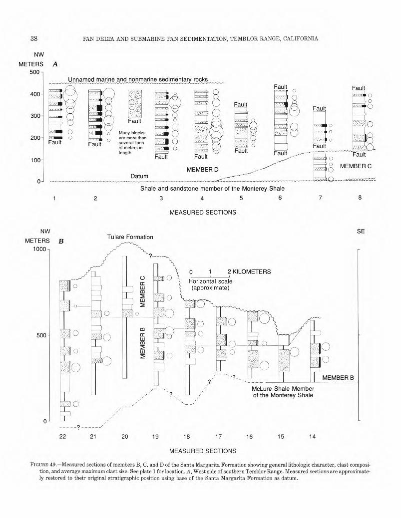
Unnamed marine and nonmarine sedimentary rocks
400
Fault
300 Fault
=me 0 Many blocks 200 .m• are more than
Fault several tens 0of meters in length Fault Fault FaultFault Fault �0100
° MEMBER CMEMBER D 0
Datum 0
Shale and sandstone member of the Monterey Shale
1 2 3 4 5 6 7 8
MEASURED SECTIONS
NW SE Tulare Formation
METERS B 1000 -
0 1 2 KILOMETERS
Horizontal scale�cc (approximate)Ldii
J I onew o si
500 -
ME
MB
ER
B
10
MEMBER B
McLure Shale Member of the Monterey Shale
0 2
DISPERSAL PATTERNS, DEPOSITIONAL ENVIRONMENTS, AND SEDIMENTARY PROCESSES� 39
SEBitterwater Creek Shale
Fault
Shale and sandstone member of the Monterey Shale
9 10 11 12 13
MEASURED SECTIONS
0 1 2 KILOMETERS
Horizontal scale (approximate)
EXPLANATION
Diatomite
Sandstone
Conglomerate—No clast count
- „ Conglomerate—Clast composition
a )C U)
ca 0
Average maximum clast diameter—Size of circle according to scale:
A 0 120 CENTIMETERS p.e 0 120 CENTIMETERS LLL-LJ� LLLLJ
Contact—In figure 498. Dashed where approximately located; queried where uncertain. Local datum near base of member C except in sections 14 and 15 where it is near base of member B
Unconformity—Queried where uncertain
FIGURE 49.—Continued. B, East side of southern Temblor Range. Measured sections are approximately restored to their original stratigraphic position using selected diatomite and sandstone marker beds as datum.
This structure probably blocked the basinward advance mation of small-radius fans with broad northwestward of the Republic and Williams fans and deflected them sweeps (Callaway, 1962). Fans of this type, whose nornorthwestward, down a synclinal trough between the mal growth patterns have been hindered by tectonic Buena Vista Hills anticline and the southern Temblor features on the sea floor, are called "choked" fans by Range anticlinorium, with the net result being the for- Mutti and Ricci Lucci (1972).
• • •
40 FAN DELTA AND SUBMARINE FAN SEDIMENTATION, TEMBLOR RANGE, CALIFORNIA
119°40' 35°15' 119°35'
Santa Margarita Formation
0,0 o d119°45'
C7
35°15' Santa Margarita
Formation
ANDREAS FAULT 0�2 KILOMETERS SAN I I
7
119°45' 35°10' 119°40'
EXPLANATION
Paleocurrent direction—Based on: (C) Channel margin
Orientation of a-axes of sand grains (A) Alignment of oversized boulders; Arrow connects outcrops from which alignment is
Azimuth is oriented at a low angle to N. 45° based E.-dipping regional paleoslope
Present-day outcrop patternAzimuth is oriented at high angle to re
gional paleoslope Granite conglomerate with very large boulders and blocks
Imbrication of sand grains Fault—Arrows indicate direction of relative
(XB) Small-scale cross-stratification horizontal movement
(F)�Flute cast
FIGURE 50.—Summary diagram of paleocurrent measurements in the Santa Margarita Formation, the Republic sandstone of local usage, and the Williams sandstone of local usage. Stippled pattern shows present-day outcrop pattern of the Santa Margarita Formation, Republic sandstone, and Williams sandstone.
DEPOSITIONAL ENVIRONMENTS AND SEDIMENTARY PROCESSES OF 3. Abrupt west to east change in facies of the Santa
THE SANTA MARGARITA FORMATION Margarita Formation across the range, from conglom-The following evidence suggests that eastward- erate with argillaceous sandy matrix (unfossiliferous) to
prograding alluvial fans and peripheral submarine conglomerate with sandy matrix and sandstone (shallowcanyons and submarine fans created the Santa Margarita water marine macrofossils) to conglomerate with sandy Formation: matrix, sandstone, and diatomite (deep-water marine
1. Tectonically active depositional site of the Santa microfossils). Margarita Formation. 4. Eastward change from unstratified to poorly strati
2. Predominance of boulder and cobble conglomerate fied conglomerate in the Santa Margarita Formation with in the Santa Margarita Formation. thick to very thick horizontal beds to poorly and moderate-
DISPERSAL PATTERNS, DEPOSITIONAL ENVIRONMENTS, AND SEDIMENTARY PROCESSES� 41
35°10'� 119°30' 119°25' 35°05' x
....cp.> ,o.
._--------
Williams sandstone of local usage
N 119°25'
(C) Republic sandstone
of local usage
(XB)
Santa Margarita Formation
(F)
Santa Margarita
Formation
/ 35°00'
SAN —•—.1.... ANDREAS
FAULT
/ \ 35°05'� 119°35' 35°00' 119°30'
FIGURE 50.—Continued.
ly stratified conglomerate with thick to very thick horizontal beds.
5. Internal structure of the parallel beds in the Santa Margarita conglomerates changes eastward from massive to normally graded and massive.
6. Several sequences of upward-coarsening maximum-sized clasts in the Santa Margarita conglomerates on the west side of the range.
7. Maximum size of the clasts in the Santa Margarita Formation decreases from conglomerate with argillaceous sandy matrix to conglomerate with sandy matrix on the west side of the range.
8. Presence of several large channel-form units in the Santa Margarita Formation on the west side of the range (near crest) as much as 200 m thick and filled with thick to very thick parallel beds of conglomerate with sandy matrix and sandstone that are internally massive and normally graded.
9. Fining- and thinning-upward sequences in the Santa Margarita conglomerate with sandy matrix and sandstone on the east side of the range.
10. Eastward increase in the number of single and composite channels in the Santa Margarita Formation.
Characteristic features of the Santa Margarita alluvial fan deposits, listed under preceding items 2-7, have many
similarities to alluvial fan deposits summarized by Nilsen (1982). The Santa Margarita alluvial fans had a large subaqueous component and, thus, they will hereafter be referred to as fan deltas (Holmes, 1965; McGowen, 1970).
The Santa Margarita fan delta, submarine canyon, and submarine fan system extended from near the San Andreas fault, across the southern Temblor anticlinorium, to as far eastward as the Buena Vista Hills anticline (fig. 1; pl. 5). Today, the deposits of the fan deltas and the submarine canyons are located on the west side of the southern Temblor Range and in the subsurface beneath the Elkhorn Plain, whereas the deposits of the submarine fans are located on the east side of the range and in the adjacent subsurface (fig. 16). Outcrops of the Santa Margarita Formation on the crest of the range probably are distal fan delta and(or) submarine canyon deposits. A close modern analog to the depositional environment envisioned for the Santa Margarita Formation is the Yallahs River fan delta, Jamaica, and its adjoining submarine fan in the Yallahs basin (Burke, 1967; Wescott and Ethridge, 1980). A good ancient analog for the depositional environment of the Santa Margarita Formation is the Eocene sequence of the California borderlands (Howell and Link, 1979).
The interpretation of the Santa Margarita depositional
42� FAN DELTA AND SUBMARINE FAN SEDIMENTATION, TEMBLOR RANGE, CALIFORNIA
environments suggested here is consistent with interpretations by Vedder (1970, 1975) and Huffman (1972). Vedder (1970, 1975) regarded the conglomerate and sandstone of the Santa Margarita on the west side of the range as nonmarine(?) and high-energy, shallow-marine deposits derived from a precipitous coastal zone directly to the west. Moreover, Vedder (1975) recognized the eastward pinch out of Santa Margarita conglomerate and sandstone into diatomite and shale on the east side of the range but did not comment on their origin. Huffman (1972) agreed with the shallow-marine interpretation of Vedder (1970, 1975) for the origin of the Santa Margarita Formation on the west side of the range and speculated that some or all of the Santa Margarita on the east side of the southern Temblor Range is of deep-water marine origin.
On the other hand, the fan-delta and submarine-fan interpretation offered here differs from the interpretations of Simonson and Krueger (1942) and Webb (1981), where a shallow-marine origin is suggested for all of the Santa Margarita Formation, and from the interpretation of Ryder and Thomson (1979), where a deep-water marine origin is suggested for all of the Santa Margarita Formation. Simonson and Krueger (1942) concluded that on the west side of the southern Temblor Range the Santa Margarita Formation consists of fluviatile channel and littoral deposits, whereas on the east side of the range the Santa Margarita Formation consists of torrential stream deposits that were deposited in shallow seas contemporaneously with thick deposits of diatomaceous sediments. Webb (1981) was less specific than Simonson and Krueger (1942) about the depositional setting of the Santa Margarita Formation, but stated that "the diatomite is overlain by thick shallow-water sandstones and conglomerates of the Santa Margarita which outcrop in a band along the edge of the Midway-Sunset field." Ryder and Thomson (1979) suggested that the entire Santa Margarita Formation was deposited in a submarine fan system composed of upper fan deposits on the west side of the southern Temblor Range and uppermost midfan deposits on the east side.
SANTA MARGARITA FAN DELTAS
The Santa Margarita fan deltas are similar to the Pleistocene Lake Bonneville deltas, which, according to Wescott and Ethridge (1980), were among the first fan deltas to be described in the literature. These Pleistocene deltas, better known as Gilbert deltas (Gilbert, 1890), have the following components: (1) topset beds of flat-lying gravels that form the subaerial part of the delta, (2) foreset beds of sand and gravel, dipping basinward at 10° to 25° that form the bulk of the subaqueous part of the delta, and (3) bottomset beds of sand, silt, and clay that form the distal subaqueous part of the delta. Prograda-
tion of the Gilbert delta produced an upward-coarsening sequence composed of bottomset beds at the base, foreset beds in the middle, and topset beds at the top. Refer to Elliott (1978, p. 97) for a schematic cross-sectional illustration of a Lake Bonneville, Gilbert-type delta. In the following section, the deposits of the Santa Margarita fan deltas are identified and discussed in terms of the major components of the Lake Bonneville fan deltas.
Each of the four members of the Santa Margarita Formation on the west side of the range probably were deposited by a separate fan delta. Owing to significant syndepositional and post-depositional tectonism and erosion, none of these individual fan deltas are completely preserved. Member A, composed of either bottomset beds or distal foreset beds on the subaqueous part of the fan delta, and member C, composed of topset beds on the subaerial part of the fan delta, are the most incomplete of the four fan-delta deposits (fig. 16).
The 16-km long member D outcrop belt shows the most complete longitudinal view of a Santa Margarita fan delta (pl. 1; fig. 16). The northern three-quarters of the member D outcrop belt is composed primarily of boulder conglomerate with argillaceous sandy matrix that represents the topset beds or subaerial part of the fan delta. The remaining quarter of the outcrop belt is composed of alternating boulder conglomerate with sandy matrix and fossiliferous sandstone that represent foreset beds of the subaqueous part of the fan delta. The shoreline between the subaerial and subaqueous parts of the member D fan delta cannot be clearly defined because obvious shoreline deposits, such as beaches, are nonexistent. Deposits of very well rounded cobbles in member D conglomerates with sandy matrix are probable remnants of gravel beaches, but they are local and they have been susceptible to reworking into deep water so that a credible shoreline trend cannot be established. Bottomset beds of the member D fan delta are absent, but they probably existed at one time east and southeast of the outcrop belt. The foreset beds in member D probably were originally contiguous with the outcrops of isolated fossiliferous conglomerate and sandstone along the crest of the range and together they formed a large, arcuate, northeastwardprograding, fan delta. Therefore, it is likely that the member D fan delta advanced down the paleoslope defined by the alignment of very large boulders and blocks and the depositional margin of a nearby submarine canyon deposit (fig. 50), and not southeastward as the direction of the facies change between the topset and foreset beds in member D suggests.
Judging from the combined thicknesses of member D foreset beds and from published relations between water depth and the thickness of Gilbert-type foreset beds (Gilbert, 1885; Stanley and Surdam, 1978), the member D fan delta probably prograded into water between 270
DISPERSAL PATTERNS, DEPOSITIONAL ENVIRONMENTS, AND SEDIMENTARY PROCESSES� 43
and 300 m deep. These depths imply that many of the marine megafossils found in the foreset beds probably have been displaced, down the slope of the fan delta, from an inner-neritic habitat to outer-neritic or upper-bathyal depths.
The outcrops of member B on both sides of the Cochora Ranch anticline expose the structure of another Santa Margarita fan delta (pl. 1; fig. 16). Conglomerates with argillaceous matrix on the west side of the anticline are interpreted to be topset beds on the subaerial part (alluvial fan) of the fan delta, whereas large units of fossiliferous conglomerate and sandstone that are northwest-facing and inclined on the east side of the anticline are interpreted to be foreset beds on the subaqueous part of the fan delta (fig. 16). The 10° dip of the foreset beds probably approximates closely the dip of the fan-delta front. Silty sandstone composing the youngest foreset beds (fig. 16) probably was deposited during the waning stages of fan-delta construction. Fossiliferous conglomerate and sandstone amid the conglomerate with argillaceous sandy matrix on the west side of the anticline are interpreted to be proximal foreset-bed deposits that probably formed in a local reentrant in the shoreline. The shoreline between the subaerial and subaqueous parts of the member B fan delta cannot be clearly defined because distinct shoreline deposits, such as beaches, are nonexistent. Deposits of very well rounded cobbles in member B conglomerate with sandy matrix are probable remnants of gravel beaches, but they are so localized and susceptible to reworking into deeper water that a credible shoreline trend cannot be established. No bottomset beds were noted in the member B fan delta, with the possible exception of the silty sandstone with shale interbeds exposed on the east side of the Recruit Pass fault (secs. 9 and 10, T. 32 S., R. 22 E.).
The northeast-oriented depositional margin of the submarine canyon (fig. 50) that cuts the foreset beds of member B suggests that the member B fan delta pro-graded northeastward rather than northwestward as the dip direction of the foreset beds implies (fig. 16). Apparently, the northwest-facing foreset beds are remnants of a large fan delta whose deposits may include the fossiliferous conglomerate in member B in the southernmost part of the study area (fig. 16).
Judging from the combined thickness of member B foreset beds and published reports that point out the relation between the water depth and thickness of Gilbert-type delta foreset beds (Gilbert, 1885; Stanley and Surdam, 1978), the member B fan delta probably pro-graded into water between 400 and 500 m deep. These estimated water depths are consistent with the upper bathyal depth inferred from available microfossil collections (samples SM34 and SM35; pls. 1 and 3). Moreover, a 400- to 500-m water depth implies that many of the marine megafossils found in the foreset beds probably
have been transported down the slope of the fan delta from an inner-neritic habitat to outer-neritic or upperbathyal waters.
The shelf upon which the Santa Margarita fan deltas developed would have to dip uniformly eastward from the San Andreas fault at about 5° to achieve a 500-m water depth near the Recruit Pass fault. If the shelf continued as a ramp beyond the Recruit Pass fault at a 5° slope, the water depth at which submarine-fan deposition occurred on the east side of the range would have been about 800 m. If a break in slope accompanied the east margin of the shelf, the water depth on the east side of the range where Santa Margarita deposition occurred may have approached 1,000 m. However, 800- to 1,000-m water depths are inconsistent with the upper bathyal depth (200-500 m) indicated by calcareous foraminifers collected from the Santa Margarita Formation (samples SM176, 62-1, 62-2; pl. 3) and from the upper part of the McLure Shale Member (Bandy and Arnal, 1969) on the east side of the range.
This discrepancy in the late Miocene bathymetry on the east side of the range can be resolved by assuming that the range of water depths indicated by the microfossils is correct and that the 500-m thickness of the foreset beds was controlled by both water depth and syndepositional movement of the nearby Recruit Pass fault. By using 500 m for the water depth on the east side of the range during Santa Margarita sedimentation (pl. 5), the water depth near the Recruit Pass fault and the dip of the ramplike shelf are reduced to about 300 m and 3°, respectively. Approximately 300 m of foreset beds can be accommodated by a water depth of 300 m near the Recruit Pass fault, and the remaining 200 m of foreset beds can be accounted for by 200 m of down-to-the-west syndepositional dip separation along the Recruit Pass fault.
SANTA MARGARITA SUBMARINE CANYONS AND FANS
The large channel-form units that cut the well-exposed foreset beds in members B and D are interpreted to be submarine-canyon deposits (fig. 16; p1.5). These canyons, filled with poorly to moderately stratified beds of conglomerate and sandstone which internally are normally graded or massive, clearly served as the conduits through which detritus from the deltas was redistributed to deeper water on the east (pl. 5). The estimated water depth of the adjacent foreset beds indicates that the submarine canyons were probably formed at upper bathyal depths. Abundant shallow-marine macrofossils in the member B submarine canyon (fig. 16) must have been reworked into deeper water. The presence of the submarine canyons suggests that the foreset beds were steep and unstable (pl. 5).
The isolated and composite channel-form units that characterize the outcrops of the Santa Margarita Forma-
44� FAN DELTA AND SUBMARINE FAN SEDIMENTATION, TEMBLOR RANGE, CALIFORNIA
tion on the east side of the range are interpreted as channels on the upper part of a submarine fan (pls. 1 and 5). Names assigned to these proximal submarine-fan channels include leveed valley (Howell and Normark, 1982; Normark, 1970, 1978), leveed channel (Walker and Mutti, 1973), principal valley (Mutti and Ricci Lucchi, 1972), feeder channel (Walker, 1978), and inner-fan channel (Lohmar and others, 1979). Deposits of the channeled suprafan, suprafan lobes, and lower fan, as described by Normark (1970), Howell and Normark (1982), Mutti and Ricci Lucchi (1972), and Walker (1978), probably are present in the adjacent subsurface. R.B. Lennon (oral commun., 1970) has shown that detailed electric-log correlations of beds within the Santa Margarita Formation in the Midway-Sunset oil field (fig. 1) are more difficult to make in the strike direction than in the dip direction, suggesting that channel deposits dominate the Santa Margarita submarine fans for at least 3 km into the subsurface. Calcareous foraminifers collected from diatomaceous shale in the Santa Margarita Formation on the east side of the range (samples SM176, 62-1, 62-2; pls. 1 and 3)suggest that the fan channels were deposited in upperbathyal water. The shallow-water macrofauna present in samples 11567, V311, and A918 (pls. 1 and 3) must have been recycled into deeper water.
The numerous channel-form units that crop out in a given stratigraphic horizon indicate that the upper reaches of the Santa Margarita submarine fans were crossed by many channels (pl. 5). Moreover, the fining- and thinning-upward sequences recorded in many of the channels (pl. 4)suggest that many of the channels were gradually abandoned and thus were restricted to one area of the fan for long periods of time.
The Santa Margarita submarine fans, like the Republic and Williams fans, were deflected northwestward down the synclinal trough between the tectonically active Buena Vista Hills anticline (fig. 1) and the southern Temblor Range anticlinorium. However, in contrast to the Republic and Williams fans, the Santa Margarita fans swept around the northwest-plunging nose of the Buena Vista Hills anticline and supplied coarse sand to the San Joaquin basin (Webb, 1981). Most likely, the Santa Margarita fans have either reduced (or nonexistent) lower-fan assemblages because of their interaction with the growing Buena Vista Hills anticline, and so qualify as choked fans (Mutti and Ricci Lucchi, 1972).
SANTA MARGARITA DEPOSITIONAL PROCESSES
Santa Margarita conglomerate on the subaerial part of the fan deltas are interpreted to be subaerial debris-flow deposits (pl. 5) because of their similarity to modern subaerial debris-flow deposits (Blackwelder, 1928; Johnson, 1965, 1970; Beaty, 1970; Bull, 1972; Nilsen, 1982). Features common to Santa Margarita conglomer-
ate and modern subaerial debris-flow deposits include (1) poor sorting, (2) poor horizontal stratification, (3) large clast size, (4) matrix-supported clasts without a noticeable fabric, (5) predominantly massive with local reverse to normally graded beds, and (6) an absence of channel-fill deposits.
Debris flow, as used here, is a descriptive field term applied by Jahns (1949), Sharp and Nobles (1953), and Johnson (1965, 1970) to a rapidly flowing, gravity-driven mass of granular solids, clay, and water. The term mudflow, as used later in the text, is defined as a variety of debris flow dominated by sand-, silt-, and clay-sized detritus (Sharp and Nobles, 1953; Bull, 1972). According to Johnson (1965, 1970), the cobbles and boulders in a debris-flow deposit, such as the Santa Margarita Formation, have been largely supported by the strength and buoyancy of the matrix of the debris flow, which in turn are controlled by the strength and density of the clay-water fluid in the flow. Johnson (1965, 1970) also concluded that debris-flow deposition took place by mass emplacement of the flow rather than by the gradual settling of particles from the moving flow. Mass emplacement (or "freezing") occurred when the driving stress of gravity decreased below the matrix strength of the debris flow.
The 7 to 13 weight percent of clay with respect to the total matrix of the conglomerate with argillaceous sandy matrix (fig. 22) is probably too low for matrix strength and buoyancy to have been the predominant support for the cobbles and boulders in the subaerial debris flows of the Santa Margarita Formation. These clay values would be even lower had the weight percent of clay been measured with respect to the entire debris flow (weight percent clay/weight percent clay plus weight percent water plus weight percent of all the granular solids). However, as emphasized by Hampton (1979), the important factor controlling the competence of a debris flow (that is, largest grain size that can be supported by matrix strength) is the relative proportion of clay to water in the original debris flow. The importance of matrix strength and buoyancy as a sediment-support mechanism will never be known for the Santa Margarita debris flows and other ancient debris flows because the clay-to-water ratios of their deposits are unobtainable.
On the basis of investigations of recent debris flows, such as the Mayflower Gulch debris flow in Colorado, Curry (1966), Middleton and Hampton (1973) and Hampton (1975, 1979) concluded that most gravity-driven sediment flows (given the field name debris flow) are probably a combination of two or more of the following types of flow: (1) debris flow with matrix strength and buoyancy being the major mechanism of sediment support, (2) grain flow with grain interaction or dispersive pressure being the major mechanism of sediment support, (3) liquified
DISPERSAL PATTERNS, DEPOSITIONAL ENVIRONMENTS, AND SEDIMENTARY PROCESSES� 45
flow with upward granular flow being the major mechanism of sediment support, and (4) turbulent flow with fluid turbulance being the major mechanism of sediment support. A recent study of modern debris flows on the flanks of Mt. Thomas in New Zealand (Pierson, 1981) further corroborates the coexistence of several types of sediment support in a subaerial debris flow.
Subaerial mudflow deposits of the Santa Margarita Formation are akin to the pebbly mudstones of Crowell (1957). Grain-size analyses for the finer grained conglomerates with argillaceous sandy matrix, yielding weight percent clay values of 11 and 13 (fig. 22), indicate that the mudflows that deposited them were richer in clay than were the debris flows that deposited the coarser grained conglomerates with argillaceous sandy matrix. Local boulder and cobble trains in the subaerial mudflow deposits probably formed on the lee side of obstructions, such as larger boulders and cobbles (Nilsen, 1982). Subaerial mudflows that contributed detritus to the Santa Margarita Formation probably evolved either directly from the source terrane or from the tails of highly fluid debris flows. Mudflows of the first type were derived in a source terrane where only fine-grained detritus was available owing to bedrock lithology or intensity of weathering; mudflows of the second type, because of their high fluidity, separated from the emplaced parent debris flow and advanced farther downslope.
The conglomerate with very large boulders and blocks was probably emplaced by a debris avalanche which, according to Johnson (1965), is a variety of debris flow (pl. 5). Momentum of the avalanche and possibly a trapped air column beneath the avalanche (Shreve, 1968) permitted the over-sized boulders to be transported several kilometers from their source. The largest boulders and blocks found in the Santa Margarita debris-avalanche deposit are comparable in size to boulders and blocks carried over 3 km by the Nevados Huascaran debris avalanche of Peru (Ericksen and others, 1970). The total volume of rock material moved by the Nevados Huascaran debris avalanche could have been 50 million m3 (Ericksen and others, 1970).
Many of the large subaerial debris flows reached the seaway and accumulated at various levels on the subaqueous foreset beds. Furthermore, large quantities of water that commonly precede and follow modern debris flows probably accompanied the Santa Margarita sub-aerial debris flows and transported large quantities of sand-sized detritus into the adjacent marine environment. Redistribution of the sand-sized detritus by flood water created a coarse- to medium-grained sand apron that was interbedded with and generally peripheral to subaerial debris-flow deposits (pl. 5). Judging from the paucity of well-defined channel-fill deposits and cross-stratification in the subaerial deposits of the Santa Margarita Forma-
tion, depositional processes associated with sediment-laden floodwater were limited to stream flow in shallow, braided channels and(or) to sheet flooding outside the confines of channels. The absence of well-defined stratification and sedimentary structures in the sand apron and associated subaqueous conglomerates suggests that these deposits underwent minimal reworking by waves and shallow marine currents.
Tectonic instability and oversteepening of the foreset beds due to progradation led to the repeated failure of subaerial debris-flow deposits and to the subsequent spawning of subaqueous debris flows (pl. 5). Where subaqueous slumping involved the sand apron, the resultant flows were probably akin to high-concentration turbidity currents (pl. 5). These regenerated subaqueous debris flows and high-concentration turbidity currents formed the foreset-bed and submarine-canyon deposits on the subaqueous Santa Margarita fan deltas and the fan-channel deposits on the Santa Margarita submarine fans (pl. 5). Many of the Santa Margarita subaqueous debris flows (pl. 5) may have evolved into high-concentration turbidity currents, as experiments by Hampton (1972) have shown. These experiments suggest that subaerial debris flows evolve into turbidity currents by erosional mixing at the snout of the flow; however, other mechanisms are possible, such as the mixing of water directly with the body of the flow. The mechanics of subaerial debris flows are considered by Hampton (1972) and Middleton and Hampton (1973) to be similar to those described by Johnson (1965, 1970).
Except for a slight loss of clay in the matrix (3-6 weight percent versus 7-13 weight percent) and a marked increase in normally graded and reverse to normally graded beds, the subaqueous debris-flow deposits are very similar in appearance to the subaerial debris-flow deposits. The slight reduction in the weight percent of clay in the resedimented subaqueous debris-flow deposits is attributed to the expulsion of clay from the subaqueous debris flows during their formative and in-transit stages. In the formative stage of the debris flow, clay was probably expelled in large sediment plumes as slumped sediments were jostled about and remolded into a slurry. Clay loss during the in-transit stage resulted from the probable generation of a turbidity current at the snout of the subaqueous debris flow, a process described by Hampton (1972) in laboratory experiments.
The presence of normally graded and reverse- to normally graded beds in the subaqueous debris-flow deposits suggests that the movement and interaction of clasts was greater in the subaqueous debris flows than in the subaerial debris flows. This increase in clast mobility probably resulted from the increased water content of the subaqueous debris flows. Thus, dispersive pressure and perhaps turbulence may account for a major share of the
46� FAN DELTA AND SUBMARINE FAN SEDIMENTATION, TEMBLOR RANGE, CALIFORNIA
sediment support in the subaqueous Santa Margarita debris flows, a conclusion also arrived at by Walker (1975a, 1975b, 1977, 1978) for other resedimented conglomerates. Walker's (1975a, 1975b, 1977, 1978) conclusion is further supported by the preferred clast fabric in many of the conglomerates he studied—long axes parallel to and plunging away from the dip direction of the paleoslope. The maximum clast size observed in the reverse- to normally graded beds of the Santa Margarita resedimented conglomerate is about 45 cm, suggesting that clasts larger than this size could not be supported by the available dispersive pressure and thus settled to the bottom of the flow and became part of a normally graded bed.
INFLUENCE OF A RIGHT-LATERALLY SHIFTING SOURCE TERRANE ON SEDIMENTATION
RIGHT-LATERAL SEPARATION ALONG SAN ANDREAS FAULT IN CENTRAL CALIFORNIA
According to Hill and Dibblee (1953), remnants of a once-contiguous late Oligocene and early Miocene sedimentary complex containing volcanic rocks, red beds, and marine rocks crop out on opposite sides of the San Andreas fault in the San Emigdio Mountains and the San Juan Bautista area in the northernmost Gabilan Mountains (fig. 1). Hill and Dibblee (1953) used this correlation to propose approximately 280 km of post-early Miocene movement along the San Andreas fault. More recent work has established offsets of an early Saucesian strandline (Dibblee, 1966; Addicott, 1968; Nilson and others, 1973) and of a 22-my.-old volcanic field (Turner 1969, 1970) in the San Emigdio Mountains and San Juan Bautista area that indicate that post-early Saucesian movement on the San Andreas fault was about 295 km (Huffman and others, 1973).
Restoration of the approximately 295 km of post-22 Ma movement along the San Andreas fault places the Pinnacles Volcanics in the Gabilan Range near the strikingly similar Neenach volcanic terrane of the westernmost Mojave desert (Huffman, 1970; Turner and others, 1970; Huffman and others, 1973; fig. 1). Both the Pinnacles and Neenach volcanic fields have been dated radiometrically at approximately 23.5 Ma (late Zemorrian) (Turner and others, 1970). Detailed stratigraphic, petrographic, and geochemical investigations of the Neenach and Pinnacles volcanic fields by Matthews (1976) confirm that these volcanic fields were once contiguous. Matthews (1973, 1976) measured 315 km of right-lateral separation since the late Oligocene. This 315-km offset differs from the 295-km offset of Huffman and others (1973) because Mat-thews interpreted 20 km of right-lateral separation on the fault between 22.0 and 23.5 Ma.
During the northwest transport of the southern half of the Neenach volcanic terrane from the western Mojave block to the Pinnacles area, flow-banded felsite clasts were shed across the San Andreas fault in late Miocene time and incorporated in the Santa Margarita Formation in the southern Temblor Range (Fletcher, 1967; Berry and others, 1968; fig. 1). The hypothesis that the flow-banded felsites of the southern Temblor Range, the Pinnacles area, and the Neenach area were once part of the same volcanic terrane is strengthened by identical trace-element content and 23.5-Ma K-Ar ages of the flow-banded felsites in these areas (Turner and others, 1970; Huffman and others, 1973). Using the Santa Margarita-Pinnacles correlation, Fletcher (1967) and Berry and others (1968) estimated post-Miocene offsets along the San Andreas fault of 256 km and 200 km, respectively. Fletcher (1967) either mismeasured the distance between the Pinnacles area and the southern Temblor Range or used the northern Gabilansouthern Temblor correlation, because the Pinnacles area and southern Temblor Range are not 256 km apart. This 200-km offset is significantly greater than the 105 km of post-Miocene offset previously estimated by Hill and Dibblee (1953), suggesting that post-late Miocene movement on the San Andreas fault was greater than the movement during the Miocene (Huffman, 1970).
After a more detailed study of the geology in the two areas, Huffman (1972) concluded that the majority of the clasts in the Santa Margarita Formation were derived from the granitic-metamorphic terrane of the northern Gabilan Range and that only the felsite clasts came from the Pinnacles area (fig. 1).
Huffman (1972) rejected the Pinnacles area as the major source terrane for the Santa Margarita Formation for several reasons. First, the composition of the unnamed upper Miocene conglomerate in the Pinnacles area is very different from the composition of the conglomerate of the Santa Margarita Formation. The Pinnacles conglomerate consists of granite and flow-banded felsite clasts, the flow-banded felsite clasts being more numerous. Moreover, clasts of marble and dark pelitic metamorphic rock common in the Santa Margarita Formation are absent in the unnamed conglomerate near the Pinnacles. Also, the conglomerate near the Pinnacles grades eastward into deep-marine diatomaceous shale toward the San Andreas fault, presenting a facies mismatch when juxaposed against the shallow-marine sandstone and conglomerate of the Santa Margarita Formation in the southern Temblor Range (Huffman, 1972).
Huffman (1972) rejected the granitic basement along the San Andreas fault between the Pinnacles area and the Cholame Hills (fig. 1) as a potential source area for the conglomerate of the Santa Margarita Formation. Flanking shale and sandstone deposits indicate that this granitic terrane was either submerged or only slightly emergent
47 INFLUENCE OF A SOURCE TERRANE ON SEDIMENTATION�
during the late Miocene and thus was not a high-standing block capable of shedding boulder-sized detritus. Upper Miocene conglomerate is absent in this stretch of the Salinian block except for a unit near the Cholame Hills derived from a source to the northeast across the San Andreas fault (Huffman, 1972). Even if coarse detritus were derived from the granitic basement south of the Pinnacles area, it probably would have been trapped in the deep-water trough between the granitic source and the San Andreas fault and therefore could not have reached the southern Temblor Range (Huffman, 1972). Available surface and subsurface data suggest that the granitic basement between the Pinnacles area and the Cholame Hills lacks the marble present in the Santa Margarita conglomerate (Huffman, 1972).
The northern Gabilan Range was chosen by Huffman (1972) as the most likely source for the Santa Margarita conglomerate because of its granitic composition and accompanying metamorphic pendants, its close proximity to the San Andreas fault, and its emergent position during the late Miocene. Between 225 and 255 km of post-late Miocene offset along the San Andreas fault is implied when the northern Gabilan Range is considered the primary source terrane for the Santa Margarita Formation (Huffman, 1972).
Ross (1979) suggested some significant differences between the character of the basement-rock clasts in the Santa Margarita Formation and those of the Gabilan Range. The major discrepancy is that metavolcanic textures and dark andalusite hornfels are present in the clasts of the Santa Margarita conglomerate but are absent in the Gabilan Range. Although potentially damaging to the Gabilan-southern Temblor correlation of Huffman (1972), these differences can very likely be attributed to inadequate exposures in the Gabilan Range.
SHIFTING SOURCE TERRANE DURING SANTA MARGARITA SEDIMENTATION
Well-defined patterns of diachronous sedimentation, where conglomerate and sandstone units occupy progressively higher stratigraphic levels in a northwest direction subparallel to the trace of the San Andreas fault, provide the best evidence for a shifting source terrane at the time of Santa Margarita sedimentation. This phenomenon is observed on both a regional and local scale.
Diachronous sedimentation on a regional scale is illustrated by the distribution of major clastic units on the east side of the southern Temblor Range. Here, the Williams sandstone, Republic sandstone, and Santa Margarita Formation are arranged in steplike fashion along the outcrop belt, with each successive unit occupying a younger stratigraphic level toward the northwest (pl. 1). This staggered arrangement of clastic units led Berry and others (1968)
and Huffman (1972) to postulate a right-lateral shifting source terrane in the vicinity of the southern Temblor Range during late Miocene time.
Detailed mapping of the Santa Margarita Formation on the east side of the southern Temblor Range revealed diachronous sedimentation on a local scale (pl. 1; fig. 16). Members B and C of the Santa Margarita Formation occupy progressively higher stratigraphic levels toward the northwest (pl. 1; fig. 16; Thomson and Ryder, 1976). In a given stratigraphic sequence, conglomerate with flow-banded felsite clasts is always located above conglomerate containing only granitic and metamorphic rock clasts.
Large-scale diachronous sedimentation is also present on the west side of the southern Temblor Range, where the four members of the Santa Margarita Formation were deposited, from southeast to northwest, as successively younger sediment wedges (pl. 1; figs. 16 and 49). The unnamed marine and nonmarine sedimentary rocks unit containing flow-banded felsite clasts and resting unconformably on member D (and in part on member C) complete the pattern of northwestward sedimentation.
The cause of diachronous Santa Margarita, Republic, and Williams sedimentation on the east side of the southern Temblor Range could have been (1) right-lateral shifting of the source terrane, (2) deflection of sediment gravity flows around the Buena Vista Hills anticline, or (3) coriolis- and centrifugal-force effects. A possible (but unlikely) cause of the observed sedimentation pattern is successive northwestward uplift and erosion of a stationary source terrane.
The role of the growing Buena Vista Hills anticline in shaping the northwestward sweep of the distal reaches of the Santa Margarita, Republic, and Williams fans has been discussed earlier. The northwest-plunging synclinal trough between the Buena Vista Hills anticline and the southern Temblor Range anticlinorium also may have deflected the more proximal parts of these fans to the northwest.
Coriolis and centrifugal forces in the northern hemisphere theoretically should deflect channelized flow to the right when observed in a downcurrent direction. However, the channels on many submarine fans show just the opposite sense of deflection and occupy successively leftward positions on the fan with time. Menard (1955) and Komar (1969) suggested that submarine channels in the northern hemisphere are initially deflected to the right (looking downcurrent), as predicted by theory, but in the process, high natural levees are constructed on the right bank of the channels that inhibit further rightward migration. Consequently, the submarine channels must migrate in a leftward sense toward the underdeveloped and more easily breached natural levees. Nelson and Kulm (1973) contended that numerous Pleistocene and Holocene submarine fans have evolved in the manner described above.
48� FAN DELTA AND SUBMARINE FAN SEDIMENTATION, TEMBLOR RANGE, CALIFORNIA
Coriolis and centrifugal forces and the growing Buena Vista Hills anticline might be considered the actual mechanisms of the deflection of channelized flow if diachronous sedimentation were restricted to the submarine fan deposits along the east side of the range; however, it is unrealistic to impose these mechanisms on the fan deltas along the west side of the range where the same general pattern of diachronous sedimentation exists. First, the subaerial channels on the fan deltas would have to make an abrupt right-angle bend over a distance of 5 km or less in order to deposit fan deltas successively farther to the northwest. Paleocurrent measurements (fig. 50) suggest that this did not happen. Moreover, such rightangle bends would be too abrupt to have been controlled by coriolis forces or by the distant Buena Vista Hills anticline. Secondly, if coriolis and centrifugal forces were an important control on fan-delta sedimentation, the channels carrying the debris flows to the fan surface—because of characteristically poorly defined natural levees—would be expected to be deflected to the right looking downcurrent rather than to the left. The conclusion seems inescapable that the distribution of the Santa Margarita fan deltas and the Santa Margarita, Republic, and Williams submarine fans was largely controlled by a right-laterally shifting source terrane. This conclusion lends additional support to the earlier suggestion by Berry and others (1968) and Huffman (1972) that the staggered distribution of the Santa Margarita, Republic, and Williams elastic units along the east side of the southern Temblor Range resulted from a moving source terrane.
EVOLUTION OF THE SANTA MARGARITA FORMATION AND ITS SOURCE TERRANE
Judging from offset Precambrian and Mesozoic basement terranes, the approximately 295 km of post-early Saucesian right-lateral offset along the northern strand of the San Andreas fault was accommodated south of the Transverse Ranges by approximately 240 km of right-lateral offset along the southern strand of the San Andreas fault and by approximately 60 km of right-lateral offset along the San Gabriel fault (Crowell, 1962, 1975). Restoration of these amounts of offset along the southern strand of the San Andreas and the San Gabriel faults aligns the late Miocene Caliente and Mint Canyon Formations with one another and with their probable source terrane in the Orocopia region of southern California (Ehlig and others, 1975; Ehlert, 1982). Because the basement rocks show the same amount of offset as the Caliente-Mint Canyon-Orocopia sedimentary complex, movement on the San Andreas-San Gabriel fault system probably did not commence until about 12 Ma, the age of the uppermost part of the Mint Canyon Formation (Crowell, 1975; Ehlig and others, 1975). For the northern
strand of the San Andreas fault this post-12 Ma motion followed a possible pre-Eocene phase of motion (Nilsen and Clarke, 1975); for the southern strand and the accompanying San Gabriel fault, it represents initial motion. Reconstructed events using sea-floor magnetic anomalies (Atwater, 1970) permit the San Andreas fault to be as old as 20 Ma, but these data are probably less accurate than the reconstructed late Miocene sedimentary deposits.
A complex depositional history is suggested for the Santa Margarita Formation and associated upper Miocene conglomerate and sandstone units in the southern Temblor Range, which involves a migrating source terrane, differential uplift in the source terrane with time, and reworking of previously deposited conglomerate (fig. 51). The reconstruction (Fig. 51) of the evolving source terrane of the Santa Margarita Formation and associated units assumes an average rate of displacement along the San Andreas fault of 2.5 cm/yr. and major clockwise rotation of the Salinian block.
In the middle Miocene (Luisian-Relizian), the present-day Salinian block between the northern Gabilan Range and the Cholame Hills, the south end of the Sierran block, and the west end of the Mojave block formed a contiguous landmass of basement rocks flanked on the north by the south end of the San Joaquin basin and on the south by the Salinas basin (Dibblee, 1967; Graham, 1978; fig. 51A). This emergent basement terrane was locally covered by centers of silicic volcanism, the most extensive of which was the 23.5-m.y.-old Neenach-Pinnacles volcanic field. The major sediment depocenters were the San Joaquin and Salinas basins where marine shale of the Monterey Shale and peripheral deposits of marine and nonmarine sandstone and conglomerate accumulated (Nilsen and others, 1973; Graham, 1978). The San Andreas, Garlock, and White Wolf faults probably were not active during the middle Miocene (fig. 51A).
By early Mohnian time (about 11 Ma), the San Andreas fault was active and had offset the Salinian block from the adjoining Sierran and Mojave blocks by about 25 km in a right-lateral sense (fig. 51B). The 23.5 Ma Neenach-Pinnacles volcanic field was split apart and offset about 25 km during this renewed period of movement on the northern strand of the San Andreas fault, and in its wake the incipient Gabilan trough of Huffman (1972), the Bitter-water basin (Graham, 1978), was formed (fig. 51B). Sea water from the San Joaquin basin probably invaded the incipient Gabilan trough at this time, but the sediments deposited here were predominantly nonmarine sandstone and conglomerate derived from the Salinian block. The northern part of the Salinian block also emerged at this time as an active source of sediment and contributed detritus to forerunners of the Leutholtz, Williams, and Republic sandstones (fig. 51B). Along the southwest margin of the Salinian block, the Monterey Shale and
49 INFLUENCE OF A SOURCE TERRANE ON SEDIMENTATION�
associated coastal sandstone units lapped onto the granitic basement rocks (Payne, 1967). Moreover, the Sierran block continued to supply granitic detritus to conglomerate and sandstone units in the adjacent San Joaquin basin (fig. 51B), a process that began in Eocene times (Nilsen and others, 1973). The Mojave block remained relatively free of sediment, except possibly for a thin veneer of conglomerate and sandstone representing the basal part of the Quail Lake Formation (Dibblee, 1967).
At approximately 10 Ma (late Mohnian), the "big bend" in the San Andreas fault was formed by the wedge-shaped south end of the Sierran block—driven by left-lateral offset along the Garlock and White Wolf faults—slamming into the adjacent Salinian block. This suggested age for the Garlock and White Wolf faults is at least several million years older than the age suggested by Carter (1971, 1980) and Jahns (1973), but it is consistent with the hypothesis of Davis and Burchfiel (1973) that the Garlock fault is a manifestation of extensional tectonic events in the Basin and Range province. Dibblee (1967), Nilsen and Clarke (1975), Cox (1979), and Sharry (1982) have suggested that the Garlock fault may also have had a pre-Miocene history.
The northern Gabilan Range and the Pinnacles Volcanics were caught in the evolving "big bend" and became highly extended, possibly to the extent that horst-andgraben structures were formed at high angles to the San Andreas fault. As right-lateral oblique slip along the San Andreas fault and left-lateral slip along the Garlock and White Wolf faults continued, the extended granitic basement of the northern Gabilan Range and the Pinnacles area partly overrode the more ductile and slightly denser southeast-tapering wedge of Franciscan basement rocks. The juxtaposition of Salinian granitic basement rocks against Franciscan basement rocks, the ensuing partial tectonic overlap of these terranes, and the vertical displacement of rigid Salinian basement rocks by subducted Franciscan basement rocks created the uplift that contributed detritus to the Santa Margarita Formation and its associated units.
Accelerated uplift of the northern Gabilan Range was first evidenced by the deposition of the Republic, Williams, and Leutholtz sandstones about 9.5 Ma (late Mohnian). Uplifted blocks, spaced approximately 5 to 10 km apart, are favored as the source of these sandstones, rather than a single migrating source, because the sandstones are relatively isolated from one another. Had the Republic, Williams, and Leutholtz sandstones been generated from a single, northwestward-migrating, uplifted block, the sandstone bodies would be expected to be generally interconnected. The slight decrease in age of the base of the sandstone bodies in a northwest direction, from the Leutholtz to the Williams to the Republic, suggests that the Leutholtz source was active slightly before the
Williams source, which in turn was active slightly before the Republic source.
About 9 Ma (late Mohnian), the granitic basement of the northern Gabilan Range was uplifted abruptly opposite the present-day southern Temblor Range and shed boulders, cobbles, and coarse sand into members A and B of the Santa Margarita Formation (fig. 51C). Member A was deposited slightly earlier than member B, was more local in extent, and was less conglomeratic. The conglomerate and sandstone units composing member B extended for 15 to 20 km into the adjacent San Joaquin basin and intertongued with diatomite of the Monterey Shale. Some of the sand-sized detritus from the northern Gabilan Range was funneled through large submarine channels beyond the limits of member B and into the Stevens sandstone in the center of the San Joaquin basin, as was detritus from the emergent south end of the Sierran block (Webb, 1981). From the Pinnacles volcanic field southward, the Salinian block supplied modest amounts of volcanic and granitic detritus to the adjacent Gabilan trough (fig. 51C). However, these conglomerates and sandstones were prevented from crossing the San Andreas fault because the volume of the sediments was relatively small and the southwest margin of the Gabilan trough probably was steep. Sandstone and conglomeratic sandstone that covered the Salinian basement in the vicinity of the Cholame Hills probably was derived from granitic and volcanic sources in the western part of the Mojave block (Huffman, 1972; fig. 51C). The Garlock and White Wolf faults remained active and continued to modify the "big bend" of the San Andreas fault.
Vigorous erosion eventually consumed most of the uplifted granitic terrane of the northern Gabilan Range as it passed the site of Santa Margarita deposition, and the uplift shifted southward to the Pinnacles volcanic field and adjoining area (fig. 51D). Some of the granitic and volcanic detritus from this newly uplifted sector of the Salinian block was trapped along the west margin of the Gabilan trough (Huffman, 1972), but most of it was transported around the north end of the Gabilan trough and across the San Andreas fault to member C of the Santa Margarita Formation, whose depocenter was northwest of member B (fig. 51D ). The well-rounded pebbles and cobbles of flow-banded felsite in member C probably were derived from a more distant source than most of the accompanying granitic clasts (fig. 51D ). Several times during the late Mohnian, the broad shelf between the San Joaquin and Salinas basins was flooded by sea water and the Monterey Shale was deposited (fig. 51D ). The northeast limit of one of these transgressive events may very likely be represented by marine shale beds in the Quail Lake Formation of the western Mojave block (Dibblee, 1967). Also at about 8 Ma, a small fault sliver of the Neenach volcanic field was incorporated in the terrane
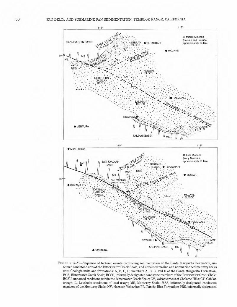
�����
50� FAN DELTA AND SUBMARINE FAN SEDIMENTATION, TEMBLOR RANGE, CALIFORNIA
119° 118°
A. Middle Miocene (Luisian and Relizian,
SAN JOAQUIN BASIN�„. <\•,•c, 71'..:;. " ::S/IEFt - N • TEHACHAPI� approximately 14 Ma)° :::. ..: --' '' :‘RA..i.cc .,.. ,, , - BLOCK,. dotP” MSS" . �y.1 1/....,: •��."/ , �-. ,1 , ,, k / , -- �ec • MOJAVE- �\
35°
ii,v0 ,, 1 �,`,,./.�,-..„ ,�r \ , '- • I 1 ..._ -s-MSST/ ,, : \:.‘---�
...1 ' " - ,' _ _ •''.:7.i ;i.- t - It
: '��,.‘-I�I 1 - - - ... -e I it 1 1 M- -1 -::,t : ' ' — . I :IAVIE --- '— BLOCK
•— �NV �- I - '‘,. _ ,--- , NORTHERN; , -,- v�s, `, i , - - - ' - , ,--1 1 ,:, % - , , , GABILAN , , , : v'' s, v ; _- .-- 1 , ! , - ' - - , ,
' - ,- RANGE , -_-, k ./ , '-'��...1.,/ �, C - , _ I - r t i
,...,..„, ��k, - -____ „,,s, v __,.„\-- „... /,-, , .- , ' -- - ` .,, ,��, , ,-- - /—__%$,,.1 X • ,o , • o/ /". • j .,. \ ‘,.
PALMDALE• 1 t .., / • , , -- — , --- 1 — -e- • ' • • / ' I • ' ; il: : / / 7UNIA_N ,` :.> 7 :::, ,!, ` i•-"\ i,,.. , „..:: - i , _ , ' ,1 , BLOCK ' \ �, ' ‘ '\1,14, \ , , -��' ' - .'" '
• s ‘ : rii: , :' ::"..
:ii. 5NEWHAL11_•," ,- I/ ,‘ -, , .., ---,---/ 7 : , , ,, /‘ ,/ I.r��c), ::/.,,,,, ii2.., ;,...,,,).6;[S" ,T: ii i .:...4
\ I• VENTURA 5- ' , ,4-7 -....: ' CHOLAME HILLS
SALINAS BASIN� MS
119° 118° • McKITTRICK
‘is B. Late Miocene .. ,-•�/ - r • - (early Mohnian,x .. �- -
ON- •,16 6/ / ‘ approximately 11 Ma)SAN JOAQUIN�II ..•••,,,,�i�, ,, ( - -TAFT • BASIN�_,�,„„\.) -�',/' / SIERRAN - '
\IlY ' ‘ ,BLOCK , ,I, TEHACHAPI... .., qo ` ' 7 , 1 ,„, ‘ / r \ ,,..MSS ..MSS % • MS�il.....y .- • MOJAVE
i ; '-/ S /(' •,N\\)ac.t.'- \\
35° .. +,,t�/ r ;)NuEm GDNiso/...,:.,...7'.:.:„•;5, i ik..e .. ri ' / v/p,A2_,.;:),".-,/ .../NTIAI - 7ictvc.... .. ,_..• ,\ / / ,,i \••?.- ••....v.,..: -,-- ,f, <?•k•o ' • -, -;,- • •o ,...;.„.•,\ r o„; /,.., \ / r ..... .../.., . '_ ,�NORTHERN , • , •,, • .• • .- • S .. ..... •
GABILAN -� - . • , - _ RANGE I s MOJAVE— BLOCK/ —
i PV ,:,:)411 - `.�� 6 •
• \ / • • t • / •
-�•• � ` ,��///
5 -�SALINIAN'�/ I - 4 '.0,„„ -�„ `'�\ 5 / / BLOCK 1 `-, '�-, „`TF.,=k�/�'I
5 r • '" • - PALMDALE ' 1 1 51Z-7'
• 1 • • / — / • • •I / • / • ‘, • /
/ /‘' /
•
NEWHALL•� - CHOLAME - HILLS
SALINAS BASIN • VENTURA
FIGURE 51A-F.—Sequence of tectonic events controlling sedimentation of the Santa Margarita Formation, unnamed sandstone unit of the Bitterwater Creek Shale, and unnamed marine and nonmarine sedimentary rocks unit. Geologic units and formations: A, B, C, D, members A, B, C, and D of the Santa Margarita Formation; BCS, Bitterwater Creek Shale; BCSS, informally designated sandstone members of the Bitterwater Creek Shale; BCSU, unnamed sandstone unit in the Bitterwater Creek Shale; CV, volcanic rocks of Cholame Hills; GT, Gabilan trough; L, Leutholtz sandstone of local usage; MS, Monterey Shale; MSS, informally designated sandstone members of the Monterey Shale; NV, Neenach Volcanics; PR, Pancho Rico Formation; PRS, informally designated
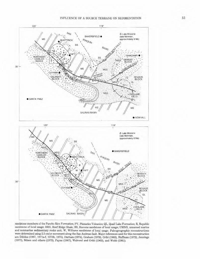
• •
������
� INFLUENCE OF A SOURCE TERRANE ON SEDIMENTATION 51
�120° 119°
SIIA/ C. Late Miocene BAKERSFIELD • (late Mohnian,
approximately 9 Ma)McKITTRICK�J0,1,„y(ifiv
SS \' o o + <4r -/ o o sips,
/ 0 0 - • \ ▪ , • —•••••
o R AFT` /,. TEHACHAPI •• NORTHERN':
GABILAN , W ) • .• • • SS�;•:'•••.- MSS/ t SIERRAN � _- / RANGE , BLOCK N\)\,'\ ‘•\�‘• ...•••..
350 I.• • •��.../•••:•:\I dist'j , , {..•‘‘ MSS�• c•�
I CUYAMA
_ , SALINIAN\ v E • r‘ k \4< • . MOJAVESI44„, 140.5 •
`.BLOCK�PV • BLOCK , 0171. •t�v'
, -„ _ v� _ •. • I: '
, • - •
/•-•‘,�� '
-1 - - - 7 :�• .- -�-If •.•; CHOLAME • — - - HILLS ' • SANTA YNEZ
MS
MS/SALINAS BASIN
• NEWHALL
120° 119°
D. Late Miocene (late Mohnian,
MS .•• approximately 8 Ma)
\ • • •• SS
: .. • BAKERSFIELDSAN
-- ' - GABILAN -i�, ` RANGE, ,1 ,--� McKITMIcK.: �\ 4- JOA.
- NORTHERN 4.--
• (-),.',WA/
‘ —
\ .• .\ . ss� ,...,-� _,..\-,--\\ ,�' / - - \14 •• �• -,- -\ SALINIANr� \••4! \'• ' ' • - i's• SIERRAN \ �BLOCK ... .. / I BLOCKs• 1.:� /:
\ —�\ ' t PV� I:, ,�, • .�•e- • •N': ----,•\, _- ,,,..., v vi.‘, ,..•:-..• .c ,-- ,' -1 --.- -•
35° N . • , , - • v• \ • 1JYAMAD:' •-..�%�-' MOJAVE
• / ' / I _ - ;BLOCK \' \ r - ::: r - ; ' r"-\\ _ ' • OL `.-- - ' o
. • •�1�NV�• •
.CHOLAME• .. .„...Hus -
//�• SANTA YNEZ SALINAS BASIN
sandstone members of the Pancho Rico Formation; PV, Pinnacles Volcanics; QL, Quail Lake Formation; R, Republic sandstone of local usage; RRS, Reef Ridge Shale; SS, Stevens sandstone of local usage; UMNS, unnamed marine and nonmarine sedimentary rocks unit; W, Williams sandstone of local usage. Paleogeographic reconstructions were determined using 2.5 cm/yr movement along the San Andreas fault. Major references used for this reconstruction are Dibblee (1967, 1971a-f, 1973b, 1975), Durham (1974), Graham (1978), Gribi (1963), Huffman (1972), Jennings (1977), Nilsen and others (1973), Payne (1967), Walrond and Gribi (1963), and Webb (1981).
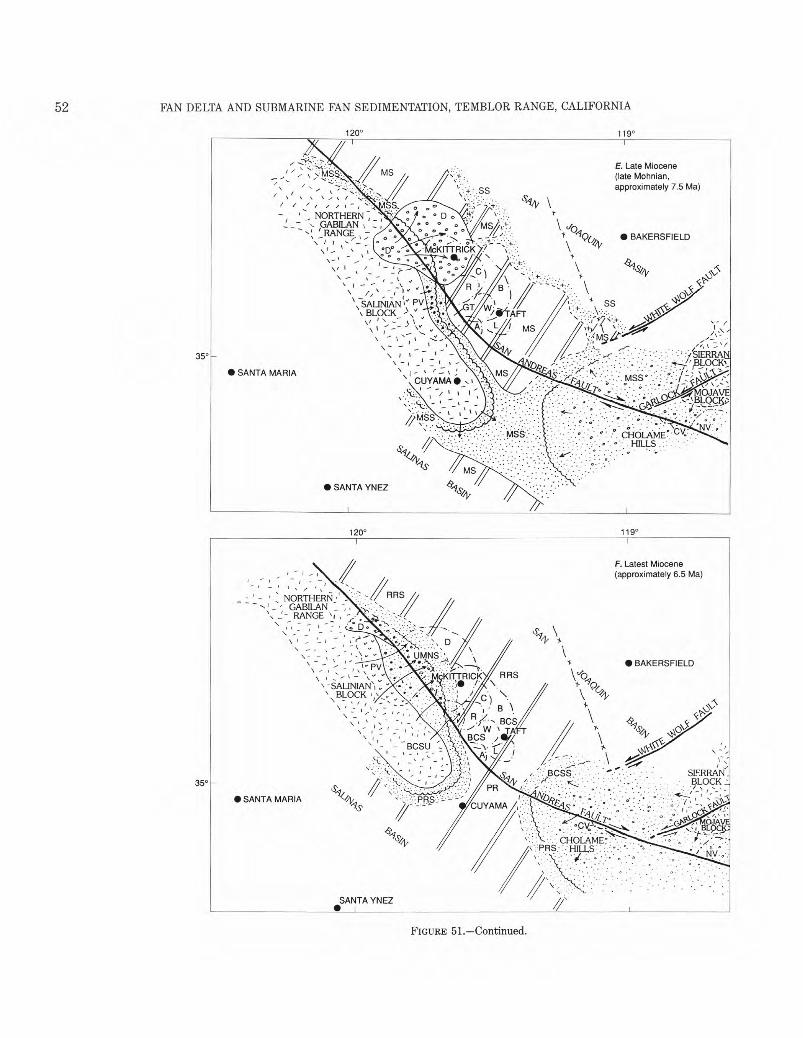
52� FAN DELTA AND SUBMARINE FAN SEDIMENTATION, TEMBLOR RANGE, CALIFORNIA
120° 119°
- -s E. Late Miocene
- , >1:1§..,.,. (late Mohnian, , -
,:**--..1::•::. approximately 7.5 Ma)\ ' :7, - • • f , ... , ..." , I
' " 1 , , l - ,
i .._. NORTHERN , ,�� 0 D .,�; '�v, _1 _- ‘• GABILAN \ : S�
- ,'‘ ' RANGE ,� * c,�* '� ..--'s • . •
\' ....,� a�McKITTRICK ?, I oDp N.
. - t
', SALINIAN1 ,, 1-"V GT W1BLOCK_ ''-'‘ �� ,;iii'AFT v , • - , %� \• ,--,, -,-_- - V A• L ) MS
) s-,
35°
• SANTA MARIA
• SANTA YNEZ
120° 119°
F. Latest Miocene (approximately 6.5 Ma)
- ,
_ -�NORTHERN _�RRS
_ • GABILAN _ - RANGE \4
• -•
_ r \- - - '\ -
_ , - 1- PV -
-SALINIAN \ \
BLOCK
I r
\ I " - BCSU
C) B
'• BCS • W BCS TA
:--*
RRS
• BAKERSFIELD V./0
fi
\ x �8
qs \14(0
NOCC'
35° . .•
• SANTA MARIA 'vqs
SANTA YNEZ •
FIGURE 51.—Continued.
53 INFLUENCE OF A SOURCE TERRANE ON SEDIMENTATION�
EXPLANATION
Granitic rocks
V v VV v Volcanic rocks
Sandstone
Deep-water sandstone
Conglomeratic sandstone
▪•• Conglomerate—Composed of granitic rocks and flow-banded felsite
o 000 0 Conglomerate—Composed of granitic rocks,O 0 0 marble, and dark pelitic metamorphic rocks
Marine shale
Boundary of designated geologic feature—Dashed where approximately located
-X-- X - Approximate boundary between Franciscan assemblage basement rocks (west of line) and Sierran basement rocks (east of line)
—— — Concealed geologic feature
Shoreline—Crests facing landward; broken where uncertain
Direction of sediment transport
Fault—Dashed where approximately located. Arrows indicate relative horizontal movement
0 50 KILOMETERS III! II
FIGURE 51.—Continued.
of the present-day Cholame Hills (fig. 51D). Member D of the Santa Margarita Formation was
deposited about 7.5 Ma when the granitic basement of the northern Gabilan Range underwent renewed uplift (fig. 51E). The resultant depocenter was shifted about 25 to 30 km northwest of the member B depocenter and had a sediment volume that was equal to or greater than the sediment volume of the member B depocenter. Although member D is largely a first-generation deposit, some of its detritus was probably recycled from proximal deposits of member B preserved on the Salinian block. The absence of flow-banded felsite clasts in member D suggests that the Pinnacles volcanic field was effectively shielded from the northern Gabilan Range source terrane; conglomerate and sandstone units derived from the Pinnacles volcanic field during the time that member D was deposited were confined to the west margin of the Gabilan trough (fig. 51E). A significant amount of coarse sand derived from the northern Gabilan Range either bypassed or was reworked and deposited in the center of the San Joaquin basin. The broad marine shelf that connected the San Joaquin and Salinas basins was probably dominated by coarse clastic deposits at the time member D was being deposited, as were the Cholame Hills area (Huffman, 1972) and the western Mojave block (Dibblee, 1967). The major sources of these sandstone and conglomerate units were emergent parts of the Sierran and Mojave blocks and the south end of the Salinian block (fig. 51E).
Santa Margarita sedimentation ceased between 6.5 and 7 Ma (latest Mohnian) when the precipitous tectonic uplands in the northern Gabilan Range were removed by erosion and uplift of the Salinian block shifted southeastward to the Pinnacles volcanic terrane. The tectonic uplands in the Pinnacles terrane exhibited considerably less topographic relief with the adjacent sediment depocenter than the previous uplifts and consequently deposits derived from them were characterized by sandstone, shale, and minor conglomerate. A change from oblique slip to strike slip along the San Andreas fault and a cessation of major left-lateral slip along the Garlock and White Wolf faults were the probable causes of diminished uplift in the Salinian block. About 6.5 Ma a mixture of volcanic-rich detritus from the Pinnacles terrane and first-generation and recycled granitic detritus from adjacent parts of the Salinian block spilled across the Gabilan trough and buried parts of the Santa Margarita Formation beneath the unnamed sandstone unit of the Bitter-water Creek Shale and the unnamed marine and nonmarine sedimentary rocks unit (fig. 51F). The deposition of the unnamed marine and nonmarine sedimentary rocks unit and the partly correlative Etchegoin Forma-
54� FAN DELTA AND SUBMARINE FAN SEDIMENTATION, TEMBLOR RANGE, CALIFORNIA
tion may have lasted into the earliest Pliocene. The Bitter-water Creek Shale, Reef Ridge Shale, and Pancho Rico Formation of the San Joaquin and Salinas basins and the intervening shelf are deeper-water equivalents of one or more of the previously named clastic units and of non-marine sandstone and conglomeratic sandstone units in the Cholame Hills area (fig. 51F).
The events that followed the deposition of the Etchegoin Formation and the unnamed marine and nonmarine sedimentary rocks unit are not important to this study. Suffice it to say that after 5 Ma the San Joaquin, Paso Robles, and Tulare Formations were deposited in the southern Temblor Range and adjacent San Joaquin basin, and the northern Gabilan Range and Pinnacles Volcanics continued to be offset in a right-lateral sense along the San Andreas fault at a rate of approximately 2.5 cm/yr.
SUMMARY AND CONCLUSIONS
The Santa Margarita Formation (late Mohnian) of the southern Temblor Range evolved as a large fan delta and submarine fan complex whose source was an abruptly uplifted part of the Salinian block containing an 80- to 90-Ma granitic terrane and a 23.5-Ma volcanic terrane. These terranes are now located in the Gabilan Range and in the Pinnacles area of central California, respectively. Most of the cobble- and boulder-sized detritus derived from the uplifted Salinian block accumulated within 15 km of the source area in the Santa Margarita Formation. However, a significant quantity of the sand-sized detritus derived from the uplifted Salinian block bypassed the Santa Margarita depocenter, through large submarine channels, and accumulated between 25 and 35 km from the source area in the center of the San Joaquin basin as part of the Stevens sandstone. The Republic, Williams, and Leutholtz sandstones of the southern Temblor Range were also derived from the Salinian block, and although slightly older than the Santa Margarita Formation, they are considered to be part of the same depositional system.
The Santa Margarita Formation thickens eastward from about 500 m on the west side of the southern Temblor Range, to 800 m on the east side of the range, to 1,250 m in the subsurface between the eastern outcrop belt of the range and the Buena Vista Hills anticline. In general, the fan deltas are located along the west side of the southern Temblor Range and in the subsurface beneath the Elkhorn Plain, whereas the submarine fans are located along the east side of the range and in the adjacent subsurface. Most of the transitional deposits between the fan deltas and the submarine fans of the Santa Margarita Formation have been removed by erosion. Major lithofacies of the Santa Margarita Formation consist of (1) granite conglomerate with sandy matrix, (2) granite conglomerate with argillaceous sandy matrix,
(3) granite conglomerate with very large boulders and blocks, (4) granite and flow-banded felsite conglomerate with sandy matrix, (5) granite and flow-banded felsite conglomerate with argillaceous sandy matrix, (6) sandstone, and (7) silty sandstone.
The fan deltas are composed of subaerial topset beds and subaqueous foreset beds. Strata interpreted to be the subaerial topset beds of the fan deltas consist largely of conglomerate with thick to very thick horizontal beds that in general are internally massive and disorganized and matrix-supported clasts. The clay fraction in the matrix of the topset beds averages between 7 and 13 weight percent and commonly gives a greenish cast to the conglomerate units. Local thin beds of green and red shale are intercalated with the conglomerates. No marine macrofossils were found in the topset beds. Strata interpreted to be thick foreset beds are arranged in large-scale, low-angle, cross-stratified conglomerate and sandstone that internally are massive. These beds were deposited in water depths ranging from inner neritic to upper bathyal. The clay fraction in the matrix of the foreset beds averages between 3 and 6 weight percent and therefore is slightly lower than the weight percent of clay in the matrix of the topset beds. Abundant mollusks, such as Ostrea and Pecten, are present in the subaqueous foreset beds, but many have probably been displaced downslope from their original site of deposition.
The foreset beds of the fan deltas are locally cut by conglomerate- and sandstone-filled nested submarine channels, interpreted here to be submarine canyons. The canyons were probably initiated and perpetuated by major slumping events at the front of the fan delta and served as conduits through which coarse-grained detritus was transferred to the adjacent submarine fans. These submarine-canyon deposits, consisting of thick horizontal strata that internally are crudely normally graded and massive, are generally better stratified than the adjacent foreset-bed deposits. Commonly these strata are arranged in fining- and thinning-upward sequences. The weight percent of clay in the matrix of the submarine-canyon deposits is approximately the same as for the foreset-bed deposits.
Isolated and amalgamated conglomerate- and sandstone-filled channels that crop out on the east flank of the southern Temblor Range are interpreted to be proximal submarine-fan channel deposits. These channel-form deposits are characterized by thick, horizontal strata that are internally massive and normally graded. The normally graded beds contain division Ta and (locally) division Tb of the Bouma sequence; inverse to normally graded conglomerate beds are present locally. Commonly, the conglomerate and sandstone beds are arranged in fining- and thinning-upward sequences, representing gradual abandonment of the submarine channels. Sparse calcareous
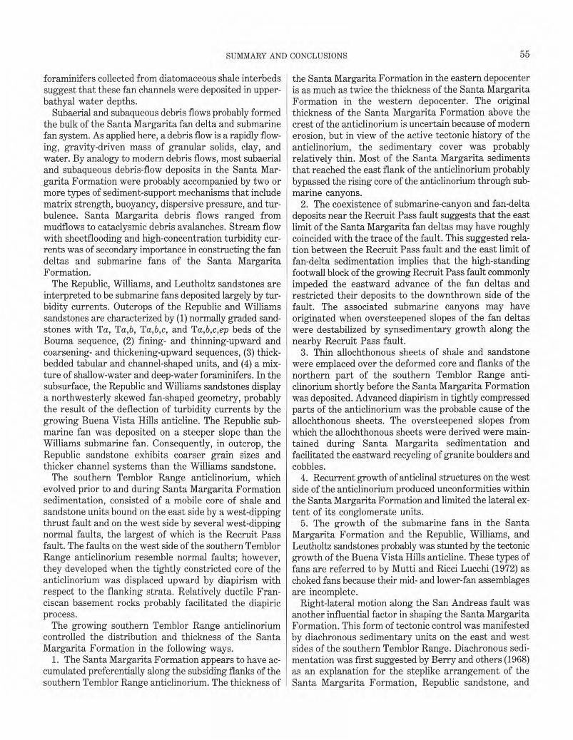
55 SUMMARY AND CONCLUSIONS�
foraminifers collected from diatomaceous shale interbeds suggest that these fan channels were deposited in upperbathyal water depths.
Subaerial and subaqueous debris flows probably formed the bulk of the Santa Margarita fan delta and submarine fan system. As applied here, a debris flow is a rapidly flowing, gravity-driven mass of granular solids, clay, and water. By analogy to modern debris flows, most subaerial and subaqueous debris-flow deposits in the Santa Margarita Formation were probably accompanied by two or more types of sediment-support mechanisms that include matrix strength, buoyancy, dispersive pressure, and turbulence. Santa Margarita debris flows ranged from mudflows to cataclysmic debris avalanches. Stream flow with sheetflooding and high-concentration turbidity currents was of secondary importance in constructing the fan deltas and submarine fans of the Santa Margarita Formation.
The Republic, Williams, and Leutholtz sandstones are interpreted to be submarine fans deposited largely by turbidity currents. Outcrops of the Republic and Williams sandstones are characterized by (1) normally graded sandstones with To, Ta,b, Ta,b,c, and Ta,b,c,ep beds of the Bouma sequence, (2) fining- and thinning-upward and coarsening- and thickening-upward sequences, (3) thick-bedded tabular and channel-shaped units, and (4) a mixture of shallow-water and deep-water foraminifers. In the subsurface, the Republic and Williams sandstones display a northwesterly skewed fan-shaped geometry, probably the result of the deflection of turbidity currents by the growing Buena Vista Hills anticline. The Republic submarine fan was deposited on a steeper slope than the Williams submarine fan. Consequently, in outcrop, the Republic sandstone exhibits coarser grain sizes and thicker channel systems than the Williams sandstone.
The southern Temblor Range anticlinorium, which evolved prior to and during Santa Margarita Formation sedimentation, consisted of a mobile core of shale and sandstone units bound on the east side by a west-dipping thrust fault and on the west side by several west-dipping normal faults, the largest of which is the Recruit Pass fault. The faults on the west side of the southern Temblor Range anticlinorium resemble normal faults; however, they developed when the tightly constricted core of the anticlinorium was displaced upward by diapirism with respect to the flanking strata. Relatively ductile Franciscan basement rocks probably facilitated the diapiric process.
The growing southern Temblor Range anticlinorium controlled the distribution and thickness of the Santa Margarita Formation in the following ways.
1. The Santa Margarita Formation appears to have accumulated preferentially along the subsiding flanks of the southern Temblor Range anticlinorium. The thickness of
the Santa Margarita Formation in the eastern depocenter is as much as twice the thickness of the Santa Margarita Formation in the western depocenter. The original thickness of the Santa Margarita Formation above the crest of the anticlinorium is uncertain because of modern erosion, but in view of the active tectonic history of the anticlinorium, the sedimentary cover was probably relatively thin. Most of the Santa Margarita sediments that reached the east flank of the anticlinorium probably bypassed the rising core of the anticlinorium through submarine canyons.
2. The coexistence of submarine-canyon and fan-delta deposits near the Recruit Pass fault suggests that the east limit of the Santa Margarita fan deltas may have roughly coincided with the trace of the fault. This suggested relation between the Recruit Pass fault and the east limit of fan-delta sedimentation implies that the high-standing footwall block of the growing Recruit Pass fault commonly impeded the eastward advance of the fan deltas and restricted their deposits to the downthrown side of the fault. The associated submarine canyons may have originated when oversteepened slopes of the fan deltas were destabilized by synsedimentary growth along the nearby Recruit Pass fault.
3. Thin allochthonous sheets of shale and sandstone were emplaced over the deformed core and flanks of the northern part of the southern Temblor Range anticlinorium shortly before the Santa Margarita Formation was deposited. Advanced diapirism in tightly compressed parts of the anticlinorium was the probable cause of the allochthonous sheets. The oversteepened slopes from which the allochthonous sheets were derived were maintained during Santa Margarita sedimentation and facilitated the eastward recycling of granite boulders and cobbles.
4. Recurrent growth of anticlinal structures on the west side of the anticlinorium produced unconformities within the Santa Margarita Formation and limited the lateral extent of its conglomerate units.
5. The growth of the submarine fans in the Santa Margarita Formation and the Republic, Williams, and Leutholtz sandstones probably was stunted by the tectonic growth of the Buena Vista Hills anticline. These types of fans are referred to by Mutti and Ricci Lucchi (1972) as choked fans because their mid- and lower-fan assemblages are incomplete.
Right-lateral motion along the San Andreas fault was another influential factor in shaping the Santa Margarita Formation. This form of tectonic control was manifested by diachronous sedimentary units on the east and west sides of the southern Temblor Range. Diachronous sedimentation was first suggested by Berry and others (1968) as an explanation for the steplike arrangement of the Santa Margarita Formation, Republic sandstone, and
56� FAN DELTA AND SUBMARINE FAN SEDIMENTATION, TEMBLOR RANGE, CALIFORNIA
Williams sandstone on the east side of the southern Temblor Range. According to Berry and others (1968), these deposits were shed from a source in the Pinnacles volcanic area as it moved northward past the southern Temblor Range.
The diachronous arrangement of member A (oldest) through member D (youngest) in the Santa Margarita Formation provides additional evidence in support of the contemporaneity of San Andreas fault movement and Santa Margarita sedimentation. On the east side of the southern Temblor Range, members B and C of the Santa Margarita Formation occupy progressively higher stratigraphic levels toward the northwest, and in a given stratigraphic sequence the conglomerates in member C (characterized by flow-banded felsite clasts) are always located above the conglomerates in member B (characterized by granitic and metamorphic clasts). Similarly, on the west side of the southern Temblor Range, members A through D and the unnamed marine and nonmarine sedimentary rocks unit were deposited from southeast to northwest as successively younger sediment wedges.
The source terranes of the Santa Margarita Formation underwent approximately 295 km of post-early Saucesian and approximately 200 km of post-late Miocene lateral separation along the San Andreas fault (Huffman, 1972).
The influence of a laterally shifting source terrane on sedimentation is not unique to the Santa Margarita Formation and related units. Conglomerates with a depositional history similar to the Santa Margarita conglomerates have been documented by Crowell (1952, 1974) in several southern California basins. Other examples of a laterally shifting source terrane probably exist but are obscured by homogeneous lithology and(or) scarce paleontologic data. A shifting-source model, which requires a different configuration of depositional facies than a stationary- source model, should at least be considered as an alternate hypothesis in areas where strike-slip faulting is suspected.
Regional geologic factors that helped focus conglomeratic sedimentation in the southern Temblor Range locale for 2- to 3-m.y. in the late Mohnian were right-lateral oblique slip on the San Andreas fault, formation of the "big bend" in the San Andreas fault by left-lateral slip along the Garlock and White Wolf faults, and partial tectonic overlap of the Salinian and Franciscan basement rocks in the southernmost San Joaquin basin.
REFERENCES CITED
Addicott, W.O., 1968, Mid-Tertiary zoogeographic and paleogeographic discontinuities across the San Andreas fault, California, in Dickinson, W.P., and Grants, Arthur, eds., Proceedings of conference on geologic problems of San Andreas fault system, Stanford University Publications, Geological Sciences, v. XI, p. 144-165.
�1972, Provincial middle and late Tertiary molluscan stages, Temblor Range, California, in Proceedings of Pacific Coast Miocene Biostratigraphic Symposium: 47th Annual Pacific Coast Society of Economic Paleontologists and Mineralogists Meeting (March 9-10, 1972, Bakersfield) p. 1-26.
Armstrong, R.L., and Suppe, John, 1973, Potassium-argon geochronology of Mesozoic igneous rocks in Nevada, Utah, and southern California: Geological Society of America Bulletin, v. 84, no. 4. p. 1375-1392.
Atwater, Tanya, 1970, Implications of plate tectonics for the Cenozoic tectonic evolution of western North America: Geological Society of America Bulletin, v. 81, no. 12, p. 3513-3536.
Bailey, E.H., Irwin, W.P., and Jones, D.L., 1964, Franciscan and related rocks and their significance in the geology of western California: California Division of Mines and Geology Bulletin 183, p. 1- 177.
Bandy, O.L., and Arnal, R.E., 1969, Middle Tertiary basin development, San Joaquin Valley, California: Geological Society of America Bulletin, v. 80, no. 5, p. 783-820.
Bandy, O.L., and Ingle, J.C. Jr., 1970, Neogene planktonic events and radiometric scale, California, in Bandy, O.L., ed., Radiometric dating and paleontologic zonation: Geological Society of America Special Paper 124, p. 131-172.
Barbat, W.F., and Weymouth, A.A., 1931, Stratigraphy of the Borophagus littoralis locality, California: University of California Publications, Bulletin of the Department of Geological Sciences, v. 21, no. 3, p. 25-36.
Beaty, C.A., 1970, Age and estimated rate of accumulation of an alluvial fan, White Mountains, California, U.S.A.: American Journal of Science, v. 268, no. 1, p. 50-77.
Berry, F.A.F., Huffman, 0.F., and Turner, D.L., 1968, Post- Miocene movement along the San Andreas fault, California [abs.]: Geological Society of America Special Paper 101, p. 15.
Blackwelder, Eliot, 1928, Mudflow as a geologic agent in semiarid mountains: Geological Society of America Bulletin, v. 39, no. 2, p. 465-484.
Bouma, A.H., 1962, Sedimentology of some flysch deposits, a graphic approach to facies interpretation: Amsterdam, Elsevier, 168 p.
Bull, W.B., 1972, Recognition of alluvial-fan deposits in the stratigraphic record, in Rigby, J.K., and Hamblin, W.K., eds., Recognition of ancient sedimentary environments: Society of Economic Paleontologists and Mineralogists Special Publication 16, p. 63-83.
Burke, Kevin, 1967, The Yallahs basin: a sedimentary basin southeast of Kingston, Jamaica: Marine Geology, v. 5, no. 1, p. 45-60.
Cady, J.W., 1975, Magnetic and gravity anomalies in the Great Valley and western Sierra Nevada metamorphic belt, California: Geological Society of America Special Paper 168, 156 p.
Callaway, D.C., 1962, Distribution of upper Miocene sands and their relation to production in the north Midway area, Midway-Sunset field, California: San Joaquin Geological Society Selected Papers, v. 1, p. 47- 55.
Carter, Bruce, 1971, Quaternary displacement on the Garlock fault, California [abs.]: Eos (American Geophysical Union Transactions), v. 52, no. 1, p. 350. �1980, Possible Pliocene inception of lateral displacement on the
Garlock fault, California [abs.]: Geological Society of America Abstracts with Programs, v. 12, no. 3, p. 101.
Cox, B.F., 1979, Early Paleogene laterite and debris-flow deposits, El Paso Mountains, California [abs.]: Geological Society of America Abstracts with Programs, v. 11, no. 3, p. 73-74.
Crowell, J.C., 1952, Probable large lateral displacement on the San Gabriel fault, southern California: American Association of Petroleum Geologists Bulletin, v. 36, no. 10, p. 2026-2035. �1957, Origin of pebbly mudstones: Geological Society of America
Bulletin, v. 68, no. 8, p. 993-1010. �1962, Displacement along the San Andreas fault, California:
Geological Society of America Special Paper 71, 61 p. �1974, Sedimentation along the San Andreas fault, California, in
57 �
REFERENCES CITED
Dott, R.H., Jr., and Shaver, R.H., eds., Modern and ancient geosynclinal sedimentation: Society of Economic Paleontologists and Mineralogists Special Publication 19, p. 292-303. �1975, The San Andreas fault in southern California, in Crowell,
J.C., ed., San Andreas fault in southern California-a guide to San Andreas fault from Mexico to Carrizo Plain: California Division of Mines and Geology Special Report 118, p. 7-27.
Curry, R.R., 1966, Observations of alpine mud flows in the Tenmile Range, central Colorado: Geological Society of American Bulletin, v. 77, no. 7, p. 771-776.
Davis, G.A., and Burchfiel, B.C., 1973, Garlock fault: an intracontinental transform structure, southern California: Geological Society of America Bulletin, v. 84, no. 4, p. 1407-1422.
Dibblee, T.W., Jr., 1962, Displacements on the San Andreas rift zone and related structures in Carrizo Plain and vicinity, in Guidebook to the geology of Carrizo Plain and San Andreas fault, San Joaquin Geological Society and Pacific Sections American Association of Petroleum Geologists and Society of Economic Paleontologists and Mineralogists: p. 5-12, pl. 1. �1966, Evidence for cumulative offset on the San Andreas fault
in central and northern California, in Bailey, E .H., ed., Geology of northern California: California Division of Mines and Geology Bulletin 190, p. 375-384. �1967, Areal geology of the western Mojave Desert, California
(Kern, Los Angeles, and San Bernardino Counties): U.S. Geological Survey Professional Paper 522, 153 p. �1968, Geologic map of the Temblor Range, San Luis Obispo and
Kern Counties, California, in Guidebook to geology and oil fields of west side southern San Joaquin Valley: American Association of Petroleum Geologists and Society of Economic Paleontologists and Mineralogists, Pacific Section, in pocket. �1971a, Geologic map of the Greenfield quadrangle, California:
U.S. Geological Survey Open-File Report, scale 1:62,500. �1971b, Geologic map of the Hernandez Valley quadrangle, Califor
nia: U.S. Geological Survey Open-File Report, scale 1:62,500. �1971c, Geologic map of the Parkfield quadrangle, California: U.S.
Geological Survey Open-File Report, scale 1:62,500 �1971d, Geologic map of the Priest Valley quadrangle, California:
U.S. Geological Survey Open-File Report, scale 1:62,500. 1971e, Geologic map of the San Ardo quadrangle, California: U.S.
Geological Survey Open-File Report, scale 1:62,500. �1971f, Geologic map of the San Miguel quadrangle, California:
U.S. Geological Survey Open-File Report, scale 1:62,500. �1973a, Stratigraphy of the southern Coast Ranges near the San
Andreas fault from Cholame to Maricopa, California: U.S. Geological Survey Professional Paper 764, 45 p. �1973b, Regional geologic map of San Andreas and related faults
in Carrizo Plain, Temblor, Caliente, and La Panza Ranges and vicinity, California: U.S. Geological Survey Miscellaneous Geological Investigations Map 1-757. �1975, Geologic map of the San Benito quadrangle, California: U.S.
Geological Survey Open-File Report 75-394, scale 1:62,500. Dickinson, W.R., 1983, Cretaceous sinistral strike slip along Nacimiento
fault in coastal California: American Association of Petroleum Geologists Bulletin, v. 67, no. 4, p. 624-645.
Durham, D.L., 1974, Geology of the southern Salinas Valley area, California: U.S. Geological Survey Professional Paper 819, 111 p.
Ehlert, K.W., 1982, Basin analysis of the Miocene Mint Canyon Formation, southern California, in Ingersoll, R. V. and Woodburne, M.O., eds., Cenozoic nonmarine deposits of California and Arizona: Society of Economic Paleontologists and Mineralogists, Pacific section, p. 51-64.
Ehlig, P.L., Ehlert, K.W., and Crowe, B.M., 1975, Offset of upper Miocene Caliente and Mint Canyon Formations along the San Gabriel and San Andreas faults, in Crowell, J.C., ed., San Andreas fault
in southern California-a guide to San Andreas fault from Mexico to Carrizo Plain: California Division of Mines and Geology Special Report 118, p. 83-92.
Elliott, Trevor, 1978, Deltas, in Reading, H.G., ed., Sedimentary environments and facies: New York, Elsevier, p. 97-142.
Ericksen, G.E., Plafker, George, and Concha, J.F., 1970, Preliminary report on the geologic events associated with the May 31, 1970, Peru earthquake: U.S. Geological Survey Circular 629, 25 p.
Evernden, J.F., Savage, D.E., Curtis, G.H., and James, G.T., 1964, Potassium-argon dates of the Cenozoic mammalian chronology of North America: American Journal of Science, v. 262, no. 2, p. 145-198.
Fletcher, G.L., 1962, The Recruit Pass area of the Temblor Range, San Luis Obispo and Kern Counties, California, in Geology of Carrizo Plains and San Andreas fault: San Joaquin Geological Society Field Trip Guidebook, p. 16-20. �1967, Post late Miocene displacement along the San Andreas fault
zone, central California, in Guidebook to the Gabilan Range and adjacent San Andreas fault: American Association of Petroleum Geologists, Society of Economic Paleontologists and Mineralogists, Pacific Section, p. 74-80.
Foss, C.D., and Blaisdell, Robert, 1968, Stratigraphy of the west side of southern San Joaquin Valley, in Guidebook to geology and oil fields of west side southern San Joaquin Valley, American Association of Petroleum Geologists, Society of Economic Geophysicists, and Society of Economic Paleontologists and Mineralogists, Pacific Sections, Annual Field Trip, 1968, p. 33-43.
Gilbert, G.K., 1885, The topographic features of lake shores: Fifth Annual Report, U.S. Geological Survey, p. 69-123. �1890, Lake Bonneville: U.S. Geological Survey Monograph 1,
438 p. Graham, S.A., 1978, Role of Salinian block in evolution of the San
Andreas fault system, California: American Association of Petroleum Geologists Bulletin, v. 62, no. 11, p. 2214-2231.
Gribi, E.A., Jr., 1963, Salinas Basin oil province, in Guidebook to the geology of the Salinas Valley and the San Andreas Fault: American Association of Petroleum Geologists and Society of Economic Paleontologists and Mineralogists, Pacific Section, p. 16- 27.
Hamilton, Warren, 1969, Mesozoic California and the underflow of Pacific mantle: Geological Society of America Bulletin, v. 80, no. 12, p. 2409-2430. �1978, Mesozoic tectonics of the western United States, in Meso
zoic Paleogeography of the western United States, Pacific Coast Paleogeography Symposium 2: Society of Economic Paleontologists and Mineralogists, Pacific Section, p. 33-70.
Hampton, M.A., 1972, The role of subaqueous debris flow in generating turbidity currents: Journal of Sedimentary Petrology, v. 42, no. 4, p. 775-793. �1975, Competence of fine-grained debris flows: Journal of Sedi
mentary Petrology, v. 45, no. 4, p. 834-844. �1979, Buoyancy in debris flows: Journal of Sedimentary Petrol
ogy, v. 49, no. 3, p. 753-758. Harding, T.P., 1976, Tectonic significance and hydrocarbon trapping
consequences of sequential folding synchronous with San Andreas faulting, San Joaquin Valley, California: American Association of Petroleum Geologists Bulletin, v. 60, no. 3, p. 356-378.
Heward, A.P., 1978, Alluvial fan sequence and megasequence models, with examples from Westphalian D-Stephanian B coalfields, northern Spain, in Miall, A.D., ed., Fluvial sedimentology: Canadian Society of Petroleum Geologists Memoir 5, p. 669-702.
Hill, M.L., and Dibblee, T.W., Jr., 1953, San Andreas, Garlock, and Big Pine faults, California-a study of the character, history, and tectonic significance of their displacements: Geological Society of America Bulletin, v. 64, no. 4, p. 443-458.
Holmes, Arthur, 1965, Principles of physical geology: New York, Ronald
58� FAN DELTA AND SUBMARINE FAN SEDIMENTATION, TEMBLOR RANGE, CALIFORNIA
Press Company, 1288 p. Houbolt, J.J.H.C., and Jonker, J.B.M., 1968, Recent sediments in the
eastern part of the Lake of Geneva (Lac Leman): Geologie Mijnbouw, v. 47, no. 2, p. 131-148.
Howell, D.G., and Link, M.H., 1979, Eocene conglomerate sedimentology and basin analysis, San Diego and the southern California borderland: Journal of Sedimentary Petrology, v. 49, no. 2, p. 517-540.
Howell, D.G., McLean, Hugh, and Vedder, J.G., 1980, Late Cretaceous suturing and translation of the Salinian and Nacimiento blocks, California [abs.]: Eos (American Geophysical Union Transactions), v. 61, no. 46, p. 948.
Howell, D.G. and Normark, W.R., 1982, Sedimentology of submarine fans, in Scholle, P.A., and Spearing, Darwin, eds., Sandstone depositional environments: American Association of Petroleum Geologists Memoir 31, p. 365-404.
Hudson, F.S., and White, G.H., 1941, Thrust faulting and coarse clastics in the Temblor Range, California: American Association of Petroleum Geologists Bulletin, v. 25, no. 7, p. 1327-1342.
Huffman, O.F., 1970, Miocene and post-Miocene offset on the San Andreas fault in central California [abs.]: Geological Society of America Bulletin, Abstracts with Programs (Cordilleran Section), v. 2, no. 2, p. 104-105. �1972, Lateral displacement of upper Miocene rocks and the
Neogene history of offset along the San Andreas fault in central California: Geological Society of America Bulletin, v. 83, no. 10, p. 2913-2946.
Huffman, O.F., Turner, D.L., and Jack, R.N., 1973, Offset of late Oligocene- early Miocene volcanic rocks along the San Andreas fault in central California, in Kovack, R.L., and Nur, Amos, eds., Proceedings of the conference on tectonic problems of the San Andreas fault system, Stanford University Publications, Geological Sciences, v. XIII, p. 368-373.
Jahns, R.H., 1949, Desert floods: Engineering and Science Monthly, California Institute of Technology, May, p. 10-14. �1973, Tectonic evolution of the Transverse Ranges province as
related to the San Andreas fault system, in Kovach, R.L., and Nur, Amos, eds., Proceedings on the conference on tectonic problems of the San Andreas fault system, Stanford University Publications, Geological Sciences, v. XIII, p. 149-170.
Jennings, C.W., compiler, 1977, Geologic map of California, scale 1:750,000: California Division of Mines and Geology, Geologic Map Series.
Johnson, A.M., 1965, A model for debris flow: University Park, Pennsylvania State University, Ph.D. dissertation, 205 p. �1970, Physical processes in Geology: San Francisco, Freeman,
Cooper, and Company, 577 p. Kleinpell, R.M., 1938, Miocene stratigraphy of California: Tulsa, Okla
homa, American Association of Petroleum Geologists, 450 p. Komar, P.D., 1969, The channelized flow of turbidity currents with ap
plication to Monterey deep-sea fan channel: Journal of Geophysical Research, v. 74, no. 18, p. 4544-4558. �1970, The competence of turbidity current flow: Geological Society
of America Bulletin, v. 81, no. 5, p. 1555-1562. Lohmar, J.M., May, J.A., Boyer, J.E., and Warme, J.E., 1979, Shelf
edge deposits of the San Diego embayment, in Abbott, P.L., ed., Eocene depositional systems San Diego, California, Society of Economic Paleontologists and Mineralogists, Pacific Section, p. 19-27.
Lowell, J.D., 1972, Spitsbergen Tertiary orogenic belt and the Spitsbergen fracture zone: Geological Society of America Bulletin, v. 83, no. 10, p. 3091-3102.
Matthews, Vincent, III, 1973, Pinnacles-Neenach correlation: a restriction for models of the Transverse Ranges and the big bend in the San Andreas fault: Geological Society of America Bulletin, v. 84, no. 2, p. 683-688.
�1976, Correlation of Pinnacles and Neenach volcanic formations and their bearing on San Andreas fault problem: American Association of Petroleum Geologists Bulletin, v. 60, no. 12, p. 2128-2141.
McGowen, J.H., 1970, Gum Hollow fan delta, Nueces Bay, Texas: Texas University Bureau of Economic Geology Report of Investigation 69, 91 p.
Menard, H.W., 1955, Deep sea channels, topography, and sedimentation: American Association of Petroleum Geologists Bulletin, v. 39, no. 2, p. 236-255.
Middleton, G.V., and Hampton, M.A., 1973, Sediment gravity flows: mechanisms of flow and deposition, in Middleton, G.V., and Bouma, A.H., co-chairmen, Turbidites and deep-water sedimentation: Society of Economic Paleontologists and Mineralogists Pacific Section, p. 1-38.
Mutti, Emilliano, and Ricci Lucchi, Franco, 1972, Le torbiditi dell'Appenino settentrionale: introduzione all'analisi di facies: Memoires della Societa Geologica Italiana, v. 11, p. 161-199. (Translated by Nilsen, T.H., 1978, Turbidites of the northern Appennines: Introduction to facies analysis, American Geological Institute Reprint Series 3, reprinted from International Geology Review, v. 20, no. 2, p. 125-166.)
Nelson, C.H., and KuIm, L.D., 1973, Submarine fans and deep-sea channels, in Middleton, G.V., and Bouma, A.H., co-chairmen, Turbidites and deep-water sedimentation: Society of Economic Paleontologists and Mineralogists, Pacific Section, p. 39-78.
Nilsen, T.H., 1982, Alluvial fan deposits, in Scholle, P.A., and Spearing, Darwin, eds., Sandstone depositional environments: American Association of Petroleum Geologists Memoir 31, p. 49-86.
Nilsen, T.H., and Clarke, S.H., 1975, Sedimentation and tectonics in the early Tertiary continental borderland of central California: U.S. Geological Survey Professional Paper 925, 64 p.
Nilsen, T.H., Dibblee, T.W., Jr., and Addicott, W.O., 1973, Lower and middle Tertiary stratigraphic units of the San Emigdio and western Tehachapi Mountains, California: U.S. Geological Survey Bulletin 1372-H, 23 p.
Normark, W.R., 1970, Growth patterns of deep-sea fans: American Association of Petroleum Geologists Bulletin, v. 54, no. 11, p. 21702195. �1978, Fan valleys, channels and depositional lobes on modern sub
marine fans: characters for recognition of sandy turbidite environments: American Association of Petroleum Geologists Bulletin, v. 62, no. 6, p. 912-931.
Normark, W.R., and Dickson, F.H., 1976, Sublacustrine fan morphology in Lake Superior: American Association of Petroleum Geologists Bulletin, v. 60, no. 7, p. 1021-1036.
Obradovich, J.D., and Naeser, C.W., 1981, Geochronology bearing on the age of the Monterey Formation and siliceous rocks in California, in The Monterey Formation and related siliceous rocks of California: Society of Economic Paleontologists and Mineralogists, Pacific Section, p. 87- 95.
Pacific Section of AAPG-SEG-SEPM, 1968, Guidebook to geology and oil fields of west side southern San Joaquin Valley: Annual Field Trip of American Association of Petroleum Geologists, Society of Exploration Geophysicists, and Society of Economic Paleontologists and Mineralogists, Pacific Section, 85 p.
Page, B.M., 1982, Migration of Salinian composite block, California and disappearance of fragments: American Journal of Science, v. 282, p. 1694-1734.
Payne, M.B., compiler, 1967, San Andreas fault cross sections, east and west longitudinal cross sections parallel to the San Andreas fault and east-to-west cross sections across the San Andreas fault, California: American Association of Petroleum Geologists, Pacific Section, various scales.
Pierson, T.C., 1981, Dominant particle support mechanisms in debris flows at Mt. Thomas, New Zealand, and implications for flow
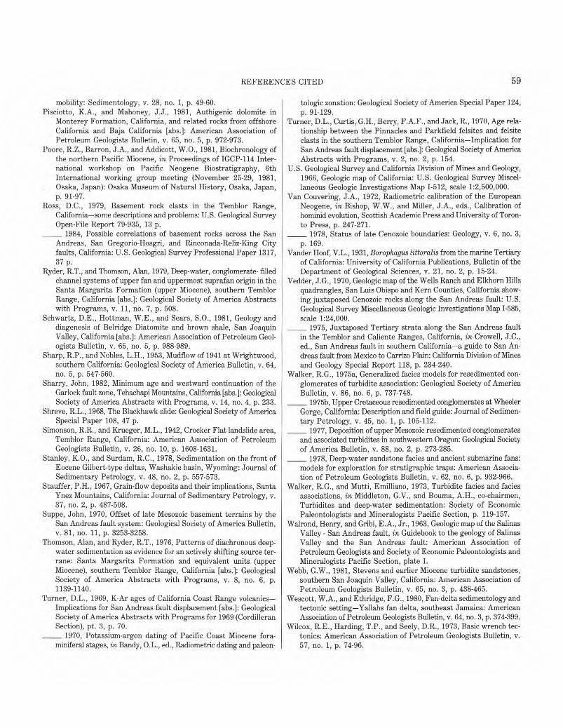
59 �
REFERENCES CITED
mobility: Sedimentology, v. 28, no. 1, p. 49-60. Pisciotto, K.A., and Mahoney, J.J., 1981, Authigenic dolomite in
Monterey Formation, California, and related rocks from offshore California and Baja California [abs.]: American Association of Petroleum Geologists Bulletin, v. 65, no. 5, p. 972-973.
Poore, R.Z., Barron, J.A., and Addicott, W.O., 1981, Biochronology of the northern Pacific Miocene, in Proceedings of IGCP-114 International workshop on Pacific Neogene Biostratigraphy, 6th International working group meeting (November 25-29, 1981, Osaka, Japan): Osaka Museum of Natural History, Osaka, Japan, p. 91-97.
Ross, D.C., 1979, Basement rock clasts in the Temblor Range, California-some descriptions and problems: U.S. Geological Survey Open-File Report 79-935, 13 p. �1984, Possible correlations of basement rocks across the San
Andreas, San Gregorio-Hosgri, and Rinconada-Reliz-King City faults, California: U.S. Geological Survey Professional Paper 1317, 37 p.
Ryder, R.T., and Thomson, Alan, 1979, Deep-water, conglomerate- filled channel systems of upper fan and uppermost suprafan origin in the Santa Margarita Formation (upper Miocene), southern Temblor Range, California [abs.]: Geological Society of America Abstracts with Programs, v. 11, no. 7, p. 508.
Schwartz, D.E Hottman, W.E., and Sears, S.O., 1981, Geology and diagenesis of Belridge Diatomite and brown shale, San Joaquin Valley, California [abs.]: American Association of Petroleum Geologists Bulletin, v. 65, no. 5, p. 988-989.
Sharp, R.P., and Nobles, L.H., 1953, Mudflow of 1941 at Wrightwood, southern California: Geological Society of America Bulletin, v. 64, no. 5, p. 547-560.
Sharry, John, 1982, Minimum age and westward continuation of the Garlock fault zone, Tehachapi Mountains, California [abs.]: Geological Society of America Abstracts with Programs, v. 14, no. 4, p. 233.
Shreve, R.L., 1968, The Blackhawk slide: Geological Society of America Special Paper 108, 47 p.
Simonson, R.R., and Krueger, M.L., 1942, Crocker Flat landslide area, Temblor Range, California: American Association of Petroleum Geologists Bulletin, v. 26, no. 10, p. 1608-1631.
Stanley, K.O., and Surdam, R.C., 1978, Sedimentation on the front of Eocene Gilbert-type deltas, Washakie basin, Wyoming: Journal of Sedimentary Petrology, v. 48, no. 2, p. 557-573.
Stauffer, P.H., 1967, Grain-flow deposits and their implications, Santa Ynez Mountains, California: Journal of Sedimentary Petrology, v. 37, no. 2, p. 487-508.
Suppe, John, 1970, Offset of late Mesozoic basement terrains by the San Andreas fault system: Geological Society of America Bulletin, v. 81, no. 11, p. 3253-3258.
Thomson, Alan, and Ryder, R.T., 1976, Patterns of diachronous deepwater sedimentation as evidence for an actively shifting source terrane: Santa Margarita Formation and equivalent units (upper Miocene), southern Temblor Range, California [abs.]: Geological Society of America Abstracts with Programs, v. 8, no. 6, p. 1139-1140.
Turner, D.L., 1969, K-Ar ages of California Coast Range volcanics-Implications for San Andreas fault displacement [abs.]: Geological Society of America Abstracts with Programs for 1969 (Cordilleran Section), pt. 3, p. 70. �1970, Potassium-argon dating of Pacific Coast Miocene fora
miniferal stages, in Bandy, 0.L., ed., Radiometric dating and paleon-
tologic zonation: Geological Society of America Special Paper 124, p. 91-129.
Turner, D.L., Curtis,,G.H., Berry, F.A.F., and Jack, R., 1970, Age relationship between the Pinnacles and Parkfield felsites and felsite clasts in the southern Temblor Range, California-Implication for San Andreas fault displacement [abs.]: Geological Society of America Abstracts with Programs, v. 2, no. 2, p. 154.
U.S. Geological Survey and California Division of Mines and Geology, 1966, Geologic map of California: U.S. Geological Survey Miscellaneous Geologic Investigations Map 1-512, scale 1:2,500,000.
Van Couvering, J.A., 1972, Radiometric calibration of the European Neogene, in Bishop, W.W., and Miller, J.A., eds., Calibration of hominid evolution, Scottish Academic Press and University of Toronto Press, p. 247-271. �1978, Status of late Cenozoic boundaries: Geology, v. 6, no. 3,
p. 169. Vander Hoof, V.L., 1931, Borophagus littoralis from the marine Tertiary
of California: University of California Publications, Bulletin of the Department of Geological Sciences, v. 21, no. 2, p. 15-24.
Vedder, J.G., 1970, Geologic map of the Wells Ranch and Elkhorn Hills quadrangles, San Luis Obispo and Kern Counties, California showing juxtaposed Cenozoic rocks along the San Andreas fault: U.S. Geological Survey Miscellaneous Geologic Investigations Map 1-585, scale 1:24,000. �1975, Juxtaposed Tertiary strata along the San Andreas fault
in the Temblor and Caliente Ranges, California, in Crowell, J.C., ed., San Andreas fault in southern California-a guide to San Andreas fault from Mexico to Carrizo Plain: California Division of Mines and Geology Special Report 118, p. 234-240.
Walker, R.G., 1975a, Generalized facies models for resedimented conglomerates of turbidite association: Geological Society of America Bulletin, v. 86, no. 6, p. 737-748. �1975b, Upper Cretaceous resedimented conglomerates at Wheeler
Gorge, California: Description and field guide: Journal of Sedimentary Petrology, v. 45, no. 1, p. 105-112. �1977, Deposition of upper Mesozoic resedimented conglomerates
and associated turbidites in southwestern Oregon: Geological Society of America Bulletin, v. 88, no. 2, p. 273-285. �1978, Deep-water sandstone facies and ancient submarine fans:
models for exploration for stratigraphic traps: American Association of Petroleum Geologists Bulletin, v. 62, no. 6, p. 932-966.
Walker, R.G., and Mutti, Emilliano, 1973, Turbidite facies and facies associations, in Middleton, G.V., and Bouma, A.H., co-chairmen, Turbidites and deep-water sedimentation: Society of Economic Paleontologists and Mineralogists Pacific Section, p. 119-157.
Walrond, Henry, and Gribi, E.A., Jr., 1963, Geologic map of the Salinas Valley - San Andreas fault, in Guidebook to the geology of Salinas Valley and the San Andreas fault: American Association of Petroleum Geologists and Society of Economic Paleontologists and Mineralogists Pacific Section, plate I.
Webb, G.W., 1981, Stevens and earlier Miocene turbidite sandstones, southern San Joaquin Valley, California: American Association of Petroleum Geologists Bulletin, v. 65, no. 3, p. 438-465.
Wescott, W.A., and Ethridge, F.G., 1980, Fan-delta sedimentology and tectonic setting-Yallahs fan delta, southeast Jamaica: American Association of Petroleum Geologists Bulletin, v. 64, no. 3, p. 374-399.
Wilcox, R.E., Harding, T.P., and Seely, D.R., 1973, Basic wrench tectonics: American Association of Petroleum Geologists Bulletin, v. 57, no. 1, p. 74-96.

GPO 685-041 /9787