taxonomic justification of the landscape factor in land use
TRANSCRIPT

Area: Environment
―Selected Proceedings from the 13th International Congress on Project Engineering‖. (Badajoz, July 2009)
TAXONOMIC JUSTIFICATION OF THE LANDSCAPE FACTOR IN
LAND USE
Garraín, D.
Cebrián-Tarrasón, D.
Vidal, R.
GID, Grupo de Ingeniería del Diseño, Dpto. Ingeniería Mecánica y Construcción, Universitat Jaume I de Castellón (Spain)
Abstract
Land use by human beings is the main direct cause of many of the impacts brought about by production systems. The term land use has traditionally been employed to refer to a classification of human activities that involve the modification of an area of land. In the field of LCA (Life-Cycle Assessment), this term or the impact of land use have been utilised to refer to environmental impacts due to occupation and physical transformation of areas of land.
Some authors have carried out inventories of the methods that attempt to analyse and to evaluate this kind of impact. The general rule that they have followed in order to distinguish among the main impacts that land use entails has been to consider biodiversity and land fertility as the two aspects that are most badly damaged.
In this article the justification for including a new factor is presented in order to analyse the regionalization of land use impact using a taxonomy based on the SUMO (Suggested Upper Merged Ontology).
Keywords: LCA, land use, taxonomy
Introduction
Land use by human beings is the main direct cause of many of the impacts brought about by production systems. It is widely agreed that this is the main cause of degradation of biological diversity, and also that its inappropriate management is one of the main factors leading to the reduction in the land's capacity for biological production (Milà i Canals, 2007a).
The term land use has traditionally been employed to refer to a classification of human activities that involve the modification of an area of land. Within the field of Life-Cycle Assessment (LCA), this term or the impact of land use have been utilised to refer to environmental impacts due to occupation and physical transformation of areas of land (Lindeijer, 2000a).
In studies carried out with the aim of evaluating the environmental impact of products or processes by applying LCA, the impact category of land use is not always included or is not well suited to such evaluations. This circumstance, together with the scarcity of available data, has resulted in a situation in which the application of indicators referring to land use is still a complex task due to the lack of agreement on the parameters to be considered and the methodology to be followed.
Several authors have reviewed the different indicators that can be used to calculate the impact of land use and how it can be approached within the LCA. Yet, to date no agreement
216

Area: Environment
―Selected Proceedings from the 13th International Congress on Project Engineering‖. (Badajoz, July 2009)
has been reached as regards the way the impacts caused by land use can be incorporated into LCA.
In early studies, the assessment was carried out on the basis of the surface area of land concerned. The impact category of land use was associated with the area being used for something related to the life cycle of a product or system. This was calculated without there being any intention to distinguish between the different forms of land use and without taking into account the original state of the land. There was general agreement as regards combining this land occupation with the amount of time that human activities were being carried out. Consequently the surface area being used was added to the time the activity was performed, the impact thus being measured in terms of surface area multiplied by time. But this occupation value must be accompanied by a qualitative assessment of the changes undergone by the land as a consequence of its being used. It is internationally accepted that the life cycle inventory phase must focus on two aspects of land use, i.e. the area occupied and the changes that are produced in the quality of the land. Two different concepts thus appear: land occupation and transformation (Lindeijer, 2000a).
Some authors have carried out inventories of the methods for analysing and assessing this impact (Lindeijer et al., 1998; Cowell & Lindeijer, 2000a; van der Voet, 2001; Milà i Canals, 2003; Guinée et al., 2006; Antón et al., 2007). The general rule that they have followed in order to differentiate the main impacts caused by land use has been to consider the biodiversity and fertility of the land as the aspects that are hit the hardest.
The lines that follow offer an overview of the main methodologies that have been developed to date.
1.1 Impact on biodiversity
Biodiversity can be defined as the variety of plants and animal life in a particular habitat, including the diversity of ecosystems (variety of habitats within a region or the mosaic of small plots to be found within a landscape), genetic diversity (the combination of different genes to be found within a population of singular species and the greater variation that can be found within different populations of the same species) and the diversity of species (variety and abundance of different types of organisms that inhabit a particular area).
Generally speaking, the methodologies that are applied to compute the impact of land use on biodiversity usually measure the number of species or density of vascular plants, which are representative of the diversity of species, in general, on a given type of land. The works by Barthlott et al. (1996, 1999) showed a strong correlation between the number of species of vascular plants and the abundance of other animal and plant species. The main reason for choosing the diversity of vascular plants as the indicator of biodiversity is that it is the only indicator for which global scientific data are available on different scales (Lindeijer, 2000b).
In this section the following methods can be highlighted:
One of the first authors to deal with this subject was Müller-Wenk (1998), who put forward a proposal for modelling the impact of land use on ecosystems by measuring vascular plants, using characterisation factors.
Lindeijer‘s method (Lindeijer et al., 1998, 2002; Lindeijer, 2000b) uses the
measurement of the number or the density of vascular plant species, which are representative of the diversity of species in general. A further development of the
217

Area: Environment
―Selected Proceedings from the 13th International Congress on Project Engineering‖. (Badajoz, July 2009)
method is the one presented by Weidema and Lindeijer (2001), which measures the richness of vascular species.
Köllner (2000, 2007, 2008) also measures the richness of vascular plant species, where differences in density will depend on the type of land use in the area of study.
Goedkoop and Spriensma (2001) applied Köllner‘s method (2000) to develop the
impact category of land use in the Ecoindicator-99 assessment method.
Schenk (2001) proposed a preliminary list of indicators that had been agreed on by experts in the field with the aim of further developing them in the future.
The method developed by Vogtländer et al. (2004) expresses the impact according to the changes in the biodiversity of the flora. It presents two models of characterisation based on species richness and on the rarity of the ecosystems and their vascular plants.
The methodology by Michelsen (2008) is applied in order to carry out an indirect evaluation of the biological diversity based on knowledge about which factors are important to maintain the biodiversity in a boreal forest. In addition, the intrinsic quality of a region is also submitted to an analysis based on the factors determined by Weidema and Lindeijer (2007): the scarcity of ecosystems and their vulnerability.
1.2 Impact on fertility or life-support functions
Soil performs a series of functions that help to maintain life in ecosystems, and which are known as life-sustaining or life-support functions. These functions allow a soil to be fertile from a chemical (the capacity to provide nutrients), physical (the capacity to offer suitable structural conditions for the support and growth of crops, such as porosity, bulk density, penetration resistance, etc.) or biological point of view (linked to the biological processes of the soil, related with its organisms, in all their different forms).
In this section the following methods can be highlighted:
Baitz et al. (1999) present a method in which landscape values are not taken into account and impacts on biodiversity are considered to be only slightly dominant. The method takes into account eleven different quantitative indicators that measure the life-support functions of the soil.
The method developed by Lindeijer (2000b) and later improved by Weidema and Lindeijer (2001) presents the impact in terms of net primary production (NPP) values. The NPP value can be seen as an expression of the natural dynamic value of a particular area. In terrestrial ecosystems, the availability of biotic resources is related to their productivity potential, understood as referring to the production of biomass that is photosynthesised by green plants from water, CO2 and solar energy. The NPP is obtained by subtracting the amount consumed in cell respiration from this biomass.
Both Milà i Canals (Milà i Canals, 2003; Milà i Canals et al., 2007b) and Cowell and Clift (2000) suggest using soil organic material (SOM) as an indicator of the long-term effects on soil quality and productivity. An increase in the amount of SOM improves its biological, chemical and physical quality for a particular crop production. The first of these two studies proposes a model for calculating characterisation factors for several interventions that affect the total amount of SOM, such as crop waste or
218

Area: Environment
―Selected Proceedings from the 13th International Congress on Project Engineering‖. (Badajoz, July 2009)
organic waste. Cowell and Clift (2000) present a characterisation model based on the reserves of organic materials in the soil.
Classification Authors Main characteristic
Based on the impact on
biodiversity
Müller-Wenk (1998) Measurement of vascular plants
Lindeijer et al. (1998, 2002), Lindeijer (2000b) Measurement of vascular plants
Weidema and Lindeijer (2001)
Measurement of vascular plants modified with specific characteristics of the
ecosystems
Köllner (2000, 2007, 2008) Measurement of vascular plants
Goedkoop and Spriensma (2001)
Computer-based method by Köllner (2000) (Ecoindicator-99)
Schenk (2001) List of indicators
Vogtländer et al. (2004) Measurement of vascular plants and rarity of the ecosystems
Michelsen (2008) Based on Weidema and Lindeijer (2001) applied to ecosystems
Based on the impact on
fertility or life-support
functions
Baitz et al. (1999) List of indicators
Lindeijer (2000b) Measurement of the NPP
Weidema and Lindeijer (2001)
Improvement by Lindeijer (2000b), measurement of the NPP
Milà i Canals (2003), Milà i Canals et al. (2007c) Measurement of the SOM
Cowell and Clift (2000) Measurement of the SOM
Table 1. Summary of the methodologies for evaluating the impact of land use
1.3 Landscape impact
The number of vascular plants and the amount of carbon in the land provide generic information about the impact of land use. Because of this general nature, it could be thought that they do not provide totally specific and complete information about the different characteristics regarding the situation of a particular area of land.
In order to obtain a global or generic index of the impact caused by the transformation of a particular type of land, it is necessary to determine the main impacts. Studies carried out by experts show that the main impacts should be those affecting biodiversity and life-support functions. The reasons behind the importance and appropriateness of considering the impact on biodiversity and fertility as being the best suited for assessing the impact category of land use have already been explained in the previous section.
219

Area: Environment
―Selected Proceedings from the 13th International Congress on Project Engineering‖. (Badajoz, July 2009)
However, due to its importance in the quality of a particular landscape and its influence on human beings, visual or landscape impact is also considered to be an impact caused by land use.
The development and application of different methods for evaluating the landscape in different territories has led to the existence of maps that assess it in a number of regions and countries. In the case of Spain, studies have been conducted on a regional level, but the landscape has only been described qualitatively and not quantitatively (Otero et al., 2007a, 2007b). These authors understand the landscape as ‗nature, territory, geographical area,
environment, system of systems, natural resource, habitat, scenario, daily setting, a one-
point neighbourhood, but above all, and in all cases, landscape is an external manifestation,
image, indicator or key to the processes that take place within the territory, whether we are
dealing with the natural or the human sphere. As a source of information, the landscape
becomes the object of interpretation: humans establish their relationship with the landscape
as receivers of information and then analyse it scientifically or they experience it emotionally‘
(our translation). They claim that the process of evaluating the landscape is recognised as a powerful interdisciplinary tool for evaluating the environment and that it provides a basis on which to perceive an area of study as a system of interrelated territorial units with specific environmental characteristics. In order to produce the map of landscape quality on a national scale, they divided the Iberian Peninsula and the Balearic Islands up into 24 large groups or associations of landscapes, subdivided into 51 subgroups. They then analysed and extracted the main features that go to make up each landscape. These were based mainly on physical characteristics such as relief, altitude, position or influence, morphological features, uses and populated areas.
The information provided by the landscape quality factor that was supplied from a series or physical features, such as relief or altitude, shows data that are useful for categorising the impact of land use with greater accuracy. The information about these features is the basis on which to evaluate the landscape.
Thus, introducing this landscape variable can be a very important aspect to be taken into account in land planning processes, together with information about vegetation, geology, soil, and so forth (Otero et al., 2007a, 2007b).
The foregoing hypothesis can be extrapolated when it comes to considering the environmental impact of transforming a particular land use, so as to complete the traditionally studied impacts such as those produced on biodiversity or the fertility of the land. Thus, the impact on the quality of the landscape based on physical factors can therefore be considered an important factor for the impacts of land use.
Methodology
In order to explain the reasons why the three selected impacts are appropriate for evaluating changes in land use from the environmental point of view, we will now go on to consider the concepts of ontologies and taxonomies, which are used in the field of design engineering to organise information.
Taxonomies are generally used to classify large amounts of information, although it is important to point out that the knowledge that is available can only be arranged over a set of variables. This limitation implies, however, that knowledge about any subject is neither exhaustive nor objective (Genshenson & Stauffer, 1999).
220

Area: Environment
―Selected Proceedings from the 13th International Congress on Project Engineering‖. (Badajoz, July 2009)
Ontologies are formal representations of a set of concepts with a domain and the relationships among those concepts. They are a system for representing knowledge that is the result of selecting a field within that knowledge and applying a method in order to obtain a formal relation among its concepts and the relationships that link them. These concepts are organised in taxonomic structures and an ontology therefore contains a taxonomy of classes, along with their corresponding properties and instances.
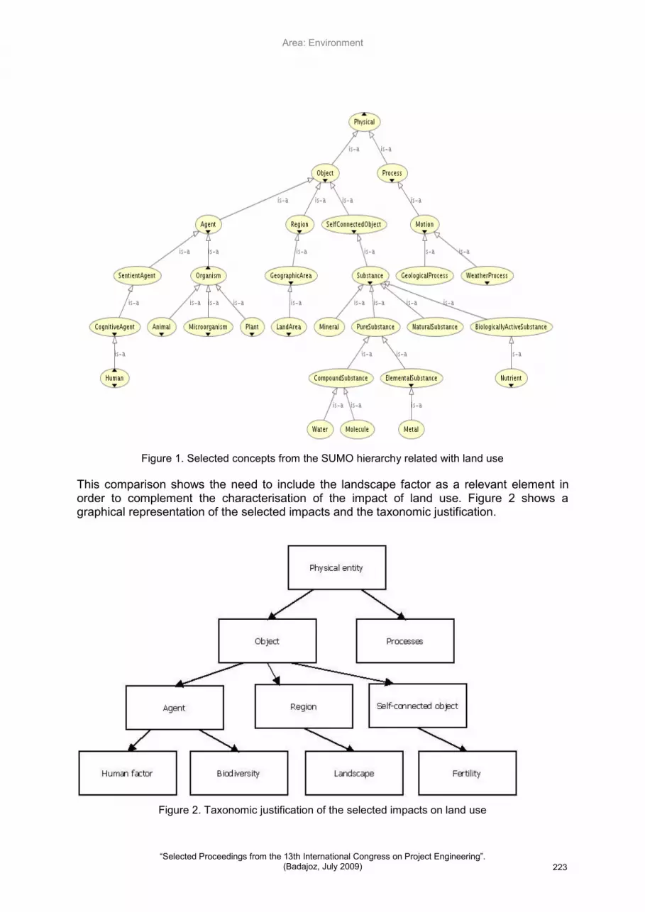
Of all the different ontologies that exist, to justify the choice of the impacts, the Suggested Upper Merged Ontology (SUMO) (Cebrián-Tarrasón, 2008) is used because of its high level of abstraction and because it provides definitions for commonly used terms. This ontology divides physical entities into objects and processes. The definitions of each entity are as follows:
An object is considered to be an entity if it is always present as a single unit, such as a person, a car or a watch, for example.
A process is an entity that is present for a specific time, such as a particular action, a storm or the design of an object, for example.
Identification and justification of the selected impacts
The significant concepts from the information provided by the SUMO ontology related with the physical concept of land use can be represented as shown in Figure 1.
By comparing these concepts with the selected impacts, the following information can be organised and identified:
Biodiversity. According to the definition in the Compact Oxford English Dictionary, biodiversity is the variety of plant and animal life in the world or in a particular habitat. This factor can be related with the concept of ‗organism‘ (Agent – Organism) in the SUMO ontology. In order to understand this identification, it is necessary to explain the reasons why an organism is considered to be an element related with the biodiversity factor. According to the definition proposed by the SUMO, an organism is ‗generally, a living individual, including all plants and animals‘, which corresponds
directly with part of the definition of biodiversity.
Fertility. In the horticultural sense fertility can be defined as a measure of the nutritional richness of the soil. This factor can be directly related to the concept of ‗substance‘ (Self-connected Object – Substance). According to the definition put forward by the SUMO, a substance is ‗an object in which every part is similar to every other in every relevant respect'. It must be pointed out that a substance can have physical-chemical properties that vary, such as temperature, chemical constitution, density and so forth, (a body of water, for example). The SUMO subdivides the concept of ‗substance‘ into six types, of which the concepts of ‗minerals‘, ‗pure
substances‘, ‗natural substances‘ and 'biologically active substances‘ are selected as
the most significant. Likewise, pure substances are considered to be ‗metals‘,
‗molecules' and ‗water‘, while an example of a biologically active substance could be
‗nutrients‘. All these elements would be essentially related as the constituting
components of the nutritional richness of the soil.
Landscape. Landscape can be defined as the extension of land that can be seen from a certain point, although it is a concept that is used in different ways by several
221

Area: Environment
―Selected Proceedings from the 13th International Congress on Project Engineering‖. (Badajoz, July 2009)
fields of study. Nevertheless, all the uses of the term implicitly refer to the existence of an observing subject and an observed object (the land), the most important features of which are stated as being its visual and spatial qualities.
The meaning used in this study is taken from a geographical point of view, in which landscape is understood to refer to any area on the Earth's surface that is the sum of the interaction of the different factors it contains and which are reflected visually in space. The geographical landscape is therefore the appearance taken on by geographical space. It is defined in terms of its forms, which may be natural or anthropic. Every landscape is made up of elements that are connected to one another. These elements can be one of essentially three types: abiotic (non-living elements), biotic (resulting from the activity of living beings) and anthropic (resulting from human activity). Thus, this factor can be directly related with that of ‗region‘
(Region – Geographic Area), since, according to the SUMO definition, a region is a ‗topographic location. Regions encompass surfaces of objects, imaginary places and geographic areas. Note that a region is a single type of object and that it may be located by itself'.
The term referring to human intervention (Agent – SentientAgent) implies the need for human beings to modify the environment in order to bring about the changes in the impact of land use. This is, therefore, the impact that is to be assessed, which affects the other independent, equally levelled impacts that were cited above.
The part referring to processes, which are divided into geological and climatic, interact in the four factors and are thus very important external factors; nevertheless, they are already being taken into account individually by considering the factors of fertility, biodiversity and landscape.
Therefore, by means of what has been outlined above and taking any ontology as the starting point, it can be said that the selected terms satisfy the requirements as regards taxonomic consistency (Cebrián-Tarrasón & Vidal, 2008), and can be described as follows:
Thoroughness, which means that it fully covers the whole of a particular domain, so that all cases can be classified. This taxonomical arrangement can be considered to be exhaustive because, as pointed out in the related comparison, all the concepts associated with the impact of land use fit perfectly into the three domains of the different characterisation factors mentioned above.
Conceptual orthogonality, which means that the terms inside the arrangement of the knowledge about the factors involved in land use are mutually exclusive of the other terms. This taxonomy is considered to be conceptually orthogonal because each term is mutually exclusive. As an example of this type of consistency, the landscape factor is exclusive to the concept referring to region in the SUMO ontology, without there being any similar element that can give rise to ambiguity in its definition.
Parallel structure, which means that the requirements are classified hierarchically. This taxonomy is considered to fulfil a parallel structure because, as it is classified in Figure 1, the terms that are related with land use are hierarchically distributed thus indicating their relation between the more concrete and the more general terms. In the case of the concept ‗substance‘, the idea is exemplified by indicating that any substance is an object and that, at the same time, any mineral can be considered a substance.
222
Area: Environment
―Selected Proceedings from the 13th International Congress on Project Engineering‖. (Badajoz, July 2009)
Figure 1. Selected concepts from the SUMO hierarchy related with land use
This comparison shows the need to include the landscape factor as a relevant element in order to complement the characterisation of the impact of land use. Figure 2 shows a graphical representation of the selected impacts and the taxonomic justification.
Figure 2. Taxonomic justification of the selected impacts on land use
223

Area: Environment
―Selected Proceedings from the 13th International Congress on Project Engineering‖. (Badajoz, July 2009)
Conclusion
This work shows the possibility of applying taxonomies to the field of LCA. It describes a new way of working by formalising the knowledge that is available and by opening up the way to the future development of an ontology about LCA.
Likewise, as regards the justification for the work, it must be noted that if only the impacts or fundamental sections referring to the biodiversity and fertility factors are considered, then no specific factors from the region where it is located are included. This problem can be solved by including the landscape factor, either from the physical or the geographical point of view.
References
Angell I.O. and Straub B., ―Rain-Dancing with Pseudo-Science‖, Cognition, Technology & Work, Vol. 1, 1999, pp.179-196.
Antón, A., Castells, F., Montero, J.I. ―Land use indicators in life cycle assessment. Case study: The environmental impact of Mediterranean greenhouses‖, Journal of Cleaner Production, 15 (2007), pp. 432-438.
Baitz, M., Freissig, J., Schöch, C. ―Method to integrate Land Use in Life Cycle Assessment‖, Institut für Kunststoffprüfung (IKP), University of Stuttgart, Germany, 1998.
Barthloot W., Lauer W., Placke A. ―Global distribution of species diversity in vascular plants: towards a world map of phytodiversity‖, Erdkunde, 1996, 50, Vol.4, pp. 317-327. [http://www.botanik.uni-bonn.de/phytodiv.htm].
Barthlott W., Biedinger N., Brau G., Feig F., Kier G., Mutke J. ―Terminological and methodological aspects of the mapping and analysis of global biodiversity‖, Acta Botanica Fennica, 162 (1999), pp. 103-110.
Cebrián-Tarrasón, D., Vidal, R. (2008) ―Las Ontologías y el marco FBS‖, Actas del XII Congreso Internacional de Ingeniería de Proyectos, Zaragoza, Spain.
Cowell, S.J., Lindeijer, E. ―Impacts on ecosystem due to land use: biodiversity, life support and soil quality in LCA‖, in: Agricultural data for Life Cycle Assessments, B.P. Weidema & M.J.G. Meeusen (eds.), Agricultural Economics Research Institute (LEI), The Hague, Holland, 2000.
Crisfield M.A., ―Non-linear Finite Element Analysis of Solids and Structures. Volume 2: Advanced Topics‖, John Wiley & Sons, Chichester, 1997.
Eppinger S.D. and Salminen V.K., ―Patterns of product development interactions‖, Proceedings of the International Conference on Engineering Design 20‘01, Vol. 1, Glasgow, 2001, pp.283-290.
Gershenson, J.K., Stauffer, L.A. (1999) ―A Taxonomy for Design Requirements from Corporate Customers‖, Research in Engineering Design 11: 103-115.
Goedkoop, M., Spriensma, R. ―The Eco-indicator 99. A damage oriented method for Life Cycle Impact Assessment‖, Methodology report, Third Edition, PRé Consultants, Amersfoot, Holland, 2001.
Güereca, L.P. ―Desarrollo de una metodología para la valoración en el análisis del ciclo de vida aplicada a la gestión integral de residuos municipales‖, Tesis Doctoral, Departamento de Proyectos de Ingeniería, Universitat Politècnica de Catalunya, Barcelona, Spain, 2006.
224

Area: Environment
―Selected Proceedings from the 13th International Congress on Project Engineering‖. (Badajoz, July 2009)
Guinée, J.; van Oers, L.; de Koning, A.; Tamis, W.; ―Life cycle approaches for conservation agriculture‖, CML report 171, Dpt. of Industrial Ecology & Dpt. of Environmental Biology, 2006, Universiteit Leiden, Holland.
Köllner, T. ―Species-pool effect potentials (SPEP) as a yardstick to evaluate land-use impacts on biodiversity‖, Journal of Cleaner Production, 2000, 8, pp.293-311.
Köllner, T., Scholz, R.W. ―Assessment of land use impacts on the natural environment. Part 1: An analytical Framework for pure land occupation and land use change‖, International Journal of Life Cycle Assessment, 2007, 12 (1) pp. 16-23.
Köllner, T., Scholz, R.W. ―Assessment of land use impacts on the natural environment. Part 2: Generic characterization factors for local species diversity in central Europe‖, International Journal of Life Cycle Assessment, 2008, 13 (1) pp. 32-48.
Lindeijer E. ―Review of land use impact methodologies‖, Journal of Cleaner Production, 2000, 8, pp. 273-281, 2000a.
Lindeijer E. ―Biodiversity and life support impacts of land use in LCA‖, Journal of Cleaner Production, 2000, 8, pp. 313-319, 2000b.
Lindeijer E., van Kampen M., Fraanje P.J., van Gooben H.F., Nabuurs G.J., Schouwenberg E.P.A.G., Prins A.H., Dankers N., Leopold M.F. ―Biodiversity and land use indicators for land use impacts in LCA‖, Ministerie V&W. Publicatiereeks Grondstoffen 1998/07, rapport n. W-DWW-98-059, Holland, 1998.
Lindeijer, E., Kok, I., Eggels, P., Alfers, A. ―Improving and testing a land use methodology in LCA. Including case-studies on bricks, concrete and wood‖, Ed: Dutch Ministry of Transport, Public Works and Water Management (RWS DWW), Holland, 2002.
Michelsen, O. ―Assessment of land use impact on biodiversity. Proposal of a new methodology exemplified with forestry operations in Norway‖, International Journal of Life Cycle Assessment, 2008, 13 (1) pp. 22-31.
Milà i Canals L. ―Contributions to LCA methodology for agricultural systems. Site-dependency and soil degradation impact assessment‖, PhD dissertation, Universitat Autònoma de Barcelona, Spain, 2003.
Milà i Canals L., Basson L., Clift R. Müller-Wenk R., Bauer C., Hansen Y., Brandao M. ―Expert Workshop on Definition of Best Indicators for Biodiversity and Soil Quality for Life Cycle Assessment (LCA)‖, CES Working Paper 02/06, Centre for Environmental Strategy, University of Surrey, United Kingdom, 2006.
Milà i Canals, L. ―Land use in LCA: a new subject area and call for papers‖, International Journal of Life Cycle Assessment, 2007, 12 (1): 1, 2007a.
Milà i Canals, L. Romanyà, J., Cowell, S.J. ―Method for assessing impacts on life support functions (LSF) related to the use of ‗fertile land‘ in Life Cycle Assessment (LCA)‖, Journal of Cleaner Production, 2007 15, pp. 1426-1440, 2007b.
Müller-Wenk, R. ―Land use - The main threat to species. How to include Land use in LCA‖. IWÖ-Diskussionbeitrag n. 64, IWÖ, Universität St. Gallen, Switzerland, 1998.
Otero, I., Casermeiro, M. A., Esparcia, P. ―Landscape evaluation: comparison of evaluation methods in a region of Spain‖, Journal of Environmental Management, 2007, vol. 85, n.1, pp. 204-214, 2007a.
Otero, I., Mancebo, S., Ortega, E., Casermeiro, M. Á. ―Mapping landscape quality in Spain‖, M+A Revista Electrónic@ de Medioambiente, 4, pp. 18-34, 2007b.
225

Area: Environment
―Selected Proceedings from the 13th International Congress on Project Engineering‖. (Badajoz, July 2009)
Schenk, R.C. ―Land use and biodiversity indicators for life cycle impact assessment‖, International Journal of Life Cycle Assessment, 2001, 6 (2) 114-117.
van der Voet, E. ―Land use in LCA‖, CML-SSP Working Paper, Centre of Environmental Science, Leiden University, Holland, 2001.
van Wezel W. and Jorna W.J., ―Paradoxes in planning‖, Engineering Applications of Artificial Intelligence, Vol. 14, 2001, pp.269-286.
Vogtländer, J.G., Lindeijer, E., Witte, J.P.M., Hendriks, C. ―Characterizing the change of land-use based on flora: application for EIA and LCA‖, Journal of Cleaner Production, 2004, 12, pp.47-57.
Weidema, B., Lindeijer, E. ―Physical impacts of land use in product life cycle assessment‖, Final report of the EURENVIRON-LCAGAPS sub-project on land use. Department of Manufacturing Engineering and Management, Technical University of Denmark, Denmark, 2001.
Correspondence (for further information please contact):
Daniel Garraín Cordero. GID – Engineering Design Group. Dpt. Mechanical Engineering and Construction, Universitat Jaume I. Av. Sos Baynat, s/n. E-12071 Castellón (Spain) Tel. +34964729252 Fax +34964728106 e-mail: [email protected] URL: http://www.gid.uji.es David Cebrián Tarrasón. GID – Engineering Design Group. Dpt. Mechanical Engineering and Construction, Universitat Jaume I. Rosario Vidal Nadal. GID – Engineering Design Group. Dpt. Mechanical Engineering and Construction, Universitat Jaume I.
226