subproject “sustainable livelihood and development for
TRANSCRIPT

1
MINISTRY OF AGRICULTURE AND RURAL DEVELOPMENT
CENTRAL PROJECT OFFICE FOR WATER RESOURCES PROJECT
PROJECT: MEKONG DELTA INTEGRATED CLIMATE RESILIENCE AND
SUSTAINABLE LIVELIHOODS (MD-ICRSL)
ENVIRONMENTAL AND SOCIAL IMPACT ASSESSMENT
SUBPROJECT
INFRASTRUCTURE TO DEVELOP SUSTAINABLE LIVELIHOODS FOR PEOPLE
IN THE COASTAL AREA IN BA TRI, BEN TRE TO ADAPT TO CLIMATE
CHANGE
(Final)
March 2016
SFG1698 V1 REV

2
TABLE OF CONTENTS
TABLE OF CONTENTS .................................................................................................................. 2
ABBREVIATIONS ......................................................................................................................... 6
LIST OF TABLE ............................................................................................................................. 7
LIST OF FIGURE ........................................................................................................................... 9
CHAPTER 1. INTRODUCTION AND SUBPROJECT DESCRIPTION ........................................... 10 1.1. SUBPROJECT BACKGROUND ................................................................................................ 10
1.1.1. Link of the subproject to the Regional Environmental Assessment ............................................. 10 1.1.2. Need of the subproject ................................................................................................................. 14 1.1.3. Subproject objectives ................................................................................................................... 14
1.2. OVERVIEW OF ENVIRONMENTAL AND SOCIAL IMPACT ASSESSMENT ............................... 15 1.2.1. Objectives of the report ................................................................................................................ 15 1.2.2. Organization of environmental impact assessment ..................................................................... 16 1.2.3. ESIA Implementation Coordination Agencies ............................................................................... 18
1.3. NATIONAL LAWS AND REGULATIONS AND WORLD BANK SAFEGUARD POLICIES .............. 18 1.3.1. Relevant National Laws and Regulations ...................................................................................... 18 1.3.2. Applicable World Bank Safeguard Policies ................................................................................... 22
1.4. ENVIRONMENTAL IMPACT ASSESSMENT METHODOLOGIES AND APPROACHES ............... 23 1.4.1. Methods of ESIA ........................................................................................................................... 23
1.4.1.1. Rapid Assessment Method .................................................................................................. 23 1.4.1.2. Impact Matrix Method ........................................................................................................ 23 1.4.1.3. Comparison Method ........................................................................................................... 23 1.4.1.4. Impact Identification Method ............................................................................................. 23 1.4.1.5. Checklist Method ................................................................................................................ 23 1.4.1.6. Method of Public Consultation and Disclosure of Information ........................................... 24
1.4.2. Other Methods ............................................................................................................................. 24 1.4.2.1. Information and secondary data inheritance, summary and analysis ................................ 24 1.4.2.2. Field survey method ............................................................................................................ 24 1.4.2.3. Consensus and Expert Adjustment Method ........................................................................ 24 1.4.2.4. Sampling and Laboratory analysis ....................................................................................... 25
1.4.3. Data analysis ................................................................................................................................. 25 1.5. SUBPROJECT DESCRIPTION .................................................................................................. 25
1.5.1. Subproject Name .......................................................................................................................... 25 1.5.2. Subproject owner ......................................................................................................................... 25 1.5.3. Subproject location and affected area ......................................................................................... 26 1.5.4. Subproject components ................................................................................................................ 27 1.5.5. Items and scope of the subproject components .......................................................................... 28
1.5.5.1. Component 1: (ZONE 1: 2,484 ha): Restoring Mangrove Belt ............................................. 28 1.5.5.2. Component 2: (ZONE 2: 7,940 ha): Improving Sustainability of Brackish Water Systems .. 29 1.5.5.3. Component 3: (Zone 3: 5,105 ha): Adaptation and Mitigation for Zone 3 (Saltwater Intrusion) 34
1.5.6. Measures of construction organization, construction technology for component 2 ................... 36 1.5.6.1. Sluice gates construction..................................................................................................... 36 1.5.6.2. Measures for dredging organization ................................................................................... 36
1.5.7. The list of proposed machinery and equipment ........................................................................... 37 1.5.8. Materials of the subproject .......................................................................................................... 39
1.5.8.1. Filling materials ................................................................................................................... 39 1.5.8.2. Other materials ................................................................................................................... 39 1.5.8.3. Energy .................................................................................................................................. 39
1.5.9. Subproject progress ...................................................................................................................... 40 1.5.10. Investment cost........................................................................................................................ 40
1.6. ORGANIZATION OF PROJECT MANAGEMENT AND IMPLEMENTATION .............................. 40

3
CHAPTER 2. NATURAL, ENVIRONMENTAL, ECONOMIC AND SOCIAL CONDITIONS IN SUBPROJECT AREA ................................................................................................................... 41
2.1. NATURAL CONDITION .......................................................................................................... 41 2.1.1. Topographical, geological conditions ........................................................................................... 41
2.1.1.1. Topographical conditions .................................................................................................... 41 2.1.1.2. Geological condition of construction works: ....................................................................... 41
2.1.2. Climate, meteorology conditions .................................................................................................. 42 2.1.2.1. Temperature ....................................................................................................................... 42 2.1.2.2. Wind direction and wind speed .......................................................................................... 44 2.1.2.3. Hurricane ............................................................................................................................. 44 2.1.2.4. Rainfall ................................................................................................................................. 44 2.1.2.5. Other factors ....................................................................................................................... 45
2.1.3. Hydrological/oceanographic conditions ....................................................................................... 46 2.1.3.1. River and tide water level ................................................................................................... 46 2.1.3.2. Sea level rise due to climate change ................................................................................... 49
2.2. ENVIRONMENTAL QUALITY BASELINE IN THE SUBPROJECT AREA ...................................... 49 2.2.1. Water Resources ........................................................................................................................... 50
2.2.1.1. Groundwater environment ................................................................................................. 52 2.2.1.2. Wastewater sample analysis results ................................................................................... 52
2.2.2. Air Environmental Status .............................................................................................................. 54 2.2.3. Soil and canal sediment quality .................................................................................................... 55 2.2.4. Biological Resources ..................................................................................................................... 58
2.2.4.1. The coastal mangrove forests in Ben Tre province ............................................................. 58 2.2.4.2. Marine and coastal wetland biodiversity ............................................................................ 60
2.3. SOCIAL AND ECONOMIC CONDITIONS ................................................................................ 62 2.3.1. Economic conditions ..................................................................................................................... 62 2.3.2. Social conditions ........................................................................................................................... 68
2.3.2.1. Population ........................................................................................................................... 68 2.3.2.2. Public health ........................................................................................................................ 69 2.3.2.3. Education and training ........................................................................................................ 69 2.3.2.4. Culture - Information - Sports ............................................................................................. 70
2.3.3. The status of infrastructure .......................................................................................................... 70 2.3.3.1. Drainage and Salinity Control .............................................................................................. 70 2.3.3.2. Water Supply ....................................................................................................................... 71 2.3.3.3. Traffic Network.................................................................................................................... 71
2.4. GENDER CHARACTERISTICS ................................................................................................. 72 2.5. PHYSICAL CULTURAL RESOURCES ........................................................................................ 72 2.6. SITE – SPECIFIC CHARACTERISTICS ...................................................................................... 73
2.6.1. Sluice Gate .................................................................................................................................... 73 2.6.2. Dredging canal systems ................................................................................................................ 74
CHAPTER 3. ALTERNATIVES ANALYSIS OF SUBPROJECT ...................................................... 76 3.1. Need for the Subproject ...................................................................................................... 76 3.2. ASSESSING “WITH” AND “WITHOUT” SUBPROJECT ............................................................ 78 3.3. ANALYSIS OF ALTERNATIVES ............................................................................................... 81
CHAPTER 4. ENVIRONMENTAL AND SOCIAL IMPACT ASSESSMENT .................................... 85 4.1. CLASSIFICATION AND SCALE OF IMPACTS ........................................................................... 85 4.2. POSITIVE IMPACTS ............................................................................................................... 86
4.2.1. Socio-economic condition ............................................................................................................ 86 4.2.2. Capacity of Climate Resilience ...................................................................................................... 87 4.2.3. Positive overall impacts ................................................................................................................ 88
4.3. IMPACT OF CLIMATE CHANGE ............................................................................................. 89 4.3.1. Impacts of climate change on the subproject area ...................................................................... 89 4.3.2. The impact of climate vulnerabilities on the livelihood models ................................................... 90 4.3.3. The impact of the Subproject to adapt to climate change ........................................................... 91
4.4. POTENTIAL NEGATIVE IMPACT ............................................................................................ 92

4
4.4.1. Type and Scale of Impacts ............................................................................................................ 92 4.4.2. Potential Impacts of sluice gate construction and dredging activities to Sensitive Facilities and Areas 98 4.4.3. Impact Assessment during Pre-construction Phase ..................................................................... 98 4.4.4. Impact Assessment during Construction Phase ............................................................................ 99
4.4.4.1. Impact sources .................................................................................................................... 99 4.4.4.2. Identifying Source Of Impacts ............................................................................................. 99 4.4.4.3. Assessing impacts during the construction stage of sluice gates ...................................... 100 4.4.4.4. Assessing impacts during the dredging ............................................................................. 116
4.4.5. Impact Assessment during Operation Phase .............................................................................. 124 4.4.5.1. Identifying Source of Impacts ............................................................................................ 124 4.4.5.2. Assessing impact in the operation phase of sluice gates .................................................. 125 4.4.5.3. Impact of supporting from Livelihood Models .................................................................. 130 4.4.5.4. Environmental and social incidents................................................................................... 139 4.4.5.5. Regional Impacts ............................................................................................................... 140
CHAPTER 5. PROPOSED MITIGATION AND PREVENTION MEASURES ............................... 142 5.1. IMPLEMENTATION PRINCIPLE ........................................................................................... 142 5.2. MITIGATION MEASURES IN THE PRE-CONSTRUCTION PHASE .......................................... 142 5.3. MITIGATION MEASURES IN THE CONSTRUCTION PHASE.................................................. 142
5.3.1. Sluice gates construction ............................................................................................................ 143 5.3.1.1. Impact sources related to waste ....................................................................................... 143 5.3.1.2. Impact sources not-related to waste ................................................................................ 145 5.3.1.3. Preventing and troubleshooting environmental incidents of construction ...................... 148
5.3.2. Measures to control the impact of dredging .............................................................................. 150 5.3.2.1. Controlling the impact related to waste ........................................................................... 150 5.3.2.2. Control Impact sources not-related to waste ................................................................... 154 5.3.2.3. Preventing and troubleshooting environment incidents due to dredging activties ......... 156
5.4. MITIGATION MEASURES IN THE OPERATION PHASE ........................................................ 158 5.4.1. Measures to mitigate impacts due to sluice gates operation..................................................... 158 5.4.2. Control Impact from Livelihood Models ..................................................................................... 161
5.4.2.1. Seed quality and screening ............................................................................................... 161 5.4.2.2. Pond filling and water preparation ................................................................................... 161 5.4.2.3. Mitigation of organic pollution ......................................................................................... 162 5.4.2.4. Mitigation of chemicals’ effects ........................................................................................ 164 5.4.2.5. Energy source and fuel management: .............................................................................. 166 5.4.2.6. Farm sanitation management ........................................................................................... 166 5.4.2.7. Labour management ......................................................................................................... 166 5.4.2.8. Social and environmental responsibilities ......................................................................... 167
5.4.3. Mitigation measures negative impacts for expansion of models ............................................... 167 5.4.4. Environmental and social incidents ............................................................................................ 170
CHAPTER 6. ENVIRONMENTAL AND SOCIAL MANAGEMENT PLAN (ESMP) ...................... 173 6.1. BASIC PRINCIPLES .............................................................................................................. 173 6.2. SUMMARY OF POTENTIAL ENVIRONMENTAL AND SOCIAL IMPACTS ............................... 173
6.2.1. Positive impacts .......................................................................................................................... 173 6.2.2. Negative impact .......................................................................................................................... 174
6.3. MITIGATION MEASURES .................................................................................................... 184 6.3.1. Mitigation measures of general impacts .................................................................................... 184 6.3.2. Site-specific Impacts and Mitigation Measures .......................................................................... 200
6.4. ENVIRONMENTAL MONITORING PROGRAM..................................................................... 213 6.4.1. Monitoring of Contractor’s Safeguard Performance .................................................................. 214 6.4.2. Environmental Quality Monitoring ............................................................................................. 214 6.4.3. Community-based monitoring .................................................................................................... 215 6.4.4. Monitoring Effectiveness of the ESMP ....................................................................................... 216
6.5. ROLE AND RESPONSIBILITIES FOR ESMP IMPLEMENTATION ............................................ 216 6.5.1. Implementation arrangement .................................................................................................... 216

5
6.5.2. Environmental Compliance Framework ..................................................................................... 219 6.5.2.1. Environmental Duties of the Contractor ........................................................................... 219 6.5.2.2. Contractor’s Safety and Environment Officer (SEO) ......................................................... 219 6.5.2.3. Independent Environmental Monitoring Consultant (IEMC) ............................................ 220 6.5.2.4. Environmental Supervision during Construction .............................................................. 220 6.5.2.5. Compliance with Legal and Contractual Requirements .................................................... 221 6.5.2.6. Environmental Claims and Penalty System ....................................................................... 221
6.5.3. Reporting Arrangements ............................................................................................................ 221 6.6. CAPACITY BUILDING PROGRAM ........................................................................................ 222
6.6.1. Technical assistance support for the implementation of safeguards ......................................... 222 6.6.2. Training programs proposed ...................................................................................................... 223
6.7. ESTIMATED ESMP COST ..................................................................................................... 224 6.8. GRIEVANCE REDRESS MECHANISM (GRM) ........................................................................ 228
CHAPTER 7. PUBLIC CONSULTATION AND DISCLOSURE .................................................... 230 7.1. OBJECTIVES OF PUBLIC CONSULTATION ........................................................................... 230 7.2. IMPLEMENTATION METHODS ........................................................................................... 230 7.3. PUBLIC CONSULTATION RESULTS ...................................................................................... 231 7.4. ENVIRONMENTAL INFORMATION DISCLOSURE ................................................................ 232
CONCLUSIONS, RECOMMENDATIONS AND COMMITMENTS ................................................. 233
REFERENCES ........................................................................................................................... 235
APPENDIX 1. AQUATIC SPECIES IN HAM LUONG RIVER ........................................................ 236
APPENDIX 2: LOCATION MAP FOR ENVIRONMENT MONITORING PRE-CONSTRUCTION .... 254
ANNEX 3: SIMPLIFIED ECOP ................................................................................................... 255
APPENDIX 4: PICTURES OF CONSULTATION MEETINGS ....................................................... 260

6
ABBREVIATIONS
BMP Best Management Practices
CC Climate change
CMC Construction monitoring consultant
CPMU Central Project Management Unit
CPO Central Project Office
DARD Ben Tre Department of Agriculture and Rural Development
DONRE Department of Natural Resources and Environment
EA Environmental Assessment
ECOP Environmental Code of Practice
EIA Environmental impact assessment
EMC External Monitoring Consultant
EMP Environmental Management Plan
EMS Environmental monitoring system
ESIA Environmental and Social Impacts Assessment
ESMP Environmental and Social Management Plan
FFS Farmer Field School
FS Feasibility study
GAP Good Agricultural Practices
GHP Good Handling Practices
GOV Government of Vietnam
HACCP Hazard Analysis Critical Control Point
HH Household
MARD Ministry of Agriculture and Rural Development
MD-ICRSL Mekong Delta Integrated Climate Resilience and Sustainable Livelihoods
Project
MKD Mekong Delta
NGO Non-governmental organization
ODA Official Development Assistance
P/PC Provincial/ People’s Committee
PPMU Provincial Project Management Unit
QCVN National Technical Regulations
SIWRR Southern Institute of Water Resources Research
SNV Netherlands Development Organisation
IUCN International Union for Conservation of Nature,
TCVN Vietnam standard
WB World Bank
WHO World Health Organization

7
LIST OF TABLE
Table 1.1: List of Involved Consulting Members and Their Roles .......................................................................... 16
Table 1.2: Total scale of the five sluice gates ....................................................................................................... 29
Table 1.3: Total Quantity of dredging canal ......................................................................................................... 31
Table 1.4 : List of tools and equipment using for the subproject construction ..................................................... 37
Table 1.5: List of tools and equipment using for the dredging ............................................................................. 38
Table 2.1: Max, min, and average temperature of Ba Tri station ........................................................................ 43
Table 2.2. Monthly characteristics of wind of Ba Tri station ................................................................................ 44
Table 2.3. Month Average Rainfall of Ba Tri station ............................................................................................. 45
Table 2.4: The number of rainfall days of Ba Tri station ....................................................................................... 45
Table 2.5 Monthly Average Humidity of Ba Tri station ......................................................................................... 46
Table 2.6. Monthly Average Evaporation of Ba Tri station ................................................................................... 46
Table 2.7 frequency level hydrological stations in the subproject area (H: m,) ................................................... 47
Table 2.8: Position of Sampling Surface Water .................................................................................................... 50
Table 2.9: Surface water quality analysis results .................................................................................................. 51
Table 2.10: Positions of Sampling Underground Water ....................................................................................... 52
Table 2.11: Groundwater quality analysis results ................................................................................................. 52
Table 2.12: Positions of Sampling Domestic Wastewater .................................................................................... 53
Table 2.13: Wastewater quality analysis results .................................................................................................. 53
Table 2.14: Air sampling position ......................................................................................................................... 54
Table 2.15: Ambient air quality analysis results ................................................................................................... 55
Table 2.16: Soil quality analysis results ................................................................................................................ 56
Table 2.17: Soil sampling position ........................................................................................................................ 57
Table 2.18: Sediment sampling position ............................................................................................................... 57
Table 2.19: Sediment quality analysis results ....................................................................................................... 58
Table 2.20. Investigated income of farming households ...................................................................................... 63
Table 2.21: The aquaculture in the subproject area phase 2001 – 2010 .............................................................. 66
Table 2.22: Aquaculture area (ha) of communes in subproject area in 2015 ....................................................... 67
Table 2.23: Aquaculture of communes in subproject area to 2020 (Unit: ha) ...................................................... 67
Table 2.24: Population of communes in subproject area ..................................................................................... 68
Table 2.25: School students status in the subproject area ................................................................................... 70
Table 2.26 The number households served with piped water system .................................................................. 71
Table 2.27. Historical and Cultural Sites in the Subproject area ........................................................................... 72
Table 2.28. Sensitive Features around sluice gates .............................................................................................. 73
Table 2.29. Sensitive Features around canals ....................................................................................................... 74
Table 3.1: Environmental and social impacts in case of “without the subproject” and “with the subproject” .... 78
Table 3.2: Optional alternatives in terms of Technical Aspect for the sluice gates of the Subproject .................. 81
Table 4.1: Summary of Impacts Caused by the Implementation of the Subproject .............................................. 93
Table 4.2: Potential Negative Impacts of the 5 Sluice Gates ................................................................................ 94
Table 4.3: Potential Negative Impacts of dredging .............................................................................................. 95
Table 4.4: Potential Negative Impacts of the Livelihood Models in 3 zones ......................................................... 96
Table 4.5. Historical and Cultural Sites in the Subproject area ............................................................................. 98
Table 4.6: Impacts During The Pre-Construction Phase ........................................................................................ 99
Table 4.7: The emission coefficients of each pollutant ....................................................................................... 101
Table 4.8: The concentrations of pollutants in the construction areas of sluice gates ....................................... 102
Table 4.9: The digging and filling quantity for construction of sluice gates ....................................................... 102
Table 4.10: The materials quantity used for construction of sluice gates .......................................................... 103
Table 4.11 : The dispersion coefficients of barges powered by diesel engines ................................................... 104

8
Table 4.12 : The estimated amount of pollutants of barge per voyage .............................................................. 104
Table 4.13: The load and concentrations of pollutants of barges transporting raw materials .......................... 104
Table 4.14: The load and concentrations of pollutants in workers ‘wastewater ................................................ 106
Table 4.15. The volume of hazardous waste estimated in the construction ....................................................... 108
Table 4.16: The maximum noise level of some facilities and equipment at source ............................................ 109
Table 4.17. Forecast noise in the neighbourhood ............................................................................................... 110
Table 4.18: The air pollution coefficients of DO/FO combustion engines (Unit: Pound/1000 Gallons of oil). .... 116
Table 4.19: The total load of pollutants from dredgers ...................................................................................... 117
Table 4.20 : The load of pollutants arising from excavators, dredgers for dredging sections ............................ 117
Table 4.21 : The concentration of pollutants arising from machine and equipment .......................................... 118
Table 4.22: The quality of the water outfall of sludge dump site dredged from Tac Cay Tram canal ................ 119
Table 4.23: The load and concentrations of pollutants in workers’ domestic wastewater ................................ 119
Table 4.24: The maximum noise level of some vehicles and equipment ............................................................ 121
Table 4.25: The recovery time observed in dredging areas ................................................................................ 122
Table 4.26: Quality of intensive shrimp pond effluent compared with domestic wastewater ........................... 131
Table 4.27: Variations in effluent quality from an intensive shrimp farm in southern Thailand ........................ 132
Table 6.1: Potential Negative Impacts of the Subproject ................................................................................... 175
Table 6.2: Mitigation Measures of General Impacts related to Subproject’s Activities ...................................... 185
Table 6.3: Site -specific Mitigation Measures ..................................................................................................... 202
Table 6.4: Scope of environmental monitoring during construction and operation ........................................... 215
Table 6.5: Institutional Responsibilities for the Project and Subproject Safeguard Implementation ................. 217
Table 6.6: Regular Reporting Requirements ....................................................................................................... 222
Table 6.7: Training Programs for Capacity Building on Environmental Supervision and Management ............. 223
Table 6.8: Cost for ESMP in the entire subproject (VND) .................................................................................... 225
Table 6.9: Cost for environmental monitoring in the entire subproject .............................................................. 227

9
LIST OF FIGURE
Figure 1.1. The production zoning map in the subproject region ......................................................................... 15
Figure 1.2. The zoning map in the subproject region ............................................................................................ 26
Figure 1.3: Location of 5 Sluice gates ................................................................................................................... 30
Figure 1.4:Lay out of construction site for sluice gate .......................................................................................... 30
Figure 1.5: The structure of the joint chamber ..................................................................................................... 30
Figure 1.6: The flat valve gate .............................................................................................................................. 31
Figure 1.7: Dredging location map ....................................................................................................................... 31
Figure 1.8: Canal cross- section of dredging ......................................................................................................... 32
Figure 1.9: The locations of demonstration area .................................................................................................. 33
Figure 1.10: The locations of demonstration area ................................................................................................ 35
Figure 1.11: 5 steps for dredging .......................................................................................................................... 37
Figure 2.1: Distribution of yearly average temperature in Ben Tre ...................................................................... 43
Figure 2.2: Multi-year average rainfall distribution in Ben Tre ............................................................................. 45
Figure 2.3: Salinity intrusion in Ben tre in 2009 .................................................................................................... 48
Figure 2.4: Salinity intrusion in Ben tre in 2020-sea level rise of 11cm ................................................................. 48
Figure 2.5: Area ratio of flooded dictricts of Bentre ............................................................................................. 49
Figure 2.6. Current land use in the subproject area .............................................................................................. 60
Figure 2.7. Current land use in the Ba Tri ............................................................................................................. 64
Figure 2.8: Map of the Traffic Situation in the Subproject Area ........................................................................... 72
Figure 4.1: Map of the transport for materials to the Subproject Area .............................................................. 103
Figure 4.2. Salt fields in the subproject area ....................................................................................................... 113
Figure 5.2: Steel sheet pile coffer dam for in-river construction activities .......................................................... 146
Figure 5.3: Images the dredging ......................................................................................................................... 151
Figure 5.4: Layout of Spoil disposal site .............................................................................................................. 152
Figure 5.5: The benefit time scale for transiting activities .................................................................................. 170
Figure 6.1: Organization structure for safeguard monitoring ............................................................................ 216
Figure 6.2: Environment monitoring Sampling Locations, Construction and Operation phase .......................... 228

10
CHAPTER 1. INTRODUCTION AND SUBPROJECT DESCRIPTION
1.1. SUBPROJECT BACKGROUND
Subproject “Infrastructure to develop sustainable livelihoods for people in the coastal area in
Ba Tri, Ben Tre to adapt to climate change” is a subproject to be implemented under
Component 31 of the Mekong Delta Integrated Climate Resilience and Sustainable Livelihoods
(MD-ICRSL) Project which is proposed by the Government of Vietnam (GOV) for financing
from the World Bank (WB). The Central Project Management Unit (CPMU) of the Central
Project Office (CPO) of the Ministry of Agriculture and Rural Development (MARD) is
responsible for the overall management of the MD-ICRSL project. The development objective
of the MD-ICRSL project is to enhance tools for climate-smart planning, and improve climate
resilience of land and water management practices in selected provinces of the Mekong Delta
in Vietnam. The Subproject owner is the MARD. The Provincial Project Management Unit
(PPMU) of Ben Tre Department of Agriculture and Rural Development (DARD) are
responsible for the planning and implementation of the subproject during preparation and
construction. The Division of Water Resources of Ben Tre DARD will be responsible during
operation. The subproject will be financed by GOV (central and local) and the WB.
1.1.1. Link of the subproject to the Regional Environmental Assessment
During the MDICRSL project identification and preparation a Regional Environmental
Assessment have been carried out to identify the main environmental and social issues and
challenges that relevant to the project and subproject design and environmental management.
The section below provides a summary of the REA findings and recommendations for the
subproject.
a) The main environmental and social challenges in the Delta estuary
The Delta estuary the riverine levies and alluvial floodplains of Can Tho, Vinh Long, Tien
Giang, Long An, Kien Giang, Soc Trang and Ben Tre. The inter-tidal zone is under the mixed
influence of upstream hydrology as well as coastal processes such as tidally-induced saline
intrusion and channel-flow reversal. In the delta estuary under mixed coastal and freshwater
influence, rice is still an important crop accounting for 30% of provincial area, with brackish
aquaculture accounting for a further 11%. Rapid population growth and intensive agricultural
and aquaculture development over the past decades have significantly reduced the natural
values in the delta estuary.
Salinization of the estuary
- Salinity intrusion into the delta estuary is reducing agricultural productivity and
leading to dry season freshwater shortages. Tidal fluctuations drive saline intrusion
more than 80km inland, affecting 40% of the Mekong Delta. Seven provinces are highly
prone to saline intrusion, including: Kien Giang, Tra Vinh, Ben Tre, Soc Trang, Ca
1Component 3 (Adapting to Salinity Transitions in the Estuary) has been designed to address the challenges related
to salinity intrusion, coastal erosion, sustainable aquaculture and improved livelihoods for communities living in
the coastal areas. This will potentially consist of: i) construction of coastal defenses consisting of combinations
of compacted earth embankments and coastal mangrove belts; ii) modification of water and agricultural
infrastructure along the coastal zone to allow flexibility for sustainable aquaculture activities and adapt to
changing salinity levels; iii) support to farmers to transition (where suitable) to more sustainable brackish water
activities such as mangrove-shrimp, rice-shrimp, and other aquaculture activities; and iv) supporting climate smart
agriculture by facilitating water use efficiency in the dry season

11
Mau, Bac Lieu and Long An, with more than 1 million hectares experiencing salinity
concentrations above 4g/L.
- The situation of salinity intrusion in Mekong Delta is complex. Each year the
situation is different, depending on the magnitude of the previous years flooding, the
ability to supply fresh water upstream in the dry season, the production level of
Summer-Autumn paddy and the onset of the rainy season. Salinity can intrude far
inland when rains start late, as happened for instance in 1977, 1993, 1998 and in 2004-
2005. Highest salinity levels are reached at the end of the dry season, usually in April,
but when rains are late sometimes even into early May. Figure 44 below shows the
duration of salinity intrusion (>4g/L) in the delta estuary provinces of Ben Tre, Tra
Vinh and Soc Trang.
- Expected sea level rise will further increase salinity levels in the delta's river
branches and its water network. A sea level rise of one metre would increase the area
of 4g/L salinity with 334,000 ha in relation to the benchmark year of 2004, a rise of
25%. Deep salinity intrusion is occurring already during dry seasons, giving rise to
significant crop losses. Its extent and frequency is likely to increase due to climate
change, giving rise to even higher and more frequent economic losses.
- Water control infrastructure has been constructed in coastal provinces to control
salinity intrusion into the estuaries. Sea dikes have been constructed along estuaries
and coasts in Tien Giang, Tra Vinh, Soc Trang, Bac Lieu, Kien Giang, Ben Tre and Ca
Mau provinces. In Ben Tre and Ca Mau the sea dike system is not closed, and only
gives partial protection. Both the height and strength of the dikes need upgrading.
- Saline water is prevented to enter the canals by the construction of sluices that can
be closed when the seawater rises with the tide above river water levels. However,
many canals do not have such sluices. Where sluices do exist, this creates conflicts
between the freshwater needs of agriculture and the brackish water needs for
aquaculture, which will be explored further in the following section. A large decline in
capture fisheries is also associated with construction of a sea dikes to cut off saltwater
flow into mangrove habitats so it could be used for rice farming. Estuarine fish and
other animals rely on these intertidal habitats for feeding so impacts on coastal and
freshwater fisheries also need to be considered.
Estuary balance between saline and freshwater farming
- Balancing the needs of freshwater agriculture and brackish aquaculture is
required to effectively adapt to salinity intrusion in the delta estuary. In the delta
estuary under the influence of both river flow and tidal action, the provincial authorities
are faced with the decision to protect freshwater farming systems from salinity intrusion
or open up the estuary floodplains for saline tolerant systems. The brackish water
environment in the coastal provinces of the delta estuary and are gaining importance,
not only due to emerging salinity issues, but also by the growing importance of adapting
to this unfavourable situation. Measures to create a clear borderline between brackish
and the freshwater environment remain underdeveloped.
- Investment in large water control infrastructure for salinity intrusion will have
far-reaching and long-lasting impacts on the delta system. At present Ben Tre
province is exploring the potential for a major investment in dykes and sluice gates,
including a ring of sluice gates is proposed at the canal entrances for Ben Tre provinces.
The provincial authorities are making decisions for the installation of sluices and dikes,
which will shape the future land use in the province and the farming opportunities

12
available to local communities. In the past, the development of water control
infrastructure has lead to conflicting interests and inflexible water management when
local rice farmers sought to benefit their income through the conversion of their farms
from rice to shrimp. Rice production has been unstable due to droughts, salinity
intrusion and excessive flooding in the delta estuary.
- Aquaculture area and aquaculture and shrimp production has increased in the
delta estuary. From 1995-2013 the total aquaculture area (ha), aquaculture and shrimp
production increased significantly in Ben Tre, Tra Vinh and Soc Trang. Aquaculture in
the delta estuary primarily includes pangasius catfish (Ben Tre and Tra Vinh only),
shrimp and bivalve.
- The areas of high value fruit crops have decreased from 2005 to 2012 due to issues
with drought, salinity intrusion and conversion to aquaculture.
Dry season freshwater shortages and droughts
- Coping with dry season fresh water shortages and droughts and securing fresh
water supply is a critical challenge for the delta estuary. Ben Tre, Tra Vinh and Soc
Trang, like many other coastal provinces suffer from several negative trends, like
increased salinity intrusion, decreasing availability of fresh water of sufficient quality,
depletion of aquifers. Sea-level rise and dry-season salinity intrusion limit the
possibilities for fresh water agriculture and horticulture. Water quality problems put
strain on (saline) aquaculture. There is a conflict in water use and availability between
brackish areas and fresh areas, and more broadly between agricultural, industrial and
domestic water uses. Some parts of Soc Trang and Kien Giang experience dramatic
changes in seasonal freshwater available as surface waters in the dry season are almost
exclusively dominated by tidal forces and the main source of freshwater is rainfall.
- The droughts in 2002 and 2004-05 caused extensive damage to agricultural crops
and water supply in the delta estuary. The drought of 2002 was a dry season drought
that occurred from February to April. Some 70,300 ha of the delta were affected, with
crops lost from 17,800 ha (25 per cent of the affected area). Crop losses in the Mekong
Delta accounted for about 25 per cent of the national crop loss and, based on these
figures, the cost of this drought to the delta was estimated as approximately US$24
million (US$1350 per ha of crop loss).
- The 2004 wet season finished early, causing salinity intrusion to occur further
upstream than normal leading to widespread failure of the autumn rice crop and
reduced dry season water supply. More than 104,000 ha of rice were damaged in the
delta. Ben Tre was the worst affected province, where 7000 ha of rice and 15,000 ha of
fruit orchards worth US$33 million were destroyed. As well, more than 82,000 families
were forced to buy water. The total drought damage bill to the delta was US$42 million.
- Water supply in many areas, such as Ca Mau, Bac Lieu and Soc Trang water is
used without treatment, so water quality is below the required standards. Existing
water infrastructure is said to operate at no more than 55-65% of the design capacity.
According to the report of the Southern Institute for Urban and Rural Planning, around
60-65% of the urban population in the Delta receive water from the existing supply
systems. The groundwater has been exploited for industrial and agricultural use since
1941. Up till now, there are about 200 large wells to provide water for urban areas and
over 25,000 small-scale drilled wells to provide water for rural areas. The current total
exploited groundwater amounts in the order of 480,000 m3/day. The freshwater
shortages calls for a detailed assessment of the effectiveness of horticulture, freshwater

13
agriculture and brackish aquaculture in the delta estuary, especially as climate change
is expected to bring increased average temperatures and further salinity intrusion.
- Reduced retention area and sea level rise increase the vulnerability to flooding in
the delta estuary leading to an increased need for capital-intensive measures for
flood protection. Conversion of agricultural land and floodplains decreases flood
retention in the wet season, exacerbating the impacts of flooding in urban areas. Raising
dykes in the upper delta to enable triple instead of double crop rice takes retention area
from the river system decreases and increases flooding risks downstream. Drainage
capacity is insufficient in many areas during periods of heavy rainfall and high river
discharges, causing floodwaters to recede late.
- The trend in industrialization and urbanization is growth, taking more land out
of agricultural production. At the same time more people need to be provided with
food and fresh water. Ongoing industrialization will also take up more space and
increase the demand for water as well as the production of wastewater. Both trends will
increase the need for proper spatial planning, efficient water supply and further
investments in water treatment.
Ethnic minorities and reduced farm-based income
- A high number of Khmer people are living in Soc Trang and Tra Vinh, the Khmer
are some of the poorest households in the Mekong Delta. The Khmer people living
in the Tra Cu district of Tra Vinh are living with poor water sanitation and hygiene
conditions and relying on untreated groundwater for drinking. Their livelihoods totally
depend on the natural resource base. Government initiatives have been targeted at the
Khmer people and some improvements have been made. However, the proportion of
Khmer households with improved income and wealth was lower than other households.
- Khmer households and farmers are vulnerable to water related issues in the delta
estuary. Khmer farmers in the Soc Trang and Tra Vinh provinces are experiencing rice
losses due to salinization and droughts in the early rainy season and pollution of inlet
canal water is causing high mortality rates of culture shrimp. The pollution of surface
water from disposal of human and animal wastes and run-off agro-chemicals from rice
fields are impacting human health, agriculture and aquaculture. Poor sanitation
conditions have increased the prevalence of mosquitoes carrying dengue and malaria.
b) Strategic direction for the Delta Estuary - Adapting to salinity transitions
The strategy for the delta estuary must address flood protection, freshwater supply for the
horticultural/agricultural areas of Ben Tre and Tra Vinh, the limitation of groundwater aquifer
exploitation to sustainable levels and livelihoods improvements. Adapting to salinity intrusion
is required to address the challenges related to salinity intrusion, flooding through transitions
to sustainable aquaculture and improved livelihoods for communities living in the coastal areas.
The key components in the strategy for the delta estuary and other coastal areas is to strengthen
coastal protection through a mix of 'building with nature' type (where possible) and
infrastructural measures (where needed) and facilitate a gradual transition from existing fresh
water based rice production towards a brackish and diversified aquaculture system that adapts
to increasingly saline conditions. An additional priority is the protection of groundwater
aquifers, due to increasing evidence that excessive groundwater extraction accelerates land
subsidence.
This subproject has been designed taking into account the strategic direction recommended by
the REA to include restoration of mangroves along the provincial coastline, dredging of infield
3rd order canals, and constructing sluice gates to improve water quality, efficiency and

14
sustainability of aquaculture in the brackish water zone, and supporting a gradual transition
from rice and other freshwater crops in the saline intruded zone to a brackish water economy
including aquaculture through demonstration and aquaculture extension together with
necessary adjustments to land-use plans in a longer term.
1.1.2. Need of the subproject
Ba Tri is a coastal district of Ben Tre Province which is frequently affected by saltwater
intrusion, storms, cyclones, tidal surges, etc. causing serious damages to production and living
in the region. According to the report of Ba Tri District, the loss in 5 years (2010 – 2014) by
affected of salinization and the rise of water levels was VND 238 billion, in which the
aquaculture sector lost VND 127 billion).
The proposed of Subproject will focus on the following activities: i) Building sluice gates to
control salinity intrusion; ii) Developing shrimp model in coastal protection forests; iii)
Dredging canals to improve water quality for aquaculture to meet the needs of production
restructuring, disaster prevention, and waterway transport development; iv) Investing in
livelihood models for climate change adaptation in the coastal region of Ba Tri district; and v)
Enhancing the understanding of current climate change adaptation practices. Especially, the
Subproject will support the Farmers’ Unions and market links, promoting the good practice in
agriculture and aquaculture cultivation, providing technical guidance and training for
aquaculture, and raising awareness about climate change. The subproject scope is presented in
Figure 1.1.
1.1.3. Subproject objectives
General objectives: The primary objective of this subproject is to address the challenges related
to salinity intrusion, sustainable and improved livelihoods for communities living in the coastal
zone of Ba Tri district, Ben Tre Province.
Key objectives:
Constructing coastal defences consisting of combinations of compacted earth
embankments and coastal mangrove belts;
Modifying water and agricultural infrastructure along the coastal zone to allow flexibility
for sustainable aquaculture activities and adapt to changing salinity levels;
Supporting farmers in to transition (where suitable) to more sustainable brackish water
activities such as mangrove-shrimp, rice-shrimp, and other aquaculture activities; and
Supporting climate smart agriculture by facilitating water use efficiency in the dry season.

15
Figure 1.1. The production zoning map in the subproject region
1.2. OVERVIEW OF ENVIRONMENTAL AND SOCIAL IMPACT
ASSESSMENT
1.2.1. Objectives of the report
The Environmental and Social Impacts Assessment (ESIA) and Environmental and Social
Management Plan (ESMP) have been prepared in parallel with the feasibility study of the
subproject in order to identify and assess the potential impacts, and propose measures for
Area: 15.529 ha
Beneficiaries: 98,000 people

16
preventing, minimizing and controlling potential negative social and environmental impacts
that may occur during project implementation. The environmental friendly solutions aiming at
sustainable development has also been considered in the subproject.
The ESIA report has been made in compliance with the World Bank Safeguard Policy and
related policies of Vietnamese Government.
1.2.2. Organization of environmental impact assessment
Subproject approval authority: Ben Tre Provincial People committee (Ben Tre PPC)
Subproject owner: Ben Tre Department of Agriculture and Rural Development (DARD)
The consultant: Southern Institute of Water Resources Research (SIWRR)
Represented by: Dr. Tran Ba Hoang - Position: Director
Address: 658 Vo Van Kiet, Ward 1, District 5, Ho Chi Minh City.
Phone: (08) 39233700 - Fax: (08) 39235028
SIWRR was established in 1978 based on the Decision No 864 QD/TC dated 19 August, 1978
of the Ministry of Water Resources (now Ministry of Agriculture and Rural Development).
Over 35 years of operation, development and growth, the Institute’s activities have always been
focusing on agriculture and rural development, integrated water resources management, natural
disaster mitigation, land reclamation, environmental protection, etc. in the Southern provinces,
especially in the Mekong Delta.
SIWRR has legal capacity to prepare this report. Regarding the research facility, SIWRR has
second facility for experimental laboratories located in Binh Duong Province with three
specialized laboratories registered LAS -1037, LAS - 155, LAS - 143 with the Ministry of
Construction.
Besides being ISO 9001 – 2008 certified, the Labs have been accredited by the Laboratory
Accreditation System. Regarding Machinery and Equipment: In addition to common
machinery and equipment, the Institute’s professional units are also equipped with many
advanced research machines and devices such as Distomat wind meter; Wave height-speed-
direction and current data in a single Instrument, Acoustic Doppler Velocimeter, Sediment
Instruments for all environment, Echo-sounding meter, ADCP (acoustic doppler current
profilers), GPS, gas chromatography, atomic absorption spectrometer, Programmable
electromagnetic four quadrant liquid velocity meter, control unit for ultrasonic high
concentration meter (UHCM), concrete compression gauging machine, cement bending
compression machine and steel laminating machine, triaxial compressor (ELLE), etc. and
advanced supporting softwares: ArcGIS, Satellite image processing software, MIKE set,
HYDROGIS, DUFLOW, KOD, SAL, VRSAP, IMSOP, SOIL, SOICHEM. Regarding human
resources, SIWRR has 178 staffs working in different professional scientific and technological
fields. To implement this report, SIWRR has nominated the necessary staffs (Table 1.1) with
good competence and high experience not only on specialist knowledge but English as well.
They are really reliable staffs of our Institute to fulfill the tasks of this report.
Table 1.1: List of Involved Consulting Members and Their Roles
No Full name Background Assigned tasks
I Representative of Subproject Owner – CPO Irrigation
1 Nguyen Van Ngan Water Resources
Directing the implementation of
reporting environmental impact
assessment.

17
No Full name Background Assigned tasks
II Consultant – Southern Institute of Water Resouces Research
1 MSc. Duong Thi
Thanh
Environmental
Sciences
Team leader - The administrative
procedures, contacts and transactions
related to the reporting EA.
Public consultation.
Composing EIA report.
2 MSc. Dong Thi An
Thuy
Environment and
Climate Change
Writing report on analyzing and
evaluating the impact of the works on
the environmental quality of land,
water and air in stages of the
subproject.
Analyzing and assessing impacts of
climate change on the region,
considering and impacts of the
subproject with or without climate
change.
Public consultation.
3 Ass. Prof. Vo Khac
Tri Water Resources
Undertaking hydraulic and water
quality modelling.
Assessing the results of water quality
and salinity intrusion models.
4 MSc. Le Van Kiem Construction - Water
Works, Water Supply
Developing and implementing
scenarios of salinity intrusion.
Developing and implementing
scenarios of organic pollution
forecasting.
Composing section on hydrological
and meteorological characteristics in
the subproject area and the affected
areas.
6 BSc. Nguyen Thi
Tam Analytical Chemistry
Conducting report on the existing
environmental quality (water, soil, air
and sediment quality).
Developing environmental monitoring
and management in subproject life.
Estimating costs for environmental
monitoring.
Organizing public consultation.
6 Prof. Dr. Tran Thi
Thanh
Water Resources –
Land Improvement
Conducting report on existing water
resources works and river/canal
system in the subproject area and its
surrounding areas.
7 BSc. Tran Thi Thu
Huong Biology
Undertaking report on analysis and
evaluation of the subproject impacts
on the biodiversity due to subproject
implementation.

18
No Full name Background Assigned tasks
Proposing mitigations to control and
mitigate subproject impacts on
biodiversity.
8 MSc. Pham The
Vinh
Construction of
Marine Works
Undertaking report on impacts of the
subproject on water transport.
Developing program to control and
mitigate impacts of the subproject on
water transport.
9 Ass Prof. Dr. Thai
Thanh Luom Forestry
Developing forest management plan
during subproject operation.
10 Dr. Nguyen Minh
Nien Aquaculture
Analysis impacts of shrimp model on
environment and propose mitigation
measures.
1.2.3. ESIA Implementation Coordination Agencies
Ben Tre Department of Natural Resources and Environment (DONRE).
Ben Tre Statistics Bureau.
The local People's Committees and other local organizations.
1.3. NATIONAL LAWS AND REGULATIONS AND WORLD BANK
SAFEGUARD POLICIES
1.3.1. Relevant National Laws and Regulations
In Vietnam, there are national laws, regulations, and policies related to implementation of
safeguard related activities and measures including and the key ones related to the project are
briefly summarized as follows:
Environmental Protection Law No. 55/2014/QH13 of the National Assembly of Vietnam
dated June 23, 2014. This law enacted policies and regulations on environmental
safeguards, and rights and obligations of organizations, households and individuals related
to environmental protection activities.
Land Law No. 45/2013/QH13 of the National Assembly of Vietnam dated November 29,
2013 prescribes the regime of land ownership, powers and responsibilities of the State in
representing the entire-people owner of land and uniformly managing land, the regime of
land management and use, the rights and obligations of land users involving land in the
territory of the Socialist Republic of Vietnam.
Law on Natural Disaster Prevention and Control No. 33/2013/QH13 of the National
Assembly of Vietnam dated on June 19, 2013 provides natural disaster prevention and
control activities; specifies the rights and obligations of agencies, organizations,
households and individuals engaged in natural disaster prevention and control activities;
and details the state management of, and assurance of resources for, natural disaster
prevention and control.
Law on water resources No. 17/2012/QH13 of the National Assembly of Vietnam dated
June 21, 2012 provides on management, protection, exploitation and use of water resources,
as well as the prevention of, combat against and overcoming of harmful effects caused by
water in the territory of the Socialist Republic of Vietnam.

19
Law on amending and supplementing a number of articles of the law on cultural heritages
No. 32/2009/QH12 of the National Assembly of Vietnam dated June 18, 2009 to amend
and supplement a number of articles of the Law on Cultural Heritages.
Law on biodiversity No. 20/2008/QH12 of the National Assembly of Vietnam dated
November 13, 2008 provides for the conservation and sustainable development of
biodiversity; rights and obligations of organizations, households and individuals in the
conservation and sustainable development of biodiversity.
Law on Forest Protection and Development No. 29/2004/QH11 of the National Assembly
of Vietnam dated December 03, 2004 provides for the management, protection,
development and use of forests; and forest owners’ rights and obligations.
Law on Fisheries No. 17/2003/QH11 passed by the National Assembly of the Socialist
Republic of Vietnam on 26 November 2003 and took effect since 01 July 2004;
Law on inland waterway navigation No 23/2004/QH11 on Inland Waterway Navigation
passed by the National Assembly of the Socialist Republic of Vietnam on of 15 June 2004.
Decree No. 38/2015/ND-CP of 24 April 2015 of the Government on management of waste
and discarded materials;
Decree No. 39/2015/NĐ-CP of the Government dated 27 April 2015 on assistance policy
applied to ethnic minority and poor women who comply the population policy will take
effect as from 15 June 2015.
Decree No. 18/2015/ND-CP dated February 14, 2015 of the Government on environmental
protection planning, strategic environmental assessment, environmental impact
assessment, and environmental protection commitment.
Decree No.19/2015/ND-CP of 14 February 2015 of the Government detailing the
implementation of a number of articles of the Law on Environmental Protection;
Decree No.43/2014/ND-CP dated May 15, 2014 of the Government providing guidance on
detailed implementation of some articles from the Land Law 2013.
Decree No.44/2014/ND-CP dated 15 May 2014 of the Government providing regulations
on land prices.
Decree No.47/2014/ND-CP dated 15 May 2014 of the Government on compensation,
support, and resettlement when land acquisition is required by the State.
Decree No. 179/2013/NĐ-CP dated 14 November 2013 of the Government prescribing
administrative sanctions for environmental protection.
Decree No. 25/2013/ND-CP of 29 March 2013 of the Government on environmental
protection charges for wastewater;
Decree No. 67/2012/ND-CP of the Government dated 10 September 2012 on the
amendment of Decree No. 143/2003/ND-CP of the Government dated 28 November 2003
on detailing the implementation of a number of articles of the ordinance on exploitation
and protection of irrigation works
Decree No. 113/2010/NĐ-CP dated 3 December 2010 of the Government on valuation of
damages caused to the environment.
Decree No. 174/2007/ND-CP of 29 November 2007 on environmental protection charges
for solid waste;

20
Circular No. 27/2015/TT-BTNMT dated 19 May 2015 of the Ministry of Natural Resources
and Environment on strategic environmental assessment, environmental impact
assessment, and environmental protection plan.
Decree No. 39/2015/NĐ-CP of the Government dated 27 April 2015 on assistance policy
applied to ethnic minority and poor women who comply the population policy.
Decree No. 38/2015/NĐ-CP of the Government dated 24 April 2015 on waste management
including hazardous wastes, daily-life solid waste, ordinary industrial solid waste, liquid
waste products, wastewater, industrial emissions and other particular wastes;
environmental protection in discarded material imports.
Circular No. 36/2014/TT-BTNMT dated 30 June 2014, specifying detailed methods of
valuation of land prices, construction, adjustment of land prices; specific land prices
valuation and land prices valuation consulting service.
Circular No.37/2014/TT-BTNMT dated 30 June 2014, providing detailed regulation
compensation, assistance, and resettlement when the State acquires land.
Circular No. 30/2014/TT-BTNM, regulating the records for land allocation or land lease,
the change of land use purposes, land acquisition
Circular No. 12/2011/TT-BTNMT dated 14 January 2011 of the Ministry of Natural
Resources and Environment on hazardous waste management.
Circular No. 19/2011/TT - BYT of 06 June 2011 of the Ministry of Health guiding labour
hygiene, labourers’ health and occupational diseases.
Circular No 13/2007/TT-BXD of December 31st 2007. Providing guidance on a number of
articles of decree no. 59/2007/nd-cp dated 09/4/2007 by the government on solid waste
management.
Circular No. 36/2015/TT-BTNMT of 30 June 2015 on hazardous waste management.
Circular No. 19/2011/TT - BYT of 06 June 2011 of the Ministry of Health guiding labour
hygiene, labourers’ health and occupational diseases.
Circular No. 22/2010/TT-BXD the Ministry of Construction of December 3, 2010: On
labour safety in work construction.
Decision No. 1956/2009/QD-TTg, dated November 17, 2009, by the Prime Minister
approving the Master Plan on vocational training for rural labours by 2020.
Decision No. 52/2012/QD-TTg, dated November 16,2012 on the support policies on
employment and vocational training to farmers whose agricultural land has been recovered
by the State.
Decision No. 3733/2002/QD-BYT dated 10 October 2002 on the application of 21
standards on safety and health.
Decision No. 3733/2002/QD-BYT dated 10 October 2002 on the application of 21
standards on safety and health.
Decision No. 23/2006/QĐ-BTNMT of 26 December 2006 of the Minister of Natural
Resources and Environment) with list of hazardous substance
Decision No. 96/2006/QD-TTg dated 04 May 2006 on management and implementation of
bomb mine explosive material disposal.

21
Decision No. 35/2005/QD-BGTVT dated July 21, 2005 of the Ministry of Transport
promulgating the Regulation on quality, technical safety and environmental protection
inspection of motor vehicles imported into Vietnam.
Decision No 25/2004/QD-BGTVT MOT 25/11/2004 on the promulgating regulations on
registration and inspection of inland waterway transport.
There are also a number of regulations and technical guidelines related to environmental quality
and other requirements that need to be observed during the assessment of potential impacts as
well as during implementation of the project and the key ones are highlighted as follow:
QCVN 01:2009/BYT: National technical regulation on drinking water quality.
QCVN 02:2009/BYT: National technical regulation on domestic water quality.
QCVN 08-MT:2015/BTNMT: National technical regulation on water surface quality.
QCVN 09:2008/BTNMT: National technical regulation on underground water quality.
QCVN 10:2008/BTNMT: National technical regulation on water quality in coastal areas.
QCVN 14:2008/BTNMT: National technical regulation on domestic wastewater.
QCVN 40:2011/BTNMT: National technical regulation on industrial wastewater.
QCVN 39:2011/BTNMT: National technical regulation on Water Quality for irrigated
agriculture.
QCVN 38:2011/BTNMT: National technical regulation on Surface Water Quality for
protection of aquatic life.
QCVN 02-19: 2014/BNNPTNT: National technical regulation on brackish water shrimp
culture farm - Conditions for veterinary hygiene, environmental protection and food safety.
QCVN 03:2008/BTNMT: National technical regulation on permitted limit of heavy metal
in land.
QCVN 15:2008/BTNMT: National technical regulation on the pesticide residues in the
soils.
QCVN 43:2012/BTNMT - National technical regulation on sediment quality in fresh water
areas.
QCVN 05:2013: National technical regulation on ambient air quality.
QCVN 06:2008: National technical regulation on hazardous substances in ambient air.
QCVN 19:2009/BTNMT: National technical regulation on industrial emission of dust and
inorganic substances.
QCVN 20:2009/BTNMT: National technical regulations on industrial emission of some
organic substances.
QCVN 26:2010/BTNMT: National technical regulation on noise.
QCVN 27:2010/BTNMT: National technical regulation on vibration.
QCVN 07:2009/BTNM: National Technical Regulation on Hazardous Waste Thresholds.
QCVN 31:2010/BTNMT: National technical regulation on enviroment for imported steel
scrap.
QCVN 32:2010/BTNMT: National technical regulation on environment for imported
plastic scrap.

22
QCVN 33:2010/BTNMT: National technical regulation on evironment for imported paper
scrap.
Solid waste standards: TCVN 6705-2000: Non-hazardous waste. Classification; TCVN
6706-2000: Hazardous waste. Classification
QCVN 17:2011/BGTVT: National technical regulation on Rules for Pollution Prevention
of inland waterway ships.
TCVN 4447:1987: Earth works-Codes for construction;
TCVN 5308-91: Technical regulation on safety in construction
TCVN 6438-2005: Road vehicles. Maximum permitted emission limits of exhaust gas.
TCVN 7222: 2002: General requirements on centralized wastewater treatment plant.
Other relevant sector technical regulation and standards
1.3.2. Applicable World Bank Safeguard Policies
The environmental and social screening according to the criteria described in the Donor’s
policy on environmental assessment has been carried out in line with the Environmental and
Social Management Framework (ESMF) which has been designed to be applied for the Project
(MD-ICRSLP). Of the nine WB safeguard policies triggered for the Project 5 policies,
Environmental Assessment (OP/BP 4.01); Natural Habitats (OP/BP 4.04); Forests (OP/BP
4.36); Pest Management (OP/BP 4.09); and Involuntary Resettlement (OP/BP/4.12). The
subproject has also to comply with the WB’s requirements on public consultation and Policy
on Access to Information. Overall, the proposed project will bring about long-term
environmental benefits and positive impacts to the lives of the people in the subproject area
Ben Tre Province. The subproject will have some potential negative environmental and social
impacts in associated with the construction of the 5 sluice gates and dredging 14 canals. The
potential negative impacts of the civil works during construction are known including
generation of noise, dust, solid waste, traffic and social disturbance, and are at a moderate level.
Therefore, the subproject as categorized as a Category B project for environment.
The subproject Environmental and Social Impact Assessment (ESIA) and Resettlement Action
Plan (RAP) have been prepared in line with the government Environmental Impact Assessment
EIA regulations and the World Bank safeguards requirements.
World Bank Group Environmental, Health, and Safety Guidelines
World Bank-financed projects should also take into account the World Bank Group
Environmental, Health, and Safety Guidelines2 (known as the "EHS Guidelines"). The EHS
Guidelines are technical reference documents with general and industry-specific examples of
Good International Industry Practice.
The EHS Guidelines contain the performance levels and measures that are normally acceptable
to the World Bank Group and are generally considered to be achievable in new facilities at
reasonable costs by existing technology. The environmental assessment process may
recommend alternative (higher or lower) levels or measures, which, if acceptable to the World
Bank, become project- or site-specific requirements. This subproject should conform to the
general EHS Guidelines and industry specific EHS Guidelines on Annual Crop Production and
Aquaculture.
2The EHS Guidelines can be consulted at www.ifc.org/ifcext/enviro.nsf/Content/EnvironmentalGuidelines.

23
1.4. ENVIRONMENTAL IMPACT ASSESSMENT METHODOLOGIES AND
APPROACHES
Given that the ESIA report will be submitted both to the Government and the WB, the ESIA
report has adopted the conventional methods being used for the preparation of an EIA in
Vietnam (Sections 1.4.1 and 1.4.2) as well as the technical guidance from the ESMF with
respect to the preparation of an ESMP for the subprojects aiming for dredging the existing
canals, piloting new livelihood models in the estuary and peninsula, expanding aquaculture
and shrimp farming, and planting mangrove forests in coastal areas, as recommended by the
Regional Environmental Assessment (REA), which will be presented in Chapter 3.
1.4.1. Methods of ESIA
1.4.1.1. Rapid Assessment Method
The Rapid Assessment Method was issued by the World Health Organization (WHO) in 1993.
Basis of this method is nature of materials, technologies and rules of natural processes as well
as experiences in rating pollution load.
In Vietnam, this method is introduced and applied in many ESIA studies, performing the
relatively accurate calculation of the pollution load in the context of limited measurement and
analysis instruments. In this report, the pollution load coefficients are taken under the EIA
guidelines of the World Bank (Environmental Assessment Sourcebook, Volume II, Sectoral
Guidelines, Environment, World Bank, Washington D.C 8/1991) and Handbook of Emission,
Non-Industrial and Industrial source, Netherlands).
1.4.1.2. Impact Matrix Method
Building correlation between effects of each subproject activity to each issue and
environmental composition are shown in the impact matrix. On such basis, to orientate detailed
contents to be studied with impacts.
1.4.1.3. Comparison Method
The comparison method is to assess the environmental quality, effluent quality, pollution load,
etc. On the basis of comparison are with the concerning environment norms and standards, the
regulations of the Ministry of Health as well as the related researches and experiments.
1.4.1.4. Impact Identification Method
This method is applied through the following specific steps: describe the environment system;
identify the subproject components that affect the environment; and identify the full range of
related waste streams, environmental issues to serve the detailed evaluation.
1.4.1.5. Checklist Method
It is used quite common (since the establishment of the National Environmental Protection
Agencies in some countries - NEPA) and bring positive results thank to many advantages as
clear approach, systematic provision during system analysis and evaluation. It includes 2 main
categories: (1) The description listing table which lists the environment components in need of
research in addition to the information on the measurement, prediction and evaluation; and (2)

24
Simple checklist which will list environmental components to be studied and likely to be
affected.
1.4.1.6. Method of Public Consultation and Disclosure of Information
Public consultation is used to help identify opportunities and risks, improved project design
and implementation, and increase project ownership and sustainability. Public consultation is
specifically required by the World Bank’s environmental and social safeguard policies. This is
a two-way process in which beneficiaries provide advice and input on the design of proposed
subproject that affect their lives and environment, promotes dialogue between governments,
communities, NGOs and implementing agencies to discuss all aspects of the proposed
subproject. The feedbacks from consultation will be incorporated into the subproject ESIA and
design.
Those affected by the subproject include those resettled and those in the nearby community
affected by subproject impacts, intended beneficiaries of the subproject, key interest groups –
depends upon the project, local NGOs/Mass organizations, including women’s unions, local,
state and central governments, other donor and development agencies, and other stakeholders.
Disclosure of the project information including the subproject safeguards instruments allows
the public access to information on environmental and social aspects of subprojects. Disclosure
is mandated by policies for the WB’s Environmental Assessment, Involuntary Resettlement
and Indigenous Peoples. The subproject safeguards instruments will be disclosed in country
and in local languages and at the World Bank Infoshop, like consultation, it is an on-going
process during project preparation and supervision.
1.4.2. Other Methods
1.4.2.1. Information and secondary data inheritance, summary and analysis
This method is deployed to identify and assess natural conditions and socio-economic
conditions of the subproject area through data and information collected from various sources
such as the statistic yearbooks, regional socio-economic profile reports, regional baseline
environmental and relevant studies. At the same time, the inheritance of the available studies
and reports is really essential to use up available findings and further identify limitations.
1.4.2.2. Field survey method
Field survey is compulsory for ESIA/EIA to identify the status of the subproject area, relevant
surrounding objects to select sampling positions, survey of status of natural environmental
components, hydrography, weather conditions, land use, vegetation cover, fauna and flora in
the subproject areas. These survey results will be used for assessment of natural conditions of
the subproject area.
1.4.2.3. Consensus and Expert Adjustment Method
Based on expert’s knowledge and experiences in environmental science of EIA, the specialists
of the consultant team and other scientific research units will discuss and agree the findings of
impacts and identification of mitigation measures.

25
1.4.2.4. Sampling and Laboratory analysis
Sampling and laboratory analysis samples of environmental components (soil, water, air) are
integral parts to identify and evaluate status of environmental baseline in the subproject area as
follows:
Surface and underground water quality: samples were taken and analysed, complying with
the Vietnam standards, and results compared with National Technical Regulation on
Surface Water Quality (QCVN 08-MT:2015/BTNMT) and National Technical Regulation
on Coastal Water Quality (QCVN 10:2008/BTNMT) and National Technical Regulation
on Underground Water Quality (QCVN 09:2008/BTNMT).
Ambient air quality: samples were taken and analysed, complying with the Vietnam
standards, and results compared to QCVN 05:2013/BTNMT– National Technical
Regulation on ambient air quality.
Noise and vibration: samples were taken and analysed, complying with the Vietnam
standards, and the results compared to QCVN 26:2010/BTNMT- National Technical
Regulation on Noise and QCVN 27:2010/BTNMT- National Technical Regulation on
Vibration.
1.4.3. Data analysis
Collected data and information will be aggregated and synthesized to:
Calculate and establish the tables, graphs;
Assess the environmental quality;
Calculate and evaluate generally the positive and negative impacts;
Propose mitigation measures;
Build environmental monitoring program.
Send the report to the environmental experts (senior experts of World Bank, DONRE) for
comments.
Revise and complete the EIA report and submit it to the authorities for approval.
Complete the final reports after receiving the comments of the Appraisal Council.
1.5. SUBPROJECT DESCRIPTION
1.5.1. Subproject Name
“Infrastructure to develop stable livelihoods for people in the coastal area in Ba Tri, Ben Tre
to adapt to climate change”
1.5.2. Subproject owner
- Subproject owner: Ben Tre Department of Agriculture and Rural Development (DARD).
- Address: 26, 3/02 Road, ward 3, Ben Tre city, Ben Tre province.
- Telephone: 075.3822101 - 3575439- Fax: 075.3825601
- Representative: Mr Bui Van Lam

26
1.5.3. Subproject location and affected area
Ben Tre is one of the Mekong downstream provinces, which belongs to Tien tributary entering
into the East Sea with four major estuaries in Ben Tre Province: Cua Dai, Ham Luong, Co
Chien, Ba Lai. The Subproject is located in the area between the two estuaries of the Ba Lai
and Ham Luong Rivers, with 25km of coastline.
The directly benefited area of the Subproject includes the 10 coastal communes of Tan Xuan,
Bao Thanh, Bao Thuan, Tan Thuy, An Thuy, An Hoa Tay, Vinh Hoa, Vinh An, An Duc, Phu
Ngai in Ba Tri district - Ben Tre Province. The natural area of the directly benefited area is
about 15,529ha. The subproject region is far from Ben Tre town about 40 km, which borders
to (Figure 1.2):
The East Sea on the South-eastern side.
Ham Luong River on the Southwest.
Ba Lai River on the North-eastern side.
Ba Tri town (Ba Tri district) on the Northwest.
The subproject area includes the 10 coastal communes with a natural area of 15,529ha; the
population is more than 98,000 people; the average population density is 631people/km2. Most
local residents are farmers (70%), others do fishing, aquaculture, salt-making, and a small part
do services.
Figure 1.2. The zoning map in the subproject region
Ben Tre sea-dike was built covering the territory of the communes: Tan Xuan, Bao Thanh, Bao
Thuan, Tan Thuy, An Thuy and An Hoa Tay in Ba Tri district, Ben Tre Province. The
subproject region is one of the slow economic - social development areas of Ben Tre Province.
The technical infrastructure is poor, especially the traffic conditions in the construction area,
which is very limited and difficult in addition to difficult natural conditions such as:
Lack of freshwater in the dry season due to salt intrusion. The aquaculture sector is
undeveloped due to the fact that sluice gates and ponds are incomplete (for extensive
farming households), leading to low and unstable yield (the average yield is 0.3 tons/ha).
For industrial shrimp farms, due to weather effects (salinity, rain, floods, typhoons, storms,

27
tidal surges etc.), shrimp epidemic diseases caused significant losses for many households.
As a result, people are afraid of restructuring into aquaculture; therefore, the current area
of aquaculture practices is mainly located from district road No. 16 to the border of the
protective forests of Tan Xuan, Bao Thanh, Bao Thuan, Tan Thuy, An Thuy, An Hoa Tay
communes with industrial, semi-industrial, extensive and intensive shrimp farms.
The status of high tides, flooding in the rainy season and drought in dry season makes it
difficult for production, causing huge economic losses and serious impacts on the
environments in the subproject region. Besides, the salt intrusion in the dry weather affects
both production and serious water shortage for residents in the six coastal communes.
The implementation of the Subproject aims to prevent adverse effects from the sea, adapt
to climate change and sea level rise, and prevent erosion of dike system to protect the lives,
property and production of people in the coastal areas, and to improve the ecological
environment along the coast.
The subproject is also designed to address poor infrastructure, incomplete irrigation
systems by (i) providing budget for the construction of essential works to control salinity,
tidal surges to ensure the sustainable development of the aquaculture sector while minimize
damage to rice-growing areas, crop areas; (ii) upgrading water supply and drainage canals
to serve the aquaculture.
The construction of the Subproject will mobilize the local workforce, contributing to solving
unemployment, increasing temporary income of workers, and promoting the development of
business and services such as dining, entertainment etc.
1.5.4. Subproject components
The Subproject includes 03 components including support of the implementation of the
livelihood models described below in the subproject area. These models have been selected
and designed based on the results of some pilot models being implemented in the Mekong
Delta. However, the final design and locations of the demonstration sites will be confirmed
after discussion and confirmation with the local authorities and communities during the
preparation of an implementation plan.
Component 1: (ZONE 1: 2,484 ha): Restoring mangrove belt
1. Additional mangrove planting in shrimp ponds (250 ha)/a.
Survey and design: 250ha.
Earthwork + Seedlings: 250ha.
2. Certification of shrimp mangrove eco-farming.
Training for farmers: 1000 HHs.
Certification of shrimp-mangrove eco farming: 1000ha.
Component 2: (ZONE 2: 7,940 ha): Improving sustainability of brackish water systems
1. Building 5 sluice gates to reducing economic losses caused by high tides.
2. Dredging 14 canals to improve water quality for aquaculture.
3. Improving biosecurity of shrimp aquaculture: 2500ha/8 cooperatives.
a. Establish farmer cooperatives: 8 cooperatives.
b. Demonstration models: 1 site/cooperative.

28
c. Training for farmers: 2500ha/300 HHs.
Component 3: (ZONE 3: 5,105 ha): Climate change adaptation for zone 3 (Saltwater
intrusion)
1. Demonstration model rice - shrimp culture. Training for farmers: 180ha/150hhs.
2. Farmer Field School (FFS) Training for rice - shrimp culture model.
3. Raising Climate Change awareness & supporting establishment of commune Climate
Change response teams.
Other activities: Preparing and implementing commune action plans:
a. Technical assistance (TA) assessments and planning for community action plans.
b. Training for extension staff and farmers on GAP.
c. Preparing and implementing commune action plans.
1.5.5. Items and scope of the subproject components
1.5.5.1. Component 1: (ZONE 1: 2,484 ha): Restoring Mangrove Belt
Objective: To restore coastal mangrove systems by additional planting of mangroves along the
coastline and inside shrimp ponds (shrimp -mangrove eco-farming)
The scope of Component 1:
1. Additional mangrove planting in
shrimp ponds (250 ha): Survey and
design (250ha), Earthwork + Seedings
(250ha).
2. Certification of shrimp mangrove eco-
farming: Training for farmers (1,000
households), Establishing farmer groups,
and Certifying shrimp-mangrove eco
farming (1,000ha).
The Mangrove-Shrimp Model is a
mixture of shrimp and mangrove forest
where forest area accounts for 50 % of
the land area.
Location of the Component 1: Mangrove-
Shrimp Model in the subproject area
Advantage: The environment is natural. The mangroves take up organic pollution from the
shrimp. The sizes of mature shrimps are large, fetching good prices. This system is considered
the most sustainable system.
Certification of shrimp-mangrove eco farming support by the international shrimp market. The
requirements for obtaining certification are:
Forest area must be at least a certain percentage of the area of the land plot depending on
the types of certificate (e.g., Natural land Certificate: 40% as a starting point moving to
50% within 2 years);

29
The farming procedures must follow the standards guidelines;
Post larvae must be sourced from a certified hatchery provider;
The environment must be better protected, particularly:
Pens and cages for animals and livestocks as well as sanitation facilities must meet
standards;
Records of farming activities must be kept;
Supporting documents proving origin of products must be kept;
Storage and preservation facilities must be available for storage of harvesting.
1.5.5.2. Component 2: (ZONE 2: 7,940 ha): Improving Sustainability of Brackish Water
Systems
Objective: To improve stability and efficiency of brackish water aquaculture production
through reducing losses due to high tides, improving water quality and extension, and
establishing farmer organizations and promoting good aquaculture practices (GAP).
The scope of component 2:
1. Constructing 5 sluice gates to reducing economic losses caused by high tides;
2. Dredging 14 canals to improve water quality for aquaculture;
3. Improving biosecurity of shrimp aquaculture (2, 500ha/8coop);
a. Establishing farmer coop: 8 coops;
b. Demonstrating models (1 site/coop): 8 site/coop;
c. Training for farmers (2,500ha/300hhs): 2500 households.
The content of the component includes:
a). Constructing 5 sluice gates
5 sluice gates will be constructed along the Ba Tri sea dike with the aperture of 2 to 20m and
the forced open-close valves. Scale of the five sluice gates construction is summarized in Table
1.2 and locations of 5 sluice gates are shown in Figure 1.3.
Tidal and salinity controlling sluice gates will be built using a monolithic structure (hard
structure) with a joint chamber (Figure 1.4). Piers and bottom beams are monolithic with hard
links. This structure is upgraded from monolithic piers and bottom beams. With this structure,
the bottom is cut off a part to form the bottom slab structure connected with the base of piers
(Figure 1.5). The valve structure is flat as shown in Figure 1.6.
Table 1.2: Total scale of the five sluice gates
N0 Name of
sluice gates Model
Width of level
water (m) Elevation
(m) Top of
Piers (m)
1 Duong Khai Opencast, reinforced concrete M300
M300 7.5 3.0 +3.5
2 Trang Nuoc Opencast, reinforced concrete M300
M300 20.0 4.0 +3.5
3 Duong Tac Opencast, reinforced concrete M300
M300 20.0 4.0 +3.5

30
4 Cay Keo Opencast, reinforced concrete M300
M300 5.0 -3.0 +3.5
5 An Thanh Dike sluice box, reinforced concrete M300 2.0 -2.0 2.0 x 2.0
Figure 1.3: Location of 5 Sluice gates
Figure 1.4:Lay out of construction site for sluice gate
Figure 1.5: The structure of the joint chamber

31
Figure 1.6: The flat valve gate
b). Dredging 14 canals to improve water quality for aquaculture practices
Dredging the canal system to improve the water supply quality for aquaculture (Figure 1.7).
The dimensions of dredging are shown in Table 1.3.
Figure 1.7: Dredging location map
Table 1.3: Total Quantity of dredging canal
N0 Item Location
(communes)
Dimension
Quantity
(m3) Length
(m)
Up
Wide
(m)
Down
wide
(m)
Height
(m)
1 Gia canal Bao Thanh 2,350 13 4 1.5 26,438
2 Xeo Giua canal Bao Thanh 720 12 3 1.5 6,804
3 Cat canal Bao Thanh 1,100 13 4 1.5 12,375

32
4 No canal Bao Thanh 1,750 13 4 1.5 19,688
5 Cua canal Bao Thanh 1,600 13 4 1.5 18,000
6 Duong Khai canal Bao Thuan 2,040 15 6 1.5 30,294
7 Duong Xuong canal Bao Thuan 2,400 15 6 1.5 35,640
8 Duong Mieu canal Bao Thuan 1,720 15 6 1.5 25,542
9 Duong Chua canal Bao Thuan 2,180 15 6 1.5 32,373
10 Cay Bang canal Bao Thuan 2,000 15 6 1.5 29,700
11 Ong Hai Ha canal Bao Thuan 1,630 15 6 1.5 24,206
12 Đe Quoc Phong canal Bao Thuan 5,000 16.5 6 2 108,000
13 Đuong Tac canal Bao Thuan 2,540 15 6 1.5 37,719
14 Cay Mam canal Tân Thuy 1,640 15 6 1.5 24,354
Total 28,700 431,133
Figure 1.8: Canal cross- section of dredging
c). Improving biosecurity of shrimp
The production models to be built in the coastal communes of Bao Thanh, Bao Thuan and Tan
Thuy (Figure 1.9). Technical grow Biosafety shrimp by following steps:
Design Pond:
Bund solid, avoid leakage during growing.
To ensure good water quality: 10-25 ‰ salinity, temperature around 25-31oC.
Ensure electrical and convenient communication.
Design rectangular pond.
The aspect of biological safety:
Reduce or no water exchange due to control pathogens at minimize in ponds.

33
Use prevented net around the pond to prevent carriers pathogenic translators such as birds,
disinfect water, avoid cross contamination, should have use certification for quality breed,
water quality management and personal hygiene utensils.
Use bio organic products.
Prepare pond
Dredge bottom to release the organic humus from previous stage, dry pond bottom.
Measures such as use lime in pond.
Supply water through a sieve, the depth of the pond is maintained at least 1.5 m.
Water disinfection by chlorine dose of 60 ppm.
Inorganic Fertilization to stimulate development of natural food, with ratio of urea and
phosphorus is 2: 1.
Figure 1.9: The locations of demonstration area
Stocking
Release the base from the healthy breed which certified breed.
Stocking density is 12 fry/m2.
Tame breed to reduce stress when stocking.
Stocking right time / right season.
Manage water quality in aquaculture
Maintain a stable environment by using bio organic products.
Mode suitable aeration in closed culture systems.
The environmental parameters as alkalinity, pH and oxygen are maintained in the optimal
range.
Nitrogen dose (N) and phosphorus dose (P) are maintained at high levels in shrimp culture
systems of Biosafety.
Methods for feed

34
Appropriate feeding regime through periodic sampling and testing sieve.
Avoid superfluous feed to curb redundant food.
When shrimp shell out (malt) or having any stress (shock) phenomenon, food should be
reduced in shrimp feed.
Periodically control in pond, in case necessary pond treatment by liming.
Shrimp health management
Periodic health control of shrimps by biosafety method.
Use bio organic products such as Bacillus spp efficiency, Lactobacillus spp, Pseudomonas
spp and Sacharomyses spp.
Best Management Practices (BMP) as prevent pathogenic carriers, pond management,
breed quality certified quarantine and no use of chemical antibiotics.
Measures (methods) harvest and postharvest
Minimize the shocking at the time of harvesting shrimp.
Shrimp are preserved in ice in the best way and be transported to the processing plant based
on the HACCP system.
1.5.5.3. Component 3: (Zone 3: 5,105 ha): Adaptation and Mitigation for Zone 3 (Saltwater
Intrusion)
Objective: To build capacity and necessary steps for gradual transition to brackish water
economy.
The scope of component 3:
1. Raising public awareness on climate change and supporting the establishment of communal
climate change response teams:
Conducting campaigns on information dissemination and awareness raising;
Supporting the establishment of 6 communal climate change response teams.
2. Preparing and implementing commune action plans: TA assessments and planning for 6
community action plans. Training for extension staff and farmers on GAP. Preparing and
implementing commune action plans.
3. Piloting climate resilience models: Building and adopting rice and forest-shrimp models
(Giant freshwater shrimp/ crawfish shrimp – Macrobrachium rosenbergii) for 180 ha of 150
households.
4. FFS Training (Farmer Field School – FFS)
* Piloting climate resilience models Adaptation Model Rice and Giant Freshwater
Shrimp for 180 ha of 150 households
The production models to be built in the Tan Xuan commune (Figure 1.10).
Technical giant freshwater prawn combined rice growing as follows:
Conditions of field:
Near the river, canal, canals to the drainage level easily.
Water supply should be clean, proper pH.

35
Applying IPM in rice cultivation.
Nearly a convenient place for the care and management.
Construct field:
The area of field from 0,5-2ha, common is 1ha.
Dike must be assured, no flooding, width of 2-3m shore;
higher 0.5m above of the water level.
The field should be flat land, water levels on the farm
reaches 0.3 m.
Ditch surround farm is 2-3m wide, 0.5 to 1.2 m deep. Flat
bottom ditch slopes towards the drainage culvert.
Drain: should have 1 drain for take water into farm and 1
drainage culvert. Manhole with nets to prevent pest into
rice fields or shrimp escape. Important places have pens.
Prepare shrimp farming:
Water drain off, clean grass, moss, mud pumped ditch,
embankment cover, bottom dry during 7-10 days.
Lime to disinfect and eliminate acid, increase the pH
level.
Dose 1.5-2kg per 1000m2. Keep the water level 0.3 m.
After drying pond 7-10 days, taking water into fields and
breeding stock
Liming before manure.
Figure 1.10: The locations
of demonstration area
Shrimp breeding stock:
Shrimp must be healthy, homogeneous, may use Stocking natural shrimp or artificial
shrimp production.
Stocking density: 0.5-1 individual per m2. First shrimp are stocked into the ditch, then shift
to field
Management and take care shrimp:
Food for shrimp include food rich protein such as powder fish, crushed snails or soy
dipping, and flours such as rice bran, corn, wheat, etc. synthetic foods.
The weight of food is equal 2-5 % by weight in shrimp farming.
Feeding should spread around the fields and ditches.
Be sure to clean (fresh) water. If available should change 10 % of water for daily.
In case of using pesticides for treatment disease on rice, the farmer should drain water in
the rice field for shrimp protection against pesticides.
Checking the dikes, the drains, leaking,
Check periodically at 10 - 15 days per time to observe the growing of shrimp in ponds.
After 4-6 months of growing, shrimps can be harvested at the size 70-100g/ shrimp

36
1.5.6. Measures of construction organization, construction technology for component 2
1.5.6.1. Sluice gates construction
To meet the objectives, the construction should include: Construction of 5 sluice gates; in the
large canals which have inland navigation function, open sluice / navigation locks must be built
to allow continuous navigation even when they are not necessary to prevent high tides and
salinity control; sluice gates work in the compulsory operation to control the water level &
salinity.
* The construction steps of sluice gates:
Step 1: Prepare construction site, positioning, driving foundation treatment piles under the
sluice gates construction stages.
Step 2: Excavate and fill up foundation pits to the design elevation.
Step 3: Construction of steel piles, sluice gates out for construction of scaffolding for
cofferdams.
Step 4: Treat foundation pits, construction of reinforced concrete structures under the
construction stage of sluice gates.
Step 5: Once reinforced concrete structures are completed, proceed the valve installation and
valve control system, that opens and closes valves.
Step 6: Construction of dissipative structures that connect upstream and downstream of sluice
gates.
Step 7: Complete the construction of sluice gates.
1.5.6.2. Measures for dredging organization
The order and process of the dredging steps are presented in Figure 1.11.
Step 1: Preparation of construction machine and equipment and construction site
Complete documents and procedures related to the construction; request for permits of
construction site; notify the dredging schedule.
Establish the steering committee and directly responsible divisions in the field.
Take over the worksite, landmark coordinates, elevation marks and legal documents, which are
necessary for the construction of works.
Develop the quality management process, labour safety, environment sanitation, fire fighting
and prevention, rules.
Based on the list of construction equipment, the steering committee will issue mobilization
orders for equipment at site. The equipment mobilized to the construction site is right on
number, types and construction locations based on the mobilization orders.
Step 2: Using the total station to check and position dredging center lines and dredging
marginal.
Position center-lines and marginal of the dredging area by GPS, Echo-sounder, Theodolite.
Step 3: Installation of signals and buoys for dredging and transport of dredging sludge.
The dredging route has 2 buoys and warning signs for traffic safety.

37
Step 4: Using vertical dredger on barge for the dredging
The dredging is implemented by layers; each layer is < 2m high; the dredging slope is always
guaranteed to be not being destabilized; check the dredging by the total station and the echo
sounder. The dredging process is as follows:
The dredging vessels are positioned correctly at dredging locations barges are alongside
dredgers with wire buckets start dredging sludge to move it into embankment.
Step 5: Completion and acceptance of works to put into use
Figure 1.11: 5 steps for dredging
1.5.7. The list of proposed machinery and equipment
The equipment and machine proposed for the construction are summarized in the following
table and they are common used, however, their depreciation rates remains 10-20% only and
are regularly maintained (Table 1.4).
Table 1.4 : List of tools and equipment using for the subproject construction
N0 Equipment and tools Equipment
characteristic Status
I Excavation of soil and sand
1 Bulldozer 110 CV Good
2 Excavator 0,6 m3 Good
3 Dumping truck 9T Good
4 Compactor - Good
5 Tracked crane (0,7÷1,1)m3 Good
II Reinforcement, formwork
Dropping position floating
Disposed soil
Survey and preparation of
construction sites
- subproject area
Dredging
- subproject area
- Surrounding area
- Solid waste
- Gaseous emissions, noise
- Sludge
- Wastewater
- emissions, noise
Completion of dredging work

38
N0 Equipment and tools Equipment
characteristic Status
1 Iron bending machine 5 KW 5 KW Good
2 Iron cutting machine - Good
3 crane boom 5T Good
4 welding machine 50 KW Good
5 welding transformer 50 KW Good
III Foundation treatment
1 Piling machine - Good
2 Support barge 200T tug 180CV Good
IV Concrete work
1 Concrete mixer 750L Good
2 Fixed concrete batching plant 30m3/h Good
3 Cement silos - Good
4 Cold station - Good
5 Bulldozer 110 CV Good
6 Truck for transportation and mixing of
concrete -
Good
7 Crawler crane - Good
8 Needle vibrator 1.5kW Good
9 Vibrator plate compactor 1.5kW Good
10 Concrete jack hammer - Good
11 concrete drilling machine f 32 mm Good
V Other equipment
1 Concrete strength tester - Good
2 Concrete Thermometer - Good
3 Car pump - Good
4 Generators 200 KVA Good
5 Electric winch 5T Good
6 Fire extinguisher - Good
Source: FS report of the subproject, 2015
List of tools and equipment using for the the dredging is summarized in Table 1.5.
Table 1.5: List of tools and equipment using for the dredging
N0 Equipment and tools Equipment characteristic Status
I Dredging Equipments
1 Excavator 0,8 m3 volumetric 0,8 m3 Good
2 Barge volumetric bq 100T Good

39
N0 Equipment and tools Equipment characteristic Status
3 Dredger 100 CV Good
4 Bulldozer 110 CV Good
II Tools
1 Machine echo sounder Syquest, Odom Good
2 Machine locators DGPS Promark 3 Good
3 Machine Total Station Leica Good
4 AT-B3 – Auto Level Topcon Good
5 Water levels Good
6 Steel ruler, plumb Good
III Other equipment
1 Boats 60CV Good
2 Icom PTT Good
1.5.8. Materials of the subproject
1.5.8.1. Filling materials
Some working items need filling of soil such as the connecting roads, approach roads to sluice
gates. However, their quantity is not too large so that soil can be reused from the soil excavation
concerning the sluice gates foundation or canals without planning material yards.
1.5.8.2. Other materials
In the construction area, there is no quarry, sand mining to provide for the construction works.
Local materials are dike-filling soil, sluice gates-filling soil etc. The construction scale of the
subproject does not requires opening of new borrow pits or quarries. Other building materials
are transported from the following provinces:
Sand, stone, gravel will be purchased from secondary wholesale providers located long the
Ba Hien canal, Tra Vinh province, about 8-20km from the construction. All the
construction materials will be transported to the subproject by water way. At this stage,
decision on where to buy sand and stones from these providers could not be made because
specific requirements on the quality of these materials will only be available during the
detailed technical design stage. Nevertheless, during subproject implementation due
diligence procedures will be followed to ensure that these sources are legally-produced and
practicing sound environmental and social management. Requirements for environmental
and social due diligence of materials sources are included in the ESMP
Iron bars, cement are purchased from factories in Ben Tre and Tra Vinh.
Melaleuca piles, petrol and lubricant are purchased in Ben Tre.
1.5.8.3. Energy
The power supply is to serve the construction and the later operation and management. The
main power supply is from the national grid. The power line and 250 kVA substation is

40
supplied from 22 kV medium-voltage line in the region and is lowered at 0.4 kV voltage to
serve the construction and the later operation and management.
1.5.9. Subproject progress
Completion of detailed outline (pre-feasibility study): 05/2016
Completion of feasibility study report: 08/2016
Preparation time for the first investment phase: 2016-2017.
Construction time: from 2/2017 to 12 /2021.
1.5.10. Investment cost
The total funding for the implementation of the subproject is US$ 14,213,000 in which the
ODA funding is US$10,700,000.
1.6. ORGANIZATION OF PROJECT MANAGEMENT AND
IMPLEMENTATION
The institutional management for the subproject is as follows:
The Ministry of Agriculture and Rural Development, on behalf of the Government of
Vietnam, is the Executive agency.
The Central Project Organization (CPO) is on behalf of the Ministry of Agriculture and
Rural Development to act as the management unit of the subprojects that belong to the
“Mekong Delta Integrated Climate Resilience and Sustainable Livelihoods Project"
sponsored by the WB. A Central Project Management Unit (CPMU) for the above project
is set up by the Ministry of Agriculture and Rural Development under the CPO.
The Department of Agriculture and Rural Development (DARD) in Ben Tre Province, on
behalf of the People's Committee of Ben Tre Province, is the subproject employer.
The Project Management Unit for the Subproject “Infrastructure to develop sustainable
livelihoods for people in the coastal area in Ba Tri, Ben Tre to adapt to climate change”
was established from the Ben Tre Project Management Unit for Agricultural Investment
Projects will directly govern and operate the Subproject implementation (PPMU).
Ben Tre Department of Irrigation and Ben Tre Department of Agriculture and Rural
Development are responsible for managing the Subproject after it is completed.
Ben Tre Irrigation Work Exploitation One-member Co.Ltd. (IMC) takes responsibility to
take over the works after the construction stage finishes managing and exploiting under the
agreeable processes of the subproject.

41
CHAPTER 2. NATURAL, ENVIRONMENTAL, ECONOMIC AND
SOCIAL CONDITIONS IN SUBPROJECT AREA
2.1. NATURAL CONDITION
2.1.1. Topographical, geological conditions
2.1.1.1. Topographical conditions
The terrain in the region is relatively flat. The sand dune is the highest, running parallel to the
coast. The natural ground elevation is 0.8 - 1.2m. With such natural elevation, the proactive
prevention of salinity, water reserve in rainy season and dry season is very difficult while the
sluice gates is unfavourable because the lowland lies deep infield (0.6 - 0.8 m high). The region
is strongly affected by ocean tides of the East Sea, Ham Luong River and Ba Lai River through
infield canals engraining infield.
In the subproject premise there are plenty of natural watercourses and sand dunes, which
separate the region into small areas. In the subproject area, a local salinity dike runs parallel
with the East Coast. The dike starts from Truong Dang (the Party School - near the end of
Provincial road 885) and passes An Thuy commune, Tan Thuy commune, Bao Thuan
commune and ends at Bao Thanh commune (Ruong Muoi ditch). The dike is a small scale and
engrains infield. The canals originating from the East Sea to come to inland that cut through
the dike are still being open without control works, so the operation efficiency is not high. In
addition, there are some irrigation works which have been invested as 10 sluice gates, Rach No
sluice gates, Rach La irrigation system, infrastructure projects that serve tiger-shrimp feeding
in Bao Thuan, An Hoa Tay, Tan Xuan etc. together with the local dyke and canal system
attached to the system of works. The waterway traffic is quite convenient, especially for the
planning and construction of irrigation works.
2.1.1.2. Geological condition of construction works:
The stratigraphy, in general, in the construction area is as follows:
Layer D: filling soil layer. The composition of this layer includes blue-grey clay, brown-grey
clay, with some sand, gravel and plant roots; soft plastic - hard plastic state.
Layer 1b: riverbed mud clay; dark grey, black –brown grey; liquid state.
Layer 1: estuary marsh sediment, fine-grained sand, sandy loam, loamy clay, black-grey, blue-
grey black-brown-grey, lenticular structure mixed with lateritized sand and granule,
somewhere has tiny broken shells and plant humus; plastic - liquid state.
Layer 1a: Originated same as Layer 1 but contains higher sand grains somewhere which forms
loamy clay, sand-clay; plastic - liquid state; somewhere has very soft-plastic soft soil. This
layer exists in layer 1 at lenticular structure without distinct marks which make particle fine;
the humidity and ductility is locally reduced.
Layer 1c: mainly composed of fine clayed-sand, mixed with clay seam - loamy clay - slightly
loamy clay, grey-yellow-brownish grey clay with less tight structure, which is regarded as the
marking layer with significant seashells. In addition, there is lenticular structure in layer 1 and
layer 1a.
Layer 1d: is the lenticular structure of fine sand mixed with medium – heavy loamy clay, at
high-viscosity of liquid state. Layer 1d is mixed in Layer 1 in lenticular structure; when there

42
is the considerable density, the independent fine-sand lenticular structures reserve molecular
water which increases the amount of raw particles and local viscosity.
Layer 2: Late Quaternary marine sediments with medium sandy clay - medium clay, light
yellow-brown - white - blue. Hard - semi hard plastic state.
Layer 2a: Late Quaternary marine sediments with heavy loamy clay – sandy clay, bright
yellow-brownish-white - light blue. Hard - semi hard plastic state.
Layer 1c sometimes meets Layer 1d and Layer 1a due to focusing lenticular structures and thin
mud.
c. Hydrogeological conditions:
Based on geological documents, the components and nature of surface water and groundwater
in the construction area are as follows:
- Surface water resources:
The surface water in the subproject region is considered abundant due to being wrapped by Ba
Lai River in the north and Ham Luong River in the south, which are branches of Tien River.
However, the water quality is poor due to the salinity intrusion, so mining surface water for
agriculture and daily life is very limited.
- Groundwater resources:
According to the groundwater documents of the Geology - Hydrology Union (mapping of
1/250,000) and the drilling results of the Rural Water Program, groundwater in the subproject
area is divided as following:
The tasteless Pleistocene aquifers focus in Thanh Phu and An Thuy, where there are 2
aquifers: the first aquifer appears at the depth of 30-50m and the 2nd aquifer appears at the
depth of 60-90m. The groundwater here is typical by high chloride (Cl-) content (454-
925mg/l) and alum (Fe2+:0.4-36mg/l). However this water source can be used for drinking
in case of water scarce.
The bottom Pleistocene aquifer at the of the depth of 165-175m is saline and has very poor
quality and high mineralization, which cannot be used for drinking and farming.
The upper Pliocene aquifer appears at the depth of 160-197m, rich in water Q= 6.65-16.6l/s
and the water is tasteless with low mineral content but can be used for domestic purposes.
The lower Pliocene aquifer appears at the depth of 346-446m and has low total
mineralization. The trace elements are smaller than the normative limits (QCVN 01:
2009/BYT).
2.1.2. Climate, meteorology conditions
2.1.2.1. Temperature
The average monthly temperature is high (26.8 – 27.3oC) and relatively stable during the year,
in January, February the temperature is the lowest of the year, averaging 25.2 – 25.5oC (Table
2.1 and Figure 2.1).
The average temperature in Ben Tre increases in North West – South East direction. The
maximum temperature has the same spatial distribution to the average, e.g. the area with
highest temperature lies in North East of the province. The distribution is reversed in case of
minimum temperature, the minimum temperature is at the South East of the province and
gradually increases Northwestwards.

43
Period with max and min temperature connects with time of ENSO, years with highest max
temperature (37.30C) usually fall in period of El Nino (2003), and years with lowest min
temperature (17.20C) fall in period of La Nina (1999)
Table 2.1: Max, min, and average temperature of Ba Tri station
Year I II III IV V VI VII VIII IX X XI XII Tavg Tmax Tmin
1990 25.6 26.2 27.3 29.2 28.8 27.8 27.5 27.1 25.8 27.2 26.3 25.6 27.0 37.1 20.1
1991 26.1 26.0 26.7 28.4 28.7 27.5 27.0 26.8 26.7 26.4 26.1 25.8 26.9 34.1 20.6
1992 24.8 26.0 27.1 28.9 29.3 27.8 27.0 26.3 27.1 26.1 25.8 25.5 26.8 35.3 19.7
1993 25.4 24.7 26.6 28.1 28.5 27.7 27.2 26.7 26.6 26.6 26.7 25.2 26.7 35.0 18.6
1994 25.5 26.1 27.2 28.3 28.1 27.1 26.6 26.8 26.4 26.3 26.9 26.0 26.8 36.2 19.8
1995 25.6 25.3 26.8 28.7 28.6 27.9 27.0 27.2 26.3 27.0 26.5 24.9 26.8 34.5 18.9
1996 24.6 25.1 26.3 28.0 28.0 27.4 26.7 27.3 26.8 26.6 26.4 25.0 26.5 35.2 19.3
1997 24.6 26.0 26.4 27.8 28.3 28.1 26.7 27.0 27.1 27.2 27.0 26.7 26.9 34.8 20.8
1998 26.9 26.6 27.6 28.6 29.8 28.1 28.1 27.4 26.9 26.9 26.4 25.4 27.4 36.0 18.7
1999 26.2 25.8 27.4 27.7 27.4 27.0 26.7 26.9 27.1 26.6 26.5 24.8 26.7 34.7 17.2
2000 25.9 25.9 26.9 27.9 28.0 27.2 26.9 26.8 27.2 26.4 26.3 26.0 26.8 34.4 20.2
2001 25.6 25.8 26.9 28.8 28.4 27.2 27.6 26.9 27.3 27.1 25.9 25.8 26.9 36.1 18.3
2002 25.1 25.3 26.3 28.4 28.6 28.0 28.2 26.6 27.2 27.1 26.8 26.9 27.0 35.6 19.7
2003 25.3 26.4 27.8 29.1 28.0 28.3 26.9 27.3 27.0 26.6 27.1 25.2 27.1 37.3 19.6
2004 25.6 25.1 27.1 29.2 28.7 27.4 27.3 27.0 27.2 26.6 27.5 25.2 27.0 36.8 20.0
2005 24.7 26.1 27.0 28.8 29.0 28.1 26.6 27.4 27.1 27.2 26.8 25.4 27.1 36.2 19.0
(Source: South Center of Hydrology and Meteorology)
Figure 2.1: Distribution of yearly average temperature in Ben Tre

44
2.1.2.2. Wind direction and wind speed
There are two major monsoons during the year:
The Eastern North-eastern monsoon corresponds to dry season from December to April.
Average wind velocity ranges from 2.4 m/s to 4.5 m/s. Sea water accompanied with tide
penetrates deeply into inner fields, threatens production and water supply for local people.
The West - Southwestern monsoon corresponds to rainy season from May to November.
Average wind velocity ranges only from 2.2 m/s to 4.2 m/s (Table 3.9) in normal days. During
days with typhoons or cyclones, wind velocity is about 15 m/s. However, there are a few storms
occurring in the area. Strong whirlwind often occurs in early rainy season when tropic
convergence is very active (July, August).
Table 2.2. Monthly characteristics of wind of Ba Tri station
Months I II III IV V VI VII VIII IX X XI XII Annual
average
Value (mm) 3.1 3.6 3.2 2.5 1.6 1.8 1.6 1.9 1.3 1.3 1.9 2.1 2.2
(Source: South Center of Hydrology and Meteorology)
2.1.2.3. Hurricane
The statistics (over the period from 1929 to 1985) show that the area have suffered weak and
medium typhoons. The hundred years a typhoon takes place with the wind speed at 30 m/s.
This might be the reason the Linda typhoon which occurred in November 1997 with not so
high wind speed (force 10 offshore and more than force 5 on the mainland) could cause serious
damages to the region: aquatic farms' embankments and surrounding sluice gates collapsed,
fishing boats sunk; many losses in properties and human lives, cereal and infrastructure due to
typhoon wind combined with spring waters and due to no adequate preparations to face up to
this mishap.
Typhoon No.9 statistically completely collapsed 4338 main houses, damaged roofs of 16,403
main houses. 56 schools were affected, of which 16 classrooms were collapsed; roofs of 215
classrooms were turned over, many teaching and learning tools were damaged. 42 working
offices, 17 health clinics and two cultural institutions were badly damaged. There were 2 dead
and 99 injuries, 10 sunken ships. The total loss of Ba Tri district was estimated VND 282.67
billion.
2.1.2.4. Rainfall
Rain is dominant and significant for agricultural production in the project area. Rain is the main
source of fresh water with relatively good quality and the majority of people in the Mekong
delta use it. The rainy season in Ben Tre starts from May to November which coincides with
the southwest monsoon. The annual average rainfall ranges 1,500 ÷ 1,250 mm; the average
rainfall is 1,404 mm/year, classified as low in the Mekong delta. The distribution of rainfall in
the province is not large; heavy rain appears in Ben Tre city and lowers in coastal areas (1,210
÷1,240mm only).
The seasonal rainfall distribution is a feature of the Southern region in general and in the project
area in particular. Rainy season really begins on 4-18/05 and ends on 13-30/10. The total
raining days in rainy season are really 156-164 days but the rainfall does account for 75-82%
of total annual rainfall. The number of rainy days in rainy season is really uneven

45
(approximately 50-60 days). During dry season, the rainfall is only from 1.5% to 6% of the
total annual rainfall. Rainfall concentrates in July (299.2 mm), August (216 mm), September
(209.4 mm) and October with the max rainfall of 366.2 mm.
In summary, the climate is very favourable for agricultural production, especially the factors:
temperature, light, humidity etc. The only difficulty to overcome is the rain, especially rain
appears very little in dry season, causing stagnated production due to lack of fresh water.
Table 2.3. Month Average Rainfall of Ba Tri station
Months I II III IV V VI VII VIII IX X XI XII Annual
average
Value (mm) 0.4 0.7 4.4 38.5 157. 207 174 174 286 278 93 9.9 1404
Table 2.4: The number of rainfall days of Ba Tri station
Months I II III IV V VI VII VIII IX X XI XII Annual
average
Value (mm) 2 1 1 4 15 20 20 20 20 19 11 4 132
Source: FS report of the subproject, 2015
During rainy season sometimes drought occurs. Drought appears 5-10 days in May, June, July
that local people often referred to as Ba Chang drought, which lasts about 15 to 20 days.
Figure 2.2: Multi-year average rainfall distribution in Ben Tre
It can be seen from the map that in Ben Tre, rainfall distribution decreases towards the North.
The north west of the province has the lowest average rainfall (1550 mm), the South East of
the province has the highest average rainfall (1580 mm).
2.1.2.5. Other factors
a. Humidity:

46
The air humidity is closely related to rainfall regime. The rainy season from May to November
is the wet season with the average humidity of 83% - 86%.
Dry season appears from December to April. The average humidity is 76% - 80%. The lowest
humidity appears in February to April, averaging about 77% (Table 2.5).
Table 2.5 Monthly Average Humidity of Ba Tri station
Months I II III IV V VI VII VIII IX X XI XII Annual
average
Value (%) 81 81 80 80 83 85 86 86 88 88 86 82 84
(Source: South Center of Hydrology and Meteorology)
b. Evaporation:
The total evaporation throughout the year is about 959-1126mm. The evaporation is less in
rainy season. The monthly average evaporation is 55-90 mm (Table 2.6).
Dry season evaporates greater. In most dry season months, the average evaporation is 100 mm
per month.
The average daily evaporation is 2.9 mm.
The average daily evaporation of the largest evaporation month is 4.2 mm.
The average daily evaporation of the less evaporation month is 2.2 mm.
The largest evaporation month: February.
The less evaporation month: October.
Table 2.6. Monthly Average Evaporation of Ba Tri station
Months I II III IV V VI VII VIII IX X XI XII Annual
average
Value
(mm/7day) 3.7 4.2 4.0 4.1 3.0 3.0 2.7 2.5 2.3 2.2 2.6 3.1 2.9
Source: FS report of the subproject, 2015
2.1.3. Hydrological/oceanographic conditions
2.1.3.1. River and tide water level
The Subproject area is surrounded by Tien River, Ham Luong River and the East Sea. The
regional hydrological regime is strongly affected annually by tidal regime of the East Sea and
the Mekong River Upstream - through Ba Lai River and Ham Luong River.
Because Ba Tri district lies in such location, the East Sea tides penetrate deep into regional
canals. In flood season, the biggest amplitude in Tan Thuy is 3.18 – 3.24m. During flood
season, the region is flooded by rains and tides.
The East Sea tides affect the subproject area year-round, even during flood season. September
and October (Mekong River flood peak period) meet the most powerful influence of Mekong
River floods. The tidal amplitude in My Tho, My Thuan, Cho Lach, My Hoa reach the biggest

47
in September and October but in the eastern stations: Binh Dai, Tan Thuy, Vam Kenh, the
biggest values reach in December, January and lowest values reach in June and July.
The average daily tide-level in most months of the year usually reaches at the max values
+1.0m, which creates favourable conditions for local gravity of water flow.
The average daily falling tide-level in September and October which reaches the greatest values
in the year is lower than (-0.5m) (My Tho), in September is (-93cm), in October is (-80cm), so
in the subproject area, water is virtually free flowing and sluice gates throughout the year (Table
2.7).
Table 2.7 frequency level hydrological stations in the subproject area (H: m,)
N0 Station Frequency level (P:%)
0.2% 0.5% 1.0% 1.5% 2.0% 3.0%
1 Cho Lach (Ham Luong) 2.16 2.11 2.06 2.04 2.02 1.98
2 An Thuan (cua H. Luong) 2.01 1.97 1.93 1.91 1.89 1.86
3 Binh Đai (Cua Đai river) 2.04 1.99 1.95 1.93 1.90 1.87
4 My Hoa (Ham Luong river) 1.87 1.84 1.81 1.80 1.78 1.76
5 Binh Đai - Cho Lach 2.1 2.05 2.01 1.99 1.97 1.93
6 An Thuan - My Hoa 1.94 1.9 1.87 1.86 1.84 1.81
7 Ben Trai (Co Chien river) 2.04 2.00 1.96 1.95 1.93 1.90
Source: FS report of the subproject, 2015
Among the hydrological stations above, An Thuan hydrological station (Ham Luong estuary)
is next to the subproject area.
Ba Lai is the main river in Ben Tre and is the tributary of the Mekong River which flows
through the Mekong Delta and empties into the sea. The hydrological regime here is subject to
the East Sea tides of semi-irregular tides. In most days, there are 2 times of flood-tide and ebb-
tide. The difference amplitude between flood-tide days is 2.5-3.5m and is below 1m in ebb-
tide days. The water flow in Ba Lai estuary is 59 m3/s in the dry season and 240 m3/s in the
flooding season3.
* Canal network
The project zone shares some common characteristics with the Mekong river delta and is
located within a plenty of canals area. The relatively even topography, natural and artificial
canals, linked each to other, create a complicated canal network. Canals and ditches within
fresh water area (in the inner side of district road system No 16 from Provincial road 885 to
Tan Xuan) which support aquaculture production such as Gia canal, Xeo Giua canal, Cat canal,
No canal, Cua canal, Duong Khai canal, Duong Xuong canal, Duong Mieu canal, Duong Chua
canal, Cay Bang canal, Ong Hai Ha canal, Đe Quoc Phong canal, Duong Tac canal, Cay Mam
canal. Canals within coastal saline water area come from East Sea and mainly support
aquaculture farming and salt production.
* Salinity intrusion
3 www.bentre.gov.vn

48
Salinity is closely linked to upstream flow regime. The higher water discharge comes from
upstream, the lower salinity in the subproject area and vice versa. On the other hand, salinity
depends on tide mode and wind surges. When wind surge is strong, salinity will increase.
Every year, the salinity intrusion occurs from November to January when upstream water
discharge in Ham Luong and Co Chien rivers goes down and tidal affects are significant. The
salinity increases and reaches maximum values from March to May. The salinity gradually
decreases by June, July and from the river mouth upstream; it decreases fast once flows of
upper reaches are considerable for salt dilution and pushes down it to the river mouth.
On Ba Lai river next to Ba Lai bridge (about 50km from the sea) when no dam on Ba Lai river;
the 4g/l salinity limit may surpass My Hoa (Ham Luong river), Son Ma canal (50km from the
sea), Vam Thom-Mo Cay (Co Chien river).
On Cua Dai river water supply may be successful for 8 months in a year; about 5 – 7km upper
Rach Mieu ferry on Tien river people may make water supply all year round.
On Ham Luong river upper Phu Khanh (Thanh Phu) some km, water supply may be
implemented during 8 months in a year; some km above My Hoa (at Son Ma canal, Son Dong
water supply factory of Ben Tre township) water supply may be successful all year round. In
1998 saline water might intrude up to Phu Son (Cho Lach) and Thanh Tan (Mo Cay) about
10km upper Son Ma canal.
At Vam Thom (Co Chien river) water supply is done all year round except in 1998 when saline
water penetrates up to Tan Thieng (Cho Lach) about 15km upper Vam Thom.
Studies show that the salinity on Ham Luong and Co Chien rivers tends to raise in concentration
and in duration.
The salty boundary primarily depends on the upstream fresh water. The smaller amount of
fresh water, the deeper saltwater boundary in inland. In dry season the salty boundary almost
covers the entire subproject area. The calculation of the saline level in the region is shown in
Figure 2.3 and Figure 2.4.
It can be seen from the map that at the subproject site salinity reached 40‰ (while the
requirement for shrimp raising lies within 15 - 20‰, that made mass dead of prawn, great
damages.
As interviewed with local officials on the weather change, the increase in the sea surface
temperature and the salinity made 100% Meretrix lyrata in the subproject area died in March
and April 2011.
Figure 2.3: Salinity intrusion in Ben tre in
2009
Figure 2.4: Salinity intrusion in Ben tre in
2020-sea level rise of 11cm

49
2.1.3.2. Sea level rise due to climate change
In recent years, the region has been suffered from heavy impacts of natural disasters and
extreme weather phenomena, notably in the lowland in the sub-project area, which is affected
by the rising sea level, riverbank erosion and coast erosion, salinisation and droughts. The
phenomenon of rising water in the rainy season causes very serious damages, extensive
flooding in large areas of agricultural land (orchards, vegetables, rice fields, aquaculture etc.);
the lowlands, sand dunes, riparian land are eroded by flooding flow; which floods and damages
traffic works, irrigation works, embankment dike etc.
The rising water is mainly caused by tidal surges, appearing from mid to late of rainy season
(August, September, October and November of the lunar calendar) and in the beginning and
middle of month (1st and 15th). Water surges appear 2 times per month, from 4 to 7 days. In
2006, strong winds and high tides caused damages to the economic sectors, agriculture, salt
and aquaculture production in Bao Thanh, Bao Thuan, Tan Thuy, An Thuy, damaging crops,
breaking fishing ponds of mostly extensive shrimp farmers (overflow of shrimp ponds), unable
to harvest salt. The total loss was amounted to VND 6,617 billion.
Figure 2.5: Area ratio of flooded dictricts of Bentre
2.2. ENVIRONMENTAL QUALITY BASELINE IN THE SUBPROJECT AREA
To assess the current state of the quality of environmental components in the subproject area,
the Ecology and Environmental Center of the Southern Institute of Water Resources Research
carried out sampling campaigns, analysis, site survey of the following environmental
components:
Water resources (surface water, groundwater);
Air Environmental Status.
Noise and vibration.
Soil and Sediments.
Aquatic organisms.

50
2.2.1. Water Resources
The results show that analytical indicators of most of samples are within the permitted limits
of National technical regulation on coastal water quality (QCVN 10: 2008/BTNMT) (Table
2.9).
Table 2.8: Position of Sampling Surface Water
Code
Coordinates
Sampling location
Location map
Latitude Latitude
N1 10° 3'6.96"N 106°40'10.62"E Duong Khai sluice
gate
N2 10° 1'54.01"N 106°40'20.95"E Trang Nuoc sluice
gate
N3 10° 0'26.02"N 106°39'31.16"E Duong Tac sluice gate
N4 10° 0'8.91"N 106°38'51.81"E Cai Keo sluice gate
N5 9°59'16.47"N 106°37'59.21"E An Thanh sluice gate
N6 10° 1'17.31"N 106°38'28.94"E end of Duong Tac
canal
N7 10° 6'48.24"N 106°39'18.11"E No canal
N8 10° 4'38.95"N 106°39'11.99"E Canal next to Bao
Thanh market
N9 10° 2'29.85"N 106°37'15.90"E Ba Tri canal
N10 10° 0'36.35"N 106°35'23.82"E Nga Cat canal
Comment:
Compared with the Vietnamese standards for surface water quality, QCVN 08-
MT:2015/BTNMT, the surface water sample analysis results (Appendix 1.1) show that:
pH value, concentrations of N-NO3, Cl, Pb, As, Zn, Cd, Cr (IV) at all measuring points are
within the permitted standard.
N-NH4 concentration: 2 of the 40 samples exceeded the permitted standard from 1.1 to 3
times.
BOD concentration in most sampling points are less than the permitted standard (QCVN08-
2008), only 5 of the 20 samples have a BOD concentration exceeding 1.2 to 1.5 times the
standard.
DO concentration: 16 of the 20 samples meet the standard ( 6mg/l). However, the lowest
DO concentration in remaining samples is so high ( 4.1 mg/l).
TSS concentration: 8 of the 20 samples meet the standard (<50mg/l).
Fe concentration: only one sample is in the permitted limit, the remaining samples excess
the standard from 10 to 30 times.
Coliform: Coliform value at all sampling points are very high and exceeded the standards
from 1-80 times (Coliform <2.5×10³ MPN/100ml).
Analysis indicates that surface water in the subproject area is without heavy metal
contamination, the main pollution sources are organic.

51
Table 2.9: Surface water quality analysis results
Para
mete
r
pH EC Salinity Turbid
ity DO TSS BOD5 TOC TN
N-
NH4+
N-
NO2-
N-
NO3-
P-
PO43-
Cl- Cd Hg Pb As FeTS Cu Zn Grease
Cl-
originat
ed
pesticid
e
P-
originat
ed
pesticid
e
Total
coliform
Code Unit dS/m ‰ NTU mg/l mg/l mg/l mg/l mg/l mg/l mg/l mg/l mg/l
mg/l mg/l mg/l mg/l mg/l mg/l mg/l mg/l mg/l mg/l mg/l 102x
tb/100
ml
QCVN 10-
2008
6.5-
8.5 - - - >5 50 - - - 0.1 - - - - 0.005 0.001 0.05 0.01 0.1 0.03 0.05 0
0.008-
0.013
0.32-
0.4 10
N1
H 7.4 43.1 28.4 81 7.6 58 2.6 2.1 1.2 0.07 0.03 0.9 0.08 13265 KPH KPH KPH KPH 1.2 KPH KPH KPH KPH KPH 18
L 7.2 45 26.1 60 6.5 66 3.4 2.9 1.1 0.06 0.03 0.8 0.04 11868 KPH KPH KPH KPH 2.5 KPH KPH KPH KPH KPH 57
N2
H 7.5 29.7 24.7 28 6 31 4.9 4 1.8 0.09 0.08 1.3 0.1 11479 KPH KPH KPH KPH 0.8 KPH KPH KPH KPH KPH 6
L 7.1 30.8 21.3 22 6.3 28 4.3 3.6 1.4 0.1 0.04 1.02 0.13 11156 KPH KPH KPH KPH 1.1 KPH KPH KPH KPH KPH 41
N3
H 7.3 36.7 23.2 18 5.3 23 4.5 3.6 1.6 0.11 0.1 1.08 0.06 12078 KPH KPH KPH KPH 1.2 KPH KPH KPH KPH KPH 130
L 7.3 34.6 20.1 22 6.1 42 5.4 4.3 1.6 0.1 0.08 1.11 0.1 10300 KPH KPH KPH KPH 2.8 KPH KPH KPH KPH KPH 380
N4
H 7.1 36 23.8 17 5.5 55 2.9 2.4 1.4 0.06 0.1 1.08 0.1 12360 KPH KPH KPH KPH 1.1 KPH KPH KPH KPH KPH 62
L 7.2 41.6 21.4 31 6.6 69 4.2 3.5 1.4 0.09 0.07 0.95 0.09 11036 KPH KPH KPH KPH 1.7 KPH KPH KPH KPH KPH 280
N5
H 7 32.3 18.6 25 6.5 18 6.2 4.9 1.7 0.2 0.09 1.04 0.18 10070 KPH KPH KPH KPH 1 KPH KPH KPH KPH KPH 48
L 7.1 33.9 17.1 21 5.8 33 7.4 5.9 1.9 0.27 0.05 1.16 0.16 9322 KPH KPH KPH KPH 1.9 KPH KPH KPH KPH KPH 120
N6
H 7 30 18.5 84 6.4 180 3.8 3.3 1.7 0.05 0.09 1.32 0.03 8403 KPH KPH KPH KPH 2.8 KPH KPH KPH KPH KPH 34
L 7.2 44.2 15.7 109 6.6 143 4.5 3.7 1.5 0.05 0.1 1.07 0.05 8642 KPH KPH KPH KPH 3.3 KPH KPH KPH KPH KPH 430
N7
H 7 31.9 19.9 51 6.3 60 8.1 6.3 1.7 0.28 0.09 0.82 0.14 10851 KPH KPH KPH KPH 2.3 KPH KPH KPH KPH KPH 110
L 7.1 32.3 13.4 45 5.7 48 7.7 6.2 2.2 0.34 0.08 1.31 0.11 6980 KPH KPH KPH KPH 2.3 KPH KPH KPH KPH KPH 230
N8
H 7 19.7 11.7 164 6 233 4.8 4 1.2 0.06 0.07 0.8 0.09 5992 KPH KPH KPH KPH 2.5 KPH KPH KPH KPH KPH 140
L 7.1 30.7 15.5 81 6.5 256 6.2 5.1 1.5 0.09 0.09 0.99 0.09 8253 KPH KPH KPH KPH 3 KPH KPH KPH KPH KPH 520
N9
H 6.5 2.4 1.2 23 6.9 35 10.1 7.9 2 0.06 0.02 1.32 0.15 621 KPH KPH KPH KPH 1.7 KPH KPH KPH KPH KPH 420
L 6.6 2.4 1.2 28 6.1 44 9.2 7.3 1.5 0.07 0.04 0.85 0.1 609 KPH KPH KPH KPH 1.7 KPH KPH KPH KPH KPH 610
N10
H 8.1 3.6 1.9 27 6.4 50 7.8 6.2 2.1 0.32 0.02 1.3 0.04 917 KPH KPH KPH KPH 1.2 KPH KPH KPH KPH KPH 690
L 7.2 3.5 1.8 38 5.9 38 8.7 7 1.9 0.27 0.02 1.08 0.06 849 KPH KPH KPH KPH 1.3 KPH KPH KPH KPH KPH 830

52
2.2.1.1. Groundwater environment
Table 2.10, Table 2.11 present position of sampling underground water and analytical results
of underground water quality. Analytical results show that most of analytical indicators pass
permitted limits according to QCVN 09:2008/BTNMT (national technical regulation on
surface water).
Table 2.10: Positions of Sampling Underground Water
Code Coordinates
Sampling location Location map
Latitude Latitude
GK1 10° 6'27.19"N 106°39'6.42"E Residential of No canal-HL16
GK2 10° 1'36.21"N 106°38'43.31"E Residential along HL16 road
GK3 9°59'10.36"N 106°37'41.28"E Residential near An Thanh sluice
Table 2.11: Groundwater quality analysis results
N0 Parameter Unit GK1 GK2 GK3 QCVN
09:2008/BTNMT
(Column A1)
QCVN
02:2009/BYT
1 pH - 6.72 7.09 7.12 5.5-8.5 6.0-8.5
2 Hardness mgCaCO3/l 250 182 197 500 350
3 TS mg/l 429 437 374 1500
4 NH4 mg/l 1.12 0.11 0.82 0.1 3
5 COD mg/l 1.31 1.75 1.27 4 4
6 N-NO2 mg/l 0.11 0 0.13 1
7 N-NO3 mg/l 0.09 0.34 0.41 15
8 Cl mg/l 245 276 297 250 300
9 As mg/l 0 0 0 0.05 0.01
10 Fe mg/l 1.27 0.73 0.97 5 0.5
11 Mn mg/l 0.09 0.12 0.17 0.5
12 E. Coli MPN/100ml 3 0 0 ND 50
The analysis shows that groundwater quality in all Zone in the subproject area is quite good
parameters such as pH, hardness, TS, N-NH4, COD, N-NO2, N-NO3, Cl, As, Fe, Mn are within
the permitted limits of Vietnam standards (QCVN 09-2008). However, only coliform in
samples at the household adjacent intersection between 9A Canal and district road 16 exceed
the permitted standard. Coliform contamination in groundwater may be due to exploitation
techniques and not good management. Wells that are damaged and not used are reasons to
pollute high coliform in groundwater causing negative impacts on users’ health.
2.2.1.2. Wastewater sample analysis results
Table 2.12, Table 2.13 present positions and analytical results of sampling domestic
wastewater. Analytical results show that some parameters that are within permitted limits on
national technical regulation on domestic waste water quality (QCVN 14:2008/BTNMT).

53
Table 2.12: Positions of Sampling Domestic Wastewater
No Cod
e
Coordinates Sampling location
Location map
Latitude Latitude
1 NT1 10° 6'27.81"N 106°39'18.29"E At residential of No canal-
HL16
2 NT2 10° 1'45.67"N 106°38'49.93"E At residential along HL16,
near Ong Hai Ha canal,
3 NT3 9°59'22.85"N 106°37'51.26"E At residential near An
Thanh sluice
Table 2.13: Wastewater quality analysis results
N0 Parameter Unit N1 N2 N3 QCVN
14:2008/BTN
MT
1 pH 6.82 6.91 6.47 5 - 9
2 EC μS/cm 415 417 527 -
3 TDS mg/l 231 284 317 -
4 Turbidity NTU 30.2 25.1 33.9
5 SS mg/l 317 184 241 100
6 DO mgO2/l 0.8 1.3 0.5 -
7 BOD5 mg/l 96 75 180 50
8 TOC mg/l 172 144 324 -
9 TN mg/l 5.1 6.8 9.1 -
10 N-NH4+ mg/l 1.37 3.15 4.28 10
11 N-NO2- mg/l 0.21 0.54 0.87 -
12 N-NO3- mg/l 1.33 0.81 1.46 50
13 Cl- mg/l 87.2 68.7 103.4 -
14 Cd mg/l KPH KPH KPH -
15 Hg mg/l KPH KPH KPH -
16 Pb mg/l KPH KPH KPH -
17 As mg/l KPH KPH KPH -
18 Fe mg/l 0.47 0.15 0.28 -
19 Cu mg/l KPH KPH KPH -
20 Zn mg/l 0.080 0.062 0.091 -
21 Total coliform MPN/100ml 47000 31000 130000 5000
Compared with Vietnamese standards on wastewater quality, QCVN 14-2008 (Column B), the
analysis results of wastewater samples in the subproject area showed that:

54
The values of pH, TDS, N-NO2, N-NO3, N-NH4 at all measuring points are within the
permitted standard.
BOD concentration in analyzed samples excessed the permitted standard from 1.2 to 3,5
times.
Coliform values at all analyzed points were very high and exceeded the standards from 8-
25 times (Coliform <5 × 10³ MPN/100ml).
Generally, wastewater in the project area is mainly polluted by organic substances and
coliform.
2.2.2. Air Environmental Status
Table 2.14, Table 2.15 present position and analytical results of Ambient Air Samples. The
measurement results show that analysis indicators are within permitted limits of QCVN
05:2013/BTNMT, within one hour.
Air pollution sources in the subproject areas are mainly from increase of transport means. Air
sample analysis results at some points in the project area showed that most of the air quality
parameters are within the permitted standard. Overall, quality of air environment in the
subproject area is relatively unpolluted.
Table 2.14: Air sampling position
No.
Code Coordinates
Sampling location Location map
Longitude Latitude
1 KK1 10° 3'4.83"N 106°40'10.32"E Left Branch of Duong
Khai sluice gate
2 KK2 10° 1'52.38"N 106°40'20.13"E Right Branch of Trang
Nuoc sluice gate
3 KK3 10° 0'26.84"N 106°39'27.58"E Left Branch Duong
Tac sluice gate
4 KK4 9°59'11.63"N 106°37'56.50"E Right Branch An
Thanh sluice gate
5 KK5 10° 1'14.46"N 106°38'28.72"E The end of Duong Tac
canal
6 KK6 10° 6'27.07"N 106°39'6.66"E at Intersection of No
canal-HL16

55
Table 2.15: Ambient air quality analysis results
N0 Code T0 Humidity TSP NO2 SO2 CO
Noise
Instant Max Min 0C % µg/m3 dB
1 KK1 30.6 81 86 22 17 830 60.4 72.1 46.4
2 KK2 31.9 83 140 24 29 1300 61.4 76.4 47.3
3 KK3 31.1 85 80 31 17 950 56.5 73.1 42.5
4 KK4 31.9 81 160 34 25 1200 64.2 78.6 46.4
5 KK5 30.7 83 94 21 22 1300 58.7 70.4 41.1
6 KK6 30.4 79 110 27 28 1400 58.4 76.8 47.2
7 KK7 30.9 77 140 43 24 1400 61.7 80.3 50.7
8 KK8 30.6 82 82 22 22 1200 60.1 76.4 45.2
QCVN05:2013 - - 300 200 350 30,000 - - -
QCVN26:2010 - - - - - - - - 70
2.2.3. Soil and canal sediment quality
To assess soil and canal sediment quality in the subproject, samples were collected and the
content of heavy metals such as Cd, As, Cu, Pb and Zn, nitrogen and phosphorus analyzed.
The soil and sediment sample analysis results will provide indicators of the potential impacts
arising from the dredging and disposal of construction waste during the construction and
operation phases as well.
Analysis results presented in Table 2.16 - Table 2.19 showed that sediment and soil samples in
the project area are within the permitted standard. Therefore, the soil and sediment can be
utilized as leveling materials during construction and operation phases.

56
Table 2.16: Soil quality analysis results
N0 Code pH
H2O
(1:5)
pH KCl
(1:5)
EC
(1:5) Sal
(1:5) Cl-
Organic
humus Nt
P-
PO43-
SO42- FeTS Cd Hg Pb As Cu Zn
dS/m ‰ % mg/100g mg/kg
1
Đ1
T1 6.7 6.4 6.33 4.1 1.13 2.93 0.16 6.09 126 204 0.017 KPH 0.029 0.37 7.17 83.6
2 T2 6.3 6.0 7.68 5 1.42 2.11 0.13 5.22 174 242 0.030 KPH 0.005 0.26 7.98 90.6
3 T3 7.2 6.9 8.44 5.5 1.60 1.68 0.09 5.75 192 247 0.014 KPH 0.005 0.11 6.81 26.6
5
Đ2
T1 7.8 7.6 7.09 4.6 1.29 2.26 0.13 9.04 175 267 0.031 KPH 0.005 0.32 7.26 42.6
6 T2 6.6 6.3 7.45 4.8 1.36 1.77 0.11 5.94 315.8 187 0.016 KPH 0.046 0.59 7.96 50.6
7 T3 7.3 7.0 8.31 5.4 1.58 1.94 0.1 5.28 127 276 0.010 KPH 0.039 0.49 6.66 51.6
9
Đ3
T1 5.7 5.4 6.36 4.1 1.14 2.34 0.14 7.21 108 133 0.018 KPH 0.021 0.33 5.06 50.6
10 T2 6.3 6.0 8.11 5.3 1.53 1.83 0.12 5.56 152 86 0.021 KPH 0.020 0.17 5.66 33.6
11 T3 7.8 7.7 7.95 5.2 1.52 1.39 0.08 5.47 108 192 0.025 KPH 0.026 0.29 6.06 40.6
13
Đ4
T1 6.5 6.1 7.12 4.6 1.28 2.29 0.14 7.06 155 223 0.040 KPH 0.042 0.51 4.26 28.6
14 T2 6.9 6.6 7.32 4.8 1.33 1.81 0.14 4.97 95.7 183 0.044 KPH 0.033 0.17 6.16 63.6
15 T3 7.3 7.0 7.95 5.2 1.51 1.01 0.07 5.36 172 230 0.057 KPH 0.046 0.23 7.06 51.6
17
Đ5
T1 6.9 6.5 7.09 4.6 1.20 2.26 0.13 4.02 680 201 0.024 KPH 0.018 0.19 3.46 72.6
18 T2 6.6 6.1 8.08 5.3 1.47 1.99 0.11 3.79 683 170 0.020 KPH 0.024 0.22 6.96 34.6
19 T3 6.1 5.8 8.67 5.6 1.61 1.62 0.1 5.25 150 238 0.036 KPH 0.032 0.19 3.66 40.6
21
Đ6
T1 6.8 6.5 7.6 4.9 1.40 2.52 0.17 7.64 131 173 0.022 KPH 0.022 0.26 7.06 33.6
22 T2 6.4 6.0 8.54 5.6 1.54 1.43 0.1 5.58 186.4 100 0.025 KPH 0.059 0.51 6.26 70.6
23 T3 7.7 7.4 8.93 5.8 1.69 1.53 0.09 3.73 161 252 0.020 KPH 0.027 0.22 7.26 66.6
25
Đ7
T1 5.6 5.1 0.53 0.2 0.05 2.52 0.16 5.44 594 287 0.027 KPH 0.023 0.36 5.76 76.6
26 T2 5.1 4.3 0.71 0.35 0.10 2.01 0.12 4.75 452 128 0.044 KPH 0.027 0.36 6.16 25.6
27 T3 7.0 6.7 1.2 0.6 0.17 1.3 0.08 5.13 162.4 296 0.037 KPH 0.012 0.21 8.46 63.6
29
Đ8
T1 6.5 6.1 0.38 0.2 0.05 2.89 0.17 7.21 65 267 0.003 KPH 0.016 0.16 5.56 47.6
30 T2 6.2 5.9 0.52 0.3 0.09 1.92 0.11 5.72 240 214 0.003 KPH 0.038 0.36 5.76 45.6
31 T3 6.7 6.5 0.59 0.3 0.09 1.38 0.08 5.38 86 248 0.003 KPH 0.022 0.20 9.06 28.6

Subproject “Sustainable Livelihood and Development for Climate Change Resilience in the Coastal Region of Ba Tri
District, Ben Tre Province
57
Table 2.17: Soil sampling position
No.
Co
de
of
Stat
ion
Coordinates
Sampling location
Location map
Latitude Latitude
1 station took 3 samples at 3
soil layers: 1st layer depth of
0-20 cm (T1), 2nd layer depth
of 50 - 70 cm (T2), 3rd layer
depth 1.3 - 1.5 m (T2).
1 Đ1 10° 7'20.73"N 106°38'46.24"E Branch of Rach
Gia Canal
2 Đ2 10° 3'5.18"N 106°40'8.29"E Branch of Duong
Khai sluice gate
3 Đ3 10° 1'52.27"N 106°40'21.79"E Branch of Trang
Nuoc sluice gate
4 Đ4 10° 0'27.94"N 106°39'25.01"E Branch of Duong
Tac sluice gate
5 Đ5 10° 0'6.50"N 106°38'51.65"E Branch of Cai Keo
sluice gate
6 Đ6 9°59'16.50"N 106°37'55.56"E Branch of An
Thanh sluice gate
7 Đ7 10° 1'12.54"N 106°38'35.49"E End of Duong Tac
canal
8 Đ8 10° 2'11.23"N 106°37'0.85"E Infield near Ba Tri
canal
Table 2.18: Sediment sampling position
No. Locations Coordinates Description of sampling
location Longitude Latitude
1 TT1 10° 5'35.18"N 106°38'57.17"E Infield canal
2 TT2 10° 2'29.95"N 106°36'58.00"E Ba Tri canal
3 TT3 10° 3'59.21"N 106°39'20.63"E Giong Bong canal
4 TT4 10° 0'18.70"N 106°37'30.37"E Cau Vi canal
5 TTN1 10° 7'21.22"N 106°38'52.33"E Rach Gia canal
6 TTN2 10° 7'30.79"N 106°39'17.30"E Xeo Giua canal
7 TTN3 10° 7'9.95"N 106°39'26.26"E Cat canal
8 TTN4 10° 6'50.96"N 106°39'17.61"E No canal
9 TTN5 10° 6'11.54"N 106°39'50.40"E Cua canal
10 TTN6 10° 3'7.21"N 106°40'10.11"E Duong Khai canal
11 TTN7 10° 2'58.34"N 106°39'50.17"E Duong Xuong canal
12 TTN8 10° 2'26.37"N 106°39'49.90"E Duong Mieu canal
13 TTN9 10° 1'53.81"N 106°40'17.11"E Duong Chua canal
14 TTN10 10° 2'13.20"N 106°39'17.78"E Cay Bang canal
15 TTN11 10° 1'39.68"N 106°39'39.86"E Ong Hai Ha canal
16 TTN12 10° 1'26.21"N 106°39'9.27"E Cay Mam canal
17 TTN13 10° 0'29.42"N 106°39'27.13"E Duong Tac canal
18 TTN14 9°59'14.49"N 106°38'4.41"E Canal along Quoc Phong dyke

Subproject “Sustainable Livelihood and Development for Climate Change Resilience in the Coastal Region of Ba Tri
District, Ben Tre Province
58
Table 2.19: Sediment quality analysis results
TT Code pHH2O
(1:5) pHKCl
(1:5) FeTS Cd Hg Pb As Cu Zn
mg/kg
1 TT1 6.82 6.11 55.2 0.16 KPH 0.318 0.135 3.42 47.2
2 TT2 6.04 5.77 29.7 0.513 KPH 0.251 0.141 8.14 59.6
3 TT3 6.53 5.95 47.1 0.217 KPH 0.473 0.372 4.01 34.1
4 TT4 6.27 5.81 58.3 0.241 KPH 0.847 0.319 7.88 75.3
5 TTN1 6.72 5.80 50.1 0.06 KPH 0.92 0.16 6.72 51.6
6 TTN2 6.59 5.91 48.9 0.05 KPH 1.07 0.20 8.15 59.1
7 TTN3 7.08 5.59 38.0 0,12 KPH 1.26 0.19 7.36 63.2
8 TTN4 6.34 5.78 41.6 0.11 KPH 0.89 0.26 5.32 52.9
9 TTN5 6.68 5.73 36.5 0.07 KPH 1.53 0.34 4.50 48.3
10 TTN5 7.04 5.96 42.8 0.05 KPH 2.61 0.15 9.26 40.0
11 TTN6 6.93 5.90 36.5 0.16 KPH 0.92 0.24 8.37 61.4
12 TTN7 6.52 5.74 30.8 0.09 KPH 1.76 0.29 6.12 52.3
13 TTN8 6.73 6.01 29.6 0.07 KPH 1.08 0.16 7.08 48.4
14 TTN9 6.27 5.48 34.7 0.07 KPH 1.23 0.28 5.70 37.6
15 TTN10 6.43 5.72 40.2 0.01 KPH 0.78 0.30 6.17 61.2
16 TTN11 6.62 5.56 31.1 0.03 KPH 1.32 0.19 4.90 56.7
17 TTN12 6.81 5.92 34.2 0.01 KPH 1.56 0.22 8.06 49.5
18 TTN13 6.77 5.84 29.9 0.02 KPH 1.37 0.31 6.34 50.6
19 TTN14 6.92 6.12 32.6 0.02 KPH 1.07 0.15 7.61 39.7
2.2.4. Biological Resources
2.2.4.1. The coastal mangrove forests in Ben Tre province
With the natural area of 236,020ha, Ben Tre established and developed the natural unique
ecosystems for long time, especially the mangrove ecosystem. The Province’s mangrove forest
is approximately 3,759ha and the forest coverage is nearly 1.59% of the Province’s natural
land. The coverage of regional forestry planning is 47.97%, 3.45% of the natural area 3 coastal
districts.
The mangrove forest play an extremely important role in the economic and social development,
which makes the ecological environment balance in the Mekong Delta region in general and in
Ben Tre province in particular. The mangrove forest is home, habitat of spawning ground for
many species of aquatic animals as well as important bird species, reptiles and other
amphibians.
The mangrove forest in the coastal estuaries of the province is threatened by the decline in the
size and structure of vegetation. There are only 145 species, 56 families in the typical flora of
the tropical rain. The typical species of mangrove forest in coastal estuaries are Avicennia,
Avicennia balanophora, Avicennia bicolor, Sonneratia caseolaris, Sonneratia alba, “Gia”,
Xylocarpus granatum.

Subproject “Sustainable Livelihood and Development for Climate Change Resilience in the Coastal Region of Ba Tri
District, Ben Tre Province
59
For the fauna, the species and number of individuals of the terrestrial vertebrate classes are
relatively poor. The aves class remains the highest with 80 species of 11 ordos, 35 families.
The reptile class has 15 species of 10 families. The amphibians class has 5 species of 3 families
and 1 ordo. Besides the aquatic has 226 species of 7 classes; 5 phylums of plankton species of
plants; 105 species of plankton animal of 8 groups. The fish fauna has 117 species belonging
to 28 families, 15 ordos. In addition, there are several species of molluscs, crustaceans.
The statistics indicates that the mangrove forest in the coastal areas of Ben Tre province is rich
in the biodiversity. However, the biodiversity is at risk of loss. Forest animals tend to reduce
both in number and quantity of species and many are endangered of extinct. The decrease in
the number of fauna species reflects the excessive and indiscriminate hunting in addition to the
deforestation. The loss of grassland causes the loss of habitat of several species of animals.
The forest area is shrunk. The vegetation barely has rare species. Therefore, the remaining
forest should be zoned and protected, which is the only method to preserve the existing
diversity of forest in the coastal estuaries of Ben Tre. In recent years, the protection and
development of mangrove ecosystem in the coastal provinces in the region are interested.
However, potential impacts do threaten the mangrove ecosystem in the Mekong Delta in
general and Ben Tre province in particular. This situation requires effective solutions in the
planning of protected areas of coastal wetlands and organizing exploitation of natural resources
associated with the development of this unique ecosystem for the protection and sustainable
development of the regional ecosystem.
The forests in the sub-project area are mainly located in Zone 1, Zone 2 where there are sluice
gates construction and dredging activities, but there are no mangrove forest except some
rhizophora apiculata which are planted alternating with shrimp ponds and salt pans. The plants
are sporadic which cannot concentrate into a population.

Subproject “Sustainable Livelihood and Development for Climate Change Resilience in the Coastal Region of Ba Tri
District, Ben Tre Province
60
Figure 2.6. Current land use in the subproject area
2.2.4.2. Marine and coastal wetland biodiversity
Ba Tri district is characterized by the coastal estuaries, which is one of the ecosystems that
characterize the tropical sea, rich in bio-resources and biodiversity and is considered the highest
biological productive ecosystem compared with the East Sea coastal ecosystems in the South
of Vietnam, including aquatic species, plankton species with tiny sizes. The fish stocks in the
region are plentiful of marine and freshwater fish from the Mekong River system.
The Sub-project area is located in Ham Luong River basin. The survey data in 2009-2010 in
the study: "Planning and development of the co-management model for the biodiversity reserve
in Ham Luong River estuary in two districts of Ba Tri and Thanh Phu, Ben Tre province" the
Department of Agriculture and Rural Development of Ben Tre province implemented and
DANIDA – Denmark sponsored, were recorded as follows:
a. Regarding the biodiversity of the aquatic fauna:

Subproject “Sustainable Livelihood and Development for Climate Change Resilience in the Coastal Region of Ba Tri
District, Ben Tre Province
61
* The Phytoplankton: (please refer to the Appendix 1.1a, 1.1b, 1.4)
As recorded by the survey results, in the estuarine of Ham Luong river and the adjacent canals
and ditches there are 162 species, 45 families and 24 ordos of 6 algae phylums in total.
Bacillariophyta is the dominate species in Ham Luong River with 81 species (50%), followed
by Cyanobacteria with 28 species (17.3%), Chlorophyta with 27 species (16.7%), Pyrrhophyta
with 14 species (8.6%), Euglenophyta with 11 species (6.8%) and Chrysophyta with 1 species
(0.6%).
The study results that the number of cells at the study sites ranged from 1,088-54,438 cells/liter.
The dominant species in the study sites include Cyanobacteria (Microcystis, Oscillatoria) and
Bacillariophyta (Coscinodiscus, Thalassiosionema, Skeletonema and Actinoptychus). The
dominant species: Skeletonema thrive strongly (accounting for 78-94%), this dinoflagellates
contains appropriate nutritions for the types larvaes, crabs etc.
* The Zooplankton: (please refer to the Appendix 1.2a, 1.2b, 1.5)
The survey recorded 53 species, belonging to the groups: Protozoa, Rotifera, Arthropoda
(Copepoda, Cladocera, Ostracoda, Decapoda, Insecta), Hydrozoa, Chordata, Chaetognatha and
several types of larvae, in which the crustacean group occupies the largest number of 15
species, accounting for 40.5% of the total species which were recorded. Next is the rotifer
group with 8 species, accounting for 21.6%, the larvae group with 7 species, accounting for
18.9%. For the remaining groups, the number of recorded species is relatively low, ranging
from 1-4 species/group, accounting for 2.7 to 10.8%.
The individual density of Zooplanktons recorded in May 2009 is high, ranging from 18,500-
293,000/m3. Dominating in the individual density in most survey sites is the Copepoda nauplius
larva.
* The Zoobenthos: (please refer to the Appendix 1.3a, 1.3b, 1. 6)
The survey of large species of zoobenthos invertebrate animals in Ham Luong estuary
identified 84 species belonging to 4 phylums: Mollusca, Annelida, Arthropoda, Echinodermata
and larva.
The distribution density of the zoobenthos in Ham Luong estuary ranges from 10-570/m2.
b. The flora: (please refer to the Appendix 1.7)
The survey in Ham Luong estuary recorded 147 species of vascular plants belonging to 58
families. The survey along the entire study area also shows the following main groups of
population: the vegetation corridor along the river, infield canals, mangroves, rice fields &
crops, soil & aquaculture ponds, garden-forest and residential areas.
* Aquatic resources:
According to the survey for the exploitation and protective planning of coastal and offsea
fishery resources, there are mainly coastal species as shrimp, squid, crab, flower crab,
synodontidae, snapper, striped mullet, sciaenidae, white dragon, trichiurus lepturus,
leiognathidae, nemipterus furcosus, priacanthidae, barracuda, mackerel, cynoglossidae,
goat fish, raw fish.
The fish in the coastal and riverine areas of Ben Tre province includes 120 species belonging
to 28 families, 15 fish ordors. Perciformes dominate in both families (21 families) and species
(54 species), Carangidae (9 species), Sciaenidae (8 species), Leiognathidae (6 species),
Pleuronectiformes (14 species belonging to 3 families), Cynoglossidae (8 species), Bothidae
Subproject “Sustainable Livelihood and Development for Climate Change Resilience in the Coastal Region of Ba Tri
District, Ben Tre Province
62
(4 species), Soleidae (2 species), Clupeiforms (13 species), Cluipeidae (6 species), Engraulidae
(6 species).
The fish composition in the coastal and estuary areas of Ben Tre province reflects the diverse
of species, ecology but the quantity of each species is not large, in which the fish families that
play an important role to the regional fishery estuary are Carangidae, Lutianidae,
Synodontidae, Sciaenidae, Mullidae, Clupeidae, Engraulidae, Leiognathidae, Gobiidae,
Cynoglossidae, Bothidae, Theraponidae, Gerridae, Sillaginidae etc.
The fishes are more abundant in rainy season than in dry season: rainy season have 18/28
families, 81/120 species (67.5 ‰ of the total species); while dry season have 16/51 families,
only 56/120 species (representing 46.67 ‰ of the total species). The fish groups can be divided
as follows:
* The brackish fish group: usually small sized species like Oxyurichthys tentacularis,
Glossogobius giuris. The zoobenthos fish in the estuary or in the lagoons are the coastal objects.
This number does not account small in the entire annual fishing output in the province.
* The migratory sea fish group: include zooplankton as Clupeiforms, zoobenthos as Liga,
Oxyurichthys papuensis. The sea and brackish fish are mostly from the Perciformes,
Clupeiformes, Aulopiformes, Scorpaeniformes, Pleuronectiformes, Anguilliformes.
* The freshwater fish group: includes Puntius gonionotus, Clarias macrocephalus etc.
* The fish group on farm: typical are Channa striata, Oreochromis, Clarias, Trichogaster.
The types of shrimp: in the province 20 species are identified, including 12 species of marine
shrimp (of 5 families) and 8 species of freshwater shrimp (of 2 families). Salty brackish water
shrimp, the most common wild shrimps are Penaeus merguiensis, Penaeus monodon and
freshwater Macrobrachium rosenbergii.
The types of crabs: 2 large-sized marine crab species with high economic values are Scylla
paramamosain and Scylla serrata, which are mainly distributed in coastal brackish area, in the
mangrove forests, aquaculture shrimp swamps etc.
Additionally, the molluscs resources include Meretrix, Andara, Mytilus, Ostrea, Lutraria,
Sanguinolaria, Cyclina, Cyrena, Mactra, don Glaucomya, Aliodis, Dosinia, Cerithidium.
Cerithidium, Nerita live in bottom sediment or gravel, stick on stones in the middle and lower
intertidal areas and concentrate into yards. These are valuable food species, which are exploited
daily and some are valuable for export. Currently, some species such as meretrix lyrata, andara
granosa etc. are kept in semi-natural estuarine and coastal intertidal zones, which have been
bringing high economic efficiency.
The meretrix lyrata area in the subproject area in 3 aquaculture cooperatives: An Thuy, Tan
Thuy, Bao Thuan is the concentrated-feeding meretrix lyrata.
2.3. SOCIAL AND ECONOMIC CONDITIONS
2.3.1. Economic conditions
The statistics shows that the per capita income in the region remains low and unstable. The per
capita income in Ba Tri district is 28.70 million VND/year. The disparity between income
groups in the population since 2008 is relatively high for 6.2 times, demonstrating that the
growing rich-poor gap tends to increase. The life of people in the region does face many
difficulties. The income status of households in the sub-project communes are as follows:

Subproject “Sustainable Livelihood and Development for Climate Change Resilience in the Coastal Region of Ba Tri
District, Ben Tre Province
63
Table 2.20. Investigated income of farming households
N0 Commune
Rich
household
group
Fair
household
group
Medium
household
group
Poor
household
group
Total
households
1 Tan Xuan 385 713 220 193 1511
2 Bao Thanh 968 233 143 240 1584
3 Bao Thuan 310 632 403 204 1549
4 Tan Thuy 50 150 898 908 2006
5 An Thuy 1216 1040 494 390 3140
6 An Hoa Tay 552 655 741 910 2858
7 Tan Xuan 532 696 578 506 2312
8 Bao Thanh 250 501 1581 172 2504
9 Bao Thuan 982 1634 534 778 3928
Total 5245 6254 5592 4301 21392
Rate (%) 24.5 29.2 26.1 20.1
(Source: People Committees, 2/2016)
The primary influences to the local low-income status are natural calamities: too salty (dry
season), tidal surges (rainy season), abnormal weather conditions in recent years (drought,
flooding, storms, tropical depressions, thunders etc.). The area of arable land for Agriculture -
Forestry – Fishery has not been exploited efficiently with seasonally unstable production,
which are totally dependent on nature, especially for the recent movement of Penaeus monodon
farming in the region that faces high salinity or continuous rains, which reduce salinity and
cause mass mortality of shrimps or high tides which broke embankments and made many
households lost.
The urgency posed for the water-sources sector and the concerned sectors is quickly solving
the flooding phenomenon, mitigating damages caused by floods and storms, taking initiative
in preventing floods, waves, tides and reasonable control of water resources in the region to
gradually lighten natural disasters, take the initiative in crop production, increase crop-
husbandry yields (fishery and salt-making) and cultivation areas.
The status of land use:
The total natural area of land in Ba Tri district is 35,581.75 hectares, accounting for 15.08% of
the total natural area of the province. The total agricultural land is 28,320.24 hectares,
accounting for 79.59% of the total natural area. The total non-agricultural land is 7,261.51
hectares, accounting for 20.41% of the natural area. The land in the project area is mostly
exploited by people with no waste land/vacant land except some coastal mudflats and
protection forests managed by the State.
The paddy, vegetable and aquaculture land increases markedly, however the production land
increases locally where each subproject invested and the productivity remains uncertain
because of no measures of works that protect the production safety from annually abnormance
of natural disasters, weather, and tides.
Production status:

Subproject “Sustainable Livelihood and Development for Climate Change Resilience in the Coastal Region of Ba Tri
District, Ben Tre Province
64
The subproject region is relatively abundant and diversified in economic sectors. The
significant production activities in the region are agriculture (rice, vegetables, fruit trees on
residential land, raising cattle, pigs, goats, chickens, ducks etc.) Aquaculture (raising sea
shrimp, Meretrixs, oysters in sea-beaches, fish in ponds, salt fields, ditches, mining infield and
sea). Forestry (planting protective forests, mining firewood, water coconut leaves etc.). Salt
industry (salt production). Industry (seafood processing establishments, fishing ports etc.)
Handicraft services (small trading, markets and small handicraft establishments, shrimp/fish
hatcheries, fish breeding, shrimp food). Especially in recent years the movement of industrial
shrimp farming are thriving in most communes in the project area, however, due to weather
conditions (salinity, tides, rain etc.), the shrimp yield is unstable and the shrimp epidemic
mortality in industrial ponds happen constantly every year.
Figure 2.7. Current land use in the Ba Tri
Rice:
The rice farming area inside the dike of district Highway 16 (from Tan Thuy to Tan Xuan) is
changeable and largely dependent on rains. When rainfall is distributed evenly and saltwater
intrusion is less, the cultivated area will reach a large scale. Rice is almost cultivated in 1, 2
crops on most of the area. The 3-crop area of rice is very small (succeed Chau Binh - Vam Ho
Project and Cay Da Project and a part of dike in the irrigated basin of Chin A canal, Dong
Xuan). Ba Lai Irrigation Project has supplied freshwater for this area for more than one year
but because the system is not complete, the water storage in Ba Lai reservoir is low and the
infield canal in the subproject area is narrow, shallow, so the freshwater source is not high and
the productivity and yield remain low and seasonally precarious, meeting only 50 - 60% of the
average yield of the Mekong River Delta Region.
According to the feasibility study report, the 2015 paddy growing area in the subproject area
is 3,405.79ha. In 2015, the summer-autumn crop reaches 4.7 tons/ha, the autumn-winter crop

Subproject “Sustainable Livelihood and Development for Climate Change Resilience in the Coastal Region of Ba Tri
District, Ben Tre Province
65
reaches between 5.5 tonnes and 6 tonnes/ha and the 2015 winter-spring crop in Tan Xuan, Bao
Thanh, Bao Thuan, Vinh Hoa, Vinh An, Tan Thuy etc. due to small size, difficult farming
conditions, located at the end of the water source, which are heavily influenced by the salt
intrusion, the crop yield reaches 4.8 tonnes/ha lower 1 tons compared to the previous year. The
rice yield in the region is very erratic and largely dependent on the weather.
Crops:
The cultivated area for vegetables and other crops is mainly located in the agricultural area (2
rice crops + 1 vegetable crop or 1 rice crop + 2 vegetable crops). The vegetable area mainly
includes peanuts, corns, potatoes, cassavas, beans, melons, peppers, onions etc. and other
vegetables mostly planted on sandy soil. Currently the movement of intercropping gardens
tends to increase more and more, which proves high efficient.
Due to soil is saline, crop yield is not high, and the cultivated area is only about 80% of the
agricultural land.
Aquaculture:
Aquaculture land focuses on the outside dike to the boundary of protection forest in the
communes: Tan Xuan, Bao Thanh, Bao Thuan, Tan Thuy, An Thuy, An Hoa Tay, which
belongs to the projects of Program 773, the technical infrastructure project for industrial shrimp
in Bao Thuan, shrimp farming project (164ha) in An Hoa Tay under the industrial, semi-
industrial, extensive and improved extensive forms. In some communes as Bao Thanh, Tan
Thuy, An Thuy, people changed salt-production to industrial shrimp and extensive farming.
However due to the limited capital and high-risk, the industrial shrimp area in the region is not
high (639.6ha/4,250.6 ha).
Due to incomplete offtakes and ponds (for extensive farming households), the yield is low and
unstable (the shrimp average yield is 0.3 tons/ha). As for the industrial shrimp area, due to
weather affection (salinity, rains, floods, typhoons, storms, surges etc.), epidemic mortality
always happen, many households lost, the average yield (under normal conditions) is 5 -: - 7
tons/ha.
Additionally, in some coastal mudflats, people also take advantage to feed oysters, Meretrixs
with high productivity but the prices are volatile.
The annual fishing production of the entire project area is about 21,560 tons, mostly in An
Thuy and Tan Xuan communes.
The coastal communes including Thuy An, Tan Thuy, Bao Thuan have the Meretrix lyrata area
of 872ha (2010). Households participating in the Meretrix lyrata and Andara granosa
cooperative model in riparian areas and fishing courtyards. The average one workday for
working or exploiting Meretrix lyrata and Andara granosa is paid 100,000-120,000
VND/person (from 2- 4 hours/day). Each period of exploitation lasts about 5-10 days, 2 times
per month. This is a fair income for rural areas, contributing to the poverty alleviation,
increasing income and reducing the unemployment rate in coastal rural areas. However, due to
the climate change, the Andara granosa output tends to decrease in 2009 from 3,436 tons into
1,493 tons (2010). According the Department of Agricuture and Rural Development of Ba Tri
district, the aquaculture in the subproject area is as follows:
Currently, the management regulation is incomplete. The lack of aquaculture techniques, using
extraction destructive tools, impacts from agricultural activities have been depleted the regional
fishery resources, polluted the water environment and changed the composition of the natural
food of aquatic species in estuaries.

Subproject “Sustainable Livelihood and Development for Climate Change Resilience in the Coastal Region of Ba Tri
District, Ben Tre Province
66
Table 2.21: The aquaculture in the subproject area phase 2001 – 2010
(Unit: ha)
N0
0 Item 2001 2002 2003 2004 2005 2006 2007 2008 2009 2010
1 Aquaculture area 3,782 4,295 3,116 4,609 4,439 3,941 4,059 4,282 4,507 4,071
* Black tiger shrimp 2,444 2,490 1,705 2,804 3,170 2,957 3,161 3,189 3,016 2,979
- Intensive Shrimp
Farming and Semi -
Intensive 814 905 936 1,123 1,077 910 680
- Improved Extensive
Shrimp Farming 1,353 1,698 1,493 1,178 1,495 1,629 1,802
- Shrimp - rice 95 114 75 165 120 5 0
- Shrimp - Mangrove 542 453 453 695 497 472 497
* White leg shrimp 105 114 90
* Seafish
72 22
* Mollusca
1,338 1,805 1,411 1,805 1,269 984 898 988 1,305 980
- Clam
1,150 872
- Blood cockle
155 108
2 Quantity 34,168 31,313 30,249 18,999 13,299 7,632 10,904 12,090 12,715 10,777
- Shrimp aquaculture
733 915 1,155 2,668 3,789 3,450 4,023 3,676 3,707 5,005
- Mollusca 31,635 28,850 27,536 15,401 8,512 2,261 3,269 3,083 3,436 1,493
3 Yield 7.95 6.50 7.99 3.58 2.60 1.68 2.34 2.48 2.52 2.38
- Shrimp aquaculture
0.30 0.37 0.68 0.95 1.20 1.17 1.27 1.15 1.23 1.68
- Mollusca 23.64 15.98 19.52 8.53 6.71 2.30 3.64 3.12 2.63 1.52
Source: Department of Agriculture and Rural Development of Ba Tri district

Subproject “Sustainable Livelihood and Development for Climate Change Resilience in the Coastal Region of Ba Tri
District, Ben Tre Province
67
Aquaculture area of communes in subproject area from 2015 to 2020 presented in the table
Table 2.22: Aquaculture area (ha) of communes in subproject area in 2015
N0 Commune Total
area
Mixture
of
shrimp
and
other
Black tiger shrimp
White
leg
shrimp clam
Blood
cockle
Intensive
Shrimp
Farming
and Semi
-
Intensive
Extensive
Shrimp
Farming
Shrimp -
Mangrove
1 An Đuc 120 120
2 Tan Xuan 260 20 40 100 100
3 Vinh An 125 125
4 Vinh Hoa 12 12
5 An Hoa Tay 91 80 11
6 Tan Thuy 409 13 13 150 33 200
7 Bao Thanh 654 70 274 180 50 80
8 Bao Thuan 1,568 135 785 150 120 350 28
9 An Thuy 1,544 97 380 137 130 800
Total 4783 45 680 1700 500 400 1,350 108
Source:Department of Agricuture and Rural Development of Ba Tri district
Table 2.23: Aquaculture of communes in subproject area to 2020 (Unit: ha)
N0 Commune Total
area
(ha)
Mixture
of
shrimp
and
other
Black tiger shrimp (ha)
White
leg
shrimp clam
Blood
cockle
Intensive
Shrimp
Farming
and Semi -
Intensive
Extensive
Shrimp
Farming
Shrimp -
Mangrove
1 An Duc 120 120
2 Tan Xuan 260 20 40 100 100
3 Vinh An 125 125
4 Vinh Hoa 12 12
5 An Hoa Tay 96 80 16
6 Tan Thuy 409 13 13 150 33 200
7 Bao Thanh 1,039 70 609 180 100 80
8 Bao Thuan 1,468 135 555 150 150 450 28
9 An Thuy 1,544 97 360 137 150 800
Total 5,073 45 680 1790 500 500 1,450 108
Source: Department of Agriculture and Rural Development of Ba Tri district
Salt production:

Subproject “Sustainable Livelihood and Development for Climate Change Resilience in the Coastal Region of Ba Tri
District, Ben Tre Province
68
The salt production in Ben Tre was generally formed hundreds of years ago, which becomes a
longstanding tradition job in the coastal areas of Ba Tri and Binh Dai districts. People in Tan
Xuan, Bao Thanh, Bao Thuan, Tan Thuy communes mainly produce salt in the areas close to
the coast and estuaries. The total area of salt production in the project area is 887ha, especially
in Bao Thanh commune (650ha), the average salt production is 45 - 50 kg/ha/crop.
However, the salt prices fluctuate, the salt production is almost dependent on nature, especially
the weather, so the lives of people who make salt encounter numerous difficulties of flood tides
and storms. Some salt farming households gave off their job to change to other sectors. Many
salt-farming areas are abandoned. To direct the salt-production in the project area, the Ministry
of Agriculture and Rural Development introduced the Technical Infrastructure Project that
serves the salt-production for 650ha in Bao Thanh commune (dredging canals, local
embankments, pump system, electrical system and internal roads in salt fields), which is the
necessary and urgent work to stabilize the lives of people in the salt production area.
In recent years, the sea-shrimp movement thrives in the coastal districts and brings higher
efficiency than other sectors (although it is highly risky), especially the industrial penaeus
monodon raising, people in the area transferred from salt-farming into shrimp farming and
extensive shrimp farming. The salt area converted into shrimp farming accounts the highest in
Bao Thuan, Tan Thuy, An Thuy communes. In these communes, salt area remains very little
and in some communes, there is no salt area.
Animal husbandry:
Livestock is ranked second after farming. The livestock is small in family scale to take
advantage of family labor, agricultural by-products, additional income, family food and power
for crop production. The total cattle in the entire project area is 8,346; the total pigs and goats
in the entire project area is 28,050; the total poultry in the entire project area is 145,478.
The infrastructure and equipment for production:
Generally, the facilities serving production and living in the project area is very limited and not
asynchronous like machines for agricultural production, information, communication and
education, especially housing for people (80% thatched houses). To raise the labor
productivity, the rate of agricultural mechanization should be increased in the same time with
the rural industrial development on the basis of exploiting local materials to create more jobs
for people, increase income and contribute the effective capital circulation in people.
2.3.2. Social conditions
2.3.2.1. Population
The Subproject, covering 10 coastal communes, has the great potential for the integrated
economic development: industry - agriculture - forestry - aquaculture – salt - tourism - small
services etc., but this potential has not been exploited effectively.
The natural land of the area: 15.529ha, the population: 98,000 inhabitants; average density: 631
persons per square km of them 52% are female; the main workforce is 45%. Most are farmers
(70%) ; the rest are fishmen, aquatic farmers, salt makers and servicing people.
Table 2.24: Population of communes in subproject area
N0 Commune Population
(person)
Male
(person) Rate (%)
Female
(person) Rate (%)
1 Phu Ngai 6527 2675 41,0 3852 59,0

Subproject “Sustainable Livelihood and Development for Climate Change Resilience in the Coastal Region of Ba Tri
District, Ben Tre Province
69
N0 Commune Population
(person)
Male
(person) Rate (%)
Female
(person) Rate (%)
2 Vinh Hòa 6681 3369 50,4 3312 49,6
3 Vinh An 6882 3398 49,4 3484 50,6
4 An Đuc 8841 4609 52,1 4232 47,9
5 Tan Xuan 13068 6832 52,3 6236 47,7
6 Bao Thanh 11960 6103 51,0 5857 49,0
7 Bao Thuan 10107 5035 49,8 5072 50,2
8 Tan Thuy 10584 5379 50,8 5205 49,2
9 An Thuy 19194 7678 40,0 11618 60,5
(Source: People Committees, 2/2016).
The noticeable characteristics is that most population settle on the sand dunes (dry, high and
have fresh water sources etc.), along roads and canals. Some population lives in the islets (Con
Ho, Con Tron - An Thuy commune; Con Nhan, Con Ngoai - Bao Thuan commune etc.), which
close to the coast and earn for living by fishing, forestry combined with short-term crops on
soil mounds. Except the commune centers and focal points that develop the fishery trading
(Shrimp Store - An Thuy commune), most people in the region live in thatched houses or small
and simple houses, which have a lot of troubles when there are storms, tidal surges from the
sea.
In recent years the region's population tends to increase due to the integrated economic
potential of land. The communes began to plan economic development orientation, targeting
on the development of the marine and coastal economic sectors, including the extensive and
industrial farming movement of penaeus monodon which is well developed in the coastal
communes.
The typical feature in the project area is that the population changes seasonally. People's lives
are not stable; the source of labor capacity in the project area has not been used up. Therefore,
it requires the agriculture - forestry - fishery sectors the intensive investment by areas to suit
the ability of land and crops.
The majority of residents in the region have experiences and certain production levels.
However due to the limited production conditions (water sources, saline soil, lack of capital,
difficult traffic conditions, natural disasters etc.), the productivity of plants and animals remains
low and the production efficiency is not high.
2.3.2.2. Public health
The current communal health system is poor and needy. The medical staff are less qualification
so that patients have to go to the district hospitals for their health examination, which cost time
and money.
2.3.2.3. Education and training
In general, the education and training in the project area is paid attention by the local branches
of the Communist Party and the local government. The education and training is considered as
one of the major tasks. The communes in the project area have primary schools and secondary
schools. The school enrolment and graduation rates are relatively high but changeable because
students drop schools or do not come to class. The number of schools and students to schools
at all levels in 6 communes in the project area are listed in the following table.
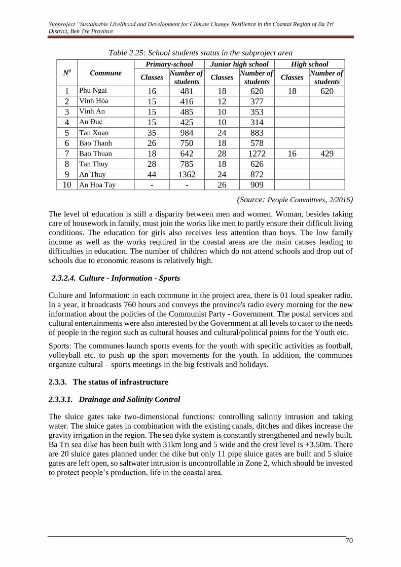
Subproject “Sustainable Livelihood and Development for Climate Change Resilience in the Coastal Region of Ba Tri
District, Ben Tre Province
70
Table 2.25: School students status in the subproject area
N0 Commune
Primary-school Junior high school High school
Classes Number of
students Classes
Number of
students Classes
Number of
students
1 Phu Ngai 16 481 18 620 18 620
2 Vinh Hòa 15 416 12 377
3 Vinh An 15 485 10 353
4 An Đuc 15 425 10 314
5 Tan Xuan 35 984 24 883
6 Bao Thanh 26 750 18 578
7 Bao Thuan 18 642 28 1272 16 429
8 Tan Thuy 28 785 18 626
9 An Thuy 44 1362 24 872
10 An Hoa Tay - - 26 909
(Source: People Committees, 2/2016)
The level of education is still a disparity between men and women. Woman, besides taking
care of housework in family, must join the works like men to partly ensure their difficult living
conditions. The education for girls also receives less attention than boys. The low family
income as well as the works required in the coastal areas are the main causes leading to
difficulties in education. The number of children which do not attend schools and drop out of
schools due to economic reasons is relatively high.
2.3.2.4. Culture - Information - Sports
Culture and Information: in each commune in the project area, there is 01 loud speaker radio.
In a year, it broadcasts 760 hours and conveys the province's radio every morning for the new
information about the policies of the Communist Party - Government. The postal services and
cultural entertainments were also interested by the Government at all levels to cater to the needs
of people in the region such as cultural houses and cultural/political points for the Youth etc.
Sports: The communes launch sports events for the youth with specific activities as football,
volleyball etc. to push up the sport movements for the youth. In addition, the communes
organize cultural – sports meetings in the big festivals and holidays.
2.3.3. The status of infrastructure
2.3.3.1. Drainage and Salinity Control
The sluice gates take two-dimensional functions: controlling salinity intrusion and taking
water. The sluice gates in combination with the existing canals, ditches and dikes increase the
gravity irrigation in the region. The sea dyke system is constantly strengthened and newly built.
Ba Tri sea dike has been built with 31km long and 5 wide and the crest level is +3.50m. There
are 20 sluice gates planned under the dike but only 11 pipe sluice gates are built and 5 sluice
gates are left open, so saltwater intrusion is uncontrollable in Zone 2, which should be invested
to protect people’s production, life in the coastal area.

Subproject “Sustainable Livelihood and Development for Climate Change Resilience in the Coastal Region of Ba Tri
District, Ben Tre Province
71
2.3.3.2. Water Supply
In the subproject area, the rainfall occupies the lowest in the region. The main water sources
are from rivers, sand dunes and deep ground water in water scarce areas. The subproject area
are abundant in surface water but because of locating in the river downstream, coastal area,
saline intrusion often takes place in dry months. The water supply work in the region belongs
to the Rural Water Supply and Sanitation Center and some private economic sectors. The water
supply systems have no coherence in the whole. The drinking water supply for people in the
subproject area meets difficulties. Total households who use piped water from Tan My water
plant and some other small water supply schemes are 5432 households. 11,194 households of
6 coastal communes in the subproject area have no clean water. The drinking water need for
these households is extremely urgent.
Table 2.26 The number households served with piped water system
N0 Commune
2015
Number
people Household
Water
meter Rate (%)
1 Tan Xuan 13,175 3,137 1,131 8.58
2 Bao Thanh 11,193 2,665 1,604 14.33
3 Bao Thuan 9,156 2,180 1,001 10.93
4 Tan Thuy 15,826 3,768 572 3.61
5 An Thuy 10,114 2,408 664 6.57
6 An Hoa Tay 10,336 2,468 460 4.45
Total 69,800 16,626 5,432
2.3.3.3. Traffic Network
Current local traffic Network consists of both waterway and landroute. There was Ba Lai sluice
gates connecting Ba Tri district with Binh Dai district so it is convenient for travelling.
In the project area, the inter-district road No 16 connects inter-province road No 885, up to Tan
Xuan, Ba Lai sluice gates directs, towards Binh Dai. This route has been covered with asphalt
on about 4km and with red-gravel on remaining part. Inter-province route No 885 cross, over
the project area for about 6500m, was asphalted about 4000m and red-gravel on rest road part
from Truong Dang to Bai Ngao. Besides, almost remaining landroutes are pathway and red-
gravel path with 3-5m in width. The tracffic is difficult, especially in months of rainy season,
so the traffic is mainly waterway.
The waterway is convenient due to two large rivers: Ba Lai and Ham Luong that run around
the project area and the arroyos connecting with the sea. Local people often use junks, boats
with load of 5-100 tons to transport agricultural products and other agricultural materials such
as the pesticides, breed-rice, shrimp, etc as well as the construction materials such as cement,
iron, steel, etc.
At present, most of the canals, arroyos in the salt-marsh area have not yet irrigation works so
the traffict by boats, ships is still convenient. However, this canals are being deposited. Some
canals in the area was dredged but they have not yet satisfied with demands as well as
requirements of waterway.

Subproject “Sustainable Livelihood and Development for Climate Change Resilience in the Coastal Region of Ba Tri
District, Ben Tre Province
72
2.4. GENDER CHARACTERISTICS
According to site investigation, the majority of households are headed by male persons. Except
some households, female is a main householder due to unexpected conditions of single - mum
or divorced marital status.
Agricultural practices are the main income source of female persons, meanwhile male persons
involve into non-agricultural activities or are seasonal workers in urban areas. Generally, the
workforce of female is dominant in agricultural production, but their incomes are lower than
male. Meanwhile, women or females play a crucial role in their families for many different
responsibilities such as chore, looking after children and other houseworks. Women have also
participated in many social activities along with man. However, women have to play dual roles
as workforce and family careers, there are some hurdles still remain including time available,
opportunity and other requirements for social activities. Therefore, the supporting aim of the
Subproject is to reduce burdens and responsibilities for women through incremental incomes
from production in association with their position opportunities to participate into community-
based activities.
Figure 2.8: Map of the Traffic Situation in the Subproject Area
2.5. PHYSICAL CULTURAL RESOURCES
In the Subproject area, there are three (03) national historical sites and one (01) local site. These
historical sites are valuable and worthy of spirit life to local people as well as tourism attraction.
Specific names and locations of historical sites are described in Table 2.27.
Table 2.27. Historical and Cultural Sites in the Subproject area
N0 Name of Historical Sites Description
1. National sites
Gravestone
Relic and
Nguyen
Dinh Chieu
Monument
The relic has an area of 13,00m2, which is located in An Duc
commune, which is 2km away from Ba Tri town, and 15km
for the Dredging site.
This relic was recognized by Ministry of Culture –
Information on 27 April 1990.

Subproject “Sustainable Livelihood and Development for Climate Change Resilience in the Coastal Region of Ba Tri
District, Ben Tre Province
73
N0 Name of Historical Sites Description
Vo Truong
Toan
Gravestone
It is located in Bao Thanh commune, 18km away from Ba
Tri town, and 2km from the Dredging site.
This relic was recognized by the Ministry of Culture –
Information on 24 Jan 1998.
Nguyen Van
Cung and
Cay Da Doi
It is located in Tan Xuan commune, 16km away from Ba
Tri town, and 5 km from the Dredging site.
It is recognized by the Ministry of Culture – Information
on 07 May 1997.
2. Provincial Monuments and Relics
Phan Thanh
Gian
Gravestone
The monument is located in Bao Thanh commune, which
is 12km away from ba Tri town and 2 km from the
Dredging site.
2.6. SITE – SPECIFIC CHARACTERISTICS
2.6.1. Sluice Gate
The construction area of sluice gates is mainly weeds and brush trees. Local transportation
system is not available. During high tide regime (spring tide), boat is the only one transportation
facility accessing to this construction area. There 5 sluice gates will be constructed in the
Subproject area, including: Duong Khai, Trang Nuoc, Duong Tac, Cay keo and An Thanh.
Each sluice gate is illustrated by pictures in the following table:
Table 2.28. Sensitive Features around sluice gates
Name of
sluice gate Picture Description Social and economic conditions
1 Duong Khai
This sluice gate is at the
beginning point of Duong
Khai, Bao Thanh commune. It
is 745m away from coastal
mangrove forest.
Production activities of
surrounding areas are shrimp
farms and salt making.
Low waterway transportation
activity.
2 Trang Nuoc
The sluice gate is located on
Trang Nuoc canal, which is
1000m away from Ba Tri
coastal mangrove forest
area.
Extensive shrimp farming.
Low waterway transportation
activity.

Subproject “Sustainable Livelihood and Development for Climate Change Resilience in the Coastal Region of Ba Tri
District, Ben Tre Province
74
Name of
sluice gate Picture Description Social and economic conditions
3 Duong Tac
It is located on Duong Tac
canal with 20m width, and is
about 1,270m away canal
mouth.
Intensive and extensive shrimp
farms.
Low waterway transportation
activity.
4 Cay Keo
The sluice gate is located on
Cay keo canal with 5m
width.
Extensive shrimp farms.
Low waterway transportation
activity.
5 An Thanh
It is located on An Thanh
canal with 4m in width.
Intensive shrimp farms.
Residential area is 200m away
from the sluice gate.
Low waterway transportation.
2.6.2. Dredging canal systems
All 14 proposed dredged canals are connected to the sea in which water flow and level are
directly influenced by uneven semi – tidal regime. Shrimp farms are not able to cultivated due
to salt intrusion. During the period of spring tide and neap tide, water level of the canal is up
to 3m and is lowered at 0.5m, respectively. Shrub and scattered trees are mainly vegetation on
both sides of canal’s branches, with low waterway transportation activity.
Location and socio-economic activities in these existing canals are summarized and illustrated
in the following table:
Table 2.29. Sensitive Features around canals
Canal name Picture Location Production Activities of Existing
Canals in Subproject Area
1 Gia
Bao
Thanh
commune
2 Xeo Giua
3 Cat
4 No
5 Cua
Salt production and Black tiger shrimp
area.
6 Duong Khai Bao
Thuan
commune
7 Duong Xuong
8 Duong Mieu
9 Duong Chua

Subproject “Sustainable Livelihood and Development for Climate Change Resilience in the Coastal Region of Ba Tri
District, Ben Tre Province
75
Canal name Picture Location Production Activities of Existing
Canals in Subproject Area
10 Cay Bang
Black tiger shrimp area and salt
production
11 Ong Hai Ha
Black tiger
shrimp area
12 Đe Quoc Phong
13 Đuong Tac
14 Cay Mam Tan Thuy
commune
Black tiger shrimp area and salt
production
Existing canals Soil types in the subproject
area

Subproject “Sustainable Livelihood and Development for Climate Change Resilience in the Coastal Region of Ba Tri
District, Ben Tre Province
76
CHAPTER 3. ALTERNATIVES ANALYSIS OF SUBPROJECT
This chapter aims to provide justification on how and why this subproject is selected based on
the approach recommended by the Regional Environmental Assessment (REA) and the
Resional Social Assessment (RSA) for the MDICRSL project for the transition zone to the
estuary region (Section 3.1) as well as the alternative analysis considered during the design of
the subproject (Setion 3.2). The ESMP (Chapter 6) has explicitly incorporated a technical
assistance to ensure that extensive consultation is made during the development of the sluice
operational manual and that DARD will have adequate capacity to manage and control future
development of aquaculture farming including possible scale up of the proposed livelihood
models. These measures are intended to prevent and/or mitigate potential negative impacts on
land and water uses due to operation of sluice gates as well as possible expansion of
aquaculture activities in the subproject and nearby areas. The technical assistance will plan
and implement the mitigation measures to address the potential impacts during operation phase
of the subproject.
3.1. Need for the Subproject
Need for implementation of the subproject has been identified in the REA and RSA prepared
for the MDICRSL Project. It has been concluded that overall the proposed subprojects are
designed to have positive environmental and social impacts and monitoring changes during
construction and operation of water control infrastructure and livelihood models is required.
The additional surface and groundwater monitoring and assessing changes in coastal and
riverbank erosion under Component 1 of the MDICRSL Project will be important for
measuring and managing the long term regional impacts of the Subprojects 2, 3 and 4 and the
implementation of subprojects in Phase I will provide important insights into the design and
safeguard instruments for the Phase II subprojects.
The proposed subproject will be implemented under Component 3 of the MDICRSL Project.
Below highlights justification for the subproject and measures to mitigate potential negative
impacts as recommended in the REA and RSA and they have been considered during the
preparation of Chapters 4, 5, and 6.
a) Impacts of dredging
The main possible impacts on the local environment during maintenance dredging and/or
construction of secondary and/or tertiary sluices would be: (a) contamination of the lands and
water resulting from the disposal of dredged materials; (b) contamination of the roads and lands
resulting from the transportation of the dredged materials; and (c) an increase in suspended
solids in water due to disturbances of bottom sediment. A sampling survey suggested that
dredged materials are mainly silt and clay with high organic content with the content of the
heavy metals and residual pesticides being below the national thresholds. Therefore, the risk
of contamination to the disposal land and ground water is small.
In the Mekong Delta, it is customary that dredged materials be stored on the land next to the
canal for drying for one or two years and then used as a basis for roads or dykes. However, it
should be noted that the dredging would take place over extensive areas and over the whole
project implementation period. Important information such as estimated quantity and likely
quality of the sediments, availability of lands for disposal is at the detailed design stage. In this
context, it is appropriate to develop a detailed plan for the disposal of the dredged materials at
the detailed design stage.

Subproject “Sustainable Livelihood and Development for Climate Change Resilience in the Coastal Region of Ba Tri
District, Ben Tre Province
77
b) Impacts of sustainable livelihood models in the estuary and peninsula
The livelihood models in the delta estuary and peninsula will support to farmers to transition
(where suitable) to more sustainable brackish water activities such as mangrove-shrimp, rice-
shrimp, and other aquaculture activities and to implement climate smart agriculture by
facilitating water use efficiency in the dry season. Livelihood programs are very important in
the delta estuary and coastal provinces ashouseholds in the transition between fresh and
brackish water had lower income than those in other zones. Livelihoods of people in this zone
are more vulnerable to freshwater availability from the upstream, to salinity intrusion from
estuaries and/or adjacent shrimp farming areas and to extreme dry season freshwater shortages.
Providing livelihoods support measures to farmers to adapt to salinity intrusion and transition
to brackish aquaculture is an important initiative. Salinity issues in the estuary areas have
caused production losses to rice and high value agriculture. The transition to high value
agriculture will provide many social benefits to local communities and households involved in
the livelihood models. Construction of salinity control infrastructure in the past has been
inflexible and locked farmers into development pathways. The transition to aquaculture in the
estuary areas will be complex as currently high value crops provide more farm-based income
than aquaculture and supports employment opportunities for local people.
The mangrove-shrimp and rice-shrimp are more sustainable options for aquaculture. The
development of livelihood models will need to consider the potential environmental impacts of
aquaculture and shrimp farming including the release of organic wastes, agro-chemicals,
antibiotics, the transmission of diseases and the ecological impact on freshwater and coastal
fisheries in the Mekong Delta.
c) Expanding aquaculture and shrimp farming
The large areas of land required for intensive and semi-intensive shrimp farming have led to
significant natural habitat loss through conversion of mangroves and wetlands into shrimp
ponds. The investment in large water control infrastructure has lead to conflicting interests and
inflexible water management when local rice farmers sought to benefit their income through
the conversion of their farms from rice to shrimp.
The project will promote integrated rice-shrimp and mangrove-shrimp farming that are
considered to be more environmentally sustainable aquaculture because it is extensive and uses
less agro-chemicals (i.e. fertilizers, antibiotics) and can lead to restoration of mangrove areas.
Environmental concerns such as effluents from the shrimp farms, disposal of the sediments in
the shrimp ponds into canals and rivers need to be managed. Applying sustainable rice-shrimp
model using VietGap standard to develop operational guidelines for water management
systems in the project area will lead to more sustainable shrimp farming in the estuary and
peninsula.
Nevertheless, there are some environmental concerns relating to the current rice-shrimp
farming systems. First, the current shrimp farming method is based on high water exchange,
which would result in high accumulation of sediment in the rice farms in the long-term. Many
farmers reportedly dispose of accumulated sediment back into the canals or nearby river, which
would induce negative environmental impacts. Furthermore, recent introduction of exotic
species and introduction of more intensive shrimp aquaculture may also lead to more pollution
in the effluent of the wastewater from the shrimp farming.
d) Impacts of protecting mangrove forests in coastal areas
To adapt to saline intrusion and prevent coastal erosion in Ben Tre, measures will include
ecosystem-based aquaculture, resilient infrastructure for aquaculture and mangrove

Subproject “Sustainable Livelihood and Development for Climate Change Resilience in the Coastal Region of Ba Tri
District, Ben Tre Province
78
reforestation. Mangroves play a critical role in biodiversity and ecosystem productivity in the
coastal areas of the Mekong Delta. In some areas of the delta, dikes are already being
strengthened or heightened and mangroves are being planted to improve protection from storm
surges and coastal erosion The GIZ Integrated Coastal and Mangrove Protection (ICMP)
program is supporting Vietnam to manage its coastal ecosystems in order to strengthen
resilience to climate change. To manage environmental impacts, a forest Management Plans
(0P 4.36) will be prepared for all mangrove reforestation work undertaken as part of the project.
Integrated coastal management requires a combination of sea dykes, mangrove restoration and
sustainable shrimp farming to protect the peninsula from coastal erosion and sea level rise.
Increasing the mangrove area will protect against coastal erosion, storm surges and may
increase biodiversity. This activity should be supported by biodiversity conservation and
monitoring to protect saline and estuarine species in the mangrove areas. The sustainable
management of coastal (near-shore) fisheries and other aquatic animals is important to support
livelihoods of landless and protect biodiversity.
3.2. ASSESSING “WITH” AND “WITHOUT” SUBPROJECT
This section includes the analysis of environmental and social impacts in case of “without” and
“with” subproject as follows:
- “Without” subproject: this means environmental and social issues are ongoing as present.
For example, the fresh water sources for drinking and production are in the scarcity; often
salinity intrusion has been causing serious damages to the production and the livelihood in
the people area.
- “With the subproject”: this means the subproject portfolio includes: constructing 9 salt-
preventive sluice gates, dredging 14 infield canals, building the water supply station of
330m3/h, supporting local governments the sustainable livelihood models which proactively
adapt to climate and sea-level rise.
The analysis details on environment and social impacts are shown in Table 3.1.
Table 3.1: Environmental and social impacts in case of “without the subproject” and “with
the subproject”
Impacts Selected alternatives
"Without the Subproject” "With the Subproject”
1 ENVIRONMENTAL ASPECTS
Water
Quality
Improvement
The canal water is currently
affected by wastewater from rice
production and aquaculture.
The canal water quality will be improved and
better drainage condition due to dredging.
Land Use
Change
Zone 2 is a mainly salt-making
area.
The main economic activity in
Zone 3 is rice cultivation. This will
affect soil quality due to utilization
of chemical fertilizers.
Zone 2 is brackish shrimp farming and
economic sustainability.
Possible resulting to the conversion of
land-use purpose in Zone 3, from traditional
rice-growing to the specialized farming to
make high competitiveness in the market.
Gradually, improve the added value of
agricultural production and the income for
local people, to actively adapt to climate and
sea-level rise.

Subproject “Sustainable Livelihood and Development for Climate Change Resilience in the Coastal Region of Ba Tri
District, Ben Tre Province
79
Impacts Selected alternatives
"Without the Subproject” "With the Subproject”
Biodiversity There are no critical, sensitive
natural habitats and species listed
in the Red Book of Vietnam and
IUCN in the subproject area.
Currently, the sluice gates of
Duong Khai, Trang Nuoc, Duong
Tac, Cay Keo, An Thanh have no
salinity regulatory works that
make pathway for aquatic species
to find food as well as to reside.
However, the salinity constantly
changes, which is also an affecting
factor on the aquatic ecosystem in
the Subproject area.
The construction of tidal control sluice
gates may affect the movement and foraging
of some aquatic species.
However, the operation condition is
flexible, active, short time and uncontinuous
open – close regime. Therefore, this effect is
negligible.
Salinity
controlling
Uncontrolled Salinity, surge tides and drainage
conditions are well controlled and regulated
by the sluice gates system.
Coping with
climate
change
The Subproject is located in the
coastal region which is forecast to
be severely affected by saltwater
intrusion due to sea level rise,
leading to serious scarcity of fresh
water resources.
A part budget of the Subproject is
proposed for supporting local people and
authorities. This enables sustainable
development and conversion of livelihood
models in adapting with climate change
impacts.
Raising public awareness on climate
change and support the establishment of the
communal climate change response teams.
Forming the community-based model and
building capacity that actively responds to
climate change.
Upon the completion of the Subproject,
livelihoods of local people are sustained in
the context of climate change.
2 SOCIAL ASPECTS
Land
acquisition
and
resettlement
There is no land acquisition and
resettlement.
There is no land acquisition and
resettlement.
Income of
local people
Agricultural production is not
really sustainable and the state of
"planting, cutting” perennials and
"bumper crops, cheap at prices" is
popularly observed;
Most agricultural products are
poor quality and less competitive
These limitations will be addressed
quickly in association with fulfilling the
complete irrigation works, electrical supply
system; enhanced production quality models
and linking production – market chain.

Subproject “Sustainable Livelihood and Development for Climate Change Resilience in the Coastal Region of Ba Tri
District, Ben Tre Province
80
Impacts Selected alternatives
"Without the Subproject” "With the Subproject”
because of the small-scale,
fragmented production;
Large quantity of farm products,
but in homogeneous;
Inadequate technical
contribution to agricultural values.
Particularly, there is a lack of
cohesiveness in the added value
chain in terms of production -
purchase - processing - storage -
consuming of products.
Aquaculture
practices
Climate-related risks are often
observed. A serious phenomenon
of massive deaths of scallop in
2011 was recorded due to climate-
related factors, including climate
change, salt intrusion, extremely
high temperature and insufficient
nutrition sources.
It was estimated that 1,500 tons
of mature scallop and 2,635 tons
of young scallop were dead,
which caused total loss values up
to 127.6 billion VND in three (03)
fishery cooperatives (An Thuy,
Tan Thuy and Bao Thuan
communes).
The saline intrusion areas (aquaculture
and salt-making areas) will no longer
depend entirely on nature and can be more
active in prevention and minimization of
natural disasters through the sea dike system
and tide-prevention sluices (sluice gates).
In the dry season, sluice gates will be
closed to prevent saltwater, if the salinity is
too high. In case of late seeding crop, which
caused late harvesting, shrimps would be
shocked due to rains leading to reduction in
salinity level, salt water in-canal salt water
and in-pond salt water storage measures will
be applied.
Eco-shrimp farming and implemented
biological safety measures will help local
farmers to minimize difficulties and risks
faced by climate-related risks. These will
also enable sustainable aquaculture
practices, increase product values and
support export activities.
Rice
production
Salt water intrusion caused yield
reduction of rice, crops, and fruit
trees. In the Winter-Spring crop
(2014 – 2015), the total area
which was directly affected by
salt intrusion was about 3,825 ha,
loss value was estimated over 63
billion VND.
Salt intrusion can be minimized,
production activities are no longer face with
risks of saltwater intrusion due to the
proactive open – close sluice gate system.
An increase in production though the
number of crops decreases. Crops and
livestocks will be diverse.
Enabling rice – shrimp models. This kind
of integrated model minimizes epidemic
diseases, promotes clean shrimp products
and brings sustainable economic efficiency.

Subproject “Sustainable Livelihood and Development for Climate Change Resilience in the Coastal Region of Ba Tri
District, Ben Tre Province
81
Impacts Selected alternatives
"Without the Subproject” "With the Subproject”
Freshwater
supply for
production
Insufficient fresh water
resources for agricultural
practices.
The entire area of zone 3 is
facing with a shortage of
freshwater in the dry weather due
to inadequate sluices for
freshwater intake and lacking of
regulatory works preventing
saltwater intrusion.
Once saltwater intrusion is controlled
resulting in a reduction in salinity in Zone 3,
production activities will be sustained
through a combination of propaganda with
public awareness on the advantage and
prevalence of local crops and livestocks.
Improve
traffic
demand of
people in the
area
The existing 31km long of
transport infrastructure in the sea-
dyke system is not yet connected
completely.
Construction of 5 tidal sluices making a
complete connection of transport route with
11 existing sluice gates on a 31 km sea-dyke
system.
Interruption
of living and
production of
people
There is no obstruction for local
waterway transport.
Without sluice gates, boats
travel easily within the Subproject
area.
Waterway traffic can be affected when
closing sluice gates.
However, this effect is negligible as sluice
gates are closed for a short time and the
operation plan will be publicly noticed for
local people to arrange their traveling
schedules.
3.3. ANALYSIS OF ALTERNATIVES
Component 1: No alternatives to be considered.
Component 2: The optional alternatives in terms of structural techniques for sluice gates
presented in Table 3.2 show that the alternatives to be selected are economic optimal and
environmental and social impacts are at the acceptable levels.
Table 3.2: Optional alternatives in terms of Technical Aspect for the sluice gates of the
Subproject
Component Selected alternatives
Alternative 1 Alternative 2
1 Sluice gates
structure
On-site reinforced concrete
structure by using steel-pile
cofferdams or soil-retaining
dikes impounding to keep dry
the entire construction pits and
foundations.
Assembled concrete structure: sluice
gates pillars and valve towers (divided
into segments, 2-3m each segment) are precast reinforced concrete structure.
Advantage The concrete work is simple
that requires medium
techniques and machines/equipment.
The time for completion of assembled works is short.
The quality of concrete structures is guaranteed.

Subproject “Sustainable Livelihood and Development for Climate Change Resilience in the Coastal Region of Ba Tri
District, Ben Tre Province
82
Component Selected alternatives
Alternative 1 Alternative 2
The material supply source
(sand, stone, cement and steel)
is abundant, and is not far
from the construction area, about 15 - 20km.
Material transportation is
convenient, by road or
waterway
Fabrication of structures of works does not depend on the weather condition.
Disadvantage Difficulty in creating dry pits.
For high water column H = (6
- 8) m, steel-pile cofferdams
or soil-retaining dikes must be
installed to keep dry the entire construction pits.
The quality is harder to control
than casting structures in
plants.
Modern construction machines and
equipment are required.
Workers must be skillful, technicians are
highly qualified.
Trucking, assembling components in
large quantities and bulk, about 100 tons
from plants to the construction sites is
very difficult, specialized equipment and machines are needed.
Environmenta
l and Social
aspects
The construction depends on
the weather, and therefore, it is
not easy to minimize
unexpected impacts.
Social impact will be
significant due to the
acquisition of land for
construction, warehouses,
workers’ camps to serve for the concreting.
The execution time is long,
leading to the environmental
effects will be longer.
Less environmental pollution in the
construction sites than the in-situ
reinforced concrete plan because there is
a substantial amount of workers and machines at the workshop.
Social impacts will be less as main
components are manufactured at the workshop.
Economic
efficiency
Cheap, saving cost High cost
Conclusion Selected Not selected
2 Type of
structure
Rigid structure: reinforced
concrete is monolithic
between pillars and bottom
beams.
Soft structure: removable concrete, soft
links between pillars and bottom beams.
Advantages Acting force is distributed on
both pillars and bottom beams.
The structure is more stable
and reliable when it is
subjected to external force
caused by small foundation
pressure. The horizontal force
is evenly distributed to both
Pillar is the main load-bearing structure,
the bottom suffers dead-load only, so the
bending moment is small, which help minimize required reinforcement.
Require narrower construction site; the
construction in steel-pile cofferdams costs lower.

Subproject “Sustainable Livelihood and Development for Climate Change Resilience in the Coastal Region of Ba Tri
District, Ben Tre Province
83
Component Selected alternatives
Alternative 1 Alternative 2
bottom pillars and bottom beams.
The number of piles is smaller.
The construction work,
monitoring of work quality is
implemented by experienced staff.
The design is in accordance
with sluice gates aperture of
50 - 30m.
Local contractors have a lot of
experiences in this kind of designing proposed structure.
Safe design, management and
operation of the opening and closing valves.
The volume of construction at the same
time is small and can be arranged flexibly.
Designed in accordance with the sluice gates aperture > 20m.
Disadvantage
s
Bottom beams are bearing
structures (mainly bending
moment), so it must be thick
enough and reinforced,
especially the cavity at
aperture > 20m.
A wider work site is required;
the cost will be higher when applying cofferdams.
The volume of construction
required simultaneously is larger and inflexible.
The structure is less stable as foundation
pressure on pillar is huge.
Linked by soft joints or abutment.
Affect on absorbent safety of the
construction works when the joints/links
get troubles/incidents.
Valve gate works is unsafe when
subsidence or sinking between the two pillars occurs.
The foundation pressure posed by the
work is large. The treatment of pillar
bottom is difficult.
Horizontal force will affect on pillar.
Piles must be dense, pillar bottom slab
area must be increased when there is a large difference of water column/level.
Local contractors are less experience in
design, construction, quality monitoring in the irrigation sector.
The settlement at 2 pillars appears
easily, therefore, the coupling for
components must be compatible with the
operation of the door and limit subsidence.
Environment
al and Social
aspects
Local navigation will be
affected during the construction phase.
A large construction site, the
area of acquired land and
compensation is large.
Influence on navigation is minimized
during the construction phase.
No need for large construction site; land
acquisition and compensation are less;
can be constructed in cofferdams,

Subproject “Sustainable Livelihood and Development for Climate Change Resilience in the Coastal Region of Ba Tri
District, Ben Tre Province
84
Component Selected alternatives
Alternative 1 Alternative 2
construction works can be carried out in watery condition.
Economic
efficiency
For sluice gates with cavity
aperture 20m, the investment cost will be greater.
The rate of investment is feasible.
Conclusion Selected Not selected
Component 3: There are no alternatives to be considered.

85
CHAPTER 4. ENVIRONMENTAL AND SOCIAL IMPACT
ASSESSMENT
It is noted that although the potential negative impacts of works (dredging and building sluice
gates) to be conducted under Components 2 of this subproject is in line with the key findings
of the REA for the MDICRSL that it will generally increase the level of air, noise, vibration,
and water pollution as well as increasing local traffic congestion including road safety risks
and disturbance to local residents and they could be mitigated by (a) ensuring that contractors
apply good construction practices and initiate/maintain close consultation with local authorities
and communities throughout the construction period and (b) close supervision of field
engineers and/or environmental officer as recommended in the REA. However, to comply with
Government’s expectation for the EIA analysis, the ESIA also included the results of the
analysis related to air/noise and water pollution in Section 4.4.4. As suggested by the REA,
these impacts will be mitigated through the application of the Environmental Code of Practices
(ECOP) which has been prepared in lien with the ESMF.
Potential negative impacts of the subproject activities during operation of sluice gates and
application of the livelihood models have also been found to be moderate and they can be
mitigated through a technical assistance to be provided during the preparation and
implementation of the livelihood development models (Component 1 and 3 of this subproject).
The technical assistance will also address the need for extensive consultation with water users
and key stakeholders during the development of sluice operations and possible impacts due to
expansion of aquaculture faring and the livelihood model without adequate management and
control.
4.1. CLASSIFICATION AND SCALE OF IMPACTS
In the implementation of the subproject, there will be some potential impacts on the
environment and society in the subproject area and the surroundings. The impacts may be
temporary in each phase of the subproject or may be recurring during the subproject lifespan.
The common collateral impacts are classified into two types: impacts caused by daily activities
and impacts caused by the accidence/incidences. The first type involves in the normal operation
activities of the subproject while the later one involves in the unwanted accidences from the
activities. During the evaluation process, the degree of the impact on the environment will be
determined based on the following criteria:
Significant impact (S)
- Significant changes, over a significant area, to key characteristics or features or to the
landscape’s character or distinctiveness for more than 2 years.
- The impact goes beyond regulatory standards or long-lasting and widespread impacts
- Altering the ecosystems or ecological functions on a large area causing losses at the
moderate scale (lasting over 2 years) but having the ability to restore within 10 years;
- Tentatively affect human health;
- Causing financial damage to the users or communities.
Moderate impact (M)

86
- Noticeable but not significant changes for more than 2 years or significant changes for
more than 6 months but less than 2 years, over a significant area, to key characteristics or
features or to the landscape’s character or distinctiveness.
- Altering the ecosystems or ecological functions locally in a short time with potentially
good recovering capacity. The impact level is similar to the changes at present but
potentially causing accumulated impact.
- Possibly (unlikely) affect human health; may causes difficulties to some users.
Low Impact (L).
- Noticeable changes for less than 2 years, significant changes for less than 6 months, or.
- Changes occur only in the current variation range or barely discernible changes for any
length of time, within acceptable standards and their impacts can be totally controlled.
- The impacts may affect the operation but does not hinder the users or the public.
- Mild impact on the human health or quality of life.
No impact (Insignificant/Negligible) N
- Any change would be negligible, unnoticeable or there are no predicted changes;
- Changes that are not perceivable or can be measurable based on the basic operation;
- No mutual influence and therefore no changes occurred.
4.2. POSITIVE IMPACTS
4.2.1. Socio-economic condition
The current saline soil and saline water can be affected to decline both quality and quantity of
some local crops. The two crops in many areas are not arable due to salinization and lack of
fresh water for irrigation as well as dilution for aquaculture. According to the survey results,
the proportion of irrigated arable land in the Subproject area is low (accounts 11.7% of the
surveyed households whose arable land is irrigated). The majority of households have no way
but pumped water for their cultivation and fishery land, which leads to high production costs.
The common state of soil salinization, flooding or water shortage in many places causes
significant effects on production and people's life. Accordingly, local people have faced with
difficulties related to water resources for agricultural practices such as fresh water shortage,
flooding, salinity, water pollution, even shortage of saltwater for aquaculture cultivation in the
rainy season.
Once the Subproject is completed, the system of canal and sluice works, which prevent salt
intrusion, will be improved to reserve freshwater for irrigation. Therefore, local people can be
able to produce local plants and animals, which are competitive in the market. This will
gradually improve the value of agricultural production and income and actively adapt to climate
change and sea level rise. The combination of agriculture, aquaculture and livestocks at the
household and cooperatives level will accelerate the alleviation of poverty in the region,
making the number of subproject beneficiaries 98,000 people. According to site investigation
in associated with public consultation, the percentage of households utilizing 1 rice-crop per
year and 2 rice-crop per year are 10.1% and 42.2%, respectively. Interestingly, about 17.8% of
the respondents said that they will increase crops if water provision is sufficient. Further, about
2.3% of respondents want to switch to aquaculture and 10.2% will combine rice cultivation

87
with aquaculture, 0.7% shift to the rice-crop model, and about 4.4 % switch to cultivation of
high-yield crops (which need more water).
4.2.2. Capacity of Climate Resilience
Given the context of agriculture-based livelihoods, the three (03) proposed components of the
Subproject aim to underpin local livelihoods in association with the enhancement of local
adaptive capacity climate change effects through:
Restoring mangrove belt in combination with sustainable livelihoods by developing
aquaculture models of mangrove – shrimp and rice – shrimp;
Improving sustainability of brackish water aquaculture by dredging 14 canals to control
tidal surge; and
Building adaptive capacity by supporting adaptation and mitigation measures for local
people.
Component 1: Mangrove – shrimp
Mangrove-shrimp to organically certify is to establish an “organic coast” that both produces
high-value certified shrimp and protects from the rise of sea level as well as extreme weather
events. According to IUCN, the mangrove – shrimp model can contribute to natural disaster
risk reduction and enhance livelihoods. In fact, the plantation of 9,462 ha forest of 166
communes in Northern Vietnam (in which mangrove forests accounting for 8,961 ha), reduce
damages caused by tropical cyclones for dyke systems. Damages cost about 80,000-295,000
USD, but total saving costs are over weighted the damages, estimated about 15 million USD.
In this scenario, integration of mangrove-shrimp farming and organic certification offer a
strong example of an ecosystem-based adaptation to climate change. Further, with a direct
financial incentive which is being provided to farmers to plant and conserve mangroves, it can
also be seen as an effective form of Payment for Ecosystem Services (PES).
Whether or not certified organic shrimp farming results in permanent improvements to
livelihoods and the environment remains to be seen. Nevertheless, with strong business and
provincial government support, there are grounds to believe that the project will deliver
economic and environmental benefits that, because the project aims to change the underlying
business model, will persist after the project ends.
Component 2: Improving Sustainability of Brackish Zone
The activities of the Subproject in Zone 2 lend a hand to protect vulnerable people to adapt to
climate change are mainly performed via the climate change adaptation works, better welfare
network and risk management activities. The Subproject will construct 5 tidal-sluices in the
sea-dike area to minimize effects and enhance the resilience to climate change.
The dredging activities for 14 canals will facilitate the improvement of irrigation works and
efficiency of water use. In addition, it is suitable to turn to cropping structure in the context of
extreme weather conditions by crop diversification, restructuring of monoculture crops to
intercropping and rotation crops. Further, paddy fields are also protected from salt water during
serious drought periods.
Component 3: Building Capacity for Climate Change Resilience
The fieldwork results combined with the interviews of local people in the subproject region
reveal that most vulnerable people much depend on natural conditions for their living activities.

88
Therefore, in a long – run, this component of the Subproject will bring positive benefits for
local people in terms of awareness and adaptive capacity.
Consequently, raising public awareness on climate change and support the establishment of
communal response teams to climate change adaptation are the vital of concerns and needed
solutions that help local people to minimize climate vulnerabilities and to strengthen their
resilient capacity to climate change. These supporting measures include:
Providing necessary skills and knowledge to adapt to climate change. Knowledge helps
increase people’s ability to cope with climate shocks in the short-term and to adapt with
climate change in the long-term.
Sharing lessons learned among local people to be affected may enhance the adaptation
activities of the Subproject.
Deploying the appropriate model in rice fields, training and field seminars (FS) is
improving social resources and increasing the access to information sources, which may
create more effective economic development opportunities.
Establishing/Supporting farmers' unions and market linkages will amplify the access and
connections to markets and to promote the establishment of partnerships and cooperation
among communities, private companies and local organizations to create long-term stable
income for the people in the subproject region.
This model of capacity building will gradually change people’s perception and attract them to
engage in the alternative livelihood activities. This will enable transformation from
spontaneous adaptation activities to planned adaptation measures.
4.2.3. Positive overall impacts
The positive overall impacts of subproject implementation as following
Operation of the proposed 5 sluices to be constructed under the subproject will help
increasing ability of Ben Tre province to manage water resources in the subproject area
more systematically, which will in turn enhance effectiveness of agricutlure production and
reduce potential conflict among local people regarding land and water uses. Rice farming
will require freshwater, while shrimp farming will require high quality of water and can
create water pollution and soil pollution seriously affecting rice production. Nonetheless,
it is necessary for the province to establish clear procedures for operation of these sluices
through close consultation with the local farmers and other water users to ensure that they
agree and be aware of the water supply situation as well as know rules and regulations
regarding on-farm management and other requirements. Overall, these sluices will be
operated according to an operation manual which will be acceptable to farmers. During the
subproject appropriate water quality monitoring program will also be carried out to ensure
that adverse negative impacts will not occur.
Plantation of mangrove forests in the target area will also help prevent coastal erosion and
soil erosion of the embankment, and over time it can create a mangrove forest buffer zone
for the area as well as provide lessons learnt that could be used to applied in other areas.
Dredging: the dredging will be done in the livehood model areas. This can result in increase
of water for production in the models.
Implementation of the livelihood models will enhance opportunity for the local farmers to
build their knowledge and experience on implementation of appropriate technology that
could be friendly to the local environment as well as bring them more income. Nonetheless,

89
an approrpaite training program and a social survey will have to be made to ensure that
farmers have knowledge and be aware of the tehnical and financial risks, while Ben Tre
province will have to establish and implement a program to register all farmers in the
subproject areas as well as in the province to ensure that negative impacts will not occur
due to uncontrolled development of inappropriate scalling up of these models.
4.3. IMPACT OF CLIMATE CHANGE
4.3.1. Impacts of climate change on the subproject area
The subproject area in Ba Tri district is regularly affected by saltwater intrusion, storms, low
pressures, tidal surges, cyclones etc. which cause serious damages to local people's production
and people's lives. The inland saltwater intrusion affects agricultural and fishery practices,
which are two main sources of local livelihoods.
The field surveys combined with household interviews in the subproject region found that the
impact of climate change in recent years significantly reduces drinking water sources of
residents as well as irrigation water for their crops. In the dry season, communal people in the
subproject region meet the serious fresh water shortage due to the reduction in water flow from
upstream parts resulted from the decrease of rainfall. In addition to the effect of sea level rise,
especially the deeper saltwater intrusion, in some areas salinity occurs for 4-6 months per year,
making people face with water scarcity daily purposes. More than 11,000 households in the
area are not provided with clean water except water from inner canals which are seriously
polluted from agricultural wastes and residues from plant protective chemicals. Households
located in the areas where is near the year-round salty waters must buy raw-water from some
households who trucked water elsewhere with inadequate quality, sanitation and high prices as
well.
Rice farming is the main source of staple food of local people with two crops a year: winter-
spring and summer-autumn. Farming is usually associated with livestock feeding, mostly pigs
and poultry, to increase income. Given this context, most local people is poor, in which Women
are the primary labor force in agricultural practices. According to statistical data carried out by
Ba Tri district Department of Agriculture and Rural Development, climate change and climate
– related risks caused huge damages on rice production in recent years as follows:
In the Winter-Spring crop 2009 – 2010: saline intrusion reduced the rice yield at about 580
ha in several communes such as Bao Thanh, Bao Thuan, Vinh An, An Hoa Tay, Tan Thuy,
Tan Xuan, and An Hiep. The recorded productivity is less than 3tons/ha.
In the Winter-Spring crop 2010 - 2011: The paddy area affected by salt intrusion was about
1,900 ha causing about 30% reduction in productivity in the communes of Bao Thanh, Bao
Thuan, Tan Xuan, Phu Ngai, Tan My, My Hoa, Vinh Hoa, My Chanh, My Nhon, and Phu
Le town. Particularly, Bao Thanh, Tan Xuan and Vinh Hoa communes account for 52 ha
of the damage area in which the damage percentage reached 60-80%. The estimated value
of loss was over 20 billion VND.
In the Winter-Spring 2012 – 2013: Ba Tri district lost entirely 247.4 ha of rice in total, and
a sharp reduction (30% - 70%) in productivity was recoreded in 1,288 ha due to saltwater
intrusion. The value of damage was estimated at 24.5 billion VND.
In the Winter-Spring 2014 - 2015: rice productivity and quality were affected by salinity in
which about 3,825 ha were more than 30% of productivity reduction. Especially, rice
productivity of 632 ha in An Ngai Tay, An Hiep, Vinh An, Bao Thanh, Bao Thuan, Tan

90
Xuan, and Tan Thuy communes were substantially decreased at 70%. The estimated value
of damage is 63 billion VND.
In addition to immediate losses of income, local people also suffer from burdens of desalination
and reclamation as well as fertilizer supplementation. The losses in agricultural production
impoverish a number of people in the region who has pledged all land and financial property
to become employed workers. As a result, the existing situation will be more exacerbated in
the age of climate change in a long-time.
For aquaculture practices, not all households have enough money to invest in aquaculture,
except some wealthy households. Aquaculture production tends to be decreased recently
because of a number factor, including diseases, water pollution, reduced salinity of brackish
water (due to flooding), salinization (due to salt intrusion and droughts) and climate change.
However, aquaculture activities also cause environmental pollution as a large amount of
untreated wastewater from aquaculture ponds is directly discharged into canals that supplies
water for the neighbourhood. According to Ba Tri Department of Agriculture and Rural
Development, the damages of aquaculture practices in recent years are summarized as follows:
In 2011, a massive death of scallop (meretrix lyrata) due to a number of factors resulted from
natural climate – related risks and environmental change, such as extremely high temperature
(exceeding biological threshold of scallop), salinity, climate change, inadequate nutrition
and pathogens. Total loss was estimated at 127.6 billion VND in which 1,500 tons of adult
scallop and 2,635 tons of young (baby) scallop were died in 3 cooperatives of An Thuy, Tan
Thuy, Bao Thuan.
The total value of fishery losses from 2010 to 2015 was estimated about VND 238.105
billion VND.
Damages of aquaculture production caused many people lost money. The reasons for this
difficulty are posed by above-mentioned factors that made low aquaculture output. There is
a fact that local people do not have adaptive capacities to respond to the vagaries of climatic
variations. Some farmers stopped or downsized their aquaculture farming to reduce losses.
Other households burdened severe losses that they pledged land to pay bank loans for their
investments.
It is clear to say that climate vagaries obviously caused vulnerabilities to agricultural
production and fishery in the region where most people are the poor. Most importantly, local
people do not have financial and human resources to apply various ways to minimize the risks
of climate change. People in the Subproject area are implementing adaptive activities
spontaneously to cope with the nature rather than planned adaptive activities. This means that
there is a need for supporting and building adaptive capacity for people to make this project
sustainable and resilient to climate change.
4.3.2. The impact of climate vulnerabilities on the livelihood models
Impacts of climate vulnerabilities on the livelihood models include:
An increase in temperature, especially more days with hot and extreme temperature. This
will accelerate temperature of surface water and accelerate evaporation, leading to an
increase in the degree of salinity. However, the integrative models of forest – shrimp and
rice – shrimp are less vulnerable to high temperature due to the coverage of forest and canopy
protecting pond systems.
The rainy season will become shorter and the dry season is longer, which accelerate the
extent of salinity affecting the integrative models of forest – shrimp and rice – shrimp.

91
The rise of sea level will cause high tides posing the risk of breaking bunds of shrimp farms
and resulting to the escape of shrimps from ponds.
Unpredictable weather conditions like prolonged rainy season will wash away pollutants to
ponds. This will cause high risks for proposed integrative livelihood models
Drought periods is likely prolonged which will create transitions making shrimp becomes
more susceptible to disease.
4.3.3. The impact of the Subproject to adapt to climate change
From the current state of aquaculture activities and agricultural activities taking place in the
subproject region in the context of climate change, it can be asserted that in order to help people
adapt to climate change, we needs proper response planning to have overall approaches,
including the need to integrate sustainable livelihood programs with disaster risk management
programs.
Component 1: Mangrove-shrimp to organically certified mangrove-shrimp.
“Organic certification of mangrove-shrimp” is to establish an “organic coast” that both
produces high-value certified shrimp and protects against rising sea level and potentially
stronger storms. In this scenario, integrated mangrove-shrimp farming and organic certification
offer a strong example of an ecosystem-based adaptation to climate change. Because a direct
financial incentive is being provided to farmers to plant and conserve mangroves, it can also
be seen as an effective form of Payment for Ecosystem Services (PES).
Whether or not certified organic shrimp farming results in permanent improvements to
livelihoods and the environment remain a question. Nevertheless, with strong business and
provincial government support, there are grounds to believe that the project will deliver
economic and environmental benefits that, because the subproject aims to change the
underlying business model, will persist after the subproject ends.
Component 2: The activities of the Subproject in Zone 2: the subproject’s activities which
lend a hand to protect vulnerable people to adapt to climate change are mainly performed via
the climate change adaptation works, better welfare network and risk management activities.
The Subproject will build 9 tidal-sluices in the sea-dike area to minimize effects and enhance
the resilience to climate change.
The dredging activities for 14 canals in the subproject region facilitate the canal irrigation
system of canals to adapt to droughts thank to the improvement of irrigation works and efficient
use of water. In addition to the water and sluice gates infrastructure, there are suitable planting
structures for the extreme conditions of weather by the crop diversification, restructuring of
monoculture crops to intercropping and rotation crops. Also in salinization condition, the canal
system can sluice gates saltwater out of the fields.
The construction of the water supply station of Ba Lai enables 10,000 households in the
Subproject area to improve the living conditions to ensure the hygiene and prevent diseases.
Improving water quality and water supply will help improve health and reduce labor costs and
other cost for collecting water. These improvements can help improve living quality and
prosperity for the community thank to the reduction of working time, improvement of health
and income.
Component 3: The fieldwork results combined with the interviews of people in the subproject
region reveal that most vulnerable people are not only those who live in the boundary areas
between land and sea but also those whose living activities depend greatly on the nature.

92
Therefore, raising climate change awareness and establishment of the communal response
teams, assessing the status of climate change impacts, infrastructure, organization and
management, analysis of disaster risks, selection of a model that the community can actively
respond to climate change, building and strengthening capacity, preparation and
implementation of the communal action plans etc. are the active solutions that help people
minimize their vulnerability and strengthen their resilience to climate change in order to
achieve the poverty reduction goals. These solutions support to strengthen the capacity to adapt
to climate change through equipping necessary skills and knowledge to adapt to climate
change. Knowledge helps increase people’s ability to cope with climate shocks in the short-
term and adapt to climate change in the long-term. Sharing lessons learned among the people
to be affected the same climate change may enhance the adaptation activities of the Subproject.
Deploying giant fresh water shrimp culture in rice fields, training and field farmer seminars
(FS) is improving social resources and increasing the access to information sources, which may
create more effective economic development opportunities. Currently the poor in the
subproject region hesitates to risk dangers, they do not boldly change and pay much attention
to the supplementary livelihood activities. The model will gradually change their perception
and attract them to engage in the alternative livelihood activities. The people in the subproject
region will transform from their spontaneous adaptation to their planned adaptation to impacts
of climate change.
Establishing/Supporting Farmers' Unions and market linkages will be the supports to amplify
the access and connections to markets and to promote the establishment of partnerships and
cooperation among communities, private companies and local organizations to create long-
term stable income for the people in the subproject region.
4.4. POTENTIAL NEGATIVE IMPACT
4.4.1. Type and Scale of Impacts
Short-term and long-term negative impacts are the results of lack of environmental
management of the Subproject in the construction phase. Therefore, the following items should
be deployed to predict positive effects and negative effects to the physical environment,
biological environment and human habitat caused by the operation of Subproject from pre-
construction, construction to operation phases.
Based on the data analysis, site investigation, discussions with local government officers, the
potential negative impacts caused by the Subproject on the economy, society and environment
are summarized in Table 4.1.

93
Table 4.1: Summary of Impacts Caused by the Implementation of the Subproject
The Impact
Physical Environment Biological Envi. Socio - Economic Other issues
Remark Air
and
Noise
envi.
Soil
and
Water
envi.
Solid
Waste,
Slurry/
Sludge
Forest,
Natura
l Area
Fish,
Marine
Creature
s
Land
acquisition,
Resettleme
nt
Indigenou
s People
Physical /
Tangible
cultural
Resources
Livelihood,
social
disturbance
, Land use
Local
flooding,
traffic
(land/water),
safety
Construction of five sluice gates
Pre-
construction N N L N N L N N L N
No household will
physically resettled.
Construction L M M N L N N N L M
The works in the
construction stage may
increase pollution level of
air, noise, vibration, waste
and water pollution,
increase water turbidity,
affect local people and
disrupt waterway.
Operation L M L N M N N N L M
Dredging 14 canals
Pre-
construction N N N N N L N N N N
Construction
L M M M M M N N M M The densely populated
areas with narrow roads
should be concerned;
small dredging, local
stagnancy, construction
site will affect residents.
Operation L M M N N N N N N M Ensure the efficient and
effective operation and
maintenance; prevent

94
dispose waste in canals,
local stagnancy.
Livelihood Models
Detailed design
of the models N N N N N N N N N N
Construction of
the small
facilities for the
models
N N N N N N N N N N
Operation of
the models L M M N L N N N N M
Notes (1): * Other impacts to local people; (2) N = No impact; L = small impact (small scale, local and temporary); M = moderate impact (average scale, impacts can
be minimized by management and prevention measures); H: Significant impact.
For M and H impacts: Monitoring and implementing mitigation measures as well as adequate institutional capacity should be implemented.
Table 4.2: Potential Negative Impacts of the 5 Sluice Gates
The Impact Physical Environment Biological Envi. Socio - Economic Other issues Remark
Air and
Noise
envi.
Soil and
Water
envi.
Solid
Waste,
Slurry/
Sludge
Forest,
Natural
Area
Fish,
Marine
Creatures
Land
acquisiti
on,
Resettle
ment
Indigenou
s People
Physical /
Tangible
cultural
Resources
Livelihoo
d, social
disturbanc
e, Land
use
Local
flooding,
traffic
(land/water),
safety
Construction of the Duong Khai (DK1) - Duong Khai canal; Gate width 7.5 m; Location 745m away from the East sea; Land/water uses: Production
activities of surrounding areas are shrimp farms and salt making. Low waterway transportation
Pre-construction N N L N N L N N L N L
Construction L M M N L N N N L M M
Operation L M L N M N N N L M M
Construction of the Trang Nuoc (TN2) – Trang Nuoc Canal; Gate width 20m; Location 1000m away from Ba Tri coastal mangrove forest area;
Land/water uses: Extensive shrimp farming. Low waterway transportation
Pre-construction N N L N N L N N L N L

95
Construction L M M N L N N N L M M
Operation L M L N M N N N L M M
Construction of the Duong Tac (DT3) - Duong Tac Canal; Gate width 20m; Location about 1,270m away the canal mouth to the East sea; Land/water
uses: Intensive and extensive shrimp farms. Low waterway transportation
Pre-construction N N L N N L N N L N L
Construction L M M N L N N N L M M
Operation L M L N M N N N L M M
Construction of the Cay Keo (CK4) -- Cay Keo Canal; Gate width 5m; Land/water uses: Extensive shrimp farms. Low waterway transportation
Pre-construction N N L N N L N N L N L
Construction L M M N L N N N L M M
Operation L M L N M N N N L M M
Construction of the An Thanh (AT5) - An Thanh Canal; Gate width 2m; Location on An Thanh canal; Hot spots: Residential area is 200m away from the
sluice gate; Land/water uses: Intensive shrimp farms
Pre-construction N N L N N L N N L N L
Construction L M M N L N N N L M M
Operation L M L N M N N N L M M
Table 4.3: Potential Negative Impacts of dredging
The Impact
Physical Environment Biological Envi. Socio - Economic Other
issues Remark
Air and
Noise
envi.
Soil and
Water
envi.
Solid
Waste,
Slurry/
Sludge
Forest,
Natural
Area
Fish,
Marine
Creatures
Land
acquisiti
on,
Resettle
ment
Indigenou
s People
Physical /
Tangible
cultural
Resources
Livelihoo
d, social
disturbanc
e, Land
use
Local
flooding
, traffic
(land/wa
ter),
safety
Dreding of 14 canal; total disposal material is 431,133m3
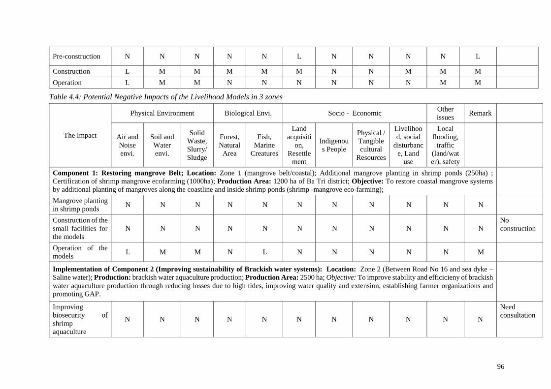
96
Pre-construction N N N N N L N N N N L
Construction L M M M M M N N M M M
Operation L M M N N N N N N M M
Table 4.4: Potential Negative Impacts of the Livelihood Models in 3 zones
The Impact
Physical Environment Biological Envi. Socio - Economic Other
issues Remark
Air and
Noise
envi.
Soil and
Water
envi.
Solid
Waste,
Slurry/
Sludge
Forest,
Natural
Area
Fish,
Marine
Creatures
Land
acquisiti
on,
Resettle
ment
Indigenou
s People
Physical /
Tangible
cultural
Resources
Livelihoo
d, social
disturbanc
e, Land
use
Local
flooding,
traffic
(land/wat
er), safety
Component 1: Restoring mangrove Belt; Location: Zone 1 (mangrove belt/coastal); Additional mangrove planting in shrimp ponds (250ha) ;
Certification of shrimp mangrove ecofarming (1000ha); Production Area: 1200 ha of Ba Tri district; Objective: To restore coastal mangrove systems
by additional planting of mangroves along the coastline and inside shrimp ponds (shrimp -mangrove eco-farming);
Mangrove planting
in shrimp ponds N N N N N N N N N N N
Construction of the
small facilities for
the models
N N N N N N N N N N N No
construction
Operation of the
models L M M N L N N N N N M
Implementation of Component 2 (Improving sustainability of Brackish water systems): Location: Zone 2 (Between Road No 16 and sea dyke –
Saline water); Production: brackish water aquaculture production; Production Area: 2500 ha; Objective: To improve stability and efficicieny of brackish
water aquaculture production through reducing losses due to high tides, improving water quality and extension, establishing farmer organizations and
promoting GAP.
Improving
biosecurity of
shrimp
aquaculture
N N N N N N N N N N N
Need
consultation

97
Construction of the
small facilities for
the models
N N N N N N N N N N N
Dredge
bottom to
release the
organic
humus from
previous
stage
Operation of the
models L M M N L N N N N N M
Implementation of Adaptation and Mitigation for Zone 3 (Saltwater Intrusion): Location: Zone 3 (inside sea dyke –Road No 16–Fresh water);
Production: Piloting climate resilience models: Building and adopting rice and forest-shrimp models (Giant freshwater shrimp/ crawfish shrimp –
Macrobrachium rosenbergii) for 180 ha of 150 households; Objective: To build capacity and necessary steps for gradual transition to brackish water
economy.; Production Area: 5,105 ha; Calendar: None:
Detailed design of
the Pilot N N N N N N N N N N N
Need
consultation
Construction of the
small facilities for
the Pilot
N N N N N N N N N N N
Prepare pond
for shrimp
farming
Operation of the
Pilot L M M N L N N N N N M

98
4.4.2. Potential Impacts of sluice gate construction and dredging activities to Sensitive
Facilities and Areas
In the Subproject area, there are three (03) national historical relics and one (01) local relics
which are valuable to spirit life of local people and tourism attraction. Therefore, the subproject
are may have indirect impact on these sensitive areas which are described in Table 4.5.
Table 4.5. Historical and Cultural Sites in the Subproject area
N0
Name of Sensitive Areas Location Distance to
Constructio
n Works
Description
1 Gravestone
Relic and
Nguyen Dinh
Chieu
Monument
An Duc
commune
15km The relic has an area of
13,00m2, which was
recognized by Ministry of
Culture – Information on 27
April 1990.
2 Vo Truong
Toan
Gravestone
Bao
Thanh
commune
2km This relic was recognized by
the Ministry of Culture –
Information on 24 Jan 1998.
3 Nguyen Van
Cung and
Cay Da Doi
Tan Xuan
commune
5 km It is recognized by the
Ministry of Culture –
Information on 07 May
1997.
4 Phan Thanh
Gian
Gravestone
Bao
Thanh
commune
12 km The monument is located in
Bao Thanh commune.
4.4.3. Impact Assessment during Pre-construction Phase
Due to land for construction of the subproject was done in the other WB’s project and the End-
of-Assignment Report on RAP of this project showed that there are no problems/issues in the
process of compensation and resettlement. So there is no impact due to land acquisition of the
subproject sluice gates.
The subproject area may have unexploded ordnances (UXOs) left during the wars. Therefore,
there is risk of human safety and asset damage during construction if the UXOs have not be
cleared before commencement of the civil works.
In the locations of livelihood models are mainly water surface land and agricultural land.
Aquaculture production will take place in the existing ponds and no land acquisition and land
clearance is needed. So impacts due to clearance and pre-construction phase are negligible.

99
4.4.4. Impact Assessment during Construction Phase
4.4.4.1. Impact sources
The impact sources in the construction stage primarily arise from the following activities:
- Construction of 5 sluice gates.
- Dredging sedimentation for 14 canals, which affects the aquaculture water quality.
4.4.4.2. Identifying Source Of Impacts
Table 4.6 presents source of impacts, impacts and scale of impact will occur in contruction
period basing on its activities.
Table 4.6: Impacts During The Pre-Construction Phase
N0 Source of
impacts Impacts Significance of Impact
(i) Construction of 5 sluices
A – Impact sources related to waste
1 Clearance
- Emissions generated from
construction vehicles.
- Solid waste generated from the
reclamation.
- Small, short term, can be
mitigated
- Small, short term, can be
mitigated
- Small, short term, can be
mitigated
2
The
preparation
process prior
Construction
Dust, emissions from material
transportation.
- Small, short term, can be
mitigated
3 Worker
activities
- Domestic waste water
- Domestic solid waste
- Small, short term, can be
mitigated
- Small, short term, can be
mitigated
4
Maintenance
of vehicle
and
machinery
- Hazardous waste
- Small, short term, can be
mitigated
B - Impact sources not-related to waste
1 clearance
- Disruption of daily life, negative
effects on local businesses
- Conflicts between people in the
construction area and subproject
owners.
- Moderate, long term, can be
mitigated
- Small, long term, can be
mitigated
2
The
preparation
process prior
Construction
- Noise and vibration from machinery,
vehicles.
- Impacts to surface of plant cover
impact to ecosystems.
- Small, long term, can be
mitigated
- Small, long term, can be
mitigated
3 Vehicles,
machinery
- Noise and vibration from machinery,
vehicles
- Small, long term, can be
mitigated

100
4.4.4.3. Assessing impacts during the construction stage of sluice gates
During the construction of sluice gates that prevent salinization, the construction activities
mainly affect the biological resources, air quality and surface water in the surrounding area.
The impacts on the environment are as follows:
a) Impacts related to waste
a.1) Dust - emissions:
During the construction stage of the sluice gates items that prevent salinization, dust and gases
arise mainly from the transport activities of soil, sand, sludge, building materials and the
4
Concentrated
workers at
the
subproject
site
- Affect on local economic – social
condition.
The ability in generating a number of
diseases and social problems caused by
the concentrated workers.
- Small, long term, can be
mitigated
- Small, long term, can be
mitigated
5
Traffic congestion during the
construction phase.
- Impact on aquaculture
- Small, short term, can be
mitigated
- Small, short term, can be
mitigated
(ii) Dredging 14 canals
A – Impact sources related to waste
1 Vehicles,
machinery
- Dust, emissions from machinery, and
material transportation.
- Small, short term, can be
mitigated
2 Excavators Water to be dredged with sludge - Moderate, short term, can be
mitigated
3 Worker
activities
- Domestic waste water
- Domestic solid waste
- Small, short term, can be
mitigated
- Small, short term, can be
mitigated
4
Maintenance
of vehicle
and
machinery
- Hazardous waste
- Small, long term, can be
mitigated
B – Impact sources not-related to waste
1 Vehicles,
machinery -Noise and vibration from machinery - Small, short term, can be
mitigated
2 Ecosystem Impacts to surface of plant cover impact
to ecosystems
- Small, short term, can be
mitigated
3 Traffic Traffic congestion during the
construction phase.
- Moderate, short term, can be
mitigated
4
Concentrated
workers at
the
subproject
site
- Affect on local economic – social
condition.
The ability in generating a number of
diseases and social problems caused by
the concentrated workers.
- Small, long term, can be
mitigated
- Small, long term, can be
mitigated
5 Socio-
economics
Impact on aquaculture - Small, short term, can be
mitigated

101
construction (special dust and emissions from the operation of the concrete mixing plant -
which is located in the construction area of sluice gates). The composition of pollutants
includes: dust and gases (SO2, CO, NOx, HC etc.) arising from the operation of equipment and
machine that consume gasoline as barges and motorized construction equipment.
* Dust - emissions from construction of sluice gates:
Dust - emissions from the construction process are mainly from the machinery operation on
construction sites. The loads of dust - emissions are calculated based on the amount of
equipment and the fuel consumption.
The construction vehicle includes cranes, bulldozers, excavators, hammers, compactors,
concrete mixers (estimated tonnage is 10 tons).
The fuel consumption in the case that the equipment and machine operate continuously is
estimated at 10 kg/h.
According to the World Health Organization - WHO, the air pollution levels of the engine with
capacity of over 16 tones are as follows:
Table 4.7: The emission coefficients of each pollutant
Engine type Unit Suspended
dust (TSP) SO2 NOx CO HC
Truck and diesel engine > 16
tons
kg/tons of
fuel
consumption
4.3 20S 55 28 2.6
The emission level from fuel
usage (M) kg/h 0.043 0.02 0.55 0.28 0.052
Total load, Es mg/s.m2 0.0094 0.0044 0.1202 0.001 0.0612
* S is the % of S in diesel oil, the actual S = 0.05
As assumed that the emission level is stable over time and evenly distributes over an area of
240m2 of each sluice gates and the total area of 5 sluice gates is 1,200 m2, the concentrations
of pollutants in the subproject region is calculated on the large-scale emission source by the
following formula:
(1)
In which:
C : Stable concentrations of pollutants in the pollution area, mg/m3
Cinput: concentrations of pollutants in the subproject region, mg/m3
Es : Load of pollutants, mg/s.m2, Es =
(M: The emission amount because of fuel consumption, kg/h = emission coefficient x amount
of fuels)
L: Subproject length according to the wind direction, L= 120 m
M
Subproject area (82,000m2) subpoject area (1200m2)
vào
s CHu
LEC
.
.

102
H: The height of the disturbing area (from the ground to the motion stop of hot air molecules,
which evaporate from on the ground; it is respective with the stable air temperature at 280C,
close to the ground, it is 300C; select H = 200m).
u: The stable average wind speed (select u = 2.6 m/s, corresponding to the actual weather
conditions of the region).
The calculated results of pollutant concentrations are listed in the following Table 4.8:
Table 4.8: The concentrations of pollutants in the construction areas of sluice gates
The concentration of
pollutants Unit
Suspended
dust (TSP) SO2 NOx CO HC
Baseline environment Cin mg/m3 0.12 0.037 0,29 - -
Subproject area C mg/m3 0.0022 0.001 0.028 10.017 0.0142
Total concentration mg/m3 0.122 0.038 0.22 - -
QCVN 05:2013/BTNMT mg/m3 0.3 0.35 0.2 30 5*
* QCVN 05: 2013/BTNMT- National technical regulations on some toxic substances in the
ambient air.
Thus, according to the calculated results, the amount of dust and gases generated in the process
of sluice gates construction remains within the permitted limits.
The concentration of air pollutants emitted by motor vehicles, machinery and equipment during
the construction process depends very much on the number of construction vehicles, machinery
state, wind direction, density of operating machinery. However, the sources of toxic emissions
are low sources and the possibility of spreading away is very poor. Therefore, they only pollute
locally and affect downwind areas and directly affect workers in construction areas.
* Dust - emissions from transport activities during construction of sluice gates:
The volume of soil, sand, sludge from excavation of foundation, road construction etc. is
calculated approximately 2,110m3, which will be reused a part to fill sluice gates embankment,
sluice gates connecting roads. The reused volume of soil is taken by 70% of the required soil
(mixing 70% soil with 30% sand for filling sluice gates, road embankment). Soil yard retained
for filling is planned right on the riverside adjacent to the construction site. The specific area
of soil yard is provided in table 4.6 below. The remaining soil of about 18-240 m3 at each sluice
gates will be used for filling dike/shore embankment by local government, so there is no
transport of excavated soil to dumpsite.
Table 4.9: The digging and filling quantity for construction of sluice gates
No. Names of sluice gates
Digging
quantity
(m3)
Filling
quantity (m3)
Surplus
quantity (m3) Soil yard (m2)
1 Duong Khai 225 157.5 67.5 300
2 Trang Nuoc 800 560 240 500
3 Duong Tac 800 560 240 500
4 Cay Keo 225 157.5 67.5 300

103
5 An Thanh 60 42 18 200
Total 2,110 1,477 633
Currently the regional road transportation is extremely difficult, so the transportation of raw
materials to build sluice gates is entirely by waterway, by barges. As calculated, the amount of
raw materials and the number of barge voyages to the construction areas are presented in Table
4.10.
Table 4.10: The materials quantity used for construction of sluice gates
No. Names of sluice
gates
Quantity of
stones,
concrete
(m3)
Quantity of
steel of all
types (tons)
Number of
piles,
columns,
beams (unit)
Estimated
number of
barge trips
(voyage)
Construction
time (months)
1 Duong Khai 662 113 245 10 6
2 Trang Nuoc 2,647 452 982 35 12
3 Duong Tac 2,647 452 982 35 12
4 Cay Keo 662 113 245 10 6
5 An Thanh 331 56 123 5 3
Total 6,949 1,186 2,577
The construction process takes place about 3-12 month for each sluice gates as shown in Table
4.10. The number of barges that transport materials to the construction area is not as greater as
3-5 voyages per month. The average transport distance for materials purchased in Ba Tri town
by river is 70 km long (see Figure 4.1).
Figure 4.1: Map of the transport for materials to the Subproject Area
The load and the pollution coefficients of the air pollutants caused by barges that transport
materials are presented in the following table.
Subproject
area
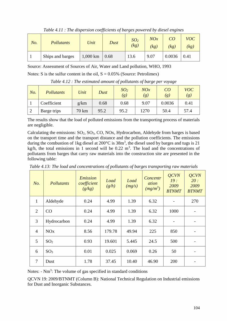
104
Table 4.11 : The dispersion coefficients of barges powered by diesel engines
No. Pollutants Unit Dust SO2
(kg)
NOx
(kg)
CO
(kg)
VOC
(kg)
1 Ships and barges 1,000 km 0.68 13.6 9.07 0.0036 0.41
Source: Assessment of Sources of Air, Water and Land pollution, WHO, 1993
Notes: S is the sulfur content in the oil, S = 0.05% (Source: Petrolimex)
Table 4.12 : The estimated amount of pollutants of barge per voyage
No. Pollutants Unit Dust SO2
(g)
NOx
(g)
CO
(g)
VOC
(g)
1 Coefficient g/km 0.68 0.68 9.07 0.0036 0.41
2 Barge trips 70 km 95.2 95.2 1270 50.4 57.4
The results show that the load of polluted emissions from the transporting process of materials
are negligible.
Calculating the emissions: SO2, SO3, CO, NOx, Hydrocarbon, Aldehyde from barges is based
on the transport time and the transport distance and the pollution coefficients. The emissions
during the combustion of 1kg diesel at 200°C is 38m3, the diesel used by barges and tugs is 21
kg/h, the total emissions in 1 second will be 0.22 m3. The load and the concentrations of
pollutants from barges that carry raw materials into the construction site are presented in the
following table:
Table 4.13: The load and concentrations of pollutants of barges transporting raw materials
No. Pollutants
Emission
coefficient
(g/kg)
Load
(g/h)
Load
(mg/s)
Concentr
ation
(mg/m3)
QCVN
19 :
2009
BTNMT
QCVN
20 :
2009
BTNMT
1 Aldehyde 0.24 4.99 1.39 6.32 - 270
2 CO 0.24 4.99 1.39 6.32 1000 -
3 Hydrocarbon 0.24 4.99 1.39 6.32 - -
4 NOx 8.56 179.78 49.94 225 850 -
5 SO2 0.93 19.601 5.445 24.5 500 -
6 SO3 0.01 0.025 0.069 0.26 50 -
7 Dust 1.78 37.45 10.40 46.90 200 -
Notes: - Nm3: The volume of gas specified in standard conditions
QCVN 19: 2009/BTNMT (Column B): National Technical Regulation on Industrial emissions
for Dust and Inorganic Substances.
105
QCVN 20: 2009/BTNMT (Column B): National Technical Regulation on Industrial emissions
for Organic Substances.
The comparison of the concentrations of pollutants arising from the operation of construction
equipment with QCVN 19: 2009/BTNMT and QCVN 20: 2009/BTNMT (Column B) shows
that they are within the permissible limits. The calculation results no emissions greater than
about 0.22 m3/s, the concentrations of pollutants is below the permissible standards, and the
sources of emissions are mobile, the impact that spreads pollutants caused by barges that
transport construction materials into sluice gates construction sites very quickly is considered
negligible.
* Dust caused by wind from material yards (sand):
According to a survey around 5 sluice gates, only An Thanh sluice gate has a residential area
away from 200m, the others are located in the salt-production fields and Intensive Shrimp
Farming and Semi - Intensive Shrimp Farming.
In the subproject region, the number of sunshine hours in a day is relatively high. If the average
wind speed is greater, the influence of dust in material yards when building An Thanh sluice
gate on a residential area are likely occur if the material yards are not carefully covered.
From the analysis above, it can be seen that the concentrations of toxic gases generated by the
transport and operation of construction equipment are very low, moreover, the pollutants are
dispersed over a large space, the averaged dispersion height is 5m, the amount of dust and toxic
gases will be greatly reduced. Compared to the allowed limits in QCVN 05: 2013/BTNMT and
QCVN 06: 2013/BTNMT, the concentrations of air pollutants are much lower.
Thus, we can say that the effects of dust and air pollutants on the environment and people’s
health in the construction sites of sluice gates are negligible. However, when carrying out the
construction, the subproject owner and the Contractors should have appropriate construction
methods and mitigation measures to control negative impacts consistent with the actual
situation to minimize impact on the environment, workers, and local communities near An
Thanh sluice gate. These measures will be presented in detail in Chapter 5.
a.2) Waste waters:
During the construction stage, the water environment will be influenced by two main impact
sources: rainwater runoff and domestic wastewater from construction workers ‘camps.
* Wastewater from domestic activities of sluice gates construction workers:
Domestic wastewater contains organic matters, suspended solids (SS), nutrients (N, P) and
microorganisms etc. BOD, COD and odours will attract pathogenic parasites (flies, mosquitoes
etc.) that cause air pollution and pollution spread under the water flow. The highest
concentration of labor on the construction site of each sluice gate is assumed about 20 workers,
the average water use on the construction site is 60 liters/person/day for rural areas (TCXDVN
33: 2006), the amount of wastewater generated in the construction area of each sluice gates is
as follows:
Q = 80% x 20 persons/day x 60 liters/person = 0.96 m3/day
(The amount of wastewater is calculated equal with 80% supply water).
The total wastewater during the construction of 5 sluice gates is approximately 4.8m3/day.
The estimated total labor on the construction site of 5 sluice gate are assumed about 100
workers. The estimated amount of wastewater is based on the emission coefficients of
pollutants in domestic wastewater in the developing countries proposed by the WHO. The load

106
calculation results and the concentration of pollutants in wastewater from workers' camps are
presented in the following table.
Table 4.14: The load and concentrations of pollutants in workers ‘wastewater
No. Pollutants
Emission
coefficient
(g/person/day)
Load (kg/day)
Untreated
concentration
(mg/l)*
QCVN 14 –
2008 (Column
B)
1 BOD5 45 – 54 4.5 – 5.4 110 - 400 50
2 COD 72 – 102 7.2 – 10.2 250 - 1000 -
3 TSS 70 – 145 7 – 14.5 350 - 1200 100
4 TN 6 – 12 0.6 – 1.2 20 - 85 -
5 N-NH4 2.4 – 4.8 0.24 - 0.48 12 - 50 10
6 Pt 0.8 – 4 0.08 – 0.4 4 - 15 10
Source : WHO, 1993 * Metcalf and Eddy. 1979.
The calculation results show that the concentrations of pollutants exceeding the standard many
times, which we can see that the impact of wastewater from construction workers is moderate.
Therefore, during the construction, wastewater must be collected and treated and construction
unreasonable plans must be organized to limit environmental impacts on water, land, people's
health and construction workers.
* Storm water on the site:
Rainwater runoff through construction areas will sluice gates away oil, dust etc. and all kinds
of domestic waste and construction waste that pollute receiving waters. Compared with other
types of wastewater, rainwater is fairly clean (the statistics of the World Health Organization -
WHO show that the concentration of pollutants in rainwater after the next period is about 0.5
to 1.5 mgN/l; 0.004 to 0.03 mgP/l; 10-20 mgCOD/l and 10-20 mgTSS/l).
Heavy rains on construction sites of sluice gates may wash away dirt and grease and oil
splattered on the ground, which causes puddle water, erosion of construction works which have
not yet solidified, clog the sluice gates system etc.
To assess the impact of storm-water runoff in the construction sites of the sluice gates on the
environment around them, we will use the calculation method of hydraulic sluice gate system
via the limited intensity formula (source: Environmental Engineering Handbook, 2005) as
follows:
1000
C I AQ
In which:
Q: The maximum runoff amount of water (m3/day)
C: Coefficient of water flow, choose C = 0.6
I: Maximum precipitation (mm/day), select the maximum value in Ba Tri rainfall is 150
mm/day during the construction.
A: Construction area (m2)

107
Thus, the amount of storm-water runoff in a day at the construction site is 1200 m2 on rainy
days as estimated as follows:
Q (m3/day) = 0.60 * 0.15m/day * 1200m2 = 108 m3/day
However the capacity of canal system in the construction sites of the sluice gates is very good,
without flooding when there are heavy rains. To minimize impacts, appropriate measures need
to be taken to avoid solid wastes and waste water.
* Wastewater from construction sites:
Construction wastewater includes water used for washing materials, water used for
moisturizing concrete etc. This amount of water is not much and often flows on the surface,
partly evaporates, and partly penetrates into thick sand layer before merging into shallow
groundwater or surface water into the region.
a.3) Solid waste:
Two main sources of solid waste affecting the environment are: solid waste from construction
and solid waste from daily life of workers.
* Solid waste arising from the construction of sluice gates items:
Solid waste in the construction process includes dirt and mud dredged from organic sediment
layer; pile-boring during the construction of sluice gates, stones and sand and building
materials scattered in the construction process, packages of building materials etc.
The volume of wastes is estimated as follows:
Silt, sand mixing in bentonite from sluice gates construction: the construction technology of
bored piles by bentonite is applied for the construction of sluice gates that prevent salinization.
Soil excavated from the sluice gates foundation is reused for filling and levelling.
In addition, solid waste in the construction process also arises as construction materials are
spilled during the construction process such as lime, mortar, broken bricks, bags of cement,
iron and steel scraps. The construction solid waste is inert with the environment, so their impact
is negligible. However, if these wastes are not well controlled, they may cause obstruction to
the construction and increase the amount of dust in and around the construction area.
Other different types of waste such as wood, metal scraps, packages etc, can be sold as scraps
and are not release to the environment.
* Solid waste arise from domestic activities of sluice gates construction workers:
Domestic wastes on the site include empty cans, bottles (food and beverage), paper etc. The
amount of waste is determined according to the level of emission of 0.4kg/person/day and the
number of regular workers employed at site is 20 people (the emission norm is equal to 50%
under Decision No. 04/2008/QD - BXD of the Ministry of Construction).
So, the volume of waste from domestic activities of sluice gates construction workers are:
0.4 kg/person/day x 20 people = 8kg/day.
The volume of solid waste generated from domestic activities of workers in each sluice gates
construction site is 8 kg/day. The total of 5 sluice gates arises about 40 kg/day.
The main components of domestic waste include organic matters that can decompose easily
and cause bad odours, annoy workers on the construction site if waste is not collected and
handled thoroughly. The Subproject owner and the construction companies will have
appropriate measures for management, treatment, so they are at low levels.
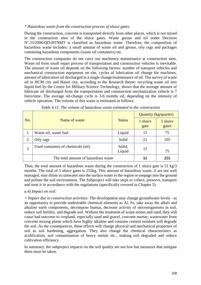
108
* Hazardous waste from the construction process of sluice gates:
During the construction, concrete is transported directly from other places, which is not mixed
in the construction sites of the sluice gates. Waste grease and oil under Decision
No.23/2006/QD-BTNMT is classified as hazardous waste. Therefore, the composition of
hazardous waste includes: a small amount of waste oil and grease, oily rags and packages
containing hazardous components (waste oil containers) etc.
The construction companies do not carry out machinery maintenance at construction sites.
Waste oil from small repair process of transportation and construction vehicles is inevitable.
The amount of waste oil depends on the following factors: number of transport vehicles and
mechanical construction equipment on site, cycles of lubrication oil change for machines,
amount of lubrication oil discharged in a single change/maintenance of oil. The survey of waste
oil in HCM city and Hanoi city, according to the Research theme: recycling waste oil into
liquid fuel by the Centre for Military Science Technology, shows that the average amount of
lubricant oil discharged from the transportation and construction mechanization vehicle is 7
liters/time. The average oil-change cycle is 3-6 months oil, depending on the intensity of
vehicle operation. The volume of this waste is estimated as follows:
Table 4.15. The volume of hazardous waste estimated in the construction
No. Name of waste Status
Quantity (kg/quarter)
1 sluice
gate
5 sluice
gates
1 Waste oil, waste fuel Liquid 15 75
2 Oily rags Solid 21 105
3 Used containers of chemicals (oil) Solid,
Liquid 15
75
The total amount of hazardous waste 51 255
Thus, the total amount of hazardous waste during the construction of 1 sluice gate is 51 kg/3
months. The total of 5 sluice gates is 255kg. This amount of hazardous waste, if are not well
managed, may dilute in rainwater into the surface water in the region or seepage into the ground
and pollute the soil environment. The Subproject will take steps to collect, preserve, transport
and treat it in accordance with the regulations (specifically covered in Chapter 5).
a.4) Impact on soil:
+ Impact due to construction activities: The development may change groundwater levels - as
an opportunity to provide undesirable chemical elements as Al, Fe, take away the alkali and
alkaline earth components, decompose humus, decrease activity of microorganisms in soil,
reduce soil fertility, and degrade soil. Without the treatment of waste stones and sand, they will
cause bad outcome to cropland, especially sand and gravel, concrete mortar, wastewater from
concrete mixing plants which have highly alkaline and contains cement residues will degrade
the soil. As the consequences, these effects will change physical and mechanical properties of
soil as soil hardening, aggregation. They also change the chemical characteristics as
acidification, soil contamination of heavy metals etc., making soil degraded and reduce
cultivation efficiency.
In summary, the subproject impacts on the soil quality are not low but measures that mitigate
them must be taken.

109
+ Impacts by workers' domestic activities: non-degradable solid waste (packages, plastic) and
some other inorganic solids will contaminate soil in the construction area. The Investor in
conjunction with the construction Contractors will take measures to collect and treat them to
avoid harmful impacts on the environment.
a.5) Impact on groundwater:
Causes that affect the quality of groundwater resources in the construction process are as
follows:
Surface water is the main source of groundwater, so the contamination of surface water
will lead to the contamination of water aquifers.
The pile driving, drilling, digging sluice gates nails and pillars will perforate the topsoil
and make the direct exchange between contaminated surface water and groundwater and
pollute the water aquifers.
For shallow aquifers, the earthworks and leveling will make the groundwater exposed; surface
water and storm-water containing pollutants will enter into the aquifers and cause groundwater
pollution.
The artificial change of the water flows will alters the natural rule of the water flows and entail
the water tables which possibly be lowered or increased depending on the change of surface
flow system, which is one of the causes that change of the quality and flow of the aquifers.
The main sources of the Subproject’s wastewater are from domestic wastewater and solid
waste, construction wastewater, waste from earthworks and hazardous waste. The above types
of waste will be collected and treated as regulated to avoid affecting the infiltration of waste
into soil and groundwater.
b) Assessing impact sources which are not related to waste
During the construction of sluice gates, noise and vibration will arise, which are caused by the
motor activities and make negative changes to the landscape and biodiversity etc.
b.1) Impacts of noise:
During the construction of sluice gates, noise may arise from the mechanic transportation and
construction equipment, from operations of workers, in which noise arising from transportation
vehicles, construction machines, generators, concrete mixers etc. are the matters of concern.
The machines can make noise at high levels within working scale. However noise spreads in
the air and stops rapidly by distance and is localized, the extent impact on the neighbourhood
is almost negligible. We can refer the maximum noise levels of vehicles in the following table:
Table 4.16: The maximum noise level of some facilities and equipment at source
No. Means of transport and motor construction equipment Noise levels at source (dBA)
Range Average
1 Bulldozers 93.0
2 Rollers 72.0 – 74.0 73.0
3 Excavator with front bucket 72.0 – 84.0 78.0
4 Tractor 77.0 – 96.0 86.5
5 Scrapers, graders 80.0 – 93.0 86.5

110
No. Means of transport and motor construction equipment Noise levels at source (dBA)
Range Average
6 Paver 87.0 – 88.5 87.7
7 Truck 82.0 – 94.0 88.0
8 Concrete mixers 75.0 – 88.0 81.5
9 Mobile cranes 76.0 – 87.0 81.5
10 Generator 72.0 – 82.5 72.2
11 Compressor 75.0 – 87.0 81.0
12 Pile drivers 96.0 – 106.0 100.5
QCVN 26: 2010/BTNMT: the noise level in common areas caused by construction activities
is 70dBA (6h - 21h)
The standards of the Ministry of Health (Decision No.3733/2002/QD-BYT dated 10/10/2002),
noise regulation in manufacturing sector: the exposure time in 8 hours is 85dBA.
Source: Environment air - Pham Ngoc Dang - Science and Technology Publisher.
We can predict impacts of noise to the neighbourhood of the construction site (Reference:
Pham Ngoc Dang - Air Environment, Science and Technology Publisher, 1997) as follows:
Li = Lp - Ld - Lc
In which:
- Lp: Noise at the distance far from source 15 m.
- Ld: Noise reduction in distance d and is calculated by the following formula:
Ld = 20.lg [(r2/r1)](1+ a) (dBA)
- a: The coefficient that takes into account of noise absorption of the ground terrain.
Because the ground area is considered empty without trees, so a = 0.
- r: The distance from source to the measuring point, r = 15 m.
- Lc: The level of noise reduction when passing obstacles. In this case, the calculation
excludes obstacles, Lc = 0 (dBA).
The total noise at one measuring point caused by all sources is calculated based on the
following formula:
L = 10lg
n
i
Li100
(dBA)
From the above formula, we can calculate the noise caused by construction vehicles by distance
as follows:
Table 4.17. Forecast noise in the neighbourhood
No. Noise sources Distance Total noise
15m* 20m 50 m 15m* 20m 50 m
1 Concrete mixers 75 72.5 64.5 86 81.89 75.63

111
2 Cranes 72.5 70 62
3 Welders 76 73.5 65.5
4 Drillers 79 76.5 68.5
5 Saw machine 77.5 75 67
The labor safety standard: 3733/2002/QD-
BYT 85 dBA
QCVN 26:2010/BTNMT: - Normal area 70 dBA
* Source: Pham Ngoc Dang, 2003.
According to the above table:
+ In the location that is away from a noise source 15m, when the source makes noise
simultaneously, the noise level will exceed the acceptable standards for the working
environment but the level of increase is not significant. However, to ensure the working
environment which is not contaminated in the construction process, necessary attention must
be paid to this location.
+ In the location that is away from a noise source 20m, when the source makes noise
individually or simultaneously, the noise level remains within the acceptable standards for the
working environment.
+ If equipment that makes too high noise works simultaneously, the noise level may exceeds
the acceptable standard (> 70dBA) in some areas away from the sluice gates construction area
15m, 20m and 50m. So in the construction process, noise source must be paid attention to
ensure no impact to people in the surrounding area of An Thanh sluice gates.
Special attention should be paid to the concrete piling-driving areas because the noise intensity
of the device can reach 98 dBA at the distance of 15m.
b.2) Impacts on regional economy - society:
* Conflicts between construction workers and local people:
Although most sluice gates are located away from residential areas, there are exchanges
between local people with construction companies. Each sluice gates construction area has an
average of 20 workers, who will cause certain impacts to the local social environment, security,
practices as well as habits of local people.
The impacts on employment disputes between local people and workers as well as between
workers may leave unfortunate consequences.
Infectious diseases caused by deprivation and unhygienic conditions may arise and spread at a
rapid pace.
The social evils like gambling, alcoholism, prostitution etc. may increase and create bad habits
for part of local youth people. These types of services are dependent on large construction sites,
which are common in all regions in the country. These types of services attract a lot of young
people, which are not only workers but also local people, which makes conflicts arise between
the groups of young people. In such circumstances, if there is not close management
cooperation between the construction companies and the local authorities, significant damages
to physical and mental health of workers and local people may be unavoidable.
The increase of workers may cause environment impact because of solid waste and wastewater.
If the sanitation, waste collection is not done regularly and seriously, the possibility of

112
spreading of infectious diseases from workers to local people and vice versa (malaria, dengue
etc.) very likely occur. The process of storage and accumulation of waste will be the habitat for
mediated disease species and insects (rats, flies, mosquitoes, cockroaches and
microorganisms), which make the risk of infection for local communities and the surrounding
areas more serious.
* Economic impacts
Impacts on local production (salt production and shrimp culture). Currently around 5
sluice gates, the local economic activities are mainly salt-production (Figure 4.2) and intensive
shrimp farming and semi-intensive shrimp farming. Increasing turbidity and water pollution
during the construction of sluice gates will impact on quality of salt and shrimp, causing loss
of income of local people.
Water quality in the canals using for salt production is low and salt in the subproject area is the
lowest one in Vietnam. Currently many households are still having thousands tones of salt
produced 2014 and 2015 but could not sell because there were no buyers. Local governments
are encouraging some inefficient area of salt production to convert to intensive and extensive
shrimp farming. The most area of transition from salt to the shrimp is in Bao Thuan, Tan Thuy,
An Thuy communes. The areas of salt fields in these communes is very small even bare. In
addition, all in-canal construction activities will be in steel sheet pile cofferdams, so increasing
of turbidity will be minimized and only occurs about 20m upstream and about 50m downstream
from the pile construction locations. The impacts of sluice gates construction on local
production is low, especially impact on salt production. However, the contractors will strictly
manage construction activities to avoid this impact.
Local inundation. Construction of each chamber of sluice gate will partly narrow cross
sections of the canals which may cause local inundation in the construction site. However,
there is no local residents living surrounding the influence area of inundation of 4 sluice gates
except one residential area in the An Thanh sluice gate, so this impact will be low and short
term.

113
Figure 4.2. Salt fields in the subproject area
b.3) Impact on navigation:
The building locations of sluice gates are on dike and canals, where there is dike embankment.
This means water transport activities in the construction area of sluice gates are very diverse
and complex. During the construction, there would be an increase of waterway traffic on Trang
Nuoc and Duong Tac canals in the subproject area due to raw material transport for
construction. This may result in the appearance of spontaneous berths which strengthen the
congestion. Therefore, vessel collisions, water traffic accidents, disputes in anchorage area may
occur. Without construction warning signs, water vessels will be out of order, especially in
evenings. For these reasons, sign boards, signal lights, fences around sluice gates must be
installed and necessary preventive measures must be taken to reduce road accidents during the
construction of sluice gates.
The subproject owner is acutely aware of the importance of the above impacts and commits to
take measures as well as closely coordination with the Inland Waterway Station, Dyke Station,
Traffic Station and local authorities to overcome traffic congestion during the construction as
much as possible. Besides we will integrate the mitigation measures for the operation stage in
Chapter 5 of this report.
b.4) Assessing hydrological impacts

114
During the sluice gates construction, the temporary block of waterway will be local bad for the
flood mode. The construction means on the canals will impede the canal flow in flood season,
which make pressure to shore and will cause shore erosion. Fortunately, these impacts are
minor and temporary.
b.5) Assessing impacts on ecosystems and resources
The construction will bring certain negative impacts on the organisms. The loss of habitat
includes loss of natural water habitats and shrimp and fish farming.
* Terrestrial ecosystem
Most land along the sluice gates is salt-production land, so the vegetation to be cleared for
construction will be minor. The surveys found that the animals and plants here are not rare
species to be protected as listed in Vietnam’s Red Book. The animals are mostly migratory
species like storks and domestic animals. Therefore, the impact on the terrestrial ecology in the
subproject area is negligible.
* Aquatic ecosystem
Regarding the aquatic ecosystem, the impacts will become direct for submerged plants and
planktons. They are the basic components of habitat, the food for fish and successive trophic
levels. According to the statistics, in the construction sites of sluice gates, the population of
species of aquatic organisms and benthos is very rich in quantity, quality and variety.
For the Subproject, the building works pave certain implications of impacts on the underwater
ecosystem. The aquatic species may be affected by the following reasons:
Turbidity pollution due to the construction, which makes oxygen levels in water
significantly reduced, the feeding of underwater animals is also affected by limited food
sources or inability to detect food sources.
Leaking gasoline, chemicals etc. from the transport vehicles, construction vehicles and fuel
spillage during transportation etc.
Changes in the hydrological regime, water pollution will affect aquatic biological resources
and their diversity on the canals.
The concentration of construction motor-vehicles will result in the spillage of fuel, oil, grease
or overflowing when failures happen during the operation and repair of vehicles. Oil and fuel
seeps into soil and is swept away by rainwater into rivers and canals, which pollute the waters
and causes negative impacts on the aquatic ecosystem. The planktons in water like algae and
other animals such as shrimp, fish may be affected. Some may be sick or die because of their
inadaptability. However, the extent of this impact can be mitigated during the construction and
operation of the equipment. The contractor, construction companies, consultants should closely
monitor and take appropriate solutions for collection to avoid the spillage or leakage of such
wastes to the water flows. However, the scope of this impact is considered small (about 20m
upstream and about 50m downstream from the pile construction locations) and the impact time
in the pile construction of canals, rivers is short.
b.6) Assessing erosion and sedimentation impacts
* Impacts by erosion:
The process of erosion and siltation, transformation of river/canal beds and bank erosion is
very complex as the result of the interactions between water flows and river/canal beds in
nature and under human impacts, in which water flows directly plays the major role to this

115
process when the rivers/canals bear weak geological, chemical, mechanical conditions. The
river/canal beds and the morphology here features the nuances of the tidal rivers.
The Subproject Owner will adopt appropriate measures to control shoreline erosion during the
construction of sluice gates. The measures will be presented in detail in Chapter 5 of this report.
* Impact by sedimentation:
The spillage during the construction, transport of construction materials as sludge, soil, sand
arises during the construction. This mainly occurs during the construction period and the
impact scale is average, which focuses on the aquatic environment at the infield supply canals.
b.7) Affecting sensitive areas
In the construction area of 5 sluice gates, no temples, churches, administrative offices, banks,
historic parks, restaurants, hotels, schools, hospitals are found.
* Impacts on Historical, Natural and Cultural Resources: No impact is anticipated on the
historical, natural and cultural resources.
* Impact on Protected Wetlands: There are no recognized local or national wetlands in the
subproject area. Therefore, the construction will not affect any protected wetland.
c. Environmental incidents in the construction of sluice gates
c.1) Impact due to chemical spillage:
During the construction stage, the main potential impacts to soil come from a few chemical
accidents. Any chemicals, when being spilled, must be cleaned quickly. The amount of
hazardous chemicals used at the construction site is low and it will be strictly managed, so this
impact on the soil quality is negligible.
c.2) Labour accidents:
During the construction stage, the movement and operation of equipment, especially cranes,
pile-driving machines may hurt workers who stand underneath. Workers who do not comply
with the regulations on labour safety when transporting materials may cause falling and injury
to others. In addition, other incidents as electric shock and lightning are potentially fatal. The
risk of exposure to pathogens in solid waste is also quite high for workers. In these works,
smoking or carelessness may cause fire. Most causes of these problems are originated from the
consciousness to abide by the regulations on labour safety of the construction workers, which
is not high. Lack of equipment for labour protection and unsafe working conditions are also
the indirect causes of accidents and incidents.
The consequences of accidents may be property damages, equipment damages, injuries, which
directly affect the health and lives of workers and lead to different consequences for their
families. To restrict these unfortunate accidents which may happen, strong measures that force
workers to comply correctly and fully the regulations and protective measures during the
construction must be developed. Shielding/covering around sluice gates, earthwork area to
prevent regrettable accidents not only for workers but also for people living around must be
implemented. The installation of warning systems, temporary lighting to help people recognize
the construction areas easily must be in full, too.
* c.3) The unexpected situations that may occur during the construction process include:
Finding of cultural artefacts/archaeological facilities during the earthwork.
There are complaints from the public about environmental issues related to construction
activities.

116
Findings of UXOs.
Review and forecast of impacts caused by dredging item
4.4.4.4. Assessing impacts during the dredging
a) Impact related to waste
The main activities in the dredging process include:
The operation of dredging means (dredgers, excavators and barges that support the
dredging)
Water scooped up with muddy sediments.
Domestic activities of dredging officers and workers on site.
a.1) Dust and emission waste.
* Emissions from dredgers, excavators, bulldozers:
The calculation of the loads of the pollutants coming from dredging activities (the total volume
of 14 dredging canals is estimated 431,133 m3) is based on WHO's pollution coefficients, in
which the diesel oil is 0.835 kg/l. The pollution loads caused by excavators 0.8 m3 & 1.6m3,
bulldozers and dredgers are presented in the following table.
Table 4.18: The air pollution coefficients of DO/FO combustion engines (Unit: Pound/1000
Gallons of oil).
No. Pollutants Power plant Industry
Living Not entirely burn Entirely burn
1 Aldehyde 0.6 2 2 2 2 CO 0.04 2 2 2 3 Hydrocarbon 3.2 2 2 3 4 NOx 104 72 72 72
5 SO2 157.S 157.S 157.S 157.S
6 SO3 2.4.S 2.S 2.S 2.S
7 Dust 10 23 15 8
Source: EPA, Dinh Xuan Thang, 2007 (1pound = 450gram; 1 gallon = 3.785 litres; the
conversion coefficient from pound/1000 gallons into grams/kg is 0.1189).
The calculations of the emissions: SO2, SO3, CO, NOx, hydrocarbons, aldehyde from
excavators 0.8m3, excavators 1.6m3, bulldozers, dredger are as follows. Currently, Vietnam’s
petroleum market has two main types of diesel fuel: 0.05%S and 0.25%S. To control emissions
from operating dredging equipment and transport vehicles, the Subproject owner will be
interested in the less sulfur fuel (S = 0.05%), so the emissions from the combustion of 1kg
diesel oil at temperature of 200°C is 38 m3. According to the norm of raw materials, oil used
for excavators 0.8 m3 is 6.76kg/h, excavators 1.6 m3 is 11.82 kg/h, bulldozers is 4.82kg/h,
dredger is 31.78kg/h. The loads and the concentrations of pollutants from excavators 0.8m3,
excavators 1.6m3, bulldozers, dredger are presented in Table 4.19.
The calculation results that the highest pollution load focuses on the dredgers. The air pollution
loads from other machines are not much. The Subproject Owner will apply measures to control
machinery and equipment tightly when carrying out the dredging activities.

117
Table 4.19: The total load of pollutants from dredgers
No.
Dredging equipment Pollution parameters
Aldehyde CO Hydroca
rbon NOx SO2 Dust
Emission coefficients of
substances from diesel
equipment (kg/t of diesel)
(WHO 1993)
0.24 0.24 0.24 8.56 0.93 1.78
Total load (kg)
1 Excavators 0.8m3 10.45 10.45 10.45 372.70 40.49 77.50
2 Excavators 1.6m3 9.13 9.13 9.13 325.73 35.39 67.73
3 Bulldozers 7.45 7.45 7.45 265.81 28.88 55.27
4 Dredgers 24.55 24.55 24.55 875.79 95.15 182.12
Source: Rapid Environmental Assessment, WHO, 1993
(Content of sulfur in diesel is 0.05%)
Table 4.20 : The load of pollutants arising from excavators, dredgers for dredging sections
No. Dredging equipment
The load of pollutants (mg/s)
Consumpti
on fuel
(tons)
Alde -hyde
CO Hydro carbon
NOx SO2 Dust
1 Excavators 0.8m3 43,540 0.90 0.90 0.90 32.16 3.49 6.69
2 Excavators 1.6m3 38,052 0.79 0.79 0.79 28.10 3.05 5.84
3 Bulldozers 31,052 0.64 0.64 0.64 22.93 2.49 4.77
4 Dredgers 102,312 2.12 2.12 2.12 75.57 8.21 15.71
Typically in a combustion process, the residual fuel emissions are 30%. When the temperature
of the emissions (or exhaust fumes) is 2000C, the combustion emission of 38 m3 DO is 1kg.
Based on the flows (m3/s) and the loads (mg/s) of emissions above, the calculation results of
emissions of excavators 0.8m3, excavators1.6m3, bulldozers, dredgers are shown in Table 4.21.
Comparing the concentrations of pollutants from the operation of the construction equipment
with QCVN 19: 2009/BTNMT and QCVN 20: 2009/BTNMT (Column B) shows that the
concentrations of pollutants are within the permissible standards. Therefore, impacts on the air
environment from the operation of excavators 0.8 m3, excavators 1.6 m3, bulldozers, dredgers
are negligible.
* Smell from dump sites of soil and sludge:
The dredging operations do not impact much on the ambient air quality but odour from the
anaerobic decomposition of organic sediment sludge as CO, H2S, CH4 affect the air quality in
the dredging area where sludge is piled up on shore.
The result analysis shows that the sludge composition in the dredging area contains mostly
sand and mud without organic matters, so the possibility of odour is quite low or if there is
odour, the impact scale is minor.

118
Table 4.21 : The concentration of pollutants arising from machine and equipment
No Pollutants Aldehyde CO Hydro
carbon NOx SO2 Dust
1 Pollutant concentrations
(mg/m3) 6.32 6.32 6.32 225 24.5 46.9
2 QCVN 19 : 2009 /BTNMT
(mg/Nm3) - 1000 - 850 500 200
3 QCVN 20 : 2009 /BTNMT
(mg/Nm3) 270 - - - - -
Notes: - Nm3: The volume of emissions converted to the standard conditions - QCVN 19:
2009/BTNMT (Column B): National Technical Regulation on Industrial Emissions for Dust
and Inorganic Substances.
QCVN 20: 2009/BTNMT (Column B): National Technical Regulation on Industrial Emissions
for Organic Substances.
Conclusion:
As the results of the calculations, the concentrations of pollutants such as dust, NOx arising
from the operations of dredging machines are not exceeding the permitted values. The
Subproject scale in each dredging canal is small and machines work not continuously 30 days
- 60 days in a canal construction area only. Besides, the construction environment is large and
ventilated, so the impacts on the surrounding environment are negligible. Emissions primarily
affect workers who operate equipment and work near the equipment.
a.2) Liquid waste:
The liquid-waste sources that impact environment include water to be dredged with sludge,
domestic wastewater from workers at construction site and pollution from storm-water runoff
that carries pollutants into the water body.
* Water to be dredged with sludge:
The dredging process will disrupt the stability of canal sediment, namely, the concentrations
of pollutants in water may increase because pollutants are released from sediment. In addition,
water leak from the sludge during the dredging also contributes to increasing the concentrations
of pollutants. This effect is particularly acute if water is used for domestic purposes and
aquaculture. However, the dredging impacts of 14 canals in the affected areas are negligible
because of the following reasons: the canals to be dredged contain good sediment quality for
crops; the dredging takes place on autumn-winter season without aquaculture operations in the
region; the operations on canals remain a single purpose of water traffic of the kinds of small
boats. Thus, the impacts on the water environment from dredging operations on the canals are
negligible. However, the water scooped up canal banks with mud during the dredging process
may flow into rice fields. The daily scooped volume is about 100 m3/day. The characteristics
of this leachate are that it contains high concentrations of suspended solids and some deposition
metals in sediment which will adversely affect the environment.
The references to the water quality analysis at the outfall of the dredging dump site in Tac Cay
Tram canal - Hau Giang province are presented in the table below:

119
Table 4.22: The quality of the water outfall of sludge dump site dredged from Tac Cay Tram
canal
No. Station Results
T (0C) pH DO (mg/l) SS (mg/l) F.Coli MPN/100ml 1 Km 257 30.2 3.12 1.1 1452 210
2 Km 257 30.4 2.98 1.4 1224 110
3 Km 257 30.1 -
3.03
5.5 -9
1.9 -
869
100
90 - Source: EPC, 2003
The results show that in the water quality scooped up with sludge during the dredging, the
suspended solid concentrations reach 9 to 25 times compared with QCVN 40: 2011/BTNMT.
However, the suspended solids are components of sludge dredged in canals, so the amount of
suspended solids does not alter the composition of canal water but may affect crops, so
conveying this water into settling tank to ensure enough sedimentation time before it
recirculates into canals must be implemented. The specific solutions are presented in Chapter
5.
* Domestic wastewater from workers:
During the dredging stage, wastewater is mainly domestic wastewater from barges, vessels
where workers are living. According to the National Standard: QCVN 17: 2011/BGTVT issued
by the Ministry of Transportation, the amount of wastewater estimated for worker on boards is
50 litres/person/day. On average, number of workers is 60 workers on boards and 4 persons in
charge in dredging area. As calculated, the total domestic wastewater from workers in each
canal dredging area is about 3.2 m3/day. Based on the pollution coefficient issued by the World
Health Organization, the total load of pollutants in domestic wastewater from 64 workers in
the dredging area is calculated and presented in the following table:
Table 4.23: The load and concentrations of pollutants in workers’ domestic wastewater
No. Pollutants Emission coefficient
(kg/person/day) Load (kg/day)
Untreated
concentration (mg/l)* QCVN 14 – 2008
(Column B)
1 BOD5 45 – 54 45 – 54 110 - 400 50
2 COD 72 – 102 72 – 102 250 - 1000 -
3 TSS 70 – 145 70 – 145 350 - 1200 100
4 TN 6 – 12 6 – 12 20 - 85 -
5 N-NH4 2.4 – 4.8 2.4 - 4.8 12 - 50 10
6 Pt 0.8 – 4 0.8 – 4.0 4 - 15 10
Source : WHO, 1993 *Metcalf and Eddy. 1979.
Comparing with QCVN 14-2008 - Column B, workers’ untreated domestic wastewater
contains higher levels of pollutants than the permitted values: BOD increases 18 times, other
pollutants exceed the permitted values for many times which cannot be discharged directly into
the environment. The Subproject owner will apply regulations to the construction companies
which must register their vehicles and equipment in compliance with the provisions of the
National Regulation (QCVN 17: 2011/BGTVT) about the Pollution Prevention from Internal
Waterway Vessels.

120
* Effects of rainwater runoff or dredging water runoff:
By nature, rainwater is considered clean and normal water without negative impacts on the
environment. However, when rainwater lands in the ground which contains contaminants such
as grease, dust, waste, substances, it will carry them and becomes a contaminated water source.
The construction works are mainly on the water and the surface to be washed off is the vessel
and equipment surface, so the management of this surface will be easier than the management
of construction surface on land. When it rains, contaminated rainwater runoff will appear when
there are project activities which the construction companies do not abide by the waste control.
This factor can be controlled by management and technical solutions. Therefore, to minimize
this impact, the Subproject owner and the Contractors must have strict control measures of
waste sources, particularly when the construction takes place in bad weather.
a.3) Solid waste:
The solid waste sources in the dredging are determined including domestic waste from the
operation of workers on construction site and the dredged sediment.
*Impact of domestic solid waste:
Domestic waste mainly includes such organic ingredients as vegetables and leftovers which
are biodegradable. Besides there are other type of waste, especially plastic bags, which are
difficult to decompose and may exist hundreds of years. If this waste is not collected but
dropped into canals in dredging area, it will affect the water environment. Plastic bags affect
the canal sediment or vessels when their propellers catch them.
The number of workers engaged in the dredging process is 64 people. As estimated, the amount
of waste discharged by one person is 0.4 kg/person/day, the amount of waste generated by 64
workers is about 26 kg/day. Since most workers do not stay in one place but distribute in vessels
in different locations, so the actual amount of waste loads will be smaller than as estimated.
This waste is easily collected at source, manages and minimized by appropriate measures, so
the environment impact is low.
* Dredged sludge:
During the dredging canals, a large amount of sludge must be treated. The volume of dredged
material is estimated 431,133 m3. The dredged material includes: sediment and solid wastes in
canal bottom, bottom soil and bank soil. According to the local survey, the demand for local
filling embankment in large. At the same time, local governments committed to using this dried
sludge for filling dike embankment in the region. According to the monitoring result, the
quality of sludge in the dredged canals, the concentration of pollutants and heavy metals remain
within the allowable limits of soil of QCVN 03: 2008 which can used as levelling material
when people need. Since the dredging will be conducted in a large area along about 28km of
canals, the impacts of dredged material are localized and or small significance.
a.4) Impact due to hazardous waste.
Arising source: hazardous waste arises mainly due to the operation of construction equipment
such as barges, dredgers, excavators etc.
Compositions: lubricant sludge, viscous waste, oily rags etc.
Arising time: infrequent, occur during dredging, only arise when there are emergency repairs.
The construction time takes place on each canal about 30 -60 days only, so there is no
maintenance work. There are no lubricants from maintenance of machine, ships and barges.
Unexpected repairs are estimated 7 litres/time on average (Research on recycling viscosity
waste into liquid fuel - Military Engineering Science and Technology Center - Ministry of

121
Defence 2002). Lubricant is regarded as hazardous waste with the identification number of
A3020.
The spillage or leakage of oil from construction means into water very likely occur. It forms
oil film and their dispersed products. The oil pollution and their dispersed products affect the
self-cleaning of water. Oil films hinder the penetration of light to the photosynthesis of
phytoplankton which reduces oxygen dissolved in water. Oil dispersed products may kill
plankton organisms, benthos which play an important role in the self-cleaning process.
So during the dredging, the Subproject owner requires the Contractors to comply with the oil
supply process: collecting, storing, transporting oil according to the regulations of Circular
No.36/2015/TT-BTNMT on the management of hazardous waste issued by the Ministry of
Natural Resources and Environment. Vessels must abide by the National regulations: QCVN
17: 2011/BGTVT - Guidelines for the Prevention of Pollution from Inland Waterway Vessels,
Part 2 - Structure and Equipment to Prevent Pollution Caused by Oil and Part 4 - Structure and
Equipment to Prevent Pollution Caused by Hazardous Liquids.
b. Impacts not-related to waste
b.1) Noise
Overall, the extent and scope of noise during construction of the items depends on their
technical characteristics, duration, operation frequency of machine and equipment as well as
the direction and distance to the receivers. The construction time of the sub-project takes place
primarily in the daytime while noise is also a factor that affects the life of people, especially at
night. The research results show that the noise level away from source 1m, 20m and 50m of
construction equipment are shown in the table below.
Table 4.24: The maximum noise level of some vehicles and equipment
No. Vehicles
Noise level 1m far from
source (dBA)(1) Noise level
20m far from
source
(dBA)(2)
Noise level
50m far from
source
(dBA)(2) Distance Average
1 Excavator with front bucket 72.0 - 84.0 78.0 52.0 44.0
2 Tractor 77.0 - 96.0 86.5 60.5 52.5
3 Scrapers, graders 80.0 - 93.0 86.5 60.5 52.5
QCVN 26: 2010/BTNMT for common
area from 6-21h 70 dBA
Source: (1): Mackemize, L.Da, 1985. (2): Air pollution, Pham Ngoc Dang, 1997.
Use the following formula for identifying sound spreading in the air to calculate noise
spreading in the air:
ΔL = 20lg (r2/r1)1 + a (dB)
In which: r1 is the distance where initial noise is measured; r2: the distance from calculating
point to the noise source (m); a: the coefficient that takes into the absorption of ground noise.
The maximum noise level due to the operation of dredgers and motorized construction
equipment at the location away from the noise source 20 meters is smaller the permissible limit
of QCVN 26/2010. Besides, the dredging location is away from residential areas, so the impact
of noise is negligible, which only directly impact on workers working on boats and on barges.
b.2) Environmental impact during the dredging

122
The environmental issue of concern caused by dredging is that the surface water in dredging
area to be affected is not related to the amount of waste by mixing bottom sediments. The total
dredged volume of sediment in canals is about 431,133 m3.
The dredging by excavators, dredgers make sludge dispersed in water. Besides, the
hydrological regime of the area is also affected by the dispersal of sediments, the dredging
quantity, the time, facilities, appropriate time etc. The dredging process causes impacts on the
environmental components as follows:
* Sediment dispersion and deposition.
The dredging will affect the lives of aquatic species. The most direct impact is the removal of
the substrate, including benthic organisms and smothering invertebrates as well as losing their
habitat. There are other effects related to the dredging, the influence of suspended solids in the
water on the life of aquatic species. Some experiments and researches on the impact of
suspended solids in the water on the lives of aquatic species have been made. DOER (2000)
[5] reviewed these studies and linked with the suspended solid evidences related to the
dredging. The research shows that where there is high turbidity of suspended sediment, eggs
and larvae of fish are one of the most sensitive species to the degree of suspended sediment in
water. The underwater population of creatures like fish can able to swim out of the disturbed
area. The sludge particles sinking to the bottom or dispersed in water make water in turbidity
and force the creatures to move out of the area due to loss of stable habitat. Shellfish are
virtually unaffected by the level of sediment caused by the dredging as the sediment levels
affect over 10,000 mg/l (DOER 2000) [5]. The disturbance boosts the decomposition of organic
matters by microorganisms. Oxygen depletion in water causes immediate impact on aquatic
life and indirectly impact on the aquatic resources. The concentration of suspended solids in
the water caused by long dredging will restrict light into the water layer and affect the
photosynthesis of algae, moss and irritate the fish species (small particles get into gills and
make fish smothered). The hydrology in the region (tide, currents) also significantly influences
the dispersal of sediments. However, the construction by large bucket of 1.6 m3 in short time
and narrow scale will cause negligible environmental impact.
* The recovery in the dredging area:
The experiences in the estuaries are used as reference materials to evaluate the recovery time
in the dredging area. Among the available materials on the recovery of the benthic communities
along river, notably the scientific report of the USACE and EPA and as reported by the
USACE, if the substrate is stabilized at small and medium speed, the recovery time in the
dredging area will be under 5 years.
Measured by the US EPA for the recovery in dredging areas in Alaska river pointed out the
restoration of the biological diversity of invertebrate is determined after 1 year (A. M. Prussian
et al. 1999).
The referred documents in the world about dredging in the coastal areas indicate that the
recovery speed of the benthic community after their habitat is dredged change significantly4 .
The recovery speed and morphology of residence are listed in the following table:
Table 4.25: The recovery time observed in dredging areas
No. Dredging area Morphological residence Recovery time
1 Coos Bay, Oregon Sludge is regularly disturbed 4 weeks
4 (Nedwell & Elliot, 1998; Newell, Seiderer & Hitchcock 1998 print http:
//www.ukmarinesac.org.uk/activities/ports/ph5_2_2.htm#a1)

123
No. Dredging area Morphological residence Recovery time
2 Cagaliari Bay, Sardinia Canal sludge 6 months
3 Mobile Bay, Alabama Canal sludge 6 months
4 Goose Creek, Long Island Lagoon sludge >11 months
5 Klaver Bank, North Sea Sand-gravel-stone 1-2 years
6 Chesapeake Bay Sludge-sand 18 months
7 Lowestoft, Norfolk Gravel >2 years
8 Dutch coast Sand 3 years
9 Boca Ciega Bay, Florida Shell-sand 10 years
The general observation shows that the fastest recovery speed happens in the estuaries, where
fine sediments are disturbed and where opportunistic species predominate. In general, the
recovery time increases in the stable area of sand and gravel, where the species are long-lived
with complex biological interactions which control community structure of dominating
organisms.
The research in contaminated estuaries in the North East of England also indicated that the
recovery time of the benthic community is more than 6 months (MP Quigley and JA Hall,
1999). The research in a small dredging area (2625m2) of the similar environment in the North
African port of Ceuta also pointed out that a disturbed area takes about 6 months to restore the
community structures of benthic organisms to become similar to an undisturbed area (Jose M
Guera-Garcia et al. 2003).
Based on the resulting data, the resilience after dredging will be approximately 6 months.
b.3) Impacts on water transport
The dredged canals mostly uses for water navigation. The contractors will notify and set up
regulating station to direct boats to move to another canal in the region. The density of boats
on the canal to be dredged is not high. From actual surveys and the dredging item, the
construction will hinder movement of small boats on canal. Therefore if there is no warning
station, controlling and regulating traffic better, canal boats will go into under-dredging canals
and they have to turn back, which waste time and money of the vehicle owners. Thus the
contractors must be prepared the traffic management plan on dredged canals before dredging.
The plan is proposed in Chapter 5.
b.4) Impact on fauna and ecosystem
As the dredging work in the area have been exploited and used for domestic purposes, the
aquatic fauna in the area is not many. According to the documents, the aquatic fauna in the
region contains no species in the Red Book to be endangered.
The dredging will inevitably affect the canal benthic fauna. However, as discussed above, the
level of impact will not be great because the dredging area is very smaller than the canal area,
the creatures are able to migrate to other areas where there is not being dredged. The level of
impact to the aquatic fauna is low and sweeping out the surrounding area.
b.5) Impact on economy and society
The construction time for each canal is short, only about 30-60 days, the number of construction
workers is 64 people, there are less inhabited areas, so conflicts between workers and local
people unlikely occur.

124
b.6) Impact on aquaculture and salt production
The canal dredging will increase turbidity which may affect aquaculture and salt production.
However the Subproject owner committed no dredging in the aquaculture and intaking water
for salt production (Just only canal dredging in dry season and the low tide). However, to limit
the impact of uncertainty in the construction, the construction companies must coordinate
closely with the local government and people for the communications and do not take water
for any purposes during dredging time or stop the dredging when people get water if necessary.
b.7) Impact on sensitive areas
The canal dredging area is mainly located on Intensive Shrimp Farming and Semi - Intensive
Shrimp Farming and salt production. During the dry season there is no shrimp culture. There
are not sensitive points in dredging area as temples, churches, administrative offices, banks,
historic parks, restaurants, hotels, schools, hospitals.
* Impacts on Historical, Natural and Cultural Resources: No impact is anticipated on the
historical, natural and cultural resources.
* Impact on Protected Wetlands: There are no important local or national wetlands in the
subproject area, and thus the construction will not affect any protected wetland.
c. Assessing impact due to the incidents during the dredging item
The dredging does not generate a lot of pollution wastewater as well as not dust. However, the
incidents often more risky, causing significant impacts to the environmental resources and
damages on property and lives. The most common risks during the dredging may include: labor
accidents, traffic accidents, accidents in soil dump site.
c.1) Labour accidents:
Labour accidents as falling from board due to negligence when working on boats, electrocution
caused by careless, manipulation and other mechanical repairs on boats, entangling in anchor
ropes or winches on boats etc. mainly affect workers in the field, causing personal injury or
occupational disease, or death. This impact on the communities around is insignificant.
c.2) Traffic accidents:
Traffic accidents from sinking boats and boat collision will cause oil spill. The reasons are the
lack of navigation regulation to let boats go into dredging area; dredger turns incorrectly and
does not ensure technical operations; dredger shell has defect, cracking or insufficient strength
after a period of operation, dredging in bad weather, boats encounter unexpected obstacles
which have not been cleared etc. Traffic accidents led to the oil spill and affect canal water
quality and sediment in the region.
c.3) Unexpected circumstances likely occur during construction: like sluice gates
construction.
4.4.5. Impact Assessment during Operation Phase
4.4.5.1. Identifying Source of Impacts
The impact sources during the operation stage are primarily from the operation of 5 sluice gates
which prevent tidal surges.
After canals are dredged, the environment and response to climate change will be improved in
the future. Therefore, no negative impacts from the operation of the dredged canals are
expected.

125
4.4.5.2. Assessing impact in the operation phase of sluice gates
After completion of the 5 sluice gates, in addition to the already completed 31 km of sea-dyke
and 11 existing sluice gates, there will be an extensive infrastructure network which ensures
the prevention of saltwater intrusion, sea water intrusion by tides, tidal surges and storm waves
and protect 13,045 hectares land and 85,000 people. At the same time, it creates a favorable
infrastructure for the stable production and sustainable economic and social improvement for
the people living in the subproject region.
The 5 sluice gates will connect with the existing infrastructure of Ba Tri sea-dike to ensure the
safety for people and thousands of hectares of rice and aquaculture, control tide and provide
water for production, prevent salinity intrusion and reduce damages on rice and vegetables. It
will create a new opportunities for the region and to be a prerequisite of the regional economic
development as it increases the production from 2 to 3 crops, increases livestock and
aquaculture, increase rice output and fruit output. Completing the 5 sluice gates will result in
completed road infrastructure for the region and ensure the traffic safety when vehicles move
on the dike. However, when the system is put to use, the main environmental impacts are as
follows:
a) Impact related to waste
a.1) Impact on air environment
When the construction of 5 sluice gates is completed, the approach roads to dike and 11 existing
sluice gates are connected. More vehicles will make use of the road in the dike, which increases
emissions, dust and noise. However, according to the field survey, the subproject is located the
rural region with low traffic demand and vehicles are mostly bicycles and motorcycles, so the
emissions and impacts are not many which can be controlled by the solution that bans
motorized vehicles traveling on the dike to protect dike body.
Also, the operation of the facility increases the production rotation and the greening time in the
region. The low-lying areas inside District Road No 16 will be sluice gates quickly and more
thoroughly, land will be flushed better and salty alum evaporation will be low in dry season,
causing the air quality to improve. In addition, the air environment of the hot and dry weather
caused by microclimate and environmental changes, thanks to the larger water storage in canals
which increases the evaporation, will improve.
a.2) Impact on water environment
When the tidal sluice gates operate, inside the District Road No 16, the water quality will change
significantly. The tidal sluice gates regulate discharging water directly into the sea, making
water logging and will reduce pollution.
When the system operates, the production structure of the benefited region will not be affected
but production crops increase that contributes to the stability of people.
Other negative side effect that may occur to the water quality during operation is when the
sluice gates are closed and less water circulation in this region happens with the risk of increase
of contamination of water sources. The project management units responsible for the sluice
gates operation must ensure the harmony between economic interests and environmental
protection.
b) Impacts not related to waste
b.1) Changes in the distribution and concentration of salt water intrusion

126
After the sluice gates are built, almost saltwater in the entire subproject area will be controlled
as salty water in the subproject region is mainly depends on the ocean tides and upstream flow.
The impacts of the subproject sluice gates combined with the sea-dike will be positive, which
will limit the penetration of the tidal salt water into the infield canals. When the sluice gates
provide fresh water, they will reduce the salt concentration in river.
Sluice gates discharge impacts: there are several periods when the sluice gates are closed
including: (i) in the dry season when salinity is too high (above 20‰) the sluice gates are closed
so that freshwater from Ba Lai River can be taken in through the canal system to maintain
suitable salinity level for the shrimp, and (ii) in the rainy season from June onwards, the sluice
gates are closed to keep freshwater for rice farming.
If the saline degree is too high in the dry season the sewers on District Road No 16 will be shut
for prevention of saline intrusion and supply of water from the artificial fresh water zone for
saline dilution. In case shrimps get shocked due to late harvest under hard rains, the salt water
will be kept in canals for water treatment in ponds.
The water - level, the saline intrusion, the supply of fresh water and the drainage of dirty water
in both salt and fresh water areas would be controlled by the coastal sewers and the sluice gates
on District Road No 16.
In both cases: either the storage of sea water for the canals’ appropriate saline concentration
or the supply of fresh water originating from the artificial fresh water zone for the requested
dilution require the closure of the coastal sewers for a period of time, that hinders the transport
into and out of the subproject area.
b.2) Changes in hydrology
When the system of tidal sluice gates and dikes is completed, the hydrology regime inside the
dike will change the water flow. The water levels will depend on the operating mode of the
sluice gates. More deposit appears outside the dike. Damages caused by storms and high tides
will not cause damages to the inside of the dike.
Water flow changes in dry season: In case, the sluice gates are closed, there are not considerable
changes because the region is mainly affected by the East Sea tides. The out/in flows to the
subproject area decrease during the period when the sluice gates close, which will make the
water circulation less, enable the deterioration of water quality and large sedimentation in
canals.
b.3) Impact on groundwater environment
The salt prevention that control risks leads to the increase use of chemical fertilizers in the area.
Without proper and reasonable use, they will affect the shallow groundwater quality. However,
this effect is unclear.
b.4) Impact on soil environment
Inside the sluice gates are mostly saline soils. When salt intrusion is prevented, salty soil in the
area inside district Road 16 that receives freshwater will be washed to meet the growing of
crops.
Also, if excessive chemical fertilizers used in the agricultural production in Zone 3 in the
subproject region will make soil compacted; the soil salinization increases; the soil porosity
reduces; the absorption of plant roots will be poorer; the water permeability is less, which
makes the storage of plant protection chemicals in the soil increase. Moreover, the
microorganisms which are beneficial to the soil are depleted; the soil mineralization decrease;
therefore, in the long term, the soil quality will diminish.

127
Another kind is the sandy soil. Once there is sufficient supply of fresh water to this region the
requirements for intensive vegetables cultivation will be met.
b.5) Impacts on biological resources and biodiversity
* Terrestrial and freshwater ecosystems
The sluice gates combined with the existing tidal dike lead to significant changes to the
freshwater ecosystem. In the freshening area, the ecosystem will thrive better thank to the
abundant fresh water resource, irrigation and sluice gate usage, adequate water supply for dry
season, livestock and poultry are also benefited in dry season. However, it will have local
flooding due to siltation of canals. Therefore, regular dredging will maximize the effectiveness
of the sluice gates-dike system in the subproject region.
The freshwater species that live in the subproject region mainly consists of Channa, Snakehead
fish, Eel, Siniperca, Clarias Batrachus, Barbodes Goninotus, Barbonymus Schwanenfeldii,
Mad Barb etc. With open sluice gates, their migration entirely depends on the tidal level and
salt water intrusion. However, when the sluice gates are closed, tidal water will be prevented
to enter. This means that during the dry season, when saltwater penetrates into the infield, the
sluice gates will be closed to prevent saltwater intrusion. This enables the migration of
freshwater species to the sluice gates locations. In rainy season when the sluice gates are open,
the freshwater species can migrate outside to feed. In summary, when the subproject works the
freshwater aquatic species will benefit the living space as well as search of food areas, which
help them have ability to grow and thrive.
* Coastal Ecosystems
When completed, the dyke will lead to expand the area of intensive aquaculture ponds and
reduce the area of suitable habitat for a number of bird species such as saltpans, extensive
aquaculture ponds etc.
The sluice gates system can control saltwater intrusion and provide fresh water to change
salinity level to improve the water quality in the region. Any changes in the environmental
conditions also have impacts on the regional biota, inside sluice gates, coconuts may be
affected because of less salt water, however, coconuts are adaptable to low salinity conditions,
even in fresh water.
The aquatic life in the ponds also enjoy more fresh water when it is add to dilute saltwater to
suit shrimp growth. When completed, the sluice gates will lead to expand the area of intensive
aquaculture ponds and reduce the area of suitable habitat for a number of bird species such as
saltpans, extensive aquaculture ponds etc.
Tides cause significant impacts as changing migratory habits of some species of fish and other
aquatic species. In the ecosystem of the coastal estuaries, there are many species of aquatic
organisms, especially fish, shrimp etc., which own migrating habits to search for food sources
and breeding grounds. This migration is completely dependent on the water quality, food
sources and migrating habit of each species. When no sluice gates appear, many species live in
the brackish waters of the coastal estuaries will migrate inland into rivers following the extent
of the tidal salt water intrusion. When the sluice gates that control saline appear, the habits as
well as the migratory ranges of the species will be changed. Sometimes, when fresh water is
required, sluice gates will be closed to prevent the intrusion of saltwater into deep inland,
affecting agricultural activities (Zone1) and shrimp activities (Zone 2). That means the popular
brackish species such as fish (Engraulidae, Liga, Sillaginidae etc.) which live in brackish
waters previously likely move deeper into the infield to find food following the salinization
flow, so their foraging range are limited in front of sluice gates.

128
When the gates are opened, the water released through the sluice gates carries accumulated
agro-chemicals which can be detrimental to the coastal and mangrove ecosystems. The
freshwater released through the gates might affect the blood cockles and saline ecosystem
around the estuaries of the outlet canals. These effects careful consideration in the
environmental impact assessment.
Almost the important habitat area for shorebird population will be situated outside the sluice
gates. Therefore the impact of sluice gates operation in this case is considered negligible.
Salinity’s fluctuation in inshore water together with other changes of living environment due
to the change of freshwater regime will influence aquatic life and community structure in a
way that they favor tolerant species (e.g. euryhaline ones) and disadvantage less tolerant
species (e.g. stenohaline ones). Those impacts can reduce very much in 5 years when newly
planted mangroves will be stable.
* Fish migration
The sluice gates will create a barrier preventing the movement of aquatic species (fish, shrimp,
etc.). Aquatic species in inshore water, especially migratory species or those who need more
than one habitat to complete their life cycles, will suffer from loss of habitat availability due
to a fact that the sluice gates will partly block their migration way further in to land. Life
cycles of migratory species such as shrimp, mud crab and some fishes might by interrupted.
Based on the field work in October 2015, which included interviewing local residents, and
The survey data in 2009-2010 in the study: "Planning and development of the co-management
model for the biodiversity reserve in Ham Luong River estuary in two districts of Ba Tri and
Thanh Phu, Ben Tre province…., 70 species of fish belonging to 40 families of 13 orders
occurring in the Ham Luong river system were identified (Table 1.7, for full list of species see
Appendix 1). Among them, the perciformes order had 30 species, constituting 42,9 % of total
amount of species. The fish found in Zone 2 consist of: Corica laciniata, Setipinna taty, Coilia
grayii, Barbonymus gonionotus, Mystus rhegma, Pangasius krempfi , Pangasius
polyuranodon, Pangasianodon, hypophthalmus, Plotosus lineatus , Plotosus canius,
Monopterus albus, Oreochromis niloticus niloticus, Butis butis, Oxyeleotris siamensis,
Pseudapocryptes elongatus, Boleophthalmus boddarti, Anabas testudineus, Trichogaster
trichopterus, Osphronemus goramy, Channa striata. Among the fish species of Canal system,
none species are listed as threatened in the Red Data Book of Vietnam (2000).
According to the knowledge of local people, fishes are generally distinguished into two kinds:
black fish and white fish:
Black fish: fish species often survive the dry season in the bottom layer in the wet mud
among vegetation. Often found in rice fields, as well as in sluggish parts of rivers and
streams. Mostly carnivorous and detritus feeders. This group includes the families of
Anabantidae, Channidae, Synbranchidae, Bagridae... Most of the species has dark colour.
White fish: this group includes Cyprinidae, and catfishes belonging to the families of
Pangansiidae, Siluridae, etc.
The canal system is not continuous water body with fish migration barriers is District Road No
16. In such a system the fish community will always be comprised of small migratory
populations, special not suitable for Anadromous species. With respect to migration habits the
fish community can be divided into:

129
1. Anadromous species: Species that live in the sea and which goes up into the river for
spawning.
2. Catadromous species: Species that live in the river and which migrate to the sea for
spawning.
3. Potamodromous species: Species that perform annual migrations within the river system,
either for spawning or for feeding purposes.
4. Stationary species: Species that live in the same area of the river all their life
A representative for the catadromous species is the important and highly priced (up to 100,000
VND per kg) Pseudapocryptes elongatus (Goby). The goby (Pseudapocryptes elongatus)
abundantly follows the tidal currents for migration to sea in January and February meanwhile
it was rarely during October to December. The goby migrated to sea two times per month
during the full moon (15th day of lunar calendar) and new moon (30th day of lunar calendar)
period, in which they mainly migrated during the new moon period. Almost of the migrated
goby was examined as immature fish. The goby migrated abundantly when the salinity, current
velocity and tidal range were higher. Except for the dry season, fish migration period of month
to coincide with time served offtake open aquaculture. Therefore the environmental impact to
fish migration to the sea is Moderate.
Many fish species migrate within the canal system this group includes: Pangasius krempfi,
Pangasianodon hypophthalmus, Barbonymus gonionotus, Mystus rhegma, Giant freshwater
shrimp … both for spawning and for feeding. These are called potamodromous species. Their
migration distance can be both long and short, depending on the species. Other species live
more or less in the same area of the river all the time (stationary species). The hydrological
regime is a major factor in steering the timing of the fish migrations. The migrations are trigged
by seasonal rise and decline of water level and water flow. Upstream spawning migration of
adults generally starts at the beginning of the rainy season, when flows increase and water
levels are rising. Meanwhile sluice gates saline control only closed into the dry season so the
impact migratory Potamodromous species is Moderate.
b.6) Impact on traffic
* Water navigation
The water level, the salinization regime, the fresh water supply to the subproject area are
coordinated suitably for both freshwater and saltwater areas. When there area detrimental
changes of salinity to shrimps, appropriate saltwater will be taken from canals and sluice gates
will be closed to enable households to get water into their aquaculture pond. When the seawater
salinity is too high to wait for appropriate level, sluice gates are closed to feed fresh water to
dilute water to meet the requirements. In both cases, when sluice gates are closed, vehicles can
not reach the subproject region. The sluice gates elevation is designed + 2.5m. The
embankment is designed 2.3-2.5m. At the time of peak flood tide, which is higher than the
designed embankment elevation, sluice gates must be closed and it will affect the navigation,
especially for large tonnage vessels with tall flags while sluice gates height is limited, however
this case is rare in comparison with the current status.
* Road traffic
Due to the low terrain condition, which is separated by many rivers and canals, the construction
of traffic bridge-sluice gates will contribute to facilitating the circulation of goods, social

130
interaction of people in the island area, which creates a continuous network of waterway and
roadway in the region.
b.7) Impact of conflicts in water use
The use of water in rivers and canals takes place naturally under the water-flow conditions but
will be changed when the regulation works on rivers appear. Since the purpose and demand for
water differs in each area, the required water quantity and water quality differs. For example,
while the rice farmers want to keep fresh water in canals and rivers for their irrigation, others
need salt water for their aquaculture ponds and salt fields. These differences can be conflicts
between the upstream and the downstream, between different water-user groups, which will be
difficult for the regulation works to meet their demand at the same time.
Fortunately, time for salt production in the area is mainly from December to May next year and
during this time, sluice gates will totally open and even though, as mentioned above, salt
farmers now are changing to other brackish productions so this impacts of sluice gates closing
will be low.
However, the construction of sluice gates that control salty water must be minded this issue to
develop appropriate solutions for the operation of the sluice gates.
b.8) Impact on socio-economy
The natural disaster mitigation has much to do with the community health care and the quality
of life. On the project completion worries will be overcome about affects of high tide and
typhoon. The living houses will be kept clean and dry. The economic growth and the better
quality of life will help the population to pay attention to the environmental protection and to
hygienical conditions. This will improve the community health, maintain and develop the
manpower for the subproject zone area.
Once the subproject is completed the negative impacts caused but nature will be restricted and
alleviated. The increasing output of high quality aquatic products will help boost the region
economic growth.
Aquaculture farming area in Zone 1 (there are Mangrove belt) which is directly affected by sea
water during the year with grossly excessive salinity of more than 300/00 is inappropriate to
raise prawns. Shrimp farming area cannot be expanded due to the inactive regulation of salinity.
When sluice gates are under operation, because of better water supply, suitable water salinity
to shrimp culture and more safety of the farming ponds, total area for aquaculture and scale of
aquaculture will tend to rise (possibly more intensive) producing more waste and more sewage
discharge from the farming area.
Consequently, draining canals will be filled up soon. Therefore, frequent dredging and good
management of waste and sewage from aquaculture is necessary to sustain good environment.
4.4.5.3. Impact of supporting from Livelihood Models
4.3.5.3.1. Environmental impact assessment
* Mangrove-shrimp to organically certified mangrove-shrimp model:
The offspring of natural shrimps are obtained according to tide inlet. Some offspring are added
to create up a population density between 1 – 3 shrimps/m2.
* Biosecurity of shrimp aquaculture model:

131
Amount of feeding is controlled according to the standard; only eco-friendly microorganisms
are used for shrimp farming, a litter chemicals. Because of meeting the standards and following
standard processes, the environmental impact of shrimp farming is negligible. Nevertheless,
shrimp farming is currently so risky, due to uncontrollable shrimp related diseases. The main
actual or potential environmental impacts of shrimp farming fall into the following categories:
Organic matter and nutrient pollution:
The water in shrimp ponds is high in nutrients and organic matter, especially towards the end
of the production cycle. These nutrients are derived mainly from waste food and metabolic
products, as well as from the small quantities of fertilizer added at the start of the cycle to
stimulate plankton blooms (Boyd, 1998).
When pond water containing high concentrations of nutrients and organic matter from a large
number of shrimp farms is discharged into coastal waters, the effects can be negative,
depending on the ecosystem’s capacity to receive the discharges. Potential negative effects
include (Clay 1996; Dierberg & Kiattisimkul 1996; Lin 1995):
Unusual rates of sedimentation;
Eutrophication, with increased risk of harmful algal blooms;
Change in the nutrient cycle;
Oxygen depletion;
Toxicity from sulfide compounds and ammonia following degradation of organic matter;
and increased incidence of disease, stemming from poor water quality and stress on aquatic
life.
These impacts may be detrimental to the farm itself, to neighboring farms, and to the around
environment. However, that increased levels of nutrients and organic matter may be desirable
for some coastal ecosystems. Indeed one valuable function of mangroves is their capacity to
absorb and use the detritus and nutrients that arrive in estuaries and coastal waters. So long as
carrying capacity is not exceeded, the nutrient and organic matter discharges from shrimp
ponds may actually be beneficial.
Although there are examples of lake eutrophication as a result of fish farming, few examples
are reported in coastal waters. Other than at harvest, the concentration of nutrients and organic
matter in effluents from shrimp farms are relatively low compared, for example, with treated
sewage (Table 4.26). However, when pond effluent is added to other sources of nutrients (e.g.,
from agricultural and domestic wastes), the risks of algal blooms or suffocation of marine
organisms may become significant. At that point, nutrient discharge should be minimized.
Table 4.26: Quality of intensive shrimp pond effluent compared with domestic wastewater
N0 Component
(mg/l) Shrimp effluent
Domestic wastewater
Untreated Primary
treated
Secondary
treated
1 BOD5 4 – 10,2 300 200 30
2 TN 0,03-1,24 74 60 40
3 TP 0,011-2,02 20 15 12
4 SS 30-225 - 500 15
Source: Beveridge, Phillips, & Mackintosh 1997

132
The significance of the impacts of organic matter and nutrients from aquaculture depend on
management practices on the one hand, and environmental capacity on the other. Good
management practices can radically reduce the export of nutrients to the environment, and
where farms are well dispersed, or carrying capacity is high (e.g., because the local
environment is effectively flushed), effects are likely to be minimal. The most severe impacts
arise at the time of harvest, when accumulated and concentrated organic matter and pond
bottom sediments may be discharged to the environment either passively, following re-
suspension during the harvesting process, or through active flushing with high-pressure hoses
(Table 4.27).
Table 4.27: Variations in effluent quality from an intensive shrimp farm in southern Thailand
N0 Parameter (mg/l) Routine discharge Draining & harvest
1 Total N 0.5–3.4 1900–2600
2 Total P 0.05–0.4 40–110
Source: Lin 1995
Chemicals
In addition to the use of fertilizers discussed above, shrimp farmers now use a wide range of
chemicals to prevent and manage disease, to manage water and pond soil quality, and to
facilitate harvesting and transportation. They include the following:
Soil and water treatments (e.g., EDTA, lime, zeolite);
Disinfectants (e.g., sodium or calcium hypochlorite and chloramine, benzalkonium chloride
(BKC), formalin, iodine, ozone);
Pesticides and herbicides (e.g., saponin, rotenone, anhydrous ammonia, Gusathion, Sevin,
organophosphates, organotins);
Antibacterial agents (e.g., nitrofurans, erythromycin, chloramphenicol, oxolinic acid,
various sulphonamides, oxytetracycline);
Other therapeutants (e.g., formalin, acriflavine, malachite green, methylene blue, potassium
permanganate, Trifluralin);
Feed additives (e.g. immunostimulants, preservatives and anti-oxidants, feeding attractants,
vitamins);
Anesthetics (e.g., benzocaine, quinaldine); and
Hormones.
In addition, chemicals may be leached from plastics and other structural materials used in
shrimp farming.
The most commonly used chemicals in shrimp culture are chlorine for disinfecting tanks,
ponds, and (increasingly) the water supply; quick lime, saponin, and rotenone for pond soil
disinfection; formalin for disinfecting broodstock and larvae, and as a general disinfectant and
disease treatment; BKC and EDTA for pond water management; and various antibiotics for
disease treatment. Relatively small quantities of anesthetics may be used in the transportation
of broodstock. Hormones are not widely used in the shrimp industry. The overall use of
chemicals in aquaculture has recently been reviewed by GESAMP (1997).

133
As with agriculture and other forms of aquaculture, the use of some of these chemicals raises
a variety of environmental concerns. Perhaps the greatest is the indiscriminate use of antibiotics
to control or prevent disease outbreaks, and in particular the use of antibiotics that affect human
health, such as chloramphenicol. Several bacterial and viral diseases have plagued the shrimp
farming industry in recent years, and large quantities of antibiotics and other drugs have been
used to reduce shrimp mortality. Some of the medicine will eventually end up in the
environment, exposing other organisms. One report notes that approximately 70 to 80% of the
administered antibiotics will ultimately end up in the environment as a result of uneaten food
and contaminated excrement (Greenpeace 1995, cited in Clay 1996). Three primary
environmental concerns are associated with the use of antibiotics:
The proliferation of antibiotic-resistant (and thus more dangerous) pathogens as a result of
incorrect or continual use of antibiotics, and/or their persistence in sediments.
The transfer of antibiotics to wild fish and other organisms in the vicinity of farms using
medicated feeds.
The effect of antibiotics on natural bacterial decomposition in bottom sediments, and their
influence on the ecological structure of benthic microbial communities.
Drugs and other chemicals are commonly overused, since the costs of possible losses from
disease are very high compared with the costs of treatment. Furthermore, when instructions
specify a certain dosage, operators sometimes believe that doubling the dosage will double the
effect of the drug, so they use more than the recommended dosage. Lack of training and
knowledge can therefore lead to poor production rates, or even disasters. The effect of most of
the chemicals used in shrimp farming depends on the amount used, exposure time, and dilution.
Even if a compound does not cause harmful effects in moderate amounts in an environment
with good dilution properties, the effects might be severe if large amounts of the same
compound are discharged in coastal environments with poor water exchange.
Chlorine is used to disinfect ponds between generations of shrimp. It is used to disinfect water
for use in hatcheries, and increasingly to disinfect water in reservoir ponds (used to fill
production ponds). The most common compounds used are sodium and calcium hypochlorite.
Chloramine is sometimes used to disinfect tanks and equipment. In the presence of organic
matter, both hypochlorite and chloramine are rapidly reduced to nontoxic compounds, and it is
the remaining available chlorine that causes inactivation of viruses (Hedge et al. 1996). Neither
hypochlorite nor chloramine are bioaccumulative, and they are likely to have only localized
biological effects. Research is currently under way to explore the possibility of creating
complex persistent chlorinated organic compounds, but these could have serious environmental
impacts.
Formalin (aqueous solution of 40% formaldehyde) is used extensively against fungus, viruses,
bacteria, and ectoparasites in shrimp farming. Formaldehyde has low persistence, with a half-
life of 36 hours.
Along with sodium hydroxide (NaOH), formalin exists in nature and should not have a
significant impact on the wider environment under normal farm usage (Tobiesen & Braaten
1995).
The effect of the chemicals on humans who handle them should also be considered (GESAMP
1997).
For example, organophosphates and malachite green are respiratory enzyme poisons. Rotenone
can cause respiratory paralysis. Ingestion of chloramphenicol may cause aplastic anemia.
Formalin can cause cancer and severe allergic reactions in people through long-term exposure.

134
Even though some of the most frequently used chemicals in shrimp farming are only
moderately toxic, they can have severe effects on the environment and people working at the
shrimp farms, depending on amounts used, dilution, repeated measures, and preventive
measures.
Many of the chemicals used in shrimp farming (e.g., formalin, furazolidone, dichlorvos) are
not persistent, with half-lives ranging from 36 to 200 hours. Oxytetracycline, oxolinic acid, and
flumequine, on the other hand, are relatively persistent and can be found in pond sediments six
months or more after treatment.
Organisms in the wider environment may be susceptible to some of the chemicals used in
aquaculture, especially those used to combat ectoparasites. In practice, their use is rather less
common in the case of shrimp than in finfish farming. Other organisms in the local environment
may take up chemicals directed at the aquaculture enterprise. Mollusks, for example, may take
up chemotherapeutants, especially if grown in polyculture. Mollusks may then pose a hazard
to humans who eat them, although there is little evidence of this to date.
There is widespread concern among consumers relating to chemical residues in farmed
products. Most shrimp destined for export are now tested for antibiotic and other residues.
However, such testing may result in consignments that fail the tests being marketed locally,
where regulations are less stringent.
Disease
Some of the diseases that trouble the shrimp farming industry are directly caused by
environmental problems, while a number of other diseases are triggered or spread more
effectively by the stress induced by environmental problems. None of the shrimp diseases are
known to be pathogenic to humans. In recent years, shrimp farming has been afflicted with
outbreaks of viral diseases that have greatly undermined profitability and sustainability of
operations.
Viral diseases: More than 15 different viruses have been identified for Penaeid shrimp over the
past 20 years. Many of the known viruses infect larvae and juveniles, and they can be species-
specific. Shrimp may become less resistant under conditions of stress, such as overcrowding,
water temperature fluctuation, low oxygen levels, or high levels of pollutants (Lundin 1996).
White Spot Virus Disease: In the Eastern Hemisphere, White Spot Virus Disease is the most
common and serious shrimp disease affecting shrimp farms (Rosenberry 1996). White spot was
also probably responsible for the major shrimp farming disasters in Vietnam. It has caused
problems in Ben Tre province.
Bacterial diseases: Many different forms of bacteria can affect shrimp, frequently as
opportunistic follow-ups to viral infection or environmental stress (Lundin 1996). The short-
term strategy for dealing with bacteria has been to use antibiotics as well as improving pond
cleaning and increasing water exchange.
Vibrio species, in particular V. harveyii (luminescent bacteria), have posed significant
problems in Vietnam, including the Ben Tre province, affecting hatcheries and grow-out ponds.
Other diseases: Other diseases affecting shrimp include rickettsia, such as the Texas necrotizing
hepatopancreatitis (TNHP) in Penaeus vannamei, and rickettsia-like infection of Pandalus.
Fungi also occasionally infect shrimp. Protozoa can cause considerable damage to shrimp as
well, particularly under poor farming conditions.
However, under the subproject and with the construction of new sluice, water circulation in the
pilot area can be regulated so that water supply could be separate from the drainage. Effort

135
will also be made to minimize any discharge from the farms. The impact is considered
moderate.
* Rice crop + Giant Freshwater Shrimp model:
The environmental impact of this farming model is not high. However, unless the offspring of
shrimp and water bodies for farming are controlled properly, this model is much too risky. In
particular, when there are shrimp related diseases in a farm, and water from the farm is
discharged to surrounding water bodies, these diseases will be spread over a larger area.
* The impacts of these models on the environment mainly from organic wastewater and solid
waste.
Wastewater: The livelihood model increase will bring about the larger volume of wastewater
from rice - shrimp fields. The amount of wastewater from these fields if not being treated
thoroughly will affect the quality of the freshwater resources, which in turn affect the daily
lives of households living in the planning region and in the surrounding region in addition to
people's health and the agriculture and aquaculture efficiency in the long run.
The Rice crop + Giant Freshwater Shrimp model bring the amount of chemicals, fertilizers,
pesticides, which affect the water quality, soil and aquatic life in the subproject region.
However, with the goal that develops sustainable livelihoods, apart from the construction of
works, the subproject introduces sustainable livelihood models for the region and encourages
the preservation and rational use of chemical fertilizers and pesticides in addition to raising
awareness about the environmental protection for the people, so the affection by the use of
pesticides can be minimized.
Solid waste: The waste sludge from cleaning aquaculture models, which contains organic
contaminants, nutrients, heavy metals, mineral elements and microorganisms. If there are not
any proper treatment measures, these matters will cause pollution on soil, water, air and the
spread of diseases.
In case, if the community's awareness about environmental protection in the subproject region
is not improved, their indiscriminate disposal of packages from agricultural production and
aquaculture into canals may also occur in operational stage. This can make many canals more
contaminated. Therefore the community involvement in the environmental management,
especially in the operational stage is vital.
However, as mentioned earlier, when the sluice gates implement, some area which has been
used for rice culture can be altered into aquaculture area resulting in less environmental
problems to the dumping area of the sewage since rice farming has been heavily chemical
dependent.
4.3.5.3.2. Economic impact
* Mangrove-shrimp to organically certified mangrove-shrimp model (Zone 1):
If the model is not certified by GAP, the annual profit of farming is about 32 million VND/ha.
Otherwise, the GAP certified model provides an annual profit of around 45 – 48 million
VND/ha. An increase of profit is up to 13 – 16 million VND/ha.
Given that the ratio between shrimp area and area of mangroves, which are already recognized
as vital to sustainable aquaculture and durability of any shore constructions. The profit of the
model may lead to the conversion of mangroves forest into shrimp. If loss of mangrove forest
will severely affect to the survival of the remaining mangroves due to the decreased resistance
of mangroves forest against the wave and tide strength, especially in the natural calamities such

136
as typhoon. Consequently, threat to biodiversity and abundance of aquatic species in the
subproject area and its surrounding will rise.
* Biosecurity of shrimp aquaculture model (Zone 2):
This model is very profitable. If the treatment of the aquaculture pond, selection of shrimp
offspring, feeding, harvesting and eco-friendly processes are properly managed, shrimp related
diseases are controllable. This will decrease the costs and increase productivity, which might
result in a profit up to 300 million VND/ha. Meanwhile, a conventional model, without shrimp
related diseases, results in a profit of about 100 million VND/ha.
* Rice crop+ Giant Freshwater Shrimp aquaculture model (Zone 3):
The average profit for this model is calculated to be about 25 – 30 million VND/ha, whereas a
water rice cultivation model provides a profit of about 20 – 25 million VND/ha. As a result, if
the model is properly managed and the shrimp related diseases are controlled, the profit
obtained from this combined model is 5 million VND higher than the water rice cultivation
model.
4.3.5.3.3. Social impact
* Mangrove-shrimp to organically certified mangrove-shrimp model:
Zone 1 is a mangrove forest along the sea with a poor access by road. Transportation is mainly
done by navigation. There is a high ratio of low-income households in this zone. The
households are provided a quota of land use to protect forest. There is also a high ratio of
illiteracy and school leavers in this zone. The forest – shrimp model will create jobs and
increase the income for local people. Gender related issues are not affected when this combined
model is implemented.
Demand for labour for this combined model is low because of low production intensity and
light harvest year-round. The local people themselves can accordingly take part in the daily
production. The demand for labour is significantly increased during the period of sludge
removal and wood harvest (at the end of tree growth period of 12 – 15 years).
Because the production activities are scattered in the remote areas and are large farms, there is
low feasibility of forming of cooperation to assist the local people to gain higher profit.
Nevertheless, the households using this combined model can create a group to promote training
programs, information sharing and to communicate with the companies that certify the GAP
standards. Formation of the group can be a motivation to expand this combined model.
The implement of this combined model does not affect cultural heritages.
* Biosecurity of shrimp aquaculture model:
The ratio of low-income households per total households in the eco-friendly shrimp farming
area is lower, lowest in Zone 1. Most of the poor people in Zone 2 not own any land. They rent
land for farming. Eco-friendly shrimp farming improves the incomes of farmers. As a
consequence, the low-income people gradually save enough money to afford their own
farmland, which again will have a positive impact on their income.
Women can be fully involved in eco-friendly shrimp farming. However, because due to the old
traditional ideas in the subproject areas that women cause bad luck for the shrimp farming, job
opportunities for women are limited. Investment risk and risky propensity of eco-friendly
shrimp farming is quite high. Women are consequently not considered to be involved in the
shrimp farming. Meanwhile, there are no additional proposals to promote women’s incomes in
the subproject.

137
Formation of cooperation for the purpose of improvement of the farmers’ incomes is feasible.
Cooperatives can be used to create jobs and approach loans. Profitable aspect of the combined
model is a motivation to expand this model in order to enhance the farmers’ incomes.
Social impact of infrastructure: construction of sewer systems as well as improvement of
transport by road and water. Ships navigating on the canals could have to wait. There is
necessity of consulting by and communicating with community for the operation of the sluice
gates.
* Rice crop + Giant Freshwater Shrimp aquaculture model:
In this zone, the farmlands belong to the farmers. The ratio of low-income household per total
households in this zone is lower than that in Zone 2. However, most of the low-income people
not own any land. They are hired by the landlords of the farmland. If the subproject only
supports the landlords, the low-income people who not own any land will be are ignored.
Therefore, the subproject needs an additional solution to increase the income of people’s that
not own any land. This could be cows, pigs and ducks feeding, etc.
Gender issues: the ratio of illiteracy of women in this zone is higher than that of men. As a
consequence, the combined model is more beneficial for the men than the women in this area.
Labour demand for this combined model is not substantially changed. As a result, job creation
due to implementation of the combined model is negligible.
Due to the high population density along the district Road 16, formation of cooperation to
support the local people is feasible. Nevertheless, two factors should be considered: 1)
educational level is low; and 2) women are the main force of labour in this area. Therefore, the
combined model in Zone 3 can form cooperatives in combination with the farmers’ association
for safe production by using less pesticides and fertilizers. Safe production can be supplied
among farmers and to the market. The farmers’ association with the support of the farming
promotion staff can provide trainings on water rice and safe shrimp for the association
members. The association members who are well organized and gain high profit can share their
experience and financially support other poor households.
Because there is not activity that substantially affects culture in this subproject, the impact on
culture is negligible.
4.3.5.3.4. Impact on infrastructure:
The sluice gate system on the district Road 16 is operated to protect Zone 3 from saline
intrusion during high tides. Closing of sluice gates can cause traffic jam for transport by both
road and water. However, sluice gate closes to protect the zone from saline intrusion during
the high tide take place during short periods: twice per month, 3 – 4 times per day. Sluice gate
closure during the dry season can last longer than several weeks. Therefore, there is necessity
of close communication by and with the community concerning the operation of the sluice
gates.
The subproject proposes the formation of formal farmer cooperatives. While this may be fine
in theory, and may provide more bargaining power to farmers, it is an ambitious objective given
that there is the lack of farmer experience and familiarity with cooperatives in the area. A
preferred approach may be to implement less formal collective groups which would build on
the SNV Netherlands Development Organization (SNV)/IUCN experience of farmer groups as
a starting point.
4.3.5.3.5. Potential impacts from future expansion of models
* Mangrove-shrimp to organically certified mangrove-shrimp model (Zone 1):

138
The great earnings of shrimp culture may be make expanding shrimp aquaculture industry
poses one of the gravest threats to mangrove forests. The great earnings of shrimp culture are
short lived, while the real costs in terms of consequent environmental ruin and social disruption
are long term and astronomical. While the immediate profits from shrimp farming may satisfy
a few, vast numbers of coastal residents, once dependent on healthy coastal ecosystems for
fishing and farming, will be displaced and impoverished.
However mangroves will not be converted into shrimp when farmer know the conditions and
standards of GAP certification for Mangrove-shrimp model. Also in the shrimp Zone 1 no
protection if the forests were cut down. Intensive shrimp farming in the area Zone 1 is a huge
risk because of uncontrollable nature and environment factors.
On the one hand, mangroves area along sluice gate will not be altered more into aquaculture
pond as farmers tend to stay behind the sluice gates and dyke to have their pond protected so,
to some extent, mangroves left in this area can have some better protection from cutting.
* Biosecurity of shrimp aquaculture model (Zone 2):
Given that aquaculture farming could bring more benefits to farmers, it is likely that expansion
of the aquaculture activities and/or the proposed models could occur quickly without
inadequate management and/or control. From the environmental and social perspectives,
implementation of Model 2 of monoculture may trigger induced impacts which include:
Changes in land use from salt production to intensive shrimp farming and increased water
pollution. These in turn would negatively affect biodiversity, water supply, and income of the
poor who may not afford intensive shrimp farming. These induced impacts should be addressed
comprehensively at the provincial and local levels. This change does not put pressure on
infrastructure and society because this area has been planned for the aquaculture development.
In addition, waste and sewage from aquaculture area, which are very rich in organic material,
will be regularly washed out to the sea. If they are dumped only in several sites, there will be
significant impact to mangroves and tidal flat ecosystem because of a pile up of nutrients at
those sites. A good management and wise strategy of dumping waste and sewage from shrimp
farming areas should be in place to mitigate those impacts.
* Rice crop+ Giant Freshwater Shrimp aquaculture model (Zone 3):
Profits earned from the model will encourage a transition from rice cultivation to shrimp
farming. In the early stages of the transition, the rice shrimp intercropping model are
encouraged to apply to ensure ecological balance and food security. With the huge success of
the first shrimp crop, people tend to give up rice cultivation. Even local people farm shrimp all
throughout the year or empty the land without rice cultivation due to the low value of rice
production which is no longer attractive to farmers as shrimp.
In addition, there are not many rice farmers which have made it difficult for other farmers want
to grow rice because the insects, birds and rats devouring, causing heavy casualties, not even
to harvest rice. Gradually, due to the limited land area while wants to increase the productivity,
the farmers had to dig away part of paddy land in the shrimp ponds to make deeper shrimp
ponds to feed many more shrimp. The rice fields have now become the " pond " shrimp. Mode
of living of the local people now depends entirely on marine ecosystems. Shrimp people
farming in the rainy season and leave land in the dry season. However, shrimp farming is also
a potential risk profession. Therefore, in parallel with the success brought by shrimp farming,
the phenomenon of land pledging or labor migration due to shrimp farming loss has also
appeared in the area.

139
On the one hand, some area which has been used for rice culture can be altered into aquaculture
area resulting in less environmental problems to the dumping area of the sewage since rice
farming has been heavily chemical dependent.
In the event of a change in the mode of production of rice - shrimp into the Zone 3, social and
the environmental issues appear as shrimp theft, conflict of resource benefits in community
and pollution environment.
Due to the large area of arable land and scattered human habitation, theft of shrimp will cause
annoyance and anxiety to the community. Compared to freshwater fish and other agricultural
products, shrimp is vulnerable to theft in large numbers. The farmers must constantly guard the
shrimp ponds. The rhythm of life is affected due to frequent theft of crop production at night.
Shrimp is not required much labor and economic conditions could be improved so that people
have more leisure time than rice. Besides, the conflict over water shrimp farming is potential.
On the one hand, waste from the shrimp ponds are polluted source impact on the general culture
water of the community. Because of the planning, Zone 3 minimize the effects of salinization,
water supply are shared on a system. When shrimp die due to diseases, the wastewater directly
discharge to environment causing disease outbreaks throughout the region, especially if the
transition to shrimp model at high-density.
Spontaneous individual change to brackish water without adequate support will fail. Therefore
need to build capacity and necessary steps for gradual transition to brackish water economy
and should be a planning and closely compliance control for the Zone 3 to achieve the
objectives of the subproject.
4.4.5.4. Environmental and social incidents
* Risks Sluice gate operation
Risks and incidents happening during operation are mainly derived from subjective causes;
sometimes there are objective reasons. The reasons that might lead to risks and incidents are:
(i) Technical quality of the works is not guaranteed from the beginning; (ii) Operation of these
sluice gates does not follow the regulations; (iii) Regular maintenance activities do not comply
with regulations; (iv) People lacking awareness of protection of the works;
Damage incidents to sluicegates are among the most serious incidents in terms of the
environment, and may cause adverse impacts on the ecosystem and socio-economic activities
in the area affected by the incident, especially when the ecological environment has been
improved through a reduction in salinity.
If a sluicegate is damaged, the salinity from the main rivers will quickly enter into the water
environment of the fields. Salt water will immediately interact with every aspect of the
environment, leading to severe consequences, including damage of rice, fruit trees, and other
crops; depletion of freshwater aquatic sources in the area, directly affecting aquaculture in the
area; salinity intrusion into surface water, contaminating the soil environment.
* Risks in aquaculture, agriculture production:
Natural disasters like flooding in storm reason: upstream flooding waters will wash away alum,
decomposable organic matters and toxic plant protection agents, mix them in water flows of
rivers and canals, and change the environmental condition abruptly (pH decreases, low purity).
The pollutant increase in water environment indirectly pollutes crops and livestock activities
via collecting system. Overflowing flood waters possibly destroy dykes, causing loss of crops,

140
adding alum in aquaculture ponds because infield water rise overflows into aquaculture ponds
and fields, causing loss or adverse impacts on economic crops and livestock.
Plant diseases and livestock die-off: The occurring probability depends on the quality of the
water environment, the climate and the health of aquatic animals and plants. The effect exerts
serious economic damages to the farming and pollutes the environment.
Outbreaks and spread of shrimp diseases cause serious environmental problems, including:
Increased risk of infections in wild populations of shrimp and other crustaceans.
Widespread use of antibiotics and chemicals that can harm wild populations and human
health.
Large amounts of dead shrimp.
Large areas abandoned by shrimp farmers.
The diseases caused by specific agents like viruses, bacteria, and fungi originate in wild shrimp
and other crustacean populations. Concentrated outbreaks of an infectious disease in shrimp
farms are likely to increase the risk of infecting wild stocks locally, as well as farther away
from the farms. This could cause increased mortality in wild stocks, resulting in alterations to
the ecosystem and reduced production of shrimp biomass. If dead shrimp are not removed
quickly from shrimp ponds and properly disposed of, their presence increases the spread of
disease in the pond and environment surrounding.
4.4.5.5. Regional Impacts
A Regional Environmental Assessment (REA) has been prepared for the whole MDICRSL
project. The REA analysed the regional impacts of the subprojects under Components 3 of the
MDICRSL project are summarized in the table below. Most of the regional impacts of the
subproject are positive including: Reduced coastal erosion; Increased income from high value
aquaculture; Improved surface water quality from reduced intensive shrimp; Reduced use of
groundwater; Increased mangrove forest areas and biodiversity; Increased protection from
coastal erosion and sea level; Establish mangrove-clam farming systems. The REA indicates
that the subproject may have negative regional impacts due to construction of the infrastructure
to develop sustainable livelihood in the coastal area in Ba Tri, Ben Tre province to adapt to
climate change and implementation of the livelihood models. The key regional adverse impacts
include:
Impactd due to dredging: Loss of vegetation covers, agricultural land and habitat;
Increase in suspended solids in water due to disturbances of bottom sediment;
Contamination of land and water from disposal of dredged material;
Development of livelihood models in delta estuary and peninsula: Surface water
quality issues of aquaculture and shrimp farming; Livelihood programs not provided to
Khmer, other ethnic minorities and women
Expanding aquaculture and shrimp farming: Reduced income for intensive shrimp
farmers; Conflict between fresh and brackish water uses.
The REA, however, suggests that these impacts can be mitigated at the subproject level by
implementation of the subproject ESMP, and by (a) ensuring that contractors apply good
construction practices and initiate/maintain close consultation with local authorities and
communities throughout the construction period and (b) close supervision of field engineers
and/or environmental officer as recommended in the REA.

141
The regional negative impacts of the subproject activities during operation of sluice gates and
application of the livelihood models can be mitigated through a technical assistance to be
provided during the preparation and implementation of the livelihood development models
(Component 1 and 3 of this subproject). The technical assistance will also address the need for
extensive consultation with water users and key staekholders during the development of sluice
operations and possible impacts due to expansion of aquaculture farming the livelihood model
without adequate management and control. In addition, the water resources monitoring
program and MARD real time operations system for hydraulic infrastructure under Component
1 of the MDICRSL project will informed information for management of these regional
impacts.
Table: Summary of regional impacts for Components 3 of the MDICRSL Project
Activity Demand on natural
resources
Significant impacts Impact
Intensity/Extent/Duration Rating
Dredging Dredging of
approximately 150-
200km of land (ha).
Loss of vegetation covers, agricultural land
and habitat W/Lo/Lt Minor
Increase in suspended solids in water due to
disturbances of bottom sediment W/Lo/St Minor
Contamination of land and water from
disposal of dredged material (volume)
M/Lo/St
Moderate
Development of
livelihood models
in delta estuary
and peninsula
Pilot areas of land
(ha) for brackish
aquaculture.
Increased income from high value
aquaculture M/Lo/Mt Moderate
Livelihood programs not provided to Khmer,
other ethnic minorities and women M/Lo/Mt Moderate
Surface water quality issues of aquaculture
and shrimp farming M/Sr/St Moderate
Expanding
aquaculture and
shrimp farming
Conversion of land
for sustainable
shrimp farming.
Reduced income for intensive shrimp
farmers M/Lo/St Moderate
Conflict between fresh and brackish water
uses M/Lo/St Minor
Improved surface water quality from
reduced intensive shrimp M/Sr/Lt Moderate
Reduced use of groundwater M/Sr/Mt Moderate
Protecting
mangrove forests
in coastal areas
Increased area of
mangroves in coastal
areas.
Increased mangrove forest areas and
biodiversity H/Sr/Mt Major
Increased protection from coastal erosion
and sea level H/Sr/Mt Moderate
Establish mangrove-clam farming systems
M/Lo/Mt Moderate
Note:
- Impact intensity is evaluated as high (H), medium (M), or weak (W)
- Spatial extent is evaluated as regional (R), subregional (Sr), or local (Lo)
- Duration is evaluated as long-term (Lt), medium term (Mt), or short term (St)
- Color codes: Blue for positive regional impacts; Grey for negative regional impacts

142
CHAPTER 5. PROPOSED MITIGATION AND PREVENTION
MEASURES
The impact analysis conducted in Chapter 4 suggested that the potential negative impacts of
the subprojects are considered low to moderate and most of them would be localized,
temporary, and reversible. These impacts can be prevented and/or mitigated through the
application of the Environmental Code of Practice (ECOP) that has been developed as part of
the ESMF as well as the site-specific measures that have been developed to address site-specific
issues during the preparation of this ESIA. In this context, this chapter presents the measures
to mitigate the site-specific impacts of the subproject activities while the Environmental and
Social Management Plan (ESMP) covering the ECOP and site specific is presented in Chapter
6.
5.1. IMPLEMENTATION PRINCIPLE
Identified negative impacts of the Subprojects include the following components:
- Building forest-shrimp model with GAP certified to innovate the forest area, ecological
environment to meet the international standard’s regulations and aquaculture biosafety
model.
- Constructing 5 sluice gates for minimizing salinity and enhancing water use efficiency
during droung periods.
- Dredging 14 canals and waterways to enable drainage conditions and efficient water use.
All these impacts are analysed and assessed in Chapter 4. Therefore, to minimize the negative
impacts on natural resources and the environments, sources of pollution need to be under the
control and the potential presence of environmental risk needs to be minimized. The
Subproject’s owner (Ben Tre DARD) and contractors have to implement many technological
measures to minimize and mitigate negative impacts during: (i) Pre-construction phase; (ii)
Construction phase; and (iii) Operation phase
Based on the environmental impacts evaluated in Chapter 4, mitigation measures will be
proposed in this chapter in order to minimize the envirommental impacts caused by the
subproject
5.2. MITIGATION MEASURES IN THE PRE-CONSTRUCTION PHASE
As discussed in Section 4.4.1, key site-specific impacts for the subproject during
preconstruction phase mainly from landmines and explosives (UXOs) which still persist in the
ground. To prevent and/or mitigate this impacts the subproject owner will allocate fund for
UXO clearance of all the construction areas. The subproject owner will sign a contract with the
specialized military unit in Ben Tre province to carry out an UXO clearance at the construction
sites. This activity will be implemented before construction commence.
5.3. MITIGATION MEASURES IN THE CONSTRUCTION PHASE
To minimize the negative impacts duringthe construction phase, the Subproject’s Owner has
to request Contractors for implementing the following measures:

143
5.3.1. Sluice gates construction
5.3.1.1. Impact sources related to waste
a.1) Air quality
* Dust – air emission from sluice gates construction
Dust and air emission have to be controlled in the construction area during activities such as,
but not limited to: concrete mixing, digging activities, materials transportation.
Isolate sluice gates construction area to reduce dust dispersion;
Minimize impacts of dust emission to the community in An Thanh sluice gates area,
especially to children and elderly. Spray waters during the dry season at least twice a day.
Periodically maintain machinery and transport means (6 months/time for new equipment or
every 3 months for older devices). Dust and air emission must meet the QCVN 19, 20-
2009/BTNMT.
Do not burn waste on site and dry sweep.
* Dust – air emission from transportation during sluice gates construction
Transported materials such as concrete, limestone and sand have to be covered to avoid
spreading.
To spray water on the road near the construction area especially at An Thanh sluice gates.
Loaded weight must not exceed the standard.
Streamline traffic and navigation with consultations with local government and community.
* Dust transported by wind from granulair materials (sand):
Use a storage facilities, and materials will be covered to avoid dust spreading. Allocate a
storage house to avoid transport by wind.
Material storage house and construction machines are managed and controlled strictly.
Materials such as, but not limited to sand and soils are covered.
Daily cleaning, including maintenance of machines.
Provide safety equipments, proper tools, protective clothing as well as ensuring the
application of safety measures during construction.
Watering the surface.
Successive construction method.
Monitoring air quality.
a.2) Liquid waste:
* Rainwater at construction site:
The rainwater runoff flows flow into the water collection system.
Chemical and fuels are stored in tanks, placing in the concrete base with fence covered,
avoiding contact with water.
Establish and comply with a solid waste management system at the camp and construction
site.

144
Sweep the oil spreading.
Surface water monitoring at the construction site including: TSS, pH, BOD,coliform in order
to mee the QCVN 10: 2008/BTNMT.
* Domestic wastewater:
Establish and comply with a wastewater management system.
Wastewater water monitoring periodically every 3 months at the construction site including:
SS, pH, DO, BOD5, COD, fecal coliform.
Assign daily toilet cleaners.
Hire a Contractor to clear the cesspool before completion.
a.3) Solid waste:
* Construction-generated solid waste:
The Contractors have to collect residue materials to fill the sluice gates or road. Recyclable
materials such as wood, steel and packagesshould be collected and transported away of the
construction site. Contrators have to dispose the solid waste at the designated disposal site.
The solid waste have to be keep in covered/ closed containers.
Do not burn the solid waste at the construction site.
Do not treat any materials on site, as well as disposal into a water source.
*Domestic waste:
Contractors have to collect and treat the waste according to the Circular 59/2007/ NĐ – CP
và TCVN 6705-2000.
Place waste containers at the camp and construction area in order to collect daily waste.
Domestic waste have to be collected daily and moved by waste collection Contractors of Ba
Tri District.
Do not bury or burn at the construction site.
Hire a contractor to clear the cesspool before completion.
a.4) Harzadous waste:
Comply with transportation management and hazardous waste treatment circulars
36/2015/TT-BTNMT issued by MONRE.
Do not pour the oil into the soil. Spillage have to be collected and treated safely.
Do not repair pumps and machines at the construction site.
Oil spillage vehicles and machines have to be removed from the construction site for
immediate repair.
Define a machine repairing area in case of unexpected situations.
Inform and report to the board of management and supervision consultants in case of any
accident and spillage. Implement corrective actions.
Used oil should be removed and transported from the construction site and sold.
Oil rags will be collected into the containers, remove and treated at an approved area.

145
a.5) Soil impact
Prevent soil erosion by appropriate construction techniques
Regulate lubricant storage area: oil must be stored in containers not to leak out into the
environment.
Constructors should not dump waste into the soil ( petrol, oil, grease,... ).
5.3.1.2. Impact sources not-related to waste
b.1) Noise
To minimize the impact of construction activities on the community and the local
environment, the construction will implement measures such as:
All means of transportation, construction machines, generators, concrete mixers ensure
vibration noise to the people in the region comply with Vietnam QCVN, 26:2010/BTNMT;
QCVN 27:2010/BTNMT.
Vehicles and construction equipment shouldnot cause more than 90dB. At the An Thanh
sluice gates area the noise should be smaller than 70dB.
The device has high noise level should be only be used during daytime. If necessary to
operate at night, noise abatement equipment shuld be fitted.
All means must be registered and meet safety standards issued by the registry
Construction is usually not done during the night. In some cases the Contractor has to work
at night, for instance when continiously pouring of concrete is required. If construction
activities take place at night, the local government and community need to be informed of
the scheduled construction activities in advance.
Residents are allowed to present worries, difficulties and propose measures to reduce noise
before the start of construction at night. The Contractor should address the concerns and
apply mitigating measures when appropriate.
Maintenance of construction equipment in the best operating conditions and at the lowest
possible noise level.
Planning and construction solutions accordingly.
Observation of noise and vibration during construction every three months.
Provide earplugs for the workers, who work with high noise machinery as piling, generators,
mixers, etc....
Set up a bulletin board at the construction site to provide information about the building
schedule, roads as well as contact information of site managers, environmental staff, phone
number and the message that anyone affected can use to express their concerns and provide
their suggestions.
b.2) Mitigate impacts on local production
Washing instruments/vehicles next to the water bodies is forbidden to avoid leaching of
waste, sludge, soil, oil contaminated water.
All in-canal construction activities, especially in An Thanh, Duong Khai, Trang Nuoc, Cay
Keo, Duong Tac canals should be in steel sheet pile coffer dam (Figure 5.1) to manage
turbidity in canals to avoid impacts of salt production and shrimp farming.

146
Figure 5.1: Steel sheet pile coffer dam for in-river construction activities
b.3) Control social impact
To address the potential negative impact on the local society by the construction workers. The
Subproject owner to coordinate implementing activities related to workers’ camps with the
Contractors of the 5 sluice gates as follows:
All workers working at construction sites should be adequately trained. Contractors must
consider all aspects of labor administration and addressing the risk of tension between the
workers and the local community, risk control, prostitution, infectious disease, theft, drug
abuse and alcoholism. The area of the construction camp must be approved by the local
government.
Prepare fence with warning signs to restrict unauthorized people to access the construction
sites.
Do not allow workers that are not on duty at the construction site.
Construct camp accommodation for construction workers.
Regularly training for the construction workers on how to deal with the community.
Contact the relevant authorities to manage the places to stay for the construction workers.
Prohibit workers to use weapons, gambling, fighting, causing inconvenience and disturbance
in or near the communities.
In case of incidents, the Contractor will implement measures to end the problem and work
with local authorities to compensate for the damages.
Any problems and complaints must be acknowledged and addressed immediately. The
settlement should be officially recorded.
The health checks for employees every 6 months to avoid the spread of disease to local
people.
Informing people about the construction schedule .
Limit construction activities at night. When required, the construction atnight should be
planned carefully and the local people need to be informed in advance so that necessary
measures can be taken;
Prepare signs, publicizing the project information on the posters pasted in the field and
headquarters of CPC, the culture house of the village community.

147
The Contractor regularly exchange information with community representatives on the
activities on site, the situation of the construction and estimated completion time in order to
maintain an open relationship between the Contractor and the people;
Have a list of addresses of the agencies and organizations involved in the construction;
Monitoring the community's concerns and information needs of the construction schedule.
Answering questions by telephone and mail in a timely manner and accurately. Avoid
conflicts of culture/ society between workers and local residents.
b.3) Control traffic impact
During the construction process the Subproject’s Owner cooperate with Contractors to ensure
traffic safety, comply with the safety requirements of the national and local authoritiesnand
implement the necessary measures to avoid accidents. Plans for implementation include:
Signs to regulate traffic in the construction area. Maintain adequate measures to regulate
traffic and these measures should be advised to and approved by construction supervisor and
project owners in advance.
All activities related to water transport will comply with the agreed hours of work in each
area.
Place signs around the construction site to guide traffic, installing sign posts for temporary
paths and different work items, safety instructions
The Contractor have to perform and supervise the work to regulate the traffic. Limit of the
transport of supplies on transport routes during peak hours.
In the event of a breakdown in communication, cooperate with the provincial and local
authorities in Ben Tre province.
b.4) Control hydrology impacts
As the impacts on the flow is negligible, no mitigation method is proposed.
b.5) Control ecosystems and resources impact
Contractor must comply with national regulations and local policies related to the protected
species, protected areas of wildlife, conservation of natural landscapes in the mangrove areas
and control the disturbance to these areas. It is strictly prohibited for workers to use electricity
for fishing andusing wild animals for food.
Control liquid and solid waste, as described in section a.2, a.3.
b.6) Control erosion and sedimentation impact
The process of excavating and construction of sluice gate abutments need done quickly in order
to stabilize the excavation area, control sluice gate and deposited of sediment.
Construction in the dry season is preferred.
Insert plates to slow the flow of the water flow at the location where the sluice gates are
constructed.
Do not disturb areas without construction activities.
When the construction finishes, restore the original environmental conditions. Earth
recovery must be done properly in accordance with the technical specifications.
b.7) Controlling immpact on aquaculture operation

148
When preparing/planning the construction works, the Constractor will work with the local
people to inform them about the planning and construction time so that aquaculture farmers
can plan when to collect water and prevent the intake of water with high turbidity due to
construction works.
Usually the intake of water into the shrimp ponds takes place in the day from 12 to 17 and
from 28 to 3 each month of the lunar calendar. Therefore, dredging or other water related
activities should not take place during those periods.
Arranging suitable construction time to avoid dredging during low tide.
Controlling all liquid and solid waste.
5.3.1.3. Preventing and troubleshooting environmental incidents of construction
c.1) Preventing control and troubleshooting of chemical spillage:
The measures to manage chemical grease while construction are as follows:
Organize training for workers at site so they recognize and can use hazardous chemicals at
the site.
Used oil and grease will be removed from the site and sold for reuse.
The used oil, grease, and a sweep cloth, rags,... will be collected into containers and
transported by a company for reuse, or to be processed at an approved area.
Unused materials or bitumen products will be returned to the manufacturer.
Use appropriate chemicals and labeling.
Chemical wastes must be collected and treated according to Circular 36/2015/ TT - BTNMT
on hazardous waste management as published by the Ministry of Natural Resources and
Environment.
When there is incident concerning oil spillage: contaminated soil have to be excavated and
buried at a approved waste treatment area.
c.2) Occupational health and safety control and prevention of working accident
Measures to ensure labor safety and health in the construction process will be implemented by
the Subproject owner and Contractors including:
* For human beings:
All personnel are checking the health, safety and sanitation trained as prescribed in Circular
No. 37/ 2005/ TT - 29/12/2005 BLDTBXH of the Ministry of Labour - Veterans and Social
Affairs, Health and Safety measures to ensure TCVN 5308 - 91. After completion of training,
a list of Health and Safety cards are issued for each employee.
Purchasing life insurance for employees working at the site.
All laborers working on the construction site should be in compliance with the technical
standard of Health and Safety TCVN 5308-91 in construction, in accordance with the current
regulations of the State and best execution rules and safety regulations on construction sites.
Equipped with all the safety tools such as a safety belt when working at elevated area, boots,
gloves, helmet, life-jacket, etc. while working to meet TCVN 2287-78: labor safety
standards system.

149
Officers and workers assigned to work in accordance with their training. Do not use the
untrained/ unskilled workers.
Difficult and dangerous tasks should be supervised and monitored closely.
Workers using equipments are strictly forbidden to leave the equipments in operation. Do
not smoke near the fuel tank.
Provide adequate hygiene and clean water to workers at the construction site.
Setting labor rules - prohibiting: Drinking alcohol and stimulants at work. Do not carry
inadequate labor protection. Improper use of equipment and operating procedures..
Committee Board of the construction site to execute regularly check to see if safety measures
are implemented accordingly.
Prepare a medicine cabinet. Assign permanent medical staff at the construction site.
Organize first aid training and establish first aid group at the construction site.
No construction works when there are potentially dangerous situations such as heavy rain
and lightning...
Provide adequate lighting at night;
Provide and install adequate fire fighting equipment at the site.
Provide Information and training for employees on social principles including prevention of
HIV/AIDS.
When there is flood announcement, stop construction, assign people on duty, establish and
equipp essential facilities for response team to the bad situation caused by natural disasters.
Establish information systems and ensure smooth communication 24/day and 7/week.
* For construction equipments
All construction equipment on site have to comply with the standard 2290-78 for
manufacturing equipment, general requirements for safety.
Construction machinery facilities are granted registration certificate and accreditation by the
authorities.
Mandantory requirement for drivers of excavators, drilling, pile driving, concrete mixing
machines...: if detected an abnormal phenomenon, works should be stopped in order to
examine and fix the problem. Construction is only permitted in safe situations.
When an incident happens, conduct First Aid and transport the victim immediately to the
nearest health center.
c.3) Dealing with unexpected situations
* Archaeological/Cultural objects found during excavation:
Contractor keeps the site intact and report to Supervisor/PMU, museums and Local
Department of Culture and Information.
Submit the artifact to museum/cultural management agency.
Evaluate the situation in order to decide whether earthwork can be continued or should be
stopped for further survey.

150
Director of local Department of Culture and Information will be responsible for managing
the found artifacts as stipulated by Article 21 of Decree No. 92/2002 Implementation
Guidance for Culture and Heritage Law.
Human remains found during excavation:
Notify local authorities.
Determine how to solve the situation: duties of individuals involved, time and location for
relocation.
Implement the recommended measures.
Complaints from the community on environmental issues related to construction activities:
Immediately implement mitigating measures if possible. Officialy record the issues and
measures in the construction logbook. Discussions with subproject owner/ local authorities
to resolve conflicts.
Explosives found: Place danger signs. Producing accident report. Notify local authorities.
Contact local military to request support.
5.3.2. Measures to control the impact of dredging
5.3.2.1. Controlling the impact related to waste
a.1) Measures to minimize air pollution
As discussed in Chapter 4 when the devices are operating normally in compliance with
regulatory standards, the impact of pollution from dredging operations on the environment is
not too serious. But to ensure safety and limit the effects, Investors should coordinate with the
Contractors concerning the following solutions:
Do not use too old ships, barges (over 20 years).
All dredging construction equipment must be periodically checked and maintained in
accordance with regulations. Ensure the parameters of emissions, noise, vibration meets the
requirement by the registration department for the technical and environmental safety
(according to Circular No. 30 - BGTVT dated 15 April, 2011) and QCVN 26: 2010/BTNMT.
Prior to dredging works, machines must be registered and accreditation granted by the
repsonisble authority. These measures bring high effective treatment and can result inreach
95-100%, minimize the impact on the environment.
Spray solution to cover the smell, if there is any, in the morning in the case of dredging a
canal ends at a distance of 200m from households like the Gia canal, No canal, Cua canal.
This measure will decrease the negative impact by 60 to 70%.
Encourage contractors to use diesel fuel with low sulfur content 0.05 %.
Do not dredging at night, weekend and holidays such as Saturday, Sunday.
Domestic waste to be put ashore every day, be treated to avoid decomposition generating
stench.
The waste water tank on the construction ship have to be pumped ashore as prescribed by
QCVN 17: 2011/ BGTVT national technical standards and regulations on prevention of
pollution of inland waterway means through a contract with the Ba Tri District collection
team.

151
a.2) Measures to minimize water pollution
Reducing pollution of water quality due to dredging
As discussed in Chapter 4, dredging activties certainly cause aqueous environmental impact.
To minimize the negative impact, subproject owner should collaborate with the construction
company to strictly implement the suitable construction process, with the appropriate
construction solutions to control the dispersal of sediment in acceptable environmental
conditions include:
Dredging method: Using dredger with limited pollution to minimize the disturbance. Use the
watertight bucket dredger can minimize the spread of residual cloudiness and turbulent in
the canal at the dredging area. The order of dredging from downstream direction to upstream
of the canals. Dredgers are are technical and administrative registered in Vietnam registry
department under Decision No 25/2004/QD-BGTVT of Ministry of Transportation dated on
25 November, 2004 on the promulgating regulations on registration and inspection of inland
waterway transport.
Investor require all contrators used vehicles of the dredging involved company must ensure
the technical requirements specified in QCVN 17:2011/BGTVT: National Technical
Regulation on rules on the Prevention of Pollution from inland waterway vessels in terms of
control of domestic wastewater, waste and wastewater contaiminated with oil.
To conduct dredging during the dry season and the tide at low, when there is no aquaculture
and activities take water for salt production.
Figure 5.2: Images the dredging
As the dredged materials are in the state of mud at first and soil particles are suspended for
24 to 48 hours. All drainage water from disposal land shall be driven to the drains and
discharged back to the canal. In order to limit the negative impacts of mud (produced by
dredging) on the environment as well as the water quality of the canals, the dredged sediment
will be transported to a containing area which is appropriately located and properly design
with an adequate size. The dredged spoil will be pumped to the disposal land and then
overflow to a settlement pond, where turbidity and total suspended solids are settled. After
some time, effluent is returned to the canals. Design of the dike around each disposal as
follows: Height: 2m, Footing width: 5 m, and Surface width: 1m (Figure 5.4).

152
Figure 5.3: Layout of Spoil disposal site
Before carrying out, the dredging crews perform mooring as regulated. When weather is bad:
as night or day with fog or rain with less than 300m of vision, the construction teams will
turn on signal lamps as regulated.
Before dredging, the Subproject owner together with the construction company will notify
management of inland waterway, community and local government at least 1 week in
advance so that people involved know and can collect water in advance when required.
Dredging bucket operation should comply to the regulated process and reduce withdrawing
velocity to reduce sediment dispersion.
Implement environmental monitoring for water quality parameters such as SS, pH, DO and
T0 during dredging.
In the case of there is incident causing damage, Investor and Contractors commit adequate
compensation the loss to people.
Dredging activities, dredger, barges are regularly monitored and technical inspected
periodically. Perform check on hygiene of the equipments and instruct the worker operate
equipments correctly.
Do not work when bad weather causes unsafe for transport.
Workers are strictly prohibited dispose waste and waste engine oil, grease from the dredger
and barges into the canal. Motor oil, used oil, and other hazardous substances and hazardous
waste have to be collected, stored in containers at the construction site, the containers do not
leak, are labeled, stored properly, and returned to the manufacturers.
In case of a boat sinks, Subproject owner and Contractors have to coordinate with local
authhoritites for immediate rescue and contact to the rescue center for most effective
solutions.
Leachate quality control due to dredger
Soil, sludge from the bottom of the canal will be drawn to both sides. The leachates scooped
up with dredger, scrappers are flowed into the stilling basin before flowing back to the
canals..
Monitor the water in the stilling basin. Where the water quality does not meet the standard
requirements, the construction must stop dredging and wait for SS concentration not exceed
the allowed norm.

153
In case water with low quality from stilling basin overflows, crews will take measures to
stop the problem and work with local authorities to compensate the loss.
Stop all the dredging works during heavy rain or any dangerous situations.
* Domestic wastewater:
To comply with QCVN 17: 2011/ BGTVT: National technical standards and regulations on
prevention of pollution by inland waterway vessel on domestic sewage control, on each
dredging canal and install mobile toilets.
Domestic wastewater is to be collected in composite septic tanks equipped on-board.
Effective treatment of septic tanks from 55-70 % concentration of contaminants.
The operating principle of this tank is sedimentation and anaerobic digestion residue. Solid
residue is left in the tank for a certain time. The organic matter are anaerobic decomposed,
partially forming gases, partly made up of inorganic dissolved. Part of sediment will be
periodically withdrawn and brought ashore to treat.
BOD5 removal effectivities of 3- compartment septic tanks and SS are 55-60 % and 75-80%.
The domestic waste water contains mostly dissolved and suspended organic ingredients. Due
to the limited volume of waste water per day on a dredger, after flowing through a septic
tank, wastewater will be discharged into the canal. With the self-cleaning capability of the
receiving water body, the waste water after it leaves septic tanks will be diluted by water and
not influence the receiving water and aquatic livings.
Environmental quality monitoring of wastewater during construction of indicators such as
SS, pH, DO, BOD5, COD, fecal coliform.
a.3) Solid waste management
* Minimize pollution by domestic solid waste
Subproject owner together with the construction company will implement the following
measures to control domestic waste:
Put garbage containers on all ships to collect daily garbage as prescribed in QCVN 17: 2011/
BGTVT: National technical standards and regulations on prevention of pollution by inland
waterway vehicles.
Require workers to not litter garbage after meal.
Prohibition to burn solid waste from barges ashore or throw garbage into canals.
Contractors to hire Ba Tri District waste collection team to collect the waste in every 2 days.
* Dredging sludge control
Before dredging, Subproject owner will inform the local authorities and community dredging
plan Survey results show that components mud from the canals have metal concentration
meeting the environment standards and can be used for the purpose of filling after drained. The
mud poured on both sides has dried to 75% moisture content is checked soil reusable quality
as in compliance with the regulations QCVN 03: 2008/ BTNMT: national regulation of heavy
metal content in soil before reusing.
Subproject owner coordinate with Contractors to regularly check the leachate reservoirs,
especially after heavy rains to observe the damage due to created flow, soil erosion or
sedimentation. At the same time regenerate the land area before completing the work.

154
Check the salinity of the mud before reuse for planting purposes, in case of unsatisfactory SAR
number to reuse for planting, people wait 3 rains in order to decrease salinity, use balance
fertilizers of nitrogen, phosphate and potassium, and adding more fertilizers containing
phosphorus as DAP, NPK or sufer phosphate and lime to create conditions for developing
crops.
a.4) Hazardous waste management
Subproject owner and contractors are committed to apply the following measures to control
hazardous wastes in dredging as follows:
No maintenance of construction equipment on excavation site.
To collect all the waste lubricant oil, packaged, labeled and stored according to regulations
for hazardous waste and contract to the collection company for waste collection,
transportation and disposal according to Circular No. 36/2015/ TT - BTNMT.
Do not let the fuel tank shell and oil tank outdoor on the barger.
Signing the contract with organizers who are capable of handling hazardous waste coming
to collect and handle periodically.
5.3.2.2. Control Impact sources not-related to waste
b.1) Noise
Subproject owner will require dredging contractors to follow:
The equipments, ships and barges before entering the site must have granted accreditation
certificate.
Do not dredge at night.
The dredging operator must be professionally trained and isresponsible for the operation and
maintenance of equipment.
Planning and dredging measures are proper and approved.
Environmental education for workers.
Noise monitoring during construction.
b.2) Control traffic safely
Subproject owner together with Contractors to implement measures to reduce traffic accidents:
Apply for permission and inform on the canal dredging traffic announcement on the mass
media.
To establish safety groups to ensure the safety traffic during dredging works.
Inform local authorities and local people, the extraction management units about dredging
construction time, and traffic regulation time in order to plan the regulation.
Installation of signal buoys in the construction area (specialized floats in maritime
transportation). The signs to identify areas under construction to control the means with
caution, reduce speed to ensure safety. Each dredging area installs 02 buoys at the 2 ends,
100m away from the dredging area.
The communications is done by Very High Frequency (VHF) radios and speakers and some
other communications devices as under the guidance of regulating stations.

155
Strictly observe Inland Waterway Laws.
b.3) Minimize impacts from dredging to aquaculture and salt production
As discussed in Chapter 4 dredging operations can have negative impacts to aquaculture and
salt production in the dredging area. The analysis shows that negative impacts can be controlled
through management solutions that include:
To conduct dredging during the dry season and the tide at low when there is no aquaculture
and activities take water for salt production. No dredging in rainy season and high tide
When preparing the construction, the Contractor must coordinate with local authorities, the
inhabitants of Ba Tri District to inform about planning and construction time. Local residents
can manage to take water accordingly and not use turbid water affected by dredging.
In urgent cases, the dredging from high must be approved by DARD Ben Tre and the ward
authorities and communities.
b.4) Impact on economy and society
To minimize the economic and social impact in the dredging area, Subproject owner requires
the Contractors to implement the following methods:
Priority use of the local workforce.
Sign up temporary residence for workers with local police.
Inform local authorities, to know the people participating in dredging, the project start and
completion time. This will help the local authority to plan and ahve appropriate management
measures in place.
The protection of the health of workers and residents during construction shall comply with
the specific provisions of the health measures and food hygiene in the dredging area.
To minimize problems of conflicts between workers and conflicts between workers and local
communities, a Construction Board is required. In case of a conflict between the workers,
the intervention commander must timely settle, to avoid problems.
b.5) Erosion control
Erosion control solution in dredging are applied as follows:
Observe and monitor erosion phenomenon during dredging.
Appoint officials to daily monitor the erosion.
No dredging during heavy rainfall and/ or flooding.
Construction should be in compliance with the design dredging slope.
b.6) The support measures
During dredging, Subproject owner and construction units to coordinate with local authorities
about measures to mitigate environmental impacts include:
Information on local public media: Subproject owner in coordination with local authorities
should announce on newspapers and local radio, information on dredging including
implementation plans, and items of information the environmental impacts and mitigation
measures, etc...
Flyer about the environment: a flyer about the impacts and the mitigation measures will be
prepared based on the approved ESIA report. This flyer will be posted at the headquarters of

156
the districts People's Committees of the communes, as well as sent to local unions such as
farmer associations, women's associations and all affected households in the dredging area.
Leaflet will include the following information:
Describe the characteristics of the dredging area.
Describe the effects of dredging on the environment as well as the impact on residential
areas, affect soil erosion, noise, etc...
Description of measures to minimize the environmental impact to be applied.
The responsible authorities in the process of monitoring the implementation of measures to
minimize environmental impact;
The claims and solving procedures for issues arising from the dredging activities.
Inform local authorities about the environmental impact: the impact of environmental issues
arising during construction and operation of the facility if it is found to be public information
in meetings with local authorities in finding solutions to avoid conflict, affecting the progress
of dredging.
Clearance up the field after dredging.
5.3.2.3. Preventing and troubleshooting environment incidents due to dredging activties
c.1) The labor accidents
* Preventing lobor accidents
Measures to improve labor safety and ensure health of workers in the implementation process
of dredging was by constructor include:
For human beings
All personnel to check health, safety - labor sanitation trained as prescribed in Circular No.
37/ 2005/ TT/BLDTBXH of the Ministry of Labour - Invalids Social Affairs, Health and
Safety measures dated on 29 December according to ISO 5308 ensure -91. After the check
is completed, a Health and Safety card is issued for each employee.
Overall laborers working on the construction site work in compliance with, the provisions
of the technical norms Health and Safety TCVN 5308-91 in construction safety, Health and
Safety standards in accordance with the current regulations of the State and execution for
rules and safety regulations on construction sites.
All personnel work in compliance with standards TCVN 3254-89 Fire safety: General
requirements. TCVN 5585: 91: Diving: Safety requirements. TCVN 3255-86 Explosive
Safety: General requirements. TCVN 3146-86 Welding works Electric: General
requirements for safety when using electric welding, brazing when doing repairing task.
Equipped with all the safety tools to ensure labor safety, such as life jackets, buoys when
working in water, a safety belts when working at elevate locations, boots, gloves, helmet...
while working meet TCVN 2287-78: system safety standards.
Workers to be assigned to work in accordance with their professional training. Do not use
the untrained/ unskilled workers.
When peforming difficult and dangerous tasks, the work should be monitored by other
closely.

157
It is strictly forbidden for workers who operating equipment leave the equipment in operation
and not smoke near the fuel tank.
Providing adequate clean water for workers on barges.
Construct labor rules with prohibiting: drinking alcohol, stimulant drugs at work; not carry
adequate labor protection; improper use of equipment operating procedures.
Committee of the construction site regularly inspect the Work Safety.
Assign a medical team, prepare amedicine cabinet, definepermanent medical staff at the site,
organize first aid training and define first aid teams at the site. Define cooperation and
agreement with local health authorities on health care and first aid for workers on the
construction site.
Training on HIV prevention measures and free condom distribution to workers.
Training in responding and handling bad situations of Work Safety on the construction site,
the rescue vehicles, escaped tools, first aid medicine cabinet... always full and ready to use.
Installation of warning signs reminding work safety, dangerous positions on the field for
employees to be careful and work with precautions
When there is information of storm and typhoon, move dredging facilities in safe havens,
assign people to assist, equip the response team to bad situations caused by natural disasters
with items such as buoys, lifeboats, emergency medicine cabinet, boats, tugs,
communication tool....
Establish information systems and ensure smooth communication 24/day and 7/week.
+ For construction equipment
All dredging equipment on site have to meet the standard TCVN 2290-78 manufacturing
equipment. General requirements for safety.
Dredging machinery vehicles registered and inspected according to Decision No. 25/ 2004/
QD - BGTVT dated on November 25, 2004 and the Decision No. 29/2004/ QD - BGTVT
dated on November 25, 2004.
Signal buoy installed in construction zones to warn and instruct traffic.
Require operators to stop the works and fix the problem in case abnormal things are
observed. Construction is only permitted during in safe conditions.
When incidents occur, they must immediately seek for measures to rescue, first aid and
immediately move the victim to the nearest medical centers.
Report to the people committee, communal police of the incident area.
c.2) The traffic accidents:
Although traffic is regulated well but if there are incidents of collision causing the sinking
of vessels, immediately measures should de taken to to save lives and protect the area. Save
the victims and bring them to the health care centre.
Report to the people committee, communal police of the incident area, waterways
management board, waterway police, inspection team inland waterway transport, and the
relevant authorities to tackle the consequences.

158
If there are spills from boats, prevent oil and other substances from spreading and causing
negative impacts.
Salvage vessel and materials and make sure the waterways is not obstructed.
Regulate traffic and implement warning signs at both side of the incident.
c.3) Respond to unexpected situations: Similar to drain construction phase
5.4. MITIGATION MEASURES IN THE OPERATION PHASE
After finishing the construction of drains, dredging canals, Contractors:
Dismantle, collect buoys, signboards. Also conduct rapid cleaning equipment, machinery
and materials activities and move workers to assembly area to avoid polluting the area
shortly after the completion of works.
Develop operating procedures for drain operation and signalling traffic on canals.
Installation waterway traffic signboards, prior to operation.
Regular inspection and maintenance of control equipment to open and close sluice gates,
dike, etc. to limit incidents.
Soil and water sampling in locations can be specified to control the environment and ensure
environmental safety.
5.4.1. Measures to mitigate impacts due to sluice gates operation
a) Waste impact
a.1) Air impact
Air pollution, noise, primarily in the operational phase is due to operating vehicles on sewer
and waterway and through the canal. Especially the dust comes from tires when cars are
moving. To reduce dust pollution reduction, all vehicles should comply with the traffic speed
control, environmental safety requirements such as using proper fuel and engine capacity.
a.2) Water environment impact:
* Surface water quality
Strengthening environmental hygiene in salt separated area;
Set reasonable operating procedures, reducing the time to close the sluice gates to a
minimum, timely and flexible in operating the system. Strengthening the salinity monitoring
frequency on Co Chien, Ben Tre, Ham Luong Rivers, measuring salinity and take advantage
of every opportunity to operate the drains, especially for the large drain.
Perform dredging, widening drain canals at both ends of drain, ensure rapid tidal intake and
drainage.
Regularly check environmental hygiene at the production facilities, livestock and processing
livestock and aquaculture.
Managing strictly the pesticides, pollutions from aquatic farming industry production and
others so that all waste waters should be treated into the natural environment.

159
Strictly managing the insecticides, pesticides, products used in aquaculture as well as their
distribution system. To guide the use mentioned chemicals and list of prohibited chemicals.
Regular checking all these activities to reduce negative impacts.
Setting up plans for monitoring and minimizing the negative impacts on water quality inside
and outside the project area resulted from the increasing use of pesticide and fertilizers.
Need some fisheries development planning and rational agriculture.
Integrating IPM content in the training program and agriculture promoting programs.
*b) Waste unrelated impacts
b.1) Changes in the distribution of salt water intrusion and salinity
As discusses in Chapter 4, operation of the sluice gates can result in both positive and negative
impacts but all impacts will be low to moderate and can be mitigated through consultation and
agreement among local agency responsible for sluice operations, water users, and local people.
To mitigate the potential impacts the following measures will be carried out by the subproject
owner:
Preparation and operation of an operational plan: During implementation of the subproject,
a consultation process will be conducted with all key stakeholders to establish an operations
plan for these sluice gates and the final plan will be publically disclosed. The plan will take
into account new 5 sluices will not be constructed. It is expected that the draft plan will be
available for the first consultation in 2017 so that the final plan can be available for public
consultation and finalization in 2019. A budget will be allocated for the activities (see
Chapter 6).
Planning and undertaking water quality monitoring: To ensure that operation of the sluice
gates will not create significant impacts on local environment and local people/activities, a
water quality monitoring program will be conducted upstream and downstream of the sluice
gates as well as nearby critical areas that may have significant impacts. The water quality
monitoring will include some selected biological parameters and the plan will be finalized
in consultation with key stakeholders. Chapter 6 presents a draft plan for water quality
monitoring to be conducted during the implementation of the subproject.
b.2) Control of hydrological change for erosion prevention
The impact to flow is negligible. However, to minimize the potential change of the
hydrological regime, the designed technique should consider the layout of the piers between
the flow lines at positions that are less likely to alter velocity and flow direction.
To prevent erosion, the canal roofs are designed to reduce the maximum velocity and the
wave impact to the boats; reinforcement of embankments at the most important positions;
after construction, dredging, creating available vegetation on both sides of the channel to
prevent erosion; Periodic dredging operation system as defined; protect the safety corridor;
adjust the vessel speed to limit the impact of wave on the shore.
Periodically inspections of the piers at the edge of the embankment for timely handling
measures when erosion occurs.
Predict the areas where landslides could occur (roads, dikes, embankments).
Based on each location in the subprojects selected the crops are: Hospice sour, Page,
mangrove.
After finishing all the work, the subproject owner will hand over to local management.

160
b.3)Impact on the soil environment and groundwater
Strictly manage liquid and solid waste sources and avoid impact of soil pollution.
Develop a plan for caring and fertilizing the plants at the right time and in the right way. Not
leave excess fertilizer and plant protection chemicals which will contaminate the soil.
Compliance rules 4R (right time, right type, right way and enough doses) in spraying
pesticides and fertilizing.
b.4) Impacts on biological resources and biodiversity
Land use controls and zoning to prevent expanding shrimp farms and maintain seasonally
flooded ecosystem.
Expand the forest plantation area, increase opportunities for afforestation restoration of
natural course of land and green corridors, multiple benefits through mangrove forest
management.
Managing closely the supply sources of pesticides, products used in aquatic farming.
Increase control by District FPD.
Improve people awareness and environmental education. Awareness and environmental
education activities for the local communities on wildlife protection
Established management areas managed by the community.
Raising awareness to the people and government at all levels of the value of biodiversity,
creating a sense of responsibility for local conservation.
b.6) Control impact on traffic
* Road transport
Traffic organization and safety should be under the "Road Signs Charter and 22TCN 273 -01",
consisting of the components:
Ensure sufficient visibility for the participating vehicles on the road.
Allocate signs, marker system.
* Waterway transportation
Place warning buoys and warning signs according to the approved traffic safety plan. Notify
and request transportation means to abide strictly and fully the provisions of the Law on
Waterway Traffic Safety.
The vehicles travelling on the river and canals have to registered in Vietnam Register under
Decision No. 25/2004 /QD-BGTVT and the Decision No. 29/2004 /QD-BGTVT.
To comply strictly and fully the provisions of the Law on waterway traffic safety and to
comply with Vietnam maritime law.
b.7) Impact of water use conflicts
Closely consult with local authorities and people on development of operational procedures
of the 5 sluice gates.
During the dry season, the sluice gates will be open and close on a regular natural basis of
the water resources in the region to ensure safety, stability and development of all water user
groups in the subproject area.

161
The rational use of chemical fertilizers and pesticides. Closely monitoring salinity at
different locations is a reasonable method for operating the sluice gates to prevent
salinization.
Researching operation process and supervising the implementation sluice gates. Ensuring
water resource in the area is always cleaned out and the water quality is better.
In the process of planning and operation of the drains, the water user should be consulted
and specific actions should be ready to respond.
Must fully integrate downstream water pollution problems, the concern of the water users
on the operational plan, the operator limited liability company Ben Tre Irrigation
Exploitation should ensure the needs of water users.
There is a need for extensive discussions aimed at the local people’s livelihoods, demands
consultations and collaboration among local people and company Ben Tre Irrigation
Exploitation.
To develop the pastoral sector the provision of information and public education activities
through the mass media.
5.4.2. Control Impact from Livelihood Models
The causes of environmental impacts are multiple, although seldom present all at once: poor
planning and management of water supply and effluent; poor sitting; poor design and
technology; poor management practices and lack of knowledge about potential environmental
damage; high disease incidence and associated use of chemicals; insufficient legal frameworks
and regulatory instruments; weak law enforcement; and the prospect of rapid, high profits.
Disease prevention and management implement Good farm management (GFM). Farm
management Good plan will prevent contamination and environmental deterioration. Good
farm management may be done by the use of disease resistant shrimp fry, selection of farming
season, suitable farming system. The various measures for reducing environmental impacts
may be classified as follows:
5.4.2.1. Seed quality and screening
Selection of shrimp fry is one of the success factors of shrimp farming. The good quality shrimp
fry will grow well and have high survival rate. Skilled assessment of seed health prior to
purchase should reduce disease risks.
Stocking density is the other success factor that is essential to shrimp management. In case of
stocking at high density, large amount of feed used may cause water pollution which will lead
to shrimp stress and disease susceptibility.
Fry should be obtained from hatchery certified by the Department of Fisheries. Fry should be
healthy. The record of certificate of, or testing report on health should be made available.
5.4.2.2. Pond filling and water preparation
Design of shrimp pond:
Good design of shrimp ponds—in particular, design of water supply and discharge
systems—can have a major impact on sustainability.
162
Ensure high-quality water supply and optimal pond water conditions; Water in the pond
should be maintained in appropriate depth as well as oxygen management because water
depth will affect the culture management, (The best water depth is 1.5-2.0m).
Closely located to quality water suitable for shrimp culture: DO > 5 mg/l, pH 7.0 to 8.3,
Salinity 15 to 20 mg/g, NH3 <0,1 mg/l, H2S <0,03 mg/l, degrees in the water < 30 - 45 cm5.
Treatment of influent water supply (for example with chlorine) to eliminate pathogens and
carriers may reduce disease incidence and associated use of chemicals.
Materials and equipment such as seine and net should be used to screen out pest and disease
carrier into the pond during the periods of pond preparation, water preparation and raising.
Intensive aeration may itself serve as a form of water treatment. Aerator should be installed
to maintain suitable living condition of shrimp and located in proper position to reduce soil
leaching into the pond.
Pond vacating and/or appropriate preparation should be practiced prior to starting new crop.
5.4.2.3. Mitigation of organic pollution
Feed management
The quantity of waste nutrients and organic matter produced in a shrimp farming system is
directly related to the feed conversion efficiency, and this in turn depends on feed quality and
feeding practice.
High-quality feed, and feeding the right amounts at the right time, can radically reduce nutrient
and organic matter wastes, while at the same time reducing costs. Low-pollution diets
(specifically low phosphorus diets) can also be manufactured specifically to reduce this type
of pollution. Feed management following:
Food meet standard 28 TCN 102: 2004.
Regularly used of higher - quality, low - pollution diets will reduce feed - associated wastes
in pond water and thus improve effluent quality.
Hold on and adoption of low-fishmeal diets should protect shrimp farmers from the likely
rise in prices of fishmeal, as well as reducing pressure from aquaculture on these prices.
Farmer should regularly examine quality of feed. In practice, famer should feed at the rate
of 1-2 kg/100,000 shrimp/day depending on stocking density of fry and amount of natural
feeds available in pond. The increase of daily feeding is fixed at the rate of 0.5-1 kg/100,000
shrimp/day until the shrimp reaching the age of 15-20 days, where the examination of shrimp
feeding will be detected by using feeding tray when possible, the adjustment of feeding rate
will be practiced each meal according to the results of feeding tray examination.
Feed storage shall be separately located. The storage area shall be dry, clean and with a
proper condition to maintain feed quality, temperature, and prevent the disease-carriers such
as rats, birds and other animals.
Fresh feed is allowed only in necessary case and if used, proper management shall be
practiced to prevent water pollution. Prevention is the most suitable approach to control and
maintain shrimp in good health. The health management could reduce stress and maintain
normal growth and high survival rate. The health management will be involving other
5 Source Sandeep K Mukhi, B K Das, B Masdavi, C K Misra and K Pani Prasad, 2001
163
management such as the examination on shrimp health, feed quality and feeding, water and
sediment quality management.
Providing the right amount of high-quality food at the right time throughout the production
cycle can greatly reduce feed and metabolic wastes.
Water management:
Poor water quality affects not only the shrimp in the concerned ponds but also those in
neighboring ponds, as well as life in adjoining water bodies. The eruption and spread of
disease often occurs in connection with poor water quality; disastrous outbreaks affecting
entire regions can result. Water management is as follows:
Careful management of soil, in particular soil acidity, through appropriate treatment
including regular flushing, liming, or lining with laterite soils, may improve pond water
quality and reduce shrimp stress and disease;
Careful management of water at the time of harvest, and effective use of settling ponds, can
greatly reduce nutrient and organic matter loadings on the environment;
Effluent and Sediment Management Effluent contains high level of nutrients,
microorganisms, planktons, and other substances. A large proportion of the nutrients are in
suspended solids, and it is relatively easy to remove about half of these in simple settling
ponds. It is particularly effective—and particularly important—to settle effluents released at
the time of harvest. If water exchange is relatively low during most of the culture period, the
area of settling ponds relative to production ponds need not be very high.
Settled solids can be removed and dried to oxidize organic matter, and may be suitable for
other uses. In most circumstances, settling ponds are likely to be the simplest and most cost-
effective approach to making effluents of acceptable quality.
A good farming practice will reduce effluent but enhance quality. Some direct removal of
ammonia may also occur during intensive aeration. Settling ponds suitable for both routine
and harvest effluents should be constructed.
Applying the industrial, semi industrial, intensive farming at ponds after new method that
uses the water cycling with little water change, with water treatment pond sedimentation
pond, waste treatment pond so as to limit the direct discharge of water to the farming ponds
and from ponds to rivers to prevent water pollution.
Building water treatment pond for water treatment and management for improve effluent
quality; Efforts shall be taken to improve the quality of effluent and to meet standard as
required by laws. Effluent should not be discharged to the fresh water canals and arable
lands. Building water treatment pond for water treatment and management for improve
effluent quality. It is advisable to encourage farmers to apply some methods to control
pollution. The suggested methods are as follows:
* Biological method: The waste water from pawn raising pond is discharged through pond
culvert. This eliminated water then comes into the waste treatment pond via canal system.
Finally, the water after treated will be disposed via irrigation canal system. The cycle for
dismissing waste water is a period of 10 days.
* The biological chemical method: This method can be used at the end of harvest gathering
period due to the limited storage capcity of the waste water storage system. By this way, water
is eliminated not once only but 4 times. Waste water is stored within 24 hours before being
dismissed. During a waste water storage period, it is advisable to use Al2(SO4)3 or Fe2(SO4)

164
with concentration of (1- 5 g/m3) waste water. It is also better to use CaOCl2 with concentration
of 500 - 800mg/m3 for waste water effective treatmemt.
Effluent shall be treated or subject to quality control before discharged. The effluent parameters
shall meet qualifications as required by laws as follows: (1) pH 5.5 - 9. (2) BOD not exceeded
50 mg/l. (3) Suspension solid not exceeded 100 mg/l. (4) Coliform not exceeded 5000
MPN/100ml (QCVN 02-19/2014/BNNPTNT: National technical regulation On brackish water
shrimp culture farm - Conditions for veterinary hygiene, environmental protection and food
safety).
In case of serious epidemics, it is prohibited to release water into canals. It is reccommended
to treat pond by pond. The ultilization of CaOCl2 with concentration of (20 – 30 mg/ l) will be
the best choice. Also, some above- mentioned chemicals of the appropriate doses could be used
for water treatment before the disposal of water into canals.
Sediment and effluent management must be done with the water treatment ponds suitable to
avoid the environmental impact.
Sediments from culture ponds, outlet canals and reservoirs should be reused or discharged
without causing environmental impact. Careful disposal of pond sediments (rather than
simple flushing) to allow for oxidation and decomposition will greatly reduce the nutrient
and organic matter loading to the environment; Sediment discharge shall not cause
environmental impact. If possible these sediments shall be reused.
Prevent salinization of adjacent agricultural lands, groundwater, or freshwater irrigation
systems. Lining of ponds or dikes may reduce seepage and, in some cases, saline
contamination.
Precaution should be taken during effluent discharge, in order to control floating of
suspension particles. Flow rate of the effluent discharge should be controlled.
Material or tools such as net or seine at the inlet and outlet water should be used for
prevention the escaped shrimp.
5.4.2.4. Mitigation of chemicals’ effects
Two basic rules should apply to the use of chemicals in aquaculture: minimal use and correct
use. Use can be minimized if disease incidence can be reduced by other means (see discussion
below). Correct use depends upon effective information dissemination and communication,
including agricultural extension and other training. Shrimp farming generates substantial
profits, and the industry itself is therefore well capable of funding improved information and
training. However, the role of companies that market chemicals in providing advice at the
grassroots level in many countries is of concern, since their interests are inevitably biased
toward greater chemical usage. The recommendations are as follows:
Knowledge and skills in identifying and treating disease will greatly reduce the incidence of
disease and the associated use of chemicals.
Observance of an adequate withdrawal period when chemicals and therapeutants have to be
used, to clear the shrimp of residues, will improve their marketability and raise their market
value.
Reduce the likelihood of disease and the use of undesirable chemicals;
Regularly check for shrimp health and water quality. If the health problem was found,
diagnosis and analysis shall be done immediately.

165
Prohibited substances indicated in the Animal Feed Quality Control Decision No
07/2005/QĐ-BTS, date 24/02/2005 and its amendments and other relevant laws are not
allowed.
Use of veterinary drugs, chemicals, hazardous substances and probiotics in aquaculture Uses
of veterinary drugs and chemicals should be regarded as the last resort for shrimp health
management when diseases are found because veterinary drugs and some chemicals may be
residual in shrimp that would be harmful to consumer health. In fact, the improvement of
culture pond environment is the best way for better health and recovery from the disease
infection. The prevention and disease treatment are specifically depended on causes of a
particular disease, the recommendations are as follows.
Regularly maintain inlet and outlet canals and dike to reduce soil leaching and
sedimentation.
Use organic fertilizer from organic agricultural farm to increase the natural feeds, if
necessary. This should be done with efficient feeding to minimize the excessive feed supply.
Rapid identification and correct treatment of disease Early identification and treatment of
disease is essential to prevent disease spread. Correct and timely treatment will also reduce
the environmental impact of many of the chemicals and medicines used in disease control.
Vaccination diseases: The prevention and disease treatment are specifically depended on
causes of a particular disease, the recommendations are as follows:
Veterinary drugs registered with the competent authority shall be applied. The
veterinary drugs on the banned list for aquaculture under the national regulation and of
the importing countries are not allowed. The application of veterinary drugs shall be
restricted according to the manufacturer’s instruction of relevant drugs as well as a
withdrawal period.
The storage of veterinary drugs shall be adhered to the label and direction. The
veterinary drugs prescribed by veterinarian shall be separately kept from the
unprescribed drugs.
Veterinary drugs shall be used when disease was properly diagnosed under supervision
of veterinarian or fishery biologist who is expert in aquatic animal disease. The expired
veterinary drugs according to product label shall not be used. The handling or disposal
of expired veterinary drugs shall be in responsible manner.
Hazardous substances and probiotics for aquaculture registered with the competent
authority shall be used. The banned list for aquaculture under the national regulation
and of the importing countries is not allowed. The application shall be used according
to label and provided information.
If the dead or sick shrimp is found, the cause of symptoms diagnosis shall be done
immediately. While, improving water quality, reducing feed or increasing aeration
should be performed in order to reduce shrimp stress. If the mortality is continuously
observed, the harvest of shrimp production is recommended.
Strictly preventive measures such as disinfect the farm equipment, assign responsible worker
for such infected pond and stop water exchange shall be in place to control the disease
transmission from pond to pond or from farm to farm.
In case of the outbreak of aquatic animal disease, competent authority and surrounding
farmers, members of the shrimp organization shall be notified immediately.

166
5.4.2.5. Energy source and fuel management:
Energy source and fuel Fuel, lubricants and grease for lubrication of farm machines namely,
vehicles, water pumps, aerator and other farm machines, are normally used in shrimp farm.
Some of those fuels are highly potentially flammable and/or explosive. Farmer should pay
much attention on potential danger to workers. Moreover, the spillover of unconventional
removal of those fuels may have adverse affect to shrimps and pollute wider area. The
recommendations are as follows:
Fuels and lubricants should be labeled and stored away from flammable and explosive
materials and be careful about the spillover.
Changing of lubricant should be done carefully and avoid leakage or spillover.
Devices and equipment for removal and cleaning up fuels on the ground should be promptly
provided.
Using of water pump and aerator should be under control measure for water conservation
and energy saving.
5.4.2.6. Farm sanitation management
Shrimp farm normally has large amount of waste that could be a source of pollution. If waste
is not managed properly, may cause smell or hazardous substances to health of people living
in farm and surrounding area. The kitchen leavings, expired food and other wastes might attract
waste feeders such as disease carrier animal. In this regards, farm sanitation is necessary for
maintaining good quality of shrimp more appetizing. Daily maintenance of farm sanitation will
greatly contribute to farm management in compliance with farm standard requirements. The
recommendations are as follows:
Garbage and refuse should be separately kept for proper disposal and to prevent the
contamination to the culture pond.
Keep in order the production input, materials and equipment so as not to harbour disease
carrier animals.
Bathroom and toilet shall not be located near the culture pond and not directly drained that
may contaminate the pond. Disposal tank of the toilet shall be no leakage and equipped with
highly efficient decomposed system. Besides, waste water and effluence from other resident
buildings shall be well managed away from production pond and surrounding area.
Fresh manure such as chicken or cow manures shall not be used in shrimp farm. If necessary,
the manure shall be treated by any means in order to prevent contamination to the culture
pond.
Pets are not allowed in the culture pond. In case guarding dog is needed, much attention
should be paid to dog droppings and regular cleaning the place.
5.4.2.7. Labour management
Labour and welfare working in shrimp farm is considered to be risky from using of
potentially dangerous equipment and hazard materials.
Welfare for worker should be appropriately provided for such as accommodation, drinking
water, water, medicine cupboard and other facilities.

167
Safety environment for work and living condition such as well ventilate dwelling place,
bathroom and toilet should be provided adequately.
Adequate training on work safety and first aid in particularly the accident from electric
shock, loss in blood, drowning and other possible emergency first aid should be provided.
5.4.2.8. Social and environmental responsibilities
The problems between shrimp farmers and vicinity, residents as well as between employer
and employee are rather complicated. Thus, farmer organization should be an effective
approach to enhance farming efficiency.
Participating in social activities with local community. Group activities should be well
organized to regularly exchange the knowledge on shrimp farming.
Meeting or technical training should be conducted on the issues of farm management, inputs
application as regards to shrimp production.
Training courses for farmers on GFM introduction and application should be orgarnised in
coopeartion with local extension center. Raising awareness for farmers on risks of
environmental pollution from farming ponds and on higher value of aquaculture products
produced from farms where GFM is applied should also be conducted.
5.4.3. Mitigation measures negative impacts for expansion of models
Currently, the local authorities have rearranged prawn farming sections by categories so as to
avoid the adverse impact on the environment. More effective measures are to be taken to
stabilize cultivation and the life of population. By so doing can deforestation be avoided in the
protection forest area (Forest clearing prevention for prawn farming).
* Mangrove-shrimp to organically certified mangrove-shrimp (Zone 1):
Mangrove-shrimp to organically certified mangrove-shrimp model in zone 1 is to
simultaneously achieve a coastal protection outcome through a market driven sustainable
livelihood. It does this by increasing farmer incentives to invest in increasing mangrove cover
to a minimum of 50 % of tree cover on their farms. The farmers can sell their shrimp at a 10-
percent price premium with significant benefits.
The subproject aims to expand shrimp - mangrove eco-farming to 2,484 ha. To restore coastal
mangrove systems by additional planting along the coastline and inside shrimp ponds. The
following recommendations increase the success and extension of shrimp - mangrove eco-
farming:
The local authority need to give right financial incentives for farmers they are likely to
apply production shrimp and expand mangrove forest cover.
The DARD must help farmers design, provision of mangrove seedlings, certification costs,
linking farmers to markets.
Training courses for farmers on GAP introduction and application should be orgarnised in
coopeartion with local extension center. Raising awareness for farmers on risks of
environmental pollution from farming ponds and on higher value of aquaculture products
produced from farms where GAP is applied should also be conducted.

168
Training FFS for farmers the farming procedures follow the standards guidelines. The
shrimp farming in the area that is not yet certified need to practice in the area already
certified.
Increase control by District FPD.
Public technical documentation shrimp international standards issued to farmers.
Setting up internal control systems in shrimp - mangrove eco-farming communities.
Establishing of community management of shrimp - mangrove eco-farming.
Supporting for the afforestation area is not up to the standard of GAP.
Guidance for farmers notes and keeps management documents according to international
standards.
Linking farmers to markets by link enterprise companies with farmers.
Workshop set up chain linking: Providing seeds, supplies, ..
Establishing links with the business chain purchasing, processing and exporting seafood.
Lobbying of civil society organizations is important to motivate more buyers to procure
ECO shrimp and thus to further increase its market volume. The domestic market for ECO
shrimp can be enlarged by continuous media coverage regarding the environmental and
health benefits of organic shrimp aquaculture.
Developing and promoting brand internationally certified - mangrove eco-farming.
* Biosecurity of shrimp aquaculture (Zone 2):
Control land use plans with the multi-disciplinary assistance of agricultural, aquaculture
and forestry (mangrove-shrimp).
Need the expertise of agricultural and aquaculture specialists to optimize the structural
works supporting expansion models. For example, water quality, issues risks, quality
produce, and market confidence, and reach commercial sizes to fetch optimal prices.
Share and transfer lessons and experience between Biosecurity of shrimp in the subprojects.
Sharing lessons and experience between Biosecurity of shrimp in subproject could also
help increase safe production.
Operation sluice gates can better control the water availability and quality needs of the
respective Biosecurity of shrimp will be critical to reducing farmers’ climate/environmental
risks.
These clean production systems could be similarly developed in zone Biosecurity of shrimp
system.
These models could be adopted in the Zone 2 Biosecurity of shrimp systems - which have
relatively high productivity - to increase income.
Expansion models near successful Biosecurity of shrimp in order to change farmer’s
perceptions. Farmer to farmer exchanges of knowledge and experience would also be more
likely to occur, and easier to facilitate.
Farmers should be provided with financial and economic analysis of the demonstrations
once the pilots are demonstrated to be financially beneficial. Scaling-up should branch out
from these areas. The same approach could also be used in the Neighboring farmers.

169
Conduct water quality control for Biosecurity of shrimp zone (both fresh and brackish
water) if the livelihoods are to be sustainable.
Collecting data Biosecurity of shrimp systems.
Establishing of community management Biosecurity of shrimp farming.
Training courses for farmers on GFM introduction and application.
Training methods of collecting water samples, samples of shrimp diseases.
Public manuals measuring environmental factors and sampling water bowl disease.
Building regulations farming communities.
Organize environmental commitment signed between farmers.
Organization of environmental monitoring and notification of monitoring results and
recommends solutions to social radio.
* Rice crop+ Giant Freshwater Shrimp aquaculture (Zone 3):
Rice culture transition into aquaculture is opportunities of changing climate change. Status
issues in Zone 3:
Lack of freshwater and saline intrusion in Winter-Spring season.
Contaminated freshwater from rice paddle fields discharged to rivers affecting shrimp
farming downstream.
Low productivity and profit from rice farming, lack of farming diversification.
Poor farmers (including landless), no necessary infrastructure to allow them to transition to
brackish aquaculture which requires investment and skills Spontaneous individual change
to brackish water without adequate support will fail.
In the context of changing climate change, and rice culture transition into aquaculture is
opportunities and challenges. No Quick Changes, thus to enhance the rice culture transition
into aquaculture, it is necessary to:
1. Priority is to maintain incomes for farmers, avoid economic shocks: Allow to continue
freshwater production where still economically viable, adjust the cropping systems (away from
rice) and calendar to cope with shortage of freshwater in dry season. No big investments in
infrastructure to maintain freshwater production, especially for rice.
2. Develop a transitional plan with clear and realistic goals. The plan should clearly identify
various steps to be taken in making the transition to aquaculture and be sure to include realistic
time frames.
3. Build capacity and necessary steps to allow smooth transition: improve the technical capacity
of farmers; create effective mechanisms for strengthening, promoting, and disseminating
locally initiated efforts.
3. Subsidize and improve access to credit services.
4. Establish commune CC Response Team to raise local awareness, identify collective action
plan, pilot CC farming models, and establish farmer organizations.
5. Improve links between production and markets; and establish effective mechanisms for
coordination.
Activities as the benefit time scale see Figure

170
Figure 5.4: The benefit time scale for transiting activities
The land use changes and water infrastructure must take into account the future conversion of
the intensive shrimp growing area behind District Road 16 and how effluent – rice
agrochemicals in the short term, aquaculture effluent in the long term – will be discharged into
downstream areas.
Report on progress of carrying out environment management plan for aquaculture in coastal
area of Ba Tri district prepared by implementation agency and submitted to Ben Tre DARD
for consideration and approval.
5.4.4. Environmental and social incidents
c.1) The risks in aquaculture and agriculture
The risk management objective was to develop practical measures for containing/ preventing
shrimp disease outbreaks that should specifically cover identification of shrimp disease risk
factors, diagnosis of problems and management strategies to control disease in farms to identify
practical farm risk management interventions. Eventually two key were identified:
Good farm management (GFM) that are practical farm-level interventions to address the key
“risk factors”. These were subsequently expanded to include all relevant shrimp disease risk
factors, plus food safety and environmental risks. The (GFM) use are good pond preparation,
good quality seed selection, water quality management, feed management, health
monitoring, pond bottom monitoring, disease management, emergency harvest, harvest and
post-harvest, food safety and environmental awareness. Apply synthesized disease
prevention method.
Farmer organization/self-help groups/clusters to address social and financial risks associated
with farming and allow effective dissemination of the (GFM) among group members. The
GFM will disseminated through communication channels involving farmer meetings,
regular pond visits, training of extension workers and publication of ten brochures on steps
of GFM adoption and booklets on shrimp health management and extension.
The GFM will implemented through farmer groups and clusters, a cluster being a group of
interdependent shrimp ponds situated in a specified geographical locality and typically being
comprised of the farmers whose ponds are dependent on the same water source. The cluster
could make it practical to communicate risks and risk management to farmers more effectively
to reduce risks and maximize returns. Inform the local residents about the procedures to detect
and report accidents to the authorities.

171
* Repair and prevention of water overflowing
Spring tide or flood, typhoon landing in this area will make water overflow the banks, leading
to the loss of shrimp, or spreading of waste and waste water into river and canals. To prevent
and repair this breakdown, the height of farming ponds should be enough to prevent the average
max tide level, the pond slope should be designed with m = 1,5-1,75 to avoid bank collapse
due to wind wave. Use net surrounding the pond during rainy season, to avoid losses and
prevent insects get into the pond. When the pond is not yet repaired, it is impossible to take
water from canal into the pond, and water in pond should be drained out entirely. After
treatment to prevent diseases and observation shows that water quality meets the criteria, it is
possible to charge water into the pond.
*Repair and prevention of the spreading of diseases
When discover diseases in the pond or in canal, immediately close sluice gates that supply
water in the pond, absolutely do not continue to change water, report to responsible agencies
for consideration and treatment, and avoid the spreading of diseases.
Use Clorin of high dose (concentration of 30ppm), maintain in 7 days.
Fish out the shrimp to incinerate.
Clean, sterilize tools, feet and hands before contact with other ponds. Sterilize polluted water
before discard.
When diseases happen on large scale, there should be additional prevention measures as
follows:
Close sluice gates, totally isolate with outside environment.
Fish out all the dead shrimps, bury with lime them by bags handled safely. Thoroughly
discard weak shrimps, limit birds or other livestock to eat sick shrimp. The Bag made of
HDPE thickness σ = 1.5 mm. Depending on the amount of mortality should handle that
different sized bags. The bag for 200kg shrimp die size is 0.75 x 0.75 m x 1 m. Figure of
Bag following
- Mix medicines in food, and give shrimp 10 days/time under the form of pill food such as
Furazon: 0,25 g/kg food; oxy tetracylin: 1,8g/kg food.
* Repair and prevention of over increase or decrease of salinity
In dry season, there are times with long sunny and hot spells, when strong evaporation makes
salinity in the pond increase over the limit that allow the development of shrimp, leading to the

172
death of some shrimps or their massive death. Pay attention to daily weather forecast to have
plan of storing saline water with low salinity in canals, or choose appropriate time to open fresh
water through sluice gates. The big aquaculture areas should reserve suitable area for fresh
water pond, preventing this breakdown.
In rainy season, salinity often decreases suddenly, leading to shocking and killing shrimp. So,
it is necessary to have preventive measures such as storing of saturated water (salinity 100%0)
or drilling of underground water wells with low and stable salinity to dissolve into shrimp pond
when needed.
C.2) Measures for responding and handling sluice gate incidents
Incidents involving damage to the sluice gate or dyke rupture may result in salinity intrusion.
When such incident occurs the following steps should be carried out:
Timely covering and shielding plants with earth bags and closing the sluice gate to prevent
saltwater from entering the fields.
Timely mobilization of equipment and rescue teams to the site to embank and reinforce the
damaged dyke section.
Promptly repairing or replacing malfunctioning gate.
The risk management objective was to develop practical measures for containing/ preventing
shrimp disease outbreaks that should specifically cover identification of shrimp disease risk
factors, diagnosis of problems and management strategies to.

173
CHAPTER 6. ENVIRONMENTAL AND SOCIAL MANAGEMENT
PLAN (ESMP)
Based on the assessment of the potential negative impacts discussed in Chapter 4 and the
mitigation measures proposed in Chapter 5, this chapter presents the Environmental and Social
Management Plan (ESMP) for the subproject. The ESMP identifies actions to be carried out
under the subproject including the environmental monitoring program and the implementation
arrangements, taking into account the need to comply with the Government’s EIA regulations
and the WB’s safeguard policies, including those of the World Bank Group’s Environmental,
Health, and Safety Guidelines.
6.1. BASIC PRINCIPLES
As a part of the ESIA, an Environmental and Social Management Plan (ESMP) is a safeguards
instrument that is typically used in many projects and which consists of information on and
guidance for the process of mitigating and managing adverse environmental impacts
throughout project implementation. Typically in Vietnam, an ESMP comprises a list of typical
mitigation measures to be carried out by contractors, an environmental monitoring program,
organization arrangements, and an estimated monitoring cost.
There is a comprehensive regulatory framework in Vietnam related to ESIA preparation,
environmental standards, protection and management of forest and cultural property, and other
aspects related to construction and operation of facilities and infrastructures in Vietnam. This
ESMP is consistent with these regulations.
To facilitate effective implementation of the ESMP, the PPMU Ben Tre will: (a) Establish an
Environment and Social Unit (ESU) responsible for ensuring timely implementation of the
ESMP, including monitoring, reporting, and capacity building related to safeguards; (b) Assign
the Construction Supervision Consultant (CSC) to also be responsible for supervision of the
contractor’s safeguard performance as part of the construction contract and this requirement
will be included in the CSC’s terms of reference; and (c) Hire qualified national consultants as
the Independent Environmental Monitoring Consultant (IEMC) to assist the ESU in performing
its task.
DARD of Ben Tre will be responsible for implementation of the mitigation measures during
the operation stage of the project and they will ensure that the mitigation measures are
implemented and adequate budget is provided. MARD will provide the overall policy guidance
and oversight of the subproject implementation. Roles and responsibilities of the specialized
agencies and the DONRE will also be critical.
Activities to be carried out to mitigate impacts due to land acquisition and resettlement are
presented separately (RAP and RPF) and they will be carried out and monitored separately.
6.2. SUMMARY OF POTENTIAL ENVIRONMENTAL AND SOCIAL
IMPACTS
6.2.1. Positive impacts
Building 5 sluice gates will bring positive impacts to the subproject area as follows:
Improving regulation of freshwater supply and salinity intrusion. When the subproject is
completed and put into operation, the effects on saltwater intrusion and inundation due to
flood tide controls are positive. Under the regulatory activities of the sluice gates, the
intrusion of salinity into inland canals and rivers will be limited. Once the Subproject is
174
completed, the system of canal and sluice works, which prevent salt intrusion, will be
improved to reserve freshwater for irrigation. Therefore, local people can be able to grow
local plants and animals of superiority, which are competitive in the market, in specialized
areas to gradually improve the added value of agricultural production and income and
actively adapt to climate change and sea level rise. The application of the combined models:
rice-shrimp, shrimp-forest, agriculture, livestock etc. at the household level and
cooperatives will accelerate the alleviation of poverty in the region, making the number of
subproject beneficiaries 98,000 people. Contributing to economic development.
Enhancing biological resources and biodiversity: Livelihood models operation will be
reduced use of fertilizers and pesticides as well as chemicals used in aquaculture. As such,
the quality of the environment is expected to improve. Improved biological resources and
biodiversity also enhance the livelihood solutions for people shifting to sustainable farming
methods.
6.2.2. Negative impact
The implementation of the subproject would mainly cause land acquisition, increase dust
generation, air pollution, domestic waste, and health and safety issues. Site investigation and
document review were conducted for identifying and assessing these potential negative
impacts, including consultation with the local communities and affected people.
The potential negative impacts of the subproject are identified in and could be minimized by
applying the proposed mitigation measures developed for the project, which are described in
Table 6.1. The negative impacts of project could be summarized as follows:
a. Building 5 sluice gates
Potential increase in traffic accident especially in 5 bridges over the sluice gates.
Interruption of waterway navigation during construction.
Increase in other negative impacts on environment during construction and operation
stages.
Impacts on aquatic life, water quality and waterway navigation if closing the sluice gate in
the long time.
b. Dredging works
Stirring of the mud causing turbid, muddy water flowing down the canal from shore, affects
the production water taking activities in the region, negatively impact on organisms.
Leakage of oil and hazardous material spills can cause negative impacts on the
environment.
Waterway traffic disturbances.

175
Table 6.1: Potential Negative Impacts of the Subproject
No. Impacts/ Issues Impact Description Location/Affected Object Significan
ce of
impacts
Impact
duration
A Construction of 5 sluice gates (Duong Khai, Trang Nuoc, Duong Tac, Cay Keo, An Thanh sluice gates).
I Pre-construction Phase
1 UXOs remain The subproject area may have mines left during the wars. Therefore, if the
construction work has no demining detectors or thoroughly demining, it can damage
to the lives of people or assets caused by mine explosion.
Construction sites Moderate Long-term
II Construction Phase
1 Dust generation/ Air
pollution
Earthworks and excavation activities the 5 sluice gates will generate dust.
The amount of dust generated from these activities depends on volume of digging
and backfilling, and also depends on the number of machines and trucks working
on site.
The total volume of soil excavation is expected to be 2,110m3 in 15-60 days. The
construction will be on the river, canal, in sequences, which will help to minimize
dust generation issues so air pollution caused by soil excavation is moderate
Workers at the
construction sites.
Small Short-term
2 Impacts from noise and
vibration
Operating the construction machines, vehicles will cause the noise and the biggest
noise is from the pile driving. Noise level at location 100m is less than the limit. No
sensitive receptors but some houses within 1km from the construction sites of 5 sluice
gates
Workers at the
construction sites.
Small Short-term
The operation of the mixing station will generate noise pollution at a distance of about
45 meters (in day-time) and 90 meters (in night-time).
Workers at the
construction sites.
Small Short-term
3 Surface water pollution
from excavation and
filling activities, worker’s
camp and construction
equipment.
No active the maintenance activity in the site.
Wastewater from worker’s camps (4.8 m3/day) contains organics easy to
decompose, so if this kind of wastewater is directly discharged to the environment
it would make the receiving water sources polluted.
Runoff water on the construction site contains high concentration of suspend solid
and leakage oil from machine hat lead to increasing the concentration of pollution
matters such as: SS, COD, oil in the surrounding water sources.
Water quality and
aquatic life in the Duong
Khai, Trang Nuoc,
Duong Tac, Cay Keo,
and An Thanh canals
Surrounding 5 workers’
camps
Small Short-term
4 Drainage and
sedimentation
Lacking of control of the temporary material yards in the subproject area may be
lead to erosion and sedimentation problems.
Duong Khai, Trang
Nuoc, Duong Tac, Cay
Keo, and An Thanh
canals
Small Short-term
5 Solid waste Solid waste includes construction solid waste and domestic solid waste.
Construction solid waste includes waste soil and waste rock. They will be reused
for backfilling and the local authorities have plan to reuse the remaining solid
At the construction sites
and worker’s camps.
Moderate Short-term

176
wastes. These are non-hazardous wastes but it need to be handled to avoid impacts
on air, water qualities, and big dirty masses in the subproject area.
Domestic waste and rubbish (domestic solid waste) generated from workers’ camp
that contain organic wastes such as rubbish, paper, carton box, etc and other
wastes. The average generation volume of the domestic solid waste is about 0.4
kg/person/day.
This domestic waste will be collected to avoid environmental pollution. Due to the
volume of this kind of waste is not big, they can be collected into the rubbish
collection system along the subproject
6 Hazardous wastes Other wastes as waste batteries, accumulators, plastic cores contain printing ink,
etc. generated with small volume (estimate about 255 kg/ quarter), but not directly
at the construction sites, almost at the construction management offices and repair
workshops. These wastes will be collected, transported and treated by a licensed
agency according the provisions of the Hazardous Waste Management.
The waste oil and oil-containing wipers from periodical oil change also identified
as hazardous wastes. The amount of waste oil is estimated that: i) the amount of
oil discharged each time is 07 litters. The amount of hazardous wastes is not much,
but they could cause adverse impacts to the environment, insanitary, source of
diseases on the site. Therefore, it is necessary to collect, transport and treat
appropriately.
At the areas of material and
equipment storages.
Moderate Short-term
7 Interruption of waterway
navigation and product
Sluice gates construction will happen mainly in the canals can cause interruption of
waterway navigation, and irrigation activities. However, construction activities are in
a coffer, only partly narrow theirs cross sections of canals. The impact on waterway
navigation, and irrigation activities is moderate
In the construction
sections of Duong Khai,
Trang Nuoc, Duong Tac,
Cay Keo, An Thanh canals
Salt production and Black
tiger shrimp region sluice
gates.
Moderate Short-term
8 Worker and public safety Workers and local people could be at risk if they travel around or closed to
construction sites, or fall to the open pit, buried in the material, etc.
At the construction area. Small Short-term
9 Traffic safety All the materials will be transported by water, accidents can occur due to boats
colliding during the travel to the work sites. These incidents can cause serious
impacts to the environment, especially to the water quality, such as increasing
turbidity by stirring the bed on contact or through oil spills from engine damage
Narrow partly cross-section of Duong Khai, Trang Nuoc, Duong Tac, Cay Keo,
An Thanh canals will lead waterway incidents
Along transportation route
At the construction section
of Duong Khai, Trang
Nuoc, Duong Tac, Cay
Keo, An Thanh sluice
gates.
Moderate Short-term
10 Communication with
local communities
Lack of communication and consultation with local communities can lead to an
opposition to the subproject delays in the construction process, increased costs and
unsatisfactory solutions.
Communities and local
authorities in the
Low Short-term

177
construction area of An
Thanh sluice gate.
11 Workforce management Worker concentration will cause the following impacts:
Increased demand for infrastructure and utilities.
Pollution caused by waste and domestic wastewater.
Increase risk of communicable diseases, such as malaria, HIV/AIDS, etc threaten
health of workers and local people.
Affect local social secure, increase crime rate, drug use, prostitution, social
conflict, etc.
Communities and local
authorities in the
construction area of 5
sluice gates
12 Cultural impacts There are also no important historical and cultural sites identified in the subproject
construction sites.
No adverse impacts on other historical and cultural heritage features are expected
during the construction phase of the subproject
At any location in the
subproject area if cultural
work findings.
Negligible Short-term
13 Occurrence of accidents
related to construction
phase
Workers who do not comply with the regulations on labor safety when transporting
materials may cause falling and injury to others.
In the whole of
construction area
Moderate Short-term
III Operation phase
1 Waterway limitation This impact is small because the closing time of 5 sluice gates is very short At Duong Khai, Trang
Nuoc, Duong Tac, Cay
Keo, An Thanh sluice
gates.
Small Long-term
2 Water pollution Closing of the sluice gates will reduce water exchange in the subproject area and the
risk of water pollution may be increase. But this impact is small due to short time of
sluice gates closing
At Duong Khai, Trang
Nuoc, Duong Tac, Cay
Keo, An Thanh sluice
gates.
Small Long-term
3 Fish migration
The sluice gates will create up a barrier preventing the movement of the wild animal,
especially the aquatic species (fish, shrimp, etc.). Aquatic species in inshore water,
especially migratory species or those who need more than one habitat to complete
their life cycles, will suffer from loss of habitat availability due to a fact that the sluice
gates will partly block their migration way further in to land. Life cycles of migratory
species such as shrimp, mud crab and some fishes might by interrupted.
The canal system is a uncontinuous water body with fish migration barriers is District
Road No 16. In such a system the fish community will always be comprised of small
migratory populations, special not suitable for Anadromous species. With respect to
migration habits the fish community can be divided into:
1. Anadromous species: Species that live in the sea and which goes up into the river
for spawning.
At Duong Khai, Trang
Nuoc, Duong Tac, Cay
Keo, An Thanh sluice
gates.
Moderate Long-term

178
2. Catadromous species: Species that live in the river and which migrate to the sea
for spawning.
3. Potamodromous species: Species that perform annual migrations within the river
system, either for spawning or for feeding purposes.
4. Stationary species: Species that live in the same area of the river all their life
A representative for the catadromous species is the important and highly priced (up
to 100,000 VND per kg) Pseudapocryptes elongatus (Goby). The goby
(Pseudapocryptes elongatus) abundantly follows the tidal currents for migration to
sea in January and February meanwhile it was rarely during October to December.
The goby migrated to sea two times per month during the full moon (15th day of
lunar calendar) and new moon (30th day of lunar calendar) period, in which they
mainly migrated during the new moon period. Almost of the migrated goby was
examined as unmatured fish. The goby migrated abundantly when the salinity, current
velocity and tidal range were higher. Except for the dry season, fish migration period
of month to coincide with time served offtake open aquaculture.
Many fish species migrate within the canal system this group includes: Pangasius
krempfi, Pangasianodon hypophthalmus, Barbonymus gonionotus, Mystus rhegma,
Giant freshwater shrimp … both for spawning and for feeding. These are called
potamodromous species. Their migration distance can be both long and short,
depending on the species. Other species live more or less in the same area of the river
all the time (stationary species). The hydrological regime is a major factor in steering
the timing of the fish migrations. The migrations are trigged by seasonal rise and
decline of water level and water flow. Upstream spawning migration of adults
generally starts at the beginning of the rainy season, when flows increase and water
levels are rising. Meanwhile sluice gates saline control only closed into the dry season
so the impact migratory Potamodromous species is Moderate.
4 Risks and incidents
Damage of sluice gates: the salinity from the main rivers will quickly enter into the
water environment of the fields. Salt water will immediately interact with every
aspect of the environment, leading to severe consequences, including damage of
freshwater aquatic sources in the area, directly affecting aquaculture in the area;
salinity intrusion into surface water, contaminating the soil environment.
At Duong Khai, Trang
Nuoc, Duong Tac, Cay
Keo, An Thanh sluice
gates.
Moderate Long-term
B Dredging 14 canals (Gia, Xeo Giua, Cat, No, Cua, Duong Khai, Duong Xuong, Duong Mieu, Duong Chua, Cay Bang, Ong Hai Ha, Đe Quoc Phong, Đuong Tac, Cay Mam
canals).
I Construction Phase
1 Dust and emission waste Calculation emissions of excavators 0.8m3, excavators1.6m3, bulldozers, dredgers
are
Workers at the
construction sites.
Negligible Short-term

179
Aldehyde: 6.32 mg/m3, CO: 6.32 mg/m3 Hydro carbon: 6.32 mg/m3, NOx: 225
mg/m3, SO2 : 24.5 mg/m3, Dust: 46.9 mg/m3. The impacts on the air environment
from the operation of excavators 0.8 m3, excavators 1.6 m3, bulldozers, dredgers are
negligible.
2 Smell from dump sites of
soil and sludge
The sludge composition in the dredging area contains mostly sand and mud without
organic matters. The impacts of odors is quite low
Workers at the
construction sites.
Negligible Short-term
3 Water to be dredged with
sludge
Domestic wastewater
from workers
The water quality scooped up with sludge during the dredging, the suspended solid
concentrations reach 9 to 25 times compared with QCVN 40: 2011/BTNMT.
Domestic wastewater from workers in each canal dredging area is about 3.2 m3/day
contains organics easy to decompose, so if this kind of wastewater is directly
discharged to the environment it would make the receiving water sources polluted
- Water quality and
aquatic life of Gia, Xeo
Giua, Cat, No, Cua,
Duong Khai, Duong
Xuong, Duong Mieu,
Duong Chua, Cay Bang,
Ong Hai Ha, Đe Quoc
Phong, Đuong Tac, Cay
Mam canals.
High Short-term
4 Solid waste
The volume of dredged material is estimated 431,133m3. The dredged material
includes: sediment and solid wastes in canal bottom, bottom soil and banks’canals.
Domestic waste and rubbish (domestic solid waste) generated from workers’ camp
that contain organic wastes such as rubbish, paper, carton box, etc and other
wastes. The average generation volume of the domestic solid waste is about 0.4
kg/person/day.
This domestic waste will be collected to avoid environmental pollution.
Soil quality of Gia, Xeo
Giua, Cat, No, Cua,
Duong Khai, Duong
Xuong, Duong Mieu,
Duong Chua, Cay Bang,
Ong Hai Ha, Đe Quoc
Phong, Đuong Tac, Cay
Mam canals region.
Moderate Short-term
5 Hazardous wastes The waste oil and oil-containing wipers from periodical oil change also identified as
hazardous wastes. The amount of waste oil is estimated that: i) the amount of oil
discharged each time is 07 litters. The amount of hazardous wastes is not much, but
they could cause adverse impacts to the environment, insanitary, source of diseases
on the site. Therefore, it is necessary to collect, transport and treat appropriately.
At the areas of material and
equipment storages.
Moderate Short-term
6 Impact on fauna and
ecosystem
The disturbance boosts the decomposition of organic matters by microorganisms.
Oxygen depletion in water causes immediate impact on aquatic life and indirectly
impact on the aquatic resources. However, the dredging when low tide and by large
bucket of 1.6 m3 in short time and narrow scale will cause low environmental impact.
The dredging will inevitably affect the canal benthic fauna.
At Gia, Xeo Giua, Cat, No,
Cua, Duong Khai, Duong
Xuong, Duong Mieu,
Duong Chua, Cay Bang,
Ong Hai Ha, Đe Quoc
Phong, Đuong Tac, Cay
Mam canals.
Moderate Short-term

180
Impact on aquaculture
and salt production
The canal dredging will increase turbidity which may affect aquaculture and salt
production. But Just only canal dredging in dry season and the low tide. The impact
on aquaculture is moderate.
At 14 canals region. Moderate Short-term
7 Interruption of waterway
navigation
The canal dredging mostly happens in water surface of the canals. The boats and ships
of local must move to another canal in the region. The impact on waterway navigation
is moderate.
At 14 canals. Moderate Short-term
8 Worker and public safety Workers and local people could be at risk if they travel around or closed to
construction sites, or fall to the open pit, buried in the material, etc.
At the construction area. Low Short-term
10 Communication with
local communities
Lack of communication and consultation with local communities can lead to an
opposition to the subproject delays in the construction process, increased costs and
unsatisfactory solutions.
Communities and local
authorities near the
Dredging area of At Gia,
Xeo Giua, Cat, No, Cua
canals.
Low Short-term
11 Workforce management Worker concentration will cause the following impacts:
Increased demand for infrastructure and utilities.
Pollution caused by waste and domestic wastewater.
Increase risk of communicable diseases, such as malaria, HIV/AIDS, etc threaten
health of workers and local people.
Affect local social secure, increase crime rate, drug use, prostitution, social
conflict, etc.
Communities and local
authorities in the
construction area of 14
canals.
Low Short-term
12 Occurrence of accidents
related to Dredging phase
Workers who do not comply with the regulations on labor safety when transporting
materials may cause falling and injury to others.
In the whole of dredging
area
Moderate Short-term
III Operation Phase Erosion and sedimentation In the whole of canals Moderate Long –
term
C Mangrove-shrimp to organically certified mangrove-shrimp model
I In preconstruction phase In the locations of mangrove - shrimp ponds for additional mangrove planting to
achieve requirements of ecofarming certification are mainly water surface land and
agricultural land, there have very few houses and reforestation will take place in the
existing ponds and no land acquisition and land clearance. So impacts in this phase
are negligible.
Mangrove - shrimp ponds Negligible Short- term
II In construction phase Rhizophora will be planted by putting about one-third of the seed length into the mud.
Therefore, the impact of reforestation during this phase is very low. Mangrove - shrimp ponds Negligible Short- term
III In operation phase Shrimp survival and biomass decreased significantly when the shrimp were cultured
at the relatively higher concentrations of Rhizophora leaves and leachates; in contrast,
moderate amounts of Rhizophora leaves or their leachates had positive effects on
shrimps. But this impact is low due to water circulation may help to prevent low
oxygen conditions and reduce local accumulations of mangrove leaves and good take
care of Rhizophora to avoid defoliation of Rhizophora.
Mangrove - shrimp ponds Low Short- term

181
IV Induced impacts due to
possible expansion of the
models in the zone and
nearby area without
proper control and
management
The great earnings of shrimp culture may be make expanding shrimp aquaculture
industry poses one of the gravest threats to mangrove forests. The great earnings of
shrimp culture are short lived, while the real costs in terms of consequent
environmental ruin and social disruption are long term and astronomical. While the
immediate profits from shrimp farming may satisfy a few, vast numbers of coastal
residents, once dependent on healthy coastal ecosystems for fishing and farming, will
be displaced and impoverished.
However mangroves will not be converted into shrimp when farmer know the
conditions and standards of GAP certification for Mangrove-shrimp model. Also in
the shrimp Zone 1 no protection if the forests were cut down. Intensive shrimp
farming in the area Zone 1 is a huge risk because of uncontrollable nature and
environment factors.
In the Zone and nearby
areas
Moderate Long term
D Biosecurity of shrimp aquaculture model
I In preconstruction phase These activities require no land acquisition and resettlement, as well as public
infrastructure encroachment because they are developed on the existing ponds. Aquaculture ponds using
for demonstrations
Negligible Short- term
II In construction phase The demonstration sites are located in the existing ponds, so no need to dig new ponds
or building infrastructure for the demonstrations, only cleaning out the mud layer on
the bottom of the ponds and very few people live surrounding so impacts on local
environment and people in this phase is low.
Aquaculture ponds using
for demonstrations
Negligible Short- term
III In operation phase Currently, ponds for demonstration are now raising intensive shrimp, the impacts of
this method on the environment mainly from organic wastes water and solid waste.
However, in case of “without subproject”, these impacts still occur, and when
implementation of the subproject, objectives will be diversified not only shrimp but
also Biosecurity of shrimp aquaculture will be done in form of cleaner production,
the impact on the environment will reduced. When pond water containing high
concentrations of nutrients and organic matter from a large number of shrimp farms
is discharged into coastal waters, the effects can be negative, depending on the
ecosystem’s capacity to receive the discharges. Potential negative effects include :
Unusual rates of sedimentation; Eutrophication, with increased risk of harmful algal
blooms; Change in the nutrient cycle; Oxygen depletion; Toxicity from sulfide
compounds and ammonia following degradation of organic matter; and Increased
incidence of disease, stemming from poor water quality and stress on aquatic life.
Aquaculture ponds using
for demonstrations
Moderate Long –
term
IV Induced impacts due to
possible expansion of the
models in the zone and
nearby area without
proper control and
management
Given that aquaculture farming could bring more benefits to farmers, it is likely that
expansion of the aquaculture activities and/or the proposed models could occur
quickly without inadequate management and/or control. From the environmental and
social perspectives, implementation of Model 2 of monoculture may trigger induced
impacts which include: Changes in landuse from salt production to intensive shrimp
farming and increased water pollution. These in turn would negatively affect
In the Zone and nearby
areas
Moderate Long term

182
biodiversity, water supply, and income of the poor who may not afford intensive
shrimp farming. These induced impacts should be addressed comprehensively at the
provincial and local levels.
In addition, waste and sewage from aquaculture area, which are very rich in organic
material, will be regularly washed out to the sea. If they are dumped only in several
sites, there will be significant impact to mangroves and tidal flat ecosystem because
of a pile up of nutrients at those sites. A good management and wise strategy of
dumping waste and sewage from shrimp farming areas should be in place to mitigate
those impacts. E Rice crop + Giant Freshwater Shrimp aquaculture model
I In preconstruction phase These activities require no land acquisition and resettlement, as well as public
infrastructure encroachment because they are developed on the existing ponds. Rice- field using for
demonstrations
Negligible Short- term
II In construction phase The demonstration sites are located in the existing ponds, so no need to dig new ponds
or building infrastructure for the demonstrations, only cleaning out the mud layer on
the bottom of the ponds and very few people live surrounding so impacts on local
environment and people in this phase is low.
Rice -field using for
demonstrations
Negligible Short- term
III In operation phase Currently, field for demonstration is now raising rice, the impacts of this method on
the environment mainly from organic wasteswater and solid waste. However, in case
of “with out subproject”, these impacts still occur, and when implementation of the
subproject, objectives will be diversified not only rice but also Giant Freshwater
Shrimp will be done in form of cleaner production, the impact on the environment
will reduced however the problems of concern are water polution (chemicals,
fertilizers, pesticides), the spread of disease. When outbreaks occur, the government
offers free treatment of ponds when disease appears. If the shrimp are older than one
month when they become infected, farmers will not notify authorities but try to
salvage their investment by releasing water to harvest the shrimp to sell. However,
these modes use for demonstration purposes only and its impacts will be localized
and minimized through increasing farmer awareness on the impacts of the diseases
and develop good quality seeds.
Rice - shrimp field using
for demonstrations
Moderate Long –
term
IV Induced impacts due to
possible expansion of the
models in the zone and
nearby area without
proper control and
management
Profits earned from the model will encourage a transition from rice cultivation to
shrimp farming. In the early stages of the transition, the rice shrimp intercropping
model are encouraged to apply to ensure ecological balance and food security. With
the huge success of the first shrimp crop, people tend to give up rice cultivation. Even
local people farm shrimp all throughout the year or empty the land without rice
cultivation due to the low value of rice production which is no longer attractive to
farmers as shrimp.
In addition, there are not many rice farmers which have made it difficult for other
farmers want to grow rice because the insects, birds and rats devouring, causing heavy
In the Zone and nearby
areas
Moderate Long term

183
casualties, not even to harvest rice. Gradually, due to the limited land area while
wants to increase the productivity, the farmers had to dig away part of paddy land in
the shrimp ponds to make deeper shrimp ponds to feed many more shrimp. The rice
fields have now become the " pond " shrimp. Mode of living of the local people now
depends entirely on marine ecosystems. However, shrimp farming is also a potential
risk profession. Therefore, in parallel with the success brought by shrimp farming,
the phenomenon of land pledging or labor migration due to shrimp farming loss has
also appeared in the area.
On the one hand, some area which has been used for rice culture can be altered into
aquaculture area resulting in less environmental problems to the dumping area of the
sewage since rice farming has been heavily chemical dependent.
In the event of a change in the mode of production of rice - shrimp into the Zone 3,
social and the environmental issues appear as shrimp theft, conflict of resource
benefits in community and pollution environment.
Due to the large area of arable land and scattered human habitation, theft of shrimp
will cause annoyance and anxiety to the community. Compared to freshwater fish and
other agricultural products, shrimp is vulnerable to theft in large numbers. The
farmers must constantly guard the shrimp ponds. The rhythm of life is affected due
to frequent theft of crop production at night.
Shrimp is not required much labor and economic conditions could be improved so
that people have more leisure time than rice. Besides, the conflict over water shrimp
farming is potential.
On the one hand, waste from the shrimp ponds are polluted source impact on the
general culture water of the community. Because of the planning, Zone 3 minimize
the effects of salinization, water supply are shared on a system. When shrimp die due
to diseases, the wastewater directly discharge to environment causing disease
outbreaks throughout the region, especially if the transition to shrimp model at high-
density.
Spontaneous individual change to brackish water without adequate support will fail.
Therefore need to build capacity and necessary steps for gradual transition to brackish
water economy and should be a planning and closely compliance control for the Zone
3 to achieve the objectives of the subprojects.

184
6.3. MITIGATION MEASURES
This section presents the measures to be carried out by the subproject owner (Ben Tre DARD)
during the implementation of the subproject to mitigate the potential negative impacts of the
subproject activities considered to be general impacts and the site-specific impacts. Section
6.3.1 (Table 6.2) presents the potential negative impacts of the subproject activities considered
as general impacts and they could be mitigated through ECOP while Section 6.3.2 (Table 6.3)
presents site-specific impacts that require special attention. Nonetheless, it is noted that if the
contracts for Component 1 and 3 are implemented through different contractor, the simplified
ECOP shown in Annex 3 will be applied.
For works of Component 2, during the preparation of bidding documents, the Ben Tre project
management unit (PPMU) will incorporate both the mitigation measures identified under the
preconstruction and construction phases under the ECOP and site-specific requirements into
the bidding and contract documents and ensure that the contractor are well aware of these
obligations. During construction, the PPMU will assign the Construction Supervision
Consultant (CSC) to also be responsible for the day-to-day supervision and monitoring of
contractor performance in compliance with these measures. During construction, the contractor
will be required to prepare and implement a Contractor Environmental and Social Management
Plan (CESMP) in line with these requirements. The Ben Tre PPMU will also include results
of contractor performance in the subproject monthly progress report to be submitted to the
Cetral Project Management Unit (CPMU) of the Central Project Management Office (CPO) to
be established in CanTho.
During operation of the Components 1 and 2 activities, the subproject owner (Ben Tre DARD)
will be responsible for ensuring that the responsible agencies of the province will take actions
to implement the activities identified in ECOP (Table 6.2) as well as those identified under the
site-specific requirements (Table 6.3). One technical assistance will be provide for safeguard
training as well as ensuring that the sluice operation procedure will be developed in close
consultation with water users and key stakeholders. For the Component 3, in additional to the
technical assistance to be provided during the planning and implementation of the 5 models,
one additional technical assistance will be needed to mitigate the potential negative socio-
economic impacts on poor farmers and the potential negative impacts that may occur due to
possible expansion of the models in the future.
6.3.1. Mitigation measures of general impacts
The mitigation measures of general impacts during pre-construction, construction, and
operation phases, the environmental codes of practices, related to the general construction
activities of the 5 sluice gates and canal dredging are presented in Table 6.2.

185
Table 6.2: Mitigation Measures of General Impacts (ECOPs) related to Subproject’s Activities
Environmental –
social issues Mitigation measure Vietnam code/regulation Responsibility
Verification of
effectiveness of measures
A. For 5 sluice gates (Duong Khai, Trang Nuoc, Duong Tac, Cay Keo, An Thanh sluice gates).
I. During pre-construction
Land
acquisition
UXO
clearance
Subproject located in the potential UXO which could threat to worker which
could create accidents due to UXO.
Coordinate with the appropriate agencies at the design stage to identify if
UXO is a potential threat to works.
Ensure that the contractors shall only commence site works after the
subproject areas are already been cleared.
Contractor
implementing the
package of
searching and
removing/destroy
ing UXO
PPMU Ben Tre
Implementation report
supervision reports of the
PPMU Ben Tre
II. During construction
1.Dust
generation
and air
pollution
The Contractor is responsible for compliance with relevant Vietnamese
legislation with respect to ambient air quality.
The Contractor shall ensure that the generation of dust is minimized and is
not perceived as a nuisance by local residents and shall implement a dust
control plan to maintain a safe working environment and minimize
disturbances for surrounding residential areas/dwellings.
The Contractor shall implement dust suppression measures (e.g. covering of
material stockpiles, etc.) as required.
Material loads shall be suitably covered and secured during transportation to
prevent the scattering of soil, sand, materials, or dust.
Exposed soil and material stockpiles shall be protected against wind erosion
and the location of stockpiles shall take into consideration the prevailing wind
directions and locations of sensitive receptors.
Dust masks should be used by workers where dust levels are excessive
All vehicles must comply with Vietnamese regulations controlling allowable
emission limits of exhaust gases.
Vehicles in Vietnam must undergo a regular emissions check and obtain
certification: “Certificate of conformity from inspection of quality, technical
safety and environmental protection” following Decision No. 35/2005/QD-
BGTVT.
There should be no burning of waste or construction materials on site.
Cement processing plants should be far from residential areas.
TCVN 6438-2005
No. 35/2005/QD-BGTVT
QCVN 19:
2009/BTNMT:.
QCVN 20:
2009/BTNMT:
Contractor Supervision reports of CSC
Supervision and
monitoring reports of
PPMU Ben Tre
186
Environmental –
social issues Mitigation measure Vietnam code/regulation Responsibility
Verification of
effectiveness of measures
2.Impacts from
noise and
vibration
The contractor is responsible for compliance with the relevant Vietnamese
legislation with respect to noise and vibration.
All vehicles must have appropriate “Certificate of conformity from inspection
of quality, technical safety and environmental protection” following Decision
No. 35/2005/QDBGTVT, to avoid exceeding noise emission from poorly
maintained machines.
When needed, measures to reduce noise to acceptable levels must be
implemented and could include silencers, mufflers, acoustically dampened
panels or placement of noisy machines in acoustically protected areas.
Avoiding or minimizing transportation through community areas and avoiding
as well as material processing areas (such as cement mixing).
QCVN 26:2010/BTNMT:
QCVN 27:2010/BTNMT:
Contractor Supervision reports of CSC
Supervision and
monitoring reports of
PPMU Ben Tre
3.Water
pollution
The Contractor must be responsible for compliance with Vietnamese
legislation relevant to wastewater discharges into watercourses.
Portable or constructed toilets must be provided on site for construction
workers. Wastewater from toilets as well as kitchens, showers, sinks, etc. shall
be discharged into a conservancy tank for removal from the site or discharged
into municipal sewerage systems; there should be no direct discharges to any
waterbody.
Wastewater containing pollutants over standards set by relevant Vietnamese
technical standards/regulations must be collected in a conservancy tank and
removed from site by licensed waste collectors.
Make appropriate arrangements for collecting, diverting or intercepting
wastewater from households to ensure minimal discharge or local clogging
and flooding.
Before construction, all necessary wastewater disposal permits/licenses and/or
wastewater disposal contracts have been obtained.
At completion of construction works, wastewater collection tanks and septic
tanks shall be safely disposed or effectively sealed off.
QCVN 09:2008/BTNMT:
QCVN14:2008/BTNMT:
QCVN 40: 2011/BTNMT:
TCVN 7222: 2002:
Contractor Supervision reports of CSC
Supervision and
monitoring reports of
PPMU Ben Tre
4.Drainage
and
sedimentation
control
The Contractor shall follow the detailed drainage design included in the
construction plans, intended to prevent storm water from causing local
flooding or scouring slopes and areas of unprotected soil, resulting in heavy
sediment loads affecting local watercourses.
Ensure the drainage system is always maintained cleared of mud and other
obstructions.
Areas of the site not disturbed by construction activities shall be maintained
in their existing conditions.
TCVN 4447:1987: Earth
works-Codes for
construction;
Decree No. 22/2010/TT-
BXD
QCVN 08-
MT:2015/BTNMT
Contractor Supervision reports of CSC
Supervision and
monitoring reports of
PPMU Ben Tre

187
Environmental –
social issues Mitigation measure Vietnam code/regulation Responsibility
Verification of
effectiveness of measures
Earthworks, and fill slopes shall be properly maintained, in accordance with
the construction specifications, including measures such as installation of
drains, use of plant cover.
To avoid sediment-laded runoff that could adversely impact watercourses,
install sediment control structures where needed to slow or redirect runoff and
trap sediment until vegetation is established. Sediment control structures
could include windrows of logging slash, rock berms, sediment catchment
basins, straw bales, storm drain inlet protection systems, or brush fences.
The amount of excavated soil will be stored along the route at the locations
agreed upon with the local authorities and people. At the same time, the
contractor will try to avoid construction plans or earthworks in the rainy
season to avoid leaching and water pollution problems. In the case of
construction during the rainy season, the contractors should have appropriate
construction methods to prevent local flooding such as embankments,
shielding excavated land by canvas, digging temporary drainage ditches and
pumping for drying the construction site and limit flooding.
5. Solid waste The Contractors have to collect residue materials to fill the sluice gates or
road. Recyclable materials such as wood, steel and packages should be
collected and transported away of the construction site. Contractors have to
dispose the solid waste at the designated disposal site.
The solid waste have to be keep in covered/ closed containers.
Do not burn the solid waste at the construction site.
Do not treat any materials on site, as well as disposal into a water source.
Contractors have to collect and treat the waste according to the Circular
59/2007/ NĐ – CP and TCVN 6705-2000.
Place waste containers at the camp and construction area in order to collect
daily waste.
Domestic waste has to be collected daily and moved by waste collection
Contractors of Ba Tri District.
Do not bury or burn at the construction site.
Hire a contractor to clear the cesspool before completion.
Decree No. 59/2007/ND-
CP
Contractor Supervision reports of CSC
Supervision and
monitoring reports of
PPMU Ben Tre
6. Haz`ardous
waste
Comply with transportation management and hazardous waste treatment
circulars 36/2015/TT-BTNMT issued by MONRE.
Do not pour the oil into the soil. Spillage has to be collected and treated safely.
Do not repair pumps and machines at the construction site.
Decision No.
23/2006/QD-BTNMT
Circular No. 36/2015/TT-
BTNMT
Contractor Supervision reports of CSC
Supervision and
monitoring reports of
PPMU Ben Tre

188
Environmental –
social issues Mitigation measure Vietnam code/regulation Responsibility
Verification of
effectiveness of measures
Oil spillage vehicles and machines have to be removed from the construction
site for immediate repair.
Define a machine repairing area in case of unexpected situations.
Inform and report to the board of management and supervision consultants in
case of any accident and spillage. Implement corrective actions.
Used oil should be removed and transported from the construction site and
sold.
7.
Management
of stockpiles,
quarries and
borrow pits
Large scale stockpiles will need site-specific measures that go beyond those
in these ECOPs.
All locations to be used must be previously identified in the approved
construction specifications. Sensitive sites such as scenic spots, areas of
natural habitat, areas near sensitive receptors, or areas near water should be
avoided.
An open ditch shall be built around the excavated soil storage area to intercept
wastewater.
Stockpile topsoil when first opening a borrow pit and use it later to restore the
area to near natural conditions.
If needed, disposal sites shall include a retaining wall.
If the need for new sites arises during construction, they must be pre-approved
by the Construction Engineer.
If access roads are needed, they must have been considered in the
environmental assessment.
PPMU’s Environment Officer should conduct due diligence to make sure that
borrow pits and quarries are legally operating, with licensed and that sound
environment and social standards are being practiced.
Include the requirement that the contractors shall be required to buy materials
from licensed borrow pit and quarry operators into the civil work contractual
documents.
PPMU’s Environment Officer should undertake a rapid review of quarry sites
to assess if operations are in compliance with Vietnamese laws and Bank
requirements prior to construction.
Include monitoring of borrow pits and quarries.
Decision No.
23/2006/QD-BTNMT
Decree No. 59/2007/ND-
CP
Decree No. 38/2015/ND-
CP.
Contractor Supervision reports of CSC
Supervision and
monitoring reports of
PPMU Ben Tre
8. Disruption
of vegetative
The Contractor shall prepare a Clearance, Revegetation and Restoration
Management
Law on Environment
protection
Contractor Supervision reports of CSC

189
Environmental –
social issues Mitigation measure Vietnam code/regulation Responsibility
Verification of
effectiveness of measures
cover and
ecological
resources
Plan for prior approval by the Construction Engineer, following relevant
regulations. The Clearance Plan shall be approved by the Construction
Supervision Consultant and followed strictly by the contractor. Areas to be
cleared should be minimized as much as possible.
Site clearance in a forested area is subject to permission from Ben Tre DARD.
The contractor shall remove topsoil from all areas where topsoil will be
impacted by construction activities, including temporary activities such as
storage and stockpiling, etc; the stripped topsoil shall be stockpiled in areas
agreed to by the Construction Supervision Consultant for later use in re-
vegetation and shall be adequately protected.
The application of chemicals for vegetation clearing is not permitted.
Trees cannot be cut down unless explicitly authorized in the vegetation
clearing plan.
When needed, temporary protective fencing will be erected to efficiently
protect the preserved trees before commencement of any works within the
site.
No area of potential importance as an ecological resource should be disturbed
unless there is prior authorization from CSC, who should consult with
PPMUs, IEMC and the relevant local authorities. This could include areas of
breeding or feeding for birds or animals, fish spawning areas, or any area that
is protected as a green space.
The Contractor shall ensure that no hunting, trapping, shooting, poisoning of
fauna takes place.
No. 55/2014/QH13 Supervision and
monitoring reports of
PPMU Ben Tre
9. Traffic
management
Signs to regulate traffic in the construction area. Maintain adequate measures
to regulate traffic and these measures should be advised to and approved by
construction supervisor and project owners in advance.
All activities related to water transport will comply with the agreed hours of
work in each area.
Place signs around the construction site to guide traffic, installing sign posts
for temporary paths and different work items, safety instructions
The Contractors have to perform and supervise the work to regulate the traffic.
Limit of the transport of supplies on transport routes during peak hours.
In the event of a breakdown in communication, cooperate with the provincial
and local authorities in Ben Tre province.
Law on inland waterway
navigation No
23/2004/QH11
Law on construction No.
50/2014/QH13
Circular No.22/2010/TT-
BDX
Contractor Supervision reports of CSC
Supervision and
monitoring reports of
PPMU Ben Tre
10.
Interruption of
Provide information to affected households on working schedules as well as
planned disruptions (at least 5 days in advance).
Decree No.
73/2010/NDCP on
Contractor Supervision reports of CSC

190
Environmental –
social issues Mitigation measure Vietnam code/regulation Responsibility
Verification of
effectiveness of measures
utility services Interruptions of water supply to agricultural areas must be avoided.
The contractor should ensure alternative water supply to affected residents in
the event of disruptions lasting more than one day.
Any damages to existing cable utility systems shall be reported to the
authorities and repaired as soon as possible.
administrative
penalization security and
society issues
Supervision and
monitoring reports of
PPMU Ben Tre
11.
Restoration of
affected areas
Cleared areas such as borrow pits which are no longer in use, disposal areas,
site facilities, workers’ camps, stockpiles areas, working platforms and any
areas temporarily occupied during construction of the subproject works shall
be restored using landscaping, adequate drainage and revegetation.
Start revegetation at the earliest opportunity. Appropriate local native species
of vegetation shall be selected for the planting and restoration of the natural
landforms.
Spoil heaps and excavated slopes shall be re-profiled to stable conditions, and
grassed to prevent erosion.
All affected areas shall be landscaped and any necessary remedial works shall
be undertaken without delay, including green-spaces, roads, bridges and other
existing works.
Trees shall be planted at exposed land and on slopes to prevent or reduce land
collapse and keep stability of slopes.
Restore all damaged roads and bridges caused by subproject activities.
Law on Environment
protection
No. 55/2014/QH13
Contractor Supervision reports of CSC
Supervision and
monitoring reports of
PPMU Ben Tre
12. Worker
and
public Safety
Contractor shall comply with all Vietnamese regulations regarding worker
safety.
Prepare and implement an action plan to cope with risk and emergency.
Preparation of emergency aid service at the construction site.
Training workers on occupational safety regulations.
If blasting is to be used, additional mitigation measures and safety precautions
must be outlined in the ESMP.
Ensure that ear pieces are provided to and used by workers who must use
noisy machines such as piling, explosion, mixing, etc., for noise control and
workers protection.
During demolition of existing infrastructure, workers and the general public
must be protected from falling debris by measures such as chutes, traffic
control, and use of restricted access zones.
The contractor shall provide safety measures such as installation of fences,
barriers warning signs, lighting system against traffic accidents as well as
other risk to people.
Circular No. 22/2010/TT-
BXD
Directive No. 02
/2008/CT-BXD
TCVN 5308-91:
Decision No.
96/2006/QD-TTg
Contractor Supervision reports of CSC
Supervision and
monitoring reports of
PPMU Ben Tre

191
Environmental –
social issues Mitigation measure Vietnam code/regulation Responsibility
Verification of
effectiveness of measures
Contractors’ contracts to include conditions to ensure occupational health and
safety; do not differentiate payment between women and men, for work of
equal value; prevent use of child labor; and comply with the government’s
labor laws and related international treaty obligations.
Maximize employment of women and poor HH during construction.

192
13.
Communicati
on with local
communities
Maintain open communications with the local government and concerned
communities; the contractor shall coordinate with local authorities (leaders of
local wards or communes, leader of villages) for agreed schedules of
construction activities at areas nearby sensitive places or at sensitive times
(e.g., religious festival days).
Copies in Vietnamese of these ECOPs and of other relevant environmental
safeguard documents shall be made available to local communities and to
workers at the site.
Reduced playground space, loss of playing fields and car parking: The loss of
amenities during the construction process is often an unavoidable source of
inconvenience to users in sensitive areas. However, early consultation with
those affected provides the opportunity to investigate and implement
alternatives.
Disseminate subproject information to affected parties (for example local
authority, enterprises and affected households, etc) through community
meetings before construction commencement, focusing on female headed
households, poor and vulnerable populations.
Provide a community relations contact from whom interested parties can
receive information on site activities, subproject status and subproject
implementation results.
Provide all information, especially technical findings, in a language that is
understandable to the general public and in a form useful to interested citizens
and elected officials through the preparation of fact sheets and news releases,
when major findings become available during the subproject phase.
Monitor community concerns and information requirements as the subproject
progresses.
Respond to telephone inquiries and written correspondence in a timely and
accurate manner.
Inform local residents about construction and work schedules, interruption of
services, traffic detour routes and provisional waterway routes, blasting and
demolition, as appropriate.
Provide technical documents and drawings to PC’s community, especially a
sketch of the construction area and the ESMP of the construction site.
Notification boards shall be erected at all construction sites providing
information about the subproject, as well as contact information about the site
managers, environmental staff, health and safety staff, telephone numbers and
other contact information so that any affected people can have the opportunity
to voice their concerns and suggestions.
Decree No.
73/2010/ND-CP on
administrative
penalization security and
society issues
Contractor Supervision reports of CSC
Supervision and
monitoring reports of
PPMU Ben Tre

193
Environmental –
social issues Mitigation measure Vietnam code/regulation Responsibility
Verification of
effectiveness of measures
14. Chance
find
procedures
If the Contractor discovers archeological sites, historical sites, remains and
objects, including graveyards and/or individual graves during excavation or
construction, the Contractor shall:
Stop the construction activities in the area of the chance find.
Delineate the discovered site or area.
Secure the site to prevent any damage or loss of removable objects. In cases
of removable antiquities or sensitive remains, a night guard shall be arranged
until the responsible local authorities or the Department of Culture, Sports and
Tourism takes over.
Notify the Construction Supervision Consultant who in turn will notify
responsible local or national authorities in charge of the Cultural Property of
Viet Nam (within 24 hours or less).
Relevant local or national authorities are in charge of protecting and
preserving the site before deciding on subsequent appropriate procedures.
This will require a preliminary evaluation of the findings to be performed.
The significance and importance of the findings should be assessed according
to the various criteria relevant to cultural heritage; including the aesthetic,
historic, scientific or research, social and economic values.
Decisions on how to handle the finding shall be taken by the responsible
authorities. This could include changes in the layout (such as when finding an
irremovable remains of cultural or archeological importance) conservation,
preservation, restoration and salvage.
If the cultural sites and/or relics are of high value and site preservation is
recommended by the professionals and required by the cultural relics
authority, the Subproject’s owner will need to make necessary design changes
to accommodate the request and preserve the site.
Decisions concerning the management of the finding shall be communicated
in writing by relevant authorities.
Construction works could resume only after permission is granted from the
responsible local authorities concerning safeguard of the heritage.
Law on Cultural
Heritage 32/2009/QH12
Decree No. 98/2010/ND-
CP dated 21/09/2010 of
the Government on
implementing a number
of articles of Law on
cultural heritage and Law
on amendment and
supplementation of a
number of articles of Law
on cultural heritage.
Contractor Supervision reports of
CSC
Supervision and
monitoring reports of
PPMU Ben Tre
III. In operation phase
1. Surface
water quality
Strengthening environmental hygiene in salt separated area;
Set reasonable operating procedures, reducing the time to close the sluice gates
to a minimum, timely and flexible in operating the system. Strengthening the
salinity monitoring frequency on Co Chien, Ben Tre, Ham Luong Rivers,
QCVN 10:2008/BTNMT
QCVN 14:2008/BTNMT
Liability
company Ben Tre
Irrigation
Exploitation
Ba Tri District People's
Committee
Ben Tre DARD
Ben Tre DONRE

194
Environmental –
social issues Mitigation measure Vietnam code/regulation Responsibility
Verification of
effectiveness of measures
measuring salinity and take advantage of every opportunity to operate the
drains, especially for the large drain.
Perform dredging, widening drain canals at both ends of drain, ensure rapid
tidal intake and drainage.
Regularly check environmental hygiene at the production facilities, livestock
and processing livestock and aquaculture.
Managing strictly the pesticides, pollutions from aquatic farming industry
production and others so that all waste waters should be treated into the natural
environment.
Strictly managing the insecticides, pesticides, products used in aquaculture as
well as their distribution system. To guide the use mentioned chemicals and
list of prohobited chemicals. Regular checking all these activities to reduce
negative impacts.
Setting up plans for monitoring and minimizing the negative impacts on water
quality inside and outside the project area resulted from the increasing use of
pesticide and fertilizers.
Need some fisheries development planning and rational agriculture.
Integrating content on IPM in the training program and agriculture promoting
programs.
2. Water use
conflicts
During the dry season, the gates will be open and close on a regular basis to the
water in the region to ensure safety, stability and development of aquaculture.
The rational use of chemical fertilizers and pesticides. Closely monitoring salinity
at different locations is a reasonable method for operating the sluice gates to
prevent salinization.
Researching operation process and supervising the implementation sluice gates.
Ensuring water resource in the area is always cleaned out and the water quality is
better.
Set up a reasonable procedure of operation of the overall system to get better
effectiveness, frequently check the operation.
Obey the regulation on changing the work regime of the Sluice gates. In every
case of changing the work regime of the sluice gates, only operate the valve of
sluices when the water level at downstream is stable In the process of planning
and operation of the drains, the water user should be consulted and specific
actions should be ready to respond.
Law on water resources No.
17/2012/QH13
Liability
company Ben Tre
Irrigation
Exploitation
Local
government
Ba Tri District People's
Committee
Ben Tre DARD
Ben Tre DONRE

195
Environmental –
social issues Mitigation measure Vietnam code/regulation Responsibility
Verification of
effectiveness of measures
Must fully integrate downstream water pollution problems, the concern of the
water users on the operational plan, the operator limited liability company Ben
Tre Irrigation Exploitation should ensure the needs of water users.
There is a need for extensive discussions aimed at the local people’s livelihoods,
demands consultations and collaboration among local people and company Ben
Tre Irrigation Exploitation.
To develop the pastoral sector the provision of information and public
education activities through the mass media.
3.
Biodiversity Land use controls and zoning to prevent expanding shimp farms and maintain
seasonally flooded ecosystem.
Expand the forest plantation area, increase opportunities for afforestation
restoration of natural course of land and green corridors, multiple benefits
through mangove forest management.
Managing closely the supply sources of pesticides, products used in aquatic
farming.
Increase control by District FPD.
Improve people awareness and environmental education. Awareness and
environmental education activities for the local communities on wildlife
protection
Established management areas managed by the community.
Raising awareness to the people and government at all levels of the value of
biodiversity, creating a sense of responsibility for local conservation
Law on Environment
protection No.
55/2014/QH13
Liability
company Ben Tre
Irrigation
Exploitation
Local
government
Ba Tri District People's
Committee
Ben Tre DARD
Ben Tre DONRE
4. Waterway
limitation
The sluice will be opened most of time
Develop a plan to optimize time of sluice gate closures and notify local
authorities and people.
Notify local people and authorities regarding sluice gate operation (opening
and closing times).
Law on inland waterway
navigation No
23/2004/QH11
Liability
company Ben Tre
Irrigation
Exploitation
Local
government
Ba Tri District People's
Committee
Ben Tre DARD
Ben Tre DONRE
B. Dredging 14 canals (Gia, Xeo Giua, Cat, No, Cua, Duong Khai, Duong Xuong, Duong Mieu, Duong Chua, Cay Bang, Ong Hai Ha, De Quoc Phong, Duong Tac, Cay Mam
canals).
1. Dust and
emission waste
Do not use too old ships, barges.
All dredging construction equipment must be periodically checked and
maintained in accordance with regulations. Ensure the parameters of
emissions, noise, vibration meets the requirement by the registration
department for the technical and environmental safety.
Circular No. 30 - BGTVT
dated 15.4.2011.
No. 35/2005/QD-BGTVT;
QCVN 19:
2009/BTNMT:.
Contractor Supervision reports of
CSC
Supervision and
monitoring reports of
PPMU Ben Tre

196
Environmental –
social issues Mitigation measure Vietnam code/regulation Responsibility
Verification of
effectiveness of measures
Spray solution to cover the smell in the morning in the case of dredging a
canal ends at a distance of 200m from households like Gia canal, No canal,
Cua canal.
Domestic waste to be put ashore every day, be treated to avoid decomposition
generating stench.
The waste water tank on the construction ship as prescribed by QCVN 17:
2011/ BGTVT: national technical standards and regulations on prevention of
pollution of inland waterway.
QCVN 20:
2009/BTNMT:
QCVN 26: 2010/BTNMT
QCVN 17: 2011/ BGTVT
national technical standards
and regulations on
prevention of pollution of
inland waterway.
2. Smell from
dump sites of
soil and sludge
Spray solution to cover the smell in the morning in the case of dredging a canal
ends at a distance of 200m from households like Gia canal, No canal and Cua
canal. This measure will decrease the negative impact by 60 to 70%
QCVN 20: 2009/BTNMT: Contractor Supervision reports of
CSC
Supervision and
monitoring reports of
PPMU Ben Tre
3.Water waste
Selecting dredging equipment and Planning appropriate dredging methods to
reduce pollution.
Environmental monitoring at the dredging areas during the construction
period.
Dredging in dry season and when low tide.
Build Mobile septic tanks on barges.
Implement environmental monitoring for water quality parameters such as SS,
pH, DO and temperature, etc. during dredging.
QCVN 17: 2011/BGTVT
QCVN14:2008/BTNMT
QCVN 40: 2011/BTNMT
Decision No 25/2004/QD-
BGTVT MOT 25/11/2004
Contractor Supervision reports of
CSC
Supervision and
monitoring reports of
PPMU Ben Tre
4.Solid waste
Domestic waste: Put rubbish bin.
Do not burn waste on site
Dredging material: Determining the location of construction spoil relocation
area with the consent of the receiving local governments.
Use excavated materials for land levelling. Collecting sand stone, digging
material scattered
Waste arising from the canal: contract with companies specialized collected
Prohibition to burn solid waste from barges ashore or throw garbage into
canals.
Contractors to hire Ba Tri District waste collection team to collect the waste
in every 2 days
Decision No.
23/2006/QD-BTNMT
Decree No. 59/2007/ND-
CP
Decree No. 38/2015/ND-
CP
QCVN 17: 2011/ BGTVT
QCVN 03: 2008/ BTNMT
Contractor Supervision reports of
CSC
Supervision and
monitoring reports of
PPMU Ben Tre
5.Hazardous
wastes
Train site officers and workers about suit control with hazardous materials.
Contracts with companies specialized in the collection hazardous materials.
Circular No.36/2015/TT-
BTNMT
Contractor Supervision reports of
CSC

197
Environmental –
social issues Mitigation measure Vietnam code/regulation Responsibility
Verification of
effectiveness of measures
Supervision and
monitoring reports of
PPMU Ben Tre
6.Impact on
fauna and
ecosystem
Implement environmental monitoring for water quality parameters such as SS,
pH, DO and temperature during dredging.
Excavation spoils and soil dredging should be reused so the excess water does
no
Disperse back into the river.
Earthworks should be conducted during dry periods.
All construction fluids such as oils, and fuels should be stored and handled
well away from surface waters.
No waste of any kind is to be thrown in surface waters.
No washing or repair of machinery near surface waters
Law on Environment
protection No.
55/2014/QH13
Contractor Supervision reports of
CSC
Supervision and
monitoring reports of
PPMU Ben Tre
7.Impact on
aquaculture
and salt
production
To conduct dredging during the dry season and the tide at low when there is
no aquaculture and activities take water for salt production. No dredging in
rainy season and high tide
When preparing the construction, the Contractor must coordinate with local
authorities, the inhabitants of Ba Tri District to inform about planning and
construction time. Local residents can manage to take water accordingly and
not use turbid water affected by dredging.
In urgent cases, the dredging from high must be approved by DARD Ben Tre
and the ward authorities and communities.
QCVN 10:2008/BTNMT
QCVN 14:2008/BTNMT
Contractor Supervision reports of
CSC
Supervision and
monitoring reports of
PPMU Ben Tre
8.Interruption
of waterway
navigation
Streamline traffic and navigation with consultations with local government
and community
Implement necessary measures such as placing signs, signage,... to ensure
public and traffic safety,
Notice the dredging plan for the ward authorities and communities, at least one
week before construction.
9.Worker and
public safety
Provide emergency medical services at construction sites.
Install construction barriers/ fences and dangerous warning signs.
Limit speed at the dredging sites.
Installation of lighting at night.
Equipped workers with labor protection instruments.
Avoid long exposure to waste.
Training workers on safety regulations.
Keep the construction area safe and orderly.
Circular No. 22/2010/TT-
BXD
TCVN 5308-91:
Technical regulation on
safety in construction
Decision No.
96/2006/QD-TTg dated
04 May 2006 on
Contractor Supervision reports of
CSC
Supervision and
monitoring reports of
PPMU Ben Tre

198
Environmental –
social issues Mitigation measure Vietnam code/regulation Responsibility
Verification of
effectiveness of measures
Calculate and apply the necessary measures to prevent landsides.
Workers should carry protective clothing and goggle to protect.
In case of problems, stop the dredging and implement of necessary measures.
management and
implementation of bomb
mine explosive material
disposal.
10.Communica
tion with local
communities
Notice the dredging plan for the ward authorities and communities, at least one
week before construction.
Management training and coaching reasonable way, not to spill or fill
excavated approach to land’s household
Priority use of the local workforce.
Sign up temporary residence for workers with local police.
Inform local authorities, to know the people participating in dredging, the
subproject start and completion time. This will help the local authority to plan
and ahve appropriate management measures.
The protection of the health of workers and residents during construction shall
comply with the specific provisions of the health measures and food hygiene
in the dredging area.
To minimize problems of conflicts between workers and conflicts between
workers and local communities. In case of a conflict between the workers, the
intervention commander must timely settle, to avoid problems.
Decree No. 73/2010/ND-
CP
Contractor Supervision reports of
CSC
Supervision and
monitoring reports of
PPMU Ben Tre
11.Workforce
management
Prohibiting: drinking alcohol, stimulant drugs at work; not carry adequate
labor protection; improper use of equipment operating procedures.
Workers to be assigned to work in accordance with their professional training.
Do not use the untrained/ unskilled workers.
When performing difficult and dangerous tasks, the work should be monitored
by other closely.
It is strictly forbidden for workers who operating equipment leave the
equipment in operation and not smoke near the fuel tank.
Providing adequate clean water for workers on barges.
All personnel to check health, safety - labor sanitation trained
Health and Safety measures according to ISO 5308-91. After the check is
completed, a Health and Safety card is issued for each employee.
Circular No. 37/ 2005/ TT
- 29/12/2005
Contractor Supervision reports of
CSC
Supervision and
monitoring reports of
PPMU Ben Tre

199
Environmental –
social issues Mitigation measure Vietnam code/regulation Responsibility
Verification of
effectiveness of measures
12.Occurrence
of accidents
related to
Dredging phase
Overall laborers working on the dredging site work in compliance with, the
provisions.
All dredging equipment on site have to meet the standard TCVN 2290-78
Dredging machinery vehicles registered and inspected according.
Signal buoy installed in construction zones to warn and instruct traffic.
Require operators to stop the works and fix the problem in case abnormal
things are observed. Dredging is only permitted during in safe conditions.
TCVN 5308-91. the
technical norms Health
and Safety.
TCVN 2290-78
manufacturing equipment.
Decision No. 25/ 2004/
QD - BGTVT 25/11/2004
MOT
Decision No. 29/2004/ QD
- BGTVT 25/11/2004
MOT.
Contractor Supervision reports of CSC
Supervision and
monitoring reports of
PPMU Ben Tre
II. In operation phase
Maintenance
Canals
Setting up maintenance Canals.
Request dredging and good management of waste and sewage from
aquaculture.
To prevent erosion, the canal roofs are designed to reduce the maximum
velocity and the wave impact to the boats; reinforcement of embankments at
the most important positions; after construction, dredging, creating available
vegetation on both sides of the channel to prevent erosion ; Periodic dredging
operation system as defined ; protect the safety corridor ; adjust the vessel
speed to limit the impact of wave on the shore.
Periodically inspections of the piers at the edge of the embankment for
timely handling measures when erosion occurs.
Predict the areas where landslides could occur.
Law on water resources
No. 17/2012/QH13
Liability
company Ben Tre
Irrigation
Exploitation
Local
government
Ba Tri District People's
Committee
Ben Tre DARD
Ben Tre DONRE

200
6.3.2. Site-specific Impacts and Mitigation Measures
Error! Not a valid bookmark self-reference. presents site-specific impacts and mitigation
measures that could not addressed through the application of the ECOPs. This may be because
the impacts are very site-specific in nature and thus require very site-specific mitigation
measures.

201
Table 6.3: Site -specific Mitigation Measures
Sensitive Area or Activity Mitigation Measures Vietnam code/
regulation
Responsibility Verification of
effectiveness of measures
A. For 5 sluice gates and canal dredging
I. During pre-constrution phase
Clearance of UXOs The subproject will allocate fund for clearance of the
UXO remained after the war at the construction areas.
The subproject owner will sign a contract with the
specialized military unit in Ben Tre province to carry
out the UXO clearance at the construction sites. This
activity will be implemented right after completing
land acquisition and compensation and before any
dismantling, demolition or ground levelling takes
place.
Ensure that the contractors shall only commence site
works after the subproject areas are already been
cleared
Decision No.
96/2006/QD-TTg dated
04 May 2006 on
management and
implementation of
bomb mine explosive
material disposal.
PPMU Ben
Tre
Implementation report
Supervision reports of the
PPMU Ben Tre
II. During construction phase
1. Salt production and shrimp farming at
Duong Khai canal
Inform the local authorities, community, and shrimp
pond owners of the construction activities and their
potential impacts one month before start of the
construction.
Ring-fence construction areas and create separate
drainage to control erosion and sedimentation to the
shrimp ponds and salt fields.
Collect wastewater, solid wastes, and contruction
spoils and dispose at a designated site as required in
the contractor’s SEMP.
Use appropriate construction methods to reduce
suspended solids in the water column such as steel
sheet pile coffer dam.
Provide alternative water diversion to the shrimp
ponds and sea water diversion channel to the salt filed
if required.
QCVN
05:2013/BTNMT
QCVN
06:2008/BTNMT
QCVN
10:2008/BTNMT
Circular
36/2015/BTNMT
QCVN
14:2008/BTNMT
QCVN
Contractor Supervision reports of CSC
Supervision and
monitoring reports of
PPMU Ben Tre

202
Immediately rehabilitate any canal damaged by the
construction activities.
Immediately address any problem caused by the
subproject and raised by the local authorities,
community, and affected shrimp pond owners and salt
producers.
2. Salt production and shrimp farming at
Trang Nuoc sluice gate
Inform the local authorities, community, and shrimp
pond owners of the construction activities and their
potential impacts one month before start of the
construction.
Ring-fence construction areas and create separate
drainage to control erosion and sedimentation to the
shrimp ponds and salt fields.
Collect wastewater, solid wastes, and contruction
spoils and dispose at a designated site as required in
the contractor’s SEMP.
Use appropriate construction methods to reduce
suspended solids in the water column such as steel
sheet pile coffer dam.
Provide alternative water diversion to the shrimp
ponds and sea water diversion channel to the salt filed
if required.
Immediately rehabilitate any canal damaged by the
construction activities.
Immediately address any problem caused by the
subproject and raised by the local authorities,
community, and affected shrimp pond owners and salt
producers.
QCVN
05:2013/BTNMT
QCVN
06:2008/BTNMT
QCVN
10:2008/BTNMT
Circular
36/2015/BTNMT
QCVN
14:2008/BTNMT
QCVN
Contractor Supervision reports of CSC
Supervision and
monitoring reports of
PPMU Ben Tre
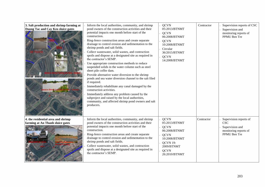
203
3. Salt production and shrimp farming at
Duong Tac and Cay Keo sluice gates
Inform the local authorities, community, and shrimp
pond owners of the construction activities and their
potential impacts one month before start of the
construction.
Ring-fence construction areas and create separate
drainage to control erosion and sedimentation to the
shrimp ponds and salt fields.
Collect wastewater, solid wastes, and contruction
spoils and dispose at a designated site as required in
the contractor’s SEMP.
Use appropriate construction methods to reduce
suspended solids in the water column such as steel
sheet pile coffer dam.
Provide alternative water diversion to the shrimp
ponds and sea water diversion channel to the salt filed
if required.
Immediately rehabilitate any canal damaged by the
construction activities.
Immediately address any problem caused by the
subproject and raised by the local authorities,
community, and affected shrimp pond owners and salt
producers.
QCVN
05:2013/BTNMT
QCVN
06:2008/BTNMT
QCVN
10:2008/BTNMT
Circular
36/2015/BTNMT
QCVN
14:2008/BTNMT
Contractor Supervision reports of CSC
Supervision and
monitoring reports of
PPMU Ben Tre
4. the residential area and shrimp
farming at An Thanh sluice gates
Inform the local authorities, community, and shrimp
pond owners of the construction activities and their
potential impacts one month before start of the
construction.
Ring-fence construction areas and create separate
drainage to control erosion and sedimentation to the
shrimp ponds and salt fields.
Collect wastewater, solid wastes, and contruction
spoils and dispose at a designated site as required in
the contractor’s SEMP.
QCVN
05:2013/BTNMT
QCVN
06:2008/BTNMT
QCVN
10:2008/BTNMT
QCVN 19:
2009/BTNMT
QCVN
26:2010/BTNMT
Contractor Supervision reports of
CSC
Supervision and
monitoring reports of
PPMU Ben Tre

204
Use appropriate construction methods to reduce
suspended solids in the water column such as steel
sheet pile coffer dam.
Provide alternative water diversion to the shrimp
ponds and sea water diversion channel to the salt filed
if required.
Immediately rehabilitate any canal damaged by the
construction activities.
Spray enough water during dry days to suppress dust.
Prohibit construction activities before 6:30 am and
after 8:00pm.
Ensure traffic safety by installing safety fence, road
safety warning sign, traffic instruction, around
construction area.
Immediately address any problem caused by the
subproject and raised by the local authorities,
community, and affected shrimp pond owners and salt
producers.
QCVN
27:2010/BTNMT
Circular
36/2015/BTNMT
5. Dredging
For the five sluice gates: The total dredged materials
would be 2,110 m3. The total filling soil needed is 1,477
m3. Therefore, the excess is 633 m3 which will be
temporarily stored at the five sites (Table 2.5). Anlysis of
the soils indicates that they are not polluted by hazardous
substances, and thus can be reused by the local people for
filling eroded dykes or house foundation.
For dredging the canals:
The total dredged volume is 431,133m3 over 28,700m
of the 14 canals. Analysis results presented in Table
2.16 - Table 2.19 showed that sediment and soil
samples in these areas are within the permitted standard
and are not contaminated with the heavy metals or
organic matters. Therefore, the dredged soil and
sediment can be utilized as leveling materials during
construction and operation phases, and no disposal sites
are needed. The following site-specific mitigation
meares need to be implemented:
QCVN
10:2008/BTNMT
QCVN
14:2008/BTNMT
QCVN 17: 2011/
BGTVT national
technical standards and
regulations on
prevention of pollution
of inland waterway.
Contractor Supervision reports of
CSC
Supervision and
monitoring reports of
PMU

205
Only dredge in the dry season and the tide at low level
when there is no aquaculture and activities take water
for salt production.
Notify the local community about the schedule of
dredging works.
Create drainage ditches along the dredged canals
between the canals and the aquaculture ponds to avoid
erosion and sedimentation to the ponds.
Implement environmental monitoring for Contractors
during the construction period.
Regulate traffic to minimize the impact on waterways
traffic.
Strict control of chemicals and hazardous waste, store
in areas that are not flooded and located far from
water bodies.
Liability to pay loss if the incident causing loss to the
area residents.
All complaints about environmental pollution,
households can directly contact the local people
community for guidance and settlement.
As the dredged materials are in the state of mud at
first and soil particles are suspended for 24 to 48
hours. All drainage water from disposal land shall be
driven to the drains and discharged back to the canal.
In order to limit the negative impacts of mud
(produced by dredging) on the environment as well as
the water quality of the canals, the dredged sediment
will be transported to a containing area which is
appropriately located and properly design with an
adequate size. The dredged spoil will be pumped to
the disposal land and then overflow to a settlement
pond, where turbidity and total suspended solids are
settled. After some time, effluent is returned to the
canals.
B. Mangrove plantation (component 1)

206
Mangrove forest management Obtain permission from the before planting, thinning or
harvesting mangroves, including (i) thining tree as first thinning to a density of 5,000 trees/ha at 9 to 10 years
of age and second thinning to a density of 2,000 -2,500
trees/ha at 14 -15 years of age; (ii) Harvesting at about 20 years of age, after harvesting, prepare to plant a new
cycle and obtain permission from the before planting,
thinning or harvesting mangroves.
Law on Forest
Protection and Development No.
29/2004/QH11
Division of
Foresty of Ben Tre
province
Ben Tre
PPMU
Supervision reports of
CSC
Supervision and monitoring reports of Ben
Tre DARD
C. Implementation of Livelihood Models ( 3 Zones)
I. Ensure adequate measures to mitigate
potential negative impacts on poor farmers
dur to implementation of the Mangrove-
shrimp to organically certified mangrove-
shrimp model
Forest area must be at least a certain percentage of the
area of the land plot depending on the types of
certificate (e.g., Natureland Certificate: 40% as a
starting point moving to 50% within 2 years). So,
farmers always keep the forest area as requirements of
certification authorities.
Obtain permission from the before planting, thinning
or harvesting mangroves, including (i) thining tree as
first thinning to a density of 5,000 trees/ha at 9 to 10
years of age and second thinning to a density of 2,000
-2,500 trees/ha at 14 -15 years of age; (ii) Harvesting
at about 20 years of age, after harvesting, prepare to
plant a new cycle and obtain permission from the
before planting, thinning or harvesting mangroves.
Do not place soil from pond construction or cleaning
in mangrove areas, because Rhizophora trees do not
grow well or may die on high land without flooding
by the tide.
Do not pump soil from pond construction or cleaning
into waterways.
Use soil from pond construction and cleaning to build
up an area of high land for domestic use or where
other crops can be grown.
Regularly circulate water in the ponds to prevent low
oxygen conditions and reduce local accumulations of
mangrove leaves.
Law on Forest
Protection and
Development No.
29/2004/QH11
Law on Fisheries No.
17/2003/QH11
Division of
Foresty of
Ben Tre
province
Ben Tre
PPMU
Division of
Aquaculture
of Ben Tre
province Agriculture
and Fishery
Extension Center of
Ben Tre
province
Ba Tri District People's
Committee
Ben Tre DARD
Ben Tre DONRE

207
Prevent expanding shrimp aquaculture
industry poses one of the gravest threats to
mangrove forests
The following recommendations increase the success and
extension of shrimp - mangrove eco-farming:
The local authority need to give right financial
incentives for farmers they are likely to apply
production shrimp and expand mangrove forest cover.
The DARD must help farmers design, provision of
mangrove seedlings, certification costs, linking farmers
to markets.
Training courses for farmers on GAP introduction and
application should be orgarnised in coopeartion with
local extension center. Raising awareness for farmers
on risks of environmental pollution from farming
ponds and on higher value of aquaculture products
produced from farms where GAP is applied should also
be conducted.
Training for farmers the farming procedures follow the
standards guidelines. The shrimp farming in the area
that is not yet certified need to practice in the area
already certified.
Increase control by District FPD.
Public technical documentation shrimp international
standards issued to farmers.
Setting up internal control systems in shrimp -
mangrove eco-farming communities.
Establishing of community management of shrimp -
mangrove eco-farming.
Supporting for the afforestation area is not up to the
standard of GAP.
Guidance for farmers notes and keeps management
documents according to international standards.
Linking farmers to markets by link enterprise
companies with farmers.
Workshop set up chain linking: Providing seeds,
supplies
Establishing links with the business chain purchasing,
processing and exporting seafood.
Lobbying of civil society organizations is important to
motivate more buyers to procure ECO shrimp and thus
to further increase its market volume. The domestic
Law on Forest Protection
and Development No.
29/2004/QH11
Law on Fisheries No.
17/2003/QH11
Division of
Foresty of
Ben Tre
province
Ben Tre
PPMU
Division of
Aquaculture
of Ben Tre
province Agriculture
and Fishery
Extension Center of
Ben Tre
province
Ba Tri District People's
Committee
Ben Tre DARD
Ben Tre DONRE

208
market for ECO shrimp can be enlarged by continuous
media coverage regarding the environmental and health
benefits of organic shrimp aquaculture.
Developing and promoting brand internationally certified
- mangrove eco-farming.
II. Ensure adequate measures to mitigate
potential negative impacts on poor farmers
dur to implementation of the Biosecurity of
shrimp model
Seed quality and screening: The good quality shrimp fry
will grow well and have high survival rate. Skilled
assessment of seed health prior to purchase should reduce
disease risks.
Pond filling and water preparation:
Good design of shrimp ponds—in particular, design of
water supply and discharge systems—can have a
major impact on sustainability.
Ensure high-quality water supply and optimal pond
water conditions;
Closely located to quality water suitable for shrimp
culture
Treatment of influent water supply to eliminate
pathogens and carriers may reduce disease incidence
and associated use of chemicals.
Intensive aeration may itself serve as a form of water
treatment.
Mitigation of organic pollution: Feed management, Water
management (see 5.4.2.3)
Mitigation of chemicals’ effects (see 5.4.2.4)
Energy source and fuel management (5.4.2.5)
Farm sanitation management (see 5.4.2.6)
Labour management (see 5.4.2.7)
Social and environmental responsibilities (see 5.4.2.8)
Law on Fisheries No.
17/2003/QH11
QCVN 09:2008/BTNMT
QCVN 02 - 19 :
2014/BNNPTNT
Division of
Aquaculture of
Ben Tre
province
Agriculture
and Fishery
Extension
Center of Ben
Tre
Ben Tre
PPMU
Ba Tri District People's
Committee
Ben Tre DARD
Ben Tre DONRE
Reduce potential negative impacts due to
possible expansion of the Biosecurity of
shrimp model
Control land use plans with the multi-disciplinary
assistance of agricultural, aquaculture and forestry
(mangrove-shrimp).
Need the expertise of agricultural and aquaculture
specialists to optimize the structural works supporting
expansion models. For example, water quality, issues
risks, quality produce, and market confidence, and
reach commercial sizes to fetch optimal prices.
Law on Fisheries No.
17/2003/QH11
QCVN
09:2008/BTNMT
QCVN 02 - 19 :
2014/BNNPTNT
Division of
Aquaculture of
Ben Tre
province
Agriculture
and Fishery
Extension
Ba Tri District People's
Committee
Ben Tre DARD
Ben Tre DONRE

209
Share and transfer lessons and experience between
Biosecurity of shrimp in the subprojects. Sharing
lessons and experience between Biosecurity of shrimp
in subproject could also help increase safe production.
Operation sluice gates can better control the water
availability and quality needs of the respective
Biosecurity of shrimp will be critical to reducing
farmers’ climate/environmental risks.
These clean production systems could be similarly
developed in zone Biosecurity of shrimp system.
These models could be adopted in the Zone 2
Biosecurity of shrimp systems - which have relatively
high productivity - to increase income.
Expansion models near successful Biosecurity of
shrimp in order to change farmer’s perceptions.
Farmer to farmer exchanges of knowledge and
experience would also be more likely to occur, and
easier to facilitate.
Farmers should be provided with financial and
economic analysis of the demonstrations once the
pilots are demonstrated to be financially beneficial.
Scaling-up should branch out from these areas. The
same approach could also be used in the Neighboring
farmers.
Conduct water quality control for Biosecurity of
shrimp zone (both fresh and brackish water) if the
livelihoods are to be sustainable.
Collecting data Biosecurity of shrimp systems.
Establishing of community management Biosecurity
of shrimp farming.
Training courses for farmers on GFM introduction
and application.
Training methods of collecting water samples,
samples of shrimp diseases.
Public manuals measuring environmental factors and
sampling water bowl disease.
Building regulations farming communities.
Organize environmental commitment signed between
farmers.
Center of Ben
Tre
Ben Tre
PPMU

210
Organization of environmental monitoring and
notification of monitoring results and recommends
solutions to social radio.
Ensure adequate measures to mitigate
potential negative impacts on poor farmers
dur to implementation of the Rice crop+
Giant Freshwater Shrimp model
Treatment waster water from aquaculture farming
before discharging into water course.
Develop and integrate real-time environmental
monitoring tools into the livelihood component of the
subproject.
Share and transfer lessons and experience between
subprojects under the MD-ICRSL project.
Use farmer cooperatives or collective groups to
implement livelihood adaptation models.
Locate pilot livelihood demonstrations near successful
models in order to change farmer’s perceptions.
Reduce the risk of over-supply by working with
agribusinesses on a staged incremental approach.
Start-up capital needs to be provided to fund the
livelihood investments.
Hire aquaculture and agriculture specialists to support
cooperatives/collective groups.
Establish hatcheries capable of producing high quality
aquaculture seed as close as possible to the subproject
site.
Law on Fisheries No.
17/2003/QH11
QCVN 09:2008/BTNMT
QCVN 02 - 19 :
2014/BNNPTNT
Division of
Aquaculture of
Ben Tre
province
Agriculture
and Fishery
Extension
Center of Ben
Tre
Ben Tre
PPMU
Ba Tri District People's
Committee
Ben Tre DARD
Ben Tre DONRE
Reduce potential negative impacts due to
possible expansion of the the Rice crop+
Giant Freshwater Shrimp model
Priority is to maitain incomes for farmers, avoid
economic shocks: Allow continuing freshwater
production where still economically viable, adjust the
cropping systems (away from rice) and calendar to
cope with shortage of freshwater in dry season. No big
investments in infrastructure to maintain freshwater
production, especially for rice.
Develop a transitional plan with clear and realistic
goals. The plan should clearly identify various steps to
be taken in making the transition to aquaculture and
be sure to include realistic time frames.
Build capacity and necessary steps to allow smooth
transition: improve the technical capacity of farmers;
create effective mechanisms for strengthening,
promoting, and disseminating locally initiated efforts.
Law on Fisheries No.
17/2003/QH11
QCVN 09:2008/BTNMT
QCVN 02 - 19 :
2014/BNNPTNT: N
Division of
Aquaculture of
Ben Tre
province
Agriculture
and Fishery
Extension
Center of Ben
Tre
Ben Tre
PPMU
Ba Tri District People's
Committee
Ben Tre DARD
Ben Tre DONRE

211
Subsidize and improve access to credit services.
Establish commune CC Response Team to raise local
awareness, identify collective action plan, pilot CC
farming models, and establish farmer organizations.
Improve links between production and markets; and
establish effective mechanisms for coordination.
The land use changes and water infrastructure must
take into account the future conversion of the
intensive shrimp growing area behind District Road
16 and how effluent – rice agrochemicals in the short
term, aquaculture effluent in the long term – will be
discharged into downstream areas.
Report on progress of carrying out environment
management plan for aquaculture in coastal area of Ba
Tri district prepared by implementation agency and
submitted to DARD Ben Tre for consideration and
approval.

212
Addressing Regional Environmental Impacts
The REA report systematically and qualitatively assesses the regional impacts of the proposed
subprojects. The regional impacts, both positive and negative, are generally mild and moderate
for two reasons: i) the scale of the investments, from a regional perspective, are small; and ii)
the investments are designed to be low-regret and conform with the 2013 Mekong Delta Plan
strategies for sustainable development. In addition to addressing the regional environmental
impacts at the subproject level through satisfactory implementation of the subproject ESMP, a
Technical Assistance (TA) will be provided to help address regional issues. A well-designed
Component 1 ($48 million) of the MDICRSL supports the following initiatives through
technical assistance activities in the Project which will be extended to the subproject level:
Formulation of a Mekong Delta Climate Sustainability Assessment: This will be
comprehensive assessment of Delta sustainability issues, including status, trends, and
recommendations on how to adaptively manage the Delta in context of rapidly changing
environmental conditions. It will be a document that informs the government’s next five
year regional, local, and sectoral planning in the Delta. The Assessment should be
completed by 2019 and will help to inform planning exercises in the Vietnam government,
including the Ministry of Planning and Investment’s (MPI) “Socio-Economic Development
Plan for the Mekong Delta”, provincial socio-economic development and land use plans,
and sector master plans for the next planning cycle (2021-2025). The Assessment will
develop a set of key environmental and socio-economic indicators related to MD
sustainability taking into account the regional environmental impacts of the MD
development, and then assess the status, trends, and driving factors related to those
indicators. The Assessment will also identify any data or knowledge gaps which need to be
addressed for the next Assessment process, which ideally should take place every five
years. Finally, the Assessment will provide a set of recommendations related to the next
planning cycle in order promote adaptive management of the Delta.
Upgrading Monitoring Programs: Including remote sensing, land use, water quantity and
quality, groundwater, coastal and river morphology, coastal zone protection, etc. to provide
better information. These programs will help produce better tools and information for both
planning and management purposes, including informing design of phase II subprojects to
address the regional environmental impacts. The results of the programs will be shared with
the project provinces and broader MD stakeholders, and other relevant capacity building
activities will be developed and carried out during project implementation.
Establishment of the Mekong Delta Center: Several research institutes and departments
are involved in gathering and analyzing data and information on the Delta; however, there
are no current mandates for data sharing which would contribute to the integrated and
multi-sectoral solutions that are often needed. The Center is envisioned to serve as a hub
for Delta-wide information, including water, land use, environmental and climate change
information, education and outreach, and provide support to specialized studies and
research projects that inform decisions and investments in the Mekong Delta. For
addressing regional environmental impacts the provinces will benefit from data provided
by the center.
MARD Real Time Operations System for Hydraulic Infrastructure: This will be a
decision support center to provide real-time information on salinity, floods, and droughts
to allow for better operation of infrastructure, especially the sluice gates, to meet real-time
conditions and demands. Under the system a database on MD sea dykes and mangrove
forests will be established for a systematic assessment and monitoring of sea dykes and

213
mangrove belts, which will allow for better monitoring, maintenance, and investments for
these critical coastal assets.
6.4. ENVIRONMENTAL MONITORING PROGRAM
The main objective of the environment monitoring program is to ensure that (a) the potential
negative impacts of the project are minimized; (b) the ESMP is effectively implemented; and
(c) the ESMP is adequate to mitigate the potential negative impacts. Given that monitoring the
implementation of the RAP will be conducted separately, the environmental monitoring
program will comprise: (a) monitoring the safeguard performance of the contractor during site
clearance and construction; (b) environmental quality monitoring; (c) community-based
monitoring; and (d) monitoring effectiveness of the ESMP.
6.4.1. Monitoring of Contractor’s Safeguard Performance
Three levels of safeguard monitoring will be implemented: routine monitoring, periodic
monitoring, and community monitoring, as follows:
Routine monitoring: The routine monitoring will be made by the Construction Supervision
Consultant (CSC) as assigned by PPMU Ben Tre. The CSC will include the monitoring
results in the project progress reports.
Periodic monitoring (every six months): As part of the overall monitoring of the ESMP, the
ESU assisted by the Independent Environmental Monitoring Consultant (IEMC) will also
monitor the contractor performance every 6 months and the results will be reported to the
PPMU Ben Tre and the WB.
Community monitoring: Monitoring by local communities will be conducted following the
Government practices with the technical and management support from the PPMU Ben Tre.
6.4.2. Environmental Quality Monitoring
To ensure an acceptable level of environmental quality, monitoring of dust, noise, vibration,
air quality, and water quality will be made at project specific locations that are likely to be
significantly affected by the construction activities, or requested by local authorities and
communities for specific purposes. ESU/IEMC will be responsible for the monitoring of the
program.
Below is a list of the key issues and scope of monitoring that will be considered in the
implementation of the monitoring program (Table 6.4):
General Construction Impacts: To include local flooding; traffic management especially in
residential areas; air, noise, and dust levels in residential areas; and water quality upstream
and downstream of construction sites, with specific attention on impacts to local residents;
Others: As agreed with local agencies and communities during the preparation of the
monitoring program.
The monitoring scope provides general guidance on the monitoring program and estimated cost
considering that the activities will be carried out before construction (subproject baseline
environment), during construction (assumed 1 years), and during the first 2 years of subproject
operation. Detailed monitoring programs will be prepared during the detailed design stage. An
estimated cost for monitoring is incorporated into the ESMP cost (Section 6.6). Many of these
measurements are required by Vietnamese regulations and would need to be done even if not
directly related to expected subproject impacts.

214
Table 6.4: Scope of environmental monitoring during construction and operation
No
Contents
Specific requirements Applied standard
5 sluices 14 canals
I Construction phase
1 Air/noise, vibration QCVN
05:2013/BTNMT,
QCVN
26:2010/BTNMT;
QCVN
27:2010/BTNMT
a Parameters TSP, NO2, SO2, CO, noise, vibration
b Locations 5 stations
c Frequency
03 months/time x
12 months
2 Water + micro organism + aquatic life
QCVN 08-
MT:2015/BTNMT a
Parameters
pH, Turbidity, Salinity, DO, TSS, BOD5, TN, TP,
oil & grease, coliform, phytoplankton,
zooplankton, zoobenthos
b Locations 5 stations 14 stations
c Frequency
03 months/time x
12 months 03 months/time x 6 months
3 Sediment
QCVN
43:2012/BTNMT;
a Parameters pHKCl, salinity, Cu, Pb, Zn, Cd, As, TP, TN, TC
b Locations 5 stations 14 stations
c Frequency
03 months/time x
12 months 03 months/time x 6 months
II Operation phase
1 Water + micro organism + aquatic life
QCVN 08-
MT:2015/BTNMT
a
Parameters
pH, Turbidity, Salinity, DO, TSS, BOD5, TN, TP,
oil & grease, coliform, phytoplankton,
zooplankton, zoobenthos
b Locations 5 stations 14 stations
c
Frequency
06 months/time
during the first 2
years of operation
06 months/time during the
first 2 years of operation
2 Sediment
QCVN
43:2012/BTNMT;
a Parameters pHKCl, salinity, Cu, Pb, Zn, Cd, As, TP, TN, TC
b Locations 5 stations 14 stations
c Frequency
06 months/time during the first 2 years of
operation
6.4.3. Community-based monitoring
Community-based monitoring is a voluntary activity of people living in commune/ward areas.

215
Community Supervision Board will be established by Decision No. 80/2005/QD-TTg and
others relevant regulations. Community Supervision Board will be responsible for:
Monitoring and assessing the observance of investment management regulations by
agencies competent to decide on investment, Subproject owner, subproject management
unit, contractors and subproject-implementing units in the investment process (including
environmental issues);
Detecting and recommending to the competent state agencies on violations of regulations
on investment management (including environmental issues) so as to promptly prevent and
handle acts that violate regulations, cause wastage and/or loss of state capital and properties
or infringe the interests of the community.
6.4.4. Monitoring Effectiveness of the ESMP
The ESU assisted by IEMC will monitor performance of the ESMP implementation during the
detailed design/bidding stage as well as during construction and first year operation of the
facilities to ensure that (a) appropriate dredging and disposal of drainage sludge is properly
carried out, in accordance with the ESMP; (b) other impacts identified in the ESMP are
effectively managed and mitigated; and (c) traffic management is adequate and the level of
impacts is acceptable (no complaints or outstanding cases). Results are to be properly kept in
the subproject file for possible review by PPMU and the WB. Cost for the monitoring will be
part of the PPMU cost.
6.5. ROLE AND RESPONSIBILITIES FOR ESMP IMPLEMENTATION
6.5.1. Implementation arrangement
Role and responsibilities for ESMP implementation are described in Figure 6.1 and Table 6.5.
Figure 6.1: Organization structure for safeguard monitoring
PPCs, DONRE, and local
community (CDC)
World Bank

216
Table 6.5: Institutional Responsibilities for the Project and Subproject Safeguard
Implementation
Community/
Agencies
Responsibilities
Project Implementing
Agency (IA) and
PMU
(The IA means
MARD and MONRE
while PMU here
means the PMU of
MONRE and CPMU
and ICMB10 of
MARD and PPMU of
the Ben Tre province)
- The IA will be responsible for overseeing the Project implementation
including ESMF implementation and environmental performance of
contractors.
- PMU, representative of the IA, will be responsible for monitoring the
overall Project implementation, including environmental compliance of
the Project. PMU will have the final responsibility for ESMF
implementation and environmental performance of the Project during the
construction and operational phases.
- Specifically the PMU will: (i) closely coordinate with local authorities in
the participation of the community during project preparation and
implementation; (ii) monitor and supervise ESMP implementation
including incorporation of ESMP into the detailed technical designs and
bidding and contractual documents; (iii) ensure that an environmental
management system is set up and functions properly; (iv) be in charge of
reporting on ESMP implementation to the IA and the World Bank.
- In order to be effective in the implementation process, PMU will
establish an Environmental and Social Unit (ESU) with at least two
safeguard staff to help with the environmental aspects of the Project.
Environmental and
Social Unit (ESU)
under PMU
- The ESU is responsible for monitoring the implementation of the World
Bank’s environmental safeguard policies in all stages and process of the
Project. Specifically, this unit will be responsible for: (i) screening
subprojects against eligibility criteria, for environment and social
impacts, policies triggered and instrument/s to be prepared;(ii) reviewing
the subproject EIAs/EPPs and ESIAs/ESMPs prepared by consultants to
ensure quality of the documents; (iii) helping PMU incorporate ESMPs
into the detailed technical designs and civil works bidding and
contractual documents; (iv) helping PMU incorporate responsibilities for
ESMP monitoring and supervision into the TORs, bidding and
contractual documents for the Construction Supervision Consultant
(CSC) and other safeguard consultants (SSC, ESC, IMA, and EMC) as
needed; v) providing relevant inputs to the consultant selection process;
(v) reviewing reports submitted by the CSC and safeguard consultants;
(vi) conducting periodic site checks; (vii) advising the PMU on solutions
to environmental issues of the project; and viii) preparing environmental
performance section on the progress and review reports to be submitted
to the Implementing Agency and the World Bank.
PPMUs, DARDs,
ICMB10, PMU of
MONRE
- As the subproject/activity owner, PPMU/ICMB10/PMU of MONRE is
responsible for implementation of all the ESMP activities to be carried
out under the Project, including fostering effective coordination and
cooperation between contractor, local authorities, and local communities
during construction phase. PPMU/ICMB10/PMU of MONRE will be
assisted by the environmental staff, safeguard consultants, and CSC/or
field engineer.
- Division of Aquaculture of Ben Tre Province DARD and Agriculture and
Fishery Extension Center of Ben Tre Province are responsible for
livelihoods models.

217
- During operation, the responsibility to operate the sluice gate will be
transferred to the Provincial Department of Water Resources (PDWR) of
DARD and they will be responsible for monitoring of water quality and
ecosystem before and after the operation of the sluice gates and submit
water quality report to the DONRE one time per three months.
Construction
Supervision
Consultant (CSC)
and/or Field Engineer
- The CSC will be responsible for routine supervising and monitoring all
construction activities and for ensuring that Contractors comply with the
requirements of the contracts and the ECOP. The CSC will engage
sufficient number of qualified staff (e.g. Environmental Engineers) with
adequate knowledge on environmental protection and construction
project management to perform the required duties and to supervise the
Contractor’s performance.
- The CSC will also assist the PMU/PPMU/ICMB10/PMU of MONRE in
reporting and maintaining close coordination with the local community.
Contractor
- Based on the approved environmental specifications (ECOP) in the
bidding and contractual documents, the Contractor is responsible for
establishing a Contractor ESMP (CESMP) for each construction site area,
submit the plan to PPMU/ICMB10/PMU of MONRE and CSC for review
and approval before commencement of construction. In addition, it is
required that the Contractor get all permissions for construction (traffic
control and diversion, excavation, labor safety, etc. before civil works)
following current regulations.
- The Contractor is required to appoint a competent individual as the
contractor‘s on-site Safety and Environment Officer (SEO) who will be
responsible for monitoring the contractor‘s compliance with health and
safety requirements, the CESMP requirements, and the environmental
specifications (ECOP).
- Take actions to mitigate all potential negative impacts in line with the
objective described in the CESMP.
- Actively communicate with local residents and take actions to prevent
disturbance during construction.
- Ensure that all staff and workers understand the procedure and their tasks
in the environmental management program.
- Report to the PPMU/ICMB10/PMU of MONRE on any difficulties and
their solutions.
- Report to local authority and PPMU/ICMB10/PMU of MONRE if
environmental accidents occur and coordinate with agencies and keys
stakeholders to resolve these issues.
Independent
Envionmental
Monitoring
Consultants (IEMC)
- IEMC will, under the contract scope, provide support to
PPMU/ICMB10/PMU of MONRE to establish and operate an
environmental management system, offers suggestions for adjusting and
building capacity for relevant agencies during project implementation and
monitor the CESMP implementation in both construction and operation
stages. IEMC will also be responsible to support PPMU/ICMB10/PMU
of MONRE to prepare monitoring reports on ESMP implementation.
- The IEMC will have extensive knowledge and experience in
environmental monitoring and auditing to provide independent, objective
and professional advice on the environmental performance of the Project.
218
Local community
- Community: According to Vietnamese practice, the community has the
right and responsibility to routinely monitor environmental performance
during construction to ensure that their rights and safety are adequately
protected and that the mitigation measures are effectively implemented
by contractors and the CPMU/PPMU/ICMB10/PMU of MONRE. If
unexpected problems occur, they will report to the CSC and/or
CPMU/PPMU/ICMB10/PMU of MONRE.
Social organizations,
NGOs and civil
society groups
- These organizations could be a bridge between the PPC/DPC,
communities, Contractors, and the CPMU/PPMU/ICMB10/PMU of
MONRE by assisting in community monitoring.
- Mobilizing communities' participation in the subproject, providing
training to communities and Participating in solving environmental
problems, if any.
Province and District
People’s Committees
(PPCs/DPCs),
Provincial DONRE
- Oversee implementation of subprojects under recommendations of
DONRE and PPMU/ICMB10/PMU of MONRE to ensure compliance of
Government policy and regulations. DONRE is responsible for
monitoring the compliance with the Government environmental
requirements.
6.5.2. Environmental Compliance Framework
6.5.2.1. Environmental Duties of the Contractor
The contractor firstly shall adhere to minimize the impact that may be result of the project
construction activities and secondly, apply the mitigation measures under ESMP to prevent
harm and nuisances on local communities and environment caused by the impacts in
construction and operation stages.
Remedial actions that cannot be effectively carried out during construction should be carried
out on completion of the works (and before issuance of the acceptance of completion of works)
The duties of the Contractor include but not limiting to:
Compliance with relevant legislative requirements governing the environment, public
health and safety;
Work within the scope of contractual requirements and other tender conditions;
Organize representatives of the construction team to participate in the joint site inspections
undertaken by the Environmental Supervisor (ES) of the CSC;
Carry out any corrective actions instructed by the Environmental Control Officer (ECO) of
the PPMU and ES;
In case of non-compliances/discrepancies, carry out investigation and submit proposals on
mitigation measures, and implement remedial measures to reduce environmental impact;
Stop construction activities, which generate adverse impacts upon receiving instructions
from the ECO and ES. Propose and carry out corrective actions and implement alternative
construction method, if required, in order to minimize the environmental impacts; Non-
compliance by the Contractor will be cause for suspension of works and other penalties
until the non-compliance has been resolved to the satisfaction of the ECO and ES.
6.5.2.2. Contractor’s Safety and Environment Officer (SEO)
The contractor shall be required to appoint a competent individual as the Contractor‘s on-site

219
safety and environment officer (SEO). The SEO must be appropriately trained in environmental
management and must possess the skills necessary to transfer environmental management
knowledge to all personnel involved in the contract. The SEO will be responsible for
monitoring the contractor‘s compliance with the ESMP requirements and the environmental
specifications. The duties of the SEO shall include but not be limited to the following:
Carry out environmental site inspections to assess and audit the contractors' site practice,
equipment and work methodologies with respect to pollution control and adequacy of
environmental mitigation measures implemented;
Monitor compliance with environmental protection measures, pollution prevention and
control measures and contractual requirements;
Monitor the implementation of environmental mitigation measures;
Prepare audit reports for the environmental monitoring data and site environmental
conditions;
Investigate complaints and recommend any required corrective measures;
Advise the contractor on environment improvement, awareness and proactive pollution
prevention measures;
Recommend suitable mitigation measures to the contractor in the case of non-compliance.
Carry out additional monitoring of noncompliance instructed by the ECO/ES;
Inform the contractor and ECO/ES of environmental issues, submit contractor’s ESMP
Implementation Plan to the ECO/ES, and relevant authorities, if required;
Keep detailed records of all site activities that may relate to the environment.
6.5.2.3. Independent Environmental Monitoring Consultant (IEMC)
In order to minimize the environmental impacts during construction stage of the Project, the
Project owner shall ensure that environmental quality monitoring requirements are established
for the project. An Independent Environmental Monitoring Consultant (IEMC) appointed by
CPMU shall carry out the monitoring.
IEMC will be responsible for carrying out environmental sampling, monitoring and
marking report during all stages of the Project. Environmental quality monitoring will be
report periodically to PPMU (every 06 months in construction stage and in operation stage).
IEMC will also supply specialized assistance to CPMU and ECO in environmental matters.
6.5.2.4. Environmental Supervision during Construction
During construction stage, a qualified Construction Supervision Consultant (CSC) reporting to
the PPMU shall carry out the environmental supervision. The CSC is responsible for
inspecting, and supervising all construction activities to ensure that mitigation measures
adopted in the ESMP are properly implemented, and that the negative environmental impacts
of the Project are minimized. The CSC shall engage sufficient number of Environmental
Supervision Engineers with adequate knowledge on environmental protection and construction
project management to perform the required duties and to supervise the Contractor’s
performance. Specifically ES will:
Review and assess on behalf of the PPMU whether the construction design meets the
requirements of the mitigation and management measures of the ESMP,

220
Supervise site environmental management system of contractors including their
performance, experience and handling of site environmental issues, and provide corrective
instructions;
Review the ESMP implementation by the contractors, verify and confirm environmental
supervision procedures, parameters, monitoring locations, equipment and results;
Report ESMP implementation status to PPMU and prepare the environmental supervision
statement during the construction stage; and
Approve invoices or payments.
6.5.2.5. Compliance with Legal and Contractual Requirements
The constructions activities shall comply not only with contractual environmental protection
and pollution control requirements but also with environmental protection and pollution control
laws of the Socialist Republic of Viet Nam.
All the works method statements submitted by the Contractor to the ECO for approval shall
also be sent to the ES to see whether sufficient environmental protection and pollution control
measures have been included.
The ES shall also review the progress and program of the works to check that relevant
environmental laws have not been violated, and that any potential for violating the laws can be
prevented.
The Contractor shall copy relevant documents to the SEO and the ES. The document shall at
least include the updated work progress report, the updated work measure, and the application
letters for different license/permits under the environmental protection laws, and all the valid
license/permit. The SEO and the ES shall also have access, upon request, to the Site Log-Book.
After reviewing the documents, the SEO or the ES shall advise the ECO and the contractor of
any non-compliance with the contractual and legislative requirements on environmental
protection and pollution control for them to take follow-up actions. If the SEO or the ES
concludes that the status on license/permit application and any environmental protection and
pollution control preparation works may not comply with the work measure or may result in
potential violation of environmental protection and pollution control requirements, they shall
advise the Contractor and the ECO accordingly.
6.5.2.6. Environmental Claims and Penalty System
In the compliance framework, if non-compliance with environmental regulations are
discovered by ECO/CSC/ES/IEMC during the site supervision, 2% values of interim payment
of the contractor of this month will be held back. The Contractor will be given a grace period
(determined by CSC/ES) to repair the violation. If the Contractor performs the repairs within
the grace period (confirmed by CSC/ES), no penalty is incurred and keeping money will be
pay. However, if the Contractor fails to successfully make the necessary repairs within the
grace period, the Contractor will pay the cost for a third party to repair the damages (deduction
from keeping money).
In case of IEMC/CSC/ES not detected of non-compliance with environmental regulations of
the contractor, they will be responsibility payment to repair the violation.
6.5.3. Reporting Arrangements
ESMP monitoring and reporting requirements are summarized in Table 6.6.

221
Table 6.6: Regular Reporting Requirements
No. Report Prepared by Submitted to Frequency of Reporting
1 Contractor to the
Employer
PPMU Ben Tre Once before construction
commences and monthly thereafter
2 Construction Supervision
consultant (CSC)
PPMU Ben Tre Weekly and monthly
4 Community Monitoring PPMU Ben Tre When the community has any
complaint about the subproject
safeguards implementation
5 PPMU Ben Tre CPMU Monthly
6 CPMU WB Every six-month
6.6. CAPACITY BUILDING PROGRAM
6.6.1. Technical assistance support for the implementation of safeguards
An assessment of safeguards implementation capacity of existing PPMU staff indicates the
staff have limited knowledge on WB safeguard requirements as well as limited knowledge of
environmental and social issues. Such lack of capacity represents a risk to project
implementation of safeguards requirements contained in the ESMP and, as required by the WB
policy, is to be addressed through capacity building. Therefore it is proposed to provide
capacity building through technical assistance that will support the PPMU during the
implementation of the safeguards requirements. The technical assistance will provide the
necessary technical support for the PPMU in its work with contractors as well as other entities
involved in the implementation of the ESMP.
The scope of the technical assistance would cover support from experts and training that would
include knowledge on safeguards requirements and procedures for the subproject as well as
training that covers both specific knowledge on safeguard procedures and requirements for the
subproject staff, consultants, and national contractor. More specifically, the support would
include, for example, assistance in the preparation of documents and implementation of training
programs on environmental management and environmental monitoring for contractors, CSC
and relevant staff of PPMU (environmental staff and coordinators of packages) to do their tasks.
It would also include assisting the PPMUs’ environmental staff with the review of contract
documents on the bidding packages for construction items of the subproject to ensure
compliance with environmental protection policies and impact mitigation and monitoring
requirements; as well as provide general environmental guidance as requested by the PPMU to
enhance overall project implementation and performance.
Given the nature, locations, and scale of construction, it is anticipated that the safeguard
technical assistance support and training will be provided at least during the first 3 years of the
project implementation. The WB safeguard specialists will participate in the capacity building,
in particular in the training activities as appropriate.
Special technical assistance: Additional technical assistance will be necessary for ensuring
that (a) the potential negative impacts during sluice operations will be minimized and accepted
by key stakeholders, (b) the mitigation measures for potential impacts on socio-economic
conditions of poor farmers is adequate and farmers have improved knowledge to minimize
technical and marketing risks, and (c) regulatory measures to control and manage possible
induced impacts due to possible expansion of the livelihood models is inplace before the

222
subproject closing. It is expected that 2 national firms will be mobilized to provide these
technical services: for (1) for safeguard training and the development and consultation of the
operation plan for the sluice gates including meetings and workshops for 2 years during 2017-
2019 and (2) (i) the planning and undertaking socio-economic survey for the farmers in the
pilot sites and nearby areas for 3 years during (2017-2020), (ii) development of a registration
program on aquacutlure farming in the subproject and nearby areas, and (iii) development of
FFS application and implementation of a series of technical workshops, TOT, and development
of guidelines and awareness materials, and study visits and building farmer network etc. to be
implemented during 2017-2020. TORs for these technical assistances will be prepared by the
subproject owner in close consultation with CPMU.
6.6.2. Training programs proposed
Table 6.7 provides the basic training programs for safeguards during subproject
implementation. The training programs will be developed and delivered by the Technical
Assistance team for the implementation of safeguards for the PPMU training. The
PPMU/IEMC with the support of the the Technical Assistance team for the implementation of
safeguards will provide the training to contractors, CSC and other groups. In addition, given
limited safeguard capacity of the main stakeholders of the project, The Bank will provide a
training on Preparation of ESIA and Integration of Cumulative Impact Assessment (CIA) into
ESIA which is part of the safeguards capacity program to develop during implementation while
identifying and agreeing on one of the specific training or capacity building activities. The
Bank consultant will provide a five-day training on integration of CIA into ESIA and on how
to address the quality and the implementation of the EIAs in conjunction with other safeguards
instruments
Other more specific and tailored training will be developed and agreed upon between PPMU,
IEMC and the Technical Assistance team for the implementation of safeguards during project
implementation based upon a reassessment of needs and the status of safeguards
implementation with the following contents (Table 6.7):
Target groups for the training include PPMU staff, ESU staff, field engineers, CSC,
construction contractors.
Training schedule: At least 1 month before the implementation of the first contract. The
training can be adjusted in line with the implementation schedule of the
subproject/contracts.
Training frequency: The basic training programs proposed in will take place every six
months on a yearly basis and its content updated and adapted to implementation issues.
Training frequency and content will be reassessed during implementation depending on
needs.
Table 6.7: Training Programs for Capacity Building on Environmental Supervision and
Management
1. Objects CPO, CPMU, PPMUs, ESIA Consultants
Training course Preparation of Environmental and Social Impacts Assessment and
integration of cumulative impact assessment (CIA) into ESIA.
Participants CPO, CPMU, PPMUs technical staff and ESIA Consultants.
The week long or so training referred to integrates CIA but goes beyond
to address the quality and the implementation of the EIAs in conjunction
with other safeguards instruments.

223
Course duration
and time
A five-day training to be conducted in June 2016, before implementation
of the MDICRSL project
Content World Bank requirements for ESIAs
Preparation of ESIA
Intergation of CIA into ESIA
Quality requirements and quality control of ESIA
Implementation of the EIAs in conjunction with other safeguards
instruments.
Responsibilities The World Bank
2. Objects PROVINCE PROJECT MANAGEMENT UNIT
Training course Environmental supervision, monitoring and reporting.
Participators Environmental staff and technical staff.
Training
Frequency
At least 1 month before implementation of the first contract. The follow-
up training will be scheduled as needed.
Time Four days of training twice a year to be repeated on a yearly basis.
Content General environmental management relating to the subproject including
requirements of WB, DONRE, and cooperating with relevant
enterprises.
Requirements on environmental supervision.
Supervision and implementation of mitigation measures; community
participation in environmental supervision.
Guide and supervise contractor, CSC and community representatives in
implementation of environmental supervision.
Forms used in environmental supervision.
Risk response and control.
Reporting and submit forms.
Responsibilities PPMU, IEMC with support of the Technical Assistance team for the
implementation of safeguards.
3. Objects CSC, CONTRACTOR
Training course Implementation of mitigation measures.
Participators CSC; on-site construction management staff; environmental staff of
contractor.
Training
frequency
After bidding, update based on requirements.
Time three days of training twice a year to be repeated on a yearly basis
Content Overview of environmental monitoring.
Requirements of environmental monitoring.
Role and responsibilities of contractors and CSC.
Content and methods of environmental monitoring.
Response and risk control.
Propagate monitoring forms and guide how to fill in the forms and risk
reports.
Preparation and submission of reports.
Responsibilities PPMU, IEMC with support of the Technical Assistance team for the
implementation of safeguards.
6.7. ESTIMATED ESMP COST
The EMP cost will comprise: (a) cost for resettlement and land acquisition; (b) cost for
implementation of the mitigation measures by the contractor; (c) cost for supervision by the

224
CSC; (d) cost for the Environmental Management Consultant (EMC) including monitoring of
environmental quality; (e) cost for water quality/ecology monitoring during operation for at
least 2 years; and (f) supervision and safeguard management costs incurred by PPMU and
CPMU. All the costs will be included as the subproject cost as shown in Table 6.8.
Cost for the implementation of the mitigation measures during construction will be part of
the contract costs while the costs for monitoring by the CSC is provided for in the
construction supervision contracts.
Cost for EMC and monitoring of environmental quality during construction is included in
the subproject cost.
Costs for PPMU operations related to the EMP are provided for in the subproject
management budget of the PPMU.
Cost for technical assistance for safeguard training and technical services to be provided to
mitigate the potential negative impacts during construction and operations of the sluice gates
including the development of operational plan for sluices in consultation with water users
and key stakeholders.
Cost for technical assistance for mitigation of potential negative impacts due to the
implementation of the 3 livelihood models especially (a) on poor farmers including
undertaking socioeconomic survey, promoting aquaculture products, and implementation of
the FFS on aquaculture models in the subproject areas and building farmers networks, and
(b) for establishment of a registration system for aquaculture farmings to mitigate potential
negative impacts due to possible expansion of the models in the future. It is estimated that
the EMP implementation cost (excluding those to be included in civil works contract and
CSC contract and RAP) will be about 8,121,276,000 VND (398,000USD) over a 5 years
period. Estimation cost for ESMP is shown in Table 6.8.
Table 6.8: Cost for ESMP in the entire subproject (VND)
Activity Source of fund Total cost (VND)
(a) Resettlement and land acquisition Part of subproject cost 0
(b) Mitigation measures during the
construction phase
Part of contract cost
(c) Safety monitoring during the
construction phase (2 manmonth x18
months x 10 millions VND/months)
Part of subproject cost 360,000,000
(d) PPMU environmental staff Part of subproject cost 180,000,000
Environmental monitoring in the entire
subproject (see Table 6.9)
Part of subproject cost 861,276,000
(e) Environmental monitoring
consultant (EMC)
Part of subproject cost 720,000,000
(f) Technical assistance (national
consultant) for safeguard training and
development and consultation of the
operation plan for the sluice gates
including meetings and workshops for
3 years during 2017-2019
Part of subproject cost $100,000
(g) Technical assistance (national
consultant) for (i) planning and
undertaking socio-economic survey
Part of subproject cost $200,000

225
for the farmers in the pilot sites and
nearby areas for 5 years during (2016-
2020), (ii) development of a
registration program on aquacutlure
farming in the subproject and nearby
areas, and (iii) development of FFS
application and implementation of a
series of technical workshops, TOT,
and development of guidelines and
awareness materials, and study visits
and building farmer network etc. (to
be implemented during 2016-2020)

226
Table 6.9: Cost for environmental monitoring in the entire subproject
No.
Subproject’s
phase
Subproject activities
Unit Quan
tity
Unit
price
(VND)
Total
(VND) 5 sluice gates 14 canals
I Construction phase 415,536,000
1 Total of
sampling
12 months x 3
months/time =4
times
6 months x 3
months/time =2
times Time
2 Air/noise,
vibration 10 stations x 4
times Sample 40 654,000 26,160,000
3 Water + micro
organism +
aquatic life
5 stations x 2
samples/station
(high tide -low
tide) x 4 times
14 stations x 2
samples/station
(high tide - low
tide) x 2 times
Sample 96 2,247,000 215,712,000
4 Sediment 5 stations x 1
sample/station x
4 times
14 stations x 1
samples/station x
2 times Sample 48 1,371,000 65,808,000
5 Wastewater 5 stations x 1
sample/station x
4 times
14 stations x 1
samples/station x
2 times Sample 48 2,247,000 107,856,000
II Operation phase (before operation and 1 year after operation) 445,740,000
1
Total of
sampling (24
months x 6
months/time)
4 times 4 times Time
2 Water + micro
organism +
aquatic life
5 stations x 2
samples/station
(high tide -low
tide) x 4 times
14 stations x 2
samples/station
(high tide - low
tide) x 4 times
Sample 152 2,247,000 341,544,000
3 Sediment 5 stations x 1
sample/station x
4 times
14 stations x 1
samples/station x
4 times Sample 76 1,371,000 104,196,000
Total= I+II 861,276,000

227
Figure 6.2: Environment monitoring Sampling Locations, Construction and Operation phase
Note: N: Surface Water; NT: Wastewater; TT: Sediment locations sluice gates; TTN: Sediment
locations canals; KK: Air Quality
6.8. GRIEVANCE REDRESS MECHANISM (GRM)
Within the Vietnamese legal framework citizen rights to complain are protected. As part of
overall implementation of the subproject, a grievance redress mechanism (GRM) will be
developed by ESU of the PPMU which will identify procedures, responsible persons and
contact information. It will be readily accessible, handle grievances and resolve them at the
lowest level as quickly as possible. The mechanism will provide the framework within which
complaints about environmental and safety issues can be handled, grievances can be addressed
and disputes can be settled quickly. The GRM will be in place before the subproject
construction commences.
During construction, the GRM will be managed by the Contractor under supervision of the
CSC. The Contractor will inform the communities and communes affected by the contract
about the GRM in place to handle complaints and concerns about the subproject. This will be
done via the Information Disclosure and Consultation Process under which the Contractor will
communicate with the affected communities and interested authorities on a regular basis:
Meetings will be held at least quarterly, a monthly information brochure will be published,
announcements will be placed in local media, and notices of upcoming planned activities will
be posted, and so on.
All complaints and corresponding actions undertaken by the Contractor will be recorded in the
subproject safeguard monitoring report. Complaints and claims for damages could be lodged
as follows:

228
Verbally: direct to the CSC and/or the Contractor safeguard staff or representative at the
subproject office.
In writing: by hand-delivering or posting a written complaint to the address specified.
By telephone, fax, e-mail: to the CSC, the Contractor safeguard staff or Contractor’s
representative.
On receipt of a complaint, the CSC, Contractor safeguard staff or representative will register
the complaint in the complaints file and maintain a log of events pertaining to it thereafter, until
its resolution. Immediately after receipt, three copies of the complaint will be made. The
original will be kept in the file, one copy will be used by the Contractor’s safeguard staff, one
copy will be forwarded to the CSC, and the third copy to the PPMU within 24 hours of the
complaint being made.
Information to be recorded in the complaints log will include:
The date and time of the complaint.
The name, address and contact details of the complainant.
A short description of the issue of complaint.
Actions taken to address the complaint, including persons contacted and findings at each
step in the complaint redress process.
The dates and times when the complainant is contacted during the redress process.
The final resolution of the complaint.
The date, time and manner in which the complainant was informed thereof.
The complainant’s signature when resolution has been obtained.
Small complaints will be dealt with within one week. Within two weeks (and weekly
thereafter), a written reply will be delivered to the complainant (by hand, post, fax, e-mail)
indicating the procedures taken and progress to date.
The main objective will be to resolve an issue as quickly as possible by the simplest means
involving as few people as possible, at the lowest possible level. Only when an issue cannot be
resolved at the simplest level and/or within 15 days, will other authorities become involved.
Such a situation may arise, for example, when damages are claimed and the amount to be paid
cannot be resolved or the cause of the damages determined.
World Bank Grievance Redress Mechanism: Communities and individuals who believe that
they are adversely affected by a World Bank (WB) supported project may submit complaints
to existing project-level grievance redress mechanism or the WB’s Grievance Redress Service
(GRS). The GRS ensures that complaints received are promptly reviewed in order to adddress
project-related concerns. Subproject affected communities and individuals may submit their
complaints to the WB’s independent Inspection Panel which determines whether harms
occurred, or could occur, as a result of WB non-compliance with its policies and procedures.
Complaints may be submitted at anytime after concerns have been brought directly to the WB’s
attention, and Bank Management has been given an opportunity to respond. For information
on how to submit complaints to the World Bank’s corporate Grievance Redress Service (GRS),
please visit www.worldbank.org/grs. For information on how to submit complaints to the
World Bank Inspecition Panel, please visit www.inspectionpanel.org.

229
CHAPTER 7. PUBLIC CONSULTATION AND DISCLOSURE
In the ESIA process, information disclosure and public consultation on environment ensures
the acceptance of local authorities, local NGOs and local affected people in the subproject area.
Public participation is one of basic conditions that ensure the local authority and community’s
support for project and take their view into account. Through public consultation, unidentified
environmental adverse impacts and mitigation measures can be recognized and included in
ESIA report. In fact, if community takes part early in the project preparation, the relationship
between community and project officials becomes closer. Thereafter, the community can
continue to contribute their feedback and any concerns they may have during project
implementation.
7.1. OBJECTIVES OF PUBLIC CONSULTATION
The World Bank’s policy (OP/BP 4.01) on Environmental Impact Assessment requires that the
Project Affected People (PAPs) and local authorities to be provided with notification and
consultation during the preparation of ESIA report.
Public consultation (in the preparation of ESIA report for the subproject) must comply with the
requirements in the Government’s Decree No. 18/2015/ND-CP dated 14 February 2015 on
environmental protection planning, strategic environmental assessment, environmental impact
assessment and environmental protection plan, and Circular No. 27/2015/TT-BTNMT dated
29 May 2015 of the Ministry of Natural Resources and Environment on strategic environmental
assessment, environmental impact assessment and environmental protection plan.
Objectives of public consultation:
The consultation with the participation of local authorities and local people in the subproject
site during the preparation and implementation of ESMP and ESIA is to provide essential
information for further understanding about the project, impacts of the subproject
implementation and potential mitigation measures for the subproject;
Clarify issues discussed in the beginning period of the project;
Inform benefits achieved when the subproject is implemented;
State responsibilities and awareness of stakeholders, beneficiary people in the subproject
site during the subproject implementation;
Encourage the community participation in determining the environmental impacts of the
subproject;
Collect information about demands as well as correspondences of local people and
authorities in the construction and recommendation in order to mitigate environmental
impacts or considering adjustment in the technical design stage.
7.2. IMPLEMENTATION METHODS
This is a Category A project, thus it was required by WB to carry out the public consultation
twice during the ESIA process. Technical consultants and environmental consultants
collaborated closely with PMU, local authorities and community in affected areas to perform
these two public consultations in order to meet the WB’s requirement.
The first round: As soon as environmental screening is completed and before TOR for ESIA
report is finalized.

230
Second round: After the first draft of EIA report is prepared.
To implement the ESIA report of the subproject, the CPO organized consultation meetings
with the People’s Committees and Vietnam Fatherland Front of 10 communes in Ba Tri.
Before consulting at communes, CPO held general meetings at Ben Tre Province to introduce
the project, the subproject and collect opinions for the subproject. The meeting was held at the
office of Ben Tre DARD. The participants at these meetings consist of representatives of DPC,
provincial departments as DONRE, DOST, DOIT, etc.
After holding the general meetings at the province, CPO carried out consultations at affected
communes to introduce the subproject, collect information about the status of environmental
sanitation at the locality, discuss potential environmental impacts and mitigation measures as
well as coordinate with the local authorites in holding public consultation in the subproject
area.
7.3. PUBLIC CONSULTATION RESULTS
Generally, through the public consultations at the subproject area, the authorities and local
people supported the subproject and desired the subproject to be implemented early. Some
consultation opinions are summarized as follows:
The first consultation. The first public consutation was carried out at the meeting hall of Ba
Tri DPC on October 22, 2015.
All participants agreed with the subproject implementation and its investment items.
In Bao Thanh commune, some sluices has been built and amplitude of tide is higher and
higher leading to households of salt making inside the dike are get in trouble by freshwater
intrusion, thus proposing the construction of sluice gate is the first priority and construction
activities should be taken in the dry season in order to minimize impact on the people in the
subproject area.
During the operation phase of subproject, if sluice gates will be consistent with the operation
scheme, it will not affect the people. However, there is a need to propose solution for saline
water taking for households are producing salt after the dike.
Trang Nuoc and Duong Tac canals are served as goods transportation and storm shelters,
these activities will be impacted when building sluice gates in these canals.
Some sluice gates are put into operation shortly, but some of them are corrosed, degraded so
there need to consider when chosing structural and building materials for sluice gates and
having suitable maintenance and operation planning.
The second consultation. The second public consultation was conducted the meeting hall of
Ba Tri DPC on January 24, 2016.
The consultation was organized with Commune’s People Committee with the participation of
local organizations, unions and some households in the subproject area. Main content of the
meetings is to provide information of the subproject ESIA, the expected impacts on
environment and associated mitigation measures and to obtain feedbacks from the
communities. The results of the consultation are as follows:
All participants welcomed the subproject implementation and its investment items.
For dredged sludge: according to the community experience, the mud in the region has good
quality and local people are very short of land for filling embankments and leveling ground,
so we would like to have the dredged sludge for filling embankments and leveling ground.

231
During construction phase, contractors need to dredge quickly in order not to affect the
community agricultural and aquaculture activities and lives.
Now people are contributing money to buid temporary bridges. If the subproject builds sluice
gates in these locations, it should be quick so that to people have not to contribute money for
building sluice gates as when the sluice gates are built, the bridges to be donated by people
must be dismantled, which waste money.
All the comments and inputs from the consultations were taken into account by the subproject
owners and the EA consultants and have been incorporated into the subproject design and the
final ESIA.
7.4. ENVIRONMENTAL INFORMATION DISCLOSURE
Following requirements for information dissemination in OP/BP 4.01, the CPO and PPMU
have disclosed the final draft Vietnamese version of the subproject ESIA report and the
summary report at the office of Ben Tre PPC and CPC of the subproject communes. Prior to
the project appraisal the final draft ESIA report (English version) has also been disclosed at the
World Bank InfoShop as per the Bank requirement. The final ESIA will be disclosed locally
and at the InfoShop as required.

232
CONCLUSIONS, RECOMMENDATIONS AND COMMITMENTS
1. CONCLUSIONS
The report for subproject Infrastructure to develop stable livelihoods for people in the coastal
area in Ba Tri, Ben Tre to adapt to climate change after environment and social analysis
concludes that the project falls in 'low impact' category and have overall positive benefits on
the life and environment of the people. Land acquisition or livelihood losses envisaged due to
the proposed project are very low. As per environmental and social management framework
guidelines of WB and MONRE, Environmental and Social Impact Assessment, with an ESMP
was prepared for addressing potential environmental and social impacts arising from
implementaiton of the proposed subproject.
These impacts have been identified and fully analyzed in Chapter 4. The impacts of the
clearance phase and construction phase of the subproject items include:
Air pollutants, dust and noise pollution caused by means and construction machines.
Storm water runoff and wastewater from camps of construction workers.
Construction waste and domestic waste of workers on construction site.
Sludge discharged during dredging.
Stirring the mud causing turbid, muddy water flowing down the canal from shore, affects
the production water taking activities in the region, negatively impact on organisms.
Waterway traffic interuption.
Social environment Public Health and Safety including enhanced HIV/AIDS and other
infectious disease risk.
These impacts can be overcome and minimized if applied strictly mitigation measures as
described in Chapter 5.
The environmental impacts in operation phase of project are mainly positive impacts,
contributing to sustainable livelihood development for climate change in the subproject area.
To use these construction works safely, sustainably and bring high economic efficiency, it
needs to have specific regulations, and apply fully mitigation measures of negative impacts as
given in Chapter 5. It should have communication and education programs to raise awareness
of people in works and environment protection.
2. RECOMMENDATION
Environmental and Social Impact Assessment report again confirms that the negative
environmental impacts are small to moderate, temporary and can be mitigated during the
subproject implementation process. It can be fully minimized and overcome by simple
technical solutions at low cost.
During the pre-construction, construction and operation phases, concerned parties must comply
strictly with the subproject ESMP to ensure sustainable efficiency of the subproject.
The impacts to community, environment and sustainable livelihood development for Climate
change adaptation of Ben Tre province is mainly positive and long term.
Since, it is recommended to competent authorities, World Bank to consider and approve the
next steps to implement the subproject on time.

233
It is recommended that environmental management agencies monitor to ensure construction
process complying technological parameters and implement environmental monitoring during
subproject construction and operation.
3. COMMITMENT OF THE SUBPROJECT’S OWNER
The subproject’s owner, agencies, construction organization, management agencies and
construction works operation unit commit that:
Strictly complying with environmental regulations of Vietnam and the safeguards policies
of the World Bank. Assuring that environmental parameters meet current Vietnamese
environmental standards and technical regulations.
Implementing all environmental protection measures and mitigation measures during
construction phase as mentioned above.
Be responsible to the law of Vietnam if breaking international conventions and
Vietnamese standards on environment.
Committing to implement environmental protection measures in accordance with the current
law of Vietnam. Annually sending environmental monitoring reports to the people’s committee
of the Ba Tri District, Ben Tre DONRE and other involved departments.

234
REFERENCES
1. Army Dredging Operations and Environmental Research (DOER) 2000. Assessment of
Potential Impacts of Dredging Operations Due to Sediment Resus pension
http://www.tpub. com/
2. Assessment of Sources of Air, Water, and Land Pollution, WHO, 1993.
3. EPA Victoria, 1996. Environmental Guidelines for Major Construction Sites: Best
Practices EPA Publication,http:// www.epa.vic.gov.au
4. Mekong River Commission, Impacts of climate change and development on Mekong flow
regimes, First assessment – 2009, MRC Technical Paper No 29, June, 2010.
5. Pham Ngoc Dang, 2003. Air environment. Science and Technology Publishing House,
2003.
6. P. Economopolous Rapid Assessment for the Sources of Water, Solid and Air Pollution,
WHO, Geneva, 1993.
7. WHO, Environmental Management, Geneva, 1986.
8. The World Bank Group Environment, Health, and Safety Guidelines

235
APPENDIX 1. AQUATIC SPECIES IN HAM LUONG RIVER
Appendix 1.1: The list of phytoplantkton species at Ham Luong River region (2008 – 2009)
N0 Class-Breed- Species M10/2008 M11/2008 M5/2009 M6/2009
CYANOPHYTA
CHROOCOCCALES
CHROOCOCCACEAE
1 Chroococcus sp. + + +
2 Micocystis sp. +
3 Microcystis aeruginosa Kutz + + + +
4 Microcystis botrys Teiling + +
5 Microcystis wesenbergii Komárek + + +
6 Snowella litoralis (Häyrén) Komárek + +
SYNECHOCOCCALES
MERISMOPEDIACEAE
7 Aphanocapsa sp. + +
NOSTOCALES
OSCILLATORIACEAE
8 Arthrospira sp. + + +
9 Lyngbya sp. + + + +
10 Oscillatoria acuta Bruhl & Bisw + + +
11 Oscillatoria lemmermannii Woloszynska + + + +
12 Oscillatoria limosa Agardh +
13 Oscillatoria perornata Skuja + + + +
14 Oscillatoria princeps Vaucher +
15 Oscillatoria subbrevis Schmidle + + +
16 Oscillatoria sp. +
17 Oscillatoria cf tenuis Agardh + +
18 Phormidium mucicola Huber-Pestalozzi + +
19 Planktothrix sp. +
20 Trichodesmium erythraeum Ehrenberg +
SPIRULINACEAE
21 Spirulina sp. +
ANABAENACEAE
22 Anabaenopsis sp. + + + +
23 Anabaena spiroides Klebahn + +
24 Anabaena sp. + + + +
25 Anabaena viguieri Denis & Frémy + +
NOSTOCACEAE
26 Aphanizomenon sp. + +
27 Cylindrospermopsis sp. +
PSEUDANABAENALES
PSEUDANABAENACEAE

236
N0 Class-Breed- Species M10/2008 M11/2008 M5/2009 M6/2009
28 Pseudanabaena sp. + + +
CHRYSOPHYTA
DICTYOCHALES
DICTYOCHACEAE
29 Dictyocha fibula Ehrenberg + + +
BACILLARIOPHYTA
ACHNANTHALES
ACHNANTHACEAE
30 Achnanthes sp. + +
BIDDULPHIALES
CHAETOCERACEAE
31 Bacteriastrum varians Lauder + +
32 Chaetoceros affinis Lauder + +
33 Chaetoceros curvisetus Cleve + +
34 Chaetoceros debilis Cleve +
35 Chaetoceros diversus Cleve +
36 Chaetoceros lorenzianus Grunow +
37 Chaetoceros teres Cleve + +
BIDDULPHIACEAE
38 Ditylum sol Bailey + + +
39 Ditylum brightwelli (West.). Journ + + + +
40 Biddulphia heteroceros Grun + + + +
41 Biddulphia mobilensis Bailey +
42 Biddulphia obtusa (Kützing) Hustedt +
43 Biddulphia regia (Schultze) Ostenfeld + + + +
44 Biddulphia reticumlum (Ehrenberg) Boyer + +
45 Biddulphia sinensis Grev. + + +
46 Bellerochea homologicalis Stosch +
47 Cerataulina dentata Hasle in Hasle & Syvertsen + +
RHIZOSOLENIACEAE
48 Rhizosolenia alata Brightwell + + + +
49 Rhizosolenia acuminata Gran +
50 Rhizosolenia calca-avis Schultze + +
51 Rhizosolenia imbricata Brightwell + + + +
52 Rhizosolenia setigera Brightwell + +
HEMIAULALES
HEMIAULACEAE
53 Hemiaulus sinensis Greville + + +
STREPTOTHECACEAE
54 Streptotheca thamesis Shrubsole + +
CENTRALES.

237
N0 Class-Breed- Species M10/2008 M11/2008 M5/2009 M6/2009
COSINODISCAEAE
55 Actinoptychus annulatus (Wallich) Grunow + + + +
56 Coscinodiscus asteromphalus Ehrenberg + + + +
57 Coscinodiscus bipartitus Rattray + + + +
58 Coscinodiscus gigas Ehrenberg + +
59 Coscinodiscus excentricus Ehrenberg +
60 Coscinodiscus jonesianus (Greville) Ostenfeld + + + +
61 Coscinodiscus lineatus Ehrenberg + + + +
62 Coscinodiscus marginatus Ehrenberg + +
63 Coscinodiscus radiatus Ehrenberg + + + +
64 Coscinodiscus subtilis Ehrenberg + + + +
65 Coscinodiscus thorii Duda + + + +
66 Cyclotella comta (Ehrenb.) Grunow + + + +
67 Cyclotella meneghiniana Kützing + +
NAVICULALES
NAVICULACEAE
68 Navicula elegans W. Smith + + +
69 Pleurosigma angulatum Wm. Smith + + + +
70 Pleurosigma affinis W. Smith + + +
71 Gyrosigma acuminatum (Kutz.) Rabh + + +
72 Gyrosigma attenuatum (Kütz.) Rabenh +
73 Gyrosigma distortum (W. Smith) Cleve +
74 Gyrosigma sinensis Greville + + +
PINNULARIACEAE
75 Pinnularia sp. +
76 Cymbella affinis Kütz +
77 Cymbella lanceolata (Ehrenberg) Kirchner +
78 Diploneis sp. +
AMPHIPLEURACEAE
79 Amphipleura pellucida Kützing + + +
80 Frustulia sp. +
MELOSIRACEAE
81 Melosira granulata (Ehr.) Ralfs + + + +
82 M. gr. var.angustissima fo spiralis O.Müll + + +
83 M. gra.var.angustissima O. Müll + + +
84 Melosira sulcata Ehr and Kuetz + + +
85 Melosira varians Agardh +
RAPHINALES
NITZSCHIACEAE
86 Nitzschia closterium Ehrenberg + +
87 Nitzschia longissima (Bréb.) Ralfs + + + +

238
N0 Class-Breed- Species M10/2008 M11/2008 M5/2009 M6/2009
88 Nitzschia lorenziana Grunow + + + +
89 Nitzschia paradoxa (Gmelin) Grunow + + + +
90 Pseudonitzschia sp. + +
SURIRELLACEAE
91 Surirella capronii (Fitzer) Hustedt + + +
92 Surirella elegans (V. Schl) Ehr. + +
93 Surirella gemma (Ehrenb.) Kütz + +
94 Surirella robusta Ehrenberg + + +
PENNALES
TABELLARIACEAE
95 Climacosphenia moniligera Ehrenberg + + +
FRAGILARIACEAE
96 Asterionella japonica Cleve +
97 Fragilaria sp. +
98 Synedra acus Kütz + +
99 Synedra ulna (Nitzsch) Ehrenberg + +
100 Thalassiosionema nitzschioides (Grunow) Grunow + + + +
101 Thalassiothrix frauenfeldii Grunow + +
SKELETONEMACEAE
102 Skeletonema costatum (Grev.) Cleve + + + +
THALASSIOSIRACEA
103 Thalassiosira sp. + + +
104 Thalassiosira sp1 +
105 Planktoniella sol (Wallich) Schuet + + + +
106 Tryplioptychus cocconeiformis Hendey + +
STEPHANODISCACEAE
107 Stephanodiscus sp. + +
LAUDERIACEAE
108 Lauderia borealis Gran + +
RHOPALODIALES
RHOPALODIACEAE
109 Epithemia sp. +
TRICERATIALES
TRICERATIACEAE
110 Triceratium favus Ehrenberg + +
CHLOROPHYTA
CHLOROCOCCALES
ANKSTRODESMACEAE
111 Ankistrodesmus gracilis (Reinsch) Korshikov +
OOCYSTACEAE
112 Oocystis sp. + +

239
N0 Class-Breed- Species M10/2008 M11/2008 M5/2009 M6/2009
113 Chodatella subsalsa Lemmermann + +
114 Tetraedron gracile (Reinsch) Hansg + +
RHADIOCOCCACEAE
115 Coenococcus sp. +
HYDRODICTYACEAE
116 Pediastrum duplex Meyen + + + +
117 Pediastrum simplex Meyen + + +
118 Pediastrum tetras (Ehrenberg) Ralfs +
SCENEDESMACEAE
119 Actinastrum hantzschii Lagerheim + + +
120 Actidesmium hookeri Reinsch +
121 Coelastrum microsporum Naeg +
122 Scenedesmus acuminatus (Lagerheim) Chodat + + + +
123 Scenedesmus bijugatus (Turp.) Kütz + +
124 Scenedesmus denticulatus Lagerhiem + +
125 Scenedesmus quadricauda (Turpin) Brébisson + + + +
ZYGNEMATALES
PENIACEAE
126 Arthrodesmus sp. +
127 Closterium gracile Breb + + +
128 Closterium intermedium Ralfs +
129 Closterium lineatum Ehrenberg +
130 Closterium moniliferum (Bory) Ehrbg + +
ZYGNEMATACEAE
131 Spirogyra ionia Wade + +
132 Spirogyra prolifica Kuetzing + +
DESMIDIALES
DESMIDIACEAE
133 Staurastrum paradoxum Meyen + +
134 Staurastrum tohopekaligense var insigne West +
VOLVOCALES
VOLVOCACEAE
135 Eudorina elegans Ehrenberg + + +
136 Pandorina charkoviensis Korsch + + + +
137 Volvox aureus Ehrenberg + +
EUGLENOPHYTA
EUGLENALES
EUGLENACEAE
138 Euglena acus Ehrenberg + + + +
139 Euglena spirogyra Ehrenberg + + + +
140 Euglena sp. +

240
N0 Class-Breed- Species M10/2008 M11/2008 M5/2009 M6/2009
141 Phacus caudatus Huebner + + +
142 Phacus curvicauda Swirenko + + +
143 Phacus longicauda (Ehrenberg) Dujardin + + + +
144 Phacus pleuronectes (O.F. Müller) Dujardin + + + +
145 Phacus tortus (Lemmermann) Skvortzow + +
146 Strombomonas napiformis (Playfair) Deflandre + +
147 Strombomonas sp. + +
148 Trachelomonas volvocina Ehrenberg +
DINOPHYTA
GONYAULACALES
GONYAULACACEAE
149 Gonyaulax spinifera Diesing + +
150 Gonyaulax verior Sournia +
PROROCENTRALES
PROROCENTRACEAE
151 Prorocentrum mican Ehrenberg + +
PERIDINIALES
CERATIACEAE
152 Ceratium hirundinella Dujardin +
153 Ceratium furca (Ehrenberg) Claparède et Lachmann + + + +
154 Ceratium tripos Nitzsch +
PERIDINIACEAE
155 Protoperidinium leonis Balech + +
156 Protoperidinium pellucidum Bergh + + +
157 Protoperidinium sp. + +
158 Protoperidinium sp1 + +
159 Protoperidinium sp2 + +
DINOPHYSIALES
DINOPHYSIACEAE
160 Dinophysis caudata Saville-Kent + + +
161 Dinophysis sp. + +
NOTILUCALES
NOTILUCACEAE
162 Noctiluca scintillans (Macartney) Kofoid et Swezy + +
Total specices 96 106 95 89

241
Appendix 1.2 The list of Zooplankton species of Ham Luong River region (2008 – 2009)
N0 Class-Breed- Species Oct-08 Nov-08 May-09 Jun-09
PROTOZOA
Spirotrichea
Tintinnida
Codonellidae
1 Tintinnopsis cylindrita Daday * *
2 Tintinnopsis nordguisti Leprotin *
Codonellidae
3 Codonella aspera Kofoid & Campbel * *
Xystonellidae
4 Favella sp * *
ROTIFERA
Monogononta
Ploimida
Asplanchnidae
5 Asplanchna (Asplanchna) priodonta Gosse * * *
Brachionidae
6 Brachionus plicatilis O.F.Muller * * *
7 Brachionus angularis Gosse * * *
8 Brachionus calyciflorus Pallas * *
9 Brachionus falcatus Pallas * * *
10 Brachionus quadridentatus Hermann * *
11 Brachionus caudatus Apstein *
12 Keratella cochlearis (Gosse) * * *
Conochilidae
13 Conochilus hippocrepis Schrank *
Synchaetidae
14 Polyarthra vulgaris Carlin * *
Lecanidae
15 Lecane (Monostyla) bulla (Gosse) *
Flosculariacea
Filiniidae
16 Filinia longiseta Ehrenberg * *
17 Filinia brachiata (Rousselet) *
Hexarthridae
18 Hexarthra mira Hudson *
ARTHROPODA
Branchiopoda
Cladocera
Moinidae
19 Moina dubia de Guerne et Richard * *

242
20 Moina macrocopa Straus *
Bosminidae
21 Bosmina longirostris (O.F. Müller) * *
22 Bosminopsis deitersi Richard * *
Daphniidae
23 Daphnia lumholtzi Sars *
24 Ceriodaphnia rigaudi Richard * *
Sididae
25 Diaphanosoma sarsi Richard * * * *
26 Diaphanosoma excisum Sars * *
Chydoridae
27 Chydorus sphaericus (O.F. Müller) *
28 Alona rectangula Sars *
29 Dunhevedia crassa King *
30 Alonella excisa Fischer *
Macrothricidae
31 Macrothrix spinosa King *
32 Ilyocryptus halyi Brady *
Copepoda
Cyclopoida
Cyclopidae
33 Thermocyclops hyalinus (Rehberg) * * * *
34 Tropocyclops prasinus Fischer * *
35 Mesocyclops leuckarti Claus *
36 Microcyclops varicans Sars *
Oithonidae
37 Oithona simplex Farran * * * *
38 Oithona nana Giesbrecht *
Calanoida
Mazellinidae
39 Mazellina sp *
Diaptomidae
40 Neodiaptomus malaindosinensis Lai & Fernando *
41 Neodiaptomus yangtsekiangensis Mashiko *
42 Neodiaptomus botulifer Kiefer *
43 Allodiaptomus raoi Kiefer *
44 Allodiaptomus gladiolus Shen et Lee *
45 Heliodiaptomus serratus Shen et Tai *
Paracalanidae
46 Paracalanus parvus Claus * * * *
Centropagidae
47 Sinocalanus leavidactilus Shen & Tai * * *

243
Acartiidae
48 Acartia clausi Giesbrecht * *
49 Acartia pacifica Steuer * *
50 Acartiella siamensis Shen & Lee * *
Pontellidae
51 Labidocera sp *
Lucicutiidae
52 Lucicutia sp *
Harpacticoida
Euterpinidae
53 Euterpina acutifrons Dana * * *
Laophontidae
54 Laophonte brevirostris Claus * *
Metidae
55 Metis sp * *
Ectinosomitidae
56 Microsetella norvegica Boeck *
Canthocamptidae
57 Attheyella vietnamica Borutsky *
Ostracoda
Cyprididae
58 Heterocypris anomala Klie * *
Malacostraca
Decapoda
Luciferidae
59 Lucifer sp * *
AQUATIC INSECTA
60 Emphemeroptera *
Diptera
61 Chironomidae * *
CNIDARIA
HYDROZOA
Leptothecatae
Campanulariidae
62 Laomedea geniculata (Linnaeus) *
Anthoathecata
Hydractiniidae
63 Podocoryna sp *
CHORDATA
Appendicularia
Oikopleuridae
64 Oikopleura sp * * *

244
CHAETOGNATHA
Sagittoidea
Aphragmophora
Sagittidae
65 Sagitta sp * *
LARVA
66 Copepoda nauplius * * * *
67 Metanauplius larva * *
68 Fish young * * *
69 Bivalvia larva * * *
70 Gastropoda larva *
71 Amphipoda larva *
72 Zoea larva * * *
73 Mysis larva * * * *
74 Polychaeta larva * * * *
Total specices 33 43 37 27

245
Appendix 1.3 The list of Zoobenthod species of Ham Luong River region (2008 – 2009)
N0 Class-Breed- Species Time
Oct-08 Nov-08 May-09 Jun-09
Phylum MOLLUSCA
Class GASTROPODA
Buccinidae
1 Clea helena Busch, 1847 * * *
2 Babylonia spirata Linnaeus, C., 1758 *
Thiaridae
3 Melanoides tuberculatus Muller, 1774 * * *
4 Sermyla tornatella Lea, 1850 *
Viviparidae
5 Filopaludina filosa Reeve, 1863 * *
Iravadiidae
6 Fairbankia cochinchinensis Bavay & Dautzenberg, 1910 * * *
Terebridae
7 Terebra sp *
8 Hastula mera Hinds, 1844 *
Naticidae
9 Polinices didyma Roding, 1798 *
Turritellidae
10 Turritella terebra Linne 1758 *
Valvatidae
11 Valvata tricarinata Say, 1817 *
Cerithiidae
12 Cerithidea cingulata Gmelin, 1791 * *
Neritidae
13 Nerita sp *
14 Nerita violacea *
15 Neritina waigiensis Lesson, 1831 * *
Melanellidae
16 Melanella candida Marrat, 1880 *
Olividae
17 Oliva sp * *
Hydrobiidae
18 Paludinella sp *
Nassariidae
19 Nassarius velatus Gould, 1850 * *
Class BIVALVIA
Cuspidariidae
20 Cuspidaria sp *
Mytilidae

246
N0 Class-Breed- Species Time
Oct-08 Nov-08 May-09 Jun-09
21 Brachidontes sp * *
Pholadidae
22 Monothyra orientalis Gmelin, 1791 *
Arcidae
23 Anadara granosa Linnaeus, 1758 * *
Veneridae
24 Meretrix lyrata Sowerby, 1851 * * * *
25 Meretrix meretrixLinnaeus, 1758 *
Cutellidae
26 Siliqua costata Say, 1822 *
Donacidae
27 Donax townsendi Sowerby, 1894 *
28 Donax trunculus Linne, 1758 *
Tellinidae
29 Tellina sp *
Corbulidae
30 Corbula erythrodon Lamarck, 1818 *
Unionidae
31 Pilsbryoconcha exilis exilis Lea, 1838 *
Class SCAPHOPODA
Dentaliidae
32 Antalis tibana Nomura, 1940 *
Phylum ANNELIDA
Class POLYCHAETA
Nereidae
33 Namalycastis longicirris Takahasi, 1933 * * * *
Nereididae
34 Ceratonereis erythraeensis Fauvel, 1918 * *
35 Ceratonereis marmorata Horst, 1924 * *
36 Ceratonereis mirabilis Kinberg, 1865 *
Sabellidae
37 Chone sp * *
38 Branchiomma cingulata Grube, 1870 *
Sternaspidae
39 Sternaspis scutata Renier, 1807 * *
Spionidae
40 Boccardia proboscidea Hartman, 1940 *
41 Prionospio sp *
Orbiniidae
42 Orbinia johnsoni Hering, 1928 *

247
N0 Class-Breed- Species Time
Oct-08 Nov-08 May-09 Jun-09
43 Scoloplos armiger O. F. Müller, 1776 *
Cossuridae
44 Cossura brunnea Sasakawa, 1994 *
Onuphidae
45 Diopatra chiliensis Quatrefages, 1866 *
Trichobranchidae
46 Terebellides stroemii Sars, 1835 *
Capitellidae
47 Heteromastus filiformis Claparède, 1864 *
Phylum ARTHROPODA
Class CRUSTACEA
Order Mysidacea
Mysidae
48 Siriella clausi G.O. Sars, 1877 * * *
Order Decapoda-Macrura
Alpheidae
49 Alpheus crassimanus Heller, 1865 * * *
Penaeidae
50 Metapenaeus brevicornis H.M.Edward, 1837 * *
Ogyrididae
51 Ogyrides striaticauda Kemp, 1915 * * *
Upogebiidae
52 Upogebia major de Haan, 1841 *
Order Decapoda-Brachyura
Grapsidae
53 Varuna litterata Fabricius, 1798 *
Leucosiidae
54 Philyra globulosa H.Milne Edwards, 1837 *
Porcellanidae
55 Petrolisthes asiaticus Leach, 1820 *
56 Petrolisthes spLeach, 1820 *
Portunidae
57 Scylla serrata Forskål, 1775 *
Order Decapoda Anomura
Paguridae
57 Calcinus gaimardi A.M.Edwards, 1848 * *
Order Amphipoda
Hyalidae
59 Hyale sp * * *
60 Hyale sp.1 *

248
N0 Class-Breed- Species Time
Oct-08 Nov-08 May-09 Jun-09
61 Hyale sp.2 *
62 Hyale hawaiensis Joseph, 1972 *
Corophiidae
63 Corophium sp *
64 Corophium minutum Dang, 1965 *
Ampeliscidae
65 Ampelisca orops Imbach, 1967 *
66 Ampelisca cyclops Walker, 1904 *
67 Byblis pilosaImbach, 1967 * *
68 Ampelisca tridens Walker, 1904 * *
69 Ampelisca sp * *
Order Isopoda
Spaeromatidae
70 Spaeroma hookeri Leach, 1969 * *
Anthuridae
71 Cyathura sp *
72 Cyathura truncata Dang,1965 * * * *
Idotheidae
73 Idothea sp * * *
Hyssuridae
74 Eisothistos sp *
Calabozoidae
75 Calabozoa pellucida Van Lieshout, 1983 * *
Order Tanaidacea
Apseudidae
76 Apseudes vietnamensis Dang, 1965 * * *
Phylum NEMERTEA
Class ANOPLA
Lineidae
77 Cerebratulus lacteus Leidy, 1851 *
Phylum SIPUNCULA
Class SIPUNCULIDEA
Sipunculidae
78 Sipunculus nudus Linnaeus, 1767 *
Phylum ECHINODERMATA
Class HOLOTHUROIDEA
Holothuriidae
79 Aphelodactyla australis *
Class OPHIUROIDEA
80 Amphiuridae *

249
N0 Class-Breed- Species Time
Oct-08 Nov-08 May-09 Jun-09
LARVA
81 Decapoda-brachyura * * * *
82 Polychaeta larva * *
83 Bivalvia larva * * *
84 Gastropoda larva *
Total specices 49 36 26 24

250
Appendix 1.4 The list of fish species of Ham Luong River region (2008 – 2009)
N0 Vietnam Name SPECIES
I BỘ CÁ ĐUỐI RAJIFORMES 1 cá đuối bồng Dasyatidae
1 Cá đuối bồng viền trắng Himantura signifer Compagno & Robert, 1982
II BỘ CÁ CHÁO BIỂN ELOPIFORMES
2 Cá Cháo lớn Megalopidae
2 Cá Cháo lớn Megalops cyprinoides (Broussonet, 1782)
3 cá Cháo biển Elopidae
3 Cá cháo biển Slops saurus Linnaeus, 1766
III BỘ CÁ MÒI ĐƯỜNG ALBULIFORMES
4 cá Mòi đường Albulidae
4 Cá Mòi đường Albula vulpes (Linnaeus, 1758) IV BỘ CÁ CHÌNH ANGUILLIFORMES 5 Cá Dưa Muraenesocidae 5 Cá Lạc vàng Congresox talabon (Cuvier, 1849) 6 Cá Chình rắn Ophichthidae 6 Cá Lịch cu Pisodonophis boro ( Hamilton, 1822)
V BỘ CÁ TRÍCH CLUPEIFORMES
7 Cá Trích Clupeidae
7 Cá Cơm sông Corica laciniata Fowler, 1935
8 Cá Cơm Corica laciniata Fowler, 1935
9 Cá Cơm trích Clupeoides borneensis Bleeker, 1851
10 Cá mòi không rằng chacun Anodontostoma chacunda (Hamilton, 1822)
11 Cá cháy nam Tenualosa thibaudeaui(Durand, 1940)
8 cá Trỏng Engraulidae 12 Cá lẹp vàng Setipinna taty (Valenciennes, 1848) 13 Cá Lành canh đỏ Coilia mystus Linnaeus, 1775
14 Cá lành canh trắng Coilia grayii Richardson, 1844 15 Cá Mề gà Coilia macrognathos Bleeker, 1852
VI BỘ CÁ CHÉP CYPRINIFORMES
9 cá chép Cyprinidae
16 Cá lòng tong đá Rasbora argyrotaenia (Bleeker, 1850)
17 Cá dầm Puntius brevis (Bleeker, 1860)
18 Cá mè vinh Barbonymus gonionotus (Bleeker, 1850)
VII BỘ CÁ NHEO SILURIFORMES
10 cá Lăng Bagridae
19 Cá Chốt vạch Mystus rhegma Fowler, 1935
11 cá tra Pangasiidae
20 Cá Bông lau Pangasius krempfi Fang & Chaux, 1942
21 Cá Dứa Pangasius polyuranodon Bleeker, 1852
22 Cá tra Pangasianodon hypophthalmus (Sauvage, 1878)
12 cá úc Ariidae

251
23 Cá úc chấm Arius malculatus (Thunberg, 1822) 24 Cá úc trắng Arius sciurus Smith, 1931
25 Cá úc nghệ trunca Arius truncatus Valenciennes, 1840
26 Cá úc thiều Arius stormii (Bleeker, 1858)
13 cá ngát Plotosidae 27 Cá Ngát sọc Plotosus lineatus (Thunberg, 1791) 28 Cá Ngát nam Plotosus canius Hamilton, 1822
VIII BỘ CÁ ĐÈN SÔNG AULOPIFORMES
14 cá khoai Synodontidae
29 Cá khoai Harpadon nehereus Hamilton, 1822
30 Cá mối thường Saurida argentea Macleay, 1881
IX BỘ CÁ NHÁI BELONIFORMES. 15 Cá Nhái Belonidae 31 Cá Nhái Xennentodon canciloides (Bleeker), 1853
16 Cá Lìm kìm Hemiramphidae
32 Cá Lìm kìm sông Zenarchopterus ectuntio (Hamilton, 1822)
33 Cá Kìm sông Hyporhamphus unifasciatus (Ranzant, 1842)
X BỘ MANG LIỀN SYNBRANCHIFOMES
17 Lươn Synbranchidae
34 Lươn đồng Monopterus albus (Zuiew, 1793)
35 Cá Lịch sông Macrotrema caligans (Cantor, 1849)
XI BỘ CA MÙ LÀN SCORPAENIFORMES
18 Cá Chai Platycephalidae
36 Cá Chai Platycephalus indicus (Linnaeus, 1758)
XII BỘ CÁ VƯỢC PERCIFORMES
19 Cá Chẽm Centropomidae. 37 Cá Chẽm Lates calcarifer (Bloch, 1790)
20 cá sơn Ambassidae
38 Cá sơn xương Ambassis gymnocephalus (Lacépède, 1802) 21 cá căng Terapontidae 39 Cá ong Terapon jarbua (Forsskăl, 1775)
40 Cá Căng Terapon theraps (Cuvier, 1829)
22 Cá Đục Sillaginidae
41 Cá đục bạc Sillago sihama (Forsskăl, 1775)
42 Cá Đục chấm Sillago maculata Quoy & Gaimard, 1824.
23 Cá Hồng Lutijanidae
43 Cá Hường vẩy nhỏ Coius microlepis (Bleeker, 1853)
24 Cá móm Gerreidae
44 Cá Móm gai dài Gerres filamentosus Cuvier, 1829 25 cá sạo Haemulidae 45 Cá sạo chấm Pomadasys maculatus (Bloch, 1797)
26 Cá Tráp Sparidae
46 Cá tráp be đa Acanthpagrus berda (Forsskăl, 1775)
27 cá đù Sciaenidae

252
47 Cá Sửu Nibea soldado (Lacépède 1802) 28 cá Nhụ Polynemidae 48 Cá Chét Eleutheronema tetradactylum (Shaw, 1804)
49 Cá Phèn vàng Polynemus paradiseus Linnaeus, 1758
29 cá Mang rổ Toxotoidae
50 Cá Mang rổ Toxotes chatareus (Hamilton, 1822)
30 cá khiên Drepanidae
51 Cá Khiên Drepane punctatus (Linnaeus, 1758)
31 Cá Đối Mugilidae
52 Cá Đối mục Mugil cephalus Linnaeus, 1758
32 cá rô phi Cichlidae
53 Cá rô phi vằn Oreochromis niloticus niloticus (Linaeus, 1758)
33 Cá Bống đen Eleotridae
54 Cá Bống cau Butis butis (Hamilton, 1822)
55 Cá Bống dừa xiêm Oxyeleotris siamensis (Gỹnther, 1861)
34 Cá Bống trắng Gobiidae
56 Cá Bống Cát Glossogobius aureas Akihito & Meguro, 1975
57 Cá Bống cát trắng Glossogobius sparsipapillus Akihito & Meguro, 1976
58 Cá Bống kèo Pseudapocryptes elongatus (Cuvier, 1816)
59 Cá Bống sao Boleophthalmus boddarti (Pallas, 1770)
60 Cá Thòi lòi Periophthalmodon schlosseri (Pallas, 1770)
61 Cá Rẻ cau Taenioides gracilis (Valenciennes, 1837)
62 Cá Đèn cầy Trypauchen vagina (Bloch & Shcneider, 1801)
35 Cá Nâu Scatophagidae
63 Cá Nâu Scatophagus argus ( Linnaeus, 1776)
36 Cá Rô đồng Anabantidae
64 Cá Rô đồng Anabas testudineus (Bloch, 1792)
37 cá Tai Tượng Osphronemidae
65 Cá Sặc bướm Trichogaster trichopterus (Pallas, 1770)
66 Cá tai tượng Osphronemus goramy Lacépède, 1801
38 Cá Quả Channidae
67 Cá Lóc Channa striata (Bloch, 1797)
XIII BỘ CÁ BƠN PLEURONETIFORMES
39 cá Bơn Soleidae
68 Cá Bơn lưỡi mèo Brachirus harmandi (Sauvage, 1878)
40 Cá Bơn cát Cynoglossidae
69 Cá Bơn lưỡi trâu Paraplagusia bilineata (Bloch, 1785)
70 Cá bơn điểm Cynoglossus puncticeps (Richardson, 1846)

253
APPENDIX 2: LOCATION MAP FOR ENVIRONMENT MONITORING PRE-
CONSTRUCTION
Figure : Location of sampling of micro organic
Code Coordinates
Sampling location Latitude Latitude
TS1 10° 3'6.96"N 106°40'10.62"E Duong Khai sluice gate
TS 2 10° 1'54.01"N 106°40'20.95"E Trang Nuoc sluice gate
TS 3 10° 0'26.02"N 106°39'31.16"E Duong Tac sluice gate
TS 4 10° 0'8.91"N 106°38'51.81"E Cai Keo sluice gate
TS 5 9°59'16.47"N 106°37'59.21"E An Thanh sluice gate
TS 6 10° 1'17.31"N 106°38'28.94"E end of Duong Tac canal
TS 7 10° 6'48.24"N 106°39'18.11"E No canal
TS 8 10° 4'38.95"N 106°39'11.99"E Canal next to Bao Thanh market
TS 9 10° 2'29.85"N 106°37'15.90"E Ba Tri canal
TS 10 10° 0'36.35"N 106°35'23.82"E Nga Cat canal

254
ANNEX 3: SIMPLIFIED ECOP
1. This annex presents the Environmental Codes of Practice (ECOP) to be applied in the proposed
subproject when small works are involved. The content and requirements following the WB guideline
described in (the ESMF tool kit -annex 5).
A3.1 Objectives
2. The Environmental Codes of Practice (ECOP) is prepared to manage small environmental impacts
during construction. The ECOPs will apply to manage small scale infrastructure investments subproject.
ECOP will be a mandatory part of construction contract or bidding documents so that contractor
complies with environmental covenants. The subproject owner (Ben Tre PPMU) and construction
supervisors will be responsible for monitoring of compliance with ECOP and preparing the required
reports.
3. There are a number of national technical regulations related to environmental, health and safety
that apply to construction activities. Some of them are listed below:
Water Quality: (QCVN 01:2009/BYT, QCVN 02:2009/BYT, QCVN 08-MT:2015/BTNMT, QCVN
09:2008/BTNMT, QCVN 10:2008/BTNMT, QCVN 14:2008/BTNMT, TCVN 5502:2003; TCVN
6773:2000, TCVN 6774:2000, TCVN 7222:2002)
Air and Soil Quality (QCVN 05:2008/BTNMT, QCVN 06:2008/BTNMT, QCVN 07:2008/BTNMT
Solid Waste Management (QCVN 03:2008/BTNMT, TCVN 6438:2001, TCVN 6696:2009, QCVN
07:2009)
Vibration and Noise (QCVN 27:2010/BTNMT, QCVN 26:2010/BTNMT, TCVN 5949: 1998)
Labor Health and Safety: Decision No.3733/2002/QĐ-BYT issued by Ministry of Healthcare dated
on 10/10/2002 about the application of 21 Labor health and safety standards that concerned about
microclimate, noise, vibration, Chemicals – Permitted level in the working environment
The World Bank Group Environmental Health and Safety Guidelines which available at:
http://www.ifc.org/wps/wcm/connect/topics_ext_content/ifc_external_corporate_site/ifc+sustainab
ility/our+approach/risk+management/ehsguidelines
A4.2 Responsibilities
4. The subproject owner (Ben Tre PPMU) and Contractors are the key entities responsible for
implementation of this ECOP. Key responsibilities of the PPMU and the contractors are as follows:
(a) Ben Tre PPMU
PPMU is responsible for ensuring that the ECOP is effectively implemented. The PPMU will assign
a qualified staff to be responsible for checking implementation compliance of Contractors, include
the following: (a) monitoring the contractors’ compliance with the environmental plan, (b) taking
remedial actions in the event of non-compliance and/or adverse impacts, (c) investigating
complaints, evaluating and identifying corrective measures; (d) advising the Contractor on
environment improvement, awareness, proactive pollution prevention measures; (e) monitoring the
activities of Contractors on replying to complaints; (f) providing guidance and on-the-job training
to field engineers on various aspects to avoid/mitigate potential negative impacts to local
environment and communities during construction.
(b) Contractor
Contractor is responsible for carrying out civil works and informs PPMU/ICBM10, local authority
and community about construction plan and risks associated with civil works. As such, contractor is
responsible for implementing agreed measures to mitigate environmental risks associated with its
civil works.
Contractor is required to obey other national relevant legal regulations and laws.
Part 1 – Contractor’s Responsibilities

255
7. This is an example and is not necessarily a full treatment of all requirements for a specific project.
For example, there might be reason to have contractor deal with sexually transmitted diseases, medical
and hazardous waste s (e.g., oil from vehicle or furnace repair and similar, oily rags).
Issues/Risks Mitigation Measure
1) Dust
generation/ Air
pollution
The Contractor implement dust control measures to ensure that the generation of dust is
minimized and is not perceived as a nuisance by local residents, maintain a safe working
environment, such as:
Water dusty roads and construction sites;
covering of material stockpiles;
Material loads covered and secured during transportation to prevent the scattering of
soil, sand, materials, or dust;
Exposed soil and material stockpiles shall be protected against wind erosion.
2) Noise and
vibration
All vehicles must have appropriate “Certificate of conformity from inspection of quality,
technical safety and environmental protection” following Decision No. 35/2005/QD-
BGTVT; to avoid exceeding noise emission from poorly maintained machines.
3) Water pollution Portable or constructed toilets must be provided on site for construction workers.
Wastewater from toilets as well as kitchens, showers, sinks, etc. shall be discharged into a
conservancy tank for removal from the site or discharged into municipal sewerage systems;
there should be no direct discharges to any water body.
Wastewater over permissible values set by relevant Vietnam technical standards/regulations
must be collected in a conservancy tank and removed from site by licensed waste collectors.
At completion of construction works, water collection tanks and septic tanks shall be
covered and effectively sealed off.
4) Drainage and
sedimentation
The Contractor shall follow the detailed drainage design included in the construction plans,
to ensure drainage system is always maintained cleared of mud and other obstructions.
Areas of the site not disturbed by construction activities shall be maintained in their existing
conditions.
5) Solid waste At all places of work, the Contractor shall provide litter bins, containers and refuse
collection facilities.
Solid waste may be temporarily stored on site in a designated area approved by the
Construction Supervision Consultant and relevant local authorities prior to collection and
disposal.
Waste storage containers shall be covered, tip-proof, weatherproof and scavenger proof.
No burning, on-site burying or dumping of solid waste shall occur.
Recyclable materials such as wooden plates for trench works, steel, scaffolding material,
site holding, packaging material, etc. shall be collected and separated on-site from other
waste sources for reuse, for use as fill, or for sale.
If not removed off site, solid waste or construction debris shall be disposed of only at sites
identified and approved by the Construction Supervision Consultant and included in the
solid waste plan. Under no circumstances shall the contractor dispose of any material in
environmentally sensitive areas, such as in areas of natural habitat or in watercourses.
6) Chemical or
hazardous wastes
Used oil and grease shall be removed from site and sold to an approved used oil recycling
company.

256
Issues/Risks Mitigation Measure
Used oil, lubricants, cleaning materials, etc. from the maintenance of vehicles and
machinery shall be collected in holding tanks and removed from site by a specialized oil
recycling company for disposal at an approved hazardous waste site.
Unused or rejected tar or bituminous products shall be returned to the supplier’s production
plant.
Store chemicals in safe manner, such as roofing, fenced and appropriate labeling.
7) Disruption of
vegetative cover
and ecological
resources
Areas to be cleared should be minimized as much as possible.
The Contractor shall remove topsoil from all areas where topsoil will be impacted on by
rehabilitation activities, including temporary activities such as storage and stockpiling, etc;
the stripped topsoil shall be stockpiled in areas agreed with the Construction Supervision
Consultant for later use in re-vegetation and shall be adequately protected.
The application of chemicals for vegetation clearing is not permitted.
Prohibit cutting of any tree unless explicitly authorized in the vegetation clearing plan.
When needed, erect temporary protective fencing to efficiently protect the preserved trees
before commencement of any works within the site.
The Contractor shall ensure that no hunting, trapping shooting, poisoning of fauna takes
place.
8) Traffic
management
Before construction, carry out consultations with local government and community and with
traffic police.
Significant increases in number of vehicle trips must be covered in a construction plan
previously approved. Routing, especially of heavy vehicles, needs to take into account
sensitive sites such as schools, hospitals, and markets.
Installation of lighting at night must be done if this is necessary to ensure safe traffic
circulation.
Place signs around the construction areas to facilitate traffic movement, provide directions
to various components of the works, and provide safety advice and warning.
Employing safe traffic control measures, including road/rivers/canal signs and flag persons
to warn of dangerous conditions.
Avoid material transportation for construction during rush hour.
Signpost shall be installed appropriately in both water-ways and roads where necessary.
9) Interruption of
utility services
Provide information to affected households on working schedules as well as planned
disruptions of water/power at least 2 days in advance.
Any damages to existing utility systems of cable shall be reported to authorities and
repaired as soon as possible.
10) Restoration of
affected areas
Cleared areas such as disposal areas, site facilities, workers’ camps, stockpiles areas,
working platforms and any areas temporarily occupied during construction of the project
works shall be restored using landscaping, adequate drainage and revegetation.
Trees shall be planted at exposed land and on slopes to prevent or reduce land collapse and
keep stability of slopes.
Soil contaminated with chemicals or hazardous substances shall be removed and transported
and buried in waste disposal areas.

257
Issues/Risks Mitigation Measure
11) Worker and
public Safety
Training workers on occupational safety regulations and provide sufficient protective
clothing for workers in accordance with applicable Vietnamese laws.
Install fences, barriers, dangerous warning/prohibition site around the construction area
which showing potential danger to public people.
The contractor shall provide safety measures as installation of fences, barriers warning
signs, lighting system against traffic accidents as well as other risk to people and sensitive
areas.
If previous assessments indicate there could be unexploded ordnance (UXO), clearance
must be done by qualified personnel and as per detailed plans approved by the Construction
Engineer.
12)
Communication
with local
communities
The contractor shall coordinate with local authorities (leaders of local communes, leader of
villages) for agreed schedules of construction activities at areas nearby sensitive places or at
sensitive times (e.g., religious festival days).
Copies in Vietnamese of these ECOPs and of other relevant environmental safeguard
documents shall be made available to local communities and to workers at the site.
Disseminate project information to affected parties (for example local authority, enterprises
and affected households, etc) through community meetings before construction
commencement.
Provide a community relations contact from whom interested parties can receive
information on site activities, project status and project implementation results.
Inform local residents about construction and work schedules, interruption of services,
traffic detour routes and provisional bus routes, blasting and demolition, as appropriate.
Notification boards shall be erected at all construction sites providing information about the
project, as well as contact information about the site managers, environmental staff, health
and safety staff, telephone numbers and other contact information so that any affected
people can have the channel to voice their concerns and suggestions.
13) Chance find
procedures
If the Contractor discovers archeological sites, historical sites, remains and objects,
including graveyards and/or individual graves during excavation or construction, the
Contractor shall:
Stop the construction activities in the area of the chance find;
Delineate the discovered site or area;
Secure the site to prevent any damage or loss of removable objects. In cases of removable
antiquities or sensitive remains, a night guard shall be arranged until the responsible local
authorities or the Department of Culture and Information takes over;
Notify the Construction Supervision Consultant who in turn will notify responsible local or
national authorities in charge of the Cultural Property of Viet Nam (within 24 hours or less);
Relevant local or national authorities would be in charge of protecting and preserving the
site before deciding on subsequent appropriate procedures. This would require a preliminary
evaluation of the findings to be performed. The significance and importance of the findings
should be assessed according to the various criteria relevant to cultural heritage; those
include the aesthetic, historic, scientific or research, social and economic values;
Decisions on how to handle the finding shall be taken by the responsible authorities. This
could include changes in the layout (such as when finding an irremovable remain of cultural
or archeological importance) conservation, preservation, restoration and salvage;

258
Issues/Risks Mitigation Measure
If the cultural sites and/or relics are of high value and site preservation is recommended by
the professionals and required by the cultural relics authority, the Project’s Owner will need
to make necessary design changes to accommodate the request and preserve the site;
Decisions concerning the management of the finding shall be communicated in writing by
relevant authorities;
Construction works could resume only after permission is granted from the responsible
local authorities concerning safeguard of the heritage.
Part 2 – Contractor’s Workers Environmental Code of Conducts
8. This is an example for typical project.
Do: Do not
Use the toilet facilities provided – report
dirty or full facilities
Clear your work areas of litter and building
rubbish at the end of each day – use the
waste bins provided and ensure that litter
will not blow away.
Report all fuel or oil spills immediately &
stop the spill from continuing.
Smoke in designated areas only and dispose
of cigarettes and matches carefully.
(littering is an offence.)
Confine work and storage of equipment to
within the immediate work area.
Use all safety equipment and comply with
all safety procedures.
Prevent contamination or pollution of
streams and water channels.
Ensure a working fire extinguisher is
immediately at hand if any “hot work” is
undertaken e.g. welding, grinding, gas
cutting etc.
Report any injury of workers or animals.
Drive on designated routes only.
Prevent excessive dust and noise
Remove or damage vegetation without direct instruction.
Make any fires.
Poach, injure, trap, feed or harm any animals – this includes birds,
frogs, snakes, etc.
Enter any fenced off or marked area.
Drive recklessly or above speed limit
Allow waste, litter, oils or foreign materials into the stream
Litter or leave food lying around.
Cut trees for any reason outside the approved construction area
Buy any wild animals for food;
Use unapproved toxic materials, including lead-based paints,
asbestos, etc.;
Disturb anything with architectural or historical value
Use of firearms (except authorized security guards)
Use of alcohol by workers during work hours
Wash cars or machinery in streams or creek
Do any maintenance (change of oils and filters) of cars and
equipment outside authorized areas
Dispose trash in unauthorized places
Have caged wild animals (especially birds) in camps
Work without safety equipment (including boots and helmets)
Create nuisances and disturbances in or near communities
Use rivers and streams for washing clothes
Dispose indiscriminately rubbish or construction wastes or rubble
Spill potential pollutants, such as petroleum products
Collect firewood
Do explosive and chemical fishing
Use latrines outside the designated facilities; and
Burn wastes and/or cleared vegetation.

259
APPENDIX 4: PICTURES OF CONSULTATION MEETINGS

260