stratigraphic architecture and fracture-controlled dolomitization of the cretaceous khami and...
TRANSCRIPT

doi:10.1144/SP329.14 2010; v. 329; p. 343-396 Geological Society, London, Special Publications
Pickard, J. Garland and D. Hunt I. Sharp, P. Gillespie, D. Morsalnezhad, C. Taberner, R. Karpuz, J. VergéS, A. Horbury, N.
study, Zagros Mountains, Iranthe Cretaceous Khami and Bangestan groups: an outcrop case Stratigraphic architecture and fracture-controlled dolomitization of
Geological Society, London, Special Publications
serviceEmail alerting
article to receive free email alerts when new articles cite thisclick here
requestPermission to seek permission to re-use all or part of this article click here
SubscribePublications or the Lyell Collection
to subscribe to Geological Society, London, Specialclick here
Notes
Downloaded by Statoil on 5 April 2010
London © 2010 Geological Society of

Stratigraphic architecture and fracture-controlled dolomitization of
the Cretaceous Khami and Bangestan groups: an outcrop case
study, Zagros Mountains, Iran
I. SHARP1*, P. GILLESPIE1, D. MORSALNEZHAD2, C. TABERNER3, R. KARPUZ4,
J. VERGES5, A. HORBURY6, N. PICKARD6, J. GARLAND6 & D. HUNT1
1Statoil Research Centre, Sandsliveien 90, N5020, Bergen, Norway2National Iranian Oil Company, Jomhouri Ave, Tehran, Iran
3Shell International Exploration and Production B.V., The Netherlands4OMV Exploration & Production, Vienna, Austria
5Institute of Earth Sciences, CSIC, Barcelona, Spain6Cambridge Carbonates Ltd, Northampton House, Solihull, UK
*Corresponding author (e-mail: [email protected])
Abstract: The Barremian–Aptian upper Khami Group and Albian–Campanian Bangestan Grouphave been studied at outcrop in Lurestan, SW Iran. The upper Khami Group comprises a thindeltaic wedge (Gadvan Fm) transgressively overlain by shelfal carbonates (Dariyan Fm). TheDariyan Fm can be divided into lower and upper units separated by a major intra-Aptian frac-ture-controlled karst. The top of the Daryian Fm is capped by the Arabian plate-wide Aptian–Albian unconformity. The overlying Bangestan Group includes the Kazhdumi, Sarvak, Surgahand Ilam formations. The Kazhdumi Fm represents a mixed carbonate-clastic intrashelf basinsuccession, and passes laterally (towards the NE) into a low-angle Orbitolina-dominated muddycarbonate ramp/shoal (Mauddud Mbr). The Mauddud Mbr is capped by an angular unconformityand karst of latest Albian–earliest Cenomanian age. The overlying Sarvak Fm comprises both low-angle ramp and steeper dipping (5–108) carbonate shelf/platform systems. Three regionallyextensive karst surfaces are developed in the latest Cenomanian–Turonian interval of theSarvak Fm, and are interpreted to be related to flexure of the Arabian plate margin due to theinitiation of intra-oceanic deformation. The Surgah and Ilam Fm represent clastic and muddycarbonate ramp depositional systems respectively.
Both The Khami and Bangestan groups have been affected by spectacularly exposed fracture-controlled dolomitization. Dolomite bodies are 100 m to several km in width, have plume-likegeometry, with both fracture (fault/joint) and gradational diagenetic contacts with undolomitizedcountry rock. Sheets of dolomite extend away from dolomite bodies along steeply dipping fault/joint zones, and as strata-bound bodies preferentially following specific depositional/diageneticfacies or stratal surfaces. There is a close link between primary depositional architecture/faciesand secondary dolomitization. Vertical barriers to dolomitization are low permeability mudstones,below which dolomitizing fluids moved laterally. Where these barriers are cut by faults and fracturecorridors, dolomitization can be observed to have advanced upwards, indicating that faults andjoints were fluid migration conduits.
Comparisons to Jurassic–Cenozoic dolomites elsewhere in Iran, Palaeozoic dolomites ofNorth America and Neogene dolomites of the Gulf of Suez indicate striking textural, parageneticand outcrop-scale similarities. These data imply a common fracture-controlled dolomitizationprocess is applicable regardless of tectonic setting (compressional, transtensional and extensional).
The role and importance of fractures duringdolomitization has been the focus of discussionwithin both academia and industry in recentyears (See review in Davies & Smith 2006;Roure et al. 2005; Machel & Lonnee 2002;
Machel 2004). Debate has focused on the followingkey areas:
(a) Do fractures act as conduits for the flow ofdolomitizing fluids?
From: VAN BUCHEM, F. S. P., GERDES, K. D. & ESTEBAN, M. (eds) Mesozoic and Cenozoic Carbonate Systems of theMediterranean and the Middle East: Stratigraphic and Diagenetic Reference Models.Geological Society, London, Special Publications, 329, 343–396.DOI: 10.1144/SP329.14 0305-8719/10/$15.00 # The Geological Society of London 2010.

(b) Are fractures capable of introducing hotter(hydrothermal) fluids from depth into the sur-rounding country rock, resulting in the devel-opment of regional scale dolomite bodies?
(c) From a reservoir perspective: what is the formand vertical-horizontal length scale distribu-tion of the dolomite bodies, when is porositycreated and preserved; how is porosity spatiallydistributed within the dolomite bodies; howdoes dolomite distribution and porosity relateto primary facies and depositional architecture;and what is the relationship between thedolomite bodies and ‘leached’ microporouslimestone.
To date, the majority of published data aimed atanswering these questions has focused on the inte-gration of seismic, core and outcrop data from thePalaeozoic of North America, with an emphasis ondiagenetic/petrographic/geochemical studies toproduce conceptual models of dolomitization. Theresults of these studies have been published as a setof thematic papers (Bulletin AAPG, 90, 2006, seereview article by Smith & Davies 2006). However,despite the growing volume of work on fracture-controlled dolomites, relatively little has been pub-lished describing well exposed field exampleswhere detailed cross-cutting field relationships canbe systematically walked/mapped out and sampledto give a pseudo-3D picture of a major dolomitebody integrating primary facies, sequence architec-ture, fracture development, diagenetic phases anddolomite body size/orientation. For the reservoirgeologist faced with fracture-controlled dolomitereservoirs, this lack of a well documented outcropcase study results in significant uncertainty whentrying to populate reservoir models between thecore scale and seismic scale, particularly duringearly field development/appraisal stages (e.g.Grammer et al. 2004; Sharp et al. 2006). In addition,with the exception of the Jurassic Arab, Sargalu andSurmeh formations (Cantrell et al. 2004; Goff2005), and recently described outcrop examplesfrom Borneo and Northern Spain (Wilson et al.2007; Lapponi et al. submitted; Rosales & Perez-Garcia 2010), the majority of case studies forfracture-fed dolomitization have addressed thePalaeozoic of the North American Craton.
The aim of this paper is thus two-fold:
(a) To document and describe the facies, deposi-tional and sequence stratigraphic architectureof the ‘host’ Upper Khami and Bangestangroups in Lurestan province, SW Iran. This fra-mework forms the basis for understanding thedistribution of dolomite. To date, few pub-lished studies have addressed these groups(e.g. James & Wynd 1965; Setudehnia 1978;Taghavi et al. 2006, 2007; van Buchem et al.
2006; Razin et al. 2010). A modern faciesand sequence stratigraphic framework wasthus required to serve as a reference modelfor these hydrocarbon prolific reservoirs unitsin the Lurestan region of SW Iran.
(b) To describe and illustrate exceptionally wellexposed fracture-controlled dolomite bodies,with specific focus on description and inter-pretation of field observations and cross cuttingrelationships between dolomites, fractures,stratal architecture and primary and secondaryfacies.
Although emphasizing the field relationships, ouroutcrop observations of dolomites are supported bydetailed petrographic studies (CL, isotopes, fluidinclusions), a summary of which is included here.
The main drive for our outcrop work has been toestablish a robust reservoir framework for theCretaceous Khami and Bangestan groups incorpo-rating matrix (depositional, diagenetic) and fracture(joint, fault) heterogeneity that could be used as apredictive tool in the nearby subsurface. The out-crops studied are located less than 20 km awayfrom the prospective Mesopotamian foreland basin(Figs 1 & 2), and expose an almost identical strati-graphic and depositional succession. In addition,the outcrop diagenetic and structural template isdirectly comparable to the subsurface. Subsurfacedata are limited to a few wells and spaced 2Dseismic. The outcrops thus represent a uniquedataset that can be used to reduce uncertainty insubsurface geological models and understanding,both during exploration and field development(Sharp et al. 2006).
Regional setting and methodology
The case study focuses on facies and dolomitebodies developed within the Barremian–AptianKhami Group and the Albian–Campanian Bange-stan Group which, after the Miocene aged AsmariFormation, form the most prolific hydrocarbonreservoir units in Iran (Fig. 3, James & Wynd1965; Hull & Warman 1970; Setudehnia 1978;Beydoun et al. 1992; Alsharhan & Nairn 1997).The outcrops studied are located in the AnaranAnticline, which forms the south-westernmostanticline of the Simply Folded Belt of the ZagrosMountains (Fig. 1, Emami et al. 2010). In thisregion rapid recent uplift associated with up to 1km of erosional incision by rivers (Homke et al.2004; Verges 2007; Verges et al. 2010; Emamiet al. 2010) has resulted in spectacular pseudo-3Doutcrops where individual dolomite bodies can bewalked out and sampled from core to tip in dip,strike, plan and vertical sections (Figs 2, 4 & 5).In addition, the relationship to primary depositional
I. SHARP ET AL.344

Fig. 1. (a) Geological map of Anaran Anticline (Modified from Emami et al. 2010). The Anaran Anticline forms thewestern-most fold of the Simply Folded Belt of the Zagros Mountains bounded to the west by the MesopotamianForeland Basin. The boxed area in red forms the focus of dolomite bodies studied in this paper (NW Dome) and isenlarged in Figure 2. Dolomites have also been studied at Kuh-E-Pashmi. Location of cross section A–A0 shown. Insertat top right shows regional location of the Anaran Anticline. (b) Simplified cross-section through the central portion ofthe Anaran Anticline. Bedding dips are indicated. MFF, Mountain Front Flexure.
STRATIGRAPHIC ARCHITECTURE AND FRACTURE-CONTROLLED DOLOMITIZATION 345

Fig. 2. (a) Oblique satellite and DEM view of the NW Dome area, Anaran Anticline (see Fig. 1 for location). Note asymmetric nature of Anaran Anticline, with long shallow-angledipping NE limb and a short, steeper dipping SW limb. Also note crestal normal faulting. (b) Simplified stratigraphic column of exposed stratigraphy in Anaran Anticline. Intervalstudied indicated. (c) Photo panorama of NW Dome river gorge. Photo corresponds to red boxed area in Figure 2a. Massive dolomites on the right (NE) of the image pass intolimestones on the left (SW). Dolomite bodies are outlined by white dashed line. Also note crestal graben defined by normal offset of top Lower Sarvak (MFS-Sa3 Ahmadi Member).Faults offset dolomite bodies. Logged Sarvak section and Lower Sarvak lithostratigraphic units indicated.
I.S
HA
RP
ET
AL
.346

facies, sequence architecture, diagenetic facies andfractures ( joints and faults, Fig. 6) may be studiedand documented in detail.
Horizontal (plan section) outcrops of the hostlimestones and dolomite bodies comprise largebedding plane exposures from which it was possibleto capture joint and fault density and dolomite distri-bution by analysis of both high resolution satellitedata (IKONOS, QuickBird) and geo-rectified highresolution digital photographs taken from a helicop-ter (Figs 5 & 7a). Multiple cross-sectional outcrops
are afforded by antecedent river systems and associ-ated tributary drainage which have cut through thecore of the anticline, giving excellent full sectionoutcrops in a variety of orientations (i.e. bothdepositional dip and strike, Figs 2, 4, 5 & 6a). Thesections were captured by high resolution digitalphotography which were geo-located on a satellitedraped DEM of the study area. LiDAR data havealso been obtained.
Vertical stratigraphic logging and sampling wasundertaken to establish several control sections
Fig. 3. Simplified stratigraphic column of the Cretaceous in SW Iran. Modified from James & Wynd (1965). This studyfocuses on outcrops in the Lurestan area.
Fig. 4. Helicopter photograph of conjugate normal faults (sub-vertical white dashed lines) and spectacularlyexposed dolomites bodies (edges outlined by white dashed lines), SW flank of Anaran Anticline, NW Dome. Viewis towards NW. Massive dolomites on the right (NE) pass into stratabound dolomites and limestones on the left (SW).Note rotated (folded) aspect of normal faults (rotation towards left/SW), and that dolomite bodies are offset by thefaults. Exposed section is 750 m thick. A hanging wall syncline is developed in the Ilam Fm along the SW fault due toductile folding of the Surgah Fm (see also Fig. 16a).
STRATIGRAPHIC ARCHITECTURE AND FRACTURE-CONTROLLED DOLOMITIZATION 347

Fig. 5. (a & b) QuickBird images, NW Dome, river gorge section (see also Fig. 2c). Dolomite bodies visible indark brown. Trace of NW–SE trending normal faults which offset the dolomite bodies indicated by red arrows. Locationof Figures 5b, 7a & 18 indicated. View points for Figures 2 & 4 also indicated. Red-boxed area indicates Figure 5blocation. Note isolated dolomite plumes developed in the Upper Sarvak Fm in right part of image. (b) Detail of Figure 5a,Contact between massive dolomites (right) to stratabound dolomites and limestones (left) indicated by white dotted line.Top lower Sarvak/MFS-Sa3 (Ahmadi Mbr) marked in blue. The Ahmadi Mbr is interpreted to have formed a significantbarrier to vertical migration of dolomitizing fluids. This contact is offset by two normal faults (red arrows). See Figure 4for outcrop view of same area. Location of Figures 20a & 23 indicated.
I. SHARP ET AL.348

Fig. 6. (a) Georectified outcrop photograph of Lower Sarvak Fm (sequences Sa1 and Sa2, Fig. 10). Strike of face is NE-SW, thus NW striking joint trend is well represented.Joints and small faults (red lines) and major bedding breaks (yellow) have been digitized. Note variation in joint density from lithology to lithology (high joint density in rudisticgrainstones of top LSF. Low joint density in lagoonal wackestones of LSE). Where a series small faults (0.5–2 m displacement) cut the section, a through going damage zoneis developed in all lithologies, resulting in good vertical fracture communication. Note stratabound D2 dolomite in unit LSC (dark brown colour). (b) Top Mauddud Mbr (unitH) and Lower Sarvak Fm (Units A–G) joint density plots by lithostratigraphic unit, NW Dome type section. Density data based on outcrop line sampling and digitized outcropphotographs. Highest density (upto 14 joints per metre) are within the more ‘grainy’ lithologies (LSF platform margin rudistic shoal, LSE2-1 platform top grainstone tidal shoal, LSD2-2 and 1-1 rudist-foram platform margin shoal, LSH Mauddud Mbr karst). Lowest joint density (less than 1 joint per metre) is within platform top/lagoonal micrites of units LSE1-1, 2-3, 3-2, 3-4, 3-6.
ST
RA
TIG
RA
PH
ICA
RC
HIT
EC
TU
RE
AN
DF
RA
CT
UR
E-C
ON
TR
OL
LE
DD
OL
OM
ITIZ
AT
ION
349

from which unit thickness, facies, microfacies, pore-type, porosity–permeability data, joint density dataper facies type and reservoir zonation, could bederived. Porosity-permeability typing was basedon thin section study using the methodology ofLønøy (2006) and conventional analysis of plugsdrilled at outcrop or collected from large samples.‘Walking-out’ and sampling of depositional anddiagenetic elements away from the control sectionscaptured horizontal and vertical correlation lengthscales of primary and secondary facies and, inpart, porosity-permeability distribution. Similarly,‘walking out’ and digital photo line drawing inter-pretation captured depositional architecture, diage-netic and fracture heterogeneity (e.g. Fig. 6a). Anemphasis was placed on the systematic documen-tation of paragenetic and textural relationships atall studied outcrops, in particular the relationshipbetween dolomitized units and fractures ( jointsand faults).
Petrographic work has involved standard thinsection analysis, cathodoluminesence and scanningelectron microscopy. Geochemical work hasinvolved stable isotope analysis (d13C, d18O,
87Sr/86Sr ratio, trace elements) and fluid inclusionmicrothermometry. This work has allowed isolationof individual cement phases and development of afluid and cement stratigraphy, a summary of whichis included here.
The final stage of the study has involved buildingan outcrop reservoir model. The work flow andmethodology used during reservoir model buildingis documented in Sharp et al. (2006).
Structural framework
The Anaran Anticline is a 100 km-long and 5 kmwide mountain-forming anticline that forms thefrontal fold of the Zagros Fold Belt in the Lurestanregion of SW Iran (Fig. 1). The anticline has amaximum topography of about 1.6 km in its centralsegment. To the SW of the Anaran Anticline liesthe hydrocarbon-prolific Mesopotamian ForelandBasin of Iran and Iraq, and to the NE lies the spec-tacularly exposed Zagros Simply Folded Zone(Blanc et al. 2003; McQuarrie 2004; Sepehr &Cosgrove 2004; Sepehr et al. 2006; Sherkati &
Fig. 7. (a) Georectified helicopter photograph looking vertically down onto joints in basinal-slope wackestones ofUpper Sarvak Fm (sequence Sa6), NW Dome. Jointing is predominantly NE and NW striking. Density of NE set is twicedensity of NW set. Joint density is ‘low’ by comparison to packstone, grainstone and dolomite lithologies. NW–SEstriking set abut against NE–SW striking joint set, implying that the NE–SW set formed first. (b) Simplifiedrepresentation of jointing developed in Sarvak Fm. Jointing is developed at 908 to bedding, and joint density variesmarkedly from layer to layer. Joints stop at bedding planes, particularly at depositional cycle tops or marly/claystonelayers. Joints are thus predominantly stratabound, but occasionally go through more than one layer. Joint density inNE orientation is twice that in NW orientation. (c) Outcrop reservoir model (350 m high, 1.2 � 1.6 km wide) ofLower Sarvak Fm in NW Dome. Joint density is shown. Note vertical joint heterogeneity and horizontal jointhomogeneity. See Sharp et al. (2006) for a full description.
I. SHARP ET AL.350

Letouzey 2004; Sherkati et al. 2005; Verges et al.2010). The elevation difference between theKhami and Bangestan groups exposed at outcropand in the subsurface is between 4–5 km, achievedalong a major basement-involved steep normalto reverse fault and/or monoclinal flexure, theMountain Front Fault/Flexure (Figs 1b & 8, Blancet al. 2003; Emami et al. 2010; Verges et al.2009). There are pronounced changes in structuralorientation along the strike of both the Anaran Anti-cline and anticlines imaged on 2D seismic data inthe foreland (Fig. 1a). These changes in orientationare thought to be related to a combination of under-ling N–S and NE–SW trending basement faults,and/or interference and linkage of originally iso-lated fold segments during fold growth and faultpropagation (Emami et al. 2010).
Fold development in both the prospective fore-land and the studied outcrops is related to the col-lision of the Eurasian plate and the Arabian platein the Miocene. In the study area, fold developmentis constrained to have initiated after 8 Ma, as docu-mented by growth strata in the Changuleh andZarrin Abad synclines which onlap the AnaranAnticline (Fig. 1, Homke et al. 2004). Hydrocarbongeneration and migration occurred slightly prior toand coeval with folding (Bordenave & Hegre2005). In both the outcrops and the proximal fore-land, the structural style is of open asymmetricfolds with a vergence towards the SW (towardsthe foreland). The NE limbs typically dip between58 and 158 at Bangestan levels, whilst the SWlimbs dip between 158 and 368 (Fig. 1b). The dolo-mite outcrops described in detail in this paper arelocated at the northern end of the Anaran Anticline(NW Dome, Kuh-E-Pashmi, NS Fault Complex;Figs 1 & 2).
During our study we made a clear distinctionbetween faults and joints, which collectivelydefine fractures. The reason for this is three fold:
(a) Faults are through-going structures associatedwith significant damage zones and displace-ment which offset stratigraphic/reservoirlayers. They represent major conduits forflow, and thus may be expected to have had amajor impact on the migration of diageneticand hydrocarbon-bearing fluids.
(b) Joints are short dilational fractures upon whichthere is no visible shear displacement. As suchthey are not major flow conduits, but representdiscontinuities along which both diageneticand hydrocarbon-bearing fluids could accessvolumetrically large areas of undolomitizedcountry rock.
(c) The timing of development of joints and faultsis not necessarily synchronous, and thus theycould record different diagenetic histories.
Despite the overall contractional setting, the predo-minant small-scale structures observed in the Khamiand Bangestan groups at outcrop are normal faults(Figs 1, 2 & 4). Bedding parallel slip is rare orabsent, with the exception of the clay-rich SurgahFm and limestone-marl Ilam Fm (Fig. 4). TheSurgah Fm forms an excellent smear horizonalong faults. Fault displacements are typically inthe order of 50–300 m, although throws of upto1000 m have been recorded (N–S Fault Complex,Fig. 1a). Displacement on normal faults within theSarvak and older formations is often lost up-sectiondue to accommodation of displacement by foldingand bedding parallel slip within the overlyingSurgah and Ilam fm’s. The Surgah Fm thus formsan excellent regional top seal to the vertical migra-tion of hydrocarbon and dolomite/Mg-bearingfluids. Remote sensing and field mapping indicatethat there is a greater concentration of normalfaulting on the steeper dipping SW limb, and thatfault development was slightly pre- to coeval withfolding (Figs 1, 2, 4 & 5). 2D seismic data in theforeland indicate a comparable development ofnormal faults in relation to folding. Fault kinematicsare complex, and at any given location two sets ofconjugate normal faults can be recognized (NW–SE: F1, NE–SW: F2, Fig. 8) with two extensiondirections which vary in orientation along the anti-cline. Pre-last phase of folding, NW–SE striking,conjugate faults can be recognized, as they havebeen passively rotated towards the foreland, withSW dipping faults showing increased dips (locallyoverturned) and NE dipping faults showingdecreased dips (Figs 4, 8 & 9). The geometries aresimilar to rotated normal faults described fromextensional settings by Sharp et al. (2000). Allstudied normal faults are associated with significant
Fig. 8. 3D sketch of Anaran Anticline combiningoutcrop and seismic data to illustrate main structuralfeatures. Section is representative of central portion ofAnaran Anticline (Fig. 1). Note NW–SE trending F1conjugate normal fault set, which are passively rotated(folded) and offset by NE–SW trending F2 faults.
STRATIGRAPHIC ARCHITECTURE AND FRACTURE-CONTROLLED DOLOMITIZATION 351

damage zones and fault rock, and have significantlyincreased permeability in relation to the surroundingcountry rock. The majority of observed fault planesare associated with vertical to slightly (58) obliqueslickensides and corrugations, although rare pureoblique (strike) slip faults have been observed.
Joints are pervasive at outcrop (Figs 6 & 7),and are typically stratabound or partially strata-bound. In map view, the joints form well connectednetworks (Fig. 7). Two joint sets predominate,which strike NE–SW and NW–SE. The NW–SEset often abut against the NE–SW set, indicatingthat the NE–SW set pre-dates the NW–SE set.Earthquake focal mechanisms in the region(Hessami et al. 2006) indicate that the principalhorizontal stress is NE–SW. This orientation isthus the optimal direction for open fractures. Bore-hole break-out and image log data from wells inthe foreland indicate a comparable joint and in-situstress pattern.
Joint density within any one lithologically hom-ogenous stratigraphic unit is relatively uniformacross the Anaran Anticline. However, jointdensity is very heterogeneous vertically showingan organized and predictable lithology/faciescontrol on spacing and density (Figs 6 & 7). Joint
density is typically highest in grainstones and dolo-mites and is lower in carbonate mudstones. Shales ormarls are unjointed or sparsely jointed and tend toform vertical barriers to joint propagation. Suchshales and marls could thus also have formed sig-nificant barriers/baffles to fluid flow (dolomitizingfluids and hydrocarbons).
Joints typically are developed perpendicular tobedding, suggesting they formed prior to significantfolding. Also, in most of the region, faults appear tohave no effect on joint orientation, implying that thejoints pre-dated the faults. However, in one wellexposed area (Ghir-ab, Fig. 1a), the first, most con-tinuous joint set changes orientation systematicallyby over 458 in the vicinity of a fault, so that closeto the fault, the joints and the faults have the samestrike. This indicates that the joints formed duringor after faulting in this area (Rawnsley et al.1992). Whilst there is clearly a continuumbetween jointing, faulting and folding, the majorityof our outcrop data indicate the following defor-mation sequence (Fig. 9):
(a) First phase of joint formation was prior to bothsignificant folding and faulting. Joints form at908 to bedding.
Fig. 9. Conceptual structural evolution of the Anaran Anticline. North is towards top of page.
I. SHARP ET AL.352
(b) Initial phase of faulting was pre- to syn-foldingassociated with layer parallel extension.
(c) The last phase of folding passively rotated(folded) NW–SE trending faults, and wasassociated with NE–SW trending faultingwhich offset NW–SE trending faults. Thislast phase of faulting was also associated withfold tightening and uplift above the MountainFront Flexure (Emami et al. 2010).
Stratigraphic framework
The Barremian–Aptian Khami Group and Albian–Campanian Bangestan Group were deposited onthe NE facing passive margin of the Arabian Plateand are dominated by carbonate lithologies withsubordinate interbedded clastics (distal deltaic andshelfal shales, silts and sands, Fig. 3). A recurringlateral facies association of clastics – intrashelfbasin – carbonate shelf – open marine basin charac-terizes both groups moving from the Arabian Shieldin the SW (Iraq) towards the open marine Tethys inthe NE (Iran), Davies et al. (2002).
Since the publications of James & Wynd (1965)and Setudehnia (1978), little has been published onthe sedimentological and stratigraphic developmentof the Khami and Bangestan groups in Iran. Corre-lation of the Iranian units within an Arabian platesequence stratigraphic framework was attemptedby Sharland et al. (2001), and van Buchem et al.(2006) have proposed a correlation scheme for theCretaceous of SW Iran. Razin et al. (this volume)and Taghavi et al. (2006, 2007) have recentlysuggested a revised stratigraphic and reservoir fra-mework for the Sarvak Fm based on study of out-crops in the High Zagros and core material fromthe Dehluran field. Detailed biostratigraphical, sedi-mentological and sequence stratigraphical studiesundertaken during the course of this study are sum-marized in Figure 10 and in the following section ona formation by formation basis (e.g. Fig. 11). Theframework is based on integration of outcrop andsubsurface data throughout Lurestan, although inthis paper emphasis is placed on description of stra-tigraphic development in the Anaran Anticline. Thisframework forms the basis for understanding thedistribution of secondary dolomite bodies. To estab-lish the stratigraphical framework emphasis wasplaced on identification and dating of MaximumFlooding Surfaces (MFSs) as these have the greatestgeographical extent, are often datable at outcrop andin the subsurface (using ammonites, nannofossils,palynomorphs and microfossils) and are distincton wireline logs. However, we define depositionalsequences (Sensu Van Wagoner et al. 1990) asopposed to genetic sequences (sensu Galloway1989), as depositional sequences allow a better tie to
the existing lithostratigraphic framework (Fig. 10).System tract assignment is based on geometricalobservations from seismic-scale outcrops, and infer-red geometrical relationships based on correlationof outcrop and well data.
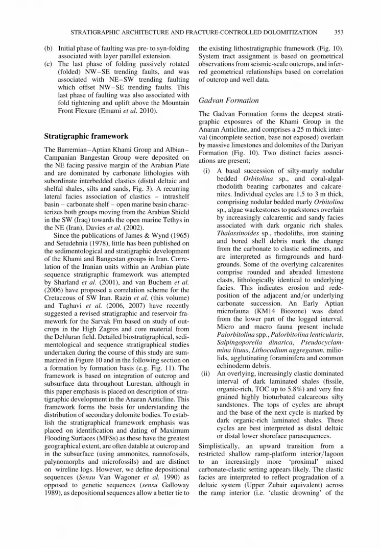
Gadvan Formation
The Gadvan Formation forms the deepest strati-graphic exposures of the Khami Group in theAnaran Anticline, and comprises a 25 m thick inter-val (incomplete section, base not exposed) overlainby massive limestones and dolomites of the DariyanFormation (Fig. 10). Two distinct facies associ-ations are present;
(i) A basal succession of silty-marly nodularbedded Orbitolina sp., and coral-algal-rhodolith bearing carbonates and calcare-nites. Individual cycles are 1.5 to 3 m thick,comprising nodular bedded marly Orbitolinasp., algae wackestones to packstones overlainby increasingly calcarentic and sandy faciesassociated with dark organic rich shales.Thalassinoides sp., rhodoliths, iron stainingand bored shell debris mark the changefrom the carbonate to clastic sediments, andare interpreted as firmgrounds and hard-grounds. Some of the overlying calcarenitescomprise rounded and abraded limestoneclasts, lithologically identical to underlyingfacies. This indicates erosion and rede-position of the adjacent and/or underlyingcarbonate succession. An Early Aptianmicrofauna (KM14 Biozone) was datedfrom the lower part of the logged interval.Micro and macro fauna present includePalorbitolina spp., Palorbitolina lenticularis,Salpingoporella dinarica, Pseudocyclam-mina lituus, Lithocodium aggregatum, milio-lids, agglutinating foraminifera and commonechinoderm debris.
(ii) An overlying, increasingly clastic dominatedinterval of dark laminated shales (fissile,organic-rich, TOC up to 5.8%) and very finegrained highly bioturbated calcareous siltysandstones. The tops of cycles are abruptand the base of the next cycle is marked bydark organic-rich laminated shales. Thesecycles are best interpreted as distal deltaicor distal lower shoreface parasequences.
Simplistically, an upward transition from arestricted shallow ramp-platform interior/lagoonto an increasingly more ‘proximal’ mixedcarbonate-clastic setting appears likely. The clasticfacies are interpreted to reflect progradation of adeltaic system (Upper Zubair equivalent) acrossthe ramp interior (i.e. ‘clastic drowning’ of the
STRATIGRAPHIC ARCHITECTURE AND FRACTURE-CONTROLLED DOLOMITIZATION 353

Fig. 10. Stratigraphic and reservoir framework for the Upper Khami and Bangestan groups in Lurestan. The scheme is based on logged sections, biostratigrahy (micro and macro fauna), diagenetic, geometric and sequence stratigraphic analysis in theAnaran and adjacent areas (Kabir Kuh, Siah Kuh, Chenareh, Rit, Khorrama-Abad, Anjir and Sultan Anticlines). Where possible, the sequence stratigraphic scheme has been correlated to Sharland et al. (2001) and van Buchem et al. (2006).Inferred periods of active tectonics are indicated, based on outcrop observation of faulting, jointing, tilting and fracture-controlled karstification. The lithostratigraphic units allow correlation on a local scale in wells and outcrops. Joint density isbased on facies, and does not take into account location on a fold (e.g. crest vs flank). D1 dolomites are typically developed as dolomitic limestones (scattered dolomite rhombs in limestone matrix), and are commonly associated with stylolites in slope andplatform top facies. D2-D3 dolomites are associated with fracture and fold development, and are prevalent beneath aquitards, within karsts, nucleated on earlier D1 dolomite, and within permeable HST strata. The most favourable primaryreservoir facies are skeletal grainstones developed during late HST. Secondary reservoir facies develop due to fracturing and late diagenesis. Reservoir quality is related to primary facies (e.g. fractured HST skeletal grainstone margins will typically havebetter reservoir properties than fractured and dolomitized basin-slope facies). Early cements typically occur within TST packstones and grainstones (marine cements), and have a detrimental effect on reservoir quality. Early cemented intervalsare not strongly affected by later diagenesis (dolomitization). Silica cements are pore filling or developed as chert nodules, and have a detrimental effect on reservoir quality. Meteoric diagenesis is associated with HST-FRST-LST and karsts.Both reservoir enhancing and destroying affects occur. Source Rocks are of two depositional types: (i) Pro-delta plant-rich mudstones (e.g. Gadvan, Nahr Umr); (ii) Restricted intrashelf basin facies and MFS intervals (e.g. Ahmadi and Ghirab Mbrs).

Fig. 11. Logged stratigraphic sections of the Dariyan, Kazhdumi, and Lower Sarvak formations in NW Dome and N-S Fault Complex. See Figure 1 for location. Main depositional sequences andfacies indicated.

carbonate environment). This interpretation is inagreement with the regional depositional modelsof Sharland et al. (2001) and Davies et al. (2002).In our sequence stratigraphic scheme a sequenceboundary (SB-Ga1 – candidate K70 SB of Sharlandet al. 2001) is placed near the top of the Gadvan Fmwithin the maximum regressive clastic deposits.
Dariyan Formation
The Dariyan Fm is 163 m thick where fully exposedin the NW Dome section and totally dolomitized.Early Aptian ages have been confirmed from anundolomitized section further to the SE (N–SFault Complex, Fig. 11). The Dariyan Fm can bedivided into Lower and Upper, separated by amajor karst surface, SB-Da1 (Figs 10–12). Anangular unconformity and karst surface also capsthe Dariyan Fm, marking the Aptian–Albianboundary and the contact between the Khami andBangestan groups, SB-Da2 (Fig. 12). The LateAptian has not been positively identified, although
it is speculated that the Upper Dariyan Fm is atleast partly Late Aptian in age.
The Lower Dariyan Fm is 100 m thick andabruptly overlies the Gadvan Formation. Thiscontact is interpreted as a major transgression(MFS-Da1, candidate Earliest Aptian MFS K70of Sharland et al. 2001, Fig. 10). Despite dolo-mitization primary facies may be identified. TheLower Dariyan Fm comprises prograding grain-stone shoal units overlying muddy Orbitolina sp.,and coral-algal bearing nodular wackestones.Individual shoal cycles comprise nodular bed-ded bottom/toesets, and distinctly cross-beddedforsets to topsets. Shoals can be up to 15 m thick,and are typically rich in reworked rudistic material(Agrioplurids sp.,) in their upper part. Bioturbatedcycle tops are picked out by Thalassinoides sp.Overlying facies comprise nodular bedded wacke-stones with intensive bioturbation and miliolidsevident in thin section. A low angle tidally influ-enced ramp margin to inner ramp setting is envi-saged. In the undolomitized N–S Fault Complex
Fig. 12. Outcrop photograph of angular contact between the Khami and Bangestan groups, NW Dome gorge section.Faults and joints are karstified beneath SB-Da1 and SB-Da2, indicating at least two periods of active tectonics inthe upper part of the Khami Group. Section is partly dolomitized. Location of NW Dome section indicated on left. Thelower 2 lithostratigraphic units of the Kazhdumi Fm are also well exposed. Exposed total section is c. 150 m thick.
I. SHARP ET AL.354

section (Fig. 11) an inner ramp/platform top(lagoonal) depositional setting is confirmed basedon the occurrence of abundant miliolids, Palorbo-tolina lenticularis and Salpingoporella dinarica.
The top of the Lower Dariyan Fm is marked bya major fracture-controlled karst (SB-Da1,Figs 10–12). In the NW Dome section solution-enlarged E–W and NW–SE trending karstifiedjoints (1–8 m wide) can be mapped extending upto 50 m into the underlying Lower Dariyan Fm.The fractures are filled by intraformational breccias,vadose silts and pebble conglomerates. Small strati-form karstic caverns, up to 1 m high, can be mappedaway from the main fracture zones. Individualcaverns have very irregular solution controlled basesand a composite fill, comprising laminated vadoseand locally pisolithic cave sediments at the baseoverlain by radial sparry cements. These karsticfeatures are totally dolomitized. The top 10–15 mof the Lower Dariyan Fm is characterized by arubbly weathering karstic breccia, although lateroverprint by D2 and D3–D5 dolomites (discussedlater) obscures much of the primary karst fabrics.
The Upper Dariyan Fm is between 35–65 mthick (Fig. 11). The base is marked by a transgres-sive, 8 m thick package of iron-stained, glauconitic,bioturbated, oyster and rudist-rich tabular beddedpackstones and grainstones with bored intraclastswhich lie horizontally on the dipping and rubblyweathering karst zone below. These beds locally‘sag’ downwards into the underlying karst zone. Inthe overlying interval, large cross-bedded rudist-filled sub-tidal channels (upto 20 m wide) are devel-oped, overlain by an homogenous interval rich inOrbitolina-bearing wacke-packstones with biotur-bated bed tops (Thalassinoides sp.,). The upper11 m of the Dariyan Fm is intensly bioturbated andrich in small conical Orbitolina sp., capped abruptlyby a marl/clay layer. This contact marks the top ofthe Dariyan Formation, and is associated with asignificant angular uncomformity (between 1–58dip discordance between Dariyan Fm and overlyingKazhdumi Fm, SB-Da2 – Fig. 12). Biostratigraphicdating of the N–S Fault Complex section indicatesthat the topmost Dariyan Fm is of Early Aptianage (KM14 biozone) and is overlain by a thinEarly Albian interval at the base of the KazhdumiFm. The Late Aptian has not been positively ident-ified. The presence of an angular unconformity plusconjugate joints (with minor karst) at the top of theDariyan Fm is interpreted to indicate a period ofnormal faulting. This unconformity is well knownon the Arabian Plate (Sharland et al. 2001).
Kazhdumi Formation and Mauddud Member
The Kazhdumi Formation is 50 m thick at outcropin the Anaran Anticline and up to 150 m thick in
nearby wells to the SW. It is entirely Albianin age, and typically comprises a regionallydeveloped three-fold lithostratigraphic succession(Figs 10 & 11):
(i) A lower recessive weathering Orbitolina lime-stone marl-dominated interval overlain byglauconitic calcarenites – Unit KZC
(ii) A central unit of Orbitolina and pelloid-richgrainstones – Unit KZB
(iii) An upper recessive weathering interval oforganic-rich calcareous mudstones – UnitKZA.
A shallow water (lagoonal to mid ramp) setting issuggested for unit KZC, with abundant conicalOrbitolina sp., possibly indicative of a sea grassmeadow setting (cf. Davies 1970; van Buchemet al. 2000a, 2002a; Simmons et al. 2000; Joneset al. 2004). The first few metres of this interval,however, yield belemnite guards, pectinids andlarge discoidal Orbitolina sp., representing a majorflooding event over the top Dariyan unconformity.Biostratigraphical data indicate an Early Albianage, although the first sample above the topDariyan unconformity is of possible Late Aptianage (?KM13 biozone) in the N–S Fault Complexsection. Towards the upper part of unit KZC, tworegionally developed 1 m thick Orbitolina-bearingmicrite-rich layers are capped by an iron-phosphatestained surface. Overlying marls (3 m thick) are richin planktonic dinoflagellate cysts and planktonicforaminifera, and show a decline in orbitolinidsand miliolids. This interval is picked as an MFS(MFS-Kz1, Early Albian K90 MFS candidate ofSharland et al. 2001, Figs 10 & 11). The MFS isabruptly overlain by silt and very-fine grained sand-stone rich in glauconite and conical Orbitolinasp. Well exposed tidal bundling within tidal barswith robust Ophiomorpha nodosa extending offset boundaries are evident. Conical Orbitolina sp.in this unit are abraded and reworked. A veryshallow water depositional setting (subtidal, proxi-mal ramp interior) appears likely, and the contactwith the marls below is regressive.
The sands are overlain by a 15 m thick resistantweathering cross-bedded grainstone shoal complex(Unit KZB) rich in pelloids, ooids, red algae andabraded Orbitolina sp. (Fig. 11). Angular clastsderived from the underlying unit are also present,associated with a fungal spore peak, and may beinterpreted as a regressive event. SB-Kz1 may bepicked at this fungal spore peak or at the base ofthe glauconitic sands below (equivalent to regres-sive maximum of Burgan/Nahr Umr Deltaics,Fig. 10). Above this, the limestones ‘clean’ upwardsand are overlain by a thin interval of marlyrecessive-weathering limestones extremely rich inconical Orbitolina sp., high spiral gastropods and
STRATIGRAPHIC ARCHITECTURE AND FRACTURE-CONTROLLED DOLOMITIZATION 355

in-faunal echinoderms. This interval is capped by aniron oolite bed, which marks a distinct deepening ofthe depositional environment (? TransgressiveSurface) associated with an increase in dinoflagel-lates and decrease in fungi.
The upper lithostratigraphic interval of theKazhdumi Formation (unit KZA, 20–30 m thickat outcrop, 50 m thick in subsurface) is recessiveweathering and essentially records the ‘deepestwater’ facies of the Kazhdumi Fm. The basal ironoolite is interpreted as a hard-ground, and is overlainby pectinids and Orbitolina sp. bearing marls and asecond hard-ground associated with Lithophaga sp.,bored iron carbonate clasts. The uppermost unitscomprise organic-rich, thin bedded micritic lime-stones and marls which are very rich in dinoflagel-lates and in-faunal spiny echinoderms. This upperinterval is interpreted as the most ‘distal’ facies(intrashelf basin/outer ramp). Biostratigraphically,the interval above the iron oolite is of MiddleAlbian age. A MFS is picked just above the secondhardground associated with maximum marinesignature based on relative increases in planktonicforaminifera, dinoflagellate cysts and foraminiferaltest linings (MFS-Kz2, candidate Middle AlbianMFS K100 of Sharland et al. 2001, Fig. 10).
The lithostratigraphical contact between typicalKazhdumi Fm facies of unit KZA and the base ofthe Mauddud Mbr is marked by a rapid shallowingto cliff-forming nodular bedded and cross-beddedtidal shoals (Fig. 11). A thin mudstone intervaljust below this contact is dated as Late Albian inage, associated with a relative increase in planktonicforaminifera, dinoflagellate cyst abundance, forami-niferal test linings and decline in orbitolinids. Thislocalized event may be part of the underlyingdeeper water interval seen within the MiddleAlbian section. However, it may represent a separ-ate phase of increased water depth and as such is apossible candidate level for placement of the K110MFS of Sharland et al. (2001). This is MFS-Kz3(Fig. 10). At outcrop, MFS-Kz3 is abruptly overlainby shallow water facies of the Mauddud Mbr, whilstin nearby wells to the S/SW a thick organic-richLate Aptian succession is present, characterizedby relatively common Favusella washitehsis. Thisfacies configuration is similar to that proposed byBordenave & Burwood (1995) and Bordenave &Hegre (2005), with a shallow water Mauddud Mbrcarbonate shoal (Bala Rud Shoal) in the area ofthe Anaran Anticline–Bala Rud Flexure separatingthe Garau Basin to the north from the Kazhdumiintrashelf basin to the south. Progradation of theMauddud Mbr appears to have been both towardsthe open Garau Basin in the NE and the Kazhdumiintrashelf basin in the SW.
At outcrop in the Anaran Anticline, the Kazh-dumi to Mauddud transition represents a relatively
simple prograding highstand succession. Verticallythree main facies associations are developed;
(a) Thin-bedded organic-rich micritic limestonesand marls, interpreted as intrashelf basin/deep ramp deposits (Kazhdumi Fm unit KZA).
(b) Mid ramp facies (Mauddud Mbr). Orbitolinasp., and echinoderm-rich wackestones, pack-stones and grainstones deposited as high energysubtidal shoals characterized by nodular bed-ded bioturbated bottomsets and bi-directionaltabular to trough cross-bedded foresets totopsets. Thalassinoides sp. and Ophiomorphasp. burrows are common extending downwardsoff bed and set boundaries. The burrows typi-cally are dolomitized. Individual shoal cyclesin this facies association are 5–10 m thick.
(c) Inner ramp (Mauddud Mbr). MonotonousOrbitolina sp. wackestones to packstones asso-ciated with locally developed layers rich inelevator rudists, Chondrodonta sp., and raresolitary corals. Rudists and Chondrodontasp., typically are reworked as storm lags,although they locally occur in-situ. Dolomi-tized Thalassinoides sp. burrows are verycommon, and typically extend off bed bound-aries. In-faunal echinoderms are also present.Secondary replacement chert and dolomiteare relatively common in the inner ramp facies.
A major karst (SB-Kz3) caps the Mauddud Mbrand has a penetration depth/profile of 15–20 m(Fig. 13). The karst is fracture-controlled by earlyNW–SE trending joints and normal faults. Thesejoints and faults are transgressively ‘sealed’ by theoverlying Sarvak Formation. Erosional relief alongthe top Mauddud Mbr karst surface is in the orderof 3–9 m, with a low amplitude sink hole/doline-like morphology mappable in well exposed sections.Sink holes and dolines show a preferential elong-ation parallel to NW–SE trending faults and joints,with a preferential development in the hangingwall of faults (Fig. 13). A sheet-like karstic solutionbreccia is locally developed below the karst surface,and varies from 5 m to 10 cm in thickness. Replace-ment chert and dolomite commonly fill secondaryporosity within the karst breccia (Fig. 13). Areddish mudstone is also evident above the breccia,and forms a locally important permeability barrier.Below this uppermost heterogeneous breccia level,the karst is typically expressed as solution-enlargedfractures which pass into two levels of strataboundcaverns occurring along major bedding breaks.Caverns and fractures are partially filled byreddish vadose silt and clay, which are themselvescut by dolomite filled fractures. The caverns areupto 5 m across and 1–2 m high, typically with flatbases and convex roofs. Vuggy porosity is locallydeveloped between the solution-enlarged fractures
I. SHARP ET AL.356

and caverns, with vugs either developed along hair-line fractures or forming enlarged moulds afterdissolved bioclasts.
Correlation to nearby wells to the south indicatesthe presence of a detrital unit (up to 50 m thick)which lithostratigraphically sits between the Kazh-dumi and Lower Sarvak formations. This detritalunit (lithostratigraphic unit LSH, Fig. 10) is rich inabraded and well rounded clasts of Mauddud Mbraffinities set within basinal facies. The unit isdated as latest Albian-Earliest Cenomanian, and isinterpreted as a lowstand wedge (LST) shed into aremnant Kazhdumi intrashelf basin during erosionof the uplifted and karstified Mauddud Mbr highto the NE. Inclusion of the Mauddud Mbr withinthe Sarvak Fm thus needs revision, as these newdata indicate that the Mauddud Mbr is geneticallyrelated to the Kazhdumi Fm as a lateral faciesequivalent, and separated from the overlying SarvakFm by a major karst. This interpretation is in
keeping with observations by van Buchem et al.(2006, pers comm. 2005) from the Fars provinceof SW Iran.
Sarvak Formation
The Sarvak Formation has been informally dividedinto the Lower and Upper in the Lurestan area(Fig. 3, James & Wynd 1965; Player et al. 1966;Setudehnia 1978). The contact between the Lowerand Upper Sarvak is topographically well expressedthroughout Lurestan, typically separating massiveneritic cliff-forming carbonates of the Lower SarvakFormation below from more recessive weatheringbasinal carbonates and mudstones of the UpperSarvak Formation above, (Figs 2, 4, 14, 15 & 16a).Foraminifer and ammonite fauna collected duringthe course of this study allow assignment of thisboundary to a latest Early Cenomanian floodingevent (MFS-Sa3, Ahmadi Member).
Fig. 13. Outcrop photo of the contact between the Mauddud Mbr and base Lower Sarvak Fm in NW Dome. The contactis marked by a well developed fracture-controlled karst (red dashed line). Significant karstic relief is evident pickedout by sink holes/dolines, which are elongated parallel to and in the hanging wall of NW–SE trending faults (traceof fault indicated on left). Solution enlarged fractures extend down from the karst surface, and link to two major levels ofstratabound caves. The karst has been extensively overprinted by D2 and D3–D5 dolomites, which utilized thekarst as a major permeability pathway. D2 dolomitization progressively dies out upwards into muddier and lessfractured facies of lithostratigraphic unit LSG of the Lower Sarvak Fm.
STRATIGRAPHIC ARCHITECTURE AND FRACTURE-CONTROLLED DOLOMITIZATION 357

Fig. 14. Logged stratigraphic section of the Upper Sarvak, Surgah and basal Ilam formations in NW Dome. See Figure 1 for location. Main depositional sequences and facies indicated. The UpperSarvak is developed in relatively ‘distal’ basin and slope facies in NW Dome, but passes into more ‘proximal’ higher energy shelf margin and platform interior facies towards the SE in Central andSouthern Anaran (e.g. Fig. 16b). SB-Sa4 and sequence Sa5 are poorly developed in the NW Dome section.

Lower Sarvak Formation
The Lower Sarvak Formation transgressively over-lies the top Mauddud Mbr karst and can bedivided into two depositional sequences; SarvakSequence 1 (Sa1) and Sarvak Sequence 2(Sa2, Figs 10, 11, 14 & 15). Sa1 is of ?latestAlbian-earliest Cenomanian age, and Sa2 is entirelyof Early Cenomanian age.
The lithostratigraphic base of the Lower Sarvakis associated with a relatively thin transgressivesystem tract (TST, 30 m thick) which infills the ero-sional relief of the top Mauddud Mbr karst overlainby a thick highstand system tract (HST, 150 m). Alowstand system tract (LST, lithostratigraphicalunit LSH) can be identified in the remnant Kazh-dumi intrashelf basin to the SW and Garau Basinto the NE, where it is typically rich in secondarysilica (chert) and dolomite. The TST comprisestwo main facies associations (Fig. 11):
(a) Rudist–Chondrodonta shell banks and bio-stromes, abruptly overlain by
(b) outer platform Orbitolina-rich bioturbatedwackestones-packstones.
MFS conditions (MFS-Sa1) are associated withclosely spaced omission surfaces with abundantThalassinoides bioturbation (dolomitized). In thesubsurface, the TST and associated MFS-Sa1 inter-val is thicker and associated with a rich planktonicfaunal association, including relatively commonFavusella washithensis. Above MFS-Sa1, the HSTis associated with a strongly progradational intervalcharacterized by a three-fold facies association(Figs 10, 11 & 15):
(a) Outer platform Orbitolina-rich bioturbatedwackestones-packstones (lithostratigraphicunit LSG)
(b) Platform margin rudistic and pelloidal-benthicforam shoals (lithostratigraphic unit LSF). The
Fig. 15. Outcrop photo of type section of Mauddud Mbr and Lower Sarvak Fm exposed in NW Dome, AnaranAnticline. Depositional sequences and lithostratigraphic units shown. Cliff face is 350 m high. Depositional sequenceSa1 is well expressed in this section, with a strongly progradational signature from slope/outer platformwackestones (unit G), to coral-rudist platform margin shoals (unit F) overlain by a thick platform top succession(unit E). Note the extremely fractured nature of unit F (Rudist shoals). Sequence Sa2 is developed in stacked platformmargin to platform top facies capped by 2 micro-karst intervals (top units C and B). SB-Sa2 is placed at the contactbetween lithostratigraphic units LSB and LSA.
I. SHARP ET AL.358

Fig. 16. (a) Upper Sarvak Fm exposed in ‘distal’ facies in NW Dome. Depositional sequences and location of loggedsection indicated. Upper Sarvak Fm is 270 m thick. In this location SB-Sa4 and sequence Sa5 are poorly expressed.Also note folding of Ilam Fm in hanging wall of normal fault due to ductile deformation of Surgah Fm. (b) Loggedsection and outcrop photograph of Upper Sarvak Fm in Central Anaran Anticline. In this region, SB-Sa4 is welldeveloped, and overlain by an early cemented transgressive ooid-pelloid shoal complex, which is in turn capped by karstSB-Sa5. Sa5 is 40 m thick for scale. (c) Detail of glauconitic transgressive conglomerate sitting above karst SB-Sa4.(d) Karstic cavern filled with vadose silts cutting pelloidal-ooid shoal within Sa5. The caverns extend down 8 m from thekarst surface SB-Sa5. (e) Detail of solution-enlarged fractures at SB-Sa5. The karst is filled by glauconitic andphosphatic silts rich in a Turonian-aged planktonic fauna of overlying sequence Sa6.
STRATIGRAPHIC ARCHITECTURE AND FRACTURE-CONTROLLED DOLOMITIZATION 359

rudists are rarely preserved in-situ, but ratheroccur as reworked clusters developed alongforeset and cross set boundaries (Fig. 17c).
(c) Platform top/interior pelloidal-miliolid-Chondrodonta rich micrites to wackestoneswith localized pelloidal packstone-grainstonetidal shoals (lithostratigraphic unit LSE,Figs 17a, b). The pelloidal-miliolid-Chondro-donta-rich facies are locally associated withlaminated cherty micrites with well developed
fenestral and tepee fabrics and high-spiral gas-tropods. These facies are interpreted as interto supra-tidal deposits. Spectral gamma logs(subsurface and outcrop data) indicate a signifi-cant uranium content throughout this unit,possibly reflecting proximity to a clasticsource. The pelloidal packstone-grainstoneshoals have well developed tidal bedforms,and are interpreted as migrating sub-tidal plat-form top shoals developed in slightly deeper
Fig. 17. (a–b) Outcrop photographs of Thalassinoides sp., bioturbated platform top miliolid, Dasycladacae,Chondrodonta-rich mudstones and wackestones of lithostratigraphic unit LSE. Cycle tops are characterized byerosive-based wave and current rippled packstones, often associated with a lag of disarticulated Chondrodonta shells.Pervasive Thalassinoides burrows extend off cycle tops and represent omission colonisation surfaces. The burrow fillsand storm lags are preferentially dolomitized by D1 dolomite. In thin-section, D1 dolomites in the burrow fill arecharacterized by zoned dolomite rhombs with inclusion-rich cores and clear rims. See also Figure 31b. (c) Outcropphotograph of Radiolitid rudist floatstone-packstone facies typical of the Sarvak Fm platform margin. Finger for scale.(d) Outcrop photograph of highly bioturbated cherty slope wackestones and packstones cut by stylolites. D1 dolomitesare concentrated around early cemented nodules (characterized by uncompacted burrows) and along stylolites. See alsoFigure 31a.
I. SHARP ET AL.360

parts of the platform top. Similar facies devel-oped immediately above the platform marginfacies (ii) are interpreted as wash-over fansand tidal deltas.
In favourably orientated outcrops and seismic sec-tions the three facies associations define a welldeveloped clinoform geometry associated with plat-form/shelf margin progradation. The steeper clino-forms (3–108) are developed within the platformmargin shoals (facies ii, LSF). Our outcrop obser-vations in Lurestan indicate that Sarvak sequenceSa1 displays both accretionary low-angle ramp(,18) and steep-dipping (3–108) clinoform shelfmargin geometries, presumably reflecting basingeomorphology and windward-leeward relation-ships (Embry et al. 2008). Regional mapping alsoindicates that Sarvak sequence Sa1 has a complexprogradation orientation, with both a north andsouth facing margin evident working away fromthe outcrops in the Anaran Anticline. The northfacing margin is located between Kuh-E-Anjir andKabir Kuh, whilst the south facing margin appearsto have prograded southwards into the remnantKazhdumi intrashelf basin. Progradation towardsthe NW, N and NE from the SE (Dehluran) andSW (Iraq) is also evident. By end Sarvak sequenceSa1, the remnant Kazhdumi intrashelf basin hadclearly been filled in the Anaran area.
Lower Sarvak sequence 2 (Sa2) sits transgres-sively over Lower Sarvak sequence 1, and com-prises a very thin/condensed TST/MFS interval(2–3 m oligosteginid mudstone, MFS-Sa2) overlaininitially by HST platform margin shoals followed bya thick aggradational package of platform top facies(90 m, Figs 11 & 15). The sequence is entirely ofEarly Cenomanian age, and is characterized byabundant benthic forams for example, Orbitolinasp. and Praealveolina sp. and limited rudistic facies.Two exposure surfaces and hard-grounds associatedwith reddish silt are evident towards the top ofthe HST, the second of which is associated with afracture-controlled micro-karst (SB-Sa2, Fig. 10),which is abruptly overlain by an interval of highenergy stacked sub-tidal packstone-grainstoneshoals and subordinate platform top wackestones(unit LSA, TST of overlaying Sa3, Figs 11 & 15).SB-Sa2 is locally associated with an incised channelgeometry, with overlying LST–TST charophyte-bearing packstones to grainstones interpreted astransgressive valley-fill deposits (cf. Top Natih E,Grelaud et al. 2006, 2010). The lithostratigraphictop of the Lower Sarvak Fm is marked by an abruptcontact to outer platform-basinal ammonite-bearingmicritic limestones related to latest Early Cenoma-nian MFS-Sa3. This unit is lithostratigraphicallyassigned to the Ahmadi Member of the UpperSarvak Formation.
Upper Sarvak Formation
The Upper Sarvak Formation is 270 m thick atoutcrop in the Anaran Anticline and 345 m thickin the subsurface to the south. It may be dividedinto four depositional sequences (Figs 10, 14 & 16);
(a) Sarvak sequence 3 (Sa3) is of latest Early Ceno-manian to earliest Late Cenomanian age. TheTST at the base of Sa3 comprises transgressivevalley fill or sheet-like tidal shoals (unit LSA,30 m) abruptly overlain by ammonite-bearingouter platform-basinal micritic limestones andshales of the Ahmadi Mbr (25 m, Figs 14 &16a). The contact between LSA and theAhmadi Member is typically marked by abored iron-glauconite hardground. Sa3 HST is65 m thick at outcrop and up to 125 m thickin the subsurface to the south. It is character-ized by pelagic to hemipelagic oligosteginidand planktonic foram rich wackestones andmudstones, including slope to basin floorchannel-levee and lobe facies in the NWDome section (Fig. 14). These facies passinto dolomitic bioclastic wackestones inter-preted to have been deposited in outer to midshelf settings in Central and Southern Anaran,which in turn pass into shelf margin faciesin Siah Kuh and the Dehluran field. TheHST is capped by a subaerial erosion surface(SB-Sa3, karst in platformal areas, e.g. SiahKuh outcrops and Dehluran field; Taghaviet al. 2006, 2007) associated with significantporosity creation and secondary dolomitedevelopment. At outcrop in Anaran, SB-Sa3is poorly expressed in slope facies, althoughit is typically associated with a zone ofenhanced meteoric diagenesis and secondarydolomitization. Within a regional context,Sarvak Sequence Sa3 appears to be equivalentto the Rumalia Fm in Iraq, and progrades fromthe south towards the Garau Basin in the north.
(b) Sarvak sequence 4 (Sa4) is of Late Cenoma-nian age (Mishrif Fm equivalent). At outcrop,it comprises a thin LST and TST associatedwith amalgamated turbidite channels overlainby a strongly progradational HST. Wherefully developed, the HST records a thick suc-cession from outer shelf wackestones throughcherty-dolomitic bioclastic mid shelf faciesup to rudist-rich margin and muddy platformtop facies and a capping conglomerate andkarst (SB-Sa4). In favourably orientated sec-tions, seismic scale clinoforms (,18 to 58dips) are evident within the shelf to rudistmargin facies. In outcrops NE and E ofAnaran (Rit, Chenareh and Khorram-AbadAnticlines), a detached ‘down-stepped’
STRATIGRAPHIC ARCHITECTURE AND FRACTURE-CONTROLLED DOLOMITIZATION 361

platform has been identified lateral to karstSa4, and is interpreted as a forced regressiveunit. This unit is poorly developed in northernAnaran (Figs 14 & 16). In Central-SouthernAnaran a truncated sequence Sa4 is cut bykarst Sa4, and directly overlain by the TST ofSarvak sequence Sa5 (Figs 10 & 16).
(c) Sarvak sequence 5 (Sa5) is characterized by abasal oligosteginid-rich glauconitic mudstoneand conglomerate overlain by a pelloidal-oolitic shoal complex in Central and SouthernAnaran (Fig. 16b & c). The shoals are trans-gressive (TST). No HST is preserved withinSa5, and the TST shoals are capped by aregionally developed penetrative karst whichmarks the Cenomanian-Turonian boundarythroughout Lurestan (SB-Sa5). In the NWDome section Sa5 is poorly expressed, withsequence Sa6 apparently sitting directly onsequence Sa4, or on a much reduced sequenceSa5 (Figs 14 & 16). Throughout Anaran karstdeposits associated with SB-Sa5 fill bothNE–SW and NW–SE solution enlarged conju-gate joints and normal faults (Fig. 16e), indicat-ing that the platform underwent normalfaulting and flexural uplift followed by subar-eal erosion and karstification. This regionalscale doming/flexing is also associated withan angular unconformity, partial removal ofsequence Sa5, and onlap by the overlying Tur-onian sequence Sa6. A clastic glauconitic fillhas locally been observed in the karst, includ-ing well developed dolines with depths ofupto 10 m (e.g. Central Anaran and Chenarehanticlines). SB-Sa5 (which occurs in the middleof a depositional sequence), and the forcedregressive interval locally developed atthe top of Sa4 are attributed to the onset ofdeformation and flexural uplift along the NEmargin of the Arabian plate. This deformationoccurred from Turkey in the NW to Omanin the SE due to intra oceanic thrusting andthe commencement of ophiolitic nappeemplacement, and accounts for the complexstratal architecture which typifies the latestCenomanian-earliest Turonian throughout thisregion (Robertson & Searle 1990; Stoneley1990; Burchette 1993; Homke et al. 2009).
(d) Sarvak Sequence 6 (Sa6) is of Middle Turonianto Late Turonian–Early Coniacian age. KarstSa5 is overlain by a transgressive glauconiticconglomerate and pelloidal shoals which passrapidly up into a condensed nodular beddedinterval rich in ammonites (Ghirab Member,MFS-Sa6). Dating of ammonites and micro-fauna from the MFS give a latest MiddleTuronian age. The Early Turonian has notbeen identified. The MFS is interpreted as a
significant baffle/barrier horizon, and is over-lain by a progradational HST characterizedby mid shelf facies at outcrop and shelfinterior/platform top facies in the subsurface,indicating a progradational direction towardsthe north. In proximal locations, the HST iscapped by a karst (SB-Sa6), and abruptlyoverlain by claystones of the Surgah Fm (e.g.Dehluran field, Taghavi et al. 2006, and SiahKuh outcrops).
Surgah Formation
At outcrop the Turonian–Coniacian aged SurgahFm comprises a 40 m thick claystone interval withthin micritic limestone interbeds. This intervalthins to 2 m in the subsurface (SW) and thickensto over 100 m at outcrop in the NE (Kabir Kuh).The top Sarvak–Surgah formation boundary is con-formable where studied at outcrop in the AnaranAnticline, and coincides with the Late Turonian–Early Coniacian boundary (Fig. 14). The SurgahFm is interpreted as a regressive clastic wedge(LST) related to deformation of the north-easternmargin of the Arabian Plate (Setudehnia 1978;Alavi 2004; Homke et al. 2009). Chlorite-smectiterich claystones of the Surgah Formation form anexcellent regional top seal to the underlyingSarvak Formation reservoirs. The Surgah Formationis also interpreted to form an excellent top seal to thefracture-fed dolomitic bodies, and an excellent claysmear unit when involved in faulting (Figs 4 & 16a).
Ilam Formation
The contact between the Surgah and Ilam for-mations is conformable and associated with areturn to carbonate deposition. An MFS (MFS-Il1)is picked at the top of the Surgah Fm/base of theIlam Fm. The Ilam Formation can be divided intotwo main sequences (Fig. 10).
(a) Ilam sequence 1 (Il1) comprises a thin LST/TST, predominantly within Surgah Fm clay-stones and pelagic micrites, overlain by a thickHST of shallow shelf to mid-inner ramp pelloi-dal wacke to packstones rich in Rotalia sp.,green algae, Inoceramus sp., and rudist debriscapped by a karst (SB-IL1). Ilam Sequence 1is predominantly of Middle Coniacian age.
(b) Ilam sequence 2 (Il2) is of latest Middle Conia-cian, Santonian to base Early Campanian age.Karst SB-Il1 is abruptly overlain by a complexof stacked and channelized wackestonesand packstones interpreted as LST outer shelfto toe of slope turbidites which deepen up toMFS Il2. The overlying HST comprises arelatively monotonous succession of oligostegi-nid-rich marls and wackestones. The Early
I. SHARP ET AL.362

Campanian MFS (MFS-Il3) marks the contactto the overlying Gurpi Fm, and is associatedwith glauconite and phosphatic nodules.
Dolomites – field observations
Multiple dolomite fabrics can be recognized in thestudied outcrops. Our data also allows the identifi-cation of multiple dolomite stages. Fabrics andstages of dolomitization identified in the field areconfirmed by detailed thin section petrographicobservations, although it is important to stressthat the key cement stratigraphic-structural-faciesrelationships were best pieced together based onobservations in the field, and in particular by under-taking vertical and lateral ‘diagenetic transects’away from fault zones. This is in keeping with theview of Warren (2000) that interpretation of dolo-mite genesis is often best deduced from outcrop/external geometry. Successive and distinctive dolo-mite and calcite cement stages are termed D1, D2,D3, D4, D5, C1, C2. . . . etc. and are describedbelow. Simplistically, three main stages/types ofdolomitization are evident:
(a) D1, fabric/facies selective. Observed relation-ship to stylolites. Volumetrically moderate.
(b) D2, fracture-controlled, fabric selective.Volumetrically large.
(c) D3-D5, fracture-controlled saddle dolomite,typically cement in D2 dolomites and prevalentalong faults. Volumetrically small.
D2 and D3–D5 are interpreted to be closely relatedin time, and are best interpreted as having developed‘distal’ (D2) and ‘proximal’ (D3–D5) to fault zones(cf. Yao & Demicco 1995; Swennen et al. 2003).D1 dolomites could also have developed duringthe same dolomitization event as D2 and D3–D5,occurring ‘distal’ to D2 dolomite, although ourdata does not conclusively demonstrate this as yet(research in progress). D3–D5 dolomites are volu-metrically more significant towards the centre ofdolomite bodies and at deeper stratigraphic levelsin the Anaran outcrops.
D1 matrix replacement dolomite
D1 dolomites are developed within three distinctfacies (Fig. 10):
(i) Chondrodonta, miliolid and Dasycladacaealgae rich platform interior/lagoonal micrites,wackestones and packstones. The dolomitesare focused within Thalassinoides burrowsand thin wave-rippled intervals (Fig. 17a, b).The Thalassinoides burrows extend offscoured bed boundaries, and typically arecapped by Chondrodonta sp. storm lags
associated with current and wave ripples.These boundaries are interpreted as storm trun-cated omission colonization surfaces. Dolomi-tization appears to have affected the slightly‘grainier’ fill of the burrows and the overlyingwave-ripple storm beds. The facies andfabrics are comparable to early dolomitizedburrow fills described by Cantrell et al.(2004) from the Arab Fm in the Ghawar fieldand by Horbury & Qinq (2004) from theCarboniferous of Northern England.However, the fabrics are also comparableto late burial-related dolomitized burrows fromthe Natih Formation in the Fahud field ofOman (Vahrenkamp et al. 2006; Taberneret al. 2007). Type i facies are most prevalentwithin lithostratigraphic unit LSE of LowerSarvak sequence Sa1 in the Anaran Anticline,but are also developed within Sa2, Sa3, Sa4,Sa6 and Il1 elsewhere in Lurestan (Fig. 10).
(ii) Mid to upper shelf bioclastic Orbitolina-richwackestones to packstones. Bed boundariesare often associated with wave scoured omis-sion colonization surfaces from which robustThalassinoides burrows extend. The burrowsare dolomitized. Facies ii is present in theMauddud Mbr and Sarvak sequence Sa1,Sa2, Sa3 and Sa4 (Fig. 10).
(iii) Outer to mid shelf cherty bioclastic wacke-stones rich in planktonic fauna including oligo-steginids, globigerinids, in-faunal echinodermsand siliceous sponge spicules (Fig. 17d).Bioturbation is intense (Bioturbation index4/5: Thalassinoides, Planolites, Palaeophy-cus, Anconichnus, Chondrites, Helminthopsis,echinoderm burrows). The Thalassinoidesburrows are pervasively dolomitized. Thisfacies is very common in the Sarvak Fm,particularly sequences Sa3, Sa4 and Sa6.
In all three facies, bedding-parallel to slightlyoblique stylolites and stylo-cumulates are devel-oped around early cemented nodules (characterizedby uncompacted burrows). There is a clear relation-ship between the occurrence of stylolites anddolomite, with dolomite rhombs concentratedalong and immediately adjacent to stylolites(Fig. 17). This relationship is interpreted to indicatethat dolomitizing fluid flow was focused alongstylolites (cf. Graham et al. 2003; Graham Wallet al. 2006), indicating that dolomitization occurredunder at least some burial depth (1000 mþ ?) thatis, following compaction and cementation. Petro-graphically, D1 dolomites can be difficult to dis-tinguish from D2 dolomites, both characterized byinclusion-rich dolomite rhombs.
Field mapping of D1 dolomites indicates thatthey are laterally persistent over 10s of kilometres,
STRATIGRAPHIC ARCHITECTURE AND FRACTURE-CONTROLLED DOLOMITIZATION 363

Fig. 18. (a) Outcrop photograph of D2 dolomite body, core of Anaran Anticline, NW Dome (See Fig. 5a for location).D2 dolomite is picked out by dark brown colour. Base of section (base of gorge) is 100% dolomite. Top of sectionis 100% limestone. Notice how vertical extent of D2 dolomite is inhibited by major bedding breaks (MFS mudstones),which are interpreted to have behaved as aquitards. In the centre of the photograph, the first major aquitard (MFS-Sa3,Top Lower Sarvak) is breached by a number of closely spaced small displacement faults and associated fractures. Inthis region, the D2 dolomites have extended up to the next major aquitard (MFS-Sa6), which again hindered thevertical advance of dolomite. Where breached by fractures, dolomite can be mapped to extend up to the top of the SarvakFm, before being stopped at the contact to ductile claystones of the overlying Surgah Fm, which act as the main topseal to both hydrocarbon migration and dolomitization. Upper Sarvak is c. 270 m thick for scale. Boxed area is enlargedin b. (b). Detail of a dolomite plume developed at the contact between the Lower and Upper Sarvak Fm (boxed area in a).At this location, a normal fault tips out upwards (looses displacement) at the contact with mudstones of the AhmadiMember. D2 dolomite can be mapped to have developed along this fault zone, with a plume developed immediatelyabove the fault, and multi-directional stratabound fingers developed laterally away from the fault in unit LSA. Thestratabound fingers occur below cycle tops/bed boundaries. Note also bulbous irregular bases and sharp tops ofstratabound D2 dolomites. The recessive-weathering non-dolomitized facies below the plume are muddy lagoonalmicrites of lithostratigraphic unit LSB (sparsely jointed, low matrix poro-perm). Unit LSA is 45 m thick for scale.In both Figures a and b note doming above the D2 dolomite bodies.
I. SHARP ET AL.364

although volumetrically small to moderate in distri-bution in the country rock (10–20% of total rockvolume prior to D2 dolomitization). Field mappinghas also clearly demonstrated that D1 dolomiteswere utilized as flow pathways and nucleation sitesfor D2 dolomites, as the spatially most extensivestratabound D2 dolomites can be ‘walked out’ in toD1 dolomites (typically Thalassinoides-burrowedintervals – discussed below).
D2 matrix replacement dolomite
D2 dolomite is volumetrically the most significantdolomite in the study area and occurs as massivedark reddish brown bodies in the outcrops. Thecolour contrast to the light grey and white limestonecountry rock is striking, and it is this colourcontrast that allows spectacular visualisation of theD2 dolomite geometries and relationship to frac-tures and facies (Figs 4, 5 & 18). D2 dolomitesoccur as massive, domal and plume-like bodies,
sub-horizontal stratabound layers, and as halos toboth faults and joints (Figs 18–22). Both grada-tional (diagenetic front) and fracture ( joint, fault)terminations to D2 dolomite bodies are observed(Fig. 19). Vertically, D2 dolomite bodies eitherhave gradational convex-up diagenetic tops to lime-stone country rock (Fig. 20b) or stop very abruptlyat low permeability stratigraphic layers such asmudstones, claystones and muddy wackestones inwhich joints are sparse to absent (Fig. 18b).
D2 dolomite bodies can be mapped up to the topof the Sarvak Formation, and are only very rarelyobserved above the Surgah Formation. The SurgahFormation is c. 40 m thick at outcrop, thinning toonly a few metres thick in the subsurface. It com-prises an argillaceous claystone rich in chloriteand smectite. Most joints and major (normal)faults developed within the Sarvak Formation stopat the base of the Surgah Formation. Normal faultsloose displacement very rapidly in the Surgah clay-stones as displacement is taken up by ductile folding
Fig. 19. (a) Diagenetic termination of a D2 stratabound dolomite tongue. Note visible vuggy porosity developmentin centre of dolomite body, and lack of porosity in adjacent limestone country rock. Unit LSG, NW Dome.(b) Diagenetic edge of the Kuh-E-Pashmi dolomite body (See Fig. 20b). Bedding within turbidites of Upper Sarvaksequence Sa6 can be ‘walked’ into the dolomite body, but bedding definition becomes difficult to define in the dolomitebody. Iron sulphides are developed along the edge of the dolomite-limestone contact. This diagenetic contact canbe mapped out on the top and two sides of the Kuh-E-Pashmi dolomite plume. (c) Fractured (joint) edge to D2 dolomitebody (white dashed line) developed in ramp interior muddy carbonates of the Gadvan Fm exposed at base of gorgein NW Dome. Joints strike NE–SW. Dolomitization is also controlled by bedding breaks, which are represented by thinbioturbated siltstones overlying firm/hardgrounds at the top of individual ramp interior carbonate cycles.
STRATIGRAPHIC ARCHITECTURE AND FRACTURE-CONTROLLED DOLOMITIZATION 365

(Fig. 16a). Where faults do cut through to the over-lying Ilam Formation the Surgah Formation typi-cally forms a very well developed smear alongthe fault zone. These observations indicate that theSurgah Formation would have been a very effectivetop seal to any vertical movement of dolomitizingfluids, which is also in keeping with the role of theSurgah Formation as the main top seal to hydro-carbon reservoirs of the Sarvak Formation in thenearby subsurface.
On the scale of the studied river gorge in the NWDome area of Anaran Anticline (c. 8 km long by1 km deep section), D2 dolomites are volumetri-cally more abundant in the deepest exposures, anddecrease in volume successively upwards (Figs 5& 18). Comparable observations can be made in
several other sections in the Anaran and adjacentanticlines (e.g. Kuh-E-Pashmi, Anjir Anticline, RitAnticline). Significant upward volume reductionsin D2 dolomites are evident at major stratal contactsas listed below:† Base of the Surgah Fm (SB-Sa6)† Base of the Ghirab Member (MFS Sa6)† Thin argillaceous transgressive mudstone
capping SB Sa4† MFS Sa4† Base of the Ahmadi Member (MFS Sa3 zone)† Thin argillaceous transgressive mudstone
capping SB Sa2† MFS Sa2† Thin argilaceous mudstone above Mauddud Mbr
karst (SB-Kz3)
Fig. 20. (a) D2 dolomite plume developed in footwall of a normal fault. Fault plane strikes parallel to cliff face,and trends NW (right)-SE (left) – see Figure 5 for location. Note subtle doming above plume associated withdevelopment of radial fractures. Also note stratabound D2 body extending laterally within karstic horizon LSC andbelow lagoonal micrites (LSB) which define top of Lower Sarvak Sequence Sa2. (b) Outcrop photograph ofKuh-E-Pashmi dolomite plume. The upper and lateral edges of this plume are diagenetic (Fig. 19b), whereas the lowerlateral edges are in part fault bounded. Note massive nature of core of dolomite body, and absence of bedding, which canbe traced into well bedded and jointed limestones of Upper Sarvak sequence Sa6 (right edge of photo). Also at thislocality organic-rich mudstones associated with MFS-Sa6 appear baked at the contact to the dolomite body. A transect atthe MFS level (white dashed line) reveals bitumen and local hydrocarbon adjacent to the dolomite, particularlydeveloped along joints. (c) Stratabound dolomite developed within lithostratigraphic unit LSG of the Lower Sarvaksequence Sa1. Note sharp top (defined by bioturbated bed boundary) and irregular bulbous lower boundary (whitearrows). Massive dolomite in lower left part of photograph is developed along top Mauddud karst (SB-Kz3), but extendsvertically in a fracture corridor (also visible on D). (d) Example of stratabound dolomites developed in top Mauddud andbase Lower Sarvak. Dolomite follows Sb-Kz3 and D1 dolomitized burrow horizons. More extensive vertical dolomitedistribution in right side of image is related to a fracture corridor.
I. SHARP ET AL.366

† MFS Kz2† MFS Kz1† MFS Da2
All of these boundaries are associated with distinctlow matrix porosity-permeability and low fracture( joint) density mudstone/argillaceous facies(Fig. 10). Joints and faults also often stop at thesemudstone/argillaceous breaks, indicating that theyrepresent major breaks in the mechanical strati-graphy. Where joints and faults have cut thesemuddy/argillaceous intervals, D2 dolomite bodiescan be mapped to extend upwards along the frac-tures and extend laterally in more permeable/jointed facies of the overlying sequence, beforebeing stopped or retarded by the next argillaceouslayer. This situation is spectacularly exposed in
Figure 18. These data clearly indicate that the lowmatrix porosity and low fracture ( joint) densityunits hindered or stopped the vertical migration ofdolomitizing fluids.
Where D2 dolomites have been mapped alongfaults which tip out (i.e. loose displacement) atmajor argillaceous breaks, such as the base of theAhmadi Member, subtle low-relief dome-like geo-metries are evident (Figs 18b & 20a). At least twoof these domes have been mapped associated withfractures which radiate away from the dome centre.
Sub-horizontal stratabound sheets of D2 dolo-mite are concentrated below the major argillaceousboundaries listed above, following specific faciesor bed boundaries in the underlying units (grain-stones, thin mudstone breaks or cemented cycletops). The tops of these stratabound sheets typically
Fig. 21. D2 dolomites and fault zones. (a) D2 dolomite developed along damage zone/fault breccia in hanging wall of anormal fault extending above the Kuh-E-Pashmi dolomite body. Offset is c. 15 m. The fault trends parallel to theelongation of the Anaran Anticline (SE–NW, F1 faults). Several such dolomitized faults can be mapped in theKuh-E-Pashmi area extending from the main dolomite body. (b) Dolomitized NE–SW trending (F2) normal fault in theKuh-E-Pashmi area. The outer (most recent) slip surface of this fault is associated with re-brecciation of the D2dolomitized fault breccia, with the younger breccia comprising D2 dolomite clasts cemented by calcite (inset photo).This indicates a change in mineral chemistry of the fluids circulating along the faults during the late stages ofdeformation. Map board (30 cm long) for scale. (c) Normal fault zone cutting Lower Sarvak Fm in NW Dome. Faultplane and breccia are partially dolomitized. Boxed are is enlarged in D. (d) Detail of fault breccia developed along faultshown in C. Host rock clasts remain as unaltered limestone, whereas the permeable fault rock is preferentiallydolomitized. Hammer head for scale.
STRATIGRAPHIC ARCHITECTURE AND FRACTURE-CONTROLLED DOLOMITIZATION 367

are very sharp and follow lithological boundaries,whilst the bases often are very irregular andbulbous (Fig. 20c). Vug development (fabric andnon-fabric selective) is prevalent immediatelybelow cycle-capping permeability barriers. Whentraced laterally, the strata-bound sheets have twotypes of termination:
(a) Diagenetic front. Lateral termination of the D2stratabound dolomites are relatively abrupt,with 100% dolomite passing into 100% lime-stone in a matter of a few cm (Fig. 19a, b).Occasionally, scattered dolomite rhombs ofD1 and D2 affinities are observed in the lime-stone country rock. Strikingly, the D2 dolo-mites can be associated with well developedmouldic, intercrystalline and vuggy porosity,whilst the immediately adjacent limestonecountry rock appears tightly cemented(Fig. 19a).
(b) Fracture. Fracture controlled edges to D2 stra-tabound dolomites are also observed, althoughless common. In Figure 19c, 100% dolomitizedunits of the Gadvan Formation with well devel-oped intercrystalline, mouldic and vuggy por-osity can be traced laterally away from amajor fault zone to where they abruptly stopat vertical NE–SW striking joints. Across thejoints the country rock is undolomitized andlacks porosity development. The implication
is that the joint acted as a barrier to the lateraladvance of dolomitizing fluids.
The lateral extent of D2 stratabound dolomites awayfrom the interpreted input points (faults) is stronglyinfluenced by and follows the pre-dolomitizationstratigraphic and diagenetic framework. The listbelow records in approximate order of importanceintervals most susceptible to D2 dolomitization(see also Fig. 10):
(a) Karstified horizons (e.g. SB-Da1, SB-Da2,SB-Kz3, SB-Sa2, SB-Sa5).
(b) Intervals immediately beneath cycle cappingmudstones, from the metre scale within indi-vidual platform top cycles, to the sequencescale beneath major transgressive surfacesand maximum flooding surfaces.
(c) The tops of highstand deposits, for exampleSarvak sequences Sa1, Sa2, Sa3 and Sa4. Pet-rographic studies indicate that cycle-cappingexposure surfaces at the top of these sequencesare associated with early meteoric porositycreation. These leached intervals were laterutilized as flow pathways by D2 dolomitizingfluids.
(d) Beneath seismic-scale mid shelf clinoformboundaries, particularly in Sarvak Fmsequences Sa1, Sa3 and Sa4 in the Lurestanarea. This appears to reflect early cementation
Fig. 22. Bedding plane outcrop of jointed Turonian mudstones associated with MFS-Sa6. Both NE–SW and NW–SEtrending joints are well developed, as well as en-echelon shear fabrics. NE is towards page top. The joints are associatedwith microporosity development and partial dolomitization, picked out by light brown coloured ‘halos’ along the joints.Notice that alteration is most extensive where joints intersect. The shear fabrics have a central fill of blocky calcite.Jacobs staff is 1.5 m long, and orientated NW–SE.
I. SHARP ET AL.368

of set boundaries, and focus of fluid flowbeneath them.
(e) Porous/permeable ‘grainy’ facies, for examplerudist-filled tidal channels and shoals devel-oped within the TST of Dariyan sequence Da2.
(f) Bioclast-rich facies, associated with the cre-ation of biomouldic porosity due to dissolutionof calcitic/aragonitic bioclasts. Interestingly,this does not always appear to be applicableto rudist-rich facies (e.g. within Sa1 and Sa4in Lurestan). The reason for this is unclear asyet (research in progress).
In contrast, D2 dolomite advances only minordistances away from faults in the following facies:
(a) Low porosity/permeability and low jointdensity argillaceous mudstones, either cappingsmall scale cycles or major MFS intervalscapping sequences.
(b) Low porosity/permeability slope or platformtop micrites and wackestones.
(c) ‘Grainy’ pelloidal/oolitic non-skeletal TSTunits (e.g. lithostratigraphic units KZB, LSA,USB). These units are preferential cementedby early marine cements and only moderatelyjointed by widely spaced joints. This combi-nation of low matrix porosity and widelyspaced joints is interpreted to have limited theaccess of D2 dolomitizing fluids to significantrock volumes.
When all these factors are combined, a preferencefor D2 development at porous cycle tops (cycle,parasequence, HST sequence, karst) immediatelybeneath aquitards (mudstone breaks, flooding sur-faces, transgressive surfaces, maximum floodingsurfaces) is clear. This template is similar to thatproposed by Swennen et al. (2003) and Davies &Smith (2006) for High Temperature Dolomites(HTD) in North America. Importantly, in theIranian case study, these conclusions have allowedthe establishment of a powerful stratigraphic/diagenetic framework that may be used as apredictive tool to establish likely D2 dolomitedistribution in the nearby subsurface and populatereservoir models. However, as mentioned aboveand discussed later, it is perhaps even moreimportant to superimpose a fracture (joint) stratigra-phy on the stratigraphic framework to fully ascertaina unit’s susceptibility to dolomitization.
The importance of karst as a flow pathwayduring D2 dolomitization is best demonstrated atthe karst horizon which caps the Mauddud Mbr(SB-Kz3, Figs 13 & 20c, d). The karst is associatedwith significant permeability development (solutionbreccias, cave layers, solution enlarged faults andjoints), and is capped by a thin (5–20 cm thick)mudstone layer. D2 dolomitizing fluids utilized the
high permeability karst, resulting in a stratabounddolomite body which can be mapped laterally over100 km. D2 dolomites are thickest within the karsti-fied interval, and have irregular and bulbous bases.The thickness of the interval that is dolomitizedbeneath the karst thins when mapped away frommajor fault zones, implying that the dolomitizingfluids were sourced from the fault zones. Abovethe karst dolomitization is limited to a thin trans-gressive interval of rudist shoals and grainstones,and generally does not extend up into the overlyinglow permeability wackestones of the Lower SarvakFormation (unit LSG, Figs 13 & 20c, d). Exceptionsto this are where major joints and faults cut throughthe stratigraphy, and dolomite can be mappedupwards along the faults and then outwards alongthe next permeable layer or beneath the next majoraquitard (Fig. 18a).
On a smaller scale, intensively bioturbated anddolomitized (D1) intervals (Fig. 17) are also utilizedas flow pathways for D2 dolomites, with strata-bound ‘patchy sheets’ of D2 dolomite extendingthe most significant distance laterally away fromfaults along these horizons. Good examples of thiscan be walked out within platform top facies ofLower Sarvak sequence Sa1 and mid-upper shelffacies of Upper Sarvak sequence Sa4.
At the deepest stratigraphic levels in the NWDome outcrops (e.g. Dariyan Fm) D2 dolomitiza-tion is total, although primary facies may still beidentified. The originally more ‘grainy’ facies (shoalfore- and top-sets, rudistic beds, Thalassinoidesintervals) form the coarser crystalline dolomites.These are also the intervals associated with thehigher visible porosity at outcrop. Rudist-filled chan-nels at the base of sequence Da2, for example, appearto have been utilized as a flow horizon. In contrast,the originally muddier shoal toesets and lagoonalmicrites to wackestones form micro-crystallinedolomites with minimal porosity enhancement.
The process by which D2 dolomitization of largeareas of low permeability wackestones and mud-stones occurred was initially unclear, for examplelithostratigraphic units KZC, KZA, LSG, USD andNNS (Fig. 10), which have been observed totallydolomitized in the Anaran Anticline. Detailedobservations at several well exposed outcropsoutline the importance of jointing in this process.Figure 22 shows a bedding plane of jointed inter-bedded calcareous mudstones and pelagic micritesof the Middle Turonian Ghirab Member exposedat Kuh-E-Pashmi. The Ghirab Member representsa major MFS and a significant aquitard to theadvance of D2 dolomites. In the Kuh-E-Pashmiarea, however, this interval is dolomitized, with aspectacularly exposed dolomite plume developedwhich can be mapped up to the contact with theoverlying Surgah Formation (Fig. 20b). The upper
STRATIGRAPHIC ARCHITECTURE AND FRACTURE-CONTROLLED DOLOMITIZATION 369

and lateral edges of this plume can be ‘walked-out’,and the contact is a well defined diagenetic front(Fig. 19b). The front is associated with a thinzone of iron sulphides. Moving into the immediatelysurrounding undolomitized country rock, halos ofdolomite and microporous limestone can bemapped along subvertical joints (Fig. 22). Thejoints trend NE–SW and NW–SE, and there is evi-dence for dilational shear on both joint sets. Bothsets of joints are associated with dolomite andmicroporous limestone, but alteration is generallymore intense along the NE–SW trending set. Weinterpret these observations as indicating that theNE–SW trending set were optimally oriented fordiagenetic fluids (i.e. oriented parallel to themaximum horizontal stress and thus open). Closeexamination of the joint edges allows mapping ofsuccessive diagenetic fronts which parallel thejoints. In thin-section, a front of dolomite rhombsand microporous limestone is evident defining thecontact to unaltered country rock. Where NE–SWand NW–SE trending joint sets intersect, the areaaffected is volumetrically larger, and the diageneticbodies converge to produce a larger irregular body.Where joints are closely spaced, the total areaaffected is large, but where joints are widelyspaced only limited areas of the country rock areaffected. These small scale observations clearlyindicate the importance of joints, joint density andjoint aperture/permeability within specific litholo-gies as a primary control on flow of diageneticfluids. If up scaled to a regional scale, we feel thisprocess may adequately explain how large areas oflow permeability rock are dolomitized.
D2 dolomite bodies are intimately related tofaults (Figs 18b & 21). The greatest verticalextent of D2 dolomites is always along fault zonesor intensely jointed fracture corridors (incipientfaults?). In both the Kuh-E-Pashmi and NW Domeareas steep dipping and resistant weathering sheetsof D2 dolomite can be mapped radiating awayfrom the tops of dolomite plumes following faultsor fracture corridors (Fig. 21). Both NE–SWand NW–SE trending faults are associated withD2 dolomites. The faults are associated with welldeveloped breccias. Figures 21c, d shows anexample of a fault breccia where the individualclasts of limestone sit in a D2 dolomitized faultbreccia. When mapped downwards, both the clastsand breccia are dolomitized, and when mappedupwards first the clasts are undolomitized, andthen the breccia matrix. These relationships areinterpreted to indicate that D2 dolomitizing fluidswere flowing through the permeable fault breccia.
On other faults, notably NE–SW trendingfaults, resistant weathering dolomitized ribs andsheets of fault rock are themselves brecciatedand occur as clasts set within a calcitic fault rock
matrix (Fig. 21b). D2 dolomite bodies are alsoclearly offset by both NE–SW and NW–SE trend-ing faults (Figs 4 & 5). The implication is that theflow of dolomitizing fluids along faults progress-ively ceased to be active through time, with D2dolomite bodies pre-dating the last phase of fault-ing. In NW Dome and elsewhere in the AnaranAnticline, NW–SE trending conjugate faults whichbrecciate and offset D2 dolomite bodies record arotated geometry, with NE-dipping faults rotatedto shallower angles and SW-dipping faultsrotated to steeper angles (Fig. 4). This indicatespassive folding of the conjugate faults during thelater stages of fold growth (cf. Sharp et al. 2000).
Although the timing and evolution of jointing,faulting and folding are interpreted to be closelyrelated, the detailed field observations of D2 dolo-mites allows the following simplified chronologyto be developed:
(a) Pre-folding jointing of the country rock byNE–SW and NW–SE trending joint sets.Joints develop at 908 to bedding.
(b) Normal faulting of the country rock associatedwith the development of D2 dolomite bodies.Dolomitizing fluids flowed along faults, jointsand favourable horizontal flow pathways orbeneath aquitards.
(c) Continued faulting and folding, but with aswitch from dolomite-rich fluids to calcite-richfluids.
(d) Final stages of folding resulting in passiverotation of D2 dolomite bodies and NW–SEorientated conjugate normal faults. NE–SWtrending faults continued to be active at thistime, and offset NW–SE trending faults.
D3–D5 fracture and vug cementing saddle
dolomites
Cement phases D3–D5 comprise very distinctivecoarse crystalline white saddle dolomite cementsat outcrop. Petrographically, only three saddle dolo-mite events are easily distinguished (D3, D4, D5),but in the field locally up to nine saddle dolomitecement phases can be identified, typically in theimmediate hanging wall of normal faults (Fig. 23).The saddle dolomites are volumetrically not assignificant as the D2 dolomites, and are spatiallyclosely related to fault zones and to the deeper stra-tigraphic/structural levels in the outcrops. Thesaddle dolomites either cement dilatational ‘floatingclast’ breccias adjacent to faults (crackle and mosaicfault breccia fabrics of Woodcock & Mort 2008), orfill inclined or bedding parallel shear zebra fabrics(Swennen et al. 2003; Vandeginste et al. 2005;Davies & Smith 2006), which can be mapped backto fault zones. Saddle dolomite cements lining
I. SHARP ET AL.370

vugs and filling intercrystalline porosity in D2dolomites are also common. The field relationshipsclearly point to a fault link/derivation for the saddledolomite generating fluids (cf. Swennen et al. 2003;Davies & Smith 2006).
To spatially understand the distribution andfabric development of the saddle dolomite cements,dip transects working away from major normalfaults (displacements between 50–250 m) wereundertaken. Well exposed transects are locatedwithin the Gadvan and Dariyan formations at thebase of the NW Dome gorge section. Figures 23–25 show outcrop photos of our type location for
saddle dolomite textures and cement stratigraphy.In this region, a NW-SE striking, NE dippingnormal fault (558 fault plane dip) with upto 50 mof displacement can be observed juxtaposing theGadvan and base Dariyan formations in the footwallagainst the middle part of the Lower Dariyan For-mation in the hanging wall. Outcrops in the immedi-ate hanging wall are characterized by dilationalbreccias (cf. crackle, mosaic and chaotic brecciasof Woodcock & Mort 2008), comprising floatingclasts of D2 dolomites within a cement of D3–D5saddle dolomites. The D2 dolomite clasts rangefrom truly angular crackle fabrics, to clasts which
Fig. 23. (a) Outcrop photograph of normal fault zone exposed in NW Dome (see Fig. 5 for location). D2 dolomites inthe hanging wall of the fault are associated with jig-saw chaotic, mosaic and crackle breccias, with individual D2 clastscemented by D3–D5 saddle dolomite. Floating clast chaotic breccias can be walked out to clast support mosaic andcrackle breccias and zebra fabrics by taking a transect away from the fault along the river valley (left edge of photo).Note development of vuggy and cavernous porosity (arrowed) in immediate hanging wall. In this example upto nineseparate botryoidal saddle dolomite cement phases can be identified lining the cavern wall. (c) Also evident in thefootwall of the fault is the contact between the Gadvan and Dariyan Fm. Organic rich shales (TOC up to 5 %) and distaldeltaic sands of the Gadvan Fm are ‘baked’ in the immediate footwall, with joints in the shales impregnated withbitumen. When traced laterally away from the fault (towards right in footwall), this baking disappears. (b) Detail ofexploded jig-saw (chaotic to mosaic) fault breccia, with clasts of D2 dolomite cemented by multiple saddle dolomitecements (D3–D5). Note ‘fitted’ nature of some clasts, and embayed and dissolved edges of other clasts, implying acombination of hydraulic brecciation and corrosion of the country rock. (c) Detail of nine phases of D3–D5 saddledolomite cements in cavern arrowed in A. Two layers with iron sulphides are evident, as are hydrocarbon fluidinclusions in the D3–D5 saddle dolomites in thin-section.
STRATIGRAPHIC ARCHITECTURE AND FRACTURE-CONTROLLED DOLOMITIZATION 371

are more smooth edged in appearance and have cor-roded margins. Both clast- and matrix-(cement)support fabrics are evident. The clast-support(crackle-mosaic) fabrics are interpreted to berelated to limited dilation (e.g. Fig. 24f), whilstthe matrix/cement support (mosaic-chaotic) float-ing clast fabrics (e.g. Fig. 24g, i) are interpreted tobe related to either significantly more dilationand/or dissolution of the D2 clasts. Which processis more prevalent can be judged by examining ifthe D2 clasts are angular, and can be fitted together(dilation), or if they have rounded and embayededges (dissolution). Vuggy and cavernous porosityis evident where D3–D5 saddle dolomite cementshave not fully cemented the porosity created(Figs 24 & 25). In one of these caverns (1 m in
diameter) up to nine successive phases of botryoidalsaddle dolomite cements could be identified inaddition to two zones associated with iron sulphides(Fig. 23c).
Moving further away from the fault in a dipsection into the hanging wall, the chaotic, mosaicand crackle breccias decrease abruptly in volume,from 20 m thick immediately adjacent to thefault to 5 m thick 15 m away. A progression fromchaotic to mosaic to crackle breccias is alsoevident. Moving still further away, the breccia hor-izons pass into several thin intervals associatedwith saddle dolomite filled vugs concentratedbelow major bedding breaks. Well developedinclined zebra sheer and domal fabrics directlycomparable to those described by Swennen et al.
Fig. 24. Representative fabrics associated with development of D3–D5 saddle dolomites. (a) Domal zebra shear fabric.Sense of shear is into the page. Compare to examples from Canada and Egypt (Fig. 37). (b–d) Bedding-paralleland elongate saddle dolomite filled vugs and zebra fabrics. B is looking down onto a bedding plane. C and D are beddingparallel. (e) En-echelon shear zebra fabric filled by composite saddle dolomite cements. Shear is away from thefault zone in Figure 23. (f) Angular jig-saw/mosaic clast breccia, with cement of saddle dolomite. (g) View lookingvertically down onto shoal-top vugs shown in Figure 25. Cycle bounding D2 dolomitized muddy facies (left) underlainby dissolved and D3-D5 saddle dolomite cemented vugs at top of shoal. (h) Dissolutional/corroded fabric developed inD2 dolomites, with resultant porosity filled by D3–D5 saddle dolomites. Also notice saddle dolomite filled bi-lateralshear fabrics (sensu Davies & Smith 2006). (i) Dissolutional fabric developed towards top of shoal cycle shown inFigure 25.
I. SHARP ET AL.372

(2003), Davies (2004), Davies & Wendte (2005),Vandeginste et al. (2005), Davies & Smith (2006),Roure et al. (2005) and Smith & Davies (2006)are also developed, typically immediately belowbed tops. The sense of shear is away from the faultzone. In dip sections, the zebra fabrics areinclined systematically as en-echelon shear fabrics(Fig. 24e). In fault parallel sections domal fabricsare evident, associated with bilateral shear micro-fractures and ladder fractures (Fig. 24a, cf. Davies2004, his Figs 5–15, Davies & Smith 2006). Inother beds the zebra fabric is sub horizontal tobedding and associated with vug development(Figs 24b–d). The horizontal zebra fabric is clearlydeveloped by parting (vertical separation) of indi-vidual original bed laminae and precipitation ofsaddle dolomite cements, as the zebra fabric canbe walked out into undisturbed bedding. Individuallaminae can also be visually pieced back togetherlike a jig-saw when saddle dolomite filledzebras are removed (cf. Zebra dolomites fromWestern Canada, G. Davies, pers comm., 2006).The horizontal zebra fabrics can be ‘walked out’
from the fault, from dilational and sheared brecciasadjacent to the fault, to inclined zebra fabrics, tohorizontal zebra fabrics and then to undisturbedbedding in D2 dolomites. These lateral fabricchanges are thus best interpreted as an evolutionarycontinuum, with the dilational chaotic breccias evo-lving into mosaic and crackle breccias and then intoinclined/sheared zebra fabrics which in turn evolveinto horizontal zebra fabrics which in turn pass intoisolated bedding-parallel saddle dolomite filledvugs and ultimately undisturbed bedding.
Despite the intense alteration, primary deposi-tional fabrics can be identified in the hanging walloutcrops of the Lower Dariyan Fm. Figure 25shows a well developed platform top shoal cycle,characterized by muddy sub-horizontal nodularand bioturbated bottomsets passing up into inclinedgrainy foresets and relatively flat lying topsets and athin capping mudstone (5 cm thick). The entireshoal cycle is 8 m thick and has been altered toD2 dolomite. D3–D5 dolomite is most pervasivein the upper part of the shoal, with closely spaced,partially saddle dolomite cemented vugs prevalent
Fig. 25. (a & b) Tidal shoal developed in Lower Dariyan Fm, gorge base, NW Dome. B is in-situ outcrop and Ais a fallen block of the same unit which exposes the D2 and D3–D5 fabrics well. Shoal is c. 8 m thick (2 m Jacobstaff in A for scale). In both outcrops muddy bottomsets pass up into increasingly grainy foresets and topsets capped by a10 cm thick mudstone horizon (white dashed line in B) which caps the depositional cycle. Bedding-parallel zebraand shear fabrics and vugs partially filled with D3–D5 saddle dolomite are prevalent in the upper part of the cycle,especially immediately below the capping mudstone. (c) Detail of zebra fabric developed below a bedding break (boxedarea in A). Zebra fabric and saddle dolomite cements are prevalent towards the bed top.
STRATIGRAPHIC ARCHITECTURE AND FRACTURE-CONTROLLED DOLOMITIZATION 373

immediately below the capping mudstones. Saddledolomite cements and shear fabrics are well devel-oped within the foresets, and individual zebrashave maximum dilation in the upper part of thesets and loose dilation and angle as they passdown into the muddy toesets.
In the second detailed studied fault example(Figs 26 & 27), developed within platform topfacies of Lower Sarvak sequence Sa1, an almostidentical fabric progression to that developed inthe Dariyan Fm described above could be identified.Moving away from a normal fault zone in theimmediate hanging wall, dilational chaotic, mosaicand crackle breccias cemented by saddle dolomitecan be mapped to pass into a series of inclinedarcuate shear saddle dolomite veins (zebra fabric)which progressively flatten out into a horizontal
zebra fabric which also thin and then terminateaway from the fault. This lateral fabric progressionis evident in excess of 10 cycles in the immediatehanging wall of the fault (Fig. 27). The fabrics arecontained on either a bed by bed (1 m thick) ordepositional cycle (3–5 m thick) scale (Fig. 27).The lateral extent of the fabrics away from thefault in this case is relatively limited (1–10 m),despite a fault displacement of 250 m. Partiallycemented vugs with saddle dolomite are almostalways located towards the tops of individualbeds/cycles, with both fabric-selective and nonfabric-selective vugs being evident (Figs 26 & 27).Bed tops are associated with mudstone breaks withhorsetail stylo-cumulates. The breccias are againcharacterized by D2 dolomite clasts set in a whitecement of D3–D5 saddle dolomite. Embayed andirregular edges to D2 clasts indicate a period of cor-rosion prior to precipitation of D3–D5 cements(confirmed by petrographic study). Geopetalcrystal fills are also locally present (Fig. 26, cf.Davies & Smith 2006). The breccia and zebrafabrics are predominantly developed in the upperpart of radiolitid rudist–Chondrodonta shell bedswhich are capped by thin red-stained mudstonelayers interpreted as minor cycle top exposure sur-faces (Figs 26 & 27). Both rudists and Chondro-donta shells are mimetically replaced by D3–D5saddle dolomite, whilst the matrix comprises D2dolomite with visible intercrystalline porosity.Microfractures filled with saddle dolomite cross-cutthe matrix and link cements in both vugs and mime-tically replaced shells. At this location, vugs andfractures have a central fill of calcite and red-pinksilt, which are the youngest cement phases identifiedat outcrop (Fig. 26).
Several normal faults can be ‘walked out’ upsection in the NW Dome outcrops, from the gorgebase to top (almost 1 km of section). A clear verticaldiagenetic trend is evident in these vertical trans-ects. Simplistically, the deepest outcrops have themost complex petrographic history, with up tonine stages of saddle dolomite (D3–D5) beingevident in the field, often associated with the mostcomplex tectonically-related textures and fabrics(dilational jig-saw, ‘floating clast’ chaotic-mosaic-crackle breccias and zebra shear fabrics). Movingup section, the number of identifiable saddle dolo-mite (D3–D5) cement stages decreases, associatedwith a corresponding reduction in the degree ofbrecciation and zebra fabrics. Towards the top ofthe section, saddle dolomites are absent or onlylocally identifiable, and D2 dolomites form themost pervasive dolomite. At the very top of thesection, D2 dolomites also abruptly reduce involume. Similar petrographic relationships areevident in a transect along the river gorge of NWDome from the core of the Anaran Anticline
Fig. 26. (a & b). D3–D5 fabric development in theimmediate hanging wall to a 250 m displacementnormal fault cutting Lower Sarvak unit LSE in NWDome. The fault occurs just to right of photo in A. In thehanging wall a series of 1–2 m thick platform interiorcycles are developed capped by cemented and stylolitichardgrounds (finger is on contact in A). Beneath thehard-ground in A, an exploded chaotic jig-saw brecciaadjacent to the fault (detail in B) passes in to inclinedshear zebra fabrics moving away from the fault (A, leftcentre). This fabric progression is comparable toexample in Figure 20, but on a smaller scale. Also noteapparent geopetal fabric to right of clast labelled D2 in B.
I. SHARP ET AL.374

Fig. 27. Log and photos of dolomite fabrics developed in platform top facies of Lower Sarvak unit LSE, NW Dome.Same location as Figure 26. Note preferential development of non-fabric selective vugs immediately beneath cyclecapping exposure surfaces, hardgrounds and associated mudstones. Vugs are partially filled by D3–D5 dolomite andrare fluorite. Bedding parallel and domal zebra fabrics are also well developed locally. Lower right photographillustrates non-fabric selective D3–D5 filled vugs linked by saddle dolomite cemented hairline fractures. Late calcitesand geopetal sediment are developed in the centre of these vugs. Calcite and pink vadose silt-filled fractures are thelatest petrographic fill, and cut the D2 and D3–D5 dolomites.
STRATIGRAPHIC ARCHITECTURE AND FRACTURE-CONTROLLED DOLOMITIZATION 375

towards the SW flank. The core has the largestvolume of D2 and D3–D5 dolomites, whilst theSW flank has limited volumes (Fig. 5).
Solid bitumen and live oil have been observed atoutcrop in the normal fault zones in NW Dome.These hydrocarbons are most prevalent in thedeepest stratigraphic sections and are typically(although not exclusively) associated with thedevelopment of D3–D5 dolomites. Fluid inclusionstudy confirms the association of hydrocarbonwith the D3–D5 and late calcite cements. Bitumenand oil impregnation are particularly evidentwhere the Gadvan Fm organic-rich shales (TOC3–5%) are exposed adjacent to normal faults(Fig. 23). The shales have a ‘baked’ (i.e. weaklymetamorphosed) appearance and are very light inweight. Bitumen is developed along joints in theshales. When these organic-rich shales are tracedhorizontally away from the fault zone (less than50 m laterally), bitumen impregnation decreasesand the ‘baked’ appearance is progressively lost.Analysis of organic matter maturity and vitrinitedata of the shales away from the fault indicatemaximum temperatures of 70–808 and burial depthsof 2.5 km. In contrast, organic matter maturity, fluidinclusion and vitrinite samples taken adjacent to thefault zone indicate temperatures of up to 1308. Thistemperature gradient occurs in the same bed over ahorizontal distance of less than 50 m from thefault zone. A similar situation was encountered atKuh-E-Pashmi, where TOC-rich mudstones associ-ated with the Turonian MFS-Sa6 showed theappearance of bitumen and live oil when tracedinto the dolomite body (Fig. 20b). These data areinterpreted as evidence for elevated heat flowalong the fault zone and associated local maturationof organic rich layers where they are juxtaposedagainst the fault. Research in progress is testingthis hypothesis.
In summary, our outcrop observations clearlyindicate that D3–D5 saddle dolomites are spatiallyrelated to fault zones, forming cements withinfault breccias or shear fabrics which show asense of shear away from individual faults(Figs 28 & 29). Secondly, the observation thatsaddle dolomites, zebra fabrics and dilational brec-cias are volumetrically most abundant in the coreof the anticline at the stratigraphically deepestexposures, and show a progressive decrease bothstratigraphically upwards and away from the coreof the anticline towards the flanks clearly indicatesthat they are sourced from depth. Thirdly, the obser-vation of local ‘forced maturation’ (cf. Davies 2004)of organic rich shales and temperature anomaliesadjacent to fault zones and in association with theD3–D5 saddle dolomite cements points to elevatedheat flow along the faults. That is, the presence ofhydrothermal systems.
Our outcrop observations are directly compar-able to the observations of Swennen et al. (2003)and Davies & Smith (2006), who proposed amodel for HTD development, and in particularsaddle dolomite cements, along faults during coseismic deformation in an overpressured system,resulting in hydrofracturing, brecciation and thedevelopment of zebra shear fabrics (Figs 5–15,Davies 2004; Davies & Smith 2006).
Late calcites and vadose sediment
The last cement phases observed at outcrop are vug,fracture and cave filling calcites and pink silts/muds(Figs 26 & 27). The calcites fill remaining porosityin both the D2 and D3–D5 dolomites. Thickpolyphase calcitic cements are also developedalong fault zones, typically cementing fault rockwhich comprises D2 and D3–D5 dolomites. Theseobservations indicate that faulting continued afterdevelopment of D3–D5 saddle dolomites, but thata change in fluid composition circulating alongthe faults occurred. Fluid inclusions from thecalcites confirm continued elevated heat flowalong the faults (80–130 8C). The last cementphase comprises friable pink silts and muds, whichare often developed as geopetal fills in vugs,fractures and caverns. These sediments are bestinterpreted as exposure-related terrestrial vadosesediment.
Cement stratigraphy
Figure 30 shows a summary of petrographic, fluidinclusion and isotope data for the study area. Asthis paper focuses on the documentation and des-cription of field geometrical relationships, only asummary of the salient petrographic data are inclu-ded here. A full petrographic study of the Anarandolomites by Lapponi et al. was prepared for theEAGE Arabian Plate Workshop, Jan 2010 (to bepublished by the Geological Society, London indue course).
Shallow to burial diagenesis
Shallow burial diagenesis is characterized byaragonite dissolution (creating mouldic porosity),a suite of early marine calcite cements (EC1-EC3),fractures and local dolomitization. Early marineequant calcite cements are prevalent in grainyfacies, particularly in transgressive non-skeletalgrainstone intervals, for example, lithostratigraphicunits LSA, USB (Fig. 10), and fill mouldic porosityafter aragonite. Secondary chert, locally mimetic ofbioclasts, also develops in mid slope facies, as dosmall calcite-filled pinnate hydrofractures at the
I. SHARP ET AL.376

Fig. 28. Schematic block diagram based on field observations summarizing D1, D2 and D3–D5 fabric development ‘proximal’ and ‘distal’ to fault zones. Sketched blockrepresents hanging wall to a normal fault which bounds the bottom right hand edge of the block. A fabric progression from a complex polyphase D2 and D3–D5 cement stratigraphyadjacent to the fault to a less complex cement statigraphy and fabric development away from the fault is shown. Note the evolution from chaotic jig-saw breccias, to mosaicand crackle breccias, to inclined zebra fabrics, to bedding parallel zebra fabric, to isolated vugs, to D2 and D1 dolomite moving progressively away from the fault zone.
ST
RA
TIG
RA
PH
ICA
RC
HIT
EC
TU
RE
AN
DF
RA
CT
UR
E-C
ON
TR
OL
LE
DD
OL
OM
ITIZ
AT
ION
377

Fig. 29. Conceptual summary figure of D1, D2, D3–D5 field relationships based on outcrops in the NW Dome and Kuh-E-Pashmi region of the Anaran Anticline. Vertical sectionis c. 1 km, and cross section is c. 3 km. D2, D3–D5 dolomites are spatially linked to fault zones (fracture fed vertically), and follow below aquitards or within permeable facies(karst, HST units) laterally. Top seal to the whole system is the clay-rich and ductile Surgah Formation.
I.S
HA
RP
ET
AL
.378

edges of early diagenetic uncompacted noduleswhich are bounded by stylolites.
D1 dolomites are interpreted as predominantlyrelated to burial stage diagenesis based on texturalrelationships observed in the field and in thinsection. Petrographically, D1 dolomites are finelycrystalline, euhedral dolomite rhombs, which areusually minor in abundance but locally completelydominate samples. D1 dolomites typically occur asdolomitic limestones. Rhombs are replacive, bothof matrix and wall-structures of foraminifera. Stylo-lite/pressure solution development occurs duringburial, and D1 dolomite is preferentially developedalong stylolites in muddy carbonate facies (basin/slope or platform top/lagoon), suggesting syn- orpost-stylolite formation (Figs 17 & 31a, b). The con-centration of D1 dolomites along stylolites points toa strong permeability control on precipitation (cf.Graham et al. 2003; Graham Wall et al. 2006).
D1 dolomites also developed within grainyThalassinoides burrow fills, indicating that
depositional fabric is important in controlling dolo-mitization. D1 dolomitization can locally beobserved in close association with early marinecalcite cements and porosity destruction, raisingthe possibility that at least some D1 dolomites pre-cipitated at shallow burial depths. Three suites ofearly fractures also are attributed to early burial,near surface diagenesis. These include compac-tional stylo-fractures associated with the formationof stylolites, early crumbly-edged fractures relatedto bioturbation and sediment movement, anden-echelon fractures attributed to tectonic fracturingduring the early stages of burial. These fractures arealmost always cemented by early calcite cements,and pre-date D1 dolomites.
Late burial diagenesis
D2 dolomites range from microcrystalline dolo-mites to coarse crystalline dolomites, typicallywith inclusion rich centres and clear outer rims.
Fig. 30. Summary of the paragenesis for the Khami and Bangestan Groups in the Anaran Anticline. Depth is onleft vertical axis, time on horizontal axis. Porosity increase and decrease schematically shown at base. EC – Earlycalcite. LC – Late calcite. D – Dolomite. F – Fracture phase. Diagenetic phase i is the early diagenesis (Early marinecalcite cements EC1þ EC2þ aragonite dissolution) to burial phase. Burial is associated with calcite cements (EC3)increasing temperatures, compaction (stylolites), and cumulates in the onset of deformation at ca 8 Ma and D1 to D2dolomitization associated with fracturing. Dolomite phase ii is associated with proven hydrothermal fluids (fluidinclusion temps of 80–120 8C) and hydrocarbon generation, as is late calcite stage iii. Phase ii is also associated withseveral dolomite replacement and dissolution events. Phase iv is related to uplift and unroofing of the Anaran Anticlineand a progressive cooling of the system.
STRATIGRAPHIC ARCHITECTURE AND FRACTURE-CONTROLLED DOLOMITIZATION 379

Fig. 31. Thin-section photomicrographs representative of D1, D2, D3–D5, late calcite and vadose silt cements. Allsections are impregnated with blue epoxy resin to define porosity. (a) D1 inclusion-rich dolomite developing along a
I. SHARP ET AL.380

Locally, D2 dolomites are difficult to distinguishfrom D1, although it appears likely that D2 dolo-mites are in part centred over D1 cores (Fig. 32a,b). This observation could be interpreted as evi-dence that D1 and D2 are in fact related to thesame stage of dolomitization. Petrographic analysisshows that the D2 phase varies from anhedral toeuhedral dependent on the degree to which it isreplacive and also the packing of crystals (‘over-dolomitization’ – that is, all calcite replaced andporosity occluded). The dolomites are locallymimetic (e.g. of radiolitid rudists). Intercrystallineand mouldic (after Orbitolina sp.) porosity areevident (Fig. 31c, d). In CL, D2 dolomites areeither bright red/oranges with reddish cores, ordull–milky purple colours.
Petrographic, fluid inclusion and organic mattermaturity data studies indicate burial depths ofc. 2.5 km (80 8C) and that D2 dolomitizationoccurred at that depth, implying that D2 dolomitescan not be defined as hydrothermal sensu-stricto(Lapponi et al. 2010). Burial to 2.5 km is thoughtto have occurred during the middle Miocene(Homke et al. 2004).
An important phase of hydraulic fracturing(Fig. 32c), corrosion and vug development(Fig. 31f–h), affecting the D2 dolomites, precedesprecipitation of D3–D5 dolomites. This stage (actu-ally several stages) is easily identifiable in the fieldand is confirmed in thin-section.
D3–D5 dolomites are characterized by whitesaddle dolomites with undulose extinction andwell developed curved crystal facies. D3–D5dolomites fill vugs, fractures and moulds, and areoften coarsely crystalline. In cavern and vug fillingsaddle dolomite botryoids developed adjacent tothe normal fault in Figure 23 up to nine phases ofsaddle dolomite and iron sulphide precipitationcan be identified. In thin-section however, onlythree phases of saddle dolomite development canbe systematically distinguished.
Petrographically, D3–D5 dolomites are verydistinctive. Crystal terminations are usually euhe-dral, and in CL the dolomites are distinctivelyzoned bright orange/red and reddish brown
colours (Fig. 32d, e). D3–D5 dolomites are com-monly pore/fracture-filling and overgrow dolomiterhombs of D2 origin. Several phases of fracturing(including crackle or exploded texture fractures)are also associated with these dolomites, with acomplex and intricate relationship between thefracturing and dolomite phases.
Temperatures of homogenization in primary fluidinclusions in zoned saddle dolomites (D3–D5) andlate calcites (LC) record temperatures between80–130 8C and the development of hydrothermalpulses during precipitation (Figs 30 & 33). Oilinclusions are also evident. These data prove ahydrothermal origin (i.e. the introduced fluidsresponsible for saddle dolomites were hotter thanthe surrounding country rock). Organic matterstudies adjacent to faults confirm localized elevatedtemperatures.
Several phases of calcite cementation postdatethe saddle dolomites. Late calcites phasesLC1–LC5 are very distinctive and well-zoned inthin-section. The full zonal sequence starts fromnon-luminescent cement and passes gradually intobright luminescent cement, then to sector-zonedcements. Thin-sections show evidence for thesecalcites being fracture-fed (Fig. 32f, g). The latecalcite cements show a trend from initially depleted(low) to enriched (higher) d13C values and aprogressive increase of d18O (Fig. 30, Lapponiet al. 2010). The ‘switch’ to calcite cementationindicates a probable change of thermodynamicconditions and/or hydrothermal pore waters,becoming less magnesium and more calcitic (alka-line). The fine zonation observed in CL suggestsmicro-variations in chemistry of pore fluidsalthough the precise control on these variations isuncertain (changes in original input fluid compo-sitions or effects of rock-buffering as fluids cemen-ted the rock). Fluid inclusions range from 120–1308C indicating continued hydrothermal conditionsduring late calcite precipitation (Fig. 33). A suiteof associated minerals, including fluorite, kaolinite,barite and dickite are also associated with the latecalcites. LC1–LC5 incompletely fill vugs andfractures.
Fig. 31. (Continued) stylolite within pelloidal dasycladacaen-rich platform-top micritic facies. D1 dolomite overprintsearly calcite cements. (b) Scattered inclusion-rich D1 dolomite rhombs developed in a Chondrodonta storm bed(see also Fig. 17). (c) Tight (nonporous), undolomitized orbitolina packstone facies with early marine calcite cements.(d) Totally dolomitized (D2) porous Orbitolina packestone facies. The Orbitolina are dissolved out to form welldeveloped mouldic porosity. Facies in C can be walked into facies in D over a few metres. Burial dolomitization thus hasa dramatic effect on porosity/reservoir creation. (e) D2 dolomites, with inclusion rich centres and clear zoned outers.Saddle and late calcite cements partially fill the intercrystalline pore space. (f) Dissolution of D2 dolomites andpartial cementation by D3–D5 saddle dolomites. (g) D2 dolomites showing pervasive dissolution and vug developmentprior to precipitation of vug-lining and pore-filling D3–D5 saddle dolomite cements. Geopetal fill of uplift related pinkvadose silts also evident (arrow). (h) Saddle dolomite partially lining vug in D2 dolomite. Saddle dolomite and latecalcite filled veins are also evident. Note geopetal fill prior to precipitation of saddle dolomite. Compare to Figure 27(same location).
STRATIGRAPHIC ARCHITECTURE AND FRACTURE-CONTROLLED DOLOMITIZATION 381

Fig. 32. (a & b) Plain Polarized light (PPL) and cathodluminescence (CL) pair of photographs highlighting burialD1 and later D2–D4 dolomites. Cores of the dolomite are D1 phase, consisting of bright reddish euhedral rhombs. Theseare etched and overgrown by D2 phase milky then dull purple dolomite with ragged/etched outlines, followed bybrown euhedral D3 dolomite. The final dolomite phase is a well-zoned (thin bright orange fading to red then dull with a
I. SHARP ET AL.382

Uplift-related diagenesis
The last diagenetic phases identified appear to berelated to uplift, cooling and exposure of the AnaranAnticline. These include yellow luminescent vadosesilts (typically developed in fracture and vug cores),dissolution and dedolomitization and calcrete for-mation with local dripstones/speleothem textures.Homke et al. (2004) interpreted the late uplift ofthe Anaran Anticline to be .3 km with respect tothe foreland.
Reservoir characterization
Outcrop data record the development of complex,well connected, three-dimensional dolomite reser-voir bodies controlled by fractures (joints andfaults), facies/stratal architecture and diageneticheterogeneity. Dolomitization caused porosityredistribution (enlargement, destruction, formationof new porosity/pore types). Despite apparent com-plexity, we have shown that an understanding ofwhich fault/joint systems were active during
Fig. 32. (Continued) final thin red/orange subzone) D4 phase. The subsequent vug-fill phase consists of a streaky zonedbrown/dull calcite cement (LC5). (c) Whole thin-section scan highlighting nature of hydraulic fracturing and zebrafabrics. Bands of dark, mimetically-dolomitized matrix sediment are separated by bands of saddle dolomite. Remnantvuggy pores in the banded microfacies are partially infilled by coarse sparry calcite. There are minor late microfractureswhich cross-cut the dolomite. (d & e) PPL-CL pair highlighting hydrothermal dolomite and late calcite phases. Initialdolomitization (D2) is inclusion-rich subhedral-anhedral crystals which replace matrix. These dolomites have a uniformdull dark brown character in CL. A later pore-filling dolomite is then precipitated (D3). The rhombs are euhedral andgrow into open pore-space. These dolomites often form the nucleus for later, D4 pore-filling dolomites. The poresformed initially as a result of a dissolution event where bioclasts are preferentially removed. D4 euhedral dolomitecrystals continue to infill porosity. They have more limpid properties in PPL (compared to the earlier dolomite phases),yet are zoned. In CL, they display concentric multiple zones of oranges and reds. The final dolomite phase is D5 with adull orange luminescence. Etched LC5 calcite infills remaining pore space and has a yellow-brown CL character. (f & g)PPL-CL pair highlighting late calcite cements. D1 dolomite crystals show a brownish followed by red luminescence andeuhedral zonation, whilst D2 dolomite has a darker brownish luminescence. A brecciation/fracture event then developsporosity which is filled with LC2 dull brown to non-luminescent concentrically zoned/subzoned calcite spar, followedby LC3 non-luminescent to dull brown concentrically zoned/subzoned calcite spar, and finally by LC4 moderate brownto bright yellow luminescent concentrically zoned/subzoned calcite.
Fig. 33. Summary of burial dolomite and late calcite (LC) fluid inclusion data. The saddle dolomites have generallyhigher temperatures than mosaic dolomites, and a distinct cooling trend is evident to LC1 calcites associated with adecrease in salinity/influx of low salinity water. Occurrence of hydrocarbon inclusions also plotted at top.
STRATIGRAPHIC ARCHITECTURE AND FRACTURE-CONTROLLED DOLOMITIZATION 383

dolomitization, coupled with systematic mappingof dolomite distribution within a facies andsequence stratigraphic framework allows establi-shment of a qualitative predictive template(Figs 10, 28 & 29). This template can be used toaid reservoir characterization and model buildingin the subsurface.
In order to assist characterization of fracturecontrolled dolomite reservoirs in the subsurface,an outcrop reservoir model was built using theNW Dome outcrops (Sharp et al. 2006). Thismodel was built up in three layers to capture thedifferent types of reservoir heterogeneity (deposi-tional, diagenetic and fracture, Fig. 34). Buildingthe first (depositional) layer used a vertical syntheticwell (outcrop section) to establish zonation, primaryfacies, microfacies, poro-perm data, and deposi-tional architecture. Depositional geometry, faciesand layering was built away from the controlsection using geometries observed at outcrop. Thedepositional model was populated with poro-permdata collected at outcrop and using the methodologyof Lønøy (2006). The diagenetic (dolomite, karst)and fracture (faults, joints) layers were then super-imposed on the depositional layers. It is beyondthe scope of this paper to describe the full model(see Sharp et al. 2006 for more details). However,it is relevant to describe how the fracture controlleddolomites were modelled, and the main challengesin reservoir characterization and modelling offracture controlled dolomites.
Modelling of the dolomite reservoirs involveddetailed photo interpretation of the distributionand geometry of dolomite bodies observed atoutcrop in dip, strike and plan sections. Theseinterpretations were used to build dolomite ‘geo-bodies’ (objects) which formed a unique reservoirlayer that replaced pre-existing limestone matrixin the reservoir model. Within the objects verticaland lateral trends were input for percentagelimestone versus dolomite. Vertical and lateralporo-perm trends were input in to the dolomitizedparts of the geobodies based on outcrop poro-permdata. Facies belts were also used to model dolomitebodies with gradational vertical and lateraltransitions to limestone. The average fraction ofdolomite was given manually for each layer andvertical and lateral trends input. Both methods pro-duced realistic dolomite geobodies which recreatedoutcrop geometries (Fig. 34). A third type ofdolomite modelled was laterally extensive strata-bound dolomite which occurred at the same strati-graphic level throughout the model area. Thesedolomites were conditioned to synthetic well data(outcrop sections) and allowed to fill the entiremodel laterally.
Vuggy and cavernous porosity is associated withD2 and D3–D5 dolomites. Vugs were observed to
be in the order of 5 mm to 10 cm across atoutcrop. Several vug types were identified:
(a) Non-fabric selective, random.(b) Non-fabric selective, occurring towards the tops
of depositional cycles, with cycle tops markedby thin mudstone/marl permeability barriers.
(c) Stratabound elongate vugs associated withzebra saddle dolomite cements spatiallyrelated to fault zones.
Vuggy porosity estimates based on image analysisof outcrop photographs gave values of up to 20%.However, 90% of these vugs had no cementlining, and were thus interpreted to be surficialweathering features. Vuggy porosity with cementlining is in the order of 5–10%. These cement-linedvugs were interpreted as representative of vuggyporosity that would be present in the subsurface.The percentage of vuggy porosity was added todolomite matrix values on a zone by zone basis.Lateral trends were given a wide variability, butan increase in vuggy porosity towards fault zonesand towards the tops of depositional cycles wasimplemented to reflect outcrop observations. Simi-larly, cavernous porosity was only observed andhence modelled adjacent to fault zones, andformed less that 5% of the total rock volume inthe reservoir model.
Modelling of the D2 and D3–D5 dolomites asobjects and facies trends worked well for theoutcrop model, as constraints on the extent anddimensions are easily obtained. However, predict-ing the length-scale distribution of porosity-permeability variations within dolomite bodies ismore challenging, requiring time consuminglateral and vertical sampling in the field withinindividual dolomite tongues developed within indi-vidual primary facies types and individual faultzones. Our preliminary poro-perm data collectedat outcrop indicate a relatively uniform log-normaldistribution of porosity and permeability for crys-talline D2 dolomites regardless of facies (Sharpet al. 2006), but this is based on a relativelylimited sample suit (250 samples) and is not con-sidered adequate to capture the true variability ofdolomite porosity and permeability. Further sys-tematic sampling is thus required on a facies byfacies basis in order to develop a pre- and post-dolomite poro-perm dataset. Similarly, systematicvertical and lateral sampling transects are requiredin the footwall and hanging wall to normal faultsfor individual facies types to capture fault zoneheterogeneity. This work is time consuming, butis key to quantitative and realistic representationof reservoir properties.
With regard to subsurface reservoir charac-terization, the established predictive template,quantitative dataset and outcrop model goes a
I. SHARP ET AL.384

Fig. 34. Workflow for modelling and reservoir characterization of dolomite bodies using the Anaran outcrops. (a & b) A 1.2 � 1.6 km � 350 m thick area of outcrop was modelled(Mauddud Mbrþ Lower Sarvak Fm). The model was built up in three layers (depositional, diagenetic, fracture). The depositional layer (c) used a vertical synthetic well(outcrop section) to establish zonation, facies/microfacies and depositional architecture. The depositional model was populated with ‘facies’ poro-perm data collected at outcrop (d).The diagenetic bodies (dolomites) were then superimposed as geobody objects (plumes, sheets, patchy sheets) based on outcrop geometries (e), and dolomite porosity/permeabilityvalues replaced ‘facies’ values (f). Fracture (faults, joints) porosity and permeability layers were then superimposed on both depositional and diagenetic layers (g). The full modelbuilding workflow is described in Sharp et al. (2006).
ST
RA
TIG
RA
PH
ICA
RC
HIT
EC
TU
RE
AN
DF
RA
CT
UR
E-C
ON
TR
OL
LE
DD
OL
OM
ITIZ
AT
ION
385

considerable way to aid subsurface model building,and in particular allows ‘weighting’ of whichprimary facies and faults are more susceptible todolomitization. However, subsurface data in thearea is limited to widely spaced wells and 2Dseismic data, resulting in considerable uncertaintywith regard to property modelling. Forward strati-graphic modelling conditioned to well, seismicand outcrop data has thus been used to establishthe primary (depositional) heterogeneity (Fig. 35,Embry et al. 2008). Stochastic modelling of dolo-mite bodies has been superimposed on this deposi-tional template. The stochastic modelling is basedon the field observations of dolomite occurrencealong faults and as stratabound bodies followingspecific horizons (e.g. permeability pathways suchas karst and ‘grainy’ carbonate facies, and beneathpermeability barriers). A ‘greater susceptibility todolomitization’ weighting was given to faultsobserved on the seismic with the same trends asfaults know to be associated with dolomitization atoutcrop. Similarly, specific facies types and hor-izons were given a ‘susceptibility to dolomitization’weighting based on the outcrop framework. Inaddition, seismic forward modelling of the outcropsections was undertaken to produce syntheticseismic sections which were used for seismicfacies classification and to aid identification ofdolomite bodies on 2D subsurface seismic. Thiscombined methodology allowed a realistic rep-resentation of the external form of the dolomitereservoirs (Fig. 35). However, the results still fallshort of what is needed to fully characterize andaccurately model the dolomite reservoirs in the sub-surface. Two areas in particular remain a challenge:
(a) Prediction of lateral and vertical extent of indi-vidual dolomitic bodies away from feederpoints (fault zones).
(b) Vertical and horizontal length scales of varia-bility of porosity and permeability withindolomitic bodies.
Published and unpublished data from hydrothermaldolomite reservoirs have indicated that well-tiedmulti-attribute analysis of 3D seismic is the key toaccurate imaging of the external form of hydrother-mal dolomite bodies (Sagan & Hart 2006; Davies &Smith 2006). Where 3D data is lacking, reactivetransport modelling may be used to directly modelthe development of dolomite plumes, and todevelop an understanding of the controls on dolo-mite body size and orientation (e.g. Yao &Demicco 1995, 1997; Whitaker et al. 2004; Jones& Xiao 2005). Predicting the vertical and horizontallength scales of variability of dolomite porosity andpermeability can only be achieved by the establish-ment of a facies-based quantitative outcrop and sub-surface (core) database.
Predicting the distribution and geometry ofchalky/microporous limestones, both at outcropand in the subsurface, is also a major challenge.Geometrical data is more difficult to gain from theoutcrop data as these lithologies do not weather asclearly visible bodies as the dolomites do. Obtainingthe dimensions of these lithologies will thus involvemore systematic outcrop sampling and mapping. Todate, the majority of our outcrop data point to aclear primary facies control on the occurrence ofchalky and microporous limestones (typicallywithin platform margin to interior rudistic andshoal facies), and length scales well beyond thescale of the outcrop model and dolomite bodydistribution.
Regional comparisons and discussion
In order to establish how representative the datafrom the Anaran study area are, it is useful tocompare to other known fracture-controlled dolo-mite occurrences. It is also informative to comparefracture-fed dolomites developed in compressive(Zagros), extensional (Gulf of Suez) and trans-tensional (North America) settings.
Middle East – Zagros fold belt and
Arabian plate
Outcrop study of other anticlines within the Zagrosfold belt has revealed that fracture-controlleddolomites are common. In the Lurestan area ofIran alone, fracture-fed and associated stratabounddolomites have been observed in the Khami andBangestan groups in the following areas;Kuh-E-Anjir, Kabir Kuh, Kuh-E-Safid, Kuh-E-Chenareh, Siah Kuh, Kuh-E-Rit, Kuh-E-Kurnas,Kuh-E-Sarkan, Kuh-E-Sultan, and in numerous anti-clines exposed along the Tang-E-Haft river section(Fig. 36a). In the majority of these outcrops, thedolomites are developed along normal faults (e.g.spectacularly exposed in Kuh-E-Anjir) and show astrong facies/depositional architecture control onlateral extent (e.g. Kuh-E-Safid, Fig. 36c). Theseobservations are directly comparable to data fromAnaran. In contrast, in the Chenareh, Rit andKurnas anticlines, located in the more internalparts of the Zagros Simply Folded belt, dolomite isobserved developed along Cenozoic thrust faultswhich cut neritic facies of the Sarvak Fm(Fig. 36b). The thrust faults are associated withchaotic, mosaic and crackle breccias, composed offloating clasts of ferroan dolomite (cf. D2 inAnaran) cemented by white saddle dolomite (cf.D3–D5 in Anaran). Layer parallel and shear zebrafabrics cemented by white saddle dolomite are alsowell developed, and can be mapped short distances
I. SHARP ET AL.386

Fig. 35. Reservoir modelling in the subsurface. Forward stratigraphic modelling of depositional architecture conditioned to wells and outcrop logs can be used to build primarydepositional facies as input to reservoir models (a). Seismic modelling (b) of outcrop geometries and object based models of plug and stratabound dolomites (c) can then be used tosuperimpose diagenetic bodies, which can be combined to produce a final matrix reservoir model integrating primary and secondary reservoir facies (d).
ST
RA
TIG
RA
PH
ICA
RC
HIT
EC
TU
RE
AN
DF
RA
CT
UR
E-C
ON
TR
OL
LE
DD
OL
OM
ITIZ
AT
ION
387

(10–50 m) away from the thrust faults. They aredeveloped in both the footwall and hanging wall,although volumetrically are more significant in thehanging wall. Laterally more extensive (km scale)stratabound ferroan dolomite bodies (cf. D2 inAnaran) can also be mapped away from the thrustfaults (e.g. Rit, Kurnas – Fig. 36b), and occureither beneath aquitards and/or following precursorD1 dolomitic limestones (slope and platform interiorfacies). These dolomites are volumetrically mostsignificant adjacent to the thrust faults, and progress-ively die out away from the fault. They appear to bemore prevalent in the hanging wall (e.g. KurnasAnticline – Fig. 36b). Exposures of the basinalequivalent of the Sarvak Fm (Garau Fm) in Tang-E-Haft reveal that fracture-fed and stratabound dolo-mites are also common in these facies, and thus notconfined to platformal settings (cf. Goff 2005).
In the Fars province of southern Iran, fracture-fedand stratabound dolomites in the Khormuj, Khartangand Gach anticlines have affected the interval from
top Jurassic to Upper Eocene. In the KhartangAnticline dolomites within the Surmeh, Hith andFahliyan formations are concentrated along normalconjugate faults which feed stratabound bodiescapped by aquitards (in this case evaporites andcycle capping mudstones). The normal faults arelocated on the steeper dipping SW limb of theanticline. Importantly, dolomite bodies in the Farsprovince are preferentially development alongN–S/NE–SW trending basement lineaments.
In the Zagros Mountains of Iraq, dolomitizationof the Lower and Mid Cretaceous Qamchuqa Groupis widespread (Al Shadidi et al. 1995). A fractureorigin is postulated based on proximity to theIranian examples described in this paper. Also inIraq, Goff (2005) described fracture-controlleddolomitization of the Late Jurassic Surmeh Fm,with dolomitization focused along the Surmehplatform margin. At outcrop in Oman, fracture-controlled dolomites are well exposed cutting pre-Cambrian carbonates in Jebel Akhdar (Fig. 36d)
Fig. 36. (a) Known occurrences (outcrop and subsurface) of fracture-controlled dolomites in the Lurestan region of SWIran. (b) D2 and D3–D5 dolomite developed in hanging wall of reverse fault (arrowed) developed on NE limb ofKurnas Anticline, Lurestan. Also note laterally extensive stratabound dolomites in footwall region, developed within theSarvak Formation. (c) Stratabound dolomites developed within the Khami Group, Kuh-E-Safid Anticline nearKhoram-abad, Lurestan. Dolomites occur beneath low permeability shelf margin clinoforms and in platform top facies.Note absence of dolomite in ‘grainy’ margin facies. Image courtesy of IFP (Frans van Buchem). (d) Outcrop photographof dolomite body developed along normal fault within Precambrian carbonates. Jebel Akhdar, Oman.
I. SHARP ET AL.388

and also cut Cretaceous limestones in the AdamsFoothills, where they are volumetrically subordinateto ‘leached/chalky’ microporous limestones. In theGhawar field of Saudi Arabia, Cantrell et al. (2004)attribute dolomites in the Arab D Formation to afracture origin.
Middle East – Gulf of Suez
Fracture-controlled hydrothermal dolomites andcalcites have been described from crustal-scale(25 km wide, 50 km long) tilted fault blocks of theSuez Rift (e.g. Clegg et al. 1998). The dolomitesdescribed by Clegg et al. (1998) are spatiallylimited and volumetrically small by comparison tothe Iranian examples, although the dolomitizationmechanism invoked is comparable. Outcrops inthe footwall to the Gebel Araba and HammamFaraun fault blocks however, located on theeastern (Sinai) side of the Suez Rift (Patton et al.1994; Moustafa & Abdeen 1992; Moustafa 1996),expose areally extensive fracture-fed and strata-bound dolomites (Fig. 37a–c). Dolomites withinthe Hammam Faraun Fault block have three distinctoccurrences:
(a) As steep dipping to vertical discontinuoussheets along major normal fault zones (forexample the Hammam Faraun Fault, whichhas over 5 km of normal displacement,Fig. 37a, b). Dolomitization is typically ofthe fault breccias and adjacent countryrock to produce dolomitized ‘halos’ (cf.Davies & Smith 2006) which extend shortdistances (,50 m) into the hanging wall andfootwall.
(b) Dolomites adjacent to and above rift-relatedOligocene volcanic dykes and sills, againforming localized ‘halos’ (1–10 m wide).Dolomitized joints can be mapped away fromthe edges of dykes and sills. The dykes areoften injected along fault planes. These dolo-mites are comparable to those described byNader et al. (2007) associated with volcanicsin the Jurassic of Lebanon.
(c) As laterally extensive (1–4 km) strataboundbodies, especially within ‘grainier’ carbonatefacies. This situation is well exposed incoastal exposures of the Eocene-aged ThebesFm in the immediate footwall of theHammam Faraun Fault (Fig. 37b), wheresub-vertical dolomite bodies developed alongthe Hammam Faraun Fault can be traced intostratabound dolomites which preferentiallydevelop within slump sheets, debris flowsand grain-benthic foram rich turbidites. Bio-clasts (corals, nummulites) in these facies areoften dissolved to form moulds and vugswhich are lined by saddle dolomite crystals
(cf. Orbitolina in Iran, Fig. 31c, d). The strata-bound dolomites are locally associated with awell developed zebra shear fabric. The zebrafabrics are filled by saddle dolomite and showa consistent sense of shear away from thefault zone. In sections parallel to the strike ofthe fault, the zebra fabrics are seen to bedomal in nature, and associated with bilateralshear microfractures (ladders) and rimmedmicrofracture fabrics (Fig. 37c, Davies &Smith 2006). These textures are directly com-parable to those observed adjacent to normalfaults in Iran (this paper) and to those describedfrom Canada (Fig. 37f, cf. Figs 5–15, Davies2004; Davies & Smith 2006; Vandeginsteet al. 2005).
The fracture-controlled dolomites of the HammamFaraun Fault zone are also associated with chalky/microporous limestone halos, and individual strata-bound dolomites can be ‘walked out’ into micro-porous limestones. Contact metamorphism andbaking of the limestone country rock adjacent tovolcanic dykes, sills and mineralized joints is alsopresent. In one example at Hammam Faraun hotsprings, the Late Cretaceous Sudr Fm, whichforms one of the major source rock intervals in theregion (Patton et al. 1994), shows localizedbaking, bitumen formation and contact metamorph-ism between two sub-vertical fractures (joints). Thiscontact metamorphism is lacking when the Sudr Fmis walked out away from the fractures. This situationis comparable to that observed within organic richmudstone units adjacent to major normal faults inAnaran, Iran.
The present day location of hot springs(Hammam Faraun translates as Pharaohs baths),oil/bitumen seeps, karstic caverns, active normalfaulting, and dolomite bodies along the HammamFaraun Fault and other block-bounding faults (e.g.Gebel Araba, El Tor and Hammam Musa) in theSuez Rift indicate that hydrothermal systems(and diagenesis?) are active present day. The Sinaioutcrops may thus form a unique area wherefracture-controlled diagenesis can be studied as amodern active process.
Western Canada and NE USA
Comparisons between the Iranian data and welldocumented Cambrian, Devonian and Mississippianhydrothermal/high temperature dolomite (HTD)reservoirs of western Canada and the north easternUSA reveal marked similarities with regard externalform (Fig. 37d, e), textural relationships, para-genesis and models of structural emplacement(e.g. Yao & Demicco 1995, 1997; Swennen et al.2003; Davies 2004; Smith 2006; Davies & Smith2006; Vandeginste et al. 2005). However, several
STRATIGRAPHIC ARCHITECTURE AND FRACTURE-CONTROLLED DOLOMITIZATION 389

Fig. 37. (a) View of the Hammam Faraun fault scarp, Gulf of Suez. Footwall on right, hanging wall on left. Fault displacement is 5 km. Fracture-controlled dolomite bodiesare well developed along the fault and extend into the footwall region (Fig. 37 b). (b) Detail of dolomites in the immediate footwall. The dolomites can be mapped up the fault andextend into the footwall as stratabound sheets following bioclast and grain-rich debrites and turbidites. Trace of fault indicated (c) Domal saddle dolomite shear fabric developedadjacent to the fault zone. Note bilateral shear microfracture defining left-hand edge of dome fabric. Shear is into the page. (d, e & f). Fracture-fed dolomites from the Cambrian of theCanadian Rockies. (d) Helicopter photograph of spectacular vertical dolomite pipe/plume (up to 200 m high – arrowed) developed in outcrops above Lake O’Hare. The externalgeometry is directly comparable to plumes developed in Iran. (e) Dolomite plumes developed along joints and as stratabound bodies. Note ‘bulbous’ lower boundaries andstratabound top. Outcrop is approximately 50 m high. Yoho Glacier region, Canadian Rockies. Arrows indicate dolomite bodies. (f) Domal and inclined zebra shear fabrics. Sense ofshear is away from viewer in lower image, and towards the left in upper image. Both outcrops are c. 50 cm high. These fabrics are directly comparable to those developed in Iran andGulf of Suez.
I.S
HA
RP
ET
AL
.390

notable differences occur, which are worthy offurther discussion:
(a) The importance of joints during the dolomitiza-tion process in the Iranian outcrop examples.There is limited published data to date addres-sing the relationship between Canadian/NorthAmerican HTD reservoirs and jointing,although Davies & Wendte (2005, theirFigs 39 & 40) illustrate abrupt dolomite-limestone boundaries along shear microfrac-tures. Focus has mainly been on faulting andstratal controls. The Iranian data has shownthat closely spaced stratabound joints providedone of the main pathways by which dolomitiz-ing fluids were able to access and dolomitizelarge areas of low permeability country rock.This includes dolomitization of argillaceouslimestones which otherwise will behave like acap rock to dolomitizing fluids. Based on ourdata from Iran we feel this point justifiesfurther study in the Canadian/North Americanexamples, as understanding the relationshipbetween joint density and facies could be keywhen trying to characterize HTD reservoirs inthe subsurface, and also when trying to ascer-tain the age of emplacement of the NorthAmerican HTD.
(b) Late stage of emplacement as part of Zagrosfolding for Iranian examples as opposed toan early, shallow emplacement model forNorth American examples. In the Zagros thelate stage of emplacement, and an intimaterelationship to development of the Mesopota-mian foreland basin and Zagros fold beltappears clear. HTD dolomite is mapped asdeveloping along joints and normal and reversefaults which are intimately related to foldsdated as developing between 8 to 5 Ma. In con-trast, the Cambrian, Devonian and Mississip-pian HTD’s of western Canada and NorthAmerica are interpreted to have formed eithersyn-depositionally or shortly after burial atrelatively shallow depths, and certainly priorto Laramide deformation (Yao & Demicco1995, 1997; Swennen et al. 2003; Davies &Wendte 2005; Davies & Smith 2006).
(c) Strike slip v. extensional and thrust faulting. Anassociation of the HTD to thrust as well asnormal faults is clear in the Iranian examples.In contrast, in the Canadian and North Ameri-can examples, an association with wrench/strike slip faulting is well established, andlocally a relationship to extensional faults(e.g. Mississippian Debolt Fm in NE BritishColumbia, Davies & Berger 2004). No clearrelationship to thrusts/reverse faults hasbeen established.
(d) The development of subtle domes (Iranianexamples) as opposed to sags (Canadian–North American examples) above dolomiteplumes and faults. The identification of subtledoming and associated fracturing above dolo-mite plumes in the Iranian examples is quitedifferent from the sags developed in theCanadian and North American examples(Davies & Smith 2006; Sagen & Hart 2006).Possibly this is related to an overall additionof material during the dolomitization process,or ‘fossilization’ of the Iranian dolomiteplumes before subsequent fluid withdrawal,hydrostatic pressure drop and/or corrosionand collapse? It may also relate to transtensio-nal tectonics being dominant in the Canadian–North American examples, resulting in greaterspace development and collapse.
In summary, the similarity in external form, texturaldevelopment and paragenesis of global fracture-controlled dolomites is striking. This implies auniform emplacement and dolomitization mechan-ism for fracture-controlled dolomite, regardless ofage and to some degree structural setting. All exam-ples emphasize the importance of the pre-existingstratigraphic architecture on the resultant dolomitebody distribution and external form. All examplesalso emphasize the importance of faults, and in par-ticular hydraulic fracturing during co seismic faultrupture to allow advancement of dolomitizing fluidsinto the country rock. Not all examples address theimportance of joints (density, orientation, spacing,aperture) as a mechanism for dolomitizing largeareas of country rock. We feel a major lessonlearnt from the Iranian case study is the importanceof establishing a mechanical (joint) stratigraphy topredict dolomite distribution. This may have beenunderestimated in the other case studies.
What perhaps is most surprising is the texturaland paragenetic similarity developed alongnormal, reverse and strike-slip faults in either com-pressional (Zagros), extensional (Suez) or transten-sional (Canada–NE USA) regimes. Fault breccias,bedding parallel and inclined shear zebra fabricsare remarkably similar in all examples studiedregardless of structural setting. This appears toimply a similar dolomitization and hydraulic frac-turation process regardless of structural setting.
In two of the discussed case studies (Anaran andGulf of Suez) there is evidence to support the theoryof local ‘forced maturation’ of organic rich for-mations along faults and fractures associated withfocused elevated heat flow, as originally suggestedby Davies (2004, his Fig. 16) and Esteban &Taberner (2003). We feel a detailed study of thisphenomenon would be of great benefit to thedebate on the presence or absence of pulsed
STRATIGRAPHIC ARCHITECTURE AND FRACTURE-CONTROLLED DOLOMITIZATION 391

hydrothermal systems and dolomites developedalong faults. Systematic and detailed lateralsampling of units affected by such contact meta-morphism would give a good understanding oftemperature gradients associated with fluid flowalong faults, and effectively end the hydrothermaldolomite debate (Machel & Lonnee 2002).
The relationship between late microporositycreation in leached/chalky limestones and HTDdevelopment remains somewhat enigmatic, butthere is a clear relationship locally (e.g. Ladyfernfield, Davies & Smith 2006). Further work isneeded to understand this relationship.
From a process standpoint, many questionsremain, including the source and volume of thedolomitizing fluids, relationship to hydrocarbonmigration (if any), and the process of dolomitefront advance and fluid flow within the countryrocks and fractures (advection, diffusion, convec-tion). Based on our Iranian data, we propose threemodels of dolomitization;
(a) Focus of massive hydrothermal dolomitesalong the palaeo-shelf margin, with a transitionto stratabound dolomites, dolomitic limestonesand ‘leached/chalky’ microporous limestonesin the shelf interior. In this model, the sourceof Mg might be basinal shales of the GarauBasin which fringe the shelf margin in Lurestan,or underlying Jurassic and Triassic evaporites.This model is comparable to that suggested forthe Cambrian and Devonian of Canada (Yao& Demicco 1995, 1997; Davies & Smith 2006)and the Jurassic of Iran–Iraq (Goff 2005).
(b) A deep-seated basement fault control, withelevated heat flow along long-lived crustalscale N–S/NE–SW trending faults.
(c) A combination of both of the above.
On balance, we favour model ‘b’, as dolomitebodies developed in the Fars province of SW Iranare far removed from the shelf margin and show apreferential development along long-lived base-ment lineaments associated with elevated heat flow.
Conclusions
A revised lithostratigraphic, biostratigraphic andsequence stratigraphic template is presented forthe Upper Khami and Bangestan Groups in Lure-stan, SW Iran. Reservoir, source, seal, structureand diagenesis are incorporated into this framework,and form a powerful reservoir characterization toolwith which to address subsurface and outcrop data-sets. The importance of tectonics on sequence archi-tecture and karst development in the study area isstressed, in particular during the Aptian (IntraDariyan), Latest Albian (Top Mauddud) and latestCenomanian-Turonian (Upper Sarvak). Outcrop
data indicate that the Mauddud Member should beassigned to the Kazhdumi Formation, and not tothe overlying Sarvak Formation.
Outcrop data have also been utilized to demon-strate stratigraphic and structural controls on thedevelopment of regional scale dolomite bodies.Dolomite bodies are;
(a) Fracture-fed vertically, utilizing faults andjoints to dolomitize large areas of relativelylow permeability country rock.
(b) Stratabound laterally, following ‘permeabilitypathways’ (e.g. Karst) and/or beneathaquitards.
(c) Associated with both diagenetic (dolomitefront) and fracture-defined edges (joints andfaults).
Saddle dolomites and associated saddle dolomite-cemented shear fabrics (zebras) and floating clastjig-saw breccias are spatially related to faultzones. They are interpreted to have developed dueto pulsed pressure release and hydraulic brecciationduring co-seismic deformation (fault rupture).Pulsed fault rupture results in multiple corrosion/cementation phases. Field relationships indicatethat D2–D5 dolomites formed slightly pre- to syn-Zagros folding (between 8–5 Ma), whist fluidinclusion and organic matter maturity data indicatethat D2 dolomitization occurred at 80 8C, whichequates to 2.5 km burial depths. Temperatures ofhomogenization in primary fluid inclusions inzoned saddle dolomites (D3–D5) and late calcites(LC) record temperatures between 80–130 8C,thus proving the existence of a hydrothermalsystem (i.e. introduced fluids were hotter than thesurrounding country rock).
These data and observations are in goodagreement with the observations and models ofYao & Demicco (1995, 1997), Swennen et al.(2003) and Davies & Smith (2006) for the gener-ation and emplacement of hydrothermal dolomitebodies. Comparison to published examples andour own data from elsewhere in the Middle East,indicate that fracture-controlled diagenesis anddolomitization is more widespread than previouslythought, and indeed may be the predominant dolo-mitization mechanism in a number of prolificMiddle East reservoirs. Our data also indicate acommon hydraulic fracturing process is applicablealong normal, reverse and strike slip faults ineither compressional (Zagros), extensional (Suez)or transtensional (Canada, North America) regimes.
The importance of an integrated structural,sedimentological, stratigraphic, petrographic andgeochemical approach to understanding fracture-controlled dolomites and diagenesis is stressed. Inthis paper, we emphasize the importance of detailedfield observations, and in particular of systematic
I. SHARP ET AL.392

documentation of cross-cutting relationships at theoutcrop scale, especially of joint systems. Petro-graphic and geochemical studies in isolation are notadequate to fully describe fracture-controlled dia-genesis, as they lack the spatial variability that canbe systematically documented at outcrop. They arecrucial however, to constrain background and empla-cement temperatures, fluid composition and source,and establishment of a detailed cement stratigraphy.
From a reservoir characterization perspectivedolomitization caused porosity redistribution, enlar-gement, and formation of new porosity. The benefitof outcrop study is clear, allowing unequivocaldocumentation of the relationship between struc-ture, stratigraphy and diagenesis. These data canbe used as a qualitative and semi-quantitative pre-dictive tool and framework for modelling dolomitedistribution in the subsurface. However, muchremains to be done on reservoir characterization,in particular with regard to the establishment ofquantitative datasets. Key questions include;
(a) Is there a relationship between fault displace-ment, fault damage zone width, and dolomitebody size? In particular, is there a relationshipbetween the distance stratabound dolomitesextend away from individual faults and faultdisplacement?
(b) Is there a systematic variation in the lengthscales of dolomite porosity and permeabilityvariability within specific primary facies?
(c) At what distance from the fracture feeder is sec-ondary porosity creation optimal, and underwhat conditions does ‘over-dolomitization’lead to the destruction of secondary porosity?
(d) What is the spatial relationship betweenfracture-fed dolomites and ‘leached/chalky’microporous limestones, over what distancesdo leached limestones develop, and what isthe process that creates ‘leached/chalky’limestones.
Our outcrop study has gone someway to addressthese questions, particularly with regard to the stra-tal and fracture control and resultant geometries,but it is clear that further detailed, systematic field,petrographic and modelling work on dolomitebodies is needed to obtain more quantitative answers.
This work has been carried out as part of a joint studybetween Norsk Hydro (now Statoil) and NIOC (NationalIranian Oil Company). The manuscript greatly benefittedfrom editorial input by Graham Davies, Mateu Estebanand Frans van Buchem. Stephen Packer and EsmeraldaCaus are acknowledged for dating benthic foraminiferaand associated fauna. Statoil and NIOC are thanked forpermission to publish these data. Stian Soltvedt, JonIneson and Jean-Christophe Embry are acknowledgedfor contribution and discussion concerning reservoircharacterization.
References
ALAVI, M. 2004. Regional stratigraphy of the Zagros fold-thrust belt of Iran and its proforeland evolution. Amer-ican Journal of Science, 304, 1–20.
ALSHARHAN, A. S. & NAIRN, A. E. M. 1997. SedimentaryBasins and Petroleum Geology of the Middle East.Elsevier.
AL SHADIDI, S., THOMAS, G. & DELFAUD, J. 1995. Sedi-mentology, Diagenesis and oil habit of Lower Cretac-eous Qamchuqa Group, Northern Iraq. Bulletin of theAmerican Association of Petroleum Geologists, 79,763–778.
BEYDOUN, Z. R., HUGHES CLARKE, M. W. & STONE-
LEY, R. 1992. Petroleum in the Zagros basin: a latetertiary foreland basin overprinted onto the outeredge of a vast hydrocarbon-rich Paleozoic–Mesozoicpassive margin shelf. In: MAEQUEEN, R. W. &LACKIE, D. H. (eds) Foreland Basins and FoldBelts. American Association of Petroleum GeologistsMemoir, 55, 309–339.
BLANC, E. J.-P., ALLEN, M. B., INGER, S. & HASSANI, H.2003. Structural styles in the Zagros simple foldedzone, Iran. Journal of the Geological Society,London, 160, 401–412.
BORDENAVE, M. L. & BURWOOD, R. 1995. The AlbianKazhdumi Formation of the Dezful Embayment,Iran: one of the most efficient petroleum generatingsystems. In: KATZ, B. J. (ed.) Petroleum SourceRocks Series: Case Book in Earth Sciences. SpringerVerlag, Heidelberg, 183–207.
BORDENAVE, M. L. & HEGRE, J. A. 2005. The influenceof tectonics on the entrapment of oil in the DezfulEmbayment, Zagros Foldbelt, Iran. Journal of Pet-roleum Geology, 28, 339–368.
BURCHETTE, T. P. 1993. Mishrif Formation(Cenomanian–Turonian), Southern Arabian Gulf: car-bonate platform growth along a cratonic basin margin.In: SIMO, T. J. A., SCOTT, R. W. & MASSE, J.-P. (eds)Cretaceous Carbonate Platforms. American Associ-ation of Petroleum Geologists Memoir, 56, 185–199.
CANTRELL, D., SWART, P. & HAGERTY, R. 2004.Genesis and characterization of dolomite, Arab-DReservoir, Ghawar field, Saudi Arabia. GeoArabia, 9,11–36.
CLEGG, N., HARWOOD, G. & KENDALL, A. 1998. Thedolomitization and post-dolomite diagenesis ofMiocene platform carbonates: Abu Shaar, Gulf ofSuez, Egypt. In: PURSER, B. H. & BOSENCE,D. W. J. (eds) Sedimentation and Tectonics in RiftBasins, Red Sea – Gulf of Aden. Chapman & Hall,London, 369–387.
DAVIES, G. R. 1970. Carbonate bank sedimentation,Eastern Shark Bay, Western Australia. In: LOGAN,B. W., DAVIES, G. R., READ, J. F. & CEBULSKI,D. E. (eds) Carbonate Sedimentation and Environ-ments, Shark Bay, Western Australia. AmericanAssociation of Petroleum Geologists, Memoir, 13,85–168.
DAVIES, G. R. 2004. Hydrothermal (thermobaric)dolomitization: rock fabric and organic petrologysupport for emplacement under transient temperature,pressure and shear stress conditions. In: MCAULEY,R. (ed.) Dolomites – The Spectrum: Mechanisms,
STRATIGRAPHIC ARCHITECTURE AND FRACTURE-CONTROLLED DOLOMITIZATION 393

Mmodels, Reservoir Development. Canadian Societyof Petroleum Geologists Seminar and Core Confer-ence, January 2005, Calgary, Extended Abstract, CDformat.
DAVIES, G. R. & BERGER, Z. 2004. Shelf-margin hydro-thermal to inboard shallow burial dolomitisation of theMississippian Debolt Formation, NE BC: Sikanni toBlueberry. In: MCAULEY, R. (ed.) Dolomites – TheSpectrum: Mechanisms, Models, Reservoir Develop-ment. Canadian Society of Petroleum GeologistsSeminar and Core Conference, January 2005,Calgary, Extended Abstract, CD format.
DAVIES, G. R. & WENDTE, J. 2005. Major dolostonereservoir types, outcrop and subsurface analogies,Western Canada: distinct types or continium? Cana-dian Society of Petroleum Geologists, AmericanAssociation of Petroleum Geologists, Joint Conven-tion, Calgary, Field Trip Guidebook.
DAVIES, G. R. & SMITH, L. B. 2006. Structurally con-trolled hydrothermal dolomite reservoir facies: anoverview. Bulletin of the American Association ofPetroleum Geologists, 90, 1641–1690.
DAVIES, R. B., CASEY, D. M., HORBURY, A. D., SHARL,P. R. & SIMMONS, M. D. 2002. Early to mid-Cretaceous mixed carbonate-siliciclastic shelfalsystems: examples, issues and models from theArabian Plate. GeoArabia, 7, 541–598.
EMAMI, H., VERGES, J. ET AL. 2010. Structure of theMountain Front Flexure along the Anaran Anticlinein the Pusht-e Kuh Arc (NW Zagros, Iran): insightsfrom sand box models. In: LETURMY, P. & ROBIN,C. (eds) Tectonic and Stratigraphic Evolution ofZagros and Makran during the Meso-Cenozoic. Geo-logical Society, London, Special Publications, 330,155–178.
EMBRY, J.-C., HUNT, D. W., SHARP, I. R., SOLTVEDT, S.& JAHANPANAH, A. 2008. Integration of outcrop andsubsurface data through forward stratigraphic model-ling: application to Middle East Cenomanian-Turonian Carbonate Platforms. AAPG Annual Con-vention, 2008, San Antonio, Texas.
ESTEBAN, M. & TABERNER, C. 2003. Secondary porositydevelopment during late burial in carbonate reservoirsas a result of mixing and/or cooling of brines. Journalof Geochemical Exploration, 78–79, 355–359.
GALLOWAY, W. E. 1989. Genetic stratigraphic sequencesin basin analysis I: architecture and genesis offlooding-surface bounded depositional units. Bulletinof the American Association of Petroleum Geologists,73, 125–142.
GOFF, G. 2005. Origin and potential of unconventional oilreservoirs on the Northern Arabian Plate. SPE 93505.14th SPE Middle East Oil and Gas Conference,Bahrain, 12–15th March, 2005.
GRAMMER, G. M., HARRIS, P. M. & EBERLI, G. P. 2004.Intergration of outcrop and modern analogs inreservoir modeling: overview with examples from theBahamas. In: GRAMMER, G. M., HARRIS, P. M. &EBERLI, G. P. (eds) Integration of Outcrop and ModernAnalogs in Reservoir Modeling. American Associationof Petroleum Geologists, Memoir, 80, 1–22.
GRAHAM, B., ANTONELLINI, M. & AYDIN, A. 2003. For-mation and growth of normal faults in carbonates
within a compressive environment. Geology, 31,11–14.
GRAHAM WALL, B. R., GIRBACEA, R., MESONJESI, A.& AYDIN, A. 2006. Evolution of fracture andfault-controlled fluid pathways in carbonates of theAlbanides fold-thrust belt. Bulletin of the AmericanAssociation of Petroleum Geologists, 90, 1227–1249.
GRELAUD, C., RAZIN, P., HOMEWOOD, P. W. &SCHWAB, A. M. 2006. Development of incisions ona periodically emergent carbonate platform (NatihFormation, Late Cretaceous, Oman). Journal of Sedi-mentary Research, 76, 647–669.
GRELAUD, C., RAZIN, P. & HOMEWOOD, P. 2010. Chan-nelized systems in an inner carbonate platform setting:differentiation between incisions and tidal channels(Natih Formation, Late Cretaceous Oman). In: VAN
BUCHEM, F. S. P., GERDES, K. D. & ESTEBAN, M.(eds) Mesozoic and Cenozoic Carbonate Systems ofthe Mediterranean and the Middle East: Stratigraphicand Diagenetic Reference Models. Geological Society,London, Special Publications, 329, 163–186.
HESSAMI, K., FARAMARZ NILFOROUSHAN, F. &TALBOT, C. J. 2006. Active deformation within theZagros Mountains deduced from GPS measurements.Journal of the Geological Society, London, 163,143–148.
HOMKE, S. J., VERGES, J., GARCES, M., EMAMI, H. &KARPUZ, R. 2004. Magnetostratigraphy ofMiocene–Pliocene Zagros foreland deposits in thefront of the Push-e Kush Arc (Lurestan Province,Iran). Earth and Planetary Science Letters, 225,397–410.
HOMKE, S. J., VERGES, J. ET AL. 2009. Late Cretaceous-Paleocene Formation of the Proto-Zagros forelandbasin, Lurestan Province, SW Iran. GeologicalSociety of America Bulletin, 121, 963–978.
HORBURY, A. D. & QINQ, H. 2004. Pseudobrecciasrevealed as calcrete mottling and bioturbation in theLate Dinantian of the southern Lake District, UK.Sedimentology, 51, 19–38.
HULL, C. E. & WARMAN, H. R. 1970. Asmari Oil Fieldsof Iran. Bulletin of the American Association ofPetroleum Geologists, 14, 428–437.
JAMES, G. A. & WYND, J. G. 1965. Stratigraphic Nomen-clature of Iranian Oil Consortium Agreement Area.Bulletin of the American Association of PetroleumGeologists, 49, 2182–2245.
JONES, R. W., SIMMONS, M. & WHITTAKER, J.2004. Chronostratigraphic and palaeonvironmentalsignificance of agglutinated and associated larger fora-minifera from the Lower to ‘Middle’ Cretaceous of theMiddle East. In: BUBIK, M. & KAMINSKI, M. A. (eds)Proceedings of the Sixth International Workshop onAgglutinated Foraminifera. Grzybowski FoundationSpecial Publication, 8, 229–235.
JONES, G. D. & XIAO, Y. 2005. Dolomitization, anhydritecementation, and porosity evolution in a reflux system:insights from reactive transport models. Bulletin of theAmerican Association of Petroleum Geologists, 89,577–601.
LØNØY, A. 2006. Making sense of carbonate pore systems.Bulletin of the American Association of PetroleumGeologists, 90, 1–25.
I. SHARP ET AL.394

LAPPONI, F., AMILIBIA CABEZA, A. ET AL. 2010.Fracture-controlled dolomite reservoirs in Late Cretac-eous Carbonates of the Sarvak Formation, AnaranAnticline, Islamic Republic of Iran. 2nd ArabianPlate Workshop – Albian/Cenomanian/TuronianCarbonate-Siliciclastic Systems of the Arabian Plate.
MACHEL, H. G. 2004. Concepts and model of dolomitisa-tion: a critical reappraisal. In: BRAITHWAITE, C. J.,RIZZI, G. & DARKE, G. (eds) The Geometry andPetrogenesis of Dolomite Hydrocarbon Reservoirs.Geological Society, London, Special Publications,235, 7–63.
MACHEL, H. G. & LONNEE, J. 2002. Hydrothermaldolomite – a product of poor definition and imagin-ation. Sedimentary Geology, 152, 163–171.
MCQUARRIE, N. 2004. Crustal scale geometry of theZagros fold–thrust belt, Iran. Journal of StructuralGeology, 26, 519–535.
MOUSTAFA, A. R. 1996. Internal structure and defor-mation of an accommodation zone in the northernpart of the Suez rift. Journal of Structural Geology,18, 93–107.
MOUSTAFA, A. R. & ABDEEN, A. R. 1992. Structuralsetting of the Hammam Faraun Block, eastern side ofthe Suez rift. Journal of the University of Kuwait(Science), 19, 291–310.
NADER, F. H., SWENNEN, F. & ELLAM, R. M. 2007. Fieldgeometry, petrography and geochemistry of a dolomi-tization front (Late Jurassic, central Lebanon). Sedi-mentology, 54, 1093–1120.
PATTON, T. L., MOUSTAFA, A. R., NELSON, R. A. &ABDINE, S. A. 1994. Tectonic evolution and structuralsetting of the Suez Rift. In: LANDON, S. M. (ed.)Interior Rift Basins, American Association of Pet-roleum Geologists Memoir, 59, 7–55.
PLAYER, R. A., HULSTRAND, R. F. & GHASHGHAIE, M.1966. The Central Lurestan Geological Surveys 1963–1964. National Iranian Oil Company Report 1103.
RAWNSLEY, K. D., RIVES, T., PETIT, J. P., HENCHER,S. R. & LUMSDEN, A. C. 1992. Joint development inperturbed stress fields near faults. Journal of StructuralGeology, 14, 939–951.
ROBERTSON, A. H. F. & SEARLE, M. P. 1990. The north-ern Oman Tethyan continental margin: stratigraphy,structure, concepts and controversies. In: ROBERT-
SON, A. H. F., SEARLE, M. P. & RIES, A. C. (eds)The Geology and Tectomics of the Oman Region. Geo-logical Society, London, Special Publications, 49,3–25.
RAZIN, P., TAATI, F. & VAN BUCHEM, F. S. P. 2010.Sequence stratigraphy of Cenomanian–Turonian car-bonate platform margins (Sarvak Formation) in theHigh Zagros, SW Iran: an outcrop reference modelfor the Arabian Plate. In: VAN BUCHEM, F. S. P.,GERDES, K. D. & ESTEBAN, M. (eds) Mesozoic andCenozoic Carbonate Systems of the Mediterraneanand the Middle East: Stratigraphic and DiageneticReference Models. Geological Society, London,Special Publications, 329, 187–218.
ROSALES, I. & PEREZ-GARCIA, A. 2010. Porosity devel-opment, diagenesis and basin modelling of a LowerCretaceous (Albian) carbonate platform from northernSpain. In: VAN BUCHEM, F. S. P., GERDES, K. D. &
ESTEBAN, M. (eds) Mesozoic and Cenozoic CarbonateSystems of the Mediterranean and the Middle East:Stratigraphic and Diagenetic Reference Models.Geological Society, London, Special Publications,329, 317–342.
ROURE, F., SWENNEN, R. ET AL. 2005. Incidence andimportance of tectonics and natural fluid migrationon reservoir evolution in foreland fold-and-thrustbelts. Oil & Gas Science and Technology – Revue deL’IFP, 60, 67–106.
SAGAN, J. A. & HART, B. S. 2006. Three-dimensionalseismic-based definition of fault-related porositydevelopment: Trenton-Black River interval, Saybrook,Ohio. Bulletin of the American Association of Pet-roleum Geologists, 90, 1763–1785.
SETUDEHNIA, A. 1978. The Mesozoic sequence in south-west Iran and adjacent areas. Journal of PetroleumGeology, 1, 3–42.
SEPEHR, M. & COSGROVE, J. W. 2004. Structural frame-work of the Zagros Fold–Thrust Belt, Iran. Marine andPetroleum Geology, 21, 829–843.
SEPEHR, M., COSGROVE, J. W. & MOIENI, M. 2006. Theimpact of cover rock rheology on the style of foldingin the Zagros Fold-Thrust Belt. Tectonophysics, 427,265–281.
SHARLAND, P. R., ARCHER, R. ET AL. 2001. Arabian PlateSequence Stratigraphy. GeoArabia Special Publi-cation, 2, Gulf PetroLink, Bahrain.
SHARP, I. R., GAWTHORPE, R. L., ARMSTRONG, B. &UNDERHILL, J. R. 2000. Propagation history andpassive rotation of mesoscale normal faults: impli-cations for synrift stratigraphic development. BasinResearch, 12, 285–305.
SHARP, I. R., GILLESPIE, P., LØNØY, A., HORN, S. &MORSALNEZHAD, D. 2006. Outcrop characterisationof fractured Cretaceous carbonate reservoirs, ZagrosMts, Iran. SPE 104001. First International Oil Confer-ence and Exhibition in Mexico, 31 August–2 Septem-ber 2006, Cancun, Mexico.
SHERKATI, S. & LETOUZEY, J. 2004. Variation of struc-tural style and basin evolution in the central Zagros(Izeh zone and Dezful Embayment), Iran. Marineand Petroleum Geology, 21, 535–554.
SHERKATI, S., MOLINARO, M., FRIZON DE LAMOTTE,D. & LETOUZEY, J. 2005. Detachment folding in theCentral and Eastern Zagros fold-belt (Iran): salt mobi-lity, multiple detachments and late basement control.Journal of Structural Geology, 27, 1680–1696.
SIMMONS, M. D., WHITTAKER, J. E. & JONES, R. W.2000. Orbitolinids from Cretaceous sediments of theMiddle East – a revision of the F. R. S. Henson andAssociates Collection. In: HART, M. B., KAMINSKI,M. A. & SMART, C. W. (eds) Proceedings of theFifthInternational Workshop on Agglutinated Foramini-fera. Grzybowski Foundation Special Publication, 7,411–437.
SMITH, L. B. & DAVIES, G. R. 2006. Structurally con-trolled hydrothermal alteration of carbonate reservoirs:Introduction. Bulletin of the American Association ofPetroleum Geologists, 90, 1635–1640.
STONELEY, R. 1990. The Arabian continental margin inIran during the Late Cretaceous. In: ROBERTSON, A.,SEARLE, M. & RIES, A. (eds) The Geology and
STRATIGRAPHIC ARCHITECTURE AND FRACTURE-CONTROLLED DOLOMITIZATION 395

Tectonics of the Oman Region. Geological Society,London, Special Publications, 49, 787–795.
SWENNEN, R., VANDEGINSTE, V. & ELLAM, R. 2003.Genesis of zebra dolomites (Cathedral formation:Canadian cordillera fold and thrust belt, BritishColumbia). Journal of Geochemical Exploration,78–79, 571–577.
TABERNER, C., VAHRENKAMP, ET AL. 2007. Earlykarstic porosity development or late burial related cor-rosion in a Middle East giant field (Natih Fm., Oman):Implications for reservoir properties distribution.American Association of Petroleum GeologistsAnnual Convention, Long Beach, California, Searchand Discovery Article #90063.
TAGHAVI, A. A., MØRK, A. & EMADI, M. A. 2006.Sequence stratigraphically controlled diagenesisgoverns the reservoir quality of a carbonate reservoirfrom southwest Iran. Petroleum Geoscience, 12,115–126.
TAGHAVI, A. A., MORK, A. & KAZEMZADEH, E. 2007.Flow unit classification for geological modelling of aheterogeneous carbonate reservoir: CretaceousSarvak Formation, Dehluran Field, SW Iran. Journalof Petroleum Geology, 30, 129–146.
VAHRENKAMP, V. C., BAHRY, A. A. ET AL. 2006. Deposi-tional Environments, Architecture and Diagenesis ofFahud Field, Oman. Association of Petroleum Geol-ogists Annual Convention, Houston.
VAN BUCHEM, F. S. P., RAZIN, P. ET AL. 1996. High res-olution sequence stratigraphy of the Natih formation(Cenomanian/Turonian) in Northern Oman: distri-bution of source rocks and reservoir facies. GeoArabia,1, 65–91.
VAN BUCHEM, F. S. P., RAZIN, P., HOMEWOOD, P. W.,OTERDOOM, W. H. & PHILIP, J. 2002a. Stratigraphicorganization of carbonate ramps and organic-richintrashelf basins: Natih Formation (Middle Cretac-eous) of North Oman. Bulletin of the American Associ-ation of Petroleum Geologists, 86, 21–53.
VAN BUCHEM, F. S. P., PITTET, B. ET AL. 2002b. High-resolution sequence stratigraphic architecture ofBarremian/Aptian carbonate systems in NorthernOman. GeoArabia, 7, 461–500.
VAN BUCHEM, F. S. P., BAGHBANI, D. ET AL. 2006.Aptian organic-rich intrashelf basin creation in theDezful Embayment (Kazhdumi and Dariyan For-mations, Southwest Iran). Association of PetroleumGeologists Annual Convention, Houston.
VAN WAGONER, J. C., MITCHUM, R. M., CAMPION,K. M. & RAHMANIAN, V. D. 1990. Siliciclastic
sequence stratigraphy in well logs, cores, and outcrops:American Association of Petroleum Geologists.Methods in Exploration Series, 7, 55.
VANDEGINSTE, V., SWENNEN, R., GLEESON, S. A.,ELLEM, R. M. & OSADETZ, K. R. 2005. Zebra dolomi-tization as a result of focused fluid flow in the RockyMountains Fold and Thrust Belt, Canada. Sedimentol-ogy, 52, 1067–1095.
VERGES, J. 2007. Drainage responses to oblique andlateral thrust ramps: a review. In: NICHOLS, G. G.,PAOLA, C. & WILLIAMS, E. (eds) Sedimentary Pro-cesses, Environments and Basins: A Tribute to PeterFriend, v. Special Publication of the InternationalAssociation of Sedimentologists.
VERGES, J., GOODARZI, M. H., EMAMI, H., KARPUZ, R.,EFSTATIOU, J. & GILLESPIE, P. 2009. Multipledetachment folding in Pusht-e Kuh Arc, Zagros.Role of mechanical stratigraphy. In: MCCLAY, K.,SHAW, J. & SUPPE, J. (eds) Thrust Fault Related-Folding. American Association of Petroleum Geo-logists Memoir, 94, 1–26.
WARREN, J. 2000. Dolomite: occurrence, evolution andeconomically important associations. Earth-ScienceReviews, 52, 1–81.
WHITAKER, F. F., SMART, P. L. & JONES, G. D. 2004.Dolomitisation: from conceptual to numericalmodels. In: BRAITHWAITE, C. J. R., RIZZI, G. &DARKE, G. (eds) The Geometry and Petrogenesis ofDolomite Hydrocarbon Reservoirs. GeologicalSociety, London, Special Publication, 235, 99–139.
WILSON, M. E. J., EVANS, J. E., OXTOBY, N. H., NAS,D. S., DONNELLY, T. & THIRLWALL, M. 2007.Reservoir quality, textural evolution, and originof fault-associated dolomites. Bulletin of theAmerican Association of Petroleum Geologists, 91,1247–1272.
WOODCOCK, N. H. & MORT, K. 2008. Classification offault breccias and related fault rocks. GeologicalMagazine, 145, 435–440.
YAO, Q. & DEMICCO, R. V. 1995. Paleoflow patterns ofdolomitizing fluids and paleo hydrology of thesouthern Canadian Rocky Mountains: evidence fromdolomite geometry and numerical modeling.Geology, 23, 791–794.
YAO, Q. & DEMICCO, R. V. 1997. Dolomitization of theCambrian carbonate platform, Southern CanadianRocky Mountains: dolomite front geometry, fluidinclusion geochemistry, isotope signature, and hydro-geologic modelling studies. American Journal ofScience, 297, 892–938.
I. SHARP ET AL.396