shifting occupation dynamics from the early neolithic to the chalcolithic: the onset of mountain...
TRANSCRIPT
lable at ScienceDirect
Quaternary International 353 (2014) 140e152
Contents lists avai
Quaternary International
journal homepage: www.elsevier .com/locate/quaint
Shifting occupation dynamics in the MadriuePerafitaeClaror valleys(Andorra) from the early Neolithic to the Chalcolithic: The onset ofhigh mountain cultural landscapesq
Hector A. Orengo a,b,*, Josep M. Palet b, Ana Ejarque b,c, Yannick Miras d,e, Santiago Riera f
aDepartment of Archaeology, University of Nottingham, University Park, NG7 2RD Nottingham, UKb Landscape Archaeology Research Group (GIAP) e Catalan Institute of Classical Archaeology (ICAC), Pl. Rovellat s/n, 43003 Tarragona, Spainc School of Earth Sciences & Environmental Sustainability, Northern Arizona University, 602 S Humphreys, AZ 86011 Flagstaff, Arizona, USdCNRS, GEOLAB, UMR 6042, Laboratoire de Géographique physique et environnementale, 4 rue Ledru, F-63057 Clermont-Ferrand, FranceeClermont Université, Université Blaise Pascal, GEOLAB, Maison des Sciences de l’Homme, BP 10448, F-63000 Clermont-Ferrand, Francef Seminar of Prehistoric Study and Research (SERP), Department of Prehistory, Ancient History and Archaeology, University of Barcelona, C. Montalegre 6,08001 Barcelona, Spain
a r t i c l e i n f o
Article history:Available online 18 February 2014
q This is an open access article under the CC BY lic* Corresponding author.
E-mail address: [email protected]
1040-6182/$ e see front matter � 2014 Elsevier Ltd ahttp://dx.doi.org/10.1016/j.quaint.2014.01.035
a b s t r a c t
The MadriuePerafitaeClaror valleys (MPCV) (Eastern Pyrenees, Andorra) were the focus of a multidis-ciplinary microregional landscape research project that aimed to study the long term shaping of thisUNESCO World Heritage Site in the category of cultural landscape. The study area is situated on a glacialmodelled high mountain environment ranging from 1250 to 2800 m.a.s.l.
Multidisciplinary approaches integrating archaeologyand palaeoenvironment have been directed towardsthe unravelling of the long-term humanelandscape relationships, which ultimately resulted in the MPCVcultural landscape. The development of high-resolution temporal and spatial studies could successfullycorrelate archaeological and palaeoenvironmental data. This study leads to the location of more than 400archaeological structures, 55 of which were excavated, and the multiproxy study of 7 palaeoenvironmentalsequences. The combination and analysis of all these data have permitted developing a history of humaneenvironment interactions from theMesolithic to the 20th century. In this paper, data gathered in theMPCVcorresponding to the Neolithic and Chalcolithic periods are presented for the first time.
During the Early Neolithic small groups are documented with a diversified economy in which grazing,hunting, fishing, gathering and an incipient cereal agriculture activities are well represented. Thesegroups seem to follow highly mobile occupation patterns with continuous high mountain seasonalgrazing exploitations that lasted one or two centuries. They appear to frequent diverse altitudinal belts inorder to take advantage of different resources. A strong pastoral orientation is related to the exploitationof high mountain areas.
During the Middle/late Neolithic human groups show a higher degree of sedentism. Hunting andgathering are still important activities although agriculture and animal husbandry increase in impor-tance. During this period an augmentation in the pastoral pressure in the MPCV is also documented,linked to the first use of fires to create grazing areas. Symbolic landscape appropriation practices are alsofirstly documented during this period.
During the Chalcolithic, human landscape use becomes intensive enough to cause permanent land-scape changes. The upper parts of the MPCV are deforested by the action of fire while intensive agri-culture takes place at the lower valleys.
The evidence presented by the MPCV project demonstrates that it was during the Neolithic when thishigh mountain cultural landscape was firstly formed. This process is probably related to an increase inthe population and progressive sedentism, which required a more intensive and organised use of re-sources and, eventually, the adoption of landscape management practices.
� 2014 Elsevier Ltd and INQUA. All rights reserved.
ense (http://creativecommons.org/licenses/by/3.0/).
(H.A. Orengo).
nd INQUA. All rights reserved.
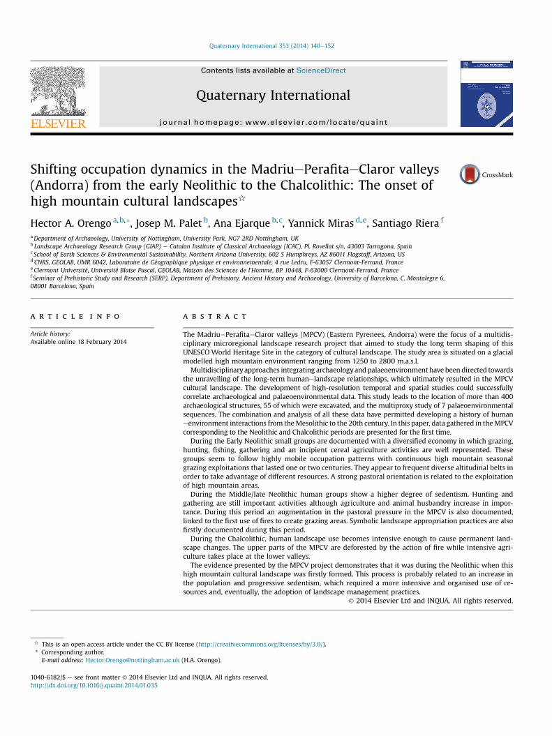
Fig. 1. Location of the study area, the archaeological structures dated to the Neolithic, and the palaeoenvironmental registers used in the text.
H.A. Orengo et al. / Quaternary International 353 (2014) 140e152 141
1. Introduction
Highmountain European areas, which for a long time have beenconsidered marginal spaces due to their extreme climatic condi-tions and topography, are acknowledged today as human inducedenvironments and, in consequence, cultural landscapes. Palae-oenvironmental and archaeological research in these highlandshave played an important role in the conceptualisation of highmountain areas as cultural landscapes proving that human occu-pation and landscape management practices can be traced back tothe Mesolithic period (Oeggl and Wahlmüller, 1993; Biagi andNandris, 1994; Galop, 1998; Moe and Hjelle, 1999; Rendu, 2003;Efstratiou et al., 2006; Palet et al., 2007; Ejarque et al., 2010;Orengo, 2010; Palet et al., 2010; Ejarque, 2013; Servera et al., 2014).
The MadriuePerafitaeClaror valleys (MPCV) (Eastern Pyrenees,Andorra) were the object of a transdisciplinary microregionallandscape research project, aiming to study the long term shapingof this high mountain area listed as a UNESCO World Heritage Sitein the category of Cultural Landscape. Although the MPCV projectemployed a long-term diachronic research perspective, this paperwill focus on the results obtained for the Neolithic period. Theproject’s general research objective of studying the long-termshaping of cultural landscapes is here reduced to focus on thefirst human landscape modifications recorded in the study areaand, therefore, it attempts to analyse the onset of Pyrenean high-mountain cultural landscapes. As discussed elsewhere (Ejarqueand Orengo, 2009), the formation of cultural landscapes follows acumulative process in which earlier landscape modificationsdetermine future human uses of the landscape. Therefore, under-standing the origins of cultural landscapes, in this case the firsthumanelandscape modifications in the high mountain Pyrenees, isessential for the correct analysis of their long-term evolution. This
study aims to explore this topic and, by doing so, endeavours tounravel the social, economic and environmental factors involved inits shaping, the landscape management tools employed, and thesocial, economic and environmental outcomes of the MPCVNeolithic occupation.
Palaeoenvironmental studies have provided evidence of humanimpact in European High mountain areas since the early Neolithic(e.g. Ejarque et al., 2010; Orengo, 2010). However, the characteri-sation of this impact in cultural terms has been largely neglected.This can be related to the lack of proper integration of palae-oenvironmental studies and archaeological research. In this regard,archaeology can be considered as a much needed proxy able toprovide cultural explanations for the earliest human impacts inhigh mountain environments reflected in the palaeoenvironmentalrecord (see, for later periods, Orengo et al., 2013, 2014). Thus, thispaper fulfils a double purpose: to showhowarchaeological data canprovide meaningful explanations to changes in the palae-oenvironmental record by relating them to demographic, culturaland socio-economic factors and, by doing so, to contribute to theanalysis of the creation and development of highmountain culturallandscapes.
2. The physical setting
TheMPCV valley, ranging from 1250 to 2800m.a.s.l., is located atthe axial area of the Eastern Pyrenees, Andorra. It follows an NWe
SE orientation and it is formed by the main Madriu valley and thePerafitaeClaror valley (Fig. 1). The geomorphology of the study areais characterised by glacial, periglacial and fluvial modelling. Thegranitic geologic substratum, formed by granodiorites and biotite,creates in this area a very abrupt relief characterised by steep cliff-like slopes, glacial cirques, and tarns where lakes and peatbogs
H.A. Orengo et al. / Quaternary International 353 (2014) 140e152142
have been formed. Periglacial deposits of lobular morphology thatexpanded from the glacial cirques are also found in the upper partsof the Madriu valley. These valleys form in their lower areas narrowV shaped sections as a result of glacial modelling and subsequentHolocene slope scree deposits. The upper parts present an openmorphology modelled by glacial cirques and ice transfluenceprocesses.
The altitudinal variation and the slopes’ orientation promoteimportant vegetation diversity in the study area, characteristic ofhigh mountain zones (Gómez, 2001). In the lower sectors of theMPCV, from approximately 900 to 1700 m.a.s.l., a Scots pine (Pinussylvestris) forest dominates over mixed deciduous woodland andoccasional hazel (Corylus avellana) and silver birch (Betula pendula)formations. In the subalpine altitudinal belt the mountain pine(Pinus mugo ssp. uncinata) gradually increases its presence until,approximately, 2300 m.a.s.l. Mountain pine is more dense andmixed with rhododendron in the northern slopes while in southoriented slopes it is more dispersed and mixed with juniper.Furthermore, silver birch and silver fir (Abies alba) are respectivelypresent at the upper- and lower-most part of the subalpinewoodland. From 2300 m.a.s.l. upwards Caricetalia curvulae alpinegrasslands dominate the landscape until the appearance of massivescree slope deposits and the vertical rock walls of the upper glacialcirques at around 2600 m.a.s.l.
3. Methodology
This five-year project included researchers from a diverse arrayof palaeoenvironmental and historical sciences in order to unravelthe long-term humanelandscape relation, which ultimately resul-ted in the MPCV cultural landscape. The approach is based on theintegration of datasets from diverse nature, including palae-oenvironmental multi-proxy studies and archaeology. The meth-odology followed in the project was designed to obtain a highdegree of correspondence between the archaeological and thepalaeoenvironmental records based on the use of high-resolutiontemporal and spatial frameworks and the premise that local scalecase studies is the most suitable approach to analyse humaneenvironment interactions (Dearing et al., 2006), particularly inupland environments (Davies, 2007; Ejarque et al., 2010).
In this regard, the MPCV offers an ideal setting: the presence ofmultiple peatbogs and lakes from which palaeoenvironmental se-quences were obtained could be matched by numerous closelylocated multi-period archaeological sites.
3.1. Archaeology
Archaeology, as a complementary proxy to those offered bypalaeoenvironmental sciences, is particularly useful since it pro-vides data specifically related to the use of the landscape. Thesedata are chronologically and spatially referenced. The attributes ofarchaeological data allow the documentation of specific humanaction on the landscape that can be linked to human-related dis-turbances in the palaeoenvironmental record by the use of highresolution chronological frameworks obtained through radio-carbon dating of organic material recovered in well-definedarchaeological contexts.
In order to retrieve a significant amount of archaeological data,total coverage survey was carried out. Geographic InformationSystems (GIS) software was employed to incorporate high resolu-tion orthophotographs (0.25 m/pixel), 1:5.000 digital maps,1:25.000 vegetation maps, 1:25.000 digital geomorphologicalmaps, and a 5 m/cell digital terrain model of the study area. Thesedata were employed in a first assessment of the study area byphotointerpretation procedures (Orengo, 2010). On a second stage,
field walking allowed the verification of these structures and theincorporation of new ones. Field walking was also useful inassessing preservation issues and the typological diversity of thestructures. These criteria were essential in selecting those struc-tures fit for test pit digging. The information collected duringphotointerpretation and field walking was incorporated in severalvector layers linked to a database where the georeferenced plans ofthe structures and information related to typology, constructiontechniques, surface material, and geographical setting, could bequeried.
Of those structures located during field walking the mostrepresentative in terms of typology and preservation wereselected for archaeological excavation. Archaeological trenchescovered an area of at least 2 m2. Their purpose was to record thetypology of the excavated structure, to recover informationrelated to the human use of the landscape and to obtain adequatesamples for radiocarbon dating. The excavation process followedstandard procedures of stratigraphic excavation. The limited timeavailability in high mountain archaeology, however, forced theadoption of a combination of digital photogrammetric recordingand differential GPS measurements to record the excavationprocess (Orengo, 2013). This methodology permitted an accurateand fast recording of the excavation process and allowed thegeneration of plans and profiles of both test pits and structures ata later stage.
The excavation methodology included besides the standardrecording of all materials dry-sieving of all sediment from occu-pation levels. Also, from each excavated stratum aminimum of fourlitres of sediment was kept for environmental processing. For thosestructures presenting adequate continuous sedimentation amicromorphological core was retrieved to conduct micromorpho-logical analysis at a later stage. Some natural soils located close toexcavated archaeological structures were also excavated in order tocorrelate natural sedimentation to that documented inside humanoccupation structures. This is particularly important since occu-pation levels inside prehistoric stone-made habitation structuresare, typically, lower than the surface outside them. The excavationof test pits outside the structures could confirm whether or notoccupation levels were limited to the space covered by the habi-tation structure and were related to it. In this way, the excavatorcould avoid dating levels preserved under the structure that wereprevious to its construction.
3.2. Palaeoenvironmental multi-proxy analyses
A total number of seven sequences from the MPCV were studiedfor pollen analyses: two lakes and five fens. From these, only fourprovided Neolithic dates. In the Madriu valley the three studiedrecords are taken in such a way that follows an altitudinal rangewith distinctive vegetation settings (Fig. 1). Bosc dels Estanyons(BDE) is a small fen of 0.7 ha located within the subalpinemountainforest belt at 2180m.a.s.l. (Miras et al., 2007). Riu dels Orris (RDO) isa black sedge acidic fen of 0.8 ha set on the tree limit of the sub-alpine pine woodland at 2390 m.a.s.l. (Ejarque et al., 2010). Forcat(FOR) is an oligotrophic alpine lake at 2545 m.a.s.l. settled in aglacial basin of 3.5 ha surrounded by alpine grasslands (Ejarque,2013). In Perafita valley, Planells de Perafita (PDP) is a fen of2.9 ha located at 2240 m.a.s.l. in the tree limit of the subalpine pinewoodland. The fen is surrounded by a patchwork of open grass-lands and small pine groups (Miras et al., 2010). These multi-proxysequences include the study of pollen, non-pollen palynomorphs(NPPs: fungal spores, parasites and stomata) micro- and macro-charcoal. Details of the sampling and analytical procedures thatwere followed in the palaeoenvironmental study of these se-quences can be found in Miras et al. (2007, 2010), Ejarque et al.
H.A. Orengo et al. / Quaternary International 353 (2014) 140e152 143
(2010) and Ejarque (2013). The inclusion of NPPs and macro-charcoal provides a local counterpart to the mainly regional char-acter of the pollen record, providing altogether spatially precisepalaeoenvironmental information that can be analysed inconjunction with nearby archaeological structures. Also, both therelatively small size of the studied basins and the distribution ofmultiple sequences in the different sectors of the MPCV offer a highspatial resolution, which allows the documentation of differencesin local dynamics that can be then compared with the distributionof archaeological sites.
The integration of palaeoenvironmental and archaeological datawas further achieved by employing high-resolution chronologicalparameters. The studied records had an accurate chronologicalframing, each palaeoenvironmental register accounting for at leasttwo radiocarbon measurements for the Neolithic period. Aremarkably high temporal resolution can be observed for the RDOfen during the early and middle Neolithic, with temporal intervalsbetween samples of ca. 55 years, and for the FOR lake during theLate Neolithic, with temporal intervals between samples of ca. 25years. In addition, at FOR fine-resolution pollen analysis was con-ducted for the late NeolithiceChalcolithic transition, with theanalysis of contiguous 1 cm samples encompassing between ca.15e35 years of pollen rain (Ejarque, 2013).
4. Results
4.1. Archaeological results
A total of 421 multi-period structures were located and 55 ofthese, corresponding to periods from the Neolithic to the 20thcentury, were excavated. From the 30 AMS 14C dates from materialrecovered in well-contextualised archaeological layers only 12correspond to Neolithic occupation levels or ancient soil surfaces(Fig. 2). Six of these were obtained from occupation levels insidehabitation stone structures while four others from occupationlevels inside enclosure structures. The last two correspond toNeolithic soil levels with no associated structure.
4.1.1. Early NeolithicP009 (Fig. 3) is the earliest structure dated to this period. This
roughly circular structure of a maximum of 6 m in diameter in-cludes several occupation layers. The first one, P009107, is dated tothe Mesolithic period. This date corresponds to the construction of
Fig. 2. Radiocarbon dates corresponding to
the structure. Its construction technique and size distinguishes itfrom later structures. Structure P009107 has walls made of localgranitic stone cut in large pointed triangles. These stones wereassembled using the ‘fish-scale’ techniquewith their longest cornertowards the interior of the structure, probably to avoid them fallingtowards the inner side of the structure. The early Neolithic in-habitants reused this structure, which resulted in several occupa-tion levels. P009110 was radiocarbon dated to 5544 � 69 cal. BC.Levels P009106 and P009109 provided similar material culture tothat of P009110, mainly local schist work debris and tools but alsolocal and extra-regional flint debris (Fig. 4). This suggests a longoccupation period for this structure. As in the case of all otheroccupation structures from the period, the occupation levels insidethe structure were excavated, and therefore, they were much lowerthan the ancient soil level outside the structure. This accounted fora good preservation of the structure’s occupation layers.
Structure M152 (Fig. 3) is a stone hut of small size located at2518 m.a.s.l. at Pleta de les Bacives I site, a natural enclosed spacemodelled by glacial movements. A ring of medium and big-sizedgranitic stones demarcates the elongated circular habitation areadefining an inner space of around 3 m2. This structure presents twophases of occupation: the earlier corresponding to the earlyNeolithic and the latest to the Late Roman period. As seen for theprevious structure, the early Neolithic occupation levels wereexcavated under the surface, possibly in order to preserve heat andreduce the need for high roofing. The occupation level presentedscarce material culture, including a hearth dated to 4481 �112 cal.BC. Both the stratigraphic relationships between the excavatedlevels and the levels documented in a second test pit located a fewmeters from this structure confirmed that the M152 occupationlevel is confined inside the limits of the structure and therefore theconserved structure was part of the Neolithic habitationconstruction.
4.1.2. End of the middle Neolithic/late NeolithicP008 (Fig. 5) is also a habitation structure. As it was reused
during the early medieval period, its original shape and construc-tion methods were not documented except from two small post-holes associated to the occupation levels. These suggest that thiswas a large roofed structure and therefore it probably was a habi-tation space. Despite the lack of direct archaeological evidence ofwalls, the size of the trench (2 � 0.5 m) confirms the bigger size ofthis structure compared to that of other habitation structures. The
the Neolithic occupation of the MPCV.
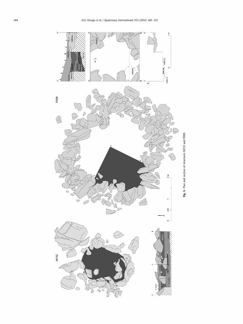
Fig.
3.Plan
andsectionof
structures
M15
2an
dP0
09.
H.A. Orengo et al. / Quaternary International 353 (2014) 140e152144
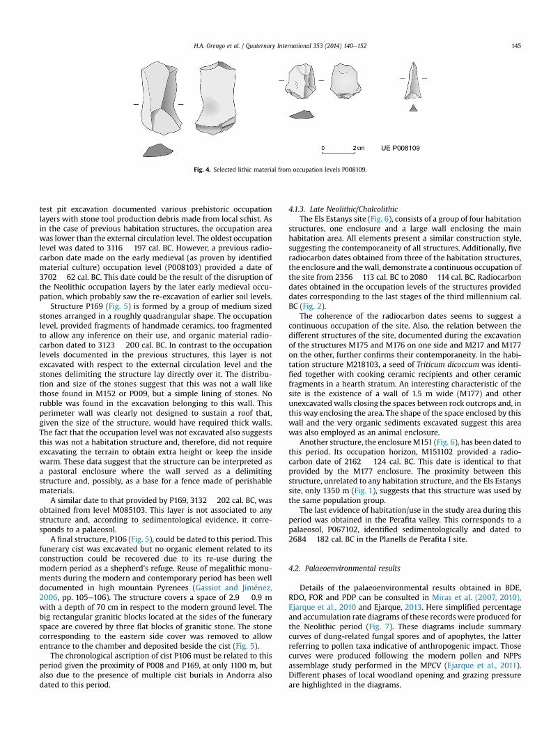
Fig. 4. Selected lithic material from occupation levels P008109.
H.A. Orengo et al. / Quaternary International 353 (2014) 140e152 145
test pit excavation documented various prehistoric occupationlayers with stone tool production debris made from local schist. Asin the case of previous habitation structures, the occupation areawas lower than the external circulation level. The oldest occupationlevel was dated to 3116 � 197 cal. BC. However, a previous radio-carbon date made on the early medieval (as proven by identifiedmaterial culture) occupation level (P008103) provided a date of3702 � 62 cal. BC. This date could be the result of the disruption ofthe Neolithic occupation layers by the later early medieval occu-pation, which probably saw the re-excavation of earlier soil levels.
Structure P169 (Fig. 5) is formed by a group of medium sizedstones arranged in a roughly quadrangular shape. The occupationlevel, provided fragments of handmade ceramics, too fragmentedto allow any inference on their use, and organic material radio-carbon dated to 3123 � 200 cal. BC. In contrast to the occupationlevels documented in the previous structures, this layer is notexcavated with respect to the external circulation level and thestones delimiting the structure lay directly over it. The distribu-tion and size of the stones suggest that this was not a wall likethose found in M152 or P009, but a simple lining of stones. Norubble was found in the excavation belonging to this wall. Thisperimeter wall was clearly not designed to sustain a roof that,given the size of the structure, would have required thick walls.The fact that the occupation level was not excavated also suggeststhis was not a habitation structure and, therefore, did not requireexcavating the terrain to obtain extra height or keep the insidewarm. These data suggest that the structure can be interpreted asa pastoral enclosure where the wall served as a delimitingstructure and, possibly, as a base for a fence made of perishablematerials.
A similar date to that provided by P169, 3132 � 202 cal. BC, wasobtained from level M085103. This layer is not associated to anystructure and, according to sedimentological evidence, it corre-sponds to a palaeosol.
A final structure, P106 (Fig. 5), could be dated to this period. Thisfunerary cist was excavated but no organic element related to itsconstruction could be recovered due to its re-use during themodern period as a shepherd’s refuge. Reuse of megalithic monu-ments during the modern and contemporary period has been welldocumented in high mountain Pyrenees (Gassiot and Jiménez,2006, pp. 105e106). The structure covers a space of 2.9 � 0.9 mwith a depth of 70 cm in respect to the modern ground level. Thebig rectangular granitic blocks located at the sides of the funeraryspace are covered by three flat blocks of granitic stone. The stonecorresponding to the eastern side cover was removed to allowentrance to the chamber and deposited beside the cist (Fig. 5).
The chronological ascription of cist P106 must be related to thisperiod given the proximity of P008 and P169, at only 1100 m, butalso due to the presence of multiple cist burials in Andorra alsodated to this period.
4.1.3. Late Neolithic/ChalcolithicThe Els Estanys site (Fig. 6), consists of a group of four habitation
structures, one enclosure and a large wall enclosing the mainhabitation area. All elements present a similar construction style,suggesting the contemporaneity of all structures. Additionally, fiveradiocarbon dates obtained from three of the habitation structures,the enclosure and thewall, demonstrate a continuous occupation ofthe site from 2356 � 113 cal. BC to 2080 � 114 cal. BC. Radiocarbondates obtained in the occupation levels of the structures provideddates corresponding to the last stages of the third millennium cal.BC (Fig. 2).
The coherence of the radiocarbon dates seems to suggest acontinuous occupation of the site. Also, the relation between thedifferent structures of the site, documented during the excavationof the structures M175 and M176 on one side and M217 and M177on the other, further confirms their contemporaneity. In the habi-tation structure M218103, a seed of Triticum dicoccum was identi-fied together with cooking ceramic recipients and other ceramicfragments in a hearth stratum. An interesting characteristic of thesite is the existence of a wall of 1.5 m wide (M177) and otherunexcavated walls closing the spaces between rock outcrops and, inthis way enclosing the area. The shape of the space enclosed by thiswall and the very organic sediments excavated suggest this areawas also employed as an animal enclosure.
Another structure, the enclosureM151 (Fig. 6), has been dated tothis period. Its occupation horizon, M151102 provided a radio-carbon date of 2162 � 124 cal. BC. This date is identical to thatprovided by the M177 enclosure. The proximity between thisstructure, unrelated to any habitation structure, and the Els Estanyssite, only 1350 m (Fig. 1), suggests that this structure was used bythe same population group.
The last evidence of habitation/use in the study area during thisperiod was obtained in the Perafita valley. This corresponds to apalaeosol, P067102, identified sedimentologically and dated to2684 � 182 cal. BC in the Planells de Perafita I site.
4.2. Palaeoenvironmental results
Details of the palaeoenvironmental results obtained in BDE,RDO, FOR and PDP can be consulted in Miras et al. (2007, 2010),Ejarque et al., 2010 and Ejarque, 2013. Here simplified percentageand accumulation rate diagrams of these records were produced forthe Neolithic period (Fig. 7). These diagrams include summarycurves of dung-related fungal spores and of apophytes, the latterreferring to pollen taxa indicative of anthropogenic impact. Thosecurves were produced following the modern pollen and NPPsassemblage study performed in the MPCV (Ejarque et al., 2011).Different phases of local woodland opening and grazing pressureare highlighted in the diagrams.
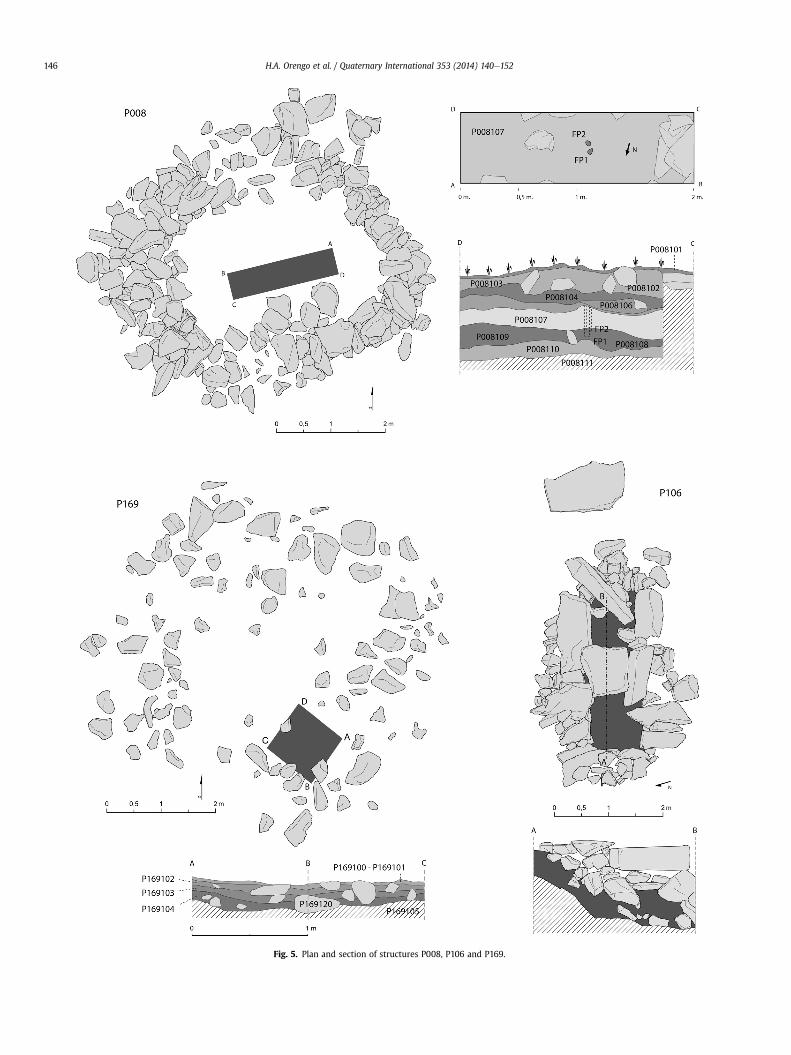
Fig. 5. Plan and section of structures P008, P106 and P169.
H.A. Orengo et al. / Quaternary International 353 (2014) 140e152146
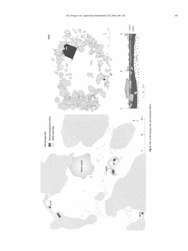
Fig.
6.Plan
ofElsEstany
ssite
anden
closureM15
1.
H.A. Orengo et al. / Quaternary International 353 (2014) 140e152 147
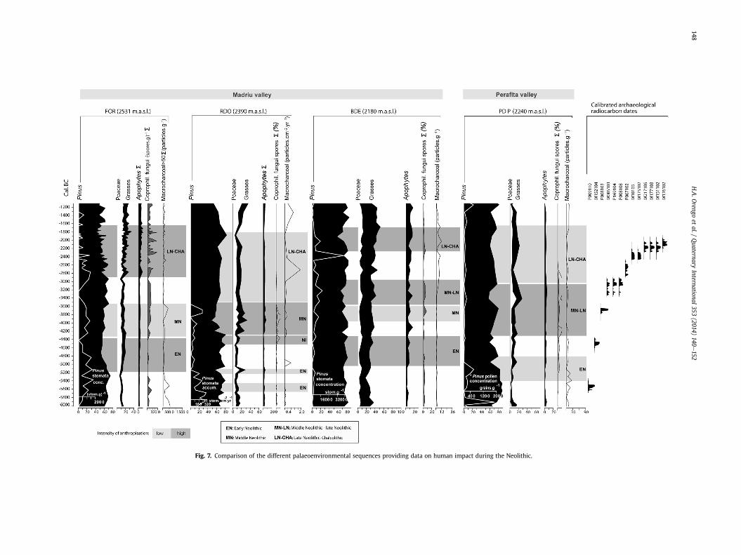
Fig. 7. Comparison of the different palaeoenvironmental sequences providing data on human impact during the Neolithic.
H.A.O
rengoet
al./Quaternary
International353(2014)
140e152
148
H.A. Orengo et al. / Quaternary International 353 (2014) 140e152 149
5. Discussion
In this section each Neolithic cultural period will be dealt withseparately in order to provide a clear picture of human inducedlandscape changes over time. The archaeological and palae-oenvironmental evidence is compared and discussed and theresulting humaneenvironment dynamics are contrasted againstthe evidence gathered in neighbouring Pyrenean high mountainareas.
5.1. Early Neolithic
Both early Neolithic structures are located close to palae-oenvironmental registers, where local human impact was detectedduring this period. In Perafita valley, habitation structure P009 islocated just a fewmeters away from the PDP fen, which documentsa phase of local human impact between 5300 and 4900 cal. BC witha reduction in pine and an increase in ruderal indicators (Miraset al., 2010) (Fig. 7). Although the dating of the first occupationlevel, 5544 � 69 cal. BC, is around 250 years earlier to the earlyNeolithic palaeoenvironmental impact phase, the presence ofanother two occupation levels with similar material culture thanthat of the dated level attests to its long term occupation.
In the Madriu valley, the size of M152 hut, the only structurefully excavated for this period, suggests a small group probablycomposed for a maximum of four people. Its construction tech-nique indicates that the structure was not conceived for long-termhabitation but it was a temporary shelter. This perhaps may berelated to the local activities of small nomadic pastoralist groupstransiting the upper areas of the valley, which is consistent with theavailable palaeoenvironmental information in the area.
The Madriu valley at the time of this first highland settlingshows more intense human-related landscape impact than thatrecorded in Perafita. From 5800 cal. BC the extension of pine forestup to the most elevated sectors of the MPCV (around 2600 m.a.s.l.)is documented in a context of climatic amelioration (Ejarque, 2013,pp. 118). In this context, the occupation phase of M152 coincideswith human-induced local pine forest openings documented atFOR lake from ca 5200 to 4400 cal. BC and RDO fen from ca 4500 to4350 cal. BC (Ejarque et al., 2010; Ejarque, 2013). The retreat anddisappearance of pine stomata together with the increase of apo-phytes and herbaceous pollen taxa at FOR and the increase ofapophytes and dung-related fungi at RDO at the moment of occu-pation of the pastoral enclosure M152 (Fig. 5) reinforces the hy-pothesis of pastoralism-related clearances for the increase ofgrazing areas at Madriu valley. A further insight into this activity isprovided by the RDO’s resolution, documenting between 5650 and4350 cal. BC three forest opening phases spanning approximatelyfrom 90 to 170 years which are embedded within pine recoveryphases (Ejarque, 2013, pp. 128).
Results obtained from BDE fen (Fig. 4) are consistent with thepicture provided by the FOR and RDO records. It shows a decreasein pine stomatawhile herbaceous and anthropic indicators increaseand diversify between 5050 and 4350 cal. BC. These include thestrict coprophilous fungal spore Sporormiella (Miras et al., 2007),indicating the existence of local pastoral activities also at the sub-alpine areas of Madriu valley.
Both archaeological and palaeoenvironmental evidence docu-ment a human frequentation of the MPCV related to discontinuouspastoral practices. These seem to entail small-scale pine forestclearances for livestock grazing, followed by woodland recovery,which favoured the configuration of open pine woodland at highaltitudes. Although the time length of these impacts is variable,they were probably seasonal and, as indicated by the short forestclearance phases of RDO, they were repeated during one or two
centuries. The observed highland shifting grazing system wasprobably complemented by incipient agricultural activities devel-oped in the lower subalpine and mountain belts of Andorra. TheMPCV palaeoenvironmental records attest openings in the decid-uous oak, hazel and birch forest located in the lower subalpine andmountain belts together with the first recordings of Cerealia-typein RDO and PDP between 5600 and 5300 cal. BC and the moreregular presence of Cerealia-type in FOR, between 5375 and4850 cal. BC (Miras et al., 2010; Ejarque, 2013). This evidence pointsto the existence of agricultural activities and forest openings in thelower Andorran valleys, and is further corroborated by therecording of wheat (Triticum sp.) and barley (Hordeum vulgare) inthe early Neolithic levels of the Balma de la Margineda site(Andorra) at 970 m.a.s.l (Marinval, 1995).
Regional archaeological data seem to suggest a Pyrenean earlyNeolithic model of mountain use entailing a wide spectrum econ-omy as evidenced in the Balma de la Margineda site, where huntingof animals, such as the Iberianwild goat (Capra pyrenaica), deer andwild boar coexisted with pastoral activities that included species,such as sheep (Ovis aries), goat (Capra hircus) and pig (Sus scrofadomesticus) (Geddès, 1995). This site also provided evidence forfishing, gathering and agricultural activities, with the presence ofboth wheat and barley (Marinval, 1995, pp. 130). Balma de laMargineda also sees an increase in the number of the site’s in-habitants towards the end of the period at the same time that aspace of the site is employed as a stabling area (Llovera, 1984, pp.44). A second archaeological site from this period has been locatedin Andorra. Segudet Tomb is an individual inhumation that alsoprovided evidence supporting a wide economic orientation forthese early Neolithic groups. The identification of Cerealia, honeyand milk inside a votive vase close to the tomb attest to thediversification of the group’s economic activities. This site alsoprovides evidence for wild fruit gathering, while a fish scale foundin a sample of dental calculus indicated the consumption of fish(Yáñez, 2005, pp. 55). The presence of objects made of non-localmaterials at both sites further attest to the high level of mobilityof these groups and/or the existence of contacts with other groupswith which ideas and objects could be exchanged.
When comparing the evidence gathered in the MPCV with thatfrom other neighbouring Andorran areas, a consistent pictureemerges for the early Neolithic of small groups with a diversifiedeconomy where pastoralism, hunting, fishing, gathering and anincipient cereal agriculture are well represented. These groupsseemed to have highly mobile occupation patterns with constantexploitation of high mountain seasonal grazing areas that lastedone or two centuries. They would frequent diverse altitudinal beltsin order to take advantage of the different resources that eachecological niche had to offer. Therefore, a strong pastoralist focusrelated to the exploitation of high mountain areas can be observedwhile lower Andorran valleys are mainly used for agricultural ac-tivities. Such mountain land-use system is comparable with theitinerant agropastoral system, the so called “landman model”described for lowland European Neolithic communities (Iversen,1941; Vuorela, 1986; Behre, 1988; Riera, 1994).
5.2. Middle/late Neolithic
During the middle Neolithic and the transition to the lateNeolithic the archaeological evidence of human occupation in-creases in the MPCV as they do in other Pyrenean areas. The syn-chronous occupation of P008 habitation structure with that ofP169, a pastoral enclosure, provides important data on the type ofactivities carried out in the area by middle/late Neolithic groups.These were probably recurrent summer occupations focused onpastoral activities. The human groups had probably a more
H.A. Orengo et al. / Quaternary International 353 (2014) 140e152150
sedentary character and were probably linked to lower habitationsites. The presence of the P106 burial cist in the area can also belinked to a more sedentary character of these groups and can offer acultural context for them. These monumental tombs have beenfrequently linked to assertions of territoriality (Barrett, 1993; Muir,2000; Agirre García et al., 2010), characteristic of sedentary groups.
The site of Feixa del Moro lying at a lower altitude (1335m.a.s.l.)offers a complementary image to that of Perafita valley. This site hasyielded two radiocarbon dates corresponding to 3712 � 362 and4152 � 654 cal. BC (Llovera and Bertran, 1991, pp. 20). It includesboth habitation layers and cist burials. From the three cists recor-ded, two still preserved the inhumations and the funerary offerings,characteristic of the so-called Sepulcres de Fossa Culture. Thepresence of votive axes made of serpentine and shale and decora-tive items made of variscite from the mines of Can Tintorer, in Gavà(135 km to the south of Andorra) attests to the participation of thisgroup in long-distance trade networks. Feixa del Moro has beendescribed as a seasonal but stable site (Yáñez, 2005, pp. 57). Insidethe habitation areas various artefacts related to the process of food,such as hand mills, were recovered. Close to these structuresseveral ceramic containers were discovered with cereals andhazelnut (C. avellana) shells (Llovera and Bertran, 1991; Yáñez,2005, pp. 56e57). Close to Feixa del Moro, the sites of Camp delColomer and Carrer Llinàs 28 (Fortó et al., 2009), provided two hutoccupation levels (excavated with respect to the external surface)and seven grain silos of around 170 cm depth. The presence of millstones together with the silos affirms the strong agriculturalorientation of Camp del Colomer. This site has been interpreted as astable settlement periodically occupied by an itinerant group thatwould move inside a well delineated territory. There is also evi-dence to highlight the agricultural orientation of the group thatseems to be involved in deforestation activities, as suggested by thehigh number of axes with use marks found at Carrer Llinàs 28, forthe creation of open areas for agricultural exploitation (Fortó et al.,2009).
The middle Neolithic groups in the Perafita valley had a signif-icant impact on their immediate landscape as attested by thepalaeoenvironmental study of the PDP fen, located in the vicinity ofstructures P008, P169 and P106 (Fig.1). The pine forest opening andthe extension of alpine grasslands together with the rise ofanthropogenic indicators and dung-related fungal spores docu-mented between 3600 and 3050 cal. BC are linked to the increase oflocal pastoral activities (Miras et al., 2010), which were synchro-nous with the presence of the human groups occupying the area.
Human occupation seems to favour Perafita valley during themiddle Neolithic given the scarce evidence documented at Madriuvalley. However, palaeoenvironmental data indicate the existenceof grazing activities and pine woodland clearances also in theMadriu valley. The RDO fen shows a more permanent pine clear-ance between 4350 and 3500 cal. BC that can be related to local,occasional fires. The continuous presence of stomata together withcoprophilous fungi spores and local grazing indicators at thisperiod suggests that forest clearance was aimed at the creation ofan open forest that was employed for grazing purposes. Thedisappearance of pine stomata in RDO towards 3500 cal. BC in-dicates the definitive stabilisation of alpine grasslands probably, asa consequence of the pastoral pressure in a first phase of themiddleNeolithic. From this moment onwards the area around RDO(located at 2390 m.a.s.l.) remained deforested until today as pineforests grow only at lower altitudes (Ejarque, 2013, pp. 131). Duringthe final phase of the middle Neolithic (ca. 3500 to 3000 cal. BC) inthe highland alpine belt of the Madriu valley a decrease inanthropogenic activities is documented while at lower sectors ofthe valley the BDE fen at 2130m suggests continuity of grazing witha moderate opening of the pine forest, associated to low intensity
local fires (Miras et al., 2007). This is archaeologically attested by acirculation level or palaeosol, M085103, from the Riu dels Orris Isite (2390 m.a.s.l.) dated to 3132 � 202 cal. BC. The limited time lagbetween this circulation level and the occupation levels docu-mented in Perafita may suggest that Madriu and Perafita valleyswere frequented during the same period. This would thus attest tothe frequentation and pastoral exploitation of the neighbouringMadriu valley.
Archaeological and palaeoenvironmental data point to a stron-ger human frequentation of the Perafita valley and the highestsectors of the Madriu valley during the last stages of the middleNeolithic compared to the early Neolithic phase, and was probablyassociated to animal husbandry. Both datasets indicate longer hu-man occupation, according to the two radiocarbon dates of P008hut, in contrast with the shorter occupation period documentedduring the early Neolithic. Although only one habitation structurein each period was excavated enough to allow the extrapolation ofthe size of the habitation space, the size of P008 is much biggerthan that of M152. This increase in size may suggest an increase inthe number of individuals forming the middle Neolithic group withrespect to that of the early Neolithic. This could explain the changesobserved in the palaeoenvironmental record, with the increase ofdeforestation and the expansion of alpine grasslands, particularly atPerafita, where these expand over 2000 m.a.s.l. (Miras et al., 2010).
The dating of sites such as those at Perafita and Feixa del Moro inAndorra and other neighbouring sites, such as Serrat de la Padrillaand Cova del Sardo are concurring with an increased stability insettlement patterns. At Serrat de la Padrilla site, at 2300 m.a.s.l.(French Cerdanya), two closely located habitat structures evidencecontinuous occupation between 4287 and 3051 cal. BC and arerelated to an opening of the pine forest at 3353 cal. BC (Galop,1998;Rendu, 2003, pp. 215e228). In the Pallars Sobirà region (CentralPyrenees, Spain) evidence of occupation during this period is re-ported in several highland sites such as the Abric del Estany de laCoveta I, 2431 m.a.s.l., at Obagues de Ratera site, 2322 m.a.s.l., atColl del Portarró site, between 2280 and 2327 m.a.s.l., and at Covadel Sardo site (Vall de Boí, Alta Ribagorça) at 1830 m.a.s.l. (Gassiotand Jiménez, 2006; Jiménez, 2006). This last site shows a longoccupation sequence with middle Neolithic phases dated to2745 � 69 cal. BC and to 3864 � 98 cal. BC. Microwear analysisperformed on the tools found on site, showed these have beenemployed to work non-woody plants (Gassiot and Jiménez, 2006,pp. 100; Jiménez, 2006).
It is thus tempting to link this stability in the highlands with theincreasing intensity of agricultural activities documented in boththe palaeoenvironmental and archaeological record at lower alti-tudes. The different palaeoenvironmental records studied in theMPCV between 4500e4200 and 3000 cal. BC document a gener-alised opening of the lower mixed deciduous woodland (i.e. de-ciduous oak, hazel, elm, lime tree), and the more regular recordingof Cerealia-type (Ejarque, 2013, pp. 132). Archaeological data ob-tained in these areas (e.g. Feixa del Moro site) corroborate thispicture. A more agriculture-oriented economy of the middleNeolithic groups would imply higher sedentism as opposed to thehigher mobility pattern suggested for the early Neolithic. Thedevelopment during this period of monumental funerary practicesinterpreted as territorial assertions can be linked to this process.However, according to the archaeological evidence at the MPCV,these groups would still be involved in seasonal movements linkedto the exploitation of different resources along the altitudinal belt.This reduced mobility would not entail a decrease in exchangesbetween groups as indicated by the high percentage of non-localmaterials recovered in various sites, such as Feixa del Moro. It ispossible that the sedentary character of these groups can also berelated to the increase in population that was demonstrated in the
H.A. Orengo et al. / Quaternary International 353 (2014) 140e152 151
archaeological record by the increase in the size of habitationstructures and the multiplication of occupation documented at aregional level.
5.3. Late NeolithiceChalcolithic
During the last part of the third millennium cal. BC new evi-dence of occupation were recovered in the MPCV, such as the fourhabitation structures inside an enclosed area, and the large enclo-sures M218 and M151 at the site of Els Estanys (Fig. 6). Dating ev-idence suggests the seasonal occupation of the site for about 300years, covering the period between 2356 � 113 and 2080 � 114 cal.BC. Els Estanys shows important changes in respect to previousperiods: this is a group of clearly delimited habitation structuresforming a small village. This village is the higher Neolithic orChalcolithic settlement ever found in Europe and, as such, deservesspecial attention. In general, the structures are bigger than those ofprevious phases, particularly M175 and M217. M175 is particularlylarge, its interior covering an area of 17 m2 and prohibiting theemployment of a circular plan. This is the earliest quadrangularstructure in the study area. It is also constructively linked to M176and M225. These habitation structures cover approximately 40 m2
and if they are all indeed for habitation, they could have hostedcomfortably up to 20 people, suggesting is a significant increase inthe number of people inhabiting the area respect to that of previousperiods. This settlement probably accommodated a whole groupand not only a part of a group specialised in summer pastoralpractices. The presence of cooking ceramics and a seed of T. dicoc-cum associated with a hearth found in M218 occupation can beindicative of a relation of this group with agricultural practicesdeveloped at lower altitudes. In fact, palaeoenvironmental analysisin the MPCV also registers the retraction of birch, fir, hazel and oakat the lower subalpine and mountain areas together with a moreregular recording of Cerealia pollen, the latter possibly related tothe expansion of agricultural practices during this period (Ejarque,2013, pp. 138).
This group probably spent the winter in lower areas and thesummer in high mountain environments. Their summer occupa-tion can be linked to pastoral activities, as attested by the presenceof two enclosures and the use of Els Estanys site central area as anenclosure itself (Fig. 6). The total amount of enclosed space coversabout 1300 m2. In accordance with archaeological data, palae-oenvironmental analyses point to a strong change in both thelandscape configuration of the MPCV and the means employed toachieve this during this period. The FOR sequence from 2800 cal. BCand until 1650 cal. BC, demonstrates local opening of the pine forestthat reaches its peak towards 2450 cal. BC. It is in this momentwhen the highest areas of the Madriu valley, around Forcat Lake,are cleared and covered by alpine grasslands, which will dominatethe alpine belt in theMadriu valley for the rest of the late Holocene.The increase in apophytes, including nitrophilous and ruderal taxa,together with the presence of coprophilous fungi spores, pointstowards the strong grazing orientation of the forest clearanceduring this phase. Pastoral pressure is intense, constant andcontinuous in a way that forest regeneration is not allowed(Ejarque, 2013, pp. 136). In this sense, the spatial and chronologicalrelation between the palaeoenvironmental evidence provided byFOR lake and the occupation at Els Estanys and the M151 enclosure(Fig. 1), strongly suggests that the group inhabiting this site wasresponsible for the deforestation of the area and its conversion topastoral grasslands.
Although of lower intensity, human impact was also detected inthe subalpine vegetation zone. Thus, at 2180m.a.s.l., the BDE recordshows an increase of grasses and anthropic indicators and thepresence of coprophilous fungi spores together with a decrease in
pine pollen and stomata that indicate the existence of forestopenings and local grazing activities between 2200 and 1650 cal.BC. The increase of macro-charcoal in BDE suggests that these de-forestations were aided by the use of fire (Miras et al., 2007). Theuse of human-induced fires as a landscape-forming tool is onlydocumented in the lower part of the Madriu valley while the upperarea’s deforestation can be related to a more intensive and sus-tained pastoral exploitation (Ejarque et al., 2010). Differences be-tween valleys in the MPCV were also recorded: in Perafita valleyonly a circulation level, P067102, was archaeologically attested.However, the PDP register shows a decrease in the human exploi-tation of this area (Miras et al., 2010). The existence of suchdifferent landscapemanagement strategies between different areasof the same valley and even between adjacent valleys during thesame period demonstrate the development of a land-use systemcharacterised by a strong human-directed landscape organisationof high altitude areas.
Human activities become, for the first time, intensive enough toresult in a perdurable landscape change in theMadriu valley duringthis period. From this moment onwards the upper areas of theMadriu valley will remain treeless until today due to continuoushuman pressure (Ejarque, 2013), as it was the case of the Perafitavalley from the middle Neolithic onwards. These woodland clear-ances resulted from the need to create grazing areas in the upperhighmountain valleys and agricultural areas in the lower mountainbelt. In relation to this need, fire becomes generalised as a land-scape modification tool. Uppermost mountain areas are trans-formed into grasslands. It is possible that the stronger economicfocus on agriculture and pastoralism could have influenced thesedeforestations. The importance of hunting and gathering activitiesis reduced and therefore, forest was probably no longer consideredthe principal resource for subsistence.
6. Conclusions
This study has presented strong evidence for the first develop-ment of high mountain cultural landscapes in the Pyrenees. Thedata point to an increase in both the size and the degree of sed-entism of the human groups frequenting the MPCV and neigh-bouring areas during the Neolithic. This tendency is particularlyevident in the increase in both the number and size of human-made structures, in the landscape impact of these groups, i.e. for-est clearances and the use of fire as a landscape management tool,and the emergence of monumental funerary elements that havebeen claimed to assert territoriality. The increase in cereal culti-vation in the lower areas of Andorra as attested by pollen data andarchaeological evidence corroborate these observations. It is diffi-cult to speculate what the causes and the consequences were ofthese processes, but a long-term relationship between populationincrease, sedentism, cereal agriculture and intensive pastoralism(as reflected in the everlasting deforestation of the upper areas ofthe Madriu and Perafita valleys) seem to have played an increasingrole in the MPCV during the Neolithic.
This research has also stressed how the integration of archae-ology with palaeoenvironmental analysis can contribute to theinterpretations not only of landscape changes, but also of the eco-nomic, demographic and social processes driving them. This is onlypossible if a microregional integrated methodology is followed,where spatial and chronological contexts can be compared. In thepast few years, there is an increasing number of studies thatendeavour to integrate palaeoenvironmental and archaeologicaldata, some of the problems in attempting such an approach mightbe related to a number of factors: (1) the adoption of a regionalapproach in which the study area includes different environmentalsettings, (2) the scarcity of palaeoenvironmental sequences/
H.A. Orengo et al. / Quaternary International 353 (2014) 140e152152
archaeological data to be employed in conjunction in the expla-nation of human-directed landscape changes, (3) lack of high-resolution chronologies which prevent the correlation of archaeo-logical and palaeoenvironmental data and (4) the lack of multi-proxy palaeoenvironmental studies combining pollen and otherbio-indicators that allow a better understanding of the local andextra-local palaeoenvironmental signal. The MPCV project dem-onstrates how adopting a high spatial (multiple multiproxy se-quences and total coverage archaeological survey and excavation)and chronological resolution can result in meaningful data in-tegrations and, consequently, in the explanation of highly complexinteraction dynamics between humans and their environment.
Acknowledgements
The MPCV Project was funded by the Andorran Government(Area de Recerca Històrica), the AGAUR from the Catalan Autono-mous Goverment (EXCAVA program) and by the Catalan Institute ofClassical Archaeology (ICAC). The first author received a BE grantfrom the AGAUR to conduct research in the Àrea de Recerca His-tòrica d’Andorra (Andorra) and an AIRE grant from the PyreneanWork-Group (CTP) to conduct research in the FRAMESPA ResearchGroup of the CNRS/Université Toulouse II e Le Mirail (France).
The authors would also like to thank Dr. Manon Cabanis (INRAP/GEOLAB UMR6042 CNRS, Clermont-Ferrand II) for the identifica-tion of the Triticum dicoccum seed found in M218103.
References
Agirre García, J., Moraza Barea, A., Mujika Alustiza, J.A., 2010. Los elementos físicoscomo reivindicación del territorio y de sus frutos en los espacios de montaña.In: Fernández Eraso, J., Mujika Alustiza, J.A. (Eds.), Proceedings of the Interna-tional Congress on the Study of Megaliths and Other Contemporary Burials in aSocial, Economic and Cultural Context, Munibe, suplemento 32. Sociedad deCiencias Aranzadi Zientzi Elkartea, Donostia, pp. 286e313.
Barrett, J.C., 1993. Fragments from Antiquity. An Archaeology of Social Life in Britain,2900e1200 BC. Blackwell, Oxford.
Behre, K.E., 1988. The role of man in vegetation history. In: Huntley, B., Webb, T.(Eds.), Vegetation History. Kluwer Academic Publishers, Dordrecht, pp. 633e672.
Biagi, P., Nandris, J. (Eds.), 1994. Highland Zone Exploitation in Southern Europe.Monografie di ‘Natura Bresciana’, vol. 20.
Davies, A.L., 2007. Upland agriculture and environmental risk: a new model ofupland land-use based on high spatial-resolution palynological data from WestAfrica, NW Scotland. Journal of Archaeological Science 34, 2053e2063.
Dearing, J.A., Battarbee, R.W., Dikau, R., Larocque, I., Oldfied, F., 2006. Human-environment interactions: learning from the past. Regional EnvironmentalChange 6, 115e123.
Efstratiou, N., Biagi, P., Elefanti, P., Karkanas, P., Ntinou, M., 2006. Prehistoricexploitation of Grevena highland zones: hunters and herders along the Pinduschain of western Macedonia (Greece). World Archaeology 38 (3), 415e435.
Ejarque, A., 2013. La alta montaña pirenaica: génesis y configuración holocena de unpaisaje cultural. In: British Archaeological Reports International Series.Archaeopress, Oxford.
Ejarque, A., Orengo, H.A., 2009. Legacies of change: the shaping of cultural land-scapes in a marginal Mediterranean range, Garraf Massif, North-eastern Spain.Oxford Journal of Archaeology 28 (4), 425e440.
Ejarque, A., Miras, Y., Riera, S., Palet, J.M., Orengo, H.A., 2010. Testing microregionalvariability in the Holocene shaping of high mountain cultural landscapes: apalaeoenvironmental case-study in the Eastern Pyrenees. Journal of Archaeo-logical Science 37 (7), 1468e1479.
Ejarque, A., Miras, Y., Riera, S., 2011. Pollen and non-pollen palynomorph indicatorsof vegetation and highland grazing activities obtained frommodern surface anddung datasets in the eastern Pyrenees. Review of Palaeobotany and Palynology167 (1), 123e139.
Fortó, A., Vidal, À., Maese, X., 2009. Darreres troballes del neolític a Juberri(Andorra). Cota Zero 24, 14e16.
Galop, D., 1998. La Forêt, l’Homme et le Troupeau dans les Pyrénées. 6000 Ansd’Histoire de l’Environnement entre Garonne et Méditerranée. In: ContributionPalynologique. GEODE-Laboratoire d’écologie terrestre-Framespa, Toulouse.
Gassiot, E., Jiménez, J., 2006. El poblament prefeudal de l’alta muntanya dels Pir-ineus occidentals catalans (Pallars Sobirà i Alta Ribagorça). Tribuna d’Arqueo-logia 2004e2005, 89e122.
Geddès, D., 1995. La fauna mesolítica i neolítica de la Balma de la Margineda. In:Guilaine, J., Martzluff, M. (Eds.), Les excavacions a la Balma de la Margineda(1979e1991), vol. II. Edicions del Govern d’Andorra, Andorra, pp. 83e91.
Gómez, A., 2001. El necesario equilibrio entre preservación y explotación del pai-saje: el caso del Principado de Andorra. Scripta Nova. Revista electrónica deGeografía y Ciencias Sociales V, 103.
Iversen, J., 1941. Landnam i Danmarks Stenalder. Danmarks Geologiske Under-sogelse 66, 1e68.
Jiménez, J., 2006. La imagen de los espacios de alta montaña en la prehistoria: elcaso de los Pirineos Catalanes Occidentales (Unpublished dissertation).Autonomous University of Barcelona, Barcelona.
Llovera, X., 1984. Carta Arqueològica del Principat d’Andorra (Unpublished disser-tation). Autonomous University of Barcelona, Barcelona.
Llovera, X., Bertran, R., 1991. Juberri (Andorra): un exemple de centre receptor i decomerç de joies cap a l’any 3000 aC. In: Les Joies de la Prehistoria, catàleg del’exposició. Govern, d’Andorra, Generalitat de Catalunya, Museu de Gavà,Ajuntament de Barcelona, Andorra la Vella, pp. 20e24.
Marinval, P., 1995. Recol$lecció i agricultura de l’epipaleolític al neolític antic: anàlisicarpològica de la Balma de la Margineda. In: Guilaine, J., Martzluff, M. (Dirs.),Les excavacions a la Balma de la Margineda (1979e1991), vol. II. Edicions delGovern d’Andorra, Andorra, pp. 65e77.
Miras, Y., Ejarque, A., Riera, S., Palet, J.M., Orengo, H.A., Euba, I., 2007. Dynamiqueholocène de la végétation et occupation des Pyrénées andorranes depuis leNéolithique ancien, d’après l’analyse pollinique de la tourbière de Bosc delsEstanyons (2180 m, Vall del Madriu, Andorre). Comptes Rendus Palevol 6 (4),291e300.
Miras, Y., Ejarque, A., Orengo, H.A., Riera, S., Palet, J.M., Poiraud, A., 2010. Prehistoricimpact on landscape and vegetation at high altitudes: an integrated palae-oecological and archaeological approach in the eastern Pyrenees (Perafita val-ley, Andorra). Plant Biosystems 144 (4), 946e961.
Moe, D., Hjelle, K.L., 1999. Mesolithic human adaptation to changing alpine/subal-pine vegetation in the Central and Eastern Alps, based on vegetational historicalstudy from Val Febbraro, Spluga Valley (Italy). Universitätsforschungen zurPrähistorischen Archäologie 55, 207e214.
Muir, R., 2000. The New Reading the Landscape: Fieldwork in Landscape History.University of Exeter Press, Exeter.
Oeggl, K., Wahlmüller, N., 1993. Vegetation and climate history of a high alpinemesolithic camp site in the Eastern Alps. Preistoria Alpina 28, 71e82.
Orengo, H.A., 2010. Arqueología de un paisaje cultural pirenaico de alta montaña.Dinámicas de ocupación del valle del Madriu-Perafita-Claror (Andorra) (Ph.D.thesis). Rovira i Virgili University, Spain.
Orengo, H.A., 2013. Combining terrestrial stereophotogrammetry, DGPS and GIS-based 3D voxel modelling in the volumetric recording of archaeological fea-tures. ISPRS Journal of Photogrammetry and Remote Sensing 76, 49e55.
Orengo, H.A., Palet, J.M., Ejarque, A., Miras, Y., Riera, S., 2013. Pitch productionduring the Roman period: an intensive mountain industry for a globalisedeconomy? Antiquity 87 (337), 802e814.
Orengo, H.A., Palet, J.M., Ejarque, A., Miras, Y., Riera, S., 2014. The historicalconfiguration of a UNESCO world heritage site: the cultural landscape of theMadriu-Perafita-Claror Valley. Archeologia Postmedievale 17 (in press).
Palet, J.M., Ejarque, A., Miras, Y., Riera, S., Euba, I., Orengo, H.A., 2007. Formesd’ocupació d’alta muntanya a la Vall de la Vansa (Serra del Cadí - Alt Urgell) i lavall de Madriu-Perafita-Claror (Andorra): estudi diacrònic de paisatges culturalspirinencs. Tribuna d’Arqueologia 2006, 229e253.
Palet, J.M., Orengo, H.A., Ejarque, A., Euba, I., Miras, Y., Riera, S., 2010. Formas depaisaje de montaña y ocupación del territorio en los Pirineos orientales enépoca romana: estudios pluridisciplinares en el valle del Madriu-Perafita-Claror(Andorra) y en la Sierra del Cadí (Cataluña). Bollettino di Archeologia on line 1,67e79.
Rendu, C., 2003. La montagne d’Enveig. Une estive pyrénéenne dans la longuedurée. Trabucaire.
Riera, S., 1994. Evolució del paisatge vegetal holocè al Pla de Barcelona, a partir deles dades pol$líniques (Unpublished doctoral thesis). Universitat de Barcelona,Barcelona.
Servera, G., Miras, Y., Riera, S., Julià, R., Allée, Ph., Orengo, H., Paradis-Grenouillet, S.,Palet, J.M., 2014. Tracing the land use history and vegetation dynamics in theMont Lozère (Massif Central, France) during the last 2000 years: the interdis-ciplinary study case of Countrasts peat bog. Quaternary International 353, 123e139. http://dx.doi.org/10.1016/j.quaint.2013.10.048.
Vuorela, I., 1986. Palynological evidence of slash-and-burn cultivation in SouthFinland. In: Behre, K.E. (Ed.), Anthropogenic Indicators in Pollen Diagrams. A.A.Balkema, Rotterdam, pp. 53e64.
Yáñez, C., 2005. El neolítico. In: Belenguer, E. (Ed.), Història d’Andorra. De la pre-història a l’edat conteporània. Edicions 62, Barcelona.