shallow gas in shelf sediments of the namibian coastal upwelling ecosystem
TRANSCRIPT
ARTICLE IN PRESS
Continental Shelf Research 24 (2004) 627–642
*Correspondin
Meerschemie, U
burg 20146, Ger
42838-6347.
E-mail addre
(K.-C. Emeis).
0278-4343/$ - see
doi:10.1016/j.csr
Shallow gas in shelf sediments of the Namibiancoastal upwelling ecosystem
K.-C. Emeisa,*, V. Br .uchertb, B. Curriec, R. Endlera, T. Ferdelmanb, A. Kiesslinga,T. Leipea, K. Noli-Peardc, U. Struckd, T. Vogta
a Institut f .ur Ostseeforschung Warnem .unde, Seestr. 15, Warnem .unde 18119, FRGbMax-Planck-Institut f .ur Marine Mikrobiologie Bremen, Celsiusstr. 1, Bremen 28359, FRG
cMinistry of Fisheries and Marine Resources of Namibia (MFMR), National Marine Information and Research Centre (NatMIRC),
Swakopmund, NamibiadLudwig-Maximilian-Universit .at M .unchen, Richard-Wagner-Str. 10, M .unchen 80333, FRG
Received 19 February 2003; received in revised form 5 November 2003; accepted 30 January 2004
Abstract
Outbreaks of toxic H2S gas are a seasonally recurrent feature in the near-shore environment of Namibian shelf. They
potentially have a significant economic and societal relevance because of their effects on biota in one of the largest marine
coastal upwelling regions. Until recently they were considered to be of local geographical extent and forced by processes in
the water column. Here, we report on ship-borne acoustic surveys and core evidence that suggest a significant contribution
by eruptions of biogenic gas accumulations in unconsolidated organic-rich diatomaceous oozes on the shelf. Approximately
8% of the mud area (1360km2) hosts free gas just decimeters to meters below the sediment–water interface. The gas is a
mixture of methane and H2S. A portion of the H2S is produced by the reduction of sulfate with methane in the sulfate–
methane transition zone, where it reaches pore water concentrations up to 18mmol/l. The gas is contained in very porous,
low density and liquid sediments and is in some cases capped by a denser layer within the sediment.
Possible candidates to trigger eruptions are changes in the atmospheric and oceanographic pressure fields, shoaling of
the methane–sulfate transition zone caused by decreasing rates of methane oxidation, and precipitation-induced
pressure signals from the inland catchment transmitted to the base of the diatomaceous ooze via fossil river beds.
r 2004 Elsevier Ltd. All rights reserved.
Keywords: Hydrogen sulfide; Methane; Shallow gas; Sediments; Namibia; Benguela region; SE Atlantic Ocean
1. Introduction
The Benguela coastal upwelling system is one ofthe classical eastern boundary current systems that
g author. Institut fur Biogeochemie und
niversit.at Hamburg, Bundesstrasse 55, Ham-
many. Tel.: +49-40-42838-4992; fax: +49-40-
front matter r 2004 Elsevier Ltd. All rights reserve
.2004.01.007
are among the most biologically productiveregions of the World ocean. It has recently beenestablished as a Large Marine Ecosystem and isjointly managed by the states of Angola, Namibia,and South Africa. A remarkable feature of theNamibian coast is events of hydrogen sulfidepervading the coastal waters and near-shore land(Copenhagen, 1953; Weeks et al., 2002). Althoughnot a regular feature, most outbreaks appear tocoincide with specific climatic and associated
d.
ARTICLE IN PRESS
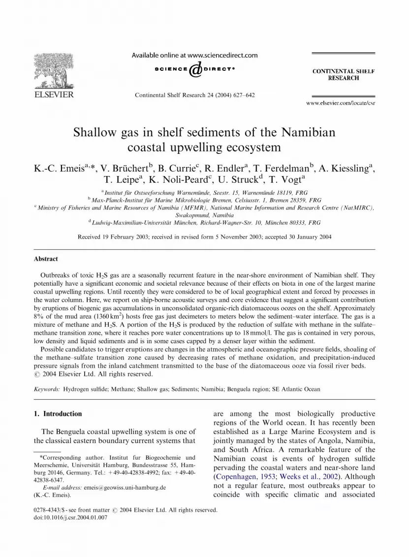
Fig. 1. Station map of F/S Meteor expedition 48-2 (August
2000) with track lines of PARASOUND surveys, and the extent
of diatomaceous mud on the shelf (modified from Bremner,
1983 and new data). Station numbers refer to locations
discussed in the text. Rectangles mark the PARASOUND
profile segments shown in Fig. 3.
K.-C. Emeis et al. / Continental Shelf Research 24 (2004) 627–642628
weather patterns in austral summer and have a—possibly spurious—correlation with inland rains(Reuning, 1925). The sulfide outbreaks are sus-pected to be a major and sometimes catastrophicinfluence on coastal and pelagic habitats in theshelf ecosystem (Copenhagen, 1953; Weeks et al.,2002). Geographical regions on the shelf with thehighest incidence of observed eruptions alsocoincide with nursery grounds of importantpelagic and demersal fish; in 1992/93 half of therecruit population of cape hake (two billionindividuals) was eradicated by anoxic conditions,possibly in connection to sulfide eruptions. Untilrecently, sulfide outbreaks have been attributedto processes in the water column (Bailey, 1991;Copenhagen, 1953).
Here we show that an alternative source ofH2S may be gas-laden sedimentary deposits onthe shelf. Sediments rich in opal and organiccarbon are deposited in a narrow belt on theinner shelf beneath the upwelling area off Nami-bia. Their distribution and facies are deter-mined by water depth, the current and waveenergy at the sea floor, biological productivity(both pelagic and benthic), terrigenous input, anddiagenesis (Bremner, 1983). Biogeochemical pro-cesses at the sediment–water interface are deter-mined by very high accumulation rates of organicmaterial which result in high oxygen consumptionrates and high sulfate reduction rates at the seafloor (Br .uchert et al., in press; Ferdelman et al.,1999). Based on results of an acoustic survey andcoring in August of 2000, we propose thateruptions of methane and H2S originating fromunconsolidated, gas-charged sediments are animportant source of H2S. This view is supportedby reports of ephemeral mud islands that havebeen sighted in the near-coastal zone in the years1900, 1959, and 2000.
2. Methods
All data were acquired during expedition R/VMETEOR 48-2 (5–23 August, 2000). Fig. 1 depictstrack lines, the extent of the diatomaceous mudaccording to PARASOUND, and stations forwater column and sediment work.
2.1. Acoustic surveys
Seafloor morphology, sediment distribution,and layering of sediments were investigated usingthe PARASOUND subbottom profiling system onR/V METEOR. Detailed technical descriptions ofthe acoustic systems are given in SpieX (1993).PARASOUND seismograms were digitized, pre-processed, printed and stored on hard disk in amodified SEG-Y-format using the ParadigmaSystem. A frequency of 4 kHz and a pulse lengthof two periods were used during the whole cruise.Additional measurements with different frequen-cies (2.5–5.5 kHz) and pulse lengths of 1–6 periodswere performed at coring stations in order to studythe influence of frequency and pulse length ofthe source signal on the reflection pattern. Theacoustic data were acquired in straight lines to getcross-sections of the sub-bottom structure.
ARTICLE IN PRESS
K.-C. Emeis et al. / Continental Shelf Research 24 (2004) 627–642 629
2.2. Water column work
CTD-profiles and water samples were obtainedduring the cruise with help of a completeSBE 911+(Sea-Bird Electronics Inc., USA) CTDsystem equipped with sensors for pressure, con-ductivity, temperature, oxygen, and a HAARDT-fluorometer for measuring chlorophyll andturbidity. The sensors were connected to a rosettewater sampler containing 12 5-l bottles (HYDRO-BIOS, Kiel, Germany).
Samples taken from bottom water were ana-lyzed for dissolved oxygen and hydrogen sulfide.Sample depths were selected at the oxygen minimaand/or turbidity maxima based on CTD profiles.Also analyzed were samples from the supernatantwater of multicores (see below). Samples wereimmediately fixed for oxygen content analysisaccording to the Winkler method, and for hydro-gen sulfide using 20% zinc acetate. Winklertitrations for oxygen used a visual endpointdetection (detection limit 0.07ml/l), sulfide wasdetermined by a spectrophotometric method(Cline, 1969); both were carried out on board.
2.3. Coring devices
Sediment samples were retrieved by multicorerand van-Veen grab sampler at 31 stations in theshelf area and on the upper continental slope offNamibia between 25�300S and 19�470S. At selectedstations, we also obtained long sediment coreswith a gravity corer (Table 1). For the sampling ofcomplete and undisturbed sediment surfaces andthe overlying bottom water, we used a multicorerequipped with 8 large tubes (10-cm outer, 9.6-cminner diameter) and 4 small tubes (8 cm, 7.6-cminner diameter) of 80-cm length.
2.4. Pore water analyses
Stations 226620, 226680, 226750, and 226840(close to 226750) were selected for detailed pore-water and gas profiling. Stations 226680 and226750 were selected based on PARASOUNDdepth profiles that indicated a shallow reflector at4–5-m sediment depth with a gas-rich zone below.By contrast, gas-rich zones were not indicated
by the PARASOUND at stations 226620 and226840.
The gravity cores were cut into 100 cm sectionson deck after core retrieval. Immediately after thesediment was cut, a 3 cm3 sediment plug was takenfrom the cut ends of the sections and added to 5mlof 2.5% NaOH in a serum vial. The vial wascapped with a butyl rubber stopper and sealedwith an aluminum crimp for immediate measure-ment of the CH4 concentration in the headspace.This procedure allowed, within minutes afterthe core came on deck, an approximate deter-mination in which section the sulfate–methanetransition zone was located. For detailed pro-filing, the cores were extruded with a whole corepiston and sampled every 10 cm to the sulfate-transition zone, then in 5-cm intervals across thetransition into the methanogenic zone which wasidentified by its porous texture. Below this depth,samples were taken every 15 cm to the bottom ofthe core.
Pore water was squeezed pneumatically underair at in situ temperatures through 0.4 mm nitrate-free Millipore cellulose acetate filters into 10-mlglass syringes taking care to avoid the develop-ment of air bubbles. A 1-ml sub-sample was fixedwith 300-ml 20% zinc acetate for the determinationof dissolved sulfate and sulfide.
Methane and dissolved sulfide were analyzed inthe ship laboratory. A 500- or 1000-ml sub-samplewas withdrawn from the headspace of the serumvial with a syringe and analyzed by an HP 5890gas chromatograph equipped with a flame ioniza-tion detector. Dissolved sulfide concentrationwas determined spectrophotometrically at a wave-length of 670 nm using the methylene blue method(Cline, 1969). After adequate dilution to achieveabsorptions in the linear range of this method,the zinc acetate-fixed pore-water was derivatizedwith phenylethylene diamine and kept for 3 h inthe dark before analysis. Concentrations weredetermined after daily calibration with ZnSsuspensions having concentrations of 2.65 and26.5 mmol/l.
In order to account for the possible loss ofsurface sediment during gravity coring, cores fromStations 226620, 226680, and 226750 weresqueezed in a glove bag, and also analyzed for
ARTICLE IN PRESS
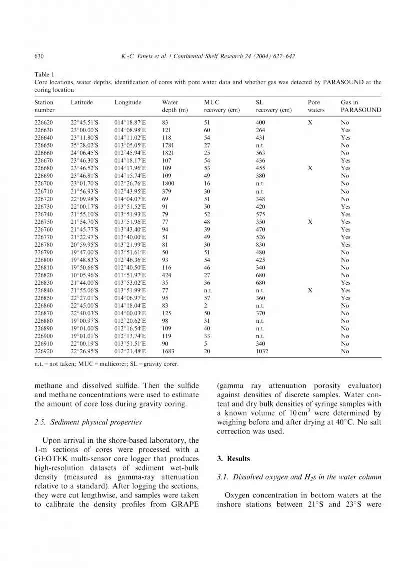
Table 1
Core locations, water depths, identification of cores with pore water data and whether gas was detected by PARASOUND at the
coring location
Station
number
Latitude Longitude Water
depth (m)
MUC
recovery (cm)
SL
recovery (cm)
Pore
waters
Gas in
PARASOUND
226620 22�45.510S 014�18.870E 83 51 400 X No
226630 23�00.000S 014�08.980E 121 60 264 Yes
226640 23�11.800S 014�11.020E 118 54 431 Yes
226650 25�28.020S 013�05.050E 1781 27 n.t. No
226660 24�06.450S 012�45.940E 1821 25 563 No
226670 23�46.300S 014�18.170E 107 54 436 Yes
226680 23�46.520S 014�17.960E 109 53 455 X Yes
226690 23�46.810S 014�15.740E 109 49 380 No
226700 23�01.700S 012�26.760E 1800 16 n.t. No
226710 21�56.930S 012�43.950E 379 30 n.t. No
226720 22�09.980S 014�04.070E 69 51 348 No
226730 22�00.170S 013�51.520E 91 50 420 Yes
226740 21�55.100S 013�51.930E 79 52 575 Yes
226750 21�54.700S 013�51.960E 77 48 350 X Yes
226760 21�45.770S 013�43.400E 94 39 470 Yes
226770 21�22.970S 013�40.000E 51 49 526 Yes
226780 20�59.950S 013�21.990E 81 30 830 Yes
226790 19�47.000S 012�51.610E 50 51 480 No
226800 19�48.830S 012�46.360E 93 54 425 No
226810 19�50.660S 012�40.500E 116 46 340 No
226820 10�05.960S 011�51.970E 424 27 680 No
226830 21�44.000S 013�53.020E 35 36 680 Yes
226840 21�55.060S 013�51.990E 77 n.t. n.t. X Yes
226850 22�27.010S 014�06.970E 95 57 360 Yes
226860 22�45.000S 014�18.040E 83 2 n.t. No
226870 22�40.030S 014�00.030E 125 50 370 No
226880 19�00.970S 012�20.620E 98 31 n.t. No
226890 19�01.000S 012�16.540E 109 40 n.t. No
226900 19�01.010S 012�13.740E 119 33 n.t. No
226910 22�00.190S 013�51.510E 90 5 340 No
226920 22�26.950S 012�21.480E 1683 20 1032 No
n.t.=not taken; MUC=multicorer; SL=gravity corer.
K.-C. Emeis et al. / Continental Shelf Research 24 (2004) 627–642630
methane and dissolved sulfide. Then the sulfideand methane concentrations were used to estimatethe amount of core loss during gravity coring.
2.5. Sediment physical properties
Upon arrival in the shore-based laboratory, the1-m sections of cores were processed with aGEOTEK multi-sensor core logger that produceshigh-resolution datasets of sediment wet-bulkdensity (measured as gamma-ray attenuationrelative to a standard). After logging the sections,they were cut lengthwise, and samples were takento calibrate the density profiles from GRAPE
(gamma ray attenuation porosity evaluator)against densities of discrete samples. Water con-tent and dry bulk densities of syringe samples witha known volume of 10 cm3 were determined byweighing before and after drying at 40�C. No saltcorrection was used.
3. Results
3.1. Dissolved oxygen and H2s in the water column
Oxygen concentration in bottom waters at theinshore stations between 21�S and 23�S were
ARTICLE IN PRESS
K.-C. Emeis et al. / Continental Shelf Research 24 (2004) 627–642 631
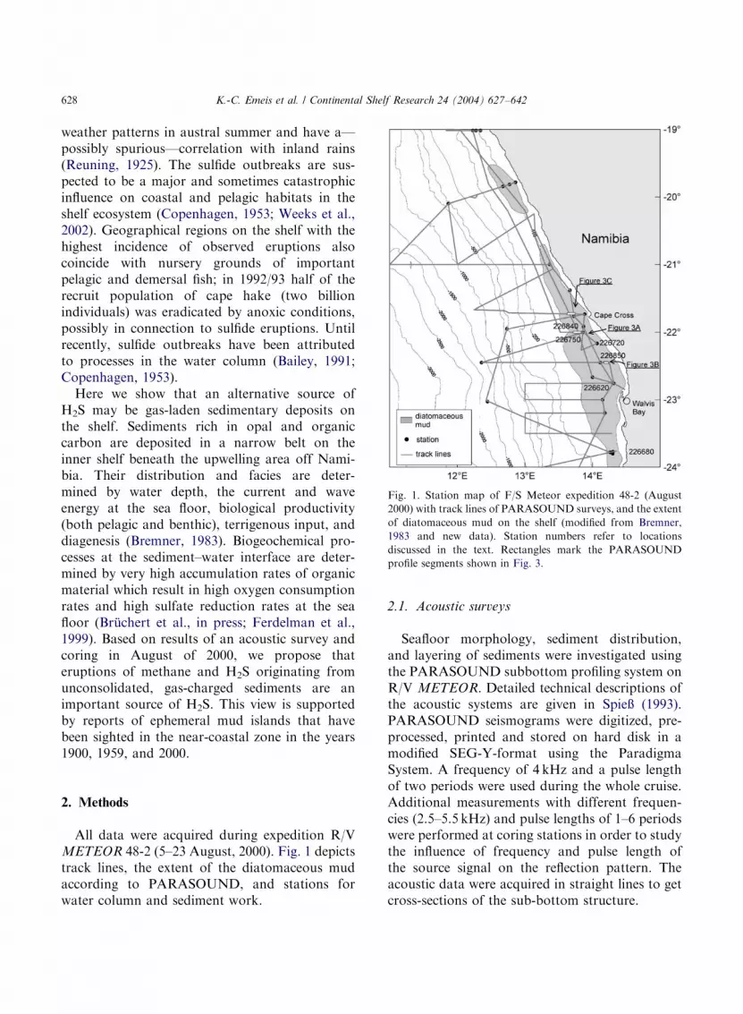
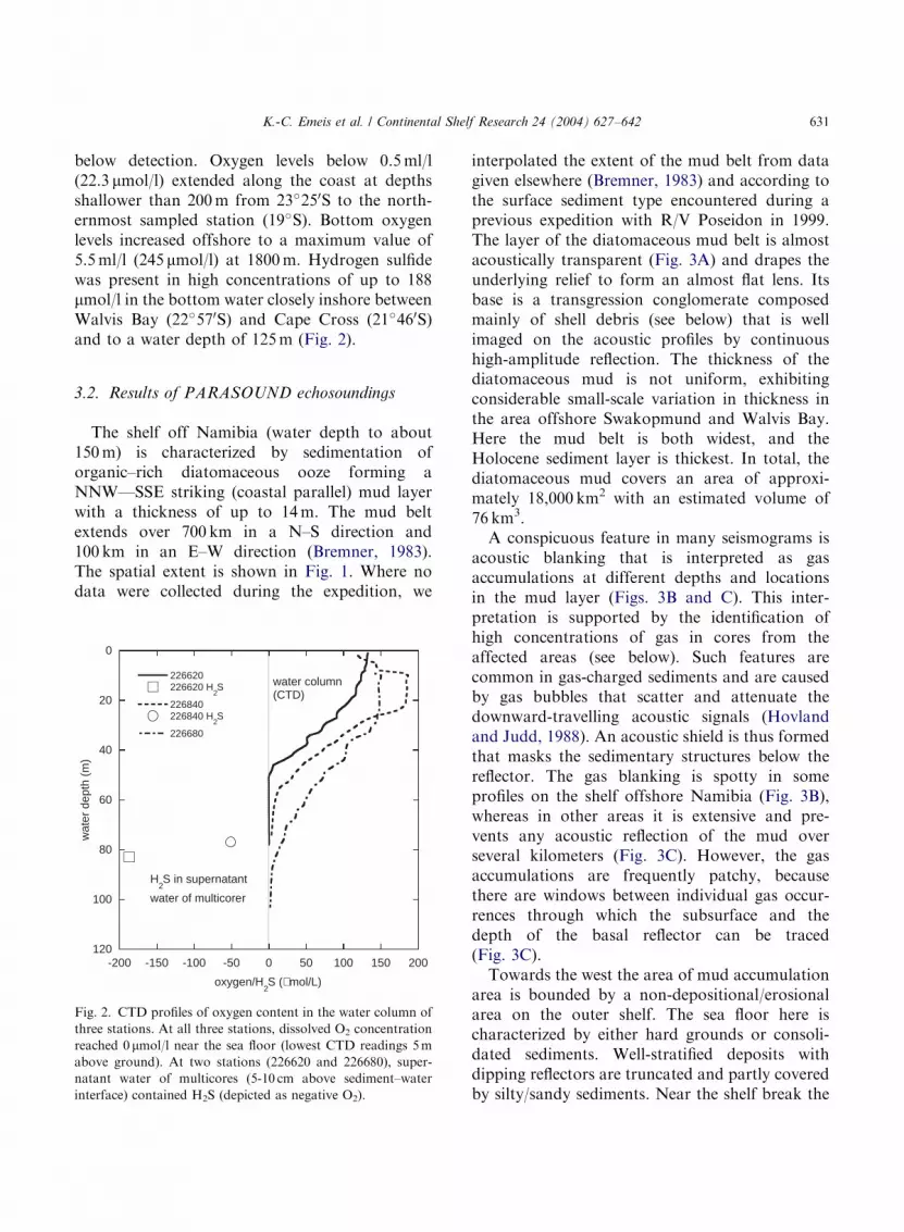
below detection. Oxygen levels below 0.5ml/l(22.3 mmol/l) extended along the coast at depthsshallower than 200m from 23�250S to the north-ernmost sampled station (19�S). Bottom oxygenlevels increased offshore to a maximum value of5.5ml/l (245 mmol/l) at 1800m. Hydrogen sulfidewas present in high concentrations of up to 188mmol/l in the bottom water closely inshore betweenWalvis Bay (22�570S) and Cape Cross (21�460S)and to a water depth of 125m (Fig. 2).
3.2. Results of PARASOUND echosoundings
The shelf off Namibia (water depth to about150m) is characterized by sedimentation oforganic–rich diatomaceous ooze forming aNNW—SSE striking (coastal parallel) mud layerwith a thickness of up to 14m. The mud beltextends over 700 km in a N–S direction and100 km in an E–W direction (Bremner, 1983).The spatial extent is shown in Fig. 1. Where nodata were collected during the expedition, we
-200 -150 -100 -50 0 50 100 150 200
0
20
40
60
80
100
120
226620226620 H
2S
226840226840 H
2S
226680
oxygen/H2S (µmol/L)
wat
er d
epth
(m
)
water column (CTD)
H2S in supernatant
water of multicorer
Fig. 2. CTD profiles of oxygen content in the water column of
three stations. At all three stations, dissolved O2 concentration
reached 0 mmol/l near the sea floor (lowest CTD readings 5m
above ground). At two stations (226620 and 226680), super-
natant water of multicores (5-10 cm above sediment–water
interface) contained H2S (depicted as negative O2).
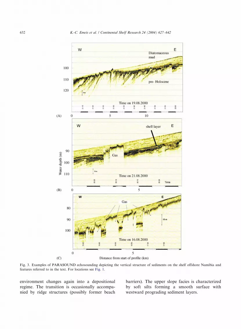
interpolated the extent of the mud belt from datagiven elsewhere (Bremner, 1983) and according tothe surface sediment type encountered during aprevious expedition with R/V Poseidon in 1999.The layer of the diatomaceous mud belt is almostacoustically transparent (Fig. 3A) and drapes theunderlying relief to form an almost flat lens. Itsbase is a transgression conglomerate composedmainly of shell debris (see below) that is wellimaged on the acoustic profiles by continuoushigh-amplitude reflection. The thickness of thediatomaceous mud is not uniform, exhibitingconsiderable small-scale variation in thickness inthe area offshore Swakopmund and Walvis Bay.Here the mud belt is both widest, and theHolocene sediment layer is thickest. In total, thediatomaceous mud covers an area of approxi-mately 18,000 km2 with an estimated volume of76 km3.
A conspicuous feature in many seismograms isacoustic blanking that is interpreted as gasaccumulations at different depths and locationsin the mud layer (Figs. 3B and C). This inter-pretation is supported by the identification ofhigh concentrations of gas in cores from theaffected areas (see below). Such features arecommon in gas-charged sediments and are causedby gas bubbles that scatter and attenuate thedownward-travelling acoustic signals (Hovlandand Judd, 1988). An acoustic shield is thus formedthat masks the sedimentary structures below thereflector. The gas blanking is spotty in someprofiles on the shelf offshore Namibia (Fig. 3B),whereas in other areas it is extensive and pre-vents any acoustic reflection of the mud overseveral kilometers (Fig. 3C). However, the gasaccumulations are frequently patchy, becausethere are windows between individual gas occur-rences through which the subsurface and thedepth of the basal reflector can be traced(Fig. 3C).
Towards the west the area of mud accumulationarea is bounded by a non-depositional/erosionalarea on the outer shelf. The sea floor here ischaracterized by either hard grounds or consoli-dated sediments. Well-stratified deposits withdipping reflectors are truncated and partly coveredby silty/sandy sediments. Near the shelf break the
ARTICLE IN PRESS
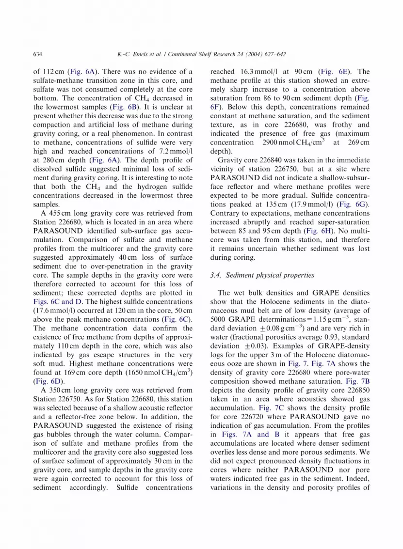
Fig. 3. Examples of PARASOUND echosounding depicting the vertical structure of sediments on the shelf offshore Namibia and
features referred to in the text. For locations see Fig. 1.
K.-C. Emeis et al. / Continental Shelf Research 24 (2004) 627–642632
environment changes again into a depositionalregime. The transition is occasionally accompa-nied by ridge structures (possibly former beach
barriers). The upper slope facies is characterizedby soft silts forming a smooth surface withwestward prograding sediment layers.
ARTICLE IN PRESS
Table 2
Statistical evaluation of diatomaceous mud belt area occupied
by gas charged sediments from PARASOUND
Area in Fig. Area (km2) Percentage in area of
K.-C. Emeis et al. / Continental Shelf Research 24 (2004) 627–642 633
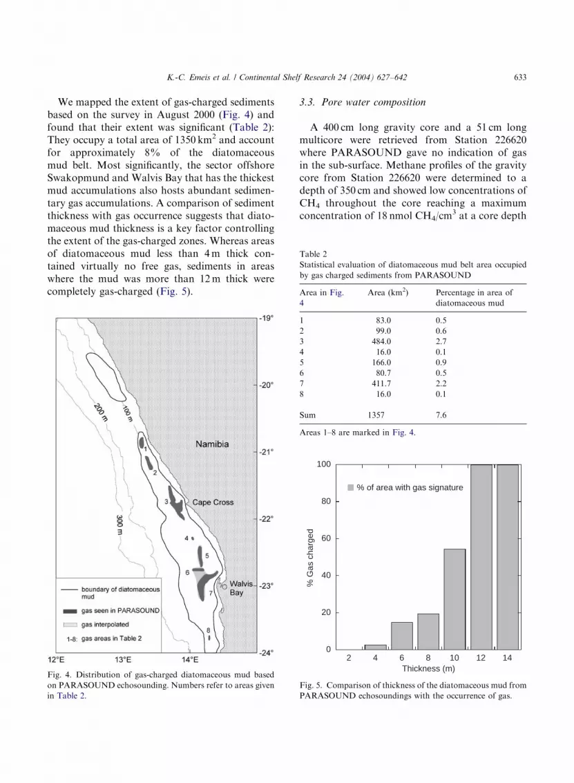
We mapped the extent of gas-charged sedimentsbased on the survey in August 2000 (Fig. 4) andfound that their extent was significant (Table 2):They occupy a total area of 1350 km2 and accountfor approximately 8% of the diatomaceousmud belt. Most significantly, the sector offshoreSwakopmund and Walvis Bay that has the thickestmud accumulations also hosts abundant sedimen-tary gas accumulations. A comparison of sedimentthickness with gas occurrence suggests that diato-maceous mud thickness is a key factor controllingthe extent of the gas-charged zones. Whereas areasof diatomaceous mud less than 4m thick con-tained virtually no free gas, sediments in areaswhere the mud was more than 12m thick werecompletely gas-charged (Fig. 5).
Fig. 4. Distribution of gas-charged diatomaceous mud based
on PARASOUND echosounding. Numbers refer to areas given
in Table 2.
3.3. Pore water composition
A 400 cm long gravity core and a 51 cm longmulticore were retrieved from Station 226620where PARASOUND gave no indication of gasin the sub-surface. Methane profiles of the gravitycore from Station 226620 were determined to adepth of 350 cm and showed low concentrations ofCH4 throughout the core reaching a maximumconcentration of 18 nmol CH4/cm
3 at a core depth
0
20
40
60
80
100
2 4 6 8 10 12 14
% G
as c
harg
ed
Thickness (m)
% of area with gas signature
Fig. 5. Comparison of thickness of the diatomaceous mud from
PARASOUND echosoundings with the occurrence of gas.
4 diatomaceous mud
1 83.0 0.5
2 99.0 0.6
3 484.0 2.7
4 16.0 0.1
5 166.0 0.9
6 80.7 0.5
7 411.7 2.2
8 16.0 0.1
Sum 1357 7.6
Areas 1–8 are marked in Fig. 4.
ARTICLE IN PRESS
K.-C. Emeis et al. / Continental Shelf Research 24 (2004) 627–642634
of 112 cm (Fig. 6A). There was no evidence of asulfate-methane transition zone in this core, andsulfate was not consumed completely at the corebottom. The concentration of CH4 decreased inthe lowermost samples (Fig. 6B). It is unclear atpresent whether this decrease was due to the strongcompaction and artificial loss of methane duringgravity coring, or a real phenomenon. In contrastto methane, concentrations of sulfide were veryhigh and reached concentrations of 7.2mmol/lat 280 cm depth (Fig. 6A). The depth profile ofdissolved sulfide suggested minimal loss of sedi-ment during gravity coring. It is interesting to notethat both the CH4 and the hydrogen sulfideconcentrations decreased in the lowermost threesamples.
A 455 cm long gravity core was retrieved fromStation 226680, which is located in an area wherePARASOUND identified sub-surface gas accu-mulation. Comparison of sulfate and methaneprofiles from the multicorer and the gravity coresuggested approximately 40 cm loss of surfacesediment due to over-penetration in the gravitycore. The sample depths in the gravity core weretherefore corrected to account for this loss ofsediment; these corrected depths are plotted inFigs. 6C and D. The highest sulfide concentrations(17.6mmol/l) occurred at 120 cm in the core, 50 cmabove the peak methane concentrations (Fig. 6C).The methane concentration data confirm theexistence of free methane from depths of approxi-mately 110 cm depth in the core, which was alsoindicated by gas escape structures in the verysoft mud. Highest methane concentrations werefound at 169 cm core depth (1650 nmolCH4/cm
3)(Fig. 6D).
A 350 cm long gravity core was retrieved fromStation 226750. As for Station 226680, this stationwas selected because of a shallow acoustic reflectorand a reflector-free zone below. In addition, thePARASOUND suggested the existence of risinggas bubbles through the water column. Compar-ison of sulfate and methane profiles from themulticorer and the gravity core also suggested lossof surface sediment of approximately 30 cm in thegravity core, and sample depths in the gravity corewere again corrected to account for this loss ofsediment accordingly. Sulfide concentrations
reached 16.3mmol/l at 90 cm (Fig. 6E). Themethane profile at this station showed an extre-mely sharp increase to a concentration abovesaturation from 86 to 90 cm sediment depth (Fig.6F). Below this depth, concentrations remainedconstant at methane saturation, and the sedimenttexture, as in core 226680, was frothy andindicated the presence of free gas (maximumconcentration 2900 nmolCH4/cm
3 at 269 cmdepth).
Gravity core 226840 was taken in the immediatevicinity of station 226750, but at a site wherePARASOUND did not indicate a shallow-subsur-face reflector and where methane profiles wereexpected to be more gradual. Sulfide concentra-tions peaked at 135 cm (17.9mmol/l) (Fig. 6G).Contrary to expectations, methane concentrationsincreased abruptly and reached super-saturationbetween 85 and 95 cm depth (Fig. 6H). No multi-core was taken from this station, and thereforeit remains uncertain whether sediment was lostduring coring.
3.4. Sediment physical properties
The wet bulk densities and GRAPE densitiesshow that the Holocene sediments in the diato-maceous mud belt are of low density (average of5000 GRAPE determinations=1.15 g cm�3, stan-dard deviation 70.08 g cm�3) and are very rich inwater (fractional porosities average 0.93, standarddeviation 70.03). Examples of GRAPE-densitylogs for the upper 3m of the Holocene diatomac-eous ooze are shown in Fig. 7. Fig. 7A shows thedensity of gravity core 226680 where pore-watercomposition showed methane saturation. Fig. 7Bdepicts the density profile of gravity core 226850taken in an area where acoustics showed gasaccumulation. Fig. 7C shows the density profilefor core 226720 where PARASOUND gave noindication of gas accumulation. From the profilesin Figs. 7A and B it appears that free gasaccumulations are located where denser sedimentoverlies less dense and more porous sediments. Wedid not expect pronounced density fluctuations incores where neither PARASOUND nor porewaters indicated free gas in the sediment. Indeed,variations in the density and porosity profiles of

ARTICLE IN PRESS
0 10 20
0
100
200
300
400
500
226840
Sulfide (mM)
dept
h (c
m)
1 100 10000
methane (nM cm-3)
0 10 20
0
50
100
150
200
250
300
350
400
226750
dept
h (c
m)
1 100 10000
0 10 20
0
100
200
300
400
500
226680
dept
h (c
m)
1 100 10000
0 10 20
0
50
100
150
200
250
300
350
226620
dept
h (c
m)
1 100 10000(A)
(C)
(E)
(G)
(B)
(D)
(F)
(H)
Fig. 6. Pore water profiles of sulfide and methane in 4 cores of the diatomaceous mud. Filled symbols denote samples from gravity
cores, circles denote samples from multicores. Note log scale in B, D, F, and H. See Table 1 and Fig. 1 for locations.
K.-C. Emeis et al. / Continental Shelf Research 24 (2004) 627–642 635

ARTICLE IN PRESS
1 1.1 1.2 1.3
0
50
100
150
200
250
300
dept
h in
cor
e (c
m)
core # 226680
1 1.1 1.2 1.3GRAPE density (g/cm3)
core # 226850
1 1.1 1.2 1.3
core # 226720
(A) (B) (C)
Fig. 7. Results of density measurements on whole cores (GRAPE) for core 226680 with methane supersaturation from pore water
analyses in interval underlain in gray (A), for core 226850 from an area where PARASOUND indicated free gas in the sub-surface in
the intervals underlain in gray (B), and for core 226720 where no gas was detected by PARASOUND.
K.-C. Emeis et al. / Continental Shelf Research 24 (2004) 627–642636
core 226720 are comparatively smaller (between1.1 and 1.2 g/cm3) than in the two other cores. Onthe other hand, cores 226850 and 226720 displayeddensity variations of the same magnitude as coresfrom locations with gas (data not shown), but thecoring locations had no gas signature in theacoustic survey.
To evaluate further the origin of denser sedi-ment layers, we analyzed a set of sample acrossthe dense sediment layer between 50 and 200 cmdepth in core 226680 (Fig. 7A), because wespeculated that the denser sediment layer withinthe mud might originate from diagenetic carbo-nate formation in association with methaneoxidation (Paull et al., 1992). This diageneticmineral formation thus may have created a caprock that might act as trap for gas. However, uponanalysis of several samples within, above, andbelow the denser layers with a scanning electronmicroscope equipped with an energy-dispersive X-ray detector, we found no evidence for carbonateformation, or any compositional differences ordifferences in mineral assemblages.
In conclusion, the results of investigations intosediment physical properties indicate that the wetbulk density of the diatomaceous mud is exceed-ingly low. Contrary to our expectations, we foundno systematic change in sediment density asso-ciated with observed or inferred upper limits offree gas.
4. Discussion
Seasonal occurrence of H2S-rich waters andassociated fish kills and lobster walk-outs are partof the folk lore in the area of Swakopmund andWalvis Bay (Copenhagen, 1953). They typicallyoccur during austral summer (November toMarch) and are characterized by localized dis-colorations of the sea surface (turquoise to khaki-green), intensive smell of H2S. Sulfide outbreaksare suspected to be a major influence on coastaland pelagic habitats in the shelf ecosystem,because H2S is a potent respiratory toxin (Baileyet al., 1985; Classen, 1930; Copenhagen, 1953).

ARTICLE IN PRESS
K.-C. Emeis et al. / Continental Shelf Research 24 (2004) 627–642 637
Geographical regions on the shelf with the highestincidence of observed eruptions coincide withnursery grounds of important pelagic and demer-sal fish; in 1992/1993 half of the recruit populationof cape hake (two billion individuals) may havebeen eradicated by anoxic conditions, possibly inconnection to sulfide eruptions (Hamakuya et al.,1998; Weeks et al., 2002).
The discussion focuses on two issues. First is theorigin of hydrogen sulfide and methane gas in lightof our new findings, where we dispute thetraditional explanation of anoxia and H2S erup-tions over the shelf offshore Namibia. Second isthe question of what external or internal triggermay cause gas eruptions from sediments.
4.1. Origin of gas: water column versus sediment
The eruption intensity and frequency appears tovary between years, and are regionally focusedover the wide shelf offshore of Walvis Bay andSwakopmund. According to a recently initiatedobservation program by NATMIRC, eruptionsoccur most frequently after inland rains, a featurethat will be discussed later. The original and stillcommonly accepted scientific hypothesis is thatthese events are due to H2S generation in waterover the shelf. This was (to our knowledge) firstformulated by Copenhagen (1953) and laterrefined by Hart and Currie (1960) and Bailey(1991). This hypothesis attributes anoxia and H2Sliberation to an interplay between regional-scalemeteorological processes associated with the tradewind system, changes in the water mass structureover the shelf, and biological processes.
4.2. The oceanographic/biological hypothesis
The high biological productivity in the euphoticzone overlying the shelf off Namibia (SteemanNielsen and Jensen, 1957) results in high oxygenconsumption rates in waters below the thermoclineand at the sea floor. Three hydrographic featuresof this upwelling system are important with respectto the oxygen supply for shelf water: The first isthe poleward undercurrent that compensates thenorthward component of the Ekman transport. Itis fed by South Atlantic Central Water (SACW)
originating in the area of the Angola Dome—anoceanic area with old and oxygen-depleted waters(Chapman and Shannon, 1987)—and arrives off-shore Namibia with oxygen concentrations wellbelow 90 mM. The second feature is landwardadvection of Eastern South Atlantic Central Water(ESACW) in a deep compensation current balan-cing the offshore Ekman transport. This watermass typically has oxygen concentrations of178 mmol/l and originates in the source region ofthe Benguela Current near the Cape of GoodHope. It is transported northwards along theupper slope at water depths of o400m. Advectionof this water mass onto the shelf as an onshorecompensation current below the thermocline isforced by the offshore component of the Ekmantransport. A third water mass which has consider-able effects on the phenomena described here iswarm tropical surface water normally found northof the Angola–Benguela Front, usually situatednear 17�S. Under specific conditions—outlinedbelow—it is advected southward along the coastto the area off Walvis Bay (and sometimes evenfurther south).
Decreases in trade wind intensity disrupt theoxygen balance over the shelf by altering currents.The cross-shelf compensation current of ESACWreacts instantaneously to changing trade-windintensity and is immediately interrupted when thetrade winds stop. In other words, the mostimportant oxygen source for waters overlying theshelf is directly coupled to fluctuations in thecoast-parallel component of the wind field. Onlythe poleward undercurrent, which has a longerresponse time, remains to counteract oxygenconsumption in the water column and thesediment. However, this water mass is alreadydepleted in oxygen. In addition, oxygen consump-tion may be enhanced, because stabilization of thewater column and stratification after weakening ofthe upwelling promote plankton blooms over theshelf (Bailey, 1991). Oxygen levels over the shelfcan only increase after the trade winds resume,turning on the cross-shelf ‘‘conveyer’’ of oxygenand at the same time force H2S-laden waters toupwell.
Characteristic features of eruptions caused bythis process thus should be linked to lessening
ARTICLE IN PRESS
K.-C. Emeis et al. / Continental Shelf Research 24 (2004) 627–642638
trade wind intensity, with a characteristic time lagof approximately one week between relaxation ofwind intensity and the development of anoxia inshelf bottom waters. After renewed trade windactivity, H2S-laden surface waters should berelatively cold (SACW type), and should occurover spatial scales on the order of tens ofkilometers.
Several eruption features cannot be explained bythis mechanism. One key phenomenon in thecontext of H2S eruptions that previously has notbeen adequately credited is the occasional emer-gence of ephemeral mud islands and sea moundsoffshore Pelican Point in the years 1884 (report ofanomalous sea floor sounding published in theSouth African Pilot, No. 2 of 1884, pages 208–210),1900, 1959 and 2000 (Waldron, 1901). The onlydocumentation and scientific account available tous is by Waldron (1901): In June of 1900 an island(50m long, 10m wide and 5m high) composed ofunconsolidated diatomaceous ooze was observedin waters 15m deep offshore Pelican Point(22�530S/014�260E). ‘‘A very strong odour ofsulfuretted hydrogen pervaded the spot and steamappeared to issue from the northern end of themass’’, ‘‘ythe smell from the island was noticed atSwakopmund, a distance of 25 miles from WalvisBay’’ and ‘‘ydirty appearance of the water withbubbles on the surfacey’’ (Waldron, 1901). Abrave-hearted lieutenant, who swam to the island,reported that the water around it was very cold.The island had disappeared entirely by June 7 of1900. The phenomenon requires mud outflow oreruption at the sea floor, driven by processesbeneath the sediment–water interface. The phe-nomenon differs from mud diapirs known fromother submarine settings (Hovland and Curzi,1989; Hovland and Judd, 1988) in that the upliftedmaterial was the very young diatomaceous mud ofHolocene age that is not tectonically or gravita-tionally overpressured.
An additional fact that is difficult to reconcile withthe oceanographic hypothesis is the initially smalldimension (less than 1km diameter) of discretesurface sea water discolorations by elemental sulfurparticles (Weeks et al., 2002). This observationargues for an initially localized source of eitherelemental sulfur or H2S, which is then oxidized.
4.3. The methane eruption hypothesis
Our alternative and preferred hypothesis pro-poses that gas accumulates in the pore space ofdiatomaceous mud and erupts under specificconditions to deliver a mixture of methane andH2S to the water and to the atmosphere. Thegeological and geochemical results presentedsuggest that gas-charged sediments occur mostfrequently in areas with the highest sedimentaccumulation rates with the thick layer of diato-maceous mud offshore Walvis Bay and Swakop-mund having the largest accumulations. At highsedimentation rates, the sulfate gradients into thesediments are steep so that the zone of methaneproduction is situated close to the sediment–waterinterface (Berner, 1980). The acoustic and porewater studies indicate that free gas is present in thepore space of the unconsolidated diatomaceousmud, which has low bulk density and low shearstrength. These initial gas accumulations arecomposed predominantly of methane producedduring late stages of anaerobic microbial degrada-tion of organic matter (Claypool and Kvenvolden,1983). H2S, the product of bacterial reduction ofsulfate, is also present in the gas phase. Theformation of gas-filled voids decreases the densityof lower sediment layers and creates buoyancy. Ifthe gas-filled sediment behaved like a liquid, adensity inversion caused by the buoyancy of freegas would cause the sediment to be mobilized.While the shear strength of the diatomaceous mudcounteracts mobilization, increased pore fluidpressure decreases the shear strength. However,the observed eruptions have a seasonal patternand, to our knowledge, do not occur in therandom manner expected from gas-driven sedi-ment overturning.
4.4. Possible causes for eruptions
What causes the eruptions to occur at a specifictime of year with considerable inter-annual differ-ences in eruption intensity? It is clear that thetrigger for eruptions should affect the balance ofoverburden pressure, sediment shear strength, andinternal gas pressure or gravitational instability.The gas is confined either by denser layers in the
ARTICLE IN PRESS
K.-C. Emeis et al. / Continental Shelf Research 24 (2004) 627–642 639
sediments (cap ‘‘rocks’’), or merely by the coupledeffects of overburden pressure and shear strength.However, there are numerous possible externalinfluences on the pressure balance, and internalmicrobiological processes may also play a role. Inthe following, we review the most likely candi-dates: (1) the trade-wind system and its effects onthe coupled hydrographic and biological condi-tions in the water column and (2) influences ofweather patterns that are connected to low trade-wind phases. Finally, we speculate on the possiblerole of microbial processes in the sediment. Ourevidence at this point is far from conclusive andthese influences are at the moment based onconjecture.
4.5. Climatic/oceanographic control
Wind stress is seasonal in the northern Benguelaregion and imposes considerable seasonality onupwelling and biological production. In additionto seasonal variations, interannual variations areimparted to the coastal upwelling system bychanges in trade-wind intensity (Shannon andNelson, 1996). They arise from variations of theSt Helena anti-cyclone and cause variations intrade wind intensity, which in turn acts on theequatorial current system and the BenguelaCurrent (Hagen et al., 2001). The westwardequatorial trade winds tend to drive warm surfacewaters towards the western tropical Atlantic. Thewestward transport is balanced by eastwardcounter-currents that feed water into the Gulf ofGuinea. The majority of this water is deflectedsouthward by the African coast and is entrainedinto the permanent poleward undercurrent thatcompensates the eastern boundary current. Thetropical and eastern boundary current watermasses meet at the Angola–Benguela Front thatis usually located between 14�S and 17�S (Meeu-wis and Lutjeharms, 1990; Shannon and Nelson,1996).
During years with weak SE trade wind intensitythe Intertropical Convergence Zone is displacedsouthwards, and an equatorial Kelvin wave trans-ports warm, saline waters from the westerntropical Atlantic to the Gulf of Guinea. Thisanalogue to the El Ni $no in the Pacific (Shannon
et al., 1986) are called Benguela Ni $no and haveapproximately the same temporal recurrence astheir Pacific counterpart. This warm surface wateris deflected southwards by the African Coast,penetrates the Angola–Benguela Front with warmsurface water masses along the coast and reachesas far South as 25�S, causing positive sea-levelchanges of up to 5 cm at Walvis Bay (Shannon andNelson, 1996).
In the northern sector of the coastal upwellingsystem (17�300 S to 25�S, approximately 15–30 kmwide and characterized by SST of 14�C) the inflowof warm waters raises SST by 2�C to 8�C(Shannon and Nelson, 1996). The increased SSTcauses increased evaporation and atmosphericconvection: small atmospheric cyclones mark thetrack of the warm water and lead to increasedprecipitation on land. The biological consequenceof inhibited upwelling is a drastic decrease inphytoplankton productivity, lasting no more than10 days. The immediate effects of the BenguelaNi $nos on the pressure at the sediment–waterinterface thus are the sum of (decreased) atmo-spheric pressure and a 5-cm increase in sea level.The resulting combined effect is negligible con-sidering that eruptions may occur in 100m waterdepth. In addition, this effect is counteracted by adecreased flux of organic matter to the sediment,which would tend to reduce oxygen consumptionat the sediment surface.
Ongoing in situ measurements with a mooringon the shelf 5 km offshore from Swakopmund(position22�41.050S and 14�28.460E in 30m waterdepth) also discount increases in water tempera-ture as a likely cause for eruptions. Such increaseswould possibly propagate into the sediment andexpand the gas volume. Situated in the immediatevicinity of an eruption that occurred offshoreSwakopmund on February 15, 2001, the sensor at25-m water depth did not register a change inwater temperature—it remained at 13.2–13.4�Cin the entire period from February 9–16, 2001.(The recorded data is held in the environmentaldatabase of the Ministry of Fisheries and MarineResources, Namibia.) In contrast, historical re-ports suggest that the waters around the mudislands were generally colder than normal duringevents (Copenhagen, 1953).
ARTICLE IN PRESS
K.-C. Emeis et al. / Continental Shelf Research 24 (2004) 627–642640
Waves and swells have significantly morepotential to change the pressure on the sediment:Swell height from southwesterly to westerly direc-tions typically is between 1 and 3m and wavelength is of the order of 150m (Wannasurf, 2001);it thus has the potential to reach sea floorshallower than 75m water depth. However, insome locations around Swakopmund such condi-tions are found for >150 days per year and thuswould not explain the observed seasonality ineruptions.
Since oceanographic explanations are lacking,we turn to two processes that may indirectlychange the pressure balance in the sediment.
4.6. Biological control
Aside from physical processes, two specificbiological processes are very important to thecontrol the hydrogen sulfide concentrations insediment pore waters and the water column: (1)The production of hydrogen sulfide in the sedi-ments by sulfate-reducing bacteria; (2) The con-sumption of hydrogen sulfide at the sediment/water interface and in the water column by sulfide-oxidizing organisms. A recent study of sulfatereduction and sulfide oxidation on the Namibianshelf and slope established that hydrogen sulfideproduction in the top 10 cm of sediment issufficient to account for the hydrogen sulfide fluxacross the sediment–water interface (Br .uchertet al., 2003). The gradient of hydrogen sulfide ismaintained by high sulfate reduction rates, whichare sustained by the high accumulation rates oforganic matter on the shelf. Because the diatomac-eous mud contains little reactive iron to precipitatehydrogen sulfide, the sediment is quickly saturatedwith respect to hydrogen sulfide and concentra-tions of sulfide steadily increase with depth untilall sulfate is consumed. Although a slow bacterialprocess, anaerobic oxidation of methane withsulfate converts all remaining sulfate to hydrogensulfide and thus is the largest contributor to thepore water pool of hydrogen sulfide. Undernormal circumstances, the anaerobic oxidation ofmethane by sulfate in the Namibian shelf sedi-ments removes more than 99% of the methanediffusing upwards. In areas with free gas, the
sulfate-methane transition usually occurs 1mbelow the sediment surface. This ‘‘biological filter’’may fail if the rate of upward methane transportor the production rate exceed the rate of methaneoxidation.
Consumption of hydrogen sulfide in the Nami-bian shelf sediments is mediated by the largesulfur- and nitrate-storing sulfur bacteria Thio-
margarita namibiensis, Thioploca spp., and Beggia-
toa spp. (Schulz et al., 1999). The distribution ofThiomargarita is linked to the presence of free gasin the sediment (Vogt, 2002). Since Thiomargarita
is not motile, a regular recharge of its intracellularnitrate stock requires that the bacterium ispassively moved to environments where nitrate isabundant. Sedimentary gas eruptions would pro-vide a transport mechanism, and may explain thespatial coincidence of observed eruptions andbacterial populations (Vogt, 2002). Thiomargarita
has been estimated to account for as much as 55%of the total sulfide oxidation (Br .uchert et al.,2003), which emphasizes their important ecologi-cal role. Only Thiomargarita appears to tolerateenvironments with high concentrations of hydro-gen sulfide. The possible feed-back mechanismsfrom this sulfide-oxidizing consortium to themethane-oxidizing consortia that may influencerates of methane oxidation and pore watergradients are unknown. Whereas it is entirelypossible that the bacterial assemblage benefits onlypassively from the eruptions without having anactive role in triggering them, any change in therates of methane production and oxidation bymicrobial consortia would affect the methanegradient and potentially cause eruptions.
4.7. Climatic control, II
A final hypothesis links gas eruptions to inlandrains, which according to observations invariablyaccompany phases of H2S outbreaks. The near-coastal low-pressure troughs linked to the ingres-sions of warm, tropical water masses bringlocalized rains to parts of the Namibian coastand inland mountains. Precipitation (up to 60mm/day) is collected and channelled into wadis thateither discharge into the ocean, or disappear underthe famous sand dunes of the Great Namib Desert
ARTICLE IN PRESS
K.-C. Emeis et al. / Continental Shelf Research 24 (2004) 627–642 641
(Christelis and Struckmeier, 2001). One of these isthe Kuiseb River that disappears in the highlyporous dune sands inland close to Walvis Baybefore reaching the sea. River beds were incised onthe shelf during the last glaciation; today, thesedrowned valleys are filled with alluvial sedimentsand are extensively mined for diamonds in south-ern Namibia. We hypothesize that such river bedsfilled with highly porous sands and gravel depositsalso underlie the Holocene diatomaceous muds inthe area offshore Swakopmund and Walvis Bay.Near coastal and submarine freshwater dischargesare a common feature of the coast near Walvis Bay(Reuning, 1925). We postulate that aquifers at thebase of the diatomaceous mud may transmit ahydraulic pressure signal of rising water tables inthe aquifers to the base of the mud, triggeringeruptions of barely contained sedimentary gasaccumulations.
5. Conclusions
Outbreaks of toxic H2S gas are a seasonally(austral summer) recurrent feature in the near-coastal shelf environment offshore Namibia. Theyhave a significant economic and societal relevancebecause of their effects on biota in one of thelargest marine coastal upwelling regions (fisheriesbeing the third largest source of revenue forNamibia). Until recently they were considered tobe of local geographical extent and forced by acombination of high biological productivity incombination with reduced advection of oxyge-nated ocean water. Ship-borne acoustic surveys in2000 suggest a significant contribution by erup-tions of biogenic gas (methane and H2S) from thesea floor: An area of approximately 1500 km2 ofunconsolidated organic-rich diatomaceous oozeon the shelf is gas-charged to within 100 cm belowthe sediment–water interface. The sedimentary gasaccumulations contain a highly toxic mixture ofmethane and H2S and eruptions of that gas may bea reason for large-scale fish kills known from thearea. As yet the triggering mechanisms have notbeen identified, but processes that may be respon-sible include mud diapirism forced by buoyancy,increases in pore pressure by submarine freshwater
discharge, changes in the rate of microbialmethane oxidation, or changes in the watercolumn pressure at the sea floor.
Acknowledgements
We thank captain and crew of F/S METEOR
for an enjoyable time offshore Namibia and theNamibian authorities and NATMIRC for excel-lent co-operation. Helpful reviews by L.I. Dimi-trov, A.D. Judd, K.A. Kvenvolden, and I. Leiferare gratefully acknowledged. Funding was ob-tained from the German Research Foundationunder Grants EM37-10/1, EM37-16/1, and EM37-17/1 to the senior author.
References
Bailey, G.W., 1991. Organic carbon flux and development of
oxygen deficiency on the modern Benguela continental shelf
south of 22�S: spatial and temporal variability. In: Tyson,
R.V., Pearson, T.H. (Eds.), Modern and Ancient Con-
tinental Shelf Anoxia. The Geological Society, London,
pp. 171–183.
Bailey, G.W., De Beyers, C.J., Lipschitz, S.R., 1985. Seasonal
variation of oxygen deficiency in waters off southern South
West Africa in 1975 and 1976 and its relation to the
catchability and distribution of the Cape rock lobster
Jasus lalandii. South African Journal of marine Science 3,
197–214.
Berner, R.A., 1980. Early Diagenesis: A Theoretical Approach.
Princeton University Press, Princeton, NJ, 241pp.
Bremner, J.M., 1983. Biogenic sediments on the SW African
(Namibian) continental margin. In: Thiede, J., Suess, E.
(Eds.), Coastal Upwelling: Its Sediment Record. Part B:
Sedimentary Records of Ancient Coastal Upwelling.
Plenum Press, New York, pp. 610.
Br .uchert, V., J^rgensen, B.B., Neumann, K., Riechmann, D.,
Schl .osser, M., Schulz, H., 2003. Regulation of bacterial
sulfate reduction and hydrogen sulfide fluxes in the central
Namibian coastal upwelling zone. Geochim. Cosmochim.
Acta 67, 4505–4518.
Chapman, P., Shannon, L., 1987. Seasonality in the oxygen
minimum layers at the extremities of the Benguela system.
South African Journal of Marine Science 5, 11–34.
Christelis, G., Struckmeier, W., 2001. Groundwater in Nami-
bia—An Explanation to the Hydrogeological Map. John
Meinert Printing, Windhoek, 128pp.
Classen, T., 1930. Periodisches Fischsterben in Walvis Bay,
South West Africa. Palaebiologica 111, 13.
ARTICLE IN PRESS
K.-C. Emeis et al. / Continental Shelf Research 24 (2004) 627–642642
Claypool, G.E., Kvenvolden, K.A., 1983. Methane and other
hydrocarbon gases in marine sediment. Annual Review of
Earth and Planetary Sciences 11, 299–327.
Cline, J.D., 1969. Spectrophotometric determination of hydro-
gen sulfide in natural waters. Limnology and Oceanography
14, 454–458.
Copenhagen, W.J., 1953. The periodic mortality of fish in the
Walvis region—a phenomenon within the Benguela Cur-
rent. Investigational Report Division of Fisheries-Union of
South Africa 14, 1–35.
Ferdelman, T.G., Fossing, H., Neumann, K., 1999. Sulfate
reduction in surface sediments of the southeast Atlantic
continental margin between 15�380S and 27�570S (Angola
and Namibia). Limnology and Oceanography 44 (3),
650–661.
Hagen, E., Feistel, R., Agenbag, J.J., Ohde, T., 2001. Seasonal
and interannual changes in intense Benguela upwelling
(1982–1999). Oceanologica Acta 24 (6), 557–568.
Hamakuya, H., O’Toole, M., Woodhead, P.M.J., 1998.
Observations of severe hypoxia and offshore displacement
of Cape Hake over the Namibian shelf in 1994. In: Benguela
dynamics: Impacts of Variability on Shelf-sea Environments
and Their Living Resources. South Afrircan Journal of
marine Science, 19, 41–57.
Hart, T.J., Currie, R.I., 1960. The Benguela Current. Discovery
Reports XXXI, 123–298.
Hovland, M., Curzi, P., 1989. Gas seepage and assumed mud
diapirism in the Italian central Adriatic Sea. Marine and
Petroleum Geology 6, 161–169.
Hovland, M., Judd, A.G., 1988. Seabed Pockmarks and
Seepages. Graham and Trotman, London, 293pp.
Meeuwis, J.M., Lutjeharms, J.R.E., 1990. Surface thermal
characteristics of the Angola Benguela Front. South African
Journal of Marine Science 9, 261–279.
Paull, C.K., et al., 1992. Indicators of methane-derived
carbonates and chemosynthetic organic carbon deposits:
examples from the Florida Escarpment. Palaios 7, 361–375.
Reuning, E., 1925. Gediegen Schwefel in der K .ustenzone
S .udwestafrikas. Centralblatt f .ur Mineralogie A (3), 86–94.
Schulz, H.N., et al., 1999. Dense populations of a giant
sulfur bacterium in Nambian shelf sediments. Science 284,
493–495.
Shannon, L.V., Boyd, A.J., Brundrit, G.B., Taunton-Clark, J.,
1986. On the existence of an El Nino type phenomenon
in the Benguela system. Journal of Marine Research 44,
495–520.
Shannon, L.V., Nelson, G., 1996. The Benguela: large-scale
features and processes and system variability. In: Wefer, G.,
Berger, W.H., Siedler, G., Webb, D.J. (Eds.), The South
Atlantic: Present and Past Circulation. Springer, Berlin,
pp. 163–210.
SpieX, V., 1993. Digitale Sedimentechographie—Neue Wege zu
einer hochaufl.osenden Akustostratigrafie., Ber. FB Geowis-
senschaften Bremen, 35, Bremen.
Steeman Nielsen, E., Jensen, E.A., 1957. Primary oceanic
production. The autotrophic production of organic matter
in the oceans. Galathea Reports 1, 49–136.
Vogt, T., 2002. Akustische Fazies auf dem Schelf und oberen
Kontinentalrand vor Nambia—Auswertung von PARA-
SOUND-Ergebnissen der Reise METEOR 48-2. M.Sc.
Thesis, University of Greifswald, Greifswald, 80pp.
Waldron, F.W., 1901. On the appearance and disappearance of
a mud island at Walvis Bay. Transactions of the South
African Philosophical Society XI, 185–188.
Wannasurf, 2001. http://www.wannasurf.com/spot/Africa/
Namibia/cape cross/index.html.
Weeks, S., Currie, B., Bakun, A., 2002. Massive emissions of
toxic gas in the Atlantic. Nature 415, 493–494.