shaddix & associates - court reporters (952)888-7687
TRANSCRIPT
Shaddix & Associates - Court Reporters(952)888-7687 - 1(800)952-0163 - [email protected]
50
1
2
3
4
5
6
7
8
9
10
11
12
13
14
15
MS. SARAH HARPER: Okay. Hello, my
16 name is Sarah Harper. That is S-A-R-A-H,
17 H-A-R-P-E-R.
18 I would first like to thank you for
19 allowing me to comment today. The pipeline and the
20 considerations being made for its proposed
21 construction are a big deal to me. I spend every
22 summer up north at my family farm, enjoying the
23 spectacular lakes our state has to offer. And I
24 would love to share these traditions with others.
25 But with the new Line 3 breathing through regulatory
1535
Shaddix & Associates - Court Reporters(952)888-7687 - 1(800)952-0163 - [email protected]
51
1 approval and our bordering states and Canada, I'm
2 worried this may not be possible.
3 The current state of this DEIS
4 reflects what will be taken into account for
5 something far less potentially detrimental to our
6 state, priceless land, lakes, rivers, and wetlands.
7 It is clearly rushed and inconsistent.
8 As previously mentioned, the
9 possibility of permanently decommissioning Line 3
10 for good with no alternative was not considered in
11 any of the sections. This is a huge problem. The
12 false trichotomy of either relying on the old Line
13 3, building a new one, or implementing
14 poorly-thought-out and even infeasible
15 alternatives,indicates an unmistakable preference
16 for Enbridge's profitability over any other concern.
17 I would hope that all the decision
18 makers know that there is an option to shut down
19 Line 3 entirely by gradually diminishing the use of
20 economically, ill-advised tar sands oil. But they
21 won't know what benefits or downsize there are to
22 this unmeasured alternative if it isn't analyzed
23 sufficiently or at all. Lately this dirty oil is
24 about as difficult to make a profit off of as it is
25 to clean up, and much of it is selling at a loss.
1535
Shaddix & Associates - Court Reporters(952)888-7687 - 1(800)952-0163 - [email protected]
52
1 It is stated in Section 3.1.1C that
2 the Commission must determine whether or not the
3 consequences to society of granting a certificate
4 are more favorable than the consequences of denying
5 it. And how can they accurately decide without
6 being given the full range of options?
7 I see that in Section 4.2.2 it states
8 that the Applicant should reasonably be expected to
9 meet shipper demand through other means, but I don't
10 see any comprehensive analysis of projected demand
11 relating specifically to this project.
12 The scoping document promised much
13 more. In fact, what I do see in Section 5.2.7.3
14 regarding overall energy consumption in the U.S.
15 remaining relatively flat through 2040 would lead me
16 to believe that upping the capacity is not a
17 critical need. If this is the case, how do we know
18 if it even is necessary to approve Line 3, which
19 will be the largest project in Enbridge history?
20 It also states in this section that
21 approval or denial of any one crude oil transfer
22 project is unlikely to significantly impact the rate
23 of extraction in the oil sands. This is
24 inconsistent with what the executive summary says,
25 which is that the project will have an increase in
1535-1
1535
Shaddix & Associates - Court Reporters(952)888-7687 - 1(800)952-0163 - [email protected]
53
1 extraction over what would have occurred if demand
2 was met instead with light crude oil. This is
3 misleading and --
4 FACILITATOR: Thank you.
5 MS. SARAH HARPER: -- makes me wonder
6 how carefully this document was put together.
7
8
9
10
11
12
13
14
15
16
17
18
19
20
21
22
23
24
25
1535-1Cont'd
1535
1
Levi, Andrew (COMM)
From: Patricia Hauser <[email protected]>Sent: Monday, July 10, 2017 3:09 AMTo: MN_COMM_Pipeline CommentsSubject: Docket numbers CN-14-916 and PPL 15-137 Re: DEIS proposed ENBRIDGE Line 3
Dear Jamie MacAlister, Environmental Review Manager, I am writing to comment on and ask questions regarding the draft Environmental Impact Statement for Enbridge’s proposed Line 3 Project, docket numbers CN-14-916 and PPL 15-137. I was born in and grew up in Winona, MN which is on the Mississippi River. I have an MS degree. As a life long resident of Minnesota I have enjoyed the beauty of Minnesota’s rivers, lakes, and streams since the 1950s when I was a child. I have swam, fished, canoed, and boated in these precious waters. For years I’ve been going to my friend’s cabin on Lake Superior. She and her (now adult) children still swim in the Lake Superior. In addition to the water recreation, my family, friends, and I have all enjoyed the food these waters have provided…from the delicious variety of fish to the unique wild rice! Minnesota’s lakes, rivers, streams are each such invaluable and irreplaceable resources! i’ve been learning about oil pipelines for about 10 years. I’ve heard many talks on oil pipeline, one being a talk given by the League of Women voters on Enbridge oil pipelines in particular. I’ve attended oil pipeline meetings, I’ve read about pipelines, and I have personal friends that follow pipeline happenings. Regarding the Draft Environmental Impact Statement (EIS) for the proposed Line 3 Project...It is flawed and needs to be rewritten so regular citizens can read and understand it. For starters it would be wise to shorten the 5,500 page document and it is imperative that you fix some of the graphs. I went to the Line 3 Project Public Meeting in St. Paul, MN and got a copy of the Guide to the Draft Environmental Impact Statement (DEIS) for the proposed Line 3 which I have read. The document lacks clear, concise, plain language and accurate tables/figures that regular MN citizens (who will be deeply impacted) can quickly and easily grasp. Why is there no acronym guide in the paper? One of the problems was that the DEIS was lacking an acronym guide in the beginning (or anywhere) to refer to. So I would be reading along, an acronym would be introduced, I’d understand it and then several pages later there would be only the acronym with no guide to refer to in order to refresh my memory. So I’d go back through what I had read, find the acronym, and continue reading. finally I started making my own guide to the acronyms used. An acronym guide, on one page, is needed. Regular citizens are not going to have the time to shift back and forth looking for the introduction of the acronym being used. Professional works that are meant to encourage reading and communication have this embedded in their papers. Will you please fix this in the rewriting? I have other questions regarding the draft EIS.
2653-1
2653
2
Why, in 'Table ES-1 Certificate of Need Alternatives,’ is there not consistency of colors in the table? When color coding the eight “Yes" responses you used a consistent lime green (LG) on only six of the “Yes” responses. Of the two “No” responses you used “dull pink” (DP) on four boxes, when only two boxes said “No.” So another question with regard to this table is, did you mean for the two boxes saying “Yes” (that you colored “dull pink” the apparent “No” color, instead of the “Yes” color of “lime green”) are really meant to say “No” and not “Yes?” In other words, does LG indicate “Yes"? Does DP indicate “No”? If so, then will you fix this table to have consistent colors? If not, then will you just drop the use of colors? The color on this page is confusing and possibly misleading. Why, in ‘Figure ES-2 Certificate of Need Alternatives’ does the Legend at the bottom indicate that “Major Rivers” will be marked with a — (blue line) yet, none of them are? Why is the Minnesota River written in huge letters (clearly named) and the Mississippi River’s name written in super tiny, faded letters, and only in one spot instead of clearly marking it the entire section shown on the map? This is significant because it doesn’t show that the ‘Systems Alternative SA-04’ dark violet line crosses both the Minnesota River AND the Mississippi River. This is a significant omission. Under the section “Major Issues for the Certificate of Need Decision,” regarding continued use of existing Line 3 it says, “Since 1990, Line 3 has experienced 15 failures that released more than 50 barrels of oil during each incident, with seven of these failures occurring in Minnesota.” Are there more incidents of failures that have less than 50 barrels of oil released and if so, how many incidents were in Minnesota? How much oil per incident? What were the consequences environmentally and monetarily? Have there ever been any oil spills on this Line 3 that were not found by Enbridge employees, but found by regular citizens and missed by Enbridge? Are all of the oil spill incidents cleaned up and what is the change to the land, water, animals, and communities because of all of these spills? I have been reading about Enbridge and their pipelines for a number of years. And I question, why you are willing to work with this company that has a history of oil spills? In this same section it was stated, “Existing Line 3 goes through both the Leech Lake and Fond du Lac reservations…Tribal members who submitted comments during this EIS process and provided input for this Draft EIS reported that all of the proposed routes, including either keeping the current Line 3 in place or abandoning it, would add to the negative mental, spiritual, and physical health impacts already disproportionately suffered by American Indian populations.” Why are any of these routes, from a foreign country (in this case, Canada) even considered in any areas that Impact American Indian reservations? how is this not a form of racism and environmental injustice? In this same section it was stated, “The program has required substantial investment, with no feasible technology or operational changes that can arrest or reverse the external corrosion on Line 3…Maintenance and repair activities and disturbance from successive integrity digs would continue to increase over time.” If this is true, then why is continuing to keep Line 3 operational even an option? In 'Figure ES-4 Annual Average Number of Incidents of Hazardous Materials Transport and Average Incident Size’ the bar chart doesn’t match the written words. Part of the problem is that the scale on the two edges of the vertical lines are different from each other, so it looks as though the blue bar is at “462” but that matches the “average number of accidental release incidents per year” which is scaled on the left side of the chart, written vertically above the gray box. The blue line should match the vertical words above the blue box on the right side of the bar chart which says, “Average size of accidental release (barrels)." This would put it above the 800 number on the left side. This table needs to be redone. Perhaps the information should be in two different bar graphs. As is, this figure is confusing and inaccurate. How will you address this in the next EIS? Why, in "Figure ES-5 High-Quality Surface Waters Crossed by Certificate of Need Alternatives” aren’t the Minnesota River and the Mississippi River considered? The Minnesota River is a tributary of the Mississippi River. Therefore, it feeds into the Mississippi River which supplies tens of thousands of people with drinking
2653-2
2653-3
2653-4
2653-5
2653
3
water, to say nothing of it’s role in the fishing and farming industries. These are ‘high-quality water resources’ yet they aren’t even mentioned. Also, in addition to including both rivers on this ‘Figure ES-5 High-Quality Surface Waters Crossed by Certificate of Need Alternatives’ could you re-position the Legend so it isn’t parallel with the y axis of the bar graph regarding SA-04? My eyes went from the Legend straight to the “Transport by Rail” and skipped the diminutively named SA-04 which ironically had the least impact on Minnesota’s high-quality water resources! It is curious that this alternative route for an oil pipeline that won’t impact American Indian’s wild rice lakes is almost hidden in this bar graph. Why, in ‘Figure ES-6 Impacts on Prime Farmland and Forests’ is the yellow horizontal bar for SA-04 listed as over 4,000 miles? The 4,000 miles must be referring to the entire length of the pipeline. If you look back at ‘Figure ES-2 Certificate of Need Alternatives' where the purple line of SA-04 pipeline enters Minnesota from North Dakota and exits Minnesota at Austin, MN, you can visually see that length is not 4,000 miles! That distance is therefore inaccurate and the orange bar for SA-04 should only reflect the pipeline as it crosses the state of Minnesota, not the distance of the entire pipeline. Can this be fixed in the next draft EIS? There needs to be real alternatives to the proposed action of pipelines that eventually leak and need to be mended or removed. Allowing Enbridge to “abandon” the old decaying pipeline is ridiculous, if not criminal, since it will eventually collapse and causing sinkholes in various places which will then cause who knows what other kind of damage to land, water, and/or animals, Who is to pay for that damage and is it even possible to repair and restore the damage caused? Will Enbridge agree to pay for future removals of future aging oil pipelines by agreeing to give a substantial sum of money up-front to our state of MN, before a single oil pipeline is laid in the ground for when it eventually wears out or leaks? Speaking of leaks, calling the transporting of oil by a new pipeline, or truck, or train or various combinations of them is a false alternative because they ALL have caused and will cause enormous environmental damage either by oils spills or when they wear out and even in the construction phase. These so-called alternatives don’t reduce the harm, they just take the enormous harm to different locations, to different ecosystems, to different animals, different communities. These different modes of transportation just shift who and what gets impacted. That gives the illusion of an alternative, but is NOT a real alternative. I ask you to consider that this draft EIS needs to be re-written to fix mistakes and inconsistencies that I pointed out; provide reasonable alternatives that protect the water, land, ecosystems, and all citizens of the state of Minnesota; stop forcing American Indians living on reservations to have yet another oil pipeline go through their land causing more harm; and make the document more readable for all MN citizens. Patricia Hauser
2653-5Cont'd
2653-6
2653-7
2653

Shaddix & Associates - Court Reporters(952)888-7687 - 1(800)952-0163 - [email protected]
10
1
2
3
4
5
6
7
8
9
10
11
12
13
14
15
16
17
18
19
20
21
22
23
24
25
side of the room, that's fine. Don't stand too
much in front of the speakers, because there
will be feedback, so watch that.
Again, our first commenter
tonight is Russell Hess.
Russell, just as a reminder, say
your name and spell it.
MR. RUSSELL HESS: My name is
Russell, R-U-S-S-E-L-L, Hess, H-E-S-S.
First, I want to emphasize how
thorough and complete we feel the DEIS is. We
also want to thank the Department of Commerce
for keeping the process on schedule so far.
Second, we see in a few areas
where the DEIS could be improved.
First, employment impacts based
on an assumption that zero workers will be
local is way off base. My union and others
have agreements in place that will ensure local
workers will be working on this project.
All along the route we have guys
and gals from Minnesota that are working in
other states now. They want to be in
Minnesota, working on pipeline projects. This
will help them come home and work close to
0842
Shaddix & Associates - Court Reporters(952)888-7687 - 1(800)952-0163 - [email protected]
11
1
2
3
4
5
6
7
8
9
10
11
12
13
14
15
16
17
18
19
20
21
22
23
24
25
their families.
We also feel that the DEIS should
take into account other benefits of high
quality union jobs and career pathways other
than just working on the pipeline directly, and
we believe that the lack of discussion of the
risks of moving crude oil on rails, including
the very present accident risks, should also be
more fully addressed in the DEIS.
Finally, we would like to note
that proposed Line 3 replacement reduces
estimated spill risks by 40 percent, and that
the proposed route exposes fewer high
consequence areas to spill risk than any of the
alternatives. Thanks.
0842-10842
From: Jenny HillTo: MN_COMM_Pipeline CommentsSubject: CN-14-916 and PPL-15-137Date: Sunday, June 11, 2017 9:10:15 PM
I appreciate the opportunity to comment on the draft Environmental Impact Statement for theLine 3 Replacement project. I am against the addition of a new pipeline as well as theabandonment of Line 3 as I believe transporting Canadian tar sands oil is not worth theenvironmental risks
My main concern with the draft EIS is the lack of details around mitigation and clean-up ofthe old pipeline beyond the initial abandonment. The EIS should spell out at least a minimumresponsibility for Enbridge if mitigation is needed at any point in the future.
The last paragraph of section 8.3.1.3, "Long-Term Effects Could Be Significant and WouldRequire Site-Specific Mitigation Measures," has great potential for spelling out suchresponsibility. The paragraph states,
".. impacts on human and natural resources due to potential subsidence of the ground abovethe abandoned Line 3 are anticipated to be minimal in the near term but could be significant inthe longer term, absent effective monitoring, adaptive management, and the timelyintroduction of mitigation measures."
What is the definition of "timely" when it comes to mitigation measures? Who would beresponsible for seeing adaptive management takes place? Who would pay for mitigationmeasures and management?
The paragraph concludes: "Because of the length of Line 3 and the variety of resourcescrossed, mitigation measures would be site specific and would need to be designed incollaboration with those agencies and authorities responsible for the resources in question." Iwould like to see much mores specific language about who would be responsible forinstigating and financing the mitigation measures as well as seeing that collaboration does takeplace.
Thank you for this opportunity to comment.
Jenny Hill6704 Northumbria DrPine River, MN 56474
0126-1
0126
Shaddix & Associates - Court Reporters(952)888-7687 - 1(800)952-0163 - [email protected]
28
1
2
3
4
5
6
7
8
9
10
11
12
13
14
15
16
17
18
19
20
21
22
23
24
25
on, please.
FACILITATOR: Okay. Keenan, I can
also put you in the next line, if you want to. You
bet. We'll come back. No worries.
Next will be Janet Hill. Janet?
Okay. And we'll have Leslie bring you the mic.
Name and spelling for the record.
And, Keenan, we'll get to you when you're ready.
Let us know.
MS. JANET HILL: It's Janet Hill.
J-A-N-E-T. H-I-L-L. I'd like to cover some
specific parts of the draft EIS.
Page 2-38 discusses the merits of the
SCADA system, a computer system that will monitor
Line 3 to detect leaks. There are lots of
assurances about this computer system in the EIS,
but nothing about what happens when it's compromised
or hacked.
1982-1
1982
Shaddix & Associates - Court Reporters(952)888-7687 - 1(800)952-0163 - [email protected]
29
1 A quick Google search brings up all
2 kinds of information on how attacks on the SCADA
3 systems are on the rise, and there should be a
4 section in the EIS on what measures are in place to
5 deal with hacking.
6 On page 2-41 are assurances that
7 Enbridge inspects and monitors its pipelines. And
8 that's really great; but, again, we need to know
9 what they do to fix those problems when they find
10 them.
11 Just two weeks ago it was reported
12 that Enbridge had been in noncompliance with
13 Michigan law for years for insufficient supports
14 along their Line 5 pipeline running under the
15 Mackinac Straits of the Great Lakes. In northwest
16 Minnesota on the Tamarack River, erosion has exposed
17 a 100-foot section of pipe, leaving it vulnerable to
18 whatever comes floating down the river. To fix the
19 problem, Enbridge simply added legs to the pipe to
20 stabilize it. This kind of duct tape solution is a
21 real problem.
22 In twenty -- a 2013 study by the
23 Pipeline and Hazardous Materials Safety
24 Administration found that depletion of cover, which
25 is what happened at the Tamarack River, was a factor
1982-1Cont'd
1982-2
1982
Shaddix & Associates - Court Reporters(952)888-7687 - 1(800)952-0163 - [email protected]
30
1 in 16 significant pipeline spills at river crossings
2 in the past 25 years. The two examples I just gave
3 underscore why Enbridge's assurances mean little.
4 Given their history, they need to do more work to
5 assure us that they'll fix problems properly, before
6 we should entrust them with our lakes and rivers.
7 The EIS also requires more information
8 on the effects of peat acidity on pipes. In Aitkin
9 County much of the pipeline would lie in peat
10 bogs -- apparently forever -- and this could be a
11 big problem for this area. The pipeline lies in the
12 watershed of the Big Sandy Lake, a ten-mile square
13 of lake that's the backbone of our local economy.
14 Enbridge claims that the oil from Line
15 3 will benefit of U.S. But as long as any part of
16 this oil is being used to shore up the U.S. oil
17 reserves, which in turn enables companies to sell
18 surplus oil to foreign markets for a profit, then
19 Enbridge's claim is untrue, and their main reason
20 for needing this Line 3 is false.
21 Then I have one last comment. Today
22 half of Norway's auto sales are electric cars.
23 India has a goal to have all electric cars by 2030.
24 And that's the direction we're headed in the United
25 States.
1982-3
1982
Shaddix & Associates - Court Reporters(952)888-7687 - 1(800)952-0163 - [email protected]
31
1
2
3
4
5
6
7
8
9
10
11
12
13
14
15
16
17
18
19
20
21
22
23
24
25
One of Minnesota's electric utilities,
Xcel, already has the technology to borrow
electricity from cars being charged on the grid.
That's the state of green energy technology right
now, one of the fastest-growing job sectors in the
country.
Enbridge's temporary Line 3 jobs pale
in comparison to the good-paying, permanent jobs we
can create if we focus on infrastructure of
renewable -- of renewable clean energy. If we allow
Pipeline 3 to be built through Minnesota, we'll be
stuck with a permanent aging pipeline running
through the best parts of our state and slowly
leaking oil into our water for years to come. The
EIS needs to include the option to close Line 3 and
not rebuild it.
Thank you.
1982
1
Levi, Andrew (COMM)
From: Janet Hill <[email protected]>Sent: Monday, July 10, 2017 4:25 PMTo: MN_COMM_Pipeline CommentsSubject: Comment for Enbridge Line 3 Project: CN-14-916 and PPL-15-137Attachments: JanetHillComment.pdf
Dear Environmental Review Manager, Attached is my comment in pdf format for the Enbridge Line 3 project.
2662
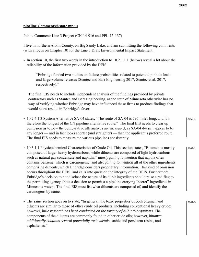
Public Comment: Line 3 Project (CN-14-916 and PPL-15-137)
I live in northern Aitkin County, on Big Sandy Lake, and am submitting the following comments (with a focus on Chapter 10) for the Line 3 Draft Environmental Impact Statement.
• In section 10, the first two words in the introduction to 10.2.1.1.1 (below) reveal a lot about the reliability of the information provided by the DEIS:
“Enbridge funded two studies on failure probabilities related to potential pinhole leaks and large-volume releases (Stantec and Barr Engineering 2017; Stantec et al. 2017, respectively).”
The final EIS needs to include independent analysis of the findings provided by private contractors such as Stantec and Barr Engineering, as the state of Minnesota otherwise has no way of verifying whether Enbridge may have influenced these firms to produce findings that would skew results in Enbridge’s favor.
• 10.2.4.1.3 System Alternative SA-04 states, “The route of SA-04 is 795 miles long, and it is therefore the longest of the CN pipeline alternative route.” The final EIS needs to clear up confusion as to how the comparative alternatives are measured, as SA-04 doesn’t appear to be any longer — and in fact looks shorter (and straighter) — than the applicant’s preferred route. The final EIS needs to measure the various pipelines consistently.
• 10.3.1.1 Physicochemical Characteristics of Crude Oil. This section states, “Bitumen is mostly composed of larger heavy hydrocarbons, while diluents are composed of light hydrocarbons such as natural gas condensate and naphtha,” utterly failing to mention that naptha often contains benzene, which is carcinogenic, and also failing to mention all of the other ingredients comprising diluents, which Enbridge considers proprietary information. This kind of omission occurs throughout the DEIS, and calls into question the integrity of the DEIS. Furthermore, Enbridge’s decision to not disclose the nature of its dilbit ingredients should raise a red flag to the permitting agency about a decision to permit a a pipeline carrying “secret” ingredients in Minnesota waters. The final EIS must list what diluents are composed of, and identify the carcinogens by name.
• The same section goes on to state, “In general, the toxic properties of both bitumen and diluents are similar to those of other crude oil products, including conventional heavy crude; however, little research has been conducted on the toxicity of dilbit to organisms. The components of the diluents are commonly found in other crude oils; however, bitumen additionally contains several potentially toxic metals, stable and persistent resins, and asphaltenes.”
2662-1
2662-2
2662-3
2662
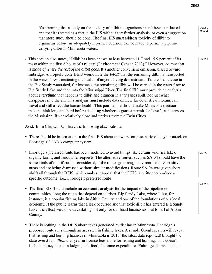
It’s alarming that a study on the toxicity of dilbit to organisms hasn’t been conducted, and that it is stated as a fact in the EIS without any further analysis, or even a suggestion that more study should be done. The final EIS must address toxicity of dilbit to organisms before an adequately informed decision can be made to permit a pipeline carrying dilbit in Minnesota waters.
• This section also states, “Dilbit has been shown to lose between 11.7 and 15.9 percent of its mass within the first 6 hours of a release (Environment Canada 2013).” However, no mention is made of where the rest of the dilbit goes. It’s another convenient omission, biased toward Enbridge. A properly done DEIS would note the FACT that the remaining dilbit is transported in the water flow, threatening the health of anyone living downstream. If there is a release in the Big Sandy watershed, for instance, the remaining dilbit will be carried in the water flow to Big Sandy Lake and then into the Mississippi River. The final EIS must provide an analysis about everything that happens to dilbit and bitumen in a tar sands spill, not just what disappears into the air. This analysis must include data on how far downstream toxins can travel and still affect the human health. This point alone should make Minnesota decision-makers think long and hard before deciding whether to grant a permit for Line 3, as it crosses the Mississippi River relatively close and upriver from the Twin Cities.
Aside from Chapter 10, I have the following observations:
• There should be information in the final EIS about the worst-case scenario of a cyber-attack on Enbridge’s SCADA computer system.
• Enbridge’s preferred route has been modified to avoid things like certain wild rice lakes, organic farms, and landowner requests. The alternative routes, such as SA-04 should have the same kinds of modifications considered, if the routes go through environmentally sensitive areas and are being dismissed without similar modifications. Route SA-04 was given short shrift all through the DEIS, which makes it appear that the DEIS is written to produce a specific outcome (i.e., Enbridge’s preferred route).
• The final EIS should include an economic analysis for the impact of the pipeline on communities along the route that depend on tourism. Big Sandy Lake, where I live, for instance, is a popular fishing lake in Aitkin County, and one of the foundations of our local economy. If the public learns that a leak occurred and that toxic dilbit has entered Big Sandy Lake, the effect would be devastating not only for our local businesses, but for all of Aitkin County.
• There is nothing in the DEIS about taxes generated by fishing in Minnesota. Enbridge’s proposed route runs through an area rich in fishing lakes. A simple Google search will reveal that fishing and hunting licenses in Minnesota in 2015 (the latest data reported) brought the state over $60 million that year in license fees alone for fishing and hunting. This doesn’t include money spent on lodging and food, the same expenditures Enbridge claims is one of
2662-3Cont'd
2662-4
2662-5
2662-6
2662
Line 3’s “benefits” to the state of Minnesota (they claim that pipeline workers will spend money in various communities during construction, and that this is one of Line 3’s benefits, in addition to taxes). This Enbridge “benefit” ends when Line 3 is complete, but income from fishing is constant and may even increase, if our lakes remain clean and desirable to visit. If Minnesota’s reputation as a fishing destination is compromised by a new pipeline corridor, approval of Enbridge’s preferred route would be a multi-billion dollar mistake that would compound each year, as we lose more and more revenue from fishing and tourism. Enbridge’s $25 million annual tax payment pales in comparison. The final EIS must have an analysis of the state economy with and without Line 3 to show a complete picture.
• There is nothing in the DEIS about the effect of induced charge from high-voltage power lines on pipelines in wetlands. The pipeline will be co-located along power lines in much of Aitkin County, which is mostly wetland. The final EIS must address this issue with an independent study (i.e., not an Enbridge-funded one).
• Recently, Volvo announced a move toward electric engines, and with higher standards in Europe, other auto makers will soon follow suit. The affordable Tesla Model 3 is now in production in the U.S., with a forecast of 20,000 cars produced monthly by December 2017. India plans to go to all electric cars by 2030, and currently half of Norway’s car sales are electric cars. Unlike a few years ago, consumers now have affordable choices between electric and internal combustion engines. As a result, the need for oil will diminish over time, not increase. The final EIS needs to address the energy transition that’s currently underway, and assess — without bias toward Enbridge — the need for Minnesota to permanently sacrifice its lakes to transport oil we likely will not need ten or twenty years from now.
• I understand that some of the firms who contributed to this DEIS (Barr and Cardno, for instance) have a history of working with Enbridge. This is a conflict of interest, and it’s surprising that their input was considered to adequate information. I would like to see this addressed in the final EIS.
• The original Line 3 is 34 inches in diameter. The new Line 3 is proposed to be 36 inches diameter. Why is larger diameter pipe necessary to achieve same volume flow as the original Line 3? Does Enbridge plan to increase the barrels per day pumped through Line 3? If so, where did they get permission for this? This needs to be addressed in the final EIS.
• The rail and truck transport data doesn’t make sense. They wouldn’t run rail and truck routes along the preferred route; they would ship it on existing tracks and roads that would lead more directly to markets, not drive through Clearbrook and Superior. The final EIS needs to redo the truck and train data to reflect reality, not an unrealistic scenario as presented in the DEIS. (To be entirely honest, this kind of thing, which runs through the entire DEIS, makes the DEIS look like it was slapped together with very little thought: it’s wholly inadequate considering the potential impacts of this project across northern Minnesota.)
2662

• In Chapter 5 the methodology used for analyzing construction impacts to groundwater is different for different routes. The “Region Of Interest” for the Enbridge’s preferred route was a 1000 ft buffer on either side of the center line of the route. For route SA04, a 2500 ft buffer was considered on either side of the center line. The distances need to be consistent in the final EIS, obviously, or the impacts will be biased toward Enbridge's preferred route.
• Reuters reported on July 8, 2017, that the Canadian lender Desjardins is considering no longer funding energy pipelines, citing concerns about the impact such projects may have on the environment. Desjardins is the largest association of credit unions in North America, and has temporarily suspended lending for such projects and may make the decision permanent (decision to be made in September). Reuters reported: “If it makes the decision permanent, that would likely mean Desjardins would not help finance other major Canadian pipelines projects, including TransCanada Corp's Keystone XL and Energy East and Enbridge Inc's Line 3. Such a move would follow that of Dutch lender ING Groep NV, which has a long-standing policy of not funding projects directly related to oil sands, and is the latest sign that pipelines could have a harder time getting funding as banks face increasing pressure to back away.” The final EIS needs to take these kinds of fundamental changes in the tar sands industry into consideration. Things are changing fast as the effects of climate change become more obvious, and the Paris Climate Agreement starts to take effect.
• The comments that citizens, organizations, and government agencies submitted for Sandpiper must be incorporated in the final EIS, as the preferred route for Line 3 is the same as the Sandpiper route. We’ve covered much of this before.
Thank you for the opportunity to comment on the inadequacy of the DEIS.
Sincerely, Janet Hill 50569 218th Place McGregor, MN 55760
2662-7
2662

Shaddix & Associates - Court Reporters(952)888-7687 - 1(800)952-0163 - [email protected]
13
1
2
3
4
5
6
7
8
9
10
11
12
13
14
15
16
17
18
19
20
21
22
23
24
25
Name and spelling for the court
reporter.
MS. WINONA LADUKE:
(Indiscernible). My name is Winona LaDuke, and
I'm from the White Earth Reservation, and I'm a
0858
Shaddix & Associates - Court Reporters(952)888-7687 - 1(800)952-0163 - [email protected]
14
1 traditional harvester, and I'm also the
2 executive director of a national organization
3 called Honor the Earth, and I'm an economist by
4 training.
5 I was asked to kind of give that
6 description a little bit more clearly. And I'm
7 with everybody here. This is our territory,
8 and I'd like to make sure that the -- I can
9 still have good water here a long time from
10 now.
11 So what I wanted to say is a
12 couple of things.
13 First, I have to ask the
14 Department of Commerce why we don't matter.
15 That's what I have to ask. I have to ask that,
16 although all of the study and all of the
17 discussion and all the testimony and all the
18 crying we presented about the duress in our
19 communities, you acknowledged it, and you said,
20 "We understand that you guys are in really
21 rough shape. We understand that your people
22 are dying at really 44 years of age. We
23 understand you all have diabetes. We
24 understand that you can't get out on your land.
25 We understand that you have health stressors,
0858-1
0858
Shaddix & Associates - Court Reporters(952)888-7687 - 1(800)952-0163 - [email protected]
15
1 and we understand that this project is going to
2 stress out the people of White Earth."
3 It's going to add more stress to
4 all of our communities, Leech Lake, Fond Du Lac
5 and Mille Lacs, East Lake.
6 "But we don't think that that is
7 enough of a reason to stop the project."
8 So I want to ask the State of
9 Minnesota why we don't matter. That's what I
10 want to say, is, why don't we matter, because
11 this is the only land we have. And it is
12 really -- you know, it's disheartening to see
13 that you would not just say, "This is too
14 tough."
15 This is the part that hits the
16 most wild rice lakes. It will take our most
17 precious territory.
18 So that's the first thing I have
19 as a comment on the DEIS.
20 The second thing is, what about
21 abandonment?
22 You know, we all know that Line 3
23 is in a weeping state. We all know that.
24 Enbridge says that it's in a state of
25 deterioration. I know that that's because it's
0858-2
0858
Shaddix & Associates - Court Reporters(952)888-7687 - 1(800)952-0163 - [email protected]
16
1 a really old pipe, and I know there's a bunch
2 of other really old pipes there.
3 What I'm trying to understand is
4 why we don't have a full EIS on abandonment.
5 What I want to know is why
6 there's only 14 pages on abandonment. And I
7 want to know how we're going to deal with this
8 problem, because this is not just a Minnesota
9 problem, it's a national problem.
10 And what I know is that cleaning
11 up the mess of hydrocarbons weeping for 50
12 years into our ecosystem is a big mess.
13 I know there are leaks all along
14 this line. Ten thousand anomalies is what they
15 are talking about, and I drive over here and
16 there's like burping substations and all kinds
17 of stuff.
18 So what we're saying is we'd like
19 a cleanup.
20 If you got an underground tank in
21 the state of Minnesota, you gotta clean it up.
22 How come you don't gotta clean up your
23 pipeline? How come the liability is left for
24 all of us?
25 And then what's the plan for the
0858
Shaddix & Associates - Court Reporters(952)888-7687 - 1(800)952-0163 - [email protected]
17
1 other four lines, or five lines, and what's the
2 plan for the next corridor?
3 We need some pipeline abandonment
4 regulations. We need to be sure that things
5 are cleaned up. And there are five times as
6 many jobs in that than in just throwing down
7 new pipe.
8 That's what we should be talking
9 about, is infrastructure that's going to
10 protect our water and protect our people.
11 The third thing I want to talk
12 about is the cumulative impact assessment. Our
13 staff and I reviewed a lot of this.
14 It's a very long report, you
15 know, and I know people worked really hard on
16 this report. There is no question.
17 We have a lot of comments on
18 things that were a little short in it, but I
19 really feel like -- you know, I'm looking at
20 this and this is an eagle feather, and this
21 eagle feather is from Lake Athabasca, which is
22 in the middle of the tar sands.
23 What I know is the people up in
24 that territory are dying from the tar sands.
25 Their water is contaminated. Their food
0858
Shaddix & Associates - Court Reporters(952)888-7687 - 1(800)952-0163 - [email protected]
18
1 systems are contaminated. Their animals are
2 dying, and they have bile duct cancer. These
3 people are dying at a very fast rate.
4 And I know that corporations are
5 not investing in more and more tar sands
6 production for a lot of reasons.
7 But what I want to know is what's
8 fair about tar sands? What's fair about the
9 dirtiest oil in the world coming our way?
10 What's fair about all the health effects on
11 poor communities upstream, and what's fair
12 about the people that live, whether they're in
13 Detroit or whether they living down there in
14 New Orleans, around that area, next to
15 refineries that are dirty?
16 Don't tell me it's because we
17 need the oil, because we all drive around. I
18 got that. I've lived in the fossil fuel era my
19 whole life, but what I want is a graceful
20 transition out of it. I don't want to choke on
21 it. I don't want everything contaminated.
22 This is our chance. This is our chance to
23 change that.
24 I want a full assessment of the
25 cumulative impact. We did a little bit of math
0858
Shaddix & Associates - Court Reporters(952)888-7687 - 1(800)952-0163 - [email protected]
19
1 on the carbon. You know, how are you going to
2 pay for $262 billion, you know? How you going
3 to do that, Enbridge? Who's going to pay for
4 the carbon impact of all this on our
5 environment? So I want a full assessment.
6 And the last thing is, really,
7 this no-build option. I think you are very
8 weak on the no-build option. You act as if it
9 was like, well, it's just going to like fall
10 apart. I'm like, Enbridge got a brand new line
11 in a few years ago. You guys worked really
12 hard to build that line, and that line is
13 probably pretty tight and pretty good, as
14 pipelines go.
15 I know people worked really hard.
16 I get that Line 3 is not the same thing as the
17 clipper, but all I want to say is, look, they
18 twisted the regulatory process to get in that
19 line. You got in a brand new line.
20 I'm saying the no-build option is
21 close down the leaking line. Close down the
22 leaking line. No new corridor. Just close
23 down the line, because the fact is is that
24 between Canada and the United States, Trump and
25 Trudeau, they have approved 2.4 million barrels
0858-3
0858
Shaddix & Associates - Court Reporters(952)888-7687 - 1(800)952-0163 - [email protected]
20
1
2
3
4
5
6
7
8
9
10
11
12
13
14
15
16
17
18
19
20
21
22
23
24
25
a day, more pipeline capacity than there are
pipelines.
That's between TransCanada, the
Keystone Excel, Energy East, and Line 3. Globe
and Mail, Toronto Globe and Mail says pipeline
capacity approved is 2.4 million barrels a day
more than they're ever going to get. That oil
is not going to come out of the tar sands, and
there is no reason to put us all in jeopardy
for that. That's it.
Thank you. Miigwech.
0858
Shaddix & Associates - Court Reporters(952)888-7687 - 1(800)952-0163 - [email protected]
86
1
2
3
4
5
6
7
8
9
10
11
12
13
14
Next I've got Winona LaDuke.
MS. WINONA LADUKE:
15 (indiscernible). My name is Winona LaDuke,
16 W-I-N-O-N-A, L-A-D-U-K-E.
17 You know what, I just want to
18 start by saying I'm really proud of the people
19 from our territory for coming out. It takes a
20 lot of courage to stand up to big corporations
21 and to say it's not right what they want to
22 do.
23 And you know, even discussing
24 this whole process, I think it is a really
25 fair criticism to say that we are operating
0859
Shaddix & Associates - Court Reporters(952)888-7687 - 1(800)952-0163 - [email protected]
87
1 under the guidelines and the timetables set by
2 a corporation, and I don't think that's fair
3 to us. I don't think it's fair to drop an EIS
4 that's so long on people and ask them to
5 comment a week later.
6 We're the people who live here,
7 all of us. And we're the people who know
8 these lakes and we value this land and this
9 water, and I think it's an unfair process.
10 And I think there's a lot of
11 things missing in the DEIS that we're talking
12 about here, and I think the process should be
13 extended significantly to address those
14 issues, because rushing through is not fair.
15 It's too significant of a
16 decision. People have spoken really well. I
17 was really heartened to hear what everybody
18 said, and I understand a lot of these pieces.
19 I was asked by someone yesterday
20 to explain -- I'm an economist by training. I
21 went to Harvard. I direct a national
22 organization. But I live here. This is where
23 I live, and this is the land that my ancestors
24 are from. This is the land all my children
25 and descendents will be from, just like all of
0859
Shaddix & Associates - Court Reporters(952)888-7687 - 1(800)952-0163 - [email protected]
88
1 you.
2 So the first thing that I have
3 to ask is why we don't matter? Why you could
4 do a full DEIS and say tribal people are
5 already in tough shape, you're dying at 44
6 years of age. I'm one of the few grandmothers
7 around. I'm 57.
8 I'm the same age as a lot of
9 you, but we're dying, we're under duress, we
10 aren't eating right, we're stressed out, we've
11 got every disease you don't want to have.
12 It's very clear this pipeline
13 runs through the heart of Anishinaabe
14 territory. The DEIS says that we are the most
15 impacted. It says that this is where all the
16 rice lakes are, and that's the heart of our
17 people. There's no rice anywhere else in the
18 world, and we have no place else to go.
19 What I don't understand is that
20 although the DEIS concludes that the
21 disproportionate and adverse impacts would
22 occur on American Indian populations, it is
23 not a reason to deny the permit.
24 So I really don't get why we
25 don't count.
0859
Shaddix & Associates - Court Reporters(952)888-7687 - 1(800)952-0163 - [email protected]
89
1 You know, I feel like, don't
2 question my patriotism. We just want good
3 decisions to be made, and we feel that we
4 should be fairly treated, and this is not
5 fair.
6 And the rest of the people who
7 live here, you're going to be treated just
8 like Indians in this one. We're all in the
9 same place. This is where we live.
10 The second thing I want to talk
11 about, you know, just spoken to last night.
12 This is a feather from Lake Athabasca, in the
13 middle of the tar sands. It's from an eagle.
14 It was given to me by the people up there
15 because they understand that what we are doing
16 here affects them. They are already dying
17 from tar sands mines. They're dying.
18 Those people didn't ask for
19 that. They're Cree people that are just
20 trying to live the same life as their
21 ancestors, and they're victims of the tar
22 sands industry. They're poisoned all around
23 them.
24 It's not just the people that
25 are dying. It's all of the animals that are
0859
Shaddix & Associates - Court Reporters(952)888-7687 - 1(800)952-0163 - [email protected]
90
1 dying up there and all of the birds that are
2 dying. It's a death zone. It's a national
3 sacrifice area.
4 For the life of me, I can't see
5 why we are trying to justify that and to make
6 sure to figure out how to get that oil down
7 here.
8 You know, as an economist, what
9 I'm going to tell you -- and a lot of people
10 in here know this -- is that the writing is on
11 the wall that it's the end of tar sands time.
12 We're in extreme extraction.
13 That's when you get to the bottom of the
14 barrel and you keep scraping, rather than
15 trying to figure out the solution.
16 And the bottom of the barrel is
17 the tar sands, and the bottom of the barrel
18 was the fracking proposal that we all defeated
19 last time. You know, when you blow up the
20 bedrock of Mother Earth, put 602 chemicals in
21 there and pretend it's going to work out for
22 you all. It's not going to work out for
23 anybody.
24 Up there, those people, it is
25 not included in the DEIS the destruction of
0859
Shaddix & Associates - Court Reporters(952)888-7687 - 1(800)952-0163 - [email protected]
91
1 people, the destruction of ecosystems in the
2 tar sands area. It is super destructive oil,
3 and those people also have a right to live.
4 And so when you talk about the
5 cumulative impact of the pipeline, everybody
6 in this room knows that it is not from one
7 border of Minnesota to the other border. It
8 comes from someplace that they are turning
9 into hell, and it goes to someplace that they
10 are turning into hell.
11 The last round of hearings, we
12 brought in people from Detroit tar sands
13 communities who are dying, black community
14 right next to the Marathon refinery. They are
15 dying.
16 So what I want to understand is,
17 you know, people here talked about the
18 cumulative impact. We already got widespread
19 agricultural contamination. Our water is
20 already in danger.
21 I also want to say, as an
22 economist, I don't understand, and I think a
23 lot of people here don't understand, is why
24 the no-build option is not considered in this
25 proposal. It's super dismissive.
0859
Shaddix & Associates - Court Reporters(952)888-7687 - 1(800)952-0163 - [email protected]
92
1 And the reason that you would
2 have a no-build option is, one, because of the
3 economics of it. The fact is that, you know,
4 tar sands capacity is projected to diminish,
5 and they are projecting to overbuild
6 pipelines, between Trump and Trudeau, by a
7 factor of 2.4 million barrels a day. They've
8 approved more permits than there are a need
9 for pipelines.
10 So the no-build option would be
11 leave that guy, start cleaning it up. Clean
12 up the abandoned pipeline. You know, they
13 already got that pipeline through them, the
14 Alberta Clipper. They could use that one for
15 now. It's a new line.
16 So I just want to say we really
17 feel that the no-build option should be
18 rigorously reviewed. The cumulative impact
19 should be expanded to both ends.
20 There is no way to justify the
21 destruction of our people. There is no way to
22 justify that.
23 And finally, as I look to the
24 future, the stranded asset that this is going
25 to be a liability for our communities, when
0859-1
0859
Shaddix & Associates - Court Reporters(952)888-7687 - 1(800)952-0163 - [email protected]
93
1 they bring five more lines down here, or
2 whatever they're going to do, and then they
3 abandon them. That's a huge economic disaster
4 for all of us.
5 I just want to thank everybody
6 for coming. I'm really proud to be from this
7 area. Thank you.
8
9
10
11
12
13
14
15
16
17
18
19
20
21
22
23
24
25
0859
Shaddix & Associates - Court Reporters(952)888-7687 - 1(800)952-0163 - [email protected]
58
1
2
3
4
5
6
7
8
9
10
11
12
13
Thank you.
FACILITATOR: Thank you, Annette.
Thane Maxwell next.
MR. THANE MAXWELL: Hi, I'm Thane
14 Maxwell, T-H-A-N-E, M-A-X-W-E-L-L. Thank you
15 for the opportunity to speak.
16 I live in Minneapolis, and I work
17 with Honor the Earth. I have basically given
18 my life to stopping these projects, not because
19 I don't want any of you to have a job, but
20 because we don't need them and because they
21 hurt people.
22 I've been reading through the EIS
23 for the last few weeks. 5,000 pages is a lot
24 to get through in three weeks, but we did our
25 best. We do have some highlights over here, if
0867
Shaddix & Associates - Court Reporters(952)888-7687 - 1(800)952-0163 - [email protected]
59
1 anybody wants to come check them out, you can
2 see what we're interpreting in the data.
3 I wanted to point out a few
4 questions that we're going to comment on -- or
5 that I'm going to comment on in my written
6 comments, but I wish there were a forum here to
7 ask questions and get answers to these.
8 You know, I realize people worked
9 really hard on this document, spent a lot of
10 time on it, and there's a lot of improvement to
11 the past few years of the process, I really
12 appreciate that, but there's, you know, of
13 course, in 5,000 pages you're going to have
14 holes.
15 So, for example -- I'll just
16 throw out a few examples.
17 In all of the impact
18 calculations, the assumption for the life span
19 of the pipeline is 30 years. And that's really
20 confusing to me because Enbridge has a number
21 of pipelines running right through this town
22 that have been here for 50 or 60 years,
23 sometimes 65 years, so I'm wondering where that
24 calculation comes from.
25 Another question I had is why is
0867
Shaddix & Associates - Court Reporters(952)888-7687 - 1(800)952-0163 - [email protected]
60
1 there no spill analysis at all for the
2 St. Louis or Nemadji rivers, which dump right
3 into Lake Superior as the pipeline reaches the
4 Twin Ports there.
5 Why is there no discussion of
6 what the impact would be on Lake Superior? The
7 Great Lakes hold 20 percent of the world's
8 fresh water, and we're not even looking at
9 that. We're not even looking at the impact on
10 the harbor in the Twin Ports and what the
11 impact would be, what it would really look like
12 to clean up a tar sands spill in that harbor.
13 It's confusing there's no meeting
14 in Duluth for folks in that community to talk
15 about that.
16 Another question I had is in the
17 spill section, this one over here, "Accidental
18 Releases." Some of the numbers are confusing
19 to me. It says -- it gives annual
20 probabilities of spills in Minnesota, so it
21 calculates what the chances are each year of a
22 spill, and it breaks them down by size.
23 And it says, "The chance of a
24 small spill is 107 percent in one year." So
25 basically, we can expect more than one small
0867-1
0867
Shaddix & Associates - Court Reporters(952)888-7687 - 1(800)952-0163 - [email protected]
61
1 spill or about one small spill a year.
2 It then gives a separate number
3 for just the overall chance of any kind of
4 spill, any size, and it says, "25 percent a
5 year." So we can expect one every four years.
6 I don't understand how that makes
7 sense. How could the chance of a small spill
8 be 107 percent and the chance of a spill of any
9 size be 25 percent?
10 So I think there's some math
11 wrong there that we need to look at.
12 The other thing that I find very
13 confusing or problematic in the EIS is the
14 alternatives that are considered.
15 For example, the rail alternative
16 that is considered involves building a rail
17 terminal at the border of Canada and the United
18 States and bringing the oil from the partial
19 pipeline that Enbridge would build by rail to
20 Superior.
21 Now we all know that Enbridge
22 would never do that, so I don't think that's a
23 reasonable alternative to consider.
24 Similarly, the truck option looks
25 at trucking the oil from the border from a new
0867-2
0867
Shaddix & Associates - Court Reporters(952)888-7687 - 1(800)952-0163 - [email protected]
62
1 truck terminal to Superior, and we know
2 Enbridge would never do that.
3 So we need to have realistic
4 alternatives if we're genuinely considering
5 alternatives.
6 Another alternative that someone
7 has mentioned before me is the no build
8 alternative. The no build alternative is
9 defined in the EIS as, "Continued use of Line
10 3."
11 But that -- that's a distorted
12 way of framing the question, because there are
13 other ways of not building it, right, and the
14 question really is about need, and there is no
15 discussion of need.
16 I find this sign over here, the
17 Certificate of Need Alternatives very
18 problematic because it outlines the
19 considerations that the PUC will go through to
20 determine whether to grant the Certificate of
21 Need or not. It list two out of three. There
22 are actually three.
23 The two that are listed over
24 there, it says they will consider the economic
25 need, which by the way, there's no analysis of
0867
Shaddix & Associates - Court Reporters(952)888-7687 - 1(800)952-0163 - [email protected]
63
1 in the EIS.
2 And two, they will consider
3 alternatives. The one that's missing is the
4 most important. The one that's missing is that
5 the PUC also must consider, by Minnesota
6 statute, also must consider whether the
7 pipeline is in the best interests of society.
8 So I think you should add that to that sign.
9 Similarly, on the impacts boards
10 over here, you have two different impact
11 boards; one for the Certificate of Need and one
12 for the routes. And both of them have a
13 socioeconomic section, but neither of them
14 mention that there will be zero permanent jobs
15 created by the project.
16 That's a big question that you
17 see in the media a lot and the decision makers
18 really want to know. I think that should be
19 included there.
20 The other thing not included
21 there is there's no discussion of the property
22 tax that counties would lose when the existing
23 Line 3 is abandoned. It states that counties
24 that have the new line put in would receive
25 property tax benefits, but it doesn't discuss
0867
Shaddix & Associates - Court Reporters(952)888-7687 - 1(800)952-0163 - [email protected]
64
1 the loss.
2 My last point is also about
3 abandonment. There's a lot of people in this
4 community really concerned about abandonment,
5 and I agree, it is a really huge deal.
6 A couple things that I just
7 wanted to pick up on that other people were
8 saying and just clarify a little bit, in case
9 you didn't get it.
10 The DEIS says that when you stop
11 flowing oil through a pipe, you don't have that
12 weight in it anymore, it starts to rot. Okay.
13 So, what, 300 miles of pipe around here is
14 going to start to lift itself out of the
15 ground. A lot of it is already exposed, as
16 people are saying. I've seen it. I've walked
17 on it.
18 There should be more than 14
19 pages on abandonment. There should be an
20 analysis of how fast that's going to happen,
21 where is that going to happen, what is it going
22 to cost.
23 Similarly, there should be a
24 discussion of the effect on people's property
25 values, and there should be a discussion of the
0867-3
0867
Shaddix & Associates - Court Reporters(952)888-7687 - 1(800)952-0163 - [email protected]
65
1 liability. What happens if some of the
2 risks --
3 FACILITATOR: Can you wrap up
4 soon? It's been about six minutes, so if you
5 could wrap up soon.
6 MR. THANE MAXWELL: I'm almost
7 done. Thank you.
8 What happens when one of the
9 things that's listed as a possibility over
10 here, like contamination or the flooding of a
11 farm field, when that pipe breaks down and
12 serves as a conduit and drains a lake? Who
13 pays for that? What protection is there for
14 landowners? The PUC has the power to do
15 something about that and ensure that.
16 The other thing I really think
17 needs to be included in the abandonment section
18 is an economic analysis. What kind of jobs
19 could we create? Maybe we could partner on
20 that with some of the unions here.
21 Maybe we could look at the
22 numbers here and see what kind of jobs we would
23 create if we clean up the old mess before we
24 make a new one.
25
0867-4
0867
Shaddix & Associates - Court Reporters(952)888-7687 - 1(800)952-0163 - [email protected]
3
1
2
3
4
5
6
(Change in court reporter.)
FACILITATOR: Then I have Thane
Maxwell. Just a name and spelling, please.
MR. THANE MAXWELL: All right. Thank
you for the opportunity to speak. My name is Thane
Maxwell, T-H-A-N-E, M-A-X-W-E-L-L.
7 UNIDENTIFIED: Pull the mic close,
8 please.
9 MR. THANE MAXWELL: Okay, thank you.
10 Is that good?
11 I gave some comments yesterday in
12 Grand Rapids. Don't worry, I'm not going to comment
13 at all 22 meetings, I promise.
14 But I just really wanted to say a few
15 things today because I'm really moved by how many
16 people from the community came out here today, I can
17 see you are very concerned about this, and I wanted
18 to support you as you stand up and protect your
19 community here.
20 So I've been looking at the EIS for
21 the past few weeks, ever since it was released, and
22 I wanted to share some of the things that I've seen
23 and share some of my interpretations of it.
24 You know, as you notice, I feel it is
25 really unfair to you all to ask you to comment on a
0868
Shaddix & Associates - Court Reporters(952)888-7687 - 1(800)952-0163 - [email protected]
4
1 document that doesn't have some of the most
2 important things in it. That doesn't have the
3 economic need analysis in it. That doesn't have
4 spill modeling information in it. That doesn't have
5 the contamination plan that Enbridge promises to
6 give us later for the contamination that they find
7 when they abandon Line 3 or remove it. Hopefully
8 remove it.
9 So, you know, here's something that is
10 also not in the EIS that you can say. When someone
11 stands up here and tells you that it's a fact that
12 pipelines are safer than rail, okay, well, when
13 someone stands up and tells you that, that is
14 actually not a fact. There is no way to compare two
15 different kinds of violence like that. Pipelines
16 spill less frequently, but they spill more volume
17 each time they spill, okay. So pipelines are more
18 likely to spill in a rural area where you're going
19 to affect someone's water sources, the aquifers, the
20 lakes, the rivers, the farmland, that sort of thing.
21 The places where people are more immediately
22 dependent on the health of their natural resources.
23 Rail is more likely to spill in an urban area and
24 blow up and kill somebody. How do you compare those
25 two things? You cannot. That's not in the EIS and
0868
Shaddix & Associates - Court Reporters(952)888-7687 - 1(800)952-0163 - [email protected]
5
1 I think it should be.
2 The other thing I wanted to point out
3 in the EIS is understanding the probabilities of
4 spills. There's two different numbers in there.
5 One gives the annual probability of a spill in
6 Minnesota on Enbridge's preferred route that says 25
7 percent. So every four years we're going to have
8 spills in Minnesota on Enbridge's lines. But then
9 it gives a different set of stats and it breaks it
10 down by the size of the spill and it gives totally
11 different numbers which to me seem mathematically
12 incompatible. I'm confused about the data and we
13 need check on them.
14 But those numbers are the following:
15 The chance of a small spill each year in Minnesota
16 is 107 percent. So at least one a year, a small
17 spill. The chance of a medium size spill, 8
18 percent. The chance of a large spill is 6 percent.
19 And the chance of a catastrophic spill is 1.1
20 percent. So I did a little math. If this pipeline
21 runs 50 years, and keep in mind that some of these
22 old ones are running 60, 65 years already. Let's
23 say it runs 50 years. We can expect 14 pinhole
24 leaks, 54 small leaks, four mediums, three larges,
25 and one catastrophic spill. So that's what we're
0868-1
0868
Shaddix & Associates - Court Reporters(952)888-7687 - 1(800)952-0163 - [email protected]
6
1 signing up for. And that's the risk you're asked to
2 assume.
3 When they say on the tribal resources
4 map over there that tribal communities will be
5 disproportionately impacted, and the tribal
6 resources that are essential to the survival of
7 these people will be disproportionately impacted.
8 That's what we're talking about. That's the risk
9 we're talking about.
10 And we talk about the risk of the
11 headwaters, that's what we're looking at, 76 spills
12 in the lifetime of this pipeline. And that's
13 according to their data, which I was just getting
14 at. When we look at the data of Enbridge's history
15 we find much higher numbers.
16 The other question I'm really thinking
17 needs to be answered. And we're in Grand Rapids,
18 there are a lot of people who are very concerned
19 about this abandonment question. A lot of people
20 really don't feel that Enbridge should be able to
21 leave that in the ground and walk away.
22 So we commented a lot last night about
23 all of those things that actually should be in the
24 EIS, the impact of that and assess the risk, but one
25 thing that I think is really important for this
0868
Shaddix & Associates - Court Reporters(952)888-7687 - 1(800)952-0163 - [email protected]
7
1 community here is what are they going to do with the
2 other three ancient lines they have in that pipeline
3 corridor? There is absolutely no mention of that.
4 And it's not like Enbridge hasn't thought of it and
5 doesn't have a plan. Those three lines are also
6 just about done. They all in a state of
7 deterioration. Are those three lines coming over
8 here, too? Are you being asked to accept one
9 pipeline or four? I think that needs to be in
10 there.
11 The other thing, I want to encourage
12 you to question and look at more closely is the
13 alternatives that are offered and compared to
14 Enbridge's preferred route. So in the certificate
15 of need permit decision, which is what this is all
16 about, the PUC decides whether Enbridge gets the
17 pipeline, the certificate of need.
18 They compare the preferred route to
19 several alternatives. Seven of them, actually. And
20 some of them, quite frankly, are absurd. The rail
21 option assumes that they would build a new rail
22 terminal at the border.
23 I'll wrap up in a second.
24 They would do a new rail terminal at
25 the border and ship everything by rail from the
0868-2
0868
Shaddix & Associates - Court Reporters(952)888-7687 - 1(800)952-0163 - [email protected]
8
1 partial new pipeline that they built through Canada.
2 They would never do that. Similar for the truck
3 option, they would never do that. And the no-build
4 option, which we've mentioned already, is defined as
5 continued use of Line 3. You can't let them distort
6 your options that way. They don't get to decide
7 what the options are based on Enbridge's ability to
8 sell something. That's just unreasonable.
9 So I encourage you to push back on
10 that. What we want is we want the no-build option
11 and shut down Line 3 'cause it's poisoning people
12 right now. That's what we're asking for. And the
13 way that we do that is we call them the third
14 certificate of need consideration, which is very
15 conveniently not listed on the sign over there. The
16 sign over there says when they consider the
17 certificate of need that they think about two
18 things. One, the need of the pipeline; and two, the
19 alternatives, the alternative routes. The third
20 thing that by Minnesota statute they have to
21 consider, is the pipeline in the best interest of
22 society. They left that out.
23 And that's what we're looking for
24 here. No build. Shutdown of Line 3. It's in the
25 best interest of society.
0868
Shaddix & Associates - Court Reporters(952)888-7687 - 1(800)952-0163 - [email protected]
9
1
2
3
Thank you very much.
4
5
6
7
8
9
10
11
12
13
14
15
16
17 (Meeting concluded.)
18
19
20
21
22
23
24
25
0868
Shaddix & Associates - Court Reporters(952)888-7687 - 1(800)952-0163 - [email protected]
98
1
2
3
4
5
6
7
8
9
10
11
12
13
14
15
16
17
18
19
20
21
22
23
24
promised in the Line 3 corridor and see how it
relates to what people have said. And I
support remove the old line and put in the new
one.
I don't give a dam, and I don't
think any of us give a dam about the profit and
loss statement for Enbridge. If it costs more
to do that, that's just too bad. That's the
price of doing business.
FACILITATOR: Thank you.
So we have three more. We need to make sure
we give folks enough time to finish up.
So we've got Nicolette Slagle is
next. Give your name and spelling, if you
could.
MS. NICOLETTE SLAGLE:
Nicolette, N-I-C-O-L-E-T-T-E, Slagle,
S-L-A-G-L-E. My name is Nicolette Slagle, and
I'm the research director for Honor the Earth.
I'm not really going to talk too
much about our stance on the pipeline. I'm
sure everybody knows that. I'm sure the DOC
has heard that already from us.
25 I do have some specific
0909
Shaddix & Associates - Court Reporters(952)888-7687 - 1(800)952-0163 - [email protected]
99
1 comments, specific on the DEIS, but I did want
2 to address something that I heard numerous
3 time here and Grand Rapids and other places,
4 which is what a great neighbor Enbridge is.
5 And I sometimes wonder if it's a completely
6 different Enbridge than the one that I know
7 of, because the one that I know of has
8 numerous safety violations. They have one of
9 the worst spill records, one of the highest
10 incidences of spills.
11 The industry average is about
12 three spills per thousand miles of pipeline
13 per year. Enbridge's average is 3.19 spills
14 per thousand miles of pipeline. Enbridge has
15 about 8,009 miles of pipeline in Minnesota,
16 which means that there's an average of 25
17 spills in Minnesota every year.
18 Now, these vary in sizes and
19 these are reportable spills, but this is the
20 average.
21 Over in our little display area,
22 we also have this corporate research project
23 profile on Enbridge. It's their corporate rap
24 sheet, and it's a little out of date. We're
25 working on trying to update it and do a better
0909
Shaddix & Associates - Court Reporters(952)888-7687 - 1(800)952-0163 - [email protected]
100
1 summation, but it has a record of their
2 various violations and spills.
3 Just two that I want to pull out
4 for you guys, and then I'll get on my comments
5 on the DEIS, is, "In 2004, the US Pipeline and
6 Hazardous Material Safety Administration,
7 PHMSA, proposed a fine of $11,500 against
8 Enbridge Energy for safety violations found
9 during inspections of pipelines in Illinois,
10 Indiana, and Michigan. The penalty was later
11 reduced to $5,000.
12 "In a parallel case involving
13 Enbridge pipeline operations in Minnesota, an
14 initial penalty of $30,000 was revised to
15 $25,000."
16 And I'm sure this didn't have to
17 do with the reanalysis of the impacts of this
18 bill. I'm sure it had something to do with
19 some back-door dealings.
20 Another one, this is more
21 recent. "In 2008, the Wisconsin Department of
22 Natural Resources charged Enbridge Energy with
23 more than 100 environmental violations
24 relating to the construction of a 320-mile
25 pipeline across much of the state.
0909
Shaddix & Associates - Court Reporters(952)888-7687 - 1(800)952-0163 - [email protected]
101
1 "The agency said that Enbridge
2 workers illegally cleared and disrupted wooded
3 wetlands and were responsible for other
4 actions that resulted in discharging sediments
5 into waterways.
6 "In January 2009, the company
7 settled the charges by agreeing to pay
8 $1.1 million in penalties.
9 "In March 2010, the PHMSA
10 proposed a fine of $28,800 against Enbridge
11 Energy Pipelines, LLC for safety violations in
12 Oklahoma."
13 So I'm just wondering, is this
14 Enbridge that's such a great neighbor, a
15 different Enbridge, or are these the ones that
16 have numerous safety violations and numerous
17 fines across this country?
18 Specifically related to the DEIS
19 and some of its weaknesses, I did notice in
20 there that in the abandonment section they
21 have a price tag at $120 billion to remove the
22 pipeline. There's no indication of where that
23 number came from, other than an estimate of
24 Enbridge at $855 per foot as the removal cost.
25 But there's no breakdown of what
0909-1
0909
Shaddix & Associates - Court Reporters(952)888-7687 - 1(800)952-0163 - [email protected]
102
1 those costs entail, how much of it is for
2 removal of the pipeline, how much of it is for
3 sediment cleanup, how much of it is for
4 putting in new clean fill, how much of it is
5 for restoration of the environment.
6 And in Canada, Enbridge was
7 required to complete a full abandonment
8 assessment for part of Line 3. We have no
9 idea how the numbers from what they've told
10 Canada it would cost versus what they told the
11 DOC, because we don't have any of that record,
12 so we can't compare that.
13 Another question is, again, on
14 to the jobs. So we're saying that everybody
15 needs jobs. It's going to cost $120 billion
16 to clean up this pipeline. If Enbridge isn't
17 going to pay for that, who is going to pay for
18 that?
19 We also know the restoration
20 economy jobs, for every million dollars
21 invested, 10 to 39 jobs are created. So if
22 you're investing $120 billion, how many jobs
23 are you going to create into the restoration
24 economy? It's going to create a whole new
25 industry for Minnesota and for the region.
0909
Shaddix & Associates - Court Reporters(952)888-7687 - 1(800)952-0163 - [email protected]
103
1 Enbridge also says that there's
2 going to be a 30-year life span for this new
3 pipeline. What's their abandonment plan for
4 that pipeline?
5 I have a question for the DOC
6 and the PUC. Through this whole process,
7 you've gotten a lot of comments from people.
8 Is there any analysis of those comments, like
9 how many are for, how many against. The ones
10 that are against, why are they against it?
11 The ones that are for it, why are they for it?
12 You know, I think that would kind of help all
13 of us to kind of see where we're all kind of
14 falling on this, and if there is some kind of
15 shared ground that we can come to an
16 understanding of, what is the best way to move
17 forward.
18 Which brings me to the next
19 comment, that in the beginning of this
20 document it says that this document is not
21 here to talk about policy implications of
22 renewable versus fossil fuels; this, that, and
23 the other thing.
24 But the question is, when is
25 that time to make those decision? We're right
0909
Shaddix & Associates - Court Reporters(952)888-7687 - 1(800)952-0163 - [email protected]
104
1 here on this precipice of investing into a
2 dying industry.
3 Yes, we need oil. Yes, we're
4 all using oil, but saying that if we build a
5 pipeline, we're going to have oil for our
6 grandchildren? We're probably going to run
7 out of it in 20 to 30 years. And I know most
8 of the youth that I know don't want to be
9 relying on fossil fuels, and we want to
10 transition to clean energy. We also know that
11 there's ways to make all of the plastics and
12 all of the fuels that we currently use out of
13 hemp and other materials.
14 FACILITATOR: Wrap up if you can.
15 Thank you.
16 MS. NICOLETTE SLAGLE: Another
17 thing, like we've talked about this before, is
18 kind of the lack of response information.
19 I've tried myself to get Enbridge's integrated
20 regional response plan or whatever they call
21 it, but they only give it out to emergency
22 first responders.
23 So we can't even look at that
24 and see how much they rely on local first
25 responders to respond to these spills, which
0909
Shaddix & Associates - Court Reporters(952)888-7687 - 1(800)952-0163 - [email protected]
105
1 history has shown that's how it goes.
2 So what Enbridge does is they
3 come into these communities, give communities
4 grants so they can buy response equipment, and
5 then Enbridge uses that equipment in their
6 response plan, saying, "Oh, well, we've got it
7 covered. This local fire department just
8 bought this huge truck or whatever, and
9 they'll all be able to respond to this, no
10 problem."
11 FACILITATOR: Can you wrap up in
12 the next few minutes.
13 MS. NICOLETTE SLAGLE: I guess
14 the last thing I have to say is the
15 projections of the needed demand for this
16 pipeline. A lot of these projections have
17 been shown to be inflated, and a lot of the
18 projections are based off of growing global
19 demand.
20 And what we've seen is that a
21 lot of the countries that they're saying the
22 demand is going to come from are leapfrogging
23 over fossil fuels and going right to renewable
24 energy, so we really need to take that into
25 account.
0909
Shaddix & Associates - Court Reporters(952)888-7687 - 1(800)952-0163 - [email protected]
106
1
2
Thank you.
3
4
5
6
7
8
9
10
11
12
13
14
15
16
17
18
19
20
21
22
23
24
25
0909
Shaddix & Associates - Court Reporters(952)888-7687 - 1(800)952-0163 - [email protected]
33
1
2
3
4
5
6
7
8
9
10
11
12
13
14
15
16
17
18
19
20
21
22
23
24
25
them fish, all them animals, you know, they're
all counting on us, because we already
destroyed a lot of the ecosystem.
They're hanging on, too, and they
start putting these lines through the new
corridor, it's going to be very unlikely that
those animals are going to make this next
round.
That's all I got to say right
now, but I want to thank you again.
FACILITATOR: We'll take the
comment. Did you have your hand up?
MS. NICOLETTE SLAGLE: Nicolette
Slagle, N-I-C-O-L-E-T-T-E, S-L-A-G-L-E. I'm
with Honor the Earth. I'm their research
director. And I'm originally from
Pennsylvania, and I tell you that is a place
that we have let industry run roughshod over.
It's been clear-cut, two or
three times, the birthplace of oil industry,
birthplace of coal industry. Now fracking is
out of control there. Our water is not
drinkable in much of the state.
And we shouldn't let that happen
here. We shouldn't let that happen anywhere.
2030
Shaddix & Associates - Court Reporters(952)888-7687 - 1(800)952-0163 - [email protected]
34
1 I want to talk a little bit
2 about a couple of things specifically related
3 to some of the analysis that I've been trying
4 to do on this project and its potential
5 impacts.
6 Just this weekend I ran a little
7 analysis on potentially impacted wild rice
8 beds, and in the state's DEIS they have
9 indicated 17 wild rice lakes directly impacted
10 by potential Line 3 routes for the preferred
11 route, Enbridge's preferred route, 17.
12 That's actually the highest of
13 any of the routes. I went a step further and
14 looked at wild rice watersheds, because we
15 know wild rice is a very sensitive plant and
16 it changes even the levels of water, the
17 amounts of silt, climate can all impact it.
18 So I think that looking at the
19 wild rice watersheds is a more reasonable
20 metric to see how many potential impacts there
21 are.
22 What I got was 41 watersheds
23 that would be potentially -- wild rice
24 watersheds that would be potentially impacted
25 by Enbridge's proposed route.
2030-1
2030
Shaddix & Associates - Court Reporters(952)888-7687 - 1(800)952-0163 - [email protected]
35
1 While I, of course, respect
2 everybody's need to have a job and respect the
3 union immensely, I also really respect the
4 right for tribal communities to exist and
5 survive. If we destroy these wild rice beds,
6 they won't be able to.
7 Along with -- again, I know that
8 this process isn't necessarily the process for
9 talking about these large scale, long-term
10 energy infrastructure needs.
11 But again, I've asked this
12 before, like if this isn't the time, when and
13 where will that be? How often are we going to
14 be in a room with employees from the MPCA, the
15 DNR union guys, tribal people, nonprofits,
16 both us and MN350.
17 I mean, if any of us tried to
18 set up something like this, it would be a very
19 one-sided conversation.
20 We do know that there are
21 alternatives to oil. There's hemp, which
22 Henry Ford built a car completely made out of
23 hemp which ran on hemp fuel. There's numerous
24 renewable ways to develop electrical cars.
25 Public transportation, that is a
2030
Shaddix & Associates - Court Reporters(952)888-7687 - 1(800)952-0163 - [email protected]
36
1 major issue that we are missing in the United
2 States. A lot of the oil, if you look at the
3 charts of who consumes the oil and where and
4 for what, a lot of it's consumed in the south,
5 in urban areas, because they don't have public
6 transportation.
7 Why should we be allowing this
8 pipeline to come through, full of the dirtiest
9 oil on the planet, to fuel people's vehicles
10 in the South because they don't have public
11 transportation or they don't want to take a
12 bus.
13 I'm not going to talk about the
14 abandonment cost and how many potential jobs
15 there are with that. It's well known within
16 the oil and gas industry that they have like
17 max 30 years left of economically viable
18 extracted oil. And I don't consider the tar
19 sands economically viable.
20 So what that means is in 30
21 years we have to be ready to be off of oil.
22 So are we going to build another
23 pipeline and push the time that we start that
24 transition until the next 15 years, the next
25 20 years, so that in 30 years, when we're
2030
Shaddix & Associates - Court Reporters(952)888-7687 - 1(800)952-0163 - [email protected]
37
1 completely out of oil, everybody is going to
2 be like, "Oh, what are we going to do now?"
3 Our vehicles are going to
4 stopping running. We need to prepare for that
5 now.
6 That is a major lacking in the
7 EIS, that there's no addressing the issues for
8 future generations.
9 There's all of this talk about
10 potential impacts and potential benefits, but
11 it's all for now. It's not what is this going
12 to create for the long term?
13 Real quick, I've also been doing
14 some calculations on what are the
15 environmental impacts of this potential line
16 and the oil industry as a whole.
17 And, you know, of course, yes,
18 it's going to create some jobs, but it also
19 creates at least $41 billion in social costs
20 from the carbon. We've estimated at
21 $170 billion for the removal of the carbon
22 from the atmosphere.
23 So those two numbers are
24 different. One is about the impacts that
25 increasing carbon will have on people,
2030
Shaddix & Associates - Court Reporters(952)888-7687 - 1(800)952-0163 - [email protected]
38
1 including climate change and things like that.
2 The other one is the cost to
3 remove the carbon from the atmosphere.
4 Because not only do we have to stop our carbon
5 emissions, but we need to get the carbon out.
6 It's impacting the environment now.
7 Annual cost, Boreal Forest lost
8 315 million wetlands in the right-of-way,
9 $3 million, and those are ecosystems services
10 cost.
11 So wetlands provide a number of
12 services, including water filtration, flood
13 control, biodiversity. And so we would lose
14 $3 million annually from the right-of-way and
15 $315 million from the loss of Boreal Forest.
16 And I can talk to people more
17 about that later because I'm running low on
18 time.
19 Just to close, I want to also
20 say that I know you've been trying to do a
21 much better job with consulting with the
22 tribes. But consultation is not consent.
23 Thank you.
24
25
2030
Shaddix & Associates - Court Reporters(952)888-7687 - 1(800)952-0163 - [email protected]
26
1
2
3
4
5
6
7
8
9
10
11
12
13
14
15
16
17
18
19
20
MS. NICOLETTE SLAGLE: Hi,
Nicolette
21 Slagle. N-I-C-O-L-E-T-T-E. S-L-A-G-L-E.
22 I'm Honor the Earth's research
23 director. I'm not going to talk about oil use or
24 the need to transition off of it or anything of
25 that. I'm going to speak specifically about a
2053
Shaddix & Associates - Court Reporters(952)888-7687 - 1(800)952-0163 - [email protected]
27
1 couple of issues with the Draft Environmental Impact
2 Statement.
3 One of them is the issue of cathodic
4 protection along the pipeline, and this is a -- it's
5 like a charge or a current that's applied to -- and
6 I could be describing it wrong, but it's basically a
7 charge or current that's applied to the pipeline to
8 counteract both microbial activity that causes
9 corrosion on the pipelines and also helps like
10 ground the current that can be created between a
11 pipeline and high-voltage transmission lines when
12 they share the same corridor, which it does. The
13 proposed -- the Applicant's proposed preferred
14 route, for at least a segment of it, shares the same
15 corridor with a high-voltage power line.
16 And in the impact statement it states
17 that this cathodic protection isn't going to be
18 installed for a year after the pipeline is put in
19 the ground. And there's really no examination of
20 what can happen when it's sitting underneath power
21 lines for that long without this protection being
22 put in.
23 When part of the original Keystone
24 Xcel was put in the ground through an area that it
25 shared a corridor as a power line with, they started
2053-1
2053
Shaddix & Associates - Court Reporters(952)888-7687 - 1(800)952-0163 - [email protected]
28
1 to get a lot of pinhole -- pinholes. They didn't
2 actually put the oil through it, so it didn't get to
3 the leaking point. But they did get pinhole
4 corrosion pits from having the pipeline in the
5 ground in the same corridor as the power lines,
6 without having the cathodic protection in place.
7 Also, along with that, I don't know --
8 I don't think they started to do it down here as
9 much. I know that over by Cloquet, up by Lake
10 George, a couple of places up by Lake George, they
11 have already started stockpiling pipes. They've had
12 those pipes in those yards for several years now.
13 And there is research out there about the fact that
14 UV rays can corrode pipes when they sit out for that
15 long, because they're not designed to be exposed to
16 UV rays; they're designed to be under the ground.
17 And there's no analysis in the impact statement
18 about what is the potential impact of UV pipes that
19 have been stockpiled for years.
20 Also, with the cathodic protection is
21 the abandonment of the existing Line 3. And, again,
22 you know, they say that they're going to maintain
23 the right-of-way and they're going to keep
24 monitoring it and they're going to keep the cathodic
25 protection in place so that it won't -- you know, if
2053-1Cont'd
2053-2
2053
Shaddix & Associates - Court Reporters(952)888-7687 - 1(800)952-0163 - [email protected]
29
1 they shut it off, then that will allow the pipeline
2 to crumble quicker, which could lead to ground
3 subsidence or water conduits being created. But a
4 lot of the issues with this existing line is from
5 the coating that they used on it. And in places
6 that coating has disbonded from the pipeline, so
7 it's not attached to it anymore. And that cathodic
8 protection is now also removed from the pipeline.
9 So if you already have a system that
10 isn't working and you're not going to go in there
11 and fix the system, how would that system keep
12 working after you stop using that pipeline?
13 So, yeah, I think that's all that I
14 have on the cathodic protection. But I'd also like
15 to see in the DEIS international standards used for
16 some of this analysis, especially where it comes to
17 tribal and indigenous people's rights and
18 consultation.
19 So there's a few different
20 international standards. The International Labor
21 Organization passed the convention C169 that
22 addresses indigenous rights when it comes to
23 planning and siting and implementing new projects.
24 There is the UN Declaration of Indigenous Rights,
25 and there's also the equator principle, which is
2053-3
2053
Shaddix & Associates - Court Reporters(952)888-7687 - 1(800)952-0163 - [email protected]
30
1 used by financial institutes for examining the
2 impacts of projects. And all of these different
3 standards use the standard of free prior informed
4 consent, which means that indigenous need to be --
5 need to have free prior informed consent, which
6 basically means that indigenous communities are
7 consulted before a project is planned and permits
8 are applied for, not consulted afterwards.
9 And just along with that, like I'd
10 like to remind everybody that consultation does not
11 equal consent.
12
13
14
Thank you.
15
16
17
18
19
20
21
22
23
24
25
2053-3Cont'd
2053

Shaddix & Associates - Court Reporters(952)888-7687 - 1(800)952-0163 - [email protected]
25
1
2
3
4
5
6
7
8
9
10
11
12
13
14
15
16
17
18
19
20
21
22
23
24
25
Paris Accord, and which includes other state
policy around carbon reduction, including
renewable energy standard and carbon reduction
goals at the state level in Minnesota and also
at many cities.
So I would encourage that be
assessed as well specifically in the
Environmental Impact Statement document as it's
a document designed to inform a Certificate of
Need decision.
These carbon analyses need to be
in there a little bit more than we're seeing
right now, although I respect and appreciate
the work that's gone into getting us to the
level of analysis that we have in the document.
Just looking to kick it to the
next step up so that the Commission is able to
use it to make a fully informed decision as
we're looking at whether to go forward with
building this project.
Thank you.
FACILITATOR: And you're up next.
Just name and spelling for the record.
MS. NICOLETTE SLAGLE: I'm
Nicolette Slagle, N-I-C-O-L-E-T-T-E,
2062
Shaddix & Associates - Court Reporters(952)888-7687 - 1(800)952-0163 - [email protected]
26
1 S-L-A-G-L-E.
2 I'm with Honor the Earth. I am
3 their research director, and I wanted to thank
4 you for bringing up the issues of the oil sand
5 or the tar sands up in Alberta, because as our
6 stance with Honor the Earth, we are wholly
7 opposed to anymore expansion of the tar sands
8 industry for a number of reasons. And so I
9 really appreciate you also stating some facts
10 about how terrible of an industry it is.
11 One of the things that I've been
12 working on, researching a lot in the last two
13 years is this issue of abandonment. And as
14 you may know, that this line is coming from
15 Canada, and the Canadian National Energy Board
16 is also facing the abandonment of the existing
17 Line 3 up in Canada. So a lot of the
18 information that I have learned about what the
19 potential impacts of abandonment is comes from
20 the research that the NEB has done.
21 A few interesting things about
22 that is that I was able to speak yesterday with
23 some representatives from the Canadian
24 Association of Energy and Pipeline Landowner
25 Association. So this is a group that was
2062
Shaddix & Associates - Court Reporters(952)888-7687 - 1(800)952-0163 - [email protected]
27
1 started by a Canadian landowner that had a
2 pipeline running through their yard that was
3 concerned about what would happen if that
4 pipeline was abandoned.
5 And what I learned is that back
6 in 1985, the National Energy Board actually had
7 on their books seven different regulations
8 related to pipeline abandonment, and their
9 preferred method for dealing with abandonment
10 was complete removal.
11 Now, some politics changed up
12 there, a lot of those regulations got removed
13 from the books, but the CAEPLA organization is
14 working to get some of those back on there,
15 including landowners' choice of what happens to
16 pipelines that run through their yards.
17 So it is possible to completely
18 remove pipelines and it is an expense that most
19 likely somebody will bear. And we want to make
20 sure that it is the company that is bearing
21 those costs and not society.
22 Now, as it relates back to this,
23 the issues here in Minnesota, and this document
24 in particular, I'm going to read a couple of
25 things and I will tie them together. This is
2062
Shaddix & Associates - Court Reporters(952)888-7687 - 1(800)952-0163 - [email protected]
28
1 from the CAEPLA's summer 2016 magazine. It's
2 an article about aging pipelines, what are the
3 risks. And it's an article about independent
4 research that is co-sponsored between Enbridge
5 and CAEPLA.
6 "Enbridge has acknowledged that
7 the extensive disbonding of the Line 3
8 polyethylene tape pipe coating will render
9 cathodic protection ineffective to prevent
10 corrosion and has estimated time to through
11 wall penetration at 25 to 50 years.
12 "Progressively greater
13 agricultural surface loads increase the
14 potential for pipeline collapse and ground
15 subsidence. In addition to health and safety
16 concerns and related costs and liabilities,
17 topsoil loss upon ground subsidence will result
18 in permanent long term production losses."
19 So I read that and I was thinking
20 back to myself, okay, I don't really remember
21 that being stated as clearly in the DEIS. I
22 have tried to read as much of it as possible,
23 and I did manage to read the entire section on
24 abandonment because it was about 14 pages.
25 So in here, in section 8.3.1.2,
2062-1
2062
Shaddix & Associates - Court Reporters(952)888-7687 - 1(800)952-0163 - [email protected]
29
1 "Existing Line 3 as a Water Conduit," so this
2 is one of the issues that if there is through
3 wall corrosion, water can get into the pipeline
4 and it can move through the pipeline into
5 different areas.
6 So yeah, basically says that this
7 could happen but cathodic protection in
8 cementing the pipeline would minimize the
9 effects on water resources. And it says here
10 that -- yeah, over time -- well, basically it
11 says cathodic protection is going to limit that
12 from happening.
13 And so I was interested to see --
14 again, they didn't give any numbers, just that
15 the cathodic protection is going to stop that
16 from happening.
17 But if you then go into appendix
18 B, which is the appendix to the abandonment
19 section, so it has more of the technical
20 documents and additional information that were
21 used to -- I'm assuming, used to create the
22 section on abandonment.
23 So from that, on page 26 of
24 appendix B, Line 3 is externally coated with
25 polyethylene tape. A Gas Research Institute
2062-1Cont'd
2062
Shaddix & Associates - Court Reporters(952)888-7687 - 1(800)952-0163 - [email protected]
30
1 report published in 1992, provides information
2 that, "The most common problem reported by the
3 pipeline operators who had used tape coating on
4 their pipeline systems were poor field
5 application, failure of adhesive, poor
6 resistance to soil stress and high
7 susceptibility to shielding the current of the
8 cathodic protection system."
9 There's some more talk about
10 what's happened over the years. The end of the
11 second paragraph, "Once the wrinkles form,
12 water is able to seep under the disbonded
13 coating and is carried along the pipeline's
14 steel surface by capillary action. Permeation
15 of the CP current is limited due to high
16 dielectric strength of the polyethylene tape
17 shielding the current."
18 Which, long story short,
19 basically they're saying that, well, the
20 cathodic protection is already disbonding from
21 the pipeline. So again, I really want to
22 understand how their cathodic protection is
23 going to protect this pipeline when it's not
24 even functioning now.
25 So then they have a lot of
2062-1Cont'd
2062
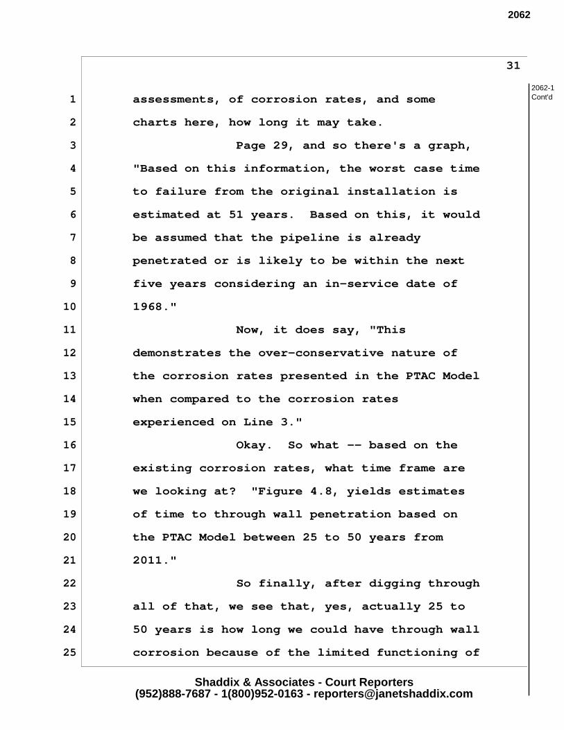
Shaddix & Associates - Court Reporters(952)888-7687 - 1(800)952-0163 - [email protected]
31
1 assessments, of corrosion rates, and some
2 charts here, how long it may take.
3 Page 29, and so there's a graph,
4 "Based on this information, the worst case time
5 to failure from the original installation is
6 estimated at 51 years. Based on this, it would
7 be assumed that the pipeline is already
8 penetrated or is likely to be within the next
9 five years considering an in-service date of
10 1968."
11 Now, it does say, "This
12 demonstrates the over-conservative nature of
13 the corrosion rates presented in the PTAC Model
14 when compared to the corrosion rates
15 experienced on Line 3."
16 Okay. So what -- based on the
17 existing corrosion rates, what time frame are
18 we looking at? "Figure 4.8, yields estimates
19 of time to through wall penetration based on
20 the PTAC Model between 25 to 50 years from
21 2011."
22 So finally, after digging through
23 all of that, we see that, yes, actually 25 to
24 50 years is how long we could have through wall
25 corrosion because of the limited functioning of
2062-1Cont'd
2062
Shaddix & Associates - Court Reporters(952)888-7687 - 1(800)952-0163 - [email protected]
32
1 the cathodic protection system.
2 FACILITATOR: Been about seven
3 minutes.
4 MS. NICOLETTE SLAGLE: Okay. So
5 I just would like the abandonment section to
6 be a lot more clear about the fact that these
7 issues are not going to happen sometime in the
8 far away future, they're going to happen
9 within people's lifetimes. And I really do
10 think that the State needs to complete an
11 entirely separate Environmental Impact
12 Statement on the issue of abandonment,
13 because, as Allen said, this is not the
14 first -- well, it is the first major pipeline,
15 but it is not going to be last.
16
17
18
19
20
Thank you.
21
22
23
24
25
2062-1Cont'd
2062

1
Levi, Andrew (COMM)
From: MacAlister, Jamie (COMM)Sent: Tuesday, July 11, 2017 10:14 AMTo: MN_COMM_Pipeline CommentsSubject: FW: DEIS CommentsAttachments: Comments_NS.pdf
Jamie MacAlister Environmental Review Manager Minnesota Department of Commerce 85 7th Place East, Suite 280, Saint Paul, MN 55101 P: 651‐539‐1775
The linked image cannot be displayed. The file may have been moved, renamed, or deleted. Verify that the link points to the correct file and location.
CONFIDENTIALITY NOTICE: This message is intended only for the use of the individual(s) named above. Information in this e-mail or any attachment may be confidential or otherwise protected from disclosure by state or federal law. Any unauthorized use, dissemination, or copying of this message is prohibited. If you are not the intended recipient, please refrain from reading this e-mail or any attachments and notify the sender immediately. Please destroy all copies of this communication. From: Nicolette Slagle [mailto:[email protected]] Sent: Monday, July 10, 2017 11:41 PM To: MacAlister, Jamie (COMM) <[email protected]> Subject: DEIS Comments
Hi Jamie, Please see my attached comments.
Scan Jul 9, 17.pdf
pipeline risks scan nicolette.pdf
Bob Merrit_Addendum.pdf
Grand Rapids_Ltr_ Line 3 Draft EIS Comment.pdf
Barbara Harper_Line 3 Review.pdf
Leah_critique of DEIS_EJ.pdf
2681
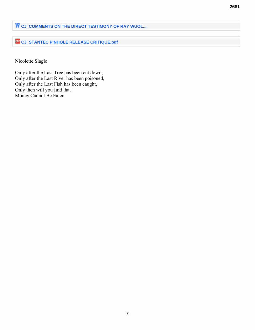
2
CJ_COMMENTS ON THE DIRECT TESTIMONY OF RAY WUOL...
CJ_STANTEC PINHOLE RELEASE CRITIQUE.pdf
Nicolette Slagle Only after the Last Tree has been cut down, Only after the Last River has been poisoned, Only after the Last Fish has been caught, Only then will you find that Money Cannot Be Eaten.
2681
Indigenous Science and Traditional Ecological Knowledge (TEK)
Traditional Ecological Knowledge has been developed over centuries of living in the landscape, developed through a methodology known as Indigenous science. Indigenous science is just as methodological and empirical as Western science, but is defined by several important distinctions. First, Indigenous scientists, and cultures see time a cyclical. Second, Indigenous science is holistic and systems based. Third, Indigenous scientists utilize a sixth sense that is not understood by Western scientists. Finally, Indigenous science structures Indigenous societies in a much more fundamental way than Western science does. The recognition of the inseparability, reciprocity, and responsibility between humans and the rest of creation, particularly land and place, serves to create an ethical code of conduct in interacting and being in the world. TEK emphasizes that all aspects of physical space are considered part of a connected, interrelated community (humans, animals, plants, land), shifting the Western emphasis from the human to the ecological community of which humans are an integral part. According to Pierotti and Wildcat (2000), a core component of TEK is that non-humans and nature exist on their own terms independent of human interpretation. Additionally, TEK acknowledges that IP are native to a place and live with nature – following an ethical code of conduct that exists in relation with ecosystems – in contrast to dominant Western worldviews (e.g., Manifest Destiny), which assumes humans are superior to, separated from (e.g., going “into nature”), or in opposition to – where nature needs to be tamed or conquered primarily for the benefit of humans (Pierotti and Wildcat 2000). Many of the principles of western science are based on a type of logic and mindset which require hierarchical thinking. Non-reciprocal causality, for instance, requires that one think of phenomena in the following way, according to Marayama as cited by Cajete:
“’That for every effect there is one single cause which can be objectively observed and described given the proper tools, the correct hypothesis and appropriate experimentation.’ Non reciprocal, or what has been popularly termed ‘linear thinking’ conditions for ‘mono-polarization’ in both thinking and personality development . ‘Mono explanation’ is defined as a ‘psychological need to believe that there is one universal truth, and to seek out, find secret in, and hang onto one authority, one theory , uniformity, homogeneity, and standardization’” . 1
In TEK systems, there is a more holistic understanding of cause and effect. There is an understanding that cause A and effect B cannot be isolated from cause B and effect B in a system. This is known as “mutualistic logic” and “reciprocal causality”. In practical terms, this is the difference between 2
examining the increase of GHG from a pipeline project (by direct emission, replacement increases, etc) and examining the impact increased investment in fossil fuel infrastructure will have on future
1 Cajete, A. Gregory. Igniting the Sparkle: An Indigenous Science Education Model. Michigan: Kivaki Press, 1999. 2 IBID.
2681
generations. As TEK system recognize a mutual relations between all things in the natural world… animals, plants, humans, celestial bodies, spirits and natural forces, they strive to maintain a balance in this system. Instructions for maintaining this balance are handed down, generation to generation through rituals, storytelling, and other means. Often, these rituals and knowledge-transfer activities are directly tied to the place the knowledge relates to.
Ways of knowing In addition to linear thinking, western science also emphases knowledge developed through experimentation and repetition. These processes form the basis of logical/mathematical and spatial intelligence, however, there are more domains of intelligence than these two. These include; linguistic, kinesthetic, musical, interpersonal (understanding of people), and intrapersonal (understanding of self )”. Indigenous scholars also recognize the existence of additional domains- 3
spiritual intelligence and interspecies intelligence as well. Simply stated, this is an ability to communicate with the spiritual world, a plane which exists in the Anishinaabe world as a parallel world, and is accessed through prayer, ceremony, or may manifest when it decides to do so.
Anishinaabe Akiing: The Land to Which the People Belong The very definition of “indigenous” intimates a sacred thread or reciprocal tie to land, place, and identity (King 2009). Cajete (1999: 6) notes that the word “indigenous” “is derived from the Latin root indu or endo, which is related to the Greek word endina, which means ‘entrails.’ Indigenous literally means being so completely identified with a place that you reflect its entrails, its insides, its soul.” Any disruption in indigenous land, place, or culture clearly has a potentially harmful effect on indigenous health and wellness, which may then persist for generations to come (Walters et al. 2002: 166) IP have unique attachments to original lands, and we carry these attachments, or sacred threads, wherever we go. These attachments are linked not only to special or sacred ritual sites but also to the whole of land and creation. In fact, the boundaries between “sacred sites” and secular sites are often difficult to define or even nonexistent as all land and locations are viewed as sacred (Zarsky 2006). AIAN belief systems and emotional intelligence descend from these attachments. While typical mainstream conceptualizations of place often have a unidirectional and temporal order, indigenous conceptualizations do not. In her research exploring the role of healing landscapes with the Amuzgo Indians of Oaxaca, Mexico, Elizabeth Cartwright (2007: 10) cites Casey’s (1993) description of place to illustrate the idea that “who we are is based on where we are”: Place ushers us into what already is: namely, the environing subsoil of our embodiment, the bedrock of our being-in-the-world. If imagination projects us out beyond ourselves while memory takes us back behind ourselves, place subtends and enfolds us, lying perpetually under and around us. In imagining and remembering, we go into the ethereal and the thick respectively. By being in a place, we find ourselves in what is subsistent
3IBID.
2681
and enveloping. This description illustrates a more complex comprehension of place by appreciating the past and future sensory experiences along with the enveloping and alive process of the present. It brings alive the possibility of place as not occurring at a particular instance but something that happens dynamically in all directions over time.
The Anishinaabe person is inseparable from the land; identity, sense of place and history is intimately related to the land. We originated here. The North American Indigenous person did not migrate from anywhere else, nor originate from any other peoples. The Creator took four parts of Earth and molded the form of the first human person. Since then, all of humankind has been related to the Earth in a very intimate way -- the Earth, in fact, is our Mother. The human person is a relative to all other persons of the Earth, and, along with all creatures call the Earth, Mother. “ 4
James Dumont (Foushee and Senogles)
“At the time of first European contact, the Anishinaabe Nation extended from the East Coast to the Red River Valley here in the West, from the Hudson’s Bay in the North and South to about the Ohio River Valley. These are all people who spoke Algonquin-based language, although different dialects. They were all related through the language. The language is a very important and sacred means of communication. Ten to twelve thousand years ago, where we are living now, was covered with ice. Our oral history goes back that far when our ancestors lived on the Atlantic Coast. …”
Earl Hoagland (Foushee and Senogles)
We are place, we are. Not those who occupy that place. We do not exist, we are. We only are. Comandante David and Subcomandante Marcos
Our story is in the land. It is written in those sacred places. My children will look after those places . That’s the law.
Ggudju elder (indigenous Australian): Cited in (Burgess et al. 2005: 118).
“Native American intellectual tradition still continues to express the North American landscape in intellectual and spiritual reciprocity, where the more-than-human grants qualities of mind to the human”
Sheridan and Longboat 2006 In TEK, “place” is not given meaning by the human mind, rather, it is understood places express their meaning to IP through the intimate relationship they share. IP converse with places, as though they are relatives. This is demonstrated in the indigenous constructs of place and beings that inhabit place or space as “relatives” or “relations” as revealed in common references to “mother earth” or to rocks as “grandfathers.”
4 Foushee, Lea, and Renee Gurneau. Sacred Water: Water for Life. Lake Elmo, MN: North American Water Office, 2010. Pg. 37.
2681
Gregory Cajete, a Tewa scholar (2000: 186) notes Native people express a relationship to the natural world that could only be called ‘ensoulment’…which for Native people represents the deepest level of psychological involvement with their land and which provides a kind of a map of the soul. The psychology and spiritual qualities of Indigenous peoples’ behavior…are thoroughly ‘in-formed’ by the depth and power of their participation… with the Earth as a living soul. It was from this orientation that Indigenous peoples develop ‘responsibilities’, and maintain those. This is also referred to as a covenant with the Creator and all that is created- the land, water and all living things. As Cajete notes, “’ In the Native mind, spirit and matter are not separate: They are one and the same…. Place is part of our ancestral heritage, our present, and our future. It links us in immediate and visceral ways to our past, present, and future. In this sense, IP emerge from the place and have a bidirectional relationship of caring with place – place cares for us and we care for it. In a study investigating the connections between culture, health, and place in First Nations people, Wilson (2003: 88) asked First Nations (Anishinabek) individuals about their views on the influence of the land on spiritual, physical, mental, and emotional health.
“I believe that we came from the earth – just like everything is alive, potatoes, plants, anything comes alive and flourishes with flowers. The earth provides everything, wild animals, insects. The earth provides for us. The earth provides strength, that’s why we call it mother. She provides life…helps us live. Without her we would not live. ”
In Anishinabeg worldviews, the earth is seen as a feminine being and is regarded as the source of all life-sustaining things (Wilson 2003). Another description from an elder expresses similar sentiments (Wilson 2003: 88):
“Mother Earth is everything that you see. You look everywhere on earth and you see Mother Earth. The way you raise your children, the way people do things together, the way we live among our people. She is in everything we do.”
As Wilson (2003: 88) notes, “the relationship Anishinabek have with the land cannot be captured by the simplified notion of being ‘close to nature.’ The land is not just seen as shaping or influencing identity, but being an actual part of it.” We live in a world of inter-relationship and responsibilities to other parts of reality. As such, we can not limit our assessment to just our treaty areas, or just Anishinabeg Akiing. The reality is that these projects, the pipelines and the tar sand extraction they support, have massive impacts both upstream and downstream. In the case of the pipeline, that includes the communities near the extraction of the tar sands and the downstream communities around refineries (and ultimately, the communities where the oil is combusted). As well, the pipeline requires significant energy to move a million barrels of oil. Power lines are proposed throughout our territory, and the power for these lines must be sourced. We will review some of the impact of these infrastructure additions. The downstream communities of this project are both the Anishinaabe tribal communities, and the multitude of communities impacted directly by the tar sands refineries.
2681
The extraction communities: As described above, this would include the communities around the tar sands projects in Alberta. The Lakehead system also carries Bakken oil and these communities should be included in this assessment as well. These communities are all facing increasing pollution burdens, serious environmental justice issues and increasing sexual assaults. Alberta
The beginning of this energy corridor, is the Alberta Tar Sands, home of the Mikisew Cree First Nation, Athabasca Chipewyan First Nation, Fort McMurray First Nation, Fort McKay Cree Nation, Beaver Lake Cree First Nation Chipewyan Prairie First Nation, and the Metis. Their lands and health have been destroyed by the tar sands industry.
The Bakkens
The Lakehead system also carries Bakken oil, produced through hydrological fracturing the shale that underlays the lands of the Mandan, Arika and Hidatsa in North Dakota. The refinery communities: While there is indication that much of new pipeline capacity will be bound for international markets, either as crude or refined products, Enbridge’s system (of which Line 3 is a major component of) feeds into several refineries across Turtle Island. As the refining of the oil will increase the pollution burden of these communities, we will examine few case examples and develop a profile of their pollution burden. Aamjaning
A destination for much of the oil that comes through the Lakehead system ends up at the refineries around Sarnia, the homelands of the Aamjaning community. Detroit
A major partner in Enbridge’s Bakken oil investment is Marathon. They run a refinery in Detroit. This refinery has also recently been upgraded to handle Tar Sands crude. Flint Hills
Just south of Minneapolis is Flint Hills. This is the final destination of the Koch Brother’s pipeline, which the Lakehead system feeds directly into.
2681
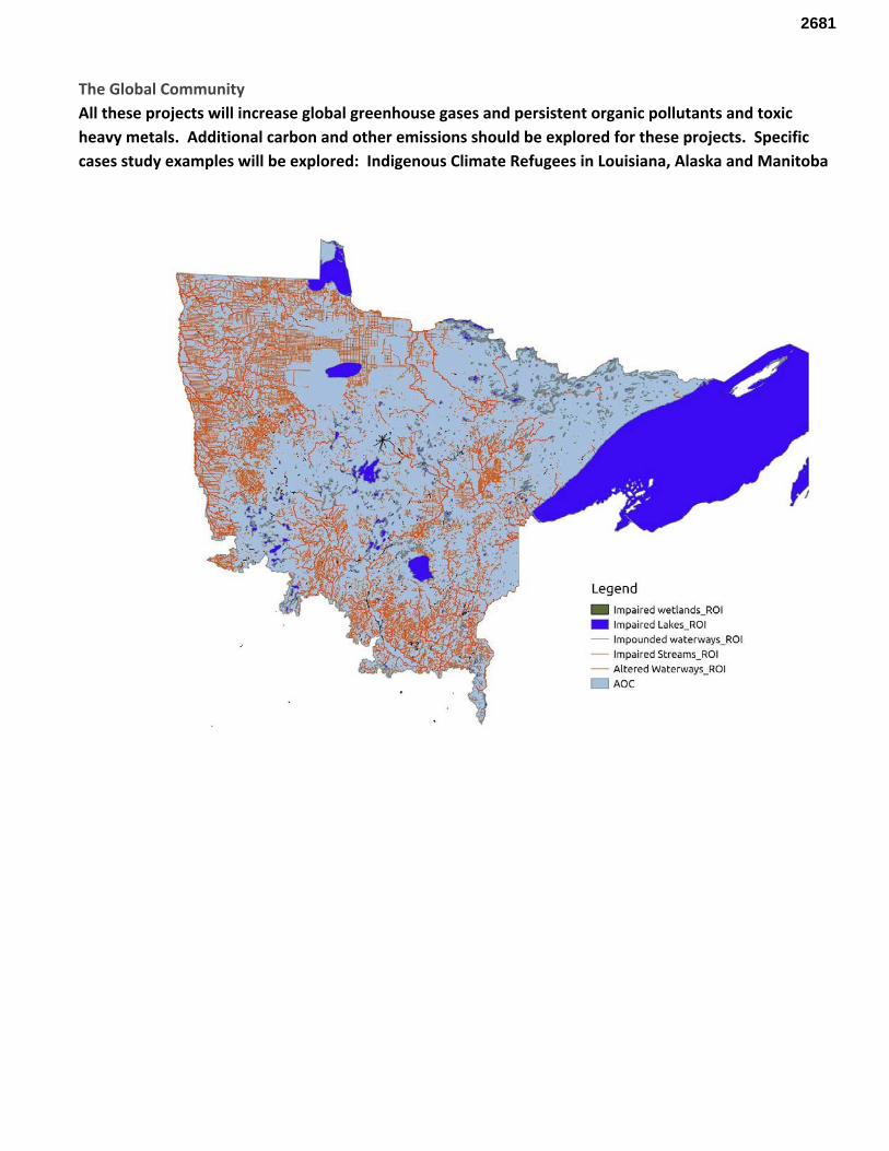
The Global Community All these projects will increase global greenhouse gases and persistent organic pollutants and toxic heavy metals. Additional carbon and other emissions should be explored for these projects. Specific cases study examples will be explored: Indigenous Climate Refugees in Louisiana, Alaska and Manitoba
2681
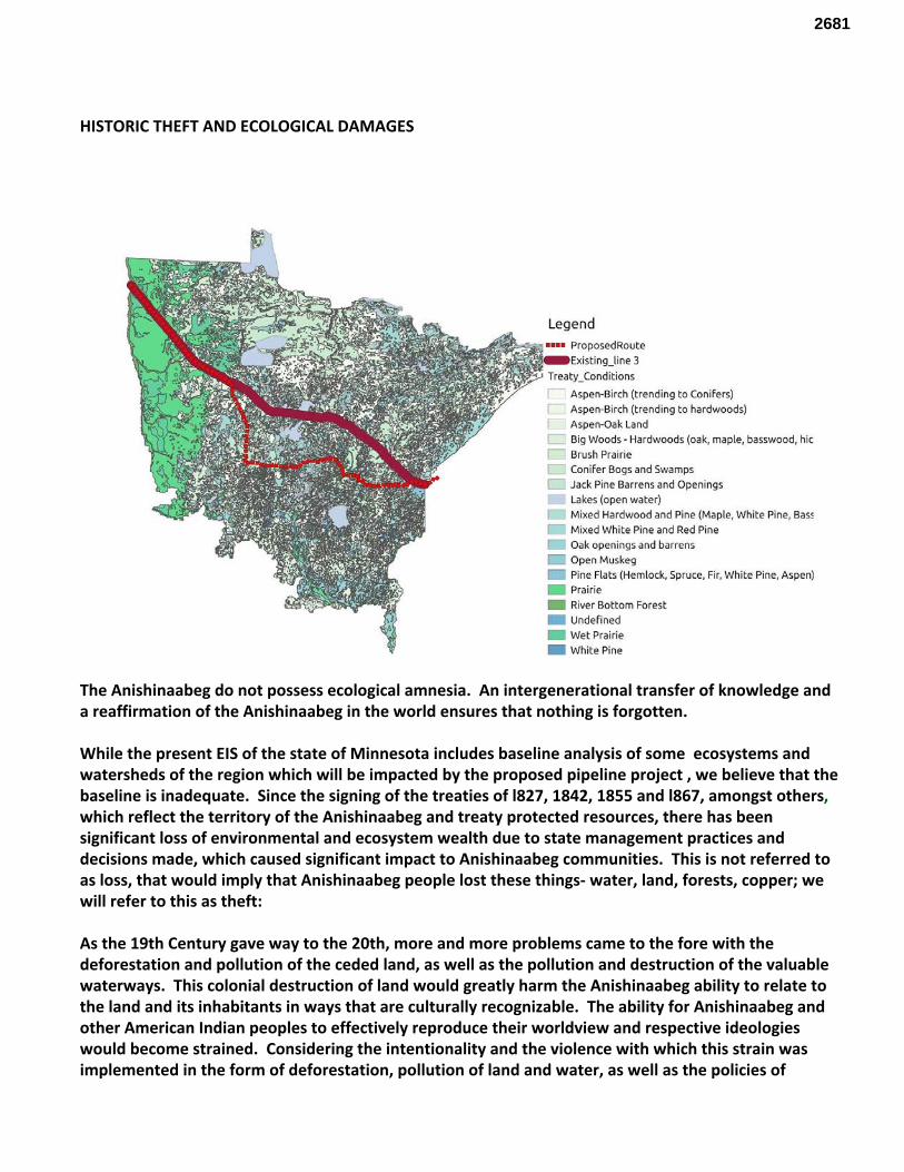
HISTORIC THEFT AND ECOLOGICAL DAMAGES
The Anishinaabeg do not possess ecological amnesia. An intergenerational transfer of knowledge and a reaffirmation of the Anishinaabeg in the world ensures that nothing is forgotten. While the present EIS of the state of Minnesota includes baseline analysis of some ecosystems and watersheds of the region which will be impacted by the proposed pipeline project , we believe that the baseline is inadequate. Since the signing of the treaties of l827, 1842, 1855 and l867, amongst others, which reflect the territory of the Anishinaabeg and treaty protected resources, there has been significant loss of environmental and ecosystem wealth due to state management practices and decisions made, which caused significant impact to Anishinaabeg communities. This is not referred to as loss, that would imply that Anishinaabeg people lost these things- water, land, forests, copper; we will refer to this as theft: As the 19th Century gave way to the 20th, more and more problems came to the fore with the deforestation and pollution of the ceded land, as well as the pollution and destruction of the valuable waterways. This colonial destruction of land would greatly harm the Anishinaabeg ability to relate to the land and its inhabitants in ways that are culturally recognizable. The ability for Anishinaabeg and other American Indian peoples to effectively reproduce their worldview and respective ideologies would become strained. Considering the intentionality and the violence with which this strain was implemented in the form of deforestation, pollution of land and water, as well as the policies of
2681
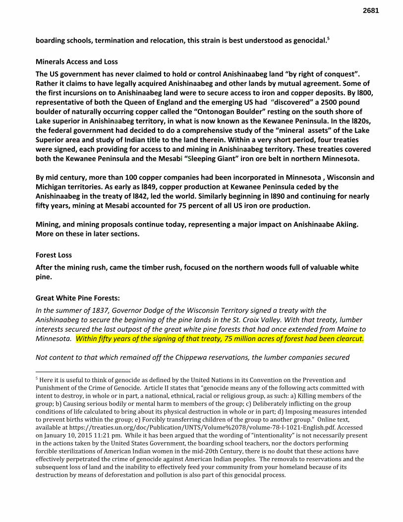
boarding schools, termination and relocation, this strain is best understood as genocidal. 5
Minerals Access and Loss The US government has never claimed to hold or control Anishinaabeg land “by right of conquest”. Rather it claims to have legally acquired Anishinaabeg and other lands by mutual agreement. Some of the first incursions on to Anishinaabeg land were to secure access to iron and copper deposits. By l800, representative of both the Queen of England and the emerging US had “discovered” a 2500 pound boulder of naturally occurring copper called the “Ontonogan Boulder” resting on the south shore of Lake superior in Anishinaabeg territory, in what is now known as the Kewanee Peninsula. In the l820s, the federal government had decided to do a comprehensive study of the “mineral assets” of the Lake Superior area and study of Indian title to the land therein. Within a very short period, four treaties were signed, each providing for access to and mining in Anishinaabeg territory. These treaties covered both the Kewanee Peninsula and the Mesabi “Sleeping Giant” iron ore belt in northern Minnesota. By mid century, more than 100 copper companies had been incorporated in Minnesota , Wisconsin and Michigan territories. As early as l849, copper production at Kewanee Peninsula ceded by the Anishinaabeg in the treaty of l842, led the world. Similarly beginning in l890 and continuing for nearly fifty years, mining at Mesabi accounted for 75 percent of all US iron ore production. Mining, and mining proposals continue today, representing a major impact on Anishinaabe Akiing. More on these in later sections.
Forest Loss After the mining rush, came the timber rush, focused on the northern woods full of valuable white pine.
Great White Pine Forests: In the summer of 1837, Governor Dodge of the Wisconsin Territory signed a treaty with the Anishinaabeg to secure the beginning of the pine lands in the St. Croix Valley. With that treaty, lumber interests secured the last outpost of the great white pine forests that had once extended from Maine to Minnesota. Within fifty years of the signing of that treaty, 75 million acres of forest had been clearcut. Not content to that which remained off the Chippewa reservations, the lumber companies secured
5 Here it is useful to think of genocide as defined by the United Nations in its Convention on the Prevention and Punishment of the Crime of Genocide. Article II states that “genocide means any of the following acts committed with intent to destroy, in whole or in part, a national, ethnical, racial or religious group, as such: a) Killing members of the group; b) Causing serious bodily or mental harm to members of the group; c) Deliberately inflicting on the group conditions of life calculated to bring about its physical destruction in whole or in part; d) Imposing measures intended to prevent births within the group; e) Forcibly transferring children of the group to another group.” Online text, available at https://treaties.un.org/doc/Publication/UNTS/Volume%2078/volume-78-I-1021-English.pdf. Accessed on January 10, 2015 11:21 pm. While it has been argued that the wording of “intentionality” is not necessarily present in the actions taken by the United States Government, the boarding school teachers, nor the doctors performing forcible sterilizations of American Indian women in the mid-20th Century, there is no doubt that these actions have effectively perpetrated the crime of genocide against American Indian peoples. The removals to reservations and the subsequent loss of land and the inability to effectively feed your community from your homeland because of its destruction by means of deforestation and pollution is also part of this genocidal process.
2681
through laws forwarded by Minnesota Senator Nelson and Representative Steenerson, to open up what remained of Anishinaabeg territory. “ Cruisers of lumber companies also made their examinations and notes. As there were still standing on White Earth reservation some three hundred million feet of pine, as roughly estimated, it was worth their while…” (Folwell: :267) In 1889, Minnesota ranked second in the country in logging, with the northwestern section leading the state’s production. In l889-l890, 11 million board-feet of lumber was taken from the White Earth reservation. In the next year, 15 million board-feet were cut, followed by another 18 million in 1891-92 season. By 1895, Frederick Weyerhauser of Little Falls, Minnesota, owned more acres of timber than anyone else in the world. The Little Falls Daily Transcript would write in 1893: “Weyerhauser's Pine Tree Lumber company “... is eating a big hole in the forests of northern Minnesota , as it runs steadily, rarely meeting an accident ... The Weyerhausers have secured a monopoly of the Mississippi River so far as the driving of logs is concerned …” In 1893, Weyerhauser and other lumber interests secured funding from public and other sources to build a railroad from Little Falls into Leech Lake reservation , where Weyerhauser had access to 800,000 board feet of standing timber. But in October of 1898, when the Anishinaabeg people on nearby Leech Lake reservation resisted further encroachment, the military came to the defense of lumber companies. Later private Oscar Buckhard was awarded a medal of honor for ‘ distinguished bravery in action against hostile Indians. ” The largest log jam in the world occurred in Little Falls, Minnesota, in 1894, a time of the logging of northern Ojibwe reservations. The log jam (according to Theodor Mattson, in the Sister Bernard Coleman et al book, Old Crow Wing) was six-and-a-half miles long north and one-half mile wide and 60 feet deep in most places. Estimated to contain four billion five hundred feet of lumber, it took 150 men, five teams of horses, and one steam engine six months to break it up. The White Earth reservation was perhaps hit the hardest in terms of ecological damages, and taking of trees. As it continued, in 1897, 50 permits were issued for 70 million board- feet of timber from the reservation. By l898, in excess of 76 million board-feet were being cut annually. “ (LaDuke 117-118) ( Folwell) . White Earth: The Appropriation of a Homeland Not content to take just the great pines, the lumber companies and land speculators set their eyes upon the land itself. Mechanisms were set in place to pry land from children at boarding school, blind women living in overcrowded housing, veterans, and those who could not read or write English. A common saying describing what happened sprung up in nearby Detroit Lakes: “Fleec[ing] the Indian.” 6
A quarter of a million acres of White Earth land were taken by the state of Minnesota as tax payments. In other cases, minors were persuaded to sell their lands illegally.
6 Folwell, pp. 263-64.
2681
Through almost every conceivable mechanism, the land changed hands. As one Anishinaabe elder, Fred Weaver, recalls, “We used to have a lot of them lands here around Pine Point. We had eight 80s [80-acre allotments]. Them land speculators came and tricked us out of them lands. My mother had an 80 on Many Point Lake. They tricked her out of that for $50. Now that’s a Boy Scout camp. And my father-in-law, Jim Jugg, he had land too. The County says it owns them lands, too. All of them. We lived poor a long time, and we should’ve had all of them lands.” 7
By 1904, 99.5 percent of the remaining reservation lands were allotted, and ten years later, just 14 percent of the original White Earth land was still in Indian hands. The newly acquired land was a bonanza to the border towns and the timber industry. Land companies emerged overnight, fly-by-night mortgage outfits held deeds for thousands of acres of lands, and timber companies closed in on leases to clearcut almost a third of the reservation. “There is a myth, which was created at that time,” Bob Shimek, a local Native harvester turned forest activist, reminds me. “It was this Paul Bunyan myth, Paul and Babe, and their ability to change the landscape. That myth is in the center of America, and that myth is what we are dealing with today.” 8
The stripping of the great forests of White Earth began a process that would be devastating to the Anishinaabeg forest culture. Great maple trees and maple sugarbushes moved horizontally toward logging mills, clearcuts replaced biodiverse groves of medicinal plants and trees, basket-makers searched for materials, and birchbark canoe-makers couldn’t find the huge trees for the great Anishinaabeg canoes. The Anishinaabeg had become “painfully aware of the mortality of wealth which nature bestows and imperialism appropriates,” as Latin American scholar Eduardo Galeano wrote in 1973. “There was quite a forest when I left, before the war started,” recalls Bill Gagnon, a White Earth 9
elder, “and when I came back on furlough, there was just a desert. There was no timber left.” 10
Another notes how “the clearcut logging just hurts everything… I have a place I like to pick strong woods medicines. The medicine I pick in the jackpine forest, it’s a lifesaver. The jackpines, they’ve been butchered. Where they’ve been butchered, the medicine’s gone.” 11
In the beginning, the Anishinaabeg people simply crowded together in the remaining houses, as one family was pushed off the land into another family’s house. This adaptation was not without consequences, as the recently traumatized refugee population was susceptible to illness. From 1910 to 1920, epidemics of trachoma and tuberculosis swept through the villages on White Earth. Every family was affected, and some families disappeared altogether. As Minnesota historian William Folwell reports, “The principal conditions of the Indians at White Earth the inspectors found to be ‘very bad.’ Fully 60 percent of the people were infected with tuberculosis, from 30 to 35 percent with trachoma, and from 15 to 20 percent with syphilis; and the diseases were on the increase. 12
7 Meyer, pp. 168-70. 8 Interview with Robert Shimek, March 15, 1998. 9 Eduardo H. Galeano, Open Veins of Latin America, New York: Monthly Review Press, 1973, p. 13. 10 Interview with Bill Gagnon, June 1983. 11 Laura McLeod interview with Sunfish Oppegard, August 1997, in White Earth Land Recovery Project harvester study. 12 Folwell, p. 283.
2681
After a few years, the federal government came to view the social experiment of White Earth as a failure and sought to relocate the White Earth people. This was perceived as the final assimilation and the end of a long road for the White Earth people. By 1930, of the total enrolled population of 8,584 persons, only 4,628 remained on the reservation, slightly more than half. In the mid-1930s, more White Earth land was annexed to form the northern half of the Tamarac National Wildlife Refuge, which ostensibly became a hunting area for non-Indians from the South. By 1934, only 7,890 acres, or less than 10 percent of the reservation was in tribal trust, and Indians were being arrested for traditional harvesting on White Earth land that was now considered “private property” requiring permits. In a harvesting economy that had existed for eons, this was a strange transformation. 13
Removals continued under the so-called Relocation Act of the 1950s, under which tribal members (and native people across the country) were offered one-way bus tickets to major urban areas. The Land Struggle Continues In 1966, as a result of mounting criticism of its management of the estate of Native peoples, the “wards of the federal government”, Congress decided to look at the problem of loss of land and other assets in Native America. It had become clear to the public that in spite of the supposedly vast Native landholdings, Indian people were not doing very well. Every economic, social, and health indicator showed Native people at the bottom. Title VIII of the U.S. Code, section 2415, mandated a federal investigation into land and trespass issues since the turn of the century on some 40 reservations in the United States. It wasn’t until 1978 that what became known as the “2415 investigation” came to White Earth, and it was 1981 when federal investigators began to interview elders on the reservation, who had first-hand knowledge of how the land had been plied, stolen, or taken. However, the investigation did reveal the tangled mess that each title to Anishinaabeg land had become. For over 60 years, the Bureau of Indian Affairs hadn’t properly recorded the many complex transactions that had occurred during the great transfer of land from Indian to non-Indian hands. Ultimately, it was revealed that the state of Minnesota’s claim to White Earth lands and their subsequent sales and transfers of those lands were, in fact, illegal. Further damning the state’s Native land transactions, the Minnesota Supreme Court ruled, in the 1977 case State of Minnesota v. Zah Zah , that the tax forfeitures that removed the Indians from the lands in the late 1800s were also illegal. According to the court, “the removal of the U.S. government’s trust responsibility under the 1889 Nelson Act should not have occurred unless the allottee applied for such removal.” 14
In 1982, with less than a third of its research complete, the 2415 investigation team published a preliminary list of several hundred land parcels with questionable title transactions. The title to such parcels was “clouded”, they wrote, and thus could not be legally sold or transferred until the title was cleared. This meant that thousands of acres of Minnesota’s land, much of which was owned by farmers, could not be used by their erstwhile owners as collateral to secure mortgages or other sorts of loans. We are attempting to complete a comprehensive assessment of what was lost in this timber rush, both
13 LaDuke. 14 Meyer, p. 230.
2681
in land, ecosystems and board-feet. What is clear is that the value of the ecosystems and the services they provide throughout Anishinabeg Akiing and the 1855 Treaty Area has vastly diminished since the formation of the United States of America. Both Native and Non-Native populations are increasing in these areas. Either the primary consumers need to cut back on consumption, or primary wasters need to cut back consumption. Tribal communities can be seen as primary consumers as they live closest to the land, both culturally and economically. Across the seven tribes in Northern Minnesota, manoomin and other wild harvested or gathered foods and products make up the backbone of the communities’ economies. Among ricers, this is amply evident as demonstrated by the years of comments and testimonies by traditional ricers. Ricing season is short, about one month. During this time, ricers plan to gather enough to support their family for as much of the year as they can. Basically- they earn their entire year’s income in a one month period. This pipeline proposal- all elements of it (abandonment, expansion, the tar sands), threaten this lifestyle. Honor the Earth will in no way condone the approval of this project. The primary wasters can be seen as the urban communities whose development and expansion were funded by the resources from the treaty areas. This includes the city of Minneapolis. The Mississippi River headwaters area not only provides drinking water for the city of Minneapolis, but also is extensively dammed for flood control.
2681
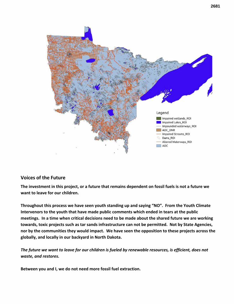
Voices of the Future
The investment in this project, or a future that remains dependent on fossil fuels is not a future we want to leave for our children. Throughout this process we have seen youth standing up and saying “NO”. From the Youth Climate Intervenors to the youth that have made public comments which ended in tears at the public meetings. In a time when critical decisions need to be made about the shared future we are working towards, toxic projects such as tar sands infrastructure can not be permitted. Not by State Agencies, nor by the communities they would impact. We have seen the opposition to these projects across the globally, and locally in our backyard in North Dakota. The future we want to leave for our children is fueled by renewable resources, is efficient, does not waste, and restores. Between you and I, we do not need more fossil fuel extraction.
2681
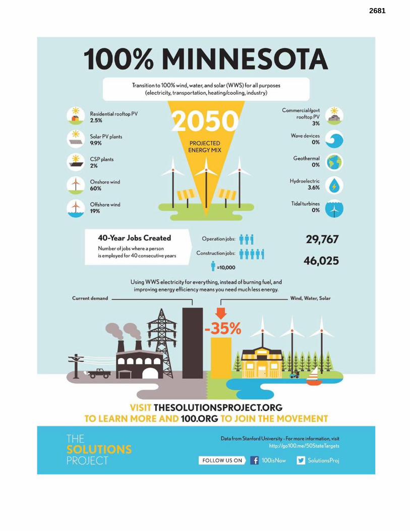
* * ~ * t ~
100% MINNESOTA Transition to 100% wind, water, and solar (WWS) for all purposes
(electricity, transportation, heating/cooling, industry)
Residential rooftop PV 2.5%
Solar PV plants 9.9%
CSP plants 2%
Onshore wind 60%
Offshore wind 19%
40-Year Jobs Created Number of jobs where a person
•
is employed for 40 consecutive years
PROJECTED
ENERGY MIX
•
Operation jobs: iii Construction jobs: i i i i i
i =10,000
Using WWS electricity for everything, instead of burning fuel, and
improving energy efficiency means you need much less energy.
Commercial/govt * rooftop PV
3%
Wave devices 4 0% ~
Geothermal 0%
Hydroelectric 3.6%
Tidal turbines 0%
29,767
46,025
Current demand ~-------- Wind, Water, Solar
~ -35% •
VISIT THESOLUTIONSPROJECT.ORG
•
TO LEARN MORE 100.0RG JO OVEMENT
Data from Stanford University - For more information, visit
• FOLLOW US ON
2681

100% MINNESOTA Transition to 100% wind, water, and solar (WWS) for a ll purposes
(electricity, transportation, heating/cool ing, industry)
Avoided Mortality and Illness Costs Percentage of Minnesota Land Needed for All New WWS Generators
,, I I I I I I
\ -
Avoided health costs per year:
1% of State GDP
Air pollution deaths avoided every year: 692
', I I I I I
, I
Spacing a...,
=100
Plan pays for itself in as litt le as 3 years from air pollution and cl imate
cost savings alone
Future Energy Costs 2050
BAU (Business as usual) WWS(Wind, wale.., solar)
U.S. average fossil -fuel energy costs•
9.3c/kWh
State average WWS
electricity costs
9.8c/kWh
r-----1
: Money in Your Pocket I
I : $2,QQQ
Annual energy, health, and climate cost savings per person
in 2050: $9,134
Annual energy cost savings per person in 2050: $98
-- ------------VISIT THESOLUTIONSPROJECT.ORG
TO LEARN MORE A 100.0RG J VEMENT
----., I I I
Data from Stanford University - For more information, visit
• FO LLOW US ON
2681
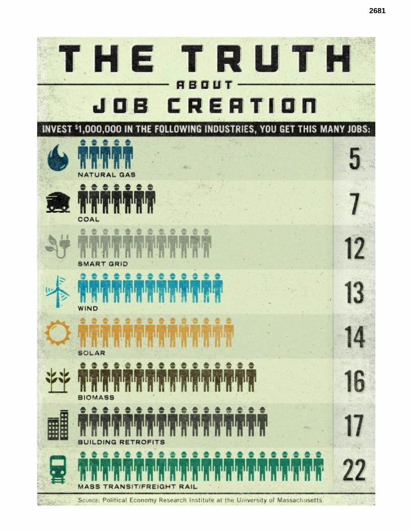
u J ' I
-• - - - - - -
INVEST $1,000,000 IN THE FOLLOWING INDUSTRIES, YOU GET THIS MANY JOBS:
~ .
a,,;,,;, l COA L.
. .. .. . .. . ... .. ... ......... .. Il iiiiiiiT. iiiiiii
. B tOMAS·S ~ .
111 · !ILD!G R!RO!! i '' ' . ' 1 ............. . ..................... '
·i. i ·,; -ii -i -ii -i -ii -i -T 22 MASS TRA'NSIT/FREl·GHT RAIL
-~ SouRc&: :Political Economy Research 1:nstitute at t h~ U, iv~rsi y of Massachusetts
2681
Enbridge and other large oil companies have been allowed to develop a (mostly) unregulated expansive network of pipelines and refineries across the country over the last 50-60 years. This is about the life span of most of that infrastructure. That is part of the “need” for this most recent round of pipeline projects. Not that demand has gone up, but that infrastructure has decayed and markets have shifted. While domestically, urban areas are still the largest consumers of fossil fuels, there has finally been substantial movement towards investment in sustainable urban development. A major component of this is investment in public transportation. Often these vehicles do not rely on fossil fuels. Why should we invest in an infrastructure our grandchildren will not need? Long story short, if Enbridge was run by intelligent, thoughtful people, we would be discussing the expansion of a regional public transportation network. Additionally, with the Chinese markets (and potentially European) opening to North American oil, corporations with investment in oil extraction projects are desperately seeking routes to coastal refineries and shipping channels. With the blocking of KXL and the Gateway project, Enbridge has looked towards eastern ports and refineries as transmission spots. With the growing public objection to bomb trains, terminals and pipelines in general, it is questionable that further major development of eastern ports and refineries will occur. In their public utility commission submissions, Enbridge repeatedly states the vast need for the pipeline due to rising production rates and the petroleum consuming public’s need for more oil. Unfortunately for Enbridge, the reality is that production is decreasing. As for the petroleum consuming public? What they really need is strong government leadership in the areas of public transportation, fuel efficiency, and investments in renewable energy infrastructure. To permit the development of this fossil fuel energy corridor would achieve short-term goals to the disadvantage of long-term goals. most products from the refinery will not be consumed by reservation communities.. In the Clipper ROD, there was mention of the "need' for the crude so people can keep consuming gas. Highest user of gasoline is urban areas. Stop and go driving less efficient.
In reality, however, there are numerous ways to replace the petrochemicals we currently use. Vehicles can be made more efficient, mass transportation systems can be improved, plant-based plastics are already being developed. The use of pharmaceuticals could be decreased by proper nutrition, exercise, and community health programs. Recent studies have shown that the investment in these types of projects result in economic benefits that far outweigh the economic benefits resulting from the oil industry.
Enbridge claims the need for the pipeline is the need for access to cheap and reliable oil. Oil is not an infinite resource, and we are running low. We do not need to invest in another generation of oil infrastructure that will not be needed in the very near future. What we need is investment in infrastructure that will move us away from this dirty, inefficient energy source and towards a future developed on ecological principles. This investment will not harm the economy, rather it will strengthen it by creating jobs, new industries and protect future generations well being.
2681
ALBERTA’S NEW CLIMATE PLAN: the global leadership failing in addressing climate change. Shortly before the Paris climate negotiations, Alberta Premier Rachel Notley announced her province’s climate leadership plan, which includes a cap on emissions from tar sands production of 100 Megatonnes per year.109
This cap corresponds to approximately 3 million barrels per day, up from some 2.2 million barrels per day today. That means that there is a limited amount of Canadian tar sands oil that will ever be produced, and if all of Enbridge’s plans go forward, there is a real possibility that there will be pipeline over capacity.
Another major issue that has been brought up doing this whole process is how unresponsive the PUC and other regulators are to the concerns of the public. We are supposed to be living in a democracy that values public input and works to protect human health. This process does neither thing. It is time to end corporate control of government and put the power back where it belongs- in the hands of the public. What we need are participatory planning processes for large energy projects, transparent government processes- public-private partnerships where corporations work with regulatory agencies and public stakeholders to design the best possible projects that address the LONG TERM needs of communities, rather than the quarterly profit margins of private corporations.
Enbridge and other proponents of the “free market” say that government should not be regulating the industry so much, that they should let the market work on its own. What we have seen in recent years is an increasing segment of consumers standing up and saying “no more dirty oil”. The market has spoken. We want a clean future. We will no longer bear the brunt of your externalities.
Numerous state agencies and politicians have submitted letters against this proposed project. They include the MPCA, the MN DNR, Minnesota Senators Steve Dribble, John Marty and Representatives Frank Hornstein and Jean Wagenius. The National American Indian Congress also recently released a statement against the project.
On July 1, 2015, the National Congress of American Indians adopted a formal resolution calling for a full
Environmental Impact Statement (EIS) on Enbridge Energy’s proposed Sandpiper/Line 3 oil pipeline
corridor across treaty-ceded territory in Northern Minnesota. The NCAI is the oldest and largest
national organization of American Indian and Alaska Native tribal governments. 15
15 http://www.ncai.org/resources/resolutions/calling-for-environmental-justice-and-a-full-environmental-impact-statement-on-enbridge-energy-s-proposed-tar-sands-oil-pipeline-across-treaty-ceded-territory-in-minnesota
2681
This move was part of a larger coordination and agreements between Tribes to oppose fossil fuels. Across Turtle
Island, 122 First Nations and Tribes have signed the Treaty Alliance Against Tar Sands Expansion stating their
official opposition to the expansion of the Alberta tar sands and barring the passage of proposed tar sands
pipeline and rail projects, including associated tanker traffic. The signatories are working collectively to enforce
the ban which covers the following pipeline projects, which threaten our water and our coasts and which would
fuel catastrophic climate change effects (by making further tar sands expansion possible): Kinder Morgan, Line 3,
Keystone XL, Energy East and Northern Gateway, which our members stopped long ago. 16
Tribal Interventions: Tribes have been actively engaged in the opposition to the Enbridge expansion on a
number of fronts. They have been filing as intervenors in state processes and have engaged in their own internal
processes of review. White Earth, Mille Lacs, and Leech Lake Bands have all held hearings on the Enbridge
proposals. Public opinion is unanimous. These projects are not wanted and not consented to.
Tribal Impact Assessments:
“Cumulative impacts to tribal cultures are a combination of pre-existing stressors (existing conditions or
co-risk factors) and any other contamination or new activity that affects environmental quality.
Characterizing risks or impacts … entails telling the cumulative story about risks to trust resources and
a cultural way of life. Equity assessments could also be performed in a way that describes these
systems-level cumulative risks/impacts. This requires improvements in metrics based on an
understanding of the unbreakable ties between people, their cultures, and their resources. ” 17
The reality of what life is for Tribal communities is not represented in the US state or federal processes.
“Cumulative impacts to tribal cultures are a combination of pre-existing stressors (existing conditions or co-risk factors) and any other contamination or new activity that affects environmental quality. Characterizing risks or impacts … entails telling the cumulative story about risks to trust resources and a cultural way of life. Equity assessments could also be performed in a way that describes these systems-level cumulative risks/impacts. This requires improvements in metrics based on an understanding of the unbreakable ties between people, their cultures, and their resources. ” 18
16 http://www.ubcic.bc.ca/treatyalliance_neb_012717 17 “Environmental Justice in Indian Country: Using Equity Assessments to Evaluate Impacts to Trust Resources, Watersheds and Eco-cultural Landscapes” Harris, S and Harper, B. Presented at Environmental Justice: Strengthening the Bridge Between Tribal Governments and Indigenous Communities, Economic Development and Sustainable Communities” Conference sponsored by EPA and Medical University of South Carolina, June 11, 1999. 18 “Environmental Justice in Indian Country: Using Equity Assessments to Evaluate Impacts to Trust Resources, Watersheds and Eco-cultural Landscapes” Harris, S and Harper, B. Presented at Environmental Justice: Strengthening the Bridge Between Tribal Governments and Indigenous Communities, Economic Development and Sustainable Communities” Conference sponsored by EPA and Medical University of South Carolina, June 11, 1999.
2681
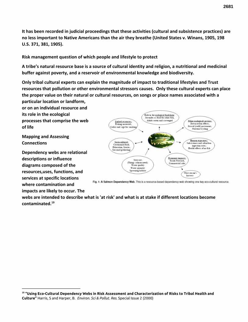
It has been recorded in judicial proceedings that these activities (cultural and subsistence practices) are no less important to Native Americans than the air they breathe (United States v. Winans, 1905, 198 U.S. 371, 381, 1905). Risk management question of which people and lifestyle to protect
A tribe’s natural resource base is a source of cultural identity and religion, a nutritional and medicinal buffer against poverty, and a reservoir of environmental knowledge and biodiversity.
Only tribal cultural experts can explain the magnitude of impact to traditional lifestyles and Trust resources that pollution or other environmental stressors causes. Only these cultural experts can place the proper value on their natural or cultural resources, on songs or place names associated with a particular location or landform, or on an individual resource and its role in the ecological processes that comprise the web of life
Mapping and Assessing Connections
Dependency webs are relational descriptions or influence diagrams composed of the resources,uses, functions, and services at specific locations where contamination and impacts are likely to occur. The webs are intended to describe what is 'at risk' and what is at stake if different locations become contaminated. 19
19 “Using Eco-Cultural Dependency Webs in Risk Assessment and Characterization of Risks to Tribal Health and Culture” Harris, S and Harper, B. Environ. Sci & Pollut. Res. Special Issue 2 (2000)
2681
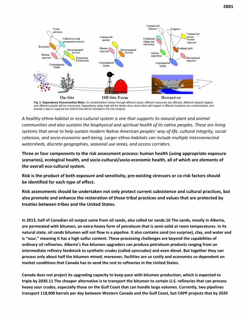
A healthy ethno-habitat or eco-cultural system is one that supports its natural plant and animal communities and also sustains the biophysical and spiritual health of its native peoples. These are living systems that serve to help sustain modern Native American peoples' way of life, cultural integrity, social cohesion, and socio-economic well-being. Larger ethno-habitats can include multiple interconnected watersheds, discrete geographies, seasonal use areas, and access corridors.
Three or four components to the risk assessment process: human health (using appropriate exposure scenarios), ecological health, and socio-cultural/socio-economic health, all of which are elements of the overall eco-cultural system.
Risk is the product of both exposure and sensitivity, pre-existing stressors or co-risk factors should be identified for each type of effect.
Risk assessments should be undertaken not only protect current subsistence and cultural practices, but also promote and enhance the restoration of those tribal practices and values that are protected by treaties between tribes and the United States.
In 2013, half of Canadian oil output came from oil sands, also called tar sands.16 The sands, mostly in Alberta, are permeated with bitumen, an extra-heavy form of petroleum that is semi-solid at room temperatures. In its natural state, oil sands bitumen will not flow in a pipeline. It also contains sand (no surprise), clay, and water and is “sour,” meaning it has a high sulfur content. These processing challenges are beyond the capabilities of ordinary oil refineries. Alberta’s five bitumen upgraders can produce petroleum products ranging from an intermediate refinery feedstock to synthetic crudes (called syncrudes) and even diesel. But together they can process only about half the bitumen mined; moreover, facilities are so costly and economics so dependent on market conditions that Canada has to send the rest to refineries in the United States. Canada does not project its upgrading capacity to keep pace with bitumen production, which is expected to triple by 2030.11 The cheaper alternative is to transport the bitumen to certain U.S. refineries that can process heavy sour crudes, especially those on the Gulf Coast that can handle large volumes. Currently, two pipelines transport 118,000 barrels per day between Western Canada and the Gulf Coast, but CAPP projects that by 2020
2681
supply could reach 709,000 barrels per day.11 Hence, the scramble by TransCanada to build the Keystone XL as well as Enbridge, Kinder Morgan, and other companies to build other pipelines. To get bitumen to flow in a pipeline, it is diluted with a lighter-viscosity solvent called a diluent. If mixed with upgraded light crude at roughly 50:50, the result is synthetic bitumen or “synbit”; if mixed 70:30 bitumen with a naphtha-based oily condensate recovered from processing natural gas, the result is diluted bitumen or “dilbit.” Both are categorized as “oil sands heavy crude.” The 2010 Enbridge pipeline rupture in Michigan revealed that once dilbit was exposed to the ambient air, the diluent evaporated, leaving a heavy sludge, much of which still floated but some of which partially submerged or sank to the river bottom. The evaporation of the diluent created two hazards. The evaporating diluent released high levels of benzene (a known carcinogen) and other unknown toxic gases that sickened 331 residents and caused the issuance of a voluntary evacuation order. And because conventional oil-spill recovery equipment is designed to collect floating oil, the submerged fraction has posed technical challenges for removal. Dredging and other remediation, still ongoing in 2017, has so far topped $1 billion. Few have studied both dilbit’s behavior in freshwater and technologies for detecting and recovering submerged or sunken oil sands products. That is of concern because proposed pipelines carrying dilbit would pass over or under major U.S. rivers including the Missouri and Mississippi. Moreover, Enbridge is now expanding its existing Lakehead pipeline system to carry Alberta tar sands heavy crude, including through Line 5B: twin 20-inch pipelines installed in 1953 lying on the bottom of the Straits of Mackinac between Lake Michigan and Lake Huron. Should one of those 62-year-old pipes leak, strong and rapid currents could swiftly disperse crude widely throughout both these major sources of drinking water, and 150-foot depths could further complicate cleanup. In the event of an oil sands spill, the U.S. National Oceanic and Atmospheric Administration (NOAA) recently identified two appalling regulatory shortcomings: 1) Oil sands products are exempted from the excise tax that provides funds for cleaning up spills in the U.S., and 2) Specific product information is unavailable from oil sands facilities and transporters for what was in the pipeline at the time of the spill. The industry average of 0.34 to 0.5 incident per 1,000 miles per year translates to 170 to 250 incidents per year somewhere in the nation—a number actually about half of what is observed. Statistically, the record shows that several per year are catastrophic. PHMSA data from 2001 to 2011 compelled KAI to conclude: “The ‘average’ pipeline therefore has a 57% probability of experiencing a major leak, with consequences over the $1 million range, in a ten-year period.” If past industry averages and practices hold, as pipeline mileage increases, so will accidents—including ones involving fatalities or dilbit in major waterways. (I haven’t even mentioned ExxonMobil’s 200,000-gallon dilbit spill in Mayflower, AR, in March 2013.) For at least three years running, because of aging pipelines and SCADA vulnerabilities, enhancing pipeline safety has made the NTSB’s top ten
2681
“Most Wanted” list of critical transportation changes needed to reduce transportation accidents and save lives. The American Society of Civil Engineers (ASCE) in its 2013 Report Card for America’s Infrastructure for energy—including oil and natural gas pipelines—kept its previous grade of D+, in part because of aging pipelines and SCADA vulnerabilities. Because of the more viscous makeup of dilbit, it must be pumped at higher pressure and at higher temperatures than conventional crude oil. Additional toxic chemicals are added to allow the product flow. Some sand remains in dilbit. A combination of these attributes has led some engineers to compare dilbit to “fast, hot, and toxic liquid sandpaper.” Add this to the fact that 41 percent of the pipelines were built to carry conventional crude oil in the 1950’s and 1960’s. The alarming speed at which tar sands are being added to this pipeline network raises legitimate questions about the likelihood of many more accidents. The environmental group Natural Resources Defense Council (NRDC) notes that pipelines in the upper Midwest that routinely carry oil from tar sands have spilled 3.6 times more oil per pipeline mile than the U.S. average. 20
The chemistry of the tar sands oil could contribute to corrosion as well. In processing, the tar sands are boiled to separate the bitumen from the surrounding sand and water, and then mixed with diluent—light hydrocarbons produced along with natural gas—to make the oil less viscous and able to flow. But even so, the resulting dilbit is among the lowest in hydrogen as well as the most viscous, sulfurous and acidic form of oil produced today. 21
From: http://onlinepubs.trb.org/onlinepubs/dilbit/Dettman102312.pdf What is Diluent? An example of diluent is called CRW condensate
● “Naptha”- based oil which can include natural gas condensate ○ Natural gas condensate is the “liquid” that is produced with natural gas where the
lowest boiling component is butane which boils at -0.5 degree C/31.9 degree F ● Approximately 75wt% of the condensate boils at temperatures less than 204 degrees C/399.2
degrees F ● Final boiling point is approximately 524 degree C/975.2 degree F
What Is Dilbit?
● Dilbit is the mixture of diluent and bitumen that meets pipeline specifications for density and viscosity ○ Approximately 30vol% of diluent is used in the mixture ○ Consists of componets that boil over the full range of both oils, from -0.5 degree C/31.9 degree F
to over 750 degree C/1382 degree F
20 http://www.oilandwaterdontmix.org/the_bigger_picture 21 https://www.scientificamerican.com/article/tar-sand-oil-and-pipeline-spill-risk/
2681
2681
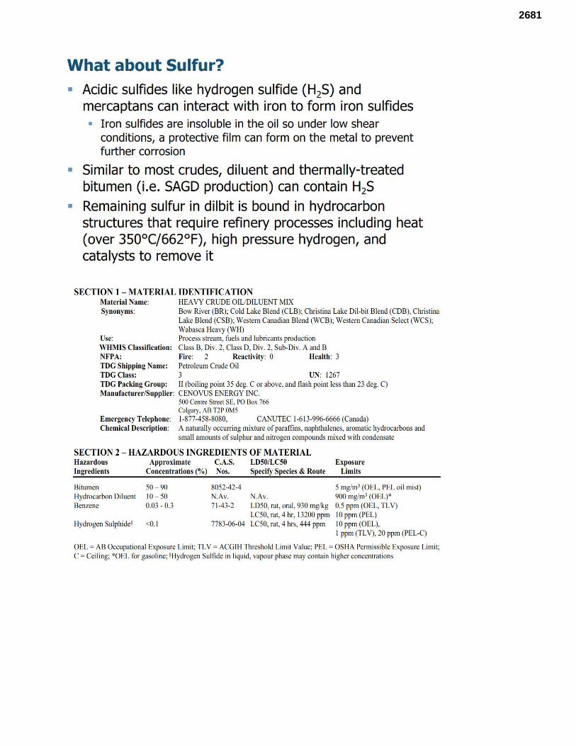
2681
2681
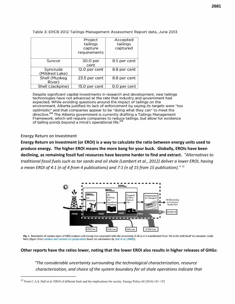
Energy Return on Investment Energy Return on Investment (or EROI) is a way to calculate the ratio between energy units used to produce energy. The higher EROI means the more bang for your buck. Globally, EROIs have been declining, as remaining fossil fuel resources have become harder to find and extract. “Alternatives to traditional fossil fuels such as tar sands and oil shale (Lambert et al., 2012) deliver a lower EROI, having a mean EROI of 4:1 (n of 4 from 4 publications) and 7:1 (n of 15 from 15 publication).” 22
Other reports have the ratios lower, noting that the lower EROI also results in higher releases of GHGs:
“The considerable uncertainty surrounding the technological characterization, resource characterization, and choice of the system boundary for oil shale operations indicate that
22 From C.A.S. Hall et al. EROI of different fuels and the implications for society. Energy Policy 64 (2014) 141–152
2681
oil shale is only a minor net energy producer if one includes internal energy (energy in the shale that is used during the process) as an energy cost. The energy return on investment (EROI) for either of these methods is roughly 1.5:1 for the final fuel product. The inclusions or omission of internal energy is a critical question. If only external energy (energy diverted from the economy to produce the fuel) is considered, EROI appears to be much higher. In comparison, fuels produced from conventional petroleum show overall EROI of approximately 4.5:1. “At the wellhead” EROI is approximately 2:1 for shale oil (again, considering internal energy) and 20:1 for petroleum. The low EROI for oil shale leads to a significant release of greenhouse gases. The large quantities of energy needed to process oil shale, combined with the thermochemistry of the retorting process, produce carbon dioxide and other greenhouse gas emissions. Oil shale unambiguously emits more greenhouse gases than conventional liquid fuels from crude oil feedstocks by a factor of 1.2 to 1.75. Much of the discussion regarding the EROI for oil shale should be regarded as preliminary or speculative due to the very small number of operating facilities that can be assessed.” 23
It is important to note that these estimates do not include the energy required to remediate and restore extraction points. Jobs related to ecological conservation, restoration, and mitigation represent an emerging sector with promising prospects, and offer an alternative path to ecologically destructive development. According to existing literature on this sector, the restoration industry creates 10.4 to 39.7 jobs per $1 million invested, in comparison to the oil and gas industry, which produces 5.3 jobs per $1 million invested. Additionally, jobs associated with this sector tend to be better paying jobs. There have been an increasing number of studies conducted on the emerging green economy, in relation to renewable energy and energy efficiency. According to Bureau of Labor Statistics Green Goods and Services 2011 survey, the green economy supported 3.4 million jobs nationally. The outdoor industry can be considered part of this sector, and supports 118,000 jobs in Minnesota. On June 10, 2015 over 100 leading scientists called for a moratorium on new oil sands development . They have cited 24
the following ten reasons as evidence for the need of a moratorium:
1. Continued expansion of oil sands and similar unconventional fuels in Canada and beyond is incompatible with limiting climate warming to a level that society can handle without widespread harm.
23 From Energy Return on Investment (EROI) of Oil Shale Cutler J. Cleveland * and Peter A. O’Connor, Sustainability 2011, 3, 2307-2322; doi:10.3390/su3112307 24 http://www.oilsandsmoratorium.org/
2681
2. Oil sands should be one of the first fuel sources we avoid using as society moves to non-polluting forms of energy, not the next carbon-intensive source we exploit. Extracting, refining, transporting, and burning oil-sands energy produces among the most greenhouse gases of any transport fuel per unit energy delivered (Brandt 2011, Gordon et al. 2015). Expansion of oil sands production will exacerbate the problem of carbon pollution and slow the transition to cleaner energy (Unruh 2000).
3. Current oil sands environmental protections and baseline data are largely lacking, and protections that exist are too seldom enforced. Too often, the development of the oil sands is presented as inevitable, while protections for human health and the environment are treated as optional.
4. Contaminants from oil sands development permeate the land, water and air of the Canadian boreal landscape, and many of these impacts are difficult to mitigate. Independent studies have demonstrated that mining and processing Albertan oil sands releases carcinogenic and toxic pollutants (e.g., heavy metals, polycyclic aromatic compounds) to the atmosphere from smoke stacks and evaporation, and to groundwater from leaching of tailings ponds. This pollution harms terrestrial and aquatic ecosystems and the species within them (Pollet and Bendell-Young 2000, Gurney et al. 2005, Nero et al. 2006, Gentes et al. 2007, Kelly et al. 2009, Kelly et al. 2010, Landis et al. 2012, Rooney et al. 2012, Kurek et al. 2013, Andrishak and Hicks 2011, Hebert et al. 2013, Galarneau et al. 2014, Parajulee and Wania 2014, Schindler 2014, Schwalb et al. 2015).
5. Less than 0.2% of the area affected by Canadian oil sands mining has been reclaimed, and none restored to its original state (Government of Alberta 2014).
6. Development and transport of oil sands is inconsistent with the title and rights of many Aboriginal Peoples of North America. Rapid expansion of the oil sands in Canada violates or puts at risk nation-to-nation agreements with Aboriginal peoples. In Alberta, oil sands mining is contributing to the degradation and erosion of treaty and constitutionally protected rights by disrupting ecological landscapes critical to the survival of Aboriginal culture, activities, livelihoods, and lifeways (Passelac-Ross and Potes 2007, Foote 2012, ACFN). In the US, proposed infrastructure projects threaten to undermine Treaty agreements between the federal government and Native American tribes (Mufson 2012, Hart 2014). In both countries, contamination of sacred lands and waters, disruption of cultural sites, lack of consultation, and long-term effects of climate change undermine sustainable social, ecological, and economic initiatives involving Aboriginal peoples across the continent and constitute violations of Native sovereignty (Passelac-Ross and Potes 2007, Foote 2012, Mufson 2012, Hart 2014, Irvine et al. 2014, McLachlan 2014, Wohlberg 2014, Athabasca Chipewyan First Nation, Tsleil-Wautath Nation).
7. What happens in North America will set a precedent for efforts to reduce carbon pollution and address climate warming elsewhere. The choices we make about the oil sands will reverberate globally, as other countries decide whether or how to develop their own large unconventional
2681
oil deposits (Balouga 2012). Strong North American leadership is needed now, because the impacts of current decisions will be felt for decades and centuries.
8. Controlling carbon pollution will not derail the economy. Most leading economists now agree that limits on carbon pollution – using mechanisms such as carbon taxes, cap-and-trade systems, or regulations – can facilitate a transition over several decades to low-emission energy without a dramatic reduction in global economic growth (Global Energy Assessment 2012, IPCC 2014, Nordhaus 2014).
9. Debates about individual pipeline proposals underestimate the full social costs of the oil sands, and existing policies ignore cumulative impacts. These are not simply business decisions. Responsible policies should address the interwoven, system-wide impacts of oil sands development, from mines and refineries, to pipelines, rail and tanker traffic, to impacts on economies and the global climate system. Current laws, regulations, and policies are not designed to assess cumulative impacts (Johnson and Miyanishi 2008, Office of the Auditor General of Canada 2011). When oil sands development is viewed as an integrated whole, the costs and benefits of individual decisions can be evaluated responsibly (Chan et al. 2014). Land use and regulatory decisions are considered lease-by-lease with no single agency responsible for oversight, accounting of cumulative impacts, or information flow. For example, decisions regarding mineral rights are made by Alberta Energy, those for timber by Alberta Sustainable Resource Development, while Alberta Environment decides on water and air impacts, and the National Energy Board decides on pipeline and rail transport of oil sands products (Johnson and Miyanishi 2008).
10. A majority of North Americans want their leaders to address climate change, and they are willing to pay more for energy to help make that happen.
Because of high extraction costs and low oil prices, the mining of the Alberta Tar Sands is a rapidly dying industry. Many companies are withdrawing their investments. Those that remain are borrowing against our children’s future, taking on massive amounts of debt to pay false dividends to shareholders and prevent them from fleeing. Despite an overly optimistic industry forecast of increased production that justifies 1 new pipeline carrying tar sands out of Canada in the next 4-5 years, a total of 4 new pipelines are currently proposed. Every one of them must cross tribal lands, and every one of them faces bold resistance. At the same time, Enbridge’s proposal to simply abandon its old, crumbling Line 3 pipeline risks setting dangerous precedent, and raises serious questions about who will be left holding the bill for this industry’s slow painful death, toxic legacy and stranded assets. Now is the time for tribal governments to come together and take bold action to protect our territories and the natural and cultural resources our future generations will depend on. A Dying Industry: Compared to conventional oil, tar sands crude is a lot more expensive to extract. New oil development in the tar sands costs over $80/barrel(bbl). But since the end of 2014, oil prices have only ranged between $30 and $60/bbl, with current prices around $50/bbl. So tar sands extraction is simply not economically viable in the long term. If gasoline prices don’t return to $3.00-$3.50/gal (equivalent to crude oil at $70-$85/bbl), the oil industry will go bankrupt - it’s that simple. And tar sands producers will go first.
2681
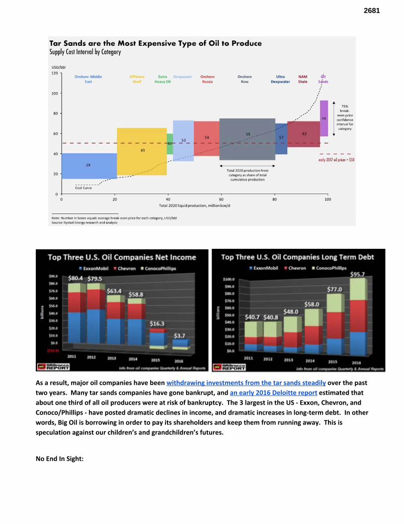
As a result, major oil companies have been withdrawing investments from the tar sands steadily over the past two years. Many tar sands companies have gone bankrupt, and an early 2016 Deloitte report estimated that about one third of all oil producers were at risk of bankruptcy. The 3 largest in the US - Exxon, Chevron, and Conoco/Phillips - have posted dramatic declines in income, and dramatic increases in long-term debt. In other words, Big Oil is borrowing in order to pay its shareholders and keep them from running away. This is speculation against our children’s and grandchildren’s futures.
No End In Sight:
2681
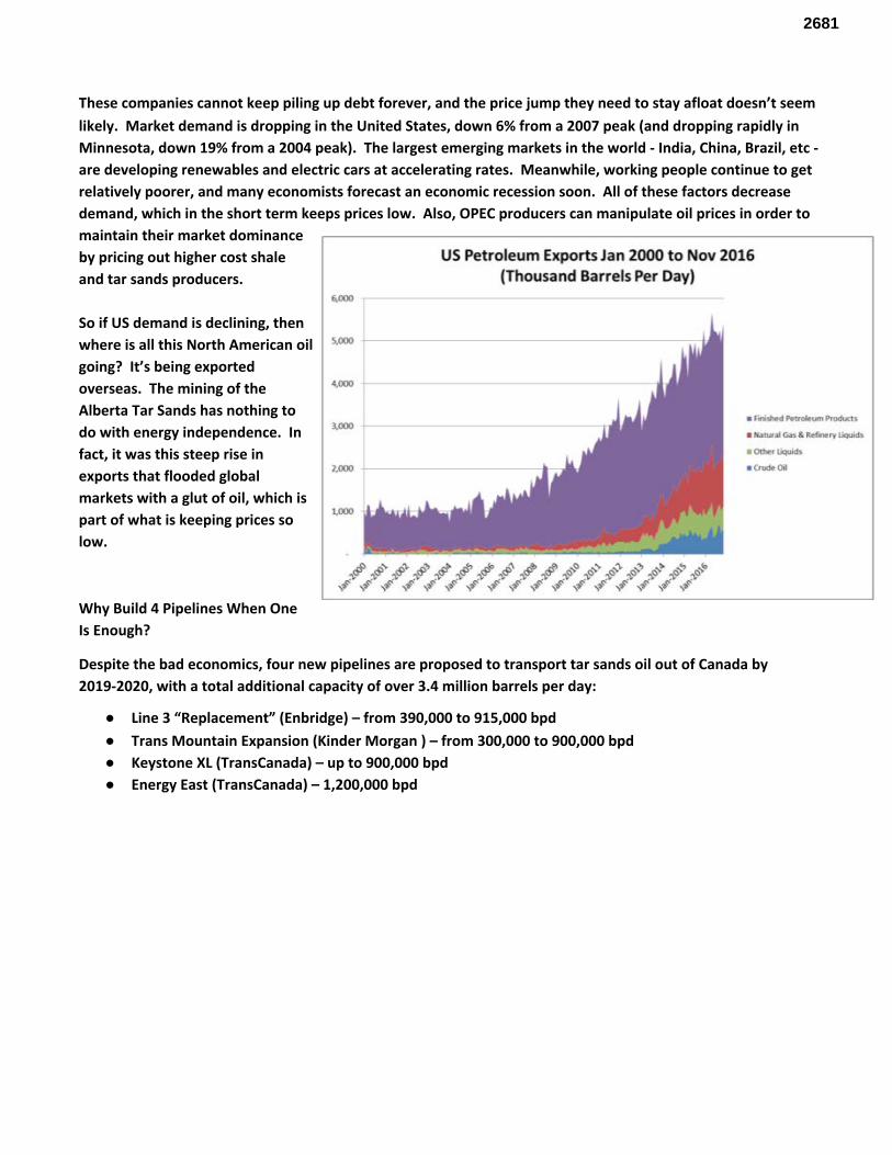
These companies cannot keep piling up debt forever, and the price jump they need to stay afloat doesn’t seem likely. Market demand is dropping in the United States, down 6% from a 2007 peak (and dropping rapidly in Minnesota, down 19% from a 2004 peak). The largest emerging markets in the world - India, China, Brazil, etc - are developing renewables and electric cars at accelerating rates. Meanwhile, working people continue to get relatively poorer, and many economists forecast an economic recession soon. All of these factors decrease demand, which in the short term keeps prices low. Also, OPEC producers can manipulate oil prices in order to maintain their market dominance by pricing out higher cost shale and tar sands producers. So if US demand is declining, then where is all this North American oil going? It’s being exported overseas. The mining of the Alberta Tar Sands has nothing to do with energy independence. In fact, it was this steep rise in exports that flooded global markets with a glut of oil, which is part of what is keeping prices so low.
Why Build 4 Pipelines When One Is Enough?
Despite the bad economics, four new pipelines are proposed to transport tar sands oil out of Canada by 2019-2020, with a total additional capacity of over 3.4 million barrels per day:
● Line 3 “Replacement” (Enbridge) – from 390,000 to 915,000 bpd ● Trans Mountain Expansion (Kinder Morgan ) – from 300,000 to 900,000 bpd ● Keystone XL (TransCanada) – up to 900,000 bpd ● Energy East (TransCanada) – 1,200,000 bpd
2681
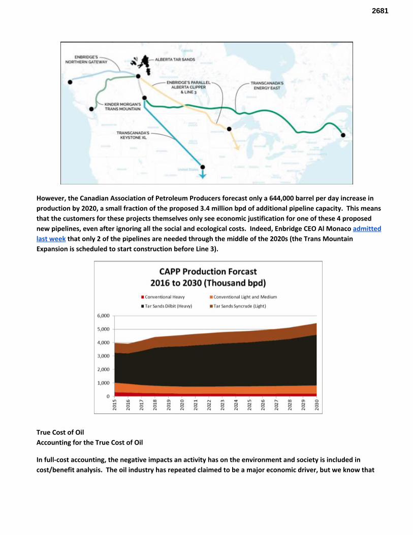
However, the Canadian Association of Petroleum Producers forecast only a 644,000 barrel per day increase in production by 2020, a small fraction of the proposed 3.4 million bpd of additional pipeline capacity. This means that the customers for these projects themselves only see economic justification for one of these 4 proposed new pipelines, even after ignoring all the social and ecological costs. Indeed, Enbridge CEO Al Monaco admitted last week that only 2 of the pipelines are needed through the middle of the 2020s (the Trans Mountain Expansion is scheduled to start construction before Line 3).
True Cost of Oil Accounting for the True Cost of Oil
In full-cost accounting, the negative impacts an activity has on the environment and society is included in cost/benefit analysis. The oil industry has repeated claimed to be a major economic driver, but we know that
2681
internationally, the industry receives $775 billion to $1 trillion in subsidies annually. We also know that fossil 25
fuels are a finite resource and are getting harder and harder to extract. We must start investing in sustainable infrastructure, and further investments in fossil fuels threatens our survival. Carbon Costs
The most widely recognized cost of the oil industry is carbon costs. The DOC’s DEIS acknowledges this, but only uses one measurement of cost. We have reviewed the literature and have determined at least two cost factors. While the DOC utilizes a “best case” scenario to calculate the amount of carbon released from these projects, we utilize a “worst case” scenario. This is a decision made based on our level of acceptable risk. The first cost is the removal of carbon from the atmosphere. This is currently trending at $1,000.00/metric ton . 26
The second cost is the social cost of carbon. Again, while the DOC acknowledges this is a potential impact, they use a smaller cost. Our cost is $210/ton . To reach the carbon measurements for the two projects, we 27
converted the capacity of the lines into carbon production. Running the numbers gives us a cost of over $396 billion, annually. Ecosystem costs
Atmospheric carbon production is not the only negative externality of the oil industry. The extraction, refining, transportation, and combustion all have landscape level impacts. Through the destruction of boreal forests and wetlands through tar sands mining and pipeline corridor creation, humanity is losing valuable ecosystem services. These services can vary and include such benefits as water filtration, flood protection, food source, carbon storage, and recreational benefits. There is also the spiritual value of land and functioning ecosystems, but it is inappropriate to put a monetary value on this aspect. The numbers we use for calculating the value of the lost ecosystem services come from Earth Economics report: “The Value of Nature’s Benefits in the St. Louis River Watershed” and the Pembina Institute's “Counting Canada’s Natural Capital” report. To get the size of ecosystem destroyed, we calculated the land area lost to tailing ponds. Each barrel of oil creates approximately 16.9 barrels of tailings. These tailings are stored in pits for at least 40 years while they settle and compact. The volume of these tailings, converted to area represent the annual area of boreal forest lost from tar sands extraction. We multiply this by the proposed volume in the pipelines, and convert it to hectares. We also estimate the total area of wetlands destroyed during the construction of the new corridor, which Enbridge has no plan to restore. The total cost of the loss of ecosystem services for these pipelines is over $595 million, annually. As we develop our methods, we will include the loss of services from other ecosystems to give a fuller picture of the cost of oil. An Incomplete Total Adding these costs together give us a full cost of over $397 billion annually. Since there are currently no real plans to remove the carbon or restore the forests and wetlands, we have applied an annual interest rate of 26%. This rate is based off Enbridge’s spill rate (3.19 per/1000 ft of pipeline). This gives us a $499 billion annual cost
25 http://priceofoil.org/fossil-fuel-subsidies/ 26 House, K. Z.; Baclig, A. C.; Ranjan, M.; A, v. N. E.; Wilcox, J.;Herzog, H. J. Economic and Energetic Analysis of Capturing CO2from Ambient Air.Proc. Natl. Acad. Sci.2011,108(51), 20428−20433 27 https://www.greenbiz.com/article/governments-social-cost-carbon-could-be-increased
2681
from Enbridge’s proposed Line 3 Expansion. As we develop our methods, we will refine the way we compound our interest based on the needs of the future generations.
Specific comments related to the DEIS document 1. It seems to be more of a review document rather than a document of critical thought. In the
environmental impacts section, it is basically cut and paste from Enbridge’s proposal without a real consideration that maybe, just maybe Enbridge won’t actually follow the requirements of the permits they will be required to get (such as NPDES/CWA construction permits). History shows that they continually violate the terms of these permits.
a. https://insideclimatenews.org/news/20131202/enbridge-could-be-forced-boost-pipeline-safety-mich-after-water-violations
b. https://www.desmogblog.com/2016/07/19/former-inspectors-describe-dangerous-flaws-construction-major-east-coast-gas-pipeline
c. http://grangehallpress.com/Enbridgeblog/2013/01/20/the-latest-construction-violation/ d. http://archive.jsonline.com/news/wisconsin/37009324.html e. http://michiganradio.org/post/enbridge-energy-could-face-fines-after-incident-pipeline-thats-u
nder-construction f. http://oxfordleader.com/enbridge-sub-contractor-ticketed/ g. http://www.freep.com/story/news/local/michigan/2016/08/03/ag-bill-schuette-enbridge-violati
ng-straits-pipeline-easement/88039662/ h. https://insideclimatenews.org/news/20130709/mich-officials-step-scrutiny-enbridge-after-wate
r-law-violations i. https://www.dnr.illinois.gov/programs/NRDA/Pages/Lakehead.aspx
All true independent analysis of this document and project has said it is a bad idea. Not one person that spoke approvingly of the project at the public meetings was not paid, or otherwise compensated by Enbridge, or completely unaware of any real details of the DEIS.
Enbridge.
Where to start. We could begin at Line 5, the aging, deteriorating line that runs under the Straits of Mackinac and directly threatens ⅕ of the world’s freshwater. Enbridge keeps insisting it can run safely, indefinitely. Yet their internal documents show the outer coating is flaking off. We could talk about Line 6b, the one that ruptured in Michigan. This is one where Enbridge’s handling of the response was described as “keystone cop-like”.
2681
At fault in the 2010 Kalamazoo spill was a faulty detection system and response procedure that Enbridge states will remedy the issues that resulted in the catastrophic spill. Critics contend the entire US pipeline system is still riddled with faulty leak detection. 28
An independent review of Enbridge’s policies and procedures should be conducted to verify the needed changes have been made. A review should also be done regarding the in-place monitoring to ensure it is sufficient and if proposed system are sufficient to a Tribally determined level.
Response According to the Wall Street Journal, an estimated 80% of spills are actually detected by civilians, despite pipeline companies enormous investments in state of the art detection systems. 29
A federal audit of Enbridge’s 2010 spill in Marshall, MI, showed that Enbridge was unable to stop leaks on aging pipelines, and still does not know the best way to completely clean up after a catastrophic spill. The audit showed that Enbridge could not prove that it knew how to monitor and repair pipeline cracks forming from corrosion - the key factor that had led to two major Enbridge oil spill disasters in 2007 and 2010 in Glenavon, Saskatchewan and Marshall, Michigan. As it were, Enbridge lobbied 30
hard to demand the NEB remove the most incriminating parts of that report, and covered up two secret environmental documents. In fact, Enbridge has lobbied aggressively against responsible spill response regulations in Minnesota. In an October 2014 letter to the Environmental Quality Board, a number of Minnesota legislators pointed out Enbridge’s resistance and determination to thwart any safety regulations by the state of Minnesota. The letter, from Minnesota Senators Steve Dribble, John Marty and Representatives Frank Hornstein and Jean Wagenius, stated: “Enbridge and the pipeline industry were unwilling to agree to:
● Provide a qualified company employee to advise public sector incident commander by telephone within one hour of a major pipeline oil discharge;
● Provide monitoring equipment within three hours of a discharge, or to develop an annual plan to deliver monitoring equipment to a discharge site to comply with the provision;
● Provide qualified personnel to advise incident commanders at the discharge site within three hours of a major spill;
● Provide containment booms from land across sewer outfalls, creeks, ditches and other places where oil and other hazardous substances may drain in order to contain leaked material before it reaches those resources;
● To have capability to deliver containment booms, boats, oil recovery equipment and trained staff within eight hours of a confirmed discharge to recover 10% of a worst case discharge,
28 http://www.wsj.com/articles/SB1000142405270 29 http://thinkprogress.org/climate/2014/01/21/3186261/pipeline-spills-discovered-people/ 30 http://www.nationalobserver.com/2016/05/02/news/heres-how-enbridge-edited-federal-pipeline-audit
2681
including protection of listed sensitive areas and potable water intakes within one mile of a discharge site
● Deliver equipment to protect sensitive environmental areas and drinking water intakes, within 60 hours of a major spill
● Provide updated disaster prevention and response plans to the Pollution Control Agency every three years…”
We could talk about how they’ve been dragging their feet on fixing this line for years. In 2003, both the Minnesota Pollution Control Agency (MPCA) and the Minnesota Office of Pipeline Safety (MN OPS) wrote letters to the Pipeline and Hazardous Materials Safety Administration (PHMS) stating their concern over Line 3. The MPCA’s letter included these facts:
● MPCA has records of nearly three dozen non-third-party spills, leaks, or ruptures of Line 3 between 1972 and 2003
● About 87% of the pipeline petroleum spills in Minnesota in the period of 1991-2002 were from Line 3. ● About 48% of all petroleum spilled from all sources in Minnesota was from Line 3
Line 3 was responsible for the 1.7 million gallon spill in 1991 in Grand Rapids and the 2002 250,000 rupture in Cohasset. The Grand Rapids spill was between a college and an apartment building. But for incredible luck an inferno could have resulted. 300,000 gallons of the Grand Rapids spill flowed to a river. Luck with the timing of the spill; river-ice conditions; and an aggressive and organized recovery by the company kept hundreds of thousands of gallon of crude oil from entering the Mississippi River. Oil in the Mississippi would likely have fouled St. Cloud, St. Paul, and Minneapolis drinking water intakes for months. Likewise, the Cohasset spill could have easily entered the Mississippi River it had happened in a different segment of Line 3. 2007-2008, a focus group within Enbridge recommended that segments of Line 3 be replaced because of the high density of identified anomalies. At that time, the optimal maintenance approach was determined to be lowering the pressure on the pipeline in successive steps, which deferred the immediate need for pipeline replacement. In 2008, Line 3’s capacity was 503,000 bpd of mixed service, and by 2010, it had been lowered to a capacity of 390,000 bpd of light crude oil. This lowered pressure maintained a safety factor on the line, deferred some of the maintenance work on the anomalies, and still allowed the pipeline to function, albeit at a much reduced rate. In the U.S. alone, approximately 4,000 integrity digs were forecast during the following 15 years to maintain Line 3 at its reduced level of operation. Dig and repair costs were forecasted to exceed $6 billion through the year 2026, and replacing the segments in the worst integrity condition would only lower the forecasted cost to $4.3 billion. Further pressure reductions could not be implemented because the pipeline was already operating at the lowest operable pressures. We could also talk about the number of spills, or fines they’ve recieved.
2681
2010 Duluth New Tribune article http://www.duluthnewstribune.com/content/state-records-show-many-minnesota-pipeline-ruptures The News Tribune found that over the past 30 years, nearly 1.5 million gallons of oil have spilled out of the Enbridge/Lakehead pipes in northern Minnesota -- much of it into wetlands and some of it close to the Mississippi River. In one case, tens of thousands of spilled gallons were set on fire to avoid causing more serious environmental damage.
The PCA data shows 145 of those spills occurred since the company became Enbridge, though only 10 were greater than 1,000 gallons.
One of the Enbridge lines has been a particular problem -- a 34-inch pipe that has been the source of most of the state's major oil spills in recent years. It's the line that exploded in 2007, killing two workers near Clearbrook, and it's the pipe that caused one of the state's largest-ever spills in 1991 near Grand Rapids.
"The record of Enbridge's (older) 34-inch line is not good; it is responsible for more than half of the oil spilled in Minnesota," said Sam Brungardt, a spokesman for the PCA.
In a memo to the National Transportation Safety Board, the PCA warned as early as 2003, four years before the deadly explosion, that the 34-inch line had problems when operated at full-capacity pressure. PCA officials say
2681
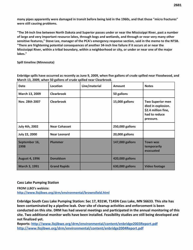
many pipes apparently were damaged in transit before being laid in the 1960s, and that those "micro fractures" were still causing problems.
"The 34-inch line between North Dakota and Superior passes under or near the Mississippi River, past a number of large and very important resource lakes, through bogs and wetlands, and through or near very many other sensitive features," Steve Lee, manager of the PCA's emergency response section, said in the memo to the NTSB. "There are frightening potential consequences of another 34-inch line failure if it occurs at or near the Mississippi River, within a tribal boundary, within a neighborhood or city, or under or near one of the major lakes." Spill timeline (Minnesota)
Enbridge spills have occurred as recently as June 9, 2009, when five gallons of crude spilled near Floodwood, and March 13, 2009, when 50 gallons of crude spilled near Clearbrook.
Date Location Line/material Amount Notes
March 13, 2009 Clearbrook 50 gallons
Nov. 28th 2007 Clearbrook 15,000 gallons Two Superior men died in explosion. $2.4 million fine, had to reduce pressure.
July 4th, 2002 Near Cohasset 250,000 gallons
July 22, 2000 Near Leonard 20,000 gallons
September 16, 1998
Plummer 147,000 gallons Town was temporarily evacuated
August 4, 1996 Donaldson 420,000 gallons
March 3, 1991 Grand Rapids 630,000 gallons Video footage
Cass Lake Pumping Station FROM LLBO’s webiste: http://www.llojibwe.org/drm/environmental/brownsfield.html Enbridge South Cass Lake Pumping Station: Sec 17, R31W, T145N Cass Lake, MN 56633. This site has been contaminated by a pipeline leak. Over site of cleanup activities and enforcement is been conducted on this site. DRM has had several meetings and participated in the annual monitoring of this site. Two additional monitor wells have been installed. Feasibility studies are still being developed and not finalized yet. Reports: http://www.llojibwe.org/drm/environmental/content/enbridge2003Report.pdf http://www.llojibwe.org/drm/environmental/content/enbridge2004Report.pdf
2681
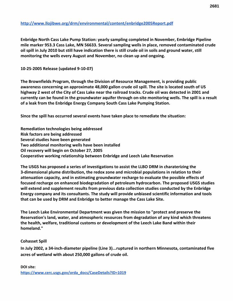
http://www.llojibwe.org/drm/environmental/content/enbridge2005Report.pdf Enbridge North Cass Lake Pump Station: yearly sampling completed in November, Embridge Pipeline mile marker 953.3 Cass Lake, MN 56633. Several sampling wells in place, removed contaminated crude oil spill in July 2010 but still have indication there is still crude oil in soils and ground water, still monitoring the wells every August and November, no clean up and ongoing.
10-25-2005 Release (updated 9-10-07)
The Brownfields Program, through the Division of Resource Management, is providing public awareness concerning an approximate 48,000 gallon crude oil spill. The site is located south of US highway 2 west of the City of Cass Lake near the railroad tracks. Crude oil was detected in 2001 and currently can be found in the groundwater aquifer through on-site monitoring wells. The spill is a result of a leak from the Enbridge Energy Company South Cass Lake Pumping Station.
Since the spill has occurred several events have taken place to remediate the situation:
Remediation technologies being addressed Risk factors are being addressed Several studies have been generated Two additional monitoring wells have been installed Oil recovery will begin on October 27, 2005 Cooperative working relationship between Enbridge and Leech Lake Reservation The USGS has proposed a series of investigations to assist the LLBO DRM in charaterizing the 3-dimensional plume distribution, the redox zone and microbial populations in relation to their attenuation capacity, and in estimating groundwater recharge to evaluate the possible effects of focused recharge on enhanced biodegradation of petroleum hydrocarbon. The proposed USGS studies will extend and supplement results from previous data collection studies conducted by the Enbridge Energy company and its consultants. The study will provide unbiased scientific information and tools that can be used by DRM and Enbridge to better manage the Cass Lake Site.
The Leech Lake Environmental Department was given the mission to "protect and preserve the Reservation's land, water, and atmospheric resources from degradation of any kind which threatens the health, welfare, traditional customs or development of the Leech Lake Band within their homeland."
Cohasset Spill In July 2002, a 34-inch-diameter pipeline (Line 3)...ruptured in northern Minnesota, contaminated five acres of wetland with about 250,000 gallons of crude oil. DOI site: https://www.cerc.usgs.gov/orda_docs/CaseDetails?ID=1019
2681
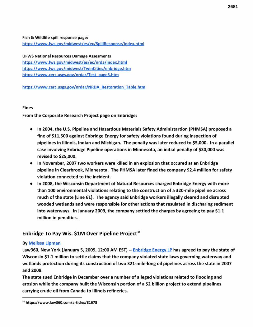
Fish & Wildlife spill response page: https://www.fws.gov/midwest/es/ec/SpillResponse/index.html UFWS National Resources Damage Assesments https://www.fws.gov/midwest/es/ec/nrda/index.html https://www.fws.gov/midwest/TwinCities/enbridge.htm https://www.cerc.usgs.gov/nrdar/Test_page3.htm https://www.cerc.usgs.gov/nrdar/NRDA_Restoration_Table.htm
Fines From the Corporate Research Project page on Enbridge:
● In 2004, the U.S. Pipeline and Hazardous Materials Safety Administartion (PHMSA) proposed a fine of $11,500 against Enbridge Energy for safety violations found during inspection of pipelines in Illinois, Indian and Michigan. The penalty was later reduced to $5,000. In a parallel case involving Enbridge Pipeline operations in Minnesota, an initial penalty of $30,000 was revised to $25,000.
● In November, 2007 two workers were killed in an explosion that occured at an Enbridge pipeline in Clearbrook, Minnesota. The PHMSA later fined the company $2.4 million for safety violation connected to the incident.
● In 2008, the Wisconsin Department of Natural Resources charged Enbridge Energy with more than 100 environmental violations relating to the construction of a 320-mile pipeline across much of the state (Line 61). The agency said Enbridge workers illegally cleared and disrupted wooded wetlands and were responsible for other actions that resulated in discharing sediment into waterways. In January 2009, the company settled the charges by agreeing to pay $1.1 million in penalties.
Enbridge To Pay Wis. $1M Over Pipeline Project 31
By Melissa Lipman Law360, New York (January 5, 2009, 12:00 AM EST) -- Enbridge Energy LP has agreed to pay the state of Wisconsin $1.1 million to settle claims that the company violated state laws governing waterway and wetlands protection during its construction of two 321-mile-long oil pipelines across the state in 2007 and 2008. The state sued Enbridge in December over a number of alleged violations related to flooding and erosion while the company built the Wisconsin portion of a $2 billion project to extend pipelines carrying crude oil from Canada to Illinois refineries.
31 https://www.law360.com/articles/81678
2681
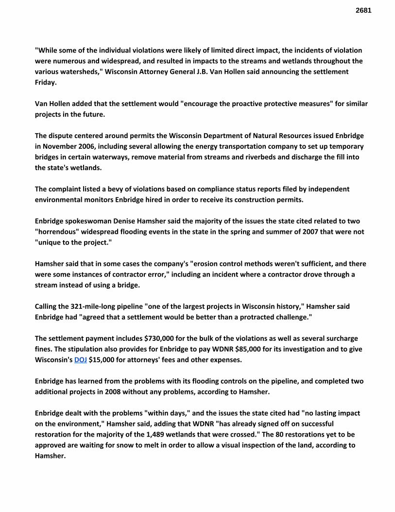
"While some of the individual violations were likely of limited direct impact, the incidents of violation were numerous and widespread, and resulted in impacts to the streams and wetlands throughout the various watersheds," Wisconsin Attorney General J.B. Van Hollen said announcing the settlement Friday. Van Hollen added that the settlement would "encourage the proactive protective measures" for similar projects in the future. The dispute centered around permits the Wisconsin Department of Natural Resources issued Enbridge in November 2006, including several allowing the energy transportation company to set up temporary bridges in certain waterways, remove material from streams and riverbeds and discharge the fill into the state's wetlands. The complaint listed a bevy of violations based on compliance status reports filed by independent environmental monitors Enbridge hired in order to receive its construction permits. Enbridge spokeswoman Denise Hamsher said the majority of the issues the state cited related to two "horrendous" widespread flooding events in the state in the spring and summer of 2007 that were not "unique to the project." Hamsher said that in some cases the company's "erosion control methods weren't sufficient, and there were some instances of contractor error," including an incident where a contractor drove through a stream instead of using a bridge. Calling the 321-mile-long pipeline "one of the largest projects in Wisconsin history," Hamsher said Enbridge had "agreed that a settlement would be better than a protracted challenge." The settlement payment includes $730,000 for the bulk of the violations as well as several surcharge fines. The stipulation also provides for Enbridge to pay WDNR $85,000 for its investigation and to give Wisconsin's DOJ $15,000 for attorneys' fees and other expenses. Enbridge has learned from the problems with its flooding controls on the pipeline, and completed two additional projects in 2008 without any problems, according to Hamsher. Enbridge dealt with the problems "within days," and the issues the state cited had "no lasting impact on the environment," Hamsher said, adding that WDNR "has already signed off on successful restoration for the majority of the 1,489 wetlands that were crossed." The 80 restorations yet to be approved are waiting for snow to melt in order to allow a visual inspection of the land, according to Hamsher.
2681
The stipulation requires Enbridge to retain its independent environmental monitors until the company has completely restored the wetlands to comply with its construction permits. The Wisconsin project is part of Enbridge's larger expansion and extension of pipelines carrying crude oil from western Canada to refineries in Chicago and southern Illinois. Enbridge expects the entire project, with more than 600 miles of new pipeline, to begin operating by 2011 and has spent $2.6 billion on construction since 2006. Enbridge was represented by in-house counsel and Whyte Hirschboeck Dudek SC. The case is State of Wisconsin v. Enbridge Energy LP, case number 2008-cx-24, in the State of Wisconsin Circuit Court, Dane County Branch. What do we know about the integrity of Line 3? According to their most recent publicly disclosed inspection records:
● Over 70 percent of the 140,000 pipe sections between welds (referred to as “pipe joints”) are experiencing external corrosion;
● Corrosion deeper than 50 percent of the pipe wall thickness would increase to affect over 3,000 of the pipe joints in 2016 – an increase from approximately 900 pipe joints in 2012; and
● Over 25,500 pipe joints will have a corrosion depth of 50 percent or greater by 2030 – an increase from approximately 18,000 pipe joints forecast for 2027
● Ten times as many corrosion anomalies per mile (with a depth of more than 20 percent of the pipe wall thickness) than any other Enbridge pipeline in the same corridor.
● SCC affecting over 15 percent of the pipe joints, and five times as many SCC anomalies per mile (with a depth of more than 10 percent of the pipe wall thickness) than any other Enbridge pipeline in the same corridor.
Why is this pipeline in such bad condition? Line 3 in the U.S. was built in 1962/1963 with two characteristics that make this pipeline particularly susceptible to three integrity threats. First, on Line 3 in Minnesota, 84 percent of the coating is Polyethylene (“PE”) tape, which has been found to disbond from the pipe, making the pipeline more susceptible to both external corrosion and SCC. Second, 53 percent of the longitudinal welds are flash welded (“FW”), which was a pipe manufacturing process that has an inherently higher susceptibility to the formation of defects along the long seam of the pipe. Although not all FW pipe contain manufacturing defects, there are FW segments of Line 3 where the combination of these defects and internal pipeline pressure developed into long-seam cracking and contributed to some of the historical failures, including the 1991 1,700,000 gallon Grand Rapids Spill- the largest inland spill in U.S. history. It’s also what caused the Kalamazoo rupture, the largest inland spill in US history (replacing the previous record holder, the 1979 Bemidji spill). It has been 6 years and $1.2 billion has been spent, and that spill is still not 32
cleaned up. The community near the spill has been suffering negative health effects, and it has been shown that Enbridge knew about the crack, but did nothing about it. We do not want this risk in our pristine waterways and
32 http://www.ntsb.gov/investigations/AccidentReports/Pages/PAR1201.aspx
2681
sacred rice beds. These lines are catastrophes waiting to happen. Allowing Enbridge to abandon Line 3 without a sufficient review process will set a dangerous precedent. Management Systems 33
Pipeline operators are not required to have electronic leak detection systems. Instead, they use a system of weights and balances to determine if their system is losing volume. Part of these management systems include the “smart pigs” that inspect the pipelines from the inside out. Currently, regulations do not govern a standard response time for leak detection. Small leaks are the most difficult to detect; “Even the best leak detection systems may not be able to detect small leaks under 3% of the volume of the flow through the pipeline”. Integrity Management is the set of rules that operators follow regarding the identification and assessment of all threats to a particular pipeline segment, be they from internal or external corrosion, flooding, landslides, excavation damage, weld or construction defects, etc. As part of this set of rules, they must also produce a specific Integrity Management plan designed to routinely assess those threats. This plan must also cover the undertaking of any necessary repairs or replacements, the improvement of cathodic protection, and outline other actions necessary to maintain the pipeline’s safety. These Integrity Management rules, however, are not applicable toward all pipelines. The rules are only implemented for pipelines that could affect a “High Consequence Area” (HCA) in the event of a spill. For liquid lines, HCAs include defined densities of populated “Unusually Sensitive Areas” (USAs) such as: drinking water sources, commercial or recreational fishing areas, and commercially navigable waterways. Each HCA pipeline segment must be re-assessed at least every five years. About 44% of all hazardous liquid pipelines fall within HCAs. Limitations of Smart Pigs 34
Despite the industry’s reliance and touting of smart pigs, there are several limitations associated with the process. Every five years may not be frequent enough. The data that is collected by the pigs are not analyzed in real time and can take up to nine months for staff to go through. Even with a detection rate of 90% pigs can, and do, miss things. For example, corrosion and tiny cracks that follow a welded seam are commonly missed. This data gap has been indicated as a primary cause of the 2012 ExxonMobil Pegasus pipeline rupture, when one hundred and thirty-four million gallons of oil were released into a neighborhood in Mayflower, AR.
“Damage was so extensive that many people opted never to return home.” - (PST White Paper)
Another limitation of the pigs is that depth of corrosion can be misreported. After the San Bruno spill of 2015 , 35
it was discovered that a recent pigging had underrepresented the depth of corrosion by 35%. It is also worth noting that not all pipelines are piggable. Narrow diameters, tight turns, or changes in diameters can all restrict the usability of pigs. Lastly, even in the best possible conditions, operators still need to respond to results in a timely manner. This has not always been the case with Enbridge.
33 From Pipeline Safety Trust’s Pipeline Safety New Voices Project, Briefing Paper #3 - Hazardous Liquid Pipelines- Basics and Issues and Pipeline Safety Trust’s White Paper on Pigging 34 From: Bell, Trudy E. “Pipelines Safety and Security: Is It No More Than a Pipe Dream?” copyright 2014. 35 From “The Trouble with Inspection Tools for Oil Pipelines”. The Wall Street Journal. https://www.wsj.com/articles/pipeline-inspection-tools-are-far-from-perfect-1435875737
2681
Leak Detection Systems Supervisory Control And Data Acquisition systems (SCADA) are often used as leak detection systems, though they were not originally designed for that purpose. They collect and display real-time data and sound alarms if pressure drops, or metered-out quantities do not match metered-in. They also allow operators to remotely control pump stations and valves. The most reliable leak detection systems include acoustic and pressure wave analysis, fiber optic cables, hydrocarbon sensors, and thermal imaging. Unfortunately, when these systems are not utilized, it is often because they do not offer a 1 to 5 year return on investment (ROI). The industry also does not weigh the avoidance of costs for cleanup and fines in their ROI equations. From an engineering standpoint, the best process would be to implement at least two methods that rely on entirely separate physical principles. Utilizing a ten-year horizon, these detection systems would yield a valuable ROI. Human Error 36
As pointed out above, even with the best leak detection systems, there is still room for human error and mismanagement. This room includes the selection of the testing tools, interpreting test results, and response to detected issues. In a report by Richard Kuprewicz of AccuFacts, Inc, he stated: “In 40 years of doing this, I’ve yet to run across a true accident- a random event the pipeline operator had no real control over… Even when a test highlights a problem with a pipeline, executives have to be willing to sign off on fixes instead of delaying expensive repairs…. You can have a smart pig, smart people, and dumb management.”
Risk
Chapter 9, “Tribal Resources,” states that ANY of the possible routes for Line 3 “would have a long-term detrimental effect on tribal members and tribal resources” that cannot be accurately categorized, quantified, or compared (9.6). It also acknowledges that “traditional resources are essential to the maintenance and realization of tribal lifeways, and their destruction or damage can have profound cultural consequences” (9.4.3). Why are the Tribal communities being asked to assume all the risk? Risk is the product of both exposure and sensitivity, pre-existing stressors or co-risk factors should be identified for each type of effect. This risk assessment is being undertaken not only protect current subsistence and cultural practices, but also promote and enhance the restoration of those tribal practices and values that are protected by treaties between tribes and the United States. In addition to the dependency webs, we will use a number of methods to assess these potential impacts. For ecosystem-level impacts, the Invest GIS modeling tool should be used, along with the UCONN Landscape fracture tool. This will give an estimation of ecosystems impacted. Utilizing ecosystem services valuation will give an economic impact of the loss of these ecosystems services.
36 IBID
2681
The communities of Rice Lake and East Lake, which are most directly impacted by the prefered route, are already at risk. These projects are placing significant additional stress on these communities, which will only increase health inequities and cause additional harm. At both the Rice Lake and McGregor meetings, emotional verbal comments addressed the community address associated with the prospect of these projects. In the case of Rice Lake and East Lake, the larger territory would be impacted by the proposed pipeline project, and in the case of East Lake, the community has not only the prospect of a pipeline, but also the proposed Tamarac Copper mine.
Native American youth 15-24 suicide rate more than 3 times more than national average Suicide leading cause of death for those 10-34
Reservations among the poorest places in the nation Rates of depression twice national average
Alcoholism 5.5 times national rates Heart disease twice national average 37
On both White Earth and Mille Lacs reservation, suicides are already much higher than the state average, along with many other health conditions. Reservations across North America are also suffering from major drug and suicide epidemics. The health impacts of the proposed Line 3 damage to Ojibwe communities will be significant, and the full, cumulative human consequences must be considered. These consequences are not limited to the populous Twin Cities, but are spread across Native communities from Alberta, North Dakota, and here in Minnesota. As we have stated before, the front line communities in Alberta and North Dakota are suffering from increased sexual violence, exposure to toxic chemicals, and a loss of community and ecology. These two tribal (Rice Lake and East Lake) communities are already under stress of socio-economic conditions which places them at higher health risks. This is placing significant additional stress on these communities, which will only increase these health inequities and cause additional harm. The tribal community members testified at the Bands’ pipeline hearing that this pipeline will cause them additional harm through environmental degradation and potential spills. This feeling will increase stress which causes tribal members additional health issues, psychological and potentially physical. The pipeline is opposed in the tribal community, which values the way of life, and the cultural and spiritual connections to the wild rice beds.
Exposure Risks
.. the combined effects of an environmental stressor on health and well-being can permeate both individual and the collective community levels whereby an entire community may be impacted by
exposure (e.g. McGee 1999, Elliott et al. 1999, Luginaah et al. 2002) . 38
37 McLeigh JD. 2014. What are the policy issues related to the mental health of Native Americans? PsycINFO. 38 Luginaah I, Smith K & Lockridge A. 2010. Surrounded by Chemical Valley and 'living in a bubble': the case of the Aamjiwnaang First Nation, Ontario. Jrnl of Enviro Plan and Mana. 53: 353-370.
2681
Cultural Impacts Through the Native American Graves Protection and Repatriation Act (“NAGPRA”), Congress has recognized the obligation of federal agencies to ensure the repatriation of Native American cultural items – human remains, funerary objects, sacred objects, and objects of cultural patrimony – to lineal descendants and culturally-affiliated tribes. If the pipeline is built along the Proposed Route, there is a 39
near certainty that these types of cultural items will be encountered, as they have during past construction projects in the area. Realistically, only Anishinaabeg – in particular, the Tribal Historic 40
Preservation Officers and related staff – have sufficient historical knowledge and expertise to be able to identify the types of lands that are likely to contain cultural items, and to be able to identify burials, human remains and other cultural resources once uncovered. Even with adequate consultation (but 41
especially without it), the Proposed Route could result in the loss or destruction of these cultural items, whose loss would be considered irreparable by us. Beyond the physical and the economic, Anishinaabeg exist because of the manoomin. It is an integral part of our creation story and the entire area of the pipeline represents a significant cultural and spiritual area, representing an important example of a major period of Native American history. Enbridge also has not addressed the physiological impact of the pipeline running through this sacred area in any of their documents or public meetings. It may be safe to say Enbridge does not understand spiritual matters because Enbridge, as a company, has no soul. In the minds and hearts of many Tribal members, it does not matter if the pipeline leaks or not (it will), it’s mere existence is damaging to their sacred landscapes. Additionally, Many Tribal members have no reason to believe Enbridge when they say something is “safe” or “clean”. This distrust may also extend to governmental regulators, as US Federal agencies do not have the best history with Native Americans. Indeed, part of the proposed route follows a historical forced removal trail . This route presents an important example of a major period of US history.
Ecologic Health and the Rights of Nature
An important ecological concept for measuring ecosystem health is the indicator species. These species can be used to quickly gage the overall health of an ecosystem. When looking at the global system, and specifically human communities, Indigenous communities need to be understood as humanity’s “indicator species”. Indigenous communities live in much more intimate connection with the environment. As such, these communities suffer the consequences of environmental degradation first and more severely. As all humanity depends on the environment, Indigenous communities are an indicator of the health of overall human community.
39 25 U.S.C. § 3001 et se 40 Weyaus Testimony at 146-47. 41 Testimony of Charles Sam, Transcript at 150-51;Testimony of Commissioner Susan Klapel, Transcript at 150-152.
2681
When it comes to ecosystem valuation, there are several different methodologies used to derive values (Troy and Wilson 2006, Costanza and Folke 1997, Raudsepp-Hearne, Peterson and Bennett 2010, Sutton and Costanza 2002, Zhao, Hong and Zhang 2008). These methods include inferring value based on what people spend to enjoy ecosystem services, deriving values through surveys or participatory approaches and value transfers. When utilizing a value transfer approach, values derived for a geographically similar area are applied to a study area. This is the approach this project will take. Just as there are several techniques for deriving values, there are several uses for the resulting information (Farber et al 2006, Jenerett, Marussich, Newell 2006, Pagiola n/d, Graymore, Sipe, Rickson 2009). These uses included developing prices for natural resources, developing conservation plans, providing compensation for environmental damage and developing payment amounts for ecosystem managers.
The Rights of Nature Stated in another way, if we naively attach our Indigenous categories of thought to colonial religious and legal language that does not have the ability to understand those concepts, then without a mechanism to keep our traditional understandings of those relationships intact, we are in constant risk of participating in our own cultural genocide 42
While the global movement to include sustainability principles in development decisions has been growing for decades, there is another movement that has been gaining traction in recent years. This is the “Rights of Nature” movement. Rights of Nature is the recognition and honoring that natural ecosystems including trees, oceans, animals, mountains have rights just as human beings have rights. Rather than treating nature as property under the law, the time has come to recognize that nature and all our natural communities have the right to exist, maintain and regenerate their vital cycles. And we – the people – have the legal authority and responsibility to enforce these rights on behalf of ecosystems. The ecosystem itself can be named as a rights bearing subject with standing in a court of law 43
Unsurprisingly, this movement started in Indigenous communities in Ecuador. Ecuador officially
42 While one could certainly argue that protecting our lands may be worth this stretch and that the U.S. Legal system is the only such vehicle for such protection, there are two glaring problems. First, if we actually were having some success in protecting our lands from eurowestern development (read destruction), then one could certainly argue that participating in these legal cases could be worth the stretch. However, little to no protection has been had thus far. Second, if we negotiated these legal cases from a place of cultural and communal functionality where the colonial mentality could be kept at bay in our own ceremonies and communities, then again, one could say the risk of colonizing our thought would be diminished. However, none of our communities negotiate the world from a place of functional balance where we are consistently in charge of our own children’s education, or even our own cultural categories of thought. The constant intergenerational dysfunctionality in our communities makes the colonial mentality all the more dangerous when we begin to translate our languages and concepts around land into eurowestern religious language.Therefore, I believe that it is essential to clearly identify methods of engagement that do not compromise our Indigenous categories of thought and to develop new and better methods of land protection. 43 http://therightsofnature.org/learn-about-rights-of-nature/
2681
included these rights in their new constitution in 2008. In 2010, Bolivia hosted the World People’s Conference on Climate Change and the Rights of Mother Earth. Held in Cochabamba, Bolivia, at the conference CELDF assisted in drafting the proposed Universal Declaration on the Rights of Mother Earth, which was modeled on the U.N. Universal Declaration on Human Rights. The Declaration on the Rights of Mother Earthhas been presented to the U.N. General Assembly for its consideration. 44
Since then, a number of other communities (Indigenous and non-Indigenous) have used this principle to protect their lands. New Zealand ” Ko au te awa, Ko te awa ko au ~ I am the river and the river is me” expresses the special, spiritual relationship the iwi peoples (Maori) hold with the Whanganui river (New Zealand). In a landmark agreement between the Crown government of New Zealand and the Whanganui River iwi, the Whanganui River was granted legal personhood status. The agreement recognizes the river and all its tributaries as a single entity, Te Awa Tupua, and makes it a legal entity with rights and interests, and the owner of its own river bed. Two guardians, one from the Crown and one from a Whanganui River iwi, are given the role of protecting the river (Global Alliance, September 2012) . 45
India An Indian court has recognized Himalayan glaciers, lakes and forests as "legal persons" in an effort to curb environmental destruction, weeks after it granted similar status to the country's two most sacred rivers (PRI, April 2017). 46
Pennsylvania
Grant Township in Pennsylvania, USA, has passed a law legalising direct action to prevent the fracking wastewater injection wells within the township. The law permits non-violent direct action to enforce the provisions of the Grant Township Community Bill of Rights Ordinance which established rights to clean air and water, the right to local community self-government and the rights of Nature. The proposed well would be a violation of those rights. 47
There are many other communities across the globe that are adopting, or looking at adopting this legal framework. The recognition of the Rights of Mother Earth (Nature) is essential to create a sustainable future for our descendants. Pipeline Impacts The ROWs for pipelines clear large swathes of forests, which can impact forest dynamics and open up areas to invasive species. The Proposed Route calls for the clearing of over 1,500 forested acres, creating the potential for short-term and long-term impacts to wildlife from soil runoff, introduction of invasive species, and habitat loss. Their mitigation plan for construction impacted areas seems to 48
44 https://celdf.org/rights/rights-of-nature/ 45 http://therightsofnature.org/tag/new-zealand/ 46 https://www.pri.org/stories/2017-04-01/himalayan-glaciers-are-granted-rights-human-beings-protection 47 http://therightsofnature.org/tag/grant-township/ 48 Horbacz Testimony at 72.
2681
take a “let nature run it’s course” approach. This does not acknowledge the great potential of the corridor to also become a pathway for invasive species. There revegetation time line also seems to be based on hope and not science. Their projects estimate a recovery time of 40 years for sites disturbed by construction activities. Studies from Pennsylvania have shown that pipeline impacted forested areas take over 100 years to return to pre-construction states . Wetland areas may never return to 49
their pre-construction states if there is significant altering of the hydrology. The indirect and cumulative effect of this loss, in addition to direct impact of pipeline construction, operation and potential release, would have a significant and adverse economic, social, medicinal and religious impact on the Band members, other tribal communities and low-income communities. The loss of ecosystem services would also affect a number of downstream communities. The full cost of the loss of ecosystems needs to be addressed in any permitting process. All of these matters are connected to tribal rights, resources and health impacts to the Band, other Ojibwe Tribes or other tribal communities. Impacts from construction methods At every stage of construction, there is potential for impact. Construction of access roads can fragment landscape, as can the creation of the ROW. Improper topsoil separation can impact subsoil conditions. In some sensitive ecosystems, the ability to recover from construction impacts is less than others. Revegetation of the corridor can introduce invasive species, as is the case in the existing corridor. Landscape fragmentation and edge effect Landscape fragmentation is created by roads, utility corridors and other developments that divide continuous ecosystems into discontinuous pieces. This can impact wildlife, sensitive plants and other ecosystem functions. It also creates an edge effect that has many other repercussions. Among these are loss of core forest, noise, dust, invasive species, etc. These edges are also more susceptible to wind damage and can create wind tunnel effects. Alteration of wetlands/hydrology
Where pipelines are built in wetlands, they can alter hydrology. This area has a complex hydrology that would be permanently impacted by the development of an energy corridor. The pipeline construction process will compact soils, alter terrain, and hydrological regimes. Some of these impacts will be permanent. A 337 ft, 34’ pipeline would permanently displace roughly 43,000,000 cubic feet of soil, not counting soil displaced for footers or other fill material. This displaced soil changes the structure of
49 Kiviat E. 2013. Risks to biodiversity from hydraulic fracturing for natural gas in the Marcellus and Utica shales. Ann. N.Y. Acad. Sci 1286: 1-14.
2681
the land near the ROW. In sensitive wetland areas, of which the prefered route crosses some 458 of, 50
this displaced soil can change the morphology of the wetland. The issue which is not discussed by the pipeline company, amongst others, is the impact on a delicate aquatic ecosystem by the installation of the pipes. Studies from Louisiana show pipeline cuts through wetlands can increase in size two fold in five years. This cut is not a static event, it is temporal event, changing the dynamics of wetlands over time. And not for the better. “Once the oil companies come in and started dredging all the canals, everything just started falling apart,” said Joseph Bourgeois, 84, who grew up and still lives in the area . 51
Wetlands are among the most valuable ecosystems on the planet; in terms of their biodiversity, their services provided to humans (such as flood control and provision of clean water), and to the Anishinaabeg for their provision of food, medicine, and spiritual health/wealth. The permitted destruction of these sacred wetlands represents a breach of contract between United State governments and the Anishinaabeg governments. The baseline data on wetland quantity reveal that Minnesota currently has 10.6 million acres of wetlands. The initial survey on wetland quality, which focused on depressional wetlands such as marshes and ponds, showed that the plant communities in nearly half of the wetlands were in poor condition, while aquatic macroinvertebrates (such as aquatic insects, leeches and snails) fared much better. Certain species of plants and aquatic macroinvertebrates are sensitive to various disturbances, so they are good indicators of a wetland’s ecological health or condition . 52
Our wetlands, and the plant communities they support are already in poor condition. Fracturing these sensitive landscapes with pipelines will add more stress, resulting in the loss of plant communities. Including wild rice. Wild rice is considered to be a bio-sentinel for water quality due to its tendency to thrive under specific
conditions . 53
As Commissioner Klapel of the Mille Lacs Band of Ojibwe notes, in her letter to the Public Utilities Commission, the present proposal and analysis provided by Enbridge is entirely inaccurate in the hydrological assessment provided by the company to the Public Utilities Commission, falsely representing the risk.
50 From the Minnesota Department of Commerce: Sandpiper Pipeline: Comparison of Environmental Effects of Reasonable Alternatives In the Matter of the Application of North Dakota Pipeline Company LLC for a Certificate of Need for the Sandpiper Pipeline Project in Minnesota, Minnesota Public Utilities Commission Docket CN-13-473 51 From Scientific American (Marshall 2014) 52 From http://www.savelakesuperior.org/files/15winter.pdf 53 Kjerland, T. 2015. Wild Rice Monitoring Handbook. The University of Minnesota Sea Grant Program.
2681
Enbridge states: “Ground disturbance associated with pipeline construction is primarily limited to the
upper ten feet which is above the water table in most of the region’s aquifers…’ Enbridge’s generalized claim depicting the water table as ten feet deep is not accurate in the Big Sandy or Rice Lake
watersheds. Based on NRCS soil data, the depth of the water table in these watersheds is measured in inches , not feet…”
According to the Minnesota Department of Natural Resources, any factor that can affect water quality or water levels can endanger stands of wild rice. In some locations, the quality of surface water is 54
already impacted by sulfates from mining discharges. For these reasons, biologists and engineers 55
have concluded that routing the Pipeline along the Proposed Route poses the potential for significant impacts to the waters of the Ojibwe homelands, the wild rice that depends upon it, the Band, and its members. Vegetation clearing and grading during construction is likely to alter the complex 56
ecosystem and increase sedimentation. Dredging of wetlands and waterways for bridges and equipment also has a significant potential to alter water levels, further affecting wild rice. Operating 57
and maintaining the Pipeline will create further adverse impacts. These impacts rise to a high level of 58
significance, even before consideration of the risk of an oil spill from the Pipeline into the natural environment and the watershed. A DNR assessment found over 1,200 lakes and rivers in 54 counties that currently contain or historically had wild rice. Over 64,000 acres of wild rice (out of roughly 2 million basin acres) were found on these waters. More than half of the acreage was found in Aitkin, Cass, Crow Wing, Itasca, and St. Louis counties. http://www.dnr.state.mn.us/wildlife/shallowlakes/wildrice.html Exposed pipes
Exposed pipes run the risk of being damaged, but no law requires companies to rebury them. Risks increase the longer a line is exposed, but determining the level of risk is up to Enbridge, not the Office of Pipeline Safety. Although federal regulations specify how deep pipelines must be buried, the rules only apply during initial construction, and there is absolutely no law to require Enbridge to rebury the pipe. There are exposed pipes all along the Enbridge corridor, and as the plan stands now, they can 59
just walk away from this exposed pipes when they abandon their lines. These exposed pipes can also limit revegetation/reuse of the corridor, and empty pipes may become more buoyant and continue to work their way out of the ground.
54 MDNR Wild Rice Report, at 21. 55 Id.at 25. 56 Bunting Testimony at 39-45; Rupp Testimony at 45-53; Weiss Testimony at 53-58; Testimony of brownfield coordinator Todd Moilanen at 58-65; Testimony of chemical engineer and chemist Charles Lippert, Transcript at 65-71; Testimony of forester Jacob Horbacz at 71-74; Testimony of wildlife biologist Kelly Applegate, Transcript at 75-78 57 Weiss Testimony at 55. 58 Id. at 55-56. 59 Jon Wolfgram, chief engineer for the Minnesota Office of Pipeline Safety
2681

Exposed pipes at river crossings can also change the dynamics of the river system. River crossing issues will continue to grow as the climate continues to change. Flood events and alterations of waterway dynamics, changes in freeze/thaw cycles are all elements of climate change. The rapidly shifting climate can increase scour in river beds, and increase the likelihood of a spill at river crossings. In 2014, an MPR report showed that 3 of the 6 Enbridge crude oil pipelines crossing Minnesota's Tamarac River were exposed by floodwater erosion years beforehand, but were still exposed. None 60
of the pipes had failed at that point, but one was being propped up by steel legs. A study last year by the Pipeline and Hazardous Materials Safety Administration found "depletion of cover" was a factor in 16 significant pipeline spills at river crossings since 1991. 61
Exposed Enbridge crude oil pipeline in the Tamarac River in Marshall County, MN. (Photo: Dan Gunderson/MPR News)
Enbridge has stated that since the lines 2 and 13 were installed, the Tamarac River has shifted its position. As such, there are now four locations where those pipes are exposed where the river crosses them. They would like to replace the lines and move them parallel to their existing mainline; as illustrated above. They state that: In accordance with Minnesota Statutes 2016G.02, subd 3(c) and Minnesota Rules 7852.0300, subpart 1(D), this Project qualifies as an exclusion from the Commission’s rules governing the routing of pipelines under Minnesota Statutes 216.G.02 and the Minnesota Rules
60 http://www.mprnews.org/story/2014/07/29/enbridge-pipelines-exposed 61 http://www.phmsa.dot.gov/staticfiles/PHMSA/DownloadableFiles/Files/Rep_to_Congr_on_Res_of_Haz_Liq_Incid_at_Cert_In_Wat_Cross_Stu_Final_8_27_13.pdf
2681
7852. Enbridge has applied for and received all applicable federal and state environmental permits, and all affected landowners have agreed to the relocation of these pipeline segments. They say the replacement pipelines would be “like-size”. They state this replacement will not change the operating pressure, or capacity. No mention of if they are going to remove the pipes or leave in place, also no word about how they will address line 3. Enbridge’s Line 9 here in Ontario, which is also exposed where it crosses the Rouge River in Toronto’s Rouge Park. 62
Surface waters The Proposed Route attempts to thread the needle along a very narrow strip of high ground between the Big Sandy Lake and Rice Lake watersheds. While the watersheds are often described as separate, the divide between the two watersheds is “very narrow.” According to the Minnesota Department of 63
Commerce, the surrounding area contains “high flood hazard risk areas.” After recent flooding events, evidence indicates that floodwaters combined contamination from different surface waters and impacted groundwater quality. 64
As noted in the section on the current conditions in Anishinaabeg Akiing, many surface waters are contaminated or otherwise impaired. Below is a chart describing the streams (and watersheds) the proposed route crosses and their status. {working on chart} Groundwater Many Anishinaabeg, and other Minnesotans, continue to rely on groundwater as their primary drinking water source. Some reservation homes may even still utilize standpipes, which tap into shallow 65
aquifers that are more susceptible to contamination. In the case of Pine Point, on the White Earth reservation, this aquifer is already contaminated by the spraying activities of RDO. The area of the Proposed Route is amongst the most susceptible to groundwater contamination in the state. Aquifer sensitivity in the area is considered high because of the local geological setting. 66 67
Construction and operation of the Pipeline – to say nothing of a potential release – has significant potential to introduce petroleum and other contaminants into proximate aquifers and impact beneficial uses. 68
62 http://grandrivermc.ca/content/daily-grrr-august-4-2014-%E2%80%9Cmonday-morning-edition%E2%80%9D 63 David Aubid Testimony at 23. 64 Rupp Testimony at 51; EERA, at 82-83. 65 Rupp Testimony at 47 66 Rupp Testimony at 46; Weiss Testimony at 55; EERA, at 68-70, at B-1. 67 Rupp Testimony 48 68 Rupp Testimony at 46.
2681
Flora and Fauna (Interspecies Equality)
Interspecies Equality In Ojibwe culture, as stated by a Band elder, all “beings on this earth. . . got a spirit,” and are considered “brothers and sisters.” Many Ojibwe who provided testimony expressed their common 69
understanding that the well-being of the natural world is integral to the well-being of self. 70
The Anishinaabe world undulates between the spiritual and physical planes, and our reality is defined by this recognition. Additionally, in our cosmo-geneology and creation stories, there is an understanding of fluidity and transformation between species. This is demonstrated in our story of how corn first came to the Anishinaabeg as a visitor in human form. this is recognized as our reality. Interspecies intelligence plays a significant role in our Dodaem (clan system). This reality creates a need to maintain interspecies equality, as the other species of creation are seen as relatives. This broader understanding is reflected in most non-western worldviews, where spiritual practices are essential to all cultural practices, including food production. This is why in an Anishinaabeg world view,
69 Testimony of Dale Green, Transcript at 16; Applegate Testimony at 75. 70 See, e.g., Testimony of Laura Shingobe-Garbow, Transcript at 95 (“Mother Earth . . . [is] everything to me. When I need healing, I go outside. She's our heartbeat”).
2681
the practices, for instance of “reciprocity”, or making an offering before one harvests, taking only what one needs, and then offering a feast of the first harvest − for the spirits and all to celebrate − displays the practice of spiritual intelligence. As does speaking to relatives who have fins, wings, or roots. The American practice of Thanksgiving is an adaptation of a multi-cultural practice of a harvest feast, resonating with most agriculturally based societies. Indigenous societies have a larger practice of reciprocity for all harvests, which insures sustainability and a balance.
Habitat loss
Among the many wildlife species that dwell in the boreal forest region that the Proposed Route would transverse are Canadian lynx and the northern long-eared bat, both of which are listed as “threatened species” under the Endangered Species Act. Other species that occupy the area, such as gray owls, 71
northern hawk-owls, wolves, deer, bear, and beaver, are culturally significant animals for religious or traditional food purposes. The area also features dancing grounds of the sharp-tailed grouse, where 72
conditions must be ideal for the birds to perform their mating dance. 73
The Proposed Route would also pass within miles of the Rice Lake National Wildlife Refuge, one of the most important stopping points in the nation for migratory waterfowl. 74
The Minnesota Biological Survey (MBS) ranks lands of ecological significance based on the number of rare species, the quality of native plant communities, site size and context within the landscape. For aquatic ecosystems, the State of Minnesota has ranked lakes in a similar manner. Combined with data on trout streams, these three data sources provide details on sensitive ecosystems and species on land and in the water.
71 Horbacz Testimony at 73; EERA at 75 72 Applegate Testimony at 76 73 Id. 74 Id.at 77(“Rice Lake holds the state record for the most waterfowl at a single migratory stopping point of over one million waterfowl in 1994”)
2681
Biological importance, created from MNDNR Native Plant Communities, MN DNR SNA Conservation Opportunity Areas and Marxan Conservation Prioritization, and Wild Rice Lakes Identified by DNR Wildlife. 75
Construction in or near these areas or spills could have a larger impact on sensitive species than similar impacts outside of these areas. Additionally, species that are federally listed as threatened or endangered are especially sensitive to changes in habitat. The area along the proposed pipeline route with the greatest number of endangered species is located in Polk County. In addition to wild rice, Anishinaabeg make important use of numerous other native plants. These 76
plants, which have significant medicinal and religious significance, are dependent upon high-quality –uncontaminated– water, soil and wetlands. The Proposed Route has significant potential to 77
endanger these natural resources. To consider just two examples, Labrador tea, an evergreen shrub traditionally used as medicine for a variety of ailments, grows only in wet woods, swamps and sphagnum bogs, and would be adversely affected by the contamination of wetlands and waterways. 78
75 https://gisdata.mn.gov/dataset/biota-dnr-native-plant-comm, https://gisdata.mn.gov/dataset/env-sna-conserv-opportunity-area, https://gisdata.mn.gov/dataset/biota-wild-rice-lakes-dnr-wld 76 See generally James E. Meeker, Joan E. Elias & John A. Heim, Plants Used by the Great Lakes Ojibwa(1993). 77 Lippert Testimony at 69. 78 Lippert Testimony at 71; Meeker et al, at 196.
2681
Northern white cedar, a tree found along wetlands and waterways, is traditionally used as incense in religious ceremonies as well as a medical treatment. 79
Invasive species
A vegetation management plan needs to be prepared, detailing the existing noxious plants in the project area, prevention, early detection of invasion and control procedures for each species of concern. If infestations already occur, a weed management plan should be developed (including education, prevention, biological, mechanical, chemical management). Plan should focus on non-chemical treatments first. Yearly review and planning activities for the plans, including evaluation of effectiveness to date. Enbridge should revegetate using native plants that are pollinator species friendly when restoring the ROW after construction.
Hunting and fishing areas
The proposed pipeline route cuts through the second and fourth most productive regions for wild turkey hunting in Minnesota. The pipeline would cut through one state designated hunter trail and the buffer would pass alongside another hunter trail and a lake important for waterfowl habitat.
79 Testimony of Harvey Goodsky, Transcript at 164-65; Meeker et al, at 387.
2681
Turkey harvest:
Cass, Clearwater, Hubbard and Wadena counties had the second highest turkey harvest in the state in 2013; 8,107 hunters harvested 2,628 turkeys. To the west, the medium-brown region provided 3,868 hunters with 1,170 turkeys, the fourth highest total in the state. Temporary pipeline construction disturbances and any habitat loss might be the most substantial concerns from the proposed pipeline. Construction during the spring could have the largest direct impacts on harvest because spring turkey harvest tends to be greater than fall harvest. Seasonal restrictions on construction could be beneficial.
Waterfowl habitat:
Though wild rice lakes provide habitat for waterfowl, many of these have not been designated as such by the State of Minnesota. A single lake- Upper Rice Lake- along the pipeline buffer is recognized as primary waterfowl habitat. {Looking for more info on habitats- hopefully will have map} → also working on maps of canoe routes, fishing access, etc.
Fish
In the sense of fish, for instance, I am of the Fish Clan, so there are certain species of fish that I cannot eat, because if I do, I won’t be here, because I will have eaten myself. Again, being Clan is another story. But, to us, the leader of the fish of our clan is the Sturgeon. The Sturgeon and the Catfish are like first cousins. They have a third cousin that is the Bullhead. I am of the Bullhead Clan. So, I cannot eat Sturgeon, I cannot eat Catfish, I cannot eat Bullhead. And turtle, like all people of the water clans, we don’t eat turtle. With each of those fish, there was a gift that was transmitted into humankind via the giving of the Clans. Like the Bullhead, the Bullhead was given many gifts. You are supposed to know your clan and clan story. If you are Bear Clan, you are supposed to know why the Bear is your Clan. And, what did the Bear give to humankind in that time of need. Our story relates the chain and reality of relatedness. So, the fish, likewise, came to be in that manner. The fish could not have survived, if they appeared instantly. They could not have survived, in no way. So, the story about the fish says that the water and the Earth worked together, so that the fish being giigoo, the underwater beings, would also have food, would also have a food chain. Otherwise they would have eliminated themselves by preying on each other, which does happen in that environment. But, there is a natural balance of that“.
James Dumont 80
80Fish evolved over a long period of time. There is not one species that did not come to being in that manner. Through what we know as evolution, they evolved. The evidence of that is right before our very eyes, but we never take the time to observe that, and that is what is called the tadpole.
2681
Fish are the thing from the Great Spirit that would take us to the good life. Giigoonhyag ningii-miinigoonaan aw Gichi-Manidoo da-izhiwinigooyaang owidi mino-bamaadiziwining. Fish represent everything that was taken away from us. Giigoonhyag dibishkooo aawiwag gakina gegoo gaa-makamiggoyaang. We were able to take it back. Ningii-gashkitoomin da-azhenimaagooyang. It is an important part of the cultural mystic that we have. Gishi-apiitendaagoziwag gidaadizookaaninaanig gashki’esiziwin wii-ayaamang.”
Niib Aubid Well, these days a pregnant woman or a child can eat only one meal a month of walleye (under two feet), bass, catfish or northern, and none of the larger ones. Coal-fired generation will do that. The rest of us can eat once a week before we have to worry about methyl mercury poisoning.
Horizontal Directional Drilling (HDD) 5.2.1.1.3 (page 5-27) - “The potential exists for an inadvertent rupture of the bore hole or “frac-out” and release of the drilling fluid. Such events can occur when pressurization of the drill hole increases beyond the containment capability of the overburden soil material, which allows the drilling fluid to flow to the ground surface. The general risks to groundwater associated with HDD construction methods include loss of drilling mud into surficial aquifers, which could lead to turbidity in nearby aquifers and wells.”.... “If a frac-out occurred and went undetected or was not quickly contained, impacts on groundwater quality could be long term and major.” So what is HDD? “During drilling, fluid (water, bentonite clay, and possible MN PCA approved additives) is circulated through the drilling pipe to lubricate the drill bit, remove drill cuttings, and stabilize the open hole. The potential exists for an inadvertent release or “frac-out” of this drilling fluid to occur when
If you ever watch that process, from egg, to polliwog to a tadpole that has a tail on it, that eventually becomes a frog. Again, right there is the lesson of how it all came to be. And the word, boodoon, in our language, means that process. Boodoon becomes makakii. Makakii does not become boodoon. Boodoon become makakii. The tadpole becomes frog. So, again, we see that lesson of evolvement. That is in the whole of creation. Fish came to be in that manner. Again it is emphasized, they could not have survived if not first, before them came their food and their way of survival. Foushee, Lea, and Renee Gurneau. Sacred Water: Water for Life. Lake Elmo, MN: North American Water Office, 2010. Pg. 106-108.
2681
pressurization of the drill hole is beyond the containment capability of the overburden soil material, which would allow the drilling fluid to flow to the ground or riverbed surface. Although bentonite clay is non-toxic, drilling mud can smother aquatic wildlife and increase turbidity in affected surface waters. Additives may be mixed with the drilling fluids/mud for viscosity or lubricating reasons” 5.2.1.2.4 (Ch 5, pg 71). Sources: 1. BenDor T., Lester T., Livengood A., Davis A., Yonavjak L. (2015). Estimating the Size and Impact of the Ecological Restoration Economy. PLoS ONE 10(6): e0128339. doi:10.1371/journal.pone.012833 http://www.plosone.org/article/fetchObject.action?uri=info:doi/10.1371/journal.pone.0128339&representation=PDF 2. BenDor T., Lester T., Livengood A., Davis A., Yonavjak L. (2014). Exploring and Understanding the Restoration Economy. University of North Carolina at Chapel Hill. pp 1-30. Retrieved from https://curs.unc.edu/files/2014/01/RestorationEconomy.pdf 3. Yonavjak, L. (2014). Now THIS Is What We Call Green Jobs: The Restoration Industry ‘Restores’ the Environment and the Economy. Forbes. Retrieved from: http://www.forbes.com/sites/ashoka/2014/01/08/now-this-is-what-we-call-green-jobs-the-restoration-industry-restores-the-environment-and-the-economy/ 4. The Outdoor Industry Association. The Outdoor Recreation Economy. Retrieved from: https://outdoorindustry.org/images/ore_reports/MN-minnesota-outdoorrecreationeconomy-oia.pdf
2681
1
Review of Enbridge Line 3 Draft Environmental Impact Statement by
Robert Merritt, P.G Merritt Hydrologic and Environmental Consulting, LLC
Purpose
This paper is a review of the Draft Environmental Impact Statement (DEIS) for the Enbridge Limited Partnership (Enbridge) Line 3 proposed replacement prepared by Cardno, Inc. for the Minnesota Department of Commerce (DOC). Because of the document’s magnitude (approximately 5000 pages) and limited time in which to review the DEIS, this paper will focus on broad inconsistencies and methods with examples from the report. Hydrology and hydrogeology will be the primary focus. It is intended to be a companion to Clarence Johnson’s report titled Comments on the Direct Testimony of Ray Wuolo given on January 31, 2017.
Introduction Enbridge has applied to the DOC for approval to replace its existing Line 3 pipeline. Their preferred route (APR) traverses Northern Minnesota through the most sensitive surface water and groundwater portions of Minnesota. The DEIS alternative route analysis is inconsistent, favoring the applicant's preferred route and incorrectly skews data against the most environmentally suitable southern alternative route. Figure 1 presents the Line 3 replacement alternatives.
Previous Work Preceding Line 3, Enbridge applied for Sandpiper, a new pipeline with the same preferred route ( APR). Extensive review and comments were prepared and presented to the DOC and contained in the Sandpiper dockets CN-13-473 and PPL-13-474. Important information regarding Sandpiper’s APR environmental hazards were presented by groups, individuals and agencies such as the Minnesota Pollution Control Agency (PCA) and Minnesota Department of Natural Resources (DNR). I presented expert testimony March 12, 2014 in Park Rapids; it was submitted in writing to the DOC on March 17, 2014 and filed in docket PPL-13-474 as document number 20144-98433-06. My testimony is attached in Appendix A. It focused on the importance of the Straight River Basin and intensive irrigation within the area. I referenced a number of United States Geological Survey (USGS) and DNR reports describing the aquifer characteristics. Neither my testimony nor any of the documents referenced in my testimony were used in the Sandpiper alternative environmental review. Similarly, none of these documents have been used to discuss APR through the Straight River Basin in the Line 3 DEIS.
2681
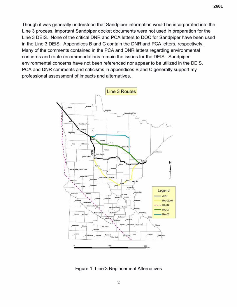
2
Though it was generally understood that Sandpiper information would be incorporated into the Line 3 process, important Sandpiper docket documents were not used in preparation for the Line 3 DEIS. None of the critical DNR and PCA letters to DOC for Sandpiper have been used in the Line 3 DEIS. Appendices B and C contain the DNR and PCA letters, respectively. Many of the comments contained in the PCA and DNR letters regarding environmental concerns and route recommendations remain the issues for the DEIS. Sandpiper environmental concerns have not been referenced nor appear to be utilized in the DEIS. PCA and DNR comments and criticisms in appendices B and C generally support my professional assessment of impacts and alternatives.
Figure 1: Line 3 Replacement Alternatives
2681
3
Both the PCA and DNR were critical of the Sandpiper APR environmental impacts in comparison to alternative routes. They urged selection of the southern route (Line 3 SA-04) because it was the least detrimental alternative. The DNR and PCA criticism continued through the January 23, 2015 DNR letter to Administrative Law Judge Lipman and May 12, 2015 PCA letter to the Public Utilities Commission (PUC); the PCA letter addressed Line 3 issues. On March 6, the PCA, DNR and DOC signed a Memorandum of Understanding (MOU) committing the DNR and PCA to assist the DOC in preparation of the DEIS. The DOC was placed in a leadership position over these crucial environmental agencies. Technical review by these vital environmental agencies has not been publicly available since the MOU. Yet many of the problems and concerns expressed by the DNR and PCA persist in the Line 3 DEIS.
Route Alternative Analysis Though the DEIS examines route SA-04 as a project alternative (along with Truck, Rail and continued use of existing Line 3) for the Certificate of Need (CN) portion of the DEIS, it argues for exclusion of SA-04 for other comparisons of alternative pipeline routes for the DEIS. However, SA-04 will be included in this discussion and compared to the CN approved System and Route Alternatives. The DEIS alternative analysis was skewed and incorrectly applied as follows:
• SA-04 is the only route the DEIS compiled cumulative impacts east and south of Minnesota. The applicant’s proposed route has impacts in several of these same states, including Wisconsin and Illinois.
• Construction impacts were not uniformly calculated. DEIS Chapter 5, pages 5-5 to 5-6 state “along the SA-04 route, a standard 120-foot-wide construction work area, 60 feet either side of the centerline, was applied to assess the impacts associated with pipeline construction. This allowed quantification of construction and operations impacts on land cover, habitat, and resources along the SA-04 route based on publicly available information on existing conditions. ... the primary shortcoming of the above approach for the environmental analysis is associated with Enbridge’s proposal to reduce the width of the construction work area for the Applicant’s preferred route in some wetlands and waterbodies (from 120 feet to 95 feet) based on site-specific field investigations and engineering. These refinements have not been incorporated into the general approach for the SA-04 footprint” This shortcoming should be corrected by using consistent 120 foot construction work area widths for all alternatives.
• No well or water supply analysis was performed east of Minnesota for any RA
alternatives. DEIS Chapter 5 pages 5-19 states the SA-04 ROI would encompass… 36 unverified location and 134 verified location domestic wells in Minnesota, 46 permitted private wells and 190 wells included in the private well tracking system in Iowa, and 205 domestic wells in Illinois. Public wells encompassed by the SA-04 ROI are as follows: ... nine verified location public wells in Minnesota; four in Iowa; and one
2681
4
in Illinois. Public and domestic wells would be similarly affected along the Superior to Chicago route, but they were not identified or included in the evaluation, calculations and comparison tables. Though it may be argued that construction impacts from Superior to the Chicago area (Chicago) accrued prior to Line 3 replacement, several factors associated with conveyance of product to Superior warrant inclusion of impacts associated with the Superior to Chicago pipeline. They are: ◦ Operational impacts will intensify east of Superior Wisconsin due to increased
pumping volumes made possible by expanded capacity of the proposed project.
◦ Though no permit applications have been filed for Superior to Chicago pipeline facility expansions, they have been seriously considered in company planning documents.
◦ A Nov. 28, 2015 Milwaukee Journal Sentinel article titled Wisconsin's Largest Oil Pipeline System May See Major Expansion stated:
“We are highly confident that we will see the heavy production grow as expected," Guy Jarvis, president of liquids pipelines for Enbridge, said at an investment conference in Toronto Oct. 7. ://archive.jsonline.com/news/wisconsin/wisconsins-largest-oil-pipeline-system-may-see-major-expansion-b99622819z1-357334661.html/
◦ A Jan 13, 2017 Milwaukee Journal Sentinel series stated:
And the company that owns the pipeline network is considering adding a fourth line in Wisconsin — one that could dwarf the rejected Keystone XL. ://projects.jsonline.com/news/2017/1/15/intro/oil-and-water.
DEIS Figures 10.4-2, 10.4-3 and 10.4-4 display the incongruous analysis which caused skewed values contained in Chapter 5 tables. These illustrations are labeled Fgures 2, 3, and 4, respectively. Because SA-04 was the only route with analysis comprising areas south and east of Minnesota, impact acreages reported in DEIS Chapter 10 tables for unusual ecological areas, drinking water sources, area of interest, and wetlands are inflated in comparison to APR and RA routes. The skewed comparison is perpetuated in the Executive Summary Table ES-2. PUC Commissioners will most likely rely upon the Executive Summary over wading through 500 pages of DEIS documentation. Unless specifically identified, all figures following Figure 4 were compiled using GIS layers identified in the DEIS and developed by the author.
2681
5
Figure 2: High Consequences Area Unusually Ecological Areas Along the Applicant’s Preferred Route (APR) and Certificate of Need Alternative Routes (RA)
from DEIS Chapter 10
2681
6
Figure 3: High Consequences Area Drinking Water Sources Along the APR and
RA Routes from DEIS Chapter 10
2681
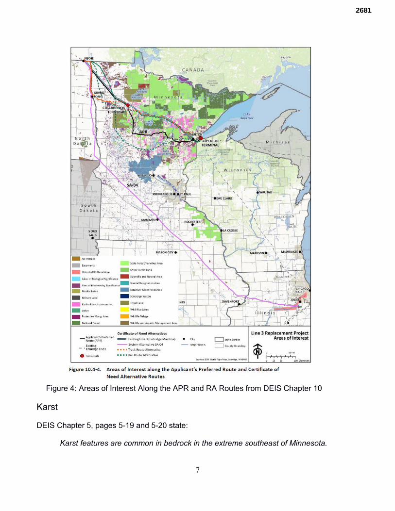
7
Figure 4: Areas of Interest Along the APR and RA Routes from DEIS Chapter 10
Karst DEIS Chapter 5, pages 5-19 and 5-20 state:
Karst features are common in bedrock in the extreme southeast of Minnesota.
2681
8
Conditions vary locally, but generally these aquifers are capable of yielding quantities of groundwater that are sufficient for most purposes. However, these aquifers are highly vulnerable to contamination and structural changes with ground disturbance; including induced sinkhole formation and alteration of groundwater flow. Karst topography is found in southeastern and eastern Minnesota … Along system alternative SA-04, relatively shallow carbonate bedrock with potential for karst intersects the route across Minnesota, Iowa, and Illinois (none is present in North Dakota). Karst features are present in Minnesota along 8 miles of system alternative SA-04 in Mower County and 3 miles in Le Seur and Blue Earth counties (Minnesota DNR 2016; USGS 2016).
DEIS Executive Summary page ES-15 states:
SA-04 is the only CN Alternative that crosses vulnerable karst topography. A karst aquifer is a type of bedrock aquifer that usually consists of basic rock types that are prone to chemical weathering and dissolution from the slight acidity of precipitation and groundwater. This can result in the formation of fractures, joints, sinkholes, cavities, caves, and void spaces that allow the movement of large volumes of surface water into and through the aquifer. These characteristics also allow contamination to spread rapidly within the aquifer. Karst aquifers are susceptible to collapse of the aquifer matrix, which can be triggered by construction activities on the land surface. This can lead to the formation of sinkholes in unconsolidated sediments that overlie the bedrock.
This is a crucial statement regarding SA-04 which will give the PUC Commissioners (Commissioners) the wrong perspective of SA-04. Figures 4 and 5 provide GIS DNR field mapped Karst Features overlying the Pollution Sensitivity of Near Surface Materials GIS layer. Figure 5 is a close-up of Figure 4. As the above description expresses, karst topography is largely in the SE part of Minnesota. Though SA-04 as drawn does touch the western edge of the karst mapped features, a minor alignment refinement of approximately 25 miles westward situates SA-04 out of the karst terrain and avoids sand deposits in Freeborn County; it would eliminate the 8 miles of karst terrain. The applicant’s APR alignment has been refined and is proposed to be refined during construction to avoid wetland and other impacts. A move of 25 miles to the west for SA-04 is reasonable and in keeping with APR formulation; it is in line with that afforded the Applicant’s preferred route. Figures 4 and 5 also display that SA-04 traverses some of the least pollution sensitive near surface materials within Minnesota.
2681
9
Figure 4: Pollution Sensitivity of Near Surface Materials overlaid by DNR field mapped Karst features.
2681
10
Figure 5: Close-up of Pollution Sensitivity of Near Surface Materials overlaid by DNR
field mapped Karst features.
2681
11
Ecoregions DEIS Chapter 5, page 5-61 discusses ecoregion health: It states:
In general, the north-central and northeast forested portions of Minnesota are the least affected and have the highest quality surface water resources, and areas in the west and south agricultural portions of the state have the most affected surface water resources and are of poorer quality across the state. There are a large number of lakes and streams in north-central and northeast Minnesota and they are of the highest quality when comparing Ecoregion data. Specifically, the data indicate that there are higher quality resources in the NLF Ecoregion of the State. Lower nutrients (mainly phosphorus) and chlorophyll-a (algae) and greater transparency are indicative of lakes in this ecoregion. Streams in this ecoregion exhibit lower nutrients, turbidity, and fecal coliform, as well as lower temperature and biological oxygen demand conditions. In reviewing three selected watersheds throughout the state, that each represent potential pipeline routing areas, the Pine River watershed (north-central), Chippewa River (west) and Le Sueur River (south) ... (t)he Watershed health index scores indicate the best health scores are represented in the Pine River and the worst scores in the Chippewa and Le Sueur River watersheds accordingly. Further, in general, statewide maps indicate better health scores across the north and east and poorer scores across the south and west as depicted by analysis of the five different components: Biology, Connectivity, Geomorphology, Hydrology and Water Quality (Appendix J-1).
Figure 6 displays the alternative routes overlying the DNR designated Public Waters GIS layer. It shows the magnitude of public water, including public water wetlands, through which APR and AR routes would traverse verses SA-04. The northern routes are forced through the highest number of lakes and wetlands within Minnesota. SA-04 traverses through the corridor with the least lakes and wetlands. Trout Streams The DEIS, page 5-62 discusses trout streams. It states:
Applicant’s preferred route passes within ½ mile of 17 designated trout streams or protected tributaries to designated trout streams….. Route SA-04 crosses within two designated trout streams or protected tributaries to designated trout streams Though more streams/ditches are crossed in southern areas, the analysis indicates the quality of the streams crossed in northern routes is greater since many are trout waters.
Trout streams are merely cataloged. Qualitative analysis of impacts to individual streams was
2681
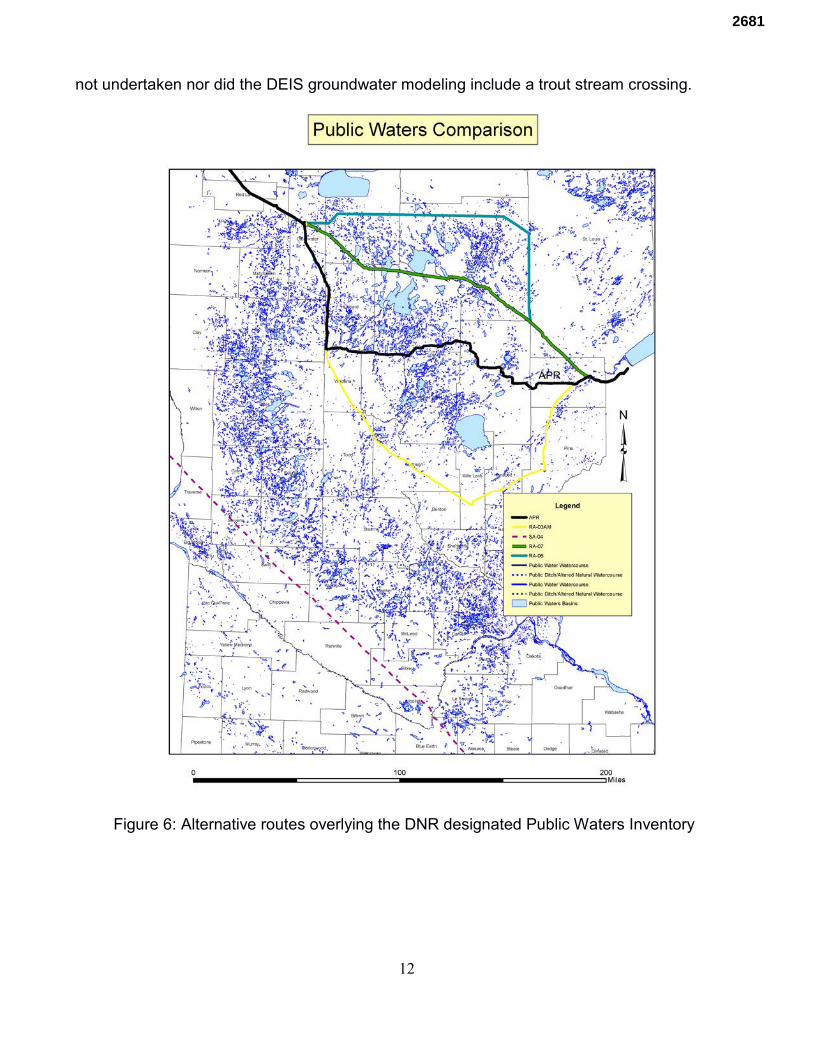
12
not undertaken nor did the DEIS groundwater modeling include a trout stream crossing.
Figure 6: Alternative routes overlying the DNR designated Public Waters Inventory
2681
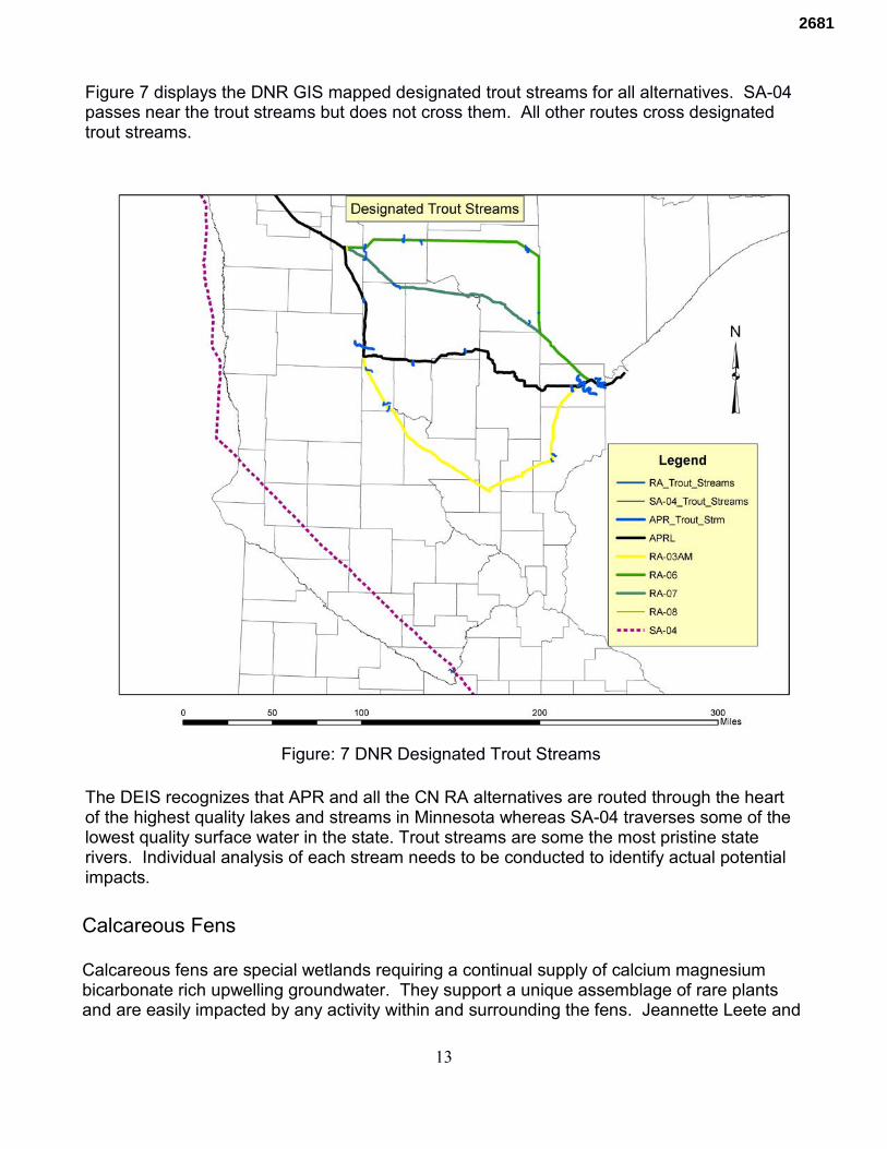
13
Figure 7 displays the DNR GIS mapped designated trout streams for all alternatives. SA-04 passes near the trout streams but does not cross them. All other routes cross designated trout streams.
Figure: 7 DNR Designated Trout Streams The DEIS recognizes that APR and all the CN RA alternatives are routed through the heart of the highest quality lakes and streams in Minnesota whereas SA-04 traverses some of the lowest quality surface water in the state. Trout streams are some the most pristine state rivers. Individual analysis of each stream needs to be conducted to identify actual potential impacts. Calcareous Fens Calcareous fens are special wetlands requiring a continual supply of calcium magnesium bicarbonate rich upwelling groundwater. They support a unique assemblage of rare plants and are easily impacted by any activity within and surrounding the fens. Jeannette Leete and
2681
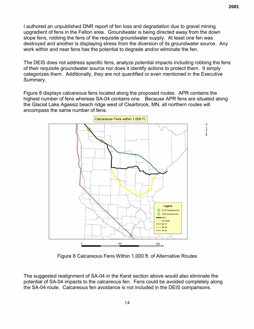
14
I authored an unpublished DNR report of fen loss and degradation due to gravel mining upgradient of fens in the Felton area. Groundwater is being directed away from the down slope fens, robbing the fens of the requisite groundwater supply. At least one fen was destroyed and another is displaying stress from the diversion of its groundwater source. Any work within and near fens has the potential to degrade and/or eliminate the fen. The DEIS does not address specific fens, analyze potential impacts including robbing the fens of their requisite groundwater source nor does it identify actions to protect them. It simply categorizes them. Additionally, they are not quantified or even mentioned in the Executive Summary. Figure 8 displays calcareous fens located along the proposed routes. APR contains the highest number of fens whereas SA-04 contains one. Because APR fens are situated along the Glacial Lake Agassiz beach ridge west of Clearbrook, MN, all northern routes will encompass the same number of fens.
Figure 8 Calcareous Fens Within 1,000 ft. of Alternative Routes The suggested realignment of SA-04 in the Karst section above would also eliminate the potential of SA-04 impacts to the calcareous fen. Fens could be avoided completely along the SA-04 route. Calcareous fen avoidance is not included in the DEIS comparisons.
2681
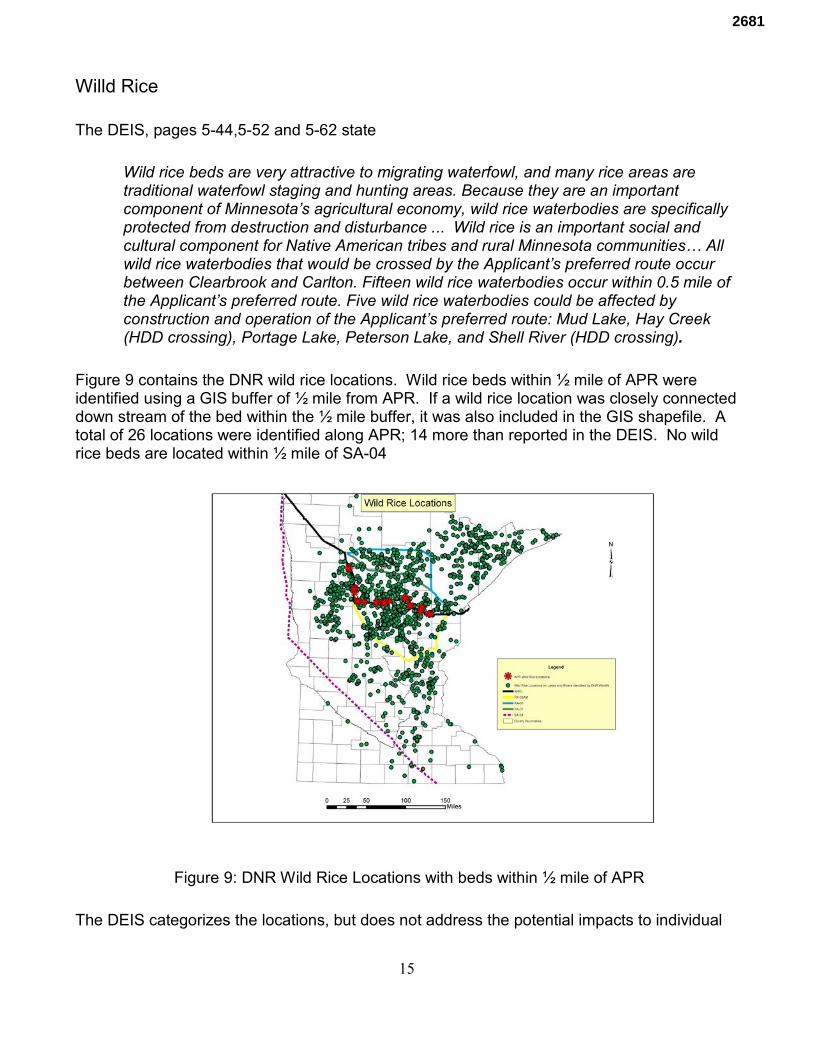
15
Willd Rice The DEIS, pages 5-44,5-52 and 5-62 state
Wild rice beds are very attractive to migrating waterfowl, and many rice areas are traditional waterfowl staging and hunting areas. Because they are an important component of Minnesota’s agricultural economy, wild rice waterbodies are specifically protected from destruction and disturbance ... Wild rice is an important social and cultural component for Native American tribes and rural Minnesota communities… All wild rice waterbodies that would be crossed by the Applicant’s preferred route occur between Clearbrook and Carlton. Fifteen wild rice waterbodies occur within 0.5 mile of the Applicant’s preferred route. Five wild rice waterbodies could be affected by construction and operation of the Applicant’s preferred route: Mud Lake, Hay Creek (HDD crossing), Portage Lake, Peterson Lake, and Shell River (HDD crossing).
Figure 9 contains the DNR wild rice locations. Wild rice beds within ½ mile of APR were identified using a GIS buffer of ½ mile from APR. If a wild rice location was closely connected down stream of the bed within the ½ mile buffer, it was also included in the GIS shapefile. A total of 26 locations were identified along APR; 14 more than reported in the DEIS. No wild rice beds are located within ½ mile of SA-04
Figure 9: DNR Wild Rice Locations with beds within ½ mile of APR The DEIS categorizes the locations, but does not address the potential impacts to individual
2681
16
beds at risk. It does not discuss how the rice will be impacted nor how vastly impacts could spread. Executive Summary The Executive Summary is the document upon which the Commissioners will largely base their decisions. As described above computations for the DEIS are skewed against SA-04 and in favor of APR. Figure ES-5 is extremely important to characterize the ecological and overall environmental conditions through which the alternatives would pass. It is merely an insert, difficult to read and easily ignored. Table ES-4 covers an entire page. Figure ES-5 needs to be given sufficient space to make it readily read and understood. It needs to be highlighted to inform the Commissioners and public of the environmental impacts each route will encompass. Hydrogeology Several state agencies including the Department of Agriculture (DOA) Department of Health (DOH) PCA and DNR have developed forms of groundwater sensitivity maps. The latest, Hydrogeology Atlas Series HG-02, was published by the DNR in June 2016. It is titled Pollution Sensitivity of Near-Surface Materials by Roberta Adams. Along with this series DNR also published Minnesota Hydrogeology Atlas Series Atlas HG-03 in June 2016 by Adams. Two plates, Water-Table Elevation and Depth to Water Table accompany this report. In 1979 the Minnesota Geologic Survey published State Map Series S-4 titled Geology Map of Minnesota Quaternary Geology by Goebel and Walton. In 1999, the Minnesota Geological Survey (MGS) published the Regional Hydrogeologic Assessment Quaternary Geology – Otter Tail Area, West-Central Minnesota with two plates titled Surficial Geology by Harris and Knaeble, and Quaternary Stratigraphy by Harris, Knaeble, and Berg. In January 2016 DNR produced a Surficial Sands geographic information system (GIS) layer derived from MGS GIS surficial geology polygons. GIS layers of the above referenced maps and reports were used to evaluate the alternative routes in Minnesota. Because the DNR pollution sensitivity map is the latest publication, it was used rather than the PCA map referenced in the DEIS. Figure 10 displays the alternative routes overlying the DNR Pollution Sensitivity of Near Surface Materials. It shows that APR and other CN northern routes traverse through the most pollution sensitive near surface materials within Minnesota; SA-04 is within the least sensitive areas. Figure 11 displays the alternative routes overlying DNR’s Surficial Sand GIS layer. The Central Minnesota Sands through which the CN routes travel are mapped as glacial outwash materials by Harris and others. The outwash materials were formed by meltwaters derived
2681
17
from receding glacial lobes. Because the outwash materials are composed of sand and granular material, they are porous, allowing rapid infiltration through the unsaturated zone to the groundwater. For that reason, they are mapped as highly sensitive in Figure 10. Figure 12 displays the routes overlying the sands shown in Figure 11 along with the soils along SA-04 clipped from the Minnesota Soils GIS layer. The soils through which SA-04 travels are predominately clay which are much less permeable than the outwash sands. Because of the clay’s impermeability, water is perched creating a shallow, high water table that is unsuitable for water supply. For that reason, Figure 10 depicts the area through which SA-04 is mapped as some of the least pollution sensitive near surface materials in Minnesota. The Executive Summary page ES-26 states:
In general, RA-06 would least affect groundwater resources, including highly vulnerable aquifers and groundwater resources with high contamination sensitivity, high pollution sensitivity, and high to very high bedrock sensitivity. RA-03AM is the only route alternative that crosses vulnerable karst topography.
As shown in the Karst Section, a refinement of SA-04 would eliminate karst topography. Figure 10 displays that SA-04 is comparable to RA-03AM in near surface material pollution sensitivity. Similar to the ecoregions conclusions discussed above, APR and the other northern routes (except RA-03AM) traverse the most sensitive surficial groundwater; SA-04 travels through the least sensitive surficial groundwater in the state. The ecoregion and surficial groundwater comparisons substantiate the earlier DNR and PCA support for SA-04 over APR.
2681
18
Figure 10: Alternative routes overlying DNR’s Pollution Sensitivity of Near Surface Materials
2681
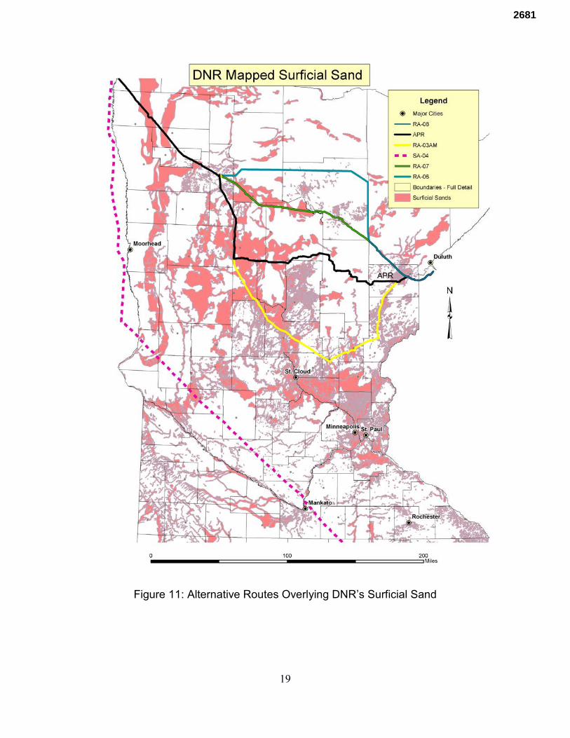
19
Figure 11: Alternative Routes Overlying DNR’s Surficial Sand
2681
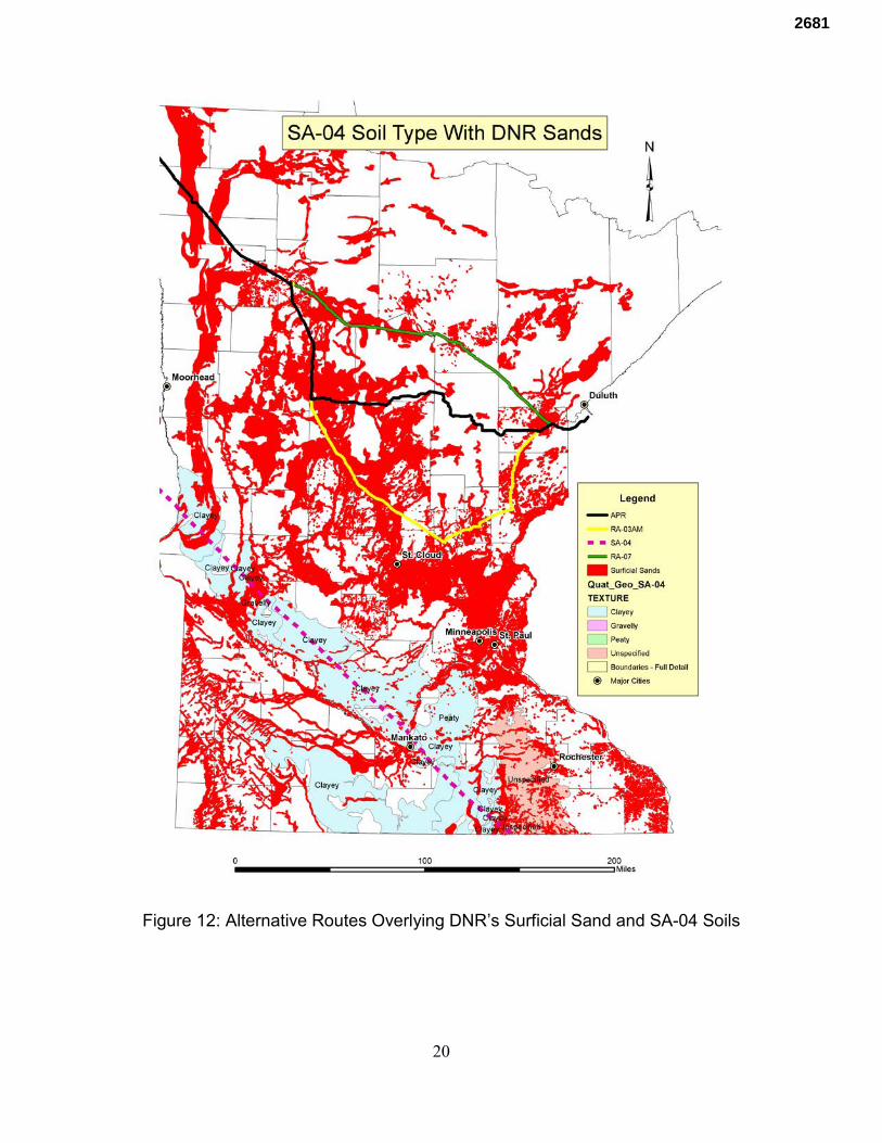
20
Figure 12: Alternative Routes Overlying DNR’s Surficial Sand and SA-04 Soils
2681

21
Groundwater Analysis The DEIS does not report individual groundwater analysis beyond hypothetical modeling of selected stream crossings. Discussion regrading groundwater only addresses horizontal flow and ignores vertical migration, an essential groundwater flow component. Like statistics, models can be manipulated to show what the modeler or client wants it to derive. DEIS Chapter 5, page 5-10 states:
The ROI for the analysis of potential impacts on groundwater during construction generally consists of the pipeline, rail, or truck corridor and a 1,000-foot buffer on either side of the centerline of the Applicant’s preferred route and the CN Alternatives. …. The ROI for assessment of operations impacts varied according to the configuration of the alternative. Operations impacts for the Applicant’s preferred route were estimated based on the footprints for the permanent right-of-way provided by the Applicant. Operations impacts for the existing Line 3 were evaluated based on the existing permanent right-of-way for that pipeline. …. Impacts on groundwater resources were identified based on common construction methods; peer- reviewed literature; agency documents, including permit requirements and guidance manuals; Applicant-submitted documents, including the November 2016 EAW and associated construction BMP plans (Enbridge 2016a); and the experience and professional judgment of the hydrogeologists involved in developing this analysis … Identification of groundwater resources potentially affected by the Project was completed by reviewing reports and data from the U.S. Geological Survey (USGS); the State Geological Surveys of Minnesota, Iowa, and Illinois; the North Dakota State Water Commission and North Dakota Source Water Protection Program; the Minnesota Department of Natural Resources (Minnesota DNR), Minnesota Pollution Control Agency (Minnesota PCA), Minnesota Department of Agriculture (Minnesota DA), and Minnesota Department of Health (Minnesota DH); Iowa Department of Natural Resources (Iowa DNR); and the U.S. Environmental Protection Agency (EPA).
No individual analysis of known groundwater aquifers was reported in the DEIS. It was argued that data is insufficient to conduct such analysis. Yet, hydrogeologic atlases have been produced by Minnesota along the northern alignments. Along with the studies identified above, a geologic atlas has been published for Carlton County. Though the DEIS states USGS, MGS, and DNR reports were reviewed, non of the local groundwater reports identified above and in my testimony were referenced nor appear to have been included in the review. This is particularly problematic in the Straight River Basin and a significant missing component in the DEIS.
2681
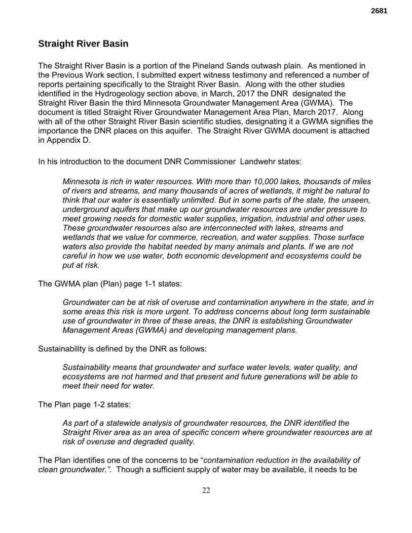
22
Straight River Basin The Straight River Basin is a portion of the Pineland Sands outwash plain. As mentioned in the Previous Work section, I submitted expert witness testimony and referenced a number of reports pertaining specifically to the Straight River Basin. Along with the other studies identified in the Hydrogeology section above, in March, 2017 the DNR designated the Straight River Basin the third Minnesota Groundwater Management Area (GWMA). The document is titled Straight River Groundwater Management Area Plan, March 2017. Along with all of the other Straight River Basin scientific studies, designating it a GWMA signifies the importance the DNR places on this aquifer. The Straight River GWMA document is attached in Appendix D. In his introduction to the document DNR Commissioner Landwehr states:
Minnesota is rich in water resources. With more than 10,000 lakes, thousands of miles of rivers and streams, and many thousands of acres of wetlands, it might be natural to think that our water is essentially unlimited. But in some parts of the state, the unseen, underground aquifers that make up our groundwater resources are under pressure to meet growing needs for domestic water supplies, irrigation, industrial and other uses. These groundwater resources also are interconnected with lakes, streams and wetlands that we value for commerce, recreation, and water supplies. Those surface waters also provide the habitat needed by many animals and plants. If we are not careful in how we use water, both economic development and ecosystems could be put at risk.
The GWMA plan (Plan) page 1-1 states:
Groundwater can be at risk of overuse and contamination anywhere in the state, and in some areas this risk is more urgent. To address concerns about long term sustainable use of groundwater in three of these areas, the DNR is establishing Groundwater Management Areas (GWMA) and developing management plans.
Sustainability is defined by the DNR as follows:
Sustainability means that groundwater and surface water levels, water quality, and ecosystems are not harmed and that present and future generations will be able to meet their need for water.
The Plan page 1-2 states:
As part of a statewide analysis of groundwater resources, the DNR identified the Straight River area as an area of specific concern where groundwater resources are at risk of overuse and degraded quality.
The Plan identifies one of the concerns to be “contamination reduction in the availability of clean groundwater.”. Though a sufficient supply of water may be available, it needs to be
2681
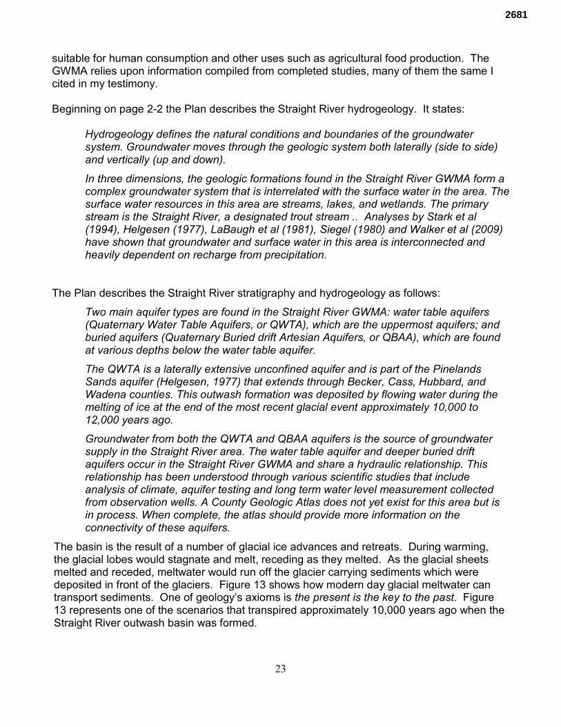
23
suitable for human consumption and other uses such as agricultural food production. The GWMA relies upon information compiled from completed studies, many of them the same I cited in my testimony. Beginning on page 2-2 the Plan describes the Straight River hydrogeology. It states:
Hydrogeology defines the natural conditions and boundaries of the groundwater system. Groundwater moves through the geologic system both laterally (side to side) and vertically (up and down).
In three dimensions, the geologic formations found in the Straight River GWMA form a complex groundwater system that is interrelated with the surface water in the area. The surface water resources in this area are streams, lakes, and wetlands. The primary stream is the Straight River, a designated trout stream .. Analyses by Stark et al (1994), Helgesen (1977), LaBaugh et al (1981), Siegel (1980) and Walker et al (2009) have shown that groundwater and surface water in this area is interconnected and heavily dependent on recharge from precipitation.
The Plan describes the Straight River stratigraphy and hydrogeology as follows:
Two main aquifer types are found in the Straight River GWMA: water table aquifers (Quaternary Water Table Aquifers, or QWTA), which are the uppermost aquifers; and buried aquifers (Quaternary Buried drift Artesian Aquifers, or QBAA), which are found at various depths below the water table aquifer.
The QWTA is a laterally extensive unconfined aquifer and is part of the Pinelands Sands aquifer (Helgesen, 1977) that extends through Becker, Cass, Hubbard, and Wadena counties. This outwash formation was deposited by flowing water during the melting of ice at the end of the most recent glacial event approximately 10,000 to 12,000 years ago.
Groundwater from both the QWTA and QBAA aquifers is the source of groundwater supply in the Straight River area. The water table aquifer and deeper buried drift aquifers occur in the Straight River GWMA and share a hydraulic relationship. This relationship has been understood through various scientific studies that include analysis of climate, aquifer testing and long term water level measurement collected from observation wells. A County Geologic Atlas does not yet exist for this area but is in process. When complete, the atlas should provide more information on the connectivity of these aquifers.
The basin is the result of a number of glacial ice advances and retreats. During warming, the glacial lobes would stagnate and melt, receding as they melted. As the glacial sheets melted and receded, meltwater would run off the glacier carrying sediments which were deposited in front of the glaciers. Figure 13 shows how modern day glacial meltwater can transport sediments. One of geology’s axioms is the present is the key to the past. Figure 13 represents one of the scenarios that transpired approximately 10,000 years ago when the Straight River outwash basin was formed.
2681
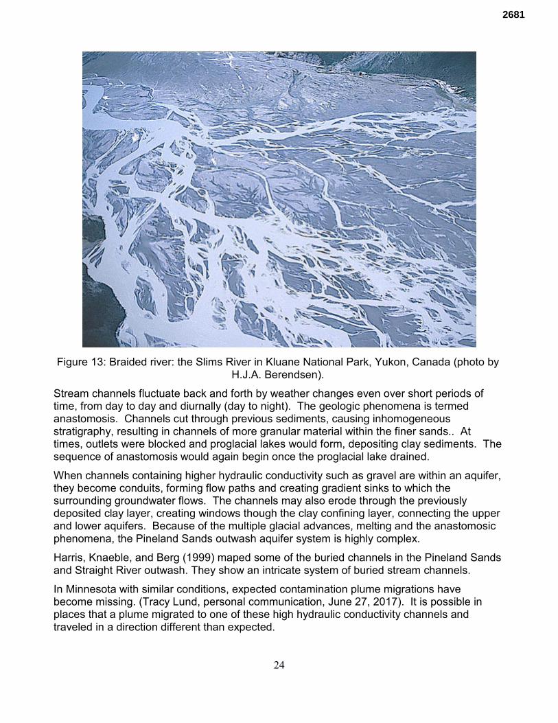
24
Figure 13: Braided river: the Slims River in Kluane National Park, Yukon, Canada (photo by H.J.A. Berendsen).
Stream channels fluctuate back and forth by weather changes even over short periods of time, from day to day and diurnally (day to night). The geologic phenomena is termed anastomosis. Channels cut through previous sediments, causing inhomogeneous stratigraphy, resulting in channels of more granular material within the finer sands.. At times, outlets were blocked and proglacial lakes would form, depositing clay sediments. The sequence of anastomosis would again begin once the proglacial lake drained.
When channels containing higher hydraulic conductivity such as gravel are within an aquifer, they become conduits, forming flow paths and creating gradient sinks to which the surrounding groundwater flows. The channels may also erode through the previously deposited clay layer, creating windows though the clay confining layer, connecting the upper and lower aquifers. Because of the multiple glacial advances, melting and the anastomosic phenomena, the Pineland Sands outwash aquifer system is highly complex.
Harris, Knaeble, and Berg (1999) maped some of the buried channels in the Pineland Sands and Straight River outwash. They show an intricate system of buried stream channels.
In Minnesota with similar conditions, expected contamination plume migrations have become missing. (Tracy Lund, personal communication, June 27, 2017). It is possible in places that a plume migrated to one of these high hydraulic conductivity channels and traveled in a direction different than expected.
2681
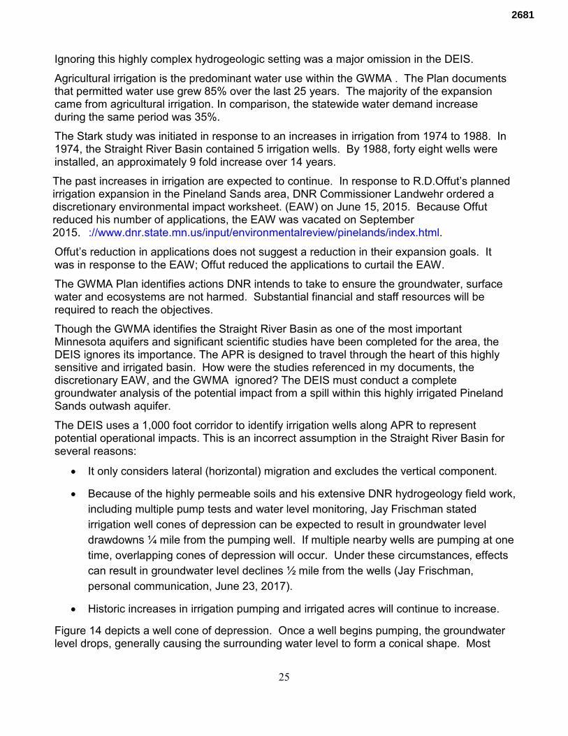
25
Ignoring this highly complex hydrogeologic setting was a major omission in the DEIS.
Agricultural irrigation is the predominant water use within the GWMA . The Plan documents that permitted water use grew 85% over the last 25 years. The majority of the expansion came from agricultural irrigation. In comparison, the statewide water demand increase during the same period was 35%.
The Stark study was initiated in response to an increases in irrigation from 1974 to 1988. In 1974, the Straight River Basin contained 5 irrigation wells. By 1988, forty eight wells were installed, an approximately 9 fold increase over 14 years.
The past increases in irrigation are expected to continue. In response to R.D.Offut’s planned irrigation expansion in the Pineland Sands area, DNR Commissioner Landwehr ordered a discretionary environmental impact worksheet. (EAW) on June 15, 2015. Because Offut reduced his number of applications, the EAW was vacated on September 2015. ://www.dnr.state.mn.us/input/environmentalreview/pinelands/index.html.
Offut’s reduction in applications does not suggest a reduction in their expansion goals. It was in response to the EAW; Offut reduced the applications to curtail the EAW.
The GWMA Plan identifies actions DNR intends to take to ensure the groundwater, surface water and ecosystems are not harmed. Substantial financial and staff resources will be required to reach the objectives.
Though the GWMA identifies the Straight River Basin as one of the most important Minnesota aquifers and significant scientific studies have been completed for the area, the DEIS ignores its importance. The APR is designed to travel through the heart of this highly sensitive and irrigated basin. How were the studies referenced in my documents, the discretionary EAW, and the GWMA ignored? The DEIS must conduct a complete groundwater analysis of the potential impact from a spill within this highly irrigated Pineland Sands outwash aquifer.
The DEIS uses a 1,000 foot corridor to identify irrigation wells along APR to represent potential operational impacts. This is an incorrect assumption in the Straight River Basin for several reasons:
• It only considers lateral (horizontal) migration and excludes the vertical component.
• Because of the highly permeable soils and his extensive DNR hydrogeology field work, including multiple pump tests and water level monitoring, Jay Frischman stated irrigation well cones of depression can be expected to result in groundwater level drawdowns ¼ mile from the pumping well. If multiple nearby wells are pumping at one time, overlapping cones of depression will occur. Under these circumstances, effects can result in groundwater level declines ½ mile from the wells (Jay Frischman, personal communication, June 23, 2017).
• Historic increases in irrigation pumping and irrigated acres will continue to increase.
Figure 14 depicts a well cone of depression. Once a well begins pumping, the groundwater level drops, generally causing the surrounding water level to form a conical shape. Most
2681
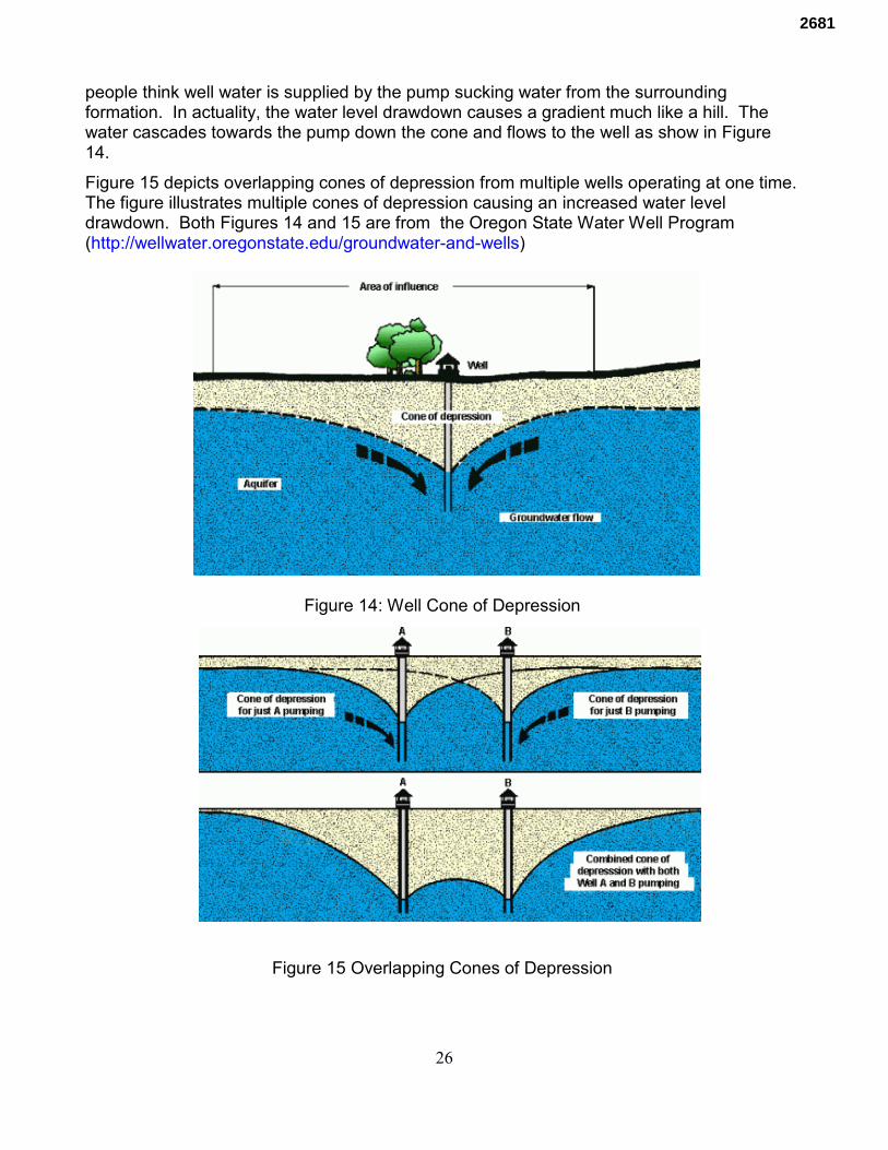
26
people think well water is supplied by the pump sucking water from the surrounding formation. In actuality, the water level drawdown causes a gradient much like a hill. The water cascades towards the pump down the cone and flows to the well as show in Figure 14.
Figure 15 depicts overlapping cones of depression from multiple wells operating at one time. The figure illustrates multiple cones of depression causing an increased water level drawdown. Both Figures 14 and 15 are from the Oregon State Water Well Program (http://wellwater.oregonstate.edu/groundwater-and-wells)
Figure 14: Well Cone of Depression
Figure 15 Overlapping Cones of Depression
2681
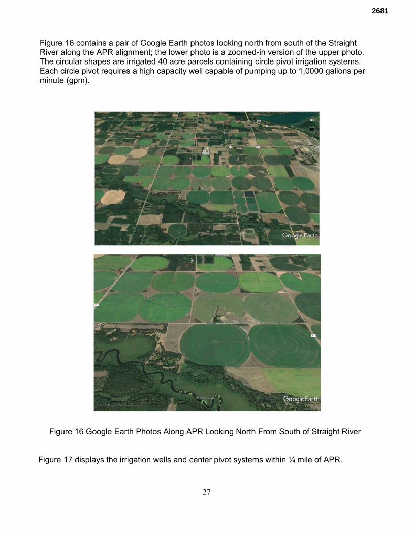
27
Figure 16 contains a pair of Google Earth photos looking north from south of the Straight River along the APR alignment; the lower photo is a zoomed-in version of the upper photo. The circular shapes are irrigated 40 acre parcels containing circle pivot irrigation systems. Each circle pivot requires a high capacity well capable of pumping up to 1,0000 gallons per minute (gpm).
Figure 16 Google Earth Photos Along APR Looking North From South of Straight River
Figure 17 displays the irrigation wells and center pivot systems within ¼ mile of APR.
Stra
2681
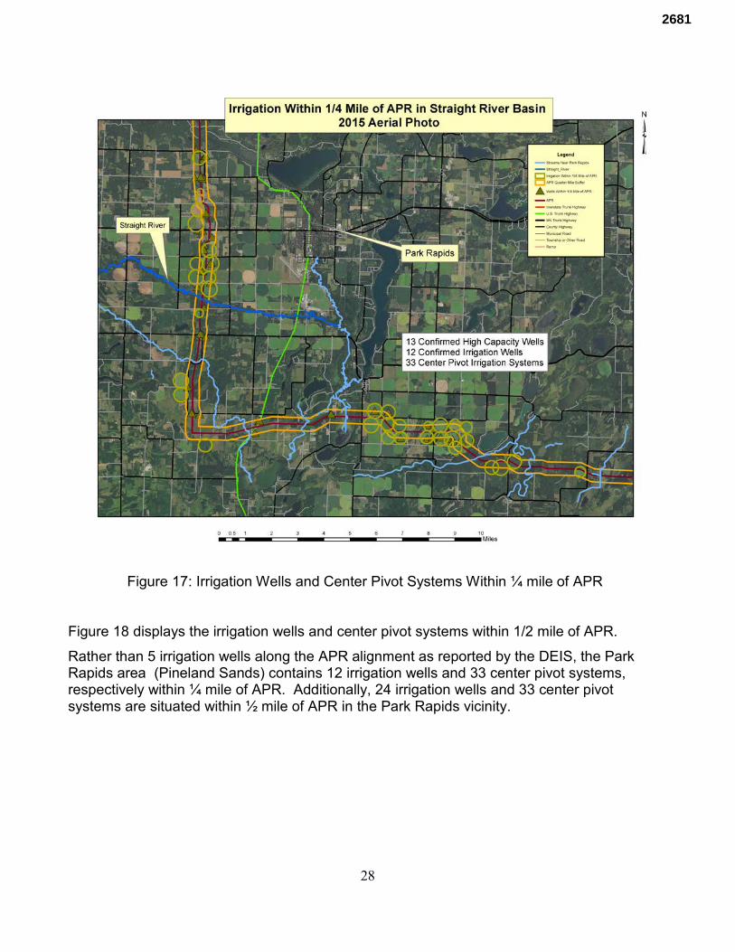
28
Figure 17: Irrigation Wells and Center Pivot Systems Within ¼ mile of APR
Figure 18 displays the irrigation wells and center pivot systems within 1/2 mile of APR.
Rather than 5 irrigation wells along the APR alignment as reported by the DEIS, the Park Rapids area (Pineland Sands) contains 12 irrigation wells and 33 center pivot systems, respectively within ¼ mile of APR. Additionally, 24 irrigation wells and 33 center pivot systems are situated within ½ mile of APR in the Park Rapids vicinity.
2681
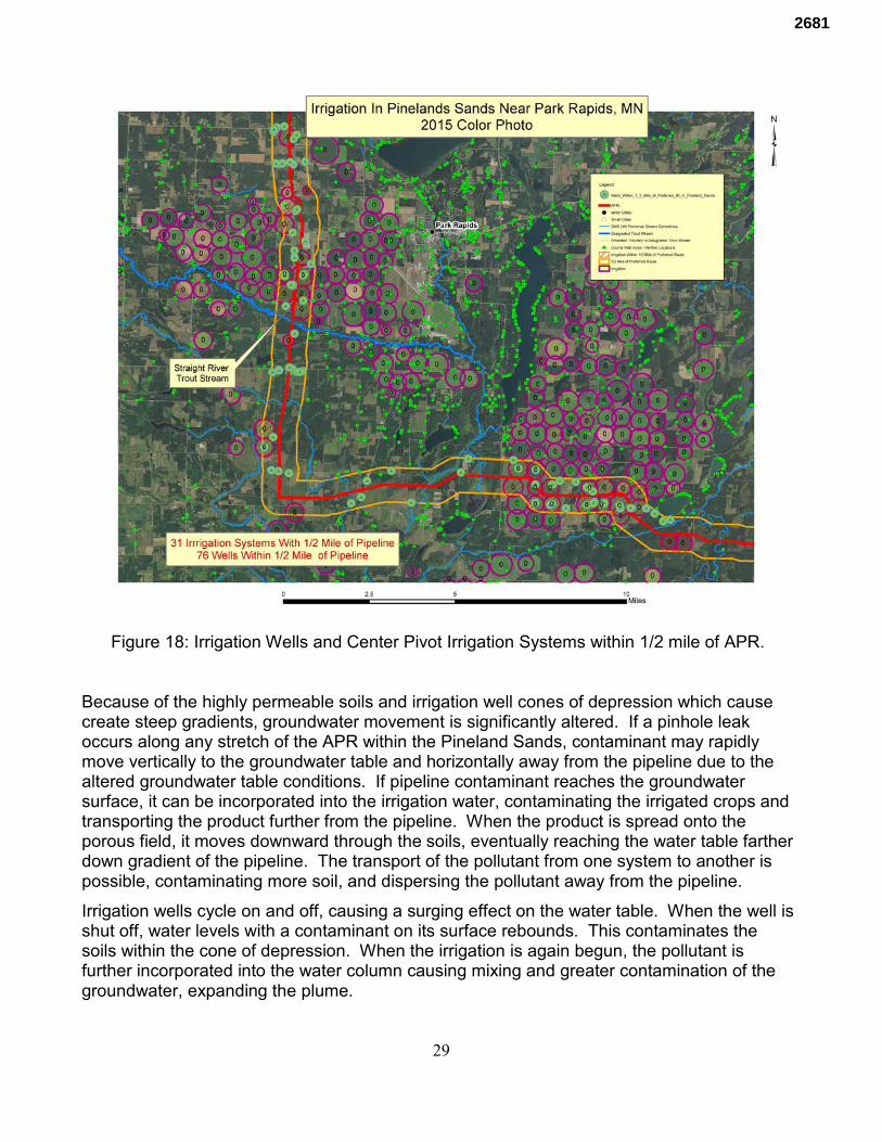
29
Figure 18: Irrigation Wells and Center Pivot Irrigation Systems within 1/2 mile of APR.
Because of the highly permeable soils and irrigation well cones of depression which cause create steep gradients, groundwater movement is significantly altered. If a pinhole leak occurs along any stretch of the APR within the Pineland Sands, contaminant may rapidly move vertically to the groundwater table and horizontally away from the pipeline due to the altered groundwater table conditions. If pipeline contaminant reaches the groundwater surface, it can be incorporated into the irrigation water, contaminating the irrigated crops and transporting the product further from the pipeline. When the product is spread onto the porous field, it moves downward through the soils, eventually reaching the water table farther down gradient of the pipeline. The transport of the pollutant from one system to another is possible, contaminating more soil, and dispersing the pollutant away from the pipeline.
Irrigation wells cycle on and off, causing a surging effect on the water table. When the well is shut off, water levels with a contaminant on its surface rebounds. This contaminates the soils within the cone of depression. When the irrigation is again begun, the pollutant is further incorporated into the water column causing mixing and greater contamination of the groundwater, expanding the plume.
2681
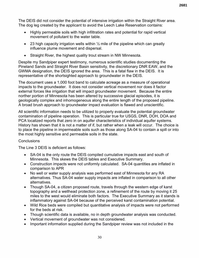
30
The DEIS did not consider the potential of intensive irrigation within the Straight River area. The dog leg created by the applicant to avoid the Leech Lake Reservation contains:
• Highly permeable soils with high infiltration rates and potential for rapid vertical movement of pollutant to the water table.
• 23 high capacity irrigation wells within ½ mile of the pipeline which can greatly influence plume movement and dispersal.
• Straight River, the highest quality trout stream in NW Minnesota.
Despite my Sandpiper expert testimony, numerous scientific studies documenting the Pineland Sands and Straight River Basin sensitivity, the discretionary DNR EAW, and the GWMA designation, the DEIS ignored the area. This is a fatal flaw in the DEIS. It is representative of the shortsighted approach to groundwater in the DEIS.
The document uses a 1,000 foot band to calculate acreage as a measure of operational impacts to the groundwater. It does not consider vertical movement nor does it factor external forces like irrigation that will impact groundwater movement. Because the entire norther portion of Minnesota has been altered by successive glacial episodes, it is geologically complex and inhomogeneous along the entire length of the proposed pipeline. A broad brush approach to groundwater impact evaluation is flawed and unscientific.
All scientific information needs to be utilized to properly evaluate the potential groundwater contamination of pipeline operation. This is particular true for USGS, DNR, DOH, DOA and PCA localized reports that zero in on aquifer characteristics of individual aquifer systems. History has shown that it is not a matter of if, but rather when a leak will occur. The choice is to place the pipeline in impermeable soils such as those along SA-04 to contain a spill or into the most highly sensitive and permeable soils in the state.
Conclusions
The Line 3 DEIS is deficient as follows:
• SA-04 is the only route the DEIS compiled cumulative impacts east and south of Minnesota. This skews the DEIS tables and Executive Summary.
• Construction impacts were not uniformly calculated. SA-04 quantities are inflated in comparison to APR
• No well or water supply analysis was performed east of Minnesota for any RA alternatives. Thus SA-04 water supply impacts are inflated in comparison to all other alternatives.
• Though SA-04, a citizen proposed route, travels through the western edge of karst topography and a wellhead protection zone, a refinement of the route by moving it 25 miles to the west would eliminate both factors. The Executive Summary as it stands is inflammatory against SA-04 because of the perceived karst contamination potential.
• Wild Rice beds were compiled but quantitative analysis of impacts were not performed for the beds at risk.
• Though scientific data is available, no in depth groundwater analysis was conducted. • Vertical movement of groundwater was not considered. • Important information supplied during the Sandpiper review was not included in the
2681
31
Line 3 DEIS • The Executive Summary Figure ES-5 comparing ecological and water resources
impacted is unreadable and needs to be highlighted. It is the only source of comparison between the routes when water and ecological quality is discussed.
• Individual impact analysis of trout stream impacts was not performed. Since they are the most sensitive stream environment, quantification of potential impacts is required to properly understand and evaluate proposed alternative routes.
• The report compiles calcareous fens along the alternative routes, but does not quantify the potential impacts of these rare protected wetlands. Calcareous fens are omitted in the Executive Summary.
• APR and northern route alternatives (except RA-03AM) pass through areas of the highest pollution sensitivity of near surface materials whereas SA-04 is in some of the lowest pollution sensitive near surface materials in the state.
• The Straight River Basin GWMA designation was not considered in evaluation of APR. • The June DNR discretionary Straight River irrigation EAW was not considered. • The highly complex Straight River and Pineland Sands hydrogeologic and geologic
conditions were ignored.
2681
Addendum ToReview of Enbridge Line 3 Draft Environmental Impact Statement
By Robert MerrittMerritt Hydrologic and Environmental Consulting, LLC
Since writing Review of Enbridge Line 3 Draft Environmental Impact Statement (RDEIS) I examined a portion of the Minnesota Departments of Agriculture (DOA) Commerce (DOC) Natural Resources (DNR) and Pollution Control Agency (PCA) Data Practices Act Request (DPA) documents. I also read the Stantec Pinhole Release Critique by CJE. This is to document substantive materials I identified in the DPA and CJE report. It is an addition to RDEIS. I will use the same acronyms from the RDEIS.
As discussed in RDEIS, the MOU between DNR and PCA effectively masked DNR and PCA Line 3 DEIS critiques from the public. I included all of the PCA and DNR letters from the Sandpiper Docket (RDEIS Appendicies B and C) and stated that many of their concerns remained in the DEIS.
The following Draft DEIS and DOC peer reviews by the DNR and PCA corroborates my RDEIS critiques. I will identify the DPA document, location and relevant discussion.
2017 0210 DNR comments_Line 3 PDEIS.This peer review was contained in a spreadsheet. Relevant comments are as follows:
Section 5.2.1.1.1, Page 5.2.1-4 DNR’s HL states:
ROI for Groundwater should extend beyond a 1000 foot buffer. It should be at least 1 mile.
Section 6.3.1.1.3, Page 6.3.1-6 DNR’s MW states:
Need to evaluate each route alternative for groundwater vulnerability. I recommend using the pollution sensitivity map. Water table aquifers are most vulnerable to contamination because of their lack of confining layers and direct connection to the landsurface. https://gisdata.mn.gov/dataset/water-aquifer-vulnerability
Section 5.2..1.1.3, Page 5.2.1-8 DNR’s MW states:
There is a new pollution sensitivity map for MN. The Watershed Health Assessment Framework uses the 1989 MPCA model. MN DNR has an updated model available at: https://gisdata.mn.gov/dataset/geos-hydrogeology-atlas-hg02
Although I am unsure, it is possible that MW stands for Michele Walker, the DNR Region 1 Hydrogeologist. Despite the DNR professional’s advises to employ a 1 mile groundwater
1
2681
impact corridor, DOC and Cardno continued to use 1,000 feet This is a crucial groundwater related error.
My RDEIS analysis employed a ½ mile buffer to identify the irrigation wells within the StraightRiver Basin. Using HL’s suggested 1 mile metric, 50 center pivot irrigation systems, 30 irrigation wells, and 87 domestic wells exist in the Straight River Basin/Pineland Sand Aquifer one mile groundwater corridor.
Despite the fact that DNR advised DOC a new, updated pollution sensitivity map was available, DOC persisted in using the outdated version. Additionally, analysis of groundwater sensitivity assessment based upon MW’s recommendation was not performed correctly. The updated DNR GIS pollution sensitivity layer was used in the RDEIS figures and discussion.
The two above examples display the degree to which DOC ignored DNR professional advise and peer review; it supports the concern I expressed in RDEIS. They demonstrate the DOC’scloaking of Minnesota environmental agency critique.
DNR Chapt 5 Water Resources MW Re-write -final
5.2.1 Water Resources Page 1 MWCommented [MW1]: Wisconsin is not evaluated. The route from Superior to Jolliet also needs to be evaluated.
5.2.1.1.2 Existing Conditions Page 11 Aquifers
Commented [MW7]: Need to check Illinois and Wisconsin. Wisconsin GIS data on unconfined glacial aquifers is available by county at: http://wgnhs.uwex.edu/maps-data/gis-data/ Statewide Illinois data is also available at: https://clearinghouse.isgs.illinois.edu/dataThese could be used to determine water table aquifer vulnerability. They have a map of potential of agricultural chemical contamination of aquifers which would be an aquifer sensitivity map.
5.1 Master Into_MPCA
Page 27 (5-3) Sec 5.1.3Commented [CD(1]: Global comment and flaw in analysis:
My comment - For quantitative construction and operation impact assessment on land cover, habitat and resources along SA-04, was the analysis done from the Canada/US.Boarder to Pontiac IL? If so, that should be clearly stated in terms of what the boundary conditions were for analysis. However, how can SA-04 be directly
2
2681
comparable to analyses done for other RA's contained only within MN? As is stated onpage 5.2.1-7, "It is expected that alternatives that cross longer distances of sensitive orhigh-susceptibility areas or that are located near larger numbers of potable supply wells and contamination sites have the potential to have greater construction impacts than alternatives that cover shorter distances or that are near fewer numbers of wells or contamination sites." Lastly, it is stated on page 5.2.1-16, "However, if impacts were determined for the entire 803-mile length of the SA-04 route in Minnesota and the other states it crosses and compared to the impacts for the 380 miles of the Applicant’spreferred route, the SA-04 route would certainly have more impacts." Therefore, either SA-04 analysis must be contained within MN only, or the connecting pipe network fromSuperior through WI and IL to Pontiac (shown as a dashed line on all figures throughout) must be considered in the analysis for all RAs and RSAs so that a true "apples to apples" comparison can be made to SA-04.
Cardno Response - No change to EIS. Geographic extent of SA- 04 defined in Section4.2.5 (Neche, North Dakota to Joliet, Illinois) and associated ROI defined in each resource section in Chapter 5.
5.2 Master Water Resources Section_MPCA
Page 1 (5-9)
Commented [KL(1]: This chapter appears flawed in its analysis. I question (again) thedecision to discuss potential impacts of SA-04 outside of MN in the EIS. Given that the EIS is a state document, Minnesota citizens need to be able to compare potential impacts of all alternatives within MN only since we have no jurisdiction or authority beyond our own borders.
Commented [SK(6]: The waters outside of Minnesota should be irrelevant to this document. Minnesota agencies can only make decisions on Minnesota waters.
10 Master Accidental Releases_MPCA
Page 1
Commented [KL(2]: Again, this chapter is flawed in that it includes potential environmental impacts from SA-04 in other states outside of MN. This is a Minnesota environmental review process. Therefore, only those potential impacts within MN boundaries should be compared. Otherwise we are comparing apples to oranges.
RDEIS identified that SA-04 is the only route containing potential impacts east of Minnesota, skewing the data in favor of APR and RA routes. The analysis was biased and unevenly applied. The above comments recognize the same DEIS problem by DNR and
3
2681
PCA professionals; DOC ignored DNR and PCA admonitions.
Sole Source AquifersThe Applicant’s preferred route would not cross any aquifers designated by EPA assole source aquifers.
Commented [T9]: This is a very narrow designation that is only based on nomination of aquifers as sole source. The MPCA Petroleum Remediation Program has a definition of sole source aquifers which there are many in the central part of the state.
The DEIS retained the EPA sole source discussion and ignored the above PCA sole source aquifer definition. Using only the EPA definition and ignoring the PCA Minnesota definition at the very least suggests to the public and PUC that no sole source aquifers exist along APR. Itis deceptive in the face of PCA advise; it ignores and censures the PCA to the benefit of APR.
APR travels through many Minnesota sole source aquifers. As stated above, 87 domestic supply wells exist within 1 mile of the APR Pineland Sand Aquifer alignment alone.
Page 9 (5-17)
Minnesota DWSMAsThe Applicant’s preferred route would cross 450 acres of DWSMAs in Minnesota. DWSMA data do not exist for other states.
Commented [SK(12]: I stopped here in removing the non-MN text for the Groundwater section…there are probably more below that I haven’t highlighted.
Page 17 (5-25)
Degradation of Shallow Groundwater Quality from Blasting, Spills, or Contamination
Commented [KL(13]: It seems that this document should not only have addressed thepotential impacts of blasting, spills or contamination from construction to groundwater, but also from long-term operation of the pipeline.
For example: Nationwide, have any aquifers been contaminated with oil from pin-hole leaks or other pipeline failures? We get no real sense of that from this analysis. Peopleliving near the pipeline route will care about this issue from a source water protection and public water supply perspective
The RDEIS identified the groundwater analysis deficiency. It also showed that the DEIS ignored DNR’s GWMA Straight River Basin designation, a major drinking water source. The PCA advised DOC regarding this crucial component and were ignored. Besides stream crossings focused analysis, the DEIS contains no in-depth investigation of the potential impact to groundwater and aquifers.
4
2681
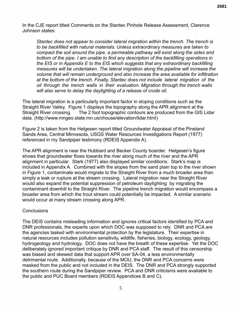
In the CJE report titled Comments on the Stantec Pinhole Release Assessment, Clarence Johnson states:
Stantec does not appear to consider lateral migration within the trench. The trench is to be backfilled with natural materials. Unless extraordinary measures are taken to compact the soil around the pipe, a permeable pathway will exist along the sides and bottom of the pipe. I am unable to find any description of the backfilling operations in the EIS or in Appendix E to the EIS which suggests that any extraordinary backfilling measures will be undertaken. The lateral migration along the pipeline will increase the volume that will remain underground and also increase the area available for infiltrationat the bottom of the trench. Finally, Stantec does not include lateral migration of the oil through the trench walls in their evaluation. Migration through the trench walls will also serve to delay the daylighting of a release of crude oil.
The lateral migration is a particularly important factor in sloping conditions such as the Straight River Valley. Figure 1 displays the topography along the APR alignment at the Straight River crossing. The 2 foot topographic contours are produced from the GIS Lidar data. (http://www.mngeo.state.mn.us/chouse/elevation/lidar.html)
Figure 2 is taken from the Helgesen report titled Groundwater Appraisal of the Pineland Sands Area, Central Minnesota, USGS Water Resources Investigations Report (1977) referenced in my Sandpiper testimony (RDEIS Appendix A).
The APR alignment is near the Hubbard and Becker County boarder. Helgesen’s figure shows that groundwater flows towards the river along much of the river and the APR alignment in particular. Stark (1977) also displayed similar conditions. Stark’s map is included in Appendix A. Combined with the slopes from the sand plain top to the river shown in Figure 1, contaminate would migrate to the Straight River from a much broader area than simply a leak or rupture at the stream crossing. Lateral migration near the Straight River would also expand the potential suppression of petroleum daylighting by migrating the contaminant downhill to the Straight River. The pipeline trench migration would encompass a broader area from which the trout stream could potentially be impacted. A similar scenario would occur at many stream crossing along APR.
Conclusions
The DEIS contains misleading information and ignores critical factors identified by PCA and DNR professionals, the experts upon which DOC was supposed to rely. DNR and PCA are the agencies tasked with environmental protection by the legislature. Their expertise in natural resources includes pollution sensitivity, wildlife, fisheries, biology, ecology, geology, hydrogeology and hydrology. DOC does not have the breath of these expertise. Yet the DOCdeliberately ignored important critique by DNR and PCA staff. The result of this censorship was biased and skewed data that support APR over SA-04, a less environmentally detrimental route. Additionally, because of the MOU, the DNR and PCA concerns were masked from the public and not included in the DEIS. The DNR and PCA strongly supported the southern route during the Sandpiper review. PCA and DNR criticisms were available to the public and PUC Board members (RDEIS Appendices B and C).
5
2681
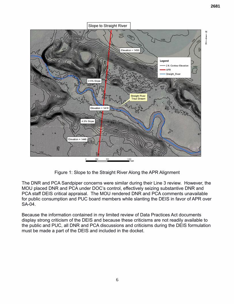
Figure 1: Slope to the Straight River Along the APR Alignment
The DNR and PCA Sandpiper concerns were similar during their Line 3 review. However, the MOU placed DNR and PCA under DOC’s control, effectively seizing substantive DNR and PCA staff DEIS critical appraisal. The MOU rendered DNR and PCA comments unavailable for public consumption and PUC board members while slanting the DEIS in favor of APR overSA-04.
Because the information contained in my limited review of Data Practices Act documents display strong criticism of the DEIS and because these criticisms are not readily available to the public and PUC, all DNR and PCA discussions and criticisms during the DEIS formulation must be made a part of the DEIS and included in the docket.
6
2681
Figure 2: Groundwater Elevations and Flow from Helgesen (1977)
7
2681
COMMENTS ON THE DIRECT TESTIMONY OF RAY WUOLO GIVEN ON JANUARY 31, 2017
PREPARED BY
CJE 57 AMBERWOOD COURT MORAGA, CALIFORNIA
JUNE 26, 2017
2681
INTRODUCTION Mr. Ray Wuolo, on January 31, 2017, offered testimony on possible releases of petroleum hydrocarbons from the proposed Enbridge Energy Partners (Enbridge) Line 3 Replacement in northern Minnesota (MPUC DOCKET NOs. PL9/CN-14-916 and PPL-15-137, OAH Docket Nos. 65-2500-32764 and 65-2500-33377). The testimony was apparently offered in support of the reports prepared for the Draft Environmental Impact Statement (DEIS) by Barr Engineering Company (Barr). Mr. Wuolo is employed by Barr. Mr. Wuolo’s testimony is irrelevant in that it does not address the impact of any release. The purpose of a DEIS is, as the name clearly states, to assess the impact of possible releases of petroleum hydrocarbons to the environment. Mr. Wuolo does not address the impact of possible releases. Mr. Wuolo’s testimony is simply a recital of the possible migration paths of a release. Examples of Mr. Wuolo’s failure to accurately address the impacts of a release of petroleum hydrocarbons are given below. SECTION IV - LAKES REPORT Several of the questions posed to Mr. Wuolo, in this section as well as the other sections, begin with “In the unlikely event of an accidental release of crude oil from the pipeline…” Mr. Wuolo at no time corrects the questioner. Releases from a pipeline are not “unlikely.” For example, the reason to replace the existing pipeline is because of the number of releases from the pipeline. The Keystone 1 pipeline, recently built by Enbridge, had 35 releases in the first year of operation. Mr. Wuolo did not, at any time, challenge the incorrect assertion that a release from a pipeline was unlikely which calls into question the objectivity of his testimony. The failure of the Barr report and Mr. Wuolo’s testimony on the Barr report to assess site specific conditions is shown by Mr. Wuolo’s testimony beginning on the bottom of Page 3 where Mr. Wuolo states that the Barr report did not consider “…the broader set of factors such as site-specific conditions, seasonality, crude oil type and volume, or response time.” If these site specific conditions are not part of the evaluation, the impact of a release cannot be assessed. Therefore, the Barr report and Mr. Wuolo’s testimony are irrelevant. Mr. Wuolo’s testimony on the impact on lakes continues with a discussion of migration of a release of crude oil. At no time does Mr. Wuolo actually address the impacts of a release on a lake or associated wetlands. As such, Mr. Wuolo’s narrative is simply a statement that liquids flow downhill and he provides no information on the environmental or human health impacts of the release. Mr. Wuolo’s conclusion in this section is that less than two percent “… of the lakes in the watersheds in the pipeline corridor are susceptible to the effects [sic] of a potential release from the pipeline.” Mr. Wuolo apparently presupposes that polluting a lake is acceptable if only a few lakes are polluted. His lack of concern is difficult to properly assess because the impacts of a release are not identified or quantified in any way in his testimony. However, Mr. Wuolo’s dismissal of crude oil contamination of only a “few” lakes is not acceptable public policy or environmental stewardship.
2681
SECTION V – GROUNDWATER REPORT Again, this is a section filled with general statements about the possible pathways a release of crude oil could follow to impact the ground water. This section is completely devoid of any discussion of the possible impacts to ground water. In this respect, the entire section has no value in evaluating the potential impacts of a release. Site-specific conditions are not addressed and the site-specific affects of a release are not addressed. Mr. Wuolo presumes to assess the susceptibility of the water-table aquifers along the preferred pipeline route. For this evaluation he relies on the Minnesota Department of Health (MDH) Water Table Susceptibility Map published in 2015. However, Mr. Wuolo omits an important fact. MDH classified lacustrine sediments as having medium susceptibility. Barr arbitrarily reclassified these sediments as having low susceptibility. No scientific explanation, nor any other explanation, is given for this reclassification. Further, Barr and Mr. Wuolo do not state how many pipeline sites were reclassified. It appears that this arbitrary reclassification was made only to reduce, without justification, the threat posed by releases from the pipeline. The evaluation of the susceptibility of the aquifers to pollution was made using arbitrary data points. Barr divided the pipeline into one-mile segments and determined the susceptibility at the midpoint of each segment. If this type of sampling is to be used, it must be demonstrated statistically that the use of the midpoint is valid. No such statistical analysis appears to have been undertaken. Therefore, any conclusions Barr and Mr. Wuolo make with regard to aquifer susceptibility are strictly speculation. Mr. Wuolo and Barr cite a release of contamination from an Enbridge pipeline in Bemidji to show that migration of released crude oil is contained by natural attenuation. Neither the Barr report nor Mr. Wuolo’s testimony demonstrate that the environmental conditions at the Bemidji release are equivalent to the environmental conditions at any place along the proposed pipeline route. Further, the environmental conditions along the proposed pipeline route are highly variable, and the Bemidji release cannot be used to estimate the affects of a release for the entire pipeline. The information on which Barr and Mr. Wuolo base their speculative statement that any release would be contained by natural attenuation is incomplete. Although Mr. Wuolo and Barr rely heavily on the Bemidji study, they ignore the data published by the United Stated Geological Survey (USGS) in 2015 which shows the release at the Bemidji site has non-volatile dissolved organic compounds (NVDOC) which have migrated further than the volatile compound plume and are not contained by natural attenuation. Because the Bemidji release is from an Enbridge pipeline, it is difficult to understand how Enbridge and its consultants could be unaware of the USGS report. It is even more difficult to understand how this information could be ignored in the Enbridge/Barr/Wuolo documents addressing groundwater contamination. Mr. Wuolo states that “…natural attenuation would limit the maximum movement of a plume of dissolved crude oil byproducts to a distance on the order of a few hundred feet.” This statement is unsupported by any site-specific data. In fact, this speculative statement is refuted by the USGS 2015 publication, which addresses the migration of contamination at the Bemidji site.
2681
Mr. Wuolo states that the “…water quality of the higher permeability water table aquifers tends to be already degraded by fertilizers, herbicides, and pesticides from agricultural operations. Mr. Wuolo does not compare the relative toxicity of the contaminants to the toxicity of crude oil, he does not cite the concentrations of these contaminants, and he does not provide locations of the contaminants. His statement on the pollutants is, at best, incomplete and has no relevance to the pipeline issue. Adding pollutants to an aquifer is always unacceptable and can only increase the impact to the aquifer. Mr. Wuolo offers no analysis of the potential impact to the aquifer or justification for ignoring the added pollution. VI – WILD RICE REPORT Mr. Wuolo presents an inventory of the wild rice lakes in the project area. Mr. Wuolo, however, does not discuss the impacts of a release; he seeks only to minimize any concerns by stating that only a few areas could be affected. This is not an analysis of the possible impacts. This is a justification for permitting the pipeline to cross sensitive areas. CONCLUSIONS The testimony of Mr. Wuolo consists only of speculation and an enumeration of areas of concern. At no point does Mr. Wuolo discuss the possible impacts of the project on human health or the environment. As such, this document deals only in generalities. An Environmental Impact Statement must address the potential impacts to human health and the environment. Because Mr. Wuolo does not address any impacts, his testimony is not germane to the project and should be dismissed as irrelevant.
2681
CrIYOF
GRAND RAPIDS !T's IN MINNESOTA'S NATURE
June 261\ 2017
Jamie Macalister
Environmental Review Manager
MN Department of Commerce
85 7th Place East, Suite 280
Saint Paul, MN 55101-2198
AD,\\I NI 'ff RATION DE PARTM F NT
420 N<.11U-I I l'UKFljJ\/\,\t\ AVLNllr. l,RAN[) ll.1\l'ID\ MINN bl HA 55744-2<,<,2
Re: Line 3 Project Draft EIS Comment, specifically regarding Chapter 8 "Existing Line 3 Abandonment and
Removal"
Dear Ms. Macalister,
We understand that Enbridge has filed a proposed abandonment plan per PHMSA regulations. We also
understand, per the D-EIS, that Enbridge has filed with the Minnesota PUC a draft of the required plan that
specifically show how the PHMSA abandonment regulations will be achieved. According to Enbridge,
abandonment will include: removing the oil, cleaning the pipeline, disconnecting the pipeline, segmenting
the pipeline, and monitoring and maintaining the pipeline, indefinitely. As Grand Rapids City Council
Members, we would like you to consider how the proposed existing Line 3 abandonment will affect our City
based on information provided in the Line 3 Project D-EIS. From 8.3.1 of the D-EIS, Potential Impacts and
Mitigation Measures: Leaving Existing Line 3 in Place Could Have Potentially Significant Effects:
There are, however, some potentially significant impacts associated with abandoning the existing
Line 3. These longer term impacts are caused by the continued presence of undiscovered legacy
contamination that may exist surrounding the existing pipeline, as well as the potential hazards
associated with the aging of the abandoned pipe. These impacts include soil and water
contamination, the ability of the pipeline to serve as a water conduit, subsidence due to the failure
over time of the pipeline, and loss of buoyancy control for the pipeline. (8.4)
The existing Line 3 runs through the NW part of Grand Rapids' Wellhead Protection Area (WHPA). A
Wellhead Protection Area (WHPA) is the Minnesota Department of Health (MDH) approved surface and
subsurface area that surrounds a public water supply well (or well field) that supplies a public water system,
through which contaminants are likely to move toward and reach the well or well field. According to the D
EIS, "Soils and waters near the abandoned Line 3 could also be adversely affected where undiscovered
contamination along the existing pipeline (from lubricants, process chemicals, and oil spills) are left behind.
-----------\'. H~'.\I ()!'!'<111!1''.'.ll't \f!!!,\\\l!\! \l 111''- l.\\f'I\Yt!R------------
2681
Potential impacts on soil and water resources are highly uncertain; however, as they depend on the extent
of the existing undiscovered contamination." (8.6)
We understand from the D-EIS that the current Line 3 is in grave condition and the concerns of accidental
release having "the most exposure" is in keeping the existing Line 3 in place. It remains unclear as to how a
deteriorated Line 3 would handle the removal of the oil, cleaning, disconnecting, and segmenting of the
pipeline, as proposed. There is no specific plan within the D-EIS that states how Enbridge will manage a
contaminated site other than "Enbridge has indicated that it would .... " (8.12).
The City of Grand Rapids has 11,000+ residents who rely on the WHPA to provide them with a safe public
water source to supply our public water system. Our community brand is: Grand Rapids, It's in Minnesota's
Nature. We pride ourselves on the precious resource that is our water. From 8.3.1 of the D-EIS, Potential
Impacts and Mitigation Measures: Long-Term Effects Could Be Significant and Would Require Site-Specific
Mitigation Measures:
In sum, impacts on human and natural resources due to potential subsidence of the ground above
the abandoned Line 3 are anticipated to be minimal in the near term but could be significant in the
longer term, absent effective monitoring, adaptive management, and the timely introduction of
mitigation measures. Because of the length of Line 3 and the variety of resources crossed, mitigation
measures would be site specific and would need to be designed in collaboration with those agencies
and authorities responsible for the resources in question. (8.4)
The resource in question for our community is our public water supply and we cannot support the
abandonment of Line 3 knowing that the impact "could be significant in the long-term." According to the D
EIS, "The Longer the Pipe Is in the Ground, the More Likely It Is to Fail" (8-8). If Line 3 is not removed, and
when it fails and/or buoyancy is lost; it is generally expected that Cities and its residents are responsible for
the clean-up. Since Line 3 runs directly through our Well Head Protection Area (WHPA), which is the sole
source of municipal water for two cities (Grand Rapids and LaPrairie), the City is requesting that you require
the total removal of Line 3 within the WHPA. In addition, the City requests that any contaminated soils
within the WHPA be removed. Lastly, we request that Line 3 be removed in any urban developed areas.
Please find attached the Line 3 replacement project detailed map set (23A and 238), aerial and topographic.
Sincerely,
~~ 7JJ~~~ Rick Blake, Council Member
Tasha Connelly, Council Member
~f!.~~12/ Bill Zeige, Coun~~ber
CC: Tom Pagel, City Administrator, Denny Doyle, Grand Rapids Public Utilities
-----------:\\. htl Al, ll'l'dlUi \.I!', \11 lR.\\:\l I\ I:\, l h.l\. !.\\I'll l'il R------------
2681
~·--·
I l
~----
c::.,:;ol~~~~ c;;:l~~~·-""''
UNIS ~PIIQIIICT
DfiT-MAPKT -RA-o7 - RA-OS Ql_lD_ .. •
--------------:\'.'. I, l,l '.\i , ll'l\ llU \ '. l l '1 \I lH~.\IAl l\ I \, I It l'.\. I \ll'l, n I it-------------
2681
Hello all, For those who don't know me, I am a member of 350 Madison and my professional background is in communities' (primarily Indigenous peoples) engagements with industrial expansion, from academic, activist, and applied standpoints. Thank you very much for the opportunity to comment on the DEIS as I am very interested in what's happening around Line 3 and hope my perspective may be of use. I am assuming that the plan going forward is a) to provide feedback to the Department of Commerce on how the document should be improved, and b) to see how the information it contains - or doesn't contain – can be used to argue that Line 3 should be removed, cleaned up, and not replaced. Please correct me if I am mistaken in either assumption. Here is my critique of the DEIS: I can only critique the social aspects of the document as this is my area. It is heartening that social impacts were considered and tribes consulted, but it is of course best practice to have such research conducted by someone who has training in and experience with SIA (Social Impact Assessment), and associated methodologies. (It saddens me that in this day & age, the assumption is still that “anyone” can do social science research.) Indeed, it is baffling that the Dept. of Commerce was charged with the EIS. It would be interesting (and probably revealing!) to find out why this choice was made. Here are some gaps in the current SIA, based on the latest thinking in this field.
1) Identifying stakeholder groups. There has clearly been an extensive effort to identify tribes living nearby as well as those with treaty rights, which is laudable. However, an SIA also should solicit input from local NGOs with an interest in the area, including conservationist groups.
2) The task of an SI is to establish a “baseline” with data on where the community is right now, before the project, and then construct a “forward scenario” – what is likely to happen in the absence of any project. This should then be compared to projections of what is likely to happen under various project alternatives. The way to do this involves collecting data on socioeconomic indicators. This can be done through household surveys (asking families about their income sources & amount, typical household structure, assets, home ownership vs. rental, etc.), as well as through assessment of the community infrastructure (community centers, social services, main employers, proximity to hospitals, education levels & access to education, etc.).
3) There should also be an opinion survey with a large enough sample to be statistically significant. The survey should be designed and conducted by trained and experienced social scientists.
4) There is a need to recognize diversity within stakeholder groups – e.g. young vs. old, women vs. men. For the communities, this could be captured in a survey that separates responses and analyses them by gender, age group, socio-economic status, etc.
5) It would be interesting to include, as part of the survey, a “risk rating” – essentially, a table in which people list the risks they foresee and rate them according to both likelihood and severity.
6) The SIA needs to consider, separately, both the construction and the operations phases.
7) The construction phase should consider the following issues:
2681
a. Will there be local recruitment or will the company temporarily bring workers from outside? If local recruitment, what skills/education are needed? What communities are workers likely to be recruited from?
b. If external recruitment, where will construction workers be housed? How will the company address a potential increase in sexual violence and trafficking associated with the “man camps” that come with construction?
8) Construction could also impact archeological sites. So, there should be an archeological survey
conducted by trained professionals in collaboration with local knowledgeable community members. This has been called for on several occasions, as documented in Appendix P:
a. A Traditional Cultural Places inventory was called for by Jim Jones, Cultural Resources Director of MIAC in a letter to DoC on 3/31/17.
b. A letter from Honor the Earth states that at least 280 “significant areas of traditional cultural use and sacred sites” were identified through an EPA Technical Assistance for Communities contract. This letter also calls for an evaluation by MIA archeologists.
c. A letter from the Mille Lacs Band calls for the EIS to describe how cultural items, if discovered during construction, will be preserved and repatriated as per the Native American Graves Protection and Repatriation Act.
9) For the operations phase, the main concern is potential impacts from a spill, particularly:
a. human health consequences of a spill; b. who would pay for treatment; c. an inventory of locally accessible health care facilities and their capacity to treat health
issues stemming from exposure to, e.g., benzene from a spill; d. impacts on fish & wild rice & hunting of a spill – this should involve an inventory of how
much of people's diet those wild resources compose (there are ethnographic techniques to measure this);
e. projection of economic impacts of a spill, e.g. on fishing, hunting, tourism, agriculture.
10) For both phases, an important way to project impacts is to look at other, similar projects. This information can be hard to find, but can come from a thorough review of published and, to the extent accessible, unpublished literature.
11) Many of the tribes brought up climate change as an associated issue of concern. One way to factor this in is through an estimation of the social cost of the carbon the pipeline would generate. Currently, the estimate is about $40 / ton (although this is widely seen as an underestimate).
12) The SIA mentions, but does not fully account for, cumulative impacts. For instance, wild rice beds could be examined for current levels of various pollutants, which would allow for a projection of whether the release of additional pollutants, such as through construction or a spill, would cause those levels to surpass acceptable thresholds.
13) The SIA should not be thought of as a one-off but as an ongoing process, continually revisited and re-assessed periodically. As part of that process, the communities should help to develop a Participatory Monitoring Plan. Apparently this is being negotiated for Line 3 in Canada, so there is no reason not to do so here as well. There should also be a Social Impact Management Plan in which tribal members and other community members help to decide how, whether from construction or in the event of a spill, the resultant social impacts would be managed.
14) There should also be consideration given to community grievance mechanisms. In other words, if
there is a dispute between company and community, how will this be addressed? How will the
2681
company address complaints, and how will third-party arbitration be carried out? What are communities’ option for legal recourse?
15) It would be good to see some consideration of the concept of Free, Prior, and Informed Consent in the SIA, given that this is an internationally recognized (and UN-endorsed) best-practice approach when working with Indigenous communities.
16) There should also be some consideration given to the possibility of the community negotiating an Impact & Benefit Agreement with the company. There is a lot of precedent for this, too much to go into here. I can send guidance documents if people are interested.
17) Having an explicit Environmental Justice component to an SIA per se is, to my knowledge, rather unusual. I am checking with a colleague who is an expert in EJ and will hopefully be able to get more information on this soon.
Additional thoughts:
1) The EIA should consider ways that risks/impacts could be mitigated through project design, in addition to different routing options – such as, perhaps, though pipe thickness, choice of materials, etc. (If it does this in another section and I missed it, please let me know.)
2) It would be good to know what sort of financial assurance the company will be obliged to provide, such as insurance in case of a spill.
3) It will be important to liaise with other stakeholder groups to get their take on the DEIS. These include (but are not limited to) GLIFWC, tribal leadership, tribal legal counsel. I wonder whether the EPA's Environmental Justice division would be willing to comment on the DEIS. I have some contacts over there (although from a few years ago) that I could try and get in touch with if that would be useful.
4) RA-06, 07, and 08 would cross reservations and therefore require tribal authorizations and an environmental review from the BIA. This is why Enbridge does not want to use those routes.
I hope this critique is useful. Please let me know if you have any further questions I might help address. Best, Leah
2681
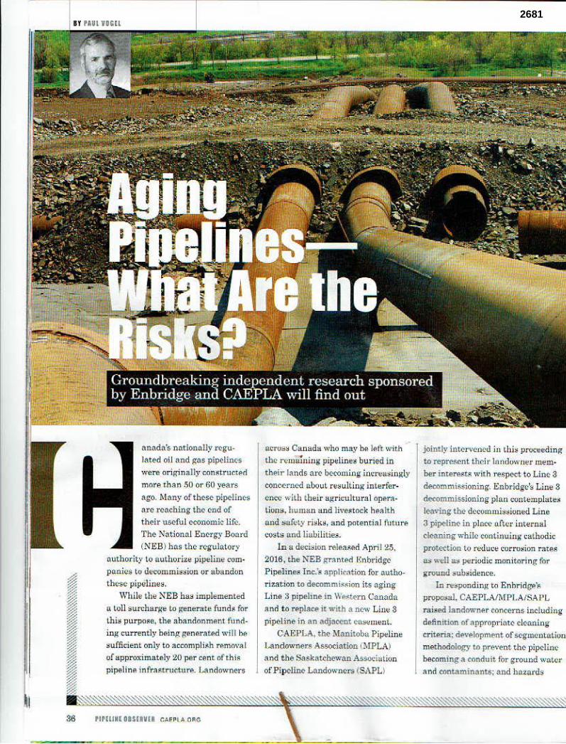
BY PAUl VOGll
anada's nationally regulated oil and gas pipclinc·s
were originally constructeti mora t han .50 or 60 years
ago. Many of these pipelines
are reaching the G-nd of th e.ir useful economic life.
The National Energy Boord
(NEB) has the regulatory
auth ority lo a.,.ahorize pipeline com
po..nies lo decommission or ttbandon
th ese pipelines.
While the NEB has implemented
a toll surcharge to generate funds for
this purpose, the abandonment fund ing currently being generated will be
sufficient onJy to accompliAA rem<wAI of approximately 20 per cent ofthi::;
pipeline infr;q~t ructurP,:. l...andowners
36 PIPHIMl OIS!8VII CAFPl.•.ORG
fWrQ~S C~nada who may be. J~ft Wit.h
the remaining pipelines buried in their lands arc bc-comi1)g in1:reaz;iugly
conc<.>r ucd a.bout re:;ulling interference with (,heir agricultural opflra
~iuns, human and Ji\'eSt()ck health und !Safot.y risks, and pote ntia l fu t11re
cosls and liabilities.
In a decision rele~~Ad Ap ril 25,
2016, the NEB granted ·1,:nbr idi;e
Pipe)in.es Inc.~s appli<:~t ion for autho~
rizati on to decommis..5ion its ag ing
Lin(:! ;i pipeline in We~tC>rn Canada
and to r~place it with a nc·,\.' Line 3
pipeline ii) an adjacent C.-l\$f.!utent. C AEPLA. the. Manitoba Pipelin e
1 ..... indowners Association (MPLA)
and t he Saskatchewan Associulion of Pip e line Lru,downers (SAPL)
jointly intt:>rvcncd i1\ chi:; proceeding
to represent. t.hc:il' londi,wuer mem•
ber interest.i:; w ith respe.ct t o Linc 3
decommissioning. Enbridgc's Line 3 decommissioning plnn <.'Ontemplates
leaving thC' decommissioned Line
3 pipelinC' in_ place· aft.er inte.l'oal
cleaning while continuing cathodic prob.~ .tion lu re<luc:e corrosion ra~s
as well .a::. periodic monitoring for
ground subsidence.
In responding to Enhridge'• propo,,al. CAEPLA/MPI .A/SA PL
raised landownAr concerns including
definition of a!)pl'Oprfotc clenning
criteria; devfl'Jopment of segmcnta.t.iun
methodology to pr:even t d1c pipclitl~
becoming a eonduft for ground \VO.t,c1·
and contaminants: and ha.zatds
2681
fo,· agriculturo I eq uipment, p.,ople.
machinery nnd live.tock thlll could re$ultf1'om pipe collupsc • nd gtou nd • ubsidence.
E nbridge hn• ackuowledxed that the extensive di<bondint: of the Line :1 polyethylene tape pipe c<>Bti ug will rflnd~r c~thodic prntectlon.i.neffcctive
f
Rccogniiint: the coM;derllble uncen .. 1intitis re1:tted to ..nnticipote<l I ,ine 3 corrosion rt\tes, p.ipe collapse
I 1
J
potential and r(.."SUltmM implications for landowner,, CA F:PLA/M PLN
SA P L ll!lci f:nbrids-o. agreed to joint.ly commission and direct independent, third-party reselll'Ch at H C-4.n.adian
First steps The CAEPLA- Enbridge [omtly comm1ss1oned slll1ly is now uncerway at the
University ol Calgary. It 1s an Important first s!ep to better defining the risks and
liabilities of pipelines decomm,ssloned and aba/ldonP.d in place and to developing
acceptable methodologies to reduce risks for landowners.
t.o pri1'\'ent corro8lon. and ha~ csti- I mnted time t-0 th rough-wall ~•o~tra- f tjua at. :l5 to 50 yea rs. Progrt:ssiv,a,Jy r greutc~ricultural surface loads I :inc,..,n$e the potential for pipeline col
lapse M d JtrOund subsidcnc•. ln nd- J dit.fon to heulth and ~nfcty cont.-crns and rc~.1ed <'OStu,nd liabilities. topsoil lo.,. upOn ground suh•idence I would ,·csult in pcrma.ntmt long•U:tm production los~es.
ln the negolioted ,et Llcm~nt resolving landowner conoetnl:f \'lith respect t() the new Line 3 conslruc
tion in March 2015, CAEPLA/ M PLA/SA 1-'l, and Enbridge <\greed to continue con• ultotion vn how to
re~olve thcAe Linc 3 decummiAFJoninG" issue, . CA1'PLAAIPLA1SAl'L a nd Enbridge subsequently coucl<ideri a nd filed with lhe NEB n further Settle-
d«ommissioning.
Under the term• of this a11reemcnt, F.'nbridge ack.nQ\v}edgei its Jia. bm~~ with rcspe,ct to dceommi~sioned or abAndoncd pipelin<.:s n:nd 1:1.grCC$ to implPmenl me211ru.re~ similar lO act.h·e pipeline.s to maintain depth of cover. facilitate <russiJlg with agricullul'nl equipn,en t and address s ub<iden<..,/
nni"crsity to ~tudy the impActs uf dc,comntiAsioni11g :\nd uba.ncion ing pipt!lincs m place. wit.Ji n view to
further defining the u•ociated risks o.nd consideration of a 1t~rnati,·e deco mm iisi<mi ng/{tb{'ndonmtortt methodolc,ci••·
Enbrids-e i• rcspon•iblc both for the fun<lingofthis res enrch project
und for the cosi. of CAF.PLA's partic~tion. including CA l•~PLA's own independent c.onsult.Mt.s. A8 pa.rt of th i~ agreement, E nbridge h11• also provided to landowner." prcp,lym~nt to be appl ied on account of possihle
futura <lect1mmi;i;sioo.in, or abandon• rucnt damugcs..
In its decision grnnting Eo.brid,ge\t 1:1.pplie.(ltion for l .ine 3 dacom1nissioning, the Board refe...,occs the CAEPl.A/MP!.A/SAPL - Enbridge S•ttlemenl Agreemtnt:
"The Board ,;ews this Agreement as a positive i.nitiatl\·e und found it to
be a pitrsuas.ive factor in favour of tho re.::ii:ionublone~M of Enhridgc's dec:oromi••ioninr plan .. . The BOOJ<l ,_-.:p,,cts Enbridge to coni..inue to cvnsuit wilh nffect•d ... landowners during the Dcc()mmissioning J\ctivilies a.rui the
Decommi•sionlng Period and peri•
ha.zards that lirn.it pipeline removal to llTrl•,c ot a solution rhet. is agTtN:-
11.blA to all pa nies, baSf'd on site·•peci.fic circumst.'\nce~."
\Vhile nuthorizing l~nbri<lgc·~ Line a dticommu1sioll.in,, thtt Board e.,l)reAAly •1'1-:
'1
) lowev~r. thi~ docs not m~nn that t,hA Board will not order pipeline removal in" future <:A•e. ,;houlrl
the cvid•nc• •upp<1rt i~. It Also docs not Jllcan thaL the Roard w; ll not
nrder the removal of the D<-oommis.-iontU Line 3 Pipeline iu th!! fun.ire if cir<.:umfl.tancts ch::i ogt. Thi~ muy or.cur wh('rP. th~ benefit, of removing certain scgm•nts ofth• Existing liM 3 .Pipeline outweigh th~ ruks oft.he pipeline r1..:m'-';ning in-place.""
The CAEl'I--Afl-lPL.A/SAPL
- Enbridge jointls commissjunecl • tudy represent. purt of F.nl,,·idgs'• required I.inc 3 d•commissioning conLinuin,:t landowner consultation. Thi:.1 1·eF.P.n.rch is nnw underway ul thit Un iversity ofCalgury. It is un
im;,ortant first step to bctt>r defining
the risks and linhilit.ie• vfpipAliues de<:nmmissionod und •haudonerl in
methodologiea w rtduee these ri~ks for lnndPwntrs.
The flnal report that ro$ults fro~ thi• research will ns.<i•t landowncrF.. th~ indn~try. ond re~ulatorM in tHidrt :;sinc the:;~ issues us C~nadu's aginH ~llCl'C)' pipclu,• infnistru<IUJ'C is removed from uso. It i, anticipated
~hat this l'Oport will be fi l•d with the NE il prior to 1.lne 3 dccommissfoning and will then form Lhc ha&is for regu• • lo.t-0ry apµtovnl for possible required chang•~ to Enbrirli:es current Line 3
decommi~•ioning plan. •
- Paul 0. \{,gd ,,..~ a por·tm r w lhl•
tomln11. Ont., lc,r, Ii.rm oft ·nJrc11 Hi;,Mey I.LP. He pracJi s t11 11,~ c 1'f'II
mtmtttl lnu·.
2681
•f •• .. ~
'" •<f . , • ... . ,, . .
2681
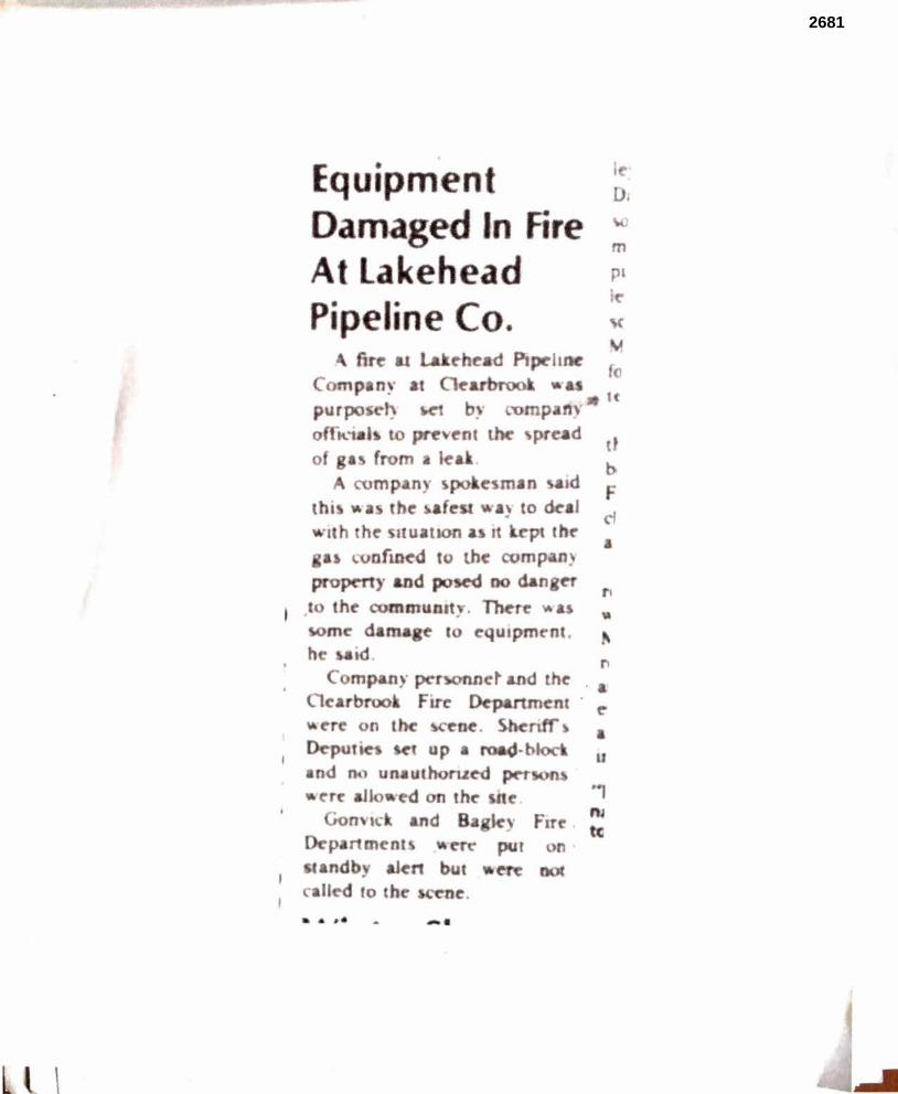
• I Di
m pl
p· I
• ~
fo I
d tt
m n ad &) to deal
cf
r,
. ~· -·
L \
2681

--
2681
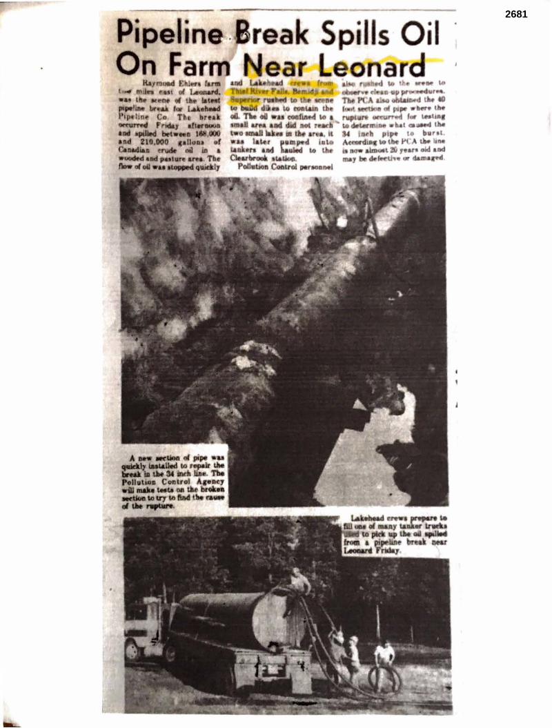
"'-tfll l -.., mtlft Ill
• Ill. •~ tu laWIIC lllPt' bf; &i '' Weftllld l•ip .. hn.. Co Tti, break ~ rld&1 afler9WII IN epaDed bet• II 1 , nd 210.000 canuat .. r C..Mllia11 "'* oil ill a ~ •ad peallar &tft. Tbe ""'"'o61• ~q . 1
2681
(U. .P.S. 3 7 ·62 25
G
2681
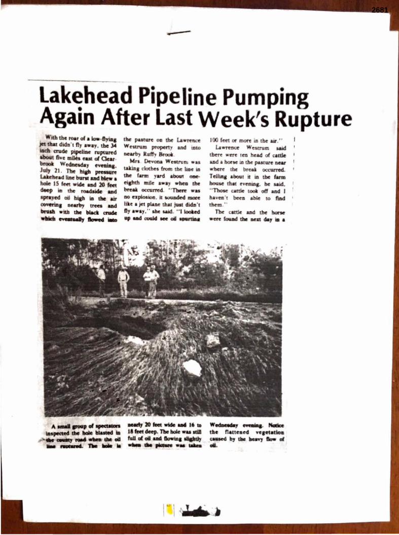
Lakehead Pipe ·ne Pump·ng Again After Last Week's upture
A ..... .-pvlllf9d•ill .......... tbe ... bl&tlled .. ... -
... awa4- n. .... "
...t,20fed .. ,."-'·,,. '11D al oil ..
- .......
(ee1 mon i.a tk aar." u~ We5tnlm Mid 1
2681
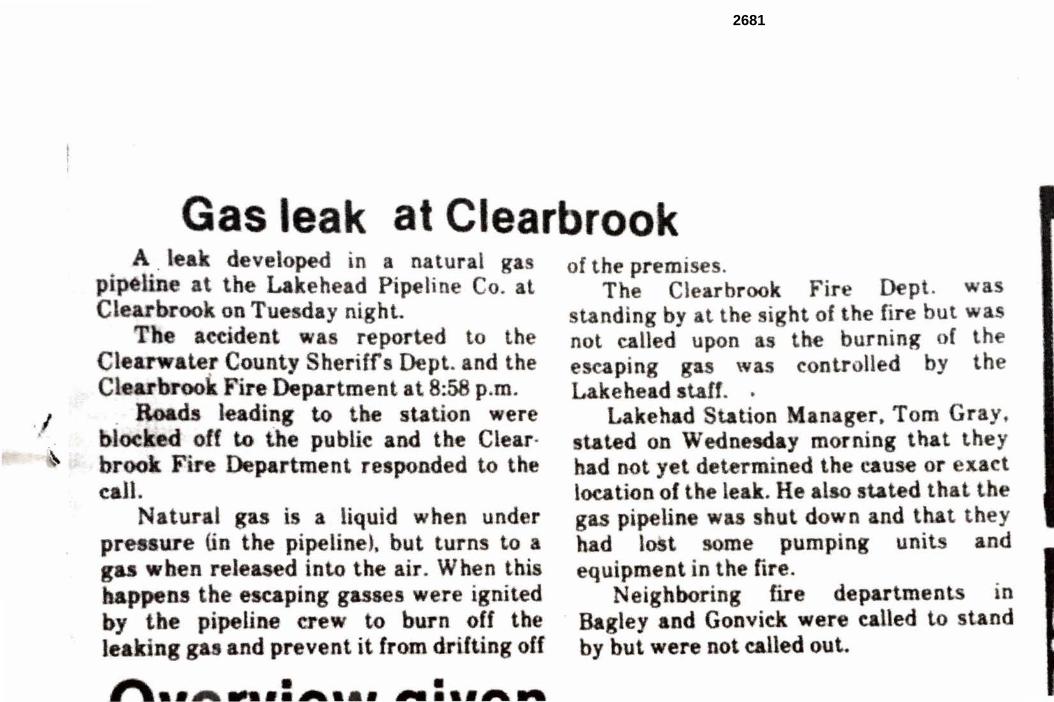
-~
C ll. i a liquid h n u nd r pipelin ), but urn to
1:A-'l~~1d in to the air. hen hi · r ignited
• • .• ..., ............. ~ ....
. . pump1n . un1
fir .
a
h th
. l
t nd
2681
r:
•)
2681
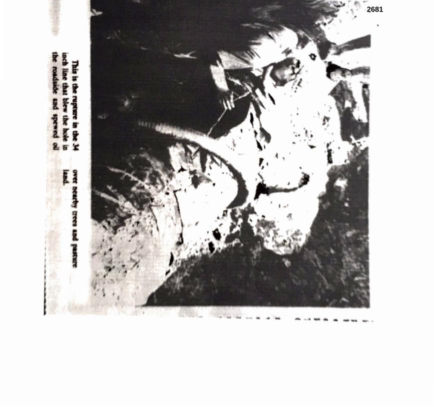
2681
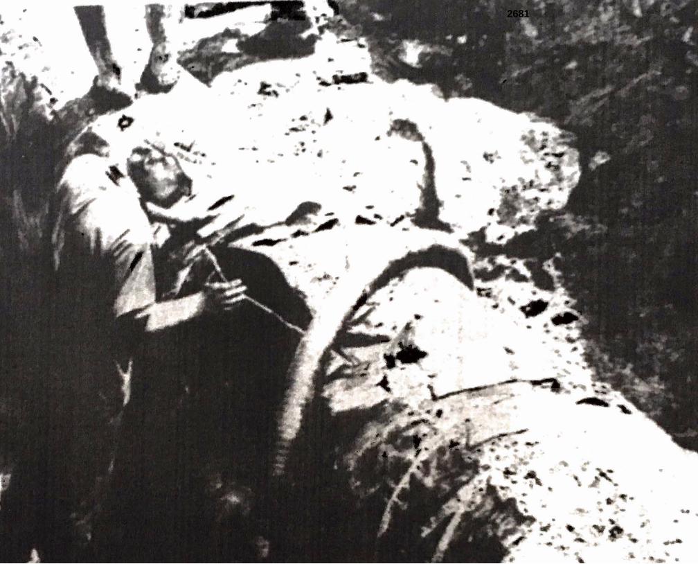
2681
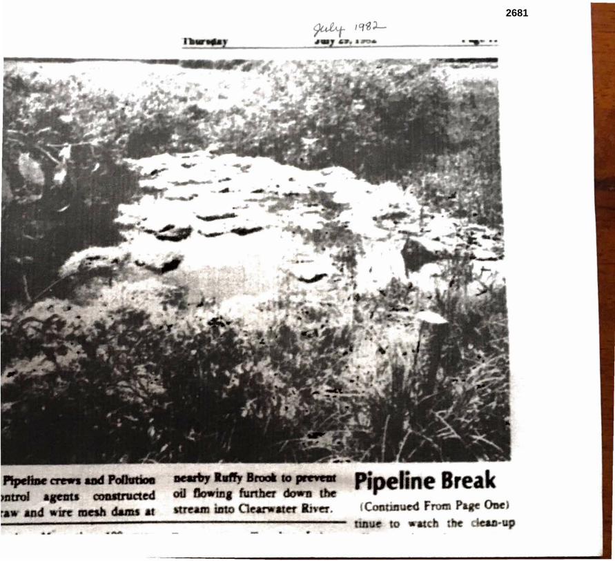
2681
,
2681
1
Levi, Andrew (COMM)
From: Tim Horyza <[email protected]>Sent: Monday, June 19, 2017 12:08 PMTo: MN_COMM_Pipeline CommentsSubject: Enbridge L-3 Replacement
I have 32 years of experience in pipeline construction and operation and Enbridge is the best in the business about caring for the natural resources around the right of way. I can attest that the mitigation measures discussed in Enbridge’s Environmental Protection Plan and summarized in the DEIS reflect the best practices in the industry and effectively minimize construction‐related impacts. Enbridge works hard to minimize construction impacts and restore the land. Enbridge has worked hard to address specific concerns raised by landowners along the Preferred Route. More than 95% of the private landowners have signed voluntary easements with Enbridge, and Enbridge has modified the Preferred Route based on public comments/landowner feedback. These efforts to minimize impacts and address landowner feedback should be better reflected in the FEIS. I am a Minnesotan and want to see the environment protected like most others. To me, there’s no greater demonstration to the environment than the $7.5 billion in private investment Enbridge has committed to replacing existing Line 3. The DEIS should acknowledge the environmental benefits of replacing aging infrastructure with a new pipeline built using modern materials, designs and construction techniques. Modern‐day preventive maintenance and inspection technology make accidents, especially large releases, highly unlikely. In the event of a leak or other incident, Enbridge has robust and tested emergency response equipment, training and expertise to ensure a quick and effective response. Enbridge is an active participant in leak detection research and development programs. Enbridge employs industry leading leak detection programs on all of its systems today, and continually invests in technology development so that the company can improve leak detection thresholds in the future. Tim Horyza
Duluth MN
* * * * * * * * * * * * * * * * * * * * * * * * * IMPORTANT NOTICE* * * * * * * * * * * * * * * * * * * * * * * * * Unless otherwise indicated or obvious from the nature of the transmittal, the information contained in this email message is CONFIDENTIAL information intended for the use of the individual or entity named herein. If the reader of this message is not the intended recipient, or the employee or agent responsible to deliver it to the intended recipient, you are hereby notified that any dissemination, distribution or copying of this communication is strictly prohibited. If you have received this communication in error, please immediately notify the sender using the above contact information or by return email and delete this message and any copies from your computer system. Thank you.
0525-1
0525
1
Levi, Andrew (COMM)
From: Jennifer Houston <[email protected]>Sent: Friday, June 30, 2017 7:40 PMTo: MN_COMM_Pipeline CommentsSubject: Comments re: line 3 Pipeline
RE: LINE 3 PIPELINE AND IT’S NEGATIVE EFFECTS:
TRIBAL IMPACTS
The United Nations international standard for projects that impact Indigenous Peoples is Free, Prior and Informed consent. Tribal consultancy after the project is already proposed and designed is not free, prior, and informed consent.
Most of the issues specific to tribal people and tribal resources are confined to a separate chapter that attempts to provide “an American Indian perspective.” They are excluded from the main chapters that assess potential impacts. This allows the EIS to avoid drawing conclusions about the impacts on tribal people. (Chapter 9)
Chapter 9, “Tribal Resources,” states that ANY of the possible routes for Line 3 “would have a long-term detrimental effect on tribal members and tribal resources” that cannot be accurately categorized, quantified, or compared (9.6). It also acknowledges that “traditional resources are essential to the maintenance and realization of tribal lifeways, and their destruction or damage can have profound cultural consequences” (9.4.3). This does not acknowledge the treaty responsibilities the state of Minnesota has to the tribal members.
Chapter 11, “Environmental Justice,” acknowledges that pipeline impacts on tribal communities “are part of a larger pattern of structural racism” that tribal people face in Minnesota, which was well documented in a 2014 study by the MN Department of Health. It also concludes that “the impacts associated with the proposed Project and its alternatives would be an additional health stressor on tribal communities that already face overwhelming health disparities and inequities” (11.4.3).
The DEIS concludes that “disproportionate and adverse impacts would occur to American Indian populations in the vicinity of the proposed Project” (11.5) But it also states that this is NOT a reason to deny the project!
Chapter 6 states that Enbridge’s preferred route would impact more wild rice lakes and areas rich in biodiversity than any of the proposed alternative routes (Figure ES-10).
Most of the analysis of archaeological resources in the path of the pipeline rely on Enbridge’s surveys. For some reason, only 3 of their 8 surveys are available, and the 5 missing are the most recent! In those, Enbridge found 63 sites, but claims that only 3 are eligible for protection under the National Register of Historic Places. (5.4.2.6.1). Honor the Earth has had the studies we have been able to see reviewed, and there are numerous flaws in their methodology.
The DEIS acknowledges that “The addition of a temporary, cash-rich workforce increases the likelihood that sex trafficking or sexual abuse will occur,” and that these challenges
1027-1
1027-2
1027-3
1027-4
1027
2
hit Native communities the hardest. But the DEIS dismisses this problem quickly, saying that “Enbridge can prepare and implement an education plan or awareness campaign around this issue” (11.4.1). What experience does Enbridge have planning and implementing an anti-sex trafficking program?
BIG PICTURE PROBLEMS
Many of the environmental impacts and "plans" for minimizing them are drawn directly from Enbridge’s permit application (“Enbridge would do this” and “Enbridge would do that”) without any evidence of compliance or genuine consideration that maybe, just maybe, Enbridge won’t follow all the rules. History shows that they continually violate permit conditions - we are working on compiling an enormous record of these violations. The DEIS should analyze the likelihood of compliance.
The Alternatives chosen for comparison to the pipeline proposal are absurd -- for example, the only rail alternative assumes the construction of a new rail terminal at the US border, and thousands of new railcars to transport oil to Clearbrook and Superior. Enbridge would never do that. The only reasonable rail option would begin in Alberta. The truck alternatives are similarly unreasonable.
The “No Build” Alternative is not genuinely considered. It is framed as “Continued Use of Existing Line 3” (Chapters 3 and 4), but nowhere is the “Shut Line 3 Down” option considered. There is no discussion of renewable energy, conservation, or the rapid development of electric car infrastructure. There is no assessment of the decline in oil demand. The entire study assumes that society needs X amount of oil, simply because Enbridge says they can sell it. That assumption ignores the massive fossil fuel subsidies and debts that make Enbridge’s profits possible, and avoids the moral question of what is good for people and the planet. We know we must stop burning fossil fuels yesterday.
There is zero discussion of how all this extra oil will go once it leaves Superior, Wisconsin. With 370,000 bpd of additional capacity, Enbridge will need a new pipeline departing its terminal in Superior. We know that they plan to build Line 66 through Ojibwe territories in Wisconsin, but they continue to deny this. Why isn’t MN asking?
The DEIS contains no spill analysis for tributaries of the St. Louis River or Nemadji River, where spills could decimate Lake Superior and the harbors of the Twin Ports.
For calculations of impact, the lifespan of the new Line 3 is estimated at 30 years. But Lines 1-4 are 55-65 years old! And hasn’t the technology improved? The lifespan should be at least 50 years, a shorter lifespan is a clear indication that Enbridge themselves know that the fossil fuel era is coming to an end. In Honor the Earth’s analysis, we have attempted to predict the impacts of this pipeline on the next 7 generations.
This project is a further investment in a dying Tar Sands industry. Numerous international oil companies and financing institutions are divesting from the tar sands. Why should Minnesota invest in this industry? Why should our Nation be forced to deal with a bad idea in perpetuity.
The DEIS assumes that the Koch pipelines to MN refineries get all their oil from Line 3, but the current Line 3 does not supply enough capacity for this (390,000 barrels per day), and we know that some of it comes from Line 81, which brings oil from the Bakken in North Dakota.
1027-4Cont'd
1027-5
1027-6
1027
3
SPILL RISK
The 7 sites chosen for spill modeling are not representative of the locations and resources put at risk along the entire corridor. A more thorough analysis of different locations is needed - for example, what about Lake Superior?
There is no analysis on Enbridge’s leak detection system, or their inability to respond quickly to major emergencies.
Enbridge’s response plans are highly guarded, and Honor the Earth’s attempts to receive and review these documents has been blocked. What we can infer is that Enbridge relies on local first responders for their emergencies. They attempt to use the money they donate to communities along their corridors as proof that they have an integrated emergency response program.
The DEIS estimates the annual probability of different kinds of spills on the proposed route in MN:
Pinhole leak = 27% Catastrophic = 1.1% Small Spill = 107%, Medium = 7.6%, Large = 6.1%
So in 50 years, we can expect 14 pinhole leaks, 54 small spills, 4 medium, 3 large, and 1 catastrophic!
ABANDONMENT
The risks of pipeline abandonment are not adequately assessed. For example, there is no discussion of landowner property values and the effect that an abandoned pipe could have on them, especially if there is indeed “legacy contamination” on people’s land.
Impacts on human and natural resources due to the abandoned Line 3 are anticipated to be minimal in the near term but could be significant in the longer term, absent effective monitoring, adaptive management, and the timely introduction of mitigation measures. There is not much information on what these mitigation and management plans are.
If there is a dearth of surrounding soil, or if the cover for the pipeline is relatively shallow, the pipeline bears more of the load and, all things being equal, is more likely to fail. We know from experience that there are numerous areas where the pipes are exposed and near the surface.
There is also no discussion of exposed pipe, how fast it will corrode, or how much currently buried pipe will become exposed once it is emptied. “When a pipe is empty, the weight of the liquid load that once contributed to buoyancy control is lost. As a result, the pipe could become buoyant and begin rising toward the surface at watercourse crossings, in wetlands, and in locations where soil density is low and the water table is high” (8.3.1).
We know that the abandonment of the existing line 3 is bad. But there is also no mention of the abandonment of the other 3 ancient pipelines in Enbridge’s existing mainline corridor (Lines 1, 2, and 4), which we expect Enbridge will very soon attempt to abandon. Nor is there any discussion of the abandonment of the NEW Line 3 in the future.
1027-7
1027-8
1027-9
1027-10
1027-11
1027-12
1027-13
1027
4
The DEIS states that it will be very risky to remove and clean up the existing Line 3 because the pipelines are very close together. “The distance between pipelines within this corridor varies, but they are generally 10 to 15 feet apart” (8.3.1). This is not consistent with our extensive observations and physical measurements on the land. Also, don’t they dig up pieces of pipe for maintenance purposes all the time? Why is it suddenly risky?
The DEIS simply states that “Enbridge has indicated that it would develop a contaminated sites management plan to identify, manage,and mitigate historically contaminated soils and waters” found during the abandonment or removal of the existing Line 3 (8.3.1.1.1). We want to see that plan.
CONSTRUCTION AND RESTORATION
Chapter 2, “Project Description” states that Enbridge has requested a 750-foot route width (375 feet on each side of the Line 3 Replacement pipeline centerline). They claim only 50 of the 750 feet would remain a permanent right-of-way (2.1) All of this width should be included in an impact analysis because Enbridge’s environmental protection plan and record is abysmal.
Their “restoration” plans for restoring the landscape around the corridor after installation is laughable. Enbridge’s process for restoring wetlands includes dumping the now compacted (and probably de-watered) soil back in the trench, sowing some oats and “letting nature take it’s course”. This is not how you re-establish a wetland. Studies have shown that even with proper restoration practices, it can take decades to get back to the biological functioning it was at prior to disturbance. When Enbridge stores the soil, they will also be driving equipment over it- which compacts it, they also plan to compact the soil after refilling the trenches. This is not good for the soil.
Cathodic protection, which applies electric current to the pipeline in order to protect it from corrosion caused by nearby utility lines, will not be installed for up to 1 year after pipeline construction (2.3.2.3). Lack of cathodic protection is what caused many pinhole leaks in the Keystone pipeline, almost immediately after construction. The proposed route for Line 3 follows a utility corridor for much of its length - this is a recipe for disaster. Even the US Army Corps’s rubber-stamp approval of the Dakota Access pipeline required the cathodic protection system to be installed within 6 months!
ECONOMIC IMPACTS
Chapter 5, “Existing Conditions, Impacts, and Mitigation” states that Line 3 will create ZERO permanent jobs. Enbridge’s application states that “existing operations staff would be able to operate the [pipeline] and that few additional employees would be hired to assist the staff” (5.3.4).
Also in Chapter 5, the DOC assumes “all workers would re-locate to the area” and ZERO construction jobs will go to Minnesotans. The pipeline would have “no measureable impact on local employment, per capita household income, median household income, or unemployment” (5.3.4).
The DEIS does not acknowledge that when the existing Line 3 shuts down, Enbridge will stop paying taxes to the MN counties along the mainline corridor. For many of these poor counties in the north, revenue from Enbridge’s property tax makes up a significant portion of
1027-14
1027-15
1027-16
1027-17
1027-18
1027-18Cont'd
1027
5
the county budget. There is also the issue that Enbridge is now in the process of appealing years of back taxes, burdening two of the poorest counties in Minnesota with over $10 million due.
CLIMATE CHANGE
The DEIS acknowledges that Line 3 would contribute to climate change. It analyses 3 different types of emissions - direct, indirect, and lifecycle. Direct emissions are those that the pipeline infrastructure itself emits, and these are very small. Indirect emissions are those created by the power plants that provide electricity for the pipeline’s pumping stations, and these are significant. Lifecycle emissions are those caused by the refinement and eventual use of the oil, and these are massive. Line 3’s direct and indirect emissions alone would be 453,000 tons of CO2 per year. Over a 50-year lifespan, that would cost society an estimated $1.1 billion. (Executive Summary p.18).
The lifecycle emissions of Line 3 would be 193 million tons of CO2 each year. Over a 50-year lifespan, that would cost society an estimated $478 billion (5.2.7.3)
The DEIS does not discuss the unprecedented challenges of human casualty, displacement, conflict, natural disaster, biodiversity loss, etc, that climate change is causing, or the consensus from the scientific community that we must leave fossil fuels in the ground. It also fails to acknowledge that across the planet, Indigenous people are disproportionately impacted.
The DEIS affirms that the MN PUC can only grant the permit if "the consequences to society of granting are more favorable than the consequences of denying the certificate." Regardless of whether or not Enbridge can find customers, the DEIS shows that the negative impacts far outweigh the benefits. So our position remains:
NO PERMIT. SHUT DOWN LINE 3 AND DEVELOP RENEWABLE ENERGY INFRASTRUCTURE.
1027-19
1027
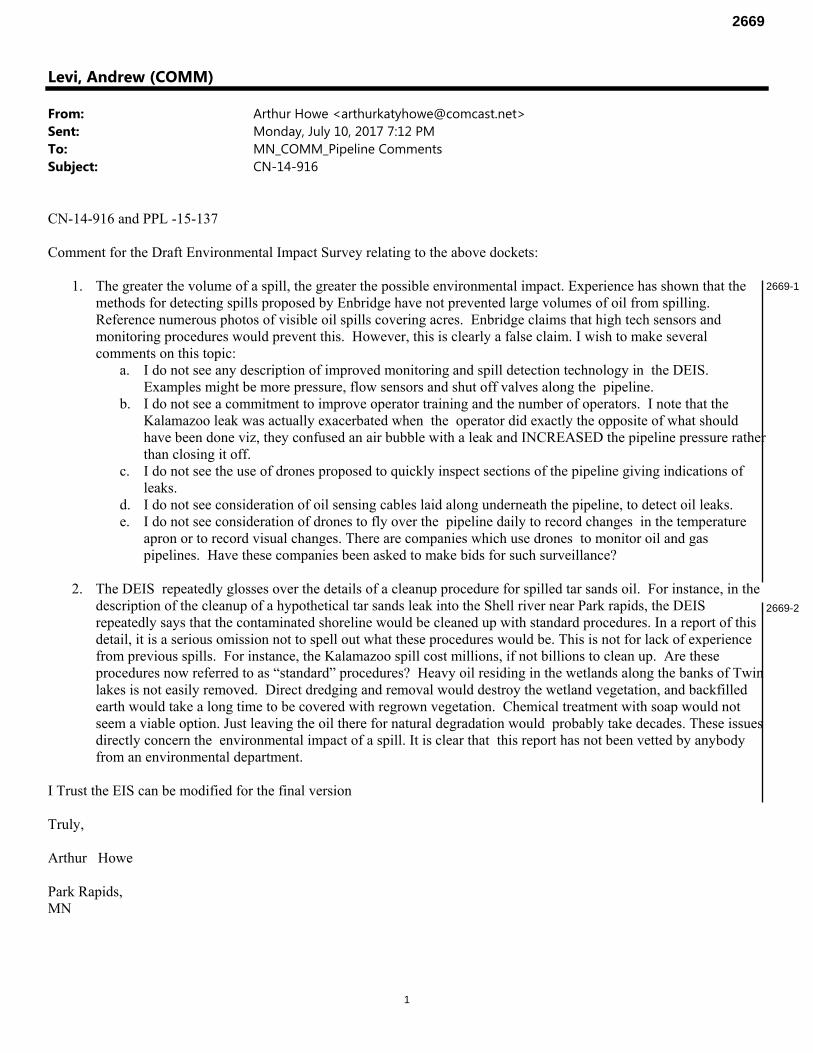
1
Levi, Andrew (COMM)
From: Arthur Howe <[email protected]>Sent: Monday, July 10, 2017 7:12 PMTo: MN_COMM_Pipeline CommentsSubject: CN-14-916
CN-14-916 and PPL -15-137 Comment for the Draft Environmental Impact Survey relating to the above dockets:
1. The greater the volume of a spill, the greater the possible environmental impact. Experience has shown that the methods for detecting spills proposed by Enbridge have not prevented large volumes of oil from spilling. Reference numerous photos of visible oil spills covering acres. Enbridge claims that high tech sensors and monitoring procedures would prevent this. However, this is clearly a false claim. I wish to make several comments on this topic:
a. I do not see any description of improved monitoring and spill detection technology in the DEIS. Examples might be more pressure, flow sensors and shut off valves along the pipeline.
b. I do not see a commitment to improve operator training and the number of operators. I note that the Kalamazoo leak was actually exacerbated when the operator did exactly the opposite of what should have been done viz, they confused an air bubble with a leak and INCREASED the pipeline pressure rather than closing it off.
c. I do not see the use of drones proposed to quickly inspect sections of the pipeline giving indications of leaks.
d. I do not see consideration of oil sensing cables laid along underneath the pipeline, to detect oil leaks. e. I do not see consideration of drones to fly over the pipeline daily to record changes in the temperature
apron or to record visual changes. There are companies which use drones to monitor oil and gas pipelines. Have these companies been asked to make bids for such surveillance?
2. The DEIS repeatedly glosses over the details of a cleanup procedure for spilled tar sands oil. For instance, in the
description of the cleanup of a hypothetical tar sands leak into the Shell river near Park rapids, the DEIS repeatedly says that the contaminated shoreline would be cleaned up with standard procedures. In a report of this detail, it is a serious omission not to spell out what these procedures would be. This is not for lack of experience from previous spills. For instance, the Kalamazoo spill cost millions, if not billions to clean up. Are these procedures now referred to as “standard” procedures? Heavy oil residing in the wetlands along the banks of Twin lakes is not easily removed. Direct dredging and removal would destroy the wetland vegetation, and backfilled earth would take a long time to be covered with regrown vegetation. Chemical treatment with soap would not seem a viable option. Just leaving the oil there for natural degradation would probably take decades. These issues directly concern the environmental impact of a spill. It is clear that this report has not been vetted by anybody from an environmental department.
I Trust the EIS can be modified for the final version Truly, Arthur Howe Park Rapids, MN
2669-1
2669-2
2669
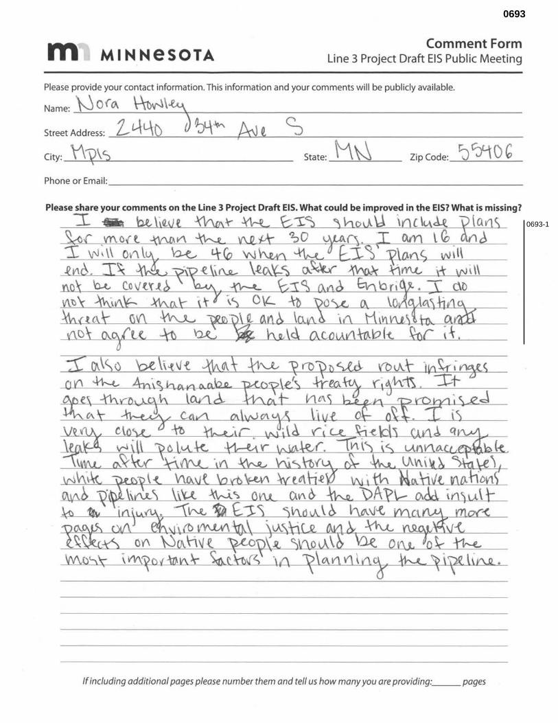
ffl MINNeSOTA Comment Form
Line 3 Project Draft EIS Public Meeting
Please provide your contact information. This information and your comments will be publicly available.
Name: ).j O(~ \\t)V'l\~
Street Address: 2-£-.\L-\-() J ~~ A-J t S I
State: _M_~~-- Zip Code: ~ C~f\ 0 G City: \\yV:;, Phone or Email: ________________________ _
If including additional pages please number them and tell us how many you are providing: __ pages
0693-1
0693
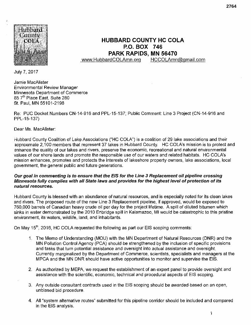
Hubbard Coun·tv·
OLA HUBBARD COUNTY HC COLA P.O. BOX 746
PARK RAPIDS, MN 56470 www.HubbardCOLAmn.org [email protected]
July 7, 2017
Jamie MacAlister Environmental Review Manager Minnesota Department of Commerce 85 y!h Place East, Suite 280 St. Paul, MN 55101-2198
Re: PUC Docket Numbers CN-14-916 and PPL-15-137; Public Comment: Line 3 Project (CN-14-916 and PPL-15-137)
Dear Ms. MacAlister:
Hubbard County Coalition of Lak~ Associations ("HC COLA") is a coalition of 29 lake associations and their approximate 2,100 members that represent 37 lakes in Hubbard County. HC COLA's mission is to protect and enhance the quality of our lakes c;1nd rivers, preserve the economic, recreational and natural environmental values of our shore lands and promote the responsible use of our waters and related habitats. HC COLA's mission enhances, promotes and protects the interests of lakeshore property owners, lake associations, local government, the general public and future generations.
Our goal in commenting is to ensure that the EIS for the Line 3 Replacement oil pipeline crossing Minnesota fully complies with all State laws and provides for the highest level of protection of its natural resources.
Hubbard County is blessed with an abundance of natural resources, and is especially noted for its clean lakes and rivers. The proposed route of the new Line 3 Replacement pipeline, if approved, would be exposed to 760,000 barrels of Canadian heavy crude oil per day for the project lifetime. A spill of diluted bitumen which sinks in water demonstrated by the 2010 Enbridge spill in Kalamazoo, Ml would be catastrophic to this pristine environment, its waters, wildlife, land, and inhabitants.
On May 151\ 2016, HC COLA requested the following as part our EIS scoping comments:
1. The Memo of Understanding (MOU) with the MN Department of Natural Resources (DNR) and the MN Pollution Control Agency (PCA) should be strengthened by the inclusion of specific provisions and tasks that turn potential assistance and oversight into actual assistance and oversight Currently marginalized by the Department of Commerce, scientists, specialists and managers at the MPCA and the MN DNR should have active opportunities to monitor and supervise the EIS.
2. As authorized by MEPA, we request the establishment of an expert panel to provide oversight and assistance with the scientific, economic, technical and procedural aspects of EIS scoping.
3. Any outside consultant contracts used in the EIS scoping should be awarded based on an open, unbiased bid procedure.
4. All "system alternative routes" submitted for this pipeline corridor should be included and compared in the EIS analysis.
1
2764
After reviewing the draft EIS, it is evident that our scoping EIS comments I recommendations were not heeded. The Draft EIS of the potential environmental, human and economic impacts of the Line 3 Project and its proposed routes is inadequate due to the following issues directly affecting water resources:
1. Chapter 10 Accidental Crude Oil Releases comments a) The oil release (spill) analysis was supplied by Enbridge, and their paid contractors who were also
hired by the State to formulate the EIS. This is an obvious conflict of interest. The spill analysis was done without an independent 3rd party analysis.
b) The numbers used to calculate the spill scenarios were redacted; limiting the public to incomplete analysis and understanding.
c) The oil spill analysis was limited to only 7 sites, all along Enbridge's proposed route. This is insufficient as it does not represent all of the topographical features found on their proposed route nor features found on route alternatives.
d) The long term risk assessment for the life of the project is missing; this project life is at least 50 years based on the current age of Line 3.
e) There is no long term risk assessment of leaving the pipe in the ground indefinitely. f) Missing winter spill analysis with the complexities of cleaning a river or lake covered by ice. g) Missing the effect on a spill site where first response personnel are hampered from accessing the
site of a spill where there are no existing roads.
2. Chapters 5, 6, 7, 9, and 11 in addition to 10 above - - Economics-related comments a) The oil release (spill) analysis is missing the economic analysis of the damage to our natural
resources: i. Tourism ii. Itasca State Park iii. Property Values
b) Post construction impacts and costs to our natural resources
3. Chapters 5, 6, 7, 9, and 11 - - Environmental-related comments a) Considering there are 192 water crossings in Minnesota via the proposed route, there appears to be
no apparent usage of the MN PCA comprehensive water crossings report done for the Sandpiper, which follows the same proposed route in Minnesota. This is a gap.
b) There is no disclosure (or analysis) of hydraulic drilling fluids used to tunnel under streams, but which are known to be toxic to aquatic life.
c) Water body analysis appears only quantitative, not qualitative - resulting in shallow lakes being equated with water-filled ditches.
d) In addition we found insufficient analysis of pipeline construction impact regarding the potential spread of invasive species.
4. Chapters 4, 5, 6, 7, and 9 - System Alternative SA04 and Line 3 comments a) The System Alternative SA04 that bypasses the Mississippi River and the clean lakes region of
Northern Minnesota was not adequately considered. b) Minor route alternatives which resulted in reduced impacts of proposed Line 3R were not
considered in SA04 like bypass karst areas c) The construction impact on ground water discrepancy of 1000 ft Line 3R versus 2500 ft for SA04
Thank you for considering our Hubbard County Coalition of Lake Associations comments on the Draft Environmental Impact Statement. If you have any questions or want to discuss these matters further, please contact our current HC COLA President, Sharon Natzel, at email address [email protected].
Sincerely, .J .L) L I/. , ,t1 ~ ~u/ fli.A.U~ 'TJ,vL. f/aJ:,6t:1A.P CotUl'l:J eoal?h~()I) .J.:.a.tr.JL ;S:s'oC.,a.r,~ a -() A?\
The Hubbard County Coalition of Lake Associations Board of Directors
7.
2764-1
2764-2
2764-3
2764-4
2764-5
2764
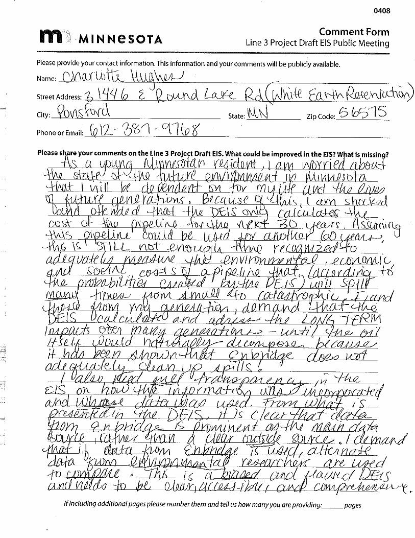
j '
ffl MINNeSOTA Comment Form
Line 3 Project Draft EIS Public Meeting
Please provide your contact information. This information and your comments will be publicly available.
Name: 1 W\(,lf U) t \\J '1 'vw!-J Street Address: 1- \!.JI._
City: Qo\j\s; ~{(.\ State: \J0v N Zip Code: 6 /oSr1 5 Phone or Email: [Q l2 ~ 01> '1 r C\1 lo '6
·"1----'-'-~ll'+t,i'/Lf'lL-~----"--________J_J_'-+D----:---+-&-~~~.t.L_----(,,JL,[U,.4,-----,f'.'=,~d{-~ ts W"LLLJ'.'.LQ:ta,~::[U_______,t,'i'.L_----1,d4.Q.lUD--Ul.Li!,,(b:L-J'»,JJL_LJ',LJ{''£'!:!_____Lilt].1'14LJ~UU!~~ l-'''f •
If including additional pages please number them and tell us how many you are providing .. ·~ _pages
0408
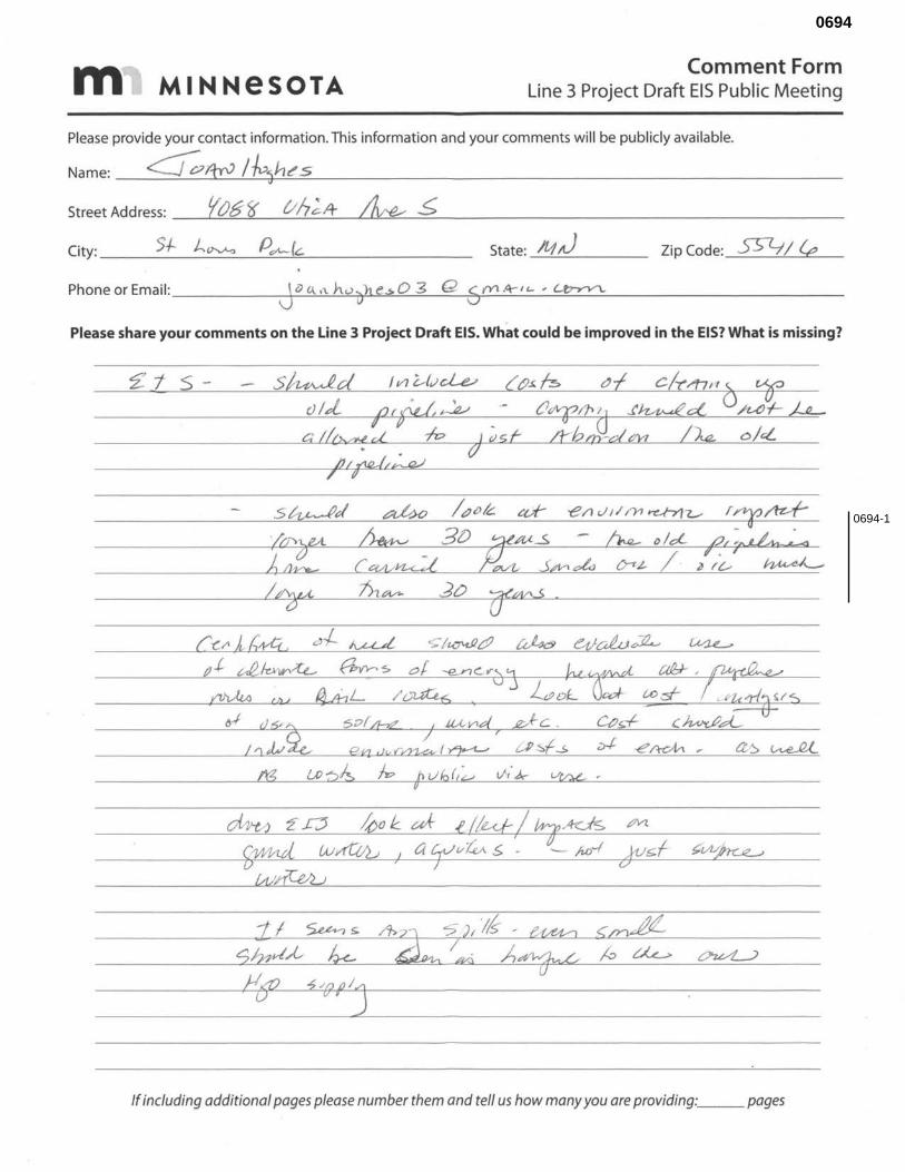
ffl1 MINNeSOTA Comment Form
Line 3 Project Draft EIS Public Meeting
Please provide your contact information. This information and your comments will be publicly available.
Name: ~ftyv /-~~h~s
Street Address: ft;&-?f vh;lt ~ ~
City: ___ 5_+-_J..._v-v-o ___ P--=-,:>\,-____,,("==------------- State: A1 ,J Zip Code: S57--J I Y,
Phone or Email: _____ J-l)~G\.~,,~h~u-o"'"'""h~e=..$-0_3_Q_6-=,.-t'Y1_A-_1_'-_'_ ~ ____________ _
Please share your comments on the Line 3 Project Draft EIS. What could be improved in the EIS? What is missing?
z.'t s-
If including additional pages please number them and tell us how many you are providing: pages
0694-1
0694
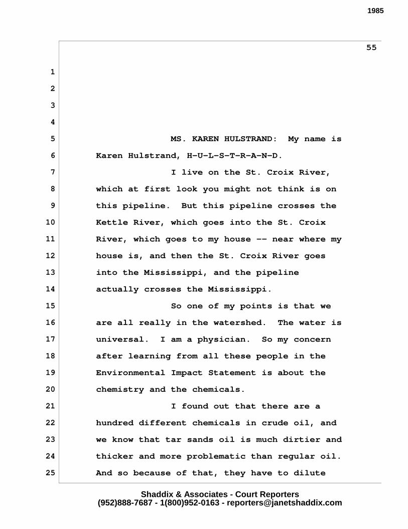
Shaddix & Associates - Court Reporters(952)888-7687 - 1(800)952-0163 - [email protected]
55
1
2
3
4
5
6
7
8
9
10
11
12
13
14
15
16
17
18
19
20
21
22
23
24
25
want to. It's because we're prisoners of the
system that we're in.
FACILITATOR: Next, just name and
spelling for the record.
MS. KAREN HULSTRAND: My name is
Karen Hulstrand, H-U-L-S-T-R-A-N-D.
I live on the St. Croix River,
which at first look you might not think is on
this pipeline. But this pipeline crosses the
Kettle River, which goes into the St. Croix
River, which goes to my house -- near where my
house is, and then the St. Croix River goes
into the Mississippi, and the pipeline
actually crosses the Mississippi.
So one of my points is that we
are all really in the watershed. The water is
universal. I am a physician. So my concern
after learning from all these people in the
Environmental Impact Statement is about the
chemistry and the chemicals.
I found out that there are a
hundred different chemicals in crude oil, and
we know that tar sands oil is much dirtier and
thicker and more problematic than regular oil.
And so because of that, they have to dilute
1985
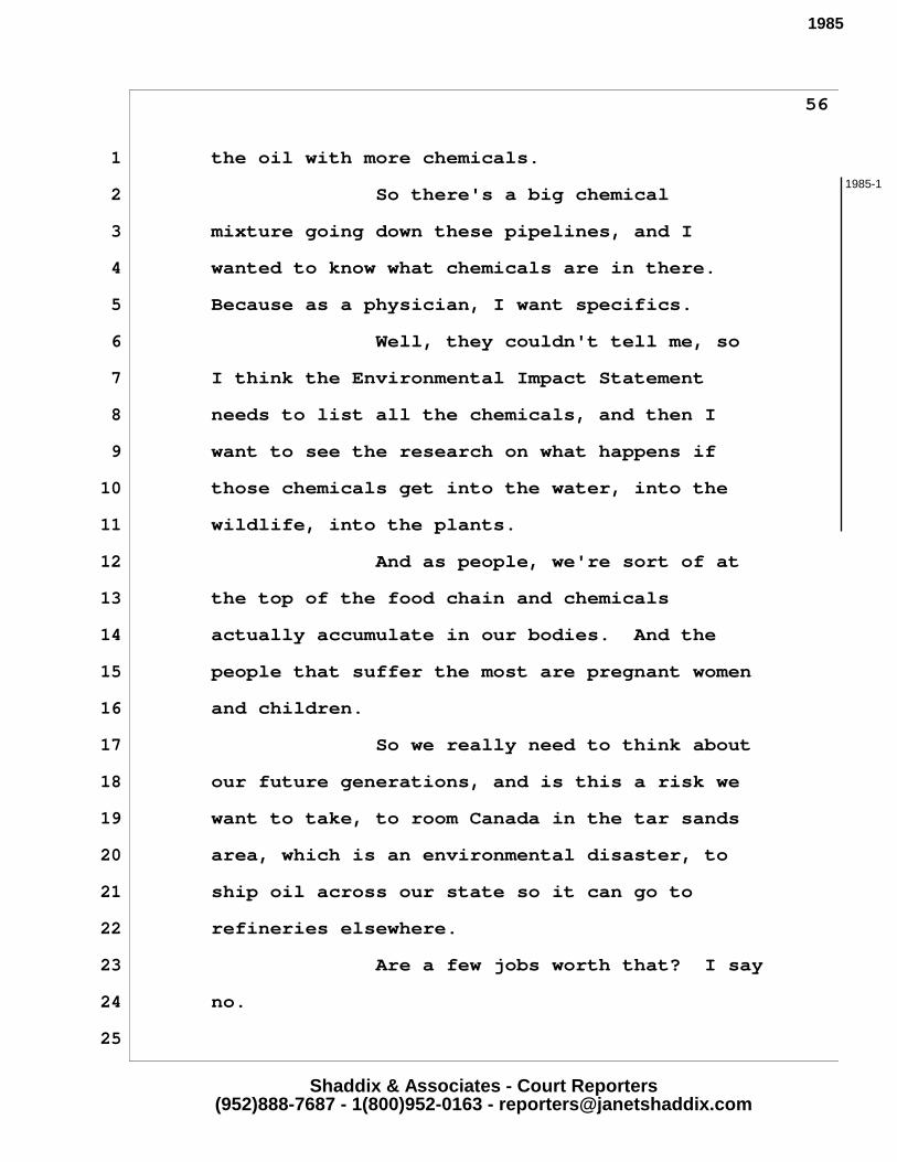
Shaddix & Associates - Court Reporters(952)888-7687 - 1(800)952-0163 - [email protected]
56
1 the oil with more chemicals.
2 So there's a big chemical
3 mixture going down these pipelines, and I
4 wanted to know what chemicals are in there.
5 Because as a physician, I want specifics.
6 Well, they couldn't tell me, so
7 I think the Environmental Impact Statement
8 needs to list all the chemicals, and then I
9 want to see the research on what happens if
10 those chemicals get into the water, into the
11 wildlife, into the plants.
12 And as people, we're sort of at
13 the top of the food chain and chemicals
14 actually accumulate in our bodies. And the
15 people that suffer the most are pregnant women
16 and children.
17 So we really need to think about
18 our future generations, and is this a risk we
19 want to take, to room Canada in the tar sands
20 area, which is an environmental disaster, to
21 ship oil across our state so it can go to
22 refineries elsewhere.
23 Are a few jobs worth that? I say
24 no.
25
1985-1
1985