semantic classification in aerial imagery by integrating appearance and height information
TRANSCRIPT

Semantic Classification in Aerial Imagery byIntegrating Appearance and Height Information?
Stefan Kluckner, Thomas Mauthner, Peter M. Roth, and Horst Bischof
Institute for Computer Graphics and Vision,Graz University of Technology, Austria
{kluckner,mauthner,pmroth,bischof}@icg.tugraz.at
http://www.icg.tugraz.at
Abstract. In this paper we present an efficient technique to obtain ac-curate semantic classification on the pixel level capable of integratingvarious modalities, such as color, edge responses, and height informa-tion. We propose a novel feature representation based on Sigma Pointscomputations that enables a simple application of powerful covariancedescriptors to a multi-class randomized forest framework. Additionally,we include semantic contextual knowledge using a conditional randomfield formulation. In order to achieve a fair comparison to state-of-the-artmethods our approach is first evaluated on the MSRC image collectionand is then demonstrated on three challenging aerial image datasets Dal-las, Graz, and San Francisco. We obtain a full semantic classification onsingle aerial images within two minutes. Moreover, the computation timeon large scale imagery including hundreds of images is investigated.
1 Introduction
Internet driven initiatives, like Google Earth and Virtual Earth, collect an enor-mous amount of aerial and satellite images in order to automatically construct3D worlds of urban environments because of the demand for fast realistic 3Dmodeling, cartography, navigation support, etc. These location-aware applica-tions on the internet push the development of efficient, accurate, and automatictechnologies. The first step is to acquire high resolution images. In particular, theMicrosoft Ultracam takes multi-spectral images in overlapping strips, resultingin high redundancy, which adheres every visible spot of urban environments frommany different camera viewpoints. The high redundancy within the data enablesmethods for automatic height data generation [1] or full photo-realistic 3D mod-eling [2]. In contrast to photo-realistic 3D modeling, where the model consistsof millions of triangles with fitted texture extracted from aerial images, we aim
? This work was supported by the Austrian Science Fund Projects W1209 and P18600under the doctoral program Confluence of Vision and Graphics, by the FFG projectsAPAFA (813397) and AUTOVISTA (813395), financed by the Austrian ResearchPromotion Agency, and by the Austrian Joint Research Project Cognitive Visionunder the projects S9103-N04 and S9104-N04.

2 Kluckner et al.
for synthetic modeling, i.e., based on the information directly derived from theimages to build a virtual model of a city. In addition, a synthetic model reducesthe problem of privacy violations due to modeling the semantic interpretationinstead of the realistic appearance.
Due to high variability in aerial imagery, automatic classification and seman-tic description still pose an unsolved task in computer vision. We aim to useappearance cues, such as color, edge responses, and height information for accu-rate semantic classification into five classes. For instance, using a combination ofcolor and height data successfully separates the street regions from gray-valuedroof tops or distinguishes between green areas and trees. Figure 1(a) shows cor-responding color and height images, extracted from the dataset San Francisco.The classification of aerial images into several classes provides a semantic knowl-edge of the objects on ground and approves a specified post-processing to buildup a semantic 3D world, where each object is modeled according to its ob-tained interpretation. A semantic description of a small sub-image is illustratedin Fig. 1(b).
Fig. 1. A pair of images extracted from the dataset San Francisco consisting of colorand height information, and the corresponding semantic description of the sub-image(highlighted rectangles).
In [3], the authors proposed an appearance driven approach to exploit colorand infrared data for initial classification. Several methods concentrate on ex-tracting single object classes, e.g., buildings by integrating only LIDAR data [4]or height models [5]. The tight integration of 3D data into image classification,as additional information source, is still a new and upcoming field of research.Hoiem [6] extracted 3D information, such as surface orientation or vanishinglines, from single images to improve 2D object recognition. Recent approaches [7,8] include SfM to improve the interpretation in street side images. In this work,we exploit dense matching results [1] together with appearance features to obtainan accurate semantic interpretation.
Shotton et al. [9] proposed simple color value differences in a small neigh-borhood for initial semantic classification on the pixel level using a randomizedforest (RF) classifier [10]. Schroff et al. [11] extended this approach by includingmultiple feature types for an improved RF classification. Strong low level fea-

Semantic Classification in Aerial Imagery 3
ture representations, such as SIFT [12], histograms of oriented gradients [13], orvarious types of filter responses [14–16] are widely used in appearance driven su-pervised classification. However, a compact combination of different feature cuesis computationally very expensive. In addition, an integration into a commonclassification framework requires sophisticated techniques.
Thus, our work has three main contributions: To allow an efficient semanticclassification, we first introduce a novel technique to obtain a powerful featurerepresentation, derived from compact covariance descriptors [17] which is di-rectly applicable to RF classifiers. Covariance matrices [17] can be efficientlycomputed and provide an intuitive integration of various feature channels. Sincethe space of covariance matrices does not form a Euclidean vector space [17], thisrepresentation can not be directly used for most machine learning techniques.To overcome this drawback, manifolds [18, 17, 19] are typically utilized, which,however, is computationally expensive. In contrast to calculating similarity be-tween covariance matrices on Riemannian manifolds [18], we present a simpleconcept for mapping individual covariance descriptors to Euclidean vector space.The derived representation enables a compact integration of appearance, filterresponses, height information etc. while the RF efficiently performs a multi-classclassification task on the pixel level. Second, we introduce semantic knowledge byapplying an efficient conditional random field (CRF) stage incorporating againseveral feature cues and co-occurrence information. To demonstrate the state-of-the-art performance we present quantitative results on the Microsoft ResearchCambridge dataset MSRC-9 [15] by integrating visual appearance cues, suchas color and edge information. Third, we apply our proposed method to realworld aerial imagery, performing large scale semantic classification. We extendthe novel feature representation with available height data as an additional cueand investigate the classification accuracy in terms of correctly classified pixels.Labeled training data, representing five annotated classes (building, tree, water-body, green area and streetlayer), provides the input for the training process.
The remainder of this paper is structured as follows. Section 2 describes thederived covariance region descriptor in detail, illustrates the application to theRF framework, and also addresses the integration of the contextual constraints.Section 3 highlights the included feature cues and presents results on the MSRC-9 dataset and various real world aerial images. Finally, Sec. 4 concludes our workand gives an outlook on future work.
2 Semantic Classification
In this section we highlight the semantic classification pipeline including thefeature representation based on covariance descriptors and Sigma Points, re-spectively, the straight forward application to a multi-class RF framework, andthe CRF stage to handle the contextual constraints.

4 Kluckner et al.
2.1 Approximated Covariance Representation
Tucel et al. [17, 19] presented a compact feature representation based on covari-ance matrices for rapid object detection and classification. In fact, covariancedescriptors [17] provide a low-dimensional feature representation that simplyintegrates multiple feature channels, such as color, filter responses, height in-formation, etc. and also exploits the correlation between them. The diagonalelements provide the variances of the feature attributes in one channel, whereasthe off diagonal elements capture the correlation values between the differentfeature modalities. The statistics up to second order of N independent and iden-tically distributed feature vectors xi ∈ Rd can be represented by the samplemean µ = 1
N
∑Ni=1 xi and the sample covariance Σ ∈ Rd×d:
Σ =1
N − 1
N∑i=1
(xi − µ) (xi − µ)T. (1)
As shown by Tuzel et al. [17] the concept of integral images [16] can be appliedto compute covariance descriptors on a rectangular image grid in constant time:Given a multi-channel feature image I of the dimension w × h × d, any n ×mrectangular region R ⊆ I can be represented by a d×d covariance matrix Σ. Anextension of common integral images to higher dimensions incorporating addi-tional tensor integral images, enables the computation of symmetric covariancematrices using the law of total variance. Implementation details can be foundin [17].
Because of the missing symmetry requirement the space of covariance ma-trices is non-Euclidean [17]. Hence, standard machine learning methods, whichrequire similarity computations can not be used directly. Instead of exploitingcomputationally costly manifolds [17, 19] to obtain a valid covariance similaritymeasurement, we propose a technique to represent individual covariance matri-ces directly on Euclidean vector space. Julier et al. [20] proposed the unscentedtransform (UT), which approximates a single distribution by sampling insteadof approximating an arbitrary non-linear function by mapping to manifolds [18].The UT provides an efficient estimator for the probability distribution and wassuccessfully applied to unscented Kalman filtering [21], where it overcomes thedrawbacks of truncated (second order) Taylor expansions. In the d-dimensionalcase the UT relies on constructing a small set of 2d+ 1 specific vectors si ∈ Rd,also referred to as Sigma Points [20]. We construct the set of Sigma Points asfollows:
s0 = µ si = µ+ α(√Σ)i si+d = µ− α(
√Σ)i, (2)
where i = 1 . . . d and (√Σ)i defines the i-th column of the required matrix
square root√Σ. The scalar α defines a constant weighting for the elements in
the covariance matrix and is set to α =√
2 for Gaussian input signals [20].In contrast to Monte Carlo methods, where test vectors are selected at ran-
dom, the construction of the Sigma Points can be seen as an efficient mapping of

Semantic Classification in Aerial Imagery 5
a specified set of test vectors ti ∈ Rd that deterministically sample the intersec-tions of an unit hypersphere with a d-dimensional Cartesian coordinate system.Here, the mean vector t0 = µ represents the origin. The computed statistics ofthese points si accurately capture the original information about Σ up to thirdorder for Gaussian and up to second order for non-Gaussian inputs [21]. Fig-ure 2 illustrates the specified sampling of the test vectors and the mapping fora simplified 2D case.
Since covariance matrices Σ are positive semi-definite by definition, we firstperform a simple regularization Σ = Σ + εI, where I is the identity matrix andε = 1e-6, to obtain symmetric positive definite matrices. Due to symmetry andpositive definiteness of the regularized covariance matrices, the efficient Choleskyfactorization can be applied to compute the matrix square root by decomposingΣ = LLT . Then, L corresponds to
√Σ and is a lower triangular matrix. In
principle any method for square root factorization can be used, however, theCholesky decomposition requires the lowest mathematical operations yielding acomplexity of O(n3/3).
The resulting feature representation Sk =(sk0 , s
k1 . . . s
k2d
)is obtained by con-
catenation of the Sigma Points and captures both, first and second order statis-tics, which are given by the mean and covariance information. Each of thesegenerated vectors sk
i ∈ Rd describe Euclidean space, therefore, element-wise dis-tance computations between corresponding samples of a given distribution arefeasible. The construction pipeline for the set of Sigma Points is summarized inAlgorithm 1.
Fig. 2. The mapping of a fixed set of test vectors ti to the Sigma Points si given ina second coordinate system, representing the original characteristics of the covariancematrix Σ = LLT .
The structure of this feature representation Sk perfectly fits the concept ofrandomized forest classifiers, where the learning and evaluation strategy is basedon comparing randomly selected attributes of an available representation. Notethat, since a reference representation is missing, similarity measurements, suchas the Foerstner metric [18] are intractable to directly use in decision trees. Inthe following section we show how our representation can be applied straightforward to a RF framework.

6 Kluckner et al.
Algorithm 1 Construction of our proposed feature representation based onSigma Points.Require: Mean vector µk and covariance matrix Σk
1: Perform a simple regularization Σk = Σk + εI2: Compute matrix square root Σk = LLT
3: Compute ski according to (2)
4: Construct the set of Sigma Points Sk =(sk0 , s
k1 . . . s
k2d
)
2.2 Randomized Forest Framework
Randomized forests [10] have proven to give robust and accurate classificationresults for multi-class tasks [9, 11, 22]. An RF consists of an ensemble of bi-nary decision trees, where the nodes of each tree include split criteria thatgive the direction of branching left and right down the tree until a leaf nodeis reached. Each leaf node li in a given maximal depth D contains a learnedclass distribution P (c|li). By averaging the decisions over all T trees in a for-est the resulting accumulated probabilities yield an accurate class distributionP (c|L) = 1
T
∑Ti=1 P (c|li). To rapidly grow each tree of the forest, the split
node criteria are learned using only a subset S ′ of the whole training data S.For training a class label ck is assigned to each feature representation Sk ∈ S.The learning proceeds from the root node top-down by tiling the available subsetat each split node into left and right sets. Proposed splitting decisions in [9, 22]are achieved by comparing two or multiple randomly chosen elements sk
i and skj
of the given feature sample Sk. In our implementation we follow a strategy sim-ilar to [22], randomly taking into account the correct corresponding dimensiona ∈ {1 . . . d} selecting two weighted elements i and j according to
αski (a) + βsk
j (a) ={> γ, split left≤ γ, split right . (3)
Here, α, β, and γ denote the greedy-optimized parameters that minimize theinformation gain with respect to the training labels [9, 22]. We take the numbersof split node tests as suggested in [22]. Once the forest is trained, we evaluatethe classifier at each pixel location by parsing down the extracted feature rep-resentation in the forest and accumulating the class distribution to obtain anoverall probability map P (c|L).
2.3 Incorporating Contextual Information
Although our feature representation includes a spatial neighborhood of n ×mimplicitly, each pixel is classified independently. In this work we apply an effi-cient conditional random field (CRF) stage based on linear programming [23]to incorporate semantic contextual constraints yielding a smooth labeling ofthe final image classification. In addition, we include edge information into thefour-connected graph to exactly capture the real object boundaries.
Semantic Classification in Aerial Imagery 7
In order to obtain the contextual semantic information, we construct a datasetdependent co-occurrence matrix by counting the frequency of class labels in thetraining images within randomly chosen rectangular sub-windows [9]. The fre-quency counts can be performed quickly on single images using integral struc-tures [16]. Furthermore, we follow the concept of [24] to compute a normalizedco-occurrence matrix θ(ci, cj) representing the pairwise semantic contextual in-formation of the grid nodes i and j. The application of the CRF allows us toinclude the posterior class distribution P (c|L), the likelihood co-occurrence ma-trices θ(·) and an edge penalty function to preserve the object boundaries. Givena four-neighborhood connected image I we define an energy with respect to theclass labels according to
E (c) =∑
i
D(ci) +∑i,j
wijV (ci, cj), (4)
where D(ci) denotes the data term, including the unary potentials according toD(ci) = − log (P (ci|L)) at grid node i. The pairwise class potentials are com-puted according to V (ci, cj) = − log(θ(ci, cj))δ(ci 6= cj) and include the semanticknowledge. The weight wij describes an edge penalty term between the nodesi and j. Following the concept suggested in [11], where the authors used colordistance computations to capture the object boundaries, we exploit the heightinformation in case of the aerial images. Thus, the weight is constructed withwij = exp
(−λ‖hi − hj‖2
), where hi, hj are the height values at the neighboring
graph nodes. λ defines a factor and is learned while training. In this work weapply the strategy of Komodakis et al. [23] to minimize the energy defined in (4).In the experimental evaluation we present overall results incorporating semanticcontextual information into the classification pipeline.
3 Experimental Evaluation
Due to efficient computation of our region based covariance representation, weexploit several feature cues incorporating a small spatial neighborhood. First,we construct the required integral images to compute the covariance descriptorsincluding the feature cues, such as color channels, first derivatives in x and ydirection, and the height values. Then, the feature instances are constructedaccording to our proposed concept (see Sec. 2.1). The collected samples providethe representation for training and testing. In the following, we first evaluateour classification pipeline on the standard MSRC-9 [15] evaluation dataset. Byintegrating appearance and height information we illustrate the application toreal world aerial imagery and investigate large scale capability.
3.1 Experiments on MSRC-9 Dataset
In our first experiment we use the MSRC-9 dataset with nine on the pixellevel labeled classes to provide results for a comparison to state-of-the-art ap-proaches [11, 25]. For the training and the testing procedure we randomly split
8 Kluckner et al.
the dataset including a total number of 240 images, 120 training and 120 testimages. The training samples, consisting of the set of Sigma Points S and atarget label vector c, are regularly collected on a 5 × 5 grid with a small spa-tial neighborhood of n = m = 21 pixels. The corresponding label is extractedby considering the available ground truth images. Confirming the observationin [9], the CIELab color space generalizes better than raw RGB values. The firstderivatives are computed on the L-channel. We apply small synthetic affine dis-tortions to the training images capturing an invariance to shape deformations [9].In addition, we extend the test images, according to the spatial neighborhood,to obtain class probabilities at the image borders. Due to randomness of our ap-proach, we repeat the experiment 20 times independently to obtain meaningfulaveraged classification rates. In this work, we choose a relatively small size ofthe forest (T = 15 trees and a maximum depth of D = 10) to provide both,efficiency in testing and classification accuracy.
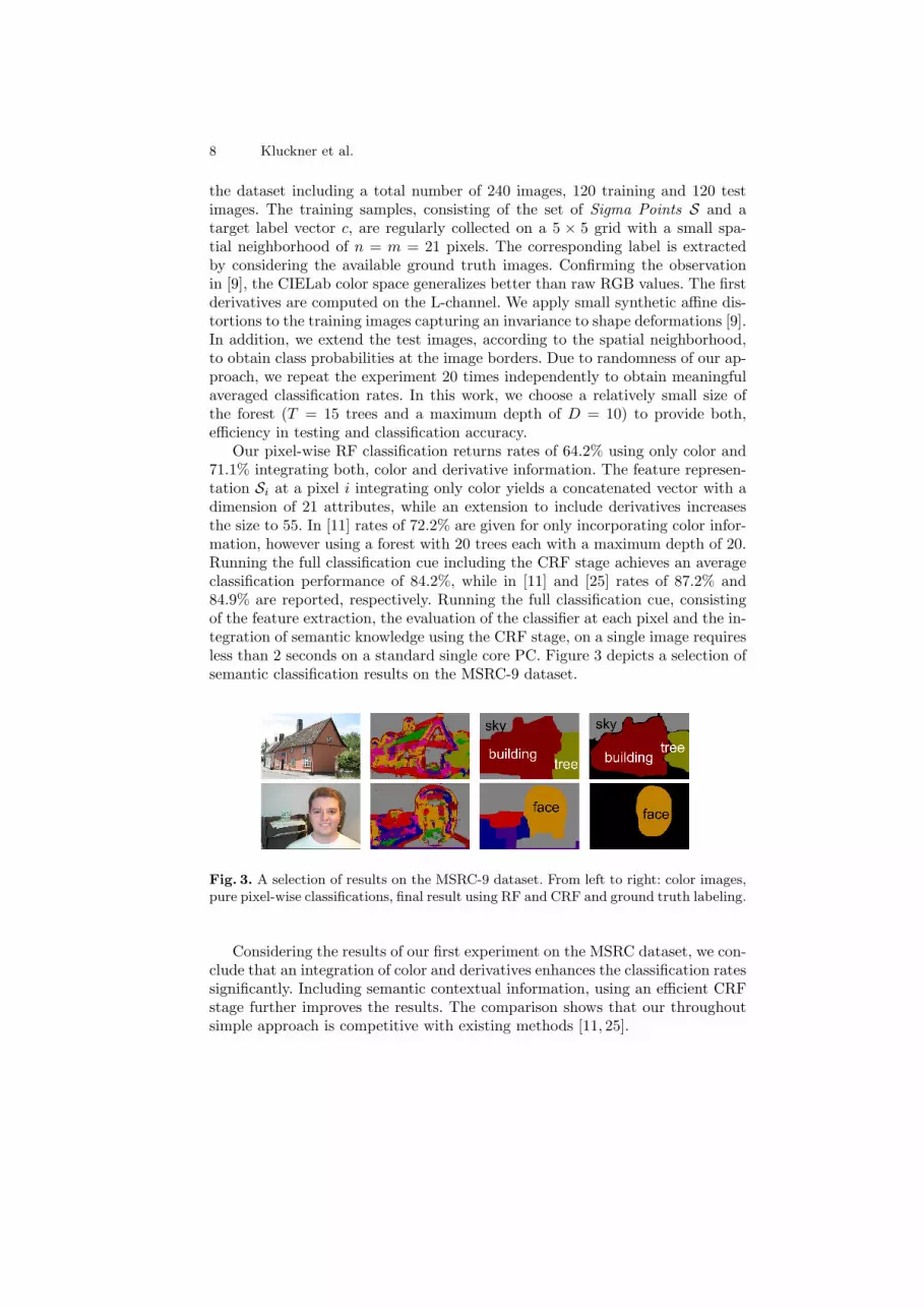
Our pixel-wise RF classification returns rates of 64.2% using only color and71.1% integrating both, color and derivative information. The feature represen-tation Si at a pixel i integrating only color yields a concatenated vector with adimension of 21 attributes, while an extension to include derivatives increasesthe size to 55. In [11] rates of 72.2% are given for only incorporating color infor-mation, however using a forest with 20 trees each with a maximum depth of 20.Running the full classification cue including the CRF stage achieves an averageclassification performance of 84.2%, while in [11] and [25] rates of 87.2% and84.9% are reported, respectively. Running the full classification cue, consistingof the feature extraction, the evaluation of the classifier at each pixel and the in-tegration of semantic knowledge using the CRF stage, on a single image requiresless than 2 seconds on a standard single core PC. Figure 3 depicts a selection ofsemantic classification results on the MSRC-9 dataset.
Fig. 3. A selection of results on the MSRC-9 dataset. From left to right: color images,pure pixel-wise classifications, final result using RF and CRF and ground truth labeling.
Considering the results of our first experiment on the MSRC dataset, we con-clude that an integration of color and derivatives enhances the classification ratessignificantly. Including semantic contextual information, using an efficient CRFstage further improves the results. The comparison shows that our throughoutsimple approach is competitive with existing methods [11, 25].

Semantic Classification in Aerial Imagery 9
3.2 Experiments on Aerial Images
The second experiment evaluates the classification pipeline on huge real worldaerial images. We apply separately trained RF classifies to single aerial imagesperforming a semantic classification into five classes (building, tree, waterbody,green area and streetlayer) on the level of pixels.
In this work, we perform experiments on three different datasets, generatedby the Microsoft Ultracam: The dataset Dallas includes large building struc-tures and gray valued areas, Graz shows a colorful characteristic with challeng-ing building blocks, and the images of San Francisco have mainly suburbanappearance. The color images have a dimension of 11.5K × 7.5K pixels andprovide a ground sampling distance (GSD) of 8 cm (Graz ) and 15 cm (Dallas,San Francisco). Due to high redundancy a dense matching process [1], takinginto account three adjacent images, yields range images representing the surfacemodel. Subtracting the surface model from the extracted ground plane using,e.g., [26] produces the relative height information that is directly applicable toour classification procedure as an additional feature channel. The dimension ofthe resulting feature vector increases to 78, if CIELab color, derivative, andheight information are integrated. Figure 1(a) shows a pixel synchronous pair ofa color and the corresponding height image. For each dataset we independentlylabel three images providing the training labels on the pixel level. Additionally,we generate two non-overlapping images as ground truth data for testing. Simi-lar to the MSRC training process the target labels are then collected taking intoaccount these training maps.
In case of the aerial images we compute our feature representation integratingthe color, texture, and height information and train an RF classifier with 15trees and maximum depths of 10 separately for each dataset. The dimension ofthe spatial neighborhood is set according to the datasets GSD with n = m =2(50/GSD + 1). The trained RFs are evaluated at each pixel location usinga fourth of the full image resolution. The obtained classification rates for thethree datasets are summarized as confusion matrices in Fig. 5. A combinationof color, derivatives, and height information results in averaged rates of 92%(Dallas), 93% (Graz ), and 88% San Francisco. For instance, using only colorand derivative cues yields low classification accuracies of 79% (Dallas), 78%(Graz ), and 73% San Francisco.
Figure 4 depicts a full semantic classification including the CRF stage of asingle image taken from the Graz dataset. The feature extraction and pixel-wiseclassification of a single aerial image of Graz covering an area of approximately0.5 km2 requires about 35 seconds, the CRF stage increases the computation timeto approximately 80 seconds. This scales to an overall computation of about 1.5hours on a standard PC given a complete dataset, e.g., Graz with 155 images.Note that for a full dataset processing the CRF stage can be applied to a fusedclassification result instead of using the per-image classification, which speedsup the computation drastically. Figure 6 illustrates a selection of classified sub-images extracted from full processing steps.

10 Kluckner et al.
Fig. 4. Full semantic classification of a single image taken of the dataset Graz. Theimage provides a ground sampling of 8 cm and covers an area of approximately 0.5 km2.
(a) Dallas (b) Graz (c) San Francisco
Fig. 5. Computed confusion matrices on the three aerial image datasets. We obtainclassification rates of approximately 90% on the three challenging datasets. The lowgray-valued buildings in Dallas are sometimes mixed with the streetlayer class whichcan be caused by inaccurate terrain models. Due to similar spectral ranges small shadowregions in the streets are classified as waterbody in Graz. Many small trees inside ofcourtyards and the hilly terrain in San Fransisco explain the relatively low classificationrate for trees.

Semantic Classification in Aerial Imagery 11
Fig. 6. Representative sub-images extracted from full semantic classification results.From left to right: a hotel complex with a pool/trees on the top in Dallas, a churchsurrounded with vegetation in Graz, a typical building block of San Fransisco, and adetail showing a river in Graz.
4 Conclusion
This work has proposed an efficient approach for semantic classification of imagesby integrating multiple types of feature modalities, such as appearance, edgeresponses, and height information. We presented a novel feature representationbased on covariance matrices and Sigma Points, respectively, that can be directlyapplied to multi-class RF classifiers. By including contextual information usinga CRF stage, we achieved an accurate semantic description of test images on thepixel level. We performed experiments on the MSRC dataset and on huge realworld aerial images and demonstrated accurate classification results with lowcomputational costs. Further work will investigate the influence of additionaldata cues, like infrared and pan-chromatic images, on the classification quality.In addition, we work on exploiting the redundancy by fusing multiple imageclassification results of different viewpoints.
References
1. Klaus, A., Sormann, M., Karner, K.: Segment-based stereo matching using beliefpropagation and a self-adapting dissimilarity measure. In: Proceedings ICPR.(2006)
2. Zebedin, L., Bauer, J., Karner, K., Bischof, H.: Fusion of feature- and area-basedinformation for urban buildings modeling from aerial imagery. In: ProceedingsECCV. (2008)
3. Zebedin, L., Klaus, A., Gruber-Geymayer, B., Karner, K.: Towards 3D map gen-eration from digital aerial images. International Journal of Photogrammetry andRemote Sensing 60 (2006) 413–427
4. Matei, B.C., Sawhney, H.S., Samarasekera, S., Kim, J., Kumar, R.: Building seg-mentation for densely built urban regions using aerial LIDAR data. In: ProceedingsCVPR. (2008)

12 Kluckner et al.
5. Lafarge, F., Descombes, X., Zerubia, J., Pierrot-Deseilligny, M.: Automatic build-ing extraction from dems using an object approach and application to the 3D-citymodeling. International Journal of Photogrammetry and Remote Sensing 63(3)(2008) 365–381
6. Hoiem, D., Stein, A., Efros, A.A., Hebert, M.: Recovering occlusion boundariesfrom a single image. In: Proceedings ICCV. (2007)
7. Brostow, G.J., Shotton, J., Fauqueur, J., Cipolla, R.: Segmentation and recognitionusing structure from motion point clouds. In: Proceedings ECCV. (2008)
8. Cornelis, N., Leibe, B., Cornelis, K., Van Gool, L.: 3D city modeling using cognitiveloops. In: International Symposium on 3DPVT. (2006)
9. Shotton, J., Johnson, M., Cipolla, R.: Semantic texton forests for image catego-rization and segmentation. In: Proceedings CVPR. (2008)
10. Breiman, L.: Random forests. Machine Learning (2001) 5–3211. Schroff, F., Criminisi, A., Zisserman, A.: Object class segmentation using random
forests. In: Proceedings BMVC. (2008)12. Lowe, D.G.: Distinctive image features from scale-invariant keypoints. Interna-
tional Journal of Computer Vision 60(2) (2004) 91–11013. Dalal, N., Triggs, B.: Histograms of oriented gradients for human detection. In:
Proceedings CVPR. (2005)14. Shotton, J., Winn, J., Rother, C., Crimininsi, A.: Textonboost: Joint appearance,
shape and conext modeling for muli-class object recognition and segmentation. In:Proceedings ECCV. (2006)
15. Winn, J., Criminisi, A., Minka, T.: Object categorization by learned universalvisual dictionary. In: Proceedings ICCV. (2005)
16. Viola, P., Jones, M.: Robust real-time object detection. International Journal ofComputer Vision (2002)
17. Tuzel, O., Porikli, F., Meer, P.: Learning on lie groups for invariant detection andtracking. In: Proceedings CVPR. (2008)
18. Foerstner, W., Moonen, B.: A metric for covariance matrices. Technical report,Department of Geodesy and Geoinformatics, Stuttgart University (1999)
19. Tuzel, O., Porikli, F., Meer, P.: Human detection via classification on riemannianmanifolds. In: Proceedings CVPR. (2007)
20. Julier, S., Uhlmann, J.K.: A general method for approximating nonlinear transfor-mations of probability distributions. Technical report, Robotics Research Group,Department of Engineering Science, University of Oxford (1996)
21. Julier, S., Uhlmann, J.K.: A new extension of the kalman filter to nonlinear sys-tems. In: International Symposium of Aerospace/Defense Sensing, Simulations andControls. (1997)
22. Bosch, A., Zisserman, A., Munoz, X.: Image classification using random forestsand ferns. In: Proceedings ICCV. (2007)
23. Komodakis, N., Tziritas, G.: Approximate labeling via graph cuts based on linearprogramming. IEEE Transactions on Pattern Analysis and Machine Intelligence29(8) (2007) 1436–1453
24. Rabinovich, A., Vedaldi, A., Galleguillos, C., Wiewiora, E., Belongie, S.: Objectsin context. In: Proceedings ICCV. (2006)
25. Verbeek, J., Triggs, B.: Scene segmentation with CRFs learned from partiallylabeled images. In: Advances in NIPS. (2007)
26. Champion, N., Boldo, D.: A robust algorithm for estimating digital terrain modelsfrom digital surface models in dense urban areas. In: Proceedings ISPRS Commis-sion 3 Symposium, Photogrammetric Computer Vision. (2006)