seismic and volcanic hazards in argentina
TRANSCRIPT

SEISMIC AND VOLCANIC HAZARD IN ARGENTINA
Laura P. Perucca 1* and Stella M. Moreiras 2
1Consejo Nacional de Investigaciones Científicas y Tecnológicas (CONICET) - Gabinete de Neotectónica. INGEO. Facultad de Ciencias Exactas, Físicas y Naturales. Universidad Nacional de San Juan. * Correspondig author: Tel: (54-0264) 4265103. Fax: 54-0264-4265103. e-mail: [email protected] 2 Consejo Nacional de Investigaciones Científicas y Tecnológicas (CONICET). Instituto Argentino de Nivología, Glaciología y Ciencias Ambientales (IANIGLA) - CRICYT.e-mail:[email protected] Abstract Research for evaluation of geologic hazards, especially seismic and volcanic, have generally received but little attention in Argentina. Nevertheless, the relative small work done up to the present indicates that a vast field of research has to be developed, not only from de viewpoint of the potential hazard occurrence of an earthquake with destructive features in the Argentine territory, but also from the perspective of the Neogene tectonic architecture. Earthquakes with magnitudes higher than Ms>6 are numerous in the Argentine territory. Even though these events have been analyzed, mostly in the central western provinces of this country, their effects have been underestimated in the northwestern and southern parts of it. Since the urban centres in the Argentine western and southern provinces have not experienced an explosive growth in recent years, it is feasible to recommend set up plans for reducing hazards, based on restrictions in the use of land in, undeveloped areas and following standards established for the construction of infrastructure works. This type of planning results in the best strategies to reduce the economic impact that could arise from eventual seismic and/or volcanic phenomena. In the present paper are analyzed some evidences of Quaternary faulting considered to be potential seismogenic sources, as well as the main destructive earthquakes occurred in Argentina. The types of Quaternary volcanic eruptions are described, and a preliminary sketch estimation is made about the hazard type and degree implied by the presence of active and potentially active volcanic centres in the arc and back-arc environments in the country.
1. Introduction
The analyses of seismic and volcanic hazard made during the last decades have progressively been improved with the use of geologic data which permit to reconstruct the seismic history of active faults and the volcanic activity in the past. The historic and instrumental records cover a too short time span to make it possible to establish precise seismicity values for a long term and for a correct evaluation of earthquake hazard.
The west part of South America has a complex morphology pattern, with an active western margin, as shown by its relief and seismicity produced by the drift of the Nazca, Antartic and South American Plates. The convergence of the Nazca and South American plates began about 200 millions years ago, with the subduction of the oceanic plate beneath the continental one. The subduction suface has an eastern slope, and the ocean- continent boundary shows a displacement to the west at an absolute rate of 2.2 cm/year (Uyeda and Kanamori, 1979). This displacement rate should have been different in magnitude and direction during the geologic past, thus giving rise to a complex mosaic of movements, which now appear to be static because the observation time spam and brief in relation to the total time during which these movements took place.
Therefore, Quaternary faulting and volcanism in Argentina is the result of ongoing subduction of the Nazca Plate beneath the South American Plate and as a result of differing geometries of the Nazca Plate (Barazanghi and Isacks, 1976, Jordan et al., 1983), the distribution of neotectonic strain and volcanism are not homogeneous along the Andean belt.
The northern region between 18º and 28º South Latitude is characterized by a high seismicity and an active record of earthquakes. The Nazca Plate is being subducted at a 30º dip angle. A recent and active volcanism is present, and several Quaternary faults are described affecting alluvial fans, bajadas and salt lakes. The most important historic earthquake recorded in this region is located in the province of Salta (Talavera del Esteco, 1692) with a reconstructed magnitude of 7.3 (INPRES, 2006).
Between 28º and 32ºSL a series of geologic and tectonic factors is met with, which seems to be related to surface seismic activity, since a these latitudes the Nazca Plate is subducing subhorizontally. In this region a substantial part of the Quaternary deformations in Argentina is concentrated. Here the main seismogenic sources can be located and defined with certitude. Such sources show different degrees of activity. Generally, they are subparallel faults, predominantly N-S trending.
In this intra-plate setting, the most important destructive earthquakes took place. They were related to surface ruptures, such as the earthquakes of 1894 (Ms 7.5), 1944 (Ms 7.4) and 1977 (Ms 7.4). At 32º S the main Quaternary deformations are faults and folds, related to high seismicity but without clear evidences of rupture surfaces during the earthquakes that affected the region. The only exception could be La Cal fault, which was probably ruptured during the earthquake of 1861 (Ms 7.2) (Mingorance, 2000a,b).
At the western flank of Precordillera, the Holocene, rectilinear and left lateral strike slip morphology of El Tigre fault system is clear seen for more than 200 km with a N-S trending (Withney and Bastias, 1984; Bastias et al., 1990; Siame et al. 1997).
Eastward of the Central Andes, the Sierras Pampeanas are basement blocks that have been uplifted and tilted during the Neogene, bounded by west verging reverse faults. Small to moderate earthquakes have affected the area during the last century, like the 1934 Ms 6.0 Sampacho earthquake, but no rupture surfaces have been recognized.
South of 33ºSL, the subduction angle of the Nazca Plate varies and, from here southwards the seismicity diminishes notably: only low magnitude earthquakes are recorded in this area. Only in the Isla Grande de Tierra del Fuego, at least three earthquakes during the middle past century have been recorded, because of the interaction of the South American, Scotia and Antartic plates.
The volcanic activity in the western border is directly related, also, to the subduction of the Nazca plate beneath South America. This activity takes place in a discontinuous volcanic arc, from 16º to 28º latitudes, which includes the southern portion of the Central Volcanic Zone (to which we will refer in later pages). From 33º to 46º SL a set of active volcanoes which extends to the south of the Tupungatito volcano, and which is known as the southern volcanic zone, is associated to a subduction angle of 30º of the Nazca Plate. Finally, from 49º to 56º SL extends the Austral Volcanic zone, with isolated eruptive centers associated to the subduction of the Antartic Plate.
The volcanic activity is interrupted from 28º to 33º 15’SL, just in coincidence with the increase in the superficial seismicity, which is ascribed to the progressive sub-horizontal subduction of the Nazca Plate since the upper Miocene (Barazanghi and Isacks, 1976).
After having analyzed individually the different tectonic aspects, the regional geomorphologic features and the seismic and volcanic activity in the past and at present, it is important to consider their interrelations. The occurrence of these phenomena could indicate the regions in the Earth crust which now are being submitted to higher deformations and then, releasing stresses in order to carry out studies of risk.
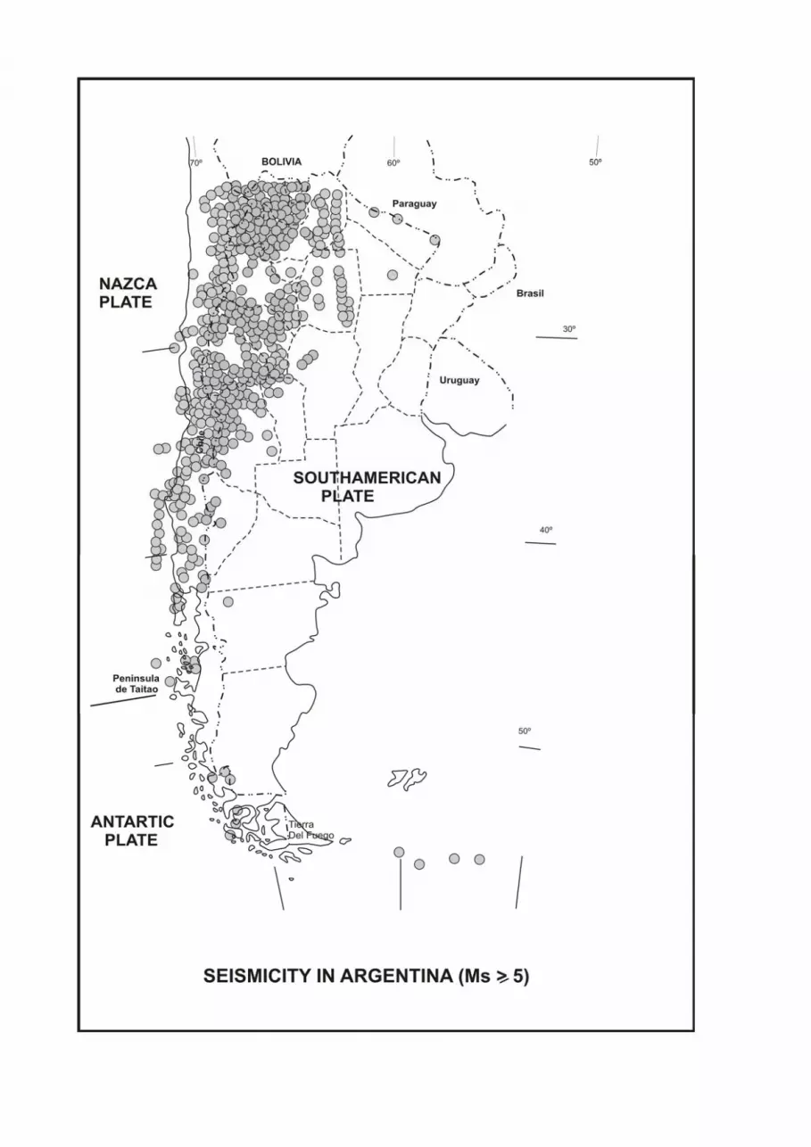
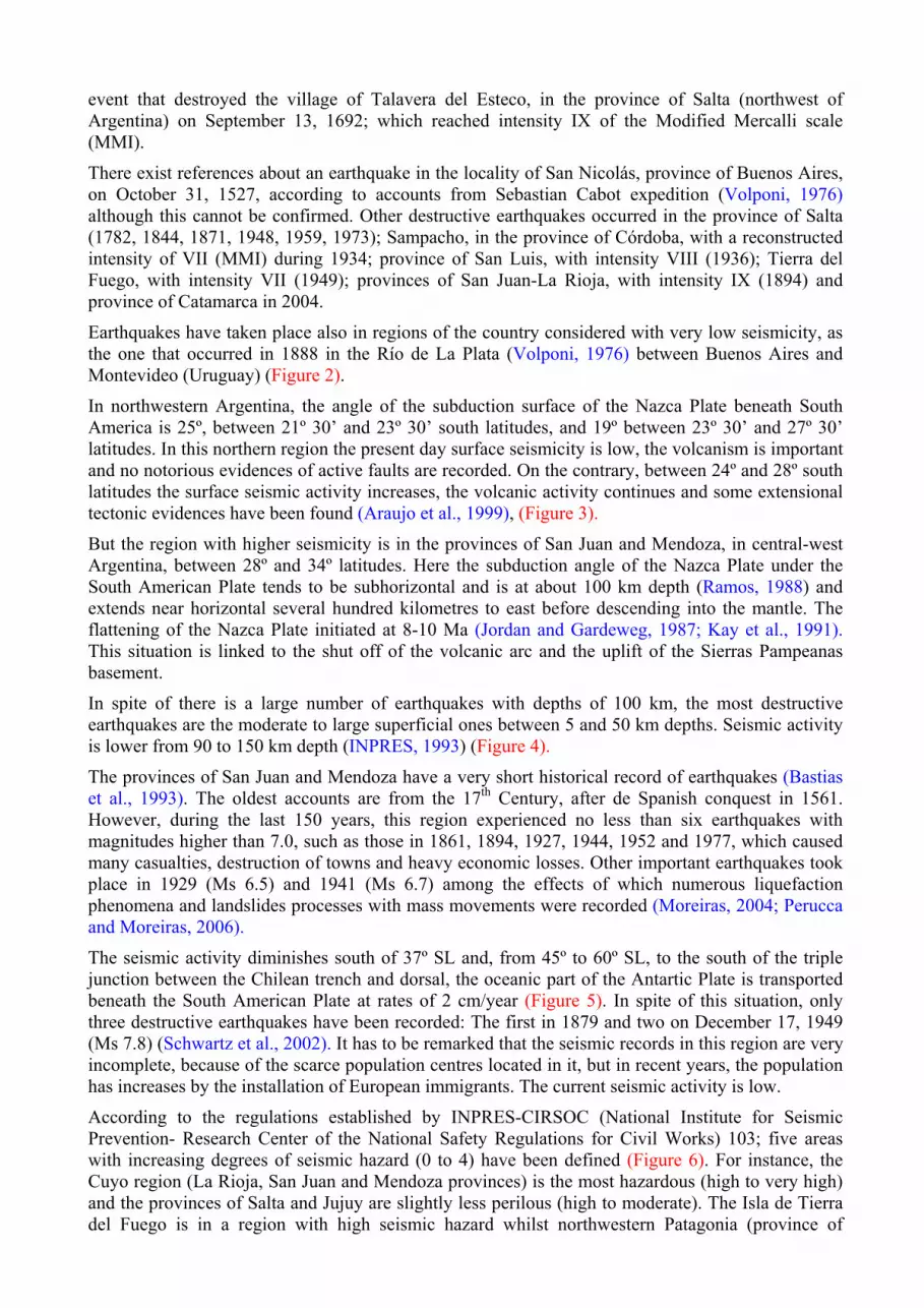
2. Seismotectonic Setting The seismic area in Argentina extends along the Andes, from the province of Jujuy in the north, to the Isla de Tierra del Fuego, in the south (Figure 1). Nevertheless, there is but scarce documentation of the earthquakes in this area. The first historic mention of destructive earthquakes is about the
event that destroyed the village of Talavera del Esteco, in the province of Salta (northwest of Argentina) on September 13, 1692; which reached intensity IX of the Modified Mercalli scale (MMI).
There exist references about an earthquake in the locality of San Nicolás, province of Buenos Aires, on October 31, 1527, according to accounts from Sebastian Cabot expedition (Volponi, 1976) although this cannot be confirmed. Other destructive earthquakes occurred in the province of Salta (1782, 1844, 1871, 1948, 1959, 1973); Sampacho, in the province of Córdoba, with a reconstructed intensity of VII (MMI) during 1934; province of San Luis, with intensity VIII (1936); Tierra del Fuego, with intensity VII (1949); provinces of San Juan-La Rioja, with intensity IX (1894) and province of Catamarca in 2004.
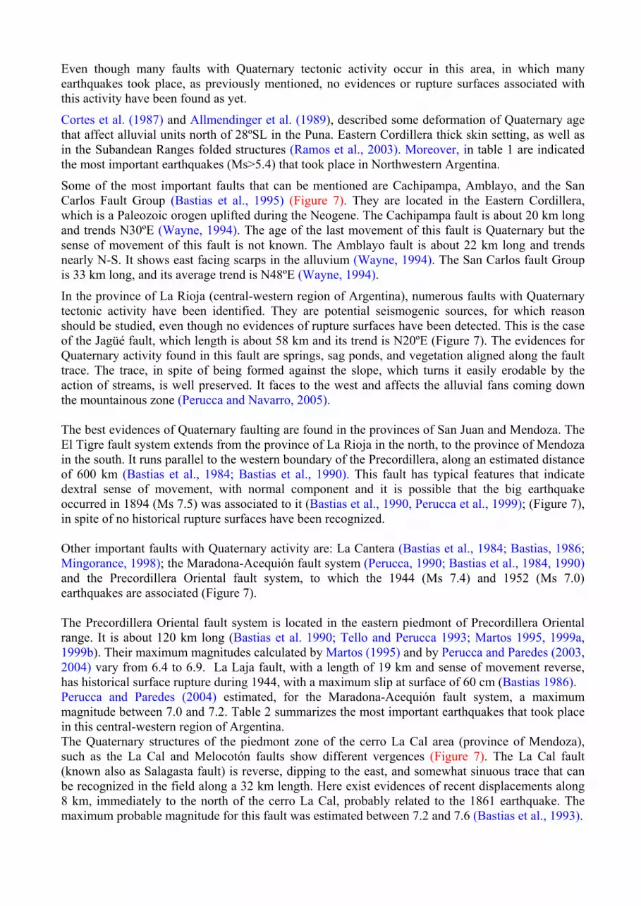
Earthquakes have taken place also in regions of the country considered with very low seismicity, as the one that occurred in 1888 in the Río de La Plata (Volponi, 1976) between Buenos Aires and Montevideo (Uruguay) (Figure 2).
In northwestern Argentina, the angle of the subduction surface of the Nazca Plate beneath South America is 25º, between 21º 30’ and 23º 30’ south latitudes, and 19º between 23º 30’ and 27º 30’ latitudes. In this northern region the present day surface seismicity is low, the volcanism is important and no notorious evidences of active faults are recorded. On the contrary, between 24º and 28º south latitudes the surface seismic activity increases, the volcanic activity continues and some extensional tectonic evidences have been found (Araujo et al., 1999), (Figure 3).
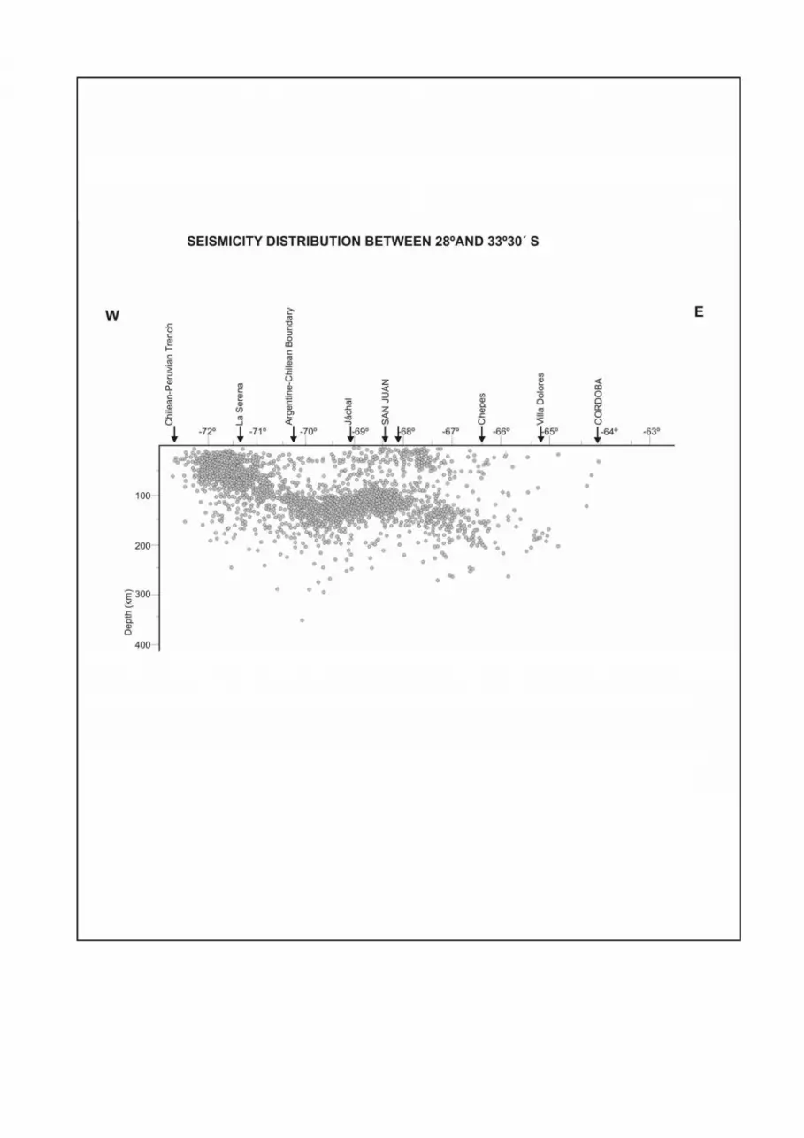
But the region with higher seismicity is in the provinces of San Juan and Mendoza, in central-west Argentina, between 28º and 34º latitudes. Here the subduction angle of the Nazca Plate under the South American Plate tends to be subhorizontal and is at about 100 km depth (Ramos, 1988) and extends near horizontal several hundred kilometres to east before descending into the mantle. The flattening of the Nazca Plate initiated at 8-10 Ma (Jordan and Gardeweg, 1987; Kay et al., 1991). This situation is linked to the shut off of the volcanic arc and the uplift of the Sierras Pampeanas basement.
In spite of there is a large number of earthquakes with depths of 100 km, the most destructive earthquakes are the moderate to large superficial ones between 5 and 50 km depths. Seismic activity is lower from 90 to 150 km depth (INPRES, 1993) (Figure 4).
The provinces of San Juan and Mendoza have a very short historical record of earthquakes (Bastias et al., 1993). The oldest accounts are from the 17th Century, after de Spanish conquest in 1561. However, during the last 150 years, this region experienced no less than six earthquakes with magnitudes higher than 7.0, such as those in 1861, 1894, 1927, 1944, 1952 and 1977, which caused many casualties, destruction of towns and heavy economic losses. Other important earthquakes took place in 1929 (Ms 6.5) and 1941 (Ms 6.7) among the effects of which numerous liquefaction phenomena and landslides processes with mass movements were recorded (Moreiras, 2004; Perucca and Moreiras, 2006).
The seismic activity diminishes south of 37º SL and, from 45º to 60º SL, to the south of the triple junction between the Chilean trench and dorsal, the oceanic part of the Antartic Plate is transported beneath the South American Plate at rates of 2 cm/year (Figure 5). In spite of this situation, only three destructive earthquakes have been recorded: The first in 1879 and two on December 17, 1949 (Ms 7.8) (Schwartz et al., 2002). It has to be remarked that the seismic records in this region are very incomplete, because of the scarce population centres located in it, but in recent years, the population has increases by the installation of European immigrants. The current seismic activity is low.
According to the regulations established by INPRES-CIRSOC (National Institute for Seismic Prevention- Research Center of the National Safety Regulations for Civil Works) 103; five areas with increasing degrees of seismic hazard (0 to 4) have been defined (Figure 6). For instance, the Cuyo region (La Rioja, San Juan and Mendoza provinces) is the most hazardous (high to very high) and the provinces of Salta and Jujuy are slightly less perilous (high to moderate). The Isla de Tierra del Fuego is in a region with high seismic hazard whilst northwestern Patagonia (province of

Neuquén and the western part of the province of Chubut) has moderate seismic hazard. In Patagonia, however, the seismicity has only been partially investigated and the main reasons thereof are few seismological observation points and geophysical researches.
2. Neotectonics and historical seismicity The word “neotectonic” is used in Argentina for the study of the crustal deformations that took place in times subsequent to the end of the Pliocene, in coincidence with the last orogenic events on the western part of the country. This term occasionally is not clear, since it lacks precision and indicates only recently formed structures in a general sense. For this reason, it is preferable to characterize the deformations by referring them to the last movement determined, that is, to refer to Pleistocene or Holocene structures.
One of the most used definition of an active fault was given by Slemmons (1977, 1981), which states that an active fault is the one that registers historical or seismologic antecedents of activity, and/or has en expectative of occurrence in a time interval similar to human life expectative. It is considered that a fault that has undergone displacement during the Pleistocene and/or Holocene can move again in the future. For this reason, the paleoseismic study of such structures, which are considered potential seismogenic sources, is a fundamental tool for the evaluation of the seismic hazard from a geologic viewpoint.
The term “active fault” is used to designate faults, fault segments or fault systems along which relative displacements or rupture surfaces took place, together with moderate or intense earthquakes, during the last 10,000 years (Holocene). These faults are potential sources of destructive earthquakes and rupture surfaces because they experienced displacement during the present time seismo-tectonic conditions, have evidences of activity shown by stratigraphic evidences, and the regional tectonic setting suggest the probability of future displacement.
The parameters that can be determined by the investigation of active faults by using empirical relations are:
-Recurrence
- Magnitude of the earthquake to be produced in the structure
-Yearly average movement
Once the different seismogenic sources placed in the Argentine territory are known and the maximum values of the ground movement, as well as the acceleration this earthquake will produce in the sites where infrastructure works have been built.
From the viewpoint of the seismicity, the Argentine territory lacks almost entirely prehispanic earthquake information. There is, also, little information about earthquakes during the 300 years of Spanish colonization from many regions in the country. This lack of information affects the seismologic record interval. For this reason geologic studies related to neotectonics are essential in Argentina for extending the paleoseismic record in the country.
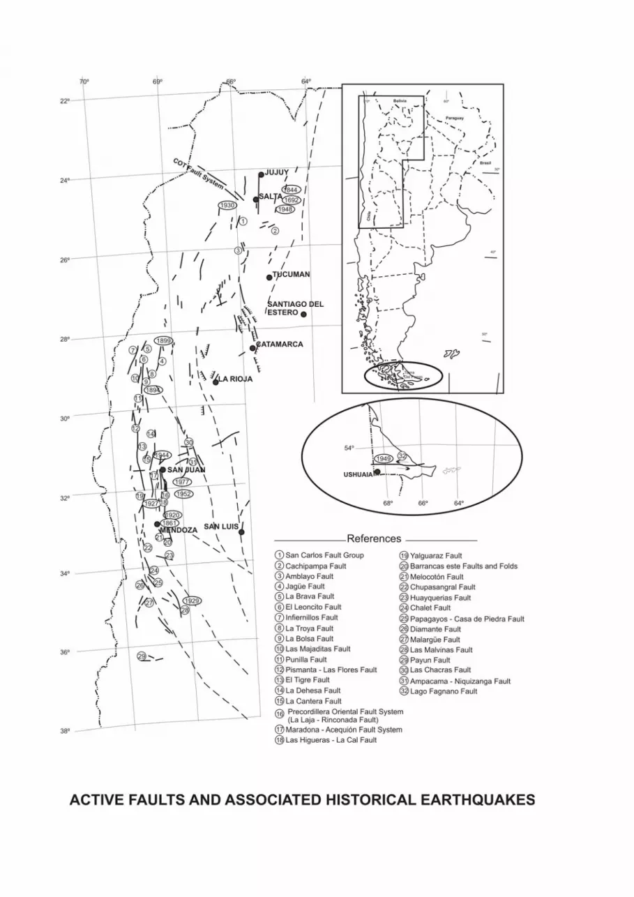
It is possible to subdivide the Argentine territory in areas where the main Quaternary faults occur, even though most deformations are in the Precordilleran sector of the provinces of La Rioja, San Juan and Mendoza (Figure 7).
In northwestern Argentina, the evidences of Quaternary tectonic activity are numerous. For instance, in the Argentine Puna, the tectonic activity is so recent that the faults affect Holocene evaporite crusts or Pleistocene lacustrine sediments situated in tectonic terraces. Fault scarps occur in alluvial fans where regional fractures at the foot of mountainous blocks. Here triangular of trapezoidal facets indicate Quaternary faulting. Water runoff directions towards many salars (saline playas) indicate tilting of the blocks where this saline depressions are located (Igarzábal, 1999).
Even though many faults with Quaternary tectonic activity occur in this area, in which many earthquakes took place, as previously mentioned, no evidences or rupture surfaces associated with this activity have been found as yet.
Cortes et al. (1987) and Allmendinger et al. (1989), described some deformation of Quaternary age that affect alluvial units north of 28ºSL in the Puna. Eastern Cordillera thick skin setting, as well as in the Subandean Ranges folded structures (Ramos et al., 2003). Moreover, in table 1 are indicated the most important earthquakes (Ms>5.4) that took place in Northwestern Argentina.
Some of the most important faults that can be mentioned are Cachipampa, Amblayo, and the San Carlos Fault Group (Bastias et al., 1995) (Figure 7). They are located in the Eastern Cordillera, which is a Paleozoic orogen uplifted during the Neogene. The Cachipampa fault is about 20 km long and trends N30ºE (Wayne, 1994). The age of the last movement of this fault is Quaternary but the sense of movement of this fault is not known. The Amblayo fault is about 22 km long and trends nearly N-S. It shows east facing scarps in the alluvium (Wayne, 1994). The San Carlos fault Group is 33 km long, and its average trend is N48ºE (Wayne, 1994).
In the province of La Rioja (central-western region of Argentina), numerous faults with Quaternary tectonic activity have been identified. They are potential seismogenic sources, for which reason should be studied, even though no evidences of rupture surfaces have been detected. This is the case of the Jagüé fault, which length is about 58 km and its trend is N20ºE (Figure 7). The evidences for Quaternary activity found in this fault are springs, sag ponds, and vegetation aligned along the fault trace. The trace, in spite of being formed against the slope, which turns it easily erodable by the action of streams, is well preserved. It faces to the west and affects the alluvial fans coming down the mountainous zone (Perucca and Navarro, 2005). The best evidences of Quaternary faulting are found in the provinces of San Juan and Mendoza. The El Tigre fault system extends from the province of La Rioja in the north, to the province of Mendoza in the south. It runs parallel to the western boundary of the Precordillera, along an estimated distance of 600 km (Bastias et al., 1984; Bastias et al., 1990). This fault has typical features that indicate dextral sense of movement, with normal component and it is possible that the big earthquake occurred in 1894 (Ms 7.5) was associated to it (Bastias et al., 1990, Perucca et al., 1999); (Figure 7), in spite of no historical rupture surfaces have been recognized. Other important faults with Quaternary activity are: La Cantera (Bastias et al., 1984; Bastias, 1986; Mingorance, 1998); the Maradona-Acequión fault system (Perucca, 1990; Bastias et al., 1984, 1990) and the Precordillera Oriental fault system, to which the 1944 (Ms 7.4) and 1952 (Ms 7.0) earthquakes are associated (Figure 7). The Precordillera Oriental fault system is located in the eastern piedmont of Precordillera Oriental range. It is about 120 km long (Bastias et al. 1990; Tello and Perucca 1993; Martos 1995, 1999a, 1999b). Their maximum magnitudes calculated by Martos (1995) and by Perucca and Paredes (2003, 2004) vary from 6.4 to 6.9. La Laja fault, with a length of 19 km and sense of movement reverse, has historical surface rupture during 1944, with a maximum slip at surface of 60 cm (Bastias 1986). Perucca and Paredes (2004) estimated, for the Maradona-Acequión fault system, a maximum magnitude between 7.0 and 7.2. Table 2 summarizes the most important earthquakes that took place in this central-western region of Argentina. The Quaternary structures of the piedmont zone of the cerro La Cal area (province of Mendoza), such as the La Cal and Melocotón faults show different vergences (Figure 7). The La Cal fault (known also as Salagasta fault) is reverse, dipping to the east, and somewhat sinuous trace that can be recognized in the field along a 32 km length. Here exist evidences of recent displacements along 8 km, immediately to the north of the cerro La Cal, probably related to the 1861 earthquake. The maximum probable magnitude for this fault was estimated between 7.2 and 7.6 (Bastias et al., 1993).
Further south, the Las Vacas-Tupungato fault system has a sinistral sense of displacement and extends several hundreds of kilometres, trending NNW-SSE, and its southern prolongation, the Diamante and Papagayos faults affect Quaternary deposits (Figure 7). South of Mendoza province, the Malvinas fault (Figure 7), which trends nearly N-S and shows a left lateral and normal sense of displacement, affects Quaternary deposits (Bastias et al. 1993). This fault has been related to the earthquake occurred on May 13, 1929 (Loos 1929; Lunkenheimer 1930). Other parallel faults are the Piedemonte Andino fault system, rimming the eastern piedmont of Cordillera Frontal, where are located the Chupasangral, Chalet and Malargüe faults (Figure 7). These faults trend nearly N-S, parallel to the mountain ranges front (Bastias et al. 1993; Cortés 2000). There are not historical rupture surfaces related with these faults. Then, the Payún Matru fault (Figure 7), which is in the south of the province of Mendoza, near the boundary with the provinces of Neuquén and La Pampa, is located in the extensive volcanic field known as Payunia (Bastias et al. 1993). The Sierras Pampeanas basement, which are situated to the east of the Central Andes, are considered to be made up, by uplifted blocks of the broken Andean foreland, thus being another feature of the Pampean flat subduction segment (Jordan et al. 1983; Jordan and Allmendinger 1986). From the neotectonic viewpoint, the evolution of these mountain ranges is related to the Neogene Andean orogenic processes, in which the response to crustal shortening of the Andean foreland was the inception of a thick skinned tectonic style, which less deformation rates than those found in the Andes (Costa, 1999). In general, the blocks show an asymmetrical east-west profile, usually with a steeper western slope affected by 30º to 70º east dipping faults. In these western slopes, Costa (1996, 1999) and Costa et al. (2000) described fault with Quaternary tectonic activity. The fault scarps generally are not exposed, except in the river ravines, where the basement-piedmont contact and the faults themselves can be observed. Most faults situated in the main range fronts have had little activity during the Quaternary. This activity is migrating towards the piedmont (Costa, 1999). For these reasons the Sierras Pampeanas have been considered an area with moderate seismic activity, with little superficial deformation. Nevertheless the 1977 earthquake that took place in Caucete, province of San Juan (Ms 7.4), gave origin to secondary rupture surfaces related to normal faults in the eastern piedmont of the Sierra de Pie de Palo, the Ampacama-Niquizanga fault system (Volponi et al., 1977; Bastias, 1986; Bastias et al., 1990) (Figure 7). It is probable also, that superficial deformation existed during the Sampacho earthquake (Ms 6.0) in the province of Córdoba, occurred in 1934 (Mingorance, 1991; Sagripanti et al., 1999; Costa et al., 2001). The Ampacama-Niquizanga fault system extends along approximately 70 km, segmented in many stretches not surpassing 8 km in length, along a N20ºE trend (Figure 7). The evidences for Quaternary fracturation are met in the neighbourhood of the eastern mountainous front, where their effects on alluvial fans and terraces can be observed (Bastias, 1986).The scarps face west and, during the 1977 earthquake, a new displacement was produced, as revealed by geodetic levelling, which caused permanent deformation of the ground amounting to 1.20, whilst the displacement of the scarps was not higher than 0.30 m (Bastias, 1986). Other important earthquake took place in 1941 (Ms 6.3) in the same region, probably related with the same fault system, but no rupture surface was found. The most important earthquakes that took place in this region are in table 3. The calculations based on empirical relationships made by Bastias (1986) to determine the maximum magnitude of a probable earthquake, gave values from Ms 6.8 to Ms 7.1, with a recurrence interval of about 15,000 years. The seismic activity in the Patagonia region is related to a deformation and fracture belt that, at the latitude of Lago Fagnano, extends E-W for over 600 km, from one ocean to the other, and is known as the Magallanes-Fagnano Fault System (Figure 7). All along this active fault, the South American

continent moves very slowly to the west, with respect to the Tierra del Fuego Andean region. The border between the South American and Scotia plates extends for more than 3,000 km, from the western section of North Scotia ridge, in the Chilean Southern trench, at 50° SL, through the Isla de Tierra del Fuego. The Magallanes-Fagnano fault system, with a sinistral E-W displacement, evolved as a component of relative plate movements between the southern end of South America and the Antarctic Peninsula. This regional alignment can be seen mainly in the eastern branch of the Magellan Straits, along the northern shore of Lago Fagnano and along the Atlantic coast (Winslow, 1982; Winslow and Prieto, 1991). It has a length of 165 km, and trends N89°W. The present deformation, measured at stations located on both sides of the main faults of the South American and Scotia plates, shows a sliding rate of around 0.5 cm/yr (Del Cogliano et al., 2000). Furthermore, the seismicity along the entire fault system is low (Ms< 3.5), mainly superficial, and the focal mechanisms indicate a distensive component and a strike-slip feature (Pelayo and Wiens, 1989). The Isla de Tierra del Fuego was affected in 1949 by two earthquakes of Ms 7.8, that caused widespread strike slipping on the shores of Lago Fagnano, and a local tsunami in the western branch of the Magellan Straits (Jaschek et al., 1982). Surfaces ruptures and displaced fences were reported (Costa et al., 2000). Since 1969 to the present date, more than 400 superficial earthquakes of magnitude over 4 have been registered in the Argentinean Patagonia. Even through, as there are poor historical seismic data in the Santa Cruz province, and due to its proximity to regions with earthquakes of magnitude higher than 7 (Isla Grande de Tierra del Fuego), González Bonorino (2002) assumed that the eastern region of the province is moderately seismic. In short, although the magnitude of earthquakes in Patagonia is generally moderate in strength, most of these events were superficial and related to active faults, which indicate potential future seismogenic sources. As shown in the previous paragraphs, the relative large number of records corresponding to the second half of the past century, in comparison with records from previous years, is an indicator of the scarcity of seismological stations in the region and not the absence of seismic activity in the past. The historical record of Isla Grande de Tierra del Fuego is also very brief, due to the relatively recent European settlement and its low population density. The seismic activity record in Tierra del Fuego goes back to 1879 and continues up to the present date, recording 1,600 events, although most of them of a very low magnitude. There are references to an ancient earthquake that took place before the European colonization, according to a Yaghan (indigenous Fuegians) legend mentioned by Lucas Bridges (2000). The first recorded earthquake occurred on February 1st, 1879, at 5 a.m. (local time). It was described by Thomas Bridges (1879), an Anglican missionaire, the first European settler in Tierra del Fuego. Its intensity was of grade VI in the MM (Modified Mercalli) scale and its epicenter was located at 54° SL and 65° WL (Figure 2). 3. Seismic hazard and risk In spite of having been recorded many earthquakes in Argentina during historical times, no clear relation exists between their epicenters and the main Quaternary structures. In most of cases, no historical rupture surfaces have been observed, associated to these epicenters, with the exception of those observed in the La Laja fault during the 1944 earthquake, the Fagnano fault in 1949, and the Niquizanga fault in the 1977 earthquake. It is probably also that many prehistorical earthquakes of high magnitude have been characterized by deformations in folds and secondary fractures rather than by surface ruptures. Costa et al. (1999) indicated that it is possible that this type of paleo-events, even the destructive ones, have not left evidences in the Quaternary morphostratigraphic record, thus complicating the estimation about parameters, such as recurrence and movement rates. In other cases, the evidences of tectonic activity during the Quaternary suggest the occurrence of destructive prehistoric earthquakes recurrent during the Holocene and related to Quaternary structures.

Earthquakes with magnitudes higher than Ms 6, with subsurface hypocenters shallower than 30 km generally produce deformations in the surface, thus constituting a major risk for the residents. Among the primary effects produced by an earthquake are, surface ruptures and deformations that occur at the epicenter or near it. It is here where greater damages are produced in constructions. On both sides next to the fault, no constructions must be built because this is the “Zone with surface displacements hazard”. The secondary effects associated to liquefaction processes and slope instability can give rise to greater damage than the earthquake shake itself, even in areas distant to the rupture zone when local conditions favor this hazard. A second effect concomitant with the majority of the earthquakes in western Argentina was soil liquefaction. The fissures, lateral spreadings, sand volcanoes and spills have been very abundant in areas up to 260 km far from the epicenter and affected areas up to 4,000 km2, like during the 1977 earthquake (INPRES 1977). The damages produced by liquefaction include soil collapse under buildings, roads, railroads, irrigation channels, water reservoirs and houses, due to the lack of bearing strength. Alluvial plain, paleochannels and playa deposits of Holocene age, due to their predominant lithology (sand) and superficial water table, among other conditions, were strongly affected by liquefaction (Perucca and Bastias 2005, 2006; Perucca and Moreiras, 2006). Moreover numberless landslides occurred during most historical earthquakes in the provinces of Mendoza and San Juan (Moreiras 2004). 4. Volcanism and volcanic hazard The Andean Cordillera is segmented in three portions where the present day volcanic activity is concentrated (Figure 8): a) the northern segment, the southern portion of which includes the Central Volcanic Zone (CVZ) which extends from the province of Jujuy to the province of Catamarca, b) the central-south segment located in the province of Mendoza and the northern part of the province of Chubut and that has been named South Volcanic Zone (SVZ), and c) the austral segment in the province of Santa Cruz, which makes up the Austral Volcanic Zone (AVZ). The eruptive centers in these segments are huge strato-volcanoes, andesite-dacite calderas and basalt plateaus (Sruoga et al. 1993), younger Pliocene, Pleistocene, and Holocene in age (less than 2 Ma) related to the last great uplifting and faulting events in the Cordillera de Los Andes. The lavas and pyroclastic deposits associated to these volcanic events extend over wide regions and attain great thicknesses in all western Argentina. These materials are predominant in the northwestern portion (Puna) and from the middle part of the province of Mendoza to the southern portion of the province of Santa Cruz. They are not restricted to the Andes, but extend also, over the extra-Andean part of the provinces of Mendoza, Neuquén, La Pampa and Santa Cruz. The historical record, in spite of being scarce, points out to eruptions in some volcanoes in the bordering zone with Chile, as the eruption of the Hudson volcano in 1991 and of the Descabezado-Quizapu volcano in south Mendoza in 1932. The active cordilleran magmatic arc has migrated in recent geologic times, in most cases to the west, nearer the subduction zone. For this reason, the greater part of the active and latent volcanoes is along the international boundary or few kilometers to the west, in Chilean territory. During the 20th Century occurred several eruptions with different consequences in some regions of the Argentina. They were explosive in most cases and were of plinian, pelean, phreatomagmatic and vulcanian types, and took place preceding earthquakes and related to these (Sruoga and Schonwandt, 2004). Among the volcanic eruptions occurred during the 20th Century, the most remarkable ones are those of the Descabezado-Quizapu (1932), Tupungatito (1952, 1980 and 1986), Peteroa (1937, 1991), Hudson (1991), Copahue (1992) and Lascar (1989, 1993), all of them characterized by ash rain. Because the active volcanic centers are situated in zones with scarce population or unpopulated at all, the direct impact of lavas and pyroclastic flows was of relative low significance. Nevertheless, the indirect effects were potentially much higher, especially on the farming and animal husbandry

activities due to the accumulation of ashes. For instance, the volcano Hudson eruption in 1991 caused the death of a great part of the sheep flocks in the province of Santa Cruz, due to the considerable destruction of the vegetal cover (Clarín, 1991). This phreatoplinian eruption affected a region greater than 300,000 km2 and accumulated a layer of ashes surpassing 1m in thickness in the areas near the volcano. Bitschene (1995) estimated that this eruption implied, in the provinces of Chubut and Santa Cruz direct losses estimated in $10,000,000 in animals, wool, houses, cleaning of water supplying systems, cleaning of airports and roads, communication and electric equipment, etc. The Lascar volcano, situated in northern Chile, next to the boundary with the provinces of Salta and Jujuy had eruptions of the plinian type near the end of the 20th Century, with emission of ashes which affected the north of Argentina, especially air routes. One of the few regions where eruptions can have direct effects on the population is the zone of the Copahue volcano, in the neighborhood of which are situated the villages of Copahue and Caviahue. Also the Lanín volcano, near the tourist towns of San Martín de Los Andes and Junín de Los Andes, shows indications of Holocene activity and is closely related to active volcanoes in Chile. Other impacts can be mentioned, as strong earthquakes as those that took place in the city of Bariloche, with casualties and material damages, caused by the eruption of the Osorno volcano in 1961. 4.1 Central Volcanic Zone (CVZ, 10º -28º SL) This segment has some of the higher active volcanoes of the world: Ojos del Salado and Llullaillaco, both surpassing 6,000masl at he boundary of the provinces of Catamarca and Salta with Chile (Figure 8). The southern portion of the Central Volcanic Zone, between 22º and 27º SL is an uplifted tableland with an average altitude of 3,700 m, with N-S trending mountain chains encircling closed depressions and is known as Puna. The volcanic activity in this region began in the Oligocene-Early Miocene up to the present (Coira et al. 1993; Allmendinger et al. 1997). The location of the volcanism in this area is conditioned by the regional tectonic structures (Riller et al. 2001) as indicated by the existence of a north-south trending magmatic arc and volcanic chain oriented obliquely to the Andean trends. This chain coincides with regional alignments running from NW to SE (Viramonte 1984; Salfity 1985). Calama-Olacapato-Toro (COT) lineament is a seismically active fault zone (Schurr et al. 1999) delineated by a 170 km long volcanic belt between the Incahuasi volcano and the Río de Las Burras volcanic complex (Hongn et al. 2002). In this fault zone there are more than twenty active volcanic centres, which include domes, volcanic fields, strato-volcanoes, collapse calderas and small volcanic centres, all of which indicate magmatic activity from the Miocene to the Pleistocene and in some cases, to historical times. The volcanic activity in this region is confined also, to two WNW-ESE trending faults (Marret et al. 1994; Petrinovic 1999), connected by normal faults and with en echelon horizontal displacement. Therefore, the fault activity must have had an important role in the origin of these volcanoes. To the north and to the south, respectively, of the COT lineament, the Puna seems to have had different volcanic evolutions. North of this lineament the volcanic activity notably diminishes from the upper Miocene-Early Pleistocene, so that ignimbrite mantles are affected locally by faults (Seggiaro 1994). To the south, volcanism and deformation continued during the Pliocene and Quaternary (Mon et al. 1988; Marret et al. 1994). The potentially active volcanoes occur mainly in the N-S trending magmatic arc, between 22º and 27º SL and their composition is principally andesitic to basaltic. They have produced areally restricted eruptions, with very short lava flows (1 to 8 km) and associated ash deposits. In table 4, some of the most important active volcanoes of the CVZ are briefly described.

Nearly all of these volcanoes are far from populated zones or infrastructure works, for which reason their risk is low. Nevertheless, the risk associated especially to ash rains must not be underestimated in the provinces of northwestern Argentina, principally in Salta and Catamarca. 4.2 South Volcanic Zone (SVZ, 33º to 43ºSL) To the south of 33º 15’SL a Plio-Quaternary volcanism developed associated to two tectonic settings related to the subduction of the Nazca Plate beneath the South American Plate. The present day volcanic arc is situated along the Cordillera de Los Andes and the back arc, to the east, in the extra Andean region. One example of high risk in the zone (in Chilean territory) is the Descabezado Grande-Quizapu volcanic field, which was fairly continuous in historical times. Even though these volcanoes are located 30 km west of the Argentina-Chile boundary, due to the direction of the winds, from west to east, has affected mainly Argentine territory with fall of tephra and ash . The volume of ejected tephra has been estimated in 20 km3. The ash fall covered more than 2,000,000 km2 of South America reaching Santiago, Montevideo, Brasil, and even the coast of South Africa. In Buenos Aires city, located 1,200 km east of the volcano, the rain ash reached 150 ton/km2(González Ferran et al. 2003). The Tupungatito volcano had eighteen eruptions during the last 160 years. For this reason, it is highly dangerous and a risky center for the north zone of the province of Mendoza, where is the situated the majority of the population. Moreover, Loss (1929) mentions an eruption of the Maipo volcano in 1882, which affected the city of San Rafael (in the south of Mendoza). The Peteroa volcano had eruptions also, in historical times. In 1937 covered the city of Mendoza with an important accumulation of ash. The 1991 eruption produced inconveniences in the aero navigation. The hazard of occurrence of lahars and fall of ejecta in case of a new eruption is high (Haller et al. 1991). Summarizing, the area between 33º and 36ºSL is the most hazardous region in view of the high rate of eruptive activity during historical times, in the Azufre-Planchón-Peteroa and Descabezado Grande-Quizapu volcanic centres. Besides their predominantly explosive character, the action of ash rains would bring about great damage, especially in the San Rafael oasis. For instance, during the eruption of the Quizapu volcano in 1932, the most important changes were: a reduction of the weather temperature because of the ash rain produced an immediate total darkness, high turbidity in the rivers, livestock dispersal, damming of water sources and the death of animals and plants within a radius of 40 km around the volcano. The population was highly alarmed because of quakes and subterranean noises perceived (González et al. 2002; Hildreth and Drake 1992). In this region were felt also the seismic movement associated to the Azul volcano eruption in Chile, which occurred in July, 1924. Between 33º and 34º SL, the eruptions are effusive in character. The evidences of volcanic activity are here less than in the former areas, but this activity could produce lahars and mass movements due to the glaciers covering the volcanic centers. Lahars have been documented in the cerro Overo, near the río Atuel, in January 1942. In view of the proximity to population centers, not only in Chile but also in Argentina, the hazard is high. Between 34º and 35º SL, the hazard is related to the potential activity of the Maipo volcano (Sruoga et al. 1993, 2000) since a possible eruption like the one that generated the Diamante caldera cannot be discarded. If a similar phenomenon would occur, some cities as Santiago and localities in the south of the province of Mendoza could be damaged. The ash rains would affect not only the province of Mendoza, but also a great part of the Argentine territory (Sruoga et al. 1993).
About the backarc volcanism, as the Payun Matru complex, bearing in mind the low population density and the few cultivated areas and natural woods that could be affected by its basaltic magmas with low explosive character, the volcanic hazard is low. But the roads could be affected, rivers deviated or dammed, as happened in the recent past (Delpino 1993). The southern segment (37º to 45º SL) has the highest volcanic activity at present and its volcanic risk results from the vicinity of permanent residents and tourists to the eruptive centers, since this area has many touristy attractions. Generally the volcanoes in this region are not characterized by explosions of great magnitude, with the exception of the Hudson volcano, which is in Chilean territory (Sruoga and Schonwandt 2004) In table 5 are described some of the most important volcanoes in this region. But even phreatomagmatic explosions with small volume, as the one that took place in the year 2000 in the Copahue volcano, could cause important economic losses, because of the increasing urban development in the area. The studies made in this volcano have shown the occurrence hazard of pyroclastic flows, tephra falls and lahars (Delpino and Bermúdez 2002; Naranjo and Polanco 2004).The presence of an acid lake in the active crater represents one of the principal risks that could affect the touristy locality of Caviahue, populated by 800 to 1,500 inhabitants according to the season of the year. Some important volcanoes in this zone are summarized in table 5. 4.3 Austral volcanic zone Volcanoes located to the southern extreme of Argentina and Chile are characterized by adakitic composition and are grouped in the Andean Austral Volcanic Zone (AVZ; Stern, 2004). The magmagenesis of adakitic volcanoes is attributed to dehydration melting of oceanic crust on the surface of subducting young and hot slab, the phenomenon called slab melting (Defant and Durmmond, 1990). In the south of Chile, near volcano Lautaro, the tephra deposited on the glacier could be entirely carried out in about 60 years. If so, based on a simple calculation the tephra of 1959-60 eruption should be totally swept out by 1990 and the recent tephra layers near the ice surface could be originated from unknown eruptions after 1970. Lliboutry (1999) cited two possible eruptions, in 1972 and 1978, based on oral communications of local farmers. So, it is possible to infer multiple eruptions of Lautaro volcano after 1970. An eruption in 1988 confirmed the presence of a postulated subglacial vent in the Patagonian Icefield NW of Viedma Lake. The Viedma volcano eruptive center is a subglacial dacitic volcano beneath the Patagonian Icecap, with only part of the older edifice rising above the surface of the icecap (Figure 8). However, these volcanoes are far from towns and infrastructure, so that the risk is low. Only occasionally, ash rains could affect areas far from these volcanic centers, as during the eruption of the Hudson volcano in 1991. The risk of pyroclastic flows and lahars are less probable, in spite of the existence of a cap of ice over the volcanoes, because of the lack of population in the area. Some important volcanoes in this zone (Chilean and Argentine territories) are summarized in table 6.
5. Final remarks From the study of the seismic, tectonic and morphological characteristics, carried out for Argentina, it is possible to arrive at the following conclusions:
There is a marked lack of uniformity in the distribution of earthquakes and anomalous areas occurrence, either due to excess of or absence of notable seismic events in relation to what may be considered as a normal value. For example, in Patagonia, many earthquakes have been localized in Chilean territory, while to the East seismic activity is either low or inexistent.
It seems to be a close relation between the great structures and the site of seismic events, especially in what refers to the separation of environments with different levels of seismic activity. These large structures would delimit the Neogene volcanic environments as well.
Works done up to present referring to Neotectonic activity in Argentina, indicate an extensive research field to be developed, not only in what regards to potential hazard of earthquake occurrence, but also to the architectural point of view of Neogene tectonism.
The provinces of northwestern Argentina, as well as the majority of those located in seismic regions of the country, have very scarce prehispanic historical information, same as from the three centuries of Spanish rule. It is probable that this blank in the historical records was due to the low population density, to political events that led to foundation of urban centers east of the Cordillera, and to colonist’ ignorance of the culture and habits of the indigenous populations.
This must be corrected with geologic research of the active faults in order to establish viable strategies for an accurate territorial planning in accordance with the potential seismic hazard that could affect numerous regions in Argentina.
Most valleys are located the principal towns of western Argentina are liable to undergo liquefaction, since the sediments filling those valleys are, mainly, alluvial and unconsolidated. Therefore, even when constructions are built according to rules against seismic hazard, lack of soils studies at the town sites can cause great economic losses, not only in buildings, but also in communications, water wells, roads, gas or oil lines, electric lines, etc. In many earthquakes, recorded in historical time in Argentina, soil liquefaction was produced, since the physical characteristics of the soil and shallow water table, are factors of local damage amplification and reassert the need for carrying out details studies in those regions of Argentina where cities have been founded in areas prone to liquefaction.
The finding of at least one historical displacement in the Fagnano fault, the last one in 1949, offers the possibility of new working labs, such as those in San Juan and Mendoza provinces, where destructive earthquakes became most valuable tools for the study of neotectonic in that part of Argentina. The studies carried out in the Cuyo region are an example of the methodologies to be used for a detailed analysis of each area, such as trench making, calculation of seismic parameters associated to each structure in order to finally enable an estimation of seismic risk values in any point of the Patagonia region. The occurrence of earthquakes with Ms> 7.5 in the Isla de Tierra del Fuego and western border of Patagonia in historical times, constitute clear evidences that a probably earthquake with similar characteristics will take place in the future. The recurrence of earthquakes with this magnitude, taking as an hypothesis the distribution of the movement in the time, is calculated in intervals of around 500 years for a magnitude 6.5 and more than 10.000 years for maximum earthquakes with M≥7.
One of the most difficult aspects in these evaluations is to be able to establish in what moment of the window of time is possible to make the analysis, for what it is indispensable to carry out detail studies and to obtain absolute ages of the deposits affected by faults. The seismic potentiality in the western portion of South America and Isla de Tierra del Fuego varies between moderate and high and this must be considered, since a correct planning constitutes the best strategy to reduce the impact of a destructive earthquake. The ideas about reducing the seismic risk by means of detailed studies should be taking into account by governments and planners, creating conscience that the occurrence of an earthquake in the area is a dynamic and probable process. This will allow the existence of big infrastructure building sites and expansion of cities of the southern continent.
In comparison with other regions, the volcanic hazard in Argentina does not impact so much on human activities. But many evidences exist that indicate the extension and significance of the volcanism. The geologic evidence indicates the importance of volcanism in recent times. In the northern region, the absence of population in the neighborhood of the volcanoes permits to assume a low risk for the area. This risk probably is restricted to the damage arising from ash rains originated in the west on the cities of Salta and Jujuy, especially problem in the aerial traffic.
In the central region, the rivers with catchment basins in the high Cordilleran ranges, flow through the piedmont and wash the flat zone where the main towns or the region are placed. This water courses can be important channels for the lavas, pyroclastic flows and lahars.
The presence of strong winds over all western Argentina will also facilitate to spread of the fine pyroclastic material expelled by the volcanoes over wide, distant areas, in a short time, as it happened during the Hudson and Peteroa eruptions. The velocities and directions of the winds are very variable in the region, for which reason a particular study must be done for each case, in order to determine the dynamics and evolution of the ash plume
In the south of the country, villages of Baños Copahue and Caviahue demonstrated too their extremely high vulnerability to hazards related to the Copahue volcano. Any larger magnitude event would seriously impact them, partly due to the low awareness of the inhabitants of the potential danger posed by the volcano. It would be very difficult to persuade the local people and the authorities to make contingency plans for mitigating the consequences of important eruptions effects. Thus, an educational program is urgently needed.
Furthermore, it can be concluded that the main hazards related to the volcanic activity seem to be restricted to those areas where eruptions of acid to mesosilicic magmas are predominant, since these magmas are viscous and with high content of gasses. Precisely this type of volcanism is the dominant in the Andes Cordillera at the latitudes of Argentina.
On the other hand, the volcanic risk increases in those areas with population in the proximity of volcanic centers, because of the existence of an abrupt relief, with potentially unstable slopes, proximity to water bodies (lakes, rivers, ice caps) or of humid regional climatic conditions and the existence of dominant winds blowing from the west and transporting products from volcanoes located in the western portion.
Finally, it has to be borne in mind that the absence of civil protection programmes in Argentina increases the potentiality of these volcanic hazards.
Acknowledgements The authors thank to Dr Edgardo Latrubesse for inviting us to participate in this volume. REFERENCES Allmendinger, R., Strecker, M., Eremchuck, J., Francis, P., 1989. Neotectonic deformation of the southern Puna Plateau, Northwestern Argentina. Journal of South American Earth Sciences, Volume 2, 11-130. Allmendinger, R., Jordan, T., Kay, S., Isacks, B., 1997. The evolution of the Altiplano-Puna plateau of the Central Andes. Ann. Rev. Earth and Planetary Sciences, 25, 139-174. Araujo, M., Tello, G., Perez, A., Perez, I., Puigdomenech, C., 1999. Shallow Seismicity in the north-western part of Argentina and its relations with tectonics. Fourth ISAG, 42-46. Germany. Barazangui, M., and Isacks, B., 1976. Spatial distribution of earthquakes and subduction of the Nazca Plate beneath South America. Geology, v. 4, 686-692. Bastias, H., 1986. Fallamiento Cuaternario en la Región Sismotectónica de Precordillera. Ph.D. Thesis (Unpublished), San Juan University, 160p. Argentina. Bastias, H., Weidmann, N., Perez, A., 1984. Dos zonas de fallamiento Plio-Cuaternario en la Precordillera de San Juan. IX Congreso Geológico Argentino Actas Volumen 2, 329-341. Bastias, H., Tello, G., Perucca, L., Paredes, J., 1993. Peligro Sísmico y Neotectónica. 12° Congreso Geológico Argentino y 2° Congreso de Exploración de Hidrocarburos. Geología y Recursos Naturales de Mendoza. V. Ramos (Ed.), Relatorio, VI (l), 645-658. Bastias, H., Paredes, J., Perucca, L., Tello, G., 1995. Mapa Neotectónico preliminar de la República Argentina. Universidad Nacional de San Juan, Mapa inédito. Escala 1:500.00. Argentina. Bastias, H., Uliarte, E., Paredes, J., Sanchez, A., Bastias, J., Ruzycki, L., Perucca L., 1990. “Neotectónica de la provincia de San Juan.” 11º Congreso Geológico Argentino. Relatorio de Geología y Recursos Naturales de la provincia de San Juan, 228-245. San Juan.

Bitschene P R, 1995. Environmental impact and hazard assessment of the August 1991 eruption of Mt. Hudson (Patagonian Andes). In: Bitschene P R, Mendia J (eds) The August 1991 eruption of the Hudson volcano (Patagonian Andes): a thousand days after, Univ Nac de la Patagonia San Juan Bosco, Serv Nac Geol, 2-15 Bridges, L., 2000. El último confín de la tierra. Editorial sudamericana, Capítulo 16, 511 p. Bridges, T., 1879. Southern Misión. Tierra del Fuego. South American Missionary Magazine, July 1, 151-156. Clarín newspapers, 1991. Coira B, Kay S M, 1993. Implications of Quaternary volcanism at Cerro Tuzgle for crustal and mantle evolution of the Puna Plateau, Central Andes, Argentina. Contr Mineral Petr, 113, 40-58. Coira, B., Kay, S., Viramonte, J., 1993. Upper Cenozoic Magmatic evolution of the argentine Puna. A model for changing subduction geometry. International Geology Review 35 (8), 677-720. Cortés, J., 2000. Fallas cuaternarias oblicuas al frente montañoso en la Cordillera Frontal de Mendoza (34º- 34º 30’). Revista de Cuaternario y Ciencias ambientales. Publicación Especial Nº 4. Asociación Geológica Argentina, 57-62. Cortés, C., Franchi, M., Nullo, F., 1987. Evidencias de neotectónica en Las Sierras de Aguilar y del Tanque, Cordillera Oriental y Puna Jujeñas, Argentina. X Congreso Geológico Argentino, Actas, Volumen 1, 239-242. Costa, C., 1996. Análisis geotectónico en las sierras de San Luis y Comechingones: Problemas y métodos. XIII Congreso Geológico Argentino. Volumen 2, 285-300. Costa, C. 1999. Tectónica Cuaternaria en las Sierras Pampeanas. In: Caminos, R. (Ed.) Geología Argentina, Anales 29 (24), Sección 2B, 779-784. Segemar. Costa, C., Rockwell, T., Paredes, J. y Gardini, C., 1999. Quaternary deformations and seismic hazard at the Andean orogenic front (31º-33º, Argentina): A paleoseismological perspectiva. Proceedings 4º International Symposium on Andean Geodynamics, 187-191. Costa, C., Machette, M., Dart, R., Bastias, H., Paredes, J., Perucca,L., Tello, G., Haller, K., 2000. Map and Database of Quaternary Faults and Folds in Argentina. U.S.Geological Survey Open-File Report 00-0108, 75 p. Costa, C., Murillo, V., Sagripanti, G., Gardini, C., 2001. Quaternary intraplate deformation in the southeastern Sierras Pampeanas, Argentina. Journal of Seismology, Vol. 5, 399-409. Defant, M.; Durmmond, M., 1990. Derivation of some modern arc magmas by melting of young subducted lithosphere. Nature 347, 662-665. Delpino, D., 1993. Peligrosidad del volcanismo de retroarco del sur de Mendoza. Primeras Jornadas Nacionales de Vulcanología, Medio Ambiente y Defensa Civil. Mendoza. Delpino, D. y Bermúdez, A., 2002. La erupción del volcán Copahue del año 2000. Impacto social y al medio natural. Provincia de Neuquén. Argentina. XV Congreso Geológico Argentino, Actas 3, 365-370. Calafate. De Silva, S., Francis, P., 1991. Volcanoes of the Central Andes. Berlin: Springer-Verlag, 216 p. Del Cogliano, D., R. Perdomo, J.-L. Hormaechea, 2000. Desplazamiento entre placas tectónicas en Tierra del Fuego, Actas de la XX Reunión Científica de la AAGG, Mendoza. Francis, P., 1982. The Cerro Galan caldera, Argentina. Earthquake Inf. Bulletin, 14, 124-133. González, M., González Díaz, E., Sepúlveda, E., Regairaz, M., Costa, C., Cisneros, H., Bea, S., Gardini, C., Pérez, I., Pérez, M., 2002. Carta de Peligrosidad Geológica 3369 –II Mendoza. Provincias de Mendoza y San Juan. Boletín N° 324. Segemar, 178p. González Bonorino, G., 2002. Erosión y acreción litoral durante el Holoceno, con especial referencia a las puntas Bustamante y Dungeness. Geología y Recursos Naturales de Santa Cruz. Relatorio XV Congreso Geológico Argentino. El Calafate, I-20,317-324. Buenos Aires. Gonzalez-Ferran O, 1995. Volcanes de Chile. Santiago: Instituto Geografico Militar, 635 p. Gonzalez-Ferran O, Lahsen, A., Brown, F., 2003. 1932 Quizapu Eruption: The Impact on the atmosphere and environment in South America. Volcanism and the Earth's Atmosphere (IAVCEI, IAMAS). Abstract. Haller, M., Mendía, J., Ostera, H., 1991. Mapa preliminar de riesgo en la vertiente argentina del Volcán Peteroa. VI Congreso Geológico Argentino, Actas II, 355-358. Hildreth, W., Drake, R.E., 1992. Volcán Quizapu, Chilean Andes. Boletín of Volcanology. 54,93-125. Hongn, F., Tubía, J., Aranguren, A., Mon, R., 2002. La monzodiorita Las Burras: un plutón Mioceno en el Batolito de Tastil, Cordillera Oriental Argentina. Actas del XV Congreso Geológico Argentino, vol. II, 128-133. Hormann, P. K, Pichler, H., Zeil, W., 1973. New data on the young volcanism in the Puna of NW. Argentina. Geol Rundschau, 62, 397-405. Igárzabal, A., 1999. Cuaternario: 1. Cuaternario de La Puna. Geología Argentina. Anales 29 (23), 683-714. Buenos Aires. INPRES 1993. La verdadera dimensión del problema sísmico en la provincia de San Juan. Publicación Técnica Nº 18, 46 p. San Juan. INPRES, 2006. Listado de terremotos históricos, on line catalog (www.inpres.gov.ar).

Jaschek, E., Sabbione, N., Sierra, P., 1982. Reubicación de sismos localizados en territorio argentino. Serie Geofísica, tomo XI, N°1, Publicaciones Observatorio de la Universidad de La Plata, 1920-1963. Jordan, T., Allmendinguer, R., 1986. The Sierras Pampeanas of Argentina. A modern analogue of Rocky Mountains foreland deformation: American Journal of Science, Volume 286, 737-764. Jordan, T. y Gardeweg, M., 1987. Tectonic evolution of the late Cenozoic Central Andes. En: Z. Ben Avraham (Ed.), Mesozoic and Cenozoic Evolution of the Pacific Margins, Oxford University Press, 193-207. Nueva York. Jordan, T., Isacks, B., Allmendinguer, R., Brewer, J., Ramos, V., Ando, C., 1983. Andean tectonics related to geometry of subducted Nazca plate. Geological Society of America Bulletin. Volume 94, 341-361. Kay, S., Mpodozis, C., Ramos, V., Munizaga, F., 1991. Magam source variations for mid-late Tertiary magmatic rocks associated with a shallowing subduction zone and a thickening crust in the central Andes (28º to 33º S), in: R. S. Harmon, C.W. Rapela (Eds.), Andean Magmatism and its Tectonic Setting, Geol. Soc. Am. Spec. Pap., vol. 265, 113-137. Lliboutry, L. 1999. Glaciers of the Wet Andes. In Satellite Image Atlas of Glaciers of the World, South America. (Williams, R.J.Jr.; Ferringo, J.G.; editors). United States Geological Survey, Professional Papers 1386-I, on-line version 1.01. http://pubs.usgs.gov/prof/p1386i/index.html. Loos P.A., 1926. Los terremotos del 17 de diciembre de 1920 en Costa de Araujo, La valle, La central, Tres Porteñas, etc. Contribuciones Geofísicas, Tomo I, N° 2. Observatorio Astronómico de la Universidad Nacional de La Plata. Loos, P.A., 1929. Relatos del Dr Lukenheimer: Observaciones del sismo 1929 en Villa Atuel. Observatorio de La Plata. Lukenheimer, F., 1930. El terremoto sudmendocino del 30 de mayo de 1929. Contribuciones geofísicas, Tomo III, Nº 2. Observatorio de La Plata. Marret, R., Allmendinger, R., Alonso, R., Drake, R., 1994. Late Cenozoic tectonic evolution of the Puna plateau and adjacent foreland, northwestern Argentine Andes. Journal South American Earth Sciences 7, 179-208. Martos, L., 1995. Fallamiento cuaternario en el borde oriental de Precordillera entre el río San Juan y el río de Los Pozos. Unpublished Doctoral Thesis, Universidad Nacional de San Juan, San Juan, Argentina, 250 p. Martos, L., 1999a, Dinámica morfoestructural del paisaje cuaternario en el piedemonte oriental de la Precordillera Oriental, San Juan: Décimo Cuarto Congreso Geológico Argentino Actas, v. I, 275-278. Martos, L., 1999b, Cronoestratigrafía de los niveles pedemontanos cuaternarios en el este de Precordillera Oriental, San Juan: Décimo Cuarto Congreso Geológico Argentino Actas, v. I, 279-282. Mingorance, F., 1991. Análisis y evaluación tectónica asociada a la falla Sampacho, Provincia de Córdoba, Argentina Central. Revista Geofísica, Volumen 35, 13-39. Mingorance, F., 1998. Evidencias de paleoterremotos en la falla activa La Cantera- cinturón de empuje de la Precordillera, San Juan, Argentina. X Congreso Latinoamericano de Geología Actas v. II, 161-166. Mingorance, F., 2000a. Peligro de desplazamiento superficial de falla en el núcleo urbano del Gran Mendoza, Argentina. 9º Congreso Geológico Chileno, Actas I, 81-85. Mingorance, F., 2000b. Caracterización de la geometría de la zona de fallamiento activo La Cal, Mendoza, Argentina. 9º Congreso Geológico Chileno, Actas I, 800-804. Mon, R., Mena, R., Marret, R., Hongn, F., 1988. Rasgos de Geotectónica en la Puna Austral (República Argentina). V Congreso Geológico Chileno, Actas I, A69-A83. Moreiras, 2004. Zonificación de Peligrosidad y Riesgo de procesos de remoción en masa en el valle del Río Mendoza, Argentina. Unpublished Doctoral Thesis, Universidad Nacional de San Juan, San Juan, Argentina, 190p. Moreno H., 1976. The upper Cenozoic volcanism in the Andes of southern Chile (from 40deg 00min to 41deg 30min lat S). In: Gonzalez-Ferran O (ed) Proc Symp Andean & Antarctic Volcanology Problems (Santiago, Chile, Sept 1974), Rome: IAVCEI, 143-171 Moreno H., Naranjo J. A., 1991. The southern Andes volcanoes (33 deg-41 deg 30 min S), Chile. 6th Geol Cong Chile, Excur PC-3, 26 p. Motoki A., Orihashi, Y., Naranjo, J., Hirata, D., Skvarca, P., Anma, R., 2006. Geologic reconnaissance of Lautaro Volcano, Chilean Patagonia. Revista Geológica de Chile, vol. 33, Nro. 1, 177-187. Naranjo J. y Polanco, E., 2004. The 2000 AD eruption of Copahue Volcano, Southern Andes. Revista Geológica de Chile 31 (2), 279-292. Pelayo A., Wiens, D., 1989. Seismotectonics and relative motions in the Scotia Sea Region, JGR, v. 94, No B6, 7293-7320. Perucca, L., 1990. “Sistema de Fallamiento La Dehesa - Maradona - Acequión, San Juan, Argentina.” XI Congreso Geológico Argentino. Tomo II, 431-434. San Juan. Perucca, L., Bastias, H., 2005. El terremoto argentino de 1894. Fenómenos de licuefacción asociados a sismos. In: Aceñolaza F. (Ed.). INSUGEO, Serie Correlación Geológica, 19, 55-70. Perucca, L., Bastias, H., 2006. Regiones sismotectónicas en el centro-oeste argentino. Provincias de La Rioja, San Juan y Mendoza. In: Aceñolaza F. (Ed.). INSUGEO, Serie Correlación Geológica, 16, 7-16

Perucca, L.P.; Moreiras, S.M., 2006. Liquefaction phenomena associated with historical earthquakes in San Juan and Mendoza provinces, Argentina. Quaternary International (in press). Perucca, L., Navarro, C., 2005. El terremoto de Jagüé, departamento Vinchina, provincia de La Rioja. In: Cabaleri N., Cingolani, C.A., Linares, E., López de Luchi, M.G., Ostera, H.A. y Panarello, H.O. (eds.). XVI Congreso Geológico Argentino, Tomo 4, 501-504. Perucca, L., Paredes, J., 2003. Fallamiento cuaternario en la zona de La Laja y su relación con el terremoto de 1944, Departamento Albardón, San Juan, Argentina. Revista Mexicana de Ciencias Geológicas, vol. 20, nº 1, 20-26. Perucca, L., Paredes, J., 2004. Descripción del Fallamiento activo en la provincia de San Juan. Tópicos de Geociencias. Un volumen de Estudios Sismológicos, Geodésicos y Geológicos en Homenaje al Ing. Fernando Séptimo Volponi, 269-309. Perucca L., Paredes J., Tello. G., Bastias H., 1999. Fallamiento Activo en el área norte del Sistema de Fallamiento El Tigre, San Juan-La Rioja, Argentina." Revista de la Asociación Geológica Argentina, 54 (3), 206-214 Petrinovic, I.A., 1999. La caldera de colapso del cerro Aguas Calientes, Salta; República Argentina; Evolución y Esquema estructural. In: Colombo, F., Queralt, I., Petrinovic, I. (Eds.), Geología de los Andes Centrales Meridionales: El Noroeste Argentino, Acta Geológica Hispánica, vol. 34, 243-255. Ramos V., 1988. The tectonic of the central Andes: 30° to 33° S latitude. In: Clark, S., Burchfield, D. (Eds.), Processes in Continental Litospheric Deformation, Geological Society of America, Special Paper 218, 31-54. Ramos, V., Alonso, R., Strecker, M., 2003. Neotectónica cuaternaria en Lomas de Olmedo, Salta. Argentina. X Congreso Geológico Chileno, Actas CD Rom. Riller, U., Petrinovic, I., Ramelow, J., Greskowiack, J., Strecker, M., Oncken, O., 2001. Late Cenozoic tectonism, caldera and plateau formation in the central Andes. Earth Planetary Science Letter 188, 299-311. Sagripanti, G., Costa, C., Giaccardi, A., Aguilera, D., Schiavo, H., Campanella, O., Dolso, M., 1999. Nuevos datos sobre la actividad cuaternaria de la falla Las Lagunas. XIV Congreso Geológico Argentino Actas, Volumen 1, 42. Salfity, J., 1985. Lineamientos transversales al rumbo andino en el noroeste argentino. IV Congreso Geológico Chileno, vol. 2, 119-137. Schwartz, D., Stenner, H., Costa, C., Smalley, R., Ellis, M., Velasco, S., 2002. Rupturas asociadas a los sismos Ms 7.8 de 1949 en Tierra del Fuego: Investigaciones Paleosismológicas iniciales. XV Congreso Geológico Argentino, Actas 1: 136-138. Calafate. Schurr, B., Asch, G., Rietbrock, A., Kind, R., Pardo, M., Heit, B., 1999. Seismicity and average velocities beneath the Argentine Puna plateau. Geophysical Research Letter 26, 3025-3028. Seggiaro, R., 1994. Petrología, geoquímica y mecanismos de erupción del Complejo volcánico Coranzulí. Tesis Doctoral, Universidad Nacional de Salta, 150 p. Siame, L:, Bourles, D., Sebrier, M., Bellver, O., Castano, J., Araujo, M., Perez, M., Raisbeck, G., Yiou, F., 1997. Cosmogenic dating from 20 to 700 ka of a series of alluvial fan surfaces affected by El Tigre fault, Argentina. Geology, v. 25, 975-978. Skewes, M. A., Stern, C. R., 1979. Petrology and geochemistry of alkali basalts and ultramafic inclusions from the Palei-Aike volcanic field in southern Chile and the origin of the Patagonian plateau lavas. J Volc Geotherm Research, 6, 3-25. Slemmons, D., 1977. Faults and earthquake magnitude. In: State of the art of assessing earthquake hazards in the United Status. Report 6. United States Army Engineers. Waterway Station. Miscelaneous Paper S-73-1, 129 p. Slemmons, D., 1981. A procedure for analyzing fault controlled lineaments and the activity of faults. In: O’Leary, D., and Earle, J., Eds., Proc. III Conference on Basement Tectonics. Bas. Tect. Comm. Publ. Volume 3, 33-49. Sruoga, P., Schonwandt, D., 2004. Volcanismo. Peligrosidad Geológica en Argentina. Metodologías de Análisis y mapeo. Estudio de casos. Revista de la Asociación Argentina de Geología Aplicada a la Ingeniería. Publicación Especial Nº 4. Capítulo 8, 469-475. Sruoga, P., Guerstein, P., Bermúdez, A., 1993. Riesgo Volcánico. En: Geología y Recursos Naturales de Mendoza. Parte III: Geología Ambiental y Riesgo Geológico, 659-667. Ramos, V (Ed). Sruoga, P., Llambías, E. Fauqué, L., 2000. Geocronología t evolución geoquímica del Volcán Maipo (34º 10’S). IX Congreso Geológico Chileno, Actas II, 72-76. Stern, C.R. 2004. Active Andean volcanism: its geologic and tectonic setting. Revista Geológica de Chile 31 (2): 161-206. Tello, G., Perucca, L., 1993. El sistema de fallamiento Precordillera Oriental y su relación con los sismos históricos de 1944 y 1952, San Juan, Argentina: XII Congreso Geológico Argentino Actas v. 3, 258-265. USGS/NEIC, 2002. National Earthquake Information Center, World Data Center A for Seismology. Global Earthquake Search. United States Geological Survey, National Earthquake Information Center, http://wwwneic.cr.usgs.gov/neis/epic/epic_global.html. Uyeda, S., Kanamori, H., 1979. Back-arc opening and mode of subduction. Journal Geophysical Research, 84, 1049-1061.

Viramonte, J., Gallisky, M., Araña, V., Aparicio, A., García-Cacho, L., Escorza, C., 1984. El finivulcanismo básico de la depresión de Arizaro, provincia de Salta. IX Congreso Geológico Argentino, Actas 3, 234-253. Volponi, F., 1976. El riesgo sísmico en territorio Argentino. Anales de la Sociedad Científica Argentina. Serie II, Ciencias Aplicadas, N° 42, 36-44. Buenos Aires. Volponi, F., Quiroga, M., Robles, A., 1978. El terremoto de Caucete del 23 de noviembre de 1977. Instituto Sismológico Zonda. Universidad Nacional de San Juan, 81 p. Wayne, W., 1994. Mass wasting as a geological hazard in the province of Salta, Argentina. Unpublished report, 28p. Salta. Withney, R., Bastias, H., 1984. The Tigre fault of the San Juan province, Argentina-The late boundary of the Andes uplift. Geological Society of America Program with Abstract , v., 16, no. 6, p. 693. Winslow, M.A., 1982. The structural evolution of the Magallanes Basin and neotectonics in the southernmost Andes, In: Antarctic Geoscience (C. Craddock, ed.), Madison, University of Winsconsin Press, 143-154. Winslow , M., Prieto, X., 1991. Evidence of Active Tectonics along the Strait of Magellan. VI Congreso Geológico Chileno. Resúmenes Ampliados, 654-655.

Figure Captions Figure 1: Simplified map indicating the seismicity of Argentina (M > 5) (Modified from USGS/NEIC, 2002).
Figure 2: Map with the historical distribution of earthquakes.
Figure 3: West – East seismic cross-section between 21° and 28° SL.
Figure 4: West – East seismic cross-section between 28° and 33º 30’ SL.
Figure 5: West – East seismic cross-section between 33° 30’ and 46° SL.
Figure 6: Simplified map of the main Seismic Zonation of Argentina (Modified from INPRES, 2006).
Figure 7: Simplified map showing active faults and associated historical earthquakes.
Figure 8: Simplified map of Argentina with the active volcanism (Modified from Sruoga and Schonwandt, 2004).

Table 1: Historical earthquakes of the Northern region of Argentina. D (depth in km), Ms (Magnitude) and I (MM intensity).
Date Locality SL WL D Ms I Characteristics
13-09-1692 Talavera del Esteco (Salta) 25º 24’ 64º 48’ 30 7.0 IX Liquefaction, landslides and
several victims.
04-07-1817 Santiago del Estero 28º 64º 30’ 30 7.0 VIII
Liquefaction and damages in Tucumán, Jujuy and Salta
19-01-1826 Las Trancas (Tucumán) 26º 12’ 65º 15’ 30 6.4 VII
I Damages in Tucumán and Santiago. del Estero
18-10-1844 Salta 24º 48’ 64º 42’ 30 6.5 VII Liquefaction and damages in Salta, Tucumán, Catamarca, La Rioja, etc.
14-01-1863 Jujuy 26º 36’ 65º 00’ 30 6.4 VIII
Houses and public building collapses
09-10-1871 Orán (Salta) 23º 06’ 64º 18’ 30 6.4 VIII
The city of Orán completely destroyed
17-11-1906 Tafí del Valle (Tucumán) 26º 45’ 65º 42 30 6.0 VII Some damages in buildings
11-08-1907 Monteros (Tucumán) 27º 12’ 65º 30’ 30 5.5 VI Material Damages 05-02-1908 Metán (Salta) 25º 12’ 64º 42’ 30 6.0 VII Material Damages
06-11-1913 San Miguel (Tucumán) 26º 48’ 65º 06’ 30 5.5 VI Material Damages
24-12-1930 La Poma (Salta) 24º 42’ 66º 18’ 30 6.0 VIII
Liquefaction, landslides, material damages and fatal victims.
03-04-1931 El Naranjo, Tucumán 27º 00’ 65º 00’ 180 6.3 VII Material Damages
12-02-1933 Raco (Tucumán) 26º 36’ 65º 21’ 30 5.5 VI Material Damages
25-08-1948 Anta (Salta) 24º 54’ 64º 48’ 50 7.0 IX Liquefaction, victims, material damages
12-05-1959 San Andrés (Salta) 23º 10’ 64º 39’ 10
0 6.8 VIII Landslides, material damages
19-11-1973 Santa Clara (Jujuy) 24º 34’ 64º 35’ 12 5.4 VII Material Damages
07-09-2004 Los Angeles (Catamarca) 28º34’ 65º50’ 22 6.5 VI Material Damages
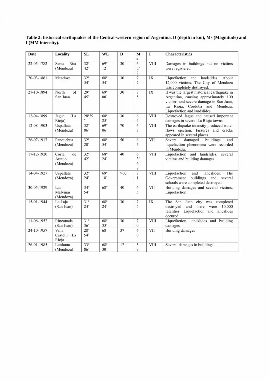
Table 2: historical earthquakes of the Central-western region of Argentina. D (depth in km), Ms (Magnitude) and I (MM intensity).
Date Locality SL WL D Ms
I Characteristics
22-05-1782 Santa Rita (Mendoza)
32º 42’
69º 12’
30 6.5/7
VIII Damages in buildings but no victims were registered
20-03-1861 Mendoza 32º 54’
68º 54’
30 7.2
IX Liquefaction and landslides. About 12,000 victims. The City of Mendoza was completely destroyed.
27-10-1894 North of San Juan
29º 45’
69º 00’
30 7.5
IX It was the largest historical earthquake in Argentina, causing approximately 100 victims and severe damage in San Juan, La Rioja, Córdoba and Mendoza. Liquefaction and landslides.
12-04-1899 Jagüé (La Rioja)
28º39’
68º 25’
30 6.4
VIII Destroyed Jagüé and caused important damages in several La Rioja towns.
12-08-1903 Uspallata (Mendoza)
32º 06’
69º 06’
70 6.3
VIII The earthquake intensity produced water flows ejection. Fissures and cracks appeared in several places.
26-07-1917 Panquehua (Mendoza)
32º 20’
68º 54’
50 6.5
VII Several damaged buildings and liquefaction phenomena were recorded in Mendoza.
17-12-1920 Costa de Araujo (Mendoza)
32º 42’
68º 24’
40 6.3/6.8
VIII Liquefaction and landslides, several victims and building damages
14-04-1927 Uspallata (Mendoza)
32º 24’
69º 18’
>60 7.1
VIII Liquefaction and landslides. The Government buildings and several schools were completed destroyed
30-05-1929 Las Malvinas (Mendoza)
34º 54’
68º 40 6.5
VII Building damages and several victims. Liquefaction
15-01-1944 La Laja (San Juan)
31º 24’
68º 24’
30 7.4
IX The San Juan city was completed destroyed and there were 10,000 fatalities. Liquefaction and landslides occured
11-06-1952 Rinconada (San Juan)
31º 36’
68º 35’
30 7.0
VIII Liquefaction, landslides and building damages
24-10-1957 Villa Castelli (La Rioja
28º 54’
68 37 6.0
VII Building damages
26-01-1985 Lunlunta (Mendoza)
33º 06’
68º 30’
12 5.9
VIII Several damages in buildings

Table 3: Historical earthquakes of the Sierras Pampeanas. D (depth in km), Ms (Magnitude) and I (MM intensity).
Date Place SL WL D Ms I (MM)
Characteristics
11-06-1934
Sampacho (Córdoba)
33º 30’ 64º 30’ 30 6.0 VIII This city was partially destroyed with several victims.
03-07-1941
Caucete (San Juan)
31º 54’ 67º 54’ 30 6.7 VI Liquefaction. Damages were mainly characterized by cornices collapses and walls fissures.
23-11-1977
Caucete (San Juan)
31º 02’ 67º 45’ 17 7.4 IX Liquefaction, 70 victims, about 200 injured and substantial damage in buildings
28-05-2002
La Rioja 28º 56’ 66º 48’ 22 6.0 VIII Several damages in buildings

Table 4: Active volcanoes of the Central Volcanic Zone. Volcano LS LW Summit
elevation(m) Characteristics
Lascar (1) 23º 22’ 67º 34’ 5,550 Stratovolcano that consists of an elongate series of six overlapping craters, trending roughly northeast, with the active, fuming crater located near the centre of this cluster. It has registered permanent episodic and explosive fumarolic activity. During 1986 an eruption occurred and the ash arrived to the city of Salta.
C. Tuzgle (2) 24º 03’ 66º 29’ 5,500 It is the easternmost young stratovolcano of the central Andes Many youthful-looking Holocene lava flows were erupted from the well-preserved summit crater. Inactive.
Aracar (3) 24º 15’ 67º 46’ 6,082 Well-preserved lava flows are found at the base of the volcano. Prior to a report of possible ash columns from the summit in 1993, the volcano was not known to be active
Socompa (4) 24º 24’ 68º 15’ 6,051 Stratovolcano. During the Holocene produced a 600 sq km debris-avalanche deposit that is one of the largest and best exposed of the world. No historical eruptions are known. Current fumarolic activity.
Llullaillaco (5)
24º 43’ 68º 32’ 6739 Stratovolcano with well preserved cone. Two explosive eruptions and another that may have included lava effusion were reported from Llullaillaco in the 19th century. Latent activity
Co. Escorial (6)
25º 05’ 68º 22’ 5,447 Stratovolcano that has young-looking lava flows and a well-preserved crater. It is considered inactive.
Co. Bayo (7) 25º 25’ 68º 35’ 5,401 It is a complex volcano of partial Holocene age with lava flows well preserved. Currently inactive
Antofalla (8) 25º 32’ 68º 6,100 There are mentions of smoking in 1901 and 1911. De Silva and Francis (1991) did not see evidence for Holocene activity but noted that the scoria cones and lava flows are very well preserved, indicating ages of a few thousand to ten thousand years. Latent activity.
Antofagasta de la Sierra Volcanic field (9)
26º 05’ 67º 30’ 4,000 Contains the youngest volcanic vents of the Argentinian Puna region (Hormann et al., 1973). The area includes several "extremely youthful” scoria cones, few thousand years old (de Silva and Francis, 1991)
Co. El Cóndor (10)
26º 37’ 68º 21’ 6,532 Strato-volcano that contains several ash cones and has been a source of lava flows of Holocene age (de Silva and Francis, 1991). Latent activity.
Falso Azufre (11)
26º 48’ 68º 22’ 5,890 Consists of overlapping craters that contain small composite cones and lava domes of recent activity of the complex (de Silva and Francis, 1991).
Cordón del Azufre (12)
25º 20’ 68º 31’ 5,463 Small volcanic complex with a cluster of lava flows and a chain of vents. An older edifice was covered by younger Holocene lava flows. Latent activity.
Lastarria (13) 25º 10’ 68º 30’ 5,697 Although no historical eruptions have been recorded, the youthful morphology of deposits suggests activity during historical time. Fumarolic activity occurs.
Co. Peinado (14)
26º 37’ 68º 09’ 5,740 This stratovolcano is the source of well-preserved lava flows of Holocene age (de Silva and Francis, 1991) and is one of the youngest volcanoes in the region. Fumarolic activity occurs
Nevado de Incahuasi (15)
27º 02’ 68º 17’ 6,621 Stratovolcano, the youngest one is capped by a crater, and lava flows radiate down the volcano's flanks. The fresh-looking morphology of the youngest products suggests a Holocene age (González-Ferrán, 1995). Fumarolic activity.
Tipas (16) 27º 12’ 68º 33’ 6,660 This volcanic complex of craters, cones, lava domes and lava flows covers an area of 25 sq km. It displays a youthful morphology, and its latest eruptions were considered by de Silva and Francis (1991) to be of Holocene age. Fumarolic activity
Nevados Ojos del Salado (17)
27º 07’ 68º 33’ 6,887 The most recent eruptive activity involved formation of lava flows and cones, lava domes, and explosion craters. No confirmed historical eruptions have been recorded, but the volcano has fumarolic activity.
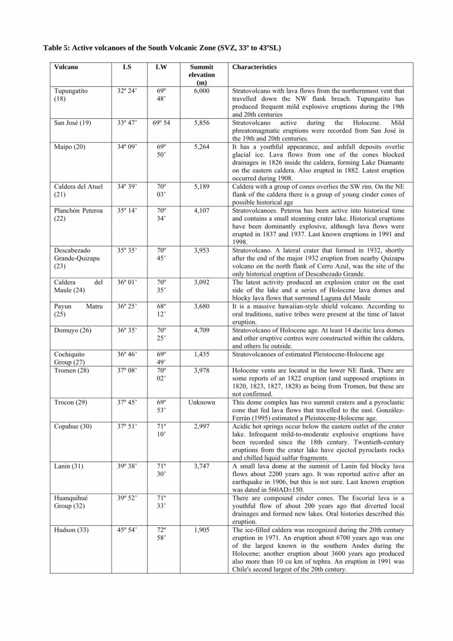
Table 5: Active volcanoes of the South Volcanic Zone (SVZ, 33º to 43ºSL)
Volcano LS LW Summit elevation
(m)
Characteristics
Tupungatito (18)
32º 24’ 69º 48’
6,000 Stratovolcano with lava flows from the northernmost vent that travelled down the NW flank breach. Tupungatito has produced frequent mild explosive eruptions during the 19th and 20th centuries
San José (19) 33º 47’ 69º 54 5,856 Stratovolcano active during the Holocene. Mild phreatomagmatic eruptions were recorded from San José in the 19th and 20th centuries.
Maipo (20) 34º 09’ 69º 50’
5,264 It has a youthful appearance, and ashfall deposits overlie glacial ice. Lava flows from one of the cones blocked drainages in 1826 inside the caldera, forming Lake Diamante on the eastern caldera. Also erupted in 1882. Latest eruption occurred during 1908.
Caldera del Atuel (21)
34º 39’ 70º 03’
5,189 Caldera with a group of cones overlies the SW rim. On the NE flank of the caldera there is a group of young cinder cones of possible historical age
Planchón Peteroa (22)
35º 14’ 70º 34’
4,107 Stratovolcanoes. Peteroa has been active into historical time and contains a small steaming crater lake. Historical eruptions have been dominantly explosive, although lava flows were erupted in 1837 and 1937. Last known eruptions in 1991 and 1998.
Descabezado Grande-Quizapu (23)
35º 35’ 70º 45’
3,953 Stratovolcano. A lateral crater that formed in 1932, shortly after the end of the major 1932 eruption from nearby Quizapu volcano on the north flank of Cerro Azul, was the site of the only historical eruption of Descabezado Grande.
Caldera del Maule (24)
36º 01’ 70º 35’
3,092 The latest activity produced an explosion crater on the east side of the lake and a series of Holocene lava domes and blocky lava flows that surround Laguna del Maule
Payun Matru (25)
36º 25’ 68º 12’
3,680 It is a massive hawaiian-style shield volcano. According to oral traditions, native tribes were present at the time of latest eruption.
Domuyo (26) 36º 35’ 70º 25’
4,709 Stratovolcano of Holocene age. At least 14 dacitic lava domes and other eruptive centres were constructed within the caldera, and others lie outside.
Cochiquito Group (27)
36º 46’ 69º 49’
1,435 Stratovolcanoes of estimated Pleistocene-Holocene age
Tromen (28) 37º 08’ 70º 02’
3,978 Holocene vents are located in the lower NE flank. There are some reports of an 1822 eruption (and supposed eruptions in 1820, 1823, 1827, 1828) as being from Tromen, but these are not confirmed.
Trocon (29) 37º 45’ 69º 53’
Unknown This dome complex has two summit craters and a pyroclastic cone that fed lava flows that travelled to the east. González-Ferrán (1995) estimated a Pleistocene-Holocene age.
Copahue (30) 37º 51’ 71º 10’
2,997 Acidic hot springs occur below the eastern outlet of the crater lake. Infrequent mild-to-moderate explosive eruptions have been recorded since the 18th century. Twentieth-century eruptions from the crater lake have ejected pyroclasts rocks and chilled liquid sulfur fragments.
Lanin (31) 39º 38’ 71º 30’
3,747 A small lava dome at the summit of Lanin fed blocky lava flows about 2200 years ago. It was reported active after an earthquake in 1906, but this is not sure. Last known eruption was dated in 560AD±150.
Huanquihué Group (32)
39º 52’ 71º 33’
There are compound cinder cones. The Escorial lava is a youthful flow of about 200 years ago that diverted local drainages and formed new lakes. Oral histories described this eruption.
Hudson (33) 45º 54’ 72º 58’
1,905 The ice-filled caldera was recognized during the 20th century eruption in 1971. An eruption about 6700 years ago was one of the largest known in the southern Andes during the Holocene; another eruption about 3600 years ago produced also more than 10 cu km of tephra. An eruption in 1991 was Chile's second largest of the 20th century.

Table 6: Volcaneos of the Austral volcanic zone
Volcano LS LW Summit elevation
(m)
Characteristics
Lautaro (33) 49º 01’
73º 33’
3,607 Stratovolcano. Ash deposits from eruptions of this dominantly dacitic volcano are visible in aerial photos. At least three layers of fallout deposits have been recognised in parts of the surface of the glacier, which may correspond to the latest known eruptions.
Viedma (34) 49º 21’
72º 10’
1,500 It is a subglacial volcano. The 1988 eruption deposited ash and pumice on the Patagonian Icecap and produced a lahar that reached Viedma Lake.
Pali-Aike (35) volcanic field
52º 70º 282 The most recent volcanic event produced scoria and spatter cones and fresh lava flows not covered by soil. Ejecta covers prehistorical artifacts.