second avenue apartments - troy, ny
TRANSCRIPT
Project Info:
Second Avenue and Roosevelt Avenue
City of Troy and Town of Schaghticoke
Rensselaer County, New York
Prepared for:
Kevin Vandenburgh
430 9th Ave
Troy, NY 12182
Prepared by:
Insite Northeast
2301 Western Avenue
Guilderland, NY 12084
Insite Northeast Engineering & Land Surveying, P.C. Civil Engineering ● Site Design ● Land Development ● Utilities ● Stormwater ● Land Surveying
SECOND AVENUE APARTMENTS
NARRATIVE DESCRIPTION REPORT
JANUARY 2021
January 25, 2021 2ND AVENUE APARTMENTS - NARRATIVE REPORT.docx Page 1
Insite Northeast Engineering & Land Surveying, P.C. ● 2301 Western Avenue Guilderland, NY 12084 ● 518-867-3323 ● www.insitenortheast.com
Table of Contents
Section I: Executive Summary & Project Description ............................................................... 2
1. Executive Summary .................................................................................................... 2 2. Legal Authorization ..................................................................................................... 2 3. Project Description ...................................................................................................... 3
Section II: Existing Conditions and Environmental Considerations .............................................. 6
1. Site Location .............................................................................................................. 6 2. Topography and Vegetation.......................................................................................... 6 3. Site Soils and Geotechnical Analysis .............................................................................. 8 4. Floodplain and Floodway .............................................................................................. 8 5. Wetlands and Watercourses ......................................................................................... 8 6. Threatened/Endangered Species ................................................................................. 10 7. Archaeology ............................................................................................................. 10 8. NYSDEC Environmental Remediation Sites ................................................................... 10
Section III: Land Use and Zoning .......................................................................................... 12
1. Site Location and Parcels ........................................................................................... 12 2. City of Troy Zoning Regulations .................................................................................. 13 3. City of Troy Comprehensive Plan ................................................................................ 19 4. Town of Schaghticoke Zoning Regulations .................................................................... 20 5. State and County Regulations..................................................................................... 20 6. Federal Regulations ................................................................................................... 21 7. Permits, Variances and Approvals ............................................................................... 21
Section IV: Traffic ............................................................................................................... 22
1. Existing Traffic Conditions .......................................................................................... 22 2. Proposed Project Traffic Impacts ................................................................................. 24
Section V: Utilities ............................................................................................................. 28
1. Sewer ..................................................................................................................... 28 2. Domestic Water ........................................................................................................ 28 3. Fire Flow .................................................................................................................. 28 4. Electric, Gas and Telecommunications ......................................................................... 28
Section VI: Stormwater and Erosion & Sediment Control ......................................................... 29
1. NYSDEC Stormwater Regulations ................................................................................ 29 2. Post Construction Stormwater Management ................................................................. 29 3. Erosion & Sediment Control........................................................................................ 29
Section VII: School Enrollment and Impacts ............................................................................ 31
1. School Enrollment Data ............................................................................................. 31 2. Existing School Data ................................................................................................. 31 3. Proposed Impacts ..................................................................................................... 31
Section VIII: Project Development Analysis .............................................................................. 32
1. Project Benefit, Improvements and Amenities .............................................................. 32 2. Visual Impacts .......................................................................................................... 32 3. Alternatives to the Proposed Action ............................................................................. 36 4. Summary and Conclusions ......................................................................................... 37
January 25, 2021 2ND AVENUE APARTMENTS - NARRATIVE REPORT.docx Page 2
Insite Northeast Engineering & Land Surveying, P.C. ● 2301 Western Avenue Guilderland, NY 12084 ● 518-867-3323 ● www.insitenortheast.com
Section I: Executive Summary & Project Description
1. Executive Summary
The Project Applicant proposes to construct three (3) 4-story multi-family apartment buildings on Second
Avenue in the City of Troy (City), NY. The 11-acre property is situated next to the Hudson River and includes
two parcels, the larger of which is in the City with the smaller portion in the Town of Schaghticoke. As part of
the Project, the Applicant proposes rezoning the City parcel to be within the Planned Development District
Zone as well as applying for several Variances to accommodate the Project as further outlined herein.
Each apartment building will include a mix of one and two-bedroom apartments with above and below-ground
parking. Project impacts are minimal, and results in reduced impacts vs. an alternative single-family residential
development allowed under existing zoning.
The Project comports with the Realize Troy 2018 Comprehensive Plan and includes notable improvements to
the County Sewer System, and provides public access to the Hudson River, a multi-use trail and sidewalks
along Second Avenue. Due to the private maintenance of the infrastructure, the Project will generate additional
tax revenue without greatly increasing the burden on the City or school district. The Project is intended to
provide new rental housing opportunities in the City along the Hudson River waterfront. The Project has been
designed to appeal to the community by preserving open-space while achieving density demands required to
complete the Project.
2. Legal Authorization
It should be noted that the Applicant previously retained MJ Engineering and Land Surveying, P.C. (MJ) to
provide engineering support for the Project discussed herein. Pursuant to conversations with the Applicant,
Insite Northeast Engineering & Land Surveying, P.C. (Insite) has express authorization to reference materials
developed by MJ. Insite acknowledges these items as being developed by MJ and makes no attempt to copy
or alter the Work. The exhibits provided and discussed herein were supplied by the Applicant and were
previously submitted to the City. As such, they are considered public record. Further, Insite will replace the
drawings as the project development proceeds.
January 25, 2021 2ND AVENUE APARTMENTS - NARRATIVE REPORT.docx Page 3
Insite Northeast Engineering & Land Surveying, P.C. ● 2301 Western Avenue Guilderland, NY 12084 ● 518-867-3323 ● www.insitenortheast.com
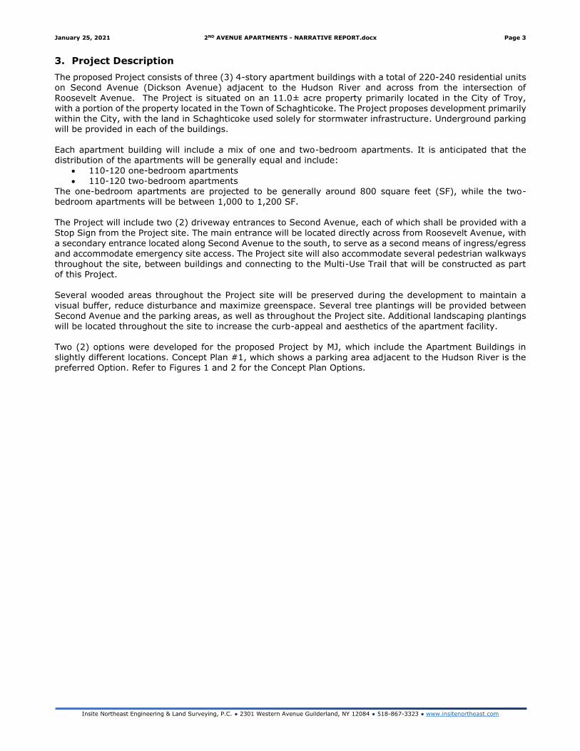
3. Project Description
The proposed Project consists of three (3) 4-story apartment buildings with a total of 220-240 residential units on Second Avenue (Dickson Avenue) adjacent to the Hudson River and across from the intersection of
Roosevelt Avenue. The Project is situated on an 11.0± acre property primarily located in the City of Troy, with a portion of the property located in the Town of Schaghticoke. The Project proposes development primarily within the City, with the land in Schaghticoke used solely for stormwater infrastructure. Underground parking will be provided in each of the buildings. Each apartment building will include a mix of one and two-bedroom apartments. It is anticipated that the distribution of the apartments will be generally equal and include:
• 110-120 one-bedroom apartments • 110-120 two-bedroom apartments
The one-bedroom apartments are projected to be generally around 800 square feet (SF), while the two-bedroom apartments will be between 1,000 to 1,200 SF. The Project will include two (2) driveway entrances to Second Avenue, each of which shall be provided with a
Stop Sign from the Project site. The main entrance will be located directly across from Roosevelt Avenue, with
a secondary entrance located along Second Avenue to the south, to serve as a second means of ingress/egress and accommodate emergency site access. The Project site will also accommodate several pedestrian walkways throughout the site, between buildings and connecting to the Multi-Use Trail that will be constructed as part of this Project. Several wooded areas throughout the Project site will be preserved during the development to maintain a
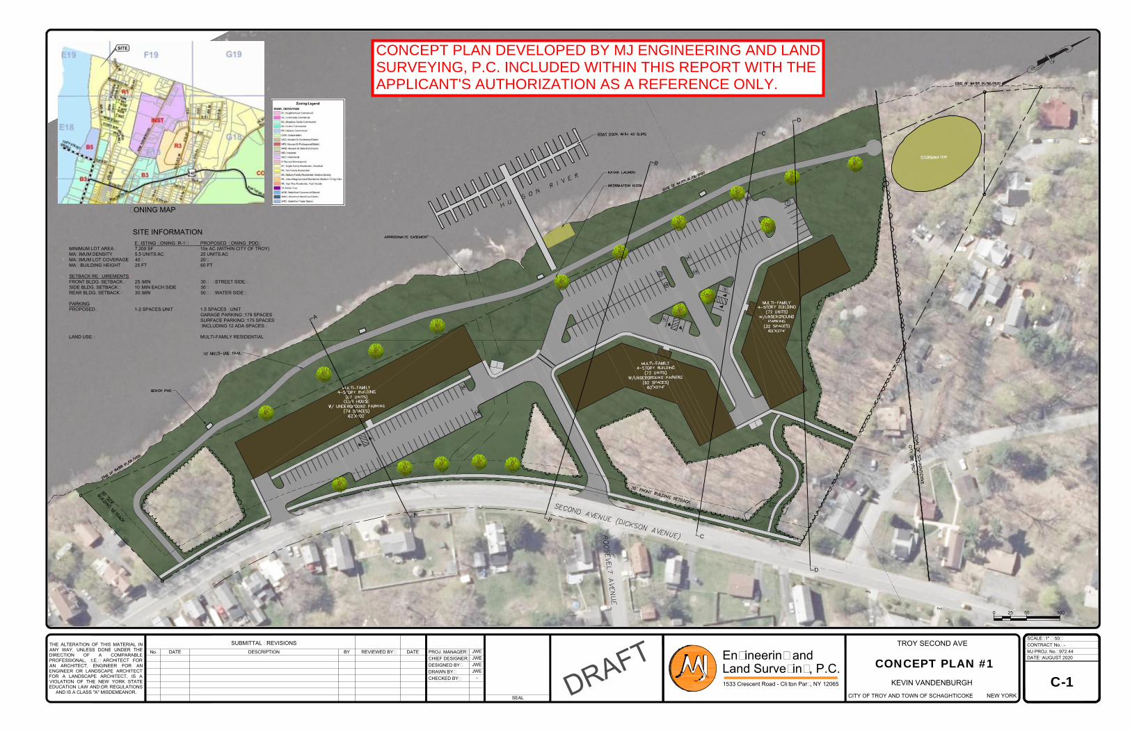
visual buffer, reduce disturbance and maximize greenspace. Several tree plantings will be provided between Second Avenue and the parking areas, as well as throughout the Project site. Additional landscaping plantings will be located throughout the site to increase the curb-appeal and aesthetics of the apartment facility. Two (2) options were developed for the proposed Project by MJ, which include the Apartment Buildings in slightly different locations. Concept Plan #1, which shows a parking area adjacent to the Hudson River is the preferred Option. Refer to Figures 1 and 2 for the Concept Plan Options.
THE ALTERATION OF THIS MATERIAL IN
ANY WAY, UNLESS DONE UNDER THE
DIRECTION OF A COMPARABLE
PROFESSIONAL, (I.E.) ARCHITECT FOR
AN ARCHITECT, ENGINEER FOR AN
ENGINEER OR LANDSCAPE ARCHITECT
FOR A LANDSCAPE ARCHITECT, IS A
VIOLATION OF THE NEW YORK STATE
EDUCATION LAW AND/OR REGULATIONS
AND IS A CLASS "A" MISDEMEANOR.
SEAL
DATENo. DESCRIPTION
SUBMITTAL / REVISIONS
PROJ. MANAGER:REVIEWED BY:
CHIEF DESIGNER:
BY DATE
DESIGNED BY:
DRAWN BY:
CHECKED BY:
DATE:
MJ PROJ. No.:
CONTRACT No.:
SCALE:
1533 Crescent Road - Clifton Park, NY 12065
Engineering and
Land Surveying, P.C.
-
972.44
AUGUST 2020
JWE
JWE
JWE
JWE
-
KEVIN VANDENBURGH
NEW YORKCITY OF TROY AND TOWN OF SCHAGHTICOKE
TROY SECOND AVE
C-1
D
R
A
F
T
CONCEPT PLAN #1
1" = 50'
ZONING MAP
SITE INFORMATION
0 25' 50' 100'
SITE
EXISTING ZONING (R-1) PROPOSED ZONING (PDD)
MINIMUM LOT AREA: 7,200 SF 10± AC (WITHIN CITY OF TROY)
MAXIMUM DENSITY 5.5 UNITS/AC 25 UNITS/AC
MAXIMUM LOT COVERAGE 40% 20%
MAX BUILDING HEIGHT 25 FT 60 FT
SETBACK REQUIREMENTS
FRONT BLDG. SETBACK: 25' MIN 30' (STREET SIDE)
SIDE BLDG. SETBACK: 10' MIN EACH SIDE 30'
REAR BLDG. SETBACK: 30' MIN 50' (WATER SIDE)
PARKING
PROPOSED: 1-2 SPACES/UNIT 1.5 SPACES / UNIT
GARAGE PARKING: 178 SPACES
SURFACE PARKING: 175 SPACES
(INCLUDING 12 ADA SPACES)
LAND USE: MULTI-FAMILY RESIDENTIAL
CONCEPT PLAN DEVELOPED BY MJ ENGINEERING AND LANDSURVEYING, P.C. INCLUDED WITHIN THIS REPORT WITH THEAPPLICANT'S AUTHORIZATION AS A REFERENCE ONLY.
THE ALTERATION OF THIS MATERIAL IN
ANY WAY, UNLESS DONE UNDER THE
DIRECTION OF A COMPARABLE
PROFESSIONAL, (I.E.) ARCHITECT FOR
AN ARCHITECT, ENGINEER FOR AN
ENGINEER OR LANDSCAPE ARCHITECT
FOR A LANDSCAPE ARCHITECT, IS A
VIOLATION OF THE NEW YORK STATE
EDUCATION LAW AND/OR REGULATIONS
AND IS A CLASS "A" MISDEMEANOR.
SEAL
DATENo. DESCRIPTION
SUBMITTAL / REVISIONS
PROJ. MANAGER:REVIEWED BY:
CHIEF DESIGNER:
BY DATE
DESIGNED BY:
DRAWN BY:
CHECKED BY:
DATE:
MJ PROJ. No.:
CONTRACT No.:
SCALE:
1533 Crescent Road - Clifton Park, NY 12065
Engineering and
Land Surveying, P.C.
-
972.44
AUGUST 2020
JWE
JWE
JWE
JWE
-
KEVIN VANDENBURGH
NEW YORKCITY OF TROY AND TOWN OF SCHAGHTICOKE
TROY SECOND AVE
C-1
D
R
A
F
T
CONCEPT PLAN #2
1" = 50'
ZONING MAP
SITE INFORMATION
0 25' 50' 100'
SITE
EXISTING ZONING (R-1) PROPOSED ZONING (PDD)
MINIMUM LOT AREA: 7,200 SF 10± AC (WITHIN CITY OF TROY)
MAXIMUM DENSITY 5.5 UNITS/AC 25 UNITS/AC
MAXIMUM LOT COVERAGE 40% 20%
MAX BUILDING HEIGHT 25 FT 60 FT
SETBACK REQUIREMENTS
FRONT BLDG. SETBACK: 25' MIN 30' (STREET SIDE)
SIDE BLDG. SETBACK: 10' MIN EACH SIDE 30'
REAR BLDG. SETBACK: 30' MIN 50' (WATER SIDE)
PARKING
PROPOSED: 1-2 SPACES/UNIT 1.5 SPACES / UNIT
GARAGE PARKING: 178 SPACES
SURFACE PARKING: 175 SPACES
(INCLUDING 12 ADA SPACES)
LAND USE: MULTI-FAMILY RESIDENTIAL
CONCEPT PLAN DEVELOPED BY MJ ENGINEERING AND LANDSURVEYING, P.C. INCLUDED WITHIN THIS REPORT WITH THEAPPLICANT'S AUTHORIZATION AS A REFERENCE ONLY.
January 25, 2021 2ND AVENUE APARTMENTS - NARRATIVE REPORT.docx Page 6
Insite Northeast Engineering & Land Surveying, P.C. ● 2301 Western Avenue Guilderland, NY 12084 ● 518-867-3323 ● www.insitenortheast.com
Section II: Existing Conditions and Environmental Considerations
1. Site Location
The Project site is located along Second Avenue (Dickson Avenue) adjacent to the Hudson River and across
from the intersection of Roosevelt Avenue. The Project area is primarily located within the City. Refer to
Figure 3 for the Site Location Map.
Figure 3 – Site Location Map
2. Topography and Vegetation
The topography varies greatly within the Project property. The steepest slope within the property is greater than 50% with some areas flattening off closer toward the watercourse. The existing topography is rolling
from the north and south ends of the property to the center. The overall grade drops approximately 70 feet from the north end and 40 feet from the south end towards the center of the parcel.
The property is primarily wooded, with a small field area and an existing access road.
A field survey was completed by MJ but was not furnished to Insite Northeast at the time of this Narrative
Report. A more detailed analysis of topography and vegetation will be provided once the field survey
information is made available.
Refer to Figure 4 for a topographical map of the Project site.
S
E
C
O
N
D
A
V
E
N
U
E
1
2
6
T
H
S
T
R
E
E
T
REV. DATE DESCRIPTION DATE
JOB #
SCALE
Insite Northeast2390 Western Avenue ● Guilderland, NY 12084
518-867-3323 ● www.InsiteNortheast.com
PROJECT SITE
LOCATION
SITE TOPOGRAPHY MAP
SECOND AVENUE
SECOND AVENUE AND ROOSEVELT AVENUE
KEVIN VANDENBURGH * 430 9TH AVENUE TROY, NY 12182
S.B.L. 70.64-1-1 AND S.B.L. 70.56-1-6
CITY OF TROY
TOWN OF SCHAGHTICOKE
RENSSELAER COUNTY NEW YORK
January 25, 2021 2ND AVENUE APARTMENTS - NARRATIVE REPORT.docx Page 8
Insite Northeast Engineering & Land Surveying, P.C. ● 2301 Western Avenue Guilderland, NY 12084 ● 518-867-3323 ● www.insitenortheast.com
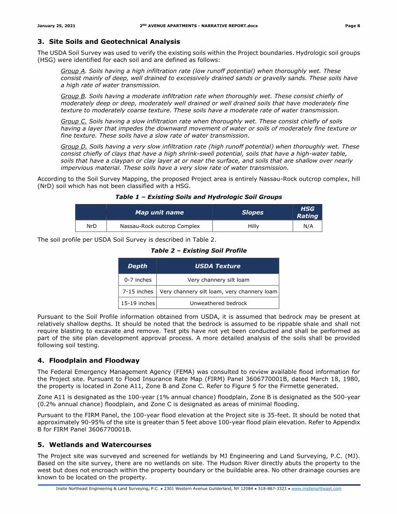
3. Site Soils and Geotechnical Analysis
The USDA Soil Survey was used to verify the existing soils within the Project boundaries. Hydrologic soil groups (HSG) were identified for each soil and are defined as follows:
Group A. Soils having a high infiltration rate (low runoff potential) when thoroughly wet. These consist mainly of deep, well drained to excessively drained sands or gravelly sands. These soils have a high rate of water transmission.
Group B. Soils having a moderate infiltration rate when thoroughly wet. These consist chiefly of moderately deep or deep, moderately well drained or well drained soils that have moderately fine texture to moderately coarse texture. These soils have a moderate rate of water transmission.
Group C. Soils having a slow infiltration rate when thoroughly wet. These consist chiefly of soils
having a layer that impedes the downward movement of water or soils of moderately fine texture or fine texture. These soils have a slow rate of water transmission.
Group D. Soils having a very slow infiltration rate (high runoff potential) when thoroughly wet. These consist chiefly of clays that have a high shrink-swell potential, soils that have a high-water table, soils that have a claypan or clay layer at or near the surface, and soils that are shallow over nearly
impervious material. These soils have a very slow rate of water transmission.
According to the Soil Survey Mapping, the proposed Project area is entirely Nassau-Rock outcrop complex, hill (NrD) soil which has not been classified with a HSG.
Table 1 – Existing Soils and Hydrologic Soil Groups
Map unit name Slopes HSG
Rating
NrD Nassau-Rock outcrop Complex Hilly N/A
The soil profile per USDA Soil Survey is described in Table 2.
Table 2 – Existing Soil Profile
Depth USDA Texture
0-7 inches Very channery silt loam
7-15 inches Very channery silt loam, very channery loam
15-19 inches Unweathered bedrock
Pursuant to the Soil Profile information obtained from USDA, it is assumed that bedrock may be present at
relatively shallow depths. It should be noted that the bedrock is assumed to be rippable shale and shall not require blasting to excavate and remove. Test pits have not yet been conducted and shall be performed as part of the site plan development approval process. A more detailed analysis of the soils shall be provided following soil testing.
4. Floodplain and Floodway
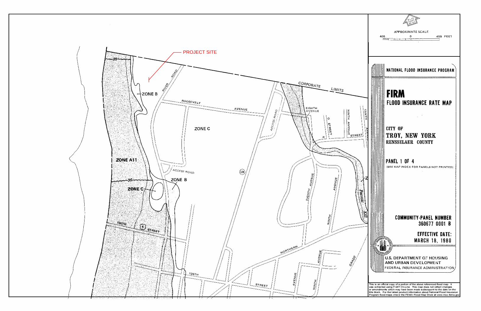
The Federal Emergency Management Agency (FEMA) was consulted to review available flood information for
the Project site. Pursuant to Flood Insurance Rate Map (FIRM) Panel 3606770001B, dated March 18, 1980, the property is located in Zone A11, Zone B and Zone C. Refer to Figure 5 for the Firmette generated.
Zone A11 is designated as the 100-year (1% annual chance) floodplain, Zone B is designated as the 500-year (0.2% annual chance) floodplain, and Zone C is designated as areas of minimal flooding.
Pursuant to the FIRM Panel, the 100-year flood elevation at the Project site is 35-feet. It should be noted that approximately 90-95% of the site is greater than 5 feet above 100-year flood plain elevation. Refer to Appendix
B for FIRM Panel 3606770001B.
5. Wetlands and Watercourses
The Project site was surveyed and screened for wetlands by MJ Engineering and Land Surveying, P.C. (MJ). Based on the site survey, there are no wetlands on site. The Hudson River directly abuts the property to the west but does not encroach within the property boundary or the buildable area. No other drainage courses are known to be located on the property.
PROJECT SITE
January 25, 2021 2ND AVENUE APARTMENTS - NARRATIVE REPORT.docx Page 10
Insite Northeast Engineering & Land Surveying, P.C. ● 2301 Western Avenue Guilderland, NY 12084 ● 518-867-3323 ● www.insitenortheast.com
6. Threatened/Endangered Species
The US Fish and Wildlife database was consulted through the NYSDEC Nature Explorer for the presence or reports of threatened and/or endangered species within the Project boundaries. No species have been recorded
as being threatened and/or endangered at the site. Similarly, the site is not known to contain suitable habitats for threatened or endangered species noted by the NYSDEC. The map is included in Appendix C.
7. Archaeology
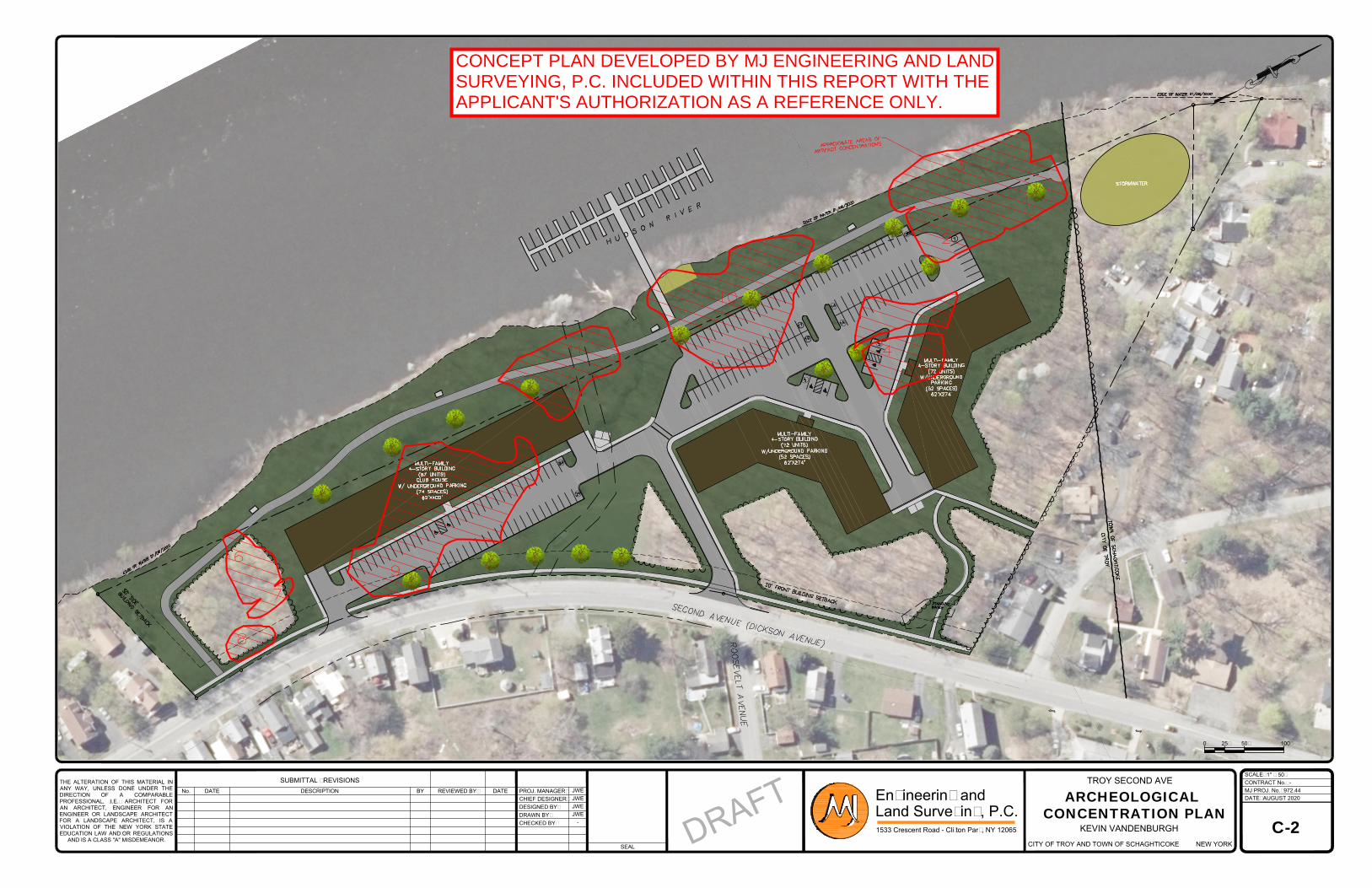
The Project site is known to contain several archaeological areas located throughout the property. A Phase 1A, 1B and Phase II Archeological Site Evaluation report was developed by Hartgen Archeological Associates, Inc. (Hartgen) dated April 2020. Hartgen visited the site in 2019 to perform the field investigation, and determined
the site contained a mix of quarried outcrops, lithic workshops and camp locations. Hartgen recommended avoidance of the defined site areas or additional Phase III Data Recovery. Refer to Figure 6 for a visual depiction of the concentrated areas on the Project site. Refer to Appendix D for the complete Hartgen Report.
The applicant will coordinate with OPRHP to determine the proper method of remediating the archeologic area. This work will contain throughout the site plan development approval process. The Project proposes a Phase III Data Recovery to maximize developability of the site.
8. NYSDEC Environmental Remediation Sites
Three (3) environmental remediation sites were recorded within 2,000 feet of the Project site. The incidents are summarized in Table 3.
Table 3 – NYSDEC Site Remediation Records
Site Location Program Location Classification and Status
546031 Hudson River PCB
Sediments
State Superfund Program
02 02 - Registry of Inactive Hazardous Waste Disposal Sites. See Note 1.
546053 Former Ford
Manufacturing Company Mill Site
State Superfund Program
121-125 2nd Street Waterford, NY
C - Remediation has been satisfactorily completed under a
remedial program
E546053 Former Ford
Manufacturing Company Mill Site
Environmental Restoration
Program
121-125 2nd Street Waterford, NY
N - No Further Action at this Time
Note 1: NYSDEC Classification 02 – A site at which:
a. the disposal of hazardous waste has been confirmed and the presence of such hazardous waste or its components or breakdown products represents a significant threat to public health or the environment: or;
b. hazardous waste disposal has not been confirmed, but the site has been listed on the Federal National Priorities
List (NPL).
THE ALTERATION OF THIS MATERIAL IN
ANY WAY, UNLESS DONE UNDER THE
DIRECTION OF A COMPARABLE
PROFESSIONAL, (I.E.) ARCHITECT FOR
AN ARCHITECT, ENGINEER FOR AN
ENGINEER OR LANDSCAPE ARCHITECT
FOR A LANDSCAPE ARCHITECT, IS A
VIOLATION OF THE NEW YORK STATE
EDUCATION LAW AND/OR REGULATIONS
AND IS A CLASS "A" MISDEMEANOR.
SEAL
DATENo. DESCRIPTION
SUBMITTAL / REVISIONS
PROJ. MANAGER:REVIEWED BY:
CHIEF DESIGNER:
BY DATE
DESIGNED BY:
DRAWN BY:
CHECKED BY:
DATE:
MJ PROJ. No.:
CONTRACT No.:
SCALE:
1533 Crescent Road - Clifton Park, NY 12065
Engineering and
Land Surveying, P.C.
-
972.44
AUGUST 2020
JWE
JWE
JWE
JWE
-
KEVIN VANDENBURGH
NEW YORKCITY OF TROY AND TOWN OF SCHAGHTICOKE
TROY SECOND AVE
C-2
D
R
A
F
T
ARCHEOLOGICAL
CONCENTRATION PLAN
1" = 50'
0 25' 50' 100'
CONCEPT PLAN DEVELOPED BY MJ ENGINEERING AND LANDSURVEYING, P.C. INCLUDED WITHIN THIS REPORT WITH THEAPPLICANT'S AUTHORIZATION AS A REFERENCE ONLY.
January 25, 2021 2ND AVENUE APARTMENTS - NARRATIVE REPORT.docx Page 12
Insite Northeast Engineering & Land Surveying, P.C. ● 2301 Western Avenue Guilderland, NY 12084 ● 518-867-3323 ● www.insitenortheast.com
Section III: Land Use and Zoning
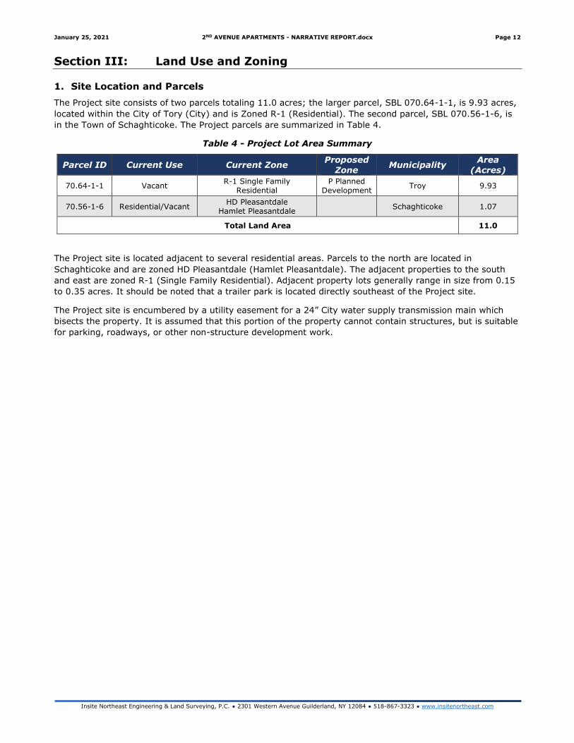
1. Site Location and Parcels
The Project site consists of two parcels totaling 11.0 acres; the larger parcel, SBL 070.64-1-1, is 9.93 acres,
located within the City of Tory (City) and is Zoned R-1 (Residential). The second parcel, SBL 070.56-1-6, is
in the Town of Schaghticoke. The Project parcels are summarized in Table 4.
Table 4 - Project Lot Area Summary
Parcel ID Current Use Current Zone Proposed
Zone Municipality
Area
(Acres)
70.64-1-1 Vacant R-1 Single Family
Residential P Planned
Development Troy 9.93
70.56-1-6 Residential/Vacant HD Pleasantdale
Hamlet Pleasantdale Schaghticoke 1.07
Total Land Area 11.0
The Project site is located adjacent to several residential areas. Parcels to the north are located in
Schaghticoke and are zoned HD Pleasantdale (Hamlet Pleasantdale). The adjacent properties to the south
and east are zoned R-1 (Single Family Residential). Adjacent property lots generally range in size from 0.15
to 0.35 acres. It should be noted that a trailer park is located directly southeast of the Project site.
The Project site is encumbered by a utility easement for a 24” City water supply transmission main which
bisects the property. It is assumed that this portion of the property cannot contain structures, but is suitable
for parking, roadways, or other non-structure development work.
January 25, 2021 2ND AVENUE APARTMENTS - NARRATIVE REPORT.docx Page 13
Insite Northeast Engineering & Land Surveying, P.C. ● 2301 Western Avenue Guilderland, NY 12084 ● 518-867-3323 ● www.insitenortheast.com
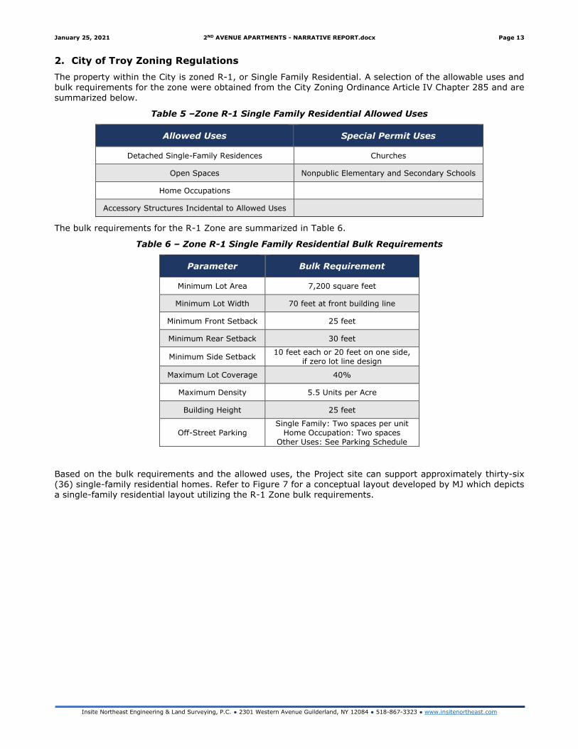
2. City of Troy Zoning Regulations
The property within the City is zoned R-1, or Single Family Residential. A selection of the allowable uses and bulk requirements for the zone were obtained from the City Zoning Ordinance Article IV Chapter 285 and are
summarized below.
Table 5 –Zone R-1 Single Family Residential Allowed Uses
Allowed Uses Special Permit Uses
Detached Single-Family Residences Churches
Open Spaces Nonpublic Elementary and Secondary Schools
Home Occupations
Accessory Structures Incidental to Allowed Uses
The bulk requirements for the R-1 Zone are summarized in Table 6.
Table 6 – Zone R-1 Single Family Residential Bulk Requirements
Parameter Bulk Requirement
Minimum Lot Area 7,200 square feet
Minimum Lot Width 70 feet at front building line
Minimum Front Setback 25 feet
Minimum Rear Setback 30 feet
Minimum Side Setback 10 feet each or 20 feet on one side,
if zero lot line design
Maximum Lot Coverage 40%
Maximum Density 5.5 Units per Acre
Building Height 25 feet
Off-Street Parking Single Family: Two spaces per unit
Home Occupation: Two spaces Other Uses: See Parking Schedule
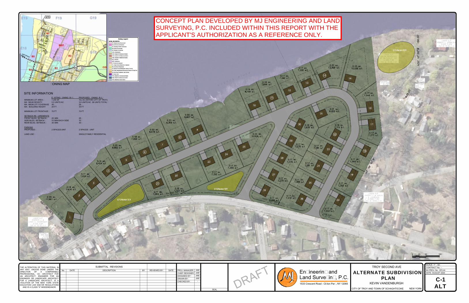
Based on the bulk requirements and the allowed uses, the Project site can support approximately thirty-six (36) single-family residential homes. Refer to Figure 7 for a conceptual layout developed by MJ which depicts a single-family residential layout utilizing the R-1 Zone bulk requirements.
THE ALTERATION OF THIS MATERIAL IN
ANY WAY, UNLESS DONE UNDER THE
DIRECTION OF A COMPARABLE
PROFESSIONAL, (I.E.) ARCHITECT FOR
AN ARCHITECT, ENGINEER FOR AN
ENGINEER OR LANDSCAPE ARCHITECT
FOR A LANDSCAPE ARCHITECT, IS A
VIOLATION OF THE NEW YORK STATE
EDUCATION LAW AND/OR REGULATIONS
AND IS A CLASS "A" MISDEMEANOR.
SEAL
DATENo. DESCRIPTION
SUBMITTAL / REVISIONS
PROJ. MANAGER:REVIEWED BY:
CHIEF DESIGNER:
BY DATE
DESIGNED BY:
DRAWN BY:
CHECKED BY:
DATE:
MJ PROJ. No.:
CONTRACT No.:
SCALE:
1533 Crescent Road - Clifton Park, NY 12065
Engineering and
Land Surveying, P.C.
-
972.44
AUGUST 2020
JWE
JWE
JWE
JWE
-
KEVIN VANDENBURGH
NEW YORKCITY OF TROY AND TOWN OF SCHAGHTICOKE
TROY SECOND AVE
C-1
ALT
D
R
A
F
T
ALTERNATE SUBDIVISION
PLAN
1" = 50'
ZONING MAP
SITE INFORMATION
EXISTING ZONING (R-1) PROPOSED ZONING (R-1)
MINIMUM LOT AREA: 7,200 SF 10± AC (WITHIN CITY OF TROY)
MAXIMUM DENSITY 5.5 UNITS/AC 3.6 UNITS/AC (36 UNITS TOTAL)
MAXIMUM LOT COVERAGE 40% 28%
MAX BUILDING HEIGHT 25 FT 35 FT
MINIMUM LOT FRONTAGE: 70 FT 70 FT
SETBACK REQUIREMENTS
FRONT BLDG. SETBACK: 25' MIN 25'
SIDE BLDG. SETBACK: 10' MIN EACH SIDE 10'
REAR BLDG. SETBACK: 30' MIN 30'
PARKING
PROPOSED: 2 SPACES/UNIT 2 SPACES / UNIT
LAND USE: SINGLE FAMILY RESIDENTIAL
0 25' 50' 100'
SITE
CONCEPT PLAN DEVELOPED BY MJ ENGINEERING AND LANDSURVEYING, P.C. INCLUDED WITHIN THIS REPORT WITH THEAPPLICANT'S AUTHORIZATION AS A REFERENCE ONLY.
January 25, 2021 2ND AVENUE APARTMENTS - NARRATIVE REPORT.docx Page 15
Insite Northeast Engineering & Land Surveying, P.C. ● 2301 Western Avenue Guilderland, NY 12084 ● 518-867-3323 ● www.insitenortheast.com
Zone Change to Planned Development District
Pursuant to City Code, a zone change to the Planned Development District (P) allows for the development of multi-family structures and flexibility with the development process. Section §285-57 A defines the City’s
Philosophy for the justification to change to the P Zone.
Philosophy
This District is designed to maximize choice in the types of environment, housing, densities, occupancy tenure, lot sizes, community facilities, usable open space and recreational areas within a large parcel of land in which a planned mix of residential uses is proposed. The intent of this District is to foster a creative and efficient use of land resulting in small networks of utilities and streets, the preservation of existing natural resources, and a development pattern consistent with community needs and
standards.
The allowed uses and bulk requirements for the P Zone are included in Tables 4 and 5.
Table 7 – Planned Development District (P) Allowed Uses
Allowed Uses Special Permit Uses
Dwelling Units (detached, semidetached, attached or a combination thereof whether
single-family, duplex, multiplex, condominium or low-rise multifamily)
None
Recreational facilities expressly designed for use by occupants of the above cited dwelling units.
Table 8 – Planned Development District (P) Bulk Requirements
Parameter Single-Family
Detached Two-Family
Other
Residential
Recreational
Facilities
Minimum Lot Area 5,800 sqft 3,000 sqft per unit 2,500 sqft per unit 10,000 sqft
Minimum Lot Width at Front Building Line
40 feet 40 feet 20 feet per unit 50 feet
Minimum Front Setback
20 feet 15 feet 25 feet 20 feet
Minimum Rear Setback
30 feet 20 feet 20 feet1 35 feet
Minimum Side Setback
5 feet either side or a total of 10 feet on one
side, if zero lot line design
5 feet either side or a total of 10 feet on one side, if zero lot
line design
10 feet total 10 feet each side
Maximum Lot Coverage
50% 50% 60% 50%
Maximum Density 6 units /acre 14 units / acre 21.5 units / acre N/A
Building Height 30 feet 35 feet 40 feet 25 feet
Off-Street Parking Two spaces per unit Two spaces per unit Two spaces per unit2 See Note 3
1. Rear setback applies to shoreline for parcels on Hudson River. 2. See 285-87 Planned Development Parking (Table 9) 3. See 285-91 General Required Off-Street Parking
Based on the summary included in Table 8, the proposed Project would be considered “other residential”, with maximum lot coverage of 60%, maximum building height of 40 feet and maximum density of 21.5 units per acre. As the Project proposes 220 - 240 Dwelling Units/Apartments, the Project proposes a density of approximately 20-21.8 units/acre, inclusive of both parcel areas (11-acres) as the basis for development. Utilizing only the City parcel (9.93-acres) as the basis for the calculation, the effective density increases to
22.1-24.2, and a Variance would be required.
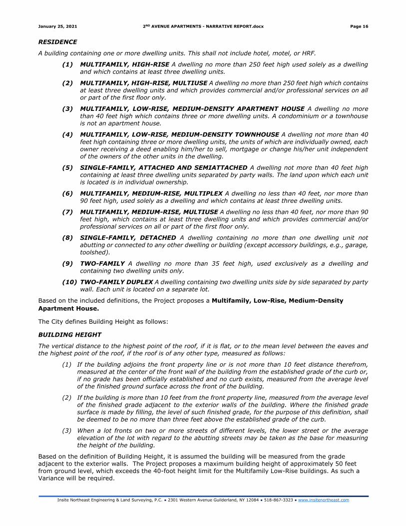
The City has specific criteria and definitions for what constitutes a residence type. Specifically, each building type (i.e. single-family, multifamily, etc.) are defined in §285-12, and are included below.
January 25, 2021 2ND AVENUE APARTMENTS - NARRATIVE REPORT.docx Page 16
Insite Northeast Engineering & Land Surveying, P.C. ● 2301 Western Avenue Guilderland, NY 12084 ● 518-867-3323 ● www.insitenortheast.com
RESIDENCE
A building containing one or more dwelling units. This shall not include hotel, motel, or HRF.
(1) MULTIFAMILY, HIGH-RISE A dwelling no more than 250 feet high used solely as a dwelling and which contains at least three dwelling units.
(2) MULTIFAMILY, HIGH-RISE, MULTIUSE A dwelling no more than 250 feet high which contains at least three dwelling units and which provides commercial and/or professional services on all or part of the first floor only.
(3) MULTIFAMILY, LOW-RISE, MEDIUM-DENSITY APARTMENT HOUSE A dwelling no more than 40 feet high which contains three or more dwelling units. A condominium or a townhouse is not an apartment house.
(4) MULTIFAMILY, LOW-RISE, MEDIUM-DENSITY TOWNHOUSE A dwelling not more than 40
feet high containing three or more dwelling units, the units of which are individually owned, each owner receiving a deed enabling him/her to sell, mortgage or change his/her unit independent of the owners of the other units in the dwelling.
(5) SINGLE-FAMILY, ATTACHED AND SEMIATTACHED A dwelling not more than 40 feet high containing at least three dwelling units separated by party walls. The land upon which each unit is located is in individual ownership.
(6) MULTIFAMILY, MEDIUM-RISE, MULTIPLEX A dwelling no less than 40 feet, nor more than 90 feet high, used solely as a dwelling and which contains at least three dwelling units.
(7) MULTIFAMILY, MEDIUM-RISE, MULTIUSE A dwelling no less than 40 feet, nor more than 90 feet high, which contains at least three dwelling units and which provides commercial and/or professional services on all or part of the first floor only.
(8) SINGLE-FAMILY, DETACHED A dwelling containing no more than one dwelling unit not abutting or connected to any other dwelling or building (except accessory buildings, e.g., garage,
toolshed).
(9) TWO-FAMILY A dwelling no more than 35 feet high, used exclusively as a dwelling and containing two dwelling units only.
(10) TWO-FAMILY DUPLEX A dwelling containing two dwelling units side by side separated by party wall. Each unit is located on a separate lot.
Based on the included definitions, the Project proposes a Multifamily, Low-Rise, Medium-Density
Apartment House.
The City defines Building Height as follows:
BUILDING HEIGHT
The vertical distance to the highest point of the roof, if it is flat, or to the mean level between the eaves and the highest point of the roof, if the roof is of any other type, measured as follows:
(1) If the building adjoins the front property line or is not more than 10 feet distance therefrom, measured at the center of the front wall of the building from the established grade of the curb or,
if no grade has been officially established and no curb exists, measured from the average level of the finished ground surface across the front of the building.
(2) If the building is more than 10 feet from the front property line, measured from the average level of the finished grade adjacent to the exterior walls of the building. Where the finished grade surface is made by filling, the level of such finished grade, for the purpose of this definition, shall be deemed to be no more than three feet above the established grade of the curb.
(3) When a lot fronts on two or more streets of different levels, the lower street or the average
elevation of the lot with regard to the abutting streets may be taken as the base for measuring the height of the building.
Based on the definition of Building Height, it is assumed the building will be measured from the grade adjacent to the exterior walls. The Project proposes a maximum building height of approximately 50 feet from ground level, which exceeds the 40-foot height limit for the Multifamily Low-Rise buildings. As such a Variance will be required.
January 25, 2021 2ND AVENUE APARTMENTS - NARRATIVE REPORT.docx Page 17
Insite Northeast Engineering & Land Surveying, P.C. ● 2301 Western Avenue Guilderland, NY 12084 ● 518-867-3323 ● www.insitenortheast.com
In addition to the P Zone bulk requirements, there are additional standards that the Commission shall ensure
to enforce the Philosophy of the P Zone is met. The Review Standards from §285-57 H are included below:
(1) To the extent feasible, at least 10% of the total number of dwellings within this District should
be in single-family detached structures.
(2) Building height, size and design shall be appropriate to the location within the district where proposed and shall further be appropriate to the overall development plan of the district.
(3) There shall be off-street parking facilities which shall be adequate for the particular development, as determined by the Commission. In no cases shall campers, boats and other recreational vehicles be stored in other than screened or enclosed structures.
(4) Landscaped open spaces or open areas left in their natural state should be provided at a ratio of
not less than 1,000 square feet of open space for every dwelling unit.
(5) A buffer strip of adequate width should be provided, where appropriate, between residential and nonresidential areas and between residential areas and state and county roads. Said buffer strip may be created by utilizing suitably landscaped green areas, by design, configuration and location of particular buildings, or by an other method meeting the approval of the Commission.
No parking shall be permitted as a buffer area.
(6) Where feasible, natural features such as streams, rocks, outcrops, topsoil, trees and shrubs shall
be preserved and incorporated in the landscape of the development.
(7) To improve the quality of the environment and to reduce inconvenience during bad weather, the underground installation of electrical and telephone equipment shall be required where feasible.
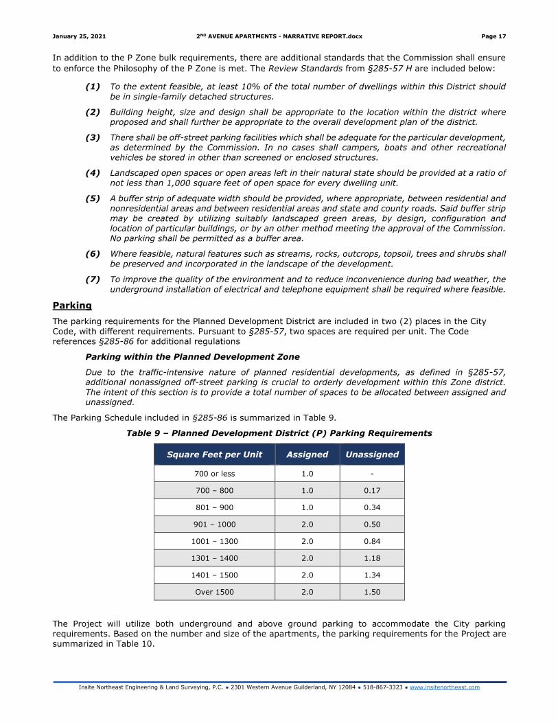
Parking
The parking requirements for the Planned Development District are included in two (2) places in the City
Code, with different requirements. Pursuant to §285-57, two spaces are required per unit. The Code references §285-86 for additional regulations
Parking within the Planned Development Zone
Due to the traffic-intensive nature of planned residential developments, as defined in §285-57, additional nonassigned off-street parking is crucial to orderly development within this Zone district.
The intent of this section is to provide a total number of spaces to be allocated between assigned and unassigned.
The Parking Schedule included in §285-86 is summarized in Table 9.
Table 9 – Planned Development District (P) Parking Requirements
Square Feet per Unit Assigned Unassigned
700 or less 1.0 -
700 – 800 1.0 0.17
801 – 900 1.0 0.34
901 – 1000 2.0 0.50
1001 – 1300 2.0 0.84
1301 – 1400 2.0 1.18
1401 – 1500 2.0 1.34
Over 1500 2.0 1.50
The Project will utilize both underground and above ground parking to accommodate the City parking requirements. Based on the number and size of the apartments, the parking requirements for the Project are summarized in Table 10.
January 25, 2021 2ND AVENUE APARTMENTS - NARRATIVE REPORT.docx Page 18
Insite Northeast Engineering & Land Surveying, P.C. ● 2301 Western Avenue Guilderland, NY 12084 ● 518-867-3323 ● www.insitenortheast.com
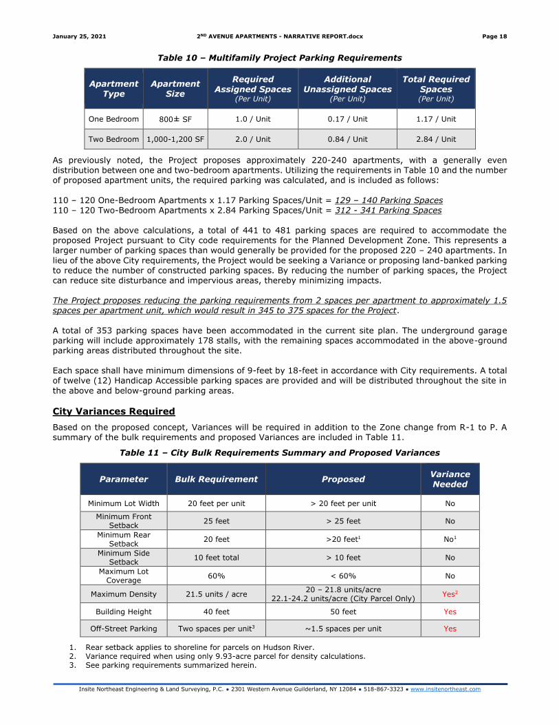
Table 10 – Multifamily Project Parking Requirements
Apartment Type
Apartment Size
Required Assigned Spaces
(Per Unit)
Additional Unassigned Spaces
(Per Unit)
Total Required Spaces (Per Unit)
One Bedroom 800± SF 1.0 / Unit 0.17 / Unit 1.17 / Unit
Two Bedroom 1,000-1,200 SF 2.0 / Unit 0.84 / Unit 2.84 / Unit
As previously noted, the Project proposes approximately 220-240 apartments, with a generally even distribution between one and two-bedroom apartments. Utilizing the requirements in Table 10 and the number of proposed apartment units, the required parking was calculated, and is included as follows:
110 – 120 One-Bedroom Apartments x 1.17 Parking Spaces/Unit = 129 – 140 Parking Spaces 110 – 120 Two-Bedroom Apartments x 2.84 Parking Spaces/Unit = 312 - 341 Parking Spaces
Based on the above calculations, a total of 441 to 481 parking spaces are required to accommodate the proposed Project pursuant to City code requirements for the Planned Development Zone. This represents a larger number of parking spaces than would generally be provided for the proposed 220 – 240 apartments. In
lieu of the above City requirements, the Project would be seeking a Variance or proposing land-banked parking to reduce the number of constructed parking spaces. By reducing the number of parking spaces, the Project can reduce site disturbance and impervious areas, thereby minimizing impacts. The Project proposes reducing the parking requirements from 2 spaces per apartment to approximately 1.5 spaces per apartment unit, which would result in 345 to 375 spaces for the Project.
A total of 353 parking spaces have been accommodated in the current site plan. The underground garage parking will include approximately 178 stalls, with the remaining spaces accommodated in the above-ground parking areas distributed throughout the site. Each space shall have minimum dimensions of 9-feet by 18-feet in accordance with City requirements. A total of twelve (12) Handicap Accessible parking spaces are provided and will be distributed throughout the site in
the above and below-ground parking areas.
City Variances Required
Based on the proposed concept, Variances will be required in addition to the Zone change from R-1 to P. A summary of the bulk requirements and proposed Variances are included in Table 11.
Table 11 – City Bulk Requirements Summary and Proposed Variances
Parameter Bulk Requirement Proposed Variance Needed
Minimum Lot Width 20 feet per unit > 20 feet per unit No
Minimum Front Setback
25 feet > 25 feet No
Minimum Rear Setback
20 feet >20 feet1 No1
Minimum Side Setback
10 feet total > 10 feet No
Maximum Lot Coverage
60% < 60% No
Maximum Density 21.5 units / acre 20 – 21.8 units/acre
22.1-24.2 units/acre (City Parcel Only) Yes2
Building Height 40 feet 50 feet Yes
Off-Street Parking Two spaces per unit3 ~1.5 spaces per unit Yes
1. Rear setback applies to shoreline for parcels on Hudson River. 2. Variance required when using only 9.93-acre parcel for density calculations. 3. See parking requirements summarized herein.
January 25, 2021 2ND AVENUE APARTMENTS - NARRATIVE REPORT.docx Page 19
Insite Northeast Engineering & Land Surveying, P.C. ● 2301 Western Avenue Guilderland, NY 12084 ● 518-867-3323 ● www.insitenortheast.com
3. City of Troy Comprehensive Plan
The proposed Project generally comports with the Realize Troy 2018 City Comprehensive Plan and will have a positive impact on the community. The City has provided initial review of the proposed Project as is depicted
in the Comprehensive Plan Analysis provided by the City. As shown in the analysis, the Project meets many of the goals and intent of the comprehensive plan. A selection of the review items are included below:
Waterfront – p.18 – lack of access to waterfront
It is an opportunity that will require a range of strategies from improving connections, removing barriers, increasing access to and from the water and determining the specific role and character of the area as a successful waterfront place
Goal 1: Grow the Economy & Population P28
Supports target of 1% new growth annually.
Goal 2: Promote Healthy, Safe, and Green Neighborhoods. Pg 33
The creation of new areas for mixed-use development with a range of housing choices will support new home ownership and rental options which are needed to keep established neighborhoods healthy. Enhancing the
relationship between the city’s existing and new neighborhoods, the riverfront and the city’s park lands through new connections, linkages and public realm improvements will connect established neighborhoods to new
investment making these areas more attractive places to live within the city and region.
Encourage a diverse housing stock to meet the needs of Troy’s existing and future population pg 34- 2.2.1
A variety of housing types in terms of housing form, tenure and affordability will be promoted. In particular, townhouses and multi-unit buildings will be encouraged in the neighborhoods. New housing will be compatible and complementary to the existing building stock. Within primarily residential areas, the City will identify methods to prohibit uses which create heavy parking demand where insufficient capacity exists.
2.4.1 Land use and development will be planned in a manner that ensures residents have access to a basic food store, park or other open space amenities within a fifteen-minute walk of their home or workplace.
2.4.2 Neighborhoods will have high-quality pedestrian sidewalks and bicycle infrastructure to support active transportation.
2.4.3 Linkages and corridors to existing and planned parks and open spaces will be improved to ensure green spaces are within walking distance of nearby residents.
Place-Specific Strategies – Lansingburgh P 36
Reconnect Lansingburgh visually and physically to the Hudson River shoreline.
L11: Improve sidewalk conditions throughout the neighborhood to improve safety and neighborhood connections.
3.3.2 Neighborhoods will be planned to encourage walking and cycling by ensuring that key routes and corridors have sidewalks and safe crossing zones. The City of Troy will work with property owners to encourage maintenance of local sidewalks.
4.1 Ensure Troy has an adequate supply of accessible, well maintained parks and open spaces to provide active and passive rec. ops.
4.2.3 A city-wide waterfront trail/promenade along the Hudson River will be planned to improve access to the
water’s edge and to enhance recreational opportunities.
4.2.5 Entryways into the city will be enhanced by ensuring new buildings are appropriately sited and massed to define these entryways and through the introduction of landscape elements, pedestrian amenities and other special treatments such as decorative pavement, distinctive street furniture, public art and/or other landscape
features.
Goal 5: Invest in sustainable infr. & protect the env. Pg 57
5.1.1 Watercourses and major open spaces, shown on Map 12 will be protected and the City will prohibit major development in these areas. Pg 58
Goal 6 Support Compact Growth pg 62
Map 9 pg. 148 shows waterfront trail connection to north of Hannaford.
January 25, 2021 2ND AVENUE APARTMENTS - NARRATIVE REPORT.docx Page 20
Insite Northeast Engineering & Land Surveying, P.C. ● 2301 Western Avenue Guilderland, NY 12084 ● 518-867-3323 ● www.insitenortheast.com
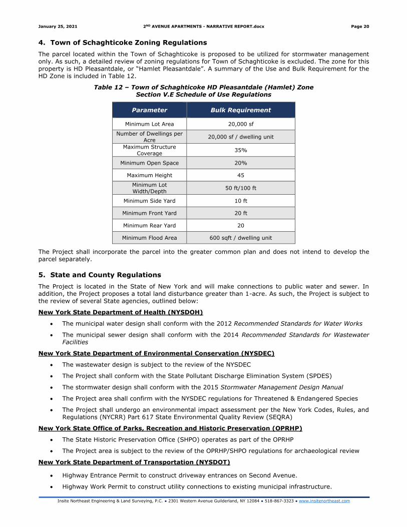
4. Town of Schaghticoke Zoning Regulations
The parcel located within the Town of Schaghticoke is proposed to be utilized for stormwater management only. As such, a detailed review of zoning regulations for Town of Schaghticoke is excluded. The zone for this
property is HD Pleasantdale, or “Hamlet Pleasantdale”. A summary of the Use and Bulk Requirement for the HD Zone is included in Table 12.
Table 12 – Town of Schaghticoke HD Pleasantdale (Hamlet) Zone Section V.E Schedule of Use Regulations
Parameter Bulk Requirement
Minimum Lot Area 20,000 sf
Number of Dwellings per Acre
20,000 sf / dwelling unit
Maximum Structure Coverage
35%
Minimum Open Space 20%
Maximum Height 45
Minimum Lot Width/Depth
50 ft/100 ft
Minimum Side Yard 10 ft
Minimum Front Yard 20 ft
Minimum Rear Yard 20
Minimum Flood Area 600 sqft / dwelling unit
The Project shall incorporate the parcel into the greater common plan and does not intend to develop the
parcel separately.
5. State and County Regulations
The Project is located in the State of New York and will make connections to public water and sewer. In addition, the Project proposes a total land disturbance greater than 1-acre. As such, the Project is subject to the review of several State agencies, outlined below:
New York State Department of Health (NYSDOH)
• The municipal water design shall conform with the 2012 Recommended Standards for Water Works
• The municipal sewer design shall conform with the 2014 Recommended Standards for Wastewater Facilities
New York State Department of Environmental Conservation (NYSDEC)
• The wastewater design is subject to the review of the NYSDEC
• The Project shall conform with the State Pollutant Discharge Elimination System (SPDES)
• The stormwater design shall conform with the 2015 Stormwater Management Design Manual
• The Project area shall confirm with the NYSDEC regulations for Threatened & Endangered Species
• The Project shall undergo an environmental impact assessment per the New York Codes, Rules, and Regulations (NYCRR) Part 617 State Environmental Quality Review (SEQRA)
New York State Office of Parks, Recreation and Historic Preservation (OPRHP)
• The State Historic Preservation Office (SHPO) operates as part of the OPRHP
• The Project area is subject to the review of the OPRHP/SHPO regulations for archaeological review
New York State Department of Transportation (NYSDOT)
• Highway Entrance Permit to construct driveway entrances on Second Avenue.
• Highway Work Permit to construct utility connections to existing municipal infrastructure.
January 25, 2021 2ND AVENUE APARTMENTS - NARRATIVE REPORT.docx Page 21
Insite Northeast Engineering & Land Surveying, P.C. ● 2301 Western Avenue Guilderland, NY 12084 ● 518-867-3323 ● www.insitenortheast.com
6. Federal Regulations
Based upon the environmental findings, the US ACOE or FEMA may be involved agencies if wetlands, streams, or the floodplain is proposed to be altered. Should they remain undisturbed, permits or approvals will not be
necessary. No encroachment into these areas is proposed as part of the Project.
No other federal regulations have been identified that would require permitting or approvals for this Project.
7. Permits, Variances and Approvals
SEQRA Review and Declaration
• The Project is subject to the environmental impact assessment per the New York Codes, Rules, and Regulations (NYCRR) Part 617 State Environmental Quality Review (SEQRA).
• Based on a review of the Realize Troy 2018 Comprehensive Plan and discussions with the City, the
proposed Project is assumed to be a Type 1 action.
• The City Council is assumed to be lead agency.
Zoning Variances
• The proposed concept plan does not meet all bulk requirements as outlined in Article IV 285-57 Planned Development. Area Variances shall be requested of the City of Troy for these purposes, and are summarized in Table 11
Site Plan Approval
• Projects for the parcels located within the City of Troy will be subject to Site Plan approval through their Department of Planning office.
• Rensselaer County Planning Board is assumed to be an interested/involved agency but will not be lead agency.
• Town of Schaghticoke is assumed to be an interested/involved agency but will not be lead agency.
January 25, 2021 2ND AVENUE APARTMENTS - NARRATIVE REPORT.docx Page 22
Insite Northeast Engineering & Land Surveying, P.C. ● 2301 Western Avenue Guilderland, NY 12084 ● 518-867-3323 ● www.insitenortheast.com
Section IV: Traffic
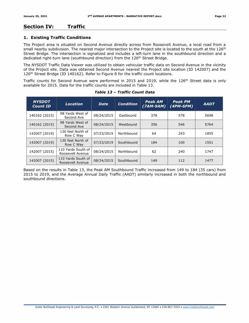
1. Existing Traffic Conditions
The Project area is situated on Second Avenue directly across from Roosevelt Avenue, a local road from a small nearby subdivision. The nearest major intersection to the Project site is located to the south at the 126th
Street Bridge. The intersection is signalized and includes a left-turn lane in the southbound direction and a dedicated right-turn lane (southbound direction) from the 126th Street Bridge.
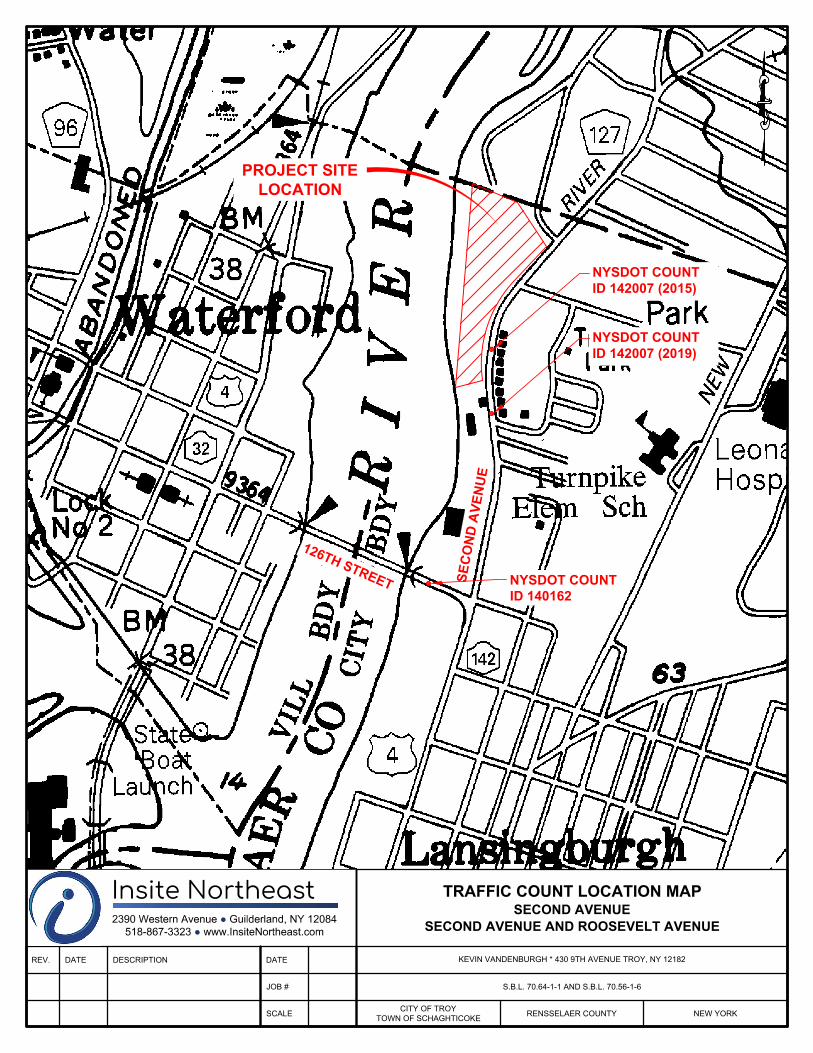
The NYSDOT Traffic Data Viewer was utilized to obtain vehicular traffic data on Second Avenue in the vicinity of the Project site. Data was obtained Second Avenue nearest the Project site location (ID 142007) and the 126th Street Bridge (ID 140162). Refer to Figure 8 for the traffic count locations.
Traffic counts for Second Avenue were performed in 2015 and 2019, while the 126th Street data is only
available for 2015. Data for the traffic counts are included in Table 13.
Table 13 – Traffic Count Data
NYSDOT
Count ID Location Date Condition
Peak AM
(7AM-9AM)
Peak PM
(4PM-6PM) AADT
140162 (2015) 98 Yards West of
Second Ave 08/24/2015 Eastbound 378 578 5698
140162 (2015) 98 Yards West of
Second Ave 08/24/2015 Westbound 356 546 5764
142007 (2019) 130 feet North of
Row C Way 07/23/2019 Northbound 64 243 1855
142007 (2019) 130 feet North of
Row C Way 07/23/2019 Southbound 184 100 1551
142007 (2015) 110 Yards South of Roosevelt Avenue
08/24/2015 Northbound 62 240 1747
142007 (2015) 110 Yards South of Roosevelt Avenue
08/24/2015 Southbound 149 112 1477
Based on the results in Table 13, the Peak AM Southbound Traffic increased from 149 to 184 (35 cars) from
2015 to 2019, and the Average Annual Daily Traffic (AADT) similarly increased in both the northbound and southbound directions.
S
E
C
O
N
D
A
V
E
N
U
E
1
2
6
T
H
S
T
R
E
E
T
NYSDOT COUNT
ID 142007 (2019)
NYSDOT COUNT
ID 142007 (2015)
NYSDOT COUNT
ID 140162
REV. DATE DESCRIPTION DATE
JOB #
SCALE
Insite Northeast2390 Western Avenue ● Guilderland, NY 12084
518-867-3323 ● www.InsiteNortheast.com
PROJECT SITE
LOCATION
TRAFFIC COUNT LOCATION MAP
SECOND AVENUE
SECOND AVENUE AND ROOSEVELT AVENUE
KEVIN VANDENBURGH * 430 9TH AVENUE TROY, NY 12182
S.B.L. 70.64-1-1 AND S.B.L. 70.56-1-6
CITY OF TROY
TOWN OF SCHAGHTICOKE
RENSSELAER COUNTY NEW YORK
January 25, 2021 2ND AVENUE APARTMENTS - NARRATIVE REPORT.docx Page 24
Insite Northeast Engineering & Land Surveying, P.C. ● 2301 Western Avenue Guilderland, NY 12084 ● 518-867-3323 ● www.insitenortheast.com
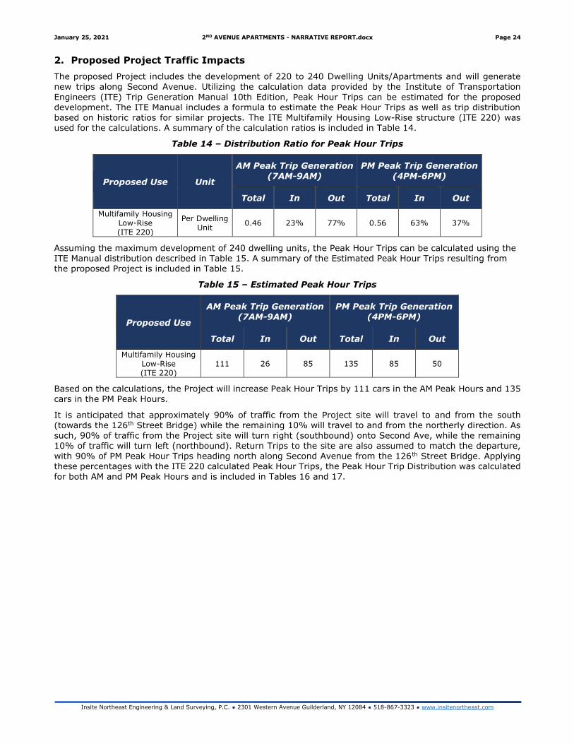
2. Proposed Project Traffic Impacts
The proposed Project includes the development of 220 to 240 Dwelling Units/Apartments and will generate new trips along Second Avenue. Utilizing the calculation data provided by the Institute of Transportation
Engineers (ITE) Trip Generation Manual 10th Edition, Peak Hour Trips can be estimated for the proposed development. The ITE Manual includes a formula to estimate the Peak Hour Trips as well as trip distribution based on historic ratios for similar projects. The ITE Multifamily Housing Low-Rise structure (ITE 220) was used for the calculations. A summary of the calculation ratios is included in Table 14.
Table 14 – Distribution Ratio for Peak Hour Trips
Proposed Use Unit
AM Peak Trip Generation
(7AM-9AM)
PM Peak Trip Generation
(4PM-6PM)
Total In Out Total In Out
Multifamily Housing Low-Rise (ITE 220)
Per Dwelling Unit
0.46 23% 77% 0.56 63% 37%
Assuming the maximum development of 240 dwelling units, the Peak Hour Trips can be calculated using the ITE Manual distribution described in Table 15. A summary of the Estimated Peak Hour Trips resulting from the proposed Project is included in Table 15.
Table 15 – Estimated Peak Hour Trips
Proposed Use
AM Peak Trip Generation (7AM-9AM)
PM Peak Trip Generation (4PM-6PM)
Total In Out Total In Out
Multifamily Housing Low-Rise (ITE 220)
111 26 85 135 85 50
Based on the calculations, the Project will increase Peak Hour Trips by 111 cars in the AM Peak Hours and 135
cars in the PM Peak Hours.
It is anticipated that approximately 90% of traffic from the Project site will travel to and from the south (towards the 126th Street Bridge) while the remaining 10% will travel to and from the northerly direction. As such, 90% of traffic from the Project site will turn right (southbound) onto Second Ave, while the remaining 10% of traffic will turn left (northbound). Return Trips to the site are also assumed to match the departure, with 90% of PM Peak Hour Trips heading north along Second Avenue from the 126th Street Bridge. Applying these percentages with the ITE 220 calculated Peak Hour Trips, the Peak Hour Trip Distribution was calculated for both AM and PM Peak Hours and is included in Tables 16 and 17.
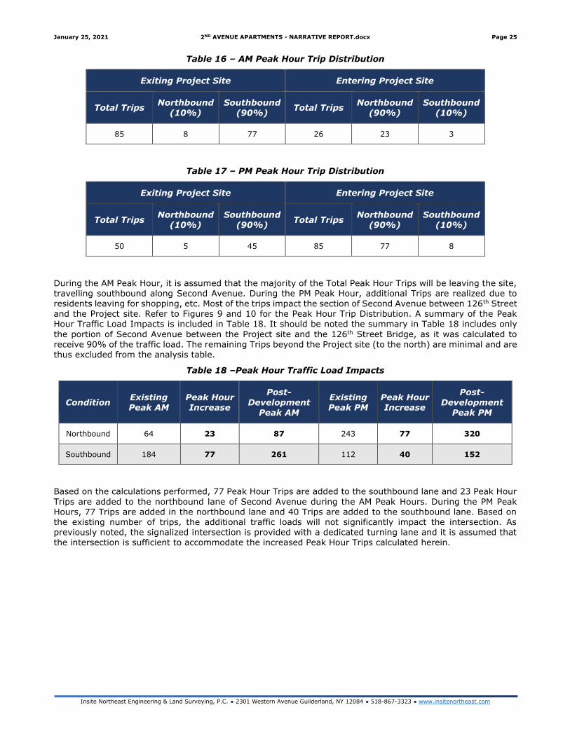
January 25, 2021 2ND AVENUE APARTMENTS - NARRATIVE REPORT.docx Page 25
Insite Northeast Engineering & Land Surveying, P.C. ● 2301 Western Avenue Guilderland, NY 12084 ● 518-867-3323 ● www.insitenortheast.com
Table 16 – AM Peak Hour Trip Distribution
Exiting Project Site Entering Project Site
Total Trips Northbound
(10%) Southbound
(90%) Total Trips
Northbound (90%)
Southbound (10%)
85 8 77 26 23 3
Table 17 – PM Peak Hour Trip Distribution
Exiting Project Site Entering Project Site
Total Trips Northbound
(10%) Southbound
(90%) Total Trips
Northbound (90%)
Southbound (10%)
50 5 45 85 77 8
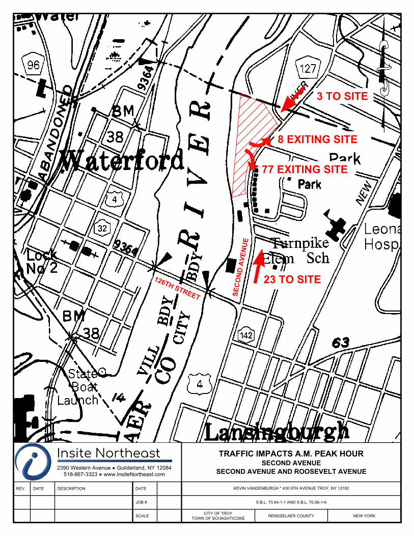
During the AM Peak Hour, it is assumed that the majority of the Total Peak Hour Trips will be leaving the site, travelling southbound along Second Avenue. During the PM Peak Hour, additional Trips are realized due to residents leaving for shopping, etc. Most of the trips impact the section of Second Avenue between 126th Street and the Project site. Refer to Figures 9 and 10 for the Peak Hour Trip Distribution. A summary of the Peak Hour Traffic Load Impacts is included in Table 18. It should be noted the summary in Table 18 includes only
the portion of Second Avenue between the Project site and the 126th Street Bridge, as it was calculated to receive 90% of the traffic load. The remaining Trips beyond the Project site (to the north) are minimal and are thus excluded from the analysis table.
Table 18 –Peak Hour Traffic Load Impacts
Condition Existing Peak AM
Peak Hour Increase
Post-
Development Peak AM
Existing Peak PM
Peak Hour Increase
Post-
Development Peak PM
Northbound 64 23 87 243 77 320
Southbound 184 77 261 112 40 152
Based on the calculations performed, 77 Peak Hour Trips are added to the southbound lane and 23 Peak Hour
Trips are added to the northbound lane of Second Avenue during the AM Peak Hours. During the PM Peak Hours, 77 Trips are added in the northbound lane and 40 Trips are added to the southbound lane. Based on the existing number of trips, the additional traffic loads will not significantly impact the intersection. As previously noted, the signalized intersection is provided with a dedicated turning lane and it is assumed that the intersection is sufficient to accommodate the increased Peak Hour Trips calculated herein.
S
E
C
O
N
D
A
V
E
N
U
E
1
2
6
T
H
S
T
R
E
E
T
REV. DATE DESCRIPTION DATE
JOB #
SCALE
Insite Northeast2390 Western Avenue ● Guilderland, NY 12084
518-867-3323 ● www.InsiteNortheast.com
TRAFFIC IMPACTS A.M. PEAK HOUR
SECOND AVENUE
SECOND AVENUE AND ROOSEVELT AVENUE
KEVIN VANDENBURGH * 430 9TH AVENUE TROY, NY 12182
S.B.L. 70.64-1-1 AND S.B.L. 70.56-1-6
CITY OF TROY
TOWN OF SCHAGHTICOKE
RENSSELAER COUNTY NEW YORK
3 TO SITE
23 TO SITE
77 EXITING SITE
8 EXITING SITE

S
E
C
O
N
D
A
V
E
N
U
E
1
2
6
T
H
S
T
R
E
E
T
REV. DATE DESCRIPTION DATE
JOB #
SCALE
Insite Northeast2390 Western Avenue ● Guilderland, NY 12084
518-867-3323 ● www.InsiteNortheast.com
TRAFFIC IMPACTS P.M. PEAK HOUR
SECOND AVENUE
SECOND AVENUE AND ROOSEVELT AVENUE
KEVIN VANDENBURGH * 430 9TH AVENUE TROY, NY 12182
S.B.L. 70.64-1-1 AND S.B.L. 70.56-1-6
CITY OF TROY
TOWN OF SCHAGHTICOKE
RENSSELAER COUNTY NEW YORK
8 TO SITE
77 TO SITE
45 EXITING SITE
5 EXITING SITE
January 25, 2021 2ND AVENUE APARTMENTS - NARRATIVE REPORT.docx Page 28
Insite Northeast Engineering & Land Surveying, P.C. ● 2301 Western Avenue Guilderland, NY 12084 ● 518-867-3323 ● www.insitenortheast.com
Section V: Utilities
1. Sewer
The Project site is located within the County Sewer District, and a Combined Sewer Overflow (CSO) gravity sewer line is located along Second Avenue. The existing County trunk sewer located along Second Avenue is
comprised of an 18-inch RCP sewer and a 24-inch VCP overflow pipe. A Sewer Engineering Report dated October 19, 2019 was completed by MJ for Rensselaer County Sewer. Based on the report, there is capacity within the system to accommodate new flows; however, any new connections or sewer flows to the CSO should be offset by removing CSO connections elsewhere in the system. Refer to Appendix G for the report.
The projected hydraulic sewer loading was estimated utilizing the NYSDEC Design Standards for Wastewater Treatment Works, 2014, corresponding with a flow of 110 gallons per day (gpd) and associated with residential
units. Assuming an equal distribution of 1 and 2-bedroom apartments for the maximum design case of 240 Dwelling Units/Apartments, a total of 360 bedrooms is calculated. Refer to Table 19.
Table 19 – Hydraulic Sewer Loading
Flow
Component # of Units
Flow Rate per Unit –
gallons per day Total Component Flow
Option 1 Apartments
360 bedrooms (120 1BR units and
120 2BR units) 110 per bedroom per day 39,600 gal/day
As the Project has not yet begin detailed engineering design, further analysis of the sewer system and required mitigation has not yet been performed. It is assumed that this will be performed during the site plan development process and will be reviewed by the City and the City’s designated review engineer. Through the Project development, the applicant will be required to improve the function of the CSO system and therefore
reduce effluent discharge to the Hudson River and relieve burden on the County Sewer system.
2. Domestic Water
The Project site is located within the City Water District, and public water is available along Second Avenue. A 24-inch ductile iron transmission waterline and associated utility easement dedicated to the City is located on
the middle of the Project site. The Project site includes a small fenced-in area which houses and electric meter and associated waterline appurtenances. It is assumed that a water service connection will be provided along
Second Avenue to accommodate the Project site. Cross-connection control will be provided within each building.
The domestic water demands can be assumed to be similar to the sewer loading previously calculated. As such, it is assumed that the Project shall require approximately 39,600 gal/day to accommodate the domestic water requirements. Additional capacity will be required during the Spring, Summer and early Fall for irrigation. It is assumed that an additional 20% of the domestic water requirements will be needed to accommodate the
irrigation requirements of the Project site. As such, the total water demand for the Project site is assumed to be 47,520 gallons/day during the summer months.
Hydrant flow tests have not yet been performed, but due to the proximity to the transmission main, it is assumed that there is sufficient pressure and flow to accommodate the Project.
3. Fire Flow
The Project will include fully sprinklered buildings, fire hydrants and fire department connections as part of the
development. The required fire-flow for the buildings will be calculated during the site plan development approval process, however it is estimated to be between 1,500 to 2,500 gallons per minute. Due to the proximity to the City transmission main, it is assumed that there is sufficient capacity to accommodate the fire flow without providing on-site water storage.
4. Electric, Gas and Telecommunications
As the Project site is situated on a major public roadway, there is direct access to electric, gas and
telecommunications services along the Project site. Interconnections to the individual utilities will be handled by the utility purveyors. It is assumed there is sufficient capacity within each system to accommodate the proposed Project.
January 25, 2021 2ND AVENUE APARTMENTS - NARRATIVE REPORT.docx Page 29
Insite Northeast Engineering & Land Surveying, P.C. ● 2301 Western Avenue Guilderland, NY 12084 ● 518-867-3323 ● www.insitenortheast.com
Section VI: Stormwater and Erosion & Sediment Control
1. NYSDEC Stormwater Regulations
Pursuant to the NYSDEC General Permit Requirements for Stormwater Discharges, the Project proposes greater than 1-acre disturbance, and is therefore subject to NYSDEC stormwater regulations. The Project shall
be required to obtain the NYSDEC permit known as the General Permit 0-20-001.
The proposed Project is anticipated to require approximately 6-7 acres of disturbance and increase impervious coverage to approximately 4 acres. To mitigate the stormwater runoff impacts as a result of the Project, the site shall be designed to capture and treat the stormwater generated on-site.
Based on the topography and site conditions, it is assumed that the Project area located within the Town of Schaghticoke shall be used for stormwater management. The area lies adjacent to the Hudson River, where
the post construction treatment system shall discharge directly. Pursuant to the New York State Department of Conservation Stormwater Management Design Manual (NYSDEC SWDM) several exemptions are provided for post construction stormwater management practices discharging directly into fifth order or larger streams, such as the Hudson River.
NYSDEC SWDM Section 4.5 which requires overbank flood control (Qp) to attenuate the post development 10-year, 24-hour peak discharge rate to predevelopment rates,
Section 4.5 – Overbank Flood Control Criteria (Qp)
The overbank flood control requirement (Qp) does not apply in certain conditions, including:
• The site discharges directly tidal waters or fifth order (fifth downstream) or larger streams. Refer to Section 4.3 for instructions.
• A downstream analysis reveals that overbank control is not needed (see section 4.10).
Similarly NYSDEC SWDM Section 4.6 requires extreme flood control (Qf) storage to attenuate the post development 100-year, 24-hour peak discharge rate (Qf) to predevelopment rates.
Section 4.6 – Extreme Flood Control Criteria (Qf)
The 100-year storm control requirement can be waived if:
• The site discharges directly tidal waters or fifth order (fifth downstream) or larger streams.
Refer to Section 4.3 for instructions. • Development is prohibited within the ultimate 100-year floodplain • A downstream analysis reveals that 100-year control is not needed (see section 4.10)
Stormwater management shall be designed to comply with the NYSDEC Storwmater Management regulations.
The City has developed a Municipal Separate Storm Sewer System (MS4) program to comply with NYSDEC regulations, and therefore is considered an MS4 community.
2. Post Construction Stormwater Management
The Project proposes stormwater management in the form of detaining the stormwater runoff for a period of time to provide water quality volume (WQv) treatment. Green Infrastructure practices shall also be required to accommodate the Runoff Reduction Volume (RRv) for the site. Further development of the stormwater
management facilities shall take place during the site plan development process.
It is anticipated that the stormwater runoff generated by this Project shall be collected by a series of drainage structures and be directed by a closed drainage system to the most northwestern area of the Project. This
area shall contain the primary WQv practice. Runoff shall be discharged to the Hudson River psot treatment.
The Project owner shall be responsible for the long-term operation and maintenance of the stormwater management facility. This entails a legal agreement with the City to ensure the system is inspected and maintained on a regular schedule to ensure the stormwater treatment system is operating properly.
3. Erosion & Sediment Control
The Project site is subject to NYSDEC requirements for erosion and sediment control measures, to be implemented in accordance with the New York State Standards and Specifications for Erosion and Sediment Control, otherwise known as the “Blue Book”. The City as an MS4 community shall oversee the implementation and maintenance of the erosion and sediment control (E&SC) measures. The E&SC measures are required to

January 25, 2021 2ND AVENUE APARTMENTS - NARRATIVE REPORT.docx Page 30
Insite Northeast Engineering & Land Surveying, P.C. ● 2301 Western Avenue Guilderland, NY 12084 ● 518-867-3323 ● www.insitenortheast.com
be maintained throughout the duration of construction and are subject to weekly inspections by a qualified professional.
January 25, 2021 2ND AVENUE APARTMENTS - NARRATIVE REPORT.docx Page 31
Insite Northeast Engineering & Land Surveying, P.C. ● 2301 Western Avenue Guilderland, NY 12084 ● 518-867-3323 ● www.insitenortheast.com
Section VII: School Enrollment and Impacts
1. School Enrollment Data
The New York State Education Department (NYSED) was consulted to obtain enrollment data for Elementary and Secondary schools. The Project site is located within the Lansingburgh Central School District, which has
Turnpike Elementary School, Rensselaer Park Elementary School, Knickerback Middle School, and Lansingburgh High School. As of the date of this report, the 2019-2020 school year data was not yet available. Five years of data were obtained for each age group, segregated by Elementary, Middle School and High School. The age distribution per grade is shown in Table 20.
Table 20 – School Grade Distribution
Educational Stage
Grades
Elementary 1st - 5th
Middle School 6th - 8th
High School 9th – 12th
2. Existing School Data
Enrollment data from NYSED is summarized in Table 21.
Table 21 – School Enrollment Data
Record Year Elementary
School Middle School High School Total
2014-2015 849 515 721 2085
2015-2016 840 484 735 2059
2016-2017 846 511 705 2062
2017-2018 883 500 694 2077
2018-2019 873 485 670 2029
Elementary and Middle School enrollment shows a generally steady enrollment of students over the last 5-6 years. There appears to be a small decline in High School students over the past two years.
3. Proposed Impacts
The Project proposes the addition of a maximum of 240 dwelling units, of which 50% shall be one-bedroom units. Utilizing a value of 12.5 school aged children for every 100 apartments and the conservative value of
240 dwelling units, a total of 30 students can be anticipated to be enrolled in the Lansingburgh Central School District. The Project anticipates a maximum of 30 students to be enrolled from the Second Avenue Apartments. It should be noted that the one-bedroom apartments are unlikely to house students and the resulting student load from the Project is likely to be further reduced.
The student distribution among the schools is assumed to average from Elementary to High School in a consistent manner. Elementary School aged children (1st through 5th grade) constitute 42% of students, Middle School aged children (6th through 8th grade) constitute 25% of students, and High School aged children (9th
through 12th grade) constitute 33% of students.
It should be noted that the projected students that reside at the Second Avenue Apartments may not be new students but moving from one area within the school district to another. While this information cannot yet be estimated, it would result in reduced impacts to the district. Based on the data of the past 5 years, the fluctuations in enrollment numbers appear to allow for the potential addition of 30 students without impacting classrooms.
January 25, 2021 2ND AVENUE APARTMENTS - NARRATIVE REPORT.docx Page 32
Insite Northeast Engineering & Land Surveying, P.C. ● 2301 Western Avenue Guilderland, NY 12084 ● 518-867-3323 ● www.insitenortheast.com
Section VIII: Project Development Analysis
1. Project Benefit, Improvements and Amenities
The Project proposes to construct a residential apartment complex in the City with direct access to the Hudson River. The Project satisfies the community needs outlined in the Realize Troy 2018 Comprehensive Plan and
The Project creates housing diversity options by incorporating higher density development in an area that is generally developed, and provides public access to the waterfront. It is the intent of the Project to appeal to a variety of potential new residents, while also providing options for those looking to downsize while remaining in Troy. As part of the Project develop, several improvements will be made to the site that will improve access to the
Hudson River and improve pedestrian safety along Second Avenue. These items include:
Multi-Use Trail • Direct Path from Second Avenue to Hudson River • 10-feet wide; accommodates pedestrians, bicyclists, etc.
• Benches & Waste Receptacles • Permanent Easement granted to City
Kayak Launch
• Publicly accessible from Multi-Use Trail or adjacent proposed parking area • Maintained by Owner/Operator of Apartments • Permanent Easement granted to City
Informational Kiosk
• Located Along Multi-Use Trail • Improves safety and accessibility of Hudson River area
Sidewalks
• New sidewalk along Second Avenue • Sidewalk will extend approximately 3,000 feet
• Will connect to 125th Street and extend beyond property to City Limits
Dock & Boat Slips
• Utilized for fishing (Accessible to Public) • 40 Slips on Hudson River (Reserved for Residents)
As noted, a permanent easement will be granted to the City to maintain public access. In addition to the above
improvements, a Clubhouse will be provided interior of one of the apartment buildings for exclusive use of the site residents. It is anticipated the clubhouse may include a common area, recreation room, fitness center etc.
In addition to the above amenities, the Project will improve the County Sewer System by reducing CSO connections. This reduces peak loading to the sewer system and improves the health of the Hudson River.
2. Visual Impacts
The Project will be partially screened by existing and proposed vegetation, as well as the natural topography of the site. Several sections through the Project site were developed (by MJ) utilizing the topographic survey
data and the conceptual plans. Refer to Figures 11 through 13. To maximize the screening, the Project proposes below-ground parking, which lowers the overall height of the buildings.
THE ALTERATION OF THIS MATERIAL IN
ANY WAY, UNLESS DONE UNDER THE
DIRECTION OF A COMPARABLE
PROFESSIONAL, (I.E.) ARCHITECT FOR
AN ARCHITECT, ENGINEER FOR AN
ENGINEER OR LANDSCAPE ARCHITECT
FOR A LANDSCAPE ARCHITECT, IS A
VIOLATION OF THE NEW YORK STATE
EDUCATION LAW AND/OR REGULATIONS
AND IS A CLASS "A" MISDEMEANOR.
SEAL
DATENo. DESCRIPTION
SUBMITTAL / REVISIONS
PROJ. MANAGER:REVIEWED BY:
CHIEF DESIGNER:
BY DATE
DESIGNED BY:
DRAWN BY:
CHECKED BY:
DATE:
MJ PROJ. No.:
CONTRACT No.:
SCALE:
1533 Crescent Road - Clifton Park, NY 12065
Engineering and
Land Surveying, P.C.
-
972.44
AUGUST 2020
JWE
JWE
JWE
JWE
-
KEVIN VANDENBURGH
NEW YORKCITY OF TROY AND TOWN OF SCHAGHTICOKE
TROY SECOND AVE
C-1
D
R
A
F
T
CONCEPT PLAN #1
1" = 50'
ZONING MAP
SITE INFORMATION
0 25' 50' 100'
SITE
EXISTING ZONING (R-1) PROPOSED ZONING (PDD)
MINIMUM LOT AREA: 7,200 SF 10± AC (WITHIN CITY OF TROY)
MAXIMUM DENSITY 5.5 UNITS/AC 25 UNITS/AC
MAXIMUM LOT COVERAGE 40% 20%
MAX BUILDING HEIGHT 25 FT 60 FT
SETBACK REQUIREMENTS
FRONT BLDG. SETBACK: 25' MIN 30' (STREET SIDE)
SIDE BLDG. SETBACK: 10' MIN EACH SIDE 30'
REAR BLDG. SETBACK: 30' MIN 50' (WATER SIDE)
PARKING
PROPOSED: 1-2 SPACES/UNIT 1.5 SPACES / UNIT
GARAGE PARKING: 178 SPACES
SURFACE PARKING: 175 SPACES
(INCLUDING 12 ADA SPACES)
LAND USE: MULTI-FAMILY RESIDENTIAL
A
A B
B
C
C
D
D
CONCEPT PLAN DEVELOPED BY MJ ENGINEERING AND LANDSURVEYING, P.C. INCLUDED WITHIN THIS REPORT WITH THEAPPLICANT'S AUTHORIZATION AS A REFERENCE ONLY.
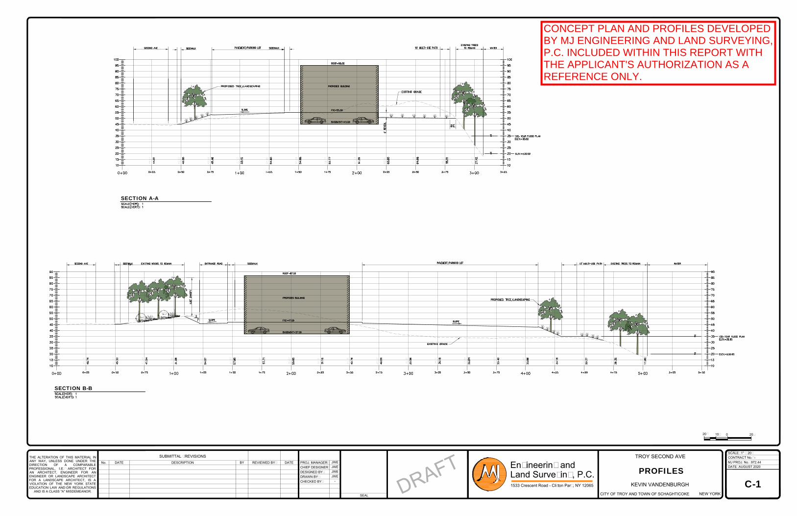
44.61
45.58
49.46
52.15
54.60
54.88
53.77
61.29
60.80
64.65
56.51
27.42
45.79
45.33
47.54
51.08
54.57
57.90
57.71
55.60
51.16
45.76
40.59
35.96
34.19
33.84
33.40
33.88
34.18
33.27
29.25
17.90
THE ALTERATION OF THIS MATERIAL IN
ANY WAY, UNLESS DONE UNDER THE
DIRECTION OF A COMPARABLE
PROFESSIONAL, (I.E.) ARCHITECT FOR
AN ARCHITECT, ENGINEER FOR AN
ENGINEER OR LANDSCAPE ARCHITECT
FOR A LANDSCAPE ARCHITECT, IS A
VIOLATION OF THE NEW YORK STATE
EDUCATION LAW AND/OR REGULATIONS
AND IS A CLASS "A" MISDEMEANOR.
SEAL
DATENo. DESCRIPTION
SUBMITTAL / REVISIONS
PROJ. MANAGER:REVIEWED BY:
CHIEF DESIGNER:
BY DATE
DESIGNED BY:
DRAWN BY:
CHECKED BY:
DATE:
MJ PROJ. No.:
CONTRACT No.:
SCALE:
1533 Crescent Road - Clifton Park, NY 12065
Engineering and
Land Surveying, P.C.
-
972.44
AUGUST 2020
JWE
JWE
JWE
JWE
-
KEVIN VANDENBURGH
NEW YORKCITY OF TROY AND TOWN OF SCHAGHTICOKE
TROY SECOND AVE
C-1
D
R
A
F
T
PROFILES
1" = 20'
10'
20'
0 20'
SECTION A-A
SECTION B-B
CONCEPT PLAN AND PROFILES DEVELOPEDBY MJ ENGINEERING AND LAND SURVEYING,P.C. INCLUDED WITHIN THIS REPORT WITHTHE APPLICANT'S AUTHORIZATION AS AREFERENCE ONLY.
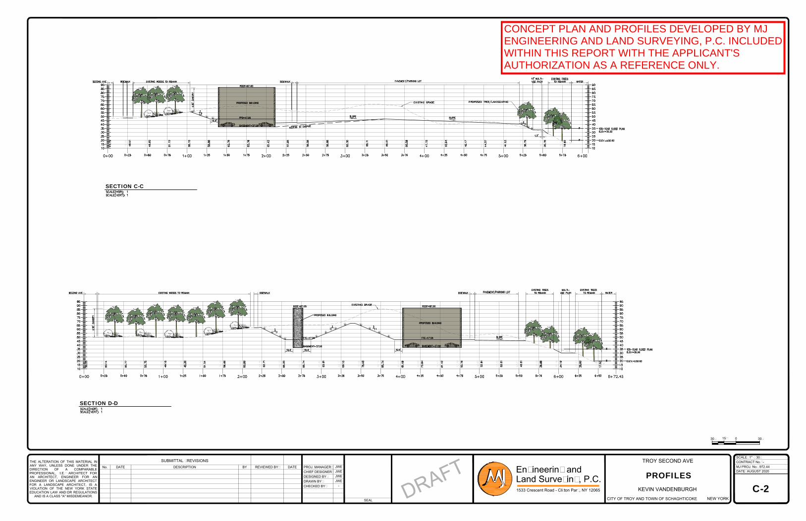
47.72
55.73
61.42
60.30
47.73
41.53
48.61
48.92
51.73
59.88
62.78
63.76
57.95
56.06
56.88
65.11
65.01
60.59
40.64
42.17
44.57
36.79
30.76
18.92
50.25
50.14
50.77
50.75
49.16
49.36
51.24
56.99
60.89
62.71
65.20
65.74
65.81
69.10
79.48
85.74
81.49
72.84
61.42
52.76
52.81
53.61
48.61
39.99
34.19
28.60
17.63
THE ALTERATION OF THIS MATERIAL IN
ANY WAY, UNLESS DONE UNDER THE
DIRECTION OF A COMPARABLE
PROFESSIONAL, (I.E.) ARCHITECT FOR
AN ARCHITECT, ENGINEER FOR AN
ENGINEER OR LANDSCAPE ARCHITECT
FOR A LANDSCAPE ARCHITECT, IS A
VIOLATION OF THE NEW YORK STATE
EDUCATION LAW AND/OR REGULATIONS
AND IS A CLASS "A" MISDEMEANOR.
SEAL
DATENo. DESCRIPTION
SUBMITTAL / REVISIONS
PROJ. MANAGER:REVIEWED BY:
CHIEF DESIGNER:
BY DATE
DESIGNED BY:
DRAWN BY:
CHECKED BY:
DATE:
MJ PROJ. No.:
CONTRACT No.:
SCALE:
1533 Crescent Road - Clifton Park, NY 12065
Engineering and
Land Surveying, P.C.
-
972.44
AUGUST 2020
JWE
JWE
JWE
JWE
-
KEVIN VANDENBURGH
NEW YORKCITY OF TROY AND TOWN OF SCHAGHTICOKE
TROY SECOND AVE
C-2
D
R
A
F
T
PROFILES
1" = 30'
030'
15'
30'
SECTION C-C
SECTION D-D
CONCEPT PLAN AND PROFILES DEVELOPED BY MJENGINEERING AND LAND SURVEYING, P.C. INCLUDEDWITHIN THIS REPORT WITH THE APPLICANT'SAUTHORIZATION AS A REFERENCE ONLY.
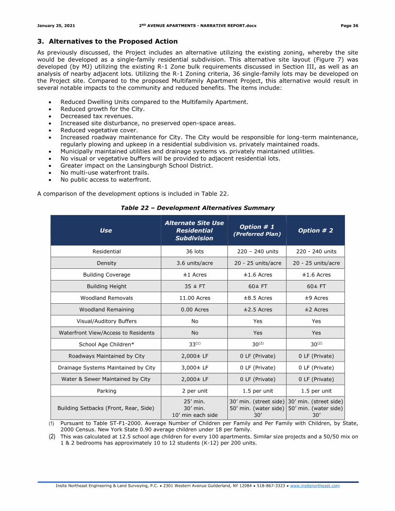
January 25, 2021 2ND AVENUE APARTMENTS - NARRATIVE REPORT.docx Page 36
Insite Northeast Engineering & Land Surveying, P.C. ● 2301 Western Avenue Guilderland, NY 12084 ● 518-867-3323 ● www.insitenortheast.com
3. Alternatives to the Proposed Action
As previously discussed, the Project includes an alternative utilizing the existing zoning, whereby the site would be developed as a single-family residential subdivision. This alternative site layout (Figure 7) was
developed (by MJ) utilizing the existing R-1 Zone bulk requirements discussed in Section III, as well as an analysis of nearby adjacent lots. Utilizing the R-1 Zoning criteria, 36 single-family lots may be developed on the Project site. Compared to the proposed Multifamily Apartment Project, this alternative would result in several notable impacts to the community and reduced benefits. The items include:
• Reduced Dwelling Units compared to the Multifamily Apartment. • Reduced growth for the City.
• Decreased tax revenues. • Increased site disturbance, no preserved open-space areas. • Reduced vegetative cover. • Increased roadway maintenance for City. The City would be responsible for long-term maintenance,
regularly plowing and upkeep in a residential subdivision vs. privately maintained roads. • Municipally maintained utilities and drainage systems vs. privately maintained utilities.
• No visual or vegetative buffers will be provided to adjacent residential lots.
• Greater impact on the Lansingburgh School District. • No multi-use waterfront trails. • No public access to waterfront.
A comparison of the development options is included in Table 22.
Table 22 – Development Alternatives Summary
Use
Alternate Site Use
Residential
Subdivision
Option # 1 (Preferred Plan)
Option # 2
Residential 36 lots 220 – 240 units 220 - 240 units
Density 3.6 units/acre 20 - 25 units/acre 20 - 25 units/acre
Building Coverage ±1 Acres ±1.6 Acres ±1.6 Acres
Building Height 35 ± FT 60± FT 60± FT
Woodland Removals 11.00 Acres ±8.5 Acres ±9 Acres
Woodland Remaining 0.00 Acres ±2.5 Acres ±2 Acres
Visual/Auditory Buffers No Yes Yes
Waterfront View/Access to Residents No Yes Yes
School Age Children* 33(1) 30(2) 30(2)
Roadways Maintained by City 2,000± LF 0 LF (Private) 0 LF (Private)
Drainage Systems Maintained by City 3,000± LF 0 LF (Private) 0 LF (Private)
Water & Sewer Maintained by City 2,000± LF 0 LF (Private) 0 LF (Private)
Parking 2 per unit 1.5 per unit 1.5 per unit
Building Setbacks (Front, Rear, Side)
25’ min.
30’ min.
10’ min each side
30’ min. (street side)
50’ min. (water side)
30’
30’ min. (street side)
50’ min. (water side)
30’
(1) Pursuant to Table ST-F1-2000. Average Number of Children per Family and Per Family with Children, by State, 2000 Census. New York State 0.90 average children under 18 per family.
(2) This was calculated at 12.5 school age children for every 100 apartments. Similar size projects and a 50/50 mix on 1 & 2 bedrooms has approximately 10 to 12 students (K-12) per 200 units.
January 25, 2021 2ND AVENUE APARTMENTS - NARRATIVE REPORT.docx Page 37
Insite Northeast Engineering & Land Surveying, P.C. ● 2301 Western Avenue Guilderland, NY 12084 ● 518-867-3323 ● www.insitenortheast.com
4. Summary and Conclusions
The proposed Project includes the development of Multifamily Apartment buildings with approximately 220 to
240 dwelling units. As part of the Project, there are several notable improvements being made to the Project
site, including a multi-use trail and public access to the Hudson River. A sidewalk will terminate beyond the
site, connecting to the nearby grocery stores and improving access for existing residences along Second
Avenue.
The Project results in minimal traffic loading impacts and will improve the public sewer system by disconnecting
a portion of the CSO loads. As the Project includes private utilities and roadways, there is no additional
maintenance required of the City. A large increase in tax revenue can be realized without the associated
increase in infrastructure spending. While there will be some new students generated from the development,
a reduction in total students is realized vs. the alternative single-family residential subdivision. When
comparing the Project to the alternative single-family residential subdivision, it is clearly shown that the Project
reduces the potential burden on the City.
The noted improvements and positive benefits provide significant value to the community and outweigh the
minor Project impacts.
Second Avenue Apartments APPENDIX A
Insite Northeast Engineering & Land Surveying, P.C. ● 2301 Western Avenue Guilderland, NY 12084 ● 518-867-3323 ● www.insitenortheast.com
APPENDIX A – EXISTING SOILS
Existing Soils Map and Report
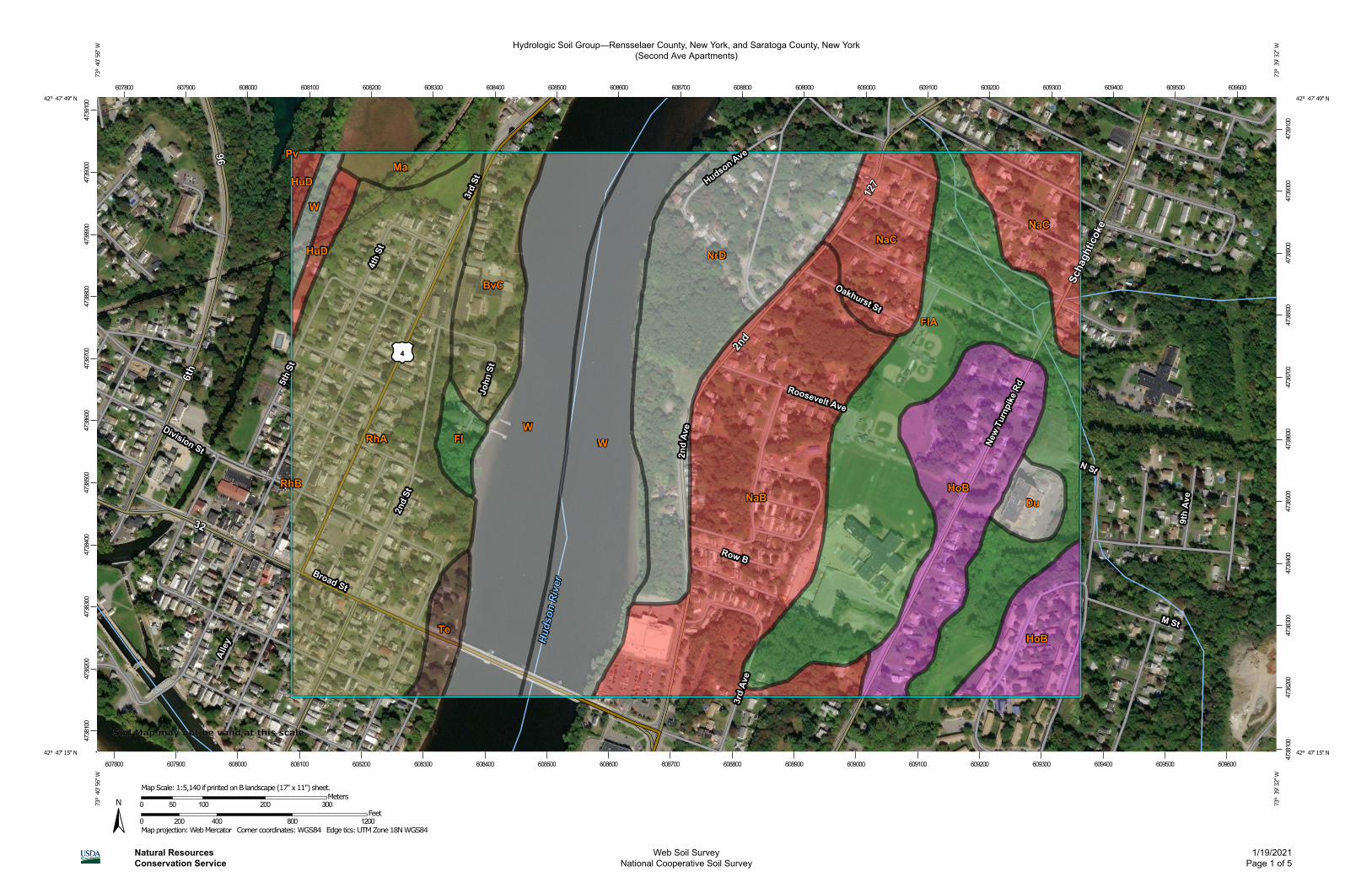
Hydrologic Soil Group—Rensselaer County, New York, and Saratoga County, New York(Second Ave Apartments)
Natural ResourcesConservation Service
Web Soil SurveyNational Cooperative Soil Survey
1/19/2021Page 1 of 5
4738
100
4738
200
4738
300
4738
400
4738
500
4738
600
4738
700
4738
800
4738
900
4739
000
4739
100
4738
100
4738
200
4738
300
4738
400
4738
500
4738
600
4738
700
4738
800
4738
900
4739
000
4739
100
607800 607900 608000 608100 608200 608300 608400 608500 608600 608700 608800 608900 609000 609100 609200 609300 609400 609500 609600
607800 607900 608000 608100 608200 608300 608400 608500 608600 608700 608800 608900 609000 609100 609200 609300 609400 609500 609600
42° 47' 49'' N73
° 4
0' 5
6'' W
42° 47' 49'' N
73° 3
9' 3
2'' W
42° 47' 15'' N
73° 4
0' 5
6'' W
42° 47' 15'' N
73° 3
9' 3
2'' W
N
Map projection: Web Mercator Corner coordinates: WGS84 Edge tics: UTM Zone 18N WGS840 200 400 800 1200
Feet0 50 100 200 300
MetersMap Scale: 1:5,140 if printed on B landscape (17" x 11") sheet.
Soil Map may not be valid at this scale.
MAP LEGEND MAP INFORMATION
Area of Interest (AOI)Area of Interest (AOI)
SoilsSoil Rating Polygons
A
A/D
B
B/D
C
C/D
D
Not rated or not available
Soil Rating LinesA
A/D
B
B/D
C
C/D
D
Not rated or not available
Soil Rating PointsA
A/D
B
B/D
C
C/D
D
Not rated or not available
Water FeaturesStreams and Canals
TransportationRails
Interstate Highways
US Routes
Major Roads
Local Roads
BackgroundAerial Photography
The soil surveys that comprise your AOI were mapped at scales ranging from 1:15,800 to 1:24,000.
Warning: Soil Map may not be valid at this scale.
Enlargement of maps beyond the scale of mapping can cause misunderstanding of the detail of mapping and accuracy of soil line placement. The maps do not show the small areas of contrasting soils that could have been shown at a more detailed scale.
Please rely on the bar scale on each map sheet for map measurements.
Source of Map: Natural Resources Conservation ServiceWeb Soil Survey URL: Coordinate System: Web Mercator (EPSG:3857)
Maps from the Web Soil Survey are based on the Web Mercator projection, which preserves direction and shape but distorts distance and area. A projection that preserves area, such as the Albers equal-area conic projection, should be used if more accurate calculations of distance or area are required.
This product is generated from the USDA-NRCS certified data as of the version date(s) listed below.
Soil Survey Area: Rensselaer County, New YorkSurvey Area Data: Version 17, Jun 11, 2020
Soil Survey Area: Saratoga County, New YorkSurvey Area Data: Version 20, Jun 11, 2020
Your area of interest (AOI) includes more than one soil survey area. These survey areas may have been mapped at different scales, with a different land use in mind, at different times, or at different levels of detail. This may result in map unit symbols, soil properties, and interpretations that do not completely agree across soil survey area boundaries.
Soil map units are labeled (as space allows) for map scales 1:50,000 or larger.
Date(s) aerial images were photographed: Jul 1, 2014—Sep 22, 2017
Hydrologic Soil Group—Rensselaer County, New York, and Saratoga County, New York(Second Ave Apartments)
Natural ResourcesConservation Service
Web Soil SurveyNational Cooperative Soil Survey
1/19/2021Page 2 of 5
MAP LEGEND MAP INFORMATION
The orthophoto or other base map on which the soil lines were compiled and digitized probably differs from the background imagery displayed on these maps. As a result, some minor shifting of map unit boundaries may be evident.
Hydrologic Soil Group—Rensselaer County, New York, and Saratoga County, New York(Second Ave Apartments)
Natural ResourcesConservation Service
Web Soil SurveyNational Cooperative Soil Survey
1/19/2021Page 3 of 5
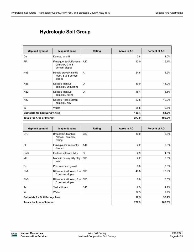
Hydrologic Soil Group
Map unit symbol Map unit name Rating Acres in AOI Percent of AOI
Du Dumps, landfill 2.8 1.0%
FlA Fluvaquents-Udifluvents complex, 0 to 3 percent slopes
A/D 42.0 15.1%
HoB Hoosic gravelly sandy loam, 3 to 8 percent slopes
A 24.6 8.9%
NaB Nassau-Manlius complex, undulating
D 39.0 14.0%
NaC Nassau-Manlius complex, rolling
D 18.4 6.6%
NrD Nassau-Rock outcrop complex, hilly
27.8 10.0%
W Water 25.8 9.3%
Subtotals for Soil Survey Area 180.4 64.9%
Totals for Area of Interest 277.9 100.0%
Map unit symbol Map unit name Rating Acres in AOI Percent of AOI
BvC Broadalbin-Manlius-Nassau, complex, rolling
C/D 10.0 3.6%
Fl Fluvaqvents frequently flooded
A/D 2.2 0.8%
HuD Hudson silt loam, hilly D 2.9 1.0%
Ma Madalin mucky silty clay loam
C/D 2.2 0.8%
Pv Pits, sand and gravel 0.0 0.0%
RhA Rhinebeck silt loam, 0 to 3 percent slopes
C/D 49.8 17.9%
RhB Rhinebeck silt loam, 3 to 8 percent slopes
C/D 0.0 0.0%
Te Teel silt loam B/D 2.9 1.1%
W Water 27.5 9.9%
Subtotals for Soil Survey Area 97.5 35.1%
Totals for Area of Interest 277.9 100.0%
Hydrologic Soil Group—Rensselaer County, New York, and Saratoga County, New York Second Ave Apartments
Natural ResourcesConservation Service
Web Soil SurveyNational Cooperative Soil Survey
1/19/2021Page 4 of 5
Description
Hydrologic soil groups are based on estimates of runoff potential. Soils are assigned to one of four groups according to the rate of water infiltration when the soils are not protected by vegetation, are thoroughly wet, and receive precipitation from long-duration storms.
The soils in the United States are assigned to four groups (A, B, C, and D) and three dual classes (A/D, B/D, and C/D). The groups are defined as follows:
Group A. Soils having a high infiltration rate (low runoff potential) when thoroughly wet. These consist mainly of deep, well drained to excessively drained sands or gravelly sands. These soils have a high rate of water transmission.
Group B. Soils having a moderate infiltration rate when thoroughly wet. These consist chiefly of moderately deep or deep, moderately well drained or well drained soils that have moderately fine texture to moderately coarse texture. These soils have a moderate rate of water transmission.
Group C. Soils having a slow infiltration rate when thoroughly wet. These consist chiefly of soils having a layer that impedes the downward movement of water or soils of moderately fine texture or fine texture. These soils have a slow rate of water transmission.
Group D. Soils having a very slow infiltration rate (high runoff potential) when thoroughly wet. These consist chiefly of clays that have a high shrink-swell potential, soils that have a high water table, soils that have a claypan or clay layer at or near the surface, and soils that are shallow over nearly impervious material. These soils have a very slow rate of water transmission.
If a soil is assigned to a dual hydrologic group (A/D, B/D, or C/D), the first letter is for drained areas and the second is for undrained areas. Only the soils that in their natural condition are in group D are assigned to dual classes.
Rating Options
Aggregation Method: Dominant Condition
Component Percent Cutoff: None Specified
Tie-break Rule: Higher
Hydrologic Soil Group—Rensselaer County, New York, and Saratoga County, New York Second Ave Apartments
Natural ResourcesConservation Service
Web Soil SurveyNational Cooperative Soil Survey
1/19/2021Page 5 of 5
Second Avenue Apartments APPENDIX B
Insite Northeast Engineering & Land Surveying, P.C. ● 2301 Western Avenue Guilderland, NY 12084 ● 518-867-3323 ● www.insitenortheast.com
APPENDIX B – FEMA MAPPING
FEMA Map Panel 3606770001B
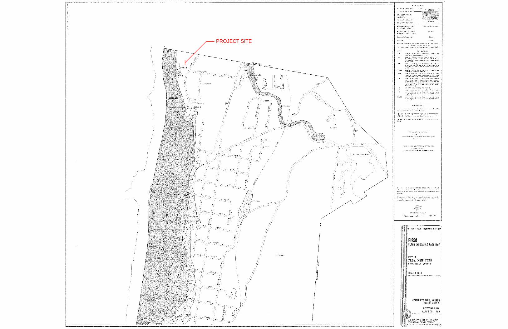
PROJECT SITE

Second Avenue Apartments APPENDIX C
Insite Northeast Engineering & Land Surveying, P.C. ● 2301 Western Avenue Guilderland, NY 12084 ● 518-867-3323 ● www.insitenortheast.com
APPENDIX C – ENDANGERED SPECIES AND WATER RESOURCES
Environmental Resource Mapper
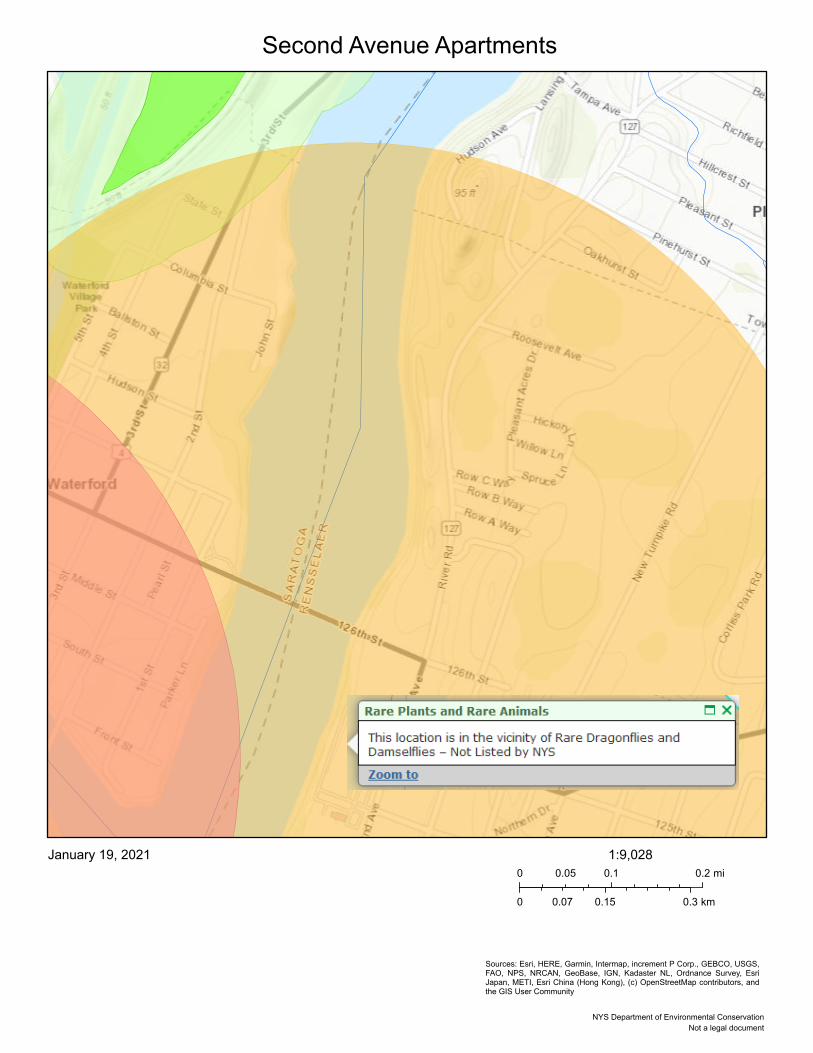
Second Avenue Apartments
Sources: Esri, HERE, Garmin, Intermap, increment P Corp., GEBCO, USGS,FAO, NPS, NRCAN, GeoBase, IGN, Kadaster NL, Ordnance Survey, EsriJapan, METI, Esri China (Hong Kong), (c) OpenStreetMap contributors, andthe GIS User Community
January 19, 20210 0.1 0.20.05 mi
0 0.15 0.30.07 km
1:9,028
Not a legal documentNYS Department of Environmental Conservation
Second Avenue Apartments APPENDIX D
Insite Northeast Engineering & Land Surveying, P.C. ● 2301 Western Avenue Guilderland, NY 12084 ● 518-867-3323 ● www.insitenortheast.com
APPENDIX D – ARCHAEOLOGICAL RESOURCES
Archaeological Survey IB/II by Hartgen
Submitted to: Golub Properties of Watervliet, Inc. 461 Nott Street – MB 617 Schenectady, NY, 12308 Prepared by: Hartgen Archeological Associates, Inc. 1744 Washington Avenue Ext. Rensselaer, New York 12144 p +1 518 283 0534 f +1 518 283 6276 e [email protected] www.hartgen.com An ACRA Member Firm www.acra-crm.org April 2020
PHASE IB/II ARCHEOLOGICAL SITE EVALUATION Troy Starlight Development 2nd Avenue City of Troy and Town of Schaghticoke Rensselaer County, New York HAA # 5470-41 OPRHP Not Yet Assigned
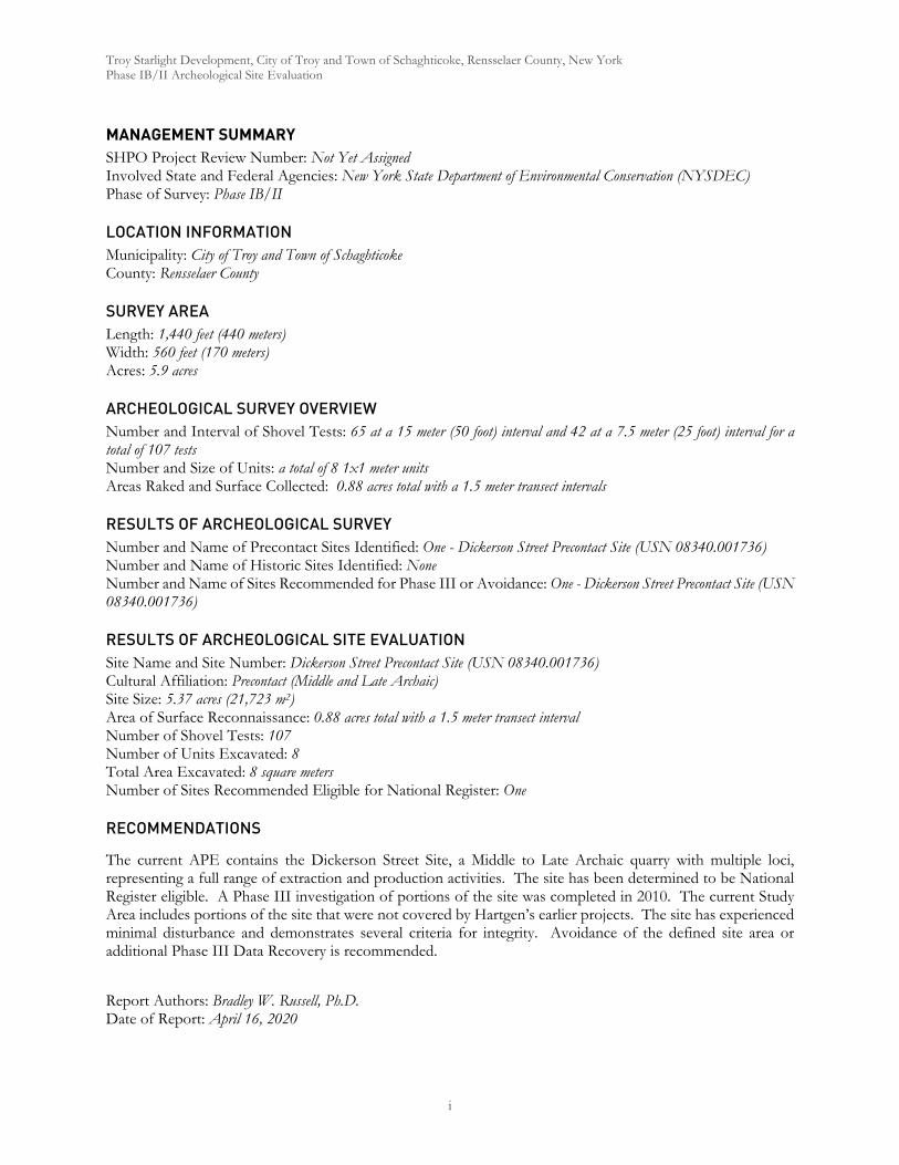
Troy Starlight Development, City of Troy and Town of Schaghticoke, Rensselaer County, New York Phase IB/II Archeological Site Evaluation
i
MANAGEMENT SUMMARY SHPO Project Review Number: Not Yet Assigned Involved State and Federal Agencies: New York State Department of Environmental Conservation (NYSDEC) Phase of Survey: Phase IB/II
LOCATION INFORMATION Municipality: City of Troy and Town of Schaghticoke County: Rensselaer County
SURVEY AREA Length: 1,440 feet (440 meters) Width: 560 feet (170 meters) Acres: 5.9 acres
ARCHEOLOGICAL SURVEY OVERVIEW Number and Interval of Shovel Tests: 65 at a 15 meter (50 foot) interval and 42 at a 7.5 meter (25 foot) interval for a total of 107 tests Number and Size of Units: a total of 8 1x1 meter units Areas Raked and Surface Collected: 0.88 acres total with a 1.5 meter transect intervals
RESULTS OF ARCHEOLOGICAL SURVEY Number and Name of Precontact Sites Identified: One - Dickerson Street Precontact Site (USN 08340.001736) Number and Name of Historic Sites Identified: None Number and Name of Sites Recommended for Phase III or Avoidance: One - Dickerson Street Precontact Site (USN 08340.001736)
RESULTS OF ARCHEOLOGICAL SITE EVALUATION Site Name and Site Number: Dickerson Street Precontact Site (USN 08340.001736) Cultural Affiliation: Precontact (Middle and Late Archaic) Site Size: 5.37 acres (21,723 m2) Area of Surface Reconnaissance: 0.88 acres total with a 1.5 meter transect interval Number of Shovel Tests: 107 Number of Units Excavated: 8 Total Area Excavated: 8 square meters Number of Sites Recommended Eligible for National Register: One
RECOMMENDATIONS
The current APE contains the Dickerson Street Site, a Middle to Late Archaic quarry with multiple loci, representing a full range of extraction and production activities. The site has been determined to be National Register eligible. A Phase III investigation of portions of the site was completed in 2010. The current Study Area includes portions of the site that were not covered by Hartgen’s earlier projects. The site has experienced minimal disturbance and demonstrates several criteria for integrity. Avoidance of the defined site area or additional Phase III Data Recovery is recommended.
Report Authors: Bradley W. Russell, Ph.D. Date of Report: April 16, 2020
Troy Starlight Development, City of Troy and Town of Schaghticoke, Rensselaer County, New York Phase IB/II Archeological Site Evaluation
ii
Hartgen Archeological Associates, Inc. (Hartgen) conducted a Phase IB/II archeological investigation for the proposed Troy Starlight Development (Project) located in the City of Troy and Town of Schaghticoke, Rensselaer County, New York. The Project requires approvals by New York State Department of Environmental Conservation (NYSDEC). The Project Area is located between 2nd Avenue and the Hudson River (Map 1). It begins north of Row C Way and ends south of Lansing Avenue. It straddles the border of the City of Troy and the Town of Schaghticoke. The development plan for the property has not been finalized. However, in generality, it will involve the construction of multiple unit residential buildings with associated driveways, parking and municipal utility connections. Plans will in part be based on avoidance areas defined by this and previous studies.
The area of potential effects (APE) includes all portions of the property that will be directly altered by the proposed undertaking. The APE encompasses ~9.75 acres total. However, it includes a roughly 4 acre area which was previously subjected to Phase I, II and III investigations and designated the Dickerson Street Precontact Site (USN 08340.001736). The site was determined to contain a mix of quarried outcrops, lithic workshops and camp locations. The survey area for the current study consists of previously undocumented areas within the broader APE and are located to the immediate north and south of the established Dickerson Street Precontact Site, which is believed to extend beyond the previously examined areas. It covers an area of approximately 5.75 acres.
La Porta’s model outlines four zones that can be found in ancient quarry sites (La Porta 2000). These consist of Zones I through IV: extraction, milling, ore processing, and workshop zones (2000:12-13). All four of these zones are identifiable at the Dickerson Street Site. Extraction took place at several locations including outcrops located along River Road (presently or in the past), along the east side of a ridge at the southern end of the site and at outcrops present on the west side of ridges in the northern end of the site. These locations show evidence of the removal of material and in several cases contained large extraction hammerstones used in that removal. Milling took place in discrete locations in the southern end of the site, particularly in collection areas 7 and 8, which were marked by dense concentrations of early stage debitage consistent with the separation of useable ores from the surrounding matrix. Some milling activity was also mixed with ore processing in locations such as the workshop area in the southeast corner of the portion of the site investigate in 2008. Other workshop zones, specializing in mid to late stage manufacture of tools, were clustered in the floodplain along the banks of the Hudson.
The Dickerson Street Precontact Site has already been recommended as eligible for the National Register during Hartgen’s initial 2008 study of the central portion of the site saying, “It is recommended that the Dickerson Street Site be considered National Register eligible under Criterion D as a site that has yielded or may be likely to yield, information important in history or prehistory.” We concur with that recommendation for the whole of the expanded site as defined during the present study.
Troy Starlight Development, City of Troy and Town of Schaghticoke, Rensselaer County, New York Phase IB/II Archeological Site Evaluation
iii
PHASE I CULTURAL RESOURCES SURVEY ........................................................................................................ 1 1 Introduction ............................................................................................................................................................... 1 2 Project Information .................................................................................................................................................. 1
2.1 Project Location ................................................................................................................................................ 1 2.2 Description of the Project ............................................................................................................................... 1 2.3 Description of the Area of Potential Effects (APE) ................................................................................... 1
3 Environmental Background .................................................................................................................................... 2 3.1 Present Land Use and Current Conditions .................................................................................................. 2 3.2 Soils ..................................................................................................................................................................... 3 3.3 Bedrock Geology .............................................................................................................................................. 4 3.4 Physiography and Hydrology .......................................................................................................................... 4
4 Previous Studies of the Dickerson Street Precontact Site .................................................................................. 5 4.1 Artifact Analysis ................................................................................................................................................ 6 4.2 Environmental Reconstruction ...................................................................................................................... 8
5 Background ................................................................................................................................................................ 8 6 Archeological Site Evaluation ................................................................................................................................. 9
6.1 Methodology ..................................................................................................................................................... 9 6.1.1 Shovel Testing .......................................................................................................................................... 9 6.1.2 Surface Collection.................................................................................................................................... 9 6.1.3 Unit Excavation ....................................................................................................................................... 9 6.1.4 Artifacts and Laboratory ...................................................................................................................... 10
6.2 Results .............................................................................................................................................................. 10 6.2.1 Site Boundaries within APE ................................................................................................................ 11 6.2.2 Site stratigraphy ...................................................................................................................................... 12 6.2.3 Site Chronology ..................................................................................................................................... 14 6.2.4 Artifact Analysis ..................................................................................................................................... 14 6.2.5 Artifact Distribution ............................................................................................................................. 20
7 Interpretation ........................................................................................................................................................... 21 8 Significance Assessment ........................................................................................................................................ 22
8.1 Significant research topics that can be addressed by site ......................................................................... 23 8.2 Integrity ............................................................................................................................................................ 24
9 Recommendations .................................................................................................................................................. 24 10 Bibliography ............................................................................................................................................................. 25 Maps Figures Photographs Appendix 1: Shovel Test Records Appendix 2: Artifact Inventory Appendix 3: Preliminary Site Plan
Troy Starlight Development, City of Troy and Town of Schaghticoke, Rensselaer County, New York Phase IB/II Archeological Site Evaluation
iv
Map 1. Project Location (USGS 2015)
Map 2. Project Map (Esri Inc. 2015)
Map 3a. Kernel Density Analysis
Map 3b. Kernel Density Analysis by Type
Figure 1. Profile and Photo of Unit 1 .............................................................................................................................. 3
Figure 2. Profile and Photo of Unit 2 .............................................................................................................................. 3
Figure 3. Profile of Unit 3 ................................................................................................................................................. 3
Figure 4. Profile and Photo of Unit 4 .............................................................................................................................. 3
Figure 5. Profile and Photo of Unit 5 .............................................................................................................................. 3
Figure 6. Profile and Photo of Unit 6 .............................................................................................................................. 3
Figure 7. Profile and Photo of Unit 7 .............................................................................................................................. 3
Figure 8. Profile and Photo of Unit 8 .............................................................................................................................. 3
Photo 1. View of Hudson River and drop off along the south end of the APE, view south.
Photo 2. Floodplain along the Hudson showing typical wooded condition of much of the APE, view west.
Photo 3. Shale outcrop along the west side of the northern ridge, view south.
Photo 4. Disturbance and modern refuse along the south end of the APE, view north.
Photo 5. Archeologist Cynthia Jackson excavating STP 16.
Photo 6. Archeologist John Ham excavating STP 98.
Photo 7. Archeologist David Wendell excavating STP 8.
Photo 8. Archeologists Amy Wilson (Left) and Cynthia Jackson (right) raking collection area 1 to remove leaf litter.
Photo 9. Archeologists Cynthia Jackson, Amy Wilson and Tom Boyd (Left to right) surveying collection area 3.
Photo 10. Collection Area 5 along slope below worked outcrop after removal of leaf litter.
Photo 11. Worked shale outcrop along the west side of the northern ridge.
Photo 12. Concentration of gangue, blocks and shatter from collection area 7.
Photo 13. Concentration of gangue, blocks and shatter from collection area 8.
Photo 14. Exposed cobbles of green chert on the west slope of the southern ridge.
Photo 15. Bottle of Brownatone hair dye recovered from small early 20th century dump area to the east of the large ridge at the far north of the APE.
Photo 16. Intact Middle Archaic Genesee (top left) (Bag 71, Item 1.1), Late Archaic Adena (top right) (Bag 75, Item 1.1) and Middle Archaic Vosburg (Bag 77, Item 1.1) projectile points.
Photo 17. Quartzite extraction hammerstone with spalls (Bag 69, Item 1) recovered from the top of the worked shale outcrop on the west side of the northern ridge, immediately above the worked section.
Photo 18. Quartzite extraction hammerstone (Bag 70, Item 1.1) recovered along the east side of the southern ridge.
Photo 19. Fragments of two extraction hammerstones (Bag 41, Item 1 and Bag 81, Item 5). Left example also appears to be fire-cracked.
Photo 20. Hammerstones (Top Row left to right: Bag 39, Item 1 – Bag 60, Item 1 – Bag 62, Item 1 Bottom Row Left to right: Bag 64, Item 1 – Bag 72, Item 1).
Troy Starlight Development, City of Troy and Town of Schaghticoke, Rensselaer County, New York Phase IB/II Archeological Site Evaluation
v
Photo 21. Hammerstones (Top Row left to right: Bag 49, Item 1 – Bag 74, Item 1 – Bag 83, Item 1 Bottom Row Left to right: Bag 86, Item 1 – Bag 89, Item 1).
Photo 22. Quarry flakes (Top Row left to right: Bag 1, Item 1.3 – Bag 5, Item 2.2 Bottom Row Left to right: Bag 7, Item 1.3 – Bag 8, Item 1.3).
Photo 23. Quarry flakes (Top Row left to right: Bag 9, Item 2.2 – Bag 10, Item 1.1 Bottom Row Left to right: Bag 12, Item 1.1 – Bag 14, Item 14.2).
Photo 24. Quarry flakes (Top Row left to right: Bag 81, Item 2 – Bag 81, Item 3.2 Bottom Row Left to right: Bag 81, Item 4.4).
Photo 25. Quarry flake (Bag 86, Item 3.3).
Photo 26. Thinning Flakes (Bag 41, Item 3.4).
Photo 27. Thinning flakes (Bag 48, Item 3.3).
Photo 28. Thinning flakes (Top Row: Bag 50, Item 3.5 Middle Row Bag 50, Item 4.5 Bottom Row: Bag 50, Item 4.6).
Photo 29. Trim flakes (Top Row: Bag 41, Item 3.5 – Bag 42, Item 2.4 Middle Row: Bag 47, Item 2.4 – Bag 48, Item 3.4 Bottom Row: Bag 50, Item 4.7 – Bag 76, Item 6.9).
Photo 30. Cores (Top Row: Bag 18, Item 1.2 – Bag 20, Item 2.1 – Bag 22, Item 2.3 Bottom Row: Bag 33, Item 4.1 – Bag 74, Item 6.3).
Photo 31. Cores (Top Row: Bag 90, Item 2.2 – Bag 90, Item 2.3 Bottom Row: Bag 91, Item 1.1).
Photo 32. Bifaces (Top Row: Bag 36, Item 1 – Bag 39, Item 2 Bottom Row: Bag 48, Item 1 – Bag 62, Item 2).
Photo 33. Bifaces (Top Row: Bag 67, Item 1 – Bag 76, Item 1.2 Bottom Row: Bag 76, Item 3 – Bag 81, Item 1.2).
Photo 34. Retouched flakes (Top Row: Bag 50, Item 1 – Bag 51, Item 1 Bottom Row: Bag 56, Item 1 – Bag 62, Item 2).
Photo 35. Retouched flakes Bifaces (Bag 74, Item 2 and Bag 74, Item 3).
Photo 36. Retouched blocks Bifaces (Top Row: Bag 5, Item 1 – Bag 65, Item 1.1 and Bag 90, Item 1.2).
Table 1. Soils in Project Area ............................................................................................................................................ 3
Table 2. Artifact Types ....................................................................................................................................................... 6
Table 3. Artifact Types and Subtypes .............................................................................................................................. 7
Table 4. Summary of archeological site information collected during the Phase I survey ..................................... 8
Table 5. Summary of Phase II field investigations ...................................................................................................... 10
Table 6. Combined summary of all field investigations .............................................................................................. 11
Table 7. Combined Artifact Types and Subtypes ........................................................................................................ 19
Table 8. Summary of archeological site information collected during the Phase I and II studies ....................... 22
Troy Starlight Development, City of Troy and Town of Schaghticoke, Rensselaer County, New York Phase IB/II Archeological Site Evaluation
1
Hartgen Archeological Associates, Inc. (Hartgen) conducted a Phase IB/II archeological investigation for the proposed Troy Starlight Development (Project) located in the City of Troy and Town of Schaghticoke, Rensselaer County, New York. The Project requires approvals by New York State Department of Environmental Conservation (NYSDEC).
This investigation was conducted to comply with Section 14.09 of the State Historic Preservation Act and will be reviewed by the New York State Office of Parks, Recreation and Historic Preservation (OPRHP). The investigation was conducted according to the New York Archaeological Council’s Standards for Cultural Resource Investigations and the Curation of Archaeological Collections (1994), which are endorsed by OPRHP. This report has been prepared according to OPRHP’s State Historic Preservation Office (SHPO) Phase I Archaeological Report Format Requirements (2005).
The primary objective of this study was to delineate the boundaries of the site(s) so that appropriate avoidance measures can be determined. Our previous work at the Dickerson Street Site concluded:
The shovel tests demonstrate that, although the artifact density within the Dickerson Street Site fluctuates, the site extends beyond the boundaries of the Study Area to the north and south and is bounded by the Hudson River on the west side. It also originally extended beyond the Study Area to the east, but has since been destroyed by the construction of River Road and likely significantly impacted if not completed destroyed in the vicinity of the houses and other development east of River Road. (Hartgen 2010a:22)
The Project Area is located between 2nd Avenue and the Hudson River (Map 1). It begins north of Row C Way and ends south of Lansing Avenue. It straddles the Border of the City of Troy and the Town of Schaghticoke.
The development plan for the property has not been finalized. However, in generality, it will involve the construction of multiple unit residential buildings with associated driveways, parking and municipal utility connections. Plans will in part be based on avoidance areas defined by this and previous studies.
The area of potential effects (APE) includes all portions of the property that will be directly altered by the proposed undertaking. The APE encompasses ~9.75 acres total. However, it includes a roughly 4 acre area which was previously subjected to Phase I, II and III investigations and designated the Dickerson Street Precontact Site (USN 08340.001736). The site was determined to contain a mix of quarried outcrops, lithic workshops and camp locations. The survey area for the current study consists of previously undocumented areas within the broader APE and are located to the immediate north and south of the established Dickerson Street Precontact Site, which is believed to extend beyond the previously examined areas. It covers an area of approximately 5.75 acres.
Hartgen’s earlier studies of the Dickerson Street Precontact Site (Hartgen Archeological Associates Inc. 2008, 2010a) were completed for the Hudson River PCB Superfund Water Line Project, which was located within
Troy Starlight Development, City of Troy and Town of Schaghticoke, Rensselaer County, New York Phase IB/II Archeological Site Evaluation
2
the Village and Town of Waterford and Town of Halfmoon, Saratoga County and the City of Troy, Rensselaer County. The project entailed the installation of a 4.3-mile (7 km) water main to provide the Towns of Waterford and Halfmoon with an alternative water supply during the removal of PCB-bearing sediments from the Hudson River upstream of these towns. A Phase IA/IB/II archeological investigation and site evaluation was completed for the project by HAA in June 2008. The study included a Phase IA literature review for the entire water line, Phase IB field reconnaissance in all appropriate locations along the water line, and Phase II site evaluations of two sites: the Dickerson Street Site and the Water Works Precontact Site (USN 09145.000747). The Phase III study completed in 2010 focused on a 0.5 acre APE for a staging area for directional drilling below the Hudson River. A second drilling location on the west bank of the river contained the Waterworks Precontact Site (USN 09145.000747) which was also investigated by a team from Hartgen (Hartgen Archeological Associates Inc. 2010b).
It should also be noted that a second site simply designated “chert quarries” (USN 08340.001092) in CRIS was initially reported by Karen Hartgen in 1992 as part of the study for the Charles Ellet Apartment Site Project. This should be considered the same as the Dickerson Street Precontact Site and is linked in CRIS although the system contains two distinct USNs and map markers.
According to La Porta’s (2000:10-16) model of quarry development, quarries can be divided into various categories based on scale of activity. An “expression” indicates a prospect that may have been tested and demonstrates evidence of extraction during possibly a single episode. A “movement” is a small-scale quarry that may demonstrate division of tasks and specialized tools such as hammerstones. A “motion” is a large scale quarry with variety of quarrying tools and subdivision of tasks evident in the spatial organization of the site. A “trend” is a series of quarries along a strike (the compass direction of a bedded chert formation) (La Porta 2000:12). A group of trends in the same vicinity and within one area of similar geology is a “district.” Based on this model, the Dickerson Street Site consists of an extensive movement or a limited motion within a district that extends from Lansingburgh to Pleasantdale.
The environment of an area is significant for determining the sensitivity of the Project Area for archeological resources. Precontact and historic groups often favored level, well-drained areas near wetlands and waterways. Therefore, topography, proximity to wetlands, and soils are examined to determine if there are landforms in the Project Area that are more likely to contain archeological resources. In addition, bedrock formations may contain chert or other resources that may have been quarried by precontact groups. Soil conditions can provide a clue to past climatic conditions, as well as changes in local hydrology.
The development of the regional and local environment is essential to understanding the development of the Dickerson Street Site. In particular, two environmental conditions were most significant in making the site preferable for precontact habitation and use: proximity to the Hudson River and the existence of chert-bearing ridges of shale along the river. The formation of the river bed and topography within the site is primarily the result of the interaction of glaciers and the regional bedrock.
A site visit was conducted by Bradley Russell on December 16, 2019 to observe and photograph existing conditions within the Project Area. The parcel is bounded on the west by the Hudson River (Photo 1) and the east by 2nd Avenue (River Road). The majority of the Study Area remains wooded (Photo 2). A portion located in the previously studied APE contains a mowed lawn and a gravel drive/parking area. The topography is characterized by a series of ridges running north/south parallel to the river. The ridges consist of chert bearing Mount Merino formation shale and Cohoes Melange, with a number of outcrops exposed at the surface (Photo 3). In the southern portion of the property, the river’s edge is marked by a sheer, shale cliff face. A relatively level flood plain runs along the river in the northern portion of the Project area. The geomorphology suggests that this portion of the site has been above flood height for several thousand years, allowing it to be a suitable
Troy Starlight Development, City of Troy and Town of Schaghticoke, Rensselaer County, New York Phase IB/II Archeological Site Evaluation
3
camp location for Native Americans drawn to the location by the available lithic raw material. Residential properties bound the parcel on its north and south sides resulting in some disturbance and accumulation of litter and other discarded material (Photo 4). The most significant of the disturbance is along the northwestern side of the property where a road bed and parking area have been built resulting in a mix of filling and grading. The northeastern portion of the property contains shallow standing water. Evidence of blasting associated with the construction of 2nd Avenue (River Road) is found in the exposed bedrock along the east side of the Project Area.
Soil surveys provide a general characterization of the types and depth of soils that are found in an area. This information is an important factor in determining the appropriate methodology if and when a field study is recommended. Much of the following information was provided by Dr. David DeSimone, who has extensively studied the geomorphology of the upper Hudson Valley and was the consulting geomorphologist for Hartgen’s earlier investigations of the Dickerson Street archeological site (Hartgen Archeological Associates Inc. 2010a).
The surficial geology of the Hudson Valley is dominated by landforms and deposits that resulted from continental glaciations which occurred numerous times throughout the Pleistocene Epoch of the last 1.7 million years. The current distribution of glacial sediments is the result of the most recent cycle of glacial advance and retreat of the Hudson-Champlain ice lobe. This ice overrode the region before 25,000 years ago and retreated from the project area approximately 13,700 years ago. As the ice lobe retreated from the Hudson-Champlain lowlands a series of glacial lakes fronted the margin of the glacier. Fine grained lake silt-clay was deposited in the deeper and quiet waters of the lakes while sand was deposited along the wave impacted shores of the lakes. Deltas were deposited by tributary streams emptying into the lakes from the uplands and also from melt-water rivers flowing from beneath the glacier directly into the lakes. Researchers have recognized the importance of major floods of glacial lake discharge that initially came down the Mohawk Valley and formed the Cohoes Falls and other prominent features of our regional landscape (DeSimone, et al. 2008). The exposed bedrock in the project area dates from these flood discharges that stripped the glacial deposits off of the bedrock and defined the present day channels of both the Mohawk and Hudson Rivers.
Soil surveys for Rensselaer County (1988) and Saratoga County (2004) provide a framework for understanding and predicting soils encountered within one meter (3.3 ft) of the ground surface. Soil maps are reasonably reliable in the recognition of “C” horizon or parent material sediment texture. However, these same maps are somewhat unreliable in the interpretation of the origin of the parent material. To provide a context for the different soil types, a review of the mapped soils units, as defined by the soil survey are included below. Following which a more detailed description of the soil development within particular portions of the project area is provided. According to the Natural Resources Conservation Service soil surveys of Rensselaer County (2006 and 2007), soils in the Dickerson Street site consist of the Nassau-Rock outcrop complex, which is comprised of silt loam formed primarily by the disintegration of shale bedrock. Shale is a fissile rock formed in fine silt and clay settling out of deep water. It tends to fracture along thin laminations, resulting in silty loam soils containing large amounts of shale rubble. It is described in detail below in Table 1. The soil description includes the name and symbol, soil horizon and depth, texture and inclusions, slope, drainage characteristics, and the general landform on which they occur (USDA 2006b and 2006c).
Troy Starlight Development, City of Troy and Town of Schaghticoke, Rensselaer County, New York Phase IB/II Archeological Site Evaluation
4
The bedrock of the Dickerson Street Site and vicinity is very complex and consists of the Cohoes Melange, a 20-kilometer (12.5-mile) wide band of rock that was highly deformed during the Taconic Orogeny. In older literature, the shale of the Hudson Valley is classified as the Normanskill/Canajoharie Formation (Fisher, et al. 1970). More recent research has demonstrated that this shale consists of several formations including the Utica shale and Schenectady Formation shale of the Proto North American plate and the Mount Merino shale associated with the Taconic Arc (Kidd, et al. 1995). It is the Mount Merino shale that contains the green chert identified along the bedrock ridges in the vicinity of the Dickerson Street Site, and therefore, this report refers to the shale as Mount Merino shale within the Cohoes Melange.
The Cohoes Melange formed toward the end of the Ordovician Age when the Iapetus Ocean closed. The pressures of the colliding plates caused the deformation of many of the bedrock formations and the juxtaposition of numerous types of bedrock formed in different environments within the Cohoes Melange. This juxtaposition of bedrock from different sources is evident within the Dickerson Street Site. Most of the bedrock observed within the Dickerson Site consists of Mount Merino formation chert-bearing shale. However, an outcrop of dolomitic sandstone was identified along the southwest ridge in the quarry workshop area. This sandstone was likely formed on the shelf or slop of the Taconic Allochthon and was juxtaposed with the deep water Mount Merino shale during the Taconic Orogeny’s deformation and compression of the rocks of the Iapetus Ocean. As a result, rocks formed in very different environments and with different compositions and properties outcrop within 15 meters (50 ft.) of each other within the Cohoes Melange of the Dickerson Street Site.
The Cambrian- and Ordovician-age (570 to 505 and 505 to 436 million years ago) cherts of New York are relatively free of fossils and are generally found in formations of shale and argillite such as the Normanskill/Canajoharie and Mount Merino formations. Cherts bedded in shale and slate are typically thought to have formed in deep ocean deposits near volcanically active faults between continental plates. Some researchers theorize that these cherts formed directly from volcanic sediments under conditions of high pressure and dynamic temperature and that silica-secreting organisms were not involved (Luedtke 1992). This theory accounts for the lack of fossils in these cherts. The chert-bearing shale in the project area east of the Hudson River consists of Ordovician-age (505 to 436 million years ago) bedrock. The chert in this bedrock was formed in a deep ocean environment and does not include fossils. The chert within the formation ranges in quality from true chert to siliceous shale, or shale that has a high silica content and has similar properties to chert but is generally softer and grainier.
Steeply sloped areas are considered largely unsuitable for human occupation. As such, the standards for archeological fieldwork in New York State generally exclude areas with a slope in excess of 12% from archeological testing (NYAC 1994). Exceptions to this rule include steep areas with bedrock outcrops, overhangs, and large boulders that may have been used by precontact people as quarries or rock-shelters. Such areas may still warrant a systematic field examination.
During the early Holocene, the Dickerson Street Site was located within a series of ridges bordered on the west by the Hudson River. These ridges were comprised of Mount Merino shale and other rocks of the Cohoes Melange. The chert within the shale and other types of bedrock such as the dolomite found within the Dickerson Street Site were more resistant to glacial and post glacial erosion, resulting in the preservation of the ridges as the surrounding shale was eroded.
The USDA soil survey of Rensselaer County (2006) does not include the floodplain located within the Dickerson Street Site. This area was likely overlooked and simply grouped with the surrounding Nassau rock outcrop during the soil survey mapping due to its small size. The floodplain was formed during the early to mid-Holocene and consists of a massive deposit of fine sand, very fine sand, silt, and minor clay. The flooding
Troy Starlight Development, City of Troy and Town of Schaghticoke, Rensselaer County, New York Phase IB/II Archeological Site Evaluation
5
may have begun during the early Holocene and ceased at least 3,900 years ago based on the finding of a Sylvan Stemmed projectile point (2400 to 1900 B.C.) within the A horizon developed above the massive silt deposit (Funk 1976:250). No evidence of cultural horizons such as A horizon development or artifacts were found deeper than one meter (3.3 ft.) during the archeological investigations, demonstrating that the site was occupied after flooding ceased. The cessation of flooding within the Dickerson Street Site may have been a result of isostatic rebound, which exerted a significant effect upon topographic development until the mid-Holocene and is still evident today in some areas. Though it has not been fully studied, there is evidence that terrain was affected disproportionately and that drainage and alluviation patterns were altered during isostatic rebound.
The location of the Project Area just one kilometer to the north of the confluence of the Hudson and Mohawk Rivers would have placed it at a key transport route for the native peoples of the area, allowing efficient canoe travel to the north, south and west. The waterways would have provided a variety of resources such as fish, waterfowl and beaver. In fact, all three were observed during our work at the site. Combined with the presence of available lithic raw materials, the location has very high Precontact sensitivity.
Phase IB/II investigation (Hartgen Archeological Associates Inc. 2008) of the Dickerson Street Precontact Site (USN 08340.001736) involved the hand excavation of 166 shovel tests and the mechanical excavation of four trenches totaling 62 meters (207 feet) in length and roughly 1 meter wide. The survey included a mix of 15 meter (50 foot) and 7.5 meter (25 foot) interval shovel tests.
Researchers divided the site into five distinct environmental zones (Southwest Ridge, Chert Workshop and Quarry, Floodplain, Northeast Ridge and East Swale) based on the topography and results of shovel tests. The Southwest Ridge contains exposed bedrock outcrops along its east side. Two depressions below the outcrops indicated possible chert extraction near tests 2 and 19. The Chert Quarry and Workshop extended north and east from these outcrops near Second Avenue (River Road). Tests from the area (STPs 1, 25, 27 and 47) produced between 100 and 277 lithic artifacts each. STP 1 contained remains representing several stages in the quarrying and reduction sequence from extraction to the production of preforms. The Floodplain located along the river contained the highest density of materials anywhere in the Project Area. The density was highest close to the shoreline and dropped moving to the east away from the water. The presence of numerous thinning and trim flakes from the area suggest mid to late stage production. The area also contained an abundance of fire-cracked rock indicating the possible presence of undiscovered hearths. The Floodplain was divided into a north and south section by the excavation of a modern sewer ditch draining into the Hudson. The two lowest density areas were the Northeast Ridge and the East Swale (erroneously referred to as the West Swale in the 2008 report text). The Northeast ridge is located east of the Floodplain and north of the Chert Workshop and Quarry. It contained no surface outcrops and was more exposed to the elements than other areas of the site. The East Swale contained some standing water and was likely wet, possibly seasonally inundated in the past accounting for limited finds.
The four backhoe trenches excavated during the investigation were divided between the high density flood plain area and an area of disturbance associated with a deeply buried sewer line running from southeast to northwest across the Study Area. Trenches 1 and 2 were excavated to provide data concerning the stratigraphy of the floodplain and to determine the depth of archeological deposits. Trench 1 revealed that the greatest density of artifacts occurred around the interface between level III, a dark brown, shale rubble colluvium and Level IV, a yellowish brown, silt alluvium. Both were covered by a roughly 50 centimeter deep layer of dark yellowish brown, clay topsoil. Trench 1 produced only 20 Precontact artifacts. There were only a few of each artifact subtype and the artifacts were not in usual proportions, demonstrating that Trench 1 was likely on the periphery of a larger deposit and not in the immediate vicinity of a lithic workstation or significant activity area. Interestingly, most of the debitage consisted of siliceous shale with only two chert artifacts.
Troy Starlight Development, City of Troy and Town of Schaghticoke, Rensselaer County, New York Phase IB/II Archeological Site Evaluation
6
784 artifacts were recovered from Trench 2. These included Late Archaic Brewerton and Lamoka projectile points from the Vosburg Complex (3,400 to 2,400 B.C.) and the Sylvan Lake Complex (2,400 to 1,900 B.C.) respectively (later reclassified see below). Most of the artifacts from Trench 2 were recovered from Level 1 topsoil and the very top of Level 2 alluvium, none deeper than 50 centimeters. The datable points were recovered from the interface of the two levels, indicating that the alluvial deposit developed in the early Holocene and that no artifacts would be present below 1 meter depth.
Trenches 3 and 4 were excavated across the route of the 1930’s sewer pipeline to determine the boundaries of the associated soil disturbance. Results indicated that the disturbance ranged between 5 (Trench 1) and 9 meters (Trench 2) wide.
In total, the Phase IB work produced 3,990 artifacts suggesting that the site was divided into several distinct functional areas, with quarrying, milling, reduction/preform production and late stage lithic production which was associated with a riverside alluvial floodplain. Diagnostic points indicated that the site dated to the Late Archaic Period with examples of projectile points representing the Vosburg Complex (3,400 to 2,400 B.C.) and the Sylvan Lake Complex (2,400 to 1,900 B.C.). It was shown that the site extended from the River in the west to 2nd Avenue (River Road) in the east. However, it was not possible to define boundaries in the north or south because the deposits extended beyond the Study Area. It was determined that the site was National Register Eligible under Criterion D and was likely to yield information important to history or prehistory and met all seven aspects of integrity. It was recommended that Phase III Data Retrieval be conducted on any areas to be impacted by planned horizontal drilling operation.
Phase III study the Dickerson Street Precontact Site (Hartgen Archeological Associates Inc. 2010a) was restricted to areas that would be directly impacted by the planned horizontal drilling operation. It involved surface collection (following brush removal and surface exposure), the excavation of an additional 87 shovel tests (producing 253 tests total), and the excavation of 20 units. 15 of the units were located within the Phase II APE. With EPA approval, 5 additional tests were located in the area of the previously identified quarry and workshop to further clarify its structure and function. Specialized analysis included thin section analysis to identify raw materials being exploited and compare them to three other local quarry sites. Two projectile points were analyzed for the presence of residues to determine if and how they were used prior to discard. Pollen and phytolith analysis was used to reconstruct past environmental conditional at the site. Finally, samples of fire-cracked rock (FCR) were tested for the presence of organic residues. Taken together with the results of previous studies, a total of 6,721 precontact artifacts were collected from the Dickerson Street Site. Results of the study incorporated findings from all three phases of investigation.
The thousands of recovered artifacts were analyzed to fully understand the extraction and production processes taking place at the Dickerson Street Site. Classifications for the lithic materials were based on widely accepted approaches (Andrefsky 1998; La Porta 2000, 2006; Odell 1982, 2004; Whittaker 1994) and considerations specific to the Dickerson Street Site. The collection was divided into five main artifact types as shown in Table 2.
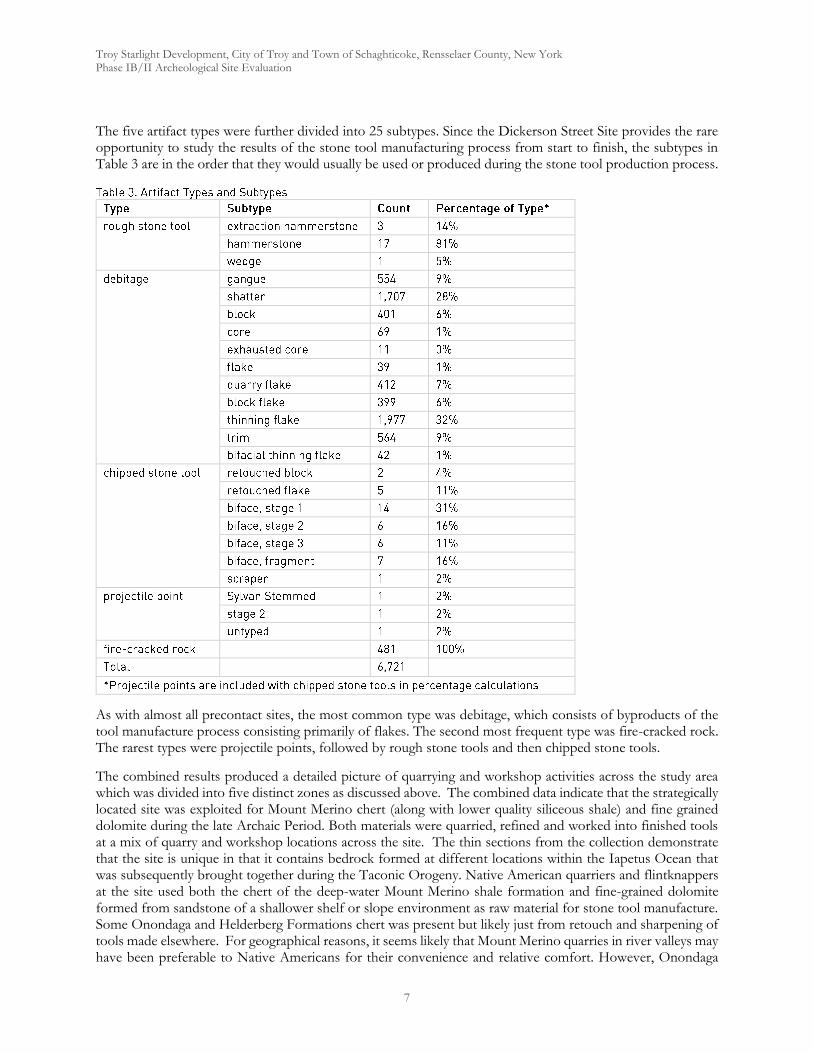
Troy Starlight Development, City of Troy and Town of Schaghticoke, Rensselaer County, New York Phase IB/II Archeological Site Evaluation
7
The five artifact types were further divided into 25 subtypes. Since the Dickerson Street Site provides the rare opportunity to study the results of the stone tool manufacturing process from start to finish, the subtypes in Table 3 are in the order that they would usually be used or produced during the stone tool production process.
As with almost all precontact sites, the most common type was debitage, which consists of byproducts of the tool manufacture process consisting primarily of flakes. The second most frequent type was fire-cracked rock. The rarest types were projectile points, followed by rough stone tools and then chipped stone tools.
The combined results produced a detailed picture of quarrying and workshop activities across the study area which was divided into five distinct zones as discussed above. The combined data indicate that the strategically located site was exploited for Mount Merino chert (along with lower quality siliceous shale) and fine grained dolomite during the late Archaic Period. Both materials were quarried, refined and worked into finished tools at a mix of quarry and workshop locations across the site. The thin sections from the collection demonstrate that the site is unique in that it contains bedrock formed at different locations within the Iapetus Ocean that was subsequently brought together during the Taconic Orogeny. Native American quarriers and flintknappers at the site used both the chert of the deep-water Mount Merino shale formation and fine-grained dolomite formed from sandstone of a shallower shelf or slope environment as raw material for stone tool manufacture. Some Onondaga and Helderberg Formations chert was present but likely just from retouch and sharpening of tools made elsewhere. For geographical reasons, it seems likely that Mount Merino quarries in river valleys may have been preferable to Native Americans for their convenience and relative comfort. However, Onondaga
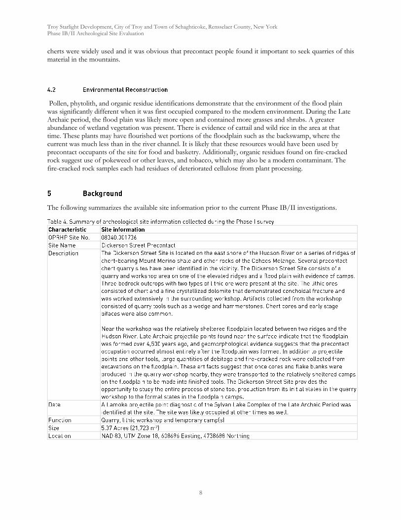
Troy Starlight Development, City of Troy and Town of Schaghticoke, Rensselaer County, New York Phase IB/II Archeological Site Evaluation
8
cherts were widely used and it was obvious that precontact people found it important to seek quarries of this material in the mountains.
Pollen, phytolith, and organic residue identifications demonstrate that the environment of the flood plain was significantly different when it was first occupied compared to the modern environment. During the Late Archaic period, the flood plain was likely more open and contained more grasses and shrubs. A greater abundance of wetland vegetation was present. There is evidence of cattail and wild rice in the area at that time. These plants may have flourished wet portions of the floodplain such as the backswamp, where the current was much less than in the river channel. It is likely that these resources would have been used by precontact occupants of the site for food and basketry. Additionally, organic residues found on fire-cracked rock suggest use of pokeweed or other leaves, and tobacco, which may also be a modern contaminant. The fire-cracked rock samples each had residues of deteriorated cellulose from plant processing.
The following summarizes the available site information prior to the current Phase IB/II investigations.
Troy Starlight Development, City of Troy and Town of Schaghticoke, Rensselaer County, New York Phase IB/II Archeological Site Evaluation
9
Our initial testing involved a 15 meter regular interval grid across all portions of the study area that were feasible for testing. Certain areas in the northern portion of the study were excluded based on standing water, steep slope or clear disturbance. Tests were excavated at a reduced interval of 7.5 meters (25 ft) within areas shown by the initial testing to contain archeological remains. Results of Phase IB testing indicated three specific areas that we deemed appropriate for close interval shovel testing. The first was on the relatively level flood plain along the Hudson River where initial testing revealed indications of lithic workshop activity. The second location chosen for close interval testing was a level area on top of a ridge showing evidence of extraction activity and later stage lithic tool production. The third area selected produced evidence of a historic midden deposit to the east of the largest ridge within the Study Area. All three of these areas were contained in the northern portion of the Study Area.
Each shovel test was 40 centimeters (16 in) in diameter. All excavated soil was passed through 0.25-inch hardware mesh and examined for both precontact (Native American) and historic artifacts. The stratigraphy of each test was recorded including the depth, Munsell color, soil description, and artifact content (Munsell Color 2000). The location of each shovel test was plotted on the project map. Test excavation was photographed (Photos 5-7).
Eight areas (0.88 acres in total) were raked to remove dried leaves and light snow where present and a non-systematic sample of surface materials collected from each. Seven of the eight areas were positioned based on the presence of test that were positive for Precontact material and had scatters of surface material. Test Area #5 was selected because it was a slope below a linear shale outcrop with evidence of raw material extraction including a large hammer stone sitting directly on top of the outcrop. The area itself was not shovel tested because the slope made that work impractical and potentially unsafe.
Areas identified for surface collection were raked to remove leaf litter/snow and expose features and artifacts before the fieldwork began. Archeologists lined up at 1.5-meter (5-ft) intervals to walk the plowed areas. Precontact (Native American) artifacts and significant historic artifacts observed on the surface were collected from within numbered collection areas. All surface material was from areas 1-6. Areas 7 and 8 contained dense deposits of quarry flakes, block flakes and large shatter which was not collected. Instead it was cleared and photographed as it was felt that was the best way to characterize the nature of the material present. Each collection area was mapped using a Trimble Geo 7X GPS for inclusion in our maps. Surface collecting fieldwork was photographed (Photos 8-10).
Eight 1x1 meter units were excavated, six in the north portion of the Study area and two more in the south. Units #1 through 3 were all located in the floodplain in the north portion of the Study Area in a location with numerous positive shovel tests and abundant surface remains. Units #4 and 6 were located at the base of a slope descending west from the main bedrock outcrop in the north section of the Study Area. Unit #5 was located in a level area extending east from the top of the same bedrock. The area contained multiple positive shovel tests and a surface scatter. Unit #7 was located in a level area below a low ridge running parallel to the Hudson below two blocks of green Mount Merino chert located at the edge of the ridge. Unit #8 was located on top of the ridge on the east side of the chert finds. Both were located close to positive shovel tests containing Precontact materials.
Soil levels were excavated separately, and all excavated soil was passed through 0.25-inch hardware mesh and examined for both precontact (Native American) and historic artifacts. Soil depths, Munsell colors, textures,
Troy Starlight Development, City of Troy and Town of Schaghticoke, Rensselaer County, New York Phase IB/II Archeological Site Evaluation
10
artifact content, and other relevant observations were recorded (Munsell Color 2000). Profiles and plan views were drawn when appropriate. The location of each unit was mapped with a Trimble Geo 7X GPS and plotted on the project map. Unit excavation fieldwork and unit wall stratigraphy was mapped and photographed (Figures 1-8).
As general procedure, all precontact (Native American) cultural material identified during the fieldwork are collected. Significant historic artifacts such as glass, ceramics, food remains, hardware, and miscellaneous items are collected. Coal, ash, cinder, brick, and modern materials are noted. Any artifacts collected are placed in paper or plastic bags labeled by provenience and inventoried in a bag list. Bags are numbered in the field and transported to the Hartgen laboratory in the Town of North Greenbush, Rensselaer County, New York, for processing.
Shovel test records and other provenience information were entered into a Microsoft Access database (Appendix 1). Artifacts were cleaned and cataloged. Cataloging entailed entering artifact provenience information, counts, weights, and descriptive information into the database (Appendix 2).
Phase IB archeological field reconnaissance and Phase II site evaluation were conducted between December 16, 2019 and January 3, 2020. The field crew consisted of Thomas Boyd, John Ham, Cynthia Jackson, Jamie Penk and Amy Wilson under the direction of Principal Investigator Bradley Russell, Ph.D.. The weather was a mix of late fall and early winter temperatures and precipitation. When work began, dry leaf litter covered the ground. It was covered in a light layer of snow which melted again toward the end of the work. The leaf litter was raked away to expose the surface for systematic collection. Overall, the weather did not negatively impact visibility, artifact recovery, etc.
A total of 107 shovel tests were excavated to an average depth of 35 centimeters during the combined Phase IB/II study. 65 of those tests were excavated in a regularly spaced 15 meter grid across the entire study area, these constituted the Phase IB portion of our work and guided later site evaluation work described below. The reminder of the shovel tests were placed to create a 7.5 meter, close interval grid in areas that the initial testing had produced positive tests and were part of the Phase II study of the site.
Testing confirmed our initial assumption that deposits related to the Dickerson Street Site extended beyond the previously studied central area of the APE. The clustering of positive tests in several areas suggested the presence of extraction/quarry areas, milling areas where chert ores were liberated from their surrounding shale matrix, and workshop areas where quarried material was crafted into finished tools. The workshop areas appear to have also functioned as temporary camps. Combined with previous Hartgen studies, this new data suggested a rather large, 5.37 acre site with multiple loci each serving distinct functions. See Table 5 for a summary of fieldwork conducted during the present study and Table 6 for a combined summary of all work from this and previous investigations.
Troy Starlight Development, City of Troy and Town of Schaghticoke, Rensselaer County, New York Phase IB/II Archeological Site Evaluation
11
Field method Qty/Area Rationale ResultsSurface collection 8 areas
totaling 0.88 acres
Observation of the site conditions suggested that a larger sample of the archeological material present could be efficiently collected by removing the leaf litter and surface collecting areas where positive shovel tests clustered.
Collection produced a significantly expanded sample of the artifacts present at the site.
Units 8 Eight units were excavated to provide a larger sample and to provide more vertical control and a better understanding of the site stratigraphy.
Units provided more detailed information about site stratigraphy and a controlled sample of artifacts present at the site.
The findings of the Phase IB survey indicated that Phase II site evaluation would be appropriate and necessary to define the site’s boundaries and chronology. This process involved excavation of the 42 close interval shovel tests described above in locations where the initial testing has produced clusters of precontact tests. That sample was further expanded by raking away leaf litter obscuring the ground surface and systematically walking and surface collecting 8 areas based on positive shovel tests and the presence of observable surface artifact scatters. In total, 0.88 acres were cleared and collected. Based on the results of the combined shovel testing and observation of the surface remains, eight locations were selected for placement of 1 by 1 meter excavation units. Three units (#’s 1-3) were placed in the flood plain running along the Hudson River. Two units (#’s 4 and 6) were placed at the base of a slope below an outcrop of shale and chert that showed evidence of having been quarried. One unit (# 5) was placed on a level area at that top of these outcrop. All six of these were located in the northern portion of the Study area. Two additional units were placed in the southern portion, one (# 8) on top of a low ridge where several large cobbles of green chert (Photo 14) were observed and one (# 7) in a flat area between the ridge and the steep drop off to the Hudson River below.
Table 6. Combined summary of all field investigations
Site Area Central (2010)
North(2020)
South(2020)
Phas
e IB
/II
Phas
e III
Tota
l
Area
m2
Area
ft2
Phas
e IB
/II
Phas
e IB
/II
Tota
l
Area
m2
Area
ft2
Area
Acr
es
Gran
d To
tal
Mechanical Excavation
Backhoe Trenches 4 4 63 678 4
Hand Excavation
Shovel Tests 166 87 253 88 19 107 360
Units 20 20 20 6 2 8 8 86 28 Surface Collections
# of areas 12 32 44 5 3 8 3561 38330 0.88
6.2.1 Site Boundaries within APE
By combining the results of the current study of the northern and southern portions of the APE and findings from Hartgen’s previous investigations within the central portion of the Project Area (Table 6), we have been able to establish boundaries for the broader Precontact site and four distinct loci within it (Maps 3a and 3b). Those four loci reflect distinct activity areas related to extraction of raw material from chert bearing shale outcrops, the processing of the extracted ores to remove and discard unwanted matrix material and workshop areas where the high-graded ores were processed into finished tools. La Porta provides a description of major
Troy Starlight Development, City of Troy and Town of Schaghticoke, Rensselaer County, New York Phase IB/II Archeological Site Evaluation
12
task areas that are found within many quarries, especially within motions. These consist of Zones I through IV: extraction, milling, ore processing, and workshop zones (2000:12-13). The 2010 Hartgen study suggested that the Dickerson Street Site is somewhat less spatially segregated that the LaPorta model suggests, combining some milling and ore processing activities into the same areas. The conclusions of the 2010 study on the central area of the APE concluded:
In contrast to LaPorta’s four-zone model, the Dickerson Site could more easily be described in terms of three zones: 1) the zone of extraction where milling also occurred, 2) preliminary workshops where milling, ore processing, and the reduction of ore into manageable cores occurred, and 3) workshops where cores were chipped into finished tools.
However, the addition of the deposits of large early stage waste material encountered in Areas 7 and 8 conform well to LaPorta’s Zone II milling area, bringing the site into closer conformity with the model.
Zone I Extraction - In addition to the extraction zone previously identified along River Road at the southeast corner of the 2010 study area, new extractions areas were identified along the east side of collection area 6 in the south of the APE (Locus 1) and along a linear outcrop located at the top of a ridge running between collection areas 4 and 5 in the north (Locus 3) (Photo 11). While specific outcrops were not observed along the large ridge at the northern boundary. Finds from STPs 53 and 54 indicate the possibility of extraction along the west slope of the ridge. Survey of the ridge, the largest in the study area, was not systematic and was particularly difficult due to the heavy slope and vegetation.
Zone II Milling - Deposits in surface collection areas 7 and 8 (Photos 12 and 13), located at the southern end of the APE contained almost exclusively large quarry flakes, and shatter consistent with milling of material most likely extracted from the previously identified extraction zone along River Road (much now likely destroyed by road construction, blasting, etc. documented during the 2010 study) and a ridge of usable material located along the eastern edge of collection area 6.
Zone III Ore Processing Zone – The earlier 2010 study identified artifacts consistent with ore processing activity in what we are now calling Locus 2 (note that Locus 2 boundaries have been drawn to exclude areas of disturbance associated with a graded gravel parking area). The location also contained evidence of some milling activity.
Zone IV Workshop – The 2010 study identified a workshop/campsite area on the floodplain along the shore of the Hudson (Locus 4). Our research shows that the area extends north along the river and taken together contains two areas that likely represent consecutive occupations at different points during the long use of the site as a quarry.
The survey also revealed the presence of an early 20th century dump immediately to the east of the large ridge at the very north end of the APE. It was revealed in remains recovered from STPs 40, 42, 102 and 104, which contained, among other items, a complete Brownatone hair dye (TPQ 1911) (Photo 15) and Mazola salad bottle (TPQ 1940). No associated features, foundations, etc. were located in the area. The small deposit does not have the potential to provide significant information about the past and did not warrant additional investigation (units or surface collection) beyond close interval tests used to establish its extent.
With regard to the vertical distribution of archeological material, our results conformed to the earlier studies finding that all remains were located in the first meter below the surface. Of the eight units excavated during the present study, none produced artifacts below 80 cm. See below for a more detailed discussion of site stratigraphy.
A total of eight units were excavated and provide our best vertical control and information about site stratigraphy. The stratigraphy varied significantly across the site, particularly between the low lying flood plain
Troy Starlight Development, City of Troy and Town of Schaghticoke, Rensselaer County, New York Phase IB/II Archeological Site Evaluation
13
and areas on ridges. Units 1-3 were all located near the river, on the northern floodplain. They were our deepest units. Units 4 and 6 were located at the base of a ridge with a worked shale outcrop. Unit 5 was located on a level area at the top of that outcrop in very shallow soil. Units 7 and 8 were placed in the southern section of the APE immediately below and on top of a bedrock ridge running parallel to a steep drop off down to the Hudson River.
Northern Floodplain
Unit 1 was excavated to a depth of 1 meter in 8 arbitrary levels (Figure 1). It contained three distinct strata. The first was a dark, yellowish brown (10YR 4/4) silt loam organic layer measuring 16 cm deep which contained a mix of modern bottle glass, lithic flakes and fire-cracked rock. He second was an A Horizon of dark, yellowish brown (10YR 5/6) silt loam extending down to approximately 50 cm which contained FCR, lithic flakes and shatter. The subsoil was a light, yellowish brown (10YR 6/4) silt loam containing a small number of lithic flakes (near its top) that was excavated into sterile soil 1 meter below the surface.
Unit 2 was excavated to an average depth of 76 cm in 7 arbitrary levels (Figure 2). It contained two strata sloping down toward the west. The first was a very dark, greyish brown (2.5 YR 3/2) silt loam A Horizon containing a mix of modern material (bottle glass, metal and plastic) and lithic flakes. The subsoil is a light olive brown silt loam containing a biface, lithic flakes, shatter and fire-cracked rock. It was terminated at bedrock.
Unit 3 was excavated to a depth of 70 cm in 5 arbitrary levels (Figure 3). Its stratigraphy was similar to Unit 1 with a dark brown (10YR 3/3) A Horizon roughly 12 cm deep which contained a well preserved, intact Genesee point near the interface with the subsoil which was the same light, yellowish brown (10YR 6/4) silt loam seen before. It contained lithic flakes, shatter, and FCR which decreased in density until sterile soils between 50 and 70 CM led to the end of excavation.
Base of Northern Ridge
Unit 4 was excavated to an average depth of 80 cm in 6 arbitrary levels (Figure 4). Soils contained dense concentrations of fragmentary shale channery that has accumulated at the base of the ridge. The stratigraphy was somewhat more complex than seen along the river floodplain. We encountered 4 distinct strata. The uppermost was a very dark brown (10YR 2/2) silt loam containing historic ceramics, a lithic biface, flakes, a core, shatter and fire-cracked rock. It reached a maximum depth of 40 cm below the surface. Below that was a dark yellowish brown (10YR 4/4) silt loam with a great deal of channery, roughly 15 cm deep. It contained flakes and shatter. The third strata, present in the northeast corner of the units was a very dark brown (10YR 2/2) silt loam with channery with just three flakes. At the base of the unit was a layer of dark greyish brown channery silt loam that contained one flake near the top and became sterile, resulting in unit termination.
Unit 6 was placed farther north along the base of the same ridge as Unit 4 (Figure 6). It was excavated to a depth of 80 cm in 4 arbitrary levels. Three strata were identified. The upper strata contained very dark greyish brown (10YR 3/2) silt loam containing flakes, shatter and bottle glass. It was roughly 40 cm deep. The second strata was also 10YR 3/2 silt loam, with a depth of around 15 cm. But, it had a significant quantity of shale channery present. It contained lithic shatter and a single hammerstone. The lowest strata was a yellowish brown gravelly silt loam. It was sterile throughout leading to the termination of the unit.
Top of Northern Ridge
Unit 5 was a very shallow unit sitting just above a worked section of the exposed bedrock of the northern ridge (Figure 5). A large extraction hammer stone was found sitting at the top of the exposure and a significant surface scatter was present all around the unit’s locations. It was excavated to bedrock, an average depth of 11.5 cm, in a single natural level. It consisted of black silt loam and contained lithic flakes and shatter.
Base of Southern Ridge
Unit 7 was placed just to the west of two large cobbles of green chert (Photo 14) visible on the surface of the southern ridge in surface collection area 6 (Figure 7). It was excavated to an average depth of 34.5 cm in two
Troy Starlight Development, City of Troy and Town of Schaghticoke, Rensselaer County, New York Phase IB/II Archeological Site Evaluation
14
arbitrary levels. It contained two strata. The first was a very dark brown (10YR 2/2) silt loam with channery with an average depth of around 15 cm. It contained no artifacts. The second strata was a light reddish brown (2.5YR 6/4) silt loam which contained a great deal of channery. It was excavated to sloping bedrock with a maximum depth of 56 cm and was also found to be sterile.
Top of Southern Ridge
Unit 8 was located to the east of the same green chert cobbles mentioned above and was excavated to an average depth of 61.5 cm in 3 arbitrary levels (Figure 8). It contained just a single strata, the same very dark brown (10YR 2/2) silt loam with channery seen at the bottom of the ridge. However, it proved to be heavily disturbed with precontact materials intermingled with historic and modern artifacts. The profile of the excavation showed a block of exposed bedrock which was once likely exposed before the disturbed material was piled up around it. The unit was abandoned once the extensive disturbance was understood. It is probably that the material was bulldozed onto and down the west slope of the ridge during construction of the home south of the APE. Further examination of the green chert cobbles showed them to be sitting on surface the disturbance, loosely imbedded and out of their original context.
Despite the presence of a significant quantity of fire-cracked rock recovered from the combined projects, no intact hearths or other features were encountered that might have provided datable carbon samples. Therefore, the chronology for the Dickerson Precontact Site is based entirely on four diagnostic projectile points. Hartgen’s previous studies varied in their interpretation of the points collected in their 2008 season. The investigators initially reported two Late Archaic points, a Brewerton from the Vosburg Complex (5,000 - 4,000 B.P.) and a Lamoka from the Sylvan Lake Complex (5,500 - 3,500 B.P.). A third untyped point was also recovered. The later 2010 analysis reclassified the first of these as simply an unfinished and therefore not diagnostic stage 2 point while reclassifying the Lamoka as a Late Archaic Sylvan Stemmed point. Therefore they assigned a Late Archaic date to the site, while noting that other occupations were possible. This survey produced three additional diagnostic points (Photo 15), all from Locus 4, the workshop/camp location on the river’s northern floodplain. Unit Three produced a Middle Archaic Genesee point (4,900 - 3,800 B.P.) from approximately 20 cm below the surface near the subsoil interface. Surface collections from Area 3 produce two additional specimens not far from Unit three, a Late Archaic to Early Woodland Adena Point (3,500 - 1,300 B.P.) and a Middle Archaic Vosburg point (5,200 - 4,500 B.P.). Consequently, we can say that the deposits represent a multi-component site utilized in the Middle and Late Archaic periods, possibly into the Early Woodland. This may account for two distinct clusters of remains within Locus 4, the workshop/camp portion of the site.
Rather than simply focus on the finds from the current project, it is more direct and more accurately describes the nature of the entire site to look at the combined results of the 2008, 2010 and the current project. All totals are broken down in Table 7 below. Taken together, the data indicate that the site was a quarry site that contains four specific loci of activity reflecting all four zones of quarry activity that were part of the La Porta model, zones of extraction, milling stations, ore processing stations and workshops (La Porta 2000). Diagnostic artifacts indicate that the quarry was in use during the Middle Archaic, Late Archaic and possibly the Early Woodland Period. The site has experienced very limited disturbance and retains key elements of site integrity and the potential to provide valuable information about the past which make it National Register Eligible as indicated in earlier reports and confirmed by this additional investigation.
In order to facilitate comparisons and provide a holistic picture of activities across the entire site, the current study followed the analytical methods and categories employed in the 2010 report. Five main types of artifacts were documented including: rough stone tools, debitage, chipped stone tools, projectile points and fire-cracked
Troy Starlight Development, City of Troy and Town of Schaghticoke, Rensselaer County, New York Phase IB/II Archeological Site Evaluation
15
rock. Those were further broken down into a number of subtypes in order to elucidate specific activities taking place across the site.
A total of 8,247 precontact artifacts have been collected from the Dickerson Street Site. As with almost all precontact sites, the most common type was debitage, which consists of byproducts of the tool manufacture process consisting primarily of flakes. The second most frequent type was fire-cracked rock. The rarest types were projectile points, followed by rough stone tools and then chipped stone tools.
Rough Stone Tools
Rough stone tools generally consist of cobbles or other stones made of materials other than chert. They are often selected for their shape, size, and other properties and used with little preparation. Whereas chert artifacts are typically categorized by the way the artifact was prepared before use, rough stone tools are typically categorized by use-wear, such as peck marks and pitting on hammer and anvilstones or polish on rough stone tools used for grinding. Rough stone tools are described first in this analysis because many of the rough stone tools found at the Dickerson Street Site were employed during the extraction of the lithic material from bedrock outcrops or the initial high-grading and reduction of the material into manageable pieces. All but one of the rough stone tools consist of hammerstones, or hard cobbles used as hammers to break lithic material into more manageable pieces. Hammerstones have damage such as pecking or flake scars on the striking surface. The other rough stone tool is a possible wedge used to focus the force of a hammerstone during the process of sizing blocks of ore.
A total of 34 rough stone tools were recovered during all stages of investigation at the Dickerson Street site. Six (18%) of those were large, heavy extraction hammerstones (Photos 17-19) used to dislodge ore and surrounding matrix from the various outcrops being exploited. They were, as would be expected, generally found in the vicinity of rock outcrops. The vast majority (79%) of the rough stone tool collection consisted of the smaller hammerstones (Photos 20-21) used to refine extracted ores and produce finished tools. These hammerstones were generally small enough to be wielded in one hand and were used to refine raw lithic material and during flintknapping. Hammerstones were disproportionately encountered in the workshop areas in the central portion of the site and in workshops in in Locus 4 floodplain. The latter were typically small examples suggesting more refined late stage production activities. A single wedge shaped piece of stone showing use wear was believed to have been used to focus the force of extraction blows and aid in widening cracks in the matrix.
Debitage
Debitage consists of the lithic byproducts of the stone tool production process. Debitage includes a wide variety of artifacts including waste from all stages of stone tool manufacture including extraction, high-grading, initial reduction, and finishing stages. The types of debitage found in an area are often the clearest indicators of the stages of tool production that took there. Following the progression of tool manufacture, this section describes the debitage subtypes produced during the extraction and beneficiation processes, and then the flakes produced during the flintknapping process.
The extraction and beneficiation (early stage) processes produce a large quantity of angular and irregular fragments of chert and surrounding matrix as the lithic material is broken from outcrops, separated from its matrix, and high-graded. The byproducts of these processes have been categorized into subtypes block, gangue, and shatter. The following subtype classifications were used for angular blocks of chert resulting from the initial stages of tool manufacture:
Troy Starlight Development, City of Troy and Town of Schaghticoke, Rensselaer County, New York Phase IB/II Archeological Site Evaluation
16
Block. A piece of lithic material generally bounded by joint or cleavage planes, lacking flake scars, and containing at least one blank. A block consists of useable ore removed from an outcrop with no additional processing. In all, 440 blocks were recovered, representing 6% of the site’s debitage.
Gangue. A piece of lithic material with a length of four centimeters or greater, a thickness of one centimeter or greater, generally bounded by joint or cleavage planes, lacking flake scars, and not containing any blanks. Gangue consists of unusable ore. Gangue is typically removed from the outcrop to expose and access higher quality ore, or gangue may be attached to higher quality ore upon removal from the outcrops and detached at a later time (LaPorta 2000: Appendix 2-1). 697 pieces of gangue were recorded at the site, representing 9% of the debitage.
Shatter. Small to medium angular pieces of lithic material less than four centimeters in any dimension produced during ore extraction or during bipolar percussion. Gangue denotes material in which the quality is too poor to produce a tool, and shatter consists of material that is too small to make a tool. Shatter was abundant at the site, with a total of 1815 pieces collected, 24% of all debitage.
Taken together these three subtype make up 39% of all debitage at the site, although that number may minimize its total representation as much of this material was simply documented in place through photos during the surface collection activities, particularly in collection areas 7 and 8. At many sites, it is not possible to be certain that each block, gangue, and shatter fragment were culturally generated. However, because of the massive floods from glacial lakes that swept through the valley at the end of the last ice age and carried away the soil and rocks excluding the largest cobbles from the Dickerson Street Site, it is likely that a higher percentage of the blocks, gangue, and shatter at the Dickerson Site is cultural compared to many other quarry sites (DeSimone, et al. 2008).
Flakes are fragments of stone removed from artifacts such as cores (mid stage) and bifaces by percussion or pressure (late stage). This process follows the extraction and high-grading process. Hand hammerstones, antler tines, and other materials are used to remove flakes from a piece strategically to form a tool. Flakes bear conchoidal fractures due to the fracturing properties of microcrystalline quartz. Presence of conchoidal fractures combined with provenience is generally strong evidence that a stone has been culturally modified.
Flakes typically have the following characteristics:
Striking platform. The portion of the flake where force is applied during its removal. The striking platform is often a small flat surface roughly perpendicular to the overall planar surface of the flake.
Bulb of percussion. A rounded protrusion that is often evident below the striking platform on the ventral side of a flake.
Flake scars. Impressions from flake removal left on the material from which flakes were removed. Several types of flakes have flake scars on the dorsal side that resulted from flakes removed before the flake bearing the scars was struck.
Flakes are typically the most common artifacts found at an archeological site. Flakes from the Dickerson Street Site were cataloged within the following four categories. The categories are generally listed in the order that the flakes were created during the stone tool production process:
Quarry Flake. A flake with a striking platform and bulb of percussion with a thickness of one centimeter or greater at the thickest point between the dorsal and ventral side. Quarry flakes are large flakes removed during the process of separating high-quality chert from lower quality material and reducing cores to manageable sizes. 488 quarry flakes were found at the Dickerson Street Site, 6% of the debitage collected (Photos 22-25). Although often quarry flakes are simply waste, several models of stone tool production techniques entail manufacturing bifaces from large flakes. Quarry flakes were typically large enough to make stone tools, and bifaces and cores at the site were formed by removing flakes from the ventral side of quarry flakes.
Block Flake. A flake with a striking platform, bulb of percussion, rippled ventral side, and angular dorsal side lacking, or with few, flake scars. Block flakes are removed early in the process of refining a
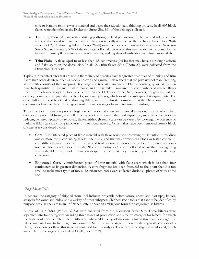
Troy Starlight Development, City of Troy and Town of Schaghticoke, Rensselaer County, New York Phase IB/II Archeological Site Evaluation
17
core or blank to remove waste material and begin the reduction and thinning process. In all, 607 block flakes were identified at the Dickerson Street Site, 8% of the debitage collected.
Thinning Flake. A flake with a striking platform, bulb of percussion, rippled ventral side, and flake scars on the dorsal side. As the name implies, it is typically removed to thin a chipped stone tool. With a count of 2,511, thinning flakes (Photos 26-28) were the most common artifact type at the Dickerson Street Site representing 33% of the debitage collected. However, this may be somewhat biased by the fact that thinning flakes have very clear attributes, making their identification as cultural more likely.
Trim Flake. A flake equal to or less than 1.5 centimeters (0.6 in) that may have a striking platform and flake scars on the dorsal side. In all, 703 trim flakes (9%) (Photo 29) were collected from the Dickerson Street Site.
Typically, precontact sites that are not in the vicinity of quarries have far greater quantities of thinning and trim flakes than other debitage, such as blocks, shatter, and gangue. This reflects that the primary tool manufacturing at these sites consist of the final production stage and tool kit maintenance. On the contrary, quarry sites often have high quantities of gangue, shatter, blocks and quarry flakes compared to low numbers of smaller flakes from more advance stages of tool production. At the Dickerson Street Site, however, roughly half of the debitage consists of gangue, shatter, blocks, and quarry flakes, which would be anticipated at a quarry site. The other half consists of block flakes, thinning flakes, and trim. This demonstrates that the Dickerson Street Site contains evidence of the entire range of tool production stages from extraction to finishing.
The stone tool production process begins when blocks of chert are removed from outcrops or when chert cobbles are procured from glacial till. Once a block is procured, the flintknapper begins to alter the block by reducing its size, typically by removing flakes. Although such scars can be caused by plowing, the presence of multiple flake scars are strong indicators of intentional activity. Once flakes have been removed from a block of chert it is considered a core.
Core. A multifaceted piece of lithic material with flake scars demonstrating the intention to produce one or more tools, containing at least one blank, and that was previously a block or tested cobble. A core differs from a biface or more advanced tool because it has not been edged or thinned and does not have two discrete faces. A total of 91 cores (Photos 30-31) were collected across the sits suggesting a considerable quantity of production despite the fact that they represent just 1% of the debitage collection.
Exhausted Core. A multifaceted piece of lithic material with flake scars which is less than four centimeters at its greatest dimension. A core fragment has been fractured to the point that it is too small to make most types of tools. 12 exhausted cores were collected during all phases of work at the site.
Chipped Stone Tools
In general, the category of chipped stone tool includes projectile points (arrow, spear, and dart tips), knives, scrapers for wood and hides, and a variety of other subtypes. Chipped stone tools that cannot be identified by purpose because they are in an unfinished state or have an ambiguous form are categorized as bifaces.
A total of 43 bifaces (Photos 32-33) were collected from the Dickerson Street Site. These bifaces were separated into four categories including three stages of production and a fourth category for bifaces for which the stage could not be determined. Different published lithic typologies use between three and six stages for biface analysis. Four to five stages are common. Since the initial stage in these models typically consists of a blank, block, core, or flake; this stage was not used for this analysis. Therefore, three stages were adopted, which are similar to the stages proposed by Odell (Odell 1982).
Troy Starlight Development, City of Troy and Town of Schaghticoke, Rensselaer County, New York Phase IB/II Archeological Site Evaluation
18
Stage 1 consists of edged bifaces, and 22 (16% of the chipped stone tools) of these artifacts were found at the site. Stage 1 bifaces differ from cores because they have an edge that divides the two faces of the artifact. These artifacts typically have a width-to-thickness ratio of 2:1. Interestingly, several Stage 1 bifaces collected had been worked, sometimes significantly, only on one side, with the side retaining a blocky, angular surface.
Stage 2 consists of the primary thinning stage. Six Stage 2 bifaces were found at the Dickerson Street Site. These bifaces have been thinned to roughly a 3:1 width-to-thickness ratio. 8 stage 2 bifaces were collected representing 6% of this type.
Stage 3 consists of the secondary thinning stage, and these bifaces can be considered finished tools. Six Stage 3 bifaces were found at the Dickerson Street Site. These bifaces have been thinned to a 4:1 width-to-thickness ratio or higher. 6 stage 3 bifaces were recovered accounting for 6% of the chipped stone tools.
Seven fragmentary bifaces that could not be categorized by stage were found. These bifaces were typically fragments of one edge and were lacking a sufficient cross-section to determine the degree of thinning. The decrease in number as we move from stage 1 to 3 potentially reflects the fact that bifaces were manufactured at the Dickerson Street Site and many bifaces were discarded on site after difficulties were encountered during the first stage, whereas later stage bifaces were removed from the site for finishing and use elsewhere.
Projectile Points
Three projectile points were found within the Dickerson Street Site. Although commonly known as “arrowheads,” projectile points also consist of spear and atlatl dart heads and hafted knives. Projectile point styles were specific to precontact cultures, and dated projectile point typologies have been developed by archeologists based on the stratigraphic context of different point styles and associated radiocarbon dates.
A total of seven projectile points (7% of the chipped stone tools) were recovered during Hartgen’s combined investigations at the Dickerson Street Site. Three of these points were not diagnostic. Two were classified as incomplete Stage 2 points and thus were not assigned a type. A third was fragmentary and a type was unable to be determined. However, the remaining points were all complete and assigned temporally diagnostic types (Photo 16). These included:
A Late Archaic Sylvan Stemmed point (4,300 - 3,500 B.P.) from Trench 2 of the 2008 investigations.
A Middle Archaic Genesee point (4,900 - 3,800 B.P.) from approximately 20 cm below the surface near the subsoil interface of Unit 3 of the present study.
A Late Archaic to Early Woodland Adena Point (3,500 - 1,300 B.P.) recovered during surface collection in Area 3.
A Middle Archaic Vosburg point (5,200 - 4,500 B.P.) also recovered during Area 3 surface collection.
Just one end scraper was collected from the ground surface on the floodplain. It was composed of a very dark chert that may have been a local variant, although was not common within the Dickerson Street Site itself.
Retouch consists of any modification of a piece after it has been stuck from its parent. Therefore, cores, bifaces, and tools have retouch. Flakes, which are typically discarded after being struck, do not generally have retouch. However, occasionally flakes were retouched to create various tools. The authors of the 2010 report indicated that they were extremely cautious about classifying edge modification as retouch, erring decidedly on the skeptical side during their Phase III investigation. They classified only 5 artifacts as retouched flakes. We took a different less skeptical approach and classified 71 flakes as retouched (Photos 34-35). That shift in method means that while the 2010 study only considered the category to represent 11% of their chipped stone
Troy Starlight Development, City of Troy and Town of Schaghticoke, Rensselaer County, New York Phase IB/II Archeological Site Evaluation
19
tools, our added data drives the number up to 56%. A more detailed study of these expedient tools would be appropriate if additional Phase III investigations were to occur. There was less difference in our classification of retouched blocks, which represented just 9 total from all investigations, however 7 of those were from the present investigation. The retouched blocks (Photo 36) differed from cores because the retouch was small and localized. This suggests that the retouch was intended to produce an expedient tool from the block.
Fire-Cracked Rock
Fire-cracked rock at the site was abundant with a total of 567 pieces recovered across all stages of work at the site. Quartzite and sandstone was present in the collection. However, quartzite was far more common. The presence of this quantity of material suggests that there are likely intact hearths still undiscovered. Accessing these features has the potential to provide carbon that could help refine the site chronology through radiocarbon dating.
Table 7. Combined Artifact Types and Subtypes Type Subtype
2002
8 an
d 20
10 C
ount
2008
and
201
0 Pe
rcen
tage
of
Type
2020
Cou
nt
2020
Pe
rcen
tage
of
Type
Com
bine
d Co
unt
Com
bine
d Pe
rcen
tage
of
Type
rough stone tool extraction hammerstone 3 14% 3 23% 6 18%hammerstone 17 81% 10 77% 27 79%wedge 1 5% 0 0% 1 3%
debitage gangue 554 9% 125 8% 679 9%shatter 1,707 28% 108 7% 1815 24%block 401 6% 39 3% 440 6%core 69 1% 22 1% 91 1%exhausted core 11 0% 1 0% 12 0%flake 39 1% 260 17% 299 4%quarry flake 412 7% 76 5% 488 6%block flake 399 6% 208 14% 607 14%thinning flake 1,977 32% 534 35% 2511 33%trim 564 9% 139 9% 703 9%bifacial thinning flake 42 1% 0 0% 42 1%
chipped stone tool retouched block 2 4% 7 8% 9 7%retouched flake 5 11% 71 77% 76 56%biface, stage 1 14 31% 8 9% 22 16%biface, stage 2 6 16% 2 2% 8 6%biface, stage 3 6 11% 0 0% 6 4%biface, fragment 7 16% 0 0% 7 5%scraper 1 2% 0 0% 1 1%
projectile point Sylvan Stemmed 1 2% 0 0% 1 1%stage 2 1 2% 1 0% 2 1%untyped 1 2% 0 0% 1 1%Adena 0 0% 1 1% 1 1%Genesee 0 0% 1 1% 1 1%Vosburg 0 0% 1 1% 1 1%
fire-cracked rock 481 100% 86 100% 567 100%Total 6,721 *Projectile points are included with chipped stone tools in percentage
Troy Starlight Development, City of Troy and Town of Schaghticoke, Rensselaer County, New York Phase IB/II Archeological Site Evaluation
20
The distributional patterns evident at the Dickerson Street Site allow us to define site boundaries, identify specific loci within the site and describe the specific production activities associated with each locus. Map 3a depicts the distribution of all Precontact artifacts recovered from shovel testing. It incorporates data collected from all stages of Hartgen’s investigations at the site. It was the basis for drawing the broad boundaries of the site and its four loci. Overall, the site encompasses 5.37 acres (21,723 m2) running along the banks of the Hudson River and inland to incorporate several ridges of bedrock that were exploited for lithic raw material. It measures approximately 373 m (1,224 ft) north to south along the river and 84 m (274 ft) east from the banks of the river. The boundaries were drawn to incorporate the highest density of materials encountered. A limited quantity of material extends farther east that the boundaries that we have established. However, any occupation in this areas was brief, leaving a very light footprint that is less likely to provide significant information.
Four distinct loci was established around the densest concentrations within the site boundaries. Locus 1 is located at the southern end of the project APE along a low ridge that was a likely extraction zone based on the presence of a large extraction hammerstone located along its east side. It also incorporates two dense deposits of large gangue, blocks and other waste debris which would have been the result of milling activity. The deposit in Collection Area 7 likely related directly to the ridge extraction zone and the deposit in Collection Area 8 likely relates to material being quarried from outcrops along River Road or destroyed during its construction. Locus 2 incorporates an extraction zone and milling/ore processing area at the southeastern corner of the central section of the site (surveyed in 2008). Locus 3 contains newly identified extraction zones along the east face of two ridges in the northern portion of the site. One large extraction hammerstone with two large spalls missing was located sitting directly on top of the ridge in an area showing clear evidence of quarrying. A scatter of lithic flaked and smaller hammerstones on a flat area above the worked ridge suggests some mid to late stage production in addition to the initial raw material quarrying. Locus 4 is located on the floodplain running from the central through the northern portions of the survey areas. The 2010 study demonstrated that the area was home to small camps where later stage lithic production was taking place. There are two clear clusters of remains within the locus with some fall off in between. This likely represents two independent camps established at different times as we have evidence that the site was in use for a long period of time, both the Middle and Late Archaic Periods and possible beyond. A lower density of remains along the floodplain were not included in the locus. However, they appear to represent similar activity, with fewer remains present. It should be noted that broadly speaking the densities of material were lower for areas surveyed in the present study. It is uncertain if this variation reflected genuine decrease in densities of if our team took a more conservative approach in identifying material as cultural. However, the latter cause seems very likely.
The functions ascribed to these loci were informed by the varying distributions of four categories of material collected during shovel testing (Map 3b). These include: quarry and block flakes, representing early stage processing of extracted ores, thinning flakes representing mid stage processing, trim flakes indicative of late stage processing and fire-cracked rock suggesting the presence of hearths that would be an indicator of campsite locations. Loci 1 and 2 contained the greatest concentrations of early stage material. These concentrations would be even higher if the results of surface collection were incorporated. However, these early stage materials were found in all four loci in lower densities suggesting that in some cases unprocessed raw material was being transported away from the extraction and main milling zones for further processing. Thinning flakes represent shaping of blanks and tools. They were widespread across the site with particular concentrations in the locus 2 workshop are and in the workshop/camps in locus 4. They were rare near the extraction zones in loci 1 and 3, suggesting that high graded ores were being refined into tool forms in other locations. The distribution of trim flakes is more restricted than we have seen for the early and mid-stage processing indicators. These were overwhelmingly concentrated in the workshop/camp areas of locus 4, with some also being found in the locus 2 workshop area. Fire-cracked rock had the most restricted distribution of all, being found almost exclusively in the floodplain area. Although a low density was also located near River Road to the east of where we drew the site boundary, suggesting some light occupation of that area as well.
Troy Starlight Development, City of Troy and Town of Schaghticoke, Rensselaer County, New York Phase IB/II Archeological Site Evaluation
21
Interestingly, no FCR was recovered from shovel tests at the north end of locus 4. However, it was not uncommon in the units excavated in that area.
These four indicator classes give us a great deal of insight into the overall organization of activities across the Dickerson Street Site. They make it clear where various stages of quarrying and tool production were taking place. They provide a clear indication of locations where small camps were placed. Additional insights could likely be gained from more detailed examination of the distribution of other artifact classes such as cores and bifaces. However, such analysis would be more appropriate for a Phase III investigation.
The Dickerson Street Precontact Site is a quarry that is just one of several located along the east side of the Hudson just north of its confluence with the Mohawk. According to La Porta’s (2000:10-16) model of quarry development, quarries can be divided into various categories based on scale of activity. An “expression” indicates a prospect that may have been tested and demonstrates evidence of extraction during possibly a single episode. A “movement” is a small-scale quarry that may demonstrate division of tasks and specialized tools such as hammerstones. A “motion” is a large-scale quarry with variety of quarrying tools and subdivision of tasks evident in the spatial organization of the site. A “trend” is a series of quarries along a strike (the compass direction of a bedded chert formation) (LaPorta 2000:12). A group of trends in the same vicinity and within one area of similar geology is a “district.” Based on this model, the Dickerson Street Site consists of an extensive movement or a limited motion within a district that extends from Lansingburgh to Pleasantdale.
La Porta’s model outlines four zones that can be found in ancient quarry sites (La Porta 2000). These consist of Zones I through IV: extraction, milling, ore processing, and workshop zones (2000:12-13). All four of these zones are identifiable at the Dickerson Street Site. Extraction took place at several locations including outcrops located along River Road (presently or in the past), along the east side of a ridge at the southern end of the site and at outcrops present on the west side of ridges in the northern end of the site. These locations show evidence of the removal of material and in several cases contained large extraction hammerstones used in that removal. Milling took place in discrete locations in the southern end of the site, particularly in collection areas 7 and 8, which were marked by dense concentrations of early stage debitage consistent with the separation of useable ores from the surrounding matrix. Some milling activity was also mixed with ore processing in locations such as the workshop area in the southeast corner of the portion of the site investigate in 2008. Other workshop zones, specializing in mid to late stage manufacture of tools were clustered in the floodplain along the banks of the Hudson.
The site offered many advantages to local populations. The easily broken shale bedrock containing much of the usable ore was easily worked and contained high quality cherts lacking in inclusions like fossils that can be found in other locations. Glacial activity in the valley exposed outcrops at the surface, making locating and extracting the material relatively convenient. Its location near the confluence of the Hudson and Mohawk rivers, provided for fast and easy transport to the site, which was probably a regular stop of seasonal rounds. The presence of the level and well drained floodplain provided a convenient place to establish camps and their associated comforts. Finally, the river would have provided a range of aquatic resources to people stopping to exploit the valuable lithic resources.
Datable diagnostic artifacts indicate that the site was used as a source of raw materials by native peoples over a long period of time including the Middle and Late Archaic Periods and possibly into the early Woodland Period. Today little chert is visible at the surface, suggesting that the resource may have been exhausted in the Late Archaic or soon thereafter.
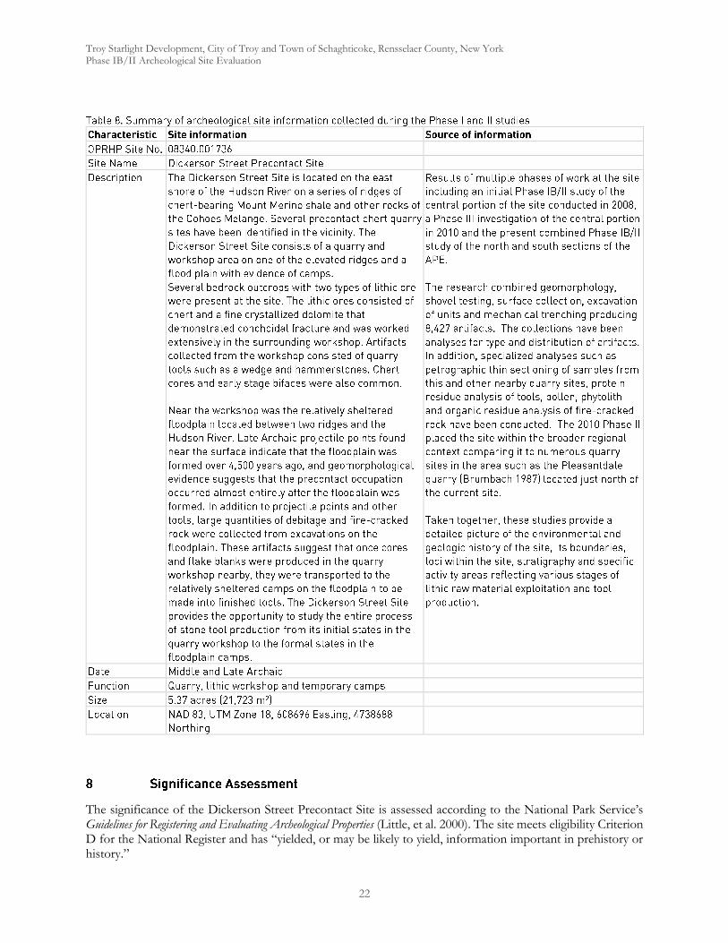
Troy Starlight Development, City of Troy and Town of Schaghticoke, Rensselaer County, New York Phase IB/II Archeological Site Evaluation
22
The significance of the Dickerson Street Precontact Site is assessed according to the National Park Service’s Guidelines for Registering and Evaluating Archeological Properties (Little, et al. 2000). The site meets eligibility Criterion D for the National Register and has “yielded, or may be likely to yield, information important in prehistory or history.”
Troy Starlight Development, City of Troy and Town of Schaghticoke, Rensselaer County, New York Phase IB/II Archeological Site Evaluation
23
The Dickerson Street Precontact Site has already been recommended as eligible for the National Register during Hartgen’s initial 2008 study of the central portion of the site saying, “It is recommended that the Dickerson Street Site be considered National Register eligible under Criterion D as a site that has yielded or may be likely to yield, information important in history or prehistory.” We concur with that recommendation for the whole of the expanded site as defined during the present study.
The Dickerson Street Precontact Site (08340.001736) has the potential to yield important information. A set of research questions were devised by the 2008 Hartgen team, some of which has already been addressed in the 2010 Hartgen Phase III Data Recovery for the central portion of the site. However, they still fully apply to the new areas covered in the current study. Those questions included the following:
Geomorphology. Part of the APE is within the floodplain, although this portion of the floodplain may have been a backswamp, or a relatively wet area behind a drier natural levee. Does this portion of the floodplain contain similar artifacts and artifact densities to those found on the levee nearer the river?
Intra-Site Spatial Organization. How was the space within the APE organized? The Phase IB results demonstrate that quarrying was carried out at the bedrock outcrops in the southern portion of the Phase IB study area, lithic workshops were located nearby, and that stone tool finishing took place on the floodplain. The APE is an area between the quarry and the floodplain. How was the APE used and how does is compare to the other zones at the site? Is there spatial patterning within the APE itself?
Features. Are there bedrock outcrops at or near the ground surface within the APE? If so, was the area quarried for chert? Additionally, are there intact subsurface features such as hearths or postmolds located within the APE?
Dates. Is it possible to determine more precise occupation dates within the Middle and Late Archaic period for occupations at the site through radiocarbon dating? Does the site contain diagnostic artifacts from other phases or periods?
Artifacts. What kinds of artifacts are associated with the site, and what does the artifact assemblage indicate about the activities that were carried out within the site?
Lithic Sources. What degree of variation is apparent in the chert available in outcrops in the vicinity of the site? Is this variation reflected in the types of chert used for tool production? Are there tools present at the site that are made from non-local materials? Thin section and trace element analysis will provide information about the source and quality of lithic material found at the site.
Lithic Quality. What is the quality of the types of lithic materials identified at the site? Did precontact people favor one type of local chert over another?
Botanical Resources. What types of botanical resources were exploited by occupants of the site? What were the potential uses of these resources? This information will be obtained by identifying pollen, phytoliths, and macrobotanical remains from soil horizons, feature fill, pottery, and stone tools.
Faunal Resources. What types of faunal resources were exploited by occupants of the site? If so, what do they indicate about the subsistence strategies and diet of the site’s occupants? This information will be obtained through identification of faunal bone and application of protein residue analysis and Fourier Transform Infrared Spectroscopy (FTIR) to stone tools.
Regional Context. How does the Dickerson Street Site relate to other sites in the vicinity, including the Pleasantdale Quarry, the Charles Ellet Apartment Site, the Mechanicville Road Site, the Second Street Site, and the Water Works Site? Were any of the sites occupied simultaneously? Were similar

Troy Starlight Development, City of Troy and Town of Schaghticoke, Rensselaer County, New York Phase IB/II Archeological Site Evaluation
24
activities performed at each site, or is it possible that several of the sites were used for different purposes, possibly contributing to a broad land-use pattern incorporating multiple sites?
The site retains important aspects of its integrity such as location, design and structure, physical setting, materials, workmanship, historical sense or feeling, and association between data and important research questions (Little, et al. 2000:35-38).
An assessment of the integrity of the site based on the seven aspects of integrity follows:
Location, Setting and Feeling. The site is in its original location and retains almost all of its occupation-period topographic setting, including significant features such as the southwest ridge with extensive views of the Hudson River, the chert quarry with bedrock outcrops and extraction excavations and the floodplain which was likely the primary habitation area.
Design. The presence of several environmental zones and identification of different activities both in different zones and within the same zone contributes to the integrity of design. For example, procurement of chert for stone tool production took place in the quarry, whereas the finishing of tools was completed in camps on the floodplain. Also, there is evidence that the quarry area itself contains different chert workshops demonstrating preferences for different materials and reduction techniques.
Materials. The presence of several sources of raw material for stone tool manufacture near the site contributes to the integrity of materials. The study of the site will facilitate the assessment of preference for different varieties of local cherts and the use of non-local sources such as Onondaga chert, which is also represented in the artifact assemblage from the site.
Workmanship. As the artifacts in Shovel Test 1 demonstrate, the site provides extensive information about the process of stone tool production. It seems likely that the site contains excellent examples of products of the entire process from quarrying to finishing tools.
Association. The site has the potential to provide data to assess a wide variety of research questions, some of which are outlined below.
The current APE contains the Dickerson Street Site, a Middle to Late Archaic quarry with multiple loci, representing a full range of extraction and production activities. The site has been determined to be National Register eligible. A Phase III investigation of portions of the site was completed in 2010. The current Study Area includes portions of the site that were not covered by Hartgen’s earlier projects. The site has experienced minimal disturbance and demonstrates several criteria for integrity. Avoidance of the defined site area or additional Phase III Data Recovery is recommended.
Troy Starlight Development, City of Troy and Town of Schaghticoke, Rensselaer County, New York Phase IB/II Archeological Site Evaluation
25
Andrefsky, William 1998 Lithics: Macroscopic Approaches to Analysis. Cambridge Manuals in Archaeology. Cambridge
University Press, New York.
Brumbach, H. J. 1987 Hudson River Quarry/ Workshop, Pleasantdale, NY. Archaeology of Eastern North America.
DeSimone, D.J. , G.R. Wall, N.G. Miller, J.A. Rayburn and A.L. Kozlowski 2008 Glacial Geology of the Northern Hudson Through Southern Champlain Lowlands: Guidebook to Field Trip
71st Annual Northeastern Friends of the Pleistocene Meeting Queensbury, NY.
Esri Inc. 2015 World Imagery. Esri, Inc., Redlands, California,
http://services.arcgisonline.com/ArcGIS/rest/services/World_Topo_Map/MapServer.
Fisher, Donald W., Yngvar W. Isachsen and Lawrence V. Rickard 1970 Geologic Map of New York. New York State Museum Map and Chart Series No. 15. The New York
State Education Department, Albany.
Hartgen Archeological Associates Inc. 2008 Phase IA/IB Archeological Investigation for the Hudson River PCB Superfund Project and Phase II Site
Examination at the Dickerson Street Site and Water Works Site, City of Troy, Rensselaer County, Village of Waterford, Town of Waterford, and Town of Halfmoon, Saratoga County, New York. Report number 4065. Submitted to Ecology & Environment, Inc. On file at Report on file at the New York State Parks, Recreation, and Historic Preservation, Waterford, New York.
2010a Phase III Data Retrieval Study, Dickerson Street Precontact Site, Hudson PCB Superfund Water Line Project. Report number 4065-21. Submitted to Ecology & Environment. On file at Report on file at the New York State Parks, Recreation, and Historic Preservation, Waterford, New York.
2010b Phase III Data Retrieval Study, Water Works Site, Hudson PCB Superfund Water Line Project. Report number 4065-21. Submitted to Ecology & Environment. On file at Report on file at the New York State Parks, Recreation, and Historic Preservation, Waterford, New York.
Kidd, W.S.F., A. Plesch and F.W. Vollmer 1995 Lithofacies and Structure of the Taconic Flysch, Mélange, and Allochthon, in the New York
Capital District. In Field Trip Guide for the 67th Annual Meeting of the New York State Geological Association, edited by J. I. Garver and J. A. Smith. Union College, Schenectady, New York.
La Porta, Philip C. 2000 Phase IB Cultural Resources Survey-Supplement, Characterization of Prehistoric Quarry Development, Smiths
Basin Site, Town of Hartford, Washington County, New York. On file at Report on file at the New York State Parks, Recreation, and Historic Preservation, Waterford, New York.
2006 Phase IA/IB Cultural Resource Investigation of the Chester Golf Club Subdivision, Town of Chester, Orange County, New York. On file at Report on file at the New York State Parks, Recreation, and Historic Preservation, Waterford, New York.
Little, Barbara, Erika Martin Seibert, Jan Townsend, John H. Sprinkle, Jr. and John Knoerl 2000 National Register Bulletin: Guidelines for Evaluating and Registering Archeological Properties. U.S.
Department of the Interior, National Park Service, Washington, D.C.
Troy Starlight Development, City of Troy and Town of Schaghticoke, Rensselaer County, New York Phase IB/II Archeological Site Evaluation
26
Luedtke, Barbara E. 1992 An Archaeologist's Guide to Chert and Flint. Archaeological Research Tools 7. University of
California, Los Angeles.
Munsell Color 2000 Munsell Soil Color Charts. GretagMacbeth, New Windsor, New York.
New York Archaeological Council (NYAC) 1994 Standards for Cultural Resource Investigations and the Curation of Archaeological Collections in New York
State. NYAC, n.p.
Odell, George H. 1982 The Typological System Employed to Process Lithic Artifacts from Sites on the F.A.P. 408
Corridor, Unpublished manuscript, Center for American Archeology, Kampsville, Illinois.
2004 Lithic Analysis. Manuals in archaeological method, theory, and technique. Kluwer Academic/Plenum Publishers, New York.
Office of Parks, Recreation and Historic Preservation (OPRHP) 2005 New York State Historic Preservation Office (SHPO) Phase I Archaeological Report Requirements. OPRHP,
Waterford, New York.
United States Geological Survey (USGS) 2015 USGS The National Map Topo Base Map - Large Scale. USGSTopo (MapServer), The National
Map Seamless Server, USGS, Sioux Falls, South Dakota, http://services.nationalmap.gov/arcgis/rest/services/USGSTopoLarge/MapServer.
Whittaker, John C. 1994 Flintknapping: Making & Understanding Stone Tools. The University of Texas Press, Austin, TX.

Troy Starlight Development, City of Troy and Town of Schaghticoke, Rensselaer County, New York Phase IB/II Archeological Site Evaluation
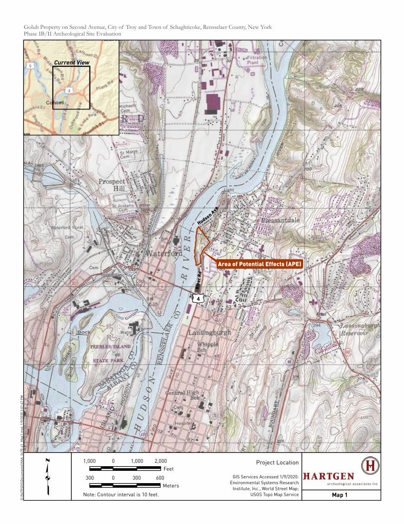
Area of Potential Effects (APE)
Riv
er
Rd
£¤4
HudsonAve
Golub Property on Second Avenue, City of Troy and Town of Schaghticoke, Rensselaer County, New YorkPhase IB/II Archeological Site EvaluationG
:\5
47
0\G
IS\D
oc
um
en
ts\H
AA
_5
47
0-4
1_
Ma
p1
.mxd
, 1
/9/2
02
0 3
:01
:47
PM
1,000 0 1,000 2,000
Feet
Note: Contour interval is 10 feet.q Map 1
Project Location
GIS Services Accessed 1/9/2020:
Environmental Systems Research
Institute, Inc., World Street Map;
USGS Topo Map Service
Current View
300 0 300 600
Meters
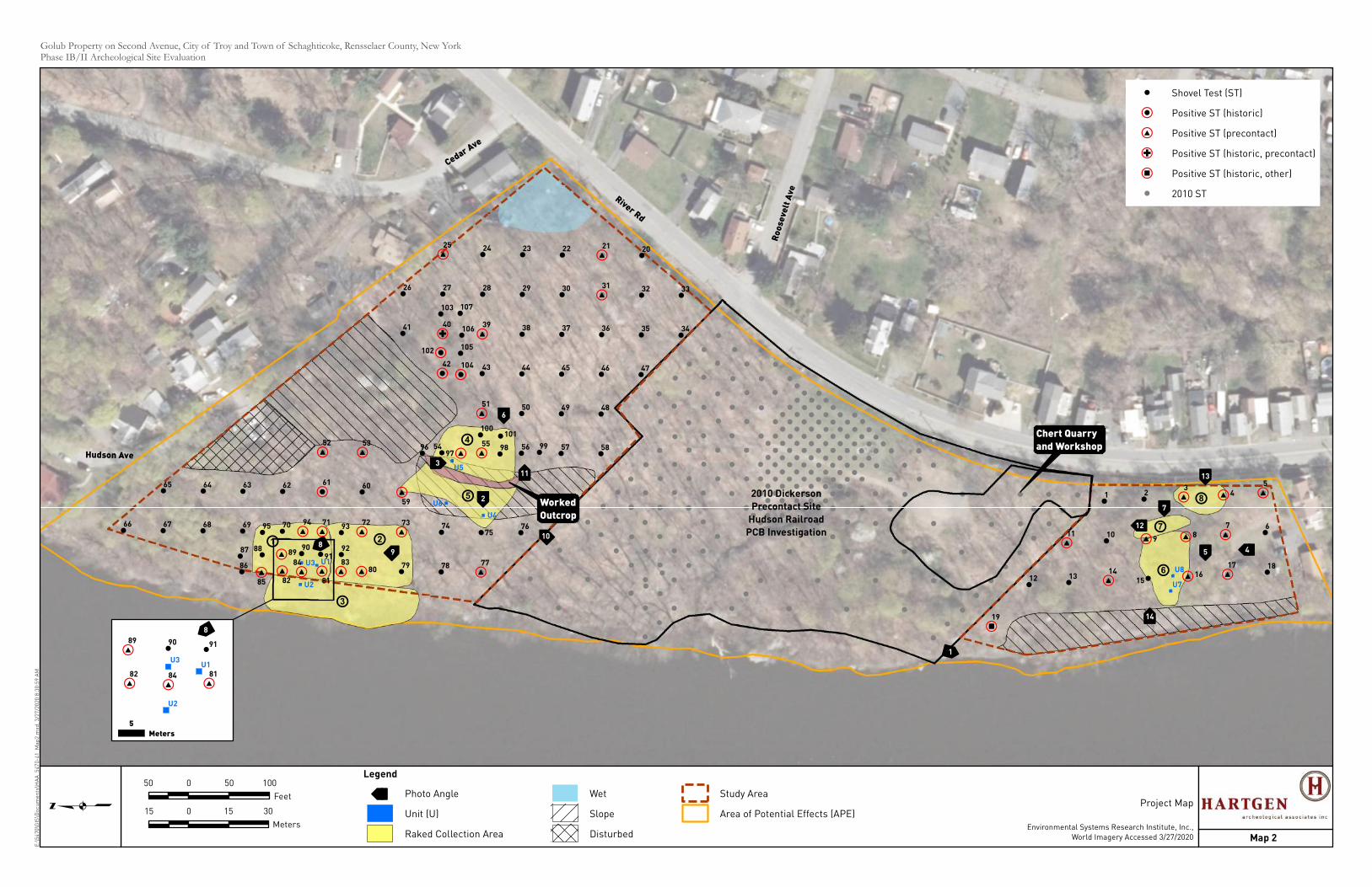
ÃÃ
ÃÃ
ÃÃ
à ÃÃÃ
ÃÃ
ÃÃ
ÃÃ ÃÃÃÃ
ÃÃ
à Ã
ÃÃ
ÃÃ
! !
!
!
!
!
!
#,
!
!
#,
#,
!,
#,
#,
#,
!
#,
!
#,
#,
!
!
!
!
!
!,
Ñ,
!
#,
#,
!
#,
#,
!
#,
!
!
!
!
!
!
!
!
!
!
!
!
!
!
!
!
!
!
!
#,
#,
!
!
!
!
!
!
,̄
#,#,#,!
! ! #, ! ! !
!#,!
! #, ! !
! !
!,
!
!,
!
!
!
! !
#,
#,
!
!
!
#,
!
#,
#,
#,
#,
#,
#,
!
!
#,
Hudson Ave
Ro
ose
velt
Ave
Cedar Ave
River Rd
Chert Quarry
and Workshop
Worked
Outcrop
U1
U2
U3
U4
U6
U5
U7
U8
2010 Dickerson
Precontact Site
Hudson Railroad
PCB Investigation
1
2
3
45
6
7
89
10
11
12
13
14
+8
+6
+7+1 +2
+3
+4
+5
66 67
65
68
64
69
63
82
70
62
81
71
61
52
80
72
60
53
79
73
59
41
26
78
74
54
42
40
27
25
77
75
55
51
43
39
28
24
76
56
50
44
38
29
23
57
49
45
37
30
22
58
48
46
36
31
21
47
35
32
20
34
33
19
8384
85
86
87 88 8990
9192
9394
95
9697
98 99
100101
102
103
104
105
106
107
12 13
11
14
10
1
15
9
2
16
8
3
17
7
4
18
6
5
Golub Property on Second Avenue, City of Troy and Town of Schaghticoke, Rensselaer County, New YorkPhase IB/II Archeological Site EvaluationE
:\5
47
0\G
IS\D
oc
um
en
ts\H
AA
_5
47
0-4
1_
Ma
p2
.mxd
, 3
/27
/20
20
8:3
0:5
9 A
M
q
Map 2
Project Map
Environmental Systems Research Institute, Inc.,
World Imagery Accessed 3/27/2020
50 0 50 100
Feet
15 0 15 30
Meters
Legend
à à Photo Angle
Unit (U)
Raked Collection Area
Wet
Slope
Disturbed
Study Area
Area of Potential Effects (APE)
#, #,#,
#, ! !
ÃÃ
U1
U2
U3
82 8184
89 90 91
8
5
Meters
! Shovel Test (ST)
!, Positive ST (historic)
#, Positive ST (precontact)
Ñ, Positive ST (historic, precontact)
,̄ Positive ST (historic, other)
! 2010 ST
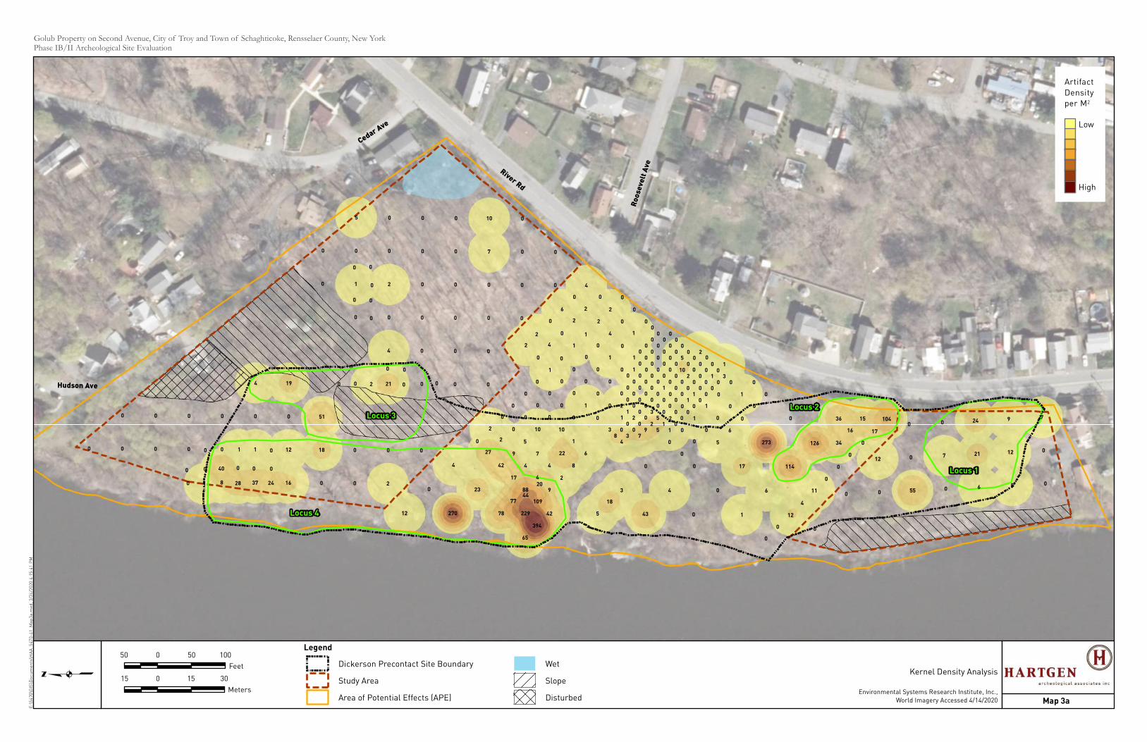
Hudson Ave
Ro
ose
velt
Ave
Cedar Ave
River Rd
Locus 1
Locus 2Locus 3
Locus 4
17
0
0
0
0
0
6
5
0
4
43
0
0
0
0
0
1
00
0
1
1
0
0
0
3
18
5
5
2
0
1
0
0
0
0
0
0
0
0
0
4
42
394
65
229
109
9
2
8
6
3
1
0
0
0
0
5
0
0
0
0
0
0
0
1
22
4
4
88
77
78
17
4
7
10
0
1
0
0
0 0
0
0
0
0
0
8
0
0
37
1
0
4
16
12
0
19
0
18
51
0
0
0
0
0
0
1
0
5
2
0
21
4
0
2
0
0
0
0
0
0
0
0
0
0
0
0
0
0
0
0
0
0
0
7
10
0
0
0
0
0
0
0
242810
0 0 40 0 0 0
010
0 2 0 0
0 0
0
0
0
0
0
0
0 0
12
55
0
0
0
7
0
6
21
24
8
12
9
0
0
7104
17
0
0
0
0
11
4
12
0
0
34
16
1536
126
114
6
1
0
273
0
1
0
0
0
1
0
1
0
0
0
0
0
10
5
9
42
23
270
27
2
0
0
0
0
0
0
0
0
4
0
0
0
2
2
1
1
0
1
0
0
0
0
2
0
4
0
12
0
0
0
2
2
0
4
0
4
6
2
2
20
44
30
00
00
00
01
1
1
0
1
0
1
00
00
00
00
05
29
7
0
2
0
0
3
0
3
20
010
00
10
00
02
00
8
0
0
0
0
0
1
00
00
00
00
00
2
0
0
0
0
0
00
00
00
10
0
0
0
Golub Property on Second Avenue, City of Troy and Town of Schaghticoke, Rensselaer County, New YorkPhase IB/II Archeological Site EvaluationE
:\5
47
0\G
IS\D
oc
um
en
ts\H
AA
_5
47
0-4
1_
Ma
p3
a.m
xd,
3/2
4/2
02
0 4
:15
:41
PM
q
Map 3a
Kernel Density Analysis
Environmental Systems Research Institute, Inc.,
World Imagery Accessed 4/14/2020
50 0 50 100
Feet
15 0 15 30
Meters
Legend
Dickerson Precontact Site Boundary
Study Area
Area of Potential Effects (APE)
Wet
Slope
Disturbed
Artifact
Density
per M2
Low
High
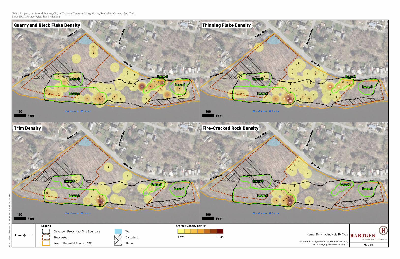
River Rd
Hudson Ave
Cedar Ave
Ro
ose
velt
Ave
H u d s o n R i v e r
51
Locus 1
Locus 3
Locus 4
Locus 2
21
3
1
16
126
3
122
1
1
12
37
17 5
4
6
6
10
7
1
4
5
4
9
1
4
2
10
12
6
4
2
31
55
19
3
1
10
2
1
1
1
1
1
1
1
1
22
34
55
River Rd
Hudson Ave
Cedar Ave
Ro
ose
velt
Ave
H u d s o n R i v e r
30
Locus 1
Locus 3
Locus 4
Locus 2
17
11
11
1
2
1
2
18
28
212
12
1
5
17
2
1
1
1
4 14
2
1
7
671
9
2
31
312
2
3
1
1
111
11
1
1
2
5
21
1
2
11
2
81
10221
6531
26
26
3184
64
River Rd
Hudson Ave
Cedar Ave
Ro
ose
velt
Ave
H u d s o n R i v e r
Locus 1
Locus 3
Locus 4
Locus 2
1017
22
1
7
11
6
2
3
22
7
3
16
1
1
41
1
3
1
5
1
1
110122
21
24
26
River Rd
Hudson Ave
Cedar Ave
Ro
ose
velt
Ave
H u d s o n R i v e r
Locus 1
Locus 3
Locus 4
Locus 2
125
513
16
6
5
1
2
1017
41
2
2
1
12
4
19
41
1
1
1
3
4
3
1
4
58
42
Golub Property on Second Avenue, City of Troy and Town of Schaghticoke, Rensselaer County, New YorkPhase IB/II Archeological Site Evaluation
q
Map 3b
Kernel Density Analysis By Type
Environmental Systems Research Institute, Inc.,
World Imagery Accessed 4/14/2020
E:\
54
70
\GIS
\Do
cu
me
nts
\HA
A_
54
70
-41
_M
ap
3b
.mxd
, 4
/14
/20
20
8:3
2:5
9 A
M
Quarry and Block Flake Density Thinning Flake Density
Fire-Cracked Rock DensityTrim Density
100
Feet
100
Feet
100
Feet
100
Feet
Legend
Dickerson Precontact Site Boundary
Study Area
Area of Potential Effects (APE)
Wet
Disturbed
Slope
Artifact Density per M2
Low High

Troy Starlight Development, City of Troy and Town of Schaghticoke, Rensselaer County, New York Phase IB/II Archeological Site Evaluation
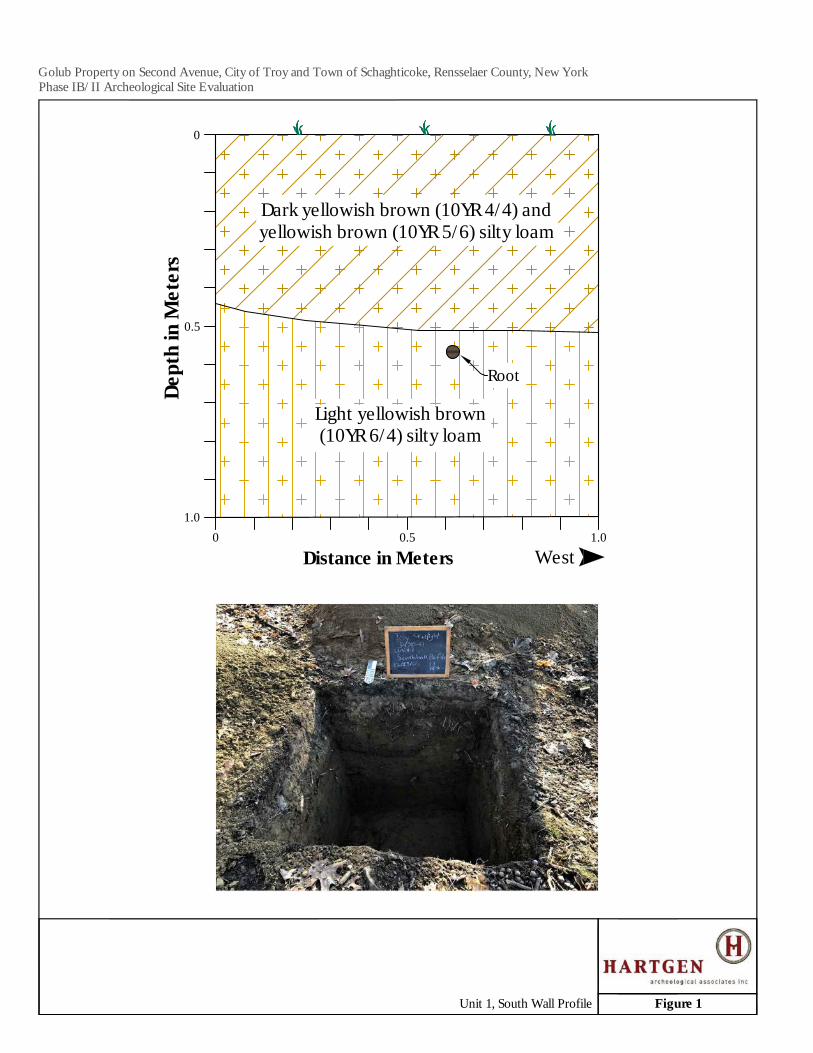
0 0.5 1.0
0.5
1.0
Dept
h in
Met
ers
Distance in Meters West
0
Dark yellowish brown (10YR 4/4) andyellowish brown (10YR 5/6) silty loam
Light yellowish brown(10YR 6/4) silty loam
Root
Golub Property on Second Avenue, City of Troy and Town of Schaghticoke, Rensselaer County, New YorkPhase IB/II Archeological Site Evaluation
Figure 1Unit 1, South Wall Profile
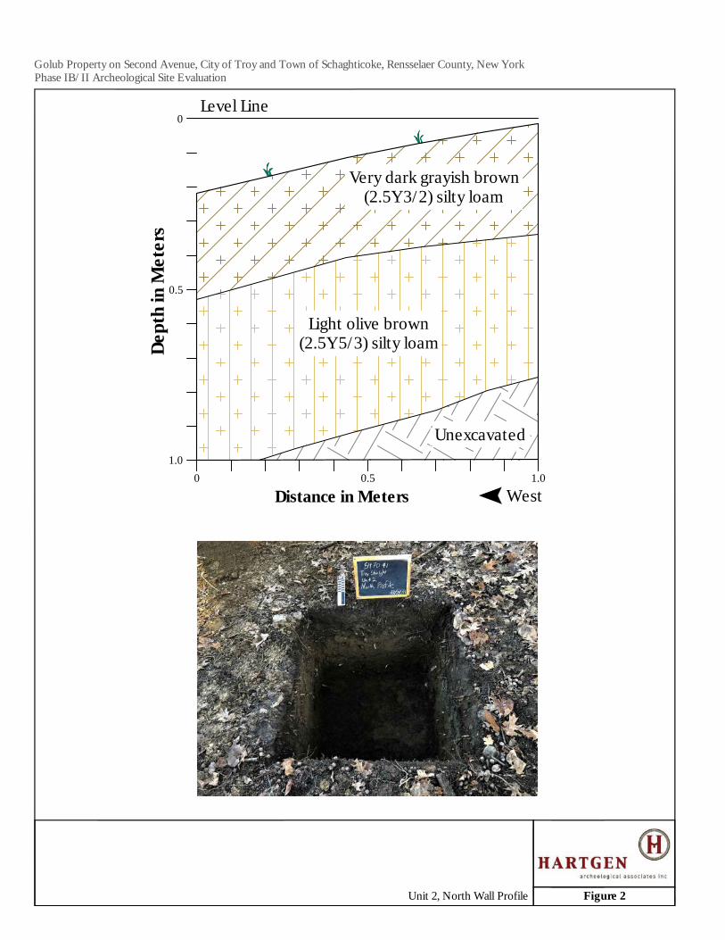
Unexcavated
0 0.5 1.0
0.5
1.0
Dept
h in
Met
ers
Distance in Meters West
0Level Line
Very dark grayish brown(2.5Y 3/2) silty loam
Light olive brown(2.5Y 5/3) silty loam
Golub Property on Second Avenue, City of Troy and Town of Schaghticoke, Rensselaer County, New YorkPhase IB/II Archeological Site Evaluation
Figure 2Unit 2, North Wall Profile
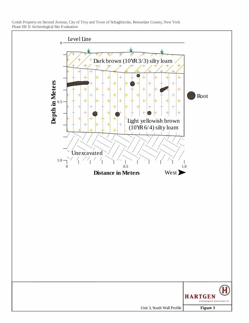
0 0.5 1.0
0.5
1.0
Dept
h in
Met
ers
Distance in Meters West
0Level Line
Unexcavated
Dark brown (10YR 3/3) silty loam
Light yellowish brown(10YR 6/4) silty loam
Root
Golub Property on Second Avenue, City of Troy and Town of Schaghticoke, Rensselaer County, New YorkPhase IB/II Archeological Site Evaluation
Figure 3Unit 3, South Wall Profile
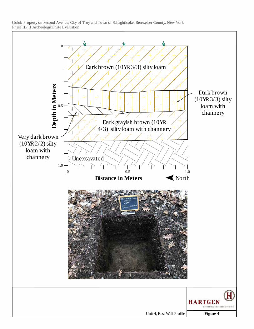
0 0.5 1.0
0.5
1.0
Dept
h in
Met
ers
Distance in Meters North
0
Unexcavated
Dark brown (10YR 3/3) silty loam
Dark brown(10YR 3/3) silty
loam withchannery
Dark grayish brown (10YR4/3) silty loam with channery
Very dark brown(10YR 2/2) silty
loam withchannery
Golub Property on Second Avenue, City of Troy and Town of Schaghticoke, Rensselaer County, New YorkPhase IB/II Archeological Site Evaluation
Figure 4Unit 4, East Wall Profile
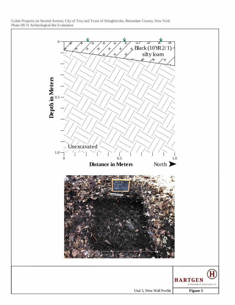
0 0.5 1.0
0.5
1.0
Dept
h in
Met
ers
Distance in Meters North
0
Unexcavated
Black (10YR 2/1)silty loam
Golub Property on Second Avenue, City of Troy and Town of Schaghticoke, Rensselaer County, New YorkPhase IB/II Archeological Site Evaluation
Figure 5Unit 5, West Wall Profile
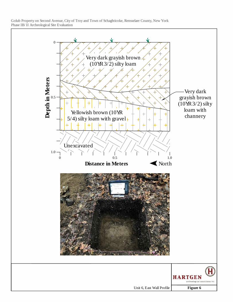
0 0.5 1.0
0.5
1.0
Dept
h in
Met
ers
Distance in Meters North
0
Unexcavated
Very dark grayish brown(10YR 3/2) silty loam
Very darkgrayish brown
(10YR 3/2) siltyloam withchannery
Yellowish brown (10YR5/4) silty loam with gravel
Golub Property on Second Avenue, City of Troy and Town of Schaghticoke, Rensselaer County, New YorkPhase IB/II Archeological Site Evaluation
Figure 6Unit 6, East Wall Profile
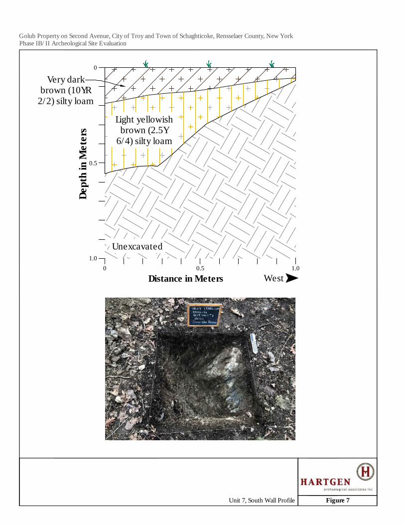
0 0.5 1.0
0.5
1.0
Dept
h in
Met
ers
Distance in Meters West
0
Unexcavated
Very darkbrown (10YR
2/2) silty loam
Light yellowishbrown (2.5Y
6/4) silty loam
Golub Property on Second Avenue, City of Troy and Town of Schaghticoke, Rensselaer County, New YorkPhase IB/II Archeological Site Evaluation
Figure 7Unit 7, South Wall Profile
0 0.5 1.0
0.5
1.0
Dept
h in
Met
ers
Distance in Meters West
0
Unexcavated
Level Line
Root
Very dark brown(10YR 2/2) silty loam
with channery
Golub Property on Second Avenue, City of Troy and Town of Schaghticoke, Rensselaer County, New YorkPhase IB/II Archeological Site Evaluation
Figure 8Unit 8, South Wall Profile

Troy Starlight Development, City of Troy and Town of Schaghticoke, Rensselaer County, New York Phase IB/II Archeological Site Evaluation
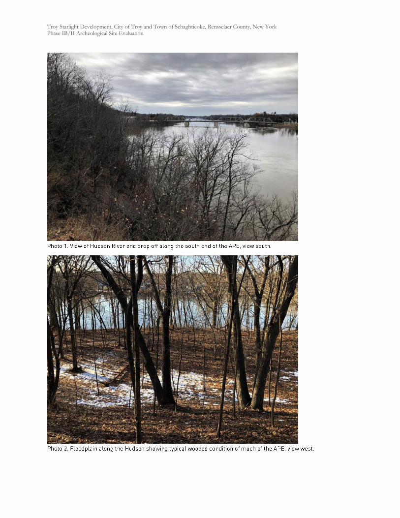
Troy Starlight Development, City of Troy and Town of Schaghticoke, Rensselaer County, New York Phase IB/II Archeological Site Evaluation

Troy Starlight Development, City of Troy and Town of Schaghticoke, Rensselaer County, New York Phase IB/II Archeological Site Evaluation
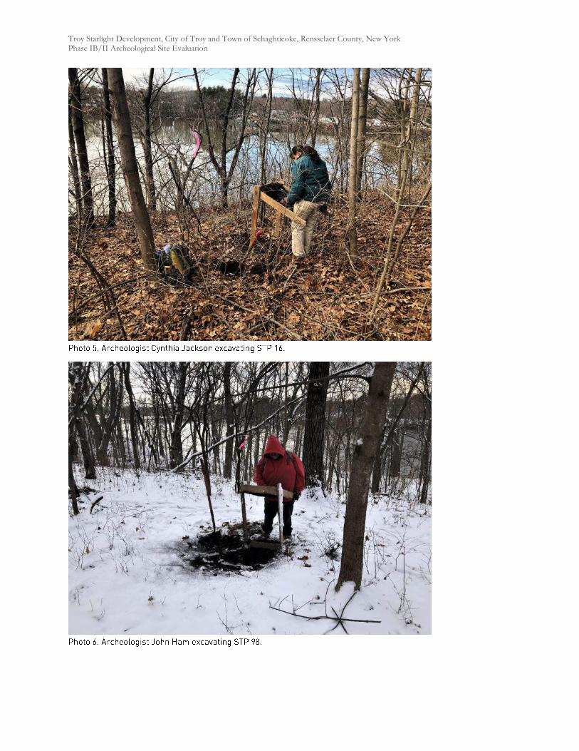
Troy Starlight Development, City of Troy and Town of Schaghticoke, Rensselaer County, New York Phase IB/II Archeological Site Evaluation
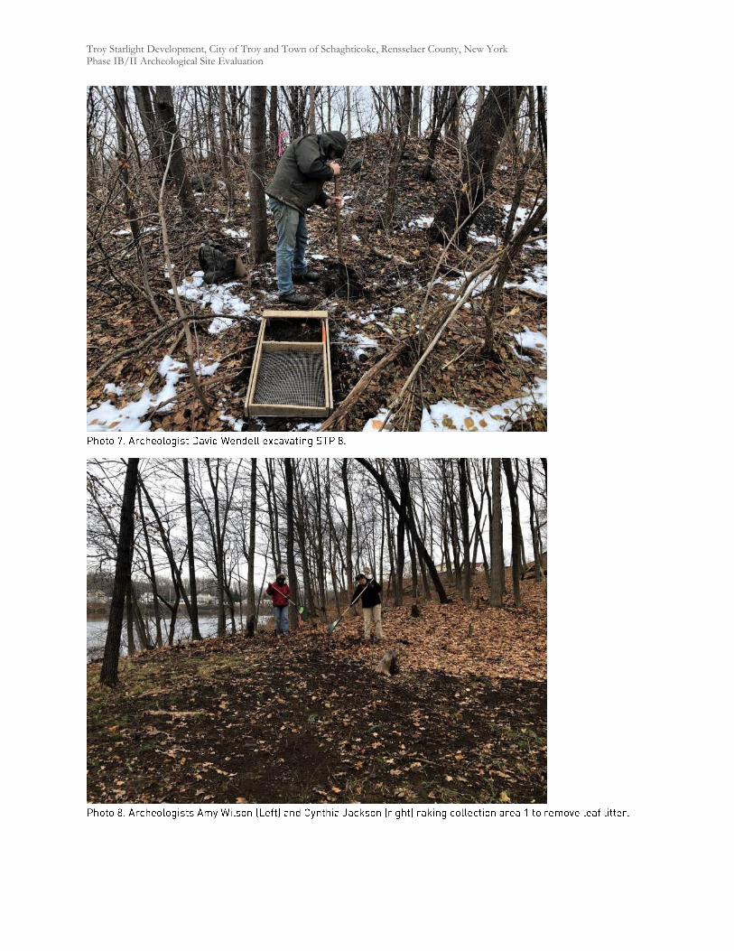
Troy Starlight Development, City of Troy and Town of Schaghticoke, Rensselaer County, New York Phase IB/II Archeological Site Evaluation
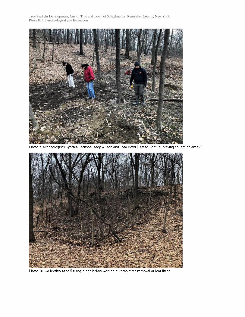
Troy Starlight Development, City of Troy and Town of Schaghticoke, Rensselaer County, New York Phase IB/II Archeological Site Evaluation
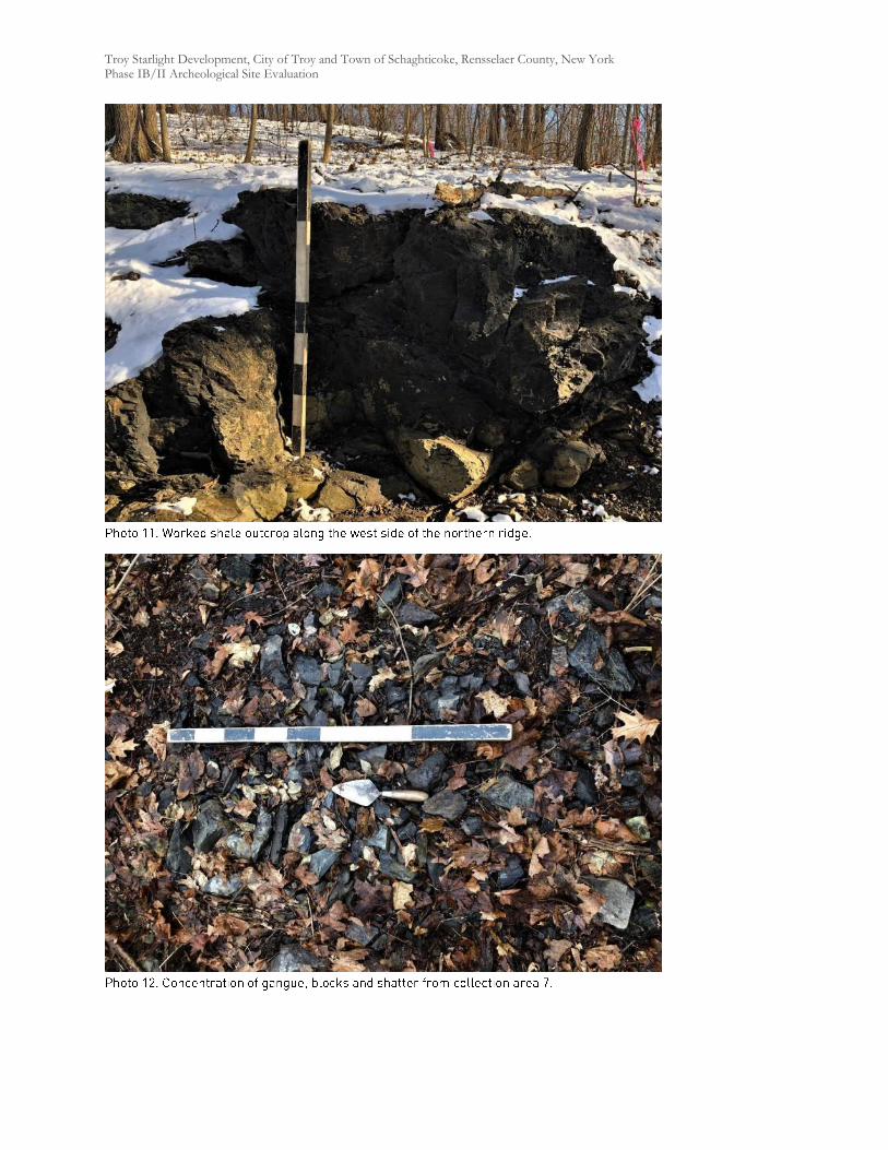
Troy Starlight Development, City of Troy and Town of Schaghticoke, Rensselaer County, New York Phase IB/II Archeological Site Evaluation
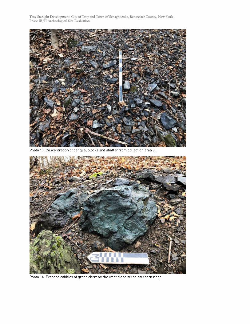
Troy Starlight Development, City of Troy and Town of Schaghticoke, Rensselaer County, New York Phase IB/II Archeological Site Evaluation
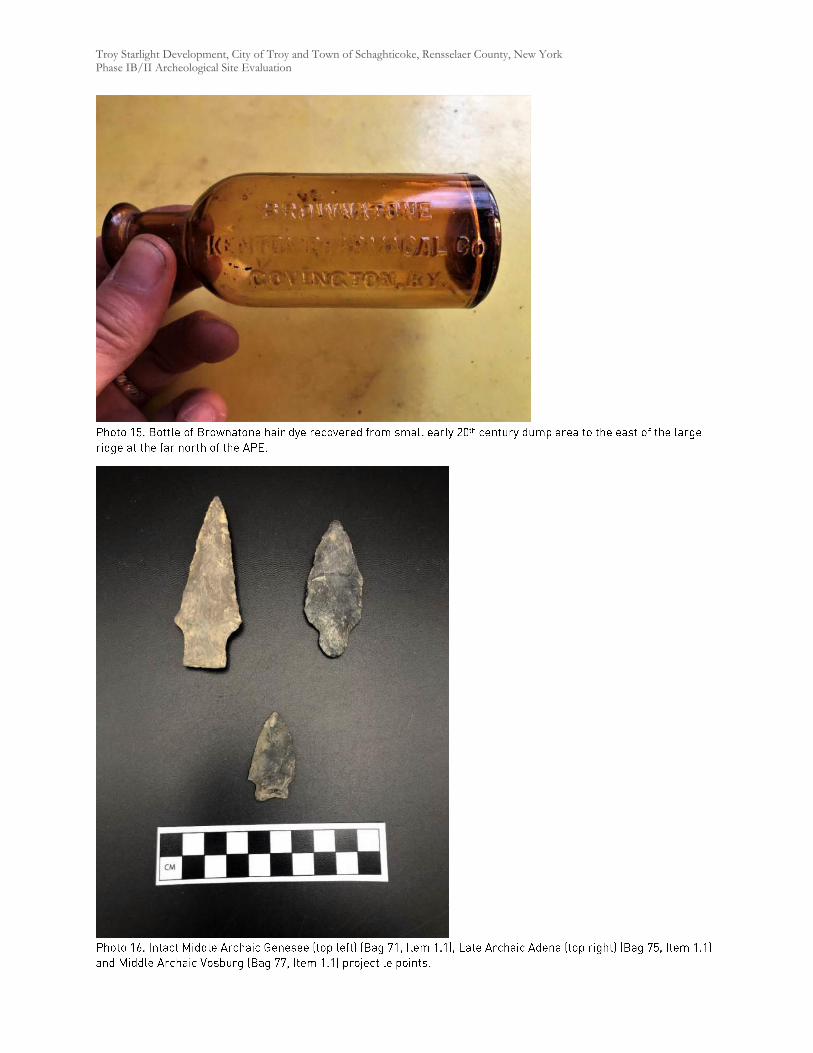
Troy Starlight Development, City of Troy and Town of Schaghticoke, Rensselaer County, New York Phase IB/II Archeological Site Evaluation
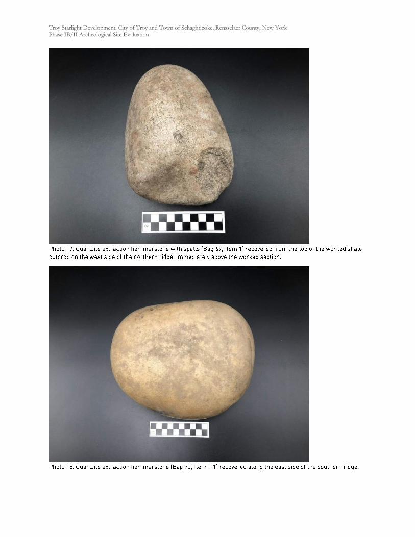
Troy Starlight Development, City of Troy and Town of Schaghticoke, Rensselaer County, New York Phase IB/II Archeological Site Evaluation
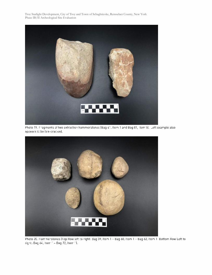
Troy Starlight Development, City of Troy and Town of Schaghticoke, Rensselaer County, New York Phase IB/II Archeological Site Evaluation
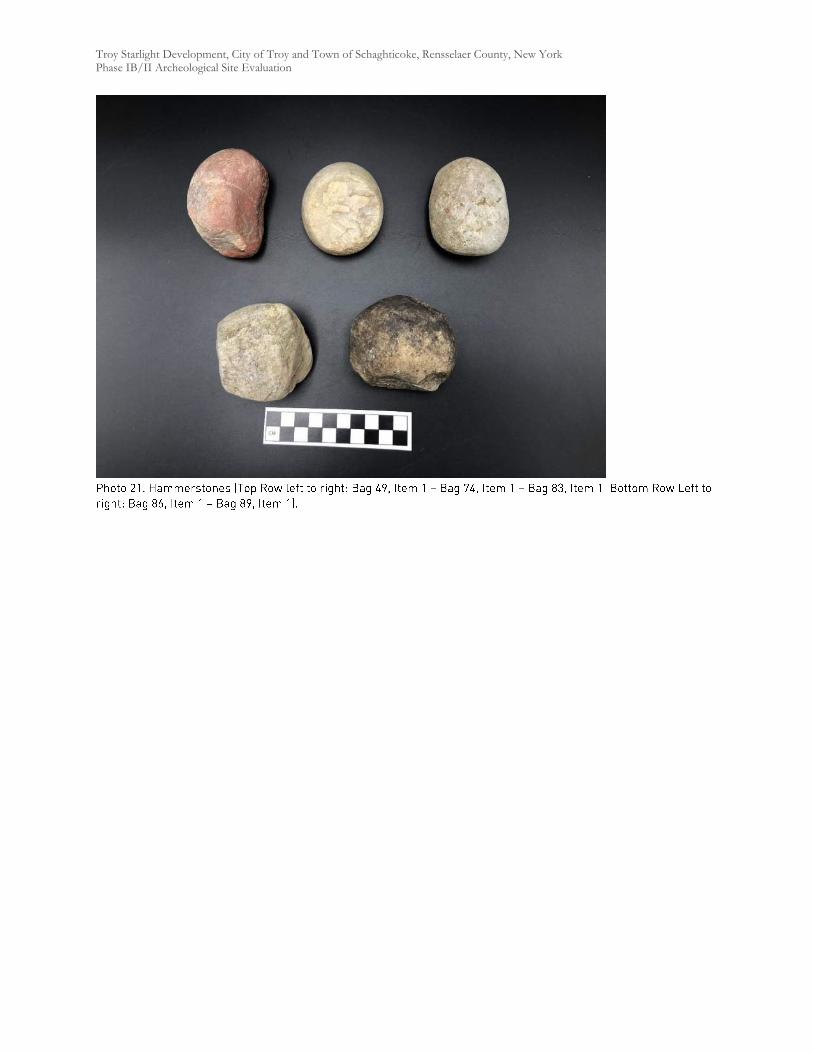
Troy Starlight Development, City of Troy and Town of Schaghticoke, Rensselaer County, New York Phase IB/II Archeological Site Evaluation
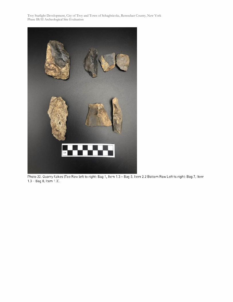
Troy Starlight Development, City of Troy and Town of Schaghticoke, Rensselaer County, New York Phase IB/II Archeological Site Evaluation
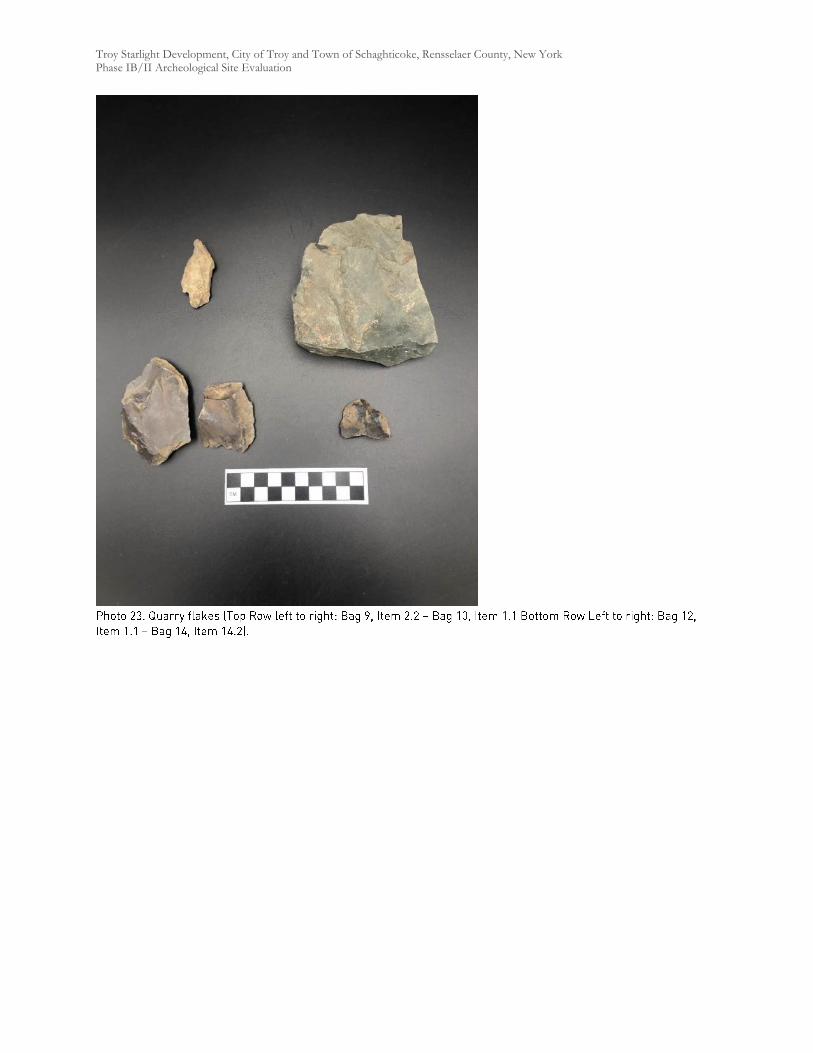
Troy Starlight Development, City of Troy and Town of Schaghticoke, Rensselaer County, New York Phase IB/II Archeological Site Evaluation
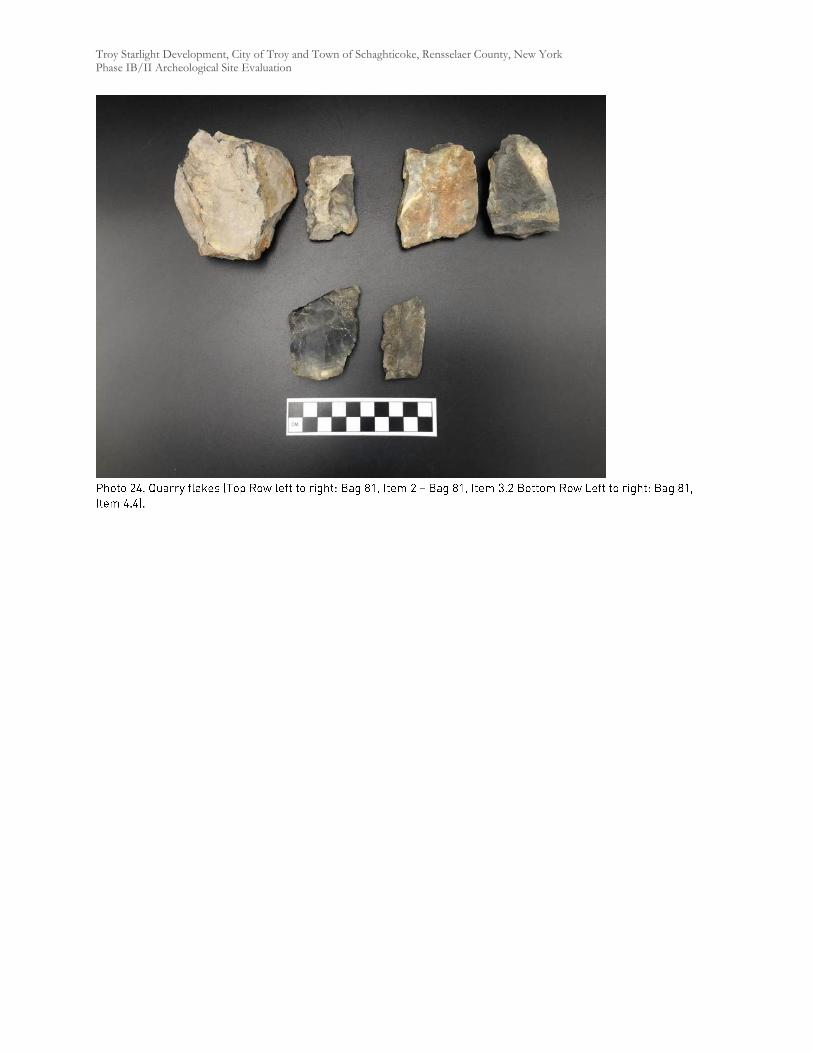
Troy Starlight Development, City of Troy and Town of Schaghticoke, Rensselaer County, New York Phase IB/II Archeological Site Evaluation
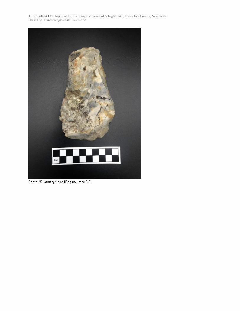
Troy Starlight Development, City of Troy and Town of Schaghticoke, Rensselaer County, New York Phase IB/II Archeological Site Evaluation
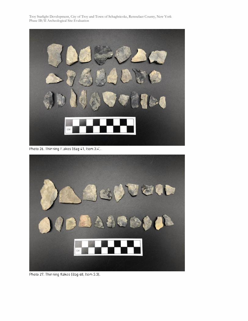
Troy Starlight Development, City of Troy and Town of Schaghticoke, Rensselaer County, New York Phase IB/II Archeological Site Evaluation
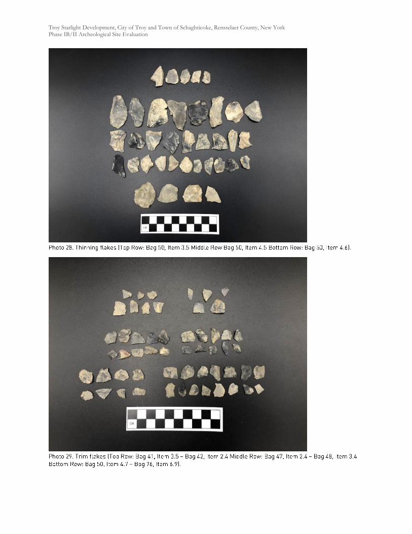
Troy Starlight Development, City of Troy and Town of Schaghticoke, Rensselaer County, New York Phase IB/II Archeological Site Evaluation
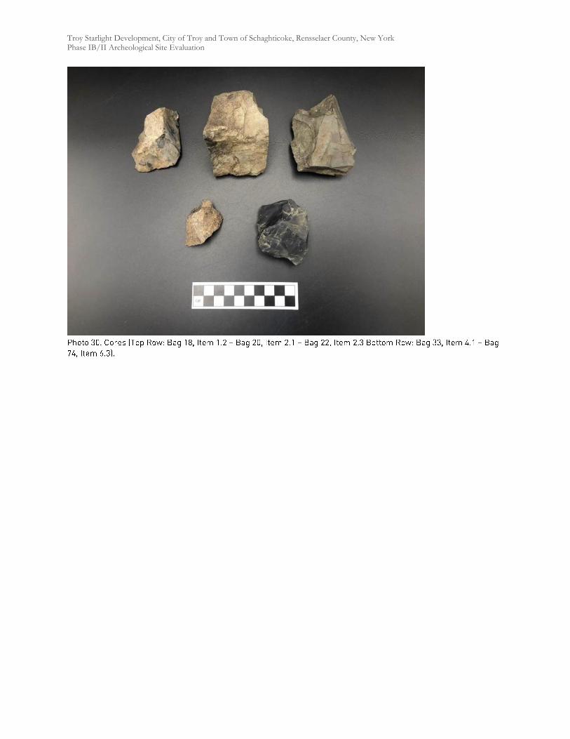
Troy Starlight Development, City of Troy and Town of Schaghticoke, Rensselaer County, New York Phase IB/II Archeological Site Evaluation
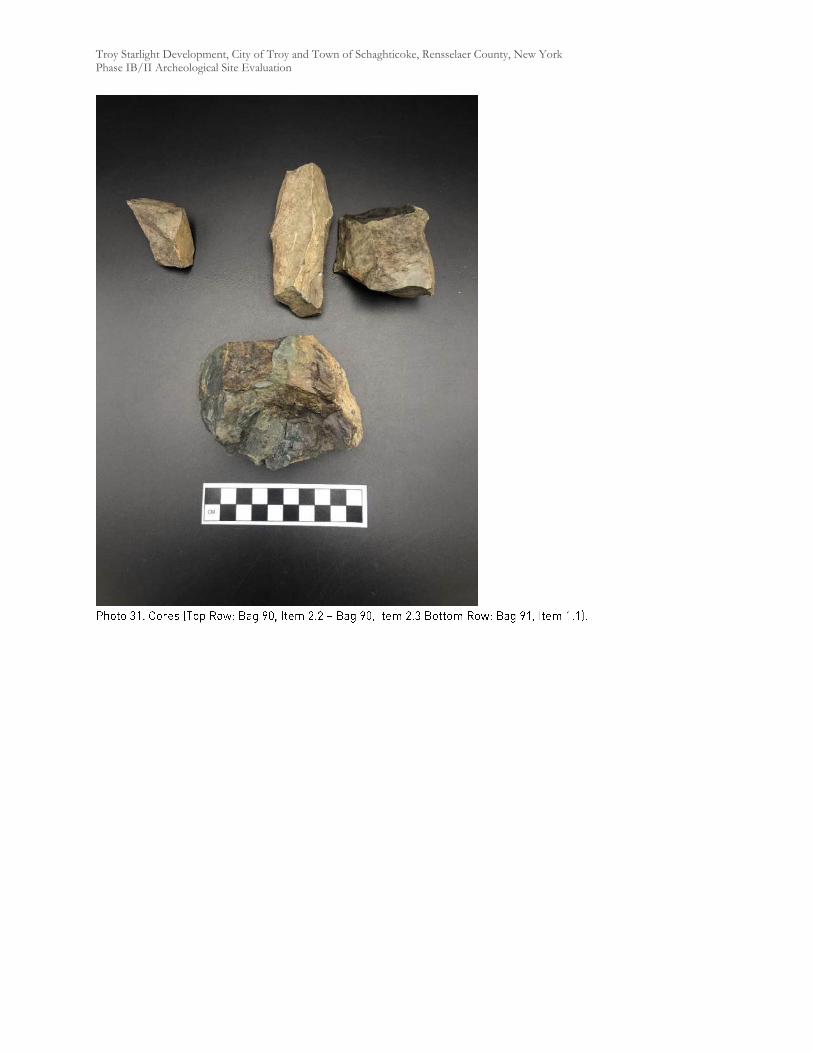
Troy Starlight Development, City of Troy and Town of Schaghticoke, Rensselaer County, New York Phase IB/II Archeological Site Evaluation
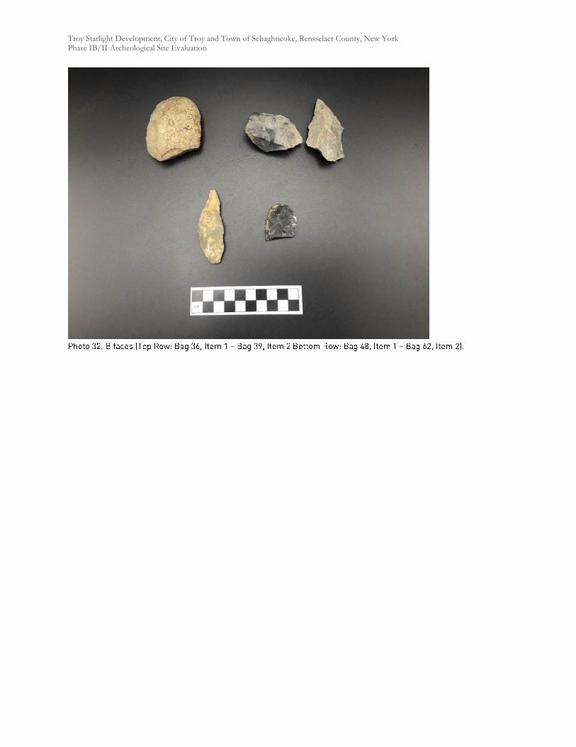
Troy Starlight Development, City of Troy and Town of Schaghticoke, Rensselaer County, New York Phase IB/II Archeological Site Evaluation
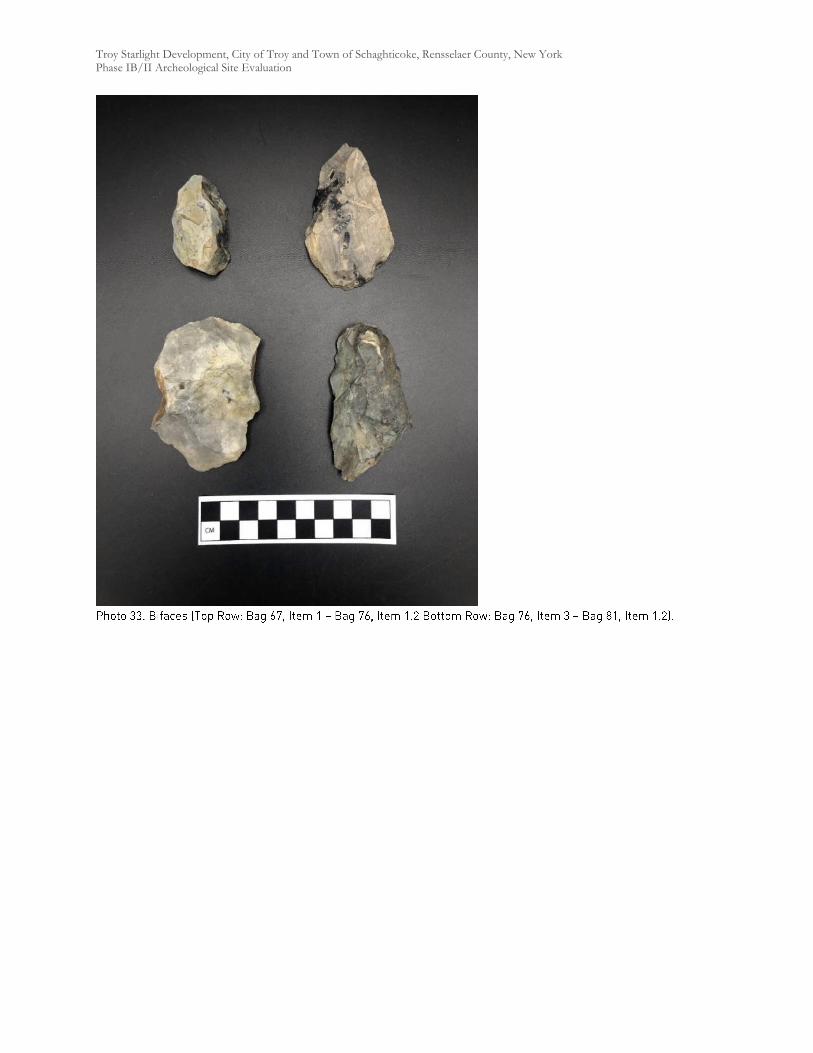
Troy Starlight Development, City of Troy and Town of Schaghticoke, Rensselaer County, New York Phase IB/II Archeological Site Evaluation
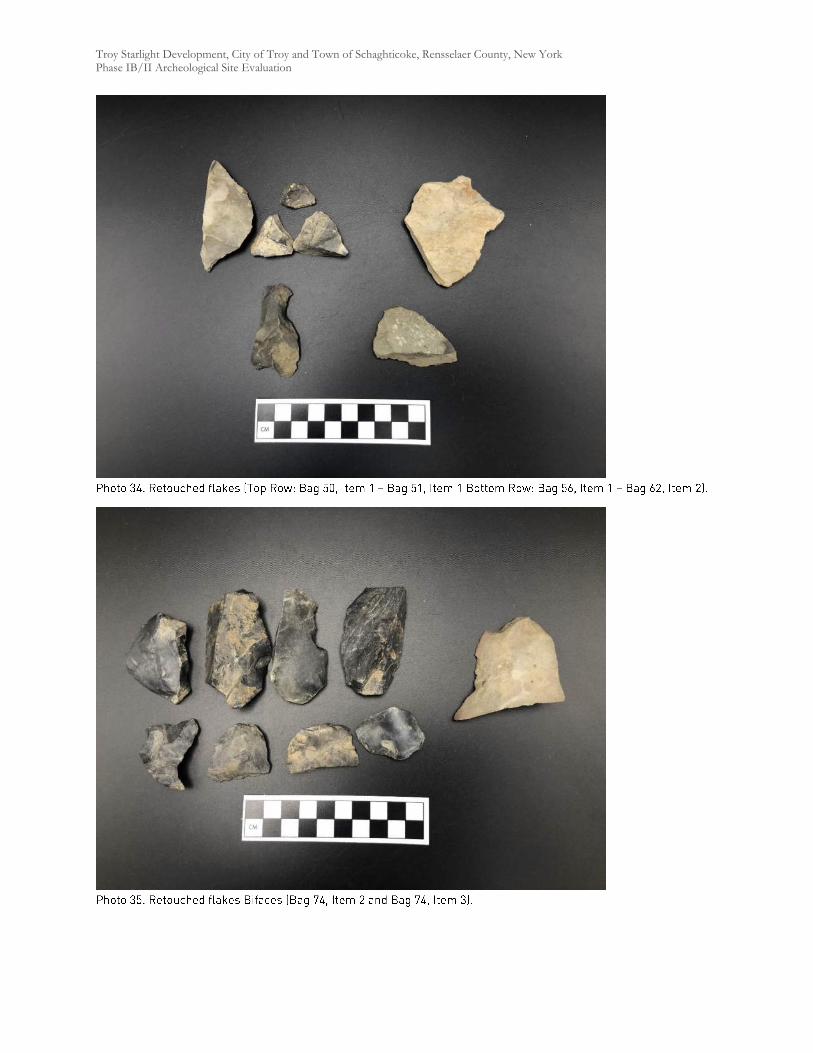
Troy Starlight Development, City of Troy and Town of Schaghticoke, Rensselaer County, New York Phase IB/II Archeological Site Evaluation
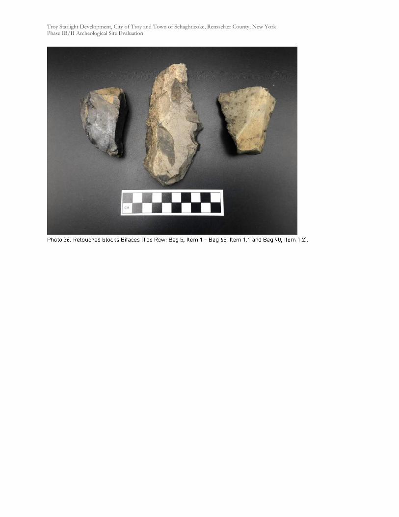
Troy Starlight Development, City of Troy and Town of Schaghticoke, Rensselaer County, New York Phase IB/II Archeological Site Evaluation

Troy Starlight Development, City of Troy and Town of Schaghticoke, Rensselaer County, New York Phase IB/II Archeological Site Evaluation
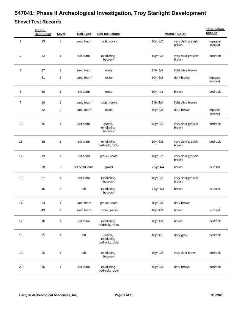
547041: Phase II Archeological Investigation, Troy Starlight Development
Shovel Test Records
Ending
Depth (cm) Munsell Color
Termination
ReasonSoil Type Soil InclusionsLevel
1 sand loam roots, rocks impasse (rocks)
123 10yr 3/2 very dark grayish brown
2 silt loam exfoliating bedrock
bedrock122 10yr 3/2 very dark grayish brown
5 sand loam roots127 2.5y 5/4 light olive brown
sand loam rocks impasse (rocks)
251 10yr 3/3 dark brown
6 silt loam roots bedrock119 10yr 4/3 brown
7 sand loam roots, rocks119 2.5y 5/4 light olive brown
sand loam rocks impasse (rocks)
232 10yr 3/3 dark brown
10 silt sand gravel, exfoliating
bedrock
bedrock115 10yr 3/2 very dark grayish brown
11 silt loam exfoliating bedrock, roots
bedrock118 10yr 3/2 very dark grayish brown
12 silt sand gravel, roots113 10yr 3/2 very dark grayish brown
silt sand loam gravel subsoil230 7.5yr 4/4 brown
13 silt loam exfoliating bedrock
127 10yr 3/2 very dark grayish brown
silt exfoliating bedrock
subsoil245 7.5yr 4/4 brown
14 sand loam gravel, roots124 10yr 3/3 dark brown
sand loam gravel, rocks subsoil243 10yr 4/3 brown
17 silt loam exfoliating bedrock, roots
bedrock116 10yr 4/3 brown
18 silt gravel, exfoliating
bedrock, roots
bedrock125 10yr 4/1 dark gray
19 silt exfoliating bedrock
bedrock125 10yr 2/2 very dark brown
20 silt loam exfoliating bedrock, roots
bedrock136 10yr 3/3 dark brown
Page 1 of 10Hartgen Archeological Associates, Inc. 3/6/2020
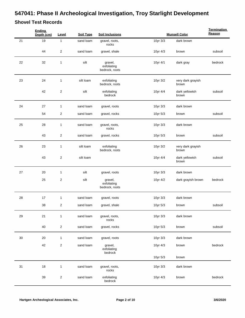
547041: Phase II Archeological Investigation, Troy Starlight Development
Shovel Test Records
Ending
Depth (cm) Munsell Color
Termination
ReasonSoil Type Soil InclusionsLevel
21 sand loam gravel, roots, rocks
119 10yr 3/3 dark brown
sand loam gravel, shale subsoil244 10yr 4/3 brown
22 silt gravel, exfoliating
bedrock, roots
bedrock132 10yr 4/1 dark gray
23 silt loam exfoliating bedrock, roots
124 10yr 3/2 very dark grayish brown
silt exfoliating bedrock
subsoil242 10yr 4/4 dark yellowish brown
24 sand loam gravel, roots127 10yr 3/3 dark brown
sand loam gravel, rocks subsoil254 10yr 5/3 brown
25 sand loam gravel, roots, rocks
128 10yr 3/3 dark brown
sand loam gravel, rocks subsoil243 10yr 5/3 brown
26 silt loam exfoliating bedrock, roots
123 10yr 3/2 very dark grayish brown
silt loam subsoil243 10yr 4/4 dark yellowish brown
27 silt gravel, roots120 10yr 3/3 dark brown
silt gravel, exfoliating
bedrock, roots
bedrock225 10yr 4/2 dark grayish brown
28 sand loam gravel, roots117 10yr 3/3 dark brown
sand loam gravel, shale subsoil238 10yr 5/3 brown
29 sand loam gravel, roots, rocks
121 10yr 3/3 dark brown
sand loam gravel, rocks subsoil240 10yr 5/3 brown
30 sand loam gravel, roots120 10yr 3/3 dark brown
sand loam gravel, exfoliating
bedrock
bedrock242 10yr 4/3
10yr 5/3
brown
brown
31 sand loam gravel, roots, rocks
118 10yr 3/3 dark brown
sand loam exfoliating bedrock
bedrock239 10yr 4/3 brown
Page 2 of 10Hartgen Archeological Associates, Inc. 3/6/2020
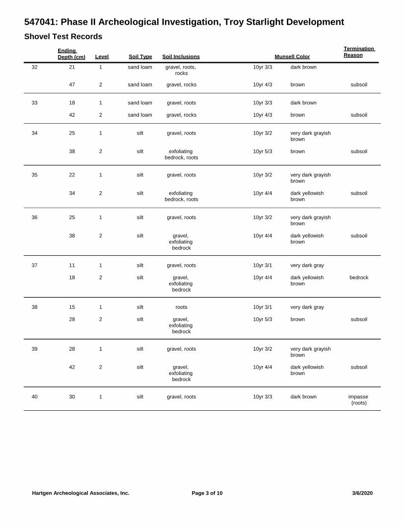
547041: Phase II Archeological Investigation, Troy Starlight Development
Shovel Test Records
Ending
Depth (cm) Munsell Color
Termination
ReasonSoil Type Soil InclusionsLevel
32 sand loam gravel, roots, rocks
121 10yr 3/3 dark brown
sand loam gravel, rocks subsoil247 10yr 4/3 brown
33 sand loam gravel, roots118 10yr 3/3 dark brown
sand loam gravel, rocks subsoil242 10yr 4/3 brown
34 silt gravel, roots125 10yr 3/2 very dark grayish brown
silt exfoliating bedrock, roots
subsoil238 10yr 5/3 brown
35 silt gravel, roots122 10yr 3/2 very dark grayish brown
silt exfoliating bedrock, roots
subsoil234 10yr 4/4 dark yellowish brown
36 silt gravel, roots125 10yr 3/2 very dark grayish brown
silt gravel, exfoliating
bedrock
subsoil238 10yr 4/4 dark yellowish brown
37 silt gravel, roots111 10yr 3/1 very dark gray
silt gravel, exfoliating
bedrock
bedrock218 10yr 4/4 dark yellowish brown
38 silt roots115 10yr 3/1 very dark gray
silt gravel, exfoliating
bedrock
subsoil228 10yr 5/3 brown
39 silt gravel, roots128 10yr 3/2 very dark grayish brown
silt gravel, exfoliating
bedrock
subsoil242 10yr 4/4 dark yellowish brown
40 silt gravel, roots impasse (roots)
130 10yr 3/3 dark brown
Page 3 of 10Hartgen Archeological Associates, Inc. 3/6/2020
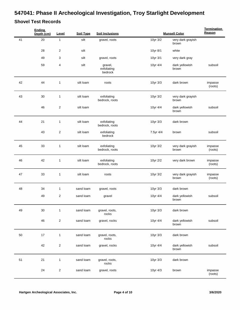
547041: Phase II Archeological Investigation, Troy Starlight Development
Shovel Test Records
Ending
Depth (cm) Munsell Color
Termination
ReasonSoil Type Soil InclusionsLevel
41 silt gravel, roots120 10yr 3/2 very dark grayish brown
silt228 10yr 8/1 white
silt gravel, roots349 10yr 3/1 very dark gray
silt gravel, exfoliating
bedrock
subsoil459 10yr 4/4 dark yellowish brown
42 silt loam roots impasse (roots)
144 10yr 3/3 dark brown
43 silt loam exfoliating bedrock, roots
130 10yr 3/2 very dark grayish brown
silt loam subsoil246 10yr 4/4 dark yellowish brown
44 silt loam exfoliating bedrock, roots
121 10yr 3/3 dark brown
silt loam exfoliating bedrock
subsoil243 7.5yr 4/4 brown
45 silt loam exfoliating bedrock, roots
impasse (roots)
133 10yr 3/2 very dark grayish brown
46 silt loam exfoliating bedrock, roots
impasse (roots)
142 10yr 2/2 very dark brown
47 silt loam roots impasse (roots)
133 10yr 3/2 very dark grayish brown
48 sand loam gravel, roots134 10yr 3/3 dark brown
sand loam gravel subsoil249 10yr 4/4 dark yellowish brown
49 sand loam gravel, roots, rocks
130 10yr 3/3 dark brown
sand loam gravel, rocks subsoil246 10yr 4/4 dark yellowish brown
50 sand loam gravel, roots, rocks
117 10yr 3/3 dark brown
sand loam gravel, rocks subsoil242 10yr 4/4 dark yellowish brown
51 sand loam gravel, roots, rocks
121 10yr 3/3 dark brown
sand loam gravel, roots impasse (roots)
224 10yr 4/3 brown
Page 4 of 10Hartgen Archeological Associates, Inc. 3/6/2020
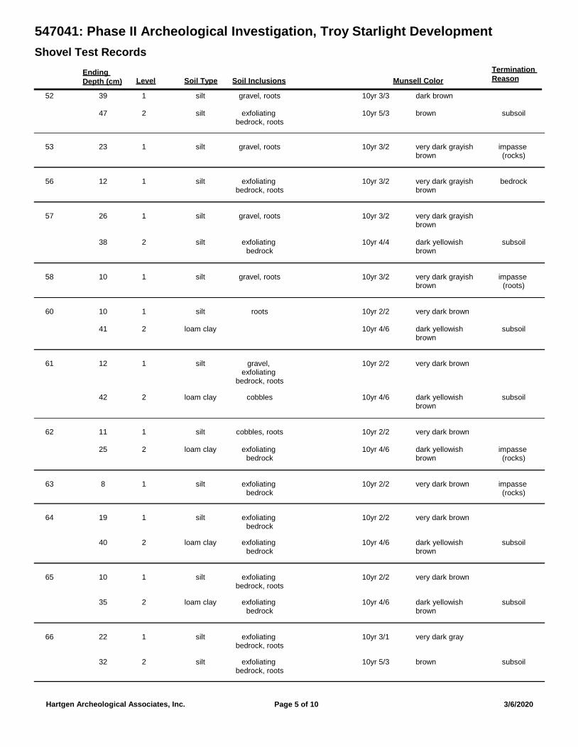
547041: Phase II Archeological Investigation, Troy Starlight Development
Shovel Test Records
Ending
Depth (cm) Munsell Color
Termination
ReasonSoil Type Soil InclusionsLevel
52 silt gravel, roots139 10yr 3/3 dark brown
silt exfoliating bedrock, roots
subsoil247 10yr 5/3 brown
53 silt gravel, roots impasse (rocks)
123 10yr 3/2 very dark grayish brown
56 silt exfoliating bedrock, roots
bedrock112 10yr 3/2 very dark grayish brown
57 silt gravel, roots126 10yr 3/2 very dark grayish brown
silt exfoliating bedrock
subsoil238 10yr 4/4 dark yellowish brown
58 silt gravel, roots impasse (roots)
110 10yr 3/2 very dark grayish brown
60 silt roots110 10yr 2/2 very dark brown
loam clay subsoil241 10yr 4/6 dark yellowish brown
61 silt gravel, exfoliating
bedrock, roots
112 10yr 2/2 very dark brown
loam clay cobbles subsoil242 10yr 4/6 dark yellowish brown
62 silt cobbles, roots111 10yr 2/2 very dark brown
loam clay exfoliating bedrock
impasse (rocks)
225 10yr 4/6 dark yellowish brown
63 silt exfoliating bedrock
impasse (rocks)
18 10yr 2/2 very dark brown
64 silt exfoliating bedrock
119 10yr 2/2 very dark brown
loam clay exfoliating bedrock
subsoil240 10yr 4/6 dark yellowish brown
65 silt exfoliating bedrock, roots
110 10yr 2/2 very dark brown
loam clay exfoliating bedrock
subsoil235 10yr 4/6 dark yellowish brown
66 silt exfoliating bedrock, roots
122 10yr 3/1 very dark gray
silt exfoliating bedrock, roots
subsoil232 10yr 5/3 brown
Page 5 of 10Hartgen Archeological Associates, Inc. 3/6/2020
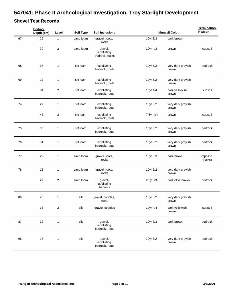
547041: Phase II Archeological Investigation, Troy Starlight Development
Shovel Test Records
Ending
Depth (cm) Munsell Color
Termination
ReasonSoil Type Soil InclusionsLevel
67 sand loam gravel, roots, rocks
122 10yr 3/3 dark brown
sand loam gravel, exfoliating
bedrock, rocks
subsoil239 10yr 4/3 brown
68 silt loam exfoliating bedrock, roots
bedrock137 10yr 3/2 very dark grayish brown
69 silt loam exfoliating bedrock, roots
122 10yr 3/2 very dark grayish brown
silt loam exfoliating bedrock, roots
subsoil234 10yr 4/4 dark yellowish brown
74 silt loam exfoliating bedrock, roots
127 10yr 3/2 very dark grayish brown
silt loam exfoliating bedrock, roots
subsoil243 7.5yr 4/4 brown
75 silt loam exfoliating bedrock, roots
bedrock135 10yr 3/2 very dark grayish brown
76 silt loam exfoliating bedrock, roots
bedrock151 10yr 3/2 very dark grayish brown
77 sand loam gravel, roots, rocks
impasse (rocks)
129 10yr 3/3 dark brown
78 sand loam gravel, roots, rocks
113 10yr 3/2 very dark grayish brown
sand loam gravel, exfoliating
bedrock
bedrock227 2.5y 3/3 dark olive brown
86 silt gravel, cobbles, roots
125 10yr 3/2 very dark grayish brown
silt gravel, cobbles subsoil236 10yr 4/4 dark yellowish brown
87 silt gravel, exfoliating
bedrock, roots
bedrock132 10yr 3/3 dark brown
96 silt gravel, exfoliating
bedrock, roots
bedrock113 10yr 3/2 very dark grayish brown
Page 6 of 10Hartgen Archeological Associates, Inc. 3/6/2020
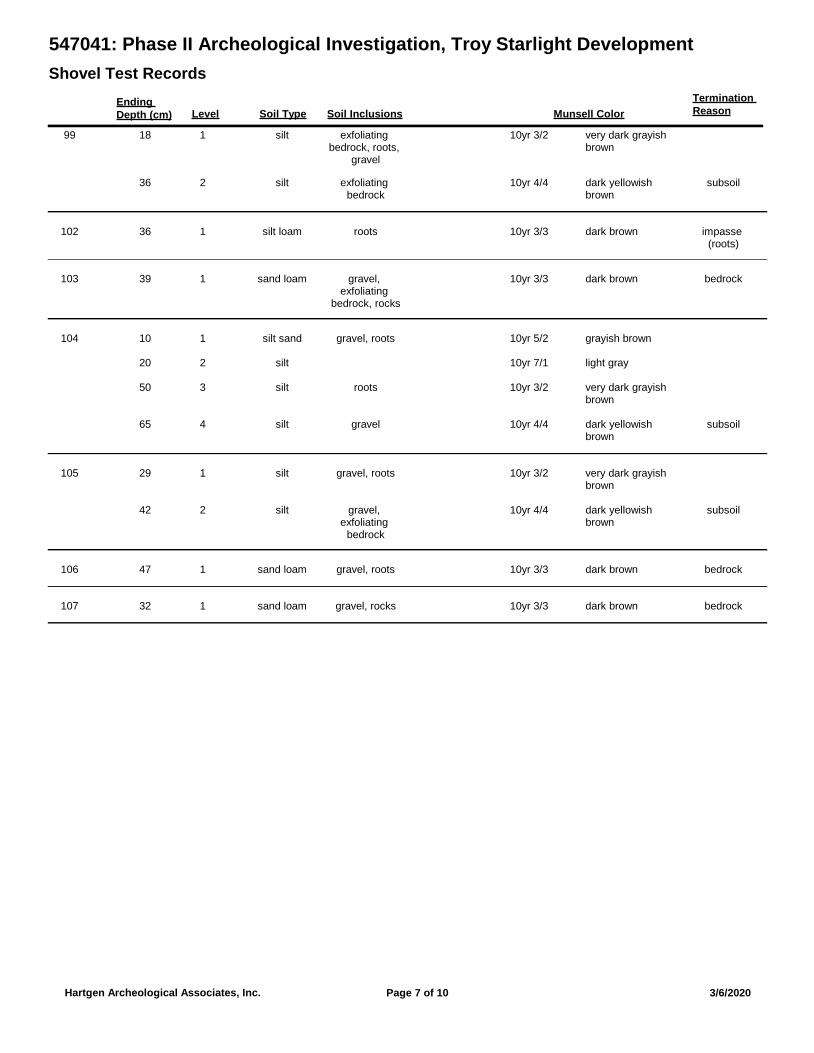
547041: Phase II Archeological Investigation, Troy Starlight Development
Shovel Test Records
Ending
Depth (cm) Munsell Color
Termination
ReasonSoil Type Soil InclusionsLevel
99 silt exfoliating bedrock, roots,
gravel
118 10yr 3/2 very dark grayish brown
silt exfoliating bedrock
subsoil236 10yr 4/4 dark yellowish brown
102 silt loam roots impasse (roots)
136 10yr 3/3 dark brown
103 sand loam gravel, exfoliating
bedrock, rocks
bedrock139 10yr 3/3 dark brown
104 silt sand gravel, roots110 10yr 5/2 grayish brown
silt220 10yr 7/1 light gray
silt roots350 10yr 3/2 very dark grayish brown
silt gravel subsoil465 10yr 4/4 dark yellowish brown
105 silt gravel, roots129 10yr 3/2 very dark grayish brown
silt gravel, exfoliating
bedrock
subsoil242 10yr 4/4 dark yellowish brown
106 sand loam gravel, roots bedrock147 10yr 3/3 dark brown
107 sand loam gravel, rocks bedrock132 10yr 3/3 dark brown
Page 7 of 10Hartgen Archeological Associates, Inc. 3/6/2020
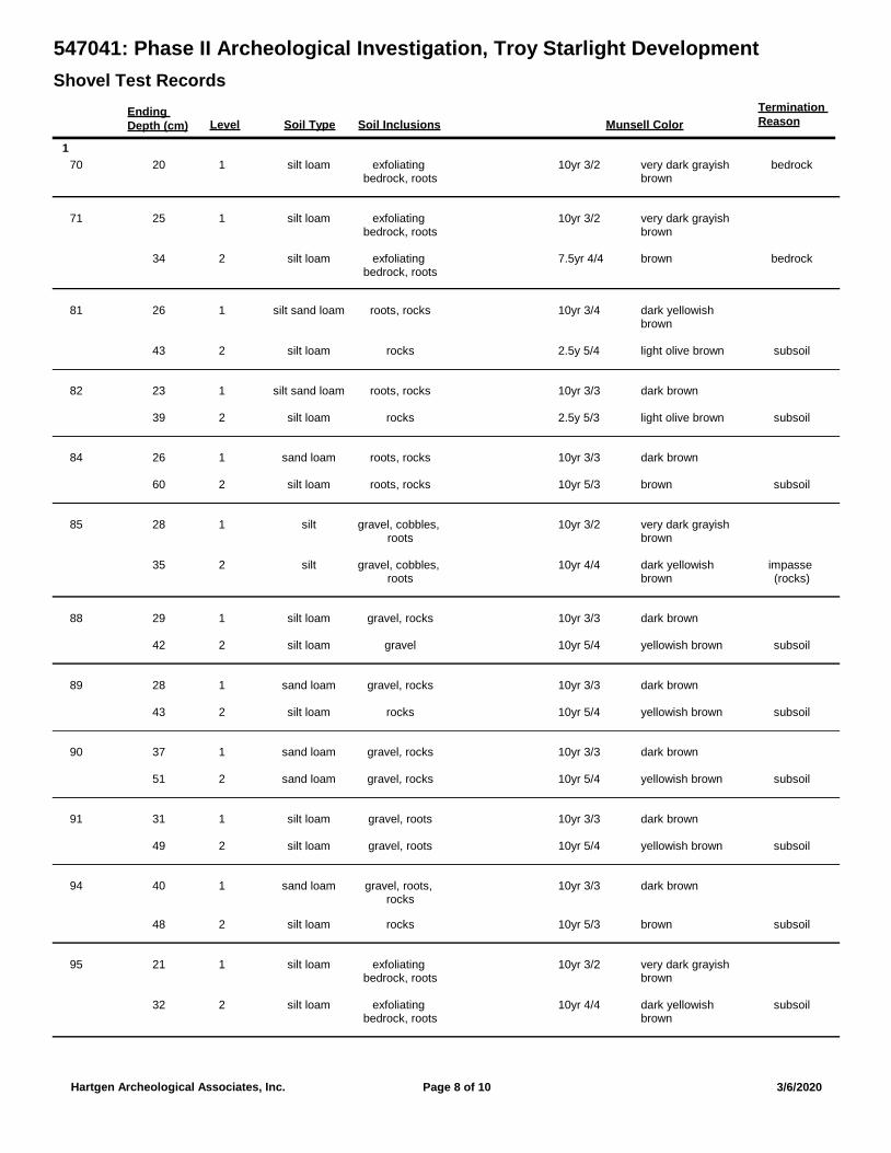
547041: Phase II Archeological Investigation, Troy Starlight Development
Shovel Test Records
Ending
Depth (cm) Munsell Color
Termination
ReasonSoil Type Soil InclusionsLevel
1
70 silt loam exfoliating bedrock, roots
bedrock120 10yr 3/2 very dark grayish brown
71 silt loam exfoliating bedrock, roots
125 10yr 3/2 very dark grayish brown
silt loam exfoliating bedrock, roots
bedrock234 7.5yr 4/4 brown
81 silt sand loam roots, rocks126 10yr 3/4 dark yellowish brown
silt loam rocks subsoil243 2.5y 5/4 light olive brown
82 silt sand loam roots, rocks123 10yr 3/3 dark brown
silt loam rocks subsoil239 2.5y 5/3 light olive brown
84 sand loam roots, rocks126 10yr 3/3 dark brown
silt loam roots, rocks subsoil260 10yr 5/3 brown
85 silt gravel, cobbles, roots
128 10yr 3/2 very dark grayish brown
silt gravel, cobbles, roots
impasse (rocks)
235 10yr 4/4 dark yellowish brown
88 silt loam gravel, rocks129 10yr 3/3 dark brown
silt loam gravel subsoil242 10yr 5/4 yellowish brown
89 sand loam gravel, rocks128 10yr 3/3 dark brown
silt loam rocks subsoil243 10yr 5/4 yellowish brown
90 sand loam gravel, rocks137 10yr 3/3 dark brown
sand loam gravel, rocks subsoil251 10yr 5/4 yellowish brown
91 silt loam gravel, roots131 10yr 3/3 dark brown
silt loam gravel, roots subsoil249 10yr 5/4 yellowish brown
94 sand loam gravel, roots, rocks
140 10yr 3/3 dark brown
silt loam rocks subsoil248 10yr 5/3 brown
95 silt loam exfoliating bedrock, roots
121 10yr 3/2 very dark grayish brown
silt loam exfoliating bedrock, roots
subsoil232 10yr 4/4 dark yellowish brown
Page 8 of 10Hartgen Archeological Associates, Inc. 3/6/2020
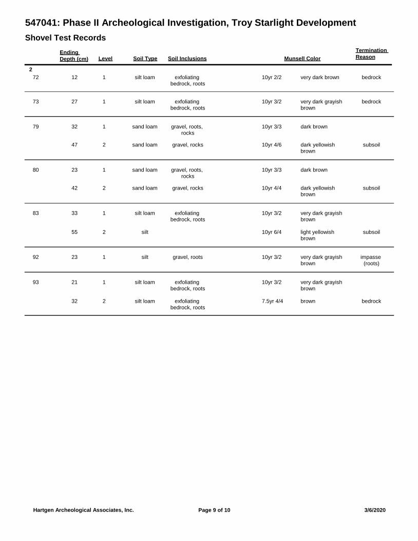
547041: Phase II Archeological Investigation, Troy Starlight Development
Shovel Test Records
Ending
Depth (cm) Munsell Color
Termination
ReasonSoil Type Soil InclusionsLevel
2
72 silt loam exfoliating bedrock, roots
bedrock112 10yr 2/2 very dark brown
73 silt loam exfoliating bedrock, roots
bedrock127 10yr 3/2 very dark grayish brown
79 sand loam gravel, roots, rocks
132 10yr 3/3 dark brown
sand loam gravel, rocks subsoil247 10yr 4/6 dark yellowish brown
80 sand loam gravel, roots, rocks
123 10yr 3/3 dark brown
sand loam gravel, rocks subsoil242 10yr 4/4 dark yellowish brown
83 silt loam exfoliating bedrock, roots
133 10yr 3/2 very dark grayish brown
silt subsoil255 10yr 6/4 light yellowish brown
92 silt gravel, roots impasse (roots)
123 10yr 3/2 very dark grayish brown
93 silt loam exfoliating bedrock, roots
121 10yr 3/2 very dark grayish brown
silt loam exfoliating bedrock, roots
bedrock232 7.5yr 4/4 brown
Page 9 of 10Hartgen Archeological Associates, Inc. 3/6/2020
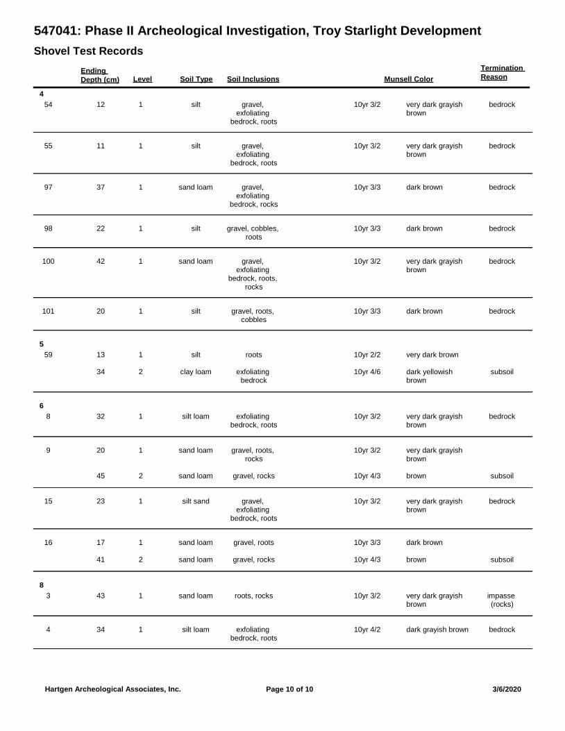
547041: Phase II Archeological Investigation, Troy Starlight Development
Shovel Test Records
Ending
Depth (cm) Munsell Color
Termination
ReasonSoil Type Soil InclusionsLevel
4
54 silt gravel, exfoliating
bedrock, roots
bedrock112 10yr 3/2 very dark grayish brown
55 silt gravel, exfoliating
bedrock, roots
bedrock111 10yr 3/2 very dark grayish brown
97 sand loam gravel, exfoliating
bedrock, rocks
bedrock137 10yr 3/3 dark brown
98 silt gravel, cobbles, roots
bedrock122 10yr 3/3 dark brown
100 sand loam gravel, exfoliating
bedrock, roots, rocks
bedrock142 10yr 3/2 very dark grayish brown
101 silt gravel, roots, cobbles
bedrock120 10yr 3/3 dark brown
5
59 silt roots113 10yr 2/2 very dark brown
clay loam exfoliating bedrock
subsoil234 10yr 4/6 dark yellowish brown
6
8 silt loam exfoliating bedrock, roots
bedrock132 10yr 3/2 very dark grayish brown
9 sand loam gravel, roots, rocks
120 10yr 3/2 very dark grayish brown
sand loam gravel, rocks subsoil245 10yr 4/3 brown
15 silt sand gravel, exfoliating
bedrock, roots
bedrock123 10yr 3/2 very dark grayish brown
16 sand loam gravel, roots117 10yr 3/3 dark brown
sand loam gravel, rocks subsoil241 10yr 4/3 brown
8
3 sand loam roots, rocks impasse (rocks)
143 10yr 3/2 very dark grayish brown
4 silt loam exfoliating bedrock, roots
bedrock134 10yr 4/2 dark grayish brown
Page 10 of 10Hartgen Archeological Associates, Inc. 3/6/2020

Troy Starlight Development, City of Troy and Town of Schaghticoke, Rensselaer County, New York Phase IB/II Archeological Site Evaluation
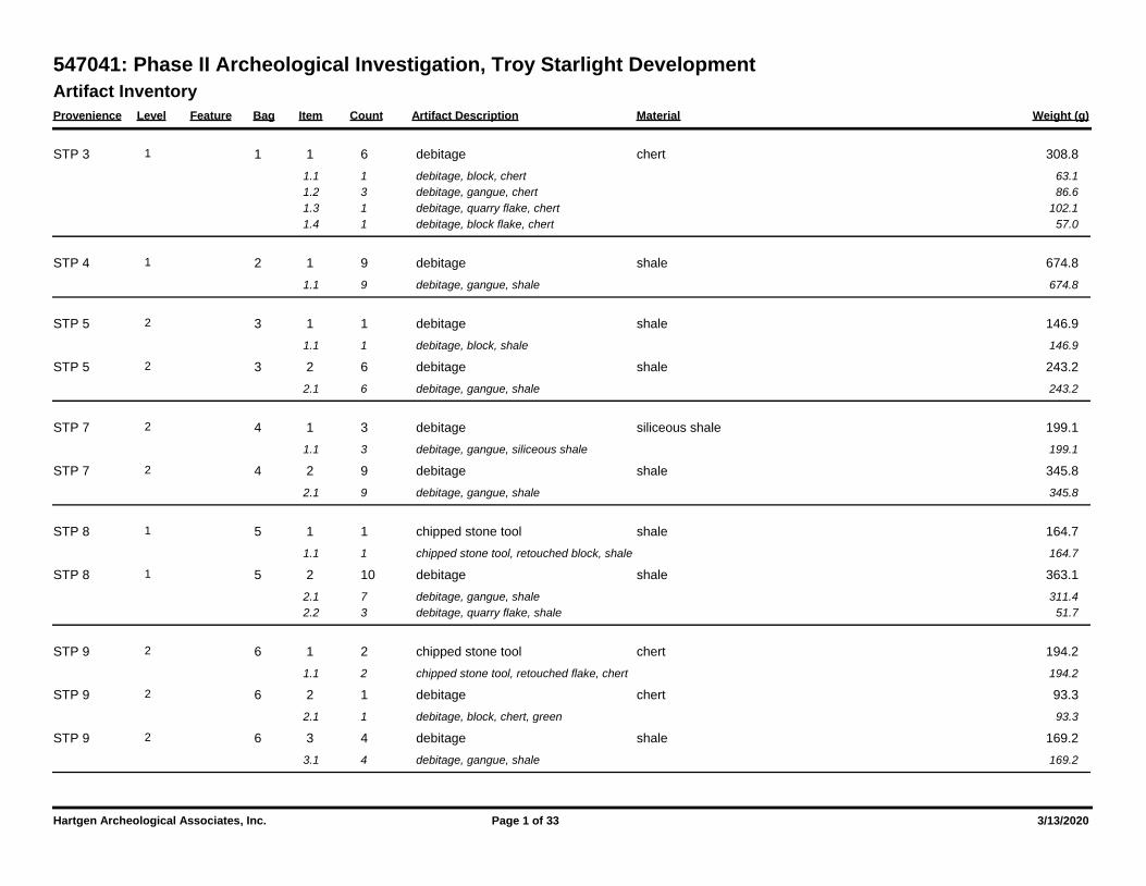
Artifact Inventory
Provenience Level Feature Bag Item Count Artifact Description Weight (g)Material
547041: Phase II Archeological Investigation, Troy Starlight Development
1 1 6 308.8debitage chert1 STP 3
1.1 1 63.1debitage, block, chert
1.2 3 86.6debitage, gangue, chert
1.3 1 102.1debitage, quarry flake, chert
1.4 1 57.0debitage, block flake, chert
2 1 9 674.8debitage shale1 STP 4
1.1 9 674.8debitage, gangue, shale
3 1 1 146.9debitage shale2 STP 5
1.1 1 146.9debitage, block, shale
3 2 6 243.2debitage shale2 STP 5
2.1 6 243.2debitage, gangue, shale
4 1 3 199.1debitage siliceous shale2 STP 7
1.1 3 199.1debitage, gangue, siliceous shale
4 2 9 345.8debitage shale2 STP 7
2.1 9 345.8debitage, gangue, shale
5 1 1 164.7chipped stone tool shale1 STP 8
1.1 1 164.7chipped stone tool, retouched block, shale
5 2 10 363.1debitage shale1 STP 8
2.1 7 311.4debitage, gangue, shale
2.2 3 51.7debitage, quarry flake, shale
6 1 2 194.2chipped stone tool chert2 STP 9
1.1 2 194.2chipped stone tool, retouched flake, chert
6 2 1 93.3debitage chert2 STP 9
2.1 1 93.3debitage, block, chert, green
6 3 4 169.2debitage shale2 STP 9
3.1 4 169.2debitage, gangue, shale
Hartgen Archeological Associates, Inc. Page 1 of 33 3/13/2020
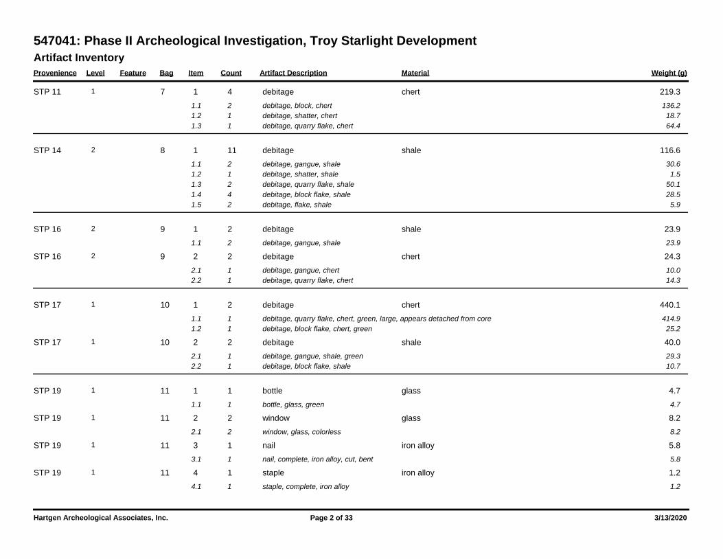
Artifact Inventory
Provenience Level Feature Bag Item Count Artifact Description Weight (g)Material
547041: Phase II Archeological Investigation, Troy Starlight Development
7 1 4 219.3debitage chert1 STP 11
1.1 2 136.2debitage, block, chert
1.2 1 18.7debitage, shatter, chert
1.3 1 64.4debitage, quarry flake, chert
8 1 11 116.6debitage shale2 STP 14
1.1 2 30.6debitage, gangue, shale
1.2 1 1.5debitage, shatter, shale
1.3 2 50.1debitage, quarry flake, shale
1.4 4 28.5debitage, block flake, shale
1.5 2 5.9debitage, flake, shale
9 1 2 23.9debitage shale2 STP 16
1.1 2 23.9debitage, gangue, shale
9 2 2 24.3debitage chert2 STP 16
2.1 1 10.0debitage, gangue, chert
2.2 1 14.3debitage, quarry flake, chert
10 1 2 440.1debitage chert1 STP 17
1.1 1 414.9debitage, quarry flake, chert, green, large, appears detached from core
1.2 1 25.2debitage, block flake, chert, green
10 2 2 40.0debitage shale1 STP 17
2.1 1 29.3debitage, gangue, shale, green
2.2 1 10.7debitage, block flake, shale
11 1 1 4.7bottle glass1 STP 19
1.1 1 4.7bottle, glass, green
11 2 2 8.2window glass1 STP 19
2.1 2 8.2window, glass, colorless
11 3 1 5.8nail iron alloy1 STP 19
3.1 1 5.8nail, complete, iron alloy, cut, bent
11 4 1 1.2staple iron alloy1 STP 19
4.1 1 1.2staple, complete, iron alloy
Hartgen Archeological Associates, Inc. Page 2 of 33 3/13/2020
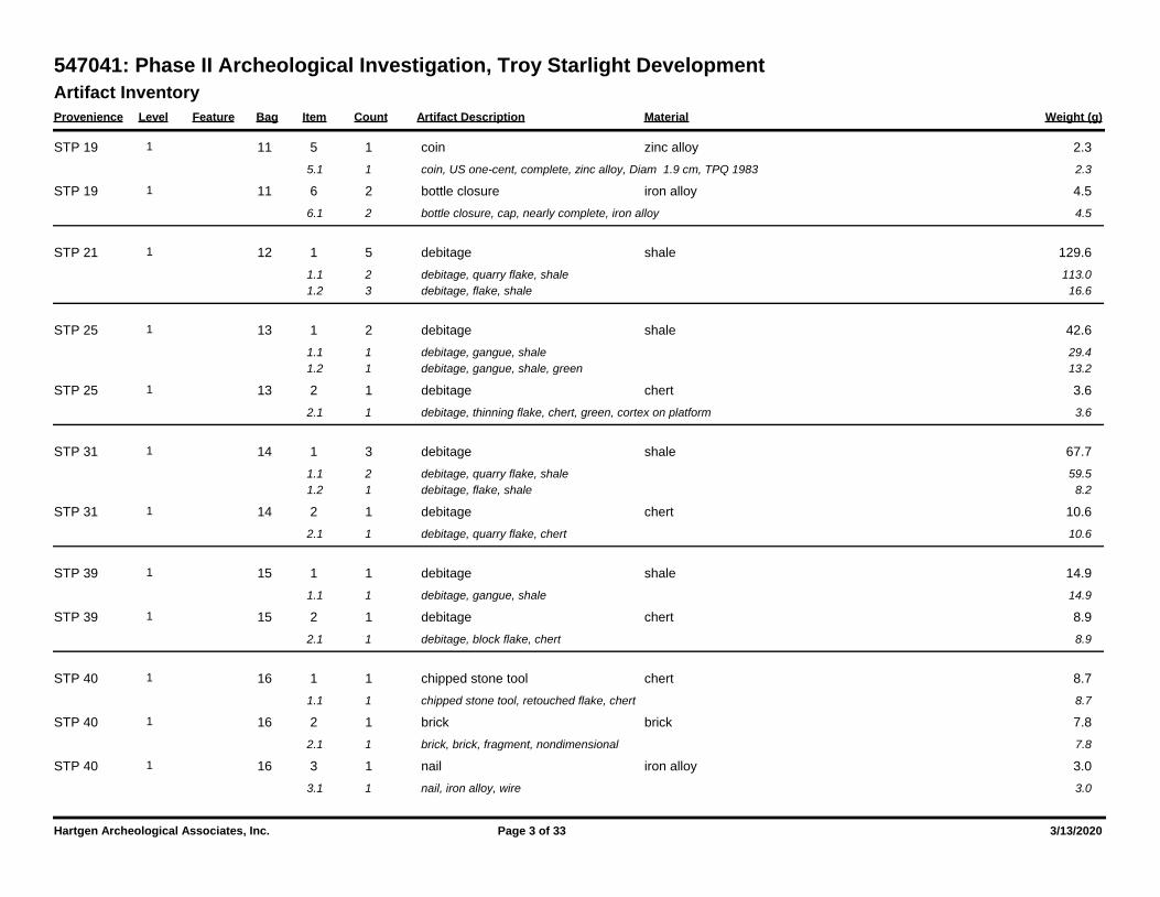
Artifact Inventory
Provenience Level Feature Bag Item Count Artifact Description Weight (g)Material
547041: Phase II Archeological Investigation, Troy Starlight Development
11 5 1 2.3coin zinc alloy1 STP 19
5.1 1 2.3coin, US one-cent, complete, zinc alloy, Diam 1.9 cm, TPQ 1983
11 6 2 4.5bottle closure iron alloy1 STP 19
6.1 2 4.5bottle closure, cap, nearly complete, iron alloy
12 1 5 129.6debitage shale1 STP 21
1.1 2 113.0debitage, quarry flake, shale
1.2 3 16.6debitage, flake, shale
13 1 2 42.6debitage shale1 STP 25
1.1 1 29.4debitage, gangue, shale
1.2 1 13.2debitage, gangue, shale, green
13 2 1 3.6debitage chert1 STP 25
2.1 1 3.6debitage, thinning flake, chert, green, cortex on platform
14 1 3 67.7debitage shale1 STP 31
1.1 2 59.5debitage, quarry flake, shale
1.2 1 8.2debitage, flake, shale
14 2 1 10.6debitage chert1 STP 31
2.1 1 10.6debitage, quarry flake, chert
15 1 1 14.9debitage shale1 STP 39
1.1 1 14.9debitage, gangue, shale
15 2 1 8.9debitage chert1 STP 39
2.1 1 8.9debitage, block flake, chert
16 1 1 8.7chipped stone tool chert1 STP 40
1.1 1 8.7chipped stone tool, retouched flake, chert
16 2 1 7.8brick brick1 STP 40
2.1 1 7.8brick, brick, fragment, nondimensional
16 3 1 3.0nail iron alloy1 STP 40
3.1 1 3.0nail, iron alloy, wire
Hartgen Archeological Associates, Inc. Page 3 of 33 3/13/2020
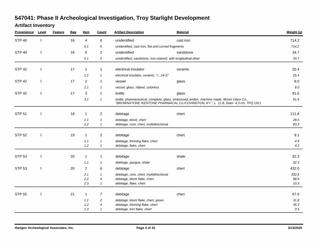
Artifact Inventory
Provenience Level Feature Bag Item Count Artifact Description Weight (g)Material
547041: Phase II Archeological Investigation, Troy Starlight Development
16 4 6 714.2unidentified cast iron1 STP 40
4.1 6 714.2unidentified, cast iron, flat and curved fragments
16 5 2 34.7unidentified sandstone1 STP 40
5.1 2 34.7unidentified, sandstone, iron-stained, with longitudinal divet
17 1 1 25.4electrical insulator ceramic1 STP 42
1.1 1 25.4electrical insulator, ceramic, "/...24-S"
17 2 1 8.0vessel glass1 STP 42
2.1 1 8.0vessel, glass, ribbed, colorless
17 3 1 91.6bottle glass1 STP 42
3.1 1 91.6bottle, pharmaceutical, complete, glass, embossed, amber, machine made, Illinois Glass Co., "BROWNATONE /KENTONE PHARMACAL Co./COVINGTON, KY.", L 11.8, Diam 4.3 cm, TPQ 1911
18 1 2 111.8debitage chert1 STP 51
1.1 1 28.5debitage, block, chert
1.2 1 83.3debitage, core, chert, multidirectional
19 1 2 9.1debitage chert1 STP 52
1.1 1 4.9debitage, thinning flake, chert
1.2 1 4.2debitage, flake, chert
20 1 1 32.3debitage shale1 STP 53
1.1 1 32.3debitage, gangue, shale
20 2 6 432.0debitage chert1 STP 53
2.1 1 332.8debitage, core, chert, multidirectional
2.2 4 88.9debitage, block flake, chert
2.3 1 10.3debitage, flake, chert
21 1 7 67.6debitage chert1 STP 55
1.1 2 31.8debitage, block flake, chert, green
1.2 4 35.3debitage, thinning flake, chert
1.3 1 0.5debitage, trim flake, chert
Hartgen Archeological Associates, Inc. Page 4 of 33 3/13/2020
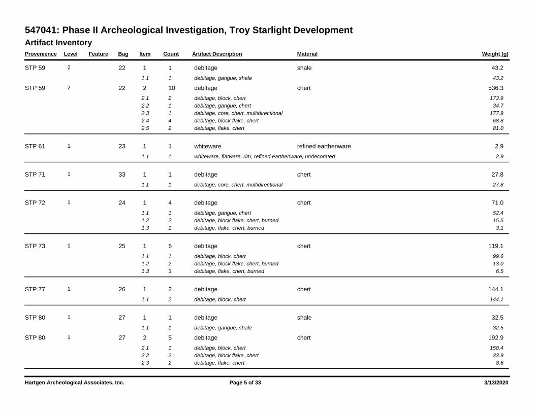
Artifact Inventory
Provenience Level Feature Bag Item Count Artifact Description Weight (g)Material
547041: Phase II Archeological Investigation, Troy Starlight Development
22 1 1 43.2debitage shale2 STP 59
1.1 1 43.2debitage, gangue, shale
22 2 10 536.3debitage chert2 STP 59
2.1 2 173.9debitage, block, chert
2.2 1 34.7debitage, gangue, chert
2.3 1 177.9debitage, core, chert, multidirectional
2.4 4 68.8debitage, block flake, chert
2.5 2 81.0debitage, flake, chert
23 1 1 2.9whiteware refined earthenware1 STP 61
1.1 1 2.9whiteware, flatware, rim, refined earthenware, undecorated
33 1 1 27.8debitage chert1 STP 71
1.1 1 27.8debitage, core, chert, multidirectional
24 1 4 71.0debitage chert1 STP 72
1.1 1 52.4debitage, gangue, chert
1.2 2 15.5debitage, block flake, chert, burned
1.3 1 3.1debitage, flake, chert, burned
25 1 6 119.1debitage chert1 STP 73
1.1 1 99.6debitage, block, chert
1.2 2 13.0debitage, block flake, chert, burned
1.3 3 6.5debitage, flake, chert, burned
26 1 2 144.1debitage chert1 STP 77
1.1 2 144.1debitage, block, chert
27 1 1 32.5debitage shale1 STP 80
1.1 1 32.5debitage, gangue, shale
27 2 5 192.9debitage chert1 STP 80
2.1 1 150.4debitage, block, chert
2.2 2 33.9debitage, block flake, chert
2.3 2 8.6debitage, flake, chert
Hartgen Archeological Associates, Inc. Page 5 of 33 3/13/2020
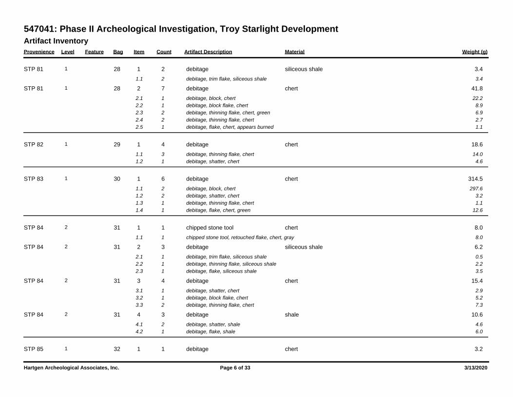
Artifact Inventory
Provenience Level Feature Bag Item Count Artifact Description Weight (g)Material
547041: Phase II Archeological Investigation, Troy Starlight Development
28 1 2 3.4debitage siliceous shale1 STP 81
1.1 2 3.4debitage, trim flake, siliceous shale
28 2 7 41.8debitage chert1 STP 81
2.1 1 22.2debitage, block, chert
2.2 1 8.9debitage, block flake, chert
2.3 2 6.9debitage, thinning flake, chert, green
2.4 2 2.7debitage, thinning flake, chert
2.5 1 1.1debitage, flake, chert, appears burned
29 1 4 18.6debitage chert1 STP 82
1.1 3 14.0debitage, thinning flake, chert
1.2 1 4.6debitage, shatter, chert
30 1 6 314.5debitage chert1 STP 83
1.1 2 297.6debitage, block, chert
1.2 2 3.2debitage, shatter, chert
1.3 1 1.1debitage, thinning flake, chert
1.4 1 12.6debitage, flake, chert, green
31 1 1 8.0chipped stone tool chert2 STP 84
1.1 1 8.0chipped stone tool, retouched flake, chert, gray
31 2 3 6.2debitage siliceous shale2 STP 84
2.1 1 0.5debitage, trim flake, siliceous shale
2.2 1 2.2debitage, thinning flake, siliceous shale
2.3 1 3.5debitage, flake, siliceous shale
31 3 4 15.4debitage chert2 STP 84
3.1 1 2.9debitage, shatter, chert
3.2 1 5.2debitage, block flake, chert
3.3 2 7.3debitage, thinning flake, chert
31 4 3 10.6debitage shale2 STP 84
4.1 2 4.6debitage, shatter, shale
4.2 1 6.0debitage, flake, shale
32 1 1 3.2debitage chert1 STP 85
Hartgen Archeological Associates, Inc. Page 6 of 33 3/13/2020
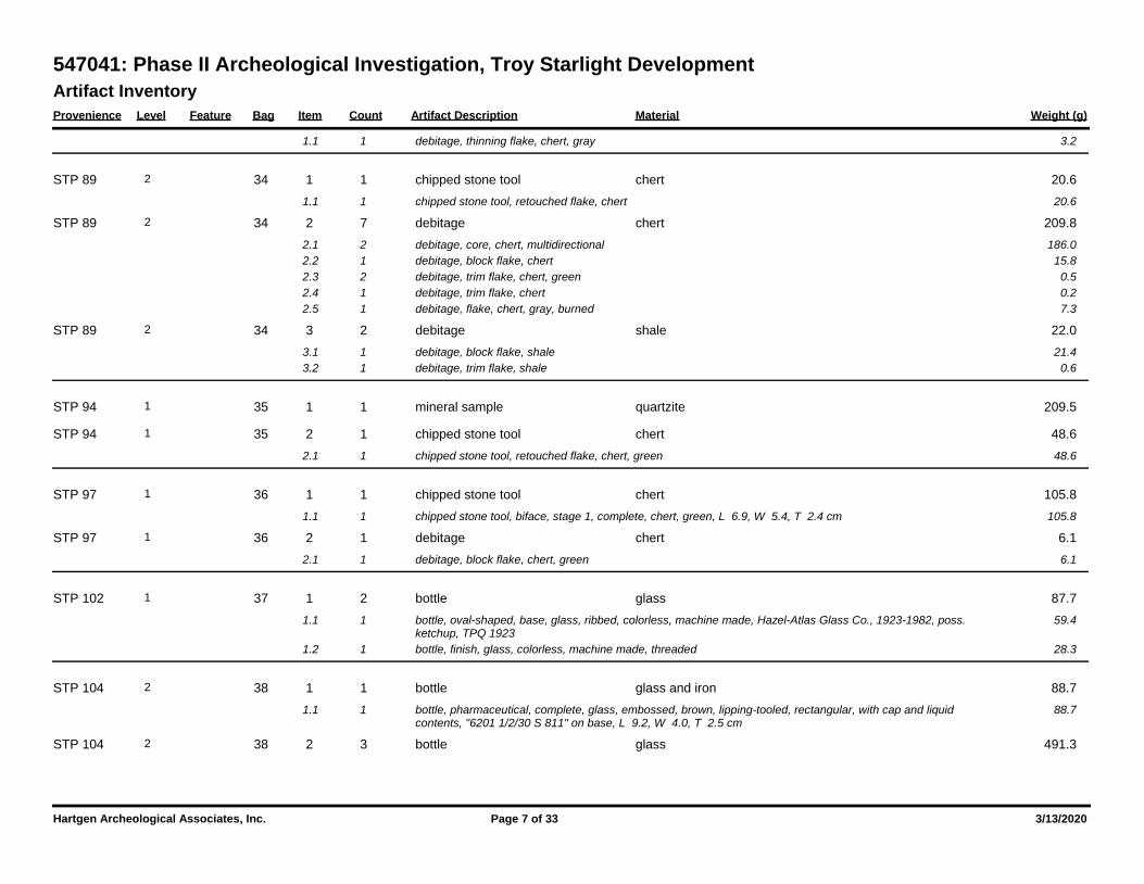
Artifact Inventory
Provenience Level Feature Bag Item Count Artifact Description Weight (g)Material
547041: Phase II Archeological Investigation, Troy Starlight Development
1.1 1 3.2debitage, thinning flake, chert, gray
34 1 1 20.6chipped stone tool chert2 STP 89
1.1 1 20.6chipped stone tool, retouched flake, chert
34 2 7 209.8debitage chert2 STP 89
2.1 2 186.0debitage, core, chert, multidirectional
2.2 1 15.8debitage, block flake, chert
2.3 2 0.5debitage, trim flake, chert, green
2.4 1 0.2debitage, trim flake, chert
2.5 1 7.3debitage, flake, chert, gray, burned
34 3 2 22.0debitage shale2 STP 89
3.1 1 21.4debitage, block flake, shale
3.2 1 0.6debitage, trim flake, shale
35 1 1 209.5mineral sample quartzite1 STP 94
35 2 1 48.6chipped stone tool chert1 STP 94
2.1 1 48.6chipped stone tool, retouched flake, chert, green
36 1 1 105.8chipped stone tool chert1 STP 97
1.1 1 105.8chipped stone tool, biface, stage 1, complete, chert, green, L 6.9, W 5.4, T 2.4 cm
36 2 1 6.1debitage chert1 STP 97
2.1 1 6.1debitage, block flake, chert, green
37 1 2 87.7bottle glass1 STP 102
1.1 1 59.4bottle, oval-shaped, base, glass, ribbed, colorless, machine made, Hazel-Atlas Glass Co., 1923-1982, poss. ketchup, TPQ 1923
1.2 1 28.3bottle, finish, glass, colorless, machine made, threaded
38 1 1 88.7bottle glass and iron2 STP 104
1.1 1 88.7bottle, pharmaceutical, complete, glass, embossed, brown, lipping-tooled, rectangular, with cap and liquid contents, "6201 1/2/30 S 811" on base, L 9.2, W 4.0, T 2.5 cm
38 2 3 491.3bottle glass2 STP 104
Hartgen Archeological Associates, Inc. Page 7 of 33 3/13/2020
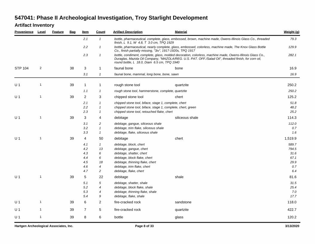
Artifact Inventory
Provenience Level Feature Bag Item Count Artifact Description Weight (g)Material
547041: Phase II Archeological Investigation, Troy Starlight Development
2.1 1 79.3bottle, pharmaceutical, complete, glass, embossed, brown, machine made, Owens-Illinois Glass Co., threaded finish, L 9.1, W 4.8, T 3.0 cm, TPQ 1929
2.2 1 129.9bottle, pharmaceutical, nearly complete, glass, embossed, colorless, machine made, The Knox Glass Bottle Co., finish partially missing, "3iv", 1917-1920s, TPQ 1917
2.3 1 282.1bottle, condiment, complete, glass, molded decoration, colorless, machine made, Owens-Illinois Glass Co., Duraglas, Mazola Oil Company, "MAZOLA/REG. U.S. PAT. OFF./Salad Oil", threaded finish, for corn oil, round bottle, L 18.0, Diam 6.5 cm, TPQ 1940
38 3 1 16.9faunal bone bone2 STP 104
3.1 1 16.9faunal bone, mammal, long bone, bone, sawn
39 1 1 250.2rough stone tool quartzite1 U 1
1.1 1 250.2rough stone tool, hammerstone, complete, quartzite
39 2 3 125.2chipped stone tool chert1 U 1
2.1 1 51.8chipped stone tool, biface, stage 1, complete, chert
2.2 1 48.2chipped stone tool, biface, stage 1, complete, chert, green
2.3 1 25.2chipped stone tool, retouched flake, chert
39 3 4 114.3debitage siliceous shale1 U 1
3.1 2 112.0debitage, gangue, siliceous shale
3.2 1 0.7debitage, trim flake, siliceous shale
3.3 1 1.6debitage, flake, siliceous shale
39 4 50 1,519.9debitage chert1 U 1
4.1 1 589.7debitage, block, chert
4.2 13 794.5debitage, gangue, chert
4.3 6 31.6debitage, shatter, chert
4.4 6 67.1debitage, block flake, chert
4.5 18 29.9debitage, thinning flake, chert
4.6 4 0.7debitage, trim flake, chert
4.7 2 6.4debitage, flake, chert
39 5 22 81.6debitage shale1 U 1
5.1 5 31.5debitage, shatter, shale
5.2 4 25.4debitage, block flake, shale
5.3 4 7.0debitage, thinning flake, shale
5.4 9 17.7debitage, flake, shale
39 6 2 118.0fire-cracked rock sandstone1 U 1
39 7 5 422.7fire-cracked rock quartzite1 U 1
39 8 6 120.2bottle glass1 U 1
Hartgen Archeological Associates, Inc. Page 8 of 33 3/13/2020
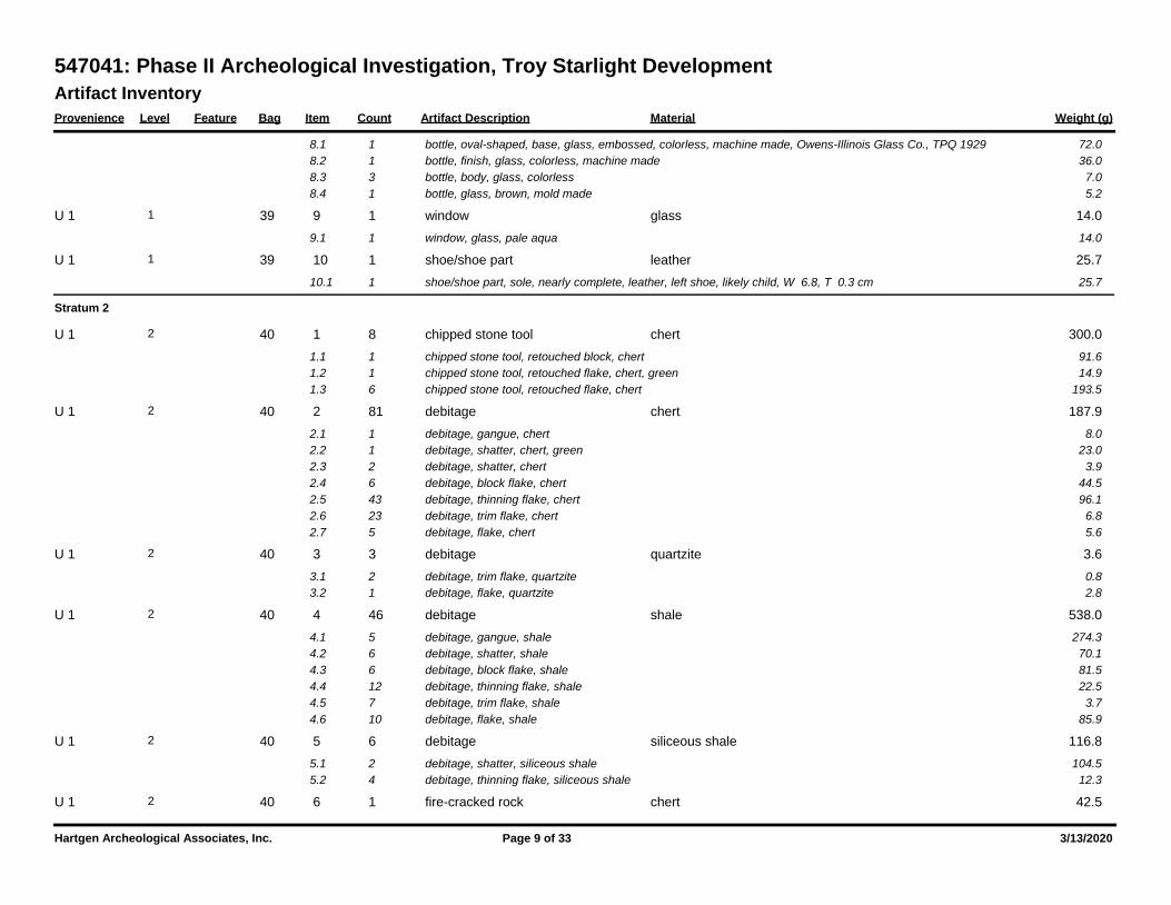
Artifact Inventory
Provenience Level Feature Bag Item Count Artifact Description Weight (g)Material
547041: Phase II Archeological Investigation, Troy Starlight Development
8.1 1 72.0bottle, oval-shaped, base, glass, embossed, colorless, machine made, Owens-Illinois Glass Co., TPQ 1929
8.2 1 36.0bottle, finish, glass, colorless, machine made
8.3 3 7.0bottle, body, glass, colorless
8.4 1 5.2bottle, glass, brown, mold made
39 9 1 14.0window glass1 U 1
9.1 1 14.0window, glass, pale aqua
39 10 1 25.7shoe/shoe part leather1 U 1
10.1 1 25.7shoe/shoe part, sole, nearly complete, leather, left shoe, likely child, W 6.8, T 0.3 cm
Stratum 2
40 1 8 300.0chipped stone tool chert2 U 1
1.1 1 91.6chipped stone tool, retouched block, chert
1.2 1 14.9chipped stone tool, retouched flake, chert, green
1.3 6 193.5chipped stone tool, retouched flake, chert
40 2 81 187.9debitage chert2 U 1
2.1 1 8.0debitage, gangue, chert
2.2 1 23.0debitage, shatter, chert, green
2.3 2 3.9debitage, shatter, chert
2.4 6 44.5debitage, block flake, chert
2.5 43 96.1debitage, thinning flake, chert
2.6 23 6.8debitage, trim flake, chert
2.7 5 5.6debitage, flake, chert
40 3 3 3.6debitage quartzite2 U 1
3.1 2 0.8debitage, trim flake, quartzite
3.2 1 2.8debitage, flake, quartzite
40 4 46 538.0debitage shale2 U 1
4.1 5 274.3debitage, gangue, shale
4.2 6 70.1debitage, shatter, shale
4.3 6 81.5debitage, block flake, shale
4.4 12 22.5debitage, thinning flake, shale
4.5 7 3.7debitage, trim flake, shale
4.6 10 85.9debitage, flake, shale
40 5 6 116.8debitage siliceous shale2 U 1
5.1 2 104.5debitage, shatter, siliceous shale
5.2 4 12.3debitage, thinning flake, siliceous shale
40 6 1 42.5fire-cracked rock chert2 U 1
Hartgen Archeological Associates, Inc. Page 9 of 33 3/13/2020
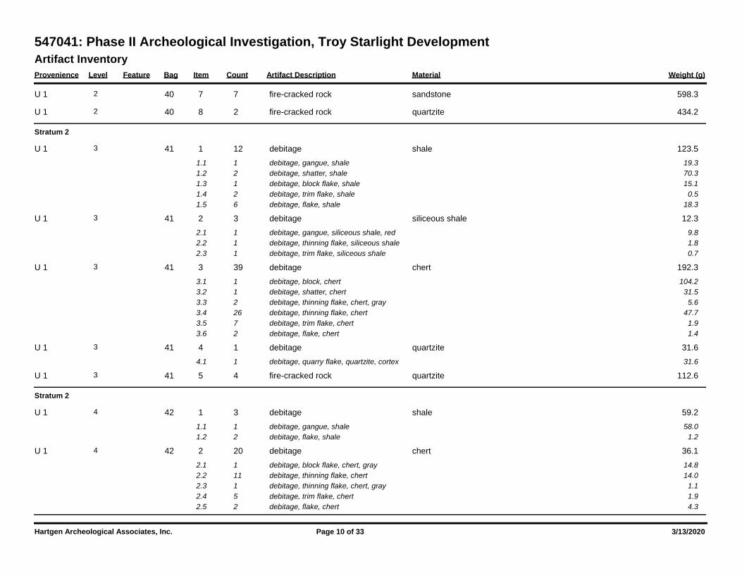
Artifact Inventory
Provenience Level Feature Bag Item Count Artifact Description Weight (g)Material
547041: Phase II Archeological Investigation, Troy Starlight Development
40 7 7 598.3fire-cracked rock sandstone2 U 1
40 8 2 434.2fire-cracked rock quartzite2 U 1
Stratum 2
41 1 12 123.5debitage shale3 U 1
1.1 1 19.3debitage, gangue, shale
1.2 2 70.3debitage, shatter, shale
1.3 1 15.1debitage, block flake, shale
1.4 2 0.5debitage, trim flake, shale
1.5 6 18.3debitage, flake, shale
41 2 3 12.3debitage siliceous shale3 U 1
2.1 1 9.8debitage, gangue, siliceous shale, red
2.2 1 1.8debitage, thinning flake, siliceous shale
2.3 1 0.7debitage, trim flake, siliceous shale
41 3 39 192.3debitage chert3 U 1
3.1 1 104.2debitage, block, chert
3.2 1 31.5debitage, shatter, chert
3.3 2 5.6debitage, thinning flake, chert, gray
3.4 26 47.7debitage, thinning flake, chert
3.5 7 1.9debitage, trim flake, chert
3.6 2 1.4debitage, flake, chert
41 4 1 31.6debitage quartzite3 U 1
4.1 1 31.6debitage, quarry flake, quartzite, cortex
41 5 4 112.6fire-cracked rock quartzite3 U 1
Stratum 2
42 1 3 59.2debitage shale4 U 1
1.1 1 58.0debitage, gangue, shale
1.2 2 1.2debitage, flake, shale
42 2 20 36.1debitage chert4 U 1
2.1 1 14.8debitage, block flake, chert, gray
2.2 11 14.0debitage, thinning flake, chert
2.3 1 1.1debitage, thinning flake, chert, gray
2.4 5 1.9debitage, trim flake, chert
2.5 2 4.3debitage, flake, chert
Hartgen Archeological Associates, Inc. Page 10 of 33 3/13/2020
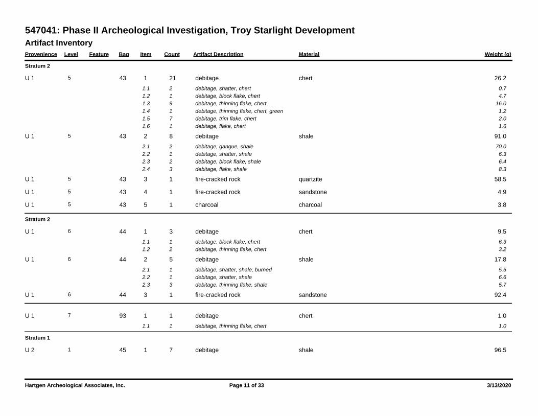
Artifact Inventory
Provenience Level Feature Bag Item Count Artifact Description Weight (g)Material
547041: Phase II Archeological Investigation, Troy Starlight Development
Stratum 2
43 1 21 26.2debitage chert5 U 1
1.1 2 0.7debitage, shatter, chert
1.2 1 4.7debitage, block flake, chert
1.3 9 16.0debitage, thinning flake, chert
1.4 1 1.2debitage, thinning flake, chert, green
1.5 7 2.0debitage, trim flake, chert
1.6 1 1.6debitage, flake, chert
43 2 8 91.0debitage shale5 U 1
2.1 2 70.0debitage, gangue, shale
2.2 1 6.3debitage, shatter, shale
2.3 2 6.4debitage, block flake, shale
2.4 3 8.3debitage, flake, shale
43 3 1 58.5fire-cracked rock quartzite5 U 1
43 4 1 4.9fire-cracked rock sandstone5 U 1
43 5 1 3.8charcoal charcoal5 U 1
Stratum 2
44 1 3 9.5debitage chert6 U 1
1.1 1 6.3debitage, block flake, chert
1.2 2 3.2debitage, thinning flake, chert
44 2 5 17.8debitage shale6 U 1
2.1 1 5.5debitage, shatter, shale, burned
2.2 1 6.6debitage, shatter, shale
2.3 3 5.7debitage, thinning flake, shale
44 3 1 92.4fire-cracked rock sandstone6 U 1
93 1 1 1.0debitage chert7 U 1
1.1 1 1.0debitage, thinning flake, chert
Stratum 1
45 1 7 96.5debitage shale1 U 2
Hartgen Archeological Associates, Inc. Page 11 of 33 3/13/2020
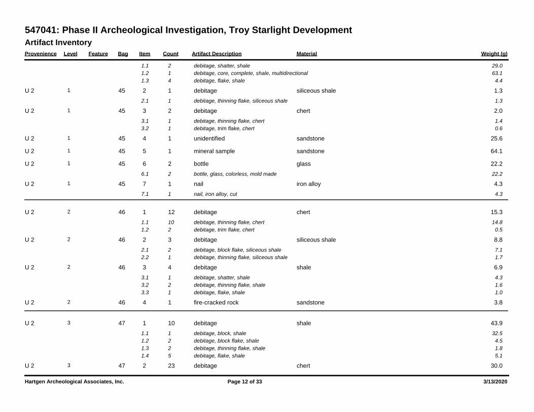
Artifact Inventory
Provenience Level Feature Bag Item Count Artifact Description Weight (g)Material
547041: Phase II Archeological Investigation, Troy Starlight Development
1.1 2 29.0debitage, shatter, shale
1.2 1 63.1debitage, core, complete, shale, multidirectional
1.3 4 4.4debitage, flake, shale
45 2 1 1.3debitage siliceous shale1 U 2
2.1 1 1.3debitage, thinning flake, siliceous shale
45 3 2 2.0debitage chert1 U 2
3.1 1 1.4debitage, thinning flake, chert
3.2 1 0.6debitage, trim flake, chert
45 4 1 25.6unidentified sandstone1 U 2
45 5 1 64.1mineral sample sandstone1 U 2
45 6 2 22.2bottle glass1 U 2
6.1 2 22.2bottle, glass, colorless, mold made
45 7 1 4.3nail iron alloy1 U 2
7.1 1 4.3nail, iron alloy, cut
46 1 12 15.3debitage chert2 U 2
1.1 10 14.8debitage, thinning flake, chert
1.2 2 0.5debitage, trim flake, chert
46 2 3 8.8debitage siliceous shale2 U 2
2.1 2 7.1debitage, block flake, siliceous shale
2.2 1 1.7debitage, thinning flake, siliceous shale
46 3 4 6.9debitage shale2 U 2
3.1 1 4.3debitage, shatter, shale
3.2 2 1.6debitage, thinning flake, shale
3.3 1 1.0debitage, flake, shale
46 4 1 3.8fire-cracked rock sandstone2 U 2
47 1 10 43.9debitage shale3 U 2
1.1 1 32.5debitage, block, shale
1.2 2 4.5debitage, block flake, shale
1.3 2 1.8debitage, thinning flake, shale
1.4 5 5.1debitage, flake, shale
47 2 23 30.0debitage chert3 U 2
Hartgen Archeological Associates, Inc. Page 12 of 33 3/13/2020
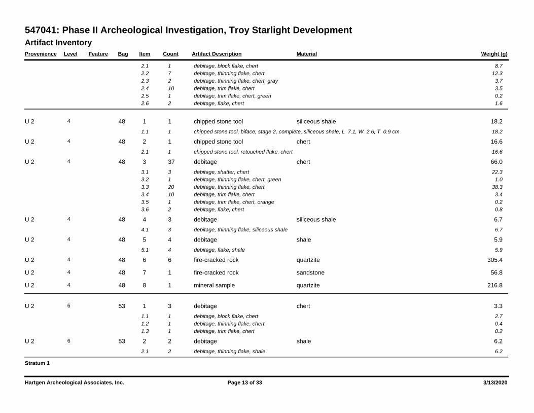
Artifact Inventory
Provenience Level Feature Bag Item Count Artifact Description Weight (g)Material
547041: Phase II Archeological Investigation, Troy Starlight Development
2.1 1 8.7debitage, block flake, chert
2.2 7 12.3debitage, thinning flake, chert
2.3 2 3.7debitage, thinning flake, chert, gray
2.4 10 3.5debitage, trim flake, chert
2.5 1 0.2debitage, trim flake, chert, green
2.6 2 1.6debitage, flake, chert
48 1 1 18.2chipped stone tool siliceous shale4 U 2
1.1 1 18.2chipped stone tool, biface, stage 2, complete, siliceous shale, L 7.1, W 2.6, T 0.9 cm
48 2 1 16.6chipped stone tool chert4 U 2
2.1 1 16.6chipped stone tool, retouched flake, chert
48 3 37 66.0debitage chert4 U 2
3.1 3 22.3debitage, shatter, chert
3.2 1 1.0debitage, thinning flake, chert, green
3.3 20 38.3debitage, thinning flake, chert
3.4 10 3.4debitage, trim flake, chert
3.5 1 0.2debitage, trim flake, chert, orange
3.6 2 0.8debitage, flake, chert
48 4 3 6.7debitage siliceous shale4 U 2
4.1 3 6.7debitage, thinning flake, siliceous shale
48 5 4 5.9debitage shale4 U 2
5.1 4 5.9debitage, flake, shale
48 6 6 305.4fire-cracked rock quartzite4 U 2
48 7 1 56.8fire-cracked rock sandstone4 U 2
48 8 1 216.8mineral sample quartzite4 U 2
53 1 3 3.3debitage chert6 U 2
1.1 1 2.7debitage, block flake, chert
1.2 1 0.4debitage, thinning flake, chert
1.3 1 0.2debitage, trim flake, chert
53 2 2 6.2debitage shale6 U 2
2.1 2 6.2debitage, thinning flake, shale
Stratum 1
Hartgen Archeological Associates, Inc. Page 13 of 33 3/13/2020
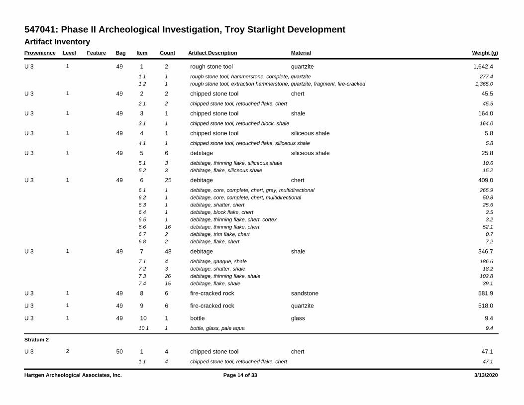
Artifact Inventory
Provenience Level Feature Bag Item Count Artifact Description Weight (g)Material
547041: Phase II Archeological Investigation, Troy Starlight Development
49 1 2 1,642.4rough stone tool quartzite1 U 3
1.1 1 277.4rough stone tool, hammerstone, complete, quartzite
1.2 1 1,365.0rough stone tool, extraction hammerstone, quartzite, fragment, fire-cracked
49 2 2 45.5chipped stone tool chert1 U 3
2.1 2 45.5chipped stone tool, retouched flake, chert
49 3 1 164.0chipped stone tool shale1 U 3
3.1 1 164.0chipped stone tool, retouched block, shale
49 4 1 5.8chipped stone tool siliceous shale1 U 3
4.1 1 5.8chipped stone tool, retouched flake, siliceous shale
49 5 6 25.8debitage siliceous shale1 U 3
5.1 3 10.6debitage, thinning flake, siliceous shale
5.2 3 15.2debitage, flake, siliceous shale
49 6 25 409.0debitage chert1 U 3
6.1 1 265.9debitage, core, complete, chert, gray, multidirectional
6.2 1 50.8debitage, core, complete, chert, multidirectional
6.3 1 25.6debitage, shatter, chert
6.4 1 3.5debitage, block flake, chert
6.5 1 3.2debitage, thinning flake, chert, cortex
6.6 16 52.1debitage, thinning flake, chert
6.7 2 0.7debitage, trim flake, chert
6.8 2 7.2debitage, flake, chert
49 7 48 346.7debitage shale1 U 3
7.1 4 186.6debitage, gangue, shale
7.2 3 18.2debitage, shatter, shale
7.3 26 102.8debitage, thinning flake, shale
7.4 15 39.1debitage, flake, shale
49 8 6 581.9fire-cracked rock sandstone1 U 3
49 9 6 518.0fire-cracked rock quartzite1 U 3
49 10 1 9.4bottle glass1 U 3
10.1 1 9.4bottle, glass, pale aqua
Stratum 2
50 1 4 47.1chipped stone tool chert2 U 3
1.1 4 47.1chipped stone tool, retouched flake, chert
Hartgen Archeological Associates, Inc. Page 14 of 33 3/13/2020
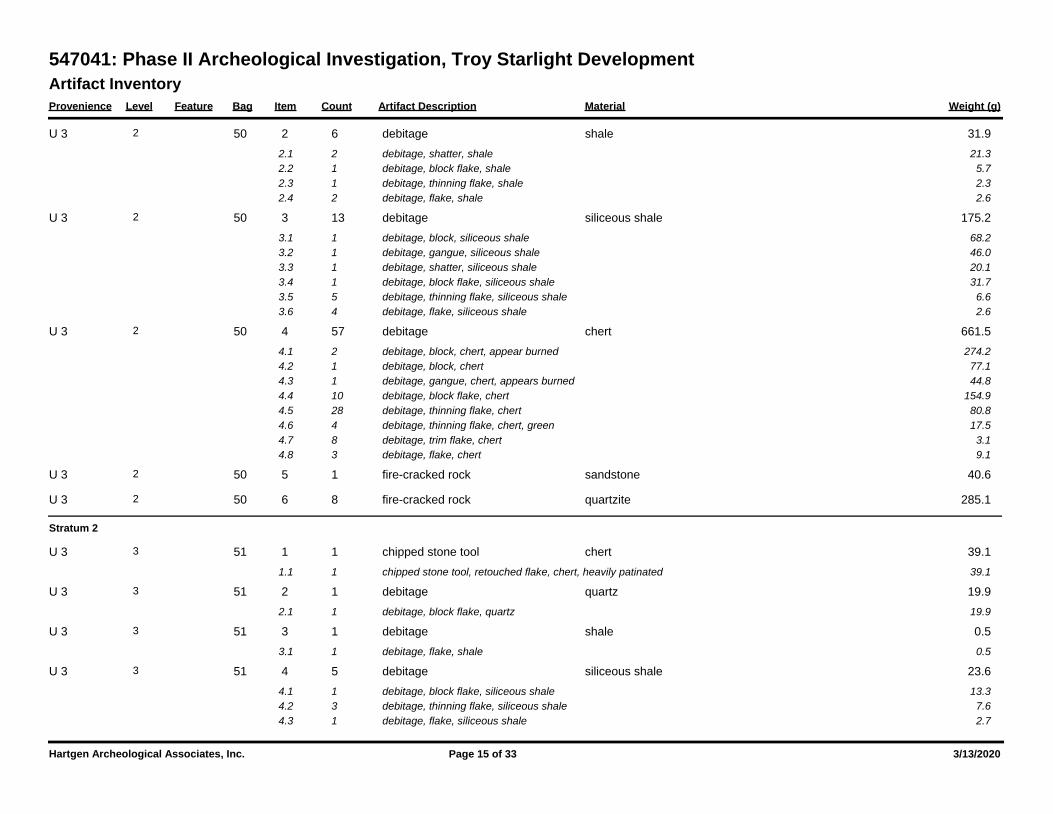
Artifact Inventory
Provenience Level Feature Bag Item Count Artifact Description Weight (g)Material
547041: Phase II Archeological Investigation, Troy Starlight Development
50 2 6 31.9debitage shale2 U 3
2.1 2 21.3debitage, shatter, shale
2.2 1 5.7debitage, block flake, shale
2.3 1 2.3debitage, thinning flake, shale
2.4 2 2.6debitage, flake, shale
50 3 13 175.2debitage siliceous shale2 U 3
3.1 1 68.2debitage, block, siliceous shale
3.2 1 46.0debitage, gangue, siliceous shale
3.3 1 20.1debitage, shatter, siliceous shale
3.4 1 31.7debitage, block flake, siliceous shale
3.5 5 6.6debitage, thinning flake, siliceous shale
3.6 4 2.6debitage, flake, siliceous shale
50 4 57 661.5debitage chert2 U 3
4.1 2 274.2debitage, block, chert, appear burned
4.2 1 77.1debitage, block, chert
4.3 1 44.8debitage, gangue, chert, appears burned
4.4 10 154.9debitage, block flake, chert
4.5 28 80.8debitage, thinning flake, chert
4.6 4 17.5debitage, thinning flake, chert, green
4.7 8 3.1debitage, trim flake, chert
4.8 3 9.1debitage, flake, chert
50 5 1 40.6fire-cracked rock sandstone2 U 3
50 6 8 285.1fire-cracked rock quartzite2 U 3
Stratum 2
51 1 1 39.1chipped stone tool chert3 U 3
1.1 1 39.1chipped stone tool, retouched flake, chert, heavily patinated
51 2 1 19.9debitage quartz3 U 3
2.1 1 19.9debitage, block flake, quartz
51 3 1 0.5debitage shale3 U 3
3.1 1 0.5debitage, flake, shale
51 4 5 23.6debitage siliceous shale3 U 3
4.1 1 13.3debitage, block flake, siliceous shale
4.2 3 7.6debitage, thinning flake, siliceous shale
4.3 1 2.7debitage, flake, siliceous shale
Hartgen Archeological Associates, Inc. Page 15 of 33 3/13/2020
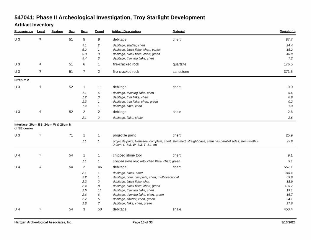
Artifact Inventory
Provenience Level Feature Bag Item Count Artifact Description Weight (g)Material
547041: Phase II Archeological Investigation, Troy Starlight Development
51 5 9 87.7debitage chert3 U 3
5.1 2 24.4debitage, shatter, chert
5.2 1 15.2debitage, block flake, chert, cortex
5.3 3 40.9debitage, block flake, chert, green
5.4 3 7.2debitage, thinning flake, chert
51 6 1 176.5fire-cracked rock quartzite3 U 3
51 7 2 371.5fire-cracked rock sandstone3 U 3
Stratum 2
52 1 11 9.0debitage chert4 U 3
1.1 6 6.6debitage, thinning flake, chert
1.2 3 0.9debitage, trim flake, chert
1.3 1 0.2debitage, trim flake, chert, green
1.4 1 1.3debitage, flake, chert
52 2 2 2.6debitage shale4 U 3
2.1 2 2.6debitage, flake, shale
Interface, 20cm BS, 24cm W & 26cm N
of SE corner
71 1 1 25.9projectile point chert1 U 3
1.1 1 25.9projectile point, Genesee, complete, chert, stemmed, straight base, stem has parallel sides, stem width = 2.0cm, L 8.5, W 3.3, T 1.1 cm
54 1 1 9.1chipped stone tool chert1 U 4
1.1 1 9.1chipped stone tool, retouched flake, chert, green
54 2 46 557.1debitage chert1 U 4
2.1 1 245.4debitage, block, chert
2.2 1 69.6debitage, core, complete, chert, multidirectional
2.3 2 18.9debitage, block flake, chert
2.4 8 135.7debitage, block flake, chert, green
2.5 16 19.1debitage, thinning flake, chert
2.6 6 16.7debitage, thinning flake, chert, green
2.7 5 24.1debitage, shatter, chert, green
2.8 7 27.6debitage, flake, chert, green
54 3 50 450.4debitage shale1 U 4
Hartgen Archeological Associates, Inc. Page 16 of 33 3/13/2020
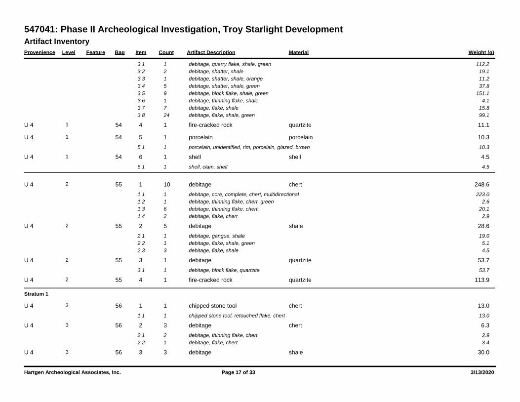
Artifact Inventory
Provenience Level Feature Bag Item Count Artifact Description Weight (g)Material
547041: Phase II Archeological Investigation, Troy Starlight Development
3.1 1 112.2debitage, quarry flake, shale, green
3.2 2 19.1debitage, shatter, shale
3.3 1 11.2debitage, shatter, shale, orange
3.4 5 37.8debitage, shatter, shale, green
3.5 9 151.1debitage, block flake, shale, green
3.6 1 4.1debitage, thinning flake, shale
3.7 7 15.8debitage, flake, shale
3.8 24 99.1debitage, flake, shale, green
54 4 1 11.1fire-cracked rock quartzite1 U 4
54 5 1 10.3porcelain porcelain1 U 4
5.1 1 10.3porcelain, unidentified, rim, porcelain, glazed, brown
54 6 1 4.5shell shell1 U 4
6.1 1 4.5shell, clam, shell
55 1 10 248.6debitage chert2 U 4
1.1 1 223.0debitage, core, complete, chert, multidirectional
1.2 1 2.6debitage, thinning flake, chert, green
1.3 6 20.1debitage, thinning flake, chert
1.4 2 2.9debitage, flake, chert
55 2 5 28.6debitage shale2 U 4
2.1 1 19.0debitage, gangue, shale
2.2 1 5.1debitage, flake, shale, green
2.3 3 4.5debitage, flake, shale
55 3 1 53.7debitage quartzite2 U 4
3.1 1 53.7debitage, block flake, quartzite
55 4 1 113.9fire-cracked rock quartzite2 U 4
Stratum 1
56 1 1 13.0chipped stone tool chert3 U 4
1.1 1 13.0chipped stone tool, retouched flake, chert
56 2 3 6.3debitage chert3 U 4
2.1 2 2.9debitage, thinning flake, chert
2.2 1 3.4debitage, flake, chert
56 3 3 30.0debitage shale3 U 4
Hartgen Archeological Associates, Inc. Page 17 of 33 3/13/2020
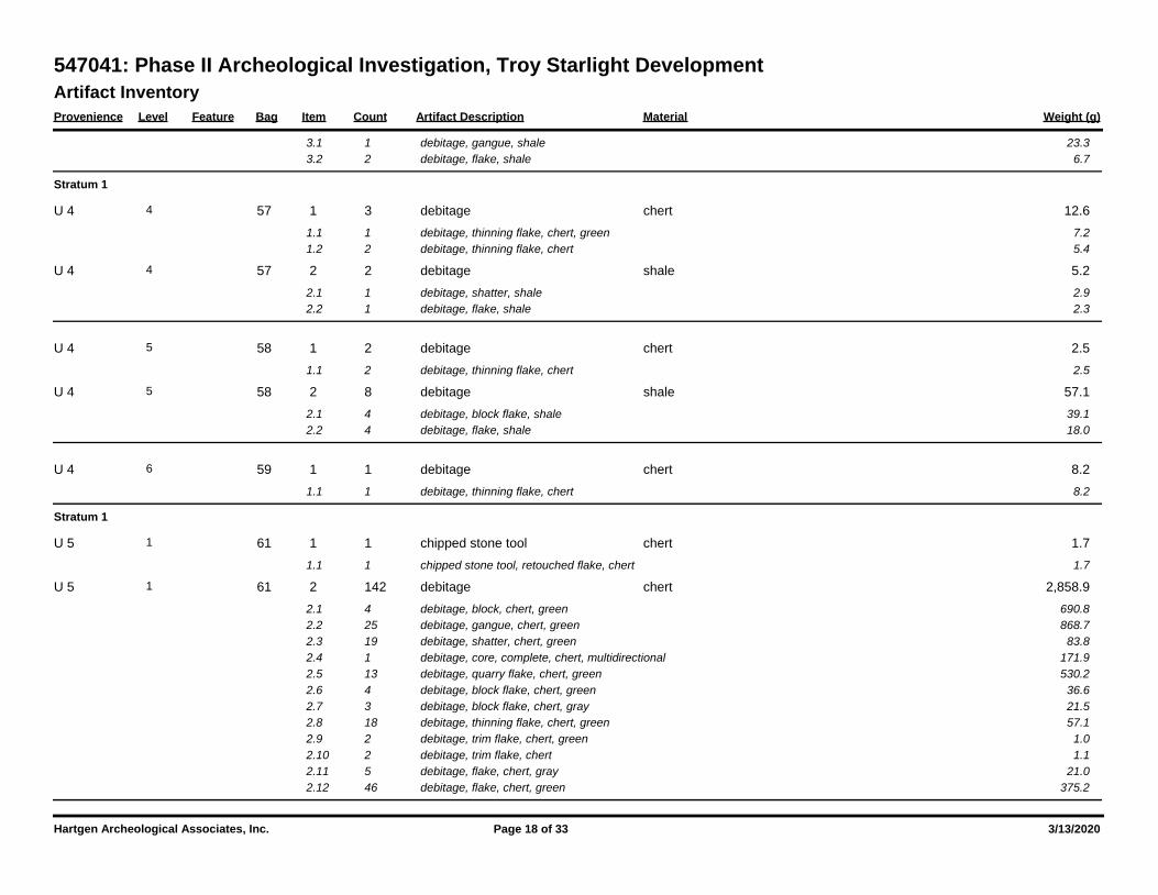
Artifact Inventory
Provenience Level Feature Bag Item Count Artifact Description Weight (g)Material
547041: Phase II Archeological Investigation, Troy Starlight Development
3.1 1 23.3debitage, gangue, shale
3.2 2 6.7debitage, flake, shale
Stratum 1
57 1 3 12.6debitage chert4 U 4
1.1 1 7.2debitage, thinning flake, chert, green
1.2 2 5.4debitage, thinning flake, chert
57 2 2 5.2debitage shale4 U 4
2.1 1 2.9debitage, shatter, shale
2.2 1 2.3debitage, flake, shale
58 1 2 2.5debitage chert5 U 4
1.1 2 2.5debitage, thinning flake, chert
58 2 8 57.1debitage shale5 U 4
2.1 4 39.1debitage, block flake, shale
2.2 4 18.0debitage, flake, shale
59 1 1 8.2debitage chert6 U 4
1.1 1 8.2debitage, thinning flake, chert
Stratum 1
61 1 1 1.7chipped stone tool chert1 U 5
1.1 1 1.7chipped stone tool, retouched flake, chert
61 2 142 2,858.9debitage chert1 U 5
2.1 4 690.8debitage, block, chert, green
2.2 25 868.7debitage, gangue, chert, green
2.3 19 83.8debitage, shatter, chert, green
2.4 1 171.9debitage, core, complete, chert, multidirectional
2.5 13 530.2debitage, quarry flake, chert, green
2.6 4 36.6debitage, block flake, chert, green
2.7 3 21.5debitage, block flake, chert, gray
2.8 18 57.1debitage, thinning flake, chert, green
2.9 2 1.0debitage, trim flake, chert, green
2.10 2 1.1debitage, trim flake, chert
2.11 5 21.0debitage, flake, chert, gray
2.12 46 375.2debitage, flake, chert, green
Hartgen Archeological Associates, Inc. Page 18 of 33 3/13/2020
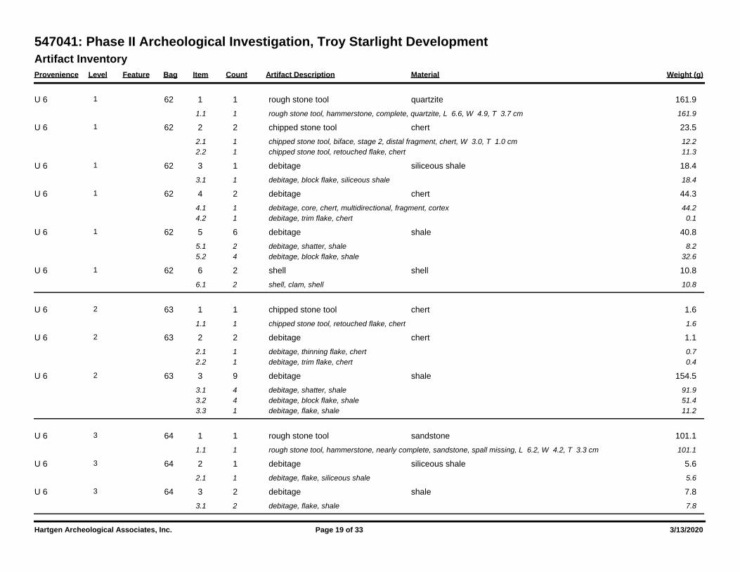
Artifact Inventory
Provenience Level Feature Bag Item Count Artifact Description Weight (g)Material
547041: Phase II Archeological Investigation, Troy Starlight Development
62 1 1 161.9rough stone tool quartzite1 U 6
1.1 1 161.9rough stone tool, hammerstone, complete, quartzite, L 6.6, W 4.9, T 3.7 cm
62 2 2 23.5chipped stone tool chert1 U 6
2.1 1 12.2chipped stone tool, biface, stage 2, distal fragment, chert, W 3.0, T 1.0 cm
2.2 1 11.3chipped stone tool, retouched flake, chert
62 3 1 18.4debitage siliceous shale1 U 6
3.1 1 18.4debitage, block flake, siliceous shale
62 4 2 44.3debitage chert1 U 6
4.1 1 44.2debitage, core, chert, multidirectional, fragment, cortex
4.2 1 0.1debitage, trim flake, chert
62 5 6 40.8debitage shale1 U 6
5.1 2 8.2debitage, shatter, shale
5.2 4 32.6debitage, block flake, shale
62 6 2 10.8shell shell1 U 6
6.1 2 10.8shell, clam, shell
63 1 1 1.6chipped stone tool chert2 U 6
1.1 1 1.6chipped stone tool, retouched flake, chert
63 2 2 1.1debitage chert2 U 6
2.1 1 0.7debitage, thinning flake, chert
2.2 1 0.4debitage, trim flake, chert
63 3 9 154.5debitage shale2 U 6
3.1 4 91.9debitage, shatter, shale
3.2 4 51.4debitage, block flake, shale
3.3 1 11.2debitage, flake, shale
64 1 1 101.1rough stone tool sandstone3 U 6
1.1 1 101.1rough stone tool, hammerstone, nearly complete, sandstone, spall missing, L 6.2, W 4.2, T 3.3 cm
64 2 1 5.6debitage siliceous shale3 U 6
2.1 1 5.6debitage, flake, siliceous shale
64 3 2 7.8debitage shale3 U 6
3.1 2 7.8debitage, flake, shale
Hartgen Archeological Associates, Inc. Page 19 of 33 3/13/2020
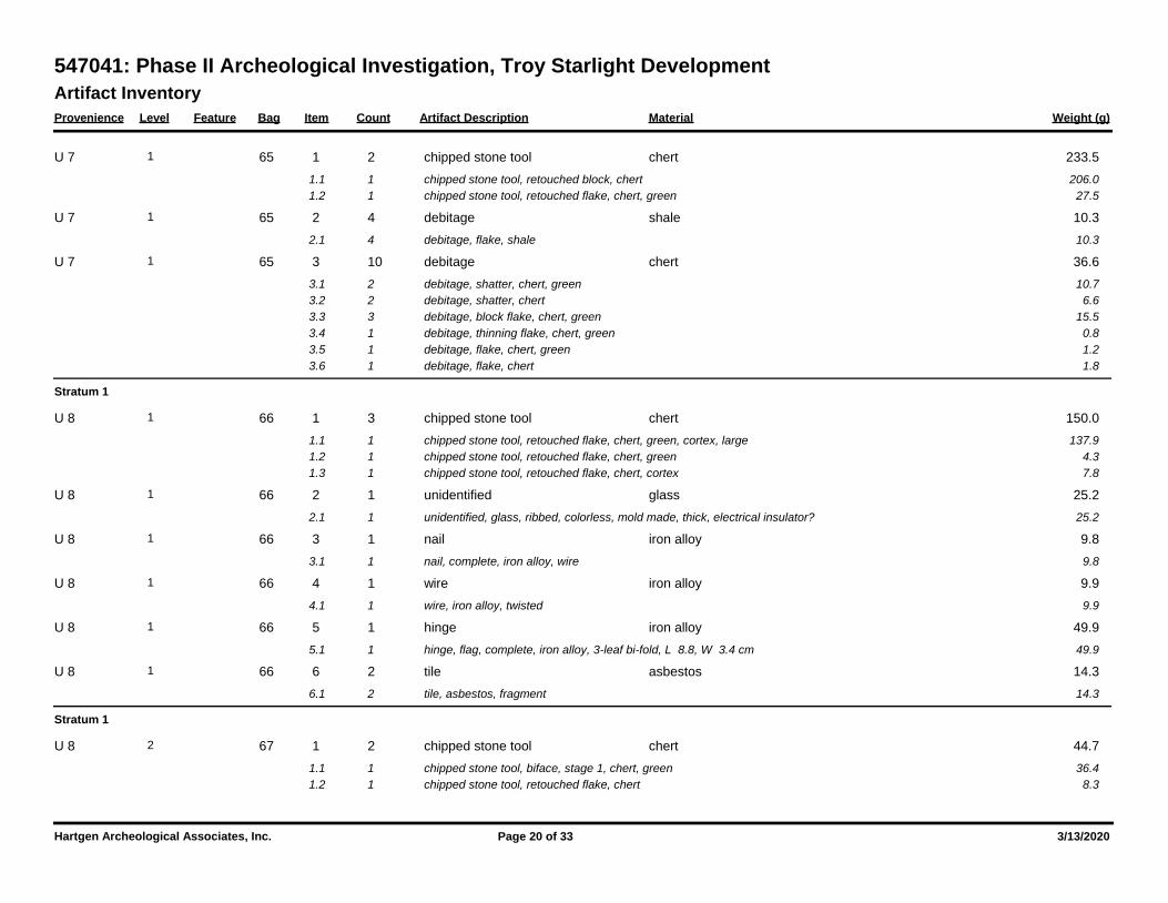
Artifact Inventory
Provenience Level Feature Bag Item Count Artifact Description Weight (g)Material
547041: Phase II Archeological Investigation, Troy Starlight Development
65 1 2 233.5chipped stone tool chert1 U 7
1.1 1 206.0chipped stone tool, retouched block, chert
1.2 1 27.5chipped stone tool, retouched flake, chert, green
65 2 4 10.3debitage shale1 U 7
2.1 4 10.3debitage, flake, shale
65 3 10 36.6debitage chert1 U 7
3.1 2 10.7debitage, shatter, chert, green
3.2 2 6.6debitage, shatter, chert
3.3 3 15.5debitage, block flake, chert, green
3.4 1 0.8debitage, thinning flake, chert, green
3.5 1 1.2debitage, flake, chert, green
3.6 1 1.8debitage, flake, chert
Stratum 1
66 1 3 150.0chipped stone tool chert1 U 8
1.1 1 137.9chipped stone tool, retouched flake, chert, green, cortex, large
1.2 1 4.3chipped stone tool, retouched flake, chert, green
1.3 1 7.8chipped stone tool, retouched flake, chert, cortex
66 2 1 25.2unidentified glass1 U 8
2.1 1 25.2unidentified, glass, ribbed, colorless, mold made, thick, electrical insulator?
66 3 1 9.8nail iron alloy1 U 8
3.1 1 9.8nail, complete, iron alloy, wire
66 4 1 9.9wire iron alloy1 U 8
4.1 1 9.9wire, iron alloy, twisted
66 5 1 49.9hinge iron alloy1 U 8
5.1 1 49.9hinge, flag, complete, iron alloy, 3-leaf bi-fold, L 8.8, W 3.4 cm
66 6 2 14.3tile asbestos1 U 8
6.1 2 14.3tile, asbestos, fragment
Stratum 1
67 1 2 44.7chipped stone tool chert2 U 8
1.1 1 36.4chipped stone tool, biface, stage 1, chert, green
1.2 1 8.3chipped stone tool, retouched flake, chert
Hartgen Archeological Associates, Inc. Page 20 of 33 3/13/2020
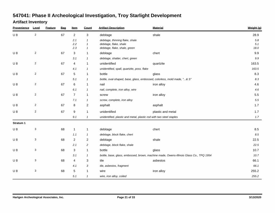
Artifact Inventory
Provenience Level Feature Bag Item Count Artifact Description Weight (g)Material
547041: Phase II Archeological Investigation, Troy Starlight Development
67 2 3 28.9debitage shale2 U 8
2.1 1 5.8debitage, thinning flake, shale
2.2 1 5.1debitage, flake, shale
2.3 1 18.0debitage, flake, shale, green
67 3 1 9.9debitage chert2 U 8
3.1 1 9.9debitage, shatter, chert, green
67 4 1 163.5unidentified quartzite2 U 8
4.1 1 163.5unidentified, spall, quartzite, poss. flake
67 5 1 8.3bottle glass2 U 8
5.1 1 8.3bottle, oval-shaped, base, glass, embossed, colorless, mold made, "...& S"
67 6 1 4.6nail iron alloy2 U 8
6.1 1 4.6nail, complete, iron alloy, wire
67 7 1 5.5screw iron alloy2 U 8
7.1 1 5.5screw, complete, iron alloy
67 8 2 1.7asphalt asphalt2 U 8
67 9 1 1.7unidentified plastic and metal2 U 8
9.1 1 1.7unidentified, plastic and metal, plastic rod with two steel staples
Stratum 1
68 1 1 8.5debitage chert3 U 8
1.1 1 8.5debitage, block flake, chert
68 2 2 22.5debitage shale3 U 8
2.1 2 22.5debitage, block flake, shale
68 3 1 10.7bottle glass3 U 8
3.1 1 10.7bottle, base, glass, embossed, brown, machine made, Owens-Illinois Glass Co., TPQ 1954
68 4 3 66.1tile asbestos3 U 8
4.1 3 66.1tile, asbestos, fragment
68 5 1 255.2wire iron alloy3 U 8
5.1 1 255.2wire, iron alloy, coiled
Hartgen Archeological Associates, Inc. Page 21 of 33 3/13/2020
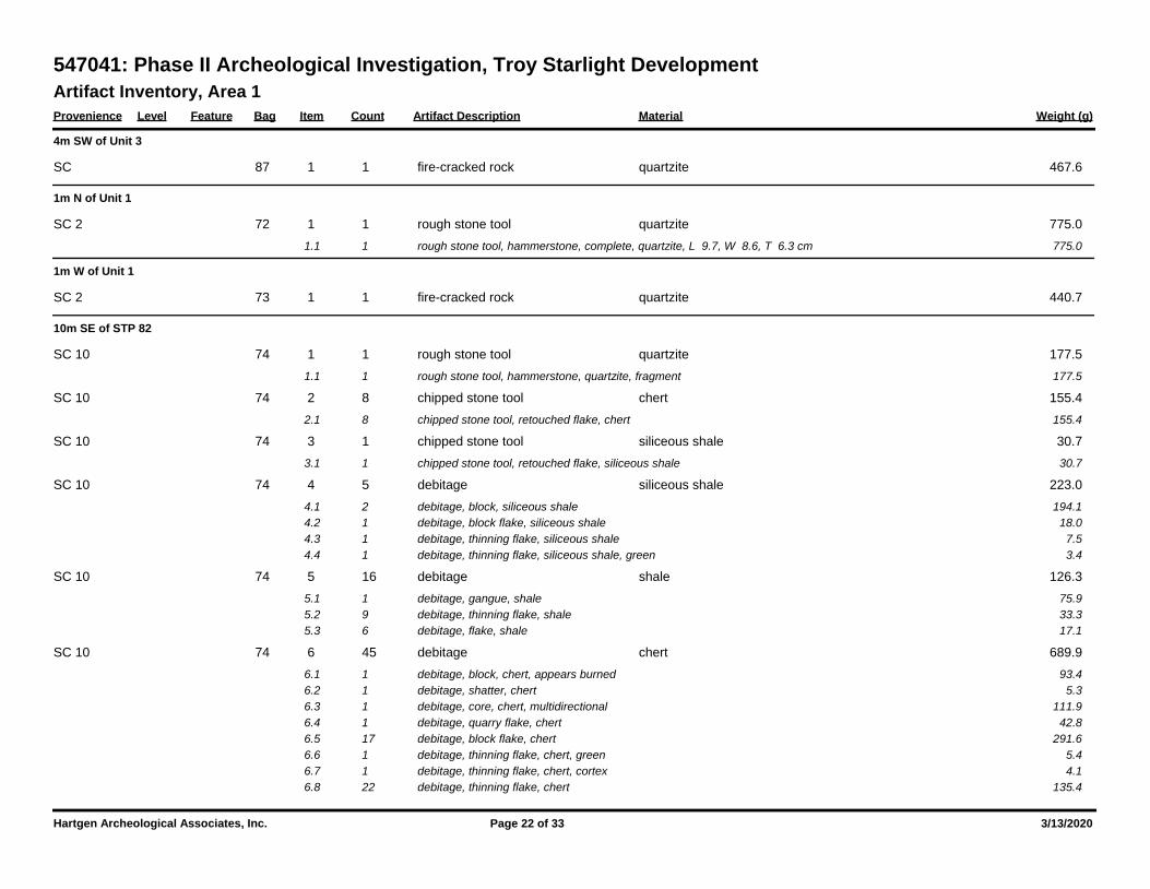
Artifact Inventory, Area 1
Provenience Level Feature Bag Item Count Artifact Description Weight (g)Material
547041: Phase II Archeological Investigation, Troy Starlight Development
4m SW of Unit 3
87 1 1 467.6fire-cracked rock quartzite SC
1m N of Unit 1
72 1 1 775.0rough stone tool quartzite SC 2
1.1 1 775.0rough stone tool, hammerstone, complete, quartzite, L 9.7, W 8.6, T 6.3 cm
1m W of Unit 1
73 1 1 440.7fire-cracked rock quartzite SC 2
10m SE of STP 82
74 1 1 177.5rough stone tool quartzite SC 10
1.1 1 177.5rough stone tool, hammerstone, quartzite, fragment
74 2 8 155.4chipped stone tool chert SC 10
2.1 8 155.4chipped stone tool, retouched flake, chert
74 3 1 30.7chipped stone tool siliceous shale SC 10
3.1 1 30.7chipped stone tool, retouched flake, siliceous shale
74 4 5 223.0debitage siliceous shale SC 10
4.1 2 194.1debitage, block, siliceous shale
4.2 1 18.0debitage, block flake, siliceous shale
4.3 1 7.5debitage, thinning flake, siliceous shale
4.4 1 3.4debitage, thinning flake, siliceous shale, green
74 5 16 126.3debitage shale SC 10
5.1 1 75.9debitage, gangue, shale
5.2 9 33.3debitage, thinning flake, shale
5.3 6 17.1debitage, flake, shale
74 6 45 689.9debitage chert SC 10
6.1 1 93.4debitage, block, chert, appears burned
6.2 1 5.3debitage, shatter, chert
6.3 1 111.9debitage, core, chert, multidirectional
6.4 1 42.8debitage, quarry flake, chert
6.5 17 291.6debitage, block flake, chert
6.6 1 5.4debitage, thinning flake, chert, green
6.7 1 4.1debitage, thinning flake, chert, cortex
6.8 22 135.4debitage, thinning flake, chert
Hartgen Archeological Associates, Inc. Page 22 of 33 3/13/2020
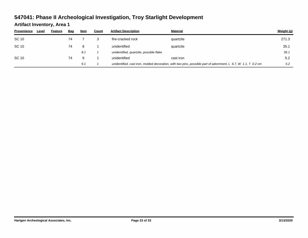
Artifact Inventory, Area 1
Provenience Level Feature Bag Item Count Artifact Description Weight (g)Material
547041: Phase II Archeological Investigation, Troy Starlight Development
74 7 3 271.3fire-cracked rock quartzite SC 10
74 8 1 35.1unidentified quartzite SC 10
8.1 1 35.1unidentified, quartzite, possible flake
74 9 1 5.2unidentified cast iron SC 10
9.1 1 5.2unidentified, cast iron, molded decoration, with two pins, possible part of adornment, L 6.7, W 1.1, T 0.2 cm
Hartgen Archeological Associates, Inc. Page 23 of 33 3/13/2020
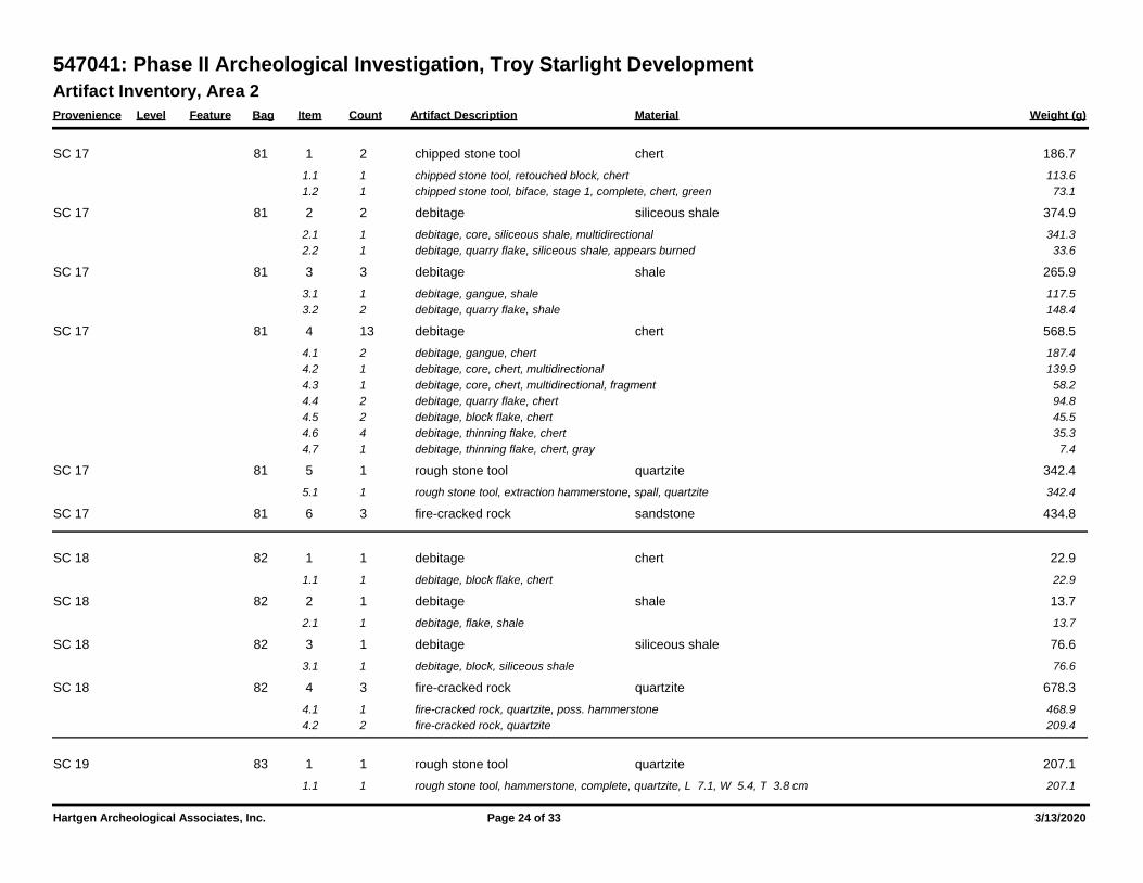
Artifact Inventory, Area 2
Provenience Level Feature Bag Item Count Artifact Description Weight (g)Material
547041: Phase II Archeological Investigation, Troy Starlight Development
81 1 2 186.7chipped stone tool chert SC 17
1.1 1 113.6chipped stone tool, retouched block, chert
1.2 1 73.1chipped stone tool, biface, stage 1, complete, chert, green
81 2 2 374.9debitage siliceous shale SC 17
2.1 1 341.3debitage, core, siliceous shale, multidirectional
2.2 1 33.6debitage, quarry flake, siliceous shale, appears burned
81 3 3 265.9debitage shale SC 17
3.1 1 117.5debitage, gangue, shale
3.2 2 148.4debitage, quarry flake, shale
81 4 13 568.5debitage chert SC 17
4.1 2 187.4debitage, gangue, chert
4.2 1 139.9debitage, core, chert, multidirectional
4.3 1 58.2debitage, core, chert, multidirectional, fragment
4.4 2 94.8debitage, quarry flake, chert
4.5 2 45.5debitage, block flake, chert
4.6 4 35.3debitage, thinning flake, chert
4.7 1 7.4debitage, thinning flake, chert, gray
81 5 1 342.4rough stone tool quartzite SC 17
5.1 1 342.4rough stone tool, extraction hammerstone, spall, quartzite
81 6 3 434.8fire-cracked rock sandstone SC 17
82 1 1 22.9debitage chert SC 18
1.1 1 22.9debitage, block flake, chert
82 2 1 13.7debitage shale SC 18
2.1 1 13.7debitage, flake, shale
82 3 1 76.6debitage siliceous shale SC 18
3.1 1 76.6debitage, block, siliceous shale
82 4 3 678.3fire-cracked rock quartzite SC 18
4.1 1 468.9fire-cracked rock, quartzite, poss. hammerstone
4.2 2 209.4fire-cracked rock, quartzite
83 1 1 207.1rough stone tool quartzite SC 19
1.1 1 207.1rough stone tool, hammerstone, complete, quartzite, L 7.1, W 5.4, T 3.8 cm
Hartgen Archeological Associates, Inc. Page 24 of 33 3/13/2020
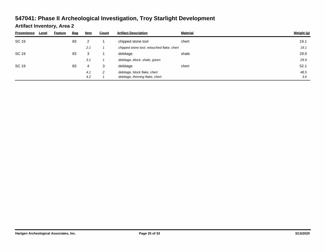
Artifact Inventory, Area 2
Provenience Level Feature Bag Item Count Artifact Description Weight (g)Material
547041: Phase II Archeological Investigation, Troy Starlight Development
83 2 1 19.1chipped stone tool chert SC 19
2.1 1 19.1chipped stone tool, retouched flake, chert
83 3 1 29.9debitage shale SC 19
3.1 1 29.9debitage, block, shale, green
83 4 3 52.1debitage chert SC 19
4.1 2 48.5debitage, block flake, chert
4.2 1 3.6debitage, thinning flake, chert
Hartgen Archeological Associates, Inc. Page 25 of 33 3/13/2020
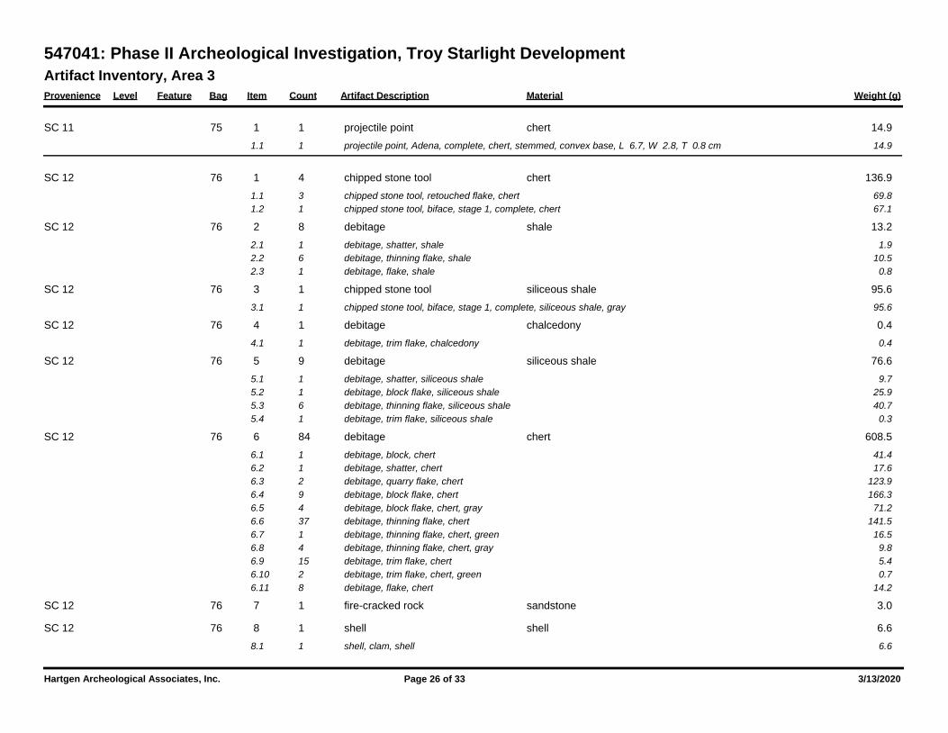
Artifact Inventory, Area 3
Provenience Level Feature Bag Item Count Artifact Description Weight (g)Material
547041: Phase II Archeological Investigation, Troy Starlight Development
75 1 1 14.9projectile point chert SC 11
1.1 1 14.9projectile point, Adena, complete, chert, stemmed, convex base, L 6.7, W 2.8, T 0.8 cm
76 1 4 136.9chipped stone tool chert SC 12
1.1 3 69.8chipped stone tool, retouched flake, chert
1.2 1 67.1chipped stone tool, biface, stage 1, complete, chert
76 2 8 13.2debitage shale SC 12
2.1 1 1.9debitage, shatter, shale
2.2 6 10.5debitage, thinning flake, shale
2.3 1 0.8debitage, flake, shale
76 3 1 95.6chipped stone tool siliceous shale SC 12
3.1 1 95.6chipped stone tool, biface, stage 1, complete, siliceous shale, gray
76 4 1 0.4debitage chalcedony SC 12
4.1 1 0.4debitage, trim flake, chalcedony
76 5 9 76.6debitage siliceous shale SC 12
5.1 1 9.7debitage, shatter, siliceous shale
5.2 1 25.9debitage, block flake, siliceous shale
5.3 6 40.7debitage, thinning flake, siliceous shale
5.4 1 0.3debitage, trim flake, siliceous shale
76 6 84 608.5debitage chert SC 12
6.1 1 41.4debitage, block, chert
6.2 1 17.6debitage, shatter, chert
6.3 2 123.9debitage, quarry flake, chert
6.4 9 166.3debitage, block flake, chert
6.5 4 71.2debitage, block flake, chert, gray
6.6 37 141.5debitage, thinning flake, chert
6.7 1 16.5debitage, thinning flake, chert, green
6.8 4 9.8debitage, thinning flake, chert, gray
6.9 15 5.4debitage, trim flake, chert
6.10 2 0.7debitage, trim flake, chert, green
6.11 8 14.2debitage, flake, chert
76 7 1 3.0fire-cracked rock sandstone SC 12
76 8 1 6.6shell shell SC 12
8.1 1 6.6shell, clam, shell
Hartgen Archeological Associates, Inc. Page 26 of 33 3/13/2020
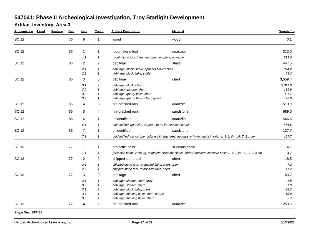
Artifact Inventory, Area 3
Provenience Level Feature Bag Item Count Artifact Description Weight (g)Material
547041: Phase II Archeological Investigation, Troy Starlight Development
76 9 1 0.1wood wood SC 12
86 1 1 313.0rough stone tool quartzite SC 12
1.1 1 313.0rough stone tool, hammerstone, complete, quartzite
86 2 2 447.5debitage shale SC 12
2.1 1 374.2debitage, block, shale, appears fire-cracked
2.2 1 73.3debitage, block flake, shale
86 3 5 3,559.4debitage chert SC 12
3.1 2 3,011.0debitage, block, chert
3.2 1 119.9debitage, gangue, chert
3.3 1 331.7debitage, quarry flake, chert
3.4 1 96.8debitage, quarry flake, chert, green
86 4 3 513.9fire-cracked rock quartzite SC 12
86 5 4 689.0fire-cracked rock sandstone SC 12
86 6 1 466.6unidentified quartzite SC 12
6.1 1 466.6unidentified, quartzite, appears to be fire-cracked cobble
86 7 1 127.7unidentified sandstone SC 12
7.1 1 127.7unidentified, sandstone, oblong with fractures, appears to have quartz interior, L 8.1, W 4.5, T 2.1 cm
77 1 1 4.7projectile point siliceous shale SC 13
1.1 1 4.7projectile point, Vosburg, complete, siliceous shale, corner-notched, concave base, L 4.0, W 2.2, T 0.4 cm
77 2 2 18.5chipped stone tool chert SC 13
2.1 1 7.3chipped stone tool, retouched flake, chert, gray
2.2 1 11.2chipped stone tool, retouched flake, chert
77 3 9 53.7debitage chert SC 13
3.1 1 1.9debitage, shatter, chert, gray
3.2 1 1.9debitage, shatter, chert
3.3 2 26.2debitage, block flake, chert
3.4 1 18.0debitage, thinning flake, chert, cortex
3.5 4 5.7debitage, thinning flake, chert
77 4 2 259.6fire-cracked rock quartzite SC 13
Slope Near STP 81
Hartgen Archeological Associates, Inc. Page 27 of 33 3/13/2020
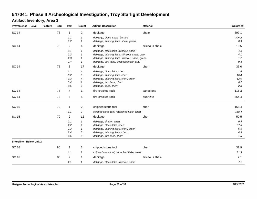
Artifact Inventory, Area 3
Provenience Level Feature Bag Item Count Artifact Description Weight (g)Material
547041: Phase II Archeological Investigation, Troy Starlight Development
78 1 2 397.1debitage shale SC 14
1.1 1 396.2debitage, block, shale, burned
1.2 1 0.9debitage, thinning flake, shale, green
78 2 4 10.5debitage siliceous shale SC 14
2.1 1 4.9debitage, block flake, siliceous shale
2.2 1 4.1debitage, thinning flake, siliceous shale, gray
2.3 1 1.2debitage, thinning flake, siliceous shale, green
2.4 1 0.3debitage, trim flake, siliceous shale, gray
78 3 17 33.0debitage chert SC 14
3.1 1 1.6debitage, block flake, chert
3.2 9 16.4debitage, thinning flake, chert
3.3 4 12.0debitage, thinning flake, chert, green
3.4 1 0.2debitage, trim flake, chert
3.5 2 2.8debitage, flake, chert
78 4 1 116.3fire-cracked rock sandstone SC 14
78 5 5 554.4fire-cracked rock quartzite SC 14
79 1 2 158.4chipped stone tool chert SC 15
1.1 2 158.4chipped stone tool, retouched flake, chert
79 2 12 50.5debitage chert SC 15
2.1 1 0.5debitage, shatter, chert
2.2 2 37.5debitage, block flake, chert
2.3 1 6.5debitage, thinning flake, chert, green
2.4 5 4.5debitage, thinning flake, chert
2.5 3 1.5debitage, trim flake, chert
Shoreline - Below Unit 2
80 1 2 31.9chipped stone tool chert SC 16
1.1 2 31.9chipped stone tool, retouched flake, chert
80 2 1 7.1debitage siliceous shale SC 16
2.1 1 7.1debitage, block flake, siliceous shale
Hartgen Archeological Associates, Inc. Page 28 of 33 3/13/2020
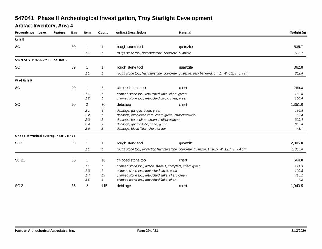
Artifact Inventory, Area 4
Provenience Level Feature Bag Item Count Artifact Description Weight (g)Material
547041: Phase II Archeological Investigation, Troy Starlight Development
Unit 5
60 1 1 535.7rough stone tool quartzite SC
1.1 1 535.7rough stone tool, hammerstone, complete, quartzite
5m N of STP 97 & 2m SE of Unit 5
89 1 1 362.8rough stone tool quartzite SC
1.1 1 362.8rough stone tool, hammerstone, complete, quartzite, very battered, L 7.1, W 6.2, T 5.5 cm
W of Unit 5
90 1 2 289.8chipped stone tool chert SC
1.1 1 159.0chipped stone tool, retouched flake, chert, green
1.2 1 130.8chipped stone tool, retouched block, chert, green
90 2 20 1,351.0debitage chert SC
2.1 6 236.5debitage, gangue, chert, green
2.2 1 62.4debitage, exhausted core, chert, green, multidirectional
2.3 2 309.4debitage, core, chert, green, multidirectional
2.4 9 699.0debitage, quarry flake, chert, green
2.5 2 43.7debitage, block flake, chert, green
On top of worked outcrop, near STP 54
69 1 1 2,305.0rough stone tool quartzite SC 1
1.1 1 2,305.0rough stone tool, extraction hammerstone, complete, quartzite, L 16.5, W 12.7, T 7.4 cm
85 1 18 664.8chipped stone tool chert SC 21
1.1 1 141.9chipped stone tool, biface, stage 1, complete, chert, green
1.3 1 100.5chipped stone tool, retouched block, chert
1.4 15 415.2chipped stone tool, retouched flake, chert, green
1.5 1 7.2chipped stone tool, retouched flake, chert
85 2 115 1,940.5debitage chert SC 21
Hartgen Archeological Associates, Inc. Page 29 of 33 3/13/2020
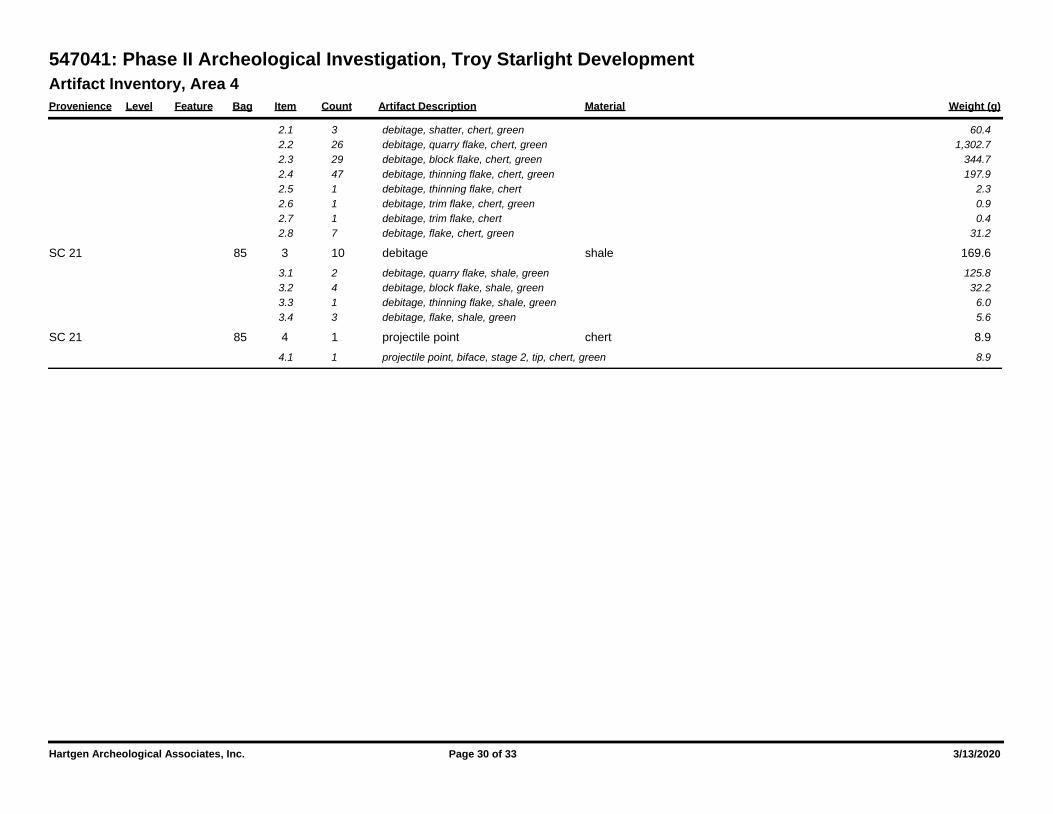
Artifact Inventory, Area 4
Provenience Level Feature Bag Item Count Artifact Description Weight (g)Material
547041: Phase II Archeological Investigation, Troy Starlight Development
2.1 3 60.4debitage, shatter, chert, green
2.2 26 1,302.7debitage, quarry flake, chert, green
2.3 29 344.7debitage, block flake, chert, green
2.4 47 197.9debitage, thinning flake, chert, green
2.5 1 2.3debitage, thinning flake, chert
2.6 1 0.9debitage, trim flake, chert, green
2.7 1 0.4debitage, trim flake, chert
2.8 7 31.2debitage, flake, chert, green
85 3 10 169.6debitage shale SC 21
3.1 2 125.8debitage, quarry flake, shale, green
3.2 4 32.2debitage, block flake, shale, green
3.3 1 6.0debitage, thinning flake, shale, green
3.4 3 5.6debitage, flake, shale, green
85 4 1 8.9projectile point chert SC 21
4.1 1 8.9projectile point, biface, stage 2, tip, chert, green
Hartgen Archeological Associates, Inc. Page 30 of 33 3/13/2020
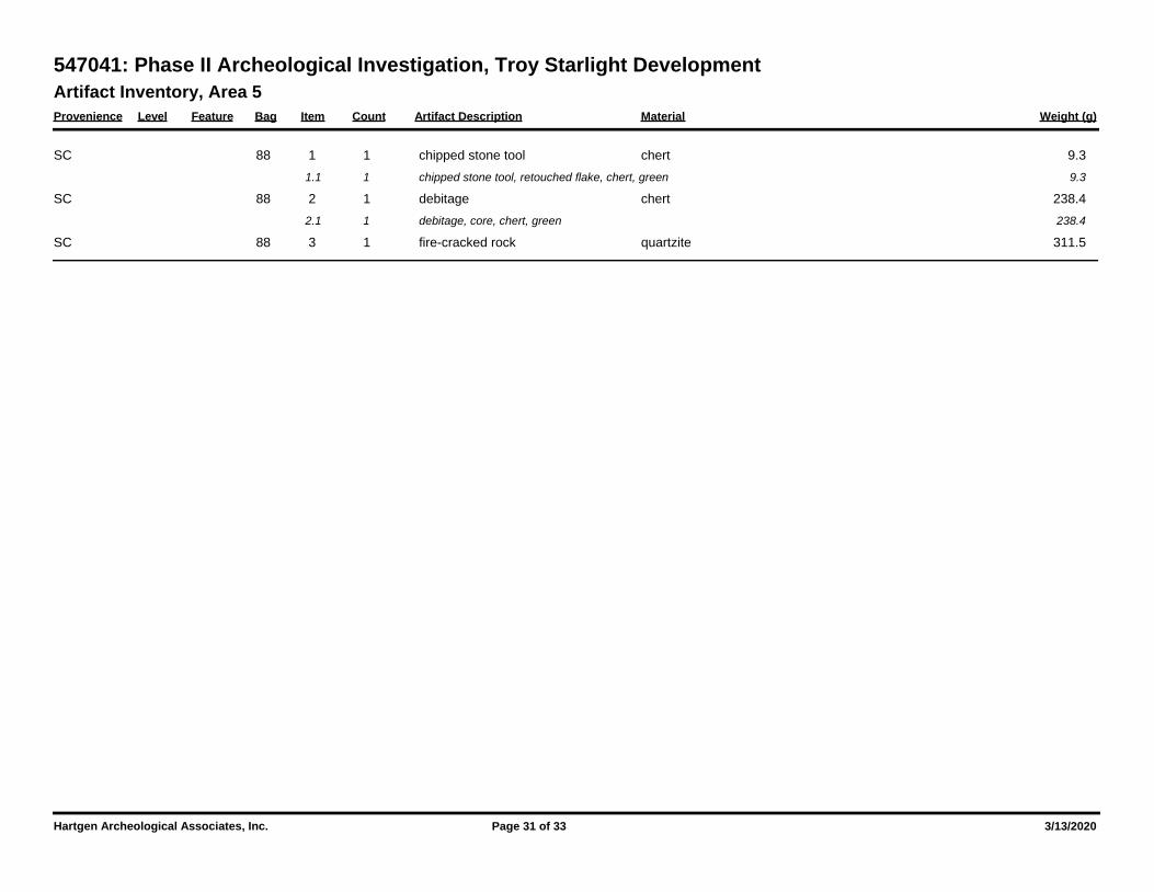
Artifact Inventory, Area 5
Provenience Level Feature Bag Item Count Artifact Description Weight (g)Material
547041: Phase II Archeological Investigation, Troy Starlight Development
88 1 1 9.3chipped stone tool chert SC
1.1 1 9.3chipped stone tool, retouched flake, chert, green
88 2 1 238.4debitage chert SC
2.1 1 238.4debitage, core, chert, green
88 3 1 311.5fire-cracked rock quartzite SC
Hartgen Archeological Associates, Inc. Page 31 of 33 3/13/2020
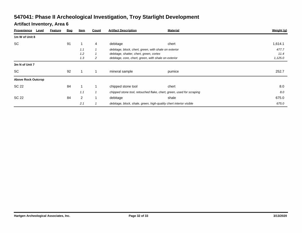
Artifact Inventory, Area 6
Provenience Level Feature Bag Item Count Artifact Description Weight (g)Material
547041: Phase II Archeological Investigation, Troy Starlight Development
1m W of Unit 8
91 1 4 1,614.1debitage chert SC
1.1 1 477.7debitage, block, chert, green, with shale on exterior
1.2 1 11.4debitage, shatter, chert, green, cortex
1.3 2 1,125.0debitage, core, chert, green, with shale on exterior
3m N of Unit 7
92 1 1 252.7mineral sample pumice SC
Above Rock Outcrop
84 1 1 8.0chipped stone tool chert SC 22
1.1 1 8.0chipped stone tool, retouched flake, chert, green, used for scraping
84 2 1 675.0debitage shale SC 22
2.1 1 675.0debitage, block, shale, green, high-quality chert interior visible
Hartgen Archeological Associates, Inc. Page 32 of 33 3/13/2020
Artifact Inventory, Area 7
Provenience Level Feature Bag Item Count Artifact Description Weight (g)Material
547041: Phase II Archeological Investigation, Troy Starlight Development
70 1 1 8,105.0rough stone tool quartzite SC 23
1.1 1 8,105.0rough stone tool, extraction hammerstone, complete, quartzite
Hartgen Archeological Associates, Inc. Page 33 of 33 3/13/2020

Troy Starlight Development, City of Troy and Town of Schaghticoke, Rensselaer County, New York Phase IB/II Archeological Site Evaluation
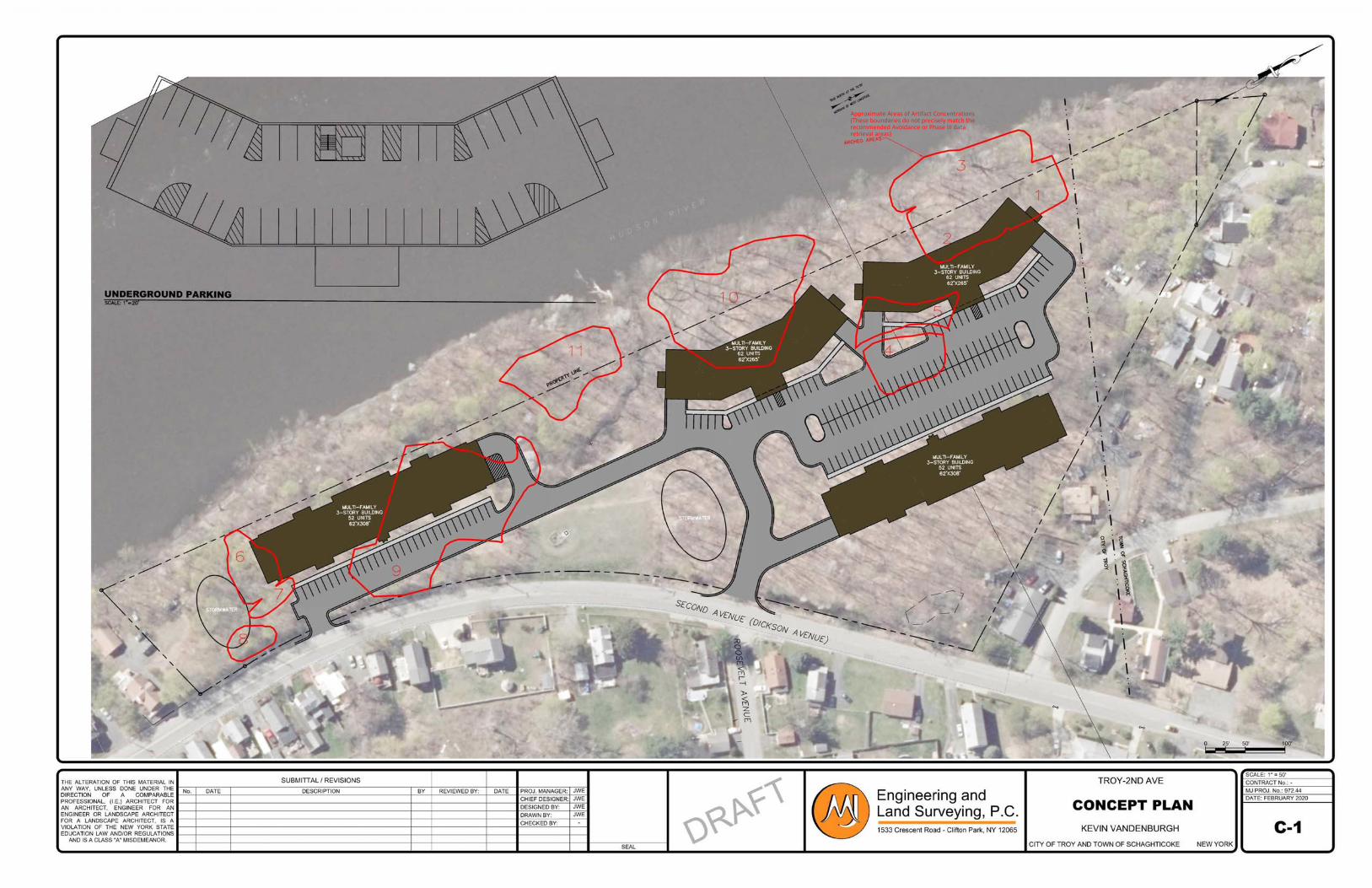
���������������� ���� ������������������������������������������������������������������������������������������������
Second Avenue Apartments APPENDIX E
Insite Northeast Engineering & Land Surveying, P.C. ● 2301 Western Avenue Guilderland, NY 12084 ● 518-867-3323 ● www.insitenortheast.com
APPENDIX E – NYSDEC ENVIRONMENTAL SITE DATABASE
NYSDEC Remediation 546031 Report
NYSDEC Remediation 546053 Report
NYSDEC Remediation E546053 Report
NYSDEC Classification Summary
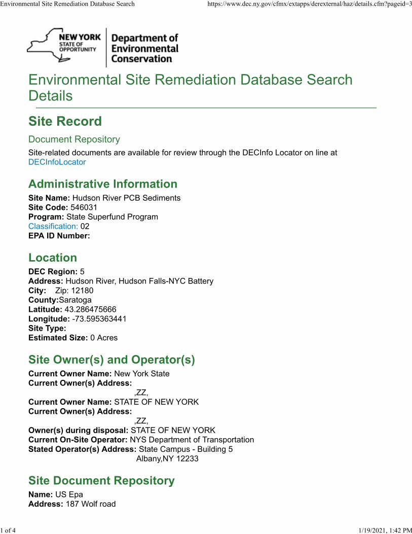
Environmental Site Remediation Database SearchDetails
Site Record
Document Repository
Site-related documents are available for review through the DECInfo Locator on line atDECInfoLocator
Administrative InformationSite Name: Hudson River PCB SedimentsSite Code: 546031Program: State Superfund ProgramClassification: 02EPA ID Number:
LocationDEC Region: 5Address: Hudson River, Hudson Falls-NYC BatteryCity: Zip: 12180County:SaratogaLatitude: 43.286475666Longitude: -73.595363441Site Type:Estimated Size: 0 Acres
Site Owner(s) and Operator(s)Current Owner Name: New York StateCurrent Owner(s) Address: ,ZZ,Current Owner Name: STATE OF NEW YORKCurrent Owner(s) Address: ,ZZ,Owner(s) during disposal: STATE OF NEW YORKCurrent On-Site Operator: NYS Department of TransportationStated Operator(s) Address: State Campus - Building 5 Albany,NY 12233
Site Document RepositoryName: US EpaAddress: 187 Wolf road
Environmental Site Remediation Database Search https://www.dec.ny.gov/cfmx/extapps/derexternal/haz/details.cfm?pageid=3
1 of 4 1/19/2021, 1:42 PM
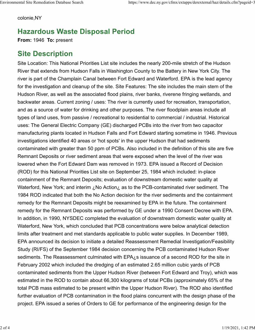
colonie,NY
Hazardous Waste Disposal PeriodFrom: 1946 To: present
Site Description
Site Location: This National Priorities List site includes the nearly 200-mile stretch of the Hudson
River that extends from Hudson Falls in Washington County to the Battery in New York City. The
river is part of the Champlain Canal between Fort Edward and Waterford. EPA is the lead agency
for the investigation and cleanup of the site. Site Features: The site includes the main stem of the
Hudson River, as well as the associated flood plains, river banks, riverene fringing wetlands, and
backwater areas. Current zoning / uses: The river is currently used for recreation, transportation,
and as a source of water for drinking and other purposes. The river floodplain areas include all
types of land uses, from passive / recreational to residential to commercial / industrial. Historical
uses: The General Electric Company (GE) discharged PCBs into the river from two capacitor
manufacturing plants located in Hudson Falls and Fort Edward starting sometime in 1946. Previous
investigations identified 40 areas or 'hot spots' in the upper Hudson that had sediments
contaminated with greater than 50 ppm of PCBs. Also included in the definition of this site are five
Remnant Deposits or river sediment areas that were exposed when the level of the river was
lowered when the Fort Edward Dam was removed in 1973. EPA issued a Record of Decision
(ROD) for this National Priorities List site on September 25, 1984 which included: in-place
containment of the Remnant Deposits; evaluation of downstream domestic water quality at
Waterford, New York; and interim ¿No Action¿ as to the PCB-contaminated river sediment. The
1984 ROD indicated that both the No Action decision for the river sediments and the containment
remedy for the Remnant Deposits might be reexamined by EPA in the future. The containment
remedy for the Remnant Deposits was performed by GE under a 1990 Consent Decree with EPA.
In addition, in 1990, NYSDEC completed the evaluation of downstream domestic water quality at
Waterford, New York, which concluded that PCB concentrations were below analytical detection
limits after treatment and met standards applicable to public water supplies. In December 1989,
EPA announced its decision to initiate a detailed Reassessment Remedial Investigation/Feasibility
Study (RI/FS) of the September 1984 decision concerning the PCB contaminated Hudson River
sediments. The Reassessment culminated with EPA¿s issuance of a second ROD for the site in
February 2002 which included the dredging of an estimated 2.65 million cubic yards of PCB
contaminated sediments from the Upper Hudson River (between Fort Edward and Troy), which was
estimated in the ROD to contain about 66,300 kilograms of total PCBs (approximately 65% of the
total PCB mass estimated to be present within the Upper Hudson River). The ROD also identified
further evaluation of PCB contamination in the flood plains concurrent with the design phase of the
project. EPA issued a series of Orders to GE for performance of the engineering design for the
Environmental Site Remediation Database Search https://www.dec.ny.gov/cfmx/extapps/derexternal/haz/details.cfm?pageid=3
2 of 4 1/19/2021, 1:42 PM
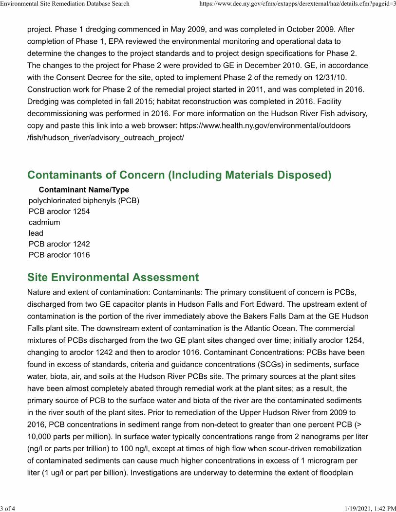
project. Phase 1 dredging commenced in May 2009, and was completed in October 2009. After
completion of Phase 1, EPA reviewed the environmental monitoring and operational data to
determine the changes to the project standards and to project design specifications for Phase 2.
The changes to the project for Phase 2 were provided to GE in December 2010. GE, in accordance
with the Consent Decree for the site, opted to implement Phase 2 of the remedy on 12/31/10.
Construction work for Phase 2 of the remedial project started in 2011, and was completed in 2016.
Dredging was completed in fall 2015; habitat reconstruction was completed in 2016. Facility
decommissioning was performed in 2016. For more information on the Hudson River Fish advisory,
copy and paste this link into a web browser: https://www.health.ny.gov/environmental/outdoors
/fish/hudson_river/advisory_outreach_project/
Contaminants of Concern (Including Materials Disposed)
Contaminant Name/Type
polychlorinated biphenyls (PCB)
PCB aroclor 1254
cadmium
lead
PCB aroclor 1242
PCB aroclor 1016
Site Environmental Assessment
Nature and extent of contamination: Contaminants: The primary constituent of concern is PCBs,
discharged from two GE capacitor plants in Hudson Falls and Fort Edward. The upstream extent of
contamination is the portion of the river immediately above the Bakers Falls Dam at the GE Hudson
Falls plant site. The downstream extent of contamination is the Atlantic Ocean. The commercial
mixtures of PCBs discharged from the two GE plant sites changed over time; initially aroclor 1254,
changing to aroclor 1242 and then to aroclor 1016. Contaminant Concentrations: PCBs have been
found in excess of standards, criteria and guidance concentrations (SCGs) in sediments, surface
water, biota, air, and soils at the Hudson River PCBs site. The primary sources at the plant sites
have been almost completely abated through remedial work at the plant sites; as a result, the
primary source of PCB to the surface water and biota of the river are the contaminated sediments
in the river south of the plant sites. Prior to remediation of the Upper Hudson River from 2009 to
2016, PCB concentrations in sediment range from non-detect to greater than one percent PCB (>
10,000 parts per million). In surface water typically concentrations range from 2 nanograms per liter
(ng/l or parts per trillion) to 100 ng/l, except at times of high flow when scour-driven remobilization
of contaminated sediments can cause much higher concentrations in excess of 1 microgram per
liter (1 ug/l or part per billion). Investigations are underway to determine the extent of floodplain
Environmental Site Remediation Database Search https://www.dec.ny.gov/cfmx/extapps/derexternal/haz/details.cfm?pageid=3
3 of 4 1/19/2021, 1:42 PM
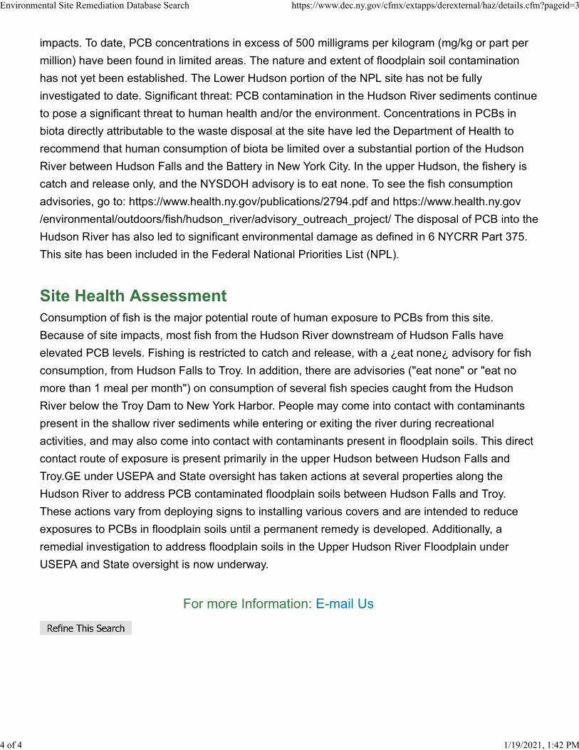
impacts. To date, PCB concentrations in excess of 500 milligrams per kilogram (mg/kg or part per
million) have been found in limited areas. The nature and extent of floodplain soil contamination
has not yet been established. The Lower Hudson portion of the NPL site has not be fully
investigated to date. Significant threat: PCB contamination in the Hudson River sediments continue
to pose a significant threat to human health and/or the environment. Concentrations in PCBs in
biota directly attributable to the waste disposal at the site have led the Department of Health to
recommend that human consumption of biota be limited over a substantial portion of the Hudson
River between Hudson Falls and the Battery in New York City. In the upper Hudson, the fishery is
catch and release only, and the NYSDOH advisory is to eat none. To see the fish consumption
advisories, go to: https://www.health.ny.gov/publications/2794.pdf and https://www.health.ny.gov
/environmental/outdoors/fish/hudson_river/advisory_outreach_project/ The disposal of PCB into the
Hudson River has also led to significant environmental damage as defined in 6 NYCRR Part 375.
This site has been included in the Federal National Priorities List (NPL).
Site Health Assessment
Consumption of fish is the major potential route of human exposure to PCBs from this site.
Because of site impacts, most fish from the Hudson River downstream of Hudson Falls have
elevated PCB levels. Fishing is restricted to catch and release, with a ¿eat none¿ advisory for fish
consumption, from Hudson Falls to Troy. In addition, there are advisories ("eat none" or "eat no
more than 1 meal per month") on consumption of several fish species caught from the Hudson
River below the Troy Dam to New York Harbor. People may come into contact with contaminants
present in the shallow river sediments while entering or exiting the river during recreational
activities, and may also come into contact with contaminants present in floodplain soils. This direct
contact route of exposure is present primarily in the upper Hudson between Hudson Falls and
Troy.GE under USEPA and State oversight has taken actions at several properties along the
Hudson River to address PCB contaminated floodplain soils between Hudson Falls and Troy.
These actions vary from deploying signs to installing various covers and are intended to reduce
exposures to PCBs in floodplain soils until a permanent remedy is developed. Additionally, a
remedial investigation to address floodplain soils in the Upper Hudson River Floodplain under
USEPA and State oversight is now underway.
For more Information: E-mail Us
Environmental Site Remediation Database Search https://www.dec.ny.gov/cfmx/extapps/derexternal/haz/details.cfm?pageid=3
4 of 4 1/19/2021, 1:42 PM
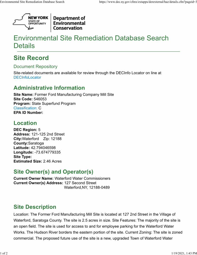
Environmental Site Remediation Database SearchDetails
Site Record
Document Repository
Site-related documents are available for review through the DECInfo Locator on line atDECInfoLocator
Administrative InformationSite Name: Former Ford Manufacturing Company Mill SiteSite Code: 546053Program: State Superfund ProgramClassification: CEPA ID Number:
LocationDEC Region: 5Address: 121-125 2nd StreetCity:Waterford Zip: 12188County:SaratogaLatitude: 42.794046598Longitude: -73.674779335Site Type:Estimated Size: 2.46 Acres
Site Owner(s) and Operator(s)Current Owner Name: Waterford Water CommissionersCurrent Owner(s) Address: 127 Second Street Waterford,NY, 12188-0489
Site Description
Location: The Former Ford Manufacturing Mill Site is located at 127 2nd Street in the Village of
Waterford, Saratoga County. The site is 2.5 acres in size. Site Features: The majority of the site is
an open field. The site is used for access to and for employee parking for the Waterford Water
Works. The Hudson River borders the eastern portion of the site. Current Zoning: The site is zoned
commercial. The proposed future use of the site is a new, upgraded Town of Waterford Water
Environmental Site Remediation Database Search https://www.dec.ny.gov/cfmx/extapps/derexternal/haz/details.cfm?pageid=3
1 of 2 1/19/2021, 1:43 PM
Treatment Plant. Historical Use: The site was last utilized as a mill complex in the 1960's, portions
of the abandoned and deteriorating mill complex was demolished in the 1970s. The Town of
Waterford took possession of the property in 1986. An initial investigation conducted by the Town
identified a 20,000 gallon petroleum storage tank and significant contaminated soils. Shaw
Environmental completed a Site Assessment Report in September of 2010 using an EPA Targeted
Site Assessment Grant. The 20,000 gallon underground tank, it's contents, and contaminated
subsurface soils near the tank removed and disposed of as IRMs during site assessment. No
contaminants of concern remain or were further identified on site.
Site Environmental Assessment
Nature and Extent of Contamination: Limited Phase II work completed at the location by Waterford
identified a 20,000 gallon petroleum UST and petroleum contaminated soils in the area of the tank.
Shaw Environmental completed a Site Assessment Report in September of 2010. The 20,000
gallon underground tank, it's contents, and petroleum contaminated subsurface soils near the tank
were removed and disposed of as IRMs during the site assessment. No contaminants of concern
remain near the tank or were identified at the site in other locations. Special Resources
Impacted/Threatened: None
Site Health Assessment
Low level residual soil contamination remains at the site below the ground surface, therefore it is
not expected that people will come in contact with it unless they dig below the surface material.
People are not coming into contact with the contaminated groundwater because the area is served
by a public water supply that is not affected by this contamination.
For more Information: E-mail Us
Environmental Site Remediation Database Search https://www.dec.ny.gov/cfmx/extapps/derexternal/haz/details.cfm?pageid=3
2 of 2 1/19/2021, 1:43 PM
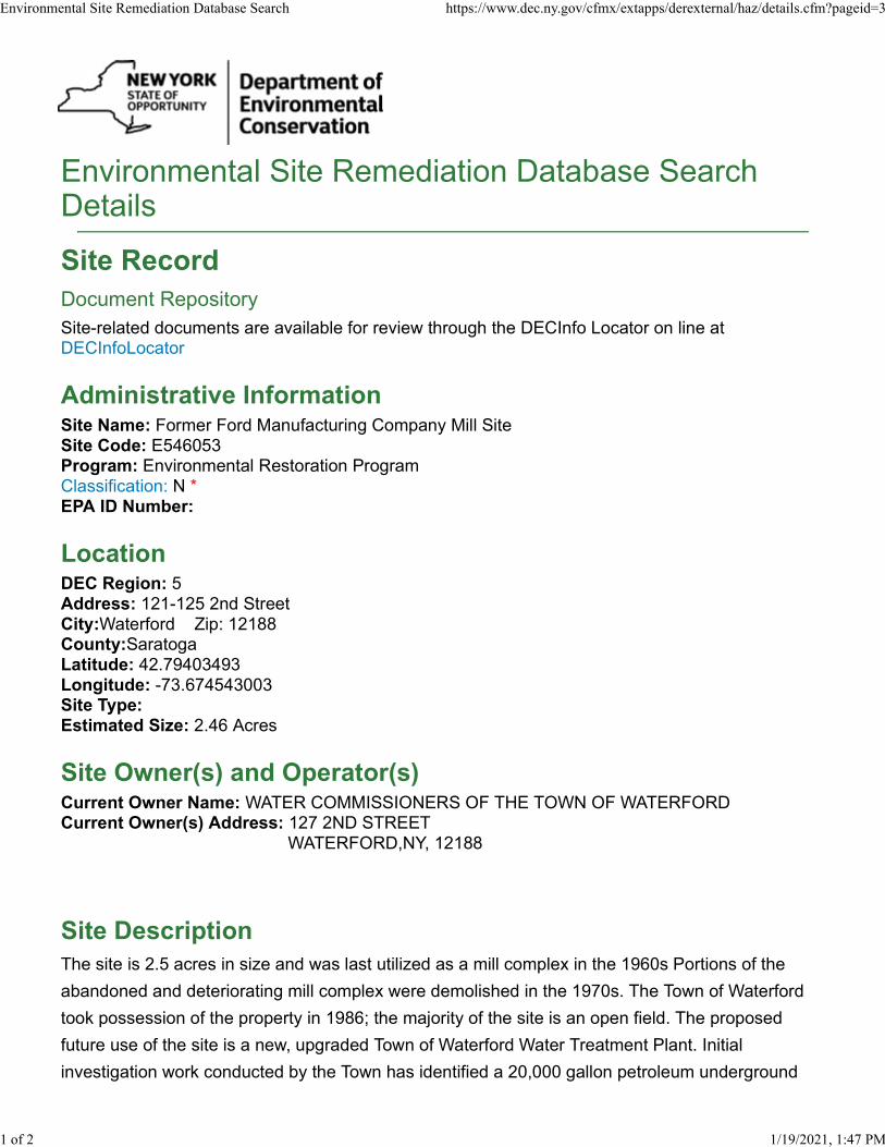
Environmental Site Remediation Database SearchDetails
Site Record
Document Repository
Site-related documents are available for review through the DECInfo Locator on line atDECInfoLocator
Administrative InformationSite Name: Former Ford Manufacturing Company Mill SiteSite Code: E546053Program: Environmental Restoration ProgramClassification: N *EPA ID Number:
LocationDEC Region: 5Address: 121-125 2nd StreetCity:Waterford Zip: 12188County:SaratogaLatitude: 42.79403493Longitude: -73.674543003Site Type:Estimated Size: 2.46 Acres
Site Owner(s) and Operator(s)Current Owner Name: WATER COMMISSIONERS OF THE TOWN OF WATERFORDCurrent Owner(s) Address: 127 2ND STREET WATERFORD,NY, 12188
Site Description
The site is 2.5 acres in size and was last utilized as a mill complex in the 1960s Portions of the
abandoned and deteriorating mill complex were demolished in the 1970s. The Town of Waterford
took possession of the property in 1986; the majority of the site is an open field. The proposed
future use of the site is a new, upgraded Town of Waterford Water Treatment Plant. Initial
investigation work conducted by the Town has identified a 20,000 gallon petroleum underground
Environmental Site Remediation Database Search https://www.dec.ny.gov/cfmx/extapps/derexternal/haz/details.cfm?pageid=3
1 of 2 1/19/2021, 1:47 PM

storage tank and significant contaminated soils. The application could not be processed due to a
lack of funding in the Environmental Restoration Program. Using EPA Targeted Site Assessment
Funding, Shaw Environmental completed Site Assessment Report in September of 2010.
Site Environmental Assessment
No contaminants of concern present on the site; 20K tank, contents, and contaminated soils near
tank removed and disposed of as IRMs during site assessment.
* Class N Sites: "DEC offers this information with the caution that the amount of informationprovided for Class N sites is highly variable, not necessarily based on any DEC investigation,sometimes of unknown origin, and sometimes is many years old. Due to the preliminary nature ofthis information, significant conclusions or decisions should not be based solely upon thissummary."
For more Information: E-mail Us
Environmental Site Remediation Database Search https://www.dec.ny.gov/cfmx/extapps/derexternal/haz/details.cfm?pageid=3
2 of 2 1/19/2021, 1:47 PM
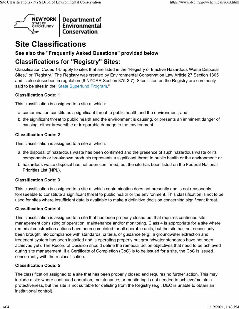
Site ClassificationsSee also the "Frequently Asked Questions" provided below
Classifications for "Registry" Sites:Classification Codes 1-5 apply to sites that are listed in the "Registry of Inactive Hazardous Waste Disposal
Sites," or "Registry." The Registry was created by Environmental Conservation Law Article 27 Section 1305
and is also described in regulation (6 NYCRR Section 375-2.7). Sites listed on the Registry are commonly
said to be sites in the "State Superfund Program."
Classification Code: 1
This classification is assigned to a site at which:
a. contamination constitutes a significant threat to public health and the environment; and
b. the significant threat to public health and the environment is causing, or presents an imminent danger of
causing, either irreversible or irreparable damage to the environment.
Classification Code: 2
This classification is assigned to a site at which:
a. the disposal of hazardous waste has been confirmed and the presence of such hazardous waste or its
components or breakdown products represents a significant threat to public health or the environment: or
b. hazardous waste disposal has not been confirmed, but the site has been listed on the Federal National
Priorities List (NPL).
Classification Code: 3
This classification is assigned to a site at which contamination does not presently and is not reasonably
foreseeable to constitute a significant threat to public health or the environment. This classification is not to be
used for sites where insufficient data is available to make a definitive decision concerning significant threat.
Classification Code: 4
This classification is assigned to a site that has been properly closed but that requires continued site
management consisting of operation, maintenance and/or monitoring. Class 4 is appropriate for a site where
remedial construction actions have been completed for all operable units, but the site has not necessarily
been brought into compliance with standards, criteria, or guidance (e.g., a groundwater extraction and
treatment system has been installed and is operating properly but groundwater standards have not been
achieved yet). The Record of Decision should define the remedial action objectives that need to be achieved
during site management. If a Certificate of Completion (CoC) is to be issued for a site, the CoC is issued
concurrently with the reclassification.
Classification Code: 5
The classification assigned to a site that has been properly closed and requires no further action. This may
include a site where continued operation, maintenance, or monitoring is not needed to achieve/maintain
protectiveness, but the site is not suitable for delisting from the Registry (e.g., DEC is unable to obtain an
institutional control).
Site Classifications - NYS Dept. of Environmental Conservation https://www.dec.ny.gov/chemical/8663.html
1 of 4 1/19/2021, 1:43 PM
Classifications for Non-Registry Sites:Non-Registry sites are those that are being investigated and remediated in a brownfield program or other
environmental remediation program and are not listed in the Registry.
Classification Code: A (Active)
The classification assigned to a non-registry site in any remedial program where work is underway and not yet
complete (i. e., Brownfield Cleanup Program, Environmental Restoration Program, Voluntary Cleanup
Program and RCRA Corrective action Program sites). This may be used for Manufactured Gas Plant sites or
those being remediated under an EPA Cooperative Agreement.
Classification Code: C (Completed)
The classification used for sites where the Department has determined that remediation has been
satisfactorily completed under a remedial program (i. e., State Superfund, Brownfield Cleanup Program,
Environmental Restoration Program, Voluntary Cleanup Program, and RCRA Corrective Action Program).
State Superfund (Registry) sites must have completed all active operation, maintenance, or monitoring
requirements before they can be delisted and made class C. Non-registry sites may be made a class C after
successful completion of all required construction or after a no further action remedy has been selected by the
Department. These sites will be issued a Certificate of Completion (COC), but may still require ongoing
maintenance and periodic certification of institutional/engineering controls (IC/ECs).
Classification Code: P (Potential)
This classification is used for sites where preliminary information indicates that a site may have contamination
that makes it eligible for consideration for placement on the Registry of Inactive Hazardous Waste Disposal
Sites (commonly referred to as the list of State Superfund Sites). Further information and/or investigation, in
the form of a site characterization, is needed to determine if a Class P site qualifies for listing of the site on the
Registry. Generally, to qualify for placement on the Registry, there must be evidence that hazardous waste
was disposed on the site and that any resulting contamination presents a significant threat (or reasonably
foreseeable threat) to public health or the environment. Class P sites are not listed on the Registry and many
are eventually found to not qualify for Registry listing. Sites that do not qualify for listing are typically then
reclassified to a "Class N" site.
Classification Code: PR (Potential RCRA Corrective Action)
"Class PR" is a specialty classification code that is not related to the Registry. This classification code is used
for sites that are, or have been, subject to the requirements of the Resource Conservation and Recovery Act
(RCRA). RCRA sites are those that are managing or have actively managed hazardous waste (e.g., waste
solvents from a manufacturing process). If spills occurred resulting in environmental contamination,
remediation may be necessary under the RCRA corrective action program. Similar to a Class P site, Class
PR sites are investigated and reviewed to determine if RCRA corrective action is necessary. If so, remediation
is carried out under a RCRA permit, order, or other legal mechanism.
Classification Code: N (No Further Action at this Time)
Sites are given a classification of "N" when:
the investigation and evaluation of a Class P site results in a determination that contamination at the site
does not warrant placing the site on the Registry or it is being addressed under a brownfield program;
a site was in a brownfield program (BCP, ERP or VCP) or other non-Registry program, remediation was not
completed, and the site did not otherwise qualify for listing on the Registry. As an example, this occurs
Site Classifications - NYS Dept. of Environmental Conservation https://www.dec.ny.gov/chemical/8663.html
2 of 4 1/19/2021, 1:43 PM
when a volunteer begins a brownfield project and then for economic or other reasons, determines they
cannot complete the work and the brownfield project is terminated. If the contamination at the brownfield
site qualifies it for placement on the Registry, the Department acts to do so. If the site re-enters a
brownfield program, it can be reclassified to Class A (active) to indicate that work has recommenced;
a site was identified simply as the location(s) where a drum(s) or other discrete waste was at one time
present and subsequently removed by DEC or others and, based on the resulting conditions, no need for
additional work was apparent; or
an application to the BCP, ERP or VCP was submitted, and was then withdrawn or terminated before any
actions were taken to investigate or remediate the site.
Frequently Asked Questions about Site ClassificationsQ. Are Registry sites more heavily contaminated than non-Registry sites?
A: Sites are placed on the Registry if the Department determines that they present a significant threat to
public health (as determined by the Department of Health) or the environment and therefore meet the
definition of Class 2. When a Class 2 site has been remediated, it is reclassified or removed from the Registry
(delisted) to indicate that the significant threat(s) has been addressed. Non-Registry sites may but usually do
not also present significant threats. For all sites in a Department remedial program, the goal of investigating
and remediating a site is that the result must be protective of public health and the environment regardless of
whether the site is on the Registry or not.
Q. When did the Department begin to make information available on its public website about Class P?
A: Prior to 2013, information about Class P sites was available by request but was not placed on the public
website because by the nature of these sites, the information is often preliminary, incomplete, or not verified.
Since existing conditions at P sites are often unknown or incomplete and not fully characterized, information
about these sites can easily be misunderstood. Their mere existence may unnecessarily raise concern about
human exposures or environmental impacts before the sites are better characterized. This information is now
being made available on the public website due to the increasing and large numbers of requests for property
information that are often associated with buying and selling property. DEC offers the information with the
caution that it should not be used to form conclusions about site contamination beyond what the
definition of this classification provides, namely the potential for concern. It should be noted that the
information provided for a P site is preliminary in nature and unverified and that no DEC investigation
has yet been completed. Due to the preliminary nature of this information, significant conclusions or
decisions should not be based solely upon these summaries.
Q. When did the Department begin to make information available on its public website about Class N
sites?
A: Like the Class P sites, prior to 2013, information about Class N was available by request but was not
placed on the public website for several reasons. Many Class N sites were investigated decades ago before
information was added to the database making the online information incomplete. Others are brownfield sites
where only an application to a program was submitted and no further action taken. Still others were projects
undertaken voluntarily but not completed for lack of funding or another reason. Class N site information is now
being made available on the public website due to the increasing and large numbers of requests for property
information that are often associated with buying and selling property. Again, DEC offers the information with
the caution that the amount of information provided for Class N sites is highly variable, not necessarily based
on any DEC investigation, sometimes of unknown origin, and sometimes is many years old. Due to the nature
Site Classifications - NYS Dept. of Environmental Conservation https://www.dec.ny.gov/chemical/8663.html
3 of 4 1/19/2021, 1:43 PM
of this information, significant conclusions or decisions should not be based solely upon the released
summaries.
Q. How can I get more information about Registry and Non-Registry Sites?
A: If you have specific questions about a remedial site and need more information, you may send an email to
[email protected]. Please include a description of the specific information you need and when you need it.
Q. How does DEC determine that a site should be placed on the Registry?
A. To be placed on the Registry, a site must pass two basic conditions. First, there must be evidence that
hazardous waste (as defined in the law and regulations) was disposed on the site. Second, the existence of
hazardous waste on the site must create an existing or reasonably foreseeable significant threat to public
health or the environment. There are many criteria that define a significant threat that are described in the
regulations (6 NYCRR 375-2.7(a)) including whether the contaminants disposed at the site or coming from the
site result in, or are reasonably foreseeable to result in adverse impacts to public health (e.g., morbidity,
disease, reproductive toxicity, etc.), adverse impacts to plants/animals, or significant environmental damage.
Q. Will DEC determine whether the P sites should be placed on the Registry?
A. All P sites are evaluated to determine if they should be placed on the Registry. The time it takes to
complete an evaluation depends upon the priority of the site which reflects what is known about the nature
and extent of contamination at the site and the potential for adverse impacts to public health and the
environment.
Q: When is a site reclassified and how does the reclassification process work?
A: Generally, sites are given an initial classification when they enter a remedial program and are reclassified
when major milestones are accomplished (e.g., remediation complete, construction complete and site
management needed, decision made that no further remediation is necessary, etc.). Registry site
classifications follow the requirements of the applicable regulation (6 NYCRR section 375-2.7). All Registry
reclassifications include various forms of public notice as described in subdivision 375-2.7(b). When initially
placed on the Registry, public notice is provided to property and adjacent property owners, municipal officials,
and the public generally through newspaper notices and the issuance of fact sheets. Registry sites typically
begin the remedial process as a "Class 2" site and progress to "Class 4" when remedial construction is
complete but site management is needed to achieve the remedial goals for the site (e.g., by collecting and
treating contaminated groundwater). When all work is completed at a Registry site, it is "delisted" from the
Registry.
Non-Registry sites are given an "Active" (Class A) classification when they enter a program (e.g., Brownfield
Cleanup Program) and are reclassified to "Complete" (Class C) when the work is finished or only site
management remains. In the Brownfield Cleanup Program, public comment on the project is built in at major
milestones (e.g., application to the program, investigation work plan (if applicable), remedy selection). If a
party begins a voluntary investigation or remediation project under one of the non-registry programs and
elects to terminate the work before completion, and the site does not otherwise qualify for listing on the
Registry, it will be identified as a Class N site.
Site Classifications - NYS Dept. of Environmental Conservation https://www.dec.ny.gov/chemical/8663.html
4 of 4 1/19/2021, 1:43 PM
Second Avenue Apartments APPENDIX F
Insite Northeast Engineering & Land Surveying, P.C. ● 2301 Western Avenue Guilderland, NY 12084 ● 518-867-3323 ● www.insitenortheast.com
APPENDIX F – MUNICIPAL ZONING MAP
City of Troy Zoning Map
Town of Schaghticoke Zoning Map
Æþ40
Æþ40
Æþ7
Æþ142
Æþ2
Æþ142
Æþ66
Æþ2 Æþ2
Æþ7
G19
E18
F18G18 H18
D17 E17 F17 G17 H17
D16E16
F16G16 H16
D15E15
F15 G15
D14 E14 F14 G14
C13D13
E13 F13 G13
C12D12
E12 F12 G12
C11 D11E11
F11 G11
C10 D10 E10 F10 G10
C9 D9E9
F9G9
B8 C8 D8 E8F8
G8
B7 C7 D7E7
F7G7
B6C6
D6
E6 F6 G6 H6
A5 B5 C5 D5 E5 F5 G5 H5
A4B4 C4
D4E4
F4 G4
A3 B3 C3 D3 E3F3
G3 H3
A2B2
C2 D2E2
F2
H4
A1 B1 C1 D1 E1 F1 G1 H1
H2
E19 F19
G2
£¤4
£¤4
£¤4
£¤4
FRAN
KLIN
ST
CEMETERY RD
LILAC LN
ROW B WAY
SPRIN
GWOO
D ES
T
MANO
R BL
VD
C ROS
S ST
TOM
PHEL
AN PL
1 ST
STRE
E T AL
Y
MARS HLAND CT
OAKW
O OD A
V
RIDGE
DR
SAUSS E AV
2ND S
T
MARV
I N AV
CLARE NDON S T
FRON
T ST
F RE A
R AL Y
FRO N
T ST
L ANN
AV
3 RD S
T
JOSE
PH ST
REET
E XT
A LD ER AV
PARKVIEW
CO URT EXT
IN DUSTRIAL
PA RK RD
PEC K DR
C HER YL
C T
OIL MILL
HIL L RD
S RI VE
R ST
AR CHIBA LD ST
C ONWAY CT
PRES
ID EN T
ST DRO U
I N S T
O RR S
T
BOUTON RD
GRISWOLD HGTS
RP I WAY
LANDFILL RD
AUT U
M N L N
WIN TER ST
ALBIA AV
LANG
LOTZ
LN
L ANS ING AV
FREA R AV
16TH S
T
HUDSON ST
17TH
ST
EMMA WILLA RD WAY
ROB B
INS AV
O LD MILL ST
TIBBIT
S AV
LAVIN
CT
SUNS
ET CT
WEND
ELL A
V
S T MICHAELS AV
GRANT AV
ORCH A RD A V
BORA
D AILE DR
GEO R
GIAN
CT
ANCHOR
PARK W AY
CO LLEGE AV
BRINS
M ADE
T ER R
S HE RIDAN AV
MAXWELL DR
HEYDEN RD
FAIR F
IELD R
D
CARR
OLL
HILL C
T
SUMMIT AV
JESSE CT
MORRIS ON AV
HYLAND CIR
BURD
ETT A
V
EUC LI D A V
COLLA R
CITY BR IDGE
CENT
RAL A
V
DES S
ON AV
P HE LA N C T
ROSE
L AWN
A V
HAWTH ORNE AV
S LAK
E AV
1 0TH
AV
NORTH RD
WRIGHTS
LAKE RD
LI NDE
NWOO
D CT
C OLLEE N RD
CRO S
S RD
ROSS
TECH
PK
RED
ROCK
RD
WILD
E ST
W OO DROW CT
BREN
T WOO
D AV
E SU N
NYSID
E
MYRTLE
AV
PLUM AV
HIA LEAH DR
8TH A
V
N LAKE AV
GILLETTE AV
COBBLESTONE LN
PROJECT RD
9TH A
V
STERLING AV
PO IN T VI EW D R
LEXIN GTON AV
BILLINGS AV
MADISON AV
AHER
N AV
ZETTA PL
CE NT E R V IE W
D R
LIVING STON ST
BALLI
NA
ST
CARL
Y LE A
V
L ORI JEAN P L
W SU
N NY S
I DE
2ND A
V
BELLE AV
22ND
ST
ALBRIGHT CT
CARR
OLL P
L
10TH
ST
M ILL ST
FORB
ES AV
W G LEN AV
MITC
HEL L
ST
BROADWAY
ELMG
ROVE
AV
HORIZON
LN
BURKE ST
M ANNIN
G AV
NORTH ST
HUDS
ON AV
WASHINGTO N ST
STATE ST
DEFREEST AVFREAR PA RK R D
EMMA WI LL ARD WAY
1 ST S
T
SPRING AV
OUTLO OK CT
23RD
ST
2N D AV
5TH A
V
S T MA
RYS A
V
GRISWOLD AV
GEORGE E HOLLIDAY DR
PAWLING AV
24TH
ST
PAT O
N Y ST
WESTOVER RD
CHUR
CH S T
SPRUCE ST
FRAN
KLIN
S T
JA CKSON PL
BROOKVIEW AV
WILL I S ST
REG ATTA PL
HANOVER ST
1 06TH ST
INGALLS AV
COLLEGE HILL APTS
BAL HARBOUR
RI VER
ST
HARRISON ST
FOREST AV
16TH S
T
DOUW S T
PROS
PECT
PARK
RD
MADISO N S T
ST JOSEPHS ST
RP I WAY
PO LK S T
PRINCE S T
TYLER ST
BLEE
K ER A
V
L INDE
N AV
M CGR
ATH L
N
BIRCH ST
FRONT ST
JACKSON S T
COLLAR CITY BRIDGE
JOSE PH ST
HY LAND D R
VANDERHEYDEN ST
11TH ST
EAST
INDUS
TRIAL
PKWY
KANE ST
GEOR
GE ST
G EOR
GI AN
TER
11TH
ST
HOO SICK ST
FALE S CT
DARTM OUTH ST
FARM ST
STO W
AV
12 2ND ST
RP I FIELDHOUSE WAY
ED DYS LN
IRVING P L
7 TH AV
HARR
I SON P
L
WATER
PLANT RD
10TH
A VELM PL
MCCHESNEY CT
VANDENBURGH PL
WAT E
R ST
BRUNSWICK RD
BUCK
LEY ST
GURLE Y AV
CALD
ER ST
12 6TH ST
7TH A
V
9TH S
T
PALMET TO CT
6TH AV
25TH S
T
CAMPBELL AV
JEFFERSON ST
FERRY ST
VAN BUREN ST
DIVISION ST
IDA ST
WAT E
R ST
12 5TH ST
MIDDLEBURGH S T
TAY LO R CT
CONGRESS S T
VALLEY VIEW AV
BROO
KVIEW
LN
FRE AR PARK RD
WOOL
AV
ADAMS ST
COLLINS AV
VICTORIA AV
LIBERTY S T
HARRIS
R D
CONGRESS ST
SULLIVAN ST
NORTHERN DR
HAVE
RMAN
S AV
MONROE ST
M ST
STO NE LE DGE DR
FRANKLIN PL
8TH S
T
LEVE
RSE E
R D
ROW
C WA Y
TAFT
AV
FEDERAL STGRAND ST
CHRIS TIE ST
GRISWOLD HGTS
COLV I
N CIR
COOK DR
HIGHP
OINTE
DR
FAR RELL ROA D E XT
ST PA ULS PL
LI NCOLN AV
M ANN
AV
OAK ST
A SHL AND PL
WILL
OW ST
PARK BLVD
3RD A
V
CATH
ERI NE
SWEE
NEY AP
T S
MECHANIC S T
RPI WAY
14TH
ST
CAME RON RDTU
RNER
ST
CLINTON AV
YATE
S ST
MARCY AV
DE TROIT DR
SHERRY RD
CEDAR AV
LARK ST
PRES
IDENT
ST
BURGER LN
HAMILT
ON AV
POPL
AR ST
MENANDS BRIDGE
HI LL ST
P UTNAM ST
MCLOUGHLIN LN
FORS YTH DR
PROUT AV
TAYLOR LN
HUTTON ST
ROW D WAY
CANAL AV
COUNT RY
GARDEN APTS
SEWA
RD ST
CORNING AV
4TH A
V
KELLY ST
R S T
D UK E
S T
ARTS
ST
RENS SELAE R ST
OAKWOOD AV
V ISTA AV
MERID
I AN CT
BRIDGE AV
SMITH AV
HUTTON ST
HADDEN LN
LEW IS ST
THORNTON ST
ARTH
UR C T
GR AND VIEW AV
DAL EY CT
9T H AV
ROCK AV
5 TH A
V
MARQUIS CT
CENTER ALY
107 TH ST
JAY ST
WY NAN TSKILL WAY
HOOSICK ST
GRANITE L N
HOPK
INS ST
FORD AV
RICHMOND ST
NEW TU
RNPIK
E RD
MASSACHUSETTS AV
EAGLE ST
PARK DR
S WIFT S T
HUTTON ST
1 04TH ST
IPHOFEN DR
CLEA
RVIEW DR
DUNH
AM ST
6TH AV
BURDEN AV
ONE IL
ST
MCCLELLAND AV
C LOVE RLAW N AV
EXCE
LSI OR
AV
PATRIC IA DR
WARREN AV
EATO
N RD
PINEW OODS AV
JACOB ST
18TH
ST
MICH
I GAN A
V
FOX F
ORD RD
SPENCE ST
CLAR
K AV
WOOD
LAWN
CT
FRAN
KLIN
ST
101ST S T
MT ST MA RY S AV
PROS
PEC T
AV
SH ER MAN AV
ROW F WAY
LAKE
W OOD
PL
4 TH ST
CARY CT
ROW E WAY
THOMAS ST
SPRING AV
S AGE AV
10TH
STB A
LTIC
AV
ELDRIDG E CT
W IN S
LOW
AV
DE LAWARE AV
ODEL
L ST
MT PLEASANT AV
WILLARD AV
TRUBEL PL
FONDA AV
GLEN AV
CRAG
IN A V
N 1ST
ST
4T H ST
GREEN ISLAND BRIDGE
SUNSET T ERR
11TH S
T
STANFORD AV
REID AV
C OR L
I SS PK
S EYMO UR CT
HICKO
RY ST
JOSE
P H C T
L ARK
ST
105TH ST
THOMPSON ST
JOHN S T
GARDEN CT
5 TH A
V
B OLIV
AR A V
FRE DERICK ST
9TH A
V
COTTA
GE ST
ROOSEVELT AV
VAND
E NBU
R GH A
V
118TH ST
119TH ST
IVE S CT
GRACE CT
KINNEY S T
NEW HAMPSHIRE AV
OAK W
OOD T
ERR
110TH ST
1 24TH ST
1 09TH ST
115 TH ST
FULTON ST
116TH ST
1 26TH ST
EDGE
HI LL
TERR
11 4TH ST
113 TH ST
DETROIT AV
1 08TH ST
ALMA CT
SCHANZ PL
M AIN ST
N ST
123RD ST
12 5TH ST
1 03RD ST
111 TH ST
117TH S T
1 20TH ST
112TH ST
WASHINGTON PL
MANC H ES TER AVLEE AV
12 1ST ST
13TH
ST
NY ROY DR
GRI SWO LD RD
E GLEN AV
BEDF
ORD
ST
MORRISON AV
WALKER AV
BEM AN LN
RI VER
ST1 S
T S T
REE T
A LY
LEVI AV
APEX LN
MACSHERRY CT
HOUSE AV
ANT ON IA C T
O LD
6 TH A
V
RAN KIN
AV
ADA RE RD
KELL
OGG DR
5TH A
V
VAN
EVER
Y AV
O S T
PLEA
SANT
ACR E
S DR
B ISCAYNE
BLVD
BURRET T L N
10TH S
T
KING ST
LUTHER ST
CHELTON AV
F LOR
ENCE
P L
MOUNTAINVIE
W AV
ALBERT ST
ANNIE ST
PETERSON CT
19TH S
T
D UNLEER DR
PEOPLES AV
C ESTA LN
WALNUT ST
12TH
ST
BRUN
SWICK
AV
MASO
N ST
HIGHLAND AV
16TH
ST
NOR THERN DR
WILL
IAMS S
T RE E
T ALY
ST LUKES AV
EARL
ST
UNIO
N ST
PARM
ENTE
R AV
13TH
ST
NORTON ST
17TH S
T
HIGH ST
6TH A
V
CHUR
CH S T
WILL
I AMS
S TRE
ET AL
Y
C YPR
ESS
S T
PARKVIEW CT
MUNRO CT
102ND ST
14TH
ST
BLAKELY CT
9TH A
VGR
EGOR
Y CT
P LANK RD
OLD CAMPB ELL AV
STR
ATTON C IR
KERRY DR
L OCUST AV
11TH S
T
PARK AV
VIEWP
OINT
DR
RPI W
AYW
SUNN
YSI
DE
WAY
MAPLE AV
FA RVIEW AV
CLIF F ST
3 RD A
V
WIL L
I AMS S
T RE E
T ALY
1 5TH
ST
MONUMENT SQ
7 TH A
V
7 TH A
V
E RIE ST
7 TH A
V
F RE A
R AL
Y
9T H AV
PROSPECT
PARK RD
8T H AV
MONETA
OVERLOOK
TRACEY CT
TERRACE PL
126TH STR EET B RIDGE
FREA
R ALY
4TH A
V
4TH A
V
8TH A
V
4TH A
V
W PA
RK P L
SAMPSO N AV
7 TH A
V
STAN
N AR D
AV
BANK ST
1ST A
V
THURMOND
LN
MCLEOD R D
SHELD ON AV
DO NEG AL AV
W INN
IE AV
21ST S
T
7TH A
V
ROW A WAY
HILL S L DG
DIACK
P L
CRES
TWOO
D AV
HUMISTON AV
KI NLO
CH AV
9 TH A
V
LARC
H AV
LANS
ING T E
RR
112TH STREET BRI DGE
WHITMAN CT
7TH A
V
S L AKE AV
8 TH A
V
PATTISO N
WAY
BERKE LE Y ST
CENTRE ST
ELM ST
NOTT DR
TRENTON ST
BEDFORD ST
SNYDER AV
HOWARD ST
MARSHALL ST
THURLES CT
BOND ST
HALE ST
FARRINGTON AV
VANDENBURGH PL
CROCKETT AV
STANTON ST
LILLIAN LN
EMMAWILLARD
WAY
GRISWOLDHGTS
E PARK PL
DIAMONDROCK CIR
HILLTOP CT
RIDGECIR
ST VINCENTS AV
CPL WILLIAM ADICKERSON PL
WOODSPTH
LAUNDRY PL
BURDETT CT
BALSAM AV
HYLAND CT
KENNEDY LN
POND LN
SYCAMORE PL
CHERRY ST
CONGRESSSTREETBRIDGE
E SUNNYSIDEWAY
COTTAGE ST
PALLISADE CT
E SUNNYSIDE ST
PAT ST
FRANCIS ST
NORTHRIDGE
EST
R1
CONR5
R1
B1R4
R2
IND
R1
R4
R1B2 IND
R4CON
CON
INSTR1
CON
R2
CON
R4
R2
B2
R4
IND
R4
R2
B3
B5
CON
R1
R3
B5
HWD
R2R1
INST
R2
WMD
WTD
CON
IND
IND
IND
IND
R4IND
WCD
CON
INST
P
B5
B4
CON
T5
B2
B2
R1
R3R2
HPDB2
INST
CON
HCD
R2
R3R1
R1
INST
R3
B3
R1
R3CONR3
B1
R1
P
R1
B3INST
B2 CON
R1
R3R3
R1
CON
R2B5
INST
B2
R1
B2
INDB5
R3
R3
CONR3 P
R2
R2
CON
R3
IND
INST
B1
R3
R1
R2
R2
R3 B5R3
R1
CON
PR2
CON R2
B2
R3
R1
INST
R5
R1
CON
MITCHELL ST
MEADOWLAWN AV
ST PETERS AVST JOSEPHS AV
ARNOLD EFALLON
APTS
BLATCHFORD DR
POMPANO DR
Zoning LegendZONE, DEFINITION
B1, Neighborhood CommercialB2, Community CommercialB3, Shopping Center CommercialB4, Central CommercialB5, Highway CommercialCON, ConservationHCD, Hoosick St Commerce DistrictHPD, Hoosick St Professional DistrictHWD, Hoosick St Waterfront DistrictIND, IndustrialINST, InstitutionalP, Planned DevelopmentR1, Single Family Residential, DetachedR2, Two Family ResidentialR3, Multiple Family Residential, Medium DensityR4, Urban Neighborhood Residential, Medium To High DenR5, High Rise Residential, High DensityT5, Urban CoreWCD, Waterfront Commercial DistrictWMD, Waterfront Mixed Use DistrictWTD, Waterfront Trade District
1ST AVE - D14,D15,D16,E16,E171ST ST - B3,B4,B5,B6,B71ST STREET ALY - B3,B4,B5,B6,B72ND AVE - D12,D13,D14,D15,E15,E16,E17, E18,E19,,F192ND ST - B3,B4,B5,B6,C6,C7,C83RD AVE - D13,D14,D15,E15,E16,E17,E18,F18,F193RD ST - B4,B5,C5,C6,C7,C84TH AVE - D13,D14,E14,E15,E16,E17,F17,F184TH ST - B3,B4,B5,C5,C6,C7,C85TH AVE - C5,C6,C7,C8,C9,D9,D10,D11,D12,,D13,D14,E14, E15,E16,E17,F17,F186TH AVE - C5,C6,C7,C8,D8,D9,D10,D11,D12,,D13,E13, E14,E15,E16,F16,F177TH AVE - D10,D11,D12,D13,E13,E14,E15,E16,F16,,F177TH ST - C5,C78TH AVE - E12,E14,E15,F17,F188TH ST - D7,D8,D9,D109TH AVE - E12,E14,F15,F17,F18,G189TH ST - D8,D9,D10,D11,E1110TH AVE - E12,G1810TH ST - D8,D9,D10,E1011TH ST - D7,D8,D9,E1012TH ST - D8,D913TH ST - D6,D7,D8,E8,E914TH ST - D6,D7,D8,E8,E915TH ST - D6,D7,E7,E8,E9,E1016TH ST - D6,E8,E9,E1018TH ST - E10,F1017TH ST - E8,E9,E1019TH ST - E8,E921ST ST - F922ND ST - F923RD ST - F924TH ST - F925TH ST - F9101ST ST - D11,D12,E11102ND ST - D12,E12103RD ST - D12,D13,E12104TH ST - D13,E13105TH ST - D13,E13106TH ST - D13,E13107TH ST - D13,D14,E13108TH ST - D14,E13,E14109TH ST - D14,E14110TH ST - D14,E14111TH ST - D14,E14112TH ST - D15,E14,E15112TH STREET BRIDGE - D15113TH ST - D15,E15114TH ST - D15,E15,F15115TH ST - D15,E15,F15116TH ST - D16,E15,E16117TH ST - E15,E16118TH ST - E16,F16119TH ST - E16,F16120TH ST - E16,F16121ST ST - E16,E17,F16122ND ST - E17,F17123RD ST - E17,F17124TH ST - E17,F17125TH ST - E17,E18,F17126TH ST - E18,F17,F18,G17126TH STREET BRIDGE - E18ADAMS CT APTS WAY - E3ADAMS ST - B6,C6ADARE RD - E2AHERN AVE - F6,F7ALBERT ST - G2ALBIA AVE - G3ALBRIGHT CT - E7,E8,F7ALDER AVE - F4ALMA CT - D12,E12ANCHOR PARK WAY - E18,F18ANNIE ST - G2ANTONIA CT - F16APEX LN - G15ARCHIBALD ST - D9,E9ARNOLD E FALLON APTS - D11ARTHUR CT - C5ARTS ST - H2ASHLAND PL - C6AUTUMN LN - F12BAL HARBOUR - H17BALLINA ST - D2,D3,E2BALSAM AVE - E5BALTIC AVE - D6BANK ST - D6,E6BEDFORD ST - C4,C5BELLE AVE - E5,F5BEMAN LN - F8BERKELEY ST - G1BILLINGS AVE - G2,H2BIRCH ST - D6BISCAYNE BLVD - H16,H17BLAKELY CT - F3,G3BLATCHFORD DR - F8BLEEKER AVE - E6BOLIVAR AVE - F6,F7BOND ST - D11BORADAILE DR - F16BOUTON RD - D7,E6,E7BRENTWOOD AVE - C1,C2BRIDGE AVE - C8BRINSMADE TERR - F8BROADWAY - C7BROOKVIEW AVE - G2BROOKVIEW LN - G2BRUNSWICK AVE - E6BRUNSWICK RD - E6,F6,G6BUCKLEY ST - C5,C6BURDEN AVE - B2,B3BURDETT AVE - E6,E7,E8,E9,F9BURDETT CT - F8BURGER LN - C2BURKE ST - B2BURRETT LN - G2CALDER ST - B2CAMERON RD - G1CAMPBELL AVE - C2,D2,D3,E3,E4,F4CANAL AVE - B5,C5,D5CARLYLE AVE - G7CARROLL PL - D4CARY CT - G8CATHERINE SWEENEY APTS - B4,C4,C5CEDAR AVE - F19CEMETERY RD - F16,G16,G17CENTER ALY - D11CENTRE ST - B3CENTER VIEW DR - F9,F10CENTRAL AVE - G3,G4,G5CESTA LN - D2CHELTON AVE - G7CHERRY ST - C3,C4CHERYL CT - F6CHRISTIE ST - D6,E6CHURCH ST - B5,C5,C6,C7CLARENDON ST - G2CLARK AVE - D4,D5CLEARVIEW DR - C4CLIFF ST - B2CLINTON AVE - G8CLOVERLAWN AVE - G9COBBLESTONE LN - F3COLLAR CITY - C9,D8,D9COLLEEN RD - E2COLLEGE AVE - D7COLLINS AVE - F4,F5COLVIN CIR - F7CONGRESS ST - B7,C7,D6,D7,E6CONGRESS STREET BRIDGE - B7CONWAY CT - G9COOK DR - F7CORLISS PARK - F18CORNING AVE - F4COTTAGE ST - B1,B2,C2CPL WILLIAM A DICKERSON PL - D8,D9CRAGIN AVE - D11CRESTWOOD AVE - C1,C2CROCKETT AVE - B1,B2CROSS RD - D1CROSS ST - B3CYPRESS ST - D6DALEY CT - G2,G3DARTMOUTH ST - G2DEFREEST AVE - C2DELAWARE AVE - C4,D4DENISE DR - F12DESSON AVE - G3,G4DETROIT AVE - E8,F8DETROIT DR - F8DIACK PL - D14DIAMOND ROCK CIR - G15DIVISION ST - B7,C6,C7DONEGAL AVE - D3,E2,E3DOUW ST - C11,D11DROUIN ST - D10,D11DUKE ST - B3DUNHAM ST - D4DUNLEER DR - D2,E2E GLEN AVE - D11E PARK PL - E15E SUNNYSIDE - D10,D11,E11E SUNNYSIDE WAY - D10,E10EAGLE ST - D8,E8EARL ST - C8,D8,D9,D10EAST INDUSTRIAL PKWY - B3,B4EATON RD - E7,E8EDDYS LN - E11EDGEHILL TERR - F8ELDRIDGE CT - G8ELM PL - D9ELM ST - B2ELMGROVE AVE - F4,G4,G5EMMA WILLARD WAY - F4,G4,G5ERIE ST - B3,C3EUCLID AVE - G6,G7,G8EXCELSIOR AVE - G3,G4FAIRFIELD RD - G5FALES CT - G3FARM ST - D6,D7FARRELL ROAD EXT - G15FARRINGTON AVE - G1,G2FARVIEW AVE - E10FEDERAL ST - C8,D8FERRY ST - B7,C7,D7FLORENCE PL - D12FONDA AVE - F3,G2,G3FORBES AVE - B1,B2FORD AVE - G2,G3FOREST AVE - G2,G3FORSYTH DR - F8FOXFORD RD - D2FRANCIS ST - C4FRANKLIN PL - C6FRANKLIN ST - B3,B4,B5,B6,C6,C7,C8FREAR ALY - B4,B5,B6,B7,C7FREAR PARK RD - E10,F10,G10FREDERICK ST - B1FRONT ST - B6,B7,C7,C8FULTON ST - C8GARDEN CT - D11,E11GEORGE E HOLLIDAY DR - C1,D1GEORGE ST - D11GEORGIAN CT - F7,F8,F9GILLETTE AVE - D2,E2GLEN AVE - D11,E11GRACE CT - D12,E12GRAND ST - C8GRANDVIEW AVE - F9GRANITE LN - F3GRANT AVE - D2GRAPE ST - B4,C4GREEN ISLAND BRIDGE - C8GREGORY CT - G3GRISWOLD AVE - G2,H2,H3GURLEY AVE - F15,F16,G16,G17HADDEN LN - C1HALE ST - D6HAMILTON AVE - G1,G2HANOVER ST - C4,C5HARRIS RD - G16,G17HARRISON PL - D8HARRISON ST - B4HAVERMANS AVE - C6HAWTHORNE AVE - E4,E5,F5HEYDEN RD - F3,F4HIALEAH DR - H17HICKORY ST - C4HIGH ST - B2HIGHLAND AVE - E6,F6HIGHPOINTE DR - G15,G16HILL ST - C5,C6,D5HILLS LDG - G4,H4HILLTOP CT - G15HOLLIDAY DR - C1,D1HOOSICK ST - C9,D9,E9,F9,G9HOPKINS ST - B3HORIZON LN - G15,G16HOUSE AVE - E11HOWARD ST - C3HUDSON AVE - B4HUDSON ST - B1HUMISTON AVE - F12HUTTON ST - C9,D8,D9,E8HYLAND CIR - G16HYLAND CT - G16HYLAND DR - G16IDA ST - B5,C5,D5INDUSTRIAL PARK RD - E2,E3INGALLS AVE - D10,E10IPHOFEN DR - G2IRVING PL - C6,C7IVES CT - F17,G17JACKSON PL - B6JACKSON ST - B5JACOB ST - C8,D8,E8JAY ST - C9,D9JEFFERSON ST - B6,C6JESSE CT - G2,G3JOHN ST - B1JOSEPH CT - G8, G9JOSEPH ST - G8JOSEPH ST EXT - G8
KANE ST - D6KELLOGG DR - F8KELLY ST - B3KENNEDY LN - C6KERRY DR - E2KING ST - C8KINLOCH AVE - G3,G4KINNEY ST - G3LAKEWOOD PL - F5LANDFILL RD - E2LANGLOTZ LN - C7LANN AVE - G17LANSING AVE - F4LANSING TERR - E16LARCH AVE - F5LARK ST (2-6) - E4LARK ST - C2LAUNDRY PL - C8LAVIN CT - E9,E10LEE AVE - G8,G9LEVERSEE RD - H17,H18LEVI AVE - G2LEWIS ST - G9LEXINGTON AVE - E4LIBERTY ST - B6,C6LILAC LN - G2LILLIAN LN - D5LINCOLN AVE - B4,C4LINDEN AVE - D5,E6,E5LINDENWOOD CT - E9,E10LIVINGSTON ST - H17LOCUST AVE - E4,F4LORI JEAN PL - F16LUTHER ST - G1,G2,H1M ST - F18,G18,MAC SHERRY CT - E2MADISON AVE - C4,C5,D4,D5,E4,F4MADISON ST - B5,C5MAIN ST - A2,A3,B3MANCHESTER AVE - G9MANN AVE - B4,C3,C4 MANNING AVE - D4MANOR BLVD - C4,C5MAPLE AVE - F4,F5MARCY AVE - G2,H2MARQUIS CT - C4MARSHALL ST - D6MARSHLAND CT - F9,G9MARVIN AVE - B1,B2MASON ST - D4,D5MASSACHUSETTS AVE - E9,E10MAXWELL DR - A1,B1MCCHESNEY CT - F3MCCLELLAND AVE - C5,D4,D5MCLOUGHLIN LN - D12MCLEOD RD - E7,E8MEADOWLAWN AVE - F9,G9MECHANIC ST - B3,C3MENANDS BRIDGE - A2,B2MERIDIAN CT - G16MICHIGAN AVE - F8,F9MIDDLEBURGH ST - D10,E10MILL ST - B3,C2,C3MITCHELL ST - B2MONETA OVERLOOK - G16MONROE ST - B5,C5MONTGOMERY ST - C4MONUMENT SQ - B7,C7,C8MORRISON AVE (1000+) - H2,H3MORRISON AVE (5-105) - B2,C2MORRISON MANOR APTS - C2MOUNTAINVIEW AVE - H2MT PLEASANT AVE - G9MT ST MARYS AV - F7MUNRO CT - F3,G3MYRTLE AVE - F4N 1ST ST - C8,C9,D9,D10N LAKE AVE - G9,G10NEW HAMPSHIRE AVE - E9NEW TURNPIKE RD - F17,F18,F19NORTH RD - C1,D1NORTH ST - D10NORTH RIDGE EST - G17NORTHERN DR - F17,F18,G17,G18,H17NORTON ST - B4,C4NOTT DR - F8NYROY DR - F9O ST - G18OAK ST - C4OAKWOOD AVE - D9,E9,E10,E11,E12,F12,F13,G16,G17,,H17OAKWOOD TERR - D9ODELL ST - E4OIL MILL HILL RD - G18,H18OLD MILL ST - C3OLD CAMPBELL AVE - E3,E4ONEIL ST - D4ORCHARD AVE - F6ORR ST - D10,D11OUTLOOK CT - G15PALLISADE CT - G16PALMETTO CT - G17,H16,H17PARK AVE - D11PARK BLVD - E10,F10PARK DR - F10PARKVIEW COURT EXT - F2,F3PARKVIEW CT - F3,G3PARMENTER AVE - G3,G4PAT ST - B3,C3PATONY ST - C5,C6PATRICIA DR - E2PATTISON WAY - E4PAWLING AVE - E5,E6,F3,F4,F5,G2,G3,H2PECK DR - F7,F8PEOPLES AVE - D8,E8,F7,F8PETERSON CT - F3PHELAN CT - B3PINEWOODS AVE - E5,F5,G5,H5PLANK RD - H17PLEASANT ACRES DR - F18,F19PLUM AVE - G2,G3POINT VIEW DR - F9,F10POLK ST - B3POMPANO DR - H17POND LN - G15,G16POPLAR ST - F5PRESIDENT ST - D10,D11PRINCE ST - B2PROJECT RD - D4,E3,E4PROSPECT AVE - D6,E6PROSPECT PARK RD - C6,D6PROUT AVE - G8PUTNAM ST - G9R ST - F18,G18RANKIN AVE - G7,G8RED ROCK RD - F16,G16REGATTA PL - D11REID AVE - G8,G9RENSSELAER ST - C10,D9,D10RICHMOND ST - D6RIDGE CIR - G15RIDGE DR - C4RIVER ST - B6,B7,C7,C8,C9,D9,D10,D11,D12ROBBINS AVE - B4,C4ROCK AVE - G3ROOSEVELT AVE - E19,F18,F19ROSELAWN AVE - F9,G9ROSS TECH PK - E12ROW A WAY - E18,F18ROW B WAY - E18,F18ROW C WAY - E18,F18ROW D WAY - E18,F18ROW E WAY - E18,F18ROW F WAY - E18,F18RPI FIELDHOUSE WAY - E8,F8RPI WAY - D7,D8,E7RUSSELL ST - D7S LAKE AVE - G6,G7,G8,G9S RIVER ST - B3SAGE AVE - D7,D8,E7SAMPSON AVE - E5,E6SAUSSE AVE - D9,E9SCHANZ PL - E15SEWARD ST - C4SEYMOUR CT - F5SHELDON AVE - E5SHERIDAN AVE - C2,D2SHERMAN AVE - C2,D2,E2SHERRY RD - E7SMITH AVE - D11SNYDER AVE - B3SPENCE ST - G2SPRING AVE - D5,E4,E5,F3,F4,G3,H3SPRINGWOOD EST - C3SPRUCE ST - B2ST JOSEPHS ST - B4ST JOSEPHS AVE - C6ST LUKES AVE - B3ST MARYS AVE - C6ST MICHAELS AVE - B2ST PAULS PL - C7ST PETERS AVE - C6ST VINCENTS AVE - C5STANNARD AVE - D11STANTON ST - C4STATE ST - B7,C7STERLING AVE - D2,E2STOW AVE - B1,B2STRATTON CIR - G16SULLIVAN ST - B3SUMMIT AVE - E10,E11SUNSET CT - C4,C5SUNSET TERR - F7,F8SWIFT ST - D11SYCAMORE PL - F5TAFT AVE - G2TAYLOR CT - F9,G9TAYLOR LN - G6TERRACE PL - E5,F5THE CROSSWAYS - H4THOMAS ST - D2THOMPSON ST - B3,C2,C3THORNTON ST - C4THURLES CT - E2THURMOND LN - F5TIBBITS AVE - D6,E6,F6,F7,G7,G8TOM PHELAN PL - E7,E8TRACEY CT - D5TRENTON ST - B4,C4TRUBEL PL - G8TURNER ST - D11TYLER ST - B4,C3,C4UNION ST - C7,C8VALLEY VIEW AVE - F9,G9VAN BUREN ST - B4VAN EVERY AVE - B3,B4VANDENBURGH AVE - C1,C2VANDENBURGH PL - C1,C2,D1,D2VANDERHEYDEN ST - C9,D9VICTORIA AVE - H2VIEWPOINT DR - G16VINE ST - B4,C4VISTA AVE - G4W GLEN AVE - D11W PARK PL - E15W SUNNYSIDE - D10,D11,E11W SUNNYSIDE WAY - E11WALKER AVE - E4,F4,F5WALNUT ST - D6WARREN AVE - G8,G9WASHINGTON PL - B6,C6WASHINGTON ST - B6,C6WATER PLANT RD - G18,H17,H18WATER ST - B2,B3WENDELL AVE - G7,G8WESTOVER RD - E5WHITMAN CT - E5WILDE ST - C1,C2WILLARD AVE - F3,G3WILLIAMS ST - C5,C6,C7,C8WILLIAMS ST ALY - C6WILLIS ST - C2WILLOW ST - B4WINNIE AV - D11, E11WINSLOW AVE - B3WINTER ST - G1,G2WOODLAWN CT - F2,G2,G3WOODROW CT - G9WOODS PTH - G15WOOL AVE - H2WRPI PLZ - D7WYNANTSKILL WAY - E4,F3,F4YATES ST - G10ZETTA PL - G2,H2
.
Zoning Data Information:Adopted 10/1988
Amended 06/2001, 06/2005,09/2009, 10/2016
LEGENDLocalWayState RouteUS RouteIndex2015 Tax ParcelsHudson River
Base layers provided by Rensselaer County Bureau of Research and Information Services | Maintained and published by City of Troy NY Bureau of Information Services | Dated: 12/19/16
OFFICIALCity of Troy
ZONING MAP
PROJECT SITE
Melrose
Speigletown
Pleasantdale
Hemstreet Park
NY7
NY40
NY67
CT125
CT121 - RIVER RD
NY142
CT114 - M
ASTER ST
VERBECK AVE
CT12
9 - TA
MARA
C RD
MARPIE RD
HANSEN RD
RILEY RD
CROLL RD
CT128 - PLANK RD
3RD A
VE
CUSHMAN RD
PINEWOODS RD
KARD
AS R
D
HAYES RD
FLIKE
RD
2ND A
VE
BELL RD AKIN RD
CT115 - RESERVOIR LAKE RD
6TH
AVE
FORD RD EXT
CO76 - LAKE RD
MALM RD
RIDG
E RD
NY67 - FARM TO MARKET RD
QUAKER ST
LE LOUP RD
OTTER CREEK RD
AUSTIN RD
SMITH
HILL
RDCA
SEY
RD
LEES CROSSING RD
GIFFORD RD
HOAGS RD
BEAD
LE HILL
RD
DELU
REY R
D
SLITER RD
GROS
E RD
N POL
E RD
SOUT
H RD
CO11
3 - R
IVER
RD
RIVER RD
GEARY RD
LOCKROW RD
PHILLIPS RD
HUNT RD
BUTTON RD
ALLE
N RD
DORR
RD
CT123 - FORD RD
NY32
VALL
EY FA
LLS
RD
PISER HILL RD
BRICK
YARD
RD
US4
HEMPSTREET RD
S MAI
N ST
CT126 - FOGARTY RD
TURNER RD
GURL
EY RD
2ND S
T
NICK MUSH HILL RD
CUMO RD
HERR
INGT
ON R
D
NORTONVILLE RD
TOM
CONN
ERS
RD
DEEP KILL RD
LOG WOODS RD
DELA
WAR
E AV
E
7TH
AVE
FARRELL RD
CT122 - CALHOUN DR
JOLLY RD
FRYE
R RD
MADIGAN RD
KNICK
ERBO
CKER
RD
OLD TURNPIKE RD
KELLOG RD
CT126 - COOKSBORO RD
MEAD
RD
EDDY RDJOHN SNYDER RD
MINERAL SPRINGS RD
CAMEL HILL
RD
LANE
ST
BALD MOUNTAIN RD
SPROAT RD
GUTBRODT RD
IRISH RD
MCGO
WAN
RD
BUTTERMILK FALLS RD
EAST
ST
4TH
ST
SKYLINE DR
NORTHLINE DR
CLUM RD
ROWE RD
DUNN RD
HAYES LA
FACTORY HOLLOW RD
ART HILLMAN RD
LIBERTY RD
FLOWER RD
SCHWINIGER RD
LONG WOODS RD
CO96 - MIDDLETOWN RD
BROW
N RD
WETSEL RD
FERRY LA
CT11
9 - M
ADIG
AN R
D
HOAG RD
BRUNDIGE RD
MORRIS RD
LEWIS RD
WEST S
T
BROOKWOOD RD
VAN NESS RD
WHITE
SIDE
RD
NY40
- OAK
WOO
D AV
E
COON RD
LAKE SHORE RD
STERUP DR
HILL RD
OLD SIEK RD
GYPSY LA
114TH ST
HOLB
RITTE
R RD
115TH ST
111TH ST
BRACKEN RD
BARBER RD
SLEE
PY H
OLLO
W R
D
NY40
- MAI
N ST
MOHAWK ST
RIFENBURG RD
FANE
CT
BELLV
IEW RD
113TH ST
COLONEL BURCH RD
NOYES LA
BEVIS RD
HAUGHNEY RD
SWEET MILK CREEK RD
LOWER NEWTOWN RD
DICK LYNCH RD
6TH
STCO54 - CRANDALLS CORNER RD
FREN
CH RD
123RD ST
EAST SCHAGHTICOKE RD
CT120 - RIVER RD N
119TH ST
CT12
7 - R
IVER
RD
MICKLE HILL RD
CO74
- RAIL
ROAD
RD
121ST ST
HERD RD
ROBIN LA
120TH ST
WASH RD
WOODVIEW RD
MASON LA
SHERMAN RD
110TH ST
WILL
ROW
LA
124TH ST
CO97 - FONDA RD
122ND ST
BARTON RD
BUNK RDKR
IEGER
LA
LANG
RD
LAKE ST
CURT
IS RD
BENS LA
PLEA
SANT
AVE
SAGE RD
COON
S RD
SPINK RD
8TH
AVE
BENTLEY RD
PERRY RDHILL
VIEW DR
1ST AVE
BILL S
MITH
RD
AIKEN LA
TAMBUL LA
NEW
TURN
PIKE R
D
DUBOIS LA
ASHCROFT RD
STAR
R RD
R ST
RICH WAEDER RD
CT112 - RIVER RD
NY40 - S MAIN ST
COLO
NIAL
RD
CHURCH ST
CONT
INEN
TAL A
VE
MULB
ERRY
AVE
SCHLUSINGER RD
BLEA
KLEY
AVE
OLGA
LA
BELL
S LA
N
POPL
AR AV
E
NY14
6 FISHERMANS LABUNKER HILL RD
MILKYWAY RD
BLIZZARD RD
125TH ST
VISTA RD
HOGAN LA
BORNT LA
CHES
TER
CT
3RD
ST
SYLV
IA D
R
N MAIN
ST
WEIR
RD
HARKNESS RD
SCHOOL ST
PRIC
E RD
HALFWAY HOUSE RD
MATAL
A LA
DOTY AVE
DOWNEY RD
GUN CLUB RD
8TH S
T
9TH
AVE
BATE
S GR
OVE L
A
OIL MILL H
ILL RD
DAVIS DR
CUKROVANY LA
RAILROAD AV
E
EMILY ST
OLD ROUTE 59
ANTLOCK RD
ELM AVE
HARRIS AVE
PARK
AVE
NY67 - RIVER RD
RIVE
R ST
BROT
T RD
MOLESKI RD
MURRAY AVE
PRATT RD
HURLEY DR
BANKER RD
HERRICKS LA
YANKE RD
HOWE LA
BELLS LA
RYAN LA
BIG B
EAR
RD
ELLA ST
SR915C
LAUR
A DR
SKYCREST DR
PARK
ER ST
PURDY RD
BISCA
NE BL
VD
MALONE RD
GROV
E ST
MATALAS RD
DUREE LA
LINDA LA
BROCKS LA
OBRI
AN LA
MAPLE AVE
NY40
RIVE
R RD
BARTON RD
NY40
HAYES RD
2ND
ST
PRICE RD
NY67
RIVER RD
OTTER CREEK RD
1ST A
VE
GIFFORD RD
9TH
AVE
0 1 2 30.5Miles
Town of Schaght icokeTown of Schaght icoke Rensse laer County Rensse laer County
LegendTown BoundaryVillage BoundariesWaterStreams
Zoning DistrictsHD - Hamlet:Hemstreet Park,Melrose,Spiegletown,PleasantdaleR40 - ResidentialR - ResidentialRA - Residential AgricultureHC - Highway CommercialHC-1 - Highway Commercial 1M - ManufacturingMD - MarineKnickerbocker Historic District
Zoning Map4-21-2010
PROJECT SITE
Second Avenue ApartmentsG.0 Cover.docx APPENDIX G
Insite Northeast Engineering & Land Surveying, P.C. ● 2301 Western Avenue Guilderland, NY 12084 ● 518-867-3323 ● www.insitenortheast.com
APPENDIX G – RENSSELAER COUNTY SEWER REPORT
Rensselaer County Sewer Report by MJ Engineering (October 19, 2019)

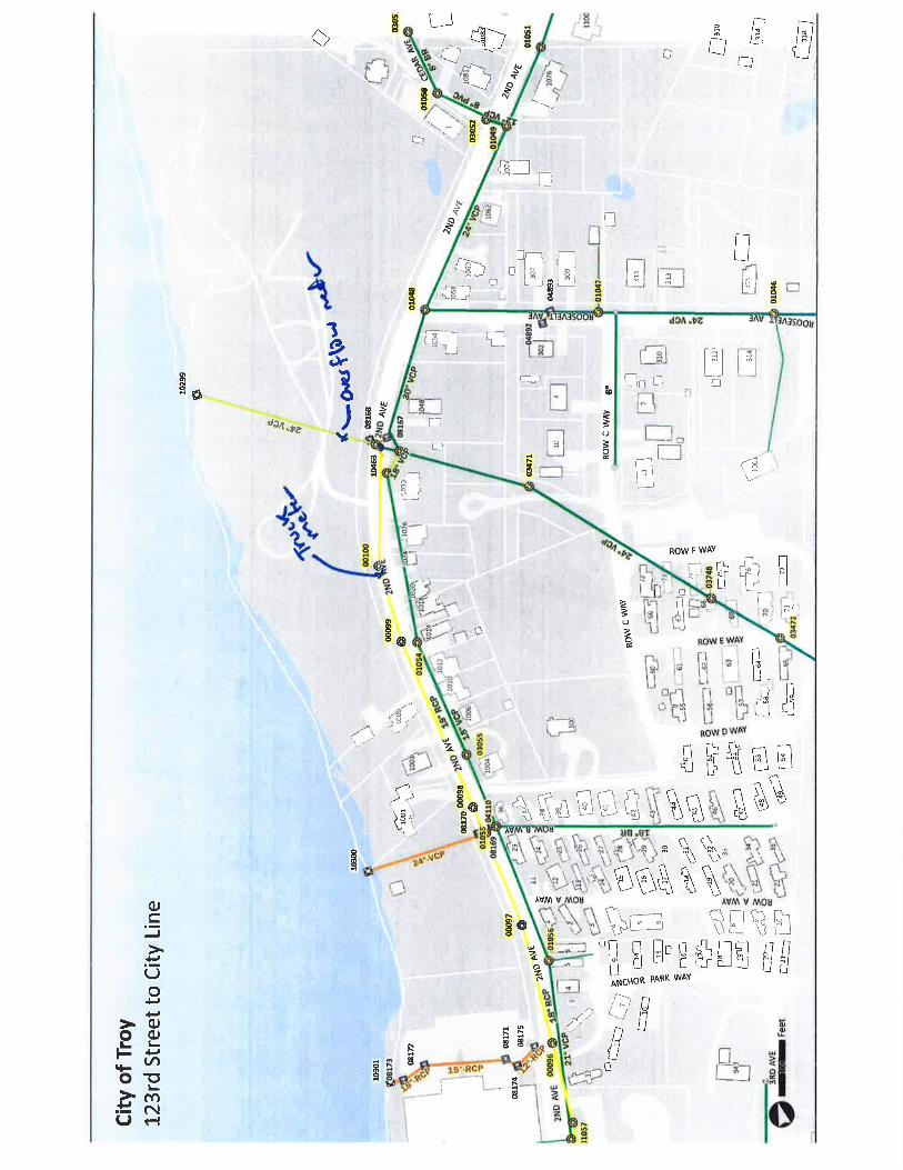
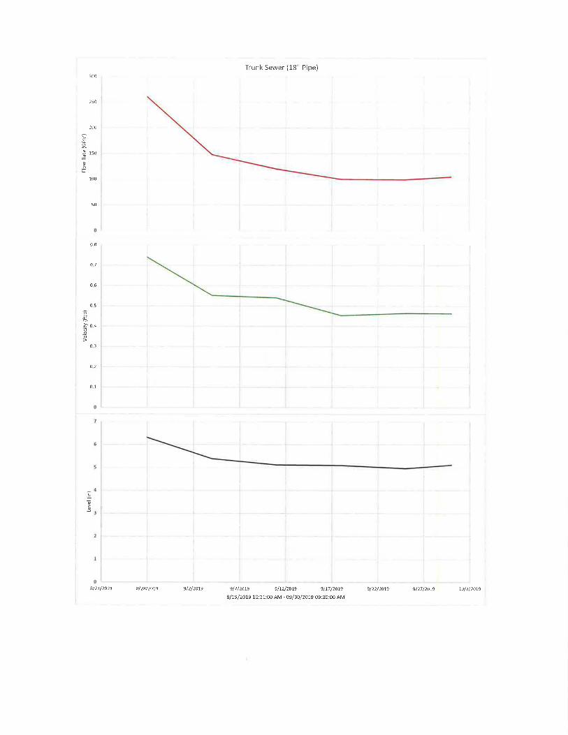
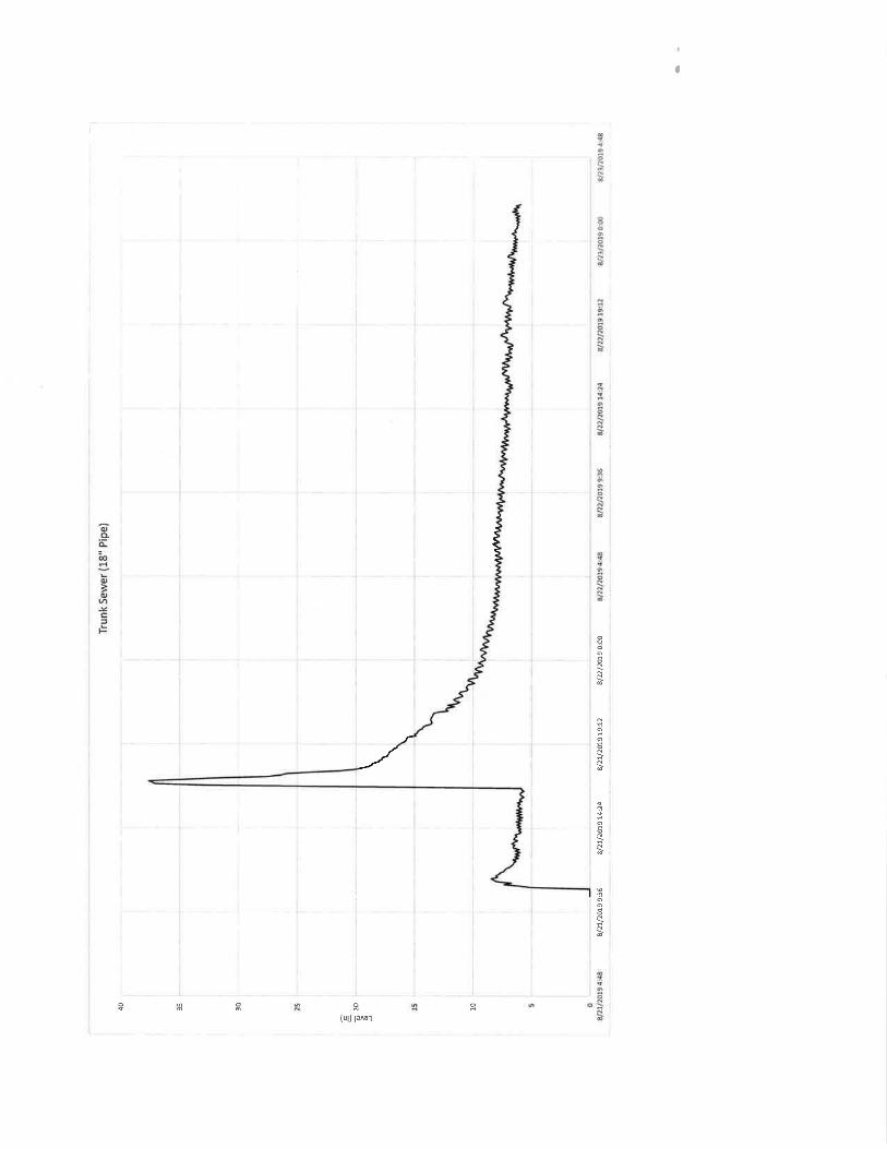
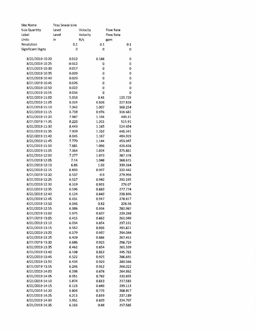
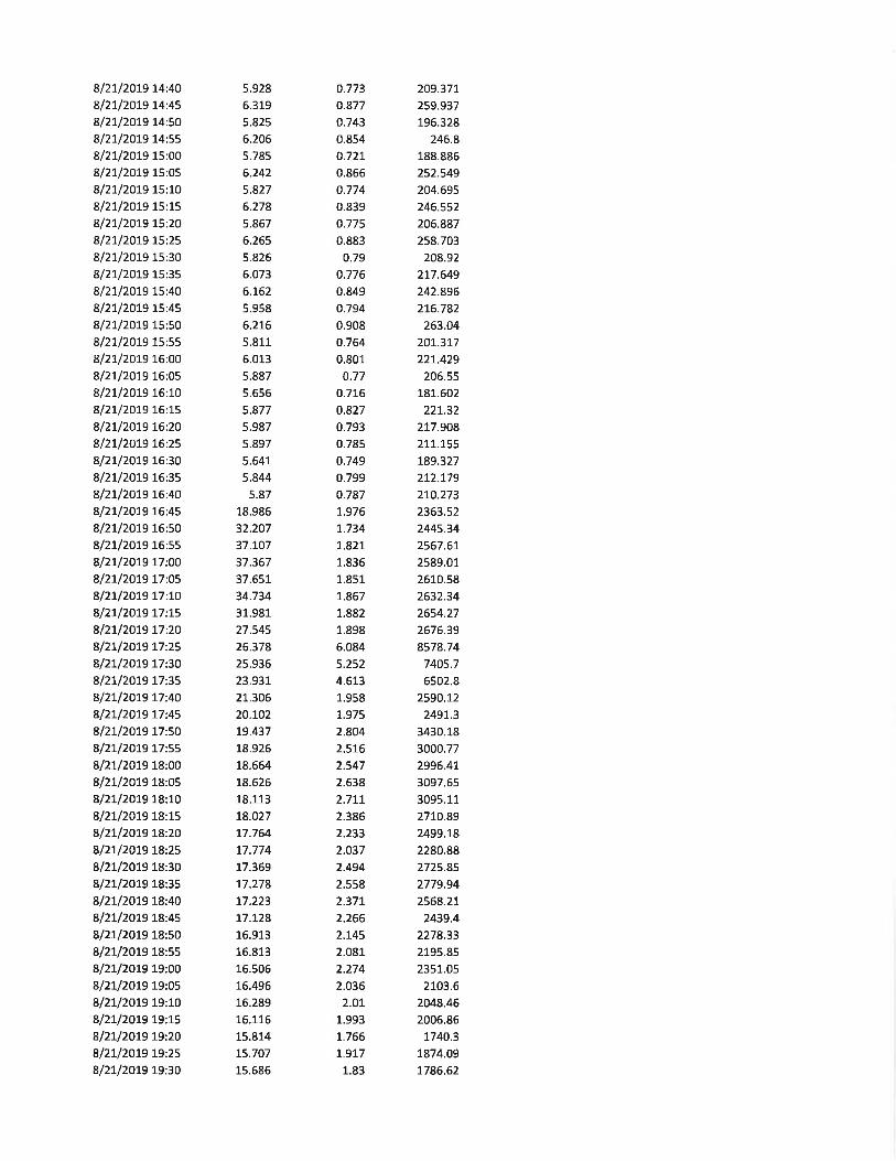
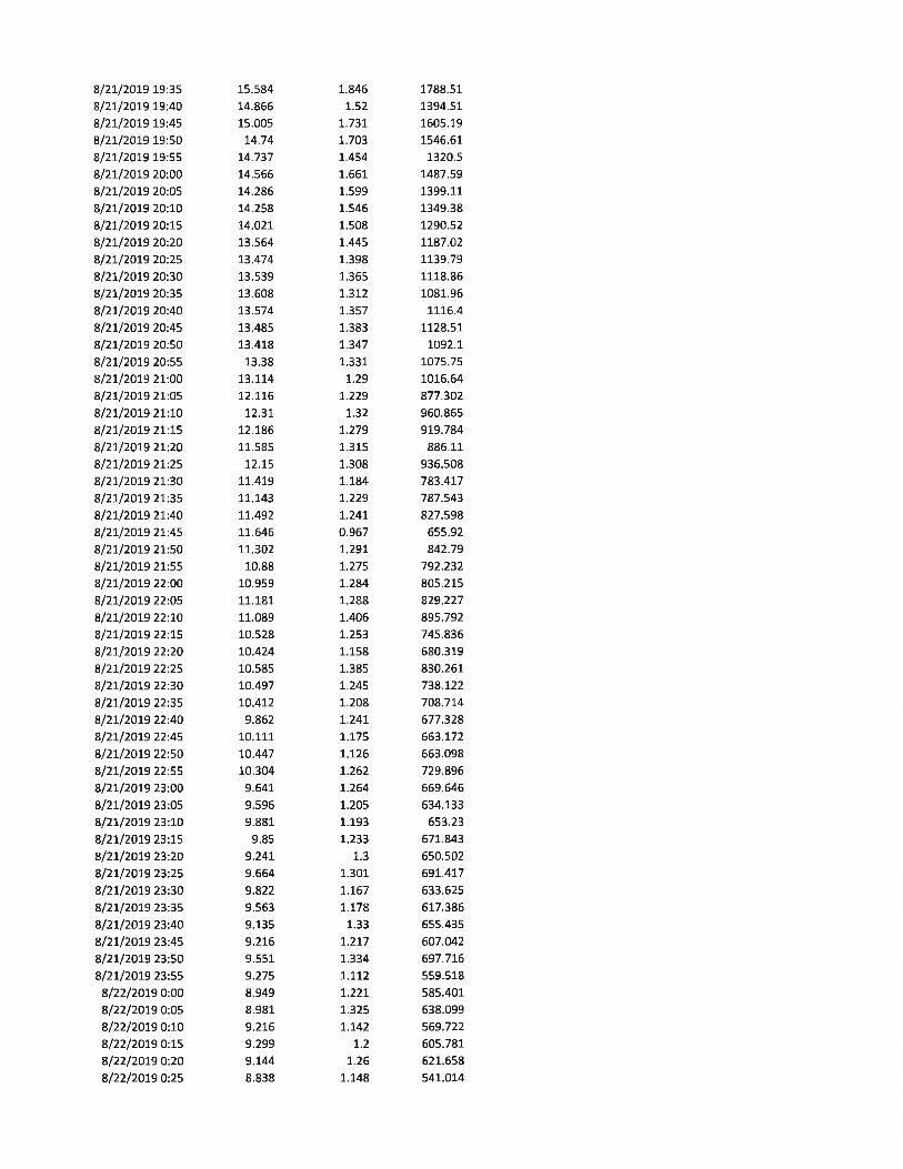
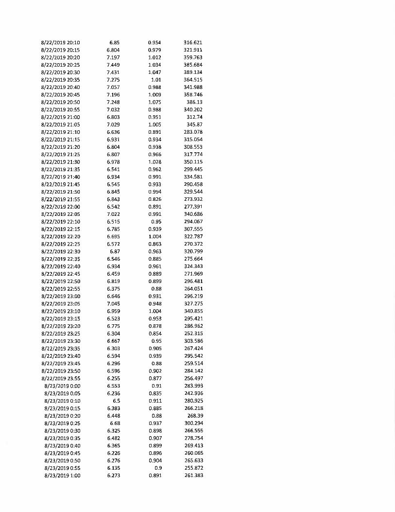
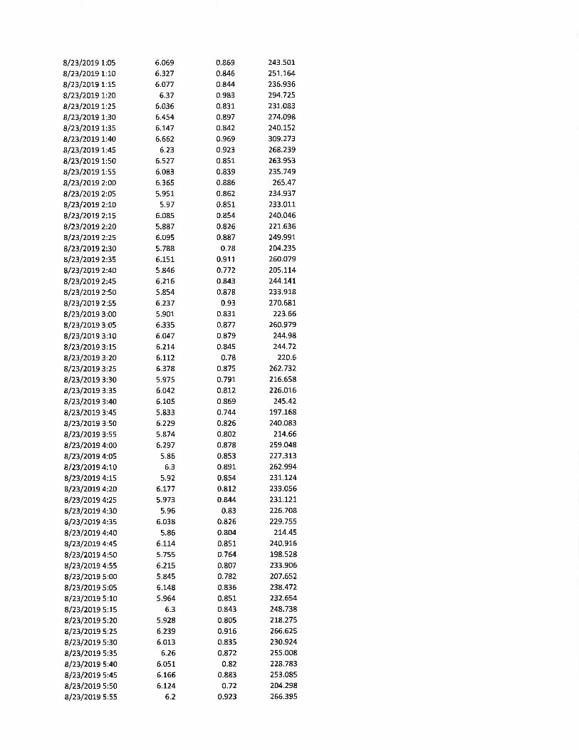
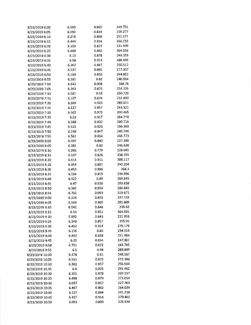
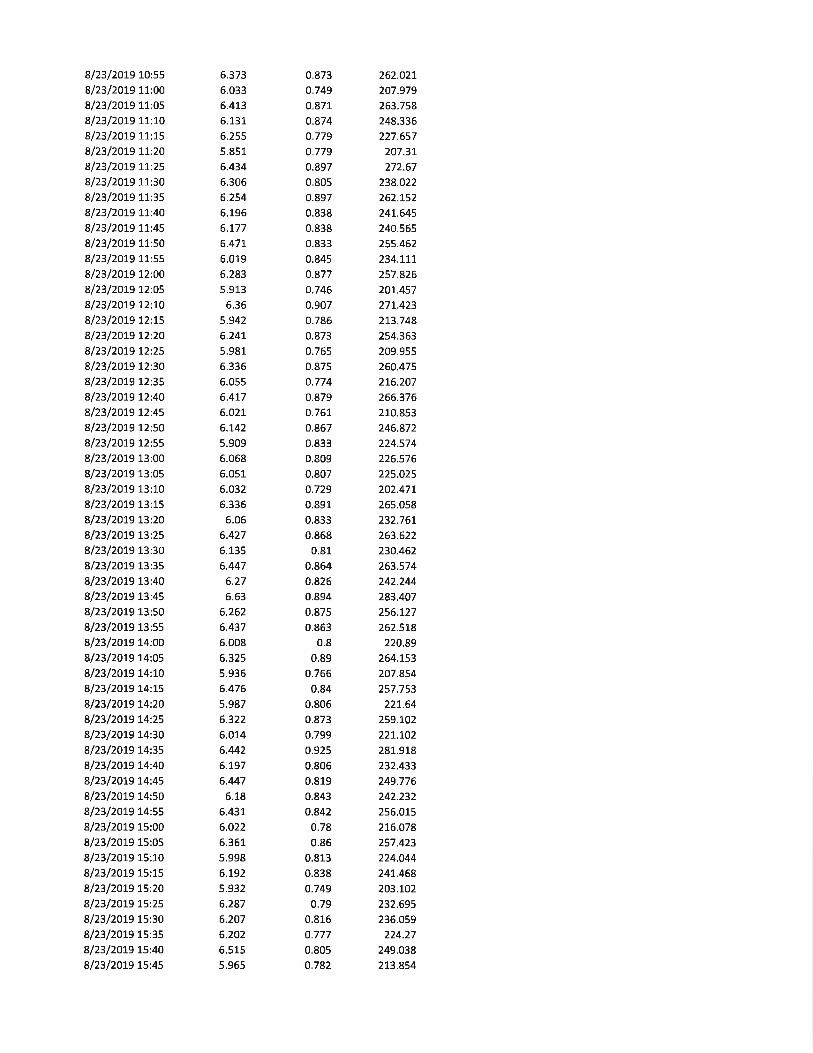
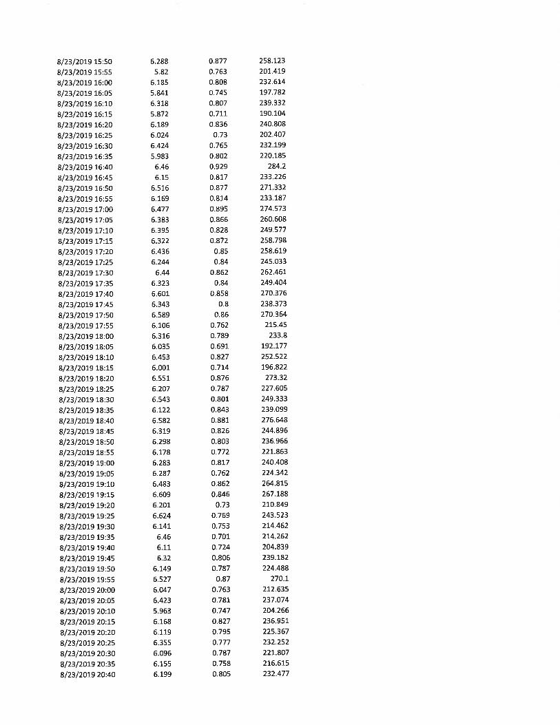
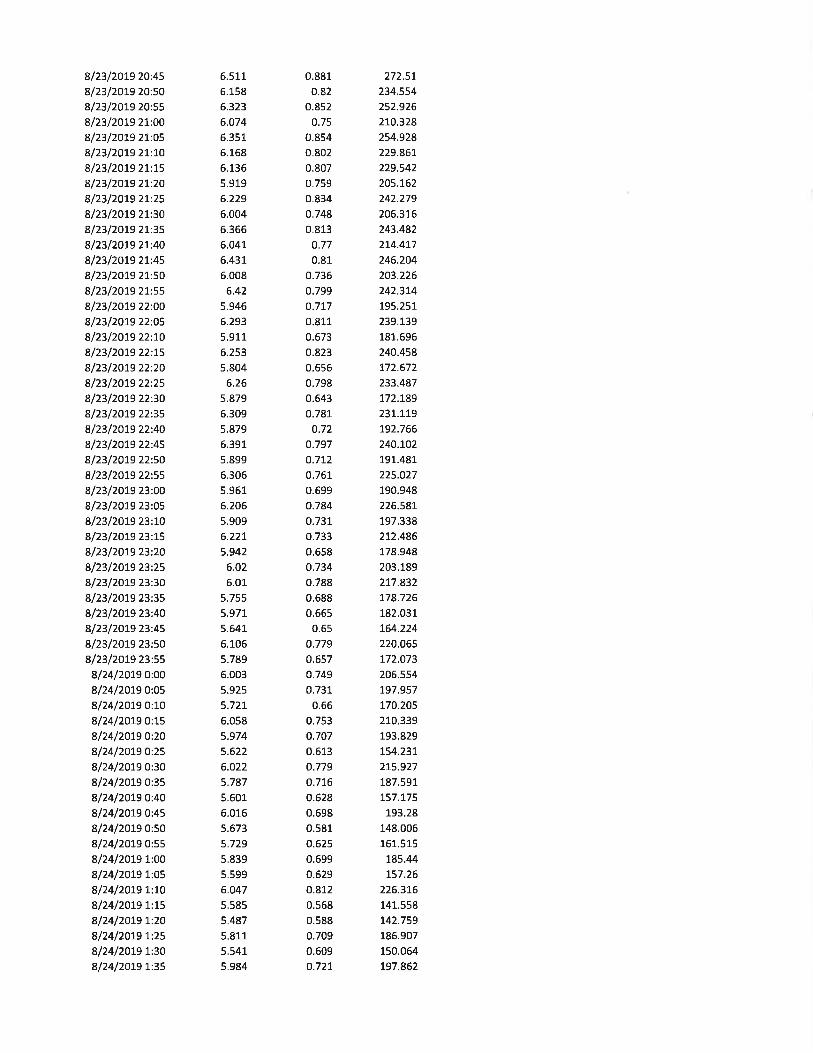
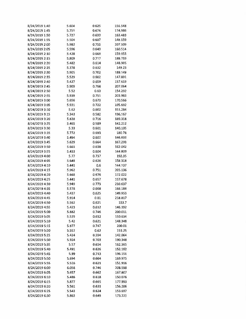
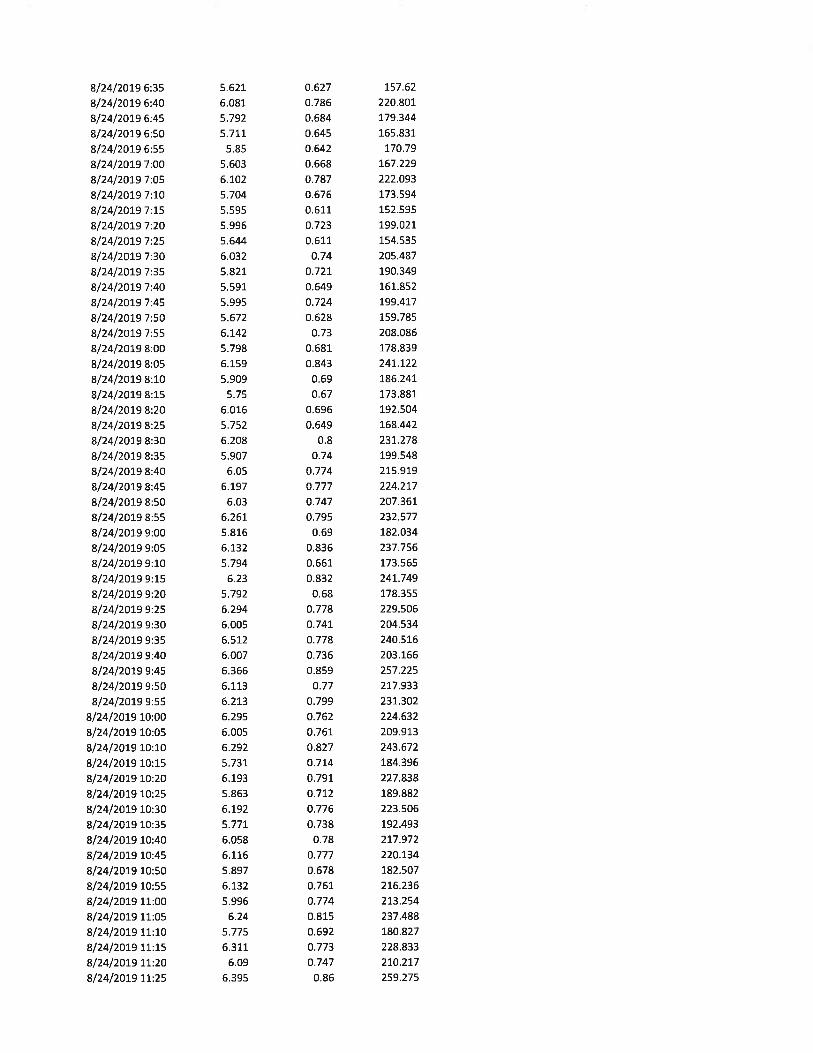
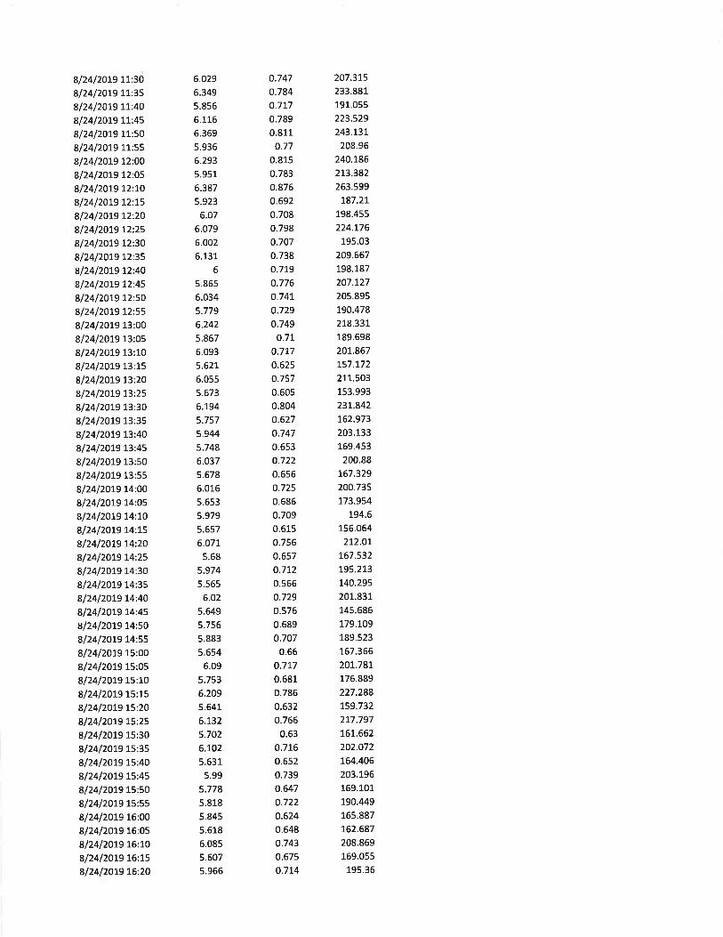
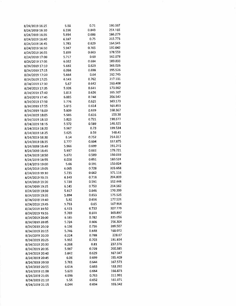
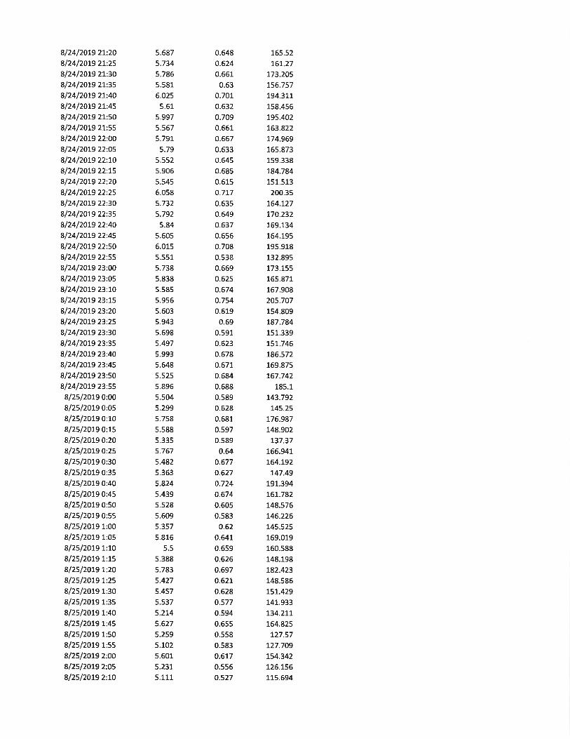
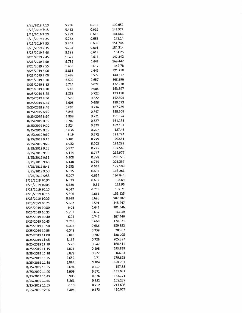
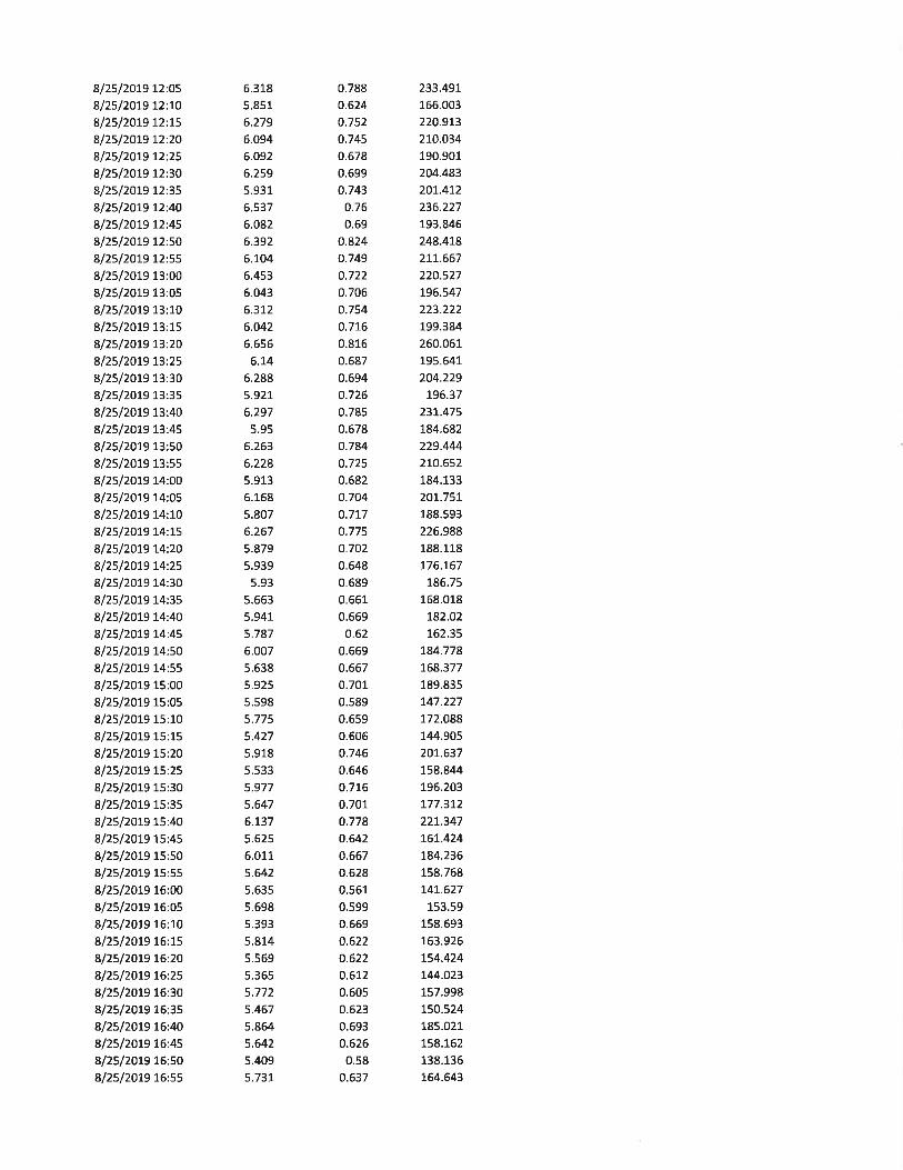

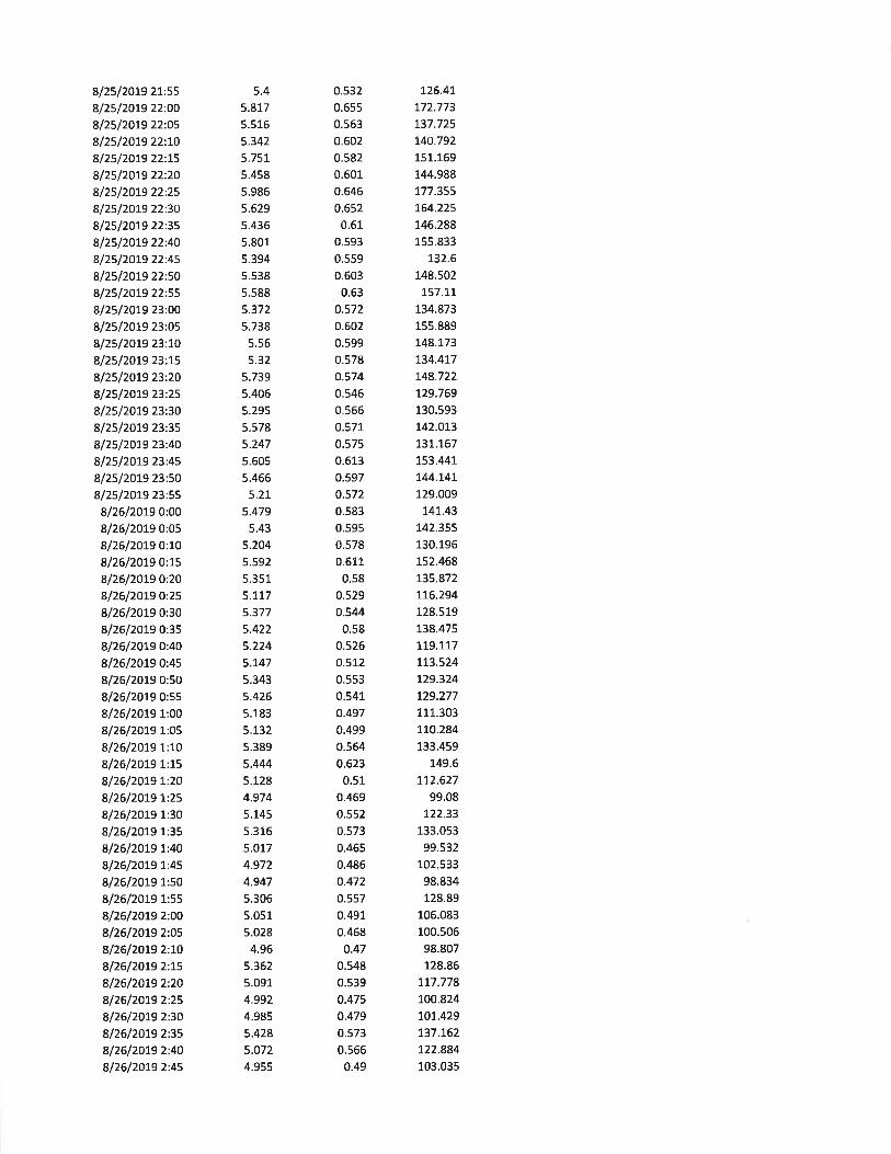
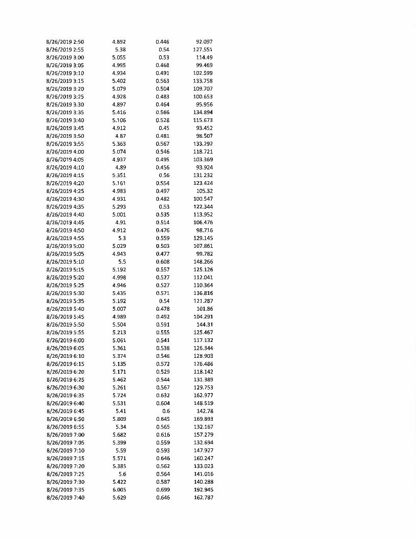
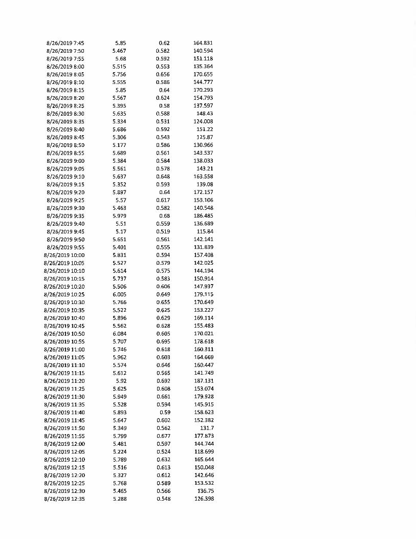
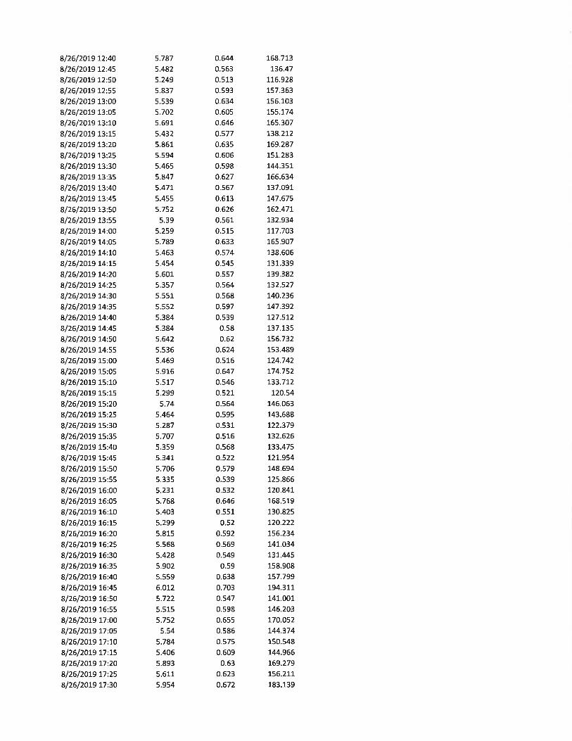
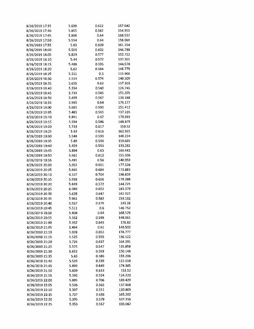
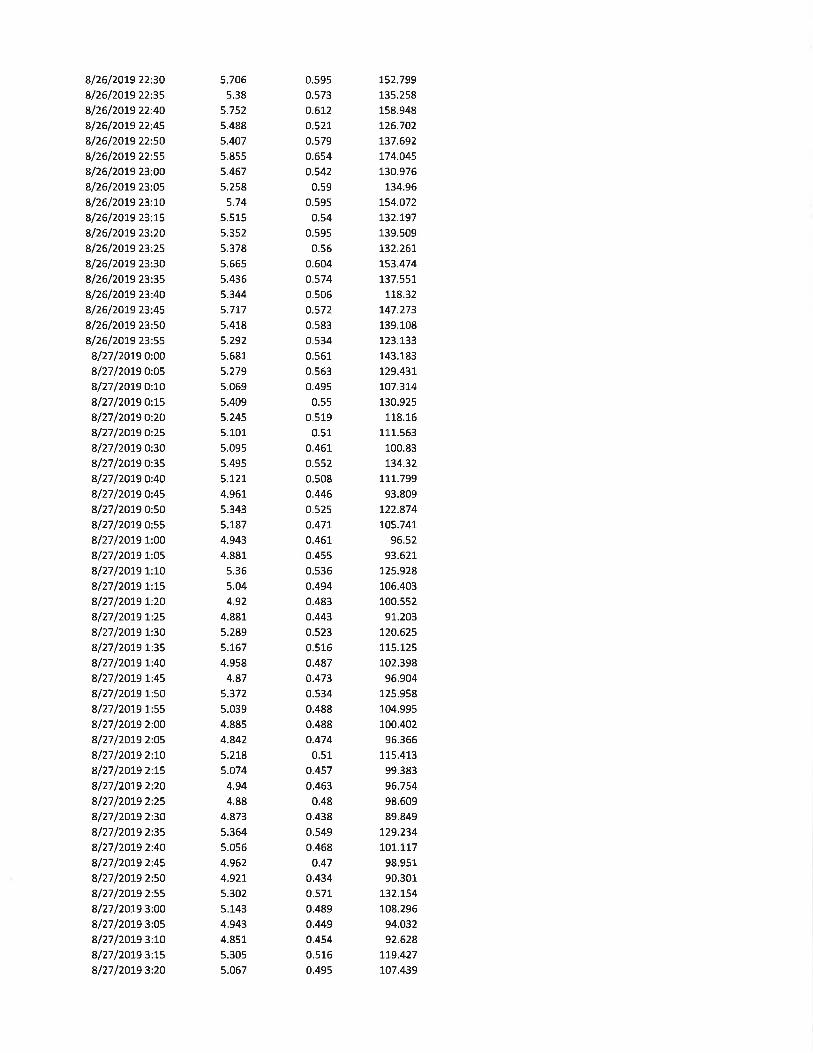
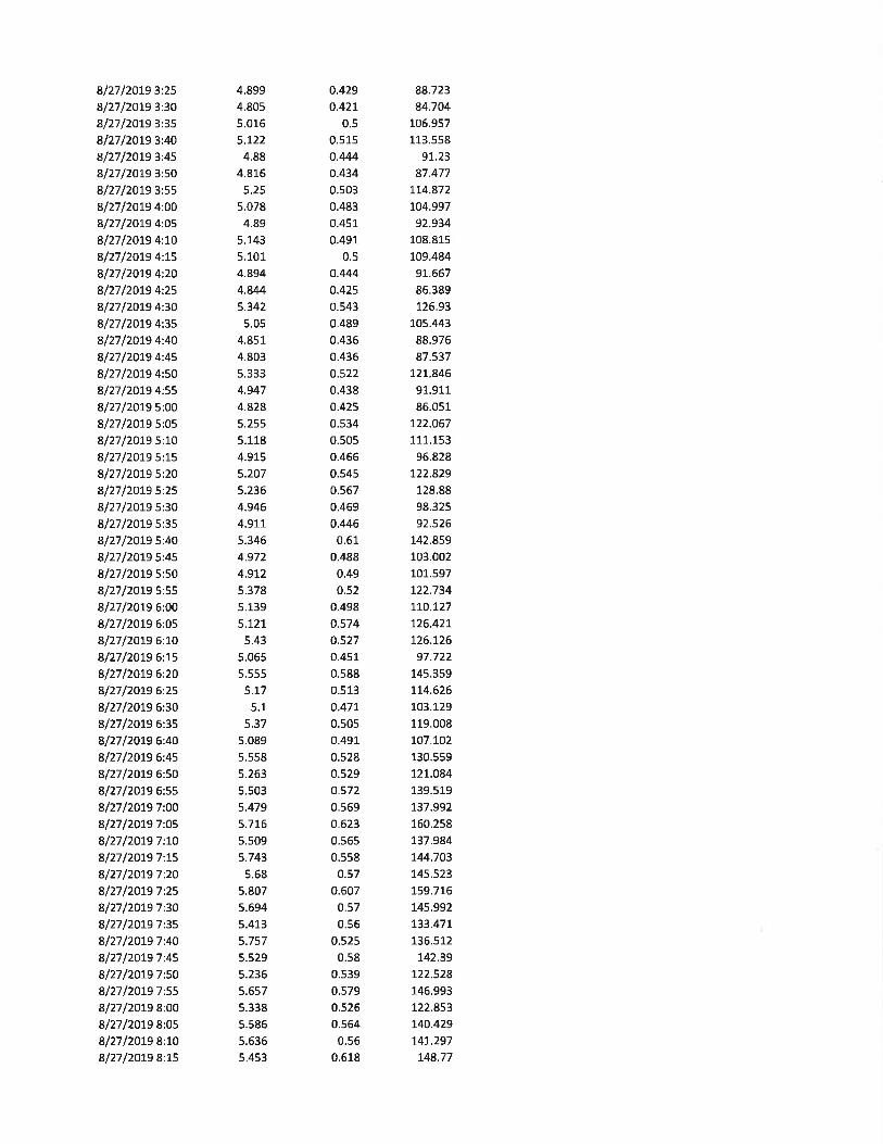
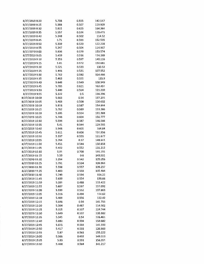
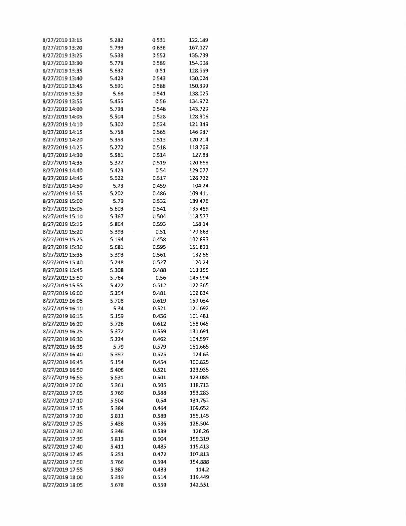
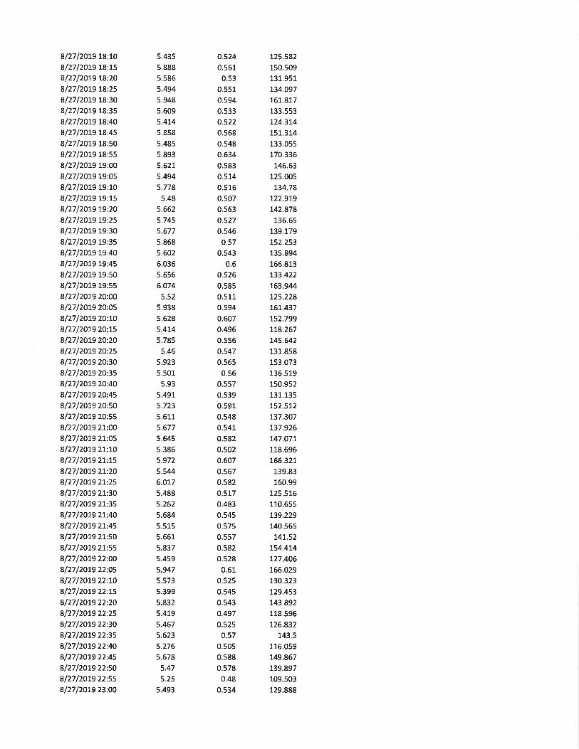
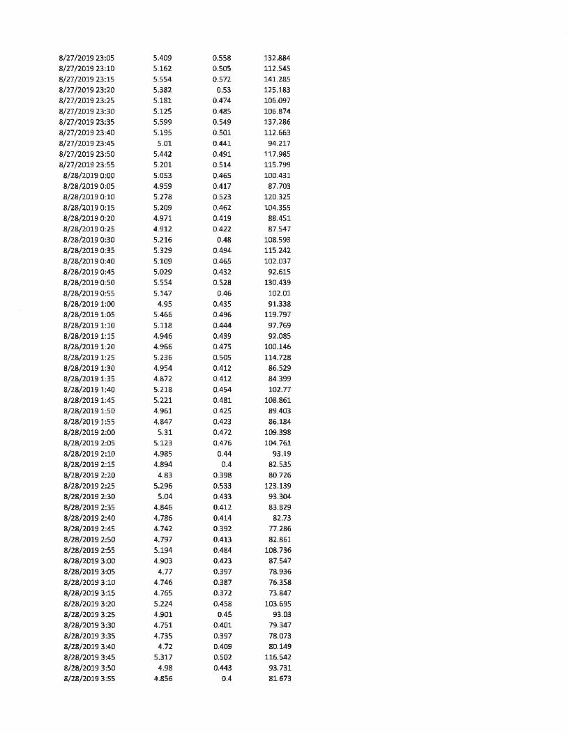
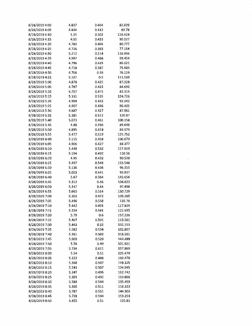
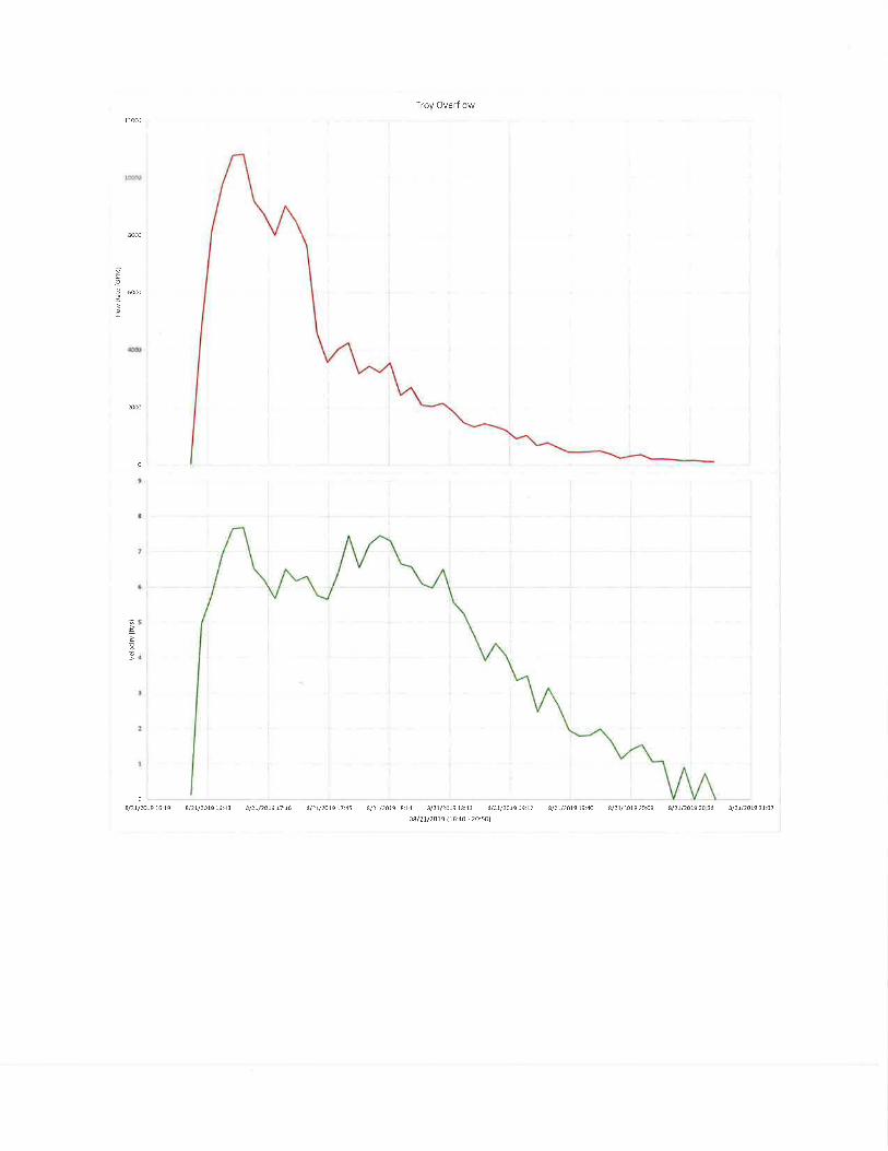
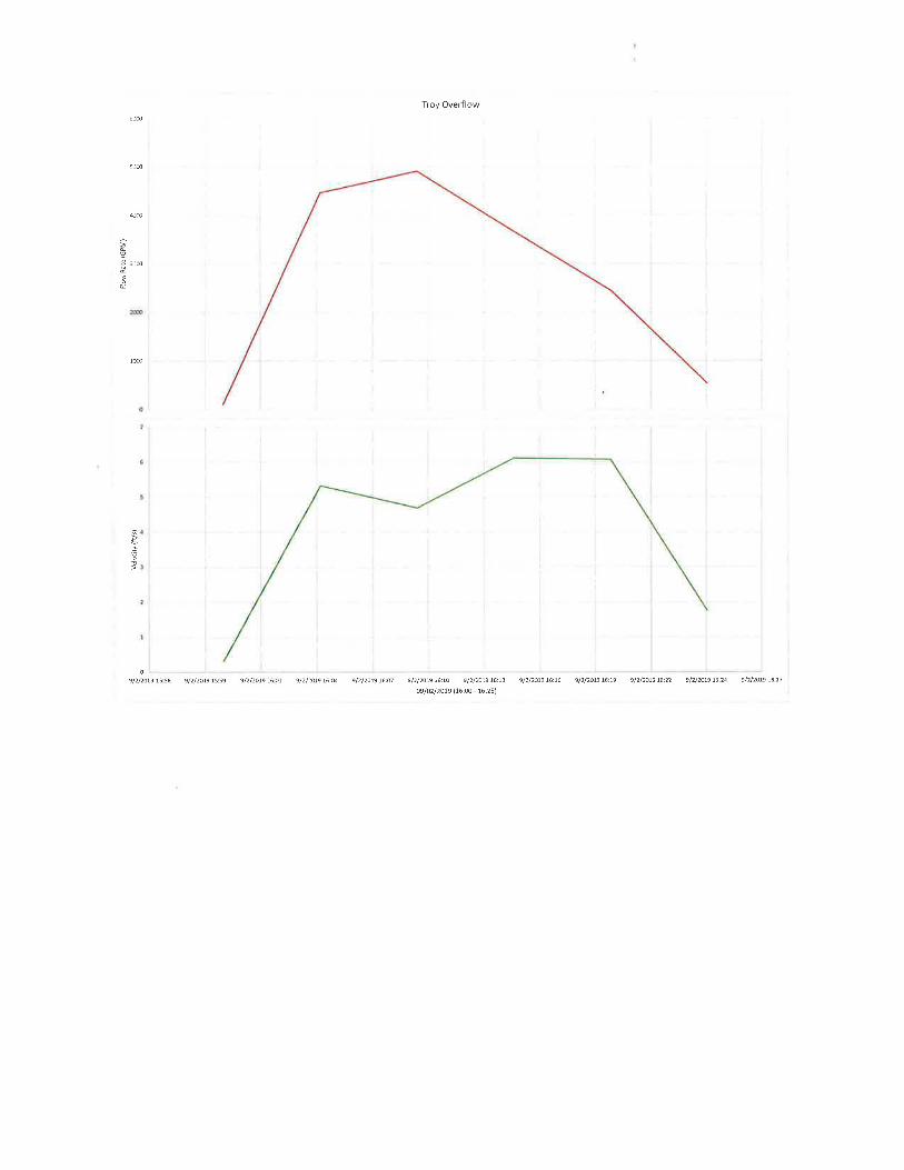
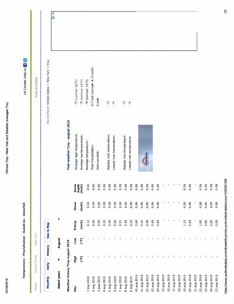
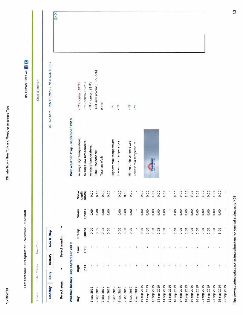
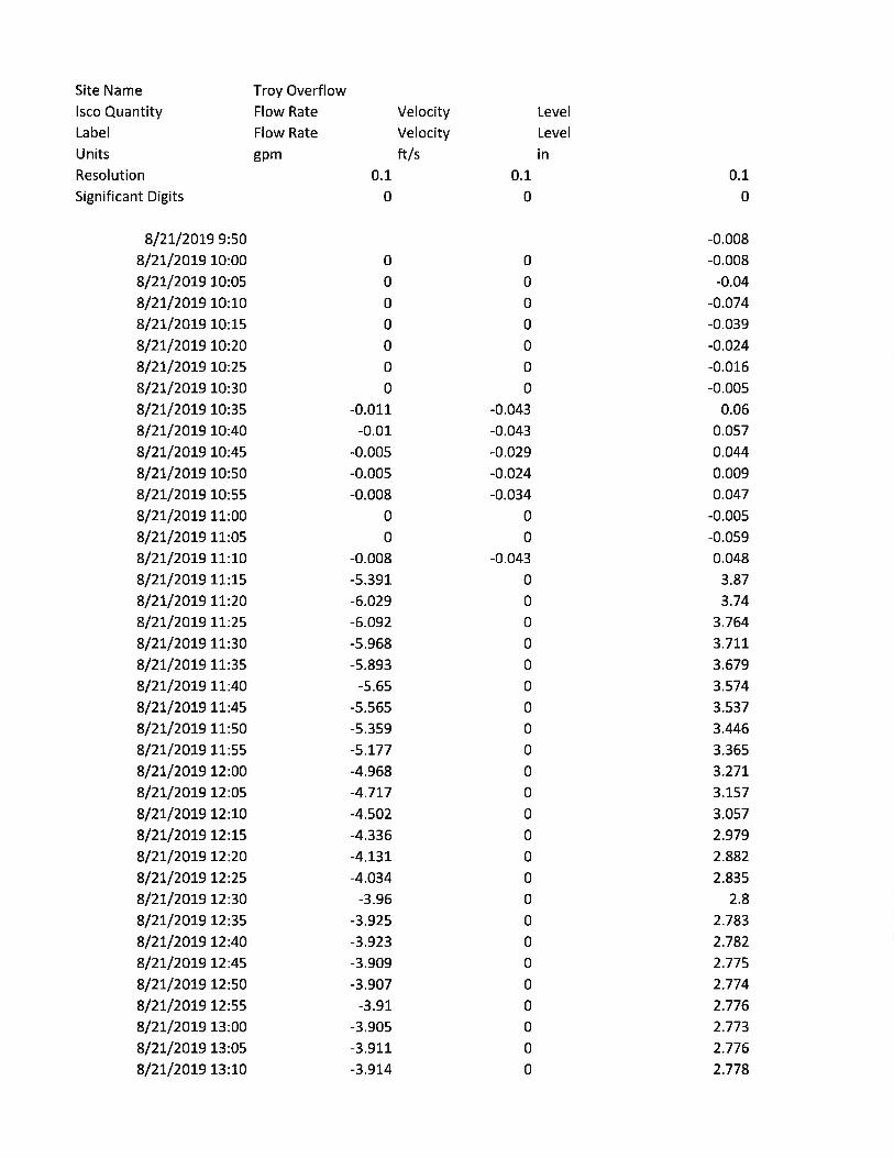
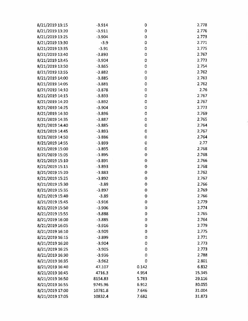
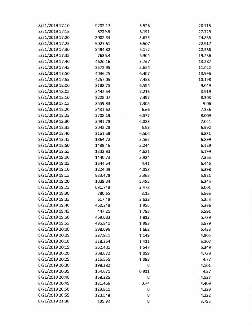

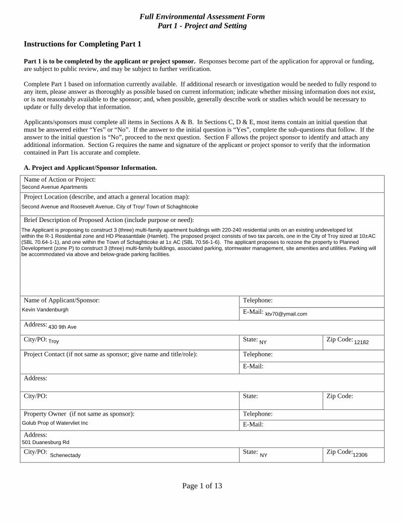
Page 1 of 13
Full Environmental Assessment Form Part 1 - Project and Setting
Instructions for Completing Part 1
Part 1 is to be completed by the applicant or project sponsor. Responses become part of the application for approval or funding, are subject to public review, and may be subject to further verification.
Complete Part 1 based on information currently available. If additional research or investigation would be needed to fully respond to any item, please answer as thoroughly as possible based on current information; indicate whether missing information does not exist, or is not reasonably available to the sponsor; and, when possible, generally describe work or studies which would be necessary to update or fully develop that information.
Applicants/sponsors must complete all items in Sections A & B. In Sections C, D & E, most items contain an initial question that must be answered either “Yes” or “No”. If the answer to the initial question is “Yes”, complete the sub-questions that follow. If the answer to the initial question is “No”, proceed to the next question. Section F allows the project sponsor to identify and attach any additional information. Section G requires the name and signature of the applicant or project sponsor to verify that the information contained in Part 1is accurate and complete.
A. Project and Applicant/Sponsor Information.
Name of Action or Project:
Project Location (describe, and attach a general location map):
Brief Description of Proposed Action (include purpose or need):
Name of Applicant/Sponsor: Telephone:
E-Mail:
Address:
City/PO: State: Zip Code:
Project Contact (if not same as sponsor; give name and title/role): Telephone:
E-Mail:
Address:
City/PO: State: Zip Code:
Property Owner (if not same as sponsor): Telephone: E-Mail:
Address:
City/PO: State: Zip Code:
Second Avenue Apartments
Second Avenue and Roosevelt Avenue, City of Troy/ Town of Schaghticoke
The Applicant is proposing to construct 3 (three) multi-family apartment buildings with 220-240 residential units on an existing undeveloped lot within the R-1 Residential zone and HD Pleasantdale (Hamlet). The proposed project consists of two tax parcels, one in the City of Troy sized at 10±AC(SBL 70.64-1-1), and one within the Town of Schaghticoke at 1± AC (SBL 70.56-1-6). The applicant proposes to rezone the property to PlannedDevelopment (zone P) to construct 3 (three) multi-family buildings, associated parking, stormwater management, site amenities and utilities. Parking willbe accommodated via above and below-grade parking facilities.
Kevin [email protected]
430 9th Ave
Troy NY 12182
Golub Prop of Watervliet Inc
501 Duanesburg Rd
Schenectady NY 12306
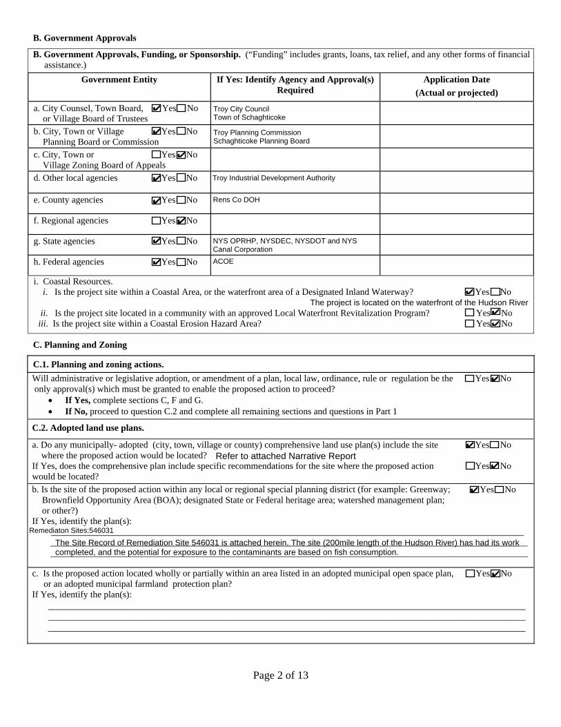
Page 2 of 13
B. Government Approvals
B. Government Approvals, Funding, or Sponsorship. (“Funding” includes grants, loans, tax relief, and any other forms of financialassistance.)
Government Entity If Yes: Identify Agency and Approval(s) Required
Application Date (Actual or projected)
a. City Counsel, Town Board, 9 Yes 9 Noor Village Board of Trustees
b. City, Town or Village 9 Yes 9 No Planning Board or Commission
c. City, Town or 9 Yes 9 No Village Zoning Board of Appeals
d. Other local agencies 9 Yes 9 No
e. County agencies 9 Yes 9 No
f. Regional agencies 9 Yes 9 No
g. State agencies 9 Yes 9 No
h. Federal agencies 9 Yes 9 No
i. Coastal Resources.i. Is the project site within a Coastal Area, or the waterfront area of a Designated Inland Waterway? 9 Yes No
ii. Is the project site located in a community with an approved Local Waterfront Revitalization Program? 9 Yes No iii. Is the project site within a Coastal Erosion Hazard Area? 9 Yes 9 No
C. Planning and Zoning
C.1. Planning and zoning actions.Will administrative or legislative adoption, or amendment of a plan, local law, ordinance, rule or regulation be the 9 Yes 9 No only approval(s) which must be granted to enable the proposed action to proceed?
• If Yes, complete sections C, F and G.• If No, proceed to question C.2 and complete all remaining sections and questions in Part 1
C.2. Adopted land use plans.
a. Do any municipally- adopted (city, town, village or county) comprehensive land use plan(s) include the site 9 Yes 9 No where the proposed action would be located?
If Yes, does the comprehensive plan include specific recommendations for the site where the proposed action 9 Yes 9 No would be located? b. Is the site of the proposed action within any local or regional special planning district (for example: Greenway; 9 Yes 9 No
Brownfield Opportunity Area (BOA); designated State or Federal heritage area; watershed management plan;or other?)
If Yes, identify the plan(s): _______________________________________________________________________________________________________
________________________________________________________________________________________________________ ________________________________________________________________________________________________________
c. Is the proposed action located wholly or partially within an area listed in an adopted municipal open space plan, 9 Yes 9 Noor an adopted municipal farmland protection plan?
If Yes, identify the plan(s): ________________________________________________________________________________________________________ ________________________________________________________________________________________________________ ________________________________________________________________________________________________________
✔ Troy City CouncilTown of Schaghticoke
✔ Troy Planning CommissionSchaghticoke Planning Board
✔
✔ Troy Industrial Development Authority
✔ Rens Co DOH
✔
✔ NYS OPRHP, NYSDEC, NYSDOT and NYSCanal Corporation
✔ ACOE
✔
✔
✔
✔
✔
✔
✔
Remediaton Sites:546031
✔
Refer to attached Narrative Report
The Site Record of Remediation Site 546031 is attached herein. The site (200mile length of the Hudson River) has had its workcompleted, and the potential for exposure to the contaminants are based on fish consumption.
The project is located on the waterfront of the Hudson River✔
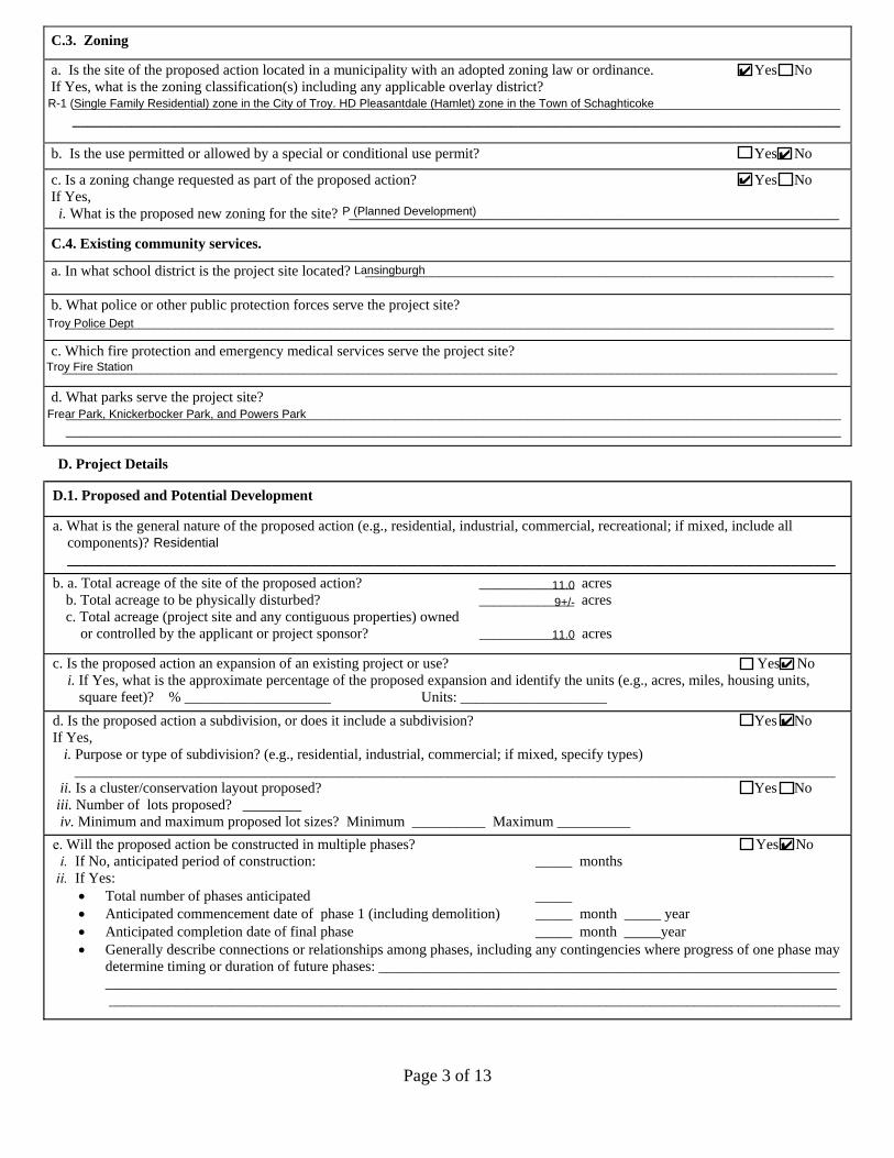
Page 3 of 13
C.3. Zoning
a. Is the site of the proposed action located in a municipality with an adopted zoning law or ordinance. 9 Yes 9 NoIf Yes, what is the zoning classification(s) including any applicable overlay district?
__________________________________________________________________________________________________________________________________________________________________________________________________________________
b. Is the use permitted or allowed by a special or conditional use permit? 9 Yes 9 No
c. Is a zoning change requested as part of the proposed action? 9 Yes 9 No If Yes,
i. What is the proposed new zoning for the site? ___________________________________________________________________
C.4. Existing community services.
a. In what school district is the project site located? ________________________________________________________________
b. What police or other public protection forces serve the project site? _________________________________________________________________________________________________________
c. Which fire protection and emergency medical services serve the project site?__________________________________________________________________________________________________________
d. What parks serve the project site?____________________________________________________________________________________________________________________________________________________________________________________________________________________
D. Project Details
D.1. Proposed and Potential Development
a. What is the general nature of the proposed action (e.g., residential, industrial, commercial, recreational; if mixed, include allcomponents)?_________________________________________________________________________________________________________
b. a. Total acreage of the site of the proposed action? _____________ acres b. Total acreage to be physically disturbed? _____________ acres c. Total acreage (project site and any contiguous properties) owned
or controlled by the applicant or project sponsor? _____________ acres
c. Is the proposed action an expansion of an existing project or use? 9 Yes 9 No i. If Yes, what is the approximate percentage of the proposed expansion and identify the units (e.g., acres, miles, housing units,
square feet)? % ____________________ Units: ____________________d. Is the proposed action a subdivision, or does it include a subdivision? 9 Yes 9 No If Yes,
i. Purpose or type of subdivision? (e.g., residential, industrial, commercial; if mixed, specify types)________________________________________________________________________________________________________
ii. Is a cluster/conservation layout proposed? 9 Yes 9 No iii. Number of lots proposed? ________iv. Minimum and maximum proposed lot sizes? Minimum __________ Maximum __________
9 Yes 9 No _____ months
_____ _____ month _____ year
e. Will the proposed action be constructed in multiple phases?i. If No, anticipated period of construction:
ii. If Yes:• Total number of phases anticipated• Anticipated commencement date of phase 1 (including demolition)• Anticipated completion date of final phase _____ month _____year • Generally describe connections or relationships among phases, including any contingencies where progress of one phase may
determine timing or duration of future phases: _______________________________________________________________________________________________________________________________________________________________________________________________________________________________________________________________________
✔
R-1 (Single Family Residential) zone in the City of Troy. HD Pleasantdale (Hamlet) zone in the Town of Schaghticoke
✔
✔
P (Planned Development)
Lansingburgh
Troy Police Dept
Troy Fire Station
Frear Park, Knickerbocker Park, and Powers Park
11.0
9+/-
11.0
✔
✔
✔
Residential
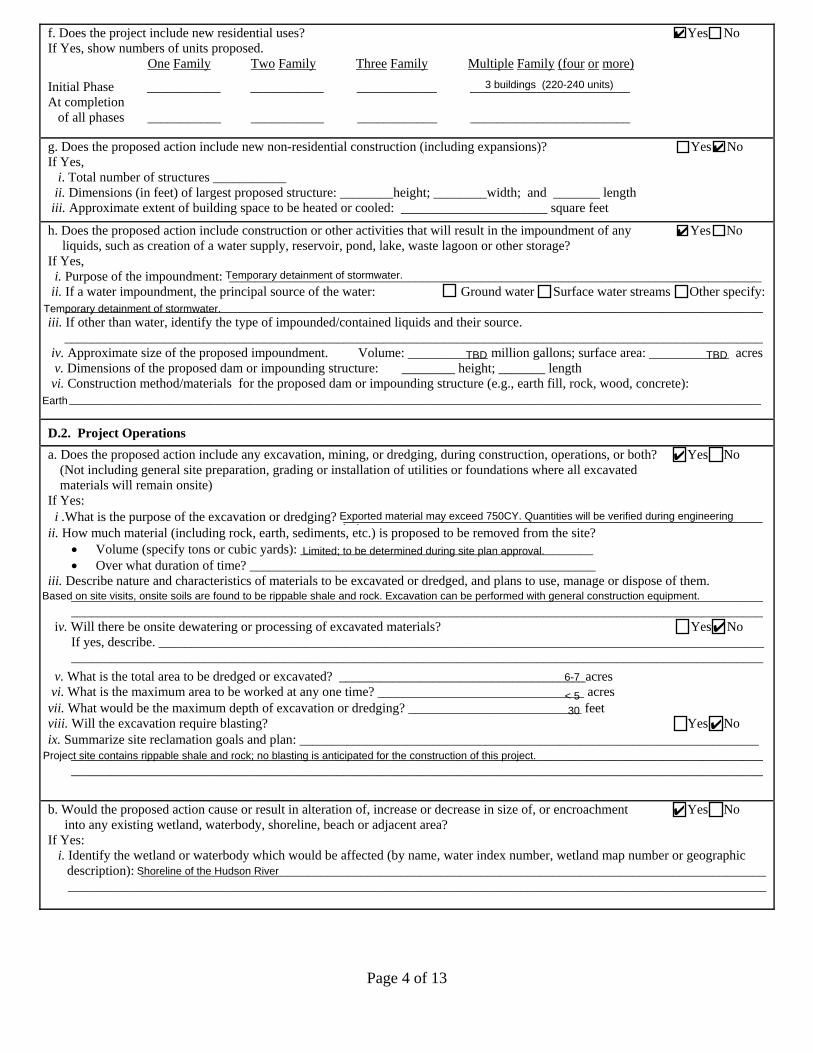
Page 4 of 13
f. Does the project include new residential uses? 9 Yes 9 No If Yes, show numbers of units proposed.
One Family Two Family Three Family Multiple Family (four or more)
Initial Phase ___________ ___________ ____________ ________________________ At completion of all phases ___________ ___________ ____________ ________________________
g. Does the proposed action include new non-residential construction (including expansions)? 9 Yes 9 No If Yes,
i. Total number of structures ___________ii. Dimensions (in feet) of largest proposed structure: ________height; ________width; and _______ length
iii. Approximate extent of building space to be heated or cooled: ______________________ square feet
h. Does the proposed action include construction or other activities that will result in the impoundment of any 9 Yes 9 No liquids, such as creation of a water supply, reservoir, pond, lake, waste lagoon or other storage?
If Yes, i. Purpose of the impoundment: ________________________________________________________________________________
ii. If a water impoundment, the principal source of the water: 9 Ground water 9 Surface water streams 9 Other specify:_________________________________________________________________________________________________________
iii. If other than water, identify the type of impounded/contained liquids and their source._________________________________________________________________________________________________________
iv. Approximate size of the proposed impoundment. Volume: ____________ million gallons; surface area: ____________ acres v. Dimensions of the proposed dam or impounding structure: ________ height; _______ length
vi. Construction method/materials for the proposed dam or impounding structure (e.g., earth fill, rock, wood, concrete):________________________________________________________________________________________________________
D.2. Project Operationsa. Does the proposed action include any excavation, mining, or dredging, during construction, operations, or both? 9 Yes 9 No
(Not including general site preparation, grading or installation of utilities or foundations where all excavatedmaterials will remain onsite)
If Yes: i .What is the purpose of the excavation or dredging? _______________________________________________________________ ii. How much material (including rock, earth, sediments, etc.) is proposed to be removed from the site?
• Volume (specify tons or cubic yards): ____________________________________________• Over what duration of time? ____________________________________________________
iii. Describe nature and characteristics of materials to be excavated or dredged, and plans to use, manage or dispose of them.________________________________________________________________________________________________________________________________________________________________________________________________________________
iv. Will there be onsite dewatering or processing of excavated materials? 9 Yes 9 NoIf yes, describe. ___________________________________________________________________________________________________________________________________________________________________________________________________
v. What is the total area to be dredged or excavated? _____________________________________acresvi. What is the maximum area to be worked at any one time? _______________________________ acres
vii. What would be the maximum depth of excavation or dredging? __________________________ feetviii. Will the excavation require blasting? 9 Yes 9 No ix. Summarize site reclamation goals and plan: _____________________________________________________________________
________________________________________________________________________________________________________ ________________________________________________________________________________________________________
b. Would the proposed action cause or result in alteration of, increase or decrease in size of, or encroachment 9 Yes 9 No into any existing wetland, waterbody, shoreline, beach or adjacent area?
If Yes: i. Identify the wetland or waterbody which would be affected (by name, water index number, wetland map number or geographic
description): _______________________________________________________________________________________________________________________________________________________________________________________________________
✔
3 buildings (220-240 units)
✔
✔
Temporary detainment of stormwater.
Temporary detainment of stormwater.
TBD TBD
Earth
✔
Exported material may exceed 750CY. Quantities will be verified during engineeringdesign.
Limited; to be determined during site plan approval.
Based on site visits, onsite soils are found to be rippable shale and rock. Excavation can be performed with general construction equipment.
✔
6-7
< 530
✔
Project site contains rippable shale and rock; no blasting is anticipated for the construction of this project.
✔
Shoreline of the Hudson River
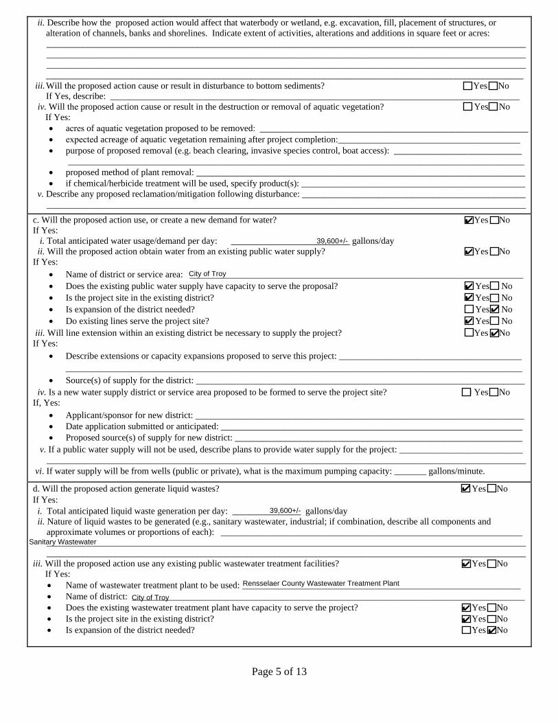
Page 5 of 13
ii.
iii.
Describe how the proposed action would affect that waterbody or wetland, e.g. excavation, fill, placement of structures, or alteration of channels, banks and shorelines. Indicate extent of activities, alterations and additions in square feet or acres: _________________________________________________________________________________________________________ _________________________________________________________________________________________________________ _________________________________________________________________________________________________________ _________________________________________________________________________________________________________ Will the proposed action cause or result in disturbance to bottom sediments? Yes 9 No If Yes, describe: __________________________________________________________________________________________
iv. Will the proposed action cause or result in the destruction or removal of aquatic vegetation? 9 Yes 9 No If Yes:• acres of aquatic vegetation proposed to be removed: ___________________________________________________________• expected acreage of aquatic vegetation remaining after project completion:________________________________________• purpose of proposed removal (e.g. beach clearing, invasive species control, boat access): ____________________________
____________________________________________________________________________________________________• proposed method of plant removal: ________________________________________________________________________• if chemical/herbicide treatment will be used, specify product(s): _________________________________________________
v. Describe any proposed reclamation/mitigation following disturbance: __________________________________________________________________________________________________________________________________________________________
c. Will the proposed action use, or create a new demand for water? 9 Yes 9 No If Yes:
i. Total anticipated water usage/demand per day: __________________________ gallons/dayii. Will the proposed action obtain water from an existing public water supply? 9 Yes 9 No
If Yes: • Name of district or service area: _________________________________________________________________________• Does the existing public water supply have capacity to serve the proposal? 9 Yes 9 No • Is the project site in the existing district? 9 Yes 9 No • Is expansion of the district needed? 9 Yes 9 No • Do existing lines serve the project site? 9 Yes 9 No
iii. Will line extension within an existing district be necessary to supply the project? 9 Yes 9 No If Yes:
• Describe extensions or capacity expansions proposed to serve this project: ____________________________________________________________________________________________________________________________________________
• Source(s) of supply for the district: ________________________________________________________________________iv. Is a new water supply district or service area proposed to be formed to serve the project site? 9 Yes 9 No
If, Yes: • Applicant/sponsor for new district: ________________________________________________________________________• Date application submitted or anticipated: __________________________________________________________________• Proposed source(s) of supply for new district: _______________________________________________________________
v. If a public water supply will not be used, describe plans to provide water supply for the project: ____________________________________________________________________________________________________________________________________
vi. If water supply will be from wells (public or private), what is the maximum pumping capacity: _______ gallons/minute.
d. Will the proposed action generate liquid wastes? 9 Yes 9 No If Yes:
i. Total anticipated liquid waste generation per day: _______________ gallons/dayii. Nature of liquid wastes to be generated (e.g., sanitary wastewater, industrial; if combination, describe all components and
approximate volumes or proportions of each): ____________________________________________________________________________________________________________________________________________________________________________________________________________________________________________________________________________________
iii. Will the proposed action use any existing public wastewater treatment facilities? 9 Yes 9 NoIf Yes:• Name of wastewater treatment plant to be used: _____________________________________________________________• Name of district: ______________________________________________________________________________________• Does the existing wastewater treatment plant have capacity to serve the project? 9 Yes 9 No • Is the project site in the existing district? 9 Yes 9 No • Is expansion of the district needed? 9 Yes 9 No
✔
39,600+/-
✔
City of Troy
✔
✔
✔
✔
✔
✔
39,600+/-
Sanitary Wastewater
✔
Rensselaer County Wastewater Treatment Plant
City of Troy✔
✔
✔
Page 6 of 13
9 Yes 9 No • Do existing sewer lines serve the project site?• Will a line extension within an existing district be necessary to serve the project? 9 Yes 9 No
If Yes: • Describe extensions or capacity expansions proposed to serve this project: ____________________________________
________________________________________________________________________________________________________________________________________________________________________________________________________
iv. Will a new wastewater (sewage) treatment district be formed to serve the project site? 9 Yes 9 No If Yes:• Applicant/sponsor for new district: ____________________________________________________________________• Date application submitted or anticipated: _______________________________________________________________• What is the receiving water for the wastewater discharge? __________________________________________________
v. If public facilities will not be used, describe plans to provide wastewater treatment for the project, including specifying proposedreceiving water (name and classification if surface discharge or describe subsurface disposal plans):
________________________________________________________________________________________________________________________________________________________________________________________________________________
vi. Describe any plans or designs to capture, recycle or reuse liquid waste: _______________________________________________________________________________________________________________________________________________________
________________________________________________________________________________________________________
e. Will the proposed action disturb more than one acre and create stormwater runoff, either from new point 9 Yes 9 No sources (i.e. ditches, pipes, swales, curbs, gutters or other concentrated flows of stormwater) or non-pointsource (i.e. sheet flow) during construction or post construction?
If Yes: i. How much impervious surface will the project create in relation to total size of project parcel?
_____ Square feet or _____ acres (impervious surface) _____ Square feet or _____ acres (parcel size)
ii. Describe types of new point sources. ___________________________________________________________________________________________________________________________________________________________________________________
iii. Where will the stormwater runoff be directed (i.e. on-site stormwater management facility/structures, adjacent properties,groundwater, on-site surface water or off-site surface waters)?________________________________________________________________________________________________________________________________________________________________________________________________________________• If to surface waters, identify receiving water bodies or wetlands: ________________________________________________
________________________________________________________________________________________________________________________________________________________________________________________________________
• Will stormwater runoff flow to adjacent properties? 9 Yes 9 No iv. Does the proposed plan minimize impervious surfaces, use pervious materials or collect and re-use stormwater? 9 Yes 9 Nof. Does the proposed action include, or will it use on-site, one or more sources of air emissions, including fuel 9 Yes 9 No
combustion, waste incineration, or other processes or operations?If Yes, identify:
i. Mobile sources during project operations (e.g., heavy equipment, fleet or delivery vehicles)_________________________________________________________________________________________________________
ii. Stationary sources during construction (e.g., power generation, structural heating, batch plant, crushers)________________________________________________________________________________________________________
iii. Stationary sources during operations (e.g., process emissions, large boilers, electric generation)________________________________________________________________________________________________________
g. Will any air emission sources named in D.2.f (above), require a NY State Air Registration, Air Facility Permit, 9 Yes 9 No or Federal Clean Air Act Title IV or Title V Permit?
If Yes: i. Is the project site located in an Air quality non-attainment area? (Area routinely or periodically fails to meet 9 Yes 9 No
ambient air quality standards for all or some parts of the year)ii. In addition to emissions as calculated in the application, the project will generate:
• ___________Tons/year (short tons) of Carbon Dioxide (CO2)• ___________Tons/year (short tons) of Nitrous Oxide (N2O)• ___________Tons/year (short tons) of Perfluorocarbons (PFCs)• ___________Tons/year (short tons) of Sulfur Hexafluoride (SF6)• ___________Tons/year (short tons) of Carbon Dioxide equivalent of Hydroflourocarbons (HFCs)• ___________Tons/year (short tons) of Hazardous Air Pollutants (HAPs)
✔
✔
✔
✔
4+/-
11All point sources (swales, gutters, etc.) will be routed to appropriately sized stormwater management areas.
On-site stormwater management facilities will be discharged directly to the Hudson River.
Hudson River
✔✔
✔
✔
Stormwater will discharge to the Hudson River
Page 7 of 13
h. Will the proposed action generate or emit methane (including, but not limited to, sewage treatment plants, 9 Yes 9 No landfills, composting facilities)?
If Yes: i. Estimate methane generation in tons/year (metric): ________________________________________________________________
ii. Describe any methane capture, control or elimination measures included in project design (e.g., combustion to generate heat orelectricity, flaring): _________________________________________________________________________________________________________________________________________________________________________________________________
i. Will the proposed action result in the release of air pollutants from open-air operations or processes, such as 9 Yes 9 Noquarry or landfill operations?
If Yes: Describe operations and nature of emissions (e.g., diesel exhaust, rock particulates/dust): _________________________________________________________________________________________________________ _________________________________________________________________________________________________________
j. Will the proposed action result in a substantial increase in traffic above present levels or generate substantial 9 Yes 9 No new demand for transportation facilities or services?
If Yes: i. When is the peak traffic expected (Check all that apply): Morning Evening Weekend
Randomly between hours of __________ to ________.ii. For commercial activities only, projected number of truck trips/day and type (e.g., semi trailers and dump trucks): _____________
iii.iv.v.
Parking spaces: Existing ___________________ Proposed ___________ Net increase/decrease _____________________Does the proposed action include any shared use parking? Yes No
9 Yes 9 No vi. Are public/private transportation service(s) or facilities available within ½ mile of the proposed site?vii Will the proposed action include access to public transportation or accommodations for use of hybrid, electric 9 Yes 9 No
or other alternative fueled vehicles? viii. Will the proposed action include plans for pedestrian or bicycle accommodations for connections to existing 9 Yes 9 No
pedestrian or bicycle routes?
k. Will the proposed action (for commercial or industrial projects only) generate new or additional demand 9 Yes 9 No for energy?
If Yes: i. Estimate annual electricity demand during operation of the proposed action: ____________________________________________
_________________________________________________________________________________________________________ii. Anticipated sources/suppliers of electricity for the project (e.g., on-site combustion, on-site renewable, via grid/local utility, or
other):________________________________________________________________________________________________________
iii. Will the proposed action require a new, or an upgrade, to an existing substation? 9 Yes 9 No
l. Hours of operation. Answer all items which apply.i. During Construction: ii. During Operations:• Monday - Friday: _________________________ • Monday - Friday: ____________________________• Saturday: ________________________________ • Saturday: ___________________________________• Sunday: _________________________________ • Sunday: ____________________________________• Holidays: ________________________________ • Holidays: ___________________________________
If the proposed action includes any modification of existing roads, creation of new roads or change in existing access, describe:________________________________________________________________________________________________________
________________________________________________________________________________________________________
✔
✔
✔
0 353 +353
✔
All construction roads shall be privately maintained.
✔✔
✔
✔
7am - 7 pm
7am - 7 pm
24 hour (residential)
24 hour (residential)
24 hour (residential)
24 hour (residential)
Refer to the attached Narrative Report
Page 8 of 13
m. Will the proposed action produce noise that will exceed existing ambient noise levels during construction, 9 Yes 9 No operation, or both?
If yes: i. Provide details including sources, time of day and duration:
_______________________________________________________________________________________________________ _______________________________________________________________________________________________________
ii. Will the proposed action remove existing natural barriers that could act as a noise barrier or screen? 9 Yes 9 No Describe: _________________________________________________________________________________________________ _________________________________________________________________________________________________________
n. W thill prope os actioed havn e outd lighoor ting? 9 Yes 9 No If yes: i. Describe source(s), location(s), height of fixture(s), direction/aim, and proximity to nearest occupied structures:
__________________________________________________________________________________________________________________________________________________________________________________________________________________
ii. Will proposed action remove existing natural barriers that could act as a light barrier or screen? 9 Yes 9 NoDescribe: __________________________________________________________________________________________________________________________________________________________________________________________________________
o. Does the proposed action have the potential to produce odors for more than one hour per day? 9 Yes 9 NoIf Yes, describe possible sources, potential frequency and duration of odor emissions, and proximity to nearestoccupied structures: ______________________________________________________________________________________________________________________________________________________________________________________________ ________________________________________________________________________________________________________
p. 9 Yes 9 No Will the proposed action include any bulk storage of petroleum (combined capacity of over 1,100 gallons)or chemical products 185 gallons in above ground storage or any amount in underground storage?
If Yes: i. Product(s) to be stored ______________________________________________________________________________________ii. Volume(s) ______ per unit time ___________ (e.g., month, year)iii. Generally, describe the proposed storage facilities:________________________________________________________________
________________________________________________________________________________________________________
q. Will the proposed action (commercial, industrial and recreational projects only) use pesticides (i.e., herbicides, 9 Yes 9 No insecticides) during construction or operation?
If Yes: i. Describe proposed treatment(s):
________________________________________________________________________________________________________________________________________________________________________________________________________________________________________________________________________________________________________________________________________________________________________________________________________________________________
ii. Will the proposed action use Integrated Pest Management Practices? 9 Yes 9 No r. Will the proposed action (commercial or industrial projects only) involve or require the management or disposal 9 Yes 9 No
of solid waste (excluding hazardous materials)?If Yes:
i. Describe any solid waste(s) to be generated during construction or operation of the facility:• Construction: ____________________ tons per ________________ (unit of time)• Operation : ____________________ tons per ________________ (unit of time)
ii. Describe any proposals for on-site minimization, recycling or reuse of materials to avoid disposal as solid waste:• Construction: ________________________________________________________________________________________
____________________________________________________________________________________________________• Operation: __________________________________________________________________________________________
____________________________________________________________________________________________________iii. Proposed disposal methods/facilities for solid waste generated on-site:
• Construction: ____________________________________________________________________________________________________________________________________________________________________________________________
• Operation: ______________________________________________________________________________________________________________________________________________________________________________________________
✔
Noise is expected to increase during construction, assumed to be between 7AM and 4PM
✔Clearing is proposed.
✔
Lighting shall be proposed to adhere to local and state regulations.
✔Clearing is proposed.
✔
✔
✔
✔
Page 9 of 13
s. Does the proposed action include construction or modification of a solid waste management facility? 9 Yes 9 No If Yes:
i. Type of management or handling of waste proposed for the site (e.g., recycling or transfer station, composting, landfill, orother disposal activities): ___________________________________________________________________________________
ii. Anticipated rate of disposal/processing:• ________ Tons/month, if transfer or other non-combustion/thermal treatment, or• ________ Tons/hour, if combustion or thermal treatment
iii. If landfill, anticipated site life: ________________________________ years
t. Will the proposed action at the site involve the commercial generation, treatment, storage, or disposal of hazardous 9 Yes 9 No waste?
If Yes: i. Name(s) of all hazardous wastes or constituents to be generated, handled or managed at facility: ___________________________
__________________________________________________________________________________________________________________________________________________________________________________________________________________
ii. Generally describe processes or activities involving hazardous wastes or constituents: ____________________________________________________________________________________________________________________________________________________________________________________________________________________________________________________
iii. Specify amount to be handled or generated _____ tons/monthiv. Describe any proposals for on-site minimization, recycling or reuse of hazardous constituents: ____________________________
________________________________________________________________________________________________________________________________________________________________________________________________________________
v. Will any hazardous wastes be disposed at an existing offsite hazardous waste facility? 9 Yes 9 No If Yes: provide name and location of facility: _______________________________________________________________________
________________________________________________________________________________________________________ If No: describe proposed management of any hazardous wastes which will not be sent to a hazardous waste facility:
________________________________________________________________________________________________________ ________________________________________________________________________________________________________
E. Site and Setting of Proposed Action
E.1. Land uses on and surrounding the project site
a. Existing land uses.i. Check all uses that occur on, adjoining and near the project site.
9 Urban 9 Industrial 9 Commercial 9 Residential (suburban) 9 Rural (non-farm) 9 Forest 9 Agriculture 9 Aquatic 9 Other (specify): ____________________________________
ii. If mix of uses, generally describe:__________________________________________________________________________________________________________ __________________________________________________________________________________________________________
b. Land uses and covertypes on the project site.Land use or Covertype
Current Acreage
Acreage After Project Completion
Change (Acres +/-)
• Roads, buildings, and other paved or impervioussurfaces
• Forested• Meadows, grasslands or brushlands (non-
agricultural, including abandoned agricultural)• Agricultural
(includes active orchards, field, greenhouse etc.) • Surface water features
(lakes, ponds, streams, rivers, etc.) • Wetlands (freshwater or tidal)• Non-vegetated (bare rock, earth or fill)
• OtherDescribe: _______________________________ ________________________________________
✔
✔
✔
✔ ✔
0 4+/- +4+/-
7+/- 2.6+/- -4.4+/-
4+/- 0 -4+/-
grass 4.4+/- +4.4+/-
Page 10 of 13
c. Is the project site presently used by members of the community for public recreation? 9 Yes 9 No i. If Yes: explain: __________________________________________________________________________________________
d. Are there any facilities serving children, the elderly, people with disabilities (e.g., schools, hospitals, licensed 9 Yes 9 No day care centers, or group homes) within 1500 feet of the project site?
If Yes, i. Identify Facilities:
________________________________________________________________________________________________________________________________________________________________________________________________________________
e. Does the project site contain an existing dam? 9 Yes 9 No If Yes:
i. Dimensions of the dam and impoundment:• Dam height: _________________________________ feet • Dam length: _________________________________ feet • Surface area: _________________________________ acres • Volume impounded: _______________________________ gallons OR acre-feet
ii. Dam=s existing hazard classification: _________________________________________________________________________iii. Provide date and summarize results of last inspection:
_______________________________________________________________________________________________________ _______________________________________________________________________________________________________
f. Has the project site ever been used as a municipal, commercial or industrial solid waste management facility, 9 Yes 9 No or does the project site adjoin property which is now, or was at one time, used as a solid waste management facility?
If Yes: i. Has the facility been formally closed? 9 Yes 9 No • If yes, cite sources/documentation: _______________________________________________________________________
ii. Describe the location of the project site relative to the boundaries of the solid waste management facility:______________________________________________________________________________________________________________________________________________________________________________________________________________
iii. Describe any development constraints due to the prior solid waste activities: _________________________________________________________________________________________________________________________________________________
g. Have hazardous wastes been generated, treated and/or disposed of at the site, or does the project site adjoin 9 Yes 9 No property which is now or was at one time used to commercially treat, store and/or dispose of hazardous waste?
If Yes: i. Describe waste(s) handled and waste management activities, including approximate time when activities occurred:
_______________________________________________________________________________________________________ _______________________________________________________________________________________________________
h. Potential contamination history. Has there been a reported spill at the proposed project site, or have any 9 Yes 9 No remedial actions been conducted at or adjacent to the proposed site?
If Yes: i. Is any portion of the site listed on the NYSDEC Spills Incidents database or Environmental Site 9 Yes 9 No
Remediation database? Check all that apply:9 Yes – Spills Incidents database Provide DEC ID number(s): ________________________________ 9 Yes – Environmental Site Remediation database Provide DEC ID number(s): ________________________________ 9 Neither database
ii. If site has been subject of RCRA corrective activities, describe control measures:_______________________________________________________________________________________________________________________________________________________________________________________________________________________________________________________
iii. Is the project within 2000 feet of any site in the NYSDEC Environmental Site Remediation database? 9 Yes 9 No If yes, provide DEC ID number(s): ______________________________________________________________________________ iv. If yes to (i), (ii) or (iii) above, describe current status of site(s):
_______________________________________________________________________________________________________ _______________________________________________________________________________________________________
✔
✔
Turnpike Elementary School, Knickerbacker Middle School, and Lansingburgh High School
✔
✔
✔
✔
✔
✔ 546031
✔546031, 546053, E546053
NYSDEC classification 02 (a. the disposal of hazardous waste has been confirmed and the presence of such hazardous waste or its components orbreakdown products represents a significant threat to public health or the environment: or b. hazardous waste disposal has not been confirmed, butthe site has been listed on the Federal National Priorities List (NPL).
See attached documents
Page 11 of 13
v. Is the project site subject to an institutional control limiting property uses? 9 Yes 9 No • If yes, DEC site ID number: ____________________________________________________________________________• Describe the type of institutional control (e.g., deed restriction or easement): ____________________________________• Describe any use limitations: ___________________________________________________________________________• Describe any engineering controls: _______________________________________________________________________• Will the project affect the institutional or engineering controls in place? 9 Yes 9 No • Explain: ____________________________________________________________________________________________
___________________________________________________________________________________________________ ___________________________________________________________________________________________________
E.2. Natural Resources On or Near Project Sitea. What is the average depth to bedrock on the project site? ________________ feet
b. Are there bedrock outcroppings on the project site? 9 Yes 9 No If Yes, what proportion of the site is comprised of bedrock outcroppings? __________________%
c. Predominant soil type(s) present on project site: ___________________________ __________% ___________________________ __________% ____________________________ __________%
d. What is the average depth to the water table on the project site? Average: _________ feet
e. Drainage status of project site soils: 9 Well Drained: _____% of site 9 Moderately Well Drained: _____% of site 9 Poorly Drained _____% of site
f. Approximate proportion of proposed action site with slopes: 9 0-10%: _____% of site 9 10-15%: _____% of site 9 15% or greater: _____% of site
g. Are there any unique geologic features on the project site? 9 Yes 9 No If Yes, describe: _____________________________________________________________________________________________
________________________________________________________________________________________________________
h. Surface water features.i. Does any portion of the project site contain wetlands or other waterbodies (including streams, rivers, 9 Yes 9 No
ponds or lakes)?ii. Do any wetlands or other waterbodies adjoin the project site? 9 Yes 9 No
If Yes to either i or ii, continue. If No, skip to E.2.i.iii. Are any of the wetlands or waterbodies within or adjoining the project site regulated by any federal, 9 Yes 9 No
state or local agency?iv. For each identified regulated wetland and waterbody on the project site, provide the following information:
• Streams: Name ____________________________________________ Classification _______________________ • Lakes or Ponds: Name ____________________________________________ Classification _______________________• Wetlands: Name ____________________________________________ Approximate Size ___________________ • Wetland No. (if regulated by DEC) _____________________________
v. Are any of the above water bodies listed in the most recent compilation of NYS water quality-impaired 9 Yes 9 No waterbodies?
If yes, name of impaired water body/bodies and basis for listing as impaired: _____________________________________________ ___________________________________________________________________________________________________________
i. Is the project site in a designated Floo dway? 9 Yes 9 No
j. Is the project site in the 100-year Floodplain? 9 Yes 9 No
k. Is the project site in the 500-year Floodplain? 9 Yes 9 No
l. Is the project site located over, or immediately adjoining, a primary, principal or sole source aquifer? 9 Yes 9 No If Yes:
i. Name of aquifer: _________________________________________________________________________________________
✔
Average 5+/-
✔< 5
NrD Nassau Rock outcrop complex 100
Assumed 6
✔ 100
✔ 15✔ 30✔ 55
✔
✔
✔
✔
Federal Waters, Federal Waters
✔
✔
✔
✔
✔
Principal Aquifer
(Hudson River)
Hudson River
The project property lies partially within Zone A11 (Elev. 35+/-)
The project property lies partially within Zone B
Page 12 of 13
m. Identify the predominant wildlife species that occupy or use the project site: ______________________________ ______________________________ _______________________________ ______________________________ ______________________________ _______________________________ ______________________________
n. Does the project site contain a designated significant natural community? 9 Yes 9 No If Yes:
i. Describe the habitat/community (composition, function, and basis for designation): _____________________________________________________________________________________________________________________________________________
ii. Source(s) of description or evaluation: ________________________________________________________________________iii. Extent of community/habitat:
• Currently: ______________________ acres • Following completion of project as proposed: _____________________ acres• Gain or loss (indicate + or -): ______________________ acres
o. Does project site contain any species of plant or animal that is listed by the federal government or NYS as 9 Yes 9 No endangered or threatened, or does it contain any areas identified as habitat for an endangered or threatened species?
p. Does the project site contain any species of plant or animal that is listed by NYS as rare, or as a species of 9 Yes 9 Nospecial concern?
q. Is the project site or adjoining area currently used for hunting, trapping, fishing or shell fishing? 9 Yes 9 No If yes, give a brief description of how the proposed action may affect that use: ___________________________________________
________________________________________________________________________________________________________
E.3. Designated Public Resources On or Near Project Sitea. Is the project site, or any portion of it, located in a designated agricultural district certified pursuant to 9 Yes 9 No
Agriculture and Markets Law, Article 25-AA, Section 303 and 304?If Yes, provide county plus district name/number: _________________________________________________________________
b. Are agricultural lands consisting of highly productive soils present? 9 Yes 9 No i. If Yes: acreage(s) on project site? ___________________________________________________________________________
ii. Source(s) of soil rating(s): _________________________________________________________________________________
c. Does the project site contain all or part of, or is it substantially contiguous to, a registered National 9 Yes 9 No Natural Landmark?
If Yes: i. Nature of the natural landmark: 9 Biological Community 9 Geological Featureii. Provide brief description of landmark, including values behind designation and approximate size/extent: ___________________
________________________________________________________________________________________________________ ________________________________________________________________________________________________________
d. Is the project site located in or does it adjoin a state listed Critical Environmental Area? 9 Yes 9 No If Yes:
i. CEA name: _____________________________________________________________________________________________ii. Basis for designation: _____________________________________________________________________________________
iii. Designating agency and date: ______________________________________________________________________________
If Yes: i. Species and listing (endangered or threatened):______________________________________________________________________________
________________________________________________________________________________________________________________________
________________________________________________________________________________________________________________________
If Yes: i. Species and listing:____________________________________________________________________________________________________
_______________________________________________________________________________________________________________________
deer small mammals
✔
✔
✔
✔
✔
✔
✔
✔

EAF Mapper Summary Report Friday, January 8, 2021 9:20 AM
Disclaimer: The EAF Mapper is a screening tool intended to assist project sponsors and reviewing agencies in preparing an environmental assessment form (EAF). Not all questions asked in the EAF are answered by the EAF Mapper. Additional information on any EAF question can be obtained by consulting the EAF Workbooks. Although the EAF Mapper provides the most up-to-date digital data available to DEC, you may also need to contact local or other data sources in order to obtain data not provided by the Mapper. Digital data is not a substitute for agency determinations.
B.i.i [Coastal or Waterfront Area] No
B.i.ii [Local Waterfront Revitalization Area] No
C.2.b. [Special Planning District] Yes - Digital mapping data are not available for all Special Planning Districts. Refer to EAF Workbook.
C.2.b. [Special Planning District - Name] Remediaton Sites:546031
E.1.h [DEC Spills or Remediation Site - Potential Contamination History]
Yes - Digital mapping data for Spills Incidents are not available for this location. Refer to EAF Workbook.
E.1.h.i [DEC Spills or Remediation Site - Listed]
Yes
E.1.h.i [DEC Spills or Remediation Site - Environmental Site Remediation Database]
Yes
E.1.h.i [DEC Spills or Remediation Site - DEC ID Number]
546031
E.1.h.iii [Within 2,000' of DEC Remediation Site]
Yes
E.1.h.iii [Within 2,000' of DEC Remediation Site - DEC ID]
546031, 546053, E546053
E.2.g [Unique Geologic Features] No
E.2.h.i [Surface Water Features] Yes
E.2.h.ii [Surface Water Features] Yes
E.2.h.iii [Surface Water Features] Yes - Digital mapping information on local and federal wetlands and waterbodies is known to be incomplete. Refer to EAF Workbook.
E.2.h.iv [Surface Water Features - Wetlands Name]
Federal Waters
E.2.h.v [Impaired Water Bodies] No
E.2.i. [Floodway] Digital mapping data are not available or are incomplete. Refer to EAF Workbook.
1Full Environmental Assessment Form - EAF Mapper Summary Report
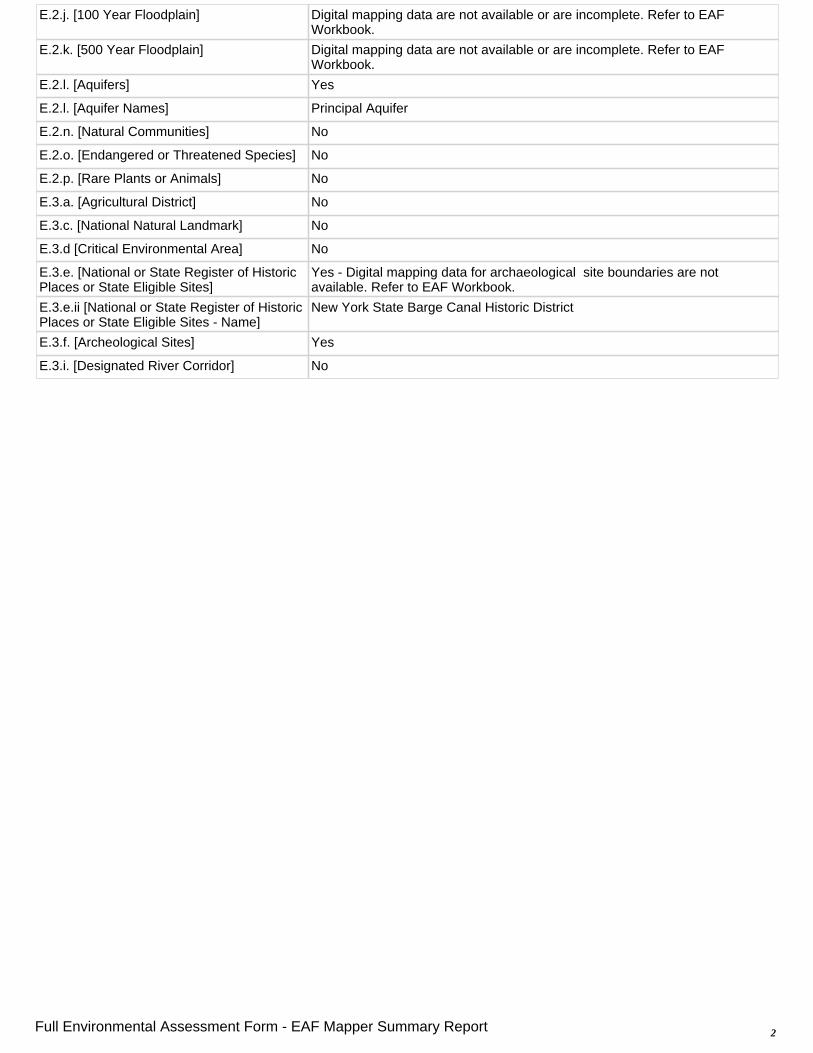
E.2.j. [100 Year Floodplain] Digital mapping data are not available or are incomplete. Refer to EAF Workbook.
E.2.k. [500 Year Floodplain] Digital mapping data are not available or are incomplete. Refer to EAF Workbook.
E.2.l. [Aquifers] Yes
E.2.l. [Aquifer Names] Principal Aquifer
E.2.n. [Natural Communities] No
E.2.o. [Endangered or Threatened Species] No
E.2.p. [Rare Plants or Animals] No
E.3.a. [Agricultural District] No
E.3.c. [National Natural Landmark] No
E.3.d [Critical Environmental Area] No
E.3.e. [National or State Register of Historic Places or State Eligible Sites]
Yes - Digital mapping data for archaeological site boundaries are not available. Refer to EAF Workbook.
E.3.e.ii [National or State Register of Historic Places or State Eligible Sites - Name]
New York State Barge Canal Historic District
E.3.f. [Archeological Sites] Yes
E.3.i. [Designated River Corridor] No
2Full Environmental Assessment Form - EAF Mapper Summary Report