roads and buildings department government of gujarat - world
TRANSCRIPT
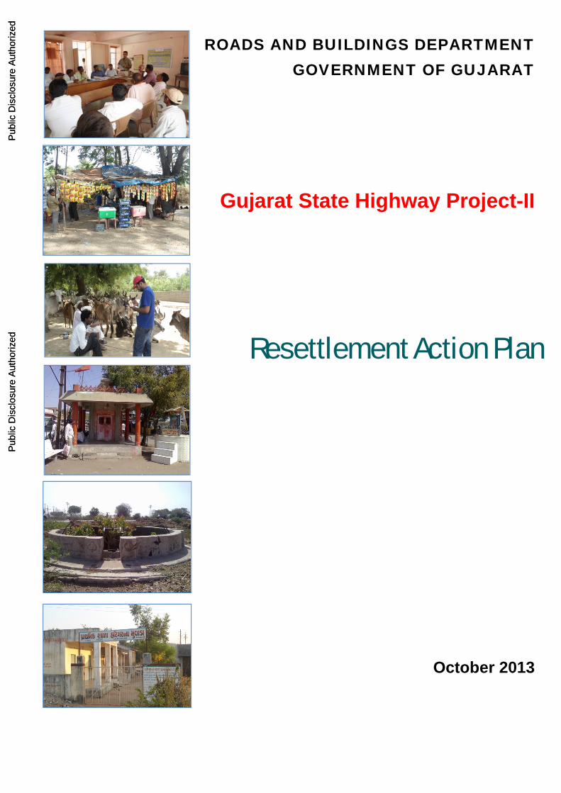
ROADS AND BUILDINGS DEPARTMENT GOVERNMENT OF GUJARAT
Resettlement Action Plan
Gujarat State Highway Project-II
October 2013
Pub
lic D
iscl
osur
e A
utho
rized
Pub
lic D
iscl
osur
e A
utho
rized
Pub
lic D
iscl
osur
e A
utho
rized
Pub
lic D
iscl
osur
e A
utho
rized
Pub
lic D
iscl
osur
e A
utho
rized
Pub
lic D
iscl
osur
e A
utho
rized
Pub
lic D
iscl
osur
e A
utho
rized
Pub
lic D
iscl
osur
e A
utho
rized
i
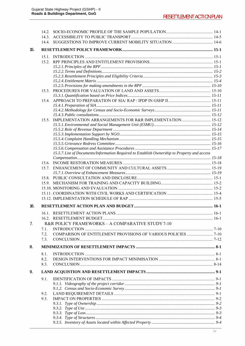
CONTENTS 1. OVERVIEW OF THE PROJECT AND APPROACH FOLLOWED TOWARDS ADDRESSING SOCIAL IMPACTS AND THEIR MITIGATION.............................................................................................. 1-1
1.1. BACKGROUND ............................................................................................................................... 1-1 1.2. OBJECTIVES OF SOCIAL IMPACT ASSESSMENT AND RESETTLEMENT ACTION PLAN –
GSHP – II ........................................................................................................................................... 1-2 1.3. APPROACH TO MINIMIZE LAND ACQUISITION AND ADVERSE SOCIAL IMPACTS IN
GSHP-II ............................................................................................................................................. 1-5 1.3.1. Improvements to be planned within the available RoW .......................................................... 1-5 1.3.2. Adoption of Corridor of Impact (CoI) Approach .................................................................... 1-6 1.3.3. Location specific measures to further minimize impacts within the CoI ................................. 1-7
1.4. SOCIAL SCREENING ...................................................................................................................... 1-9 1.4.1. Preliminary Assessment of Impacts ...................................................................................... 1-10
1.5. METHODOLOGY FOR SOCIAL IMPACT ASSESSMENT AND RESETTLEMENT ACTION PLAN ............................................................................................................................................... 1-10 1.5.1. Review of secondary information .......................................................................................... 1-10 1.5.2. Stakeholder Consultations .................................................................................................... 1-11 1.5.3. Review of Land Acquisition Practices in Gujarat ................................................................. 1-11 1.5.4. Profile of Project Affected Families ...................................................................................... 1-11 1.5.5. Accessibility and Mobility to Transport Facilities in Villages .............................................. 1-11 1.5.6. Preparation of Indigenous Peoples Development Plan ........................................................ 1-12 1.5.7. Preparation of HIV/AIDS Prevention Plan........................................................................... 1-12 1.5.8. Finalization of Resettlement Policy Framework ................................................................... 1-13 1.5.9. Preparation of Resettlement Action Plan .............................................................................. 1-13
1.6. STRUCTURE OF SIA & CONSOLIDATED RAP ........................................................................ 1-13
2. PROJECT DESCRIPTION ........................................................................................................................ 2-1
2.1. LOCATION AND DESCRIPTION OF THE PROJECT ROADS .................................................... 2-1 2.1.1. Lunawada – Khedapa ............................................................................................................. 2-1 2.1.2. Bayad-Lunawada .................................................................................................................... 2-2 2.1.3. Dhansura – Meghraj ............................................................................................................... 2-3 2.1.4. Atkot – Gondal ........................................................................................................................ 2-4 2.1.5. Dhandhuka – Dholera ............................................................................................................ 2-4 2.1.6. Umreth- Vasad (including Ladvel - Kapadvanj) ..................................................................... 2-5 2.1.7. Dabhoi – Bodeli ...................................................................................................................... 2-7 2.1.8. Mehsana – Himatnagar .......................................................................................................... 2-8
2.2. DESIGN INTERVENTIONS ............................................................................................................ 2-9 2.2.1. Upgradation and Rehabilitation Proposals ............................................................................ 2-9 2.2.2. Other Design Measures ........................................................................................................ 2-10
3. SOCIO-ECONOMIC PROFILE OF PROJECT AREA ......................................................................... 3-1
3.1. POPULATION DISTRIBUTION ...................................................................................................... 3-1 3.1.1. Settlements and Population ..................................................................................................... 3-1 3.1.2. Sex Ratio ................................................................................................................................. 3-2 3.1.3. Literacy Rate ........................................................................................................................... 3-2 3.1.4. Work Participation Rate ......................................................................................................... 3-2
3.2. SOCIAL CHARACTERISTICS ........................................................................................................ 3-2 3.3. AGRICULTURAL SCENARIO ........................................................................................................ 3-3
4. LEGAL AND POLICY FRAMEWORK .................................................................................................. 4-1
4.1. INTRODUCTION ............................................................................................................................. 4-1 4.2. LAND ACQUISITION AND RESETTLEMENT ............................................................................. 4-1
4.2.1. Land Acquisition Act (LA Act) ................................................................................................ 4-1 4.2.2. National Policy on Resettlement and Rehabilitation, 2007 .................................................... 4-2 4.2.3. World Bank Safeguard Policies - OP/BP 4.12 – Involuntary Resettlement ............................ 4-3
4.3. TRIBAL DEVELOPMENT ............................................................................................................... 4-3 4.3.1. Scheduled Tribes, Scheduled Areas and Constitution of India ............................................... 4-3 4.3.2. National Rehabilitation and Resettlement Policy, 2007 and R&R Assistance for STs ........... 4-4 4.3.3. The Scheduled Tribes and Other Traditional Forest Dwellers (Recognition of Forest Rights) Act, 2006 ............................................................................................................................................ 4-4
Gujarat State Highway Project (GSHP) - II Roads & Buildings Department, GoG
RESETTLEMENT ACTION PLAN
ii
4.3.4. World Bank Safeguard policies - OP 4.10 - Indigenous People ............................................. 4-5 4.3.5. Scheduled Caste and Scheduled Tribes (Prevention of Atrocities) Act, 1989 ......................... 4-5 4.3.6. Panchayats (Extension to the Scheduled Areas) Act, 1996 ..................................................... 4-5 4.3.7. Constitutional Provisions for Safeguard of SC /ST’S ............................................................. 4-6 4.3.8. Bombay Money Lender’s Act .................................................................................................. 4-7 4.3.9. Bombay Land Revenue (Gujarat Second Amendment) Act, 1980 ........................................... 4-7
5. STAKEHOLDER CONSULTATIONS ..................................................................................................... 5-1
5.1. INTRODUCTION ............................................................................................................................. 5-1 5.2. CONSULTATION PROCESS ........................................................................................................... 5-1
5.2.1. Identification of Stakeholders ................................................................................................. 5-1 5.2.2. Levels of Consultation ............................................................................................................ 5-1
5.3. CONSULTATIONS WITH VARIOUS STAKEHOLDERS ............................................................. 5-2 5.3.1. Consultation with Government Officials ................................................................................. 5-2 5.3.2. Consultation with Non-Governmental Organisations............................................................. 5-4 5.3.3. Consultation with Trucker Community ................................................................................... 5-5 5.3.4. Consultation in Fifth Schedule Areas ..................................................................................... 5-5 5.3.5. Consultation with Women ....................................................................................................... 5-7 5.3.6. Consultations on Cultural Properties and Community Assets ................................................ 5-7 5.3.7. Consultation with Affected Communities ................................................................................ 5-8 5.3.8. Outcomes of Community Consultation ................................................................................. 5-10
5.4. PERCEIVED POSITIVE AND ADVERSE IMPACTS .................................................................. 5-22 5.5. CONCLUSION ................................................................................................................................ 5-22
6. LAND ACQUISITION AND COMPENSATION PRACTICES ............................................................ 6-1
6.1. GUJARAT STATE HIGHWAY PROJECT: LESSONS LEARNED ............................................... 6-1 6.2. REVIEW OF RECENT PRACTICES IN GUJARAT ....................................................................... 6-1
6.2.1. Road Development Projects by GSRDC ................................................................................. 6-1 6.2.2. WB Funded Integrated Coastal Zone Management Project, 2010 ......................................... 6-2 6.2.3. Gujarat Solar Power Transmission Project (GSPTP) ............................................................ 6-2 6.2.4. Land Acquisition by other GoG Agencies ............................................................................... 6-3 6.2.5. Procedures followed by TPVD for land allotment .................................................................. 6-3
6.3. LAND VALUATION AND COMPENSATION: OPTIONS ............................................................ 6-3 6.4. JANTRI / GUIDELINE LAND VALUES ......................................................................................... 6-4 6.5. COMPARISON OF JANTRI VALUES (2006 AND 2011) ALONG THE CORRIDOR ................. 6-8 6.6. CONCLUSION .................................................................................................................................. 6-9
7. R&R POLICY FRAMEWORKS – A COMPARATIVE STUDY ........................................................ 7-10
7.1. INTRODUCTION ........................................................................................................................... 7-10 7.2. COMPARISON OF ENTITLEMENT PROVISIONS OF VARIOUS POLICIES ......................... 7-10 7.3. CONCLUSION ................................................................................................................................ 7-12
8. MINIMIZATION OF RESETTLEMENT IMPACTS ............................................................................ 8-1
8.1. INTRODUCTION ............................................................................................................................. 8-1 8.2. DESIGN INTERVENTIONS FOR IMPACT MINIMISATION ...................................................... 8-1 8.3. CONCLUSION ................................................................................................................................ 8-14
9. LAND ACQUISTION AND RESETTLEMENT IMPACTS .................................................................. 9-1
9.1. IDENTIFICATION OF IMPACTS ................................................................................................... 9-1 9.1.1. Videography of the project corridor ....................................................................................... 9-1 9.1.2. Census and Socio-Economic Survey ....................................................................................... 9-1
9.2. LAND REQUIREMENT DETAILS ................................................................................................. 9-1 9.3. IMPACT ON PROPERTIES ............................................................................................................. 9-2
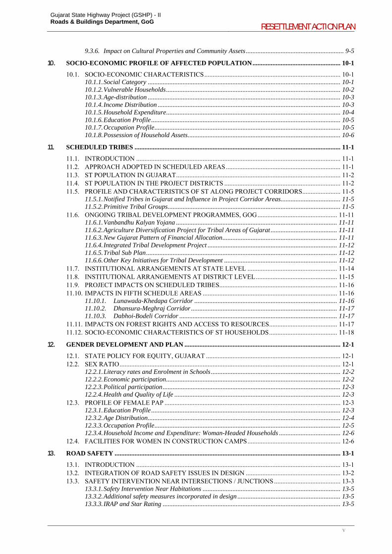
9.3.1. Type of Ownership .................................................................................................................. 9-2 9.3.2. Type of Use ............................................................................................................................. 9-3 9.3.3. Type of Loss ............................................................................................................................ 9-3 9.3.4. Type of Structures ................................................................................................................... 9-4 9.3.5. Inventory of Assets located within Affected Property ............................................................. 9-4 9.3.6. Impact on Cultural Properties and Community Assets ........................................................... 9-5
Gujarat State Highway Project (GSHP) - II Roads & Buildings Department, GoG
RESETTLEMENT ACTION PLAN
iii
10. SOCIO-ECONOMIC PROFILE OF AFFECTED POPULATION ..................................................... 10-1
10.1. SOCIO-ECONOMIC CHARACTERISTICS .................................................................................. 10-1 10.1.1. Social Category .................................................................................................................... 10-1 10.1.2. Vulnerable Households ......................................................................................................... 10-2 10.1.3. Age-distribution .................................................................................................................... 10-3 10.1.4. Income Distribution .............................................................................................................. 10-3 10.1.5. Household Expenditure ......................................................................................................... 10-4 10.1.6. Education Profile .................................................................................................................. 10-5 10.1.7. Occupation Profile ................................................................................................................ 10-5 10.1.8. Possession of Household Assets ............................................................................................ 10-6
11. SCHEDULED TRIBES ............................................................................................................................ 11-1
11.1. INTRODUCTION ........................................................................................................................... 11-1 11.2. APPROACH ADOPTED IN SCHEDULED AREAS ..................................................................... 11-1 11.3. ST POPULATION IN GUJARAT ................................................................................................... 11-2 11.4. ST POPULATION IN THE PROJECT DISTRICTS ...................................................................... 11-2 11.5. PROFILE AND CHARACTERISTICS OF ST ALONG PROJECT CORRIDORS ....................... 11-5
11.5.1. Notified Tribes in Gujarat and Influence in Project Corridor Areas .................................... 11-5 11.5.2. Primitive Tribal Groups ........................................................................................................ 11-5
11.6. ONGOING TRIBAL DEVELOPMENT PROGRAMMES, GOG ................................................ 11-11 11.6.1. Vanbandhu Kalyan Yojana ................................................................................................. 11-11 11.6.2. Agriculture Diversification Project for Tribal Areas of Gujarat ........................................ 11-11 11.6.3. New Gujarat Pattern of Financial Allocation ..................................................................... 11-11 11.6.4. Integrated Tribal Development Project .............................................................................. 11-12 11.6.5. Tribal Sub Plan ................................................................................................................... 11-12 11.6.6. Other Key Initiatives for Tribal Development .................................................................... 11-12
11.7. INSTITUTIONAL ARRANGEMENTS AT STATE LEVEL ...................................................... 11-14 11.8. INSTITUTIONAL ARRANGEMENTS AT DISTRICT LEVEL ................................................. 11-15 11.9. PROJECT IMPACTS ON SCHEDULED TRIBES ....................................................................... 11-16 11.10. IMPACTS IN FIFTH SCHEDULE AREAS ................................................................................. 11-16
11.10.1. Lunawada-Khedapa Corridor ...................................................................................... 11-16 11.10.2. Dhansura-Meghraj Corridor ........................................................................................ 11-17 11.10.3. Dabhoi-Bodeli Corridor ............................................................................................... 11-17
11.11. IMPACTS ON FOREST RIGHTS AND ACCESS TO RESOURCES ......................................... 11-17 11.12. SOCIO-ECONOMIC CHARACTERISTICS OF ST HOUSEHOLDS ......................................... 11-18
12. GENDER DEVELOPMENT AND PLAN .............................................................................................. 12-1
12.1. STATE POLICY FOR EQUITY, GUJARAT ................................................................................. 12-1 12.2. SEX RATIO ..................................................................................................................................... 12-1
12.2.1. Literacy rates and Enrolment in Schools .............................................................................. 12-2 12.2.2. Economic participation ......................................................................................................... 12-2 12.2.3. Political participation ........................................................................................................... 12-3 12.2.4. Health and Quality of Life .................................................................................................... 12-3
12.3. PROFILE OF FEMALE PAP .......................................................................................................... 12-3 12.3.1. Education Profile .................................................................................................................. 12-3 12.3.2. Age Distribution .................................................................................................................... 12-4 12.3.3. Occupation Profile ................................................................................................................ 12-5 12.3.4. Household Income and Expenditure: Woman-Headed Households ..................................... 12-6
12.4. FACILITIES FOR WOMEN IN CONSTRUCTION CAMPS ........................................................ 12-6
13. ROAD SAFETY ........................................................................................................................................ 13-1
13.1. INTRODUCTION ........................................................................................................................... 13-1 13.2. INTEGRATION OF ROAD SAFETY ISSUES IN DESIGN ......................................................... 13-2 13.3. SAFETY INTERVENTION NEAR INTERSECTIONS / JUNCTIONS ........................................ 13-3
13.3.1. Safety Intervention Near Habitations ................................................................................... 13-5 13.3.2. Additional safety measures incorporated in design .............................................................. 13-5 13.3.3. IRAP and Star Rating ........................................................................................................... 13-5
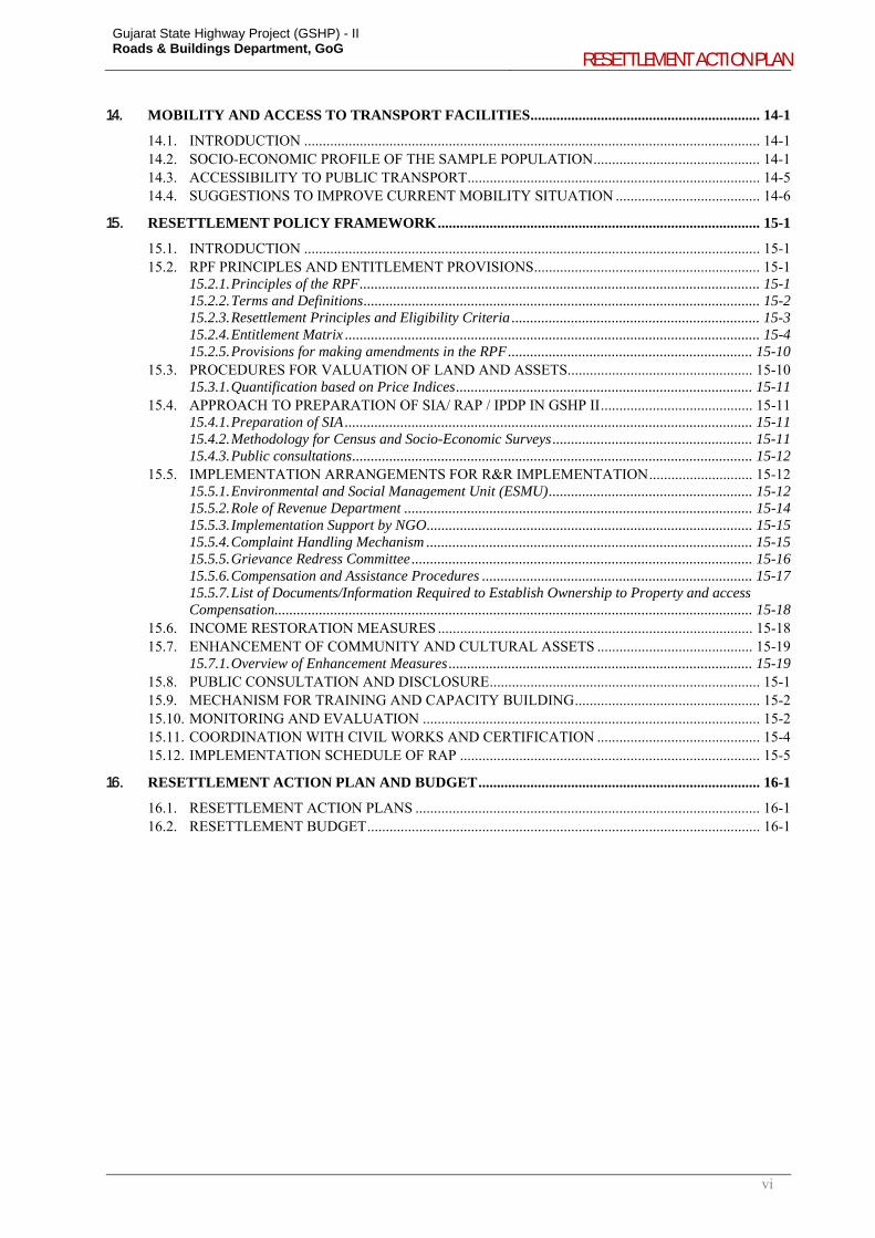
14. MOBILITY AND ACCESS TO TRANSPORT FACILITIES .............................................................. 14-1
14.1. INTRODUCTION ........................................................................................................................... 14-1
Gujarat State Highway Project (GSHP) - II Roads & Buildings Department, GoG
RESETTLEMENT ACTION PLAN
iv
14.2. SOCIO-ECONOMIC PROFILE OF THE SAMPLE POPULATION ............................................. 14-1 14.3. ACCESSIBILITY TO PUBLIC TRANSPORT ............................................................................... 14-5 14.4. SUGGESTIONS TO IMPROVE CURRENT MOBILITY SITUATION ....................................... 14-6
15. RESETTLEMENT POLICY FRAMEWORK ....................................................................................... 15-1
15.1. INTRODUCTION ........................................................................................................................... 15-1 15.2. RPF PRINCIPLES AND ENTITLEMENT PROVISIONS ............................................................. 15-1
15.2.1. Principles of the RPF ............................................................................................................ 15-1 15.2.2. Terms and Definitions ........................................................................................................... 15-2 15.2.3. Resettlement Principles and Eligibility Criteria ................................................................... 15-3 15.2.4. Entitlement Matrix ................................................................................................................ 15-4 15.2.5. Provisions for making amendments in the RPF .................................................................. 15-10
15.3. PROCEDURES FOR VALUATION OF LAND AND ASSETS .................................................. 15-10 15.3.1. Quantification based on Price Indices ................................................................................ 15-11
15.4. APPROACH TO PREPARATION OF SIA/ RAP / IPDP IN GSHP II ......................................... 15-11 15.4.1. Preparation of SIA .............................................................................................................. 15-11 15.4.2. Methodology for Census and Socio-Economic Surveys ...................................................... 15-11 15.4.3. Public consultations ............................................................................................................ 15-12
15.5. IMPLEMENTATION ARRANGEMENTS FOR R&R IMPLEMENTATION ............................ 15-12 15.5.1. Environmental and Social Management Unit (ESMU) ....................................................... 15-12 15.5.2. Role of Revenue Department .............................................................................................. 15-14 15.5.3. Implementation Support by NGO ........................................................................................ 15-15 15.5.4. Complaint Handling Mechanism ........................................................................................ 15-15 15.5.5. Grievance Redress Committee ............................................................................................ 15-16 15.5.6. Compensation and Assistance Procedures ......................................................................... 15-17 15.5.7. List of Documents/Information Required to Establish Ownership to Property and access Compensation................................................................................................................................. 15-18
15.6. INCOME RESTORATION MEASURES ..................................................................................... 15-18 15.7. ENHANCEMENT OF COMMUNITY AND CULTURAL ASSETS .......................................... 15-19
15.7.1. Overview of Enhancement Measures .................................................................................. 15-19 15.8. PUBLIC CONSULTATION AND DISCLOSURE ......................................................................... 15-1 15.9. MECHANISM FOR TRAINING AND CAPACITY BUILDING .................................................. 15-2 15.10. MONITORING AND EVALUATION ........................................................................................... 15-2 15.11. COORDINATION WITH CIVIL WORKS AND CERTIFICATION ............................................ 15-4 15.12. IMPLEMENTATION SCHEDULE OF RAP ................................................................................. 15-5
16. RESETTLEMENT ACTION PLAN AND BUDGET ............................................................................ 16-1
16.1. RESETTLEMENT ACTION PLANS ............................................................................................. 16-1 16.2. RESETTLEMENT BUDGET .......................................................................................................... 16-1
7. R&R POLICY FRAMEWORKS – A COMPARATIVE STUDY 7-10 7.1. INTRODUCTION ........................................................................................................................... 7-10 7.2. COMPARISON OF ENTITLEMENT PROVISIONS OF VARIOUS POLICIES ......................... 7-10 7.3. CONCLUSION ................................................................................................................................ 7-12
8. MINIMIZATION OF RESETTLEMENT IMPACTS ............................................................................ 8-1
8.1. INTRODUCTION ............................................................................................................................. 8-1 8.2. DESIGN INTERVENTIONS FOR IMPACT MINIMISATION ...................................................... 8-1 8.3. CONCLUSION ................................................................................................................................ 8-14
9. LAND ACQUISTION AND RESETTLEMENT IMPACTS .................................................................. 9-1
9.1. IDENTIFICATION OF IMPACTS ................................................................................................... 9-1 9.1.1. Videography of the project corridor ....................................................................................... 9-1 9.1.2. Census and Socio-Economic Survey ....................................................................................... 9-1
9.2. LAND REQUIREMENT DETAILS ................................................................................................. 9-1 9.3. IMPACT ON PROPERTIES ............................................................................................................. 9-2
9.3.1. Type of Ownership .................................................................................................................. 9-2 9.3.2. Type of Use ............................................................................................................................. 9-3 9.3.3. Type of Loss ............................................................................................................................ 9-3 9.3.4. Type of Structures ................................................................................................................... 9-4 9.3.5. Inventory of Assets located within Affected Property ............................................................. 9-4
Gujarat State Highway Project (GSHP) - II Roads & Buildings Department, GoG
RESETTLEMENT ACTION PLAN
v
9.3.6. Impact on Cultural Properties and Community Assets ........................................................... 9-5
10. SOCIO-ECONOMIC PROFILE OF AFFECTED POPULATION ..................................................... 10-1
10.1. SOCIO-ECONOMIC CHARACTERISTICS .................................................................................. 10-1 10.1.1. Social Category .................................................................................................................... 10-1 10.1.2. Vulnerable Households ......................................................................................................... 10-2 10.1.3. Age-distribution .................................................................................................................... 10-3 10.1.4. Income Distribution .............................................................................................................. 10-3 10.1.5. Household Expenditure ......................................................................................................... 10-4 10.1.6. Education Profile .................................................................................................................. 10-5 10.1.7. Occupation Profile ................................................................................................................ 10-5 10.1.8. Possession of Household Assets ............................................................................................ 10-6
11. SCHEDULED TRIBES ............................................................................................................................ 11-1
11.1. INTRODUCTION ........................................................................................................................... 11-1 11.2. APPROACH ADOPTED IN SCHEDULED AREAS ..................................................................... 11-1 11.3. ST POPULATION IN GUJARAT ................................................................................................... 11-2 11.4. ST POPULATION IN THE PROJECT DISTRICTS ...................................................................... 11-2 11.5. PROFILE AND CHARACTERISTICS OF ST ALONG PROJECT CORRIDORS ....................... 11-5
11.5.1. Notified Tribes in Gujarat and Influence in Project Corridor Areas .................................... 11-5 11.5.2. Primitive Tribal Groups ........................................................................................................ 11-5
11.6. ONGOING TRIBAL DEVELOPMENT PROGRAMMES, GOG ................................................ 11-11 11.6.1. Vanbandhu Kalyan Yojana ................................................................................................. 11-11 11.6.2. Agriculture Diversification Project for Tribal Areas of Gujarat ........................................ 11-11 11.6.3. New Gujarat Pattern of Financial Allocation ..................................................................... 11-11 11.6.4. Integrated Tribal Development Project .............................................................................. 11-12 11.6.5. Tribal Sub Plan ................................................................................................................... 11-12 11.6.6. Other Key Initiatives for Tribal Development .................................................................... 11-12
11.7. INSTITUTIONAL ARRANGEMENTS AT STATE LEVEL ...................................................... 11-14 11.8. INSTITUTIONAL ARRANGEMENTS AT DISTRICT LEVEL ................................................. 11-15 11.9. PROJECT IMPACTS ON SCHEDULED TRIBES ....................................................................... 11-16 11.10. IMPACTS IN FIFTH SCHEDULE AREAS ................................................................................. 11-16
11.10.1. Lunawada-Khedapa Corridor ...................................................................................... 11-16 11.10.2. Dhansura-Meghraj Corridor ........................................................................................ 11-17 11.10.3. Dabhoi-Bodeli Corridor ............................................................................................... 11-17
11.11. IMPACTS ON FOREST RIGHTS AND ACCESS TO RESOURCES ......................................... 11-17 11.12. SOCIO-ECONOMIC CHARACTERISTICS OF ST HOUSEHOLDS ......................................... 11-18
12. GENDER DEVELOPMENT AND PLAN .............................................................................................. 12-1
12.1. STATE POLICY FOR EQUITY, GUJARAT ................................................................................. 12-1 12.2. SEX RATIO ..................................................................................................................................... 12-1
12.2.1. Literacy rates and Enrolment in Schools .............................................................................. 12-2 12.2.2. Economic participation ......................................................................................................... 12-2 12.2.3. Political participation ........................................................................................................... 12-3 12.2.4. Health and Quality of Life .................................................................................................... 12-3
12.3. PROFILE OF FEMALE PAP .......................................................................................................... 12-3 12.3.1. Education Profile .................................................................................................................. 12-3 12.3.2. Age Distribution .................................................................................................................... 12-4 12.3.3. Occupation Profile ................................................................................................................ 12-5 12.3.4. Household Income and Expenditure: Woman-Headed Households ..................................... 12-6
12.4. FACILITIES FOR WOMEN IN CONSTRUCTION CAMPS ........................................................ 12-6
13. ROAD SAFETY ........................................................................................................................................ 13-1
13.1. INTRODUCTION ........................................................................................................................... 13-1 13.2. INTEGRATION OF ROAD SAFETY ISSUES IN DESIGN ......................................................... 13-2 13.3. SAFETY INTERVENTION NEAR INTERSECTIONS / JUNCTIONS ........................................ 13-3
13.3.1. Safety Intervention Near Habitations ................................................................................... 13-5 13.3.2. Additional safety measures incorporated in design .............................................................. 13-5 13.3.3. IRAP and Star Rating ........................................................................................................... 13-5
Gujarat State Highway Project (GSHP) - II Roads & Buildings Department, GoG
RESETTLEMENT ACTION PLAN
vi
14. MOBILITY AND ACCESS TO TRANSPORT FACILITIES .............................................................. 14-1
14.1. INTRODUCTION ........................................................................................................................... 14-1 14.2. SOCIO-ECONOMIC PROFILE OF THE SAMPLE POPULATION ............................................. 14-1 14.3. ACCESSIBILITY TO PUBLIC TRANSPORT ............................................................................... 14-5 14.4. SUGGESTIONS TO IMPROVE CURRENT MOBILITY SITUATION ....................................... 14-6
15. RESETTLEMENT POLICY FRAMEWORK ....................................................................................... 15-1
15.1. INTRODUCTION ........................................................................................................................... 15-1 15.2. RPF PRINCIPLES AND ENTITLEMENT PROVISIONS ............................................................. 15-1
15.2.1. Principles of the RPF ............................................................................................................ 15-1 15.2.2. Terms and Definitions ........................................................................................................... 15-2 15.2.3. Resettlement Principles and Eligibility Criteria ................................................................... 15-3 15.2.4. Entitlement Matrix ................................................................................................................ 15-4 15.2.5. Provisions for making amendments in the RPF .................................................................. 15-10
15.3. PROCEDURES FOR VALUATION OF LAND AND ASSETS .................................................. 15-10 15.3.1. Quantification based on Price Indices ................................................................................ 15-11
15.4. APPROACH TO PREPARATION OF SIA/ RAP / IPDP IN GSHP II ......................................... 15-11 15.4.1. Preparation of SIA .............................................................................................................. 15-11 15.4.2. Methodology for Census and Socio-Economic Surveys ...................................................... 15-11 15.4.3. Public consultations ............................................................................................................ 15-12
15.5. IMPLEMENTATION ARRANGEMENTS FOR R&R IMPLEMENTATION ............................ 15-12 15.5.1. Environmental and Social Management Unit (ESMU) ....................................................... 15-12 15.5.2. Role of Revenue Department .............................................................................................. 15-14 15.5.3. Implementation Support by NGO ........................................................................................ 15-15 15.5.4. Complaint Handling Mechanism ........................................................................................ 15-15 15.5.5. Grievance Redress Committee ............................................................................................ 15-16 15.5.6. Compensation and Assistance Procedures ......................................................................... 15-17 15.5.7. List of Documents/Information Required to Establish Ownership to Property and access Compensation................................................................................................................................. 15-18
15.6. INCOME RESTORATION MEASURES ..................................................................................... 15-18 15.7. ENHANCEMENT OF COMMUNITY AND CULTURAL ASSETS .......................................... 15-19
15.7.1. Overview of Enhancement Measures .................................................................................. 15-19 15.8. PUBLIC CONSULTATION AND DISCLOSURE ......................................................................... 15-1 15.9. MECHANISM FOR TRAINING AND CAPACITY BUILDING .................................................. 15-2 15.10. MONITORING AND EVALUATION ........................................................................................... 15-2 15.11. COORDINATION WITH CIVIL WORKS AND CERTIFICATION ............................................ 15-4 15.12. IMPLEMENTATION SCHEDULE OF RAP ................................................................................. 15-5
16. RESETTLEMENT ACTION PLAN AND BUDGET ............................................................................ 16-1
16.1. RESETTLEMENT ACTION PLANS ............................................................................................. 16-1 16.2. RESETTLEMENT BUDGET .......................................................................................................... 16-1
Gujarat State Highway Project (GSHP) - II Roads & Buildings Department, GoG
RESETTLEMENT ACTION PLAN
vii
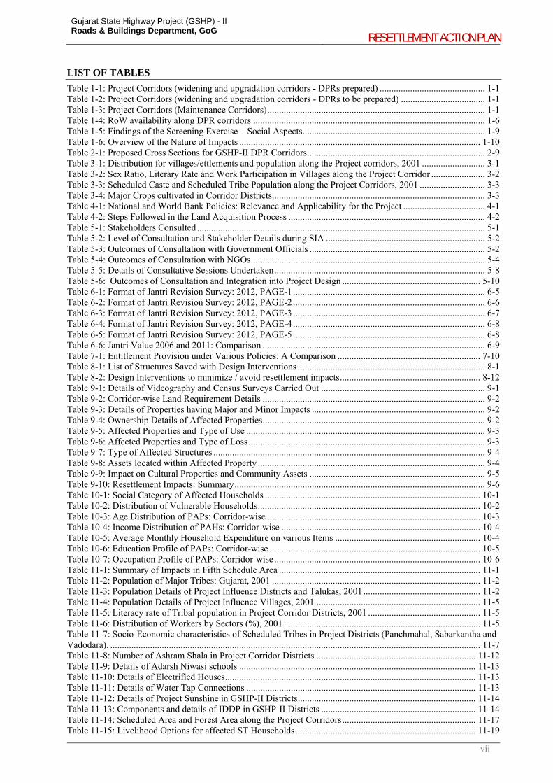
LIST OF TABLES
Table 1-1: Project Corridors (widening and upgradation corridors - DPRs prepared) ............................................. 1-1 Table 1-2: Project Corridors (widening and upgradation corridors - DPRs to be prepared) .................................... 1-1 Table 1-3: Project Corridors (Maintenance Corridors) ............................................................................................. 1-1 Table 1-4: RoW availability along DPR corridors ................................................................................................... 1-6 Table 1-5: Findings of the Screening Exercise – Social Aspects .............................................................................. 1-9 Table 1-6: Overview of the Nature of Impacts ....................................................................................................... 1-10 Table 2-1: Proposed Cross Sections for GSHP-II DPR Corridors ............................................................................ 2-9 Table 3-1: Distribution for villages/ettlements and population along the Project corridors, 2001 ........................... 3-1 Table 3-2: Sex Ratio, Literary Rate and Work Participation in Villages along the Project Corridor ....................... 3-2 Table 3-3: Scheduled Caste and Scheduled Tribe Population along the Project Corridors, 2001 ............................ 3-3 Table 3-4: Major Crops cultivated in Corridor Districts ........................................................................................... 3-3 Table 4-1: National and World Bank Policies: Relevance and Applicability for the Project ................................... 4-1 Table 4-2: Steps Followed in the Land Acquisition Process .................................................................................... 4-2 Table 5-1: Stakeholders Consulted ........................................................................................................................... 5-1 Table 5-2: Level of Consultation and Stakeholder Details during SIA .................................................................... 5-2 Table 5-3: Outcomes of Consultation with Government Officials ........................................................................... 5-2 Table 5-4: Outcomes of Consultation with NGOs .................................................................................................... 5-4 Table 5-5: Details of Consultative Sessions Undertaken .......................................................................................... 5-8 Table 5-6: Outcomes of Consultation and Integration into Project Design ........................................................... 5-10 Table 6-1: Format of Jantri Revision Survey: 2012, PAGE-1 .................................................................................. 6-5 Table 6-2: Format of Jantri Revision Survey: 2012, PAGE-2 .................................................................................. 6-6 Table 6-3: Format of Jantri Revision Survey: 2012, PAGE-3 .................................................................................. 6-7 Table 6-4: Format of Jantri Revision Survey: 2012, PAGE-4 .................................................................................. 6-8 Table 6-5: Format of Jantri Revision Survey: 2012, PAGE-5 .................................................................................. 6-8 Table 6-6: Jantri Value 2006 and 2011: Comparison ............................................................................................... 6-9 Table 7-1: Entitlement Provision under Various Policies: A Comparison ............................................................. 7-10 Table 8-1: List of Structures Saved with Design Interventions ................................................................................ 8-1 Table 8-2: Design Interventions to minimize / avoid resettlement impacts ............................................................ 8-12 Table 9-1: Details of Videography and Census Surveys Carried Out ...................................................................... 9-1 Table 9-2: Corridor-wise Land Requirement Details ............................................................................................... 9-2 Table 9-3: Details of Properties having Major and Minor Impacts .......................................................................... 9-2 Table 9-4: Ownership Details of Affected Properties ............................................................................................... 9-2 Table 9-5: Affected Properties and Type of Use ...................................................................................................... 9-3 Table 9-6: Affected Properties and Type of Loss ..................................................................................................... 9-3 Table 9-7: Type of Affected Structures .................................................................................................................... 9-4 Table 9-8: Assets located within Affected Property ................................................................................................. 9-4 Table 9-9: Impact on Cultural Properties and Community Assets ........................................................................... 9-5 Table 9-10: Resettlement Impacts: Summary ........................................................................................................... 9-6 Table 10-1: Social Category of Affected Households ............................................................................................ 10-1 Table 10-2: Distribution of Vulnerable Households ............................................................................................... 10-2 Table 10-3: Age Distribution of PAPs: Corridor-wise ........................................................................................... 10-3 Table 10-4: Income Distribution of PAHs: Corridor-wise ..................................................................................... 10-4 Table 10-5: Average Monthly Household Expenditure on various Items .............................................................. 10-4 Table 10-6: Education Profile of PAPs: Corridor-wise .......................................................................................... 10-5 Table 10-7: Occupation Profile of PAPs: Corridor-wise ........................................................................................ 10-6 Table 11-1: Summary of Impacts in Fifth Schedule Area ...................................................................................... 11-1 Table 11-2: Population of Major Tribes: Gujarat, 2001 ......................................................................................... 11-2 Table 11-3: Population Details of Project Influence Districts and Talukas, 2001 .................................................. 11-2 Table 11-4: Population Details of Project Influence Villages, 2001 ...................................................................... 11-5 Table 11-5: Literacy rate of Tribal population in Project Corridor Districts, 2001 ................................................ 11-5 Table 11-6: Distribution of Workers by Sectors (%), 2001 .................................................................................... 11-5 Table 11-7: Socio-Economic characteristics of Scheduled Tribes in Project Districts (Panchmahal, Sabarkantha and Vadodara). .............................................................................................................................................................. 11-7 Table 11-8: Number of Ashram Shala in Project Corridor Districts .................................................................... 11-12 Table 11-9: Details of Adarsh Niwasi schools ..................................................................................................... 11-13 Table 11-10: Details of Electrified Houses ........................................................................................................... 11-13 Table 11-11: Details of Water Tap Connections .................................................................................................. 11-13 Table 11-12: Details of Project Sunshine in GSHP-II Districts ............................................................................ 11-14 Table 11-13: Components and details of IDDP in GSHP-II Districts .................................................................. 11-14 Table 11-14: Scheduled Area and Forest Area along the Project Corridors ......................................................... 11-17 Table 11-15: Livelihood Options for affected ST Households ............................................................................. 11-19
Gujarat State Highway Project (GSHP) - II Roads & Buildings Department, GoG
RESETTLEMENT ACTION PLAN
viii
Table 12-1: Juvenile Sex ratio in Project corridors, 2001 ....................................................................................... 12-1 Table 12-2 : Percentage of girls to boys enrolled in primary school in project district, 2001 ................................ 12-2 Table 12-3: Female WPR for Project districts, 2001 (in %) ................................................................................... 12-2 Table 12-4: Education Profile of Female PAPs: Corridor-wise .............................................................................. 12-4 Table 12-5: Age Distribution of Female PAPs: Corridor-wise ............................................................................... 12-4 Table 12-6: Occupation Profile of Female PAPs: Corridor-wise ........................................................................... 12-5 Table 13-1: Activity Schedule and SIA inputs for Road Safety ............................................................................. 13-1 Table 13-2: Integration of Road Safety Issues into Project Design – An illustration ............................................. 13-2 Table 13-3: Safety Interventions for Curves Incorporated in Final Design ............................................................ 13-2 Table 13-4: Safety Interventions near Intersections/Junctions Incorporated in Final Design ................................. 13-3 Table 13-5: Safety Interventions near Habitations Incorporated in Final Design ................................................... 13-5 Table 13-6: Star Rating before and after the Design: Dhansura-Meghraj Corridor ................................................ 13-6 Table 14-1: Sample Size for mobility surveys ........................................................................................................ 14-1 Table 14-2: Population Composition ...................................................................................................................... 14-1 Table 14-3: Age Distribution among Sample Population ....................................................................................... 14-2 Table 14-4: Education Profile (% population) ........................................................................................................ 14-2 Table 14-5: WPR and Occupation Profile (% population) ..................................................................................... 14-2 Table 14-6: Household Income Profile and Dependency Ratio (% population) ..................................................... 14-3 Table 14-7: Trip Information by Income Group ..................................................................................................... 14-3 Table 14-8: Mode of Travel for Usual Trips .......................................................................................................... 14-3 Table 14-9: Frequency of Travel for Different Purposes ........................................................................................ 14-5 Table 14-10: Travel Expenditure (Rs.) ................................................................................................................... 14-5 Table 14-11: Distance to Bus/Chakda Stop from Home (in meters) ...................................................................... 14-5 Table 14-12: Frequency and Regularity of Bus and Chakda Services ................................................................... 14-6 Table 15-1: Entitlement Matrix .............................................................................................................................. 15-4 Table 15-2: Properties selected for enhancements under GSHP-II ........................................................................ 15-1 Table 15.3: Monitoring Indicators for Physical Progress ....................................................................................... 15-3 Table 15.4: Monitoring Indicators for Financial Progress ...................................................................................... 15-3 Table 15.5: Monitoring of Grievance Redress ........................................................................................................ 15-3 Table 15.6: Illustrative Evaluation Indicators of Atkot-Gondal Corridor ............................................................... 15-4 Table 15.7: RAP Implementation Schedule ........................................................................................................... 15-6 Table 16-1: Resettlement Budget ........................................................................................................................... 16-1
Gujarat State Highway Project (GSHP) - II Roads & Buildings Department, GoG
RESETTLEMENT ACTION PLAN
ix
LIST OF FIGURES
Figure 1-1: Project Corridors - location .................................................................................................................... 1-4 Figure 1-2: Corridor of Impact and Right of Way - Illustration ............................................................................... 1-7 Figure 1-3: Minimization of impacts – Ghogavadhar Village, Atkot-Gondal .......................................................... 1-8 Figure 1-4: Iterative approach towards minimizing land acquisition and resettlement impacts ............................... 1-8 Figure 2-1: Key map of Lunawada – Khedapa ......................................................................................................... 2-1 Figure 2-2: Key map of Bayad-Lunawada ............................................................................................................... 2-2 Figure 2-3: Key map of Dhansura – Meghraj ........................................................................................................... 2-3 Figure 2-4: Key map of Atkot – Gondal ................................................................................................................... 2-4 Figure 2-5: Key map of Dhandhuka – Dholera ........................................................................................................ 2-5 Figure 2-6: Key map of Umreth-Vasad (including Ladvel-Kapadvanj) ................................................................... 2-6 Figure 2-7: Key map of Dabhoi – Bodeli ................................................................................................................. 2-7 Figure 2-8: Typical Cross Section for 2 Lanes with Paved and Hard Shoulder (2L+PS+HS) Option ..................... 2-9 Figure 2-9: Typical Rural Cross Section for 2 Lanes with Hard Shoulder (2L+HS) Option .................................... 2-9 Figure 2-10: Typical Urban Cross Section for 4 Lanes with Hard Shoulder (4L+HS) with Drain Option ............ 2-10 Figure 2-11: Typical Urban Cross Section for 4 Lanes with Hard Shoulder (4L+HS) with Foot Path and Closed Drain Option ........................................................................................................................................................... 2-10 Figure 5-1: Snapshots of Stakeholders consultations ............................................................................................... 5-9 Figure 8-1: Sample Design Interventions for Impact Minimisation ....................................................................... 8-11 Figure 10-1: Social Category of Affected Households [n=384] ............................................................................. 10-2 Figure 10-2: Vulnerable Category of Affected Households [n=112] ..................................................................... 10-2 Figure 10-3: Age Distribution of PAPs [n=2107]................................................................................................... 10-3 Figure 10-4: Income Distribution (monthly household income in INR) of PAHs [n=364]: All Corridors ............ 10-4 Figure 10-5: Education Profile of PAPs: All Corridors .......................................................................................... 10-5 Figure 10-6: Occupation Profile of PAPs: All Corridors [n=631] .......................................................................... 10-6 Figure 10-7: Possession of Household Assets (% of Households) [n=384] ........................................................... 10-7 Figure 11-1: Tribal Concentration in Talukas ........................................................................................................ 11-4 Figure 11-2: Tribal Development Department: Organogram ............................................................................... 11-15 Figure 11-3: Institutional Arrangement at District Level ..................................................................................... 11-16 Figure 12-1: Education Profile of Female PAPs (n=980) ....................................................................................... 12-3 Figure 12-2: Age Profile of Female PAPs (n=980) ................................................................................................ 12-4 Figure 12-3: Occupation Profile of Female PAPs (n=79)....................................................................................... 12-5 Figure 12-4: Income Distribution: Woman-Headed Households (number of households) .................................... 12-6 Figure 12-5: Household Expenditure: Woman Headed Households (in Rs.) ......................................................... 12-6 Figure 14-1: Mode of Travel to Workplace/agriculture field ................................................................................. 14-4 Figure 14-2: Mode of Travel to School .................................................................................................................. 14-4 Figure 14-3: Mode of Travel to Local Market ........................................................................................................ 14-4 Figure 14-4: Mode of Travel for Social Trips ........................................................................................................ 14-4 Figure 14-5: Mode to Travel to Hospital ................................................................................................................ 14-4 Figure 14-6: Mode of Travel to Block Headquarter ............................................................................................... 14-4 Figure 14-7: Mode to Travel to Agriculture Market ............................................................................................... 14-4 Figure 14-8: Mode to Travel to Nearby Town ........................................................................................................ 14-4 Figure 14-9: Suggestion to Improve Present Transport Situation (% of population) ............................................. 14-6 Figure 15-1: Implementation Arrangements ......................................................................................................... 15-13 Figure 15-2: Grievance Redress Mechanism ........................................................................................................ 15-17
Gujarat State Highway Project (GSHP) - II Roads & Buildings Department, GoG
RESETTLEMENT ACTION PLAN
x
ABBREVIATIONS
AIDS - Acquired Immune Deficiency Syndrome
BPL - Below Poverty Line
CHO - Complaint Handling Officer
CoI - Corridor of Impact
DSIRDA - Dholera Special Investment Region Development Authority
ESMU - Environmental and Social Management Unit
FGD - Focused Group Discussion
GoG - Government of Gujarat
GSACS - Gujarat State Aids Control Society
GSHP - Gujarat State Highways Project
GWSSB - Gujarat Water Supply and Sewerage Board
Ha - Hectare
HH - Household
HIV - Human Immunodeficiency Virus
HPP - HIV/AIDS Prevention Plan
IPDP - Indigenous Peoples Development Plan
Km - Kilometre
LA - Land Acquisition
LASA - LEA Associates South Asia Pvt. Ltd.
LHS - Left Hand Side
MDR - Major District Road
M&E - Monitoring and Evaluation
NGO - Non-Governmental Organization
NRRP - National Rehabilitation and Resettlement Policy
OBC - Other Backward Classes
OP - Operational Policy
PAF - Project Affected Family
PAP - Project Affected Person
PIU - Project Implementation Unit
R&BD - Roads and Buildings Department
R&R - Resettlement and Rehabilitation
RAP - Resettlement Action Plan
RHS - Right Hand Side
RoW - Right of Way
RPF - Resettlement Policy Framework
SC - Scheduled Caste
SH - State Highway
SIA - Social Impact Assessment
sq.m - Square Meter
ST - Scheduled Tribe
TCIF - Transport Corporation of India Foundation
WHH - Woman Headed Household
WPR - Workforce Participation Ratio
1-1
1. OVERVIEW OF THE PROJECT AND APPROACH FOLLOWED TOWARDS ADDRESSING SOCIAL IMPACTS AND THEIR MITIGATION
1.1. BACKGROUND
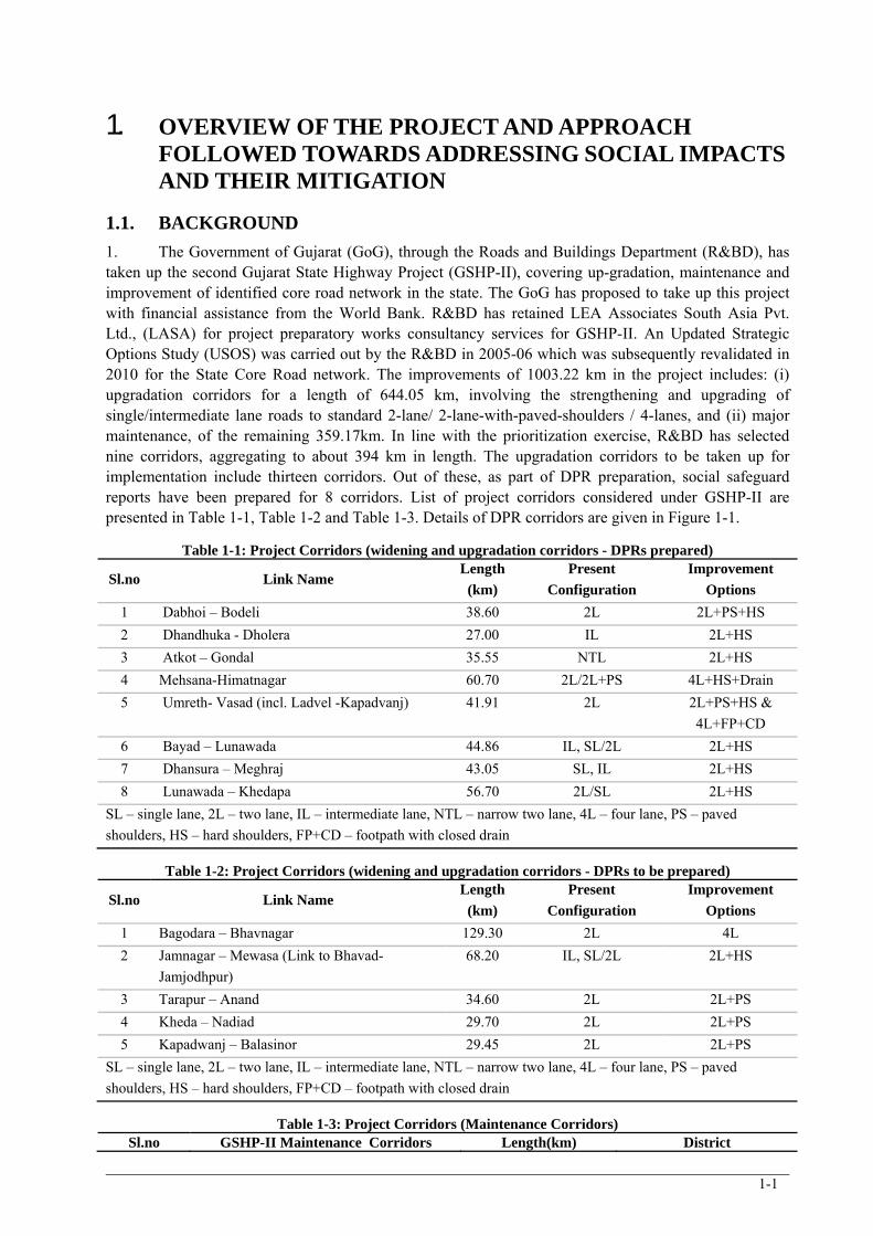
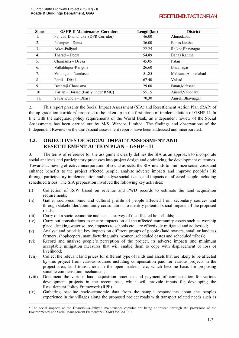
1. The Government of Gujarat (GoG), through the Roads and Buildings Department (R&BD), has taken up the second Gujarat State Highway Project (GSHP-II), covering up-gradation, maintenance and improvement of identified core road network in the state. The GoG has proposed to take up this project with financial assistance from the World Bank. R&BD has retained LEA Associates South Asia Pvt. Ltd., (LASA) for project preparatory works consultancy services for GSHP-II. An Updated Strategic Options Study (USOS) was carried out by the R&BD in 2005-06 which was subsequently revalidated in 2010 for the State Core Road network. The improvements of 1003.22 km in the project includes: (i) upgradation corridors for a length of 644.05 km, involving the strengthening and upgrading of single/intermediate lane roads to standard 2-lane/ 2-lane-with-paved-shoulders / 4-lanes, and (ii) major maintenance, of the remaining 359.17km. In line with the prioritization exercise, R&BD has selected nine corridors, aggregating to about 394 km in length. The upgradation corridors to be taken up for implementation include thirteen corridors. Out of these, as part of DPR preparation, social safeguard reports have been prepared for 8 corridors. List of project corridors considered under GSHP-II are presented in Table 1-1, Table 1-2 and Table 1-3. Details of DPR corridors are given in Figure 1-1.
Table 1-1: Project Corridors (widening and upgradation corridors - DPRs prepared)
Sl.no Link Name Length
(km)
Present
Configuration
Improvement
Options
1 Dabhoi – Bodeli 38.60 2L 2L+PS+HS
2 Dhandhuka - Dholera 27.00 IL 2L+HS
3 Atkot – Gondal 35.55 NTL 2L+HS
4 Mehsana-Himatnagar 60.70 2L/2L+PS 4L+HS+Drain
5 Umreth- Vasad (incl. Ladvel -Kapadvanj) 41.91 2L 2L+PS+HS &
4L+FP+CD
6 Bayad – Lunawada 44.86 IL, SL/2L 2L+HS
7 Dhansura – Meghraj 43.05 SL, IL 2L+HS
8 Lunawada – Khedapa 56.70 2L/SL 2L+HS
SL – single lane, 2L – two lane, IL – intermediate lane, NTL – narrow two lane, 4L – four lane, PS – paved
shoulders, HS – hard shoulders, FP+CD – footpath with closed drain
Table 1-2: Project Corridors (widening and upgradation corridors - DPRs to be prepared)
Sl.no Link Name Length
(km)
Present
Configuration
Improvement
Options
1 Bagodara – Bhavnagar 129.30 2L 4L
2 Jamnagar – Mewasa (Link to Bhavad-
Jamjodhpur)
68.20 IL, SL/2L 2L+HS
3 Tarapur – Anand 34.60 2L 2L+PS
4 Kheda – Nadiad 29.70 2L 2L+PS
5 Kapadwanj – Balasinor 29.45 2L 2L+PS
SL – single lane, 2L – two lane, IL – intermediate lane, NTL – narrow two lane, 4L – four lane, PS – paved
shoulders, HS – hard shoulders, FP+CD – footpath with closed drain
Table 1-3: Project Corridors (Maintenance Corridors) Sl.no GSHP-II Maintenance Corridors Length(km) District
Gujarat State Highway Project (GSHP) - II Roads & Buildings Department, GoG
RESETTLEMENT ACTION PLAN
1-2
Sl.no GSHP-II Maintenance Corridors Length(km) District 1. Paliyad-Dhandhuka (DPR Corridor) 46.00 Ahmedabad
2. Palanpur – Danta 36.00 Banas kantha
3. Atkot-Paliyad 22.25 Rajkot,Bhavnagar
4. Tharad – Deesa 54.89 Banas Kantha
5. Chanasma – Deesa 45.05 Patan
6. Vallabhipur-Rangola 26.60 Bhavnagar
7. Viramgam–Nandasan 51.85 Mehsana,Ahmedabad
8. Pardi – Dixal 67.40 Valsad
9. Bechraji-Chanasma 29.00 Patan,Mehsana
10. Karjan – Borsad (Partly under RMC) 55.15 Anand,Vadodara
11. Savar Kundla – Dhasa 70.30 Amreli,Bhavnagar
2. This report presents the Social Impact Assessment (SIA) and Resettlement Action Plan (RAP) of the up gradation corridors1 proposed to be taken up in the first phase of implementation of GSHP-II. In line with the safeguard policy requirements of the World Bank, an independent review of the Social Assessments has been carried out by M/S. Wapcos Limited. The findings and observations of the Independent Review on the draft social assessment reports have been addressed and incorporated.
1.2. OBJECTIVES OF SOCIAL IMPACT ASSESSMENT AND RESETTLEMENT ACTION PLAN – GSHP – II
3. The terms of reference for the assignment clearly defines the SIA as an approach to incorporate social analyses and participatory processes into project design and optimizing the development outcomes. Towards achieving effective incorporation of social aspects, the SIA intends to minimize social costs and enhance benefits to the project affected people, analyse adverse impacts and improve people’s life through participatory implementation and analyse social issues and impacts on affected people including scheduled tribes. The SIA preparation involved the following key activities:
(i) Collection of RoW based on revenue and PWD records to estimate the land acquisition requirements;
(ii) Gather socio-economic and cultural profile of people affected from secondary sources and through stakeholder/community consultations to identify potential social impacts of the proposed roads;
(iii) Carry out a socio-economic and census survey of the affected households; (iv) Carry out consultations to ensure impacts on all the affected community assets such as worship
place, drinking water source, impacts to schools etc., are effectively mitigated and addressed; (v) Analyse and prioritise key impacts on different groups of people (land owners, small or landless
farmers, shopkeepers, manufacturing units, women, scheduled castes and scheduled tribes); (vi) Record and analyse people’s perception of the project, its adverse impacts and minimum
acceptable mitigation measures that will enable them to cope with displacement or loss of livelihood;
(vii) Collect the relevant land prices for different type of lands and assets that are likely to be affected by this project from various sources including compensation paid for various projects in the project area, land transactions in the open markets, etc, which become basis for proposing suitable compensation mechanism;
(viii) Document the various land acquisition practices and payment of compensation for various development projects in the recent past, which will provide inputs for developing the Resettlement Policy Framework (RPF).
(ix) Gathering baseline socio-economic data from the sample respondents about the peoples experience in the villages along the proposed project roads with transport related needs such as
1 The social impacts of the Dhandhuka–Paliyad maintenance corridor are being addressed through the provisions of the Environmental and Social Management Framework (ESMF) for GSHP-II.
Gujarat State Highway Project (GSHP) - II Roads & Buildings Department, GoG
RESETTLEMENT ACTION PLAN
1-3
agricultural activities, rural marketing, health, education, travel to nearby towns, etc. which will become baseline for measuring the impact in this aspect after the roads are improved in these areas;
Gujarat State Highway Project (GSHP) - II Roads & Buildings Department, GoG RESETTLEMENT ACTION PLAN
1-4
Figure 1-1: Project Corridors - location
Gujarat State Highway Project (GSHP) - II Roads & Buildings Department, GoG
RESETTLEMENT ACTION PLAN
1-5
(x) For project roads planned to be implemented in the Tribal areas, assess the current socio-cultural living style of the tribal and come out with an approach in line with the World Bank’s Operational policy on Indigenous Peoples (OP 4.10). The assessment shall provide inputs to prepare the “Indigenous Peoples Development Plan” along the project roads in the tribal areas;
(xi) Assess issues with respect to mobility pattern of the High Risk Groups and analyse potential risks pertaining to HIV/AIDS on the construction workers, project personnel and the communities along the corridors. This assessment shall provide inputs to the formulation of HIV/AIDS prevention plan; and
(xii) The findings of the SIA will provide inputs for the formulation of the RPF, which shall detail the compensation and assistances in the project, implementation and monitoring arrangements for the implementation of the RPF provisions.
4. The principles laid down in the RPF formed the basis for formulation of RAP and Indigenous Peoples Development Plans (IPDP) for the individual corridors. The consolidated RAP in this report outlines the extent of impacts due to road improvements on communities and the mitigation of the potential impacts. It details necessary implementation procedures for resettlement and rehabilitation. The objectives of RAP is:
(i) To identify adverse impacts and determine how they could be overcome or substantially mitigated with the project implementation;
(ii) To present the entitlements for the affected persons for payment of compensation and assistance for establishing the livelihoods;
(iii) To present an action plan for the delivery of compensation and assistance in accordance with the RPF of the project; and
(iv) To prepare and action plan for the project affected people for improving or at least retaining the living standards in the post-resettlement period.
1.3. APPROACH TO MINIMIZE LAND ACQUISITION AND ADVERSE SOCIAL IMPACTS IN GSHP-II
5. A conscious effort towards avoidance of land acquisition and resettlement impacts has been taken up as an integral part of the entire project preparation and design in GSHP-II. Wherever unavoidable, efforts to minimize impacts through design interventions have been worked out. A three stage iterative process to minimise land acquisition and resettlement impacts has been worked out, and is detailed in the following sections. The iterative approach adopted for minimizing impacts is illustrated in Figure 1-4.
1.3.1. Improvements to be planned within the available RoW
6. As a first step, discussions with the PIU were carried out prior to the formulation of preliminary design options and the cross-sections along the project corridors. In line with the requirements of the ToR for the assignment, the team was advised to design cross-sections to be accommodated within the available RoW. Only at locations unavoidable, acquisition of land shall be taken up in the project, and would include:
locations requiring geometric improvements, constricted locations with insufficient RoW to accommodate the basic road width, and, locations requiring improvements for enhanced road safety, approaches to new bridges, etc.
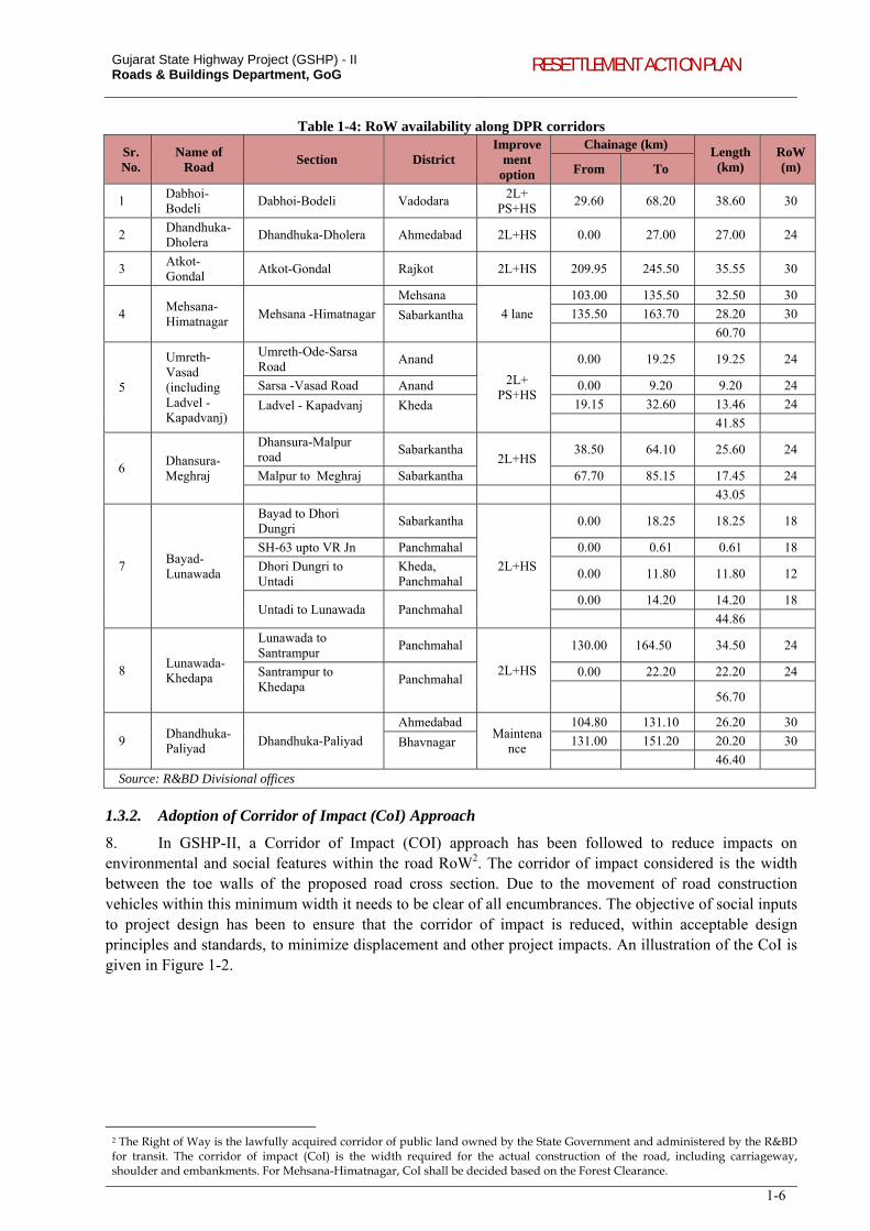
7. Accordingly, RoW information from each of the R&BD field divisions along the project corridors was collected (Refer Appendix 1.1 for copies of Certificates from respective R&BD Divisions). As is reflected in the Table 1-4, RoW of at least 24 m is available along most of the corridors for their entire lengths. However, there are village settlement stretches along several corridors where the available RoW on ground is less and varies between 12 to 18m. Amongst the 9 DPR corridors, Bayad-Lunawada has RoW less than 24m.
Gujarat State Highway Project (GSHP) - II Roads & Buildings Department, GoG RESETTLEMENT ACTION PLAN
1-6
Table 1-4: RoW availability along DPR corridors
Sr. No.
Name of Road
Section District Improve
ment option
Chainage (km) Length (km)
RoW (m) From To
1 Dabhoi-Bodeli
Dabhoi-Bodeli Vadodara 2L+
PS+HS 29.60 68.20 38.60 30
2 Dhandhuka-Dholera
Dhandhuka-Dholera Ahmedabad 2L+HS 0.00 27.00 27.00 24
3 Atkot-Gondal
Atkot-Gondal Rajkot 2L+HS 209.95 245.50 35.55 30
4 Mehsana-Himatnagar
Mehsana -Himatnagar
Mehsana
4 lane
103.00 135.50 32.50 30
Sabarkantha
135.50 163.70 28.20 30
60.70
5
Umreth-Vasad (including Ladvel - Kapadvanj)
Umreth-Ode-Sarsa Road
Anand
2L+ PS+HS
0.00 19.25 19.25 24
Sarsa -Vasad Road Anand 0.00 9.20 9.20 24
Ladvel - Kapadvanj
Kheda
19.15 32.60 13.46 24
41.85
6 Dhansura-Meghraj
Dhansura-Malpur road
Sabarkantha 2L+HS
38.50 64.10 25.60 24
Malpur to Meghraj Sabarkantha 67.70 85.15 17.45 24
43.05
7 Bayad-Lunawada
Bayad to Dhori Dungri
Sabarkantha
2L+HS
0.00 18.25 18.25 18
SH-63 upto VR Jn Panchmahal 0.00 0.61 0.61 18
Dhori Dungri to Untadi
Kheda, Panchmahal
0.00 11.80 11.80 12
Untadi to Lunawada Panchmahal 0.00 14.20 14.20 18
44.86
8 Lunawada-Khedapa
Lunawada to Santrampur
Panchmahal
2L+HS
130.00 164.50 34.50 24
Santrampur to Khedapa
Panchmahal
0.00 22.20 22.20 24
56.70
9 Dhandhuka-Paliyad
Dhandhuka-Paliyad
Ahmedabad Maintena
nce
104.80 131.10 26.20 30
Bhavnagar
131.00 151.20 20.20 30
46.40
Source: R&BD Divisional offices
1.3.2. Adoption of Corridor of Impact (CoI) Approach
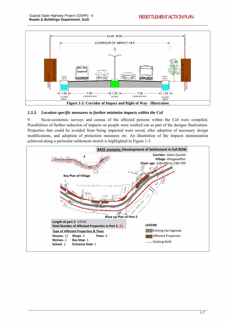
8. In GSHP-II, a Corridor of Impact (COI) approach has been followed to reduce impacts on environmental and social features within the road RoW2. The corridor of impact considered is the width between the toe walls of the proposed road cross section. Due to the movement of road construction vehicles within this minimum width it needs to be clear of all encumbrances. The objective of social inputs to project design has been to ensure that the corridor of impact is reduced, within acceptable design principles and standards, to minimize displacement and other project impacts. An illustration of the CoI is given in Figure 1-2.
2 The Right of Way is the lawfully acquired corridor of public land owned by the State Government and administered by the R&BD for transit. The corridor of impact (CoI) is the width required for the actual construction of the road, including carriageway, shoulder and embankments. For Mehsana-Himatnagar, CoI shall be decided based on the Forest Clearance.
Gujarat State Highway Project (GSHP) - II Roads & Buildings Department, GoG RESETTLEMENT ACTION PLAN
1-7
Figure 1-2: Corridor of Impact and Right of Way - Illustration
1.3.3. Location specific measures to further minimize impacts within the CoI
9. Socio-economic surveys and census of the affected persons within the CoI were compiled. Possibilities of further reduction of impacts on people were worked out as part of the designs finalization. Properties that could be avoided from being impacted were saved, after adoption of necessary design modifications, and adoption of protection measures etc. An illustration of the impacts minimization achieved along a particular settlement stretch is highlighted in Figure 1-3.
Corridor‐ Atkot‐Gondal Village‐ Ghogavadhar
Chain age‐ 238+000 to 238+700
Key Plan of Village
2
Existing Carriageway
Affected Properties
Existing RoW
LEGEND
Blow up Plan of Part‐2
Length of part 2‐ 370 M Total Number of Affected Properties in Part 2‐ 21
Houses‐ 12 Shrines‐ 2 School‐ 1
Shops‐ 4 Bus Stop‐ 1 Entrance Gate‐ 1
Type of Affected Properties & Trees
Trees‐ 4
BASE scenario: Development of Settlement in full ROW
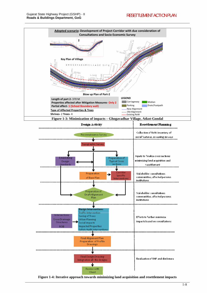
Gujarat State Highway Project (GSHP) - II Roads & Buildings Department, GoG RESETTLEMENT ACTION PLAN
1-8
Key Plan of Village
2
Adopted scenario: Development of Project Corridor with due consideration of Consultations and Socio Economic Survey
Length of part 2‐ 370 MProperties affected after Mitigation Measures‐ Only 2Partial affect‐ 1 (School Boundary wall)
Shrines‐ 2 Trees‐ 4
Type of Affected Properties & Trees
Blow up Plan of Part‐2
LEGENDCarriageway
Parking
New AlignmentOld AlignmentExisting RoW
Median
Drain/Footpath
Figure 1-3: Minimization of impacts – Ghogavadhar Village, Atkot-Gondal
Figure 1-4: Iterative approach towards minimizing land acquisition and resettlement impacts
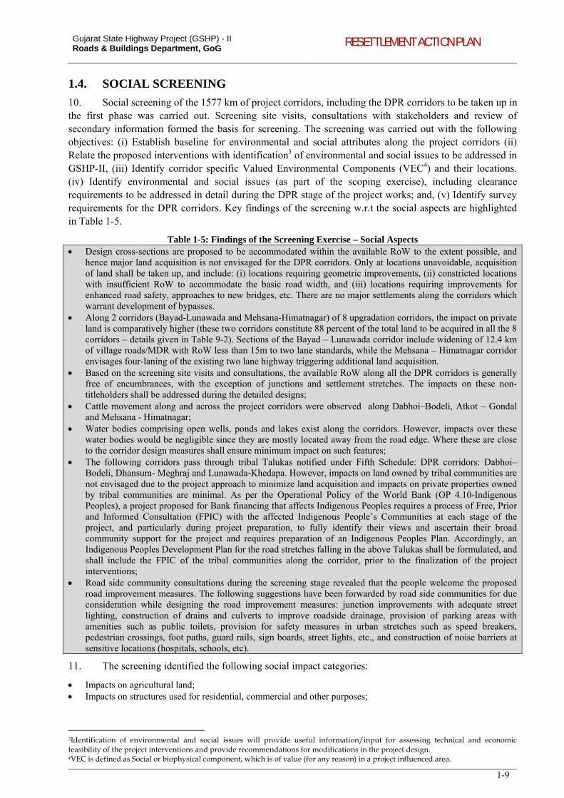
Gujarat State Highway Project (GSHP) - II Roads & Buildings Department, GoG RESETTLEMENT ACTION PLAN
1-9
1.4. SOCIAL SCREENING
10. Social screening of the 1577 km of project corridors, including the DPR corridors to be taken up in the first phase was carried out. Screening site visits, consultations with stakeholders and review of secondary information formed the basis for screening. The screening was carried out with the following objectives: (i) Establish baseline for environmental and social attributes along the project corridors (ii) Relate the proposed interventions with identification3 of environmental and social issues to be addressed in GSHP-II, (iii) Identify corridor specific Valued Environmental Components (VEC4) and their locations. (iv) Identify environmental and social issues (as part of the scoping exercise), including clearance requirements to be addressed in detail during the DPR stage of the project works; and, (v) Identify survey requirements for the DPR corridors. Key findings of the screening w.r.t the social aspects are highlighted in Table 1-5.
Table 1-5: Findings of the Screening Exercise – Social Aspects Design cross-sections are proposed to be accommodated within the available RoW to the extent possible, and
hence major land acquisition is not envisaged for the DPR corridors. Only at locations unavoidable, acquisition of land shall be taken up, and include: (i) locations requiring geometric improvements, (ii) constricted locations with insufficient RoW to accommodate the basic road width, and (iii) locations requiring improvements for enhanced road safety, approaches to new bridges, etc. There are no major settlements along the corridors which warrant development of bypasses.
Along 2 corridors (Bayad-Lunawada and Mehsana-Himatnagar) of 8 upgradation corridors, the impact on private land is comparatively higher (these two corridors constitute 88 percent of the total land to be acquired in all the 8 corridors – details given in Table 9-2). Sections of the Bayad – Lunawada corridor include widening of 12.4 km of village roads/MDR with RoW less than 15m to two lane standards, while the Mehsana – Himatnagar corridor envisages four-laning of the existing two lane highway triggering additional land acquisition.
Based on the screening site visits and consultations, the available RoW along all the DPR corridors is generally free of encumbrances, with the exception of junctions and settlement stretches. The impacts on these non-titleholders shall be addressed during the detailed designs;
Cattle movement along and across the project corridors were observed along Dabhoi–Bodeli, Atkot – Gondal and Mehsana - Himatnagar;
Water bodies comprising open wells, ponds and lakes exist along the corridors. However, impacts over these water bodies would be negligible since they are mostly located away from the road edge. Where these are close to the corridor design measures shall ensure minimum impact on such features;
The following corridors pass through tribal Talukas notified under Fifth Schedule: DPR corridors: Dabhoi–Bodeli, Dhansura- Meghraj and Lunawada-Khedapa. However, impacts on land owned by tribal communities are not envisaged due to the project approach to minimize land acquisition and impacts on private properties owned by tribal communities are minimal. As per the Operational Policy of the World Bank (OP 4.10-Indigenous Peoples), a project proposed for Bank financing that affects Indigenous Peoples requires a process of Free, Prior and Informed Consultation (FPIC) with the affected Indigenous People’s Communities at each stage of the project, and particularly during project preparation, to fully identify their views and ascertain their broad community support for the project and requires preparation of an Indigenous Peoples Plan. Accordingly, an Indigenous Peoples Development Plan for the road stretches falling in the above Talukas shall be formulated, and shall include the FPIC of the tribal communities along the corridor, prior to the finalization of the project interventions;
Road side community consultations during the screening stage revealed that the people welcome the proposed road improvement measures. The following suggestions have been forwarded by road side communities for due consideration while designing the road improvement measures: junction improvements with adequate street lighting, construction of drains and culverts to improve roadside drainage, provision of parking areas with amenities such as public toilets, provision for safety measures in urban stretches such as speed breakers, pedestrian crossings, foot paths, guard rails, sign boards, street lights, etc., and construction of noise barriers at sensitive locations (hospitals, schools, etc).
11. The screening identified the following social impact categories:
Impacts on agricultural land; Impacts on structures used for residential, commercial and other purposes;
3Identification of environmental and social issues will provide useful information/input for assessing technical and economic feasibility of the project interventions and provide recommendations for modifications in the project design. 4VEC is defined as Social or biophysical component, which is of value (for any reason) in a project influenced area.
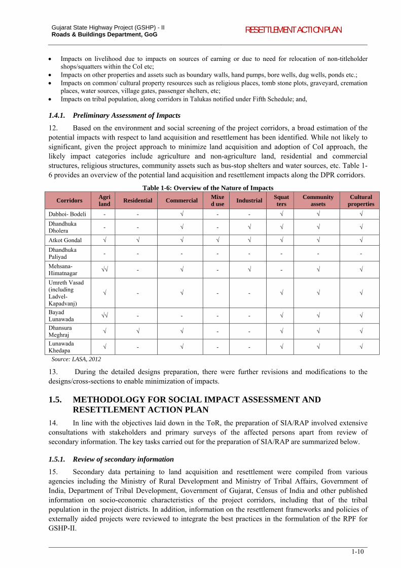
Gujarat State Highway Project (GSHP) - II Roads & Buildings Department, GoG RESETTLEMENT ACTION PLAN
1-10
Impacts on livelihood due to impacts on sources of earning or due to need for relocation of non-titleholder shops/squatters within the CoI etc;
Impacts on other properties and assets such as boundary walls, hand pumps, bore wells, dug wells, ponds etc.; Impacts on common/ cultural property resources such as religious places, tomb stone plots, graveyard, cremation
places, water sources, village gates, passenger shelters, etc; Impacts on tribal population, along corridors in Talukas notified under Fifth Schedule; and,
1.4.1. Preliminary Assessment of Impacts
12. Based on the environment and social screening of the project corridors, a broad estimation of the potential impacts with respect to land acquisition and resettlement has been identified. While not likely to significant, given the project approach to minimize land acquisition and adoption of CoI approach, the likely impact categories include agriculture and non-agriculture land, residential and commercial structures, religious structures, community assets such as bus-stop shelters and water sources, etc. Table 1-6 provides an overview of the potential land acquisition and resettlement impacts along the DPR corridors.
Table 1-6: Overview of the Nature of Impacts
Corridors Agri land
Residential Commercial Mixed use
Industrial Squatters
Community assets
Cultural properties
Dabhoi- Bodeli - - √ - - √ √ √
Dhandhuka Dholera
- - √ - √ √ √ √
Atkot Gondal √ √ √ √ √ √ √ √
Dhandhuka Paliyad
- - - - - - - -
Mehsana-Himatnagar
√√ - √ - √ - √ √
Umreth Vasad (including Ladvel-Kapadvanj)
√ - √ - - √ √ √
Bayad Lunawada
√√ - - - - √ √ √
Dhansura Meghraj
√ √ √ - - √ √ √
Lunawada Khedapa
√ - √ - - √ √ √
Source: LASA, 2012
13. During the detailed designs preparation, there were further revisions and modifications to the designs/cross-sections to enable minimization of impacts.
1.5. METHODOLOGY FOR SOCIAL IMPACT ASSESSMENT AND RESETTLEMENT ACTION PLAN
14. In line with the objectives laid down in the ToR, the preparation of SIA/RAP involved extensive consultations with stakeholders and primary surveys of the affected persons apart from review of secondary information. The key tasks carried out for the preparation of SIA/RAP are summarized below.
1.5.1. Review of secondary information
15. Secondary data pertaining to land acquisition and resettlement were compiled from various agencies including the Ministry of Rural Development and Ministry of Tribal Affairs, Government of India, Department of Tribal Development, Government of Gujarat, Census of India and other published information on socio-economic characteristics of the project corridors, including that of the tribal population in the project districts. In addition, information on the resettlement frameworks and policies of externally aided projects were reviewed to integrate the best practices in the formulation of the RPF for GSHP-II.
Gujarat State Highway Project (GSHP) - II Roads & Buildings Department, GoG RESETTLEMENT ACTION PLAN
1-11
1.5.2. Stakeholder Consultations
16. Stakeholder consultations were an integral part of the SIA preparation. Consultations were carried out with a wide range of stakeholders including affected communities, government agencies, municipal authorities, NGOs etc. These consultations were to disseminate information about project to the stakeholders including the potentially affected people, and also to appraise their views and suggestions about the project and the project impacts. The views expressed by the community in general and the affected population has been documented and later discussed in details with the Design Team. Design changes have been done to accommodate the views of community, especially with respect to minimising or even avoiding adverse impacts. These consultations formed inputs to the finalization of the RPF and towards preparation of designs that ensures minimal impacts on land and assets. Consultation formats were developed and used as guideline to discuss about various issues (refer Appendix 5.1 for Consultation Format developed for Dabhoi-Bodeli corridor).
1.5.3. Review of Land Acquisition Practices in Gujarat
17. Land acquisition practices and procedures for determination of compensation for various infrastructure development projects within Gujarat in recent past were reviewed. Towards this, consultations with various implementing / Government agencies including the Gujarat State Road Development Corporation (GSRDC), Town Planning and Valuation Department, Revenue Department (Land Acquisition), Department of Stamp Duty, Gujarat Industrial Development Corporation, PIU-National Highway Authority of India, Narmada Main Canal Project etc., have been done and information gathered to understand the process followed for the acquisition of lands and determination of compensation in these projects. Jantri rates of lands which are affected due to the project has been collected and analyzed. The Jantri rates published by Government of Gujarat during 2006 and 2011 have been analyzed. Land prices in open-market transactions have been collected to understand the prevailing land values along the corridor to enable comparison with the prevailing Jantri rates.
1.5.4. Profile of Project Affected Families
18. Using available RoW records with the R&BD and Revenue Department, the social team verified the boundaries of private properties within and in the vicinity of potential corridor of impact (CoI). Census survey has been carried out covering 100 percent of the potentially affected properties within the likely CoI, and detailed socio-economic information has been collected from 50 percent of project affected families. The socio economic survey was conducted through door-to-door personal interviews. Copy of the questionnaire used for collecting information is given in Appendix 1.2. The location, size and type of construction of the structures were recorded. Names of the owners, addresses, possession of legal documents (if any, towards the claim of property), tenure status, and the possible project-induced losses were recorded. Information about the structure of the household, occupation, literacy level, income and other social information about the affected family were also collected. Information has been gathered for all the affected community assets such as worship place, drinking water sources, medical and education institutions and other community facilities.
1.5.5. Accessibility and Mobility to Transport Facilities in Villages
19. Baseline socio-economic information related to access to transport facilities and travel patterns in the villages along the proposed corridors have been collected and analysed. The study intended to assess the travel pattern of villagers, which includes travel time to markets, educational and health institutions, frequency of trips to nearby places, perception of villagers on travel situation, etc. The findings of the study formed the basis for measuring impacts after the proposed roads are improved. The study has identified villages within 2 km of proposed corridors and subsequently, selected 50 percent of villages from the total list of villages within 2 km bandwidth, considering proportionate number of villages on LHS and RHS and villages abutting the corridor and villages off-the-corridor. Survey has been carried out in 5 households from each selected village. Information has been gathered using the structured questionnaire (Appendix 14.1).
Gujarat State Highway Project (GSHP) - II Roads & Buildings Department, GoG RESETTLEMENT ACTION PLAN
1-12
1.5.6. Preparation of Indigenous Peoples Development Plan
20. Three of the project corridors identified for inclusion in the first year namely (a) Lunawada-Khedapa, (b) Dhansura-Meghraj, and (c) Dabhoi-Bodeli pass through Fifth Schedule areas. These corridors pass through 4 Talukas of 3 tribal districts i.e. Meghraj Taluk of Sabarkantha district, Santrampur and Kadana in Panchmahal and Sankheda in Vadodara district. Consultations with tribal communities, Panchayati Raj Institutions (PRIs), Tribal Development Department, Community Based Organizations (CBOs) and Non-government Organizations (NGOs), etc., has been carried out ensuring participation of tribal community in various stages of the project implementation.
21. No acquisition of lands is proposed for the section of corridors passing through Scheduled Areas. The designs for the proposed corridors have been worked out within the available RoW to minimize land acquisition and resettlement impacts. As a result, direct impacts on tribal communities pertaining to land acquisition are not envisaged. As part of the SIA, census survey of 100 percent of potentially affected population within the likely CoI has been carried out. Socio-economic profile of a sample of affected households including ST households has been collected and entitlements for respective impact on assets were estimated.
22. FPIC in Fifth Schedule Areas was carried out in each of the 4 tribal Talukas covering the following aspects: (i) awareness and opinion about the project; (ii) awareness about Chief Minister’s Ten Point Programme – Vanbandhu Kalyan Yojana; (iii) distinctive customs or economic activities maintained by the community (access to forest produce, fishing, grazing land, firewood, etc.); (iv) discussions regarding customary behaviour, economic opportunities, customary institutions, way of living etc; (v) customary rights over forest land, community land or private land, (vi) benefits perceived and outcome expected from the road development project; (vii) safety issues along the corridor (road accidents/avoidance/suggestions etc. – specific cases of accidents taking place in particular locations – reasons for such accidents); and (viii) impact or avoidance of impact on religious properties / common property resources, enhancement of such properties, support and involvement of Panchayati raj institutions and tribal community organizations in sustainable project delivery, etc. Suggestions, observations by the communities during the consultations have been incorporated into the project designs.
23. The direct impacts on the tribal population are limited to the impacts on the non-titleholders who have been identified as vulnerable and provided additional assistances. The budgetary provisions and mechanisms for implementation of these measures are incorporated in the Resettlement Action Plans for the respective corridors. Therefore, the scope of the IPDP is limited to provides a detailed framework for consultation and active participation with the tribal communities during project implementation with the objective of seeking broad community support for the project.
1.5.7. Preparation of HIV/AIDS Prevention Plan
24. HIV/AIDS Prevention Plan (HPP) has been prepared to assess and address the pertinent issues with respect to the mobility pattern of high-risk groups (HRGs) and bridge population and analyses the potential risk factors on the local communities, and the construction workers during the implementation of the project. HPP also suggests for appropriate mitigation measures and institutional arrangements for the sustainable delivery of project benefits to community. Site visits and consultations along the corridors were undertaken and potential hotspots including major transport nodes, industrial hubs, construction sites, health-care service centres, etc., were identified. Consultations were held with various agencies involved in the HIV/AIDS prevention in the state, including Gujarat State AIDS Control Society (GSACS) and Ahmadabad Municipal Corporation AIDS Control Society (AMCACS), Transport Corporation of India Foundation (TCIF), etc.
25. Based on site visits and consultations, information regarding corridor-specific and local level interventions was obtained on HRGs, activity places, hotspot networks, NGOs, sex workers and other stakeholders. Content analysis of secondary data was carried out and correlated with the primary data collected through focus group discussions, individual interviews and consultations. Discussions at various
Gujarat State Highway Project (GSHP) - II Roads & Buildings Department, GoG RESETTLEMENT ACTION PLAN
1-13
levels were carried out with NGO Personnel functioning in respective villages along the project corridor and discussions held with HRGs in view of assessing the scenario of HIV/AIDS and its potential spread effect concomitant with the development of the highway. A detailed survey among trucker community has been carried out using structured questionnaires (Appendix 1.3). These information provided inputs towards development of a strategy and action plan outlining measures for addressing impacts on the construction workers, communities etc., during the project implementation. The specific measures to be taken up have been integrated into the bid documents and shall be implemented by the Contractors, with support from the PIU and the NGO implementing the RAP. HPP has been prepared as a standalone document.
1.5.8. Finalization of Resettlement Policy Framework
26. Resettlement Policy Framework (RPF) has been prepared based on the findings of the SIA. To address land acquisition and resettlement impacts in the project, RPF outlines the principles and procedures, legal framework, operational guidelines, institutional arrangements, entitlements for different types of impacts, disclosure procedures and monitoring and evaluation. This framework will guide in management of social impacts caused by the proposed project and improvement works to be taken up for subsequent corridors. Preparation of resettlement action plan, Indigenous Peoples Development Plan, strategies of public consultations, especially with the tribal population will be steered through the principles of RPF. The RPF: (i) brings commonality in resettlement and rehabilitation benefits under the project, (ii) bridges the gap between Bank’s policy on Involuntary Resettlement and NRRP 2007, (iii) brings together and built upon the current good practices in terms of procedures to address more systematic and institutional issues, (iv) establishes institutional arrangements at project level for the implementation of RAP, and (v) establishes mechanism for redressing grievances, and monitoring and evaluation etc.
1.5.9. Preparation of Resettlement Action Plan
27. Corridor-wise RAP has been prepared and a consolidated version has been presented in this report. As mentioned in section 1.3, a conscious effort has been taken towards avoidance of land acquisition and resettlement impacts. Wherever unavoidable, efforts to minimize impacts through design interventions have been worked out. The RAP is prepared to ensure that the affected persons are: (i) informed about their options and rights pertaining to resettlement; (ii) consulted, offered choices among, and provided with technically and economically feasible resettlement alternatives; (iii) provided prompt and effective compensation at full replacement cost for losses of assets caused due to the project; (iv) provided assistance (such as shifting allowance, transition allowance, etc.) during relocation and for a transition period, to restore their livelihood and standards of living; and, (v) provided with development assistance such as training, in addition to compensation.
1.6. STRUCTURE OF SIA & CONSOLIDATED RAP Chapter 1 - Introduction: provides an overview of the proposed project and the project corridors,
objectives of social impact assessment, approach to minimize impacts, and the methodology adopted for SIA preparation;
Chapter 2 – Project Description: provides details of the project corridors, proposed design interventions, expected project benefits, and overview of potential impacts;
Chapter 3 - Socio Economic Profile of the Project Area: describes socio-economic profile of the project area, including a brief account of scheduled caste and scheduled tribe population;
Chapter 4 – Legal and Policy Framework: discusses the state and national level acts relevant to land acquisition, comparison of National R&R policy and World Bank safeguard policies relevant to the project, and applicability for GSHP II;
Chapter 5 - Stakeholder Consultations: presents the list of stakeholders selected, key outcomes of consultations carried out and the ways in which the concerns and suggestions of the community were integrated into the project design are presented;
Gujarat State Highway Project (GSHP) - II Roads & Buildings Department, GoG RESETTLEMENT ACTION PLAN
1-14
Chapter 6 - Land Acquisition and Compensation Practices: presents a summary of the lessons learned from GSHP I and review of the current land acquisition and compensation practices in Gujarat.
Chapter 7 – R&R Policy Frameworks-Comparison: presents comparative assessment of entitlement provisions of GSHP-I, R&R Policy of Kerala State Transport Project of Government of Kerala, Mumbai Urban Transport Project and Karnataka State Highway Improvement project.
Chapter 8 – Minimization of Resettlement Impacts: presents the methods used and the list of structure saved through design modifications along the project corridors.
Chapter 9 – Land Acquisition and Resettlement Impacts: presents the nature and extent of impact on various properties alongside the corridor.
Chapter 10 – Socio-Economic Profile of Affected Population: socio-economic details collected through the socio-economic survey of affected population has been analysed and presented in this chapter. The details include social category, age distribution, household income, household expenditure, occupation profile, etc.
Chapter 11 – Scheduled Tribes: presents the socio-economic profile of the scheduled tribes, tribal development programmes, issues and concerns of the community and entitlements under the project;
Chapter 12 – Gender Development: presents the socio-economic profile of women in the project district, Talukas and along the corridor, profile of women headed households along the corridor, details of consultation carried out with women, gender participation in the project, and identification of gender specific issues and concerns, and entitlements under the project entitlements;
Chapter 13 – Road Safety: present the approaches adopted in assessing road safety issues through road safety audit and consultations with community during the SIA. The ways in which various safety issues are integrated into the road design is presented by way of an illustration.
Chapter 14 –Mobility and Access to Transport Facilities: presents the assessment of travel pattern of villagers, perception of villagers’ with respect to current transport infrastructure.
Chapter 15- Resettlement Policy Framework: outlines the provisions for implementation of R & R provision under the project based on the findings of the SIA. The RPF defines the proposed institutional arrangements for the implementation of RAP and outlines the roles and responsibilities of various agencies including the PIU, NGO implementing the RAP, M&E Consultants etc.
Chapter 16 – Resettlement Action Plan and Budget: gives a summary of RAP prepared for implementation in respective corridors. The chapter contains budget estimates (cost of land to be acquired, cost of structures based on R&BD Schedule of Rates, cost of other assets located within the affected property, etc) for RAP implementation.
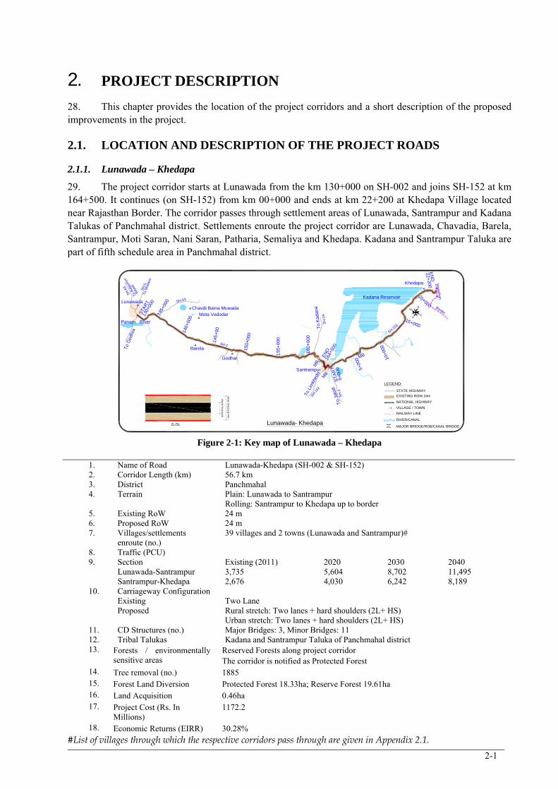
2-1
2. PROJECT DESCRIPTION
28. This chapter provides the location of the project corridors and a short description of the proposed improvements in the project.
2.1. LOCATION AND DESCRIPTION OF THE PROJECT ROADS
2.1.1. Lunawada – Khedapa
29. The project corridor starts at Lunawada from the km 130+000 on SH-002 and joins SH-152 at km 164+500. It continues (on SH-152) from km 00+000 and ends at km 22+200 at Khedapa Village located near Rajasthan Border. The corridor passes through settlement areas of Lunawada, Santrampur and Kadana Talukas of Panchmahal district. Settlements enroute the project corridor are Lunawada, Chavadia, Barela, Santrampur, Moti Saran, Nani Saran, Patharia, Semaliya and Khedapa. Kadana and Santrampur Taluka are part of fifth schedule area in Panchmahal district.
N
S
W
E
LunawadaKadana Reservoir
Santrampur
Mota VadodarChavdi Baina Muwada
Barela
To
Jalo
d
To L
imkh
eda
To
Kad
ana
To
Mod
asa
To
God
hra
Godhar
Panam River
To B
alas
inor
/
145+
00
150+
000
155
+00
0
160
+0
00
164+
500
5+00
0
140+
000
135+
000
STA
RT
0+00
0
10+0
00
15+000
20+000
22+200
Lunawada- Khedapa
Border
Rajasthan
24m
EX
IST
ING
RO
W
EX
IST
ING
RO
AD
130+
000
EN
D
ST
AR
T
EN
D
MB
MB
MB
SH-2
SH-152
Khedapa
LEGEND:
STATE HIGHWAY
EXISTING ROW 24m
NATIONAL HIGHWAY
VILLAGE / TOWN
RAILWAY LINE
RIVER/CANAL
MAJOR BRIDGE/ROB/CANAL BRIDGE
SH-63
SH
-2
SH-1
52
SH
-2A
SH
-5
SH
-63
Bay
ad
2L/SL
Figure 2-1: Key map of Lunawada – Khedapa
1. Name of Road Lunawada-Khedapa (SH-002 & SH-152) 2. Corridor Length (km) 56.7 km 3. District Panchmahal 4. Terrain Plain: Lunawada to Santrampur
Rolling: Santrampur to Khedapa up to border 5. Existing RoW 24 m 6. Proposed RoW 24 m 7. Villages/settlements
enroute (no.) 39 villages and 2 towns (Lunawada and Santrampur)#
8. Traffic (PCU) 9. Section Existing (2011) 2020 2030 2040
Lunawada-Santrampur 3,735 5,604 8,702 11,495 Santrampur-Khedapa 2,676 4,030 6,242 8,189
10. Carriageway Configuration Existing Two Lane Proposed Rural stretch: Two lanes + hard shoulders (2L+ HS)
Urban stretch: Two lanes + hard shoulders (2L+ HS) 11. CD Structures (no.) Major Bridges: 3, Minor Bridges: 11 12. Tribal Talukas Kadana and Santrampur Taluka of Panchmahal district 13. Forests / environmentally
sensitive areas Reserved Forests along project corridor The corridor is notified as Protected Forest
14. Tree removal (no.) 1885 15. Forest Land Diversion Protected Forest 18.33ha; Reserve Forest 19.61ha 16. Land Acquisition 0.46ha 17. Project Cost (Rs. In
Millions) 1172.2
18. Economic Returns (EIRR) 30.28% #List of villages through which the respective corridors pass through are given in Appendix 2.1.
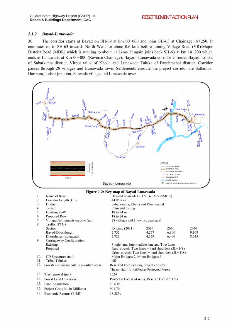
Gujarat State Highway Project (GSHP) - II Roads & Buildings Department, GoG RESETTLEMENT ACTION PLAN
2-2
2.1.2. Bayad-Lunawada
30. The corridor starts at Bayad on SH-69 at km 00+000 and joins SH-63 at Chainage 18+250. It continues on to SH-63 towards North West for about 0.6 kms before joining Village Road (VR)/Major District Road (MDR) which is running to about 11.8kms. It again joins back SH-63 at km 14+200 which ends at Lunawada at Km 00+000 (Reverse Chainage). Bayad- Lunawada corridor enroutes Bayad Taluka of Sabarkanta district, Virpur taluk of Kheda and Lunawada Taluka of Panchmahal district. Corridor passes through 28 villages and Lunawada town. Settlements enroute the project corridor are Sattamba, Hatipura, Lalsar junction, Salwada village and Lunawada town.
N
S
WE
Bayad - Lunawada
Bayad
Sathamba
Dhori Dungri
Vardhari
Lunawada
Pandwa
To
Mod
asa
To
Nad
iyad
To
God
hra
24m
EX
IST
ING
RO
W
EX
IST
ING
RO
AD
River
River
Riv
er
ST
AR
T
10+
000
15+000
18+
250
0+00
0
5+00
0
10+
000
11+
800
14+
000 10
+000 5+
000
0+
000
0+00
0
EN
DS
TA
RT
Can
al
Can
al EN
D
EN
D ST
AR
T
Can
al
MB
VR-MDR
SH-69
MD
R SH-63
10+
000
MB
SH
-5
To V
irpur
To V
irpur
To
Gab
at
To
Virp
ur
SH
-63
SH
-63
SH
-5
Nana Sonela
LEGEND:
STATE HIGHWAY
EXISTING ROW
NATIONAL HIGHWAY
VILLAGE / TOWN
RAILWAY LINE
RIVER/CANAL
MAJOR BRIDGE/ROB/CANAL BRIDGE
SH
-59
SH
-59
SH-69SH-238
IL/2LHS
Figure 2-2: Key map of Bayad-Lunawada 1. Name of Road Bayad-Lunawada (SH 69, 63 & VR/MDR) 2. Corridor Length (km) 44.86 Km 3. District Sabarkantha, Kheda and Panchmahal 4. Terrain Plain and rolling 5. Existing RoW 18 to 24 m 6. Proposed Row 18 to 24 m 7. Villages/settlements enroute (no.) 28 villages and 1 town (Lunawada) 8. Traffic (PCU)
Section Existing (2011) 2020 2030 2040 Bayad-Dhoridungri 2,752 4,257 6,800 9,108 Dhoridungri-Lunawada 2,726 4,129 6,490 8,645
9. Carriageway Configuration Existing Single lane, Intermediate lane and Two Lane Proposed Rural stretch: Two lanes + hard shoulders (2L+ HS)
Urban stretch: Two lanes + hard shoulders (2L+ HS) 10. CD Structures (no.) Major Bridges: 2, Minor Bridges: 5 11. Tribal Talukas Nil 12. Forests / environmentally sensitive areas Reserved Forests along project corridor
The corridor is notified as Protected Forest 13. Tree removal (no.) 1324 14. Forest Land Diversion Protected Forest 24.42ha; Reserve Forest 5.37ha 15. Land Acquisition 20.6 ha 16. Project Cost (Rs. In Millions) 991.70 17. Economic Returns (EIRR) 18.28%
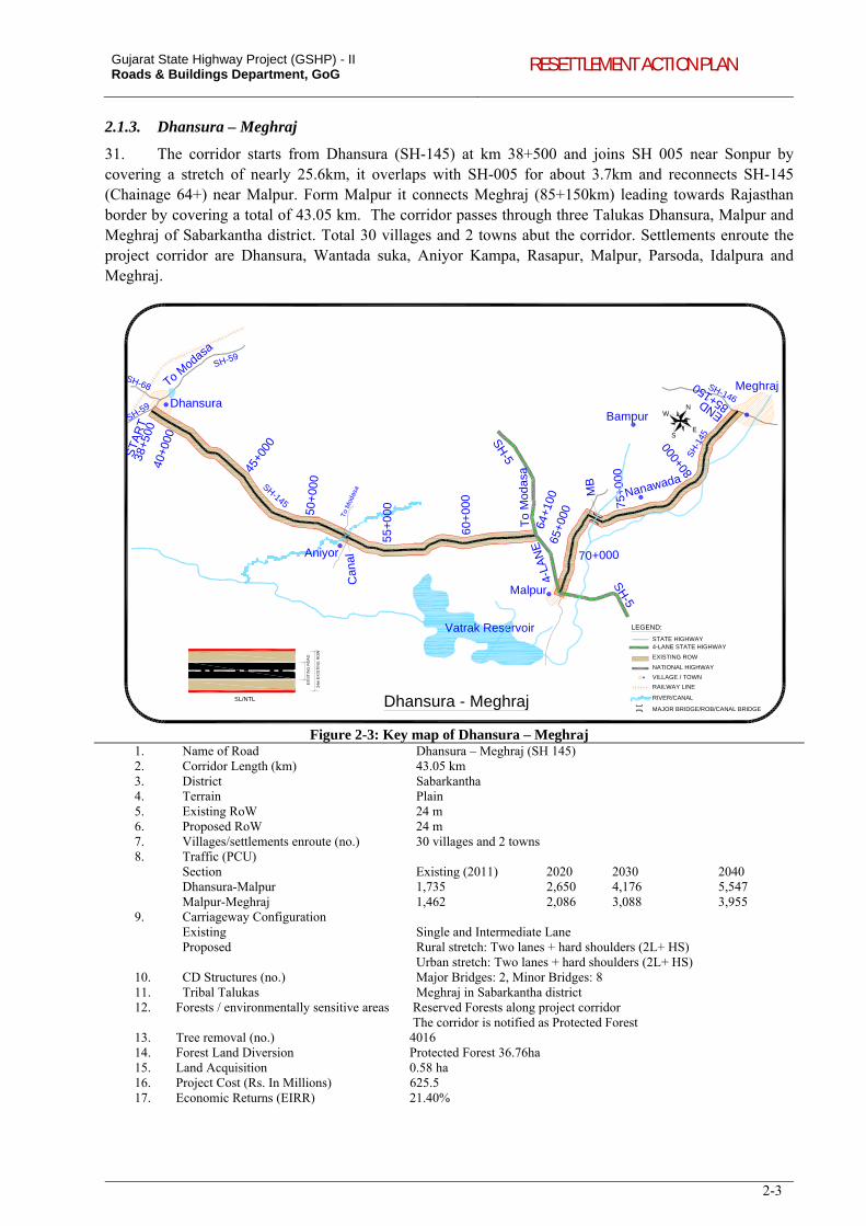
Gujarat State Highway Project (GSHP) - II Roads & Buildings Department, GoG RESETTLEMENT ACTION PLAN
2-3
2.1.3. Dhansura – Meghraj
31. The corridor starts from Dhansura (SH-145) at km 38+500 and joins SH 005 near Sonpur by covering a stretch of nearly 25.6km, it overlaps with SH-005 for about 3.7km and reconnects SH-145 (Chainage 64+) near Malpur. Form Malpur it connects Meghraj (85+150km) leading towards Rajasthan border by covering a total of 43.05 km. The corridor passes through three Talukas Dhansura, Malpur and Meghraj of Sabarkantha district. Total 30 villages and 2 towns abut the corridor. Settlements enroute the project corridor are Dhansura, Wantada suka, Aniyor Kampa, Rasapur, Malpur, Parsoda, Idalpura and Meghraj.
N
S
W
E
Dhansura - Meghraj
Vatrak Reservoir
Dhansura
Aniyor
Malpur
Meghraj
Bampur
Nanawada
40+0
00
45+0
00
50+
000
55+
000
60+
000
64+1
0065
+000
70+000
75+
000 80
+000
85+150
To
Mod
asa
To
Mod
asa
To Modasa
4-LA
NE
SH
-538+5
00
ST
AR
T
END
MB
Can
al
SH-145
SH-59
SH
-145
SH-146
SH-59
SH-68
SH
-5
LEGEND:
STATE HIGHWAY
EXISTING ROW
NATIONAL HIGHWAY
VILLAGE / TOWN
RAILWAY LINE
RIVER/CANAL
MAJOR BRIDGE/ROB/CANAL BRIDGE
4-LANE STATE HIGHWAY
24m
EX
IST
ING
RO
W
EX
IST
ING
RO
AD
SL/NTL
Figure 2-3: Key map of Dhansura – Meghraj 1. Name of Road Dhansura – Meghraj (SH 145) 2. Corridor Length (km) 43.05 km 3. District Sabarkantha 4. Terrain Plain 5. Existing RoW 24 m 6. Proposed RoW 24 m 7. Villages/settlements enroute (no.) 30 villages and 2 towns 8. Traffic (PCU)
Section Existing (2011) 2020 2030 2040 Dhansura-Malpur 1,735 2,650 4,176 5,547 Malpur-Meghraj 1,462 2,086 3,088 3,955
9. Carriageway Configuration Existing Single and Intermediate Lane Proposed Rural stretch: Two lanes + hard shoulders (2L+ HS)
Urban stretch: Two lanes + hard shoulders (2L+ HS) 10. CD Structures (no.) Major Bridges: 2, Minor Bridges: 8 11. Tribal Talukas Meghraj in Sabarkantha district 12. Forests / environmentally sensitive areas Reserved Forests along project corridor
The corridor is notified as Protected Forest 13. Tree removal (no.) 4016 14. Forest Land Diversion Protected Forest 36.76ha 15. Land Acquisition 0.58 ha 16. Project Cost (Rs. In Millions) 625.5 17. Economic Returns (EIRR) 21.40%
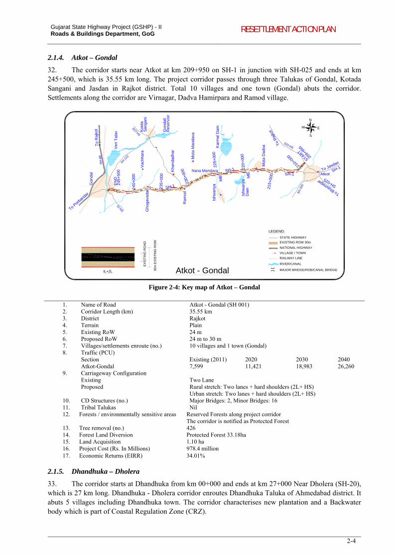
Gujarat State Highway Project (GSHP) - II Roads & Buildings Department, GoG RESETTLEMENT ACTION PLAN
2-4
2.1.4. Atkot – Gondal
32. The corridor starts near Atkot at km 209+950 on SH-1 in junction with SH-025 and ends at km 245+500, which is 35.55 km long. The project corridor passes through three Talukas of Gondal, Kotada Sangani and Jasdan in Rajkot district. Total 10 villages and one town (Gondal) abuts the corridor. Settlements along the corridor are Virnagar, Dadva Hamirpara and Ramod village.
Gon
dal
Vac
hha
ra
Ra
mod
Mo
ta D
adv
a
Atkot
Sa
nga
niG
hoga
vad
ar
Ish
wa
riya
To
Ra
jkot
To Porb
anda
r
To R
ajko
t
To Jasdan
Nana MandavaKha
nda
dh
ar
Mot
a M
and
ava
Atkot - Gondal 30m
EX
IST
ING
RO
W
EX
IST
ING
RO
AD
IL+2L
N
S
W E
24
0+00
0
235
+0
00
230+
000
225
+00
0
220
+00
0
215+
000
210+
000
START
24
5+50
0
MB
MB
209+
950
EN
D
SH-1
SH-1
SH-1
SH-31
NH
-8B
SH-122
SH-233
SH-025
SH
-320
Ka
rma
l Da
m
Gon
dali
Ver
i Tal
av
Ishw
ariy
aD
am
SH-025
SH-1
LEGEND:
STATE HIGHWAY
EXISTING ROW 30m
NATIONAL HIGHWAY
VILLAGE / TOWN
RAILWAY LINE
RIVER/CANAL
MAJOR BRIDGE/ROB/CANAL BRIDGE
To Bhavnagar
Kot
da
Res
erv
oir
Figure 2-4: Key map of Atkot – Gondal
1. Name of Road Atkot - Gondal (SH 001) 2. Corridor Length (km) 35.55 km 3. District Rajkot 4. Terrain Plain 5. Existing RoW 24 m 6. Proposed RoW 24 m to 30 m 7. Villages/settlements enroute (no.) 10 villages and 1 town (Gondal) 8. Traffic (PCU)
Section Existing (2011) 2020 2030 2040 Atkot-Gondal 7,599 11,421 18,983 26,260
9. Carriageway Configuration Existing Two Lane Proposed Rural stretch: Two lanes + hard shoulders (2L+ HS)
Urban stretch: Two lanes + hard shoulders (2L+ HS) 10. CD Structures (no.) Major Bridges: 2, Minor Bridges: 16 11. Tribal Talukas Nil 12. Forests / environmentally sensitive areas Reserved Forests along project corridor
The corridor is notified as Protected Forest 13. Tree removal (no.) 426 14. Forest Land Diversion Protected Forest 33.18ha 15. Land Acquisition 1.10 ha 16. Project Cost (Rs. In Millions) 978.4 million 17. Economic Returns (EIRR) 34.01%
2.1.5. Dhandhuka – Dholera
33. The corridor starts at Dhandhuka from km 00+000 and ends at km 27+000 Near Dholera (SH-20), which is 27 km long. Dhandhuka - Dholera corridor enroutes Dhandhuka Taluka of Ahmedabad district. It abuts 5 villages including Dhandhuka town. The corridor characterises new plantation and a Backwater body which is part of Coastal Regulation Zone (CRZ).
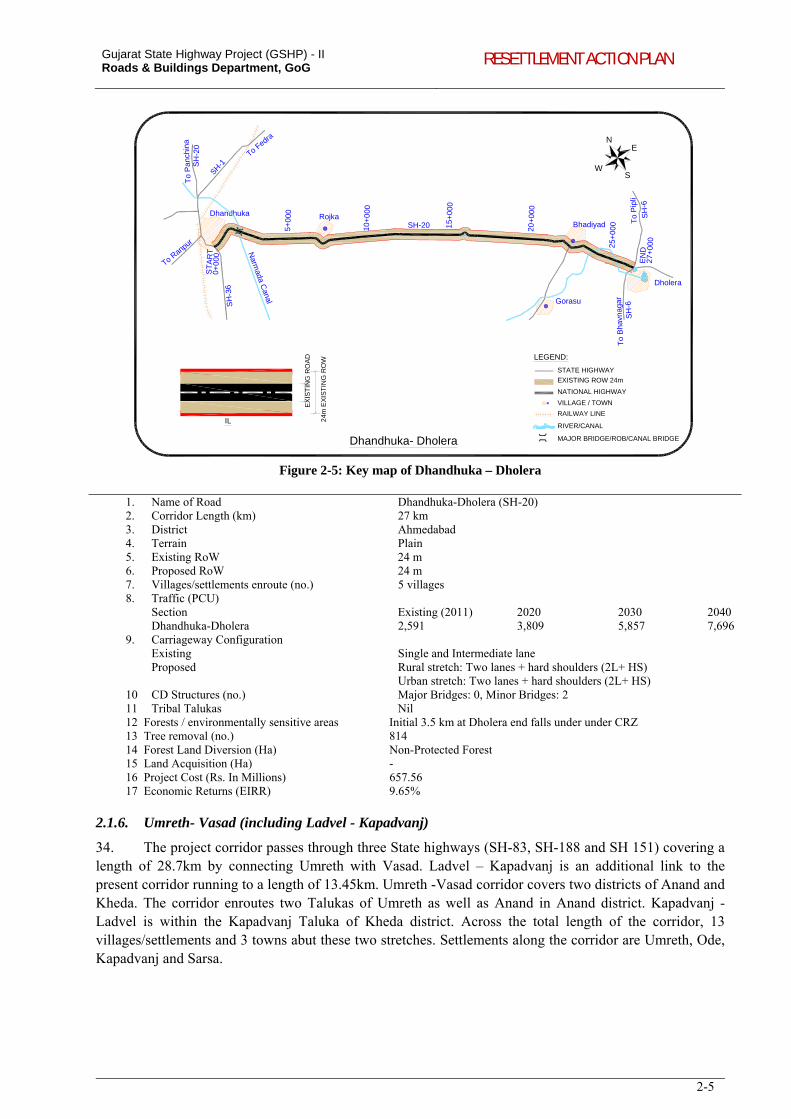
Gujarat State Highway Project (GSHP) - II Roads & Buildings Department, GoG RESETTLEMENT ACTION PLAN
2-5
Dhandhuka- Dholera
To
Pa
nchi
na
To Fedra
To Ranpur
To
Pip
li
To
Bha
vnag
ar
Bhadiyad
Gorasu
Dholera
Dhandhuka
Narm
ada Canal
N
SW
E
24m
EX
IST
ING
RO
W
EX
IST
ING
RO
AD
IL
0+00
0
5+0
00
10+
000
15+
000
20+
000
25+
000
27+
000
ST
AR
T
EN
D
Rojka
LEGEND:
STATE HIGHWAY
EXISTING ROW 24m
NATIONAL HIGHWAY
VILLAGE / TOWN
RAILWAY LINE
RIVER/CANAL
MAJOR BRIDGE/ROB/CANAL BRIDGE
SH-1SH
-20
SH
-36
SH-20
SH
-6
SH
-6
Figure 2-5: Key map of Dhandhuka – Dholera
1. Name of Road Dhandhuka-Dholera (SH-20) 2. Corridor Length (km) 27 km 3. District Ahmedabad 4. Terrain Plain 5. Existing RoW 24 m 6. Proposed RoW 24 m 7. Villages/settlements enroute (no.) 5 villages 8. Traffic (PCU)
Section Existing (2011) 2020 2030 2040 Dhandhuka-Dholera 2,591 3,809 5,857 7,696
9. Carriageway Configuration Existing Single and Intermediate lane Proposed Rural stretch: Two lanes + hard shoulders (2L+ HS)
Urban stretch: Two lanes + hard shoulders (2L+ HS) 10 CD Structures (no.) Major Bridges: 0, Minor Bridges: 2 11 Tribal Talukas Nil 12 Forests / environmentally sensitive areas Initial 3.5 km at Dholera end falls under under CRZ 13 Tree removal (no.) 814 14 Forest Land Diversion (Ha) Non-Protected Forest 15 Land Acquisition (Ha) - 16 Project Cost (Rs. In Millions) 657.56 17 Economic Returns (EIRR) 9.65%
2.1.6. Umreth- Vasad (including Ladvel - Kapadvanj)
34. The project corridor passes through three State highways (SH-83, SH-188 and SH 151) covering a length of 28.7km by connecting Umreth with Vasad. Ladvel – Kapadvanj is an additional link to the present corridor running to a length of 13.45km. Umreth -Vasad corridor covers two districts of Anand and Kheda. The corridor enroutes two Talukas of Umreth as well as Anand in Anand district. Kapadvanj - Ladvel is within the Kapadvanj Taluka of Kheda district. Across the total length of the corridor, 13 villages/settlements and 3 towns abut these two stretches. Settlements along the corridor are Umreth, Ode, Kapadvanj and Sarsa.
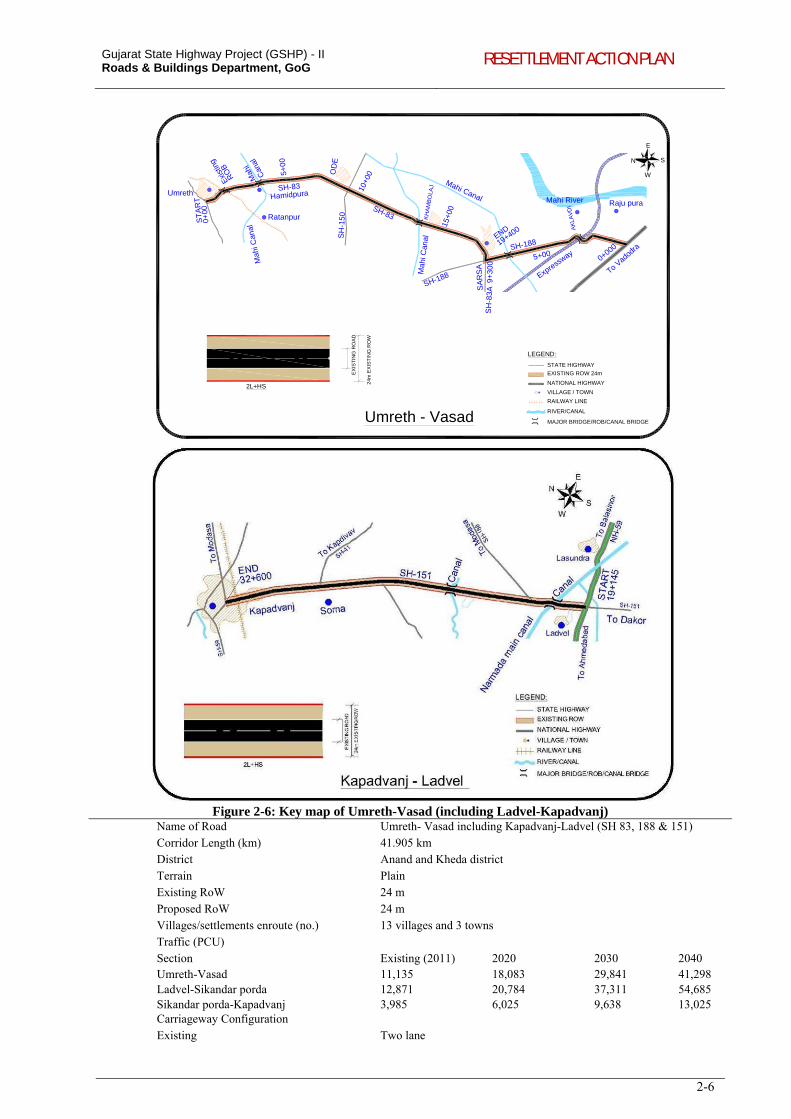
Gujarat State Highway Project (GSHP) - II Roads & Buildings Department, GoG RESETTLEMENT ACTION PLAN
2-6
N S
W
E
Ratanpur
UmrethRaju pura
Mah
i Can
al
Mahi Canal
Mah
i Can
al
To Vadod
ra
Express
way
Mahi River0+
00
5+00
10+0
0
15+0
0
9+30
0
19+400
5+000+000
Umreth - Vasad
24m
EX
IST
ING
RO
W
EX
IST
ING
RO
AD
2L+HS
SH-83
SH-83
ST
AR
T
END
SH-188
SA
RS
A
OD
E
KH
AM
BO
LAJ
Hamidpura
AK
LAV
DI
Can
alM
ahi
Exi
stin
g
RO
B
LEGEND:
STATE HIGHWAY
EXISTING ROW 24m
NATIONAL HIGHWAY
VILLAGE / TOWN
RAILWAY LINE
RIVER/CANAL
MAJOR BRIDGE/ROB/CANAL BRIDGE
SH-188
SH
-83A
SH
-150
Figure 2-6: Key map of Umreth-Vasad (including Ladvel-Kapadvanj) Name of Road Umreth- Vasad including Kapadvanj-Ladvel (SH 83, 188 & 151) Corridor Length (km) 41.905 km District Anand and Kheda district Terrain Plain Existing RoW 24 m Proposed RoW 24 m Villages/settlements enroute (no.) 13 villages and 3 towns Traffic (PCU)
Section Existing (2011) 2020 2030 2040 Umreth-Vasad 11,135 18,083 29,841 41,298 Ladvel-Sikandar porda 12,871 20,784 37,311 54,685 Sikandar porda-Kapadvanj 3,985 6,025 9,638 13,025
Carriageway Configuration Existing Two lane
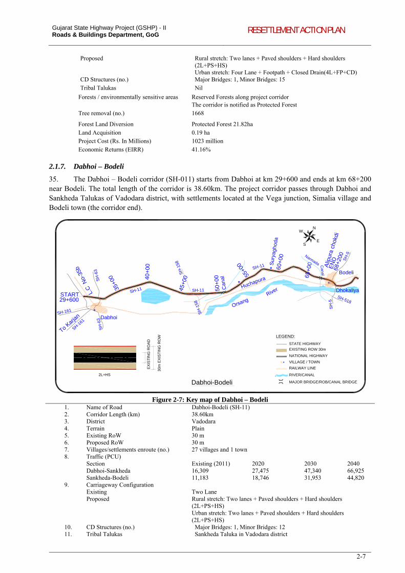
Gujarat State Highway Project (GSHP) - II Roads & Buildings Department, GoG RESETTLEMENT ACTION PLAN
2-7
Proposed Rural stretch: Two lanes + Paved shoulders + Hard shoulders (2L+PS+HS) Urban stretch: Four Lane + Footpath + Closed Drain(4L+FP+CD)
CD Structures (no.) Major Bridges: 1, Minor Bridges: 15 Tribal Talukas Nil
Forests / environmentally sensitive areas Reserved Forests along project corridor The corridor is notified as Protected Forest
Tree removal (no.) 1668
Forest Land Diversion Protected Forest 21.82ha Land Acquisition 0.19 ha Project Cost (Rs. In Millions) 1023 million Economic Returns (EIRR) 41.16%
2.1.7. Dabhoi – Bodeli
35. The Dabhoi – Bodeli corridor (SH-011) starts from Dabhoi at km 29+600 and ends at km 68+200 near Bodeli. The total length of the corridor is 38.60km. The project corridor passes through Dabhoi and Sankheda Talukas of Vadodara district, with settlements located at the Vega junction, Simalia village and Bodeli town (the corridor end).
Alip
ura
chok
di
Bodeli
Dhokaliya
Dabhoi
Dabhoi-Bodeli
30m
EX
IST
ING
RO
W
EX
IST
ING
RO
AD
River
To Karja
n
N
S
W
E
29+600
35+0
0 40+
00
45+0
0
50+
00
55+0
0
60+
00
65+
00Orsang
SH-11
SH-11
SH-11START
68+2
00
EN
D
Sur
yagh
oda
Huchapura
L.C
No-
35b
Can
al
Can
al
Narmada
SH
-63
SH
-63
SH-161
SH-161
SH
-158
SH
-158
SH
-5
SH
-5
SH-518
2L+HS
LEGEND:
STATE HIGHWAY
EXISTING ROW 30m
NATIONAL HIGHWAY
VILLAGE / TOWN
RAILWAY LINE
RIVER/CANAL
MAJOR BRIDGE/ROB/CANAL BRIDGE
Figure 2-7: Key map of Dabhoi – Bodeli 1. Name of Road Dabhoi-Bodeli (SH-11) 2. Corridor Length (km) 38.60km 3. District Vadodara 4. Terrain Plain 5. Existing RoW 30 m 6. Proposed RoW 30 m 7. Villages/settlements enroute (no.) 27 villages and 1 town 8. Traffic (PCU)
Section Existing (2011) 2020 2030 2040 Dabhoi-Sankheda 16,309 27,475 47,340 66,925 Sankheda-Bodeli 11,183 18,746 31,953 44,820
9. Carriageway Configuration Existing Two Lane Proposed Rural stretch: Two lanes + Paved shoulders + Hard shoulders
(2L+PS+HS) Urban stretch: Two lanes + Paved shoulders + Hard shoulders (2L+PS+HS)
10. CD Structures (no.) Major Bridges: 1, Minor Bridges: 12 11. Tribal Talukas Sankheda Taluka in Vadodara district
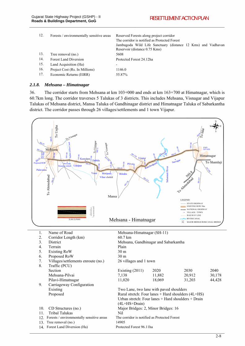
Gujarat State Highway Project (GSHP) - II Roads & Buildings Department, GoG RESETTLEMENT ACTION PLAN
2-8
12. Forests / environmentally sensitive areas Reserved Forests along project corridor The corridor is notified as Protected Forest Jambugoda Wild Life Sanctuary (distance 12 Kms) and Vadhavan Reservoir (distance 0.75 Kms)
13. Tree removal (no.) 5608 14. Forest Land Diversion Protected Forest 24.12ha 15. Land Acquisition (Ha) - 16. Project Cost (Rs. In Millions) 1146.0 17. Economic Returns (EIRR) 55.87%
2.1.8. Mehsana – Himatnagar
36. The corridor starts from Mehsana at km 103+000 and ends at km 163+700 at Himatnagar, which is 60.7km long. The corridor traverses 5 Talukas of 3 districts. This includes Mehsana, Visnagar and Vijapur Talukas of Mehsana district, Mansa Taluka of Gandhinagar district and Himatnagar Taluka of Sabarkantha district. The corridor passes through 26 villages/settlements and 1 town Vijapur.
Palavasna
Himatnagar
To
Unj
ha
To
Ahm
eda b
ad
Mansa
Udalpur
Vasai BilodraVihar chokdi
Proposed ROB
Sab
arm
ati R
iver
To Shamlaji
To Ahm
edab
adNH-8
Suj
lam
suf
lam
Can
al
Pilvai
To
Idar
97+
800
100+
00
105+
00
110+
00
115+
00
120+
00
125+
00
130+
00
135+
00 140+
00
145+
00 150+
00 155+
00 160+
00
163+650
Rampura chokdi
Vijapur
N
Mehsana - Himatnagar
Dabhla
S
W E
ST
AR
T
END
Devrasan
Kamalpur
Ranchodpura
Derol
Navagar
Motipura
To
Vis
naga
r
To
Vis
naga
r
To Visnagar
30m
EX
IST
ING
RO
W
EX
IST
ING
RO
AD
SH-4
1S
H-4
1
SH-19
SH-134
SH-55
SH-55
SH-55
SH-55
SH
-71
SH-218
SH-130
SH-1
30
SH-213
SH-9
SH-2
37
SH-1
45
LEGEND:
STATE HIGHWAY
EXISTING ROW 30m
NATIONAL HIGHWAY
VILLAGE / TOWN
RAILWAY LINE
RIVER/CANAL
MAJOR BRIDGE/ROB/CANAL BRIDGE2LHS/2LPSHS
Mehsana
1. Name of Road Mehsana-Himatnagar (SH-11) 2. Corridor Length (km) 60.7 km 3. District Mehsana, Gandhinagar and Sabarkantha 4. Terrain Plain 5. Existing RoW 30 m 6. Proposed RoW 30 m 7. Villages/settlements enroute (no.) 26 villages and 1 town 8. Traffic (PCU)
Section Existing (2011) 2020 2030 2040 Mehsana-Pilvai 7,138 11,882 20,912 30,178 Pilavi-Himatnagar 11,020 18,069 31,203 44,428
9. Carriageway Configuration Existing Two Lane, two lane with paved shoulders Proposed Rural stretch: Four lanes + Hard shoulders (4L+HS)
Urban stretch: Four lanes + Hard shoulders + Drain (4L+HS+Drain)
10. CD Structures (no.) Major Bridges: 2, Minor Bridges: 16 11. Tribal Talukas Nil 12. Forests / environmentally sensitive areas The corridor is notified as Protected Forest
13. Tree removal (no.) 14905
14. Forest Land Diversion (Ha) Protected Forest 96.11ha
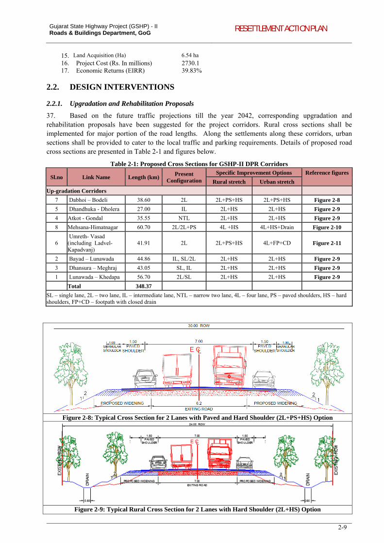
Gujarat State Highway Project (GSHP) - II Roads & Buildings Department, GoG RESETTLEMENT ACTION PLAN
2-9
15. Land Acquisition (Ha) 6.54 ha
16. Project Cost (Rs. In millions) 2730.1 17. Economic Returns (EIRR) 39.83%
2.2. DESIGN INTERVENTIONS
2.2.1. Upgradation and Rehabilitation Proposals
37. Based on the future traffic projections till the year 2042, corresponding upgradation and rehabilitation proposals have been suggested for the project corridors. Rural cross sections shall be implemented for major portion of the road lengths. Along the settlements along these corridors, urban sections shall be provided to cater to the local traffic and parking requirements. Details of proposed road cross sections are presented in Table 2-1 and figures below.
Table 2-1: Proposed Cross Sections for GSHP-II DPR Corridors
Sl.no Link Name Length (km)Present
Configuration Specific Improvement Options Reference figures
Rural stretch Urban stretch
Up-gradation Corridors
7 Dabhoi – Bodeli 38.60 2L 2L+PS+HS 2L+PS+HS Figure 2-8
5 Dhandhuka - Dholera 27.00 IL 2L+HS 2L+HS Figure 2-9
4 Atkot - Gondal 35.55 NTL 2L+HS 2L+HS Figure 2-9
8 Mehsana-Himatnagar 60.70 2L/2L+PS 4L +HS 4L+HS+Drain Figure 2-10
6 Umreth- Vasad (including Ladvel-Kapadvanj)
41.91 2L 2L+PS+HS 4L+FP+CD Figure 2-11
2 Bayad – Lunawada 44.86 IL, SL/2L 2L+HS 2L+HS Figure 2-9
3 Dhansura – Meghraj 43.05 SL, IL 2L+HS 2L+HS Figure 2-9
1 Lunawada – Khedapa 56.70 2L/SL 2L+HS 2L+HS Figure 2-9
Total 348.37
SL – single lane, 2L – two lane, IL – intermediate lane, NTL – narrow two lane, 4L – four lane, PS – paved shoulders, HS – hard shoulders, FP+CD – footpath with closed drain
Figure 2-8: Typical Cross Section for 2 Lanes with Paved and Hard Shoulder (2L+PS+HS) Option
Figure 2-9: Typical Rural Cross Section for 2 Lanes with Hard Shoulder (2L+HS) Option
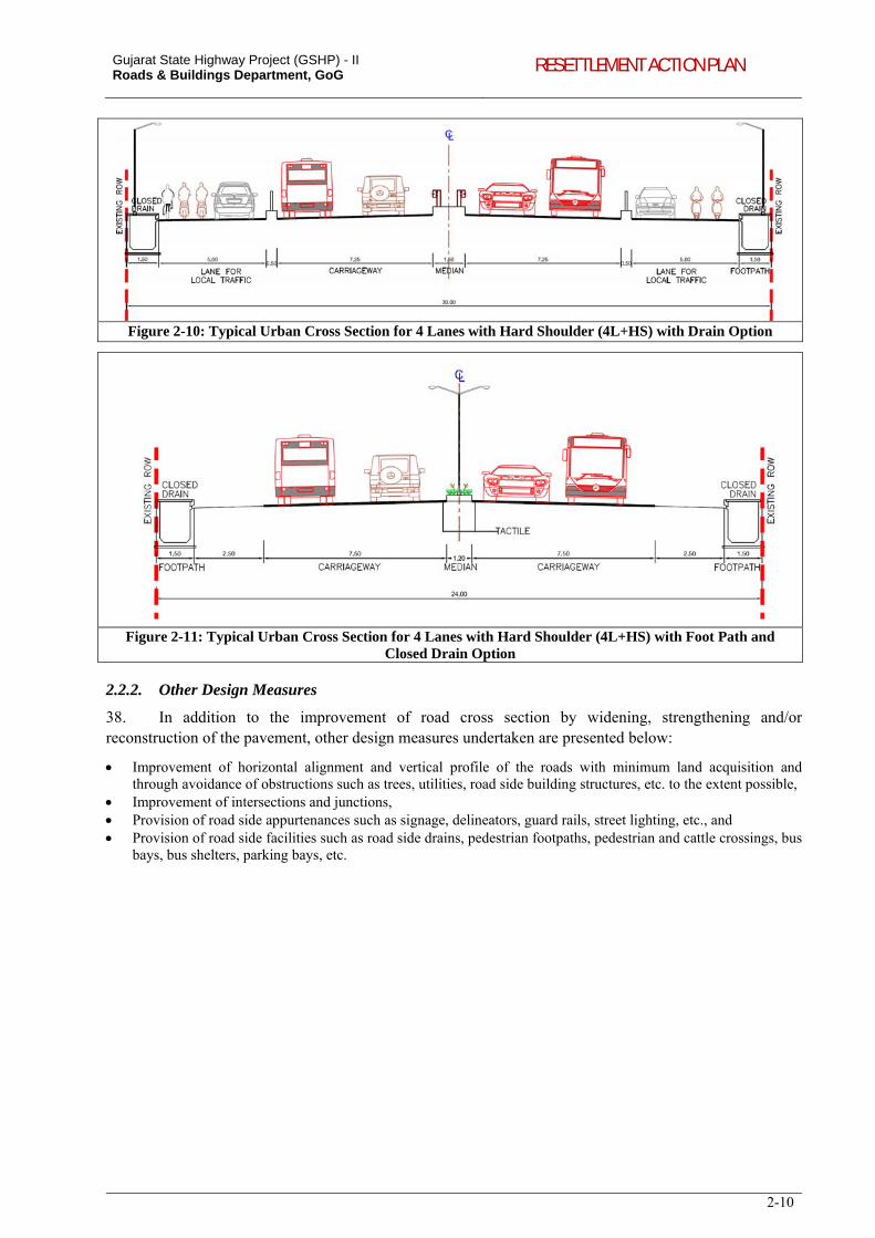
Gujarat State Highway Project (GSHP) - II Roads & Buildings Department, GoG RESETTLEMENT ACTION PLAN
2-10
Figure 2-10: Typical Urban Cross Section for 4 Lanes with Hard Shoulder (4L+HS) with Drain Option
Figure 2-11: Typical Urban Cross Section for 4 Lanes with Hard Shoulder (4L+HS) with Foot Path and Closed Drain Option
2.2.2. Other Design Measures
38. In addition to the improvement of road cross section by widening, strengthening and/or reconstruction of the pavement, other design measures undertaken are presented below:
Improvement of horizontal alignment and vertical profile of the roads with minimum land acquisition and through avoidance of obstructions such as trees, utilities, road side building structures, etc. to the extent possible,
Improvement of intersections and junctions, Provision of road side appurtenances such as signage, delineators, guard rails, street lighting, etc., and Provision of road side facilities such as road side drains, pedestrian footpaths, pedestrian and cattle crossings, bus
bays, bus shelters, parking bays, etc.
3-1
3. SOCIO-ECONOMIC PROFILE OF PROJECT AREA
39. The chapter presents the socio-economic profile of Talukas and villages/settlements abutting the project roads. The selection of the GSHP II project roads is based on the findings of the Updated SOS study carried out by R&BD in 2010. Options taken into consideration towards evolving a strategic road development program include:
Development of Backward Areas: Prioritisation given additional weightage for network development in backward areas and improving its connectivity,
DMIC/DFC Connectivity: Due consideration for development of road corridors within DMIC influence zone and enabling connectivity to DMIC/DFC development nodes, and
Major Corridor Development: Focus on formation of through corridors and their higher order improvements (normally four-laning).
40. The development of the prioritized roads over other alternative routes will result in added revenue generation from dairy, agricultural and other industrial sectors leading to enhanced economic growth. In addition, adjacent communities and road users shall benefit from proposed improvements in road safety, better environmental conditions, etc., and therefore shall contribute significantly to the growth of local economy. The proposed project corridors pass through 9 districts5 of Gujarat. The regional features of development or backwardness6 is summarized as follows:
Dholera Special Investment Region initiated by the Gujarat Infrastructure development board (GIDB) is located in the vicinity of Dhandhuka-Dholera corridor. The Dholera SIR is a self-governed economic region which will enjoy full support of government and full potential for private sector participation.
Government of India is developing Dedicated Freight Corridor (DFC) from Dadri to Mumbai, in which 38 percent of the DFC is passing through Gujarat. Mehsana and Vadodara districts are part of DFC.
Delhi Mumbai Industrial Corridor (DMIC) has identified 5 development nodes in its influence area, of which one investment region and one industrial area are located in Ahmedabad and Vadodara. Two proposed corridors, Dhandhuka-Dholera and Dabhoi-Bodeli pass through the DMIC influence districts.
Lunawada-Khedapa, Bayad-Lunawada and Dhansura-Meghraj pass through backward districts which are characterized by hilly terrain, rocky soil, uncertain rainfall and the presence of large tracts of forest land.
Three corridors Lunawada-Khedapa, Dhansura-Meghraj and Dabhoi-Bodeli pass through Schedule Area.
3.1. POPULATION DISTRIBUTION
3.1.1. Settlements and Population
41. Gujarat stands at 10th rank amongst the States in the country in respect of population and at 21st rank in population density. In terms of percentage, Gujarat accounts 5.96 percentage of the area of India and 4.99 percentage of population of India. The total population of 181 villages/settlements along the project corridors is 9 lakhs as per census 2001, of which 50 percent resides alongside the villages/settlements of Atkot-Gondal, Mehsana-Himatnagar and Umreth-Vasad (including Ladvel-Kapadvanj). There are 167,587 households with an average household size of 5.3 (Table 3-1).
Table 3-1: Distribution for villages/ettlements and population along the Project corridors, 2001
Sr. No. Project Corridors Districts Taluks Villages/
Settlements Population Households
Average HH size
1 Dabhoi-Bodeli 1 2 28 93124 18518 5.03
2 Dhandhuka-Dholera 1 1 5 38634 7173 5.39
3 Atkot-Gondal 1 3 11 127299 22758 5.59
4 Mehsana-Himatnagar 3 5 27 134314 26302 5.11
5 Umreth-Vasad (Incl.Ladvel-Kapadvanj) 2 3 16 162882 31480 5.17
6 Bayad-Lunawada 3 3 29 80884 15695 5.18
7 Dhansura-Meghraj 1 3 32 58780 11563 5.08
5 Panchmahal, Sabarkantha, Kheda, Rajkot, Ahmedabad, Bhavnagar, Anand, Vadodara and Mehsana. 6 Planning Commission, GoI, has identified Panchmahal, Sabarkantha, Narmada, Dangs, Anand and Banaskantha as the backward districts in Gujarat. Source: Ministry of Rural Development, GoI 2009-2010.
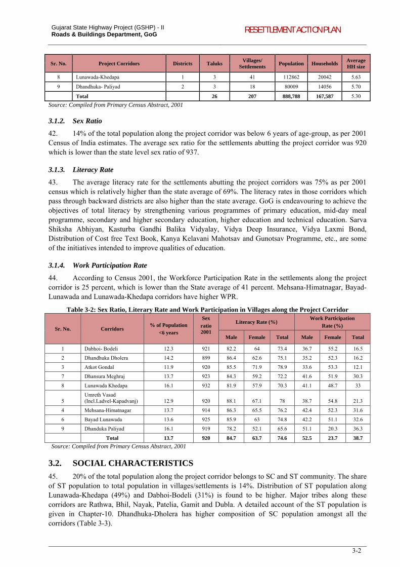
Gujarat State Highway Project (GSHP) - II Roads & Buildings Department, GoG RESETTLEMENT ACTION PLAN
3-2
Sr. No. Project Corridors Districts Taluks Villages/
Settlements Population Households
Average HH size
8 Lunawada-Khedapa 1 3 41 112862 20042 5.63
9 Dhandhuka- Paliyad 2 3 18 80009 14056 5.70
Total 26 207 888,788 167,587 5.30
Source: Compiled from Primary Census Abstract, 2001
3.1.2. Sex Ratio
42. 14% of the total population along the project corridor was below 6 years of age-group, as per 2001 Census of India estimates. The average sex ratio for the settlements abutting the project corridor was 920 which is lower than the state level sex ratio of 937.
3.1.3. Literacy Rate
43. The average literacy rate for the settlements abutting the project corridors was 75% as per 2001 census which is relatively higher than the state average of 69%. The literacy rates in those corridors which pass through backward districts are also higher than the state average. GoG is endeavouring to achieve the objectives of total literacy by strengthening various programmes of primary education, mid-day meal programme, secondary and higher secondary education, higher education and technical education. Sarva Shiksha Abhiyan, Kasturba Gandhi Balika Vidyalay, Vidya Deep Insurance, Vidya Laxmi Bond, Distribution of Cost free Text Book, Kanya Kelavani Mahotsav and Gunotsav Programme, etc., are some of the initiatives intended to improve qualities of education.
3.1.4. Work Participation Rate
44. According to Census 2001, the Workforce Participation Rate in the settlements along the project corridor is 25 percent, which is lower than the State average of 41 percent. Mehsana-Himatnagar, Bayad-Lunawada and Lunawada-Khedapa corridors have higher WPR.
Table 3-2: Sex Ratio, Literary Rate and Work Participation in Villages along the Project Corridor
Sr. No. Corridors % of Population
<6 years
Sex
ratio 2001
Literacy Rate (%) Work Participation
Rate (%)
Male Female Total Male Female Total
1 Dabhoi- Bodeli 12.3 921 82.2 64 73.4 36.7 55.2 16.5
2 Dhandhuka Dholera 14.2 899 86.4 62.6 75.1 35.2 52.3 16.2
3 Atkot Gondal 11.9 920 85.5 71.9 78.9 33.6 53.3 12.1
7 Dhansura Meghraj 13.7 923 84.3 59.2 72.2 41.6 51.9 30.3
8 Lunawada Khedapa 16.1 932 81.9 57.9 70.3 41.1 48.7 33
5 Umreth Vasad (Incl.Ladvel-Kapadvanj) 12.9 920 88.1 67.1 78 38.7 54.8 21.3
4 Mehsana-Himatnagar 13.7 914 86.3 65.5 76.2 42.4 52.3 31.6
6 Bayad Lunawada 13.6 925 85.9 63 74.8 42.2 51.1 32.6
9 Dhanduka Paliyad 16.1 919 78.2 52.1 65.6 51.1 20.3 36.3
Total 13.7 920 84.7 63.7 74.6 52.5 23.7 38.7
Source: Compiled from Primary Census Abstract, 2001
3.2. SOCIAL CHARACTERISTICS
45. 20% of the total population along the project corridor belongs to SC and ST community. The share of ST population to total population in villages/settlements is 14%. Distribution of ST population along Lunawada-Khedapa (49%) and Dabhoi-Bodeli (31%) is found to be higher. Major tribes along these corridors are Rathwa, Bhil, Nayak, Patelia, Gamit and Dubla. A detailed account of the ST population is given in Chapter-10. Dhandhuka-Dholera has higher composition of SC population amongst all the corridors (Table 3-3).
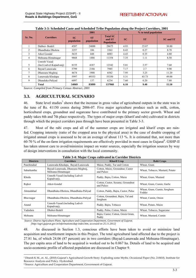
Gujarat State Highway Project (GSHP) - II Roads & Buildings Department, GoG RESETTLEMENT ACTION PLAN
3-3
Table 3-3: Scheduled Caste and Scheduled Tribe Population along the Project Corridors, 2001
Sr. No. Corridors
2001 % to total population
SC population
ST population
Total SC and ST
Population SC ST SC and ST
1 Dabhoi- Bodeli 4587 24088 28675 4.93 25.87 30.80
2 Dhandhuka Dholera 3257 106 3363 8.43 0.27 8.70
3 Atkot Gondal 5635 448 6083 4.43 0.35 4.80
4 Mehsana-Himatnagar 9868 1486 11354 7.35 1.11 8.50
5 Umreth Vasad (Incl.Ladvel-Kapadvanj) 8155 4187 12342 5.01 2.57 7.60
6 Bayad Lunawada 5799 2186 7985 7.17 2.7 9.90
7 Dhansura Meghraj 4674 1908 6582 7.95 3.25 11.20
8 Lunawada Khedapa 5997 49353 55350 5.31 43.73 49.00
9 Dhanduka Paliyad 6097 137 6234 7.60 0.20 7.80
Total 54069 83899 137968 6.10 9.40 15.50
Source: Compiled from Primary Census Abstract, 2001
3.3. AGRICULTURAL SCENARIO
46. State level studies7 shows that the increase in gross value of agricultural outputs in the state was in the tune of Rs. 41150 crores during 2006-07. Five major agriculture produce such as milk, cotton, horticultural crops, groundnut and sugarcane have contributed to the primary sector growth. Wheat and paddy takes 6th and 7th place respectively. The types of major crops (kharif and rabi) cultivated in districts through which the project corridors pass through have been presented in Table 3-3.
47. Most of the rabi crops and all of the summer crops are irrigated and kharif crops are rain-fed. Cropping intensity (ratio of the cropped area to the physical area) in the case of double cropping of irrigated annual crops is assessed to be on an average of about 113 %. It is estimated that, not more than 60-70 % of the on-farm irrigation requirements are effectively provided in most cases in Gujarat8. GSHP-II has taken utmost care to avoid/minimize impact on water sources, especially the irrigation sources by way of design interventions in consultation with the local community.
Table 3-4: Major Crops cultivated in Corridor Districts Districts Corridors Kharif Crop Rabi Crops
Panchmahal Lunawada-Khedapa, Bayad-Lunawada Maize, Paddy, Tur and Cotton Wheat, Gram
Sabarkantha Bayad-Lunawada, Dhansura-Meghraj, Mehsana-Himatnagar
Cotton, Maize, Groundnut, Castor and Pulses
Wheat, Tobacco, Mustard, Potato
Kheda Umreth-Vasad (including Ladvel-Kapadvanj),
Paddy, Bajra, Cotton, Maize Wheat, Gram, Mustard
Rajkot Atkot-Gondal Cotton, Castor, Sesame, Groundnut and Pulses
Wheat, Gram, Cumin, Garlic
Ahmedabad Dhandhuka-Dholera, Dhandhuka-Paliyad Cotton, Paddy, Bajra, Castor, Pulse Wheat, Gram, Cumin, Sorghum Fodder
Bhavnagar Dhandhuka-Dholera, Dhandhuka-Paliyad Cotton, Groundnut, Bajra, Tal and Sorghum
Wheat, Cumin, Onion
Anand Umreth-Vasad (including Ladvel-Kapadvanj),
Paddy, Bajra, Tobacco Wheat, Potato, Maize
Vadodara Dhaboi-Bodeli Paddy, Pulse, Cotton, Maize Wheat, Tobacco, Sugarcane
Mehsana Mehsana-Himatnagar Bajra, Castor, Cotton, Green Gram, Paddy
Wheat, Mustard, Cumin
Source: District Agriculture Plans. Agriculture and Cooperation Department, Government of Gujarat. [http://agri.gujarat.gov.in/informations/dap-index.htm, accessed on 25.11.2012]
48. As discussed in Section 1.3, conscious efforts have been taken to avoid or minimize land acquisition and resettlement impacts in this Project. The total agricultural land affected due to the project is 27.81 ha, of which 24.06 (87 percent) are in two corridors (Bayad-Lunawada and Mehsana-Himatnagar). The per capita area of land to be acquired is worked out to be 0.067 ha. Details of land to be acquired and socio-economic profile of affected population are discussed in Chapter 9.
7 Dinesh K M., et. Al., (2010) Gujarat’s Agricultural Growth Story: Exploding some Myths. Occasional Paper (No. 2-0410). Institute for Resource Analysis and Policy. Hyderabad. 8 Source: Agriculture and Cooperation Department, Government of Gujarat.
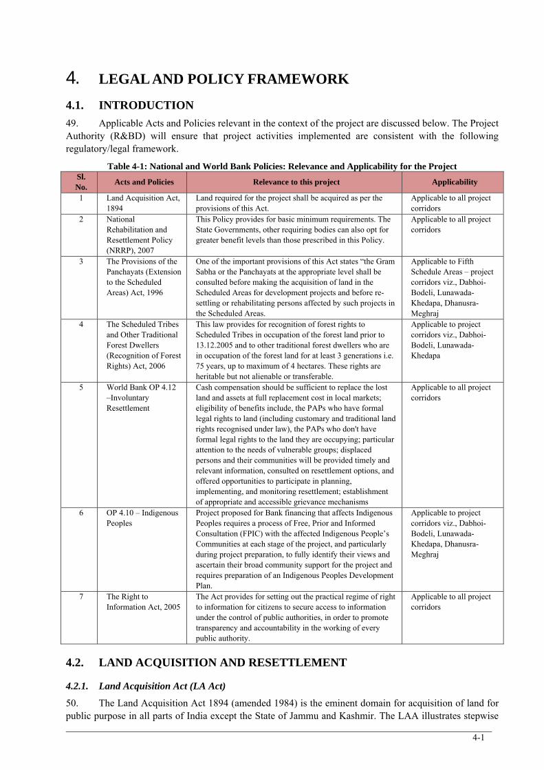
4-1
4. LEGAL AND POLICY FRAMEWORK
4.1. INTRODUCTION
49. Applicable Acts and Policies relevant in the context of the project are discussed below. The Project Authority (R&BD) will ensure that project activities implemented are consistent with the following regulatory/legal framework.
Table 4-1: National and World Bank Policies: Relevance and Applicability for the Project Sl. No.
Acts and Policies Relevance to this project Applicability
1 Land Acquisition Act, 1894
Land required for the project shall be acquired as per the provisions of this Act.
Applicable to all project corridors
2 National Rehabilitation and Resettlement Policy (NRRP), 2007
This Policy provides for basic minimum requirements. The State Governments, other requiring bodies can also opt for greater benefit levels than those prescribed in this Policy.
Applicable to all project corridors
3 The Provisions of the Panchayats (Extension to the Scheduled Areas) Act, 1996
One of the important provisions of this Act states “the Gram Sabha or the Panchayats at the appropriate level shall be consulted before making the acquisition of land in the Scheduled Areas for development projects and before re-settling or rehabilitating persons affected by such projects in the Scheduled Areas.
Applicable to Fifth Schedule Areas – project corridors viz., Dabhoi-Bodeli, Lunawada-Khedapa, Dhanusra-Meghraj
4 The Scheduled Tribes and Other Traditional Forest Dwellers (Recognition of Forest Rights) Act, 2006
This law provides for recognition of forest rights to Scheduled Tribes in occupation of the forest land prior to 13.12.2005 and to other traditional forest dwellers who are in occupation of the forest land for at least 3 generations i.e. 75 years, up to maximum of 4 hectares. These rights are heritable but not alienable or transferable.
Applicable to project corridors viz., Dabhoi-Bodeli, Lunawada-Khedapa
5 World Bank OP 4.12 –Involuntary Resettlement
Cash compensation should be sufficient to replace the lost land and assets at full replacement cost in local markets; eligibility of benefits include, the PAPs who have formal legal rights to land (including customary and traditional land rights recognised under law), the PAPs who don't have formal legal rights to the land they are occupying; particular attention to the needs of vulnerable groups; displaced persons and their communities will be provided timely and relevant information, consulted on resettlement options, and offered opportunities to participate in planning, implementing, and monitoring resettlement; establishment of appropriate and accessible grievance mechanisms
Applicable to all project corridors
6 OP 4.10 – Indigenous Peoples
Project proposed for Bank financing that affects Indigenous Peoples requires a process of Free, Prior and Informed Consultation (FPIC) with the affected Indigenous People’s Communities at each stage of the project, and particularly during project preparation, to fully identify their views and ascertain their broad community support for the project and requires preparation of an Indigenous Peoples Development Plan.
Applicable to project corridors viz., Dabhoi-Bodeli, Lunawada-Khedapa, Dhanusra-Meghraj
7 The Right to Information Act, 2005
The Act provides for setting out the practical regime of right to information for citizens to secure access to information under the control of public authorities, in order to promote transparency and accountability in the working of every public authority.
Applicable to all project corridors
4.2. LAND ACQUISITION AND RESETTLEMENT
4.2.1. Land Acquisition Act (LA Act)
50. The Land Acquisition Act 1894 (amended 1984) is the eminent domain for acquisition of land for public purpose in all parts of India except the State of Jammu and Kashmir. The LAA illustrates stepwise
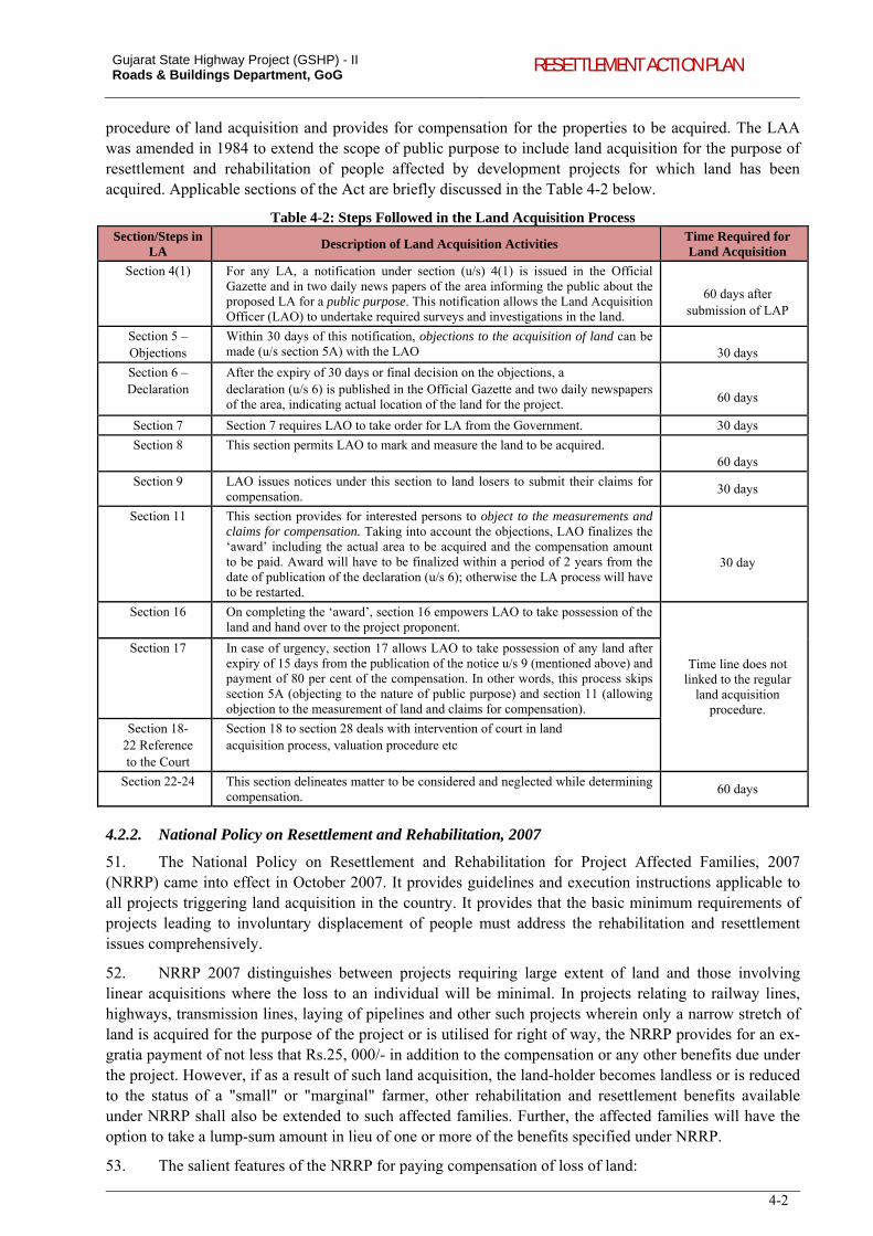
Gujarat State Highway Project (GSHP) - II Roads & Buildings Department, GoG RESETTLEMENT ACTION PLAN
4-2
procedure of land acquisition and provides for compensation for the properties to be acquired. The LAA was amended in 1984 to extend the scope of public purpose to include land acquisition for the purpose of resettlement and rehabilitation of people affected by development projects for which land has been acquired. Applicable sections of the Act are briefly discussed in the Table 4-2 below.
Table 4-2: Steps Followed in the Land Acquisition Process Section/Steps in
LA Description of Land Acquisition Activities
Time Required for Land Acquisition
Section 4(1)
For any LA, a notification under section (u/s) 4(1) is issued in the Official Gazette and in two daily news papers of the area informing the public about the proposed LA for a public purpose. This notification allows the Land Acquisition Officer (LAO) to undertake required surveys and investigations in the land.
60 days after
submission of LAP
Section 5 – Objections
Within 30 days of this notification, objections to the acquisition of land can be made (u/s section 5A) with the LAO
30 days
Section 6 – Declaration
After the expiry of 30 days or final decision on the objections, a declaration (u/s 6) is published in the Official Gazette and two daily newspapers of the area, indicating actual location of the land for the project.
60 days
Section 7 Section 7 requires LAO to take order for LA from the Government. 30 days
Section 8 This section permits LAO to mark and measure the land to be acquired. 60 days
Section 9 LAO issues notices under this section to land losers to submit their claims for compensation.
30 days
Section 11
This section provides for interested persons to object to the measurements and claims for compensation. Taking into account the objections, LAO finalizes the ‘award’ including the actual area to be acquired and the compensation amount to be paid. Award will have to be finalized within a period of 2 years from the date of publication of the declaration (u/s 6); otherwise the LA process will have to be restarted.
30 day
Section 16
On completing the ‘award’, section 16 empowers LAO to take possession of the land and hand over to the project proponent.
Time line does not linked to the regular
land acquisition procedure.
Section 17
In case of urgency, section 17 allows LAO to take possession of any land after expiry of 15 days from the publication of the notice u/s 9 (mentioned above) and payment of 80 per cent of the compensation. In other words, this process skips section 5A (objecting to the nature of public purpose) and section 11 (allowing objection to the measurement of land and claims for compensation).
Section 18- 22 Reference to the Court
Section 18 to section 28 deals with intervention of court in land acquisition process, valuation procedure etc
Section 22-24 This section delineates matter to be considered and neglected while determining compensation.
60 days
4.2.2. National Policy on Resettlement and Rehabilitation, 2007
51. The National Policy on Resettlement and Rehabilitation for Project Affected Families, 2007 (NRRP) came into effect in October 2007. It provides guidelines and execution instructions applicable to all projects triggering land acquisition in the country. It provides that the basic minimum requirements of projects leading to involuntary displacement of people must address the rehabilitation and resettlement issues comprehensively.
52. NRRP 2007 distinguishes between projects requiring large extent of land and those involving linear acquisitions where the loss to an individual will be minimal. In projects relating to railway lines, highways, transmission lines, laying of pipelines and other such projects wherein only a narrow stretch of land is acquired for the purpose of the project or is utilised for right of way, the NRRP provides for an ex-gratia payment of not less that Rs.25, 000/- in addition to the compensation or any other benefits due under the project. However, if as a result of such land acquisition, the land-holder becomes landless or is reduced to the status of a "small" or "marginal" farmer, other rehabilitation and resettlement benefits available under NRRP shall also be extended to such affected families. Further, the affected families will have the option to take a lump-sum amount in lieu of one or more of the benefits specified under NRRP.
53. The salient features of the NRRP for paying compensation of loss of land:
Gujarat State Highway Project (GSHP) - II Roads & Buildings Department, GoG RESETTLEMENT ACTION PLAN
4-3
NRRP provides for compensation for loss of land only to titleholder; Compensation by land for land (if land is available) or Compensation at “replacement cost” or “actual market
value” for agricultural land; Project displaced persons (whose entire land is taken) will receive land in lieu of his loss. In addition to their loss
cash assistance will be paid for restoring lost livelihood; Affected people without legal rights (landless agricultural workers, forest dwellers, tenants and artisans who are
critically dependent on the acquired assets for their subsistence/ livelihoods) will only receive assistance.
4.2.3. World Bank Safeguard Policies - OP/BP 4.12 – Involuntary Resettlement
54. The Operational Policy 4.12 provides procedures and responsibilities towards displaced persons involved in Involuntary Resettlement. It aims at avoiding or minimizing forced displacement due to its disruptive and impoverishing effects. The key provisions of the policy are given below:
Ensure that the displaced persons are informed about their options and rights pertaining to resettlement; Consulted on, offered choices among, and provided with technically and economically feasible resettlement
alternatives; Prompt and effective compensation at full replacement cost for losses of assets; Provide assistance and allowances; Provide equivalent productive assets for the loss of residential house, agricultural land etc.; Provide support for the transition period (between displacement and livelihood restoration); Provide land related development assistance (credit facilities and training); Preference should be given to land-based resettlement strategies for displaced persons whose livelihoods are
land-based; Cash compensation level should be sufficient to replace the lost land and assets at full replacement cost in local
markets; Eligibility of benefits include, the PAPs who have formal legal rights to land (including customary and
traditional land rights recognized under law), the PAPs who don't have formal legal rights to land at the time of census but have a claim to such land or assets and the PAPs who have no recognisable legal right to the land they are occupying;
Particular attention will be paid to the needs of vulnerable groups among those displaced, especially those below the poverty line, landless, elderly, women and children, ethnic minorities etc;
The displaced persons and their communities will be provided timely and relevant information, consulted on resettlement options, and offered opportunities to participate in planning, implementing, and monitoring resettlement. Appropriate and accessible grievance mechanisms are established for these groups.
55. In addition to the above core measures on the Bank's policy it also laid emphasis on a detailed resettlement policy inclusive of all the above points; project specific resettlement plan; institutional framework for implementation; monitoring and evaluation mechanism; time schedule for implementation; and detailed Financial Plan etc.
4.3. TRIBAL DEVELOPMENT
56. The Acts and policies related to Scheduled Tribes at the state level and national level have been reviewed and their relevance to the project has been analysed taken into consideration while preparing IPDP. A brief account of the legal framework at national and state level, Constitutional provisions for safeguard of SCs/STs, World Bank policy, etc., are presented in this section.
4.3.1. Scheduled Tribes, Scheduled Areas and Constitution of India
57. Article 366 (25) of the Constitution of India refers to Scheduled Tribes as those communities, who are scheduled in accordance with Article 342 of the Constitution. As laid down in the provisions of Article 342, communities shall be declared as such by the President through an initial public notification or through a subsequent amending Act of Parliament. The essential characteristics, for a community to be identified as Scheduled Tribes are;
Indications of primitive traits; Distinctive culture; Shyness of contact with the community at large; Geographical isolation; and
Gujarat State Highway Project (GSHP) - II Roads & Buildings Department, GoG RESETTLEMENT ACTION PLAN
4-4
Backwardness.
58. The Fifth Schedule under Article 244(1) of Constitution defines “Scheduled Areas” as such areas as the President may by order declare to be Scheduled Areas after consultation with the Governor of that State. The criteria for declaring any area as a “Scheduled Area” under the Fifth Schedule are; (a) preponderance of tribal population, (b) compactness and reasonable size of the area, (c) a viable administrative entity such as a district, block or Taluka, and (d) economic backwardness of the area as compared to the neighbouring areas.
59. In Gujarat, 43 Talukas in 12 districts have been declared as “Scheduled Area” under the Presidential Order CO. 109 dated 31/12/1977.
4.3.2. National Rehabilitation and Resettlement Policy, 2007 and R&R Assistance for STs
60. The National Rehabilitation and Resettlement Policy, 2007 (NRRP) provides guidelines and execution instructions applicable to all projects. It provides that the basic minimum requirements of projects leading to involuntary displacement of people must address the rehabilitation and resettlement issues comprehensively. The special assistance for the tribal community as per the NRRP are:
Each affected family belonging to ST shall be given preference in allotment of land-for-land, provided government land is available;
Each ST AF shall get an additional one-time financial assistance equivalent to 500 days minimum agricultural wages for loss of customary rights/usages of forest produce;
Tribal AFs will be re-settled in the same Scheduled Area in a compact block so that they can retain their ethnic, linguistic and cultural identity subject to availability of Government land;
Settlements predominantly inhabited by Scheduled Tribes shall get land free of cost for community and religious gatherings;
Tribal land alienated in violation of the laws and regulations in force on the subject will be treated as null and void. R&R benefits will be available only to the original tribal land owner; and
Tribal AFs enjoying reservation benefits in the affected zone shall be entitled to get the reservation benefits at the resettlement zone.
4.3.3. The Scheduled Tribes and Other Traditional Forest Dwellers (Recognition of Forest Rights) Act, 2006
61. The Act has been framed to recognize and vest the forest rights and occupation in forest land in forest dwelling STs and other traditional forest dwellers who have residing in such forests for generations but whose rights could not be recorded. The Act intends to provide for a framework for recording the forest rights so vested and the nature of evidence required for such recognition and vesting in respect of forest land.
62. This policy recognizes that a majority of STs continue to live below the poverty line, have poor literacy rates, suffer from malnutrition and diseases and are vulnerable to displacement and thus the policy aims at addressing each of these problems in a concrete way. It also lists out measures to be taken to preserve and promote tribal cultural heritage.
63. The main objective is to facilitate the overall development and welfare of the tribal people by empowering them socially, economically and politically without any impact on their culture, habitation and tradition and in terms of their age old rights and privileges.
There are no forest lands with traditional rights impacted along the 4 Talukas forming part of the Scheduled Areas. Impacts on forest resources along these corridors are limited to the felling of roadside tree plantations within the RoW. Forest clearance requirements are triggered because the roadside plantations in the State of Gujarat along major highways have been notified as Protected Forests. In line with the provisions of the FRA, 2006 – for each of the 32 tribal villages along the three corridors, R&BD has convened meetings of the Gram Sabha, wherein resolutions accorded no-objection for felling of the trees / protected forests after confirmation that (i) there are no forest dwellers with traditional forest rights and (ii) there are no recognized forest rights of the ST communities. Copy of Grama Sabha Resolution of Vega village (Dabhoi-Bodeli corridor) is given in Appendix 4.1. Further these resolutions at the individual village level are a prerequisite for issuance of forest clearance by the Forest Department.
Gujarat State Highway Project (GSHP) - II Roads & Buildings Department, GoG RESETTLEMENT ACTION PLAN
4-5
4.3.4. World Bank Safeguard policies - OP 4.10 - Indigenous People
64. The OP 4.10, is applicable to indigenous peoples. The directive provides policy guidance to: a) ensure that indigenous people benefit from development projects, and b) avoid or mitigate potentially adverse effects on indigenous people, tribes, ethnic minorities, or other groups. It provides directives for preparation of indigenous people development plan (IPDP). The pre requisite for successful IPDP includes:
Prepare a plan based on people's choice; Avoid or mitigate adverse trends; Development activities adaptable to the needs and environment of indigenous people; and, Encourage early hand over of project management to local people.
65. The OP 4.10 elaborates the contents and the component of the IPDP. Appropriate existing institutions, local organizations and non-governmental organizations (NGOs) with expertise in matters relating to indigenous people should implement the plan. The IPDP for indigenous people should include: (i) Assessment of legal framework; (ii) Baseline data; (iii) Land tenure; (iv) Strategy for local participation; (v) Technical identification of development or mitigation activities; (vi) Institutional capacity; (vii) Implementation Schedule; (viii) Monitoring and evaluation; and,(ix) Cost estimates and financial plan.
66. “Indigenous Peoples” is used in a generic sense to refer to a distinct, vulnerable, social and cultural group possessing the following characteristics in varying degrees:
self-identification as members of a distinct indigenous cultural group and recognition of this identity by others; collective attachment to geographically distinct habitats or ancestral territories in the project area and to the
natural resources in these habitats and territories; customary cultural, economic, social, or political institutions that are separate from those of the dominant society
and culture; and an indigenous language, often different from the official language of the country or region.
67. A group that has lost “collective attachment to geographically distinct habitats or ancestral territories in the project area” because of forced severance remains eligible for coverage under this policy.
4.3.5. Scheduled Caste and Scheduled Tribes (Prevention of Atrocities) Act, 1989
68. This Act prevents the commission of offences or atrocities against members of the STs and SCs and provides for a special court for the trial of offences against them. It also provides for the relief and rehabilitation of victims of such offences.
In order to prosecute cases under the Prevention of Atrocities Act, 1989, the Government of Gujarat, the senior-most Additional Public Prosecutors of all the Sessions Courts in Gujarat have been empowered to conduct cases under the Act in Special Courts. Therefore, 25 special courts in various districts, including the project corridor districts Vadodara, Panchmahal and Sabarkantha have been established. During the year 2009-2010, nearly 210 people were victimized for various atrocities and financial assistance Rs. 25 lakh disbursed to the affected persons. The crime against the STs9 in Gujarat is reduced to 2.6 percent (percentage with respect to All India) during 2010, from the level of 3.6 percent recorded during 200910
4.3.6. Panchayats (Extension to the Scheduled Areas) Act, 1996
69. Parliament has passed legislation in 1996 as an annexure to the 73rd Amendment specifying special provisions for Panchayats in Schedule V areas. Known as the Panchayats Extension to Schedule Areas (PESA), 1996, it decentralized existing approaches to forest governance by bringing the Gram Sabha11 centre stage and recognized the traditional rights of Scheduled Tribe people over community resources, the land, water, and forests.
9 This includes murder, rape, kidnapping and abduction, dacoit, robbery, arson, hurt, incidences with respect to Protection of Civil Rights Act and SC/ST Prevention of Atrocities Act. 10 National Crime Records Bureau (2010), Ministry of Home Affairs, Government of India. 11 The Gram Sabha is a body consisting of persons registered in the electoral rolls of a village or a group of villages which elect a Panchayat. Each Gram Sabha shall be competent to safeguard and preserve the traditions and customs of the people, their cultural identity, community resources, and the customary mode of dispute resolution.
Gujarat State Highway Project (GSHP) - II Roads & Buildings Department, GoG RESETTLEMENT ACTION PLAN
4-6
70. The 73rd amendment to the Constitution and the subsequent enactment of PESA intended to ground decentralization in India, through the transfer of power to the Gram Sabha or the village assembly. With PESA, an effort was made to vest legislative powers in the Gram Sabha, to manage community resources, and to resolve disputes according to the customs and traditions of the people. This significant legislation was expected to have far reaching consequences in the social, economic, and cultural life of tribal people in Scheduled Areas.
Many of the provisions of the Central PESA Act, 1996 were covered in the amended Gujarat Panchayat Act, 1993 after 73rd Amendment to the Indian Constitution. The Panchayati Raj system is largely prevailing in the state of Gujarat. Subsequent to this Constitutional Amendment, the Gujarat Panchayat Act was amended and enacted as “The Gujarat Panchayat Act”. This Act came into force on 20th December 1997.
4.3.7. Constitutional Provisions for Safeguard of SC /ST’S
71. The Constitution of India defines tribal groups and tribal areas under various Articles. Article 342 specifies tribes or tribal communities. Article 341 requires the President of India to specify the castes, races or tribes or parts of groups within castes, races, tribes etc., and these tribes and castes so specified are referred as STs and SCs respectively. In pursuance of these provisions, the list of STs and SCs are notified for each State and Union Territory for whom a number of social, economic and political safeguards are provided by the constitution of India. The following section lists of the major constitutional safeguards available for SCs and STs in India.
Social Safeguards Equality before Law (Article 14). The State to make special provisions for the advancement of any socially and educationally backward classes of
citizens or for the SCs and the STs (Article 15(4)). Equality of opportunity for all citizens in matters relating to employment or appointments to any office under the
State (Article 16). The State has to make provisions for reservation in appointments or posts in favour of any backward class citizen
which in the opinion of the State is not adequately represented in the services under the State (Article 16(4)). The State to make provisions in matters of promotion to any class or classes of posts in the services in favour of
the SCs and the STs (Article 16(4A)). A National Commission for SCs and the STs to investigate, monitor and evaluate all matters relating to the
Constitutional safeguards provided for the Scheduled Castes and the Scheduled Tribes (Article 338). Recognising the fact that the needs and problems of STs and the solutions required were quite different from
those of SCs, and a special approach for tribal development and independent machinery to safeguard the rights of STs was considered necessary, a separate National Commission for Scheduled Tribes (NCST) was set up through the Constitution (89th Amendment) Act, 2003 (Article 338A).
Appointment of a Commission to report on the administration of the Scheduled Areas and the welfare of the STs in the States (Article 339).
Appointment of a Commission to investigate the conditions of socially and educationally backward classes and the difficulties under which they labour and to make recommendations to remove such difficulties and to improve their conditions (Article 340).
Economic Safeguards The State to promote with special care the educational and economic interests of the weaker sections of the
people, and in particular, of SCs and the STs, and protect them from social injustice and all forms of exploitation (Article 46).
Grant-in-Aid from the consolidated fund of India each year for promoting the welfare of the STs and administration of the Scheduled Areas (Article 275(1)).
The claims of the members of the SCs and the STs in the appointments to services and posts in connection with the affairs of the Union or of a State by taking into consideration consistently with the maintenance of efficiency of administration (Article 335).
Political Safeguards Article 244 (1) of the Constitution states that the provisions of the Fifth Schedule shall apply to the
administration and control of Scheduled Areas and Scheduled Tribes in State of Gujarat. Twelve districts are identified as Fifth Schedule Areas in Gujarat.
Article 330 states that seats shall be reserved for the SCs and the STs in the House of the People. Article 332 states that seats shall be reserved for the SCs and the STs in the Legislative Assemblies of the States. Article 243D states that seats shall be reserved for the SCs and the STs in every Panchayat.
Gujarat State Highway Project (GSHP) - II Roads & Buildings Department, GoG RESETTLEMENT ACTION PLAN
4-7
4.3.8. Bombay Money Lender’s Act
72. On the recommendation of Bhuria Committee report, the government of Gujarat mandated to get authorisation of the Gram Panchayat at before lending in tribal areas vide notification dated 13/7/1998. In relation to this, Section 7(C) was introduced in Bombay Money Lending Act and hence the Gram Panchayat’s consent was made mandatory by this statutory provision. Therefore, any money lender must obtain permission from Gram Panchayat before doing money lending business to ST community. Furthermore, the Large Size Agricultural Multi-Purpose Society (LAMPS) in tribal areas provide with facility of pledging money against gold ornaments.
4.3.9. Bombay Land Revenue (Gujarat Second Amendment) Act, 1980
73. The Scheduled Tribes fall prey to the money lenders and their magnitude of the exploitation is of high. The poor sections of STs are deprived of possession of the land owing to the exploitation of the money lenders and rich people of the society. The state government has amended section 73 (C) and ratified the new sections 73 (AA) to 73 (AD) in the Bombay Land Revenue Code. The new amendment empowered the district collectors to declare the transfer made by tribes to non- tribes in conservation of provision of Bombay Land Revenue code as invalid. The Amendment has been in functional since February 1981. The land possessed by tribes cannot be transferred without permission of the district collector concerned.
5-1
5. STAKEHOLDER CONSULTATIONS
5.1. INTRODUCTION
74. Consultation with stakeholders is an integral part of the project planning and design. The consultations were carried out to develop community /stakeholder’s ownership and support for the project, and integrate and address their concerns through suitable measures in the project design and implementation. Continued consultation provides the basis to integrate concerns emerging during project implementation and also include potential good practices from previous projects.
75. Suggestions were also received from the community regarding various relocation options, types of assistance offered for the potential impact on land, structure and other assets such as agriculture crops, trees, community assets, etc. The objectives of consultation were:
To create awareness amongst stakeholders; To create improvement in project design for minimizing potential conflicts and resultant delays in
implementation; To document road safety related issues for developing possible mitigation measures; To appraise gender issues and accordingly incorporate views of women into the project design; To study specific issues related to tribal people and those of vulnerable sections; To facilitate development of appropriate and acceptable entitlement options; To increase project sustainability; and To reduce problems of institutional co-ordination.
5.2. CONSULTATION PROCESS
5.2.1. Identification of Stakeholders
76. At an early stage of the project, the project preparation team of the consultants identified key stakeholders for the project based on reconnaissance visits along the project corridor. Identification of important stakeholders for this project was done considering their expected roles in the planning and implementation of the project. Stakeholders identified for the project are given in Table 5-1.
Table 5-1: Stakeholders Consulted Potential PAPs; Groups of affected persons; Communities along the project corridors; Revenue Department; Forest Department (FD); Village representatives like Sarpanch and members, PRIs, Village level health workers; Tribal groups; Women Groups and resource persons of Mission Mangalam/Sakhi Mandal Project; Local voluntary organizations like CBOs and NGOs; Field level R&B Engineers; Gujarat State AIDS Control Society representatives; Tribal Development Department; Taluka Development Officers; and Other project stakeholders such as officials of line Departments.
77. In deciding the target groups for consultations, care was taken to have a representation of a cross section of road side community and road users. These consultations provided inputs to the various environmental & social issues and in identification of the felt needs of the communities.
5.2.2. Levels of Consultation
78. The consultation mechanism had been planned in stages at each level of project preparation. Village and Block level consultations were planned during SIA stage which will be continued even during the project implementation. District level consultations, key informant interviews and other focused
Gujarat State Highway Project (GSHP) - II Roads & Buildings Department, GoG RESETTLEMENT ACTION PLAN
5-2
consultative procedures were organized during the baseline socio-economic/census survey. Level of consultations and details of participating stakeholders involved are presented in Table 5-2.
Table 5-2: Level of Consultation and Stakeholder Details during SIA Stakeholders Level of Consultation
PAPs, village community, women groups, NGOs Village
R&BD and Officials at field level PIU and Field Offices
Officials of line Departments including Revenue, Town Planning and Valuation, Forest, Tribal Development, Water Resources
State, District and Taluka
79. A consultation format was developed for gathering information. A copy of the consultation-format is given in Appendix 5.1. Consultations were carried out with government officials (revenue department, tribal development department, Gujarat state AIDS control society); with NGOs active in the project area in field of gender, HIV/ AIDS, tribal and overall social development; and the people losing land and assets due to the proposed road improvements. The details of these consultations are discussed in the sections below.
5.3. CONSULTATIONS WITH VARIOUS STAKEHOLDERS
5.3.1. Consultation with Government Officials
80. Consultations were carried out with officials to study the current land acquisition and compensation practices in Gujarat. The outcomes of the various meeting have been discussed in Table 5-3. The discussion revealed that the current practice for fixing of land value for payment of compensation was based primarily on average of five year sale deeds. These processes are being increasing adopted as it provides for a satisfactory compensation to the affected persons, thereby, facilitating timely project implementation. The suggestions received have provided significant input towards selection of the most suitable method for land acquisition and compensation payment for GHSP II.
Table 5-3: Outcomes of Consultation with Government Officials S. No. Name of Agency Key Issues Discussed
1. Gujarat State Road Development Corporation, Gandhinagar
Method of Land acquisition and compensation followed for recent highway projects Land acquisition is based on Land Acquisition Act, 1894. For some road
projects, the acquisition of land was under emergency clause (section 17) of the Land Acquisition Act, 1894.
Land rate estimated was the average of registry rate of land in past five years in respective villages
Valuation of the affected structure was carried out by concerned sub-divisions of R&BD based on Schedule of Rates considering depreciation.
Cost of standing crops were assessed by concerned Agriculture Offices.
2. Town Planning and Valuation Department, Gandhinagar
Process of land valuation For acquisition of land for public purpose: land rate is based on last five-
year sale-deed instead of Jantri value. For allotment of private land for public purpose: Land value is finalized by
considering one-year sale-deeds. After considering average rate of comparable sale-deeds, multiplicative factors are applied to arrive at the final value of land. These factors include development plan proposals, development level of the area, connectivity, upcoming and proposed projects, land use conversion etc.
The allotment rate thus decided by the TPVD is generally considered as the ‘market rate’ of land in respective locations and is nearly 4-5 times higher than the sale-deed estimates.
3. Land Acquisition, Revenue Department, Gujarat
Ascertaining of land value for projects undertaken by GIDC, GIPCL or GPCL Land acquisition was as per LA Act, 1894. Land rates were decided based on both Jantri value (the mention is about the
pre-revised version of Jantri rates) and average of five-year sale-deed-estimates done by District Level Price Committee.
Both the rates were then disclosed to the affected persons for choosing the preferred option.
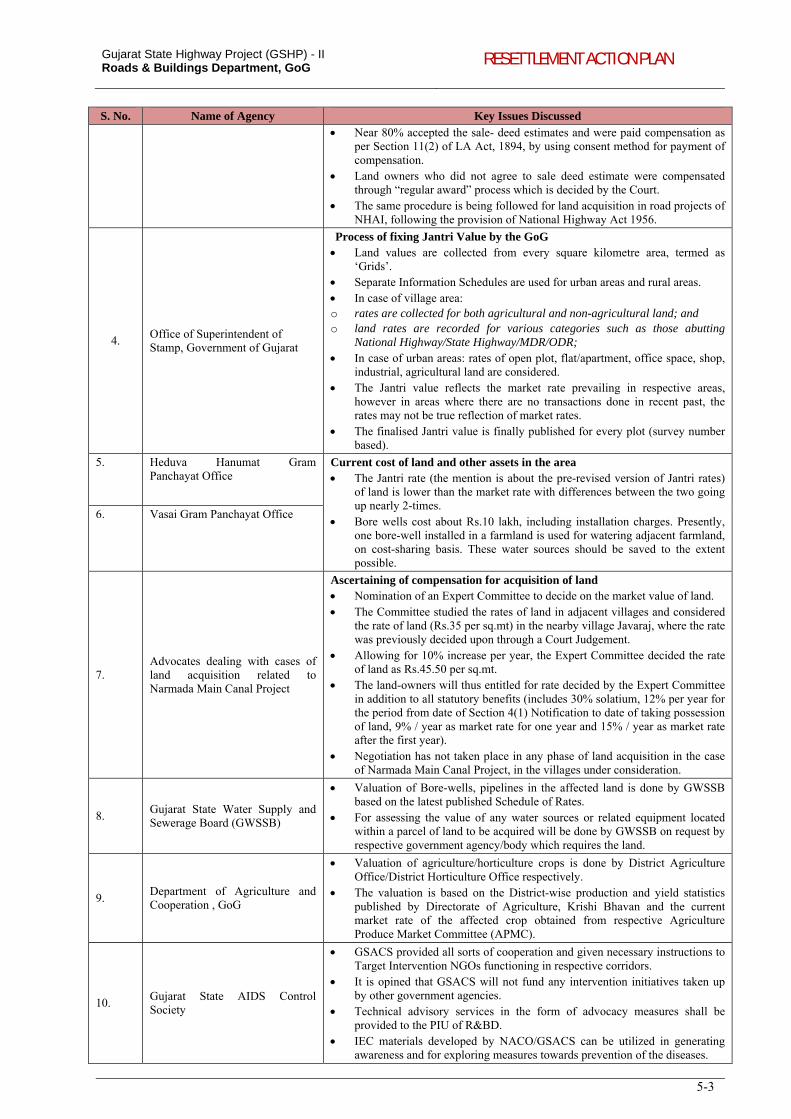
Gujarat State Highway Project (GSHP) - II Roads & Buildings Department, GoG RESETTLEMENT ACTION PLAN
5-3
S. No. Name of Agency Key Issues Discussed Near 80% accepted the sale- deed estimates and were paid compensation as
per Section 11(2) of LA Act, 1894, by using consent method for payment of compensation.
Land owners who did not agree to sale deed estimate were compensated through “regular award” process which is decided by the Court.
The same procedure is being followed for land acquisition in road projects of NHAI, following the provision of National Highway Act 1956.
4. Office of Superintendent of Stamp, Government of Gujarat
Process of fixing Jantri Value by the GoG Land values are collected from every square kilometre area, termed as
‘Grids’. Separate Information Schedules are used for urban areas and rural areas. In case of village area: o rates are collected for both agricultural and non-agricultural land; and o land rates are recorded for various categories such as those abutting
National Highway/State Highway/MDR/ODR; In case of urban areas: rates of open plot, flat/apartment, office space, shop,
industrial, agricultural land are considered. The Jantri value reflects the market rate prevailing in respective areas,
however in areas where there are no transactions done in recent past, the rates may not be true reflection of market rates.
The finalised Jantri value is finally published for every plot (survey number based).
5. Heduva Hanumat Gram Panchayat Office
Current cost of land and other assets in the area The Jantri rate (the mention is about the pre-revised version of Jantri rates)
of land is lower than the market rate with differences between the two going up nearly 2-times.
Bore wells cost about Rs.10 lakh, including installation charges. Presently, one bore-well installed in a farmland is used for watering adjacent farmland, on cost-sharing basis. These water sources should be saved to the extent possible.
6. Vasai Gram Panchayat Office
7. Advocates dealing with cases of land acquisition related to Narmada Main Canal Project
Ascertaining of compensation for acquisition of land Nomination of an Expert Committee to decide on the market value of land. The Committee studied the rates of land in adjacent villages and considered
the rate of land (Rs.35 per sq.mt) in the nearby village Javaraj, where the rate was previously decided upon through a Court Judgement.
Allowing for 10% increase per year, the Expert Committee decided the rate of land as Rs.45.50 per sq.mt.
The land-owners will thus entitled for rate decided by the Expert Committee in addition to all statutory benefits (includes 30% solatium, 12% per year for the period from date of Section 4(1) Notification to date of taking possession of land, 9% / year as market rate for one year and 15% / year as market rate after the first year).
Negotiation has not taken place in any phase of land acquisition in the case of Narmada Main Canal Project, in the villages under consideration.
8. Gujarat State Water Supply and Sewerage Board (GWSSB)
Valuation of Bore-wells, pipelines in the affected land is done by GWSSB based on the latest published Schedule of Rates.
For assessing the value of any water sources or related equipment located within a parcel of land to be acquired will be done by GWSSB on request by respective government agency/body which requires the land.
9. Department of Agriculture and Cooperation , GoG
Valuation of agriculture/horticulture crops is done by District Agriculture Office/District Horticulture Office respectively.
The valuation is based on the District-wise production and yield statistics published by Directorate of Agriculture, Krishi Bhavan and the current market rate of the affected crop obtained from respective Agriculture Produce Market Committee (APMC).
10. Gujarat State AIDS Control Society
GSACS provided all sorts of cooperation and given necessary instructions to Target Intervention NGOs functioning in respective corridors.
It is opined that GSACS will not fund any intervention initiatives taken up by other government agencies.
Technical advisory services in the form of advocacy measures shall be provided to the PIU of R&BD.
IEC materials developed by NACO/GSACS can be utilized in generating awareness and for exploring measures towards prevention of the diseases.
Gujarat State Highway Project (GSHP) - II Roads & Buildings Department, GoG RESETTLEMENT ACTION PLAN
5-4
S. No. Name of Agency Key Issues Discussed
11. Dholera Special Investment Region Development Authority
Any development intervention by any Agency in Dholera SIR should be intimated to DSIRDA. The total area of Dholera SIR is 903 sq.km with an economic activity area of 377 sq km and a developable area of 547 sq.km.
Proximity of Dholera to cities of Ahmedabad, Bhavnagar, Vadodara increases the development potential of the region. Potential for development as a multi-modal transportation hub due to lesser distance to northern Indian States.
GSHP-II should take into consideration the development implications of Dholera SIR, especially the Dhandhuka-Dholera corridor which is taken up in the first phase.
5.3.2. Consultation with Non-Governmental Organisations
81. NGOs operational in the project area were consulted to understand the issues of tribal and social development, livelihood, health, gender specific concerns etc. Interactions with these NGOs were necessary to create an encouraging environment for carrying out social mobility survey, trucker survey for HIV/AIDS Prevention plan and public consultations. Their inputs have helped in preparation of the Indigenous Peoples Development Plan and the HIV/AIDS Prevention plan. The details of the meetings have been summarized in Table 5-4.
Table 5-4: Outcomes of Consultation with NGOs S. No. Name of Organisation Location Key Function Areas Key Issues Discussed
1. Young Citizens of India Charitable Trust Mehsana-
Himatnagar
Rural development and health, including HIV/AIDS awareness
Prevalence of HIV/ AIDS, medical facilities available; Overall development concerns
2. Narottam Lalbhai Rural Development Fund
Social development Issues and concerns related to gender.
3. Shroffs Foundation Trust Dabhoi-Bodeli Rural and tribal development
Issues and concerns of the tribal community in the project area
4. Deepak Foundation
5. BHASHA
6. Acil Navsarjan (Anarde Foundation)
Umreth-Vasad (including Ladvel-Kapadvanj)
Rural development Issues and concerns related to gender. Overall development concerns. 7. Shree Navjivan Gram Vikas
Kendra
8. Saurastra Gramin Vikas Charitable Trust
Atkot-Gondal Social development Overall development concerns including health and HIV/AIDS. Facilitated in conducting public consultation.
9. Centre for Development, an NGO supported through Save the Children
Dhandhuka – Dholera and Dhandhuka – Paliyad
Social development Overall development concerns including children and women.
10. Mahiti Rural Development Centre
Dhandhuka Social development Issues related to gender, skill development among young people, youth empowerment, natural resources conservation, health care, hygiene, sanitation, micro finance, and disaster mitigation
11. SARTHI Bayad-Lunawada and Lunawada – Khedapa
Tribal development, Women empowerment
Mobilization of tribal communities and spreading awareness about their rights and entitlements by forming and strengthening their Community Based Organizations such as women Self Help Groups and Village Development Committees.
12. Seva Sangh Sarvajanik Hospital Trust
Dhansura – Meghraj
HIV/AIDS Prevalence of HIV/ AIDS, medical facilities available;
13. Development Support Centre Improving rural livelihoods through participatory management of natural resources
Occupational structure of the people and income levels, living standard;
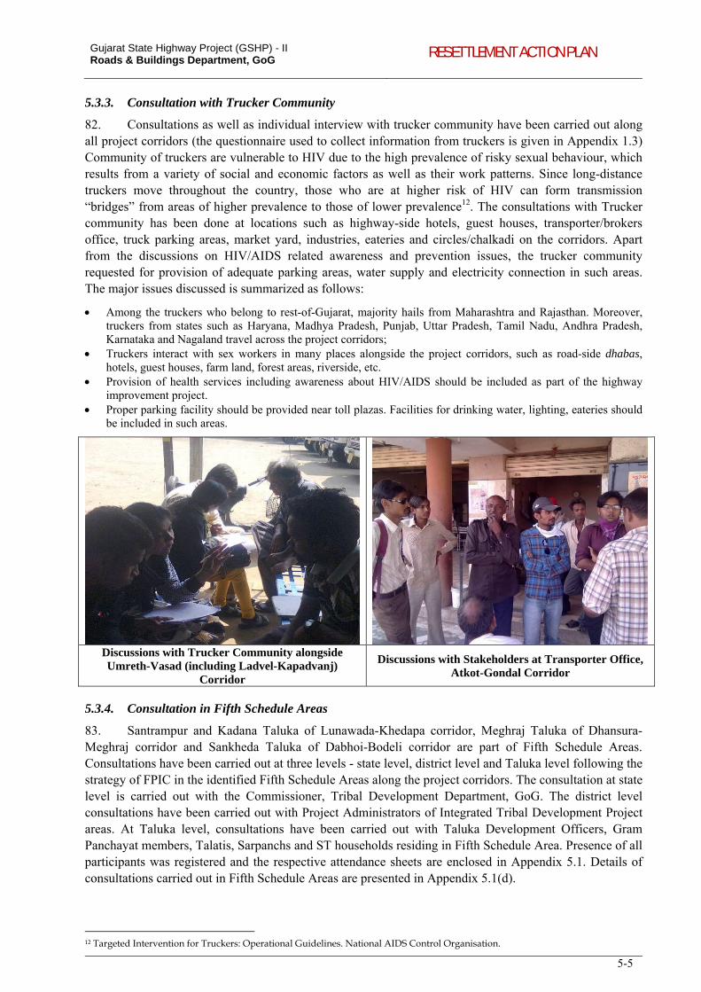
Gujarat State Highway Project (GSHP) - II Roads & Buildings Department, GoG RESETTLEMENT ACTION PLAN
5-5
5.3.3. Consultation with Trucker Community
82. Consultations as well as individual interview with trucker community have been carried out along all project corridors (the questionnaire used to collect information from truckers is given in Appendix 1.3) Community of truckers are vulnerable to HIV due to the high prevalence of risky sexual behaviour, which results from a variety of social and economic factors as well as their work patterns. Since long-distance truckers move throughout the country, those who are at higher risk of HIV can form transmission “bridges” from areas of higher prevalence to those of lower prevalence12. The consultations with Trucker community has been done at locations such as highway-side hotels, guest houses, transporter/brokers office, truck parking areas, market yard, industries, eateries and circles/chalkadi on the corridors. Apart from the discussions on HIV/AIDS related awareness and prevention issues, the trucker community requested for provision of adequate parking areas, water supply and electricity connection in such areas. The major issues discussed is summarized as follows:
Among the truckers who belong to rest-of-Gujarat, majority hails from Maharashtra and Rajasthan. Moreover, truckers from states such as Haryana, Madhya Pradesh, Punjab, Uttar Pradesh, Tamil Nadu, Andhra Pradesh, Karnataka and Nagaland travel across the project corridors;
Truckers interact with sex workers in many places alongside the project corridors, such as road-side dhabas, hotels, guest houses, farm land, forest areas, riverside, etc.
Provision of health services including awareness about HIV/AIDS should be included as part of the highway improvement project.
Proper parking facility should be provided near toll plazas. Facilities for drinking water, lighting, eateries should be included in such areas.
Discussions with Trucker Community alongside Umreth-Vasad (including Ladvel-Kapadvanj)
Corridor
Discussions with Stakeholders at Transporter Office, Atkot-Gondal Corridor
5.3.4. Consultation in Fifth Schedule Areas
83. Santrampur and Kadana Taluka of Lunawada-Khedapa corridor, Meghraj Taluka of Dhansura-Meghraj corridor and Sankheda Taluka of Dabhoi-Bodeli corridor are part of Fifth Schedule Areas. Consultations have been carried out at three levels - state level, district level and Taluka level following the strategy of FPIC in the identified Fifth Schedule Areas along the project corridors. The consultation at state level is carried out with the Commissioner, Tribal Development Department, GoG. The district level consultations have been carried out with Project Administrators of Integrated Tribal Development Project areas. At Taluka level, consultations have been carried out with Taluka Development Officers, Gram Panchayat members, Talatis, Sarpanchs and ST households residing in Fifth Schedule Area. Presence of all participants was registered and the respective attendance sheets are enclosed in Appendix 5.1. Details of consultations carried out in Fifth Schedule Areas are presented in Appendix 5.1(d).
12 Targeted Intervention for Truckers: Operational Guidelines. National AIDS Control Organisation.
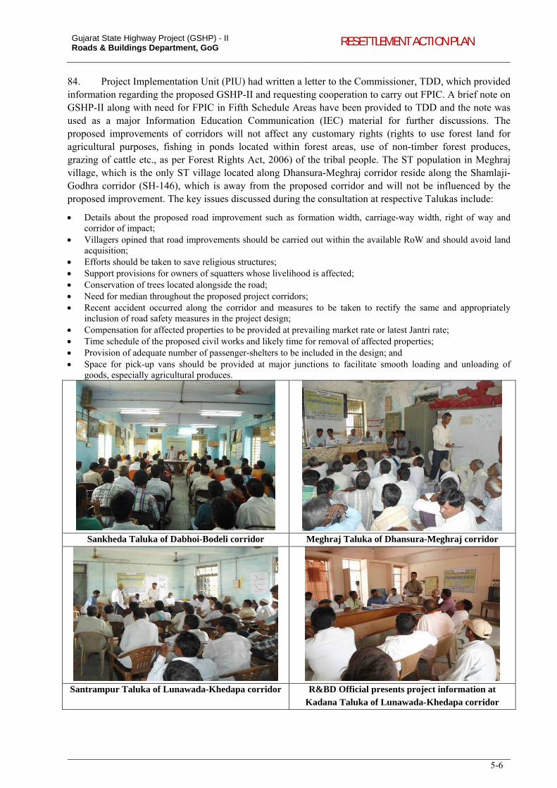
Gujarat State Highway Project (GSHP) - II Roads & Buildings Department, GoG RESETTLEMENT ACTION PLAN
5-6
84. Project Implementation Unit (PIU) had written a letter to the Commissioner, TDD, which provided information regarding the proposed GSHP-II and requesting cooperation to carry out FPIC. A brief note on GSHP-II along with need for FPIC in Fifth Schedule Areas have been provided to TDD and the note was used as a major Information Education Communication (IEC) material for further discussions. The proposed improvements of corridors will not affect any customary rights (rights to use forest land for agricultural purposes, fishing in ponds located within forest areas, use of non-timber forest produces, grazing of cattle etc., as per Forest Rights Act, 2006) of the tribal people. The ST population in Meghraj village, which is the only ST village located along Dhansura-Meghraj corridor reside along the Shamlaji-Godhra corridor (SH-146), which is away from the proposed corridor and will not be influenced by the proposed improvement. The key issues discussed during the consultation at respective Talukas include:
Details about the proposed road improvement such as formation width, carriage-way width, right of way and corridor of impact;
Villagers opined that road improvements should be carried out within the available RoW and should avoid land acquisition;
Efforts should be taken to save religious structures; Support provisions for owners of squatters whose livelihood is affected; Conservation of trees located alongside the road; Need for median throughout the proposed project corridors; Recent accident occurred along the corridor and measures to be taken to rectify the same and appropriately
inclusion of road safety measures in the project design; Compensation for affected properties to be provided at prevailing market rate or latest Jantri rate; Time schedule of the proposed civil works and likely time for removal of affected properties; Provision of adequate number of passenger-shelters to be included in the design; and Space for pick-up vans should be provided at major junctions to facilitate smooth loading and unloading of
goods, especially agricultural produces.
Sankheda Taluka of Dabhoi-Bodeli corridor Meghraj Taluka of Dhansura-Meghraj corridor
Santrampur Taluka of Lunawada-Khedapa corridor R&BD Official presents project information at
Kadana Taluka of Lunawada-Khedapa corridor
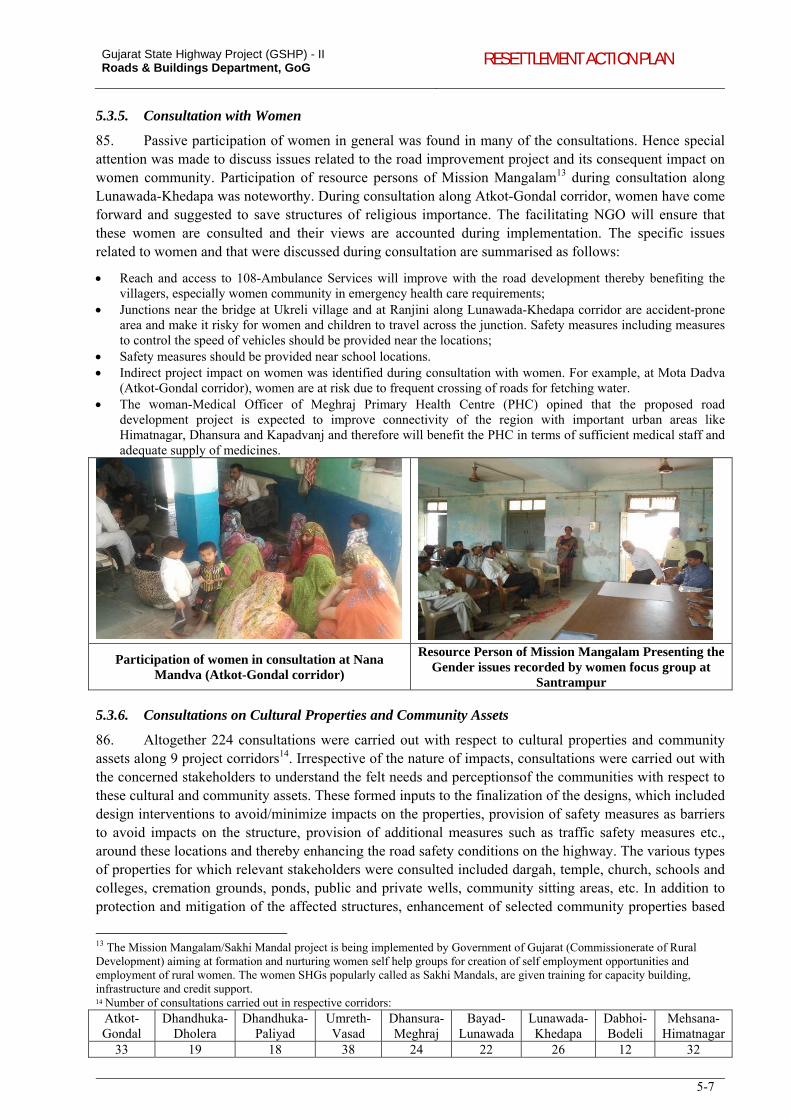
Gujarat State Highway Project (GSHP) - II Roads & Buildings Department, GoG RESETTLEMENT ACTION PLAN
5-7
5.3.5. Consultation with Women
85. Passive participation of women in general was found in many of the consultations. Hence special attention was made to discuss issues related to the road improvement project and its consequent impact on women community. Participation of resource persons of Mission Mangalam13 during consultation along Lunawada-Khedapa was noteworthy. During consultation along Atkot-Gondal corridor, women have come forward and suggested to save structures of religious importance. The facilitating NGO will ensure that these women are consulted and their views are accounted during implementation. The specific issues related to women and that were discussed during consultation are summarised as follows:
Reach and access to 108-Ambulance Services will improve with the road development thereby benefiting the villagers, especially women community in emergency health care requirements;
Junctions near the bridge at Ukreli village and at Ranjini along Lunawada-Khedapa corridor are accident-prone area and make it risky for women and children to travel across the junction. Safety measures including measures to control the speed of vehicles should be provided near the locations;
Safety measures should be provided near school locations. Indirect project impact on women was identified during consultation with women. For example, at Mota Dadva
(Atkot-Gondal corridor), women are at risk due to frequent crossing of roads for fetching water. The woman-Medical Officer of Meghraj Primary Health Centre (PHC) opined that the proposed road
development project is expected to improve connectivity of the region with important urban areas like Himatnagar, Dhansura and Kapadvanj and therefore will benefit the PHC in terms of sufficient medical staff and adequate supply of medicines.
Participation of women in consultation at Nana Mandva (Atkot-Gondal corridor)
Resource Person of Mission Mangalam Presenting the Gender issues recorded by women focus group at
Santrampur
5.3.6. Consultations on Cultural Properties and Community Assets
86. Altogether 224 consultations were carried out with respect to cultural properties and community assets along 9 project corridors14. Irrespective of the nature of impacts, consultations were carried out with the concerned stakeholders to understand the felt needs and perceptionsof the communities with respect to these cultural and community assets. These formed inputs to the finalization of the designs, which included design interventions to avoid/minimize impacts on the properties, provision of safety measures as barriers to avoid impacts on the structure, provision of additional measures such as traffic safety measures etc., around these locations and thereby enhancing the road safety conditions on the highway. The various types of properties for which relevant stakeholders were consulted included dargah, temple, church, schools and colleges, cremation grounds, ponds, public and private wells, community sitting areas, etc. In addition to protection and mitigation of the affected structures, enhancement of selected community properties based
13 The Mission Mangalam/Sakhi Mandal project is being implemented by Government of Gujarat (Commissionerate of Rural Development) aiming at formation and nurturing women self help groups for creation of self employment opportunities and employment of rural women. The women SHGs popularly called as Sakhi Mandals, are given training for capacity building, infrastructure and credit support. 14 Number of consultations carried out in respective corridors:
Atkot-Gondal
Dhandhuka-Dholera
Dhandhuka-Paliyad
Umreth-Vasad
Dhansura-Meghraj
Bayad-Lunawada
Lunawada-Khedapa
Dabhoi-Bodeli
Mehsana-Himatnagar
33 19 18 38 24 22 26 12 32
Gujarat State Highway Project (GSHP) - II Roads & Buildings Department, GoG RESETTLEMENT ACTION PLAN
5-8
on their value, age, significance etc., (assessed based on an objective criteria) is proposed to be taken up outside the RoW, within the boundaries of these cultural properties. The nature and type of interventions within these cultural properties have been finalized in consultation with the relevant stakeholders at these cultural/community assets.
5.3.7. Consultation with Affected Communities
87. Community consultations have been carried out along all project corridors. A consultation format was used as a guideline for discussions with community (refer Appendix 5.1 for the format used for consultation in Dabhoi-Bodeli corridor). Presence of all participants was registered during each consultation session and the attendance sheets have been enclosed in Appendix 5.2. The views, concerns and suggestions of the community were recorded. The details of each session conducted (date, no. of meetings, no. of participants etc.) are given in Table 5-5. As stated above the venue, time and date of the meeting was communicated to the participants in advance. The participants included peoples’ representatives, affected people and general public.
Table 5-5: Details of Consultative Sessions Undertaken S. No. Project Corridors No. of Locations No. & Composition of Participants
1. Dhansura-Meghraj 5 62: Village headmen and villagers
2. Atkot-Gondal 6 72: Local leaders, Villagers, women group, principal of local school,
3. Dhandhuka- Dholera 3 33: Local leaders, Village headmen and villagers, farmers,
4. Umreth- Vasad (including Ladvel-Kapadvanj)
5 53: shopkeepers and community members, Priest of Church, Zila Parishad member, school staff, villagers.
5. Bayad- Lunawada 5 43: Local leaders, Village headmen and villagers, farmers.
6. Dhaboi- Bodeli 9 27: Temple committee and villagers, Shop owners, School teachers.
7. Lunawada- Khedapa 7 61: MLA, villagers, Shop owners.
8. Mehsana-Himatnagar 10 235: Farmers, community leaders, teachers, shop owners
Information Dissemination
88. At the start of the consultation sessions, the project objectives, proposed improvements for the corridors were informed to the participants. They were also informed about the potential impacts of the proposed improvements. It was shared with the participants that there was a conscious effort to minimize land acquisition and impacts on private lands and assets. Accordingly designs are being worked out to avoid land acquisition, especially in the settlement stretches. Only at very constricted locations, where the safety and design standards shall warrant, the acquisition of land has been proposed in the project. Further, it was clarified that, the consultations will form inputs to further refine the project designs to minimize lands on private and community structures and assets. The dissemination process and the type of information shared with the stakeholders during consultation are summarized as follows:
While undertaking inventory of road side utilities and structures, and census survey of PAFs, information dissemination focused on the proposed road improvements;
Potential PAPs were consulted to inform them about the proposed road improvement program, resultant impacts and possible socio-cultural conflict (if any) including loss of access to and relocation of CPRs;
People were requested to gather at common places such as panchayat offices, temples, schools, etc; During these consultations, base-plans and draft designs and markers were used to explain about the project; In addition, Pictorial Methods were also used to explain proposed improvement and possible social impacts in
the concerned villages
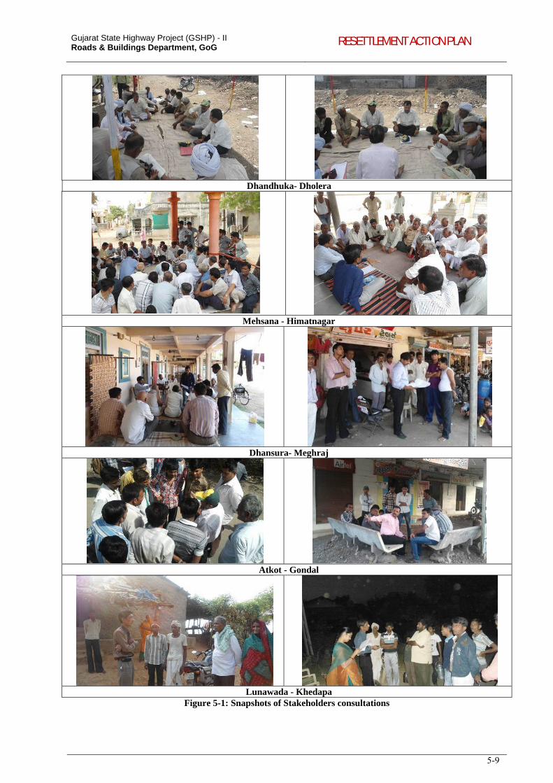
Gujarat State Highway Project (GSHP) - II Roads & Buildings Department, GoG RESETTLEMENT ACTION PLAN
5-9
Dhandhuka- Dholera
Mehsana - Himatnagar
Dhansura- Meghraj
Atkot - Gondal
Lunawada - KhedapaFigure 5-1: Snapshots of Stakeholders consultations
Gujarat State Highway Project (GSHP) - II Roads & Buildings Department, GoG RESETTLEMENT ACTION PLAN
5-10
5.3.8. Outcomes of Community Consultation
89. Along 6 of the 8 project corridors (except Bayad – Lunawada and Mehsana – Himatnagar), impacts pertaining to land acquisition and resettlement are minimal. The consultations along these corridors largely focused on impact on community assets, especially water sources, built-up structures of educational and religious institutions and its relocation. Road safety issues were another major focal point of discussion. The roads were comparatively free from encroachments except at some urban locations, where semi-permanent or temporary structures (shops) were potentially affected. The compensation for such shops and assistance for those who lose livelihood were some other major issues discussed in the consultations. In general, the community welcomed the proposed project and was of the opinion that they have the obligation to part with their land or structures for a public cause. PAPs have requested for adequate time in case the structure requires to be removed. People wanted to know more details about the project, the likely time of land and structure acquisition, project implementation schedule, etc.
90. The discussions during the consultations along Bayad – Lunawada and Mehsana-Himatnagar corridors focused on the process of determination of compensation, opportunities in the project towards minimization of land acquisition etc., apart from the other community level impacts and road safety concerns.
91. The outcomes of consultations were discussed with the design team, and all attempts were made to integrate the views and suggestions of the community into the project design. The outcomes of consultation and its integration into the project design are documented in Table 5-6.
Table 5-6: Outcomes of Consultation and Integration into Project Design
Location Issues/ Suggestions Received Integration into Project Design
and Action Plan
PROJECT CORRIDOR: Dhansura – Meghraj Aniyor Kampa village
Built-up structure of the Hanuman Temple located on LHS should be saved to the extent possible.
Safety measures should be provided near the Hanuman temple and near inhabited area of Aniyor village as the regular visit of large numbers of devotees causes traffic jam at this location.
An Open-Well with retaining wall will be affected on LHS of the road, which should be saved, to the extent possible, as this is a major source of irrigation for the adjacent agriculture fields. If the Open-Well cannot be saved, the same should be compensated at market rate and within an agreeable time [An irrigation canal (constructed as part of Vatrak Canal Project) has acquired agricultural land of the villagers during 2007-2008. The villagers have not yet received the compensation for the loss of land].
A sitting area around the tree on RHS will be affected. This community structure is presently not in use, and can be removed for the proposed road development.
Participants enquired about the likely implementation period of the project.
Built-up structure of the Hanuman Temple saved, by shifting the proposed road alignment towards RHS.
Road safety measures like cautionary signs, road markings and speed-breakers have been included in the project design.
Proposed road alignment shifted to RHS and hence the Open-Well will not be affected.
Construction/improvement of the road will begin by May-June 2013.
Rasapur Village The location is accident prone due to presence of a curve, a T-junction and shrubs. Accidents occur frequently at the location due to poor line of sight (In fact, a pick up van carrying agricultural produces turned turtle there just before the start of the consultation).
The participants suggested that the curve should be smoothened as far as possible;
The curve improvement will be carried out within the available RoW. Agriculture land on LHS will not be affected
Road safety measures like cautionary signs, road markings and speed-breakers have been included in the project design.
Gujarat State Highway Project (GSHP) - II Roads & Buildings Department, GoG RESETTLEMENT ACTION PLAN
5-11
Location Issues/ Suggestions Received Integration into Project Design
and Action Plan shrubs should be removed and necessary road safety measures should be provided.
The curve improvement will affect agricultural land parcel and a hand-pump located within the, this may be avoided to the extent possible.
Malpur Town
Built-up structure of 4 shops and extended portion (semi-permanent structures with tin-sheets and GI pipes and iron-staircases) of 12 shops on either side of the road will be affected due to junction improvement. The shop-owners suggested for design modification to save their shops as they do not have any alternative site to shift.
Compensation for affected structures (built-up structure only) should be provided at prevailing market rate.
Safety of pedestrians should be ensured. The junction is prone to accidents. A bus-depot is located near the junction leading to traffic congestion.
Junction improvement with restricted median-width included in the proposed design and hence the shops will not be affected.
Compensation for affected structures will be provided based on R&BD Schedule of Rates (SoR) without depreciation following the principles of RPF adopted for the project.
Provision for adequate safety measures such as traffic calming measures, signs, rumble strips and information signs have been incorporated into the design.
Parsoda Village
The impact on compound wall of a house and built-up structure of a temple located on the LHS should be avoided. Participants suggested considering agriculture land located outside the settlement area for the proposed road improvement.
Built-up structure of a cattle-shed on RHS will be affected. The owner of the structure enquired about the compensation details and likely time of payment.
Participants enquired about the starting date of road construction.
The compensation decided by the government for the affected land and structure is considerably lower than the market rate. Compensation at market rate should be given for actual loss of land and structure.
The proposed road alignment has been shifted towards RHS and the impact on structures will be avoided.
Compensation for affected properties will be disbursed before the start of the civil works, which is scheduled in May-June 2013.
Construction/improvement of the Road will begin by May-June 2013.
Compensation for affected land and structures will be provided following the principles of RPF adopted for the project.
Meghraj Town The impacts on shops located on either side should be avoided to the extent possible.
If impacts could not be avoided compensation at market rate should be paid to the affected people
The compensation should be provided before the before the start of road construction so that the impacted shops could be relocated without affecting livelihood.
Participants enquired about notice period for removal of affected structures
The proposed improvement will not impact any structure.
Compensation for affected and structures will be provided following the principles of RPF adopted for the project.
Civil works will be initiated only after the payment of compensation, following the principles of RPF adopted for the project.15
PROJECT CORRIDOR: Atkot-Gondal
Location
Issues/ Suggestions Received Integration into Project Design and Action Plan
243+100 Gondal village; Hanuman Temple and Tombstone-plot,
The Hanuman Temple located on RHS will be affected. The Temple is more than 75 years old and is situated about 8m from centre line. Relocating the temple was
Temple will be protected with raised platform and grilled fencing. Sitting area for devotees will be developed.
Parking space avoided from the proposed design to
15 Operational Policy (OP 4.12 Involuntary Resettlement) of the World Bank prescribes that implementation of resettlement activities is linked to the implementation of the investment component of the project to ensure that displacement does not occur before necessary measures for resettlement are in place…these measures include provision of compensation and of other assistance required for relocation, prior to displacement. In particular, taking of land and related assets may take place only after compensation has been paid to the displaced persons.
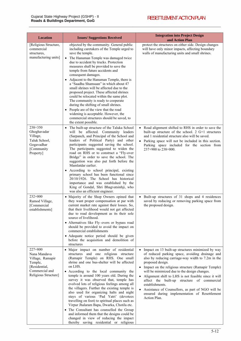
Gujarat State Highway Project (GSHP) - II Roads & Buildings Department, GoG RESETTLEMENT ACTION PLAN
5-12
Location Issues/ Suggestions Received Integration into Project Design
and Action Plan [Religious Structure, commercial structures, manufacturing units]
objected by the community. General public including caretakers of the Temple urged to save the temple.
The Hanuman Temple was damaged twice due to accident by trucks. Protection measures shall be provided to save the temple from future accidents and consequent damages.
Adjacent to the Hanuman Temple, there is a “Saadhu Shamsaan” in which about 47 small shrines will be affected due to the proposed project. These affected shrines could be relocated within the same plot. The community is ready to cooperate during the shifting of small shrines.
People are of the view that the road widening is acceptable. However, the commercial structures should be saved, to the extent possible.
protect the structures on either side. Design changes will have only minor impacts, affecting boundary walls of manufacturing units and small shrines.
238+350 Ghoghavadar Village, Taluk School, Gogavadhar [Community Property]
The built-up structure of the Taluka School will be affected. Community leaders (Sarpanch, and Principal of the School and leaders of Political Party) and other participants suggested saving the school. The participants suggested to widen the road on RHS or to construct a “Fly-over Bridge” in order to save the school. The suggestion was also put forth before the Mamlatdar earlier.
According to school principal, existing primary school has been functional since 20/10/1926. The School has historical importance and was established by the King of Gondal, Shri Bhagvatsinhji, who was also an efficient engineer.
Road alignment shifted to RHS in order to save the built-up structure of the school. 2 G+1 structures and 1 residential structure also will be saved.
Parking space will not be included in this section. Parking space included for the section from 237+900 to 238+000.
232+000 Ramod Village, [Commercial establishments]
Majority of the Shop Owners opined that they want proper compensation at par with current market rate against their losses. So, that their livelihood would not get affected due to road development as its their sole source of livelihood.
Alternatives like Fly–overs or bypass road should be provided to avoid the impact on commercial establishments
Adequate notice period should be given before the acquisition and demolition of structures
Built-up structures of 31 shops and 4 residences saved by reducing or removing parking space from the proposed design.
227+800 Nana Mandava Village, Ramapir Temple, [Residential, Commercial and Religious Structure]
Major impact on number of residential structures and one religious structure (Ramapir Temple) on RHS. One small shrine and one bus-shelter will be affected on LHS.
According to the local community the temple is around 100 years old. During the survey it was observed that, temple has evolved lots of religious feelings among all the villagers. Further the existing temple is also used for organizing halts and night stays of various ‘Pad Yatri’ (devotees travelling on foot) to spiritual places such as Virpur Jhalaram Bapa, Dwarka, Chotila etc.
The Consultant has counselled the Group and informed them that the designs could be changed in view of reducing the impact thereby saving residential or religious
Impact on 13 built-up structures minimized by way of reduced parking space, avoiding drainage and also by reducing carriage-way width to 7.2m in the proposed design.
Impact on the religious structure (Ramapir Temple) will be minimized due to the design changes.
Alignment shift to LHS is not feasible since it will affect the built-up structure of commercial establishments.
Assistance of Counsellors, as part of NGO will be ensured during implementation of Resettlement Action Plan.
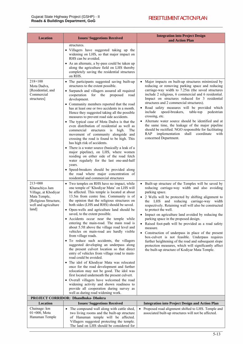
Gujarat State Highway Project (GSHP) - II Roads & Buildings Department, GoG RESETTLEMENT ACTION PLAN
5-13
Location Issues/ Suggestions Received Integration into Project Design
and Action Plan structures.
Villagers have suggested taking up the widening on LHS, so that major impact on RHS can be avoided.
As an alternate, a by-pass could be taken up along the agriculture field on LHS thereby completely saving the residential structures on RHS.
218+100 Mota Dadva, [Residential, and Commercial structures]
The participants suggested saving built-up structures to the extent possible.
Sarpanch and villagers assured all required cooperation for the proposed road development.
Community members reported that the road has at least one or two accidents in a month. Hence they suggested taking all the possible measures to prevent road side accidents.
The typical case of Mota Dadva is that the even distribution of residential as well as commercial structures is high. The movement of community alongside and crossing the road is found to be high. This has high risk of accidents.
There is a water source (basically a leak of a major pipeline), on LHS, where women residing on either side of the road fetch water regularly for the last one-and-half years.
Speed-breakers should be provided along the road where major concentration of residential and commercial structures
Major impacts on built-up structures minimized by reducing or removing parking space and reducing carriage-way width to 7.25m (the saved structures include 2 religious, 6 commercial and 6 residential. Impact on structures reduced for 3 residential structures and 2 commercial structures).
Road safety measures will be provided which include speed-breakers, table-top pedestrian crossing, etc.
Alternate water source should be identified and at the same time, the leakage of the major pipeline should be rectified. NGO responsible for facilitating RAP implementation shall coordinate with concerned Department.
213+000 Kharachiya Jam Village, at Khodiyar Mata Temple, [Religious Structure, well and agriculture land]
Two temples on RHS have no impact, while one temple of ‘Khodiyar Mata’ on LHS will be affected. This temple is located at about 13.5m from centre line. Community is of the opinion that the religious structures on both sides (LHS and RHS) should be saved.
Open-wells and agriculture land should be saved, to the extent possible.
Accidents occur near the temple while entering the main-road. The main road is about 5.5ft above the village road level and vehicles on main-road are hardly visible from village roads.
To reduce such accidents, the villagers suggested developing an underpass along the present culvert location so that direct entry of vehicles from village road to main-road could be avoided.
The idol of Khodiyar Mata was relocated once for the road development and further relocation may not be good. The idol was first located underneath the present culvert.
Overall villagers have welcomed the road widening activity and shown readiness to provide all cooperation during survey as well as during road widening work.
Built-up structure of the Temples will be saved by reducing carriage-way width and also avoiding parking space.
2 Wells will be protected by shifting alignment to the LHS and reducing carriage-way width respectively. Retaining wall will also be constructed to protect the well.
Impact on agriculture land avoided by reducing the parking space in the proposed design.
Raised foot-path will be provided as a road safety measure.
Construction of underpass in place of the present box-culvert is not feasible. Underpass requires further heightening of the road and subsequent slope protection measures, which will significantly affect the built-up structure of Kodiyar Mata Temple.
PROJECT CORRIDOR: Dhandhuka- Dholera
Location Issues/ Suggestions Received Integration into Project Design and Action Plan
Chainage: km 01+000, Mota Hanuman Temple
The compound wall along with cattle shed, two living rooms and the built-up structure of Hanuman temple will be affected. Villagers suggested protecting the temple. The land on LHS should be considered for
Proposed road alignment shifted to LHS. Temple and associated built-up structures will not be affected.
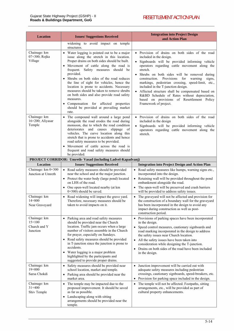
Gujarat State Highway Project (GSHP) - II Roads & Buildings Department, GoG RESETTLEMENT ACTION PLAN
5-14
Location Issues/ Suggestions Received Integration into Project Design
and Action Plan widening to avoid impact on temple structures.
Chainage: km 07+300; Rojka Village
Water logging is pointed out to be a major issue along the stretch in this location. Proper drains on both sides should be built.
Movement of cattle along the road is frequent. Safety measures should be provided.
Shrubs on both sides of the road reduces the line of sight for vehicles, hence the location is prone to accidents. Necessary measures should be taken to remove shrubs on both sides and also provide road safety measures.
Compensation for affected properties should be provided at prevailing market rate.
Provision of drains on both sides of the road included in the design.
Signboards will be provided informing vehicle operators regarding cattle movement along the stretch.
Shrubs on both sides will be removed during construction. Provisions for warning signs, markings, pedestrian crossing, speed-limit, etc., included in the T-junction design.
Affected structure shall be compensated based on R&BD Schedule of Rates without depreciation, based on provisions of Resettlement Policy Framework of project.
Chainage: km 16+200; Aliyasar Temple
The compound wall around a large pond alongside the road erodes the road during monsoon, due to which the road condition deteriorates and causes slippage of vehicles. The curve location along this stretch that is prone to accidents and hence road safety measures to be provided.
Movement of cattle across the road is frequent and road safety measures should be provided.
Provision of drains on both sides of the road included in the design
Signboards will be provided informing vehicle operators regarding cattle movement along the stretch.
PROJECT CORRIDOR: Umreth- Vasad (including Ladvel-Kapadvanj)
Location Issues/ Suggestions Received Integration into Project Design and Action Plan
Chainage: km 0+300 Junction at Umreth
Road safety measures should be provided near the school and at the major junction.
Protect the water body (large pond) located on LHS of the road.
One open-well located nearby (at km 0+500) should be saved.
Road safety measures like humps, warning signs etc., incorporated into the design.
Retaining wall will be provided throughout the pond embankment alongside the road.
The open-well will be preserved and crash barriers will be provided to address safety issues.
Chainage: km 14+800 Near Graveyard
Road widening will impact the grave yard. Therefore, necessary measures should be taken to avoid impacts on it.
The graveyard will not be affected and provision for the construction of a boundary wall for the graveyard has been incorporated in the design to avoid any impact during construction as well as post-construction period.
Chainage: km 15+100 Church and Y Junction
Parking area and road safety measures should be provided near the Church location. Traffic jam occurs when a large number of visitors assemble in the Church for prayer, especially on Sundays.
Road safety measures should be provided in T-junction since the junction is prone to accidents.
Water logging is a major problem highlighted by the participants and suggested to provide proper drains.
Provisions of parking spaces have been incorporated in the design.
Speed control measures, cautionary signboards and road marking incorporated in the design to address the safety issues near Church location.
All the safety issues have been taken into consideration while designing the T-junction.
Drains on both sides of the road have been included in the design.
Chainage: km 19+000 Sarsa Chokdi
Safety measures should be provided near school location, market and temple.
Parking area should be provided near the market area.
Junction improvement will be carried out with adequate safety measures including pedestrian crossings, cautionary signboards, speed-breakers, etc.
Provision for parking space included in the design.
Chainage: km 31+400 Shiv Temple
The temple may be impacted due to the proposed improvement. It should be saved as far as possible.
Landscaping along with sitting arrangements should be provided near the temple.
The temple will not be affected. Footpaths, sitting arrangements, etc., will be provided as part of cultural property enhancements.
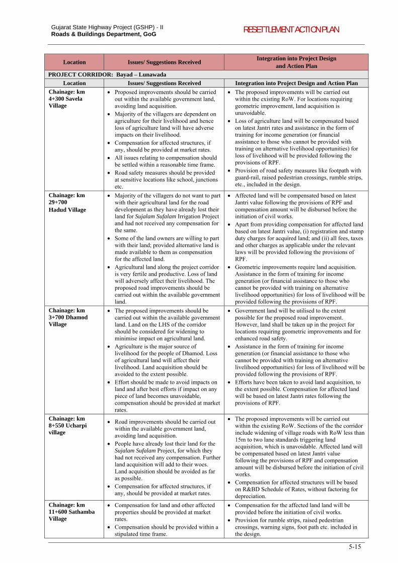
Gujarat State Highway Project (GSHP) - II Roads & Buildings Department, GoG RESETTLEMENT ACTION PLAN
5-15
Location Issues/ Suggestions Received Integration into Project Design
and Action Plan
PROJECT CORRIDOR: Bayad – Lunawada
Location Issues/ Suggestions Received Integration into Project Design and Action Plan
Chainage: km 4+300 Savela Village
Proposed improvements should be carried out within the available government land, avoiding land acquisition.
Majority of the villagers are dependent on agriculture for their livelihood and hence loss of agriculture land will have adverse impacts on their livelihood.
Compensation for affected structures, if any, should be provided at market rates.
All issues relating to compensation should be settled within a reasonable time frame.
Road safety measures should be provided at sensitive locations like school, junctions etc.
The proposed improvements will be carried out within the existing RoW. For locations requiring geometric improvement, land acquisition is unavoidable.
Loss of agriculture land will be compensated based on latest Jantri rates and assistance in the form of training for income generation (or financial assistance to those who cannot be provided with training on alternative livelihood opportunities) for loss of livelihood will be provided following the provisions of RPF.
Provision of road safety measures like footpath with guard-rail, raised pedestrian crossings, rumble strips, etc., included in the design.
Chainage: km 29+700 Hadud Village
Majority of the villagers do not want to part with their agricultural land for the road development as they have already lost their land for Sujalam Sufalam Irrigation Project and had not received any compensation for the same.
Some of the land owners are willing to part with their land; provided alternative land is made available to them as compensation for the affected land.
Agricultural land along the project corridor is very fertile and productive. Loss of land will adversely affect their livelihood. The proposed road improvements should be carried out within the available government land.
Affected land will be compensated based on latest Jantri value following the provisions of RPF and compensation amount will be disbursed before the initiation of civil works.
Apart from providing compensation for affected land based on latest Jantri value, (i) registration and stamp duty charges for acquired land; and (ii) all fees, taxes and other charges as applicable under the relevant laws will be provided following the provisions of RPF.
Geometric improvements require land acquisition. Assistance in the form of training for income generation (or financial assistance to those who cannot be provided with training on alternative livelihood opportunities) for loss of livelihood will be provided following the provisions of RPF.
Chainage: km 3+700 Dhamod Village
The proposed improvements should be carried out within the available government land. Land on the LHS of the corridor should be considered for widening to minimise impact on agricultural land.
Agriculture is the major source of livelihood for the people of Dhamod. Loss of agricultural land will affect their livelihood. Land acquisition should be avoided to the extent possible.
Effort should be made to avoid impacts on land and after best efforts if impact on any piece of land becomes unavoidable, compensation should be provided at market rates.
Government land will be utilised to the extent possible for the proposed road improvement. However, land shall be taken up in the project for locations requiring geometric improvements and for enhanced road safety.
Assistance in the form of training for income generation (or financial assistance to those who cannot be provided with training on alternative livelihood opportunities) for loss of livelihood will be provided following the provisions of RPF.
Efforts have been taken to avoid land acquisition, to the extent possible. Compensation for affected land will be based on latest Jantri rates following the provisions of RPF.
Chainage: km 8+550 Ucharpi village
Road improvements should be carried out within the available government land, avoiding land acquisition.
People have already lost their land for the Sujalam Sufalam Project, for which they had not received any compensation. Further land acquisition will add to their woes. Land acquisition should be avoided as far as possible.
Compensation for affected structures, if any, should be provided at market rates.
The proposed improvements will be carried out within the existing RoW. Sections of the the corridor include widening of village roads with RoW less than 15m to two lane standards triggering land acquisition, which is unavoidable. Affected land will be compensated based on latest Jantri value following the provisions of RPF and compensation amount will be disbursed before the initiation of civil works.
Compensation for affected structures will be based on R&BD Schedule of Rates, without factoring for depreciation.
Chainage: km 11+600 Sathamba Village
Compensation for land and other affected properties should be provided at market rates.
Compensation should be provided within a stipulated time frame.
Compensation for the affected land land will be provided before the initiation of civil works.
Provision for rumble strips, raised pedestrian crossings, warning signs, foot path etc. included in the design.
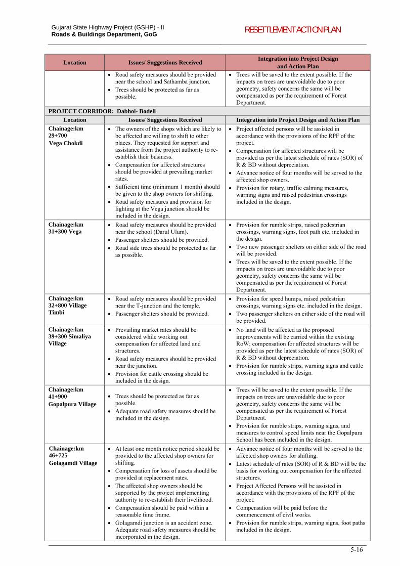
Gujarat State Highway Project (GSHP) - II Roads & Buildings Department, GoG RESETTLEMENT ACTION PLAN
5-16
Location Issues/ Suggestions Received Integration into Project Design
and Action Plan Road safety measures should be provided
near the school and Sathamba junction. Trees should be protected as far as
possible.
Trees will be saved to the extent possible. If the impacts on trees are unavoidable due to poor geometry, safety concerns the same will be compensated as per the requirement of Forest Department.
PROJECT CORRIDOR: Dabhoi- Bodeli
Location Issues/ Suggestions Received Integration into Project Design and Action Plan
Chainage:km 29+700 Vega Chokdi
The owners of the shops which are likely to be affected are willing to shift to other places. They requested for support and assistance from the project authority to re-establish their business.
Compensation for affected structures should be provided at prevailing market rates.
Sufficient time (minimum 1 month) should be given to the shop owners for shifting.
Road safety measures and provision for lighting at the Vega junction should be included in the design.
Project affected persons will be assisted in accordance with the provisions of the RPF of the project.
Compensation for affected structures will be provided as per the latest schedule of rates (SOR) of R & BD without depreciation.
Advance notice of four months will be served to the affected shop owners.
Provision for rotary, traffic calming measures, warning signs and raised pedestrian crossings included in the design.
Chainage:km 31+300 Vega
Road safety measures should be provided near the school (Darul Ulum).
Passenger shelters should be provided. Road side trees should be protected as far
as possible.
Provision for rumble strips, raised pedestrian crossings, warning signs, foot path etc. included in the design.
Two new passenger shelters on either side of the road will be provided.
Trees will be saved to the extent possible. If the impacts on trees are unavoidable due to poor geometry, safety concerns the same will be compensated as per the requirement of Forest Department.
Chainage:km 32+800 Village Timbi
Road safety measures should be provided near the T-junction and the temple.
Passenger shelters should be provided.
Provision for speed humps, raised pedestrian crossings, warning signs etc. included in the design.
Two passenger shelters on either side of the road will be provided.
Chainage:km 39+300 Simaliya Village
Prevailing market rates should be considered while working out compensation for affected land and structures.
Road safety measures should be provided near the junction.
Provision for cattle crossing should be included in the design.
No land will be affected as the proposed improvements will be carried within the existing RoW; compensation for affected structures will be provided as per the latest schedule of rates (SOR) of R & BD without depreciation.
Provision for rumble strips, warning signs and cattle crossing included in the design.
Chainage:km 41+900 Gopalpura Village
Trees should be protected as far as possible.
Adequate road safety measures should be included in the design.
Trees will be saved to the extent possible. If the impacts on trees are unavoidable due to poor geometry, safety concerns the same will be compensated as per the requirement of Forest Department.
Provision for rumble strips, warning signs, and measures to control speed limits near the Gopalpura School has been included in the design.
Chainage:km 46+725 Golagamdi Village
At least one month notice period should be provided to the affected shop owners for shifting.
Compensation for loss of assets should be provided at replacement rates.
The affected shop owners should be supported by the project implementing authority to re-establish their livelihood.
Compensation should be paid within a reasonable time frame.
Golagamdi junction is an accident zone. Adequate road safety measures should be incorporated in the design.
Advance notice of four months will be served to the affected shop owners for shifting.
Latest schedule of rates (SOR) of R & BD will be the basis for working out compensation for the affected structures.
Project Affected Persons will be assisted in accordance with the provisions of the RPF of the project.
Compensation will be paid before the commencement of civil works.
Provision for rumble strips, warning signs, foot paths included in the design.
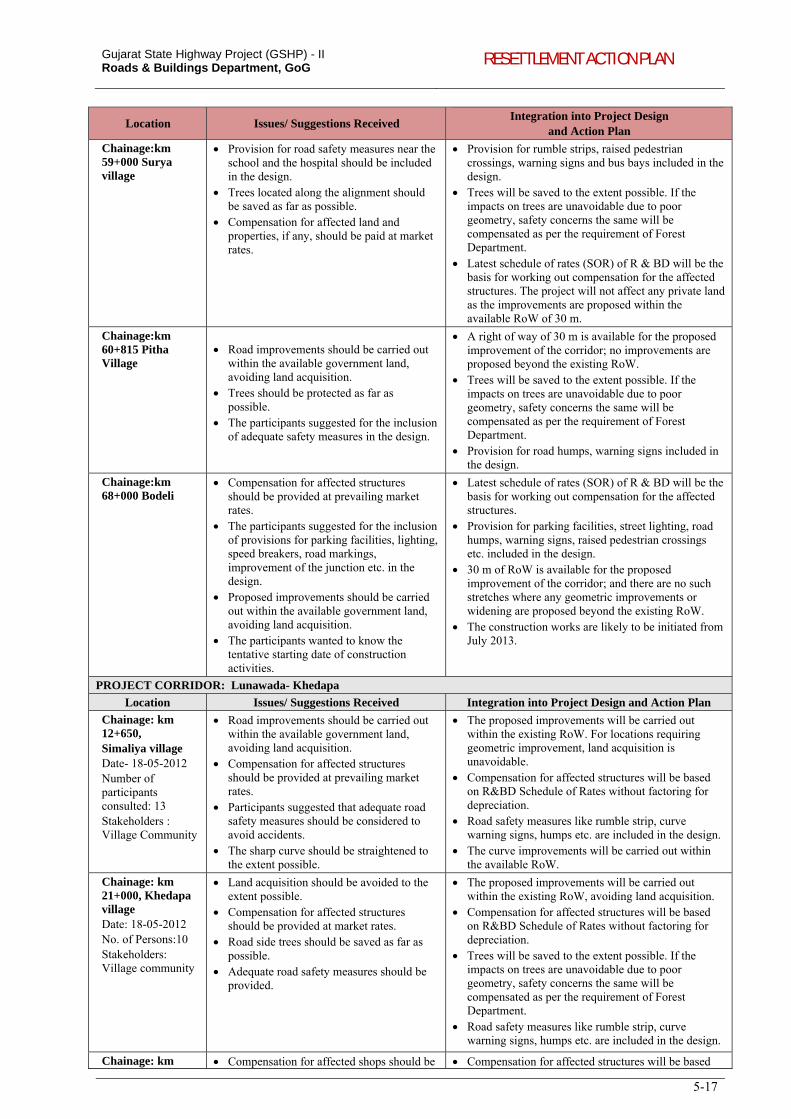
Gujarat State Highway Project (GSHP) - II Roads & Buildings Department, GoG RESETTLEMENT ACTION PLAN
5-17
Location Issues/ Suggestions Received Integration into Project Design
and Action Plan
Chainage:km 59+000 Surya village
Provision for road safety measures near the school and the hospital should be included in the design.
Trees located along the alignment should be saved as far as possible.
Compensation for affected land and properties, if any, should be paid at market rates.
Provision for rumble strips, raised pedestrian crossings, warning signs and bus bays included in the design.
Trees will be saved to the extent possible. If the impacts on trees are unavoidable due to poor geometry, safety concerns the same will be compensated as per the requirement of Forest Department.
Latest schedule of rates (SOR) of R & BD will be the basis for working out compensation for the affected structures. The project will not affect any private land as the improvements are proposed within the available RoW of 30 m.
Chainage:km 60+815 Pitha Village
Road improvements should be carried out within the available government land, avoiding land acquisition.
Trees should be protected as far as possible.
The participants suggested for the inclusion of adequate safety measures in the design.
A right of way of 30 m is available for the proposed improvement of the corridor; no improvements are proposed beyond the existing RoW.
Trees will be saved to the extent possible. If the impacts on trees are unavoidable due to poor geometry, safety concerns the same will be compensated as per the requirement of Forest Department.
Provision for road humps, warning signs included in the design.
Chainage:km 68+000 Bodeli
Compensation for affected structures should be provided at prevailing market rates.
The participants suggested for the inclusion of provisions for parking facilities, lighting, speed breakers, road markings, improvement of the junction etc. in the design.
Proposed improvements should be carried out within the available government land, avoiding land acquisition.
The participants wanted to know the tentative starting date of construction activities.
Latest schedule of rates (SOR) of R & BD will be the basis for working out compensation for the affected structures.
Provision for parking facilities, street lighting, road humps, warning signs, raised pedestrian crossings etc. included in the design.
30 m of RoW is available for the proposed improvement of the corridor; and there are no such stretches where any geometric improvements or widening are proposed beyond the existing RoW.
The construction works are likely to be initiated from July 2013.
PROJECT CORRIDOR: Lunawada- Khedapa
Location Issues/ Suggestions Received Integration into Project Design and Action Plan
Chainage: km 12+650, Simaliya village Date- 18-05-2012 Number of participants consulted: 13 Stakeholders : Village Community
Road improvements should be carried out within the available government land, avoiding land acquisition.
Compensation for affected structures should be provided at prevailing market rates.
Participants suggested that adequate road safety measures should be considered to avoid accidents.
The sharp curve should be straightened to the extent possible.
The proposed improvements will be carried out within the existing RoW. For locations requiring geometric improvement, land acquisition is unavoidable.
Compensation for affected structures will be based on R&BD Schedule of Rates without factoring for depreciation.
Road safety measures like rumble strip, curve warning signs, humps etc. are included in the design.
The curve improvements will be carried out within the available RoW.
Chainage: km 21+000, Khedapa village Date: 18-05-2012 No. of Persons:10 Stakeholders: Village community
Land acquisition should be avoided to the extent possible.
Compensation for affected structures should be provided at market rates.
Road side trees should be saved as far as possible.
Adequate road safety measures should be provided.
The proposed improvements will be carried out within the existing RoW, avoiding land acquisition.
Compensation for affected structures will be based on R&BD Schedule of Rates without factoring for depreciation.
Trees will be saved to the extent possible. If the impacts on trees are unavoidable due to poor geometry, safety concerns the same will be compensated as per the requirement of Forest Department.
Road safety measures like rumble strip, curve warning signs, humps etc. are included in the design.
Chainage: km Compensation for affected shops should be Compensation for affected structures will be based
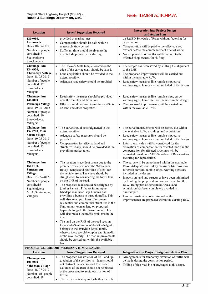
Gujarat State Highway Project (GSHP) - II Roads & Buildings Department, GoG RESETTLEMENT ACTION PLAN
5-18
Location Issues/ Suggestions Received Integration into Project Design
and Action Plan 130+030, Lunawada Date- 18-05-2012 Number of people consulted: 8 Stakeholders: Shopkeepers
provided at market rates. Compensation should be paid within a
reasonable time period. Sufficient time should be given to the
affected shop owners for shifting.
on R&BD Schedule of Rates without factoring for depreciation.
Compensation will be paid to the affected shop owners before the commencement of civil works.
Notice period of 4 months will be served to the affected shop owners for shifting.
Chainage: km 134+900, Chavadiya Village Date- 18-05-2012 Number of people consulted: 17 Stakeholders: Villagers
The Chavadi Mata temple located on the edge of the carriageway should be saved.
Land acquisition should be avoided to the extent possible.
Adequate road safety should be provided
The temple has been saved by shifting the alignment to the LHS.
The proposed improvements will be carried out within the available RoW.
Road safety measures like rumble strip, curve warning signs, humps etc. are included in the design.
Chainage: km 148+800 Pathariya Village Date- 19-05 -2012 Number of people consulted: 10 Stakeholders: Villagers
Road safety measures should be provided near the temple and the school.
Efforts should be taken to minimise effects on land and other properties.
Road safety measures like rumble strips, curve warning signs, hump etc., are included in the design.
The proposed improvements will be carried out within the available RoW.
Chainage: km 152+200, Moti Saran Village Date- 19-05-2012 Number of people consulted: 13 Stakeholders: Villagers
The curve should be straightened to the extent possible.
Adequate safety measures should be provided.
Compensation for affected land and structures, if any, should be provided at the prevailing market rates.
The curve improvements will be carried out within the available RoW, avoiding land acquisition.
Road safety measures like rumble strip, curve warning signs, humps etc. are included in the design.
Latest Jantri value will be considered for the estimation of compensation for affected land and the compensation for affected structures will be estimated based on R&BD Schedule of Rates without factoring for depreciation.
Chainage: km 161+130, Santrampur Village Date: 19-05-2012 Number of people consulted:5 Stakeholders: MLA, Santrampur, villagers
The location is accident prone due to the presence of a curve near the ‘Motichada Bavaji’ temple and poor line of sight for the vehicle users. The curve should be straightened by considering the forest land on the LHS of the road.
The proposed road should be realigned by joining Santram Pitha to Santrampur-Khedapa road near Gaja Cinema hall providing a bypass to through traffic. This will also avoid problems of removing residential and commercial structures in the Santrampur town as land on proposed bypass belongs to the Government. This will also reduce the traffic problems in the town.
The land on the RHS of the road section Lunawada-Santrampur-Zalod-Kushalgadh belongs to the erstwhile Royal family wherein there are old temples and Samadhi of the royal family. The road improvements should be carried out within the available land.
The curve will be smoothened within the available RoW. Adequate road safety measures like provision for crash barriers, rumble strips, warning signs are included in the design.
Impacts on land and structures have been minimised by limiting the proposed improvements within the RoW. Being part of Scheduled Areas, land acquisition has been completely avoided in Santrampur.
Land acquisition is not envisaged as the improvements are proposed within the existing RoW.
PROJECT CORRIDOR: MEHSANA-HIMATNAGAR
Location Issues/ Suggestions Received Integration into Project Design and Action Plan
Chainage:km 100+000 Sobhasan Village Date- 18-07-2012 Number of people consulted: 18
The proposed construction of RoB and up-gradation of the corridor to 4 lanes should not obstruct the access-road to village. Columns of the RoB should not be placed at the cross road to avoid obstruction of traffic.
The participants enquired whether there be
Arrangements for temporary diversion of traffic will be made during the construction period.
Tolling of this road is not envisaged at this stage.
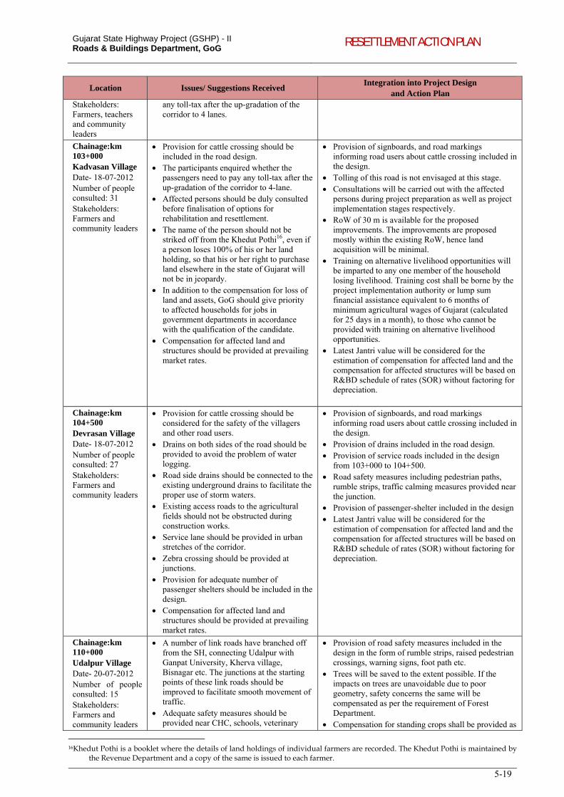
Gujarat State Highway Project (GSHP) - II Roads & Buildings Department, GoG RESETTLEMENT ACTION PLAN
5-19
Location Issues/ Suggestions Received Integration into Project Design
and Action Plan Stakeholders: Farmers, teachers and community leaders
any toll-tax after the up-gradation of the corridor to 4 lanes.
Chainage:km 103+000 Kadvasan Village Date- 18-07-2012 Number of people consulted: 31 Stakeholders: Farmers and community leaders
Provision for cattle crossing should be included in the road design.
The participants enquired whether the passengers need to pay any toll-tax after the up-gradation of the corridor to 4-lane.
Affected persons should be duly consulted before finalisation of options for rehabilitation and resettlement.
The name of the person should not be striked off from the Khedut Pothi16, even if a person loses 100% of his or her land holding, so that his or her right to purchase land elsewhere in the state of Gujarat will not be in jeopardy.
In addition to the compensation for loss of land and assets, GoG should give priority to affected households for jobs in government departments in accordance with the qualification of the candidate.
Compensation for affected land and structures should be provided at prevailing market rates.
Provision of signboards, and road markings informing road users about cattle crossing included in the design.
Tolling of this road is not envisaged at this stage. Consultations will be carried out with the affected
persons during project preparation as well as project implementation stages respectively.
RoW of 30 m is available for the proposed improvements. The improvements are proposed mostly within the existing RoW, hence land acquisition will be minimal.
Training on alternative livelihood opportunities will be imparted to any one member of the household losing livelihood. Training cost shall be borne by the project implementation authority or lump sum financial assistance equivalent to 6 months of minimum agricultural wages of Gujarat (calculated for 25 days in a month), to those who cannot be provided with training on alternative livelihood opportunities.
Latest Jantri value will be considered for the estimation of compensation for affected land and the compensation for affected structures will be based on R&BD schedule of rates (SOR) without factoring for depreciation.
Chainage:km 104+500 Devrasan Village Date- 18-07-2012 Number of people consulted: 27 Stakeholders: Farmers and community leaders
Provision for cattle crossing should be considered for the safety of the villagers and other road users.
Drains on both sides of the road should be provided to avoid the problem of water logging.
Road side drains should be connected to the existing underground drains to facilitate the proper use of storm waters.
Existing access roads to the agricultural fields should not be obstructed during construction works.
Service lane should be provided in urban stretches of the corridor.
Zebra crossing should be provided at junctions.
Provision for adequate number of passenger shelters should be included in the design.
Compensation for affected land and structures should be provided at prevailing market rates.
Provision of signboards, and road markings informing road users about cattle crossing included in the design.
Provision of drains included in the road design. Provision of service roads included in the design
from 103+000 to 104+500. Road safety measures including pedestrian paths,
rumble strips, traffic calming measures provided near the junction.
Provision of passenger-shelter included in the design Latest Jantri value will be considered for the
estimation of compensation for affected land and the compensation for affected structures will be based on R&BD schedule of rates (SOR) without factoring for depreciation.
Chainage:km 110+000 Udalpur Village Date- 20-07-2012 Number of people consulted: 15 Stakeholders: Farmers and community leaders
A number of link roads have branched off from the SH, connecting Udalpur with Ganpat University, Kherva village, Bisnagar etc. The junctions at the starting points of these link roads should be improved to facilitate smooth movement of traffic.
Adequate safety measures should be provided near CHC, schools, veterinary
Provision of road safety measures included in the design in the form of rumble strips, raised pedestrian crossings, warning signs, foot path etc.
Trees will be saved to the extent possible. If the impacts on trees are unavoidable due to poor geometry, safety concerns the same will be compensated as per the requirement of Forest Department.
Compensation for standing crops shall be provided as
16Khedut Pothi is a booklet where the details of land holdings of individual farmers are recorded. The Khedut Pothi is maintained by
the Revenue Department and a copy of the same is issued to each farmer.
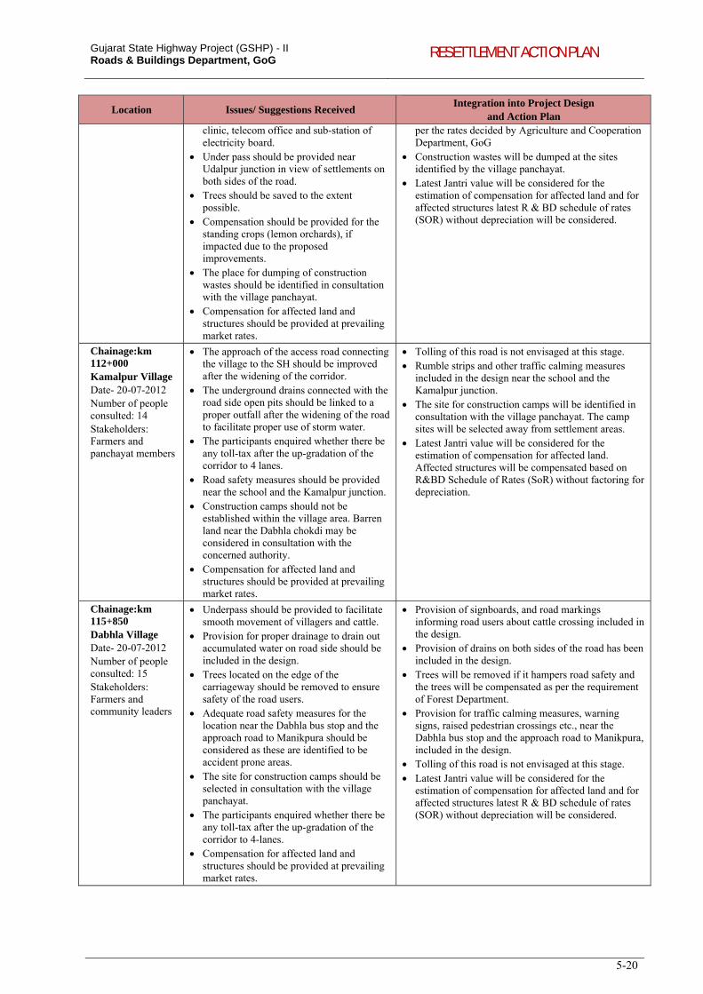
Gujarat State Highway Project (GSHP) - II Roads & Buildings Department, GoG RESETTLEMENT ACTION PLAN
5-20
Location Issues/ Suggestions Received Integration into Project Design
and Action Plan
clinic, telecom office and sub-station of electricity board.
Under pass should be provided near Udalpur junction in view of settlements on both sides of the road.
Trees should be saved to the extent possible.
Compensation should be provided for the standing crops (lemon orchards), if impacted due to the proposed improvements.
The place for dumping of construction wastes should be identified in consultation with the village panchayat.
Compensation for affected land and structures should be provided at prevailing market rates.
per the rates decided by Agriculture and Cooperation Department, GoG
Construction wastes will be dumped at the sites identified by the village panchayat.
Latest Jantri value will be considered for the estimation of compensation for affected land and for affected structures latest R & BD schedule of rates (SOR) without depreciation will be considered.
Chainage:km 112+000 Kamalpur Village Date- 20-07-2012 Number of people consulted: 14 Stakeholders: Farmers and panchayat members
The approach of the access road connecting the village to the SH should be improved after the widening of the corridor.
The underground drains connected with the road side open pits should be linked to a proper outfall after the widening of the road to facilitate proper use of storm water.
The participants enquired whether there be any toll-tax after the up-gradation of the corridor to 4 lanes.
Road safety measures should be provided near the school and the Kamalpur junction.
Construction camps should not be established within the village area. Barren land near the Dabhla chokdi may be considered in consultation with the concerned authority.
Compensation for affected land and structures should be provided at prevailing market rates.
Tolling of this road is not envisaged at this stage. Rumble strips and other traffic calming measures
included in the design near the school and the Kamalpur junction.
The site for construction camps will be identified in consultation with the village panchayat. The camp sites will be selected away from settlement areas.
Latest Jantri value will be considered for the estimation of compensation for affected land. Affected structures will be compensated based on R&BD Schedule of Rates (SoR) without factoring for depreciation.
Chainage:km 115+850 Dabhla Village Date- 20-07-2012 Number of people consulted: 15 Stakeholders: Farmers and community leaders
Underpass should be provided to facilitate smooth movement of villagers and cattle.
Provision for proper drainage to drain out accumulated water on road side should be included in the design.
Trees located on the edge of the carriageway should be removed to ensure safety of the road users.
Adequate road safety measures for the location near the Dabhla bus stop and the approach road to Manikpura should be considered as these are identified to be accident prone areas.
The site for construction camps should be selected in consultation with the village panchayat.
The participants enquired whether there be any toll-tax after the up-gradation of the corridor to 4-lanes.
Compensation for affected land and structures should be provided at prevailing market rates.
Provision of signboards, and road markings informing road users about cattle crossing included in the design.
Provision of drains on both sides of the road has been included in the design.
Trees will be removed if it hampers road safety and the trees will be compensated as per the requirement of Forest Department.
Provision for traffic calming measures, warning signs, raised pedestrian crossings etc., near the Dabhla bus stop and the approach road to Manikpura, included in the design.
Tolling of this road is not envisaged at this stage. Latest Jantri value will be considered for the
estimation of compensation for affected land and for affected structures latest R & BD schedule of rates (SOR) without depreciation will be considered.
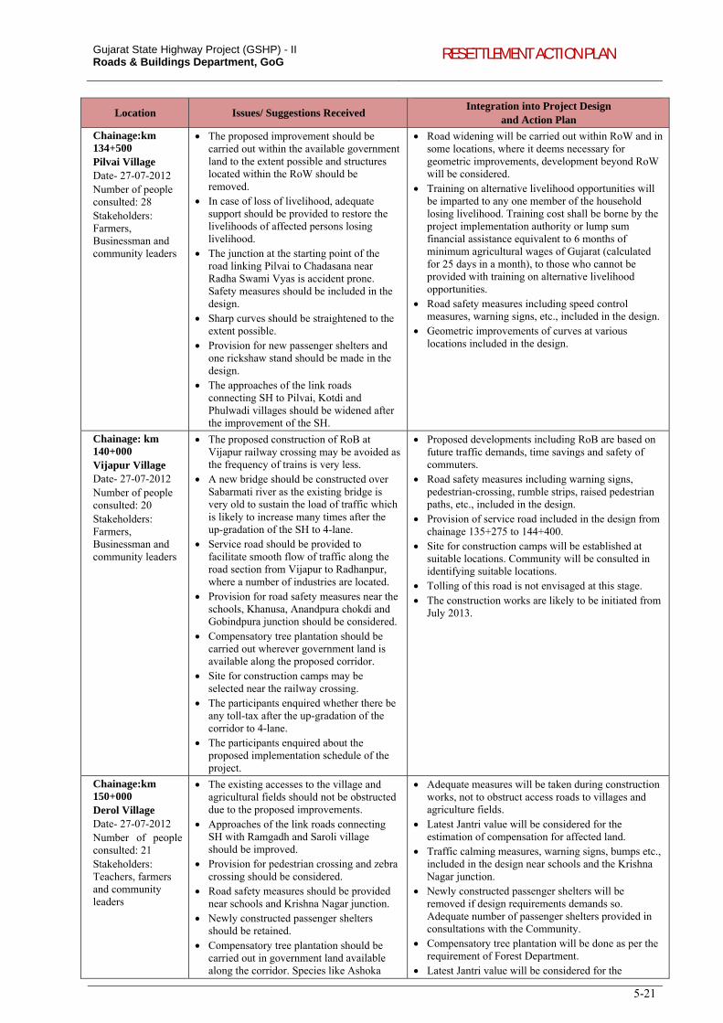
Gujarat State Highway Project (GSHP) - II Roads & Buildings Department, GoG RESETTLEMENT ACTION PLAN
5-21
Location Issues/ Suggestions Received Integration into Project Design
and Action Plan
Chainage:km 134+500 Pilvai Village Date- 27-07-2012 Number of people consulted: 28 Stakeholders: Farmers, Businessman and community leaders
The proposed improvement should be carried out within the available government land to the extent possible and structures located within the RoW should be removed.
In case of loss of livelihood, adequate support should be provided to restore the livelihoods of affected persons losing livelihood.
The junction at the starting point of the road linking Pilvai to Chadasana near Radha Swami Vyas is accident prone. Safety measures should be included in the design.
Sharp curves should be straightened to the extent possible.
Provision for new passenger shelters and one rickshaw stand should be made in the design.
The approaches of the link roads connecting SH to Pilvai, Kotdi and Phulwadi villages should be widened after the improvement of the SH.
Road widening will be carried out within RoW and in some locations, where it deems necessary for geometric improvements, development beyond RoW will be considered.
Training on alternative livelihood opportunities will be imparted to any one member of the household losing livelihood. Training cost shall be borne by the project implementation authority or lump sum financial assistance equivalent to 6 months of minimum agricultural wages of Gujarat (calculated for 25 days in a month), to those who cannot be provided with training on alternative livelihood opportunities.
Road safety measures including speed control measures, warning signs, etc., included in the design.
Geometric improvements of curves at various locations included in the design.
Chainage: km 140+000 Vijapur Village Date- 27-07-2012 Number of people consulted: 20 Stakeholders: Farmers, Businessman and community leaders
The proposed construction of RoB at Vijapur railway crossing may be avoided as the frequency of trains is very less.
A new bridge should be constructed over Sabarmati river as the existing bridge is very old to sustain the load of traffic which is likely to increase many times after the up-gradation of the SH to 4-lane.
Service road should be provided to facilitate smooth flow of traffic along the road section from Vijapur to Radhanpur, where a number of industries are located.
Provision for road safety measures near the schools, Khanusa, Anandpura chokdi and Gobindpura junction should be considered.
Compensatory tree plantation should be carried out wherever government land is available along the proposed corridor.
Site for construction camps may be selected near the railway crossing.
The participants enquired whether there be any toll-tax after the up-gradation of the corridor to 4-lane.
The participants enquired about the proposed implementation schedule of the project.
Proposed developments including RoB are based on future traffic demands, time savings and safety of commuters.
Road safety measures including warning signs, pedestrian-crossing, rumble strips, raised pedestrian paths, etc., included in the design.
Provision of service road included in the design from chainage 135+275 to 144+400.
Site for construction camps will be established at suitable locations. Community will be consulted in identifying suitable locations.
Tolling of this road is not envisaged at this stage. The construction works are likely to be initiated from
July 2013.
Chainage:km 150+000 Derol Village Date- 27-07-2012 Number of people consulted: 21 Stakeholders: Teachers, farmers and community leaders
The existing accesses to the village and agricultural fields should not be obstructed due to the proposed improvements.
Approaches of the link roads connecting SH with Ramgadh and Saroli village should be improved.
Provision for pedestrian crossing and zebra crossing should be considered.
Road safety measures should be provided near schools and Krishna Nagar junction.
Newly constructed passenger shelters should be retained.
Compensatory tree plantation should be carried out in government land available along the corridor. Species like Ashoka
Adequate measures will be taken during construction works, not to obstruct access roads to villages and agriculture fields.
Latest Jantri value will be considered for the estimation of compensation for affected land.
Traffic calming measures, warning signs, bumps etc., included in the design near schools and the Krishna Nagar junction.
Newly constructed passenger shelters will be removed if design requirements demands so. Adequate number of passenger shelters provided in consultations with the Community.
Compensatory tree plantation will be done as per the requirement of Forest Department.
Latest Jantri value will be considered for the
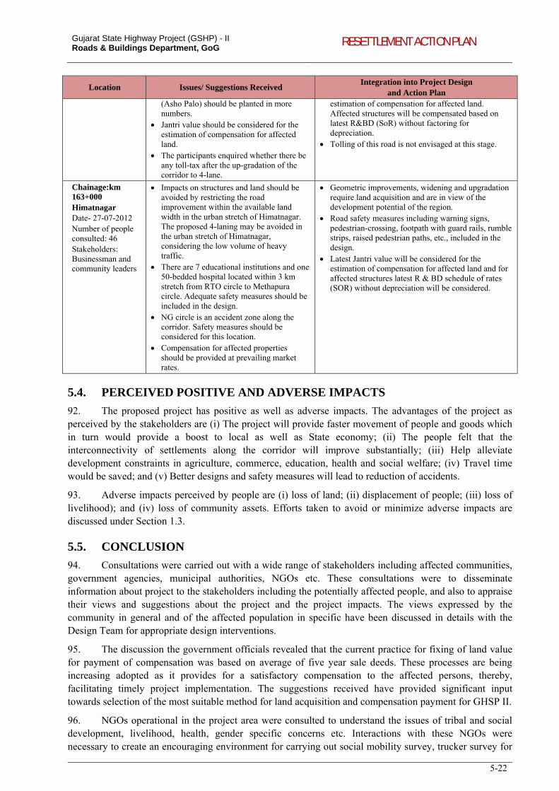
Gujarat State Highway Project (GSHP) - II Roads & Buildings Department, GoG RESETTLEMENT ACTION PLAN
5-22
Location Issues/ Suggestions Received Integration into Project Design
and Action Plan
(Asho Palo) should be planted in more numbers.
Jantri value should be considered for the estimation of compensation for affected land.
The participants enquired whether there be any toll-tax after the up-gradation of the corridor to 4-lane.
estimation of compensation for affected land. Affected structures will be compensated based on latest R&BD (SoR) without factoring for depreciation.
Tolling of this road is not envisaged at this stage.
Chainage:km 163+000 Himatnagar Date- 27-07-2012 Number of people consulted: 46 Stakeholders: Businessman and community leaders
Impacts on structures and land should be avoided by restricting the road improvement within the available land width in the urban stretch of Himatnagar. The proposed 4-laning may be avoided in the urban stretch of Himatnagar, considering the low volume of heavy traffic.
There are 7 educational institutions and one 50-bedded hospital located within 3 km stretch from RTO circle to Methapura circle. Adequate safety measures should be included in the design.
NG circle is an accident zone along the corridor. Safety measures should be considered for this location.
Compensation for affected properties should be provided at prevailing market rates.
Geometric improvements, widening and upgradation require land acquisition and are in view of the development potential of the region.
Road safety measures including warning signs, pedestrian-crossing, footpath with guard rails, rumble strips, raised pedestrian paths, etc., included in the design.
Latest Jantri value will be considered for the estimation of compensation for affected land and for affected structures latest R & BD schedule of rates (SOR) without depreciation will be considered.
5.4. PERCEIVED POSITIVE AND ADVERSE IMPACTS
92. The proposed project has positive as well as adverse impacts. The advantages of the project as perceived by the stakeholders are (i) The project will provide faster movement of people and goods which in turn would provide a boost to local as well as State economy; (ii) The people felt that the interconnectivity of settlements along the corridor will improve substantially; (iii) Help alleviate development constraints in agriculture, commerce, education, health and social welfare; (iv) Travel time would be saved; and (v) Better designs and safety measures will lead to reduction of accidents.
93. Adverse impacts perceived by people are (i) loss of land; (ii) displacement of people; (iii) loss of livelihood); and (iv) loss of community assets. Efforts taken to avoid or minimize adverse impacts are discussed under Section 1.3.
5.5. CONCLUSION
94. Consultations were carried out with a wide range of stakeholders including affected communities, government agencies, municipal authorities, NGOs etc. These consultations were to disseminate information about project to the stakeholders including the potentially affected people, and also to appraise their views and suggestions about the project and the project impacts. The views expressed by the community in general and of the affected population in specific have been discussed in details with the Design Team for appropriate design interventions.
95. The discussion the government officials revealed that the current practice for fixing of land value for payment of compensation was based on average of five year sale deeds. These processes are being increasing adopted as it provides for a satisfactory compensation to the affected persons, thereby, facilitating timely project implementation. The suggestions received have provided significant input towards selection of the most suitable method for land acquisition and compensation payment for GHSP II.
96. NGOs operational in the project area were consulted to understand the issues of tribal and social development, livelihood, health, gender specific concerns etc. Interactions with these NGOs were necessary to create an encouraging environment for carrying out social mobility survey, trucker survey for
Gujarat State Highway Project (GSHP) - II Roads & Buildings Department, GoG RESETTLEMENT ACTION PLAN
5-23
HIV/AIDS Prevention plan and public consultations. Their inputs have helped in preparation of the Indigenous Peoples Development Plan and the HIV/AIDS Prevention plan.
97. The consultations with Trucker community done at locations such as highway-side hotels, guest houses, transporter/brokers office, truck parking areas, market yard, industries, eateries and circles/chalkadi on the corridors, have given detailed information towards strategizing the awareness and intervention areas along the project corridors.
98. The FPIC carried out in Scheduled Areas in each of the 4 tribal Talukas has helped in identifying the views of Scheduled Tribes and ascertaining their broad community support for the project. The inputs from consultation has helped in formulating a consultation strategy for detailed consultation and broad community support during project implementation, which is described in detail in Indigenous Peoples Development Plan.
99. Consultations with women have ensured the active participation of women in the project development. The views and concerns of women at various corridors have been documented and wherever possible mitigation measures suggested in project design. Participation of women will be ensured during consultation process through the facilitating NGO.
100. Consultations on cultural property and community assets formed inputs to the finalization of the designs, which included design interventions to avoid/minimize impacts on the properties, provision of safety measures as barriers to avoid impacts on the structure, provision of additional measures such as traffic safety measures etc., around these locations and thereby enhancing the road safety conditions on the highway. The nature and type of interventions within these cultural properties have been finalized in consultation with the relevant stakeholders at these cultural/community assets.
101. Consultations with affected communities have provided inputs for broadly two types of integration, (i) policy level integration – compensation for affected land and structures to be given at replacement cost, resettlement assistance for loss of livelihood, loss of agriculture crops and fruit plantations, loss of water sources, provision of public toilets, etc., and (ii) design level integration – avoiding or minimizing impact on land and structures including cultural properties and community assets, road safety issues, traffic management measures, cattle crossings, etc.
6-1
6. LAND ACQUISITION AND COMPENSATION PRACTICES
102. This chapter presents a review of land acquisition and compensation practices adopted in Gujarat in recent time for undertaking various infrastructure development projects. The chapter includes review of the GSHP I, NRRP 2007, the LA Act 1894 and the World Bank OP 4.12. The review also included various case studies - World Bank funded Integrated Coastal Zone Management Project, ADB Solar Transmission Project, Sardar Sarovar Narmada Nigam Ltd (SSNNL) and other projects carried out by different Government organizations in Gujarat.
6.1. GUJARAT STATE HIGHWAY PROJECT17: LESSONS LEARNED
103. The Government of Gujarat has carried out the Gujarat State Highway Project I between 2000 and 2007. The components of the project included (i) widening and strengthening of State Highways, (ii) land acquisition and relocation and resettlement, (iii) periodic maintenance of State Highways, (iv) design and supervision of civil works contracts, (v) institutional strengthening, TA, training and equipment, and (vi) pre-investment studies.
104. This project had adopted a unique method for payment of compensation for land acquisition. The land acquisition was carried out through traditional land acquisition procedures under LA Act, 1894. The compensation paid under the LA Act was compared with the rate derived following the valuation procedures of Town Planning and valuation Department. The difference in the rate of land, the ‘top-up’ money was paid as assistance. Some observations from the Implementation Completion and Results Report (ICRR) regarding land acquisition and resettlement are summarised below:
Land acquisition and R&R were carried out successfully and in line with the World Bank safeguard policies. The final land acquisition and the final number of affected households were lower than anticipated at the
appraisal stage due to the efforts made by R&BD in exploring alternative options to minimize impacts through adjustments in the alignments and reducing the CoI width wherever possible.
Environmental and Social Management Unit (ESMU) established by R&BD was responsible for implementing RAP with the assistance of NGOs, procured specifically for the purpose.
PAPs and families were satisfied with the RAP implementation and associated compensation and training provided.
A grievance redress committee was established to hear an adjudicate grievances, during the RAP implementation.
Despite the time taken to complete the land acquisition, the civil works were not delayed for this reason; Delay in the payment of ‘top-up’ money, mainly due to the difficulties in coming up with a set of objective
criteria to arrive at appropriate and agreed replacement cost; Delay in providing permanent resettlement to the displaced households (Phase I roads). Well planned and coordinated effort on the work of land acquisition and shifting of utilities. Need for completion of all pre-construction activities before award of work. Requirement of temporary land acquisition for traffic diversions. Land should be identified as far as possible and
resolved at the design stage in such cases where insufficient space exists within RoW.
6.2. REVIEW OF RECENT PRACTICES IN GUJARAT
6.2.1. Road Development Projects by GSRDC
105. The recent projects (Ahmedabad-Viramgam-Maliya, Halol-Godhra-Shamlaji and Rajkot-Jamnagar-Vadinar Corridor) completed by Gujarat State Road Development Corporation (GSRDC) has acquired land following “emergency clause” (section 17) of the Land Acquisition Act, 1894. The registry rate of land was considered as the base for fixing land value. For the purpose, sale-deeds carried out in past five years from respective villages were collected and average land rate estimated. There are number of cases of litigation by affected land owners seeking higher compensation rate. Valuation of the affected structure was carried out by respective sub-divisions of R&BD based on Schedule of Rates considering
17 Implementation Completion and Results Report (IBRD-45770), Sustainable Development Department, India Country Management Unit, South Asia Region. The World Bank. June 18, 2008.
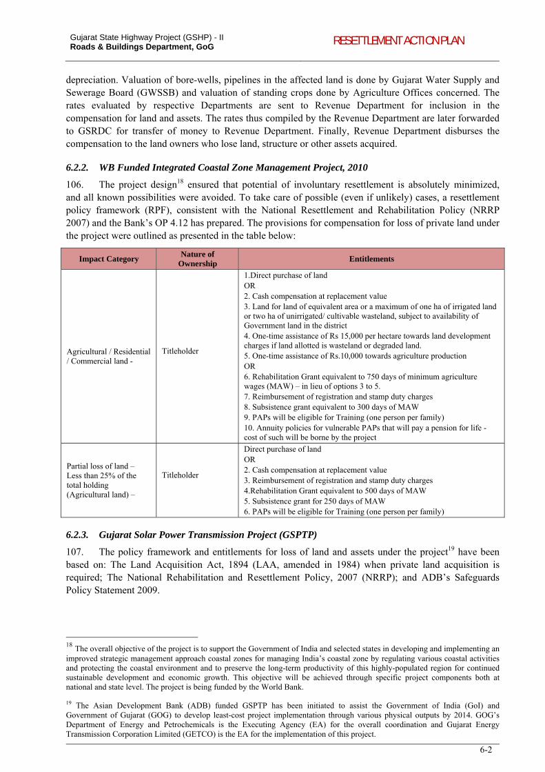
Gujarat State Highway Project (GSHP) - II Roads & Buildings Department, GoG RESETTLEMENT ACTION PLAN
6-2
depreciation. Valuation of bore-wells, pipelines in the affected land is done by Gujarat Water Supply and Sewerage Board (GWSSB) and valuation of standing crops done by Agriculture Offices concerned. The rates evaluated by respective Departments are sent to Revenue Department for inclusion in the compensation for land and assets. The rates thus compiled by the Revenue Department are later forwarded to GSRDC for transfer of money to Revenue Department. Finally, Revenue Department disburses the compensation to the land owners who lose land, structure or other assets acquired.
6.2.2. WB Funded Integrated Coastal Zone Management Project, 2010
106. The project design18 ensured that potential of involuntary resettlement is absolutely minimized, and all known possibilities were avoided. To take care of possible (even if unlikely) cases, a resettlement policy framework (RPF), consistent with the National Resettlement and Rehabilitation Policy (NRRP 2007) and the Bank’s OP 4.12 has prepared. The provisions for compensation for loss of private land under the project were outlined as presented in the table below:
Impact Category Nature of
Ownership Entitlements
Agricultural / Residential / Commercial land -
Titleholder
1.Direct purchase of land OR 2. Cash compensation at replacement value 3. Land for land of equivalent area or a maximum of one ha of irrigated land or two ha of unirrigated/ cultivable wasteland, subject to availability of Government land in the district 4. One-time assistance of Rs 15,000 per hectare towards land development charges if land allotted is wasteland or degraded land. 5. One-time assistance of Rs.10,000 towards agriculture production OR 6. Rehabilitation Grant equivalent to 750 days of minimum agriculture wages (MAW) – in lieu of options 3 to 5. 7. Reimbursement of registration and stamp duty charges 8. Subsistence grant equivalent to 300 days of MAW 9. PAPs will be eligible for Training (one person per family) 10. Annuity policies for vulnerable PAPs that will pay a pension for life - cost of such will be borne by the project
Partial loss of land – Less than 25% of the total holding (Agricultural land) –
Titleholder
Direct purchase of land OR 2. Cash compensation at replacement value 3. Reimbursement of registration and stamp duty charges 4.Rehabilitation Grant equivalent to 500 days of MAW 5. Subsistence grant for 250 days of MAW 6. PAPs will be eligible for Training (one person per family)
6.2.3. Gujarat Solar Power Transmission Project (GSPTP)
107. The policy framework and entitlements for loss of land and assets under the project19 have been based on: The Land Acquisition Act, 1894 (LAA, amended in 1984) when private land acquisition is required; The National Rehabilitation and Resettlement Policy, 2007 (NRRP); and ADB’s Safeguards Policy Statement 2009.
18 The overall objective of the project is to support the Government of India and selected states in developing and implementing an improved strategic management approach coastal zones for managing India’s coastal zone by regulating various coastal activities and protecting the coastal environment and to preserve the long-term productivity of this highly-populated region for continued sustainable development and economic growth. This objective will be achieved through specific project components both at national and state level. The project is being funded by the World Bank. 19 The Asian Development Bank (ADB) funded GSPTP has been initiated to assist the Government of India (GoI) and Government of Gujarat (GOG) to develop least-cost project implementation through various physical outputs by 2014. GOG’s Department of Energy and Petrochemicals is the Executing Agency (EA) for the overall coordination and Gujarat Energy Transmission Corporation Limited (GETCO) is the EA for the implementation of this project.
Gujarat State Highway Project (GSHP) - II Roads & Buildings Department, GoG RESETTLEMENT ACTION PLAN
6-3
108. The provision of compensation for acquisition of private land20 under the project will be as follows:
In case there is compulsory acquisition of land, compensation will be based on the Land Acquisition Act (inclusive of 30% solatium and 12% interest);
In case of land to be possessed by the project authority with mutual and voluntary consent of the affected people, compensation will be paid on estimated market price as decided by the revenue department (District Collector) /competent authority;
Transaction costs (documentary stamps, registration costs, etc.) will be borne by the project authority during registration;
If the residual plot(s) is (are) not viable, i.e., the AP becomes a marginal farmer, resettlement assistances will be paid in the form of transitional allowances based on three months of minimum wage.
6.2.4. Land Acquisition by other GoG Agencies
109. In the case of land acquisition for projects under GIDC, GIPCL or GPCL, the land acquisition has followed LA Act, 1894. The land rates were decided based on average of five-year sale-deed-estimates done by District Level Price Committee (DPLC) and Jantri rates (the mention here is about the pre-revised Jantri rates). The DLPC comprises District Collector, District Development Officer, District Head – Town Planning and Valuation Department and Deputy Collector as Member Secretary. The two rates will be disclosed to the affected person seeking his consensus. For about 80 percent of cases, sale-deed estimates would be the consented rate by the affected person and as per Section 11(2) of LA Act, 1894, consent method will be carried out. Those affected persons who are not willing to give consent will be compensated through “regular award” process which will be decided by the Court.
110. Town Planning and Valuation Department gives technical inputs for the valuation of land. There are broadly two categories of land evaluated by the TPVD, one is the land to be acquired for public purpose and second is the land to be allotted for public purpose (for schools, hospitals, etc). For acquisition of land, Revenue Department with technical inputs from TPVD does the land valuation based on the sale-deeds in the past 5 years. The sale-deeds from respective villages will be collected. The land value mentioned in the sale-deeds are adjusted to the latest year [date of publication of Section 4(1) Notification] at a rate of 12 percent per year over-and-above the actual sale-deed. The average of these adjusted five year sale deed estimates were used for determination of land compensation.
111. The same procedure (land rates decided based on average sale-deed estimates) is followed for land acquisition in road projects of National Highway Authority of India (NHAI), following the provision of National Highway Act 1956.
6.2.5. Procedures followed by TPVD for land allotment
112. With respect to allotment of land, TPVD arrives at a rate generally considering the recent one-year sale-deeds. After considering average rate of comparable sale-deeds, certain multiplying factors will be directed to increase or decrease the value of land. The factors such as development plan proposals and development of the area, access to road with respective factors for urban and rural areas, areas under existing or proposed town-planning-scheme, sale of agricultural and non-agricultural land, special projects affecting land under consideration, man-made factors, specific-natural factors will be considered21. The rates thus decided by the TPVD are for allotment purpose only and not applicable for acquisition of land. The allotment rate thus decided by the TPVD can be considered as the ‘market rate’ of land in respective locations.
6.3. LAND VALUATION AND COMPENSATION: OPTIONS
113. This section speaks about various options for land valuation and compensation:
20 These provisions are applicable only for titleholders and APs with traditional land rights. 21 Copy of the Circular with respect to ‘Guidelines for valuation of government land having government interest’ provided by the Town Planning and Valuation Department, GoG is given in Appendix 6.1 (translated version of Circular).
Gujarat State Highway Project (GSHP) - II Roads & Buildings Department, GoG RESETTLEMENT ACTION PLAN
6-4
Consent Award: Consent award is made where the persons interested in the land are agreeable to the award which the Land Acquisition Officer (LAO) proposes or in cases where the person interested in the land and the Acquiring Body have mutually settled the amount of compensation and requested the LAO to make a consent award accordingly. This is usually based on average of five-year sale-deed-estimates done by DLPC (the details of DLPC and valuation based on sale-deed estimates are given under section 6.2.4).
Negotiation22: The acquiring bodies such as public works department, district Panchayats, Gujarat State Road Transport Corporation, Gujarat Electricity Board, Oil & Natural Gas Commission, etc., obtain possession of the lands which are urgently necessary for their schemes and projects by private negotiations23 with the occupants of lands and thereafter send acquisition proposals to the Revenue Department. In the cases of these private negotiations, the land owners shall receive 75 percent of the estimated compensation as advance compensation. The acquiring body at the time obtaining possession of the lands by private negotiations from the occupants has to enter into an Agreement with the occupants. The acquiring body is required specifically to inform the interested persons concerned in writing that they would apply to the LAO for the advance compensation.
Jantri-based: Valuation of land based on Jantri rates published by the Department of Stamp Duty, would be a novel approach. The Jantri rates are derived through a pragmatic method which is discussed in detail under Section 6.4 of this report.
6.4. JANTRI / GUIDELINE LAND VALUES
114. Government of Gujarat has published the updated Guideline Values (Jantri Value) in April 2011, based on the survey carried throughout the state during January-February 2011. The updated Values are collected from every square kilometre area, termed as ‘Grids’. Separate Information Schedules are used at urban areas (Municipality/Corporation/Authority) and rural areas (Village Area: rural areas, developed areas or areas influenced with development; Village Proper) to collect necessary information towards estimation of Jantri Values. In the case of village area, the rates are collected for both agricultural and non-agricultural land. The land rates are recorded for various categories such as those abutting National Highway/State Highway/MDR/ODR. Agricultural land included irrigated, non-irrigated, non-cultivable land (ravine, river bank land, sandy, bumpy, land with mud flap) and land with minerals. Non-agricultural land included that of residential, commercial, industrial and land with mineral. In the case of urban areas, rates of open plot, flat/apartment, office space, shop, industrials land, agricultural land (irrigation and non-irrigation land).
115. The Jantri value reflects the market rate prevailing in respective areas, however in areas where there are no transactions done in recent past, the rates may not be true reflection of market rates. Plot-wise (survey number based) Jantri value is published by Government of Gujarat. At present the Government is carrying out Jantri-Revision-Survey 2012. The format used in the Jantri-Revision-Survey is presented in Table 6-1 to Table 6-5. The revision of Jantri is required to be done by the GoG every year as per the resolution No. STP-12209-769-11-H.1, of GoG., dated 31.03.2011 (a copy of the resolution – gujarati version – and its English translated version is given in Appendix 6.2).
22 Land Acquisition Procedure regarding – Circular No. LAQ/2268/L.A.IV., Sachivalaya, Ahmedabad-15, dated 6th July 1968, Revenue Department, Government of Gujarat. 23 The Circular on land acquisition procedure of the Revenue Department, GoG, states that “the usual and safe method to arrive at the fair market value of the land is to take into consideration the evidence of genuine sales effected about the time of notification under section 4...The evidence of sale made shortly before or after the notification under section 4 may be admitted for what it is worth for determining the value of the lands under acquisition, on the date of notification, making necessary allowance for the situation, fertility, level, frontage, etc”.
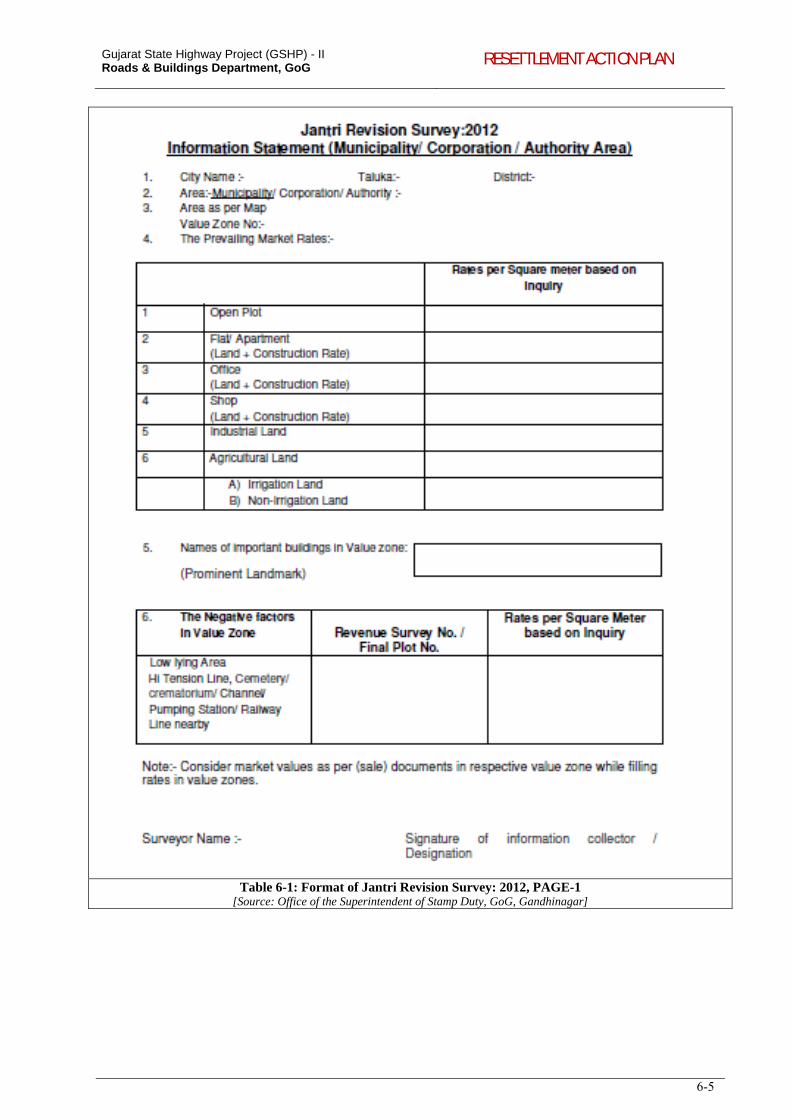
Gujarat State Highway Project (GSHP) - II Roads & Buildings Department, GoG RESETTLEMENT ACTION PLAN
6-5
Table 6-1: Format of Jantri Revision Survey: 2012, PAGE-1 [Source: Office of the Superintendent of Stamp Duty, GoG, Gandhinagar]
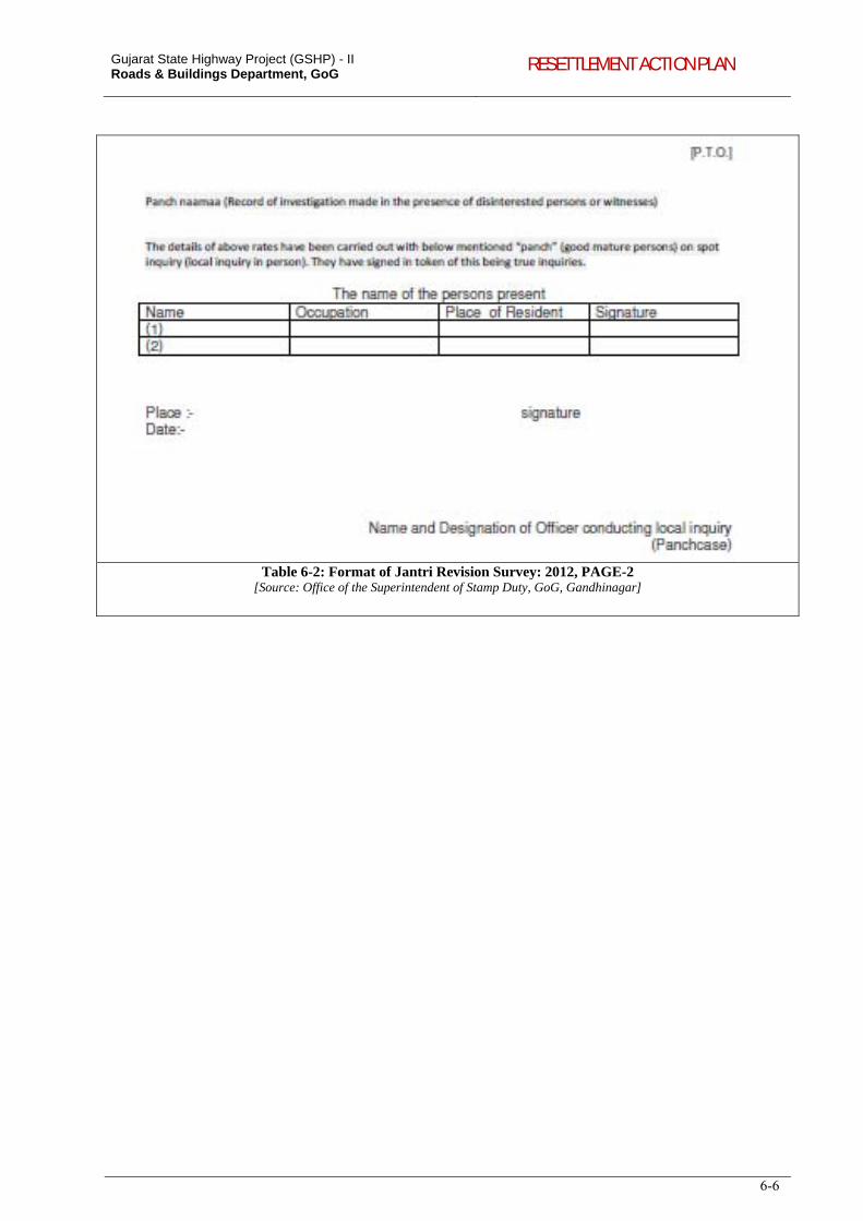
Gujarat State Highway Project (GSHP) - II Roads & Buildings Department, GoG RESETTLEMENT ACTION PLAN
6-6
Table 6-2: Format of Jantri Revision Survey: 2012, PAGE-2 [Source: Office of the Superintendent of Stamp Duty, GoG, Gandhinagar]
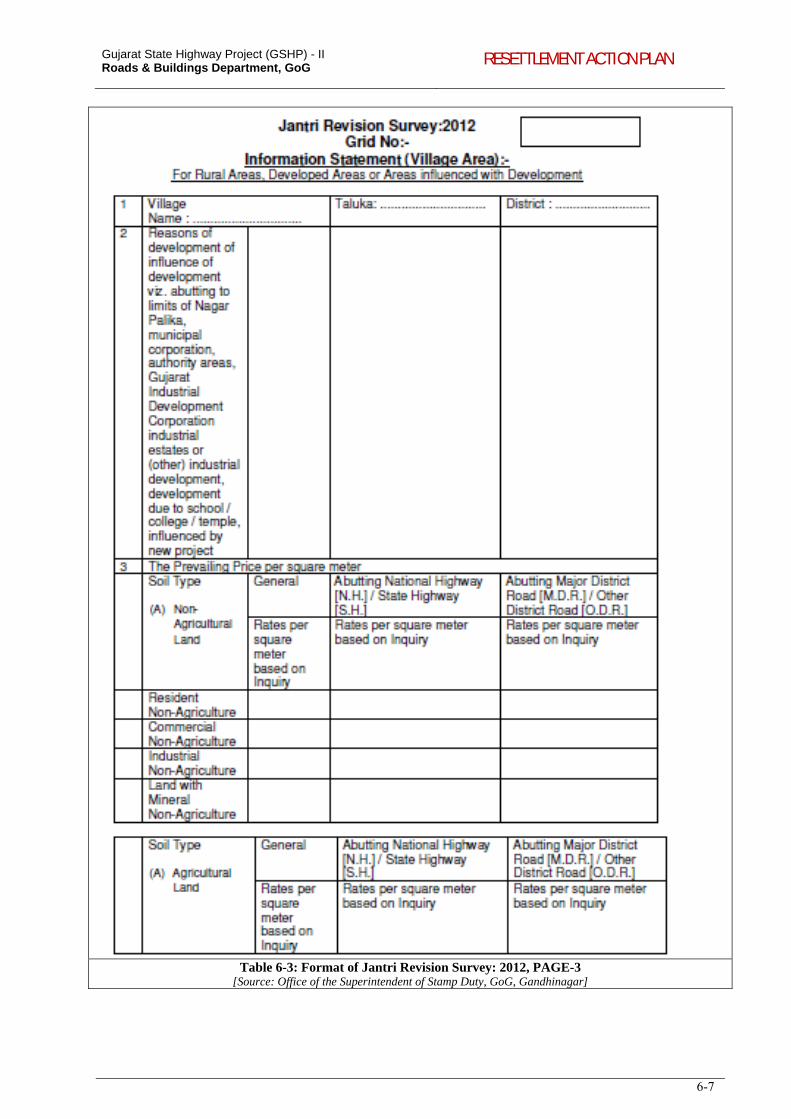
Gujarat State Highway Project (GSHP) - II Roads & Buildings Department, GoG RESETTLEMENT ACTION PLAN
6-7
Table 6-3: Format of Jantri Revision Survey: 2012, PAGE-3 [Source: Office of the Superintendent of Stamp Duty, GoG, Gandhinagar]
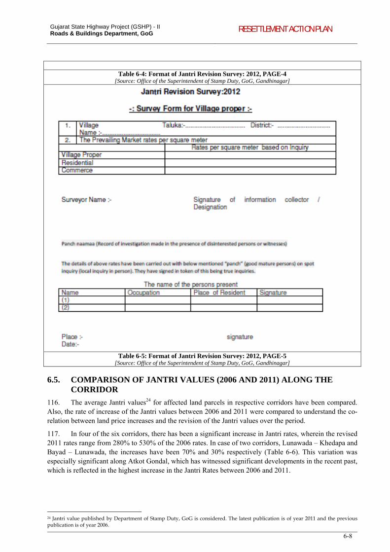
Gujarat State Highway Project (GSHP) - II Roads & Buildings Department, GoG RESETTLEMENT ACTION PLAN
6-8
Table 6-4: Format of Jantri Revision Survey: 2012, PAGE-4 [Source: Office of the Superintendent of Stamp Duty, GoG, Gandhinagar]
Table 6-5: Format of Jantri Revision Survey: 2012, PAGE-5 [Source: Office of the Superintendent of Stamp Duty, GoG, Gandhinagar]
6.5. COMPARISON OF JANTRI VALUES (2006 AND 2011) ALONG THE CORRIDOR
116. The average Jantri values24 for affected land parcels in respective corridors have been compared. Also, the rate of increase of the Jantri values between 2006 and 2011 were compared to understand the co-relation between land price increases and the revision of the Jantri values over the period.
117. In four of the six corridors, there has been a significant increase in Jantri rates, wherein the revised 2011 rates range from 280% to 530% of the 2006 rates. In case of two corridors, Lunawada – Khedapa and Bayad – Lunawada, the increases have been 70% and 30% respectively (Table 6-6). This variation was especially significant along Atkot Gondal, which has witnessed significant developments in the recent past, which is reflected in the highest increase in the Jantri Rates between 2006 and 2011.
24 Jantri value published by Department of Stamp Duty, GoG is considered. The latest publication is of year 2011 and the previous publication is of year 2006.
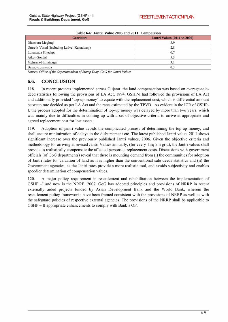
Gujarat State Highway Project (GSHP) - II Roads & Buildings Department, GoG RESETTLEMENT ACTION PLAN
6-9
Table 6-6: Jantri Value 2006 and 2011: Comparison Corridors Jantri Values (2011 vs 2006)
Dhansura-Meghraj 3.9
Umreth-Vasad (including Ladvel-Kapadvanj) 2.8
Lunawada-Khedapa 0.7
Atkot-Gondal 5.3
Mehsana-Himatnagar 3.1
Bayad-Lunawada 0.3 Source: Office of the Superintendent of Stamp Duty, GoG for Jantri Values
6.6. CONCLUSION
118. In recent projects implemented across Gujarat, the land compensation was based on average-sale-deed statistics following the provisions of LA Act, 1894. GSHP-I had followed the provisions of LA Act and additionally provided ‘top-up money’ to equate with the replacement cost, which is differential amount between rate decided as per LA Act and the rates estimated by the TPVD. As evident in the ICR of GSHP-I, the process adopted for the determination of top-up money was delayed by more than two years, which was mainly due to difficulties in coming up with a set of objective criteria to arrive at appropriate and agreed replacement cost for lost assets.
119. Adoption of jantri value avoids the complicated process of determining the top-up money, and shall ensure minimization of delays in the disbursement etc. The latest published Jantri value, 2011 shows significant increase over the previously published Jantri values, 2006. Given the objective criteria and methodology for arriving at revised Jantri Values annually, (for every 1 sq km grid), the Jantri values shall provide to realistically compensate the affected persons at replacement costs. Discussions with government officials (of GoG departments) reveal that there is mounting demand from (i) the communities for adoption of Jantri rates for valuation of land as it is higher than the conventional sale deeds statistics and (ii) the Government agencies, as the Jantri rates provide a more realistic tool, and avoids subjectivity and enables speedier determination of compensation values.
120. A major policy requirement in resettlement and rehabilitation between the implementation of GSHP –I and now is the NRRP, 2007. GoG has adopted principles and provisions of NRRP in recent externally aided projects funded by Asian Development Bank and the World Bank, wherein the resettlement policy frameworks have been framed consistent with the provisions of NRRP as well as with the safeguard policies of respective external agencies. The provisions of the NRRP shall be applicable to GSHP – II appropriate enhancements to comply with Bank’s OP.
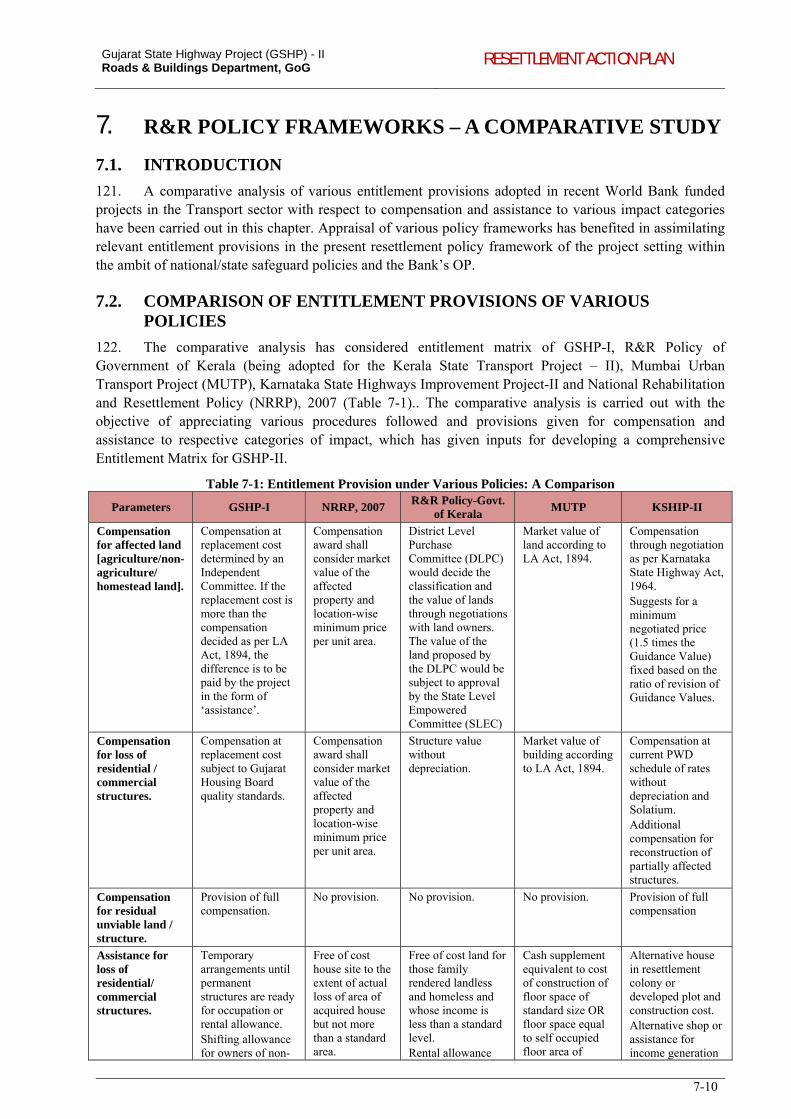
Gujarat State Highway Project (GSHP) - II Roads & Buildings Department, GoG RESETTLEMENT ACTION PLAN
7-10
7. R&R POLICY FRAMEWORKS – A COMPARATIVE STUDY
7.1. INTRODUCTION
121. A comparative analysis of various entitlement provisions adopted in recent World Bank funded projects in the Transport sector with respect to compensation and assistance to various impact categories have been carried out in this chapter. Appraisal of various policy frameworks has benefited in assimilating relevant entitlement provisions in the present resettlement policy framework of the project setting within the ambit of national/state safeguard policies and the Bank’s OP.
7.2. COMPARISON OF ENTITLEMENT PROVISIONS OF VARIOUS POLICIES
122. The comparative analysis has considered entitlement matrix of GSHP-I, R&R Policy of Government of Kerala (being adopted for the Kerala State Transport Project – II), Mumbai Urban Transport Project (MUTP), Karnataka State Highways Improvement Project-II and National Rehabilitation and Resettlement Policy (NRRP), 2007 (Table 7-1).. The comparative analysis is carried out with the objective of appreciating various procedures followed and provisions given for compensation and assistance to respective categories of impact, which has given inputs for developing a comprehensive Entitlement Matrix for GSHP-II.
Table 7-1: Entitlement Provision under Various Policies: A Comparison
Parameters GSHP-I NRRP, 2007 R&R Policy-Govt.
of Kerala MUTP KSHIP-II
Compensation for affected land [agriculture/non-agriculture/ homestead land].
Compensation at replacement cost determined by an Independent Committee. If the replacement cost is more than the compensation decided as per LA Act, 1894, the difference is to be paid by the project in the form of ‘assistance’.
Compensation award shall consider market value of the affected property and location-wise minimum price per unit area.
District Level Purchase Committee (DLPC) would decide the classification and the value of lands through negotiations with land owners. The value of the land proposed by the DLPC would be subject to approval by the State Level Empowered Committee (SLEC)
Market value of land according to LA Act, 1894.
Compensation through negotiation as per Karnataka State Highway Act, 1964. Suggests for a minimum negotiated price (1.5 times the Guidance Value) fixed based on the ratio of revision of Guidance Values.
Compensation for loss of residential / commercial structures.
Compensation at replacement cost subject to Gujarat Housing Board quality standards.
Compensation award shall consider market value of the affected property and location-wise minimum price per unit area.
Structure value without depreciation.
Market value of building according to LA Act, 1894.
Compensation at current PWD schedule of rates without depreciation and Solatium. Additional compensation for reconstruction of partially affected structures.
Compensation for residual unviable land / structure.
Provision of full compensation.
No provision. No provision. No provision. Provision of full compensation
Assistance for loss of residential/ commercial structures.
Temporary arrangements until permanent structures are ready for occupation or rental allowance. Shifting allowance for owners of non-
Free of cost house site to the extent of actual loss of area of acquired house but not more than a standard area.
Free of cost land for those family rendered landless and homeless and whose income is less than a standard level. Rental allowance
Cash supplement equivalent to cost of construction of floor space of standard size OR floor space equal to self occupied floor area of
Alternative house in resettlement colony or developed plot and construction cost. Alternative shop or assistance for income generation
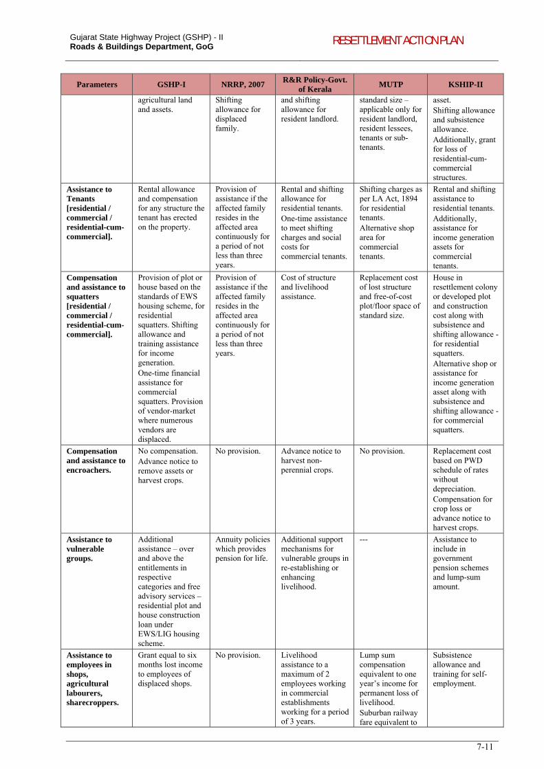
Gujarat State Highway Project (GSHP) - II Roads & Buildings Department, GoG RESETTLEMENT ACTION PLAN
7-11
Parameters GSHP-I NRRP, 2007 R&R Policy-Govt.
of Kerala MUTP KSHIP-II
agricultural land and assets.
Shifting allowance for displaced family.
and shifting allowance for resident landlord.
standard size – applicable only for resident landlord, resident lessees, tenants or sub-tenants.
asset. Shifting allowance and subsistence allowance. Additionally, grant for loss of residential-cum-commercial structures.
Assistance to Tenants [residential / commercial / residential-cum-commercial].
Rental allowance and compensation for any structure the tenant has erected on the property.
Provision of assistance if the affected family resides in the affected area continuously for a period of not less than three years.
Rental and shifting allowance for residential tenants. One-time assistance to meet shifting charges and social costs for commercial tenants.
Shifting charges as per LA Act, 1894 for residential tenants. Alternative shop area for commercial tenants.
Rental and shifting assistance to residential tenants. Additionally, assistance for income generation assets for commercial tenants.
Compensation and assistance to squatters [residential / commercial / residential-cum-commercial].
Provision of plot or house based on the standards of EWS housing scheme, for residential squatters. Shifting allowance and training assistance for income generation. One-time financial assistance for commercial squatters. Provision of vendor-market where numerous vendors are displaced.
Provision of assistance if the affected family resides in the affected area continuously for a period of not less than three years.
Cost of structure and livelihood assistance.
Replacement cost of lost structure and free-of-cost plot/floor space of standard size.
House in resettlement colony or developed plot and construction cost along with subsistence and shifting allowance -for residential squatters. Alternative shop or assistance for income generation asset along with subsistence and shifting allowance - for commercial squatters.
Compensation and assistance to encroachers.
No compensation. Advance notice to remove assets or harvest crops.
No provision. Advance notice to harvest non-perennial crops.
No provision. Replacement cost based on PWD schedule of rates without depreciation. Compensation for crop loss or advance notice to harvest crops.
Assistance to vulnerable groups.
Additional assistance – over and above the entitlements in respective categories and free advisory services – residential plot and house construction loan under EWS/LIG housing scheme.
Annuity policies which provides pension for life.
Additional support mechanisms for vulnerable groups in re-establishing or enhancing livelihood.
--- Assistance to include in government pension schemes and lump-sum amount.
Assistance to employees in shops, agricultural labourers, sharecroppers.
Grant equal to six months lost income to employees of displaced shops.
No provision. Livelihood assistance to a maximum of 2 employees working in commercial establishments working for a period of 3 years.
Lump sum compensation equivalent to one year’s income for permanent loss of livelihood. Suburban railway fare equivalent to
Subsistence allowance and training for self-employment.
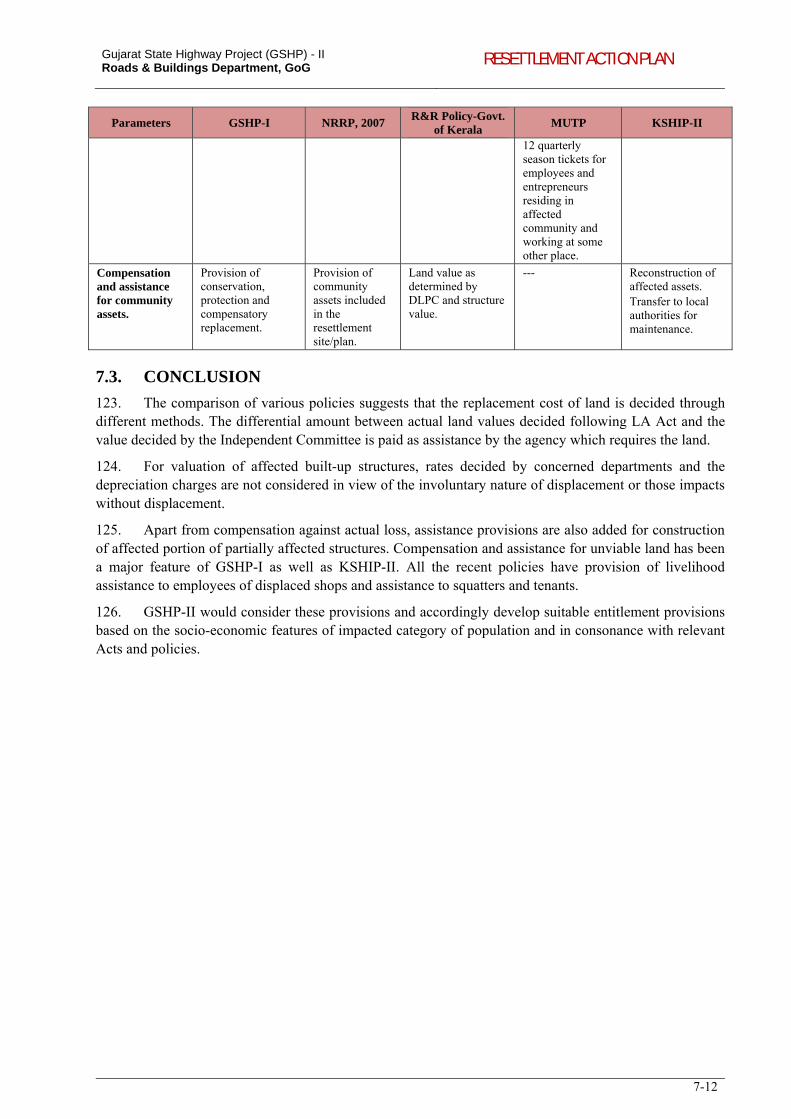
Gujarat State Highway Project (GSHP) - II Roads & Buildings Department, GoG RESETTLEMENT ACTION PLAN
7-12
Parameters GSHP-I NRRP, 2007 R&R Policy-Govt.
of Kerala MUTP KSHIP-II
12 quarterly season tickets for employees and entrepreneurs residing in affected community and working at some other place.
Compensation and assistance for community assets.
Provision of conservation, protection and compensatory replacement.
Provision of community assets included in the resettlement site/plan.
Land value as determined by DLPC and structure value.
--- Reconstruction of affected assets. Transfer to local authorities for maintenance.
7.3. CONCLUSION
123. The comparison of various policies suggests that the replacement cost of land is decided through different methods. The differential amount between actual land values decided following LA Act and the value decided by the Independent Committee is paid as assistance by the agency which requires the land.
124. For valuation of affected built-up structures, rates decided by concerned departments and the depreciation charges are not considered in view of the involuntary nature of displacement or those impacts without displacement.
125. Apart from compensation against actual loss, assistance provisions are also added for construction of affected portion of partially affected structures. Compensation and assistance for unviable land has been a major feature of GSHP-I as well as KSHIP-II. All the recent policies have provision of livelihood assistance to employees of displaced shops and assistance to squatters and tenants.
126. GSHP-II would consider these provisions and accordingly develop suitable entitlement provisions based on the socio-economic features of impacted category of population and in consonance with relevant Acts and policies.
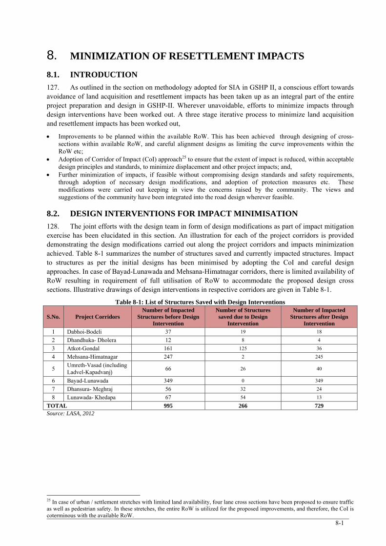
8-1
8. MINIMIZATION OF RESETTLEMENT IMPACTS
8.1. INTRODUCTION
127. As outlined in the section on methodology adopted for SIA in GSHP II, a conscious effort towards avoidance of land acquisition and resettlement impacts has been taken up as an integral part of the entire project preparation and design in GSHP-II. Wherever unavoidable, efforts to minimize impacts through design interventions have been worked out. A three stage iterative process to minimize land acquisition and resettlement impacts has been worked out,
Improvements to be planned within the available RoW. This has been achieved through designing of cross-sections within available RoW, and careful alignment designs as limiting the curve improvements within the RoW etc;
Adoption of Corridor of Impact (CoI) approach25 to ensure that the extent of impact is reduced, within acceptable design principles and standards, to minimize displacement and other project impacts; and,
Further minimization of impacts, if feasible without compromising design standards and safety requirements, through adoption of necessary design modifications, and adoption of protection measures etc. These modifications were carried out keeping in view the concerns raised by the community. The views and suggestions of the community have been integrated into the road design wherever feasible.
8.2. DESIGN INTERVENTIONS FOR IMPACT MINIMISATION
128. The joint efforts with the design team in form of design modifications as part of impact mitigation exercise has been elucidated in this section. An illustration for each of the project corridors is provided demonstrating the design modifications carried out along the project corridors and impacts minimization achieved. Table 8-1 summarizes the number of structures saved and currently impacted structures. Impact to structures as per the initial designs has been minimised by adopting the CoI and careful design approaches. In case of Bayad-Lunawada and Mehsana-Himatnagar corridors, there is limited availability of RoW resulting in requirement of full utilisation of RoW to accommodate the proposed design cross sections. Illustrative drawings of design interventions in respective corridors are given in Table 8-1.
Table 8-1: List of Structures Saved with Design Interventions
S.No. Project Corridors Number of Impacted
Structures before Design Intervention
Number of Structures saved due to Design
Intervention
Number of Impacted Structures after Design
Intervention
1 Dabhoi-Bodeli 37 19 18
2 Dhandhuka- Dholera 12 8 4
3 Atkot-Gondal 161 125 36
4 Mehsana-Himatnagar 247 2 245
5 Umreth-Vasad (including Ladvel-Kapadvanj) 66 26 40
6 Bayad-Lunawada 349 0 349
7 Dhansura- Meghraj 56 32 24
8 Lunawada- Khedapa 67 54 13
TOTAL 995 266 729 Source: LASA, 2012
25 In case of urban / settlement stretches with limited land availability, four lane cross sections have been proposed to ensure traffic as well as pedestrian safety. In these stretches, the entire RoW is utilized for the proposed improvements, and therefore, the CoI is coterminous with the available RoW.
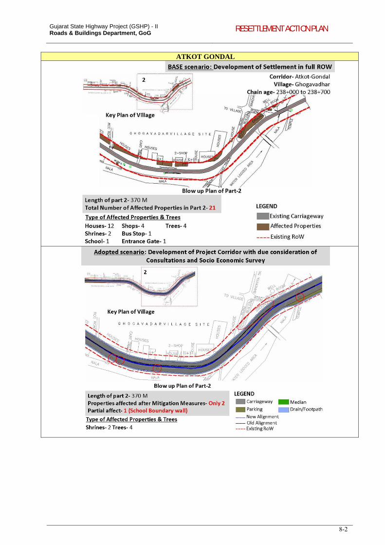
Gujarat State Highway Project (GSHP) - II Roads & Buildings Department, GoG RESETTLEMENT ACTION PLAN
8-2
ATKOT GONDAL
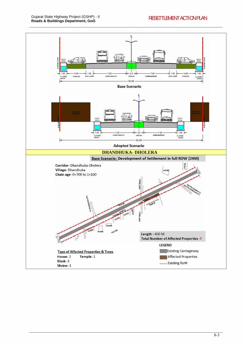
Gujarat State Highway Project (GSHP) - II Roads & Buildings Department, GoG RESETTLEMENT ACTION PLAN
8-3
DHANDHUKA- DHOLERA
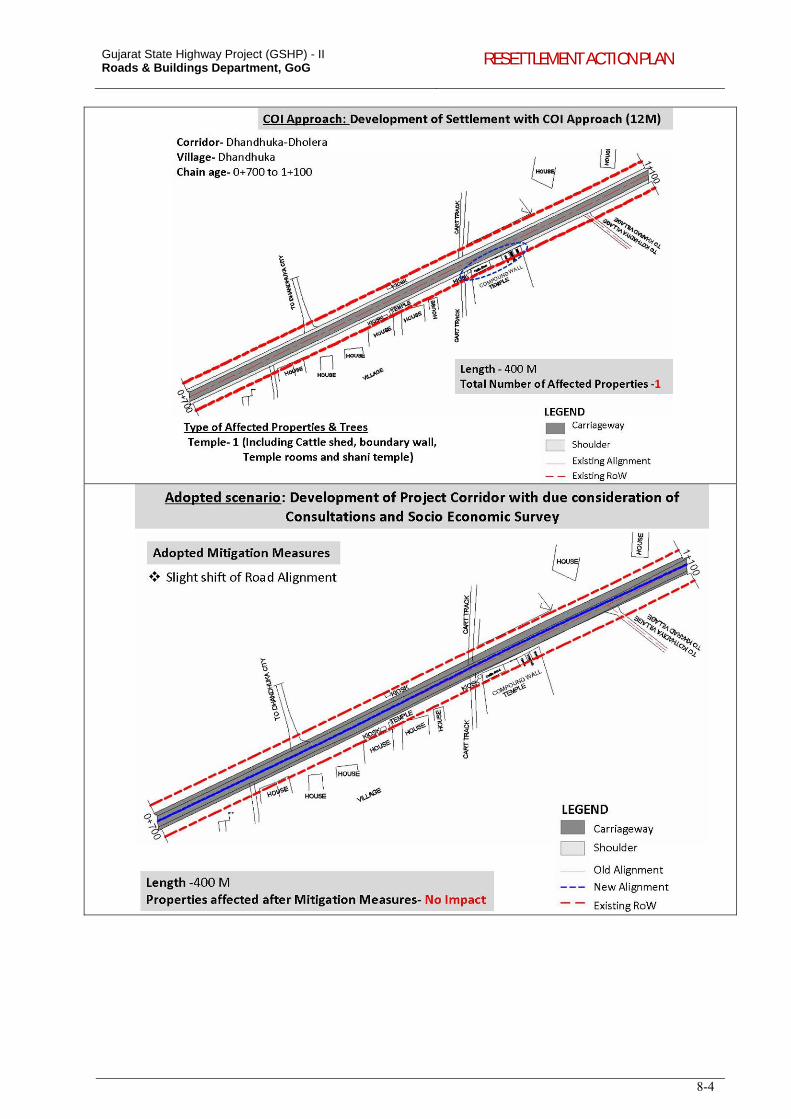
Gujarat State Highway Project (GSHP) - II Roads & Buildings Department, GoG RESETTLEMENT ACTION PLAN
8-4
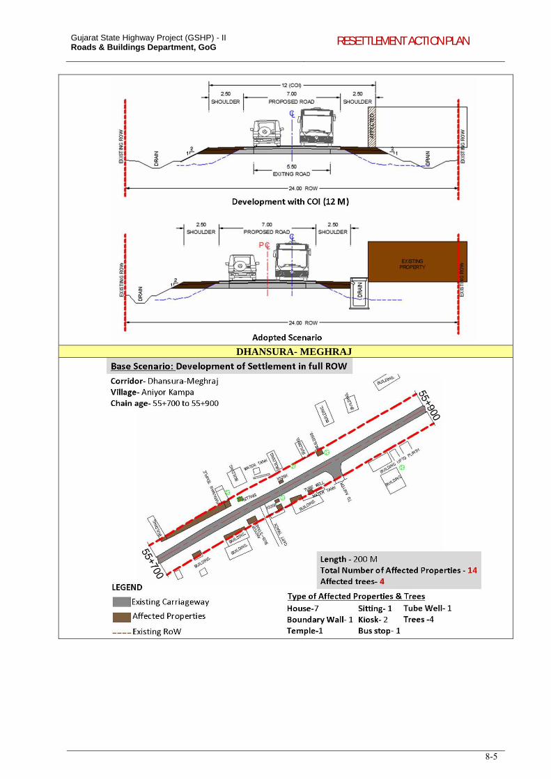
Gujarat State Highway Project (GSHP) - II Roads & Buildings Department, GoG RESETTLEMENT ACTION PLAN
8-5
DHANSURA- MEGHRAJ
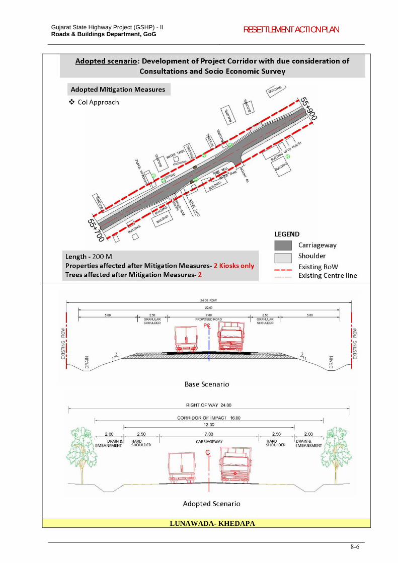
Gujarat State Highway Project (GSHP) - II Roads & Buildings Department, GoG RESETTLEMENT ACTION PLAN
8-6
LUNAWADA- KHEDAPA
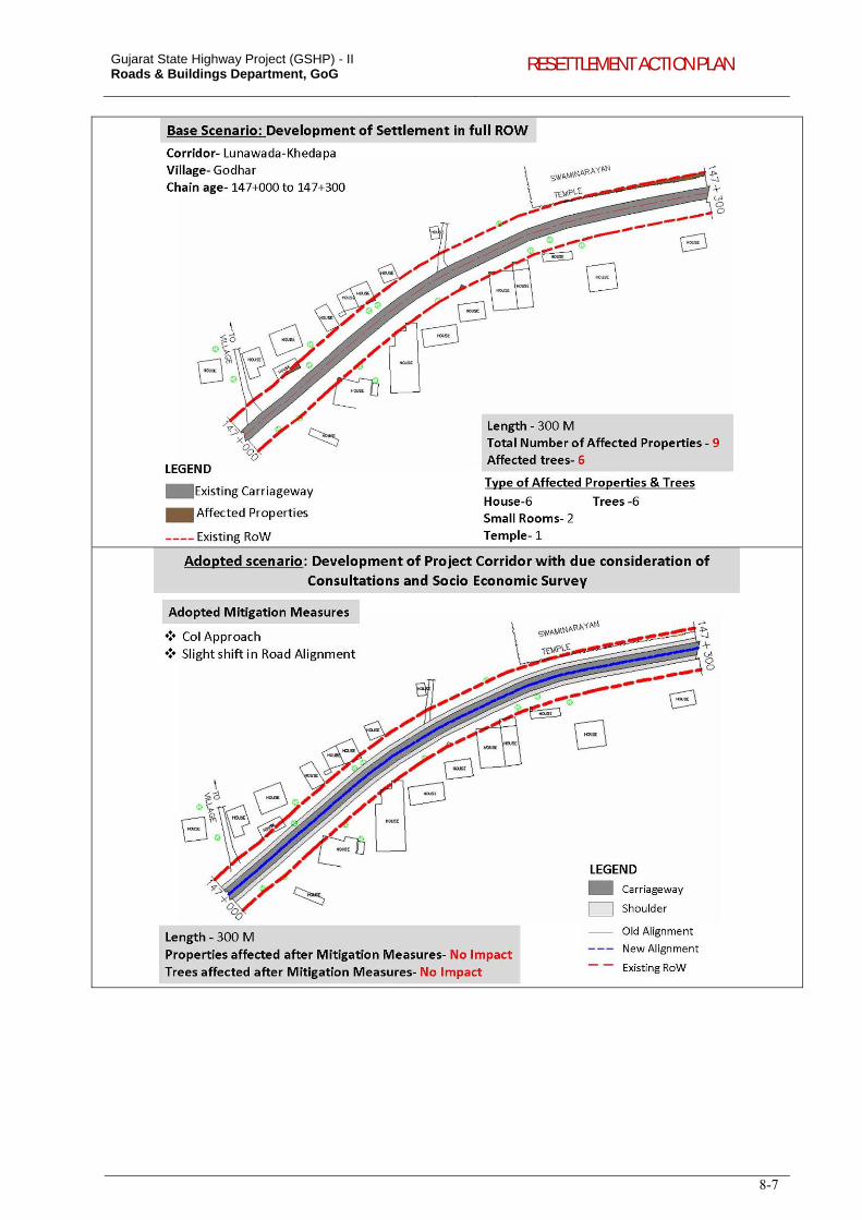
Gujarat State Highway Project (GSHP) - II Roads & Buildings Department, GoG RESETTLEMENT ACTION PLAN
8-7
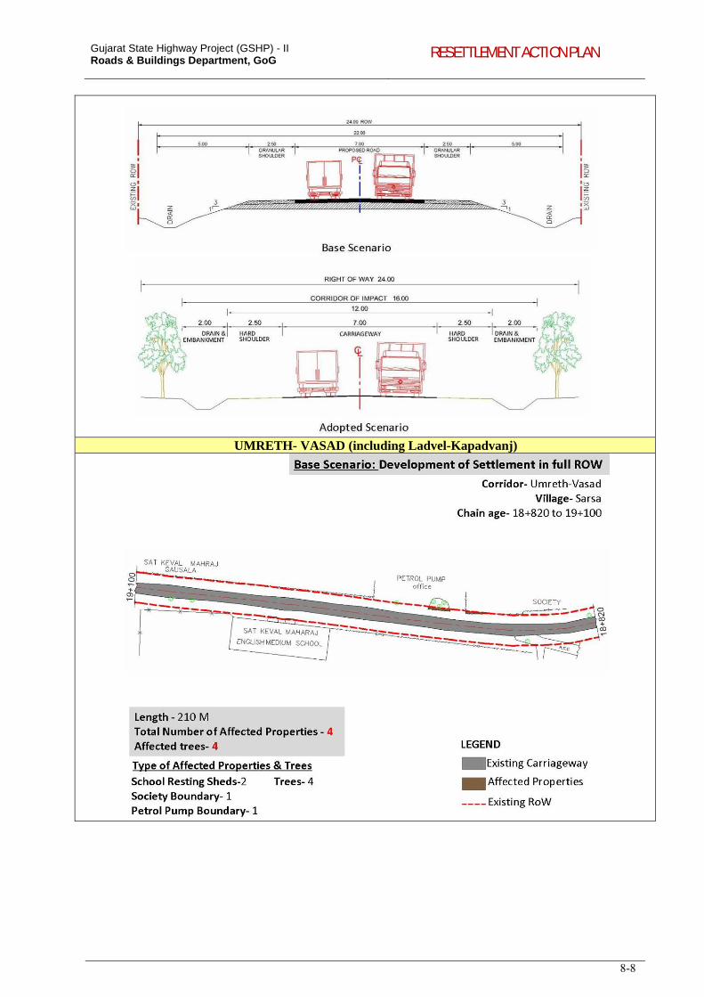
Gujarat State Highway Project (GSHP) - II Roads & Buildings Department, GoG RESETTLEMENT ACTION PLAN
8-8
UMRETH- VASAD (including Ladvel-Kapadvanj)
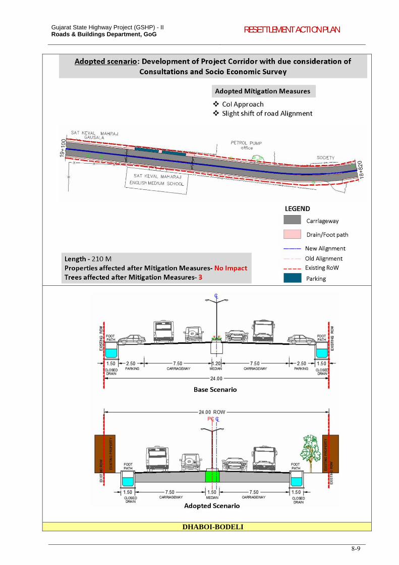
Gujarat State Highway Project (GSHP) - II Roads & Buildings Department, GoG RESETTLEMENT ACTION PLAN
8-9
DHABOI-BODELI
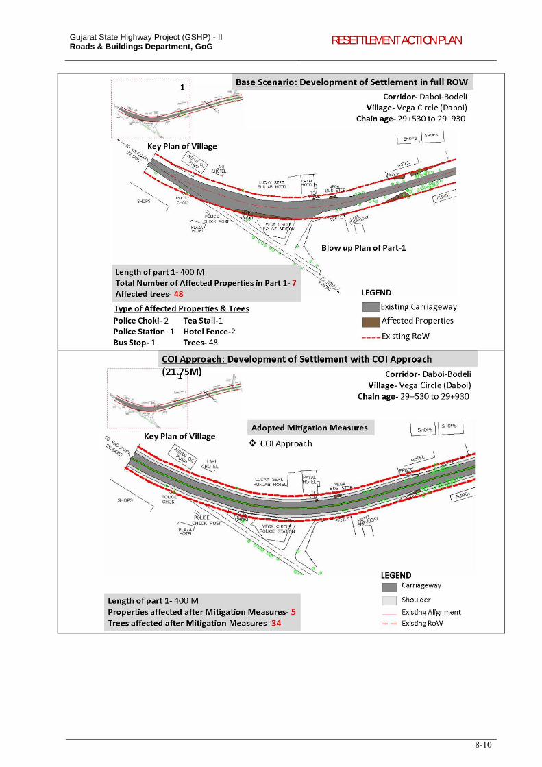
Gujarat State Highway Project (GSHP) - II Roads & Buildings Department, GoG RESETTLEMENT ACTION PLAN
8-10
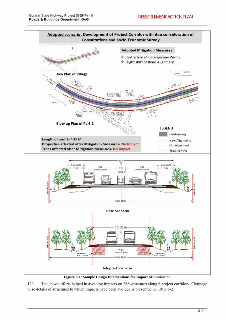
Gujarat State Highway Project (GSHP) - II Roads & Buildings Department, GoG RESETTLEMENT ACTION PLAN
8-11
Figure 8-1: Sample Design Interventions for Impact Minimisation
129. The above efforts helped in avoiding impacts on 266 structures along 6 project corridors. Chainage wise details of structures to which impacts have been avoided is presented in Table 8-2.
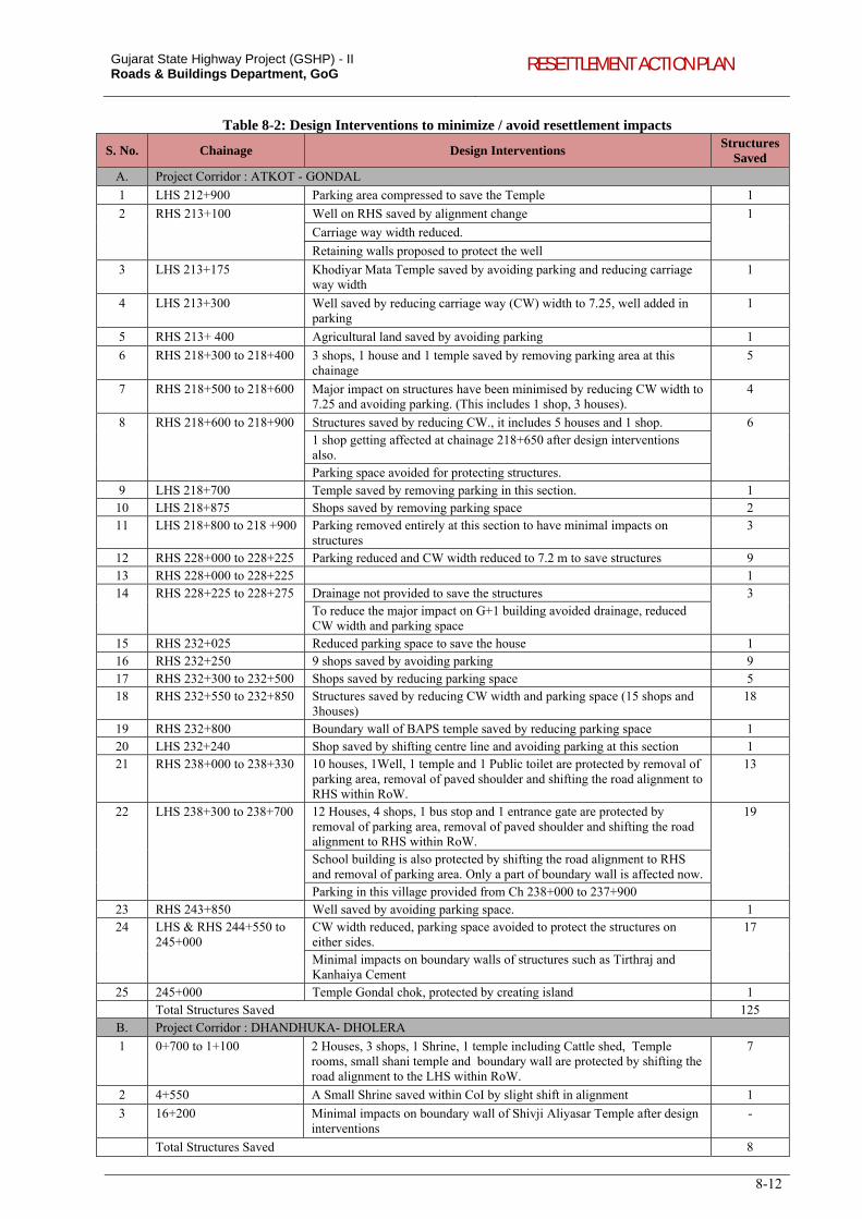
Gujarat State Highway Project (GSHP) - II Roads & Buildings Department, GoG RESETTLEMENT ACTION PLAN
8-12
Table 8-2: Design Interventions to minimize / avoid resettlement impacts
S. No. Chainage Design Interventions Structures
Saved
A. Project Corridor : ATKOT - GONDAL
1 LHS 212+900 Parking area compressed to save the Temple 1
2 RHS 213+100 Well on RHS saved by alignment change 1
Carriage way width reduced.
Retaining walls proposed to protect the well
3 LHS 213+175 Khodiyar Mata Temple saved by avoiding parking and reducing carriage way width
1
4 LHS 213+300 Well saved by reducing carriage way (CW) width to 7.25, well added in parking
1
5 RHS 213+ 400 Agricultural land saved by avoiding parking 1
6 RHS 218+300 to 218+400 3 shops, 1 house and 1 temple saved by removing parking area at this chainage
5
7 RHS 218+500 to 218+600 Major impact on structures have been minimised by reducing CW width to 7.25 and avoiding parking. (This includes 1 shop, 3 houses).
4
8 RHS 218+600 to 218+900 Structures saved by reducing CW., it includes 5 houses and 1 shop. 6 1 shop getting affected at chainage 218+650 after design interventions also. Parking space avoided for protecting structures.
9 LHS 218+700 Temple saved by removing parking in this section. 1 10 LHS 218+875 Shops saved by removing parking space 2 11 LHS 218+800 to 218 +900 Parking removed entirely at this section to have minimal impacts on
structures 3
12 RHS 228+000 to 228+225 Parking reduced and CW width reduced to 7.2 m to save structures 9 13 RHS 228+000 to 228+225 1 14 RHS 228+225 to 228+275 Drainage not provided to save the structures 3
To reduce the major impact on G+1 building avoided drainage, reduced CW width and parking space
15 RHS 232+025 Reduced parking space to save the house 1 16 RHS 232+250 9 shops saved by avoiding parking 9 17 RHS 232+300 to 232+500 Shops saved by reducing parking space 5 18 RHS 232+550 to 232+850 Structures saved by reducing CW width and parking space (15 shops and
3houses) 18
19 RHS 232+800 Boundary wall of BAPS temple saved by reducing parking space 1 20 LHS 232+240 Shop saved by shifting centre line and avoiding parking at this section 1 21 RHS 238+000 to 238+330 10 houses, 1Well, 1 temple and 1 Public toilet are protected by removal of
parking area, removal of paved shoulder and shifting the road alignment to RHS within RoW.
13
22 LHS 238+300 to 238+700 12 Houses, 4 shops, 1 bus stop and 1 entrance gate are protected by removal of parking area, removal of paved shoulder and shifting the road alignment to RHS within RoW.
19
School building is also protected by shifting the road alignment to RHS and removal of parking area. Only a part of boundary wall is affected now. Parking in this village provided from Ch 238+000 to 237+900
23 RHS 243+850 Well saved by avoiding parking space. 1 24 LHS & RHS 244+550 to
245+000 CW width reduced, parking space avoided to protect the structures on either sides.
17
Minimal impacts on boundary walls of structures such as Tirthraj and Kanhaiya Cement
25 245+000 Temple Gondal chok, protected by creating island 1 Total Structures Saved 125
B. Project Corridor : DHANDHUKA- DHOLERA
1 0+700 to 1+100 2 Houses, 3 shops, 1 Shrine, 1 temple including Cattle shed, Temple rooms, small shani temple and boundary wall are protected by shifting the road alignment to the LHS within RoW.
7
2 4+550 A Small Shrine saved within CoI by slight shift in alignment 1
3 16+200 Minimal impacts on boundary wall of Shivji Aliyasar Temple after design interventions
-
Total Structures Saved 8
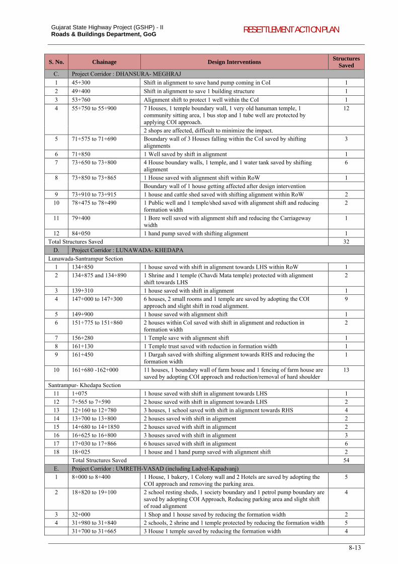
Gujarat State Highway Project (GSHP) - II Roads & Buildings Department, GoG RESETTLEMENT ACTION PLAN
8-13
S. No. Chainage Design Interventions Structures
Saved
C. Project Corridor : DHANSURA- MEGHRAJ
1 45+300 Shift in alignment to save hand pump coming in CoI 1
2 49+400 Shift in alignment to save 1 building structure 1
3 53+760 Alignment shift to protect 1 well within the CoI 1
4 55+750 to 55+900 7 Houses, 1 temple boundary wall, 1 very old hanuman temple, 1 community sitting area, 1 bus stop and 1 tube well are protected by applying COI approach.
12
2 shops are affected, difficult to minimize the impact. 5 71+575 to 71+690 Boundary wall of 3 Houses falling within the CoI saved by shifting
alignments 3
6 71+850 1 Well saved by shift in alignment 1 7 73+650 to 73+800 4 House boundary walls, 1 temple, and 1 water tank saved by shifting
alignment 6
8 73+850 to 73+865 1 House saved with alignment shift within RoW 1
Boundary wall of 1 house getting affected after design intervention 9 73+910 to 73+915 1 house and cattle shed saved with shifting alignment within RoW 2
10 78+475 to 78+490 1 Public well and 1 temple/shed saved with alignment shift and reducing formation width
2
11 79+400 1 Bore well saved with alignment shift and reducing the Carriageway width
1
12 84+050 1 hand pump saved with shifting alignment 1 Total Structures Saved 32
D. Project Corridor : LUNAWADA- KHEDAPA
Lunawada-Santrampur Section 1 134+850 1 house saved with shift in alignment towards LHS within RoW 1
2 134+875 and 134+890 1 Shrine and 1 temple (Chavdi Mata temple) protected with alignment shift towards LHS
2
3 139+310 1 house saved with shift in alignment 1 4 147+000 to 147+300 6 houses, 2 small rooms and 1 temple are saved by adopting the COI
approach and slight shift in road alignment. 9
5 149+900 1 house saved with alignment shift 1
6 151+775 to 151+860 2 houses within CoI saved with shift in alignment and reduction in formation width
2
7 156+280 1 Temple save with alignment shift 1 8 161+130 1 Temple trust saved with reduction in formation width 1
9 161+450 1 Dargah saved with shifting alignment towards RHS and reducing the formation width
1
10 161+680 -162+000 11 houses, 1 boundary wall of farm house and 1 fencing of farm house are saved by adopting COI approach and reduction/removal of hard shoulder
13
Santrampur- Khedapa Section 11 1+075 1 house saved with shift in alignment towards LHS 1
12 7+565 to 7+590 2 house saved with shift in alignment towards LHS 2 13 12+160 to 12+780 3 houses, 1 school saved with shift in alignment towards RHS 4
14 13+700 to 13+800 2 houses saved with shift in alignment 2 15 14+680 to 14+1850 2 houses saved with shift in alignment 2
16 16+625 to 16+800 3 houses saved with shift in alignment 3 17 17+030 to 17+866 6 houses saved with shift in alignment 6
18 18+025 1 house and 1 hand pump saved with alignment shift 2 Total Structures Saved 54
E. Project Corridor : UMRETH-VASAD (including Ladvel-Kapadvanj) 1 8+000 to 8+400 1 House, 1 bakery, 1 Colony wall and 2 Hotels are saved by adopting the
COI approach and removing the parking area. 5
2 18+820 to 19+100 2 school resting sheds, 1 society boundary and 1 petrol pump boundary are saved by adopting COI Approach, Reducing parking area and slight shift of road alignment
4
3 32+000 1 Shop and 1 house saved by reducing the formation width 2 4 31+980 to 31+840 2 schools, 2 shrine and 1 temple protected by reducing the formation width 5
31+700 to 31+665 3 House 1 temple saved by reducing the formation width 4
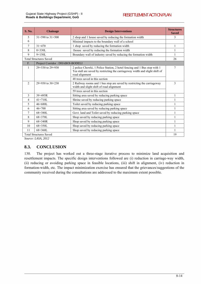
Gujarat State Highway Project (GSHP) - II Roads & Buildings Department, GoG RESETTLEMENT ACTION PLAN
8-14
S. No. Chainage Design Interventions Structures
Saved
5 6
31+590 to 31+500 2 shop and 1 house saved by reducing the formation width 3
Minimal impacts to the boundary wall of a school
7 31+470 1 shop saved by reducing the formation width 1
8 0+330L 1house saved by reducing the formation width 1
9 9+150L Boundary wall of industry saved by reducing the formation width 1
Total Structures Saved 26
F. Project Corridor : DHABOI-BODELI
1 29+530 to 29+930 2 police Chowki, 1 Police Station, 2 hotel fencing and 1 Bus stop with 1 Tea stall are saved by restricting the carriageway width and slight shift of road alignment
7
48 trees saved in this section
2 29+930 to 30+230 2 Railway rooms and 1 bus stop are saved by restricting the carriageway width and slight shift of road alignment
3
59 trees saved in this section
3 39+495R Sitting area saved by reducing parking space 1
4 41+710L Shrine saved by reducing parking space 1
5 46+680L Toilet saved by reducing parking space 1
6 46+700 Sitting area saved by reducing parking space 1
7 68+380L Govt. land and Toilet saved by reducing parking space 1
8 68+370L Shop saved by reducing parking space 1
9 68+340R Shop saved by reducing parking space 1
10 68+350L Shop saved by reducing parking space 1
11 68+360L Shop saved by reducing parking space 1
Total Structures Saved 19 Source: LASA, 2012
8.3. CONCLUSION
130. The project has worked out a three-stage iterative process to minimize land acquisition and resettlement impacts. The specific design interventions followed are (i) reduction in carriage-way width, (ii) reducing or avoiding parking space in feasible locations, (iii) shift in alignment, (iv) reduction in formation-width, etc. The impact minimization exercise has ensured that the grievances/suggestions of the community received during the consultations are addressed to the maximum extent possible.
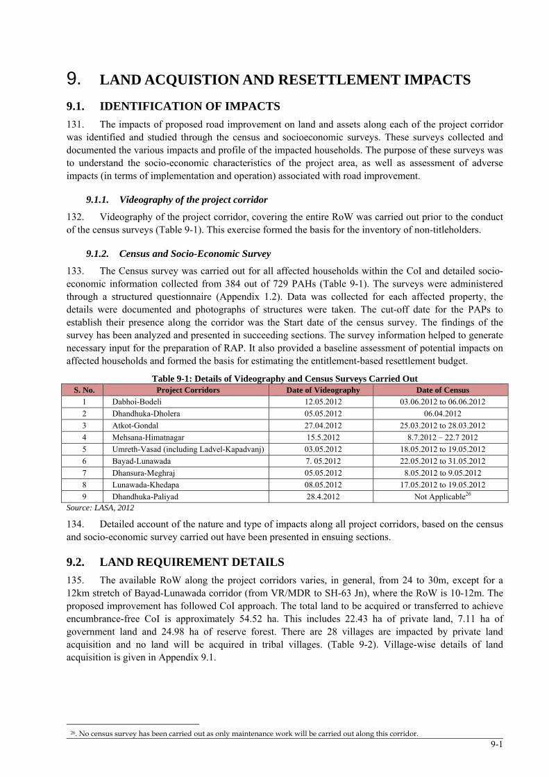
9-1
9. LAND ACQUISTION AND RESETTLEMENT IMPACTS
9.1. IDENTIFICATION OF IMPACTS
131. The impacts of proposed road improvement on land and assets along each of the project corridor was identified and studied through the census and socioeconomic surveys. These surveys collected and documented the various impacts and profile of the impacted households. The purpose of these surveys was to understand the socio-economic characteristics of the project area, as well as assessment of adverse impacts (in terms of implementation and operation) associated with road improvement.
9.1.1. Videography of the project corridor
132. Videography of the project corridor, covering the entire RoW was carried out prior to the conduct of the census surveys (Table 9-1). This exercise formed the basis for the inventory of non-titleholders.
9.1.2. Census and Socio-Economic Survey
133. The Census survey was carried out for all affected households within the CoI and detailed socio-economic information collected from 384 out of 729 PAHs (Table 9-1). The surveys were administered through a structured questionnaire (Appendix 1.2). Data was collected for each affected property, the details were documented and photographs of structures were taken. The cut-off date for the PAPs to establish their presence along the corridor was the Start date of the census survey. The findings of the survey has been analyzed and presented in succeeding sections. The survey information helped to generate necessary input for the preparation of RAP. It also provided a baseline assessment of potential impacts on affected households and formed the basis for estimating the entitlement-based resettlement budget.
Table 9-1: Details of Videography and Census Surveys Carried Out S. No. Project Corridors Date of Videography Date of Census
1 Dabhoi-Bodeli 12.05.2012 03.06.2012 to 06.06.2012
2 Dhandhuka-Dholera 05.05.2012 06.04.2012
3 Atkot-Gondal 27.04.2012 25.03.2012 to 28.03.2012
4 Mehsana-Himatnagar 15.5.2012 8.7.2012 – 22.7 2012
5 Umreth-Vasad (including Ladvel-Kapadvanj) 03.05.2012 18.05.2012 to 19.05.2012
6 Bayad-Lunawada 7. 05.2012 22.05.2012 to 31.05.2012
7 Dhansura-Meghraj 05.05.2012 8.05.2012 to 9.05.2012
8 Lunawada-Khedapa 08.05.2012 17.05.2012 to 19.05.2012
9 Dhandhuka-Paliyad 28.4.2012 Not Applicable26 Source: LASA, 2012
134. Detailed account of the nature and type of impacts along all project corridors, based on the census and socio-economic survey carried out have been presented in ensuing sections.
9.2. LAND REQUIREMENT DETAILS
135. The available RoW along the project corridors varies, in general, from 24 to 30m, except for a 12km stretch of Bayad-Lunawada corridor (from VR/MDR to SH-63 Jn), where the RoW is 10-12m. The proposed improvement has followed CoI approach. The total land to be acquired or transferred to achieve encumbrance-free CoI is approximately 54.52 ha. This includes 22.43 ha of private land, 7.11 ha of government land and 24.98 ha of reserve forest. There are 28 villages are impacted by private land acquisition and no land will be acquired in tribal villages. (Table 9-2). Village-wise details of land acquisition is given in Appendix 9.1.
26. No census survey has been carried out as only maintenance work will be carried out along this corridor.
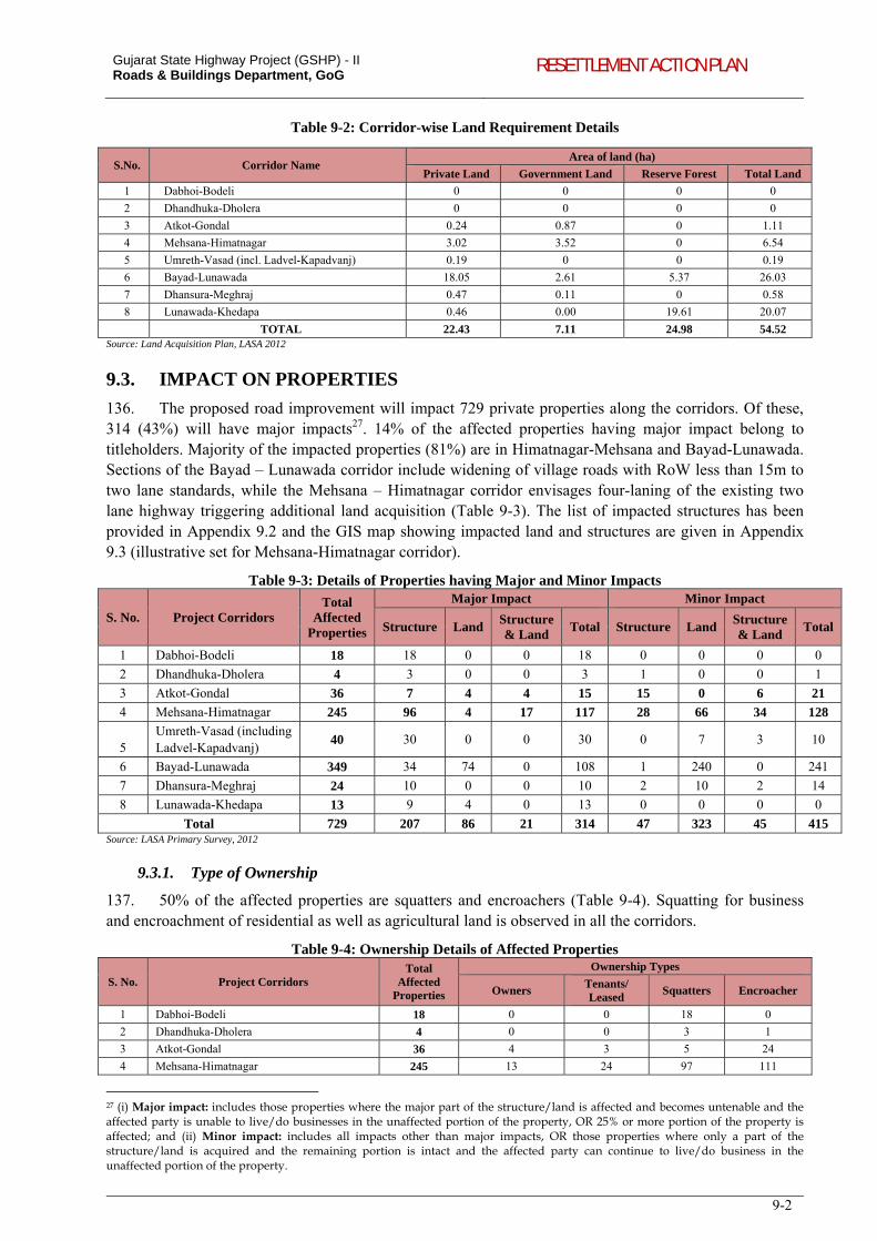
Gujarat State Highway Project (GSHP) - II Roads & Buildings Department, GoG RESETTLEMENT ACTION PLAN
9-2
Table 9-2: Corridor-wise Land Requirement Details
S.No. Corridor Name Area of land (ha)
Private Land Government Land Reserve Forest Total Land
1 Dabhoi-Bodeli 0 0 0 0
2 Dhandhuka-Dholera 0 0 0 0
3 Atkot-Gondal 0.24 0.87 0 1.11
4 Mehsana-Himatnagar 3.02 3.52 0 6.54
5 Umreth-Vasad (incl. Ladvel-Kapadvanj) 0.19 0 0 0.19
6 Bayad-Lunawada 18.05 2.61 5.37 26.03
7 Dhansura-Meghraj 0.47 0.11 0 0.58
8 Lunawada-Khedapa 0.46 0.00 19.61 20.07
TOTAL 22.43 7.11 24.98 54.52 Source: Land Acquisition Plan, LASA 2012
9.3. IMPACT ON PROPERTIES
136. The proposed road improvement will impact 729 private properties along the corridors. Of these, 314 (43%) will have major impacts27. 14% of the affected properties having major impact belong to titleholders. Majority of the impacted properties (81%) are in Himatnagar-Mehsana and Bayad-Lunawada. Sections of the Bayad – Lunawada corridor include widening of village roads with RoW less than 15m to two lane standards, while the Mehsana – Himatnagar corridor envisages four-laning of the existing two lane highway triggering additional land acquisition (Table 9-3). The list of impacted structures has been provided in Appendix 9.2 and the GIS map showing impacted land and structures are given in Appendix 9.3 (illustrative set for Mehsana-Himatnagar corridor).
Table 9-3: Details of Properties having Major and Minor Impacts
S. No. Project Corridors Total
Affected Properties
Major Impact Minor Impact
Structure Land Structure & Land
Total Structure Land Structure & Land
Total
1 Dabhoi-Bodeli 18 18 0 0 18 0 0 0 0
2 Dhandhuka-Dholera 4 3 0 0 3 1 0 0 1
3 Atkot-Gondal 36 7 4 4 15 15 0 6 21
4 Mehsana-Himatnagar 245 96 4 17 117 28 66 34 128
5 Umreth-Vasad (including Ladvel-Kapadvanj)
40 30 0 0 30 0 7 3 10
6 Bayad-Lunawada 349 34 74 0 108 1 240 0 241
7 Dhansura-Meghraj 24 10 0 0 10 2 10 2 14
8 Lunawada-Khedapa 13 9 4 0 13 0 0 0 0
Total 729 207 86 21 314 47 323 45 415 Source: LASA Primary Survey, 2012
9.3.1. Type of Ownership
137. 50% of the affected properties are squatters and encroachers (Table 9-4). Squatting for business and encroachment of residential as well as agricultural land is observed in all the corridors.
Table 9-4: Ownership Details of Affected Properties
S. No. Project Corridors Total
Affected Properties
Ownership Types
Owners Tenants/ Leased
Squatters Encroacher
1 Dabhoi-Bodeli 18 0 0 18 0
2 Dhandhuka-Dholera 4 0 0 3 1
3 Atkot-Gondal 36 4 3 5 24
4 Mehsana-Himatnagar 245 13 24 97 111
27 (i) Major impact: includes those properties where the major part of the structure/land is affected and becomes untenable and the affected party is unable to live/do businesses in the unaffected portion of the property, OR 25% or more portion of the property is affected; and (ii) Minor impact: includes all impacts other than major impacts, OR those properties where only a part of the structure/land is acquired and the remaining portion is intact and the affected party can continue to live/do business in the unaffected portion of the property.
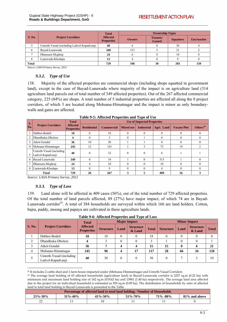
Gujarat State Highway Project (GSHP) - II Roads & Buildings Department, GoG RESETTLEMENT ACTION PLAN
9-3
S. No. Project Corridors Total
Affected Properties
Ownership Types
Owners Tenants/ Leased
Squatters Encroacher
5 Umreth-Vasad (including Ladvel-Kapadvanj) 40 6 0 30 4
6 Bayad-Lunawada 349 313 3 31 2
7 Dhansura-Meghraj 24 6 0 10 8
8 Lunawada-Khedapa 13 4 0 9 0
Total 729 346 30 203 150 Source: LASA Primary Survey, 2012
9.3.2. Type of Use
138. Majority of the affected properties are commercial shops (including shops squatted in government land), except in the case of Bayad-Lunawada where majority of the impact is on agriculture land (314 agriculture land parcels out of total number of 349 affected properties). Out of the 267 affected commercial category, 225 (84%) are shops. A total number of 5 industrial properties are affected all along the 8 project corridors, of which 3 are located along Mehsana-Himatnagar and the impact is minor as only boundary-walls and gates are affected.
Table 9-5: Affected Properties and Type of Use
S. No.
Project Corridors Total
Affected Properties
Use of Impacted Properties
Residential Commercial Mixed use Industrial Agri. Land Vacant Plot Others28
1 Dabhoi-Bodeli 18 0 18 0 0 0 0 0
2 Dhandhuka-Dholera 4 0 3 0 1 0 0 0
3 Atkot-Gondal 36 10 20 1 1 4 0 0
4 Mehsana-Himatnagar 245 12 141 1 3 72 14 2
5 Umreth-Vasad (including Ladvel-Kapadvanj)
40 0 32 0 0 6 1 1
6 Bayad-Lunawada 349 0 34 1 0 313 1 0
7 Dhansura-Meghraj 24 4 10 0 0 10 0 0
8 Lunawada-Khedapa 13 0 9 0 0 4 0 0
Total 729 26 267 3 5 409 16 3
Source: LASA Primary Survey, 2012
9.3.3. Type of Loss
139. Land alone will be affected in 409 cases (56%), out of the total number of 729 affected properties. Of the total number of land parcels affected, 89 (27%) have major impact, of which 74 are in Bayad-Lunawada corridor29. A total of 384 households are surveyed within which 166 are land holders. Cotton, bajra, paddy, moong and papaya are cultivated in these agriculture lands.
Table 9-6: Affected Properties and Type of Loss
S. No. Project Corridors Total
Affected Properties
Major Impact Minor Impact
Structure Land Structure & Land
Total Structure Land Structure & Land
Total
1 Dabhoi-Bodeli 18 18 0 0 18 0 0 0 0
2 Dhandhuka-Dholera 4 3 0 0 3 1 0 0 1
3 Atkot-Gondal 36 7 4 4 15 15 0 6 21
4 Mehsana-Himatnagar 245 96 4 17 117 28 66 34 128
5 Umreth-Vasad (including Ladvel-Kapadvanj)
40 30 0 0 30 0 7 3 10
28 It includes 2 cattle shed and 1 farm house impacted under (Mehsana Himmatnagar and Umreth Vasad Corridor) 29 The average land holding of 65 affected households (agriculture land) in Bayad-Lunawada corridor is 2237 sq.m (0.22 ha) with minimum and maximum land holding size of 142 sq.m (0.0142 ha) and 13961 (1.40 ha) respectively. The average land area affected due to the project for an individual household is estimated as 929 sq.m (0.09 ha). The distribution of households by ratio of affected land to total land holding in Bayad-Lunawada is presented in the Table.
Percentage of affected land to total land holding / Number of Households
25%-30% 31%-40% 41%-50% 51%-70% 71% -80% 81% and above
22 11 10 11 11 0
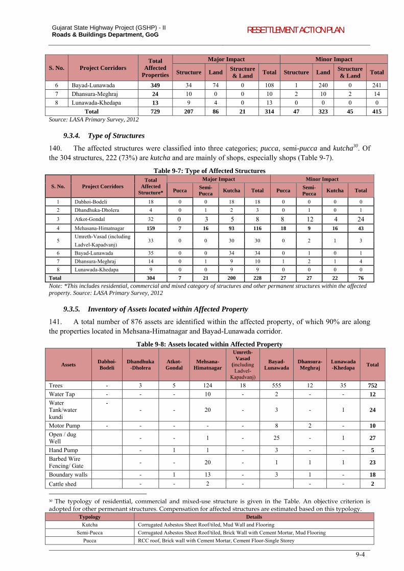
Gujarat State Highway Project (GSHP) - II Roads & Buildings Department, GoG RESETTLEMENT ACTION PLAN
9-4
S. No. Project Corridors Total
Affected Properties
Major Impact Minor Impact
Structure Land Structure & Land
Total Structure Land Structure & Land
Total
6 Bayad-Lunawada 349 34 74 0 108 1 240 0 241
7 Dhansura-Meghraj 24 10 0 0 10 2 10 2 14
8 Lunawada-Khedapa 13 9 4 0 13 0 0 0 0
Total 729 207 86 21 314 47 323 45 415 Source: LASA Primary Survey, 2012
9.3.4. Type of Structures
140. The affected structures were classified into three categories; pucca, semi-pucca and kutcha30. Of the 304 structures, 222 (73%) are kutcha and are mainly of shops, especially shops (Table 9-7).
Table 9-7: Type of Affected Structures
S. No. Project Corridors Total
Affected Structure*
Major Impact Minor Impact
Pucca Semi-Pucca
Kutcha Total Pucca Semi-Pucca
Kutcha Total
1 Dabhoi-Bodeli 18 0 0 18 18 0 0 0 0
2 Dhandhuka-Dholera 4 0 1 2 3 0 1 0 1
3 Atkot-Gondal 32 0 3 5 8 8 12 4 24
4 Mehasana-Himatnagar 159 7 16 93 116 18 9 16 43
5 Umreth-Vasad (including
33 0 0 30 30 0 2 1 3 Ladvel-Kapadvanj)
6 Bayad-Lunawada 35 0 0 34 34 0 1 0 1
7 Dhansura-Meghraj 14 0 1 9 10 1 2 1 4
8 Lunawada-Khedapa 9 0 0 9 9 0 0 0 0
Total 304 7 21 200 228 27 27 22 76
Note: *This includes residential, commercial and mixed category of structures and other permanent structures within the affected property. Source: LASA Primary Survey, 2012
9.3.5. Inventory of Assets located within Affected Property
141. A total number of 876 assets are identified within the affected property, of which 90% are along the properties located in Mehsana-Himatnagar and Bayad-Lunawada corridor.
Table 9-8: Assets located within Affected Property
Assets Dabhoi-Bodeli
Dhandhuka-Dholera
Atkot-Gondal
Mehsana-Himatnagar
Umreth-Vasad
(including Ladvel-
Kapadvanj)
Bayad-Lunawada
Dhansura-Meghraj
Lunawada-Khedapa
Total
Trees - 3 5 124 18 555 12 35 752
Water Tap - - - 10 - 2 - - 12
Water Tank/water kundi
- - - 20 - 3 - 1 24
Motor Pump - - - - - 8 2 - 10
Open / dug Well
- - 1 - 25 - 1 27
Hand Pump - 1 1 - 3 - - 5
Barbed Wire Fencing/ Gate
- - 20 - 1 1 1 23
Boundary walls - 1 13 - 3 1 - 18
Cattle shed - - 2 - - - 2
30 The typology of residential, commercial and mixed-use structure is given in the Table. An objective criterion is adopted for other permenant structures. Compensation for affected structures are estimated based on this typology.
Typology Details
Kutcha Corrugated Asbestos Sheet Roof/tiled, Mud Wall and Flooring
Semi-Pucca Corrugated Asbestos Sheet Roof/tiled, Brick Wall with Cement Mortar, Mud Flooring
Pucca RCC roof, Brick wall with Cement Mortar, Cement Floor-Single Storey
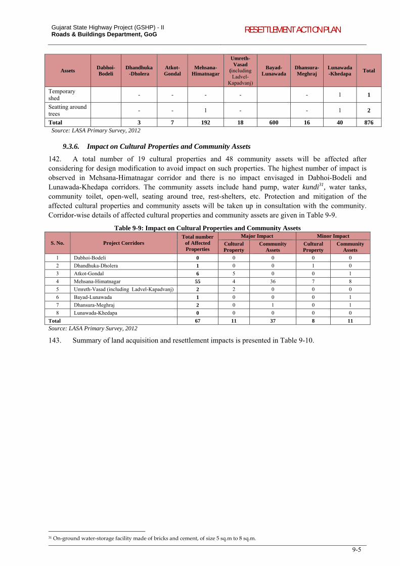
Gujarat State Highway Project (GSHP) - II Roads & Buildings Department, GoG RESETTLEMENT ACTION PLAN
9-5
Assets Dabhoi-Bodeli
Dhandhuka-Dholera
Atkot-Gondal
Mehsana-Himatnagar
Umreth-Vasad
(including Ladvel-
Kapadvanj)
Bayad-Lunawada
Dhansura-Meghraj
Lunawada-Khedapa
Total
Temporary shed
- - - -
- 1 1
Seatting around trees
- - 1 -
- 1 2
Total 3 7 192 18 600 16 40 876 Source: LASA Primary Survey, 2012
9.3.6. Impact on Cultural Properties and Community Assets
142. A total number of 19 cultural properties and 48 community assets will be affected after considering for design modification to avoid impact on such properties. The highest number of impact is observed in Mehsana-Himatnagar corridor and there is no impact envisaged in Dabhoi-Bodeli and Lunawada-Khedapa corridors. The community assets include hand pump, water kundi31, water tanks, community toilet, open-well, seating around tree, rest-shelters, etc. Protection and mitigation of the affected cultural properties and community assets will be taken up in consultation with the community. Corridor-wise details of affected cultural properties and community assets are given in Table 9-9.
Table 9-9: Impact on Cultural Properties and Community Assets
S. No. Project Corridors Total number
of Affected Properties
Major Impact Minor Impact
Cultural Property
Community Assets
Cultural Property
Community Assets
1 Dabhoi-Bodeli 0 0 0 0 0
2 Dhandhuka-Dholera 1 0 0 1 0
3 Atkot-Gondal 6 5 0 0 1
4 Mehsana-Himatnagar 55 4 36 7 8
5 Umreth-Vasad (including Ladvel-Kapadvanj) 2 2 0 0 0
6 Bayad-Lunawada 1 0 0 0 1
7 Dhansura-Meghraj 2 0 1 0 1
8 Lunawada-Khedapa 0 0 0 0 0
Total 67 11 37 8 11
Source: LASA Primary Survey, 2012
143. Summary of land acquisition and resettlement impacts is presented in Table 9-10.
31 On-ground water-storage facility made of bricks and cement, of size 5 sq.m to 8 sq.m.
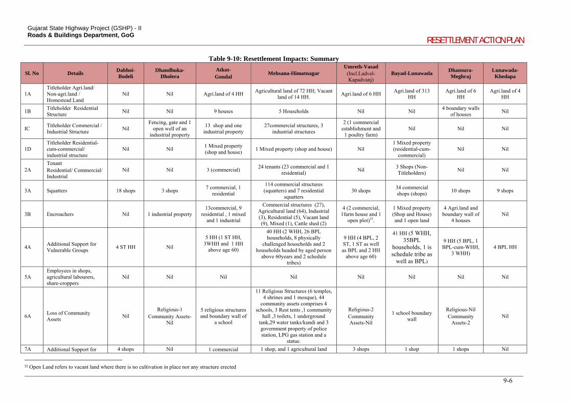
Gujarat State Highway Project (GSHP) - II Roads & Buildings Department, GoG
RESETTLEMENT ACTION PLAN
9-6
Table 9-10: Resettlement Impacts: Summary
Sl. No Details Dabhoi- Bodeli
Dhandhuka- Dholera
Atkot- Gondal
Mehsana-Himatnagar Umreth-Vasad
(Incl.Ladvel-Kapadvanj)
Bayad-Lunawada Dhansura-Meghraj
Lunawada-Khedapa
1A Titleholder Agri.land/ Non-agri.land / Homestead Land
Nil Nil Agri.land of 4 HH Agricultural land of 72 HH; Vacant
land of 14 HH. Agri.land of 6 HH
Agri.land of 313 HH
Agri.land of 6 HH
Agri.land of 4 HH
1B Titleholder Residential Structure
Nil Nil 9 houses 5 Households Nil Nil 4 boundary walls
of houses Nil
IC Titleholder Commercial / Industrial Structure
Nil Fencing, gate and 1
open well of an industrial property
13 shop and one industrial property
27commercial structures, 3 industrial structures
2 (1 commercial establishment and
1 poultry farm) Nil Nil Nil
1D Titleholder Residential-cum-commercial/ industrial structure
Nil Nil 1 Mixed property (shop and house)
1 Mixed property (shop and house) Nil 1 Mixed property (residential-cum-
commercial) Nil Nil
2A Tenant Residential/ Commercial/ Industrial
Nil Nil 3 (commercial) 24 tenants (23 commercial and 1
residential) Nil
3 Shops (Non-Titleholders)
Nil Nil
3A Squatters 18 shops 3 shops 7 commercial, 1
residential
114 commercial structures (squatters) and 7 residential
squatters 30 shops
34 commercial shops (shops)
10 shops 9 shops
3B Encroachers Nil 1 industrial property 13commercial, 9
residential , 1 mixed and 1 industrial
Commercial structures (27), Agricultural land (64), Industrial (3), Residential (5), Vacant land (9), Mixed (1), Cattle shed (2)
4 (2 commercial, 1farm house and 1
open plot)32.
1 Mixed property (Shop and House) and 1 open land
4 Agri.land and boundary wall of
4 houses Nil
4A Additional Support for Vulnerable Groups
4 ST HH Nil
5 HH (1 ST HH, 3WHH and 1 HH
above age 60)
40 HH (2 WHH, 26 BPL households, 8 physically
challenged households and 2 households headed by aged person
above 60years and 2 schedule tribes)
9 HH (4 BPL, 2 ST, 1 ST as well as BPL and 2 HH
above age 60)
41 HH (5 WHH, 35BPL
households, 1 is schedule tribe as
well as BPL)
9 HH (5 BPL, 1 BPL-cum-WHH,
3 WHH) 4 BPL HH
5A Employees in shops, agricultural labourers, share-croppers
Nil Nil Nil Nil Nil Nil Nil Nil
6A Loss of Community Assets
Nil Religious-1
Community Assets-Nil
5 religious structures and boundary wall of
a school
11 Religious Structures (6 temples, 4 shrines and 1 mosque), 44
community assets comprises 4 schools, 3 Rest tents ,1 community
hall ,3 toilets, 1 underground tank,29 water tanks/kundi and 3 government property of police station, LPG gas station and a
statue.
Religious-2 Community Assets-Nil
1 school boundary wall
Religious-Nil Community
Assets-2 Nil
7A Additional Support for 4 shops Nil 1 commercial 1 shop, and 1 agricultural land 3 shops 1 shop 1 shops Nil
32 Open Land refers to vacant land where there is no cultivation in place nor any structure erected
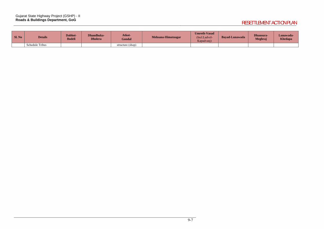
Gujarat State Highway Project (GSHP) - II Roads & Buildings Department, GoG
RESETTLEMENT ACTION PLAN
9-7
Sl. No Details Dabhoi- Bodeli
Dhandhuka- Dholera
Atkot- Gondal
Mehsana-Himatnagar Umreth-Vasad
(Incl.Ladvel-Kapadvanj)
Bayad-Lunawada Dhansura-Meghraj
Lunawada-Khedapa
Schedule Tribes structure (shop)
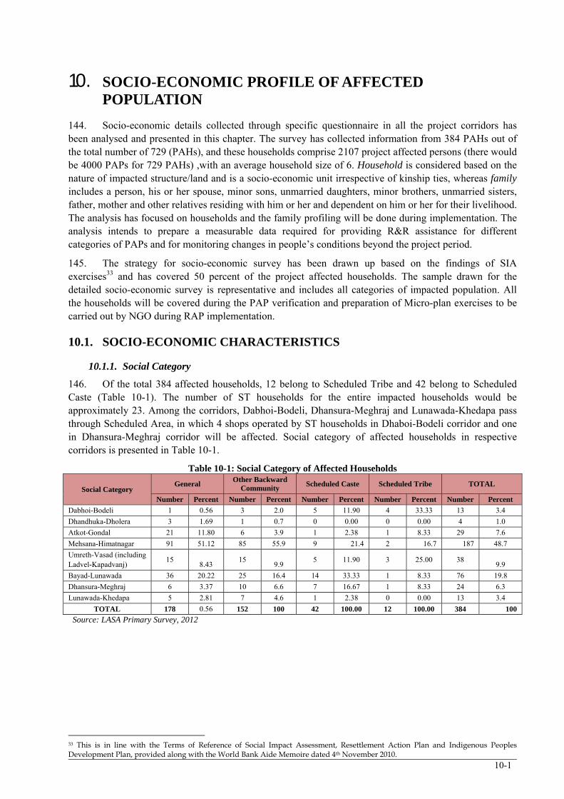
10-1
10. SOCIO-ECONOMIC PROFILE OF AFFECTED POPULATION
144. Socio-economic details collected through specific questionnaire in all the project corridors has been analysed and presented in this chapter. The survey has collected information from 384 PAHs out of the total number of 729 (PAHs), and these households comprise 2107 project affected persons (there would be 4000 PAPs for 729 PAHs) ,with an average household size of 6. Household is considered based on the nature of impacted structure/land and is a socio-economic unit irrespective of kinship ties, whereas family includes a person, his or her spouse, minor sons, unmarried daughters, minor brothers, unmarried sisters, father, mother and other relatives residing with him or her and dependent on him or her for their livelihood. The analysis has focused on households and the family profiling will be done during implementation. The analysis intends to prepare a measurable data required for providing R&R assistance for different categories of PAPs and for monitoring changes in people’s conditions beyond the project period.
145. The strategy for socio-economic survey has been drawn up based on the findings of SIA exercises33 and has covered 50 percent of the project affected households. The sample drawn for the detailed socio-economic survey is representative and includes all categories of impacted population. All the households will be covered during the PAP verification and preparation of Micro-plan exercises to be carried out by NGO during RAP implementation.
10.1. SOCIO-ECONOMIC CHARACTERISTICS
10.1.1. Social Category
146. Of the total 384 affected households, 12 belong to Scheduled Tribe and 42 belong to Scheduled Caste (Table 10-1). The number of ST households for the entire impacted households would be approximately 23. Among the corridors, Dabhoi-Bodeli, Dhansura-Meghraj and Lunawada-Khedapa pass through Scheduled Area, in which 4 shops operated by ST households in Dhaboi-Bodeli corridor and one in Dhansura-Meghraj corridor will be affected. Social category of affected households in respective corridors is presented in Table 10-1.
Table 10-1: Social Category of Affected Households
Social Category General
Other Backward Community
Scheduled Caste Scheduled Tribe TOTAL
Number Percent Number Percent Number Percent Number Percent Number Percent
Dabhoi-Bodeli 1 0.56 3 2.0 5 11.90 4 33.33 13 3.4
Dhandhuka-Dholera 3 1.69 1 0.7 0 0.00 0 0.00 4 1.0
Atkot-Gondal 21 11.80 6 3.9 1 2.38 1 8.33 29 7.6
Mehsana-Himatnagar 91 51.12 85 55.9 9 21.4 2 16.7 187 48.7
Umreth-Vasad (including Ladvel-Kapadvanj)
15 8.43
15 9.9
5 11.90 3 25.00 38 9.9
Bayad-Lunawada 36 20.22 25 16.4 14 33.33 1 8.33 76 19.8
Dhansura-Meghraj 6 3.37 10 6.6 7 16.67 1 8.33 24 6.3
Lunawada-Khedapa 5 2.81 7 4.6 1 2.38 0 0.00 13 3.4
TOTAL 178 0.56 152 100 42 100.00 12 100.00 384 100
Source: LASA Primary Survey, 2012
33 This is in line with the Terms of Reference of Social Impact Assessment, Resettlement Action Plan and Indigenous Peoples Development Plan, provided along with the World Bank Aide Memoire dated 4th November 2010.
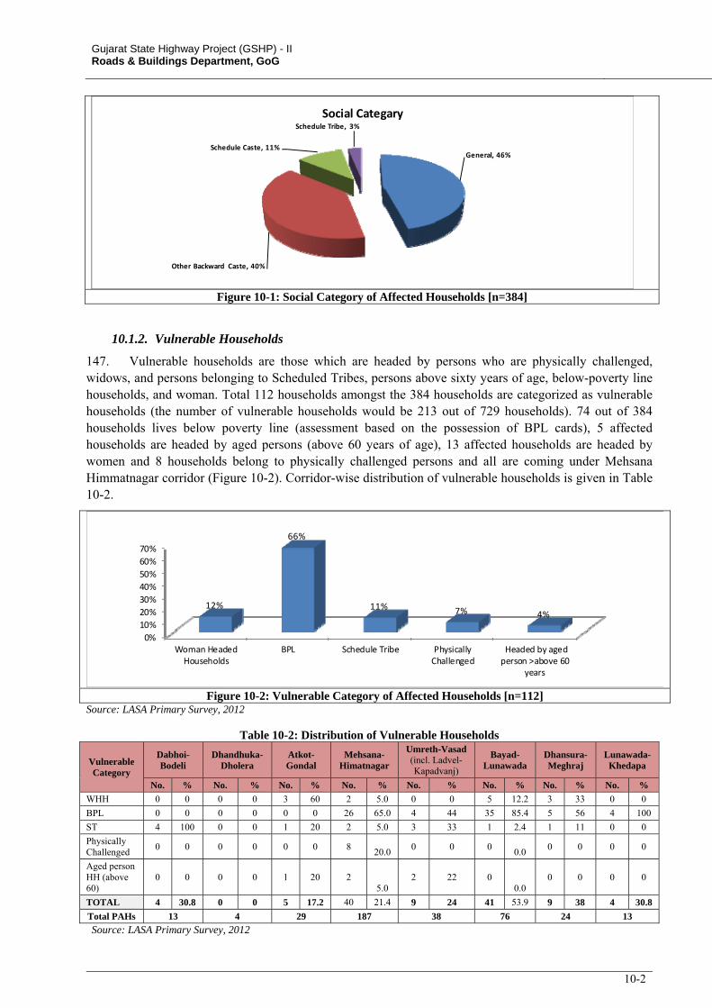
Gujarat State Highway Project (GSHP) - II Roads & Buildings Department, GoG
10-2
General, 46%
Other Backward Caste, 40%
Schedule Caste, 11%
Schedule Tribe, 3%
Social Categary
Figure 10-1: Social Category of Affected Households [n=384]
10.1.2. Vulnerable Households
147. Vulnerable households are those which are headed by persons who are physically challenged, widows, and persons belonging to Scheduled Tribes, persons above sixty years of age, below-poverty line households, and woman. Total 112 households amongst the 384 households are categorized as vulnerable households (the number of vulnerable households would be 213 out of 729 households). 74 out of 384 households lives below poverty line (assessment based on the possession of BPL cards), 5 affected households are headed by aged persons (above 60 years of age), 13 affected households are headed by women and 8 households belong to physically challenged persons and all are coming under Mehsana Himmatnagar corridor (Figure 10-2). Corridor-wise distribution of vulnerable households is given in Table 10-2.
0%
10%
20%
30%
40%
50%
60%
70%
Woman HeadedHouseholds
BPL Schedule Tribe PhysicallyChallenged
Headed by agedperson >above 60
years
12%
66%
11% 7% 4%
Figure 10-2: Vulnerable Category of Affected Households [n=112] Source: LASA Primary Survey, 2012
Table 10-2: Distribution of Vulnerable Households
Vulnerable Category
Dabhoi-Bodeli
Dhandhuka-Dholera
Atkot-Gondal
Mehsana-Himatnagar
Umreth-Vasad (incl. Ladvel-Kapadvanj)
Bayad-Lunawada
Dhansura-Meghraj
Lunawada-Khedapa
No. % No. % No. % No. % No. % No. % No. % No. %
WHH 0 0 0 0 3 60 2 5.0 0 0 5 12.2 3 33 0 0
BPL 0 0 0 0 0 0 26 65.0 4 44 35 85.4 5 56 4 100
ST 4 100 0 0 1 20 2 5.0 3 33 1 2.4 1 11 0 0
Physically Challenged
0 0 0 0 0 0 8 20.0
0 0 0 0.0
0 0 0 0
Aged person HH (above 60)
0 0 0 0 1 20 2 5.0
2 22 0 0.0
0 0 0 0
TOTAL 4 30.8 0 0 5 17.2 40 21.4 9 24 41 53.9 9 38 4 30.8
Total PAHs 13 4 29 187 38 76 24 13
Source: LASA Primary Survey, 2012
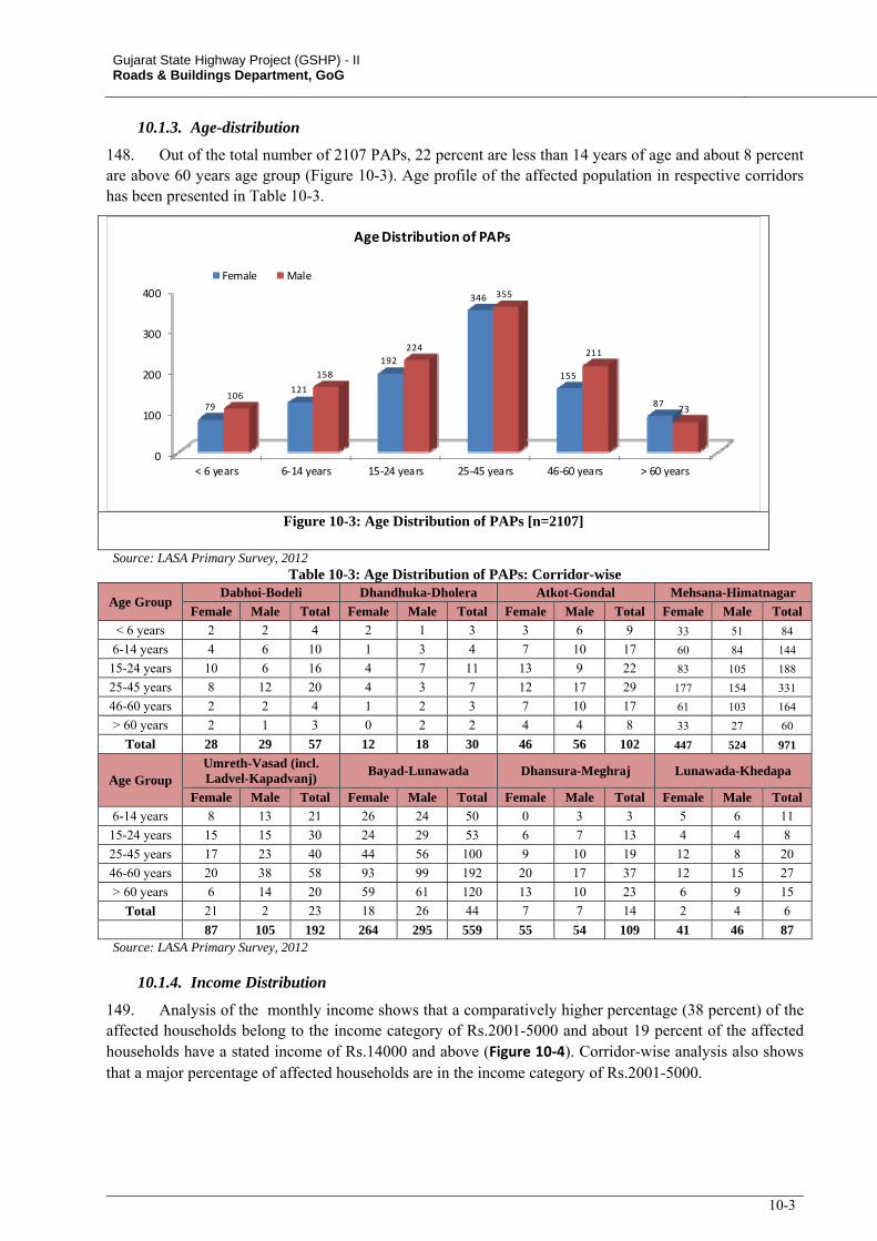
Gujarat State Highway Project (GSHP) - II Roads & Buildings Department, GoG
10-3
10.1.3. Age-distribution
148. Out of the total number of 2107 PAPs, 22 percent are less than 14 years of age and about 8 percent are above 60 years age group (Figure 10-3). Age profile of the affected population in respective corridors has been presented in Table 10-3.
0
100
200
300
400
< 6 years 6‐14 years 15‐24 years 25‐45 years 46‐60 years > 60 years
79
121
192
346
155
87106
158
224
355
211
73
Age Distribution of PAPs
Female Male
Figure 10-3: Age Distribution of PAPs [n=2107]
Source: LASA Primary Survey, 2012 Table 10-3: Age Distribution of PAPs: Corridor-wise
Age Group Dabhoi-Bodeli Dhandhuka-Dholera Atkot-Gondal Mehsana-Himatnagar
Female Male Total Female Male Total Female Male Total Female Male Total
< 6 years 2 2 4 2 1 3 3 6 9 33 51 84
6-14 years 4 6 10 1 3 4 7 10 17 60 84 144
15-24 years 10 6 16 4 7 11 13 9 22 83 105 188
25-45 years 8 12 20 4 3 7 12 17 29 177 154 331
46-60 years 2 2 4 1 2 3 7 10 17 61 103 164
> 60 years 2 1 3 0 2 2 4 4 8 33 27 60
Total 28 29 57 12 18 30 46 56 102 447 524 971
Age Group Umreth-Vasad (incl. Ladvel-Kapadvanj)
Bayad-Lunawada Dhansura-Meghraj Lunawada-Khedapa
Female Male Total Female Male Total Female Male Total Female Male Total
6-14 years 8 13 21 26 24 50 0 3 3 5 6 11
15-24 years 15 15 30 24 29 53 6 7 13 4 4 8
25-45 years 17 23 40 44 56 100 9 10 19 12 8 20
46-60 years 20 38 58 93 99 192 20 17 37 12 15 27
> 60 years 6 14 20 59 61 120 13 10 23 6 9 15
Total 21 2 23 18 26 44 7 7 14 2 4 6
87 105 192 264 295 559 55 54 109 41 46 87 Source: LASA Primary Survey, 2012
10.1.4. Income Distribution
149. Analysis of the monthly income shows that a comparatively higher percentage (38 percent) of the affected households belong to the income category of Rs.2001-5000 and about 19 percent of the affected households have a stated income of Rs.14000 and above (Figure 10‐4). Corridor-wise analysis also shows that a major percentage of affected households are in the income category of Rs.2001-5000.
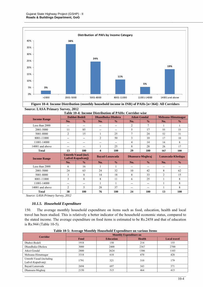
Gujarat State Highway Project (GSHP) - II Roads & Buildings Department, GoG
10-4
3%
38%
24%
11%
5%
19%
0%
5%
10%
15%
20%
25%
30%
35%
40%
>2000 2001‐5000 5001‐8000 8001‐11000 11001‐14000 14001 and above
Distribution of PAFs by Income Categary
Figure 10-4: Income Distribution (monthly household income in INR) of PAHs [n=364]: All Corridors
Source: LASA Primary Survey, 2012 Table 10-4: Income Distribution of PAHs: Corridor-wise
Income Range Dabhoi-Bodeli Dhandhuka-Dholera Atkot-Gondal Mehsana-Himatnagar
No. % No. % No. % No. %
Less than 2000 -- -- -- -- 2 7 1 1
2001-5000 11 85 -- -- 5 17 55 33
5001-8000 2 15 1 25 7 24 52 31
8001-11000 -- -- 2 50 3 10 17 10
11001-14000 -- -- -- -- 4 14 14 8
14001 and above -- -- 1 25 8 28 28 17
Total 13 100 4 100 29 100 167 100
Income Range Umreth-Vasad (incl. Ladvel-Kapadvanj)
Bayad-Lunawada Dhansura-Meghraj Lunawada-Khedapa
No. % No. % No. % No. %
Less than 2000 6 16 1 1 -- -- -- --
2001-5000 24 63 24 32 10 42 8 62
5001-8000 3 8 14 18 8 33 2 15
8001-11000 3 8 8 11 6 25 1 8
11001-14000 -- -- 1 1 -- -- 1 8
14001 and above 2 5 28 37 -- -- 1 8
Total 38 100 76 100 24 100 13 100 Source: LASA Primary Survey, 2012
10.1.5. Household Expenditure
150. The average monthly household expenditure on items such as food, education, health and local travel has been studied. This is relatively a better indicator of the household economic status, compared to the stated income. The average expenditure on food items is estimated to be Rs.2458 and that of education is Rs.944 (Table 10-5).
Table 10-5: Average Monthly Household Expenditure on various Items
Corridor Monthly Expenditure on
Food Education Health Local travel
Dhaboi-Bodeli 1918 150 214 155
Dhandhuka-Dholera 3000 2400 2367 2700
Atkot-Gondal 2800 2624 1306 1103
Mehsana-Himatnagar 3318 618 470 428
Umreth-Vasad (including Ladvel-Kapadvanj)
1791 321 310 179
Bayad-Lunawada 2694 697 343 371
Dhansura-Meghraj 2150 515 464 415
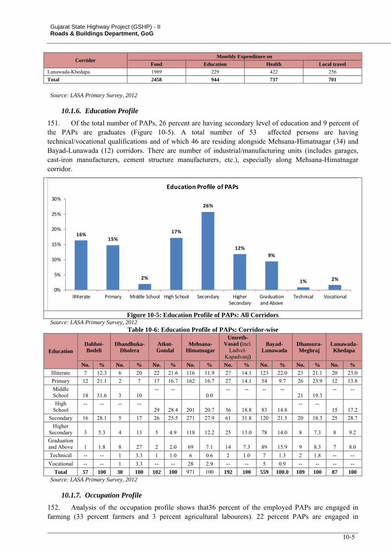
Gujarat State Highway Project (GSHP) - II Roads & Buildings Department, GoG
10-5
Corridor Monthly Expenditure on
Food Education Health Local travel
Lunawada-Khedapa 1989 229 422 256
Total 2458 944 737 701
Source: LASA Primary Survey, 2012
10.1.6. Education Profile
151. Of the total number of PAPs, 26 percent are having secondary level of education and 9 percent of the PAPs are graduates (Figure 10-5). A total number of 53 affected persons are having technical/vocational qualifications and of which 46 are residing alongside Mehsana-Himatnagar (34) and Bayad-Lunawada (12) corridors. There are number of industrial/manufacturing units (includes garages, cast-iron manufacturers, cement structure manufacturers, etc.), especially along Mehsana-Himatnagar corridor.
16%15%
2%
17%
26%
12%
9%
1% 2%
0%
5%
10%
15%
20%
25%
30%
Illiterate Primary Middle School High School Secondary HigherSecondary
Graduationand Above
Technical Vocational
Education Profile of PAPs
Figure 10-5: Education Profile of PAPs: All Corridors Source: LASA Primary Survey, 2012
Table 10-6: Education Profile of PAPs: Corridor-wise
Education Dabhoi-Bodeli
Dhandhuka-Dholera
Atkot-Gondal
Mehsana-Himatnagar
Umreth-Vasad (incl.
Ladvel-Kapadvanj)
Bayad-Lunawada
Dhansura-Meghraj
Lunawada-Khedapa
No. % No. % No. % No. % No. % No. % No. % No. %
Illiterate 7 12.3 6 20 22 21.6 116 11.9 27 14.1 123 22.0 23 21.1 20 23.0
Primary 12 21.1 2 7 17 16.7 162 16.7 27 14.1 54 9.7 26 23.9 12 13.8
Middle School 18 31.6 3 10
-- -- 0.0
-- -- -- -- 21 19.3
-- --
High School
-- -- -- -- 29 28.4 201 20.7 36 18.8 83 14.8
-- -- 15 17.2
Secondary 16 28.1 5 17 26 25.5 271 27.9 61 31.8 120 21.5 20 18.3 25 28.7
Higher Secondary 3 5.3 4 13 5 4.9 118 12.2 25 13.0 78 14.0 8 7.3 8 9.2
Graduation and Above 1 1.8 8 27 2 2.0 69 7.1 14 7.3 89 15.9 9 8.3 7 8.0
Technical -- -- 1 3.3 1 1.0 6 0.6 2 1.0 7 1.3 2 1.8 -- --
Vocational -- -- 1 3.3 -- -- 28 2.9 -- -- 5 0.9 -- -- -- --
Total 57 100 30 100 102 100 971 100 192 100 559 100.0 109 100 87 100 Source: LASA Primary Survey, 2012
10.1.7. Occupation Profile
152. Analysis of the occupation profile shows that36 percent of the employed PAPs are engaged in farming (33 percent farmers and 3 percent agricultural labourers). 22 percent PAPs are engaged in
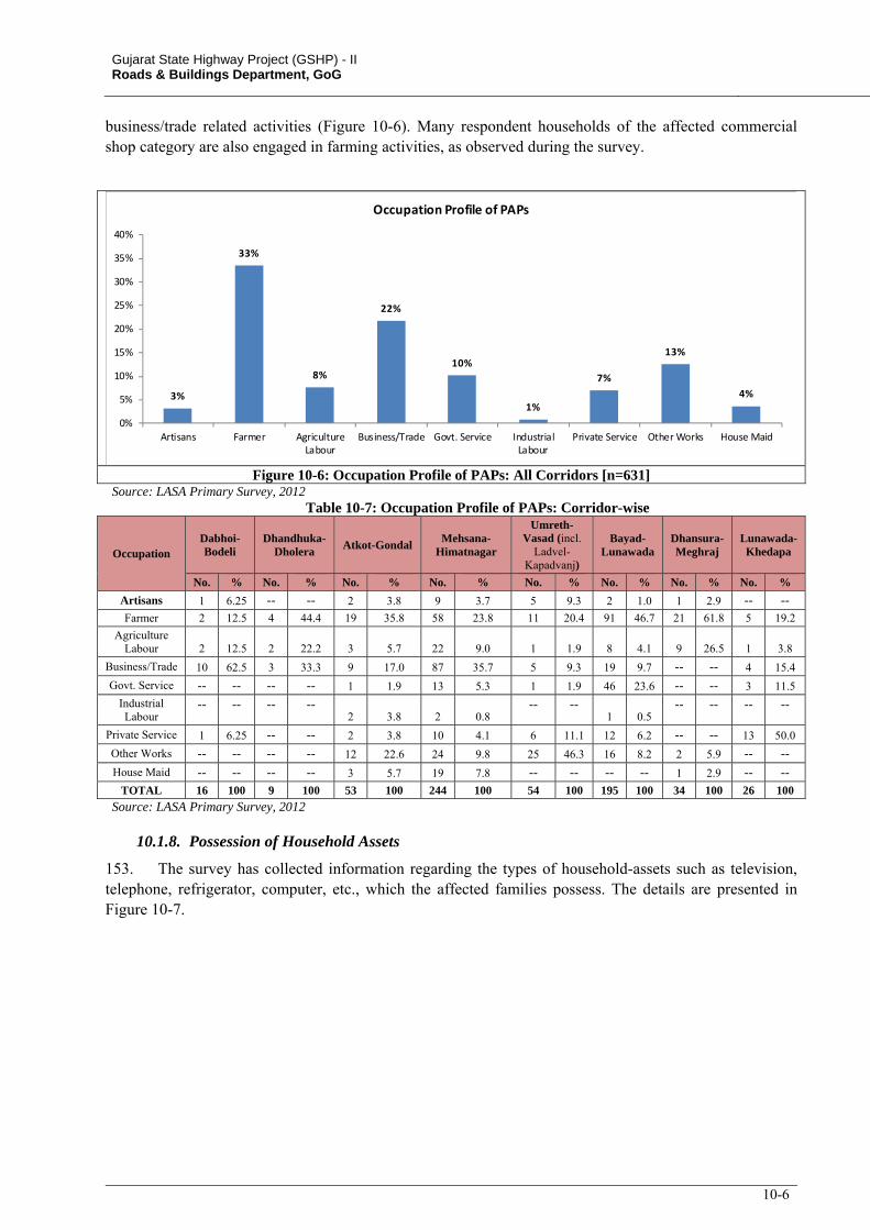
Gujarat State Highway Project (GSHP) - II Roads & Buildings Department, GoG
10-6
business/trade related activities (Figure 10-6). Many respondent households of the affected commercial shop category are also engaged in farming activities, as observed during the survey.
3%
33%
8%
22%
10%
1%
7%
13%
4%
0%
5%
10%
15%
20%
25%
30%
35%
40%
Artisans Farmer AgricultureLabour
Business/Trade Govt. Service IndustrialLabour
Private Service Other Works House Maid
Occupation Profile of PAPs
Figure 10-6: Occupation Profile of PAPs: All Corridors [n=631] Source: LASA Primary Survey, 2012
Table 10-7: Occupation Profile of PAPs: Corridor-wise
Occupation Dabhoi-Bodeli
Dhandhuka-Dholera
Atkot-Gondal Mehsana-
Himatnagar
Umreth-Vasad (incl.
Ladvel-Kapadvanj)
Bayad-Lunawada
Dhansura-Meghraj
Lunawada-Khedapa
No. % No. % No. % No. % No. % No. % No. % No. %
Artisans 1 6.25 -- -- 2 3.8 9 3.7 5 9.3 2 1.0 1 2.9 -- --Farmer 2 12.5 4 44.4 19 35.8 58 23.8 11 20.4 91 46.7 21 61.8 5 19.2
Agriculture Labour 2 12.5 2 22.2 3 5.7 22 9.0 1 1.9 8 4.1 9 26.5 1 3.8
Business/Trade 10 62.5 3 33.3 9 17.0 87 35.7 5 9.3 19 9.7 -- -- 4 15.4
Govt. Service -- -- -- -- 1 1.9 13 5.3 1 1.9 46 23.6 -- -- 3 11.5
Industrial Labour
-- -- -- -- 2 3.8 2 0.8
-- --1 0.5
-- -- -- --
Private Service 1 6.25 -- -- 2 3.8 10 4.1 6 11.1 12 6.2 -- -- 13 50.0
Other Works -- -- -- -- 12 22.6 24 9.8 25 46.3 16 8.2 2 5.9 -- --
House Maid -- -- -- -- 3 5.7 19 7.8 -- -- -- -- 1 2.9 -- --TOTAL 16 100 9 100 53 100 244 100 54 100 195 100 34 100 26 100
Source: LASA Primary Survey, 2012
10.1.8. Possession of Household Assets
153. The survey has collected information regarding the types of household-assets such as television, telephone, refrigerator, computer, etc., which the affected families possess. The details are presented in Figure 10-7.
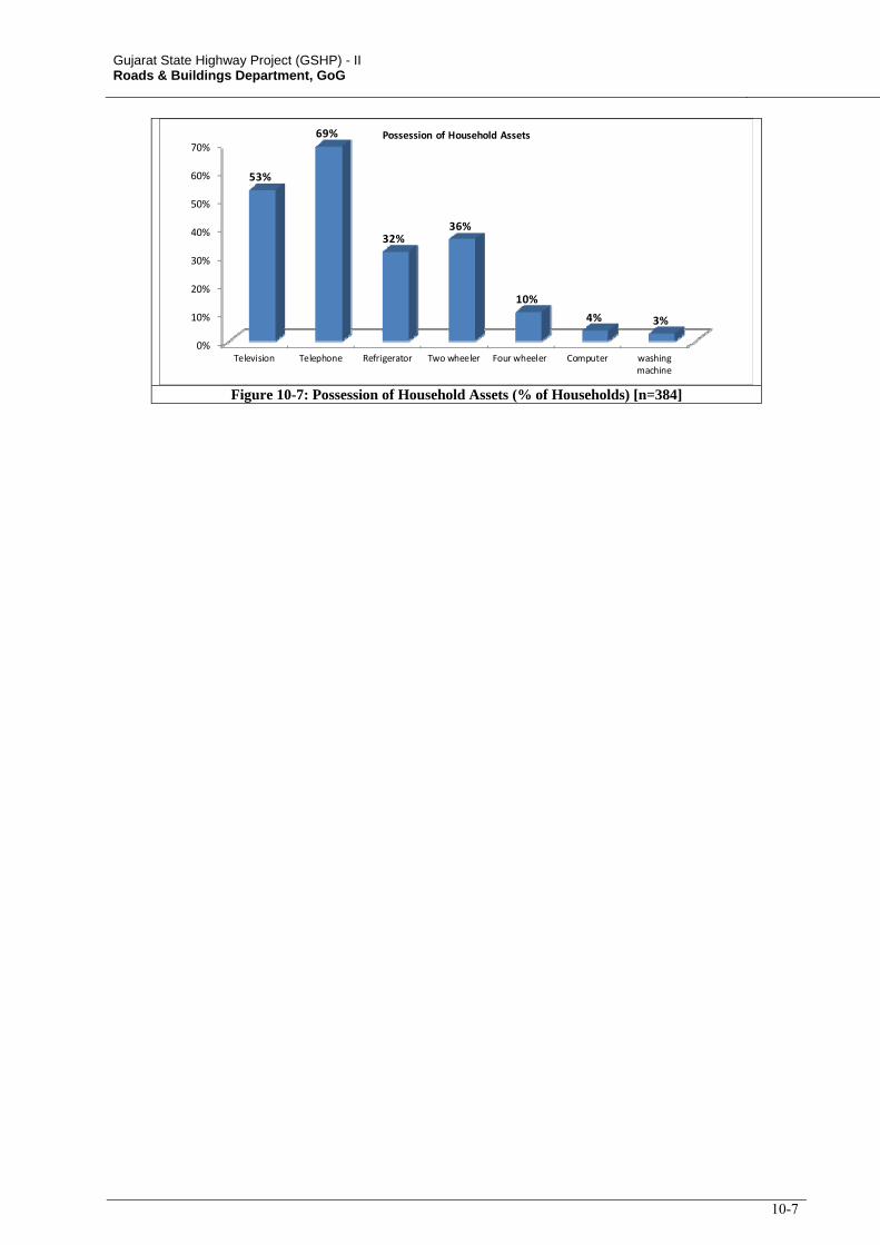
Gujarat State Highway Project (GSHP) - II Roads & Buildings Department, GoG
10-7
0%
10%
20%
30%
40%
50%
60%
70%
Television Telephone Refrigerator Two wheeler Four wheeler Computer washingmachine
53%
69%
32%36%
10%
4% 3%
Possession of Household Assets
Figure 10-7: Possession of Household Assets (% of Households) [n=384]
11-1
11. SCHEDULED TRIBES
11.1. INTRODUCTION
154. In Gujarat, Scheduled Areas consists of 43 tribal Talukas, 15 pockets and 4 clusters located in 12 districts. These areas are among the most backward in the State, characterized by hilly terrain, rocky soil, uncertain rainfall and the presence of large tracts of forest land. Of these 12 districts, project corridor abuts four Talukas of 3 districts i.e. Meghraj Taluka of Sabarkantha district, Santrampur and Kadana of Panchmahal and Sankheda of Vadodara district. To address the specific impact on tribal communities, and in compliance with the national, state and World Bank safeguard policies, a standalone Indigenous Peoples Development Plan (IPDP) has been prepared.
11.2. APPROACH ADOPTED IN SCHEDULED AREAS
155. SIA looked into the impact of the project especially on the Scheduled Areas (Taluk) through which the project road passes, and how the road project is likely to affect ST population. Public consultations were held along the project corridors with the communities to obtain their views and suggestions regarding the proposed project interventions. The views, suggestions and concerns of the community were integrated into the project design. As part of the SIA, census survey of all the potentially affected population within the likely CoI has been carried out. Socio-economic profile of all the affected households including ST households has been collected and entitlements for respective impact on assets were estimated. Even while RAP presents the details of overall affected households (including the details of affected ST households), IPDP has focused on ST households affected due to the project as well as provides details of consultation carried out in Scheduled Areas and presents the framework for consultation during project implementation with the objective of seeking broad community support.
156. No acquisition of lands is proposed for the section of corridors passing through Scheduled Areas. The designs for the proposed corridors have been worked out within the available RoW to minimize land acquisition and resettlement impacts. As a result, direct impacts on tribal communities pertaining to land acquisition are not envisaged. The impacts along the corridors through Scheduled Areas are limited to 17 non-titleholder shops squatting within the RoW for commercial purposes, out of which 3 are owned by STs who belong to Rathwa community. Impacts on these ST households are being addressed through the provisions of the Resettlement Policy Framework (RPF), which recognizes STs as vulnerable groups and provides additional assistance. Summary of impacts along the 3 corridors in Scheduled Area are presented in Table 11-1.
Table 11-1: Summary of Impacts in Fifth Schedule Area
Corridor Taluka Proposed Treatment Impact on
Land Impact on Assets/Structures
Dhansura-Meghraj Meghraj 2-lane with COI of 16m No impact 1 Hand pump
Lunawada-Khedapa Santrampur, Kadana
2-lane with COI of 16m No Impact 4 shops owned by non-STs
Dabhoi-Bodeli Sankheda 2-lane with COI of 16m No Impact 3 shops owned by STs and 10 shops owned by non-STs
Source: LASA Primary Survey, 2012
157. Data were collected from the following secondary sources: (i) census records for demographic information, (ii) Tribal Development Department for information on notified Scheduled Tribes, customary rights of ST on land and other resources and details about various development programmes intended for the benefit of STs, (iii) local organisations including NGOs for details of development interventions in Fifth Schedule areas, in order to involve them and integrate their activities in the economic development programmes of affected ST households.
158. The applicable policies and Acts relevant to ST development has been reviewed in order to understand their economic, social, and legal status which often limits their capacity to defend their interests in and rights to lands, territories, and other productive resources.
Gujarat State Highway Project for GSHP-II Roads & Buildings Department, GoG RESETTLEMENT ACTION PLAN
11-2
159. The institutional arrangements at state and national level has been studied basically to develop a framework for Free, Prior and Informed consultation with affected ST community and those who reside in the Fifth Schedule Area. FPIC to be taken up during project implementation stage also conceived the existing government level institutional set up. FPIC has twin objectives such as (i) disseminating details about the proposed project, its adverse and favourable impact on the ST community and (ii) integrating the affected ST households with suitable development programmes (income generating, skill development or capacity building).
11.3. ST POPULATION IN GUJARAT
160. As per 2001 census, the population of Gujarat was 50,671,071 of which 7,481,160 are the Scheduled Tribes (STs), accounting 14.8 percent of the total population of the state. During the period 1991-2001, the state has registered 21.4 percent growth of ST population. Among the tribe population 46 percent are Bhil followed by Dubla, Dhodia and Rathwa (7-8 percent each).
Table 11-2: Population of Major Tribes: Gujarat, 2001 Scheduled Tribe Population Percentage to Total
Bhil 3,441,945 46.01
Dubla 596,865 7.98
Dhodia 589,108 7.87
Rathwa 535,284 7.16
Naikda 393,024 5.25
Gamit 354,362 4.74
Kokna 329,496 4.40
Chaudri 282,392 3.77
Varli 255,271 3.41
Dhanka 252,637 3.38
Patelia 109,390 1.46
Koli 95,655 1.28
Others* 245,731 3.28
Total 7,481,160 100.00 * Others include Barda, Bavacha, Bharwad, Charan, Chodara, Gond, Kathodi, Kunbi, Padhar, Pardhi (in Kutch District) Pardhi-Advichincher, Pomla, Rabari, Siddi, Vaghri, and Vitolia. Source: http://censusindia.gov.in/Tables_Published/SCST/dh_st_gujarat.pdf, accessed 04.03.2012
11.4. ST POPULATION IN THE PROJECT DISTRICTS
161. Parts of twelve districts - Surat, Bharauch, Dangs, Valsad, Panchmahal, Vadodara, Sabarkanta, Narmada, Tapi, Navasari, Banaskantha and Dahod are recognised as Fifth Schedule Areas in Gujarat. Out of the 8 Project Corridors, Dabhoi-Bodeli (in Vadodara district) and Lunawada-Khedapa (in Panchmahal district) and Dhansura-Meghraj (in Sabarkantha district) traverse the tribal Talukas. Dabhoi, Sankheda, Meghraj, Kadana and Santrampur have a tribal population of 32 to 87 percent of total population (Table 11-3).
Table 11-3: Population Details of Project Influence Districts and Talukas, 2001
Sl. No. Corridors Districts % of ST to Total
District Population Talukas
% of ST to Total Taluk Population
1 Dabhoi- Bodeli Vadodara 26.56 Dabhoi 31.81
Sankheda 44.81
2 Dhandhuka-Dholera Ahmadabad 1.00 Dhandhuka 0.22
3 Atkot-Gondal Rajkot 0.42
Kotda Sangani 0.44
Jasdan 0.16
Gondal 0.30
4 Dhandhuka-Paliyad Ahmadabad 1.00
Dhandhuka 0.22
Ranpur 0.10
Bhavnagar 0.30 Botad 0.23
5 Mehsana - Himatnagar
Sabarkantha 20.18 Himatnagar 1.64
Mehsana 0.49
Visnagar 0.38
Vijapur 0.64
Mehsana 0.85
Gandhinagar 1.32 Mansa 0.58
Gujarat State Highway Project for GSHP-II Roads & Buildings Department, GoG RESETTLEMENT ACTION PLAN
11-3
Sl. No. Corridors Districts % of ST to Total
District Population Talukas
% of ST to Total Taluk Population
6 Umreth-Vasad
(including Ladvel-Kapadvanj)
Kheda 1.60 Kapadvanj 1.66
Kathlal 0.47
Anand 1.23 Umreth 1.05
Anand 2.48
7 Bayad-Lunawada
Sabarkantha 20.18 Bayad 1.26
Kheda 1.60 Virpur 0.69
Panchmahal 27.45 Lunawada 5.27
8 Dhansura-Meghraj Sabarkantha 20.18
Meghraj 36.38
Dhansura 1.56
Malpur 3.46
9 Lunawada-Khedapa Panchmahal 27.45
Lunawada 5.27
Kadana 73.20
Santrampur 72.07
Source: Census of India, 2001
162. Village-wise distribution of tribal population along these Talukas shows that project corridors of Dabhoi- Bodeli and Lunawada-Khedapa have major influence on tribal population. In Dhansura-Meghraj corridor, Meghraj Taluka has a tribal population of 36 percent, at the same time the tribal population is 2 percent in the 31 villages abutting the project corridor (Table 11-4).
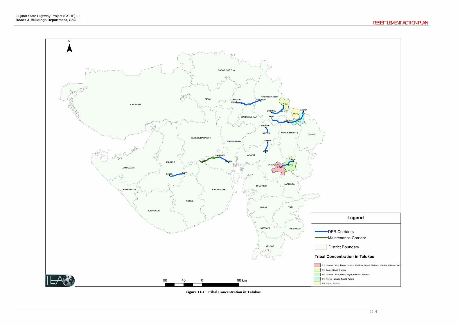
Gujarat State Highway Project (GSHP) - II Roads & Buildings Department, GoG
RESETTLEMENT ACTION PLAN
11-4
Figure 11-1: Tribal Concentration in Talukas
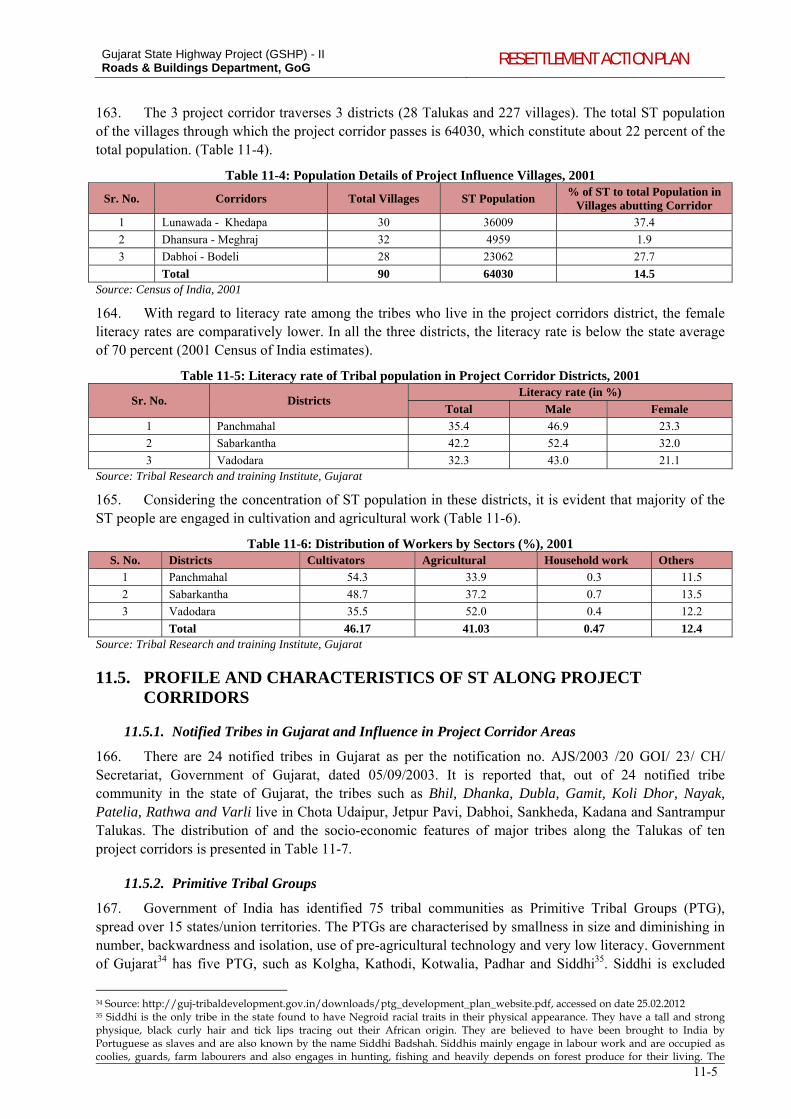
Gujarat State Highway Project (GSHP) - II Roads & Buildings Department, GoG RESETTLEMENT ACTION PLAN
11-5
163. The 3 project corridor traverses 3 districts (28 Talukas and 227 villages). The total ST population of the villages through which the project corridor passes is 64030, which constitute about 22 percent of the total population. (Table 11-4).
Table 11-4: Population Details of Project Influence Villages, 2001
Sr. No. Corridors Total Villages ST Population % of ST to total Population in
Villages abutting Corridor
1 Lunawada - Khedapa 30 36009 37.4
2 Dhansura - Meghraj 32 4959 1.9
3 Dabhoi - Bodeli 28 23062 27.7
Total 90 64030 14.5 Source: Census of India, 2001
164. With regard to literacy rate among the tribes who live in the project corridors district, the female literacy rates are comparatively lower. In all the three districts, the literacy rate is below the state average of 70 percent (2001 Census of India estimates).
Table 11-5: Literacy rate of Tribal population in Project Corridor Districts, 2001
Sr. No. Districts Literacy rate (in %)
Total Male Female
1 Panchmahal 35.4 46.9 23.3
2 Sabarkantha 42.2 52.4 32.0
3 Vadodara 32.3 43.0 21.1 Source: Tribal Research and training Institute, Gujarat
165. Considering the concentration of ST population in these districts, it is evident that majority of the ST people are engaged in cultivation and agricultural work (Table 11-6).
Table 11-6: Distribution of Workers by Sectors (%), 2001 S. No. Districts Cultivators Agricultural Household work Others
1 Panchmahal 54.3 33.9 0.3 11.5
2 Sabarkantha 48.7 37.2 0.7 13.5
3 Vadodara 35.5 52.0 0.4 12.2
Total 46.17 41.03 0.47 12.4 Source: Tribal Research and training Institute, Gujarat
11.5. PROFILE AND CHARACTERISTICS OF ST ALONG PROJECT CORRIDORS
11.5.1. Notified Tribes in Gujarat and Influence in Project Corridor Areas
166. There are 24 notified tribes in Gujarat as per the notification no. AJS/2003 /20 GOI/ 23/ CH/ Secretariat, Government of Gujarat, dated 05/09/2003. It is reported that, out of 24 notified tribe community in the state of Gujarat, the tribes such as Bhil, Dhanka, Dubla, Gamit, Koli Dhor, Nayak, Patelia, Rathwa and Varli live in Chota Udaipur, Jetpur Pavi, Dabhoi, Sankheda, Kadana and Santrampur Talukas. The distribution of and the socio-economic features of major tribes along the Talukas of ten project corridors is presented in Table 11-7.
11.5.2. Primitive Tribal Groups
167. Government of India has identified 75 tribal communities as Primitive Tribal Groups (PTG), spread over 15 states/union territories. The PTGs are characterised by smallness in size and diminishing in number, backwardness and isolation, use of pre-agricultural technology and very low literacy. Government of Gujarat34 has five PTG, such as Kolgha, Kathodi, Kotwalia, Padhar and Siddhi35. Siddhi is excluded
34 Source: http://guj-tribaldevelopment.gov.in/downloads/ptg_development_plan_website.pdf, accessed on date 25.02.2012 35 Siddhi is the only tribe in the state found to have Negroid racial traits in their physical appearance. They have a tall and strong physique, black curly hair and tick lips tracing out their African origin. They are believed to have been brought to India by Portuguese as slaves and are also known by the name Siddhi Badshah. Siddhis mainly engage in labour work and are occupied as coolies, guards, farm labourers and also engages in hunting, fishing and heavily depends on forest produce for their living. The
Gujarat State Highway Project for GSHP-II Roads & Buildings Department, GoG RESETTLEMENT ACTION PLAN
11-6
from the latest notification No. AJS/2003 /20 GOI/ 23/ CH/ Secretariat, Government of Gujarat, dated 05/09/2003. Atkot-Gondal traverses a Taluka which has population of 81 PTG households belonging to Siddhi. Siddhi community is not affected in any way by the proposed road improvement project. The residential place of Siddhi community is located about 2 km away from the project corridor. Members from Siddhi also participated in the consultation held at Gondal.
Siddhi in Gondal village of Gondal Taluk follow Muslim religion. They are landless and 56 households does not own house. There are ten female-headed households. The total PTG population is 109214, concentrated mainly in Surat, Valsad and Dangs and some PTG scattered in districts of Sabarkantha, Narmada, Ahmedabad, Surendranagar, Rajkot and Junagadh.
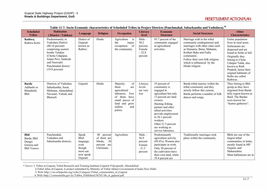
Gujarat State Highway Project (GSHP) - II Roads & Buildings Department, GoG
RESETTLEMENT ACTION PLAN
11-7
Table 11-7: Socio-Economic characteristics of Scheduled Tribes in Project Districts (Panchmahal, Sabarkantha and Vadodara).36 Scheduled
Tribes Habitation
( District / Talukas) Language Religion Occupation
Literacy level
Economic Structure
Social Structure Other
Characteristics
Rathwa, Rathwa Kolis
Predominantly in Vadodara District (80.16 percent) comprising eastern border Talukas (Chotta Udapipur, Jetpur Pavi, Sankeda and Naswadi) Panchmahal district (19.8 percent)
Dialect of Gujarati known as Rathwi.
Hindu Agriculture is the major occupation of the community.
Male – 50.2 percent, Female – 22.8 percent
95.7 percent of the community engaged in agricultural activities.
Marriage with in the tribal community (endogamous) and marriages with other clans such as Hamania, Baria, Mahania, Kothari Baka and Fadia community. Follow their own folk religion, which is influenced by the Hindu religion
Entire population lives in rural areas. Settlements are dispersed and are found in fields or hill. Originally they belong to Chota Udaipur Taluk, also known as Rath Pradesh, hence their original habitants of Raths are called Rathwas .
Barda Adibashi or Khandeshi Bhil
Districts of Vadodara Sabarkantha, Surat, Mehsana, Ahmedabad, Navasari, Valsad, and Bharuch
Gujarati Hindu Majority of them are agricultural labourers. Few of them have small pieces of land and grow millets and pulses.
Literacy levels are very low
35 percent of community is engaged in agriculture but only 13 percent are land owners. Hunting fishing pasture and other allied activities provide employment to 26.1 percent workers. Other 21.5 percent are working as service labourers.
Barda tribal marries within the tribal community and they strictly follow this custom. Barda performs a number of folk dances and songs.
They belong to Bhil group as they have migrated from Barda hilly region known as Bard. The Bardas were known for “hunter gatherers”.
Bhil Barda, Bhil Dungri Garasia and Bhil Vasava
Panchmahal, Vadodara and Sabarkantha districts.
Speak Bhili language, even though most can now speak Gujarati
80 percent of them are Hindu, 20 percent are Christians.
Agriculture Male – 56.9 percent Female –31.3 percent
Predominantly agriculture activity (89.4%), Women also participate in work. Only 50 percent of the cultivators have their own land, while 39.4 percent are
Traditionally marriages took place within the community.
Bhils are one of the largest tribal communities in India, mostly found in MP Gujarat, and Maharashtra. Main habitations are in
36 Source: 1. Tribes in Gujarat, Tribal Research and Training Institute Gujatrat Vidyapeeth, Ahemdabad 2.Tribal Atlas of Gujarat, A project submitted by Ministry of Tribal Affairs Government of India New Delhi 3. Web: http://en.wikipedia.org/wiki/Category:Tribal_communities_of_Gujarat 4. Web: http://censusindia.gov.in/Tables_Published/SCST/dh_st_gujarat.pdf
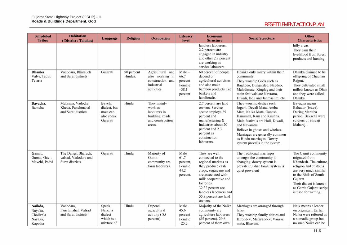
Gujarat State Highway Project (GSHP) - II Roads & Buildings Department, GoG
RESETTLEMENT ACTION PLAN
11-8
Scheduled Tribes
Habitation ( District / Talukas)
Language Religion Occupation Literacy
level Economic Structure
Social Structure Other
Characteristics
landless labourers, 2.2 percent are engaged in industry and other 2.8 percent are working as service labourers
hilly areas. They earn their livelihood from forest products and hunting.
Dhanka Valvi, Tadvi, Tetaria
Vadodara, Bharauch and Surat districts
Gujarati
90 percent Hindus.
Agricultural and also working in construction and industrial activities
Male – 66.7 percent Female –38.1 percent
60 percent of people depend on agricultural activities and also make bamboo products like baskets and handicrafts.
Dhanka only marry within their community. They worship Gods such as Baghdeo, Dungardeo, Nagdeo, Maladimate, Kinglag and their main festivals are Navratra, Diwali, Holi and Janmaslimi etc.
Dhanka claimed to be offspring of Chauhan Rajput. They cultivated small millets known as Dhan and they were called Dhanka.
Bavacha, Bamcha
Mehsana, Vadodra, Kheda, Panchmahal and Surat districts
Bavchi dialect, but most can also speak Gujarati
Hindu They mainly work as labourers in building, roads and construction areas.
2.7 percent are land owners. Service sector employs 25 percent and manufacturing & industries about 20 percent and 2.3 percent as construction labourers.
They worship deities such Jogani, Devali Mata, Amba Mata, Kalka Mata, Ganesh, Hanuman, Ram and Krishna. Main festivals are Holi, Diwali, and Navaratra. Believe in ghosts and witches. Marriages are generally common as Hindu marriages. Dowry system prevails in the system.
Bavacha means Bahadur (brave). During Maratha period, Bavacha were soldiers of Shivaji Maharaj.
Gamit, Gamta, Gavit Mavchi, Padvi
The Dangs, Bharuch, valsad, Vadodara and Surat districts
Gujarati Hindu Majority of Gamit community are farm labourers.
Male 61.7 percent, Female 44.2 percent.
They are well connected to the regional markets as they produce cash crops, sugarcane and are associated with milk cooperative and factories. 32.32 percent are landless labourers and 55.9 percent are land owners.
The traditional marriages amongst the community is changing, dowry system is prevalent, Ghar Jamai system is quiet prevalent
The Gamit community migrated from Khandesh. The culture, religion and customs are very much similar to the Bhils of South Gujarat. Their dialect is known as Gamit Gujarat script is used for writing.
Naikda, Nayaka, Cholivala Nayaka, Kapadia
Vadodara, Panchmahal, Valsad and Surat districts
Speak Naiki, a dialect which is a mixture of
Hindu Depend agricultural activity ( 85 percent)
Male – 45.6 percent Female –25.2
Majority of the Naika community are agriculture labourers (85 percent). 29.6 percent of them own
Marriages are arranged through talks. They worship family deities and Hirondev, Marryandev, Vanzari mata, Bhavani.
Naik means a leader on organizer. Earlier Naika were referred as a nomadic group but no such Naika can be
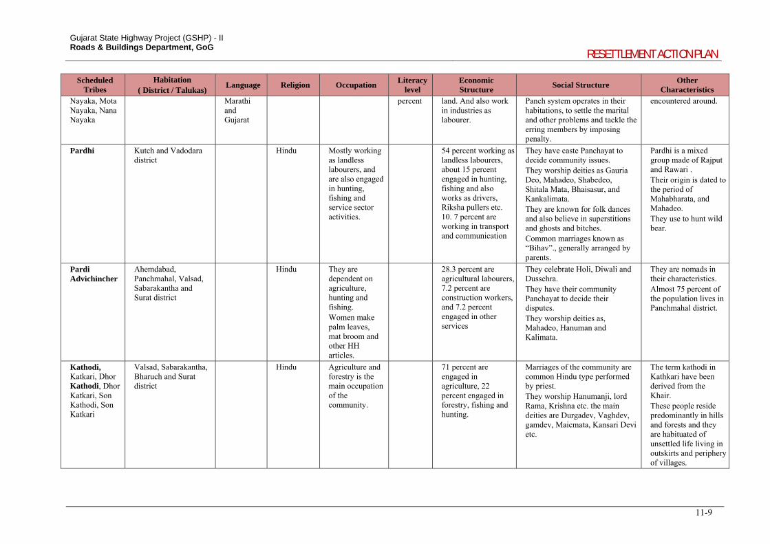
Gujarat State Highway Project (GSHP) - II Roads & Buildings Department, GoG
RESETTLEMENT ACTION PLAN
11-9
Scheduled Tribes
Habitation ( District / Talukas)
Language Religion Occupation Literacy
level Economic Structure
Social Structure Other
Characteristics Nayaka, Mota Nayaka, Nana Nayaka
Marathi and Gujarat
percent land. And also work in industries as labourer.
Panch system operates in their habitations, to settle the marital and other problems and tackle the erring members by imposing penalty.
encountered around.
Pardhi Kutch and Vadodara district
Hindu Mostly working as landless labourers, and are also engaged in hunting, fishing and service sector activities.
54 percent working as landless labourers, about 15 percent engaged in hunting, fishing and also works as drivers, Riksha pullers etc. 10. 7 percent are working in transport and communication
They have caste Panchayat to decide community issues. They worship deities as Gauria Deo, Mahadeo, Shabedeo, Shitala Mata, Bhaisasur, and Kankalimata. They are known for folk dances and also believe in superstitions and ghosts and bitches. Common marriages known as “Bihav”., generally arranged by parents.
Pardhi is a mixed group made of Rajput and Rawari . Their origin is dated to the period of Mahabharata, and Mahadeo. They use to hunt wild bear.
Pardi Advichincher
Ahemdabad, Panchmahal, Valsad, Sabarakantha and Surat district
Hindu They are dependent on agriculture, hunting and fishing. Women make palm leaves, mat broom and other HH articles.
28.3 percent are agricultural labourers, 7.2 percent are construction workers, and 7.2 percent engaged in other services
They celebrate Holi, Diwali and Dussehra. They have their community Panchayat to decide their disputes. They worship deities as, Mahadeo, Hanuman and Kalimata.
They are nomads in their characteristics. Almost 75 percent of the population lives in Panchmahal district.
Kathodi, Katkari, Dhor Kathodi, Dhor Katkari, Son Kathodi, Son Katkari
Valsad, Sabarakantha, Bharuch and Surat district
Hindu Agriculture and forestry is the main occupation of the community.
71 percent are engaged in agriculture, 22 percent engaged in forestry, fishing and hunting.
Marriages of the community are common Hindu type performed by priest. They worship Hanumanji, lord Rama, Krishna etc. the main deities are Durgadev, Vaghdev, gamdev, Maicmata, Kansari Devi etc.
The term kathodi in Kathkari have been derived from the Khair. These people reside predominantly in hills and forests and they are habituated of unsettled life living in outskirts and periphery of villages.
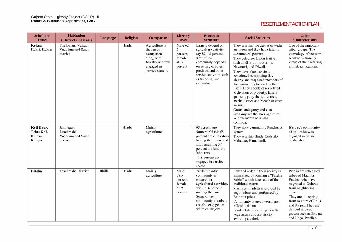
Gujarat State Highway Project (GSHP) - II Roads & Buildings Department, GoG
RESETTLEMENT ACTION PLAN
11-10
Scheduled Tribes
Habitation ( District / Talukas)
Language Religion Occupation Literacy
level Economic Structure
Social Structure Other
Characteristics
Kokna, Kokni, Kukna
The Dangs, Valsad, Vadodara and Surat district
Hindu Agriculture is the major occupation along with forestry and few engaged in service sectors.
Male 62. 6 percent, female 40.3 percent.
Largely depend on agriculture activity say 87. 13 percent. Rest of the community depends on selling of forest products and other service activities such as tailoring, and carpentry
They worship the deities of wider pantheon and they have faith in supernatural powers. They celebrate Hindu festival such as Shivratri, dussehra, Navaratri, and Diwali. They have Panch system constituted comprising five elderly and respected members of the community headed by the Patel. They decide cases related to division of property, family quarrels, petty theft, divorces, marital issues and breach of caste norms. Group endogamy and clan exogamy are the marriage rules. Widow marriage is also common.
One of the important tribal groups. The etymology of the term Konkna is from by virtue of their wearing armlet, i.e. Kankan.
Koli Dhor, Tokre Koli, Kolcha, Kolgha
Jamnagar, Panchmahal, Vadodara and Surat district
Hindu Mainly agriculture
95 percent are farmers. Of this 58 percent are cultivators having their own land and remaining 37 percent are landless labourers. 11.8 percent are engaged in service sector
They have community Panchayat system. They worship Hindu Gods like Mahadeo, Hanumanji.
It’s a sub community of koli, who were engaged in animal husbandry.
Patelia Panchmahal district Bhilli Hindu Mainly agriculture
Male 78.5 percent, female 45.9 percent.
Predominantly community is engaged in agricultural activities, with 80.6 percent owning the land. Some of the community members are also engaged in white collar jobs.
Law and order in their society is maintained by forming a “Patelia Sabha” which takes care of the traditional norms. Marriage in adults is decided by negotiations and performed by Brahmin priest. Community is great worshipper of lord Krishna. Food habits: they are generally vegetarians and are strictly avoiding alcohol.
Patelia are scheduled tribes of Madhya Pradesh who have migrated to Gujarat from neighboring areas. They are out spring from mixture of Bhils and Rajput. They are divided into sub groups such as Bhagat and Nagal Patelias.
Gujarat State Highway Project (GSHP) - II Roads & Buildings Department, GoG RESETTLEMENT ACTION PLAN
11-11
11.6. ONGOING TRIBAL DEVELOPMENT PROGRAMMES, GOG
11.6.1. Vanbandhu Kalyan Yojana
168. A comprehensive tribal development programme was initiated by the Government of Gujarat, termed as Vanbandhu Kalyan Yojana or Chief Minister’s ten-point programme. The programme was launched in 2007 and aims at ensuring high quality social and civil infrastructure and sustainable employment such that the income of every tribal family doubles in five years. The programme also envisions mainstreaming of primitive tribal groups (PTGs), quality education and access to quality health services, own house for each tribal family, safe drinking water, basic facility such as roads, bus-stand and energy network, development of tribal towns, opportunity for irrigated farming and skill development and civic amenities for migrant tribal families. The programme covers 43 ITDP Talukas. The ten-point programmes set forth to fulfil the vision of:
Employment opportunities for 5 lakh families; Quality of education and higher education; Economic development; Health; Housing; Safe drinking water; Irrigation; Universal electrification; All-weather road connectivity; and Urban development.
11.6.2. Agriculture Diversification Project for Tribal Areas of Gujarat
169. The project is initiated for the development of 43 ITDP Talukas of Gujarat, under the flagship programme of Vanbandhu Kalyan Yojana. The aim of the project is to bring out changes in agricultural practices in the areas so that farmers can get better returns from land. It has the following objectives:
170. Introducing improved agricultural practices to the small and marginal framers in tribal areas.
Doubling the income from land related activities and its sustenance for at least one generation. Ensuring sustainable and commercially viable involvement of the private sector.
171. The state Government is providing subsidized inputs and services resulting significant growth in these areas. Key features of the project are as follows:
Involvement of private sector for efficient delivery of schemes. The private sector agency selects a Taluka and decides on the crops in consultation with small and marginal farmer community considering the specific geographical conditions.
An individual project covers up to 5000 poor families in a Taluka. Non-poor families are also covered though they are not entitled to receive new subsidy.
Project covers an area of 500 acres of land designed in a cluster form. Project identifies and trains participating families and covers various components such as land development, seed
preparation, providing inputs, irrigation facilities, nurturing orchards, harvesting support, post-harvest transportation and storage facility, linkage with market and developing infrastructure.
Farming of horticulture crops with track records of suitability for the areas and exotic crops that have potential for growth in the area according to geographic conditions is envisaged
Project covers all the BPL families.
11.6.3. New Gujarat Pattern of Financial Allocation
172. This programme was initiated in 1997 with a view to ensure participation of the tribal population in the development process. Under this programme, discretionary funds are allocated to every ITDP district for de-centralised planning. The funds are to be used for framing programmes and schemes that are suited to local needs and as a bridge the gaps in existing schemes. Additionally, these funds are intended for economic development and creation of local infrastructure.
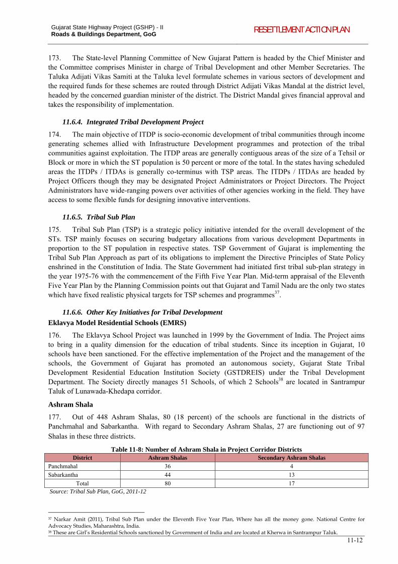
Gujarat State Highway Project (GSHP) - II Roads & Buildings Department, GoG RESETTLEMENT ACTION PLAN
11-12
173. The State-level Planning Committee of New Gujarat Pattern is headed by the Chief Minister and the Committee comprises Minister in charge of Tribal Development and other Member Secretaries. The Taluka Adijati Vikas Samiti at the Taluka level formulate schemes in various sectors of development and the required funds for these schemes are routed through District Adijati Vikas Mandal at the district level, headed by the concerned guardian minister of the district. The District Mandal gives financial approval and takes the responsibility of implementation.
11.6.4. Integrated Tribal Development Project
174. The main objective of ITDP is socio-economic development of tribal communities through income generating schemes allied with Infrastructure Development programmes and protection of the tribal communities against exploitation. The ITDP areas are generally contiguous areas of the size of a Tehsil or Block or more in which the ST population is 50 percent or more of the total. In the states having scheduled areas the ITDPs / ITDAs is generally co-terminus with TSP areas. The ITDPs / ITDAs are headed by Project Officers though they may be designated Project Administrators or Project Directors. The Project Administrators have wide-ranging powers over activities of other agencies working in the field. They have access to some flexible funds for designing innovative interventions.
11.6.5. Tribal Sub Plan
175. Tribal Sub Plan (TSP) is a strategic policy initiative intended for the overall development of the STs. TSP mainly focuses on securing budgetary allocations from various development Departments in proportion to the ST population in respective states. TSP Government of Gujarat is implementing the Tribal Sub Plan Approach as part of its obligations to implement the Directive Principles of State Policy enshrined in the Constitution of India. The State Government had initiated first tribal sub-plan strategy in the year 1975-76 with the commencement of the Fifth Five Year Plan. Mid-term appraisal of the Eleventh Five Year Plan by the Planning Commission points out that Gujarat and Tamil Nadu are the only two states which have fixed realistic physical targets for TSP schemes and programmes37.
11.6.6. Other Key Initiatives for Tribal Development
Eklavya Model Residential Schools (EMRS)
176. The Eklavya School Project was launched in 1999 by the Government of India. The Project aims to bring in a quality dimension for the education of tribal students. Since its inception in Gujarat, 10 schools have been sanctioned. For the effective implementation of the Project and the management of the schools, the Government of Gujarat has promoted an autonomous society, Gujarat State Tribal Development Residential Education Institution Society (GSTDREIS) under the Tribal Development Department. The Society directly manages 51 Schools, of which 2 Schools38 are located in Santrampur Taluk of Lunawada-Khedapa corridor.
Ashram Shala
177. Out of 448 Ashram Shalas, 80 (18 percent) of the schools are functional in the districts of Panchmahal and Sabarkantha. With regard to Secondary Ashram Shalas, 27 are functioning out of 97 Shalas in these three districts.
Table 11-8: Number of Ashram Shala in Project Corridor Districts District Ashram Shalas Secondary Ashram Shalas
Panchmahal 36 4
Sabarkantha 44 13
Total 80 17 Source: Tribal Sub Plan, GoG, 2011-12
37 Narkar Amit (2011), Tribal Sub Plan under the Eleventh Five Year Plan, Where has all the money gone. National Centre for Advocacy Studies, Maharashtra, India. 38 These are Girl’s Residential Schools sanctioned by Government of India and are located at Kherwa in Santrampur Taluk.
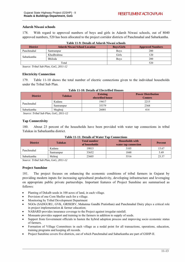
Gujarat State Highway Project (GSHP) - II Roads & Buildings Department, GoG RESETTLEMENT ACTION PLAN
11-13
Adarsh Niwasi schools
178. With regard to approved numbers of boys and girls in Adarsh Niwasi schools, out of 8040 approved numbers, 520 has been allocated to the project corridor districts of Panchmahal and Sabarkantha.
Table 11-9: Details of Adarsh Niwasi schools District Adarsh Niwasi School Location Boys/Girls Approved Numbers
Panchmahal Santrampur Boys 200
Sabarkantha Khedbrahma Girls 120
Bhiloda Boys 200
Total 520 Source: Tribal Sub Plan, GoG, 2011-12 Electricity Connection
179. Table 11-10 shows the total number of electric connections given to the individual households under the Tribal Sub Plan.
Table 11-10: Details of Electrified Houses
District Talukas Existing
electrified house Power Distribution
Centers
Panchmahal Kadana 19417 2215
Santrampur 35379 2368
Sabarkantha Meghraj 26001 414 Source: Tribal Sub Plan, GoG, 2011-12 Tap Connectivity
180. About 23 percent of the households have been provided with water tap connections in tribal Talukas in Sabarkantha district.
Table 11-11: Details of Water Tap Connections
District Talukas Total number of households
Households with water tap connection
Percent
Panchmahal Kadana 19815 3105 15.67
Santrampur 33652 1848 5.49
Sabarkantha Mehraj 23605 5516 23.37 Source: Tribal Sub Plan, GoG, 2011-12 Project Sunshine
181. The project focuses on enhancing the economic conditions of tribal farmers in Gujarat by providing modern inputs for increasing agricultural productivity, developing infrastructure and leveraging on appropriate public private partnerships. Important features of Project Sunshine are summarised as follows:
Planting of Dekalb seeds in 100 acres of land, in each village. Provision of one Corn Sheller each for a village. Monitoring by Tribal Development Department NGOs (SADGURU, GVK, GRISERV, Mahatma Gandhi Pratisthan) and Panchmahal Dairy plays a critical role
in project implementation & farmer education; NABARD provides insurance coverage to the Project against irregular rainfall. Monsanto provides support and training to the farmers in addition to supply of seeds. Support from Government officials to hasten the hybrid adoption process and improving socio economic status
of farmers. Formation of Village Committees in each village as a nodal point for all transactions, operations, education,
training programs and keeping all records. Project Sunshine covers five districts, out of which Panchmahal and Sabarkantha are part of GSHP-II.
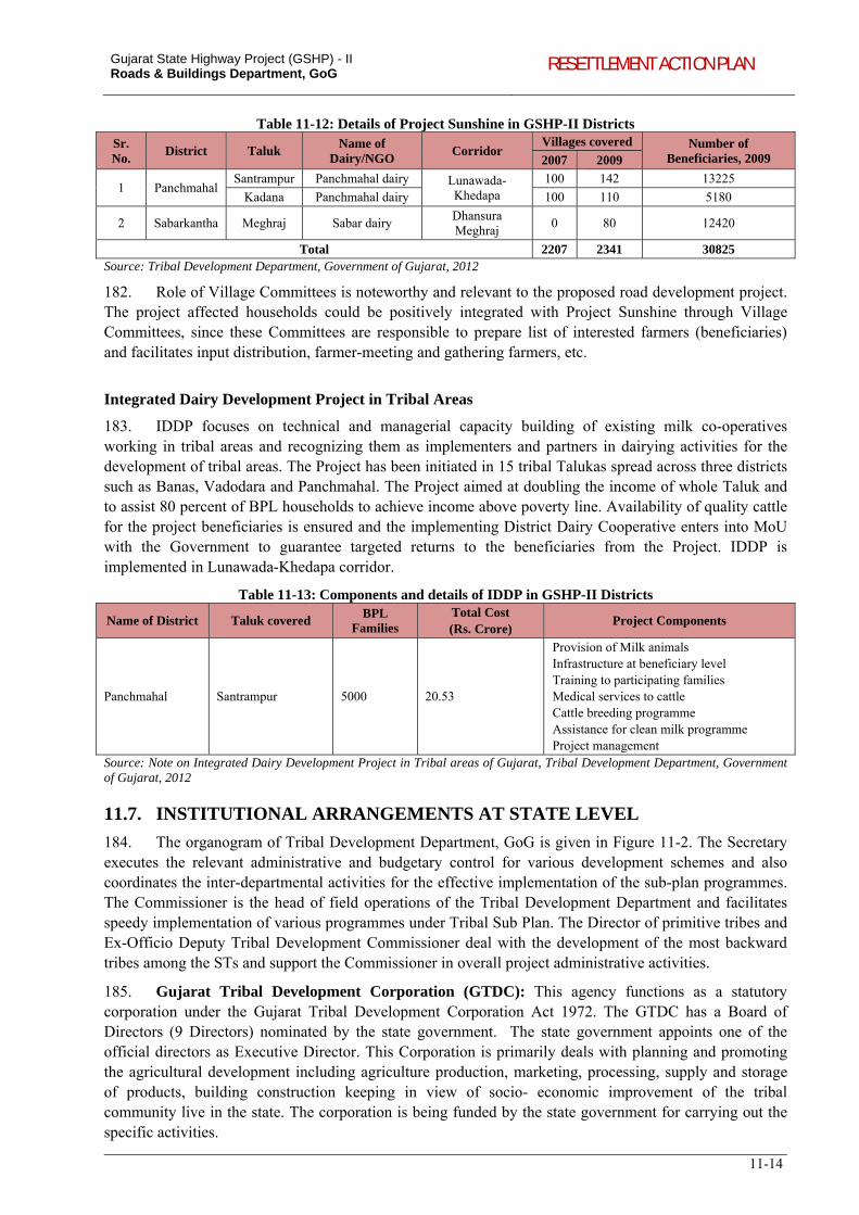
Gujarat State Highway Project (GSHP) - II Roads & Buildings Department, GoG RESETTLEMENT ACTION PLAN
11-14
Table 11-12: Details of Project Sunshine in GSHP-II Districts Sr. No.
District Taluk Name of
Dairy/NGO Corridor
Villages covered Number of Beneficiaries, 2009 2007 2009
1 Panchmahal Santrampur Panchmahal dairy Lunawada-
Khedapa 100 142 13225
Kadana Panchmahal dairy 100 110 5180
2 Sabarkantha Meghraj Sabar dairy Dhansura Meghraj
0 80 12420
Total 2207 2341 30825 Source: Tribal Development Department, Government of Gujarat, 2012
182. Role of Village Committees is noteworthy and relevant to the proposed road development project. The project affected households could be positively integrated with Project Sunshine through Village Committees, since these Committees are responsible to prepare list of interested farmers (beneficiaries) and facilitates input distribution, farmer-meeting and gathering farmers, etc.
Integrated Dairy Development Project in Tribal Areas
183. IDDP focuses on technical and managerial capacity building of existing milk co-operatives working in tribal areas and recognizing them as implementers and partners in dairying activities for the development of tribal areas. The Project has been initiated in 15 tribal Talukas spread across three districts such as Banas, Vadodara and Panchmahal. The Project aimed at doubling the income of whole Taluk and to assist 80 percent of BPL households to achieve income above poverty line. Availability of quality cattle for the project beneficiaries is ensured and the implementing District Dairy Cooperative enters into MoU with the Government to guarantee targeted returns to the beneficiaries from the Project. IDDP is implemented in Lunawada-Khedapa corridor.
Table 11-13: Components and details of IDDP in GSHP-II Districts
Name of District Taluk covered BPL
Families Total Cost (Rs. Crore)
Project Components
Panchmahal Santrampur 5000 20.53
Provision of Milk animals Infrastructure at beneficiary level Training to participating families Medical services to cattle Cattle breeding programme Assistance for clean milk programme Project management
Source: Note on Integrated Dairy Development Project in Tribal areas of Gujarat, Tribal Development Department, Government of Gujarat, 2012
11.7. INSTITUTIONAL ARRANGEMENTS AT STATE LEVEL
184. The organogram of Tribal Development Department, GoG is given in Figure 11-2. The Secretary executes the relevant administrative and budgetary control for various development schemes and also coordinates the inter-departmental activities for the effective implementation of the sub-plan programmes. The Commissioner is the head of field operations of the Tribal Development Department and facilitates speedy implementation of various programmes under Tribal Sub Plan. The Director of primitive tribes and Ex-Officio Deputy Tribal Development Commissioner deal with the development of the most backward tribes among the STs and support the Commissioner in overall project administrative activities.
185. Gujarat Tribal Development Corporation (GTDC): This agency functions as a statutory corporation under the Gujarat Tribal Development Corporation Act 1972. The GTDC has a Board of Directors (9 Directors) nominated by the state government. The state government appoints one of the official directors as Executive Director. This Corporation is primarily deals with planning and promoting the agricultural development including agriculture production, marketing, processing, supply and storage of products, building construction keeping in view of socio- economic improvement of the tribal community live in the state. The corporation is being funded by the state government for carrying out the specific activities.
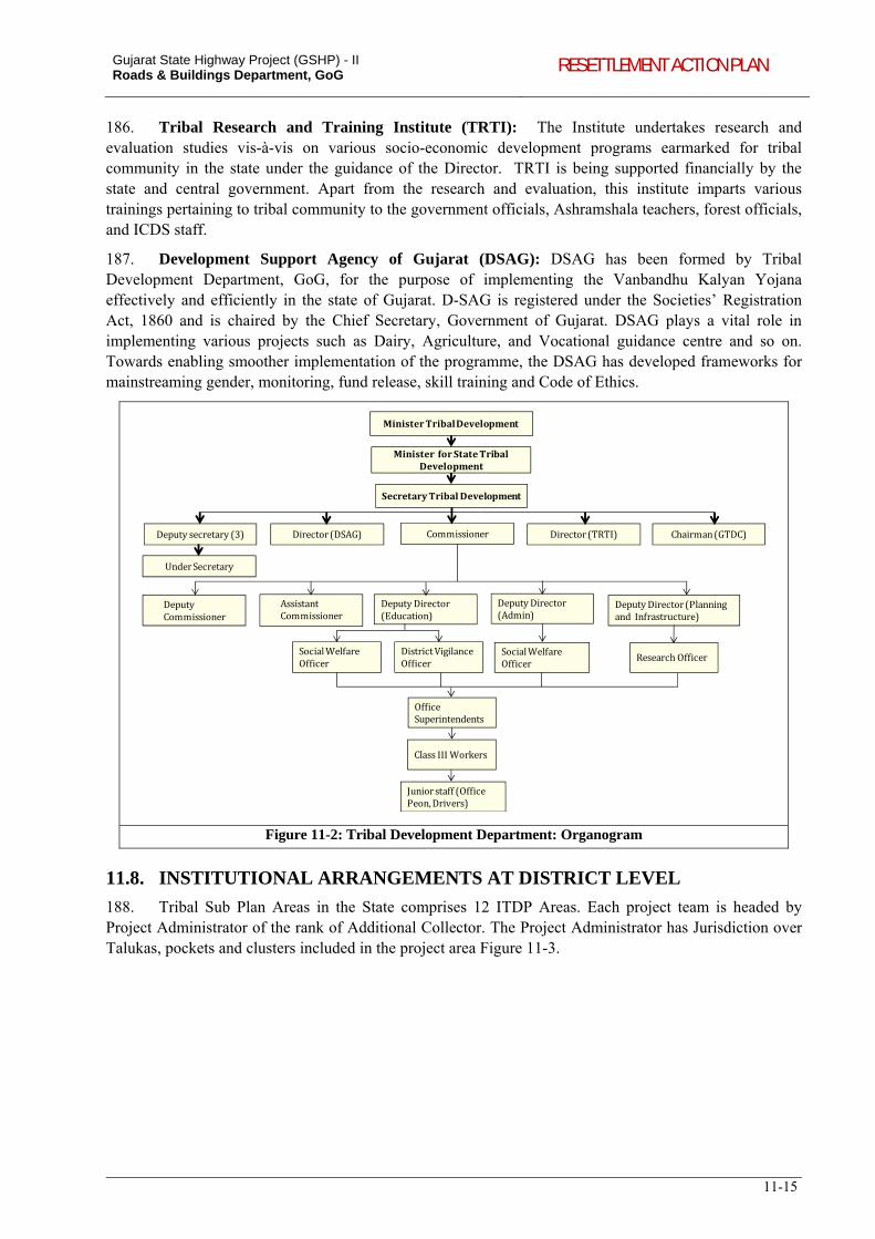
Gujarat State Highway Project (GSHP) - II Roads & Buildings Department, GoG RESETTLEMENT ACTION PLAN
11-15
186. Tribal Research and Training Institute (TRTI): The Institute undertakes research and evaluation studies vis-à-vis on various socio-economic development programs earmarked for tribal community in the state under the guidance of the Director. TRTI is being supported financially by the state and central government. Apart from the research and evaluation, this institute imparts various trainings pertaining to tribal community to the government officials, Ashramshala teachers, forest officials, and ICDS staff.
187. Development Support Agency of Gujarat (DSAG): DSAG has been formed by Tribal Development Department, GoG, for the purpose of implementing the Vanbandhu Kalyan Yojana effectively and efficiently in the state of Gujarat. D-SAG is registered under the Societies’ Registration Act, 1860 and is chaired by the Chief Secretary, Government of Gujarat. DSAG plays a vital role in implementing various projects such as Dairy, Agriculture, and Vocational guidance centre and so on. Towards enabling smoother implementation of the programme, the DSAG has developed frameworks for mainstreaming gender, monitoring, fund release, skill training and Code of Ethics.
MinisterTribalDevelopment
MinisterforStateTribalDevelopment
SecretaryTribalDevelopment
CommissionerDeputysecretary(3)
UnderSecretary
DeputyCommissioner
AssistantCommissioner
DeputyDirector(Admin)
DeputyDirector(Education)
DeputyDirector(PlanningandInfrastructure)
Director(DSAG) Director(TRTI) Chairman(GTDC)
SocialWelfareOfficer
SocialWelfareOfficer
DistrictVigilanceOfficer
ResearchOfficer
OfficeSuperintendents
ClassIIIWorkers
Juniorstaff(OfficePeon,Drivers)
Figure 11-2: Tribal Development Department: Organogram
11.8. INSTITUTIONAL ARRANGEMENTS AT DISTRICT LEVEL
188. Tribal Sub Plan Areas in the State comprises 12 ITDP Areas. Each project team is headed by Project Administrator of the rank of Additional Collector. The Project Administrator has Jurisdiction over Talukas, pockets and clusters included in the project area Figure 11-3.
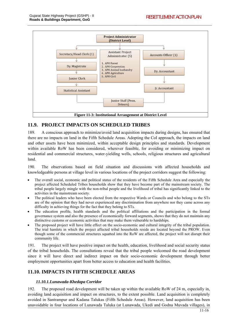
Gujarat State Highway Project (GSHP) - II Roads & Buildings Department, GoG RESETTLEMENT ACTION PLAN
11-16
Figure 11-3: Institutional Arrangement at District Level
11.9. PROJECT IMPACTS ON SCHEDULED TRIBES
189. A conscious approach to minimize/avoid land acquisition impacts during designs, has ensured that there are no impacts on land in the Fifth Schedule Areas. Adopting the CoI approach, the impacts on land and other assets have been minimized, within acceptable design principles and standards. Development within available RoW has been considered, wherever feasible, for avoiding or minimizing impact on residential and commercial structures, water-yielding wells, schools, religious structures and agricultural land.
190. The observations based on field situation and discussions with affected households and knowledgeable persons at village level in various locations of the project corridors suggest the following:
The overall social, economic and political status of the residents of the Fifth Schedule Area and especially the project affected Scheduled Tribes households show that they have become part of the mainstream society. The tribal people largely mingle with the non-tribal people and the livelihood of tribal has significantly linked to the activities in the mainstream society.
The political leaders who have been elected from the respective Wards or Councils and who belong to the STs are of the opinion that they had never experienced any discrimination from anywhere nor they came across any difficulty in achieving things for the fact that they belong to STs.
The education profile, health standards and the political affiliations and the participation in the formal governance system and also the presence of economically forward segments, shows that they do not maintain any distinctive customs or economic activities that may make them vulnerable to hardships.
The proposed project will have little effect on the socio-economic and cultural integrity of the tribal population. The trial hamlets in which the project affected tribal households reside are located beyond the PROW. Even though some of the commercial structures squatted into the RoW are affected, the project will not disrupt their community life.
191. The project will have positive impact on the health, education, livelihood and social security status of the tribal households. The consultations reveal that the tribal people welcomed the road development since it will have direct and indirect impact on their socio-economic development through better employment opportunities apart from better access to education and health facilities.
11.10. IMPACTS IN FIFTH SCHEDULE AREAS
11.10.1. Lunawada-Khedapa Corridor
192. The proposed road development will be taken up within the available RoW of 24 m, especially in, avoiding land acquisition and impact on structures, to the extent possible. Land acquisition is completely avoided in Santrampur and Kadana Talukas (Fifth Schedule Areas). However, land acquisition has been unavoidable in four locations of Lunawada Taluka (at Lunawada, Ukedi and Godna Muvada villages), in
Gujarat State Highway Project (GSHP) - II Roads & Buildings Department, GoG RESETTLEMENT ACTION PLAN
11-17
view of curve improvements. While there is no land acquisition in the Scheduled Area, 4 shops will be affected which are located alongside the road within Santrampur Taluka. All the 4 affected units are owned/operated by non-tribal PAPs.
11.10.2. Dhansura-Meghraj Corridor
193. The design for the proposed corridor has been worked out within the available RoW of 24 m to minimize land acquisition and resettlement impacts. The impact on land has been fully avoided in Meghraj Taluka. The proposed road development will not affect any properties belonging STs residing within Meghraj Taluka. One hand pump located at km 79+025 in Meghraj Taluka will be affected.
11.10.3. Dabhoi-Bodeli Corridor
194. 3 shops belonging to ST households and 10 shops owned by non-ST households in Sankheda Taluka will be affected. The designs have been worked out within the available RoW of 30 m. The impact on land has been fully avoided throughout the corridor.
11.11. IMPACTS ON FOREST RIGHTS AND ACCESS TO RESOURCES
195. As per Forest Rights Act, 2006 the scheduled tribes have rights to use forest land for agricultural purposes, fishing in ponds located within forest areas, non-timber forest produces, grazing of cattle etc. The proposed improvements of the corridors will not affect any such rights of the tribal people as these are proposed within the available Right of Way. SIA and consultations carried out at various levels (state, district, Taluka and village level) in the Fifth Schedule Areas of Lunawada-Khedapa, Dhansura-Meghraj and Dabhoi-Bodeli reveal that the proposed road improvement will not affect any customary rights of the ST community residing in the villages of Santrampur, Kadana or Sankheda Taluka. The ST population in the Meghraj village39 is not concentrated in the project influence area. The consultations carried out with the community revealed that the ST population of Meghraj village is concentrated along the Shamlaji-Godhra corridor (SH-146), which is away from the proposed corridor and will not be influenced by the proposed improvement.
196. There are 51 villages located along the project corridor which is part of 4 Talukas (Santrampur, Kadana, Meghraj and Sankheda), of which 32 villages are part of Scheduled Area (Table 11-14). In line with the provisions of the FRA, 2006 – for each of the 32 tribal villages along the three corridors, R&BD is in the process of convening meetings of Gram Sabha, wherein resolutions according no-objection for felling of the trees / protected forests after confirmation that (i) there are no forest dwellers with traditional forest rights and (ii) there are no recognized forest rights of the ST communities.
Table 11-14: Scheduled Area and Forest Area along the Project Corridors CORRIDOR TALUK VILLAGES SCHEDULED AREA
LUNAWADA-KHEDAPA SANTRAMPUR
Khedaya Alias Prat √
Simaliya √
Batakwada √
Ukhreli √
Dotawada √
Sangawada √
Santrampur √
Kunda √
Malanpur √
Lalakpur √
Ranijini Padedi √
Hadani Sarsan √
Moti Sarsan √
Nani Sarsan √
39 Meghraj village in Meghraj Taluka is part of Fifth Schedule Area.
Gujarat State Highway Project (GSHP) - II Roads & Buildings Department, GoG RESETTLEMENT ACTION PLAN
11-18
CORRIDOR TALUK VILLAGES SCHEDULED AREA
Bhandara √
Godhar (West) √
Dhamotna Moyla √
Kanbina Moyla √
Manchod √
Rafai √
Barela √
Motikharsoli √
Ranani saran √
Bahediya √
KADANA Dahyapur √
DHANSURA-MEGHRAJ MEGHRAJ
Iploda -
Kamroda -
Jashvantpura -
Vasna -
Meghraj √
Prathipura -
DABHOI-BODELI SANKHEDA
Sankheda -
Kherva √
Zankharpura -
Salpura -
Bamroli -
Garol -
Bodeli -
Patna -
Pitha -
Kundi Tappe Bahada -
Dormar -
Suryaghoda -
Jojva -
Bhadrali √
Bhulvan √
Lotiya √
Ali Kherva -
Gola Gamdi √
Kunteshwar √
Manjrol -
TOTAL NUMBER OF VILLAGES 51 32 Source: LASA, 2012.
11.12. SOCIO-ECONOMIC CHARACTERISTICS OF ST HOUSEHOLDS
197. The overall profile of the tribal households in terms of their social engagements, economic standards and participation in elections and casting of vote, interaction with local governing bodies, etc., has been assessed. This was based on field observations, consultations with the community leaders, elected tribal members of the local self-government, and group discussions.
198. The 3 affected ST households have 10 family members, of which one member is illiterate and 4 members each have primary and high school level of education respectively and one person have higher secondary level of education. One affected household has a land holding area of 2 bigha and two others does not own any land. One affected person is handicapped.
Gujarat State Highway Project (GSHP) - II Roads & Buildings Department, GoG RESETTLEMENT ACTION PLAN
11-19
Table 11-15: Livelihood Options for affected ST Households
Corridor Household Land Holding Skills Possessed Monthly HH Income (Rs.)
Livelihood Option
Dabhoi-Bodeli Household-1 Nil Nil 2500 Business/trade
Household-2 Nil Nil 2000 Business/trade
Household-3 2 Bigha Nil 4500 Business/trade Source: LASA, 2012
199. The SIA approach to avoid/minimize impacts on tribal communities has ensured that the direct impacts on the tribal communities pertaining to land acquisition and resettlement are minimal. As a result, the Indigenous Peoples Development Plan which was prepared for the 3 project corridors pass through tribal taluks focused on consultations with the tribal communities and the institutions in the Scheduled Areas. These consultations have enabled garnering support and larger acceptance from the communities for the project, and also helped in identifying specific issues and concerns of the tribal communities, which were later integrated into the project designs. Further, given that the scale and extent of impacts on the tribal communities are almost insignificant, the institutional arrangements for the implementation of the resettlement provisions are adequate to handle the measures proposed in the IPDP.
12-1
12. GENDER DEVELOPMENT AND PLAN
12.1. STATE POLICY FOR EQUITY, GUJARAT
200. Gujarat is among the frontline states which have made progressive initiatives for the development of women. GoG has formulated a State Policy for Equity – Nari Gaurav Niti, in 2006. The Policy recognizes the contribution of women in the economic and industrial development of Gujarat. The Policy has set forth the following goals:
Creating an enabling environment for enjoyment of all human rights and fundamental freedom by women on equal basis with men in all spheres;
Shared responsibility for children and home; Mainstreaming gender perspective in the development process, policies and programmes; Strengthening participation of civil society, in particular women’ s groups, networks and organizations; Eradicate all forms of violence against women and girl child.
201. The Policy has adopted (i) gender planning – develop strategies that aim at providing equal opportunities for both women and men, (ii) gender sensitization – policy makers, programme managers and the civil society sensitization, (iii) gender mainstreaming – encourage equal participation in governance and decision-making processes, (iv) gender analysis and audit – systematically analyse impact of development policies and programmes in order to facilitate equitable socio-economic growth, and (v) gender convergence – promote convergence of programmes and schemes of various departments and organizations to address identified issues.
202. The following section presents demographic profile of female population, economic and political participation of women, health and quality of life, etc.
12.2. SEX RATIO
203. Comparing the sex ratio for state, the male-female sex ratio in Gujarat has declined from 934 in 1991 to 921 in 2001 which reflects the gender discrimination in the state including discrimination against the girl child. With respect to the project corridors, it is seen that the overall sex ratio for nine corridors is 920, (refer Table 3-2,chapter 3). Amongst this, the lower sex ratio (899) is observed in the villages along Dhandhuka-Dholera corridor. Altogether, 4 corridors40 have sex ratio below 922.
204. Juvenile sex ratio is amongst the major indicators for analysing the status of women41. Table 12-1 shows notable disproportion in male and female ratio across various corridors for the population below 6 years. The average juvenile sex ratio for 9 project corridors is 845. Corridors having low juvenile sex ratio than the average of nine corridors are Atkot-Gondal, Dhandhuka-Dholera and Mehsana Himatnagar. Lowest juvenile sex ratio is observed for Mehsana-Himatnagar.
Table 12-1: Juvenile Sex ratio in Project corridors, 2001 Sr. No. Corridors Sex ratio below 6 years of age
1 Dabhoi-Bodeli 862
2 Dhandhuka-Dholera 818
3 Atkot-Gondal 792
4 Dhandhuka-Paliyad 876
5 Mehsana-Himatnagar 776
6 Umreth Vasad (including Ladvel-Kapadvanj) 848
7 Bayad-Lunawada 863
8 Dhansura-Meghraj 851
9 Lunawada-Khedapa 885
Average 844
Source: Compiled from Primary Census Abstract, 2001
40 Dabhoi- Bodeli, Atkot Gondal, Dhandhuka Paliyad, Himatnagar Mehsana, and Umreth Vasad
41 Juvenile Sex Ratio is the sex ratio of population in age-group 0-6 years.
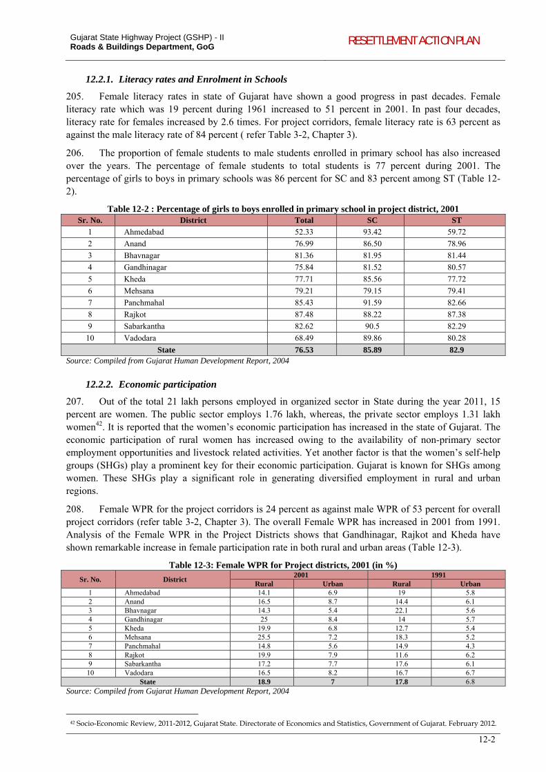
Gujarat State Highway Project (GSHP) - II Roads & Buildings Department, GoG RESETTLEMENT ACTION PLAN
12-2
12.2.1. Literacy rates and Enrolment in Schools
205. Female literacy rates in state of Gujarat have shown a good progress in past decades. Female literacy rate which was 19 percent during 1961 increased to 51 percent in 2001. In past four decades, literacy rate for females increased by 2.6 times. For project corridors, female literacy rate is 63 percent as against the male literacy rate of 84 percent ( refer Table 3-2, Chapter 3).
206. The proportion of female students to male students enrolled in primary school has also increased over the years. The percentage of female students to total students is 77 percent during 2001. The percentage of girls to boys in primary schools was 86 percent for SC and 83 percent among ST (Table 12-2).
Table 12-2 : Percentage of girls to boys enrolled in primary school in project district, 2001 Sr. No. District Total SC ST
1 Ahmedabad 52.33 93.42 59.72
2 Anand 76.99 86.50 78.96
3 Bhavnagar 81.36 81.95 81.44
4 Gandhinagar 75.84 81.52 80.57
5 Kheda 77.71 85.56 77.72
6 Mehsana 79.21 79.15 79.41
7 Panchmahal 85.43 91.59 82.66
8 Rajkot 87.48 88.22 87.38
9 Sabarkantha 82.62 90.5 82.29
10 Vadodara 68.49 89.86 80.28
State 76.53 85.89 82.9 Source: Compiled from Gujarat Human Development Report, 2004
12.2.2. Economic participation
207. Out of the total 21 lakh persons employed in organized sector in State during the year 2011, 15 percent are women. The public sector employs 1.76 lakh, whereas, the private sector employs 1.31 lakh women42. It is reported that the women’s economic participation has increased in the state of Gujarat. The economic participation of rural women has increased owing to the availability of non-primary sector employment opportunities and livestock related activities. Yet another factor is that the women’s self-help groups (SHGs) play a prominent key for their economic participation. Gujarat is known for SHGs among women. These SHGs play a significant role in generating diversified employment in rural and urban regions.
208. Female WPR for the project corridors is 24 percent as against male WPR of 53 percent for overall project corridors (refer table 3-2, Chapter 3). The overall Female WPR has increased in 2001 from 1991. Analysis of the Female WPR in the Project Districts shows that Gandhinagar, Rajkot and Kheda have shown remarkable increase in female participation rate in both rural and urban areas (Table 12-3).
Table 12-3: Female WPR for Project districts, 2001 (in %)
Sr. No. District 2001 1991
Rural Urban Rural Urban 1 Ahmedabad 14.1 6.9 19 5.8 2 Anand 16.5 8.7 14.4 6.1 3 Bhavnagar 14.3 5.4 22.1 5.6 4 Gandhinagar 25 8.4 14 5.7 5 Kheda 19.9 6.8 12.7 5.4 6 Mehsana 25.5 7.2 18.3 5.2 7 Panchmahal 14.8 5.6 14.9 4.3 8 Rajkot 19.9 7.9 11.6 6.2 9 Sabarkantha 17.2 7.7 17.6 6.1 10 Vadodara 16.5 8.2 16.7 6.7
State 18.9 7 17.8 6.8 Source: Compiled from Gujarat Human Development Report, 2004
42 Socio-Economic Review, 2011-2012, Gujarat State. Directorate of Economics and Statistics, Government of Gujarat. February 2012.
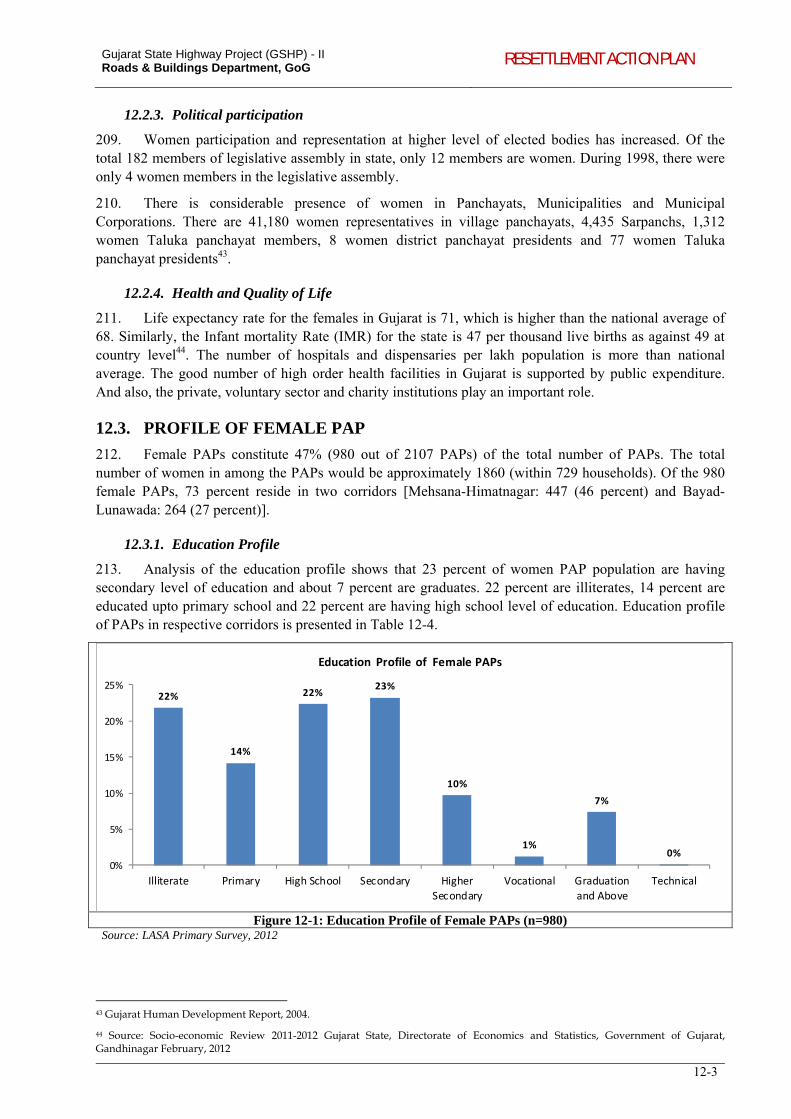
Gujarat State Highway Project (GSHP) - II Roads & Buildings Department, GoG RESETTLEMENT ACTION PLAN
12-3
12.2.3. Political participation
209. Women participation and representation at higher level of elected bodies has increased. Of the total 182 members of legislative assembly in state, only 12 members are women. During 1998, there were only 4 women members in the legislative assembly.
210. There is considerable presence of women in Panchayats, Municipalities and Municipal Corporations. There are 41,180 women representatives in village panchayats, 4,435 Sarpanchs, 1,312 women Taluka panchayat members, 8 women district panchayat presidents and 77 women Taluka panchayat presidents43.
12.2.4. Health and Quality of Life
211. Life expectancy rate for the females in Gujarat is 71, which is higher than the national average of 68. Similarly, the Infant mortality Rate (IMR) for the state is 47 per thousand live births as against 49 at country level44. The number of hospitals and dispensaries per lakh population is more than national average. The good number of high order health facilities in Gujarat is supported by public expenditure. And also, the private, voluntary sector and charity institutions play an important role.
12.3. PROFILE OF FEMALE PAP
212. Female PAPs constitute 47% (980 out of 2107 PAPs) of the total number of PAPs. The total number of women in among the PAPs would be approximately 1860 (within 729 households). Of the 980 female PAPs, 73 percent reside in two corridors [Mehsana-Himatnagar: 447 (46 percent) and Bayad-Lunawada: 264 (27 percent)].
12.3.1. Education Profile
213. Analysis of the education profile shows that 23 percent of women PAP population are having secondary level of education and about 7 percent are graduates. 22 percent are illiterates, 14 percent are educated upto primary school and 22 percent are having high school level of education. Education profile of PAPs in respective corridors is presented in Table 12-4.
22%
14%
22%23%
10%
1%
7%
0%0%
5%
10%
15%
20%
25%
Illiterate Primary High School Secondary Higher
Secondary
Vocational Graduation
and Above
Technical
Education Profile of Female PAPs
Figure 12-1: Education Profile of Female PAPs (n=980) Source: LASA Primary Survey, 2012
43 Gujarat Human Development Report, 2004.
44 Source: Socio-economic Review 2011-2012 Gujarat State, Directorate of Economics and Statistics, Government of Gujarat, Gandhinagar February, 2012
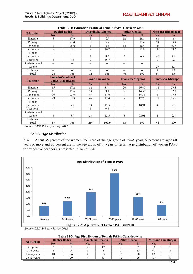
Gujarat State Highway Project (GSHP) - II Roads & Buildings Department, GoG RESETTLEMENT ACTION PLAN
12-4
Table 12-4: Education Profile of Female PAPs: Corridor-wise
Education Dabhoi-Bodeli Dhandhuka-Dholera Atkot-Gondal Mehsana-Himatnagar
No. % No. % No. % No. % Illiterate 5 17.9 3 25 12 26.1 65 14.5Primary 6 21.4 3 25 8 17.4 74 16.6
High School 7 25.0 1 8.3 14 30.4 115 25.7Secondary 9 32.1 2 16.7 9 19.6 115 25.7
Higher Secondary
-- -- 1 8.3 3 6.5 42 9.4
Vocational 1 3.6 2 16.7 -- -- 8 1.8Graduation and
Above -- -- -- -- -- --
27 6.0Technical -- -- -- -- -- -- 1 0.2
Total 28 100 12 100 46 100 447 100
Education Umreth-Vasad (incl. Ladvel-Kapadvanj)
Bayad-Lunawada Dhansura-Meghraj Lunawada-Khedapa
No. % No. % No. % No. % Illiterate 15 17.2 82 31.1 20 56.47 12 29.3 Primary 11 12.6 24 9.1 8 14.55 5 12.2
High School 20 23.0 45 17.0 9 16.36 8 19.5 Secondary 29 33.3 46 17.4 7 12.73 11 26.8
Higher Secondary 6 6.9 33 12.5 6 10.91 4 9.8 Vocational -- -- 1 0.4 -- -- -- --
Graduation and Above 6 6.9 33 12.5 5 9.091 1 2.4
Technical -- -- -- -- -- -- -- --Total 87 100 264 100.0 55 100 41 100
Source: LASA Primary Survey, 2012
12.3.2. Age Distribution
214. About 35 percent of the women PAPs are of the age group of 25-45 years, 9 percent are aged 60 years or more and 20 percent are in the age group of 14 years or lesser. Age distribution of women PAPs for respective corridors is presented in Table 12-4.
8%
12%
20%
35%
16%
9%
0%
5%
10%
15%
20%
25%
30%
35%
40%
< 6 years 6‐14 years 15‐24 years 25‐45 years 46‐60 years > 60 years
Age Distribution of Female PAPs
Figure 12-2: Age Profile of Female PAPs (n=980) Source: LASA Primary Survey, 2012
Table 12-5: Age Distribution of Female PAPs: Corridor-wise
Age Group Dabhoi-Bodeli Dhandhuka-Dholera Atkot-Gondal Mehsana-Himatnagar
No. % No. % No. % No. % < 6 years 2 7 2 17 3 7 33 7
6-14 years 4 14 1 8 7 15 60 13 15-24 years 10 36 4 33 13 28 83 19 25-45 years 8 29 4 33 12 26 177 40
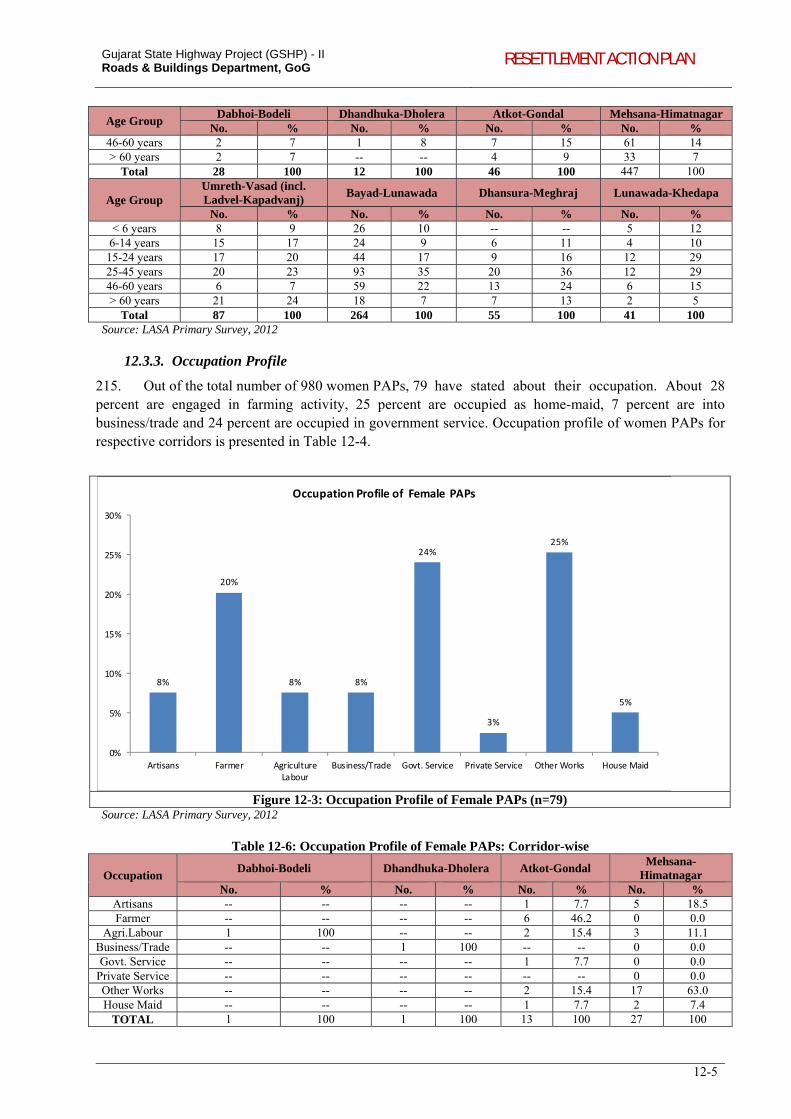
Gujarat State Highway Project (GSHP) - II Roads & Buildings Department, GoG RESETTLEMENT ACTION PLAN
12-5
Age Group Dabhoi-Bodeli Dhandhuka-Dholera Atkot-Gondal Mehsana-Himatnagar
No. % No. % No. % No. % 46-60 years 2 7 1 8 7 15 61 14 > 60 years 2 7 -- -- 4 9 33 7
Total 28 100 12 100 46 100 447 100
Age Group Umreth-Vasad (incl. Ladvel-Kapadvanj)
Bayad-Lunawada Dhansura-Meghraj Lunawada-Khedapa
No. % No. % No. % No. % < 6 years 8 9 26 10 -- -- 5 12
6-14 years 15 17 24 9 6 11 4 10 15-24 years 17 20 44 17 9 16 12 29 25-45 years 20 23 93 35 20 36 12 29 46-60 years 6 7 59 22 13 24 6 15 > 60 years 21 24 18 7 7 13 2 5
Total 87 100 264 100 55 100 41 100 Source: LASA Primary Survey, 2012
12.3.3. Occupation Profile
215. Out of the total number of 980 women PAPs, 79 have stated about their occupation. About 28 percent are engaged in farming activity, 25 percent are occupied as home-maid, 7 percent are into business/trade and 24 percent are occupied in government service. Occupation profile of women PAPs for respective corridors is presented in Table 12-4.
8%
20%
8% 8%
24%
3%
25%
5%
0%
5%
10%
15%
20%
25%
30%
Artisans Farmer AgricultureLabour
Business/Trade Govt. Service Private Service Other Works House Maid
Occupation Profile of Female PAPs
Figure 12-3: Occupation Profile of Female PAPs (n=79) Source: LASA Primary Survey, 2012
Table 12-6: Occupation Profile of Female PAPs: Corridor-wise
Occupation Dabhoi-Bodeli Dhandhuka-Dholera Atkot-Gondal
Mehsana-Himatnagar
No. % No. % No. % No. % Artisans -- -- -- -- 1 7.7 5 18.5Farmer -- -- -- -- 6 46.2 0 0.0
Agri.Labour 1 100 -- -- 2 15.4 3 11.1Business/Trade -- -- 1 100 -- -- 0 0.0 Govt. Service -- -- -- -- 1 7.7 0 0.0
Private Service -- -- -- -- -- -- 0 0.0Other Works -- -- -- -- 2 15.4 17 63.0 House Maid -- -- -- -- 1 7.7 2 7.4
TOTAL 1 100 1 100 13 100 27 100
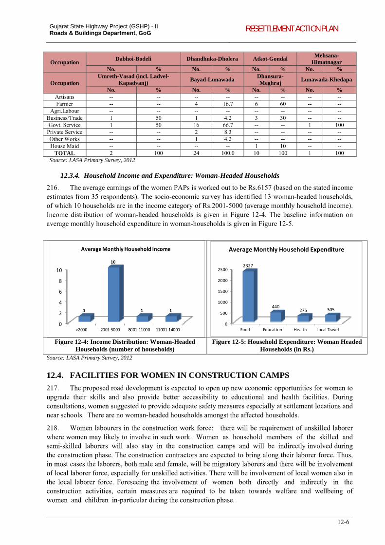
Gujarat State Highway Project (GSHP) - II Roads & Buildings Department, GoG RESETTLEMENT ACTION PLAN
12-6
Occupation Dabhoi-Bodeli Dhandhuka-Dholera Atkot-Gondal
Mehsana-Himatnagar
No. % No. % No. % No. %
Occupation Umreth-Vasad (incl. Ladvel-
Kapadvanj) Bayad-Lunawada
Dhansura-Meghraj
Lunawada-Khedapa
No. % No. % No. % No. % Artisans -- -- -- -- -- -- -- --Farmer -- -- 4 16.7 6 60 -- --
Agri.Labour -- -- -- -- -- -- -- --Business/Trade 1 50 1 4.2 3 30 -- --Govt. Service 1 50 16 66.7 -- -- 1 100
Private Service -- -- 2 8.3 -- -- -- --Other Works -- -- 1 4.2 -- -- -- --House Maid -- -- -- -- 1 10 -- --
TOTAL 2 100 24 100.0 10 100 1 100 Source: LASA Primary Survey, 2012
12.3.4. Household Income and Expenditure: Woman-Headed Households
216. The average earnings of the women PAPs is worked out to be Rs.6157 (based on the stated income estimates from 35 respondents). The socio-economic survey has identified 13 woman-headed households, of which 10 households are in the income category of Rs.2001-5000 (average monthly household income). Income distribution of woman-headed households is given in Figure 12-4. The baseline information on average monthly household expenditure in woman-households is given in Figure 12-5.
0
2
4
6
8
10
>2000 2001‐5000 8001‐11000 11001‐14000
1
10
1 1
Average Monthly Household Income
0
500
1000
1500
2000
2500
Food Education Health Local Travel
2327
440275 305
Average Monthly Household Expenditure
Figure 12-4: Income Distribution: Woman-Headed Households (number of households)
Figure 12-5: Household Expenditure: Woman Headed Households (in Rs.)
Source: LASA Primary Survey, 2012
12.4. FACILITIES FOR WOMEN IN CONSTRUCTION CAMPS
217. The proposed road development is expected to open up new economic opportunities for women to upgrade their skills and also provide better accessibility to educational and health facilities. During consultations, women suggested to provide adequate safety measures especially at settlement locations and near schools. There are no woman-headed households amongst the affected households.
218. Women labourers in the construction work force: there will be requirement of unskilled laborer where women may likely to involve in such work. Women as household members of the skilled and semi-skilled laborers will also stay in the construction camps and will be indirectly involved during the construction phase. The construction contractors are expected to bring along their laborer force. Thus, in most cases the laborers, both male and female, will be migratory laborers and there will be involvement of local laborer force, especially for unskilled activities. There will be involvement of local women also in the local laborer force. Foreseeing the involvement of women both directly and indirectly in the construction activities, certain measures are required to be taken towards welfare and wellbeing of women and children in-particular during the construction phase.
Gujarat State Highway Project (GSHP) - II Roads & Buildings Department, GoG RESETTLEMENT ACTION PLAN
12-7
219. For women working at the construction site and staying in the labour camps, the following facilities will be ensured:
temporary housing - during the construction the families of labourers/workers will be provided with the suitable accommodation and facilities for other civic requirements, particularly health and sanitation;
health centre - health problems of the female workers will be taken care of through health centres temporarily set up for the construction camp. These will provide medicines and minimum medical facilities to tackle first-aid requirements or minor accidental cases will be provided. Additional child care facilities /crèche will be ensured.
In addition, linkage to nearest higher medical care will be ensured whenever required. The contractor will arrange the visit of doctor, at least once in week, to provide required medical support to the workers in general and women in particular.
220. A strong vigilance mechanism will have to be developed by the contractor to ensure ceasing
abuses at work places. RAP implementing NGO will provide necessary support to check such exploitation.
Scheduling of working hours for women also needs to be regulated. Women, especially the mothers with
infants will be exempted from the night shifts and from prolonged working hours.
221. The Civil Works Contractor shall be responsible for the above interventions. The Social Specialist
at ESMU shall along with the contracted NGO facilitate the preferential provision of work opportunities to
those interested women. They shall be also responsible for internal monitoring of these interventions on a
periodic basis.
222. The budget for various facilities for women in construction camps as stated above have been
provision and included in the bid document [refer Clause 111 on Precautions for safeguarding the
environment, Technical Specifications in the Bid Document, which comply with (i) Factory Act 1948; (ii)
Building and Other Construction Act (Regulation of Employment and Conditions of Services) Act, 1996;
(iii) Contractor (Regulation and Abolition) Act, 1970] and respective Environmental Management Plans
(EMPs). The External Monitoring to be undertaken by the PMC shall also monitor the implementation of
these provisions based on suitably devised gender sensitive indictors.
13-1
13. ROAD SAFETY
13.1. INTRODUCTION
223. Road safety issues became the focal point of discussion in the consultations carried out with the communities along the project corridors. Apart from the consultations had with communities, comprehensive road safety audit has been undertaken during the project preparation stage. The audit included collection of accident data and black spot identification, geometric deficiencies, constrictions, town/village stretches and at all junctions and cross road locations for all the project corridors. The issues with respect to road safety were discussed with the Safety Audit Team and incorporated the same in project design. The strategy adopted to address the road safety issues in project corridors is as follows:
Outcome of Road Safety Audit of project corridors: These include (i) accident data collected from Police Department; (ii) safety issues related to design aspects – carriage-way, geometric design, intersection/junctions, CD structures, etc; (iii) traffic management and control issues along the corridor; (iv) suggestive interventions for identified road safety risks.
Road safety issues identified based on road-side consultations: These include (i) safety requirements for pedestrians at intersections; (ii) information regarding accidents at specific locations; (iii) potential safety hazards due to encroached built-up structures; (iv) road-side plantations with potential safety risks; and (v) safety requirements.
224. The approach to integrate road safety issues as part of the detailed designs preparation and the inputs provided by the SIA to incorporate road safety concerns is presented in Table 13-1.
Table 13-1: Activity Schedule and SIA inputs for Road Safety Steps Activity Social Impact Assessment inputs
I Collection of corridor geometric data through topographic surveys.
-
II Collection of Road inventory data. - III Finalising design standards and strategy to be used in
consultation with the Client. -
IV Carry out Road Safety Audit and finding gaps between safe road and present condition of corridors.
-
V Finalisation of design of typical section Screening level consultations and site visits to identify potential issues including hotspots, safety issues, cattle crossing locations etc.
VI Creation of complete roadway design Provide inputs based on Social Impact Assessment, towards design formulation with minimal impacts on land acquisition and resettlement, without compromising safety and design standards.
Horizontal alignment - Checking minimum radius - Super-elevation - Checking lateral clearance for the SSD - Avoiding broken back curve - Considering abutting property and its impact Vertical alignment - Maximum grades - Stopping Sight Distance/Head light sight distance - Strive to achieve minimum grades for drainage purposes - ditches and curb gutters - Providing minimum length of vertical curve - Balance cut and fill quantities
VII Side road design VIII Intersection design IX Other Design components In addition to the observations made by the Road safety
audit team, specific observations by the communities and stakeholders during consultations pertaining to provision of safety measures along the corridor have been incorporated in the designs. Such interventions include but not limited to: Locations for pedestrian/cattle crossing Protection measures around structures saved through design interventions, such as wells, shrines etc within the
Sidewalks ROB Vehicle under pass Pedestrian / cattle crossing Retaining Walls- where ever necessary Truck Lanes Bus bays Exclusive turn lanes
Gujarat State Highway Project (GSHP) - II Roads & Buildings Department, GoG RESETTLEMENT ACTION PLAN
13-2
Steps Activity Social Impact Assessment inputs Island Design RoW
Provision of retaining walls to minimize land uptake; Signages and mitigation measures (in form of protective barriers, footpaths, specific crossing points etc) around sensitive receivers, including schools, hospitals and other cultural properties.
Signal requirements / Cross walk locations Signage Landscaping elements
X Preparation of Plan and Profile drawing sets for the corridors
Incorporation of the safety measures in the drawings and designs
13.2. INTEGRATION OF ROAD SAFETY ISSUES IN DESIGN
225. Adopting the approach defined in Table 13-1, the following sections highlight how the findings of the consultations and field visits carried out during the SIA have formed inputs to the finalization of the safety provisions as part of the detailed designs. Integration of road safety issues into the design of Dabhoi-Bodeli corridor is given as an illustration. While the road safety audit formed the basis for the determination of the nature and type of safety provisions required at the individual location, the outcomes of the consultations formed useful inputs in confirming the need and justification for the provision. Similar efforts towards integration of road safety issues were made for all the project corridors and the corresponding measures designed and included in the final designs and the bid documents.
Table 13-2: Integration of Road Safety Issues into Project Design – An illustration
Project Corridor Design integration based on
Consultations during SIA Safety Audit Dabhoi-Bodeli Provision for lighting at
junctions. Speed control measures and
parking facilities near schools, hospitals, temples, etc.
Safety measures for cattle crossing. Curve improvement.
Design interventions at 6 major locations based on traffic accident data.
Interventions at identified locations based on inadequate shoulder width.
Removal of fixed concrete posts intended as guard stones but play as potential safety hazard.
Improvement of curve locations, intersections/ junctions and a level-crossing.
Improving the width and parapets of culverts. Safety interventions for 59 CD structures.
Warning signs for cart tracks and canal service road.
Specific safety interventions at 12 habitations (raised pedestrian crossing, rumble strips, traffic calming measures, zebra crossings, etc).
Signages at cattle crossing locations.
226. Table 13-3 presents the location of curves seeking safety interventions with respect to geometric design and traffic control measurements.
Table 13-3: Safety Interventions for Curves Incorporated in Final Design Existing Chainage
(km) Safety Aspects Incorporated in Final Design
029+700 Speed is restricted on this curve. Junction is designed properly near this curve. Warning signs are posted on both sides of the curve.
032+900 Warning sign are posted on both sides of the curve. 039+970 Warning sign are posted on both sides of the curve. 045+020 Warning sign are posted on both sides of the curve. 053+660 Warning sign are posted on both sides of the curve. 054+500 Warning sign are posted on both sides of the curve. 056+200 Warning sign are posted on both sides of the curve. 057+600 Warning sign are posted on both sides of the curve. 060+400 Warning sign are posted on both sides of the curve. 062+300 Warning sign are posted on both sides of the curve. 068+200 Warning sign are posted on both sides of the curve.
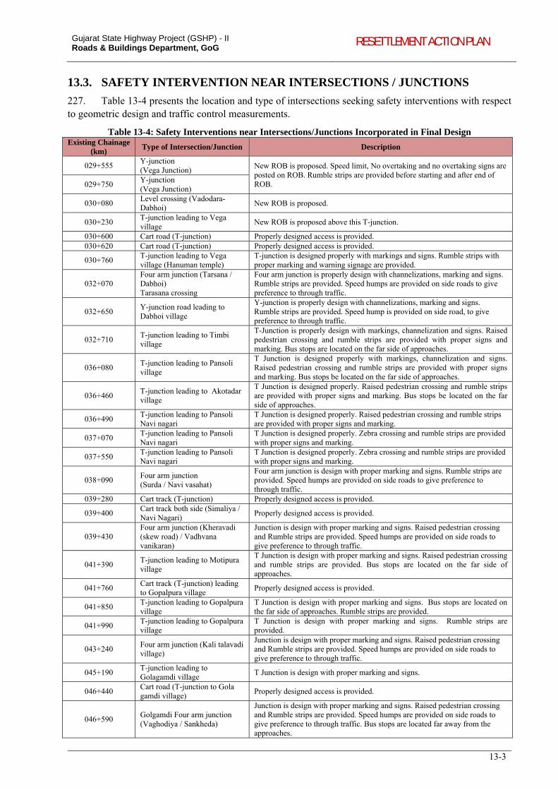
Gujarat State Highway Project (GSHP) - II Roads & Buildings Department, GoG RESETTLEMENT ACTION PLAN
13-3
13.3. SAFETY INTERVENTION NEAR INTERSECTIONS / JUNCTIONS
227. Table 13-4 presents the location and type of intersections seeking safety interventions with respect to geometric design and traffic control measurements.
Table 13-4: Safety Interventions near Intersections/Junctions Incorporated in Final Design Existing Chainage
(km) Type of Intersection/Junction Description
029+555 Y-junction (Vega Junction) New ROB is proposed. Speed limit, No overtaking and no overtaking signs are
posted on ROB. Rumble strips are provided before starting and after end of ROB. 029+750
Y-junction (Vega Junction)
030+080 Level crossing (Vadodara-Dabhoi)
New ROB is proposed.
030+230 T-junction leading to Vega village
New ROB is proposed above this T-junction.
030+600 Cart road (T-junction) Properly designed access is provided. 030+620 Cart road (T-junction) Properly designed access is provided.
030+760 T-junction leading to Vega village (Hanuman temple)
T-junction is designed properly with markings and signs. Rumble strips with proper marking and warning signage are provided.
032+070 Four arm junction (Tarsana / Dabhoi) Tarasana crossing
Four arm junction is properly design with channelizations, marking and signs. Rumble strips are provided. Speed humps are provided on side roads to give preference to through traffic.
032+650 Y-junction road leading to Dabhoi village
Y-junction is properly design with channelizations, marking and signs. Rumble strips are provided. Speed hump is provided on side road, to give preference to through traffic.
032+710 T-junction leading to Timbi village
T-Junction is properly design with markings, channelization and signs. Raised pedestrian crossing and rumble strips are provided with proper signs and marking. Bus stops are located on the far side of approaches.
036+080 T-junction leading to Pansoli village
T Junction is designed properly with markings, channelization and signs. Raised pedestrian crossing and rumble strips are provided with proper signs and marking. Bus stops be located on the far side of approaches.
036+460 T-junction leading to Akotadar village
T Junction is designed properly. Raised pedestrian crossing and rumble strips are provided with proper signs and marking. Bus stops be located on the far side of approaches.
036+490 T-junction leading to Pansoli Navi nagari
T Junction is designed properly. Raised pedestrian crossing and rumble strips are provided with proper signs and marking.
037+070 T-junction leading to Pansoli Navi nagari
T Junction is designed properly. Zebra crossing and rumble strips are provided with proper signs and marking.
037+550 T-junction leading to Pansoli Navi nagari
T Junction is designed properly. Zebra crossing and rumble strips are provided with proper signs and marking.
038+090 Four arm junction (Surda / Navi vasahat)
Four arm junction is design with proper marking and signs. Rumble strips are provided. Speed humps are provided on side roads to give preference to through traffic.
039+280 Cart track (T-junction) Properly designed access is provided.
039+400 Cart track both side (Simaliya / Navi Nagari)
Properly designed access is provided.
039+430 Four arm junction (Kheravadi (skew road) / Vadhvana vanikaran)
Junction is design with proper marking and signs. Raised pedestrian crossing and Rumble strips are provided. Speed humps are provided on side roads to give preference to through traffic.
041+390 T-junction leading to Motipura village
T Junction is design with proper marking and signs. Raised pedestrian crossing and rumble strips are provided. Bus stops are located on the far side of approaches.
041+760 Cart track (T-junction) leading to Gopalpura village
Properly designed access is provided.
041+850 T-junction leading to Gopalpura village
T Junction is design with proper marking and signs. Bus stops are located on the far side of approaches. Rumble strips are provided.
041+990 T-junction leading to Gopalpura village
T Junction is design with proper marking and signs. Rumble strips are provided.
043+240 Four arm junction (Kali talavadi village)
Junction is design with proper marking and signs. Raised pedestrian crossing and Rumble strips are provided. Speed humps are provided on side roads to give preference to through traffic.
045+190 T-junction leading to Golagamdi village
T Junction is design with proper marking and signs.
046+440 Cart road (T-junction to Gola gamdi village)
Properly designed access is provided.
046+590 Golgamdi Four arm junction (Vaghodiya / Sankheda)
Junction is design with proper marking and signs. Raised pedestrian crossing and Rumble strips are provided. Speed humps are provided on side roads to give preference to through traffic. Bus stops are located far away from the approaches.
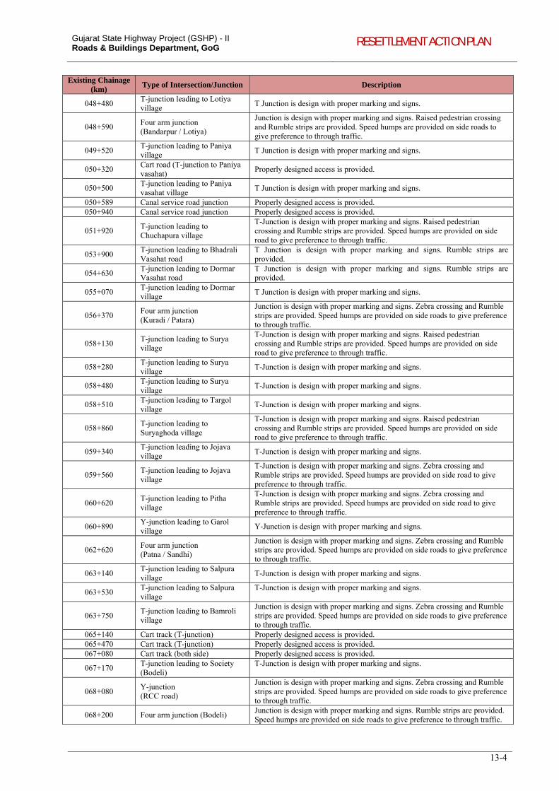
Gujarat State Highway Project (GSHP) - II Roads & Buildings Department, GoG RESETTLEMENT ACTION PLAN
13-4
Existing Chainage (km)
Type of Intersection/Junction Description
048+480 T-junction leading to Lotiya village
T Junction is design with proper marking and signs.
048+590 Four arm junction (Bandarpur / Lotiya)
Junction is design with proper marking and signs. Raised pedestrian crossing and Rumble strips are provided. Speed humps are provided on side roads to give preference to through traffic.
049+520 T-junction leading to Paniya village
T Junction is design with proper marking and signs.
050+320 Cart road (T-junction to Paniya vasahat)
Properly designed access is provided.
050+500 T-junction leading to Paniya vasahat village
T Junction is design with proper marking and signs.
050+589 Canal service road junction Properly designed access is provided. 050+940 Canal service road junction Properly designed access is provided.
051+920 T-junction leading to Chuchapura village
T-Junction is design with proper marking and signs. Raised pedestrian crossing and Rumble strips are provided. Speed humps are provided on side road to give preference to through traffic.
053+900 T-junction leading to Bhadrali Vasahat road
T Junction is design with proper marking and signs. Rumble strips are provided.
054+630 T-junction leading to Dormar Vasahat road
T Junction is design with proper marking and signs. Rumble strips are provided.
055+070 T-junction leading to Dormar village
T Junction is design with proper marking and signs.
056+370 Four arm junction (Kuradi / Patara)
Junction is design with proper marking and signs. Zebra crossing and Rumble strips are provided. Speed humps are provided on side roads to give preference to through traffic.
058+130 T-junction leading to Surya village
T-Junction is design with proper marking and signs. Raised pedestrian crossing and Rumble strips are provided. Speed humps are provided on side road to give preference to through traffic.
058+280 T-junction leading to Surya village
T-Junction is design with proper marking and signs.
058+480 T-junction leading to Surya village
T-Junction is design with proper marking and signs.
058+510 T-junction leading to Targol village
T-Junction is design with proper marking and signs.
058+860 T-junction leading to Suryaghoda village
T-Junction is design with proper marking and signs. Raised pedestrian crossing and Rumble strips are provided. Speed humps are provided on side road to give preference to through traffic.
059+340 T-junction leading to Jojava village
T-Junction is design with proper marking and signs.
059+560 T-junction leading to Jojava village
T-Junction is design with proper marking and signs. Zebra crossing and Rumble strips are provided. Speed humps are provided on side road to give preference to through traffic.
060+620 T-junction leading to Pitha village
T-Junction is design with proper marking and signs. Zebra crossing and Rumble strips are provided. Speed humps are provided on side road to give preference to through traffic.
060+890 Y-junction leading to Garol village
Y-Junction is design with proper marking and signs.
062+620 Four arm junction (Patna / Sandhi)
Junction is design with proper marking and signs. Zebra crossing and Rumble strips are provided. Speed humps are provided on side roads to give preference to through traffic.
063+140 T-junction leading to Salpura village
T-Junction is design with proper marking and signs.
063+530 T-junction leading to Salpura village
T-Junction is design with proper marking and signs.
063+750 T-junction leading to Bamroli village
Junction is design with proper marking and signs. Zebra crossing and Rumble strips are provided. Speed humps are provided on side roads to give preference to through traffic.
065+140 Cart track (T-junction) Properly designed access is provided. 065+470 Cart track (T-junction) Properly designed access is provided. 067+080 Cart track (both side) Properly designed access is provided.
067+170 T-junction leading to Society (Bodeli)
T-Junction is design with proper marking and signs.
068+080 Y-junction (RCC road)
Junction is design with proper marking and signs. Zebra crossing and Rumble strips are provided. Speed humps are provided on side roads to give preference to through traffic.
068+200 Four arm junction (Bodeli) Junction is design with proper marking and signs. Rumble strips are provided. Speed humps are provided on side roads to give preference to through traffic.
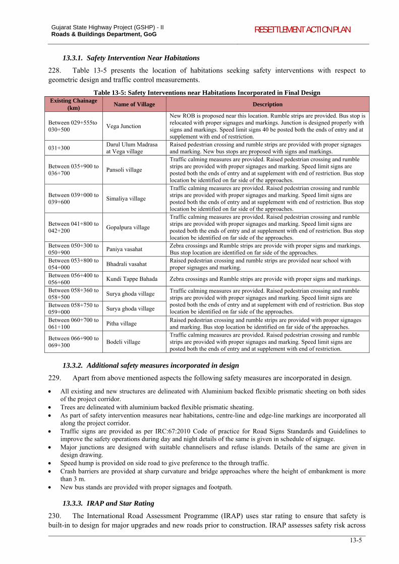
Gujarat State Highway Project (GSHP) - II Roads & Buildings Department, GoG RESETTLEMENT ACTION PLAN
13-5
13.3.1. Safety Intervention Near Habitations
228. Table 13-5 presents the location of habitations seeking safety interventions with respect to geometric design and traffic control measurements.
Table 13-5: Safety Interventions near Habitations Incorporated in Final Design Existing Chainage
(km) Name of Village Description
Between 029+555to 030+500
Vega Junction
New ROB is proposed near this location. Rumble strips are provided. Bus stop is relocated with proper signages and markings. Junction is designed properly with signs and markings. Speed limit signs 40 be posted both the ends of entry and at supplement with end of restriction.
031+300 Darul Ulum Madrasa at Vega village
Raised pedestrian crossing and rumble strips are provided with proper signages and marking. New bus stops are proposed with signs and markings.
Between 035+900 to 036+700
Pansoli village
Traffic calming measures are provided. Raised pedestrian crossing and rumble strips are provided with proper signages and marking. Speed limit signs are posted both the ends of entry and at supplement with end of restriction. Bus stop location be identified on far side of the approaches.
Between 039+000 to 039+600
Simaliya village
Traffic calming measures are provided. Raised pedestrian crossing and rumble strips are provided with proper signages and marking. Speed limit signs are posted both the ends of entry and at supplement with end of restriction. Bus stop location be identified on far side of the approaches.
Between 041+800 to 042+200
Gopalpura village
Traffic calming measures are provided. Raised pedestrian crossing and rumble strips are provided with proper signages and marking. Speed limit signs are posted both the ends of entry and at supplement with end of restriction. Bus stop location be identified on far side of the approaches.
Between 050+300 to 050+900
Paniya vasahat Zebra crossings and Rumble strips are provide with proper signs and markings. Bus stop location are identified on far side of the approaches.
Between 053+800 to 054+000
Bhadrali vasahat Raised pedestrian crossing and rumble strips are provided near school with proper signages and marking.
Between 056+400 to 056+600
Kundi Tappe Bahada Zebra crossings and Rumble strips are provide with proper signs and markings.
Between 058+360 to 058+500
Surya ghoda village Traffic calming measures are provided. Raised pedestrian crossing and rumble strips are provided with proper signages and marking. Speed limit signs are posted both the ends of entry and at supplement with end of restriction. Bus stop location be identified on far side of the approaches.
Between 058+750 to 059+000
Surya ghoda village
Between 060+700 to 061+100
Pitha village Raised pedestrian crossing and rumble strips are provided with proper signages and marking. Bus stop location be identified on far side of the approaches.
Between 066+900 to 069+300
Bodeli village Traffic calming measures are provided. Raised pedestrian crossing and rumble strips are provided with proper signages and marking. Speed limit signs are posted both the ends of entry and at supplement with end of restriction.
13.3.2. Additional safety measures incorporated in design
229. Apart from above mentioned aspects the following safety measures are incorporated in design.
All existing and new structures are delineated with Aluminium backed flexible prismatic sheeting on both sides of the project corridor.
Trees are delineated with aluminium backed flexible prismatic sheating. As part of safety intervention measures near habitations, centre-line and edge-line markings are incorporated all
along the project corridor. Traffic signs are provided as per IRC:67:2010 Code of practice for Road Signs Standards and Guidelines to
improve the safety operations during day and night details of the same is given in schedule of signage. Major junctions are designed with suitable channelisers and refuse islands. Details of the same are given in
design drawing. Speed hump is provided on side road to give preference to the through traffic. Crash barriers are provided at sharp curvature and bridge approaches where the height of embankment is more
than 3 m. New bus stands are provided with proper signages and footpath.
13.3.3. IRAP and Star Rating
230. The International Road Assessment Programme (IRAP) uses star rating to ensure that safety is built-in to design for major upgrades and new roads prior to construction. IRAP assesses safety risk across
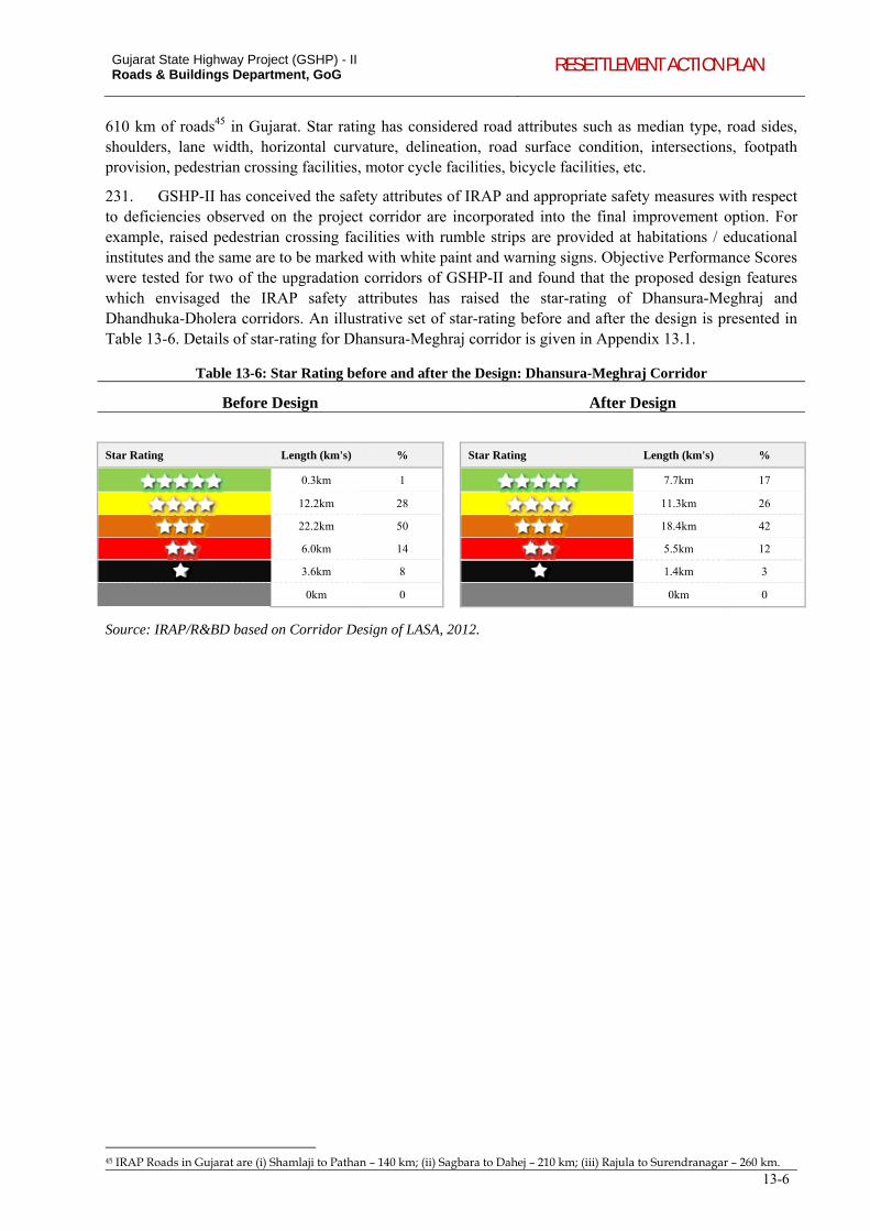
Gujarat State Highway Project (GSHP) - II Roads & Buildings Department, GoG RESETTLEMENT ACTION PLAN
13-6
610 km of roads45 in Gujarat. Star rating has considered road attributes such as median type, road sides, shoulders, lane width, horizontal curvature, delineation, road surface condition, intersections, footpath provision, pedestrian crossing facilities, motor cycle facilities, bicycle facilities, etc.
231. GSHP-II has conceived the safety attributes of IRAP and appropriate safety measures with respect to deficiencies observed on the project corridor are incorporated into the final improvement option. For example, raised pedestrian crossing facilities with rumble strips are provided at habitations / educational institutes and the same are to be marked with white paint and warning signs. Objective Performance Scores were tested for two of the upgradation corridors of GSHP-II and found that the proposed design features which envisaged the IRAP safety attributes has raised the star-rating of Dhansura-Meghraj and Dhandhuka-Dholera corridors. An illustrative set of star-rating before and after the design is presented in Table 13-6. Details of star-rating for Dhansura-Meghraj corridor is given in Appendix 13.1.
Table 13-6: Star Rating before and after the Design: Dhansura-Meghraj Corridor
Before Design After Design
Star Rating Length (km's) % Star Rating Length (km's) %
0.3km 1 7.7km 17
12.2km 28 11.3km 26
22.2km 50 18.4km 42
6.0km 14 5.5km 12
3.6km 8 1.4km 3
0km 0 0km 0
Source: IRAP/R&BD based on Corridor Design of LASA, 2012.
45 IRAP Roads in Gujarat are (i) Shamlaji to Pathan – 140 km; (ii) Sagbara to Dahej – 210 km; (iii) Rajula to Surendranagar – 260 km.
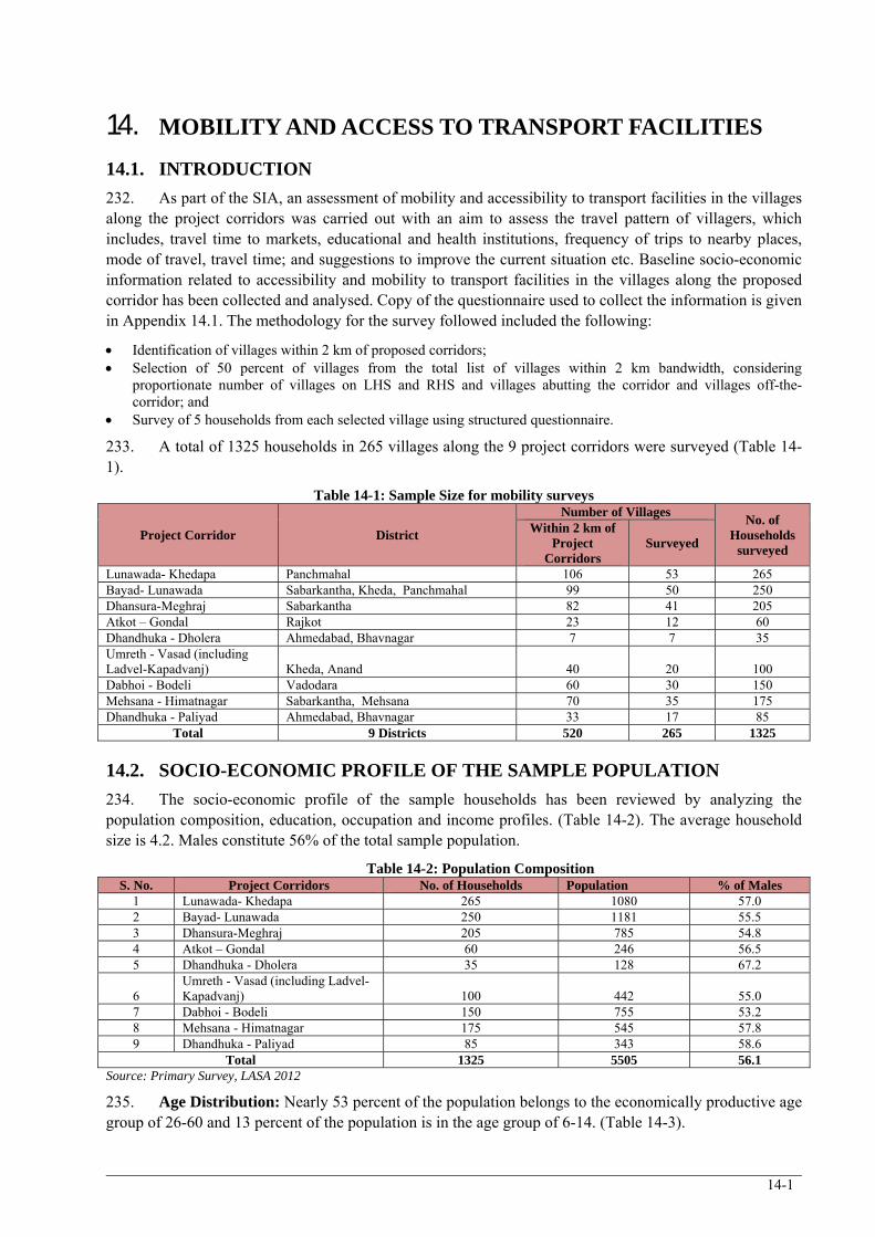
14-1
14. MOBILITY AND ACCESS TO TRANSPORT FACILITIES
14.1. INTRODUCTION
232. As part of the SIA, an assessment of mobility and accessibility to transport facilities in the villages along the project corridors was carried out with an aim to assess the travel pattern of villagers, which includes, travel time to markets, educational and health institutions, frequency of trips to nearby places, mode of travel, travel time; and suggestions to improve the current situation etc. Baseline socio-economic information related to accessibility and mobility to transport facilities in the villages along the proposed corridor has been collected and analysed. Copy of the questionnaire used to collect the information is given in Appendix 14.1. The methodology for the survey followed included the following:
Identification of villages within 2 km of proposed corridors; Selection of 50 percent of villages from the total list of villages within 2 km bandwidth, considering
proportionate number of villages on LHS and RHS and villages abutting the corridor and villages off-the-corridor; and
Survey of 5 households from each selected village using structured questionnaire.
233. A total of 1325 households in 265 villages along the 9 project corridors were surveyed (Table 14-1).
Table 14-1: Sample Size for mobility surveys
Project Corridor District
Number of Villages No. of
Households surveyed
Within 2 km of Project
Corridors Surveyed
Lunawada- Khedapa Panchmahal 106 53 265 Bayad- Lunawada Sabarkantha, Kheda, Panchmahal 99 50 250 Dhansura-Meghraj Sabarkantha 82 41 205 Atkot – Gondal Rajkot 23 12 60 Dhandhuka - Dholera Ahmedabad, Bhavnagar 7 7 35 Umreth - Vasad (including Ladvel-Kapadvanj) Kheda, Anand 40 20 100 Dabhoi - Bodeli Vadodara 60 30 150 Mehsana - Himatnagar Sabarkantha, Mehsana 70 35 175 Dhandhuka - Paliyad Ahmedabad, Bhavnagar 33 17 85
Total 9 Districts 520 265 1325
14.2. SOCIO-ECONOMIC PROFILE OF THE SAMPLE POPULATION
234. The socio-economic profile of the sample households has been reviewed by analyzing the population composition, education, occupation and income profiles. (Table 14-2). The average household size is 4.2. Males constitute 56% of the total sample population.
Table 14-2: Population Composition S. No. Project Corridors No. of Households Population % of Males
1 Lunawada- Khedapa 265 1080 57.0 2 Bayad- Lunawada 250 1181 55.5 3 Dhansura-Meghraj 205 785 54.8 4 Atkot – Gondal 60 246 56.5 5 Dhandhuka - Dholera 35 128 67.2
6 Umreth - Vasad (including Ladvel-Kapadvanj) 100 442 55.0
7 Dabhoi - Bodeli 150 755 53.2 8 Mehsana - Himatnagar 175 545 57.8 9 Dhandhuka - Paliyad 85 343 58.6
Total 1325 5505 56.1 Source: Primary Survey, LASA 2012
235. Age Distribution: Nearly 53 percent of the population belongs to the economically productive age group of 26-60 and 13 percent of the population is in the age group of 6-14. (Table 14-3).
Gujarat State Highway Project (GSHP) - II Roads & Buildings Department, GoG RESETTLEMENT ACTION PLAN
14-2
Table 14-3: Age Distribution among Sample Population
S. No. Project Corridors Age Groups (% of population)
<6 6-14 15-25 26-60 61 and above 1 Lunawada- Khedapa 7.2 13.7 22.4 51.6 5.1 2 Bayad- Lunawada 5.0 12.0 22.8 52.8 7.5 3 Dhansura-Meghraj 4.7 11.0 25.7 52.0 6.6 4 Atkot – Gondal 4.5 16.3 19.9 54.9 4.5 5 Dhandhuka - Dholera 3.1 14.1 23.4 53.9 5.5
6 Umreth - Vasad (including Ladvel-Kapadvanj) 7.5 13.8 25.3 50.2 3.2
7 Dabhoi - Bodeli 6.9 16.0 19.1 50.1 7.9 8 Mehsana - Himatnagar 4.8 9.2 20.7 60.2 5.1 9 Dhandhuka - Paliyad 7.6 9.9 26.5 53.6 2.3
Average 5.9 12.7 22.7 52.8 5.9 Source: Primary Survey, LASA 2012
236. Education profile: 28% of the total population includes those who have not completed primary education level (Table 14-4). In terms of higher level education, including technical and vocational education, 12.5% of the surveyed population has attained higher or technical education.
Table 14-4: Education Profile (% population)
S. No. Project Corridor Not completed
Primary Primary Secondary
Higher Secondary
Technical or Vocational
Graduation and Above
1 Lunawada- Khedapa 21.3 15.7 37.5 8.8 0.4 16.4 2 Bayad- Lunawada 22.7 17.8 26.0 19.3 4.4 9.9 3 Dhansura-Meghraj 8.3 14.8 35.3 20.7 6.6 14.3 4 Atkot – Gondal 46.4 6.4 30.0 6.4 0.0 10.7 5 Dhandhuka - Dholera 30.4 21.7 21.7 22.8 1.1 2.2
6 Umreth - Vasad (including Ladvel-Kapadvanj) 31.9 30.5 18.1 10.1 3.2 6.3
7 Dabhoi - Bodeli 24.4 27.7 30.4 9.6 1.2 6.7 8 Mehsana - Himatnagar 29.9 27.3 23.0 11.6 1.1 7.1 9 Dhandhuka - Paliyad 37.3 17.5 20.2 22.8 0.8 1.5
Average 24.3 20.1 28.8 14.3 2.5 10.0 Note: sample size excludes population below 14 years of age Source: Primary Survey, LASA 2012
237. WPR and Occupation Profile: The average WPR along the project corridors is 34%. Villages along Dhandhuka- Paliyad and Dhandhuka- Dholera have the highest WPR. Agriculture followed by business and trade is the main occupation of villagers along all the project corridors except for Atkot- Gondal and Dabhoi- Bodeli. 64% of the sample population is engaged in agriculture (Table 14-5). Nearly 80% of the workers in along Dhandhuka- Paliyad and Lunawada- Khedapa are engaged in agriculture, either as cultivators or labourers. Business and trade is the main occupation along 3 corridors of Atkot- Gondal, (58.2%), Dabhoi- Bodeli (52.4%) and Umreth- Vasad (including Ladvel-Kapadvanj) (46.5%).
Table 14-5: WPR and Occupation Profile (% population) S.
No. Project Corridors WPR Agriculture Manufacturing Construction
Govt. Service
Business & Trade
1 Lunawada- Khedapa 30.1 80.3 0.3 0.0 10.5 8.9 2 Bayad- Lunawada 34.8 70.6 4.4 2.7 11.4 10.9 3 Dhansura-Meghraj 30.4 74.1 0.8 0.4 5.0 19.7 4 Atkot – Gondal 32.1 34.2 0.0 3.8 3.8 58.2 5 Dhandhuka - Dholera 39.8 47.1 2.0 5.9 3.9 41.2 6 Umreth - Vasad (including Ladvel-Kapadvanj) 36.0 33.3 16.4 0.6 3.1 46.5 7 Dabhoi - Bodeli 32.8 42.3 0.0 2.8 2.4 52.4 8 Mehsana - Himatnagar 38.9 62.3 6.1 3.3 6.1 22.2 9 Dhandhuka - Paliyad 45.2 86.5 4.5 1.3 1.9 5.8
Average 34.1 64.0 3.6 1.9 6.7 23.8 Source: Primary Survey, LASA 2012
238. Income Profile and Dependency Ratio: 62 percent of the total sample households have a stated monthly income of less than Rs.3000, of which 31 percent have a monthly income less than Rs.2000 (Table 14-6) Bayad - Lunawada has the highest percentage (18.4%) of households with average monthly income of above Rs. 10,000. Higher proportion of households has an average monthly income of less than Rs. 2000 in villages along Lunawada- Khedapa (61%). The dependency ratio is also the highest (2.4:1) along this corridor. It is comparatively higher (3.2 to 3.8) along the corridors in the Fifth Schedule Area.
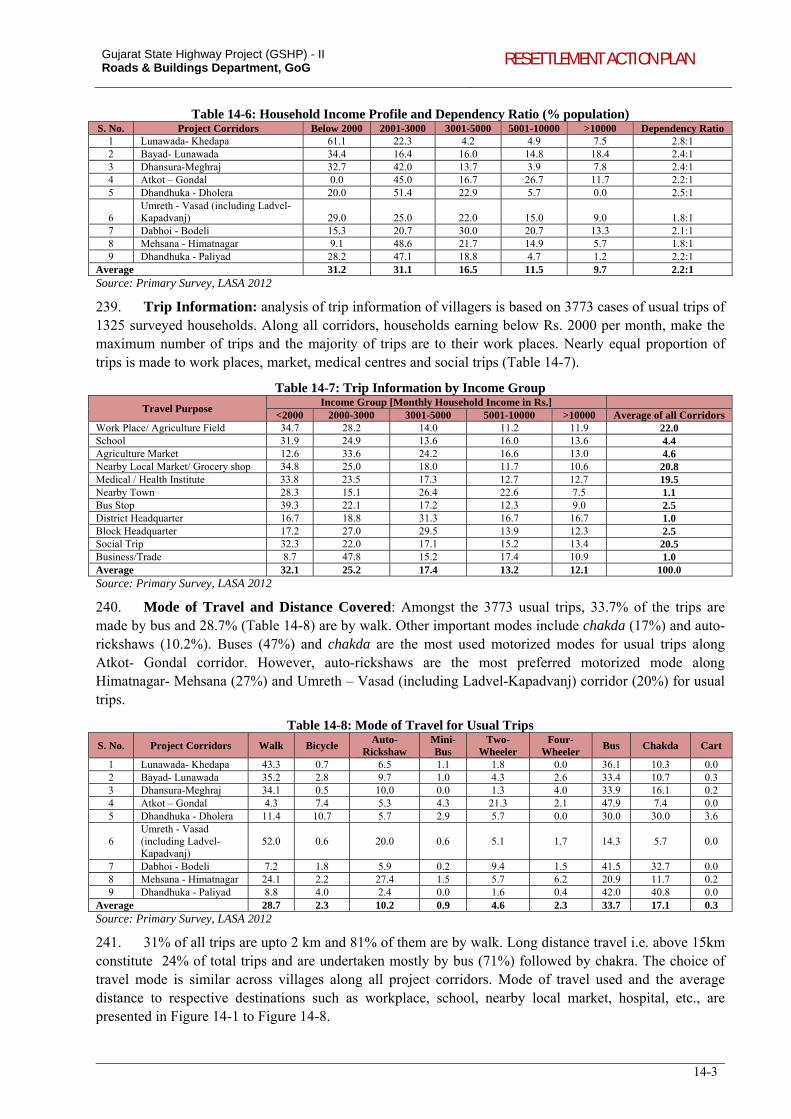
Gujarat State Highway Project (GSHP) - II Roads & Buildings Department, GoG RESETTLEMENT ACTION PLAN
14-3
Table 14-6: Household Income Profile and Dependency Ratio (% population) S. No. Project Corridors Below 2000 2001-3000 3001-5000 5001-10000 >10000 Dependency Ratio
1 Lunawada- Khedapa 61.1 22.3 4.2 4.9 7.5 2.8:1 2 Bayad- Lunawada 34.4 16.4 16.0 14.8 18.4 2.4:1 3 Dhansura-Meghraj 32.7 42.0 13.7 3.9 7.8 2.4:1 4 Atkot – Gondal 0.0 45.0 16.7 26.7 11.7 2.2:1 5 Dhandhuka - Dholera 20.0 51.4 22.9 5.7 0.0 2.5:1
6 Umreth - Vasad (including Ladvel-Kapadvanj) 29.0 25.0 22.0 15.0 9.0 1.8:1
7 Dabhoi - Bodeli 15.3 20.7 30.0 20.7 13.3 2.1:1 8 Mehsana - Himatnagar 9.1 48.6 21.7 14.9 5.7 1.8:1 9 Dhandhuka - Paliyad 28.2 47.1 18.8 4.7 1.2 2.2:1
Average 31.2 31.1 16.5 11.5 9.7 2.2:1 Source: Primary Survey, LASA 2012
239. Trip Information: analysis of trip information of villagers is based on 3773 cases of usual trips of 1325 surveyed households. Along all corridors, households earning below Rs. 2000 per month, make the maximum number of trips and the majority of trips are to their work places. Nearly equal proportion of trips is made to work places, market, medical centres and social trips (Table 14-7).
Table 14-7: Trip Information by Income Group
Travel Purpose Income Group [Monthly Household Income in Rs.]
<2000 2000-3000 3001-5000 5001-10000 >10000 Average of all Corridors Work Place/ Agriculture Field 34.7 28.2 14.0 11.2 11.9 22.0 School 31.9 24.9 13.6 16.0 13.6 4.4 Agriculture Market 12.6 33.6 24.2 16.6 13.0 4.6 Nearby Local Market/ Grocery shop 34.8 25.0 18.0 11.7 10.6 20.8 Medical / Health Institute 33.8 23.5 17.3 12.7 12.7 19.5 Nearby Town 28.3 15.1 26.4 22.6 7.5 1.1 Bus Stop 39.3 22.1 17.2 12.3 9.0 2.5 District Headquarter 16.7 18.8 31.3 16.7 16.7 1.0 Block Headquarter 17.2 27.0 29.5 13.9 12.3 2.5 Social Trip 32.3 22.0 17.1 15.2 13.4 20.5 Business/Trade 8.7 47.8 15.2 17.4 10.9 1.0 Average 32.1 25.2 17.4 13.2 12.1 100.0 Source: Primary Survey, LASA 2012
240. Mode of Travel and Distance Covered: Amongst the 3773 usual trips, 33.7% of the trips are made by bus and 28.7% (Table 14-8) are by walk. Other important modes include chakda (17%) and auto-rickshaws (10.2%). Buses (47%) and chakda are the most used motorized modes for usual trips along Atkot- Gondal corridor. However, auto-rickshaws are the most preferred motorized mode along Himatnagar- Mehsana (27%) and Umreth – Vasad (including Ladvel-Kapadvanj) corridor (20%) for usual trips.
Table 14-8: Mode of Travel for Usual Trips
S. No. Project Corridors Walk Bicycle Auto-
Rickshaw Mini-Bus
Two-Wheeler
Four-Wheeler
Bus Chakda Cart
1 Lunawada- Khedapa 43.3 0.7 6.5 1.1 1.8 0.0 36.1 10.3 0.0 2 Bayad- Lunawada 35.2 2.8 9.7 1.0 4.3 2.6 33.4 10.7 0.3 3 Dhansura-Meghraj 34.1 0.5 10.0 0.0 1.3 4.0 33.9 16.1 0.2 4 Atkot – Gondal 4.3 7.4 5.3 4.3 21.3 2.1 47.9 7.4 0.0 5 Dhandhuka - Dholera 11.4 10.7 5.7 2.9 5.7 0.0 30.0 30.0 3.6
6 Umreth - Vasad (including Ladvel-Kapadvanj)
52.0 0.6 20.0 0.6 5.1 1.7 14.3 5.7 0.0
7 Dabhoi - Bodeli 7.2 1.8 5.9 0.2 9.4 1.5 41.5 32.7 0.0 8 Mehsana - Himatnagar 24.1 2.2 27.4 1.5 5.7 6.2 20.9 11.7 0.2 9 Dhandhuka - Paliyad 8.8 4.0 2.4 0.0 1.6 0.4 42.0 40.8 0.0
Average 28.7 2.3 10.2 0.9 4.6 2.3 33.7 17.1 0.3 Source: Primary Survey, LASA 2012
241. 31% of all trips are upto 2 km and 81% of them are by walk. Long distance travel i.e. above 15km constitute 24% of total trips and are undertaken mostly by bus (71%) followed by chakra. The choice of travel mode is similar across villages along all project corridors. Mode of travel used and the average distance to respective destinations such as workplace, school, nearby local market, hospital, etc., are presented in Figure 14-1 to Figure 14-8.
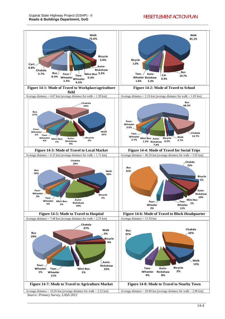
Gujarat State Highway Project (GSHP) - II Roads & Buildings Department, GoG RESETTLEMENT ACTION PLAN
14-4
Walk
72.6%
Bicycle
3.0%
Auto‐Rickshaw3.2%Mini‐Bus
0.3%Two‐
Wheeler4.5%
Four‐
Wheeler1.5%
Bus
8.3%
Chakda5.7%
Cart
0.8%
Walk
81.1%
Bus10.7%Car
0.3%
Auto‐
Rickshaw5.3%
Two‐
Wheeler1.6%
Bicycle
1.0%
Figure 14-1: Mode of Travel to Workplace/agriculture field
Figure 14-2: Mode of Travel to School
Average distance = 4.67 km [average distance for walk = 1.50 km] Average distance = 2.18 km [average distance for walk = 1.03 km]
Walk
32%
Bicycle2%
Auto‐
Rickshaw9%
Mini‐Bus1%
Two‐
Wheeler4%
Four‐Wheeler
1%
Bus27%
Chakda24%
Walk2.7%
Bicycle0.5%
Auto‐
Rickshaw7.8%
Mini‐Bus1.2%
Two‐Wheeler2.7%
Four‐
Wheeler3.0%
Bus
68.3%
Chakda13.7%
Figure 14-3: Mode of Travel to Local Market Figure 14-4: Mode of Travel for Social Trips Average distance = 6.33 km [average distance for walk = 1.71 km] Average distance = 46.28 km [average distance for walk = 3.05 km]
Walk
20%
Bicycle
1%Auto‐
Rickshaw16%
Mini‐Bus
1%
Two‐
Wheeler5%
Four‐
Wheeler3%
Bus
26%
Chakda
28%
Bicycle2%
Auto‐Rickshaw
10%Mini‐Bus
1%Two‐
Wheeler11%
Four‐Wheeler
2%
Bus41%
Chakda33%
Figure 14-5: Mode to Travel to Hospital Figure 14-6: Mode of Travel to Block Headquarter Average distance = 7.48 km [average distance for walk = 2.25 km] Average distance = 15.38 km
Walk
5%
Bicycle
4%
Auto‐
Rickshaw22%Mini‐Bus
1%
Two‐
Wheeler11%
Four‐
Wheeler1%
Bus29%
Chakda
27%
Walk
13%
Bicycle
2%Auto‐
Rickshaw8%
Two‐
Wheeler4%
Bus
41%
Chakda
32%
Figure 14-7: Mode to Travel to Agriculture Market Figure 14-8: Mode to Travel to Nearby Town
Average distance = 10.26 km [average distance for walk = 2.22 km] Average distance = 20.80 km [average distance for walk = 2.08 km] Source: Primary Survey, LASA 2012
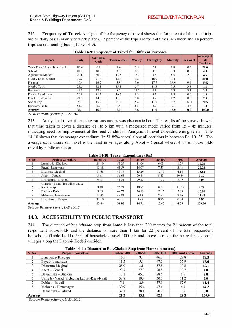
Gujarat State Highway Project (GSHP) - II Roads & Buildings Department, GoG RESETTLEMENT ACTION PLAN
14-5
242. Frequency of Travel. Analysis of the frequency of travel shows that 36 percent of the usual trips are on daily basis (mainly to work place), 17 percent of the trips are for 3-4 times in a week and 14 percent trips are on monthly basis (Table 14-9).
Table 14-9: Frequency of Travel for Different Purposes
Purpose Daily 3-4 times /
week Twice a week Weekly Fortnightly Monthly Seasonal
Average of all
CorridorsWork Place/ Agriculture Field 86.4 6.2 1.4 2.5 2.1 0.8 0.6 22.0 School 81.2 10.8 3.3 0.5 0.5 3.3 0.5 4.4 Agriculture Market 20.6 30.9 13.5 15.7 8.5 8.5 2.2 4.6 Nearby Local Market 30.2 21.6 12.6 9.2 18.0 7.4 1.0 20.8 Hospital 10.4 16.7 5.8 3.0 17.7 36.9 9.4 19.5 Nearby Town 24.5 32.1 15.1 5.7 11.3 7.5 3.8 1.1 Bus Stop 41.8 27.9 8.2 11.5 4.1 3.3 3.3 2.5 District Headquarter 20.8 41.7 16.7 8.3 4.2 8.3 0.0 1.0 Block Headquarter 21.3 44.3 11.5 9.8 4.9 8.2 0.0 2.5 Social Trip 8.1 15.9 6.3 5.4 11.7 18.5 34.1 20.5 Business/Trade 54.3 2.2 6.5 6.5 8.7 17.4 4.3 1.0 Average 36.1 16.9 7.0 5.6 11.0 13.9 9.5 100.0 Source: Primary Survey, LASA 2012
243. Analysis of travel time using various modes was also carried out. The results of the survey showed that time taken to cover a distance of 1to 5 km with a motorized mode varied from 15 – 45 minutes, indicating need for improvement of the road conditions. Analysis of travel expenditure as given in Table 14-10 shows that the average expenditure (in 51.85% cases) along all corridors in between Rs. 10- 25. The average expenditure on travel is the least in villages along Atkot – Gondal where, 48% of households travel by public transport.
Table 14-10: Travel Expenditure (Rs.) S. No. Project Corridors Below 10 10-25 25-50 50-100 >100 Average
1 Lunawada- Khedapa 28.39 53.27 11.06 6.03 1.26 15.21 2 Bayad- Lunawada 13.38 61.58 14.07 7.55 3.43 22.28 3 Dhansura-Meghraj 17.68 49.17 13.26 15.75 4.14 13.83 4 Atkot – Gondal 3.61 56.63 20.48 8.43 10.84 3.17 5 Dhandhuka - Dholera 9.43 41.51 29.25 11.32 8.49 4.05
6 Umreth - Vasad (including Ladvel-Kapadvanj) 3.49 26.74 19.77 38.37 11.63 3.29
7 Dabhoi - Bodeli 3.05 44.72 24.19 22.15 5.89 18.80 8 Mehsana - Himatnagar 15.05 49.83 6.35 21.40 7.36 11.43 9 Dhandhuka - Paliyad 35.10 60.10 3.85 0.96 0.00 7.95
Average 15.44 51.85 14.71 13.45 4.55 100.00 Source: Primary Survey, LASA 2012
14.3. ACCESSIBILITY TO PUBLIC TRANSPORT
244. The distance of bus /chakda stop from home is less than 200 meters for 21 percent of the total respondent households and the distance is more than 1 km for 22 percent of the total respondent households (Table 14-11). 53% of households travel 1000mts and above to reach the nearest bus stop in villages along the Dabhoi- Bodeli corridor.
Table 14-11: Distance to Bus/Chakda Stop from Home (in meters) S. No. Project Corridors Below 200 200-500 500-1000 1000 and above Average
1 Lunawada- Khedapa 16.5 9.7 46.0 27.8 19.3 2 Bayad- Lunawada 11.5 5.1 47.5 35.9 17.6 3 Dhansura-Meghraj 28.0 3.8 57.5 10.8 15.1 4 Atkot – Gondal 23.7 37.3 28.8 10.2 4.8 5 Dhandhuka - Dholera 17.1 45.7 28.6 8.6 2.8 6 Umreth - Vasad (including Ladvel-Kapadvanj) 38.8 19.4 30.6 11.2 8.0 7 Dabhoi - Bodeli 7.1 2.9 37.1 52.9 11.4 8 Mehsana - Himatnagar 30.9 15.4 47.4 6.3 14.2 9 Dhandhuka - Paliyad 32.1 38.1 20.2 9.5 6.8
Average 21.5 13.1 42.9 22.5 100.0 Source: Primary Survey, LASA 2012
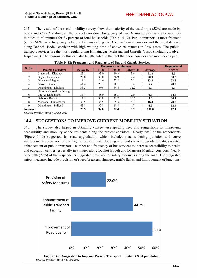
Gujarat State Highway Project (GSHP) - II Roads & Buildings Department, GoG RESETTLEMENT ACTION PLAN
14-6
245. The results of the social mobility survey show that majority of the usual trips (58%) are made by buses and Chakdas along all the project corridors. Frequency of bus/chakda service varies between 30 minutes to 60 minutes for 33 percent of total households (Table 14-12). Public transport is most frequent (i.e. in 64% cases frequency is below 15 mins) along the Atkot – Gondal corridor and the most delayed along Dabhoi- Bodeli corridor with high waiting time of above 60 minutes in 36% cases. The public- transport services are the most regular along Himatnagar- Mehsana and Umreth- Vasad (including Ladvel-Kapadvanj). The reasons for this can also be attributed to the fact that these corridors are more developed.
Table 14-12: Frequency and Regularity of Bus and Chakda Services
S. No.
Project Corridors Frequency (in minutes) Regularity of
Service Below 15 15-30 30-60 Above 60 Average 1 Lunawada- Khedapa 23.1 33.0 40.3 3.6 21.3 8.5 2 Bayad- Lunawada 25.8 30.0 36.9 7.4 20.9 50.2 3 Dhansura-Meghraj 18.1 24.6 52.2 5.1 13.3 23.3 4 Atkot – Gondal 64.4 23.7 8.5 3.4 5.7 78.0 5 Dhandhuka - Dholera 33.3 0.0 44.4 22.2 1.7 5.9
6 Umreth - Vasad (including Ladvel-Kapadvanj) 33.7 48.0 16.3 2.0 9.5 64.6
7 Dabhoi - Bodeli 11.5 30.8 21.2 36.5 5.0 36.1 8 Mehsana - Himatnagar 33.5 36.5 25.3 4.7 16.4 78.8 9 Dhandhuka - Paliyad 43.8 32.8 18.8 4.7 6.2 52.4
Average 28.9 32.0 32.4 6.7 100.0 12.1 Source: Primary Survey, LASA 2012
14.4. SUGGESTIONS TO IMPROVE CURRENT MOBILITY SITUATION
246. The survey also helped in obtaining village wise specific need and suggestions for improving accessibility and mobility of the residents along the project corridors. Nearly 58% of the respondents (Figure 14-9) suggested for road upgradation, which includes road widening, junction and curve improvements, provision of drainage to prevent water logging and road surface upgradation. 44% wanted enhancement of public transport – number and frequency of bus services to increase accessibility to health and education centres, especially in villages along Dabhoi-Bodeli and Dhansura-Meghraj corridors. Nearly one- fifth (22%) of the respondents suggested provision of safety measures along the road. The suggested safety measures include provision of speed breakers, signages, traffic lights, and improvement of junctions.
58.1%
44.2%
22.0%
0% 10% 20% 30% 40% 50% 60%
Improvement of Road quality
Enhancement of
Public Transport
Facility
Provision of
Safety Measures
Figure 14-9: Suggestion to Improve Present Transport Situation (% of population)
Source: Primary Survey, LASA 2012
Gujarat State Highway Project (GSHP) - II Roads & Buildings Department, GoG RESETTLEMENT ACTION PLAN
15-1
15. RESETTLEMENT POLICY FRAMEWORK
15.1. INTRODUCTION
247. This RPF has been prepared based on the findings of social impact assessment (SIA) carried out for the corridors proposed for inclusion in the first year of the project. The principles and procedures (pertaining to land acquisition and resettlement) adopted for the implementation of the Gujarat State Highways Project (GSHP- I) has been proposed to be adopted for GSHP-II, with modifications in terms of policy requirements triggered due to the recent policies/legislations including but not limited to the National Resettlement and Rehabilitation Policy (NRRP, 2007), apart from incorporation of the learning from implementation of GSHP I and similar World Bank funded state highway projects in other states of India.
248. To address land acquisition and resettlement impacts in the project, this Resettlement Policy Framework (RPF) outlines the principles and procedures, legal framework, operational guidelines, institutional arrangements, entitlements for different types of impacts, disclosure procedures and monitoring and evaluation. This framework will guide in management of social impacts caused by the proposed project and improvement works to be taken up for subsequent corridors. Preparation of resettlement action plan, Indigenous Peoples Development Plan, strategies of public consultations, especially with the tribal population will be steered through the principles of this RPF. The RPF (i) bring commonality in resettlement and rehabilitation benefits under the project, (ii) bring together and built upon the current good practices in terms of procedures to address more systematic and institutional issues, (iii) establish institutional arrangements at project level for the implementation of RAP, and (iv) establish mechanism for redressal of grievances; and monitoring and evaluation etc.
15.2. RPF PRINCIPLES AND ENTITLEMENT PROVISIONS
15.2.1. Principles of the RPF
249. This RPF intends to bridge the gap between the World Bank policy on Involuntary Resettlement and NRRP 2007 and has the following objectives:
i. To minimize displacement and to identify the non-displacing or least-displacing alternatives; ii. To plan the Resettlement and Rehabilitation of Project Affected People (PAPs), including
special needs of vulnerable sections; iii. To assist affected persons in maintaining/restoring their former living standards, income earning
capacity or agriculture production; iv. To suggest regular consultation and interactive meetings in order to establish harmonious
relationship between the R&BD and affected people; v. To ensure that the affected persons are meaningfully consulted and provided opportunities to
participate in the planning and implementation stages of the resettlement program in order to suitably accommodate their inputs and make this policy more participatory in nature and broad based in its scope;
vi. To ensure the disbursement of compensation and assistance in accordance with provisions of RPF;
vii. To redress grievances of the affected people that may arise during the planning, implementation stages of the project;
viii. To establish an institutional arrangement for the smooth and speedy implementation of the resettlement action plan, redressal of issues related to land acquisition and resettlement and rehabilitation; and,
ix. To detail out a specific disclosure mechanism in order to disseminate information regarding provisioned Entitlements, list of affected persons, and other details of resettlement action plan.
Gujarat State Highway Project (GSHP) - II Roads & Buildings Department, GoG RESETTLEMENT ACTION PLAN
15-2
15.2.2. Terms and Definitions
i. Agricultural land means land being used for the purpose of: (i) agriculture or horticulture; (ii) raising of crops, grass or garden produce; and (iii) land used by an agriculturist for the grazing of cattle, but does not include land used for cutting of wood only;
ii. Assistance refers to the support provided to PAPs in the form of ex-gratia payments, loans, asset services, etc. in order to improve the standard of living and reduce the negative impacts of the project.
iii. Below poverty line or BPL Family means below poverty line families as defined by the Planning Commission of India, from time to time, and those included in the State BPL list in force.
iv. Compensation refers to the amount paid under Consent Award as part of The Land Acquisition Act, 1894. For private property, structures and other assets acquired for the project, it refers to the amount as given in the Entitlement Matrix for the project.
v. Cut-off Date: the date of Notification under Section 4(1) of Land Acquisition Act, 1894 shall be the cut-off date where the land acquisition will be required. For non-titleholders the end date of census survey shall be considered as the cut-off date for PAP/PAF.
vi. Encroachers are those person/family, who transgresses into the public land (prior to the cut-off date), adjacent to his/her own land or other immovable assets and derives his/her additional source of shelter/livelihood.
vii. Family includes a person, his or her spouse, minor sons, unmarried daughters, minor brothers, unmarried sisters, father, mother and other relatives residing with him or her and dependent on him or her for their livelihood; and includes “nuclear family” consisting of a person, his or her spouse and minor children.
viii. Government refers to the Government of Gujarat. ix. Land acquisition means acquisition of land under the Land Acquisition Act, 1894, as amended
from time to time. x. Marginal farmer means a cultivator with an un-irrigated land holding up to one hectare or
irrigated land holding up to half hectare; xi. Non-Perennial Crop: Any plant species, either grown naturally or through cultivation that lives
for a season and perishes with harvesting of its yields has been considered as a non-perennial crop in the project. For example, paddy, sugarcane, groundnut, etc.
xii. Notification means a notification published in the Gazette of India, or as the case may be, the Gazette of State;
xiii. Perennial Crop: Any plant species that live for years and yields its products after a certain age of maturity is a perennial crop. Generally trees, either grown naturally or by horticultural and yield fruits or timber have been considered as perennial crop in the project. For example, tamarind, coconut, mango, etc. are perennial crops.
xiv. Project Affected Family (PAFs) means- (i) a family whose primary place of residence or other property or source of livelihood is adversely affected or involuntarily displaced by the acquisition of land for the project (ii) any tenure holder, tenant, lessee or owner of other property, who on account of acquisition of land in the affected area of otherwise, has been involuntarily displaced from such land or other property; (iii) any agricultural or non-agricultural labourer, landless person (not having homestead land or agricultural land) rural artisan, small trader or self-employed person; who has been residing or engaged in any trade, business, occupation or vocation in the affected area, and who has been deprived of earning his livelihood or alienated wholly or substantially from the main source of his trade, business, occupation or vocation because of the acquisition of land in the affected area or being involuntarily displaced for any other reason.
xv. Project Affected Persons (PAPs), any persons who have economic interests or residence within the project impact corridor and who may be adversely affected directly by the project. PAP include those losing commercial or residential structures in whole or part, those losing agricultural land or homestead land in whole or part, and those losing income sources as a result of project action. PAPs would be of two broad categories, ‘PAPs with Major Impact’ and ‘PAPs with Minor Impact’
Gujarat State Highway Project (GSHP) - II Roads & Buildings Department, GoG RESETTLEMENT ACTION PLAN
15-3
a. Major Impact: those properties where the major part of the structure/land is affected and becomes untenable and the affected party is unable to live/do business in the unaffected portion of the property, OR, 25% or more portion of the property is affected
b. Minor Impact: all other impacts other than major impact will be treated as minor impacts, OR, those properties where a part of the structure/land is acquired and the remaining portion is intact and the affected party can continue to live/do business in the unaffected portion of the property
xvi. Replacement Cost of the acquired assets and property is the amount required for the affected household to replace/reconstruct the lost assets through purchase in the open market. Replacement cost will be calculated at R&BD current Schedule of Rates without depreciation. Replacement cost shall be in line with the provisos of the Entitlement Matrix of the project.
xvii. Small farmer means a cultivator with an un-irrigated land holding upto two hectares or with an irrigated land holding upto one hectare, but more than the holding of a marginal farmer.
xviii. Squatter means a person/family that has settled on the public land without permission or has been occupying public building without authority prior to cut-off date and is depending for his or her shelter or livelihood and has no other source of shelter or livelihood.
xix. Tenants are those persons having bonafide tenancy agreements, written or unwritten, with a private property owner with clear property titles, to occupy a structure or land for residence, business or other purposes.
xx. Vulnerable Persons: persons who are physically challenged, widows, persons above sixty years of age, below-poverty line households and woman-headed household.
xxi. Woman-Headed Household: A household that is headed by a woman who is the major bread-earner of the household. This woman may be a widow, separated, deserted person or the major bread earner of the household.
15.2.3. Resettlement Principles and Eligibility Criteria
250. The RPF is based on the principle that affected people should be in a better-off position or at least at the same level as compared to the pre-project scenario. The RPF will guide in the effective management of social impacts caused by the proposed project. RPF ensures greater acceptability of the project among the community and is expected to facilitate effective communication. The RPF provides the following:
(i) Entitlements for project affected persons to cover the loss of land, structures and other assets, such as standing crops or trees. The broad categorisation of affected persons is (i) Titleholders; and (ii) Non-titleholders.
(ii) The vulnerable sections among each of the above categories will receive additional support. (iii) The negative impact on persons affected by the project would be avoided or minimized. Where
the negative impacts are unavoidable, the project-affected persons will be assisted in retaining or upgrading their standard of living.
(iv) Adverse impacts would be avoided or minimized by exploring all viable alternative project designs. Where the adverse impacts are unavoidable, the project-affected persons will be assisted in retaining or upgrading their standard of living.
(v) Compensation for land at replacement cost, plus allowances for fees or other charges will be provided along with other assistances. Land will be acquired following Land Acquisition Act, 1894 and its amendments. The difference between the land cost decided as per LA Act and the updated Jantri values for the specific land parcel to be acquired will be paid by the project in the form of assistance.
(vi) Compensation for residual unviable land parcels will be provided to those affected persons who are eligible and opting for the same.
(vii) Compensation for loss of structures, other assets will be provided at replacement cost and will be paid before physical displacement from the occupied or affected area.
(viii) Assistance will be provided to those affected persons who lose their livelihood due to the acquisition carried out as part of the project.
Gujarat State Highway Project (GSHP) - II Roads & Buildings Department, GoG RESETTLEMENT ACTION PLAN
15-4
(ix) Cut-off date for titleholders will be the date of publication of notification under Section 4(1) of Land Acquisition Act, 1894. For non-titleholders, the date of project census survey or a similar designated date declared by project authority will be considered as cut-off date.
(x) The households/land owners who are absent during the time of census survey will be entitled for assistance and budget provisions will include them also. However, people moving to the CoI after the cut-off date will not be entitled for any compensation or assistance.
(xi) Vulnerable groups will be identified and given additional support and assistance in re-establishing or enhancing livelihood.
(xii) Loss of common property resources will be compensated and reconstructed at project cost. Enhancement measures also will be provided for community assets located alongside the project corridor in consultation with the community.
(xiii) Information related to the preparation and implementation of resettlement plan will be disclosed to all stakeholders and people’s participation will be ensured in planning and implementation.
(xiv) Appropriate grievance redress mechanism will be established at the district level to ensure speedy resolution of disputes.
(xv) All consultations with PAPs shall be documented. Consultations will continue during the implementation of resettlement and rehabilitation works.
15.2.4. Entitlement Matrix
251. The Entitlement matrix (Table 15-1) provisions for the various impact categories have been worked out based on the updation of the provisions adopted in Gujarat State Highways Project (GSHP- I) The updation has been carried out to address the modifications required in terms of policy requirements triggered due to the recent policies/legislations including but not limited to the NRRP, 2007 apart from incorporation of the learning from implementation of GSHP I and similar World Bank funded state highway projects in other states of India. The basis for arriving at each of the entitlement provisions in consultations with the PIU has been presented in Appendix 15.1.
Table 15-1: Entitlement Matrix
Code Category of
PAP Type of Impact
Unit of Entitlement
Entitlement Remarks
1A Titleholder – Agriculture Land / Non-agriculture land / Homestead Land and assets
Loss of land and assets
Land owner(s)
1. Cash compensation at “actual market values”.
2. Option for compensation of residual unviable land parcels46.
3. Registration and stamp duty charges (currently applicable) for the land acquired.
4. All fees, taxes and other charges, as applicable under the relevant laws, shall be borne by the project.
5. Replacement of water-yielding bores shall be done subject to availability of water in the remaining landholding or anywhere near the beneficiary land in consultation with the affected community. If
1. Compensation shall be determined as per LA Act, 1894. Difference, if any, between the compensation award as per the LA Act, 1894 and the market value, shall be paid by the project in the form of assistance. The updated Guideline / Jantri values will be adopted for determination of actual market value for the specific land parcel to be acquired.
2. Compensation for Timber Trees shall be decided by Forest Department, Gujarat. Compensation for perennial trees and standing crops shall be decided by Agriculture and Cooperation Department, Government of Gujarat.
3. The rates for determination of assistances and compensation shall be revised annually during the project implementation period. The revision shall be
46 Less than 0.4ha in case of irrigated land and less than 1ha in case of non‐irrigated land
Gujarat State Highway Project (GSHP) - II Roads & Buildings Department, GoG RESETTLEMENT ACTION PLAN
15-5
Code Category of
PAP Type of Impact
Unit of Entitlement
Entitlement Remarks
water is not available, replacement cost of the bore-well at rates decided on case-by-case (without depreciation) based on Gujarat Water Supply and Sewerage Board (GWSSB) Schedule of Rates.
6. Financial assistance for replacement of Cattle shed: One-time financial assistance of Rs.15000 for displaced households.
7. In case land owners become landless or marginal, financial assistance equivalent to 12 months of minimum agricultural wages of Gujarat (calculated for 25 days in a month), as subsistence allowance.
8. Ex-gratia assistance of Rs.20000 for land owners losing upto 500 sq.m of land in lieu of all other benefits.
9. In case of severance of agricultural land, an additional grant of 10 percent of the amount paid for land acquisition.
10. Advance notice of 4 months to harvest standing crops.
11. Crop/tree damage compensation as assessed by the concerned Government Departments.
12. Right to salvage materials from affected land or structure.
effected from the 1st day of April every year. The real value of monetary compensation and assistance shall be assessed as follows: (i) Compensation for land shall be based on updated Jantri value; (ii) Compensation for structures/assets shall be based on updated Schedule of Rates; and (iii) Allowances and assistances shall be based on Consumer Price Index (CPI), updated 1st of April every year. In case, if Jantri Value or Schedule of Rates is not updated by the 1st of April, compensation and assistance shall be provided based on existing rates. Differences if any, between the existing rates and the updated rates will be provided by the project after publication of the updated rates.
1B Titleholder – Residential Structure
Loss of structure
Land / structure owner(s)
1. Compensation at replacement cost determined on the basis of R&BD Schedule of Rates as on date without depreciation.
2. Affected structures of size less than 20 sq.m., which are fully affected or if rendered unviable, shall have option to compensation equivalent to cost of provision of residential
1. Cost equivalent to the area mentioned in Para-2 shall be estimated based on R&BD Schedule of Rates without depreciation.
Gujarat State Highway Project (GSHP) - II Roads & Buildings Department, GoG RESETTLEMENT ACTION PLAN
15-6
Code Category of
PAP Type of Impact
Unit of Entitlement
Entitlement Remarks
structure of size 20 sq.m.
3. Shifting Allowance: One-time financial assistance of Rs. 10,000.
4. Transitional allowance of Rs.10,000 towards temporary arrangements and rentals during the transition period.
5. Right to salvage materials from affected land or structure.
1C Titleholder-Commercial/ industrial Structure
Loss of structure
Land / structure owner(s)
1. Compensation at replacement cost determined on the basis of R&BD Schedule of Rates as on date without depreciation.
2. Affected structures of size less than 10 sq.m which are fully affected, or rendered unviable, shall have option to compensation equivalent to cost of provision of commercial structure, of size 10 sq.m.
3. Shifting Allowance: One-time financial assistance of Rs. 10,000.
4. Transitional allowance of Rs.10,000 towards temporary arrangements and rentals during the transition period.
5. Right to salvage materials from affected land or structure.
1. Cost equivalent to the area mentioned in Para-2 shall be estimated based on R&BD Schedule of Rates without depreciation.
1D Titleholder-Residential-cum-commercial/ industrial structure
Loss of structure
Land / structure owner(s)
1. The entitlement provisions that shall be higher among 1B and 1C shall be provided.
2A Tenants-Residential / commercial / industrial Structure
Loss of structure
Individual / Household
1. For tenants (residential category) requiring relocation, rental allowance for 6 months at the rate of Rs.1000/month in rural areas and Rs.1500/month in urban areas, if the structure is fully affected or the unaffected part of the
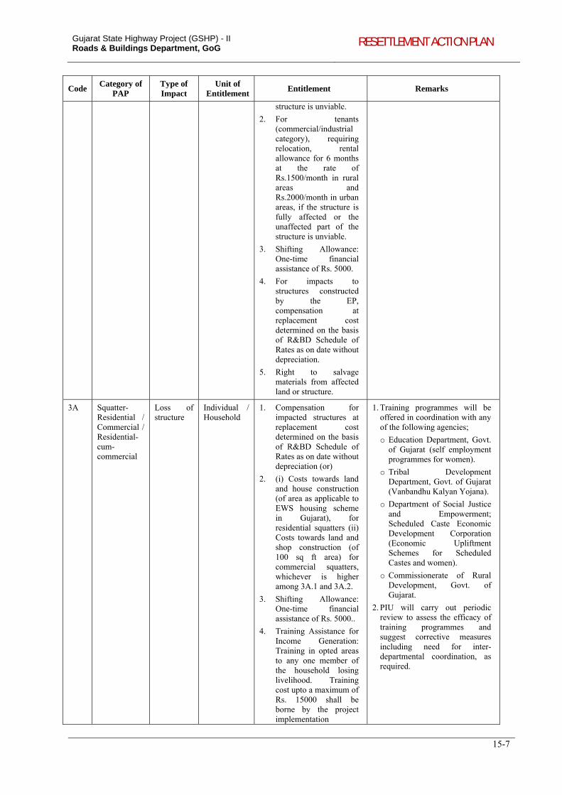
Gujarat State Highway Project (GSHP) - II Roads & Buildings Department, GoG RESETTLEMENT ACTION PLAN
15-7
Code Category of
PAP Type of Impact
Unit of Entitlement
Entitlement Remarks
structure is unviable.
2. For tenants (commercial/industrial category), requiring relocation, rental allowance for 6 months at the rate of Rs.1500/month in rural areas and Rs.2000/month in urban areas, if the structure is fully affected or the unaffected part of the structure is unviable.
3. Shifting Allowance: One-time financial assistance of Rs. 5000.
4. For impacts to structures constructed by the EP, compensation at replacement cost determined on the basis of R&BD Schedule of Rates as on date without depreciation.
5. Right to salvage materials from affected land or structure.
3A Squatter-Residential / Commercial / Residential-cum-commercial
Loss of structure
Individual / Household
1. Compensation for impacted structures at replacement cost determined on the basis of R&BD Schedule of Rates as on date without depreciation (or)
2. (i) Costs towards land and house construction (of area as applicable to EWS housing scheme in Gujarat), for residential squatters (ii) Costs towards land and shop construction (of 100 sq ft area) for commercial squatters, whichever is higher among 3A.1 and 3A.2.
3. Shifting Allowance: One-time financial assistance of Rs. 5000..
4. Training Assistance for Income Generation: Training in opted areas to any one member of the household losing livelihood. Training cost upto a maximum of Rs. 15000 shall be borne by the project implementation
1. Training programmes will be offered in coordination with any of the following agencies;
o Education Department, Govt. of Gujarat (self employment programmes for women).
o Tribal Development Department, Govt. of Gujarat (Vanbandhu Kalyan Yojana).
o Department of Social Justice and Empowerment; Scheduled Caste Economic Development Corporation (Economic Upliftment Schemes for Scheduled Castes and women).
o Commissionerate of Rural Development, Govt. of Gujarat.
2. PIU will carry out periodic review to assess the efficacy of training programmes and suggest corrective measures including need for inter-departmental coordination, as required.
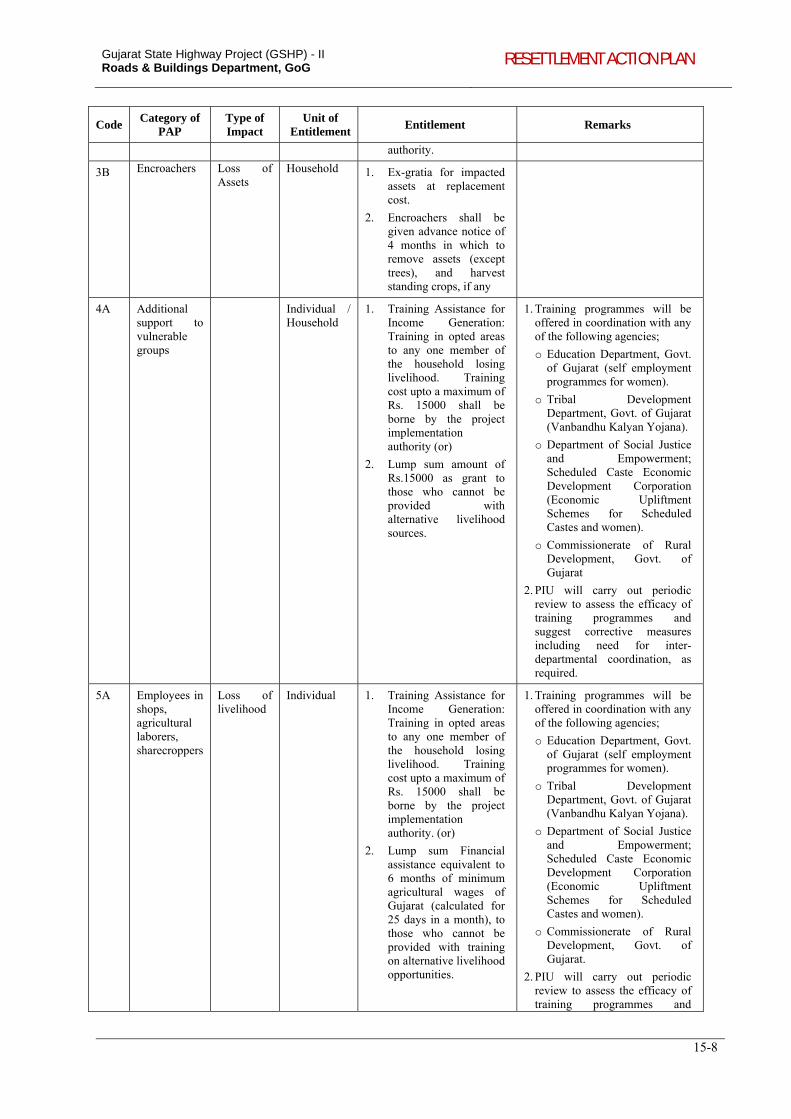
Gujarat State Highway Project (GSHP) - II Roads & Buildings Department, GoG RESETTLEMENT ACTION PLAN
15-8
Code Category of
PAP Type of Impact
Unit of Entitlement
Entitlement Remarks
authority.
3B Encroachers Loss of Assets
Household 1. Ex-gratia for impacted assets at replacement cost.
2. Encroachers shall be given advance notice of 4 months in which to remove assets (except trees), and harvest standing crops, if any
4A Additional support to vulnerable groups
Individual / Household
1. Training Assistance for Income Generation: Training in opted areas to any one member of the household losing livelihood. Training cost upto a maximum of Rs. 15000 shall be borne by the project implementation authority (or)
2. Lump sum amount of Rs.15000 as grant to those who cannot be provided with alternative livelihood sources.
1. Training programmes will be offered in coordination with any of the following agencies;
o Education Department, Govt. of Gujarat (self employment programmes for women).
o Tribal Development Department, Govt. of Gujarat (Vanbandhu Kalyan Yojana).
o Department of Social Justice and Empowerment; Scheduled Caste Economic Development Corporation (Economic Upliftment Schemes for Scheduled Castes and women).
o Commissionerate of Rural Development, Govt. of Gujarat
2. PIU will carry out periodic review to assess the efficacy of training programmes and suggest corrective measures including need for inter-departmental coordination, as required.
5A Employees in shops, agricultural laborers, sharecroppers
Loss of livelihood
Individual 1. Training Assistance for Income Generation: Training in opted areas to any one member of the household losing livelihood. Training cost upto a maximum of Rs. 15000 shall be borne by the project implementation authority. (or)
2. Lump sum Financial assistance equivalent to 6 months of minimum agricultural wages of Gujarat (calculated for 25 days in a month), to those who cannot be provided with training on alternative livelihood opportunities.
1. Training programmes will be offered in coordination with any of the following agencies;
o Education Department, Govt. of Gujarat (self employment programmes for women).
o Tribal Development Department, Govt. of Gujarat (Vanbandhu Kalyan Yojana).
o Department of Social Justice and Empowerment; Scheduled Caste Economic Development Corporation (Economic Upliftment Schemes for Scheduled Castes and women).
o Commissionerate of Rural Development, Govt. of Gujarat.
2. PIU will carry out periodic review to assess the efficacy of training programmes and
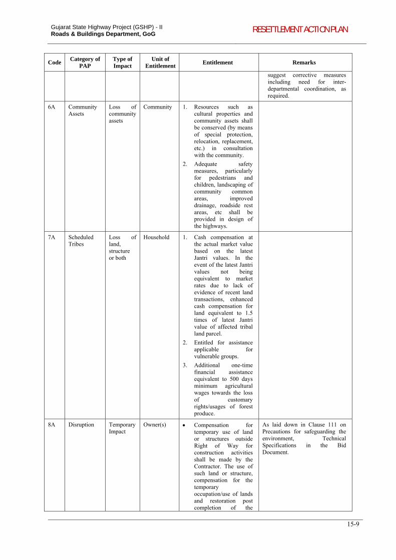
Gujarat State Highway Project (GSHP) - II Roads & Buildings Department, GoG RESETTLEMENT ACTION PLAN
15-9
Code Category of
PAP Type of Impact
Unit of Entitlement
Entitlement Remarks
suggest corrective measures including need for inter-departmental coordination, as required.
6A Community Assets
Loss of community assets
Community 1. Resources such as cultural properties and community assets shall be conserved (by means of special protection, relocation, replacement, etc.) in consultation with the community.
2. Adequate safety measures, particularly for pedestrians and children, landscaping of community common areas, improved drainage, roadside rest areas, etc shall be provided in design of the highways.
7A Scheduled Tribes
Loss of land, structure or both
Household 1. Cash compensation at the actual market value based on the latest Jantri values. In the event of the latest Jantri values not being equivalent to market rates due to lack of evidence of recent land transactions, enhanced cash compensation for land equivalent to 1.5 times of latest Jantri value of affected tribal land parcel.
2. Entitled for assistance applicable for vulnerable groups.
3. Additional one-time financial assistance equivalent to 500 days minimum agricultural wages towards the loss of customary rights/usages of forest produce.
8A Disruption Temporary Impact
Owner(s) Compensation for temporary use of land or structures outside Right of Way for construction activities shall be made by the Contractor. The use of such land or structure, compensation for the temporary occupation/use of lands and restoration post completion of the
As laid down in Clause 111 on Precautions for safeguarding the environment, Technical Specifications in the Bid Document.
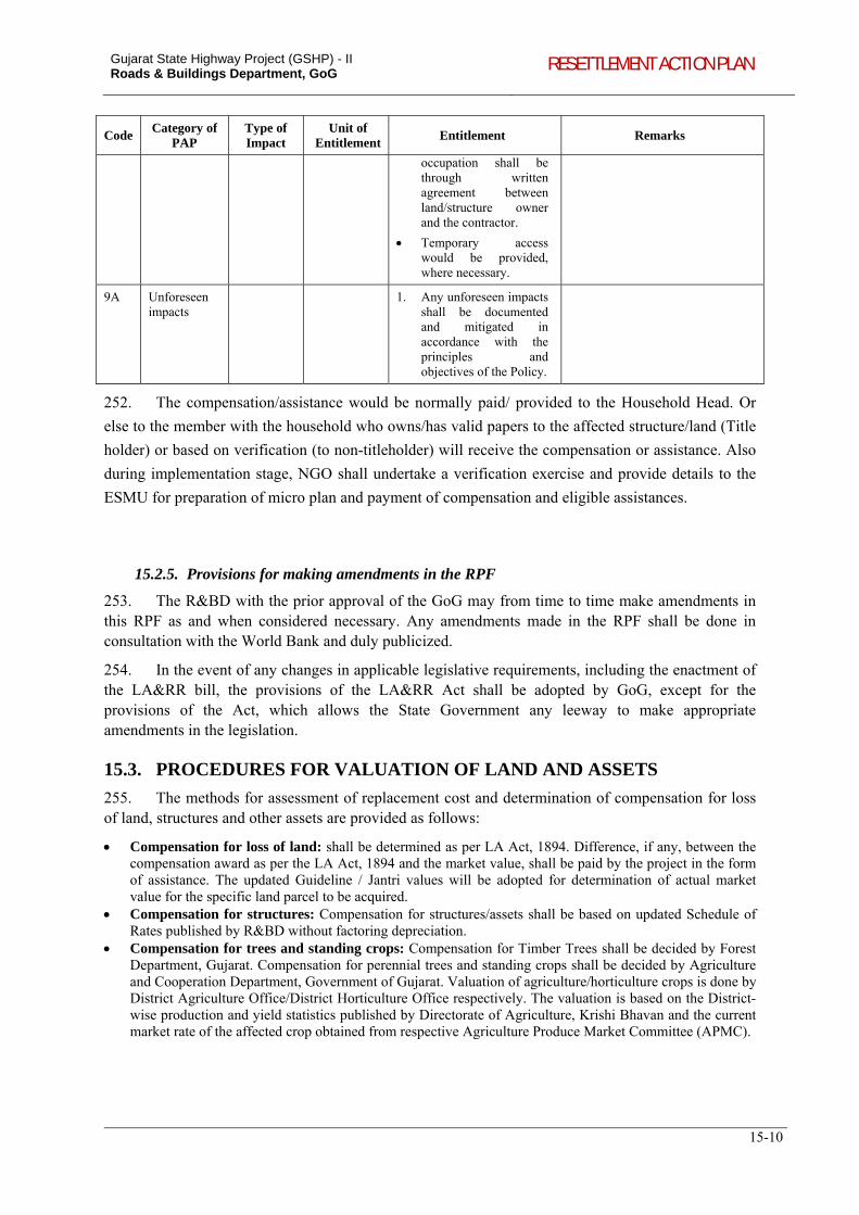
Gujarat State Highway Project (GSHP) - II Roads & Buildings Department, GoG RESETTLEMENT ACTION PLAN
15-10
Code Category of
PAP Type of Impact
Unit of Entitlement
Entitlement Remarks
occupation shall be through written agreement between land/structure owner and the contractor.
Temporary access would be provided, where necessary.
9A Unforeseen impacts
1. Any unforeseen impacts shall be documented and mitigated in accordance with the principles and objectives of the Policy.
252. The compensation/assistance would be normally paid/ provided to the Household Head. Or
else to the member with the household who owns/has valid papers to the affected structure/land (Title
holder) or based on verification (to non-titleholder) will receive the compensation or assistance. Also
during implementation stage, NGO shall undertake a verification exercise and provide details to the
ESMU for preparation of micro plan and payment of compensation and eligible assistances.
15.2.5. Provisions for making amendments in the RPF
253. The R&BD with the prior approval of the GoG may from time to time make amendments in this RPF as and when considered necessary. Any amendments made in the RPF shall be done in consultation with the World Bank and duly publicized.
254. In the event of any changes in applicable legislative requirements, including the enactment of the LA&RR bill, the provisions of the LA&RR Act shall be adopted by GoG, except for the provisions of the Act, which allows the State Government any leeway to make appropriate amendments in the legislation.
15.3. PROCEDURES FOR VALUATION OF LAND AND ASSETS
255. The methods for assessment of replacement cost and determination of compensation for loss of land, structures and other assets are provided as follows:
Compensation for loss of land: shall be determined as per LA Act, 1894. Difference, if any, between the compensation award as per the LA Act, 1894 and the market value, shall be paid by the project in the form of assistance. The updated Guideline / Jantri values will be adopted for determination of actual market value for the specific land parcel to be acquired.
Compensation for structures: Compensation for structures/assets shall be based on updated Schedule of Rates published by R&BD without factoring depreciation.
Compensation for trees and standing crops: Compensation for Timber Trees shall be decided by Forest Department, Gujarat. Compensation for perennial trees and standing crops shall be decided by Agriculture and Cooperation Department, Government of Gujarat. Valuation of agriculture/horticulture crops is done by District Agriculture Office/District Horticulture Office respectively. The valuation is based on the District-wise production and yield statistics published by Directorate of Agriculture, Krishi Bhavan and the current market rate of the affected crop obtained from respective Agriculture Produce Market Committee (APMC).
Gujarat State Highway Project (GSHP) - II Roads & Buildings Department, GoG RESETTLEMENT ACTION PLAN
15-11
15.3.1. Quantification based on Price Indices
256. In order to quantify the compensation amounts to the real value of monetary assistance the rates shall be revised annually during the project implementation period. The revision shall be effected from the 1st day of April every year. The real value of monetary compensation and assistance shall be accorded, (i) Compensation for land shall be based on most recent Jantri value; (ii) Compensation for structures/assets shall be based on most recent Schedule of Rates; and (iii) Allowances and assistances shall be based on Consumer Price Index (CPI).
15.4. APPROACH TO PREPARATION OF SIA/ RAP / IPDP IN GSHP II
15.4.1. Preparation of SIA
257. For the corridors to be taken up in the subsequent stages of the project, social Impact assessment shall be carried out to assess the likely adverse impact of the project. The SIA shall enable incorporation of the social analysis and ensure adoption of a participatory process in the project design. SIA shall involve analyzing social issues and impacts on affected population and communities, and shall help in mitigating adverse impacts. The key tasks to be carried out as part of the social assessment will include, but not be limited to the following:
(i) Collect the information on the RoW based on R&BD and Revenue Department records to estimate the land availability and identify any land acquisition requirements;
(ii) Collection of socio-economic and cultural profile of affected people (occupation/gender groups; ethnic communities including scheduled castes and tribes) from secondary sources and through stakeholder/ community consultations and identify potential social impacts of the proposed roads;
(iii) Collect the relevant land prices for different type of lands and assets that are likely to affected by this project from various sources including compensation paid for various projects in the project area, land transactions in the open markets, etc, which become basis for proposing suitable compensation mechanism;
(iv) Undertake stakeholder’s consultation, record and analyze people’s perception of the project, its adverse impacts, and minimum acceptable mitigation measures (relocation options, assistance offered) that will enable them to cope with displacement or loss of livelihoods;
(v) Carry out a structured census and socio-economic survey of PAPs along the project road corridors;
(vi) Undertake socio-economic and mobility survey of communities along the project corridors to collect information about the people’s experience in the villages along the proposed project roads with transport related needs for agricultural activities, rural marketing, health, education, travel to nearby towns, etc. which will become baseline for measuring the impact in this aspect after the roads are improved in these areas;
(vii) Collect information on all the affected community assets such as worship places, drinking water source, impacts to schools and the community facilities;
(viii) Analyse and prioritize key impacts on different groups of people (such as land owning, small/ landless farmers; shopkeepers; small businesses, manufacturing units, SCs/STs, women), and communities (common properties, lands); analyse differential risks and opportunities for different categories of people (big, middle and poor farmers, squatters, businesses, SC/ST); and
(ix) For roads to be implemented in the Tribal areas, the SIA need to assess the current socio-cultural living style of the tribal and come out with an approach in line with the World Bank’s Operational policy on Indigenous Peoples (OP 4.10).
15.4.2. Methodology for Census and Socio-Economic Surveys
258. The census survey shall be carried out for 100% of the Project Affected Families (PAFs) present during the survey period for the project corridor. The questionnaire administered for the
Gujarat State Highway Project (GSHP) - II Roads & Buildings Department, GoG RESETTLEMENT ACTION PLAN
15-12
GHSP II has been provided in Appendix 1.2. The last date of the census survey shall be the cut of date for the PAP/PAF to establish their presence within the project corridor of impact.
259. The census survey should collect details of the PAHs, details of the property (land, structures, use of the structure, age, level of impacts, etc. The socio-economic baseline survey includes name of persons, gender, age, marital status, education, occupation and income details. The data so collected should be analysed into measurable data, required for providing R&R assistance for different categories of PAPs, and for monitoring changes in people’s conditions beyond the project period. The information gathered during the census and socio-economic surveys will form the basis for developing RAP and IPDP. The outline of RAP and IPDP is provided in Appendix 15.2 and 15.3 respectively.
15.4.3. Public consultations
260. Individuals and group consultations would be carried out as part of the SIA, RAP and IPDP preparation to understand the needs and concerns of PAPs with regard to various issues such as project impacts, alternative design options, compensation, assistance, resettlement options, value addition to the project etc. Consultations shall be carried out with respective groups of affected population including those who loose property (structure & land), women groups, tribe population, farmers and agricultural labourers, etc.
261. Consultation with the community for cultural properties likely to be impacted due to the project shall also be carried out to inform them about the details of the nature of impact (no impact, partial or full) and to obtain their response and views on mitigation measures.
262. All the participants shall be informed in advance about the date, venue and time of the consultation and their presence to be noted in the form of an attendance sheet. Documentation of details of all public meetings held with people and other stakeholders including government officials, with dates, location and the information provided and the major issues discussed, shall be carried out. The documentation of these consultations shall be appended to the RAP. In the event of public announcements being made, the details / notices of such announcements including a copy of the text of such announcements shall also be included in the documents.
15.5. IMPLEMENTATION ARRANGEMENTS FOR R&R IMPLEMENTATION
15.5.1. Environmental and Social Management Unit (ESMU)
263. ESMU will be headed by an officer of the rank of Executive Engineer (EE), and will be responsible for all activities related to resettlement and rehabilitation. Chief Engineer (World Bank Projects) will have overall responsibility of the project, who will be assisted by Superintending Engineer (SE). The EE will be assisted by an Environmental Specialist and a Social Specialist. ESMU will be housed in R&BD headquarters in Gandhinagar. One each Executive Engineers at field divisions47 will be responsible for E&S activities.
Roles and Responsibilities of EE at State Level: Co-ordinate the implementation of R&R activities with PIU, field staff, engineering and revenue officials; Ensure availability of budget for R&R activities; Approve micro plans prepared by the NGOs for implementing RAP; Monitor the progress related to R&R and LA carried out by NGO and M&E Consultants; Hold periodic meetings on R&R implementation and review of activities at Divisional Offices
47 The Field Divisions of R&BD are located at Rajkot, Mehsana and Vadodara.
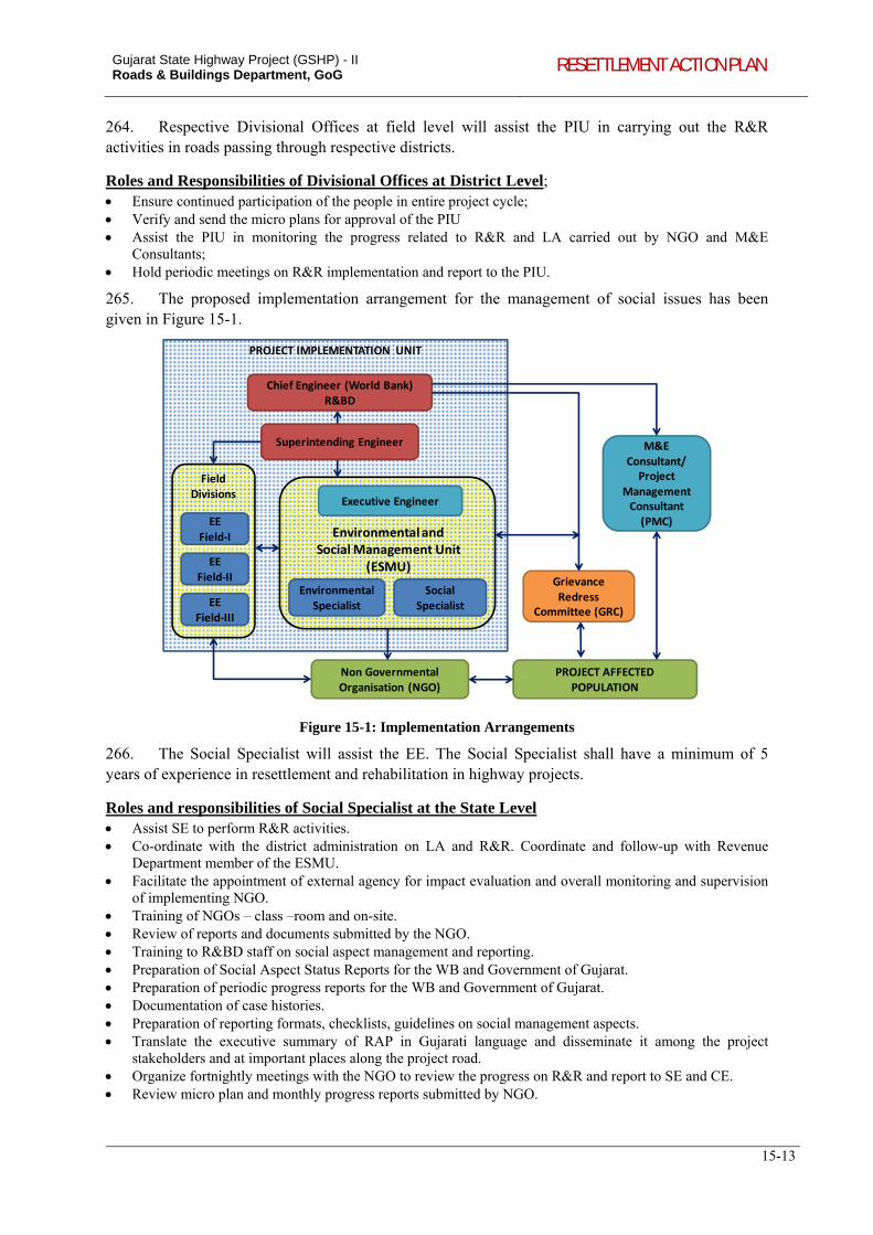
Gujarat State Highway Project (GSHP) - II Roads & Buildings Department, GoG RESETTLEMENT ACTION PLAN
15-13
264. Respective Divisional Offices at field level will assist the PIU in carrying out the R&R activities in roads passing through respective districts.
Roles and Responsibilities of Divisional Offices at District Level; Ensure continued participation of the people in entire project cycle; Verify and send the micro plans for approval of the PIU Assist the PIU in monitoring the progress related to R&R and LA carried out by NGO and M&E
Consultants; Hold periodic meetings on R&R implementation and report to the PIU.
265. The proposed implementation arrangement for the management of social issues has been given in Figure 15-1.
PROJECT IMPLEMENTATION UNIT
Environmental and Social Management Unit
(ESMU)
Chief Engineer (World Bank)R&BD
Non Governmental Organisation (NGO)
M&E Consultant/Project
Management Consultant (PMC)
Grievance Redress
Committee (GRC)
PROJECT AFFECTED POPULATION
Executive Engineer
Environmental Specialist
Social Specialist
Field Divisions
EE Field‐I
EEField‐II
EEField‐III
Superintending Engineer
Figure 15-1: Implementation Arrangements
266. The Social Specialist will assist the EE. The Social Specialist shall have a minimum of 5 years of experience in resettlement and rehabilitation in highway projects.
Roles and responsibilities of Social Specialist at the State Level Assist SE to perform R&R activities. Co-ordinate with the district administration on LA and R&R. Coordinate and follow-up with Revenue
Department member of the ESMU. Facilitate the appointment of external agency for impact evaluation and overall monitoring and supervision
of implementing NGO. Training of NGOs – class –room and on-site. Review of reports and documents submitted by the NGO. Training to R&BD staff on social aspect management and reporting. Preparation of Social Aspect Status Reports for the WB and Government of Gujarat. Preparation of periodic progress reports for the WB and Government of Gujarat. Documentation of case histories. Preparation of reporting formats, checklists, guidelines on social management aspects. Translate the executive summary of RAP in Gujarati language and disseminate it among the project
stakeholders and at important places along the project road. Organize fortnightly meetings with the NGO to review the progress on R&R and report to SE and CE. Review micro plan and monthly progress reports submitted by NGO.
Gujarat State Highway Project (GSHP) - II Roads & Buildings Department, GoG RESETTLEMENT ACTION PLAN
15-14
Roles and responsibilities of Social Specialist at the District Level Participate in public consultations. Management of conflict resolution exercises for social issues. Assistance in-community property & temple relocation cases. Monitoring of community enhancement plans. Liaison with district administration and concerned departments for dovetailing government social security
schemes for the socio-economic wellbeing of the PAPs. Develop and maintain a PAP level database including aspects related to losses, compensation, R&R
entitlement, release of funds and utilization. Assistance in Cross-verification of PAPs identified by the NGO. Finalization of individual entitlements in co-ordination with the NGO and PIU. Checking of ID cards submitted by the NGO. Participation in the ID card distribution process with NGO and PIU. Cross-verification of PAP training details submitted by the NGO. Coordination with concerned divisions regarding distribution of shifting, subsistence and training
allowances. Assistance and coordination with concerned divisions regarding notification process under RAP. Assistance and coordination for resettlement cases with State Road Project Divisions and concerned
Government departments. Supervision of the socio-economic surveys.
Assistance in grievance redressal procedures & coordination of field activities with the NGO. Assistant in Market Value Assessment Procedures. Technical assistance in creating socio-economic data base of HHs losing land.
15.5.2. Role of Revenue Department
267. Acquiring Body have to make an application for acquisition of any land for a public purpose to the Collector of the district concerned and the Collector forwards such applications for acquisition of land to the Land Acquisition Officers concerned. On receipt of such applications, the LAO makes a preliminary enquiry. The land acquisition proceedings begin with a Notification under section 4(1) and survey and investigation will be carried out under section 4(2). Section 5-A provides for filing of objection and afterwards hearing of objection and report of Collector to Government. Declaration under section 6 will be published in the Official Gazette and two daily newspapers of the area, indicating actual location of the land for the project. Land acquisition officer (LAO) takes order for LA from the Government under section 7 and measurement of land done on ground under section 8. Inquiry and offer of compensation by Collector (section 11 to 13) and possession of land will be taken under section 16 after the award is made.
268. In these proceedings, PIU will facilitate for joint verification of land by LAO. To avoid delay of any sort, it is proposed that PIU may hire an Expert who is conversant with land acquisition procedures till an alternative arrangement is in place like utilising the services of NGO proposed to be in place for RAP implementation. Valuation of assets within affected land will be carried out by respective Departments.
269. The compensation for land and other assets for titleholders (assets alone in the case of non-titleholders) will be disbursed through Revenue Department. R&R assistance as per entitlement provisions for both titleholders and non-titleholders will be disbursed through PIU.
Gujarat State Highway Project (GSHP) - II Roads & Buildings Department, GoG RESETTLEMENT ACTION PLAN
15-15
15.5.3. Implementation Support by NGO
270. As prescribed in the World Bank Operational Policy48, GSHP-II envisages involvement of NGOs in the implementation of RAP. The roles and responsibilities of NGO are summarized as follows:
Explain to PAPs about the potential adverse impacts and proposed mitigation measures and, R&R entitlements;
Distribute the dissemination materials including pamphlets on RAP and other aspects; Facilitate ESMU in organizing public information campaign at the commencement of R&R activities; Prepare the micro plans; Participate in the meetings organized by ESMU; Provide support for implementation of RAP; Prepare and distribute identity cards provided by the PIU to identified PAFs; Facilitate opening of joint bank accounts (PAPs and his/her spouse) for individual PAPs; Assist PAPs in receiving compensation, focusing on vulnerable PAPs to ensure that they get their dues on
time; Generate awareness about the productive use of compensation money and R&R grants; Explain the resource base and other opportunities to enable them to make informed choices and participate
in their own development; Ensure that vulnerable PAPs are given their dues both for payment of compensation and rehabilitation
assistance; Submit monthly progress reports to ESMU; Identify training needs of PAPs for income generating activities and ensure they are adequately supported
during the post-training period on respective income generating activities, and, Ensure that the grievances and problems faced by PAPs are presented to the Grievance Redress Committee
for their resolution.
271. Terms of Reference (ToR) for the NGO have been presented in Appendix 15.4
15.5.4. Complaint Handling Mechanism
272. Being a project involving large scale of civil works along with implementation of RAP/IPDP/HPP, the project is likely to receive suggestions, complaints, inquiries, etc. R&BD recognizes the importance of this and hence intends to address such issues through the Complaints Handling Procedures for GSHP-II, under which a centralized monitoring of all the complaints received from and through various mechanisms / individuals can efficiently take place under the information of WB.
273. Complaints Handling Procedure ensures that any citizen can lodge complaints with (i) any officer not below the rank of executive engineer in charge of the work, and (ii) any officer in charge of the redress systems in vogue in the state. Complaints related to (i) project services (new proposal/alteration in the scope of project, ongoing /completed project services in the areas of quality, procurement, R&R, environment and inaction/delayed action) and (ii) personnel (misbehaviour, corruption, service matter).
274. Complaints Handling Procedures assigns SE, PIU as the Chief Complaint Handling Officer with set roles and responsibilities. He is mainly responsible for complaints not related to personnel. Complaints related to personnel require to be dealt with as per the existing system. Training to the employees working under WB wing needs to be given for clear understanding of the procedures involved and to treat the complaints as an opportunity for improvement and not to discriminate / antagonize the complainant in future dealings.
275. Details of complaint handling procedures, response time frame, roles and responsibilities of CHO, format of the complaint register, etc are given in Appendix 15.5.
48 Annex A: Involuntary Resettlement Instruments, OP 4.12. The World Bank Operational Manual. December 2001.
Gujarat State Highway Project (GSHP) - II Roads & Buildings Department, GoG RESETTLEMENT ACTION PLAN
15-16
276.
15.5.5. Grievance Redress Committee
The project proposes to establish a Grievance Redress Committee (GRC) to hear the complaints of project affected persons and resolve the same. The process will promote settlement of disputes and reduce litigation. GRC will be set up at the district level with District Collector as head. The constitution of GRC is:
(i) District Collector or his designated representative of at least the rank of Assistant District Collector (preference would be given to women officers);
(ii) The District Development Officer of the Department of Revenue; (iii) The Executive Engineer, PIU
277. Representative from Social Sector/Local NGO (not involved with implementation) /Person conversant with similar issues and he/she should be widely respected and having problem solving skills (to be selected by DM / Collector).GRC will be responsible for the following: (i) Support PAPs in resolving issues related to R&R and LA; (ii) Record grievance and resolve them within stipulated time; (iii) Inform PIU about any serious cases; and (iv) Report to the aggrieved parties about the decisions of the PIU.
278. ESMU will provide all necessary help to PAPs in presenting his/her case before the GRC. The GRC will respond to the grievance within 15 days. The GRC will normally meet once in a month but may meet more frequently, if the situation so demands. A time period of 45 days will be available for redressing the grievance of EPs. The decision of the GRC will not be binding to PAPs. The PAP has the option of taking recourse to the court of law" , if he/she so desires. Broad functions of GRC are as under:
Record the grievances of PAPs, categorize and prioritize them and provide solution to their grievances related to resettlement and rehabilitation assistance.
The GRC may undertake site visit, ask for relevant information from Project Authority and other government and non-government agencies, etc in order to resolve the grievances of PAPs.
Fix a time frame within the stipulated time period of 45 days for resolving the grievance. Inform PAPs through ESMU about the status of their case and their decision to PAPs for compliance.
279. The GRC will be constituted within 3 months by an executive order from GoG from the date of mobilization of RAP implementing NGO.
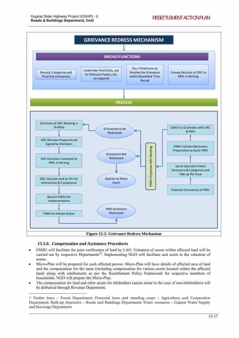
Gujarat State Highway Project (GSHP) - II Roads & Buildings Department, GoG RESETTLEMENT ACTION PLAN
15-17
GRIEVANCE REDRESS MECHANISM
BROAD FUNCTIONS
Record, Categorise and Prioritise Grievances
Undertake Field Visits, ask for Relevant Papers, etc.
as required
Fix a Timeframe to Resolve the Grievance within Stipulated Time
Period
Convey Decision of GRC to PAPs in Writing
PROCESS
Decisions of GRC Meeting is Drafted
GRC Minutes Prepared and Signed by Members
GRC Decisions Conveyed to PAPs in Writing
GRC Decision sent to PIU for Information & Compliance
Back to ESMU for Implementation
ESMU to Initiate Action
ESMU Co‐Ordinates with GRC & PAPs
ESMU Initiates Necessary Preparation to Assist PAPs
Social Specialist Check Grievance & Categories and
Take up the Issue
Potential Grievances of PAPs
Grievances to be Redressed
Grievances Not Redressed
Options to Move Court
PAPs Grievance Redressed
ESMU OrganisesGRC M
eeting
Figure 15-2: Grievance Redress Mechanism
15.5.6. Compensation and Assistance Procedures
ESMU will facilitate for joint verification of land by LAO. Valuation of assets within affected land will be carried out by respective Departments49. Implementing NGO will facilitate and assist in the valuation of assets.
Micro-Plan will be prepared for each affected person. Micro-Plan will have details of affected area of land and the compensation for the same (including compensation for various assets located within the affected land) along with entitlements as per the Resettlement Policy Framework for respective members of households. NGO will prepare the Micro-Plan.
The compensation for land and other assets for titleholders (assets alone in the case of non-titleholders) will be disbursed through Revenue Department.
49 Timber trees – Forest Department; Perennial trees and standing crops – Agriculture and Cooperation Department; Built-up structures – Roads and Buildings Department; Water resources – Gujarat Water Supply and Sewerage Department.
Gujarat State Highway Project (GSHP) - II Roads & Buildings Department, GoG RESETTLEMENT ACTION PLAN
15-18
Assistance as per entitlement provisions for both titleholders and non-titleholders will be disbursed through PIU.
Any grievances arise during valuation of land or other assets and estimation of entitlements will be referred to the Grievance Redress Committee. This will also be facilitated by NGO.
15.5.7. List of Documents/Information Required to Establish Ownership to Property and access Compensation
280. The PAP should produce the following documents/information to establish ownership to property and access compensation:
Land Records [7/12 – 8A, Khedut Pothi50]; Statement showing details of the land under acquisition.
Survey number of the land; True area of land for the purpose of award; Tenure of the land [such as new tenure, old tenure, etc]; Category of land [Jarayat (irrigated), Bagayat (unirrigated), Kyari (block), etc].
Statement showing the details of claims filed and evidence produced by the interested persons. Name of the Claimant (whether owner, lessee, tenant, etc.); Claim (area of land, number of trees, area and details of structures, details of other damages);
ID card issued by PIU and cross verified by the NGO. Details of Bank Account for transfer of compensation amount.
15.6. INCOME RESTORATION MEASURES
281. The basic objective of income restoration activities is that no project-affected person shall be worse off than before the project. Restoration of pre-project levels of income is an important part of rehabilitating individuals, households, and socio-economic and cultural systems in affected communities. Income restoration (IR) schemes will be designed in consultation with affected persons so as to benefit them. Based on the information collected on IR activities through the census socio-economic surveys, the implementing NGO will identify suitable IR programme for the affected persons. (See Terms for Reference for NGO in Appendix 6.1). Steps to be followed for income restoration include:
Identification of target groups and choosing respective income restoration activities – NGO needs to identify the affected persons and prepare a list of feasible income restoration options. While identifying IR options, the following factors shall also be considered: (i) education level of affected persons, (ii) skill possession, (iii) likely economic activities in the post-displacement period, (iv) extent of land left, (v) suitability of economic activity to supplement the income, and (vi) market potential and marketing facilities. Based on socio-economic characteristics and options preferred by affected persons, the NGO may have to assign trades to affected persons. The NGO will assist in identifying appropriate alternative economic rehabilitation schemes through counselling and consultation.
Training: option for training on skill enhancement for those losing their livelihood has been provided in the Entitlement Matrix. The beneficiary group includes employees in shops, agricultural labours, sharecroppers, squatters and vulnerable people. Training programmes will be conducted by PIU with assistance from NGO. Support shall be provided through the training agency/department to PAP in seeking employment. Periodic review meeting will be carried out by the PIU to assess the efficacy of training programmes and corrective measures, if required, will be suggested for coordination with various training institutes/departments.
Identification of Training Institutes/Departments: based on trades selected, NGO shall have to identify the training institute for different trades / activities who can provide on the job training. The suggested institutes include:
Education Department, Govt. of Gujarat (self-employment programmes for women); Tribal Development Department, Govt. of Gujarat (Vanbandhu Kalyan Yojana);
50 Khedut Pothi is a booklet where the details of land holdings of individual farmers are recorded. The Khedut Pothi is maintained by the Revenue Department and a copy of the same is issued to each farmer.
Gujarat State Highway Project (GSHP) - II Roads & Buildings Department, GoG RESETTLEMENT ACTION PLAN
15-19
Department of Social Justice and Empowerment; Scheduled Caste Economic Development Corporation (Economic Upliftment Schemes for Scheduled Castes and women); and
Commissionerate of Rural Development, Govt. of Gujarat. Training Arrangement: NGO shall group the affected persons based on their preferred trades and make all
the arrangements such as fixing the venue etc. Monitoring: After training, the contracted M&E agency shall carry out the monitoring. Internal monitoring
is the responsibility of PIU with support from PMC.
15.7. ENHANCEMENT OF COMMUNITY AND CULTURAL ASSETS
282. There are local community resources like ponds, traditional sitting areas, schools, and wells etc. apart from cultural properties, which share mutual interests with communities/users and also enhance the quality of experience of highway travelling along the corridors. The aim of these enhancement properties is to promote qualitative development and infuse greater meaning in the road environment. Its secondary objectives are:
In order to beautify and enhance the experience of travelling for the public/ road users, it is necessary to beautify the cultural and community assets along the highway,
To restrict these properties from further encroaching the RoW, and, To ensure integration of design measures which significantly improve the safety conditions and
improvement of the community infrastructure at these locations, and thereby benefit road users and local communities.
283. The selection of enhancement forms is influenced by the location of the properties and their physical relationship with the corridor.
Guiding principles for enhancements in GSHP- II The selection of properties for enhancement under GSHP II shall be in line with the following
criteria (i) value or significance (ii) age (iii) building type and material (iv) ownership and (v) size of the property;
The selection of the properties for enhancement shall be done considering potential benefits to a larger section of the community, than to private properties or assets;
The enhancements proposed to religious structures shall strictly conform to the Supreme Court order, 2009 pertaining to removal and restriction of encroachment of religious structures on public spaces;
The properties abutting the corridor and conforming to the selection criteria for enhancement shall be taken up as candidates for enhancement; and,
Maintenance free and durable measures shall be adopted and confirmation from the property owners on the maintenance of the created assets shall be a prerequisite for carrying out the enhancement.
15.7.1. Overview of Enhancement Measures
284. Providing and / or improving access: Generally shrines, temples and wells along highways are often isolated from the surrounding environs. Depending upon site specific situations, the project shall strive to improve access to these properties by providing walkways from the highway. Locally available materials shall be preferred as well as using different paving patterns and materials shall create interesting ground surfaces. The intention is to enrich the roadside places.
285. Improving, defining, redefining the precincts: In addition to providing access, emphasis shall be given for defining the precinct or area of immediate influence of the property. Hard landscaping measures shall be used in continuation with the access pathway to form the precinct of the structure. Particular attention shall be paid to the entry areas of these properties.
286. Creating seating spaces and rest areas: Formal or informal seating and rest areas are adopted to match the precinct of the property. The project shall explore avenues for creation of rest areas along the highway. Rest areas with landscaping shall be developed especially near temples and
Gujarat State Highway Project (GSHP) - II Roads & Buildings Department, GoG RESETTLEMENT ACTION PLAN
15-20
community areas where space and drinking water are available. Sitting benches can be provided depending upon the specific site conditions and needs.
287. Landscaping and Buffers: Trees not only enrich the visual quality of the space but it also acts as a buffer to abate pollution, to define the area and to provide shade for the sitting areas. Plantation of trees is a prime enhancement as well as mitigation measure in the project. Tree bases shall be built around existing as well as proposed shade trees to form informal seating spaces, which are evidently preferred to the formal seating spaces.
288. Other Enhancements: Minor improvements can be done such as to propose shade trees to provide informal seating spaces, which are evidently preferred to the formal ones. Plastering and whitewashing of some cultural properties, school boundary walls, provision of shades over the wells, etc. shall be considered. Pedestrian pathways with zebra crossings and information signage’s shall also be considered. Other enhancements shall be project-specific depending upon the specific site location and conditions.
289. Using the guiding principles for enhancements the following properties given in Table 15-2 qualify for enhancement. Details of enhancement measures and cost estimates are given in Environmental Management Plans.
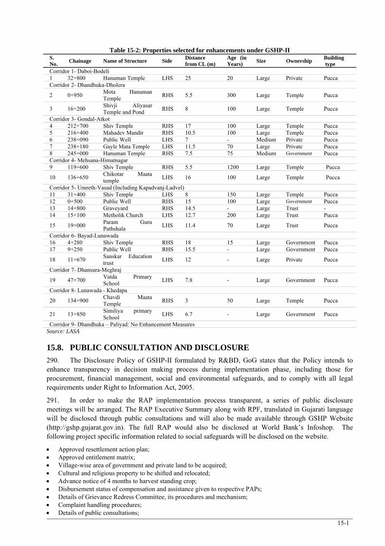
15-1
Table 15-2: Properties selected for enhancements under GSHP-II S. No.
Chainage Name of Structure Side Distance from CL (m)
Age (in Years)
Size Ownership Building type
Corridor 1- Daboi-Bodeli 1 32+800 Hanuman Temple LHS 25 20 Large Private Pucca Corridor 2- Dhandhuka-Dholera
2 0+950 Mota Hanuman Temple
RHS 5.5 300 Large Temple Pucca
3 16+200 Shivji Aliyasar Temple and Pond
RHS 8 100 Large Temple Pucca
Corridor 3- Gondal-Atkot 4 212+700 Shiv Temple RHS 17 100 Large Temple Pucca 5 216+400 Mahadev Mandir RHS 10.5 100 Large Temple Pucca 6 238+090 Public Well LHS 7 - Medium Private Pucca 7 238+180 Gayle Mata Temple LHS 11.5 70 Large Private Pucca 8 245+000 Hanuman Temple RHS 7.5 75 Medium Government Pucca Corridor 4- Mehsana-Himatnagar 9 119+600 Shiv Temple RHS 5.5 1200 Large Temple Pucca
10 136+650 Chikotar Maata temple
LHS 16 100 Large Temple Pucca
Corridor 5- Umreth-Vasad (Including Kapadvanj-Ladvel) 11 31+400 Shiv Temple LHS 8 150 Large Temple Pucca 12 0+500 Public Well RHS 15 100 Large Government Pucca 13 14+800 Graveyard RHS 14.5 - Large Trust - 14 15+100 Metholik Church LHS 12.7 200 Large Trust Pucca
15 19+000 Param Guru Pathshala
LHS 11.4 70 Large Trust Pucca
Corridor 6- Bayad-Lunawada 16 4+280 Shiv Temple RHS 18 15 Large Government Pucca 17 9+250 Public Well RHS 15.5 - Large Government Pucca
18 11+670 Sanskar Education trust
LHS 12 - Large Private Pucca
Corridor 7- Dhansura-Meghraj
19 47+700 Vatda Primary School
LHS 7.8 - Large Government Pucca
Corridor 8- Lunawada - Khedapa
20 134+900 Chavdi Maata Temple
RHS 3 50 Large Temple Pucca
21 13+850 Similiya primary School
LHS 6.7 - Large Government Pucca
Corridor 9- Dhandhuka – Paliyad: No Enhancement Measures Source: LASA
15.8. PUBLIC CONSULTATION AND DISCLOSURE
290. The Disclosure Policy of GSHP-II formulated by R&BD, GoG states that the Policy intends to enhance transparency in decision making process during implementation phase, including those for procurement, financial management, social and environmental safeguards, and to comply with all legal requirements under Right to Information Act, 2005.
291. In order to make the RAP implementation process transparent, a series of public disclosure meetings will be arranged. The RAP Executive Summary along with RPF, translated in Gujarati language will be disclosed through public consultations and will also be made available through GSHP Website (http://gshp.gujarat.gov.in). The full RAP would also be disclosed at World Bank’s Infoshop. The following project specific information related to social safeguards will be disclosed on the website.
Approved resettlement action plan; Approved entitlement matrix; Village-wise area of government and private land to be acquired; Cultural and religious property to be shifted and relocated; Advance notice of 4 months to harvest standing crop; Disbursement status of compensation and assistance given to respective PAPs; Details of Grievance Redress Committee, its procedures and mechanism; Complaint handling procedures; Details of public consultations;
Gujarat State Highway Project (GSHP) - II Roads & Buildings Department, GoG
RESETTLEMENT ACTION PLAN
15-2
Details of compensation given to land looser and PAP (Quarterly); Details of social/cultural and religious properties to be relocated; Details of benefits of project to the public; Details of NGO involved in implementation of RAP
292. The objective of the consultations is to (i) understand the view of the affected persons on rehabilitation and resettlement issues; and (ii) facilitate delivery of appropriate and acceptable entitlement options.
293. The process and proceedings of such consultations shall be documented and PIU respond to the issues raised during the consultations.
15.9. MECHANISM FOR TRAINING AND CAPACITY BUILDING
294. Training and development of project staff is an integral part for implementation GSHP-II. Training needs identification shall be carried out at State level (PIU), Regional level (Divisional offices of R&BD) and at Field level, based on which focused training modules shall be developed. This is with the objective of (i) strengthening in-house capacity to implement the RPF/RAP/IPDP/HPP; (ii) creating awareness, providing the tools for implementation and accompanying set of management procedures to all departments; and (iii) developing competence within key officials to provide training in their respective level.
295. The topics for training and capacity building includes:
a. Introduction to social & R&R issues (R&R policies at state/national/international level, social issues pertaining to R&R ( participation of women, poverty assessment, anti poverty programmes, highway related diseases, road safety, transparency, right to information);
b. Land acquisition (Acts, policies, valuation of land, concept of replacement value, /market value, institutional mechanism etc.);
c. Social Impact Assessment and RAP/IPDP/HIV/AIDS Awareness, prevention plan (social screening, census survey, socioeconomic survey, methodology, focus group discussions, institutional survey, free, prior informed consultation, data analysis report preparation);
d. Resettlement Policy Framework (category of PAPs, category of impacts, valuation of assets (land, structure, crops, trees, community assets, etc.), entitlements, women and vulnerable groups, temporary impacts, disruption/damage during construction and respective mitigation measures);
e. RAP/IPDP/HPP implementation (updating PAP database, joint verification of affected structures/land and affected population, preparation of Micro Plan, grievance redress procedures, conflict resolution packages, assistance and training for income restoration, monitoring and evaluation of social safeguards implementation.
296. The training programs are to be conducted with the help of local, state and national level training institutions and experts in various aspects of social management and safeguard issues. PIU will also identify courses offered by the premier institutions in India on social management and safeguard issues and enable participation of project staff. Towards enhancing the capacity of the R&BD engineers on social safeguards management, R&BD has over the past few years deputed engineers for participation in various safeguards training and capacity building programs.
15.10. MONITORING AND EVALUATION
297. Internal monitoring of the implementation of social safeguards will be carried out by the PIU with support of Project Management Consultant/Supervision Consultant. Towards enhancing the quality of RAP/IPDP implementation, in addition to the internal monitoring by the PIU, external monitoring will be done by a third-party agency or Project Management Consultant (PMC) for technical as well as environmental/social aspects. The role of third-party agency/PMC towards external monitoring of social safeguards will include the following:
Conduct periodic monitoring of RAP/IPDP implementation on quarterly basis to provide early alert to redress any potential problems; and,
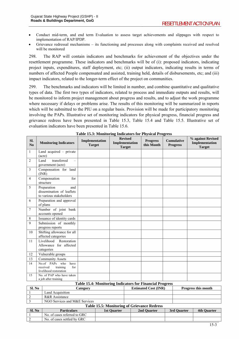
Gujarat State Highway Project (GSHP) - II Roads & Buildings Department, GoG
RESETTLEMENT ACTION PLAN
15-3
Conduct mid-term, and end term Evaluation to assess target achievements and slippages with respect to implementation of RAP/IPDP.
Grievance redressal mechanisms – its functioning and processes along with complaints received and resolved will be monitored
298. The RAP will contain indicators and benchmarks for achievement of the objectives under the resettlement programme. These indicators and benchmarks will be of (i): proposed indicators, indicating project inputs, expenditures, staff deployment, etc; (ii) output indicators, indicating results in terms of numbers of affected People compensated and assisted, training held, details of disbursements, etc; and (iii) impact indicators, related to the longer-term effect of the project on communities.
299. The benchmarks and indicators will be limited in number, and combine quantitative and qualitative types of data. The first two types of indicators, related to process and immediate outputs and results, will be monitored to inform project management about progress and results, and to adjust the work programme where necessary if delays or problems arise. The results of this monitoring will be summarized in reports which will be submitted to the PIU on a regular basis. Provision will be made for participatory monitoring involving the PAPs. Illustrative set of monitoring indicators for physical progress, financial progress and grievance redress have been presented in Table 15.3, Table 15.4 and Table 15.5. Illustrative set of evaluation indicators have been presented in Table 15.6.
Table 15.3: Monitoring Indicators for Physical Progress
Sl. No
Monitoring Indicators Implementation
Target
Revised Implementation
Target
Progress this Month
Cumulative Progress
% against Revised Implementation
Target 1 Land acquired – private
(acre)
2 Land transferred – government (acre)
3 Compensation for land (INR)
4 Compensation for structure
5 Preparation and dissemination of leaflets to various stakeholders
6 Preparation and approval of plans
7 Number of joint bank accounts opened
8 Issuance of identity cards 9 Submission of monthly
progress reports
10 Shifting allowance for all affected categories
11 Livelihood Restoration Allowance for affected categories
12 Vulnerable groups 13 Community Assets 14 No.of PAPs who have
received training for livelihood restoration
15 No. of PAP who have taken a job after training
Table 15.4: Monitoring Indicators for Financial Progress Sl. No Category Estimated Cost (INR) Progress this month
1 Land Acquisition 2 R&R Assistance 3 NGO Services and M&E Services
Table 15.5: Monitoring of Grievance Redress Sl. No Particulars 1st Quarter 2nd Quarter 3rd Quarter 4th Quarter
1 No. of cases referred to GRC 2 No. of cases settled by GRC
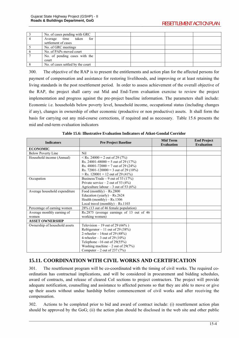
Gujarat State Highway Project (GSHP) - II Roads & Buildings Department, GoG
RESETTLEMENT ACTION PLAN
15-4
3 No. of cases pending with GRC 4 Average time taken for
settlement of cases
5 No. of GRC meetings 6 No. of PAPs moved court 7 No. of pending cases with the
court
8 No. of cases settled by the court
300. The objective of the RAP is to present the entitlements and action plan for the affected persons for
payment of compensation and assistance for restoring livelihoods, and improving or at least retaining the
living standards in the post resettlement period. In order to assess achievement of the overall objective of
the RAP, the project shall carry out Mid and End-Term evaluation exercise to review the project
implementation and progress against the pre-project baseline information. The parameters shall include:
Economic i.e. households below poverty level, household income, occupational status (including changes
if any), changes in ownership of other economic (productive or non productive) assets. It shall form the
basis for carrying out any mid-course corrections, if required and as necessary. Table 15.6 presents the
mid and end-term evaluation indicators
Table 15.6: Illustrative Evaluation Indicators of Atkot-Gondal Corridor
Indicators Pre Project Baseline Mid Term Evaluation
End Project Evaluation
ECONOMIC Below Poverty Line Nil Household income (Annual)
< Rs. 24000 = 2 out of 29 (7%) Rs. 24001-48000 = 5 out of 29 (17%) Rs. 48001-72000 = 7 out of 29 (24%) Rs. 72001-120000 = 3 out of 29 (10%) > Rs. 120001 = 12 out of 29 (41%)
Occupation Business/Trade – 9 out of 53 (17%) Private service – 2 out of 53 (4%) Agriculture labour – 3 out of 53 (6%)
Average household expenditure Food (monthly) – Rs.2800 Education (yearly) – Rs.2624 Health (monthly) – Rs.1306 Local travel (monthly) – Rs.1103
Percentage of earning women 28% (13 out of 46 female population) Average monthly earning of women
Rs.2875 (average earnings of 13 out of 46 working women)
ASSET OWNERSHIP Ownership of household assets
Television – 19 out of 29 (66% ) Refrigerator – 11 out of 29 (38%) 2-wheeler – 14out of 29 (48%) 4-wheeler – 3 out of 29 (10%) Telephone –16 out of 29(55%) Washing machine – 2 out of 29(7%) Computer – 2 out of 237 (7%)
15.11. COORDINATION WITH CIVIL WORKS AND CERTIFICATION
301. The resettlement program will be co-coordinated with the timing of civil works. The required co-ordination has contractual implications, and will be considered in procurement and bidding schedules, award of contracts, and release of cleared CoI sections to project contractors. The project will provide adequate notification, counselling and assistance to affected persons so that they are able to move or give up their assets without undue hardship before commencement of civil works and after receiving the compensation.
302. Actions to be completed prior to bid and award of contract include: (i) resettlement action plan should be approved by the GoG; (ii) the action plan should be disclosed in the web site and other public
Gujarat State Highway Project (GSHP) - II Roads & Buildings Department, GoG
RESETTLEMENT ACTION PLAN
15-5
places accessible to the local people; (iii) the first notification for private land acquisition should be issued; (iv) the issue of identity cards to eligible PAPs should be completed.
303. The actions to be completed prior to handing over of the stretch to the contractor includes: (i) acquisition of private land should be completed and compensation for land and assistance as per entitlement matrix should be disbursed and (ii) transfer of Government land should be completed or no objection should be obtained from the land owning agency.
15.12. IMPLEMENTATION SCHEDULE OF RAP
304. RAP implementation schedule is provided in Table 15.7. This provides the key benchmarks of implementing RAP.
305. The construction tenure of individual corridors ranges from 18 months to 30 months spread across an overall period of 36 months. Accordingly, R&BD has envisaged tenure of 36 months for the RAP implementing NGO. The on-ground rehabilitation and resettlement exercises and handing over the encumbrance free stretch for civil works will take 5 months to 14 months (within 5 months for a single corridor) and simultaneously, the NGO will carry out awareness programmes on road safety, HIV/AIDS prevention campaign, repeat training for PAPs, facilitate overall monitoring, etc.
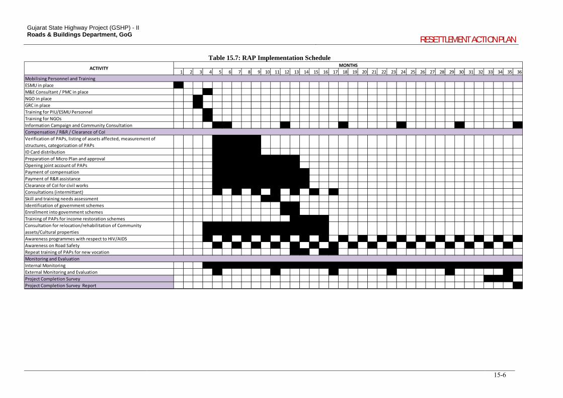
Gujarat State Highway Project (GSHP) - II Roads & Buildings Department, GoG
RESETTLEMENT ACTION PLAN
15-6
Table 15.7: RAP Implementation Schedule
1 2 3 4 5 6 7 8 9 10 11 12 13 14 15 16 17 18 19 20 21 22 23 24 25 26 27 28 29 30 31 32 33 34 35 36
ESMU in place
M&E Consultant / PMC in place
NGO in place
GRC in place
Training for PIU/ESMU Personnel
Training for NGOs
Information Campaign and Community Consultation
Verification of PAPs, listing of assets affected, measurement of
structures, categorization of PAPs
ID Card distribution
Preparation of Micro Plan and approval
Opening joint account of PAPs
Payment of compensation
Payment of R&R assistance
Clearance of CoI for civil works
Consultations (intermittant)
Skill and training needs assessment
Identification of government schemes
Enrollment into government schemes
Training of PAPs for income restoration schemes
Consultation for relocation/rehabilitation of Community
assets/Cultural properties
Awareness programmes with respect to HIV/AIDS
Awareness on Road Safety
Repeat training of PAPs for new vocation
Internal Monitoring
External Monitoring and Evaluation
Project Completion Survey
Project Completion Survey Report
ACTIVITYMONTHS
Mobilising Personnel and Training
Compensation / R&R / Clearance of CoI
Monitoring and Evaluation
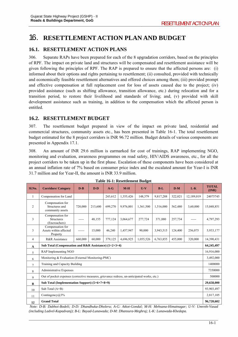
Gujarat State Highway Project (GSHP) - II Roads & Buildings Department, GoG
RESETTLEMENT ACTION PLAN
16-1
16. RESETTLEMENT ACTION PLAN AND BUDGET
16.1. RESETTLEMENT ACTION PLANS
306. Separate RAPs have been prepared for each of the 8 upgradation corridors, based on the principles of RPF. The impact on private land and structures will be compensated and resettlement assistance will be given following the principles of RPF. The RAP is prepared to ensure that the affected persons are: (i) informed about their options and rights pertaining to resettlement; (ii) consulted, provided with technically and economically feasible resettlement alternatives and offered choices among them; (iii) provided prompt and effective compensation at full replacement cost for loss of assets caused due to the project; (iv) provided assistance (such as shifting allowance, transition allowance, etc.) during relocation and for a transition period, to restore their livelihood and standards of living; and, (v) provided with skill development assistance such as training, in addition to the compensation which the affected person is entitled.
16.2. RESETTLEMENT BUDGET
307. The resettlement budget prepared in view of the impact on private land, residential and commercial structures, community assets etc., has been presented in Table 16-1. The total resettlement budget estimated for the 8 project corridors is INR 96.72 million. Budget details of various components are presented in Appendix 17.1.
308. An amount of INR 29.6 million is earmarked for cost of trainings, RAP implementing NGO, monitoring and evaluation, awareness programmes on road safety, HIV/AIDS awareness, etc., for all the project corridors to be taken up in the first phase. Escalation of these components have been considered at an annual inflation rate of 7% based on consumer price index and the escalated amount for Year-I is INR 31.7 million and for Year-II, the amount is INR 33.9 million.
Table 16-1: Resettlement Budget
Sl.No. Corridors/ Category D-B D-D A-G M-H U-V B-L D-M L-K TOTAL (INR)
1 Compensation for Land
243,612 1,355,426 148,379 9,817,288 322,021 12,189,019 24075745
2 Compensation for
Structures and community assets
720,000 213,600 699,270 9,976,001 1,361,500 1,516,000 562,480 3,60,000 15,048,851
3 Compensation for
Structures (Encroachers)
----- 48,155 777,124 3,064,677 277,724 371,880 257,734 ----- 4,797,293
3 Compensation for
Assets within affected Property
------ 15,000 46,240 1,457,947 90,000 3,943,515 124,400 256,075 5,933,177
4 R&R Assistance 660,000 60,000 379,125 4,696,925 1,055,526 6,763,855 455,000 320,000 14,390,431
A Sub Total (Compensation and R&R Assistance) (1+2+3+4) 64,245,497
5 RAP Implementing NGO 16,916,000
6 Monitoring & Evaluation (External Monitoring-PMC) 3,492,000
7 Training and Capacity Building 1400000
8 Administrative Expenses 7350000
9 Out of pocket expenses (corrective measures, grievance redress, un-anticipated works, etc.) 500000
B Sub Total (Implementation Support) (5+6+7+8+9) 29,658,000
10 Sub Total (A+B) 93,903,497
11 Contingency@3% 2,817,105
12 Grand Total 96,720,602
Note: D-B: Dabhoi-Bodeli; D-D: Dhandhuka-Dholera; A-G: Atkot-Gondal; M-H: Mehsana-Himatnagar; U-V: Umreth-Vasad (including Ladvel-Kapadvanj); B-L: Bayad-Lunawada; D-M: Dhansura-Meghraj; L-K: Lunawada-Khedapa.