road safety auditing approach in assessing safety hazards
TRANSCRIPT

ROAD SAFETY AUDITING APPROACH IN ASSESSING SAFETY HAZARDS OF A SELECTED HIGHWAY SECTION OF BANGLADESH
NASIR UDDIN AHMED
MASTER OF SCIENCE IN ENGINEERING
(CIVIL & TRANSPORTATION)
DEPARTMENT OF CIVIL ENGINEERING
BANGLADESH UNIVERSITY OF ENGINEERING AND TECHNOLOGY
DHAKA, BANGLADESH
OCTOBER 2011

i
ROAD SAFETY AUDITING APPROACH IN ASSESSING SAFETY HAZARDS OF A SELECTED HIGHWAY SECTION OF BANGLADESH
NASIR UDDIN AHMED
MASTER OF SCIENCE IN ENGINEERING
(CIVIL & TRANSPORTATION)
DEPARTMENT OF CIVIL ENGINEERING
BANGLADESH UNIVERSITY OF ENGINEERING AND TECHNOLOGY
DHAKA, BANGLADESH
OCTOBER 2011

ii
The thesis titled ‘Road safety auditing approach in assessing safety hazards of a selected highway section of Bangladesh’, Submitted by Nasir Uddin Ahmed, Roll No: 0409042436 (F), Session : April 2009, has been accepted as satisfactory in partial fulfillment of the requirement for the degree of Master of Science in Engineering (Civil & Transportation) on 17 October 2011.
BOARD OF EXAMINERS
DR. MD. SHAMSUL HOQUE CHAIRMAN PROFESSOR DEPARTMENT OF CIVIL ENGINEERING (SUPERVISOR) BUET, DHAKA DR. TANWEER HASSAN MEMBER PROFESSOR DEPARTMENT OF CIVIL ENGINEERING BUET, DHAKA DR. MD. MUJIBUR RAHMAN MEMBER PROFESSOR AND HEAD (EX-OFFICIO) DEPARTMENT OF CIVIL ENGINEERING BUET, DHAKA DR. ISHTIAQUE AHMED MEMBER TRANSPORT SPECIALIST (EXTERNAL) SOUTH ASIA SUSTAINABLE DEVELOPMENT DEPARTMENT WORLD BANK, DHAKA

iii
CANDIDATE’S DECLARATION
It is hereby declared that this thesis or any part of it has not been submitted elsewhere for the award of any degree of diploma.
Nasir Uddin Ahmed

iv
ACKNOWLEDGEMENT Foremost, the author wishes to express his profound gratitude to Almighty Allah for allowing him to complete this thesis. The author would like to express his sincere gratitude to his supervisor, Dr. Md. Shamsul Hoque, Professor, Department of Civil Engineering, Bangladesh University of Engineering and Technology (BUET) for the continuous support for this study and research, for his patience, motivation, enthusiasm, and immense knowledge. His continuous guidance helped the author in all the time of research and writing of this thesis. Besides the supervisor, the author would like to thank the rest of the Board of Examiners: Dr. Md. Mujibur Rahman, Professor and Head, Department of Civil Engineering, Bangladesh University of Engineering and Technology (BUET) , Dr. Tanweer Hassan, Professor, Department of Civil Engineering, Bangladesh University of Engineering and Technology (BUET) and Dr. Ishtiaque Ahmed, Transport Specialist, South Asia Sustainable Development Department, World Bank, Dhaka, for their encouragement and insightful comments. The author wishes to express his warm and sincere thanks to all members of Accident Research Institute (ARI), BUET for allowing using its resourceful library facilities and also for giving the scope of matching collected accident data. The author gratefully acknowledges the cooperation of all concerned persons of the Department, Civil Engineering Library and BUET Central library for their assistance. Special thanks to Traffic Engineering Laboratory for allowing various instruments to use for field study. The author’s sincere thanks go to the officials of ‘The Road Design and Safety Circle’ of Roads and Highways Department (RHD), Bangladesh for helping the author with various literatures, and suggestions. The author was benefitted from Road Maintenance Management System (RMMS) database of RHD. The author warmly thanks Mr. Ahad Ullah, Sub-Divisional Engineer (SDE), Keraniganj Road Sub-Division, Munshiganj Road Division, Dhaka Road Circle for his valuable advice on existing hazards of the highway. His friendly help by providing various designs and drawings of the highway have been very helpful for this study. Sincere thanks to the Officers-in-Charge of Keranigonj Model Thana, South Keranigonj Thana, Sirajdikhan Thana, Louhojong Thana and Srinagar Thana for their whole hearted support in collection of accident data. The author is thankful to Military Institute of Science and Technology (MIST) for providing necessary administrative support. The author’s special gratitude is due to his parents and family members for their loving support. Especially the author wishes to express his gratitude to his beloved wife and daughter whose patient love and continuous encouragement enabled him to complete this study.

v
ABSTRACT
The main objective of this research was to assess potential safety hazards of Dhaka-Mawa Highway using road safety auditing approach and to recommend possible options for remedial treatment. At first existing “Guidelines for Road Safety Audit, 2005” of Roads and Highways Department (RHD), Bangladesh is reviewed and guidelines of developed countries are analyzed to find out deficiencies of RHD guidelines. Checklists provided with RHD guidelines are also analyzed and design standards and guidelines of other countries are studied to develop a more detailed and complete checklists. Then using the modified checklists, road safety auditing was conducted for Dhaka-Mawa highway. Accident data was collected to supplement audit findings. Attempts were made to assess the safety hazard scenario and to suggest likely remedial measures in view of the construction of proposed Padma Bridge, rapid urbanization and implementation of 4-laning project. In order to achieve the objectives of the research work, various guidelines on road safety audit, design standards, as built drawings, proposed road alignment plan and related publications were consulted. A total of 13 field visits were made to observe possible hazards through conducting highway geometric study, site specific speed studies, vehicular and pedestrian counts etc. Local traffic conditions were critically observed during the whole study. Besides, a total of 11 visits were made to collect accident data from 5 police stations.
Review of ‘existing RHD guidelines on road safety’ identified the necessity of incorporating few important aspects in the manual. Noteworthy aspects are: composition and qualification of audit team, roles and responsibilities of various parties, steps of audit process, quality assurance procedure, legal issues and areas of concern, costs and benefits of audit, monitoring and evaluation (M&E) procedure, explanation of audit stages etc. Considering the local road traffic peculiarities and basing on road safety guidelines of experienced countries, the study identified some relevant issues for inclusion in the audit checklists. Striking issues are: scope of the highway, accessibility, night inspection, hazardous locations, side roads, speed-breakers, road user behavior, enforcement, trauma management, non-standard vehicles etc.
Following the checklists developed in this research work, potential safety hazards along the highway were systematically identified. Presence of 11 highway-adjacent educational institutions, 14 filling stations and 15 sites of past crashes shows the high intensity of hazard exist along the highway. Field measurement revealed inadequate Stopping Sight Distance (SSD) and Passing Sight Distance (PSD) at three curves (available sight distances at curves prior to Shologhar, Chonbari Junction and Srinagar Ferryghat are 394 ft, 291 ft and 289 ft respectively against required SSD i.e. 461.53 ft and required PSD i.e. 1657.02 ft). Measurement taken at curves discloses that curve widening is not considered for 12 sharp curves of the corridor. Particularly data analysis for curve prior to Srinagar Ferry Ghat shows that 1.5 feet and 2 feet curve widening is required for design speed of 60 kmph and 80 kmph respectively. Vehicular flow data, pedestrian intensity count as well as associated site specific safety hazards revealed the necessity of overpasses at five locations. As a whole, this corridor is assessed as hazardous mainly due to: wide range of 85th percentile speed (57 to 62 kmph) , heterogeneous vehicle composition (non-standard motorized vehicle comprises 58% and 30.92% of vehicle composition observed at two places) causing speed differential of 15 kmph and modal speeds between 44 to 46 kmph, significant variance of speed between locations and also within the same type of vehicles (average speed of bus, truck, small standard motorized vehicles and non-standard vehicles was found to vary between 49-57 kmph, 35-51 kmph, 59-66 kmph and 28-46 kmph respectively), observance of motorized vehicles’ speed between 16 kmph to 23 kmph due to various hazards at bazaar/built-up area/bus-stands etc. In addition, along 31 km route length, change of alignment at every 1.68 km length due to presence of 19 curves, high (15 to 25 feet) and steep embankments having non-

vi
traversable batter slopes (1:2), presence of one hazardous location per 1.82 km length of the highway, existence of bottlenecks i.e. narrow bridges at each 1.72 km length , existence of one untreated junction per 1.29 km length of the highway, installation of 0.94 non-standard risky speed reducing devices per kilometer of the highway etc. have increased the level of roadway hazards significantly. Moreover, field observation reveals that along this corridor drivers of heavy vehicles particularly of buses (which is 36.08% of total traffic), are always in fierce competition and also have the tendency of making risky overtaking maneuver which is often induced by presence of slow moving vehicles resulting unsafe and hazardous traffic operating condition.
To supplement safety audit findings accident data of 9 years was collected. Accident statistics shows predominance of pedestrian related accidents (38.30%) followed by head-on collision accidents (13.36%), rear end collision accidents (7.13%), loss of control accidents (10.02%) and other types of accidents out of total 449 reported accidents. Analysis also shows that there exist 25 hazardous locations where a total of 301 accidents had occurred (i.e. 67% of total accidents). Bus is found to be the most dominating vehicle involved in 53.45% (240 numbers) of total reported accidents and 58.72% (101 numbers) of pedestrian related accidents. According to user groups, pedestrians are observed to be the victims of accidents (172 accidents or 38.30%) followed by passengers of various vehicles (153 accidents or 34.07%). Various contributory factors to accidents are identified during road safety auditing.
It is anticipated that proposed construction of Padma Bridge and 4-laning project is likely to aggravate already deteriorated safety situation substantially due to increased AADT which is forecasted to be 9317 in 2014 and 17185 in 2020 and also due to rapid change of land use pattern along the corridor. Consequential major impacts on road safety are likely to be due to increase of side road connections, high level of conflict among various types of vehicles particularly through and local traffic, increased number of hazardous locations, increased roadside non-motor activities, untreated divider opening etc.
Basing on audit findings, short/mid/long term and low/high cost remedial measures were suggested in details in the audit report. Noteworthy remedial measures are: provision of service roads for non-standard motorized vehicles and non-motorized vehicles, construction of vertical bypasses (approximately of total 4 km length) and conversion of cross-junctions to staggered T Junctions at identified hazardous locations, straightening/realignment of the highway at 12 sharp curves, provisioning of W-beam type safety barriers at embankment having steep batter slopes , treatment of 24 non-engineered junctions , construction of pedestrian overpasses at 5 locations, introduction of company-based organized bus service, establishment of segment-specific speed limits etc.
In addition to the recommendations made in the audit report, the study also proposed few suggestions to mitigate probable safety hazards to be aroused due to proposed Padma Bridge, 4-laning project and expected rapid urbanization. Worth mentioning suggestions are: strict access control to national highway, development of highway-adjacent land use policy, building up of local road network, upgrading three at-grade junctions (Hasnabad BRTA T Junction, Kodomtoli T-junction and Mawa Roundabout) by constructing grade separated interchange facility etc. In regards to 4-laning project, the study suggested treated opening instead of normal opening without provision of turning refuge and New Jersey type barrier instead of low height divider. Particularly in case of 4-laning project, it is recommended that instead of providing 4 lanes for all users, central two lanes should be allocated for through traffic and other two lanes should be developed as service roads to accommodate local traffics. The study ended with few topics for future studies.

vii
CONTENTS
Page Acknowledgement iv Abstract v Contents vii List of Tables xi List of Figures xiii List of Photographs xiv List of Abbreviation xvi CHAPTER 1: INTRODUCTION 1.1 Background 1 1.2 Justification for the Study 1 1.3 Objectives 2 1.4 Scope of the Study 3 1.5 Organization of the Thesis 3
CHAPTER 2: LITERATURE REVIEW 2.1 Introduction 4 2.2 Some Basic Fundamentals about Road Safety Auditing 4
2.2.1 Background of Road Safety Audit 4 2.2.2 Definition of Road Safety Audit 4 2.2.3 Benefits of a Road Safety Audit Program 5 2.2.4 Related Issues of Safety Audit 5 2.2.5 Road Safety Audit is a Part of a Road Safety Strategy 6 2.2.6 Road Safety Audit is more than Checking Standards 6 2.2.7 Essential Elements of a Road Safety Audit 6 2.2.8 Selection of Projects for Audit 7 2.2.9 Road Safety Audit (RSA) of Existing Roads 7 2.2.10 Observing Road User Behavior 7 2.2.11 Examining Physical Evidence of Past Crashes and Off-Road Excursions 7
2.3 Review of Various Guidelines 8 2. 3.1 Salient Aspects of Existing “Guidelines for Road Safety Audit” of RHD 8 2. 3.2 Road Safety Audit, AUSTROADS, Australia 9 2. 3.3 FHWA Road Safety Audit Guidelines, USA 11 2. 3.4 Guidelines for Road Safety Audit, Institution of Highways & Transportation (IHT), United Kingdom 14 2. 3.5 Road Safety Audit Guidelines, National Roads Authority (NRA), Ireland 15
2.4 Legal Issues 15 2.4.1 AUSTROADS’ View 16 2.4.2 FHWA View 16 2.4.3 IHT View 16
2.5 Interrelationship between Functional Classifications, Access Control and Different Transport Mode 17
2.5.1 Functional Classification 17 2.5.2 Access Control 17

viii
2.5.3 Different Transport Mode 17 2.6 Miscellaneous Aspects 18
2.6.1 Trauma Management 18 2.6.2 School Safety Practices 18 2.6.3 Enforcement 19
2.7 Accident Statistics 19 2.8 Impact of ‘Padma Bridge’, Rapid Urbanization and Four-Lane Highway 19 2.9 Impact of ‘Padma Multipurpose Bridge’ 19
2.9.1 Impact on Traffic Movement Pattern 19 2.9.2 Traffic Study on Padma Bridge 20
2.10 Conversion of Existing Highway to 4-Lane Highway 22 2.11 Land Use Pattern and Future Impacts 22
2.11.1 Historical Changes in the Land Use Pattern 22 2.11.2 Present Land Use Pattern- Indication of Rapid Urbanization 23
2.12 Overview 23 CHAPTER 3: RESEARCH METHODOLOGY AND DATA COLLECTION 3.1 Introduction 24 3.2 Research Methodology 24 3.3 Methodological Consideration in the Research 24
3.3.1 Review of “Guidelines for Road Safety Audit” of RHD, Bangladesh 24 3.3.2 Modification of Checklists 25 3.3.3 Road Safety Auditing 25 3.3.4 Accident Data Analysis and Matching with Audit Findings 26 3.3.5. Impact of Padma Bridge, Urbanization and Possible Conversion of 4-lane Divided Highway 26
3.4 Methodology used in the Investigation 26 3.5 Data Collection Approach 27
3.5.1 Primary Data 27 3.5.2 Secondary Data 27 3.5.3 Study and Analysis for ‘Review of RHD Guidelines on Road Safety Audit’ and Development / Modification of Checklists 27 3.5.4 Data Collection for Road Safety Audit 28 3.5.5 Collection of Accident Data 30 3.5.6 Data on the Impact of Padma Bridge, Urbanization and 4-lane Divided Highway 31
3.6 Problems Encountered 31 3.7 Summary 32 CHAPTER 4: REVIEW OF EXISTING RHD GUIDELINES FOR ROAD SAFETY AUDIT AND DEVELOPMENT OF CHECKLISTS 4.1 Introduction 33 4.2 Review of Existing RHD Guidelines 33
4.2.1 Basic Concepts are not explained 33 4.2.2 Composition of Audit Team 33 4.2.3 Roles and Responsibilities 34 4.2.4 The Audit Process, Step by Step 34 4.2.5 Road Safety Audit and Quality Assurance 34 4.2.6 Legal Issues and Areas of Concern 34

ix
4.2.7 Costs and Benefits 35 4.2.8 Training for Road safety Auditing 35 4.2.9 Follow-Up of Road Safety Audit 36 4.2.10 Stages of Audit 36 4.2.11 Road Safety Audit of Existing Road 37 4.2.12 Case Studies 37 4.2.13 Checklists/Prompt Lists 38
4.3 Modification of Checklists 38 4.3.1 Salient Aspects of Existing Checklist of “Guidelines for Road Safety Audit” of RHD 38 4.3.2 Analysis of the Aspects to be included in the Checklists 39 4.3.3 Items to be included in the Existing Checklists of Roads and Highways Department (RHD) Guidelines 41 4.3.4 Checklists and Forms 41 4.3.5 Checklists 42 4.3.6 Safety Inventory and Survey Forms 43
4.4 Overview 44
CHAPTER 5: UNDERTAKING SAFETY AUDIT AND FUTURE IMPACTS 5.1 Introduction 45 5.2 Road Safety Audit Report 45
5.2.1 Background 45 5.2.2 General 45 5.2.3 Road Alignment and Cross Section 46 5.2.4 Approach Widening 62 5.2.5 Intersections / Built-up areas and/ or bazaars having intersection, side roads, bus-stand and other hazardous area 62 5.2.6 Lightings 75 5.2.7 Signs 75 5.2.8 Markings and Delineations 78 5.2.9 Crash Barriers, Guide Posts and Clear Zones 79 5.2.10 Pedestrians, Non-Motorized Vehicles and Motorized Vehicles 81 5.2.11 Bus Bays 86 5.2.12 Bridges and Culverts 87 5.2.13 Pavement 89 5.2.14 Side Roads 90 5.2.15 Parking 91 5.2.16 Provision for Heavy Vehicles 92 5.2.17 Roadside Plantation 93 5.2.18 Headlight Glare 94 5.2.19 Roadside Activities 94 5.2.20 CNG/ Filling Stations 95 5.2.21 Past Crashes and Off-Road Excursions 96 5.2.22 Speed-Breaker 97 5.2.23 Observations-Night Inspection 98 5.2.24 Various Types of Non- Standard Vehicles 98 5.2.25 School Zone Safety 99 5.2.26 Law Enforcement Agency 100

x
5.2.27 Trauma Management 101 5.3 Review of Accident Data to Supplement Audit Findings 101
5.3.1 Introduction 101 5.3.2 Type of Accidents’ and Hazardous Locations 101 5.3.3 Accident by Vehicle Type 110 5.3.4 Accidents Involving User Group 113 5.3.5 Problems Encountered 117
5.4 Future Impact of Padma Bridge, Urbanization and Four Lane Conversion 117 5.4.1 Introduction 117 5.4.2 Impact of Padma Bridge on Road Safety 118 5.4.3 Conversion of Existing Highway to Four-Lane Highway 118 5.4.4 Land Use Pattern and Future Impacts 120
5.5 Overview 123 CHAPTER 6: CONCLUSIONS AND RECOMMENDATIONS 6.1 Introduction 124 6.2 Summary of the Findings /Conclusion 124
6.2.1 Review of Existing RHD Guidelines on Road Safety Audit 124 6.2.2 Modification of Checklists 125 6.2.3 Road Safety Audit Report 127 6.2.4 Review of Accident Data to Supplement Audit Findings 134 6.2.5 Future Impact of Padma Bridge, Urbanization and Four Lane Conversion 137
6.3 Study Recommendations 139 6.3.1 Review of Existing Roads and Highways Department (RHD) Guidelines 139 6.3.2 Modification of Checklists 140 6.3.2 Road Safety Auditing 141 6.3.4 Analysis of Accident Data to Supplement Audit Findings 148 6.3.5 Padma Bridge, Four Lane Highway and Urbanization 149
6.4 Recommendations for Future Research 149 REFERENCES 150 APPENDIX-A CHECKLISTS- ROAD SAFETY AUDIT OF EXISTING ROAD 152 APPENDIX-B FIELD INVESTIGATION/INSPECTION FORM 175 APPENDIX-C FILLED-UP FORMS/TABLES-ROAD SAFETY AUDIT 184 APPENDIX-D CALCULATIONS 258 APPENDIX-E PHOTOGRAPHS SHOWING SAFETY HAZARDS 260

xi
LIST OF TABLES
Page Table 2.1 Multi-functionality and Accident 18 Table 2.2 Average Annual Daily Traffic at Ferry Crossings-Vehicles 20 Table 2.3 Vehicle Classification at Ferry Crossing 20 Table 2.4 Average Annual Daily Traffic on N8 Either Side of Ferry Crossing 21 Table 2.5 Proportions of Trips by Arrival Mode River Crossing 21 Table 2.6 Traffic Forecasts (AADT) -‘Most Likely Case’ Scenario 21 Table 2.7 Population and Area Size of Dhaka City (1700-2001) 22 Table 3.1 Accident Statistics by Year 31 Table 4.1 Audits at Various Stages Followed by Recognized Organizations 36 Table 4.2 Comparison between RHD and Modified Checklists 42 Table 4.3 Comparison between RHD and Modified Forms 43 Table 5.1 Traffic Volume Survey for Vehicle Composition at Straight Section 48 Table 5.2 Spot Speed Calculation at Straight Section 49 Table 5.3 Spot Speed Calculation at Curve Prior to Srinagar Ferryghat 50 Table 5.4 Traffic Volume Count for Vehicle Composition at Curve 52 Table 5.5 Spot Speed Calculation at Curve Prior to Chonbari Junction 52 Table 5.6 Average Speed of Different Vehicles from Speed Study 54 Table 5.7 Average Speed of Vehicles at Various Built-up Areas/Bazaars 55 Table 5.8 Investigation of SSD and PSD at Curves 57 Table 5.9 Pedestrian Intensity 82 Table 5.10 Skid Resistance 89 Table 5.11 Percentage of Non-Standard Vehicles 99 Table 5.12 Thana-wise Statistics of ‘Type of Accidents’ 102 Table 5.13 ‘Type of Accidents’ and Hazardous Locations- Keranigonj Thana 103 Table 5.14 ‘Type of Accidents’ and Hazardous Locations- Sirajdikhan Thana 105 Table 5.15 ‘Type of Accidents’ and Hazardous Locations- Srinagar Thana 107 Table 5.16 ‘Type of Accidents’ and Hazardous Locations- Louhojong Thana 109 Table 5.17 Accident by Vehicle Type 110 Table 5.18 Accidents Caused by Bus 111 Table 5.19 Accidents Caused by Truck 112 Table 5.20 Accidents Involving User Group 113 Table 5.21 Accidents Involving Pedestrians 114 Table 5.22 Accident Involving Non-Motorized Vehicles 115 Table 5.23 Accident Involving Motor Cyclists 116 Table 5.24 Accident Involving Passengers of Various Vehicles 116 Table C1 Spot Speed for Straight Section 184 Table C2 Spot Speed for Curve Prior to Srinagar Ferryghat 184 Table C3 Spot Speed for Curve Prior to Chonbari Junction 185 Table C4 Curve Information 185 Table C5 Design Vehicle Dimensions 186 Table C6 Carriageway Width 187 Table C7 Shoulder and Drop Height Statistics 188 Table C8 Shoulder Condition 188 Table C9 Footpath/ Walkway Width 189 Table C10 Footpath / Walkway Condition 189 Table C11 Private Driveways and Property Entrances 190

xii
Table C12 Drainage Condition 191 Table C13 Signs Investigation Form 192 Table C14 Sign Groups 210 Table C15 Inventory of Existing Traffic Sign 217 Table C16 Road Marking and Delineations Investigation Form 232 Table C17 Marking Group 236 Table C18 Bridge Crash Barrier and Guide Post State 237 Table C19 Crash Barriers and Guideposts Condition 237 Table C20 Bus Bays 239 Table C21 Bridges: Deficiencies and Recommended Measures 241 Table C22 Culvert Details 249 Table C23 Approach Alignment of Bridges 250 Table C24 Side Road without any Engineering Treatment 251 Table C25 Roadside Activities 252 Table C26 Past Crashes and Off-Road Excursions 254 Table C27 Speed-Breaker Statistics 255 Table C28 School Zone Safety 257

xiii
LIST OF FIGURES Page
Figure 2.1 Accident Chain 5 Figure 2.2 Steps in a Road Safety Audit 10 Figure 5.1 Frequency Distribution for Spot Speed at Straight Section 49 Figure 5.2 Cumulative Frequency Distribution of Spot Speed at Straight Section 50 Figure 5.3 Frequency Distribution for Spot Speed at Curve- 1 51 Figure 5.4 Cumulative Frequency Distribution of Spot Speed at Curve-1 51 Figure 5.5 Frequency Distribution for Spot Speed at Curve-2 53 Figure 5.6 Cumulative Frequency Distribution of Spot Speed at Curve-2 53 Figure 5.7 Type of Accident- All Thana 102 Figure 5.8 Types of Accidents and Hazardous Locations-Keranogonj Thana 103 Figure 5.9 Accidents at Hazardous Locations-Keranogonj Thana 104 Figure 5.10 Types of Accidents and Hazardous Locations-Sirajdikhan Thana 105 Figure 5.11 Accidents at Hazardous Locations-Sirajdikhan Thana 106 Figure 5.12 Types of Accidents and Hazardous Locations-Srinagar Thana 107 Figure 5.13 Accidents at Hazardous Locations-Srinagar Thana 108 Figure 5.14 Types of Accidents and Hazardous Locations- Louhojong Thana 109 Figure 5.15 Accidents at Hazardous Locations-Louhojong Thana 110 Figure 5.16 Vehicle Involvements in Accidents 111 Figure 5.17 Accident Caused by Bus 112 Figure 5.18 Accident Caused by Truck 113 Figure 5.19 Accident Involving User Group 114 Figure 5.20 Accident Involving Pedestrians 115 Figure 5.21 Accident Involving Non-Motorized Vehicles 115

xiv
LIST OF PHOTOGRAPHS
Page Photo 5.1: Restricted sight distance at curve at Shologhar 47 Photo 5.2: Restricted sight triangle due to corner shops at Roundabout 47 Photo 5.3: Obscured edge-line marking at Kodomtoli T Junction 47 Photo 5.4: Invisible edge-line marking at Rajendrapur 47 Photo 5.5: Inadequate shoulder width 59 Photo 5.6: High drop-offs at shoulder 59 Photo 5.7: Typical view of steep embankment 59 Photo 5.8: W-beam crash barriers 59 Photo 5.9: Footpath is not walk-able or absent due to vegetation 60 Photo 5.10: Footpath is not walk-able due to soil erosion 60 Photo 5.11: Sudden appearance of vehicles from land development project 61 Photo 5.12: Large grade difference between property entrances & highway 61 Photo 5.13: Damaged shoulder due to poor drainage at Keotkhali 62 Photo 5.14: Footpath is not walk-able due to erosion of soil 62 Photo 5.15: Location Characteristics- Abdullahpur Bazaar 64 Photo 5.16: Location Characteristics- Srinagar Ferryghat 66 Photo 5.17: A typical side road with restricted sight to the highway 67 Photo 5.18: Typical non-motor activities beside the highway 67 Photo 5.19: Vehicle paths not delineated at T-Junction 68 Photo 5.20: Bus bays not staggered resulting risky entry and exit 68 Photo 5.21: Hazardous on-street passenger boarding and alighting 68 Photo 5.22: A typical pedestrian crossing site 68 Photo 5.23: Typical illegal parking at the turning of minor roads 69 Photo 5.24: A typical non-engineered speed reducing device 69 Photo 5.25: Kodomtoli More T Junction 70 Photo 5.26: Vertical bypass at Hasnabad- Ekuria area 71 Photo 5.27: Vertical bypass at Rajendrapur 72 Photo 5.28: Vertical bypass at Abdullahpur Bazaar 72 Photo 5.29: Staggered side road at Nimtoli Bazaar 73 Photo 5.30: Vertical bypass at Chonbari Junction 73 Photo 5.31: Staggered side road at Chonbari Junction 74 Photo 5.32: Vertical bypass at Srinagar Ferryghat 74 Photo 5.33: Road sign with too much information 76 Photo 5.34: Non-standard sign at toll plaza prior to Dhaleshwari Bridge 76 Photo 5.35: Sign B 25 (Children) contrasted against billboard 76 Photo 5.36: Sign B 25 (Children) not visible due to vegetation 76 Photo 5.37: Obsolete location sign 77 Photo 5.38: Road sign on the ground 77 Photo 5.39: Splitter nose not marked or delineated 78 Photo 5.40: Pedestrian crossing site and extent of bus bay not marked 78 Photo 5.41: Non-delineated Crash Barrier at Abdullapur Bridge 79 Photo 5.42: Soil at the end of ‘crash barrier’ is eroded due to poor drainage 79 Photo 5.43: Unsafe Pedestrian crossing at Rajendrapur 82 Photo 5.44: Pedestrians using carriageway in absence of footpath 82 Photo 5.45: Uncontrolled NMV movement at T Junction 84 Photo 5.46: NMVs using bridges and restricting MV movement 84

xv
Photo 5.47: NMVs using bridges and restricting MV movement 85 Photo 5.48: Haphazard movement at Nimtoli 85 Photo 5.49: Hazardous exit and entry from bus bay due to side roads 87 Photo 5.50: Side road at Abdullahpur with restricted sight distance 90 Photo 5.51: Two oblique side roads joining Dhaleshwari Bridge 1 approach 90 Photo 5.52: Hasnabad-Ekuria - parked vehicle (CNG) on the carriageway 92 Photo 53: Abdullahpur- Northern bus bay is occupied by van and micro 92 Photo 54: Trucks waiting to enter Dhaka (after Kodomtoli T Junction) 93 Photo 55: Trucks waiting to cross Maowa (prior to Maowa Roundabout) 93 Photo 56: Inadequate turning radius for large vehicles at Nimtoli 93 Photo 57: Sight distance at curve is restricted due to road side plantation 93 Photo 58: Sight distance at curve is restricted due to road side plantation 93 Photo 59: Unauthorized structure and on-street shops 95 Photo 60: On-street vendors occupying shoulder, bus bay and clear zone 95 Photo 61: Restricted sight distance at Filling Station 96 Photo 62: Unsafe maneuvering from Filling Station 96 Photo 63: Crash location at Umpara Bailey Bridge 97 Photo 64: Damaged guide posts at curve after Abdullahpur Bridge 97 Photo 65: Non-engineered speed-breakers at Keotkhali 97 Photo 66: Jiggle Bars 97 Photo 67: Non-standard vehicle (1) 99 Photo 68: Non-standard vehicle (2) 99 Photo 69: Non-standard vehicle (3) 99 Photo 70: New towns already/being developed at Hasnabad- Ekuria area 121 Photo 71: Hasnabad-Ekuria built-up area 121 Photo 72: Ongoing land development prior to Songjog Sorok T-Junction 121 Photo 73: Developed land for new town near Songjog Sorok T-Junction 122 Photo 74: land already developed (South Model Town) prior to Abdullahpur 122 Photo 75: Unplanned development around Abdullahpur Bazaar 122 Photo 76: A potential site for land development near Dhaleshwari Bridge 1 122 Photo E1-E2: Private driveways and property entrances 260 Photo E3-E5: Drainage condition 260 Photo E6-E7: Markings and delineation 260 Photo E8-E9: Crash barriers and guide posts 261 Photo E10-E13: Pedestrian’s behavior 261 Photo E14-E15: Non-Motorized Vehicles’ behavior 262 Photo E16-E19: Side roads without engineering treatment 262 Photo E20-E25: Parking 263 Photo E26-E36: Roadside activities 264 Photo E37-E39: Speed-breakers, raised crossings and rumble strips 265

xvi
LIST OF ABBREVIATIONS AADT- Annual Average Daily Traffic AIP- Accident Investigation and Prevention ARI- Accident Research Institute BIWTC- Bangladesh Inland Water Transport Corporation BRTA- Bangladesh Road Transport Authority BUA- Built-Up Area BUET- Bangladesh University of Engineering and Technology CAM- Chevron Alignment Marker CNG- Compressed Natural Gas CW- Carriageway Width FHWA- Federal Highway Administration GDP- Gross domestic Product GDPPC- Gross domestic Product Per Capita HDM- Highway Development and Management HBB- Herringbone Bond IHT-Institution of Highways & Transportation JICA- Japan International Cooperation Agency JMBA- Jamuna Multipurpose Bridge Authority LRP - Location Reference Point MAAP- Microcomputer Accident Analysis Package MV- Motorized Vehicle NHI- National Highway Institute NLTP-National Land Transport Policy NMT- Non Motorized Transport NMV- Non Motorized Vehicle NRA- National Roads Authority OECD- Organization for Economic Cooperation and Development PSD- Passing Sight Distance RHD- Roads and Highways Department RMMS- Road Maintenance Management System RSA- Road Safety Audit RS- Rumble Strip SDE- Sub-Divisional Engineer SB- Speed-Breaker SH- Speed Hump SP- Supplementary Plate SSD- Stopping Sight Distance TRL -Transport Research Laboratory

1
CHAPTER 1
INTRODUCTION
1.1 Background
Road safety is a global socio-economic concern. In developing countries accident rates and fatalities are alarmingly higher. A research undertaken for road accident cost studies in Bangladesh during 2001-2002 by Transport Research Laboratory (TRL) of UK concluded that, the overall national cost estimated for road accidents is Taka 39 billion, which is about 1.5% of annual Gross Domestic Product (GDP). There exist two types of internationally recognized engineering approaches to counter road safety problem- the Proactive and the Reactive approach. In many countries, adoption of reactive approach could not gain significant success due to the absence of standard requirements needed for such approach (RHD, 2005). Road safety audit is “a formal examination of a future road or traffic project or an existing road, in which an independent, qualified team reports on the project’s crash potential and safety performance”. Road safety audit is relatively new and highly cost-effective tool for accident prevention. It is applicable both for new projects and exiting roads. A safety audit is carried out at discrete stages of road development projects (AUSTROADS, 2002). The application of safety audit principle has considerable potential of rapidly improving the deteriorated safety situation, and could contribute significantly to improving the long-term safety at marginal cost (Hoque, 2004). Road safety audits are both effective and cost beneficial as a proactive safety improvement tool. For example, a Surrey County, United Kingdom, study found that after implementation the average number of fatal and injury crashes at project sites that were audited fell by 1.25 crashes per year (from 2.08 to 0.83 crashes per year) (FHWA, 2006). Bangladesh Government also emphasized its commitment to reducing accident rates and speeding up the implementation of accident prevention measures (MOC, 2004). According to RHD (2005), road safety audit is not a “one-off” action rather it is an iterative action for continuous safety improvement of road environment.
The process of road safety audit can play a vital part in achieving safer roads. Failure to adopt the process runs the risk that avoidable defects on the road will not be discovered and that the defects will cause accidents (Ogden, 2002). FHWA (2006) states that road safety audits are proactive as they can identify where crashes will likely occur and what will be their resultant severity. Crash data, if available, should be used to supplement any findings made as a result of the site visit and review of project data. AUSTROADS (2002) holds the view that in developing countries, due to the non-availability of accurate accident records road safety audit of existing roads provide the opportunity to obtain a more balanced view of where crash problems are and in what order they should be treated.
AUSTROADS (2002) opines that operational safety of an existing road can change over time, as volumes, types of users or nearby land uses change. An audit of existing road provides the opportunity to identify features which are potentially hazardous, although they have not yet contributed to an accident. According to FHWA (2006), It may also be checked whether the intended function and classification of the highway is in consistent with the current use and posing potential risk to road users or not.
1.2 Justification for the Study
Road safety audit is of particular importance in Bangladesh because basic national road networks we are still being developed/ upgraded. Here, the focus should be on the most important national strategic roads which are of considerable safety concern. In Bangladesh, many roadway design features can significantly affect accident experiences and these elements can be modified to reduce accident rates. In addition to modifying the elements, sensible design alternatives could also be

2
considered to enhance safety. Furthermore, considering peculiarity of local users with large mix of non-motorized vehicles, agricultural traffic, non-standard vehicles, pedestrians and the many problems associated with street vendors and encroachment, appropriate changes can be recommended in the road safety audit process (Hoque, 2005). In Bangladesh, at national highways, road accidents are occurring very frequently. A study conducted on Dhaka – Aricha highway reported total 1922 accidents during 1990-2003 observation period of which 60% are fatal (Muniruzzaman, 2004). In 2008, a total of 2723 fatal accidents were reported in the country where accident rate was 0.177 per 10,000 populations (BRTA, 2008). Reports from Daily Newspapers indicates occurrence of many fatal accidents in the hazardous road locations in the national highways of Bangladesh. Particularly, in Dhaka-Mawa highway, the accident situation is so serious that according to local Roads and Highways Department (RHD) officials, as a symptom oriented reactive measure all together 40 speed breakers are installed within 31 km road segment from Keraniganj to Mawa. Installation of these speed breakers on high speed road is not a prescribed solution. It is perceived that many of these accidents and casualties could have been prevented by implementing simple, systematic, and cost-effective safety measures. So far, no scientific approach was followed to identify the safety deficiencies of Dhaka-Mawa highway. In this study attempts are made to investigate potential safety hazards using road safety auditing approach and to recommend possible options for remedial treatment. Again, it is anticipated that with the expected construction of Padma Bridge in near future safety situation of the highway will further aggravate unless appropriate measures are taken. A road safety audit of the highway is expected to enable in detecting its safety deficiencies and to take appropriate remedial measures before further deterioration of the situation. Experience gathered from this audit, may be of great importance if, in future, the highway is converted to a 4-lane national highway. After a preliminary study of “Guidelines for Road Safety Audit” of Roads and Highways Department (RHD), Bangladesh, it seemed that there are scopes to update existing guidelines of RHD. Some checklists are provided with the guidelines to aid road safety auditing, which was reviewed for developing a more detailed and informative checklists. RHD’s ‘Guidelines for Road Safety Audit, 2005” was a beginning only and field application, evaluation and detailed research would undoubtedly enhance its effectiveness. 1.3 Objectives
The main objective of this research was to identify the safety deficiencies and accident potential and recommend the cost effective appropriate remedial measures for the overall safety improvement of Dhaka-Mawa highway following Road Safety Auditing process.
The specific aims of the research were as follows:
‐ To review “Guidelines for Road Safety Audit” of Roads and Highways Department,
Bangladesh. ‐ To develop/ modify checklists as per standard safety audit guidelines of Roads and
Highways Department (RHD) as well as of other developed countries viz. Australia, USA, Ireland and UK.
‐ To collect data on roadway geometric and operating conditions, accidents, hazardous locations and other road side features as per modified safety audit checklists.
‐ To investigate potential safety hazards using road safety auditing approach and to recommend possible options for remedial treatment
‐ To make an attempt to identify possible road safety hazards, due to the changed scenario with the construction of proposed Padma Bridge, 4-laning project and rapid urbanization pattern.

3
It is expected that outcome of this research work in Dhaka-Mawa highway would facilitate identification of potential hazardous and unsafe road segments/locations/aspects and recommendations of remedial treatments, thereby minimizing the occurrence of accidents or reducing their severity. Experience of this road safety auditing approach would be of great value in addressing and mitigating possible safety hazards when the long desired Padma Bridge will be constructed and the highway will be converted to a 4-lane highway. Moreover, “systematic and scientific approach” of road safety audit would make positive impacts on all concerned viz. the management, the policy makers, road users and the community at large. This audit would also promote a “safety culture” and enhance safety skills and knowledge which may encourage practicing road safety engineers to improve the safety situation of other national highways.
1.4 Scope of the Study
The study mainly focused on identification of existing and potential safety hazards and recommendation of the cost effective appropriate remedial measures for the overall safety improvement of Dhaka-Mawa Highway following Road Safety Auditing process. To make the study a comprehensive one, few related and important issues such as review of ‘ RHD Road Safety Audit Guidelines’, modification of checklists, collection of crash data and matching with audit findings etc. were undertaken. Attempts were also made to assess future impact of proposed ‘Padma Bridge’, rapid urbanization and four-lane project on the safety situation of the highway.
1.5 Organization of the Thesis
Apart from this chapter, the remainder of the thesis is divided into five chapters.
Chapter 2 reviews the literatures relevant to the theme of the thesis. The review helps to understand the road safety auditing procedure, guidelines of Bangladesh and other developed countries on ‘Road Safety Audit’, literatures related to the impact of future construction of Padma Bridge, effect of urbanization, 4-laning project etc.
Chapter 3 presents an overview of the methods and data sources used in this thesis. This chapter outlines the investigation methodology, data sources related to ‘ Review of Existing RHD Guidelines’, development of checklists, road safety auditing, accident data, impact of Padma Bridge, urbanization, 4-lane conversion and data collection procedures for these aspects.
Chapter 4 analyses ‘Existing Guidelines on Road Safety Audit of RHD’ first. Guidelines of developed countries are then discussed. In view of these guidelines, local conditions and peculiarities, suggestions are made regarding topics to be included in Roads and Highways Department (RHD) guidelines. Also basing on field visits, RHD guidelines and guidelines of various developed countries, checklists including forms are modified which are used later on for road safety auditing of the highway.
Chapter 5 presents the crux of the thesis i.e. ‘Road Safety Audit Report’ of the highway first. Then accident data are analyzed to supplement the findings of the audit report. In this chapter safety impact of proposed Padma Bridge, urbanization and future 4-lane highway is highlighted.
Chapter 6 presents the conclusions and recommendations.

4
CHAPTER 2
LITERATURE REVIEW
2.1 Introduction
In this chapter, at first, basing on the literatures/ manuals of various developed countries, some basic fundamentals about road safety auditing is highlighted. Existing “Guidelines for Road Safety Audit” of Roads and Highways Department (RHD) was then discussed. Guidelines of various developed countries such as Australia, USA, UK and Ireland was critically analyzed to identify important aspects which are missed in RHD guidelines. The above-mentioned discussion/analysis helped in the review of existing guidelines of RHD. Discussion on some important aspects i.e. interrelation between functional classification, access control and different transport mode, trauma management, school safety practices, enforcement etc. was made which helped in the development/modification of checklists. Relevance of accident statistics with road safety audit was highlighted. Literatures related to ‘Padma Bridge’, rapid urbanization and four-lane highway were analyzed to understand future impacts on road safety.
2.2 Some Basic Fundamentals about Road Safety Auditing
2.2.1 Background of Road Safety Audit
Road Safety Audit has its origins in the United Kingdom in the 1980s, following the development of Accident investigation and Prevention (AIP) techniques and the requirement of successive legislation for highway authorities to take steps to reduce the possibility of accidents on their roads. AIP teams, from initially investigating problems on existing roads with great success, turned their attention to preventing accidents on new road schemes. Formal processes were developed and in 1990 the Institution of Highways and Transportation (IHT) published its guidelines for the safety audit of highways. Keen interest in road safety audit in New Zealand and Australia through the 1990s has now been followed by interest in parts of Europe, North America, Asia and Southern Africa (AUSTROADS, 2002). In Bangladesh, as a mandatory manual, “Guidelines for Road safety Audit” was introduced in May, 2005 (RHD, 2005). Well-documented experience in Europe, Australia, and elsewhere shows that road safety audits are both effective and cost beneficial as a proactive safety improvement tool. Experience with road safety audits in the United States indicates that road safety audit teams often identify safety concerns that would not otherwise have been discovered by a traditional safety review. For example, New York Department of Transportation reports a 20% to 40% reduction in crashes at more than 300 high-crash locations treated with low-cost improvements recommended as a result of road safety audits. These safety improvements resulting from road safety audits can be achieved at a relatively low cost and with minimal project delay (FHWA, 2006). In subsequent articles, some basic fundamentals are discussed to gain comprehensive knowledge on road safety auditing.
2.2.2 Definition of Road Safety Audit
AUSTROADS (2002) states road safety audit as “A formal examination of a future road or traffic project, or an existing road, in which an independent, qualified team reports on the project’s crash potential and safety performance”. According to FHWA (2006), “A road safety audit is a formal performance examination of an existing or future road or intersection by an independent audit team. It qualitatively estimates and reports on potential road safety issues and identifies opportunities for improvement in safety of all road users.” IHT (1996) opines that, “Road safety audit is a formal procedure for assessing accident potential and safety performance in the provision of new road schemes and schemes for the improvement and maintenance of existing roads”. Roads and Highways Department (RHD), Bangladesh referred to AUSTROADS’ definition. Most

5
important is definitions by all international agencies emphasizes on safety audit by independent qualified professional team.
2.2.3 Benefits of a Road Safety Audit Program Road safety audits pro-actively address safety (FHWA, 2006):
a. Road safety audited designs should produce fewer, less severe crashes. b. Road safety audits identify low-cost/high-value improvements. c. Road safety audits enhance consistency in how safety is considered and promote a “safety
culture.” d. Road safety audits provide continuous advancement of safety skills and knowledge. e. Road safety audits contribute feedback on safety issues for future projects. f. Road safety audits support optimized savings of money, time, and – most importantly –
lives. 2.2.4 Related Issues of Safety Audit Some important issues related to road safety audit are discussed in the subsequent articles. Breaking the Accident Chain Human, road environment and vehicle factors often combine in a chain of events which result in accidents. Figure 2.1 shows ‘accident chain’. Addressing the road environment factors through road safety audit allows breaking such a link in the chain of events in accidents (AUSTROADS, 2002).
Figure 2.1: Accident Chain Prevention is better than Cure A road safety audit aims to prevent the occurrence of crashes or to reduce their severity. Operational safety of an existing road can change over time, as volumes, types of users or nearby land uses change. An audit of existing road provides the opportunity to identify features which are potentially hazardous, although they have not yet contributed to an accident (AUSTROADS, 2002). While efforts to reduce accidents on existing roads through systematic accident investigation procedures must be sustained, safety audit seeks to minimize the risk of accidents occurring as a result of future changes to the highway (IHT 1996). Drive, Ride, Walk in Safety The emphasis on the mode of travel on the roads should highlight the needs of the more vulnerable road user. In a safety audit the road scene should be visualized through the eyes of all the different types of road user (IHT 1996).

6
2.2.5 Road Safety Audit is a Part of a Road Safety Strategy Road safety audit should be viewed as part of an overall strategy to reduce accident risk. A road authority committed to road safety will include an accident remedial program (the treatment of crash locations), routine road safety audits of new road and traffic designs, existing roads, and maintenance programs in its road safety plan (AUSTROADS, 2002). Road Safety Audits represent an additional tool within the suite of tools that currently make up a multidisciplinary safety management system aimed at improving safety. As such, Road Safety Audits are not a replacement for design quality control or standard compliance checks, traffic impact or safety impact studies, safety conscious planning, road safety inventory programs, traffic safety modeling efforts (FHWA, 2006). 2.2.6 Road Safety Audit is more than Checking Standards According to AUSTROADS (2002), standards do not guarantee safety as standards are developed for a range of reasons, e.g. cost or traffic capacity, as well as safety, are often a minimum requirement, usually cover general or common situations, not all situations, and may not be applicable to the circumstances in the design. Again, individual road elements, designed to standard, may be quite safe in isolation but when combined with other standard elements, be unsafe. The particular standard may be based on old information or a designer may be using an inappropriate standard or an outdated standard. IHT (1996) opines that safety needs may conflict with capacity and environmental requirements; necessary relaxation of standards due to the terrain may give rise to safety problems. As such a structured safety audit can usually identify potential problems and make practical recommendations for alleviating them.
2.2.7 Essential Elements of a Road Safety Audit To be considered a road safety audit, according to FHWA (2006), the process should contain several essential elements. They are:
1) Formal Examination- Road safety audits are a formal examination of the design components and the associated operational effects of a proposed or existing roadway from a safety perspective.
2) Team Review- Road safety audits are performed by a team (at least three auditors) who
represent a variety of experience and expertise (design, traffic, maintenance, construction, safety, local officials, enforcement personnel, first-responders, human factors) specifically tailored to the project.
3) Independent Road Safety Audit Team- In the case of a road safety audit of an existing
road, the team leader should be independent of the facility owner.
4) Qualified Team-The auditors must have the appropriate qualifications specific to the road safety audit.
5) Focus on Road Safety Issues- The principal focus of the road safety audit is to identify
potential road safety issues caused by the design, or by some operational aspect of the design. The road safety audit should not focus on issues such as standards compliance unless non-compliance is a relevant road safety issue.
6) Includes All Road Users- The road safety audit should consider all appropriate vehicle
types/modes and all other potential road users.

7
7) Proactive Nature- The nature of a road safety audit should be proactive and not reactive. The team should consider not only safety issues demonstrated by a pattern of crash occurrence, but also circumstances under which a cause and effect link is not so clear.
8) Qualitative Nature- The primary products of an audit are qualitative in nature, rather than quantitative (e.g. numerical). These include lists of identified issues, assessments of relative risk, and suggested corrective measures.
9) Field Reviews- Road safety audits are much more effective when they include day and
night field reviews. 2.2.8 Selection of Projects for Audit
Projects eligible for audit cover a wide range of types and sizes, on different classes of road, in urban and rural areas. The variety of projects is broadly covered under the headings such as major highway schemes, minor improvements, traffic management schemes, development schemes, and maintenance works (IHT 1996). It is not the scale of project that is important, but the scale of any potential hazard the design may unwittingly hide (AUSTROADS, 2002).
2.2.9 Road Safety Audit (RSA) of Existing Roads The purposes of RSA on existing roads are:
a. Evaluate all roadway and roadside features, design elements and local conditions (glare, night visibility, adjacent land uses, etc.) that would increase the likelihood and severity of a crash.
b. Review firsthand the interaction of the various design elements with each other and the surrounding road network.
c. Observe how road users are interacting with the road facility. d. Determine if the needs of all road users have been adequately and safely met. e. Explore emerging operational trends or safety issues at that location.
RSAs of existing roads rely mainly on the site visit, as-built design drawings (if kept up to date), and other project data (e.g., previous reports) to determine what safety issues are expected to arise at the site. This will provide the RSA team with an accurate picture as to the level of safety on the road. Another feature of RSAs of existing roads is that, at the outset, the RSA team will want to consider whether the road facility under review has the same function and classification as it did when it was originally designed and constructed. Changes in traffic volume, vehicle mix, increased presence of vulnerable road users, or adjoining land use developments may have rendered the original classification and design of the facility obsolete. Standards, policies and guidelines may be a starting point for the RSA team in identifying roadway/roadside elements or features that are no longer consistent with the function and classification of the road, and are potentially posing a risk to road users (FHWA, 2006). 2.2.10 Observing Road User Behavior
When conducting road safety audits of existing roads, the safety audit team will not only observe the various road features and how they complement each other but also see how road users are interacting with the road facility. They may observe incidents of driver behavior that suggest something inherently wrong, misleading, or absent in the road design. Vulnerable road users may be observed having particular difficulty negotiating through a site being investigated. Alternatively, they may observe motorists committing traffic offenses and may suggest an enforcement or education-based treatment (FHWA, 2006). 2.2.11 Examining Physical Evidence of Past Crashes and Off-Road Excursions
8
One advantage of conducting road safety audits of existing roads is the team's ability to observe physical evidence of various past crashes and off-road excursions. Such evidence will assist in diagnosing possible areas of elevated safety risk. Where damage has occurred such that a roadside feature has been compromised, this should be noted and reported in the audit as a maintenance concern (FHWA, 2006). 2.3 Review of Various Guidelines
As part of the literature review, guidelines of Roads and Highways Department (RHD) and other developed countries such as Australia, UK, USA and Ireland etc. are analyzed/ studied in article 2.3.1 to 2.3.5. This study enabled to identify missing aspects of RHD guidelines, to acquire useful input from other guidelines and ultimately to help in developing/modifying the guidelines in Bangladesh perspective.
2. 3.1 Salient Aspects of Existing “Guidelines for Road Safety Audit” of RHD
“Road safety” is recognized by RHD as a major issue of concern. ‘National Land Transport Policy (NLTP) 2004’ instructed for safety auditing of roads at various stages in planning, design, construction and maintenance of road network. In absence of any formal guidelines and in the light of ‘National Land Transport Policy (NLTP) 2004’, RHD considered the necessity of developing a set of guidelines for road safety audit of detailed engineering designs and specifications of roads under construction or to be constructed and for safety auditing of existing roads. In the subsequent articles, salient aspects of existing “Guidelines for Road Safety Audit” of Roads and Highways Department (RHD) are briefly narrated.
Bangladesh Scenario
At first road network and vehicles in Bangladesh is discussed. Road accident rate of Bangladesh was calculated based on recorded accident data of Accident Research Institute (ARI) of Bangladesh University of Engineering and Technology (BUET) and National Road Safety Council. The rate was then compared with neighboring developing countries. Limitations of accident reporting and recording system of the country are acknowledged. National costs of road accidents are highlighted.
International Experience
Experience of Organization for Economic Cooperation and Development (OECD) is highlighted to show the relative involvement of road environment, human factor and vehicle. Success experience of Malaysia in addressing the problem was narrated. The two approaches i.e. Pro-active approach and Reactive approach was discussed in details highlighting their areas of activities, limitations, appropriateness etc. and at the end “road safety audit” as a proactive action for safety improvement of Bangladesh was preferred.
Use of the Guidelines
The guideline is declared as a MANDATORY manual for safety auditing of planning, design, and construction and maintenance projects and existing roads under RHD. The users were advised to consult other safety related documents of RHD and Bangladesh Road Transport Authority (BRTA) for better understanding. The guidelines include a set of questionnaire/audit checklists and few typical formats for physical inventory. In addition, safety auditors are expected to apply professional experience, skill and judgment as appropriate depending on extent and scope of work for safety auditing.

9
Independent Safety Audit-Definition, Objectives, Purposes, Stages
AUSTROADS’ definition of road safety audit is cited. Parameters, distinctions and objectives of independent audit are discussed. The guidelines opined that audit for all or any number of the following stages of road planning, design, construction and maintenance may be undertaken:
1) Feasibility study 2) Preliminary design 3) Detailed design 4) Road under construction 5) Pre-opening/Handover stage of construction completed road 6) Existing roads 7) Traffic management scheme during road construction
Aspects and issues to be focused by independent safety audit and outcome of independent safety audits are also discussed. The guidelines also stated the contents of an audit report.
Appropriate Stage of Audit for Bangladesh
According to the guidelines, considering work/schemes/project types and their phasing for implementation in Bangladesh, safety audits for projects at four stages are considered to be most practicable and applicable under two broad heads i.e. pre-construction/under-construction projects and construction completed roads/existing roads.
Safety Measures
The attention of the users of the guidelines is invited to some very important local safety issues. The issues discussed and recommended must be attended along with other Roads and Highways Department (RHD) Manuals.
Checklists/Questionnaire and Various Forms
At the end, the guidelines provided Checklists/Questionnaire on Master Check List, Pre-Construction Safety Audit, Post-Construction Safety Audit: Traffic Management Scheme during Road Construction Works, Post-Construction Safety Audit: Pre-Opening/Hand Over Stage Audit and Existing Roads’ Audit. The guidelines also included few forms for Road Inventory and Survey, Road Sketch as per Field Condition, Traffic Sign Investigation, Road Marking Investigation, Road Junction Investigation, Bazaar/Developed Area Investigation, and Bridge/Culvert Inventory.
2. 3.2 Road Safety Audit, AUSTROADS, Australia
AUSTROADS’ guidelines on “Road safety Audit” were first published in 1994 and second edition was published in 2002 after incorporating significant changes. The guidelines are divided into four parts. Issues which are covered in AUSTROADS’ guidelines, but missed out in RHD guidelines are discussed in short and important issues are highlighted in details in the subsequent paragraphs.
2. 3.2.1 Explanation of Road Safety Audit
In Chapter 2, under the heading “Who should perform a road safety audit”, the skills and experience required for safety auditors are discussed. The importance of “independence” and benefits of having multi-number audit team is stated. The chapter also explained “Ways of organizing a road safety audit”. The heading; “How a road safety audit is conducted” states the

10
responsibilities of the designer or client and the audit team through a three-phase process. Under the heading “Avoiding misunderstanding”, the need of good, clear communication in any road safety audit is emphasized and procedures to overcome likely problems are explained. This explanation develops the mind set-up of auditors towards safety auditing.
2. 3.2.2 Road Safety Audit and Quality Assurance
Chapter 3 explains the relationship between road safety audit and quality assurance. Quality assurance procedures of an organization can state what is expected in connection with road safety audits: the frequency of audits, the required skills and experience of auditors, the number of auditors for different size design projects, selection process of auditors, the audit process to be followed and the format/content of the audit report. Thus quality assurance gets due importance in safety auditing.
2. 3.2.3 Legal Issues
Legal issues are covered in Chapter 4. The process of road safety audit has been shown to heighten an awareness of safety and to promote a safer road environment. The legal issues can no longer be ignored and the discussions educate safety auditors about the growing concerns about legal issues.
2. 3.2.4 Costs and Benefits
Chapter 5, through various examples and evidences discussed the benefit-cost ratio of audits at various stages and concluded that benefits from safety auditing will undoubtedly outweigh the costs. The audit cost may be equivalent to less than 4% of the road design cost. An evaluation of 13 pilot projects in Denmark concluded that there was a 146% first-year rate of return, considering the savings in accident costs over the direct costs of undertaking the audit.
2. 3.2.5 Audit Process, Step by Step
The step by step audit process is discussed in Chapter 6. A road safety audit is a straightforward process. The steps in the process are illustrated in the flow chart in Figure 2.2. The details in each step of the flow chart should be adapted to suit the nature and scale of a particular project.
Figure 2.2: The Steps in a Road Safety Audit

11
2. 3.2.6 An Audit Report’s Contents
An audit report’s content will include project information, background information, findings and recommendations and formal statement.
2. 3.2.7 Framing of Audit Findings and Recommendations
Findings are a listing of identified safety deficiencies and should be framed in terms of a ‘solution’. Recommendations should be appropriate for the class of road, type of project and stage of audit and should indicate the direction in which a solution should be sought, rather than specifying the solution. Solutions may be high-cost/low-cost and short-term/long-term solutions, and avoid specifying solution in detail, but equally do not be so obscure or general that the client does not understand the point being made.
2. 3.2.6 Audit of Road Designs
A road safety audit can be undertaken at feasibility stage, preliminary design stage, detailed design stage and pre-opening stage as a design proceeds from concept to implementation. In Chapter 7, four design stage audits are defined and explained at first and then the reasons for conducting audit for each stage is stated. Thus the importance of audit at each design stage is made clear.
2. 3.2.7 Other Types of Road Safety Audits and Safety Reviews
Chapter 8 describes how the step-by-step process can be applied to temporary traffic schemes during road work, off-road land use developments, specific road user groups and existing roads. Warrants/reasons/circumstances for conducting these special types of audits are discussed in details.
2. 3.2.8 Case Studies, Safety Principles and Checklists
Chapter 9 contains nine summarized case studies based on actual road safety audits. They illustrate audits of different-sized projects, as well as different styles of reporting. Part C describes some safety principles that designers can apply to projects to improve their safety performance. Part D covers checklists. Notes on the road safety audit checklists contains issues such as, the purpose of checklists, when to use the checklists and how to use the checklists. A master checklist for all stages is provided. Detail checklists are provided inside the back cover for various stages of audits.
2. 3.3 FHWA Road Safety Audit Guidelines, USA
FHWA Road Safety Audit was published in 2006. The guidelines are divided into three parts. Issues which are covered in FHWA Road Safety Audit guidelines, but missed out in RHD guidelines were discussed in short and important issues are highlighted in details in the subsequent articles. Similar issues covered in AUSTROADS’ ‘Road Safety Audit’ were not repeated. 2. 3.3.1 Training Salient aspects are: development of a road safety audit training course by the FHWA's National Highway Institute (NHI) , hands-on training involving in-house staff in real-world situations, cross-training of staff through participation in audits with knowledgeable team leaders, training by engineering faculties of universities, participation by State safety staff in university outreach programs, and participation in website forums that provide relevant guidelines, documents, and links to establish road safety audit programs.

12
2. 3.3.2 Eligibility to Conduct Road Safety Audits Specific issues are: number of team members (the smallest team that brings all of the necessary knowledge and experience to the process); team background (Professional experience in the design, operations, and safety areas that is multidisciplinary experience); independence of the road safety audit Team; team leadership (a leader who is thoroughly knowledgeable in the road safety audit process, capable of directing the other team members, and able to communicate effectively with the design team and the project owner) ; local representatives (Representatives of State or local law enforcement or leaders of local organizations not necessarily being a team member). 2. 3.3.3 Roles and Responsibilities There are varying roles and responsibilities for all of the parties involved in the road safety audit. The project owner must work to make sure that key road safety audit features, such as the formality of the road safety audit, the use of a qualified, independent multi-disciplinary road safety audit team, and the inclusion of all road users are part of and remain part of all road safety audits. The design team leader is the single point of contact for all activities related to the design and road safety audit process. The road safety audit team is responsible for reporting on all safety concerns they identify. 2. 3.3.4 Road Safety Audit steps Typical road safety audit steps include eight steps namely; identify project or existing road to be audited, select road safety audit team, conduct a pre-audit meeting to review project information, perform field reviews under various conditions, conduct audit analysis and prepare report of findings, present audit findings to Project Owner/Design Team, prepare formal response, and incorporate findings into the project when appropriate. Salient features of these steps are discussed below: Backgrounds of Road Safety Audit Team The audit team to include Road Safety Specialist (having recognized expertise in the understanding of causal factors that lead to crashes and effective treatments that would address the occurrence of such crashes), Traffic Operations Engineer (qualified in the field of traffic operations, principles of traffic flow, capacity and demand, congestion, proper placement and use of signs, pavement markings, traffic signal operations and the impact of different treatments on traffic operations) , Road Design Engineer ( having extensive road design experience, familiarity with various standards in road design, understanding of the contribution of different roadway and roadside elements to the relative safety of road users), Local Contact Person ( familiar with the area under review and the traffic safety issues experienced there), and specialists in human factors, maintenance, enforcement, first response, pedestrian and bicycle treatments, transit operations, ITS, etc. Review of Project Data The review of design drawings and other project information is to be conducted prior to and after the field review. The road safety audit team should imagine how the road would appear from the perspective of road users, may refer to the checklists as a means of reminding themselves of relevant aspects of the road safety audit, should restrict its comments to those issues having a bearing on the safety of road users and should fully review any project data provided to them prior to the field review to familiarize themselves with the location. Reviews of the project data and design drawings are performed individually and in a team setting.

13
Field Review The field review is a key task that the road safety audit team should undertake in all audits. One approach to field reviews is that each road safety audit team member reviews the entire site independently, noting anything of importance. The team then reviews the site together, discussing the various issues each team member has identified independently. Another approach is for the team to move through the site as a group, with each team member noting issues as they encounter them. Issues identified in the review of project data should be verified in the field. Photographs and possibly video footage should be taken of anything that may need to be reviewed or revisited while writing the road safety audit report or while presenting the road safety audit findings to the project owner and design team. During the field review, the road safety audit team must consider all possible movements. The road safety audit team should also conduct nighttime visits, afternoon observations, review for pedestrians on foot and route reviewing during periods of inclement weather. Conduct Audit Analysis and Prepare Report of Findings The objective of conducting road safety audit analysis and preparing the road safety audit report is to report the findings of the audit team through identification and prioritization of safety issues. The report should be concise. Where possible, the report should include pictures and diagrams as may be considered useful to further illustrate points made. References to other reports, standards, policies or published research on road safety may also be made within the road safety audit report. The audit team may wish to group safety issues into broad topics that are further broken down into subtopics. Each safety issue should be identified in the report with a brief description of why it poses a risk. The issue identified should be specific. Broad descriptions of safety issues should be avoided. Documenting Road Safety Audit Suggestions Terms such as “unsafe”, “sub-standard”, “unacceptable”, and “deficient” should be avoided. Suggestions for improvement should be constructive and realistic, and should recognize that the project owner may have several different options to achieve the desired result. The audit team leader should not demand specific corrective measures. Present Audit Findings to Project Owner/Design Team If safety concerns are identified, comments should be kept as specific as possible. Issues identified should be described in terms of where they are located and how they represent a safety risk. Pictures or video footage may be shown to the project owner and design team to further illustrate the issue. Prepare Formal Response Once the project owner and the design team have reviewed the audit report, they should jointly prepare a written response to its findings. The response should outline what actions the project owner or design team will take related to each safety concern listed in the audit report. The project owner and design team may consider more cost-effective alternatives and the possibility of mobility, environmental, or other non-safety related problems. Based on the outcome, the project owner and/or design team may either agree with the suggestion described by the audit team and commit to its implementation, outlining a schedule for the completion of the suggestion or disagree with the suggestion described by the audit team and commit to an alternative, outlining a schedule for the completion of the alternative or choose not to implement any improvement at all due to project constraints. In doing so, the project owner and/or design team must document the reasoning behind their decision.

14
Incorporate Findings into the Project when Appropriate Once the response report is sent to the road safety audit team, the project owner and design team will need to ensure that the agreements described in the response report are completed as described and in the time-frame documented. Having committed to a process of road safety audits, the project owner and design team should use the road safety audit as a learning opportunity. Internally, the recipients of the road safety audit report should have gained a better understanding of road safety and principles of road design, operations, and human factors that either contribute to or take away from the elements of risk on their road network. This knowledge may then be applied to future projects and, therefore, through repeated experiences, the project owner and design team will ultimately be managing and designing a safer road network. The project owner and design team should also review the road safety audit process to aid in refining future audits. 2. 3.3.5 Road Safety Audit Prompt Lists/Checklists Purpose of Prompt Lists: The purposes of road safety audit prompt lists are to help the road safety audit team identify potential safety issues and to ensure that they do not overlook something important. The prompt lists may also be used by designers to help them identify potential safety issues proactively as they develop their design. Road safety audit prompt lists, even the most detailed ones, should be viewed as a prompt only. They are not a substitute for knowledge and experience; rather, they are an aid in the application of knowledge and experience. Organization of Prompt Lists: The road safety audit prompt lists are provided for use at various stages of audit. These are; at Pre-construction Phase, 3 Prompt Lists (Prompt List 1 for Planning Stage, Prompt List 2 for Preliminary Design Stage, and Prompt List 3 for Detailed Design Stage), at Construction Phase, 2 Prompt Lists (Prompt List 4 for Work Zone Traffic Control Plan Stage and Prompt List 5 for Pre-Opening Stage), at Post-construction Phase, 1 Prompt List (Prompt List 6 for Existing Roads Stage) and for Development Projects, 1 Prompt List (Prompt List 7 for Land Use Development). When to Use the Prompt Lists: The prompt lists are for use during road safety audits when reviewing project data, in particular, when project drawings are being examined, conducting site visits, conducting the road safety audit analysis, and writing the road safety audit report. General Procedure for Using Prompt Lists: Before starting, the road safety audit team should decide collectively if they want to use prompt lists, and if so, which prompt lists to use, and how to use them. The prompt lists appended to this guideline are general prompts only. The prompt lists are generally designed to help the road safety audit team members to think about broader issues first (“general topics”) and to get into specific details after the more general issues are considered. In the road safety audit process, the road safety audit team may note on the prompt lists any issues that represent a safety concern or require further review and provide their comments. Additional details can be logged on the plans and drawings. It is helpful to take photographs illustrating the identified safety concerns and reference them in the prompt lists. These graphics may be used during road safety audit analyses and may subsequently be appended to the road safety audit report. 2. 3.4 Guidelines for Road Safety Audit, Institution of Highways & Transportation (IHT), United Kingdom
In 1990 the Institution of Highways & Transportation published the first “Guidelines for the Safety Audit of Highways”. In this study, “Guidelines for Road Safety Audit”, IHT, 1996 is analyzed to derive benefits from the publication. The guidelines have 9 chapters. Aspects of road safety audit which are more or less similar and already discussed in Road Safety Audit, 2002, AUSTROADS and FHWA Road Safety Audit Guidelines, 2006, USA; will not be repeated in the subsequent articles.

15
Monitoring the Individual Schemes
An essential follow-up to completion and opening of all schemes is to monitor performance. The emphasis should again be drive, ride, and walk concept to check that the perception of safety to different road users is up to the expectation. In particular, this aspect of monitoring can take account of any feedback from road users on a completed scheme. Quantitative assessment of the performance should also be monitored through accident records to identify any problems that may have been overlooked during audit. However, it will be important to allow for any “settling in” period for any significant network in change.
Monitoring and Evaluating Procedures and Practice
In the broader context, monitoring is needed to assess the procedures and practice, and update them to ensure that the effectiveness of safety audit process remains as robust as possible. To achieve this, it is important that a comprehensive record of the safety audit process is kept. Part of the monitoring process is to record common deficiencies identified at different stages of audit and on different types of scheme. This will provide a feedback to design engineers for future schemes, and alert auditors to look out for similar problems. Accident monitoring will enable the effectiveness to be measured against national criteria for similar schemed, and add to the understanding of basic safety principles. Resource costs for each stage of audit of a scheme, together with additional costs arising out of redesign or remedial action, should be recorded. Responsibility for setting up a procedure for monitoring should rest with the client (highway authority) organization. Keeping a register of all schemes audited is an essential aid to monitoring.
2. 3.5 Road Safety Audit Guidelines, National Roads Authority (NRA), Ireland
From Irish guidelines, aspects related only to ‘accident monitoring’ are discussed. Feedback of accident monitoring and matching that with audit report is expected to pay more dividends (NRA, 2004).
Accident Monitoring When a scheme has been completed, it is important to monitor its performance in terms of the number and severity of road accidents and casualties. The NRA Safety Officer is to monitor schemes one year and five years after completion. The Standard requires that accident locations and common accident types are identified and that accident rates and severity ratios are compared with average rates. Although this monitoring is necessary, it is of limited use unless it is related back to the original Safety Audit Reports. A suggested working method for monitoring is outlined below:
1) Identify accident locations; 2) Identify accident types; 3) Identify which items highlighted in the Safety Audit Report were amended on site; 4) Look at the Safety Audit Reports and compare the recorded accidents against the
problems highlighted in the report. A comparison of those problems not addressed by the client with accident occurrence will be of particular interest;
5) Prepare a monitoring report for the client (with a copy to the original Audit Team);
2.4 Legal Issues
In developed countries, road safety auditing developed safety awareness amongst all. Legal issues related to safety audits are getting increased attention from all concerned. In Bangladesh also, the

16
issues are likely to come up once safety audits would be undertaken regularly. Experiences of developed countries are discussed below so that basing on the lessons; the issues can be handled properly in Bangladesh.
2.4.1 AUSTROADS’ View
1) The common law promotes safety by awarding damage against a driver or a road authority which has fallen below the required standard of care.
2) The decision whether to adopt road safety audit and in what form is left to the individual road authority and is not mandated by parliament. The process of road safety audit has not yet been tested in an Australian court of law.
3) The court of Australia is concerned with the state of the road at the time of the crash. The court is likely to be unconcerned with the method by which the state of the road is achieved; they will concentrate on whether that level of safety on the road is reasonable or not.
4) The area of law which controls the awarding of damages to an injured person is tort. If the claimant can demonstrate to the court that the four elements i.e. presence of a duty of care, a breach of the standard of care, the breach caused the damage and damage incurred then the loss will be shifted to the defendant.
5) The liability will be on the auditor if an audit is conducted far below the standard or the area under audit is beyond the competence and experience of the auditor.
6) If an accident occurs due to the action or inaction of a person’s course of employment, concerned authority will be liable for the action of its employee.
2.4.2 FHWA View
1) Some State and local agencies have been hesitant to conduct road safety audits due to a fear that road safety audit reports will be used against them in tort liability lawsuits, which are lawsuits in which a plaintiff may sue for compensation for an injury resulting from a design or engineering flaw. In this case, such a suit would assume that road safety audit documents could be cited as proof that State or local agencies oversaw implementation of a road design that was not safe or that somehow contributed to an individual's injury.
2) One view regarding liability is, “When findings cannot be implemented, an exception report is developed to address liability and mitigating measures. Once safety issues are identified, and there exists financial limitations on how much and how fast issues can be corrected, then the audit will help in defense of liability.”
3) In the case of Kansas Department of Transportation, the road safety audit program was implemented to be proactive in identifying and fixing safety issues. Their road safety audit results are for internal staff use only and are not available to the public or to lawyers representing claims against the State.
4) Another approach could be to use road safety audit reports in tort liability suits to show the courts that the State or local agency is proactively trying to improve safety.
5) Many litigants and their lawyers will hire an expert witness to conduct their own safety review of the location in question. The road safety audit report can be used to refute or counter the expert witness's report and to show the public agency's efforts at improving safety in that location.
2.4.3 IHT View
1) Common/similar issues and concerns of AUSTROADS and FHWA are not repeated. 2) With respect to safety audit, a number of potential issues arise once an accident has
occurred on a new road scheme or scheme improvement. In devising audit procedures,

17
organizations should ask themselves the following questions. What are the legal implications if:
a) A safety audit has not been carried out on a trunk road? b) A safety audit has not been carried out on a local road? c) A safety audit has been carried out, but the recommendations have not yet been
acted upon d) A safety audit has been carried out, but has failed to identify a relevant problem? e) No effective, consistent, safety audit procedures exist?
2.5 Interrelationship between Functional Classification, Access Control and Different Transport Mode
2.5.1 Functional Classification
A safe road environment starts with the development of a hierarchy within the network that provides for the various levels of service, from access to mobility. While there are several other characteristics of roadways which define their function, such as traffic volume, design speed, types of vehicles using the roadway and connection within the network, traffic movement and land access are the prime considerations in classifying the roadway. With the proper integration of land use and transportation planning, local roadways primarily provide land access, while through traffic and high operating speeds are discouraged. On the other hand, the roadways at the upper end of the hierarchy are planned to optimize traffic flow and speed, while severely restricting or eliminating all direct access to adjacent lands (OECD, 1999).
According to FHWA (2006), one feature of road safety audits of existing roads is that, at the outset, the road safety audit team will want to consider whether the road facility under review has the same function and classification as it did when it was originally designed and constructed. Changes in traffic volume, vehicle mix, increased presence of vulnerable road users, or adjoining land use developments may have rendered the original classification and design of the facility obsolete.
2.5.2 Access Control
An important element of safe network planning is the issue of access control. The elimination of unexpected events and the separation of decision points simplify the driving task. Access control reduces the variety and changes the spacing of events to which the driver must respond. This results in improved traffic operation and reduced collision experience. As access is one of the primary functions within the road classifications, it is clear that the frequency of collisions increases with the number of access points to the road (OECD, 1999).
2.5.3 Different Transport Mode
Multi-functionality leads to contradictory design requirements and also to higher risks. Table below indicates the risk levels of different road types in Netherlands. From Table 2.1, it is apparent that combination of multi-functionality, combined use of different transport modes in the same physical space and relatively high speeds and speed differences lead to relatively high risks. It is also clear that the risks on a rural road without any traffic restrictions—i.e. an ‘all purpose’ road—are twice as high as on a rural road which is closed to slow-moving vehicles and with a certain level of access control.

18
Table 2.1: Multi-Functionality and Accident
Road type Speed limit
Mixed traffic
Intersecting/oncoming traffic
Injury rates per 10⁶ km
Residential area 30 Yes Yes o.30 Urban street 50 Yes Yes 0.75 Urban artery 50/70 Yes/no Yes 1.33 Rural road 80 Yes/no Yes 0.64 Express road or road closed to slow-moving vehicles
80 No Yes 0.30
Motor road 100 No Yes/no 0.11 Motorway 100/120 No No 0.07
Ideally, if each roadway is designed for a specific function with corresponding design characteristics, the clues provided by the road’s design features can elicit the desired driver behavior, such as travel speed, and draw attention to other road users such as pedestrians and bicyclists. At present, the majority of non-motorway rural roads are multi-functional-- i. e. from inter-urban to local traffic functions – and accommodates various types of motorized and non-motorized vehicles and pedestrians. This results in a higher accident risk (OECD, 1999).
2.6 Miscellaneous Aspects
2.6.1 Trauma Management
Data from Australia (as cited by Henderson, 1995) shows that, the risk of dying either instantly or before medical attention can be provided increases in line with the remoteness of the location from an urban center. This is because of the increased crash severity in rural areas as a consequence of typically higher speeds and the additional time before treatment is received. Australian data on the severity of crashes further reinforces the points by showing that in 57% of rural crashes, occupant death is recorded as occurring instantly while for urban crashes the comparable figure is 44%. Likewise, on the basis of a full scale survey in Hungary (as cited by Ecsedy and Hollo, 1994) it was found that in case of fatalities, about half of all the victims are taken to a hospital before they die. This figure also indicates that about half the fatalities die on the spot or on the way to the hospital. These examples clearly confirm the greater severity of rural crashes as well as emphasizing the critical importance of time – and therefore distance -- in regard to emergency help reaching an accident scene (OECD, 1999).
2.6.2 School Safety Practices
A program ensuring the safety of walking school children consists of two parts: the physical facilities and the operational plan. Sidewalks and walkways separate school children from the flow of vehicular traffic. They are a key component in the physical facilities related to the safety of walking children. The operational plan consists of the traffic control devices and the supervisory/control elements for school trip safety. The selection of appropriate school zone traffic control is dependent upon traffic characteristics, school location, and the ages of the pupil. In general, the most effective method of school zone traffic control includes well-trained, adult, crossing guards. A committee at the local level should be responsible for the appropriate and uniform application of school crossing protection measures. Committee members might represent the school, police, parent/teacher association, engineering department, mayor’s traffic safety committee (ITE, 1998).

19
2.6.3 Enforcement
Enforcement is one of several factors that contribute to the efficiency and safety of the traffic system. In terms of rural road safety, enforcement can have a significant impact on both the current level of safety as well as creating positive trends for improved levels of road safety in the future by influencing road-user behavior. Police activity and success are generally limited only by the resources that can be applied and by the established priorities. Police enforcement deals with offences such as speeding, not stopping at traffic signal, crossing a white line and illegal parking. Enforcement can only be effective if it operates in a supportive environment of laws, regulations and a sensitive penal system (OECD, 1999). 2.7 Accident Statistics
Road Safety Audits are proactive as they can identify where crashes will likely occur and what will be their resultant severity. According to FHWA (2006), Crash data, if available, should be used to supplement any findings made as a result of the site visit and review of project data. However, the audit team may choose not to examine the crash history until after the project data review and site visit have been completed so that their evaluation is not biased by the crash data. Crash data/ analysis which may be of useful for safety audit are: location-wise ‘type of accidents’, ‘vulnerable road user group, ‘vehicle type’, ‘user group’, etc. In Bangladesh, available accident statistics, though not very authentic and clear, at least gives some insight about safety hazards of the highway.
2.8 Impact of ‘Padma Bridge’, Rapid Urbanization and Four-Lane Highway
The Padma Multipurpose Bridge Project (PMBP) aims to remove the last major physical barrier in the road connection between Dhaka and the Southwest and South Central regions of Bangladesh. The construction of Padma Bridge will replace the unreliable and unsafe ferry connection with a reliable and safe fixed river crossing. The bridge will shorten the distance from the Southwest to Dhaka by 100 km and travelling time will be considerably reduced. When completed a reliable highway connection will be established between Dhaka and the land port of Benapole, the seaport of Mongla and the district capitals of Khulna and Barisal (PMBP, 2010). To accommodate increased traffic growth due to Padma Bridge, existing Dhaka-Mawa highway is planned to be converted to a 4-lane divided highway. Again expansion of Dhaka city across the Burigonga River is a matter of concern from road safety point of view. The cumulative effect of increased AADT, conversion to 4-lane highway and rapid urbanization will have a mixed effect on the safety performance of the highway.
2.9 Impact of ‘Padma Multipurpose Bridge’
2.9.1 Impact on Traffic Movement Pattern
In 2004, a feasibility study conducted by Japan International Cooperation Agency (JICA), Jamuna Multipurpose bridge Authority (JMBA) predicted changes of traffic movement patterns due to the construction of the bridge (JICA, 2004). At present, river crossing at Mawa is lower than that of Paturia because a narrow feeder road is now used as an approach road to the Mawa ferry ghat and there are no sufficient parking areas for trucks at Mawa and river crossing time at Mawa route is about two hours, significantly longer than Paturia at 35 minutes. Under these conditions, many vehicles prefer Paturia route at present. In future, direct road links from Dhaka to Khulna, Jessore and Mongla Port will be provided by Padma Bridge resulting drastic change in traffic movement pattern. Again, some portions of passenger and freight traffic by inland water transport between Dhaka and Barishal and Khulna Divisions are expected to shift to Padma Bridge.
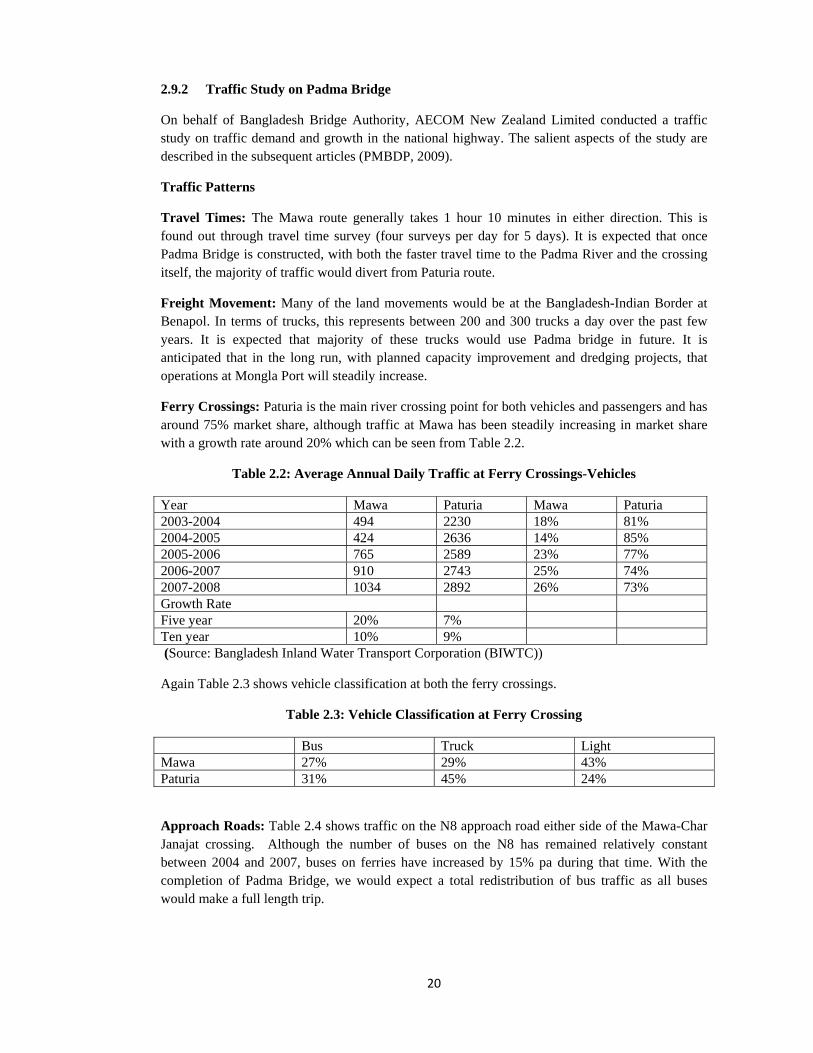
20
2.9.2 Traffic Study on Padma Bridge
On behalf of Bangladesh Bridge Authority, AECOM New Zealand Limited conducted a traffic study on traffic demand and growth in the national highway. The salient aspects of the study are described in the subsequent articles (PMBDP, 2009).
Traffic Patterns
Travel Times: The Mawa route generally takes 1 hour 10 minutes in either direction. This is found out through travel time survey (four surveys per day for 5 days). It is expected that once Padma Bridge is constructed, with both the faster travel time to the Padma River and the crossing itself, the majority of traffic would divert from Paturia route.
Freight Movement: Many of the land movements would be at the Bangladesh-Indian Border at Benapol. In terms of trucks, this represents between 200 and 300 trucks a day over the past few years. It is expected that majority of these trucks would use Padma bridge in future. It is anticipated that in the long run, with planned capacity improvement and dredging projects, that operations at Mongla Port will steadily increase.
Ferry Crossings: Paturia is the main river crossing point for both vehicles and passengers and has around 75% market share, although traffic at Mawa has been steadily increasing in market share with a growth rate around 20% which can be seen from Table 2.2.
Table 2.2: Average Annual Daily Traffic at Ferry Crossings-Vehicles
Year Mawa Paturia Mawa Paturia 2003-2004 494 2230 18% 81% 2004-2005 424 2636 14% 85% 2005-2006 765 2589 23% 77% 2006-2007 910 2743 25% 74% 2007-2008 1034 2892 26% 73% Growth Rate Five year 20% 7% Ten year 10% 9% (Source: Bangladesh Inland Water Transport Corporation (BIWTC))
Again Table 2.3 shows vehicle classification at both the ferry crossings.
Table 2.3: Vehicle Classification at Ferry Crossing
Bus Truck Light Mawa 27% 29% 43% Paturia 31% 45% 24%
Approach Roads: Table 2.4 shows traffic on the N8 approach road either side of the Mawa-Char Janajat crossing. Although the number of buses on the N8 has remained relatively constant between 2004 and 2007, buses on ferries have increased by 15% pa during that time. With the completion of Padma Bridge, we would expect a total redistribution of bus traffic as all buses would make a full length trip.

21
Table2.4: Average Annual Daily Traffic on N8 Either Side of Ferry Crossing
Year Bus Truck Light Total Intersection with R820 2004 1195 736 452 2383 2007 1183 979 952 3114 Growth Rate 0% 10% 28% 9% Between Panchar-Tarail 2004 822 424 406 1652 2007 811 759 1677 3247 Growth Rate 0% 21% 60% 25%
Travel Pattern (Origin-destination Survey): The concept of Padma Multipurpose Bridge is generally well supported by the population. Around 97% of the interviewees responded favorably to the bridge, suggesting that they would use id either in their own vehicle or with public transport.
River Crossing Surveys: The survey result at Table 2.5 shows the origin-destination patterns for vehicles crossing at Mawa and Paturia. Approximately 1400 vehicles currently cross the Padma at Mawa. These are evenly distributed as trips within Dhaka, between Dhaka-Khulna and Dhaka-Barishal. In contrast 3300 vehicles cross the Padma at Paturia, however over 50% of these trips are between Dhaka-Khulna, while only 14% are within Dhaka Division. This suggests that currently the ferry crossing at Paturia caters for the majority of longer distance trips-this is expected to change with the construction of Padma Multipurpose Bridge. Of the 1500 vehicles per day crossing at Mawa, the vehicle classes are relatively evenly distributed between trucks, buses and cars.
Table2.5: Proportions of Trips by Arrival Mode River Crossing
Mawa Paturia Truck 32% 40% Bus 31% 38% Car 29% 21% Motorbike 8% 1% (Source: AECOM calculations)
Port Surveys: On a yearly average, over 50,000 people per day travel through Sadarghat and over 55% of people travel between Dhaka-Barishal, with a further 21% between Dhaka-Chittagong and 17% with Dhaka Division.
Traffic Forecasts (AADT) -‘Most Likely Case’ Scenario
Table 2.6 shows most likely case scenario for Traffic Forecasts (AADT) which is presented below:
Table 2.6: Traffic Forecasts (AADT) -‘Most Likely Case’ Scenario
Year Truck Bus Light Total 2014 3,548 (38.1%) 2,764 (29.66%) 3,005 (32.24%) 9,317 2015 3,945 (38.33%) 2,917 (28.34%) 3,431 (33.33%) 10,293 2020 6,710 (39.05%) 3,821 (22.23%) 6,654 (38.72%) 17,185 2025 8,754 (36.19%) 4,172 (17.25%) 11,263 (46.56%) 24,189 2030 11,381
(31.94%) 4,567 (12.82%) 19,686 (55.24%) 35,634

22
2.10 Conversion of Existing Highway to 4-Lane Highway
According to a FHWA study, while a conversion is usually based on the need to more efficiently move increased traffic volumes, it has been assumed that the conversion to the higher order roadway also produces safety benefits. The best way to assess these safety effects would be to develop a model that would take a set of pre-existing (“before”) two-lane conditions, no matter how extreme, and predict the benefit of conversion to a second set of “after” four-lane conditions. This would require a database of geometric and crash information for a massive number of conversions in which many different sets of “before” conditions were converted to many different sets of “after” conditions. Since no such dataset is available anywhere, judgment of the safety effects of conversion of rural two-lane roads to a greater number of lanes must be based on other sources of information. An alternative source of such information is predictive cross-sectional models for different before/after conditions. According to the study, the results of this cross-sectional analysis are not as strong as would be the results of before/after analyses of a large sample of locations where two- to four-lane conversions had actually occurred. However, since such a database is not currently available, these cross-sectional results do provide useful information for the safety engineer. These analyses indicated that conversion from “most typical” two-lane sections to “most typical” four-lane divided sections appears to result in a crash per kilometer reduction of 40 percent to 60 percent (FHWA, 1999). The FHWA study opined to conduct further study to understand the safety benefits. In absence of any study in this regard in Bangladesh, attempts can be made to visualize probable safety effects of such conversion. Accident characteristics of four-lane divided highway can be analyzed and then may be visualized in terms of safety hazards of existing two-lane highway.
2.11 Land Use Pattern and Future Impacts
Land use pattern plays an important role on nearby highway. The highway, if not separated from local traffic’s friction may pose considerable safety impacts on the highway. 2.11.1 Historical Changes in the Land Use Pattern
Dhaka, the capital, was developed over the last four centuries. According to a study (Hossain, 2008), the growth in the population and area of Dhaka was more or less steady before the independence of the country. The trend of population and area increase is shown at Table 2.7. Dhaka City has faced its highest rate of physical and population growth during 1981-1991, with the population doubling during that decade and the city expanding from 510 sq. km to 1353 sq. km. The city now includes the surrounding areas of Gazirpur, Savar, Narayangong, Bandar thanas and the entire thana of Keraniganj.
The construction of two bridges over the Buriganga River has
encouraged the expansion of Dhaka City in a southerly direction to the other side of the river.
Table 2.7: Population and Area Size of Dhaka City (1700-2001)
Year Periods Population Area (sq.km) 1608 Pre-mughal 30,000 2 1700 Mughal period 900,000 40 1800 British period 200,000 4.5 1867 British period 51,636 10 1872 British period 69,212 20 1881 British period 80,358 20 1891 British period 83,358 20 1901 British period 104,385 20 1931 British period 161,922 20 1941 British period 239,728 25

23
1951 Pakistan period 411279 85 1961 Pakistan period 718766 125 1974 Bangladesh period 2068353 336 1981 Bangladesh Period 3440147 510 1991 Bangladesh period 6887459 1353 2001 Bangladesh period 10712206 1530
2.11.2 Present Land Use Pattern- Indication of Rapid Urbanization
According to an ‘environmental and social impact assessment’ made for Padma Multipurpose Bridge Project (PMBP, 2010), both embankments of the Padma River can be characterized as rural areas with agriculture being the predominant land use. However, there is more urban and commercial influence on the northern Mawa side. The distance from Mawa to Dhaka by car takes only 1- 1.5 hour. The presence of the capital is reflected in the lower share of agricultural land as compared to the other side of the river. On the northern side of the river only 65 % of the land is occupied by farms, whereas 86 % of the land is farmland on the south side. Residential development on the north bank is considerably higher (31 %) than on the south bank (12 %).
According to the final report of an ‘Environmental Action Plan’, the degree of urbanization in the three project districts is high and many people in the area have migrated to or work in urban centers, including Munshiganj and Dhaka. At Mawa site most people work in trade, business or services (70%) with only a minority (5%) working in agriculture (PMBDP, 2010). 2.12 Overview In this chapter, at first some basic concepts about road safety audit such as definition, benefits, essential elements etc. are explained. Guidelines of Roads and Highways Department (RHD) and other developed countries i.e. Australia, UK, USA and Ireland are discussed in details to understand the significance and mechanism of safety audit. Some important issues such as legal concerns, relationship between function-accessibility-modes, trauma management, enforcement etc. are highlighted. These helped in the review of ‘Existing Guidelines on Road Safety Audit’ and in development/ modification of checklists in Chapter 4. Some highlights on the necessity of crash data is given so that accident history can supplement audit findings. Construction of ‘Padma Bridge’, rapid urbanization and conversion of existing highway to four-lane divided highway will have impacts on the safety situation of the highway. Available and related literatures are consulted to understand the future scenario. In chapter 5, these issues are addressed in further details.

24
CHAPTER 3
RESEARCH METHODOLOGY AND DATA COLLECTION
3.1 Introduction
The main objective of this research was to identify the safety deficiencies and accident potential and recommend the cost effective appropriate remedial measures for the overall safety improvement of Dhaka-Mawa Highway following Road Safety Auditing process. Though Roads and Highways Department’s (RHD) guidelines on road safety auditing were introduced in 2005, but hardly any systematic auditing of a highway is undertaken. Again existing RHD guidelines do not give comprehensive idea as to the mechanism and procedures of safety auditing. To achieve the objective, the challenges that the researcher came across are: determination of a clear methodology for auditing, development/ modification of checklists suiting local peculiarities, carrying out safety auditing basing on modified checklists, collection of crash data and matching with audit findings, visualization of the impacts of future construction of ‘Padma Bridge’, rapid urbanization and possible conversion to four-lane divided highway. It was necessary to develop a workable methodology to address the abovementioned challenges.
3.2 Research Methodology
Research methodology followed in this research consists of a variety of approach. It was necessary to develop sufficient knowledge not only in road safety audit but also on road safety engineering, accident investigation, traffic management, highway design standards, road user behavior, enforcement, maintenance, local knowledge etc. Initial field visits (02 days), observation of local specialties, study of RHD and other developed countries’ guidelines, design standards and related literatures helped in the review of “Guidelines for Road Safety Audit” of RHD, Bangladesh and development / modification of checklists. Instead of a team, the audit was conducted by the researcher under the guidance of the learned supervisor using modified checklists. After collecting necessary background information, data was reviewed. A good number of site visits/ field reviews (11 days including night inspection) were carried out. Basing on collected data and field observation, analysis was carried out to organize audit findings. Road safety audit report was then written identifying safety hazards and suggesting remedial measures. Crash/ accident data was collected from concerned police stations (visits were made on 11 days to police stations), BRTA data base, and Accident Research institute (ARI), BUET, analyzed and matched to supplement audit findings. Basing on published literatures and field visits and considering existing safety hazards, local trends and peculiarities, attempts were made to visualize the impacts of future construction of ‘Padma Bridge’, rapid urbanization and possible conversion to four-lane divided highway. 3.3 Methodological Consideration in the Research
3.3.1 Review of “Guidelines for Road Safety Audit” of RHD, Bangladesh During ‘literature review’, salient aspects of “Guidelines for Road Safety Audit” of RHD, Bangladesh is critically discussed/analyzed to reveal whether it covers/addresses in sufficient details safety concerns in Bangladesh context or not. Attempts were made to include aspects which might have developed after the publication of the guidelines or not covered previously. Local specialties were taken into consideration for inclusion in the guidelines. In Chapter 2, Road Safety Audit Guidelines of various developed and developing countries are analyzed to find out only the aspects which are relevant but missed out and need to be included in RHD guidelines.

25
3.3.2 Modification of Checklists A thorough study of Roads and Highways Department (RHD) Guidelines’ checklists revealed that some of the local conditions were not included in the checklists. In this regard, study of road safety literatures, and guidelines of experienced countries (in chapter 2), were carried out. Initially field visits were also conducted for 2 days. Basing on the study and field visits, modification and development of some questionnaire in the checklists and development of a number of investigation/inventory forms were done. As the highway under research is an “exiting highway” so checklists were modified accordingly. Besides road environment, arena of road safety audit was expanded to road user behavior, traffic enforcement, trauma management, urbanization, new developments, etc. 3.3.3 Road Safety Auditing Limitation of the Audit Team The audit team was supposed to be a multi-disciplinary team consisting of experts from various fields. This is a research audit which is done singlehandedly by the researcher under the guidance of the supervisor. To compensate for the knowledge of the audit team, the researcher made attempts to gain and develop sufficient knowledge in road safety audit, road safety engineering, accident investigation, traffic management, highway design standards, road user behavior, enforcement, local knowledge etc. under the guidance of the supervisor. The research is an attempt to conduct safety audit of an existing road using set/ modified checklists and following the procedures as suggested in various guidelines keeping in view local conditions. Methodology followed for Road Safety Auditing Collection of Background Information- At first background information about the highway was collected. Design standards, previous road safety audit reports, existing policies and guidelines was collected from Road Design and Safety Circle of RHD and data on Annual Average Daily Traffic (AADT), Bridge/Culvert Inventory, Location Reference Point (LRP), Statement of Road Condition, Statement of Link etc was collected from Road Maintenance Management System (RMMS) database maintained by HDM circle in RHD Headquarter in Sarak Bhaban, Ramna, Dhaka. As-built Drawing of the highway (Southwest Road Network Development Project, Contract Number 1, Dhaka-Mawa Highway), and information on probable hazardous locations was collected from Sub-Divisional Engineer (SDE), Keraniganj Road Sub-Division under, Munshiganj Road Division of Dhaka Road Circle. Review of Data- The review of design drawings and other information regarding the highway was conducted prior to and after the field review. Reviews of the project data and design drawings were normally performed individually by the researcher. Reference to the checklists was made in the process which served as a means of reminding the researcher of relevant aspects of the road safety audit. As a result, during the field review, it was possible to verify identified issues and identify additional safety issues that might not be evident from the design drawings/available data. In-built drawing and other data was reviewed to familiarize with the location. Site Inspection/ Field Review- Inspection of the site was carried out both during day and night to identify safety deficiencies/ hazards as per the modified checklists. Site inspections included visit to the adjacent sections of the road, observance of movement patterns of various road user groups, collection of data on roadway geometry, operating conditions, hazardous locations and other road side features through field survey/study/count etc. Issues identified in the review of project data were verified in the field. Photographs and video footage was taken that was reviewed while writing the road safety audit report at later stage. During the field review, all possible movements were considered. On highway, both directions of travel were considered. At intersections, right, through, and left-turning movements on each approach was considered. Pedestrian and bicyclist facilities were also investigated, particularly at points where they came into conflict with vehicular

26
traffic. The interaction of the road users with road environment was observed. Semi-urban areas/ areas having urban fabric were observed to audit the highway for the peak periods under heavy traffic conditions. Locations with pedestrian traffic were inspected on foot. Considering under-reporting and unreliability of accident data, local community was interviewed to understand the nature and location of past accidents. Conduct Audit Analysis and Prepare Report of Findings- Road safety audit analysis was carried out to concisely report the findings of the audit through identification and prioritization of safety issues. Upon completion of the road safety audit analysis, the road safety audit report was written. During field visits, a number of safety issues were identified. Where necessary, the report included pictures and diagrams as may be considered useful to further illustrate points made. References to other reports, standards, policies or published research on road safety are sometimes made within the road safety audit report. The main body of the report contains all of the identified safety issues. Safety issues are sometimes grouped into broad topics that are further broken down into subtopics. Items are listed in the order in the checklists and also grouped by common issues. Writing the Road Safety Audit Report - Each safety issue identified in the report has a brief description of why it poses a risk under the head ‘problem’. The audit findings and recommendations are written in ‘prose style’ and tabular formats are used to support the facts. The recommendations usually indicated the nature or direction of a solution, rather than precise details; responsibility for that was left with concerned authority. When framing recommendations, considering the severity of the problem and the cost, feasible solutions were provided. Solutions included short-term, mid-term and long-term options. Issues identified are described in terms of where they are located and how they represent a safety risk.
3.3.4 Accident Data Analysis and Matching with Audit Findings For collecting accident data visits were made to concerned police stations. Collected accident data was analyzed to determine type of accidents, hazardous locations, accident by vehicle type, and accident by user group. Accident records were reviewed to confirm and complement the road safety audit findings. The matching was done on completion of audit so that the researcher remains completely objective during the field review. 3.3.5. Impact of Padma Bridge, Urbanization and Possible Conversion of 4-lane Divided Highway Data regarding expected traffic growth, possible land use pattern, changes of road user behavior etc. due to the future construction of Padma Bridge, urbanization and possible conversion of 4-lane divided highway was analyzed in chapter 2. Subsequent field visits helped to understand potential safety hazards.
3.4 Methodology used in the Investigation
Considering limited scope of the research work it was not possible to follow prescribed steps of formal road safety audit. In order to carry out a comprehensive road safety audit in line with the objectives set out in article 1.3, the following methodology was followed:
‐ Standard road safety audit guidelines and experiences of developed countries were
reviewed and local specialties were consulted. ‐ Efforts were made to gain and develop sufficient knowledge in road safety audit, road
safety engineering, accident investigation, traffic management, highway design standards, road user behavior, enforcement, local knowledge etc.

27
‐ Collection of background information i.e. site data (design standards, traffic data, and previous road safety audit reports), existing policies and guidelines, as-built design drawings etc. was done.
‐ Inspection of the site was carried out to identify safety deficiencies as per the checklists which were modified based on the standard guidelines of Roads and Highways Department (RHD), Bangladesh and various developed countries (Australia, USA, UK etc.).
‐ Accident related data was collected from concerned Police Stations, Accident Research Institute (BUET), and Bangladesh Road Transport Authority (BRTA) and accident records were reviewed to supplement any findings made as a result of site visits. Behavior of various road users and their interaction with the road facility was also observed in this regard.
‐ To make the study more precise, considering under-reporting and unreliability of accident data, local community was interviewed to understand the nature and location of past accidents.
‐ Data regarding expected traffic growth, possible land use pattern, changes of road user behavior etc. was collected and analyzed to understand potential safety hazards due to likely construction of Padma Bridge, urbanization, and future conversion of existing highway into a 4-lane highway.
‐ Audit findings were reported and appropriate recommendations were made addressing the identified site/subject specific safety deficiencies.
3.5 Data Collection Approach
3.5.1 Primary Data
Initial field visits (02 days) were carried out for the purpose of reviewing existing ‘Guidelines on Road safety Audit’ of RHD and to develop/ modify the checklists. For road safety auditing, a number of field visits (11 days including night inspection) were conducted to collect necessary data and make inventory through traffic volume count, spot speed and skid resistance measurement, pedestrian intensity count, collection of various geometric data, observance of road operating condition, interview with local community/road users/ Roads and Highways Department (RHD) officials/law enforcement agencies, on-ground observation etc. Field visits also assisted in developing perception about the possible impacts of ‘Padma Bridge’, rapid urbanization and conversion to four-lane divided highway. For collecting accident data, concerned police stations were visited (11 days).
3.5.2 Secondary Data
For collecting secondary data, available guidelines, design drawings and standards of RHD, various literatures of Accident Research Institute (ARI), BUET, internet publications etc. were consulted.
3.5.3 Study and Analysis for ‘Review of RHD Guidelines on Road Safety Audit’ and Development / Modification of Checklists Following guidelines, standards and procedures were studied, analyzed and used for review of ‘Road Safety Audit Guidelines’ of RHD and development / modification of checklists:
a. ‘Geometric Design Standards Manual (Revised), 2005’ of Roads and Highways Department, Ministry of Communication, Bangladesh.
b. ‘National Land Transport Policy 2004’, Ministry of Communication, Bangladesh. c. Guidelines on ‘Road Safety Audit, Second Edition, 2002’ of AUSTROADS.

28
d. ‘FHWA Road Safety Audit Guidelines, 2006’ of USA. e. ‘Safety Strategies for Rural Roads, 1999’ by Road Transport and Information
Research, Organization for Economic Cooperation and Development (OECD). f. ‘Road Safety Audit Guidelines, 2004’, National Roads Authority (NRA), Ireland. g. ‘Guidelines for Road Safety Audit, 1996’ of Institution of Highways &
Transportation (IHT), UK. h. ‘Design and Safety of Pedestrian Facilities, March 1998’ of Institute of Transport
Engineers (ITE), UK. i. Field visits to the site to understand local conditions and peculiarities. j. ‘Guidelines for Road Safety Audit, May 2005’ of Roads and Highways
Department (RHD), Ministry of Communication, Bangladesh.
3.5.4 Data Collection for Road Safety Audit Data collection approach for road safety audit is discussed below according to the chronology of the headings as appeared in the ‘audit report’: General The head ‘GENERAL’ covers two aspects of highway i.e. scope of the highway; function and access to property and development. During field visits, data /information about these aspects was collected through observation. Presence of road hierarchy and its relation with functional classification, problem of multi-functionality, plying of different transport modes interrupting through vehicle movements etc. were observed along the highway. At various locations, access to property and development was checked by observing private and commercial property entrances, roadside developments, uncontrolled side roads etc. which poses safety hazards.
Road Alignment and Cross Section
Visibility; Sight Distance: During field visits, data /information was collected through observation. The sight distance along the road was observed at straight sections (Built-up areas / bazaars/ bus-stands), and sight triangles at junctions were checked. Vegetation, roadside activities, corner shops, on-street boarding and alighting, illegal parking, inherent geometric faults were observed which causes inadequate visibility and sight distance.
Readability by Drivers: Throughout the length of the highway it was observed whether the road alignment is readable by drivers or not. Discontinuous road markings which confuse drivers about road alignment were examined.
Overtaking Opportunity: Overtaking opportunity was checked/ observed both at straight and curve segment of the highway. Safe overtaking opportunity was checked at sharp curves, narrow bridges, built-up areas, bazaars, and bus-stands. Presence of slow moving vehicles , pedestrians’ use of shoulder, non-availability of walkway, sudden appearance of vehicles from side roads and private property entrances/driveways, on-street parking, and other roadside activities were observed which do not allow drivers to make safe overtaking.
Speed Data: At first to determine vehicle composition, ‘traffic volume counts’ were conducted at a straight section and a curve. Basing on vehicle composition, spot speed data for 50 samples were collected at three different places for each location. Collected speed data was then analyzed to determine 98th and 85th percentile speed, modal speed, speed differential etc. Speed so determined was matched with posted speed limit. Average speed for various situations (at bazaar/ built-up area/ bus stand, having bridge, junction, curve, side road entry etc) was observed for justifying appropriate speed limits at these locations. Speed zoning will be based on observed speed in speed

29
studies, local requirements/ condition, safety considerations etc. Observed speed differential due to heterogeneous vehicle composition was analyzed.
Curve Information: Data regarding curvature radius, various sight distances, road sign, road marking, guide posts, skid resistance, clear zone, roadside hazards, curve widening, curve delineation, overtaking restriction etc. were obtained at curves to gain information about possible safety deficiencies. At three curves, after determining curvature radius, available sight distance was measured and then compared with standard Stopping Sight Distance (SSD) and Passing Sight Distance (PSD). Moreover, at one curve adequacy of curve widening was checked with two design speeds.
Carriageway, Shoulder, Cross-fall, Walkway, and Embankment Investigation
Width of carriageway, shoulder and walkway was measured for adequacy of width at mid block section, junction, bazaars, curves, bridge approach, culvert etc. Condition of shoulder and walkway was examined physically for damage due to poor drainage or other roadside activities. Drop height of shoulder, slope of embankment, condition of cross-fall was considered to assess the safety condition.
Private Driveways and Property Entrances
Sudden entry of vehicles from private driveways and property entrances were examined. Level of driveways in comparison to national highways, sight distance, road sign etc. was checked to understand safety effects.
Junctions/ Built-up area/ Bazaar/Bus-stand (in the Bazaar) Investigation
These places were critically examined considering location characteristics, visibility, sight distance, controls and delineation, layout and ‘readability’ (perception) by drivers, pedestrian crossing facilities and other miscellaneous aspects.
Signs and lightings
Inventory of existing traffic signs for sign type, size, mounting position, clear height, color, visibility, readability, reflectivity, condition at various locations were made. At various locations, general sign issues, sign legibility, sign supports and appropriate sign for various speed limits were investigated. This enabled to identify sign related safety issues.
Road Marking and Delineations Investigation
Road marking and delineations were investigated at various locations for general issues, centerlines, edge lines, lane lines and other markings, guideposts, reflectors and curve delineation.
Crash Barriers and Guideposts Condition
At various locations especially at curves and bridges including approaches, condition and location of delineator post, guide posts, crash barriers etc were assessed for safety impacts.
Pedestrian Intensity Count
Pedestrian intensity was counted at four hazardous locations especially at busy sites at peak hours to determine the necessity of adequate and appropriate pedestrian facilities.

30
Bus Bays
Existing bus bays were examined to see whether properly located or not. Besides, side road friction, safe boarding and alighting of the passengers and other safety hazards were investigated.
Bridge Investigation
Various features related to bridges such as approach alignment, carriageway widths, warning and other signs, control and delineation, footway, pedestrian and Non-Motorized Vehicle (NMV) facilities were examined for safety assessment.
Culvert Inventory
Data on, culvert length, carriageway width at culverts, crash barrier length and height, barrier end condition, drainage condition etc were investigated.
Skid Resistance
Skid resistance of the pavement was measured at curves, approach to junctions/ built-up areas, bazaars, bridges, pedestrian crossing sites to determine the necessity of resurfacing at these places. Skid resistance meter was used for this purpose.
Side Road without any Engineering Treatment
Side roads joining the highways were observed to identify potential safety hazards. Sight distance, level of side roads in comparison to highway, road sign and marking, design standards and requirements were examined in this regard. Necessity of appropriate engineering treatment was identified.
Miscellaneous Data
Data was collected to assess parking condition at various locations, provision for heavy vehicles, roadside activities, past crashes and off-road excursions, speed-breaker/ speed hump/rumble strip statistics, school zone safety, law enforcement agencies, hospitals with available facilities, various types of non-standard vehicles etc.
Behavior Observation of Various Road Users
Behavior of various road users’ i.e. motorized vehicles, Non-motorized vehicles and pedestrians was observed at mid-block locations, intersections, bazaars, built-up areas, bridges, curves etc. to assess the safety aspects.
3.5.5 Collection of Accident Data Accident related data for nine years was collected from five police thanas namely South Keranigonj Thana, Keranigonj Model Thana (Keranigonj Thana was divided into two separate thana in 2005), Sirajdikhan Thana, Srinagar Thana, and Louhojong Thana. Initially ‘Khatian Book’ was consulted to get the FIR (First Information Report) numbers. Later on year-wise FIR Books were consulted to get accident statistics. Data on total 449 reported accidents related to the highway under study over the period of nine years were collected which are shown in Table 3.1.

31
Table 3.1: Accident Statistics by Year
Year Keranigonj Sirajdikhan Srinagar Louhojong Total 2001 20 3 18 3 44 2002 24 2 10 4 40 2003 17 7 10 8 42 2004 6 4 17 2 29 2005 21 5 20 2 48 2006 18 10 31 3 62 2007 54 3 23 7 87 2008 33 2 23 4 62 2009 18 3 12 2 35 Total 211 39 164 35 449 3.5.6 Data on the Impact of Padma Bridge, Urbanization and 4-lane Divided Highway Data regarding expected traffic growth, possible land use pattern, changes of road user behavior etc. due to the future construction of Padma Bridge, urbanization and possible conversion of 4-lane divided highway was collected from the following references/sources:
a. Padma Multipurpose Bridge Project, Environmental and Social Impact Assessment Executive Smmmery, Volume I, Bangladesh Bridge Authority , Ministry of Communications, Government of the People’s Republic of Bangladesh, 6 September 2010.
b. The Feasibility Study of Padma Bridge in the People’s Republic of Bangladesh, Japan International Cooperation Agency (JICA), Jamuna Multipurpose bridge Authority (JMBA), March 2004.
c. Padma Multipurpose Bridge Design Project Traffic Study, Traffic Study, AECOM New Zealand Limited, Bangladesh Bridge Authority, 27 July 2009.
d. Padma Multipurpose Bridge Design Project, Final Report (Environmental Action Plan), Vol. 0: Executive Summary (Technical Summary of EAP), Bangladesh Bridge Authority, June 30, 2010.
e. FHWA, Summary Report on ‘Safety Effects of the Conversion of Rural Two-Lane Roadways to Four-Lane Roadways’, by Forrest M. Council and J. Richard Stewart, November 1999.
f. ‘Rapid Urban Growth and Poverty in Dhaka City’, Shahadat Hossain, Bangladesh e-Journal of Sociology, Volume 5 Number 1, January 2008.
g. Field visits and interview with local people, various road users, Roads and Highways Department (RHD) officials etc.
3.6 Problems Encountered Roads and Highways Department (RHD) guidelines on ‘Road Safety Audit’ do not contain the procedure for safety auditing i.e., data collection approach, field visits, presentation of audit findings etc. The procedure followed in the research was based on the guidelines of developed countries and RHD. Again RHD checklists do not address local peculiarities. So prior to safety auditing, it was necessary to review RHD guidelines, to understand the procedure and to modify/develop checklists. No appropriate previous audit report was available. Collection of accident data from Police Stations was troublesome as the record keeping system is not digitalized yet and existing records do not contain many engineering (accident related) aspects. Very little research was carried out on probable impacts of Padma Bridge and available literatures do not sufficiently contain traffic safety related aspects. There exists no literature on the effect of urbanization on road safety. Study on likely safety hazards, once a two-lane undivided highway is

32
converted to a four-lane divided highway, is not available in our country. So besides available literatures, field observation, judgment, guidance of supervisor etc. was used to visualize future safety hazards. 3.7 Summary
This chapter describes the research methodology which was followed in conducting the study. Review of existing guidelines on ‘Road Safety Audit’ of RHD and development/modification of checklists is based on the study of various guidelines, design standards, safety policies, related literatures and field visits. ‘Road Safety Auditing’ was then conducted based on learnt procedures and modified checklists. Data collection for safety auditing entailed field observation (both day and night time), on-site measurement, spot counting, interviewing, literature review, collection of background information etc. Collected data was analyzed to report audit findings and to recommend remedial measures. Accident/crash data, after collection from concerned authority was matched to supplement audit findings. Field observation, interview, literature review etc. were used to visualize possible safety impacts due to the future construction of ‘Padma Bridge’, rapid urbanization and possible conversion to four-lane divided highway.

33
CHAPTER 4
REVIEW OF EXISTING ROADS AND HIGHWAYS DEPARTMENT (RHD) GUIDELINES FOR ROAD SAFETY AUDIT AND DEVELOPMENT OF CHECKLISTS
4.1 Introduction In recent years, a number of proactive initiatives have been undertaken by RHD with a view to provide safer road environment on all roads under its jurisdiction. In 2001, RHD adopted the policy of road safety auditing. The NLTP 2004 specifies clear policies for safety auditing of roads at various stages of planning, design, construction and maintenance. Implementation of safety auditing policies calls for the adoption of standard guidelines and auditing procedures for Bangladesh context. To implement the vision and policies of NLTP 2004, RHD prepared “Guidelines for Road Safety Audit” in 2005 and started adopting the guidelines. This mandatory manual is an effective tool at the initiation of wider-scale application of road safety auditing policy. However, safety auditors were expected to exercise their professional judgment based on skill and knowledge in addition to the principles of the guidelines. In this chapter, as per the objectives of the thesis and in light of the literature review made in Chapter 2, existing RHD guidelines are analyzed. An attempt is also made to develop checklists basing on which subsequent ‘road safety audit’ is conducted. 4.2 Review of Existing RHD Guidelines In Chapter 2, existing RHD guidelines are reviewed and Safety Audit Guidelines of various developed countries are studied. It is clear that certain aspects if included in RHD guidelines will make the guidelines an effective tool for road safety auditing. Due consideration to local conditions and peculiarities are to be given. Again, aspects included in developed countries’ guidelines but missed out in RHD guidelines can be included in RHD guidelines. This necessitated updating and revision of the existing guidelines. The findings of the review are presented in the subsequent articles. 4.2.1 Basic Concepts are not explained
“Guidelines for Road Safety Audit” of RHD, which became effective from 2005, is a mandatory manual. This manual superseded relevant issues contained in earlier road safety related guidelines and notes of RHD. Being the only guidelines for road safety auditing, this manual did not explain the basic concepts or essential elements of road safety auditing in details. Review of RHD Guidelines (article 2.3.1) reveals that Information contained in Chapter 1 to 5 of the manual does not give any significant insight or background information to the decision makers, people without a technical background or even to the practitioners.
4.2.2 Composition of Audit Team
RHD guidelines stated the parameters of independent audit. As per FHWA Guidelines (article 2. 3.3.2), important aspects such as necessary skills, experience, nature of independence, number of auditors etc. are not specified. The audit team is expected to be skilled in road safety engineering, traffic engineering, traffic management, road design and construction techniques and road user behavior. The experience of audit team and specially that of Senior Road Safety Auditor should meet some specific requirements. Again different types of road and stages of audit require different skills and experience (article 2. 3.3.4). Benefits of having multi-member audit team are immense and the number of auditor may vary basing on the nature of projects. Local representatives knowledgeable of the project location may be used as a special resource while not necessarily being a team member. These aspects may be included in the RHD guidelines.

34
4.2.3 Roles and Responsibilities FHWA Guidelines states (article 2. 3.3.3) varying roles and responsibilities for all of the parties involved in the road safety audit. The project owner is a representative of the State or local highway (or road) department. The project owner must work to make sure that key road safety audit features, are part of and remain part of all road safety audits. The design team leader may have the most important role in that he or she is the single point of contact for the public agency for all activities related to the design and road safety audit process. A well-defined role for the audit team, which is communicated to both the design team and the audit team, will smooth out the relationship between designers and auditors. RHD Guidelines does not give general guidance on the roles and responsibilities of each road safety audit team member.
4.2.4 The Audit Process, Step by Step
A road safety audit is a straightforward process. AUSTROADS suggested nine steps (article 2. 3.2.5) while FHWA recommended eight steps (article 2. 3.3.4). The details in each step are to be adapted to suit the nature and scale of a particular project. The steps apply equally to design stage audits and other audits. The criteria and skills of the audit team required at various stages of audit, type of information to be provided to the team, necessity of holding commencement meting, assessment of document/ review of project data, method of inspecting the site/ field review, conduct of audit analysis, way of writing the report including findings and recommendations , completion meeting, procedures and necessity of responding to audit report , ways of framing response to recommendations , do's and don'ts in documenting road safety audit suggestions , need of subsequent audit and finally feeding back the gained knowledge etc. are covered in both the guidelines. This systematic approach of audit procedures will leave no doubt in the mind of the auditors. The detailed and step-by-step audit process is not included in Roads and Highways Department (RHD) guidelines. The manual sets no criteria for selecting audit team for audits at different stages, does not mention about the background information to be provided to the audit team and is silent about the importance of commencement and completion meeting. There exist no guidelines for the auditors as to how to assess the documents, inspect the site, and write road safety audit report, conduct audit analysis, frame audit findings and recommendations. The procedures to respond to the audit report, style of framing responses to audit recommendations, holding of subsequent audit, feeding back of the gained knowledge etc. are not included in the guidelines. Thus, a clear procedure for managing and organizing safety audit is absent, the practice of undertaking and reporting safety audit is not specified, and actions are not fully and consistently documented. Instead, the manual included a set of questionnaire / audit checklist and few typical formats and expected the safety auditors to apply professional experience, skill and judgment for safety auditing. 4.2.5 Road Safety Audit and Quality Assurance
‘Getting it right the first time’ is the underlying theme of quality assurance (article 2. 3.2.2). Audits seek to ensure the road operates ‘right the first time’ once it opens and that the road users make fewer mistakes. Quality assurance and road safety audits are complementary. Quality assurance procedures of an organization can state what is expected in connection with road safety audits: the frequency of audits, the required skills and experience of auditors, the number of auditors for different size design projects, how auditors are selected, and the audit process to be followed and the format/content of the audit report. Some insight about the relationship between these two in RHD guidelines could benefit the road’s customers.
4.2.6 Legal Issues and Areas of Concern
In article 2.4, legal issues and areas of concerns are highlighted. The process of road safety audit has not yet been tested in an Australian court of law. The court of Australia is concerned with the

35
state of the road at the time of the crash. The liability will be on the auditor if an audit is conducted far below the standard or the area under audit is beyond the competence and experience of the auditor. In USA, in one state (Kansas Department of Transportation), the road safety audit program was implemented to be proactive in identifying and fixing safety issues. They report their road safety audit results are for internal staff use only and are not available to the public or to lawyers representing claims against the State. In UK, it is opined that, in devising audit procedures, organizations should be aware of the legal implications such as: A safety audit has been carried out, but the recommendations have not yet been acted upon, a safety audit has been carried out, but has failed to identify a relevant problem, no effective, consistent, safety audit procedures exist etc. In light of the above, the issues / concerns need to be addressed in RHD guidelines may be as under:
a) The legal implications of road safety audit are not established. As road safety audit is not widely practiced, its consequences are not yet tested in a court of law.
b) In future, legislation may include mandatory adoption of certain road safety audit procedures. Time frame and documentation of responses to audit findings may be specified.
c) Perhaps in the future the failure to conduct audits during all stages of the road cycle will constitute evidence of negligence.
d) Road environment which is subjected to safety auditing- if found contributing to the accident after safety audit, then court of law, in future, is likely to be concerned about the role of safety auditors .
4.2.7 Costs and Benefits
AUSTROADS’ evaluation (article 2. 3.2.4) highlighted few issues such as comparison of audit cost and design cost, potentiality of audit to identify deficiencies and associated treatments with a significantly high return on investment regardless of project cost, significant rate of return considering the savings in accident costs over the direct costs of undertaking the audit etc. FHWA findings suggest that the RSA process is cost-effective, although most reference qualitative rather than quantitative benefits. The major quantifiable benefits of RSAs can be identified in terms of reduction of throwaway costs and reconstruction costs, lifecycle costs, societal costs of collisions and liability claims. These guidelines through various examples and evidences discussed the benefit-cost ratio of audits at various stages and concluded that benefits from safety auditing will undoubtedly outweigh the costs.
Roads and Highways Department (RHD) guidelines showed only national cost of road accidents. The qualitative and multifarious quantitative benefits to be derived from road safety audits against cost were not highlighted. Road safety audit is relatively new in Bangladesh and the benefits of such initiatives are not very clear to the decision makers, policy makers, designers, highway authorities and community. Examples, experiences, and analysis of cost and benefits of experienced countries will encourage all concerned to accept road safety audits.
4.2.8 Training for Road safety Auditing FHWA Guidelines (article 2. 3.3.1) states how training is conducted at various levels and capacities. This includes road safety audit training course, hands-on training involving in-house staffs in real-world situations, training by engineering faculties of universities, participation by State safety staff in university outreach programs, staff attendance at Road Safety Audit courses, participation in website forums that provide relevant guidelines, documents, and links to establish

36
road safety audit programs etc. RHD Guidelines does not provide any hints about the conduct of training.
4.2.9 Follow-Up of Road Safety Audit
IHT Guidelines (article 2. 3.4) emphasizes on follow-up of road safety audit. Monitoring of individual projects can be carried out on different occasions through ‘drive, ride, and walk’ concept to check that the perception of safety to different road users is up to the expectation. In the broader context, monitoring is needed to assess the procedures and practice, and update them to ensure that the effectiveness of safety audit process remains as robust as possible. IHT Guidelines suggested a number of methods for an effective and efficient system of monitoring. NRA Guidelines (articles 2. 3.5) emphasizes monitoring of performance in terms of the number and severity of road accidents and casualties. A suggested working method for accident monitoring is outlined in NRA Guidelines. Responsibility for setting up a procedure for monitoring rests with the client (highway authority) organization and Roads and Highways Department (RHD) Guidelines do not specify the procedure.
4.2.10 Stages of Audit
A road safety audit can be undertaken at one or more stages as a design proceeds from concept to implementation. Roads and Highways Department (RHD) Guidelines did not discuss various stages of audits in details. The background, necessity, requirements, significance and implementation of various stages of audits differ considerably. Absence of thorough discussion on each stage of audits deprived all concerned especially potential safety auditors in gaining appropriate knowledge. Stages of audits, being followed are more or less similar amongst various organizations. At Table 4.1, a tabular representation of audits at various stages followed by recognized organizations is shown:
Table 4.1: Audits at Various Stages Followed by Recognized Organizations
RHD, Bangladesh (2004) AUSTROADS (2002) FHWA (2006) IHT (1996)Pre-construction /under-construction safety audit for: a. Feasibility study b. Preliminary design c. Detailed design d. Under-construction schemes
The feasibility stage audit
Planning Stage Audit ( not discussed but prompt list given)
The feasibility stage audit
- The preliminary design stage audit
The preliminary design stage audit
The preliminary design stage audit
- The detailed design stage audit
The detailed/ final design stage audit
The detailed design stage audit
Post construction safety audit: Pre-opening/Hand over stage audit
The pre-opening stage audit
The pre-opening stage audit
The pre-opening stage audit
Post construction safety audit: Traffic management schemes during road construction
Audit of roadwork traffic schemes
Work zone traffic control plan audit
-
Existing roads audit Existing road: Road safety audit
Existing road audit -
- Audit of land use land use development -

37
development ( prompt list not given)
proposals audit
- Specialist audits for road user groups ( prompt list not given)
- -
AUSTROADS included other types of audits, some of which are relevant to Bangladesh context. Due to rapid urbanization and especially development of settlements/towns adjacent to highways, there is a need for conducting audit for ‘land use development’. Pedestrians are mostly vulnerable in roads. Specialist audits for ‘road user group’ can improve safety of various road users.
4.2.11 Road Safety Audit of Existing Road
AUSTROADS opines that safety audits of existing roads aim to identify any feature which may lead to future crashes, so that remedial treatment may be implemented before crashes happen. Accident records can be an important part of the information to be assessed in a safety review, but extreme care should be taken to ensure that their consideration does not focus attention away from other potential hazards. To avoid such problems, some safety reviewers like to wait until after their initial inspections before reviewing accident records.
View of FHWA is that traditional safety reviews and investigations of crash history rely primarily on crash data to determine what safety issues are occurring at the site. They are reactive as they mainly identify safety issues after a crash or pattern of crashes have occurred. In contrast, road safety audits of existing roads rely mainly on the site visit, as-built design drawings (if kept up to date), and other project data (e.g., previous reports) to determine what safety issues are expected to arise at the site. For this reason, road safety audits are proactive as they can identify where crashes will likely occur and what will be their resultant severity. According to FHWA, crash data, if available, should be used to supplement any findings made as a result of the site visit and review of project data. However, the road safety audit team may choose not to examine the crash history until after the project data review and site visit have been completed so that their evaluation is not biased by the crash data. Also, crash data is often dated and does not always help in determining emerging operational trends or safety issues at a location. In Bangladesh accurate accident records are simply not available and crash location treatment programs cannot be based on accident records. Road safety audits of existing roads by experienced road safety engineers provide the opportunity to obtain a more balanced view of where the crash problems are and in what order they should be treated. Explanation on the necessity of road safety auditing for existing roads, in context of Bangladesh country, are not covered in Roads and Highways Department (RHD) Guidelines. It was necessary to clarify distinctions between ‘accident investigation’ and ‘road safety audit of existing roads’ and to guide as to how and when to use accident data for audit.
4.2.12 Case Studies
Guidelines of reputed organizations included some case studies based on actual road safety audits. They illustrate audits of different-sized projects, as well as different styles of reporting. Road safety auditing being new, RHD Guidelines could include some case studies of developed countries to enlighten local practitioners.

38
4.2.13 Checklists/Prompt Lists
RHD Guidelines mainly followed the checklists of AUSTROADS. Very little was done to modify the checklists to suit local conditions. A checklist for “Pre-construction /under-construction safety audit” is meant to be used for feasibility stage audit, preliminary design stage audit and detailed design stage audit. Like FHWA Guidelines (article 2. 3.3.5) inclusion of ‘a general procedure for using checklists’ will benefit the safety auditors in conducting audits.
4.3 Modification of Checklists In this study attempts were made to develop checklists which were followed in conducting safety audit afterwards. As the highway under research is an “exiting highway” so checklists were modified accordingly. Development of checklists for other stages of road safety audit is beyond the scope of this study. A thorough study of RHD Guidelines’ checklists revealed that some of the local conditions were not included in the checklists. According to AUSTROADS, “Road safety audit is part of a road safety strategy” and “is only one part of a road safety engineering program”. Road safety strategy has many components. Checking whether, other aspects of safety strategies are being followed in a particular segment of the highway, through safety audit, can reduce potential hazards and remove contributory causes of accidents. FHWA Guidelines suggest that enforcement or education-based treatment may be included in the audit report. FHWA emphasizes on observing road user behavior, examining physical evidence of past crashes and off-road excursions and checking the consistency of the function and classification of the highway during the field visit. Study of various road safety literatures and guidelines of experienced countries, revealed that inclusion of some questionnaire in the checklists, development of some investigation/inventory forms, and considerations of local conditions and peculiarities may address more safety issues. Besides road environment, arena of road safety audit can be expanded to road user behavior, traffic enforcement, trauma management, urbanization, new developments, etc. This was helpful in developing effective checklists encompassing all safety issues. 4.3.1 Salient Aspects of Existing Checklist of “Guidelines for Road Safety Audit” of RHD.
RHD Guidelines’ checklists are based on AUSTROADS Guidelines (FHWA Guidelines’ checklists are also based on AUSTROADS Guidelines). The checklists cover road safety audit of existing roads under the following major heads:
1) Road alignment and cross section 2) Approach Widening 3) Intersections 4) Lighting 5) Signs 6) Markings and delineations 7) Clear zones, Crash barriers, Fences 8) Traffic signals 9) Pedestrians and Non-Motorized Traffic 10) Bridges, Culverts and Other Drainage Structures 11) Pavements 12) Vehicle Parking 13) Provisions for Heavy Vehicles 14) Floodways and Causeways (In Hill Terrains) 15) Miscellaneous

39
4.3.2 Analysis of the Aspects to be included in the Checklists
With a view to develop/ modify existing checklists, aspects which are suitable for Bangladesh but missed in RHD guidelines are discussed in the subsequent articles based on literature review in Chapter 2, field visits and observations.
Functional Classification, Accessibility and Different Transport Modes
As discussed in article 2.5, existence of road hierarchy within the network establishes appropriate standards for accessibility, level of service, traffic volume, design speed, types of vehicle, land use etc. Access control eliminates unexpected events, improves traffic operation and reduces collision experience. From a safety point of view, direct access to national highways must be minimized. Multi-functionality leads to contradictory design requirements and encourages combined use of different transport modes. Speed differences amongst standard, non-standard and non-motorized transports lead to relatively high risks. Road safety audits of existing roads can check the appropriateness of road function, access situation and impact of different modes of transport in order to identify existing and potential safety hazards. Therefore, these aspects are included in the modified checklists.
Trauma Management
The necessity for appropriate mechanisms to transport severely injured victims to distant hospitals and the requirement for adequate medical equipment and personnel at the hospitals can not be ignored (article 2.6.1). In Bangladesh, trauma management system following an accident is yet to be developed. We do have some facilities but poor management of existing resources, lack of training and coordination, insufficient equipment, ignorance at various levels etc. are possible hindrances to the development of an efficient trauma management system. An integrated approach is necessary. Audit of existing system and management can identify the weaknesses and can reinforce and improve this important safety strategy and therefore are included in the checklists and also appeared in the audit report as general observations basing on collected field data.
School Safety Practices
Initial field visits to the site revealed presence of few educational institutions adjacent to the highway and risky behavior of these vulnerable road users. Adequate safety measures are found to be necessary. In view of article 2.6.2, it was revealed that inclusion of questionnaire related to school safety would enhance safety situation. Safety strategy of other countries and NLTP also highlights the issue.
Observing Road User Behavior
Improvement of road user behavior is a major focal point in almost all the safety strategies. Various literatures and guidelines suggest ways of improving road user behavior. FHWA guidelines (article 2.2.11) highlight the issue. It is found that inclusion of the topic in checklists would assist in addressing the issue. Enforcement, education and publicity related suggestions can be brought out as a result of such observation.
Examining Physical Evidence of Past Crashes and Off-Road Excursions
Road safety audit identifies potential hazards which may contribute to accidents. Sometimes accident records are used to supplement audit findings. In absence of any reliable data, according to FHWA Guidelines (article 2.2.12), examinations of physical evidences of past crashes may give

40
clues of hazardous locations. Inclusion of such examination in the checklists is expected to assist in elevating safety situation. Built-up Area/ Bazaar/Bus-stand Development of built-up area/bazaar/bus-stand near highway is very common in Bangladesh. Here, the roads are historically developed and design standards were applied later on to elevate safety situations. In Bangladesh most accidents occur in built-up areas, bazaars and bus-stands and their approaching road sections. The accidents almost always involve a motor vehicle which is speeding through the place. The road coming from rural areas continues often unchanged through the built-up areas, bazaars and bus-stands without any information or warning to the drivers to change their behavior and adapt to the different traffic pattern, composition and road user behavior. Concentration of pedestrians, lack of appropriate traffic control devices and various roadside activities make these areas hazardous. These areas are often generators of major traffics along the highway. Presence of these areas has a significant impact on the safety situation of the highway and thus it was necessary to include this item in the checklists of “existing roads’ audit”. Night Inspection According to AUSTROADS, a night-time inspection is essential except where, in the experience of the client, there will be nothing additional to observe. The visual information available to road users can be markedly different at night time. The features on a road may be obvious in daylight, but deceptively hidden at night-time. A night time inspection permits a check on readability of the road and the effectiveness of signs, markings and street lighting. Therefore, it is necessary to include night inspection in the checklists as a separate item as it can identify various safety deficiencies of the highway from a different perspective. Enforcement
Article 2.6.3 emphasizes on the role of enforcement in developing safety situation. In the context of Bangladesh, this is more necessary as local customs and cultures are yet to be adjusted/ adapted to the safety requirements of a highway. Enforcement related observations can be brought out from the observation of road user behavior, road side activities and field visits. Inclusion of ‘enforcement’ as a separate item in the checklists is expected to assist in bringing out enforcement related observations. Speed-Breaker Statistics The highway, though classified as a national highway, but it performs multi-functional role. Access to the highway is not controlled. This is a historically developed road where design was imparted at various stages. Due to multi-functionality of the road, very often there are conflicts between through vehicles and local road users causing fatal accidents. As a reactive approach, local people constructed a number of speed-breakers to reduce vehicle speed for minimizing accidents. This is a local peculiarity in this highway. This also reflects absence of appropriate engineering treatments, attitude of motorized vehicles, vulnerability of local road users and community approach to the problem. Inclusion of the item in the checklists is certainly help in analyzing the above-mentioned situations. Various Types of Vehicle In Bangladesh of vehicles i.e. standard Motorized Vehicles (MVs), non-standard Motorized Vehicles, Non-Motorized Vehicles (NMVs) use the same road space having distinct make-up, construction, size, crashworthiness, speed etc. These cause unsafe and conflicting road movements resulting to various hazards. Inclusion of this topic in the checklists is anticipated to be able to identify various geometric and operational deficiencies of the highway.

41
Side Roads Due to mainly the lack of strict regulation and enforcement, appropriate guidelines, coordination amongst various government agencies and pressure of local needs, side roads often join the national highway. These side roads lack many engineering treatments, generate collisions amongst various types of road users and very often poses safety hazards contributing to accidents. In other countries minor cross-roads are means of gaining accessibility to a highway. In Bangladesh, unplanned connectivity of cross-roads with the highway, besides posing safety hazards reflect many other associated aspects which need to be addressed. This topic could be included under ‘accessibility’, but there are valid reasons to include this in the checklists as a separate item. Local Condition and Practices Local conditions and practices significantly influence the road users’ behavior and their interaction with various elements of the road. Political interference, organizational limitations, social culture, development patterns, economic condition, education, weather, terrain, enforcement, legislation etc. varies from country to country. Checklists developed for other countries may not be exactly appropriate for Bangladesh. Local peculiarities should be taken into consideration while auditing a road in Bangladesh. Checklists for ‘road safety audit of existing road’ do not address local conditions and peculiarities. A densely populated country like Bangladesh having medium literacy rate, emerging economy, different socio-economic background, inherent institutional weaknesses of various related organizations will have safety hazards in its highways which are different from other countries. Addressing local practices and conditions and incorporating suitable questionnaire in the checklists are certainly expected to assist in conducting safety audit more effectively.
4.3.3 Items to be included in the Existing Checklists of Roads and Highways Department (RHD) Guidelines
A thorough study and analysis of various guidelines and literatures and knowledge gained about local conditions through initial site visits suggested inclusion of following items in the existing checklists:
a. Scope of the Highway; Function b. Access to property and developments c. Night Inspection d. Interchange e. Built-up area/Bazaar/Bus-stand f. Side roads g. Speed-breaker Statistics h. Physical evidence of past crashes and off-road excursions i. Road User behavior j. Enforcement k. Hospitals and trauma management l. Various Types of Vehicles m. Interview of Local People n. School Zone Safety o. Items based on local conditions may be included under almost all items/heads.
4.3.4 Checklists and Forms
Basing on the analysis mentioned above, checklists are modified for safety audit of existing roads. RHD Road Safety Audit Guidelines for existing road addresses the audit under 15 major heads.

42
For the purpose of safety inventory and survey, 7 formats are also provided. This study conducted safety audit under 29 major heads and using 36 forms for the purpose of safety inventory and survey.
4.3.5 Checklists
The following Table 4.2 shows a comparison between checklists of ‘Road Safety Audit Guidelines, RHD’ and modified checklists. In the modified checklists, items mentioned in article 4.3.3 are included. Modified checklists are at Appendix A
Table 4.2: Comparison between Roads and Highways Department (RHD) and Modified Checklists
Checklists of Road Safety Audit Guidelines, RHD
Modified Checklists
1 General topics (Scope of the Highway; Function, Access to property and developments)
1 Road alignment and cross section 2 Road alignment and cross section 2 Auxiliary lanes 3 Approach Widening 3 Intersections 4 Intersections 5 Interchanges 6 Built-up area/ Bazaar/Bus-stand 4 Lighting 7 lightings (Roads in General) 5 Signs 8 Signs (Roads in General) 6 Markings and delineations 9 Markings and delineations 7 Clear zones ,Crash barriers , Fences 10 Crash barriers and clear zones 8 Traffic signals 11 Traffic signals 9 Pedestrians and Non-Motorized Vehicle (NMV)
12 Pedestrians , NMVs, and Public Transport
10 Bridges, Culverts and Other Drainage Structures
13 Bridges and culverts
11 Pavement 14 Pavement 15 Side road 12 Vehicle Parking 16 Parking 13 Provision for Heavy Vehicles 17 Provision for heavy vehicles 14 Floodways and Causeways ( In Hill )
18 Floodways and causeways
15 Miscellaneous
19 Miscellaneous
20 Past crashes and off-road excursions 21 Speed-breaker Statistics 22 Night Inspection 23 Law Enforcement 24 Trauma Management and Hospitals 25 Various Types of Vehicles 26 School Zone Safety 27 Road User Behavior 28 Interview of Local People 29 Observations related to enforcement,
education, publicity

43
4.3.6 Safety Inventory and Survey Forms
The following Table 4.3 shows a comparison between Safety Inventory and Survey Forms of ‘Road Safety Audit Guidelines, Roads and Highways Department (RHD)’ and modified checklists. Formats of modified checklists are at Appendix B.
Table 4.3: Comparison between RHD and Modified Forms
Safety Inventory and Survey Forms of Road Safety Audit Guidelines, RHD
Formats of Modified Checklist
1 Road Inventory and Survey Form 1 Access to Property and Development 2 Traffic Signs Investigation Form 2 Overtaking Provision 3 Road Markings Investigation Form 3 Traffic Volume Count for Vehicle
Composition 4 Road Junction Investigation Form 4 Spot Speed Determination Using Vehicle
Composition Data 5 Bazaar/ Developed Area Investigation Form 5 Average Speed of Vehicles at Various Built-
up Areas/Bazaars6 Bridge Inventory Form 6 Curve Dimensions and Investigation of SSD
and PSD at Curves 7 Road Sketch as par Field Condition Form 7 Horizontal Curves 8 Carriageway, Shoulder, Cross-fall, Walkway,
and Embankment Investigation Form 9 Shoulder and Walkway Condition 10 Sudden Entry of Vehicles from Driveways 11 Drainage condition 12 Junctions Investigation form 13 Built-up area/ Bazaar/Bus-stand (in the
Bazaar) 14 Signs and lightings Investigation Form 15 Existing Traffic Sign Investigation Form 16 Road Marking and Delineations Investigation
Form 17 Crash Barriers and Guideposts Condition 18 Pedestrian Intensity 19 Bus Bays 20 Bridge
Investigation Form 21 Approach Alignment of Bridges 22 Culvert Details 23 Pavement Condition 24 Skid Resistance 25 Side Road without any Engineering
Treatment 26 Parking Condition 27 Provision for Heavy Vehicles 28 Floodways and causeways 29 Roadside Activities 30 Past Crashes and Off-Road Excursions 31 Speed-Breaker (SB), Speed Hump (SH) and
Rumble Strip (RS) Statistics 32 Data of Law Enforcement Agency
44
33 List of Location-wise Hospitals with Available Facilities
34 Data of Various Types of Non-standard Vehicles
35 School Zone Safety 36 Behavior Observation of Pedestrians, Non-
Motorized Vehicles (NMVs) and Motorized Vehicles (MVs) at Intersections and Other Locations
4.4 Overview
Review of Existing Guidelines of Roads and Highways Department (RHD)
Updating and revision of the existing guidelines will give significant insight or background information to the decision makers, people without a technical background or to the practitioners. Explanations of basic concepts and consideration of “Road Safety Audit” as an effective tool will benefit the auditors. Inclusion of important aspects such as types of projects for audits, audit team’s qualification, roles and responsibilities of team members, step by step audit process, necessity of quality assurance, legal issues and areas of concern, significance of costs and benefits, and training for road safety auditing need to be included in RHD guidelines. Necessity of ‘follow-up and monitoring’, and responsibility of setting up appropriate procedures are of great importance. Inclusion of all probable stages of audit, importance on safety audit of existing road, incorporation of some case studies and detail procedures for using checklists/prompt lists will enrich RHD guidelines.
Development of Checklists
In this chapter an attempt is made to develop checklists to suit local conditions. At first major items of checklists of ‘ safety audit of existing roads’ of RHD Guidelines on ‘Road Safety Audit, 2005’ was listed. Discussion of various guidelines and literatures and consideration of local peculiarities highlights the necessity of including some important items such as road functions, accessibility, night inspection, past crashes, road user behavior, enforcement, trauma management, school zone safety, interview of local people, speed-breaker statistics, side roads, and different types of transport in the existing checklists to make it more effective. To supplement safety audit with modified checklists, few forms are also developed.

45
CHAPTER 5
UNDERTAKING SAFETY AUDIT AND FUTURE IMPACTS
5.1 Introduction
Road safety auditing is conducted to identify potential hazards along this highway. Checklists modified in the previous chapter are used to aid the auditing. The finding and recommendations are written in ‘prose, style. Findings are based on collected data, field observation and analytical approach. Recommendations prescribe general, short, mid and long term solutions. As the audit is part of a research work, standard contents of an audit report (suggested by AUSTROADS and Roads and Highways Department (RHD) guidelines) is not followed. Later on, accident data is analyzed to supplement audit findings (safety concerns) identified in the audit report. The observations and suggestions are related to existing two-lane national highway i.e. Dhaka- Mawa Highway (N8) which is planned to be converted to a four-lane divided highway and would also have the impacts resulting from likely construction of Padma Bridge and is experiencing the effects of rapid urbanization at this segment of the highway. In this chapter, attempts are also made to address these issues.
5.2 Road Safety Audit Report
5.2.1 Background
The audit is part of a research work conducted in partial fulfillment of the requirements for the degree of Master of Science in Civil Engineering (Transportation) under Bangladesh University of Engineering and Technology (BUET). The audit was undertaken by Mr. Nasir Uddin Ahmed, MSc Student, BUET under close supervision of Dr. Md. Shamsul Hoque, Professor, Civil Engineering Department, BUET. In-built design drawings of the highway, relevant guidelines of road safety auditing, design and safety standards of RHD and developed countries, modified checklists, various literatures were consulted and extensive field visits were conducted for the purpose of audit. Concerned experts of Road Safety Division, RHD and Sub-Divisional Engineer, Keranigong Road Sub-Division were consulted for valuable inputs. A number of both daytime and nighttime inspection/ field visits were carried out. The audit was on an ‘Existing Road’. The road was inspected by the researcher between 30 September 2010 to 04 November 2010 and 12 July 2011 to 14 July 2011. Close monitoring, guidance and supervision including a site visit by the supervisor enriched the audit report. The audit report is titled as ‘Road safety audit report of Dhaka-Mawa Highway’. In the audit report, on various occasions, references are made to various filled-up formats and Tables which are at Appendix-C. Detail calculations are shown at Appendix-D. The body of the report includes some important photographs for easy understanding. At Appendix-E, more photographs are included for better assimilation of hazards. 5.2.2 General 5.2.2.1 Scope of the Highway; Function PROBLEMS Location: General to the Highway. Summary: The highway can not perform its intended function as national highway properly and existing design is not consistent with the function. The road though classified as a national highway but the classification has become distorted over the years and no longer reflects the actual usage being made of the highway. According to Roads and Highways Department (RHD), to make optimum use of resources the standards to be adopted

46
in road design must be based wholly on traffic volume, regardless of classification. Hence Design Types are based wholly on traffic volume and have no direct relationship with functional classification. In absence of a road hierarchy based on functional classification, multi-functionality arises which leads to contradictory design requirements and also to higher risks. Uninterrupted plying of through vehicles in this highway is hindered. As a result of multi-functionality, different transport modes use the same physical space, access can not be controlled, road user behavior becomes unpredictable, and relatively high speeds and speed differences lead to relatively high accident risks. RECOMMENDATIONS Development of a road hierarchy based on functional classification is recommended so that the same level of service (LOS) can be maintained throughout the whole length of the highway.
5.2.2.2 Access to Property and Developments
PROBLEMS Locations: General to the Highway. Summary: Degree of access control is not consistent with the road’s function. As the road classification is based on traffic volume only, the issue of access control is not addressed. The occurrences of unexpected events complicate the driving task. Driver is unable to respond to the increased variety and changes in the spacing of events. This results in deteriorated traffic operation and increased collision experience. Presence of numerous private and commercial property entrances, roadside developments, uncontrolled side roads etc. poses safety hazards.
RECOMMENDATIONS
• Direct access to the national highway must be controlled. Formulation of an ‘Access Management Guidelines’ is recommended.
• Service roads are recommended to accommodate local traffics maintaining the functional requirements of the national highway.
5.2.3 Road Alignment and Cross Section
5.2.3.1 Visibility; Sight Distance
PROBLEMS
Locations: General to the Highway.
Summary: Sight distance is found to be adequate at various places along the highway.
The sight distance along the road is inadequate or restricted when plantation on the edges of embankments; especially at the inner edge of horizontal curves (Photo 5.1) obstruct the sightlines to stationary objects or oncoming vehicles. At the straight sections, visibility and sight distance is restricted at built-up areas / bazaars/ bus-stands due to parked vehicles and road side developments and activities. Sight triangles at junctions are restricted due to road-side shops (Photo 5.2). Inadequate sight distance results in a shorter reaction and response time available to the driver when the change is sighted which results in a higher crash risk. Besides, due to obstructed longitudinal sight distance drivers assume continuation of the present conditions, though alignment

47
changes or traffic hazards suddenly appear. Examples of these include; curves hiding bazaars (Abdullahpur and rajendrapur Bazaar) and bus-stands (Keotkhali, Shologhar, Bejgaon, Srinagar Ferry Ghat, Shomspur), parked vehicles obstructing visibility of pedestrian crossing sites etc.
RECOMMENDATIONS Short Term: Low-cost measures such as plantation of low-height trees at curves, banning of illegal parking and non-motor roadside activities are recommended to be adopted to address inadequate sight distance and to mitigate safety hazards. At built-up areas / bazaars/ bus-stands and junctions, obstructions to sight distance are to be removed.
Long Term: Straightening of sharp curves is recommended
5.2.3.2 Readability by Drivers
PROBLEMS
Locations: General to the Highway. Summary: The alignment of the roadway is distorted due to inadequacy of marking at some places.
As a whole, the alignment of the roadway is clearly defined by center and edge line marking. But at bazaars/built-up areas/bus-stands, (Photo 5.3 and Photo 5.4) these markings are either faded out due to poor maintenance or invisible due to roadside non-motor activities which creates confusion for the drivers.
Photo 5.2: Restricted sight triangle due to corner shops at Mawa Roundabout
Photo 5.1: Restricted sight distance at curve at Shologhar
Corner shops
Vegetation at curve
Photo 5.3: Obscured edge-line marking at Kodomtoli T Junction
Photo 5.4: Invisible edge-line marking at Rajendrapur

48
RECOMMENDATIONS
• To make the alignment of the highway more conspicuous at bazaars/built-up areas/bus-stands, the center and edge line marking should be maintained regularly.
• Moreover, roadside non-motor activities should be banned to make the road markings visible to the drivers at night.
5.2.3.3 Overtaking Provision
PROBLEMS
Locations: General to the Highway.
Summary: Overtaking provisions are absent along the highway.
It is not possible to provide separate overtaking lane at two lane undivided highway. But safe overtaking opportunities through road marking were not observed along this highway. This results in uncontrolled and risky overtaking attempts which increase safety hazards along the highway. RECOMMENDATIONS Safe overtaking opportunity through road marking is recommended to discourage uncontrolled and risky overtaking attempts along the highway.
5.2.3.4 Design speed
PROBLEMS
Summary: Design speed can not be maintained along this highway.
According to ‘Geometric Design Standards Manual (Revised) 2005, this is a Design Type 3, National Highway with Design Speed 80 kmph. Basing on ‘traffic volume survey and speed study’ carried out to determine the speed characteristics along with vehicle composition, at straight section (between Kotomtoli T Junction and Rajendrapur), 98th and 85th percentile speed was found to be 64 and 57 kmph [Table 5.1, 5.2 (below) and Table 1 of Appendix C and Figure 5.2]. Considering the same vehicle composition, at the curve prior to Srinagar Ferryghat, 98th and 85th percentile speed was found to be 68 and 57 kmph [Table 2 of Appendix C, Table 5.3 (below) and Figure 5.4]. Another ‘traffic volume survey and speed study’ carried out to determine the speed characteristics along with the vehicle composition at a curve (prior to Chonbari Junction ) revealed 98th and 85th percentile speed to be 72 and 62 kmph [Table 5.4, 5.5 (below) and Table 3 of Appendix C, and Figure 5.6] .
Table 5.1 Traffic Volume Survey for Vehicle Composition at Straight Section
Vehicle Type Number % of Vehicle #Sample Remark Bus 164 16 08 # 50 samples were
taken for spot speed study
Date: 12July 2011
Time: 1225 to 1325 hours
Truck 52 06 03 Microbus / Car/ Motor cycle
222 20 10
Human hauler/ Pick-up van/ Auto Rickshaw/ CNG Rickshaw
612 58 29
Total 1050 100 50

49
Table 5.2- Spot Speed Calculation at Straight Section (between Kotomtoli T Junction and Rajendrapur)
Speed Range
No. of vehicle
Mid-speed, V %
Cumulative %
(kmph) observed
(f) (kmph) Frequencies Frequencies 0 - 5 0 2.5 0.00 0.00
5 - 10 0 7.5 0.00 0.0010 - 15 0 12.5 0.00 0.0015 - 20 0 17.5 0.00 0.00
20 - 25 0 22.5 0.00 0.00Vavg = Sum (f * V)/Sum(f)
25 - 30 0 27.5 0.00 0.00 = 49.8 mph 30 - 35 0 32.5 0.00 0.0035 - 40 0 37.5 0.00 0.0040 - 45 15 42.5 30.00 30.0045 - 50 17 47.5 34.00 64.0050 - 55 7 52.5 14.00 78.0055 - 60 4 57.5 8.00 86.0060 - 65 5 62.5 10.00 96.0065 - 70 2 67.5 4.00 100.00
Total 50
Figure 5.1- Frequency Distribution for Spot Speed at Straight Section (between Kotomtoli T Junction and Rajendrapur)

50
Figure 5.2- Cumulative Frequency Distribution of Spot Speed at Straight Section (between Kotomtoli T Junction and Rajendrapur)
Table 5.3- Spot Speed Calculation (at curve prior to Srinagar Ferryghat)
Speed Range
No. of vehicle
Mid-speed, V %
Cumulative %
(kmph) observed
(f) (kmph) Frequencies Frequencies 0 - 5 0 2.5 0.00 0.00
5 - 10 0 7.5 0.00 0.0010 - 15 0 12.5 0.00 0.0015 - 20 0 17.5 0.00 0.00
20 - 25 0 22.5 0.00 0.00Vavg = Sum (f * V)/Sum(f)
25 - 30 2 27.5 4.00 4.00 = 44.05 mph 30 - 35 6 32.5 12.00 16.0035 - 40 3 37.5 6.00 22.0040 - 45 11 42.5 22.00 44.0045 - 50 8 47.5 16.00 60.0050 - 55 9 52.5 18.00 78.0055 - 60 4 57.5 8.00 86.0060 - 65 2 62.5 4.00 90.0065-70 2 67.5 4.00 94.0070-75 1 72.5 2.00 96.0075-80 0 77.5 0.00 96.0080-85 2 82.5 4.00 100.00Total 50

51
Figure 5.3- Frequency Distribution for Spot Speed at Curve 1 (prior to Srinagar Ferryghat)
Figure 5.4- Cumulative Frequency Distribution of Spot Speed at Curve 1 (prior to Srinagar Ferryghat)

52
Table 5.4 Traffic Volume Count for Vehicle Composition at Curve prior to Chonbari Junction
Vehicle Type Number % of Vehicle #Sample Remark Bus 140 36.08 18 # 50 samples were
taken for spot study
Date: 13July 2011 ,
Time: 1425 to 1525 hours
Truck 16 4.12 2 Microbus / Car/ Motor cycle
112 28.86 15
Human hauler/ Pick-up van/ Auto Rickshaw/ CNG Rickshaw
120 30.92 15
Total 388 100 50
Table 5.5- Spot Speed Calculation (at curve prior to Chonbari Junction)
Speed Range
No. of vehicle
Mid-speed, V %
Cumulative %
(kmph) observed
(f) (kmph) Frequencies Frequencies 0 - 5 0 2.5 0.00 0.00
5 - 10 0 7.5 0.00 0.0010 - 15 0 12.5 0.00 0.0015 - 20 2 17.5 4.00 4.00
20 - 25 3 22.5 6.00 10.00Vavg = Sum (f * V)/Sum(f)
25 - 30 6 27.5 12.00 22.00 = 36.75 mph 30 - 35 2 32.5 4.00 26.0035 - 40 4 37.5 8.00 34.0040 - 45 5 42.5 10.00 44.0045 - 50 7 47.5 14.00 58.0050 - 55 7 52.5 14.00 72.0055 - 60 3 57.5 6.00 78.0060 - 65 3 62.5 6.00 84.0065-70 3 67.5 6.00 90.0070-75 3 72.5 6.00 96.0075-80 1 77.5 2.00 98.0080-85 1 82.5 2.00 100.00Total 50

53
Figure 5.5- Frequency Distribution for Spot Speed at Curve 2 (prior to Chonbari Junction)
Figure 5.6- Cumulative Frequency Distribution of Spot Speed at Curve 2 (prior to Chonbari Junction)
From the speed study, it is found that along this highway, 98th percentile speed varies between 64 to 72 kmph and 85th percentile speed varies between 57 to 62 kmph. This implies that the highway is not capable of maintaining its intended design speed. At present condition, segment-specific speed limit/zoning needs to be applied for safety reasons.

54
From ‘traffic volume count’ (Table 5.1 and 5.4), it is seen that non-standard motorized vehicles comprises 58% and 30.92% of vehicle composition at two different places which cause speed differential amongst the vehicles. Critical analysis of vehicle speed compiled from Table 1, 2, and 3 of Appendix C reveals that average speed of fast moving vehicles is 56.55 kmph while average speed of non-standard motorized vehicles is found to be 40.98 kmph indicating speed differential of approximately 15 kmph between these two categories of vehicles.
Again modal speeds at straight section prior to Rajendrapur (Figure 5.1), at curve prior to Srinagar Ferryghat (Figure 5.3), and at curve prior to Chonbari Junction (Figure 5.5), were found to be 45 kmph, 46 kmph and 44 kmph respectively.
Table 5.6 shows varying average speed for different types of vehicles (compiled from Table 1, 2, and 3 of Appendix C). Average speed of bus, truck, small standard motorized vehicles and non-standard vehicles varies between 49-57 kmph, 35-51 kmph, 59-66 kmph and 28-46 kmph respectively. It is found that speed of vehicles varies significantly between locations and also within the same type of vehicles. As a result slow moving non-standard vehicles induce risky overtaking maneuvers and cause safety hazards.
Table 5.6 Average Speed of Different Vehicles from Speed Study
Vehicle Type Average Speed (kmph)
At Straight Section between Kodomtoli More T Junction
and Rajendrapur
At Curve Prior to Srinagar
Ferryghat
At Curve Prior to Chonbari Junction
Bus 56.87 52.62 49.16
Truck 50.66 38.33 34.5
Microbus / Car/ Motor cycle
58.8 66.6 66.26
Human hauler/ Pick-up / Auto Rickshaw/ CNG
45.72 43.06 28.66
The speed studies were carried out at free flow condition. The abovementioned speed and vehicle composition analysis reveals significant speed differential arising from heterogeneous vehicle composition. The varying level of service implies that functionally the corridor is not serving as a high standard road which definitely demands up-gradation of the highway. RECOMMENDATIONS
• Basing on ‘speed study’ it is recommended that after detailed engineering studies, segment-specific speed limits are to be installed at required places along the highway.
• To eliminate the speed differential amongst various types of vehicles, it is recommended
to segregate non-standard motorized vehicles by providing separate service roads.

55
5.2.3.5 Speed Limit/Speed Zoning
PROBLEMS
Locations: General to the Highway.
Summary: Speed limit is not compatible with the function, road geometry, land use and sight distance. Regulatory/advisory speed signs (SPECIAL SPEED LIMIT A26) are found in only four places i.e. Hasnabad (60 kmph), approach to Dhaleshwari Bridge 1 and Dhaleshwari Bridge 2 (40 kmph) and Uttar Medinimondal (60 kmph). End of the speed restricted sections are not marked by either with the ‘NATIONAL SPEED LIMIT APPLY A27’ sign or with another A26 sign indicating a different speed limit. Warning signs ‘SHARP BEND B10’ are found in only four places i.e. Rajendrapur, Abdullahpur, Shologhar and Srinagar Ferry Ghat. The signs are not installed on both approach of the curve. Warning signs and advisory speed signs required in other eligible places are not installed. During ‘speed study’, average speed of vehicles at four built-up areas/bazaars is measured which is shown at Table 5.7.
Table 5.7 Average Speed of Vehicles at Various Built-up Areas/Bazaars
location and length of the
observed segment
Type of vehicle
Average Travel time (minutes)
Average Travel time at the
segment (minutes)
Average Observed Speed of Motorized
Vehicles at the segment (kmph)
Hasnabad-Ekuria Built-up area (0.32 km)
Bus 1.65 1.13 17 Car 0.78
Truck 0.95 Rajendrapur (0.28 km)
Bus 0.74 0.83 20 Car 0.96
Truck 0.78 Abdullahpur (0.39 km)
Bus 0.85 1.00 23 Car 0.91
Truck 1.25 Nimtoli (0.14 km) Bus 0.57 0.52 16
Car 0.48 Truck 0.52
From Table 5.7, it is found that, at built-up areas/bazaars, average speed varies between 16 kmph to 23 kmph which may irritate through drivers as well as local drivers. Due to these bottlenecks, within a span of only 31 km, the drivers need to adjust speed for a number of times. As a result drivers may ignore speed limits and may have the tendency to over speed to cover up delayed time which may lead to accidents. Built-up areas (sometimes before or after curve and having side roads and private/commercial property entrances), narrow bridges (sometimes immediately before or after a built-up area/bazaar and curve) and curves demand ‘Special Speed Limits’. Due to inappropriate road geometry at bazaars/ built-up areas/ bus-stands, multi-functionality due to uncontrolled access, unplanned land use pattern and restricted sight distance at curves, bazaar, built-up areas and junctions, national speed limit i.e. 80 kmph is not compatible.

56
RECOMMENDATIONS Short term: Following measures are recommended:
• Detail engineering studies are suggested to establish appropriate special speed limits/speed
zoning for various Built-up Areas/Bazaars. • Further misuse of road adjacent land is to be stopped immediately. • Obstruction to sight distance due to illegal parking, roadside plantation and non-motor
roadside activities is to be removed.
Long term: Following measures are recommended:
• Road should be classified based on functional classification and appropriate design standards to be developed according to the classification.
• Guidelines on ‘roadside land use’ should be developed and enforced. • Sight distance at curves should be improved by road realignment to reduce road curvature.
5.2.3.6 Curves
PROBLEMS
Locations: General to the Highway.
Summary: Adequate engineering treatment, traffic control devices etc. are not applied at curves.
Adequate clear zone is not provided at any curves. Roadside hazards/objects exist within 1m of the carriageway at Rajendrapur Bazaar and Bejgaon Bus-stand which are located within curves. Except at the curve after Abdullahpur Bridge and curve prior to Srinagar Ferry Ghat, ‘F6 BARRIER LINE’ is not observed at any curves having inadequate sight distance. Overtaking restriction signs at approaches to curves do not exist. Except at the curve after Abdullahpur Bridge, curve after Shologhar Bus-stand and curve prior to Srinagar Ferry Ghat, curve warning signs are not erected at the approaches to any other curves. Advisory speed signs are not installed prior to any curves having restricted sight distances. Chevron Alignment Markers (CAMs) are not installed at any curves. Curve information is listed at Table 4 of Appendix C. According to SRNDP, there exist 19 curves along this highway, out of which 12 curves have relatively low radius of curvature between 400 to 800 meters. Presence of 19 curves within 31 km implies that, change of alignment is occurred at every 1.68 km length of the highway. This observation essentially suggests that drivers of the corridor need extra attention while negotiating these geometric constraints.
Determination of Stopping Sight Distance (SSD) and Passing Sight Distance (PSD)
In order to check adequacy of sight distance, at three curves, Stopping Sight Distance (SSD) and Passing Sight Distance (PSD) was measured. At first, required SSDs and PSDs was determined basing on some assumed data which was then compared with available SSDs and PSDs (determined basing on field measurement). Detail calculations are shown in Appendix-D and data for design vehicle dimensions are at Table 5 of Appendix C.

57
The field measurements and calculated sight distances at three curves are appended at Table 5.8, below:
Table 5.8 Investigation of SSD and PSD at Curves
Item Prior to Shologhar (Paikpara)
Prior to Chonbari Junction
Prior to Srinagar Ferryghat
D 5 7 8 R (ft) 1146 818 716 Lw (ft) 11.33 11.67 11.17 HSw (ft) 6 5.42 5.33 SSw (ft) 3 3 3 r (ft) 1140 812 710 c (ft) 13.16 12.75 12.41 Available sight distance and comment about SSD
349 ft/ 106 m ( less than required SSD and speed restriction is required)
291 ft/ 89 m ( less than required SSD and speed restriction is required)
289 ft/ 88 m ( less than required SSD and speed restriction is required)
Comment about PSD
As available sight distance is less than required PSD, so overtaking restriction is needed
As available sight distance is less than required PSD, so overtaking restriction is needed
As available sight distance is less than required PSD, so overtaking restriction is needed. (At this curve ‘ NO OVERTAKING’ marking is available but no signs are placed)
The sight distances were found to be inadequate at these curves.
Checking the Necessity of Widening at Curve
In order to check the necessity of widening at the curve prior to Srinagar Ferryghat, calculation was made basing on AASHTO formula. Detail calculations are shown in Appendix-D. At this curve at design speed 60 kmph, amount of required widening is 1.53 ft. At the same place with design speed 80 kmph, required amount of widening is found to be 2.02 ft. Any advisory speed limit is not observed and curve widening is not done at this location.
RECOMMENDATIONS Short Term
• Overtaking restrictions (sign and marking), advance curve warning signs, curve advisory speed signs, Chevron Alignment Markers are to be erected/ placed at the curves having inadequate sight distance.
• Roadside hazards/ objects within 1 m of curves at Rajendrapur Bazaar and Bejgaon Bus-stand should be removed.
• Vegetation restricting visibility splay at curves should be removed and low height plantation is recommended at the inner edge of curves.
Long Term As long term measures, straightening and curve widening, where applicable are recommended.

58
5.2.3.7 Carriageway
PROBLEMS
Locations: General to the Highway. Summary: Traffic lane and carriageway widths are not adequate for the traffic type and mix This is a Design Type 3 Highway requiring 7.3 m wide carriageway. At Table 6 of Appendix-C, carriageway widths at various sections of the roadway are appended. From the Table, it is seen that carriageway width at straight sections and curves varies between 7.0 to 7.1 m which implies that as a whole the highway has less carriageway widths than the design type and curve widening is not done at any curves which is a vital safety feature for hazardous locations like sharp curves. At bridges and culverts, carriageway width varies between 6.4 m to 7.2 m (except Abdullapur Bridge). Again, particularly at Bazaar/ Built-up area/ Bus-stand, traffic lane and carriageway widths are not adequate to accommodate existing traffic volume and mix. Separate lane for non-motorized vehicles does not exist. As a result, non-motorized vehicles use shoulders at straight sections and curves and use main carriageway on bridges. Moreover, at ‘overtaking prohibited’ sections, motorized vehicles are compelled to follow non-motorized and non-standard (less speed) motorized vehicles which often allures motorized vehicles to make unsafe overtaking.
RECOMMENDATIONS Short term: Following measures are suggested:
• Non-Motorized Vehicle (NMV) movements over two major bridges i.e. Dhaleshwari Bridge 1 and Dhaleshwari Bridge 2 are to be banned immediately.
Long Term: Following measures are suggested:
• Carriageway width should be increased to 7.3m all along the highway (requirement of Design Type 3 Highway)
• Separate service road should be provided all along the highway (including bridges) for non-motorized and non-standard (less speed) motorized vehicles.
• Additional lanes should be provided at built-up areas, bazaars and bus-stands to accommodate traffic volume having various compositions.
5.2.3.8 Shoulders
PROBLEMS
Locations: General to the Highway. Summary: Shoulder width is inconsistent throughout the highway. This is a Design Type 3 Highway requiring 1.5 m wide shoulders on each side. At Table 7 of Appendix-C, ‘Shoulder and drop height statistics’ are listed. Shoulder width at straight sections and curves varies between 1.1 to 1.7 m. The required shoulder width for broken-down or emergency vehicles (bus and tricks) to stop safely is absent in this highway (Photo 5.5) except Bazaar areas. At some places, due to roadside vegetation, effective shoulder width is reduced and as a result, Non-Motorized Vehicles (NMVs) using shoulder comes to the carriageway. Throughout the length of the highway, transition from road to shoulder is not safe due to high drop-offs (varies between 4 to 8 cm), thus restricting errant vehicles in regaining control (Photo

59
5.6). At some places, shoulders are not trafficable for vehicles and road users due to the damage caused by poor drainage and soil erosion as listed in Table 8 of Appendix C.
RECOMMENDATIONS
Short term: Following measures are suggested:
• Shoulder width as per standard design should be maintained /constructed. • Roadside vegetation reducing shoulder width should be removed immediately. • High drop-offs at shoulders should be removed all along the highway. • Damaged shoulders should be repaired soon.
5.2.3.9 Embankments
PROBLEMS
Locations: General to the Highway. Summary: Embankments are not traversable by vehicles that run off the road.
The highway as constructed on high (15 to 25 feet) and steep embankments (Photo 5.7), batter slopes are quite dangerous for run off vehicles. According to Transport Research Laboratory (as cited in Handbook of Highway Safety Design and Operating Practices (1978), Federal Highway Administration, Department of Transportation, USA), standard/ safe batter slope should be between 1:4- 1:6 which is almost absent all along the highway. According to locals, many accidents on this highway involve vehicles leaving the road and being in collision with hazardous obstacles such as trees, bridge supports or simply rolling down the high embankment.
Photo 5.6: High drop-offs at shoulder Photo 5.5: Inadequate shoulder width
Inadequate shoulder width
Photo 5.7: Typical view of Steep embankment
Photo 5.8: W-beam crash barriers

60
RECOMMENDATIONS The highway being constructed on high embankments, provision of safe batter slopes is costly. The risk of accidents can be significantly reduced by the use of guard rails or barriers. The purpose of the barrier is to absorb the impact with as little overall severity as possible. At present, W-beam barriers are in use near bridge and culvert approaches only. As a low cost measure, continuous W-beam crash barriers (Photo 5.8) are recommended to be used at high embankment to improve the safety situation of the highway.
5.2.3.10 Walkway
PROBLEMS
Locations: General to the Highway. Summary: Walkway width is not maintained and at almost the entire length of the highway is not useable by pedestrians. This is a Design Type 3 Highway requiring 1.0 m wide walkway on each side. Walkway width and condition is appended at Table 9 and 10 of Appendix C respectively. Except vary rare occasions, walkway is either not available or existing walkway is covered with roadside vegetation or damaged due to soil erosion (Photo 5.9 and 5.10) thus not useable almost throughout the length of the highway. It is observed that at areas with high pedestrian concentration such as bazaar/built-up area/bus-stands etc. there exists no raised footpath. Very often, in absence of walkway/footpath, pedestrians use shoulders compelling Non-Motorized Vehicles (NMVs) to shift to the carriageway.
RECOMMENDATIONS In order to improve pedestrian safety, raised walkway or footpath is recommended at areas with high pedestrian concentration such as bazaar/built-up area/bus-stands etc. At other road segment with low level of pedestrian, existing walkway should be maintained by increasing width where necessary and by trimming road side tree, repair of damaged walkway etc.
5.2.3.11 Private Driveways and Property Entrances
PROBLEMS
Locations: General to the Highway.
Photo 5.9: Footpath is not walk-able or absent due to vegetation
Photo 5.10: Footpath is not walk-able due to soil erosion
No walkway

61
Summary: Sudden entry of vehicle from private driveways and property entrances causes safety hazards. At Table 11 of Appendix C, details of private driveways and property entrances are listed. Presence of private driveways and property entrances are observed mainly between hasnabad and Abdullahpur area. Sight distance is restricted at almost all private driveways and property entrances. Sudden appearance of vehicles and subsequently turning on the highway increase the risk of accidents (Photo 5.11). It is found that there exist large grade difference between driveways/ property entrances and highway (Photo 5.12) which makes vehicle maneuvering very difficult. .More photographs related to private driveways and property entrances are appended at Appendix E.
RECOMMENDATIONS Short term:
• Adequate sight distance and visibility is to be provided. • Driveways with large grade difference need to be corrected.
Long term: Service roads should be constructed to serve a number of driveways together and reduce friction on the highway.
5.2.3.12 Drainage Condition
PROBLEMS
Locations: General to the Highway. Summary: Due to non-maintenance of slopes, ‘soil erosion’ damaged shoulder, walkway and verge at various places (Photo 5.13 and 5.14 below and more at Appendix E) and made these places unusable for road users. Appropriate drainage system does not exist at junction, bazaar and bus bay at Rajendrapur, Abdullahpur, Nimtoli Intersection and approaches to Dhaleshwari Bridge 1and 2. Effect of poor drainage at various places is appended at Table 12 of Appendix C.
Photo 5.12: Typical view of large grade difference between property entrances and highway
Photo 5.11: Sudden appearance of vehicles from ‘Land Development Project’ prior to Rajendrapur

62
RECOMMENDATIONS In order to improve drainage condition, cross slope of shoulder is recommended to be maintained properly by removing heaping of soil and clearing of sod. Drainage system should be improved at damaged places at bus bays and junction turning.
5.2.4 Approach Widening
PROBLEMS
Locations: General to the Highway. Summary: Approach widening is not provided at required places. It is observed that approaches to junctions are not wide enough to accommodate turning vehicles. Inadequate approach width is also observed at driveways/property entrances and filling stations. Turning at intersections, driveways, filling stations etc. becomes hazardous due to the absence of approach widening resulting wide angle merging and tail backing diverging. RECOMMENDATIONS As long term measures, for safe merging, diverging and turning, approach widening is to be provided at intersections, driveways, filling stations etc. with appropriate tapers, shoulders, signs and markings etc.
5.2.5 Intersections / Built-up areas and/ or bazaars having intersection, side roads, bus-stand and other hazardous area
Considering locational characteristics, layout, visibility and sight distance, controls and delineation, pedestrian crossing facilities and miscellaneous factors, few locations are identified as hazardous from safety point of view. Along this corridor (within the length of 31 km), 17 such locations are identified as hazardous implying one hazardous location per 1.82 km length of the highway which definitely suggests that the degree of hazardous locations is significantly high along this national highway. In the subsequent paragraphs, the above-mentioned factors are discussed in a site specific manner. Attempts are made to suggest short, mid and long term remedial measures to overcome the deficiencies of the hazardous locations.
Photo 5.13: Damaged shoulder due to poor drainage at keotkhali
Photo 5.14: Footpath is not walk-able due to erosion of soil at Hashara no 2 bus stand

63
PROBLEMS
5.2.5.1 Location Characteristics
The very location characteristics of the areas make them hazardous from safety point of view.
Hasnabad-Ekuria Area and the T-junction: The area including the T-junction is not located safely with reference to the horizontal and vertical alignment. While approaching from Dhaka, the T-junction is just after Burigonga Bridge (vertical down alignment). While approaching from Mawa, the T-junction is after Hasnabad – Ekuria built-up area. The area itself is within a horizontal reverse (mild) curve and the T-junction is at the beginning of the curve (while approaching from Dhaka). There are two closely located side roads on the south-eastern direction of the highway opposite to the T Junction. Parallel to the highway, a service road joins the intersection from the west (Mawa side). Besides there are numerous private property entries and few other side roads. While approaching from Mawa, there are two opposite side roads followed by a service road/ exclusive left turn lane leading towards BRTA office joining the intersection from the south-west direction. Present development pattern of the area does not allow relocation of the T junction, side roads or built-up area. The location of the area along with surrounding characteristics generates a number of conflicting road user movements at the area in general and at the T- junction in particular.
T Junction at Kodomtoli More: While approaching from Dhaka, the T Junction is located just after a Filling Station and after the junction a culvert exists. There is a small bridge at minor road approach of the junction. This is a major T Junction having moderately engineered treatments. The surrounding area is very lucrative for land developers and land development for some housing projects is already completed and some are on the way. In future, housing schemes will generate significant volume of traffic and will make the junction a hazardous one.
Rajendrapur: This is a built-up area with bazaar, bus-stand, side roads and bridge. The area is located in a curve. A side road from the south joins the southern bus bay at the middle and a side road from the north joins the northern bus bay at its exit, thus hindering smooth and safe boarding and alighting. While approaching from Dhaka, there exist some private/commercial property entrances and a narrow Bailey bridge at the end of the bazaar which is immediately followed by two earthen side roads on the south and a side road to the north (generator of significant amount of residential traffic). Present development pattern of the area does not allow relocation of the side roads, bridge or built-up area.
Approach to Dhaleshwari Bridge 1: There are few non-engineered earthen side roads on both side of the highway at approach to Dhaleshwari Bridge 1. The Toll Booth is not ideally placed, sign posted or marked and a small market is developed on the east side of the highway. There is a mosque on the west side prior to toll booth. While approaching from Dhaka, the area is located at the end of a high-speed environment. While approaching from Mawa, the environment after the bridge creates surprise situations for drivers.
Approach to Dhaleshwari Bridge2/ Kuchiamora: There are two non-engineered side roads immediately after the bridge (while approaching from Dhaka) on the west side. A college and a school with two driveways exist to the east side of the approach. The Toll Booth is not ideally placed, sign posted or marked, pedestrian movements take place along and across the road and small markets are developed on both sides of the highway. While approaching from Mawa, the area is located at the end of a high-speed environment. While approaching from Dhaka, the environment after the bridge creates surprise situations for drivers.

64
Abdullahpur: This is a built-up area (Photo 5.15) located at the end of a high-speed environment with bazaar, bus-stand, side roads and bridge. While approaching from Dhaka, the area is located prior to a bridge and curve. A side road from the south-east direction joins the left bus bay at its entry and a side road from the north-west joins the right bus bay at its entry, thus hindering smooth and safe boarding and alighting. These two side roads make a skewed junction where any engineering treatment is absent. There exist some private/commercial property entrances on both side of the highway. In this segment of the highway there are some schools and other educational institutions where appropriate safety measures are not adopted. While approaching from Dhaka, a narrow Bailey bridge is located at the end of the area which is immediately followed by two side roads, and then the curve starts. Present development pattern of the area does not allow relocation of the side roads, bridge or built-up area.
Nimtoli Intersection and Bazaar: While approaching from Mawa, the intersection is just after the bazaar/ built-up area and prior to a narrow bridge. This is a skewed intersection having eastern side road to SIRAJDIKHAN and western side road to SHIKHAR NAGAR. Within 200 m of the junction, a filling station (Mohammadia Filling Station) is located on the south-eastern side of the road at Dhaka side. The bus-bays (oppositely placed) are located after the junction (while approaching from Dhaka). The entry into the bus bay after Sirajdikhan side road (while approaching from Dhaka) and the exit from the bus bay prior to Shikar Nagar side road (while approaching from Mawa) makes the junction and the area very hazardous. The side roads are narrow and not at the same level of highway. The close proximity of narrow bridge, skewed intersection and built-up area/ bazaar and terrain constraints make any appropriate engineering treatment very difficult at present location. The area is at the end of high-speed environments. Existing intersection is developed historically through unplanned way where appropriate engineering treatments were not applied later on.
1
2 43
5
1. CURVE 2. STAGGERED SIDE ROADS 3. NARROW BRIDGE 4. SKEWED CROSS ROADS 5. BUS BAYS 6. BAZAAR, SCHOOL
Photo 5.15: location Characteristics- Abdullahpur Bazaar (Source: Google Image)
6

65
Hashara Number 2 Bus-Stand: There exist two side roads in this area- one prior to the location to the east leading to a high school and Ladies’ Madrasha and the 2nd side road to the west leading to Alampur. There is no designated bus bay in this location. A small market is developed at this location. The side roads are narrow and not at the same level of highway. In this segment of the highway there are some schools and other educational institutions where appropriate safety measures are not adopted. The area is at the end of high-speed environment.
Hashara Number1 Bus-Stand: There exists a HBB side road leading to the local bazaar to the north-west. Pedestrian movements across and along the road is significant. Within 150 m of the area, a filling station is located on the eastern side of the road at Mawa side. A side road from the north-west direction joins the highway at the exit of north-western bus bay. The side road is narrow and not at the same level of highway which makes vehicle maneuvering risky. The area is at the end of high-speed environments.
Keotkhali: The area is located at a straight section between two horizontal curves which are reverse. There exists an earthen side road leading to the village to the west. There is no designated bus bay in this location. In this segment of the highway there are some schools and other educational institutions where appropriate safety measures are not adopted. The area is at the end of high-speed environments.
Shologhar Bus Stand: The area is located at a straight section between two horizontal curves which are reverse. There exists two non-engineered side roads; side road to the west leads to Srinagar, and side road to the east leads to Beertara. The side roads are oppositely placed and make the location a cross-intersection. The side roads join the highway at the exit of bus bays. The side roads are narrow and not at the same level of highway. The area is at the end of high-speed environment.
Chonbari Junction and Bazaar: The area including the junction is between a narrow bridge (while approaching from Mawa) and a Filling Station (while approaching from Dhaka). This is a skewed junction with north-eastern side road leading to Srinagar and south-western side road leading to Munshigonj. The area includes bus-bays (staggered) and a small bazaar on the south western side. The exit from the bus bay prior to Munshiginj side road (while approaching from Dhaka) and the entry into the bus bay after Srinagar side road (while approaching from Mawa) makes the junction very hazardous. The side roads are narrow and not at the same level of highway. The close proximity of narrow bridge, skewed intersection, bazaar and terrain constraints make any appropriate engineering treatment very difficult at present location. The area is at the end of high-speed environments. This is an intersection developed historically through unplanned way where appropriate engineering treatments were not applied later on.
Srinagar Ferry Ghat/ Magurgaon: While approaching from Dhaka the area (Photo 5.16) is located after a curve, a side road to the north (leading to Food Go-down and120 m prior to the junction) and a narrow bridge. Then the skewed junction, immediately after the narrow bridge where north-western side road leads to Srinagar and south-eastern side road leads to Goalimandra. The area includes bus-bays (oppositely placed) and a small bazaar is developed adjacent to the highway. The side road from the north-western direction joins the highway at the exit of the bus bay and the side road from the south-eastern direction joins the highway at the entry of the other bus bay, thus hindering safe exit and entry. Within 200 m of the junction another side road to the east leads to Bhaggakul. After this side road again a curve with restricted sight distance starts. The cross side roads are narrow and not at the same level of highway. The location of the area

66
including consecutive side roads, curve, and narrow bridge along with surrounding characteristics generates a number of conflicting road user movements. The area is at the end of high-speed environments.
Bejgaon Bus-Stand: The area is located in a curve. This is a skewed junction with south-western side road leading to Srinagar and north-eastern side road leading to Tontor-Nowpara. The area includes bus-bays (slightly staggered) and a small bazaar is developed adjacent to the highway. The side road from the north-east direction joins the highway at the exit of left bus bay, thus hindering safe exit and the side road from the south-west direction joins the highway at the entry of right bus bay, thus hindering safe entry. The side roads are narrow and not at the same level of highway. The area is at the end of high-speed environments.
Shomspur Bus-Stand: There exists a side road leading to Kolapara to the west and an earthen side road leading to village to the east. The bus-bays are slightly staggered. The side roads join the highway at the exits of bus bays. The side road is narrow and not at the same level of highway. In this segment of the highway there are schools where appropriate safety measures are not adopted. The area is at the end of high-speed environments.
Dogachi Bazaar: There exists a side road leading to the nearby market and village to the north-west. While approaching from Mawa, the location is just after a narrow bridge. There are no bus bays in this area. The area is at the end of high-speed environments.
Mawa Roundabout: The roundabout is the junction of roads having four different design standards. At this roundabout, the national highway coming from the north virtually terminates, a regional road (R 812) to the east to Munshigonj originates, an insignificant road to the south terminating to the Padma River starts and the national highway continues up to Mawa ferry ghat in the form of a feeder road. Temporary shops are developed around the roundabout. This is a well designed roundabout which is losing its effectiveness due to lack of appropriate traffic control and management devices and reluctant enforcement by the concerned authorities. There is no
Photo 5.16: location Characteristics- Srinagar Ferryghat (Source: Google Image)
6
7
2
4
53
8
1
1. CURVE (MAWA SIDE) 2. SIDE ROAD 3. OPPOSITE BUS BAYS 4. SKEWED JUNCTION 5. SMALL BAZAAR 6. NARROW BRIDGE 7. SIDE ROAD 8. CURVE (DHAKA SIDE)

67
designated truck waiting area. Narrow feeder road to Mawa Ferry Ghat is unable to contain waiting vehicles resulting congestion at roundabout.
5.2.5.2 Visibility; Sight Distance of the Hazardous Location
• Presence of hazardous locations i.e. built-up areas, bazaars and bus-stands having multiple hazards (untreated side roads, problematic bus bays, road side schools, curves, pedestrian concentration and non-motorized vehicles) is not easily recognizable by all road users (Driver). The approaching environment does not give clear recognition of the places.
• The sight distance at junctions is restricted for all users due to roadside shops, plantation and buildings at ‘sight triangle’ area (Photo 5.17). Pedestrian and Non-Motorized Vehicle (NMV) movements, turning maneuvers at junctions ( at Hasnabad, T Junction at Kodomtoli More and Mawa Rounabout) , vehicular maneuvers at bus-bays and movements along the road and on the bridge ( mainly at Rajendrapur, Abdullahpur, Nimtoli, Dhaleshwari Bridge 1 and 2and other locations) are unpredictable and hazardous due to obstructed sight distance.
• Again various road side non-motor activities (Photo 5.18) and vegetation obscure sight distance/visibility of road signs (at Nimtoli, Hashara Number 2 Bus-Stand, Hashara Number1 Bus-Stand, Keotkhali, Shologhar Bus Stand, Chonbari, Bejgaon Bus-stand, Srinagar Ferry Ghat , Shomspur Bus-Stand and Mawa Roundabout).
• At T junctions and roundabouts various posters, banners, advertising boards, bill-boards etc. placed on the island restrict sight distance.
• The sight distance at Rajendrapur, Bejgaon Bus-stand and Srinagar Ferry Ghat is restricted as these places are located at curves having roadside plantation.
5.2.5.3 Controls and Delineation
• In general, at hazardous locations, appropriate traffic control devices are not placed to alert drivers. Pavement markings and control signs are not satisfactory. Delineation at location and to approaches is not appropriate. There exist no retro-reflective markings on pavement at approaches to the bridges and junctions located within built-up area/bazaar. Detail deficiencies related to sign, marking, and delineation are highlighted at subsequent paragraphs.
• At intersections/ junctions (Hasnabad BRTA T-Junction, Kodomtoli T-Junction, Nimtoli Intersection, Chonbari Junction and Mawa Roundabout) vehicle paths are not delineated at all (Photo 5.19).
• At Rajendrapur Bazaar, Bejgaon Bus-stand and Srinagar Ferry Ghat, appropriate traffic control devices are not placed to alert drivers regarding presence of curves, narrow bridges and consecutive side roads resulting surprise situations.
Photo 5.17: A typical side road with restricted sight to the highway
Photo 5.18: Typical non-motor activities beside the highway

68
5.2.5.4 Layout
• At hazardous locations, conflict points between vehicles (through, local, Non-Motorized Traffics etc) are not safely managed. Crossing/ turning facilities for Non-Motorized Vehicles (NMVs) and parking arrangement for different modes of transport do not exist at any locations.
• Due to defective lay out, entry and exit of vehicles from bus bays (Photo 5.20), side roads, driveways etc. to the highway are observed to be unsafe at all hazardous locations.
• Due to the non-engineered layout of the T-Junction and side roads, conflicting vehicular movements are observed at Hasnabad.
• At Kodomtoli More T Junction, unused pavement at minor road approach makes turning movements hazardous.
• At Rajendrapur and Abdullahpur, there exist no service/frontage road for goods loading/unloading and for safe access to driveways and abutting properties.
• In absence of designated places, unsafe on-street passenger boarding and alighting (Photo 5.21) was observed.
5.2.5.5 Pedestrian Crossing Facilities
Except Hasnabad-Ekuria area, pedestrian footway is not observed at any hazardous locations. Pedestrian crossing facilities are not observed at 10 hazardous locations. Again, available
Photo 5.19: Vehicle paths not delineated at T-Junction
Photo 5.20 Bus bays not staggered resulting risky entry and exit
A
B
B
A
A‐ ENTRY B‐EXIT
Photo 5.21: Hazardous on-street passenger boarding and alighting
Photo 5.22: A typical pedestrian crossing site

69
pedestrian crossing facilities available at other hazardous locations are non-engineered (Photo 5.22) and wrongly placed. This aspect is discussed in details in subsequent article.
5.2.5.6 Miscellaneous
• It is observed that at hazardous locations, due to the presence of multiple hazards (abutting property access/private driveways/ bridge/ side roads /toll booth /market /junction/ filling station etc.) drivers fail to perceive upcoming events.
• Besides, absence of lighting arrangements, lack of parking facilities for various vehicles (Photo 5.23), presence of non-engineered speed-breakers (Photo 5.24), inadequate turning radius for heavy vehicle at junctions, lack of appropriate drainage system, different roadside non-motor activities were observed at bazaars/built-up areas/bus-stands which create hazardous situations for traffic movements. These issues are addressed separately at subsequent articles.
RECOMMENDATIONS
General
In order to minimize conflicts between various road user movements as well as to elevate safety level, an integrated approach with appropriate treatment is necessary considering the characteristics of individual hazardous location. For hazardous locations, various countermeasures are recommended below:
Short Term
• At Kodomtoli T Junction (Photo 5.25), Nimtoli and Chonbari, the nearby filling stations are recommended to be relocated.
• At approach to Dhaleshwari Bridge 1 and 2, direct access to the highway from side roads should be stopped. Toll booth with appropriate sign, marking, delineation is to be constructed with proper design at both the locations.
• On-street and roadside non-motor activities are to be stopped. Also various posters, banners, advertising boards, bill-boards etc. placed on junction islands should be removed.
Photo 5.23: Typical illegal parking at the turning of minor roads
Photo 5.24: A typical non-engineered speed reducing device

70
• Necessary regulatory and warning signs with clear visibility and retro-reflective markings on pavement at approaches to the hazardous places are recommended.
• Appropriate speed calming devices along with retro-reflective markings are to be installed at the entry to the hazardous locations. Existing non-engineered speed-breakers should be removed.
• Priority at the T junctions/ side road-highway junctions/ roundabout should be enforced through appropriate signs and markings. Regulatory “Stop” signs and / or “Give Way” signs along with “Give Way” retro-reflective markings on pavement, positioning at the end of the “Right of Way” of highway at the approach from minor road to highway is required.
• Adequate facilities such as crossing facilities, raised footway with restraint arrangement/ fencing, signs, markings, delineation, speed calming devices should be provided for pedestrians at the junctions and other hazardous places at suitable locations.
• At all hazardous locations parking facility for different modes of transport is to be provided and illegal parking should not be allowed.
• On street boarding and alighting is to be stopped at identified hazardous locations. • Obstructions to sight distance along the highway and restrictions to ‘sight triangle’ at side
roads should be removed. • High standard innovative treatments are recommended to alert drivers about multiple
hazards. • Appropriate drainage system should be provided where lacking and should be maintained
where requiring. • Designated paths for various types of traffic (local, through, Non-Motorized Traffics etc.)
are to be marked at all junctions and locations having side roads. • Appropriate measures to ensure children’s safety are to be taken at areas having schools
and other educational institution. • Road signs are to be made visible by eliminating road side activities and vegetation at
identified locations.
Photo 5.25: Kodomtoli More T Junction (Source: Google Image)
HOUSING SCHEMES RELOCATION OF
FILLING STATION
CLEARANCE OF SPLITTER ISLANDS
REMOVAL OF SHOPS CLEARANCE OF
SIGHT TRIANGLE

71
Mid Term
• At Hasnabad-Ekuria area, channelization and exclusive left turn lane should be provided to eliminate conflicts considering the peculiar location of the T Junction at BRTA More.
• At Kodomtoli More T Junction, unused pavement of the junction should be channelized and exclusive left turn lanes should be provided at minor road approach.
• At hazardous locations, appropriate treatment of side roads, construction of pedestrian overpass, removal of hazards related to bus bays and arrangement of appropriate lighting system is suggested. Detail recommendations are made at subsequent articles.
Long Term
• Traditional measures of tackling local bottlenecks and hazardous areas (bazaar, built-up areas, and bus-stands) by constructing bypasses do not provide durable solution due to recurrence of same problems of occupying right of way, non-motor roadside activities, side friction etc. In this consideration, grade separated overpasses (in the form of fly over or vertical bypass) which is inherently access controlled and safer and has the potential to provide durable solution would be a good proposition.
• Again provision of service roads at built-up area and bazaar besides accommodating local traffic can also connect consecutive side roads/driveways/private and commercial property entrances/filling stations etc. thus reducing side frictions. Specially at Hasnabad-Ekuria, Rajendrapur, Abdullahpur, Nimtoli , Srinagar Ferry Ghat and Chonbari, service roads would be very effective.
• Besides, side roads making cross-junctions may be converted to Staggered T-Junctions to reduce vehicular conflicts at hazardous locations.
5.2.5.7 Examples of Long Term Measures at Hazardous Locations
1. Hasnabad-Ekuria Segment- Vertical Bypass (Photo 5.26).
VERTICAL BYPASS
HASNABAD‐ EKURIA AREA
Photo 5.26: Vertical bypass at Hasnabad- Ekuria area (Source: Google Image)

72
2. Rajendrapur- Vertical Bypass (Photo 5.27) to the North-East direction
3. Abdullahpur- Vertical Bypass (Photo 5.28) along present alignment (within the ‘right of way’ of Roads and Highways Department (RHD) to the north side of the highway) thus avoiding bazaar/built-up areas, bridge, side roads etc.
VERTICAL BYPASS
VERTICAL BYPASS
RAJENDRAPUR BAZAAR
Photo 5.27: Vertical bypass at Rajendrapur (Source: Google Image)
Photo 5.28: Vertical bypass at Abdullahpur Bazaar (Source: Google Image)
ABDULLAPUR BAZAAR

73
4. Nimtoli Bazaar- Staggered junction (Photo 5.29) away from the bridge towards Mawa.
Or vertical bypass at Nimtoli Bazaar
5. Chonbari Chowrasta- Vertical Bypass (Photo 5.30), thus avoiding skewed junction and bridge.
STAGGERED SIDE ROAD
VERTICAL BYPASS
NIMTOLI BAZAAR
Photo 5.29: Staggered side road at Nimtoli Bazaar (Source: Google Image)
Photo 5.30: Vertical bypass at Chonbari Junction (Source: Google Image)
CHONBARI JUNCTION
BRIDGE
BRIDGE

74
Or Staggered Junction (Photo 5.31) at Chonbari Junction
6. Srinagar Ferryghat- Only vertical bypass (Photo 5.32) thus avoiding bridge, two side road and a skewed junction with bazaar.
STAGGERED SIDE ROAD
VERTICAL BYPASS
SRINAGAR FERRYGHAT
Photo 5.31: Staggered side road at Chonbari Junction (Source: Google Image)
Photo 5.32: Vertical bypass at Srinagar Ferryghat (Source: Google Image)
CHONBARI JUNCTION

75
5.2.6 Lightings
PROBLEMS
At Hasnabad-Ekuria area street lights were found non-functional. Lighting is also not provided at major junctions and built-up areas. Considering both night time vehicular and pedestrian flows as well as hazard potentiality, it is revealed that street lighting is warranted at T Junction, (Kodomtoli More), Rajendrapur, Abdullahpur, Nimtoli Bazaar, Chonbari Chowrasta, and Mawa Roundabout for improved road safety.
RECOMMENDATIONS
• Existing lighting system at Hasnabad-Ekuria area is to be made functional and additional lighting is to be provided at the side road entries.
• Appropriate lighting arrangement is to be made at T Junction, (Kodomtoli More), Rajendrapur, Abdullahpur, Nimtoli Bazaar, Chonbari Chowrasta, and Mawa Roundabout.
5.2.7 Signs
In the previous paragraphs, general deficiencies and remedial measures about signs at hazardous locations are discussed. In this article, details of deficiencies and recommended signs for the highway including all hazardous locations are discussed. Table 13 of Appendix C is “Signs Investigation Form” where deficiencies related to general sign issues, sign legibility, sign supports and speed limit etc. are listed and appropriate remedial measures is suggested. Table 14 of Appendix C is ‘Sign Groups’ where suggested signs for various locations are listed. Table 15 of Appendix C is “Inventory of Existing Traffic Sign” where details about type, size, mounting position, clear height, color, visibility, readability, reflectivity, condition of each existing sign is listed and comments are made.
PROBLEMS
General Sign Issues
• Necessary regulatory, warning and information signs are not in place. Existing signs are not quite conspicuous and clear. In some cases, no regulatory, warning or information signs are placed.
• Correct signs are not used for each situation and existing signs are not at right place. For examples, Information Sign about junction is placed right at the junction instead of minor/side road approach; Direction sign is placed just on the location and is unable to give advance direction; instead of two signs one sign is used for both the approaches; wrong signs are placed (i.e. instead of SIGN B 1 CROSS ROADS, SIGN B 4 STAGGERED JUNCTION is used), some signs have no implications (sign for ferry ghat exists though the ferry ghat is shifted to another place).
• Sometimes too much information is placed on a sign and placed at an inappropriate location (Hasnabad) (Photo 5.33).
• Sometimes non-conventional signs are placed at the center of carriageway without any engineered treatment (approach to toll booths) (Photo 5.34).

76
• Drivers are not adequately advised for special restrictions (suppose restrictions at any particular stand for other vehicles or at narrow side road for large vehicles or no stoppage at a particular place).
• Special speed limit signs are not placed at bazaars, built-up areas, bridges or curves except Hasnabad-Ekuria area (Dhaka side only), approaches to Dhaleshwari Bridge 1 and 2 and Uttar Medinimondol (at one approach only).
• It is learnt that, sometimes road signs are stolen due to opportunity cost.
Sign Visibility: Some of the existing signs are not visible due to road side activities, roadside shops, billboard (Photo 5.35), on street parking, temporary gate installed on the road etc. Some signs are not at all visible due to vegetation and some are not visible from a distance due to vegetation (Photo 5.36). Sign visibility is severely restricted at Mawa Roundabout Island due to posters, banners, advertising boards and billboards. Some signs are not visible during day time due to the shadow of vegetation.
Sign Color: In some signs wrong color code is used, some are non-standard signs; some signs are ineffective and non-legible due to faded color in the background, letters, signs and borders.
Sign Readability: In some cases, Supplementary Plate (SP) writing is not readable due to faded color. Generally signs are not readable due to vegetation, low height, displaced or tilted sign post, distance from the carriageway, billboard, faded color and lettering, roadside activities.
Photo 5.36: Sign B 25 (Children) not visible due to vegetation
Photo 5.35: Sign B 25 (Children) contrasted against billboard
Photo 5.33: Road sign with too much information
Photo 5.34: Non-standard sign at toll plaza prior to Dhaleshwari Bridge 1.

77
Sign Type and Size: In some instances, non-standard type and size signs are used. Prior to toll booth of bridge approach, non-standard ‘OVERTAKING PROHIBITED’ SIGN is used. Sometimes non-standard and obsolete Direction Signs are still in use Photo 5.37.
Sign and Supports: Observations regarding sign supports are; tilted sign post, far away from carriageway, wrongly placed or displaced (Photo 5.38), low height etc. Supplementary plates below the sign are found broken, blank, letters missing, damaged etc.
RECOMMENDATIONS
General Sign Issues
• Necessary regulatory, warning and information signs are to be placed according to the recommendations as listed at Table 10 i.e. “Signs Investigation Form” and Table 11 ‘Sign Groups’ of Appendix C.
• Correct signs are to be used for each situation and existing signs which are not at right place are to be relocated at proper place.
• Drivers are to be adequately advised for special restrictions. • Special speed limit signs should be placed at bazaars, built-up areas, bridges or curves
after carrying out detail engineering studies and in consultation with local communities. • Non-standard signs placed at the center of carriageway without any engineered treatment
(approach to toll booths) are to be removed and appropriate signs to be placed at proper location after necessary engineering treatment at the sites.
• Considering theft potential of signs, it is recommended that perforated sign plates and stands having less opportunity cost may be used. Also, like concrete milestone, concrete road signs may be used with appropriate safety measures for errant vehicles.
Sign Visibility: Miscellaneous on-road and roadside activities obstructing sign visibility should be stopped through strict enforcement. Visibility at junctions and roundabout should be improved by eliminating posters, banners, advertising boards and billboards.
Sign and Support: It is recommended to replace tilted/displaced/ low-height signs. Signs far away from carriageway or wrongly placed should be placed at standard distances from the carriageway. Broken, blank, letters missing and damaged Supplementary Plates should be made alright.
Sign Type, Size and color: Signs having non-standard and obsolete type and size should be replaced by appropriate signs. Signs having faded color in background, letters, symbols and borders should be repaired.
Sign Readability: Supplementary Plate (SP) writing should be made readable by applying appropriate color. Strict enforcement is recommended to stop miscellaneous on-road and roadside
Photo 5.37: Obsolete location sign Photo 5.38: Road sign on the ground

78
activities restricting sign readability. Tendency of erecting large billboards which distract drivers’ observation of the sign should be stopped.
5.2.8 Markings and Delineations
In the previous paragraphs, general deficiencies and remedial measures about markings and delineations at various hazardous locations are discussed. Details of deficiencies and recommended measures are listed for few hazardous locations i.e. Hasnabad- Ekuria area, curve near South Keranigonj Thana, T Junction, (Kodomtoli More) and Rajendrapur area at Table 16 of Appendix C and suggested markings are listed at Table 17 of Appendix C. Specific area-wise discussions for other locations are avoided as the nature of problem and recommended measures are similar in nature. Marking and delineation of bridges and curves are discussed in details under “Bridge and Culverts” and “Curves” and is not included here. Built-up areas or bazaars located within/prior/after a curve or having bridges within/prior/after the location will be needed an integrated marking and delineation system. At Appendix E, more photographs are included describing marking deficiencies.
PROBLEMS
Some common characteristics of built-up areas and bazaars are presence of narrow side roads making non-engineered junctions with the highway. The situation becomes more complicated when some of the side roads are immediately after or prior to a narrow bridge which are again after or before curves, built-up areas, bazaars and bus-stands. This makes marking and delineation very challenging if appropriate engineering treatments are not given to the side roads. Other observations are:
• Various roadside and on-street activities, illegal parking etc. hide markings of bus-bays, side road entries and edge-line markings at built-up areas and bazaars.
• Vehicle paths and splitter nose at junctions are not marked or delineated (Photo 5.39) and pedestrian crossing sites and extent of bus bays are not well marked (Photo 5.40).
• Edge line markings at bazaars, built-up areas, bus-bays are faded out or invisible due to dust, mud and weather effects.
• Along the highway, retro-reflective thermoplastic painted “Edge line” and “Center line” markings with STUDS are not observed though this is warranted (AADT is over 1000).
• Markings and delineation are not appropriate considering locational characteristics. For example, appropriate marking and delineation was not done considering numerous private property entries, closely spaced T Junctions, cross junction, bus bay, curve and narrow bridge.
Photo 5.40: Pedestrian crossing site and extent of bus bay not marked
Photo 5.39: Splitter nose not marked or delineated

79
RECOMMENDATIONS
• Considering the characteristics of the locations (narrow bridge, bus bays, side roads, filling station, pedestrian concentration, non-motorized traffics etc.), an integrated approach of road marking for these areas is necessary after applying appropriate treatment to minimize conflicts between various road user’s movements.
• Designated paths for various type of traffic are to be marked at junctions. • Existing road markings are to be made visible by eliminating on-road and road side non-
motor activities. • Physical devices used to reduce speed should be marked and delineated properly. • Priority at the junction should be enforced through markings in addition to signs.
Regulatory “Stop” signs and / or “Give Way” signs along with “Give Way” retro-reflective markings on pavement at the approach of side roads is required.
• Pedestrian crossing facilities should be marked and delineated appropriately and should have retro-reflective thermoplastic painted markings.
• Marking prohibiting stoppage or parking of vehicles on the carriageway, and at junction and side road entries should be made.
• In view of theft problem of costly road signs and inability of drivers to notice these due to various reasons, it is recommended that effort and priority should be given to road marking. Because road marking is the most effective low cost safety improvement measure as drivers are certain to observe road markings if markings are conspicuous, clear and durable.
5.2.9 Crash Barriers, Guide Posts and Clear Zones
PROBLEMS
Clear Zones
As the highway is built on high (15 to 25 feet) embankment having almost 1:2 slopes and hardly any space after the verge, there exists no clear zone. Due to high slopes, an errant vehicle can not recover once it leaves the carriageway.
Crash Barriers and Guide Posts
The guideposts are installed at bridge approaches and curves. Crash barriers are sometimes available prior to bridge and culvert approaches. Crash Barrier and Guide Post state of bridges is listed at Table 18 of Appendix C and condition of Crash Barrier and Guide Posts are appended at Table 19 of Appendix C. At Appendix E, some photographs are included describing deficiencies of crash barriers and guideposts.
Photo 5.42: Soil at the end of ‘crash barrier’ is eroded due to poor drainage
Photo 5.41: No Delineator only Crash Barrier available at Abdullapur Bridge

80
Other observations are:
• Crash barriers are installed at the approaches to and on all culverts but these crash barriers are not delineated with retro-reflective materials to aid in night visibility.
• A total of 5 bridges i.e. Bagoir Baily Bridge (Rajendrapur), Abdullapur Bridge, Dhalashari Bridge-3, Small Bridge after Hasara Bus Stand and Um Para Bridge have crash barriers at approaches. These bridges do not have any delineation arrangement (Photo 5.41).
• Total 9 bridges i.e. Dhalashari Bridge-1, Dhalashari Bridge-2, Nimtali Dhalashari Bridge-4, Small Bridge after Patrol pump, Small Bridge over bill , Small Bridge at Hasara , Small bridge over Canal and two Small Bridges after Umpara Bridge have crash barriers at the approaches . These bridges also have painted guideposts without any retro-reflective material or painting.
• Three bridges i.e. Sambaria Bridge, Sambari Bazar Bridge and Serinagar Ferry Ghat Bridge have no crash barriers or delineation arrangements at all.
• Small Bridge at Dhokasi Bazar has painted guide posts only. • Some crash barriers and guideposts are damaged due to past crashes, soil erosion etc
(Photo 5.42). Some crash barriers and guideposts are not visible due to the growth of vegetation and roadside activities.
It is necessary to have crash barriers at high embankment with steep slope as well as at curves and bridge approaches. The guideposts only help night time motorists and are unable to act as crash barrier due to their discrete nature.
RECOMMENDATIONS
Clear Zones
Widening of existing embankment and flattening of slide slopes to provide safe recovery area is costly. Therefore, as low cost measure, W-beam type crash barriers should be erected continuously where height of the embankment would cross 6 feet.
Crash Barriers and Guide Posts
• All crash barriers at bridge/culvert approaches and on culverts should be delineated by retro-reflective material or painting.
• Bridges and curves having guideposts only should be delineated by retro-reflective material or painting. Preferably, at these locations crash barriers with delineator posts should be installed.
• Bridges not having any crash barriers or guideposts should have crash barriers and delineators at the approaches.
• In addition to crash barriers, Curve Alignment Markers (CAMs) should be used for bridges and culverts located at the beginning/ end/within curve.
• Damaged crash barriers and guideposts should be repaired/ replaced immediately. • Obstructions to the visibility of crash barriers and guide posts should be removed
immediately.

81
5.2.10 Pedestrians, Non-Motorized Vehicles (NMVs) and Motorized Vehicles (MVs)
In this regard existing geometric designs and prevailing operating conditions are considered at various locations and situations. Various road users’ movement was closely observed. It is found that pedestrians, NMVs and Motorized Vehicles (MVs) have different requirements which definitely demands separate facilities i.e. footpath/ walkway, service road and motorized way. Some photographs related to various road users are appended at Appendix E. Following observations are made:
5.2.10.1 Pedestrians
PROBLEMS
At Midblock Location
Walkways at both sides of the highway were planned to be used as travel paths by the pedestrians. Almost throughout the length of the highway, the walkways are not useable due to inadequate width, development of vegetation, roadside activities, parking on the walkway, soil erosion due to poor drainage etc. In absence of appropriate and continuous walkway, normally the pedestrians use shoulders. Pedestrians use shoulder in presence of useable walkway also. Pedestrian crossing sites at midblock locations do not exist, as the highway, being located mainly at rural areas and having insignificant pedestrian crossing intensity at midblock, do not warrant such facilities.
At Bazaar, Built-Up Area, Bus Stands and Junctions
Except Hasnabad-Ekuria area, raised footpath is not observed at other places. Pedestrians use walkways and these are not well-protected against vehicles.
Well-engineered pedestrian crossing sites do not exist anywhere. There exist no pedestrian crossing sites at Hasnabad- Ekuria area and Hasnabad BRTA T-junction, T Junction (Kodomtoli More), Rajendrapur, Abdullahpur, Shologhar Bus stand, Chonbari Chowrasta, Bejgaon Bus stand, Srinagar Ferry Ghat, Shomspur Bus Stand, Keotkhali, Mawa Roundabout, feeder road between Mawa Roundabout and Mawa ferry Ghat. At Approach to Dhalashari Bridge 1, Approach to Dhalashari Bridge 2, Hashara No 2 Bus stand/ School gate, Nimtoli and Hashara No 1 Bus stand inappropriate pedestrian crossing sites are available. In absence of properly designed and correctly placed pedestrian crossing sites, and in some cases, absence of any crossing sites, pedestrians are compelled/encouraged to cross the highway in an unsafely manner (Photo 5.43). There exists no signing for pedestrians near schools and hospitals.
At some places, speed-breakers/ speed-bumps/ rumble strips are used as pedestrian crossing sites. Four raised pedestrian crossing site and two marked pedestrian crossing sites were noticed. These crossing places are not properly marked and sign posted. At night, it is learnt, that these unconventional devices, contribute to accidents. The T-junction at Hasnabad, T-junction at Kodomtoli More and Mawa Roundabout do not have any pedestrian crossing facilities.
Existing walkway is used for various road side activities. Pedestrians are found to use shoulder or carriageway instead of as well as in absence of walkway (Photo 5.44). Billboards, posters, banners at roundabout, T-junction Islands restrict pedestrians’ visibility. Unplanned bus terminals pose safety hazards to pedestrians at Mawa Ferry Ghat.

82
In absence of any bus bays or designated vehicle parking / stoppages at Approach to Dhalashari Bridge 1, Approach to Dhalashari Bridge 2, Keotkhali, and Hashara No 2 Bus stand, passengers’ boarding, alighting, waiting for vehicles etc. is carried out on the shoulder or carriageway resulting in decreased carriageway width and restricted visibility along the highway.
‘Pedestrian count survey’ at five locations was carried out which is presented at Table 5.9. The Table shows high pedestrian intensity at Hasnabad, Ekuria, Rajendrapur, Abdullahpur and Nimtoli, both across the road and along the walkway. These locations definitely deserve pedestrian overpasses and raised footway due to high pedestrian concentration at peak periods and also due to obvious safety hazards.
Table 5.9 -Pedestrian Intensity
Location Time of count
(hours)
Pedestrian (No/Hour) Across the road
Along the walkway (one side only)
Hasnabad-Equria (T
Junction) 0900-1000 934
Raised footway is available
Hasnabad-Equria (cross junction)
0900-1000 1260 Raised footway is available
Rajendrapur 1015-1115 810 438 Abdullahpur 1130-1230 1470 1005
Nimtola 1245-1345 1050 471
At Bridges
All the bridges have raised footway on the bridges. Except Dhaleshwar Bridge 1 and Dhaleshwar Bridge 2, other bridges do not have low height (150mm) curb/ separators between main traffic lane and pedestrian traffic lane at approaches to bridges.
In absence of separate footway at bridge approach, pedestrians use shoulder and carriageway to walk. Pedestrians use bridge carriageway also in presence of raised footway on the bridge.
RECOMMENDATIONS
At Midblock Location
• Walkway is to be made useable by removing vegetation. • Adequate width of the walkway is to be provided where not available due to soil erosion.
Photo 5.44: Pedestrians using carriageway in absence of footpath
Photo 5.43: Unsafe Pedestrian crossing at Rajendrapur

83
• Roadside activities and non-motor activities on the walkway should be stopped.
At Bazaar, Built-Up Area, Bus Stands and Junctions
• Raised footpath should be provided at all built-up areas, bazaars and bus-stands. • Well engineered pedestrian crossing sites with appropriate sign, marking and speed
reducing devices should be provided at all built-up areas, bazaars, bus-stands and junctions. The location and number of crossing sites should be determined in consultation with local community. At approaches to pedestrian crossing sites safety fences should be installed to guide pedestrians. Retro-reflective pavement markers should be used at approaches to pedestrian crossing facilities.
• Billboards, posters, banners at roundabout restricting pedestrians’ visibility are to be removed.
• Bus terminals at Mawa Ferry Ghat are to be properly designed with separate entry and exit.
• Pedestrian overpass should be provided at Hasnabad-Ekuria, Rajendrapur, Abdullahpur and Nimtoli area.
• Signing and marking about pedestrians near schools hospitals should be provided.
At Bridges
• Walkway should continue at the approaches to the bridges. • Pedestrian should be separated from main traffic at approaches to bridges and on the
bridges physically.
5.2.10.2 Non-Motorized Vehicles (NMVs)
PROBLEMS
Critical field observations revealed that uncontrolled mix of slow-moving NMVs with high speed Motorized Vehicles (MVs) cause huge overtaking demand along this undivided two lane highway. In the subsequent paragraphs, problems arising due to NMVs are discussed.
At Midblock Location: NMVs use sealed shoulder to move along the highway which is not separated from the main carriageway. At some places, use of shoulder is restricted due to roadside activities, parking, erosion of shoulder resulting from poor drainage etc. The highway, being undivided, do not have any median opening or designated crossing places at midblock which is unsafe but typical to undivided carriageway. Sometimes NMVs use carriageway though hard shoulder is useable.
At Bazaar, Built-Up Area, Bus Stands: There exists no separate travel path for NMVs at bazaar, built-up area, bus stands, and junctions. Shoulders which are planned to be used by NMVs are not continuous at bazaar, built-up areas or bus-bays. NMV intensity (based on observation) at some locations warrants separate NMV lanes at bazaar, built-up area, and bus stands. At these locations, the NMVs use either shoulder (where bus bays do not exist) or carriageway (where bus bays do exist).
At Major Intersections: Due to lack of defined turning path, restricted visibility at corners and to side roads, absence of appropriate sign and road marking, road side activities, illegal parking at turning etc. , movement (right turn/left turn/ merging/ weaving) of Non-Motorized Vehicles

84
(NMVs) at Hasnabad BRTA T-junction, T Junction (Kodomtoli More) and Mawa Roundabout is very hazardous (Photo 5.45).
At Bridges: At all the bridges, shoulders do not continue over the bridges. NMVs have to share ‘bridge carriageway’ with Motorized Vehicles (MVs). As a result, MVs have the tendency to overtake the NMVs and have to occupy the other lane, which is hazardous. All the bridges along this highway are narrow and ‘F 6 Barrier Line’ is often violated. Movement of NMVs over Dhaleshwar Bridge 1 and Dhaleshwar Bridge 2 either slows MV speed or compel them to make risky overtaking in the narrow bridge (Photo 5.46).
Curves: At curve, when NMVs ply over carriageway, instead of shoulder, then Motorized Vehicles (MVs) shift to opposite lane for overtaking.
Parking Tendency/ Non-Motorized Vehicles (NMVs) Stand: There exist no designated NMV stands or parking places along this highway. NMVs are found to park or to use shoulders, walkway, bus bays, side road entries, carriageway in built-up areas, bazaars, bus-stands, junctions and approaches to bridges.
Entry from Minor Roads to Highway and Vice Versa: Side roads are narrow having restricted sight triangle and not at the same level of highway. This is why entry from minor roads to highway and vice versa is hazardous.
RECOMMENDATIONS
At Midblock Location
• Service road separated from the main carriageway should be provided for NMVs. • Existing shoulder should be made useable, where necessary, by removing vegetation,
roadside activities and illegal parking.
At Bazaar, Built-Up Area, Bus Stands
• Separate service road for NMVs should be provided at built-up areas, bazaars and bus-stands.
• Separate parking areas for NMVs should be provided at appropriate locations away from the road.
• Side road entries should be made free of NMV parking and provisions for these NMVs should be made at the side roads.
Photo 5.45: Uncontrolled NMV movement at T Junction
Photo 5.46: NMVs using bridges and restricting MV movement

85
At Bridges
• NMV movement on Dhaleshwar Bridge 1 and Dhaleshwar Bridge 2 should be stopped. • Future widening or constructions of bridges should include provisions of NMV lanes.
5.2.10.3 Motorized Vehicles (MVs)
PROBLEMS
Classified traffic volume count (according to Table 5.4), conducted at curve prior to Chonbari Junction reveals that, bus makes up 36.08% of total vehicle composition of the highway. During field visit it was observed that buses run by different owners induces risky competition and overtaking tendency. Other observations related to public transport and motorized vehicles are as under:
T Junctions, Roundabout and other Junctions: Due to the inherent geometric fault, lack of defined turning path, restricted visibility at corners and to side roads , absence of appropriate sign and road marking, road side activities, illegal parking at turning etc. MV movement at the junctions is very hazardous (Photo 5.47 and 5.48).
Bridge: Along this highway, all the bridges are narrow. The full carriageway width of 7.3 m is absent in all the bridges. The shoulder is not continued over the bridge. ‘A 20, NO OVERTAKING’ sign and ‘F 6 BARRIER LINE, is absent at maximum bridges. The Motorized Vehicles (MVs) often overtake slower Non-Motorized Vehicles (NMVs) and other MVs on bridge.
Bazaars/ Built-up Areas/Bus-Stands: No speed limits are set for these locations. As a reactive measure, local community constructed non-engineered speed breakers at hazardous locations. So MVs have to reduce their speed at these locations. There are bus bays at almost all the hazardous locations, but buses normally do not stop at these locations. Again bus bays are used as parking place for other vehicles (microbus, non-standard vehicles, auto rickshaws/CNG, rickshaw van, rickshaws, various stationary vehicles etc.) and various road side activities. Instead of designated bus bays, bus and other MVs stop and load/unload passengers on the shoulder, carriageway, side road entries etc.
Curves: The full carriageway width of 7.3 m is absent in this highway. The shoulders are not widened at sharp curves. ‘A 20, NO OVERTAKING’ sign is absent in all curves and ‘F 6
Photo 5.47: Illegal parking by MVs at T-Junction
Photo 5.48: Haphazard movement at Nimtoli

86
BARRIER LINE, is present at few curves. The MVs often overtake slower NMVs and other MVs at curves.
Parking Tendency: ‘Bus bays’ are available at almost all the hazardous locations. But parking / stoppage provisions for MVs (mainly CNG/ auto rickshaw, non-standard vehicles, delivery vans, micro-buses) and NMVs (mainly rickshaw van and rickshaws) are absent in this highway. So these vehicles park and make stoppages at bus bays, shoulder, walkway, entry to side roads, turning place of minor roads.
Entry from Minor Roads to Highway and Vice Versa: As entrance of side roads and turning corners of minor roads are occupied by parked vehicles, so turning to side road/ highway from highway/ side road becomes hazardous. Side roads are not geometrically designed and have restricted sight clearance. Sometimes passenger boarding and alighting is carried out at turning.
RECOMMENDATIONS
• Introduction of company based organized bus service will be a sustainable long term solution in this corridor. This will reduce risky competition and overtaking tendency of bus drivers.
• At T junctions, roundabout, and other junctions, defined turning path, clear visibility at corners and to side roads, appropriate sign and road marking, banning of road side activities and illegal parking at turning etc. are required.
• At bridges, ‘A 20, NO OVERTAKING’ sign and ‘F 6 BARRIER LINE are to be provided. • At bazaars/ built-up areas/ bus-Stands, establishment of appropriate speed limits and
‘engineered pedestrian crossing sites’, provision of parking for other vehicles, banning of road side activities and on street loading/boarding/alighting etc. should be undertaken.
• At curves, shoulder widening, provision of ‘A 20, NO OVERTAKING’ signs, ‘F 6 BARRIER LINE’ etc. are to be made.
• At side road entries, ‘sight triangles’ are to be kept clear and parking/ boarding/ alighting etc. should be stopped.
5.2.11 Bus Bays
PROBLEMS
• At Table 20 of Appendix C deficiencies of existing bus bays are listed. • Bus-bays are not staggered at Rajendrapur, Abdullahpur, Nimtoli Intersection, Hashara
Number1 Bus-Stand, Chonbari Junction, Srinagar Ferry Ghat/ Magurgaon which is risky for the movements of buses and other vehicles.
• There exist no bus-bays at Hasnabad-Ekuria area, approach to Dhaleshwari Bridge 1 and approach to Dhaleshwari Bridge2/ Kuchiamora.
• Bus bays are not safely located with reference to side roads and junctions. Entry to and exit from bus bays are hazardous due to side roads (Photo 5.49).
• Transition length from carriageway to bus bays is inadequate and bus bays are not separated from carriageway physically by divider.
• Bus bays in this highway are neither sign posted nor marked or delineated. • Bus bays do not have kerb to facilitate pedestrian boarding and alighting. • There exist no shelters for passengers waiting for vehicles.

87
RECOMMENDATIONS
• At Table 17 of Appendix C, recommendations for the deficiencies of existing bus bays are listed.
• Bus bays should be relocated away from side roads and junctions and should have safe entry and exit.
• Adequate Transition length from carriageway to bus bays should be provided. • Bus bays should be separated from the main carriageway physically by divider. • Bus bays should be positioned in a well staggered manner. • Adequate marking, sign posting and delineations prior to and at bus bays to be done. • At bus bays shelters with seats to be provided. • Bus bays to include kerbs to facilitate pedestrian boarding and alighting.
5.2.12 Bridges and Culverts
There exist total 18 bridges and 25 culverts along the highway. All the bridges are narrow which implies that along this corridor at 18 places, the vehicles have to slow down. The density of bridge is 1.72 which implies that at each 1.72 km there is a bottleneck due to these water structures. Deficiencies and recommended measures for 4 bridges are appended in details at Table 21 of Appendix C. Detail statistics of 6 culverts are given at Table 22 of Appendix C. The extent of deficiencies/hazards and recommended measures of the bridges and culverts are more or less similar in nature.
PROBLEMS
Design features
• In case of bridges, carriageway widths are not consistent with approach conditions. Maximum bridges have narrower carriageway widths than the approaching carriageway. Shoulders are not continued over any of the bridges.
Photo 5.49: Exit from bus bay (3) and entry at bus bay (4) is hazardous due to side road (1) and (2) respectively. (Source: Google Image)
3
NIMTOLI JUNCTION
12
4
DHAKA
MAOWA

88
• Approach alignment of the bridges is listed at Table 23 of Appendix C. Two bridges are located in curves. Six bridges have one approach located before or after a horizontal curve and the other approach after/before a straight section.
• Only prior to Dhaleshwari Bridge 1 and Dhaleshwari Bridge 2 special speed limit signs are placed. For other bridges, no warning signs are erected in terms of width, speed or curve.
• Except Dhaleshwari Bridge 1 and Dhaleshwari Bridge 2, no bridges have Regulatory Sign, NO OVERTAKING, A20 at the approaches. Appropriate road marking (F 6 BARRIER LINE and F 11 NO PARKING) with retro-reflective markings on pavement at approaches to or on major or narrow bridges is not done which encourage unsafe maneuvers. Besides, condition of some bridges demand other restrictions i.e. height, width, axle load etc. which are not imposed.
• Rumble strips on the pavement at the approaches to narrow bridges (all the bridges are narrow) do not exist.
Guide Posts, Crash barriers
In previous articles, condition of bridge/culvert crash barriers and guideposts are discussed and will not be repeated here.
Miscellaneous
• In all the bridges, raised footway was observed. As walkway does not continue over the bridges, sudden appearance of raised footway induces risks for vehicles.
• There exist no facilities for Non-Motorized Vehicles (NMVs) on the bridge and NMVs have to share the bridge carriageway with motorized vehicles which is not appropriate and safe.
• ‘Footway activities’ such as standing and gossiping, drying up clothes on bridge railings, use of footway for household activities etc. are observed on the bridges. There exist no prohibition signs to prevent these activities.
• Delineation does not continue over the bridges and culverts. Except 2nd part of Dhaleshwari Bridge 2, bridge railings are not delineated by any retro-reflective material or reflective paintings. Edge lines on bridge carriageway are not delineated.
RECOMMENDATIONS
High Cost Measures
• For narrow bridges, the bridges including approaches must be upgraded to the same level of cross-section standards (width of carriageway + paved shoulder + walkway) of existing road with provisions of adequate and appropriate safety measures on approaches to the bridge.
• Separated footway from the carriageway and separate lanes for NMVs are recommended at the approaches and on the bridge when the bridge is upgraded to the same level of cross-section of existing road.
Low Cost Measures
• Appropriate regulatory (A 14 NO VEHICLE OVER HEIGHT SHOWN, A 15 NO VEHICLE OVER WIDTH SHOWN, A 16 NO VEHICLE OVER MAXIMUM GROSS WEIGHT SHOWN, A 17 AXLE WEIGHT LIMIT, A 20, NO OVERTAKING, A 26,

89
SPECIAL SPEED LIMIT, A 27, NATIONAL SPEED LIMITS APPLY, A 30, RESTRICTION ENDS) and warning signs (B 20 HEIGHT LIMIT AHEAD, B 28, RIVER BANK, B 31, ROAD HUMP, B 35, NARROW BRIDGE) should be installed where applicable.
• Appropriate road marking (F6, BARRIER LINE, F7 WARNING LINE, and F11 NO PARKING) with retro-reflective markings on pavement at approaches to narrow bridges is to be done to discourage unsafe maneuvers.
• Appropriate speed calming devices such as rumble strips, tactile transverse markings etc. on the pavement at the approaches to narrow bridges (all the bridges are narrow) are recommended.
• Movement of Non-Motorized Vehicles (NMVs) over Dhaleshwari Bridge 1 and Dhaleshwari Bridge 2 is to be banned immediately.
• Appropriate prohibition sign to be placed at bridge approaches prohibiting ‘footway activities’.
• Appropriate delineation at the approaches to the bridge and continuation of the same over the bridge is recommended.
• Physical safety measures and provision of signs, markings, delineations etc. should be integrated with other characteristics i.e. presence of curves, bus-stands, bazaars, built-up areas, schools, side roads, junctions etc.
5.2.13 Pavement
PROBLEMS
5.2.13.1 Pavement Defects
The condition of the pavement and pavement edge in the feeder road (from Mawa Roundabout to Ferry Ghat) is not satisfactory. Pavement defects (for example, excessive roughness or rutting, potholes, loose material etc.) are observed in this segment.
5.2.13.2 Skid Resistance
Skid resistance testing was carried out at bridge approaches, pedestrian crossing location, approaches to intersections, approaches to bazaars and semi-urban areas, and curves. The result is appended at Table 5.10. The pavement has adequate skid resistance due to the application of Double Bituminous Surface Treatment (DBST).
Table 5.10 - Skid Resistance
Ser Location Type of Location Value 1 Abdullahpur
Prior to Abdullahpur Built-up area (approaching from Dhaka to Mawa)
75
2 Abdullahpur
Prior to speed-breaker (approaching from Dhaka to Mawa) 60
3 Dhaleshwari Bridge 2
Prior to speed-breaker (Mawa side approach) 70
4 Nimtoli Bazaar
Prior to rumble strip (approaching from Mawa to Dhaka) 70
5 Shologhar Prior to the bazaar/ bus-stand (approaching from Dhaka to Mawa) 75 6 Chonbari Prior to the Bridge (approaching from Mawa to Dhaka) 50 7 Bejgaon Prior to Bejgaon Bus stand (approaching from Mawa to Dhaka) 75

90
5.2.14 Side Roads
PROBLEMS
Built-up areas, bazaars and bus-stands along this highway obviously have side roads. Some of the side roads are immediately before or after a narrow bridge while some are located at the beginning or end of a curve or within a curve. Side roads joining the highway make skewed intersection or cross junctions or T-junctions within built-up areas, bazaars and bus-stands. Effect of these side roads on built-up areas, bazaars and bus-stands are discussed previously. These side roads are developed historically lacking proper design standards. Statistics of ‘Side Roads without any Engineering Treatment’ are listed at Table 24 of Appendix C. From the table, it is seen that along this highway, there exist 24 non-engineered junctions (4 cross junctions, 6 oblique cross junctions, 3 Staggered T junctions, 11T Junctions) due to uncontrolled and non-engineered connection of side roads to the highway. There exists one hazardous junction per 1.29 km of the highway which certainly makes the corridor hazardous. Photographs of some non-engineered side roads are appended at Appendix E. Problems related to side roads are:
• All the side roads have restricted sight triangle due to corner shops, vegetation, and on-road and roadside non-motor activities. As a result the presence of the side roads are not visible from the highway and maneuvering to/from highway is hazardous (Photo 5.50).
• Appropriate information signs or advance warning signs are not erected along the highway for side roads. In some cases, existing signs are wrongly placed; non-standard or outdated; not visible or readable; thus do not serve intended purpose.
• Side roads are too narrow to deliver or accommodate traffic to/from highway safely. • Priority at side road-highway junction is not established through any sign, marking or
physical measures. • Drivers approaching to side road-highway junctions are not warned through physical
devices such as rumble strips thus posing surprise situations. • There exists no acceleration or deceleration lane or any form of channelization at side
road-highway junctions thus making turning maneuvers hazardous. • In some cases, side roads join the highway at the entry or exit of bus bays and approach of
major bridges (Photo 5.51). • Entries of almost all the side roads are also the parking places or stands for rickshaws,
auto-rickshaws or other non-standard vehicles.
Photo 5.50: Side road at Abdullahpur with restricted sight distance
Photo 5.51: Two oblique side roads joining Dhaleshwari Bridge 1 approach

91
• Appropriate road marking becomes very difficult on this two lane highway with narrow side roads.
• Most of the side roads are have steep grade difference with national highway, thus vehicles waiting to side roads have to maneuver on sloping turning path.
RECOMMENDATIONS
Short Term
• An integrated approach of sign, marking and physical measures for the side roads located at built-up areas, bazaars and bus-stands is required.
• Obstruction (corner shops, vegetation and on-road and roadside non-motor activities) to sight triangle at side road-highway junction should be removed.
• Appropriate information signs or warning signs are to be erected. The signs should be placed at correct location having adequate visibility and readability.
• Priority at side road-highway junction should be established through sign, marking or physical measures.
• Drivers approaching to side road-highway junctions should be warned through physical devices such as rumble strips to avoid surprise situations.
• Side road entries should be made clear of illegal parking and adequate parking facilities should be provided within the side road away from the junctions.
• Further annexure of unplanned and non-engineered side roads to the national highway is to be banned immediately.
Long Term
• Side roads should be adequately widened to deliver or accommodate traffic to/from highway safely.
• Appropriate acceleration or deceleration lane or channelization at side road-highway junctions should be introduced for making turning maneuvers safe.
• Side roads making unsafe cross junctions with the highway may be converted to Staggered T junction to reduce vehicular conflicts.
• Steep grade difference between side roads and highway should be eliminated
5.2.15 Parking
PROBLEMS
Along this highway the provisions for or restrictions on parking is not satisfactory in relation to traffic safety. There exist no signs or markings allowing or prohibiting parking. Parking maneuver is not well-suited with the safety of the highway. Parking provisions is not sufficient in bazaar/ built-up areas/ bus-stands (Photo 5.52 and Photo 5.53). The sight distance at intersections and along the route is affected by parked vehicles. None of the hazardous locations (built-up areas/bazaars/ bus-stands) have separate parking area for CNG/ auto-rickshaw/rickshaw/ microbus/ delivery van/other sub-standard vehicles plying on the highway. Some photographs related to parking hazards are at appended at Appendix E. Nature of parking related problems and effects on safety at various places are discussed below:

92
• Parking/stoppage/ passenger boarding and alighting on the carriageway/ shoulder create congestion and compels through vehicles to use opposite lane on the highway and also on the bridge.
• Illegal parking/ stoppage at junctions makes turning movements to/from highway unsafe. • Illegal parking/ stoppage makes movement of through vehicles unsafe. • Passengers have to wait for bus on the shoulder and carriageway instead of bus bay. • Pedestrians are compelled to use shoulder and carriageway for walking and have to wait
for vehicles at shoulder. • Pedestrian crossing of the road becomes unsafe and pedestrians are unable to use
walkway. • Pedestrian and vehicular movements at junctions become hazardous.
RECOMMENDATIONS
Short Term
• Parking/ stoppage of vehicle and passenger boarding and alighting on the carriageway, shoulder, side road entry, junction turning is to be strictly prohibited.
• Bus bay is to be used for intended purpose.
Long Term
• Provision of parking for other types of vehicles is to be provided at built-up areas, bazaars and bus-stands. Adequate land for separate parking area is available at Hasnabad-Ekuria area (southern side of the highway), T Junction, (Kodomtoli More) (away from the junction at minor road approach), Rajendrapur (northern side of the highway), Abdullahpur (southern side of the highway), approach to Dhalashari Bridge 1(both side of the highway) , approach to Dhalashari Bridge 2 (eastern side of the highway) and Nimtoli Bazaar (away from the junction at side road approach) .
5.2.16 Provision for Heavy Vehicles
PROBLEMS
Photo 5.52: Hasnabad-Ekuria - parked vehicle (CNG) on the carriageway
Photo 5.53: Abdullahpur- Northern bus bay is occupied by van and micro

93
• There is no waiting area for trucks waiting to enter the capital near Dhaka (Photo 5.54) and to cross the river near Mawa side (Photo 5.55). As a result, trucks wait occupying walkway, shoulder and carriageway.
• Due to inadequate turning radius and restricted sight triangle, turning maneuvers by heavy vehicles at side road-highway junctions is hazardous (Photo 5.56).
RECOMMENDATIONS
• Turning radius at side road-highway junctions should be increased. • Obstructions to sight triangle at side road-highway junctions should be removed. • Designated waiting areas for Dhaka and Mawa Ferry Ghat bound trucks are to be
provided.
5.2.17 Roadside Plantation
PROBLEMS
Roadside plantation poses safety hazards to errant vehicles that leave the carriageway accidentally. Due to roadside plantation, sight distances are found to be restricted at curves (Photo 5.57 and 5.58). Field measurement confirms inadequate Stopping Sight Distance (SSD) and Passing Sight Distance (PSD) at three curves due to roadside plantation.
Photo 5.54: Trucks waiting to enter Dhaka (after Kodomtoli T Junction)
Photo 5.55: Trucks waiting to cross Maowa (prior to Maowa Roundabout)
Photo 5.56: Inadequate turning radius for large vehicles at Nimtoli
Photo 5.57: Sight distance at curve is restricted due to road side plantation prior to Shologhar
Photo 5.58: Sight distance at curve is restricted due to road side plantation prior to Shamsu Filling Station (10.9km)

94
RECOMMENDATIONS
• Low height, soft-stem, bush type trees may be planted at curves to prevent derail vehicle from rolling and falling from high embankment as well as to ensure a clear visual queue for night time driving.
• Considering the existing strong stem based plantation near to the active carriageway and its associated collision related hazard, W-beam type safety barrier should be installed in front of tree line as safe guard measure.
5.2.18 Headlight Glare
PROBLEMS
As the highway is an undivided carriageway having no wide medians or even narrow dividers, headlight glaring problem is observed throughout the highway. Rickshaws and other Non Motorized Vehicles (NMVs) not using lanterns can not be seen due to headlight glaring. Due to head light glaring center line making at curves and edge line markings at outer curves are not visible.
RECOMMENDATIONS
As low cost measures, two retro-reflective stickers (indicating the width of the vehicle) can be used at the back of Non Motorized Vehicles (NMVs) to make these visible at night. These ‘fit and forget’ type stickers need zero maintenance. Retro-reflective materials or paintings with studs are to be used at centerline and edge line at curves.
5.2.19 Roadside Activities
PROBLEMS
Due to various roadside activities, movement of vehicles along this highway is found to be very hazardous. Non-motor roadside activities besides contributing to various accidents, also increases the fatality index of accidents due to increased level of degree of exposure. Field observation shows that at approximately 4 km road segments, these roadside activities are creating hazardous traffic operations. At Table 25 of Appendix C, examples of miscellaneous roadside activities at various hazardous locations are listed. Some photographs are also appended at Appendix E. In general following roadside activities are observed along this highway:
• Unauthorized structure at splitter island and on-street shops at entry to minor road at T-junction restricting visibility and hindering vehicle maneuvers (Photo 5.59).
• Service road occupied for various business activities, vehicle repair, parking etc. hindering its intended use.

95
• Walkway, shoulder etc. are occupied by tea-stalls, shops, business materials, ticket counters, billboards, advertising boards and private construction materials (Photo 5.60).
• ‘Temporary bamboo gates’ installed by political workers on the highway and minor road approach without considering safety consequences.
• Temporary police check posts on the carriageway at Kotomtoli T-junction posing surprise situations for drivers.
• Repair of bus and rickshaw at bus bay generate conflicting use. • Temporary shops and very closely installed guideposts hindering pedestrian movements
on walkway. • Dredging pipe line along the walkway /shoulder reducing effective roadway. • Goods loading/unloading at the approaches of bridges causing unsafe traffic movements. • Street vendors occupying bus bays and turning corners of junctions, thus hindering vehicle
movements. • Signboards, billboards, banners, posters etc on T-junction and roundabout island
restricting sight distance. • Trees, electric pole, road side trading etc. adjacent to and on the highway occupying
walkway, shoulder, and clear zone in the feeder road ( between Mawa Roundabout and Ferry Ghat) and causing unsafe vehicle maneuver.
RECOMMENDATIONS
• All non-motor roadside activities hindering pedestrian and vehicle movements, restricting sight distance, contributing to and increasing the severity and fatality of accidents should be removed immediately.
• Continuous strict enforcement by police and Roads and Highway Department (RHD) should continue to preserve the right-off-way and remove roadside activities.
• Public campaign to motivate local community, businessmen and local representatives is recommended.
5.2.20 CNG/ Filling Stations
PROBLEMS
• There exist 14 filling stations along the highway. In absence of any advance informatory sign, the presence of filling stations is not recognizable by the drivers. This creates
Photo 5.59: Unauthorized structure and on-street shops
Photo 5.60: On-street vendors occupying shoulder, bus bay and clear zone

96
surprise situations for the driver who recognizes at the later hour causing generally rear-end collisions.
• The sight distance to the filling stations is restricted due to vegetation making vehicle maneuvering risky (Photo 5.61).
• Filling stations are located very close to the highway without appropriate entry and exit (insufficient length for safe maneuvering) (Photo 5.62).
• Some filling stations are located near bazaar and junctions and increase accident potentiality of the locations.
RECOMMENDATIONS
• Besides information signs, count-down type road signs should be placed sufficiently ahead of the filling stations.
• Filling stations should be away from the highway with appropriate entry and exit (sufficient length for safe maneuvering).
• Vegetations restricting sight distance to the filling stations should be removed. • Filling stations located near bazaar and junctions (Nimtoli Bazaar and Chonbari
Chowrasta) should be relocated.
5.2.21 Past Crashes and Off-Road Excursions
PROBLEMS
Interview with local people helped in identifying a total of 15 sites of past crashes and off-road excursions at various bridges, culverts and curves. Along this highway, all the bridges are narrow having no markings, signs, delineations and speed reducing physical measures. Curves are not sign posted, marked and appropriately delineated. State of crash barriers, guideposts and bridge railings damaged due to past crashes are listed at Table 26 of Appendix C. Photo 5.63 and 5.64 show evidences of past crashes and off-road excursions.
Photo 5.61: Restricted sight distance at Filling Station
Photo 5.62: Unsafe maneuvering from Filling Station

97
RECOMMENDATIONS
Damaged crash barriers, guideposts and bridge railings are to be repaired /replaced immediately.
5.2.22 Speed-Breaker
PROBLEMS
At Table 27 of Appendix C, location, type, number etc. of speed-breakers at various places are listed. These speed-breakers are placed as a reactive measure to arrest vehicle speed for minimizing occurrence of accidents. Presence of speed-breakers (Photo 5.65) indicates that these places are hazardous and lacks appropriate engineering measures. Some of the speed-breakers are not marked or poorly marked and contributing to accidents of different natures. A total of 33 non-engineered (made without any safe geometric configuration) speed-breakers and 4 raised pedestrian crossing sites are observed along 31 km segment of the highway which implies that the density of these devices are 0.94 per km of the highway.
All the speed-breakers are in the form of speed-bumps. Instead of engineered speed reducing devices having two parabolic curves (sag and summit curve) connected by straight segment, common-sense based speed-breakers with the circular curve (without any transition) are installed to arrest speed and thereby to reduce number of accidents. But these speed-breakers are also inviting accidents in different forms due to their faulty geometry as well as absence of proper warning signs and markings. Some more photographs of non-engineered speed-breakers are appended at Appendix E.
Photo 5.63: Crash location at Umpara Bailey Bridge
Photo 5.64: Damaged guide posts at curve after Abdullahpur Bridge
Photo 5.65: Non-engineered speed-breakers at Keotkhali
Photo 5.66: Jiggle Bars

98
RECOMMENDATIONS
• In order to arrest over-speeding tendency of drivers at hazardous locations, the present trend of installing speed-breakers should be replaced by more safer speed calming devices like rumble strips, jiggle bar (Photo 5.66), tactile transverse marking etc.
• In the instance of installing forced speed-breakers, present form of speed bumps should be replaced by more appropriate speed humps.
5.2.23 Observations-Night Inspection
PROBLEMS
• It is difficult to differentiate raised footways and bridge carriageway at night. • Speed-breakers and raised pedestrian crossings are either not painted or poorly painted
with white color, thus posing surprise situations to drivers at night. • At bazaars, bus stands, and junctions, edge line markings are not visible. • Existing street lights at Hasnabad-Ekuria segment is found to be out of order. • Unlit Parked vehicles were observed which were posing surprise situations for running
vehicles. • Presence of splitter islands at Songjog Sarak T Junction and Mawa Roundabout is not
visible due to the absence of proper delineation. • At Kodomtoli T-junction, establishment of temporary police check post on the
carriageway without any delineation may cause surprise collisions.
RECOMMENDATIONS
• To make raised footways over bridges distinct from the pavement, retro-reflective materials may be used at curb (kerb).
• Retro-reflective materials or paintings to be used at all speed reducing devices. • Designated parking places for various types of vehicles at bazaars, bus stands, and
junctions are to be provided and edge line to be marked with retro-reflective material or painting.
• Existing street lights at Hasnabad-Ekuria are to be made functional. • Parking of vehicles at bus bays, junction turning and on the highway should be banned. In
unavoidable circumstances (vehicle under repair), appropriate lighting should be arranged to make these vehicles visible.
• As an appropriate nose treatment measure, retro-reflective material or painting to be used at splitter nose and KEEP LEFT sign to be placed at the nose.
• Appropriate delineation should be made before establishing temporary police check post at night.
5.2.24 Various Types of Non- Standard Vehicles
PROBLEMS
Various types of non-standard vehicles (Human hauler/ Pick-up van/ Auto Rickshaw/ CNG Rickshaw etc.) are observed to move along this highway Photographs of various non-standard vehicles are shown at photographs 5.67 to 5.69. Table 5.11 shows percentage of non-standard vehicles at two locations.

99
Table 5.11-Percentage of Non Standard Vehicles
Place Standard Motorized Vehicles
Non- Standard Vehicles
Between Kodomtoli More T Junction and Rajendrapur
438 (42%) 612 (58%)
Curve, prior to Chonbari Junction
268 (69%) 120 (31%)
These non-standard vehicles have minimal crashworthiness and protection for pedestrians, passengers, drivers etc. Presence of these low speed non-standard vehicles contributes to heterogeneous vehicle composition and creates surprise situations for other fast moving vehicles at curves having restricted sight distance and induces risky overtaking maneuvers. As this is an undivided two-lane highway, also, at straight sections and narrow bridges, fast moving vehicles frequently attempt to make forced overtaking for these huge percentage of slow moving non-standard vehicles.
RCOMMENDATION
Non-standard vehicles have special and distinct static and dynamic requirements. Again considering contributions of non-standard vehicles to local needs and economy it is recommended to provide separate and segregated facility such as service road for such vehicles.
5.2.25 School Zone Safety
PROBLEMS
Along this highway a total of 11 schools/ educational institutions are found at Abdullahpur, approach to Dhaleshwari Bridge2, Hashara Number 2 Bus-Stand, Keotkhali , Shomspur Bus-Stand and Medinimondol. These locations are already identified as hazardous locations during safety audit. Appropriate crossing sites are not found with proper signs, marking, delineations and speed
Photo 5.67: Non-standard vehicle (1) with minimal crashworthiness and protection for passengers and drivers.
Photo 5.68: Non-standard vehicle (2) with no protection for drivers and having very low speed
Photo 5.69: Non-standard vehicle (3) with minimal crashworthiness, no protection for drivers and having very low speed

100
reducing devices. Poorly marked and non-engineered speed-breakers are found at some places. No side walks are found at these locations. Locations of school zones are appended at Table 28 of Appendix C.
RECOMMENDATIONS
• Appropriate speed reducing devices prior to the locations are to be provided. • Crosswalks with appropriate marking and delineations should be placed. • Appropriate signs should be erected to warn through traffics about school zones. • In school zone area, raised side walks/ separated sidewalks should be provided. • In consultation with local community, school authority, local governments etc. ‘adult
crossing control guards’ should be arranged.
5.2.26 Law Enforcement Agency
PROBLEMS The highway under study is under the jurisdiction of four Police Stations, namely, South Keranigonj Thana, Sirajdikhan Thana, Srinagar Thana, and Louhojong Thana. Sirajdikhan and Louhojong Thana are approximately 8-15 km away from the highway. From the interview with police officials, it was learnt that available manpower, equipments and vehicles are not sufficient to check over-speed, illegal parking, and hazardous roadside activities. RCOMMENDATION Law enforcement agencies are to monitor the highway and enforce the law where necessary in consultation with Roads and Highways Department (RHD), and with the help of road users, local community, local representatives and concerned government officials. Enforcement strategy should highlight on following aspects:
• Speed check. • Parking at bus lay-by, side road entry, junctions, and service road by Micro-bus, human
hauler, rickshaw, CNG, Auto rickshaw, van, truck etc. • Passenger boarding and alighting at turning of junctions, on carriageway and bridge. • Lane closure/ double stoppage on carriageway by bus for passenger boarding and
alighting. • Passenger loading on bus roof. • Use of shoulder for storage of construction material, trading of hawkers and other roadside
activities. • Checking driving license and fitness certificate. • Non-motor road side activities. • Risky overtaking. • Liaison with local community, journalists, RHD officials, hospitals, and special sources
for obtaining accident information.

101
5.2.27 Trauma Management PROBLEMS There exist a number of hospitals beside the highway between Hasnabad and Abdullahpur. ‘Hospital officials’ informed that, these hospitals are not well equipped to deal with trauma patients. For the rest of the highway, no trauma management center exists. ‘Road accident victims’ are evacuated to various hospitals in Dhaka. Interview with local people reveals that, delay in immediate response to accidents and post accident rescue operation, lack of emergency medical care on the spot/ during evacuation and well equipped ambulances, non-availability of trained paramedics etc. increases the sufferings of accident victims. RCOMMENDATION
Trauma management centers are to be developed along the highway at strategic locations. Personnel of existing private hospitals and Government Health Complexes can be trained and equipped to deal with initial trauma management. An integrated effort is required between law enforcement agencies and paramedics in terms of early response, emergency rescue, mobilization of logistics, live saving medical care on the spot and during evacuation, well equipped ambulances, hospitals, and trained paramedics. Necessary ‘Standing Operating Procedure’ needs to be developed and rehearsed. As a result chance of survival is expected to be increased.
5.3 Review of Accident Data to Supplement Audit Findings
5.3.1 Introduction
‘National Road Traffic Accident Reports’, published by Bangladesh Road transport Authority (BRTA) were consulted. Accident related data for nine years was collected from concerned police stations. Collected accident data was matched with Accident Research Institute (ARI), BUET database. Collected data was analyzed. Analysis mainly focused on ‘type of accidents’ at various locations and thereby determine hazardous locations and vulnerable road user group. Analysis on ‘vehicle type’ was carried out to identify predominant vehicle type contributing to accidents. Detail analysis of ‘user group’ is conducted so that it becomes possible to suggest appropriate remedial measures for most vulnerable group at hazardous locations. Available accident statistics, though not very clear, but at least give some insight about safety hazards of the highway. This insight is expected to supplement audit findings and will contribute in making appropriate audit recommendations as mentioned in article 1.1. Analysis basing on available statistics is presented in the subsequent articles. 5.3.2 Type of Accidents’ and Hazardous Locations 5.3.2.1 Thana-wise Statistics of ‘Type of Accidents’
Thana-wise ‘Type of Accident’ statistics is given at Table 5.12 and Figure 5.7. From the table and figure, it is found that out of total 449 reported accidents, pedestrian related accidents are 172 (38%), head-on collision accidents are 60 (13%), rear end collision accidents are 32 (7%), loss of control accidents are 45 (10%), accidents between motorized vehicles are 12(3%, type unknown), overtaking accidents are 12 (3%) and rest 116(26%) are either unknown or other types of accidents.
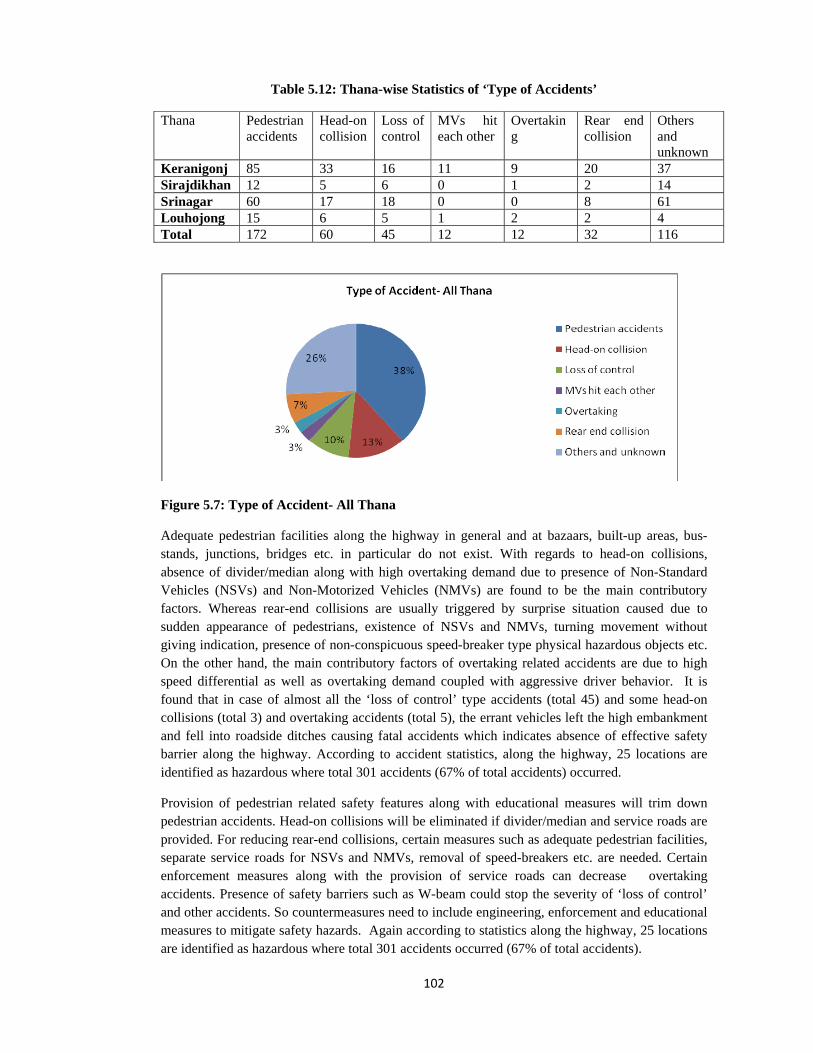
102
Table 5.12: Thana-wise Statistics of ‘Type of Accidents’
Thana Pedestrian accidents
Head-on collision
Loss of control
MVs hit each other
Overtaking
Rear end collision
Others and unknown
Keranigonj 85 33 16 11 9 20 37 Sirajdikhan 12 5 6 0 1 2 14 Srinagar 60 17 18 0 0 8 61Louhojong 15 6 5 1 2 2 4Total 172 60 45 12 12 32 116
Figure 5.7: Type of Accident- All Thana
Adequate pedestrian facilities along the highway in general and at bazaars, built-up areas, bus-stands, junctions, bridges etc. in particular do not exist. With regards to head-on collisions, absence of divider/median along with high overtaking demand due to presence of Non-Standard Vehicles (NSVs) and Non-Motorized Vehicles (NMVs) are found to be the main contributory factors. Whereas rear-end collisions are usually triggered by surprise situation caused due to sudden appearance of pedestrians, existence of NSVs and NMVs, turning movement without giving indication, presence of non-conspicuous speed-breaker type physical hazardous objects etc. On the other hand, the main contributory factors of overtaking related accidents are due to high speed differential as well as overtaking demand coupled with aggressive driver behavior. It is found that in case of almost all the ‘loss of control’ type accidents (total 45) and some head-on collisions (total 3) and overtaking accidents (total 5), the errant vehicles left the high embankment and fell into roadside ditches causing fatal accidents which indicates absence of effective safety barrier along the highway. According to accident statistics, along the highway, 25 locations are identified as hazardous where total 301 accidents (67% of total accidents) occurred.
Provision of pedestrian related safety features along with educational measures will trim down pedestrian accidents. Head-on collisions will be eliminated if divider/median and service roads are provided. For reducing rear-end collisions, certain measures such as adequate pedestrian facilities, separate service roads for NSVs and NMVs, removal of speed-breakers etc. are needed. Certain enforcement measures along with the provision of service roads can decrease overtaking accidents. Presence of safety barriers such as W-beam could stop the severity of ‘loss of control’ and other accidents. So countermeasures need to include engineering, enforcement and educational measures to mitigate safety hazards. Again according to statistics along the highway, 25 locations are identified as hazardous where total 301 accidents occurred (67% of total accidents).

103
5.3.2.2 ‘Type of Accidents’ and Hazardous Locations- Keranigonj Thana
Table 5.13 shows ‘Type of Accidents’ and Hazardous Locations for Keranigonj Thana. Out of total 211 reported accidents, pedestrian related accidents are 85 ( 40.28%), head-on collision accidents are 33 ( 15.64%), rear end collision accidents are 20 ( 9.47%), loss of control accidents are 16 ( 7.58%), accidents between motorized vehicles are 11( 5.21%,type unknown) , overtaking accidents are 9 ( 4.28%) and rest 37( 17.54%) are either unknown or other types of accidents. Total 113 accidents (53.55% of total accidents) occurred in 6 hazardous locations. Figure 5.8 shows type wise accident distribution at these locations and Figure 5.9 shows total number of accidents at these locations.
Table 5.13: ‘Type of Accidents’ and Hazardous Locations- Keranigonj Thana
Ser
Typ
e of
ac
cide
nt
Abd
ulla
hpur
Teg
hari
a
Raj
endr
apur
Has
naba
d-
Bur
igon
ga
Bri
dge
end-
Eku
ria
Dha
lesh
ari
brid
ge 1
Sonj
og m
ore
Oth
er
loca
tion
Tot
al
1
Pedestrian hit while crossing road
5 1 1 3 - 3 10 23
Standing pedestrian hit by MV 2 1 2 - 1 - 1 7
Pedestrian hit by MV 4 10 8 7 4 - 22 55 Pedestrian 11 12 11 10 5 3 33 85
2 Head-on collision 2 3 7 3 2 - 16 33 3 Loss of control 1 1 1 2 1 - 10 16 4 MVs hit each other 1 2 - 2 - 2 4 11 5 Overtaking 1 - - 1 1 - 6 9 6 Rear end collision 3 1 3 4 - 1 8 20 7 Others 3 8 - 4 - 1 21 37 Total 22 27 22 26 9 7 98 211
Figure 5.8: Type of Accidents and Hazardous Locations-Keranogonj Thana

104
Figure 5.9: Accidents at Hazardous Locations-Keranogonj Thana
Table 5.15 also shows that pedestrian related 62 accidents (72.94% of pedestrian related total accidents) occurred in 6 locations. In case of 23 accidents (27% of pedestrian related total accidents) pedestrians were hit while crossing the road. Abdullahpur and Sonjog more T-junction is found to be most vulnerable locations from pedestrians crossing point of view. In 55 accidents (64.70% of pedestrian related total accidents) pedestrians were hit by MVs, where nature of collisions is not known. From Table 5.15 it is seen that pedestrian accidents are predominant at Abdullahpur , Tegharia , Dhaleshwari Bridge 1 Approach , Hasnabad-Ekuria and Rajendrapur area.
Head-on collisions are mainly observed at Rajendrapur (31.82% of head-on collisions) which is located in a curve and also have typical hazards of a bazaar area. Loss of control type accidents are found not to be clustered rather distributed randomly along this segment Rear-end collisions are observed at Hasnabad-Ekuria , Abdullahpur , and Rajendrapur .
Analysis shows that Pedestrian related accidents are predominant in all the locations followed by head-on accidents. Countermeasures are to be planned accordingly to reduce these two types of accidents in all the locations. Hasnabad-Ekuria , Abdullahpur and Rajendrapur area need remedial measures to reduce rear end collisions. Treatment of hazardous locations will reduce accidents by at least 53.55%.
5.3.2.3 ‘Type of Accidents’ and Hazardous Locations- Sirajdikhan Thana
Table 5.14 shows ‘Type of Accidents’ and Hazardous Locations- Sirajdikhan Thana. Out of total 39 reported accidents, pedestrian related accidents are 12 ( 30.77 %), head-on collision accidents are 4 ( 10.26%), loss of control accidents are 6 ( 15.38%), and rest 17( 43.59%) are either unknown or other types of accidents. Total 26 accidents (66.66 % of total accidents) occurred in 2 hazardous locations. Figure 5.10 shows type wise accident distribution at these locations and Figure 5.11 shows total number of accidents at these locations.

105
Table 5.14: ‘Type of Accidents’ and Hazardous Locations- Sirajdikhan Thana
Ser
Typ
e of
ac
cide
nt
2nd
Dha
lesh
war
i B
ridg
e/
Kuc
hiam
ara
Cha
ltipa
ra
Nim
toli
Oth
er
loca
tion
Tot
al
1
Pedestrian hit while crossing road
- 1 4 - 5
Standing pedestrian hit by MV - - 1 - 1
Pedestrian hit by MV 4 - - 2 6 Pedestrian 4 1 5 2 12
2 Head-on collision 2 - 2 - 4 3 Loss of control - 2 1 3 6 4 Overtaking 1 - - - 1 5 Rear end collision - 1 - 1 2 6 Others 4 2 7 1 14 Total 11 6 15 7 39
Figure 5.10: Type of Accidents and Hazardous Locations-Sirajdikhan Thana

106
Figure 5.11: Accidents at Hazardous Locations-Sirajdikhan Thana
Out of total 12 pedestrian accidents, 9 accidents (75%) occurred at these 2 locations. In case of 5 accidents (41.66% of pedestrian accidents) pedestrians were hit while crossing the road. Nimtoli is found to be the most vulnerable location from pedestrians crossing point of view. At these two locations, adequate pedestrian facilities do not exist. In 6 accidents (50% of pedestrian accidents) pedestrians were hit by MVs, where nature of collisions is not known
Head-on collisions are observed at 2nd Dhaleshwari Bridge/ Kuchiamara (total 2) and Nimtoli (total 2) which are located at the end of high speed environments and also have typical hazards of roadside market/ bazaar area i.e. restricted visibility due to roadside activities, illegal parking etc. compelling vehicles to shift to opposite lane and causing such accidents. Type of accidents for 11 (28.20%) cases could not be identified due to poor record keeping system by police.
It is clear from the table that in this segment pedestrian related accidents are predominant followed by loss of control accidents. Countermeasures are to be planned accordingly. 2nd Dhaleshwari Bridge/ Kuchiamara and Nimtoli need remedial measures to reduce head on collisions and pedestrian related accidents. Treatment of three hazardous locations will reduce accidents by at least 82.05% in this segment.
5.3.2.4 ‘Type of Accidents’ and Hazardous Locations- Srinagar Thana
It is observed from Table 5.15 that out of total 164 reported accidents, pedestrian related accidents are 60 ( 36.59%), head-on collision accidents are 17 ( 10.36%), rear end collision accidents are 8 ( 4.89%), loss of control accidents are 18 ( 10.97%), and rest 61 ( 37.19%) are either unknown or other types of accidents. Total 132 accidents (80.48% of total accidents) occurred in 10 hazardous locations. Figure 5.12 shows type wise accident distribution at these locations and Figure 5.13 shows total number of accidents at these locations.

107
Table 5.15: ‘Type of Accidents’ and Hazardous Locations- Srinagar Thana
Ser
Typ
e of
acc
iden
t
Has
hara
No
2 B
us
Stan
d
Has
hara
No
1 B
us
Stan
dK
eotk
hali
Bus
St
and
Shol
ogha
r
Cho
nbar
i
Bej
gaon
Bus
Sta
nd
Srin
agar
Fer
rygh
at
Shom
spur
Dog
achi
Um
para
Oth
er lo
catio
n
Tot
al
1
Pedestrian hit while crossing road
1 4 4 4 3 2 2 2 1 1 2 26
Standing pedestrian hit by MV
1 1 2 1 - 1 - - 1 - 1 8
Pedestrian hit by MV
2 3 2 - - 1 3 1 - 6 8 26
Pedestrian 4 8 8 5 3 4 5 3 2 7 11
60
2 Head-on collision
- 2 4 2 - 1 2 1 2 1 2 17
3 Loss of control 1 - 1 1 2 - - 3 - 4 6 18 4 Rear end
collision - - 1 1 1 2 - - 2 - 1 8
5 Others /unknown
3 13 3 5 8 4 3 5 3 2 12
61
Total 8 23 17 14 14 11 10 12 9 14 32
164
Figure 5.12: Type of Accidents and Hazardous Locations-Srinagar Thana

108
Figure 5.13: Accidents at Hazardous Locations-Srinagar Thana
Pedestrian related 49 accidents (81.66% of pedestrian related total accidents) occurred in 10 locations. In case of 26 accidents (43.33% of pedestrian related total accidents) pedestrians were hit while crossing the road. All 10 hazardous locations are vulnerable for pedestrians crossing the road. In 26 accidents (43.33% of pedestrian related total accidents) pedestrians were hit by Motorized Vehicles (MVs), where nature of collisions is not known.
Head-on collisions are observed in almost all the locations and especially predominant at Keotkhali Bus Stand area. Loss of control accidents are not concentrated rather distributed along this segment though slightly higher at Shomspur Bus stand and Umpara Bottola. Rear-end collisions are distributed along this segment. Type of accidents for 55 (33.54%) cases could not be identified due to poor record keeping system by police.
Analysis reveals that pedestrian related accidents are predominant in all the locations followed by loss of control and head-on accidents. Countermeasures are to be planned accordingly. Keotkhali Bus Stand needs remedial measures to reduce head on collisions. Shomspur Bus stand and Umpara Bottola needs special attention for ‘loss of control’ accidents. Treatment of ten hazardous locations will reduce accidents by at least 80.48% in this segment.
5.3.2.5 ‘Type of Accidents’ and Hazardous Locations- Louhojong Thana
It is seen from Table 5.16 that out of total 35 reported accidents, pedestrian related accidents are 15 ( 42.86%), head-on collision accidents are 6( 17.14%), loss of control accidents are 5( 14.29%), and rest 9( 25.71%) are either unknown or other types of accidents. Figure 5.14 shows type wise accident distribution at these locations and Figure 5.15 shows total number of accidents at these locations.

109
Table 5.16: ‘Type of Accidents’ and Hazardous Locations- Louhojong Thana
Ser
Typ
e of
acc
iden
t
Maw
a R
ound
abou
t
Maw
a Fi
lling
St
atio
n
Utt
ar M
edin
i m
ondo
l, G
irls
Sc
hool
Utt
ar M
edin
i m
ondo
l Min
ar
Mos
que
Med
ini m
ondo
l,
Utt
ar M
edin
i m
ondo
l,
Oth
er lo
catio
n
Tot
al
1
Pedestrian hit while crossing road
- 1 - - - - 1 2
Pedestrian hit by MV
- - 2 1 2 3 5 13
Pedestrian - 1 2 1 2 3 6 15 2 Head-on
collision - 1 1 1 3 - - 6
3 Loss of control 3 1 - - - - 1 5 4 MVs hit each
other - - - - - 1 - 1
5 Overtaking - - - - - 1 1 2 6 Rear end
collision - - - - 1 - 1 2
7 Others /unknown 1 - - 1 - - 2 4 Total 4 3 3 3 6 5 11 35
Figure 5.14: Type of Accidents and Hazardous Locations- Louhojong Thana

110
Figure 5.15: Accidents at Hazardous Locations-Louhojong Thana
From the analysis, it is found that pedestrian related accidents are predominant in all the locations followed by head-on collisions and rear end accidents. Pedestrian accidents and head on collisions are spread all over the segment. Loss of control accidents occurred mainly near Mawa Roundabout and needs appropriate treatment. Over-speeding tendency to catch the ferry as well as after leaving ferry is observed along this segment.
5.3.3 Accident by Vehicle Type
Table 5.17 shows that bus is involved in 53.45% accidents. Other vehicles (less truck) contribute to 10.91% accidents. Vehicles of unknown types are involved in 9.80% pedestrian accidents and accidents caused by unknown vehicles are 18.27%. So in 28.07% accidents vehicle types are unknown indicating inefficiency in accident reporting or failure to identify due to other reasons.
Table 5.17: Accident by Vehicle Type
Ser Vehicle Type Keranigonj Sirajdikhan Srinagar Louhojong Total (%)
1 Bus and others 109 22 82 27 240 (53.45)
2 Truck and others 27 3 3 1 34 (7.57)
3 Various vehicles 31 2 10 6 49 (10.91)
4 Unknown vehicle and pedestrian
28 2 14 - 44 (9.80)
5 Unknown 16 10 55 1 82 (18.27)
Grand total 211 39 164 35 449 (100)

111
Figure 5.16: Vehicle Involvements in Accidents
Analysis as shown at Figure 5.16 suggests that ‘Bus and bus drivers’ as a focus group should be addressed to reduce accidents. Problems related to bus bays i.e. site, location, facilities, sign, marking, delineation etc. should be solved. Enforcement and educational measures, maintenance, licensing etc. in terms of bus and bus drivers can significantly improve safety situation.
5.3.3.1 Accidents Caused by Bus
It is marked from Table 5.18 and Figure 5.17 that bus is involved in 101 pedestrian related accidents which are 42.08% of accidents caused by buses and 22.49% of total reported accidents. ‘Bus only’ and ‘collision between buses’ contributed to 58 accidents which is 24.16% of total bus related accidents. In 36 accidents (15% of bus related accidents), bus is involved with non-standard vehicles i.e. Non-Motorized Vehicles (NMVs), baby taxi, CNG, human hauler, tempo etc. Again hazardous locations of Keranigonj Thana contributes to total 109 (45.42%) and of Srinagar Thana contributes to 82 (34.17%) of total bus related accidents.
Table 5.18: Accidents Caused by Bus
Ser Vehicle Type Keranigonj Sirajdikhan Srinagar Louhojong Total 1 Bus and pedestrian 41 9 39 12 101 2 Bus only 14 5 15 3 37 3 Between two bus 9 3 7 2 21 4 Bus and pick-up/jeep 6 - 1 2 9 5 Bus and motor cycle 6 - 7 - 13 6 Bus and microbus 3 - 1 1 5 7 Bus and NMV 5 - 2 5 12 8 Bus and baby taxi/CNG 6 1 4 1 12 9 Bus and human
hauler/tempo 6 1 5 - 12
10 Bus and taxicab/car 5 2 - 1 8 11 Bus and truck 4 1 1 - 6 12 Bus- passenger fallen 4 - - - 4 Grand total 109 22 82 27 240

112
Figure 5.17: Accident Caused by Bus
Study shows that collision points or locations between bus and pedestrians should be addressed for appropriate remedial measures i.e. bus bays, passenger waiting areas, road side activities, illegal parking restricting sight distance of pedestrians and buses, pedestrian crossing sites, raised footways at hazardous locations to separate pedestrians from buses etc. Involvement of buses with non-standard vehicles is significant (Total 36) which necessitates provisioning of separate lanes at hazardous locations. Again as mentioned in article 5.2.10.3, introduction of company based organized bus service will minimize unhealthy competition and thereby control over-speeding and dangerous overtaking tendency of bus drivers; which will lessen accidents caused by buses. Bus movements at Keranigonj and Srinagar Thana need special attention.
5.3.3.2 Accidents Caused by Truck
It is noticeable from Table 5.19 and Figure 5.18 that accidents caused by trucks are 34 (7.57%) which is significant as individual vehicle after bus. Again Keranigonj Thana alone contributes to 27 (79.41%) truck related accidents which deserves special attention.
Table 5.19: Accidents Caused by Truck
Ser Vehicle Type Keranigonj Sirajdikhan Srinagar Louhojong Total1 Truck and pedestrian 8 - 2 1 112 Truck only 3 2 - - 5 3 Truck and microbus 2 - - - 2 4 Truck and baby-
taxi/CNG 6 - - - 6
5 Truck and taxicab/car 4 - - - 4 6 Truck and Non-
Motorized Vehicles (NMVs)
1 - 1 - 2
7 Truck and motorcycle 3 - - - 3 8 Truck and pick-up - 1 - - 1 Grand total 27 3 3 1 34

113
Figure 5.18: Accident Caused by Truck
Public campaign and enforcement measures or fewer amounts of trucks may be the reasons of truck’s involvement in accidents. Future road use pattern (due to construction of Padma Bridge or conversion to 4-lane) may increase the number of trucks and especially heavy trucks in this highway. As a result, precautions are necessary in this regard.
5.3.4 Accidents Involving User Group
It is perceptible from Table 5.20 and Figure 5.19 that according to user group, pedestrians are mainly victims of accidents (172 accidents or 38.30%) followed by passengers of various vehicles (153 accidents or 34.07%).
Table 5.20: Accidents Involving User Group
Ser Vehicle Type Keranigonj Sirajdikhan Srinagar Louhojong Total 1 Accidents Involving
Pedestrians
85 12 60 15 172 (38.30)
2 Accident Involving Non-Motorized Traffics
11 - 4 6 21 (4.68)
3 Accident Involving Motor Cyclists
14 - 7 - 21 (4.68)
4 Accident Involving Passengers of Various Vehicles
85 17 38 13 153 (34.07)
22 Unknown 16 10 55 1 82 (18.27)
Total accidents 211 39 164 35 449 (100)

114
Figure 5.19: Accident Involving User Group
Remedial measures to reduce pedestrian related accidents should be the priority involving engineering, enforcement and educational measures etc. Accident severity for passengers of other vehicles can be reduced, in conjunction with engineering, enforcement and educational measures, by improving vehicle standards i.e. vehicle crashworthiness, improved cushioning/ protection inside the vehicles, use of seat belts etc.
5.3.4.1 Accidents Involving Pedestrians
It is noticeable from Table 5.21 and Figure 5.20 that Bus is involved in 101 (58.72%) pedestrian related accidents. Again hazardous locations of Keranigonj Thana contribute to 49.41% (85) and of Srinagar Thana contribute to 34.88% (60) of total pedestrian related accidents.
Table 5.21: Accidents Involving Pedestrians
Ser Vehicle Type Keranigonj Sirajdikhan Srinagar Louhojong Total 1 Bus and pedestrian 41 9 39 12 101 2 Unknown vehicle and
pedestrian 28 2 14 - 44
3 Truck and pedestrian 8 - 2 1 11 4 Pick-up and pedestrian 1 - 1 - 2 5 Microbus and pedestrian 2 1 1 1 5 6 CNG/Baby-taxi and
pedestrian 3 - - - 3
7 Taxi-cab/car and pedestrian
1 - 3 1 5
8 Human hauler and pedestrian
1 - - - 1
Total accidents involving pedestrian
85 12 60 15 172

115
Figure 5.20: Accident Involving Pedestrians
Pedestrians as a focus group should be educated/ made aware of possible hazards caused by bus through public campaign.
5.3.4.2 Accident Involving Non-Motorized Vehicles (NMVs)
Table 5.22 and Figure 5.21 reveal that accidents involving NMVs are 21 (4.76%of total accidents) where bus is involved in 12 accidents. NMV accidents mainly occurred at the identified hazardous locations.
Table 5.22: Accident Involving Non-Motorized Vehicles (NMVs)
Ser Vehicle Type Keranigonj Sirajdikhan Srinagar Louhojong Total 1 Bus and NMV 5 - 2 5 12 2 Car and NMV 3 - - - 3 3 Microbus/ambulance and
NMV 1 - - 1 2
4 Human hauler/tempo and NMV
1 - 1 - 2
5 Truck and NMV 1 - 1 - 2 Grand total 11 - 4 6 21
Figure 5.21: Accident Involving NMVs

116
Provisioning of separate service lanes for NMVs at hazardous locations, restricting roadside activities and illegal parking at walkway, shoulder and carriageway can reduce NMV related accidents. This aspect is highlighted at the audit report also.
5.3.4.3 Accident Involving Motor Cyclists
Table 5.23 reveals that accidents involving Motor cyclists are mainly victims of bus (13 accidents) followed by truck (3 accidents). This may be due to the predominance of bus and truck in this highway. Another reason may be unwillingness of motor cyclists to allow overtaking of buses and trucks, thus compelling buses and trucks to make risky overtaking attempts. Sometimes over-speeding and then failure to control speed at the event of oncoming accidents may also be a reason. Accurate accident recording system is absent to identify nature of such accidents.
Table 5.23: Accident Involving Motor Cyclists
Ser Vehicle Type Keranigonj Sirajdikhan Srinagar Louhojong Total 1 Bus and motor cycle 6 - 7 - 13 2 Car and motor cycle 1 - - - 1 3 Microbus and motor cycle 1 - - - 1 4 Truck and motorcycle 3 - - - 3 5 Motorcycle only 1 - - - 1 6 Human hauler and
motorcycle 1 - - - 1
7 Covered van and motorcycle
1 - - - 1
Grand total 14 - 7 - 21
Educational measures for motor cyclists regarding over-speeding, overtaking, wearing of appropriate crash helmets etc. may reduce accidents and severity of motor cyclists’ accidents. Accurate accident recording system should be developed and practiced.
5.3.4.4 Accident Involving Passengers of Various Vehicles
It is noticeable from Table 5.24 that passengers of buses are victimized in 40.52% (62) of accidents involving passengers; that include ‘Bus only’, ‘between two buses’ and ‘Bus- passenger fallen’ accidents. Passengers victimized by buses accounts for 110 (71.89% of accidents involving passengers) accidents. Passengers of non-standard vehicles are victimized in 24.18 % (37) of accidents involving passengers.
Table 5.24: Accident Involving Passengers of Various Vehicles
Ser Vehicle Type Keranigonj Sirajdikhan Srinagar Louhojong Total 1 Bus only 14 5 15 3 37 2 Bus and pick-up/jeep 6 - 1 2 9 3 Between two bus 9 3 7 2 21 4 Bus and microbus 3 - 1 1 5 5 Bus and baby taxi/CNG 6 1 4 1 12 6 Bus, human hauler/tempo 6 1 5 - 12 7 Bus and taxicab/car 5 2 - 1 8 8 Bus and truck 4 1 1 - 6 9 Microbus and baby-taxi 1 - - 1 2 10 Truck only 3 2 - - 5

117
11 Truck and microbus 2 - - - 2 12 Pick-up only 3 - - - 3 13 Bus- passenger fallen 4 - - - 414 Truck and baby-
taxi/CNG 6 - - - 6
15 Tank lorry/oil tanker 2 - - - 2 16 Taxicab only 2 1 - 1 4 17 Truck ,taxicab/car/pick-
up 4 1 - - 5
18 Human hauler/tempo only
2 - 2 - 4
19 Taxicab and CNG 1 - - - 1 20 Multiple vehicle 2 - 2 1 5 Grand total 85 17 38 13 153
Emphasize should given to the protection of bus passengers to reduce accident severity. Crash worthiness of buses and other standard and non-standard vehicles should be improved to reduce accident severity. Again, treatment of high embankments with the provision of safety barriers such as W-beam will protect passengers of the vehicles that leave the highway and fall into roadside ditches (total 53 accidents). This aspect was highlighted in audit report.
5.3.5 Problems Encountered
It was learnt from the interview with the local that many accidents are not reported. Accident record keeping system in police stations is not satisfactory. In some accidents time of occurrence, type of vehicle, age of victims etc. are recoded as ‘unknown’. Wounded casualties are rarely monitored for knowing subsequent condition. Appropriate ‘accident reference system’ is absent. Place of occurrence are mentioned as ‘Shomspur-12 km south-west of Srinagar Thana’ or ‘500 meter north of some bazaar or bus-stand’. Thus actual location of accident spot is not identifiable in many cases. ‘Nature of collision’ is often termed as ‘hit by certain vehicle’. Collision diagrams are not available. Accident reports are not regularly forwarded to higher authority for subsequent recording. Matching of collected accident data with Accident Research Institute (ARI), BUET database reveals that even recorded accidents are not reported for inclusion in MAAP database. 5.4 Future Impact of Padma Bridge, Urbanization and Four Lane Conversion
5.4.1 Introduction
Road safety auditing report of existing Dhaka-Mawa highway is presented in the previous articles. Potential safety hazards are identified and remedial measures are suggested. Collected accident data was consulted to supplement audit findings and recommendations. These are applicable for a two lane undivided highway with existing traffic volume, local conditions, land use pattern etc. In future it is likely that ‘ safety scenario’ may be changed due to the increased traffic flow, changing land use pattern and increased carriageway width with divider resulting from the construction of Padma Bridge (article 2.9), changing urbanization pattern (article 2.11) and possible conversion to a four lane divided highway(article 2.10). Detail study about these impacts is beyond the scope of this research. However, endeavor has been made in the subsequent articles to understand and highlight potential safety hazards basing on related literature analysis, field visits etc. so that precautionary and corrective measures can be undertaken to avoid hazards having new dimensions or magnitude.

118
5.4.2 Impact of Padma Bridge on Road Safety
5.4.2.1 Increase of Existing Hazards
It is forecasted that Padma Bridge would increase AADT along the highway (most likely case scenario: AADT 9317 in 2014 and 17185 in 2020). It is also anticipated that due to increased mobility and accessibility, urbanization process along the corridor would increase significantly. These increased AADT as well as land use development activities will induce more local traffics ; both vehicular and pedestrian, resulting higher conflicting situations between vehicle-vehicle, vehicle-pedestrian, through vehicle-local vehicle, fast moving motorized vehicle - slow moving non-motorized vehicle etc.
5.4.2.2 Increased Number of Buses
At present bus accounts for 53.45% of total reported accidents. In 2007, AADT of buses at Mawa ferry crossing was 1183 which is forecasted to increase to 2,917 in 2015. Thus it is likely that accidents related to bus will increase.
5.4.2.3 More Number of Heavy Vehicles
At present truck accounts for 7.57% of total reported accidents. In 2007, AADT of trucks at Mawa ferry crossing was only 979 which are forecasted to increase to 3,945 in 2015. Growth rate of truck movements is more than bus. Future crash patterns are likely to involve more number of trucks than buses.
5.4.2.4 Increased Number of Light Vehicles
From Table 2.9 of article 2.10, it is seen that along this corridor proportion of light vehicles would increase from 32.24% in 2014 to 55.24% in 2030. Forecasted growth rate of light vehicles is higher in comparison to other two types of vehicle which is likely to deteriorate hazards associated with light vehicles.
5.4.2.5 Effect on Road Users
Due to possible change in land use pattern, as Padma Bridge would encourage more urbanization, future crashes are likely to be pedestrian dominated. Increased AADT and especially bus and truck will pose safety hazards to non-motorizes vehicles and other non-standard slow moving vehicles.
5.4.3 Conversion of Existing Highway to Four-Lane Highway
5.4.3.1 Introduction The future construction of Padma Bridge is estimated to generate huge traffic growth in this highway. To cope up with the increased traffic, a project is underway to convert existing highway to a higher capacity highway. Conversion of existing 2-lane undivided highway to a 4-lane divided highway has both merits and demerits. The increased capacity of the highway will give the scope of improving safety situation. Again hazard pattern may be changed. In Bangladesh some of the national highways are converted to 4-lanes. But there exist no study to compare safety benefits of such conversion. 5.4.3.2 Possible Cross-sectional Elements and Existing Safety Hazards
It is learnt that, future highway will have the same alignment. Additional 2 lanes of 7.3 m width with 1.5m shoulder and 1m walkway with a raised divider will be added to the old alignment. The

119
project of ‘converting 2-lane highway to 4-lane’ does not address or mitigate following hazards which already exists:
• Uncontrolled access to the highway. • Hazards associated with bazaars, built-up area, and bus-stands as highlighted in road
safety audit. • Narrow bridges at old alignment. • Curves with restricted visibility. • Use of same road space by Non-Motorized Vehicles (NMVs), non-standard Motorized
Vehicles (MVs) and standard MVs. • Hazards associated with existing bus bays. • Absence of designated parking facilities for other vehicles. • Non-separation of through and local traffic at bazaar, built-up areas, bus-stands. • Absence of adequate clear zone and presence of non-traversable batter slopes. • Hazards associated with filling stations. • Presence of non-engineered side road-highway junctions.
5.4.3.3 Benefits of Raised Divider and Wider Carriageway
Benefits of raised divider and wider carriageway are likely to be as under:
• Raised divider will separate opposing vehicles thus will reduce head-on collisions which is 13.36% of total reported accidents.
• Severity of loss of control accidents on opposite side is likely to reduce due to the presence of raised divider (a type of barrier at one side). At present loss of control accidents (at both sides) are 10.02% of total reported accidents.
• Raised divider, if properly delineated will guide the vehicles on the carriageway. • Wider carriageway will minimize bottleneck effects at built-up areas, bazaars, bus-stands
caused by roadside activities, illegal parking etc. • Faster vehicles can overtake slow-moving vehicles easily.
5.4.3.4 Possible Safety Hazards
• Effect of headlight glaring will be not be minimized. • Collisions (rear-end and side collisions) while turning will occur with opposite vehicles as
it will not be possible to provide turning lanes at divider openings. • Due to increased crossing distance pedestrian accidents will increase if pedestrian refugee
island of appropriate width is not provided within the divider at mid-block sections, bazaars, built-up areas, bus-stands and junctions.
• Tendency of slow but heavy vehicles to occupy right lane to avoid friction with slow and non -standard vehicle is likely (as observed at other 4-lane highways), thus compelling faster vehicles to overtake using left lane which is hazardous for pedestrians and slow and non-standard vehicles.
• Vehicles attempting to make right-turns at junctions will have to traverse longer travel distance. Hazards at junctions will increase if appropriate sign, marking and speed management devices are not placed.

120
5.4.3.5 Considerations for Four-Lane Highway
Service Roads: Like any other places of Bangladesh, also in this region, local side roads joining the highway perpendicularly, transports local and intra-zonal traffics. There exist no parallel roads along this highway to carry local traffic, thus inducing various conflicting maneuvers along the only available road i.e. the national highway. From road safety audit findings (which was supplemented by accident data analysis), it is evident that presence of slow-moving non-standard Motorized Vehicles (MV) and Non-Motorized Vehicles (NMV) carrying local traffics along this highway cause huge safety hazards i.e. speed differentials, overtaking tendency etc. Again contribution of these slow-moving non-standard MVs and NMVs to local economy should not be ignored. While converting the corridor, it will be wise to provide separate service roads which will segregate local and through traffic. It is found that addition of service lanes would be more effective in removing safety hazards and restoring level of service of the highway than adding two lanes for all road users. Gradually, in this region and also throughout the country it is suggested to develop well-knit road hierarchy based on functional classification which is capable of addressing local and through traffics. Median: Instead of low-height rectangular type divider having non-engineered openings for turning vehicles (as available at some four-lane divided national highways), wide median with engineered treatment is recommended which will provide refugee for turning vehicles. At hazardous locations (bazaars, Built-up areas and bus-stands), wide median will also accommodate appropriate pedestrian refugee islands. New Jersey Barrier: Instead of low-height rectangular type divider, New Jersey type barrier should be installed which is designed to both minimize vehicle damage in cases of incidental contact by redirecting the vehicles while still preventing crossover in the case of head-on accidents. In future, along this highway proportion of light vehicles is forecasted to increase from 32.24% in 2014 to 55.24% in 2030 and New Jersey type barrier can eliminate head light glaring problem of smaller sized vehicles. At hazardous locations (bazaars, Built-up areas and bus-stands), this type of barrier can be modified with extended heights which will prevent both headlight glaring for all vehicles while preventing pedestrians in topping over the barrier. Vertical Bypass: During road safety audit, 17 locations are identified as hazardous for various reasons. Accident data analysis also supplements audit findings. Besides posing safety hazards, these places also reduce the level of service of the existing highway. It is learnt that, in the proposed four-lane highway, these issues are not addressed. It is observed that provision of vertical bypasses at 12 locations i.e. approximately 4 km length, will ensure uninterrupted flow of through traffic thereby reducing conflict level and increasing safety situation of the corridor.
5.4.4 Land Use Pattern and Future Impacts
5.4.4.1 Present Land Use Pattern- Indication of Rapid Urbanization
Except first few hundred meters, the general area adjacent to highway is ‘rural’ in nature having open and flat terrain. Roadside markets are developed adjacent to the highway. Nearby villages are connected to the highway through unplanned side roads. Hasnabad-Ekuria area is a built-up area which is gradually expanding towards Mawa side. Abdullahpur Bazaar, Rajendrapur and Nimtoli Bazaar are the existing ‘growth centers’ and have the potential to turn into built-up areas in future.

121
Due to rapid and unplanned urbanization, the segment of the highway, close to Dhaka is experiencing massive land development on both sides of the highway. New townships are already developed and more are being developed on either side of the highway. New land development is predominant from Hasnabad-Ekuria area to Dhaleshwari Bridge 1 Approach. The safety impact of these ‘new land developments’ on the highway is not assessed. ‘Photos 70 to 76’ shows present land development astride the highway.
Photo 70: New towns already developed and being developed south of the highway at Hasnabad- Ekuria area (Source: Google Image)
Photo 71: Hasnabad-Ekuria built-up area Photo 72: Ongoing land development prior to Songjog Sorok T-Junction

122
5.4.4.2 Possible Impacts on Road Safety
The problems arising from unplanned new developments are as under:
• These new developments will eventually be connected with the highway. At present there exist no efforts to limit direct access into national highway. Service or frontage roads connecting these new developments and then delivering traffic to the highway at appropriate junctions with proper engineering treatment are absent which will cause safety hazards.
• These developments will be generator of huge traffic in future. Congestion within the road network of these developments may reach to the highway.
• Local traffic including pedestrians, non-motorized traffic and other vehicles movements will be generated across existing highway.
• There will be the necessity of provisioning more public transport system on the highway. • Development of new driveways or private/ commercial property entrances will require
turning provisions thus affecting through vehicle movements and overall safety. • Pedestrian- vehicle conflicts and local-through traffic conflicts will increase. • Speed limit of the national highway will have to be lowered. • Increased roadside activities, illegal parking etc. will deteriorate existing safety situation
of the highway.
Photo 75: Unplanned development around Abdullahpur Bazaar (Source: Google Image)
Photo 76: A potential site for land development near Dhaleshwari Bridge 1(Source: Google Image)
Photo 73: Developed land for new town near Songjog Sorok T-Junction
Photo 74: land already developed (South Model Town) prior to Abdullahpur

123
5.5 Overview
Road Safety Audit Report
Road safety auditing was carried out to identify potential hazards in this highway. Findings are based on collected data, field observation and analysis. The report covers some general aspects such as scope of the highway; function and access to property and developments. Under ‘Road Alignment and Cross Section’, topics such as visibility, sight distance, readability by drivers, overtaking , design speed, speed limit/speed zoning, curves, carriageway, shoulders, embankments, walkway, private driveways and property entrances, and drainage condition were discussed. Necessity of approach widening and lightings, hazards associated with intersections, built-up areas, bazaars, side roads, bus-stands, curves, pavement, bridges etc., deficiencies of signs, markings and delineations, requirements of heavy vehicles, condition of crash barriers and guide posts, absence of clear zones are discussed. Safety hazards related to pedestrians, Non-Motorized Vehicles (NMVs) and Motorized Vehicles (MVs) at various locations are identified. Problems related with illegal parking and roadside activities, headlight glare, non-engineered speed retarding devices, discontinuous landscaping, non-standard vehicles, unsafe school zone, CNG/Filling Stations are highlighted. Night inspection brought out some drawbacks at bridges and culverts, curves, and other places. Past crashes and off-road excursions gave important hints about safety hazards. Condition of Law Enforcement Agency and trauma management systems were also discussed. Accordingly recommendations prescribed general, short, mid and long term solutions.
Review of Accident Data to Supplement Audit Findings
The road safety audit process identifies potential hazards in a road and recommends appropriate remedial measures. This is a pro-active or preventive approach suitable for Bangladesh where adequate data regarding accidents are not available. Accident statistics could identify some hazardous locations with type of accidents but details of accidents i.e. nature of accident, collision diagrams, exact location etc. can not be visualized properly. Hazards associated with curves, bridges, side roads etc. can not be identified in accident statistics as some accidents are recoded as ‘ unknown time or vehicle’ and accidents are often referred with reference to some bazaars, built-up areas etc. thus hiding true location of accidents. However, available information on accidents can supplement audit findings and in this study accident statistics did enrich audit findings.
Future Impact of Padma Bridge, Urbanization and Four Lane Conversion
Due to the increased traffic flow, changing land use pattern and increased carriageway width with divider resulting from the future construction of Padma Bridge, changing urbanization pattern and possible conversion to a four lane divided highway, ‘ safety scenario’ will be changed. Potential safety hazards having new dimensions or magnitude are identified and attempts were made to suggest remedial measures. Impact of Padma Bridge on road safety may be; increase of existing hazards, more involvement of buses and other heavy vehicles in accidents and occurrence of hazards related to pedestrians, Non-Motorized Vehicles (NMVs) and other slow-moving vehicles. If cross-sectional elements and design are not modified than conversion of existing highway to four-lane may increase hazards such as collisions while turning, rear-end collisions, accidents involving pedestrians, slow and non-standard vehicles. Rapid urbanization and unplanned land use may cause direct access into national highway, congestion resulting from huge traffic generation, risky turning maneuvers, lower speed limit, increased roadside activities and illegal parking, more pedestrian- vehicle and local-through traffic conflicts.

124
CHAPTER 6
CONCLUSIONS AND RECOMMENDATIONS
6.1 Introduction
In this study attempts are made to assess safety hazards of a selected highway section of Bangladesh i.e. Dhaka-Mawa Highway using road safety auditing approach. At first existing “Guidelines for Road Safety Audit, 2005” of Roads and Highways Department (RHD), Bangladesh is reviewed and guidelines of developed countries are analyzed to include important aspects which are missed out in RHD guidelines. The aim was to make the guidelines an effective tool for road safety auditing purposes. Checklists provided with RHD guidelines are analyzed, design standards and guidelines of other countries are studied to modify/develop more detailed and comprehensive checklists. Then with this modified checklists road safety auditing of Dhaka-Mawa highway was conducted to identify existing and potential safety hazards. Basing on audit findings, short/mid/long term and low/high cost remedial measures were suggested in the audit report. Accident data was collected from concerned police stations, analyzed and matched to supplement audit findings and to augment recommendations. Again expected construction of Padma Bridge, rapid urbanization and development pattern and likely conversion of existing highway to a four-lane divided highway are expected to have impacts on the safety situation of the highway; attempts were made to assess the impending safety hazard scenario and to suggest appropriate remedial measures.
In order to achieve the objectives of the research work, various guidelines on road safety audit, design standards, drawings, and related publications were consulted. A total of 13 field visits were conducted to observe possible hazards. On various occasions, roadway alignment and geometric measurement, field studies, field survey; both vehicular and pedestrian etc. were carried out. Day and night time inspection, use of photographs and video-taping, interview etc. were also undertaken. Altogether 11 visits were made to concerned police stations to collect accident data. Besides, local conditions were taken into consideration during the whole study.
6.2 Summary of the Findings /Conclusion
Summary of the findings are presented as per the ‘specific aims’ of the study which were planned to be achieved at the beginning of the study. While listing findings, the main objective of the research i.e. ‘to identify the safety deficiencies and accident potential and recommend the cost effective appropriate remedial measures for the overall safety improvement of Dhaka-Mawa highway following Road Safety Auditing process’ was the key consideration. Following article presents summary of the research findings:
6.2.1 Review of Existing RHD Guidelines on Road Safety Audit
While reviewing existing RHD guidelines, guidelines of various countries were studied to include important aspects in the guidelines. Existing guidelines of RHD on “Road Safety Audit’ did not include many important aspects related to safety audit. The summary of the findings are appended below:
a. Being the only guidelines for road safety auditing, this manual did not explain the basic concepts or essential elements of road safety auditing in details which are suggested to be included in Roads and Highways Department (RHD) guidelines.

125
b. Important aspects regarding audit team such as composition, skill, experience etc. which are pre-requisite for undertaking road safety audit are not included in the RHD guidelines.
c. Roles and responsibilities of various parties involved in the road safety audit such as project owner, design team leader, and the audit team are not mentioned in RHD Guidelines resulting vagueness in implementing road safety audit.
d. The detailed and step-by-step audit process is not included in RHD guidelines. A clear procedure for managing and organizing safety audit is absent, the practice of undertaking and reporting safety audit is not specified, and actions are not fully and consistently documented.
e. Quality assurance procedures of an organization can state what is expected in connection with road safety audits, the frequency of audits, the number of auditors for different size projects, and the audit process to be followed. Inclusion of this aspect will enrich RHD guidelines.
f. Legal issues and areas of concern related to road safety audit are getting appropriate attention in developed countries, but RHD guidelines are silent about the topic.
g. Guidelines of other countries, through various examples and evidences discussed the benefit-cost ratio of audits at various stages and concluded that benefits from safety auditing will undoubtedly outweigh the costs. The cost-effectiveness road safety audits are suggested to be included in RHD manual.
h. RHD Guidelines does not provide any hints about the conduct of training for road safety auditors.
i. Monitoring is needed to assess the procedures and practice, and update them to ensure that the effectiveness of safety audit process remains as robust as possible. Responsibility for setting up a procedure for monitoring rests with the client (highway authority) organization but RHD guidelines do not specify the monitoring and evaluation procedure.
j. RHD Guidelines did not discuss various stages of audits. The background, necessity, requirements, significance and implementation of various stages of audits differ considerably. Absence of thorough discussion on each stage of audits deprived all concerned especially potential safety auditors in gaining appropriate knowledge. AUSTROADS included special types of audits (audit for ‘land use development’, Specialist audits for ‘road user group’ etc.), which are relevant to Bangladesh but not included in the manual.
k. In Bangladesh accurate accident records are simply not available and crash location treatment programs based on accident records may not be able to address potential hazards. Explanation on the necessity of road safety auditing for existing roads, in context of Bangladesh, are not covered in RHD Guidelines. It was necessary to clarify distinctions between ‘accident investigation’ and ‘road safety audit of existing roads’ and to guide as to how and when to use accident data for audit.
l. Guidelines of reputed organizations included some reports based on actual road safety audits. Roads and Highways Department (RHD) Guidelines could include examples of road safety audit reports of developed countries describing reporting format/style to familiarize and enlighten the auditors.
m. RHD Guidelines mainly followed the checklists of AUSTROADS. Very little was done to modify the checklists to suit local conditions. Like FHWA Guidelines (2006), inclusion of ‘a general procedure for using checklists’ can be included in the manual.
6.2.2 Modification of Checklists
In RHD Guidelines, aspects related to local conditions viz road user behavior, roadside non-motor activities, heterogeneous vehicle composition, road usage peculiarities were not included in the checklists. FHWA Guidelines suggest that enforcement or education-based treatment may be included in the audit report. FHWA emphasizes on observing road user behavior, examining

126
physical evidence of past crashes and off-road excursions and checking the consistency of the function and classification of the highway during the field visit. Also basing on ‘National Land Transport Policy, 2004’ of Bangladesh, road safety literatures, and guidelines of experienced countries some questionnaire was included in the modified checklists and some investigation/inventory forms were made. Besides road environment, arena of road safety audit was expanded to road user behavior, traffic enforcement, trauma management, urbanization, new developments, education etc. Summary of the findings i.e. aspects which can be included in the checklists are listed below:
a. Road safety audits of ‘existing roads’ can check some important aspects viz appropriateness of road function, accessibility and impact of different modes of transport in order to identify existing and potential safety hazards. These aspects are suggested to be included in the checklists.
b. In Bangladesh, trauma management system following an accident is yet to be developed. Audit of existing system and management can identify the weaknesses and can improve this important safety strategy and may therefore be included in the checklists or may appear in the audit report as general observations basing on collected field data/observations.
c. In Bangladesh, sometimes educational institutions are located adjacent to the highway which needs special safety measures. It is therefore recommended to include ‘Educational/School Zone Safety’ in the checklists.
d. It is revealedt that important lessons can be brought out if road users’ behavior is observed. Enforcement, education and publicity related suggestions can be made as a result of such observation. Thus it is necessary to include ‘Road User Behavior’ in the checklists.
e. Examinations of physical evidences of past crashes may give clues of hazardous locations. Inclusion of such examination in the checklists will assist in elevating safety situation.
f. In Bangladesh most accidents occur in built-up areas, bazaars and bus-stands and their approaching road sections. Concentration of pedestrians, lack of appropriate traffic control devices and various roadside activities make these areas hazardous. These areas are often generators of major traffics along the highway. Thus it is necessary to include this item in the checklists.
g. A night time inspection permits a check on readability of the road and the effectiveness of signs, markings and street lighting. Therefore, it is necessary to include ‘Night Inspection’ in the checklists as a separate item as it can identify various safety deficiencies of the highway from a different perspective.
h. Enforcement related observations can be brought out from the observation of road user behavior, road side activities and field visits. Inclusion of ‘Enforcement’ as a separate item in the checklists will assist in bringing out enforcement related observations.
i. Speed reducing devices like speed-breakers/speed bumps should not be used in the highway but it is very common in Bangladesh. Reasons for establishing speed-breakers and associated hazards can be investigated if ‘Speed-breakers/Speed/hums’ are included in the checklists as separate item.
j. In Bangladesh, unplanned and non-engineered connectivity of side-roads with the national highway is very common. Safety hazards related with ‘Side Roads’ can be dealt with if this item is included in the checklists.
k. Non-standard Motorized Vehicles (MVs) and Non-Motorized Vehicles (NMVs) comprise significant part of ‘Vehicle composition’ of the highway. Safety impact of these vehicles can be assessed if this aspect is included in the checklists.
l. Local conditions viz road usage peculiarities, non-motor roadside activities, heterogeneous vehicle composition , highway adjacent land use pattern, awareness of various road users etc. should be taken into consideration while auditing a road in Bangladesh. Safety impact of these local conditions and peculiarities need to be reflected in other items of the checklists.

127
m. Basing on the abovementioned discussions, existing checklists are modified which is presented at Appendix A. necessary formats to support the checklists is presended at Appendix B.
6.2.3 Road Safety Audit Report
Road safety auditing is conducted to assess potential hazards along this highway. The audit report is titled as ‘Road safety audit report of Dhaka-Mawa Highway’. Modified checklists (Appendix A) and various forms (Appendix B) were used to aid the auditing. The audit report is written in ‘prose’ style. Findings are based on collected data, field observation, field survey and analytical approach. Recommendations prescribe general, short, mid and long term solutions. While proposing recommendations, besides standard countermeasures as suggested by established guidelines/literatures/manuals, local peculiarities are taken into consideration. In the audit report, on various occasions, references are made to various Tables (in the body of the report and also at Appendix C). The body of the report includes some related figures and photographs for easy understanding. The summary of main findings is listed below:
a. Scope of the Highway; Function: The safety audit of the study corridor i.e. Dhaka-Mawa revealed that at present the highway is not performing its intended function as national highway properly and existing design is not consistent with the function. Design Type is based wholly on traffic volume and have no direct relationship with functional classification In absence of a road hierarchy, multi-functionality arises which leads to contradictory design requirements and also to higher risks due to different transport modes, uncontrolled accessibility, unpredictable road user behavior, significant speed differentials between Motorized Vehicles (MVs), non-standard MVs and Non-Motorized Vehicles (NMVs) etc.
b. Access to Property and Developments: Degree of access control is not consistent with the
road’s function. As the road classification is based on traffic volume only, the issue of access control is not addressed. The occurrence of unexpected events due to numerous private and commercial property entrances, driveways, roadside developments, uncontrolled side roads etc. are found to be complicating the driving task.
c. Road Alignment and Cross Section
i. Visibility; Sight Distance: The sight distance along the road is inadequate or restricted at curves, junctions and straight sections (built-up areas / bazaars/ bus-stands) due to parked vehicles, road side non-motor activities and developments, roadside plantation etc. It is observed that inadequate and restricted sight distance encourage hazardous vehicular movements.
ii. Readability by Drivers: As a whole, the alignment of the roadway is clearly defined by center and edge line marking. But at bazaars/built-up areas/bus-stands, these markings are either faded out due to poor maintenance or invisible due to roadside non-motor activities which creates confusion for the drivers.
iii. Overtaking Provision: Safe overtaking opportunities through road marking were not observed along this highway. This results in uncontrolled and risky overtaking attempts which increase safety hazards along the highway.
iv. Design Speed: This is a Design Type 3, National Highway with design speed 80 kmph. From ‘speed study’, it is found that along this highway, 98th percentile speed varies between 64 to 72 kmph and 85th percentile speed varies between 57 to 62 kmph. This implies that the highway is not capable of maintaining its intended design speed. From ‘traffic volume count’ study, conducted at two places i.e. after Kodomtoli T junction and prior to Chonbari Junction, it is seen that non-standard motorized vehicle comprises 58% and 30.92% of vehicle composition

128
respectively which cause speed differential amongst the vehicles. Again modal speeds at straight section prior to Rajendrapur, at curve prior to Srinagar Ferryghat, and at curve prior to Chonbari Junction, were found to be 45 kmph, 46 kmph and 44 kmph respectively. Also, field speed study conducted at three places revealed varying average speeds for different types of vehicles. Average speed of bus, truck, small standard motorized vehicles and non-standard vehicles varies between 49-57 kmph, 35-51 kmph, 59-66 kmph and 28-46 kmph respectively. It is found that speed of vehicles varies significantly between locations and also within the same type of vehicles. Again, critical analysis of vehicle speed reveals that average speed of fast moving vehicles is 56.55 kmph while average speed of non-standard motorized vehicles is found to be 40.98 kmph indicating speed differential of approximately 15 kmph between these two categories of vehicles. These speed and vehicle composition analysis revealed quite significant speed differential arising from heterogeneous vehicle composition. It is observed that presence of non-standard slow-moving vehicles induce forced overtaking by fast-moving motorized vehicles which is one of the most dangerous maneuvers particularly for undivided road.
v. Speed Limit/Speed Zoning: Speed limit is not compatible with the function, road geometry, land use and sight distance. According to field survey, average speed of vehicles at four built-up areas/bazaars varies from 16 kmph to 23 kmph which may irritate through drivers as well as local drivers. Within a span of only 31 km, the drivers need to adjust speed for a number of times. Built-up areas, narrow bridges and curves demand ‘Special Speed Limits’. Due to inappropriate road geometry at bazaars/ built-up areas/ bus-stands, multi-functionality due to uncontrolled access, unplanned land use pattern and restricted sight distance, national speed limit i.e. 80 kmph is not compatible. Necessary warning and advisory speed limit signs and markings were not observed at all required places.
vi. Curves: Adequate engineering treatment, traffic control devices etc. are not applied at curves. Roadside hazards/objects exist within 1m of the carriageway at Rajendrapur Bazaar and Bejgaon Bus-stand which are located within curves. Except two curves, F6 BARRIER LINE is not observed at any curves having inadequate sight distance. Except three places, curve warning signs are not erected at the approaches to any other curves. Chevron Alignment Markers (CAMs) are not installed at any curves. Field measurement revealed inadequate Stopping Sight Distance (SSD) and Passing Sight Distance (PSD) at three curves (available sight distances at curves prior to Shologhar, Chonbari Junction and Srinagar Ferryghat are 394 ft, 291 ft and 289 ft respectively against required SSD i.e. 461.53 ft and required PSD i.e. 1657.02 ft). Advisory speed signs are not installed prior to any curves having restricted sight distances or inadequate curve widening. Again, calculation to check the necessity of curve widening at curve prior to Srinagar Ferry Ghat, basing on AASHTO Geometric Design formula, reveals that at design speed 60 kmph, amount of required widening is 1.53 ft. At the same place with design speed 80 kmph, required amount of widening is found to be 2.02 ft. But no curve widening was done at this place. According to SRNDP, there exist 19 curves along this highway, out of which 12 curves have relatively low radius of curvature between 400 to 800 meters. Presence of 19 curves within 31 km implies that, change of alignment is occurred at every 1.68 km length of the highway. This observation essentially suggests that drivers of the corridor need extra attention while negotiating these geometric constraints.
vii. Carriageway: As per Roads and Highways Department (RHD) design standard the highway is Type-3 category requiring 7.3 m wide carriageway. Field measurement show that carriageway width varies between 7.0 to 7.1 m which implies that as a whole the highway has less carriageway widths than the required design standard. This inadequate width related problem is more acute at bridges and culverts where carriageway width varies between 6.4 m to 7.2 m (except Abdullapur Bridge). Moreover, curve widening is not done at any curve which is a

129
vital safety feature for hazardous locations particularly for sharp curves. Again, particularly at bazaar/ built-up area/ bus-stand, traffic lane and carriageway widths are not adequate to accommodate existing traffic volume and mix.
viii. Hard Shoulders: Shoulder width is inconsistent throughout the highway. This is a Design Type 3 Highway requiring 1.5 m wide shoulders on each side. According to field measurement, shoulder width along the highway varies between 1.1 to 1.7 m. The required shoulder width for broken-down or emergency vehicles to stop safely is absent in this highway. At some places, due to roadside vegetation, effective shoulder width is reduced. Throughout the length of the highway, transition from road to shoulder is not safe due to high drop-offs (varies between 4 to 8 cm). At some places, shoulders are not trafficable for vehicles and road users due to the damage caused by poor drainage and soil erosion.
ix. Embankments: The highway as constructed on high (15 to 25 ft) and steep embankments, batter slopes are quite dangerous for run off vehicles. Standard/ safe batter slopes should be between 1:4- 1:6 which are almost absent all along the highway.
x. Soft Shoulders: Soft shoulder is supposed to be used by pedestrians as walkway. This is a Design Type 3 Highway requiring 1.0 m wide walkway on each side. Consistent walkway width is not maintained and throughout the entire length of the highway the walkways are almost not useable by pedestrians. Existing walkways are either covered with roadside vegetation or damaged due to soil erosion. As a result pedestrians are compelled to use hard shoulder which is very hazardous.
xi. Private Driveways and Property Entrances: Presence of private driveways and property entrances are observed mainly between hasnabad and Abdullahpur area. Sight distance is restricted at almost all private driveways and property entrances. Sudden entry of vehicle from private driveways and property entrances causes safety hazards.
xii. Drainage Condition: Due to poor drainage, at some places, ‘soil erosion’ caused damage to shoulder, walkways, verge , turning corners and bus bays and made these places unusable for road users.
d. Approach Widening: Approach widening is not provided at all required places. Turning at
intersections, driveways, filling stations etc. becomes hazardous due to the absence of approach widening resulting wide angle merging and tail backing diverging.
e. Hazardous Locations: Considering locational characteristics, layout, visibility and sight distance, controls and delineation, pedestrian crossing facility and miscellaneous factors, few locations are identified as hazardous. Along this corridor (within the length of 31 km), 17 locations (intersections / built-up areas / bazaars / bus-stands etc. ) are identified as hazardous implying one hazardous location per 1.82 km length of the highway which definitely suggests that the degree of hazardous locations is significantly high along this national highway . The hazardous locations are: Hasnabad-Ekuria Area and the T-junction, T Junction at Kodomtoli More, Rajendrapur, Abdullahpur, Approach to Dhaleshwari Bridge 1 and 2, Nimtoli Intersection, Hashara Number 1 and 2 Bus-Stand, Keotkhali, Shologhar Bus Stand, Chonbari Junction, Bejgaon Bus-stand, Srinagar Ferry Ghat, Shomspur Bus-Stand, Dogachi Bazaar, and Mawa Roundabout.
f. Lightings: At Hasnabad-Ekuria area street lights were found non-functional. Considering both night time vehicular and pedestrian flows, it is revealed that street lighting is warranted at T Junction (Kodomtoli More) , Rajendrapur, Abdullahpur, Nimtoli Bazaar, Chonbari Chowrasta, and Mawa Roundabout.
g. Signs: Sign deficiencies related to general issues, sign legibility, sign supports and speed limit etc. are observed. General sign issues include; absence of necessary regulatory, warning and

130
informatory signs, placement of signs at wrong place etc. Some of the existing signs are not visible and readable due to road side activities, roadside shops, billboard , on-street parking, temporary gate installed on the road, vegetation, posters, banners, advertising boards etc. Observations regarding sign supports are; tilted sign post, wrongly placed or displaced, low height etc. Supplementary plates below the sign are found broken, blank, letters missing, damaged etc. In some instances, non-standard and obsolete signs are used. In some signs wrong color code is used. Some signs are ineffective and non-legible due to faded color in the background/ letters/signs/borders. It is learnt that, sometimes road signs are stolen as these have opportunity cost.
h. Markings and Delineations: There exists very limited scope of applying appropriate marking on this two-lane highway having intersections with non-engineered side/minor roads. Even if there are marking on the road, these are obscured by various on-street non-motor activities, illegal parking etc. Edge line marking at junctions, bazaars, built-up areas and bus-stands are either faded out or obscured. Pedestrian crossing sites and vehicle paths at junctions are not marked and delineated. Retro-reflective thermoplastic painted “Edge line” and “Center line” markings with STUDS are not observed though this is warranted along the highway to aid safe night time driving. It would be more effective if commensurate markings are applied which is cost-effective as well as drivers can easily see while driving, without distracting eye sight.
i. Crash barriers, Guide posts and Clear zones: As the highway is built on high (15 to 25 ft) embankment having almost 1:2 slopes and hardly any space after the verge, there exists no clear zone. Due to the array of trees along the embankment edges and high slopes, an errant vehicle is unable to recover if accidentally it leaves the carriageway. Site specific guide posts are neither painted nor delineated with retro-reflective materials. Out of total 18 bridges, 5 bridges have crash barriers but no guideposts. Crash barriers and guide posts (without any retro-reflective material or painting) are available at 9 bridges. Three bridges have neither crash barrier nor guideposts at all while at one bridge only guide posts are available. The guideposts are installed at bridge approaches and curves but these posts only help night time motorists and are unable to act as crash barrier due to their discrete nature. In this regard continuous W-beam is the most appropriate countermeasure which has the potential to guide drivers as well as act as safety barrier. Some crash barriers and guideposts are damaged due to past crashes; soil erosion etc. and some are not visible due to the growth of vegetation and roadside activities.
j. Pedestrians, Non-Motorized Vehicles (NMVs) and Motorized Vehicles (MVs): As pedestrians, NMVs and Motorized Vehicles (MVs) have different requirements they demand separate carriageway to move. But along the whole corridor all these traffics ply on the same carriageway without any control. Associated hazards are listed below:
i. Pedestrians: At Midblock locations, the walkways are not useable due to inadequate width, development of vegetation; roadside activities, soil erosion due to poor drainage etc. Again, walkways are not separated from the shoulders and carriageway. At bazaars, built-up areas, bus stands and junctions, pedestrians use walkways which are not well-protected against vehicles. Along the corridor, well-engineered pedestrian crossing sites do not exist anywhere. Presence of billboards, posters, banners at roundabout and islands of T-junction are increasing safety hazards by obstructing sight distance of both pedestrians and drivers. Safety hazards further increase due to on-street passenger boarding and alighting practices. ‘Pedestrian intensity count’ study revealed necessity of overpass at five locations (Hasnabad, Ekuria, Rajendrapur, Abdullahpur and Nimtoli) due to high pedestrian concentration at morning and evening peak periods and also due to obvious

131
safety hazards. In absence of separate walkway at bridge approach, pedestrians use shoulder to walk.
ii. Non-Motorized Vehicles (NMVs): At Midblock locations, NMVs use sealed shoulder to move along the highway which is not separated from the main carriageway. At some places, the use of shoulder is restricted due to roadside activities, parking, erosion of shoulder resulting from poor drainage etc. At bazaar, built-up area and bus stands, there exists no separate travel path for NMVs. NMV paths at junctions are not defined. There exists no parking area or stands for NMVs. At bridges, as shoulders do not continue over the bridges, NMVs have to share ‘bridge carriageway’ with Motorized Vehicles (MVs). That is why, movement of NMVs at bridges either slows MV speed or compels them to make risky overtaking in the narrow bridge. Shoulders which are planned to be used by NMVs are not continuous at bazaar, built-up areas or bus-bays.
k. Motorized Vehicles: Classified traffic volume count conducted at curve prior to Chonbari Junction reveals that, bus makes up 36.08% of total vehicle composition of the highway. During field visit it was observed that buses are run by different owners and there exists fierce competition and overtaking tendency amongst bus drivers. Due to the lack of defined turning path, restricted visibility at corners, absence of appropriate signs and road markings, road side non-motor activities, illegal parking etc. the movement of motorized vehicles at the junctions faces severe hazardous conditions. The few bus bays which are provided are found to be used for parking purposes and for various road side activities. Instead of designated bus bays, bus and other MVs stop and load/unload passengers on the shoulder, carriageway, side road entries etc. and thereby obstructing approaching vehicles on the carriageway.
l. Bus Bays: Bus bays are not safely located with reference to side roads and junctions and also their entry and exit are not designed properly. Problems related to bus bays are: unsafe entry and exit, inadequate transition length to carriageway from bus bays, non-separation of carriageway and bus bay, oppositely placed or slightly staggered bays, non-existence of signs and delineation, absence of kerb and shelters for passenger boarding and alighting etc.
m. Bridges and Culverts: There exist a total of 18 bridges and 25 culverts along the highway. The density of bridge is 1.72 which implies that at each 1.72 km there is a bottleneck. Among these bridges none has matching formation width with respect to its approach; as a result these are acting as bottleneck. Analysis of approach alignment of bridges reveals that two bridges are located in curves while six bridges have one approach located before or after a horizontal curve and the other approach after/before a straight section. Necessary signs are not installed at bridge approaches. Appropriate road marking with retro-reflective markings on pavement at approaches of bridges is not done. Besides condition of some bridges demand certain restrictions i.e. height, width, axle load etc. which are not imposed in any bridge. Footway activities’ such as standing and gossiping, drying up clothes on bridge railings, use of footway for household activities etc. are observed on the bridges. There exist no prohibition signs for these activities. These deficiencies make the bridges hazardous from safety point of view.
n. Pavement Defects: The condition of the pavement and pavement edge in the feeder road (from Mawa Roundabout to Ferry Ghat) is not satisfactory. Pavement defects (for example, excessive roughness or rutting, potholes, loose material etc.) are observed in this segment. Skid resistance testing reveals that the pavement has adequate skid resistance due to the application of Double Bituminous Surface Treatment (DBST).

132
o. Side Roads: During field visits, it is observed that along this highway, there exist 24 non-engineered junctions (4 cross junctions, 6 oblique cross junctions, 3 staggered T-junctions, 11T-junctions) due to uncontrolled and untreated connection of side roads to the highway. There exists one non-engineered junction per 1.29 km of the highway which definitely makes the highway hazardous from safety point of view. Problems caused due to uncontrolled connections of side roads are: restricted sight triangle, inappropriate sign and marking, narrow carriageway, non-existence of priority at side road-highway junction, absence of speed retarding devices, lack of acceleration or deceleration lane or channelization, steep grading of side rods at meeting point etc.
p. Parking: The sight distance at intersections and along the route is affected by scattered parking of various vehicles. There is no separate parking area for CNG/ auto-rickshaw/rickshaw/ microbus/ delivery van/other sub-standard vehicles plying on the highway. Illegal parking and stoppage takes place on the carriageway, at bridge approaches, shoulder, service road, side road entry, junction turnings, bus bay, walkway etc. resulting increased undue conflicts and unsafe vehicular movements.
q. Provision for Heavy Vehicles: There is no waiting area for trucks waiting to enter the capital near Dhaka side and to cross the river near Mawa side. Due to inadequate turning radius and restricted sight triangle, turning maneuvers by heavy vehicles at side road-highway junctions is hazardous.
r. Roadside Plantation: Roadside plantation with strong and large stem trees poses safety hazards to errant vehicles that leave the carriageway accidentally. Generally sight distance is restricted at curves due to roadside plantation. Field measurement found inadequate Stopping Sight Distance (SSD) and Passing Sight Distance (PSD) at three curves due to roadside plantation
s. Headlight Glare: As the highway is an undivided carriageway having no wide medians or even narrow dividers, headlight glaring problem is prevalent throughout the highway. Due to the headlight glaring problem, Non-Motorized Vehicles (NMVs) particularly at night are found to be most unsafe. Moreover, center line making at curves and edge line markings at outer curves are not visible.
t. Roadside Activities: Due to various non-motor roadside activities, movement of vehicles in this highway is very hazardous contributing to various accidents. Roadside activities in the form of on-street shops, street vendors, on-street vehicle repair and parking, business materials/ticket counters/private construction materials on walkway and shoulder, ‘temporary bamboo gates’ and police check posts on the carriageway, dredging pipe line along the walkway/shoulder, goods loading/unloading at approach to major bridges, signboards/billboards/ banners/posters on roundabout island etc. are found to be rampant along the whole corridor. Field observation shows that at approximately 4 km road segments, these roadside activities are creating hazardous traffic operations.
u. Filling Stations: There exist 14 filling stations along the highway. Hazards associated with filling stations in the form of absence of information signs, restricted sight distance due to vegetation, absence of appropriate entry and exit, proximity to identified hazardous locations etc. are generating conflicting vehicular movements, thus increasing accident potentiality of the filling stations.

133
v. Past Crashes and Off-Road Excursions: Interview with local people helped in identifying a total of 15 sites of past crashes and off-road excursions at various bridges, culverts and curves. Crash barriers, guideposts and bridge railings are found to be damaged due to past crashes.
w. Speed Retarding Devices: A total of 33 non-engineered (made without any safe geometric configuration) speed-breakers and 4 raised pedestrian crossing sites are observed along 31 km segment of the highway which implies that the density of these devices are 0.94 per km of the highway. All the speed-breakers are in the form of speed-bumps. Instead of engineered speed reducing devices having two parabolic curves (sag and summit curve) connected by straight segment, common-sense based speed-breakers with the circular curve (without any transition) are installed to arrest speed and thereby to reduce number of accidents. But these speed-breakers are also inviting accidents in different forms due to their faulty geometry as well as absence of proper warning signs and markings.
x. Outcome of Night Inspection: Night inspection of the highway revealed few safety hazards, some of which are already discussed. Significant conclusions are; difficulty in differentiating raised footways and bridge carriageway at night, sudden collision with invisible speed reducing devices, failure to recognize edge line markings at bazaars, bus stands, and junctions, surprise situation posed by unlit parked vehicles, obscurity of splitter islands, possibility of sudden collisions with temporary police check post etc.
y. Various Types of Non- Standard Vehicles: On average, presence of 30-60% various types of slow-moving non-standard vehicles having minimal crashworthiness and protection for pedestrians, passengers, drivers etc. causes significant speed differentials and creates surprise situations for other fast moving vehicles at curves, straight sections and bridges, and induces forced and risky overtaking maneuvers.
z. School Zone Safety: During safety audit, at 6 hazardous locations, 11 schools/ educational institutions identified. These are located adjacent to the highway at various built-up areas, bazaars, bus-stands, approach to narrow bridges etc. Aspects regarding ‘school zone safety’ are: absence of appropriate crossing sites with proper signs, markings, delineations and speed reducing devices, non-existence of raised sidewalks, lack of crossing control personnel etc.
aa. Law Enforcement Agency: The highway is under the jurisdiction of four Police Stations out of which two are approximately 8-15 km away from the highway. From the interview with police officials, it was learnt that available manpower, equipments and vehicles are not sufficient to check over-speed, illegal parking, and hazardous roadside activities.
bb. Trauma Management: Interview with ‘hospital officials’ reveals that available hospitals are not well equipped to deal with trauma patients. Interview with local people reveals that, delay in immediate response to accidents and post accident rescue operation, absence of emergency medical care on the spot/ during evacuation, lack of well equipped ambulances, non-availability of trained paramedics etc. increases the sufferings of accident victims as well as reduces the chance of survival of the victims.
cc. Corridor Assessment: The highway under study is 31 km long. Based on above observations, as a whole this corridor may be assessed as under:
i. Along this highway, 85th percentile speed varies between 57 to 62 kmph) which implies that the highway is not capable of maintaining its intended design speed.

134
ii. Non-standard motorized vehicles comprise 58% and 30.92% of vehicle composition at two different places which cause speed differential of 15 kmph amongst fast and slow moving motorized vehicles. Due to heterogeneous vehicle composition, at the same place 2-3 modal speed is observed.
iii. Presence of Non-Motorized Vehicles (NMVs) along the corridor particularly at 17 locations ( mainly bazaars, built-up areas and bus-stands) causes varying level of service (LOS) which implies that operationally the corridor is not serving as a high standard road.
iv. At bazaar/built-up area/bus-stands, average speed of fast moving motorized vehicles varies between 16 kmph to 23 kmph.
v. Presence of 19 curves within 31 km implies that change of alignment at every 1.68 km length of the highway requiring extra attention from the drivers.
vi. The highway as constructed on high and steep embankments, batter slopes are quite dangerous for run off vehicles which make the corridor hazardous.
vii. Along this corridor, 17 locations are identified as hazardous implying one hazardous location per 1.82 km length of the highway.
viii. There exist total 18 narrow bridges along the corridor. The density of bridge is 1.72 which implies that at each 1.72 km there is a bottleneck.
ix. Existence of 24 untreated and unsafe junctions along this corridor indicates one defective junction per 1.29 km of the highway which definitely makes the corridor hazardous from safety point of view.
x. Presence of 33 speed-breakers and 4 raised pedestrian crossing sites along the highway imply 1.19 non-standard speed reducing devices per kilometer of the highway.
Therefore, it is clear that the roadway environment as well as operating condition is not compatible with the standard of national highway which definitely suggests the necessity of restoring level of service and improving safety performance of this highway.
6.2.4 Review of Accident Data to Supplement Audit Findings
Accident statistics show predominance of pedestrian related accidents (38.30%) followed by head-on collision accidents (13.36%), rear end collision accidents (7.13%), loss of control accidents (10.02%) and other types of accidents out of total 449 reported accidents. Contributory factors to these types of accidents or safety hazards are identified during road safety audit process. Adequate pedestrian facilities along the highway in general and at bazaars, built-up areas, bus-stands, junctions, bridges etc. in particular do not exist. With regards to head-on collisions, absence of divider/median along with high overtaking demand due to presence of Non-Standard Vehicles (NSVs) and Non-Motorized Vehicles (NMVs) are found to be the main contributory factors. Whereas rear-end collisions are usually triggered by surprise situation caused due to sudden appearance of pedestrians, existence of NSVs and NMVs, turning movements without giving indication, presence of non-conspicuous speed-breaker type physical hazardous objects etc. On the other hand, the main contributory factors of overtaking related accidents are due to high speed differential as well as overtaking demand coupled with aggressive driver behavior. It is found that in case of almost all the ‘loss of control’ type accidents (total 45) and some head-on collisions (total 3) and overtaking accidents (total 5), the errant vehicles left the high embankment and fell

135
into roadside ditches causing fatal accidents which indicates absence of effective safety barrier along the highway. According to accident statistics, along the highway, 25 locations are identified as hazardous where total 301 accidents (67% of total accidents) occurred. Thus accident statistics supplement audit findings where 17 hazardous locations are identified.
6.2.4.1 Hazardous Locations Analysis
Hazardous Locations- Keranigonj Thana
In this Thana out of total 211 reported accidents, pedestrian accidents are 85 (40.28%), head-on collision accidents are 33 (15.64%), rear end collision accidents are 20 (9.47%), loss of control accidents are 16 (7.58%), accidents between unknown motorized vehicles are 11 (5.21%) , overtaking accidents are 9 ( 4.28%) and rest 37 ( 17.54%) are either unknown or other types of accidents. Accident analysis identified six hazardous locations in Keranigonj Thana i.e. Hasnabad-Ekuria area,Tegharia, Songjog Sorok T-junction, Rajendrapur, Abdullahpur and Dhaleshwari Bridge 1 Approach.. Total 113 accidents (53.55%) occurred in these 6 hazardous locations. Again, out of total 85 pedestrian accidents, 62 accidents (72.94%) occurred at these 6 locations. In case of 23 accidents (27% of pedestrian accidents) pedestrians were hit while crossing the road. Abdullahpur and Sonjog more T-junction are found to be most vulnerable locations from pedestrians crossing point of view. In 55 accidents (64.70% of pedestrian accidents) pedestrians were hit by Motorized vehicles (MVs), where nature of collisions is not known. Safety deficiencies in terms of pedestrian facilities and contributory factors to pedestrian crashes are identified at all these locations during safety audit. Head-on collisions are mainly observed at Rajendrapur (31.82% of head-on collisions) which is located in a curve and also have typical hazards of a bazaar area. Loss of control type accidents are found not to be clustered rather distributed randomly along this segment. Rear-end collisions are observed at Hasnabad-Ekuria (total 4), Abdullahpur (total 3), and Rajendrapur (total 3).
Hazardous Locations- Sirajdikhan Thana
In this Thana out of total 39 reported accidents, pedestrian related accidents are 12 ( 30.77 %), head-on collision accidents are 4 ( 10.26%), loss of control accidents are 6 ( 15.38%), and rest 17 ( 43.59%) are either unknown or other types of accidents. Total 26 accidents (66.66% of total accidents) occurred at two locations i.e. 2nd Dhaleshwari Bridge approach/ Kuchiamara and Nimtoli which are also identified as hazardous locations during safety audit. Pedestrian related accidents are predominant in this segment also. Out of total 12 pedestrian accidents, 9 accidents (75%) occurred at these 2 locations. In case of 5 accidents (41.66% of pedestrian accidents) pedestrians were hit while crossing the road. Nimtoli (total 4 pedestrian crossing accidents) is found to be the most vulnerable location from pedestrians crossing point of view. At these two locations, adequate pedestrian facilities do not exist. In 6 accidents (50% of pedestrian accidents) pedestrians were hit by MVs, where nature of collisions is not known. Head-on collisions are observed at 2nd Dhaleshwari Bridge/ Kuchiamara (total 2) and Nimtoli (total 2) which are located at the end of high speed environments and also have typical hazards of roadside market/ bazaar area i.e. restricted visibility due to roadside activities, illegal parking etc. compelling vehicles to shift to opposite lane and causing such accidents.
Hazardous Locations- Srinagar Thana
In this Thana out of total 164 reported accidents, pedestrian related accidents are 60 ( 36.59%), head-on collision accidents are 17 ( 10.36%), rear end collision accidents are 8 ( 4.89%), loss of control accidents are 18 ( 10.97%), and rest 61 ( 37.19%) are either unknown or other types of

136
accidents. Total 132 accidents (80.48% of total accidents) occurred in 10 hazardous locations. During accident analysis, ten hazardous locations are identified in Srinagar Thana i.e. Hashara No 2 Bus Stand, Hashara No 1 Bus Stand, Keotkhali Bus Stand, Shologhar, Chonbari , Bejgaon Bus Stand, Srinagar Ferryghat, Shomspur Bus stand, Dogachi , and Umpara . This analysis also supplements safety audit findings. Again, out of total 60 pedestrian accidents, 49 accidents (81.66%) occurred at these 10 locations. In case of 26 accidents (43.33% of pedestrian accidents) pedestrians were hit while crossing the road. Hazardous locations are found to be vulnerable from pedestrians crossing point of view. In 26 accidents (43.33% of pedestrian accidents) pedestrians were hit by Motorized Vehicles (MVs), where nature of collisions is not known. Head-on collisions are observed at almost all the locations and especially predominant at Keotkhali Bus Stand (total 4) which is located in a curve and does not have any designated bus bays. Loss of control type accidents are found not to be clustered rather distributed randomly along this segment though slightly higher at Shomspur Bus stand (total 3) and Umpara Bottola (total 4). Rear-end collisions are distributed randomly along this segment.
Hazardous Locations- Louhojong Thana:
In Louhojong Thana, out of total 35 reported accidents, pedestrian related accidents are 15 (42.86%), head-on collision accidents are 6(17.14%), loss of control accidents are 5(14.29%), and rest 9 (25.71%) are either unknown or other types of accidents. Pedestrian and head on collision type accidents are distributed randomly along the segment. Loss of control accidents occurred mainly near Mawa Roundabout (total 3). The segment of the highway in Louhojong Thana is a comparatively straight section without any bazaar, built-up area or bus-stands but includes schools, mosque, filling station etc. and Mawa Roundabout at the end. Over-speeding tendency to catch the ferry as well as after leaving ferry is observed along this segment which might have contributed to various types of accidents.
6.2.4.2 Analysis of Accident by Vehicle Type
According to accident analysis, as a vehicle, bus is involved in 240 accidents which are 53.45% of total reported accidents. Out of 240 bus related accidents, in 101 accidents bus is involved with pedestrians only. ‘Bus only’ and ‘collision between buses’ contributed to 58 accidents which is 24.16% of total bus related accidents. In 36 accidents (15% of bus related accidents), bus is involved with non-standard vehicles. Location analysis shows that hazardous locations of Keranigonj Thana contribute to 45.42% (total 109) and of Srinagar Thana contribute to 34.17% (total 82) of bus related accidents. Problems related with bus bays, presence of non-standard vehicles and other associated contributory factors for involvement of buses in accidents is identified during road safety audit process. Accidents caused by truck are 34 (7.57% of total reported accidents) which is significant as individual vehicle after bus. Again Keranigonj Thana alone contributes to 27 truck related accidents.
6.2.4.3 Analysis of Accidents by User Group
According to different road user groups, pedestrians (172 accidents or 38.30%) are mainly found to be victims of accident incidents followed by passengers of various vehicles (153 accidents or 34.07%). Again hazardous locations of Keranigonj Thana contribute to 49.41% (85) and of Srinagar Thana contribute to 34.88% (60) of total pedestrian related accidents. Vulnerability of pedestrians as a whole is also identified during road safety audit. Accidents involving NMV occupants are 21 (4.68% of total accidents) which mainly occurred at the identified hazardous locations. Accidents involving Motor cyclists are mainly due to bus (13 accidents) followed by

137
truck (3 accidents). Accidents involving passengers of various vehicles account for 153 of which passengers of buses are victimized in 40.52% (62) of accidents involving passengers. Passengers victimized by buses accounts for 110 (71.89% of accidents involving passengers) accidents. Passengers of non-standard vehicles are victimized in 24.18% (37) of accidents involving passengers.
6.2.5 Future Impact of Padma Bridge, Urbanization and Four Lane Conversion
The road safety audit findings and recommendations are made for the Dhaka-Mawa two lane undivided highway with the existing traffic volume, local conditions, land use pattern etc. Considering the present road safety situation it is anticipated that future construction of Padma Bridge, existing urbanization pattern and possible conversion of existing highway to a four lane divided highway would deteriorate safety situation further due to increased traffic flow and would help in rapidly changing the land use pattern along the corridor which demand further safety study. As such attempts are made to understand and highlight potential safety hazards based on data/ information collected from field visits as well as from secondary sources so that precautionary and corrective measures can be undertaken to avoid impending additional hazards associated with the changed circumstances. Summary of the findings about these aspects are presented below:
6.2.5.1 Impact of Padma Bridge on Road Safety
a. It is forecasted that the Padma Bridge would increase AADT along the highway (most likely case scenario: AADT 9317 in 2014 and 17185 in 2020). It is also anticipated that due to increased mobility and accessibility, urbanization process along the corridor would increase significantly. These increased AADT as well as land use development activities will induce more local traffics ; both vehicular and pedestrian, resulting higher conflicting situations between vehicle-vehicle, vehicle-pedestrian, through vehicle-local vehicle, fast moving motorized vehicle - slow moving non-motorized vehicle etc.
b. In future, increased number of buses which is forecasted to be 2,917/ day in 2015 from 1183 in 2007 will contribute to more bus-related accidents.
c. In 2007, AADT of trucks at Mawa ferry crossing was only 979 which is forecasted to increase to 3,945 in 2015. With this increased heavy traffic movements, future crash patterns are likely to involve more number of trucks.
d. It is forecasted that along this corridor proportion of light vehicles would increase from 32.24% in 2014 to 55.24% in 2030. Forecasted growth rate of light vehicles is higher in comparison to other two types of vehicle which is likely to deteriorate hazards associated with light vehicles
e. Increased AADT, changing land use pattern and especially plying of huge quantity of buses and trucks will pose safety hazards to pedestrians, non-motorized and non-standard slow moving vehicles unless properly designed separate facilities are provided.
6.2.5.2 Conversion to Four Lane Divided Highway
Possible Safety Hazards
a. With the proposed design standards, hazards related to alignment, narrow bridge, non-separated footway and NMV will not be eliminated.
b. Effect of headlight glaring will be not be minimized.

138
c. Collisions (rear-end and side collisions) while turning will occur with the following approaching vehicles. As per the proposed plan, turning facilities are provided simply by inserting opening in the divider without any treatment.
d. Due to increased crossing distance pedestrian accidents will increase if pedestrian refugee island of appropriate width is not provided within the divider at the required places.
e. Tendency of occupying right lane by heavy vehicles to avoid friction with slow and non -standard vehicle is likely (as observed at other 4-lane highways), thus compelling faster vehicles to overtake using left lane which is hazardous for pedestrians and slow and non-standard vehicles. In absence of service roads in the proposed plan, it would not be possible to reduce road side friction and separate non-motorized vehicles and non-standard slow moving vehicles from fast moving vehicles.
f. Widening of road will induce more traffic at the junction and thereby turning movements to and from side road would increase safety hazards. If grade separation is not considered at the junction overall safety scenario will be deteriorated.
Considerations for Four-Lane Highway
Service Roads: Like any other places of Bangladesh, also in this region, local side roads joining the highway perpendicularly, transports local and intra-zonal traffics. There exist no roads parallel to the highway to carry local traffic, thus inducing various conflicting maneuvers along the only available road i.e. the national highway. From road safety audit findings and accident data analysis, it is evident that presence of slow-moving non-standard motorized vehicles and Non-Motorized Vehicles (NMV) carrying local traffics along this highway (in absence of any service roads) cause huge safety hazards resulting from speed differentials and forced overtaking maneuvers. Median: Instead of low-height rectangular type divider having non-engineered openings for turning vehicles (as available at some four-lane divided national highways), wide median with treated openings would be more appropriate which is capable of providing refugee for turning vehicles. At hazardous locations (bazaars, Built-up areas and bus-stands), wide median can also accommodate appropriate pedestrian refugee islands. New Jersey Barrier: New Jersey type barrier has the potential to minimize vehicle damage in case of incidental contact by redirecting the vehicles and to prevent crossover in case of head-on accidents. In future, along this highway proportion of light vehicles is forecasted to increase from 32.24% in 2014 to 55.24% in 2030 and New Jersey type barrier can eliminate head light glaring problem of smaller sized light vehicles also. At hazardous locations (bazaars, Built-up areas and bus-stands), this type of barrier can be modified with extended heights which will prevent both headlight glaring for all vehicles while preventing pedestrians in topping over the barrier. Vertical Bypass: During road safety audit, 17 locations are identified as hazardous for various reasons and accident data analysis also supplements audit findings. Besides posing safety hazards, these places also reduce the level of service of the existing highway. According to the information of Roads and Highways Department (RHD) officials, in the proposed four-lane highway, these issues are not addressed. Construction of vertical bypasses at hazardous locations would restore level of service and reduce safety hazards.

139
6.2.5.3 Rapid Urbanization
a. Hasnabad-Ekuria area is a built-up area which is gradually expanding towards Mawa side. Abdullahpur Bazaar, Rajendrapur and Nimtoli Bazaar are the existing ‘growth centers’ and have the potential to turn into built-up areas in future.
b. Due to rapid and unplanned urbanization activities, the segment of the highway, close to Dhaka is experiencing massive land development on both sides of the highway. New townships are already developed and more are being developed on either side of the highway. New land development is predominant from Hasnabad-Ekuria area to Dhaleshwari Bridge 1 Approach.
c. These new developments will eventually be connected with the highway. At present there exist no efforts to limit direct access into national highway. Service or frontage roads connecting these new developments and then delivering traffic to the highway at appropriate junctions with proper engineering treatment are absent which will cause safety hazards.
d. The safety problems arising from unplanned new developments are: direct access of more local traffic into national highway, generation of huge traffic and ‘spilling over’ of congestion into the highway, increased pedestrian activities etc.
e. Plying of more public transports, disruption of ‘ through vehicle movements’, increased pedestrian- vehicle and local-through traffic conflicts, lower speed limit of the national highway, increased roadside activities, illegal parking etc. will deteriorate existing safety situation of the highway.
f. The analysis essentially suggests that in order to maintain level of service and safety of the highway, there is a need for implementation of ‘access control policy’ and development of internal road network for local traffic.
6.3 Study Recommendations
Study recommendations mainly focus on cost effective appropriate remedial measures for the overall safety improvement of Dhaka-Mawa highway following Road Safety Auditing process. However, in the process few important aspects such as review of existing guidelines, modification of checklists, accident statistics, future impacts of the Padma Bridge, urbanization and ‘conversion to four-lane highway’ etc. came up. This study presents relevant recommendations for these aspects also.
6.3.1 Review of Existing Roads and Highways Department (RHD) Guidelines
In light of the review and basing on the findings, as discussed in Chapter 4, following recommendations are put forward:
a. “Guidelines for Road Safety Audit” of RHD, to include the basic concepts or essential elements of road safety auditing in details giving significant insight or background information to the decision makers, professionals of different discipline and the practitioners.
b. The qualifications and composition of the audit team required for different types of projects and stages of audit should be spelled out categorically in the guidelines.
c. RHD Guidelines should give general guidance on the roles and responsibilities of various parties (the project owner, the design team leader and the audit team) involved in the road safety audit.

140
d. The systematic and step-by-steep procedures /approach to manage, organize, undertake, document and report safety auditing should be explained in details in the guidelines. Special attention is required on detail procedures of aspects such as review of project data, method of inspecting the site, conduct of audit analysis, writing the report including findings and recommendations, responding to audit report etc.
e. Quality assurance procedures of an organization in connection with road safety audits should be stated in the guidelines.
f. Legal issues and areas of concern with respect to road safety audit should be addressed in the manual.
g. ‘Roads and Highways Department (RHD) guidelines’ should highlight the qualitative and multifarious quantitative benefits to be derived from road safety audits against costs by citing examples of experienced countries.
h. Guidelines and programs related to safety audit training for staffs and other practitioners should be included in the manual.
i. To follow-up, RHD Guidelines should include monitoring and evaluation (M&E) system of audited roads.
j. The RHD Guidelines should recast different stages of road safety audit considering experience of other countries and should explain various stages of audits in details. Other types of audits such as audit for ‘land use development’, ‘specialist audit for road user group’ etc., relevant to Bangladesh context should also be included in the manual.
k. Explanation on the necessity of road safety auditing for existing roads, in context of Bangladesh, clarification about the distinctions between ‘accident investigation’ and ‘road safety audit of existing roads’ and guidelines on use of accident data for audit should be included in the manual.
l. to make the RHD guidelines user friendly, case Studies of other countries based on actual road safety audits illustrating audits of different-sized projects, as well as different styles of reporting should be included in the RHD Guidelines.
m. Checklists/ Prompt Lists should be modified to suit local road-traffic conditions. The RHD Guidelines should also include ‘a general procedure for using checklists’.
6.3.2 Modification of Checklists a. The study recommends some important aspects for inclusion in the checklists. The items are: scope of the highway; function, access to property and developments, night inspection, interchange, built-up area/bazaar/bus-stand, side roads, speed-breaker statistics, interview of local people, physical evidence of past crashes and off-road excursions, road user behavior, enforcement, trauma management, various types of vehicles, school zone safety and aspects related to local conditions under almost all aspects. b. Modified checklists are not exhaustive and meant to be used as guide only. Socio-economic condition, regional characteristics, local conditions and safety auditors’ professional experience, skill and judgment will influence the development and inclusion of more items in the checklists. The modified checklists as presented in Appendix A and

141
formats provided in Appendix B are recommended to be followed for road safety auditing of existing roads.
6.3.3 Road Safety Auditing
The recommendations that were obtained in Chapter 5, based on the findings of ‘Road Safety Audit Report’, are summarized below:
a. Scope of the Highway; Function
Development of a road hierarchy based on functional classification is recommended so that the same level of service (LOS) can be maintained throughout the whole length of the highway. b. Access to Property and Developments Direct access to the national highway must be controlled. Formulation of an ‘Access Control Management Guidelines’ is recommended. Service roads are suggested to accommodate local traffics and to maintain the functional requirements of the national highway. c. Road Alignment and Cross Section
Visibility; Sight Distance: Low-cost measures such as plantation of low-height trees at curves, banning of illegal parking and non-motor roadside activities are recommended to be adopted to address inadequate sight distance and to mitigate safety hazards. At Built-up areas / bazaars/ bus-stands and junctions, obstructions to sight distance are to be removed. As a long term measure straightening of sharp curves is recommended.
Readability by Drivers: To make the alignment of the highway more conspicuous at bazaars/built-up areas/bus-stands, the center and edge line marking should be maintained regularly. Moreover, roadside non-motor activities should be banned to make the road markings visible to the drivers at night.
Overtaking Provision: Safe overtaking opportunity through road marking is recommended to discourage uncontrolled and risky overtaking attempts along the highway.
Design speed: Basing on ‘speed study’ it is recommended that after detailed engineering studies, segment-specific speed limits are to be installed at required places along the highway. To eliminate the speed differentials amongst various types of vehicles, it is recommended to segregate non-standard motorized vehicles and non-motorized vehicles by providing separate service roads.
Speed Limit/Speed Zoning: Detail engineering studies are suggested to establish appropriate special speed limits/speed zoning for Built-up Areas/Bazaars. Short term measures will require banning of further misuse of road adjacent land, illegal parking and roadside activities. As long term measures development of road hierarchy based on functional classification, provision of guidelines on ‘roadside land use’, and road realignment at curves are recommended.
Curves: Overtaking restrictions (sign and marking), advance curve warning signs, curve advisory speed signs, Chevron Alignment Markers are to be erected/ placed at the curves

142
having inadequate sight distance. Roadside hazards/ objects within 1 m of curves at Rajendrapur Bazaar and Bejgaon Bus-stand should be removed. Vegetation restricting visibility splay at curves should be removed and low height plantation is recommended at the inner edge of curves. As long term measures, straightening and curve widening, where applicable are recommended. Carriageway: As short term measures plying of Non-Motorized Vehicles (NMVs) over two major bridges i.e. are to be banned immediately. Long term measures will include increase of carriageway width to 7.3m all along the highway (requirement of Design Type 3 Highway), separate service roads all along the highway (including bridges) for non-motorized and non-standard (less speed) motorized vehicles, provisioning of additional lanes at built-up areas, bazaars and bus-stands to accommodate traffic volume having various compositions.
Shoulders: As short term measures provision of standard shoulder width, removal of roadside vegetation and high drop-offs of shoulder and repair of damaged shoulder are recommended.
Embankments: The highway being constructed on high embankments (15 to 25 ft), provision of safe batter slopes is not appropriate and costly. Alternatively, the risk of accidents can be significantly reduced by the use of continuous guard rails or safety barriers. As a low cost measure, continuous W-beam crash barriers are recommended to be used at high embankment to improve the safety situation of the highway.
Walkway: In order to improve pedestrian safety, raised walkway or footpath is recommended at areas with high pedestrian concentration such as bazaar/built-up area/bus-stands etc. At other road segment with low level of pedestrian, existing walkway should be maintained by increasing width where necessary and by trimming road side tree, repair of damaged walkway etc.
Private Driveways and Property Entrances: As short term measures removal of obstruction to sight triangles at driveways and correction of large grade difference of driveways with the highway is recommended. Long term measure will require construction of service roads to serve a number of driveways together and reduce friction on the highway.
Drainage Condition: In order to improve drainage condition, cross slope of shoulder is recommended to be maintained properly by removing heaping of soil and clearing of sod. Drainage system should be improved at damaged places at bus bays and junction turning.
d. Approach Widening
As long term measures, for safe merging, diverging and turning, approach widening is to be provided at intersections, driveways, filling stations etc. with appropriate tapers, shoulders, signs and markings etc.
e. Hazardous Locations
In order to improve road safety at hazardous locations, as short term measures, required treatments are suggested in the audit report. Establishment of suitable and appropriate traffic control devices (signs and markings) and delineation prior to the hazardous areas

143
and at the locations to alert drivers is required. Priority at the T junctions/ side road-highway junctions/ roundabout should be established through appropriate signs and markings. At all hazardous locations, to arrest over-speeding tendency, self enforcing measures like speed retarding devices and speed warning devices should be introduced. Moreover, removal of non-engineered speed-breakers, arrangement of pedestrian footway with restraint arrangement/ fencing, provision of parking facility for different modes of transport, banning of illegal parking and on-street boarding and alighting, clearance of ‘sight triangle’ at side roads, maintenance of drainage system etc. will improve safety situations.
At hazardous areas, basing on locational characteristics, mid-term measures such as provision of channelization and exclusive left turn, construction of pedestrian overpass, widening of side roads, provision of staggered bus bays away from side roads etc. are suggested. As long term measures, provision of vertical bypass (in the form of fly-over), provision of service roads ,construction of staggered T Junction, provision for truck waiting area etc. are recommended. f. Signs In the audit report, site specific recommendations regarding deficiencies of signs are made. Recommendations related to ‘general sign issues’ include erection of necessary regulatory, warning and informatory signs, use of correct sign for each situation and relocation of improperly placed signs, advise to the drivers regarding special restrictions (parking restrictions for specific vehicles, narrow side roads, non-stoppage at a particular place etc.), provision of special speed limit signs at bazaars, built-up areas, bridges or curves, removal of non-standard signs from toll booths approach etc.
Obstruction to sign visibility and readability (due to the shadow of vegetation at day time and for other road side activities) are to be cleared. Replacement of tilted/displaced/disoriented/ low-height signs, placement of signs (which are far away from carriageway or wrongly placed) at standard distances from the carriageway, and repair/maintenance of Supplementary Plates below the sign (broken/ blank/ letters missing / damaged) are recommended. Signs having non-standard and obsolete type and size should be replaced by appropriate signs. Signs having faded color in background, letters, symbols and borders should be repaired. Tendency of erecting large billboards which distract drivers’ observation of the sign should be stopped.
Considering theft potential of signs, it is recommended that perforated sign plates and stands having less opportunity cost may be used. Also, like concrete milestone, concrete road signs may be used with appropriate safety measures for errant vehicles.
g. Lightings
Existing lighting system at Hasnabad-Ekuria area is to be made functional and additional lighting is to be provided at the side road entries. Appropriate lighting arrangement is to be made at T Junction, (Kodomtoli More), Rajendrapur, Abdullahpur, Nimtoli Bazaar, Chonbari Chowrasta, and Mawa Roundabout.

144
h. Markings and Delineations
Detailed recommended measures for few hazardous locations i.e. Hasnabad- Ekuria area, curve near South Keranigonj Thana, T Junction, (Kodomtoli More) and Rajendrapur area and suggested markings for the highway is listed in the audit report. In general, considering the characteristics of the locations (narrow bridge, bus bays, side roads, filling station, pedestrian concentration, Non-Motorized Traffics movements etc.), an integrated approach of road marking is necessary.
Besides, ensuring visibility of existing road markings, special marking at school zone areas, retro-reflective markings on pavement, marking and delineation of speed retarding devices and pedestrian crossing facilities, establishment of priority at the junctions through various markings, and prohibitive marking for stoppage or parking of vehicles on the carriageway or at side road entries should be made.
Considering theft problem of costly road signs and inability of drivers to notice these due to various reasons, it is recommended that effort and priority should be given to road marking. Road marking is the most effective low cost safety improvement measure because drivers are certain to observe road markings if markings are conspicuous, clear and durable.
i. Crash barriers and Guide posts
Widening of existing embankment and flattening of slide slopes to provide safe recovery area is costly and to some extent is impossible. Therefore, as low cost measure, W-beam type crash barriers should be erected continuously where height of the embankment would cross 6 feet. Besides, all crash barriers at bridge/culvert approaches and on culverts should be delineated by retro-reflective material or painting to aid in night driving. Bridges and curves having guideposts only should be delineated by retro-reflective material or painting. Preferably, at these locations crash barriers with delineator posts should be installed. Bridges not having any crash barriers or guideposts should have crash barriers and delineators at the approaches. In addition to crash barriers, Chevron Alignment Markers (CAMs) should be used for bridges and culverts located at the beginning/ end/within curve. Damaged crash barriers and guideposts should be repaired/ replaced immediately. Obstructions to the visibility of crash barriers and guide posts should be removed.
j. Pedestrians At midblock locations, removal of vegetation from walkways, provision of standard walkway width (where applicable), banning of non-motor roadside activities on the walkway and separation of walkway from shoulder will improve safety situation. At bazaar/ built-up area/ bus stands/ junctions, raised walkway, pedestrian crossing sites, safety fences guiding to crossing sites, speed reducing devices, retro-reflective pavement markers at approaches to pedestrian crossing facilities will be required. At bridges, continuation of footway at the approaches and on the bridges and separation of pedestrian from main traffic at approaches to bridges and on the bridges will ensure pedestrian safety. Signing and marking about pedestrians near hospitals and schools should be provided.

145
Bus terminals at Mawa Ferry Ghat are to be properly designed with separate entry and exit. ‘Pedestrian count survey’ revealed high pedestrian intensity at Hasnabad, Ekuria, Rajendrapur, Abdullahpur and Nimtoli, both across the road and along the walkway. These locations definitely deserve pedestrian overpasses and raised footway due to high pedestrian concentration at peak periods and also due to obvious safety hazards. k. Non-Motorized Vehicles (NMVs)
At midblock locations, separate service roads for NMVs will ensure NMV safety. At bazaar/ built-up area/ bus stands/ junctions, separate NMV lanes, defined NMV paths, separate parking areas, are suggested. NMV movements on Dhaleshwar Bridge-1 and Dhaleshwar Bridge-2 (which are narrow as well as long) should be stopped and future widening or constructions of bridges should include provisions of NMV lanes.
l. Motorized Vehicles In order to ensure safe movements, at junctions, defined turning path, clear visibility at corners and to side roads, appropriate sign and road marking, banning of road side activities and illegal parking at turning etc. are required. At bazaars/ built-up areas/bus-stands/ side road entries, establishment of appropriate speed limits, provision of parking for other vehicles, banning of road side activities and on street loading/boarding/alighting etc. should be undertaken. At bridges and curves, ‘NO OVERTAKING’ sign and ‘BARRIER LINE’ are to be provided. Introduction of company-based organized bus service which has the potential to reduce unhealthy competition will be a sustainable long term solution in this corridor. m. Bus Bay Bus bays should be away from side roads and junctions, have safe entry and exit, and adequate transition length to/from carriageway. Bus bays should be separated from the main carriageway physically by divider. Bus bays should be well staggered, have adequate marking, sign posting and delineations, shelters with seats, and to include kerbs to facilitate pedestrian boarding and alighting. n. Bridges Recommended measures for 4 major bridges along this corridor are made in details in the audit report. In future while constructing new bridge, width of the bridge should be adopted matching with the approach width of the carriageway. In addition provision should be there for safe movement of pedestrians and non-motorized vehicles. A set of low cost measures are also suggested. For narrow bridges, as temporary measure, speed calming devices should be installed at the bridge approaches. Correct regulatory and advance warning signs should be installed. In order to discourage unsafe maneuvers/conditions, appropriate retro-reflective road marking should be applied on approach pavement of narrow bridges. Appropriate sign to be placed at bridge approaches prohibiting use of footway such as standing and gossiping, drying up clothes on bridge railings etc. Physical safety measures and provision of signs, markings, delineations etc. should be integrated with other characteristics i.e. presence of curves, bus-stands, bazaars, built-up areas, schools, side roads, junctions etc.

146
o. Pavement Condition
Skid resistance testing carried out at bridge approaches, pedestrian crossing location, approaches to intersections, approaches to bazaars and semi-urban areas, and curves found adequate skid resistance at pavement which needs to be maintained. Though the condition of the pavement and pavement edges in the feeder road (from Mawa Roundabout to Ferry Ghat) is not satisfactory and need repair works.
p. Side Roads An integrated approach of applying sign, marking and physical measures for the side roads located at built-up areas, bazaars and bus-stands is required. As short term measures, sight triangle at the meeting point of highway and side road should be made free of obstruction. Access control policy should be introduced and future connection for the highway adjacent land development activities including side roads should be restricted. Rumble strips should be installed at side roads to prevent sudden and speedy entry of vehicles to the highway. Appropriate informatory and warning signs should be erected at suitable location maintaining adequate visibility and readability. Long term measures include; widening of side roads, provision of acceleration and deceleration lane and channelization at the junctions, correcting the grade of side road at the meeting point etc. q. Parking Short term measures include; restriction on ‘on-street’ vehicle maintenance and repair works, ensuring proper use of bus bay and prohibition of parking/ stoppage of vehicle and passenger boarding and alighting on the active carriageway, at the shoulder, side road entry and junction turning. Openings at Guideposts and Crash Barriers between Dhalashari Bridge 1 and 2 are to be closed and loading/unloading of goods should be strictly prohibited at this location. Long term measures include; provision of bus bays (where not available) and parking facilities for other types of vehicles (detailed and site-specific recommendations are made in the audit report). Besides, designated waiting areas should be provided for freight vehicles at suilable locations at the entry of Dhaka and Mawa Ferry Ghat.
r. Roadside Plantation
Low height, soft-stem, bush type trees may be planted at curves to prevent derail vehicle from rolling and falling from high embankment as well as to ensure a clear visual queue for night time driving. Considering the existing strong stem based plantation near to the active carriageway and its associated collision related hazard, W-beam type safety barrier should be installed in front of tree line as safe guard measure. s. Headlight Glare Two retro-reflective stickers indicating the width of the vehicle can be used at the back of Non Motorized Vehicles (NMVs) to make these visible at night. This could be a very cost-effective as well as maintenance free safe measure as compared to hurricane based illumination system. Retro-reflective materials or paintings with studs are to be used at centerline and edge line at curves to make these visible.

147
t. Roadside Activities
Immediate banning of non-motor roadside activities, continuous strict enforcement by police and RHD officials as well as public awareness campaign involving community people, businessmen and local representatives are recommended.
u. CNG/ Filling Stations
In order to minimize hazards, the following measures are recommended:
• Relocation of unsafe filling stations at Nimtoli Bazaar and Chonbari Chowrasta.
• Installation of appropriate information and count-down type road signs.
• Provisioning of safe entry and exit for other filling stations deficient with safe accessibility.
v. Speed-Breaker In order to arrest over-speeding tendency of drivers at hazardous locations, the present trend of installing speed-breakers should be replaced by more safer speed calming devices like rumble strips, jiggle bar, tactile transverse marking etc. In the instance of installing forced speed-breakers, present form of speed bumps should be replaced by more appropriate speed humps. w. Outcome of Night Inspection Salient recommendations as a result of night inspections are: use of retro-reflective materials at curb (kerb) to differentiate raised footways and pavement on bridge, application of retro-reflective materials or paintings at speed reducing devices, maintenance of edge line marking at bazaar, built-up area and bus-stand with retro-reflective material or painting, appropriate delineation arrangement for vehicle under repair at night, delineation of splitter nose and temporary police check posts etc. ,
x. Various Types of Non- Standard Vehicles
Considering contributions of non-standard vehicles to local needs and economy it is recommended to provide separate and segregated facility such as service road for such vehicles.
y. School Zone Safety
School zone safety can be improved by installing appropriate signs, providing crosswalks with appropriate marking, delineations and speed reducing devices, constructing raised sidewalks, adopting ‘adult crossing control guards’ etc.
z. Law Enforcement Agency
For ensuring safe operation of highway, it is recommended that law enforcement agencies like highway police should enforce rules and regulations related to traffic movement and access control. Enforcement strategies should highlight on: speed check, illegal parking, roadside non-motor activities, risky overtaking, driving license and fitness certificate, unsafe passenger boarding and alighting etc.

148
aa. Trauma Management
Trauma management centers are to be developed along the highway at strategic locations with trained and equipped personnel. An integrated effort is required involving law enforcement agencies, medical personnel and other relevant agencies to ensure early response, emergency rescue, and mobilization of logistics, live saving medical care on the spot and during evacuation, well equipped ambulances, hospitals, and trained paramedics. Necessary ‘Standing Operating Procedure’ needs to be developed and rehearsed.
bb. Corridor Assessment
In order to restore level of service and overall safety performance of the corridor following recommendations are made:
i. Separate service roads for non-standard motorized vehicles and non-Motorized Vehicles (NMV) should be provided to maintain functional classification of the national highway as well as to ensure constant design speed along the whole corridor and to reduce speed differentials resulting from heterogeneous vehicle composition.
ii. Vertical bypasses in the form of grade separated flyover should be constructed at hazardous segments (bazaar, built-up area, bus-stands) of highway which is about 4 km.
iii. In order to ensure consistent level of service (LOS) along the highway, it is
recommended to straighten a total of 12 hazardous curves.
iv. Finding difficulties in providing recovery area by using batter slopes with high embankment, in compliance with AASHTO, it is recommended that W-beam type safety barrier should be installed at embankment having height more than 6 feet.
v. In order to improve safety condition of existing hazardous 18 narrow bridges, the
bridges need to be upgraded matching with the width of approach road.
vi. It is recommended to provide engineering treatment at 24 hazardous junctions along the corridor.
vii. To minimize impacts of existing 33 speed-breakers (speed bump) and 4 raised pedestrian crossing sites and thereby to ensure smooth movement of traffic as well as to uphold safety requirement, it is recommended to replace these on-road existing hazardous objects by other forms of relatively safer speed calming devices like rumble strips, jiggle bars, tactile transverse markings etc.
6.3.4 Analysis of Accident Data to Supplement Audit Findings
Analysis of accident data in terms of accident types, hazardous locations, involvement of vehicle and user group revealed some facts which supplement road safety audit findings and recommendations. It is found that treatment of identified hazardous locations will reduce accidents along the highway significantly. To mitigate safety hazards, countermeasures need to include engineering, enforcement and educational measures. In terms of type of accidents, remedial measures should place priority on pedestrian related accidents which are predominant at all the locations. Considering vehicle involvement, ‘bus and bus drivers’ should be at the center of attention to reduce number and fatality of accidents. From user group’s perspective, pedestrians as

149
a focus group should be educated/ made aware of traffic rules and possible safety hazards through public campaign. Due emphasize should also be given to the protection of passengers of various vehicles to reduce accident severity.
6.3.5 Padma Bridge, Four Lane Highway and Urbanization
To mitigate probable safety hazards to be aroused from the construction of proposed Padma Bridge, likely conversion to four-lane divided highway and rapid urbanization, the study proposes following recommendations:
a. In the light of road safety audit report, existing and the future potential hazards of the highway need to be addressed while implementing 4-laning projects.
b. To reduce safety hazards associated with the heavy vehicles, due to significant growth to be induced by Padma Bridge; related recommendations which were made earlier need to be addressed while implementing the 4-laning widening projects.
c. To mitigate the safety hazards resulting from expected densified land use pattern, the local traffic need to be separated from through traffic by service roads. Moreover, strict access control policy should be followed to ensure level of service (LOS) of the highway as well as to develop local road network in order to accommodate intra-zonal movements and thereby off-loading local traffic from the highway.
d. Review of the proposed 4-laning widening project revealed that the project did not consider service roads, wide median with treated opening and New Jersey type barrier. These should be addressed before implementation of the project in order to make the whole corridor safer.
e. It is recommended that instead of providing 4 lanes for all users, it would be safer and more effective if central two lanes are allocated for through traffic and other two lanes should be developed to accommodate local traffics as service roads. It is expected that the proposed configuration would improve highway safety significantly by segregating mobility and accessibility function properly.
f. Moreover, straightening of sharp curves, construction of 4 km vertical bypass/ overpass and consideration of upgrading three at-grade junctions ( Hasnabad BRTA T Junction, Kodomtoli T-Junction and Mawa Roundabout) by constructing grade separated interchange facility would reduce future safety hazards along the corridor and should therefore be addressed before implementation of 4-laning project.
6.4 Recommendations for Future Research
While conducting the research works the following issues could not be addressed due to time and economic constraints and scope of the study:
• Road safety audit should be followed by economic evaluation to assess its cost-effectiveness.
• In order to assess accurately the impact of generated traffic to be induced due to changing land use pattern, future traffic need to be forecasted reliably by applying any calibrated transport model.
The above issues could be the potential topics for further research in this area.

150
REFERENCES
American Association of State Highway and Transportation Officials (AASHTO), ‘A Policy on Geometric Design of Highways and Streets’, 1990. AUSTROADS, Road Safety Audit, Second Edition, 2002. Bangladesh Road Transport Authority (BRTA), Ministry of Communication, National Road Traffic Accident Report, p 7, 2008. Bangladesh Road Transport Authority (BRTA), Ministry of Communication, Traffic Signs Manual, 2004. Feasibility Study of Padma Bridge in the People’s Republic of Bangladesh, Japan International Cooperation Agency (JICA), Jamuna Multipurpose bridge Authority (JMBA), March 2004
FHWA, Summary Report on ‘Safety Effects of the Conversion of Rural Two-Lane Roadways to Four-Lane Roadways’, by Forrest M. Council and J. Richard Stewart, November 1999. FHWA Road Safety Audit Guidelines, 2006, http://safety.fhwa.dot.gov/rsa/ guidelines/, pp v, 1, 47 and 49, Accessed on 20 May 2010. Hoque M. M., The Road to Road Safety: Issues and Initiatives in Bangladesh, Regional Health Forum, Vol- 8, No. 1, p 45, 2004. Hoque M. M., Introduction, Relevance and Conduct of Road safety Audit, Training Courses on Road Safety ( Module-2), Department of Civil Engineering & Accident Research Centre, Bangladesh University of Engineering and Technology , 23-28 July, 2005. Hossain, S, ‘Rapid Urban Growth and Poverty in Dhaka City’, Bangladesh e-Journal of Sociology, Volume 5 Number 1, January 2008. Institution of Highways & Transportation (IHT), UK, Guidelines for Road Safety Audit, pp 8, 1996. Institute of Transport Engineers (ITE), Design and Safety of Pedestrian Facilities, March 1998. Ministry of Communication (MOC), Bangladesh, National Land Transport Policy (Unofficial English version), p 25, 2004. Muniruzzaman. S. M., Performance Evaluation of Road Safety Features in Dhaka-Aricha Highway, MSc. Engineering Thesis, Department of Civil Engineering, Bangladesh University of Engineering and Technology, p 68, 2004. National Roads Authority (NRA), Design Manual for Roads and Bridges, Road Safety Audit Guidelines, Part 3 NRA HA 42/04, Volume 5 Section 2, July 2004. Ogden, K. W. , Safer Roads: A Guide to Road safety Engineering, p 411, 2002. Organization for Economic Cooperation and Development (OECD), Road Transport and Information Research, Safety Strategies for Rural Roads, 1999.

151
Padma Multipurpose Bridge Project (PMBP), Environmental and Social Impact Assessment Executive Summary, Volume I, Bangladesh Bridge Authority , Ministry of Communications, Government of the People’s Republic of Bangladesh, 6 September 2010 Padma Multipurpose Bridge Design Project (PMBDP) Traffic Study, Traffic Study, AECOM Nee Zealand Limited, Bangladesh Bridge Authority, 27 July 2009
Padma Multipurpose Bridge Design Project (PMBDP), Final Report (Environmental Action Plan), Vol. 0: Executive Summary (Technical Summary of EAP), Bangladesh Bridge Authority, June 30, 2010 Roads and Highways Department (RHD), Ministry of Communication, Bangladesh, Guidelines for Road Safety Audit, pp 2-4, 8 and 29, May 2005.
Roads and Highways Department (RHD), Ministry of Communication, Bangladesh, Geometric Design Standards Manual (Revised), June, 2005 Roads and Highways Department (RHD), Ministry of Communication, Bangladesh, Road Safety Improvement Works Manual, May, 2005 Southwest Road Network Development Project (SRNDP), Contract No. 1 (Dhaka-Mawa Road), As Built Drawing, RHD Transport Research Laboratory (TRL) and Overseas Development Administration (ODA), 1994, ‘Towards Safer Roads in Developing Countries’,

152
APPENDIX A
CHECKLISTS- ROAD SAFETY AUDIT OF EXISTING ROAD
Issue Yes No Note/ Comment
1 General topics a Scope of the Highway; Function
1) Can the Highway/ road perform its intended function? 2) Is existing design consistent with the function?
b Access to Property and Developments Is the degree of access control consistent with the road’s function?
2 Road Alignment and Cross Section a Visibility; sight distance Is sight distance adequate for the speed of traffic using the route?
b Readability by Drivers Is the road free of elements that may cause confusion? For example:
1) Is alignment of the road way clearly defined? 2) Has disused pavement (if any) been removed or treated? 3) Have old pavement markings been removed properly? 4) Do tree lines follow the road alignment?
Does the line of street lights or the poles follow the road alignment?
c Overtaking Are safe overtaking opportunities provided?
d Design Speed 1) Is the horizontal and vertical alignment suitable for the (85th percentile) traffic speed? 2) If not;

153
Are warning signs installed? Are advisory speed signs installed?
3) Are the posted advisory speeds for curves appropriate? e Speed Limit/ Speed Zoning Is the speed limit compatible with the function, road geometry, land use and sight distance?
f Curves 1) Skid Resistance Is the skid resistance appropriate?
2) Clear Zone Is adequate clear zone provided?
3) Cross-fall a) Is appropriate super-elevation provided on curves? b) Is any adverse cross-fall safely managed?
4) Sight Distance Is the sight distance appropriate?
5) Roadside Hazards Are there any roadside hazards/objects within 1m?
6) Curve Widening Is there any necessity of curve widening?
7) Marking Is appropriate marking done?
8) Curve Warning and Delineation a) Are curve warning signs and advisory speed signs installed where required? b) Are advisory speed signs consistent along the route? c) Are the signs correctly located in relation to the curve? (i.e. not too far in advance)

154
d) Are the signs large enough? e) Are guideposts provided? f) Are Chevron Alignment Markers (CAMs) installed where required? g) Is the positioning of CAMs satisfactory to provide guidance along the curve? h) Are the CAMs the correct size? i) Are CAMs confined to curves (not used to delineate islands, etc)?
9) Do overtaking restrictions at approaches exist? ( how to enforce-sign and marking or physical barrier such as rumble strip type median)
10) Is the road free of misleading curves or combinations of curves? g Widths –Carriageway
1) Are medians and islands of adequate width for the likely users? 2) Are traffic lane and carriageway widths adequate for the traffic volume and mix?
h Shoulders 1) Are shoulders wide enough to allow drivers to regain control of errant vehicles? 2) Are shoulders wide enough for broken-down or emergency vehicles to stop safely? 3) Are shoulders sealed? 4) Are shoulders trafficable for all vehicles and road users? ((i.e. are shoulders in good condition.) 5) Is the transition from road to shoulder safe? (No drop- offs) 6) Is a different colored surface for shoulder used to differentiate with the function of the carriageway?
i Embankments- (Batter slopes) Are batter slopes traversable by cars and trucks that run off the road?
j Footpath/ Walkway 1) Is footpath/ walkway width maintained? 2) Is the footpath/ walkway useable by pedestrians? 3) Is footpath/ walkway provided?
k Private Driveways and Property Entrances 1) Is adequate sight distance provided at all private driveways and property entrances? 2) Are driveways or property entrances at same level of highway?

155
l Cross-falls Do cross-falls (carriageway and shoulder) provide adequate drainage?
m Drains 1) Are roadside drains and culvert end walls traversable? 2) Are the drains maintained properly
3 Approach Widening a Tapers
1) Are starting and finishing tapers located and aligned correctly? 2) Is there sufficient sight distance to the end of the approaches?
b Shoulders 1) Are appropriate shoulder widths provided at mergers? 2) Have shoulder widths been maintained beside the approach roads?
c Signs and Markings 1) Have all signs been installed in accordance with the appropriate guidelines? 2) Does all signs conspicuous and clear? 3) Is there advance warning of appropriate signs?
d Turning Traffic 1) Have the right turns from the through lanes avoided 2) Is there advance warning of turn lanes? 3) Is adequate sight distance provided for intersections and crossings? (For example, pedestrian, cyclist, cattle, and
railway.)
4 Intersections a Location
1) Is the intersection located safely with reference to the horizontal (straight, mild curve or sharp curve) and vertical (up or down) alignment? [ for both main road and connecting roads)
2) Is the intersection located near/just before or after/within a bazaar/ bus-stop/ built-up area? 3) Is the intersection located before or after a bridge, CNG/petrol pump or any other safety hazard area?

156
( if the situation as stated in 1), 2) and 3) are not fulfilled then follow 4), 5) , and 6))
4) Is it possible/ feasible to relocate intersection or bazaar/ bus-stop/ built-up area/ CNG/petrol pump/ any other safety
hazard area? 5) Is it possible/ feasible to change/modify existing hazardous intersections into another type (T Junctions/Staggered T
junctions/4-leg junctions/Skewed-other junctions/Roundabout) 6) Are proper treatments given at intersection for the situation as stated in 2)? 7) In case of 2), if 4), 5) and 6) can not be implemented does the situation demand construction of at grade or vertical
by-pass? 8) Where intersections occur at the end of high-speed environments (for example, at approaches to towns), are there
traffic control devices to alert drivers?
b Visibility; Sight Distance
1) Is presence of each intersection is easily recognizable by all road users? 2) Is the sight distance appropriate for all movements and all users? 3) Is stopping sight distance available at the rear of any queue or slow-moving turning vehicles? 4) Has the appropriate sight distance been provided for entering and leaving vehicles? 5) Do billboards, advertising arrangements etc restrict / distract /obscure attention/sight distance/visibility of road signs
and intersection itself?

157
c Controls and Delineation/Signing and Marking (3) 1) Are pavement markings and intersection control signs satisfactory? 2) Are vehicle paths through intersections delineated satisfactory? 3) Are all lines properly marked (including any arrows)? 4) Has delineation been provided to intersection approaches? 5) Signs and Markings (Are the followings available?)
a) Count down sign b) Warning and guide signs along with retro-reflective markings on pavement at approaches to intersection c) Regulatory “Speed Limit” signs along with “ Speed Limit” retro-reflective markings on pavement at
approaches to major intersections d) Rumble strips on the pavement at rural intersections with feeder roads/regional highways e) Regulatory “ Stop” signs and / or “ Give Way” signs along with “ Give Way” retro-reflective markings on
pavement, positioning at the end of the “ Right of Way” of highway at the approach from all access road to highway
d layout and ‘Readability’ (Perception) by Drivers 1) Are all conflict points between vehicles safely managed? (Channelization, splitter nose, exclusive left turn lane etc.) 2) Is the intersection layout easily recognizable/ obvious to all road users? 3) Is the alignment of kerbs obvious and appropriate? 4) Is the alignment of traffic islands/medians obvious and appropriate? 5) Can all likely vehicle types be accommodated? [Turning by large vehicles ( bus, trucks etc.) at intersections ( both
from highway and side roads)] 6) Are merge tapers long enough? 7) Is the intersection free of capacity problems that may produce safety problems? 8) Do provisions for NMT crossing facilities exist? 9) Is the type of intersection appropriate for the junction?
e Pedestrian Crossing Facility 1) Do appropriate and user friendly pedestrian crossing facilities exist? If does not exist at all or in wrong/faulty
location, determine the location and type ( at grade/ overpass/underpass) of pedestrian crossing facility [ in consultation with representative bodies/organizations ( such as Bazaar Committee, Mosque Committee, Shop

158
Owners Associations etc)] 2) Do pedestrian crossing facilities have median/divider with pedestrian refugee? 3) Do pedestrian crossings facilities on roads have retro-reflective thermoplastic painted markings along with regulatory
signs, speed retarding devices ( hump or raised crossing) and / or speed warning devices ( rumble strips) on approaches to crossings on roads?
4) Does pedestrian footway include restraint arrangement/fencing on approaches to crossings? 5) At crossing points is fencing oriented so that pedestrians face oncoming traffic? 6) Is the distance from the stop line to a cross walk sufficient for truck drivers to see pedestrians?
f Miscellaneous
1) Particularly at rural sites, are all intersections free of loose gravels? 2) Is the intersection area free of street vendors, illegal parking, and encroachment? 3) Is it possible or feasible to introduce 4 or more lanes (for right turn/ U turn) with proper carriageway widths using full
right-of-way? 4) Will drivers have the tendency to overlook near/far abutting property access/private driveways/ intersection due to the
attention on distant/near abutting property access/private driveways/intersection { High standard innovative treatments at near/far abutting property access/private driveways/ intersection to alert driver is necessary}
5) Is drainage at all intersections adequate, free from any temporary water ponds or water pools? 6) Do permanent or temporary fixed objects exist at intersections and to approaches? 7) Does improved skid resistance exist at approaches (by the application of surfacing with gap graded thin hot mix
asphalt concrete or cap seals etc.)
g Lighting 1) Is lighting required and, if so, has it been adequately provided? 2) Is the road free of features that interrupt illumination (for example, trees or over bridges)? 3) Is the road free of lighting poles that are a fixed roadside hazard? 4) Are frangible or slip-base poles provided? 5) Ambient lighting: if it creates special lighting needs, have these been satisfied? 6) I s the lighting scheme free of confusing or misleading effect on signals or signs? 7) Is the scheme free of any lighting back patches?
h Can any unnecessary intersections be removed/ can access be achieved more safely by changes on the existing surrounding network?

159
i Are the angle of the intersecting roads and the sight lines adequate for the safety of all road users?
j Is the movement of vulnerable road users safely managed at all intersections?
5 Interchanges (Are the followings available/ adequate?) a. Visibility; sight distance b. Lanes, shoulders c. Signing, marking, delineation d. Pedestrians, bicyclists e. Lighting
6 Built-up Area/ Bazaar/Bus-stand (in the Bazaar) a Location
1) Is the place located safely with reference to the horizontal (straight, mild curve or sharp curve) and vertical (up or down) alignment?
2) Is the place located near/just before or after/within a junction (mention type of junction)? 3) Is the place located before or after a bridge, CNG/petrol pump or any other safety hazard area?
( if the answer to 1), 2) and 3) are no, yes, and yes respectively then follow 4), 5) , and 6))
4) Is it possible/ feasible to relocate intersection or bazaar/ bus-stop/ built-up area/ CNG/petrol pump/ any other safety
hazard area? 5) Are proper treatments given at the place for the situation as stated in 1), 2) and 3)? 6) In case of 1), 2) and 3), if 4) can not be implemented does the situation demand construction of at grade or vertical
by-pass or any other suitable alternatives? 7) Where the place exists at the end or beginning of intersection / bridge/ CNG or petrol pump/ any other safety hazard
area are there traffic control devices to alert drivers?
b Visibility; Sight Distance 1) Is presence of the place easily recognizable by all road users (Driver)? 2) Is the sight distance appropriate before/at/after the place for all movements and all users? 3) Do billboards, advertising arrangements etc restrict / distract /obscure attention/sight distance/visibility of road signs

160
and the pace itself?
c Controls and Delineation 1) Are pavement markings and control signs satisfactory? 2) Is delineation at location and to approaches appropriate?
d layout 1) Are all conflict points between vehicles (through, local, NMT etc safely managed? 2) Is the alignment of traffic islands/medians obvious and appropriate? 3) Can all likely vehicle types be accommodated? [Local Buses, NMTs, micro, CNG, non-standard etc]? 4) Are merge tapers long enough? 5) Do provisions for MV/NMT crossing/ turning facilities exist? 6) Does any service/frontage road exist for retail loading/unloading, driveway, abutting properties etc and if not, is there
required land to provide this?
e Signs and Markings (Are the followings available?) 1) Count down sign 2) Warning and guide signs along with retro-reflective markings on pavement at approaches to the place 3) Regulatory “Speed Limit” signs along with “ Speed Limit” retro-reflective markings on pavement at approaches to
the place 4) Rumble strips on the pavement at the entry of the place. 5) Zone/Area speed limits signs.
f Pedestrian Crossing Facility 1) Do appropriate and user friendly pedestrian crossing facilities exist? If does not exist at all or in wrong/faulty
location, determine the location and type ( at grade/ overpass/underpass) of pedestrian crossing facility [ in consultation with representative bodies/organizations ( such as Bazaar Committee, Mosque Committee, Shop Owners Associations etc)]
2) Do pedestrian crossing facilities have median/divider with pedestrian refugee? 3) Do pedestrian crossings facilities on roads have retro-reflective thermoplastic painted markings along with regulatory
signs, speed retarding devices ( hump or raised crossing) and / or speed warning devices ( rumble strips) on approaches to crossings on roads?
4) Does pedestrian footway include restraint arrangement/fencing on approaches to crossings?

161
5) At crossing points is fencing oriented so that pedestrians face oncoming traffic? 6) Is separate raised foot walk available? 7) Is the distance from the stop line to a cross walk sufficient for truck drivers to see pedestrians?
g Will driver’s have the tendency to overlook near intersection/bazaar due to the attention on distant bazaar/intersection? ( above standard treatments at near intersection/bazaar to alert driver is necessary)
h Do NMT/ local traffic lane with proper transition/ taper length+ raised median+ appropriate road sign ,marking and management devices exist when: 1) Traffic flows contain a high proportion of slow-moving vehicles/ non-motorized traffic, i.e. at least 30% of present
AADT? 2) Slow moving vehicles are mainly non-motorized? 3) Passing opportunities for through motorized traffic are limited or become restricted? 4) Entry and exit of local traffic is much? 5) Other safety hazards are present?
i Is the area free of street vendors and encroachment?
j Do improved skid resistances exist at approaches (by the application of surfacing with gap graded thin hot mix asphalt concrete or cap seals etc.) ?
k Do permanent or temporary fixed objects exist at and to approaches?
m lightings 1) Is lighting required and, if so, has it been adequately provided? 2) Is the road free of features that interrupt illumination (for example, trees or over bridges)? 3) Is the road free of lighting poles that are a fixed roadside hazard? 4) Are frangible or slip-base poles provided? 5) Ambient lighting: if it creates special lighting needs, have these been satisfied? 6) I s the lighting scheme free of confusing or misleading effect on signals or signs? 7) Is the scheme free of any lighting back patches?

162
n Drains 1) Does drainage system exists at Bazaar/bus-stops/ built up areas and does it offer any safety hazards for pedestrians
and other vehicles? 2) Are the drains maintained properly
7 lightings (Roads in General) a Lighting
1) Is lighting required and, if so, has it been adequately provided? 2) Is the road free of features that interrupt illumination (for example, trees or over-bridges)? 3) Is the road free of lighting poles that are a fixed roadside hazard? 4) Are frangible or slip-base poles provided? 5) Ambient lighting: if it creates special lighting needs, have these been satisfied? 6) Is the lighting scheme free of confusing or misleading effect on signals or signs? 7) Is the scheme free of any lighting back patches?
8 Signs (Roads in General) a General Sign Issues
1) Are all necessary regulatory, warning and direction signs in place? 2) Are they conspicuous and clear? 3) Are the correct signs used foe each situation, is each sign necessary? 4) Are all signs effective for all likely condition (for example, day, night, rain, fog, rising sun, oncoming headlights,
poor lighting)? 5) If restrictions apply for any class of vehicle, are drivers adequately advised?( suppose at NMV lanes for MVs or at
any particular stand for other vehicles) 6) If restrictions apply for any class of vehicle, are driver advised of alternative routes? 7) Is signing for NMT lanes provided?

163
b Sign Legibility 1) In daylight and darkness, are signs satisfactory regarding visibility?
a) Clarity of messages? b) Readability/legibility at the required distance?
2) Is sign retro-reflectivity or illumination satisfactory? 3) Are signs able to be seen without being hidden by their background or adjacent distractions? 4) Is driver confusion due to too many signs avoided?
c Sign Supports 1) Are sign supports out of the clear zone (carriageway, shoulder and footpath/ walkway)? 2) If not, are they:
a) Frangible? b) Shielded by barriers (for example, guard fence, crash cushions)?
9 Markings and Delineations a General issues
1) Is the line marking and delineation: a) Appropriate for the function of the road? b) Consistent along the route? c) Likely to be effective under all expected conditions? (Day, night, wet, dry, fog, rising and setting sun
position, oncoming headlights, etc. 2) Is the pavement free of excessive markings? (For example unnecessary turn arrows, unnecessary barrier lines, etc.) 3) Is footpath at built-up area properly delineated?

164
b Centerlines, Edge Lines, Lane Lines 1) Are centerlines, edge lines, lane lines provided? If not, do drivers have adequate guidance? 2) Are RRPMs –stud/ cats eye installed? 3) If RRPMs are installed, are they correctly placed, correctly aligned, correct in colors, in good condition? 4) Are profiled (audible) edge lines provided when required? 5) Is the line marking in good condition? 6) Is there sufficient contrast between line marking and pavement color? 7) Is raised retro-reflective studs on outer edge lines (in addition to the thermoplastic with glass beads painted edge line
markings for ensuring proper guiding at night time or heavy rains) provided? {When the embankment is significantly high (over 1.5 m) and there is deep roadside canal or river etc.}
c Guideposts and Reflectors 1) Are guideposts appropriately installed? 2) Are delineators clearly visible? 3) Are the correct colors used for the delineators? 4) Are the delineators on guard fences, crash barriers and bridge railings consistent with those on guideposts?
10 Crash Barriers and Clear Zones a Clear Zones
1) Is the clear zone width traversable (i.e. drivable)? 2) Is the clear zone widths free of rigid fixtures? (If not, can all those rigid fixtures be removed or shielded?) 3) Are all power poles, trees, etc., at a safe distance from the traffic paths? 4) Is the appropriate treatment or protection provided for any objects within the clear zone?

165
b Crash Barriers 1) Are crash barriers installed where necessary? 2) Are crash barriers installed at all necessary locations in accordance with the relevant guidelines? 3) Are the barrier systems suitable for the purpose? 4) Are the crash barriers correctly installed? 5) Is the length of crash barrier at each installation adequate? 6) Is the guard fence attached correctly to bridge railings? 7) Is there sufficient width between the barrier and the edge line to contain a broken-down vehicle?
c End Treatments/Crash Cushions 1) Are end treatments constructed correctly? 2) Is there a safe run-off area behind breakaway terminals
d Fences/Pedestrian Railings 1) Are pedestrian fences frangible? 2) Are vehicles safe from being “speared” by horizontal fence railings located within the clear zone?
e Visibility of Barriers and Fences Is there adequate delineation and visibility of crash barriers and fences at night?
11 Traffic Signals a Operations
1) Are traffic signals operating correctly? 2) Are the number, location and type of signal displays appropriate for the traffic mix and traffic environment? 3) Where necessary, are there provisions for visually impaired pedestrians / (for example, audio-tactile push buttons, and
tactile markings)? 4) Where necessary, are there provisions for elderly or disabled pedestrians (for example, extended green or clearance
phase)? 5) Is the controller located in a safe position? (i.e. where it is unlikely to be hit, but maintenance access is safe.) 6) Is the condition (especially skid resistance) of the road surface on the approaches satisfactory?

166
b Visibility 1) Are traffic signals clearly visible to approaching motorists? 2) Is there adequate stopping sight distance to the ends of possible vehicle queues? 3) Have any visibility problems that could be caused by the rising or setting sun been addressed? 4) Are signal displays shielded so that they can be seen only by the motorists for whom they are intended? 5) Where signal displays are not visible from an adequate distance, are signal warning signs and/or flashing lights
installed? 6) Where signals are mounted high for visibility over crests, is there adequate stopping sight distance to the ends of
traffic queues? 7) Is the primary signal free from obstructions on the nearside footway to approaching drivers? (Trees, light poles, signs,
bus stops, etc.)
c Placement of signal heads (3)
12 Pedestrians , Non-Motorized Traffics (NMTs), and Public Transport a General Issues
1) Are there appropriate travel paths and crossing points for pedestrians and non-motorized traffic? 2) Is a safety fence installed where necessary to guide pedestrians and cyclists to crossings and overpasses? 3) Are channels/ safety barrier installed where necessary to separate vehicle, pedestrian and cyclist flows? 4) Are pedestrian and non-motorized traffic facilities suitable for night use?

167
b Pedestrians 1) Is there adequate separation distance between vehicular traffic and pedestrians on footways? 2) Are there an adequate number of pedestrian crossings along the route? ( along the route likely pedestrian crossing
sites) 3) At crossing points is fencing oriented so pedestrians face oncoming traffic? 4) Is there adequate provision for the elderly, the disabled, children, wheelchairs and baby carriages (for example,
holding rails, kerb and median crossings, ramps)? 5) Is adequate hand rails provided where necessary (for example, on over-bridges, ramps)? 6) Is signing about pedestrians near schools adequate and effective? 7) Is signing about pedestrians near any hospital adequate and effective? 8) Is the distance from the stop line to a cross walk sufficient for truck drivers to see pedestrians?
c Non-Motorized Traffics (NMTs) 1) Is the pavement and shoulder width adequate for the number of NMTs using the route? 2) Is the NMT path continuous (i.e. free of squeeze points or gaps)? 3) Are drainage pit grates ‘’NMT safe’
d Public Transport 1) Are bus stops located at safe distance from pavement edge? 2) Are bus stops safely located with adequate visibility and clearance to the traffic lane? 3) Are bus stops in rural areas signposted in advance? 4) Are shelters and seats located safely to ensure that sight lines are not impeded? Is clearance to the road adequate? 5) Is the height and shape of the kerb at bus stops suitable for pedestrians and bus drivers?
13 Older Drivers (Are the followings available/ adequate?) a. Turning operations ( receiving lane widths, radius) b. Channelization, opposing right turn lanes c. Sight triangles d. Signing, marking and delineation e. Traffic Signals

168
14 Bridges and Culverts a Design Features
1) Do bridges and culverts have the full formation width? / Do carriageway/shoulders continue over the structure? 2) Are bridge and culvert carriageway widths consistent with approach conditions? 3) Is the approach alignment compatible with the 85th percentile travel speed? 4) Have warning signs been erected if either of the above two conditions (i.e. width and speed) are not met? 5) Are appropriate road marking with retro-reflective markings on pavement at approaches to or on major or narrow
bridge done to discourage unsafe maneuvers/conditions (i.e. overtaking, parking etc.)? 6) Do rumble strips on the pavement at the approaches to narrow bridges exist? (If the bridge including approaches is
not upgraded)
b Guide Posts, Crash Barriers 1) Are there suitable traffic barriers on bridges and culverts and their approaches to protect errant vehicles? 2) Is the transition from approach carriageway to reduced width over bridge/ culvert consistent and free of hazards? 3) Is the connection between barrier and bridge safe? 4) Is the bridge free of kerbing that would reduce the effectiveness of barriers or rails?
c Miscellaneous 1) Do raised footway/concrete barriers exist? ( undesirable according to Guidelines for Road safety Audit, RHD, 2005,
Page 14) 2) Does low height (150mm) curb/ separators between main traffic lane and pedestrian/slow moving traffic lane at
approaches and over bridges exist? ( desirable according to Guidelines for Road safety Audit, RHD, 2005, Page 15) 3) Do billboards obscure sight distance or road signs? 4) Is adequate hand rails provided where necessary (for example, on bridges, ramps)? 5) Are pedestrian facilities on the bridge appropriate and safe? 6) Are NMT facilities on the bridge appropriate and safe? 7) Is ‘footway activity’ from and on the bridge prohibited (fishing, standing and gossiping, drying up clothes on bridge
railings, use of footway for household activities etc.)? If not, has the provision been made for these activities? 8) Does delineation continue over the bridge? If not, is there a surprise change of width from approach to bridge?

169
15 Pavement a Pavement Defects
1) Is the pavement free of defects (for example, excessive roughness or rutting, potholes, loose material etc.) that could result in safety problems (for example, loss of steering control)?
2) Is the condition of the pavement edge satisfactory? 3) Is the transition from pavement to shoulder free of dangerous edge drop offs? ( not more than 10 mm in heights) 4) Is the surfacing course applied on pavement provides too smooth surface, causes bleeding and is not appropriate to
climatic conditions?
b Skid Resistance Does the pavement appear to have adequate skid resistance, particularly on curves, steep grades (such as bridge approaches), pedestrian crossing location, approaches to intersections, approaches to bazaars and semi-urban areas? Has skid resistance testing been carried out when necessary?
c Hydroplaning Is the pavement free of areas where water ponds / pools or street flow of water causes hydroplaning creating safety problems
d Loose Stones/Material Is the pavement free of loose stones and other material?
e Manholes Do the manholes pose any safety hazards?
16 Side Roads a. Is there any side road with inappropriate standards? b. Are appropriate signs and markings used?

170
17 Parking a General Issues
1) Are the provisions for or restrictions on, parking satisfactory in relation to traffic safety? 2) Is the frequency of parking turnover compatible with the safety of the route? 3) Is parking provisions sufficient in bazaar/ semi-urban areas for loading/unloading vehicles; so that safety problems
due to double parking do not occur? 4) Are parking maneuvers along the route possible without causing safety problems? (for example, angle parking) 5) Is the sight distance at intersections and along the route, unaffected by parked vehicles?
b Special Issues 1) Is a separate parking area available for CNG/ auto-rickshaw/rickshaw/ microbus/ delivery van/other sub-standard
vehicles plying on the highway only? 2) Is adequate land available for providing parking areas for the abovementioned vehicles? 3) How do the local (short length) CNG/ auto-rickshaw/rickshaw/ microbus/ delivery van/other sub-standard vehicles
plying on the highway make U-turn on the highway? Is their any designated place for this purpose? 4) Can “Vehicles plying from/ to side road up to/ from highway and through highway” be accommodated on side
roads? ( look for spaces on side roads for this purpose) 5) Do the vehicles park at the entry point of small side roads? 6) Do designated bus-bays exist?
18 Provision for Heavy Vehicles a Design Issues
1) Are overtaking opportunities available for heavy vehicles where volumes of local and slow traffic are high? 2) Does the route generally cater for the size of vehicle likely to use it? 3) Is there adequate maneuvering room for large vehicles along the route, at intersections, roundabouts, etc.? 4) Is access to bus/ truck parking areas adequate for the size of the vehicle expected? (Consider acceleration,
deceleration, shoulder widths, etc.) 5) Do truck waiting areas exist (before entering the city) in the highway?
b Pavement/Shoulder Quality 1) Are shoulders sealed at bends to provide additional pavement for long vehicles? 2) Is the pavement width adequate for heavy vehicles? 3) In general, is the pavement quality sufficient for the safe travel of heavy and oversized vehicles?

171
4) On truck routes, are reflective devices appropriate for truck drivers’ eye heights? 19 Floodways and Causeways (In Hill Terrain) a Ponding, Flooding
1) Are all sections of the route free from ponding or flow across the road during wet weather? 2) If there is ponding or flow across the road during rainy days/ flood seasons, is there appropriate signposting? 3) Are floodways and causeways correctly signposted?
b Safety of Devices 1) Are all culverts or drainage structures located outside the clear roadside recovery area? 2) If not, are they shielded from the possibility of vehicle collision?
20 Miscellaneous a Landscaping
1) Is landscaping in accordance with guidelines (for example, clearances, sight distance)? 2) Will existing clearances and sight distance be maintained following future plant growth? 3) Does the landscaping at intersections// roundabouts create visibility problems?
b Temporary Works 1) Are all locations free of construction or maintenance equipment that is no longer required? 2) Are all locations free of signs or temporary traffic control devices that are no longer required?
c Headlight Glare Have any problems that could be caused by headlight glare been addressed ( for example , a two-way service road close to main traffic lanes, the use of glare fencing or screening)?
d Roadside Activities 1) Are the road boundaries free of any activities that are likely to distract drivers? 2) Are all advertising signs installed so that they do not constitute a hazard?
e Errant Vehicles Is the roadside furniture on the footways free of damage from errant vehicles that could indicate a possible problem, hazard or conflict at the site?

172
f Other Safety Issues 1) Is the embankment stability safe? 2) Is the route free of unsafe overhanging branches? 3) Is the route free of visibility obstructions caused by long grass? 4) Are any high-wind areas safely dealt with? 5) If back-to-back median kerbing is used is it:
a) Adequately delineated? b) Obvious where it starts/ c) Obvious at intersections? d) Unlikely to be a hazard to pedestrians?
g Adjacent Land Use/ Rest Areas 1) Is the location of rest areas and truck parking areas along the route appropriate? 2) Is there adequate sight distance to the exit and entry points from rest areas and truck parking areas at all times of day?
h Animals 1) Is the route free from large number of animals (for example, cattle, sheep, etc.)? 2) If not, is it protected by animal-proof fencing?
I CNG/ Petrol Filling Stations Are the CNG/ Petrol Filling Stations located outside the right-of- way of road and built as per approved guidelines?
21 Are there any physical evidence of past crashes and off-road excursions?
22 Speed-breaker Statistics Location, description about type, number, marking etc.
23 Observation-Night Inspection Bridges and culverts, curve, speed reducing devices, bazaar, bus-stands, built-up area, junctions., bus bay, parking places, splitter nose/islands, street light

173
24 Law Enforcement Agency Police station/ thana location, extent of responsibility, distance from the highway, vehicle available ( number and type), travel time to farthest point, sources of accident information, limitations
25 Trauma Management and Hospitals Location, Name of hospital with distance from highway, Response time, Available Facilities
26 Various Types of Vehicles Name and type of vehicle, Dimension ,Standard (S)/ Non-Standard (NS), Speed, Crashworthiness, Protection for pedestrians, passengers, drivers etc.
27 School Zone Safety Signs, markings, sidewalk and crosswalk, speed reduction physical measures, Adult crossing control guards etc.
28 Observation of Motorized Vehicles’ behavior at following locations/situations: a. Pedestrian Xing sites b. Bridges c. Junctions d. Bazaars/ BUAs/Bus-Stands e. Curves f. Parking tendency g. Entry from minor roads to highway and vice versa
29 Observation of Non-Motorized Vehicles’ behavior at following locations/situations: a. Bridges b. At major intersections ( Right turn/left turn/ merging/ weaving) c. At midblock/link d. Bazaars/ BUAs/Bus-Stands e. Curves f. Parking tendency/ NMT Stand g. Entry from minor roads to highway and vice versa h. Crossing of Highway from one side road to opposite side roads i. On Street repair

174
j. Loading/unloading k. Casual Parking
30 Observation of Pedestrians’ behavior at following locations/situations: a. At midblock/link b. Bridges c. Junctions d. Bazaars/ BUAs/Bus-Stands e. Crossing places
31 Interview of local people to understand the nature and location of past accidents
32 Observations related to education, publicity etc.

175
APPENDIX B
FIELD INVESTIGATION/INSPECTION FORM
Access to Property and Development
Serial Location (km)
Description of location Comments
Overtaking Provision
Location Straight Segment Length (km) Curve Segment Length (km) Midblock Bazaar, Built-up Area, Bus
Stand, Long Bridge, Junction Midblock Bazaar, Built-up Area, Bus Stand, Long Bridge ,
Junction
Traffic Volume Count for Vehicle Composition
Location: KM/Chainage: Date: Time: Duration of Count:
Vehicle Type Number % of Vehicle #Sample Remark
Spot Speed Determination Using Vehicle Composition Data
Vehicle Type Observed Speed (kmph) 1 2 3 4 5 6 7 8 9 10 11 12 13 14 15

176
Average Speed of Vehicles at Various Built-up Areas/Bazaars
Name of location and length of the observed segment
Type of vehicle Average travel time (minutes)
Average travel time at the segment
(minutes)
Average Observed Speed of Motorized Vehicles at the segment
(kmph)
Comments
Bus Congestion time is not considered Car
Truck
Curve Dimensions and Investigation of SSD and PSD at Curves
#Chainage Location Curvature Radius
Sight Distance (m) Required
Sight distance available (M)
Road Sign Road Marking
SSD OSD
Horizontal Curves
Mileage/Chainage………… Length (km +m to km+ m)………………Sharp/Moderate/mild……………Direction …………… Radius……………………Name of the place (With ref pts) …………………………………………………………………………….
Ser Points to look for Y/N Details of Deficiency Remedial Measures

177
Carriageway, Shoulder, Cross-fall, Footpath/ Walkway, and Embankment Investigation Form
Start Point: End Point: Date of Survey: Total Length:
Shoulder and Footpath/ Walkway Condition
Serial Kilometer/Location Item Comments
Sudden Entry of Vehicles from Driveways
Ser Mileage/Chainage Location Condition Recommendation
Drainage condition
Location
Carriageway Shoulder Footpath/ walkway
width (m) and
condition
Embankments Cross-fall condition Widt
hs (m)
Surface Left Right Left RightType Condition Width (m) Drop ht
(cm) / Conditio
n
Width (m) Drop ht (cm) /
Condition
Slope ( V:H)
Ht Slope ( V:H)
Ht
Serial Kilometer/Location Effect of poor drainage Comments

178
Junctions Investigation form
Mileage/Chainage…………….. Type of junction………Name of the place …………………Location Characteristics Major town/ small town/ Semi-urban area/ rural area/ Bazaar area………………………………………………………………………
Ser Points to look for Y/N Details of deficiency/hazard Comments
Built-up area/ Bazaar/Bus-stand (in the Bazaar)
Mileage/Chainage…………….. Name of the place …………………Location Characteristics Major town/ small town/ Semi-urban area/ rural area/ Bazaar area/ developing center………………………………………………………………………
Ser Points to look for Y/N Details of deficiency/hazard Remedial Measures
Signs and lightings Investigation Form
Legend: Date of Inspection: Day /Night: Weather: Start Point: End Point:
Location and location characteristics
Lightings
General sign issues Sign legibility and Sign Supports
Speed Limit
Deficiencies/ problems
Remedial Measures
Deficiencies/ problems
Remedial Measures
Deficiencies/ problems
Remedial Measures
Deficiencies/ problems
Remedial Measures

179
Existing Traffic Sign Investigation Form
Legend: Date of Inspection: Day /Night: Weather: Start Point: End Point:
Ser Location ( km + m)
Type Size Mounting Position ( From
C.W. end) (m)
Clear height
(m)
Color Visibility Readability Reflective (R) / Non Reflective
(NR)
Condition Comments
Road Marking and Delineations Investigation Form
Legend: Date of Inspection: Day /Night: Weather: Start Point: End Point:
Location General issues Centerlines, edge lines, lane lines and other markings
Guideposts, reflectors and Curve Delineation
Deficiencies/ problems
Remedial Measures
Deficiencies/ problems
Remedial Measures
Deficiencies/ problems
Remedial Measures
Crash Barriers and Guideposts Condition
Serial Kilometer/Location Condition of Guidepost/ Crash Barrier Comment

180
Pedestrian Intensity
Location Time of count
Pedestrian (No/Hour) Comment
Crossing the road
Walking along the footpath/ walkway (one side only)
Bus Bays
Bridge Investigation Form
Mileage/Chainage: Name of the Bridge (With reference points) : Legend:
Ser Points to look for Details of Deficiency Remedial Measures
Approach Alignment of Bridges
Serial Location ( km + m to km + m) Approach Alignment
Serial Place Lay out Observations Recommendation

181
Culvert Details
Serial Km/ Location
Crash Barrier to Carriage Way Distance
Culvert Length/
Carriage way width
Crash Barrier Length and Height
Crash Barrier End Condition
Crash Barrier Condition
Shoulder
Pavement Condition
Ser Mileage/ Chainage
Location Condition Comment
Skid Resistance
Side Road without any Engineering Treatment
Parking Condition
Ser Mileage/ Chainage and Location Present Condition/ Deficiencies and Effects Comments Recommendation
Ser Mileage/Chainage Type of Location Value Recommendation Remarks
Serial Km/Location Details Deficiencies Comments

182
Provision for Heavy Vehicles
Ser Mileage/Chainage Location Condition Remarks/Recommendation
Floodways and causeways
Roadside Activities
Past Crashes and Off-Road Excursions
Speed-Breaker (SB), Speed Hump (SH) and Rumble Strip (RS) Statistics
Serial Location Description Number Road Marking, Yes (Y) Or No (N)
Comments
Ser Mileage/Chainage Location Condition Remarks/Recommendation
Ser Location Condition Remarks/Recommendation
Serial Kilometer/Location Condition of Guidepost/ Crash Barrier Comments

183
Data of Law Enforcement Agency
Police Station/
Thana Distance from the highway
Vehicle available
Travel time to farthest point
Sources of accident information
Limitations Recommendation
List of Location-wise Hospitals with Available Facilities
Serial Location Name of hospital with distance from highway Response time Available Facilities Recommendation
Data of Various Types of Non-Standard Vehicles
Name and type of vehicle
Dimension Normal Speed at Mid-block , straight section
Highest speed Crashworthiness Protection for pedestrians, passengers, drivers etc.
School Zone Safety
Serial Km/ Location Type of Institution Existing Measures Remarks
Behavior Observation of Pedestrians, NMVs and MVs at Intersections and Other Locations
Location Observation Recommendation

184
APPENDIX C
FILLED-UP FORMS/TABLES-ROAD SAFETY AUDIT
Table 1-Spot Speed for Straight Section between Kodomtoli More T Junction and Rajendrapur
Vehicle Type Observed Speed (kmph) 1 2 3 4 5 6 7 8 9 10 11 12 13 14 15
Bus 44 51 58 62 52 67 56 65 Average speed= 56.87 kmph Truck 48 53 51 Average speed= 50.66 kmph Microbus / Car/ Motor cycle
70 55 52 57 42 55 65 67 67 58 Average speed= 58.8 kmph
Human hauler/ Pick-up van/ Auto Rickshaw/ CNG Rickshaw
43 48 45 45 46 48 50 45 46 48 47 48 45 41 50
48 42 46 41 43 47 44 46 45 47 43 45 48 46 Average speed= 45.72 kmph
Table 2 -Spot Speed for Curve Prior to Srinagar Ferryghat
Vehicle Type Observed Speed (kmph) 1 2 3 4 5 6 7 8 9 10 11 12 13 14 15
Bus 54 58 56 50 60 48 46 49 Average speed= 52.62 kmphTruck 39 43 33 Average speed= 38.33 kmph Microbus / Car/ Motor cycle
51 81 52 74 84 62 60 65 67 70 Average speed= 66.6 kmph
Human hauler/ Pick-up van/ Auto Rickshaw/ CNG Rickshaw
55 45 48 47 51 45 30 34 45 30 35 43 52 40 44
48 52 42 35 33 42 45 48 52 34 45 46 38 45 Average speed= 43.06 kmph

185
Table 3 -Spot Speed for Curve Prior to Chonbari Junction
Vehicle Type Observed Speed (kmph) 1 2 3 4 5 6 7 8 9 10 11 12 13 14 15 16 17 18
Bus 48 51 46 42 47 52 50 52 45 38 54 48 57 55 55 49 45 51 Average speed= 49.16 kmph
Truck 36 33 Average speed= 34.5 kmphMicrobus / Car/ Motor cycle
60 50 57 48 67 83 78 74 73 61 74 70 65 70 64 Average speed= 66.26 kmph
Human hauler/ Pick-up van/ Auto Rickshaw/ CNG
22 27 38 20 26 30 38 30 23 28 43 25 30 32 18 Average speed= 28.66 kmph
Table 4- Curve Information
Source:
# Southwest Road Network Development Project (SRNDP), Contract No. 1 (Dhaka-Mawa Road), As Built Drawing, RHD, @ Geometric Design Standards Manual (Revised), 2005, ▲Field Study
Legend: Not Available-NAV, Available- AV, Not Measured - NM
#Chainage Location #Curvature Radius
@Sight Distance (m) Required
Sight distance available (M)
Road Sign Road Marking
SSD OSD 100.00 Hasnabad, BRTA More 405 90 360 NM NAV NAV 900.00 After South Keranigonj Thana 720 120 500 NM NAV NAV4100.00 Rajendrapur Bazar 510 120 500 NM NAV NAV8050.00 After Abdullahpur bridge 510 120 500 NM WS, Sharp Bend F 6 BARRIER LINE

186
11630.00 After Dhaleshwari Bridge 2 600 120 500 NM NAV NAV 18200.00 Prior to Keotkhali 720 120 500 NM NAV NAV 18800.00 After Keotkhali 720 120 500 NM NAV NAV20150.00 Curve prior to Shologhar Busstand 560 120 500 ▲106 NAV NAV 21800.00 Curve prior to Chonbari Junction 560 120 500 ▲89 WS, Sharp Bend NAV 23500.00 Curve at Bejgaon Bus Stand 720 120 500 NM NAV NAV 24280.00 Curve prior to Srinagar Ferry Ghat 510 120 500 ▲88 WS, Sharp Bend F 6 BARRIER LINE
25850.00 Curve prior to Shomspur 800 120 500 NM NAV NAV
Table 5: Design Vehicle Dimensions
Overhang WheelbaseDesign
Vehicle Type Symbol Height (ft) Width
(ft) Length
(ft) Front (ft)
Rear (ft) (ft)
Passenger Car P 4.25 7 19 3 5 11 Single Unit
Truck SU 13.5 8.5 30 4 6 20 Single Unit
Bus BUS 13.5 8.5 40 7 8 25 Medium
Semitrailer WB-40 13.5 8.5 50 4 6 13 Large
Semitrailer WB-50 13.5 8.5 55 6 2 20

187
Table 6 - Carriageway Width
Bridge and Culvert Carriageway Width
Bagoir Baily Bridge 7.2
Abdullapur Bridge 7.3
Dhalashari Bridge-1 and Dhalashari Bridge-3 6.8
Dhalashari Bridge-2 1st part- 6.5m, 2nd part- 6.4 m, 3rd part- 6.5 m
Nimtali Dhalashari Bridge-4 6.6
Culvert at 4.8 km 6.8m
Culverts at 4.4 km ,4.95 km, 5.8 km, and 6.2 km 7.0m
Location ( km) Carriageway Widths (m) Carriageway Widths- General
Curve at South Keranogonj Thana (0.8 km), Brick Fields to the right side of highway(4.5 km) Curve after Abdullahpur Bridge( 7.4 km) Shamsu Filling Station( 10.9 km), After Bridge, 14.8 km, Curve prior to Keotkhali( 17.0 km), Curve after Keotkhali( 17.4 km), Prior to Umpara Bailey Bridge, Curve after Shologhar Bus Stand( 20.1 km), Mosque after Bejgaon( 22.0 km)
7.0
Prior to Filling Station, Songjog Sarak T Junction (1.7 km) , After Nimtoli( 12.9 km), Prior to Shomspur Bus Stand, 24.8 km, 27.1 km point, Mawa Filling Station, 28.7 km
7.1

188
Table 7 -Shoulder and Drop Height Statistics
Table 8 - Shoulder Condition
Serial Kilometer/Location Item 1 T Junction at Kodomtoli More Poor drainage at shoulder 2 Abdullahpur Damaged shoulder 3 Srinagar Ferryghat and Keotkhali Damaged shoulder due to poor drainage 4 Mawa Roundabout to Mawa Ferry Ghat Damaged shoulder due to poor drainage and soil erosion
Location ( km ) Shoulder Left Right
Width (m)
Drop height (cm)
Width (m) Drop height (cm)
Curve at South Keranogonj Thana,0.8 km 1.6 5.0 1.5 5.0 Prior to Filling Station, Songjog Sarak T Junction, 1.7 km
1.6 5 1.6 5.0
Brick Fields to the right side of highway, 4.5 km 1.4 6.0 1.5 6.0 Curve after Abdullahpur Bridge, 7.4 km 1.7 5.0
1.6 5.0
Shamsu Filling Station, 10.9 km 1.6 4.0
1.6
4.0
After Nimtoli, 12.9 km 1.5 5.0 1.4 4.0 After Bridge, 14.8 km 1.6 7.0 1.6 6.0 Curve prior to Keotkhali, 17.0 km 1.6 4.0 1.7 4.0Curve after Keotkhali, 17.4 km 1.4 5.0 1.5 5.0 Prior to Umpara Bailey Bridge 1.5 5.0 1.3 5.0 Curve after Shologhar Bus Stand, 20.1 km 1.4 5.0 1.4 7.0 Mosque after bejgaon, 22.0 km 1.6 8.0 1.6 8.0 Prior to Shomspur Bus Stand, 24.8 km 1.1 7.0 1.3 5.0 27.1 km 1.4 5.0 1.4 5.0 Mawa Filling Station, 28.7 km 1.7 5.0 1.5 5.0

189
Table 9 –Footpath/ Walkway Width
Table 10- Footpath / Walkway Condition
Serial Kilometer/Location Condition 1 3.2 km/ culvert Walkway is not walk-able due to soil erosion 2 Abdullahpur Damaged shoulder and walkway 3 4.4 km/ culvert Walkway is not walk-able due to soil erosion 4 4.8 km/culvert, 4.95 km/culvert, 5.8 km Walkway is not walk-able due to soil erosion and vegetation 6 6.2 km Walkway is not walk-able or do not exist due to vegetation 7 Hashara no 2 bus stand Walkway is not walk-able due to erosion of soil 8 Srinagar Ferryghat and 17.0 km/keotkhali Damaged Walkway and shoulder due to poor drainage 9 Mawa Roundabout to Mawa Ferry Ghat Damaged Walkway and shoulder due to poor drainage and soil erosion
Location ( km + m to km + m) Walkway /Footpath width (m) and condition
0.8 km, Curve at South Keranogonj Thana Left – Nil, Right - 0.9 1.7 km, Prior to Filling Station, Songjog Sarak T Junction Left – Nil, Right- 1.4, damaged walkway ( depressions) 2.8 km location, 4.5 km, Brick Fields to the right side of highway, 7.4 km, Curve after Abdullahpur Bridge
No walkway at both sides
10.9 km, Shamsu Filling Station Left - 0.7, Right - 0.9, No walkway at both sides available for short distance only
12.9 km, After Nimtoli No walkway at both sides 14.8 km, After Bridge Left- Nil, Right- 0.66 17.0 km, Curve prior to Keotkhali, 17.4 km, Curve after Keotkhali, Prior to Umpara Bailey Bridge, 20.1 km, curve after Shologhar Bus Stand, 22.0 km, Mosque after bejgaon 24.8 km, Prior to Shomspur Bus Stand, 27.1 km
No walkway at both sides
28.7 km, Mawa Filling Station Left - 1.4, Right - 1.4

190
Table 11 - Private Driveways and Property Entrances
Ser Mileage/ Chainage
Location Condition Recommendation
1 Driveway to commercial property, Hasnabad
1. Sight distance is restricted due to parked vehicle. 2. Footpath is discontinued due to driveway. 3. Driveway is not at same level of highway.
1. Sight distance is to be kept clear. 2. Driveway is to be constructed at same level of highway. 2. Driveways can be served together by a service road
2 0.8 km Driveway to South Keranigonj Thana
1. Adequate sight distance is not provided; visibility is restricted on both sides. 2. Driveway is not at same level of highway. 3. Driveway is located in a curve.
1. Adequate sight distance and visibility is to be provided. 2. Driveway is to be constructed at same level of highway. 3. Road Information Sign C 23 POLICE STATION is to be placed
3 2.8 km Driveway to BSRM Go-down and R B Steel Mill to the left and private property entrance to the right, Tegharia
1. Adequate sight distance is not provided; visibility is restricted on both sides. 2. Private property entrance to the right is not at same level of highway.
1. Adequate sight distance and visibility is to be provided. 2. Private property entrance to the right is to be constructed at same level of highway.
4 Entrance to ‘land Development Project’ prior to Rajendrapur
1. Adequate sight distance is not provided; visibility is restricted on both sides. 2. Entrance is not at the same level of highway.
1. Adequate sight distance and visibility is to be provided. 2. Entrance to be constructed at same level of highway.
5 4.5 km Driveway to brickfields
1. No sight distance is provided at all; visibility is restricted on both sides. 2. Driveways are not at same level of highway.
1. Adequate sight distance and visibility is to be provided. 2. Driveway is to be constructed at same level of highway.
6 Entrance to ‘ South No sight distance is provided at all; Adequate sight distance and visibility is to be provided.

191
Model Town’ prior to Abdullahpur
visibility is restricted on both sides.
7 Entry to private property, Abdullahpur
Sight distance is restricted at one side Adequate sight distance and visibility is to be provided
8 Entry to Kodomtoli Hospital,, Abdullahpur
Sight distance is restricted at both sides Adequate sight distance and visibility is to be provided
9 Entance to kodomtoli Mazar
1. No sight distance is provided at all; visibility is restricted on both sides. 2. Driveway is not at the same level of highway.
1. Adequate sight distance and visibility is to be provided. 2. Driveway is to be constructed at the same level of highway.
10 Entry to private property, Abdullahpur
No sight distance is provided at all; visibility is restricted on both sides.
Adequate sight distance and visibility is to be provided
Table 12 - Drainage Condition
Serial Kilometer/Location Effect of poor drainage 1 T Junction Poor drainage at shoulder 2 3.2 km/ culvert Walkway is not walk-able due to soil erosion resulting from poor drainage 3 Rajendrapur Poor drainage at bus bay 4 4.4 km/ culvert Walkway is not walk-able due to soil erosion resulting from poor drainage 5 4.8 km/culvert Walkway is not walk-able due to soil erosion resulting from poor drainage 6 Hashara no 2 bus stand Walkway is not walk-able due to erosion of soil resulting from poor drainage 7 Srinagar Ferryghat Damaged walkway and shoulder due to poor drainage 8 17.0 km/keotkhali Damaged walkway and shoulder due to poor drainage 9 Mawa Roundabout to Mawa
Ferry Ghat Damaged walkway and shoulder due to poor drainage and soil erosion

192
Table 13 - Signs Investigation Form
Legend: Approaching from Dhaka to Mawa (DM), Approaching from Mawa to Dhaka (MD), Regulatory Sign (RS), Warning Sign (WS), Information Sign (IS), Supplementary Plates (SP), Not Applicable (NA)
Date of Inspection: 22, 27, 30 October and 02 November 2010 (Day). 02 and 04 November (night) Weather: Cloudy with occasional sunlight
Start Point: Burigonga Bridge End, Hasnabad End Point: Mawa Ferry Ghat
Location From (km +m) to (km +m) and location characteristics
General sign issues Sign Legibility and Sign Supports
Speed Limit
Deficiencies/ problems
Remedial Measures Deficiencies/ problems
Remedial Measures
Deficiencies / problems
Remedial Measures
1. Hasnabad, Burigonga Bridge End to Ekuria Bazaar.
1. Necessary regulatory, warning and information signs are not in place. Existing signs (only 2) are not quite conspicuous and clear. 2. Correct signs are not used for each situation and existing Location Sign is not at right place.
1. After applying appropriate engineering treatments, at this segment, Sign Group 1 is recommended 2. Correct sign for situations such as junction, side road, pedestrian concentration, NMV, bus-stand etc. to be placed as per Sign Group 1
Existing Location Sign is not satisfactory regarding visibility
This sign is to be replaced or removed with appropriate sign considering visibility and necessity
Existing Speed limit of 60 km/hour is not appropriate considering location characteristics
Appropriate speed limit for this segment may be 40 km/hour

193
3. Drivers are not adequately advised for special restrictions ( suppose at NMV lanes for MVs or at any particular stand for other vehicles or at narrow side road for large vehicles)
3. Drivers are to be adequately advised through Road Signs for special restrictions
2. Curve near South Keranigonj Thana ( 0.5 to 0.9 km) (DM)
1. Necessary regulatory, warning and information signs are not in place.
1. Sign Group 3 is recommended
NA
NA No speed limit is placed for this curve
Appropriate speed limit for this curve is to placed
3. Ekuria-Tegharia Bazaar, 1.1 km (DM)
No regulatory, warning and information signs are placed
After applying necessary engineering treatments, at this location, Sign Group 5 is recommended
- - No speed limit is placed.
Appropriate speed limit for this location is to placed
4. Filling Station, 1.4 km, Left side, (DM)
No Information Sign is placed
IS, C 4 FILLING STATION is to be placed on both approaches
- - NA NA
5. Filling Station, 1.7 km, Left side, (DM)
No Information Sign is placed
IS, C 4 FILLING STATION is to be placed on both approaches
- - NA NA

194
6. T Junction, (Kodomtoli More)
1. Necessary regulatory, warning and information signs are not in place. 2. Correct signs are not used for each situation.
1. After applying necessary engineering treatments, at this junction, Sign Group 2 is recommended 2. Correct sign for situations such as junction, pedestrian movements, NMV, bus-stand etc. to be placed as per Sign Group 2
-
- Appropriate speed limit for this junction is to be placed
Appropriate speed limit for this junction may be 40 km/hour
7. Side Road after T Junction, (Kodomtoli More) , Left side, , 2.2 km, (DM)
No Warning Sign is placed
WS , B 3, SIDE ROAD is to be placed on both approaches
- - - -
8. Staggered Side Road prior to Rajendrapur Bazaar , 3.2 km, (DM)
No Warning Sign is placed
Improvised WS showing Staggered Side Road may be placed on both approaches
- - - -
9. Rajendrapur
1. Necessary regulatory, warning and information signs are not in place. Existing signs (only 2) are not quite conspicuous and clear.
1. After applying appropriate engineering treatments, at this segment, Sign Group 4 is
Existing Signs ( only 2) are not satisfactory regarding visibility due
Obstructions to visibility of existing signs are to be removed
No speed limit is set for this segment
Considering location characteristics appropriate speed limit for this segment should be set

195
2. Drivers are not adequately advised for special restrictions ( suppose at any particular stand for other vehicles or at narrow side road for large vehicles)
recommended 2. Drivers are to be adequately advised through Road Signs for special restrictions
to vegetation, road side activities and billboards
10. Anowara Filling Station Left side, 4.9 km, (DM)
No Warning and Information Sign is placed
Improvised WS showing Staggered Side Road may be placed on both approaches 2. IS, C 4 FILLING STATION is to be placed on both approaches
- - - -
11. South Model Town side Road, Right side, 5.4 km, (DM)
No Warning Sign is placed
WS , B 3, SIDE ROAD is to be placed on both approaches
- - - -
12. Side Road (to the left to KODOMPUR) after Culvert, 5.8 km, (DM)
No Warning Sign is placed
WS , B 3, SIDE ROAD is to be placed on both approaches
- - - -
13. Abdullahpur
1. Necessary regulatory, warning and information signs are not in place. Existing signs (only 3) are not quite conspicuous and clear.
1. After applying appropriate engineering treatments, at this segment, Sign Group 4 is recommended
Existing Signs ( only 3) are not satisfactory regarding visibility due to placement,
Obstructions to visibility of existing signs are to be removed
No speed limit is set for this segment
Considering location characteristics appropriate speed limit for this segment should be set

196
2. Correct signs are not used for each situation and existing Sign s are not at right place. 3. Drivers are not adequately advised for special restrictions ( suppose at NMV lanes for MVs or at any particular stand for other vehicles or at narrow side road for large vehicles)
2. Correct sign for situations such as built-up area, minor oblique cross side roads, side road, pedestrian concentration, NMV, bus-stand , bridge, curve etc. to be placed as per Sign Group 4 3. Drivers are to be adequately advised through Road Signs for special restrictions
road side activities and billboards
14. Curve after Abdullahpur bazaar , 7.1 Km , (DM)
Necessary regulatory ,warning and information signs are not in place
After applying appropriate engineering treatments, at this segment, Sign Group 6 is recommended
Existing Signs (WS, Sharp Bend to the Left B10 with SP ‘ TURN LEFT’) not visible due to vegetation and leant sign post
Sign post is to be made straight
No speed limit is set for this segment
Considering location characteristics appropriate speed limit for this segment should be set
15. Weighing Station ( Not in Necessary regulatory After applying Existing No speed limit Considering location

197
use) , 7.9 km, (DM)
,warning and information signs are not in place
appropriate engineering treatments, at this segment, Sign Group 7 is recommended
Sign (IS, ADVANCE
DIRECTION SIGN (
Stack-type-National
Highways), C29 ) is not visible from
either approach due to roadside
obstructions, distance from CW end and
wrong placement
is set for this segment
characteristics appropriate speed limit for this segment should be set
16. Approach to Dhalashari Bridge 1, 8.8 km (DM)
1. Necessary regulatory ,warning and information signs are not in place 2. Correct signs are not used for each situation and existing Signs are not at right place.
1. After applying appropriate engineering treatments, at this segment, Sign Group 8 is recommended. 2. Correct sign for each situation to be placed as per Sign Group 8.
Due to wrong color code , and use of non-standard signs , some signs are ineffective and non-legible
Correct color code to be used in existing signs, and non-standard signs are to be removed
Yes -

198
17. Between Dhalashari Bridge 1 and 2
Necessary regulatory and warning signs are not in place
Following signs are to be used: Regulatory Signs A 18 NO PARKING A 19 NO STOPPING Warning Signs B 3, SIDE ROAD RIGHT OR LEFT
NA NA NA NA
18. Approach to Dhalashari Bridge 2, 10.4 km (DM)
1. Necessary regulatory ,warning and information signs are not in place 2. Correct signs are not used for each situation and existing Signs are not at right place.
1. After applying appropriate engineering treatments, at this segment, Sign Group 8 is recommended. 2. Correct sign for each situation to be placed as per Sign Group 8.
Due to wrong color code ,leaning/displacement of sign posts and use of non-standard signs , some signs are ineffective and non-legible
Correct color code to be used in existing signs , leant/displaced sign posts to be placed properly and non-standard signs are to be removed
Yes -
19. Dhalashari Bridge 3, 10.7 km (DM)
Necessary regulatory and warning signs are not in place
Sign group 9 is recommended
No signs are placed
No signs are placed
No speed limit is set.
Appropriate speed limit should be set
20. Curve after Dhalashari Bridge 3, 10.8km (DM)
Necessary regulatory and warning signs are not in place
Sign group 3 is recommended
No signs are placed
No signs are placed
No speed limit is set.
Appropriate speed limit should be set
21. Shamsu Filling Station, No Information Sign is IS, C 4 FILLING - - NA NA

199
left side, 11.0 km, (DM) placed STATION is to be placed on both approaches
22. Talukder Filling Station, left side, 12.1 km, (DM)
No Information Sign is placed
IS, C 4 FILLING STATION is to be placed on both approaches
- - NA NA
23. MohammadiaFilling Station, left side, 12.25 km, (DM)
No Information Sign is placed
IS, C 4 FILLING STATION is to be placed on both approaches
- - NA NA
34. Nimtoli Bazaar, 12.5 km, (DM)
1. Necessary regulatory, warning and information signs are not in place. Existing signs (only 5) are not quite conspicuous and clear. 2. Correct signs are not used for each situation and existing Signs are not at right place.
1. After applying appropriate engineering treatments, at this segment, Sign Group 10 is recommended 2. Correct sign for situations such as built-up area, skewed junction, pedestrian concentration, NMV, bus-stand, bridge, etc. to be placed as per Sign Group 10.
Existing Signs ( only 5) are not satisfactory regarding visibility due to vegetation, placement, wrong color code, road side activities and billboards
Obstructions to visibility of existing signs are to be removed
No speed limit is set for this segment
Considering location characteristics appropriate speed limit for this segment should be set

200
3. Drivers are not adequately advised for special restrictions ( suppose at NMV lanes for MVs or at any particular stand for other vehicles or at narrow side road for large vehicles)
3. Drivers are to be adequately advised through Road Signs for special restrictions
25. Nimtoli Filling Station, left side, 12.8 km, (DM)
No Information Sign is placed
IS, C 4 FILLING STATION is to be placed on both approaches
- - NA NA
26. Shikder Petrol Pump, left side, 13.7 km, (DM)
No Information Sign is placed
IS, C 4 FILLING STATION is to be placed on both approaches
- - NA NA
27. Haowlader Petrol Pump, right side, 13.9 km, (DM)
No Information Sign is placed
IS, C 4 FILLING STATION is to be placed on both approaches
- - NA NA
28. Small Bridge after Petrol Pump, 14.1 km (DM)
Necessary regulatory and warning signs are not in place
Sign group 9 is recommended
No signs are placed
No signs are placed
No speed limit is set.
Appropriate speed limit should be set

201
29. Side road ( Sayedpur-Hashara-beertara-Shingpara road), 14.7 km (DM)
All necessary signs are not in place and existing Signs (only 2) are not at right place.
Sign group 11 is recommended
Advance Direction Sign C 30 is wrongly placed and not visible
All signs to be placed properly
- -
30. Small Bridge over Bill, 15.0 km (DM)
Necessary regulatory and warning signs are not in place
Sign group 9 is recommended
No signs are placed
No signs are placed
No speed limit is set.
Appropriate speed limit should be set
31. Hashara No 2 Bus stand/ School gate, 15.7 km, (DM)
1. Necessary regulatory, warning and information signs are not in place. 2. Correct signs are not used for each situation and some of the signs are not at right place. 3. Drivers are not adequately advised for special restrictions (no stoppage at this location or about narrow side road
1. After applying appropriate engineering treatments, at this segment, Sign Group 5 is recommended 2. Correct sign for situations such as, bus stoppage, side road, pedestrian concentration, NMV, school to be placed as per Sign Group 5 3. Drivers are to be adequately advised through Road Signs for special restrictions
- - No speed limit is set for this segment
Considering location characteristics appropriate speed limit for this segment should be set

202
for large vehicles) 32. Small Bridge after Hashara Bus Standl, 16.00 km (DM)
Necessary regulatory and warning signs are not in place
Sign group 9 is recommended
No signs are placed
No signs are placed
No speed limit is set.
Appropriate speed limit should be set
33. Hashara No 1 Bus stand, 16.3 km, (DM)
1. Necessary regulatory, warning and information signs are not in place. 2. Correct signs are not used for each situation and some of the signs are not at right place. 3. Drivers are not adequately advised for special restrictions (no stoppage at this location or about narrow side road for large vehicles)
1. After applying appropriate engineering treatments, at this segment, Sign Group 5 is recommended 2. Correct sign for situations such as, bus stoppage, side road, pedestrian concentration, NMV to be placed as per Sign Group 5 3. Drivers are to be adequately advised through Road Signs for special restrictions
- - No speed limit is set for this segment
Considering location characteristics appropriate speed limit for this segment should be set
34. Small Bridge at Hashara, Srinagar, 16.8 km (DM)
Necessary regulatory and warning signs are not in place
Sign group 9 is recommended
No signs are placed
No signs are placed
No speed limit is set.
Appropriate speed limit should be set
35. Keotkhali, 17.4 km, (DM)
1. Necessary regulatory, warning and information
1. After applying appropriate
Some existing signs
Some existing
No speed limit is set for this
Considering location characteristics appropriate

203
signs are not in place. 2. Correct signs are not used for each situation and some of the signs are not at right place.
engineering treatments, at this segment, Sign Group 12 is recommended 2. Correct sign for situations such as, bus stoppage, side road, pedestrian concentration, NMV, school to be placed as per Sign Group 12.
are not visible due to vegetation
signs are not readable due to vegetation
segment speed limit for this segment should be set
36. Small Bridge over canal, 17.9 km (DM)
Necessary regulatory and warning signs are not in place
Sign group 9 is recommended
No signs are placed
No signs are placed
No speed limit is set.
Appropriate speed limit should be set
37. Curve between Kumpara bridge and Shologhar Bus stand, 18.8 km (DM)
Necessary regulatory, warning and information signs are not in place.
Sign Group 3 is recommended
NA
NA No speed limit is placed for this curve
Appropriate speed limit for this curve is to placed
38. Shologhar Bus stand with Bazaar, 19.7 km (DM)
1. Necessary regulatory, warning and information signs are not in place.
1. After applying appropriate engineering treatments, at this segment, Sign Group 5 is
Some existing signs are not visible due to vegetation and on street
Some existing signs are not readable due to
No speed limit is set for this segment
Considering location characteristics appropriate speed limit for this segment should be set

204
2. Correct signs are not used for each situation. 3. Drivers are not adequately advised for special restrictions (about narrow side road for large vehicles)
recommended 2. Correct sign for situations such as, bus stoppage, side road, pedestrian concentration, NMV to be placed as per Sign Group 5 3. Drivers are to be adequately advised through Road Signs for special restrictions
parking vegetation and on street parking
39. Curve after Shologhar, 19.9 km (DM)
Necessary regulatory, warning and information signs are not in place.
Sign Group 3 is recommended
Existing sign is not visible during day due to low height and vegetation
Existing sign is not readable during day due to low height and vegetation
No speed limit is placed for this curve
Appropriate speed limit for this curve is to placed
40. Small Bridge , 20.05 km (DM)
Necessary regulatory and warning signs are not in place
Sign group 9 is recommended
No signs are placed
No signs are placed
No speed limit is set.
Appropriate speed limit should be set
41. Small Bridge , 20.20 km (DM)
Necessary regulatory and warning signs are not in place
Sign group 9 is recommended
No signs are placed
No signs are placed
No speed limit is set.
Appropriate speed limit should be set
42. Sambaria Bridge , 20.50 km (DM)
Necessary regulatory and warning signs are not in place
Sign group 9 is recommended
No signs are placed
No signs are placed
No speed limit is set.
Appropriate speed limit should be set
43. Chonbari Chowrasta, 1. Necessary regulatory, 1. After applying Some Some No speed limit Considering location

205
20.7 km, (DM)
warning and information signs are not in place. 2. Correct signs are not used for each situation. 3. Drivers are not adequately advised for special restrictions (about narrow side road for large vehicles)
appropriate engineering treatments, at this segment, Sign Group 10 is recommended 2. Correct sign for situations such as, bus stoppage, side road, pedestrian concentration, NMV , Filling station to be placed as per Sign Group 10 3. Drivers are to be adequately advised through Road Signs for special restrictions
existing signs are not visible due to shadow of vegetation and wrong placement
existing signs are not readable due to shadow of vegetation and wrong placement
is set for this segment
characteristics appropriate speed limit for this segment should be set
44. Bejgaon Bus stand, 21.6 km, (DM)
1. Necessary regulatory, warning and information signs are not in place. 2. Correct signs are not used for each situation.
1. After applying appropriate engineering treatments, at this segment, Sign Group 6 is recommended 2. Correct sign for situations such as, bus stoppage, side road, pedestrian concentration, NMV
Some existing signs are not visible due to wrong placement
Some existing signs are not readable due to wrong placement
No speed limit is set for this segment
Considering location characteristics appropriate speed limit for this segment should be set

206
3. Drivers are not adequately advised for special restrictions (about narrow side road for large vehicles)
, curve to be placed as per Sign Group 6 3. Drivers are to be adequately advised through Road Signs for special restrictions
45. Curve prior to Srinagar Ferry ghat 22.2 km ( DM)
1. Necessary regulatory, warning and information signs are not in place.
1. Sign Group 3 is recommended
- - No speed limit is placed for this curve
Appropriate speed limit for this curve is to placed
46. Srinagar Ferry Ghat 22.7 km ( DM)
1. Necessary regulatory, warning and information signs are not in place. 2. Correct signs are not used for each situation. (Instead of SIGN B 1 CROSS ROADS , wrong sign, i.e. SIGN B 4 Staggered junction is used) 3. Drivers are not adequately advised for special restrictions (about narrow side road for large
1. After applying appropriate engineering treatments, at this segment, Sign Group 10 is recommended 2. Correct sign for situations such as, bus stoppage, side road, pedestrian concentration, NMV , bridge to be placed as per Sign Group 10 3. Drivers are to be adequately advised through Road Signs for special
- - No speed limit is set for this segment
Considering location characteristics appropriate speed limit for this segment should be set

207
vehicles) restrictions 47. Curve between Srinagar Ferry ghat and Shomspur Bus Stand 23.7 km ( DM)
1. Necessary regulatory, warning and information signs are not in place.
1. Sign Group 3 is recommended
- - No speed limit is placed for this curve
Appropriate speed limit for this curve is to placed
48. Shomspur Bus Stand 25.2 km ( DM)
1. Necessary regulatory, warning and information signs are not in place. 2. Correct signs are not used for each situation. 3. Drivers are not adequately advised for special restrictions (about narrow side road for large vehicles)
1. After applying appropriate engineering treatments, at this segment, Sign Group 12 is recommended 2. Correct sign for situations such as, bus stoppage, side road, pedestrian concentration, NMV , school to be placed as per Sign Group 12 3. Drivers are to be adequately advised through Road Signs for special restrictions
- - No speed limit is set for this segment
Considering location characteristics appropriate speed limit for this segment should be set
49. Dogachi Bazaar, 25.9 km, (DM)
1. No signs are placed.
1. After applying appropriate engineering treatments, at this segment, Sign Group 13 is
- - No speed limit is set for this segment
Considering location characteristics appropriate speed limit for this segment should be set

208
2. Signs are not used for each situation. 3. Drivers are not adequately advised for special restrictions (about narrow side road for large vehicles)
recommended 2. Correct sign for situations such as, bus stoppage, side road, pedestrian concentration, NMV , l to be placed as per Sign Group 13 3. Drivers are to be adequately advised through Road Signs for special restrictions
50. Two consecutive side roads to left, after 250 m of Dogachi Bazaar, 26.5 km ( DM)
1. No signs are placed. 2. Drivers are not adequately advised for special restrictions (about narrow side road for large vehicles)
1. After applying appropriate engineering treatments, at this segment, Sign Group 11 is recommended 2. Drivers are to be adequately advised through Road Signs for special restrictions
NA NA - -
51. Mosque on right side of road, Uttar Medinimondal, 27.1 km, (DM)
1. No Information signs are placed.
Information Sign C 13 to be placed
RS , Special Speed Limit A26 with SP D12 ( 60
RS , Special Speed Limit A26 with SP
- -

209
km/hour) is not visible due to vegetation
D12 ( 60 km/hour) is not readabledue to vegetation
52. Khanbari Chowrasta, 27.8 km, (DM)
1. No signs are placed. 2. Drivers are not adequately advised for special restrictions (about narrow side road for large vehicles)
1. Sign Group 11 is recommended 2. Drivers are to be adequately advised through Road Signs for special restrictions
NA NA - -
53. Medinimondol Girls School, 28.3 Km (DM)
1. No signs are placed.
1. Following signs are recommender: B 23, PEDESTRIAN CROSSING B 25 CHILDREN B 31, ROAD HUMP C 2, PEDESTRIAN CROSSING C 21
NA NA - -
54. Mawa Roundabout, 29.3 km, (DM)
1. Necessary regulatory, warning and information signs are not in place.
After applying appropriate engineering treatments, at this segment, Sign Group 2 is recommended
Existing Signs are not satisfactory regarding visibility due to vegetation, road side activities.
Obstructions to visibility of existing signs are to be removed
No speed limit is set for this segment
Considering location characteristics appropriate speed limit for this segment should be set

210
Table 14- Sign Groups
Sign Group 1 (for Location having Bridge, Junctions, Bazaar, Built-up Area, Bus-stands etc.)
Regulatory Signs
A 1 STOP AND GIVE WAY, A 2 GIVE WAY, A18 NO PARKING, A 19 NO STOPPING, A 20 NO OVERTAKING, A 24 NO U TURN, A 26 SPECIAL SPEED LIMIT, A 27 NATIONAL SPEED LIMITS APPLY, A 30 RESTRICTION ENDS, A 32 TURN LEFT OR RIGHT, A 39 ROUTE FOR (Pedestrian/Rickshaw/Cycle) ONLY
Warning Signs
B 1 CROSSROADS, B 2 MAJOR ROAD AHEAD (CROSSROADS), B 3 SIDE ROAD RIGHT OR LEFT, B 4 STAGGERED JUNCTION, B 7 TRAFFIC MERGES FROM LEFT, B 10 SHARP BEND TO THE RIGHT OR LEFT, B 23 PEDESTRIAN CROSSING, B 24 PEDESTRIANS IN ROAD AHEAD, B 31 ROAD HUMP, B 40 CYCLES AND RICKSHAWS, B 48 T JUNCTION CHEVRON
Information Sign
C 2 PEDESTRIAN CROSSING, C 3 PARKING PLACE, C 18 RECOMMENDED ROUTE FOR (pedestrians, cycles and rickshaws), C 19 LANE FOR (cycles and rickshaws), C 20 LANE AHEAD FOR (cycles and rickshaws), C 21 BUS STOP, C 22 TAXI PARK, C 25 PLACE IDENTIFICATION SIGN (entry to built-up area), C 26 EXIT FROM BUILT-UP AREA, C 28 ADVANCE DIRECTION SIGN (map-type- National Highways), C 29 ADVANCE DIRECTION SIGN (stack-type- National Highways), C 30 ADVANCE DIRECTION SIGN (stack-type- minor routes), C 33 DIRECTION SIGN (minor routes), C 35 ROUTE CONFIRMATION SIGN (National Highways)
Sign Group 2 (for Junctions)
Regulatory Signs
A 1 STOP AND GIVE WAY, A 2 GIVE WAY, A18 NO PARKING, A 19 NO STOPPING, A 20 NO OVERTAKING, A 24 NO U TURN, A 26 SPECIAL SPEED LIMIT, A 27 NATIONAL SPEED LIMITS APPLY, A 30 RESTRICTION ENDS, A 32 TURN LEFT OR RIGHT, A 33 KEEP LEFT

211
Warning Signs
B 1 CROSSROADS (where applicable), B 2 MAJOR ROAD AHEAD (CROSSROADS) ( where applicable), B 23 PEDESTRIAN CROSSING, B 24 PEDESTRIANS IN ROAD AHEAD, B 31 ROAD HUMP, B 40 CYCLES AND RICKSHAWS, B 48 T JUNCTION CHEVRON (where applicable), Roundabout Chevron (where applicable)
Information Sign
C 28 ADVANCE DIRECTION SIGN (map-type- National Highways), C 29 ADVANCE DIRECTION SIGN (stack-type- National Highways), C 30 ADVANCE DIRECTION SIGN (stack-type- minor routes), C 33 DIRECTION SIGN (minor routes), C 35 ROUTE CONFIRMATION SIGN (National Highways)
Sign Group 3(for Curve)
Regulatory Signs
A 20 NO OVERTAKING, A 26 SPECIAL SPEED LIMIT
Warning Signs
B 10 SHARP BEND TO THE RIGHT OR LEFT, B 56, DELINEATOR POST
Information Sign
C 23, POLICE STATION (where applicable)
Sign Group 4 (for Location having Curves, Bazaar, Bridge, side roads, Bus-stands etc.)
Regulatory Signs
A 1 STOP AND GIVE WAY (for Side road after bridge), A 14 NO VEHICLE OVER HEIGHT SHOWN (where applicable), A 15 NO VEHICLE OVER WIDTH SHOWN, A 16 NO VEHICLE OVER MAXIMUM GROSS WEIGHT SHOWN, A 17 AXLE WEIGHT LIMIT, A 20 NO OVERTAKING (on curve),

212
A 20 NO OVERTAKING (on bridge), A 30 RESTRICTION ENDS , A 26 SPECIAL SPEED LIMIT (ahead of curve, bazaar and bridge), A 27 NATIONAL SPEED LIMITS APPLY, A 30 RESTRICTION ENDS, A 39 ROUTE FOR (Pedestrian/Rickshaw/Cycle) ONLY
Warning Signs
B 3 SIDE ROAD RIGHT OR LEFT, B 10 SHARP BEND TO THE RIGHT OR LEFT, B 20 HEIGHT LIMIT AHEAD (where applicable), B 23 PEDESTRIAN CROSSING, B 24 PEDESTRIANS IN ROAD AHEAD, B 28 RIVER BANK, B 31 ROAD HUMP (for narrow bridge), B 31 ROAD HUMP (for pedestrians), B 35 NARROW BRIDGE, B 40 CYCLES AND RICKSHAWS, B 56 DELINEATOR POST
Information Sign
C 3 PARKING PLACE, C 19 LANE FOR (cycles and rickshaws), C 20 LANE AHEAD FOR (cycles and rickshaws), C 21 BUS STOP, C 22 TAXI PARK, C 25 PLACE IDENTIFICATION SIGN (entry to built-up area), C 26 EXIT FROM BUILT-UP AREA, C 33 DIRECTION SIGN (minor routes), C 35 ROUTE CONFIRMATION SIGN (National Highways)
Sign Group 5 (for Location having Bazaar, Staggered Side roads, Side road etc.)
Regulatory Signs
A 1 STOP AND GIVE WAY, A 2 GIVE WAY, A18 NO PARKING, A 20 NO OVERTAKING, A 26 SPECIAL SPEED LIMIT, A 27 NATIONAL SPEED LIMITS APPLY, A 30 RESTRICTION ENDS
Warning Signs
B 2 MAJOR ROAD AHEAD (CROSSROADS), B 3 SIDE ROAD RIGHT OR LEFT, B 4 STAGGERED JUNCTION ( where applicable), B 23 PEDESTRIAN CROSSING, B 25 CHILDREN ( where applicable), B 31 ROAD HUMP,
Information Sign
C 2, PEDESTRIAN CROSSING, C 21 BUS STOP, C 25 PLACE IDENTIFICATION SIGN (entry to built-up area), C 26 EXIT FROM BUILT-UP AREA, C 33 DIRECTION SIGN (minor routes)
Sign Group 6 (for Location having Curves, Small Bazaar, Side roads, Bus-stoppage etc.)

213
Regulatory Signs
A 1 STOP AND GIVE WAY, A 20 NO OVERTAKING, A 26 SPECIAL SPEED LIMIT, A 27 NATIONAL SPEED LIMITS APPLY, A 30 RESTRICTION ENDS
Warning Signs
B 2 MAJOR ROAD AHEAD (CROSSROADS), B 3 SIDE ROAD RIGHT OR LEFT, B 10 SHARP BEND TO THE RIGHT OR LEFT, B 23 PEDESTRIAN CROSSING, B 31 ROAD HUMP, B 56 DELINEATOR POST
Information Sign
C 2 PEDESTRIAN CROSSING, C 13 MOSQUE (where applicable), C 33 DIRECTION SIGN (minor routes)
Sign Group 7 (for Location having Weighing Station, Side roads, etc.)
Regulatory Signs
A 1 STOP AND GIVE WAY, A 26 SPECIAL SPEED LIMIT, A 27 NATIONAL SPEED LIMITS APPLY, A 30 RESTRICTION ENDS
Warning Signs
B 1 CROSS ROAD, B 2 MAJOR ROAD AHEAD (CROSSROADS), B 3 SIDE ROAD RIGHT OR LEFT, B 23 PEDESTRIAN CROSSING B 31 ROAD HUMP
Information Sign
C 2 PEDESTRIAN CROSSING, WEIGHING STATION, C 33 DIRECTION SIGN (minor routes)
Sign Group 8 (for Location having Major Bridge, Small Bazaar, Mosques, School,Side roads, etc.)
Regulatory Signs

214
A 1 STOP AND GIVE WAY, A 14 NO VEHICLE OVER HEIGHT SHOWN, A 15 NO VEHICLE OVER WIDTH SHOWN, A 16 NO VEHICLE OVER MAXIMUM GROSS WEIGHT SHOWN, A 17 AXLE WEIGHT LIMIT, A18 NO PARKING (If parking place is not available), A 20 NO OVERTAKING, A 21 NO PASSING WITHOUT STOPPING, A 26 SPECIAL SPEED LIMIT, A….., NO NMV
Warning Signs
B 3 SIDE ROAD RIGHT OR LEFT, B 20 HEIGHT LIMIT AHEAD, B 23 PEDESTRIAN CROSSING, B 25 CHILDREN (where applicable), B 35 NARROW BRIDGE, B 31 ROAD HUMP
Information Sign
C 2 PEDESTRIAN CROSSING, C 3 PARKING PLACE (if available in future), C 13 MOSQUE (where applicable), C 21 BUS STOP, C 24 TOLL ROAD OR BRIDGE, C 25 PLACE IDENTIFICATION SIGN (indicating major bridge name)
Sign Group 9 for Bridges
Regulatory Signs
A 14 NO VEHICLE OVER HEIGHT SHOWN (where applicable), A 15 NO VEHICLE OVER WIDTH SHOWN, A 16 NO VEHICLE OVER MAXIMUM GROSS WEIGHT SHOWN, A 17 AXLE WEIGHT LIMIT, A 20 NO OVERTAKING, A 26 SPECIAL SPEED LIMIT, A 27 NATIONAL SPEED LIMITS APPLY, A 30 RESTRICTION ENDS
Warning Signs
B 20 HEIGHT LIMIT AHEAD (where applicable), B 28 RIVER BANK (where applicable), B 31 ROAD HUMP (for narrow bridge), B 35 NARROW BRIDGE
Sign Group 10 (for Location having Bazaar, Bridge, Skewed side roads, Bus-stands etc.)
Regulatory Signs
A 1 STOP AND GIVE WAY (for Side road), A 14 NO VEHICLE OVER HEIGHT SHOWN (where applicable), A 15 NO VEHICLE OVER WIDTH SHOWN, A 16 NO VEHICLE OVER MAXIMUM GROSS WEIGHT SHOWN, A 17 AXLE WEIGHT LIMIT, A 20 NO OVERTAKING (on bridge), A 30

215
RESTRICTION ENDS, A 26 SPECIAL SPEED LIMIT (ahead of curve, bazaar and bridge), A 27 NATIONAL SPEED LIMITS APPLY, A 30 RESTRICTION ENDS, A 39 ROUTE FOR (Pedestrian/Rickshaw/Cycle) ONLY
Warning Signs
B 1 CROSSROADS, B 2 MAJOR ROAD AHEAD (CROSSROADS), B 20 HEIGHT LIMIT AHEAD (where applicable), B 23 PEDESTRIAN CROSSING, B 24 PEDESTRIANS IN ROAD AHEAD, B 31 ROAD HUMP (for narrow bridge), B 31 ROAD HUMP (for pedestrians), B 35 NARROW BRIDGE, B 40 CYCLES AND RICKSHAWS (if available)
Information Sign
C 3 PARKING PLACE, C 4 FILLING STATION (if applicable), C 19 LANE FOR (cycles and rickshaws) (if available), C 20 LANE AHEAD FOR (cycles and rickshaws) (if available), C 21 BUS STOP, C 22 TAXI PARK (for other vehicles also), C 25 PLACE IDENTIFICATION SIGN (entry to built-up area), C 26 EXIT FROM BUILT-UP AREA, C 33 DIRECTION SIGN (minor routes), C 35 ROUTE CONFIRMATION SIGN (National Highways)
Sign Group 11 for Side Road
Regulatory Signs
A 1 STOP AND GIVE WAY, A 2 GIVE WAY (where applicable)
Warning Signs
B 3 SIDE ROAD RIGHT OR LEFT, B 31 ROAD HUMP (if applicable)
Information Sign
C 30 ADVANCE DIRECTION SIGN (stack-type- minor routes), C 33 DIRECTION SIGN (minor routes)
Sign Group 12 (for Location having school, Bus stoppage , Side road etc.)
Regulatory Signs
A18 NO PARKING, A 20 NO OVERTAKING, A 26 SPECIAL SPEED LIMIT, A 27 NATIONAL SPEED LIMITS APPLY, A 30 RESTRICTION ENDS

216
Warning Signs
B 3 SIDE ROAD RIGHT OR LEFT, B 23 PEDESTRIAN CROSSING, B 25 CHILDREN (where applicable), B 31 ROAD HUMP
Information Sign
C 2 PEDESTRIAN CROSSING, C 21 BUS STOP, C 25 PLACE IDENTIFICATION SIGN (entry to built-up area), C 26 EXIT FROM BUILT-UP AREA
Sign Group 13 (for Location having Bazaar, Bridge, side roads, etc.)
Regulatory Signs
A 1 STOP AND GIVE WAY (for Side road), A 14 NO VEHICLE OVER HEIGHT SHOWN (where applicable), A 15 NO VEHICLE OVER WIDTH SHOWN, A 16 NO VEHICLE OVER MAXIMUM GROSS WEIGHT SHOWN, A 17 AXLE WEIGHT LIMIT, A 20 NO OVERTAKING (on bridge), A 30 RESTRICTION ENDS, A 26 SPECIAL SPEED LIMIT (ahead of curve, bazaar and bridge), A 27 NATIONAL SPEED LIMITS APPLY, A 30 RESTRICTION ENDS
Warning Signs
B 2 MAJOR ROAD AHEAD (CROSSROADS), B 20 HEIGHT LIMIT AHEAD (where applicable), B 23 PEDESTRIAN CROSSING, B 24 PEDESTRIANS IN ROAD AHEAD, B 31 ROAD HUMP (for narrow bridge), B 31 ROAD HUMP (for pedestrians), B 35 NARROW BRIDGE
Information Sign
C 3 PARKING PLACE, C 21 BUS STOP, C 25 PLACE IDENTIFICATION SIGN (entry to built-up area), C 26 EXIT FROM BUILT-UP AREA, C 33 DIRECTION SIGN (minor routes), C 35 ROUTE CONFIRMATION SIGN (National Highways)

217
Table 15 - Inventory of Existing Traffic Sign
Legend: Approaching from Dhaka to Mawa (DM), Approaching from Mawa to Dhaka (MD), Regulatory Sign (RS), Warning Sign (WS), Information Sign (IS), Supplementary Plates (SP)
Date of Inspection: 22, 27 and 30 October, 02 and 05 November 2010 (day time) and 03 and 04 November (night time)
Start Point: Burigonga Bridge End, Hasnabad End Point: Mawa Ferry Ghat
Location ( km + m)
Type Size Mounting Position
( From C.W. end) (m)
Clear height
(m)
Color Visibility Readability Reflective (R) / Non
Reflective
(NR)
Condition Comments
1 Hasnabad, Burigonga Bridge end point , left side (DM)
RS , Special Speed Limit A26 with SP D12 ( 60 km/hour)
Standard 3.3 1.4 Standard Visible SP writing not readable
R White background is
in bad condition
Presence of intersection and BUA demands lower speed limit
2 Hasnabad 50 m from Burigonga Bridge end point, left side (DM)
IS, Location Sign
2.8m x 2.5m
0.3 m from Footway
1.8 Standard Letters not clearly visible from appropriate distance
Writing not readable
R White lettering is in bad condition
1.Too many information on one sign 2. Location of sign does

218
not serve purpose
3 T Junction, Nose of the island (Kodomtoli More) (MD)
RS, Keep Left A33 with SP ( Keep Left)
Standard Nose of the island
Standard Standard Visible but SP writing not visible
SP writing not readable
R SP broken -
4 Rajendrapur Bazaar , Before Bridge,right side (DM)
WS, Sharp Bend to the Left B10 with blank SP
Standard Standard Standard Standard Not Visible due to vegetation and road side parking and loading activities
Not readable due to vegetation and road side parking and loading activities
R Blank SP, nothing written,
-
5 Rajendrapur Bazaar , Before Bridge, right side,(DM)
IS, Place Identification Sign C25
Standard Standard Standard ╣Wrong color ( Green
background and white border and text instead
of white background and black border and
text
Not clearly visible due to background shops and nearby billboards
Not clearly readable due to background shops and nearby billboards
R Wrong color code
-
6 Abdullahpur Bazaar, right side, (DM)
WS, Children B25 with SP D3 ( School ahead)
Standard Standard Standard Standard color is faded
Not clearly visible due to background billboard
Not clearly readable due to background billboard and faded color and lettering
R Faded color and lettering in sign and broken SP with missing information
-

219
7 Abdullahpur Bazaar, right side, (DM)
IS, Place Identification Sign C25
Standard Standard but sign post is displaced
Standard ╣ (same as 5) and existing color is faded at sign border and mounting post
Not Visible due to vegetation and advertising board
Not readable due to vegetation and advertising board
R Sign mounting post leaned, sign border color faded , sign obscured due to vegetation and advertising board. Wrong color code
-
8 Abdullahpur Bazaar, Left side, prior to Bridge (DM)
WS, Children B25 with SP D3 ( School ahead)
Standard Standard Standard Standard Not clearly visible due to side billboard
Not clearly readable due to background billboard
R Side billboard distracts
observation of the sign
School is after a bridge following a side road but no indication about this
9 Curve after Abdullahpur bridge , 7.1 km (DM)
WS, Sharp Bend to the Left B10 with SP ‘ TURN LEFT’
Standard Standard Standard Standard Not Visible due to vegetation and leant sign post
Not readable due to vegetation and leant sign post
R Sign mounting post leaned, sign obscured due to vegetation from 10 m
-
10 Weighing Station ( Not being Used) 7.9 km (DM)
IS, ADVANCE DIRECTION SIGN ( Stack-type-National Highways),
Standard Placed far away ( approximately 20 m from CW end)
Standard Standard Not Visible from either approach due to roadside obstructions, distance
Not readable from either approach due to roadside obstructions, distance
R The sign is placed just on the location and can not give advance direction. Wrongly
The sign was originally placed in relation to old road alignment

220
C29 from CW end and wrong placement
from CW end and wrong placement
placed at right side for approach from Mawa. Same sign is intended to be for both the approach ( DM and MD)
.
11 Approach to Dhalashari Bridge 1, (DM)
RS , Special Speed Limit A26 with SP D12 (40 km/hour)
Standard Standard Standard Standard Visible Readable R Good -
12 Approach to Dhalashari Bridge 1 (DM)
IS, TOLL ROAD OR BRIDGE , C 24
Standard Standard Standard Sign background is green but should be
blue
Visible Readable R Wrong color code
On the sign post ‘TOLL
BOOTH’ written
13 Approach to Dhalashari Bridge 1, (DM)
WS , ROAD HUMP, B 31 with SP ‘ Gotirodhok’
Standard Standard Standard Standard Visible Readable R Good
14 Approach to Dhalashari Bridge 1, (DM)
Non-standard ‘ OVERTAKING PROHIBITED’ SIGN
Non-standard
Center of the carriageway
Non-standard
Non-standard
Not applicable
Not applicable
NR Non-standard sign
This sign is placed on the approach to Toll Booth at the center of the carriagew

221
ay 15 Approach to
Dhalashari Bridge 1, (DM)
RS, NO OVERTAKI
NG, A 20 with SP
OVERTAKING
PROHIBITED’
Standard Standard Standard Wrong color is used for
cars- instead of left-hand BLACK
and right-hand RED,
THE COLOR IS OPPOSITE
Visible Readable R Wrong color code
16 Approach to Dhalashari Bridge 2, (MD)
Non-standard ‘
OVERTAKING
PROHIBITED’ SIGN
Non-standard
Center of the
carriageway
Non-standard
Non-standard
Not applicable
Not applicable
NR Non-standard sign
This sign is placed
on the approach to Toll
Booth at the center
of the carriagew
ay 17 Approach to
Dhalashari Bridge 2, (MD)
RS , Special
Speed Limit ( 40
KM/HOUR) A26 with SP ‘ HIGHEST SPEEDLIMI
T’
Standard Standard Standard Standard Visibility problem due to leant sign
post
Readability problem due to leant sign
post
R Sign post is leant to the left
-

222
18 Approach to Dhalashari Bridge 2, (MD)
WS , ROAD HUMP, B 31
with SP ‘ Gotirodhok’
Standard Standard Standard Standard Visible Readable R Good
19 Approach to Dhalashari Bridge 2, (MD)
IS, TOLL ROAD OR
BRIDGE , C 24
Standard Standard Standard Sign background is green but should be
blue
Not visible as the sign
post is displaced
Not readable as the sign
post is displaced
R Color and lettering is faded and
Wrong color code
On the sign post ‘TOLL
BOOTH’ written
20 Approach to Dhalashari Bridge 2, (MD)
RS, NO OVERTAKI
NG, A 20 with SP
‘OVERTAKING
PROHIBITED’
Standard Standard Standard Wrong color is used for
cars- instead of left-hand BLACK
and right-hand RED,
THE COLOR IS OPPOSITE
Visible Readable R Sign post leant to the left and Wrong color
code
21 Prior to Nimtoli Bazaar, (DM)
IS, Place Identification
Sign C25
Standard Standard Standard ╣ Not clearly visible due
to vegetation and nearby advertising
boards
Not clearly readable due to vegetation and nearby advertising
boards
R Wrong color code
-
22 Prior to Nimtoli Bazaar, (DM)
IS, DIRECTION SIGN C 33 (
for Sirajdikhan to the left)
Standard Standard Standard ╣ (same as 5)
Not clearly visible due
to vegetation and nearby advertising
boards
Not clearly readable due to vegetation and nearby advertising
boards
R Wrong color code

223
23 Nimtoli Bazaar, 12.5 km
IS, Non-Standard Direction
Sign
Non-standard
Placed on N 8 opposite to the minor road from
Sirajdikhan
Non-standard
Non-standard
and color is faded
Not visible Not readable NR Wrongly placed at the
junction
Should have been
placed prior to junction on minor
road approach
24 Prior to Nimtoli Bazaar, (MD)
IS, Place Identification
Sign C25
Standard Standard Standard ╣ (same as 5)
Not clearly visible due
to vegetation and nearby advertising
boards
Not clearly readable due to vegetation and nearby advertising
boards
R Wrong color code
25 Prior to Nimtoli Bazaar, (MD)
IS, DIRECTION SIGN C 33 (
for Sirajdikhan to the right)
Standard Standard Standard ╣ (same as 5)
Not clearly visible due
to vegetation,
roadside shops and
nearby advertising
boards
Not clearly readable due to vegetation
, roadside shops and
nearby advertising
boards
R Wrong color code
26 Side road ( Sayedpur-Hashara-beertara-Shingpara road), 14.7 km (DM)
WS, SIDE ROAD
LEFT, B 3 with SP ‘
SIDE ROAD’
Standard Standard Standard Standard Visible Readable R Good -
27 Side road ( Sayedpur-Hashara-
IS, ADVANCE DIRECTION
Standard Placed far away (
approximately
Very low
height
╣ (same as 5)
Not Visible from either approach
Not readable from either approach
R The sign is placed just on the location
Should have been
placed

224
beertara-Shingpara road), 14.7 km (DM)
SIGN ( Stack-type-
minor routes), C30
20 m from CW end) to the left side
due to roadside
obstructions, distance
from CW end, low
height and wrong
placement
due to roadside
obstructions, distance
from CW end, low
height and wrong
placement
and can not give advance
direction. Wrongly
placed at right side for
approach from Mawa. Same
sign is intended to be for both the
approach ( DM and MD)
prior to junction on both side of
the highway
at appropria
te location
28 Prior to Hashara No 2 Bus-stand / School Gate , 15.6 km (DM)
WS, CHILDREN, B 25 with SP
D 3 ( SCHOOL AHEAD)
Standard Standard Standard Standard Visible Readable R Sign post color is faded
-
29 Prior to Hashara No 2 Bus-stand / School Gate , 15.6 km (DM)
IS, Non-standard,
Rectangular,
Non-standard
Non-standard Non-standard
Green background with white
text and symbol
Visible Readable NR Good ▲Instead of WS, ROAD
HUMP, B 31, Non-Standard
IS ( written ‘ SPEED
BREAKERAHEA
D- DRIVE
CAUTIO

225
USLY’ with white
diagram of speed breaker ) is used
30 Prior to Hashara No 2 Bus-stand / School Gate , 15.6 km (DM)
IS, Non-standard,
Rectangular,
Non-standard
Non-standard Non-standard
Green background with white text and red
symbol
Visible Readable NR Good ♠Instead of WS, ROAD
HUMP, B 31, Non-Standard
IS ( written ‘ SPEED
BREAKERAHEA
D- DRIVE
CAUTIOUSLY’ with red diagram of speed breaker ) is used
31 Prior to Hashara No 2 Bus-stand / School Gate , 15.7 km (MD)
IS, Non-standard,
Rectangular,
Non-standard
Sign post lying on left side of the rd
Sign post
lying on left side of the rd
Green background with white
text and symbol
Not-Visible Not-Readable
NR Sign post lying on left side of
the rd
▲Same as 29

226
32 Prior to Hashara No 2 Bus-stand / School Gate , 15.7 km (MD)
IS, Non-standard,
Rectangular,
Non-standard
Non-standard Non-standard
Green background with white text, black border and red symbol
Visible Readable NR Good ♠ Same as 30
33 Prior to Hashara No 2 Bus-stand / School Gate , 15.7 km (MD)
WS, CHILDREN, B 25 with SP
D 3 ( SCHOOL AHEAD)
Standard Standard Standard Standard Visible Readable R SP letter and color is faded
-
34 Prior to Hashara No 1Bus-stand, 16.3 km (DM)
IS, Place Identification
Sign C25
Standard Standard Standard ╣ (same as 5)
Visible Readable R Wrong color code
35 Prior to Keotkhali, 17.2 km, (DM)
IS, Non-standard,
Rectangular,
Non-standard
Non-standard Non-standard
Green background with white
text and symbol
Visible Readable NR Good ▲Same as 29
36 Prior to Keotkhali, 17.2 km, (DM)
IS, Non-standard,
Rectangular,
Non-standard
Non-standard Non-standard
Green background with white text and red
symbol
Visible Readable NR Good ♠ Same as 30
37 Prior to Keotkhali, 17.2 km, (MD)
IS, Non-standard,
Rectangular,
Non-standard
Non-standard Non-standard
Green background with white
text and symbol
Visible Readable NR Good ▲Same as 29
38 Prior to WS, Standard Standard Standard Standard Not visible Not readable R SP letter and -

227
Keotkhali, 17.2 km, (MD)
CHILDREN, B 25 with SP
D 3 ( SCHOOL AHEAD)
at all due to vegetation
at all due to vegetation
color is faded
39 Prior to Keotkhali, 17.2 km, (MD)
IS, Non-standard,
Rectangular,
Non-standard
Non-standard Non-standard
Green background with white text and red
symbol
Visible Readable NR Good ♠ Same as 30
40 Prior to Shologhar, 19.7 km (DM)
IS, Place Identification
Sign C25
Standard Standard Standard ╣ (same as 5)
Not visible from a distance due to vegetation
Not readable from a distance due to vegetation
R Wrong color code
41 Prior to Shologhar, 19.7 km (MD)
WS, STAGGERED JUNCTION, SIGN B 4 with SP ‘ SIDE ROAD’
Standard Standard Standard standard Not visible from a distance due to on street parking and vegetation
Not readable from a distance due to on street parking and vegetation
R SP damaged -
42 Prior to Shologhar, 19.7 km (MD)
IS, Place Identification
Sign C25
Standard Standard Standard ╣ (same as 5)
Not visible from a distance due to vegetation
Not readable from a distance due to vegetation
R Wrong color code
43 Curve after Shologhar, 19.9 km (DM)
WS, Sharp Bend to the Right, B10 with SP ‘
TURN RIGHT’
Standard Standard Standard height
not maintain
ed
Standard Not Visible due to
vegetation and low height
Not readable due to
vegetation and low height
R - -
44 Chonbari IS, Non- Non- Non-standard Non- Green Not visible Not readable NR Good ♠ Same

228
Chowrasta, 20.7 km, ( DM)
standard, Rectangular,
standard standard background with white text and red
symbol
due to the temporary
gate installed on the road
due to the temporary
gate installed on the road
as 30
45 Chonbari Chowrasta, 20.7 km, (DM)
IS, DIRECTION SIGN C 33 ( for Srinagar to the right)
Standard Standard Standard ╣ (same as 5)
Visible Readable R Wrong color code
-
46 Chonbari Chowrasta, 20.7 km, on side road to Srinagar
IS, ADVANCE DIRECTION
SIGN ( Stack-type-
minor routes), C30
Standard The sign is placed just on
‘left turn’ from Srinagar side road to
Dhaka
Standard ╣ (same as 5)
Visible Readable NR The sign is placed just on the location and can not
give advance direction.
Should have been
placed prior to junction on minor
road 47 Chonbari
Chowrasta, 20.7 km,
IS, DIRECTION SIGN C 33 ( for Srinagar to the left)
Standard Standard Standard ╣ (same as 5)
Not clearly visible
during day due to the shadow of vegetation
Not clearly readable
during day due to the shadow of vegetation
R Wrong color code
-
48 Bejgaon Bus stand, 21.6 km, (DM), Placed at the entry to left side road
IS, Non-Standard Direction
Sign
Non-standard
Placed on N 8 at the entry to left side road
to Tontor-Nowpara
Non-standard
Non-standard
and color is faded
Not visible Not readable NR Wrongly placed at the
junction
-
49 Bejgaon Bus stand, 21.6 km,
IS, Non-Standard Direction
Non-standard
Placed on N 8 at the entry to right side road
Non-standard
Non-standard
and color is
Not visible Not readable NR Wrongly placed at the
junction
-

229
(DM), Placed at the entry to right side road
Sign to Srinagar faded
50 Curve prior to Srinagar Ferry Ghat, 22.5 km, (MD)
WS, Sharp Bend to the Left, B10
Standard Standard Standard Standard Visible readable R - -
51 Srinagar Ferry Ghat, 22.7 km, (MD)
WS, STAGGERED JUNCTION, SIGN B 4 with SP ‘ SIDE ROAD’
Standard Standard Standard standard Visible readable R - Actually the sign should
have been for cross
roads
52 Prior to Shomspur Busstand, 25.2 km, (DM)
WS, CHILDREN, B 25 with SP
D 3 ( SCHOOL AHEAD)
Standard Standard Standard Standard Not clearly visible due
to faded color
Not clearly readable due
to faded color
R SP letter and color is faded
-
53 Shomspur Busstand, 25.2 km, (DM)
IS, Non-Standard Direction
Sign
Non-standard
Placed on N 8 at the entry to right side road
to kolapara
Non-standard
Non-standard
and color is faded
Not visible Not readable NR Wrongly placed at the
location
-
54 Prior to Shomspur Busstand, 25.2 km, (MD)
WS, CHILDREN, B 25 with SP
D 3 ( SCHOOL
Standard Standard Standard Standard Not visible at all due to vegetation
Not readable at all due to vegetation
R Good -

230
AHEAD)
55 Uttar Medinimondol, 26.6 km, (MD), prior to mosque
RS , Special
Speed Limit A26 with SP
D12 ( 60 km/hour)
Standard Standard Low height of sign
Standard Not clearly visible due
to low height,
vegetation and faded
color
Not clearly readable due to low height , vegetation and faded
color
R White background and SP is in
bad condition
-
56 PRIOR To Mawa Round About, 28.8 km, (DM),
IS, ADVANCE DIRECTION SIGN ( map-type-National Highways), C
28
Standard Standard Standard Standard Not clearly visible due to on street
parked vehicle
Not clearly readable due to on street
parked vehicle
NR Color of white symbol is in
bad condition
-
57 PRIOR To Mawa Round About, 28.8 km, (DM),
IS, DIRECTION SIGN C 33 (
for Munshigonj to the left)
Standard Very close to the CW
Standard ╣ (same as 5)
Not clearly visible due to on street parking and
road side shop
Not clearly readable due to on street parking and
road side shop
NR Wrong color code
-
58 PRIOR To Mawa Round About, 28.8 km, (Louhojong to Mawa)
WS, ROUDABOUT, B 9 with
SP ‘Roundabout’
Standard Standard Standard Standard Visible readable R Triangle and SP damaged
-
59 At Mawa IS, Standard Just on Standard Standard Not clearly Not clearly NR Good Placed

231
Round About, 28.8 km, (Mawa to Louhojong)
ADVANCE DIRECTION SIGN ( stack-type-National Highways), C
29
roundabout visible due to banners and posters
at roundabout
readable due to banners and posters
at roundabout
just at roundabout instead
of approach to it, thus failing to
give advance direction
60 Mawa Round About, 28.8 km,( Roundabout to Ferryghat)
WS, FERRY, B 42
Standard Standard Standard Standard Not clearly visible due to road side shopping
Not clearly readable due to road side shopping
R Good -
61 Prior to Mawa Ferryghat , ( Roundabout to Ferryghat)
IS, ADVANCE DIRECTION
SIGN ( Improvised to
indicate direction of ferry ghat), Similar to
C30
Standard Very close to the CW
Standard ╣ (same as 5)
Not clearly visible due to road side shopping
Not clearly readable due to road side shopping
NR The sign is placed just on the location and can not
give advance direction.
Actually this sign is for old
ferry ghat, but the ferry ghats are shifted to another place
62 Prior to Mawa Ferryghat ,
IS, ADVANCE DIRECTION
SIGN
Standard Very close to the CW
Standard ╣ (same as 5)
Visible readable NR The sign is placed just on the location and can not
give advance direction.
-

232
Table 16 - Road Marking and Delineations Investigation Form
Legend : Approaching from Dhaka to Mawa (DM), Approaching from Mawa to Dhaka (MD)
Location From ( km + m) to From (
km + m)
General issues Centerlines, edge lines, lane lines and other markings
Guideposts, reflectors and Curve Delineation
Deficiencies/ problems
Remedial Measures
Deficiencies/ problems
Remedial Measures
Deficiencies/ problems
Remedial Measures
1. Hasnabad, Burigonga Bridge End to Ekuria Bazaar.
1. In this segment, line markings and delineation are not appropriate considering location characteristics. For example, appropriate marking and delineation considering numerous private property entries, side roads, closely spaced T Junction, cross side roads and bridge approach was not done. 2. Specially, T junction lacks required standard markings.
1. After applying appropriate engineering treatments, at this segment, Marking Group 1 is recommended. Correct road marking and delineation for situations such as junction, side road, private property entrances, and bridge to be placed. 2. T junction requires standard markings.
1. RRPMs are required but not installed. ♠ 2. Profiled (audible) edge lines are not provided at required places. ▲ 3. Edge line marking, where exists, is not visible due to parked vehicle on the street. At some places Edge line marking is obscured due to mud/dust deposition or faded away. ♫
1. RRPMs need to be installed. 2. Profiled (audible) edge lines are to be provided at required places ╫ 3. Obstructions restricting visibility of Edge line marking is to be removed and new Edge Line marking are to be done where necessary. █
1. While approaching from Mawa to Dhaka delineation prior to Burigonga bridge (left side) is not up to the standard and guide posts are not visible from a distance due to the use of improper color. Spacing between guideposts is 2 m and average height of guidepost is 0.85-1.0 m. 2. There exists
Proper delineation prior to Burigonga bridge and median is to be provided.

233
no delineation prior to existing median between main carriageway and service road.
2. Curve near South Keranigonj Thana ( 0.5 to 0.9 km)
1. In this segment, line markings and delineation are not appropriate considering location characteristics. For example, appropriate marking and delineation considering private property entries, side roads, cross side roads, Police Station etc. was not done.
1. After applying appropriate engineering treatments, at this segment, Marking Group 2 is recommended. Correct road marking and delineation for situations such as private property entries, side roads, cross side roads, Police Station etc to be placed.
1. ♠ (same as 1) 2. ▲(same as 1) 3. Overtaking and parking restrictions are not imposed. Special speed limit line is not given
1. RRPMs need to be installed. 2. ╫ (same as 1) 3. Marking Group 2 is recommended
1. Chevron Alignment Markers (CAMs) are not placed in conjunction with Guide posts. 2. Extent of guide posts in this segment is 358 m; guideposts are located 0.81 m away from the edge of hard shoulder. Spacing between guideposts is 2 m and average height of
1. Chevron Alignment Markers (CAMs) are to be placed in conjunction with Guide posts. Displaced or broken guide posts need be repaired.

234
guidepost is 0.85 m. Some guideposts are found to be displaced or broken.
3. T Junction, (Kodomtoli More) Characteristics
1. At this segment, line markings and delineation are not appropriate.
1. After applying appropriate engineering treatments, at this segment, Marking Group 3 is recommended.
1. ♠ (same as 1) 2. ♫ (same as 1)
1. RRPMs need to be installed. 2. █ (same as 1)
1. The ends and sides of splitter islands are not delineated at all in the Highway.
1. Proper delineation with reflector is to be provided.
4. Rajendrapur
1. In this segment, line markings and delineation are not appropriate considering location characteristics. For example, appropriate marking and delineation considering curve, private /commercial property entries, side roads, speed breakers,
1. After applying appropriate engineering treatments, at this segment, Marking Group 4 is recommended. Correct road marking and delineation for situations such as curve, private
1. ♠ (same as 1) 2. ▲(same as 1) 3. ♫ (same as 1) 4. Overtaking and parking restrictions are not imposed. Special speed limit line and required marking for speed
1. RRPMs need to be installed. 2. ╫ (same as 1) 3. █ (same as 1) 4. Marking Group 4 is
1. While approaching from Dhaka to Mawa, curve delineation prior to the bazaar (left side) is not up to the standard and no delineation exists for Rajendrapur
1. Proper delineation with reflector prior to bazaar and on both side of bridge is to be provided. 2. Obstructions restricting visibility to guide posts is to be removed

235
cross side roads and bridge approach was not done.
/commercial property entries, side roads, speed breakers, cross side roads and bridge approach to be placed.
breakers are not given.
recommended bridge on either side. Guide posts (located on the left side, while approaching from Dhaka) are not clearly visible from a distance due to roadside activities and presence of continuous pipe line (placed by developers to carry sand to the site). Extent of guide posts in this segment is 272 m; guideposts are located 0.61 m away from the edge of hard shoulder.

236
Table 17 – Marking Group
Marking Group 1 (for Locations having Bridge, Junctions, Bazaar/Built-up Area, Side road, Service road, Bus-stands etc.)
F 1 STOP LINE AT STOP SIGN, F 2 GIVE WAY LINE, F3 PEDESTRIAN CROSSING, F 5 LANE LINE, F 6 BARRIER LINE, F 7 WARNING LINE, F 9 EDGE OF CARRIAGEWAY, F 10 EXTENDED ACROSS SIDE ROAD JUNCTIONS, F 11 NO PARKING, F 12 TRAFFIC LANE ARROWS, F 13 DIVERGE ARROW, F 14 GIVE WAY MARKING, F 15 CHEVRON MARKING, F 17 ROAD HUMP, F 18 SPECIAL SPEED LINE, F 19 LANE FOR (cycles and rickshaws) ONLY, F 20 ZIG-ZAG LINE
Marking Group 2 (for Locations having Curve, Police Station, Side road etc.)
F 6 BARRIER LINE, F 7 WARNING LINE, F 11 NO PARKING, F 18 SPECIAL SPEED LINE
Marking Group 3 (for Locations having T Junctions co-located with Filling Station)
F 1 STOP LINE AT STOP SIGN, F 2 GIVE WAY LINE, F3 PEDESTRIAN CROSSING, F 5 LANE LINE, F 6 BARRIER LINE, F 7 WARNING LINE, F 9 EDGE OF CARRIAGEWAY, F 11 NO PARKING, F 12 TRAFFIC LANE ARROWS, F 13 DIVERGE ARROW, F 14 GIVE WAY MARKING, F 15 CHEVRON MARKING, F 17 ROAD HUMP, F 18 SPECIAL SPEED LINE, F 20 ZIG-ZAG LINE
Marking Group 4 (for Locations having Curves, Bazaar, Bridge, side roads, Speed Breakers ( Pedestrian Crossing sites), Bus-stands etc.)
F 1 STOP LINE AT STOP SIGN, F 2 GIVE WAY LINE, F3 PEDESTRIAN CROSSING, F 5 LANE LINE, F 6 BARRIER LINE, F 7 WARNING LINE, F 9 EDGE OF CARRIAGEWAY, F 11 NO PARKING, F 12 TRAFFIC LANE ARROWS, F 13 DIVERGE ARROW, F 14 GIVE WAY MARKING, F 17 ROAD HUMP, F 18 SPECIAL SPEED LINE, F 19 LANE FOR (cycles and rickshaws) ONLY, F 20 ZIG-ZAG LINE

237
Table 18- Bridge Crash Barrier and Guide Post State
Location ( km + m to km + m) Availability of Crash Barriers and Guide Posts
Bagoir Baily Bridge 4.356 to 4.417, Abdullapur Bridge at Rasulapur, Keranigong 7.624 to 7.678, Dhalashari Bridge-3, 11.484 to 11.521, Small Bridge after Hasara Bus Stand, 17.085 to 17.131, Um Para Bridge Over Canal, 19.555 to 19.602,
No Guide Post available, only non-delineated Crash Barrier available
Dhalashari Bridge-1, 9.788 to 10.047, Dhalashari Bridge-2, 10.405 to 10.790 Nimtali Dhalashari Bridge-4, 13.339 to 13.379, Small Bridge after Patrol pump 15.127 to 15.147, Small Bridge over bill, 16.055 to 16.075, Small Bridge at Hasara, 18.202 to 18.222, Small bridg over Canal, 19.087 to 19.107, Small Bridge, 21.83 to 21.846, Small Bridge, 22.009 to 22.025,
Painted Guide Posts and Crash Barriers without any retro-reflective material or painting are available on both sides of the bridge
Sambaria Bridge, 22.271 to 22.313, Sambari Bazar Bridge, 22.691 to 22.709, Serinagar Ferry Ghat Bridge, 24.594 to 24.673
No Guide Posts or Crash Barriers available
Small Bridge at Dhokasi Bazar, 28.329 to 28.379 Painted Guide Posts without any retro-reflective material or painting are available on both sides of the bridge
Table 19 - Crash Barriers and Guideposts Condition (Approaching from Dhaka to Mawa)
Kilometer/Location Condition of Guidepost/ Crash Barrier Hasnabad-Ekuria Guideposts prior to Burigonga bridge are obscured due to contrast with wall South Keranigonj Thana Displaced guidepost and guidepost not visible due to vegetation 3.2 km/ culvert Soil at the end of ‘culvert crash barrier’ is eroded due to poor drainage from the shoulder and created big hole at the
walkway and embankment Rajendrapur View of guidepost is obstructed due to dredging pipe line
Right side crash barriers ( Dhaka side) and left side crash barriers ( Mawa side) are damaged due to past crashes Right side bridge railing (Dhaka approach) is damaged due to past crash
4.4 km/ culvert Soil below ‘culvert crash barrier’ is eroded due to poor drainage from the shoulder and created big hole at the

238
walkway and embankment 4.8 km/culvert Soil eroded at the left side barrier end. Soil eroded under the right side barrier and between walkway and barrier 4.95 km/culvert Left Crash Barrier damaged due to past crash 5.8 km Right Crash Barrier end damaged due to past crash 6.2 km Right Crash Barrier end damaged due to past crash Abdullahpur Right Crash Barrier after bridge damaged due to past crash 7.1 km/ Curve after Abdullahpur bridge
Guide posts at right side are damaged due to past crash
8.8 km/ Dhaleshwari Bridge 1 approach
Guide posts at left side of bridge approach are damaged due to past crash
/ Dhaleshwari Bridge 2 approach Crash barriers and Guide posts at left side of bridge approach are damaged due to past crash / Start of Dhaleshwari Bridge 2 Bridge railings at right side of bridge are damaged due to past crash / Dhaleshwari Bridge 2 approach ( Mawa side)
Crash barriers and Guide posts at right side of bridge approach are damaged
/ Dhaleshwari Bridge 2 approach ( Mawa side)
Crash barriers and Guide posts at left side of bridge approach are damaged due to past crash
/ Dhaleshwari Bridge 2 approach ( Mawa side)
Crash barriers and Guide posts at right side of bridge approach are damaged due to past crash
10.7km/Dhaleshwari Bridge 3 approach ( Mawa side)
Soil at the end of right side ‘bridge crash barrier’ is eroded due to poor drainage from the shoulder
12.5km/Nimtoli bridge Guide posts at right side of bridge approach (Dhaka side) are damaged due to past crash 12.5km/Nimtoli bridge Guide posts at right side of bridge approach (Dhaka side) are damaged due to soil erosion 14.0 km Guide posts at right side are damaged due to soil erosion14.8 km Guide posts at right side of road are damaged due to past crash 22.7 km/ after Srinagar ferry ghat Guide posts at right side of road are damaged due to past crash

239
Table 20 -Bus Bays
(Approaching from Dhaka to Mawa)
Serial Place Opposite or Staggered Bus Bays
Observations Recommendation
1 Rajendrapur Opposite 1. A side road from the south joins the southern bus bay at the middle, thus hindering smooth and safe boarding and alighting. 2. A side road from the north joins the northern bus bay at its exit, thus causing safety hazards.
1. Opposite bus bays are hazardous from safety point of view. 2. The bus bays should be staggered with sufficient distance. 3. Bus bays should be away from side road friction.
2 Abdullahpur Opposite 1. A side road from the south-east direction joins the left bus bay at its entry, thus hindering safe entry into the bus bay. 2. A side road from the north-west joins the right bus bay at its entry, thus hindering safe entry into the bus bay.
1. Opposite bus bays are hazardous from safety point of view. 2. The bus bays should be staggered with sufficient distance. 3. Bus bays should be away from side road friction.
3 Nimtoli Opposite 1. The left bus bay is just after Nimtoli Bridge and a side road joins the highway from the east prior to bus bay which hinders safe entry into the bus bay. 1. The right bus bay is just after Nimtoli Bridge and a side road joins the highway from the west at the exit of the bus bay which causes safety hazards.
1. Opposite bus bays are hazardous from safety point of view. 2. The bus bays should be staggered with sufficient distance. 3. Bus bays should be away from side road friction. 4. Bus bays affected by narrow bridges should be relocated.
4 Hashara No 1 Bus Stand
Opposite A side road from the north-west direction joins the highway at the exit of right bus bay which cause safety hazards.
1. Opposite bus bays are hazardous from safety point of view. 2. The bus bays should be staggered with sufficient distance. 3. Bus bays should be away from side road friction..
5 Shologhar Bus Stand
Staggered 1. A side road from the east direction joins at the exit of left bus bay, thus hindering safe exit. 2. A side road from the west direction joins at the exit of right bus bay, thus hindering safe exit.
1. Bus bays should be away from side road friction.

240
6 Chonbari Chowrasta
Slightly staggered
1. There is a filling station prior to the location and a narrow bridge after the location. 2. A side road from the north-east direction joins at the exit of left bus bay. 3. A side road from the south-west direction joins at the prior to the entry of right bus bay. 4. The filling station, narrow bridge and two side roads hinders safe entry and exit into/from the bus bays.
1. The bus bays should be staggered with sufficient distance. 2. Bus bays should be away from side road friction. 3. Filling station prior to the bus bay is to be relocated. 4. Bus bays affected by narrow bridges should be relocated.
7 Bejgaon Bus Stand
Slightly staggered
1. A side road from the north-east direction joins at the exit of left bus bay, thus hindering safe exit. 2. A side road from the south-west direction joins at the entry of right bus bay, thus hindering safe entry.
1. The bus bays should be staggered with sufficient distance. 2. Bus bays should be away from side road friction.
8 Srinagar Ferry Ghat
Opposite 1. A side road from the south-east direction joins prior to the entry of left bus bay, thus hindering safe entry. 2. A side road from the north direction joins at the exit of right bus bay, thus hindering safe exit.
1. Opposite bus bays are hazardous from safety point of view. 2. The bus bays should be staggered with sufficient distance. 3. Bus bays should be away from side road friction. 4. Bus bays affected by narrow bridges should be relocated.
9 Shomspur Bus Stand
Slightly staggered
1. A side road from the east direction joins at the exit of left bus bay, thus hindering safe exit. 2. A side road from the west direction joins at the exit of right bus bay, thus hindering safe exit.
1. The bus bays should be staggered with sufficient distance. 2. Bus bays should be away from side road friction.

241
Table 21 - Bridges: Deficiencies and Recommended Measures
Legend: Dhaka to Mawa Approach (DM), Mawa to Dhaka Approach (MD), Left Shoulder (LS), Right Shoulder (RS), Carriageway Width (CW), Not Applicable (NA), Left (L), Right ( R)
1. Name of the bridge (With ref pts) : Bagoir Baily Bridge , Rajendrapur (LRP 008 + 5 m)
Ser Details of Deficiency Remedial Measures
1 a. Shoulders do not continue over the structure. b. Bridge carriageway width is not consistent with approach conditions. (Bridge carriageway width is 7.2 m. From Dhaka end, approach condition is LS (1.7m) + CW ( 6.6m) + RS ( 1.6m)=9.9m and from Mawa end approach condition is LS (1.7m) + CW ( 6.5m) + RS ( 1.7m)=9.9m. c. The approach alignment is not compatible with the 85th percentile travel speed as the bridge is after a horizontal curve ( While approaching from Dhaka)
High Cost Measures: The bridge including approaches must be upgraded to the same level of cross-section standards (width of CW + paved shoulder + walkway) of existing road with provisions of adequate and appropriate safety measures on approaches to the bridge.
Low Cost Measures:Physical safety measures and provision of signs, markings, delineations etc. must be done.
2 Necessary signs are not erected considering safety conditions (i.e. width, speed, curves etc.).
Followings sign are suggested: Regulatory Signs A 14 NO VEHICLE OVER HEIGHT SHOWN, A 15 NO VEHICLE OVER WIDTH SHOWN, A 16 NO VEHICLE OVER MAXIMUM GROSS WEIGHT SHOWN, A 17 AXLE WEIGHT LIMIT, A 20 NO OVERTAKING, A 26 SPECIAL SPEED LIMIT A 27 NATIONAL SPEED LIMITS APPLY, A 30 RESTRICTION ENDS

242
Warning Signs B 20 HEIGHT LIMIT AHEAD , B 28 RIVER BANK, B 31 ROAD HUMP (for narrow bridge), B 35 NARROW BRIDGE
3 Appropriate road marking with retro-reflective markings on pavement at approaches to or on this bridge is not done to discourage unsafe maneuvers/conditions (i.e. overtaking, parking etc.)
Following markings are suggested:F 6, BARRIER LINE (reflectorised) , F 7 WARNING LINE (reflectorised), F 11 NO PARKING
4 Rumble strips on the pavement at the approaches to this narrow bridge do not exist
Instead of Speed Breaker, Rumble strips on the pavement at the approaches to this narrow bridge is recommended
5 There is no delineation at the approaches and on the bridge. Only non-delineated Crash Barriers are available
Appropriate delineation at the approaches to the bridge and continuation of the same over the bridge is recommended
6 Traffic barriers on bridge are suitable. Height of traffic barriers on approaches is not sufficient. At some places, barriers are damaged by errant vehicles. CB dimensions are as under: DM: L- 26 m, R- 13.5 m MD: L- 29.4 m, R- !3.7 m
Height of traffic barriers on approaches is to be increased as per standard. Damaged barriers are to be repaired /replaced.
7 Raised footway of 0.9 m width is present on both sides. There is no separate walkway at the approaches, pedestrians use hard shoulder which is not safe.
Separate footway is recommended at the approaches and on the bridge when the bridge is upgraded to the same level of cross-section of existing road.
8 The bridge is located in a horizontal curve. From Dhaka end, the bridge is just after Rajendrapur Bazaar. From Mawa end, prior to the bridge there exist two staggered side roads.
Road sign, marking and other engineering treatment to be integrated keeping the characteristics of the location
2. Name of the Bridge (With ref pts): Abdullapur Bridge at Rasulapur Keranigong (LRP008 + 3,327m)
Ser Details of Deficiency Remedial Measures
1 a. Shoulders do not continue over the structure.
1. High Cost Measures: The bridge including approaches must be upgraded to the same level of cross-section standards (width of CW

243
b. Bridge carriageway width is not consistent with approach conditions. Bridge carriageway width is 7.3 m. From Dhaka end, approach condition is LS (1.9m) + CW ( 6.7m) + RS ( 1.4m)= 10.0 m and from Mawa end approach condition is LS (1.7m) + CW ( 6.7m) + RS ( 1.7m)= 10.1 m. c. The approach alignment is not compatible with the 85th percentile travel speed as the bridge is after a horizontal curve and side road to the left ( While approaching from Mawa)
+ paved shoulder + walkway) of existing road with provisions of adequate and appropriate safety measures on approaches to the bridge.
2. Low Cost Measures: Physical safety measures and provision of signs, markings, delineations etc. must be done.
2 Necessary signs are not erected considering safety conditions (i.e. width, speed, curves etc.)
Followings sign are suggested: Regulatory Signs A 15 NO VEHICLE OVER WIDTH SHOWN, A 16 NO VEHICLE OVER MAXIMUM GROSS WEIGHT SHOWN, A 17 AXLE WEIGHT LIMIT, A 20 NO OVERTAKING, A 26, SPECIAL SPEED LIMIT, A 27 NATIONAL SPEED LIMITS APPLY, A 30 RESTRICTION ENDS Warning Signs B 28 RIVER BANK, B 31 ROAD HUMP (for narrow bridge), B 35 NARROW BRIDGE
3 Appropriate road marking with retro-reflective markings on pavement at approaches to or on this narrow bridge is not done to discourage unsafe maneuvers/conditions (i.e. overtaking, parking etc.).
Following markings are suggested:
F 6, BARRIER LINE (reflectorised), F 7 WARNING LINE (reflectorised), F 11 NO PARKING
4 Rumble strips on the pavement at the approaches to this narrow bridge do not exist.
Instead of Speed Breaker, Rumble strips on the pavement at the approaches to this narrow bridge is recommended
5 There is no delineation at the approaches and on the bridge. Only non-delineated Crash Barriers are available
Appropriate delineation at the approaches to the bridge and continuation of the same over the bridge is recommended
6 Traffic barriers on bridge are suitable. Height of traffic barriers on approaches is not sufficient. At some places, barriers are damaged by
Height of traffic barriers on approaches is to be increased as per standard. Damaged barriers are to be repaired /replaced.

244
errant vehicles. CB dimensions are as under: DM: L- 28 m, R- 13.0 m MD: L- 28.5 m, R- !2.5 m
7 Raised footway of 0.8 m width is present on the bridge. There is no separate walkway at the approaches, pedestrians use hard shoulder which is not safe.
Separate footway is recommended at the approaches and on the bridge when the bridge is upgraded to the same level of cross-section of existing road.
8 While approaching from Mawa, the bridge is located at the end of a horizontal curve. From Mawa end, prior to the bridge there exist two side roads on both sides. From Dhaka end, the bridge is just after Abdullahpur Bazaar and two side roads on both sides.
Road sign, marking and other engineering treatment to be integrated keeping the characteristics of the location
3. Name of the Bridge (With reference points) : Dhalashari Bridge-1,Over Dalashari River-1 (LRP008 + 5,437m ~ 13.217K) Ser Details of Deficiency Remedial Measures
1 a. Shoulders do not continue over the structure. b. Bridge carriageway width is not consistent with approach conditions. (Bridge carriageway width is 6.8 m. From Dhaka end, prior to approach the width is LS (1.3 m) + CW ( 7.1 m) + RS (1.6 m)=10.0 m and gradually narrowing to approach, at approach the width is LS (0.46 m) + CW ( 7.0 m) + RS ( 0.30 m)=7.76 m and from Mawa end approach condition is LS (0.30 m) + CW ( 7.0 m) + RS ( 0.30 m)=7.6 m.
1. High Cost Measures: The bridge including approaches must be upgraded to the same level of cross-section standards (width of CW + paved shoulder + walkway) of existing road with provisions of adequate and appropriate safety measures on approaches to the bridge.
2. Low Cost Measures: Physical safety measures and provision of signs, markings, delineations etc. must be done.
2 All necessary signs are not erected Followings sign are suggested: Regulatory Signs A 15 NO VEHICLE OVER WIDTH SHOWN, A 16 NO VEHICLE OVER MAXIMUM GROSS WEIGHT SHOWN, A 17 AXLE WEIGHT LIMIT, A 20 NO OVERTAKING, A 26 SPECIAL SPEED LIMIT, A 27 NATIONAL SPEED LIMITS

245
APPLY, A 30 RESTRICTION ENDS Warning Signs B 28 RIVER BANK, B 31 ROAD HUMP (for narrow bridge),B 35 NARROW BRIDGE
3 Appropriate road marking with retro-reflective markings on pavement at approaches to or on this narrow bridge is not done to discourage unsafe maneuvers/conditions (i.e. overtaking, parking etc.). Only F 6, BARRIER LINE is done
Following markings are suggested:F 6, BARRIER LINE (reflectorised), F 7 WARNING LINE (reflectorised), F 11 NO PARKING
4 Rumble strips on the pavement at the approaches to this narrow bridge do not exist.
Instead of Speed Breaker, Rumble strips on the pavement at the approaches to this narrow bridge is recommended
5 Painted Guideposts without any reflective material or reflective painting are available on both approaches of the bridge. Bridge railings are painted only but not reflectorised.
Appropriate delineation at the approaches to the bridge and continuation of the same over the bridge is recommended
6 Traffic barriers (bridge railings) on bridge are suitable. Some portion of the bridge railings is damaged. At the approach, crash barriers are fixed with the guideposts. Guideposts are placed 2.4 m apart. Height of guidepost is 0.9 m and that of crash barrier is 0.83 m. CB dimensions are as under: DM: L- 208 m, R- 220 m MD: L- 120 m, R- 120 m
Damaged bridge railing is to be repaired.
7 Footway of 0.9 m width separated by ‘crash barriers mounted on guideposts’ from the carriageway is provided prior to and at approaches to the bridge. On the bridge raised footway of 1.0m width is present but this is not separated from the carriageway.
Separate footway is recommended on the bridge when the bridge is upgraded to the same level of cross-section of existing road.
8 a. While approaching from Dhaka, a small bazaar exists on the approach to the bridge with few speed breakers, a mosque to the right, bus stoppages and on street parking. The Toll Booth is not ideally placed; pedestrian movements take place along and across the road.
a. The bazaar should be separated from the highway by a service road. The Toll Booth is to be ideally placed. Appropriate engineering treatments are to be given to the side roads.

246
Two earthen side roads from both side joins the highway just prior to the approach. Through these side roads, heavy vehicles ply making dangerous and unsafe turnings. b. While approaching from Mawa, the bridge is just after Dhaleshwari Bridge 2, where a side road joins the highway from the left. Due to few openings in the Crash Barrier and Guideposts with stairs in the embankment, MVs and NMVs stop and park to load/unload passengers and goods at this approach. c. NMVs are allowed to ply over the bridge. This is a two lane undivided highway, having narrower pavement width on the approach and on bridge. Road sign A 20, NO OVERTAKING and road marking F 6, BARRIER LINE are of little significance as MVs need to overtake NMVs on the bridge.
b. The side road is to be closed. Openings in the Crash Barrier and Guideposts are to be closed. Stopping, loading/unloading, and parking of vehicles are to be stopped between two bridges. c. NMVs must not be allowed to enter and ply over Dhaleshwari Bridge 1 and Dhaleshwari Bridge 2.
4. Name of the Bridge (With reference points) : Dhalashari Bridge-2,Over Dalashari River (LRP008 + 6,054m ~ 13.834K) Ser Details of Deficiency Remedial Measures
1 a. Shoulders do not continue over the structure. b. Bridge carriageway width is not consistent with approach conditions. Bridge carriageway width is 6.5 m (1st part), 6.4 m (2nd part) and 6.5 m (3rd part). From Dhaka end, at approach the width is LS (0.60 m) + CW ( 7.0 m) + RS ( 0.30 m)=7.90 m and from Mawa end approach width is LS (0.46 m) + CW ( 7.0 m) + RS ( 0.46 m)=7.92 m. c. From Mawa end, the approach alignment is not compatible with the 85th percentile travel speed due to the presence of curve prior to the bridge.
1. High Cost Measures: The bridge including approaches must be upgraded to the same level of cross-section standards (width of CW + paved shoulder + walkway) of existing road with provisions of adequate and appropriate safety measures on approaches to the bridge.
2. Low Cost Measures: Physical safety measures and provision of signs, markings, delineations etc. must be done.

247
2 All necessary signs are not erected Followings sign are suggested: Regulatory Signs A 14 NO VEHICLE OVER HEIGHT SHOWN, A 15 NO VEHICLE OVER WIDTH SHOWN, A 16 NO VEHICLE OVER MAXIMUM GROSS WEIGHT SHOWN, A 17 AXLE WEIGHT LIMIT, A 20 NO OVERTAKING, A 26 SPECIAL SPEED LIMIT, A 27 NATIONAL SPEED LIMITS APPLY, A 30 RESTRICTION ENDS Warning Signs B 20 HEIGHT LIMIT AHEAD , B 28 RIVER BANK , B 31 ROAD HUMP (for narrow bridge), B 35 NARROW BRIDGE
3 Appropriate road marking with retro-reflective markings on pavement at approaches to or on this narrow bridge is not done to discourage unsafe maneuvers/conditions (i.e. overtaking, parking etc.). Only F 6, BARRIER LINE is done.
Following markings are suggested:F 6, BARRIER LINE (reflectorised), F 7 WARNING LINE (reflectorised), F 11 NO PARKING
4 Rumble strips on the pavement at the approaches to this narrow bridge do not exist.
Instead of Speed Breaker, Rumble strips on the pavement at the Mawa approach to this narrow bridge is recommended
5 Painted Guideposts without any reflective material or reflective painting are available on both approaches of the bridge. Bridge railings are painted only but not reflectorised except 2nd part of the bridge
Appropriate delineation at the approaches to the bridge and continuation of the same over the bridge is recommended
6 Traffic barriers (bridge railings) on bridge are suitable. Some portion of the bridge railings and crash barriers is damaged. At the approach, crash barriers are fixed with the guideposts. Guideposts are placed 2.4 m apart. Height of guidepost is 0.9 m and that of crash barrier is 0.83 m. CB dimensions are as under: DM: L- 255.5 m, R- 228 m MD: L- 315 m, R- 351.5 m
Damaged bridge railings and crash barriers are to be repaired.

248
7 Footway of 0.9 m width separated by ‘crash barriers mounted on guideposts’ from the carriageway is provided prior to and at approaches to the bridge. On the bridge raised footway of 1.0m width is present but this is not separated from the carriageway
Separate footway is recommended on the bridge when the bridge is upgraded to the same level of cross-section of existing road.
8 Sight distance and existing road signs are not obscured by any billboards. But from Mawa end, large billboards prior to the approach to the right may distract drivers’ attention.
The billboards distracting drivers’ attention should be removed.
9 a. While approaching from Mawa, there are two side roads immediately prior to the bridge on the left side. Through these side roads, heavy vehicles ply making dangerous and unsafe turnings. A college and a school with two driveways exist to the right side of the approach. A small market is developed. The Toll Booth is not ideally placed, pedestrian movements take place along and across the road and a small market is developed on the left. There are few speed breakers, bus stoppages and on street parking in this area. b. While approaching from Mawa, the bridge is just prior to Dhaleshwari Bridge 1, where a side road joins the highway from the left. Due to few openings in the Crash Barrier and Guideposts with stairs in the embankment, MVs and NMVs stop and park to load/unload passengers and goods at this approach. c. NMVs are allowed to ply over the bridge. This is a two lane undivided highway, having narrower pavement width on the approach and on bridge. Road sign A 20, NO OVERTAKING and road marking F 6, BARRIER LINE are of little significance as MVs need to overtake NMVs on the bridge.
a. The market should be separated from the highway by a service road. The Toll Booth is to be ideally placed. Appropriate engineering treatments are to be given to the side roads. b. The side road is to be closed. Openings in the Crash Barrier and Guideposts are to be closed. Stopping, loading/unloading, and parking of vehicles are to be stopped between two bridges. c. NMVs must not be allowed to enter and ply over Dhaleshwari Bridge 1 and Dhaleshwari Bridge 2.

249
Table 22 - Culvert Details
Km/ Location
Crash Barrier
to Carriage way
Distance ( Approaching from Dhaka
to Mawa)
Culvert
Length/Carriageway width
Crash Barrier Length
and Height
Crash Barrier
End Condition
Crash Barrier Condition
Shoulder
3.2 km Left-2.5m Right-2.3m
10.3m Left-39.7m Right-39.6m Height-0.6m
Not good , soil eroded at the
left side barrier end
- Sealed
4.4 km Left-2.5m Right-2.4m
5.2m/7.0m Left-32.3m Right-32.3m
- Not good , soil eroded under the right side barrier
Left shoulder-1.1m, Right shoulder-1.3m
Walkway on both side-0.5m 4.8 km Left-2.6m
Right-2.4m 10.6m/6.8m Left-39.5m
Right-40.5m Height-0.6m
Not good , soil eroded at the
left side barrier end
Not good , soil eroded under the
right side barrier and between walkway
and barrier
Left shoulder-1.0m Right shoulder-1.3m
Walkway on both side-0.5m to 1.0m
4.95 km Left-2.4m Right-2.4m
10.5m/7.0m Left-28.5m Right-28.5m
- Left Crash Barrier damaged due to past
crash. Right crash barrier can not be
seen due to vegetation
Left shoulder-1.4m Right shoulder-1.2m Left walkway -0.5m
Right walkway - not available due to vegetation
5.8 km Left-2.4m Right-2.5m
9.5m/7.0m Left-35.0m Right-35.0m
Right crash barrier end damaged
- Left shoulder-1.2m Right shoulder-1.3m
Left Walkway is not walk-able
6.2 km Left-2.5m 8.5m/7m Left-33.6m Right crash - Left shoulder-1.4m

250
Right-2.5m Right-33.6m
barrier end damaged.
Right shoulder-1.5m.. Walkway is not walk-able
Table 23 - Approach Alignment of Bridges
LEGEND: Dhaka to Mawa (DM), Mawa to Dhaka (MD), Delineator Post (DP), Guide Posts (GP), Crash Barrier (CB)
Serial Location ( km + m to km + m) Approach Alignment
1 Bagoir Baily Bridge at Rajendrapur Bridge, (4.356 to 4.417) DM- The bridge is after a horizontal curve and 80 m straight section prior to bridge is available MD- Straight
2 Abdullapur Bridge at Rasulapur, Keranigong (7.624 to 7.678) DM- Straight MD- The bridge is after a horizontal curve and 70 m straight section prior to bridge is available
3 Dhalashari Bridge-1, (9.788 to 10.047), Dhalashari Bridge-2, (10.405 to 10.790), Nimtali Dhalashari Bridge-4, (13.339 to 13.379), Small Bridge after Patrol pump (15.127 to 15.147), Small Bridge over bill, (16.055 to 16.075), Small Bridge after Hasara Bus Stand, (17.085 to 17.131), Um Para Bridge Over Canal, (19.555 to 19.602), Sambaria Bridge, (22.271 to 22.313), Sambari Bazar Bridge, (22.691 to 22.709), Small Bridge at Dhokasi Bazar, (28.329 to 28.379)
Straight
5
Dhalashari Bridge-3, (11.484 to 11.521), Small Bridge at Hasara Srinagar, (18.202 to 18.222)
DM- Straight, MD- After a curve
6 Small bridge over Canal, (19.087 to 19.107), Small Bridge, (22.009 to 22.025) DM- After a curve, MD- Straight
7 Small Bridge, (21.83 to 21.846) In the curve
8 Serinagar Ferry Ghat Bridge, (24.594 to 24.673) Located in a reverse curve

251
Table 24 - Side Road without any Engineering Treatment (Approaching from Dhaka to Mawa)
Serial Km/Location Details Type of Junction 1 0.4km/ Hasnabad-Ekuria area Two opposite side roads , metalled roads Cross junction 2 Tegharia Two staggered side road Staggered T junction 3 4.9 km/ Anowara Filling Station 1. HBB side road to Pinerchar to the right, 2. Earthen side road to Shuvadda to the left Staggered T junction 4 5.8 km 1. Macadam side road to the left to Kodompur T Junction 5 6.6km/Abdullahpur 1. left side road to Polashpur, pucca road, suitable for Van and CNG
2. Right side road to Gingira, earthen road, 3. left side road to Kodompur, earthen road, trucks can move, 4. Right side road to Rajbari, earthen road, trucks can move
2X oblique cross junction
6 7.0km/After Abdullahpur bridge 1. Left side road to Begumbazar, pucca road, T Junction 7 7.3 km/ old alignment 1. Right side road to Rajabari, pucca road, 2. Left side road to petrol pump Cross junction 8 7.9 km/ Weighing Place 1. Right side road to Rohitpur, pucca road, all vehicle can move
2. Left side road to village, earthen road, CNG and NMT can move Cross junction
9 8.8 km/ Dhaleshwari Bridge 1 approach ( Dhaka side)
1. Right side road to river, earthen road, 2. Left side road to river and village, earthen road
Oblique cross junction
10 10.4 km/ Dhaleshwari Bridge 2 approach ( Mawa side)
1. Right side road to River, earthen road, 2. Right side road to Sayedpur, pucca road. 1 X Oblique T junction 1 X T junction
11 Nimtola 1. Right side road to Shikarnagar, pucca road, 2. Left side road to Sirajdikhan, pucca road
Oblique cross junction
12 14.7 km/ side road 1. Left side road to Shingpara, pucca road. T Junction 13 15.7 km/ Hashara no 2 bus stand 1. Right side road to Alampur-Rarikhal, pucca road T Junction 14 16.3 km/ Hashara no 1 bus stand 1. Right side road to Baraikhali, pucca/HBB road T Junction 15 17.4 km/ Keotkhali 1. Earthen side road to village T Junction 16 19.7 km/Shologhar 1. Right side road to Srinagar, pucca road , 2. Left side road to Beertara Cross junction 17 20.7 km/ Chonbari 1. Right side road to Srinagar, pucca , 2. Left side road to Munshigonj Oblique cross
junction 18 21.6 km/ Bejgaon 1. Left side road to Noapara-Tontor, pucca road , 2. Right side road to Srinagar, Pucca
road Staggered T junction
19 22.7 km/ Srinagar Ferry ghat or magurgaon
1. Right side road (prior to bridge) to Food Go-down), 2. Left side road to Goalimandra, Pucca road, 3. Right side road to Srinagar, pucca road, 4. Right side road
2X T Junction 1X Oblique cross

252
to Bhaggakul, pucca road Junction 20 25.2 km/ Shomspur bus stand 1. Right side road to Kolapara, pucca Road T Junction 4 x Cross junction, 6x Oblique cross Junction, 3x Staggered T junction, 11x T Junction
Table 25 - Roadside Activities
Location Condition Hasnabad, Burigonga Bridge End to Ekuria Bazaar
1. Unauthorized structure at splitter island and on-street shops at entry to minor road 2. Service road occupied for various business activities, vehicle repair etc. 3. Shoulder and median is used for street business activities, vehicle repair.
T Junction, (Kodomtoli More)
1. Private construction materials on shoulder. 2. Walkway and shoulder is occupied by tea-stalls, business materials. 3. Posters/signboards at median/divider restricting sight and billboards distract drivers’ attention. 4.’ Temporary bamboo gates’ installed on the minor road approach 5. Police check post material on the carriageway
Rajendrapur
1. Repair of bus and rickshaw at bus bay. 2. Temporary shops and very closely installed guideposts hindering pedestrian movement on walkway. 3. Shops located at/after walkway occupying clear zone 4. Dredging pipe line along the walkway /shoulder. 5. Miscellaneous road side activities
4.5 km, Brickfield 1. Roadside activities, Abdullahpur 1. Roadside business, private construction and miscellaneous material, on street vendors , road side repair etc.
occupying walkway, shoulder , bus bay and clear zone
Approach to Dhalashari Bridge 1 1. Tea stall, shops etc. adjacent to the highway in the clear zone.
Dhalashari Bridge 2 1. Goods loading/unloading at approach to the bridge (from Mawa side). 2. Opening at the crash barrier and guidepost at approach to the bridge (from Mawa side) to facilitate pedestrians’ movement and goods handling. 3. Tea stall, shops, temporary bamboo gate, miscellaneous materials, billboards etc. adjacent to the highway occupying walkway, shoulder and clear zone.
Nimtoli Bazaar 1. Roadside activities prior to Nimtoli bridge.

253
2. Roadside and corner shops, on street vendors , road side miscellaneous activities etc. occupying walkway, shoulder , bus bay , turning corners and clear zone
Hashara No 2 Bus stand/ School gate,
1. Tea stall, shops, signboards etc. adjacent to the highway in the clear zone.
Hashara No 1 Bus stand, 1. On street vehicle repair , road side shops, temporary bamboo gate etc. occupying walkway, shoulder , bus bay , and
clear zone
Keotkhali 1. Roadside activities.
Shologhar Bus stand 1. Tea stall, shops, miscellaneous activities, private construction materials, ticket counters etc. adjacent to the highway occupying walkway, bus bay and clear zone.
Chonbari Chowrasta 1. Tea stall, shops, temporary bamboo gate, miscellaneous materials, billboards etc. adjacent to the highway occupying walkway, shoulder and clear zone.
Bejgaon Bus stand 1. Tea stall, shops etc. adjacent to the highway occupying walkway and clear zone.
Srinagar Ferry Ghat 1. Tea stall, shops etc. adjacent to the highway occupying walkway, shoulder, and clear zone.
Mawa Roundabout 1. Roadside and corner shops, on street vendors , temporary bamboo gate, road side miscellaneous activities etc. occupying walkway, shoulder , turning corners , minor/side roads , median and clear zone 2. Signboards, billboards, banners, posters etc on roundabout island itself restricting sight distance.
Mawa Roundabout to Mawa Ferry Ghat
1. Tea stall, shops, ticket counters, trees, electric pole , road side trading etc. adjacent to and on the highway occupying walkway, shoulder, and clear zone.

254
Table 26- Past Crashes and Off-Road Excursions (Approaching from Dhaka to Mawa)
Serial Kilometer/Location Condition of Guidepost/ Crash Barrier/ Bridge Railings 1 Rajendrapur Right side crash barriers ( Dhaka side) and left side crash barriers ( Mawa side)
are damaged due to past crashes Right side bridge railing (Dhaka approach) is damaged due to past crash
2 4.95 km/culvert Left Crash Barrier damaged due to past crash 3 5.8 km Right Crash Barrier end damaged due to past crash 4 6.2 km Right Crash Barrier end damaged due to past crash 5 Abdullahpur Right Crash Barrier after bridge damaged due to past crash 6 7.1 km/ Curve after Abdullahpur bridge Guide posts at right side are damaged due to past crash 7 8.8 km/ Dhaleshwari Bridge 1 approach Guide posts at left side of bridge approach are damaged due to past crash 8 / Dhaleshwari Bridge 2 approach Crash barriers and Guide posts at left side of bridge approach are damaged due to
past crash 9 / Start of Dhaleshwari Bridge 2 Bridge railings at right side of bridge are damaged due to past crash 10 / Dhaleshwari Bridge 2 approach ( Mawa side) Crash barriers and Guide posts at left side of bridge approach are damaged due to
past crash 11 / Dhaleshwari Bridge 2 approach ( Mawa side) Crash barriers and Guide posts at right side of bridge approach are damaged due to
past crash 12 12.5km/Nimtoli bridge Guide posts at right side of bridge approach (Dhaka side) are damaged due to past
crash 13 14.8 km Guide posts at right side of road are damaged due to past crash 14 22.7 km/ after Srinagar ferry ghat Guide posts at right side of road are damaged due to past crash 15 Umpara bailey bridge Crash location

255
Table 27 - Speed-Breaker (SB), Raised Pedestrian Crossings (RPC) and Rumble Strip (RS) Statistics
Serial Location Description (Approaching from Dhaka)
Number Road Marking, Yes (Y)
Or No (N)
1 Rajendrapur, 4 km 1xSB at location 1xSB prior to Rajendrapur Bridge
2xSB Y
2 Abdullapur, 7.1 km 1xSB prior to Abdullahpur Hospital 1xSB at Abdullahpur Bazaar 1xSB after Abdullahpur Bridge near side roads
3xSB Y
3 Ola alignment, Side road on curve, 7.3 km
2xSB prior and after side roads 2xSB Y
4 Approach to Dhaleshwari Bridge 1/ Polashpur Bazaar, 11 km
1x RPC prior to toll Booth 1xSB prior to toll Booth 1xSB after toll Booth
1xSH 2xSB
Y
5 After Dhaleshwari Bridge 2/ Kuchiamara, 12.7 km
1xSB prior to toll Booth 1x RPC after toll Booth 1xSB after toll Booth 1xSB after right side road 1xSB after the location near Speed Limit Sign
1xSH 4xSB
Y
6 Nimtoli, 14.9 km 1x RS (1st) prior to Nimtoli Bridge and ‘Nimtoli Place Identification Sign) 1x RS (2nd ) prior to Nimtoli Bridge and near ‘Nimtoli Place Identification Sign’ 1x RS (3rd ) prior to Nimtoli Bridge 1x RPC just after Nimtoli Bridge 1x RPC just after bus bays 1x RS (4th ) prior to ‘Nimtoli Place Identification Sign’ ( Mawa
2xSH 4xRS
Y

256
approach) 7 Hashara No 2 Bus Stand/
Hashara School Gate, 18.4 km 1xSB prior to the location 1x Pedestrian Crossing prior to the location 1xSB after side road and the location
2xSB Y
Poor Marking Y
8 Hashara No 1 Bus Stand, 18.9 km
1xSB prior to the location 1x Pedestrian Crossing adjacent to side road 1xSB after the location
2xSB Poor marking Poor marking Poor marking
9 Keotkhali, 19.9 km 1xSB prior to the location 1xSB after the location
2xSB Y
10 Shologhar Bus Stand, 22.6 km 1xSB prior to the location 1xSB after the location
2xSB Y
11 Chonbari Chowrasta, 23.9 km 1xSB prior to the location and bus bays 1xSB after the location and bridge
2xSB Y
Poor marking 12 Bejgaon Bus Stand, 24.8 km 1xSB prior to the location
1xSB after the location 2xSB Poor marking
Poor marking 13 Srinagar Ferry Ghat/
Magurgaon, 25.9 km 1xSB after the bridge and prior to the location 1xSB after the location and bus bays
2xSB Y
14 Shomspur Bus Stand, 28.6 km 1xSB prior to the location 1xSB after the location
2xSB Poor marking Poor marking
15 Medinimondol School, 31.2 km
1xSB prior to the location 1xSB after the location
2xSB Poor marking
16 Mawa Roundabout to Mawa Ferry Ghat
2xSB and 2xRS at this segment 2xSB 2xRS
Poor marking
Total 33xSB, 4xSH 6xRS, 2x Pedestrian crossing

257
Table 28 - School Zone Safety
Serial Km/ Location Type of Institution Existing Measures 1 6.6/After Abdullahpur Bridge Schools 1. WS, Children B25 with SP D3 ( School ahead) on both approaches
2. Speed Breaker 2 10.4 km/ Dhaleshwari Bridge
2 approach (Mawa side) College, school 1. No sign
2. Speed breakers 3 15.7 km/ Hashara No 2 bus
stand School and Madrasha
1. WS, Children B25 with SP D3 ( School ahead) on both approaches 2. Speed Breaker
4 17.4 km/ Keotkhali School and Madrasha
1. WS, Children B25 with SP D3 ( School ahead) on Mawa approach only 2. Speed Breaker
5 25.2 km/ Shomspur bus stand School 1. WS, Children B25 with SP D3 ( School ahead) on both approaches 2. Speed Breaker
6 27.7/ Uttar Medinimondol, School Speed breakers

258
APPENDIX D PAGE NO
DETAIL CALCULATIONS
1. Determination of Stopping Sight Distance (SSD) and Passing Sight Distance (PSD)
To determine required SSDs and PSDs, for all the curves following dimensions were assumed:
Design speed of the road= 50 mph, Average speed of the passing vehicle= 50 mph, Average speed of passed vehicle= 40 mph, Perception and brake-reaction time, t= 2.5 sec, Co-efficient of friction, f= 0.3, Average acceleration rate, a= 1.43 mph/sec, Time for preliminary delay, t (1) = 4 sec, Average time while passing vehicle occupies the opposite lane, t (2) = 10 sec, G= 0, M=50-40=10 mph.
Now, for all the curves,
SSD= d1+d2
Where, d1= 1.47ut= 1.47x50x2.5= 183.75 ft
d2 = u²/ [30(f+ G)] = 50²/ [30 (0.3+0)] = 277.78 ft
Therefore, required SSD= 183.75+ 277.78= 461.53 ft.
Now, PSD= d1+d2+d3+d4
Where, d1= 1.47 t (1) [u- m +at (1)/2] = 1.47 x4 [50- 10 + (1.43x 4)/2] = 252.02 ft
d2= 1.47 u t (2) = 1.47x50x10= 735 ft
d3= 180 ft (assumed)
d4= (2/3) d2= (2/3) x 735= 490 ft
Therefore, required PSD = 252.02+735+180+490= 1657.02 ft.
To determine available SSDs and PSDs, following measurements were taken in the field separately for each curve:
A chord of 11.8 m at the inside edge of the curve was set and D in cm was measured taking the offset from the chord to the curve. Radius of curvature (R) along center line of 2-lane road was determined by, R= 5730 ft/D. Lane width, Lw, Hard Shoulder Width, HSw, Soft Shoulder width, SSw were then measured. Radius of curvature (r) along center line of inside lane was determined by, r = R - Lw/2. Distance (c) from the center of the road to the edge of the obstruction was found out by, c = Lw/2+HSw+SSw/2.
Basing on the above-mentioned data, on the circular curve available sight distance (S) was determined by the formulae, S= (200/D) Cos¯¹ [(r-c)/r] ft.

259
2. Checking the Necessity of Widening at Curve
In order to check the necessity of widening at the curve prior to Srinagar Ferryghat, calculation was made basing on AASHTO formula. Following equations were used:
Widening of pavement on curve, w = Wc – Wn, Width of pavement on curve, Wc = N (U+C) + (N-1) FA + Z, Track width of vehicle (out-to-out tires), U= u + R - sqrt(R2 - L2), Width of front overhang, FA = Sqrt(R2+A(2L+A) – R, Extra width allowance for driving on curve, Z = V/sqrt(R)
Where, Wn = Width of pavement on tangent, N= Number of lanes, C= Lateral clearance per vehicle, u= Track width on tangent (out-to-out), L= Wheelbase, A= Length of front overhang, V= Design Speed, R= Radius on centerline of 2-lane pavement.
Available data: Width of Pavement on Tangent, Wn = 24.00 ft, No. of lanes, N = 2.00, Radius on centerline of 2-lane pavement, R = 716.00 ft
Assumed data: Design Vehicle Symbol = BUS, Design Speed, V = 37.00 mph or 60 kmph,
Data for Design Vehicle from Table 5 of Appendix C
Track width on tangent (out-to-out), u = 8.50 ft
Wheelbase, L = 25.00 ft
Length of front overhang, A = 7.00 ft
Assuming per vehicle lateral clearance, C = 3.00 ft
Extra width allowance, Z = V/sqrt(R) = 1.38 ft
Front Overhang, FA = Sqrt(R2+A(2L+A) - R = 0.28 ft
Track width (out-to-out), U = u + R - sqrt(R2 - L2) = 8.94 ft
Pavt. width on curve, Wc = N(U+C) + (N-1)FA + Z = 25.53 ft
Check: Since Wc > Wn; pavement on curve need to be widened.
Amount of widening, w = Wc - Wn = 1.53 ft
So at this curve at design speed 60 kmph, amount of required widening is 1.53 ft. At the same place with design speed 80 kmph, required amount of widening is found to be 2.02 ft.

260
APPENDIX E
PHOTOGRAPHS SHOWING SAFETY HAZARDS
Private Driveways and Property Entrances
Drainage Condition
Markings and Delineations
Photo E 1: Driveway to commercial property, Hasnabad-Ekuria area
Photo E 2: Driveway to BSRM Go-down and R B Steel Mill, Tegharia
Photo E 3: Poor drainage at bus bay at Rajendrapur
Photo E 4: Poor drainage at Kodomtoli More
Photo E 5: Damaged shoulder at Abdullahpur
Photo E 6: Obscured pavement marking at Hasara no 2 bus stand
Photo E 7: No restrictive marking at curve at Srinagar ferry ghat

261
Crash barriers and Guide posts
Pedestrians’ Behavior
Photo E 8: Crash barriers and Guide posts are damaged at Dhaleshwari Bridge 2 approach (Maowa side)
Photo E 9: No painted Guide Post and Crash Barrier, only non-reflective painting on bridge railings at Serinagar Ferry Ghat
Pedestrians use shoulder in absence of verge (Photo E 10), cross the road at undesignated places (Photo E 11), use carriageway (Photo E 12) and wait on the street for vehicles (Photo E 13)
Photo E 10 Photo E 11
Photo E 12 Photo E 13

262
Non-Motorized Vehicles’ Behavior
Side Roads without any Engineering Treatment
Photo E 14 and E 15: NMT using carriageway at Abdullahpur (left) and roundabout (right)
Photo E 14 Photo E 15
Photo E 16
Photo E 16 and E 17: Two opposite side roads at Hasnabad-Ekuria area (left) and one side road joins Dhaleshwari Bridge 2 approach (Maowa side) almost parallel to the highway
Photo E 18 and E 19: Skewed junction at Nimtola (left) and road to Srinagar at Chonbari (right)
Photo E 18 Photo E 19
Photo E 17

263
Parking
Photo E 20: Hasnabad-Ekuria area- parked vehicle on both sides of carriageway
Photo E 21: Kodomtoli T junction- parked buses after the junction
Photo E 22: Parked vehicles occupying bus bay at Abdullahpur
Photo E 23: Parked vehicles occupying bus bay resulting on street passenger boarding and alighting at Shologhar
Photo E 24: Approach to Dhajeshwari Bridge 2- CNG Park at west side road entry
Photo E 25: Nimtoli- junction corners occupied by miscellaneous parked vehicles

264
Roadside Activities
Photo E 26 Photo E 27 Photo E 28
Photo: Service road occupied for various business activities (E 26), shoulder and median is used for street business activities (E 27), vehicle repair (E 28) at Hasnabad- Ekuria area
Photo E 29 Photo E 30 Photo E 31
Photo: Verge/footpath and shoulder is occupied by tea-stalls (E 29), ‘Temporary bamboo gates’ installed on the minor road approach (E 30), posters/signboards at median/divider, billboards beside the road , police check post material on the carriageway (E 31) at T Junction, (Kodomtoli More)
Photo: Repair of bus at bus bay (E 32) at Rajendrapur and Roadside business (E 33) occupying footpath, shoulder, bus bay and clear zone, Abdullahpur
Photo E 32 Photo E 33

265
Speed-Breakers, Raised Crossing and Rumble Strip
Photo E 34: Opening at the crash barrier and guidepost at approach to the bridge (from Maowa side) to facilitate pedestrians’ movement and goods handling at Dhalashari Bridge 2
Photo E 34
Photo E 35: Roadside and corner shops occupying verge, shoulder, turning corners and clear zone at Nimtoli Bazaar
Photo E 35
Photo E 36: Signboards, billboards, banners, posters etc on Roundabout Island at Maowa Roundabout
Photo E 36
Photo: Non-engineered Speed-Breaker at Hashara No 2 Bus Stand (E 37), Raised Pedestrian Crossing at approach to Dhaleshwari Bridge 1 (E 38), Rumble Strip prior to Nimtoli Bridge (E 39)
Photo E 37 Photo E 38 Photo E 39