road accessibility to tourist destinations of the polish-slovak borderland: 2010-2030 prediction and...
TRANSCRIPT

Geographia PolonicaVolume 87, Issue 1, pp. 5-26http://dx.doi.org/10.7163/GPol.2014.1
INSTITUTE OF GEOGRAPHY AND SPATIAL ORGANIZATIONPOLISH ACADEMY OF SCIENCES
www.igipz.pan.pl
www.geographiapolonica.pl
ROAD ACCESSIBILITY TO TOURIST DESTINATIONS OF THE POLISH-SLOVAK BORDERLAND: 2010-2030 PREDICTION AND PLANNING
Marek Więckowski1 • Daniel Michniak2 • Maria Bednarek-Szczepańska1 Branislav Chrenka2 • Vladimír Ira2 • Tomasz Komornicki1 Piotr Rosik1 • Marcin Stępniak1 • Vladimír Székely2
Przemysław Śleszyński1 • Dariusz Świątek1 • Rafał Wiśniewski1
1 Institute of Geography and Spatial OrganizationPolish Academy of SciencesTwarda 51/55, 00-818 Warsaw: Polande-mails: [email protected] • [email protected] • [email protected] [email protected] • [email protected] • [email protected] • [email protected] [email protected]
2 Institute of GeographySlovak Academy of SciencesStefánikova 49, 814 73 Bratislava: Slovakiae-mails: [email protected] • [email protected] • [email protected] • [email protected]
AbstractAn essential requirement for the development, not only of tourism but also of most sectors of economy, is the development of transport infrastructure and adequate accessibility of areas. Accessibility is an important element for tourism development. The Polish-Slovak borderland is currently suffering from inadequate routes to the region and cross-border connections because of the mountains. The borderland are characterised by the poor accessibility and bad condition of the roads. Unfortunately, tourism development analyses and studies carried out over recent decades in Poland and Slovakia have not addressed the problems. The aims of the article was to analyse the Polish-Slovak borderland road accessibility and the key transport solutions required for successful road development. The article presents the results of the analysis on road accessibility to the tourist destinations on the Polish-Slovak borderland. Opportunities for enhancing tourist potential through improved road accessibility of the borderland and new road investments are noted. The accessibility of the area was calculated separately for general tourism, and medium-term tourism (long weekends, 2-4 days) in two years: 2010 and 2030.
Key wordsroad accessibility • road transport • time-based accessibility • tourist development • regional development • demand • isochrones • potential model • Carpathians • Polish-Slovak borderland
Geographia Polonica 2014, 87, 1, pp. 5-26
6 Marek Więckowski et al.
Geographia Polonica 2014, 87, 1, pp. 5-26
Introduction
Spatial interactions result from a range of aspects and reveal the specificities of the interdependence between phenomena and the way phenomena function. As regards tourism, interactions usually occur between the emission areas and reception areas. The interactions are based on transit (trans-portation). Human mobility refers to the size and frequency of tourist flows and the impact on spatial interactions. Accessibility is an important element for tourism develop-ment. Upgrading the transport infrastructure improves the attractiveness of tourist desti-nations and helps new tourist destinations to be discovered. Increased tourism, includ-ing tourist flows, is forcing decision mak-ers to improve transport systems. On the other hand, poor accessibility causes tourists to escape to regions with better accessibility, development, and organisation, and better quality services. Poor accessibility can be the reason for the decline of a tourist region (Sorupia 2005).
There are favourable preconditions for the development of various kinds of tour-ism on the Polish-Slovak borderland and for stimulating regional development in gen-eral. This border, however, is currently suf-fering from inadequate routes to the region and cross-border connections because of the mountains. The borderland has the least favourable natural conditions for transport and transit through all border sections of both Poland and Slovakia (Pod-horský 1996; Zygadlewicz 1997; Komornicki 1999; Więckowski 2004). This is why issues for the cross-border areas concerned should be addressed.
Unfortunately, tourism development ana-lyses and studies carried out over recent decades in Poland and Slovakia have not addressed the problems. The results merely touch on the poor accessibility and bad condition of the roads. The studies on the accessibility of tourist areas are far and few between, fragmentary, and only cover small areas. We tried to fill the gap with detailed
research which was produced in two mono-graphs (Więckowski et al. 2012a,b). This article is an elaboration based on the two, above-mentioned studies. In this article, the most detailed analysis was on accessibil-ity by road. Cars make up the basic means of tourist transport to the Polish-Slovak bor-derland.
Methods
The first aim of this article was to analyse the Polish-Slovak borderland road accessibil-ity. The second aim was to analyse the key transport solutions required for successful road development. The article presents the results of the analysis on road accessibil-ity to the tourist destinations on the Polish--Slovak borderland. Opportunities for enhanc-ing tourist potential through improved road accessibility of the borderland and new road investments, are noted. The accessi-bility analysis prepared in the course of the research may serve as the basis for invest-ment- and organisation-related recommen-dations that should improve the functional connections between the areas.
After presenting some crucial connec-tions between transport accessibility and the main characteristics of the studied area, the authors present the results of road acces-sibility to the Polish-Slovak borderland. The latter has been divided into several sections, which deal with different points of view as far as scale is concerned, and general external accessibility, and accessibility to tourist des-tinations and centres, as well as different methods used: isochrones, potential accessi-bility, demand analysis.
The greatest range of methods could be applied to the accessibility by road (for all detailed needs see Więckowski et al. 2012a). In this article, the research results are for road transport accessibility, because cars are the principal means of transport used by tourists coming to the Polish-Slovak borderland area. The accessibility of the area was calculated separately for general tourism, and medium-term tourism (long weekends, 2-4 days). For

7Road accessibility to tourist destinations of the Polish-Slovak borderland: 2010-2030…
Geographia Polonica 2014, 87, 1, pp. 5-26
general tourism, time required for access ‘to’ and ‘from’ a given destination was used. For the medium-term tourism (the main type of tourism on Polish-Slovak borderland), the potential accessibility analysis and demand analysis were prepared.
External accessibility was primarily researched by using a model of potential accessibility. This model incorporated a number of assumptions (see explanations in Więckowski 2012a) about how the attrac-tiveness of a destination depends on the tourist’s perception of the time required for travel. The second method used isochrones to note the accessibility situation in 2010 (all existing roads in 2010) and 2030. The analysis of potential accessibility was car-ried out in two time spans corresponding to the current condition and to the hypo-thetical full development of the road system (2030)1. Only the current population without changes resulting from a natural popula-tion rise and (or) migration were taken into account.
The results of the comparison of the situations produced over this time should be interpreted as the maximum improvement attainable in accessibility (due to changes of new road construction). The measure-ments of internal accessibility concerned the analyses of travel times to selected cities/towns in the Polish-Slovak borderland area. The method using isochrones was similar to the method applied for external accessibil-ity. Next, cumulative accessibility was ana-lysed from the demand perspective (sources of tourist traffic).
1 For 2030, the implementation of more ambitious infrastructure versions was assumed both in Poland (the planned layout of expressways and motorways corresponding to the Regulation of 2004 amended to include the investment projects added by the new National Spatial Development Concept 2030) and in Slovakia (the development of the motorway and ex-pressway network included in the document entitled “New Plan for Motorway and Expressway Construction” of 2000 with further updates and amendments), as well as in the Czech Republic (according to the resolution of the Government of the Czech Republic no. 741/1999 on transport network development).
The main method chosen for the trans-port accessibility analysis is the method based on potential accessibility. All inhabit-ants on the European continent were con-sidered potential tourists, irrespective of the income and mobility of the population. The whole area of Europe, along with the Polish--Slovak borderland, was divided into transport regions in compliance with a traffic engineer-ing methodology developed by technical sci-entists. There were 133 regions marked out, including 49 in the borderland area; out of this number 25 were in Poland and 24 in Slova-kia. Each of these 133 transport regions was given a mass, equivalent to the population liv-ing in a given region. This mass was assumed to be the number of potential tourists. Nodal towns in each region were identified. For each nodal town, the travel time from all nodal cit-ies/towns in the Polish-Slovak borderland (49) was calculated in accordance with the traffic speed model.
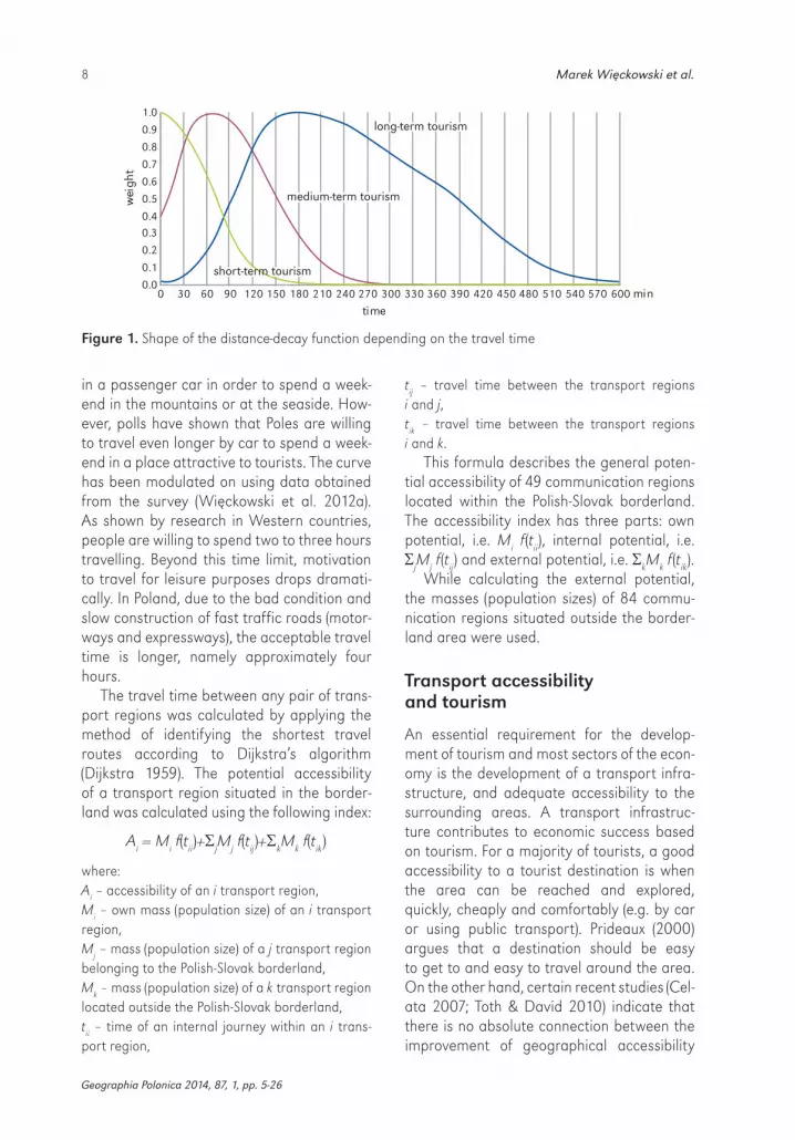
The function, which describes this phe-nomenon, is referred to as the distance-decay function. It is an explanatory function used in tourism e.g. by McKarcher & Lew (2003).
For a medium-term tourist who comes to the Polish-Slovak borderland and intends to spend 2-4 days there, the curve of the distance-decay function is no longer a declin-ing curve but resembles a Gaussian curve (Fig. 1). Only for medium and long-term tour-ist trips is the purpose for travel such that the attractiveness of the destinations is not a decreasing function in respect to increas-ing travel time. In other words, only a very limited number of travellers who go away for 2-4 days, would be willing to spend a weekend in a locality which is ‘only’ within a 15-30 min-ute drive. It was assumed that weekend trips with a destination 45-90 minutes away by car had the highest probability of being chosen. For places whose location requires a drive of more than 90 minutes, the probability of being chosen as a weekend destination decreases. When a ride takes three hours, the probability amounts to 30%, and in the case of 5 hours it is basically close to nil. Very few people decide to travel for 5 hours
8 Marek Więckowski et al.
Geographia Polonica 2014, 87, 1, pp. 5-26
in a passenger car in order to spend a week-end in the mountains or at the seaside. How-ever, polls have shown that Poles are willing to travel even longer by car to spend a week-end in a place attractive to tourists. The curve has been modulated on using data obtained from the survey (Więckowski et al. 2012a). As shown by research in Western countries, people are willing to spend two to three hours travelling. Beyond this time limit, motivation to travel for leisure purposes drops dramati-cally. In Poland, due to the bad condition and slow construction of fast traffic roads (motor-ways and expressways), the acceptable travel time is longer, namely approximately four hours.
The travel time between any pair of trans-port regions was calculated by applying the method of identifying the shortest travel routes according to Dijkstra’s algorithm (Dijkstra 1959). The potential accessibility of a transport region situated in the border-land was calculated using the following index:
Ai = Mi f(tii)+jMj f(tij)+kMk f(tik)
where: Ai – accessibility of an i transport region, Mi – own mass (population size) of an i transport region, Mj – mass (population size) of a j transport region belonging to the Polish-Slovak borderland,Mk – mass (population size) of a k transport region located outside the Polish-Slovak borderland,tii – time of an internal journey within an i trans-port region,
tij – travel time between the transport regions i and j,tik – travel time between the transport regions i and k.
This formula describes the general poten-tial accessibility of 49 communication regions located within the Polish-Slovak borderland. The accessibility index has three parts: own potential, i.e. Mi f (tii), internal potential, i.e. jMj f (tij) and external potential, i.e. kMk f (tik).
While calculating the external potential, the masses (population sizes) of 84 commu-nication regions situated outside the border-land area were used.
Transport accessibility and tourism
An essential requirement for the develop-ment of tourism and most sectors of the econ-omy is the development of a transport infra-structure, and adequate accessibility to the surrounding areas. A transport infrastruc-ture contributes to economic success based on tourism. For a majority of tourists, a good accessibility to a tourist destination is when the area can be reached and explored, quickly, cheaply and comfortably (e.g. by car or using public transport). Prideaux (2000) argues that a destination should be easy to get to and easy to travel around the area. On the other hand, certain recent studies (Cel-ata 2007; Toth & David 2010) indicate that there is no absolute connection between the improvement of geographical accessibility
long-term tourism
medium-term tourism
short-term tourism
0 30 60 90 120 150 180 210 240 270 300 330 360 390 420 450 480 510 540 570 600 min0.0
0.1
0.2
0.3
0.4
0.5
0.6
0.7
0.8
0.9
1.0
time
wei
ght
Figure 1. Shape of the distance-decay function depending on the travel time
9Road accessibility to tourist destinations of the Polish-Slovak borderland: 2010-2030…
Geographia Polonica 2014, 87, 1, pp. 5-26
(when taking into consideration only dis-tance and transportation) and the increase in income from tourism. These studies also indicate that there is a significant difference between the theoretical models of tourism and the actual tourist waves. A number of oth-er studies (Komornicki et al. 2010; Michniak 2010, 2011; Rosik 2012) clearly indicate that nowadays networking and overall regional development must be based on detailed accessibility analyses. Optimisation of the transport system can then be achieved even if there is no direct impact on tourism. In Poland, there are more than a dozen pub-lications that contain summaries and catego-risations of indices. These are primarily the works of Taylor (1999), Guzik (2003), and Komornicki et al. (2010), and a paper focus-ing on the role of new highway investments affecting accessibility in Poland (Stępniak & Rosik 2013). In geographical research in Slo-vakia, the issue of accessibility was addressed by Kusendová (1996), Tolmáči (1998, 2002), Michniak (2002, 2003, 2006, 2009, 2010a, b, c), Križan (2005, 2007), and Križan and Gurňák (2008). The effects of accessibility to tourism development, though, have been poorly studied. Few studies have been done on this topic and few studies on borderland areas. Road/train and the number of cross-border connections (by bus and trains) was studied by Więckowski (2004), and Michniak (2009, 2010a). The importance of accessibil-ity to tourist regions (the Tatras, Orava and Poloniny) was covered by Michniak (2009, 2010a,c). The only large study on the trans-port accessibility and tourism of the Polish-Slovak borderland was prepared by a group of authors, and was mentioned in the intro-duction of this article. They researched acces-sibility on both sides of the border, and the cross-border relationships between the many types of transport. One of the most interest-ing papers dealt with accessibility of health resorts only on the Polish side of the border (Guzik & Kołoś 2003). Other interesting stud-ies had to do with accessibility and the tour-ism function development of Romanian small towns (Bănică & Camară, 2011), and tourism
accessibility in Italy (Celata 2007). Lisze-wski (1989) applied isochrones to determine potential transport connections to the town of Augustów, Poland. This approach is very useful for determining tourist demand. Know-ing the potential number of people within the various isochrones makes planning the size and structure of a tourist base, a more accu-rate exercise.
The term ‘accessibility’ may be defined as the ease of reaching a place (region etc.). Accessibility of tourism destination concerns the various possible ways of reaching the tourist destination. A place of recreation qualifies as a tourist destination. Accessibil-ity plays a significant role in the choice of the destination of a planned journey. Accessibility is one of the most important factors in the development of tourist regions. The direc-tions and volumes of these flows are deter-mined by a range of factors, notably: attrac-tiveness for visitors, accessibility by various means of transport, and price. The latter being the factor regulating the exchange rate (Więckowski 2010).
Study area
The research results presented in this arti-cle cover the Polish-Slovak borderland cor-responding to the area receiving support for the Cross-border Cooperation Programme in the Republic of Poland – Slovak Repub-lic, 2007-2013. The study area encompass-es 38,000 km2 and has 4.8 million inhabit-ants. The Polish part constitutes 58.6% of the total area and Polish population account for 68.8% of the residents. The whole Polish-Slovak borderland is located in the territory of the Carpathians. The Polish-Slovak bor-der divides natural homogenous and socio-economic territories which were adminis-tered and used for tourism in different ways throughout the last few centuries. The pro-cess of connecting these two areas has lasted for almost 20 years thanks to a new transport infrastructure, common initiatives, events, promotion, etc. (Więckowski 2002; Michniak 2011; Lewkowicz 2013).

10M
arek Więckow
ski et al.
Geographia Polonica 2014, 87, 1, pp. 5-26
internal capitalsof voivodships and selectedpoviats
external major cities (mainlycapitals of voivodships)
0.5
5
21
24
10
15
rzeszowski
nowotarski
Krosnobrzozowskijasielski
strzyżowski
Bardejov
Sabinov
Svidník
MedzilaborceKežmarok
TatrzańskiTvrdošín
nowosądecki
Nowy Sącz
gorlicki
sanocki
Stará L�ubovňa
limanowski
Stropkov
krośnieński
suski
myślenicki
Rzeszów
Poprad Snina
Čadca
KysuckéNové Mesto
Žilina
Bytča
Liptovský MikulášRužomberok
Dolný Kubín
lubaczowski
Levoča
Vranovnad Topl’ou
Humenné
Przemyśl
przemyski
Námestovo
TurčianskeTeplice
Martin
pszczyński oświęcimski
bielski
leskibieszczadzki
żywiecki
przeworski
cieszyński Bielsko-Biała
jarosławski
wadowicki
Prešov
Tarnów
KATOWICE
CRACOW
KOŠICEBANSKÁ BYSTRICA
Bukowina Tatrzańskaand Białka Tatrzańska
Iwonicz-Zdr.
RZESZÓW
Starý Smokovec
Liptovský Mikuláš
Zuberec
Červený Kláštor
SzczawnicaPiwniczna--Zdr.
Poprad PREŠOV Snina
Cisna
SolinaOščadnica
ŽILINA
Bardejov
Nowy Targ
Sanok
Zakopane
Żywiec
Jasná
Krynica-Zdr.
Terchová
Wisła
Ždiar
Zwardoń
major tourist centers
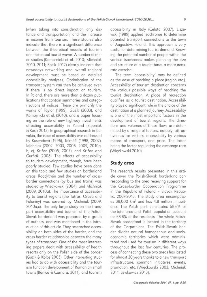
Figure 2. Tourism in the Polish-Slovak borderland by Schneider Index (annual number of overnight stays divided by number of population) by poviats (counties)Based on data of the Statistical Office of the Slovak Republic and the Central Statistical Office of Poland

11Road accessibility to tourist destinations of the Polish-Slovak borderland: 2010-2030…
Geographia Polonica 2014, 87, 1, pp. 5-26
The significant barrier effect decrease of the state border is a very important fac-tor in the development of tourism (Komornicki 1999, 2002; Ptaszycka-Jackowska & Bara-nowska-Janota 2003; Ptaszycka-Jackowska 2007; Więckowski 1999, 2004, 2010). Cur-rently tourism plays one of the most impor-tant roles in the economy in the Polish-Slovak borderland. The main development of bor-derland tourism is due to the potential ben-efits of the natural environment (Warszyńska 1971, 1985; Groch & Kurek 1995; Michniak 2010b; Zawilińska 2010, 2013). The varied topography, the climatic conditions (the num-ber of days with snow cover), forest cover, surface water and groundwater – including mineral and thermal waters which contribute to the development of spa and health tour-ism in some centres, are all part of the high aesthetic value of the country. The national and landscape parks, along with other areas protected by law, help preserve the natu-ral environment (Więckowski 2004, 2013; Zawilińska 2013). The borderland is also rich in terms of cultural heritage (cultural-histor-ical monuments, museums, folk traditions, art and skills). A large number of these types of events is organized for visitors to the bor-derland.
Recreational and active tourism domi-nates on the Polish-Slovak borderland (relaxa-tion and hiking). In particular, mountain hiking and climbing, cyclotourism, and water sports abound. Sailing on the lakes and canoeing in the mountain rivers is popular. In recent years, hipotourism has been developing as well. Cultural tourism includes sightsee-ing, pilgrimages, and the discovery of cultural heritage. Cultural tourism is popular in rural areas and in areas with valued nature rural tourism; mainly agritourism. Congress tour-ism and business trips (e.g. the Economic Forum in Krynica-Zdrój, Poland) play a sec-ondary role in the Polish-Slovak borderland. An important kind of tourism, also underval-ued, is tourism connected with the attend-ance of various events. Shopping and tran-sit tourism are also important in the vicinity of the state border.
The number of tourists on the borderland reaches 3.2 million a year. According to some estimates, this number is even higher and may reach 5 million. The number of tourists on the Polish part of the borderland exceeds 2 million per year, more than 85% of them citizens of Poland. The Slovak part of the borderland was visited by almost 1.27 mil-lion visitors in 2010. Domestic visitors made up almost two thirds of the visitors (65.9%).
On the Polish as well as on the Slovak side, the tourist flow is concentrated mainly in the Tatra region. Other frequently-visited regions are Pieniny (including rafting), the Nízke Tatry, the Malá Fatra, the Veľká Fatra and the western part of the Beskides – mainly on the Polish side (the Beskid Śląski and the Beskid Żywiecki) (Fig. 2).
Poor accessibility is one of the most important reasons for the different spatial distributions of tourist traffic. Problems with accessibility are caused by the long distance to tourist centres as well as an insufficient transport infrastructure. Such an infrastruc-ture does not make it easy to cross the Polish--Slovak border (this concerns mainly its east-ern part). Analysis concerning the improve-ment of tourism on the Polish-Slovak bor-derland has shown that the improvement of accessibility, and providing convenient transportation modes, are the most impor-tant factors to be taken into consideration.
External road accessibility
The present-day situation of the border areas threatens the development of the areas. The Polish-Slovak borderland is situated on the periphery of the European Union. According to many studies and authors, this borderland is perceived as a peripheral one with a low accessibility level (Vickermann 1995; Spiek-ermann et al. 2002, 2011; Tóth & Kincses 2011; Więckowski et al. 2012a). The values of the potential accessibility index investi-gated with the ESPON spatial arrangement at the NUTS3 level are low for the units situ-ated on both sides of the border. Therefore, the differences in the accessibility levels of the
12 Marek Więckowski et al.
Geographia Polonica 2014, 87, 1, pp. 5-26
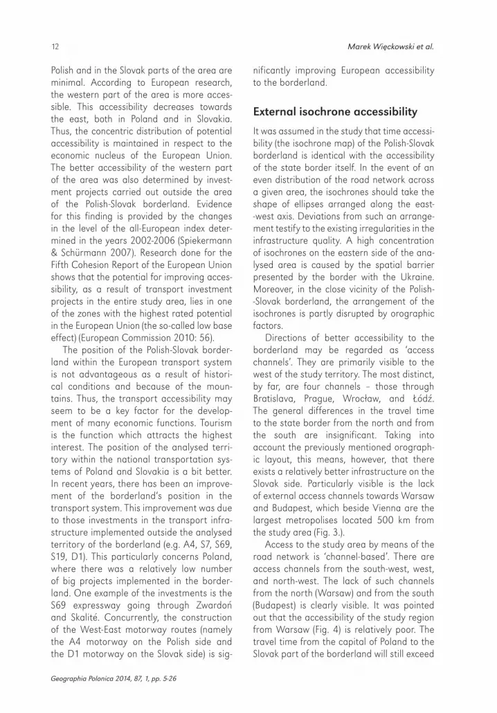
Polish and in the Slovak parts of the area are minimal. According to European research, the western part of the area is more acces-sible. This accessibility decreases towards the east, both in Poland and in Slovakia. Thus, the concentric distribution of potential accessibility is maintained in respect to the economic nucleus of the European Union. The better accessibility of the western part of the area was also determined by invest-ment projects carried out outside the area of the Polish-Slovak borderland. Evidence for this finding is provided by the changes in the level of the all-European index deter-mined in the years 2002-2006 (Spiekermann & Schürmann 2007). Research done for the Fifth Cohesion Report of the European Union shows that the potential for improving acces-sibility, as a result of transport investment projects in the entire study area, lies in one of the zones with the highest rated potential in the European Union (the so-called low base effect) (European Commission 2010: 56).
The position of the Polish-Slovak border-land within the European transport system is not advantageous as a result of histori-cal conditions and because of the moun-tains. Thus, the transport accessibility may seem to be a key factor for the develop-ment of many economic functions. Tourism is the function which attracts the highest interest. The position of the analysed terri-tory within the national transportation sys-tems of Poland and Slovakia is a bit better. In recent years, there has been an improve-ment of the borderland‘s position in the transport system. This improvement was due to those investments in the transport infra-structure implemented outside the analysed territory of the borderland (e.g. A4, S7, S69, S19, D1). This particularly concerns Poland, where there was a relatively low number of big projects implemented in the border-land. One example of the investments is the S69 expressway going through Zwardoń and Skalité. Concurrently, the construction of the West-East motorway routes (namely the A4 motorway on the Polish side and the D1 motorway on the Slovak side) is sig-
nificantly improving European accessibility to the borderland.
External isochrone accessibility
It was assumed in the study that time accessi-bility (the isochrone map) of the Polish-Slovak borderland is identical with the accessibility of the state border itself. In the event of an even distribution of the road network across a given area, the isochrones should take the shape of ellipses arranged along the east--west axis. Deviations from such an arrange-ment testify to the existing irregularities in the infrastructure quality. A high concentration of isochrones on the eastern side of the ana-lysed area is caused by the spatial barrier presented by the border with the Ukraine. Moreover, in the close vicinity of the Polish--Slovak borderland, the arrangement of the isochrones is partly disrupted by orographic factors.
Directions of better accessibility to the borderland may be regarded as ‘access channels’. They are primarily visible to the west of the study territory. The most distinct, by far, are four channels – those through Bratislava, Prague, Wrocław, and Łódź. The general differences in the travel time to the state border from the north and from the south are insignificant. Taking into account the previously mentioned orograph-ic layout, this means, however, that there exists a relatively better infrastructure on the Slovak side. Particularly visible is the lack of external access channels towards Warsaw and Budapest, which beside Vienna are the largest metropolises located 500 km from the study area (Fig. 3.).
Access to the study area by means of the road network is ‘channel-based’. There are access channels from the south-west, west, and north-west. The lack of such channels from the north (Warsaw) and from the south (Budapest) is clearly visible. It was pointed out that the accessibility of the study region from Warsaw (Fig. 4) is relatively poor. The travel time from the capital of Poland to the Slovak part of the borderland will still exceed

13Road accessibility to tourist destinations of the Polish-Slovak borderland: 2010-2030…
Geographia Polonica 2014, 87, 1, pp. 5-26
7 hours. Significant changes will only occur if the sophisticated road investment projects planned for 2030 are implemented. The layout of the isochrones would then lose its original concentric nature and there would be considerable internal variation in the accessibility of the region from Warsaw. Most of the borderland area would then find itself within the 5-hour isochrone. It must be emphasised, that accessibility from cen-tral and northern Poland is particularly sig-nificant. These are the only areas from which there is no competitive travel time to other highland regions (the Alps). Owing to the considerable advancement that has taken place in the construction of the D1 motor-way, accessibility to the western part of the Polish-Slovak borderland from Bratislava (Fig. 5) is clearly better than that from War-saw. From the point of view of the study
area’s accessibility, the investment process in the territory of Slovakia is more advanced than in Poland. Considering the fact that accessibility from Bratislava may, to a cer-tain extent, be identified with accessibility from Vienna, this means that for a potential tourist from both of these cities, the Polish part of the study area will obviously remain poorly accessible.
In years to come the development of infra-structure on the Slovak side will probably be quicker. In Slovakia, the borderland with Poland (in particular the western and central parts), are not treated so peripherally in the infrastructure plans as is the case of the Pol-ish Carpathian areas. The varying pace of the investment process may contribute to the fact that in years to come the Polish-Slovak border will become much more of an infrastructure barrier than it is now.
Figure 3. Isochrones to the Polish-Slovak border, 2010

Figure 4. Isochrones from Warsaw, 2010 and 2030
2010
2030
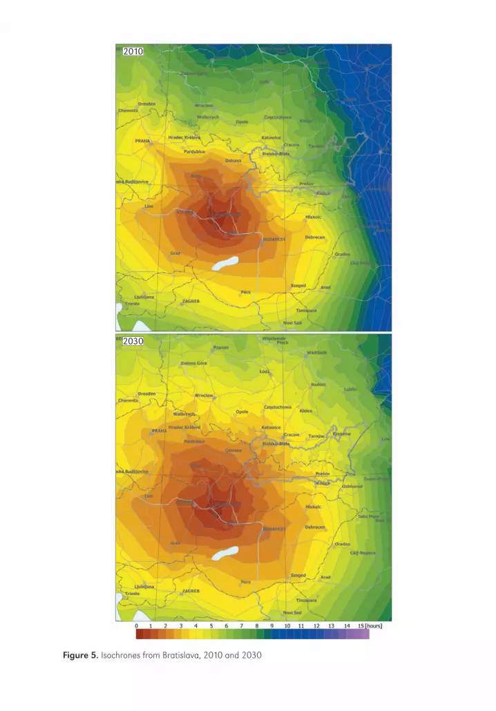
Figure 5. Isochrones from Bratislava, 2010 and 2030
2010
2030

16 Marek Więckowski et al.
Geographia Polonica 2014, 87, 1, pp. 5-26
External potential accessibility in 2010 and 2030
The distribution of short-term potential accessibility remains determined by loca-tion to large urban centres. The centres refer mainly the Upper Silesian conurbation, Cra-cow, and to a lesser extent, also Bratislava. In practice, the transport conditions in the entire eastern part of the study area are unsuitable for the development of short-term tourism.
The differences in the potential acces-sibility of the study area described above are also visible in the case of medium-term tourism, though obviously in a milder form (Fig. 6). Nevertheless, Zakopane has a better potential tourist base than Poprad or Vysoké Tatry. On the other hand, the south-western part of the area has a noticeably improved potential owing to the influence of the popu-lation potential of Bratislava and Vienna. The value of the index decreases at a steady rate towards the east on both sides of the border. The transport distance to these areas also remains a significant barrier, even for longer trips. The changes in medium-term tourism are less spectacular (Fig. 6c) and still have slightly more of an effect in the Slovak part of the study area. There is, however, a decid-ed increase in the index value noted in the eastern Polish part of the borderland, espe-cially in the Bieszczady Mountains and in the region of Przemyśl and Lubaczów.
Accessibility of tourist destinations and its changes as a result of road investments
Owing to the use of a multi-criteria analysis it is possible to show the complexity of the phenomenon and to draw conclusions from various points of view, e.g. in respect of tour-ist destinations, tourists as well as the expect-ed human pressure, especially in areas of natural value. Conclusions may also be for-mulated concerning the transport (accessibil-ity) determinants related to the development of various kinds of tourism and to competi-
tiveness – both between destinations and between countries.
To research the accessibility of particular localities, 27 towns as well as tourist desti-nations located in the borderland area were selected. In addition, 5 large cities in the vicin-ity of the area (Katowice, Cracow, Tarnów, Banská Bystrica, Košice2) were also taken into account. In total, the analysis involved 32 localities – 17 in Poland and 15 in Slovakia.
Table 1 presents the total influence of road investment projects on the accessibil-ity improvement in the poviats and regions with the most important tourist centres of the Polish-Slovak borderland.
The completion of the investment projects which are currently being carried out on the Polish side of the border will bring the largest benefits to the centres situated in the east-ern part of the study area (e.g. Iwonicz-Zdrój, Cisna, and Solina). On the Slovak side, on the other hand, the beneficiaries will include the sub-Tatra centres (Liptovský Mikuláš, Jasná, Starý Smokovec). The largest differences in the level of potential accessibility between the distribution of motorways and express-ways proposed in this study (the ‘extended’ variant of 2030) and the one provided for in government ordinances, occurs in the pov-iat centres of Nowy Sącz (Krynica-Zdrój and Piwniczna-Zdrój) in Poland and in the town of Bardejov in Slovakia. These towns would benefit relatively little from the officially planned investments. For each of them, the possible construction of the Tarnów-Nowy Sącz-Prešov expressway would result in a con-siderable improvement in spatial accessibil-ity. The effect of opening the Polish-Ukrainian border would be seen primarily in the eastern part of the Polish-Slovak borderland, namely in such centres as Iwonicz-Zdrój, Cisna, and Snina, and to a lesser degree, also in the cen-tral part (Bardejov, Krynica-Zdrój).
2 Additional cities/towns were selected because they are important destinations (for example, for admin-istrative reasons) to the Polish-Slovak borderland. These additional cities/towns are also considered to be places generating tourist traffic.

Figure 6. Potential road accessibility for medium-term tourism in 2010 (A) and in 2030 (B) and the potential road accessibility changes for medium-term tourism from 2010 to 2030 (C)
A
B
C

18 Marek Więckowski et al.
Geographia Polonica 2014, 87, 1, pp. 5-26
It should be stated that for the major-ity of the centres examined, the most impor-tant large road investments are: the Slovak D1 motorway (full length) and the traffic route of the S7 and R3 expressways – together with the Rabka-Zakopane branch (Tab. 2). Other routes are less significant. Among the shorter sections, the potential S50 expressway from Cracow to Bielsko-Biała will play an important role. The analysis also confirmed the effec-tiveness of the possible Kielce-Tarnów-Prešov route for the health resorts in the region of Nowy Sącz and for the town of Bardejov. The existing centres (both Polish and Slovak) will benefit less from the Polish A4 motorway
and the S19 and R4 expressways, with the exception of the localities in the Bieszczady Mountains (Tab. 2).
Generally speaking, for the western part of the borderland, the road investments to be implemented on the Polish side are more important, and this is also true for the Slo-vak side. In the Tatra region, these propor-tions are more equally balanced. Towards the east, there is a change in favour of the possible completion of the road investments in Slovakia; in particular, the D1 motorway. Moreover, the policy of tourist centres does not always include the increasing number of visitors.
Table 1. Changes of potential accessibility for medium-term tourism on the Polish-Slovak borderland for the period 2010-2030 (%)
Country Poviat (county) Tourist localities
Changes in the level of potential accessibility for medium-term tourism compared to 2010
government variant (2030)
extended* variant (2030)
extended* variant (2030) taking into account the open-ing of the Ukrai-
nian border
Poland cieszyński Wisła 36.6 38.1 38.3
krośnieński Iwonicz-Zdrój 65.5 66.5 80.2
leski CisnaSolina
92.2 104.5 144.9
nowosądecki Krynica-Zdrój,Piwniczna-Zdrój
28.5 71.2 75.1
nowotarski Szczawnica 50.6 52.2 52.9
tatrzański Bukowina Tatrzańska and Białka Tatrzańska,Zakopane
55.1 56.9 57.4
żywiecki Zwardoń 45.2 47.0 47.3
Slovakia Bardejov Bardejov 47.0 63.0 66.5
Čadca Oščadnica 39.1 40.9 41.0
Kežmarok Červený Kláštor 62.7 69.0 69.7
Liptovský Mikuláš Jasná Liptovský Mikuláš
93.8 94.4 94.6
Poprad ŽdiarStarý Smokovec
63.6 67.1 67.5
Snina Snina 53.6 56.7 61.4
Tvrdošín Zuberec 57.3 57.3 57.7
Žilina Terchová 47.6 49.4 49.4
*extended 2030 variant: all two-lane expressways and the possible construction of the Tarnów-Nowy Sącz-Prešov expressway.

19Road accessibility to tourist destinations of the Polish-Slovak borderland: 2010-2030…
Geographia Polonica 2014, 87, 1, pp. 5-26
The most accessible tourist centers according to the demand analysis
The demand analysis was carried out on the basis of the population size available within 2-3 hour isochrones for the alternative road network development of 2010 and 2030. Twenty-seven selected tourist destinations were analysed (extended analyse see also Śleszyński et al. 2014). The size of the market for short-term and medium-term tourism was determined for the 2 and 3-hour isochrones. In 2010, the largest population groups, with-in time distances of both up to 2 and up to 3 hours from the examined destinations were found in the localities situated in the western part of the borderland (Wisła, Żywiec, Žilina). After the completion of all roads, the largest
population potential will be that of Žilina, then Wisła and Terchová (within the 2-hour isochro-ne), and Żywiec and Liptovský Mikuláš (within the 3-hour isochrone) (Fig. 7).
The benefits enjoyed by the localities in 2030 will be considerable. For the 2-hour isochrones, the changes in the absolute val-ues range from 0.4 million (Cisna) to 6.6 mil-lion (Žilina), while the percentage changes range from 23% (Cisna) to 180% (Liptovský Mikuláš). For the 3-hour isochrones, the anal-ogous changes range from 1.6 million (Cisna) to 14.1 million (Liptovský Mikuláš), and from nearly 30% (Cisna) to 142% (Jasná) (Fig. 8).
Expanding the road infrastructure can cause changes that will benefit the develop-ment of the western part of the borderland and of the Tatra region. The destinations in Slovakia will benefit the most. The expanded motorway in Slovakia (Bratislava will be included within
Table 2. Transport investment priorities for selected tourist centres to improve of their spatial accesibility
Country Poviat (county) Tourist localitiesTransport investments priorities
1st rank 2nd rank
Poland cieszyński Wisła S50 A1
krośnieński Iwonicz-Zdrój S19/R4 D1
leski CisnaSolina
S19/R4 D1 i A4
nowosądecki Krynica-ZdrójPiwniczna-Zdrój
Kielce-Prešov D1
nowotarski Szczawnica D1 S7/R3/R1 with a branch to Zakopane
tatrzański Białka Tatrzańska and Bukowina TatrzańskaZakopane
D1 S7/R3/R1 with a branch to Zakopane
żywiecki Zwardoń S69/D3 S50
Slovakia Bardejov Bardejov D1 S19/R3/R1
Čadca Oščadnica S69/D3 S50
Kežmarok Červený Kláštor D1 S7/R3/R1 with a branch to Zakopane
Liptovský Mikuláš Jasná Liptovský Mikuláš
D1 S7/R3/R1 with a branch to Zakopane
Poprad ŽdiarStarý Smokovec
D1 S7/R3/R1 with a branch to Zakopane
Snina Snina D1 S19/R4
Tvrdošín Zuberec S7/R3/R1 D1
Žilina Terchová S69/D3 D1

20 Marek Więckowski et al.
Geographia Polonica 2014, 87, 1, pp. 5-26
the 3-hour isochrone) and the expressways to Poland will significantly increase the num-ber of Poles within reach of the 3-hour isoch-rone. The greatest beneficiaries on the Slovak side will be Žilina and Oščadnica, Liptovský Mikuláš, Jasná, and Poprad. On the Polish side, Żywiec, Zwardoń, Rzeszów and Iwonicz-Zdrój may benefit the most from these changes. The
smallest increase in the population size within the 2-hour and 3-hour isochrones will be noted in the destinations located in the east of the borderland (Cisna and Snina). This may, on the one hand, influence the continued peripher-alisation of the area, but on the other hand it may result in less tourist pressure in these attractive areas.
0 �10 �20 �30 [million] 0 � �20
0 �10 �20 �30 [million] 0 � �20
10
10
30 [million]
30 [million]
Liptovský MikulášZakopane
Bukowina Tatrzńska and Białka TatrzńskaNowy Targ
ZwardońŻywiec
Oščadnica
TerchováWisła
Žilina
PiwnicznaZakopaneTerchová
Bukowina Tatrzńska and Białka TatrzńskaOščadnica
ZwardońNowy Targ
ŽilinaŻywiecWisła
RzeszówJasná
PopradZwardońTerchová
OščadnicaWisła
Liptovský Mikulᚯywiec
Žilina
Bukowina Tatrzńskaand Białka Tatrzńska
RzeszówLiptovský Mikuláš
TerchováNowy Targ
ZwardońOščadnica
WisłaŻywiec
Žilina
Figure 7. Destinations with the highest population potential within the 2-hour isochrone (A – 2010; B – 2030) and the 3-hour isochrone (C – 2010; D – 2030)
0 5 �10 �15 [million]
�
0 200 [%]15010050
0 5 �10 �15 [million] 0 200 [%]15010050
WisłaZwardoń
OščadnicaStarý Smokovec
Rzeszów
ŽilinaPoprad
ŻywiecJasná
Liptovský Mikuláš
ZakopaneNowy Targ
Jasná
Żywiec
TerchováZwardoń
RzeszówOščadnica
Liptovský Mikuláš
Žilina
ŻywiecSanok
Bardejov
PreszówStarý Smokovec
Iwonicz-ZdrójRzeszów
Poprad
Liptovský Mikuláš
Jasná
Zakopane
Zuberec
Starý Smokovec
Oščadnica
TerchováPoprad
Žilina
Rzeszów
Jasná
Liptovský Mikuláš
Figure 8. Destinations with the largest changes in population potential between 2010 and 2030 (absolute value: A – 2-hour isochrone, C – 3-hour isochrone) and the percentage increase (B – 2-hour isochrone, D – 3-hour isochrone)
A C
B D
A C
B D
21Road accessibility to tourist destinations of the Polish-Slovak borderland: 2010-2030…
Geographia Polonica 2014, 87, 1, pp. 5-26
At present the pressure on areas of natural value is considerable and is bound to increase after construction of the planned roads. The most attractive and heavily promoted places are mainly the Tatra National Park and the Pieniny National Park. The already intense tourist traffic in the vicinity of these parks may become even more intense. Some pro-jects will bring about a significant increase in the population potential.
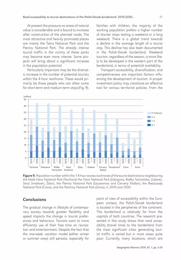
Particularly important may be the dramat-ic increase in the number of potential tourists within the 4-hour isochrone. These would pri-marily be those people who can often come for short-term and medium-term stays (Fig. 9).
Conclusions
The gradual change in lifestyle of contempo-rary society towards greater flexibility and speed impacts the change in tourist prefer-ences and behaviour. Tourists want to more efficiently use of their free time on recrea-tion and entertainment. Despite the fact that the one-week vacation model (either winter or summer ones) still persists, especially for
families with children, the majority of the working population prefers a higher number of shorter stays lasting a weekend or a long weekend. There is a global trend towards a decline in the average length of a tourist stay. This decline has also been documented in the Polish-Slovak borderland. Weekend tourism, regardless of the season, is more like-ly to be developed in the western part of the borderland, in terms of potential availability.
Transport accessibility, diversification, and competitiveness are important factors influ-encing the development of tourism. A proper investment policy may constitute an effective tool for various territorial policies. From the
point of view of accessibility within the Euro-pean context, the Polish-Slovak borderland is located in the peripheries of the continent. This borderland is relatively far from the capitals of both countries. The research pre-sented in this study shows that road acces-sibility (travel time) to the borderland from the most significant cities generating tour-ist traffic is varied but in most cases quite poor. Currently, many locations, which are
0
5�
10�
15�
20�
25�
30�
35�
40�
45�
Terchová Białka Tatrzańska
. Zuberec Červený Kláštor
Snina
3-4�[hours]
2-3
1-2
0-1
2010
2030
2010
2030
2010
2030
2010
2030
2010
2030
2010
2030
2010
2030
2010
2030
2010
2030
2010
2030
Zakopane ŽdiarStarý Smokovec
Szczawnica Cisna
[million]
Figure 9. Population number within the 1-4-hour access isochrones of the tourist destinations neighbouring the Malá Fatra National Park (Terchová) the Tatra National Park (Zakopane, Białka Tatrzańska, Zuberec, Starý Smokovec, Ždiar), the Pieniny National Park (Szczawnica and Červený Kláštor), the Bieszczady National Park (Cisna), and the Poloniny National Park (Snina), in 2010 and 2030

22 Marek Więckowski et al.
Geographia Polonica 2014, 87, 1, pp. 5-26
a source of tourist demand (e.g. large cities, such as Warsaw, Bratislava, Gdańsk, Poznań) have easier and better transport connections to many places elsewhere in Europe (by plane) than to the Polish-Slovak borderland. From these cities, the distance to the Polish-Slovak borderland is very long; from at least 5 hours to even 7-8 hours. This may result in a massive escape of both foreign and domestic tourists to destinations located abroad. The stagna-tion or decline in tourist flows may lead to an economic recession of the vast borderland areas. Internal factors alone, are not enough for these areas to prosper.
The actual impact of particular transport projects on the improvement of accessibility may vary considerably depending on their geographical scale and on the types of tour-ism. The change in the time accessibility of the border itself, as well as of the acces-sibility from particular metropolises, which generate tourist traffic, is significant from the point of view of competitiveness. In this respect several conclusions should be drawn. Within the context of Europe the area exam-ined is more accessible from the south-west, west and north-west. On the other hand, a scarcity of modern infrastructure is evident in the northerly corridor (central and north-ern Poland, including Warsaw) and the south-erly corridor (Budapest). It should be empha-sised here that accessibility from central and northern Poland is particularly signifi-cant, since it is only from these areas that the access time to other highland regions (the Alps) is clearly longer than the access time to the Carpathians. This accounts for the competitive advantage that is held by the ski resorts in the Polish-Slovak borderland. Secondly, the analyses show that the devel-opment of infrastructure and the resulting increase in accessibility will be quicker on the Slovak side of the borderland. In particular, the western and central part of the border-land is not treated as marginally as is the case with the Polish areas of the Carpathians. Therefore a rather pessimistic conclusion may be formulated at this point. Despite the investment process, the Polish-Slovak border
will, within several years, become an infra-structural barrier to a relatively higher extent than it is at present. Due to development of the highways in Poland and Slovakia exter-nal accessibility to the borderland will appear but inside (especially in cross-border mean-ing) the region it will stay at the same level as today.
The transport infrastructure, predominant-ly running along a north-south axis, also does not show any quantum change at the border. Development of weekend tourism in the Slo-vak part of the borderland will depend large-ly in the coming years on completion of the motorway network, particularly D1 motor-way as well as other north-south connections such as D3 motorway, S69 expressway and R1/R3/S7 and R4/S19 expressways. In the Slo-vak part of the central borderland the devel-opment of infrastructure consists primar-ily of expanding the base for Polish tourists on weekend or other short-term visits. In the eastern part of the area examined, on both the Polish and Slovak side, the development of ‘large-scale’ infrastructure is a condition and necessary precedent for the further development of all kinds of tourism. Crucial in this case is the completion of the A4 and D1 motorway sections leading to the Ukrain-ian border as well as ensuring that construc-tion of the Rzeszów-Košice-Miskolc express-way (S19 and R4) be completed.
For internal accessibility, i.e. for mobility within a given area, the construction of new roads with high traffic standards is impor-tant, which should result in an increase in the average travel speed (by-roads, improvement of technical and operational parameters). Although this is not readily translated into a significant improvement of travel time, it has a decisive impact on driving safety and convenience.
Road construction or upgrades may stimu-late the inflow of tourists but also generate some threats. There will be excessive conges-tion and concentration of traffic, especially during long weekends and holidays. There will also be excessive pressure on the natural environment.
23Road accessibility to tourist destinations of the Polish-Slovak borderland: 2010-2030…
Geographia Polonica 2014, 87, 1, pp. 5-26
Regional planning should focus on the dispersion of investments, especially of com-mercial tourist facilities. Such investments should have strong attraction power, e.g. aquaparks, ski resorts. This would allow such facilities to intensify their management and focus on tourism, improvement of the product range, and decentralisation of the intensity of tourist traffic (see explanation concerning the concentration of the tourist flow and their consequences Kistowski & Śleszyński 2009; Więckowski et al. 2012a). When planning the road network, it is essential to respond to var-ious kinds of internal demand connected not only with tourism but also with commuting to work and educational travel. This will cre-ate particular advantages for sub-regional centres such as Rzeszów, Nowy Sącz or Pop-rad, which contain the largest job markets.
It is equally important to stress that acces-sibility must not be seen as a panacea for the improvement of tourism development. Tour-ist potential alone, without sufficient tourist and transport infrastructure, will not ensure socio-economic growth. It merely creates a potential opportunity for such development. Therefore, it is essential to assess the accessi-bility of the regions and tourist centres in the Polish-Slovak borderland both by country and in cross-border terms. As a rule, growing or improving accessibility enhances attrac-tiveness, increasing tourism flows in many tourist regions. Poor or declining accessibility may lead to the marginalisation of towns and
whole regions, hindering or completely block-ing economic growth. Such a result would mainly concern public transport, and would hardly permit the tourist areas on both sides of the Polish-Slovak border to be explored. Meanwhile, public transportation is crucial to ensuring sustainable development within naturally valuable areas.
Acknowledgements
This article is a result of the research carried out by a team from the Institute of Geography and Spatial Organization of the Polish Acad-emy of Sciences and the Institute of Geogra-phy of the Slovak Academy of Sciences. The analytical and empirical research was carried out within the framework of the INFRAREG-TUR project (Infrastructural and organisation-al possibilities of spatial accessibility improve-ment as a factor for the development of the Polish-Slovak tourist regions), financed mainly by the European Regional Development Fund (ERDF) through the Republic of Poland – Slovak Republic 2007-2013 cross-border co-operation programme, and by: the Polish Ministry of Science and Higher Education, the Institute of Geography and Spatial Organiza-tion of the Polish Academy of Sciences, and the state budget of Slovakia.
Editors’ note:Unless otherwise stated, the sources of tables and fig-ures are the author(s), on the basis of their own research.
ReferencesBĂNICĂ A., CAMARĂ G., 2011. Accessibility and
tourist function development of the Romanian small towns. GeoJournal of Tourism and Geo-sites, vol. 7, no. 1, pp. 22-133.
CELATA F., 2007. Geographic marginality, trans-port accessibility and tourism development. [in:] A. Celant (ed.), Global tourism and region-al competitiveness, Bologna: Patron, pp. 37-46.
DIJKSTRA E.W., 1959. A note on two problems in connexion with graphs. Numerische Mathema-tik, vol. 1, no. 1, pp. 269-271.
EUROPEAN COMMISSION, 2010. Investing in Europe’s future. Fifth report on economic, social and ter-ritorial cohesion. Luxemburg, 298 pp. http://ec.europa.eu/regional_policy/sources/docof-fic/official/reports/cohesion5/pdf/5cr_en.pdf [2 January 2014].
GROCH J., KUREK W., 1995. Turystyka. [in:] J. War-szyńska (ed.), Karpaty Polskie. Przyroda, człowiek
24 Marek Więckowski et al.
Geographia Polonica 2014, 87, 1, pp. 5-26
i jego działalność, Kraków: Uniwersytet Jagiel-loński, pp. 265-300.
GUZIK R., 2003. Przestrzenna dostępność szkol-nictwa ponadpodstawowego. Kraków: Insty-tut Geografii i Gospodarki Przestrzennej UJ, 190 pp.
GUZIK R., KOŁOŚ A., 2003. Evolution of accessibil-ity in Carpathians Spa resorts between 1938 and 2000. [in:] W. Kurek (ed.), Issues of tourism and health resort management, Prace Geo-graficzne, no. 111, Kraków: Instytut Geografii i Gospodarki Przestrzennej UJ, Wydawnictwo Uniwersytetu Jagiellońskiego, pp. 356-368.
KISTOWSKI M., ŚLESZYŃSKI P., 2010. Presja turystycz-na na tle walorów krajobrazowych Polski. [in:] W. Andrejczuk (red.), Krajobraz a turystyka, Prace Komisji Krajobrazu Kulturowego PTG, vol. 14, Sosnowiec: Komisja Krajobrazu Kulturowe-go PTG, pp. 36-51.
KOMORNICKI T., 1999. Granice Polski. Analiza zmian przenikalności w latach 1990-1996. Geopolitical Studies, vol. 5, Warszawa: Instytut Geografii i Przestrzennego Zagospodarowania PAN, 348 pp.
KOMORNICKI T., 2002. Międzyregionalne związki społeczno-ekonomiczne na poziomie między-narodowym jako przedmiot badań geograficz-nych. [in:] J. Kitowski (ed.), Czynniki i bariery regionalnej współpracy transgranicznej – bilans dokonań, Rzeszów: Odział Rzeszowski PTG, Wydawnictwo Oświatowe Fosze, 584 pp.
KOMORNICKI T., ŚLESZYŃSKI P., ROSIK P., POMIANOWSKI W., 2010. Dostępność przestrzenna jako prze-słanka kształtowania polskiej polityki transpor-towej. Biuletyn KPZK PAN, no. 241, Warszawa: Komitet Przestrzennego Zagospodarowania Kraju PAN, 168 pp.
KRIŽAN F., 2005. Meranie dostupnosti v geogra-fii. [in:] F. Svatoňová (ed.), Geografické aspekty stredoevropského prostoru, Sborník prací Peda-gogické fakulty Masarykovy univerzity, vol. 183. Brno: Masarykova univerzita, pp. 267-287.
KRIŽAN F., 2007. Regionálna typológia územia Bratislavy na základe dostupnosti supermarke-tov a hypermarketov. Geografický časopis, vol. 59, no. 4, pp. 373-386.
KRIŽAN F., GURŇÁK D., 2008. Vybrané kartogra-fické metódy znázorňovania dostupnosti. Acta Geographica Universitatis Comenianae, no. 51, pp. 71-82.
KUSENDOVÁ D., 1996. Analýza dostupnosti obcí Slovenska. Aktivity v kartografii, vol. 96. Brati-slava: Kartografická spoločnosť SR, pp. 29-49.
LEWKOWICZ Ł., 2013. Europejskie Ugrupowania Współpracy Terytorialnej – nowa jakość polsko--słowackiej współpracy transgranicznej? Studia Regionalne i Lokalne, vol. 51, no 1, pp. 45-70.
LISZEWSKI S. (ed.), 1989. Funkcja turystyczna Augu-stowa. Warszawa: Instytut Turystyki, 125 pp.
MCKERCHER B., LEW A.A., 2003. Distance decay and the impact of effective tourism exclusion zones on international travel flows. Journal of Travel Research, vol. 42, no. 2, pp. 159-165.
MICHNIAK D., 2002. Dostupnosť ako geografická kategória a jej význam pri hodnotení územno-správneho členenia Slovenska. Bratislava: Geo-grafický ústav SAV, 125 pp.
MICHNIAK D., 2003. Dostupnosť okresných miest na Slovensku. Geografický časopis, vol. 55, no. 1, pp. 21-39.
MICHNIAK D., 2006. Pojem dostupnosti v geografii a vybrané prístupy k jej štúdiu. Geografická revue, vol. 2, no. 2, pp. 724-741.
MICHNIAK D., 2009. Dostupnosť vybraných turistických stredísk v regióne Tatier. [in:] I. Andráško, V. Ira, E. Kallabová (eds.), Regionálne štruktúry ČR a SR: časové a priestorové zmeny, Bratislava: Geografický ústav SAV, pp. 44-49.
MICHNIAK D., 2010a. Accessibility of selected boundary regions in Slovakia. [in:] European Union: External and internal borders, interac-tions and networks, Europa XXI, no. 20, War-szawa: Instytut Geografii i Przestrzennego Zagospodarowania PAN, Polskie Towarzystwo Geograficzne, pp. 161-173.
MICHNIAK D., 2010b. Vplyv dostupnosti na rozvoj cestovného ruchu vo vybraných regiónoch na Slovensku. Geographia Cassoviensis, vol. 4, no. 1, pp. 114-117.
MICHNIAK D., 2010c. Dopravná dostupnosť obcí v regióne Oravy. [in:] E. Kallabová, I. Andráško (eds.), Časoprostorové změny regionálních a krajinných struktur, Brno: Ústav geoniky Aka-demie věd České republiky, pp. 92-97.
MICHNIAK D., 2011. Rozvoj cezhraničnej dopravnej infraštruktúry v slovensko-poľskom pohraničí po roku 1989. [in:] I. Andráško, V. Ira, E. Kallabová (eds.), Časovo-priestorové aspekty regionálnych štruktúr ČR a SR, Bratislava: Geografický ústav SAV, pp. 81-86.

25Road accessibility to tourist destinations of the Polish-Slovak borderland: 2010-2030…
Geographia Polonica 2014, 87, 1, pp. 5-26
PIETRUSIEWICZ W., 1996. Problemy metodyczne opra-cowywania map dostępności czasowej. Polski Przegląd Kartograficzny, vol. 28, no. 2, pp. 87-100.
PODHORSKÝ F., 1996. Boundaries of Slovakia: Trans-port-geographical aspect. [in:] V. Baran (ed.), The boundaries and their impact on the terri-torial structure of region and state, Acta Uni-versitatis Matthiae Belii. Geographical Studies, no. 1, Banská Bystrica: Univerzita Mateja Bela, pp. 56-59.
PRIDEAUX B., 2000. The role of the transport sys-tem in destination development. Tourism Man-agement, vol. 21, no. 1, pp. 53-63.
PTASZYCKA-JACKOWSKA D., 2007. Gospodarowanie przestrzenią turystyczną w Polskich Karpatach. Prace Geograficzne, no. 117, Kraków: Insty-tut Geografii i Gospodarki Przestrzennej UJ, Wydawnictwo Uniwersytetu Jagiellońskiego, pp. 99-112.
PTASZYCKA-JACKOWSKA D., BARANOWSKA-JANOTA M., 2003. Tourism within the Polish and Slovak transfrontier region. Prace Geograficzne, no. 111, Kraków: Instytut Geografii i Gospodarki Przestrzennej UJ, pp. 44-60.
ROSIK P., 2012. Dostępność lądowa przestrzeni Polski w wymiarze europejskim. Prace Geogra-ficzne, no. 233, Warszawa: Instytut Geografii i Przestrzennego Zagospodarowania PAN, 307 pp.
SORUPIA E., 2005. Rethinking the role of transpor-tation in tourism. Proceedings of the Eastern Asia Society for Transportation Studies, vol. 5, pp. 1767-1777.
SPIEKERMANN K., SCHÜRMANN C., 2007. Update of selected potential accessibility indicators. Final Report for the ESPON 2006 Programme, Dort-mund: Spiekermann & Wegener, Urban and Regional Research, RRG Spatial Planning and Geoinformation, 29 pp.
SPIEKERMANN K., WEGENER M., COPUS A., 2002. Review of peripherality indices and identifica-tion of ‘Baseline Indicator’. Deliverable 1 of AsPIRE – Aspatial Peripherality, Innovation, and the Rural Economy, Dortmund-Aberdeen: Spiek-ermann & Wegener, IRPUD, SAC.
SPIEKERMANN K., WEGENER M., KVĚTOŇ V., MARADA M., SCHÜRMANN C., BIOSCA O., ULIED SEGUI A., ANTIKAINEN H., KOTAVAARA O., RUSANEN J., BIELAŃSKA D., FIORELLO D., KOMORNICKI T., ROSIK P., 2011. TRACC. Transport accessibility at regional/local scale and patterns in Europe.
Applied Research 2013/1/10, Interim Report Version 21/02/2011, Luxembourg: European Commission. ESPON Programme, 164 pp.
STĘPNIAK M., ROSIK P., 2013. Accessibility improve-ment, territorial cohesion and spillovers: A mul-tidimensional evaluation of two motorway sections in Poland. Journal of Transport Geogra-phy, vol. 31, pp. 154-163.
ŚLESZYŃSKI P., MICHNIAK D., STĘPNIAK M., WIĘC-KOWSKI M., 2014. Szacowanie popytu i podaży turystycznej na pograniczu polsko-słowackim z wykorzystaniem metod izochronowych. Mar-keting i Rynek (in print).
TAYLOR Z., 1999. Przestrzenna dostępność miejsc zatrudnienia, kształcenia i usług a codzienna ruchliwość ludności wiejskiej. Prace Geograficz-ne, no. 171, Warszawa: Instytut Geografii i Prze-strzennego Zagospodarowania PAN, 239 pp.
TOLMÁČI L., 1998. Miery dostupnosti, koncepcia pojmu a teoretická báza. Acta Facultatis rerum naturalium Universitatis Comenianae. Geo-graphica, no. 41, Bratislava: Univerzita Komen-skeho, pp. 175-191.
TOLMÁČI L., 2002. Dostupnosť miest Slovenska. [in:] L. Tolmáči (ed.), Regionálnogeografické štúdie, Bratislava: Mapa Slovakia, pp. 1-66.
TÓTH G., DÁVID L., 2010. Tourism and accessibil-ity: An integrated approach. Applied Geogra-phy, vol. 30, no. 4, pp. 666-677.
TÓTH G., KINCSES Á., 2011. New aspects of Euro-pean road accessibility. Geographia Polonica, vol. 84, no. 2, pp. 33-46.
VICKERMAN R., 1995. Location, accessibility and regional development: The appraisal of trans-European networks. Transport Policy, vol. 2, no. 4, pp. 225-234.
WARSZYŃSKA J., 1971. Waloryzacja miejscowości z punktu widzenia atrakcyjności turystycznej. Zeszyty Naukowe Uniwersytetu Jagiellońskie-go, vol. 249, Prace Geograficzne, iss. 27, Prace Instytutu Geograficznego Uniwersytetu Jagiel-lońskiego, no. 49, pp. 14-35.
WARSZYŃSKA J., 1985. Funkcja turystyczna Karpat Polskich. Folia Geographica. Series Geographi-ca-Oeconomica, vol. 18, pp. 79-104.
WIĘCKOWSKI M., 1999. Natural conditions for the development of the Polish-Slovak transbound-ary ties. Universitas Comeniana. Acta Faculta-tis rerum naturalium Universitatis Comenianae.

© Marek Więckowski et al.© Geographia Polonica© Institute of Geography and Spatial Organization
Polish Academy of Sciences • Warsaw • 2014
Article first received • November 2013Article accepted • February 2014
26 Marek Więckowski et al.
Geographica, Supplementum no. 2-I. Bratislava: Univerzita Komenskeho, pp. 257-263.
WIĘCKOWSKI M., 2002. Development of the new tour-ist space of the Western Carpathian Mts. in the 1990s. [in:] T. Komornicki, H. Powęska (eds.), Slo-vakia and Poland. Urban, social and demograph-ic questions. Relations between neighbours, Europa XXI, no. 7, Warszawa: Instytut Geogra-fii i Przestrzennego Zagospodarowania PAN, Oddział Akademicki PTG, pp. 121-131.
WIĘCKOWSKI M., 2004. Przyrodnicze uwarunkowa-nia kształtowania się polsko-słowackich więzi transgranicznych. Prace Geograficzne, no. 195, Warszawa: Instytut Geografii i Przestrzennego Zagospodarowania PAN, 231 pp.
WIĘCKOWSKI M., 2010. Tourism development in the borderland of Poland. Geographia Polonica, vol. 83, no. 2, pp. 67-81.
WIĘCKOWSKI M., 2013. Eco-frontier in the mountain-ous borderlands of Central Europe. The case of Polish border parks. Journal of Alpine Research. Revue de géographie alpine, vol. 101, no. 2, 12 pp., http://rga.revues.org/2107 [12 Feb-ruary 2014].
WIĘCKOWSKI M., MICHNIAK D., BEDNAREK--SZCZEPAŃSKA M., CHRENKA B., IRA V., KOMOR-NICKI T., ROSIK P., STĘPNIAK M., SZÉKELY V., ŚLESZYŃSKI P., ŚWIĄTEK D., WIŚNIEWSKI R., 2012a.
Polish-Slovak borderland: Transport accessibil-ity and tourism, Prace Geograficzne, no. 234, Warszawa: Instytut Geografii i Przestrzennego Zagospodarowania PAN, 323 pp.
WIĘCKOWSKI M., MICHNIAK D., CHRENKA B., IRA V., KOMORNICKI T., ROSIK P., SZÉKELY V., ŚLESZYŃSKI P., WIŚNIEWSKI R., 2012b. The potential for improved accessibility and tourism development in the Polish-Slovak borderland. Conditions, recom-mendations and good practices. Warszawa- -Bratislava: Instytut Geografii i Przestrzennego Zagospodarowania PAN, Geografický ústav SAV, 80 pp.
ZAWILIŃSKA B., 2010. Możliwości rozwoju turysty-ki w parkach krajobrazowych Karpat Polskich w świetle idei zrównoważonego rozwoju. Mono-grafie. Prace Doktorskie, no. 8. Kraków: Wydaw-nictwo Uniwersytetu Ekonomicznego, 210 pp.
ZAWILIŃSKA B., 2013. Landscape parks and the development of tourism in the protected areas of the Polish Carpathians. [in:] J. Kozak, K. Ostapowicz, A. Bytnerowicz, B. Wyżga (eds.), The Carpathians: Integrating nature and Socie-ty towards sustainability, Berlin-Heidelberg, Springer-Verlag, pp. 461-476.
ZYGADLEWICZ J., 1997. Współpraca przygraniczna polsko-słowacka. Kraków: Rządowe Centrum Studiów Strategicznych [typescript].
http://rcin.org.pl