report on fieldwork to map out quarrying activities and
TRANSCRIPT

Report on Fieldwork to Map out Quarrying activities and Recently Graded
Roads around Lake Ol Bolossat
Prepared By:
Mildred Menda
Jabes Okumu
February, 2017
ii | P a g e
Executive Summary
East African Wild Life Society (EAWLS) through funding from Birdlife International (BI) under
the Critical Ecosystem Partnership Fund (CEPF) is implementing a 6-month project entitled
“Enhancing Environmental Regulations in Safeguarding Lake Ol Bolossat in Nyandarua
County, Kenya”. This project was initiated in October 2016 and is expected to end in March 2017.
A survey was conducted around the lake to map out and assess the quarrying sites and recently
graded roads around the lake. The survey was preceded by a meeting with officials from the
County Government and key national government agencies to inform them of the project EAWLS
is implementing, and to familiarise with conservation challenges around Lake Ol Bolossat, as well
as the plans in place towards conserving the lake.
One clear message that emerged from the discussions with officers from the County Government
and the government agencies is that they have not been able to discharge their mandates effectively
in as far as conserving Lake Ol Bolossat is concerned, because the lake has not been gazetted. The
other issue that emerged was poor coordination and working relationship between different
stakeholders.
The findings show that eighty percent (80%) of all the quarrying sites mapped are not licenced,
and therefore, are not monitored by NEMA to ensure their full compliance with the environmental
regulations. Moreover, these quarries operate in very close proximity to the lake; some right inside
the reclaimed part of the lake while others on the edges of the lake causing high siltation and
receding of the underground water levels. The results further show that environmental safeguards
were not put in place during the grading of the roads around the lake, with the drainage system
directed towards the lake. The end of these roads were characterised by a relatively flat area with
heaps of soil deposits.
This report recommends sensitization of the quarry merchants and various county government
officials on the environmental safeguards, and development of a joint monitoring plan for Lake Ol
Bolossat. The bedrock to conserving this lake is its Gazettment, and therefore the great need to
fast-track the process of its gazettment by a concerted effort of the national government (Ministry
of Environment and Natural Resources and National Land Commission), county government and
other relevant authorities.
iii | P a g e
Table of content
Executive Summary ........................................................................................................................ ii
Acronyms ....................................................................................................................................... iv
1.0 Introduction ............................................................................................................................... 1
1.1 Project Overview ................................................................................................................... 1
1.2 Brief description of Lake Ol Bolossat Ecosystem ................................................................ 1
2.0 Approach and Methodology ..................................................................................................... 3
3.0 Findings..................................................................................................................................... 4
3.1 Summary of the outcomes from the entry meeting with County Government and National
agencies (including KWS, WRMA and NEMA) ........................................................................ 4
3.1.1 Key issues surrounding conservation of the lake ........................................................... 4
3.1.2 Conservation Challenges Facing Lake Ol Bolossat (threats) ......................................... 5
3.1.3 The plans the County Government of Nyandarua has towards conserving the lake ...... 5
3.2 Recently Graded Roads around Lake Ol Bolossat ................................................................ 6
4.0 Conclusion .............................................................................................................................. 10
5.0 Proposed interventions ............................................................................................................ 11
ANNEXES .................................................................................................................................... 12
Annex 1: Data Collection Tools ................................................................................................ 12
a) Checklist for Mapping Recently Graded roads around Lake Ol Bolossat ..................... 12
b) Checklist for Mapping out Quarrying Sites around Lake Ol Bolossat ............................. 13
Annex 2: Map of Lake Ol Bolossat ........................................................................................... 15
Annex 3: Recently Graded Roads Mapped around Lake Ol Bolossat ...................................... 16
Annex 4: Quarries Mapped Around Lake Ol Bolossat ............................................................. 19
iv | P a g e
Acronyms
BI: Birdlife International
CDF: Constituency Development Fund
CEC: County Executive Committee
CEPF: Critical Ecosystem Partnership Fund
EAWLS: East African Wild Life Society
EIA: Environmental Impact Assessment
GPS: Global Positioning System
IBA: Important Bird Area
KBA: Key Biodiversity Area
KWS: Kenya Wildlife Service
LUP: Land Use Planning
NBC: Nyahururu Bird Club
NEMA: National Environmental Management Authority
SNR: Samburu National Reserve
SWOT: Strengths, Weakness, Opportunities, Threats
WRMA: Water Resources Management Authority
1 | P a g e
1.0 Introduction
1.1 Project Overview
East African Wild Life Society (EAWLS) through funding from Birdlife International (BI) under
the Critical Ecosystem Partnership Fund (CEPF) is implementing a 6-month project entitled
“Enhancing Environmental Regulations in Safeguarding Lake Ol Bolossat in Nyandarua
County, Kenya”. The fundamental goal of the CEPF is to ensure civil society is engaged in
biodiversity conservation.
This project was initiated in October 2016, and was designed to strengthen environmental impact
assessment implementation in order to address ongoing and emerging threats to Lake Ol Bolossat,
a priority Key Biodiversity Area (KBA). This project has three components which include (1)
documenting all the quarrying sites and road upgrade activities around the lake; (2) engaging the
media to profile and highlight the issues facing the Lake; and (3) organizing a workshop to
sensitize all stakeholders on environmental safeguards and regulations, and initiate a joint
monitoring programme.
This report gives the background information of the project; reports findings on the assessment of
the quarrying activities and recently graded roads around Lake Ol Bolossat; and presents the
proposed interventions.
1.2 Brief description of Lake Ol Bolossat Ecosystem
Lake Ol Bolossat catchment is a unique ecosystem containing a variety of habitats that include an
alkaline lake, the Satima escarpment and the plains of grasslands in the lake basin. The nature,
geology, climate, soils and ecology all interact to make this a vulnerable and fragile ecosystem.
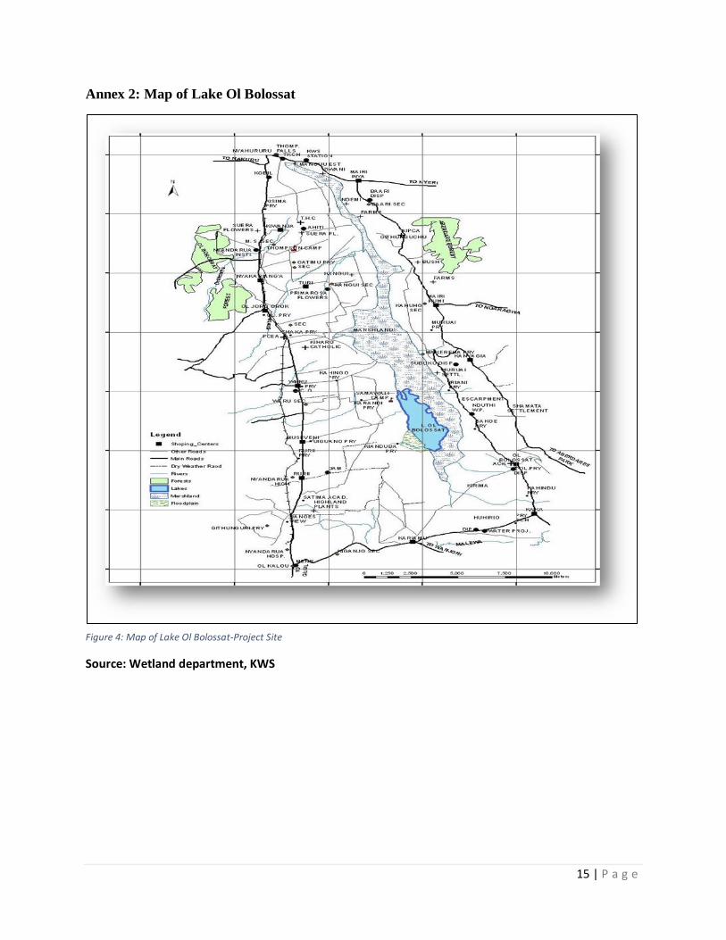
Lake Ol Bolossat is in the only natural lake in central Kenya, and covers an area of 43.3 square
kilometers (4 km2 open water and 39.3 km2 riparian section-grassland) (Annex 2). This alkaline
lake was designated as 5th Important Bird Area (IBA) in central province and 61st in Kenya. It is
centrally located touching on four out of the five Sub Counties of Nyandarua County. This clearly
indicates that more than 70% of Nyandarua county populace depends on this lake for survival. In
addition, Lake Ol Bolossat is the main source of Thomson falls and Ewaso Ngiro River that flows
through key national conservation areas, among them Samburu National Park (SNR) and Buffalo
2 | P a g e
Springs, all of which are designated IBAs. The existence of this lake also benefits other counties
such as Laikipia, Isiolo and Samburu. The catchment area has a variety of land use systems that
include urban centres, small and large-scale intensive agriculture, ranching, forestry, and wildlife
conservation.
Lake Ol Bolossat is home to hippopotamus and over 100 bird species which are either residential
or migrant Palearctic and afro-tropical water birds. Some of these birds are rated as endangered
while others are either threatened or are endemic to Kenya. These birds include Grey crested crane,
Jacksons widowbird, Long-tailed widowbird, Hunter’s cisticola, Grey crested grebe, Great white
Egret, Moccoa duck, White-backed duck, African Marsh Harrier, Saddle-billed stork, Cinnamon-
chested bee eater, White-eyed slaty flycatcher and Bronze sunbird among many more. The lake
catchment and basin are important for local and national socio - economic development especially
agriculture1. The central location of the lake with respect to the national tourist circuit and its
proximity to the equator confer the site an added advantage. The potential for tourism development
is high but remains largely unexploited.
There are several conservation challenges in the catchment arising from human activities and land
use changes threatening to disrupt its ecological integrity. These challenges include encroachment
on the riparian lands, pollution, deforestation, over-fishing, overgrazing, hunting of waterbirds for
meat and eggs, and erosion from the agricultural farmlands, quarries and recently graded roads.
These activities have resulted into siltation, introduction of invasive species, receding water levels,
disruption of hydrological balance, habitat loss, animal mortalities and human- wildlife conflicts
(human-hippo conflicts). In addition, demographic changes and its associated activities have led
to resource over-exploitation and poverty.
Several initiatives have been undertaken in the past to address these issues. However, these
initiatives have been largely ineffective due to several factors, which include fragmented and
sectoral approach in initiation and implementation, limited scope and objective, weak interagency
linkages and inadequate stakeholder involvement. The overall weakness has been lack of a
framework that integrates and guides these initiatives to achieve the overall environmental
1 Lake Ol Bolossat Integrated Management Plan (2008-2013)
3 | P a g e
conservation and development targets. EAWLS has previously played a key role in supporting
the surrounding community in developing a 5-year management plan (2008-2013) for Lake Ol
Bolossat.
2.0 Approach and Methodology
The field trip was undertaken between 25th and 27th October, 2016 by 2 project staff. Prior to the
field work, the project staff developed data collection tools (checklists) (see Annex 1) based on
the available literature and in consultation with other experts who have done such projects before.
The trip involved mapping out of the quarrying sites and upgraded roads around the lake. This was
preceded by meetings with key County Government officials (Departments of Tourism and
Wildlife; Public works, Roads and Transport; Water and Irrigation; and environment and Natural
Resources) and key government agencies (KWS, WRMA, and NEMA).
The objective of the meetings was to inform and brief the county government and these key
government agencies about the project EAWLS is undertaking around Lake Ol Bolossat, and to
familiarize with the conservation issues around the lake as well as know the future plans the County
Government has in place towards conserving the lake.
Survey around the lake involved identifying the roads that drain directly into the lake, and the
quarrying activities that take place near the lake boundary. Data collected was filled into the data
collection tools. The project team was guided around the lake by a member from Nyahururu Bird
Club (NBC).
Transcriptions and other data collected from the survey were analysed thematically and
summarized in text.
4 | P a g e
3.0 Findings
3.1 Summary of the outcomes from the entry meeting with County Government and
National agencies (including KWS, WRMA and NEMA)
3.1.1 Key issues surrounding conservation of the lake
❖ The area was not recognized as a lake in the colonial era, and thus most people are not
aware of its existence.
❖ Lake Ol Bolossat has not been gazetted. However, two attempts had been made to delineate
and demarcate the boundaries of the lake (2012 & 2013); all of which flopped. Main
challenges towards the gazettment of this lake are land issues and lack of community
support. The land around the lake is privately owned and therefore taking up the land
implies resettling the land owners which has substantial cost implication.
❖ Inadequate coordination among the key stakeholders (County Government, local
communities and NEMA) affecting the working relationship for the benefit of the lake.
This has resulted into outright rejection of most of the projects implemented by government
agencies or County government by the local communities. For example, NEMA had two
projects- one in Chebarungu forest and the other in Morai. The projects were not successful
due to rejection by some communities. In Morai there was a small spring from which the
communities depended on as their source of water. People used 10 inch pipes to draw water
from it. In attempt to save this spring, a fence was erected through the Constituency
Development Fund (CDF). Group of communities who have livestock did not support this
initiative for fear that it would limit access to this water source for their livestock. In
Chebarungu forest a nature based project, tree seedlings were provided for tree planting,
chain links and poles purchased but the beehives were never procured (disincentivised the
locals). The two projects were not successful due to lack of support by the local
communities. Also, the ministry of tourism under the county government wanted to
establish a tourism facility but it was opposed out rightly by the locals citing lack of
involvement.
5 | P a g e
❖ Enforcement of the integrated management plan for Lake Ol Bolossat (which expired in
2013) was a great challenge because the lake has not been gazetted. It was pointed out that
this management plan needs to be reviewed.
3.1.2 Conservation Challenges Facing Lake Ol Bolossat (threats)
• The lake suffers the “tragedy of the common” which has resulted into massive
encroachment into the lake shores
• Overfishing (especially the catfish which is the most predominant in the lake)
• Overgrazing along the lake shores
• Siltation as a result of soil erosion from the recently graded roads, quarrying sites and
farming activities upstream and in the adjacent areas.
• Water abstraction
• Hunting of birds for meat and eggs by the community members (both children and adults).
3.1.3 The plans the County Government of Nyandarua has towards conserving the lake
➢ Gazettment of the lake: The letter towards the gazettment has been tabled to the Ministry
of Environment and Natural Resources, and copies circulated to the other relevant
Ministries and Government Agencies.
➢ Awareness creation about the existence of the lake. The County Government has set aside
funds to design signage which will be erected at a strategic locations to inform people of
the existence of the lake. In addition, the county is organizing a marathon dubbed “Ol
Bolossat Marathon”. All the proceeds from the marathon shall go to the conservation kit
of the lake.
➢ Boost tourism sector within the County using the lake as an attraction. A SWOT analysis
conducted by the County Government revealed cold weather (not conducive for most
tourists) as one of the threats to tourism in the county. The County, therefore, proposes to
put up a leisure park next to the lake and construct a swimming pool which will act as a
weather changer, and will be heated using solar energy. A borehole with freshwater will
be drilled to supply the facility with freshwater. In addition, communities will also be
allowed to fetch water from the borehole freely thereby enlisting their support and
appreciation for the lake. Ten million Kenyan shillings has been allocated to fund this
venture.
6 | P a g e
➢ Marketing of the lake. The County Government intends to engage youths from the
communities surrounding the lake in designing wheel covers for the County Ministers with
the inscription “Lake Ol Bolossat.”
➢ Enhancing access to the lake. The county intends to tarmac two main roads leading to the
lake namely “Kasuku” and “Rurii” which are 7 km and 6.5 km long respectively.
➢ Resource mobilization towards supporting the conservation of the lake. The County
Government intends to mobilize other counties benefiting from the existence of Lake Ol
Bolossat to contribute towards conserving the lake. These counties include; Samburu,
Laikipia and Isiolo.
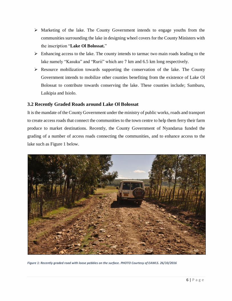
3.2 Recently Graded Roads around Lake Ol Bolossat
It is the mandate of the County Government under the ministry of public works, roads and transport
to create access roads that connect the communities to the town centre to help them ferry their farm
produce to market destinations. Recently, the County Government of Nyandarua funded the
grading of a number of access roads connecting the communities, and to enhance access to the
lake such as Figure 1 below.
Figure 1: Recently graded road with loose pebbles on the surface. PHOTO Courtesy of EAWLS. 26/10/2016
7 | P a g e
This project focused on the roads around the lake that were recently graded and quarries. In total,
eighteen roads were mapped out, majority of which were on the western side of the lake. Out of
the 18 roads, 28% (5) were graded up to the lake boundary, 39% (7) up to less than 100 m while
the remaining 33% (6) to at least 100 m from the lake boundary (Annex 3). The ministry of public
works, roads and transport under the county government only focused on opening the roads and
did not give any considerations to the environmental concerns. An officer from NEMA confirmed
that no Environmental Impact Assessment (EIA) is required for upgrading such feeder roads.
However, the environmental concerns can be put into perspective through the intervention of the
County Executive Committee (CEC) water, environment and natural resources. This committee
should come up with various legislation that guide implementation of such development projects
near the lake.
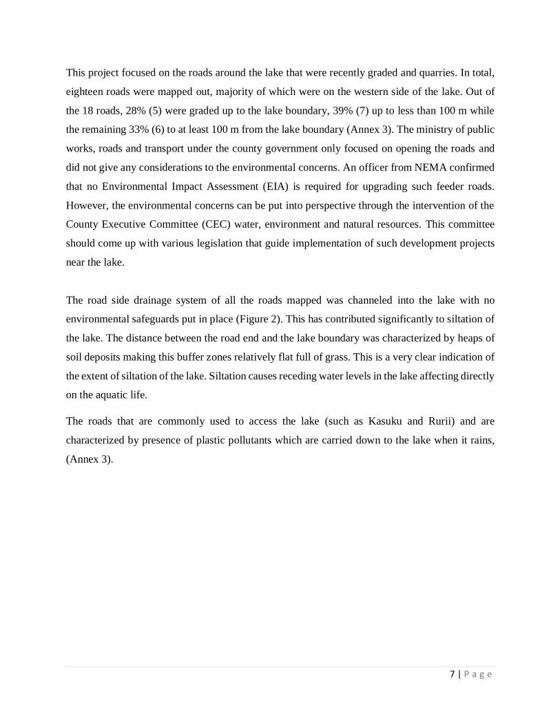
The road side drainage system of all the roads mapped was channeled into the lake with no
environmental safeguards put in place (Figure 2). This has contributed significantly to siltation of
the lake. The distance between the road end and the lake boundary was characterized by heaps of
soil deposits making this buffer zones relatively flat full of grass. This is a very clear indication of
the extent of siltation of the lake. Siltation causes receding water levels in the lake affecting directly
on the aquatic life.
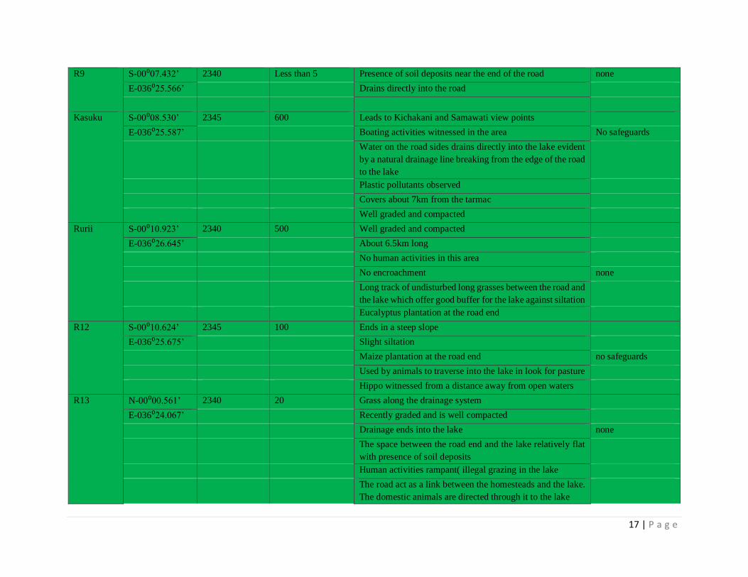
The roads that are commonly used to access the lake (such as Kasuku and Rurii) and are
characterized by presence of plastic pollutants which are carried down to the lake when it rains,
(Annex 3).
8 | P a g e
Figure 2: A recently graded road ending on the lake boundary. PHOTO courtesy of EAWLS. 25/10/2016
3.3 Quarrying Activities Mapped around Lake Ol Bolossat
This survey sought to map out all the quarrying sites in close proximity to Lake Ol Bolossat. A
total of five quarries were identified and mapped out. Out of the five quarries, only one is duly
registered and licensed by the County Government as required by law. This quarry covers an
approximate area of nine (9) acres, uses machine for extraction, and its operations are keenly
monitored by NEMA. The remaining four quarries are not registered/licensed, extract manually,
and are operated on public land. The length of operation for the quarries on “public land” was not
ascertained because the operations are carried out by different individuals.
Three of these quarries touches on the lake boundary causing direct siltation. In addition, no
decommission is conducted in any of these quarries and therefore loose soil deposits are left in
heaps which are carried into the lake when it rains.
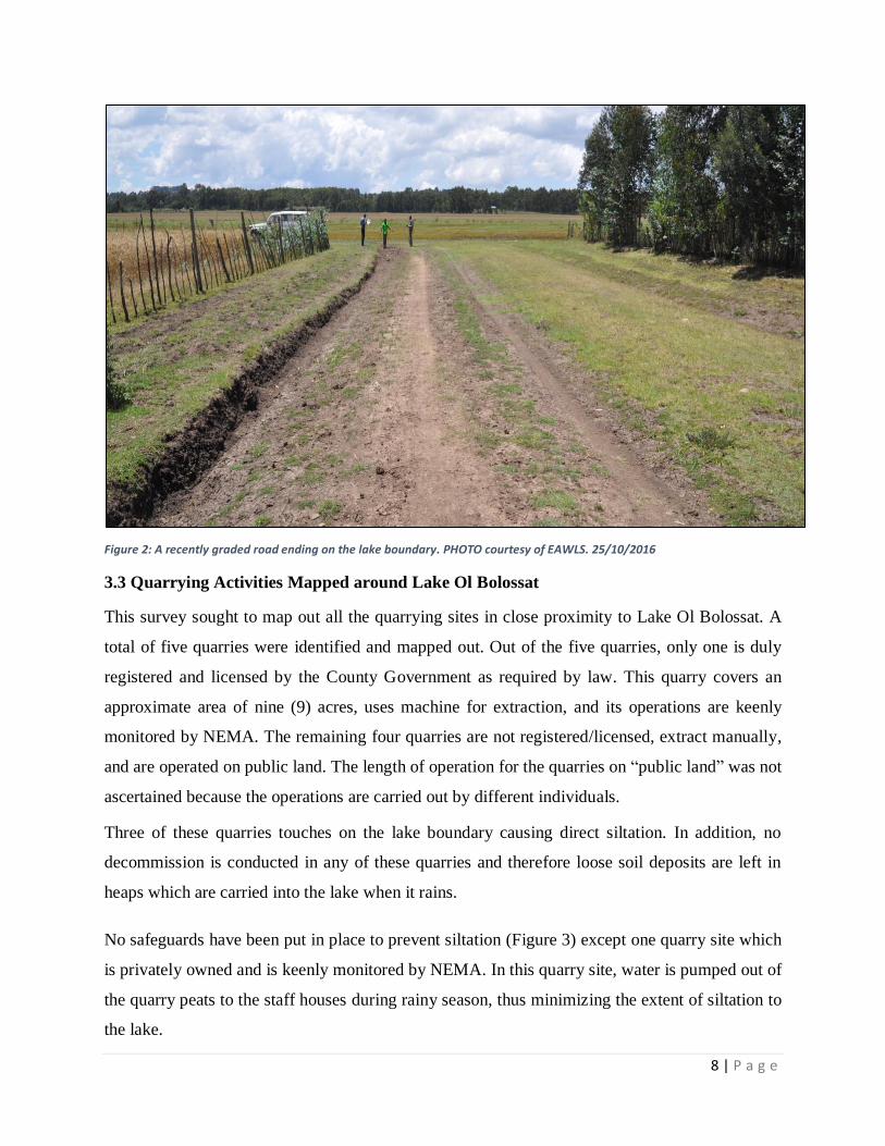
No safeguards have been put in place to prevent siltation (Figure 3) except one quarry site which
is privately owned and is keenly monitored by NEMA. In this quarry site, water is pumped out of
the quarry peats to the staff houses during rainy season, thus minimizing the extent of siltation to
the lake.
9 | P a g e
The quarries also exhibited poor waste management causing direct pollution into the lake. Oil and
grease spills, metals and organic waste are not properly handled. Remarkably, one quarry is
situated right within Ndaragua forest with massive deforestation evident in the surrounding area
in attempt to open more space for quarrying
The number of workers spotted on site directly correlated with the size of the quarry; Kamau quarry
which is privately owned and measures a total of 9 acres (largest of all the quarries mapped out)
had the highest number of workers on site (12)(Annex 4).
Figure 3: Quarrying site (within Ndaragua forest) about 100m from the lake, and is along a road leading to the lake. PHOTO courtesy of EAWLS. 25/10/ 2016.
10 | P a g e
4.0 Conclusion
Lake Ol Bolossat suffers the “tragedy of the commons”, and may not survive the next two decades
due to the continued immense pressure of human encroachment, overgrazing, and siltation that
results from soil erosion from the recently graded roads, quarrying sites and farming activities
upstream. Therefore, environmental safeguards such as EIA are key during the commencement of
projects in the lake ecosystem to ensure sustainable utilization.
The lake is not only important for the conservation of wildlife (birds and hippo) but also supports
the livelihoods of the local communities as well as the economy of the county and the country as
a whole. Drying up of this lake if not conserved will lead to massive wildlife migration and
mortalities, and affect people’s wellbeing.
There is poor working relationship and coordination among the County Government, relevant
government agencies (KWS, NEMA, and WRMA) and the local communities. This has led to
outright hostility and mistrust by the local communities making implementation of projects in the
area a great challenge. Partnership with local communities is inevitable for any conservation
project to be implemented successfully. Therefore, projects initiated around any conservation area
should take into consideration the aspirations of conservation as well as the felt needs of the
communities.
There is no integrated Land Use Plan (LUP) for Lake Ol Bolossat ecosystem. The management
plan has expired as well and a consultative review is needed. As a result, implementing policies
and laws to effectively manage this resource remains a challenge.
The tourism potential for Lake Ol Bolossat has not been fully realized and tapped to improve the
living standards of the communities and boost tourism earnings for the County. There is need to
leverage this opportunity by marketing this lake to attract potential tourism investors.
11 | P a g e
5.0 Proposed interventions
• Gazettment of the lake.
• Review and implement the integrated ecosystem management plan for Lake Ol Bolossat.
• The County Government should engage closely with the local communities, adopting a
bottom-up approach to conservation. This will enlist community support for any projects
in the area, and build synergies to push for the gazettment of the lake.
• Sensitize the communities on the impacts of quarrying and farm activities on the lake.
• Train the communities on alternative livelihood activities that are compatible with
conservation such as beekeeping, tour guiding for the birdwatchers (avi-tourism), cultural
tourism, high altitude sporting, and game viewing among others.
• Closure of all illegally operating quarrying sites.
• Develop a joint monitoring plan for Lake Ol Bolossat.
• The County department of water, environment and natural resources, in consultation with
NEMA, should develop by-laws that guide infrastructural development such as roads
within the county.
• NEMA should ensure strict monitoring of all the quarrying activities to ensure strict
adherence to environmental regulations.
• Develop a land use plan to guide activities around Lake Ol Bolossat.
• Explore the possibility of designing a payment of ecosystem services scheme to support
conservation and protection of the lake catchment area.
12 | P a g e
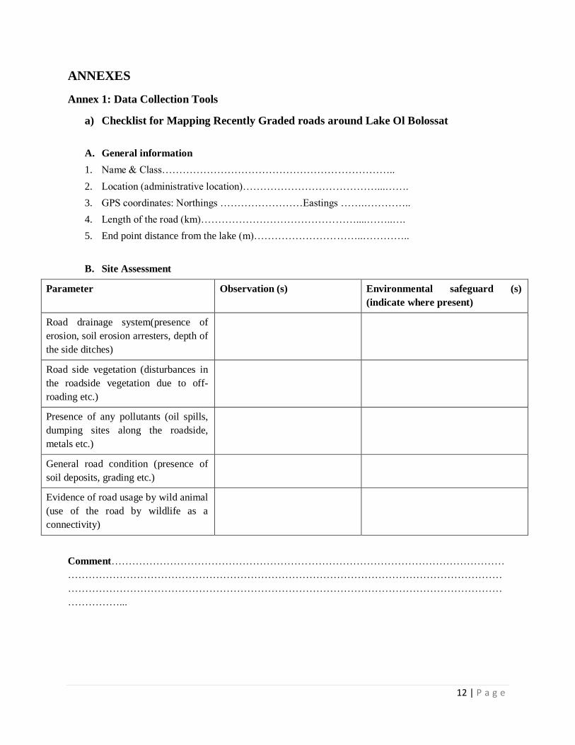
ANNEXES
Annex 1: Data Collection Tools
a) Checklist for Mapping Recently Graded roads around Lake Ol Bolossat
A. General information
1. Name & Class…………………………………………………………..
2. Location (administrative location)…………………………………...…….
3. GPS coordinates: Northings ……………………Eastings …….…………..
4. Length of the road (km)………………………………………....……..….
5. End point distance from the lake (m)…………………………..…………..
B. Site Assessment
Parameter Observation (s) Environmental safeguard (s)
(indicate where present)
Road drainage system(presence of
erosion, soil erosion arresters, depth of
the side ditches)
Road side vegetation (disturbances in
the roadside vegetation due to off-
roading etc.)
Presence of any pollutants (oil spills,
dumping sites along the roadside,
metals etc.)
General road condition (presence of
soil deposits, grading etc.)
Evidence of road usage by wild animal
(use of the road by wildlife as a
connectivity)
Comment……………………………………………………………………………………………………
………………………………………………………………………………………………………………
………………………………………………………………………………………………………………
……………...
13 | P a g e
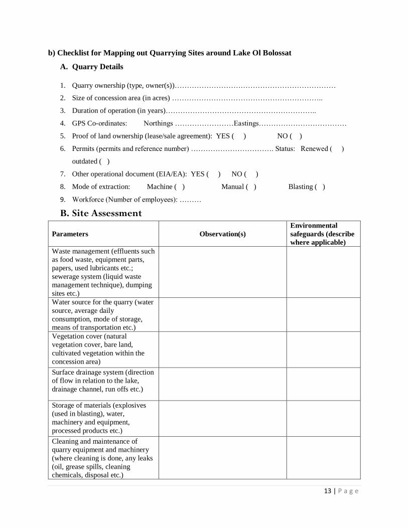
b) Checklist for Mapping out Quarrying Sites around Lake Ol Bolossat
A. Quarry Details
1. Quarry ownership (type, owner(s))…………………………………………………………
2. Size of concession area (in acres) ……………………………………………………..
3. Duration of operation (in years)……………………………………………………..
4. GPS Co-ordinates: Northings ……………………Eastings………………………………
5. Proof of land ownership (lease/sale agreement): YES ( ) NO ( )
6. Permits (permits and reference number) ……………………………. Status: Renewed ( )
outdated ( )
7. Other operational document (EIA/EA): YES ( ) NO ( )
8. Mode of extraction: Machine ( ) Manual ( ) Blasting ( )
9. Workforce (Number of employees): ………
B. Site Assessment
Parameters Observation(s)
Environmental
safeguards (describe
where applicable)
Waste management (effluents such
as food waste, equipment parts,
papers, used lubricants etc.;
sewerage system (liquid waste
management technique), dumping
sites etc.)
Water source for the quarry (water
source, average daily
consumption, mode of storage,
means of transportation etc.)
Vegetation cover (natural
vegetation cover, bare land,
cultivated vegetation within the
concession area)
Surface drainage system (direction
of flow in relation to the lake,
drainage channel, run offs etc.)
Storage of materials (explosives
(used in blasting), water,
machinery and equipment,
processed products etc.)
Cleaning and maintenance of
quarry equipment and machinery
(where cleaning is done, any leaks
(oil, grease spills, cleaning
chemicals, disposal etc.)
14 | P a g e
Depth of the quarry pits (estimated
in ft.- influences the water table
and lake volume)
Approximate distance from the
lake (in km)
Gradient of the site (gentle, steep,
flat)
Others (e.g. human wildlife
conflicts for example with hippos,
resource use conflicts due to the
existence of the quarry etc.)
C. General Remarks
…………………………………………………………………………………………………………………………………………………………………
…………………………………………………………………………………………………………………………………………………………………
…………………………………………………………………………………………………………………………………………………………………
…………………………………………………………………………………………………………………………………………………………………
………………………………………………………………………………………….
15 | P a g e
Annex 2: Map of Lake Ol Bolossat
Figure 4: Map of Lake Ol Bolossat-Project Site
Source: Wetland department, KWS
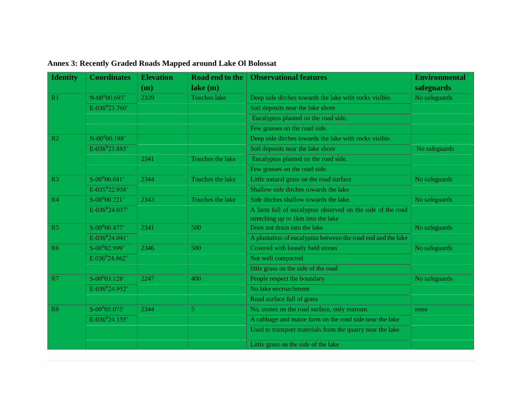
Annex 3: Recently Graded Roads Mapped around Lake Ol Bolossat
Identity Coordinates Elevation
(m)
Road end to the
lake (m)
Observational features Environmental
safeguards
R1 N-00⁰00.693’ 2339 Touches lake Deep side ditches towards the lake with rocks visible. No safeguards
E-036⁰23.760’
Soil deposits near the lake shore
Eucalyptus planted on the road side.
Few grasses on the road side.
R2 N-00⁰00.198’ Deep side ditches towards the lake with rocks visible.
E-036⁰23.885’
Soil deposits near the lake shore No safeguards
2341 Touches the lake Eucalyptus planted on the road side.
Few grasses on the road side.
R3 S-00⁰00.041’ 2344 Touches the lake Little natural grass on the road surface No safeguards
E-035⁰22.958’ Shallow side ditches towards the lake
R4 S-00⁰00.221’ 2343 Touches the lake Side ditches shallow towards the lake. No safeguards
E-036⁰24.037’ A farm full of eucalyptus observed on the side of the road
stretching up to 1km into the lake
R5 S-00⁰00.477’ 2341 500 Does not drain into the lake No safeguards
E-036⁰24.041’ A plantation of eucalyptus between the road end and the lake
R6 S-00⁰02.999’ 2346 500 Covered with loosely held stones No safeguards
E 036⁰24.862’
Not well compacted
little grass on the side of the road
R7 S-00⁰03.128’ 2247 400 People respect the boundary No safeguards
E-036⁰24.952’
No lake encroachment
Road surface full of grass
R8 S-00⁰05.075’ 2344 5 No, stones on the road surface, only marram. none
E-036⁰24.155’
A cabbage and maize farm on the road side near the lake
Used to transport materials from the quarry near the lake
Little grass on the side of the lake
17 | P a g e
R9 S-00⁰07.432’ 2340 Less than 5 Presence of soil deposits near the end of the road none
E-036⁰25.566’
Drains directly into the road
Kasuku S-00⁰08.530’ 2345 600 Leads to Kichakani and Samawati view points
E-036⁰25.587’
Boating activities witnessed in the area No safeguards
Water on the road sides drains directly into the lake evident
by a natural drainage line breaking from the edge of the road
to the lake
Plastic pollutants observed
Covers about 7km from the tarmac
Well graded and compacted
Rurii S-00⁰10.923’ 2340 500 Well graded and compacted
E-036⁰26.645’
About 6.5km long
No human activities in this area
No encroachment none
Long track of undisturbed long grasses between the road and
the lake which offer good buffer for the lake against siltation
Eucalyptus plantation at the road end
R12 S-00⁰10.624’ 2345 100 Ends in a steep slope
E-036⁰25.675’
Slight siltation
Maize plantation at the road end no safeguards
Used by animals to traverse into the lake in look for pasture
Hippo witnessed from a distance away from open waters
R13 N-00⁰00.561’ 2340 20 Grass along the drainage system
E-036⁰24.067’
Recently graded and is well compacted
Drainage ends into the lake none
The space between the road end and the lake relatively flat
with presence of soil deposits
Human activities rampant( illegal grazing in the lake
The road act as a link between the homesteads and the lake.
The domestic animals are directed through it to the lake
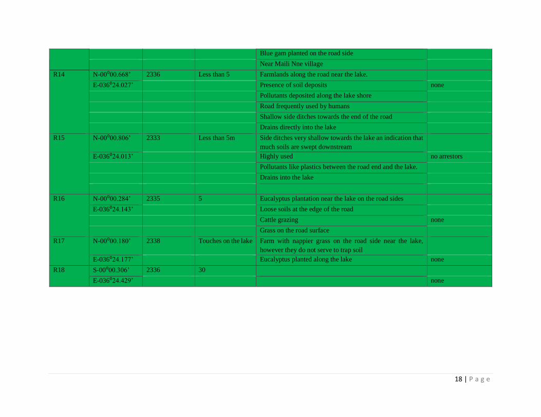
18 | P a g e
Blue gam planted on the road side
Near Maili Nne village
R14 N-00⁰00.668’ 2336 Less than 5 Farmlands along the road near the lake.
E-036⁰24.027’
Presence of soil deposits none
Pollutants deposited along the lake shore
Road frequently used by humans
Shallow side ditches towards the end of the road
Drains directly into the lake
R15 N-00⁰00.806’ 2333 Less than 5m Side ditches very shallow towards the lake an indication that
much soils are swept downstream
E-036⁰24.013’
Highly used no arrestors
Pollutants like plastics between the road end and the lake.
Drains into the lake
R16 N-00⁰00.284’ 2335 5 Eucalyptus plantation near the lake on the road sides
E-036⁰24.143’
Loose soils at the edge of the road
Cattle grazing none
Grass on the road surface
R17 N-00⁰00.180’ 2338 Touches on the lake Farm with nappier grass on the road side near the lake,
however they do not serve to trap soil
E-036⁰24.177’ Eucalyptus planted along the lake none
R18 S-00⁰00.306’ 2336 30
E-036⁰24.429’ none

19 | P a g e
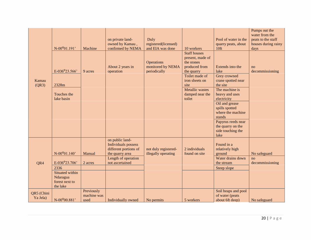
Annex 4: Quarries Mapped Around Lake Ol Bolossat
Name
Coordinates,
elevation &
distance from
the lake
Estimated
size (acres),
method of
extraction
Ownership &
length of operation Legality
Number of
workers, toilets,
damping sites,
staff housing
General
observations
Environmental
safeguards
Gatumbiro
S-00⁰05.000’ 3
on public land-
different individuals
have their specific
sites within the
quarry
not registered-No
permits
24 individuals on
site
Pool of water
within the peats No safeguards
E-036⁰24.229’ manual
Length of operation
not ascertained EIA not done
Peats are about
20ft deep
No
decommissioning
done
2340m
Extraction up to
the lake shore
Touches the
lake
Heaps of soils
within the quarry
sites
Canter for
transportation
spotted on site
during the visit
Peats are left
uncovered
QR2
S-00⁰04.942’ 0.25 acres
Is on public land, no
owner,
Not registered-No
permits/EIA/EA
Not ascertained,
only one worker
found on the site
Extends inside the
lake, No safeguards
E-036⁰24.255 Manual
Less than a year in
operation Operates illegally
Peats filled with
water and heap of
soils observed
No
decommissioning
done
2344m
Destruction of the
surrounding
vegetation by
vehicles- canter
spotted on site
Touches the
lake
20 | P a g e
Kamau
(QR3)
N-00⁰01.191’ Machine
on private land-
owned by Kamau ,
confirmed by NEMA
Duly
registered(licensed)
and EIA was done 10 workers
Pool of water in the
quarry peats, about
10ft
Pumps out the
water from the
peats to the staff
houses during rainy
days
E-036⁰23.566’ 9 acres
About 2 years in
operation
Operations
monitored by NEMA
periodically
Staff houses
present, made of
the stones
produced from
the quarry
Extends into the
lake
no
decommissioning
2328m
Toilet made of
iron sheets on
site
Grey crowned
crane spotted near
the site
Touches the
lake basin
Metallic wastes
damped near the
toilet
The machine is
heavy and uses
electricity
Oil and grease
spills spotted
where the machine
stands
Papyrus reeds near
the quarry on the
side touching the
lake
QR4
N-00⁰01.140’ Manual
on public land-
Individuals possess
different portions of
the quarry area
not duly registered-
illegally operating
2 individuals
found on site
Found in a
relatively high
ground No safeguard
E-036⁰23.706’ 2 acres
Length of operation
not ascertained
Water drains down
the stream
no
decommissioning
2336 Steep slope
Situated within
Ndaragua
forest next to
the lake
QR5 (Chini
Ya Jela) N-00⁰00.881’
Previously
machine was
used Individually owned No permits 5 workers
Soil heaps and pool
of water (peats
about 6ft deep) No safeguard
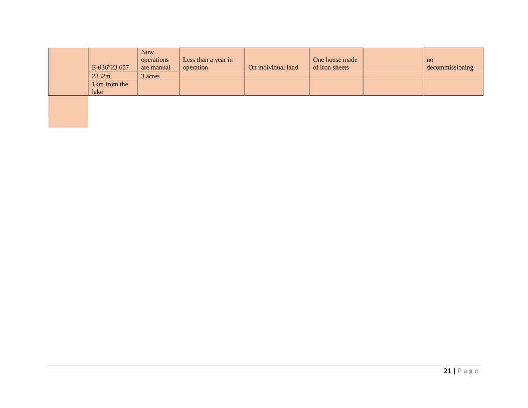
21 | P a g e
E-036⁰23.657
Now
operations
are manual
Less than a year in
operation On individual land
One house made
of iron sheets
no
decommissioning
2332m 3 acres
1km from the
lake