recognizing tide-dominated versus tide-influenced deltas: middle devonian strata of the baltic basin
TRANSCRIPT

Journal of Sedimentary Research, 2009, v. 79, 887–905
Research Article
DOI: 10.2110/jsr.2009.096
RECOGNIZING TIDE-DOMINATED VERSUS TIDE-INFLUENCED DELTAS: MIDDLE DEVONIAN STRATA OFTHE BALTIC BASIN
KATI TANAVSUU-MILKEVICIENE AND PIRET PLINK-BJORKLUNDDepartment of Geology and Geological Engineering, Colorado School of Mines, Golden, Colorado 80401, U.S.A.
e-mail: [email protected]
ABSTRACT: This paper examines the differences between tide-dominated and tide-influenced deltas, as well as tide-dominateddeltas and tide-dominated estuaries. The deltaic deposits of the Middle Devonian Kernave and Arukula formations weredocumented in cores and outcrops in the Baltic Basin and interpreted as tide-dominated delta deposits. These tide-dominateddeposits consist of three vertically stacked progradational to aggradational packages, 20–40 m thick. Each package consists oftwo stratigraphic intervals. The lower upward-coarsening interval contains seaward-accreting prodelta to distal tidal-bar andproximal tidal-bar deposits. The upper upward-fining interval consists of tidal-flat deposits and minor tidal gully, distributary-channel, supratidal muds, and paleosol deposits. The overall character of these delta deposits indicates a subaqueous delta withno river-dominated delta-plain. Comparison of these successions with modern and ancient tide-dominated and tide-influenceddeltas suggests that tide-dominated deltaic deposits tend to form in conditions of relative sea-level rise succeedingtransgressions, when tidal currents are strong enough to redeposit most river-derived sediments. Tide-dominated deltas formsubaqueous deltas, where the bulk of the deposits are tidally reworked. In contrast, tide-influenced deltas contain tidalindicators in delta-front and lower-delta-plain deposits, whereas the upper delta plain is river-dominated. Our data suggest thattide-dominated deltas may change into tide-influenced deltas during delta evolution when they prograde to the mouth of therestricted or funnel-shaped bay, given the rate of fluvial sediment supply exceeds the rate of accommodation increase.
INTRODUCTION
Most of the largest modern rivers feed tide-dominated or tide-influenced deltas (e.g., Saito et al. 2001; Hori et al. 2002a, 2002b;Lambiase et al. 2003; Roberts and Sydow 2003). Tide-dominated andtide-influenced deltas are also described in the ancient record (e.g.,Mellere and Steel 1996; Willis et al. 1999; Kitazawa 2007); however, someancient tide-dominated deltas have been interpreted as estuary deposits(see Walker 1992; Willis and Gabel 2003) or as shelf sand ridges (see Nioand Yang 1991a; Willis et al. 1999). In recent years, details of tide-dominated delta depositional systems and deltaic architecture have beendocumented (Hori et al. 2002b; Dalrymple et al. 2003; Dalrymple andChoi 2007), but most data on tide-dominated deltas have been derivedfrom modern environments.
The term tide-dominated delta has been more widely used only duringthe last decade, especially in modern deltaic successions (e.g., Harris et al.1993; Saito et al. 2001; Hori et al. 2002a, 2002b; Dalrymple et al. 2003;Choi et al. 2004; Heap et al. 2004), and less frequently applied to interpretancient deltaic deposits (e.g., Mellere and Steel 1996; Willis and Gabel2003; Kitazawa 2007). Differentiation between modern tide-dominatedand tide-influenced deltas is based on deltaic morphology. Modern tide-dominated deltas possess a straight, funnel-shaped geometry such as theFly River delta in Papua New Guinea (Dalrymple et al. 2003), or in theChangjiang (Yangtze River) delta in China (Hori et al. 2002b). Moderntide-influenced deltas form morphological features that are generallymore similar to river- or wave-dominated deltas than tide-dominateddeltas, as in the Song Hong delta in Vietnam (Hori et al. 2004) or theMahakam delta in Indonesia (Storms et al. 2005).
In ancient deposits, differences between tide-dominated or tide-influenced deltas can be difficult to recognize. In this paper, deltas arecalled tide-dominated when tidal facies dominate, and tide-influencedwhen fluvial or wave-generated facies dominate and tide-generated faciesare subordinate. However, this definition is not widely accepted.
The Kernave and Arukula formations of the Middle Devonian BalticBasin documented here are dominated by gradationally based tidal-bar andtidal-flat successions that fine seawards into prodelta muds. Only in rareplaces do channel deposits and paleosols occur. This is in contrast to theearlier documented, younger tide-influenced Gauja Formation deltas fromthe Baltic Basin, where fluvial facies dominate and consist of different typesof distributary-channel fills that grade seaward into tide-influenced mouthbars and prodelta muds (see Ponten and Plink-Bjorklund 2007). Althoughtidal influence has been documented throughout the Gauja deltaicsuccession, only in a few places do tide-dominated facies associationsoccur. The documented Kernave and Arukula formations are also distinctlydifferent from the older Parnu Formation tide-dominated estuarine depositsof the Baltic Basin, where the sediments fine into the estuarine system fromboth ends, the tidal bars are sharply based, and the prodelta muds arelacking (see Tovmasyan 2004).
In this paper, we contrast tide-dominated and tide-influenced deltaicsuccessions and document the specific criteria for recognizing tide-dominateddeltas from other tide-dominated deposits, such as estuaries. We discusswhether the tide-dominated and tide-influenced deltas may representdifferent stages of deltaic development and what conditions are likely tocause the transition from tide-dominated to tide-influenced deltas. This studyis limited to tide-dominated, tide-influenced, and river-influenced deltas only.
Copyright E 2009, SEPM (Society for Sedimentary Geology) 1527-1404/09/079-887/$03.00
GEOLOGICAL SETTING
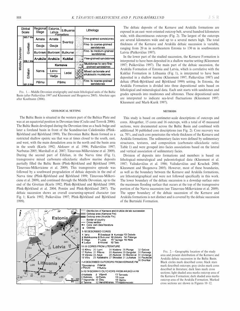
The Baltic Basin is situated in the western part of the Baltica Plate andwas at an equatorial position in Devonian time (Cocks and Torsvik 2006).The Baltic Basin developed during the Devonian time as a back-bulge andlater a foreland basin in front of the Scandinavian Caledonides (Plink-Bjorklund and Bjorklund 1999). The Devonian Baltic Basin formed as arestricted shallow epeiric sea that was at times closed to the south, east,and west, with the main denudation area in the north and the basin areain the south (Kurss 1992; Alekseev et al. 1996; Paskevicius 1997;Narbutas 2005; Marshall et al. 2007; Tanavsuu-Milkeviciene et al. 2009).During the second part of Eifelian, in the Narva time (Fig. 1),transgressive mixed carbonate–siliciclastic shallow marine depositspartially filled the Baltic Basin (Plink-Bjorklund and Bjorklund 1999;Tanavsuu-Milkeviciene et al. 2009). This transgressive episode wasfollowed by a southward progradation of deltaic deposits in the end ofNarva time (Plink-Bjorklund and Bjorklund 1999; Tanavsuu-Milkevi-ciene et al. 2009), and continued through the Middle Devonian, up to theend of the Givetian (Kurss 1992; Plink-Bjorklund and Bjorklund 1999;Plink-Bjorklund et al. 2004; Ponten and Plink-Bjorklund 2007). Thedeltaic succession shows an overall coarsening-upward character (seeFig. 1; Kurss 1992; Paskevicius 1997; Plink-Bjorklund and Bjorklund1999).
The deltaic deposits of the Kernave and Arukula formations areexposed in an east–west-oriented outcrop belt, several hundred kilometerswide, with discontinuous outcrops (Fig. 2). The largest of the outcropsare several kilometers wide and up to a several meters high. The totalthickness of the Kernave and Arukula deltaic succession is variable,ranging from 20 m in northeastern Estonia to 130 m in southwesternLatvia (Paskevicius 1997).
In the lower part of the studied succession, the Kernave Formation isinterpreted to have been deposited in a shallow marine setting (Kleesment1997; Paskevicius 1997). The main part of the deltaic succession, theArukula Formation of Estonia and Latvia, which is correlative with theKukliai Formation in Lithuania (Fig. 1), is interpreted to have beendeposited in a shallow marine (Kleesment 1997; Paskevicius 1997) anddeltaic (Plink-Bjorklund and Bjorklund 1999) setting. In Estonia, theArukula Formation is divided into three depositional units based onlithological and mineralogical data. Each unit starts with sandstones andgrades upwards into mudstones and siltstones. These depositional unitsare interpreted to indicate sea-level fluctuations (Kleesment 1997;Kleesment and Mark-Kurik 1997).
METHODS
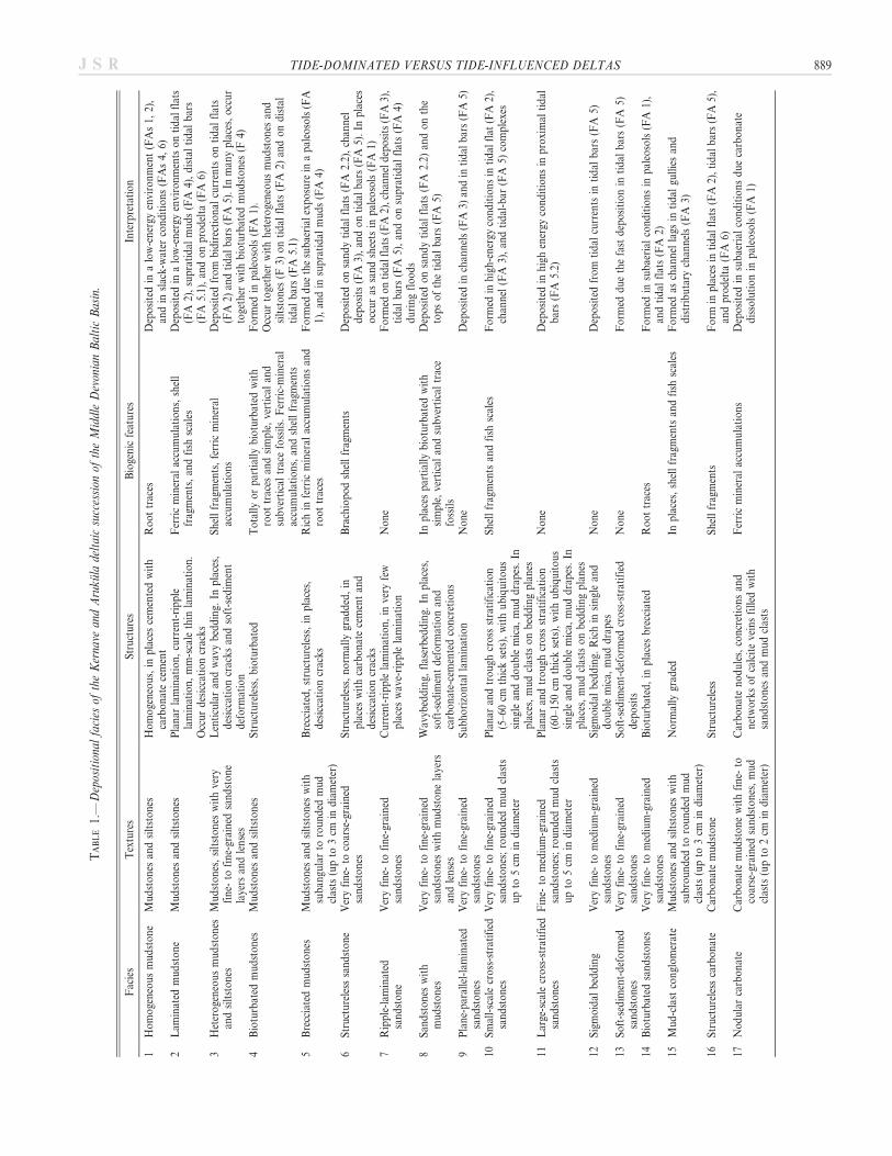
This study is based on centimeter-scale descriptions of outcrops andcores. Altogether, 15 cores and 16 outcrops, with a total of 45 measuredsections, were documented across the Baltic Basin and combined withadditional 30 published core descriptions (see Fig. 2). Core recovery wasca. 70%, and each core penetrates the whole thickness of the Kernave andArukula formations. The sedimentary facies were defined by sedimentarystructures, textures, and composition (carbonate–siliciclastic ratio;Table 1) and were grouped into facies associations based on the lateraland vertical association of sedimentary facies.
Division of deposits into formations and members is based onlithological–mineralogical and paleontological data (Kleesment et al.1987; Valiukevicius et al. 1986; Valiukevicius and Kruchek 2000;Kleesment and Shogenova 2005). However, most of these boundaries,as well as the boundary between the Kernave and Arukula formations,are lithostratigraphical and were not followed specifically in this work.The lower boundary of the deltaic succession is a downlap surface ontothe maximum flooding surface that occurs at the top of the transgressiveportion of the Narva succession (see Tanavsuu-Milkeviciene et al. 2009).The upper boundary of the deltaic succession of the Kernave andArukula formations is not distinct and is covered by the deltaic successionof the Burtnieki Formation.
FIG. 1.—Middle Devonian stratigraphy and main lithological units of the BalticBasin (after Paskevicius 1997 and Kleesment and Shogenova 2005). Absolute agesafter Kaufmann (2006).
FIG. 2.— Geographic location of the studyarea and present distribution of the Kernave andArukula deltaic succession in the Baltic Basin.Black circles mark described cores; black starsmark described outcrops; gray circles mark coresdescribed in literature; dark lines mark crosssections; light shaded area marks outcrop area ofthe Kernave Formation; dark shaded area marksoutcrop area of the Arukula Formation. Markedcross sections are shown in Figures 10–12.
888 K. TANAVSUU-MILKEVICIENE AND P. PLINK-BJORKLUND J S R
TA
BL
E1.
—D
epos
itio
nal
faci
esof
the
Ker
nave
and
Aru
kul
ade
ltai
csu
cces
sion
ofth
eM
iddl
eD
evon
ian
Bal
tic
Bas
in.
Fac
ies
Tex
ture
sS
tru
ctu
res
Bio
gen
icfe
atu
res
Inte
rpre
tati
on
1H
om
oge
neo
us
mu
dst
on
eM
ud
sto
nes
and
silt
sto
nes
Ho
mo
gen
eou
s,in
pla
ces
cem
ente
dw
ith
carb
on
ate
cem
ent
Ro
ot
trac
esD
epo
site
din
alo
w-e
ner
gyen
viro
nm
ent
(FA
s1,
2),
and
insl
ack
-wat
erco
nd
itio
ns
(FA
s4,
6)2
Lam
inat
edm
ud
sto
ne
Mu
dst
on
esan
dsi
ltst
on
esP
lan
arla
min
atio
n,
curr
ent-
rip
ple
lam
inat
ion
,m
m-s
cale
thin
lam
inat
ion
.F
erri
cm
iner
alac
cum
ula
tio
ns,
shel
lfr
agm
ents
,an
dfi
shsc
ales
Dep
osi
ted
ina
low
-en
ergy
envi
ron
men
tso
nti
dal
flat
s(F
A2)
,su
pra
tid
alm
ud
s(F
A4)
,d
ista
lti
dal
bar
s(F
A5.
1),
and
on
pro
del
ta(F
A6)
Occ
ur
des
icca
tio
ncr
ack
s3
Het
ero
gen
eou
sm
ud
sto
nes
and
silt
sto
nes
Mu
dst
on
es,
silt
sto
nes
wit
hve
ryfi
ne-
tofi
ne-
grai
ned
san
dst
on
ela
yers
and
len
ses
Len
ticu
lar
and
wav
yb
edd
ing.
Inp
lace
s,d
esic
cati
on
crac
ks
and
soft
-sed
imen
td
efo
rmat
ion
Sh
ell
frag
men
ts,
ferr
icm
iner
alac
cum
ula
tio
ns
Dep
osi
ted
fro
mb
idir
ecti
on
alcu
rren
tso
nti
dal
flat
s(F
A2)
and
tid
alb
ars
(FA
5).
Inm
any
pla
ces,
occ
ur
toge
ther
wit
hb
iotu
rbat
edm
ud
sto
nes
(F4)
4B
iotu
rbat
edm
ud
sto
nes
Mu
dst
on
esan
dsi
ltst
on
esS
tru
ctu
rele
ss,
bio
turb
ated
To
tall
yo
rp
arti
ally
bio
turb
ated
wit
hro
ot
trac
esan
dsi
mp
le,
vert
ical
and
sub
vert
ical
trac
efo
ssil
s.F
erri
c-m
iner
alac
cum
ula
tio
ns,
and
shel
lfr
agm
ents
Fo
rmed
inp
aleo
sols
(FA
1).
Occ
ur
toge
ther
wit
hh
eter
oge
neo
us
mu
dst
on
esan
dsi
ltst
on
es(F
3)o
nti
dal
flat
s(F
A2)
and
on
dis
tal
tid
alb
ars
(FA
5.1)
5B
recc
iate
dm
ud
sto
nes
Mu
dst
on
esan
dsi
ltst
on
esw
ith
sub
angu
lar
toro
un
ded
mu
dcl
asts
(up
to3
cmin
dia
met
er)
Bre
ccia
ted
,st
ruct
ure
less
,in
pla
ces,
des
icca
tio
ncr
ack
sR
ich
infe
rric
min
eral
accu
mu
lati
on
san
dro
ot
trac
esF
orm
edd
ue
the
sub
aeri
alex
po
sure
ina
pal
eoso
ls(F
A1)
,an
din
sup
rati
dal
mu
ds
(FA
4)
6S
tru
ctu
rele
sssa
nd
sto
ne
Ver
yfi
ne-
toco
arse
-gra
ined
san
dst
on
esS
tru
ctu
rele
ss,
no
rmal
lygr
add
ed,
inp
lace
sw
ith
carb
on
ate
cem
ent
and
des
icca
tio
ncr
ack
s
Bra
chio
po
dsh
ell
frag
men
tsD
epo
site
do
nsa
nd
yti
dal
flat
s(F
A2.
2),
chan
nel
dep
osi
ts(F
A3)
,an
do
nti
dal
bar
s(F
A5)
.In
pla
ces
occ
ur
assa
nd
shee
tsin
pal
eoso
ls(F
A1)
7R
ipp
le-l
amin
ated
san
dst
on
eV
ery
fin
e-to
fin
e-gr
ain
edsa
nd
sto
nes
Cu
rren
t-ri
pp
lela
min
atio
n,
inve
ryfe
wp
lace
sw
ave-
rip
ple
lam
inat
ion
No
ne
Fo
rmed
on
tid
alfl
ats
(FA
2),c
han
nel
dep
osi
ts(F
A3)
,ti
dal
bar
s(F
A5)
,an
do
nsu
pra
tid
alfl
ats
(FA
4)d
uri
ng
flo
od
s8
San
dst
on
esw
ith
mu
dst
on
esV
ery
fin
e-to
fin
e-gr
ain
edsa
nd
sto
nes
wit
hm
ud
sto
ne
laye
rsan
dle
nse
s
Wav
ybed
din
g,fl
aser
bed
din
g.In
pla
ces,
soft
-sed
imen
td
efo
rmat
ion
and
carb
on
ate-
cem
ente
dco
ncr
etio
ns
Inp
lace
sp
arti
ally
bio
turb
ated
wit
hsi
mp
le,
vert
ical
and
sub
vert
ical
trac
efo
ssil
s
Dep
osi
ted
on
san
dy
tid
alfl
ats
(FA
2.2)
and
on
the
top
so
fth
eti
dal
bar
s(F
A5)
9P
lan
e-p
aral
lel-
lam
inat
edsa
nd
sto
nes
Ver
yfi
ne-
tofi
ne-
grai
ned
san
dst
on
esS
ub
ho
rizo
nta
lla
min
atio
nN
on
eD
epo
site
din
chan
nel
s(F
A3)
and
inti
dal
bar
s(F
A5)
10S
mal
l-sc
ale
cro
ss-s
trat
ifie
dsa
nd
sto
nes
Ver
yfi
ne-
tofi
ne-
grai
ned
san
dst
on
es;
rou
nd
edm
ud
clas
tsu
pto
5cm
ind
iam
eter
Pla
nar
and
tro
ugh
cro
ssst
rati
fica
tio
n(5
–60
cmth
ick
sets
),w
ith
ub
iqu
ito
us
sin
gle
and
do
ub
lem
ica,
mu
dd
rap
es.
Inp
lace
s,m
ud
clas
tso
nb
edd
ing
pla
nes
Sh
ell
frag
men
tsan
dfi
shsc
ales
Fo
rmed
inh
igh
-en
ergy
con
dit
ion
sin
tid
alfl
at(F
A2)
,ch
ann
el(F
A3)
,an
dti
dal
-bar
(FA
5)co
mp
lexe
s
11L
arge
-sca
lecr
oss
-str
atif
ied
san
dst
on
esF
ine-
tom
ediu
m-g
rain
edsa
nd
sto
nes
;ro
un
ded
mu
dcl
asts
up
to5
cmin
dia
met
er
Pla
nar
and
tro
ugh
cro
ssst
rati
fica
tio
n(6
0–15
0cm
thic
kse
ts),
wit
hu
biq
uit
ou
ssi
ngl
ean
dd
ou
ble
mic
a,m
ud
dra
pes
.In
pla
ces,
mu
dcl
asts
on
bed
din
gp
lan
es
No
ne
Dep
osi
ted
inh
igh
ener
gyco
nd
itio
ns
inp
roxi
mal
tid
alb
ars
(FA
5.2)
12S
igm
oid
alb
edd
ing
Ver
yfi
ne-
tom
ediu
m-g
rain
edsa
nd
sto
nes
Sig
mo
idal
bed
din
g.R
ich
insi
ngl
ean
dd
ou
ble
mic
a,m
ud
dra
pes
No
ne
Dep
osi
ted
fro
mti
dal
curr
ents
inti
dal
bar
s(F
A5)
13S
oft
-sed
imen
t-d
efo
rmed
san
dst
on
esV
ery
fin
e-to
fin
e-gr
ain
edsa
nd
sto
nes
So
ft-s
edim
ent-
def
orm
edcr
oss
-str
atif
ied
dep
osi
tsN
on
eF
orm
edd
ue
the
fast
dep
osi
tio
nin
tid
alb
ars
(FA
5)
14B
iotu
rbat
edsa
nd
sto
nes
Ver
yfi
ne-
tom
ediu
m-g
rain
edsa
nd
sto
nes
Bio
turb
ated
,in
pla
ces
bre
ccia
ted
Ro
ot
trac
esF
orm
edin
sub
aeri
alco
nd
itio
ns
inp
aleo
sols
(FA
1),
and
tid
alfl
ats
(FA
2)15
Mu
d-c
last
con
glo
mer
ate
Mu
dst
on
esan
dsi
ltst
on
esw
ith
sub
rou
nd
edto
rou
nd
edm
ud
clas
ts(u
pto
3cm
ind
iam
eter
)
No
rmal
lygr
aded
Inp
lace
s,sh
ell
frag
men
tsan
dfi
shsc
ales
Fo
rmed
asch
ann
ella
gsin
tid
algu
llie
san
dd
istr
ibu
tary
chan
nel
s(F
A3)
16S
tru
ctu
rele
ssca
rbo
nat
eC
arb
on
ate
mu
dst
on
eS
tru
ctu
rele
ssS
hel
lfr
agm
ents
Fo
rmin
pla
ces
inti
dal
flat
s(F
A2)
,ti
dal
bar
s(F
A5)
,an
dp
rod
elta
(FA
6)17
No
du
lar
carb
on
ate
Car
bo
nat
em
ud
sto
ne
wit
hfi
ne-
toco
arse
-gra
ined
san
dst
on
es,
mu
dcl
asts
(up
to2
cmin
dia
met
er)
Car
bo
nat
en
od
ule
s,co
ncr
etio
ns
and
net
wo
rks
of
calc
ite
vein
sfi
lled
wit
hsa
nd
sto
nes
and
mu
dcl
asts
Fer
ric
min
eral
accu
mu
lati
on
sD
epo
site
din
sub
aeri
alco
nd
itio
ns
du
eca
rbo
nat
ed
isso
luti
on
inp
aleo
sols
(FA
1)
TIDE-DOMINATED VERSUS TIDE-INFLUENCED DELTAS 889J S R

FACIES ASSOCIATIONS
Facies Association 1: Paleosol
Facies Association 1 occurs mainly in the southern part of the basinand is up to 4 m thick. Thin units of Facies Association 1, up to 1.5 mthick, occur also in the northern and middle parts of the basin. FaciesAssociation 1 is divided into two types: (1) red, purple, and ochre coloredhomogeneous, bioturbated, and brecciated mudstones to very fine- andfine-grained sandstones (Facies 1, 4, 5, 6, and 14; Table 1, Fig. 3A), and(2) cemented, structureless, normally graded medium- to coarse-gainedsandstones (Facies 6; Table 1, Fig. 3B). Ferric minerals occur asaccumulations on bed tops and as thin layers within the deposits. Roottraces and desiccation cracks filled with coarser-grained sediments occur
in the first type. Carbonate concretions, nodules, and mud clasts, inplaces interbedded by networks of calcite veins (Facies 17; Table 1,Fig. 3C) occur in the second type. This facies association is found only incores, associated with Facies Association 2.
Interpretation.—The bioturbated and brecciated intervals togetherwith root traces, ferric mineral accumulations, and carbonate concre-tions indicate paleosol units formed during periods of subaerialexposure, landscape stability, and nondeposition (Ruskin and Jordan2007). The red, ochre, and purple pigments indicate variable content ofgoethite and hematite (Tardy and Roquin 1992). The brecciated,bioturbated mudstone and siltstone units with root traces and ferricmineral accumulations suggest paleosol formation in arid climatic
FIG. 3.— Representative stratigraphic sections and photographs of paleosol (FA 1) deposits. Note the association between paleosol (FA 1) and tidal-flat (FA 2)deposits. A) Brecciated and root-mottled mudstone in ferruginous paleosol. B) Cemented, normally graded fine- to coarse-grained sandstones, and C) carbonate nodulesin calcrete paleosol.
890 K. TANAVSUU-MILKEVICIENE AND P. PLINK-BJORKLUND J S R
conditions as ferruginous soils (Collinson 1996). Cemented sandstoneswith carbonate concretions, nodules, and networks of calcite veins areinterpreted to be formed in semiarid or arid conditions with lowprecipitation level (Mack 1992), as calcretes (Collinson 1996). Forma-tion of the deposits in arid climates is also supported by the position ofthe Baltic Basin during the Devonian time (see Cocks and Torsvik2006).
Facies Association 2: Tidal Flats
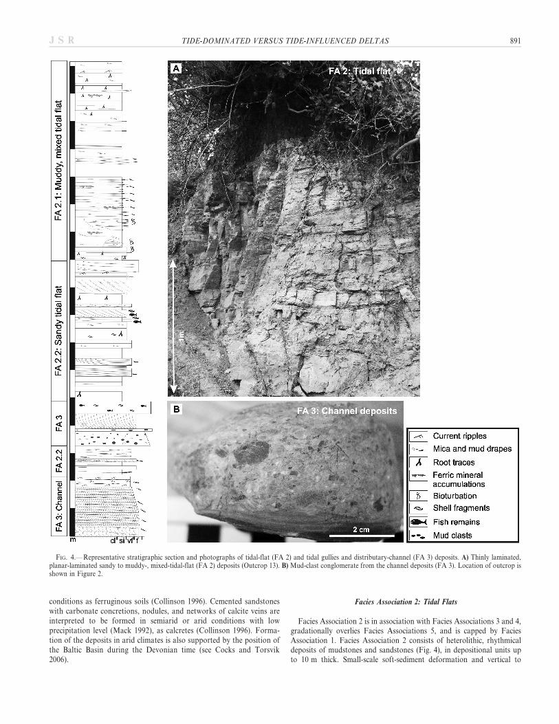
Facies Association 2 is in association with Facies Associations 3 and 4,gradationally overlies Facies Associations 5, and is capped by FaciesAssociation 1. Facies Association 2 consists of heterolithic, rhythmicaldeposits of mudstones and sandstones (Fig. 4), in depositional units upto 10 m thick. Small-scale soft-sediment deformation and vertical to
FIG. 4.— Representative stratigraphic section and photographs of tidal-flat (FA 2) and tidal gullies and distributary-channel (FA 3) deposits. A) Thinly laminated,planar-laminated sandy to muddy-, mixed-tidal-flat (FA 2) deposits (Outcrop 13). B) Mud-clast conglomerate from the channel deposits (FA 3). Location of outcrop isshown in Figure 2.
TIDE-DOMINATED VERSUS TIDE-INFLUENCED DELTAS 891J S R
892 K. TANAVSUU-MILKEVICIENE AND P. PLINK-BJORKLUND J S R
subvertical simple trace fossils occur throughout the units (Fig. 5A). Roottraces (Fig. 5B), shell fragments, and fish-scale fragments are alsocommon. In many places, deposits are red and rich in ferric mineralaccumulations that occur as thin layers or aggregates (Table 1). FaciesAssociation 2 can be divided into two types: (1) deposits where mudstonesand siltstones dominate, and (2) deposits where sandstones dominate. Thefirst type, Facies Association 2.1 consists of homogeneous (Facies 1),thinly laminated (Facies 2), and lenticular- and wavy-bedded mudstonesand siltstones (Facies 3), 0.1–1.5 m thick, with planar-laminated andcurrent-ripple-laminated sandstone (Facies 7) interlayers or interbeds upto 0.25 m thick. Locally, gray lenticular and wavy-bedded siltstones(Facies 3) occur together with structureless and bioturbated red siltstones(Facies 4). Carbonate-cemented siltstones (Facies 1) and dolomiticmarlstones (Facies 16), up to 1.3 m thick occur (Fig. 4A).
The second type, Facies Association 2.2, consists of flaser-bedded(Facies 8), planar-laminated, current-ripple-laminated (Facies 7), andplanar cross-stratified sandstones (Facies 10; Table 1) 0.05–1.3 m thick,rich in mud and mica drapes (Fig. 5C). In places, structureless sandstonesoccur (Facies 6; Table 1). Sandstones are interbedded with planar-laminated and current-ripple-laminated (Facies 2) or homogeneous(Facies 1) mudstones and siltstones up to 0.45 m thick. Carbonate clastsand carbonate-cemented bed tops occur in structureless sandstones.
Facies Association 2 is best exposed in cores. In outcrops, FaciesAssociation 2 is not always a cliff former and tends to be partially covered(Figs. 4A, 6A, B). In outcrops, Facies Association 2 occurs as laterallydiscontinuous beds with maximum lateral extent of 70 m and a height ofup to 2.5 m.
Interpretation.—Flaser-, wavy-, lenticular-bedded, and thinly laminat-ed heterolithic and rhythmical deposits suggest deposition by low-energytidal currents, most likely on tidal flats (e.g., Reineck and Wunderlich1968; Yoshida et al. 2001). The mudstone- and siltstone-rich lenticular-and wavy-bedded deposits, together with bioturbated siltstones andcurrent-ripple-laminated sandstone layers and interbeds in FaciesAssociation 2.1, indicate deposition on a lower-energy muddy supratidalor mixed, upper-intertidal flat (Dalrymple et al. 1991). The overall sandyheterolithic deposits in Facies Association 2.2 indicate strong tidalcurrents and deposition on a higher-energy sandy, lower-intertidal flatnear the channel or tidal creek thalweg (Dalrymple 1992; Davis andFlemming 1995).
Facies Association 3: Tidal Gullies and Distributary Channels
Facies Association 3 occurs as laterally discontinuous, erosionallybased units, up to 3 m thick, within Facies Associations 2 and 4. FaciesAssociation 3 consists of upward-fining depositional units. The lower partof unit consists of plane-parallel (Facies 9), planar- and trough-cross-stratified (Facies 10) and structureless (Facies 6) fine- and medium-grained sandstones that grade upwards into planar-laminated andcurrent-ripple-laminated siltstones and mudstones (Facies 2) and veryfine-grained sandstones (Facies 7). Locally, mud-clast conglomerate(Facies 15), as well as shell and fish fragments occur at the bases ofdepositional units or along the bases of the beds (Fig. 4B). Bidirectionaldip directions in adjacent cross sets are common in cross-stratifieddeposits. Mica and mud drapes, and mud lenses with variable thickness,
are also common. Facies Association 3 is documented only in coreslocated in the northern and central parts of the basin.
Interpretation.—The small-scale upward-fining depositional units ofdominantly cross-stratified sandstones with conglomerate beds, and shelland fish fragments at the bases of the units, indicate deposition fromhigh-energy currents in channels (Dalrymple et al. 1991; Willis et al.1999). Bidirectional dip direction of cross-strata and mica and muddrapes suggest deposition by tidal currents (Nio and Yang 1991b). Inaddition to the latter, Facies Association 3 is laterally equivalent withFacies Associations 2 and 4, which suggests deposition in tidal gullies ortidally influenced distributary-channels.
Facies Association 4: Supratidal Muds
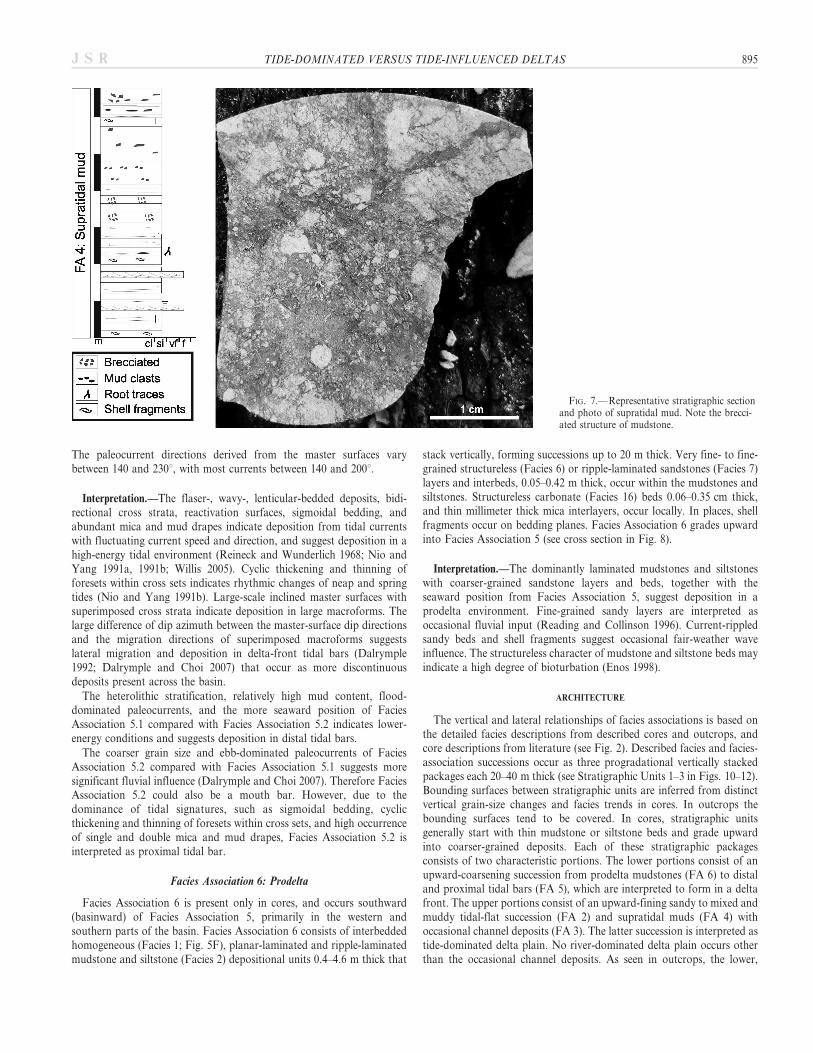
Facies Association 4 occurs in the western part of the basin, inassociation with Facies Associations 2 and 3, and passes laterallybasinward into Facies Association 6. Facies Association 4 consists of 0.1–1.8 m thick beds of red and gray homogeneous (Facies 1), brecciated(Facies 5), planar-laminated (Facies 2) mudstones and siltstones thatform units up to 10 m thick (Fig. 7, Table 1). Planar-laminated andripple-laminated very fine- to fine-grained sandstones up to 0.2 m thick(Facies 7) occur in places. No wave ripples are found. Locally, depositscontain mud clasts, isolated root traces, and shell fragments. Bioturbationis very rare. Structureless carbonate (Facies 16) interbeds occur in fewplaces. Facies Association 4 is represented only in cores.
Interpretation.—The homogenous, planar-laminated mudstone unitssuggest deposition in low-energy conditions. The occasional sandstonebeds and mud clasts indicate rare current events. The occurrence ofbrecciated deposits and isolated root traces suggests subaerial orsupratidal conditions. The predominance of mudstone and rare coarser-grained interbeds suggests deposition in areas that received minimalamounts of sand.
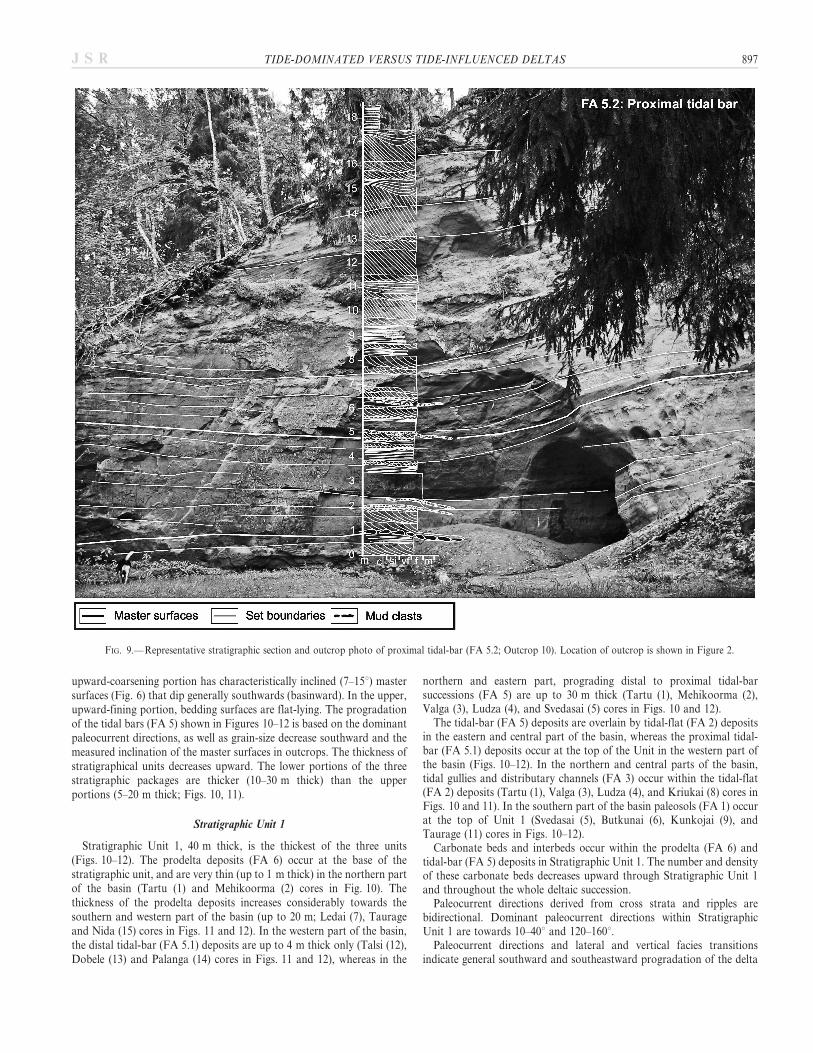
Facies Associations 5: Tidal Bar
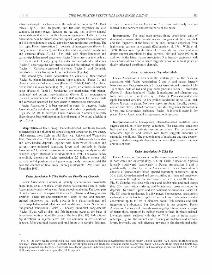
Facies Association 5 occurs across the whole basin and is well exposedin both cores and outcrops (Figs. 6, 8, 9). Facies Association 5 passeslaterally southward (basinward) to Facies Association 6 and isgradationally overlain by Facies Association 2. Facies Association 5consists of gradationally based upward-coarsening successions, up to30 m thick. Cross-laminated and cross-stratified siltstones and sandstonesare common throughout the succession (Facies 2, 9, and 10; Table 1,Fig. 8). Complex cross sets with single and double mica and mud drapes(Fig. 5D), reactivation surfaces, and bidirectional cross sets occur indeposits. Overturned ripples and soft-sediment deformations (Facies 13;Fig. 5E) occur in sandstones. In a few places, homogeneous, structurelesscarbonate (Facies 16) beds up to 0.3 m thick and carbonate-cementedconcretions up to 0.7 cm in diameter occur. Fish remains and shellfragments are abundant, but bioturbation is less common. FaciesAssociation 5 consists of upward-coarsening depositional units, a coupleof meters thick, separated by inclined master surfaces. In places inclined,low-angle master surfaces with dips of 7–15u can be traced acrossoutcrops (Fig. 6). The amount and frequency of mudstone and siltstonelayers, interbeds, and beds decrease upwards in the depositional units.
r
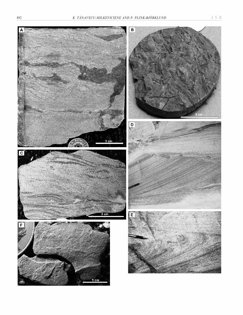
FIG. 5.—A) Wavy-bedded deposits with small-scale deformation and vertical and subvertical trace fossils in muddy-, mixed-tidal-flat (FA 2.1) deposits. B) Root tracesin muddy-, mixed-tidal-flat (FA 2.1) deposits. C) Current ripple-laminated sandstones with mud drapes in sandy-tidal-flat (FA 2.2) deposits. D) Single and double micadrapes in proximal-tidal-bar (FA 5.2) deposits. Note the rip-up clasts on bedding plane. E) Soft-sediment deformations and mica drapes in proximal tidal-bars (FA 5.2).F) Homogeneous mudstones in prodelta (FA 6) deposits.
TIDE-DOMINATED VERSUS TIDE-INFLUENCED DELTAS 893J S R
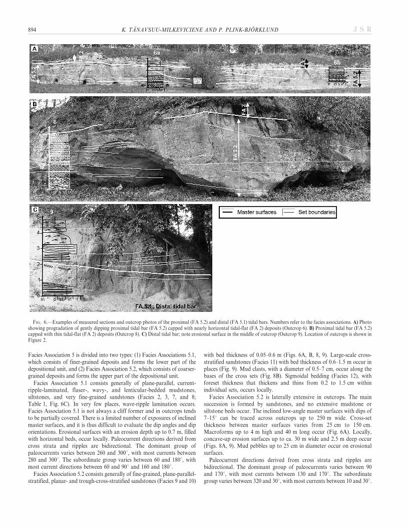
Facies Association 5 is divided into two types: (1) Facies Associations 5.1,which consists of finer-grained deposits and forms the lower part of thedepositional unit, and (2) Facies Association 5.2, which consists of coarser-grained deposits and forms the upper part of the depositional unit.
Facies Association 5.1 consists generally of plane-parallel, current-ripple-laminated, flaser-, wavy-, and lenticular-bedded mudstones,siltstones, and very fine-grained sandstones (Facies 2, 3, 7, and 8;Table 1, Fig. 6C). In very few places, wave-ripple lamination occurs.Facies Association 5.1 is not always a cliff former and in outcrops tendsto be partially covered. There is a limited number of exposures of inclinedmaster surfaces, and it is thus difficult to evaluate the dip angles and diporientations. Erosional surfaces with an erosion depth up to 0.7 m, filledwith horizontal beds, occur locally. Paleocurrent directions derived fromcross strata and ripples are bidirectional. The dominant group ofpaleocurrents varies between 260 and 300u, with most currents between280 and 300u. The subordinate group varies between 60 and 180u, withmost current directions between 60 and 90u and 160 and 180u.
Facies Association 5.2 consists generally of fine-grained, plane-parallel-stratified, planar- and trough-cross-stratified sandstones (Facies 9 and 10)
with bed thickness of 0.05–0.6 m (Figs. 6A, B, 8, 9). Large-scale cross-stratified sandstones (Facies 11) with bed thickness of 0.6–1.5 m occur inplaces (Fig. 9). Mud clasts, with a diameter of 0.5–7 cm, occur along thebases of the cross sets (Fig. 8B). Sigmoidal bedding (Facies 12), withforeset thickness that thickens and thins from 0.2 to 1.5 cm withinindividual sets, occurs locally.
Facies Association 5.2 is laterally extensive in outcrops. The mainsuccession is formed by sandstones, and no extensive mudstone orsiltstone beds occur. The inclined low-angle master surfaces with dips of7–15u can be traced across outcrops up to 250 m wide. Cross-setthickness between master surfaces varies from 25 cm to 150 cm.Macroforms up to 4 m high and 40 m long occur (Fig. 6A). Locally,concave-up erosion surfaces up to ca. 30 m wide and 2.5 m deep occur(Figs. 8A, 9). Mud pebbles up to 25 cm in diameter occur on erosionalsurfaces.
Paleocurrent directions derived from cross strata and ripples arebidirectional. The dominant group of paleocurrents varies between 90and 170u, with most currents between 130 and 170u. The subordinategroup varies between 320 and 30u, with most currents between 10 and 30u.
FIG. 6.—Examples of measured sections and outcrop photos of the proximal (FA 5.2) and distal (FA 5.1) tidal bars. Numbers refer to the facies associations. A) Photoshowing progradation of gently dipping proximal tidal bar (FA 5.2) capped with nearly horizontal tidal-flat (FA 2) deposits (Outcrop 6). B) Proximal tidal bar (FA 5.2)capped with thin tidal-flat (FA 2) deposits (Outcrop 8). C) Distal tidal bar; note erosional surface in the middle of outcrop (Outcrop 9). Location of outcrops is shown inFigure 2.
894 K. TANAVSUU-MILKEVICIENE AND P. PLINK-BJORKLUND J S R
The paleocurrent directions derived from the master surfaces varybetween 140 and 230u, with most currents between 140 and 200u.
Interpretation.—The flaser-, wavy-, lenticular-bedded deposits, bidi-rectional cross strata, reactivation surfaces, sigmoidal bedding, andabundant mica and mud drapes indicate deposition from tidal currentswith fluctuating current speed and direction, and suggest deposition in ahigh-energy tidal environment (Reineck and Wunderlich 1968; Nio andYang 1991a, 1991b; Willis 2005). Cyclic thickening and thinning offoresets within cross sets indicates rhythmic changes of neap and springtides (Nio and Yang 1991b). Large-scale inclined master surfaces withsuperimposed cross strata indicate deposition in large macroforms. Thelarge difference of dip azimuth between the master-surface dip directionsand the migration directions of superimposed macroforms suggestslateral migration and deposition in delta-front tidal bars (Dalrymple1992; Dalrymple and Choi 2007) that occur as more discontinuousdeposits present across the basin.
The heterolithic stratification, relatively high mud content, flood-dominated paleocurrents, and the more seaward position of FaciesAssociation 5.1 compared with Facies Association 5.2 indicates lower-energy conditions and suggests deposition in distal tidal bars.
The coarser grain size and ebb-dominated paleocurrents of FaciesAssociation 5.2 compared with Facies Association 5.1 suggests moresignificant fluvial influence (Dalrymple and Choi 2007). Therefore FaciesAssociation 5.2 could also be a mouth bar. However, due to thedominance of tidal signatures, such as sigmoidal bedding, cyclicthickening and thinning of foresets within cross sets, and high occurrenceof single and double mica and mud drapes, Facies Association 5.2 isinterpreted as proximal tidal bar.
Facies Association 6: Prodelta
Facies Association 6 is present only in cores, and occurs southward(basinward) of Facies Association 5, primarily in the western andsouthern parts of the basin. Facies Association 6 consists of interbeddedhomogeneous (Facies 1; Fig. 5F), planar-laminated and ripple-laminatedmudstone and siltstone (Facies 2) depositional units 0.4–4.6 m thick that
stack vertically, forming successions up to 20 m thick. Very fine- to fine-grained structureless (Facies 6) or ripple-laminated sandstones (Facies 7)layers and interbeds, 0.05–0.42 m thick, occur within the mudstones andsiltstones. Structureless carbonate (Facies 16) beds 0.06–0.35 cm thick,and thin millimeter thick mica interlayers, occur locally. In places, shellfragments occur on bedding planes. Facies Association 6 grades upwardinto Facies Association 5 (see cross section in Fig. 8).
Interpretation.—The dominantly laminated mudstones and siltstoneswith coarser-grained sandstone layers and beds, together with theseaward position from Facies Association 5, suggest deposition in aprodelta environment. Fine-grained sandy layers are interpreted asoccasional fluvial input (Reading and Collinson 1996). Current-rippledsandy beds and shell fragments suggest occasional fair-weather waveinfluence. The structureless character of mudstone and siltstone beds mayindicate a high degree of bioturbation (Enos 1998).
ARCHITECTURE
The vertical and lateral relationships of facies associations is based onthe detailed facies descriptions from described cores and outcrops, andcore descriptions from literature (see Fig. 2). Described facies and facies-association successions occur as three progradational vertically stackedpackages each 20–40 m thick (see Stratigraphic Units 1–3 in Figs. 10–12).Bounding surfaces between stratigraphic units are inferred from distinctvertical grain-size changes and facies trends in cores. In outcrops thebounding surfaces tend to be covered. In cores, stratigraphic unitsgenerally start with thin mudstone or siltstone beds and grade upwardinto coarser-grained deposits. Each of these stratigraphic packagesconsists of two characteristic portions. The lower portions consist of anupward-coarsening succession from prodelta mudstones (FA 6) to distaland proximal tidal bars (FA 5), which are interpreted to form in a deltafront. The upper portions consist of an upward-fining sandy to mixed andmuddy tidal-flat succession (FA 2) and supratidal muds (FA 4) withoccasional channel deposits (FA 3). The latter succession is interpreted astide-dominated delta plain. No river-dominated delta plain occurs otherthan the occasional channel deposits. As seen in outcrops, the lower,
FIG. 7.— Representative stratigraphic sectionand photo of supratidal mud. Note the brecci-ated structure of mudstone.
TIDE-DOMINATED VERSUS TIDE-INFLUENCED DELTAS 895J S R
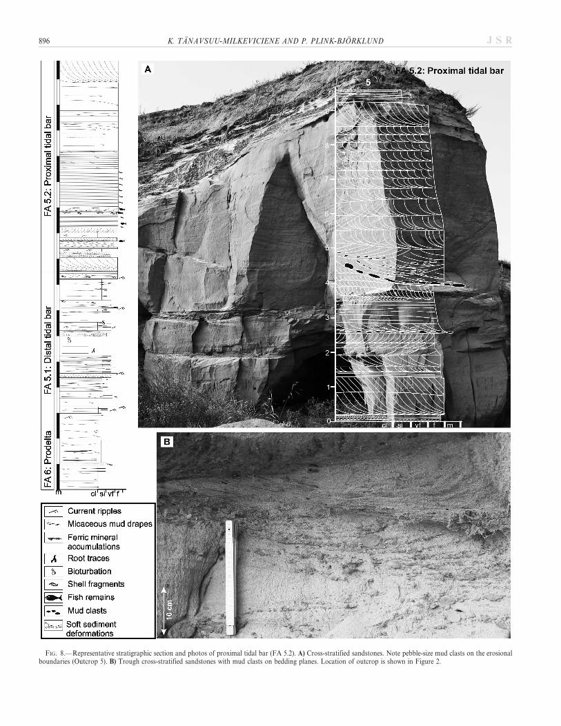
FIG. 8.—Representative stratigraphic section and photos of proximal tidal bar (FA 5.2). A) Cross-stratified sandstones. Note pebble-size mud clasts on the erosionalboundaries (Outcrop 5). B) Trough cross-stratified sandstones with mud clasts on bedding planes. Location of outcrop is shown in Figure 2.
896 K. TANAVSUU-MILKEVICIENE AND P. PLINK-BJORKLUND J S R
upward-coarsening portion has characteristically inclined (7–15u) mastersurfaces (Fig. 6) that dip generally southwards (basinward). In the upper,upward-fining portion, bedding surfaces are flat-lying. The progradationof the tidal bars (FA 5) shown in Figures 10–12 is based on the dominantpaleocurrent directions, as well as grain-size decrease southward and themeasured inclination of the master surfaces in outcrops. The thickness ofstratigraphical units decreases upward. The lower portions of the threestratigraphic packages are thicker (10–30 m thick) than the upperportions (5–20 m thick; Figs. 10, 11).
Stratigraphic Unit 1
Stratigraphic Unit 1, 40 m thick, is the thickest of the three units(Figs. 10–12). The prodelta deposits (FA 6) occur at the base of thestratigraphic unit, and are very thin (up to 1 m thick) in the northern partof the basin (Tartu (1) and Mehikoorma (2) cores in Fig. 10). Thethickness of the prodelta deposits increases considerably towards thesouthern and western part of the basin (up to 20 m; Ledai (7), Taurageand Nida (15) cores in Figs. 11 and 12). In the western part of the basin,the distal tidal-bar (FA 5.1) deposits are up to 4 m thick only (Talsi (12),Dobele (13) and Palanga (14) cores in Figs. 11 and 12), whereas in the
northern and eastern part, prograding distal to proximal tidal-barsuccessions (FA 5) are up to 30 m thick (Tartu (1), Mehikoorma (2),Valga (3), Ludza (4), and Svedasai (5) cores in Figs. 10 and 12).
The tidal-bar (FA 5) deposits are overlain by tidal-flat (FA 2) depositsin the eastern and central part of the basin, whereas the proximal tidal-bar (FA 5.1) deposits occur at the top of the Unit in the western part ofthe basin (Figs. 10–12). In the northern and central parts of the basin,tidal gullies and distributary channels (FA 3) occur within the tidal-flat(FA 2) deposits (Tartu (1), Valga (3), Ludza (4), and Kriukai (8) cores inFigs. 10 and 11). In the southern part of the basin paleosols (FA 1) occurat the top of Unit 1 (Svedasai (5), Butkunai (6), Kunkojai (9), andTaurage (11) cores in Figs. 10–12).
Carbonate beds and interbeds occur within the prodelta (FA 6) andtidal-bar (FA 5) deposits in Stratigraphic Unit 1. The number and densityof these carbonate beds decreases upward through Stratigraphic Unit 1and throughout the whole deltaic succession.
Paleocurrent directions derived from cross strata and ripples arebidirectional. Dominant paleocurrent directions within StratigraphicUnit 1 are towards 10–40u and 120–160u.
Paleocurrent directions and lateral and vertical facies transitionsindicate general southward and southeastward progradation of the delta
FIG. 9.— Representative stratigraphic section and outcrop photo of proximal tidal-bar (FA 5.2; Outcrop 10). Location of outcrop is shown in Figure 2.
TIDE-DOMINATED VERSUS TIDE-INFLUENCED DELTAS 897J S R
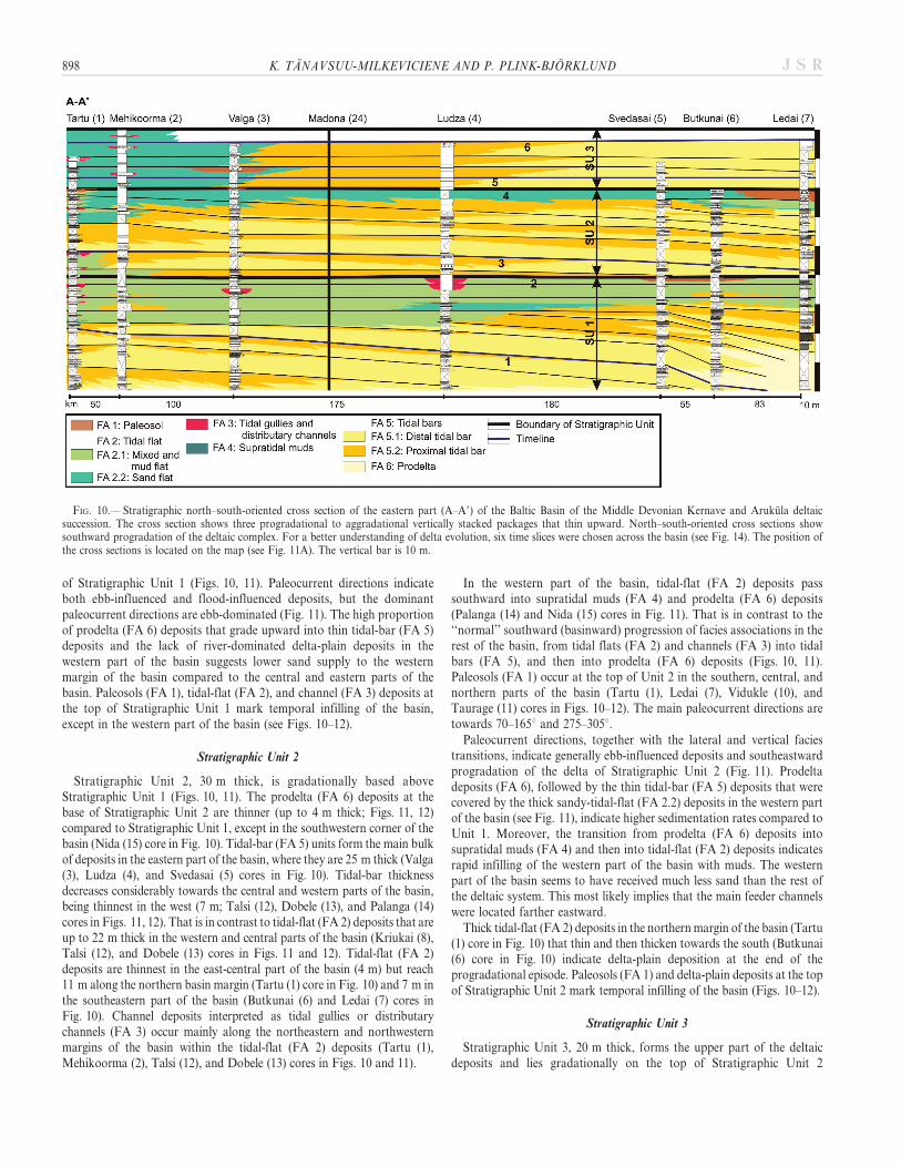
of Stratigraphic Unit 1 (Figs. 10, 11). Paleocurrent directions indicateboth ebb-influenced and flood-influenced deposits, but the dominantpaleocurrent directions are ebb-dominated (Fig. 11). The high proportionof prodelta (FA 6) deposits that grade upward into thin tidal-bar (FA 5)deposits and the lack of river-dominated delta-plain deposits in thewestern part of the basin suggests lower sand supply to the westernmargin of the basin compared to the central and eastern parts of thebasin. Paleosols (FA 1), tidal-flat (FA 2), and channel (FA 3) deposits atthe top of Stratigraphic Unit 1 mark temporal infilling of the basin,except in the western part of the basin (see Figs. 10–12).
Stratigraphic Unit 2
Stratigraphic Unit 2, 30 m thick, is gradationally based aboveStratigraphic Unit 1 (Figs. 10, 11). The prodelta (FA 6) deposits at thebase of Stratigraphic Unit 2 are thinner (up to 4 m thick; Figs. 11, 12)compared to Stratigraphic Unit 1, except in the southwestern corner of thebasin (Nida (15) core in Fig. 10). Tidal-bar (FA 5) units form the main bulkof deposits in the eastern part of the basin, where they are 25 m thick (Valga(3), Ludza (4), and Svedasai (5) cores in Fig. 10). Tidal-bar thicknessdecreases considerably towards the central and western parts of the basin,being thinnest in the west (7 m; Talsi (12), Dobele (13), and Palanga (14)cores in Figs. 11, 12). That is in contrast to tidal-flat (FA 2) deposits that areup to 22 m thick in the western and central parts of the basin (Kriukai (8),Talsi (12), and Dobele (13) cores in Figs. 11 and 12). Tidal-flat (FA 2)deposits are thinnest in the east-central part of the basin (4 m) but reach11 m along the northern basin margin (Tartu (1) core in Fig. 10) and 7 m inthe southeastern part of the basin (Butkunai (6) and Ledai (7) cores inFig. 10). Channel deposits interpreted as tidal gullies or distributarychannels (FA 3) occur mainly along the northeastern and northwesternmargins of the basin within the tidal-flat (FA 2) deposits (Tartu (1),Mehikoorma (2), Talsi (12), and Dobele (13) cores in Figs. 10 and 11).
In the western part of the basin, tidal-flat (FA 2) deposits passsouthward into supratidal muds (FA 4) and prodelta (FA 6) deposits(Palanga (14) and Nida (15) cores in Fig. 11). That is in contrast to the‘‘normal’’ southward (basinward) progression of facies associations in therest of the basin, from tidal flats (FA 2) and channels (FA 3) into tidalbars (FA 5), and then into prodelta (FA 6) deposits (Figs. 10, 11).Paleosols (FA 1) occur at the top of Unit 2 in the southern, central, andnorthern parts of the basin (Tartu (1), Ledai (7), Vidukle (10), andTaurage (11) cores in Figs. 10–12). The main paleocurrent directions aretowards 70–165u and 275–305u.
Paleocurrent directions, together with the lateral and vertical faciestransitions, indicate generally ebb-influenced deposits and southeastwardprogradation of the delta of Stratigraphic Unit 2 (Fig. 11). Prodeltadeposits (FA 6), followed by the thin tidal-bar (FA 5) deposits that werecovered by the thick sandy-tidal-flat (FA 2.2) deposits in the western partof the basin (see Fig. 11), indicate higher sedimentation rates compared toUnit 1. Moreover, the transition from prodelta (FA 6) deposits intosupratidal muds (FA 4) and then into tidal-flat (FA 2) deposits indicatesrapid infilling of the western part of the basin with muds. The westernpart of the basin seems to have received much less sand than the rest ofthe deltaic system. This most likely implies that the main feeder channelswere located farther eastward.
Thick tidal-flat (FA 2) deposits in the northern margin of the basin (Tartu(1) core in Fig. 10) that thin and then thicken towards the south (Butkunai(6) core in Fig. 10) indicate delta-plain deposition at the end of theprogradational episode. Paleosols (FA 1) and delta-plain deposits at the topof Stratigraphic Unit 2 mark temporal infilling of the basin (Figs. 10–12).
Stratigraphic Unit 3
Stratigraphic Unit 3, 20 m thick, forms the upper part of the deltaicdeposits and lies gradationally on the top of Stratigraphic Unit 2
FIG. 10.— Stratigraphic north–south-oriented cross section of the eastern part (A–A9) of the Baltic Basin of the Middle Devonian Kernave and Arukula deltaicsuccession. The cross section shows three progradational to aggradational vertically stacked packages that thin upward. North–south-oriented cross sections showsouthward progradation of the deltaic complex. For a better understanding of delta evolution, six time slices were chosen across the basin (see Fig. 14). The position ofthe cross sections is located on the map (see Fig. 11A). The vertical bar is 10 m.
898 K. TANAVSUU-MILKEVICIENE AND P. PLINK-BJORKLUND J S R
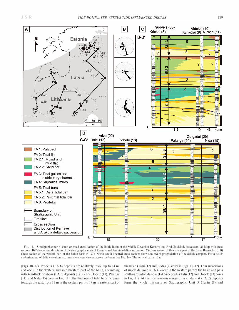
(Figs. 10–12). Prodelta (FA 6) deposits are relatively thick, up to 14 m,and occur in the western and southwestern part of the basin, alternatingwith 4-m-thick tidal-bar (FA 5) deposits (Talsi (12), Dobele (13), Palanga(14), and Nida (15) cores in Fig. 11). The thickness of tidal bars increasestowards the east, from 11 m in the western part to 17 m in eastern part of
the basin (Talsi (12) and Ludza (4) cores in Figs. 10–12). Thin successionsof supratidal muds (FA 4) occur in the western part of the basin and passsouthward into tidal-bar (FA 5) deposits (Talsi (12) and Dobele (13) coresin Fig. 11). At the northeastern margin, thick tidal-flat (FA 2) depositsform the whole thickness of Stratigraphic Unit 3 (Tartu (1) and
FIG. 11.—Stratigraphic north–south-oriented cross section of the Baltic Basin of the Middle Devonian Kernave and Arukula deltaic succession. A) Map with crosssections. B) Paleocurrent directions of the stratigraphic units of Kernave and Arukula deltaic succession. C) Cross section of the central part of the Baltic Basin (B–B9). D)Cross section of the western part of the Baltic Basin (C–C9). North–south-oriented cross sections show southward progradation of the deltaic complex. For a betterunderstanding of delta evolution, six time slices were chosen across the basin (see Fig. 14). The vertical bar is 10 m.
TIDE-DOMINATED VERSUS TIDE-INFLUENCED DELTAS 899J S R
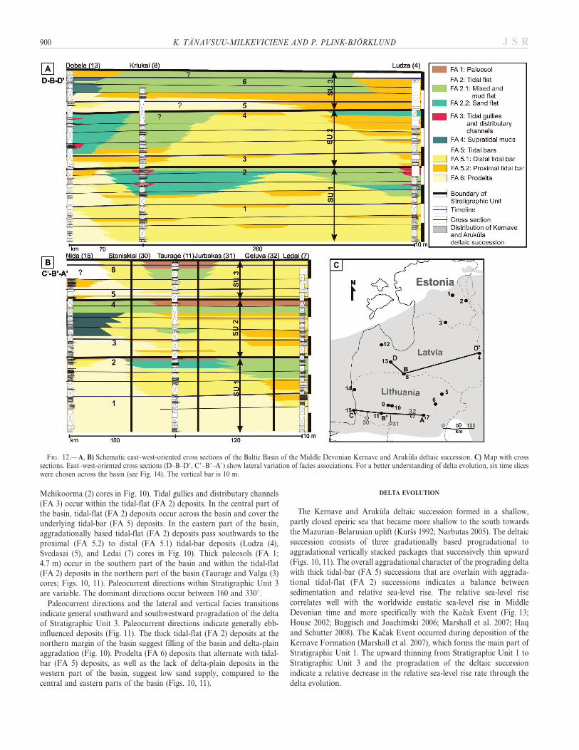
Mehikoorma (2) cores in Fig. 10). Tidal gullies and distributary channels(FA 3) occur within the tidal-flat (FA 2) deposits. In the central part ofthe basin, tidal-flat (FA 2) deposits occur across the basin and cover theunderlying tidal-bar (FA 5) deposits. In the eastern part of the basin,aggradationally based tidal-flat (FA 2) deposits pass southwards to theproximal (FA 5.2) to distal (FA 5.1) tidal-bar deposits (Ludza (4),Svedasai (5), and Ledai (7) cores in Fig. 10). Thick paleosols (FA 1;4.7 m) occur in the southern part of the basin and within the tidal-flat(FA 2) deposits in the northern part of the basin (Taurage and Valga (3)cores; Figs. 10, 11). Paleocurrent directions within Stratigraphic Unit 3are variable. The dominant directions occur between 160 and 330u.
Paleocurrent directions and the lateral and vertical facies transitionsindicate general southward and southwestward progradation of the deltaof Stratigraphic Unit 3. Paleocurrent directions indicate generally ebb-influenced deposits (Fig. 11). The thick tidal-flat (FA 2) deposits at thenorthern margin of the basin suggest filling of the basin and delta-plainaggradation (Fig. 10). Prodelta (FA 6) deposits that alternate with tidal-bar (FA 5) deposits, as well as the lack of delta-plain deposits in thewestern part of the basin, suggest low sand supply, compared to thecentral and eastern parts of the basin (Figs. 10, 11).
DELTA EVOLUTION
The Kernave and Arukula deltaic succession formed in a shallow,partly closed epeiric sea that became more shallow to the south towardsthe Mazurian–Belarusian uplift (Kurss 1992; Narbutas 2005). The deltaicsuccession consists of three gradationally based progradational toaggradational vertically stacked packages that successively thin upward(Figs. 10, 11). The overall aggradational character of the prograding deltawith thick tidal-bar (FA 5) successions that are overlain with aggrada-tional tidal-flat (FA 2) successions indicates a balance betweensedimentation and relative sea-level rise. The relative sea-level risecorrelates well with the worldwide eustatic sea-level rise in MiddleDevonian time and more specifically with the Kacak Event (Fig. 13;House 2002; Buggisch and Joachimski 2006; Marshall et al. 2007; Haqand Schutter 2008). The Kacak Event occurred during deposition of theKernave Formation (Marshall et al. 2007), which forms the main part ofStratigraphic Unit 1. The upward thinning from Stratigraphic Unit 1 toStratigraphic Unit 3 and the progradation of the deltaic successionindicate a relative decrease in the relative sea-level rise rate through thedelta evolution.
FIG. 12.—A, B) Schematic east–west-oriented cross sections of the Baltic Basin of the Middle Devonian Kernave and Arukula deltaic succession. C) Map with crosssections. East–west-oriented cross sections (D–B–D9, C9–B9–A9) show lateral variation of facies associations. For a better understanding of delta evolution, six time sliceswere chosen across the basin (see Fig. 14). The vertical bar is 10 m.
900 K. TANAVSUU-MILKEVICIENE AND P. PLINK-BJORKLUND J S R
The lateral and vertical association of the facies associations indicatesdeposition in a tide-dominated delta. The main volume of deltaicdeposits, as tidal bars (FA 5) and sandy tidal flats (FA 2.2), accumulatedon the delta front and on the subaqueous delta plain (Figs. 10, 11). Thesubaerial deposits, paleosols (FA 1), muddy and mixed tidal flat (FA 2.1),and supratidal muds (FA 4) occur at the top of the prograding tidal bars(FA 5) and adjacent to the distributary channels. The overall subaqueouscharacter of the deposits and the occurrence of marine fauna (see Mark-Kurik 1995) suggests that the Kernave and Arukula deltaic successionformed as a dominantly subaqueous, tide-dominated delta. Marine faunacommonly occur in subaqueous delta deposits (Cattaneo et al. 2003).
Reconstructions of the evolution of the Kernave and Arukula deltaicsuccession (Fig. 14) are based on detailed analysis of facies and faciesassociations and on tectonic background. The exact position of rivers isnot known. However, areas with higher sand content are interpreted tohave been closer to the river input than the areas that have higher mudcontent. The position of facies associations is based on the coredescriptions; cores from the literature are used to clarify the boundariesbetween facies associations. The orientations of tidal bars (FA 5) arebased on the paleocurrent data. The position of the shoreline isapproximate and follows existing facies models of tide-dominatedsystems.
During delta evolution, the depositional architecture and deltamorphology changed from Stratigraphic Unit 1 through 3, includinglateral changes between eastern and western parts of the basin. In thebeginning of the delta evolution, prodelta (FA 6) deposits were graduallycovered with distal tidal-bar (FA 5.1) deposits that formed in the mainpart of the basin. Proximal tidal-bar (FA 5.2) deposits occurred in thenortheastern part of the basin (Fig. 14 T1; Tartu, Mehikoorma, Valga,and Ludza cores). Large delta lobes formed in the eastern part of thebasin (Fig. 14 T1). At the end of deposition of Stratigraphic Unit 1,proximal tidal bars (FA 5.2) prograded southward and tidal-flat (FA 2)deposits occurred in the northern part of the basin (Fig. 14 T2). Thickaggrading prodelta (FA 6) to distal tidal-bar (FA 5.1) deposits indicate
lower sand input into the western part of the basin, whereas the thicksandy tidal-bar (FA 5) deposits in the central and eastern parts of thebasin suggest that the main sand inflow was directed to those parts of thebasin (Fig. 14 T1, T2). The occurrence of tidal flats (FA 2) and paleosols(FA 1) in the southern part of the basin is interpreted to be related to theMazurian–Belarusian uplift (Narbutas 2005) south of the Baltic Basin,due to shallower water depths at the southern basin margin.
Sediment input from the Mazurian–Belarusian uplift to the BalticBasin is, however, unlikely, because of documented paleocurrentdirections as well as paleogeographic reconstructions (see also Pontenand Plink-Bjorklund 2007; Tanavsuu-Milkeviciene et al. 2009). There-fore, we suggest the tidal bars (FA 5) in the southern part of the basinfilled the accommodation space due the lower water depths and werecapped by the tidal-flat (FA 2) and paleosol (FA 1) deposits.
In Stratigraphic Unit 2, sediment input increased dramatically. Sandwas mainly dispersed to the eastern part of the basin, and input of finer-grained silts and muds dominated the western and central parts of thebasin (Fig. 14 T3). Large volumes of fine-grained sediments transportedto the western and central parts of the basin formed thick tidal-flat (FA 2)and supratidal-mud (FA 4) deposits and filled the basin rapidly (Fig. 14T3, T4). At the end of Stratigraphic Unit 2 time, thick paleosol (FA 1)deposits formed in the southern and central parts of the basin.
In Stratigraphic Unit 3, the occurrence of tidal-flat (FA 2) deposits inthe central part of the basin and prograding-tidal-bar (FA 5) deposits ineastern and western part of the basin suggest two well-developed inputareas to the Baltic Basin. However, prograding-prodelta (FA 6) to tidal-bar (FA 5) deposits indicate somewhat lower sand input to the westernpart of the basin, whereas the thick tidal-bar (FA 5) deposits in theeastern part indicate main sand inflow to the eastern part of the basin(Fig. 14 T5). The occurrence of tidal-flat deposits (FA 2) in the northernmargin of the basin throughout Stratigraphic Unit 3 indicates formationof locally subaerial delta-plain deposits (Fig. 14 T6).
DISCUSSION
Differentiating Tide-Dominated Deltas Versus Tide-Dominated Estuaries
Tide-dominated deltas have been considered to be very similar to tide-dominated estuaries, so that even their very existence has been questioned(see Walker 1992). However, deltas, including tide-dominated deltas, arefundamentally different from estuaries (see discussions in Dalrymple et al.1992; Boyd et al. 2006; Dalrymple 2006; Dalrymple and Choi 2007). Thestudied tide-dominated Kernave and Arukula deltaic succession clearlyshows some fundamental differences. (1) The studied successions indicateoverall basinward (southward) fining, as it was fed by river systems to thenorth and northeast. An estuarine system, in contrast, would showcoarser grain size at either end of the system, due to a fluvial and marinesediment source (see Dalrymple et al. 1992; Boyd et al. 2006; Dalrymple2006; Dalrymple and Choi 2007). (2) In the studied Kernave and Arukulasystem, the prodelta and delta-front tidal-bar succession consists ofgradationally based, upward-coarsening mudstones to sandstones (FAs 6and 5) that prograded basinward (southward). Similar gradationalprodelta to tidal-bar deposits have been documented in other tide-dominated deltas, such as the Frewens sandstone in Wyoming (Willis etal. 1999). In estuaries, tidal bars are based by tidal ravinement surfaces orare underlain by estuarine and fluvial facies in more landward positions(Dalrymple et al. 1992; Dalrymple and Zaitlin 1994; Plink-Bjorklund2005; Boyd et al. 2006; Dalrymple and Choi 2007; Plink-Bjorklund 2008).(3) The tide-dominated delta system described in this paper showsbidirectional paleocurrent directions. However, the dominant paleocur-rent directions are ebb-dominated, i.e., basinward, even in the mostbasinward tidal bars. In a tide-dominated estuary, a landward sedimentflux from the marine end of the system would favor flood dominance inestuarine tidal bars (Friedrichs and Aubrey 1988). In conclusion, we
FIG. 13.— Relative-sea-level chart of Devonian time and positions of theKernave–Arukula deltaic succession, and the Kacak Event. The Kernave andArukula deltaic succession correlates well with overall relative sea-level rise.Modified after Marshall et al. (2007); Haq and Schutter (2008).
TIDE-DOMINATED VERSUS TIDE-INFLUENCED DELTAS 901J S R
902 K. TANAVSUU-MILKEVICIENE AND P. PLINK-BJORKLUND J S R
suggest that the overall basinward fining, overall ebb-dominatedpaleocurrent directions, and gradational upward coarsening fromprodelta muds to sandy tidal bars, in concert with their overall regressivevs. transgressive character, are useful and distinct criteria for differenti-ating tide-dominated deltas from tide-dominated estuaries (see discus-sions in Dalrymple et al. 1992; Boyd et al. 2006; Dalrymple 2006;Dalrymple and Choi 2007).
Differentiating Tide-Dominated Versus Tide-Influenced Deltas
Tide-dominated deltaic deposits are defined as progradational sedi-mentary bodies where tidal currents redeposit more sediments than riveror wave currents, change significantly the geometry of sediment bodies,and include high amounts of tidal bundles, reactivation surfaces, muddrapes, heterolithic stratification, and bidirectional stratification (Nioand Yang 1991b; Willis et al. 1999; Willis and Gabel 2001; Hori et al.2002b; Willis 2005; Bhattacharya 2006; Dalrymple and Choi 2007).However, the presence of tidal features does not necessarily ensure correctidentification and interpretation of tide-dominated deltas from tide-influenced deltas or from other tide-dominated environments, especiallyin ancient successions where the abundance of tide-dominated facies isnot enough to indicate tidal dominance of the larger environment dueerosion during transgression (Dalrymple and Choi 2007).
The delta succession described here contains ubiquitous mica andmud drapes, tidal bundles, and reactivation surfaces, and lacks majorregional erosion surfaces. The subaqueous nature of deposits and lackof a well developed river-dominated delta plain suggests that the tidalcurrents were strong enough to rework most river-supplied sediments(see also Table 2). Thus, the Kernave and Arukula deltaic succession isinterpreted as a tide-dominated delta. Similar ancient tide-dominateddelta deposits have been identified in the upper Cretaceous FrontierFormation in the Frewens sandstones in central Wyoming, USA (Williset al. 1999). The Fly River delta has been used as a modern example oftide-dominated deltas (Dalrymple et al. 2003). However, the conceptabove presented would not work at the presence of major erosionsurfaces, e.g., removal of wave-built barrier and preservation of back-barrier tidal facies.
Tide-influenced delta deposits should also include signs of tidalreworking, such as tidal bundles, mud drapes, and heterolithicstratification, but vertical and lateral density of these features is low,and the fluvial, unidirectional current features dominate the succession,e.g., the Middle Devonian Gauja Formation in the Baltic Basin (Pontenand Plink-Bjorklund 2007). Moreover, tidal signatures have beendocumented to occur mainly on the delta front, whereas the delta plainis river-dominated with some tidal influence in the lower-delta-plainreaches, such as seen in the Middle Devonian Gauja Formation (Pontenand Plink-Bjorklund 2007), or in the Mahakam River delta in Indonesia(Storms et al. 2005; see also Table 2).
In many modern tide-influenced deltas, tidal currents reach farupstream only during extreme spring tides and storm surges, or whenriver discharge is low. For example, tidal currents reach 20 km upstreamfrom the delta apex in the Mahakam River tide-influenced delta (Stormset al. 2005), and up to 50 km from the river mouth in the Huang He(Yellow River) delta (Saito et al. 2001). In contrast, in modern tide-dominated deltas, tidal currents reach up to 120 km inland in the RajangRiver delta (Staub et al. 2000), 290 km upstream in the Changjiang
(Yangtze River) delta (Hori et al. 2002a), and up to 400 km upstream inthe Fly River delta (Dalrymple et al. 2003).
Controls on Formation of Tide-Dominated and Tide-Influenced Deltas
Modern tide-dominated deltas form mainly on macrotidal coasts,whereas tide-influenced deltas occur generally on microtidal andmesotidal coasts. However, it is difficult to document tidal range inancient deposits. In the shallow epeiric Middle Devonian Baltic Basin, thehigh degree of tidal reworking throughout the Middle Devoniansuccession could be assigned to macrotidal conditions, but couldalternatively be explained by the basin configuration, since the BalticBasin was a restricted basin with low wave energy. Moreover, the tidalrange may partially be a function of coastal configuration. The funnelshape of a tide-dominated delta would magnify the tidal effect due tolateral confinement. As a delta prograded to the mouth of this funnel-shaped bay, the confinement effect would disappear, and the tidal rangemight change.
The development of tide-dominated vs. tide-influenced deltas must atleast partially be controlled by differences in fluvial sediment supply anddeposition rates, as tide-dominated deltas are suggested to form where tidalcurrents are able to rework most of the river-derived sediment (Dalrympleand Choi 2007). This could be supported by high subsidence rates oreustatic sea-level rise to create conditions where river supply is not highenough to ensure river-dominated delta-plain aggradation. However, manytide-influenced deltas form in areas with high subsidence rates, like theMahakam River delta (Roberts and Sydow 2003) or deltas in Brunei Bay(Lambiase et al. 2003). This indicates that high subsidence rates alone arenot sufficient to generate tide-dominated deltas if the accommodationincrease is balanced by increased sediment supply, or if tidal energy is nothigh enough. One of the effects of tidal reworking might be an efficientremoval of fluvially derived sediment from the river mouth, and this mayprevent mouth-bar buildup and formation of a subaerial river-dominateddelta plain. In places where the fluvial sediment supply is high enough tooverwhelm the capacity of the tidal currents to rework the sediment, ariver-dominated subaerial delta plain develops. In contrast, in the deltacomplex described here, tidal currents were able to rework most of theriver-derived sediment, and delta-plain deposits consist mainly of partiallysubaqueous tidal-flat deposits. No extensive river-dominated delta plainformed (see Fig. 14). Similarly, in the Fly River delta, the delta-plaindeposits consist of distributary channels, islands, and tidal flats on the topsof the islands (Dalrymple et al. 2003). In the tide-dominated Changjiang(Yangtze River) delta, the subaqueous delta plain is characterized bysubtidal- to lower intertidal flats, upper intertidal flats, and surface soildeposits, and there is no extensive subaerial river-dominated delta plain(Hori et al. 2002b). Also, in the Amazon delta, the relatively small deltaplain consists of islands (Warne et al. 2002). All of these deltas have beenforming during the last 8–6 thousand years, during decreasing rates of sea-level rise in the Holocene, and prograde across filled incised valleys orestuaries (Hori et al. 2002b; Dalrymple et al. 2003). Similarly, the tide-dominated delta succession documented here prograded across thetransgressive Eifelian shallow marine succession and formed during a risein relative sea level (see Fig. 13). This is in contrast to the younger, tide-influenced-delta deposits of the Middle Devonian Gauja Formation, whichdeveloped extensive subaerial, river-dominated delta plains, tide-influencedlower-delta-plains, and delta fronts (see Ponten and Plink-Bjorklund 2007).
r
FIG. 14.—Paleogeographic maps showing the progradation and retrogradation of the Kernave and Arukula deltaic succession. T1 and T2 show the delta evolutionduring Stratigraphic Unit 1 Time; T3 and T4 show the delta evolution during Stratigraphic Unit 2 Time; T5 and T6 show the delta evolution during Stratigraphic Unit 3Time. The position of time slices is shown in Figures 10–12. Black circles mark described cores; gray circles mark cores described in the literature.
TIDE-DOMINATED VERSUS TIDE-INFLUENCED DELTAS 903J S R
The Gauja Formation deltas prograded across earlier deltaic deposits ofthe Kernave and Arukula formations documented here, as well as theBurtnieki Formation. Similarly, the Mahakam delta is built on the top ofan older delta succession that formed earlier in the Holocene. Following thedeltaic evolution in the Middle Devonian Baltic Basin, we suggest that tide-dominated deltas tend to evolve with time into tide-influenced deltas, whenthey prograde to the mouth of their restricted bay, in basins where the rateof fluvial sediment supply exceeds the rate of accommodation increase (seealso Table 2).
CONCLUSIONS
Detailed sedimentological study of the Middle Devonian Kernave andArukula deposits in the Baltic Basin documents three gradationally basedstratigraphical units that thin upwards. Each stratigraphical unit consistsof progradational and aggradational successions that form two charac-teristics portions. The lower upward-coarsening portion consists ofprodelta to distal-tidal-bar and proximal-tidal-bar deposits. The upperupward-fining portion consists of tidal flat, supratidal muds, occasionaltidal gully and distributary channel, and paleosol deposits. The muddyprodelta, tidal-flat, and supratidal mud deposits in the western part of thebasin indicate lower sand input compared with the central and easternpart of the basin, where thick sandy tidal-bar deposits formed. Theoverall high occurrence of tidal signatures, such as mica and mud drapes,tidal bundles, heterolithic stratification, and bidirectional paleocurrents,as well as dominance of subaqueous depositional environments, indicatesdeposition in a tide-dominated delta.
We suggest here that tide-dominated-delta deposits form where tidalcurrents are able to efficiently remove and rework the fluvially derivedsediment and result in a deltaic succession that lacks significantvolumes of fluvial deposits. Such deltas are subaqueous with noextensive river-dominated delta plain and lack river- or wave-dominated deposits. Tide-dominated-delta deposits are limited to therestricted and, in many cases, macrotidal bays. In such deltas, tidalsignatures occur throughout the deltaic succession. During deltaevolution, the tide-dominated deltas tend to develop into tide-influenced deltas when they prograde to the mouth of the restrictedor funnel-shaped bay, at the point where the rate of fluvial sedimentsupply exceeds the rate of accommodation increase. Tide-influenceddeltas form a well developed subaerial delta plain; tidal signaturesoccur mainly in the delta-front and lower-delta-plain deposits, whereasthe upper delta plain is river-dominated. Due to the progradation ofthe delta, the confinement effect disappears, and the tidal range mightchange into microtidal or mesotidal.
ACKNOWLEDGMENTS
This work was financed by Swedish Institute grant 2003-3391 from theSwedish Research Council, by Estonian Science Foundation grant 5372, bygrant from Doctoral School of Ecology and Environmental Sciences, and bya Postgraduate Grant Scheme from the International Association ofSedimentologists. We thank Anne Kleesment and Girts Stinkulis for valuablediscussions and for significant input on regional stratigraphy. This paper hasbenefited greatly from reviewers Bob Dalrymple and Brian Willis, AssociateEditor Janok Bhattacharya, Editor Paul McCarthy, and CorrespondingEditor John Southard’s thoughtful comments.
REFERENCES
ALEKSEEV, A.S., KONONOVA, L.I., AND NIKISHIN, A.M., 1996, The Devonian andCarboniferous of the Moscow Syneclise (Russian Platform): stratigraphy and sea-levelchanges: Tectonophysics, v. 268, p. 149–168.
BHATTACHARYA, J.P., 2006, Deltas, in Posamentier, H.W., and Walker, R.G., eds.,Facies Models Revisited: SEPM, Special Publication 84, p. 237–292.
BOYD, R., DALRYMPLE, R.W., AND ZAITLIN, B.A., 2006, Estuary and incised valley faciesmodels, in Posamentier, H.W., and Walker, R.G., eds., Facies Models Revisited:SEPM, Special Publication 84, p. 171–234.
BUGGISCH, W., AND JOACHIMSKI, M.M., 2006, Carbon isotope stratigraphy of theDevonian of Central and Southern Europe: Palaeogeography, Palaeoclimatology,Palaeoecology, v. 240, p. 68–88.
CATTANEO, A., CORREGGIARI, A., LANGONE, L., AND TRINCARDI, F., 2003, The late-Holocene Gargano subaqueous delta, Adriatic shelf: sediment pathways and supplyfluctuations: Marine Geology, v. 193, p. 61–91.
CHOI, K.S., DALRYMPLE, R.W., CHUN, S.S., AND KIM, S.P., 2004, Sedimentology ofmodern, inclined heterolithic stratification (IHS) in the macrotidal Han River delta,Korea: Journal of Sedimentary Research, v. 74, p. 677–689.
COCKS, L.R.M., AND TORSVIK, T.H., 2006, European geography in a global context fromthe Vendian to the end of the Palaeozoic, in Gee, D.G., and Stephenson, R.A., eds.,European Lithosphere Dynamics: Geological Society of London, Memoir 32, p. 83–95.
COLLINSON, J.D., 1996, Alluvial sediments, in Reading, H.G., ed., SedimentaryEnvironments; Processes, Facies and Stratigraphy: Oxford, U.K., Blackwell Science,p. 37–82.
DALRYMPLE, R.W., 1992, Tidal depositional systems, in Walker, R.G., and James, N.P.,eds., Facies Models; Response to Sea Level Change: St. John’s, Newfoundland,Geological Association of Canada, p. 195–238.
DALRYMPLE, R.W., 2006, Incised valleys in time and space: an introduction to thevolume and an examination of the controls on valley formation and filling, inDalrymple, R.W., Leckie, D.A., and Tillman, R.W., eds., Incised Valleys in Time andSpace: SEPM, Special Publication 85, p. 5–12.
DALRYMPLE, R.W., AND CHOI, K., 2007, Morphologic and facies trends through thefluvial–marine transition in tide-dominated depositional systems: a schematicframework for environmental and sequence-stratigraphic interpretation: Earth-Science Reviews, v. 81, p. 135–174.
DALRYMPLE, R.W., AND ZAITLIN, B.A., 1994, High-resolution sequence stratigraphy of acomplex, incised valley succession, the Cobequid Bay–Salmon River estuary, Bay ofFundy, Canada: Sedimentology, v. 41, p. 1069–1091.
DALRYMPLE, R.W., MANKINO, Y., AND ZAITLIN, B.A., 1991, Temporal and spatialpatterns of rhythmite deposition on mud flats in the macrotidal Cobequid Bay–Salmon River estuary, Bay of Fundy, Canada, in Smith, D.G., Reinson, G.E., Zaitlin,B.A., and Rahmani, R.A., eds., Clastic Tidal Sedimentology: Canadian Society ofPetroleum Geologists, Memoir 16, p. 3–28.
TABLE 2.— Main features of tide-dominated and tide-influenced deltas.
Features Tide-dominated delta Tide-influenced delta
Form In modern: mainly on macrotidal to upper mesotidal coasts In modern: mainly on microtidal to mesotidal coastIn ancient: difficult to recognize In ancient: difficult to recognize
Depositional features Deposits are dominated by tidal features: single and double muddrapes, tidal bundles, heterolithic stratification, bidirectionalstratification, reactivation surfaces
Tide-, river-, or wave-influenced deposits may occur. Tidal featureslike single and double mud drapes, tidal bundles, heterolithicstratification and bidirectional stratification may occur but donot dominate the deposits
Delta front Tidal bars, fluvially derived sediments tidally reworked Mouthbars, delta-front deposits with some tidal reworkingDelta plain Tidal flats, tidal gullies, and distributary channels, no fluvially
dominated delta plainWell developed upper and lower delta plain. Upper delta plain is
river-dominated and lower delta plain is tide or/and wave–influenced, numerous distributary channels occur
Controls Tidal currents are strong enough to control and to rework mostof fluvially derived deposits. Prograde across incised valleys orestuaries and tend to develop to tide-influenced deltas
High sediment supply that overcomes tidal currents. In many casesform on the top of older deltaic deposits
904 K. TANAVSUU-MILKEVICIENE AND P. PLINK-BJORKLUND J S R
DALRYMPLE, R.W., ZAITLIN, B.A., AND BOYD, R., 1992, Estuarine facies models:conceptual basis and stratigraphic implications: Journal of Sedimentary Petrology,v. 62, p. 1130–1146.
DALRYMPLE, R.W., BAKER, E.K., HARRIS, P.T., AND HUGHES, M.G., 2003, Sedimentol-ogy and stratigraphy of a tide-dominated, foreland-basin delta (Fly River, Papua NewGuinea), in Hasan Sidi, F., Nummedal, D., Imbert, P., Darman, H., and Posamentier,H.W., eds., Tropical Deltas of Southeast Asia—Sedimentology, Stratigraphy, andPetroleum Geology: SEPM, Special Publication 76, p. 147–173.
DAVIS, R.A., AND FLEMMING, B.W., 1995, Stratigraphy of a combined wave- and tide-dominated intertidal sand body: Martens Plate, East Frisian Wadden Sea, Germany,in Flemming, B.W., and Bartholoma, A., eds., Tidal Signatures in Modern andAncient sediments: International Association of Sedimentologists, Special Publication24, p. 121–132.
ENOS, P., 1998, Shelf Environment, in Scholle, P.A., Bebout, D.G., and Moore, C.H.,eds., Carbonate Depositional Environments: American Association of PetroleumGeologists, Memoir 33, p. 268–295.
FRIEDRICHS, C.T., AND AUBREY, D.G., 1988, Non-linear tidal distortion in shallow well-mixed estuaries: a synthesis: Estuarine, Coastal and Shelf Science, v. 27, p. 521–545.
HARRIS, P.T., BAKER, E.K., COLE, A.R., AND SHORT, S.A., 1993, A preliminary study ofsedimentation in the tidally dominated Fly River Delta, Gulf of Papua: ContinentalShelf Research, v. 13, p. 441–472.
HAQ, B.U., AND SCHUTTER, S.R., 2008, A chronology of Paleozoic sea-level changes:Science, v. 322, p. 64–68.
HEAP, A.D., BRYCE, S., AND RYAN, D.A., 2004, Facies evolution of Holocene estuariesand deltas: a large-sample statistical study from Australia: Sedimentary Geology,v. 168, p. 1–17.
HORI, K., SAITO, Y., ZHAO, Q., AND WANG, P., 2002a, Architecture and evolution of thetide-dominated Changjiang (Yangtze) River delta, China: Sedimentary Geology,v. 146, p. 249–264.
HORI, K., SAITO, Y., ZHAO, Q., AND WANG, P., 2002b, Evolution of the coastaldepositional systems of the Changjiang (Yangtze) river in response to late Pleistocene–Holocene sea-level changes: Journal of Sedimentary Research, v. 72, p. 884–897.
HORI, K., TANABE, S., SAITO, Y., HARUYAMA, S., NGUYEN, V., AND KITAMURA, A., 2004,Delta initiation and Holocene sea-level change: example from the Song Hong (RedRiver) delta, Vietnam: Sedimentary Geology, v. 164, p. 237–249.
HOUSE, M., 2002, Strength, timing, setting and cause of mid-Palaeozoic extinctions:Palaeogeography, Palaeoclimatology, Palaeoecology, v. 181, p. 5–25.
KAUFMANN, B., 2006, Calibrating the Devonian Time Scale: a synthesis of U-Pb ID-TIMS ages and conodont stratigraphy: Earth-Science Reviews, v. 76, p. 175–190.
KITAZAWA, T., 2007, Pleistocene macrotidal tide-dominated estuary–delta succession,along the Dong Nai River, southern Vietnam: Sedimentary Geology, v. 194, p. 115–140.
KLEESMENT, A., 1997, Devonian sedimentation basin, in Raukas, A., and Teedumae, A.,eds., Geology and mineral resources of Estonia: Tallinn, Estonian AcademyPublishers, p. 205–208.
KLEESMENT, A., AND MARK-KURIK, E., 1997, Middle Devonian, in Raukas, A., andTeedumae, A., eds., Geology and Mineral Resources of Estonia: Tallinn, EstonianAcademy Publishers, p. 112–121.
KLEESMENT, A., AND SHOGENOVA, A., 2005, Lithology and evolution of Devoniancarbonate and carbonate-cemented rocks in Estonia: Estonian Academy of Sciences,Proceedings, Geology, v. 54, p. 153–180.
KLEESMENT, A., MARK-KURIK, E., AND VALIUKEVICIUS, J., 1987, On nomenklature ofsubstages of the Narva Regional Stage: Proceedings, Academy of Science, EstonianSSR, v. 36, p. 174–175.
KURSS, V., 1992, The Devonian Clastic Sedimentation in the Main Devonian Field:Riga, Zinatne, 208 p.
LAMBIASE, J.J., DAMIT, A.R., SIMMONS, M.D., ABDOERRIAS, R., AND HUSSIN, A., 2003, Adepositional model and the stratigraphic development of modern and ancient tide-dominated deltas in NW Borneo, in Hasan Sidi, F., Nummedal, D., Imbert, P., Darman,H., and Posamentier, H.W., eds., Tropical Deltas of Southeast Asia—Sedimentology,Stratigraphy, and Petroleum Geology: SEPM, Special Publication 76, p. 109–123.
MACK, G.H., 1992, Paleosols as an indicator of climatic change at early Late Cretaceousboundary, southwestern New Mexico: Journal of Sedimentary Petrology, v. 62, p.483–494.
MARK-KURIK, E., 1995, Trophic relations of Devonian fishes: Geobios, v. 28, p.121–123.
MARSHALL, J.E.A., ASTIN, T.R., BROWN, J.F., MARK-KURIK, E., AND LAZAUSKIENE, J.,2007, Recognizing the Kacak Event in the Devonian terrestrial environment and itsimplications for understanding land–sea interactions, in Becker, R.T., and Kirchgas-ser, W.T., eds., Devonian Events and Correlations: Geological Society of London,Special Publication 278, p. 133–155.
MELLERE, D., AND STEEL, R., 1996, Tidal sedimentation in Inner Hebrides half grabens,Scotland: the mid-Jurassic Bearreraig Sandstone Formation, in De Batist, M., andJacobs, P., eds., Geology of Siliciclastic Shelf Seas: Geological Society of London,Special Publication 117, p. 49–79.
NARBUTAS, V., 2005, Sedimentological–palaeogeographical maps for Ledai and Kernavetimes of the Middle Devonian, in Zuzevicius, A., ed., Evolution of Geological Environmentin Lithuania: Institute of Geology and Geography, Vilnius University, Vilnius, 308 p.
NIO, S.D., AND YANG, C.S., 1991a, Sea-level fluctuations and the geometric variability oftide-dominated sandbodies: Sedimentary Geology, v. 70, p. 161–172, 179–193.
NIO, S.D., AND YANG, C.S., 1991b, Diagnostic attributes of clastic tidal deposits: areview, in Smith, D.G., Reinson, G.E., Zaitlin, B.A., and Rahmani, R.A., eds., ClasticTidal Sedimentology: Canadian Society of Petroleum Geologists, Memoir 16, p. 3–28.
PASKEVICIUS, J., 1997. The Geology of The Baltic Republics: Vilnius, Vilnius University,Geological Survey of Lithuania, 387 p.
PLINK-BJORKLUND, P., 2005, Stacked fluvial and tide-dominated estuarine deposits inhigh-frequency (fourth-order) sequences of the Eocene Central Basin, Spitsbergen:Sedimentology, v. 52, p. 391–428.
PLINK-BJORKLUND, P., 2008, Wave-to-tide facies change in a Campanian shorelinecomplex, Chimney Rock Tongue, Wyoming–Utah, U.S.A., in Hampson, G.J., Steel,R.J., Burgess, P.M., and Dalrymple, R.W., eds., Recent Advances in Models ofSiliciclastic Shallow-Marine Stratigraphy: SEPM, Special Publication 90, p. 265–291.
PLINK-BJORKLUND, P., AND BJORKLUND, L., 1999, Sedimentary response in the Baltic Basinto postcollisional events in the Scandinavian Caledonides: GFF, v. 121, p. 79–80.
PLINK-BJORKLUND, P., ROBERTS, D., AND BJORKLUND, L., 2004. The Baltic Basinstratigraphic record: reflections of tectonothermal and magmatic events in theScandinavian Caledonides and Trans-European Suture Zone (abstract): 26th NordicGeological Winter Meeting, January 6–9, Uppsala.
PONTEN, A., AND PLINK-BJORKLUND, P., 2007, Depositional environments in an extensivetide-influenced delta-plain, Middle Devonian Gauja Formation, Devonian BalticBasin: Sedimentology, v. 54, p. 969–1006.
READING, H.G., AND COLLINSON, J.D., 1996, Clastic coasts, in Reading, H.G., ed.,Sedimentary Environments; Processes, Facies and Stratigraphy: Oxford, U.K.,Blackwell Science, p. 154–228.
REINECK, H.E., AND WUNDERLICH, F., 1968, Classification and origin of flaser andlenticular bedding: Sedimentology, v. 11, p. 99–104.
ROBERTS, H.H., AND SYDOW, J., 2003, Late Quaternary stratigraphy and sedimentologyof the offshore Mahakam delta, East Kalimantan (Indonesia), in Hasan Sidi, F.,Nummedal, D., Imbert, P., Darman, H., and Posamentier, H.W., eds., TropicalDeltas of Southeast Asia—Sedimentology, Stratigraphy, and Petroleum Geology:SEPM, Special Publication 76, p. 125–145.
RUSKIN, B.G., AND JORDAN, T.E., 2007, Climate change across continental sequenceboundaries: paleopedology and lithofacies of Iglesia Basin, northwestern Argentina:Journal of Sedimentary Research, v. 77, p. 661–679.
SAITO, Y., YANG, Z., AND HORI, K., 2001, The Huanghe (Yellow River) and Changjiang(Yangtze River) deltas: a review on their characteristics, evolution and sedimentdischarge during the Holocene: Geomorphology, v. 41, p. 219–231.
STAUB, J.R., AMONG, H.L., AND GASTALDO, R.A., 2000, Seasonal sediment transport anddeposition in the Rajang River delta, Sarawak, East Malaysia: Sedimentary Geology,v. 133, p. 249–264.
STORMS, J.E.A., HOOGENDOORN, R.M., DAM, R.A.C., HOITINK, A.J.F., AND KROONEN-
BERG, S.B., 2005, Late Holocene evolution of the Mahakam delta, East Kalimantan,Indonesia: Sedimentary Geology, v. 180, p. 149–166.
TANAVSUU-MILKEVICIENE, K., PLINK-BJORKLUND, P., KIRSIMAE, K., AND AINSAAR, L.,2009, Coeval versus reciprocal mixed carbonate–siliciclastic deposition, MiddleDevonian Baltic Basin, Eastern Europe: Implications from the regional tectonicdevelopment: Sedimentology, v. 56, p. 1250–1274.
TARDY, Y., AND ROQUIN, C., 1992, Geochemistry and evolution of lateritic landscapes, inMartini, I.P., and Chesworth, W., eds., Weathering, Soils and Paleosols: Amsterdam,Elsevier, p. 407–444.
TOVMASYAN, K., 2004. Tidal features in siliciclastic deposits of Parnu Formation, MiddleDevonian, Estonia (abstract): 32nd International Geological Congress, Resumes, Part2, p. 902–903.
VALIUKEVICIUS, J., AND KRUCHEK, S., 2000, Acanthodian biostratigraphy andinterregional correlations of the Devonian of the Baltic States, Belarus, Ukraineand Russia: Courier Forschungsinstiut Senckenberg, v. 223, p. 271–289.
VALIUKEVICIUS, J., KLEESMENT, A., MARK-KURIK, E., AND VAITEKUNENE, G., 1986,Correlation and fossil remains of the deposits of the Narva Stage, in Brangulis, A.P.,ed., Biofacies and Fauna of East Baltic Silurian and Devonian Sedimentation Basins:Zinatne, Riga, p. 73–86.
WALKER, R.G., 1992, Facies, facies models and modern stratigraphic concepts, inWalker, R.G., and James, N.P., eds., Facies Models; Response to Sea Level Change:St. John’s, Newfoundland, Geological Association of Canada, p. 1–14.
WARNE, A.G., MEADE, R.H., WHITE, W.A., GUEVARA, E.H., GIBEAUT, J., SMYTH, R.C.,ASLAN, A., AND TREMBLAY, T., 2002, Regional controls on geomorphology, hydrology, andecosystem integrity in the Orinoco Delta, Venezuela: Geomorphology, v. 44, p. 273–307.
WILLIS, B.J., 2005, Deposits of tide-influenced river deltas, in Giosan, L., andBhattacharya, J.P., eds., River Deltas—Concepts, Models, and Examples: SEPM,Special Publication 83, p. 87–129.
WILLIS, B.J., AND GABEL, S., 2001, Sharp-based, tide-dominated deltas of the SegoSandstone, Book Cliffs, Utah, USA: Sedimentology, v. 48, p. 479–506.
WILLIS, B.J., AND GABEL, S.L., 2003, Formation of deep incisions into tide-dominatedriver deltas: implications for the stratigraphy of the Sego Sandstone, Book Cliffs,Utah, U.S.A.: Journal of Sedimentary Research, v. 73, p. 246–263.
WILLIS, B.J., BHATTACHARYA, J.P., GABEL, S.L., AND WHITE, C.D., 1999, Architecture ofa tide-influenced river delta in the Frontier Formation of central Wyoming, USA:Sedimentology, v. 46, p. 667–688.
YOSHIDA, S., JACKSON, M.D., JOHNSON, H.D., MUGGERIDGE, A.H., AND MARTINIUS,A.W., 2001, Outcrop studies of tidal sandstones for reservoir characterization (LowerCretaceous Vectis Formation, Isle of Wight, southern England), in Martinsen, O.J.,and Dreyer, T., eds., Sedimentary Environments Offshore Norway—Paleozoic toRecent: Norwegian Petroleum Society, Special Publication 10, p. 233–257.
Received 3 February 2009; accepted 3 August 2009.
TIDE-DOMINATED VERSUS TIDE-INFLUENCED DELTAS 905J S R