qwu?gwes - a squaxin island tribal heritage wet site, puget sound, usa
TRANSCRIPT
134
archaeology from the wetlands: recent perspectives
135
qwu?gwes – a squaxin island tribal heritage wet site, puget sound, usa
Qwu?gwes – a Squaxin Island tribal heritage wet site, Puget Sound, USA
DALE R CROES, RHONDA FOSTER, LARRY ROSS, MELANIE DIEDRICH,NEA HUBBARD, KATHERINE KELLY, MANDY McCULLOUGH,
TOM McCULLOUGH, KAREN MYERS, CASSANDRA SHARRON, BARBARA VARGO, REBECCA WIGEN and LAUREN VALLEY
QWU?GWES LOCATION AND CULTURAL IDENTIFICATION
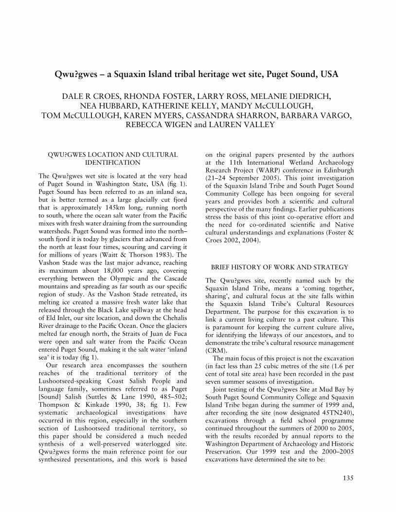
The Qwu?gwes wet site is located at the very head of Puget Sound in Washington State, USA (fig 1). Puget Sound has been referred to as an inland sea, but is better termed as a large glacially cut fjord that is approximately 145km long, running north to south, where the ocean salt water from the Pacific mixes with fresh water draining from the surrounding watersheds. Puget Sound was formed into the north–south fjord it is today by glaciers that advanced from the north at least four times, scouring and carving it for millions of years (Waitt & Thorson 1983). The Vashon Stade was the last major advance, reaching its maximum about 18,000 years ago, covering everything between the Olympic and the Cascade mountains and spreading as far south as our specific region of study. As the Vashon Stade retreated, its melting ice created a massive fresh water lake that released through the Black Lake spillway at the head of Eld Inlet, our site location, and down the Chehalis River drainage to the Pacific Ocean. Once the glaciers melted far enough north, the Straits of Juan de Fuca were open and salt water from the Pacific Ocean entered Puget Sound, making it the salt water ‘inland sea’ it is today (fig 1).
Our research area encompasses the southern reaches of the traditional territory of the Lushootseed-speaking Coast Salish People and language family, sometimes referred to as Puget [Sound] Salish (Suttles & Lane 1990, 485–502; Thompson & Kinkade 1990, 38; fig 1). Few systematic archaeological investigations have occurred in this region, especially in the southern section of Lushootseed traditional territory, sothis paper should be considered a much needed synthesis of a well-preserved waterlogged site. Qwu?gwes forms the main reference point for our synthesized presentations, and this work is based
on the original papers presented by the authors at the 11th International Wetland Archaeology Research Project (WARP) conference in Edinburgh (21–24 September 2005). This joint investigation of the Squaxin Island Tribe and South Puget Sound Community College has been ongoing for several years and provides both a scientific and cultural perspective of the many findings. Earlier publications stress the basis of this joint co-operative effort and the need for co-ordinated scientific and Native cultural understandings and explanations (Foster & Croes 2002, 2004).
BRIEF HISTORY OF WORK AND STRATEGY
The Qwu?gwes site, recently named such by the Squaxin Island Tribe, means a ‘coming together, sharing’, and cultural focus at the site falls within the Squaxin Island Tribe’s Cultural Resources Department. The purpose for this excavation is to link a current living culture to a past culture. This is paramount for keeping the current culture alive, for identifying the lifeways of our ancestors, and to demonstrate the tribe’s cultural resource management (CRM).
The main focus of this project is not the excavation (in fact less than 25 cubic metres of the site (1.6 per cent of total site area) have been recorded in the past seven summer seasons of investigation.
Joint testing of the Qwu?gwes Site at Mud Bay by South Puget Sound Community College and Squaxin Island Tribe began during the summer of 1999 and, after recording the site (now designated 45TN240), excavations through a field school programme continued throughout the summers of 2000 to 2005, with the results recorded by annual reports to the Washington Department of Archaeology and Historic Preservation. Our 1999 test and the 2000–2005 excavations have determined the site to be:
136
archaeology from the wetlands: recent perspectives
137
qwu?gwes – a squaxin island tribal heritage wet site, puget sound, usa
FIGURE 1
Location of the Qwu?gwes wet site in southern Puget Sound and southern Coast Salish Lushootseed language speakers. Other sites are wet sites that have basketry that interrelates in style to the examples recovered from Qwu?gwes (see Croes, Kelly & Collard 2005 for statistical comparisons) (Base map adapted from Suttles, W (ed) 1990 Handbook of the North American Indians. Vol 7: The Northwest Coast.
Smithsonian Institution, Washington DC).
136
archaeology from the wetlands: recent perspectives
137
qwu?gwes – a squaxin island tribal heritage wet site, puget sound, usa
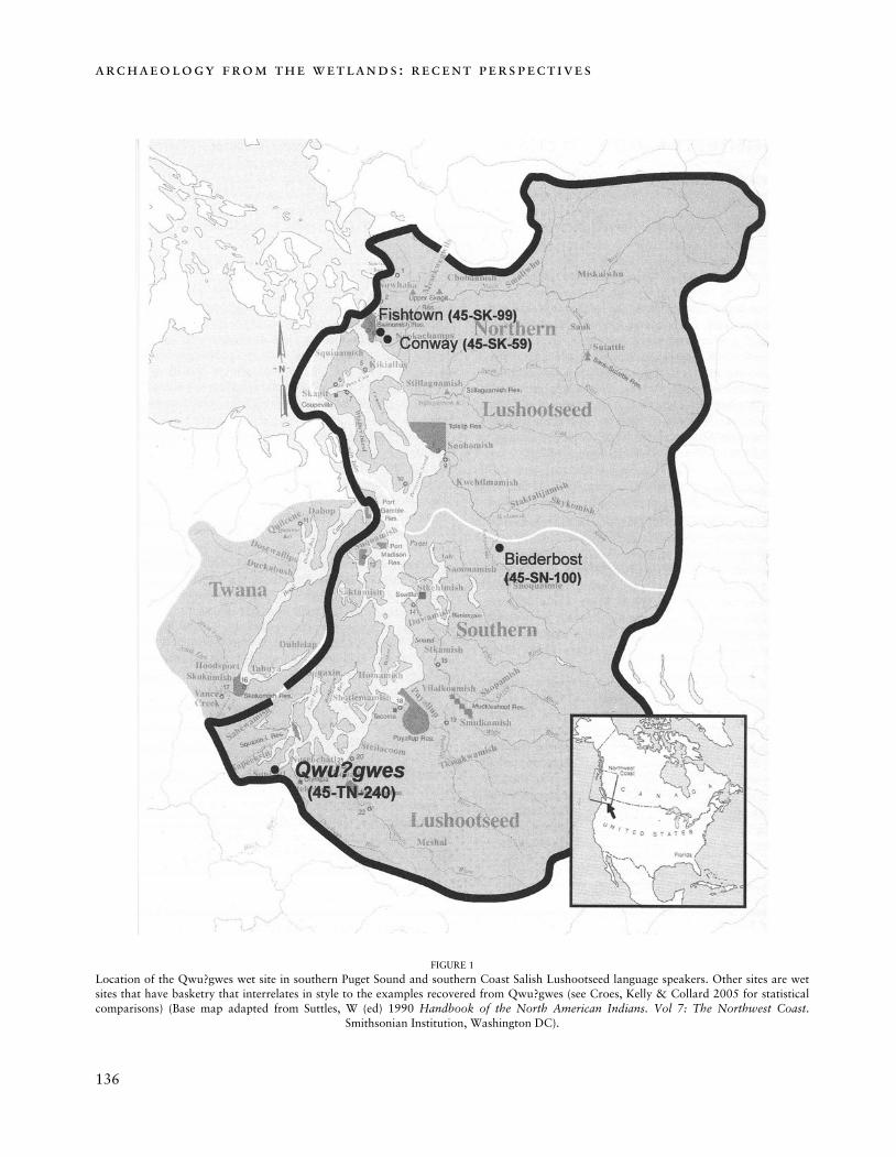
FIGURE 2
Qwu?gwes excavation areas and spring. Shaded areas represent reconstruction of ancient channel. The three squares containing the cedar bark net in the wet site area are a lighter shade. Inset: USGS map shows site location
at end of a small peninsula and where the fish traps have been recorded (see Croes & Foster 2004).
138
archaeology from the wetlands: recent perspectives
139
qwu?gwes – a squaxin island tribal heritage wet site, puget sound, usa
• A 91-metre long shell midden, resource-processing location, and possible village site, exposed on a beach front, with 1,600 cubic metres of undisturbed site area remaining(fig 2).
• A site with abundant faunal and floral remains representing the rich food resources used at the site (see below).
• A location containing a large array of stone, bone and shell artefacts typical in style of the last 1,000 years. Additionally, tens of thousands of Thermally Altered Rocks (TAR) have been recovered and analysed. This gives us an idea of the amount of shellfish steaming taking place at the major camp, and in other areas of the site.
• A site containing a buried waterlogged portion in the inter-tidal area with excellent preservation of wood and fibre artefacts, including a large section of cedar bark string net and baskets recovered and dating to approximately 500–700 years old (C14 dating). The sensitive basketry and cordage styles show close similarities to Lushootseed and Coast Salish style basketry from ancient sites dating back to as early as 3,000 years ago, demonstrating the time depth and vast extent of these traditions (Croes 1977, 1992; Croes, Kelly & Collard 2005).
The 34 1 × 1m units excavated so far clearly revealed examples of: (1) possible household living areas where cooking took place; (2), lower-lying food-processing areas with surrounding drying racks where shellfish, fish and possibly berries were steamed on pavements of rocks and dried for storage; and (3) an inter-tidal waterlogged discard shell-midden area on the beach, near the site’s fresh water spring (fig 2). We now better understand the 3-dimensional stratigraphic relationships throughout the site and have begun an extensive mapping programme.
We will elaborate and synthesize two main areas of analysis, equally important in our 50/50 sharing of the Qwu?gwes research: (a) the
scientific analyses by student and faculty researchers; and (b) the cultural analysis by the Squaxin Island tribal representatives of their Cultural Resources Department. Working together we can provide a far better overview.
SCIENTIFIC ANALYSIS
stratigraphic context
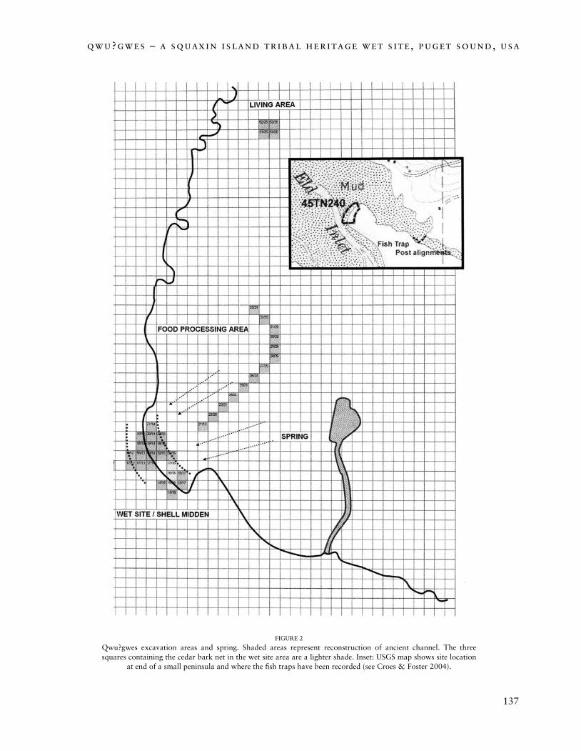
The Qwu?gwes heritage site sits on the end of a small peninsula that is underlain by alluvial lake deposits called Bellingham fine silty clay loam, deposited from glacial melt-waters of fresh-water Lake Russell (fig 2). It is very deep, poorly drained soil, formed in alluvium and lacustrine sediments. Slopes are 0–3 per cent. The native vegetation is mainly hardwoods and conifers along the peninsula margins and open prairie in the higher grounds. These alluvium deposits are overlain by a mantle of silty, sandy, gravelly and glacially derived deposits as well as culturally formed shell midden at the site. An aquifer spring provides the ground waters through these overlying deposits and moves easily through the lower half of the inter-tidal offshore cultural midden deposits (see current surface spring and direction of flow, fig 2). This contrasts with peat-bog wet sites in most other parts of the world, where relatively stagnant waters create
FIGURE 3
Example of inter-tidal shell midden area with concentrated vegetal mat below water-table. Note preservation of sticks and wood in these areas of aquifer about 50cm below the
surface.
138
archaeology from the wetlands: recent perspectives
139
qwu?gwes – a squaxin island tribal heritage wet site, puget sound, usa
the waterlogging and build up the organic deposition. In the aquifer wet site, the deposits, such as the shell midden, are culturally deposited in areas that form aqueducts for moving ground waters, thereby remaining water-saturated.
Much of our geoarchaeological attention in the wet inter-tidal shell midden area of the site has focused on finding the boundaries and layout of a vegetation-filled channel seen in the profile (fig 3), containing concentrations of wood and fibre artefacts. This ancient channel probably once flowed openly from the spring through this part of the site, in a manner similar to the current open channel flowing from the artesian spring to the inter-tidal (fig 2). In the northernmost squares of the wet site, the vegetal layer of the channel is thicker and more pronounced. This same vegetal layer or channel configuration in the shell midden is where nets (fig 2), basketry and other delicate wood and fibre artefacts are found. Woodchips, split wood and basketry debris of various sizes and varieties are also found throughout this layer. As we have developed the 3-dimensional view of the site, a more detailed view of the overall shape and stratigraphy of this dense vegetal mat channel is taking shape. In many of the excavated squares there is a layer of broken blue mussel shells and charcoal directly above this layer, showing as a dark, almost purple, layer. At the bottom of the thick vegetal mat there is often a dense thin layer of disarticulated salmon bones present.
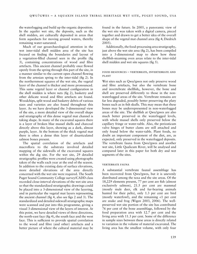
The spatial correlation of the artefacts and macroflora to the substrata involved detailed mapping of the sidewalls of the excavated squares within the dig site. For the wet site, 29 detailed stratigraphic profiles were created using photographs taken of the walls each year at the end of the season. In addition to the existing data of surface elevations, more detailed elevations of the area directly concerned with the wet site were required. The South Puget Sound Community College survey/CADD class recorded close-interval elevations of the wet site area so that the standardized stratigraphic drawings could be placed into a 3-dimensional view of the layering, and in particular the vegetal mat layers representing the ancient channel (fig 4, also see figs 2 and 3). The standardized and detailed sidewall stratigraphic maps were scanned and put into this programme, giving a visual 3-dimensional view of the layers of interest. At this point, we have detailed views of three directions, the north-east face (fig 4), the south face and the west face. This is sufficient to provide spatial correlation to the wood and fibre (and other) artefacts and a better picture of where the cultural material may be
found in the future. In 2005, a panoramic view of the wet site was taken with a digital camera, pieced together and drawn to get a better idea of the overall shape of the vegetal mat channel area (fig 4; Diedrich 2005).
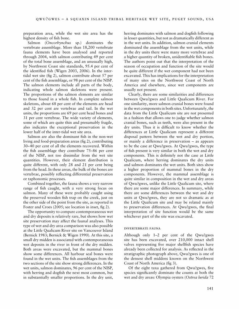
Additionally, the food-processing area stratigraphy, just above the wet site area (fig 2), has been compiled into a 3-dimensional map to show how these shellfish-steaming oven areas relate to the inter-tidal shell midden and wet site squares (fig 5).
food resources – vertebrate, invertebrate and plant
Wet sites such as Qwu?gwes not only preserve wood and fibre artefacts, but also the vertebrate bone and invertebrate shellfish;, however, the bone and shell are preserved differently to those in the non-waterlogged areas of the site. Vertebrate remains are far less degraded, possibly better preserving the platy bones such as in fish skulls. This may mean that these bones may be underrepresented in non-waterlogged areas of the site. The shellfish at Qwu?gwes are also much better preserved in the waterlogged levels, with whole mussel shells only preserved below the capillary fringe or water-table. Also, the periosticum valve hinges of butter clams are still attached and only found below the water-table. Plant foods, no doubt an important component of the diet, are, as expected, only preserved in the waterlogged deposits. The vertebrate fauna from Qwu?gwes and another wet site, Little Qualicum River, will be analysed and compared later in this paper for both dry and wet segments of the sites.
vertebrate fauna
A substantial vertebrate faunal assemblage has been recovered from Qwu?gwes, but it is unevenly distributed among the taxa and the site areas. Of the 18,229 elements present, 77 per cent are fish (almost exclusively salmon), 21.5 per cent are mammal (mostly mule deer, elk and fur-bearing animals hunted for their pelts), only 1.3 per cent are bird (mostly waterfowl), and the remaining <1 per cent are snake and frog (Wigen 2003, 2006). The well-preserved wet site portion of the site has contributed 76 per cent of the bone assemblage, followed by the food preparation area with 12.7 per cent and the living area with 11.3 per cent. Some of the difference in sample sizes between these areas is directly related to variation in the volume of material excavated. The living area has the smallest volume, with only four
140
archaeology from the wetlands: recent perspectives
141
qwu?gwes – a squaxin island tribal heritage wet site, puget sound, usa
FIGURE 4
Composite of stratigraphic drawings through north-east face of wet site stratigraphy (above; 3-dimensional created by Professor Michael Martin, Computer Aided Design Department, South Puget Sound Community College). Drawing compiled from panoramic views from
photographs indicating the vegetal mat concentrations and directions of ancient channel (below and fig 2).
excavation units, followed by the food-processing area with 13 units, and the wet site has the largest volume excavated with 23 units. Calculating the
density of the bone per cubic metre (NISP/m3) shows that the living area actually has the highest densities of mammal and bird bone, followed by the food-
140
archaeology from the wetlands: recent perspectives
141
qwu?gwes – a squaxin island tribal heritage wet site, puget sound, usa
preparation area, while the wet site area has the highest density of fish bone.
Salmon (Oncorhynchus sp.) dominates the vertebrate assemblage. More than 18,200 vertebrate fauna elements have been analysed and reported through 2004, with salmon contributing 49 per cent of the total bone assemblage, and an unusually high, by Northwest Coast site standards, 95.4 per cent of the identified fish (Wigen 2003, 2006). In the inter-tidal wet site (fig 2), salmon contribute about 57 per cent of the fish assemblage, or 98 per cent of the NISP. The salmon elements include all parts of the body, indicating whole salmon skeletons were present. The proportions of the salmon elements are similar to those found in a whole fish. In complete salmon skeletons, about 68 per cent of the elements are head and 32 per cent are vertebrae and tail. In the wet units, the proportions are 69 per cent head bones and 31 per cent vertebrae. The wide variety of elements, some of which are quite thin and presumably fragile, also indicates the exceptional preservation in the lower half of the inter-tidal wet site area.
Salmon are also the dominant fish in the non-wet living and food-preparation areas (fig 2), contributing 30– 40 per cent of all the elements recovered. Within the fish assemblage they contribute 75–86 per cent of the NISP, not too dissimilar from the wet site quantities. However, their element distribution is quite different, with only 28 and 21 per cent being from the head. In these areas, the bulk of the bones are vertebrae, possibly reflecting differential preservation or taphonomic processes.
Combined together, the fauna shows a very narrow range of fish caught, with a very strong focus on salmon. Many of these were probably caught using the preserved wooden fish trap on the creek, just on the other side of the point from the site, as reported in Foster and Croes (2005; see location in inset, fig 2).
The opportunity to compare contemporaneous wet and dry deposits is relatively rare, but shows how wet site preservation may affect the faunal analyses. This type of wet and dry area comparison was also possible at the Little Qualicum River site on Vancouver Island (Bernick 1983; Bernick & Wigen 1990). At this site, a small dry midden is associated with contemporaneous wet deposits in the river in front of the dry midden. Both areas were excavated, but the mammal bones show some differences. All harbour seal bones were found in the wet units. The fish assemblages from the two sections of the site show strong differences. In the wet units, salmon dominates, 96 per cent of the NISP, with herring and dogfish the next most common, but in substantially smaller proportions. In the dry unit,
herring dominates with salmon and dogfish following in lesser quantities, but not as dramatically different as in the wet units. In addition, salmon cranial elements dominated the assemblage from the wet units, while in the dry units there were many more vertebrae and a higher quantity of broken, unidentifiable fish bones. The authors point out that the interpretation of the season of occupation and function of the site would be quite different if the wet component had not been excavated. This has implications for the interpretation of many sites on the Northwest Coast of North America and elsewhere, since wet components are usually not present.
Clearly, there are some similarities and differences between Qwu?gwes and Little Qualicum River. For one similarity, more salmon cranial bones were found in the wet components in both sites. Unfortunately, the data from the Little Qualicum site are not presented in a fashion that allows one to judge whether salmon cranial bones, such as teeth, were also present in the dry units. Thus it is difficult to know whether the differences at Little Qualicum represent a different disposal pattern between the wet and dry portion, or mainly a difference in preservation – as appears to be the case at Qwu?gwes. At Qwu?gwes, the type of fish present is very similar in both the wet and dry components. This is definitely not the case at Little Qualicum, where herring dominates the dry units and salmon dominates the wet units. Both sites show a higher proportion of mammal bones in the dry components. However, the mammal assemblage is quite similar in composition in the wet and dry areas of Qwu?gwes, unlike the Little Qualicum site, where there are some major differences. In summary, while there are some differences between the wet and dry units at Qwu?gwes, they are not so dramatic as at the Little Qualicum site and may be related mainly to preservation differences. At Qwu?gwes, the final interpretation of site function would be the same whichever part of the site was excavated.
invertebrate fauna
Although only 1–2 per cent of the Qwu?gwes site has been excavated, over 210,000 intact shell valves representing five major shellfish species have already been collected for analysis. As reflected in the stratigraphic photograph above, Qwu?gwes is one of the densest shell middens known on the Northwest Coast of North America (fig 3).
Of the eight taxa gathered from Qwu?gwes, five species significantly dominate the counts at both the wet and dry areas: Olympia oysters (Ostrea lurida 72
142
archaeology from the wetlands: recent perspectives
143
qwu?gwes – a squaxin island tribal heritage wet site, puget sound, usa
FIGURE 5
Three-dimensional perspective of the food-processing area stratigraphy in orientation (higher ground) to inter-tidal shell midden wet site (above) and a closer view of steaming oven area stratigraphy (3-dimensional created by Professor Michael Martin, Computer Aided Design
Department, South Puget Sound Community College).
per cent), butter clams (Saxidomus giganteus 22 per cent), bay mussels (Mytilus edulis 4 per cent), native littlenecks (Protothaca staminea 1 per cent) and horse clams (Tresus capax 1 per cent). These species represent 94 per cent of the total bivalve and univalve
collection from the Qwu?gwes site (Hubbard, Foster & Myers 2005).
The Squaxin Island Tribe’s traditional territory appears to coincide with the highest densities for the range of the Olympia oyster, the native oyster species
142
archaeology from the wetlands: recent perspectives
143
qwu?gwes – a squaxin island tribal heritage wet site, puget sound, usa
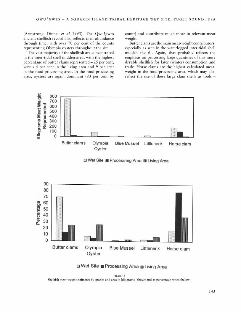
FIGURE 6
Shellfish meat-weight estimates by species and area in kilograms (above) and as percentage ratios (below).
(Armstrong, Dinnel et al 1993). The Qwu?gwes ancient shellfish record also reflects their abundance through time, with over 70 per cent of the counts representing Olympia oysters throughout the site.
The vast majority of the shellfish are concentrated in the inter-tidal shell midden area, with the highest percentage of butter clams represented – 25 per cent, versus 4 per cent in the living area and 9 per cent in the food-processing area. In the food-processing area, oysters are again dominant (83 per cent by
count) and contribute much more in relevant meat weight.
Butter clams are the main meat-weight contributors, especially as seen in the waterlogged inter-tidal shell midden (fig 6). Again, that probably reflects the emphasis on processing large quantities of this more dryable shellfish for later (winter) consumption and trade. Horse clams are the highest calculated meat-weight in the food-processing area, which may also reflect the use of these large clam shells as tools –
144
archaeology from the wetlands: recent perspectives
145
qwu?gwes – a squaxin island tribal heritage wet site, puget sound, usa
ladles or bowls. The horse clam shells are often found stuck into the ground vertically (Hubbard, Foster & Myers 2005).
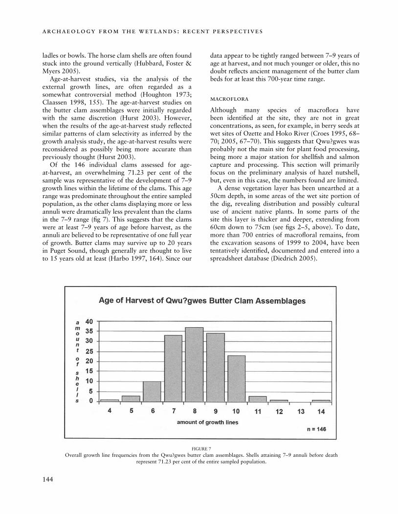
Age-at-harvest studies, via the analysis of the external growth lines, are often regarded as a somewhat controversial method (Houghton 1973; Claassen 1998, 155). The age-at-harvest studies on the butter clam assemblages were initially regarded with the same discretion (Hurst 2003). However, when the results of the age-at-harvest study reflected similar patterns of clam selectivity as inferred by the growth analysis study, the age-at-harvest results were reconsidered as possibly being more accurate than previously thought (Hurst 2003).
Of the 146 individual clams assessed for age-at-harvest, an overwhelming 71.23 per cent of the sample was representative of the development of 7–9 growth lines within the lifetime of the clams. This age range was predominate throughout the entire sampled population, as the other clams displaying more or less annuli were dramatically less prevalent than the clams in the 7–9 range (fig 7). This suggests that the clams were at least 7–9 years of age before harvest, as the annuli are believed to be representative of one full year of growth. Butter clams may survive up to 20 years in Puget Sound, though generally are thought to live to 15 years old at least (Harbo 1997, 164). Since our
data appear to be tightly ranged between 7–9 years of age at harvest, and not much younger or older, this no doubt reflects ancient management of the butter clam beds for at least this 700-year time range.
macroflora
Although many species of macroflora have been identified at the site, they are not in great concentrations, as seen, for example, in berry seeds at wet sites of Ozette and Hoko River (Croes 1995, 68–70; 2005, 67–70). This suggests that Qwu?gwes was probably not the main site for plant food processing, being more a major station for shellfish and salmon capture and processing. This section will primarily focus on the preliminary analysis of hazel nutshell, but, even in this case, the numbers found are limited.
A dense vegetation layer has been unearthed at a 50cm depth, in some areas of the wet site portion of the dig, revealing distribution and possibly cultural use of ancient native plants. In some parts of the site this layer is thicker and deeper, extending from 60cm down to 75cm (see figs 2–5, above). To date, more than 700 entries of macrofloral remains, from the excavation seasons of 1999 to 2004, have been tentatively identified, documented and entered into a spreadsheet database (Diedrich 2005).
FIGURE 7
Overall growth line frequencies from the Qwu?gwes butter clam assemblages. Shells attaining 7–9 annuli before death represent 71.23 per cent of the entire sampled population.
144
archaeology from the wetlands: recent perspectives
145
qwu?gwes – a squaxin island tribal heritage wet site, puget sound, usa
Of particular interest, regarding cultural use of plants, are what appear to be handfuls of hazelnut shells (Corylus cornuta Marsh.), that may have been thrown into the waterlogged midden area. The major amounts of the hazelnut shells, along with other wood and fibre cultural materials, have been found in the dense vegetal mat in the reconstructed ancient channel-way (see figs 2– 4 above). As previously mentioned, these are not in quantities that would be associated with extensive food processing, in contrast to the evidence of large amounts of clam steaming and salmon processing at the site (Diedrich 2005).
thermally altered rock (tar)
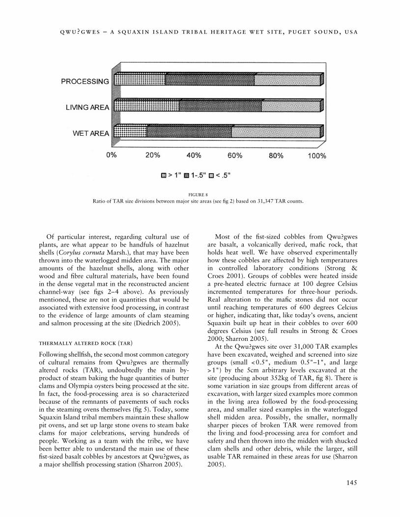
Following shellfish, the second most common category of cultural remains from Qwu?gwes are thermally altered rocks (TAR), undoubtedly the main by-product of steam baking the huge quantities of butter clams and Olympia oysters being processed at the site. In fact, the food-processing area is so characterized because of the remnants of pavements of such rocks in the steaming ovens themselves (fig 5). Today, some Squaxin Island tribal members maintain these shallow pit ovens, and set up large stone ovens to steam bake clams for major celebrations, serving hundreds of people. Working as a team with the tribe, we have been better able to understand the main use of these fist-sized basalt cobbles by ancestors at Qwu?gwes, as a major shellfish processing station (Sharron 2005).
Most of the fist-sized cobbles from Qwu?gwes are basalt, a volcanically derived, mafic rock, that holds heat well. We have observed experimentally how these cobbles are affected by high temperatures in controlled laboratory conditions (Strong & Croes 2001). Groups of cobbles were heated inside a pre-heated electric furnace at 100 degree Celsius incremented temperatures for three-hour periods. Real alteration to the mafic stones did not occur until reaching temperatures of 600 degrees Celcius or higher, indicating that, like today’s ovens, ancient Squaxin built up heat in their cobbles to over 600 degrees Celsius (see full results in Strong & Croes 2000; Sharron 2005).
At the Qwu?gwes site over 31,000 TAR examples have been excavated, weighed and screened into size groups (small < 0.5", medium 0.5"–1", and large > 1") by the 5cm arbitrary levels excavated at the site (producing about 352kg of TAR, fig 8). There is some variation in size groups from different areas of excavation, with larger sized examples more common in the living area followed by the food-processing area, and smaller sized examples in the waterlogged shell midden area. Possibly, the smaller, normally sharper pieces of broken TAR were removed from the living and food-processing area for comfort and safety and then thrown into the midden with shucked clam shells and other debris, while the larger, still usable TAR remained in these areas for use (Sharron 2005).
FIGURE 8
Ratio of TAR size divisions between major site areas (see fig 2) based on 31,347 TAR counts.
146
archaeology from the wetlands: recent perspectives
147
qwu?gwes – a squaxin island tribal heritage wet site, puget sound, usa
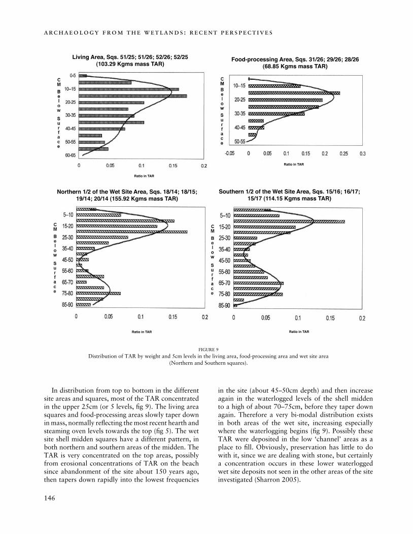
In distribution from top to bottom in the different site areas and squares, most of the TAR concentrated in the upper 25cm (or 5 levels, fig 9). The living area squares and food-processing areas slowly taper down in mass, normally reflecting the most recent hearth and steaming oven levels towards the top (fig 5). The wet site shell midden squares have a different pattern, in both northern and southern areas of the midden. The TAR is very concentrated on the top areas, possibly from erosional concentrations of TAR on the beach since abandonment of the site about 150 years ago, then tapers down rapidly into the lowest frequencies
in the site (about 45–50cm depth) and then increase again in the waterlogged levels of the shell midden to a high of about 70–75cm, before they taper down again. Therefore a very bi-modal distribution exists in both areas of the wet site, increasing especially where the waterlogging begins (fig 9). Possibly these TAR were deposited in the low ‘channel’ areas as a place to fill. Obviously, preservation has little to do with it, since we are dealing with stone, but certainly a concentration occurs in these lower waterlogged wet site deposits not seen in the other areas of the site investigated (Sharron 2005).
FIGURE 9
Distribution of TAR by weight and 5cm levels in the living area, food-processing area and wet site area(Northern and Southern squares).
Ratio in TAR Ratio in TAR
Ratio in TAR
Ratio in TAR
Living Area, Sqs. 51/25; 51/26; 52/26; 52/25(103.29 Kgms mass TAR)
Food-processing Area, Sqs. 31/26; 29/26; 28/26(68.85 Kgms mass TAR)
Southern 1/2 of the Wet Site Area, Sqs. 15/16; 16/17; 15/17 (114.15 Kgms mass TAR)
Northern 1/2 of the Wet Site Area, Sqs. 18/14; 18/15; 19/14; 20/14 (155.92 Kgms mass TAR)
146
archaeology from the wetlands: recent perspectives
147
qwu?gwes – a squaxin island tribal heritage wet site, puget sound, usa
artefact analysis
Though the emphasis is on the wood and fibre artefacts found at Qwu?gwes for this wet site synthesis, the site contains a typical Central Northwest Coast Late Period component of stone, bone-antler and shell (SB-AS) artefacts (Kelly 2005; Vargo 2005). The waterlogged sections contain a larger quantity of cultural wood and fibre artefacts and debris, including basketry, nets, cordage, fish traps and wooden artefacts as well as large quantities of wood and fibre artefact manufacturing debris. To best place Qwu?gwes into the cultural, historical context of the Central Northwest Coast, we have conducted widespread cluster analyses of degrees of similarity between all these artefacts and those commonly found in northern Puget Sound, Gulf of Georgia, Strait of Juan de Fuca and the West Coast of Washington and Vancouver Island, BC (Croes, Kelly & Collard 2005; Kelly 2005; Croes et al 2006).
The contrasting results between stone, bone-antler and shell artefacts and those of basketry demonstrate a distinct difference between diffusion of ideas (ethnogenesis) and the guarding of ideas (branching or phylogenesis) in ethnic styles and identity, especially through sensitive basketry artefacts (Croes, Kelly & Collard 2005; Croes 2005; Kelly 2005). For example, the SB-AS types from Qwu?gwes statistically link with those found at the waterlogged and contemporary site of Ozette Village; however, it becomes quite clear from the basketry artefacts that they have very different cultural traditions. In fact, because of the styles and late time periods of these sites, they clearly represent Makah (Ozette) and Squaxin Island Tribe (Qwu?gwes) in cultural tradition – language families that are guessed to be separated by over 6,500 years through lexicostatistical techniques (Swadish 1953, 1954, 362), which are certainly controversial in true validity, but suggestive of considerable separations as well. Therefore, ethnic identity appears to be ‘guarded’ more through basketry traditions (phylogenesis) than stone, bone-antler, shell artefact traditions that are more closely associated with widely spread and shared procurement and manufacturing related artefacts (ethnogenesis). These regional trends in basketry styles appear to be preserved for at least 3,000 years from wet sites in the Makah/Wakashan areas and those in the Puget Sound/Gulf of Georgia Salishan regions (Croes, Kelly & Collard 2005).
A recent study we conducted on Puget Sound projectile point types revealed a sequence from the earliest known occupations of North America, with nine scattered surface finds of Clovis points
throughout the region, through Qwu?gwes late period styles (Croes et al 2006). In comparison to better established projectile point type sequences, slightly north of our region, in the Gulf of Georgia/Fraser/San Juan Islands regions, we found that Puget Sound styles follow the same exact sequencing seen through time (Matson & Coupland 1995; Ames & Maschner 1999). Of course, since this also is the strongest and best known region of wet site basketry style continuity for 3,000 years, proposed to reflect a Coast Salish cultural continuity for at least this time stretch, the projectile points would be expected to follow a similar sequencing throughout the region, and they did (Croes et al 2006).
We will touch on the main analyses of wet site materials from Qwu?gwes with regional comparisons below, reviewing results of analyses of netting, basketry, woodworking and the fish traps.
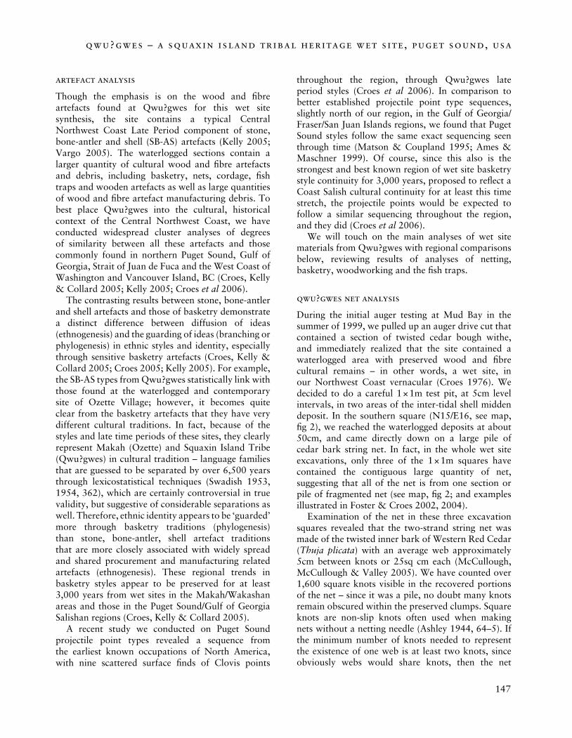
qwu?gwes net analysis
During the initial auger testing at Mud Bay in the summer of 1999, we pulled up an auger drive cut that contained a section of twisted cedar bough withe, and immediately realized that the site contained a waterlogged area with preserved wood and fibre cultural remains – in other words, a wet site, in our Northwest Coast vernacular (Croes 1976). We decided to do a careful 1 × 1m test pit, at 5cm level intervals, in two areas of the inter-tidal shell midden deposit. In the southern square (N15/E16, see map, fig 2), we reached the waterlogged deposits at about 50cm, and came directly down on a large pile of cedar bark string net. In fact, in the whole wet site excavations, only three of the 1 × 1m squares have contained the contiguous large quantity of net, suggesting that all of the net is from one section or pile of fragmented net (see map, fig 2; and examples illustrated in Foster & Croes 2002, 2004).
Examination of the net in these three excavation squares revealed that the two-strand string net was made of the twisted inner bark of Western Red Cedar (Thuja plicata) with an average web approximately 5cm between knots or 25sq cm each (McCullough, McCullough & Valley 2005). We have counted over 1,600 square knots visible in the recovered portions of the net – since it was a pile, no doubt many knots remain obscured within the preserved clumps. Square knots are non-slip knots often used when making nets without a netting needle (Ashley 1944, 64–5). If the minimum number of knots needed to represent the existence of one web is at least two knots, since obviously webs would share knots, then the net
148
archaeology from the wetlands: recent perspectives
149
qwu?gwes – a squaxin island tribal heritage wet site, puget sound, usa
involves a minimum of 800 webs × 25sq cm, equalling a minimum area of 20,000sq cm or at least 2sq metres of recovered net (McCullough, McCullough & Valley 2005). The two-strand twisted strings average 0.3–0.4cm diameter, which would fall into the string gauge diameter as established at the Ozette Village wet site (Croes 1980, 18–25).
Nets are found in many Northwest Coast wet sites, dating back as early as 5,000 years ago, and reflect a wide variety of materials used, filament or two-strand twisted strings, web sizes and proposed uses (see table 1, Croes & Foster 2004). Often a site with two-strand twisted string nets emphasizes either Z- or S-laid string, considered a cultural prescription. However, the Qwu?gwes strings appear to have about a 50/50 emphasis on lay, with 54 per cent having an S-lay and 46 per cent a Z-lay (N = 448 strings observed; McCullough, McCullough & Valley 2005).
woodworking
Wet site excavations at Qwu?gwes have unearthed a large quantity of woodchips, as well as jadite adze bits (N = 3), splitting wedges of wood (N = 1) and elk antler (N = 4). To better understand the amount and kind of woodworking taking place, woodchip samples were selected from a series of squares and levels to measure length, thickness, angle-in and angle-out points, profile and feathering. Each of these characteristics shows how different tools and woodworking technologies were used at the site. To gain a better understanding of ancient woodworking chips, we worked closely with Squaxin master woodcarver, Andrea Wilbur-Sigo (McCullough, McCullough & Valley 2005).
The Qwu?gwes woodchips are mostly western red cedar, though a fair amount of large hardwood
FIGURE 10
Example of checker work cedar bark basketry with overlay bear-grass decoration. This piece is folded, so two sides are preserved.
148
archaeology from the wetlands: recent perspectives
149
qwu?gwes – a squaxin island tribal heritage wet site, puget sound, usa
woodchips are also seen at the site (species unidentified at this time). A woodchip is any piece of wood that had obviously been cut from a piece of wood, as distinguished from any piece that could have been split or broken off. Woodchips can be distinguished by the difference between the point where the blade entered the wood and the exit point. Slicing pieces of wood along the surface plane of the wood produces feathering at the point of entrance. Another important attribute of woodchips is their plane view shape. When the adze bit cuts into the wood, it enters the wood at a certain angle. As the blade cleaves the wood from the wood surface, it tends to do so with less of an angle, leaving us with an inverted triangle. When the cutting edge of an adze bit enters the wood it compresses the wood along the cutting edge. Three other attributes, which are quite important in interpreting the woodchips, are angle-in, angle-out, and the profile (see Gleeson 1980).
Most of the Qwu?gwes woodchips have a flat-shaped plane view, as opposed to the inverted triangular profile of the other chips. According to Andrea Wilbur-Sigo, the woodchips seem to come from shaving, planing, light adzing, or finer detailed woodworking. Chips created from ‘moving wood’, or roughly cutting, would tend to be larger, with a sharper entrance angle. A number of these chips were flat, possibly resulting from cutting into the wood at a certain angle to achieve the ‘final finishing process’ (McCullough, McCullough & Valley 2005).
While there were woodchips found in different levels, they were mostly concentrated in the vegetal mat channel of the waterlogged squares (fig 2). In these waterlogged levels, the woodchips reflect the intensity of the woodworking activity during these times, levels and years.
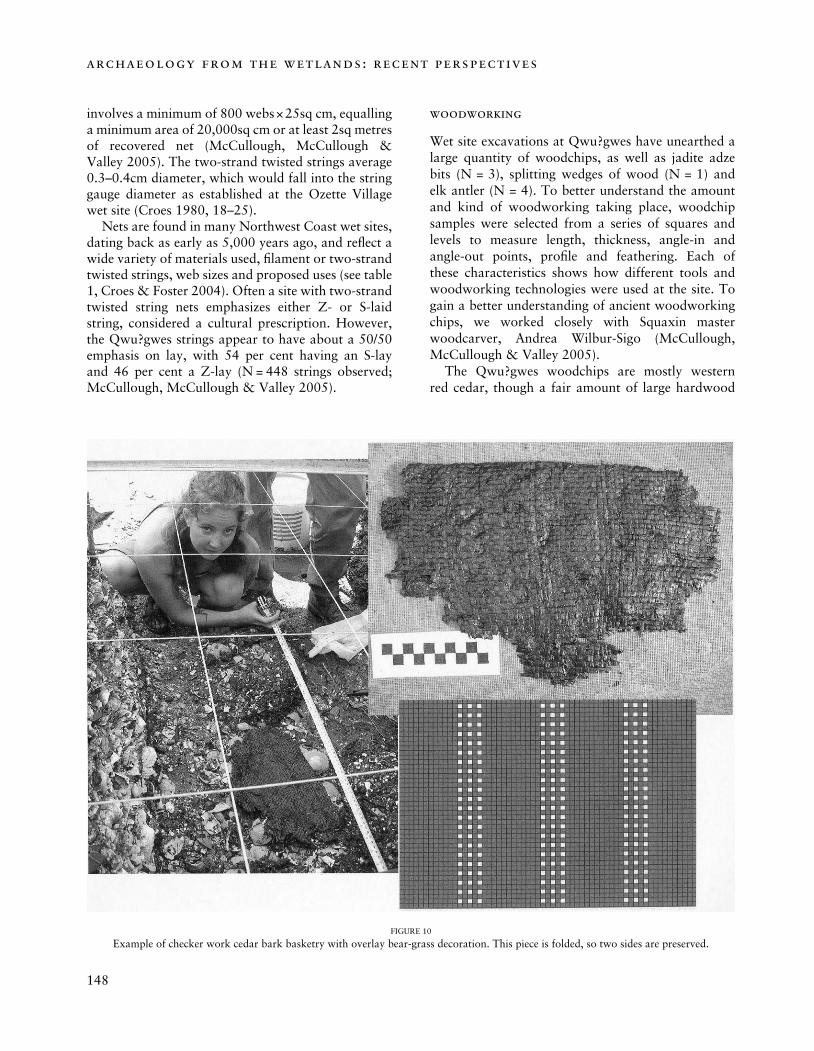
basketry
So far, three main types of basketry have been found at the Qwu?gwes site: (1) cedar bark checker weave matting, sometimes with bear-grass overlay decoration (fig 10); (2) open-twined small to large ‘pack’ baskets of cedar splints (n = 4) and (3) fine twill weave bark basketry (see Foster & Croes 2004 and Croes, Kelly & Collard 2005 for full descriptions and analyses).
With the growing basketry data base, we have conducted several basketry attribute (mode) presence/absence comparative analyses with other ancient basketry collections from Northwest Coast wet sites, to begin to see what degrees of similarity may be demonstrated from this new southern Puget Sound
wet site. Statistically, in terms of degrees of similarity, Qwu?qwes clustered closely with two other recent (within last 1,000 years) Lushootseed language area wet sites, Fishtown and Conway, and then with an early one, Biederbost, dating to 2,000 years ago (see fig 1; Croes & Foster 2004, Croes, Kelly & Collard 2005). Fishtown and Conway wet sites are about 200km north of Qwu?gwes on the Skagit River Delta.
The basketry construction debris that has been preliminarily measured consists of cedar bark strips, cedar bough/root splints and cherry bark strips. The distributional patterns, through time and space of the basketry construction debris, and the measurements, have aided us in understanding the magnitude of basketry construction taking place at the site. Variations in width and thickness have been documented and so aids in understanding the kinds of basketry being made (Smith 2004).
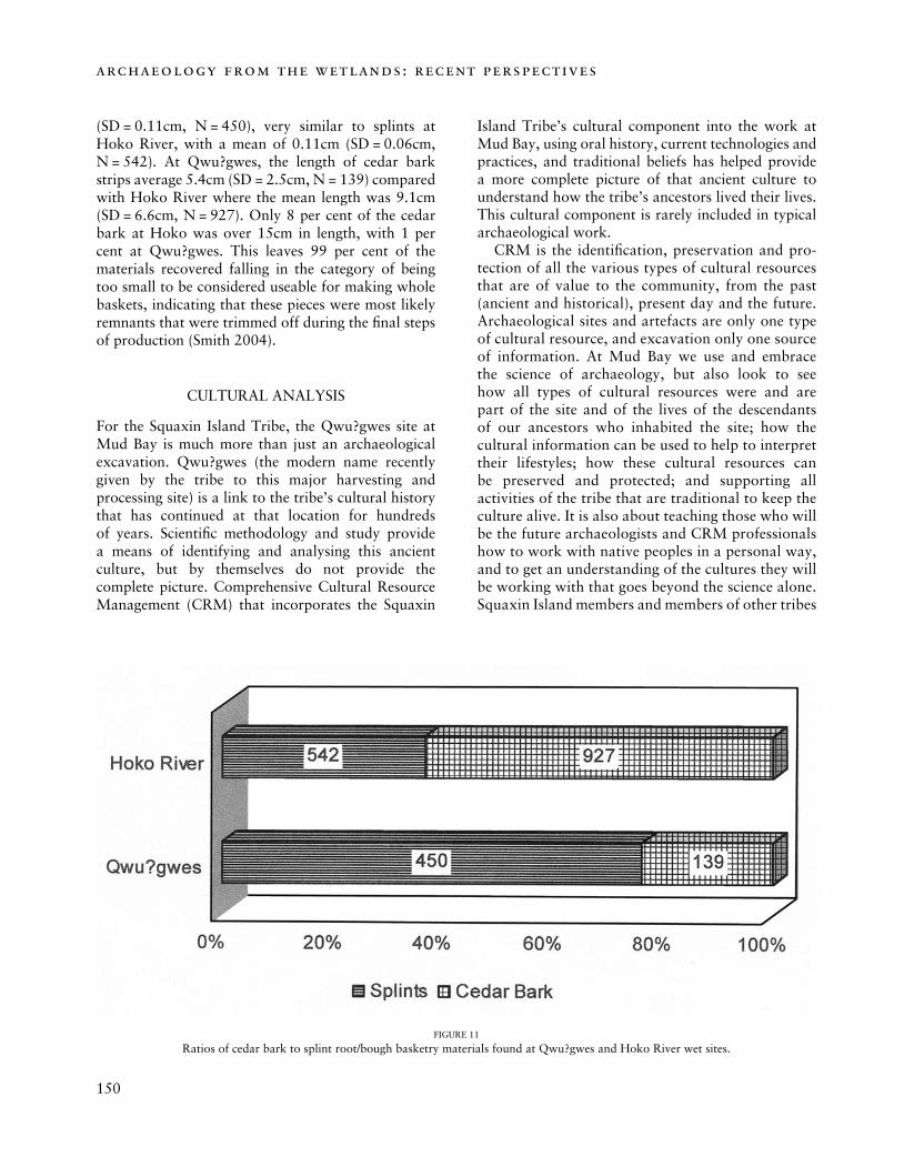
The examples of basketry waste materials include strips and edge clippings that were discarded during manufacturing or repairs of baskets, hats, mats, blankets and other useful products that were made from cedar bark and splints of roots or limbs (boughs). The Hoko River archaeological site, located 150 miles north-west of Qwu?gwes on the opposite corner of the Olympic Peninsula, is the only other wet site that has fully analysed basketry waste detritus. The large quantities of materials at Qwu?gwes indicate that basketry manufacturing had occurred at this site. The levels of production are comparable to that found at Hoko River archaeological site (Smith 2004).
Basketry waste element materials emphases were different between Qwu?gwes and Hoko River, with a major emphasis on splint bough/root material at Qwu?gwes and a heavier emphasis on cedar bark at Hoko River, probably reflecting the kinds of basketry emphasized at the two wet sites (fig 10).
In comparing preliminary measurements, the average width of cedar bark basketry waste strips at Qwu?gwes is 0.7cm (SD = 0.31cm, N = 139) and the Hoko River examples were about the same, with a mean width of 0.7cm (SD = 0.5cm, N = 927). Similarly, the Qwu?gwes splint bough/root elements, with a mean width of 0.42cm (SD = 0.91cm, N = 450) were about the same as Hoko River examples, with a mean width of 0.7cm (SD = 0.5cm, N = 542). Preliminary measurements of Qwu?gwes cedar bark strip thickness (Mean = 0.18cm, SD = 0.29cm, N = 139) indicate that they are approximately twice as thick as those from Hoko River (Mean = 0.10cm, SD = 0.06cm, N = 927). The mean thickness of Qwu?gwes cedar splint bough/roots average 0.12cm
150
archaeology from the wetlands: recent perspectives
151
qwu?gwes – a squaxin island tribal heritage wet site, puget sound, usa
(SD = 0.11cm, N = 450), very similar to splints at Hoko River, with a mean of 0.11cm (SD = 0.06cm, N = 542). At Qwu?gwes, the length of cedar bark strips average 5.4cm (SD = 2.5cm, N = 139) compared with Hoko River where the mean length was 9.1cm (SD = 6.6cm, N = 927). Only 8 per cent of the cedar bark at Hoko was over 15cm in length, with 1 per cent at Qwu?gwes. This leaves 99 per cent of the materials recovered falling in the category of being too small to be considered useable for making whole baskets, indicating that these pieces were most likely remnants that were trimmed off during the final steps of production (Smith 2004).
CULTURAL ANALYSIS
For the Squaxin Island Tribe, the Qwu?gwes site at Mud Bay is much more than just an archaeological excavation. Qwu?gwes (the modern name recently given by the tribe to this major harvesting and processing site) is a link to the tribe’s cultural history that has continued at that location for hundreds of years. Scientific methodology and study provide a means of identifying and analysing this ancient culture, but by themselves do not provide the complete picture. Comprehensive Cultural Resource Management (CRM) that incorporates the Squaxin
Island Tribe’s cultural component into the work at Mud Bay, using oral history, current technologies and practices, and traditional beliefs has helped provide a more complete picture of that ancient culture to understand how the tribe’s ancestors lived their lives. This cultural component is rarely included in typical archaeological work.
CRM is the identification, preservation and pro-tection of all the various types of cultural resources that are of value to the community, from the past (ancient and historical), present day and the future. Archaeological sites and artefacts are only one type of cultural resource, and excavation only one source of information. At Mud Bay we use and embrace the science of archaeology, but also look to see how all types of cultural resources were and are part of the site and of the lives of the descendants of our ancestors who inhabited the site; how the cultural information can be used to help to interpret their lifestyles; how these cultural resources can be preserved and protected; and supporting all activities of the tribe that are traditional to keep the culture alive. It is also about teaching those who will be the future archaeologists and CRM professionals how to work with native peoples in a personal way, and to get an understanding of the cultures they will be working with that goes beyond the science alone. Squaxin Island members and members of other tribes
FIGURE 11
Ratios of cedar bark to splint root/bough basketry materials found at Qwu?gwes and Hoko River wet sites.
150
archaeology from the wetlands: recent perspectives
151
qwu?gwes – a squaxin island tribal heritage wet site, puget sound, usa
who come to Mud Bay learn about the preservation and protection of their heritage, experience the links to the past, have the opportunity to teach others about their heritage, and are trained to become certified Cultural Resource Technicians so that the tribes can manage their own cultural sites and resources. It is important for the tribe to manage its own cultural resources, as this strengthens the connection between our ancient past and ancestors, and helps us to continue our culture for future generations. The following examples illustrate how much clearer and more complete an understanding is possible when the cultural component is balanced with the science.
In one area of the site a large number of bones were discovered. Scientific analysis could identify the species, but the cultural knowledge of the tribe correctly interpreted that the particular species found would not have been eaten, but would have been used only for spiritual and ceremonial uses.
Tribal members from the tribe’s shellfish pro-gramme, who grow and harvest many of the species found in the site’s shell midden, provide information about where and under what conditions the various species grow, the differences between modern and ancient shell types, sizes and shapes, and when to harvest those species.
Traditional tribal knowledge has been invaluable in interpreting the basketry, cordage, fish trap and gill net fragments discovered at the site. Tribal weavers identified materials used, described how artefacts were made and their uses, understood their designs, and pointed out the similarities and differences from current weaving methods and materials. The weavers also taught students how to make the cordage.
The cedar bark gill net recovered at the site measured as a 13cm stretch mesh. Tribal members who fish today recognized how the net was made, that this size of net was for smaller salmon species, described the fishing techniques and uses of a gill net and a fish trap, and knew when to use one or the other. A cedar bark gill net gives a fisher person flexibility and mobility to cover large areas in search of schools of salmon. At a young age, a child is taught how to study a school of salmon, the best approach when surrounding a school, and to only catch what can be processed in a short period of time.
Hazelnut shells have been found, but the significance of these shells would not be understood without the tribe’s traditional knowledge of the importance of this food in the ancient diet. The nuts were mixed with berries and fat to make a valuable
winter food, the husks were used for medicine, which may explain why few husks have been found at the site, and most of the nuts would have been brought to the site from the drier hilltops of the neighbouring hills.
Cherry bark is found extensively at the site. Tribal members knew that cherry bark is very supple when wet, but shrinks and becomes stiff and strong, making it excellent material for reinforcing the edges of baskets and tying cork lines to the gill nets. It would be easy to assume that the cherry bark all came from the immediate area of Mud Bay. However, many tribal families knew the ancient cherry bark gathering place, which is not at Mud Bay.
The beach at Mud Bay is littered with TAR, the remains of boiling stones that have split apart. Tribal members pointed out that rocks were spread on the beach for newly growing oysters to attach to, which demonstrates active management of shellfish resources by the ancient peoples.
As the examples have illustrated, including the cultural component from the tribe provides a wealth of knowledge and skills that are needed to manage more effectively cultural resources, and these are beyond anything that is learned in a typical university or college anthropology programme.
summary, future goals and conclusions
It is hoped that the value of a 50/50 sharing of the research at the Qwu?gwes wet site between archaeological scientists and indigenous cultural experts is understood.
Our synthesis is preliminary and we expect to continue to expand the training and joint research to assure the protection and proper presentation of our wet site work at Qwu?gwes – as this Lushootseed name implies.
ACKNOWLEDGEMENTS
We would all like to personally thank the 11th International Wetland Archaeology Research Project (WARP) Conference Chair, Dr Alison Sheridan, for helping our whole group travel to Edinburgh, providing housing for three of our students (and several receptions for our group at her home), while conducting a brilliant – the best yet – WARP Conference. The entire National Museum of Scotland faculty and personnel made sure the best conference facilities and support were always available to us and all conference attendees. John and Bryony
152
archaeology from the wetlands: recent perspectives
153
qwu?gwes – a squaxin island tribal heritage wet site, puget sound, usa
Coles, WARP leaders, attended our session, asking excellent questions, while our students gave confident responses. The authors would also like to thank Karen and Ralph Munro, property owners, Qwu?gwes Site, for supporting the Squaxin Island Tribe and South Puget Sound Community College in opening their property for several summer field school seasons of training and investigations, so this research could be conducted and presented. South Puget Sound Community College provides dedicated laboratory space for the preservation, stabilization and analysis of the cultural materials reported here. The Squaxin Island Tribe Cultural Resources Department and Museum Library and Research Center provide interpretation and public exhibition of the Qwu?gwes materials. Numerous project researchers, Squaxin Island Tribe community members, field personnel and students have contributed to data recovery, analysis and reporting. Jean and Ray Auel have generously supported Qwu?gwes excavations through the years. Though this research owes its existence to these individuals, programmes, facilities and previous and current researchers, the summary and conclusions remain the responsibility of the authors.
REFERENCES
Ames, K M & Maschner, H D G 1999 Peoples of the Northwest Coast, Their Archaeology and Prehistory. London.
Armstrong, D A, Dinnel, P A et al 1993 Washington Shellfish Resources. Seattle.
Bernick, K 1983 ‘A site catchment analysis of the Little Qualicum River site, DiSc 1: a wet site on the East Coast of Vancouver Island, BC’, National Museum of Man Mercury Series, 118, Ottawa.
Bernick, K & Wigen, R 1990 ‘Seasonality of the Little Qualicum River West site’, Northwest Anthropological Research Notes 24(2), 153–9.
Claassen, C 1998 Shells. Cambridge.Croes, D R 1976 (ed) ‘The excavation of water-saturated
archaeological sites (wet sites) on the Northwest Coast of North America’, National Museum of Man Mercury Series, 50.
Croes, D R 1977 Basketry from the Ozette Village Archaeological Site: A Technological, Functional and Comparative Study. PhD dissertation, Washington State University. University Microfilms 77–25, 762, Ann Arbor, MI.
Croes, D R 1992 ‘An evolving revolution in wet site research on the Northwest Coast of North America’, in Coles, B (ed) The Wetland Revolution in Prehistory, WARP Occasional Paper, 6, 99–111. Exeter.
Croes, D R 1995 The Hoko River Archaeological Site Complex, the Wet/dry Site (45CA213), 3,000–2,600 BP. Pullman, WA.
Croes, D R 2005 The Hoko River Archaeological Site Complex, The Rockshelter (45CA21), 1,000–100 BP. Pullman, WA.
Croes, D R, Kelly, K & Collard, M 2005 ‘Cultural historical context of Qwu?gwes (Puget Sound, USA): a preliminary investigation, Journal of Wetland Archaeology, 5, 137–49.
Croes, D R, Williams, S, Ross, L, Dennler, C & Vargo, B 2006 (submitted manuscript) ‘Projectile points from Puget Sound and the Cascade Foothills’, in Carlson, R (ed) Projectile Point Sequences in Northwestern North America. Burnaby, BC.
Diedrich, M 2005 Nuts, Seeds, and Raw Materials, Macrofloral Analysis at the Ancient Qwu?gwes Wet Site, Southern Puget Sound, USA. Paper presented at the 11th Wetland Archaeology Research Project (WARP) Conference, Edinburgh.
Foster, R & Croes, D 2002 ‘Tribal-archaeological co-operative agreement: a holistic cultural resource man-agement approach’, Journal of Wetland Archaeology, 2, 25–38.
Foster, R & Croes, D 2004 ‘Joint tribal/college wet site investigations: a critical need for Native American expertise’, Journal of Wetland Archaeology, 4, 127–39.
Foster, R & Ross, L 2005 Tribal Cultural Resource Management Review of Ancient Qwu?gwes Wet Site. Paper presented at the 11th Wetland Archaeology Research Project (WARP) Conference, Edinburgh.
Gleeson, P 1980 ‘Ozette woodworking technology’, PhD dissertation, Washington State University.
Harbo, R M 1997 Shells and Shellfish of the Pacific Northwest. Madeira Park, BC.
Houghton, J P 1973 The Inter-tidal Ecology of Kiket Island, Washington, with Emphasis on Age and Growth of Protothaca staminea and Saxidomus giganteus. PhD dissertation, University of Washington, Seattle, WA.
Hubbard, N, Foster, S & Myers, K 2005 Shellfish Analysis from Qwu?gwes, a Wet Site on Southern Puget Sound, USA. Paper presented at the 11th Wetland Archaeology Research Project (WARP) Conference, Edinburgh.
Hurst, J L 2003 The Analysis of Shell Growth and Age at Harvest of the Butter Clam (Saxidomus giganteus Deshayes): An Insight to the Implementation of Management Practices at the Qwu?gwes Archaeological Site (45TN240) in Olympia, WA, USA. MA thesis, University of Exeter, England.
Kelly, K M 2005 Analysis of the Stone, Bone-Antler and Shell Artefacts from the Qwe?gwes Site (45TN240), South Puget Sound, Washington, USA. Paper presented at the 11th Wetland Archaeology Research Project (WARP) Conference, Edinburgh.
Matson, R G & Coupland, G 1995 The Prehistory of the Northwest Coast. San Diego, CA.
152
archaeology from the wetlands: recent perspectives
153
qwu?gwes – a squaxin island tribal heritage wet site, puget sound, usa
McCullough, M, McCullough, T & Valley, L 2005 Woodworking and Net-making Technologies at the Ancient Qwu?gwes Wet Site, Southern Puget Sound, USA. Paper presented at the 11th Wetland Archaeology Research Project (WARP) Conference, Edinburgh.
Sharron, C V 2005 TAR – Thermally Altered Rock from the Ancient Qwu?gwes Wet Site, Southern Puget Sound, USA. Paper presented at the 11th Wetland Archaeology Research Project (WARP) Conference, Edinburgh.
Smith, S 2004 Qwu?gwes Basketry Debris: Measurements, Comparisons and Analysis. Paper on file, Qwu?gwes Cultural Site Project, Department of Anthropology, South Puget Sound Community College, Olympia, Washington.
Strong, J M & Croes, D R 2001 ‘Heat capacity and fragmentation pattern determinations of potential cooking stones: a case study at the Qwu?gwes archaeological Site (45-TN-240), Olympia, Washington’, Northwest Anthropological Research Notes, 35(1), 41–54.
Suttles, W & Lane, B 1990 ‘Southern Coast Salish’, in Suttles, W (ed) Handbook of North American Indians, Vol 7: Northwest Coast, 485–502. Washington, DC.
Swadesh, M 1953 ‘Mosan I: a problem of remote common origin’, International Journal of American Linguistics, 19, 26–44. New York.
Swadesh, M 1954 ‘Time depths of American linguistic groupings’. American Anthropologist, 56, 3:361–77. Menasha.
Thompson, L C & Kinkade, M D 1990 ‘Languages’,in Suttles, W (ed) Handbook of North American Indians, Vol 7: Northwest Coast, 30–51. Washington, DC.
Vargo, B A 2005 Raw Material Variation in the Qwe?gwes Stone Tool Assemblage. Paper presented at the 11th Wetland Archaeology Research Project (WARP) Conference, Edinburgh.
Waitt, R B Jr & Thorson, R M 1983 ‘The Cordilleran ice sheet in Washington, Idaho, and Montana’, in Wright Jr, H E & Porter, S C Late-Quaternary Environments of the United States, Volume 1: The Late Pleistocene, 53–70.
Wigen, R 2003 Qwu?gwes Faunal Report, 2002 Excavations. Report submitted to the Qwu?gwes Archaeological Project, on file, Office of Archaeology and Historic Preservation, Olympia, WA.
Wigen, R 2006 Qwu?gwes Faunal Report, Through 2004 Excavations. Report submitted to the Qwu?gwes Archaeological Project, on file, Office of Archaeology and Historic Preservation, Olympia, WA.

154
archaeology from the wetlands: recent perspectives