questionnaire on sustainable land management (slm
TRANSCRIPT
1
WOCAT - World Overview of Conservation Approaches and Technologies
Questionnaire on Sustainable Land Management (SLM) Technologies
Version: Core (2016)
A tool to help document, assess, and disseminate SLM practices
2
Contents
Introduction to the questionnaire 3
1. General information 5
1.1 Name of the SLM Technology (hereafter referred to as the Technology) 5 1.2 Contact details of resource persons and institutions involved in the documentation 5 1.3 Conditions regarding the use of data documented through WOCAT 7 1.4 Declaration on sustainability of the described Technology 7 1.5 Reference to Questionnaire(s) on SLM Approaches 7 1.6 Reference to/ comparison with other Technologies 7
2. Description of the SLM Technology 8
2.1 Short description of the Technology 8 2.2 Detailed description of the Technology 8 2.3 Photos of the Technology 9 2.4 Videos of the Technology 10 2.5 Country/ region/ locations where the Technology has been applied and which are covered 10 2.6 Date of implementation 10 2.7 Introduction of the Technology 10
3. Classification of the SLM Technology 11
3.1 Main purpose(s) of the Technology 11 3.2 Current land use type(s) where the Technology is applied 11 3.3 Further information about land use 13 3.4 SLM group to which the Technology belongs 13 3.5 Spread of the Technology 15 3.6 SLM measures comprising the Technology 15 3.7 Main types of land degradation addressed by the Technology 17 3.8 Prevention, reduction, or restoration of land degradation 18
4. Technical specifications, implementation activities, inputs, and costs 19
4.1 Technical drawing of the Technology 19 4.2 Technical specifications/ explanations of technical drawing 20 4.3 General information regarding the calculation of inputs and costs 20 4.4 Establishment activities 21 4.5 Costs of inputs needed for establishment 21 4.6 Maintenance/ recurrent activities 22 4.7 Costs of inputs and recurrent activities needed for maintenance (per year) 22 4.8 Most important factors affecting costs 23
5. Natural and human environment 24
5.1 Climate 24 5.2 Topography 24 5.3 Soils 25 5.4 Water availability and quality 25 5.5 Biodiversity 26 5.6 Characteristics of land users applying the Technology 26 5.7 Average area of land owned or leased by land users applying the Technology 27 5.8 Land ownership, land use rights, and water use rights 27 5.9 Access to services and infrastructure 27
6. Impacts and concluding statements 28
6.1 On-site impacts the Technology has shown 28 6.2 Off-site impacts the Technology has shown 30 6.3 Exposure and sensitivity of the Technology to gradual climate change and extremes 31 6.4 Cost-benefit analysis 32 6.5 Adoption of the Technology 33 6.6 Adaptation 33 6.7 Strengths/ advantages/ opportunities of the Technology 33 6.8 Weaknesses/ disadvantages/ risks of the Technology and ways of overcoming them 34
7. References and links 35
7.1 Methods/ sources of information 35 7.2 References to available publications 35 7.3 Links to relevant information which is available online 35
3
Introduction to the questionnaire
Definitions
Sustainable Land Management (SLM) in the context of WOCAT is defined as the use of land resources – including soils, water, vegetation, and animals – to produce goods and provide services to meet changing human needs, while simultaneously ensuring the long-term productive potential of these resources and the maintenance of their environmental functions. An SLM Technology is a physical practice on the land that controls land degradation, enhances productivity, and/ or other ecosystem services. A Technology consists of one or several measures, such as agronomic, vegetative, structural, and management measures. An SLM Approach defines the ways and means used to implement one or several SLM Technologies. It includes technical and material support, involvement and roles of different stakeholders, etc. An Approach can refer to a project/ programme or to activities initiated by land users themselves. A modular framework for the documentation and assessment of SLM practices
The ultimate goal of documenting and assessing land management practices is to share and spread valuable knowledge in land management, support evidence-based decision-making, and scale up identified good/ best practices. To achieve this, it is important to analyse field experiences and gain a better understanding of the reasons behind successful SLM practices, regardless of whether they were introduced by projects or whether they are found in traditional systems.
WOCAT focuses on efforts to prevent and reduce land degradation and restore degraded land through improved land management technologies and approaches to implement these. All practices may be considered, whether they are traditional or indigenous, newly introduced through projects or programmes, adopted and/ or adapted by land users, or recent innovations.
The Core Questionnaire on SLM Technologies (QT) helps to describe and understand the land management practice by addressing the following questions: what are the specifications of the Technology, what are the inputs and costs, where is it used (natural and human environment), and what impact does it have?
The Core Questionnaire on SLM Approaches (QA) addresses the questions of how implementation was achieved (including capacity building, decision-making, technical and material support, change of legal framework and policies) and who achieved it (including all stakeholders involved and their roles). In the case of projects, WOCAT asks you to document only those components or activities of the project that are relevant to SLM.
The Core questionnaires on SLM Technologies (QT Core) and on SLM Approaches (QA Core) contain the key questions on sustainable land management. They are the foundation of the WOCAT knowledge base. They are shorter and less time-consuming to fill in than the formerly used “basic” questionnaires.
The WOCAT framework is flexible and open. It enables users to include specific topics, depending on their interests and needs, to expand the standardized WOCAT Core questionnaires. Development of the following modules has been completed or initiated: Climate change adaptation (QC), Climate Change Mitigation/ Carbon Benefits, Economics of SLM, and Biodiversity. The realization of additional modules depends on the initiative of interested partners and the mobilization of resources. WOCAT is open for collaboration, joint projects, and further development of the knowledge base. All modules will be docked onto the core version of QT and QA.
A further tool, the questionnaire on SLM Mapping (QM), has been developed to analyse and depict the spatial distribution of SLM and land degradation processes, causes, and impacts.
The questionnaires mentioned above complement each other. All information documented through WOCAT questionnaires is made available in an open-access online database and can be used to disseminate SLM knowledge and improve decision-making for further implementation and spreading of SLM practices. Please read the following notes before filling in the questionnaire:
• It is recommended that the questionnaire be filled in by a team of SLM specialists – including land users – with different backgrounds and experience, who are familiar with the details of the SLM Technology (technical, financial, socio-economic).
• Answer all questions. If hard or precise data are not available, we ask you to provide a best estimate based on your professional judgement. If certain questions are not applicable or not relevant, indicate “n/a”. Remember that the quality of the results depends entirely on the quality of your answers.
• Questions with the icon must be answered in consultation with land users. Depending on the Technology, it may be advantageous to answer all questions in consultation with land users.
• Questions with the icon require measurements or observations in the field.

4
• Instructions, explanations, definitions, and examples are indicated in italics. Use the definitions given in this document, even if they deviate from your own/ national definitions (e.g. land use, slope classes, etc.).
• Square boxes must be ticked! If “Several answers possible” is not indicated, tick only one box! • Make use of existing documents and seek advice from other SLM specialists and land users as much as possible in
order to improve the quality of the data. • If you do not have enough space for answers, use the empty pages at the end of the questionnaire for additional
information. Please always make proper reference to particular questions and page numbers! • Attach good technical drawings, photographs (including descriptions), references, etc. • Please fill in a separate questionnaire for each Approach and each Technology (i.e. one questionnaire per Approach;
one questionnaire per Technology). An Approach should be linked with one or several Technologies. Together, the two questionnaires (on SLM Technologies and on SLM Approaches) describe a case study within a selected area.
• The questionnaire was designed to document SLM Technologies. However, it can also be used for any land use management practice which is considered non-sustainable. If the objective is to compare situation 1 (before or without SLM measures) with situation 2 (after or with SLM measures), or to assess two different technologies and compare their impacts within the same land use system, fill in two separate questionnaires. Questionnaire 1 has to be filled in completely. In Questionnaire 2, it is sufficient to fill in the answers that differ from those given in Questionnaire 1. Indicate reference/ link between questionnaires in question 1.6.
• Fill in the questionnaire carefully and legibly. • Please enter the information in the WOCAT online database, see qcat.wocat.net.

5
1. General information
1.1 Name of the SLM Technology (hereafter referred to as the Technology)
Name: ................................................................................................................................................................................
Locally used name:……………………………………………………………………… .................................................
Country: .............................................................................................................................................................................
1.2 Contact details of resource persons and institutions involved in the assessment and documentation of
the Technology
Compiler The person who conducted the interviews, compiled the information, and filled in the questionnaire.
Last name: ........................................................... First name(s): ............................................................... female male
Name of institution: ...........................................................................................................................................................
Address of institution: .......................................................................................................................................................
Postal Code: ....................................................................... City: ...................................................................................
State or District: ................................................................. Country: .............................................................................
Phone no. 1: ........................................................................ Phone no. 2 (mobile) ..........................................................
E-mail 1: ............................................................................. E-mail 2: .............................................................................
Optional: Add a photo of the compiler and indicate filename here: .....................................................................................
Key resource person(s) Person(s) who provided most of the information documented in this questionnaire. These can be land users, SLM specialists (e.g. technical advisers, researchers), or any other persons. Specify the key resource person: land user1 SLM specialist/ technical adviser other (specify):
………………………………….
Last name: ........................................................... First name(s): .................................................................. female male
Name of institution: ...........................................................................................................................................................
Address of institution: .......................................................................................................................................................
Postal Code: ....................................................................... City: ...................................................................................
State or District: ................................................................. Country: .............................................................................
Phone no. 1: ........................................................................ Phone no. 2 (mobile) ..........................................................
E-mail 1: ............................................................................. E-mail 2: .............................................................................
Optional: Provide a photo of the key resource person(s) and indicate filename here: ......................................................... 1 Land user: the person/ entity who implements/ maintains the Technology. The term land user may refer to individual small- or large-scale farmers, groups (gender, age, status, interest), cooperatives, industrial companies (e.g. mining), government institutions (e.g. state forest), etc.
Name of the institution(s) which facilitated the documentation/ evaluation of the Technology (if relevant): ....................... Name of project which facilitated the documentation/ evaluation of the Technology (if relevant): ...................................... Note: You may upload the logo(s) of your institution/ project to the WOCAT database.
6
Indicate further resource persons who have provided information on the Technology (if relevant): Resource person 2: land user SLM specialist/ technical adviser other (specify): ………………...
Last name: ........................................................... First name(s): .......................................................... female male
Name of institution: ...........................................................................................................................................................
Address: .............................................................................................................................................................................
........................................................................................................................ Country: ...........................................
Phone no. 1: ........................................................................ Phone no. 2 (mobile) ..........................................................
E-mail 1: ............................................................................. E-mail 2: .............................................................................
Resource person 3: land user SLM specialist/ technical adviser other (specify): ………………..
Last name: ........................................................... First name(s): .......................................................... female male
Name of institution: ...........................................................................................................................................................
Address: .............................................................................................................................................................................
........................................................................................................................ Country: ...........................................
Phone no. 1: ........................................................................ Phone no. 2 (mobile) ..........................................................
E-mail 1: ............................................................................. E-mail 2: .............................................................................
Resource person 4: land user SLM specialist/ technical adviser other (specify): ………………..
Last name: ........................................................... First name(s): .......................................................... female male
Name of institution: ...........................................................................................................................................................
Address: .............................................................................................................................................................................
........................................................................................................................ Country: ...........................................
Phone no. 1: ........................................................................ Phone no. 2 (mobile) ..........................................................
E-mail 1: ............................................................................. E-mail 2: .............................................................................
7
1.3 Conditions regarding the use of data documented through WOCAT
When were the data compiled (in the field)?: ………………………………………
The compiler and key resource person(s) accept the conditions regarding the use of data documented through WOCAT: yes no
Note: If you do not accept the conditions regarding the use of data documented through WOCAT, you will not be able to enter and edit data in the WOCAT database.
Conditions regarding the use of data documented through WOCAT
• Data captured through WOCAT questionnaires will be entered, edited, and stored in the WOCAT online database by the compiler or a data entry person assigned by the compiler. Overall responsibility for compilation and data quality lies with the compiler. The compiler, resource persons, and data entry person will be recorded and given credit for the data in the database as well as in any compilation or publication of the documented Technology.
• Data stored in the WOCAT database are open access. • Data are made available for users under the Creative Commons Attribution-NonCommercial-ShareAlike 3.0 Unported
License.
You are free to: • Share — copy and redistribute the material in any medium or format • Adapt — remix, transform, and build upon the material
The licensor cannot revoke these freedoms as long as you follow the following license terms: • Attribution — You must give appropriate credit, provide a link to the license, and indicate if changes were made. • Non-commercial — You may not use the material for commercial purposes. • ShareAlike — If you remix, transform, or build upon the material, you must distribute your contributions under the same
license as the original. • No additional restrictions — You may not apply legal terms or technological measures that legally restrict others from
doing anything the license permits.
Full license terms: http://creativecommons.org/licenses/by-nc-sa/3.0/legalcode
1.4 Declaration on sustainability of the described Technology
Note that WOCAT questionnaires focus on the documentation and assessment of SLM practices. However, this questionnaire can also be used to describe a non-sustainable land management practice if you wish to compare this practice with specific SLM Technologies. In this case, indicate reference to those SLM Technologies in question 1.6. Is the Technology described here problematic with regard to land degradation, so that it cannot be declared a sustainable land management technology?
yes no
Comments: .......................................................................................................................................................................
...........................................................................................................................................................................................
1.5 Reference to Questionnaire(s) on SLM Approaches
To understand properly the implementation of the Technology, the associated SLM Approach must be described. Name the corresponding Approach and its compiler below, and make sure that a link is created in the database. Name of SLM Approach: Compiler:
......................................................................................................... ...........................................................
1.6 Reference to/ comparison with other Technologies
If the Technology described in this questionnaire is part of a comparative assessment of different Technologies/ situations, please indicate details. Name of other SLM Technology/Technologies: Compiler:
......................................................................................................... ...........................................................
......................................................................................................... ...........................................................
8
2. Description of the SLM Technology
An SLM Technology is a practice applied in the field that controls land degradation and/ or enhances productivity. A Technology consists of one or several measures, such as agronomic, vegetative, structural, and management measures.
A single SLM Technology should cover a homogeneous set of natural (biophysical) and human (socio-economic) conditions. This means that the Technology is not applied or applicable to different, very dissimilar climatic or altitudinal zones or slope categories, or under very dissimilar land tenure arrangements. A Technology may consist of one or several SLM measures (agronomic, vegetative, structural, and management measures); e.g. terraces combined with grass strips and contour ploughing.
Site-specific information: Information provided in this questionnaire should strictly refer to the sites that were assessed/ analysed during the documentation of the Technology (e.g. through interviews with land users, field surveys, etc.), although the Technology might be applied or be applicable in a wider area.
2.1 Short description of the Technology
Summarize the Technology in 1-2 sentences. Make sure this short description is precise and contains relevant keywords. It is the lead text of this documentation and provides an important basis for searching the database. .................................................................................................................................................................................
.................................................................................................................................................................................
2.2 Detailed description of the Technology
The detailed description should provide a concise but comprehensive picture of the Technology to outsiders. It should therefore address key questions such as: (1) Where is the Technology applied (natural and human environment)? (2) What are the main characteristics/ elements of the Technology (including technical specifications)? (3) What are the purposes/ functions of the Technology? (4) What major activities/ inputs are needed to establish/ maintain the Technology? (5) What are the benefits/ impacts of the Technology? (6) What do land users like / dislike about the Technology? The description should ideally be 2,500-3,000 characters in length; the absolute maximum is 3,500 characters. Additional, more detailed descriptions may be uploaded to the database as separate documents. Fill in the description at the beginning, but revise it when you have completed the questionnaire.
........................................................................................................................................................................................... ........................................................................................................................................................................................... ........................................................................................................................................................................................... ........................................................................................................................................................................................... ........................................................................................................................................................................................... ........................................................................................................................................................................................... ........................................................................................................................................................................................... ........................................................................................................................................................................................... ........................................................................................................................................................................................... ........................................................................................................................................................................................... ........................................................................................................................................................................................... ........................................................................................................................................................................................... ........................................................................................................................................................................................... ........................................................................................................................................................................................... ........................................................................................................................................................................................... ........................................................................................................................................................................................... ........................................................................................................................................................................................... ........................................................................................................................................................................................... ........................................................................................................................................................................................... ........................................................................................................................................................................................... ........................................................................................................................................................................................... ........................................................................................................................................................................................... ........................................................................................................................................................................................... ...........................................................................................................................................................................................
9
........................................................................................................................................................................................... ........................................................................................................................................................................................... ........................................................................................................................................................................................... ........................................................................................................................................................................................... ........................................................................................................................................................................................... ........................................................................................................................................................................................... ........................................................................................................................................................................................... ...........................................................................................................................................................................................
............................................................................................................................................................................................
............................................................................................................................................................................................
............................................................................................................................................................................................
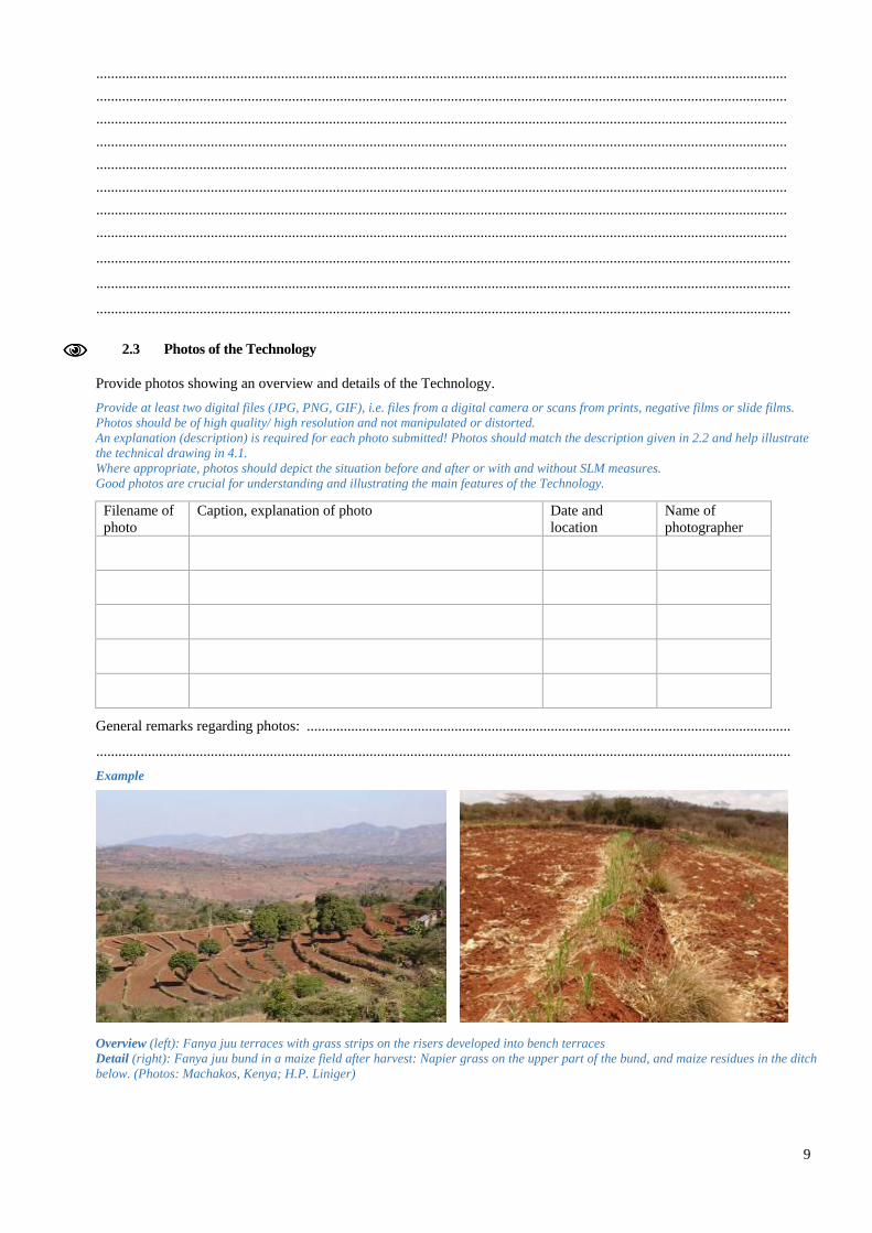
2.3 Photos of the Technology
Provide photos showing an overview and details of the Technology. Provide at least two digital files (JPG, PNG, GIF), i.e. files from a digital camera or scans from prints, negative films or slide films. Photos should be of high quality/ high resolution and not manipulated or distorted. An explanation (description) is required for each photo submitted! Photos should match the description given in 2.2 and help illustrate the technical drawing in 4.1. Where appropriate, photos should depict the situation before and after or with and without SLM measures. Good photos are crucial for understanding and illustrating the main features of the Technology.
Filename of photo
Caption, explanation of photo Date and location
Name of photographer
General remarks regarding photos: ...................................................................................................................................
............................................................................................................................................................................................ Example Overview (left): Fanya juu terraces with grass strips on the risers developed into bench terraces Detail (right): Fanya juu bund in a maize field after harvest: Napier grass on the upper part of the bund, and maize residues in the ditch below. (Photos: Machakos, Kenya; H.P. Liniger)
10
2.4 Videos of the Technology
If video files presenting the Technology are available, upload them to a public platform (e.g. vimeo.com, youtube.com) and indicate a link and a short description for each file in the table below.
Link Comments, short description Date and location
Name of videographer
2.5 Country/ region/ locations where the Technology has been applied and which are covered by this assessment
The described Technology might be applied in various sites. However, restrict information given in this questionnaire to only those sites that have been assessed/ analysed in the documentation process (through field visits, interviews with respective land users, reports, etc.). Do not include other sites where the same Technology is applied but no data have been collected. Country: ................................................. Region/ State/ Province: .........................................................................
Further specification of location (e.g. municipality, town, etc.), if relevant:: ..............................................................
Number of sites considered/ analysed in the documentation of this Technology:
single site 2-10 sites 10-100 sites 100-1,000 sites > 1,000 sites Site: A site can be a single plot or a larger area managed by individuals or a community, or a place where specific infrastructure has
been implemented (e.g. dam).
Geo-referenced information (coordinates) of the sites where the Technology was documented (reference sites):
Name of location, name of land user, etc. Longitude Latitude
Comments: ........................................................................................................................................................................
............................................................................................................................................................................................
2.6 Date of implementation
Indicate year of implementation: ……………………………………
If precise year is not known, indicate approximate date:
less than 10 years ago (recently) 10-50 years ago more than 50 years ago (traditional)
2.7 Introduction of the Technology
Specify how the Technology was introduced:
through land users’ innovation Comments (type of project, etc.) ..................
......................................................................
......................................................................
......................................................................
as part of a traditional system (> 50 years) during experiments/ research through projects/ external interventions other (specify): ………………………………..
11
The terms traditional and innovation refer to the land users’ own technologies. They cover technologies that have been in use for generations, as well as those developed more recently by innovative land users in response to changing circumstances. Use “other” when the Technology does not fit any of the given categories and specify why it does not fit.
3. Classification of the SLM Technology
3.1 Main purpose(s) of the Technology
Several answers possible.
improve production (crop, fodder, wood/ fibre, water, energy)
reduce, prevent, restore land degradation (soil, water, vegetation)
conserve ecosystem
protect a watershed/ downstream areas – in combination with other Technologies
preserve/ improve biodiversity
reduce risk of disasters (e.g. droughts, floods, landslides)
adapt to climate change/ extremes and its impacts (e.g. resilience to droughts, storms)
mitigate climate change and its impacts (e.g. through carbon sequestration)
create beneficial economic impact (e.g. increase income/ employment opportunities)
create beneficial social impact (e.g. reduce conflicts on natural resources, support marginalized groups)
other purpose (specify): ……………………………………………………………………………………………
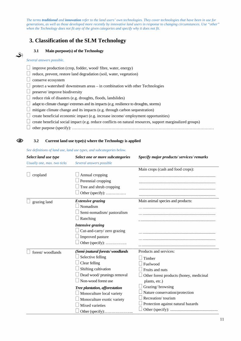
3.2 Current land use type(s) where the Technology is applied
See definitions of land use, land use types, and subcategories below.
Select land use type Usually one, max. two ticks
Select one or more subcategories Several answers possible
Specify major products/ services/ remarks
cropland
Annual cropping Perennial cropping Tree and shrub cropping Other (specify): ……………
Main crops (cash and food crops): ........................................................................... ........................................................................... ........................................................................... ...........................................................................
grazing land Extensive grazing Nomadism Semi-nomadism/ pastoralism Ranching Intensive grazing Cut-and-carry/ zero grazing Improved pasture Other (specify): …………….
Main animal species and products: … ....................................................................... … ....................................................................... .. ......................................................................... … ....................................................................... … ....................................................................... ... ........................................................................
forest/ woodlands (Semi-)natural forests/ woodlands Selective felling Clear felling Shifting cultivation Dead wood/ prunings removal Non-wood forest use
Tree plantation, afforestation Monoculture local variety Monoculture exotic variety Mixed varieties Other (specify):………………. ...
Products and services:
Timber Fuelwood Fruits and nuts Other forest products (honey, medicinal
plants, etc.) Grazing/ browsing Nature conservation/protection Recreation/ tourism Protection against natural hazards Other (specify): ...............................................

12
mixed (crops/ grazing/
trees), incl. agroforestry
Agroforestry Agro-pastoralism Agro-silvopastoralism Silvo-pastoralism Other (specify): ………………..
Main products/ services: ........................................................................... ........................................................................... ........................................................................... ........................................................................... ...........................................................................
settlements, infrastructure
Settlements, buildings Traffic: roads, railways Energy: pipelines, power lines Other (specify): ....................
Remarks: ........................................................................... ........................................................................... ........................................................................... ...........................................................................
waterways, waterbodies, wetlands
Drainage lines, waterways Ponds, dams Swamps, wetlands ........... Other (specify):
Main products/ services: ........................................................................... ........................................................................... ........................................................................... ...........................................................................
mines, extractive industries
Specify: ..................................... Main products: ...................................................
unproductive land Specify: ..................................... Remarks: ...........................................................
other (specify): ............. Specify: ..................................... Remarks: ...........................................................
Comments: .....................................................................................................................................................................
.........................................................................................................................................................................................
If land use has changed due to the implementation of the Technology, indicate land use before implementation of the Technology: ............................................................................................................................................................ Choose from the land use types and subcategories listed below. Land use: human activities which are directly related to land, making use of its resources or having an impact on it. Land cover: vegetation (natural or planted) or man-made structures (buildings, etc.) that cover the earth’s surface. Land use types Main categories Subcategories Cropland: land used for cultivation of crops (field crops, orchards)
• Ca: Annual cropping: land under temporary/ annual crops usually harvested within one, maximally two years (e.g. maize, paddy rice, wheat, vegetables, fodder crops)
• Cp: Perennial (non-woody) cropping: land under permanent (not woody) crops that may be harvested after 2 or more years, or where only part of the plants are harvested (e.g. sugar cane, banana, sisal, pineapple)
• Ct: Tree and shrub cropping: permanent woody plants with crops harvested more than once after planting and usually lasting for more than 5 years (e.g. orchard/ fruit trees, coffee, tea, grapevines, oil palm, cacao, coconut, fodder trees)
Grazing land: land used for animal production
• Ge: Extensive grazing land: grazing on natural or semi-natural grasslands, grasslands with trees/ shrubs (savannah vegetation) or open woodlands for livestock and wildlife. Includes the following subcategories: • Nomadism: people move with animals • Semi-nomadism/ pastoralism: animal owners have a permanent place of residence where
supplementary cultivation is practiced. Herds are moved to distant grazing grounds. • Ranching: grazing within well-defined boundaries, movements cover smaller distances and
management inputs are higher compared to semi-nomadism. • Gi: Intensive grazing/ fodder production: improved or planted pastures for grazing/ production of fodder
(for cutting and carrying: hay, leguminous species, silage etc.) not including fodder crops such as maize, cereals. These are classified as annual crops (see above). Intensive grazing can be subclassified into: • Cut-and-carry/ zero grazing: carrying fodder to animals confined to a stall/ shed or another
restricted area; in zero-grazing systems the livestock are not permitted to graze at any time • Improved pastures: pasture that is sown with a mixture of introduced grasses and legumes (can
be fertilized and/ or inoculated with rhizobia to fix nitrogen).
13
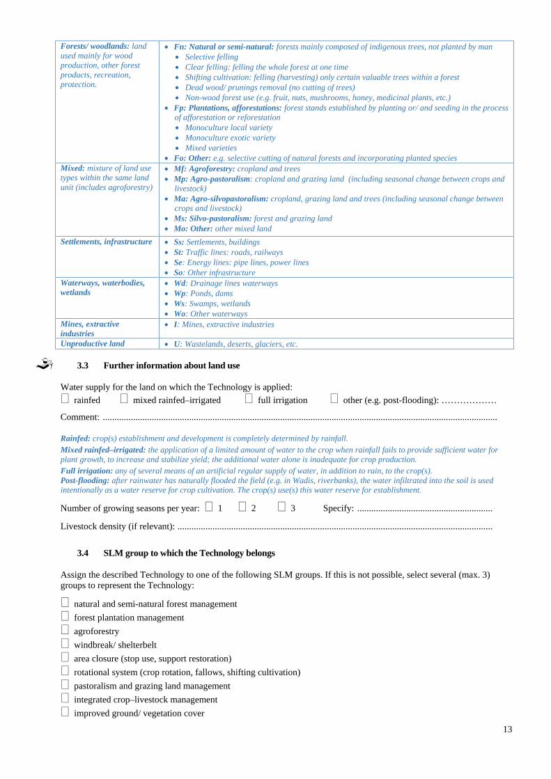
Forests/ woodlands: land used mainly for wood production, other forest products, recreation, protection.
• Fn: Natural or semi-natural: forests mainly composed of indigenous trees, not planted by man • Selective felling • Clear felling: felling the whole forest at one time • Shifting cultivation: felling (harvesting) only certain valuable trees within a forest • Dead wood/ prunings removal (no cutting of trees) • Non-wood forest use (e.g. fruit, nuts, mushrooms, honey, medicinal plants, etc.)
• Fp: Plantations, afforestations: forest stands established by planting or/ and seeding in the process of afforestation or reforestation • Monoculture local variety • Monoculture exotic variety • Mixed varieties
• Fo: Other: e.g. selective cutting of natural forests and incorporating planted species Mixed: mixture of land use types within the same land unit (includes agroforestry)
• Mf: Agroforestry: cropland and trees • Mp: Agro-pastoralism: cropland and grazing land (including seasonal change between crops and
livestock) • Ma: Agro-silvopastoralism: cropland, grazing land and trees (including seasonal change between
crops and livestock) • Ms: Silvo-pastoralism: forest and grazing land • Mo: Other: other mixed land
Settlements, infrastructure • Ss: Settlements, buildings • St: Traffic lines: roads, railways • Se: Energy lines: pipe lines, power lines • So: Other infrastructure
Waterways, waterbodies, wetlands
• Wd: Drainage lines waterways • Wp: Ponds, dams • Ws: Swamps, wetlands • Wo: Other waterways
Mines, extractive industries
• I: Mines, extractive industries
Unproductive land • U: Wastelands, deserts, glaciers, etc.
3.3 Further information about land use
Water supply for the land on which the Technology is applied: rainfed mixed rainfed–irrigated full irrigation other (e.g. post-flooding): ………………
Comment: ......................................................................................................................................................................... Rainfed: crop(s) establishment and development is completely determined by rainfall. Mixed rainfed–irrigated: the application of a limited amount of water to the crop when rainfall fails to provide sufficient water for plant growth, to increase and stabilize yield; the additional water alone is inadequate for crop production. Full irrigation: any of several means of an artificial regular supply of water, in addition to rain, to the crop(s). Post-flooding: after rainwater has naturally flooded the field (e.g. in Wadis, riverbanks), the water infiltrated into the soil is used intentionally as a water reserve for crop cultivation. The crop(s) use(s) this water reserve for establishment.
Number of growing seasons per year: 1 2 3 Specify: ..........................................................
Livestock density (if relevant): .......................................................................................................................................
3.4 SLM group to which the Technology belongs
Assign the described Technology to one of the following SLM groups. If this is not possible, select several (max. 3) groups to represent the Technology:
natural and semi-natural forest management forest plantation management agroforestry windbreak/ shelterbelt area closure (stop use, support restoration) rotational system (crop rotation, fallows, shifting cultivation) pastoralism and grazing land management integrated crop–livestock management improved ground/ vegetation cover
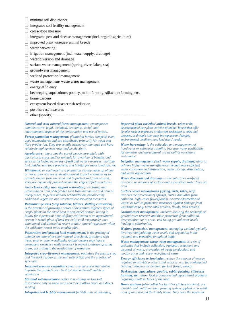
14
minimal soil disturbance integrated soil fertility management cross-slope measure integrated pest and disease management (incl. organic agriculture) improved plant varieties/ animal breeds water harvesting irrigation management (incl. water supply, drainage) water diversion and drainage surface water management (spring, river, lakes, sea) groundwater management wetland protection/ management waste management/ waste water management energy efficiency beekeeping, aquaculture, poultry, rabbit farming, silkworm farming, etc. home gardens ecosystem-based disaster risk reduction post-harvest measures other (specify): .............................................................................................. Natural and semi-natural forest management: encompasses administrative, legal, technical, economic, social, and environmental aspects of the conservation and use of forests. Forest plantation management: plantation forests comprise even-aged monocultures and are established primarily for wood and fibre production. They are usually intensively managed and have relatively high growth rates and productivity. Agroforestry: integrates the use of woody perennials with agricultural crops and/ or animals for a variety of benefits and services including better use of soil and water resources; multiple fuel, fodder, and food products; and habitat for associated species. Windbreak: or shelterbelt is a plantation usually made up of one or more rows of trees or shrubs planted in such a manner as to provide shelter from the wind and to protect soil from erosion. They are commonly planted around the edges of fields on farms. Area closure (stop use, support restoration): enclosing and protecting an area of degraded land from human use and animal interference, to permit natural rehabilitation, enhanced by additional vegetative and structural conservation measures. Rotational systems (crop rotation, fallows, shifting cultivation): is the practice of growing a series of dissimilar/ different types of crops/ plants in the same area in sequenced season, letting it fallow for a period of time, shifting cultivation is an agricultural system in which plots of land are cultivated temporarily, then abandoned and allowed to revert to their natural vegetation while the cultivator moves on to another plot. Pastoralism and grazing land management: is the grazing of animals on natural or semi-natural grassland, grassland with trees, and/ or open woodlands. Animal owners may have a permanent residence while livestock is moved to distant grazing areas, according to the availability of resources Integrated crop–livestock management: optimizes the uses of crop and livestock resources through interaction and the creation of synergies. Improved ground/ vegetation cover: any measures that aim to improve the ground cover be it by dead material/ mulch or vegetation Minimal soil disturbance refers to no-tillage or low soil disturbance only in small strips and/ or shallow depth and direct seeding. Integrated soil fertility management (IFSM) aims at managing
Improved plant varieties/ animal breeds: refers to the development of new plant varieties or animal breeds that offer benefits such as improved production, resistance to pests and diseases, or drought tolerance, in response to changing environmental conditions and land users’ needs. Water harvesting: is the collection and management of floodwater or rainwater runoff to increase water availability for domestic and agricultural use as well as ecosystem sustenance. Irrigation management (incl. water supply, drainage) aims to achieve higher water use efficiency through more efficient water collection and abstraction, water storage, distribution, and water application. Water diversion and drainage: is the natural or artificial diversion or removal of surface and sub-surface water from an area Surface water management (spring, river, lakes, sea): involves the protection of springs, rivers, and lakes from pollution, high water flows(floods), or over-abstraction of water, as well as protection measures against damage from waterbodies (e.g. river bank erosion, floods, tidal erosion) Groundwater management: involves securing the recharge of groundwater reserves and their protection from pollution, overexploitation/ overuse, and rising groundwater levels leading to salinization. Wetland protection/ management: managing wetland typically involves manipulating water levels and vegetation in the wetland, and providing an upland buffer. Waste management/ waste water management: is a set of activities that include collection, transport, treatment and disposal of waste, prevention of waste production, and modification and reuse/ recycling of waste. Energy efficiency technologies: reduce the amount of energy required to provide products and services, e.g. for cooking and heating, reducing the demand for fuel (fossil, wood). Beekeeping, aquaculture, poultry, rabbit farming, silkworm farming, etc.: allow food production and agricultural products requiring small surfaces of the land. Home gardens (also called backyard or kitchen gardens): are a traditional multifunctional farming system applied on a small area of land around the family home. They have the potential
15
soil by combining different methods of soil fertility amendment together with soil and water conservation. ISFM is based on three principles: maximizing the use of organic sources of fertilizer (e.g. manure and compost application, nitrogen-fixing green manure and cover crops); minimizing the loss of nutrients; and judiciously using inorganic fertilizer according to needs and economic availability. Cross-slope measures: are constructed on sloping lands in the form of earth or soil bunds, stone lines, or vegetative strips, etc. for reducing runoff velocity and soil erosion. Integrated pest and disease management (incl. organic agriculture): Integrated pest and disease management is a process to solve pest and disease problems while minimizing risks to people and the environment.
to supply most of the non-staple foods (including vegetables, fruits, herbs, animals and fish). They also provide a space for recreation, leisure, and relaxation. Ecosystem-based Disaster Risk Reduction: is the sustainable management, conservation, and restoration of ecosystems with the aim of enabling these ecosystems to provide services that mitigate hazards, reduce vulnerability, and increase livelihood resilience. Post-harvest measures: encompasses activities to deliver a crop from harvest to consumption with minimum loss, maximum efficiency, and maximum return for all involved – such as drying, storage, cooling, cleaning, sorting, and packing.
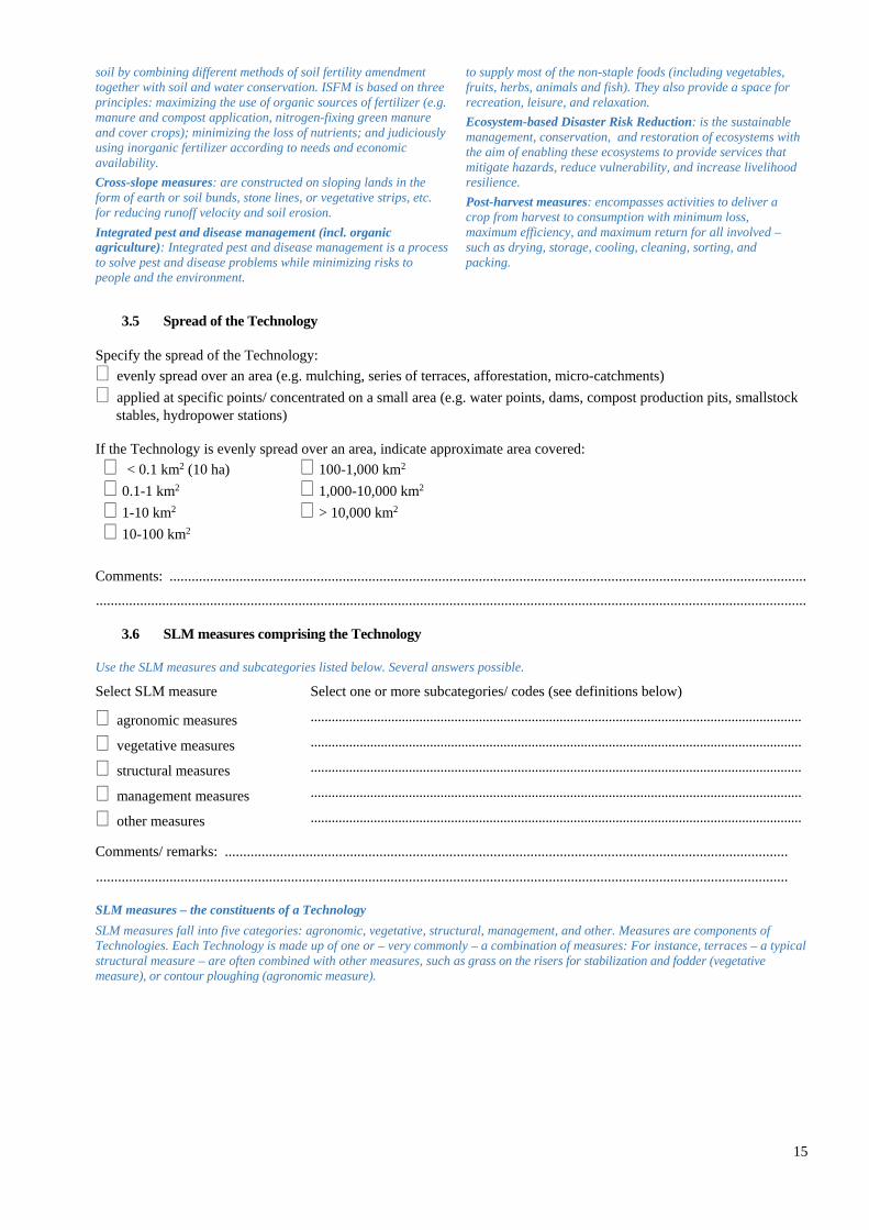
3.5 Spread of the Technology
Specify the spread of the Technology: evenly spread over an area (e.g. mulching, series of terraces, afforestation, micro-catchments) applied at specific points/ concentrated on a small area (e.g. water points, dams, compost production pits, smallstock
stables, hydropower stations) If the Technology is evenly spread over an area, indicate approximate area covered: < 0.1 km2 (10 ha) 100-1,000 km2 0.1-1 km2 1,000-10,000 km2 1-10 km2 > 10,000 km2 10-100 km2
Comments: ............................................................................................................................................................................. .................................................................................................................................................................................................
3.6 SLM measures comprising the Technology
Use the SLM measures and subcategories listed below. Several answers possible.
Select SLM measure Select one or more subcategories/ codes (see definitions below)
agronomic measures ............................................................................................................................................
vegetative measures ............................................................................................................................................
structural measures ............................................................................................................................................
management measures ............................................................................................................................................
other measures ............................................................................................................................................
Comments/ remarks: .........................................................................................................................................................
............................................................................................................................................................................................
SLM measures – the constituents of a Technology SLM measures fall into five categories: agronomic, vegetative, structural, management, and other. Measures are components of Technologies. Each Technology is made up of one or – very commonly – a combination of measures: For instance, terraces – a typical structural measure – are often combined with other measures, such as grass on the risers for stabilization and fodder (vegetative measure), or contour ploughing (agronomic measure).
16
Type of measure Subcategories Examples
Agronomic measures
• are usually associated with annual
crops • are repeated routinely each season
or in a rotational sequence • are of short duration and not
permanent • do not lead to changes in slope
profile • are normally independent of slope
A1: Vegetation/ soil cover Mixed cropping, intercropping, relay cropping, cover cropping
A2: Organic matter/ soil fertility Conservation agriculture, production and application of compost/ manure, mulching, trash lines, green manure, crop rotations
A3: Soil surface treatment Zero tillage (no-till), minimum tillage, contour tillage A4: Subsurface treatment Breaking compacted subsoil (hard pans), deep ripping,
double digging A5: Seed management, improved
varieties Production of seeds and seedlings, seed selection, seed banks, development/ production of improved varieties
A6: Others
Vegetative measures
• involve the use of perennial grasses,
shrubs, or trees • are of long duration • often lead to a change in slope
profile • are often aligned along the contour
or against the prevailing wind direction
• are often spaced according to slope
V1: Tree and shrub cover Agroforestry, windbreaks, afforestation, hedges, live fences
V2: Grasses and perennial herbaceous plants
Grass strips along the contour, vegetation strips along riverbanks
V3: Clearing of vegetation Fire breaks, reduced fuel for forest fires V4: Replacement or removal of
alien/ invasive species Cutting of undesired trees and bushes
V5: Others Tree nurseries
Structural measures
• are of long duration or permanent • often require substantial inputs of
labour or money when first installed • involve major earth movements and/
or construction with wood, stone, concrete, etc. are often carried out to control runoff, erosion, and wind velocity, and to harvest rainwater
• often lead to a change in slope profile
• are often aligned along the contour/ against prevailing wind direction
• are often spaced according to slope If structures are stabilized by means of vegetation, also select relevant vegetative measures!
S1: Terraces Bench terraces (slope of terrace bed <6%); Forward-sloping terraces (slope of terrace bed >6%
S2: Bunds, banks Earth bunds, stone bunds (along the contour or graded), semi-circular bunds (“demi-lunes”)
S3: Graded ditches, channels, waterways
Diversion/ drainage ditch, waterways to drain and convey water
S4: Level ditches, pits Retention / infiltration ditches, planting holes, micro-catchments
S5: Dams, pans, ponds Dams for flood control, dams for irrigation, sand dams S6: Walls, barriers, palisades,
fences Sand dune stabilization, rotational grazing (using fences), area closure, gully plugs (check dams)
S7: Water harvesting/ supply/ irrigation equipment
Rooftop water harvesting, water intakes, pipes, tanks, etc.
S8: Sanitation/ waste water structures
Compost toilet, septic tanks, constructed treatment wetlands
S9: Shelters for plants and animals Greenhouses, stables, shelters for plant nurseries S10: Energy saving measures Wood-saving stoves, insulation of buildings, renewable
energy sources (solar, biogas, wind, hydropower) S11: Others Compost production pits; reshaping of surface (slope
reduction)
Management measures M1: Change of land use type Area closure/ resting, protection, change from
cropland to grazing land, from forest to agroforestry, afforestation
• involve a fundamental change in
land use • usually involve no agronomic and
structural measures • often result in improved vegetative
M2: Change of management/ intensity level
Change from grazing to cutting (for stall feeding), farm enterprise selection (degree of mechanization, inputs, commercialization), vegetable production in greenhouses, irrigation; from mono-cropping to rotational cropping; from continuous cropping to managed fallow; from open access to controlled access (grazing land, forests); from herding to fencing, adjusting stocking rates, rotational grazing
M3: Layout according to natural and human environment
Exclusion of natural waterways and hazardous areas, separation of grazing types, distribution of water
17
cover • often reduce the intensity of use
points, salt licks, livestock pens, dips (grazing land); increase of landscape diversity, forest aisle
M4: Major change in timing of activities
Land preparation, planting, cutting of vegetation
M5: Control/ change of species composition (if annually or in a rotational sequence as done e.g. on cropland A1)
Reduction of invasive species, selective clearing, encouragement of desired/ introduction of new species, controlled burning (e.g. prescribed fires in forests/ on grazing land)/ residue burning
M6: Waste management (recycling, re-use or reduce)
Includes both artificial and natural methods for waste management
M7: Others Other measures • comprises any measures which do
not fit into the above categories
Beekeeping, smallstock farming (e.g. poultry, rabbits), fish ponds; food storage and processing (including post-harvest loss reduction)
Combinations Terrace (S1) + Grass strips and trees along riser (V2, V1) + Contour tillage (A3) Zero grazing/ stall feeding (M2) + Construction of stables and fence (S10) + Compost/ manure production pits (S12) + Application of manure and compost on cropland (A2)
• occur where different measures complement each other and thus enhance each other’s effectiveness
• may comprise any two or more of the above measures
3.7 Main types of land degradation addressed by the Technology
Land degradation: Degradation of land resources, including soils, water, vegetation, and animals. Use the degradation types and subcategories listed below. Several answers possible. Detailed information on the causes of land degradation may be documented using the WOCAT Mapping Tool.
Select degradation type Select one or more subcategories/ codes (see definitions below)
soil erosion by water ...........................................................................................................................
soil erosion by wind ...........................................................................................................................
chemical soil deterioration ...........................................................................................................................
physical soil deterioration ...........................................................................................................................
biological degradation ...........................................................................................................................
water degradation ...........................................................................................................................
other ...........................................................................................................................
Comments/ remarks (e.g. human-induced and natural causes of degradation): ……………………………………...
………………………………………………………………………………………………………………………...
Degradation types
W: Soil erosion by water Wt Loss of topsoil/ surface erosion: even removal of top soil, sheet and interrill erosion Wg Gully erosion/ gullying Wm Mass movements/ landslides Wr Riverbank erosion Wc Coastal erosion Wo Offsite degradation effects: deposition of sediments, downstream flooding, siltation of reservoirs and waterways,
and pollution of water bodies with eroded sediments E: Soil erosion by wind
Et Loss of topsoil: uniform displacement Ed Deflation and deposition: uneven removal of soil material Eo Offsite degradation effects: covering of the terrain with windborne sand particles from distant sources (“overblowing”)
C: Chemical soil deterioration Cn Fertility decline and reduced soil organic matter content (not caused by erosion): e.g. leaching, soil fertility
mining, nutrient oxidation and volatilization (N) Ca Acidification: lowering of the soil pH Cp Soil pollution: contamination of the soil with toxic materials Cs Salinization/ alkalinization: a net increase of the salt content of the (top) soil leading to a productivity decline
P: Physical soil deterioration Pc Compaction: deterioration of soil structure by trampling or the weight and/ or frequent use of machinery
18
Pk Slaking and crusting: clogging of pores with fine soil material and development of a thin impervious layer at the soil surface obstructing the infiltration of rainwater
Pi Soil sealing: covering of the ground by an impermeable material (e.g. construction, mining, roads, etc.) Pw Waterlogging: effects of human-induced water saturation of soils (excluding paddy fields) Ps Subsidence of organic soils, settling of soil Pu Loss of bio-productive function due to other activities
B: Biological degradation Bc Reduction of vegetation cover: increase of bare/ unprotected soil Bh Loss of habitats: decreasing vegetation diversity (fallow land, mixed systems, field borders), increased
fragmentation of habitats Bq Quantity/ biomass decline: reduced vegetative production for different land use Bf Detrimental effects of fires (includes low/ high severity of fires): on forest (e.g. slash and burn), bushland, grazing
land, and cropland (burning of residues) Bs Quality and species composition/ diversity decline: loss of natural species, land races, palatable perennial grasses;
spreading of invasive, salt-tolerant, unpalatable, species/ weeds Bl Loss of soil life: decline of soil macro-organisms and micro-organisms in quantity and quality Bp Increase of pests/ diseases, loss of predators: reduction of biological control
H: Water degradation Ha Aridification: decrease of average soil moisture content Hs Change in quantity of surface water: change of the flow regime (flood, peak flow, low flow, drying up of rivers and
lakes) Hg Change in groundwater/ aquifer level: lowering of groundwater table due to over-exploitation or reduced recharge
of groundwater; or increase of groundwater table resulting in waterlogging and/ or salinization Hp Decline of surface water quality: increased sediments and pollutants in fresh water bodies due to point pollution
and land-based pollution Hq Decline of groundwater quality: due to pollutants infiltrating into the aquifers Hw Reduction of the buffering capacity of wetland areas to cope with flooding and pollution
3.8 Prevention, reduction, or restoration of land degradation
Tick max. two answers. Specify the goal of the Technology with regard to land degradation: prevent land degradation
reduce land degradation
restore/ rehabilitate severely degraded land
adapt to land degradation
not applicable
Comments/ remarks: ..............................................................................................................................................
................................................................................................................................................................................. Prevention: good land management practices that are already in place on land that may be prone to land degradation. They maintain natural resources and their environmental and productive functions. Reduction: interventions intended to reduce ongoing degradation and/ or halt further degradation. They start improving natural resources and their functions. Impacts tend to be noticeable in the short to medium term. Rehabilitation/ restoration: required when the land is already degraded to such an extent that the original use is no longer possible, and land has become practically unproductive. Here, longer-term and more costly investments are needed to show any impact. Adaptation: applied when rehabilitation/ restoration of the original state of the land is no longer possible or requires resources beyond the means of land users. This means the state of land degradation is “accepted”, but land management is adapted to suit land degradation (e.g. adapting to soil salinity by introducing salt-tolerant plants).

19
4. Technical specifications, implementation activities, inputs, and costs
4.1 Technical drawing of the Technology
Please provide a comprehensive and detailed drawing (including dimensions) of the Technology and indicate technical specifications, measurements, spacing, gradient, etc. You can also provide several drawings showing (a) a temporal sequence of operations or (b) different elements or details of the Technology. Alternatively you can also provide one or several photographs with technical specifications drawn and/ or written onto the photograph(s). Include as much technical information as possible on the drawings (or photographs). Keep the drawing simple and schematic. The technical drawing is crucial for understanding the Technology! Scan the drawing and upload the scan.
Author: ........................................................................................................................... .. Date: ....................................
Example: Technical drawing indicating technical specifications, dimensions, spacing

20
4.2 Technical specifications/ explanations of technical drawing
Summarize technical specifications, e.g.: • Dimensions (height, depth, width, length) of structures or vegetative elements • Spacing between structures or plants/ vegetative measures • Vertical intervals structures or vegetative measures • Slope angle (before and after implementation of the Technology) • Lateral gradient of structures • Capacity of dams, ponds, etc. • Catchment area and beneficial area of dams, ponds, other water harvesting systems • Construction material used • Species used • Quantity/ density of plants (per ha)
............................................................................................................................................................................................
............................................................................................................................................................................................
............................................................................................................................................................................................
............................................................................................................................................................................................
............................................................................................................................................................................................
............................................................................................................................................................................................
............................................................................................................................................................................................
............................................................................................................................................................................................
............................................................................................................................................................................................
............................................................................................................................................................................................
4.3 General information regarding the calculation of inputs and costs
Notes on implementation activities, inputs, and costs: • It may be very difficult to determine the costs of a Technology. Nevertheless, we ask you to give your best estimate! • A distinction is made between initial establishment (construction, initiation) and maintenance/ recurrent annual activities. • All costs should be calculated based on market prices. If labour is provided by land users themselves, indicate equivalent cost of
hired labour. If inputs are provided/ produced by land users themselves, indicate equivalent market price. • Exclude costs of awareness creation, planning, training, research, and financial/ material support (these will be addressed in the
Approach questionnaire). If the objective is to compare two situations, i.e. the situation after/ with SLM measures (e.g. conservation agriculture) and the situation before/ without SLM measures (e.g. conventional agriculture), fill in two questionnaires.
• Preferably, activities, inputs, and costs should be calculated per area on which the Technology is applied. If you use a local area unit, indicate conversion factor between local unit and hectares. Include not only the area which is immediately covered by SLM measures (e.g. the area covered by stone walls, tree lines, ditches) but also the area that is affected/ protected by the SLM measures (e.g. the area between stone walls, tree lines, ditches).
• Alternatively, if it is not possible to calculate activities, inputs, and costs per area, they may be calculated per unit (e.g. dam, animal watering point, energy saving stove) or per length (e.g. metre of stone line)
Specify how costs and inputs were calculated: per Technology area indicate size and area unit: ……………………… (e.g. 24 acres, 4.5 hectares) If using a local area unit, indicate conversion factor: 1 hectare =…………… per Technology unit: specify unit: …………………….. (e.g. watering point, energy saving stove, stone line) specify volume, length, etc. (if relevant): ………….. (e.g. stone lines: 250 m, dam: 20,000 m3) Specify currency used for cost calculations: US Dollars other/ national currency (specify): ........................ You can use US dollars (USD) or any other national currency. Indicate all costs using the same currency.
Indicate exchange rate from USD to local currency (if relevant): 1 USD =...................................
Indicate average wage cost of hired labour per day: …………………………….
21
4.4 Establishment activities
List establishment activities for the Technology (in sequence) and indicate timing
Activity Type of measure1
(A/V/S/M/O)
Timing2
1. ................................................................................................................................... ...................... ...........................
2. ................................................................................................................................... .................... ...........................
3. ................................................................................................................................... .................... ...........................
4. ................................................................................................................................... .................... ...........................
5. ................................................................................................................................... .................... ...........................
6. ................................................................................................................................... .................... ...........................
7. ................................................................................................................................... .................... ...........................
8. ................................................................................................................................... .................... ...........................
9. ................................................................................................................................... .................... ...........................
10. ................................................................................................................................. .................... ...........................
Comments: ........................................................................................................................................................................ 1 Type of measure: A = Agronomic; V = Vegetative; S = Structural; M = Management; O = Other measures; refer to 3.6 2 Timing: time during which activity is carried out, e.g. month or season, or “after harvest of crops”, “before onset of rains”, etc.
4.5 Costs of inputs needed for establishment
Note: Costs and inputs specified below should refer to the Technology area/ Technology unit defined in 4.3 and to the activities listed in 4.4. Use the currency indicated in 4.3. If possible, break down the costs of establishment according to the following table, specifying inputs and costs per input. If you are unable to break down the costs, give an estimation of the total costs of establishing the Technology: ……………………………………………………………………………………………………………………………...
Input Specify input3 Unit4 Quantity Costs per unit
Total costs per input
% of costs borne by land users
Labour
Equipment
Plant material
Fertilizers and biocides
Construction material
Others
Total costs of establishment of the Technology
22
3 Specify inputs: - Labour includes total person-days, be they paid or unpaid (e.g. contributed by family members). Under “Costs per unit”,
indicate daily wage for hired labour. If relevant, differentiate between skilled and unskilled labour. - Equipment includes tools, machine hours, animal traction, etc. Cost calculation for machine hours and animal traction should
be based on hiring costs – even if the machinery/ animals are owned by the land user. - Plant material includes seeds, seedling, cuttings, etc. - Fertilizers and biocides: compost/ manure, inorganic fertilizer, herbicides, pesticides, etc. - Construction material includes timber, stones, earth, cement, pipes, tanks, etc.
4 Units: person-days, kg, litres, pieces, etc.
If land user bore less than 100% of costs, indicate who covered the remaining costs: .....................................................
Remarks/ comments: .........................................................................................................................................................
............................................................................................................................................................................................
4.6 Maintenance/ recurrent activities
List maintenance/ recurrent activities for the Technology (in sequence) and indicate timing
Activity Type of measure1
(A/V/S/M/O)
Timing2/ frequency3
1. ................................................................................................................................... .................... ...........................
2. ................................................................................................................................... .................... ...........................
3. ................................................................................................................................... .................... ...........................
4. ................................................................................................................................... .................... ...........................
5. ................................................................................................................................... .................... ...........................
6. ................................................................................................................................... .................... ...........................
7. ................................................................................................................................... .................... ...........................
8. ................................................................................................................................... .................... ...........................
9. ................................................................................................................................... .................... ...........................
10. ................................................................................................................................. .................... ...........................
Comments: ........................................................................................................................................................................ 1 Type of measure: A = Agronomic; V = Vegetative; S = Structural; M = Management; O = Other measures; refer to 3.6 2 Timing: time during which activity is carried out, e.g. month or season, or “after harvest of crops”, “before onset of rains”, etc. 3 Frequency: e.g. annually, each cropping season, etc.
4.7 Costs of inputs and recurrent activities needed for maintenance (per year)
Note: Costs and inputs specified below should refer to the Technology area/ Technology unit defined in 4.3 and to the activities listed in 4.6. Use the currency indicated in 4.3.
If possible, break down the costs of maintenance according to the following table, specifying inputs and costs per input. If you are unable to break down the costs, give an estimation of the total costs of maintaining the Technology: ………………………………………………………………………………………………………………………………
Input Specify input4 Unit5 Quantity Costs per Unit
Total costs per input
% of costs borne by land users
Labour
Equipment
Plant material
23
Fertilizers and biocides
Construction material
Others
Total costs of maintenance of the Technology 4 Specify inputs:
- Labour includes total person-days, be they paid or unpaid (e.g. contributed by family members). Under “Costs per unit”, indicate daily wage for hired labour. If relevant, differentiate between skilled and unskilled labour.
- Equipment includes tools, machine hours, animal traction, etc. Cost calculation for machine hours and animal traction should be based on hiring costs – even if the machinery/ animals are owned by the land user.
- Plant material includes seeds, seedling, cuttings, etc. - Fertilizers and biocides: compost/ manure, inorganic fertilizer, herbicides, pesticides, etc. - Construction material includes timber, stones, earth, cement, pipes, tanks, etc.
5 Units: person-days, kg, litres, pieces, etc.
If land user bore less than 100% of costs, indicate who covered the remaining costs: .....................................................
Remarks/ comments: .........................................................................................................................................................
............................................................................................................................................................................................
4.8 Most important factors affecting costs
............................................................................................................................................................................................
............................................................................................................................................................................................
24
5. Natural and human environment
Give details of the natural (biophysical) conditions where the Technology is applied. Make specific reference to the sites where the documented Technology has been assessed and analysed. Tick one box per question only, except for slope and soil parameters (see indications below). Use comment sections to specify your answers and provide additional information. Note: Some of the environmental conditions (e.g. slope angle, soil characteristics, water quality/ availability, etc.) may change as a result of the Technology! However, you are requested to describe the conditions as they were without any impact of sustainable land management! In exceptional cases, certain questions might not be relevant for the Technology. In such cases, skip the question but use the comment sections to explain why you are skipping it.
5.1 Climate
Annual rainfall (max. 2 ticks)
< 250 mm
251-500 mm
501-750 mm
751-1,000 mm
1,001-1,500 mm
1,501-2,000 mm
2,001-3,000 mm
3,001-4,000 mm
> 4,000 mm
Agro-climatic zone
humid
sub-humid
semi-arid arid
Agro-climatic zone • Humid: length of growing period (LGP) > 270 days • Sub-humid: LGP 180-269 days • Semi-arid: LGP 75-179 days • Arid: LGP < 74 days
5.2 Topography
Slopes on average (max. 2 ticks) Landforms (max. 2 ticks) Altitudinal zone (max. 2 ticks)
flat (0-2%) plateau/ plains < 100 m a.s.l. gentle (3-5%) ridges 101-500 m a.s.l. moderate (6-10%) mountain slopes 501-1,000 m a.s.l. rolling (11-15%) hill slopes 1,001-1,500 m a.s.l. hilly (16-30%) footslopes 1,501-2,000 m a.s.l. steep (31-60%) valley floors 2,001-2,500 m a.s.l. very steep (> 60%) 2,501-3,000 m a.s.l. 3,001-4,000 m a.s.l. > 4,000 m a.s.l. Slope gradient conversion table:
Slope in degrees Slope in percent 1° 2% 3° 5% 5° 8% 9° 16% 17° 30% 31° 60%
Landforms (modified from ISRIC 1993): • Plateau/ plains: extended level land (slopes less than 8%). • Ridges: narrow elongated area rising above the surrounding area, often hilltops or
mountaintops. • Mountain slopes (including major escarpments): extended area with altitude
differences of more than 600 m per 2 km and slopes greater than 15% • Hill slopes (including valley and minor escarpment slopes): altitude difference of
less than 600 m per 2 km and slopes greater than 8%
Specifications/ comments on climate: ...................................................................
...............................................................................................................................
...............................................................................................................................
Specify average annual rainfall (if known): ……………………….. mm Other specifications/ comments on rainfall distribution, seasonality (e.g. monsoon, winter/ summer rains), number/ length/ months of rainy seasons, occurrence of heavy rains, length of dry periods: .............................................. ............................................................................................................................ ............................................................................................................................ ............................................................................................................................ ............................................................................................................................
Indicate the name of the reference meteorological station considered: .............
............................................................................................................................
Length of growing period (LGP) is defined as the period during which precipitation is more than half of the potential evapotranspiration (PET) and the temperature is higher than 6.5° C.
25
45° 100% • Footslopes: zone bordering steeper mountain/ hill slopes on one side and valley floors/ plains/ plateaus on the other side
• Valley floors: elongated strips of level land (less than 8% slope), flanked by sloping or steep land on both sides
Indicate if the Technology is specifically applied in convex situations: concave situations not relevant convex: ridge (diversion of water flow) concave: depression (conversion of water flow)
Comments and further specifications on topography (e.g. exact altitude and slope angles of the evaluated sites): .......... ............................................................................................................................................................................................ ............................................................................................................................................................................................
5.3 Soils
Max. 2 ticks per question. Soil depth on average Soil texture (topsoil) Topsoil organic matter
very shallow (0-20 cm) coarse/ light (sandy) high (> 3%) shallow (21-50 cm) medium (loamy, silty) medium (1-3%) moderately deep (51-80 cm) fine/ heavy (clay) low (< 1%) deep (81-120 cm) Soil texture (> 20 cm below surface)
very deep (> 120 cm) coarse/ light (sandy) medium (loamy, silty) fine/ heavy (clay)
If available, attach full soil description or specify the available information, e.g. soil type, soil PH/ acidity, Cation Exchange Capacity, nitrogen, salinity etc.): .......................................................................... ........................................................................................................................................................................ ........................................................................................................................................................................
5.4 Water availability and quality
One tick per question. Groundwater table Availability of surface water Water quality (untreated)
on surface excess (e.g. frequent waterlogging, high runoff) good drinking water
< 5 m good (e.g. available year-round) poor drinking water (treatment required)
5-50 m medium (e.g. not available year-round) for agricultural use only (irrigation)
> 50 m poor/ none unusable
Is water salinity a problem? no yes Specify: …………………………………………………………....
Is flooding of the area occurring? no yes If yes: frequently episodically Comments and further specifications on water quality and quantity (e.g. seasonal fluctuations, source of pollution) ..... ............................................................................................................................................................................................
26
5.5 Biodiversity
Indicate the state of biodiversity in the analysed sites relative to your region/ country standards. Tick one option per question. Species diversity Habitat diversity
high high medium medium low low Comments and further specifications on biodiversity: ...................................................................................................... ............................................................................................................................................................................................ Species diversity: a measure of diversity within an ecological community that incorporates both species richness (the number of species in a community) and the evenness of species’ abundance; species include all fauna and flora above ground and in the soil (modified from eoearth.org) Habitat diversity: refers to the variety or range of habitats in a given region, landscape, or ecosystem (modified from oecd.org)
5.6 Characteristics of land users applying the Technology
Specify the characteristics of the average/ typical land users who apply the Technology. Tick max. two answers per question. Indicate characteristics relative to your region/ country standards.
Sedentary or nomadic Market orientation of production system Off-farm income1
Sedentary subsistence (self-supply) < 10% of all income Semi-nomadic mixed (subsistence/ commercial) 10-50% of all income Nomadic commercial/ market > 50% of all income Other (specify): …………..
Relative level of wealth2 Individuals or groups Level of mechanization
very poor individual/ household manual work poor groups/ community animal traction average cooperative mechanized/ motorized rich employee (company, government)
very rich Gender3 Age of land users (several answers possible)
women children youth
men middle-aged elderly
1 Off-farm income: income other than from the use of cropland, grazing land, forest, and mixed land (e.g. from business, trade, manufacturing, industry, pension, remittances) 2 Relative level of wealth: use local instead of international standards 3 Indicate gender of persons using the land
Indicate other relevant characteristics of the land users: ..................................................................................................
...........................................................................................................................................................................................
27
5.7 Average area of land owned or leased by land users applying the Technology
Indicate the total area owned or leased by land users, including the land where no Technology is applied. Tick max. two answers. < 0.5 ha
0.5-1 ha
1-2 ha
2-5 ha
5-15 ha
15-50 ha
50-100 ha
100-500 ha
500-1,000 ha
1,000-10,000 ha
> 10,000 ha
5.8 Land ownership, land use rights, and water use rights
Tick max two options per question Land ownership Land use rights Water use rights (if relevant)
state open access (unorganized) open access (unorganized) company communal (organized) communal (organized) communal/ village leased leased group individual individual individual, not titled other (specify): ....................... other (specify): ....................... individual, titled
other (specify): .........................
Comments: ............................................................................................................................................................... ................................................................................................................................................................................... Land ownership refers to the type of entity possessing the land, whereas land use rights refer to the type of entity having a right to access the land Land use rights/ water use rights: • Open access: means free for all • Communal (organized): means subject to community-agreed management rules • Leased: right to use land for a limited period of time against payment (contract) • Individual: right of use pertains to single user
5.9 Access to services and infrastructure
poor moderate good health education technical assistance employment (e.g. off-farm) markets energy roads and transport drinking water and sanitation financial services other (specify): ……………..
Is this considered small-, medium- or large-scale (referring to local context)?
small-scale medium-scale large-scale Comments: ......................................................................................................................... ............................................................................................................................................ ............................................................................................................................................
28
6. Impacts and concluding statements
Assess relevant impacts in the table below. If data based on measurements are not available, give your best estimate. Negligible means “no significant benefit nor disadvantage”. Make use of the “Quantify before SLM/ after SLM” and “Comments/ specify” columns to show evidence and justify your selection as far as possible. Choose adequate indicators to quantify impacts (e.g. t/ha for crop production, coliform measurement for water quality, etc.). Even if a 10% increase (e.g. in yield) might be judged as a great improvement, please nonetheless tick the category “Slightly positive (+5-20%)”, and use “Comments” to explain. Only indicate “Quantify (before/ after)” if impacts were measured in the field or determined by means of a survey. Impacts that are not ticked are considered “not relevant” or “not applicable”.
On-site: concerns the area where the Technology is applied. Off-site: concerns adjacent areas or areas further away from the area where the Technology is applied.
6.1 On-site impacts the Technology has shown
0BFirst, tick relevant impacts (tick boxes on the left, several answers possible). Then, for each selected impact, tick the extent and specify/ quantify if possible.
Ver
y ne
gativ
e (–
50-
100%
) N
egat
ive
(– 2
0-50
%)
Slig
htly
neg
ativ
e (–
5-2
0%)
Neg
ligib
le im
pact
Sl
ight
ly p
ositi
ve (+
5-20
%)
Posi
tive
(+20
-50%
) V
ery
posi
tive
(+50
-100
%)
If possible, quantify before SLM
after SLM
Comments/ specify
Socio-economic impacts
Production crop production decreased increased ............. ............ ................................ crop quality decreased increased fodder production decreased increased ............. ............ ................................ fodder quality decreased increased ............. ............ ................................ animal production decreased increased ............. ............ ................................ wood production decreased increased ............. ............ ................................ forest/ woodland quality decreased increased ............. ............ ................................ non-wood forest production decreased increased ............. ............ ................................ risk of production failure increased decreased ............. ............ ................................ product diversity decreased increased ............. ............ ................................ production area (new land decreased
under cultivation/ use) increased ............. ............ ................................
land management: hindered simplified ............. ............ ................................ energy generation decreased
(e.g. hydro, bio) increased
............. ............ ................................
Water availability and quality drinking water availability decreased increased ............. ............ ................................ drinking water quality decreased increased ............. ............ ................................ water availability for livestock decreased increased ............. ............ ................................ water quality for livestock decreased increased ............. ............ ................................ irrigation water availability decreased increased ............. ............ ................................ irrigation water quality decreased increased ............. ............ ................................ demand for irrigation water increased decreased ............. ............ ................................
Income and costs expenses on agricultural inputs incr. reduced ............. ............ ................................ farm income decreased increased ............. ............ ................................ diversity of income sources decreased increased ............. ............ ................................

29
economic disparities increased decreased ............. ............ ................................ workload increased decreased ............. ............ ................................ Other socio-economic impacts (specify): ......................... ……….. ……………. ............. ............ ................................ (specify): ......................... ……….. ……………. ............. ............ ................................ (specify): ......................... ……….. ……………. ............. ............ ................................ Sociocultural impacts food security/ self-sufficiency reduced improved ............. ............ ................................ health situation worsened improved ............. ............ ................................ land use/ water rights worsened improved ............. ............ ................................ cultural opportunities (spiritual, religious,
aesthetic etc.) reduced improved ............. ............ ................................
recreational opportunities reduced increased ............. ............ ................................ community institutions weakened strengthened ............. ............ ................................ national institutions weakened strengthened ............. ............ ................................ SLM/ land degradation
knowledge reduced improved ............. ............ ................................
conflict mitigation worsened improved ............. ............ ................................ situation of socially and economically
disadvantaged groups (gender, age, status, ethnicity etc.) worsened
improved ............. ............ ................................
Other sociocultural impacts (specify): ......................... ………….. ……………. ............. ............ ................................ (specify): ......................... ………….. ……………. ............. ............ ................................ (specify): ......................... ………….. ……………. ............. ............ ................................ Ecological impacts Water cycle/ runoff water quantity decreased increased ............. ............ ................................ water quality decreased increased ............. ............ ................................ harvesting/ collection of water
(runoff, dew, snow, etc.) reduced improved
............. ............ ................................ surface runoff increased decreased ............. ............ ................................ excess water drainage reduced improved ............. ............ ................................ groundwater table/ aquifer lowered recharge ............. ............ ................................ evaporation increased decreased ............. ............ ................................
Soil soil moisture decreased increased ............. ............ ................................ Soil cover reduced improved ............. ............ ................................ soil loss increased decreased ............. ............ ................................ soil accumulation decreased increased ............. ............ ................................ soil crusting/ sealing increased reduced ............. ............ ................................ soil compaction increased reduced ............. ............ ................................ nutrient cycling/ recharge decreased increased ............. ............ ................................ salinity increased reduced ............. ............ ................................ soil organic matter/
below ground C decreased
increased ............. ............ ................................
30
acidity increased reduced ............. ............ ................................
Biodiversity: vegetation, animals vegetation cover decreased increased ............. ............ ................................ biomass/ above ground C decreased increased ............. ............ ................................ plant diversity decreased increased ............. ............ ................................ invasive alien species increased reduced ............. ............ ................................ animal diversity decreased increased ............. ............ ................................ beneficial species (predators, earthworms,
pollinators) decreased increased
............. ............ ................................ harmful species (e.g. mosquitoes) decr. increased habitat diversity decreased increased ............. ............ ................................ pests/ diseases decreased increased ............. ............ ................................
Climate and disaster risk reduction flood impacts increased decreased ............. ............ ................................ landslides/ debris flows increased decreased drought impacts increased decreased ............. ............ ................................ impacts of cyclones, rain storms incr. decreased ............. ............ ................................ emission of carbon and
greenhouse gases increased
reduced ............. ............ ................................
fire risk increased reduced ............. ............ ................................ wind velocity increased decreased ............. ............ ................................ micro-climate worsened improved ............. ............ ................................ Other ecological impacts (specify): ......................... ……….. ……………. ............. ............ ................................ (specify): ......................... ……….. ……………. ............. ............ ................................ (specify): ......................... ……….. ……………. ............. ............ ................................
6.2 Off-site impacts the Technology has shown
water availability (groundwater, springs) decreased
increased ............. ............ ................................
reliable and stable stream flows in dry season (incl. low flows) reduced
increased ............. ............ ................................
downstream flooding1 ………... ……….. ............. ............ ................................ downstream siltation1 ………... ……….. ............. ............ ................................ groundwater/ river pollution increased reduced ............. ............ ................................ buffering/ filtering capacity
(by soil, vegetation, wetlands) reduced
improved ............. ............ ................................
wind transported increased sediments
reduced ............. ............ ................................
damage on neighbours’ fields increased reduced ............. ............ ................................ damage on public/ private infrastructure increased
reduced ............. ............ ................................
impact of greenhouse gases increased reduced ............. ............ ................................ Other off-site impacts (specify): ......................... ………….. ……………. ............. ............ ................................ (specify): ......................... ………….. ……………. ............. ............ ................................ (specify): ......................... ………….. ……………. ............. ............ ................................
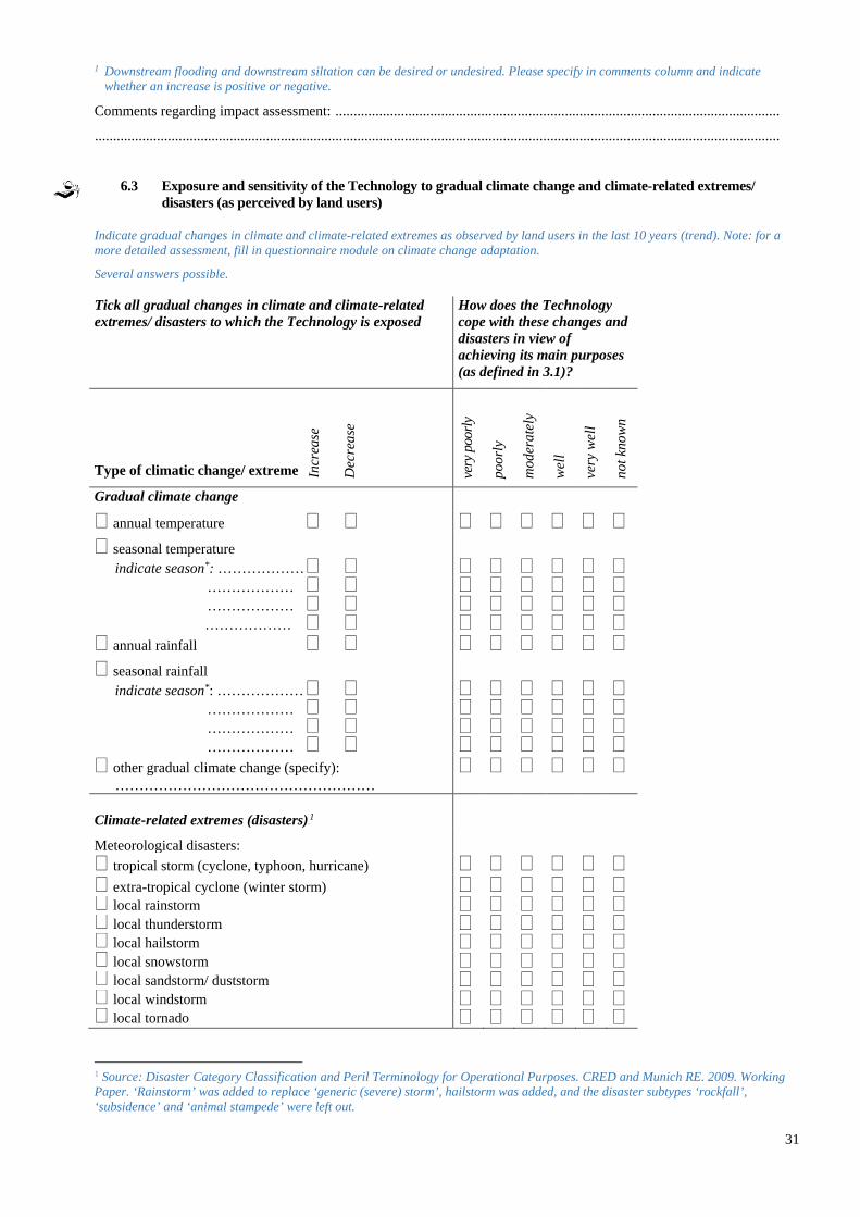
31
1 Downstream flooding and downstream siltation can be desired or undesired. Please specify in comments column and indicate whether an increase is positive or negative.
Comments regarding impact assessment: ..........................................................................................................................
............................................................................................................................................................................................
6.3 Exposure and sensitivity of the Technology to gradual climate change and climate-related extremes/ disasters (as perceived by land users)
Indicate gradual changes in climate and climate-related extremes as observed by land users in the last 10 years (trend). Note: for a more detailed assessment, fill in questionnaire module on climate change adaptation.
Several answers possible. Tick all gradual changes in climate and climate-related extremes/ disasters to which the Technology is exposed
How does the Technology cope with these changes and disasters in view of achieving its main purposes (as defined in 3.1)?
Type of climatic change/ extreme very
poo
rly
poor
ly
mod
erat
ely
wel
l
very
wel
l
not k
now
n
Gradual climate change annual temperature seasonal temperature
indicate season*: ……………… ……………… ……………… ……………… annual rainfall seasonal rainfall
indicate season*: ……………… ……………… ……………… ……………… other gradual climate change (specify):
………………………………………………
Climate-related extremes (disasters)0F
1
Meteorological disasters: tropical storm (cyclone, typhoon, hurricane) extra-tropical cyclone (winter storm) local rainstorm local thunderstorm local hailstorm local snowstorm local sandstorm/ duststorm local windstorm local tornado
1 Source: Disaster Category Classification and Peril Terminology for Operational Purposes. CRED and Munich RE. 2009. Working Paper. ‘Rainstorm’ was added to replace ‘generic (severe) storm’, hailstorm was added, and the disaster subtypes ‘rockfall’, ‘subsidence’ and ‘animal stampede’ were left out.
Incr
ease
Dec
reas
e
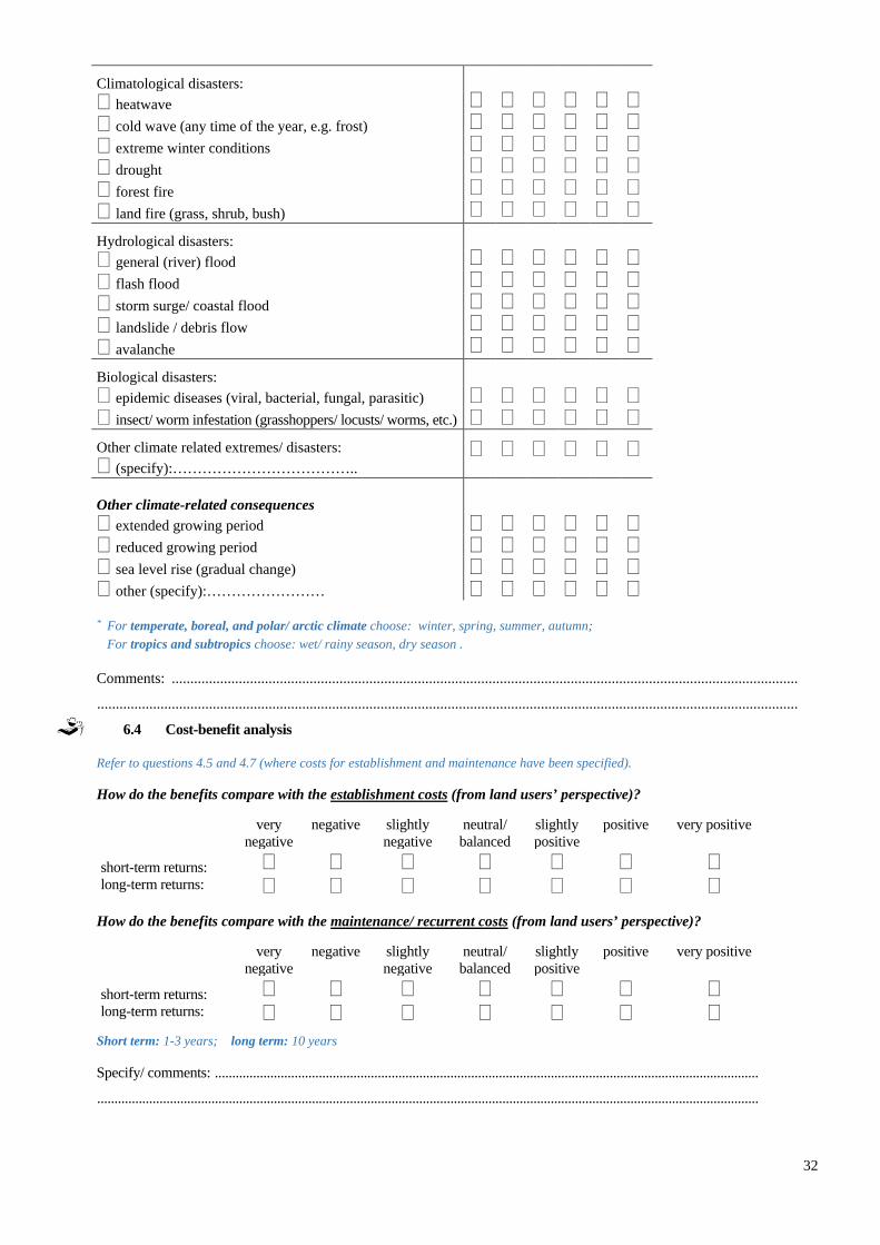
32
Climatological disasters: heatwave cold wave (any time of the year, e.g. frost) extreme winter conditions drought forest fire land fire (grass, shrub, bush) Hydrological disasters: general (river) flood flash flood storm surge/ coastal flood landslide / debris flow avalanche Biological disasters: epidemic diseases (viral, bacterial, fungal, parasitic) insect/ worm infestation (grasshoppers/ locusts/ worms, etc.) Other climate related extremes/ disasters: (specify):………………………………..
Other climate-related consequences
extended growing period reduced growing period sea level rise (gradual change) other (specify):…………………… * For temperate, boreal, and polar/ arctic climate choose: winter, spring, summer, autumn; For tropics and subtropics choose: wet/ rainy season, dry season .
Comments: ........................................................................................................................................................................
............................................................................................................................................................................................
6.4 Cost-benefit analysis
Refer to questions 4.5 and 4.7 (where costs for establishment and maintenance have been specified).
How do the benefits compare with the establishment costs (from land users’ perspective)?
very negative
negative slightly negative
neutral/ balanced
slightly positive
positive very positive
short-term returns: long-term returns:
How do the benefits compare with the maintenance/ recurrent costs (from land users’ perspective)?
very negative
negative slightly negative
neutral/ balanced
slightly positive
positive very positive
short-term returns: long-term returns:
Short term: 1-3 years; long term: 10 years Specify/ comments: .............................................................................................................................................................
...............................................................................................................................................................................................

33
6.5 Adoption of the Technology
Note: For information on adoption barriers and adoption drivers (motivation of land users to implement the Technology), refer to the WOCAT Questionnaire on SLM Approaches. How many land users in the area have adopted/ implemented the Technology? Area: Refer to the country/ region/ locations defined in 2.5 and to the land use types described in 3.2. single cases/ experimental 1-10% 10-50% more than 50%
If available, quantify (no. of households and/ or area covered): .....................................................................................
Of all those who have adopted the Technology, how many have did so spontaneously, i.e. without receiving any material incentives/ payments? 0-10% 10-50% 50-90% ....................................... 90-100% Comments: ................................................................................................................................................................ ...................................................................................................................................................................................
6.6 Adaptation
Adaptation: modifications made by land users to suit local context and changing conditions (Source: WOCAT) Has the Technology been modified recently to adapt to changing conditions? no yes
If yes, indicate to which changing conditions it was adapted: climatic change/ extremes changing markets labour availability (e.g. due to migration) other (specify): ……………………………………………………………………………………… Specify adaptation of the Technology (design, material/ species, etc.) ................................................................................................................................................................................... ................................................................................................................................................................................... ................................................................................................................................................................................... ...................................................................................................................................................................................
6.7 Strengths/ advantages/ opportunities of the Technology
Give a concluding statement about the Technology.
In land users’ view1:
1)..........................................................................................................................................................................................
.............................................................................................................................................................................................
2)..........................................................................................................................................................................................
.............................................................................................................................................................................................
3)..........................................................................................................................................................................................
.............................................................................................................................................................................................
4)..........................................................................................................................................................................................
.............................................................................................................................................................................................
In the compiler’s or other key resource persons’ view:
1)..........................................................................................................................................................................................
.............................................................................................................................................................................................

34
2)..........................................................................................................................................................................................
.............................................................................................................................................................................................
3)..........................................................................................................................................................................................
.............................................................................................................................................................................................
4)..........................................................................................................................................................................................
............................................................................................................................................................................................. 1 Land user: the person/ entity who implements/ maintains the Technology, including individual small- or large-scale farmers, groups (gender, age, status, interest), cooperatives, industrial companies (e.g. mining), government institutions (e.g. state forest), etc.
6.8 Weaknesses/ disadvantages/ risks of the Technology and ways of overcoming them
Weaknesses/ disadvantages/ risks How can they be overcome?
In land users’ view:
1) ... ..................................................................................
....... ..................................................................................
........................................................................................
.......................................................................................
.......................................................................................
.......................................................................................
2) ... ..................................................................................
....... ..................................................................................
........................................................................................
.......................................................................................
.......................................................................................
.......................................................................................
3) ... ..................................................................................
....... ..................................................................................
........................................................................................
.......................................................................................
.......................................................................................
.......................................................................................
4) ... ..................................................................................
....... ..................................................................................
........................................................................................
.......................................................................................
.......................................................................................
.......................................................................................
In the compiler’s or other key resource persons’ view:
1) ... ..................................................................................
....... ..................................................................................
........................................................................................
.......................................................................................
.......................................................................................
.......................................................................................
2) ... ..................................................................................
....... ..................................................................................
........................................................................................
.......................................................................................
.......................................................................................
.......................................................................................
3) ... ..................................................................................
....... ..................................................................................
........................................................................................
.......................................................................................
.......................................................................................
.......................................................................................
4) ... ..................................................................................
....... ..................................................................................
........................................................................................
.......................................................................................
.......................................................................................
.......................................................................................
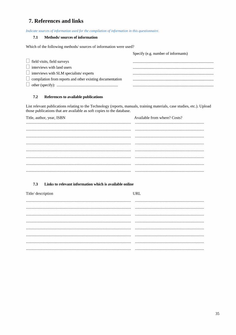
35
7. References and links
Indicate sources of information used for the compilation of information in this questionnaire.
7.1 Methods/ sources of information
Which of the following methods/ sources of information were used?
Specify (e.g. number of informants)
field visits, field surveys ....................................................................................... interviews with land users ....................................................................................... interviews with SLM specialists/ experts ....................................................................................... compilation from reports and other existing documentation ....................................................................................... other (specify): .................................................................. .......................................................................................
7.2 References to available publications
List relevant publications relating to the Technology (reports, manuals, training materials, case studies, etc.). Upload those publications that are available as soft copies to the database.
Title, author, year, ISBN Available from where? Costs? ......................................................................................................... .....................................................................
......................................................................................................... .....................................................................
......................................................................................................... .....................................................................
......................................................................................................... .....................................................................
......................................................................................................... .....................................................................
......................................................................................................... .....................................................................
......................................................................................................... .....................................................................
......................................................................................................... .....................................................................
7.3 Links to relevant information which is available online
Title/ description URL
......................................................................................................... .....................................................................
......................................................................................................... .....................................................................
......................................................................................................... .....................................................................
......................................................................................................... .....................................................................
......................................................................................................... .....................................................................
......................................................................................................... .....................................................................
......................................................................................................... .....................................................................
......................................................................................................... .....................................................................