quaternary science reviews
TRANSCRIPT
lable at ScienceDirect
Quaternary Science Reviews 169 (2017) 357e377
Contents lists avai
Quaternary Science Reviews
journal homepage: www.elsevier .com/locate/quascirev
Timing of fluvial terrace formation and concomitant travertinedeposition in the upper Sutlej River (Tirthapuri, southwestern Tibet)and paleoclimatic implications
Zhijun Wang a, Michael C. Meyer a, *, Luke A. Gliganic a, Dirk L. Hoffmann b,Jan-Hendrik May c
a Institute of Geology, University of Innsbruck, Innrain 52, A-6020 Innsbruck, Austriab Department of Human Evolution, Max Planck Institute for Evolutionary Anthropology, D-04103 Leipzig, Germanyc Institute of Earth and Environmental Sciences - Geology, Albert-Ludwigs-Universit€at Freiburg, D-79098 Freiburg, Germany
a r t i c l e i n f o
Article history:Received 16 November 2016Received in revised form1 June 2017Accepted 12 June 2017
Keywords:Travertine230Th/U datingOSL datingFluvial terracesRiver incisionIndian summer monsoonUpper Sutlej
* Corresponding author.E-mail address: [email protected] (M.C. M
http://dx.doi.org/10.1016/j.quascirev.2017.06.0090277-3791/© 2017 Elsevier Ltd. All rights reserved.
a b s t r a c t
Travertines are carbonates precipitated from hydrothermal springs and are relatively common on theTibetan plateau and occur along tectonically active faults. The Karakoram fault system is an active strike-slip fault that extends from the Pamir into southwestern Tibet, where it controls the course of the upperSutlej River and the occurrence of several hydrothermal springs, including the Tirthapuri hot springs.Multiple fluvial terraces that are partly capped by travertine are preserved in the Tirthapuri area. Fourmain fluvial terrace levels (labelled as T1 to T4 with increasing height above river) were identified andseveral meter-thick travertine platforms occur on the current river level as well as the T2 and T3 terraces.Sedimentological and petrographic observations suggest that the travertine platforms were deposited onactive floodplains of the paleo- and modern Sutlej River, and preserved from fluvial erosion becausetravertine precipitation was immediately followed by vertical river-bed incision and thus terrace aban-donment. Results of 230Th/U in combination with luminescence dating show that the deposition oftravertine platform and river incision that led to the formation of T3 terrace (~93 m above the Sutlej)took place at ca. 127.5 ka. The development of terrace T2 and overlying travertine platform (~28 m abovethe Sutlej) occurred between ca. 10.0 and 8.8 ka. Fluvial incision has arrived at the modern level at leastca. 0.2 ka ago. Both the travertine deposition and major river incision are likely triggered by theintensified Indian summer monsoon and are linked to phases of maximum monsoon strength. Duringstrong monsoon phases, a large quantity of moisture is transported into southwestern Tibet, activatinghot springs and thus travertine precipitation, facilitating fluvial incision and stripping off sediments fromthe regional hill-slopes. At least over the last glacial cycle we suggest that the Tirthapuri travertine andassociated fluvial incision are sensitive indicators of (peak) monsoonal activity and can thus providevaluable insights into past climate change and climate-driven landscape evolution on the southwesternTibetan Plateau. Comparison of our findings with published data further suggests that monsoon-controlled fluvial aggradation and incision during the early Holocene is synchronous in southwesternTibet and the adjacent sector of the Himalayan orogen (north-western Sub-to High Himalaya).
© 2017 Elsevier Ltd. All rights reserved.
1. Introduction
Over the last decades fluvial terraces have been increasinglyrecognized as an important source of evidence for Quaternaryclimate change and tectonic movements (Maddy et al., 2001;
eyer).
Wegmann and Pazzaglia, 2002, 2009; Starkel, 2003; Bridglandand Westaway, 2008; Garcia and Mahan, 2014; Wang et al.,2015). Climate regulates fluvial discharge, vegetation cover andrelated variations in sediment supply and thus plays a fundamentalrole in alluvium aggradation and incision, ultimately controllingthe formation of fluvial terraces over orbital (i.e. glacial-interglacial) and sub-orbital time-scales (Vandenberghe, 2002;Maddy et al., 2001; Bridgland and Westaway, 2008; Wang et al.,
Z. Wang et al. / Quaternary Science Reviews 169 (2017) 357e377358
2015). Furthermore, many studies suggest that fluvial terraces havea combined tectonic-climatic origin, particularly in tectonicallyactive regions (Maddy et al., 2001; Starkel, 2003; Wegmann andPazzaglia, 2009; Wang et al., 2015; Dey et al., 2016).
In the Tibetan-Himalayan orogen, fluvial systems are operatingagainst the background of (i) active tectonics that often entailpronounced rock- and surface uplift (Kirby et al., 2003; Vance et al.,2003; Finnegan et al., 2008) and (ii) spatio-temporal variations inthe intensity of the Indian summer monsoon (ISM; e.g. Bookhagenet al., 2005; Murari et al., 2014; Cai et al., 2015; Kathayat et al.,2016). The vastness of the Tibetan-Himalayan orogen and thecomplexity of climate and tectonic interactions with the Earth'ssurface complicate a simple model for terrace formation and evo-lution to be put forward for High Asia yet. Furthermore, beforedisentangling any tectonic from climatic signals in a fluvial terracesuccession, a basic geomorphic assessment of terrace type (e.g.erosional versus aggradational, paired versus unpaired) in combi-nation with a reliable chronological framework is required for agenetic interpretation of terrace formation (Bridgland andWestaway, 2008; Schaller et al., 2016). Only a limited number ofstudies with good chronological control on successive fluvialterrace levels are currently available for the Tibetan-Himalayanorogen. This research suggests that on orbital time-scales rockuplift rates varied significantly and influenced terrace formationand preservation (Pan et al., 2009; Perrineau et al., 2011). On sub-orbital time-scales studies from the northeastern, southeastern aswell as northern margins of Tibetan Plateau suggest that terraceaggradation occurred during cold periods characterized by a weakISM, while fluvial down-cutting took place during transitions fromweak to strong phases of ISM (Wang et al., 2009, 2015). This con-trasts with terrace development in catchments that are under thedirect influence of the ISM (i.e. the south-facing slopes of theHimalaya), where strong ISM enhances the sediment flux causingvalley floor aggradation, while phases of weak ISM result in valleyfill incision and terrace development (Bookhagen et al., 2006; Juyalet al., 2010; Dey et al., 2016).
In Tibet, pull-apart basins bound tomajor strike-slip faults (suchas the Karakorum fault; Fig. 1B; Armijo et al., 1989; Zhang et al.,2010) or ~ N-S-trending rift systems (such as the Yadong-Gulurift; Fig. 1B; Blisniuk et al., 2001; Taylor et al., 2003; Zhang et al.,2010; Ratschbacher et al., 2011) are common. In these basins,thick sequences composed of fluvial, lacustrine and alluvial fansediments accumulated during Late Neogene to early Quaternary(Wang et al., 2008a,b; Kempf et al., 2009; Saylor et al., 2009; Zhanget al., 2010). Today these basins are often incised by the moderndrainage network and characterized by a landscape that preservesmultiple fluvial terraces (e.g. Wang et al., 2008a). For large areas ofthe Tibetan plateau e southern Tibet included e the timing andnature of fluvial incision into these tectonic basins and the associ-ated formation of fluvial terraces are not well constrained (Brownet al., 2003; Finnegan et al., 2008; Kaiser et al., 2010; Zhu et al.,2014).
Travertine (i.e. a spring carbonate precipitated by hydrothermalwater generally >30 �C, also referred to as hydrothermal carbonate;Capezzuoli et al., 2014) is a relatively common deposit on the Ti-betan plateau and often occurs along faults that are associated withpull-apart and rift basins (Tong et al., 2000; Zentmyer et al., 2008;Wang et al., 2016). Such fault-bounded spring carbonates can beradiometrically dated via uranium-series disequilibrium datingtechniques (e.g. 230Th/U dating; Mallick and Frank, 2002; Sierraltaet al., 2010; Wang et al., 2016; Meyer et al., 2017). In valley set-tings these spring carbonates are often stratigraphically associatedwith eolian, fluvial and other types of clastic deposits that areamenable to absolute dating techniques such as optically stimu-lated luminescence (OSL) dating, in combination allowing a
chronostratigraphic framework for travertine and clastic sedimentactivity to be established (Rich et al., 2003; Ruszkiczay-Rudigeret al., 2005; Mahan et al., 2007; Luque and Julia, 2007; Schulteet al., 2008; Zentmyer et al., 2008).
In this study the Tirthapuri travertine that is located in theupper Sutlej River in southwestern Tibet and that is strati-graphically linked with a staircase of fluvial terraces are investi-gated. The travertine deposit and the fluvial terraces formed in theMenci basin (a pull-apart basin that is bound to the Karakoramstrike-slip fault) and hydrothermal spring carbonate can be foundon multiple terrace levels. We combine geomorphological, sedi-mentological and petrological investigations as well as uranium-series (i.e. 230Th/U) and OSL dating in order to (i) understand thedepositional history of the travertine complex, (ii) elucidate theLate Quaternary evolution of the Menci basin that appears to havebeen dominated by fluvial incision, and (iii) decipher the relativeimportance of tectonic versus climatic forcing on fluvial incisionand travertine formation.
2. Site description and geological setting
The Tirthapuri travertine is located 5 km south of the village ofMenci in the homonymous Menci basin in the upper reaches of theSutlej River (Fig. 1). Today a cold and dry continental climate with amean annual air temperature of 0e3 �C and mean annual precipi-tation (MAP) of ~250 mm prevails in the investigation area (Li,2006). The atmospheric circulation pattern in this region isaffected by both the ISM and the winter westerlies (Bookhagen andBurbank, 2010; Yao et al., 2013). Time series analysis of radar datafrom 1998 to 2015 from the Tropical Rainfall Measuring Mission forthe Menci basin (conducted by us) and for the southwestern Tibet(conducted by Bookhagen and Burbank, 2010) suggest that the ISMdelivers ~70% of annual precipitation to the south western part ofthe Tibetan plateau (during June to September), whereas thewesterlies contribute the remaining ~30% during the rest of theyear.
At Tirthapuri, several active hot springs with a discharge rate of~0.1e20 L/s emerge from the quartzite host rock or the modernfloodplain of the Sutlej River (Tong et al., 2000). The main hotspring water has a temperature of ~72 �C and pH value of ~7 (Tonget al., 2000). Major ions in the spring water are HCO3
� (689 mg/L),Naþ (123 mg/L), SO4
2� (89 mg/L), Ca2þ (74 mg/L) and Mg2þ (50 mg/L), whereas Kþ and Cl� are of low concentrations (20e40 mg/L;Tong et al., 2000). The enrichment of Ca2þ and HCO3
� ions in thespring water suggests that the hydrothermal water passed througha carbonate aquifer (probably the Mesozoic limestone underlyingthe Menci basin; Fig. 1C; Tong et al., 2000; Wang et al., 2008a).Bedrock outcrops adjacent to the Tirthapuri hot spring arecomposed of quartzite that probably belongs to the Tethyan met-asedimentary sequence and has locally been altered by the hy-drothermal activity.
The Menci basin is ~40 km long ~15 kmwide and one of severalbasins (like the Barga and the Zhada to the east and west, respec-tively) that trends in NW-SE direction and roughly parallels theIndus-Yarlung Tsangpo suture (IYS) zone (Fig. 1C). The IYS resultedfrom the main India-Eurasia collision at ca. 50 Ma ago (Hodges,2000; Yin and Harrison, 2000) and is thus the oldest tectonicstructure in the investigation area. It separates the Tethyan Hima-laya in the south from the Lhasa terrane in the north. In theinvestigation area the Tethyan Himalaya is composed of Late Pre-cambrian to Lower Paleozoic sedimentary and metasedimentaryrocks and Permian to Upper Cretaceous sedimentary rocks as wellas an ophiolitic m�elange sequence, while the Gangdese (or MountKailas) Range forms the southern flank of the Lhasa terrane and iscomposed of CretaceouseLower Tertiary intrusive and volcanic
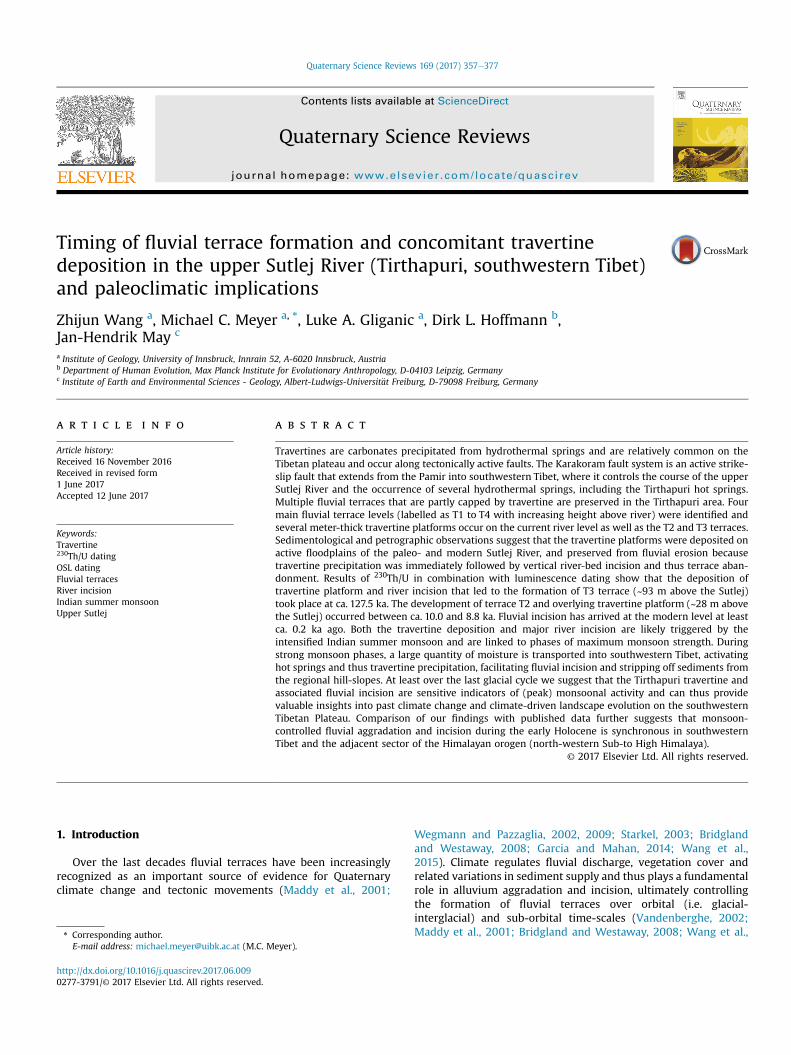
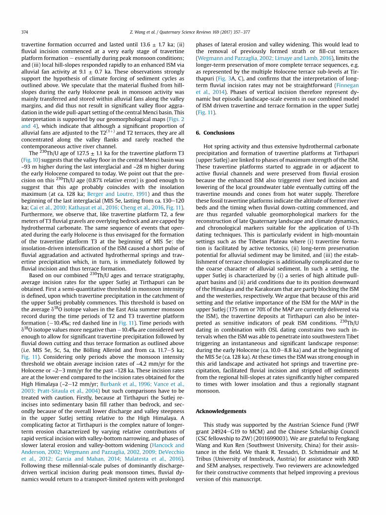
Fig. 1. (A) Overview map of High Asia with location of Tirthapuri hot springs. Black dots indicate the locations of paleoclimatic proxy records mentioned in the text: 1 e TianmenCave, Cai et al. (2010, 2012); 2 e Timta Cave, Sinha et al. (2005); 3 e Bittoo Cave, Kathayat et al. (2016); 4 e Nam Co, Zhu et al. (2015); 5 e Paiku Co, Wünnemann et al. (2015); 6 e
Ngangla Ring Tso, Hudson et al. (2015); 7 e Baqan Tso, Huth et al. (2015); 8 e Tso Kar, Demske et al. (2009); 9 e Sumxi Co, Van Campo and Gasse (1993). Travertine sites mentionedin the text: T1 e Chusang travertine, Wang et al. (2016); T2 e Nyalam travertine, Zentmyer et al. (2008). (B) Generalized tectonic overview map of the HimalayaeTibetan orogenshowing major tectonic units (modified after Yin and Harrison, 2000; Blisniuk et al., 2001). IYS: Indus - Yarlung Tsangpo suture; BNS: Bangong - Nujiang suture; JS: Jinsha suture;MBT: Main boundary thrust; HO: Himalaya Oregon; LT: Lhasa terrane; QT: Qiangtang terrane. (C) Geological map of the Menci basin and the wider Tirthapuri region (marked as ared square and shown in Fig. 2; modified after Murphy et al., 2000; Murphy et al., 2000; Murphy and Yin, 2003; CIGMR, 2004). The IYS separates the Tethyan Himalaya from theLhasa terrane and roughly follows the NW-SE trending axis of the Barga and Menci basins and the Indus River further to the northwest. (For interpretation of the references tocolour in this figure legend, the reader is referred to the web version of this article.)
Z. Wang et al. / Quaternary Science Reviews 169 (2017) 357e377 359
rocks (Gangdese batholith and magmatic arc; Fig. 1C; Yin et al.,1999; CIGMR, 2004; Murphy and Yin, 2003). The >2.5 km-thickKailas conglomerate, which is a molasse sediment that formedduring the Late Oligoceneeearly Miocene, rests unconformably onthe Gangdese batholith (Fig. 1C; Aitchison et al., 2002; DeCelles
et al., 2011). Furthermore, the IYS has been overprinted by poten-tially multiple younger tectonic events; the IYS is strongly modifiedby a series of moderate-to high-angle south-dipping reverse faults(an orogen-scale fault system known as Great Counter thrust) thatwere interpreted together with north-dipping shortening
Z. Wang et al. / Quaternary Science Reviews 169 (2017) 357e377360
structures in the Tethyan Himalaya as a large-scale “pop-up”structure that formed during the late Tertiary (Searle et al., 1990,1997; Hodges, 2000). The trace of the Great Counter thrust runsalong the northern margin of the Menci and the Barga basins and isregionally known as the South Kailas thrust (Fig.1C; Yin et al., 1999;Murphy and Yin, 2003; DeCelles et al., 2011).
Tectonically, the Menci basin is bound to the Karakoram faultsystem (KFS; Fig. 1C). The NW-SE-trending KFS extends from thePamir to the Pulan graben system in southern Tibet. It is animportant active right-lateral strike-slip fault in western Tibet andpartly overprints the IYS (Hodges, 2000; Yin and Harrison, 2000).The kinematics, geometry and chronology of the KFS are still underdebate and the KFS is variably inferred as (i) being the result ofeastward extrusion of northern Tibet (Armijo et al., 1986, 1989), (ii)oblique convergence between India and Tibet (McCaffrey andNabelek, 1998), or (iii) may be explained as an accommodationzone that transfers east-west extension from more widely-spacedrifts in the south to the more closely-spaced rifts in the north(Yin, 2000). Fault activity along the KFS dates back to at least ca. 17Ma, but for the development of the Menci and other pull-apartbasins along the KFS the transtensional fault activity thatcommenced ca. 11 Ma ago and continues until today is most rele-vant (Rumelhart et al., 1999; Murphy et al., 2000). It is estimatedthat during that time approximately ~60e100 km of right-lateraloffset were accommodated along the southern segment of theKFS, i.e. the fault segment that also controls the interconnectedZhada, Menci and Barga basins (Fig. 1C; Murphy et al., 2000; Wanget al., 2008a; Saylor et al., 2010a).
A sedimentological study by Wang et al. (2008a) suggests thatthe Zhada basin is filled with up to ~800 m of clastic sediments thatcan be divided into a basal fluvial unit (~0e220 m), an intermediatelacustrine unit (~220e610m) and an interbedded lacustrine-fluvialunit (~610e800 m). Similar sedimentological findings were re-ported by Kempf et al. (2009) and Saylor et al. (2009; 2010a,b) forthe Zhada basin and by Li et al. (1983) and Wang et al. (2008a) forthe Menci basin. Biostratigraphic and magnetostratigraphic datasuggest that these basins were filled during the Late Neogene untilthe Early Pleistocene (i.e. ca. 9 to <1 Ma; Meng et al., 2008; Wanget al., 2008b; Saylor et al., 2009; Li et al., 2011). In the Menci ba-sin these fluvial and lacustrine sediments are tectonically tilted tothe northeast by ~8e12� (Wang et al., 2008a).
3. Methods
Field investigations involved sedimentary logging and geomor-phological field mapping, the latter was aided by analysis of GoogleEarth imagery and the 30 m resolution digital elevation model(DEM) derived from the Shuttle Radar Topography Mission (SRTM).Valley cross-sections were constructed based on the SRTM data andvia elevationmeasurements obtained in the field using a hand-heldGlobal Positioning System (GPS). Additionally, river and terracelong profiles were derived from ALOS AW3D30 data (Tadono et al.,2014).
Travertine blocks were collected from individual travertine de-posits capping the fluvial terraces in the Tirthapuri hot spring area.All travertine samples were halved and thin sections were made for16 samples with representative crystal fabrics. The microscopictravertine fabrics were examined under a Nikon Eclipse E400POLmicroscope using transmitted-light. Sub-samples were obtainedfor each travertine sample for powder X-ray diffraction (XRD) an-alyses and scanning electron microscope (SEM) analyses wereperformed on selected polished slabs (using a JEOL JSM-6010LV).
For 230Th/U dating dense and clean travertines with primaryfabrics were sub-sampled using a hand-held drill and a tungstencarbide drill bit. Chemical separation and purification of U and Th
isotopes followed a modified protocol described in Hoffmann(2008) and Hoffmann et al. (2016). U and Th isotope measure-ments were undertaken using a ThermoFinnigan Neptune Multi-Collector Inductively Coupled Plasma Mass Spectrometer (MC-ICP-MS) following procedures outlined in Hoffmann et al. (2007).All ages were calculated using the half-lives reported in Cheng et al.(2000) (l234 and l230). A238U/232Th activity ratio of 0.8 ± 0.4 wasused to correct the detrital 230Th contamination (Wedepohl, 1995).For travertine samples with high detrital 232Th, Osmond typeisochron ageswere calculated based on themeasured activity ratiosof 3e5 subsamples from the same depositional layer.
For OSL dating (Huntley et al., 1985; Rhodes, 2011) standardpreparation techniques were used to isolate quartz grains from thebulk sediment samples (Wintle, 1997; Gliganic et al., 2015). Singlequartz grains were stimulated with green (532 nm) laser light(Bøtter-Jensen et al., 2003) for 2 s at 125 �C in a Risø DA20 TL/OSLreader and the ultraviolet OSL emissions were measured using anElectron Tubes Ltd 9635Q photomultiplier tube fittedwith a 7.5mmHoya U-340 filter. Laboratory irradiations were given using a cali-brated 90Sr/90Y beta source mounted on the Risø TL/OSL reader. Thesingle-aliquot regenerative dose (SAR) procedure (Murray andWintle, 2000) was used to estimate equivalent dose (De) values.Regenerative dose preheats (10 s) and test dose preheats (5 s) of220 �C were used. The appropriateness of the SAR procedure wasassessed using standard tests including a recycling ratio test,recuperation test (Murray andWintle, 2000), OSL-IR depletion ratio(Duller, 2003), and dose recovery tests (Roberts et al., 1999; Murrayand Wintle, 2003). The central age model (CAM; Galbraith et al.,1999) and minimum age model (MAM; Galbraith et al., 1999)were used to investigate De distributions and determine repre-sentative De values. The total environmental dose rate for eachsample (Table 1) was estimated using standard techniques (acombination of beta counting using a GM-25-5 beta counter(Bøtter-Jensen and Mejdahl, 1988) and thick-source alpha count-ing) and the conversion factors of Gu�erin et al. (2011) to calculatebeta and gamma dose rates. The cosmic-ray dose rate was calcu-lated following Prescott and Hutton (1994) and an internal alphadose rate of 0.03 ± 0.01 Gy/ka was assumed.
4. Results
4.1. Fluvial terraces and alluvial fans
The Sutlej River and its tributaries have incised deeply into theLate Neogene to Early Pleistocene basin infill of the central Mencibasin and have partly reached bedrock (Figs. 2 and 3). At least 4main terrace levels can be identified on the SRTM based DEM andare labelled (fromyounger to older) as T1 toT4 and range in altitudefrom ~4360m asl. (T1) to ~4600m asl. (T4; Figs. 2e4). Furthermore,remnants of a paleosurface can be identified at ~4650 m asl. Ac-cording to an unpublished geological map of the Geological Surveyof Southern Tibet this paleosurface is underlain by the Xiangziformation (Fig. 2), which is Early Pleistocene in age (Meng et al.,2008). The main terrace levels T1 to T4 can be semi-continuouslytraced along the Sutlej River and its tributaries (in some instancesfor ~5e6 km) and tread widths vary from ~100m to ~1.5 km (Figs. 2and 3). The heights of individual terrace risers are ~8 m (T1), ~20 m(T2), ~65 m (T3) and ~155 m (T4), respectively (Figs. 2 and 3).
Field mapping and Google Earth imagery further reveal that (i)these terraces preserve a veneer of younger fluvial gravels typically~0.5 to 2e3 m in thickness that is separated from the basin infill viaan angular unconformity or disconformity (Fig. 5B and C); (ii) theyare partly unpaired and (iii) in addition to the main terrace levelsseveral sub-levels can be discerned (Figs. 3 and 4). We use longi-tudinal and valley cross-profiles of the Sutlej River as well as
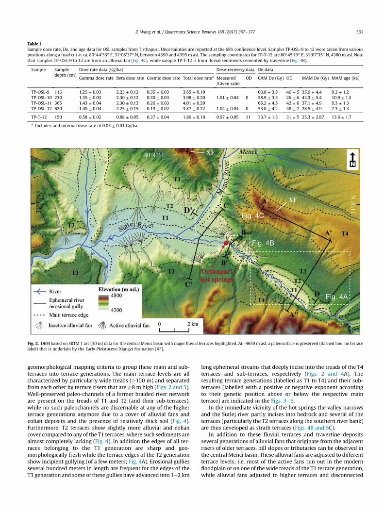
Table 1Sample dose rate, De, and age data for OSL samples from Tirthapuri. Uncertainties are reported at the 68% confidence level. Samples TP-OSL-9 to 12 were taken from variouspositions along a road cut at ca. 80�4403300 E, 31�0803700 N, between 4390 and 4395 m asl. The sampling coordinates for TP-T-12 are 80�4501900 E, 31�0703500 N, 4380 m asl. Notethat samples TP-OSL-9 to 12 are from an alluvial fan (Fig. 4C), while sample TP-T-12 is from fluvial sediments cemented by travertine (Fig. 4B).
Sample Sampledepth (cm)
Dose rate data (Gy/ka) Dose-recovery data De data
Gamma dose rate Beta dose rate Cosmic dose rate Total dose ratea Measured/Given ratio
OD CAM De (Gy) OD MAM De (Gy) MAM age (ka)
TP-OSL-9 116 1.25 ± 0.03 2.23 ± 0.12 0.35 ± 0.03 3.85 ± 0.19 60.8 ± 3.5 46 ± 5 35.9 ± 4.4 9.3 ± 1.2TP-OSL-10 230 1.35 ± 0.03 2.30 ± 0.12 0.30 ± 0.03 3.98 ± 0.20 1.01 ± 0.04 0 58.9 ± 3.5 26 ± 6 43.3 ± 5.4 10.9 ± 1.5TP-OSL-11 365 1.43 ± 0.04 2.30 ± 0.13 0.26 ± 0.03 4.01 ± 0.20 65.2 ± 4.5 42 ± 6 37.1 ± 4.9 9.3 ± 1.3TP-OSL-12 620 1.40 ± 0.04 2.25 ± 0.15 0.19 ± 0.02 3.87 ± 0.22 1.04 ± 0.04 0 53.0 ± 4.2 48 ± 7 28.5 ± 4.9 7.3 ± 1.3
TP-T-12 150 0.58 ± 0.02 0.88 ± 0.05 0.37 ± 0.04 1.86 ± 0.10 0.97 ± 0.05 11 33.7 ± 1.5 31 ± 5 25.3 ± 2.87 13.6 ± 1.7
a Includes and internal dose rate of 0.03 ± 0.01 Gy/ka.
Fig. 2. DEM based on SRTM 1 arc (30 m) data for the central Menci basin with major fluvial terraces highlighted. At ~4650 m asl. a paleosurface is preserved (dashed line, no terracelabel) that is underlain by the Early Pleistocene Xiangzi Formation (XF).
Z. Wang et al. / Quaternary Science Reviews 169 (2017) 357e377 361
geomorphological mapping criteria to group these main and sub-terraces into terrace generations. The main terrace levels are allcharacterized by particularly wide treads (�100 m) and separatedfrom each other by terrace risers that are �8 m high (Figs. 2 and 3).Well-preserved paleo-channels of a former braided river networkare present on the treads of T1 and T2 (and their sub-terraces),while no such paleochannels are discernable at any of the higherterrace generations anymore due to a cover of alluvial fans andeolian deposits and the presence of relatively thick soil (Fig. 4).Furthermore, T2 terraces show slightly more alluvial and eoliancover compared to any of the T1 terraces, where such sediments arealmost completely lacking (Fig. 4). In addition the edges of all ter-races belonging to the T1 generation are sharp and geo-morphologically fresh while the terrace edges of the T2 generationshow incipient gullying (of a few meters; Fig. 4A). Erosional gulliesseveral hundred meters in length are frequent for the edges of theT3 generation and some of these gullies have advanced into 1e2 km
long ephemeral streams that deeply incise into the treads of the T4terraces and sub-terraces, respectively (Figs. 2 and 4A). Theresulting terrace generations (labelled as T1 to T4) and their sub-terraces (labelled with a positive or negative exponent accordingto their genetic position above or below the respective mainterrace) are indicated in the Figs. 3e6.
In the immediate vicinity of the hot springs the valley narrowsand the Sutlej river partly incises into bedrock and several of theterraces (particularly the T2 terraces along the southern river bank)are thus developed as strath terraces (Figs. 4B and 5C).
In addition to these fluvial terraces and travertine depositsseveral generations of alluvial fans that originate from the adjacentrisers of older terraces, hill slopes or tributaries can be observed inthe central Menci basin. These alluvial fans are adjusted to differentterrace levels; i.e. most of the active fans run out in the modernfloodplain or on one of the wide treads of the T1 terrace generation,while alluvial fans adjusted to higher terraces and disconnected
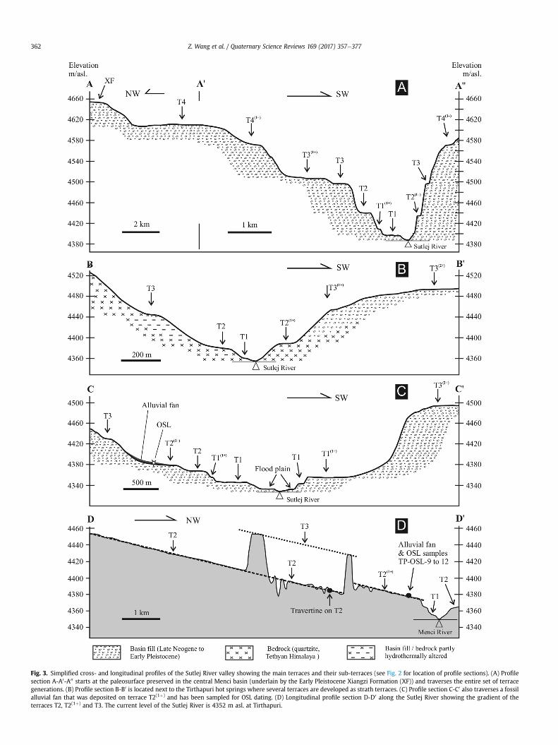
Fig. 3. Simplified cross- and longitudinal profiles of the Sutlej River valley showing the main terraces and their sub-terraces (see Fig. 2 for location of profile sections). (A) Profilesection A-A0-A00 starts at the paleosurface preserved in the central Menci basin (underlain by the Early Pleistocene Xiangzi Formation (XF)) and traverses the entire set of terracegenerations. (B) Profile section B-B0 is located next to the Tirthapuri hot springs where several terraces are developed as strath terraces. (C) Profile section C-C0 also traverses a fossilalluvial fan that was deposited on terrace T2(1þ) and has been sampled for OSL dating. (D) Longitudinal profile section D-D0 along the Sutlej River showing the gradient of theterraces T2, T2(1þ) and T3. The current level of the Sutlej River is 4352 m asl. at Tirthapuri.
Z. Wang et al. / Quaternary Science Reviews 169 (2017) 357e377362
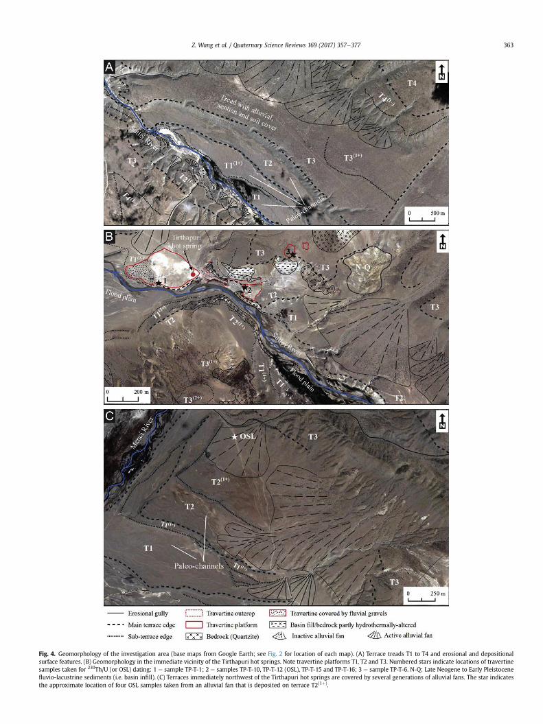
Fig. 4. Geomorphology of the investigation area (base maps from Google Earth; see Fig. 2 for location of each map). (A) Terrace treads T1 to T4 and erosional and depositionalsurface features. (B) Geomorphology in the immediate vicinity of the Tirthapuri hot springs. Note travertine platforms T1, T2 and T3. Numbered stars indicate locations of travertinesamples taken for 230Th/U (or OSL) dating: 1 e sample TP-T-1; 2 e samples TP-T-10, TP-T-12 (OSL), TP-T-15 and TP-T-16; 3 e sample TP-T-6. N-Q: Late Neogene to Early Pleistocenefluvio-lacustrine sediments (i.e. basin infill). (C) Terraces immediately northwest of the Tirthapuri hot springs are covered by several generations of alluvial fans. The star indicatesthe approximate location of four OSL samples taken from an alluvial fan that is deposited on terrace T2(1þ).
Z. Wang et al. / Quaternary Science Reviews 169 (2017) 357e377 363
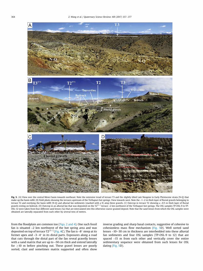
Fig. 5. (A) View over the central Menci basin towards northeast. Note the extensive tread of terrace T3 and the slightly tilted Late Neogene to Early Pleistocene strata (N-Q) thatmake up the basin infill. (B) Field photo showing the terraces upstream of the Tirthapuri hot springs. View towards west. Note the ~1e2 m thick layer of fluvial gravels belonging toterrace T2 and overlying the basin infill (N-Q) and alluvial fan sediments (marked with a X) atop these gravels. (C) Outcrop in terrace T2 showing a ~0.5 m thick layer of fluvialgravels resting on bedrock. (D) Outcrop in an alluvial fan that was deposited on the T2(1þ) terrace ~2 km northwest of the Tirthapuri hot springs. The OSL samples TP-OSL-9 to TP-OSL-12 were taken from four different sand lenses (Sa) that are intercalated into this otherwise coarse-grained deposit. Note that the sand lenses fromwhich the OSL samples wereobtained are laterally separated from each other by several tens of meters.
Z. Wang et al. / Quaternary Science Reviews 169 (2017) 357e377364
from the floodplain are common too (Figs. 2 and 4). One such fossilfan is situated ~2 km northwest of the hot spring area and wasdeposited on top of terrace T2(1þ) (Fig. 4C). The fan is ~8� steep at itsformer apex and ~3e4� in its distal parts. Exposures along a roadthat cuts through the distal part of the fan reveal gravelly lenseswith a sand matrix that are up to ~50 cm thick and extend laterallyfor �10 m before pinching out. These gravel lenses are poorlysorted, clast and sometimes matrix supported and often show
inverse grading and sharp basal contacts, suggestive of cohesive tocohesionless mass flow mechanism (Fig. 5D). Well sorted sandlenses ~10e30 cm in thickness are interbedded into these alluvialfan sediments and four OSL samples (TP-OSL-9 to 12) that arespaced ~15 m from each other and vertically cover the entiresedimentary sequence were obtained from such lenses for OSLdating (Fig. 5D).
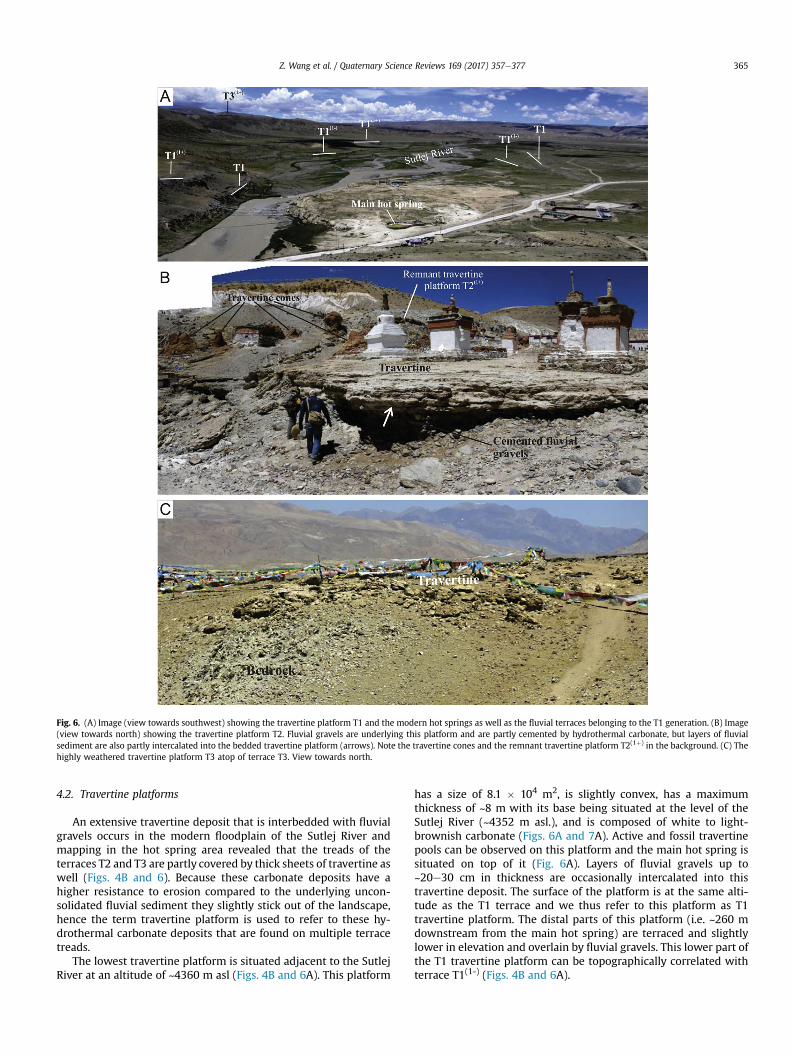
Fig. 6. (A) Image (view towards southwest) showing the travertine platform T1 and the modern hot springs as well as the fluvial terraces belonging to the T1 generation. (B) Image(view towards north) showing the travertine platform T2. Fluvial gravels are underlying this platform and are partly cemented by hydrothermal carbonate, but layers of fluvialsediment are also partly intercalated into the bedded travertine platform (arrows). Note the travertine cones and the remnant travertine platform T2(1þ) in the background. (C) Thehighly weathered travertine platform T3 atop of terrace T3. View towards north.
Z. Wang et al. / Quaternary Science Reviews 169 (2017) 357e377 365
4.2. Travertine platforms
An extensive travertine deposit that is interbedded with fluvialgravels occurs in the modern floodplain of the Sutlej River andmapping in the hot spring area revealed that the treads of theterraces T2 and T3 are partly covered by thick sheets of travertine aswell (Figs. 4B and 6). Because these carbonate deposits have ahigher resistance to erosion compared to the underlying uncon-solidated fluvial sediment they slightly stick out of the landscape,hence the term travertine platform is used to refer to these hy-drothermal carbonate deposits that are found on multiple terracetreads.
The lowest travertine platform is situated adjacent to the SutlejRiver at an altitude of ~4360 m asl (Figs. 4B and 6A). This platform
has a size of 8.1 � 104 m2, is slightly convex, has a maximumthickness of ~8 m with its base being situated at the level of theSutlej River (~4352 m asl.), and is composed of white to light-brownish carbonate (Figs. 6A and 7A). Active and fossil travertinepools can be observed on this platform and the main hot spring issituated on top of it (Fig. 6A). Layers of fluvial gravels up to~20e30 cm in thickness are occasionally intercalated into thistravertine deposit. The surface of the platform is at the same alti-tude as the T1 terrace and we thus refer to this platform as T1travertine platform. The distal parts of this platform (i.e. ~260 mdownstream from the main hot spring) are terraced and slightlylower in elevation and overlain by fluvial gravels. This lower part ofthe T1 travertine platform can be topographically correlated withterrace T1(1-) (Figs. 4B and 6A).
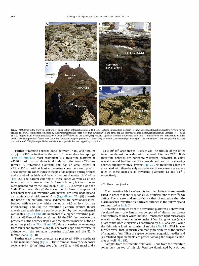
Fig. 7. (A) Outcrop in the travertine platform T1 and position of travertine sample TP-T-6. (B) Outcrop in travertine platform T2 showing bedded travertine directly overlying fluvialgravels. The fluvial sediment is cemented by the hydrothermal carbonate. Note that fluvial gravels and sands are also intercalated into the travertine (arrows). Samples TP-T-10 andTP-T-12 (approximate location indicated) were taken for 230Th/U and OSL dating, respectively. (C) Image showing a travertine cone that accumulated on the T2 travertine platformand has been sampled for 230Th/U. Note the white flowstone that precipitated in a small cavity inside the cone. (D) Image showing that the remnants of travertine platform T3. Notethe position of 230Th/U sample TP-T-1 and the fluvial gravels that are capped by travertine.
Z. Wang et al. / Quaternary Science Reviews 169 (2017) 357e377366
Further travertine deposits occur between ~4380 and 4390 masl., just ~360 m further to the east of the modern hot springs(Figs. 4B and 6A). Most prominent is a travertine platform at~4380 m asl. that correlates in altitude with the terrace T2 (thustermed T2 travertine platform) and has an areal extent of~9.8 � 103 m2 with at least 4 travertine cones built on top of it.These travertine cones indicate the position of paleo-spring orificesand are ~2e4 m high and have a bottom diameter of ~1e5 m(Fig. 7C). The natural coloring of these cones as well as of thetravertine that makes up the platform is brown, but most coneswere painted red by the local people (Fig. 7C). Outcrops along theSutlej River reveal that (i) the travertine platform is composed ofhorizontal sheets of travertine with internal dm-scale bedding andcan attain a total thickness of ~3 m (Figs. 6B and 7B); (ii) towardsthe base of the platform fluvial sediments are occasionally inter-bedded with travertine, while the upper ~2.5 m lack such aninterbedding; and (iii) the travertine platform overlies fluvialgravels and sands that are partly cemented by the hydrothermalcarbonate (Figs. 6B and 7B). Remnants of a higher travertine plat-form at ~4390 m asl. that correlates with the T2(1þ) terrace level arepreserved at the bedrock slope along the northern margin of the T2travertine platform (Figs. 4B and 6B). More travertine cones emergefrom faults and fractures along this bedrock slope and correlate inaltitude with this remnant travertine platform and the T2(1þ)
terrace level (Fig. 6B).Further travertine occurrences are preserved ~660 m northeast
of the main hot spring (Fig. 4B). There remnant travertine depositscover a ~9.8 � 103 m2 large area of terrace T3 at ~4445 m asl. and a
~1.3 � 103 m2 large area at ~4460 m asl. The altitude of this lattertravertine deposit coincides with the level of terrace T3(1þ). Bothtravertine deposits are horizontally layered, brownish in color,reveal internal bedding on the cm-scale and are partly coveringbedrock and partly fluvial gravels (Fig. 7D). No travertine cones areassociatedwith these heavily eroded travertine occurrences andwerefer to these deposits as travertine platforms T3 and T3(1þ),respectively.
4.3. Travertine fabrics
The travertine fabrics of each travertine platform were investi-gated in order to identify suitable (i.e. primary) fabrics for 230Th/Udating. The macro- and micro-fabrics that characterize the lith-ofacies of each travertine platform are outlined in the following andsummarized in Table 2.
Travertine samples from the travertine platform T1 show well-developed mm-scale lamination composed of alternating brownand relatively thinner white laminae. Transmitted light microscopyreveals that the brown laminae consist of fan-like aggregates (madeof aragonite needle crystals as confirmed by XRD analysis), whilethe thin white laminae consist of micrite (Fig. 8A). SEM imagesfurther reveal that (i) micrite commonly precipitates at the surfaceof aragonitic fans filling the space between aragonitic needles and(ii) calcified algal filaments are present among the aragonitic nee-dles as well (Fig. 8B).
Samples from the travertine platform T2 and from the travertinecones built on top of this platform are dominated by a porous
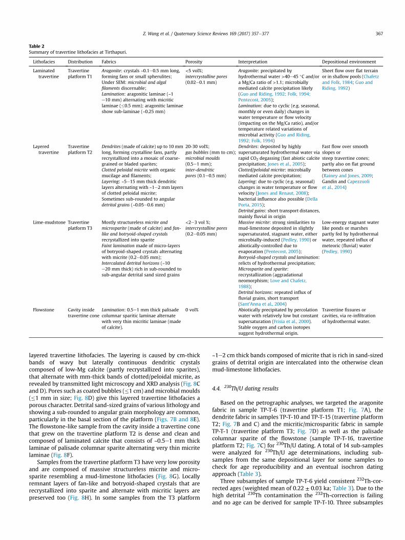
Table 2Summary of travertine lithofacies at Tirthapuri.
Lithofacies Distribution Fabrics Porosity Interpretation Depositional environment
Laminatedtravertine
Travertineplatform T1
Aragonite: crystals ~0.1e0.5 mm long,forming fans or small spherulites;Under SEM: microbial and algalfilaments discernable;Lamination: aragonitic laminae (~1e10 mm) alternating with micriticlaminae (�0.5 mm); aragonitic laminaeshow sub-laminae (~0.25 mm)
<5 vol%;intercrystalline pores(0.02e0.1 mm)
Aragonite: precipitated byhydrothermal water >40e45 �C and/ora Mg/Ca ratio of >1.1; microbiallymediated calcite precipitation likely(Guo and Riding, 1992; Folk, 1994;Pentecost, 2005);Lamination: due to cyclic (e.g. seasonal,monthly or even daily) changes inwater temperature or flow velocity(impacting on the Mg/Ca ratio), and/ortemperature related variations ofmicrobial activity (Guo and Riding,1992; Folk, 1994)
Sheet flow over flat terrainor in shallow pools (Chafetzand Folk, 1984; Guo andRiding, 1992)
Layeredtravertine
Travertineplatform T2
Dendrites (made of calcite) up to 10 mmlong, forming crystalline fans, partlyrecrystallized into a mosaic of coarse-grained or bladed sparites;Clotted peloidal micrite with organicmucilage and filaments;Layering: ~5e15 mm thick dendriticlayers alternating with ~1e2 mm layersof clotted peloidal micrite;Sometimes sub-rounded to angulardetrital grains (~0.05e0.6 mm)
20-30 vol%;gas bubbles (mm to cm);microbial moulds(0.5e1 mm);inter-dendriticpores (0.1e0.5 mm)
Dendrites: deposited by highlysupersaturated hydrothermal water viarapid CO2 degassing (fast abiotic calciteprecipitation; Jones et al., 2005);Clotted/peloidal micrite: microbiallymediated calcite precipitation;Layering: due to cyclic (e.g. seasonal)changes in water temperature or flowvelocity (Jones and Renaut, 2008);bacterial influence also possible (DellaPorta, 2015);Detrital gains: short transport distances,mainly fluvial in origin
Fast flow over smoothslopes orsteep travertine cones;partly also on flat groundbetween cones(Rainey and Jones, 2009;Gandin and Capezzuoliet al., 2014)
Lime-mudstone Travertineplatform T3
Mostly structureless micrite andmicrosparite (made of calcite) and fan-like and botryoid-shaped crystalsrecrystallized into spariteFaint lamination made of micro-layersof botryoid-shaped crystals alternatingwith micrite (0.2e0.05 mm);Intercalated detrital horizons (~10e20 mm thick) rich in sub-rounded tosub-angular detrital sand sized grains
<2e3 vol %;intercrystalline pores(0.2e0.05 mm)
Massive micrite: strong similarities tomud-limestone deposited in slightlysupersaturated, stagnant water, eithermicrobially-induced (Pedley, 1990) orabiotically-controlled due toevaporation (Pentecost, 2005);Botryoid-shaped crystals and lamination:relicts of hydrothermal precipitation;Microsparite and sparite:recrystallization (aggradationalneomorphism; Love and Chafetz,1988);Detrital horizons: repeated influx offluvial grains, short transport(Sant'Anna et al., 2004)
Low-energy stagnant waterlike ponds or marshespartly fed by hydrothermalwater, repeated influx ofmeteoric (fluvial) water(Pedley, 1990)
Flowstone Cavity insidetravertine cone
Lamination: 0.5e1 mm thick palisadecolumnar sparitic laminae alternatewith very thin micritic laminae (madeof calcite).
0 vol% Abiotically precipitated by percolationwater with relatively low but constantsupersaturation (Frisia et al., 2000).Stable oxygen and carbon isotopessuggest hydrothermal origin.
Travertine fissures orcavities, via re-infiltrationof hydrothermal water.
Z. Wang et al. / Quaternary Science Reviews 169 (2017) 357e377 367
layered travertine lithofacies. The layering is caused by cm-thickbands of wavy but laterally continuous dendritic crystalscomposed of low-Mg calcite (partly recrystallized into sparites),that alternate with mm-thick bands of clotted/peloidal micrite, asrevealed by transmitted light microscopy and XRD analysis (Fig. 8Cand D). Pores such as coated bubbles (�1 cm) andmicrobial moulds(�1 mm in size; Fig. 8D) give this layered travertine lithofacies aporous character. Detrital sand-sized grains of various lithology andshowing a sub-rounded to angular grain morphology are common,particularly in the basal section of the platform (Figs. 7B and 8E).The flowstone-like sample from the cavity inside a travertine conethat grew on the travertine platform T2 is dense and clean andcomposed of laminated calcite that consists of ~0.5e1 mm thicklaminae of palisade columnar sparite alternating very thin micritelaminae (Fig. 8F).
Samples from the travertine platform T3 have very low porosityand are composed of massive structureless micrite and micro-sparite resembling a mud-limestone lithofacies (Fig. 8G). Locallyremnant layers of fan-like and botryoid-shaped crystals that arerecrystallized into sparite and alternate with micritic layers arepreserved too (Fig. 8H). In some samples from the T3 platform
~1e2 cm thick bands composed of micrite that is rich in sand-sizedgrains of detrital origin are intercalated into the otherwise cleanmud-limestone lithofacies.
4.4. 230Th/U dating results
Based on the petrographic analyses, we targeted the aragonitefabric in sample TP-T-6 (travertine platform T1; Fig. 7A), thedendrite fabric in samples TP-T-10 and TP-T-15 (travertine platformT2; Fig. 7B and C) and the micritic/microsparitic fabric in sampleTP-T-1 (travertine platform T3; Fig. 7D) as well as the palisadecolumnar sparite of the flowstone (sample TP-T-16, travertineplatform T2; Fig. 7C) for 230Th/U dating. A total of 14 sub-sampleswere analyzed for 230Th/U age determinations, including sub-samples from the same depositional layer for some samples tocheck for age reproducibility and an eventual isochron datingapproach (Table 3).
Three subsamples of sample TP-T-6 yield consistent 232Th-cor-rected ages (weighted mean of 0.22 ± 0.03 ka; Table 3). Due to thehigh detrital 230Th contamination the 232Th-correction is failingand no age can be derived for sample TP-T-10. Three subsamples
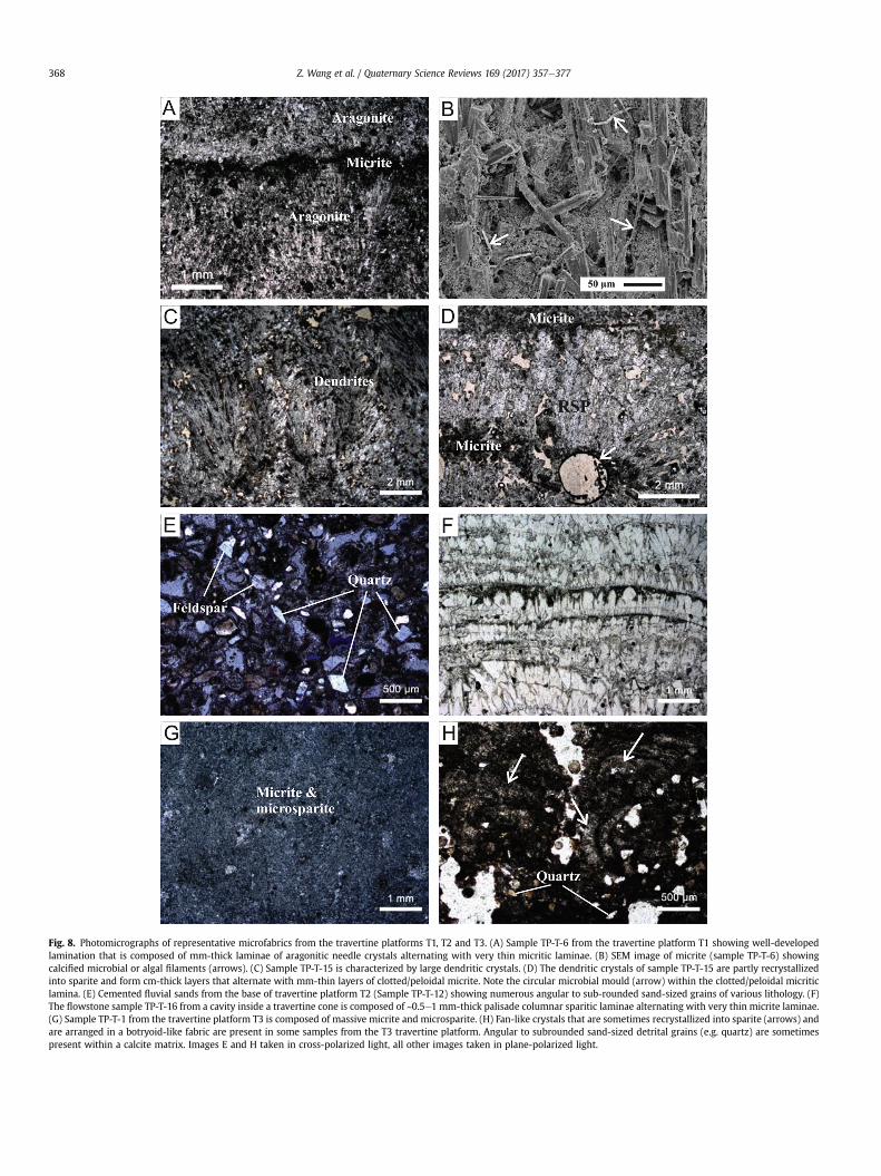
Fig. 8. Photomicrographs of representative microfabrics from the travertine platforms T1, T2 and T3. (A) Sample TP-T-6 from the travertine platform T1 showing well-developedlamination that is composed of mm-thick laminae of aragonitic needle crystals alternating with very thin micritic laminae. (B) SEM image of micrite (sample TP-T-6) showingcalcified microbial or algal filaments (arrows). (C) Sample TP-T-15 is characterized by large dendritic crystals. (D) The dendritic crystals of sample TP-T-15 are partly recrystallizedinto sparite and form cm-thick layers that alternate with mm-thin layers of clotted/peloidal micrite. Note the circular microbial mould (arrow) within the clotted/peloidal micriticlamina. (E) Cemented fluvial sands from the base of travertine platform T2 (Sample TP-T-12) showing numerous angular to sub-rounded sand-sized grains of various lithology. (F)The flowstone sample TP-T-16 from a cavity inside a travertine cone is composed of ~0.5e1 mm-thick palisade columnar sparitic laminae alternating with very thin micrite laminae.(G) Sample TP-T-1 from the travertine platform T3 is composed of massive micrite and microsparite. (H) Fan-like crystals that are sometimes recrystallized into sparite (arrows) andare arranged in a botryoid-like fabric are present in some samples from the T3 travertine platform. Angular to subrounded sand-sized detrital grains (e.g. quartz) are sometimespresent within a calcite matrix. Images E and H taken in cross-polarized light, all other images taken in plane-polarized light.
Z. Wang et al. / Quaternary Science Reviews 169 (2017) 357e377368
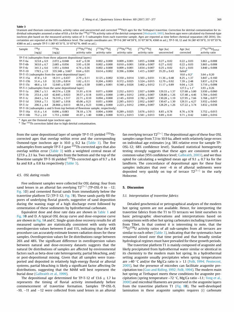
Table 3Uranium and thorium concentrations, activity ratios and uncorrected and corrected 230Th/U ages for the Tirthapuri travertine. Correction for detrital contamination for in-dividual subsamples assumed a value of 0.8 ± 0.4 for the 238U/232Th activity ratio of the detrital component (Wedepohl, 1995). Isochron ages were calculated via Osmond-typeisochron plot based on the measured activity ratios of 3e5 subsamples from each travertine sample. Ages are reported as time before chemical separation (AD 2014). Un-certainties are reported at the 95% confidence level. The sample coordinates are: TP-T-6 (80�4405900E, 31�0703600N, 4360 m asl.), TP-T-10, 12 and 16 (80�4501900E, 31�0703500N,4380 m asl.), sample TP-T-1 (80�4503100E, 31�0704200N, 4445 m asl.).
Sample 238U(ng/g)
232Th(ng/g)
[230Th/232Th]activity ratio
[232Th/238U]activity ratio
[230Th/238U]activity ratio
[234U/238U]activity ratio
Age (ka)uncorrected
Age (ka)corrected
[234U/238U]initialactivity ratio
TP-T-6 (subsamples from three adjacent depositional layers)TP-T-6a 323.8 ± 6.9 2.072 ± 0.048 4.47 ± 0.38 0.002 ± 0.000 0.009 ± 0.001 3.855 ± 0.008 0.27 ± 0.02 0.22 ± 0.03 3.861 ± 0.008TP-T-6b 363.0 ± 6.7 2.685 ± 0.056 3.95 ± 0.30 0.002 ± 0.000 0.010 ± 0.001 3.858 ± 0.007 0.27 ± 0.02 0.22 ± 0.03 3.865 ± 0.008TP-T-6c 341.3 ± 6.6 1.951 ± 0.044 4.74 ± 0.36 0.002 ± 0.000 0.009 ± 0.001 3.834 ± 0.007 0.25 ± 0.02 0.21 ± 0.03 3.840 ± 0.008TP-T-10 178.5 ± 1.9 335.348 ± 3.667 0.64 ± 0.01 0.614 ± 0.002 0.396 ± 0.004 1.415 ± 0.007 35.29 ± 0.43 failedb
TP-T-15 (subsamples from the same depositional layer) 10.0 ± 0.2a 3.64 ± 0.20TP-T-15a 47.8 ± 1.0 18.311 ± 0.437 2.79 ± 0.11 0.125 ± 0.002 0.350 ± 0.014 3.503 ± 0.031 11.36 ± 0.48 8.25 ± 1.37 3.847 ± 0.160TP-T-15b 51.4 ± 1.0 32.129 ± 0.814 1.82 ± 0.11 0.204 ± 0.003 0.372 ± 0.025 3.324 ± 0.015 12.79 ± 0.92 7.39 ± 2.48 3.837 ± 0.274TP-T-15c 48.6 ± 1.0 12.645 ± 0.307 4.00 ± 0.30 0.085 ± 0.001 0.340 ± 0.026 3.462 ± 0.012 11.17 ± 0.89 9.04 ± 1.25 3.710 ± 0.098TP-T-1 (subsamples from the same depositional layer) 127.5 ± 1.1a 3.93 ± 0.26TP-T-1a 206.7 ± 5.1 44.574 ± 1.228 31.91 ± 0.16 0.071 ± 0.000 2.252 ± 0.013 2.927 ± 0.009 129.33 ± 1.37 127.68 ± 5.80 3.930 ± 0.060TP-T-1b 253.4 ± 6.0 42.845 ± 0.923 39.57 ± 0.18 0.055 ± 0.000 2.189 ± 0.012 2.856 ± 0.007 128.80 ± 1.26 127.48 ± 4.46 3.784 ± 0.045TP-T-1c 264.5 ± 5.4 76.319 ± 1.517 22.71 ± 0.10 0.094 ± 0.000 2.145 ± 0.010 2.782 ± 0.007 130.28 ± 1.19 127.95 ± 7.66 3.768 ± 0.077TP-T-1d 339.8 ± 7.1 52.667 ± 1.018 45.06 ± 0.21 0.051 ± 0.000 2.285 ± 0.013 2.952 ± 0.007 130.47 ± 1.30 129.31 ± 4.27 3.932 ± 0.043TP-T-1e 206.3 ± 4.4 28.866 ± 0.613 48.54 ± 0.23 0.046 ± 0.000 2.223 ± 0.012 2.904 ± 0.007 128.29 ± 1.26 127.22 ± 3.74 3.832 ± 0.038TP-T-16 (subsamples a and b from top bottom of flowstone sample, respectively)TP-T-16a 61.6 ± 1.4 0.696 ± 0.083 78.18 ± 3.76 0.004 ± 0.000 0.289 ± 0.025 3.676 ± 0.013 8.85 ± 0.78 8.76 ± 0.78 3.752 ± 0.015TP-T-16b 75.2 ± 2.0 1.753 ± 0.060 41.07 ± 1.40 0.008 ± 0.000 0.313 ± 0.013 3.581 ± 0.013 9.89 ± 0.41 9.71 ± 0.42 3.669 ± 0.016
a Ages are the Osmond-type isochron ages.b The 232Th correction failed due to high detrital contamination.
Z. Wang et al. / Quaternary Science Reviews 169 (2017) 357e377 369
from the same depositional layer of sample TP-T-15 yielded 232Th-corrected ages that overlap within error and the correspondingOsmond-type isochron age is 10.0 ± 0.2 ka (Table 3). The fivesubsamples from sample TP-T-1 gave 232Th-corrected ages that alsooverlap within error (Table 3) with a weighted central mean of127.9 ± 2.1 ka. Two subsamples from the bottom and the top of theflowstone sample TP-T-16 yielded 232Th-corrected ages of 9.7 ± 0.4ka and 8.8 ± 0.8 ka respectively (Table 3).
4.5. OSL dating results
Five sediment samples were collected for OSL dating: four fromsand lenses in an alluvial fan overlying T2(1þ) (TP-OSL-9 to �12;Fig. 5D) and cemented fluvial sands from immediately below thetravertine platform T2 (TP-T-12; Fig. 7B). These sands partly fill thepores of underlying fluvial gravels, suggestive of sand depositionduring the waning stage of a high discharge event followed bycementation of these sediments by hydrothermal carbonate.
Equivalent dose and dose rate data are shown in Table 1 andFig. 9B and D. A typical OSL decay curve and dose-response curveare shown in Fig. 9A and C. Single-grain dose recovery results for allmeasured samples are statistically consistent with unity withoverdispersion values between 0 and 11%, indicating that the SARprocedure can accurately estimate known radiation doses for thesesamples. Overdispersion values for De distributions range between26% and 48%. The significant difference in overdispersion valuesbetween natural and dose-recovery datasets suggests that thenatural De distributions of samples are affected by environmentalfactors such as beta-dose rate heterogeneity, partial bleaching, and/or post-depositional mixing. Given that all samples were trans-ported and deposited in relatively high-energy fluvial or alluvialsystems, partial bleaching is likely a significant factor affecting Dedistributions, suggesting that the MAM will best represent theburial dose (Galbraith et al., 1999).
The depositional age determined for TP-T-12 of 13.6 ± 1.7 karepresents the timing of fluvial activity immediately beforecommencement of travertine formation. Samples TP-OSL-9,-10, �11 and �12 were collected from sand lenses in an alluvial
fan overlying terrace T2(1þ). The depositional ages of these four OSLsamples range from 7.3 to 10.9 ka, albeit with relatively large errorson individual age estimates (e.g. 18% relative error for sample TP-OSL-12; 68% confidence level). Standard statistical homogeneitytesting strongly suggests that these ages are consistent with acommon value (95% confidence level; Galbraith, 2003), andwe thusopted for calculating a weighted mean age of 9.1 ± 0.7 ka for thelandform. The concordance of depositional ages for these foursamples indicates that over ~6 m of alluvial sediments weredeposited very quickly on top of terrace T2(1þ) in the earlyHolocene.
5. Discussion
5.1. Interpretation of travertine fabrics
Detailed geochemical or petrographical analyses of the modernhot spring system are not available. Hence, for interpreting thetravertine fabrics from the T1 to T3 terraces we limit ourselves tobasic petrographic observations and interpretations based oncomparisonswith other hot spring carbonates including travertinesfrom Tibet. In that context it is interesting to note, that the234U/238U activity ratios of all sub-samples from all terraces aresimilar to each other (Table 3), indicating that the systematics haveremained closed over that time period and that broadly similarhydrological regimesmust have prevailed for these growth periods.
The travertine platform T1 is mainly composed of aragonite andlikely precipitated from hydrothermal water similar or identical inits chemistry to the modern main hot spring. In a hydrothermalsetting aragonite usually precipitates when spring temperaturesare >40 �C and/or the Mg/Ca ratio is > 1.1 (Folk, 1994; Pentecost,2005), but the presence of microbes can facilitate aragonite pre-cipitation too (Guo and Riding, 1992; Folk, 1994). The modern mainhot spring at Tirthapuri meets these conditions for aragonite pre-cipitation (spring temperature ~72 �C, Mg/Ca ratio ~1.1; Tong et al.,2000) and microbial filaments are preserved in the aragonite layersfrom the travertine platform T1 (Fig. 8B). The well-developedlamination in these aragonite samples requires (i) carbonate
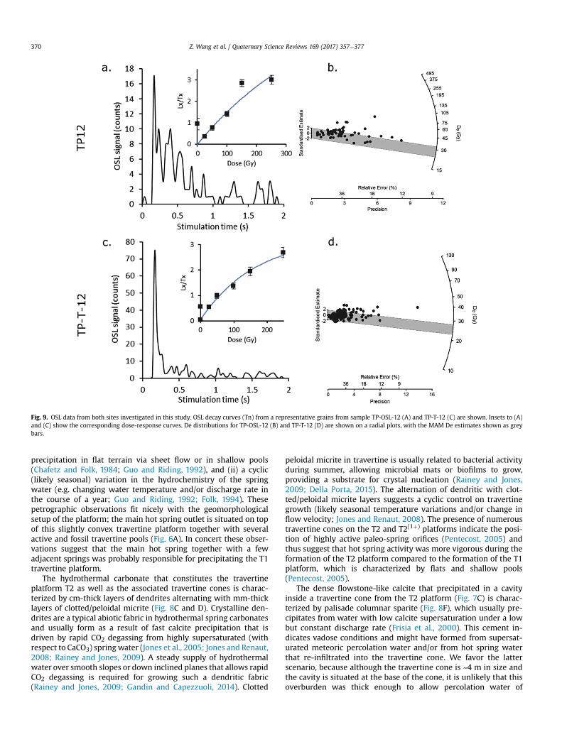
Fig. 9. OSL data from both sites investigated in this study. OSL decay curves (Tn) from a representative grains from sample TP-OSL-12 (A) and TP-T-12 (C) are shown. Insets to (A)and (C) show the corresponding dose-response curves. De distributions for TP-OSL-12 (B) and TP-T-12 (D) are shown on a radial plots, with the MAM De estimates shown as greybars.
Z. Wang et al. / Quaternary Science Reviews 169 (2017) 357e377370
precipitation in flat terrain via sheet flow or in shallow pools(Chafetz and Folk, 1984; Guo and Riding, 1992), and (ii) a cyclic(likely seasonal) variation in the hydrochemistry of the springwater (e.g. changing water temperature and/or discharge rate inthe course of a year; Guo and Riding, 1992; Folk, 1994). Thesepetrographic observations fit nicely with the geomorphologicalsetup of the platform; the main hot spring outlet is situated on topof this slightly convex travertine platform together with severalactive and fossil travertine pools (Fig. 6A). In concert these obser-vations suggest that the main hot spring together with a fewadjacent springs was probably responsible for precipitating the T1travertine platform.
The hydrothermal carbonate that constitutes the travertineplatform T2 as well as the associated travertine cones is charac-terized by cm-thick layers of dendrites alternating with mm-thicklayers of clotted/peloidal micrite (Fig. 8C and D). Crystalline den-drites are a typical abiotic fabric in hydrothermal spring carbonatesand usually form as a result of fast calcite precipitation that isdriven by rapid CO2 degassing from highly supersaturated (withrespect to CaCO3) spring water (Jones et al., 2005; Jones and Renaut,2008; Rainey and Jones, 2009). A steady supply of hydrothermalwater over smooth slopes or down inclined planes that allows rapidCO2 degassing is required for growing such a dendritic fabric(Rainey and Jones, 2009; Gandin and Capezzuoli, 2014). Clotted
peloidal micrite in travertine is usually related to bacterial activityduring summer, allowing microbial mats or biofilms to grow,providing a substrate for crystal nucleation (Rainey and Jones,2009; Della Porta, 2015). The alternation of dendritic with clot-ted/peloidal micrite layers suggests a cyclic control on travertinegrowth (likely seasonal temperature variations and/or change inflow velocity; Jones and Renaut, 2008). The presence of numeroustravertine cones on the T2 and T2(1þ) platforms indicate the posi-tion of highly active paleo-spring orifices (Pentecost, 2005) andthus suggest that hot spring activity was more vigorous during theformation of the T2 platform compared to the formation of the T1platform, which is characterized by flats and shallow pools(Pentecost, 2005).
The dense flowstone-like calcite that precipitated in a cavityinside a travertine cone from the T2 platform (Fig. 7C) is charac-terized by palisade columnar sparite (Fig. 8F), which usually pre-cipitates from water with low calcite supersaturation under a lowbut constant discharge rate (Frisia et al., 2000). This cement in-dicates vadose conditions and might have formed from supersat-urated meteoric percolation water and/or from hot spring waterthat re-infiltrated into the travertine cone. We favor the latterscenario, because although the travertine cone is ~4 m in size andthe cavity is situated at the base of the cone, it is unlikely that thisoverburden was thick enough to allow percolation water of
Z. Wang et al. / Quaternary Science Reviews 169 (2017) 357e377 371
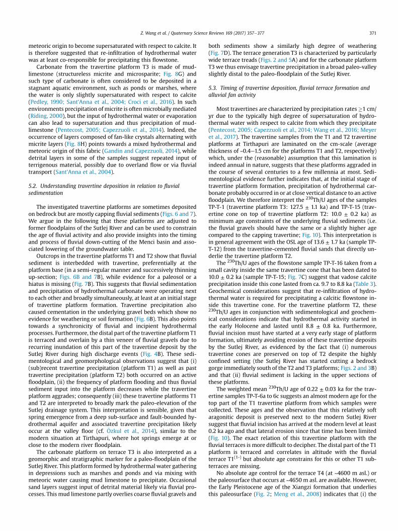
meteoric origin to become supersaturated with respect to calcite. Itis therefore suggested that re-infiltration of hydrothermal waterwas at least co-responsible for precipitating this flowstone.
Carbonate from the travertine platform T3 is made of mud-limestone (structureless micrite and microsparite; Fig. 8G) andsuch type of carbonate is often considered to be deposited in astagnant aquatic environment, such as ponds or marshes, wherethe water is only slightly supersaturated with respect to calcite(Pedley, 1990; Sant'Anna et al., 2004; Croci et al., 2016). In suchenvironments precipitation of micrite is oftenmicrobiallymediated(Riding, 2000), but the input of hydrothermal water or evaporationcan also lead to supersaturation and thus precipitation of mud-limestone (Pentecost, 2005; Capezzuoli et al., 2014). Indeed, theoccurrence of layers composed of fan-like crystals alternating withmicrite layers (Fig. 8H) points towards a mixed hydrothermal andmeteoric origin of this fabric (Gandin and Capezzuoli, 2014), whiledetrital layers in some of the samples suggest repeated input ofterrigenous material, possibly due to overland flow or via fluvialtransport (Sant'Anna et al., 2004).
5.2. Understanding travertine deposition in relation to fluvialsedimentation
The investigated travertine platforms are sometimes depositedon bedrock but are mostly capping fluvial sediments (Figs. 6 and 7).We argue in the following that these platforms are adjusted toformer floodplains of the Sutlej River and can be used to constrainthe age of fluvial activity and also provide insights into the timingand process of fluvial down-cutting of the Menci basin and asso-ciated lowering of the groundwater table.
Outcrops in the travertine platforms T1 and T2 show that fluvialsediment is interbedded with travertine, preferentially at theplatform base (in a semi-regular manner and successively thinningup-section; Figs. 6B and 7B), while evidence for a paleosol or ahiatus is missing (Fig. 7B). This suggests that fluvial sedimentationand precipitation of hydrothermal carbonate were operating nextto each other and broadly simultaneously, at least at an initial stageof travertine platform formation. Travertine precipitation alsocaused cementation in the underlying gravel beds which show noevidence for weathering or soil formation (Fig. 6B). This also pointstowards a synchronicity of fluvial and incipient hydrothermalprocesses. Furthermore, the distal part of the travertine platform T1is terraced and overlain by a thin veneer of fluvial gravels due torecurring inundation of this part of the travertine deposit by theSutlej River during high discharge events (Fig. 4B). These sedi-mentological and geomorphological observations suggest that (i)(sub)recent travertine precipitation (platform T1) as well as pasttravertine precipitation (platform T2) both occurred on an activefloodplain, (ii) the frequency of platform flooding and thus fluvialsediment input into the platform decreases while the travertineplatform aggrades; consequently (iii) these travertine platforms T1and T2 are interpreted to broadly mark the paleo-elevation of theSutlej drainage system. This interpretation is sensible, given thatspring emergence from a deep sub-surface and fault-bounded hy-drothermal aquifer and associated travertine precipitation likelyoccur at the valley floor (cf. €Ozkul et al., 2014), similar to themodern situation at Tirthapuri, where hot springs emerge at orclose to the modern river floodplain.
The carbonate platform on terrace T3 is also interpreted as ageomorphic and stratigraphic marker for a paleo-floodplain of theSutlej River. This platform formed by hydrothermal water gatheringin depressions such as marshes and ponds and via mixing withmeteoric water causing mud limestone to precipitate. Occasionalsand layers suggest input of detrital material likely via fluvial pro-cesses. This mud limestone partly overlies coarse fluvial gravels and
both sediments show a similarly high degree of weathering(Fig. 7D). The terrace generation T3 is characterized by particularlywide terrace treads (Figs. 2 and 5A) and for the carbonate platformT3we thus envisage travertine precipitation in a broad paleo-valleyslightly distal to the paleo-floodplain of the Sutlej River.
5.3. Timing of travertine deposition, fluvial terrace formation andalluvial fan activity
Most travertines are characterized by precipitation rates�1 cm/yr due to the typically high degree of supersaturation of hydro-thermal water with respect to calcite from which they precipitate(Pentecost, 2005; Capezzuoli et al., 2014; Wang et al., 2016; Meyeret al., 2017). The travertine samples from the T1 and T2 travertineplatforms at Tirthapuri are laminated on the cm-scale (averagethickness of ~0.4e1.5 cm for the platforms T1 and T2, respectively)which, under the (reasonable) assumption that this lamination isindeed annual in nature, suggests that these platforms aggraded inthe course of several centuries to a few millennia at most. Sedi-mentological evidence further indicates that, at the initial stage oftravertine platform formation, precipitation of hydrothermal car-bonate probably occurred in or at close vertical distance to an activefloodplain. We therefore interpret the 230Th/U ages of the samplesTP-T-1 (travertine platform T3: 127.5 ± 1.1 ka) and TP-T-15 (trav-ertine cone on top of travertine platform T2: 10.0 ± 0.2 ka) asminimum age constraints of the underlying fluvial sediments (i.e.the fluvial gravels should have the same or a slightly higher agecompared to the capping travertine; Fig. 10). This interpretation isin general agreement with the OSL age of 13.6 ± 1.7 ka (sample TP-T-12) from the travertine-cemented fluvial sands that directly un-derlie the travertine platform T2.
The 230Th/U ages of the flowstone sample TP-T-16 taken from asmall cavity inside the same travertine cone that has been dated to10.0 ± 0.2 ka (sample TP-T-15; Fig. 7C) suggest that vadose calciteprecipitation inside this cone lasted from ca. 9.7 to 8.8 ka (Table 3).Geochemical considerations suggest that re-infiltration of hydro-thermal water is required for precipitating a calcitic flowstone in-side this travertine cone. For the travertine platform T2, these230Th/U ages in conjunction with sedimentological and geochem-ical considerations indicate that hydrothermal activity started inthe early Holocene and lasted until 8.8 ± 0.8 ka. Furthermore,fluvial incision must have started at a very early stage of platformformation, ultimately avoiding erosion of these travertine depositsby the Sutlej River, as evidenced by the fact that (i) numeroustravertine cones are preserved on top of T2 despite the highlyconfined setting (the Sutlej River has started cutting a bedrockgorge immediately south of the T2 and T3 platforms; Figs. 2 and 3B)and that (ii) fluvial sediment is lacking in the upper sections ofthese platforms.
The weighted mean 230Th/U age of 0.22 ± 0.03 ka for the trav-ertine samples TP-T-6a to 6c suggests an almost modern age for thetop part of the T1 travertine platform from which samples werecollected. These ages and the observation that this relatively softaragonitic deposit is preserved next to the modern Sutlej Riversuggest that fluvial incision has arrived at the modern level at least0.2 ka ago and that lateral erosion since that time has been limited(Fig. 10). The exact relation of this travertine platform with thefluvial terraces is more difficult to decipher. The distal part of the T1platform is terraced and correlates in altitude with the fluvialterrace T1(1-) but absolute age constrains for this or other T1 sub-terraces are missing.
No absolute age control for the terrace T4 (at ~4600 m asl.) orthe paleosurface that occurs at ~4650 m asl. are available. However,the Early Pleistocene age of the Xiangzi formation that underliesthis paleosurface (Fig. 2; Meng et al., 2008) indicates that (i) the
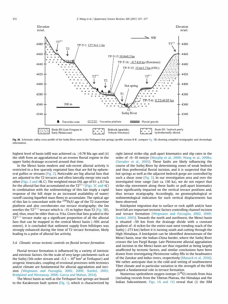
Fig. 10. Schematic valley cross-profile of the Sutlej River next to the Tirthapuri hot springs (profile section B-B0 , compare Fig. 3B) showing compiled stratigraphic and chronologicinformation.
Z. Wang et al. / Quaternary Science Reviews 169 (2017) 357e377372
highest level of basin infill was achieved ca. �0.78 Ma ago and (ii)the shift from an aggradational to an erosive fluvial regime in theupper Sutlej drainage occurred around that time.
In the Menci basin modern and sub-recent alluvial activity isrestricted to a few sparsely vegetated fans that are fed by ephem-eral gullies or streams (Fig. 2). Noticeable are big alluvial fans thatare adjusted to the T2 terraces and often laterally merge into eachother (Figs. 2 and 4B, C). The weighted mean OSL age of 9.1 ± 0.7 kafor the alluvial fan that accumulated on the T2(1þ) (Figs. 3C and 4C)in combination with the sedimentology of this fan imply a rapidresponse of the hill slope to an increased availability of water/runoff causing liquefied mass flows to accumulate. The optical ageof this fan is concordant with the 230Th/U age of the T2 travertineplatform and also corroborates our terrace stratigraphy; the fanoverlies the T2(1þ) terrace which is ~15 m higher than T2 (Fig. 3D),and, thus, must be older than ca. 9 ka. Given that fans graded to theT2(1þ) terrace make up a significant proportion of all the alluvialfans that can be mapped in the central Menci basin (~50% aerialextent), it is concluded that sediment supply from hillslopes wasstrongly enhanced during the time of T2 terrace formation, likelyleading to a pulse of alluvial fan activity.
5.4. Climatic versus tectonic controls on fluvial terrace formation
Fluvial terrace formation is influenced by a variety of intrinsicand extrinsic factors. On the scale of very large catchments such asthe Sutlej (5th order stream and ~5.3 � 104 km2 at Tirthapuri) andorogenic timescales, coupling of erosional processes with tectonicsand/or climate are fundamental for alluvial aggradation and inci-sion (Wegmann and Pazzaglia, 2002, 2009; Starkel, 2003;Bridgland and Westaway, 2008; Garcia and Mahan, 2014).
The Menci basin as well as the Tirthapuri hot springs are boundto the Karakorum fault system (Fig. 1), which is characterized by
right lateral strike-slip, pull-apart kinematics and slip rates in theorder of ~6e10 mm/yr (Murphy et al., 2000; Wang et al., 2008a;Chevalier et al., 2005). These faults are likely influencing thecourse of the Sutlej River by determining zones of weak bedrockand thus preferential fluvial incision, and it is suspected that thehot springs as well as the adjacent bedrock gorge are controlled bysuch a shear zone (Fig. 3). In our investigation area and over theinvestigated time range (last ca. 130 ka), we do not expect thatstrike-slip movement along these faults or pull-apart kinematicshave significantly impacted on the vertical terrace positions and,thus terrace stratigraphy. Accordingly, no geomorphological orsedimentological indication for such vertical displacements hasbeen observed.
Knickpoint migration due to surface or rock uplift and/or baselevel fall are important tectonic factors controlling channel incisionand terrace formation (Wegmann and Pazzaglia, 2002, 2009;Starkel, 2003). Towards the north and northwest, the Menci basinis situated ~50 km from the drainage divide with a constantgradient of ~6 m/km for the entire east-west trending reach of theSutlej (~273 km) before it is turning south and cutting through theHigh Himalaya. A knickpoint can be identified downstream of theMenci basin, near the Indian-China border, where the Sutlej Rivercrosses the Leo Pargil Range. Late Pleistocene alluvial aggradationand incision in the Menci basin are thus regarded as being largelyunaffected by tectonic factors, and similar conclusions have beendrawn from investigating Pleistocene valley fills in the headwatersof the Zanskar and Indus rivers, respectively (Munack et al., 2016).We rather anticipate that in the cold-arid setting of southwesternTibet climate and in particular variation in the strength of the ISMplayed a fundamental role in terrace formation.
Numerous speleothem oxygen-isotope (d18O) records from Asia(including records from the Tibetan Plateau, the Himalaya and theIndian Subcontinent; Figs. 1A and 11) reveal that (i) the ISM

Fig. 11. Comparison of travertine precipitation periods at Tirthapuri (black triangles represent travertine 230Th/U ages discussed in text) with cave speleothem d18O records showingthe Asian summer monsoon variability during the past 150 ka. T1 to T3: travertine platform T1 to T3. Note that the scale on the x-axis is different before and after 32 ka. a e Tianmencave (central Tibet; Cai et al., 2010, 2012); b e East Asia summer monsoon record (compilation of 3 speleothem records from southern China; Cheng et al., 2016); Black dashed line isthe 21st July insolation at 65�N (Berger and Loutre, 1991). Periods of more negative speleothem d18O values indicate times of enhanced monsoon intensity and are highlighted bygrey bars (based on Cheng et al., 2016). B/A is the B€olling/Aller€od interstadial. The red dashed line in b indicates a semi-quantitative threshold in monsoon intensity upon whichtravertine precipitation in the cold-arid catchment of the upper Sutlej probably commences (based on the average d18O isotope values in the East Asia summer monsoon recordduring the time periods of T2 and T3 travertine platform formation (i.e. �10.4‰)). (For interpretation of the references to colour in this figure legend, the reader is referred to theweb version of this article.)
Z. Wang et al. / Quaternary Science Reviews 169 (2017) 357e377 373
fluctuated over millennial to orbital time-scales in response tochanges in Northern Hemisphere summer insolation and (ii) theseoscillations were broadly synchronous, suggesting that continent-scale monsoonal circulation changes were a simultaneous phe-nomenon (Fig. 11; Fleitmann et al., 2003; Sinha et al., 2005; Caiet al., 2010, 2012; Dutt et al., 2015; Cheng et al., 2016; Kathayatet al., 2016). These variations in the intensity of the ISM are alsomirrored in lacustrine archives of several Tibetan lakes (Sumxi Co,Van Campo and Gasse, 1993; Tso Kar, Demske et al., 2009; Nam Co,Zhu et al., 2015; Baqan Co, Huth et al., 2015; Nganglan Ring Co,Hudson et al., 2015; Paiku Co, Wünnemann et al., 2015; compareFig. 1A for locations). Furthermore, current research and improvedsurface-exposure and luminescence dating chronologies suggestthat in southern Tibet and the Himalaya ISM oscillations exerted aprofound control on landscape evolution via erosional hillslopeprocesses, river discharge, and sedimentation flux (Pratt et al.,2002; Brown et al., 2003; Pratt-Sitaula et al., 2004; Bookhagenet al., 2005, 2006; Srivastava et al., 2008, 2009; Juyal et al., 2010;Thakur et al., 2014; Densmore et al., 2016; Dey et al., 2016). Thisconcept of climate forcing of sediment cycles is particularly wellinvestigated along the middle and lower reaches of the Sutlej Riverand adjacent catchments, which are characterized by highmonsoon precipitation and relatively mild temperatures (MAP of760e1320 mm/yr; MAT of 14e28 �C; Singh et al., 2015). Theemerging view for these strongly monsoon influenced settings isthat strengthening of the ISM between ~15 and 10 ka caused rapidsediment aggradation (Bookhagen et al., 2006; Thakur et al., 2014;Densmore et al., 2016) quickly followed by incision at a time whenthe ISM was still very strong (i.e. at ~9.3 ka in the case of the lowerSutlej River; Dey et al., 2016). Repeated regional incision phasesoccurred from ~8 ka onward in line with the overall decreasing ISMintensity (Bookhagen et al., 2006; Dey et al., 2016; Cheng et al.,2016). For the lower Sutlej River it is suspected that the onset ofincision at ~9.3 kawas linked to an overall decrease in the sediment
flux from the hillslopes, because the easily eroded sediments hadbeen removed from the source areas during the initial ISMstrengthening phase (~15e10 ka) (Dey et al., 2016). This phenom-enon of pulses of hill-slope driven aggradation during periods ofincreasing precipitation followed by incision during the waningstages of peak precipitation has been observed in other mountainranges as well, including NWArgentina (Schildgen et al., 2016), thePamir (Strecker et al., 2003) the Tien Shan (Huang et al., 2014) orthe Appeninies (Wegmann and Pazzaglia, 2009).
The climatic and geomorphologic setting in the upper Sutlej issignificantly different compared to that in its middle and lowerreaches, with MAP of only ~250 mm/yr, MAT of 0e3 �C and rela-tively wide basins between 4300 and 4600 m asl. that are fed byrivers originating in the Transhimalaya (~25 km to the north) or theHigh Himalaya (~80 km to the south). Despite this cold and aridsetting, the ISM is still the main source of precipitation delivering>70% of the MAP to the upper Sutlej (Bookhagen and Burbank,2010). Our 230Th/U and OSL ages from the travertine platform T2suggest that hot spring activity and hydrothermal carbonate pre-cipitation started 10.0 ± 0.2 ka ago and lasted until 8.8 ± 0.8 ka, andthus precisely coincide with the timewhen the ISM strength was atits maximum (Cai et al., 2012; Cheng et al., 2016, Fig. 11). Isotopicgroundwater studies from Tibet show that (i) hydrothermal springwater is mainly recharged via atmospheric precipitation and that(ii) groundwater circulation on the plateau is rapid and thus resi-dence times for hydrothermal water are short (i.e. a few decades;Tan et al., 2014). We thus suggest that hot spring activity at Tir-thapuri is directly related to strong phases of the ISM and such linkshave already been put forward for the Nyalam travertine (Zentmyeret al., 2008) and the Chusang travertine (Wang et al., 2016; Meyeret al., 2017; both southern Tibet; Fig. 1).
OSL dating in conjunction with geomorphologic and sedimen-tological data from the T2 travertine platform and terraces furthersuggest that (i) a short pulse of valley aggradation prior to
Z. Wang et al. / Quaternary Science Reviews 169 (2017) 357e377374
travertine formation occurred and lasted until 13.6 ± 1.7 ka; (ii)fluvial incision commenced at a very early stage of travertineplatform formation e essentially during peak monsoon conditions;and (iii) local hill-slopes responded rapidly to an enhanced ISM viaalluvial fan activity at 9.1 ± 0.7 ka. These observations stronglysupport the hypothesis of climate forcing of sediment cycles asoutlined above. We speculate that the material flushed from hill-slopes during the early Holocene peak in monsoon activity wasmainly transferred and stored within alluvial fans along the valleymargins, and did thus not result in significant valley floor aggra-dation in thewide pull-apart setting of the centralMenci basin. Thisinterpretation is supported by our geomorphological maps (Figs. 2and 4), which indicate that although a significant proportion ofalluvial fans are adjusted to the T2(1þ) and T2 terraces, they are allconcentrated along the valley flanks and rarely reached thecontemporaneous active river channel.
The 230Th/U age of 127.5 ± 1.1 ka for the travertine platform T3(Fig.10) suggests that the valley floor in the central Menci basinwas~93 m higher during the last interglacial and ~28 m higher duringthe early Holocene compared to today. We point out that the pre-cision on this 230Th/U age (0.87% relative error) is good enough tosuggest that this age probably coincides with the insolationmaximum (at ca. 128 ka; Berger and Loutre, 1991) and thus thebeginning of the last interglacial (MIS 5e, lasting from ca. 130e120ka; Cai et al., 2010; Kathayat et al., 2016; Cheng et al., 2016, Fig. 11).Furthermore, we observe that, like travertine platform T2, a fewmeters of T3 fluvial gravels are overlying bedrock and are capped byhydrothermal carbonate. The same sequence of events that oper-ated during the early Holocene is thus envisaged for the formationof the travertine platform T3 at the beginning of MIS 5e: theinsolation-driven intensification of the ISM caused a short pulse offluvial aggradation and activated hydrothermal springs and trav-ertine precipitation which, in turn, is immediately followed byfluvial incision and thus terrace formation.
Based on our combined 230Th/U ages and terrace stratigraphy,average incision rates for the upper Sutlej at Tirthapuri can beobtained. First a semi-quantitative threshold in monsoon intensityis defined, upon which travertine precipitation in the catchment ofthe upper Sutlej probably commences. This threshold is based onthe average d18O isotope values in the East Asia summer monsoonrecord during the time periods of T2 and T3 travertine platformformation (�10.4‰; red dashed line in Fig. 11). Time periods withd18O isotope values more negative than�10.4‰ are considered wetenough to allow for significant travertine precipitation followed byfluvial down cutting and thus terrace formation as outlined above(i.e. MIS 5e, 5c, 5a, the B€olling Aller€od and from ca. 11.7e5 ka;Fig. 11). Considering only periods above the monsoon intensitythreshold we obtain average incision rates of ~4.2 mm/yr for theHolocene or ~2e3 mm/yr for the past ~128 ka. These incision ratesare at the lower end compared to the incision rates obtained for theHigh Himalaya (~2e12 mm/yr; Burbank et al., 1996; Vance et al.,2003; Pratt-Sitaula et al., 2004) but such comparisons have to betreated with caution. Firstly, because at Tirthapuri the Sutlej re-incises into sedimentary basin fill rather than bedrock, and sec-ondly because of the overall lower discharge and valley steepnessin the upper Sutlej setting relative to the High Himalaya. Acomplicating factor at Tirthapuri is the complex nature of longer-term erosion characterized by varying relative contributions ofrapid vertical incisionwith valley-bottom narrowing, and phases ofslower lateral erosion and valley-bottom widening (Hancock andAnderson, 2002; Wegmann and Pazzaglia, 2002, 2009; DeVecchioet al., 2012; Garcia and Mahan, 2014; Malatesta et al., 2016).Following these millennial-scale pulses of dominantly discharge-driven vertical incision during peak monsoon times, fluvial dy-namics would return to a transport-limited systemwith prolonged
phases of lateral erosion and valley widening. This would lead tothe removal of previously formed strath or fill-cut terraces(Wegmann and Pazzaglia, 2002; Limaye and Lamb, 2016), limits thelonger-term preservation of more complete terrace sequences, e.g.as represented by the multiple Holocene terrace sub-levels at Tir-thapuri (Fig. 3A, C), and confirms that the interpretation of long-term fluvial incision rates may not be straightforward (Finneganet al., 2014). Phases of vertical incision therefore represent dy-namic but episodic landscape-scale events in our combined modelof ISM driven travertine and terrace formation in the upper Sutlej(Fig. 11).
6. Conclusions
Hot spring activity and thus extensive hydrothermal carbonateprecipitation and formation of travertine platforms at Tirthapuri(upper Sutlej) are linked to phases ofmaximum strength of the ISM.These travertine platforms started to aggrade in or adjacent toactive fluvial channels and were preserved from fluvial erosionbecause the enhanced ISM also triggered river bed incision andlowering of the local groundwater table eventually cutting off thetravertine mounds and cones from hot water supply. Thereforethese fossil travertine platforms indicate the altitude of former riverbeds and the timing when fluvial down-cutting commenced, andare thus regarded valuable geomorphological markers for thereconstruction of late Quaternary landscape and climate dynamics,and chronological markers suitable for the application of U-Thdating techniques. This is particularly evident in high-mountainsettings such as the Tibetan Plateau where (i) travertine forma-tion is facilitated by active tectonics, (ii) long-term preservationpotential for alluvial sediment may be limited, and (iii) the estab-lishment of terrace chronologies is additionally complicated due tothe coarse character of alluvial sediment. In such a setting, theupper Sutlej is characterized by (i) a series of high altitude pull-apart basins and (ii) arid conditions due to its position downwardof the Himalaya and the Karakoram that are partly blocking the ISMand the westerlies, respectively. We argue that because of this aridsetting and the relative importance of the ISM for the MAP in theupper Sutlej (175 mm or 70% of the MAP are currently delivered viathe ISM), the travertine deposits at Tirthapuri can also be inter-preted as sensitive indicators of peak ISM conditions. 230Th/Udating in combination with OSL dating constrains two such in-tervals when the ISMwas able to penetrate into southwestern Tibettriggering an instantaneous and significant landscape response:during the early Holocene (ca. 10.0e8.8 ka) and at the beginning oftheMIS 5e (ca.128 ka). At these times the ISMwas strong enough inthis arid landscape and activated hot springs and travertine pre-cipitation, facilitated fluvial incision and stripped off sedimentsfrom the regional hill-slopes at rates significantly higher comparedto times with lower insolation and thus a regionally stagnantmonsoon.
Acknowledgements
This study was supported by the Austrian Science Fund (FWFgrant 24924eG19 to MCM) and the Chinese Scholarship Council(CSC fellowship to ZW) (2011699003). We are grateful to FengkangWang and Kun Ren (Southwest University, China) for their assis-tance in the field. We thank R. Tessadri, D. Schmidmair and M.Tribus (University of Innsbruck, Austria) for assistance with XRDand SEM analyses, respectively. Two reviewers are acknowledgedfor their constructive comments that helped improving a previousversion of this manuscript.
Z. Wang et al. / Quaternary Science Reviews 169 (2017) 357e377 375
References
Aitchison, J.C., Davis, A.M., Badengzhu, B., Luo, H., 2002. New constraints on theIndia-Asia collision: the lower Miocene gangrinboche conglomerates, YarlungTsangpo suture zone, SE Tibet. J. Asian Earth Sci. 21 (3), 251e263.
Armijo, R., Tapponnier, P., Mercier, J.L., Han, T.L., 1986. Quaternary extension insouthern Tibet - field observations and tectonic implications. J. Geophys. Res. 91(B14), 13803e13872.
Armijo, R., Tapponnier, P., Tonglin, H., 1989. Late cenozoic right-lateral strike-slipfaulting in southern Tibet. J. Geophys. Res. 94 (B3), 2787e2838.
Berger, A., Loutre, M.F., 1991. Insolation values for the climate of the last 10000000years. Quat. Sci. Rev. 10 (4), 297e317.
Blisniuk, P.M., Hacker, B.R., Glodny, J., Ratschbacher, L., Bi, S.W., Wu, Z.H.,McWilliams, M.O., Calvert, A., 2001. Normal faulting in central Tibet since atleast 13.5 Myr ago. Nature 412 (6847), 628e632.
Bookhagen, B., Burbank, D.W., 2010. Toward a complete Himalayan hydrologicalbudget: spatiotemporal distribution of snowmelt and rainfall and their impacton river discharge. J. Geophys. Res. 115, F03019.
Bookhagen, B., Fleitmann, D., Nishiizurrli, K., Strecker, M.R., Thiede, R.C., 2006.Holocene monsoonal dynamics and fluvial terrace formation in the northwestHimalaya, India. Geology 34 (7), 601e604.
Bookhagen, B., Thiede, R.C., Strecker, M.R., 2005. Late Quaternary intensifiedmonsoon phases control landscape evolution in the northwest Himalaya. Ge-ology 33 (2), 149e152.
Bøtter-Jensen, L., Andersen, C.E., Duller, G.A.T., Murray, A.S., 2003. Developments inradiation, stimulation and observation facilities in luminescence measure-ments. Radiat. Meas. 37 (4e5), 535e541.
Bøtter-Jensen, L., Mejdahl, V., 1988. Assessment of beta dose-rate using a GMmulticounter system. Nucl. Tracks Radiat. Meas. 14, 187e191.
Bridgland, D., Westaway, R., 2008. Climatically controlled river terrace staircases: aworldwide Quaternary phenomenon. Geomorphology 98 (3e4), 285e315.
Brown, E.T., Bendick, R., Bourles, D.L., Gaur, V., Molnar, P., Raisbeck, G.M., Yiou, F.,2003. Early Holocene climate recorded in geomorphological features in West-ern Tibet. Palaeogeogr. Palaeoclimatol. Palaeoecol. 199 (1e2), 141e151.
Burbank, D.W., Leland, J., Fielding, E., Anderson, R.S., Brozovic, N., Reid, M.R.,Duncan, C., 1996. Bedrock incision, rock uplift and threshold hillslopes in thenorthwestern Himalayas. Nature 379 (6565), 505e510.
Cai, Y., Cheng, H., An, Z., Edwards, R.L., Wang, X., Tan, L., Wang, J., 2010. Large var-iations of oxygen isotopes in precipitation over south-central Tibet duringMarine Isotope Stage 5. Geology 38 (3), 243e246.
Cai, Y., Fung, I., Edwards, R.L., An, Z., Cheng, H., Lee, J.E., Tan, L., Sheng, C.C., Wang, X.,Day, J.A., Zhou, W., Kelly, M.J., Chiang, J.C.H., 2015. Variability of stalagmite-inferred Indian monsoon precipitation over the past 252,000 y. Proc. Natl.Acad. Sci. U. S. A. 112 (10), 2954e2959.
Cai, Y., Zhang, H., Cheng, H., An, Z., Edwards, R.L., Wang, X., Tan, L., Liang, F., Wang, J.,Kelly, M., 2012. The Holocene Indian monsoon variability over the southernTibetan Plateau and its teleconnections. Earth Planet. Sci. Lett. 335, 135e144.
Capezzuoli, E., Gandin, A., Pedley, M., 2014. Decoding tufa and travertine (freshwater carbonates) in the sedimentary record: the state of the art. Sedimen-tology 61 (1), 1e21.
Chafetz, H.S., Folk, R.L., 1984. Travertines d depositional morphology and thebacterially constructed constituents. J. Sediment. Pet. 54 (1), 289e316.
Cheng, H., Edwards, R.L., Hoff, J., Gallup, C.D., Richards, D.A., Asmerom, Y., 2000. Thehalf-lives of uranium-234 and thorium-230. Chem. Geol. 169 (1e2), 17e33.
Cheng, H., Edwards, R.L., Sinha, A., Spotl, C., Yi, L., Chen, S.T., Kelly, M., Kathayat, G.,Wang, X.F., Li, X.L., Kong, X.G., Wang, Y.J., Ning, Y.F., Zhang, H.W., 2016. The Asianmonsoon over the past 640,000 years and ice age terminations. Nature 534(7609), 640e646.
Chevalier, M.L., Ryerson, F.J., Tapponnier, P., Finkel, R.C., Van der Woerd, J., Li, H.B.,Liu, Q., 2005. Slip-rate measurements on the Karakorum Fault may implysecular variations in fault motion. Science 307 (5708), 411e414.
CIGMR (Chengdu Institute of Geology and Mineral Resources), G.S.o.C, 2004.Geological Map of Qinghai-tibet Plateau and Adjacent Region (Scale: 1:1 500000). Chengdu. Cartographic Publishing House, Chengdu.
Croci, A., Della Porta, G., Capezzuoli, E., 2016. Depositional architecture of a mixedtravertine-terrigenous system in a fault-controlled continental extensionalbasin (Messinian, Southern Tuscany, Central Italy). Sediment. Geol. 332, 13e39.
DeCelles, P.G., Kapp, P., Quade, J., Gehrels, G.E., 2011. Oligocene-Miocene Kailasbasin, southwestern Tibet: record of postcollisional upper-plate extension inthe Indus-Yarlung suture zone. Geol. Soc. Am. Bull. 123 (7e8), 1337e1362.
Della Porta, G., 2015. Special Publications. Carbonate Build-ups in Lacustrine, Hy-drothermal and Fluvial Settings: Comparing Depositional Geometry, FabricTypes and Geochemical Signature, vol. 418. Geological Society, London,pp. 17e68 (1).
Demske, D., Tarasov, P.E., Wünnemann, B., Riedel, F., 2009. Late glacial and Holocenevegetation, Indian monsoon and westerly circulation in the Trans-Himalayarecorded in the lacustrine pollen sequence from Tso Kar, Ladakh, NW India.Palaeogeogr. Palaeoclimatol. Palaeoecol. 279 (3e4), 172e185.
Densmore, A.L., Sinha, R., Sinha, S., Tandon, S.K., Jain, V., 2016. Sediment storage andrelease from Himalayan piggyback basins and implications for downstreamriver morphology and evolution. Basin Res. 28 (4), 446e461.
DeVecchio, D.E., Heermance, R.V., Fuchs, M., Owen, L.A., 2012. Climate-controlledlandscape evolution in the western transverse ranges, California: insights fromquaternary geochronology of the saugus formation and strath terrace flights.
Lithosphere 4 (2), 110e130.Dey, S., Thiede, R.C., Schildgen, T.F., Wittmann, H., Bookhagen, B., Scherler, D.,
Jain, V., Strecker, M.R., 2016. Climate-driven sediment aggradation and incisionsince the late Pleistocene in the NW Himalaya, India. Earth Planet. Sc. Lett. 449,321e331.
Duller, G.A.T., 2003. Distinguishing quartz and feldspar in single grain luminescencemeasurements. Radiat. Meas. 37 (2), 161e165.
Dutt, S., Gupta, A.K., Clemens, S.C., Cheng, H., Singh, R.K., Kathayat, G., Edwards, R.L.,2015. Abrupt changes in Indian summer monsoon strength during 33,800 to5500years BP. Geophys. Res. Lett. 42 (13), 5526e5532.
Finnegan, N.J., Hallet, B., Montgomery, D.R., Zeitler, P.K., Stone, J.O., Anders, A.M.,Yuping, L., 2008. Coupling of rock uplift and river incision in the NamcheBarwa-Gyala Peri massif. Tibet. Geol. Soc. Am. Bull. 120 (1e2), 142e155.
Finnegan, N.J., Rina Schumer, R., Finnegan, S., 2014. A signature of transience inbedrock river incision rates over timescales of 104-107 years. Nature 505(7483), 391e394.
Fleitmann, D., Burns, S.J., Mudelsee, M., Neff, U., Kramers, J., Mangini, A., Matter, A.,2003. Holocene forcing of the Indian monsoon recorded in a stalagmite fromSouthern Oman. Science 300 (5626), 1737e1739.
Folk, R.L., 1994. Interaction between bacteria, nannobacteria, and mineral precipi-tation in hot-springs of Central Italy. G�eogr. Phys. Quat. 48 (3), 233e246.
Frisia, S., Borsato, A., Fairchild, I.J., McDermott, F., 2000. Calcite fabrics, growthmechanisms, and environments of formation in speleothems from the Italianalps and southwestern Ireland. J. Sediment. Res. 70 (5), 1183e1196.
Galbraith, R.F., Roberts, R.G., Laslett, G.M., Yoshida, H., Olley, J.M., 1999. Opticaldating of single and multiple grains of quartz from Jinmium rock shelter,northern Australia: part I, experimental design and statistical models.Archaeometry 41, 339e364.
Galbraith, R., 2003. A simple homogeneity test for estimates of dose obtained usingOSL. Anc. TL 21, 75e77.
Gandin, A., Capezzuoli, E., 2014. Travertine: distinctive depositional fabrics of car-bonates from thermal spring systems. Sedimentology 61 (1), 264e290.
Garcia, A.F., Mahan, S.A., 2014. The notion of climate-driven strath-terrace pro-duction assessed via dissimilar stream-process response to late Quaternaryclimate. Geomorphology 214, 223e244.
Gliganic, L.A., May, J.-H., Cohen, T.J., 2015. All mixed up: using single-grain equiv-alent dose distributions to identify phases of pedogenic mixing on a drylandalluvial fan. Quat. Int. 362, 23e33.
Gu�erin, G., Mercier, N., Adamiec, G., 2011. Dose-rate conversion factors: update. Anc.TL 29, 5e8.
Guo, L., Riding, R., 1992. Aragonite laminae in hot water travertine crusts, Rapolano-Terme, Italy. Sedimentology 39 (6), 1067e1079.
Hancock, G.S., Anderson, R.S., 2002. Numerical modeling of fluvial strath-terraceformation in response to oscillating climate. Geol. Soc. Am. Bull. 114 (9),1131e1142.
Hodges, K.V., 2000. Tectonics of the Himalaya and southern Tibet from two per-spectives. Geol. Soc. Am. Bull. 112 (3), 324e350.
Hoffmann, D.L., Prytulak, J., Richards, D.A., Elliott, T., Coath, C.D., Smart, P.L.,Scholz, D., 2007. Procedures for accurate U and Th isotope measurements byhigh precision MC-ICPMS. Int. J. Mass Spectrom. 264 (2e3), 97e109.
Hoffmann, D.L., 2008. 230Th isotope measurements of femtogram quantities for U-series dating using multi ion counting (MIC) MC-ICPMS. Int. J. Mass Spectrom.275 (1e3), 75e79.
Hoffmann, D.L., Pike, A.W.G., García-Diez, M., Pettitt, P.B., Zilh~ao, J., 2016. Methodsfor U-series dating of CaCO3 crusts associated with Palaeolithic cave art andapplication to Iberian sites. Quat. Geochronol. 36, 104e119.
Huang, W.-l., Yang, X.-p., Li, A., Thompson, J.A., Zhang, L., 2014. Climaticallycontrolled formation of river terraces in a tectonically active region along thesouthern piedmont of the Tian Shan, NW China. Geomorphology 220, 15e29.
Hudson, A.M., Quade, J., Huth, T.E., Lei, G., Cheng, H., Edwards, L.R., Olsen, J.W.,Zhang, H., 2015. Lake level reconstruction for 12.8e2.3 ka of the Ngangla RingTso closed-basin lake system, southwest Tibetan Plateau. Quat. Res. 83 (1),66e79.
Huntley, D.J., Godfrey-Smith, D.I., Thewalt, M.L.W., 1985. Optical dating of sedi-ments. Nature 313, 105e107.
Huth, T., Hudson, A.M., Quade, J., Guoliang, L., Hucai, Z., 2015. Constraints onpaleoclimate from 11.5 to 5.0 ka from shoreline dating and hydrologic budgetmodeling of Baqan Tso, southwestern Tibetan Plateau. Quat. Res. 83 (1), 80e93.
Jones, B., Renaut, R.W., 2008. Cyclic development of large, complex, calcite dendritecrystals in the Clinton travertine, Interior British Columbia, Canada. Sediment.Geol. 203 (1e2), 17e35.
Jones, B., Renaut, R.W., Owen, R.B., Torfason, H., 2005. Growth patterns and impli-cations of complex dendrites in calcite travertines from Lysuholl, Sn ae fellsnes.Icel. Sedimentol. 52 (6), 1277e1301.
Juyal, N., Sundriyal, Y., Rana, N., Chaudhary, S., Singhvi, A.K., 2010. Late quaternaryfluvial aggradation and incision in the monsoon-dominated alaknanda valley,central Himalaya, Uttrakhand, India. J. Quat. Sci. 25 (8), 1293e1304.
Kaiser, K., Lai, Z.P., Schneider, B., Junge, F.W., 2010. Late Pleistocene genesis of themiddle Yarlung Zhangbo Valley, southern Tibet (China), as deduced by sedi-mentological and luminescence data. Quat. Geochronol. 5 (2e3), 200e204.
Kathayat, G., Cheng, H., Sinha, A., Spotl, C., Edwards, R.L., Zhang, H.W., Li, X.L., Yi, L.,Ning, Y.F., Cai, Y.J., Lui, W.G.L., Breitenbach, S.F.M., 2016. Indian monsoon vari-ability on millennial-orbital timescales. Sci. Rep. 6, 24374,. http://dx.doi.org/10.1038/srep24374.
Kempf, O., Blisniuk, P.M., Wang, S.F., Fang, X.M., Wrozyna, C., Schwalb, A., 2009.
Z. Wang et al. / Quaternary Science Reviews 169 (2017) 357e377376
Sedimentology, sedimentary petrology, and paleoecology of the monsoon-driven, fluvio-lacustrine Zhada Basin, SW-Tibet. Sediment. Geol. 222 (1e2),27e41.
Kirby, E., Whipple, K.X., Tang, W., Chen, Z., 2003. Distribution of active rock upliftalong the eastern margin of the Tibetan Plateau: inferences from bedrockchannel longitudinal profiles. J. Geophys. Res. 108, 2217. http://dx.doi.org/10.1029/2001JB000861.
Li, Q., Wang, S.Q., Xie, G.P., 2011. Discovery of fossil equss near menshi (moincer, orMenci), ngari, Xizang (Tibet). Quat. Sci. 31 (4), 689e698 (in Chinese with En-glish abstract).
Li, B.Y., Wang, F.B., Zhang, Q.S., 1983. The Series of the Scientific Expedition to theQinghai-tibet Plateau, Quaternary Geology of Tibet. Science Press, Beijing (inChinese).
Li, Y.Z., 2006. Xizang Annual. Tibet People Publishing Hause, Lhasa (in Chinese).Limaye, A.B.S., Lamb, M.P., 2016. Numerical model predictions of autogenic fluvial
terraces and comparison to climate change expectations. J. Geophys. Res. 121,512e544.
Love, K.M., Chafetz, H.S., 1988. Diagenesis of laminated travertine crusts, arbucklemountains, Oklahoma. J. Sediment. Pet. 58 (3), 441e445.
Luque, J.A., Julia, R., 2007. U/Th dating of Quaternary travertines at the middle RiverLlobregat (NE Iberian peninsula, northwestern Mediterranean). Correlationwith sea-level changes. Geol. Acta 5 (1), 109e117.
Maddy, D., Bridgland, D., Westaway, R., 2001. Uplift-driven valley incision andclimate-controlled river terrace development in the Thames Valley, UK. Quat.Int. 79, 23e36.
Mahan, S.A., Miller, D.M., Menges, C.M., Yount, J.C., 2007. Late Quaternary stratig-raphy and luminescence geochronology of the northeastern Mojave Desert.Quat. Int. 166, 61e78.
Malatesta, L.C., Prancevic, J.P., Avouac, J.-P., 2016. Autogenic entrenchment patternsand terraces due to coupling with lateral erosion in incising alluvial channels.J. Geophys. Res. 121 http://dx.doi.org/10.1002/2015JF003797.
Mallick, R., Frank, N., 2002. A new technique for precise uranium-series dating oftravertine micro-samples. Geochim. Cosmochim. Acta 66 (24), 4261e4272.
McCaffrey, R., Nabelek, J., 1998. Role of oblique convergence in the active defor-mation of the Himalayas and southern Tibet plateau. Geology 26 (8), 691e694.
Meng, X.G., Zhu, D.G., Shao, Z.G., Yang, C.B., Han, J.N., Yu, J., Meng, Q.W., Lu, R.P.,2008. Late Cenozoic stratigraphy and paleomagnetic chronology of the Zandabasin, Tibet, and records of the uplift of the Qinghai-Tibet Plateau. Acta Geol.Sin. 82, 63e72. English edition.
Meyer, M.C., Aldenderfer, M.S., Wang, Z., Hoffmann, D.L., Dahl, J.A., Degering, D.,Haas, W.R., Schlütz, F., 2017. Permanent human occupation of the central Ti-betan Plateau in the early Holocene. Science 355, 64e67.
Munack, H., Bl€othe, J.H., Fül€op, R.H., Codilean, A.T., Fink, D., Korup, O., 2016. Recy-cling of Pleistocene valley fills dominates 135 ka of sediment flux, upper IndusRiver. Quat. Sci. Rev. 149, 122e134.
Murari, M.K., Owen, L.A., Dortch, J.M., Caffee, M.W., Dietsch, C., Fuchs, M.,Haneberg, W.C., Sharma, M.C., Townsend-Small, A., 2014. Timing and climaticdrivers for glaciation across monsoon-influenced regions of the Hima-layaneTibetan orogen. Quat. Sci. Rev. 88, 159e182.
Murphy, M.A., Yin, A., Kapp, P., Harrison, T.M., Lin, D., Guo, J.H., 2000. Southwardpropagation of the Karakoram fault system, southwest Tibet: timing andmagnitude of slip. Geology 28 (5), 451e454.
Murphy, M.A., Yin, A., 2003. Structural evolution and sequence of thrusting in theTethyan fold-thrust belt and Indus-Yalu suture zone, southwest Tibet. Geol. Soc.Am. Bull. 115 (1), 21e34.
Murray, A.S., Wintle, A.G., 2000. Luminescence dating of quartz using an improvedsingle- aliquot regenerative-dose protocol. Radiat. Meas. 32, 57e73.
Murray, A.S., Wintle, A.G., 2003. The single aliquot regenerative dose protocol :potential for improvements in reliability. Radiat. Meas. 37, 377e381.
€Ozkul, M., Gokgoz, A., Kele, S., Baykara, M.O., Shen, C.C., Chang, Y.W., Kaya, A.,Hancer, M., Aratman, C., Akin, T., Ouml;rus, Z., 2014. Sedimentological andgeochemical characteristics of a fluvial travertine: a case from the easternMediterranean region. Sedimentology 61 (1), 291e318.
Pan, B.T., Su, H., Hu, Z.B., Hu, X.F., Gao, H.S., Li, J.J., Kirby, E., 2009. Evaluating the roleof climate and tectonics during non-steady incision of the Yellow River: evi-dence from a 1.24 Ma terrace record near Lanzhou, China. Quat. Sci. Rev. 28(27e28), 3281e3290.
Pedley, H.M., 1990. Classification and environmental models of cool freshwatertufas. Sediment. Geol. 68 (1e2), 143e154.
Pentecost, A., 2005. Travertine. Springer (Berlin).Perrineau, A., Woerd, J.V.D., Gaudemer, Y., Liu-Zeng, J., Pik, R., Tapponnier, P.,
Thuizat, R., Rongzhang, Z., 2011. Special Publications. Incision Rate of the YellowRiver in Northeastern Tibet Constrained by 10Be and 26Al Cosmogenic IsotopeDating of Fluvial Terraces: Implications for Catchment Evolution and PlateauBuilding, vol. 353. Geological Society, London, pp. 189e219 (1).
Pratt-Sitaula, B., Burbank, D.W., Heimsath, A., Ojha, T., 2004. Landscape disequi-librium on 1000e10,000 year scales marsyandi river, Nepal, central Himalaya.Geomorphology 58 (1e4), 223e241.
Pratt, B., Burbank, D.W., Heimsath, A., Ojha, T., 2002. Impulsive alluviation duringearly Holocene strengthened monsoons, central Nepal Himalaya. Geology 30(10), 911e914.
Prescott, J.R., Hutton, J.T., 1994. Cosmic ray contributions to dose rates for lumi-nescence and ESR dating: large depths and long-term time variations. Radiat.Meas. 23 (1), 497e500.
Rainey, D.K., Jones, B., 2009. Abiotic versus biotic controls on the development of
the fairmont hot springs carbonate deposit, british columbia, Canada. Sedi-mentology 56 (6), 1832e1857.
Ratschbacher, L., Krumrei, I., Blumenwitz, M., Staiger, M., Gloaguen, R., Miller, B.V.,Samson, S.D., Edwards, M.A., Appel, E., 2011. Special Publications. Rifting andStrike-slip Shear in Central Tibet and the Geometry, Age and Kinematics ofUpper Crustal Extension in Tibet, vol. 353. Geological Society, London,pp. 127e163 (1).
Rhodes, E.J., 2011. Optically stimulated luminescence dating of sediments over thepast 200,000 years. Annu. Rev. Earth. Planet. Sci. 39, 461e488.
Rich, J., Stokes, S., Wood, W., Bailey, R., 2003. Optical dating of tufa via in situ aeoliansand grains: a case example from the Southern High Plains, USA. Quat. Sci. Rev.22 (10e13), 1145e1152.
Riding, R., 2000. Microbial carbonates: the geological record of calcified bacterial-algal mats and biofilms. Sedimentology 47, 179e214.
Roberts, R.G., Galbraith, R.F., Olley, J.M., Yoshida, H., Laslett, G.M., 1999. Opticaldating of single and multiple grains of quartz from Jinmium rock shelter,northern Australia: part II, results and implications. Archaeometry 41 (2),365e395.
Rumelhart, P.E., Yin, A., Cowgill, E., Butler, R., Qing, Z., Xiao-Feng, W., 1999. Cenozoicvertical-axis rotation of the Altyn Tagh fault system. Geology 27 (9), 819e822.
Ruszkiczay-Rudiger, Z., Fodor, L., Bada, G., Leel-Ossy, S., Horvath, E., Dunai, T.J., 2005.Quantification of Quaternary vertical movements in the central PannonianBasin: a review of chronologic data along the Danube River, Hungary. Tecto-nophysics 410 (1e4), 157e172.
Sant'Anna, L.G., Riccomini, C., Rodrigues-Francisco, B.H., Sial, A.N., Carvalho, M.D.,Moura, C.A.V., 2004. The Paleocene travertine system of the Itaboraí basin,Southeastern Brazil. J. S. Am. Earth Sci. 18 (1), 11e25.
Saylor, J., DeCelles, P., Gehrels, G., Murphy, M., Zhang, R., Kapp, P., 2010a. Basinformation in the High Himalaya by arc-parallel extension and tectonicdamming: Zhada basin, southwestern Tibet. Tectonics 29.
Saylor, J., DeCelles, P., Quade, J., 2010b. Climate-driven environmental change in theZhada basin, southwestern Tibetan Plateau. Geosphere 6 (2), 74e92.
Saylor, J.E., Quade, J., Dellman, D.L., DeCelles, P.G., Kapp, P.A., Ding, L., 2009. The lateMiocene through present paleoelevation history of southwestern Tibet. Am. J.Sci. 309 (1), 1e42.
Schaller, M., Ehlers, T.A., Stor, T., Torrent, J., Lobato, L., Christl, M., Vockenhuber, C.,2016. Timing of European fluvial terrace formation and incision rates con-strained by cosmogenic nuclide dating. Earth. Planet. Sci. Lett. 451, 221e231.
Schildgen, T.F., Robinson, R.A.J., Savi, S., Phillips, W.M., Spencer, J.Q.G., Bookhagen, B.,Scherler, D., Tofelde, S., Alonso, R.N., Kubik, P.W., Binnie, S.A., Strecker, M.R.,2016. Landscape response to late Pleistocene climate change in NW Argentina:sediment flux modulated by basin geometry and connectivity. J. Geophys. Res.121 (2), 392e414.
Schulte, L., Julia, R., Burjachs, F., Hilgers, A., 2008. Middle Pleistocene to Holocenegeochronology of the river aguas terrace sequence (iberian peninsula): fluvialresponse to mediterranean environmental change. Geomorphology 98 (1e2),13e33.
Searle, M., Corfield, R.I., Stephenson, B., McCarron, J., 1997. Structure of the NorthIndian continental margin in the Ladakh-Zanskar Himalayas: implications forthe timing of obduction of the Spontang ophiolite. India-Asia Collis. Deform.Events Himalaya. Geol. Mag 134 (3), 297e316.
Searle, M.P., Pickering, K.T., Cooper, D.J.W., 1990. Restoration and evolution of theintermontane Indus molasse basin, Ladakh Himalaya, India. Tectonophysics 174(3e4), 301e314.
Sierralta, M., Sandor, K., Melcher, F., Hambach, U., Reinders, J., van Geldern, R.,Frechen, M., 2010. Uranium-series dating of travertine from Sutto: implicationsfor reconstruction of environmental change in Hungary. Quat. Int. 222 (1e2),178e193.
Singh, D., Jain, S.K., Gupta, R.D., 2015. Statistical downscaling and projection offuture temperature and precipitation change in middle catchment of SutlejRiver Basin, India. J. Earth Syst. Sci. 124 (4), 843e860.
Sinha, A., Cannariato, K.G., Stott, L.D., Li, H.C., You, C.F., Cheng, H., Edwards, R.L.,Singh, I.B., 2005. Variability of southwest Indian summer monsoon precipita-tion during the Boiling-Allerod. Geology 33 (10), 813e816.
Srivastava, P., Rajak, M.K., Singh, L.P., 2009. Late Quaternary alluvial fans andpaleosols of the Kangra basin, NW Himalaya: tectonic and paleoclimatic im-plications. Catena 76 (2), 135e154.
Srivastava, P., Tripathi, J.K., Islam, R., Jaiswal, M.K., 2008. Fashion and phases of latePleistocene aggradation and incision in the alaknanda River valley, westernHimalaya, India. Quat. Res. 70 (1), 68e80.
Starkel, L., 2003. Climatically controlled terraces in uplifting mountains areas. Quat.Sci. Rev. 22 (20), 2189e2198.
Strecker, M.R., Hilley, G.E., Arrowsmith, J.R., Coutand, I., 2003. Differential structuraland geomorphic mountain-front evolution in an active continental collisionzone: the northwest Pamir, southern Kyrgyzstan. Geol. Soc. Am. Bull. 115 (2),166e181.
Tadono, T., Ishida, H., Oda, F., Naito, S., Minakawa, K., Iwamoto, H., 2014. Preciseglobal DEM generation by ALOS PRISM. ISPRS annals of the photogrammetry.Remote Sens. Spat. Inf. Sci. 2 (4), 71.
Tan, H.B., Zhang, Y.F., Zhang, W.J., Kong, N., Zhang, Q., Huang, J.Z., 2014. Under-standing the circulation of geothermal waters in the Tibetan Plateau usingoxygen and hydrogen stable isotopes. Appl. Geochem 51, 23e32.
Taylor, M., Yin, A., Ryerson, F.J., Kapp, P., Ding, L., 2003. Conjugate strike-slip faultingalong the Bangong-Nujiang suture zone accommodates coeval east-westextension and north-south shortening in the interior of the Tibetan Plateau.
Z. Wang et al. / Quaternary Science Reviews 169 (2017) 357e377 377
Tectonics 22 (5), 1044.Thakur, V.C., Joshi, M., Sahoo, D., Suresh, N., Jayangondapermal, R., Singh, A., 2014.
Partitioning of convergence in Northwest Sub-Himalaya: estimation of lateQua-ternary uplift and convergence rates across the Kangra reentrant, NorthIndia. Int. J. Earth Sci. 103, 1037e1056.
Tong, W., Liao, Z., Liu, S., Zhang, Z., You, M., Zhang, M., 2000. Thermal springs inTibet. Science Press, Beijing (in Chinese).
Van Campo, E., Gasse, F., 1993. Pollen- and diatom-inferred climatic and hydro-logical changes in Sumxi Co basin (western Tibet) since 13,000 yr B.P. Quat. Res.39 (3), 300e313.
Vance, D., Bickle, M., Ivy-Ochs, S., Kubik, P.W., 2003. Erosion and exhumation in theHimalaya from cosmogenic isotope inventories of river sediments. Earth Planet.Sci. Lett. 206 (3e4), 273e288.
Vandenberghe, J., 2002. The relation between climate and river processes, land-forms and deposits during the Quaternary. Quat. Int. 91, 17e23.
Wang, A., Smith, J.A., Wang, G.C., Zhang, K.X., Xiang, S.Y., Liu, D.M., 2009. LateQuaternary river terrace sequences in the eastern Kunlun Range, northernTibet: a combined record of climatic change and surface uplift. J. Asian Earth Sci.34 (4), 532e543.
Wang, S.F., Blisniuk, P., Kempf, O., Fang, X.M., Chun, F., Wang, E., 2008a. The basin-range system along the south segment of the Karakorum fault zone, Tibet. Int.Geol. Rev. 50 (2), 121e134.
Wang, S.F., Zhang, W.L., Fang, X.M., Dai, S., Kempf, O., 2008b. Magnetostratigraphy ofthe Zanda basin in southwest Tibet Plateau and its tectonic implications. Chin.Sci. Bull. 53 (9), 1393e1400.
Wang, X., Vandenberghe, J., Yi, S., Van Balen, R., Lu, H., 2015. Climate-dependentfluvial architecture and processes on a suborbital timescale in areas of rapidtectonic uplift: an example from the NE Tibetan Plateau. Glob. Planet. Change133, 318e329.
Wang, Z., Meyer, M.C., Hoffmann, D.L., 2016. Sedimentology, petrography and earlydiagenesis of a travertineecolluvium succession from Chusang (southern Tibet).Sediment. Geol. 342, 218e236.
Wedepohl, K.H., 1995. The composition of the continental-crust. Geochim. Cos-mochim. Acta 59 (7), 1217e1232.
Wegmann, K.W., Pazzaglia, F.J., 2002. Holocene strath terraces, climate change, and
active tectonics: the Clearwater River basin, Olympic Peninsula. Wash. State.Geol. Soc. Am. Bull. 114 (6), 731e744.
Wegmann, K.W., Pazzaglia, F.J., 2009. Late Quaternary fluvial terraces of theRomagna and Marche Apennines, Italy: climatic, lithologic, and tectonic con-trols on terrace genesis in an active orogen. Quat. Sci. Rev. 28 (1e2), 137e165.
Wintle, A.G., 1997. Luminescence dating: laboratory procedures and protocols.Radiat. Meas. 27 (5), 760e817.
Wünnemann, B., Yan, D., Ci, R., 2015. Morphodynamics and lake level variations atPaiku Co, southern Tibetan Plateau, China. Geomorphology 246, 489e501.
Yao, T.D., Masson-Delmotte, V., Gao, J., Yu, W.S., Yang, X.X., Risi, C., Sturm, C.,Werner, M., Zhao, H.B., He, Y., Ren, W., Tian, L.D., Shi, C.M., Hou, S.G., 2013.A review of climatic controls on d18O in precipitation over the Tibetan Plateau:observations and simulations. Rev. Geophys 51 (4).
Yin, A., 2000. Mode of Cenozoic east-west extension in Tibet suggesting a commonorigin of rifts in Asia during the Indo-Asian collision. J. Geophys. Res. 105 (B9),21745e21759.
Yin, A., Harrison, T.M., 2000. Geologic evolution of the Himalayan-Tibetan orogen.Annu. Rev. Earth Planet. Sci. 28, 211e280.
Yin, A., Harrison, T.M., Murphy, M.A., Grove, M., Nie, S., Ryerson, F.J., Feng, W.X.,Le, C.Z., 1999. Tertiary deformation history of southeastern and southwesternTibet during the Indo-Asian collision. Geol. Soc. Am. Bull. 111 (11), 1644e1664.
Zentmyer, R., Myrow, P.M., Newell, D.L., 2008. Travertine deposits from along thesouth tibetan fault system near Nyalam. Tibet. Geol. Mag. 145 (6), 753e765.
Zhang, K.X., Wang, G.C., Ji, J.L., Luo, M.S., Kou, X.H., Wang, Y.M., Xu, Y.D., Chen, F.N.,Chen, R.M., Song, B.W., Zhang, J.Y., Liang, Y.P., 2010. Paleogene-Neogene strati-graphic realm and sedimentary sequence of the Qinghai-Tibet Plateau and theirresponse to uplift of the plateau. Sci. China Earth Sci. 53 (9), 1271e1294.
Zhu, L.P., Lu, X.M., Wang, J.B., Peng, P., Kasper, T., Daut, G., Haberzettl, T., Frenzel, P.,Li, Q., Yang, R.M., Schwalb, A., Mausbacher, R., 2015. Climate change on theTibetan Plateau in response to shifting atmospheric circulation since the LGM.Sci. Rep. 5, 13318,. http://dx.doi.org/10.1038/srep13318.
Zhu, S., Wu, Z.H., Zhao, X.T., Li, J.P., Xiao, K.Y., 2014. Ages and genesis of terraceflights in the middle reaches of the Yarlung Zangbo river, tibetan plateau, China.Boreas 43 (2), 485e504.