public works proposes to implement the bouquet canyon
TRANSCRIPT
August 2016
Public Works proposes to implement the Bouquet Canyon Creek Restoration project. The project site is located within an unincorporated area of northern Los Angeles County and within the southern part of the Santa Clara portion of the United States Forest Service Santa Clara/Mojave Rivers Ranger District of the Angeles National Forest. The proposed project involves five predefined reaches of Bouquet Canyon Creek where restoration activities would occur (from downstream to upstream, labeled as Sites 1 through 5), and a sixth site in the abandoned Zuni Campground where a fish preserve would be constructed. The primary purpose of this project is to restore in-stream and riparian habitat by reestablishing creek flows along sections of the Bouquet Canyon Creek that currently are dry. Public Works has prepared an environmental document referred to as a Mitigated Negative Declaration (MND) and Initial Study to assess the impact of the proposed project to the environment and the community. Significant environmental impacts can be addressed through mitigation. The draft MND and Initial Study are being circulated for a 30-day public review. The review period will begin August 5, 2016, and will end September 4, 2016. The document is available for review at the following URL: http://dpw.lacounty.gov/go/bccrproject. A copy of the document is available for review at the following locations: Canyon Country Jo Anne Darcy Library County of Los Angeles Department of Public Works 18601 Soledad Canyon Road Programs Development Division, 11th Floor Santa Clarita, CA 91351 900 South Fremont Avenue Alhambra, CA 91803-1331 Interested parties may submit their comments to:
County of Los Angeles Department of Public Works Programs Development Division, 11th Floor
Attention Mr. Ed Dingman P.O. Box 1460
Alhambra, CA 91802-1460 The final MND will incorporate responses to written comments received during the public review period. The final document will be considered by the County Board of Supervisors for approval. Questions regarding this notice should be directed to Mr. Ed Dingman, Programs Development Division, Environmental Planning and Assessments Section, at (626) 458-3933 or [email protected]. Si necesita asistencia con la traducción al español, por favor comuníquese con el representante del departamento de Obras Públicas del Condado de Los Ángeles, Sr. Art Correa al (626) 458-3948.
Individuals requiring reasonable accessibility accommodations may request written materials in alternate formats, physical accessibility accommodations, sign language interpreters or other reasonable accommodations by contacting our departmental Americans with Disabilities Act Coordinator at (626) 458-4081, from 7:30 a.m. to 5 p.m., Monday through Thursday (excluding holidays). Persons who are deaf or hard of hearing may make contact by first dialing the California Relay Service at 7-1-1. Requests should be made at least 1 week in advance to ensure availability. When making a reasonable accommodation request, please reference PD-3.
PREPARED BY THE
COUNTY OF LOS ANGELES DEPARTMENT OF PUBLIC WORKS FOLLOW US ON TWITTER @LAPublicWorks, @LACoGoModal
WEBSITE: dpw.lacounty.gov
COUNTY OF LOS ANGELES DEPARTMENT OF PUBLIC WORKS
NOTICE OF INTENT TO ADOPT A MITIGATED
NEGATIVE DECLARATION
BOUQUET CANYON CREEK RESTORATION PROJECT
BouquetCanyonCreekRestorationProjectDraft InitialStudy/
MitigatedNegativeDeclaration
Prepared For:
Los Angeles County, Department of Public Works Programs Development Division
900 South Fremont Avenue Alhambra, CA 91803
Prepared By: AECOM
999 Town and Country Road, 1st Floor Orange, CA 92868
August 2016

Table of Contents
Page TOC-iii Bouquet Canyon Creek Restoration Project IS/MND August 2016 Los Angeles County Department of Public Works
TABLE OF CONTENTS Section Page 1.0 INTRODUCTION ...................................................................................................................... 1-1 1.1 CEQA Process .............................................................................................................................. 1-1 1.2 Document Format ......................................................................................................................... 1-2 2.0 PROJECT DESCRIPTION ....................................................................................................... 2-1 2.1 Project Location ............................................................................................................................ 2-1 2.1.1 Regional Setting ............................................................................................................... 2-1 2.1.2 Project Setting .................................................................................................................. 2-3 2.2 Project Background ....................................................................................................................... 2-5 2.3 Project Goals and Objectives ........................................................................................................ 2-6 2.4 Project Description ....................................................................................................................... 2-6 2.4.1 Overview of the Project ................................................................................................... 2-6 2.4.2 Project Construction ........................................................................................................ 2-9 2.4.3 Project Restoration Program .......................................................................................... 2-17 2.4.4 Project Operations and Maintenance Activities ............................................................. 2-19 2.4.5 Best Management Practices ........................................................................................... 2-21 2.5 Related Projects…. ..................................................................................................................... 2-28 2.6 Required Project Approvals ........................................................................................................ 2-29 3.0 INITIAL STUDY CHECKLIST ............................................................................................... 3-1 3.1 Environmental Factors Potentially Affected ................................................................................. 3-2 3.2 Determination ............................................................................................................................... 3-2 4.0 IMPACTS AND MITIGATION MEASURES ...................................................................... 4.1-1 4.1 Aesthetics ................................................................................................................................... 4.1-1 4.2 Agriculture and Forestry Resources ........................................................................................... 4.2-1 4.3 Air Quality ................................................................................................................................. 4.3-1 4.4 Biological Resources ................................................................................................................. 4.4-1 4.5 Cultural Resources ..................................................................................................................... 4.5-1 4.6 Geology and Soils ...................................................................................................................... 4.6-1 4.7 Greenhouse Gas Emissions ........................................................................................................ 4.7-1 4.8 Hazards and Hazardous Materials ............................................................................................. 4.8-1 4.9 Hydrology and Water Quality .................................................................................................... 4.9-1 4.10 Land Use and Planning ............................................................................................................ 4.10-1 4.11 Mineral Resources ................................................................................................................... 4.11-1 4.12 Noise ........................................................................................................................................ 4.12-1 4.13 Population and Housing ........................................................................................................... 4.13-1 4.14 Public Services ......................................................................................................................... 4.14-1 4.15 Recreation ................................................................................................................................ 4.15-1 4.16 Transportation and Traffic ....................................................................................................... 4.16-1 4.17 Utilities and Service Systems ................................................................................................... 4.17-1 4.18 Mandatory Findings of Significance ........................................................................................ 4.18-1 5.0 REFERENCES ............................................................................................................................ 5-1 6.0 PREPARERS AND CONTRIBUTORS.................................................................................... 6-1

Table of Contents
Page TOC-iv Bouquet Canyon Creek Restoration Project IS/MND August 2016 Los Angeles County Department of Public Works
7.0 ACRONYMS AND ABBREVIATIONS ................................................................................... 7-1 APPENDICES A. Air Quality Modeling Outputs B. Biological Resources Assessment C. Phase I Cultural Resources Assessment D. Hydraulic and Sediment Transport Study
Table of Contents
Page TOC-v Bouquet Canyon Creek Restoration Project IS/MND August 2016 Los Angeles County Department of Public Works
LIST OF TABLES
Table Page 2-1 Project Approvals Required ...................................................................................................... 2-29 4.3-1 SCAQMD Air Quality Significance Thresholds ...................................................................... 4.3-2 4.3-2 Maximum Daily Regional Construction Emissions ................................................................. 4.3-3 4.3-3 Maximum Daily Localized Construction Emissions ................................................................ 4.3-4 4.3-4 Attainment Status for the South Coast Air Basin ..................................................................... 4.3-5 4.4-1 Estimated Population of UTS within the Project Site ............................................................ 4.4-12 4.4-2 Direct Impacts to Riparian Communities within the Project Limits (Acres) ......................... 4.4-17 4.4-3 Impacts to Jurisdictional Waters of the U.S. and State .......................................................... 4.4-18 4.4-4 Impacts to Jurisdictional Waters of the State Exclusively ..................................................... 4.4-18 4.12-1 Noise Level Limits for Non-scheduled, Intermittent, Short-term Operation of Mobile Equipment .............................................................................................................................. 4.12-2 4.12-2 Noise Level Limits for Repetitively Scheduled and Relatively Long-term Operation Of Stationary Equipment ........................................................................................................ 4.12-2
Table of Contents
Page TOC-vi Bouquet Canyon Creek Restoration Project IS/MND August 2016 Los Angeles County Department of Public Works
LIST OF FIGURES
Figure Page 2-1 Regional Location Map ................................................................................................................. 2-2 2-2 Project Vicinity ............................................................................................................................. 2-4 2-3 Site 1 and Sediment Placement Site .............................................................................................. 2-7 2-4 Sites 2, 3, 4, and 6 (Zuni Preserve) ............................................................................................... 2-8 2-5 Site 5… ....................................................................................................................................... 2-15
1.0 Introduction
Page 1-1 Bouquet Canyon Creek Restoration Project IS/MND August 2016 Los Angeles County Department of Public Works
1.0 INTRODUCTION Los Angeles County has prepared this Initial Study/Mitigated Negative Declaration (IS/MND) to address the environmental effects of the proposed Bouquet Canyon Creek Restoration Project (hereafter referred to as “the project”). The project involves five pre-defined reaches of Bouquet Canyon Creek where restoration activities would occur (from downstream to upstream, labeled as Sites 1 through 5), and a sixth site in the abandoned Zuni Campground, where a fish preserve would be constructed. The project sites are located within an unincorporated area of northern Los Angeles County and within the southern part of the Santa Clara portion of the U.S. Forest Services’ Santa Clara/Mojave Rivers Rangers District of the Angeles National Forest. The primary purpose of this project is to restore in-stream and riparian habitat by re-establishing creek flows along sections of Bouquet Canyon Creek that currently are dry. The project is required to undergo an environmental review pursuant to the California Environmental Quality Act (CEQA), as described below.
1.1 CEQA PROCESS This document has been prepared in accordance with CEQA, Public Resources Code Section 21000 et seq. and the State CEQA Guidelines, California Code of Regulations (CCR) Section 15000 et seq. One of the main objectives of CEQA is to disclose to the public and decision-makers the potential environmental effects of proposed activities. CEQA requires that the potential environmental effects of a project be evaluated prior to implementation. This Draft IS/MND includes a discussion of the project’s effects on the existing environment, including the identification of avoidance, minimization, and mitigation measures. Under CEQA, the Lead Agency is the public agency with primary responsibility over approval of a project. Pursuant to Section 15367, the CEQA Lead Agency for the project is Los Angeles County. Specifically, oversight of the project will be conducted by the Los Angeles County Department of Public Works (DPW). Los Angeles County has directed the preparation of an environmental document that complies with CEQA. The purpose of this document is to present to decision makers and the public the potential environmental consequences of implementing the project. The preparation of initial studies is guided by Section 15063 of the State CEQA Guidelines; whereas Sections 15070–15075 guide the process for the preparation of an MND. Where appropriate and supportive to an understanding of the issues, reference will be made to the statute, the State CEQA Guidelines, or appropriate case law. This Draft IS/MND meets CEQA content requirements by including a project description; a description of the environmental setting, potential environmental impacts, and mitigation measures for any significant effects; discussion of consistency with plans and policies; and names of the document preparers.
1.0 Introduction
Page 1-2 Bouquet Canyon Creek Restoration Project IS/MND August 2016 Los Angeles County Department of Public Works
Pursuant to State CEQA Guidelines, Section 15073, this Draft IS/MND will be made available for public review for a period of 30 days. Written comments received during the review period and responses to those comments will be incorporated into the final environmental document prior to the Board of Supervisors taking action to adopt the final mitigated negative declaration and approve the project.
1.2 DOCUMENT FORMAT This Draft IS/MND contains the following sections: Section 1. Introduction. This section provides an overview of the project and the CEQA environmental documentation process. Section 2. Project Description. This section provides a detailed description of the project objectives and components. Section 3. Initial Study Checklist. This section presents the CEQA checklist for all impact areas and mandatory findings of significance. Section 4. Impacts and Mitigation Measures. This section presents the environmental analysis for each issue area identified on the environmental checklist form. If the project does not have the potential to significantly impact a given issue area, the relevant section provides a brief discussion of the reasons why no impacts are expected. If the project could have a potentially significant impact on a resource, the issue area discussion provides a description of potential impacts, and appropriate mitigation measures and/or permit requirements that would reduce those impacts to a less than significant level. Section 5. References. This section provides the references used throughout the Draft IS/MND.
Section 6. Preparers and Contributors. This section provides a list of key personnel involved in the preparation of the Draft IS/MND. Section 7. Acronyms and Abbreviations. This section provides a list of acronyms and abbreviations used throughout the Draft IS/MND. The environmental analysis included in Sections 3 and 4 are consistent with the CEQA Initial Study format presented in Section 2. Impacts are separated into the following categories: Potentially Significant Impact. This category is only applicable if there is substantial evidence that an effect may be significant, and no feasible mitigation measures can be identified to reduce impacts to a less than significant level. Given that this is an IS/MND, no impacts were identified that fall into this category.
1.0 Introduction
Page 1-3 Bouquet Canyon Creek Restoration Project IS/MND August 2016 Los Angeles County Department of Public Works
Less than Significant Impact After Mitigation Incorporated. This category applies where the incorporation of mitigation measures would reduce an effect from a “Potentially Significant Impact” to a “Less than Significant Impact.” The Lead Agency must describe the mitigation measure(s), and briefly explain how they would reduce the effect to a less than significant level (mitigation measures from earlier analyses may be cross-referenced). Less than Significant Impact. This category is identified when the project would result in impacts below the threshold of significance, and no mitigation measures are required. No Impact. This category applies when a project would not create an impact in the specific environmental issue area. “No Impact” answers do not require a detailed explanation if they are adequately supported by the information sources cited by the Lead Agency, which show that the impact does not apply to the specific project (e.g., the project falls outside a fault rupture zone). A “No Impact” answer should be explained where it is based on project-specific factors as well as general standards (e.g., the project will not expose sensitive receptors to pollutants, based on a project-specific screening analysis).

1.0 Introduction
Page 1-4 Bouquet Canyon Creek Restoration Project IS/MND August 2016 Los Angeles County Department of Public Works
This page intentionally left blank.
2.0 Project Description
Page 2-1 Bouquet Canyon Creek Restoration Project IS/MND August 2016 Los Angeles County Department of Public Works
2.0 PROJECT DESCRIPTION This section discusses the location, background, objectives and goals, and description of the Bouquet Canyon Creek Restoration Project (project) proposed by Los Angeles County Department of Public Works (LACDPW). In addition, this section provides a discussion of related projects and required project approvals.
2.1 PROJECT LOCATION
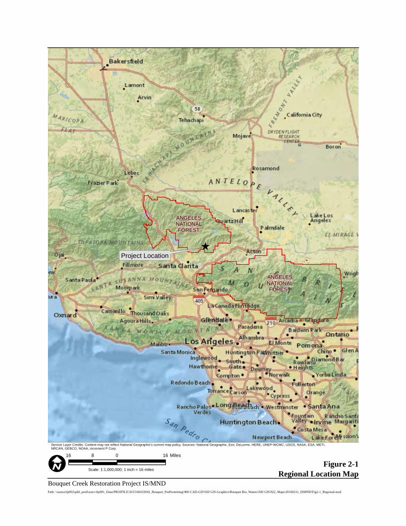
2.1.1 REGIONAL SETTING The project involves five pre-defined reaches of Bouquet Canyon Creek where restoration activities would occur (from downstream to upstream, labeled as Sites 1 through 5), and a sixth site in the abandoned Zuni Campground, where a fish preserve would be constructed. The project sites are located within an unincorporated area of northern Los Angeles County and within the southern part of the Santa Clara portion of the U.S. Forest Services’ (USFS) Santa Clara/Mojave Rivers Rangers District of the Angeles National Forest (ANF) (Figure 2-1). The sites occur within an approximate 3-mile stretch of Bouquet Canyon Creek between the southern boundary of the ANF (near Site 1), upstream to the vicinity of Bouquet Reservoir (near Site 5). Site 1 lies at approximately 1,650 feet above mean sea level (amsl) and Site 5 at approximately 2,075 feet amsl, representing a drop in elevation of 425 feet across the project area with an average slope of approximately 2.50 percent. The City of Santa Clarita is located a few miles south of the project sites, just outside of the boundary of the ANF. Santa Clarita encompasses approximately 48.1 square miles and includes most of the communities of Valencia, Newhall, Saugus, Canyon Country, Sand Canyon, and Placerita Canyon. Santa Clarita consists primarily of residential land uses with supporting commercial and industrial uses. Narrow, undeveloped north-south trending canyons similar to Bouquet Canyon lay to the east and west of the project sites. Approximately 4.3 miles northeast of the project site is Bouquet Reservoir. The reservoir capacity is 36,500 acre feet (45,000 cubic decametre [dam³]) and is formed by Bouquet Canyon Dam on Bouquet Canyon Creek. The dam is constructed of earthfill and is 190 feet (58 meters) tall, measured from the elevation of the original streambed. The dam was built by the City of Los Angeles and was completed in 1934. The reservoir is part of the Los Angeles Aqueduct system, and is managed by City of Los Angeles Department of Water and Power (DWP) (California Department of Water Resources 2007). It should be noted that through an agreement reached with the United Water Conservation District (UWCD), DWP is to maintain a schedule of discharge volumes released from the reservoir over the course of a year into Bouquet Canyon Creek.
Project Location
ANGELESNATIONALFOREST
ANGELESNATIONALFOREST
Figure 2-1Regional Location Map
Bouquet Creek Restoration Project IS/MNDScale: 1:1,000,000; 1 inch = 16 miles
Path: \\usora1fp002\pdd_prod\usirv1fp001_Data\PROJFILE\2015\60433042_Bouquet_PrePermitting\900-CAD-GIS\920 GIS-Graphics\Bouquet Bio_Waters\920 GIS\922_Maps\20160211_ISMND\Fig2-1_Regional.mxd
16 0 168 Miles
Service Layer Credits: Content may not reflect National Geographic's current map policy. Sources: National Geographic, Esri, DeLorme, HERE, UNEP-WCMC, USGS, NASA, ESA, METI,NRCAN, GEBCO, NOAA, increment P Corp.
2.0 Project Description
Page 2-3 Bouquet Canyon Creek Restoration Project IS/MND August 2016 Los Angeles County Department of Public Works
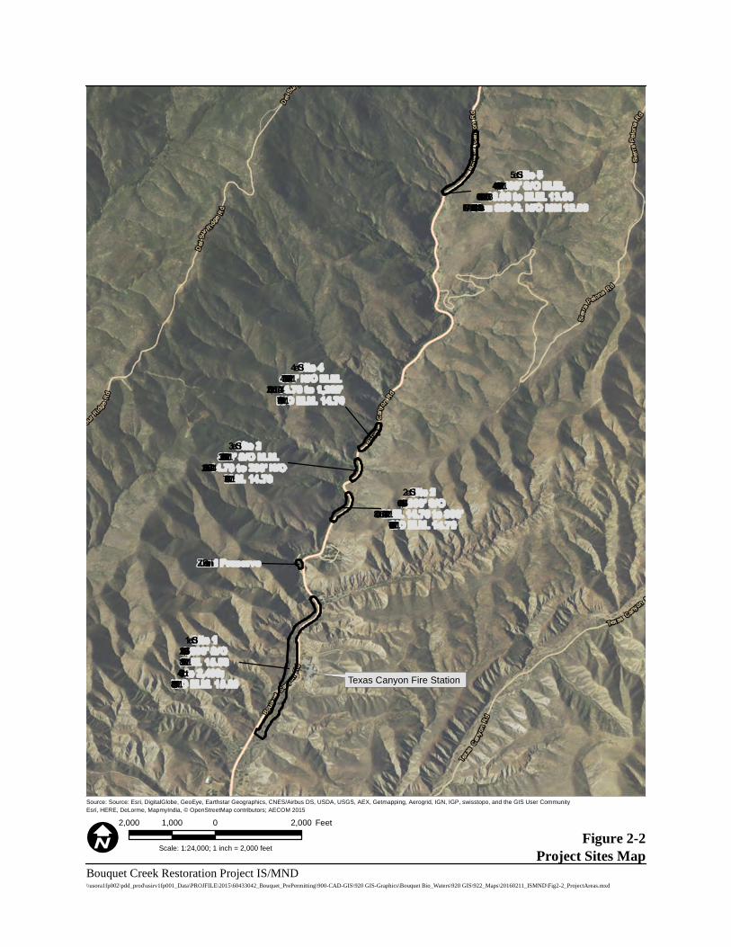
2.1.2 PROJECT SETTING The upper portion of Site 1 upstream through Site 5 occurs on the U.S. Geological Survey’s (USGS) 7.5-minute Green Valley, California quadrangle (USGS 1995) in Township 5 North, Range 15 West, Sections 10 (Site 5), 15 (Sites 3 and 4), 16 (Site 2) and 21 (Sites 1 and 6 [Zuni Preserve]), with the lower portion of Site 1 extending south into Township 5 North, Range 15 West, Section 21 of the Mint Canyon, CA quadrangle (USGS 1995) (see Figure 2-2, Project Vicinity).
Bouquet Canyon Creek Bouquet Canyon Creek is part of the Santa Clara watershed, and is within the Upper Bouquet Canyon subwatershed (12-digit Hydrologic Unit Code [HUC 12] 180701020201) (U.S. Environmental Protection Agency [EPA] 2015). Bouquet Canyon Creek flows southwest and is a tributary to the Santa Clara River. The project sites occur from approximately 8 miles upstream at Site 1, to 11 miles upstream at Site 5, of the confluence with the Santa Clara River. The project reach is generally composed of natural stream bank and bottom, although earthen berms have been installed along some reaches of the creek to contain flows in the creek bottom. From Site 5 downstream to the middle portion of Site 1 at Mile Marker (MM) 15.89, Bouquet Canyon Creek is located along the west side of Bouquet Canyon Road. From MM 15.89 downstream through the remainder of Site 1, Bouquet Canyon Creek is on the east side of the road. From Site 5 downstream to the vicinity of Site 1, the creek and road are confined in a narrow canyon with steep slopes to the west and a constructed berm between the creek and road to the east. As a result, the creek’s riparian habitat and floodplain is generally limited to a narrow area between steep canyon walls and Bouquet Canyon Road. At Site 1, the canyon opens and the creek’s floodplain increases in width; however, riparian habitat is more disturbed, reflecting human influences that occur in lower reaches. Generally, upper project sites (Sites 3-5) experience perennial flows, while the lower reach, from Zuni Preserve downstream through Site 1, is dry. Based on the establishment of aquatic vegetation along the stream in upper reaches, Bouquet Canyon Creek likely conveys sufficient flow to be considered relatively permanent water. As previously stated, upstream water sources are artificially controlled at Bouquet Reservoir and are released on a consistent schedule by DWP to maintain a relatively permanent flow. The creek also conveys some natural, unimpeded flow from small tributary streams that confluence with the creek south of the reservoir.
Bouquet Canyon Road
Bouquet Canyon Road is designated as a limited secondary highway on Los Angeles County’s Master Plan of Highways and carries one 12-foot-wide lane of traffic in each direction on asphalt pavement. The average daily traffic load is 2,300 vehicles. It is a commuter route between the rural communities of Leona Valley, Green Valley, and Elizabeth Lake to the urban areas of Santa Clarita and neighboring communities. Bouquet Canyon Road, within the vicinity of the project site, traverses predominately undeveloped land and has very few intersections with other streets.
Texas Canyon Fire Station
Site 11,200’ S/OM.M. 15.89to 2,400;
N/O M.M. 15.89
Zu ni Preserve
Site 21,600’ S/O
M.M. 14.70 to 800’S/O M.M. 14.70
Site 3320’ S/O M.M.14.70 to 200’ N/OM.M. 14.70
Site 4470’ N/O M.M.14.70 to 1,200’N/O M.M. 14.70
Site 51,400’ S/O M.M.13.06 to M.M. 13.06
Plu s 300-ft. N/O MM 13.06
Figure 2-2Project Sites Map
Bouquet Creek Restoration Project IS/MND
Source: Source: Esri, DigitalGlobe, GeoEye, Earthstar Geographics, CNES/Airbus DS, USDA, USGS, AEX, Getmapping, Aerogrid, IGN, IGP, swisstopo, and the GIS User CommunityEsri, HERE, DeLorme, MapmyIndia, © OpenStreetMap contributors; AECOM 2015
Scale: 1:24,000; 1 inch = 2,000 feet
\\usora1fp002\pdd_prod\usirv1fp001_Data\PROJFILE\2015\60433042_Bouquet_PrePermitting\900-CAD-GIS\920 GIS-Graphics\Bouquet Bio_Waters\920 GIS\922_Maps\20160211_ISMND\Fig2-2_ProjectAreas.mxd
2,000 0 2,0001,000 Feet
2.0 Project Description
Page 2-5 Bouquet Canyon Creek Restoration Project IS/MND August 2016 Los Angeles County Department of Public Works
Surrounding Land Uses The project site is immediately surrounded by undeveloped land in all directions, with the exception of the Texas Canyon Fire Station, which is located directly adjacent to Site 1 (at 30800 Bouquet Canyon Road). The Santa Clara Mojave River Ranger District Office was destroyed by the Buckweed Fire of October 2007 and was located at the same site where the Texas Canyon Fire Station now stands. The Buckweed Fire is estimated to have burned more than 38,556 acres of the ANF and Los Angeles County lands. The burn area in Bouquet Canyon included the vicinity of all project sites. Since the time of the Buckweed Fire, vegetation within the project sites and surrounding Bouquet Canyon has recovered and indications of past fire disturbance are not readily visible. The closest residential subdivision within Santa Clarita is located approximately 2-3 miles south of the Site 1 along Bouquet Canyon Road. Several ranchettes (small ranches or large homes on the outskirts of Santa Clarita, past planned neighborhoods) are located between residential development and Site 1. The Los Cantilles Picnic Area is located on the west side of Bouquet Canyon Road in the vicinity of Site 2 and was mostly destroyed by the Buckweed Fire. Since the time of the fire, this picnic area has been rebuilt but not reopened to the public. The project site is located in a USFS Special Use Permit area. The USFS Special Uses Program authorizes uses on National Forest System land that provide a benefit to the general public and protects public and natural resources values (USFS 2008).
2.2 PROJECT BACKGROUND Past disaster type storms combined with past fires in Bouquet Canyon have resulted in sediment deposition within Bouquet Canyon Creek, reducing its capacity to move water and causing the invert of the creek to be at a higher elevation than that of adjacent Bouquet Canyon Road at several locations. Even at very low flow rates within the creek, water seeps through dirt berms constructed to hold the creek back away from the roadway, or it seeps up through cracks in the roadway at locations where there is sufficient hydrostatic pressure. As a result of siltation, reduced flows in the stream due to reduced discharges from Bouquet Reservoir by DWP, and ongoing drought conditions, water is not reaching the lower end of Bouquet Canyon, contributing to a decline of in-stream and riparian habitat quality. Such conditions are not conducive to support the unarmored threespine stickleback (Gasterosteus aculeatus williamsoni; UTS), a fish species know from Bouquet Canyon Creek that is designated by California Department of Fish and Wildlife (CDFW) as Fully Protected (CDFW 2016). UTS prefer clear-flowing stream reaches with associated pools of quiet water, and areas of dense vegetation or debris to provide cover and a food supply (U.S. Fish and Wildlife Service [USFWS] 2009). Additionally, reduced flows in lower stream reaches, in particular at Site 1, have led to a decrease in riparian habitat health due to a lack of water in the creek. Dead or dying riparian vegetation is prevalent in lower reaches. Conditions where the stream invert is higher than the roadway also may pose potentially hazardous driving conditions for motorists due to flooding of the roadway. This situation is of concern to DWP,
2.0 Project Description
Page 2-6 Bouquet Canyon Creek Restoration Project IS/MND August 2016 Los Angeles County Department of Public Works
which through the agreement with the UWCD is to release 5 cubic feet per second (cfs) into Bouquet Canyon Creek during the period between April 1 and September 30, and 1 cfs during the period between October 1 and March 31. However, due to the current condition of the creek, DWP is reluctant to release the stipulated amounts which may cause roadway flooding. This has resulted in only a fraction of the stipulated flows being released into the creek. Currently outflow has averaged roughly 1.5 cfs over the course of a year.
2.3 PROJECT GOALS AND OBJECTIVES The primary purpose of this project is to restore in-stream flow capacity and improve riparian habitat by reestablishing creek flows along sections of Bouquet Canyon Creek that currently are dry, silted in, or overgrown with dense vegetation. This effort would address initial recommendations for the restoration of Bouquet Canyon Creek presented in the Hydraulic and Sediment Transport Study for Bouquet Canyon Creek Restoration Project (AECOM 2016). Recommendations in the report included creating shallower (3:1) side slopes next to the creek, replanting of riparian root mass material along the side slopes, and adding boulder clusters at strategic locations along the creek to slow creek flows and create eddying effects within the creek. These measures are intended to restore habitat suitable to support UTS and stream vegetation. USFWS are conducting a separate project on Bouquet Canyon Creek to recover UTS to the stream. This separate project is described further below in Section 2.5, Related Projects. Additional goals of the project include recharge of the Santa Clara watershed by reestablishing creek flows to the southern end of Bouquet Canyon within the Angeles National Forest. Renewed flows may also replenish the wells of residents downstream of the project site. Finally, by lowering the creek invert and restoring stream capacity, the project would help prevent flooding of Bouquet Canyon Road during DWP stipulated releases and during many storm events.
2.4 PROJECT DESCRIPTION
2.4.1 OVERVIEW OF THE PROJECT Prior to creating the plans and scope of this project, LACDPW surveyed the existing conditions of Bouquet Canyon Creek from the southern boundary of the ANF to MM 11.59, to identify locations where it was apparent that flooding was frequent or had occurred in the past. This survey identified five areas (from downstream to upstream, labeled as Sites 1 through 5, as depicted on Figures 2-3 and 2-4) where work is needed in order to achieve the desired goals. Locations of the five project sites have been identified using the existing MM posted along Bouquet Canyon Road. Additionally, at a sixth site in the abandoned Zuni Campground (as depicted on Figure 2-4), which lies between Sites 1 and 2, LACDPW proposes to construct a fish preserve by excavating a small channel off the existing creek, northeast into the former campground where a small pond would be constructed to serve as an aquatic refuge in times of high or rapid water flow; this pond may also provide an area that USFWS can use as a holding site for fish or other aquatic species.
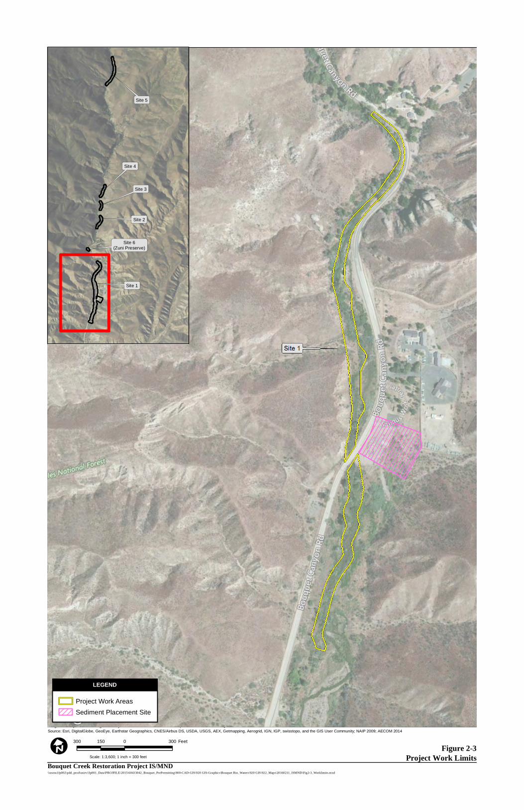
Figure 2-3Project Work Limits
Image courtesy of USGS Image courtesy of LAR-IAC © 2016 Microsoft Corporation © 2010 NAVTEQ © AND Source: Esri, DigitalGlobe, GeoEye, Earthstar Geographics, CNES/Airbus DS, USDA, USGS, AEX, Getmapping, Aerogrid, IGN, IGP, swisstopo, and the GIS User Community; NAIP 2009; AECOM 2014
\\usora1fp002\pdd_prod\usirv1fp001_Data\PROJFILE\2015\60433042_Bouquet_PrePermitting\900-CAD-GIS\920 GIS-Graphics\Bouquet Bio_Waters\920 GIS\922_Maps\20160211_ISMND\Fig2-3_Worklimits.mxd
300 0 300150 Feet
LEGEND
Scale: 1:3,600; 1 inch = 300 feet
Site 5
Site 4
Site 3
Site 2
Site 6(Zuni Preserve)
Site 1
Bouquet Creek Restoration Project IS/MND
Project Work Areas
Sediment Placement Site
LEGEND
Figure 2-4Project Work Limits
Image courtesy of USGS Image courtesy of LAR-IAC © 2016 Microsoft Corporation © 2010 NAVTEQ © AND
Source: Esri, DigitalGlobe, GeoEye, Earthstar Geographics, CNES/Airbus DS, USDA, USGS, AEX, Getmapping, Aerogrid, IGN, IGP, swisstopo, and the GIS User Community
\\usora1fp002\pdd_prod\usirv1fp001_Data\PROJFILE\2015\60433042_Bouquet_PrePermitting\900-CAD-GIS\920 GIS-Graphics\Bouquet Bio_Waters\920 GIS\922_Maps\20160211_ISMND\Fig2-4_Worklimits.mxd
300 0 300150 Feet
LEGEND
Scale: 1:3,600; 1 inch = 300 feet
Project Work Limits
LEGEND
Site 5
Site 4
Site 3
Site 2
Site 6(Zuni Preserve)
Site 1
Bouquet Creek Restoration Project IS/MND
2.0 Project Description
Page 2-9 Bouquet Canyon Creek Restoration Project IS/MND August 2016 Los Angeles County Department of Public Works
2.4.2 PROJECT CONSTRUCTION
Construction Schedule, Access, and Parking
Construction at each project site would commence after receipt of all regulatory permits and approvals (refer to Section 2.6, Required Project Approvals). Construction is anticipated to start in late November 2016. Due to projected heavy truck traffic and transport of heavy equipment on Bouquet Canyon Road during the project, Bouquet Canyon Road may be closed above and below the project area (MM13.06 to the Angeles National Forest boundary) between the hours of 7:00a.m. and 4:00p.m., when work is scheduled (primarily Monday through Friday until the project is completed). Emergency responders have been provided keys to the gates to allow for emergency access whenever closed. Construction parking would occur along Bouquet Canyon Road and/or at Site 1.
Construction Activities Overview
Prior to initiation of work at each project site, the project work limits would be delineated. Flagging would delineate boundaries of the work limits and extent of the future stream channel. Proposed vegetation removal would require consultation with USFS regarding the disposition of any oak trees greater than a 6-inches diameter and any live non-oak trees greater than 12-inches diameter. In general, trees of this size and greater would be avoided when feasible.
Vegetation and seed would be harvested from within the project area as available, and stored for restoration work. Smaller vegetation would be cut or mowed where feasible, to preserve the root and stems of riparian vegetation to allow for more rapid revegetation of the project area. Many species of riparian vegetation have the ability to produce adventitious roots. Willow, cottonwood, and mulefat are native to the area and found extensively in the project area. This vegetation would be cut and stored for restoration work immediately following sediment removal and channel creation. This vegetation can be stored for up to four months and used as bioengineering material. Bioengineering techniques would be utilized, providing stream bank stability, stream roughness, and shade. New vegetation would reduce soil moisture through transpiration and provide flood protection and soil stability for other vegetation to grow.
Root masses that come from the excavation of the creek and side slopes would be temporarily stored near Site 1 at the proposed sediment placement site near MM15.89. Final disposition of root masses would be determined by USFS, but would likely require being hauled to a dump.
Construction Activities by Project Site
Project details regarding vegetation removal and sediment removal proposed at each project site are provided below.
2.0 Project Description
Page 2-10 Bouquet Canyon Creek Restoration Project IS/MND August 2016 Los Angeles County Department of Public Works
Site 1: 1,200 feet South of MM 15.89 to 2,400 feet North of MM 15.89 Project activities are expected to begin at Site 1 due to the absence of water, either flowing or pooling, in this lower reach. The approximate project limits of Site 1 are depicted in Figure 2-3. Work at this project site would begin in the reach from the culvert under Bouquet Canyon Road at MM 15.89, south (downstream) for 1,200 feet. Work would then be conducted from the culvert north (upstream) for 2,400 feet. Culvert MM 15.89 to 1, 200 feet south of MM 15.89
Vegetation Removal Work would start at the outlet of the culvert located beneath Bouquet Canyon Road. LACDPW would conduct vegetation removal activities and clear an approximate 50 to 70-foot wide path for a distance of 1,200 south (downstream) of the culvert. The use of a masticator which would grind up, and leave in place existing brush and trees. All brush, dead trees, non-oak trees smaller than a 12-inch diameter-at-breast-height (dbh), and oak trees smaller than a 6-inch dbh would be masticated. Vegetation removal with a masticator would take approximately seven days.
Sediment Removal Following vegetation removal, the site would be surveyed and grade stakes set every 50 to 100 feet on the east side of the creek to indicate the depth of excavation. An all-wheel drive 3,500-gallon capacity water truck would be positioned on the east side of the creek, and starting at the culvert outlet would move south within the cleared path to spray water on the work area immediately preceding the excavator. The excavator would also begin at the culvert outlet, straddle the creek, and begin excavating accumulated sediment and trimmed vegetation, and working its way 1,200 feet south (downstream). The depth of excavation varies in this reach and would be deepest just downstream of the culvert outlet. The restored creek bottom in this reach would be 9-feet wide, with 3-foot horizontal to 1-foot vertical (3:1) side slopes so that the creek would be able to convey flows from upstream through the site. Excavated material would be spread out along both sides of the creek within the work area and left uncompacted, or used to provide contour. Large rocks, boulders and large tree stems would be set aside on the periphery of the project area for post-sediment removal restoration use. Once excavation of the creek channel and vegetation removal work is complete, the excavator and water truck would utilize the access path to exit the work area. The removal of sediment through this reach would take approximately seven days. Culvert MM 15.89 to 2,400 feet north of MM 15.89
Vegetation Removal Work would start at the inlet of the culvert located beneath Bouquet Canyon Road. LACDPW would conduct vegetation removal activities and clear an approximate 50 to 70-foot wide path for a distance of
2.0 Project Description
Page 2-11 Bouquet Canyon Creek Restoration Project IS/MND August 2016 Los Angeles County Department of Public Works
2,400 feet north (upstream) using masticator to clear the path, as described above. Utilizing a masticator for vegetation removal in this reach would take approximately 12 days.
Sediment Removal A major obstacle in Site 1, north of MM 15.89, is the existence of overhead power lines. The existing creek meanders under the power lines and is very close to existing power poles at some locations. LACDPW is required by California Code of Regulations to be no closer than 20 feet to the vertical projection of the nearest overhead line. Since an excavator is proposed for sediment removal activities, LACDPW have adjusted the proposed alignment of the creek to be in compliance with the code. Sediment removal activities and preparation for Site 1, north of MM 15.89, would closely mirror activities as they were described for Site 1, south of MM 15.89. The excavator would be positioned at the culvert outlet as if it were straddling the creek and begin excavating the accumulated sediment and vegetation, working its way 2,400 feet northerly. The depth of the excavation varies in this reach and progressively gets deeper to the north. The proposed creek cross section from the culvert inlet to 1,000 feet northerly would have a 7.5 foot wide creek bottom with 3:1 side slopes, where feasible, in order to maintain the existing creek capacity (182 cfs) from further upstream. From 1,000 to 2,400 feet north of the culvert inlet, the creek cross section would be a 6-foot wide bottom with 3:1 side slopes. Centered at 1,200 feet north of the culvert would be a 100 foot long transition of the creek bottom from a width of 7.5 feet to 6 feet. In areas under the power lines, where use of the excavator would be prohibited, a track loader would be used to remove sediment from the creek bed. Between 1,400-1,800 feet north of MM 15.89 the stream would be widened and pools would be incorporated where possible. Excavated material would be spread out over areas away from the creek on both sides and left uncompacted from the culvert inlet to a distance of 1,700 feet north. Large rocks, boulders and large tree stems would be set aside on the periphery of the project area for post-sediment removal restoration use. Between 1,700 and 2,400 feet north of the culvert inlet, approximately 2,000 cubic yards (CY) of excavated material would be deposited on the shoulder of the roadway. A loader with rubber tires would then load the material into dump trucks to be taken to the designated sediment placement site at MM 15.89. Pending approval from USFS, LACDPW proposes to utilize an area along the east side of Bouquet Canyon Road and just north of the culvert at MM 15.89 as a sediment placement site for the project (see Figure 2-3). The area requested is 2.2 acres and is estimated to have a capacity of 32,000 CY. Without this site, LACDPW would have to remove the estimated 10,400 CY (15,600 tons) of material from this project and dispose of it at the Chiquita Canyon Landfill, located approximately 15 miles southwest of Site 1. A backhoe with rubber tires would also work from the roadway to restore one “overshot” located at 1,400 feet north of MM 15.89. Overshots are areas, usually paved with asphalt, that are intended to direct water on Bouquet Canyon Road into Bouquet Canyon Creek. This area is currently blocked by sediment and
2.0 Project Description
Page 2-12 Bouquet Canyon Creek Restoration Project IS/MND August 2016 Los Angeles County Department of Public Works
vegetation, and water is not able to flow into the creek. Sediment removal would take approximately 18 days.
Site 2: 1,600 feet South of MM14.70 to 800 feet South of MM 14.70 Flowing water is generally present in Bouquet Canyon Creek at Site 2, and water has been observed along the flow line of the roadway between 1,350 and 1,450 feet south of MM 14.70. The approximate project limits of Site 2 are depicted in Figure 2-4. Vegetation Removal Work would start at 1,600 feet south of MM 14.70 and proceed 800 feet north to 800 feet south of MM 14.70. LACDPW would conduct vegetation removal activities to clear an approximate 40-foot wide path for 800 feet through the site. A trained crew would use chainsaws and other hand tools to clear vegetation. All existing brush, dead trees, non-oak trees smaller than a 12 inch dbh, and oak trees smaller than a 6 inch dbh would be removed and run through a wood chipper and the chips spread over the site. Vegetation removal would take approximately six days. Sediment Removal Sediment removal activities would commence at Site 2 following vegetation removal. Throughout this site, the proposed creek bed would be a minimum of four feet below the existing edge of pavement or paved inverted flow line. The grade would be checked using a hand level as work progresses. A 3,500 gallon capacity water truck would be positioned on the shoulder of the roadway and a hose would be used to spray water on the work area immediately preceding the excavator. The excavator would be positioned adjacent to the creek and work alongside the creek utilizing the area between the creek and Bouquet Canyon Road. The depth of the excavation is fairly consistent at four feet through this reach. The proposed creek cross section in this reach would have a 6 foot wide creek bottom with 3:1 side slopes on the east side and 1:1 side slopes or shallower, if possible, on the west side in order to maintain existing creek capacity. Excavated material, approximately 1,900 CY, would be deposited on the shoulder of the Bouquet Canyon Road. A loader with rubber tires would then load the material into dump trucks to be taken to the designated sediment placement site at Site 1. Once this work is completed, the excavator would exit the work area to the adjacent roadway. A rubber tire backhoe would also work from the roadway to restore one overshot located at 1,460 feet south of MM 14.70 which is currently blocked by sediment and vegetation. Sediment removal would take approximately nine days.
Site 3: (320 feet South of MM 14.70 to 200 feet North of MM 14.70
Site 3 contains flowing water in the existing creek bed, and water has been observed along the flow line of the roadway from MM 14.70 to 100 feet southerly. The approximate project limits of Site 3 are depicted in Figure 2-4.
2.0 Project Description
Page 2-13 Bouquet Canyon Creek Restoration Project IS/MND August 2016 Los Angeles County Department of Public Works
Vegetation Removal Work would start at 320 feet south of MM 14.70 and progress 520 feet northerly. LACDPW would conduct vegetation removal activities and clear an approximate 40 foot wide path for a distance of 520 feet through the site. A trained crew would use chainsaws and other hand tools to clear the path. All existing brush, dead trees, non-oak trees smaller than a 12-inch dbh, and oak trees smaller than a 6-inch dbh would be removed and run through a wood chipper and the chips spread over the site. Vegetation removal would take approximately six days. Sediment Removal Sediment removal activities at Site 3 would commence upon vegetation removal. Throughout this site, the proposed creek bed would be a minimum of four feet below the existing edge of pavement or paved inverted flow line. The grade would be checked using a hand level as work progresses. A 3,500 gallon capacity water truck would be positioned on the shoulder of the roadway and a hose would be used to spray water on the work area immediately preceding the excavator. The excavator would be positioned adjacent to the creek and work alongside the creek utilizing the area between the creek and Bouquet Canyon Road. The depth of the excavation is fairly consistent at 2 to 3 feet throughout this reach. The proposed creek cross section in this reach would have a 6-foot wide creek bottom with 3:1 side slopes on the east side and 1:1 side slopes or shallower, if possible, on the west side in order to maintain existing creek capacity. The excavated material, approximately 1,000 CY, would be deposited on the shoulder of the roadway. A rubber tire loader would then load the material into dump trucks to be taken to the designated sediment placement site at Site 1. Once work is completed, the excavator would exit the work area to the adjacent roadway. A backhoe with rubber tires would also work from the roadway to restore one overshot located at 1,460 feet south of MM 14.70 which is currently blocked by sediment and vegetation. A motor grader would be utilized for grading activities along the shoulder of the roadway to direct flows from the roadway into the creek at 330 feet south of MM 14.70. Sediment removal would take approximately seven days.
Site 4: 470 feet North of MM 14.70 to 1,200 feet North of MM 14.70 Site 4 contains flowing water in the existing creek bed, and water has been observed to be present and flowing along the asphalt invert between 700 and 580 feet north of MM 14.70. Flows on the roadway exit the roadway back into the stream channel at an overshot located at 580 feet north of MM 14.70. The approximate project limits of Site 4 are depicted in Figure 2-4. Vegetation Removal Work would start at 470 feet north of MM 14.70 and progress 730 feet north. LACDPW would conduct vegetation removal activities and clear an approximate 40-foot wide path for a distance of 730 feet
2.0 Project Description
Page 2-14 Bouquet Canyon Creek Restoration Project IS/MND August 2016 Los Angeles County Department of Public Works
through the site. A trained crew would use chainsaws and other hand tools to clear the path. All existing brush, dead trees, non-oak trees smaller than a 12-inch dbh, and oak trees smaller than a 6-inch dbh would be removed and run through a wood chipper and the chips spread over the site. Vegetation removal would take approximately seven days. Sediment Removal
Sediment removal activities would commence at Site 4 following vegetation removal. Throughout this site, the proposed creek bed would be a minimum of 4 feet below the existing edge of pavement or paved inverted flow line. The grade would be checked using a hand level as work progresses. A 3,500 gallon capacity water truck would be positioned on the shoulder of the roadway and a hose would be used to spray water on the work area immediately preceding the excavator. The excavator would be positioned adjacent to the creek and work alongside the creek utilizing the area between the creek and Bouquet Canyon Road. The depth of the excavation varies throughout Site 4 and has sections that would require 6 to 7 feet of excavation. The proposed creek cross section in this reach would have a 6-foot wide creek bottom with 3:1 side slopes on the east side and 1:1 side slopes or shallower, if possible, on the west side in order to maintain existing creek capacity. The excavated material, approximately 1,900 CY, would be deposited on the shoulder of the roadway. A loader with rubber tires would then load the material into dump trucks to be taken to the designated sediment placement site at Site 1. Once the work is completed, the excavator would exit the work area to the immediately adjacent roadway. A backhoe with rubber tires would also work from the roadway to restore one overshot located at 580 feet north of MM 14.70 that conveys surface flows from the roadway into the adjacent creek. This overshot is currently blocked by sediment and vegetation. Sediment removal would take approximately six days.
Site 5: 1,400 feet South of MM 13.06 to MM 13.06 Site 5 contains flowing water in the existing creek bed, and water has been observed to be present and flowing along the asphalt invert between 700 and 1,250 feet south of MM 13.06. The water exits Bouquet Canyon Road at an overshot located at 1,250 feet south of MM 13.60. The approximate project limits of Site 5 are depicted in Figure 2-5. Work at this project site would begin 1,400 feet south of MM 13.06 and progress toward the culvert. Work would then be performed at the culvert inlet, within the two 72- inch culvert pipes, and 300 feet northerly along the creek. 1,400 feet South of MM 13.06 to MM 13.06
Vegetation Removal Work would start at 1,400 feet south of the culvert outlet at MM 13.60 and progress toward the culvert. LACDPW would conduct vegetation removal activities and clear an approximate 40 foot wide path for a distance of 1,400 feet. A trained crew would use chainsaws and other hand tools to clear the path. All
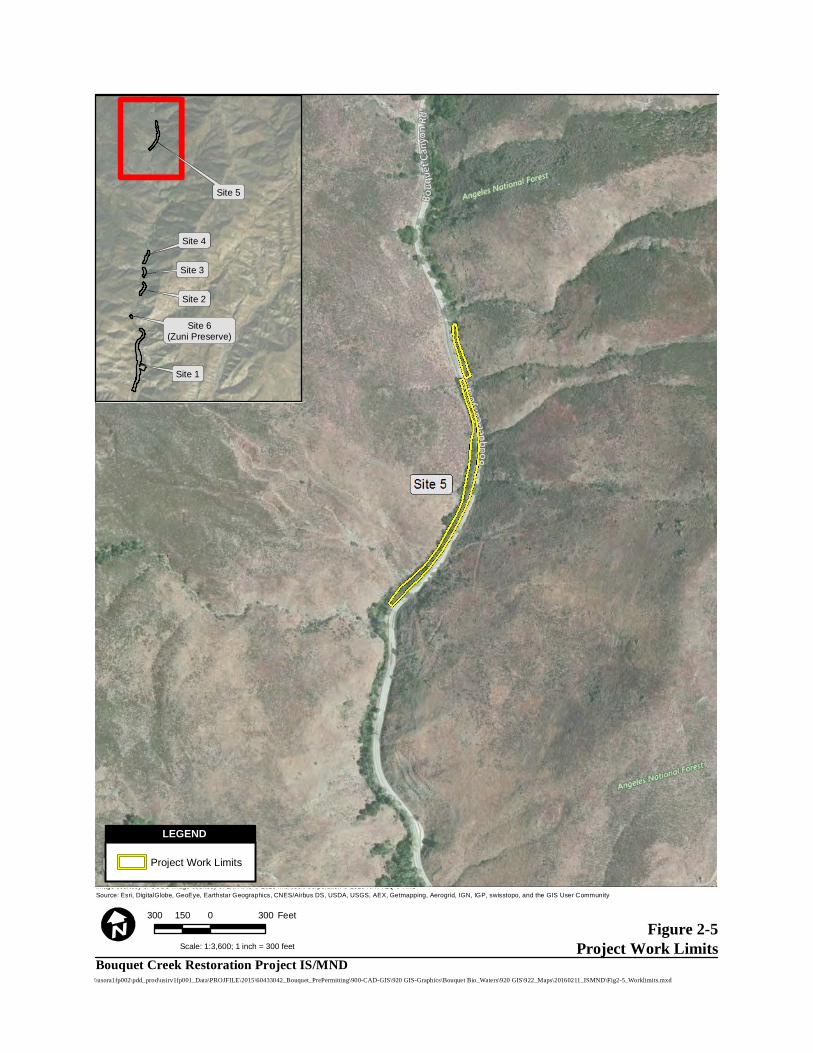
Figure 2-5Project Work Limits
Image courtesy of USGS Image courtesy of LAR-IAC © 2016 Microsoft Corporation © 2010 NAVTEQ © AND
Source: Esri, DigitalGlobe, GeoEye, Earthstar Geographics, CNES/Airbus DS, USDA, USGS, AEX, Getmapping, Aerogrid, IGN, IGP, swisstopo, and the GIS User Community
\\usora1fp002\pdd_prod\usirv1fp001_Data\PROJFILE\2015\60433042_Bouquet_PrePermitting\900-CAD-GIS\920 GIS-Graphics\Bouquet Bio_Waters\920 GIS\922_Maps\20160211_ISMND\Fig2-5_Worklimits.mxd
300 0 300150 Feet
Scale: 1:3,600; 1 inch = 300 feet
Project Work Limits
LEGEND
Site 5
Site 4
Site 3
Site 2
Site 6(Zuni Preserve)
Site 1
Bouquet Creek Restoration Project IS/MND
2.0 Project Description
Page 2-16 Bouquet Canyon Creek Restoration Project IS/MND August 2016 Los Angeles County Department of Public Works
existing brush, dead trees, non-oak trees smaller than a 12-inch dbh, and oak trees smaller than a 6-inch dbh would be removed and run through a wood chipper and the chips spread over the site. Vegetation removal would take approximately 11 days.
Sediment Removal Sediment removal activities would commence at Site 5 following vegetation removal. Throughout this site, the proposed creek bed would be a minimum of 4 feet below the existing edge of pavement or paved inverted flow line. The grade would be checked using a hand level as work progresses. A 3,500 gallon capacity water truck would be positioned on the shoulder of the roadway and a hose would be used to spray water on the work area immediately preceding the excavator. The excavator would be positioned adjacent to the creek and work alongside the creek utilizing the area between the creek and Bouquet Canyon Road. The depth of the excavation is fairly consistent at 4 feet throughout Site 5. The proposed cross section from the culvert to 500 feet south would have a 6-foot wide creek bottom with 1:1 side slopes. Within this reach, 3:1 side slopes are not feasible due to the creek’s proximity to the roadway and adjacent hillside. Between 500 and 1,400 feet south of the culvert, the proposed creek cross section would have a 6-foot wide creek bottom with 3:1 side slopes on the east side and 1:1 side slopes or shallower, if possible, on the west side in order to maintain existing creek capacity. The excavated material, approximately 3,500 CY, would be deposited on the shoulder of the roadway. A loader with rubber tires would then load the material into dump trucks to be taken to the designated sediment placement site at Site 1. Once the work is completed, the excavator would exit the work area to the immediately adjacent roadway. A backhoe with rubber tires would also work from the roadway to restore two overshots within the reach that convey surface flows from the roadway into the adjacent creek. These overshots are currently blocked by sediment and vegetation. Sediment removal would take approximately ten days. Culvert MM 13.06 to 300 feet North of MM 13.06
Vegetation Removal LACDPW would conduct vegetation removal activities and clear an approximate 40 foot wide path for a distance of 300 feet north of the culvert at MM 13.06. A trained crew would use chainsaws and other hand tools to remove overgrown vegetation and trees and any fallen debris that may be in the stream channel. Brush and dead trees removed from the channel would be run through a wood chipper and the chips spread over the site. Vegetation removal would take approximately two days.
Sediment Removal No sediment would be removed from the channel within the 300-foot reach upstream of the culvert. Only sediment directly in front of the culvert inlet would be excavated using a rubber tire backhoe staged on
2.0 Project Description
Page 2-17 Bouquet Canyon Creek Restoration Project IS/MND August 2016 Los Angeles County Department of Public Works
Bouquet Canyon Road. This material would be loaded into dump trucks to be taken to the sediment placement site. Sediment removal would take approximately two days.
Site 6: Zuni Preserve The proposed location for the Zuni Preserve is located within the former Zuni Campground (now abandoned), which occurs between Sites 1 and 2, on the west side of Bouquet Canyon Road. LACDPW proposes to excavate a small channel off the existing creek, northeast into the former campground where a small pond would be constructed to serve as an aquatic refuge in times of high or rapid water flow; this pond may also provide an area that USFWS can use as a holding site for fish or other aquatic species. USFWS is conducting a separate project to recover UTS in Bouquet Canyon Creek and this preserve is intended to aid in execution of the USFWS’s recovery project. The approximate project limits for the Zuni Preserve are depicted in Figure 2-4.
2.4.3 PROJECT RESTORATION PROGRAM
Restoration Program Overview A restoration plan (the Habitat Mitigation and Monitoring Plan [HMMP]) would be included in the submittal of regulatory permit applications required by the project (see Section 2.6, Required Project Approvals) and would require approval prior to the issuance of regulatory permits to conduct project activities in Bouquet Canyon Creek. The HMMP would include the restoration work plan, details on container plants and seeding materials, site-specific performance standards, and a site maintenance and monitoring plan that will be implemented. After construction is completed, the restoration program would be implemented and maintained until all HMMP performance standards are met. The HMMP performance standards relate mainly to wetland/riparian vegetation, rather than specific goals and objectives for the design of UTS habitat. The UTS-specific goals and objectives will be included in the HMMP, but the regulatory monitoring requirements are tied to vegetation parameters such as survival of container plants and cuttings, germination of native seed mix, and percent cover of vegetation. A qualified biologist would be present during restoration activities or available for consultation regarding restoration activities. LACDPW staff would be available with equipment to perform restoration activities, as directed by USFS staff and/or a qualified biological monitor. The anticipated duration of restoration activities at each site is approximately two to three weeks. The following restoration activities are anticipated for implementation.
Restoration Program Activities The restoration program will include replanting of wetland/riparian areas impacted by sediment removal and stream re-contouring. Vegetation will consist of native species in the form of cuttings (from nearby native trees and shrubs), container plants, and appropriate seed mixes. In addition to wetland/riparian vegetation, some areas may warrant the inclusion of a riparian-upland transition area. Rocks will be used
2.0 Project Description
Page 2-18 Bouquet Canyon Creek Restoration Project IS/MND August 2016 Los Angeles County Department of Public Works
within the channel to create areas of slower-flowing water and pools. Vegetation will be planted around most of the rock in order to stabilize sediments around the rock and provide additional structure for shading UTS. Bio-engineering structures such as vertical bundles, willow fascines, joint plantings, jute netting, and vegetated silt trenches would be installed, as needed, to restore riparian function, minimize erosion, facilitate vegetative recovery and protect Bouquet Canyon Road. Additional details on these techniques and locations where these methods would be implemented will be included in the forthcoming HMMP. General riparian habitat considerations include:
Install boulder clusters, bio-engineering elements, and other salvaged materials to provide channel structure, minimize erosion, and reduce the potential of flooding events to create habitat for aquatic biota, including UTS, and protect Bouquet Canyon Road.
Increase stream velocity through the culvert at MM 15.89 to minimize sedimentation within the existing culvert.
Excavate to bedrock in the constructed channel when possible to increase water retention (reduce infiltration).
Increase stream shade/cover, potentially with added contours (bank slopes) and vegetation using excavated materials when possible.
Install harvested native vegetation to restore riparian vegetation (e.g., willow, muelfat, cottonwood cuttings).
Where tributaries impinge on the work area, excavate and provide 3:1 slopes at confluence. Install erosion control measures on constructed slopes, where needed.
Bio-engineering structures such as vertical bundles, willow fascines, pole plantings, erosion control fabric, transplanted sedges, and vegetated slit trenches would be installed, as needed, to restore riparian function, minimize erosion, facilitate vegetative recovery and protect Bouquet Canyon Road.
An objective of this project is to provide suitable stream habitat for UTS upon project completion. Habitat requirements for UTS are described in the Unarmored Threespine Stickleback (Gasterosteus aculeatus williamsoni) 5-Year Review: Summary and Evaluation (USFWS 2009) as:
“…slow-moving reaches or quit-water microhabitats in streams and rivers. Favorable habitats are usually shaded by dense and abundant vegetation. In more open reaches, algal mats or barriers (e.g., sand bars, floating vegetation, low-flow crossings) may provide refuge for the species.”
2.0 Project Description
Page 2-19 Bouquet Canyon Creek Restoration Project IS/MND August 2016 Los Angeles County Department of Public Works
Stream channelization is documented in the UTS Recovery Plan (USFWS 1985) as a threat to UTS, as it “increases water velocity in pools, eliminates shallow backwaters and reduces aquatic vegetation.” Therefore, the preservation and restoration/establishment of pools, shallow backwater areas, and aquatic vegetation in Bouquet Canyon Creek upon completion of sediment removal is important for preservation of the post-project UTS population. Critical riparian habitat features for UTS to be implemented include:
Maintain total length of 1.0 - 1.5 percent gradient of the currently existing stream bed. Currently, approximately 2,800 feet of Bouquet Canyon Creek is less than or equal to 1.5% gradient within the project area. The majority of existing low gradient stream conditions exists at Sites 1 and 2.
In areas with greater than one percent existing stream bottom, restore riffle habitat and decrease the stream gradient, where feasible.
Manipulate the longitudinal, lateral and vertical profile of the stream to lower stream gradient, create areas of slower flow (e.g. placement of rocks and vegetation to create pools) and enhance habitat favorable for UTS.
Construct stream channel refugia (backwater areas) for UTS when high flows (10-182 cfs) are flowing within the channel.
The Zuni Preserve (Site 6) would undergo enhancement to create a large (1,500 square foot minimum) backwater preserve for UTS breeding habitat. At least one side of the channel would be created with large slow-moving pools, created as UTS habitat. An updated design of this site will be included in the HMMP.
Riparian Restoration Methods Riparian restoration efforts would focus on both the stream bank and project area impacted by project work. Restoration methods on the stream bank would focus on re-establishing riparian vegetation to provide soil stability, shade, trap runoff sedimentation from entering the stream and provide protection from stream bank erosion. Restoration methods within the stream channel would help guide the desired course for the stream, provide roughness, eddies, and habitat features with the creek itself for aquatic biota. Riparian habitat is an important component of the landscape and it is used by many species of wildlife, in addition to protection against flooding events and providing clean water. The restoration plan will include bio-engineering techniques (as discussed above) in order to provide natural bank stabilization and greater habitat structure (i.e., complexity).
2.4.4 PROJECT OPERATIONS AND MAINTENANCE ACTIVITIES In order to be able to maintain Bouquet Canyon Road, it would be necessary in the future to be able to
2.0 Project Description
Page 2-20 Bouquet Canyon Creek Restoration Project IS/MND August 2016 Los Angeles County Department of Public Works
perform maintenance within Bouquet Canyon Creek in the immediate vicinity of culverts and overshots to remove obstructions and sediment build-up, and clear culverts and overshots whenever there is observed creek flows in the roadway, road drainage cannot get into the creek, or culverts are plugged more than 25 percent of their diameter. LACDPW maintenance capabilities would occur within the area between the southern boundary of the ANF, near Site 1, upstream for approximately 7 miles to Bouquet Reservoir. LACDPW foresees that future requests to do work in the creek would be difficult, very costly, and time consuming due to the need for agreement between and permission from all of the regulatory agencies. This being the case, LACDPW seeks agreement from the agencies and proposes that future maintenance within the creek in the immediate vicinity of culverts and overshots be handled through one of the two following scenarios:
Non-Emergency or Planned Work During non-storm periods where LACDPW needs to perform work within the creek such as during annual culvert and overshot cleaning, LACDPW would implement the following.
LACDPW would notify USFS, USFWS, CDFW, and the Regional Water Quality Control Board (RWQCB) of the work and its schedule.
LACDPW would have a fisheries biologist present to net both upstream and downstream of the project area and then clear/relocate any aquatic species present in the project area.
LACDPW would consult with USFS regarding any vegetation or tree removals that would be required to access the project area.
LACDPW would then perform the needed maintenance using powered equipment.
A Fisheries biologist would remove the nets when the work is completed. This process is accepted procedure for working in areas where special-status species other than UTS are present. This process has been performed in recent requests to perform work within the creek during periods when water is flowing in the stream and was agreed to by all federal and state agencies. Additionally, no mitigation is anticipated to be required by any of the regulatory agencies, as any work that LACDPW conducts to maintain flows within the creek is beneficial to riparian habitat of the canyon and aquatic species. During consultation, USFWS would include any terms and conditions included in the issuance of a Biological Opinion and CDFW in an Incidental Take Permit (ITP), pursuant to California Fish and Game Code (CFGC) Section 2081. Potential impacts to UTS would be mitigated per Assembly Bill (AB) 353, approved by California Governor Jerry Brown on October 8, 2015, which permits CDFW to authorize the take of UTS resulting from impacts attributable to the restoration project to restore, maintain, and improve riparian habitat on public lands in the Bouquet Canyon Creek area. CDFW would authorize an ITP for the incidental take of any UTS (hybrid or pure strain) during project implementation. An Adaptive Management Plan, prepared per requirements of the AB, would include measures to avoid impacts to UTS during maintenance of the creek. Informal consultation prior to the initiation of formal consultation is anticipated to be the most appropriate way to avoid the need for future environmental review.
2.0 Project Description
Page 2-21 Bouquet Canyon Creek Restoration Project IS/MND August 2016 Los Angeles County Department of Public Works
Emergency Work During severe storm situations, silted runoff and/or mudslides from the adjacent hillsides can cause sediment build-up in Bouquet Canyon Creek and may cause the creek to leave its defined creek bed and flow onto Bouquet Canyon Road. During these times, LACDPW would deem this an emergency and would request an RGP 63 permit from the U.S. Army Corps of Engineers (USACE) to proceed with the necessary work on an emergency basis. Declaration of an “emergency” would require USFS concurrence that an emergency exists and would entail a separate permitting effort with USACE to obtain approval to conduct necessary work to address the emergency situation. LACDPW would expect that the agencies would not place any additional requirements on the permit that would prevent LACDPW from proceeding in an expeditious manner to correct the situation. As the amount of creek flow during these periods would be well above the norm and likely outside of the defined creek bed, it is impractical to require LACDPW to perform the work as outlined under the non-emergency scenario. Under this scenario, LACDPW would take immediate action to correct the problem which would likely include the use of heavy equipment such as an excavator to re-establish the creek bed to its normal location and depth. The adaptive management plan prepared pursuant to AB 353 would include measures to avoid impacts to UTS during emergency work and would provide mitigation for potential impacts to UTS. Potential impacts and take of special-status species other than UTS would be addressed in regulatory permits issued for the emergency work.
2.4.5 BEST MANAGEMENT PRACTICES The project would incorporate the most effective and appropriate combination of resource avoidance and monitoring to be employed during construction and operation, including implementation of the following Best Management Practices (BMP), as applicable. The following BMP would be implemented as general housekeeping measures to avoid and minimize impacts to biological resources.
1. The project shall minimize new disturbance, erosion on manufactured slopes, and off-site
degradation from accelerated sedimentation. 2. Potential hydrologic impacts shall be minimized through the use of BMPs, such as water bars,
silt fences, staked straw bales, and mulching and seeding of disturbed areas as appropriate. These measures shall be implemented to minimize ponding, eliminate flood hazards, and avoid erosion and siltation into any creeks, streams, or other bodies of water.
3. Prior to conducting construction activities, the boundaries of approved work limits shall be
delineated with clearly visible flagging to prevent impacts beyond those authorized.
2.0 Project Description
Page 2-22 Bouquet Canyon Creek Restoration Project IS/MND August 2016 Los Angeles County Department of Public Works
4. Construction activities shall be conducted in such a manner to minimize acreage of vegetation removal. The project includes erosion-control BMPs to minimize soil influx into Bouquet Canyon Creek during construction.
5. Where erosion control is necessary, the use of coconut coir matting or tackified hydroseeding
compounds is preferred, instead of plastic monofilament netting, to avoid wildlife entanglement or entrapment.
6. “Fueling zones” shall be designated prior to conducting construction activities and shall be
located at least 50 feet from all drainage features/wetlands and shall be flagged by a biologist.
The following BMP would be implemented to avoid and minimize impacts to general wildlife species. 7. During site clearing, unnecessary damage to ground burrows, holes, and tunnels, which provide
shelter for many small animals (snakes, lizards, toads, rodents, and squirrels), shall be avoided. 8. No wildlife, including rattlesnakes, shall be harmed except to prevent serious injury or death. 9. In order to avoid unnecessary impacts, should any non-listed species be found within the
property, a qualified biologist shall relocate them outside of the project sites or they shall be avoided and allowed to leave the project sites of their own volition.
10. Construction workers shall be prohibited from bringing domestic pets to the construction site to
ensure they would not affect wildlife through harassment or predation in adjacent natural habitats.
11. A biological monitor shall be onsite during clearing/grubbing and excavation activities.
The following BMP would be implemented to avoid and minimize impacts to bird species protected under the Migratory Bird Treaty Act (MBTA) and CFGC.
12. All vegetation clearing should occur outside of the nesting season, generally considered by CDFW to occur February 1 through September 1. If avoiding the nesting season is not practicable, then the following additional measures shall be employed:
o A pre-construction nesting survey shall be conducted by a qualified biologist within 3 days prior to the start of construction activities to determine whether active nests are present within 500 feet of proposed work.
o If construction activities must occur within 300 feet of an active nest of any passerine bird or within 500 feet of an active nest of any raptor, with the exception of an emergency, then a qualified biologist would monitor the nest to determine if construction activities can occur without disturbing nesting behaviors and activities. If
2.0 Project Description
Page 2-23 Bouquet Canyon Creek Restoration Project IS/MND August 2016 Los Angeles County Department of Public Works
the qualified biologist determines that construction activities within the avoidance zone is not feasible without disturbance to nesting, all work would cease within the avoidance buffer zone until the biologist determines that the adults and young are no longer reliant on the nest site.
Fisheries Protection – The following measures shall be implemented to assure protection of UTS and their habitat:
13. A qualified fisheries biologist shall survey proposed works area to verify the presence/absence of the UTS. The results of these surveys shall be provided to CDFW, along with copies of all field notes, prior to the initiation of work. CDFW-approved survey techniques and exclusion plan shall be conducted, as provided in the following conditions. Any variations from these techniques shall be approved by CDFW, in writing. The qualified fishery biologist shall have the required state and federal permits.
14. An “exclusion plan” shall be submitted to CDFW for review and approval. If found to be
adequate to prevent “take” of UTS, it shall be implemented. 15. The exclusion of UTS from work areas within the Bouquet Canyon Creek shall including the
following:
o A survey shall be conducted immediately before the prescribed work is to be carried out. Nets used for surveys shall be 1/8-inch maximum mesh. The entire area of impact would be seined. Fish would be removed from the large pool downstream of the culverts using minnow traps as depth and soft substrate may preclude seining.
o Any fishes found, would be moved out of the area and held until they are relocated. Removal efforts would continue until seine hauls fail to capture fish. If necessary, fishes would be held in insulated coolers with aerators to assure their survival.
o Prior to the removal survey, blocking nets, similar to those used in the survey, shall be placed upstream and downstream of the impact area to insure that no fish swim into the impact area which would be cleared of fish to the extent practical. If necessary, a 1/4-inch mesh net would be installed just upstream of the upstream blocking net to capture debris that might threaten the integrity of the upstream blocking net.
o If a stream diversion is intended in the work area, qualified biologists would patrol all impacted reaches of the creek to rescue any fishes stranded by diversion of the stream water.
o When all work is completed, the blocking nets would be removed when turbidity in the work area has returned to within 10 percent of baseline levels (as measured during the removal survey).
o A report of all activities and findings shall be submitted to CDFW.
2.0 Project Description
Page 2-24 Bouquet Canyon Creek Restoration Project IS/MND August 2016 Los Angeles County Department of Public Works
16. Should the blocking nets be compromised by high flows, construction activity or vandalism, qualified fisheries biologist should be immediately contacted so that the blocking nets can be re-established and fish removed from the area of impact.
17. Fish distribution should be monitored in any cleared stream reach 1 hour, 24 hours and 48
hours after blocking net removal to document recolonization. 18. The project applicant shall ensure that the project site is revegetated in a manner suitable for
UTS. Planting plans, including planting palette, shall be reviewed by USFWS and/or CDFW prior to implementation of restoration activities.
19. Channels modified by the project shall be designed and reconfigured to maximize stickleback
habitat. 20. A fisheries biologist should monitor all work where flowing water may be potentially impacted. 21. Where the creek flows close to the current road alignment, silt fencing should be installed to
prevent sediment-laden runoff from entering the flowing water. 22. When any artificial obstruction is being constructed, maintained, or placed in operation,
sufficient water shall at all times be allowed to pass downstream to maintain aquatic life below the obstruction pursuant to Fish and Game Code section 5937. No permanent barrier that obstructs fish passage would be incorporated.
23. If flowing or ponded water occurs within the proposed work limits, the construction crew shall
notify the CDFW fishery biologist prior to commencing activities within the bed, bank, and channel. The construction crew shall leave his/her name, date and time called, telephone number, the stream name, work location, nature of planned activities and proposed schedule.
24. All fish mortalities should immediately be reported to the CDFW fishery biologist. 25. No bark; slash; sawdust; rubbish; construction waste; cement or concrete or washings thereof;
asphalt; paint; oil or other petroleum products; or any other substances that could be hazardous to aquatic life, other organic or earthen material from any logging, construction, or other associated project-related activity shall be allowed to contaminate the soil and/or enter into or be placed where it may be washed by rainfall or runoff into waters of the state. Any of these materials placed within or where they may enter a stream or lake by the construction contractor or any party working under contract or with the permission of LACDPW shall be removed immediately. When construction is complete, any excess materials or debris shall be removed from the work area. No rubbish shall be deposited within 150 feet of the high water mark of any stream or lake.
2.0 Project Description
Page 2-25 Bouquet Canyon Creek Restoration Project IS/MND August 2016 Los Angeles County Department of Public Works
26. The construction crew shall comply with all litter and pollution laws. All contractors, subcontractors, and employees shall also obey these laws, and it shall be the responsibility of the operator to ensure compliance.
27. Any equipment or vehicles driven and/or operated within or adjacent to the stream shall be
checked and maintained daily to prevent leaks of materials that, if introduced to water, could be deleterious to aquatic life.
28. Stationary equipment such as motors, pumps, generators, and welders located within or
adjacent to the stream shall be positioned over drip pans. Stationary heavy equipment shall have suitable containment to handle a catastrophic spill/leak. Clean-up equipment such as extra boom, absorbent pads, and skimmers shall be on-site prior to the start of construction.
29. No equipment maintenance and refueling shall be done within or near any stream channel
where petroleum products or other pollutants from the equipment may enter these areas under any flow.
30. The clean-up of all spills shall begin immediately. CDFW shall be notified immediately of any
spills and shall be consulted regarding clean-up procedures. 31. Preparation shall be made so that runoff from steep, erodible surfaces shall be diverted into
stable areas with little erosion potential. Frequent water checks shall be placed on dirt roads, cat tracks, or other work trails to control erosion.
32. Water containing mud, silt, or other pollutants from equipment washing or other activities shall
not be allowed to enter the creek or placed in locations that may be subjected to high storm flows.
33. The construction contractor shall only work when no rain is predicted within a 24-hour period.
If work in the flowing stream is unavoidable, the entire stream flow shall be diverted around the work area by a barrier, temporary culvert, new channel, or other means approved by USFWS/CDFW. Location of the upstream and downstream diversion points shall be approved prior to diversion. Construction of the barrier and/or the new channel shall normally begin in the downstream area and continue in an upstream direction, and the flow shall be diverted only when construction of the diversion is completed. Channel bank or barrier construction shall be adequate to prevent seepage into or from the work area. Diversion berms shall be constructed of onsite alluvium of low silt content, inflatable dams, sand bags, or other approved materials. Channel banks or barriers shall not be made of earth or other substances subject to erosion unless first enclosed by sheet piling, rock rip-rap, or other protective material. The enclosure and the supportive material shall be removed when the work is completed and removal shall normally proceed from downstream in an upstream direction. LACDPW shall obtain all written approvals from the CDFW prior to initiation of construction activities.
2.0 Project Description
Page 2-26 Bouquet Canyon Creek Restoration Project IS/MND August 2016 Los Angeles County Department of Public Works
34. Flow diversions shall be done in a manner that shall prevent pollution and/or siltation and
which shall provide flows to downstream reaches. 35. Silty/turbid water from dewatering or other activities shall not be discharged into the stream.
Such water shall be settled, filtered, or otherwise treated prior to discharge. LACDPW’s ability to minimize turbidity/siltation shall be the subject of pre-construction planning and future implementation.
36. The construction contractor shall place a sediment curtain(s) in or immediately downstream of
the project site or create a sediment trap within the streambed to trap discharged sediment if flow is present in the stream. A suction dredge shall be used to remove accumulated sediments from the sediment trap. Sediment shall be trucked and disposed of properly.
37. When re-watering the newly constructed stream, the stream shall not have an increase in
turbidity greater than 10 percent above “current” baseline conditions. The current baseline conditions shall be determined during preconstruction surveys. An initial elevated turbidity would exist, but within 72 hours turbidity levels shall meet the baseline or additional measures shall be incorporated to reduce turbidity to downstream resources.
The following are examples of additional BMPs that could be used during project construction, as applicable (LACDPW 2005):
Temporary soil stabilization controls such as: o Scheduling management o Preservation of existing vegetation o Hydraulic mulch o Hydroseeding o Soil binders o Straw mulch o Geotextiles, plastic covers, and erosion control blankets/mats o Wood mulching o Earth dikes/drainage swales and ditches o Outlet protection/velocity dissipation devices o Slope drains o Streambank stabilization
Temporary sediment controls such as: o Silt fence o Sediment/desilting basin o Sediment trap o Fiber rolls
2.0 Project Description
Page 2-27 Bouquet Canyon Creek Restoration Project IS/MND August 2016 Los Angeles County Department of Public Works
o Street sweeping and vacuuming o Gravel bag berm o Sandbag barrier o Straw bale barrier o Storm drain protection o Wind erosion control
Tracking controls such as: o Stabilized construction entrance/exit o Stabilized construction roadway o Entrance/outlet tire wash
Non-Storm-Water management controls for: o Dewatering operations o Paving and grinding operations o Vehicle equipment cleaning o Vehicle equipment fueling o Vehicle equipment maintenance o Concrete curing o Structure demolition over or adjacent to water
Waste management and material pollution controls such as: o Material delivery o Material use o Stockpile management o Spill prevention and control o Solid waste management o Hazardous waste management o Contaminated soil management o Concrete waste management o Sanitary/septic waste management o Liquid waste management
The project shall conform to the following LACDPW requirements:
Sediments shall not be discharged to a storm drain system or receiving waters.
Sediments generated shall be contained within the project site using appropriate BMPs.
No construction-related materials, waste, spills, or residue shall be discharged from the project site to streets, drainage facilities, receiving waters, or adjacent property by wind or runoff.
Non-storm-water runoff from equipment, vehicle washing, or any other activity shall be contained within the project site using appropriate BMPs.
Erosion from exposed topsoil slopes and channels shall be prevented.

2.0 Project Description
Page 2-28 Bouquet Canyon Creek Restoration Project IS/MND August 2016 Los Angeles County Department of Public Works
Grading during the wet season shall be minimized. All erosion-susceptible slopes shall be covered, planted, or protected in any way that prevents sediment discharge from the project site.
2.5 RELATED PROJECTS In September 2015, the USFWS Ventura office approved a Categorical Exclusion for proposed efforts to recover the federally endangered UTS in Bouquet Canyon (USFWS 2015), in the reach between Bouquet Reservoir and the southern boundary of the ANF. The project’s intent would be to remove partially armored threespine stickleback (Gasterosteus aculeatus microcephalus) and hybridized threespine stickleback (Gasterosteus aculeatus williamsoni x Gasterosteus aculeatus microcephalus) from Bouquet Canyon Creek in the ANF for the conservation and recovery of the species. An authorized amendment to USFWS Sub Permit to recover the species from Bouquet Canyon Creek would authorize the incidental take of UTS, while removing partially armored UTS and hybridized UTS, and re-introducing UTS to Bouquet Canyon Creek from the Santa Clara River. In order to distinguish UTS from hybridized threespine sticklebacks, a genetic analysis must be conducted. Based on an analysis of stickleback species in Bouquet Canyon Creek by Richmond et al. (2014), USFWS anticipates that few, if any non-hybridized UTS remain in the stream. The effort to genetically analyze each individual removed from the stream would therefore not be reasonable, and as a result, all Gasterosteus spp. would be removed to ensure no hybridized strain is returned to the stream to potentially hybridize with reintroduced pure-strain UTS from the Santa Clara. USFWS approved the Categorical Exclusion by determining that the project is completely covered by Categorical Exclusion in (516 DM 8 [formerly DM 6 Appendix 1]) B(1), which identifies the projects as “research, inventory, and information collection activities directly related to the conservation of fish and wildlife resources...” With approval of the Categorical Exclusion, no further documentation in compliance with the National Environmental Protect Act (NEPA) would be prepared. However, in compliance with the Endangered Species Act (ESA), USFWS released an Intra-Service Biological Opinion for the project in October 2015 (USFWS 2015) detailing incidental take of UTS during project implementation. USFWS initiated efforts in December 2015 to remove UTS from a stream reach at MM 13.06, which were generally unsuccessful. USFWS biologists conducting the removal effort concluded that efforts were unsuccessful largely due to significant flows and amounts of aquatic vegetation in the channel, and removal efforts have been suspended. Removal would resume during the removal of vegetation under the Bouquet Creek Restoration Project analyzed in this IS/MND. As a result, implementation of the Bouquet Creek Restoration Project would result in incidental take of UTS, since they would have not been removed prior to initiation of the restoration project. Incidental take of UTS anticipated during implementation of the Bouquet Creek Restoration Project is further discussed in Section 3.5 Biological Resources of this IS/MND. As indicated in the USFWS 5-year review of UTS (USFWS 2009), the agency has had a long-time interest in restoring pure strain UTS to Bouquet Canyon Creek. The agency has expressed support for the
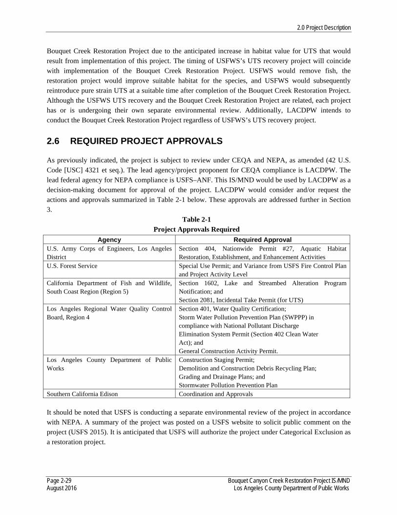
2.0 Project Description
Page 2-29 Bouquet Canyon Creek Restoration Project IS/MND August 2016 Los Angeles County Department of Public Works
Bouquet Creek Restoration Project due to the anticipated increase in habitat value for UTS that would result from implementation of this project. The timing of USFWS’s UTS recovery project will coincide with implementation of the Bouquet Creek Restoration Project. USFWS would remove fish, the restoration project would improve suitable habitat for the species, and USFWS would subsequently reintroduce pure strain UTS at a suitable time after completion of the Bouquet Creek Restoration Project. Although the USFWS UTS recovery and the Bouquet Creek Restoration Project are related, each project has or is undergoing their own separate environmental review. Additionally, LACDPW intends to conduct the Bouquet Creek Restoration Project regardless of USFWS’s UTS recovery project.
2.6 REQUIRED PROJECT APPROVALS As previously indicated, the project is subject to review under CEQA and NEPA, as amended (42 U.S. Code [USC] 4321 et seq.). The lead agency/project proponent for CEQA compliance is LACDPW. The lead federal agency for NEPA compliance is USFS–ANF. This IS/MND would be used by LACDPW as a decision-making document for approval of the project. LACDPW would consider and/or request the actions and approvals summarized in Table 2-1 below. These approvals are addressed further in Section 3.
Table 2-1 Project Approvals Required
Agency Required Approval U.S. Army Corps of Engineers, Los Angeles District
Section 404, Nationwide Permit #27, Aquatic Habitat Restoration, Establishment, and Enhancement Activities
U.S. Forest Service Special Use Permit; and Variance from USFS Fire Control Plan and Project Activity Level
California Department of Fish and Wildlife, South Coast Region (Region 5)
Section 1602, Lake and Streambed Alteration Program Notification; and Section 2081, Incidental Take Permit (for UTS)
Los Angeles Regional Water Quality Control Board, Region 4
Section 401, Water Quality Certification; Storm Water Pollution Prevention Plan (SWPPP) in compliance with National Pollutant Discharge Elimination System Permit (Section 402 Clean Water Act); and General Construction Activity Permit.
Los Angeles County Department of Public Works
Construction Staging Permit; Demolition and Construction Debris Recycling Plan; Grading and Drainage Plans; and Stormwater Pollution Prevention Plan
Southern California Edison Coordination and Approvals It should be noted that USFS is conducting a separate environmental review of the project in accordance with NEPA. A summary of the project was posted on a USFS website to solicit public comment on the project (USFS 2015). It is anticipated that USFS will authorize the project under Categorical Exclusion as a restoration project.
3.0 Initial Study Checklist
Page 3-1 Bouquet Canyon Creek Restoration Project IS/MND August 2016 Los Angeles County Department of Public Works
3.0 INITIAL STUDY CHECKLIST 1. Project Title: Bouquet Canyon Creek Restoration Project
2. Lead Agency: Los Angeles County Department of Public Works Programs Development Division 900 South Freemont Avenue, 11th Floor Alhambra, California 91803-1331
3. Contact Person: Ed Dingman, Los Angeles County Department of Public Works, Project Manager (626) 458-3933
4. Project Location: The project sites are located within an unincorporated area of northern Los Angeles County and within the southern part of the Santa Clara portion of the USFS Santa Clara/Mojave Rivers Rangers District of the ANF. The sites occur within an approximate 7.25-mile stretch of Bouquet Canyon Creek between the southern boundary of the ANF (near Site 1), upstream to the vicinity of Bouquet Reservoir (near Site 5). The upper portion of Site 1 upstream through Site 5 occurs on the USGS’ 7.5-minute Green Valley, California quadrangle in Township 5 North, Range 15 West, Sections 10 (Site 5), 15 (Sites 3 and 4), 16 (Site 2) and 21 (Site 1 and Zuni Preserve [Site 6]), with the lower portion of Site 1 extending south into Township 5 North, Range 15 West, Section 21 of the Mint Canyon, CA quadrangle.
5. Project Sponsor: Los Angeles County Department of Public Works Programs Development Division 900 South Freemont Avenue, 11th Floor Alhambra, California 91803-1331
6. General Plan Designation: Open Space-National Forest
7. Zoning: Watershed (Los Angeles County); Developed Area Interface (ANF)
8. Description of Project: The project consists of restoration of in-stream and riparian habitat by reestablishing creek flows along sections of Bouquet Canyon Creek, along with the creation of a fish preserve.
9. Surrounding Land Uses/Setting:
The project sites are immediately surrounded by undeveloped land in all directions, with the exception of the Texas Canyon Fire Station, which is located directly across Bouquet Canyon Road from Site 1 (at 30800 Bouquet Canyon Road). The closest residential subdivision within Santa Clarita is located approximately 2-3 miles south of the Site 1 along Bouquet Canyon Road. Several ranchettes (small ranches or large homes on the outskirts of Santa Clarita, past planned neighborhoods) are located between residential development and Site 1.
10. Other Public Agencies Whose Approval is Required:
U.S. Army Corps of Engineers, Los Angeles District Section 404, Nationwide Permit #27, Aquatic Habitat Restoration,
Establishment, and Enhancement Activities USFS
Special Use Permit; and Variance from USFS Fire Control Plan and Project Activity Level
California Department of Fish and Wildlife, South Coast Region (Region 5) Section 1602, Lake and Streambed Alteration Program Notification Section 2081, Incidental Take Permit (for UTS)
Los Angeles Regional Water Quality Control Board, Region 4 Section 401, Water Quality Certification Storm Water Pollution Prevention Plan (SWPPP) in compliance with
National Pollutant Discharge Elimination System Permit (Section 402 Clean Water Act)
General Construction Activity Permit Los Angeles County Department of Public Works
Construction Staging Permit Demolition and Construction Debris Recycling Plan Grading and Drainage Plans SWPPP
Southern California Edison Coordination and Approvals
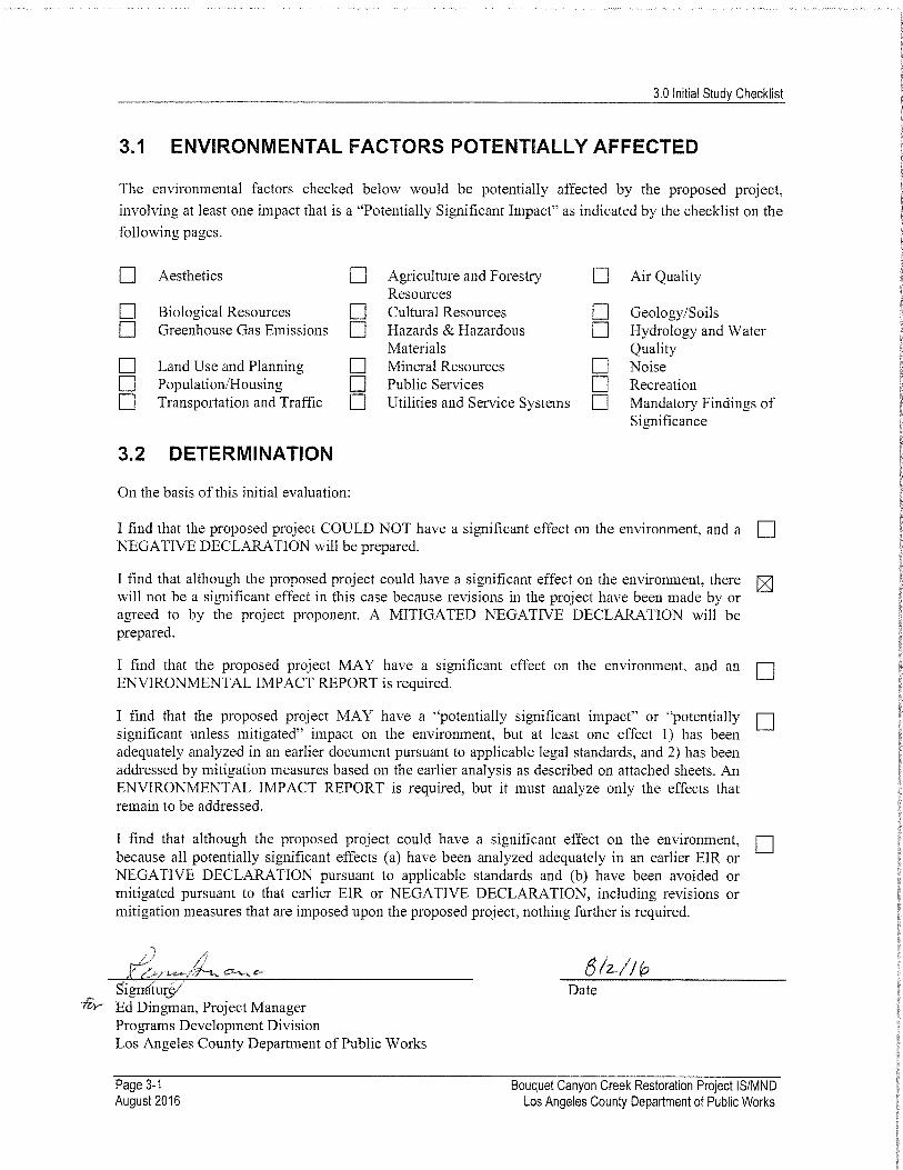
3.0 Initial Study Checklist
3.1 ENVIRONMENTAL FACTORS POTENTIALLY AFFECTED
The environmental factors checked below would be potentially affected by the proposed project,
involving at least one impact that is a "Potentially Significant Impact" as indicated by the checklist on the
following pages.
Aesthetics Agriculture and ForestryResources
Air Quality
I I Biological Resources Cultural Resources Geology/Soilsr Greenhouse Gas Emissions Hazards & Hazardous Hydrology and Water
n Land Use and PlanningMaterialsMineral Resources
QualityNoise
Population/Housing Public Services RecreationTransportation and Traffic Utilities and Service Systems Mandatory Findings of
Significance
3.2 DETERMINATION
On the basis of this initial evaluation:
I find that the proposed project COULD NOT have a significant effect on the environment, and aNEGATIVE DECLARATION will be prepared.
I find that although the proposed project could have a significant effect on the environment, therewill not be a significant effect in this case because revisions in the project have been made by oragreed to by the project proponent. A MITIGATED NEGATIVE DECLARATION will beprepared.
I find that the proposed project MAY have a significant effect on the environment, and anENVIRONMENTAL IMPACT REPORT is required.
I find that the proposed project MAY have a "potentially significant impact" or "potentiallysignificant unless mitigated" impact on the environment, but at least one effect 1) has beenadequately analyzed in an earlier document pursuant to applicable legal standards, and 2) has beenaddressed by mitigation measures based on the earlier analysis as described on attached sheets. AnENVIRONMENTAL IMPACT REPORT is required, but it must analyze only the effects thatremain to be addressed.
I find that although the proposed project could have a significant effect on the environment,because all potentially significant effects (a) have been analyzed adequately in an earlier EIR orNEGATIVE DECLARATION pursuant to applicable standards and (b) have been avoided ormitigated pursuant to that earlier EIR or NEGATIVE DECLARATION, including revisions ormitigation measures that are imposed upon the proposed project, nothing further is required.
Signature5'✓ Ed Dingman, Project Manager
Programs Development DivisionLos Angeles County Department of Public Works
Date
Page 3-1August 2016
Bouquet Canyon Creek Restoration Project IS/MNDLos Angeles County Department of Public Works
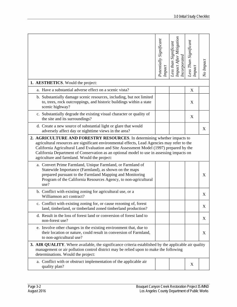
3.0 Initial Study Checklist
Page 3-2 Bouquet Canyon Creek Restoration Project IS/MND August 2016 Los Angeles County Department of Public Works
Pot
enti
ally
Sig
nifi
cant
Im
pact
Les
s th
an S
igni
fica
nt
Impa
ct A
fter
Mit
igat
ion
Inco
rpor
ated
Les
s T
han
Sign
ific
ant
Impa
ct
No
Impa
ct
1. AESTHETICS. Would the project:
a. Have a substantial adverse effect on a scenic vista? X
b. Substantially damage scenic resources, including, but not limited to, trees, rock outcroppings, and historic buildings within a state scenic highway?
X
c. Substantially degrade the existing visual character or quality of the site and its surroundings? X
d. Create a new source of substantial light or glare that would adversely affect day or nighttime views in the area? X
2. AGRICULTURE AND FORESTRY RESOURCES. In determining whether impacts to agricultural resources are significant environmental effects, Lead Agencies may refer to the California Agricultural Land Evaluation and Site Assessment Model (1997) prepared by the California Department of Conservation as an optional model to use in assessing impacts on agriculture and farmland. Would the project:
a. Convert Prime Farmland, Unique Farmland, or Farmland of Statewide Importance (Farmland), as shown on the maps prepared pursuant to the Farmland Mapping and Monitoring Program of the California Resources Agency, to non-agricultural use?
X
b. Conflict with existing zoning for agricultural use, or a Williamson act contract? X
c. Conflict with existing zoning for, or cause rezoning of, forest land, timberland, or timberland zoned timberland production? X
d. Result in the loss of forest land or conversion of forest land to non-forest use? X
e. Involve other changes in the existing environment that, due to their location or nature, could result in conversion of Farmland, to non-agricultural use?
X
3. AIR QUALITY. Where available, the significance criteria established by the applicable air quality management or air pollution control district may be relied upon to make the following determinations. Would the project:
a. Conflict with or obstruct implementation of the applicable air quality plan? X
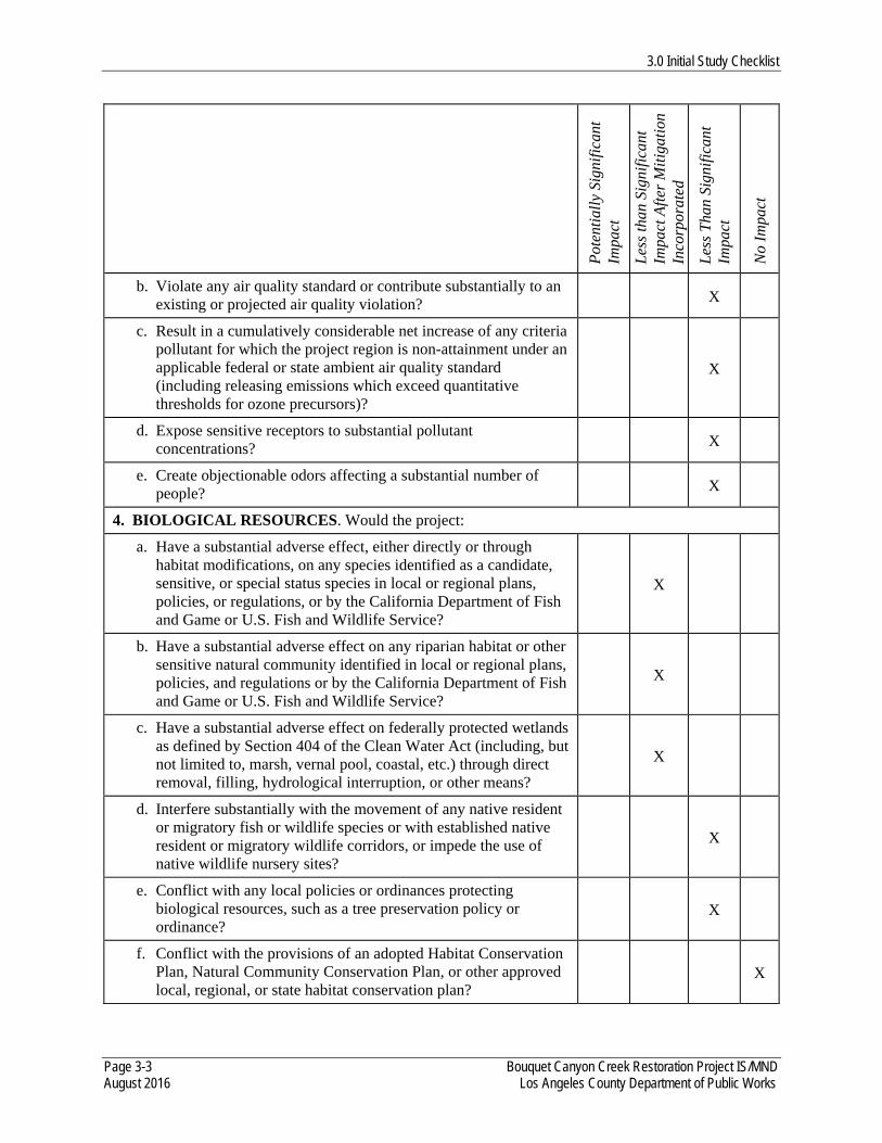
3.0 Initial Study Checklist
Page 3-3 Bouquet Canyon Creek Restoration Project IS/MND August 2016 Los Angeles County Department of Public Works
Pot
enti
ally
Sig
nifi
cant
Im
pact
Les
s th
an S
igni
fica
nt
Impa
ct A
fter
Mit
igat
ion
Inco
rpor
ated
Les
s T
han
Sign
ific
ant
Impa
ct
No
Impa
ct
b. Violate any air quality standard or contribute substantially to an existing or projected air quality violation? X
c. Result in a cumulatively considerable net increase of any criteria pollutant for which the project region is non-attainment under an applicable federal or state ambient air quality standard (including releasing emissions which exceed quantitative thresholds for ozone precursors)?
X
d. Expose sensitive receptors to substantial pollutant concentrations? X
e. Create objectionable odors affecting a substantial number of people? X
4. BIOLOGICAL RESOURCES. Would the project:
a. Have a substantial adverse effect, either directly or through habitat modifications, on any species identified as a candidate, sensitive, or special status species in local or regional plans, policies, or regulations, or by the California Department of Fish and Game or U.S. Fish and Wildlife Service?
X
b. Have a substantial adverse effect on any riparian habitat or other sensitive natural community identified in local or regional plans, policies, and regulations or by the California Department of Fish and Game or U.S. Fish and Wildlife Service?
X
c. Have a substantial adverse effect on federally protected wetlands as defined by Section 404 of the Clean Water Act (including, but not limited to, marsh, vernal pool, coastal, etc.) through direct removal, filling, hydrological interruption, or other means?
X
d. Interfere substantially with the movement of any native resident or migratory fish or wildlife species or with established native resident or migratory wildlife corridors, or impede the use of native wildlife nursery sites?
X
e. Conflict with any local policies or ordinances protecting biological resources, such as a tree preservation policy or ordinance?
X
f. Conflict with the provisions of an adopted Habitat Conservation Plan, Natural Community Conservation Plan, or other approved local, regional, or state habitat conservation plan?
X
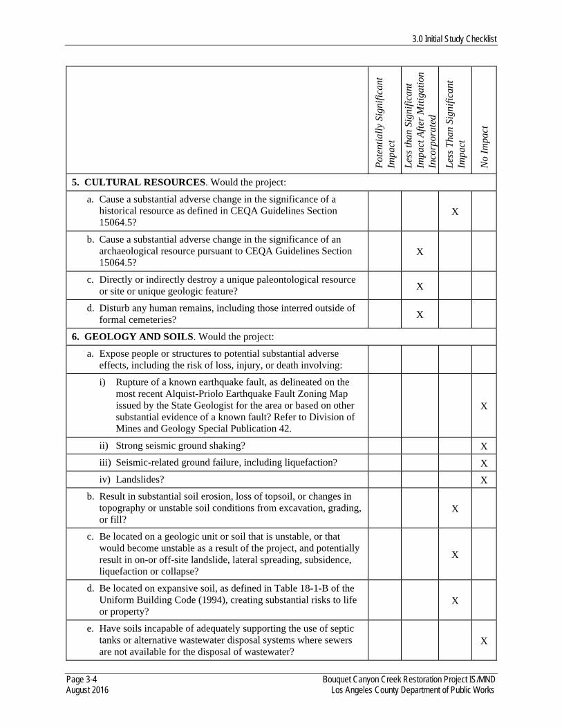
3.0 Initial Study Checklist
Page 3-4 Bouquet Canyon Creek Restoration Project IS/MND August 2016 Los Angeles County Department of Public Works
Pot
enti
ally
Sig
nifi
cant
Im
pact
Les
s th
an S
igni
fica
nt
Impa
ct A
fter
Mit
igat
ion
Inco
rpor
ated
Les
s T
han
Sign
ific
ant
Impa
ct
No
Impa
ct
5. CULTURAL RESOURCES. Would the project:
a. Cause a substantial adverse change in the significance of a historical resource as defined in CEQA Guidelines Section 15064.5?
X
b. Cause a substantial adverse change in the significance of an archaeological resource pursuant to CEQA Guidelines Section 15064.5?
X
c. Directly or indirectly destroy a unique paleontological resource or site or unique geologic feature? X
d. Disturb any human remains, including those interred outside of formal cemeteries? X
6. GEOLOGY AND SOILS. Would the project:
a. Expose people or structures to potential substantial adverse effects, including the risk of loss, injury, or death involving:
i) Rupture of a known earthquake fault, as delineated on the most recent Alquist-Priolo Earthquake Fault Zoning Map issued by the State Geologist for the area or based on other substantial evidence of a known fault? Refer to Division of Mines and Geology Special Publication 42.
X
ii) Strong seismic ground shaking? X
iii) Seismic-related ground failure, including liquefaction? X
iv) Landslides? X
b. Result in substantial soil erosion, loss of topsoil, or changes in topography or unstable soil conditions from excavation, grading, or fill?
X
c. Be located on a geologic unit or soil that is unstable, or that would become unstable as a result of the project, and potentially result in on-or off-site landslide, lateral spreading, subsidence, liquefaction or collapse?
X
d. Be located on expansive soil, as defined in Table 18-1-B of the Uniform Building Code (1994), creating substantial risks to life or property?
X
e. Have soils incapable of adequately supporting the use of septic tanks or alternative wastewater disposal systems where sewers are not available for the disposal of wastewater?
X
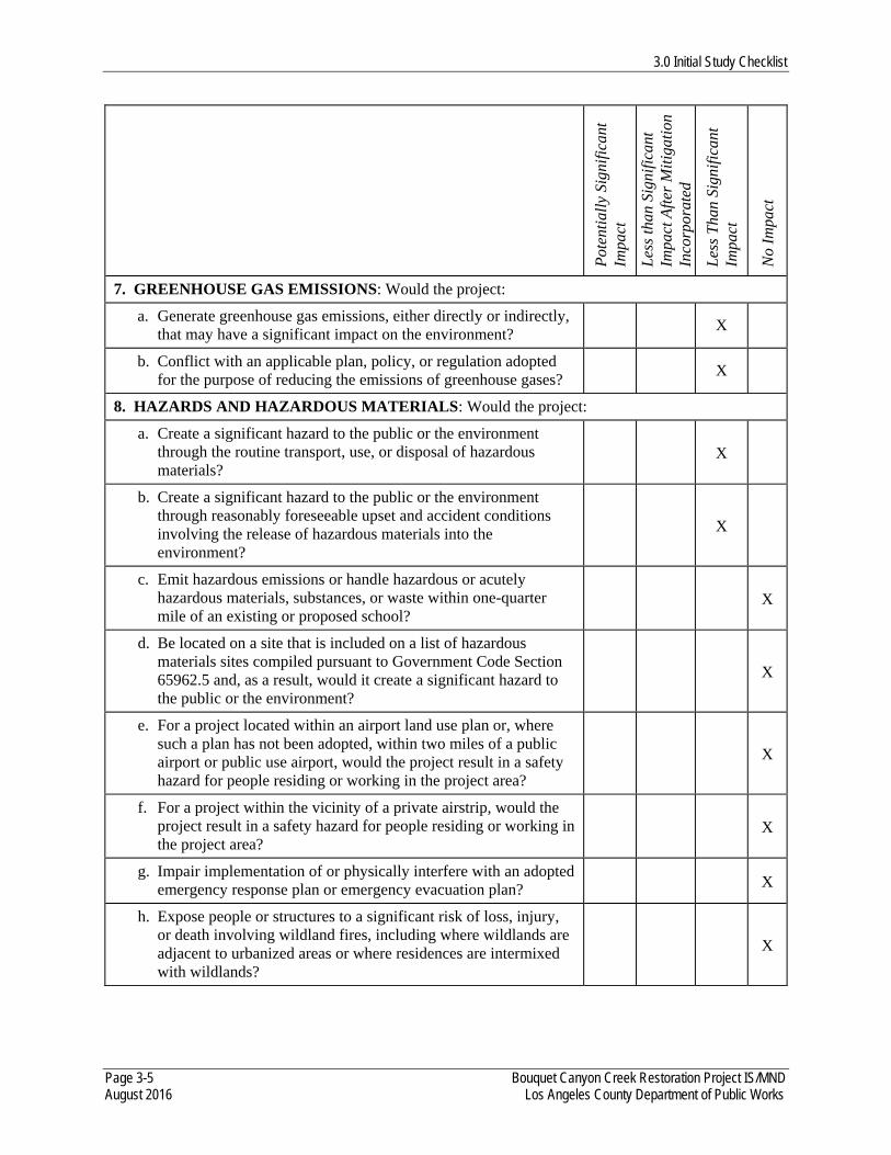
3.0 Initial Study Checklist
Page 3-5 Bouquet Canyon Creek Restoration Project IS/MND August 2016 Los Angeles County Department of Public Works
Pot
enti
ally
Sig
nifi
cant
Im
pact
Les
s th
an S
igni
fica
nt
Impa
ct A
fter
Mit
igat
ion
Inco
rpor
ated
Les
s T
han
Sign
ific
ant
Impa
ct
No
Impa
ct
7. GREENHOUSE GAS EMISSIONS: Would the project:
a. Generate greenhouse gas emissions, either directly or indirectly, that may have a significant impact on the environment?
X
b. Conflict with an applicable plan, policy, or regulation adopted for the purpose of reducing the emissions of greenhouse gases?
X
8. HAZARDS AND HAZARDOUS MATERIALS: Would the project:
a. Create a significant hazard to the public or the environment through the routine transport, use, or disposal of hazardous materials?
X
b. Create a significant hazard to the public or the environment through reasonably foreseeable upset and accident conditions involving the release of hazardous materials into the environment?
X
c. Emit hazardous emissions or handle hazardous or acutely hazardous materials, substances, or waste within one-quarter mile of an existing or proposed school?
X
d. Be located on a site that is included on a list of hazardous materials sites compiled pursuant to Government Code Section 65962.5 and, as a result, would it create a significant hazard to the public or the environment?
X
e. For a project located within an airport land use plan or, where such a plan has not been adopted, within two miles of a public airport or public use airport, would the project result in a safety hazard for people residing or working in the project area?
X
f. For a project within the vicinity of a private airstrip, would the project result in a safety hazard for people residing or working in the project area?
X
g. Impair implementation of or physically interfere with an adopted emergency response plan or emergency evacuation plan? X
h. Expose people or structures to a significant risk of loss, injury, or death involving wildland fires, including where wildlands are adjacent to urbanized areas or where residences are intermixed with wildlands?
X
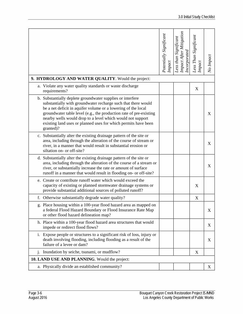
3.0 Initial Study Checklist
Page 3-6 Bouquet Canyon Creek Restoration Project IS/MND August 2016 Los Angeles County Department of Public Works
Pot
enti
ally
Sig
nifi
cant
Im
pact
Les
s th
an S
igni
fica
nt
Impa
ct A
fter
Mit
igat
ion
Inco
rpor
ated
Les
s T
han
Sign
ific
ant
Impa
ct
No
Impa
ct
9. HYDROLOGY AND WATER QUALITY. Would the project:
a. Violate any water quality standards or waste discharge requirements? X
b. Substantially deplete groundwater supplies or interfere substantially with groundwater recharge such that there would be a net deficit in aquifer volume or a lowering of the local groundwater table level (e.g., the production rate of pre-existing nearby wells would drop to a level which would not support existing land uses or planned uses for which permits have been granted)?
X
c. Substantially alter the existing drainage pattern of the site or area, including through the alteration of the course of stream or river, in a manner that would result in substantial erosion or siltation on- or off-site?
X
d. Substantially alter the existing drainage pattern of the site or area, including through the alteration of the course of a stream or river, or substantially increase the rate or amount of surface runoff in a manner that would result in flooding on- or off-site?
X
e. Create or contribute runoff water which would exceed the capacity of existing or planned stormwater drainage systems or provide substantial additional sources of polluted runoff?
X
f. Otherwise substantially degrade water quality? X
g. Place housing within a 100-year flood hazard area as mapped on a federal Flood Hazard Boundary or Flood Insurance Rate Map or other flood hazard delineation map?
X
h. Place within a 100-year flood hazard area structures that would impede or redirect flood flows? X
i. Expose people or structures to a significant risk of loss, injury or death involving flooding, including flooding as a result of the failure of a levee or dam?
X
j. Inundation by seiche, tsunami, or mudflow? X
10. LAND USE AND PLANNING. Would the project:
a. Physically divide an established community? X

3.0 Initial Study Checklist
Page 3-7 Bouquet Canyon Creek Restoration Project IS/MND August 2016 Los Angeles County Department of Public Works
Pot
enti
ally
Sig
nifi
cant
Im
pact
Les
s th
an S
igni
fica
nt
Impa
ct A
fter
Mit
igat
ion
Inco
rpor
ated
Les
s T
han
Sign
ific
ant
Impa
ct
No
Impa
ct
b. Conflict with any applicable land use plan, policy, or regulation of an agency with jurisdiction over the project (including, but not limited to the general plan, specific plan, local coastal program, or zoning ordinance) adopted for the purpose of avoiding or mitigating an environmental effect?
X
c. Conflict with any applicable habitat conservation plan or natural community conservation plan? X
11. MINERAL RESOURCES. Would the project:
a. Result in the loss of availability of a known mineral resource that would be of value to the region and the residents of the state?
X
b. Result in the loss of availability of a locally important mineral resource recovery site delineated on a local general plan, specific plan, or other land use plan?
X
12. NOISE. Would the project result in:
a. Exposure of persons to or generation of noise levels in excess of standards established in the local general plan or noise ordinance, or applicable standards of other agencies?
X
b. Exposure of persons to or generation of excessive groundborne vibration or groundborne noise levels? X
c. A substantial permanent increase in ambient noise levels in the project vicinity above levels existing without the project? X
d. A substantial temporary or periodic increase in ambient noise levels in the project vicinity above levels existing without the project?
X
e. For a project located within an airport land use plan or, where such a plan has not been adopted, within two miles of a public airport or public use airport, would the project expose people residing or working in the project area to excessive noise levels?
X
f. For a project within the vicinity of a private airstrip, would the project expose people residing or working in the project area to excessive noise levels?
X

3.0 Initial Study Checklist
Page 3-8 Bouquet Canyon Creek Restoration Project IS/MND August 2016 Los Angeles County Department of Public Works
Pot
enti
ally
Sig
nifi
cant
Im
pact
Les
s th
an S
igni
fica
nt
Impa
ct A
fter
Mit
igat
ion
Inco
rpor
ated
Les
s T
han
Sign
ific
ant
Impa
ct
No
Impa
ct
13. POPULATION AND HOUSING. Would the project:
a. Induce substantial population growth in an area, either directly (for example, by proposing new homes and businesses) or indirectly (for example, through extension of roads or other infrastructure)?
X
b. Displace substantial numbers of existing housing, necessitating the construction of replacement housing elsewhere? X
c. Displace substantial numbers of people, necessitating the construction of replacement housing elsewhere? X
14. PUBLIC SERVICES.
a. Would the project result in substantial adverse physical impacts associated with the provision of new or physically altered governmental facilities, need for new or physically altered governmental facilities, the construction of which could cause significant environmental impacts, in order to maintain acceptable service ratios, response times or other performance objectives for any of the public services:
i) Fire protection? X
ii) Police protection? X
iii) Schools? X
iv) Parks? X
v) Other public facilities? X
15. RECREATION.
a. Would the project increase the use of existing neighborhood and regional parks or other recreational facilities such that substantial physical deterioration of the facility would occur or be accelerated?
X
b. Does the project include recreational facilities or require the construction or expansion of recreational facilities that might have an adverse physical effect on the environment?
X
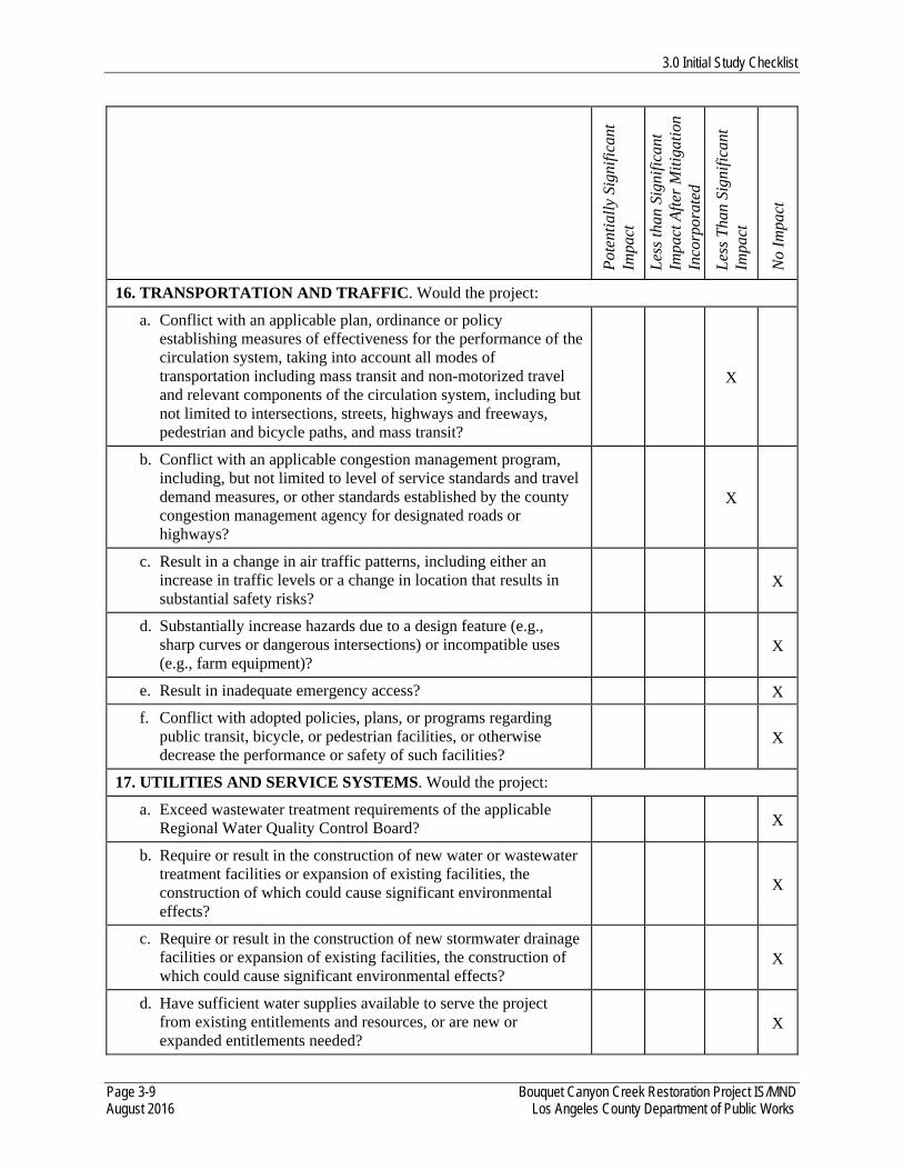
3.0 Initial Study Checklist
Page 3-9 Bouquet Canyon Creek Restoration Project IS/MND August 2016 Los Angeles County Department of Public Works
Pot
enti
ally
Sig
nifi
cant
Im
pact
Les
s th
an S
igni
fica
nt
Impa
ct A
fter
Mit
igat
ion
Inco
rpor
ated
Les
s T
han
Sign
ific
ant
Impa
ct
No
Impa
ct
16. TRANSPORTATION AND TRAFFIC. Would the project:
a. Conflict with an applicable plan, ordinance or policy establishing measures of effectiveness for the performance of the circulation system, taking into account all modes of transportation including mass transit and non-motorized travel and relevant components of the circulation system, including but not limited to intersections, streets, highways and freeways, pedestrian and bicycle paths, and mass transit?
X
b. Conflict with an applicable congestion management program, including, but not limited to level of service standards and travel demand measures, or other standards established by the county congestion management agency for designated roads or highways?
X
c. Result in a change in air traffic patterns, including either an increase in traffic levels or a change in location that results in substantial safety risks?
X
d. Substantially increase hazards due to a design feature (e.g., sharp curves or dangerous intersections) or incompatible uses (e.g., farm equipment)?
X
e. Result in inadequate emergency access? X
f. Conflict with adopted policies, plans, or programs regarding public transit, bicycle, or pedestrian facilities, or otherwise decrease the performance or safety of such facilities?
X
17. UTILITIES AND SERVICE SYSTEMS. Would the project:
a. Exceed wastewater treatment requirements of the applicable Regional Water Quality Control Board? X
b. Require or result in the construction of new water or wastewater treatment facilities or expansion of existing facilities, the construction of which could cause significant environmental effects?
X
c. Require or result in the construction of new stormwater drainage facilities or expansion of existing facilities, the construction of which could cause significant environmental effects?
X
d. Have sufficient water supplies available to serve the project from existing entitlements and resources, or are new or expanded entitlements needed?
X
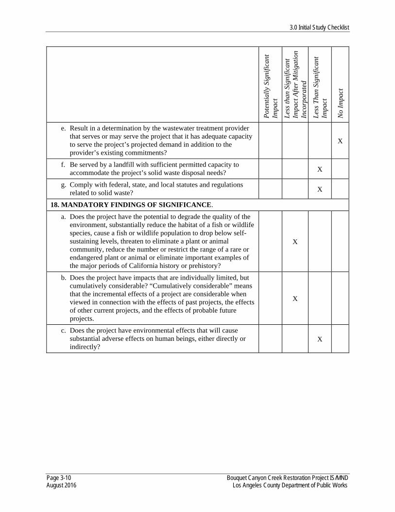
3.0 Initial Study Checklist
Page 3-10 Bouquet Canyon Creek Restoration Project IS/MND August 2016 Los Angeles County Department of Public Works
Pot
enti
ally
Sig
nifi
cant
Im
pact
Les
s th
an S
igni
fica
nt
Impa
ct A
fter
Mit
igat
ion
Inco
rpor
ated
Les
s T
han
Sign
ific
ant
Impa
ct
No
Impa
ct
e. Result in a determination by the wastewater treatment provider that serves or may serve the project that it has adequate capacity to serve the project’s projected demand in addition to the provider’s existing commitments?
X
f. Be served by a landfill with sufficient permitted capacity to accommodate the project’s solid waste disposal needs? X
g. Comply with federal, state, and local statutes and regulations related to solid waste? X
18. MANDATORY FINDINGS OF SIGNIFICANCE.
a. Does the project have the potential to degrade the quality of the environment, substantially reduce the habitat of a fish or wildlife species, cause a fish or wildlife population to drop below self-sustaining levels, threaten to eliminate a plant or animal community, reduce the number or restrict the range of a rare or endangered plant or animal or eliminate important examples of the major periods of California history or prehistory?
X
b. Does the project have impacts that are individually limited, but cumulatively considerable? “Cumulatively considerable” means that the incremental effects of a project are considerable when viewed in connection with the effects of past projects, the effects of other current projects, and the effects of probable future projects.
X
c. Does the project have environmental effects that will cause substantial adverse effects on human beings, either directly or indirectly?
X
4.1 Aesthetics
Page 4.1-1 Bouquet Canyon Creek Restoration Project IS/MND August 2016 Los Angeles County Department of Public Works
4.0 IMPACTS AND MITIGATION MEASURES
4.1 AESTHETICS
Would the Project:
a) Have a substantial adverse effect on a scenic vista?
Less than Significant Impact. According to Map 4.2, Town and Country Scenic Drives Map, in the Los Angeles County Town & Country – Antelope Valley Area Plan, Bouquet Canyon Road is shown as a “Priority Scenic Drive” (Los Angeles County Department of Regional Planning 2015c). The project site would be located within the viewshed of this scenic drive. In addition, the project site is located within the Los Angeles County’s Hillside Management Areas, which are considered scenic resources (Los Angeles County Department of Regional Planning 2014b). Also, according to the Angeles National Forest (ANF) Land Management Plan, the project site is located within an area that has a High Scenic Integrity Objective (SIO) (U.S. Department of Agriculture [USDA] 2005b). The High SIO classification provides for conditions where human activities are not visually evident and the landscape appears unaltered. SIOs have been designated for all areas of the national forest. These objectives define the minimum level to which landscapes are to be managed from an aesthetics standpoint (USDA 2005b). Views of the surrounding hills and vegetation within Bouquet Canyon from the project site would thus be considered scenic vistas.
The project consists of restoration of in-stream and riparian habitat by reestablishing creek flows along sections of Bouquet Canyon Creek, along with the creation of a fish preserve. During construction, views to and from the project site may be blocked by construction equipment. However, these visual impacts would be temporary. Furthermore, minimal damage to scenic resources during construction would not cause a substantial adverse effect on the scenic viewshed along Bouquet Canyon Road, would not cause a reduction in the High SIO classification, and would not cause a substantial adverse effect on views from the project site. Given the primary purpose of the project (i.e., habitat restoration), the scenic quality of the project site would be improved following restoration efforts. Thus, views to and from the project site would improve after restoration efforts are completed.
Therefore, implementation of the project would not have a substantial adverse effect on a scenic vista. Impacts would be less than significant.
4.1 Aesthetics
Page 4.1-2 Bouquet Canyon Creek Restoration Project IS/MND August 2016 Los Angeles County Department of Public Works
b) Substantially damage scenic resources, including, but not limited to, trees, rock outcroppings, and historic buildings within a state scenic highway?
Less than Significant Impact. According to the Los Angeles County General Plan, scenic resources in the County consist of designated scenic highways and corridors (or routes), and hillsides and ridgelines (Los Angeles County Department of Regional Planning 2015b). The project site is not located within a designated state scenic highway and corridor (or route) (Caltrans 2016, Los Angeles County Department of Regional Planning 2014a). Also, there are no historic buildings within the project site (see Section 4.5, Cultural Resources, of this Draft IS/MND). However, as discussed above, according to Map 4.2, Town and Country Scenic Drives Map, in the Los Angeles County Town & Country – Antelope Valley Area Plan, Bouquet Canyon Road is shown as a “Priority Scenic Drive” (Los Angeles County Department of Regional Planning 2015c). The project site would be located within the viewshed of this scenic drive. In addition, the project site is located within the Los Angeles County’s Hillside Management Areas, which are considered scenic resources (Los Angeles County Department of Regional Planning 2014b). Also, as discussed above, according to the ANF Land Management Plan, the project site is located within an area that has a High SIO (USDA 2005b). Thus, the landform, rock-form, water-form, and vegetation pattern within and surrounding the project site are considered scenic resources.
As discussed above, the project consists of restoration of in-stream and riparian habitat by reestablishing creek flows along sections of Bouquet Canyon Creek, along with the creation of a fish preserve. The project would include the removal of some vegetation and removal of sediment as part of this restoration effort. After construction is completed, a habitat restoration program would be implemented. All vegetation and sediment removal and restoration activities would be conducted in compliance with USFS and County requirements. Furthermore, LACPDW would obtain a USFS Special Use Permit for the project and would comply with all permit conditions. Minimal damage to scenic resources would occur during construction and would not result in a reduction in the High SIO classification or impact the quality of the scenic viewshed along Bouquet Canyon Road. Given the primary purpose of the project (i.e., habitat restoration), the scenic quality of the project site would be improved following restoration efforts.
Therefore, implementation of the project would not substantially damage scenic resources, including, but not limited to, trees, rock outcroppings, and historic buildings within a state scenic highway. Impacts would be less than significant.
c) Substantially degrade the existing visual character or quality of the site and its surroundings?
Less than Significant Impact. The project site is located within Bouquet Canyon Creek and the former Zuni Campground within the ANF. The existing visual character is forest land/open space. Surrounding land uses consist mainly of forest land/open space, with some scattered residential
4.1 Aesthetics
Page 4.1-3 Bouquet Canyon Creek Restoration Project IS/MND August 2016 Los Angeles County Department of Public Works
uses located further north and south of the project site. Also, the Texas Fire Station is located near the project site. The project site and surrounding area have a high scenic quality with a number of scenic resources and vistas in the area, as discussed above in Section 4.1, Aesthetics, Questions (a) and (b). As discussed previously, the project consists of restoration of in-stream and riparian habitat by reestablishing creek flows along sections of Bouquet Canyon Creek, along with the creation of a fish preserve. Construction activities would slightly degrade the visual character and quality of the project site. While minimal damage to scenic resources would occur during construction, project construction would not result in a reduction in the High SIO classification, and would not substantially degrade the visual quality of the project site or scenic viewshed along Bouquet Canyon Road. Given the primary purpose of the project (i.e., habitat restoration), the scenic quality of the project site would be improved following restoration efforts. Therefore, implementation of the project would not substantially degrade the existing visual character or quality of the site and its surroundings. Impacts would be less than significant.
d) Create a new source of substantial light or glare, which would adversely affect day or nighttime views in the area?
No Impact. The project consists of restoration of in-stream and riparian habitat by reestablishing creek flows along sections of Bouquet Canyon Creek, along with the creation of a fish preserve. No lighting would be associated with the project nor would it generate a new source of glare. In addition, no nighttime construction or operation would occur as a result of the project. Therefore, implementation of the project would not create a new source of substantial light or glare, which would adversely affect day or nighttime views in the area. No impact would occur.

4.1 Aesthetics
Page 4.1-4 Bouquet Canyon Creek Restoration Project IS/MND August 2016 Los Angeles County Department of Public Works
This page intentionally left blank.
4.2 Agriculture and Forestry Resources
Page 4.2-1 Bouquet Canyon Creek Restoration Project IS/MND August 2016 Los Angeles County Department of Public Works
4.2 AGRICULTURE AND FORESTRY RESOURCES Would the Project:
a) Convert Prime Farmland, Unique Farmland, or Farmland of Statewide Importance (Farmland), as shown on the maps prepared pursuant to the Farmland Mapping and Monitoring Program of the California Resources Agency, to non-agricultural use? No Impact. According to the latest farmland map for Los Angeles County prepared by the Farmland Mapping and Monitoring Program (FMMP) of the California Resources Agency (California Department of Conservation 2015a), the project does not contain any Prime Farmland, Unique Farmland, or Farmland of Statewide Importance (Farmland). The project is located entirely within the U.S. Forest Service (USFS)’s Angeles National Forest (ANF) in unincorporated Los Angeles County within five pre-defined reaches of Bouquet Canyon Creek and a sixth site in the abandoned Zuni Campground. No agricultural uses occur on or within the vicinity of the project site. Therefore, implementation of the project would not convert Farmland to a non-agricultural use. No impact would occur.
b) Conflict with existing zoning for agricultural use, or a Williamson Act contract? No Impact. There is no Williamson Act contract applicable to the project (California Department of Conservation 2015b). In addition, no agricultural zoning or uses occur on or within the vicinity of the project site. As mentioned previously, the project is located within the USFS’ ANF within the unincorporated area of Los Angeles County and is under the jurisdiction of the USFS. The project site has a Los Angeles County zoning designation of Watershed (Los Angeles County Department of Regional Planning 2009) and an ANF Land Management Plan land-use zoning designation of Developed Area Interface (DAI) (USDA 2005a). The Watershed zone allows for uses owned and maintained by USFS and recreational uses approved by the USFS. The DAI zone includes areas adjacent to communities or concentrated use areas and developed sites with more scattered or isolated community infrastructure. It does not include any agricultural uses. Therefore, implementation of the project would not conflict with existing zoning for agricultural use, or a Williamson Act contract. No impact would occur.
c) Conflict with existing zoning for, or cause rezoning of, forest land, timberland, or timberland zoned Timberland Production? No Impact. As discussed in Section 4.2, Question (b) above, the project is located within the USFS’ ANF within the unincorporated area of Los Angeles County and is under the jurisdiction of the USFS. The project site has a Los Angeles County zoning designation of Watershed (Los Angeles County Department of Regional Planning 2009) and an ANF Land Management Plan land-use zoning designation of DAI (USDA 2005a). The project is not zoned for timberland or timberland production. The Watershed zone allows for uses owned and maintained by USFS and
4.2 Agriculture and Forestry Resources
Page 4.2-2 Bouquet Canyon Creek Restoration Project IS/MND August 2016 Los Angeles County Department of Public Works
recreational uses approved by the USFS. According to the ANF Land Management Plan, restoration of vegetation condition is permitted in the DAI zone, and disposal of National Forest System Lands is permitted in the DAI zone by exception. The project consists of restoration of in-stream and riparian habitat by reestablishing creek flows along sections of Bouquet Canyon Creek, along with the creation of a fish preserve. The project would include the removal of some vegetation (e.g., overgrown vegetation, trees [i.e., dead trees, non-oak trees smaller than a 12-inch diameter-at-breast-height [dbh], and oak trees smaller than a 6-inch dbh; note that any trees of this size and greater would be avoided when feasible], and any fallen debris that may be in the stream channel, per consultation with USFS) and removal of sediment as part of this restoration effort. All vegetation and sediment removal would be conducted in compliance with USFS requirements. Furthermore, LACPDW would obtain a USFS Special Use Permit for the project and would comply with all permit conditions. Therefore, the implementation of the project would not conflict with existing zoning or cause rezoning of forest or timberland. No impact would occur.
d) Result in the loss of forest land or conversion of forest land to non-forest use? No Impact. As discussed in Section 4.2, Question (c) above, the project consists of restoration of in-stream and riparian habitat by reestablishing creek flows along sections of Bouquet Canyon Creek, along with the creation of a fish preserve. As part of this proposed restoration work, some vegetation would be removed. All vegetation and sediment removal would be conducted in compliance with USFS requirements. Therefore, implementation of the project would not result in the loss of forest land or conversion of forest land to non-forest use. No impact would occur.
e) Involve other changes in the existing environment, which, due to their location or nature, could result in conversion of Farmland, to non-agricultural use or conversion of forest land to non-forest use? No Impact. As discussed in Section 4.2, Question (a) above, the project does not contain any Farmland or agricultural uses. Therefore, implementation of the project would not result in the conversion of Farmland to non-agricultural use. In addition, as discussed in Section 4.2, Question (d) above, the project consists of restoration of in-stream and riparian habitat by reestablishing creek flows along sections of Bouquet Canyon Creek, along with the creation of a fish preserve. Therefore, implementation of the project would not involve other changes in the existing environment, which, due to their location or nature, would result in conversion of forest land to non-forest use. No impact would occur.
4.3 Air Quality
Page 4.3-1 Bouquet Canyon Creek Restoration Project IS/MND August 2016 Los Angeles County Department of Public Works
4.3 AIR QUALITY
Would the Project: a) Conflict with or obstruct implementation of the applicable air quality plan?
Less than Significant Impact. The South Coast Air Quality Management District (SCAQMD) monitors air quality within the project area and the South Coast Air Basin, which includes Orange County and portions of Los Angeles, Riverside, and San Bernardino counties. The South Coast Air Basin is bounded by the Pacific Ocean to the west; the San Gabriel, San Bernardino and San Jacinto Mountains to the north and east; and the San Diego County line to the south. The SCAQMD also has jurisdiction over the Salton Sea Air Basin and a portion of the Mojave Desert in Riverside County. Air quality plans describe air pollution control strategies to be implemented by a city, county, or region. The primary purpose of an air quality plan is to bring an area that does not attain federal and state air quality standards into compliance with the requirements of the Clean Air Act and California Clean Air Act requirements. The Air Quality Management Plan (AQMP) is prepared by SCAQMD and the Southern California Association of Governments (SCAG). The AQMP provides policies and control measures that reduce emissions to attain both state and federal ambient air quality standards. The SCAQMD is currently in the process of developing the 2016 AQMP, which is a comprehensive and integrated plan primarily focused on addressing the ozone and particulate matter less than 2.5 microns (PM2.5) standards. However, that plan has not been adopted, and therefore, the most recent AQMP adopted by the SCAQMD in 2012 is used for this analysis. The 2012 AQMP incorporates the latest scientific and technological information and planning assumptions, including the 2012 Regional Transportation Plan/Sustainable Communities Strategy and updated emission inventory methodologies. The final plan includes measures to attain the federal 24-hour PM2.5 standard in the South Coast Air Basin and the U.S. Environmental Protection Agency (USEPA) approved 8-hour ozone control plan which includes long term measures for nitrogen oxide (NOX) and volatile organic compound (VOC) reductions. The project area is approximately 10.2 acres. The project would excavate approximately 11,300 cubic yards of sediment from Bouquet Canyon Creek and remove vegetation as part of the restoration. Construction of the project would involve the use of off-road equipment, haul trucks, and worker commute trips. Assumptions for off-road equipment emissions in SIP were developed based on hours of activity and equipment population reported to the California Air Resources Board (CARB) for rule compliance. The project would not increase the assumptions for off-road equipment use in the AQMP. Therefore, while the project would generate criteria pollutant emissions, the approach to exhaust and fugitive dust emission control measures would be consistent with the air quality plan. Also, as discussed later in this section, the project-related
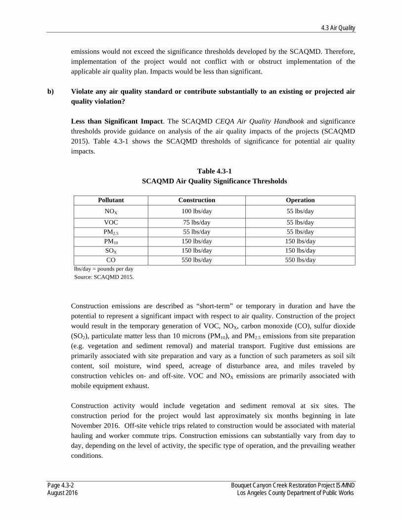
4.3 Air Quality
Page 4.3-2 Bouquet Canyon Creek Restoration Project IS/MND August 2016 Los Angeles County Department of Public Works
emissions would not exceed the significance thresholds developed by the SCAQMD. Therefore, implementation of the project would not conflict with or obstruct implementation of the applicable air quality plan. Impacts would be less than significant.
b) Violate any air quality standard or contribute substantially to an existing or projected air quality violation? Less than Significant Impact. The SCAQMD CEQA Air Quality Handbook and significance thresholds provide guidance on analysis of the air quality impacts of the projects (SCAQMD 2015). Table 4.3-1 shows the SCAQMD thresholds of significance for potential air quality impacts.
Table 4.3-1
SCAQMD Air Quality Significance Thresholds
Pollutant Construction Operation
NOX 100 lbs/day 55 lbs/day
VOC 75 lbs/day 55 lbs/day
PM2.5 55 lbs/day 55 lbs/day
PM10 150 lbs/day 150 lbs/day
SOX 150 lbs/day 150 lbs/day
CO 550 lbs/day 550 lbs/day lbs/day = pounds per day Source: SCAQMD 2015.
Construction emissions are described as “short-term” or temporary in duration and have the potential to represent a significant impact with respect to air quality. Construction of the project would result in the temporary generation of VOC, NOX, carbon monoxide (CO), sulfur dioxide (SO2), particulate matter less than 10 microns (PM10), and PM2.5 emissions from site preparation (e.g. vegetation and sediment removal) and material transport. Fugitive dust emissions are primarily associated with site preparation and vary as a function of such parameters as soil silt content, soil moisture, wind speed, acreage of disturbance area, and miles traveled by construction vehicles on- and off-site. VOC and NOX emissions are primarily associated with mobile equipment exhaust. Construction activity would include vegetation and sediment removal at six sites. The construction period for the project would last approximately six months beginning in late November 2016. Off-site vehicle trips related to construction would be associated with material hauling and worker commute trips. Construction emissions can substantially vary from day to day, depending on the level of activity, the specific type of operation, and the prevailing weather conditions.
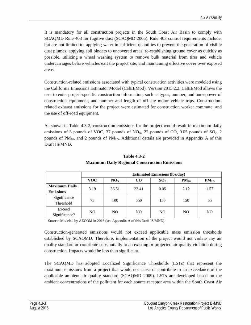
4.3 Air Quality
Page 4.3-3 Bouquet Canyon Creek Restoration Project IS/MND August 2016 Los Angeles County Department of Public Works
It is mandatory for all construction projects in the South Coast Air Basin to comply with SCAQMD Rule 403 for fugitive dust (SCAQMD 2005). Rule 403 control requirements include, but are not limited to, applying water in sufficient quantities to prevent the generation of visible dust plumes, applying soil binders to uncovered areas, re-establishing ground cover as quickly as possible, utilizing a wheel washing system to remove bulk material from tires and vehicle undercarriages before vehicles exit the project site, and maintaining effective cover over exposed areas. Construction-related emissions associated with typical construction activities were modeled using the California Emissions Estimator Model (CalEEMod), Version 2013.2.2. CalEEMod allows the user to enter project-specific construction information, such as types, number, and horsepower of construction equipment, and number and length of off-site motor vehicle trips. Construction-related exhaust emissions for the project were estimated for construction worker commute, and the use of off-road equipment. As shown in Table 4.3-2, construction emissions for the project would result in maximum daily emissions of 3 pounds of VOC, 37 pounds of NOX, 22 pounds of CO, 0.05 pounds of SO2, 2 pounds of PM10, and 2 pounds of PM2.5. Additional details are provided in Appendix A of this Draft IS/MND.
Table 4.3-2 Maximum Daily Regional Construction Emissions
Estimated Emissions (lbs/day)
VOC NOX CO SO2 PM10 PM2.5
Maximum Daily Emissions
3.19 36.51 22.41 0.05 2.12 1.57
Significance Threshold
75 100 550 150 150 55
Exceed Significance?
NO NO NO NO NO NO
Source: Modeled by AECOM in 2016 (see Appendix A of this Draft IS/MND).
Construction-generated emissions would not exceed applicable mass emission thresholds established by SCAQMD. Therefore, implementation of the project would not violate any air quality standard or contribute substantially to an existing or projected air quality violation during construction. Impacts would be less than significant.
The SCAQMD has adopted Localized Significance Thresholds (LSTs) that represent the maximum emissions from a project that would not cause or contribute to an exceedance of the applicable ambient air quality standard (SCAQMD 2009). LSTs are developed based on the ambient concentrations of the pollutant for each source receptor area within the South Coast Air
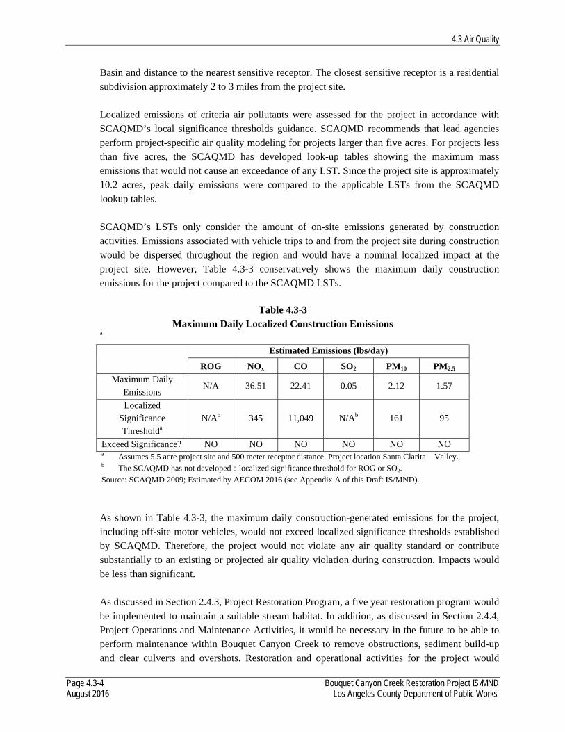
4.3 Air Quality
Page 4.3-4 Bouquet Canyon Creek Restoration Project IS/MND August 2016 Los Angeles County Department of Public Works
Basin and distance to the nearest sensitive receptor. The closest sensitive receptor is a residential subdivision approximately 2 to 3 miles from the project site. Localized emissions of criteria air pollutants were assessed for the project in accordance with SCAQMD’s local significance thresholds guidance. SCAQMD recommends that lead agencies perform project-specific air quality modeling for projects larger than five acres. For projects less than five acres, the SCAQMD has developed look-up tables showing the maximum mass emissions that would not cause an exceedance of any LST. Since the project site is approximately 10.2 acres, peak daily emissions were compared to the applicable LSTs from the SCAQMD lookup tables. SCAQMD’s LSTs only consider the amount of on-site emissions generated by construction activities. Emissions associated with vehicle trips to and from the project site during construction would be dispersed throughout the region and would have a nominal localized impact at the project site. However, Table 4.3-3 conservatively shows the maximum daily construction emissions for the project compared to the SCAQMD LSTs.
a
As shown in Table 4.3-3, the maximum daily construction-generated emissions for the project, including off-site motor vehicles, would not exceed localized significance thresholds established by SCAQMD. Therefore, the project would not violate any air quality standard or contribute substantially to an existing or projected air quality violation during construction. Impacts would be less than significant. As discussed in Section 2.4.3, Project Restoration Program, a five year restoration program would be implemented to maintain a suitable stream habitat. In addition, as discussed in Section 2.4.4, Project Operations and Maintenance Activities, it would be necessary in the future to be able to perform maintenance within Bouquet Canyon Creek to remove obstructions, sediment build-up and clear culverts and overshots. Restoration and operational activities for the project would
Table 4.3-3 Maximum Daily Localized Construction Emissions
Estimated Emissions (lbs/day)
ROG NOx CO SO2 PM10 PM2.5
Maximum Daily Emissions
N/A 36.51 22.41 0.05 2.12 1.57
Localized Significance Thresholda
N/Ab 345 11,049 N/Ab 161 95
Exceed Significance? NO NO NO NO NO NO a Assumes 5.5 acre project site and 500 meter receptor distance. Project location Santa Clarita Valley. b The SCAQMD has not developed a localized significance threshold for ROG or SO2. Source: SCAQMD 2009; Estimated by AECOM 2016 (see Appendix A of this Draft IS/MND).
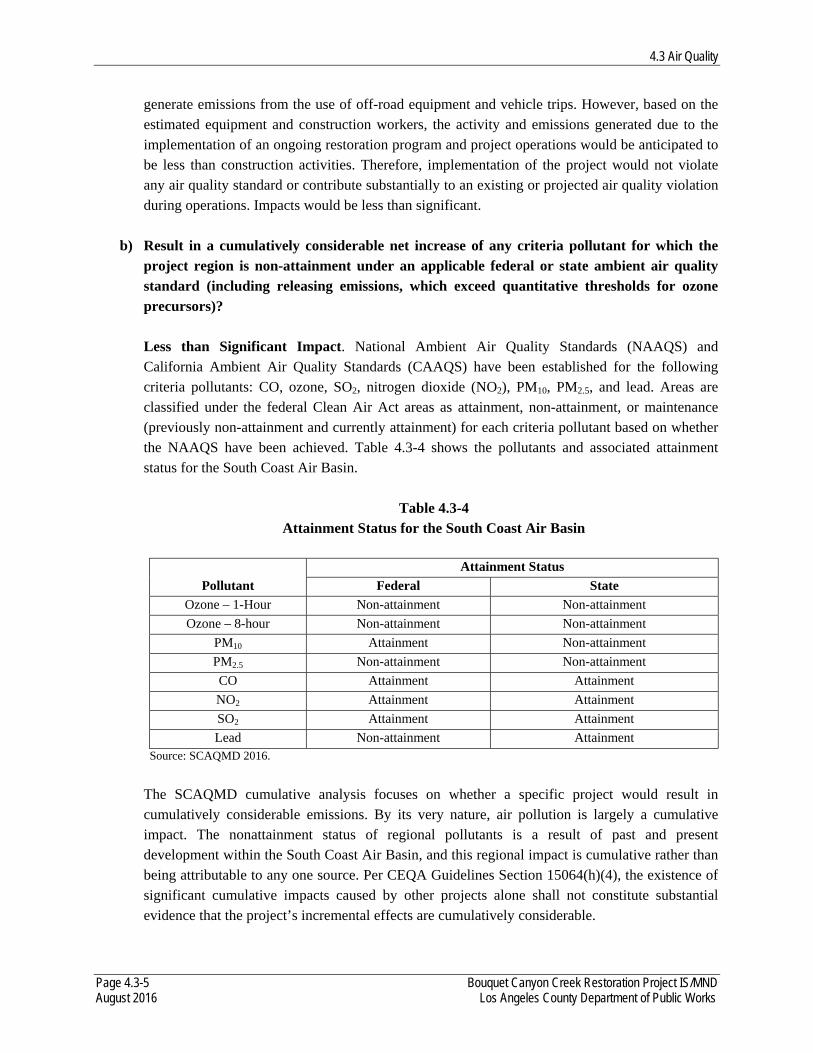
4.3 Air Quality
Page 4.3-5 Bouquet Canyon Creek Restoration Project IS/MND August 2016 Los Angeles County Department of Public Works
generate emissions from the use of off-road equipment and vehicle trips. However, based on the estimated equipment and construction workers, the activity and emissions generated due to the implementation of an ongoing restoration program and project operations would be anticipated to be less than construction activities. Therefore, implementation of the project would not violate any air quality standard or contribute substantially to an existing or projected air quality violation during operations. Impacts would be less than significant.
b) Result in a cumulatively considerable net increase of any criteria pollutant for which the project region is non-attainment under an applicable federal or state ambient air quality standard (including releasing emissions, which exceed quantitative thresholds for ozone precursors)? Less than Significant Impact. National Ambient Air Quality Standards (NAAQS) and California Ambient Air Quality Standards (CAAQS) have been established for the following criteria pollutants: CO, ozone, SO2, nitrogen dioxide (NO2), PM10, PM2.5, and lead. Areas are classified under the federal Clean Air Act areas as attainment, non-attainment, or maintenance (previously non-attainment and currently attainment) for each criteria pollutant based on whether the NAAQS have been achieved. Table 4.3-4 shows the pollutants and associated attainment status for the South Coast Air Basin.
Table 4.3-4 Attainment Status for the South Coast Air Basin
Pollutant
Attainment Status
Federal State
Ozone – 1-Hour Non-attainment Non-attainment
Ozone – 8-hour Non-attainment Non-attainment
PM10 Attainment Non-attainment
PM2.5 Non-attainment Non-attainment
CO Attainment Attainment
NO2 Attainment Attainment
SO2 Attainment Attainment
Lead Non-attainment Attainment Source: SCAQMD 2016.
The SCAQMD cumulative analysis focuses on whether a specific project would result in cumulatively considerable emissions. By its very nature, air pollution is largely a cumulative impact. The nonattainment status of regional pollutants is a result of past and present development within the South Coast Air Basin, and this regional impact is cumulative rather than being attributable to any one source. Per CEQA Guidelines Section 15064(h)(4), the existence of significant cumulative impacts caused by other projects alone shall not constitute substantial evidence that the project’s incremental effects are cumulatively considerable.
4.3 Air Quality
Page 4.3-6 Bouquet Canyon Creek Restoration Project IS/MND August 2016 Los Angeles County Department of Public Works
The SCAQMD thresholds of significance are relevant to whether a project’s individual emissions would result in a cumulatively considerable incremental contribution to the existing cumulative air quality conditions. If a project’s emissions would be less than those threshold levels, the project would not be expected to result in a considerable incremental contribution to the significant cumulative impact. As shown in Table 4.3-2, the construction emissions do not exceed the thresholds of significance for criteria pollutants. Therefore, implementation of the project would not contribute to a cumulatively considerable air quality impact. Impacts would be less than significant.
d) Expose sensitive receptors to substantial pollutant concentrations? Less than Significant Impact. Some members of the population are especially sensitive to air pollutant emissions and should be given special consideration when evaluating air quality impacts from projects. These people include children, older adults, persons with preexisting respiratory or cardiovascular illness, and athletes and others who engage in frequent exercise. Structures that house these persons or places where they gather are defined as sensitive receptors by SCAQMD. According to SCAQMD, sensitive receptors include residences, schools, playgrounds, child care centers, athletic facilities, long-term health care facilities, rehabilitation centers, convalescent centers, and retirement homes. Residential areas are considered sensitive to air pollution because residents (including children and older adults) tend to be at home for extended periods of time, resulting in sustained exposure to any pollutants present. Recreational land uses are considered moderately sensitive to air pollution. Exercise places a high demand on respiratory functions, which can be impaired by air pollution.
The overall character of the surrounding area is open space and recreational forest areas in the ANF. Due to the nature of the location, no sensitive receptors are located within the proximity of the project area. The closest residential subdivision within Santa Clarita is located approximately 2-3 miles south of the Site 1 along Bouquet Canyon Road. Several ranchettes (small ranches or large homes on the outskirts of Santa Clarita, past planned neighborhoods) are located between the residential subdivision and Site 1. The greatest potential for toxic air contaminant (TAC) emissions would be related to diesel particulate matter (diesel PM) emissions associated with heavy-duty construction equipment operations. Health effects from carcinogenic TACs are usually described in terms of individual cancer risk, which is based on a 30-year lifetime exposure to TACs. Construction activities are anticipated to last approximately six months, or approximately 2 percent of the total exposure period used for typical health risk calculations. Heavy-duty construction equipment would only operate intermittently each day during the construction period. Operational emissions will be generated due to the implementation of the ongoing restoration program; however, as stated above, these emissions would be less than those estimated for construction activities.

4.3 Air Quality
Page 4.3-7 Bouquet Canyon Creek Restoration Project IS/MND August 2016 Los Angeles County Department of Public Works
Construction of the project would also not exceed the SCAQMD localized significance thresholds, and unhealthful pollutant concentrations would not be generated. Therefore, implementation of the project would not expose sensitive receptors to substantial construction pollutant concentrations. Impacts would be less than significant.
e) Create objectionable odors affecting a substantial number of people? Less than Significant Impact. The occurrence and severity of odor impacts depend on numerous factors, including the nature, frequency, and intensity of the source; wind speed and direction; and the presence of sensitive receptors. While offensive odors rarely cause any physical harm, they still can be very unpleasant, leading to considerable distress and often generating citizen complaints to local governments and regulatory agencies. Construction activities associated with the project could result in short-term odorous emissions from diesel exhaust associated with construction equipment. Odors from these sources would be localized and generally confined to the immediate area surrounding the project site. The project would utilize typical construction techniques, and the odors would be typical of most construction sites and temporary in nature. Therefore, because of the temporary nature of these emissions, the highly diffusive properties of diesel exhaust, and the remote location of the project site, the implementation of the project would not create objectionable odors affecting a substantial number of people. Impacts would be less than significant.

4.3 Air Quality
Page 4.3-8 Bouquet Canyon Creek Restoration Project IS/MND August 2016 Los Angeles County Department of Public Works
This page intentionally left blank.
4.4 Biological Resources
Page 4.4-1 Bouquet Canyon Creek Restoration Project IS/MND August 2016 Los Angeles County Department of Public Works
4.4 BIOLOGICAL RESOURCES The following information is summarized from Appendix B, Biological Resources Assessment, of this Draft IS/MND.
Would the Project: a) Have a substantial adverse effect, either directly or through habitat modifications, on any species identified as a candidate, sensitive, or special status species in local or regional plans, policies, or regulations, or by the California Department of Fish and Wildlife or U.S. Fish and Wildlife Service?
Less than Significant Impact After Mitigation Incorporated. A discussion of the project effects on any plant and wildlife species identified as candidate, sensitive, or special status species in local or regional plans, policies, or regulations, or by the California Department of Fish and Wildlife (CDFW) and the U.S. Fish and Wildlife Service (USFWS) is provided below.
Special-Status Plant Species No special-status plant species were observed/identified during field surveys of the project site; however, of the 37 known special-status plant species from the Green Valley and adjacent quadrangles, 15 have some potential for occurrence based on presence of suitable riparian habitats and adjacent upland habitats. Species with moderate potential to occur within the project site include Nevin’s barberry, slender mariposa lily, Peirson’s morning-glory, Parry’s spineflower, and slender-horned spineflower. Species with low potential to occur within the project site include California andosace, Catalina mariposa lily, club-haired mariposa lily, Plummer’s mariposa lily, San Fernando Valley spineflower, paniculate tarplant, Palmer’s grapplinghook, Newhall sunflower, short-joint beavertail, and Hubby’s phacelia. Vegetation clearing and sediment removal activities associated with the project has the potential to result in direct significant impacts related to the removal of special-status plants. However, these significant impacts would be avoided and reduced to a less than significant level with the implementation and adherence to the Best Management Practices (BMPs) provided in Section 2.4.5, Best Management Practices, of this Draft IS/MND. Indirect impacts to special-status plant species has the potential to result in the loss of habitat and modification of sensitive natural communities as dust, noise, and stormwater runoff is generated during construction. In addition, during construction, there is the potential to spread noxious and invasive plant species into these communities. The indirect impact to special-status plant species would be significant. However, these significant impacts would be avoided and reduced to a less than significant level with the implementation and adherence to the BMPs provided in Section 2.4.5, Best Management Practices, of this Draft IS/MND.
4.4 Biological Resources
Page 4.4-2 Bouquet Canyon Creek Restoration Project IS/MND August 2016 Los Angeles County Department of Public Works
Special-Status Wildlife Species Of the 39 known special-status wildlife species from the Green Valley and adjacent quadrangles, 16 are known to occur in the project site or have some potential for occurrence based on presence of suitable riparian habitats and adjacent upland habitats. Species observed during field surveys and known to occur in the project site include the unarmored threespine stickleback (UTS), and southern California rufous-crowned sparrow. Species with moderate potential to occur within the project site include two-striped garter snake, rosy boa, Cooper’s hawk, Bell’s sage sparrow, pallid bat, and hoary bat. Species with low potential to occur within the project site include California red-legged frog, silvery legless lizard, coastal whiptail, coast horned lizard, white-tailed kite, coastal California gnatcatcher, Townsend’s big-eared bat and spotted bat. In addition, birds protected by the Migratory Bird Treaty Act (MBTA) and the California Fish and Game Code (CFGC) have the potential to nest on-site or in direct proximity to the project site.
Fish One special-status fish species, UTS, is known to occur within the project limits of Sites 1 through 5. This species has previously been documented in Bouquet Canyon Creek at locations south (downstream) of Site 1, including approximately 0.50 mile south at Texas Canyon Road and 1.8 miles south at Vasquez Canyon Road (CDFW 2016a). It has also been documented further upstream at locations that coincide with Site 1 (culvert under Bouquet Canyon Road at MM 15.89) and Site 5 (culvert at MM 13.06) (SMEA 2012). Additionally, USFWS’ 5-year review of this species summarizes known historical occurrences of this species in Bouquet Canyon Creek (USFWS 2009), including occurrences from reaches of the creek that coincide with the project site. Based on an analysis of stickleback species in Bouquet Canyon Creek by Richmond et al. (2014), few, if any non-hybridized UTS remain in the stream below Bouquet Reservoir. The effort to genetically analyze each individual removed from the stream is not feasible, and as a result, all stickleback species would be removed prior to project implementation, should they be present. Removal of the species would constitute direct impacts to UTS, a federally and state-listed endangered species, and CDFW “Fully Protected” species. UTS populations in Bouquet Canyon Creek fluctuate depending on surface flow in the stream. During surveys conducted in 1998, 2000-2003, and 2005 by San Marino Environmental Associates (SMEA), during periods of adequate surface flows, UTS were abundant in Bouquet Canyon Creek and successfully reproduce in stream reaches below Bouquet Reservoir (SMEA 2005). During higher flows, overbank flow and the creation of shallow pools and alternative small flow channels occur, providing suitable habitat for UTS in both the main channel and overflow areas. When dry conditions persist and limit stream flow, surface flows disappears in the vicinity of the former Zuni Campground, leaving downstream reaches, including Site 1, dry for extended months at a time. UTS survive the most severe drought conditions in upper reaches near the reservoir and recolonize downstream reaches as surface flows improve (USFWS 2009). Surveys for UTS in Bouquet
4.4 Biological Resources
Page 4.4-3 Bouquet Canyon Creek Restoration Project IS/MND August 2016 Los Angeles County Department of Public Works
Canyon Creek have shown that when surface waters are present, the presence of UTS should be expected (SMEA 2005).
While surface flow conditions restrict the temporal distribution of UTS in Bouquet Canyon Creek, the presence or absence of habitat preferred by UTS restricts spatial distribution of the species in the vicinity of the project site. UTS prefer slow-moving or quiet-water sections of freshwater or brackish water stream habitat with protective cover, including dense overhanging riparian vegetation, or in open areas, filamentous algae, rocks, logs, or stream banks, provide sufficient cover. Dense riparian habitat is more prevalent in the vicinity of Sites 2 through 5. However, this reach of the project site is more steep and back-water areas and small pools less prevalent. The stream is much flatter and more open at Site 1; however, the accumulation of sediment in the stream has limited habitat suitability through the project site, leaving many reaches too shallow and generally unsuitable for UTS.
SMEA conducted a survey for UTS on Bouquet Canyon Creek in June 2007 at the former Zuni Campground. A 25-meter (82-foot) reach of the creek was seined and a total of 64 UTS were captured (SMEA 2008). The 2007 survey was conducted during the same time frame (during summer months) that the project is scheduled to be initiated in. Additionally, the 2007 survey was conducted within an area that coincides with the project site. Data on UTS surveys since the 2007 survey is not readily available and/or published, or not representative of the project site. A survey in 2009 by U.S. Geological Survey (USGS) did not detect any UTS, although partially armored UTS were found in upper reaches of the creek (USFWS 2009). Other surveys have been conducted by SMEA in advance of culvert cleanout activities by LACDPW at MM 13.06 and 15.89 in December 2011 (SMEA 2011). During pre-construction surveys at the two culvert sites, approximately 700 UTS at MM 15.89 and 600 UTS at MM 13.06 were captured (SMEA 2012). These surveys were focused on pools at the upstream and/or downstream end of the culverts where UTS had concentrated, and are not necessarily representative of UTS populations across the project site.
To determine an estimate of the number of UTS anticipated to occur within the project site during project implementation, UTS data recorded from the 2007 SMEA survey will be used here as a base population within the project site. As presented above, 64 UTS were collected from an 82-foot reach, resulting in an estimated population density (PD) of 0.78 UTS/foot. Extrapolating this estimate across the length of the project site would result in an estimate of the UTS population in the project site. However, considering that surface flow does not reach downstream to Site 1 during summer months (when the project is anticipated to start), only the lengths of Sites 2 through 5 were used to estimate the UTS population (potential take numbers). Site 6 (Zuni Preserve) will be an off-stream site that currently does not include UTS and as a result this project site is not included in the estimate. The estimated population of UTS within the project site is presented in Table 4.4-1 below.
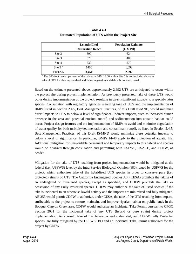
4.4 Biological Resources
Page 4.4-4 Bouquet Canyon Creek Restoration Project IS/MND August 2016 Los Angeles County Department of Public Works
Table 4.4-1
Estimated Population of UTS within the Project Site
Length (L) of Restoration Reach
Population Estimate (L X PD)
Site 2 800 624
Site 3 520 406
Site 4 730 570
Site 5 a 1400 1,092
TOTAL 3,450 2,692 a The 300-foot reach upstream of the culvert at MM 13.06 within Site 5 is not included above as take of UTS for clearing out dead and fallen vegetation and debris is not anticipated.
Based on the estimate presented above, approximately 2,692 UTS are anticipated to occur within the project site during project implementation. As previously presented, take of these UTS would occur during implementation of the project, resulting in direct significant impacts to a special-status species. Consultation with regulatory agencies regarding take of UTS and the implementation of BMPs listed in Section 2.4.5, Best Management Practices, of this Draft IS/MND, would minimize direct impacts to UTS to below a level of significance. Indirect impacts, such as increased human presence in the area and potential erosion, runoff, and sedimentation into aquatic habitat could occur. Project design features and the implementation of BMPs to avoid and minimize degradation of water quality for both turbidity/sedimentation and contaminant runoff, as listed in Section 2.4.5, Best Management Practices, of this Draft IS/MND would minimize these potential impacts to below a level of significance. In particular, BMPs 14-40 apply to the protection of aquatic life. Additional mitigation for unavoidable permanent and temporary impacts to this habitat and species would be finalized through consultation and permitting with USFWS, USACE, and CDFW, as needed. Mitigation for the take of UTS resulting from project implementation would be mitigated at the federal (i.e., USFWS) level by the Intra-Service Biological Opinion (BO) issued by USFWS for the project, which authorizes take of the hybridized UTS species in order to conserve pure (i.e., protected) strains of UTS. The California Endangered Species Act (CESA) prohibits the taking of an endangered or threatened species, except as specified, and CDFW prohibits the take or possession of any Fully Protected species. CDFW may authorize the take of listed species if the take is incidental to an otherwise lawful activity and the impacts are minimized and fully mitigated. AB 353 would permit CDFW to authorize, under CESA, the take of the UTS resulting from impacts attributable to the project to restore, maintain, and improve riparian habitat on public lands in the Bouquet Canyon Creek area. CDFW would authorize an Incidental Take Permit pursuant to CFGC Section 2081 for the incidental take of any UTS (hybrid or pure strain) during project implementation. As a result, take of this federally- and state-listed, and CDFW Fully Protected species, are fully mitigated by the USFWS’ BO and an Incidental Take Permit authorized for the project by CDFW.
4.4 Biological Resources
Page 4.4-5 Bouquet Canyon Creek Restoration Project IS/MND August 2016 Los Angeles County Department of Public Works
Amphibians One special-status amphibian species, California red-legged frog, has potential to occur within the project site. Potentially suitable dense, shrubby or emergent riparian vegetation preferred by this species is present; however, sufficient permanent sources of water are limited within the project site. Although the likelihood of direct impacts to California red-legged frog is considered low, there is the potential this species could be injured or killed during project implementation. Therefore, vegetation and sediment removal activities have the potential to result in direct impacts to this species which would be considered a significant impact. However, with implementing and adhering to the BMPs presented in Section 2.4.5, Best Management Practices, of this Draft IS/MND, direct impacts to California red-legged frog and other amphibians would be reduced to below a level of significance. Additionally, upon completion of restoration activities of the project site, permanent sources of water in the stream would increase, potentially increasing habitat quality for special-status amphibian species.
Reptiles Five special-status reptile species, silvery legless lizard, coastal whiptail, rosy boa, coast horned lizard, and two-striped garter snake, have the potential to occur within the project site due to the presence of suitable habitat. Although the likelihood of direct impacts to individual special-status reptiles is low, there is the potential they could be injured or killed from crushing or trampling during project implementation. Therefore, vegetation and sediment removal activities have the potential to result in direct impacts to these species which would be considered a significant impact. However, by implementing and adhering to the BMPs presented in Section 2.4.5, Best Management Practices, of this Draft IS/MND, direct impacts to these special-status reptiles and other reptile species during project construction would be reduced to below a level of significance. Additionally, upon completion of restoration activities at the project site, riparian and stream habitat conditions would improve, potentially increasing habitat quality for special-status reptiles.
Raptors Two special-status raptor species, Cooper’s hawk and white-tailed kit, have potential to occur within the project site. These species may forage in and near the project site, and Cooper’s hawk has potential to nest in large mature trees in the vicinity of the project site. Large mature trees were identified and mapped during the field survey and will be avoided during project implementation; however, other riparian vegetation that may provide suitable nesting habitat would be removed, resulting in direct impacts to nesting habitat for special-status raptor species which would be considered a significant impact. However, by implementing and adhering to the BMPs presented in Section 2.4.5, Best Management Practices, of this Draft IS/MND, in particular BMP 11, direct impacts to special-status raptors during project implementation would be reduced to below a level of significance.
4.4 Biological Resources
Page 4.4-6 Bouquet Canyon Creek Restoration Project IS/MND August 2016 Los Angeles County Department of Public Works
Construction may cause increased levels of noise, dust, and vibrations resulting in indirect impacts to raptor species if they are present in the vicinity of the project site during construction, causing them to change their behavior and move out of the project area. Such impacts would be considered significant. By conducting pre-construction surveys, monitoring construction during the raptor breeding season, as identified in BMP 11, and implementing and adhering to the other BMPs presented in Section 2.4.5, Best Management Practices, of this Draft IS/MND, indirect impacts to special-status raptor species would be reduced to below a level of significance.
Passerine and Non-Passerine Land Birds Three special-status passerine and non-passerine land bird species including, southern California rufous-crowned sparrow, Bell’s sage sparrow, and coastal California gnatcatcher, are known to occur or have the potential to occur within the project site. Therefore, vegetation removal has the potential to result in direct impacts to these species which would be considered a significant impact. Additionally, construction noise may indirectly impact these species if they are present in the vicinity, causing them to change their behavior and move out of the area; such impacts would be significant. By conducting vegetation removal prior to the bird breeding season (generally considered to be February 15 through September 15) or conducting pre-construction surveys and monitoring construction during the bird breeding season in potentially suitable habitat for these species, as identified in BMP 11, and by implementing and adhering to the other BMPs presented in Section 2.4.5, Best Management Practices, of this Draft IS/MND, indirect impacts to special-status passerine and non-passerine land bird species would be reduced to below a level of significance. Additionally, birds protected by the MBTA and the CFGC have the potential to nest in and near the project site. Riparian trees are present in or near the project site and provide suitable habitat for nesting. Although large, mature trees will not be removed during project implementation, some trees will be removed, resulting in potential direct impacts to nesting birds should vegetation removal during construction occur during the bird nesting season (generally considered to be February 15 through September 15). If vegetation clearance occurs during the nesting bird season, the direct impact to birds protected by the MBTA would be considered significant. By conducting vegetation removal prior to the bird breeding season (generally considered to be February 15 through September 15) or conducting pre-construction surveys and monitoring construction during the bird breeding season in potentially suitable habitat for these species, as identified in BMP 11, and by implementing and adhering to the other BMPs presented in Section 2.4.5, Best Management Practices, of this Draft IS/MND, direct impacts of vegetation removal on nesting birds or their associated habitat would be reduced to below a level of significance. Indirect impacts to nesting birds within the vicinity of the project site could occur during project implementation as a result of noise, dust, increased human presence, and vibrations resulting from construction activities. Disturbances related to vegetation and sediment removal could result in increased nestling mortality due to nest abandonment or decreased feeding frequency which would be considered a significant impact. However, by implementing and adhering to the BMPs presented
4.4 Biological Resources
Page 4.4-7 Bouquet Canyon Creek Restoration Project IS/MND August 2016 Los Angeles County Department of Public Works
in Section 2.4.5, Best Management Practices, of this Draft IS/MND, in particular BMP 11, indirect impacts to nesting birds would be reduced to below a level of significance.
Bats There is a potential for bats to roost within the vicinity of the project site, considering the presence of large, mature, native trees in and adjacent to the project site and foraging opportunities provided by Bouquet Canyon Creek. Suitable structures and caves are absent from the project vicinity; therefore, it is unlikely that colonial roost sites are present. Although large mature trees will not be removed during project implementation, some trees will be removed, resulting in potential direct impacts to special-status bats and their habitat which would be considered significant. By adhering to the BMPs provided in Section 2.4.5, Best Management Practices, of this Draft IS/MND and implementation of Mitigation Measure BIO-1, the direct impacts of vegetation removal on special-status bats or their associated habitat would be reduced to below a level of significance. Indirect impacts to special-status bats roosting within the vicinity of the project site could occur as a result of noise, dust, increased human presence, and vibrations resulting from construction activities. Disturbances related to construction have the potential to result in displacement from daytime roosts which would be considered significant. However, adhering to the BMPs presented in Section 2.4.5, Best Management Practices, of this Draft IS/MND, and implementation of Mitigation Measure BIO-1, indirect impacts of vegetation removal on special-status bats or their associated habitat would be reduced to below a level of significance. Disruption of night-time roosts is not anticipated as construction would not occur during dusk or evening hours. Operation and routine maintenance of the project site would be conducted within a previously-disturbed and active restoration site for approximately five years after implementation of restoration, during the monitoring and maintenance phase required by federal and state permit approvals for impacts to stream and riparian habitats. After the five-year monitoring and maintenance phase is complete, non-emergency or planned work at the project site would be implemented as presented in Section 2.4.4, Project Operations and Maintenance Activities, of this Draft IS/MND, which includes coordination with USFS, USFWS, and CDFW, as necessary. As additionally presented in Section 2.4.4, Project Operations and Maintenance Activities, of this Draft IS/MND, during severe storm situations, runoff and/or mudslides from the adjacent hillsides compounds the sedimentation build-up in Bouquet Canyon Creek and causes the creek to leave its defined creek bed and flow onto Bouquet Canyon Road. During these times, LACDPW would deem this an emergency and would request Regional General Permit (RGP) 63 for Repair and Protection Activities in Emergency Situations from the USACE to proceed with the necessary work on an emergency basis. Declaration of an “emergency” would require USFS concurrence and would entail a separate permitting effort with USACE.
4.4 Biological Resources
Page 4.4-8 Bouquet Canyon Creek Restoration Project IS/MND August 2016 Los Angeles County Department of Public Works
By implementing and adhering to the BMPs presented in Section 2.4.5, Best Management Practices, of this Draft IS/MND, and by obtaining applicable permits from federal and state regulatory agencies when required, operation and routine maintenance of the project site would not result in direct or indirect significant impacts to special-status species or their habitats. Additionally, AB 353, which permits CDFW to authorize the take of UTS during implementation of restoration projects, also permits the take of UTS during flow capacity maintenance activities, with preparation and implementation of an Adaptive Management Plan (AMP). An AMP would satisfy the conservation standard for monitoring the effectiveness of, and adjusting, as necessary, the measures to minimize and fully mitigate the impacts of authorized take of UTS during maintenance activities. As a result, impacts on special-status species and their habitats during operation and maintenance of the project site would be considered less than significant. BIO-1 Prior to the start of construction, a survey for roosting bats or maternity roosts shall be
performed by a qualified biologist at the appropriate time of day to maximize detectability, within seven (7) days of the start of construction for all proposed work areas adjacent to appropriate roosting habitat. The survey shall include areas within 250 feet of the project site that contain suitable roosting habitat. Where physical access to the entire project site is unavailable, alternate, appropriate survey techniques should be used to compensate for limited physical access
If an active roost is found, or survey data provides evidence of an active roost, within 100 feet of a work area, or if a maternity roost is found, or survey data provides evidence of a maternity roost, within 250 feet of a work area, the limits of the work area will be clearly marked and a qualified biologist shall remain on-site during construction activities within the vicinity of the roost or maternity roost. The biologist will ensure that construction activities do not encroach upon the 100-foot buffer around an active roost or 250-foot buffer around a maternity colony site.
b) Have a substantial adverse effect on any riparian habitat or other sensitive natural community identified in local or regional plans, policies, and regulations or by the California Department of Fish and Game or US Fish and Wildlife Service?
Less than Significant Impact After Mitigation Incorporated. Sensitive natural communities are those that are designated as rare in the region by the California Natural Diversity Database (CNDDB) (CDFW 2010), support special-status plant or wildlife species, or receive regulatory protection (i.e., §404 of the CWA and/or the §1600 et seq. of the CFGC). Riparian habitats occurring within the project site are provided in Table 4.4-2 below. Large, mature riparian trees (non-oak trees larger than a 12-inch dbh and oak trees larger than a 6-inch dbh) will not be removed by the project; however, other riparian vegetation would be removed within the project site. Riparian habitats are identified by CDFW as special communities that are either known or believed to be of high priority for inventory in the CNDDB. Furthermore, these sensitive
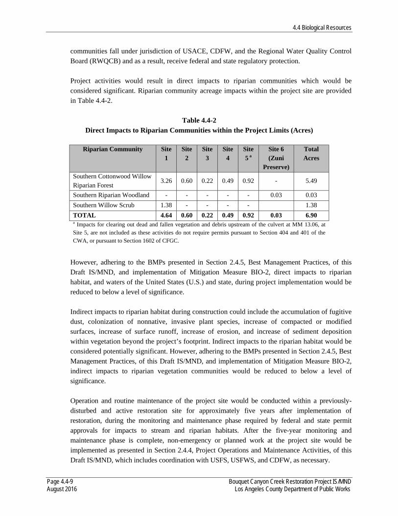
4.4 Biological Resources
Page 4.4-9 Bouquet Canyon Creek Restoration Project IS/MND August 2016 Los Angeles County Department of Public Works
communities fall under jurisdiction of USACE, CDFW, and the Regional Water Quality Control Board (RWQCB) and as a result, receive federal and state regulatory protection. Project activities would result in direct impacts to riparian communities which would be considered significant. Riparian community acreage impacts within the project site are provided in Table 4.4-2.
Table 4.4-2 Direct Impacts to Riparian Communities within the Project Limits (Acres)
Riparian Community Site 1
Site 2
Site 3
Site 4
Site 5 a
Site 6 (Zuni
Preserve)
Total Acres
Southern Cottonwood Willow Riparian Forest
3.26 0.60 0.22 0.49 0.92 - 5.49
Southern Riparian Woodland - - - - - 0.03 0.03
Southern Willow Scrub 1.38 - - - - 1.38
TOTAL 4.64 0.60 0.22 0.49 0.92 0.03 6.90 a Impacts for clearing out dead and fallen vegetation and debris upstream of the culvert at MM 13.06, at Site 5, are not included as these activities do not require permits pursuant to Section 404 and 401 of the CWA, or pursuant to Section 1602 of CFGC.
However, adhering to the BMPs presented in Section 2.4.5, Best Management Practices, of this Draft IS/MND, and implementation of Mitigation Measure BIO-2, direct impacts to riparian habitat, and waters of the United States (U.S.) and state, during project implementation would be reduced to below a level of significance. Indirect impacts to riparian habitat during construction could include the accumulation of fugitive dust, colonization of nonnative, invasive plant species, increase of compacted or modified surfaces, increase of surface runoff, increase of erosion, and increase of sediment deposition within vegetation beyond the project’s footprint. Indirect impacts to the riparian habitat would be considered potentially significant. However, adhering to the BMPs presented in Section 2.4.5, Best Management Practices, of this Draft IS/MND, and implementation of Mitigation Measure BIO-2, indirect impacts to riparian vegetation communities would be reduced to below a level of significance.
Operation and routine maintenance of the project site would be conducted within a previously-disturbed and active restoration site for approximately five years after implementation of restoration, during the monitoring and maintenance phase required by federal and state permit approvals for impacts to stream and riparian habitats. After the five-year monitoring and maintenance phase is complete, non-emergency or planned work at the project site would be implemented as presented in Section 2.4.4, Project Operations and Maintenance Activities, of this Draft IS/MND, which includes coordination with USFS, USFWS, and CDFW, as necessary.
4.4 Biological Resources
Page 4.4-10 Bouquet Canyon Creek Restoration Project IS/MND August 2016 Los Angeles County Department of Public Works
As additionally presented in Section 2.4.4, Project Operations and Maintenance Activities, of this Draft IS/MND, during severe storm situations, runoff and/or mudslides from the adjacent hillsides compounds the sedimentation build-up in Bouquet Canyon Creek and causes the creek to leave its defined creek bed and flow onto Bouquet Canyon Road. During these times, LACDPW would deem this an emergency and would request an RGP 63 permit from the USACE to proceed with the necessary work on an emergency basis. Declaration of an “emergency” would require USFS concurrence and would entail a separate permitting effort with USACE. By implementing and adhering to the BMPs presented in Section 2.4.5, Best Management Practices, of this Draft IS/MND, and by obtaining applicable permits from federal and state regulatory agencies when required, operation and routine maintenance of the project site would not result in direct or indirect impacts to riparian habitats or other sensitive natural communities. As a result, impacts during operation and maintenance of the project site on riparian habitats or sensitive natural communities would be considered less than significant.
BIO-2: The following measures shall be implemented to mitigate impacts to riparian habitat and other aquatic resources.
1. Prior to project construction, LACDPW shall coordinate with the USACE to obtain authorization pursuant to Section 404 of the CWA and the RWQCB to obtain a Water Quality Certification (WQC) pursuant to Section 401 of the CWA. Additionally, LACDPW shall obtain a Lake or Streambed Alteration Agreement (LSAA) from the CDFW pursuant to Section 1600 et seq. of CFGC.
2. The Project Applicant shall implement a project-specific Habitat Mitigation and Monitoring Plan (HMMP) as required by the permit authorizations. The HMMP shall be prepared and approved by the applicable agencies before the commencement of construction. The HMMP shall be prepared and implemented consistent with applicable requirements set for in any applicable regulatory permits (e.g., USACE 2015 Regional Mitigation Guidelines, and the USACE and USEPA 2008 Mitigation Rule). In addition, the HMMP would include the following topics: responsible parties for implementing the HMMP; the timeframe for implementation; methodology for site preparation and planting; procedures for soil and plant salvage (as applicable); the proposed native plant palette, using plant stock of local origin; methods for monitoring and maintaining the site for five years; performance standards used for judging implementation success; remedial measures that would be implemented (should restoration performance standards not be met); and specifies (through either a qualitative or quantitative assessment method) how the functions and values of all the wetland/riparian habitat would be/have been replaced.
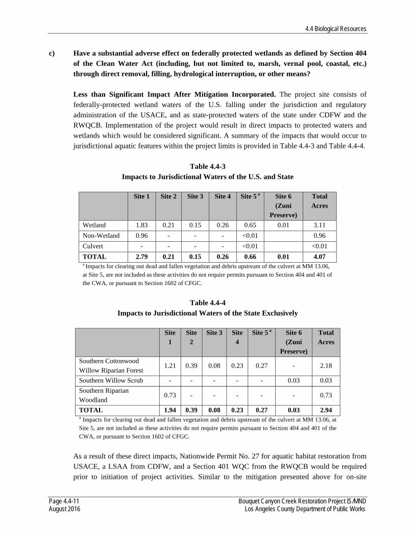
4.4 Biological Resources
Page 4.4-11 Bouquet Canyon Creek Restoration Project IS/MND August 2016 Los Angeles County Department of Public Works
c) Have a substantial adverse effect on federally protected wetlands as defined by Section 404 of the Clean Water Act (including, but not limited to, marsh, vernal pool, coastal, etc.) through direct removal, filling, hydrological interruption, or other means?
Less than Significant Impact After Mitigation Incorporated. The project site consists of federally-protected wetland waters of the U.S. falling under the jurisdiction and regulatory administration of the USACE, and as state-protected waters of the state under CDFW and the RWQCB. Implementation of the project would result in direct impacts to protected waters and wetlands which would be considered significant. A summary of the impacts that would occur to jurisdictional aquatic features within the project limits is provided in Table 4.4-3 and Table 4.4-4.
Table 4.4-3
Impacts to Jurisdictional Waters of the U.S. and State
Site 1 Site 2 Site 3 Site 4 Site 5 a Site 6 (Zuni
Preserve)
Total Acres
Wetland 1.83 0.21 0.15 0.26 0.65 0.01 3.11
Non-Wetland 0.96 - - - <0.01 0.96
Culvert - - - - <0.01 <0.01
TOTAL 2.79 0.21 0.15 0.26 0.66 0.01 4.07 a Impacts for clearing out dead and fallen vegetation and debris upstream of the culvert at MM 13.06, at Site 5, are not included as these activities do not require permits pursuant to Section 404 and 401 of the CWA, or pursuant to Section 1602 of CFGC.
Table 4.4-4
Impacts to Jurisdictional Waters of the State Exclusively
Site 1
Site 2
Site 3 Site 4
Site 5 a Site 6 (Zuni
Preserve)
Total Acres
Southern Cottonwood Willow Riparian Forest
1.21 0.39 0.08 0.23 0.27 - 2.18
Southern Willow Scrub - - - - - 0.03 0.03
Southern Riparian Woodland
0.73 - - - - - 0.73
TOTAL 1.94 0.39 0.08 0.23 0.27 0.03 2.94 a Impacts for clearing out dead and fallen vegetation and debris upstream of the culvert at MM 13.06, at Site 5, are not included as these activities do not require permits pursuant to Section 404 and 401 of the CWA, or pursuant to Section 1602 of CFGC.
As a result of these direct impacts, Nationwide Permit No. 27 for aquatic habitat restoration from USACE, a LSAA from CDFW, and a Section 401 WQC from the RWQCB would be required prior to initiation of project activities. Similar to the mitigation presented above for on-site

4.4 Biological Resources
Page 4.4-12 Bouquet Canyon Creek Restoration Project IS/MND August 2016 Los Angeles County Department of Public Works
riparian habitats (Mitigation Measure BIO-2), impacts to waters of the U.S. and state would require preparation and implementation of a HMMP that would describe on-site restoration of jurisdictional wetlands and waters. Therefore, adhering to the BMPs presented in Section 2.4.5, Best Management Practices, of this Draft IS/MND, and implementation of Mitigation Measure BIO-2, direct impacts to federally- and state-protected waters of the U.S. and state would be reduced to below a level of significance. Indirect impacts could occur to riparian areas present in the survey buffer adjacent to the project site. Indirect impacts could occur from project-related increased human presence in the area and potential erosion, runoff, and sedimentation into aquatic habitat. However, adhering to the BMPs presented in Section 2.4.5, Best Management Practices, of this Draft IS/MND, and implementation of Mitigation Measure BIO-2, indirect impacts to federally- and state-protected waters of the U.S. and state would be reduced to below of level of significance. Operation and routine maintenance of the project site would be conducted within a previously-disturbed and active restoration site for approximately five years after implementation of restoration, during the monitoring and maintenance phase required by federal and state permit approvals for impacts to stream and riparian habitats. After the five-year monitoring and maintenance phase is complete, non-emergency or planned work at the project site would be implemented as presented in Section 2.4.4, Project Operations and Maintenance Activities, of this Draft IS/MND, which includes coordination with USFS, USFWS, and CDFW, as necessary. As additionally presented in Section 2.4.4, Project Operations and Maintenance Activities, of this Draft IS/MND, during severe storm situations, runoff and/or mudslides from the adjacent hillsides compounds the sedimentation build-up in Bouquet Canyon Creek and causes the creek to leave its defined creek bed and flow onto Bouquet Canyon Road. During these times, LACDPW would deem this an emergency and would request an RGP 63 permit from the USACE to proceed with the necessary work on an emergency basis. Declaration of an “emergency” would require USFS concurrence and would entail a separate permitting effort with USACE. By implementing and adhering to the BMPs presented in Section 2.4.5, Best Management Practices, of this Draft IS/MND, and by obtaining applicable permits from federal and state regulatory agencies when required, operation and routine maintenance of the project site would not result in direct or indirect impacts to federally- or state-protected wetlands or other waters. As a result, impacts on federally- and state-protected wetlands or other waters during operation and maintenance of the project site would be considered less than significant.
4.4 Biological Resources
Page 4.4-13 Bouquet Canyon Creek Restoration Project IS/MND August 2016 Los Angeles County Department of Public Works
d) Interfere substantially with the movement of any native resident or migratory fish or wildlife species or with established native resident or migratory wildlife corridors, or impede the use of native wildlife nursery sites?
Less than Significant Impact. The project site represents a small area of the overall riparian corridor along Bouquet Canyon Creek and restoration activities proposed under the project would be temporary in nature. Upon completion, the project would restore stream and riparian habitats and associated functions. Although direct impacts to a wildlife movement corridor would occur upon removal of vegetation, they would be considered significant. Impacts would be temporary in nature and functions of the corridor to facilitate wildlife movement would be restored upon project completion and regrowth of riparian vegetation in restored areas. However, implementing and adhering to the BMPs presented in Section 2.4.5, Best Management Practices, of this Draft IS/MND, direct temporary impacts to wildlife movement would be less than significant. Project construction activities (i.e., increased dust and noise) would likely result in riparian bird species avoiding the immediate vicinity of the project site. Although such indirect effects of construction on wildlife movement would be temporary in nature and restricted to the project construction time period, these impacts would be considered significant. Project construction activities would not occur at dusk or overnight, and are therefore not expected to indirectly affect special-status bat species. The stream/riparian corridor’s function and value as a wildlife movement corridor would be unchanged from current conditions upon project completion. However, implementing and adhering to the BMPs presented in Section 2.4.5, Best Management Practices, of this Draft IS/MND, indirect impacts to wildlife movement would be less than significant. Operation and routine maintenance of the project site would be conducted within a previously-disturbed and active restoration site for approximately five years after implementation of restoration, during the monitoring and maintenance phase required by federal and state permit approvals for impacts to stream and riparian habitats. After the five-year monitoring and maintenance phase is complete, non-emergency or planned work at the project site would be implemented as presented in Section 2.4.4, Project Operations and Maintenance Activities, of this Draft IS/MND, which includes coordination with USFS, USFWS, and CDFW, as necessary. As additionally presented in Section 2.4.4, Project Operations and Maintenance Activities, of this Draft IS/MND, during severe storm situations, runoff and/or mudslides from the adjacent hillsides compounds the sedimentation build-up in Bouquet Canyon Creek and causes the creek to leave its defined creek bed and flow onto Bouquet Canyon Road. During these times, LACDPW would deem this an emergency and would request an RGP 63 permit from the USACE to proceed with the necessary work on an emergency basis. Declaration of an “emergency” would require USFS concurrence and would entail a separate permitting effort with USACE.
4.4 Biological Resources
Page 4.4-14 Bouquet Canyon Creek Restoration Project IS/MND August 2016 Los Angeles County Department of Public Works
Impacts on wildlife movement during operation and maintenance activities would be temporary in nature, restricted to the operation and maintenance time period. By implementing and adhering to the BMPs presented in Section 2.4.5, Best Management Practices, of this Draft IS/MND, and by obtaining applicable permits from federal and state regulatory agencies when required, operation and routine maintenance of the project site would not result in direct or indirect impacts to a wildlife movement corridor. As a result, impacts on a wildlife movement corridor during operation and maintenance of the project site would be less than significant.
e) Conflict with any local policies or ordinances protecting biological resources, such as a tree preservation policy or ordinance?
Less than Significant Impact. No oak trees are proposed for removal under the project. The project site is located in a USFS Special Use Permit Area and since the project is under USFS jurisdiction, LACDPW is required to comply with the USFS Oak Tree Removal Guidance. Should it be determined during implementation that removal of oak trees are required, compliance with USFS mitigation requirements for oak tree removal. Therefore, implementation of the project would not have a substantial adverse effect on local policies or ordinances protecting biological resources, such as a tree preservation policy or ordinance. Impacts would be less than significant. Should the removal of oak trees be required during operation and maintenance of the project site, LACDWP would comply with USFS Oak Tree Removal Guidance. Therefore, implementation of the project would not have a substantial adverse effect on local policies or ordinances protecting biological resources, such as a tree preservation policy or ordinance. Impacts would be less than significant.
f) Conflict with the provisions of an adopted Habitat Conservation Plan, Natural Community Conservation Plan, or other approved local, regional, or state habitat conservation plan?
No Impact. The project is not located within any habitat conservation plan (HCP) or natural community conservation plan (NCCP) (CDFW 2016b, USFWS 2016). Therefore, implementation of the project would not conflict with an adopted HCP, NCCP, or other approved conservation plan. No impact would occur.
4.5 Cultural Resources
Page 4.5-1 Bouquet Canyon Creek Restoration Project IS/MND August 2016 Los Angeles County Department of Public Works
4.5 CULTURAL RESOURCES The following information is summarized from Appendix B, Phase I Cultural Resources Assessment, of this Draft IS/MND.
Would the Project: a) Cause a substantial adverse change in the significance of a historical resource as defined in §15064.5?
Less than Significant Impact. Archival research for the project site was conducted on December 8-9, 2015 at the ANF Supervisors Office and at the South Central Coastal Information Center (SCCIC) housed at the California State University, Fullerton. The research focused on the identification of previously recorded cultural resources within one quarter-mile radius of the project site. The archival research involved review of archaeological site records, historic maps, and historic site and building inventories. The records search revealed that a total of 20 cultural resource investigations were previously conducted within one quarter-mile radius of the project site. Approximately 50 percent of the project site has been previously surveyed (LA-9986, ARR-050100615, ARR-50100800, ARR-50100835, ARR-50100961, ARR-50101132, ARR-0501SA105, ARR-501530031). The records search also indicated that a total of six cultural resources have been previously recorded within one quarter-mile of the study area. These includes three historical can scatters, one expansive mining complex, one mining site with features and artifacts, and one multicomponent site located at the Texas Canyon Fire Station. The prehistoric component included female adolescent remains and a surface scatter of prehistoric artifacts. The historic component of the site consists of Civilian Conservation Corps (CCC) camp #132. In addition, the archaeological survey identified two historic aged culverts which have been evaluated as part of this cultural resource assessment. Recorded as MAB20160208-1, the first resource consists of a multiple pipe culvert built by the Los Angeles County Flood Control District in 1964. This culvert has two, 5-foot diameter, corrugated metal pipes which extend northwest to southeast under Bouquet Canyon Road near MM 15.89 (Site 1), allowing Bouquet Canyon Creek to flow beneath the road. A multiple course concrete and local stone wall stands on the east side of the road encasing the culvert pipes. A Los Angeles County Flood Control District metal seal stamped with the 1964 date is embedded in the center top of the wall. The western side of the culvert also appears to have a wall portion associated with the lower segment of the feature but a standing wall does not currently exist. The second resource, recorded as MAB20160208-2, is a multiple pipe culvert located at the northern extent of the Site 5 area of potential effect (APE). Built in close proximity to MM 13.06, this culvert contains two corrugated metal pipes which extend parallel east to west underneath Bouquet Canyon Road, terminating on either side of the road, and one corrugated metal pipe which extends southward under the ground surface on
4.5 Cultural Resources
Page 4.5-2 Bouquet Canyon Creek Restoration Project IS/MND August 2016 Los Angeles County Department of Public Works
the east side of the road for an undetermined distance. The pipes are 5 feet in diameter and are of similar construction to those noted in MAB20160208-1. Both MAB20160208-1 and MAB20160208-2 are associated with water retrieval and conveyance systems of the 20th century. The Bouquet Reservoir, which occasionally feeds Bouquet Canyon Creek where these culverts are located, was built 1933 in response to the St. Francis Dam disaster of 1928. However, these culverts were constructed in 1964, well after the period of significance for the Bouquet Reservoir. Additionally, these culverts do not appear to have played a significant individual role in local, state, or national history individually because they are representative of such structures built throughout California in the 20th century. These culverts do not meet the National Register of Historic Places (NRHP) Criterion A or the California Register of Historic Resources (CRHR) Criterion 1. Research has not revealed a direct association with any locally or nationally important individuals involved with the construction or design of the features. These culverts have no direct association with important historic persons and, thus, do not meet NRHP Criterion A or CRHR Criterion 2. Both MAB20160208-1 and MAB20160208-2 are multiple pipe culverts encased in multiple course, concrete and local stone retaining walls, common structures throughout California. They were likely designed and constructed by the Los Angeles Flood Control District but they have no known associations with individual engineers and do not represent the work of a master. These structures do not possess high artistic values because they consist of basic multiple pipe culverts designed for function and utility and not for aesthetic quality. In summary, MAB20160208-1 and MAB20160208-2 do not have distinctive engineering or architectural features to meet NRHP Criterion C or CRHR Criterion 3. MAB20160208-1 and MAB20160208-2 were built specifically for the purpose of allowing water from Bouquet Canyon Creek to flow beneath Bouquet Canyon Road. These structures are not likely to yield further information important to history or prehistory. Therefore, these culverts do not meet NRHP Criterion D or CRHR Criterion 4. Although these structures do not appear eligible for the NRHP or the CRHR under any criterion, MAB20160208-1 and MAB20160208-2 retain integrity of location, design, materials, workmanship, and setting. These culverts are in their original locations and retain their functionality. Additionally, the design of MAB20160208-1 and MAB20160208-2 has not been substantially altered. Integrity of workmanship is also considered retained because the structures have not been altered with modern construction methods. In summary, although MAB20160208-1 and MAB20160208-2 retain integrity, these culverts do not meet any NRHP or CRHR criteria for designation and do not appear to be eligible for the NRHP or CRHR. Therefore, implementation of the project would not cause a substantial adverse change in the significance of a historical resource as defined in§15064.5. Impacts would be less than significant.
4.5 Cultural Resources
Page 4.5-3 Bouquet Canyon Creek Restoration Project IS/MND August 2016 Los Angeles County Department of Public Works
b) Cause a substantial adverse change in the significance of an archaeological resource pursuant to §15064.5?
Less than Significant Impact After Mitigation Incorporated. The project may result in impacts to one archaeological resource, the Del Sur Mining Complex (FS-05-01-53-00276/ CA-LAN-3299), located within the APE and has potential to impact additional cultural resource identified in the project vicinity, as defined in §15064.5. The records search conducted on December 8-9, 2016 at the SCCIC indicated that a total of six cultural resources have been previously recorded within one quarter mile of the study area. One of these resources (FS-05-01-53-00276/CA-LAN-3299), a dispersed scatter of mining activity from the early 1900s, extends into Site 4 and Site 5 of the APE. Additionally, historic sites are located in close proximity to Site 1 of the APE. The rapid deposition of sediment in this segment of the project suggests that portions of these sites may be encountered within the APE in the course of ground disturbing activities. Further, the location of Site 6 (Zuni Preserve) is adjacent to a known site which contains one prehistoric burial (FS-05-01-53-00024/CA-LAN-426). Site 6 is situated in a topographic environment similar to the location where the burial was recovered and warrants additional consideration in developing mitigation measures for this project. Site 4 and Site 5 of the APE overlap with the boundary of the Del Sur Mining Complex, however, this resource was not observed within the project site during the course of the survey. The Del Sur Mining Complex was originally recorded by Compass Rose Archaeological, Inc. in 2002 as the Del Sur Ridge Steatite Quarry, a moderately sized mining operation situated along the top of Del Sur ridge located far outside of the study area. The site measured 800 meters southwest-northeast by 400 meters northwest-southeast and consisted of a series of road cuts and terraces created in the removal of talc schist, steatite, and serpentine from the Pelona Schist formation. In 2006, the site was revisited by archaeologists with ECORP. At this time it was discovered that the site map and sketch map from the original record were drawn at two different scales and the site was remapped and updated. The new site dimensions were 120 meters southwest-northeast by 80 meters northwest-southeast. In 2008, the site was visited again by Compass Rose Archaeological, Inc. as part of the Tehachapi Renewable Transmission Project. Additional field surveys after area brush fires and further review of historic and contemporary maps, documents, and aerial photographs resulted in the identification of multiple excavations and terraces associated within mining across the eastern face of the Del Sur Ridge. The updated site record states that “these surface expressions are not continuous across the slopes of Bouquet Canyon and Del Sur Ridge but occur with frequency and regularity on the various accessible rock faces along a somewhat contiguous landform” (Schmidt and Schmidt 2008). Current site dimensions for this complex of mining locals is 5,500 meters southwest-northeast by 1,850 meters northwest-southeast with Bouquet Canyon Creek forming the southeast boundary of the site. The Del Sur Mining Complex was evaluated for eligibility for listing on the NRHP and CRHR in 2008 by Wendy Tinsley with Urbana Preservation and Planning. It was determined that the Del Sur Mining complex is not eligible for in inclusion on these lists because it did not demonstrate
4.5 Cultural Resources
Page 4.5-4 Bouquet Canyon Creek Restoration Project IS/MND August 2016 Los Angeles County Department of Public Works
sufficient importance under Criterion A (NRHP) or Criterion 1 (CRHR) as no physical evidence, such as building or structure, of this resource being associated with important mining events in Los Angeles County currently exists. Additionally, the site is not considered eligible under Criterion B (NRHP) or Criterion 2 (CRHR) because no information was identified to connect the complex to an important historical figure. There are no standing architectural features so the site lacks integrity and does not exemplify innovative design of a significant method of construction nor a bold engineering achievement indicating that the complex not eligible under Criterion C (NRHP) or Criterion 3 (CRHP). It was also determined that the site would not yield additional information that would provide data about the past indicating that the resource is not eligible under Criterion D (NRHP) or Criterion 4 (CRHR). No further evaluation of this resource is required. The impact to historical resources as defined in §15064.5 would be less than significant. In the immediate vicinity of Site 1 of the APE two previously recorded historical archaeological sites (FS-05-01-53-00216/CA-LAN-3082 and FS-05-01-53-00368) have been identified which exhibit the potential to extend into the work area. Site FS-05-01-53-00216/CA-LAN-3082, also known as the Bouquet Canyon Placers site, was originally recorded in 2001 by an ANF archaeologist (Vance 2001). The site is located in a southeast trending drainage which terminates at Bouquet Canyon Road about 30 meters west from the southern extent of work Site 1. The site measures approximately 450 meters northwest-southeast by 300 meters northeast-southeast and consists of approximately 15 placer pits, a small adit, four possible structure foundations, a linear rock wall feature, at least three large berms, historical artifact concentrations and a diffuse scatter of historical debris including cans and bottles. In December 2004 and January 2005, road repair activities in the canyon directly impacted the site, removing a large amount of soil which contained historical refuse. The site is interpreted to be a small scale mining operation and historical camp. The associated artifacts indicate a range of site use between the 1930s to the 1960s while land patent records indicate that people have been using the vicinity since the late 19th century. Recorded in 2009 by ANF archaeologists, site FS-05-01-53-00368, known as the Beavertail Cactus Historic Site, is located approximately 900-feet north of the Bouquet Canyon Placers site. This historical site measures 623-feet east-west by 98-feet north-south and consists of a small can scatter and associate glass fragments located in the northern portion of a southeast trending drainage which terminates in Bouquet Canyon Creek near the center of Site 1. The eastern extent of the site appears to be located approximately 17 meters from the APE. The artifacts consist predominantly of beer cans which date from 1935 to the 1950s. A known CCC camp (CA-LAN-426) was located one mile north from 1935 to 1937. In addition, Bouquet Canyon Road was initially constructed in 1915 to allow easier access for recreation activities. This site likely represents recreation activities related to CCC camp inhabitants or to general recreational activities related to forest visitors in the first half of the 20th century. To date, these sites have not been subject to subsurface testing and have not been evaluated for eligibility for the NRHP or the CRHR. Because these resources have not been evaluated they
4.5 Cultural Resources
Page 4.5-5 Bouquet Canyon Creek Restoration Project IS/MND August 2016 Los Angeles County Department of Public Works
should be treated as potentially eligible for nomination and any possible impacts to these sites should be avoided or mitigated. The location of these resources on moving alluvial deposits suggest that portions of these sites may be buried and have potential to extend into the project APE. Located approximately 600-feet northeast from the Site 6 (Zuni Preserve) APE boundary, site FS-05-01-53-00024/CA-LAN-426 consists of a prehistoric burial with associated artifacts and CCC camp 132. This site was originally identified some time prior to encountering the burial when USFS workers found a sandstone pestle in the course of trenching activities at the Texas Canyon Station. In 1965, additional construction activities led to the identification of a burial approximately 5 feet below current ground surface and about 200 feet from the pestle that was first observed at the site. The interment was that of a child, estimated to be around six years old. The body had been placed in a tightly flexed position lying on its right side with the head facing to the northwest. No artifacts were found in direct association with the burial although some of the sediment was screened. This site was determined to be a temporary seed gathering local, which had been heavily disturbed by historic use and subsequent construction. The site record was updated in 1976 to transfer the information about the site to an appropriate recording form. No additional work was conducted on the site at this time. In 2000 the site was revisited for evaluation by ANF archaeologists. A survey of the property identified one previously unrecorded schist milling slab and one quartz core. Additionally, an old stone shed and a green glass coke bottle were identified on site and are thought to be associated with the CCC occupation of the area between 1935 and 1937. The site was formally excavated on January 9-11, 2006 to evaluate potential impacts to cultural resources for a proposed trenchline at the Texas Canyon Fire Station. Three units were excavated to two sterile levels; each unit was terminated at 70 centimeters (cm) below ground surface. Historical archaeological materials were identified including nails and glass fragments. No prehistoric materials were observed. In addition to this known prehistoric cultural resource located in close proximity to the project are, the APE contains natural resources that are significant to Native American traditional lifeways. Two large stands of Juncus have been identified in Site 4 and Site 5 of the APE. Juncus has traditionally been used to weave basketry by many southern California Tribes. These plant communities were often the property of individual families or communities who would practice horticultural strategies to maintain the amount and quality of these resources (Timbrook 2008, Anderson 1999, Farmer 2010). Ground disturbing activities in the APE are anticipated to occur in Sites 1 through 6. These activities have the potential to encounter and disturb cultural resources in the project vicinity. Therefore, if any portion of the above discussed sites exists within the project site, the project has the potential to result in the physical alteration of said sites. Under Public Resources Code §5024(f), the project may adversely affect archaeological resources that have not been evaluated for eligibility to the NRHP or CRHR, treated as potentially eligible, which would result in an
4.5 Cultural Resources
Page 4.5-6 Bouquet Canyon Creek Restoration Project IS/MND August 2016 Los Angeles County Department of Public Works
adverse impact under CEQA. However, it is anticipated that the remainder of the project site, outside of any trenching associated with the project, will remain undisturbed. The project has potential to adversely affect FS-05-01-53-00276/ CA-LAN-3299 but this site has been previously been determined not eligible for listing on the NRHP or the CRHR and these possible impacts do not require mitigation. However, sites FS-05-01-53-00216/CA-LAN-3082, FS-05-01-53-00368, and FS-05-01-53-00024/CA-LAN-426 have not previously been evaluated and should be treated as potentially eligible for listing. Although these sites are currently identified outside of the APE the shifting nature of the geology in the surrounding area may have potentially moved or buried archaeological deposits. In addition, sites may be buried without any surface indications within the APE. To mitigate potential impacts to the three above mentioned sites, mitigation measures CUL-1 through CUL-2 are provided. Therefore, with implementation of these mitigation measures, potentially significant impacts on archaeological resources pursuant to §15064.5 would be reduced to below a level of significance. CUL-1 Because the potential to encounter archaeological resources exists for this
project, full-time archaeological monitoring is recommended during initial ground-disturbing activities in undisturbed native soils, including sediment removal, channel excavation and pond excavation, and, if necessary, vegetation removal and mastication. This monitoring should be done by, or under the direction of, an archaeologist who meets Secretary of the Interior Standards. The archaeological monitor would have the authority to redirect construction equipment in the event that potential archaeological resources are encountered. If archaeological resources are encountered, work in the vicinity of the discovery will halt until appropriate treatment or further investigation of the resource is determined by a qualified archaeologist in accordance with the provisions of Section 106 of the National Historic Preservation Act and CEQA Guidelines Section 15064.5. If the qualified archaeologist determines during the course of excavations that there is a low sensitivity for cultural remains, monitoring in that area may be reduced or eliminated.
CUL-2 Native Americans contacted for this study indicate a cultural sensitivity for the
APE. In addition, human remains, which may be Native American in origin, were discovered on a previous project within 0.25 mile of the APE. If any Native American cultural material is encountered within the project site, consultation with interested Native American parties will be conducted to apprise them of any such findings and solicit any comments they may have regarding appropriate treatment and disposition of the resources.
4.5 Cultural Resources
Page 4.5-7 Bouquet Canyon Creek Restoration Project IS/MND August 2016 Los Angeles County Department of Public Works
c) Directly or indirectly destroy a unique paleontological resource or site or unique geologic feature?
Less than Significant Impact After Mitigation Incorporated. It is not anticipated that paleontological resources would be discovered during ground-disturbing activities since such activities would occur within an active streambed filled with sediment from fire disasters within the past ten years and excavation work would occur at shallow depths (i.e., 1 to 3 feet). Thus, it is anticipated that ground disturbance would occur in previously disturbed sediment (buildup from recent fires) and be limited to deposits of younger Quaternary alluvium, which is too young to typically contain significant fossil deposits. Also, during operation, the project would not involve any ground-disturbing activities; thus, no paleontological resources would be encountered or impacted. However, in the unlikely event that fossils are encountered during construction, mitigation measure CUL-3 is provided to reduce potential impacts. Therefore, with implementation of mitigation measure CUL-3, potential impacts related to paleontological resources would be reduced to a less-than-significant level. CUL-3 In the event any paleontological resources are encountered during earthmoving
activities, the construction contractor shall cease activity in the affected area until the discovery can be evaluated by a qualified paleontological resources specialist
in accordance with the provisions of CEQA §15064.5.
d) Disturb any human remains, including those interred outside of formal cemeteries?
Less than Significant Impact After Mitigation Incorporated. The records search indicated that no previously-recorded formal cemeteries are located within a one quarter-mile radius of the project area. Although a Native American burial was found at site FS-05-01-53-00024/CA-LAN-426 in 1965, approximately 600 feet northeast from the APE. The site was excavated in 2000 to determine if additional subsurface deposits were present. No evidence of prehistoric material was observed. However, these excavations only extended to 70 cm below surface but the burial was encountered about 5 feet (152 cm) below ground surface. No formal cemeteries or other places of human internment are known to exist in the project site itself and no surface evidence of human remains were observed during the cultural resource survey. A lack of surface evidence and the fact that human remains have not been encountered in the area since the 1965, however, does not preclude the possibility that unknown and unanticipated human remains may be encountered within the project site. With the implementation of mitigation measure CUL-4, potential impacts to human remains would be reduced to a less-than- significant level.
CUL-4 Native American burials are often unmarked and can be disturbed during earth
moving activities. As the activities proposed within the APE are in a restricted location, avoidance of burials is difficult if not impossible. In the event human
4.5 Cultural Resources
Page 4.5-8 Bouquet Canyon Creek Restoration Project IS/MND August 2016 Los Angeles County Department of Public Works
remains are encountered during construction activities, all excavation or disturbance in the area within the vicinity of the remains shall halt in accordance with Health and Safety Code §7050.5, Public Resources Code §§5097.98 and 5097.94, and §15064.5 of the CEQA Guidelines and the Los Angeles County Coroner shall be contacted. Within 24 hours of notification, the coroner will call the Native American Heritage Commission if the remains are thought to be Native American. If the remains are deemed Native American in origin, the Native American Heritage Commission will immediately designate a person or persons it believes to be the most likely descended from the deceased (MLD) under Public Resources Code §5097.98. The MLD will then recommend means for treating and disposing with appropriate dignity the human remains and associated items, within 48 hours pursuant to Public Resources Code §5097.98 and California Code of Regulations §15064.5.
4.6 Geology and Soils
Page 4.6-1 Bouquet Canyon Creek Restoration Project IS/MND August 2016 Los Angeles County Department of Public Works
4.6 GEOLOGY AND SOILS Would the Project:
a) Expose people or structures to potential substantial adverse effects, including the risk of loss, injury, or death involving: i) Rupture of a known earthquake fault, as delineated on the most recent Alquist-
Priolo Earthquake Fault Zoning Map issued by the state geologist for the area or based on other substantial evidence of a known fault? Refer to Division of Mines and Geology Special Publication 42.
No Impact. As with most of southern California, the project site is located in a seismically active region and has the potential to be subjected to ground shaking hazards associated with earthquake events on active faults throughout the region. However, the project site is not located within an Alquist-Priolo Earthquake Fault Zone (Los Angeles County Department of Regional Planning 2014). The closest fault is the Pelona Fault, located less than 0.05 mile north of the Zuni Preserve) (Google Earth Pro 2016). However, the Pelona Fault is not an active fault and is not delineated on the most recent Alquist-Priolo Earthquake Fault Zoning Map (California Department of Conservation 1977, Los Angeles County Department of Regional Planning 2014c). Furthermore, the project does not include any habitable structures; the project consists of restoration of riparian habitat within Bouquet Canyon Creek and the creation of a fish preserve. Therefore, implementation of the project would not expose people or structures to potential substantial adverse effects, including the risk of loss, injury, or death involving the rupture of a known earthquake fault. No impact would occur.
ii) Strong seismic ground shaking? No Impact. The project site is located within the seismically active Southern California region. As such, the project could experience effects of ground shaking resulting from activity on southern California fault systems. However, as discussed in the response to Section 4.6, Question (a)(i) above, the project would is not located within an Alquist-Priolo Earthquake Fault Zone nor would it involve building new habitable structures. Therefore, implementation of the project would not expose people or structures to potential substantial adverse effects, including the risk of loss, injury, or death involving strong seismic ground shaking. No impact would occur.
iii) Seismic-related ground failure, including liquefaction? No Impact. The project site is located in an area identified as being susceptible to seismically induced liquefaction (California Department of Conservation 1999, Los Angeles County Department of Regional Planning 2014c). However, the project does not include building any new habitable structures; the project consists of restoration of riparian habitat within Bouquet
4.6 Geology and Soils
Page 4.6-2 Bouquet Canyon Creek Restoration Project IS/MND August 2016 Los Angeles County Department of Public Works
Canyon Creek and the creation of a fish preserve. Furthermore, the project would be constructed in accordance with the most current versions of all applicable federal, state, and local codes. Therefore, implementation of the project would not expose people or structures to potential substantial adverse effects, including the risk of loss, injury, or death involving seismic-related ground failure, including liquefaction. No impact would occur.
iv) Landslides? No Impact. The project site is located within an area identified as having potential for seismically induced landslides (California Department of Conservation 1999, Los Angeles County Department of Regional Planning 2014c). However, the project does not include building any new habitable structures; the project consists of restoration of riparian habitat within Bouquet Canyon Creek and the creation of a fish preserve. Furthermore, the project would be constructed in accordance with the most current versions of all applicable federal, state, and local codes. Therefore, implementation of the project would not expose people or structures to potential substantial adverse effects, including the risk of loss, injury, or death involving landslides. No impact would occur.
b) Result in substantial soil erosion or the loss of topsoil?
Less than Significant Impact. Preparation and implementation of a Stormwater Pollution Prevention Plan (SWPPP) and BMPs, as discussed in Section 4.9, Hydrology and Water Quality, during project construction and operation would minimize soil erosion and loss of topsoil. Refer to Section 2.4.5, Best Management Practices, for a full listing of the BMPs that the project would incorporate during construction and operation. Therefore, implementation of the project in conjunction with implementation of a SWPPP and BMPs would not result in substantial soil erosion or the loss of topsoil. Impacts would be less than significant.
c) Be located on a geological unit or soil that is unstable, or that would become unstable as a result of the project, and potentially result in on- or off-site landslide, lateral spreading, subsidence, liquefaction, or collapse?
Less than Significant Impact. Soils at the project site consist of: Lodo-Modesto families complex, 30 to 70 percent slopes; Exchequer family, 3- to 60 percent slopes; Modesto, moderately deep-Trigo families, 25 to 75 percent slopes; and, Cortina sandy loam, 2 to 9 percent slopes (USDA 2016). As discussed above in Section 4.6, Questions (a)(iii) and (a)(iv), the project site is located in an area susceptible to seismically induced liquefaction and landslides. However, the project does not include building any new habitable structures; the project consists of restoration of riparian habitat within Bouquet Canyon Creek and the creation of a fish preserve.). Furthermore, the project would be constructed in accordance with the most current versions of all applicable federal, state, and local codes. Therefore, implementation of the project would not
4.6 Geology and Soils
Page 4.6-3 Bouquet Canyon Creek Restoration Project IS/MND August 2016 Los Angeles County Department of Public Works
result in on- or off-site landslide, lateral spreading, subsidence, liquefaction, or collapse related to being located on a geological unit or soil that is unstable. Impacts would be less than significant.
d) Be located on expansive soil, as defined in Table 18-1-B of the Uniform Building Code (1994), creating substantial risks to life or property?
Less than Significant Impact. Expansive soils are clay-based soils that tend to expand (increase in volume) as they absorb water and shrink (lessen in volume) as water is drawn away. The hazard associated with expansive soils lie in the structural damage that may occur when buildings are placed on these soils. Expansive soils are often present in liquefaction zones due to the high level of groundwater typically associated with liquefiable soils. As discussed in the response to Section 4.6, Question (a)(iii) above, the project site is located in an area identified as being at risk for liquefaction. However, the project would be constructed in accordance with the most current versions of all applicable federal, state, and local codes. Furthermore, the project would not build any new habitable structures; project consists of restoration of riparian habitat within Bouquet Canyon Creek and the creation of a fish preserve. Therefore, implementation of the project would not create substantial risks to life or property related to being located on expansive soils. Impacts would be less than significant.
e) Have soils incapable of adequately supporting the use of septic tanks or alternative wastewater disposal systems where sewers are not available for the disposal of wastewater?
No Impact. As mentioned above in Section 4.6, Question (a), the project consists of restoration of in-stream and riparian habitat by reestablishing creek flows along sections of Bouquet Canyon Creek, along with the creation of a fish preserve. No septic tanks or alternative wastewater disposal systems are proposed as part of the project. Therefore, the use of septic tanks or alternative wastewater disposal systems would not apply to the project. No impact would occur.
4.7 Greenhouse Gas Emissions
Page 4.7-1 Bouquet Canyon Creek Restoration Project IS/MND August 2016 Los Angeles County Department of Public Works
4.7 GREENHOUSE GAS EMISSIONS Would the Project: a) Generate greenhouse gas emissions, either directly or indirectly, that may have a significant
impact on the environment?
Less than Significant Impact. Certain gases in the earth’s atmosphere, classified as greenhouse gases (GHG), play a critical role in determining the earth’s surface temperature. A portion of the solar radiation that enters earth’s atmosphere is absorbed by the earth’s surface, and a smaller portion of this radiation is reflected back toward space. Infrared radiation is absorbed by GHGs; as a result, infrared radiation released from the earth that otherwise would have escaped back into space is instead “trapped,” resulting in a warming of the atmosphere. This phenomenon, known as the “greenhouse effect,” is responsible for maintaining a habitable climate on Earth.
GHGs are present in the atmosphere naturally, are released by natural sources and anthropogenic sources, and are formed from secondary reactions taking place in the atmosphere. The following are GHGs that are widely accepted as the principal contributors to human-induced global climate change that are relevant to the project:
Carbon dioxide (CO2)
Methane (CH4)
Nitrous oxide (N2O)
Emissions of CO2 are byproducts of fossil fuel combustion. CH4 is the main component of natural gas and is associated with agricultural practices and landfills. N2O is a colorless GHG that results from industrial processes, vehicle emissions, and agricultural practices. Global warming potential (GWP) is a concept developed to compare the ability of each GHG to trap heat in the atmosphere relative to CO2. The GWP of a GHG is based on several factors, including the relative effectiveness of a gas to absorb infrared radiation and length of time (i.e., lifetime) that the gas remains in the atmosphere (“atmospheric lifetime”). The reference gas for GWP is CO2; therefore, CO2 has a GWP of 1. The other main GHGs that have been attributed to human activity include CH4, which has a GWP of 28, and N2O, which has a GWP of 265 (IPCC 2013). For example, 1 ton of CH4 has the same contribution to the greenhouse effect as approximately 28 tons of CO2. GHGs with lower emissions rates than CO2 may still contribute to climate change, because they are more effective at absorbing outgoing infrared radiation than CO2 (i.e., high GWP). The concept of CO2-equivalents (CO2e) is used to account for the different GWP potentials of GHGs to absorb infrared radiation. Off-road equipment, materials transport, and worker commutes during construction of the project would generate GHG emissions. Total project construction GHG emissions were estimated using
4.7 Greenhouse Gas Emissions
Page 4.7-2 Bouquet Canyon Creek Restoration Project IS/MND August 2016 Los Angeles County Department of Public Works
the methodology discussed earlier under Section 4.3, Air Quality. As shown in Table 4.7-1, total project emissions would be approximately 150 metric tons of CO2e. According to SCAQMD, construction emissions should be amortized over 30 years. When this total is amortized over the 30-year life of the project, annual construction emissions would be approximately 5 metric tons (MT) CO2e per year. The SCAQMD has adopted a significance threshold of 10,000 MT of CO2 per year for industrial (stationary source) projects (SCAQMD 2009). The GHG CEQA Significance Threshold Stakeholder Working Group recommended options for evaluating non-industrial projects, including thresholds for residential, commercial, and mixed use projects (SCAQMD 2009). These draft thresholds released by the SCAQMD include a threshold of 3,500 MT CO2e per year for residential projects, 1,400 MT CO2e per year for commercial projects, and 3,000 MT CO2e per year for mixed use projects. SCAQMD has not adopted thresholds of significance for other industrial projects or for residential, commercial, or mixed use projects. The amortized emissions or the total GHG emissions for the project would not exceed any of the adopted or recommended thresholds of significance. Therefore, implementation of the project would not generate GHG emissions, either directly or indirectly, that may have a significant impact on the environment. Impacts would be less than significant.
b) Conflict with an applicable plan, policy, or regulation adopted for the purpose of reducing the emissions of greenhouse gases?
Less than Significant Impact. In 2006, California passed the California Global Warming Solutions Act of 2006 (Assembly Bill [AB] 32; California Health and Safety Code Division 25.5, Sections 38500, et seq.). AB 32 establishes regulatory, reporting, and market mechanisms to achieve quantifiable reductions in GHG emissions and establishes a cap on statewide GHG emissions. It requires that statewide GHG emissions be reduced to 1990 levels by 2020 In December 2008, CARB adopted its Climate Change Scoping Plan (Scoping Plan), which contains the main strategies California will implement to achieve the required GHG reductions required by AB 32 (CARB 2008). The Scoping Plan also includes CARB-recommended GHG reductions for each emissions sector of California’s GHG inventory. CARB further acknowledges that decisions about how land is used will have large impacts on the GHG emissions that will result from the transportation, housing, industry, forestry, water, agriculture, electricity, and natural gas emissions sectors. CARB is required to update the Scoping Plan at least once every 5 years to evaluate progress and develop future inventories that may guide this process. CARB approved the first update to the Climate Change Scoping Plan: Building on the Framework in June 2014 (CARB 2014). The Scoping Plan update includes a status of the 2008 Scoping Plan measures and other federal, state, and local efforts to reduce GHG emissions in California, and potential actions to further reduce GHG emissions by 2020.
4.7 Greenhouse Gas Emissions
Page 4.7-3 Bouquet Canyon Creek Restoration Project IS/MND August 2016 Los Angeles County Department of Public Works
None of the measures listed in CARB’s Scoping Plan directly relate to construction activity. While the Scoping Plan does include some measures that would indirectly address GHG emissions levels associated with construction activity, including the phasing in of cleaner technology for diesel engine fleets (including construction equipment) and the development of a Low Carbon Fuel Standard, successful implementation of these measures will predominantly depend on the development of future laws and policies at the state level, rather than separate actions by individual agencies or local governments. Thus, it is assumed that those polices formulated under the mandate of AB 32 that are applicable to construction-related activity, either directly or indirectly, would be implemented during construction of the project if those policies and laws are developed before the commencement of project construction. Therefore, it is assumed that project construction would not conflict with the Scoping Plan. The County of Los Angeles adopted the Unincorporated Los Angeles County Community Climate Action Plan (CCAP) in August 2015. The CCAP identifies GHG reduction actions under the following strategy areas that include (1) Green Building and Energy, (2) Land Use and Transportation, (3) Water Conservation, (4) Wastewater, Waste Reduction, Reuse, and Recycling, and (5) Land Conservation and Tree Planting. The Land Conservation and Tree Planting strategy area includes action LC-4, Protect Conservation Areas. The primary purpose of the project is to restore in-stream and riparian habitat by reestablishing creek flows along sections of Bouquet Canyon Creek, which is consistent with the goals of the CCAP.
Therefore, the project would not conflict with the AB 32 Scoping Plan, CCAP, or any other plans, policies or regulations for the purpose of reducing GHG emissions. Neither the County nor any other agency with jurisdiction over this project has adopted climate change or GHG reduction measures with which the project would conflict. Impacts would be less than significant.

4.7 Greenhouse Gas Emissions
Page 4.7-4 Bouquet Canyon Creek Restoration Project IS/MND August 2016 Los Angeles County Department of Public Works
This page intentionally left blank.
4.8 Hazards and Hazardous Materials
Page 4.8-1 Bouquet Canyon Creek Restoration Project IS/MND August 2016 Los Angeles County Department of Public Works
4.8 HAZARDS AND HAZARDOUS MATERIALS Would the Project: a) Create a significant hazard to the public or the environment through the routine transport,
use, or disposal of hazardous materials?
Less than Significant Impact. The project would not involve routine transport, use, or disposal of hazardous materials. During construction, the project would involve infrequent and minor amounts of hazardous materials (e.g., on-site fueling/servicing of construction equipment, and the transport of fuels, lubricating fluids, and solvents). These hazardous materials would be handled, transported, and disposed of in compliance with the applicable regulations. During operation, the project would not involve the transport, use, or disposal of hazardous materials. Therefore, implementation of the project would not create a significant hazard to the public or the environment through the routine transport, use, or disposal of hazardous materials. Impacts would be less than significant.
b) Create a significant hazard to the public or the environment through reasonably foreseeable upset and accident conditions involving the release of hazardous materials into the environment?
Less than Significant Impact. As discussed in the response to Section 4.8, Question (a), above, construction activities would involve infrequent and limited transport, storage, use, and disposal of hazardous materials, which could include on-site fueling/servicing of construction equipment, and the transport of fuels, lubricating fluids, and solvents. However, these activities are temporary in nature, and would be subject to applicable federal, state, and local health and safety requirements. Therefore, implementation of the project would not create a significant hazard to the public or the environment through reasonably foreseeable upset and accident conditions involving the release of hazardous materials into the environment. Impacts would be less than significant.
c) Emit hazardous emissions or handle hazardous or acutely hazardous materials, substances, or waste within one-quarter mile of an existing or proposed school?
No Impact. There are no schools located within one-quarter mile of the project (Google Earth Pro 2016). The closest school to the project site is the Kenyon Scudder Detention School, which is located approximately 3 miles southwest at 28750 Bouquet Canyon Road in the City of Santa Clarita (Google Earth Pro 2016). Therefore, implementation of the project would not emit hazardous emissions or handle hazardous or acutely hazardous materials, substances, or waste within one-quarter mile of a school. No impact would occur.
4.8 Hazards and Hazardous Materials
Page 4.8-2 Bouquet Canyon Creek Restoration Project IS/MND August 2016 Los Angeles County Department of Public Works
d) Be located on a site which is included on a list of hazardous materials sites compiled pursuant to Government Code Section 65962.5 and, as a result, would it create a significant hazard to the public or the environment?
No Impact. The project is not included on any hazardous materials sites lists including the California Department of Toxic Substances Control (DTSC) EnviroStor database, the State Water Resources Control Board (SWRCB) GeoTracker site,1 the Cortese list, Superfund Site list, or other lists compiled pursuant to Section 65962.5 of the Government Code (DTSC 2016, SWRCB 2016b, California Environmental Protection Agency [CalEPA] 2016a, CalEPA 2016b, CalEPA 2016c, USEPA 2016). Therefore, implementation of the project would not create a significant hazard to the public or the environment. No impact would occur.
e) For a project located within an airport land use plan or, where such a plan has not been adopted, within two miles of a public airport or public use airport, would the project result in a safety hazard for people residing or working in the project area?
No Impact. The project is not located within two miles of a public airport, nor is it located within an airport land use plan. The nearest public airport/public use airport is the Agua Dulce Airport, located approximately 7.5 miles east of the project site (Google Earth Pro 2016, AirNav 2016b). Therefore, implementation of the project would not result in a safety hazard for people residing or working in the project area. No impact would occur.
f) For a project within the vicinity of a private airstrip, would the project result in a safety hazard for people residing or working in the project area?
No Impact. The project is not located within the vicinity of a private airstrip (Google Earth Pro 2016). The nearest private airstrips are over 20 miles away from the project site in the Lancaster area (e.g., Little Buttes Antique Airstrip, Bohunk’s Airpark, and Quail Lake Sky Park Airport) (Google Earth Pro 2016; AirNav 2016a, 2016c, 2016d). Therefore, implementation of the project would not result in a safety hazard for people residing or working in the project area. No impact would occur.
g) Impair implementation of or physically interfere with an adopted emergency response plan or emergency evacuation plan?
No Impact. While the project would result in the closure of Bouquet Canyon Road during construction (7 a.m. to 4 p.m.), the emergency responders would be provided keys to the gates to ensure emergency access is maintained. No road closures would occur during operation of the project. Therefore, implementation of the project would not impair implementation of or
1 It should be noted that a search on the SWRCB GeoTracker site identified one reported case of a leaking underground storage tank (LUST) near the project (less than 0.05 mile from Site 1) (SWRCB 2016b). However, the LUST site was cleaned up and the case was closed in 1988.
4.8 Hazards and Hazardous Materials
Page 4.8-3 Bouquet Canyon Creek Restoration Project IS/MND August 2016 Los Angeles County Department of Public Works
physically interfere with an adopted emergency response plan or emergency evacuation plan. No impact would occur.
h) Expose people or structures to a significant risk of loss, injury, or death involving wildland fires, including where wildlands are adjacent to urbanized areas or where residences are intermixed with wildlands?
No Impact. According to the Fire Hazard Severity Zones Policy Map (Figure 12.5) in the Los Angeles County General Plan, the project is located in a Very High Fire Hazard Zone (Los Angeles County 2015) with a history of wildfires. The latest occurrence was the Buckweed Fire in October 2007 (LACDPW 2011). However, the project does not include building any new habitable structures. The project consists of restoration of in-stream and riparian habitat by reestablishing creek flows along sections of Bouquet Canyon Creek, along with the creation of a fish preserve. Neither construction nor operation of the project would create the potential for wildland fires to occur within the vicinity. Therefore, implementation of the project would not expose people or structures to a significant risk of loss, injury, or death involving wildland fires. No impact would occur.

4.8 Hazards and Hazardous Materials
Page 4.8-4 Bouquet Canyon Creek Restoration Project IS/MND August 2016 Los Angeles County Department of Public Works
This page intentionally left blank.
4.9 Hydrology and Water Quality
Page 4.9-1 Bouquet Canyon Creek Restoration Project IS/MND August 2016 Los Angeles County Department of Public Works
4.9 HYDROLOGY AND WATER QUALITY The following information is summarized from Appendix D, Hydraulic and Sediment Transport Study, of this Draft IS/MND.
Would the Project: a) Violate any water quality standards or waste discharge requirements?
Less than Significant Impact. The project site is situated within Bouquet Canyon Creek, which is located within the Santa Clara River watershed in the Santa Clara-Calleguas Hydrologic Unit (HU) number 403.51. Bouquet Canyon Creek is a tributary to Santa Clara River. The Santa Clara–Calleguas Hydrologic Unit covers most of Ventura County, part of northern Los Angeles County, and small parts of Santa Barbara and Kern counties. Construction activities associated with implementation of the project has the potential to degrade water quality through the exposure of surface runoff (primarily rainfall) to exposed soils, dust, and other debris, as well as from runoff (contaminants discharge) from heavy-duty construction equipment. There is the potential for debris or contaminants to enter Bouquet Canyon Creek during construction; however, this potential impact to water quality would be minimized through the development and implementation of a SWPPP. This SWPPP would specify appropriate BMPs in order to satisfy or exceed federal, state, and local mandated guidelines for stormwater treatment to control erosion and to protect the quality of surface water runoff during construction activities, in compliance with National Pollutant Discharge Elimination System (NPDES) requirements and Los Angeles County Code. The BMPs may include, but are not limited to, the following:
Sediments shall not be discharged to the storm drain system or receiving waters.
Sediments generated shall be contained within the project site using appropriate BMPs.
No construction-related materials, waste, spills, or residue shall be discharged from the project site to streets, drainage facilities, receiving waters, or adjacent property by wind or runoff.
Non-storm-water runoff from equipment, vehicle washing, or any other activity shall be contained within the project site using appropriate BMPs.
Erosion from exposed topsoil slopes and channels shall be prevented.
Grading during the wet season shall be minimized. All erosion-susceptible slopes shall be covered, planted, or protected in any way that prevents sediment discharge from the project site.
If the project may be active during the rainy season (October 1 to April 15), the contractor shall prepare an accumulated precipitation procedure (APP) for review and approval by the County engineering department before any discharge from the project. The APP shall describe the location of proposed discharges, the BMPs to prevent
4.9 Hydrology and Water Quality
Page 4.9-2 Bouquet Canyon Creek Restoration Project IS/MND August 2016 Los Angeles County Department of Public Works
pollution, and the actual equipment to be used. The APP shall be prepared and submitted in accordance with the LACDPW Construction Site BMPs Manual (BMP Manual) and the SWPPP Preparation Manual.
Further, per LACDPW guidelines, construction projects one acre and greater that include grading activities during the rainy season must also develop a Wet Weather Erosion Control Plan (WWECP), which would be implemented in conjunction with the SWPPP (LACDPW 2008). Therefore, implementation of the project would not violate any water quality standards or waste discharge requirements during construction. Impacts would be less than significant.
The excavated Bouquet Canyon Creek would have shallower side slopes and restored riparian habitats and therefore minimized soil erosion. No development-related stormwater runoff would be expected, resulting in un-permitted discharges into the creek. As discussed in Section 2.4.3, Project Restoration Program, of this Draft IS/MND, a five-year restoration program would be implemented to maintain a suitable stream habitat. In addition, as discussed in Section 2.4.4, Project Operations and Maintenance Activities, of this Draft IS/MND, it would be necessary in the future to be able to perform maintenance within Bouquet Canyon Creek to remove obstructions, sediment build-up and clear culverts and overshots. Restoration and operational activities for the project would require the use of off-road equipment. However, compliance with NPDES requirements and Los Angeles County Code would minimize potential impacts to water quality. Therefore, implementation of the project would not violate any water quality standards or waste discharge requirements during operations. Impacts would be less than significant.
b) Substantially deplete groundwater supplies or interfere substantially with groundwater recharge such that there would be a net deficit in aquifer volume or a lowering of local groundwater table level (e.g., the production rate of pre-existing nearby wells would drop to a level which would not support existing land uses or planned uses for which permits have been granted)?
No Impact. Groundwater flow in the subbasin is southward and westward and follows the course of the Santa Clara River. The subbasin is composed of two aquifer systems: the Alluvium and the Saugus Formation. The Alluvium generally underlies the Santa Clara River and its several tributaries, and the Saugus Formation underlies virtually the entire Upper Santa Clara River area. Groundwater in the alluvial aquifer varies from calcium bicarbonate character in the east to calcium sulfate character in the western part of the subbasin. Nitrate content decreases to the west and total dissolved solids (TDS) content increases from about 550 to 600 milligrams per liter (mg/l) in the east to about 1,000 mg/l in the west. Groundwater in the Saugus Formation aquifer is of calcium bicarbonate character in the southeast, calcium sulfate in the central, and sodium bicarbonate in the western parts of the subbasin. TDS content in the Saugus Formation aquifer ranges from about 500 to 900 mg/l. Most local wells draw water from the Alluvial Aquifer. A smaller portion of the valley’s water supply is drawn from the Saugus Formation, a much deeper aquifer than the Alluvial Aquifer (RWQCB 2006).
4.9 Hydrology and Water Quality
Page 4.9-3 Bouquet Canyon Creek Restoration Project IS/MND August 2016 Los Angeles County Department of Public Works
Groundwater within Bouquet Canyon is calcium bicarbonate. As with the Alluvium, the most notable groundwater quality issue in the Saugus Formation is perchlorate contamination. Perchlorate was originally detected in four Saugus wells operated by the retail water purveyors in the eastern part of the Saugus Formation in 1997, near the former Whittaker-Bermite industrial facility. Since then, the four Saugus municipal supply wells have been out of water supply service due to the presence of perchlorate. Planning for remediation of the perchlorate and restoration of the impacted well capacity is underway (RWQCB 2006).
The project is expected to improve the capacity for surface water flows in Bouquet Canyon Creek to benefit groundwater recharge. No groundwater wells are located near the project site and therefore no groundwater supplies would be impacted by project construction or operations. The project would not involve the withdrawal of groundwater. Therefore, implementation of the project would not substantially deplete groundwater supplies or interfere substantially with groundwater recharge. No impact would occur.
c) Substantially alter the existing drainage pattern of the site or area, including through the alteration of the course of a stream or river, in a manner which would result in substantial erosion or siltation on- or off-site?
No Impact. Runoff in Bouquet Canyon Creek includes drainage from Bouquet Canyon Road and Bouquet Reservoir. Bouquet Canyon Creek flows into Santa Clara River and eventually discharges into the Pacific Ocean. The peak flows of existing creek runoff in the vicinity of the Texas Canyon confluence are 3,200 cubic feet per second (cfs), 6,700 cfs, 9,600 cfs, 13,500 cfs, and 21,600 cfs resulting from 2-, 5-, 10-, 25- and 50-year storm events, according to hydrologic data provided by LACDPW (2015). As previously discussed, the project would involve removal of deposited sediment which has clogged the channel and culvert crossings under Bouquet Canyon Road. The project is expected to significantly improve flow conveyance to minimize flooding and increase opportunities for groundwater recharge. The post-project creek would maintain its current course with stabilized side slopes to reduce soil erosion. The enlarged flow path combined with the restored habitats would maintain stable flows and minimize sediment deposition and creek bed scour. Therefore, implementation of the project would not substantially alter the existing drainage pattern of the site or area. No impact would occur.
d) Substantially alter the existing drainage pattern of the site or area, including the alteration of the course of a stream or river, or substantially increase the rate or amount of surface runoff in a manner which would result in flooding on- or off-site?
No Impact. The project would result in improved flow and sediment conveyance, reducing flooding on adjacent Bouquet Canyon Road through removal of sediment that is currently clogging the channel and culvert crossings under Bouquet Canyon Road. No increased flooding
4.9 Hydrology and Water Quality
Page 4.9-4 Bouquet Canyon Creek Restoration Project IS/MND August 2016 Los Angeles County Department of Public Works
on- or off-site is expected. Therefore, implementation of the project would not substantially alter the existing drainage pattern of the site or area. No impact would occur.
e) Create or contribute runoff water, which would exceed the capacity of existing or planned stormwater drainage systems or provide substantial additional sources of polluted runoff?
Less than Significant Impact. Runoff in Bouquet Canyon Creek includes drainage from Bouquet Canyon Road and Bouquet Reservoir. Bouquet Canyon Creek flows into Santa Clara River and eventually discharges into the Pacific Ocean. The peak flows of existing creek runoff in the vicinity of the Texas Canyon confluence are 3,200 cfs, 6,700 cfs, 9,600 cfs, 13,500 cfs, and 21,600 cfs resulting from 2-, 5-, 10-, 25- and 50-year storm events, according to hydrologic data provided by LACDPW (2015). Implementation of the project would take place mainly within the existing creek corridor, involving no substantial increase to impervious surfaces. The project would significantly improve the drainage capacity of the existing channel and culvert crossings. However, short-term pollution impacts could potentially occur as a result of construction activities near the creek. Any adverse construction impacts related to polluted runoff from the project site would be reduced with implementation of a SWPPP, as discussed in response to Section 4.9, Question (a), above. Therefore, implementation of the project would not create or contribute runoff water, which would exceed the capacity of existing or planned stormwater drainage systems or provide substantial additional sources of polluted runoff. Impacts would be less than significant.
f) Otherwise substantially degrade water quality?
Less than Significant Impact. As discussed in the response to Section 4.9, Question (a), above, implementation of the SWPPP, which would specify appropriate BMPs (compliance with NPDES requirements and Los Angeles County Code), would reduce impacts to water quality. Further, per LACDPW guidelines, construction projects one acre and greater that include grading activities during the rainy season must also develop a WWECP, which would be implemented in conjunction with the SWPPP (LACDPW 2008). The project site consists of no impermeable surfaces. Operation of the project would neither result in a change in the amount of impervious surface area nor result in an increase in stormwater runoff from the project site. Therefore, implementation of the project would not otherwise substanilly degrade water quality during construction or operations. Impacts would be less than significant.
g) Place housing within a 100-year flood hazard area as mapped on a federal flood hazard boundary or Flood Insurance Rate Pap or other flood hazard delineation map?
No Impact. A 100-year flood is one that has a one percent chance of occurring in any given year. The project reach is located outside the areas mapped by Federal Emergency Management Agency (FEMA). The project does not include any residential development. Therefore,
4.9 Hydrology and Water Quality
Page 4.9-5 Bouquet Canyon Creek Restoration Project IS/MND August 2016 Los Angeles County Department of Public Works
implementation of the project would not place housing within a 100-year flood hazard area. No impact would occur.
h) Place within a 100-year flood hazard area structures, which would impede or redirect flood flows? No Impact. As stated in response to Section 4.9, Question (g), above, the project reach is located outside the areas mapped by FEMA. The project would involve removal of the creek sediment which is currently impeding flood flows. No structures would be placed in the flood hazard area. Therefore, implementation of the project would not place structures within a 100-year flood hazard area, which would impede or redirect flood flows. No impact would occur.
i) Expose people or structures to a significant risk of loss, injury or death involving flooding, including flooding as a result of the failure of a levee or dam?
No Impact. A significant impact may occur if a project were located in an area where a dam or levee could fail. The closest water feature is Bouquet Reservoir, located approximately 4 miles upstream of the most upstream project site (Site 5). The project does not include the construction of residential units or other structures that would be occupied. Therefore, implementation of the project would not expose people or structures to risk of loss, injury, or death from flooding resulting from the failure of a levee or dam. No impact would occur.
j) Inundation by seiche, tsunami, or mudflow?
Less than Significant Impact. Seiches are oscillations generated in enclosed bodies of water usually as a result of earthquake related ground shaking. A seiche wave has the potential to overflow the sides of a containing basin to inundate adjacent or downstream areas. The closest body of water is the Bouquet Reservoir, located approximately 4 miles upstream of the project reach. Tsunamis are large ocean waves caused by the sudden water displacement that results from an underwater earthquake, landslide, or volcanic eruption, and affect low-lying areas along the coastline. Bouquet Canyon Creek is located approximately 26 miles north of the Pacific Ocean at an elevation of more than 2,000 feet above sea level. Additionally, the project site is not located within a designated Tsunami Inundation Area (California Department of Conservation 2015d). Bouquet Canyon is situated in an area surrounded by steep hill slopes; these slopes may have the potential for mudflows. However, the project does not involve building any structures. The purpose of this project is to restore in-stream and riparian habitat by re-establishing creek flows. The project would also include the creation of shallower (3:1) side slopes next to the creek, replanting of riparian root mass material along the side slopes, and adding boulder clusters at strategic locations along the creek to slow creek flows and create eddying effects within the

4.9 Hydrology and Water Quality
Page 4.9-6 Bouquet Canyon Creek Restoration Project IS/MND August 2016 Los Angeles County Department of Public Works
creek. The project would not expose people or property to greater mudflow inundation risk than currently exists at the project site. Therefore, implementation of the project would not result in inundation by seiche, tsunami, or mudflow. Impacts would be less than significant.
4.10 Land use and Planning
Page 4.10-1 Bouquet Canyon Creek Restoration Project IS/MND August 2016 Los Angeles County Department of Public Works
4.10 LAND USE AND PLANNING Would the Project: a) Physically divide an established community?
No Impact. The project is not located in or within the vicinity of an established community. Specifically, the project site is located in the USFS ANF within Bouquet Canyon Creek and the abandoned Zuni Campground. Therefore, implementation of the project would not physically divide an established community. No impact would occur.
b) Conflict with any applicable land use plan, policy, or regulation of an agency with jurisdiction over the project (including, but not limited to the general plan, specific plan, local coastal program, or zoning ordinance) adopted for the purpose of avoiding or mitigating an environmental effect?
No Impact. The project is located within the USFS’ ANF within the unincorporated area of Los Angeles County. The project site has a Los Angeles County General Plan land use designation of Open Space-National Forest (OS-NF), and a Los Angeles County zoning designation of Watershed (Los Angeles County Department of Regional Planning 2016). In addition, the project site is located within the Los Angeles County’s Santa Clarita Valley Area Plan, and have an Open Space area plan land use designation (Los Angeles County Department of Regional Planning 2012). The project site also has an ANF Land Management Plan land-use zoning designation of DAI (USDA 2005). The OS-NF and Open Space land use designations indicate that these areas are located within the national forest and are subsequently managed by the USFS. The Watershed zone allows for uses owned and maintained by USFS and recreational uses approved by the USFS (Los Angeles County Department of Regional Planning 2009). The DAI zone includes areas adjacent to communities or concentrated use areas and developed sites with more scattered or isolated community infrastructure. According to the ANF Land Management Plan, restoration of vegetation condition is permitted in the DAI zone, and disposal of National Forest System Lands is permitted in the DAI zone by exception. Although the project is located within unincorporated Los Angeles County, it is within the ANF and is thus under the jurisdiction of the USFS, as indicated by the County’s OS-NF and Open Space land use designations, and Watershed zoning designation, which defer to USFS for use approval and management. The project would be subject to the ANF Land Management Plan. The project consists of restoration of in-stream and riparian habitat by reestablishing creek flows along sections of Bouquet Canyon Creek, along with the creation of a fish preserve, which are allowable uses in the USFS’ ANF Land Management Plan - DAI zone. While the project would require the removal of some vegetation and sediment, these activities would be conducted in compliance with USFS requirements. Furthermore, LACPDW would obtain a USFS Special Use Permit for the project and would comply with all permit conditions. The project would thus be

4.10 Land use and Planning
Page 4.10-2 Bouquet Canyon Creek Restoration Project IS/MND August 2016 Los Angeles County Department of Public Works
consistent with the ANF Land Management Plan. Therefore, implementation of the project would not conflict with any applicable land use plan, policy, or regulation of an agency with jurisdiction over the project. No impact would occur.
c) Conflict with any applicable habitat conservation plan or natural community conservation plan?
No Impact. As discussed in the response to Section 4.4, Biological Resources, Question (f), the project is not located within any HCP or NCCP (CDFW 2016b, USFWS 2016). Therefore, implementation of the project would not conflict with any applicable HCP or NCCP. No impact would occur.
4.11 Mineral Resources
Page 4.11-1 Bouquet Canyon Creek Restoration Project IS/MND August 2016 Los Angeles County Department of Public Works
4.11 MINERAL RESOURCES Would the Project: a) Result in the loss of availability of a known mineral resource that would be of value to the
region and the residents of the state? No Impact. Based on a review of the Mineral Resource Zones in Los Angeles County as mapped
by the California Department of Conservation (Surface Mining Reclamation Act [SMARA] Mineral Lands Classification data portal), the ANF Land Management Plan, Los Angeles County General Plan (Figure 9.6, Mineral Resources), and the Santa Clarita Valley Area Plan (Exhibit CO-2, Mineral Resources), there are no known mineral resources, mineral resource recovery sites, or oil and gas resources on the project site (USDA 2005b; Los Angeles County Department of Regional Planning 2015b; Los Angeles County Department of Regional Planning 2012; California Department of Conservation 2015c). Therefore, implementation of the project would not result in the loss of availability of a known mineral resource that would be of value to the region and the residents of the State of California. No impact would occur.
b) Result in the loss of availability of a locally important mineral resource recovery site delineated on a local general plan, specific plan, or other land use plan?
No Impact. As discussed in the response to Section 4.11 Question (a), above, no mineral resources are known to exist on or adjacent to the project site. Therefore, implementation of the project would not result in the loss of availability of a locally important mineral resource recovery site delineated on a local general plan, specific plan, or other land use plan. No impact would occur.
4.12 Noise
Page 4.12-1 Bouquet Canyon Creek Restoration Project IS/MND August 2016 Los Angeles County Department of Public Works
4.12 NOISE Would the Project Result In: a) Exposure of persons to or generation of noise levels in excess of standards established in the
local general plan or noise ordinance, or applicable standards of other agencies?
Less than Significant Impact. Noise is unwanted or objectionable sound, which can typically cause general annoyance, speech interference, sleep disturbance, or in the extreme, hearing impairment. Noise levels are measured as decibels (dB) on a logarithmic scale, and weighted to frequencies audible by humans (“A-weighted”), expressed as dBA. In addition to instantaneous noise levels, noise levels are measured over a period of time to establish noise limits and assess impacts. Noise levels are typically measured over a 1-hour period and expressed as dBA Leq, the equivalent 1-hour noise level. Time of day is also an important factor for noise assessment; noise levels acceptable during the day may interfere with sleep during evening or nighttime hours. As such, methods for determining 24-hour noise levels and limits have been established. The community noise equivalent level (CNEL) is the cumulative noise exposure in a community during a 24-hour period. CNEL adds 5 dBA for noise levels during the evening (between 7 p.m. and 10 p.m.), and 10 dBA for noise levels during the nighttime (between 10 p.m. and 7 a.m.). Similar to CNEL, the day/night average sound level (Ldn) considers the evening period as part of the daytime period (i.e., 7 a.m. to 10 p.m.). Noise levels decrease with distance at a rate of 6 dBA per doubling of distance, assuming over an acoustically hard surface with no intervening topography or structures between source and receptor. The project site is located within both the ANF and northern Los Angeles County. Bouquet Canyon Road is a County roadway, with a Special Use Permit from USFS. The project would be subject to Los Angeles County and USFS noise regulations and standards, as discussed below. USFS (ANF): The existing 2005 ANF Land Management Plan, which regulates policy-driven requirements on National Forest System lands in the ANF, does not provide any specific noise strategies, standards, or regulations (USDA 2005b). Los Angeles County: Los Angeles County addresses noise impacts through its General Plan and Codified Ordinances. The Noise Element of the Los Angeles County General Plan provides a program for incorporating noise issues into the land use planning process, with a goal of minimizing adverse noise impacts to noise-sensitive receptors. The Noise Element specifies construction hours and noise level limits, and the acceptable property line operational noise levels at various land uses for day, evening, and night periods, which are incorporated into the County Noise Ordinance (Los Angeles County Department of Regional Planning 2015b).
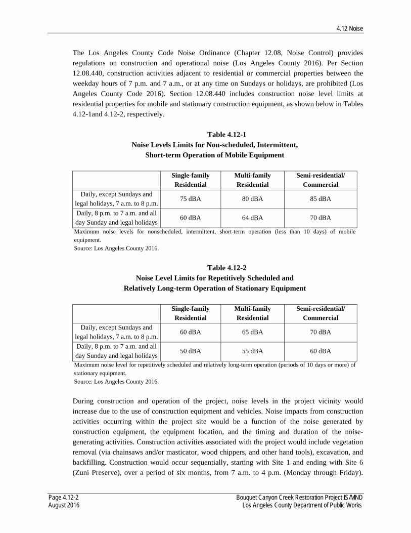
4.12 Noise
Page 4.12-2 Bouquet Canyon Creek Restoration Project IS/MND August 2016 Los Angeles County Department of Public Works
The Los Angeles County Code Noise Ordinance (Chapter 12.08, Noise Control) provides regulations on construction and operational noise (Los Angeles County 2016). Per Section 12.08.440, construction activities adjacent to residential or commercial properties between the weekday hours of 7 p.m. and 7 a.m., or at any time on Sundays or holidays, are prohibited (Los Angeles County Code 2016). Section 12.08.440 includes construction noise level limits at residential properties for mobile and stationary construction equipment, as shown below in Tables 4.12-1and 4.12-2, respectively.
Table 4.12-1 Noise Levels Limits for Non-scheduled, Intermittent,
Short-term Operation of Mobile Equipment
Single-family Residential
Multi-family Residential
Semi-residential/ Commercial
Daily, except Sundays and legal holidays, 7 a.m. to 8 p.m.
75 dBA 80 dBA 85 dBA
Daily, 8 p.m. to 7 a.m. and all day Sunday and legal holidays
60 dBA 64 dBA 70 dBA
Maximum noise levels for nonscheduled, intermittent, short-term operation (less than 10 days) of mobile equipment. Source: Los Angeles County 2016.
Table 4.12-2
Noise Level Limits for Repetitively Scheduled and Relatively Long-term Operation of Stationary Equipment
Single-family Residential
Multi-family Residential
Semi-residential/ Commercial
Daily, except Sundays and legal holidays, 7 a.m. to 8 p.m.
60 dBA 65 dBA 70 dBA
Daily, 8 p.m. to 7 a.m. and all day Sunday and legal holidays
50 dBA 55 dBA 60 dBA
Maximum noise level for repetitively scheduled and relatively long-term operation (periods of 10 days or more) of stationary equipment. Source: Los Angeles County 2016.
During construction and operation of the project, noise levels in the project vicinity would increase due to the use of construction equipment and vehicles. Noise impacts from construction activities occurring within the project site would be a function of the noise generated by construction equipment, the equipment location, and the timing and duration of the noise-generating activities. Construction activities associated with the project would include vegetation removal (via chainsaws and/or masticator, wood chippers, and other hand tools), excavation, and backfilling. Construction would occur sequentially, starting with Site 1 and ending with Site 6 (Zuni Preserve), over a period of six months, from 7 a.m. to 4 p.m. (Monday through Friday).
4.12 Noise
Page 4.12-3 Bouquet Canyon Creek Restoration Project IS/MND August 2016 Los Angeles County Department of Public Works
Operation and maintenance activities in Bouquet Canyon Creek would occur on an as-needed basis, consisting of removal of obstructions, sediment build-up, and clearing of culverts and overshots whenever there is observed creek flows in the roadway, road drainage cannot get into the creek, or culverts are plugged more than 25 percent of their diameter. These activities would occur between the hours of 7 a.m. and 4 p.m. (Monday through Friday). Typical construction and operation vehicles and equipment can generate short-term maximum noise levels in the order of 80 - 85 dBA maximum noise level at a distance of 50 feet (USEPA 1971) when the equipment is under maximum load. Due to the nature of the project’s anticipated construction and operation (maintenance) activities, with breaks and repositioning of equipment, hourly noise levels at 50 feet are assumed to average no more than 75 - 80 dBA Leq from the centroid of the each work area.
Noise-sensitive receptors in proximity of the project site are the Texas Canyon Fire Station, located approximately 250 feet from the sediment placement site, and approximately 478 feet from Site 1, and a ranchette located approximately 1,584 feet south of Site 1. Given the distance (substantially further than 50 feet) and intervening topography of Bouquet Canyon, the temporary project construction and operation noise levels would not exceed the County’s daily noise level limits (e.g., 75 dBA and 60 dBA for single-family residences for mobile and stationary equipment, respectively; and 85 and 70 dBA for semi-residential and commercial structures for mobile and stationary equipment, respectively, as shown in Tables 4.12-1 and 4.12-2). Therefore, implementation of the project would not result in the exposure of persons to or generation of noise levels in excess of standards established in the local general plan or noise ordinance, or applicable standards of other agencies. Impacts would be less than significant.
b) Exposure of persons to or generation of excessive groundborne vibration or groundborne noise levels? Less than Significant Impact. Construction and operation activities would result in varying degrees of temporary ground vibration, depending on the specific construction equipment used and operations involved. Groundborne vibration generated by construction equipment spreads through the ground and diminishes in magnitude with increases in distance. The effects of ground vibration may be imperceptible at the lowest levels, with low rumbling sounds; detectable at moderate levels; and damaging to nearby structures at the highest levels. Groundborne vibrations from typical construction activities do not often reach levels that can damage structures in proximity to construction, but their effects may manifest and be noticeable in buildings that are within 25 feet of construction activities. Vibration levels at 50 feet from construction equipment are typically below the thresholds of human annoyance and structural damage. One major concern with regard to construction vibration is potential building damage, which is assessed in terms of peak particle velocity (ppv), typically in units of inches per second (in/sec). In addition to structural damage, the vibration of room surfaces affects people as human annoyance. Human
4.12 Noise
Page 4.12-4 Bouquet Canyon Creek Restoration Project IS/MND August 2016 Los Angeles County Department of Public Works
and structural response to different vibration levels is influenced by a number of factors, including ground type, distance between source and receptor, duration, and the number of perceived vibration events. Typically, a vibration level of 0.1 in/sec ppv is the threshold of human annoyance, and 0.2 ppv is the threshold of risk of structural damage (Caltrans 2002; Los Angeles County 2016). The construction activities that typically generate the highest levels of vibration are blasting and impact pile driving, which are not required for this project. The nearest structure to the project site would be the Texas Canyon Fire Station, located approximately 250 feet from the proposed sediment placement site and approximately 478 feet from Site 1. In addition, the nearest residence is approximately 1,584 feet south of Site 1. Given the distance (over 50 feet from construction equipment) and type of construction equipment used (e.g., hand tools, excavator, dozer, loader, and backhoe, etc., which generate less than 0.1 in/sec ppv at 25 feet [Federal Transit Authority [FTA] 2006]), vibration levels at these receptors would not exceed thresholds of human annoyance and structural damage during construction and operation of the project. Therefore, implementation of the project would not result in the exposure of persons to or generation of excessive groundborne vibration or groundborne noise levels. Impacts would be less than significant.
c) A substantial permanent increase in ambient noise levels in the project vicinity above levels existing without the project?
Less than Significant Impact. As discussed in Section 4.12, Noise, Question (a) above, operation (maintenance) activities in Bouquet Canyon Creek would occur on an as-needed basis, consisting of removal of obstructions, sediment build-up, and clearing of culverts and overshots whenever there is observed creek flows in the roadway, road drainage cannot get into the creek, or culverts are plugged more than 25 percent of their diameter. These activities would occur between the hours of 7 a.m. and 4 p.m. during the weekday. While these operation (maintenance) activities would result in an increase in ambient noise levels in the project vicinity, it would be infrequent and temporary and would not exceed the County’s allowable daytime noise level limits. Therefore, implementation of the project would not result in a substantial permanent increase in ambient noise levels in the project vicinity above levels existing without the project. Impacts would be less than significant.
d) A substantial temporary or periodic increase in ambient noise levels in the project vicinity above levels existing without the project?
Less than Significant Impact. The project is located near Bouquet Canyon Road, which generates elevated ambient noise levels due to vehicle traffic, especially during peak commuter periods. Construction and operation of the project would generate noise levels which result in minor, temporary, short-term increases in daytime ambient noise levels. When compared to

4.12 Noise
Page 4.12-5 Bouquet Canyon Creek Restoration Project IS/MND August 2016 Los Angeles County Department of Public Works
existing ambient noise levels, the ambient noise levels with the project would not result in a substantial increase. Therefore, implementation of the project would not result in a substantial temporary increase in ambient noise levels in the project vicinity above levels existing without the project. Impacts would be less than significant.
e) For a project located within an airport land use plan or, where such a plan has not been adopted, within two miles of a public airport or pubic use airport, would the project expose people residing or working in the project area to excessive noise levels?
No Impact. The project is not located within 2 miles of a public airport, nor is it located within an airport land use plan. The nearest public airport/public use airport is the Agua Dulce Airport, located approximately 7.5 miles east of the project site (Google Earth Pro 2016, AirNav 2016b). Given this distance, implementation of the project would not result in the exposure of people residing or working in the project area to excessive noise levels. No impact would occur.
f) For a project within the vicinity of a private airstrip, would the project expose people residing or working in the project area to excessive noise levels?
No Impact. The project is not located within the vicinity of a private airstrip (Google Earth Pro 2016). The nearest private airstrips are over 20 miles away from the project in the Lancaster area (e.g., Little Buttes Antique Airstrip, Bohunk’s Airpark, and Quail Lake Sky Park Airport) (Google Earth Pro 2016; AirNav 2016a, 2016c, 2016d). Therefore, implementation of the project would not result in the exposure of people residing or working in the project area to excessive noise levels. No impact would occur.

4.13 Population and Housing
Page 4.13-1 Bouquet Canyon Creek Restoration Project IS/MND August 2016 Los Angeles County Department of Public Works
4.13 POPULATION AND HOUSING Would the Project: a) Induce substantial population growth in an area, either directly (for example, by proposing
new homes and businesses) or indirectly (for example, through extension of roads or other infrastructure)?
No Impact. The project does not include any residential or commercial land uses nor does it involve the construction or extension of new infrastructure that could serve future populations. The primary purpose of the project is to restore in-stream and riparian habitat by reestablishing creek flows along sections of Bouquet Canyon Creek that currently are dry. Construction workers would either be existing LACDPW employees or come from the existing local labor pool. Thus, the project would not result in the generation of new jobs and would not contribute to any substantial population growth. Therefore, implementation of the project would not induce growth, either directly or indirectly. No impact would occur.
b) Displace substantial numbers of existing housing, necessitating the construction of replacement housing elsewhere?
No Impact. As discussed in the response to Section 4.13, Question (a), above, the project does not include any residential land uses nor would it impact any existing housing. The project site is located within Bouquet Canyon Creek and the former Zuni campground, which do not contain any housing. Therefore, implementation of the project would not result in the displacement of existing housing, necessitating the construction of replacement housing. No impact would occur.
c) Displace substantial numbers of people, necessitating the construction of replacement housing elsewhere?
No Impact. As discussed in the response to Section 4.13, Question (b), above, the project does not include any residential land uses nor would it impact any existing housing. The project site is located within Bouquet Canyon Creek and the Zuni campground, which do not contain any housing. Therefore, implementation of the project would not result in the displacement of people, necessitating the construction of replacement housing. No impact would occur.

4.13 Population and Housing
Page 4.13-2 Bouquet Canyon Creek Restoration Project IS/MND August 2016 Los Angeles County Department of Public Works
This page intentionally left blank.

4.14 Public Services
Page 4.14-1 Bouquet Canyon Creek Restoration Project IS/MND August 2016 Los Angeles County Department of Public Works
4.14 PUBLIC SERVICES Would the Project:
a) Result in substantial adverse physical impacts associated with the provision of new or
physically altered governmental facilities, need for new or physically altered governmental facilities, the construction of which could cause significant environmental impacts, in order to maintain acceptable service ratios, response times, or other performance objectives for any of the following public services:
i) Fire Protection?
ii) Police protection? iii) Schools? iv) Parks?
v) Other public facilities? No Impact. The project does not include any residential or commercial land uses nor does it involve the construction or extension of new infrastructure that could generate additional demand for fire protection, police protection, schools, parks, or other public facilities. In addition, the project does not include the construction or expansion of any public facilities. The primary purpose of the project is to restore in-stream and riparian habitat by reestablishing creek flows along sections of Bouquet Canyon Creek that currently are dry. While Bouquet Canyon Road would temporarily be closed during construction, emergency access would be maintained. Although access to unmarked trails near the Texas Canyon Fire Station may be restricted during construction, they would not be physically altered or impacted. Therefore, implementation of the project would not result in substantial adverse physical impacts associated with the provision of new or physically altered governmental facilities or the need for new or physically altered governmental facilities. No impact would occur.

4.14 Public Services
Page 4.14-2 Bouquet Canyon Creek Restoration Project IS/MND August 2016 Los Angeles County Department of Public Works
This page intentionally left blank.
4.15 Recreation
Page 4.15-1 Bouquet Canyon Creek Restoration Project IS/MND August 2016 Los Angeles County Department of Public Works
4.15 RECREATION Would the Project: a) Increase the use of existing neighborhood and regional parks or other recreational facilities
such that substantial physical deterioration of the facility would occur or be accelerated?
Less than Significant Impact. The project consists of restoration of in-stream and riparian habitat by reestablishing creek flows along sections of Bouquet Canyon Creek, along with the creation of a fish preserve. Thus, the project does not include residential or other development that would result in either direct or indirect impacts to existing parks or other recreational facilities. Although the project is situated within the ANF, which is a recreational area used by the public, the visiting public does not use the project site for recreational purposes. While the proposed fish preserve would be constructed in the former Zuni Campground, this campground is no longer an active recreation site and is not planned for recreation uses at this time. However, during construction, the temporary closure of Bouquet Canyon Road would restrict access to bicycle use and unnamed trail use along the road, which could cause a slight increase in use of other nearby hiking trails and other recreational facilities. However, the road closure would be temporary and would not cause a substantial physical deterioration of these recreational facilities. Therefore, implementation of the project would not result in a permanent increase in the use of existing neighborhood and regional parks or other recreational facilities such that substantial physical deterioration of the facility would occur or be accelerated. Impacts would be less than significant.
b) Include recreational facilities or require the construction or expansion of recreational facilities, which might have an adverse physical effect on the environment?
No Impact. As discussed in response to Section 4.15, Question (a), above, the project consists of restoration of in-stream and riparian habitat by reestablishing creek flows along sections of Bouquet Canyon Creek, along with the creation of a fish preserve. Although the project is situated within the ANF, which is a recreational area used by the public, the visiting public does not use the project site for recreational purposes. While the proposed fish preserve would be constructed in the former Zuni Campground, this campground is no longer an active recreation site and is not planned for recreation uses at this time. Therefore, the project does not include the development of new recreational facilities or require the construction or expansion of other recreational facilities which might have an adverse impact on the environment. No impact would occur.

4.15 Recreation
Page 4.15-2 Bouquet Canyon Creek Restoration Project IS/MND August 2016 Los Angeles County Department of Public Works
This page intentionally left blank.
4.16 Transportation and Traffic
Page 4.16-1 Bouquet Canyon Creek Restoration Project IS/MND August 2016 Los Angeles County Department of Public Works
4.16 TRANSPORTATION AND TRAFFIC Would the Project:
a) Conflict with an applicable plan, ordinance or policy establishing measures of effectiveness for the performance of the circulation system, taking into account all modes of transportation including mass transit and non-motorized travel and relevant components of the circulation system, including but not limited to intersections, streets, highways and freeways, pedestrian and bicycle paths, and mass transit?
Less than Significant Impact. Bouquet Canyon Road is a mountain road running through Bouquet Canyon along Bouquet Canyon Creek (LACDPW 2011). Bouquet Canyon Road is designated as a limited secondary highway on the Los Angeles County Master Plan of Highways and carries one lane of traffic in each direction on asphalt pavement (LACDPW 2011). The average daily traffic (ADT) load is 2,442 vehicles2 (LACDPW 2016). It is a commuter route between the rural communities of Leona Valley, Green Valley, and Elizabeth Lake to the urban areas of Santa Clarita and other cities in the Los Angeles basin (LACDPW 2011). Within the project limits, Bouquet Canyon Road is approximately 24 feet wide and within the existing USFS Special Use Permit area.
Bouquet Canyon Road traverses the City of Santa Clarita south of the project site. However, the Santa Clarita city limits are approximately 3.5 miles south of the project site. Bouquet Canyon Road north of Santa Clarita traverses predominately undeveloped land and has very few intersections with other streets. A discussion of the project construction and operation impacts to the performance of the circulation system is provided below. The construction period for the project would last approximately six months beginning in late November 2016. Vehicle trips associated with hauling sediment would occur on-site, specifically from the project sites to the project sediment placement site. Vehicle trips to and from the project site related to construction would be associated with hauling green waste (root masses) to Chiquita Canyon Landfill and worker commute trips. A maximum of 10 daily round trips would occur associated with the hauling green waste and worker commute trips. As a worst-case scenario, it is assumed that these trips would occur during the peak a.m. and p.m. hours.
Construction-related trips would add to traffic volumes on the local roadway system, however they would be minimal (e.g., 10 daily round trips). Due to minimal impacts to peak hour traffic, the current minimal traffic along the trucking route, and the temporary nature of the construction
2 The ADT load for Bouquet Canyon Road (specifically, the portion of the road west of Quarry Road), was taken from the LACDPW Machine Count Traffic Volumes database, which was accessed on March 30, 2016. According to this database, the count date for this ADT number was June 4, 2013.
4.16 Transportation and Traffic
Page 4.16-2 Bouquet Canyon Creek Restoration Project IS/MND August 2016 Los Angeles County Department of Public Works
activities, project construction would not have measurable impact on traffic on Bouquet Canyon Road.
There would be no impact to the use of mass transit systems and non-motorized travel as a result of project construction because the project site is not near any alternative transportation systems. Bouquet Canyon Road will be closed above and below the project area (MM 13.06 to the ANF boundary) between the hours of 7 a.m. and 4 p.m., when construction work is scheduled (Monday through Friday until the project is completed).
Therefore, construction of the project would not conflict with an applicable plan, ordinance or policy establishing measures of effectiveness for the performance of the circulation system. Impacts would be less than significant.
The project would not generate new vehicle trips, result in any permanent road closures, and would not generate any additional activities related to maintenance or operations that would increase from existing levels. Thus, operation of the project would not cause an increase in traffic that would be substantial in relation to the existing traffic load and capacity of the street system. In addition, the operation of the project would not impact the use of alternative transportation systems. Therefore, operation of the project would not conflict with an applicable plan, ordinance or policy establishing measures of effectiveness for the performance of the circulation system. Impacts would be less than significant.
b) Conflict with an applicable congestion management program, including, but not limited to
level of service standards and travel demand measures, or other standards established by the county congestion management agency for designated roads or highways?
Less than Significant Impact. A Congestion Management Plan (CMP) Traffic Impact Analysis (TIA) would be required when a project adds 50 or more trips during a.m. or p.m. peak hours to any CMP arterial monitoring intersections, including monitored freeway on- or off-ramp intersections. The Los Angeles County CMP Highways in the vicinity of the project site are Sierra Highway, Magic Mountain Parkway, and San Fernando Road.
As discussed in response to Section 4.16, Question (a), above, the project would result in a daily maximum of 10 round trips in 2016 during the peak construction period. The daily trips generated in 2016 would be less than the minimum 50 a.m. or p.m. peak hour trips required for a CMP TIA; thus, a CMP TIA would not be required for the project. Therefore, implementation of the project would not conflict with an applicable congestion management program. Impacts would be less than significant.
4.16 Transportation and Traffic
Page 4.16-3 Bouquet Canyon Creek Restoration Project IS/MND August 2016 Los Angeles County Department of Public Works
c) Result in a change in air traffic patterns, including either an increase in traffic levels or a change in location that results in substantial safety risks?
No Impact. The project site is not located within two miles of a public airport or private airstrip, nor is it located within an airport land use plan. The nearest airport is the Agua Dulce Airport, located approximately 7.5 miles east of the project (Google Earth Pro 2016, AirNav 2016b). Furthermore, the project does not include construction of any aerial structures. Therefore, implementation of the project would not result in a change in air traffic patterns. No impact would occur.
d) Substantially increase hazards due to a design feature (e.g., sharp curves or dangerous intersections) or incompatible uses (e.g., farm equipment)?
No Impact. The project consists of restoration of in-stream and riparian habitat by reestablishing creek flows along sections of Bouquet Canyon Creek, along with the creation of a fish preserve. Implementation of the project would not result in any changes to the existing roadway network. Therefore, implementation of the project would not substantially increase hazards due to a design feature or incompatible uses. No impact would occur.
e) Result in inadequate emergency access?
No Impact. As discussed in response to Section 4.8, Hazards and Hazardous Materials, Question (g), while the project would result in the closure of Bouquet Canyon Road during construction (7 a.m. to 4 p.m.), the emergency responders would be provided keys to the gates to ensure emergency access is maintained. No road closures would occur during operation of the project. Therefore, implementation of the project would not result in inadequate emergency access. No impact would occur.
f) Conflict with adopted policies, plans, or programs regarding public transit, bicycle, or pedestrian facilities, or otherwise decrease the performance or safety of such facilities? No Impact. During construction, the closure of Bouquet Canyon Road would restrict access to bicycle, public transit, and hiking trail use along this road. However, impacts would be temporary and would not decrease the performance or safety of these facilities. Operation of the project would not create a demand for alternative transportation systems and would not affect public transit services. No demand for public transit, bicycle, or pedestrian facilities would be created by the project as there would be no change to land uses in the project area. Therefore, implementation of the project would not conflict with adopted policies, plans, or programs regarding public transit, bicycle, or pedestrian facilities, or otherwise decrease the performance or safety of such facilities. No impact would occur.
4.17 Utilities and Service Systems
Page 4.17-1 Bouquet Canyon Creek Restoration Project IS/MND August 2016 Los Angeles County Department of Public Works
4.17 UTILITIES AND SERVICE SYSTEMS Would the Project:
a) Exceed wastewater treatment requirements of the applicable Regional Water Quality Control Board?
No Impact. The project consists of restoration of in-stream and riparian habitat by reestablishing creek flows along sections of Bouquet Canyon Creek, along with the creation of a fish preserve. Thus, the project would not result in the generation of raw sewage. Therefore, implementation of the project would not result in the exceedance of wastewater treatment requirements of the Regional Water Quality Control Board. No impact would occur.
b) Require or result in the construction of new water or wastewater treatment facilities or expansion of existing facilities, the construction of which could cause significant environmental effects?
No Impact. The project consists of restoration of in-stream and riparian habitat by reestablishing creek flows along sections of Bouquet Canyon Creek, along with the creation of a fish preserve. Thus, the project would not create new development opportunities or result in the need for new development that would generate demand for new or expanded water or wastewater treatment facilities. Therefore, implementation of the project would not require or result in the construction of new water or wastewater facilities or expansion of existing facilities. No impact would occur.
c) Require or result the construction of new stormwater drainage facilities or expansion of
existing facilities, the construction of which could cause significant environmental effects?
No Impact. The project consists of restoration of in-stream and riparian habitat by reestablishing creek flows along sections of Bouquet Canyon Creek, along with the creation of a fish preserve. Thus, the project would not create new development opportunities or result in the need for new development that would generate demand for new or expanded stormwater drainage facilities. Therefore, implementation of the project would not require or result in the construction of new stormwater drainage facilities or expansion of existing facilities. No impact would occur.
c) Have sufficient water supplies available to serve the project from existing entitlements and resources, or are new or expanded entitlements needed? No Impact. The project consists of restoration of in-stream and riparian habitat by reestablishing creek flows along sections of Bouquet Canyon Creek, along with the creation of a fish preserve. Construction of the project would require minimal amounts of water which would be accommodated from existing water supplies and entitlements. Operation of the project would not
4.17 Utilities and Service Systems
Page 4.17-2 Bouquet Canyon Creek Restoration Project IS/MND August 2016 Los Angeles County Department of Public Works
require or create a demand for water use. Therefore, sufficient water supplies would be available to serve the project from existing entitlements and resources. No impact would occur.
e) Result in a determination by the wastewater treatment provider, which serves or may serve the project that it has adequate capacity to serve the project’s projected demand in addition to the provider’s existing commitments?
No Impact. The project consists of restoration of in-stream and riparian habitat by reestablishing creek flows along sections of Bouquet Canyon Creek, along with the creation of a fish preserve. Thus, the project would not create new development opportunities or result in the need for new development that would generate demand for new or expanded wastewater treatment facilities. In addition, the project would not result in the generation of raw sewage. Therefore, implementation of the project would not impact wastewater treatment capacity. No impact would occur.
f) Be served by a landfill with sufficient permitted capacity to accommodate the project’s solid waste disposal needs?
Less than Significant Impact. Construction activities would require excavation of sediment. However, the sediment would be placed at a permanent sediment placement site for the project (located along the east side of Bouquet Canyon Road and just north of the culvert at MM 15.89 at Site 1) pending approval from USFS. Also, brush and dead trees removed from Bouquet Canyon Creek would be run through a wood chipper and the chips spread over the project site. However, root masses that come from the excavation of the creek and side slopes would likely require being hauled to a landfill. The nearest landfill is the Chiquita Canyon Landfill, located approximately 15 miles southwest of Site 1 (Google Earth Pro 2016). Chiquita Canyon Landfill has a maximum permitted capacity of 560 tons per day for green waste with an anticipated ceased operation date of November 2019 (CalRecycle 2016). The root masses excavated during project construction would be well under the daily maximum permitted capacity of Chiquita Canyon Landfill. In addition, no solid waste would be generated during operation of the project. Therefore, the project would be served by a landfill with sufficient permitted capacity to accommodate the project’s solid waste disposal needs. Impacts would be less than significant.
g) Comply with federal, state, and local statutes and regulations related to solid waste?
Less than Significant Impact. As discussed in response to Section 4.17, Question (f), above, the quantity of solid waste generated during project construction would be minimal and would be accommodated by Chiquita Canyon Landfill. In addition, it should be noted that LACDPW would be required to comply with all federal, state and local statutes and regulations related to the disposal of solid waste. Therefore, implementation of the project would comply with federal, state, and local statutes and regulations related to solid waste. Impacts would be less than significant.
4.18 Mandatory Findings of Significance
Page 4.18-1 Bouquet Canyon Creek Restoration Project IS/MND August 2016 Los Angeles County Department of Public Works
4.18 MANDATORY FINDINGS OF SIGNIFICANCE a) Does the project have the potential to degrade the quality of the environment, substantially
reduce the habitat of a fish or wildlife species, cause a fish or wildlife population to drop below self-sustaining levels, threaten to eliminate a plant or animal community, reduce the number or restrict the range of a rare or endangered plant or animal, or eliminate important examples of the major periods of California history or prehistory? Less than Significant Impact After Mitigation Incorporated. As described throughout Section 4.0 of this Draft IS/MND, implementation of the project would not degrade the quality of the environment, substantially reduce the habitat of fish or wildlife species, cause a fish or wildlife population to drop below self-sustaining levels, threaten to eliminate a plant or animal, or eliminate important examples of major periods of California history or prehistory with the incorporation of the identified mitigation measures (e.g., BIO-1 through BIO-2, and CUL-1 through CUL-4). Impacts would be less than significant after mitigation.
b) Does the project have impacts that are individually limited, but cumulatively considerable? (“Cumulatively considerable” means that the incremental effects of a project are considerable when viewed in connection with the effects of past projects, the effects of other current projects, and the effects of probable future projects.) Less than Significant Impact After Mitigation Incorporated. As described throughout Section 4.0 of this Draft IS/MND, the project would not result in any operational environmental impacts. Therefore, there would be no cumulative operational impacts associated with the project. The project would result in some short-term impacts related to construction, all of which would be below a level of significance or reduced to below a level of significance with mitigation. These construction impacts would not be cumulatively considerable, even for the typically furthest reaching environmental factor, air quality, because the project is very small in scale and scope and impacts would be localized. As described in Section 4.3, Air Quality, the project would not exceed any SCAQMD air quality thresholds and would not result in a significant impact to existing attainment or non-attainment designations. Thus, the project would not result in significant levels of emissions related to air quality and these emissions would not be cumulatively considerable or cumulatively significant. Therefore, implementation of the project with mitigation incorporated would not result in cumulatively considerable impacts. Impacts would be less than significant after mitigation.
c) Does the project have environmental effects, which will cause substantial adverse effects on human beings, either directly or indirectly? Less than Significant Impact. As described throughout Section 4.0 of this Draft IS/MND, the project would not result in substantial adverse effects on human beings, either directly or indirectly. Impacts would be less than significant.

4.18 Mandatory Findings of Significance
Page 4.18-2 Bouquet Canyon Creek Restoration Project IS/MND August 2016 Los Angeles County Department of Public Works
This page intentionally left blank.
5.0 References
Page 5-1 Bouquet Canyon Creek Restoration Project IS/MND August 2016 Los Angeles County Department of Public Works
5.0 REFERENCES AirNav. CL46 Quail Lake Sky Park Airport Webpage. 2016a. Web. Mar. 2016.
<http://www.airnav.com/airport/CL46>. ----. L70 Agua Dulce Airport Webpage. 2016b. Web. Mar. 2016 <http://www.airnav.com/airport/L70>. ----. 1CL1 Little Buttes Antique Airfield Webpage. 2016c. Web. Mar. 2016.
<https://www.airnav.com/airport/1CL1>. ----. 0Cl6 Bohunk’s Airpark Webpage. 2016d. Web. Mar. 2016. <https://www.airnav.com/airport/0CL6>. Anderson, M Kat. “The Fire, Pruning, and Coppice Management of Temperate Ecosystems for Basketry
Material by California Indian Tribes.” Human Ecology 27.1 (1999): 79-113. Print. California Air Resources Board (CARB). First Update to the Climate Change Scoping Plan:
Building on the Framework. Pursuant to AB 32, the California Global Warming Solutions Act of 2006. 2014. Web. Mar. 2016. <http://www.arb.ca.gov/cc/scopingplan/2013_update/first_update_ climate_change_scoping_plan.pdf>.
----. Climate Change Scoping Plan. 2008. Web. Mar. 2016.
<http://www.arb.ca.gov/cc/scopingplan/document/scopingplandocument.htm>. California Department of Conservation. Division of Land Resource Protection. Farmland Mapping and
Monitoring Program. Los Angeles County Important Farmland 2012. 2015a. Web. Feb. 2016. <ftp://ftp.consrv.ca.gov/pub/dlrp/FMMP/pdf/2012/los12.pdf>.
----. Division of Land Resource Protection. Conservation Program Support. State of California Williamson Act Contract Land – Data Submissions Current to 2014. 2015b. Web. Feb. 2016. <ftp://ftp.consrv.ca.gov/pub/dlrp/wa/2104%20Statewide%20Map/WA_2014_11x17.pdf>. ----. Division of Land Resource Protection. Surface Mining and Reclamation Act (SMARA) Mineral Lands Classification data portal. 2015c. Web. Feb. 2016. <http://maps.conservation.ca.gov/cgs/informationwarehouse/index.html?map=mlc>. ----. Division of Mines and Geology. Inundation Maps, Los Angeles. 2015d. Web. Mar. 2016. <http://www.conservation.ca.gov/cgs/geologic_hazards/Tsunami/Inundation_Maps/LosAngeles>. ----. Division of Mines and Geology. State of California Seismic Hazard Zones – Mint Canyon
Quadrangle. 1999. Web. Mar. 2016. <http://maps.conservation.ca.gov/cgs/informationwarehouse/index.html?map=regulatorymaps>.
5.0 References
Page 5-2 Bouquet Canyon Creek Restoration Project IS/MND August 2016 Los Angeles County Department of Public Works
----. Division of Mines and Geology. Fault Evaluation Report, FER-62. 1977. Web. 2016. <http://maps.conservation.ca.gov/cgs/informationwarehouse/index.html?map=regulatorymaps>.
California Department of Fish and Wildlife (CDFW). California Natural Diversity Database (CNDDB). Full condensed report for the Green Valley, Mint Canyon, Newhall, Warm Springs Mountain, Burnt Peak, Lake Hughes, Del Sur, Sleepy Valley, and Agua Dulce USGS Quadrangles. Generated 17 Mar. 2016a. ----. NCCP Plan Summaries Webpage. 2016b. Web. Feb. 2016. <https://www.wildlife.ca.gov/Conservation/Planning/NCCP/Plans>. ----. List of California Terrestrial Natural Communities Recognized by the Natural Diversity Data Base. Sept. 2010. California Department of Resources Recycling and Recovery (CalRecycle). Facility/Site Summary
Details: Chiquita Canyon Sanitary Landfill (19-AA-0052). 2016. Web. Mar. 2016. <http://www.calrecycle.ca.gov/SWFacilities/Directory/19-AA-0052/Detail/>.
California Department of Toxic Substances Control (DTSC). DTSC's Hazardous Waste and Substances
Site List - Site Cleanup (Cortese List) Webpage. 2016. Web. Feb. 2016. <http://www.dtsc.ca.gov/SiteCleanup/Cortese_List.cfm>.
California Department of Transportation (Caltrans). California Scenic Highway Mapping System. 2016.
Web. Mar. 2016. <http://www.dot.ca.gov/hq/LandArch/16_livability/scenic_highways/index.htm>.
----. Transportation Related Earthborne Vibrations. 20 Feb. 2002. Print. California Environmental Protection Agency (CalEPA). Cortese List Data Resources Webpage. 2016a.
Web. Feb. 2016. <http://www.calepa.ca.gov/SiteCleanup/CorteseList/>. ----. Sitehttp://www.calepa.ca.gov/SiteCleanup/CorteseList/CurrentList.pdf>. ----. List of “Active” Cease and Desist Orders and Cleanup and Abatement Orders from Water Board.
2016c. Web. Mar. 2016. <http://www.calepa.ca.gov/SiteCleanup/CorteseList/CDOCAOList.xlsx>.
Chiang, et al. “Home Range and Habitat Use of Cooper’s Hawks in Urban and Natural Areas.” Urban
Bird Ecology and Conservation. Eds. C. A. Lepczyk and P. S. Warren. Berkeley: University of California Press, 2012. Print.
Collins, Paul W. “Rufous-crowned Sparrow (Aimophila ruficeps).” The Birds of North America Online.
Ed. A. Poole. 1999. Web. 2016. <http://bna.birds.cornell.edu/bna/species/472>.
5.0 References
Page 5-3 Bouquet Canyon Creek Restoration Project IS/MND August 2016 Los Angeles County Department of Public Works
Farmer, Justin. Basketry Plants Used by Western American Indians: A Study of Traditional North
American Indian Basketry and Plant Materials Used to Create Them with Photos Showing Characteristics of the Major Plant Materials Used by Basket Makers. Fullerton: The Justin Farmer Foundation, 2010. Print.
Federal Transit Administration (FTA). Transit Noise and Vibration Impact Assessment. 2006. Print. Google Earth Pro. 2016. Intergovernmental Panel on Climate Change (IPCC). Climate Change 2013: The Physical Science Basis.
2013. Web. Mar. 2016. <http://www.ipcc.ch/report/ar5/wg1/>. Los Angeles County Department of Regional Planning. GIS-NET3 Public. Planning & Zoning
Information for Unincorporated Los Angeles County. 2016. Web. Feb. 2016. <http://rpgis.isd.lacounty.gov/GIS-NET3_Public/Viewer.html>.
----. Final Unincorporated Los Angeles County Community Climate Action Plan. 2015a. Web. Mar.
2016. <http://planning.lacounty.gov/assets/upl/project/ccap_final-august2015.pdf>.
----. Los Angeles County General Plan. 2015b. Web. Feb. 2016.
<http://planning.lacounty.gov/generalplan/generalplan>. ----. Town & Country – Antelope Valley Area Plan. 2015c. Web. 2016. <http://planning.lacounty.gov/assets/upl/project/tnc_draft-20150601.pdf>. ----. Los Angeles County General Plan – Figure 9.7, Scenic Highways. 2014a. Web. 2016. <http://planning.lacounty.gov/assets/upl/project/gp_2035_2014-FIG_9-7_scenic_highways.pdf>. ----. Los Angeles County General Plan – Figure 9.8, Hillside Management Areas and Ridgeline
Management Map. 2014b. Web. 2016. <http://planning.lacounty.gov/assets/upl/project/gp_2035_2014-FIG_9-8_hillside_management_areas.pdf>.
----. Los Angeles County General Plan – Figure 12.1, Seismic and Geotechnical Hazard Zones Policy
Map. 2014c. Web. 2016. <http://planning.lacounty.gov/assets/upl/project/gp_2035_2014-FIG_12-1_seismic_hazards.pdf>.
----. Santa Clarita Valley Area Plan. 2012. Web. Feb. 2016
<http://planning.lacounty.gov/view/santa_clarita_valley_area_plan/>.

5.0 References
Page 5-4 Bouquet Canyon Creek Restoration Project IS/MND August 2016 Los Angeles County Department of Public Works
----. Zoning Ordinance Summary – Special Purpose Zones. 2009. Web. Feb. 2016. <http://planning.lacounty.gov/luz/summary/category/special_purpose_zones/>.
----. Santa Clarita Valley Area Plan – Trails Map. 2007. Web. 2016.
<http://planning.lacounty.gov/assets/upl/case/project_r2006-00414_scv-map.pdf>. Los Angeles County Department of Public Works (LACDPW). Machine Counts Traffic Volumes
Database. Accessed 30 Mar. 2016. Web. 2016. <http://dpw.lacounty.gov/tnl/trafficcounts/?street=bouquet canyon road&cross=>.
----. Water Resources Division. Lower Bouquet Canyon Hydrology Request. 30 Jul. 2015. ----. Bouquet Canyon Road Improvement Project – Environmental Assessment with Finding of No
Significant Impact/Initial Study with Mitigated Negative Declaration. Jun. 2011. Print. ----. Building and Safety Division – Drainage & Grading Section. Standard Urban Stormwater Mitigation Plan (SUSMP) Review Sheet. 9 Jan. 2008. Print. ----. Building and Safety Division and Land Development Division. Local Stormwater Pollution Prevention Plans (SWPPP) and Wet Weather Erosion Control Plans (WWECP) Correction Sheet. 12 Jul. 2005. Print. Regional Water Quality Control Board (RWQCB). State of the Watershed – Report on Surface Water Quality, The Santa Clara River Watershed. Nov. 2006. Print. Richmond, J.C., et al. “Ephemeral Stream Reaches Preserve the Evolutionary Distributional History of
Threespine Stickleback in the Santa Clara and Ventura River Watershed of southern California.” Conservation Genetics 16.1 (2014): 85-101. Print.
San Marino Environmental Associates (SMEA). Memo on Stickleback Monitoring During the Clearing of
Culverts in Bouquet Canyon Creek. Prepared for the Los Angeles Department of Public Works. 6 Mar. 2012. Print.
----. Memo on Survey for Threespine Sticklebacks in Bouquet Canyon Creek within the Los Angeles
County Department of Public Works Bouquet Canyon Road Realignment Project and Recommended Fish Protection and Impact Avoidance Procedures. 2011. Print.
----. Santa Clara River Stickleback Survey – Progress Report Memo. 5 Jan. 2008. Print. ----. Results of the 2005 Unarmored Threespine Stickleback Survey of Bouquet Canyon. Prepared for
Bonterra Consulting, Pasadena, California. 2005. Print.
5.0 References
Page 5-5 Bouquet Canyon Creek Restoration Project IS/MND August 2016 Los Angeles County Department of Public Works
Schmidt, James and June Schmidt. Archaeological site record for CA-LAN-3299 (FS-050153276). On file, South Central Coastal Archaeological Information Center, California State University, Fullerton. 2008.
South Coast Air Quality Management District (SCAQMD). National Ambient Air Quality Standards
(NAAQS) and California Ambient Air Quality Standards (CAAQS) Attainment Status for the South Coast Air Basin. 2016. Web. Mar. 2016. <http://www.aqmd.gov/docs/default-source/clean-air-plans/air-quality-management-plans/naaqs-caaqs-feb2016.pdf?sfvrsn=2>.
----. SCAQMD Air Quality Significance Thresholds: Revised March 2015. 2015. Web. Mar. 2016.
<http://www.aqmd.gov/docs/default-source/ceqa/handbook/scaqmd-air-quality-significance-thresholds.pdf?sfvrsn=2>.
----. Final 2012 Air Quality Management Plan. 2012. Web. Mar. 2016.
<http://www.aqmd.gov/home/library/clean-air-plans/air-quality-mgt-plan>. ----. Greenhouse Gas CEQA Significance Threshold Stakeholder Working Group Meeting #14. 2009.
Web. Mar. 2016. <http://www.aqmd.gov/docs/default-source/ceqa/handbook/greenhouse-gases-(ghg)-ceqa-significance-thresholds/year-2008-2009/ghg-meeting-14/ghg-meeting-14-main-presentation.pdf?sfvrsn=2>.
----. Rule 403: Fugitive Dust. 2005. Web. Mar. 2016.
<http://www.aqmd.gov/docs/default-source/rule-book/rule-iv/rule-403.pdf>. State Water Resources Control Board (SWRCB). Construction Stormwater Program. 2016a. Web. Mar. 2016. <http://www.waterboards.ca.gov/water_issues/programs/stormwater/construction.shtml>. ----. GeoTracker Webpage. 2016b. Web. Feb. 2016. <https://geotracker.waterboards.ca.gov/map/?CMD=runreport&myaddress=bouquet+canyon+roa d%2C+saugus%2C+ca>. Timbrook, Jan. Chumash Ethnobotany: Plant Knowledge Among the Chumash People of Southern
California. Santa Barbara Museum of Natural History, Monograph No. 5, Publications in Anthropology No. 1. Berkeley: Heyday Books, 2007. Print.
U.S. Department of Agriculture (USDA). Natural Resources Conservation Service. Web Soil Survey.
2016. Web. Feb. 2016. <http://websoilsurvey.sc.egov.usda.gov/App/WebSoilSurvey.aspx>. ----. Forest Service, Pacific Southwest Region. Plants and Animals Webpage. 2015. Web. Jan. 2015.
<http://www.fs.usda.gov/main/r5/plants-animals>.
5.0 References
Page 5-6 Bouquet Canyon Creek Restoration Project IS/MND August 2016 Los Angeles County Department of Public Works
----. Forest Service, Pacific Southwest Region. Angeles National Forest – September 2005, Final Land Management Plan Alternative 4a Selected, Land-Use Zones. 2005a. Web. Feb. 2016. <http://www.fs.usda.gov/Internet/FSE_MEDIA/stelprdb5311720.pdf>.
----. Land Management Plan, Part 2 Angeles National Forest Strategy. 2005b. Web. Feb. 2016.
<http://www.fs.usda.gov/Internet/FSE_DOCUMENTS/stelprdb5166877.pdf>. ----. Land Management Plan, Part 3 Design Criteria for the Southern California National Forests. 2005c.
Web. 2016. <http://www.fs.usda.gov/Internet/FSE_DOCUMENTS/stelprdb5166878.pdf>. U.S. Environmental Protection Agency (USEPA). CERCLIS Public Access Database – Superfund Site
Search Results. 2016. Web. Mar. 2016. <https://cumulis.epa.gov/supercpad/cursites/srchrslt.cfm?start=1&CFID=21932357&CFTOKEN=56258382>.
----. My Waters Mapper. 2015. Web. Jan. 2015. <http://watersgeo.epa.gov/mwm>. ----. Noise from Construction Equipment & Operations, EPA PB 206717. 31 Dec. 1971. Print. U.S. Fish and Wildlife Service (USFWS). ECOS – Environmental Conservation Online System. Region 8
Habitat Conservation Plans. 2016. Web. Feb. 2016. <http://ecos.fws.gov/conserv_plans/conservationPlan/region/summary?region=8&type=HCP>.
----. Unarmored Threespine Stickleback (Gasterosteus aculeatus williamsoni). 5-Year Review: Summary and Evaluation. Ventura: Ventura Fish and Wildlife Office, 2009. Print. Vance, Darrell W. Stable Fire Suppression and Rehabilitation Archaeological Reconnaissance Report
(#05-01-00658) Angeles National Forest, Los Angeles County, California. 2001. Print.
6.0 Preparers and Contributors
Page 6-1 Bouquet Canyon Creek Restoration Project IS/MND August 2016 Los Angeles County Department of Public Works
6.0 PREPARERS AND CONTRIBUTORS
Initial Study/Mitigated Negative Declaration Preparation and Oversight Los Angeles County Department of Public Works
Ed Dingman, Programs Manager AECOM
Art Popp, Project Manager
Jerry Flores, Senior Environmental Planner
Hallie Fitzpatrick, Senior Environmental Analyst
Jason Paukovits, Environmental Scientist (Air Quality and Greenhouse Gases)
Caitlin Miller, Environmental Scientist (Air Quality and Greenhouse Gases)
Jeff Goodson, Environmental Scientist (Noise)
Erik Larsen, Biologist/Regulatory Specialist
Marc Beherec, Archaeologist
Allison Hill, Archaeologist
Jun Wang, Principal Engineer (Hydrology/Water Quality)
Johnnie Garcia, GIS/Graphics Specialist
Vamshi Akkinepally, Traffic Specialist

6.0 Preparers and Contributors
Page 6-2 Bouquet Canyon Creek Restoration Project IS/MND August 2016 Los Angeles County Department of Public Works
This page intentionally left blank.
7.0 Acronyms and Abbreviations
Page 7-1 Bouquet Canyon Creek Restoration Project IS/MND August 2016 Los Angeles County Department of Public Works
7.0 ACRONYMS AND ABBREVIATIONS
AB Assembly Bill ADT average daily traffic AMP Adaptive Management Plan amsl above mean sea level ANF Angeles National Forest AQMP Air Quality Management Plan APE area of potential effect APP accumulated precipitation procedure Basin Plan Water Quality Control Plan BMPs Best Management Practices BMP Manual Los Angeles County Department of Public Works Construction Site Best Management Practices Manual BO Biological Opinion CAAQS California Ambient Air Quality Standards CalEEMod California Emissions Estimator Model CalEPA California Environmental Protection Agency Caltrans California Department of Transportation CARB California Air Resources Board CCAP Community Climate Action Plan CCC Civilian Conservation Corps CCR California Code of Regulations CDFW California Department of Fish and Wildlife CEQA California Environmental Quality Act CESA California Endangered Species Act CFGC California Fish and Game Code cfs cubic feet per second CH4 methane cm centimeters CMP Congestion Management Plan CNDDB California Natural Diversity Database CNEL Community Noise Equivalent Level CO carbon monoxide CO2 carbon dioxide CO2e carbon dioxide-equivalent CRHR California Register of Historic Resources CWA Clean Water Act CY cubic yards
7.0 Acronyms and Abbreviations
Page 7-2 Bouquet Canyon Creek Restoration Project IS/MND August 2016 Los Angeles County Department of Public Works
DAI Developed Area Interface dam3 cubic decametre dB Decibel dBA A-weighted Decibel dbh diameter-at-breast-height DTSC California Department of Toxic Substance Control DWP City of Los Angeles Department of Water and Power ESA federal Endangered Species Act Farmland Prime Farmland, Unique Farmland, or Farmland of Statewide Importance FE Federally Endangered FEMA Federal Emergency Management Agency FTA Federal Transit Authority FMMP Farmland Mapping and Monitoring Program FP Fully-Protected FT Federally Threatened GHGs Greenhouse Gases GWP Global Warming Potential H High Priority HCP habitat conservation plan HMMP Habitat Mitigation and Monitoring Plan HU Hydrologic Unit HUC Hydrologic Unit Code in/sec inches per second IS Initial Study L length LACDPW Los Angeles County Department of Public Works LADPW Los Angeles Department of Public Works lbs/day pounds per day Ldn Day-Night Average Sound Level Leq Equivalent Noise Level LSAA Lake or Streambed Alteration Agreement LSTs Localized Significance Thresholds LUST leaking underground storage tank MBTA Migratory Bird Treaty Act mg/l milligrams per liter
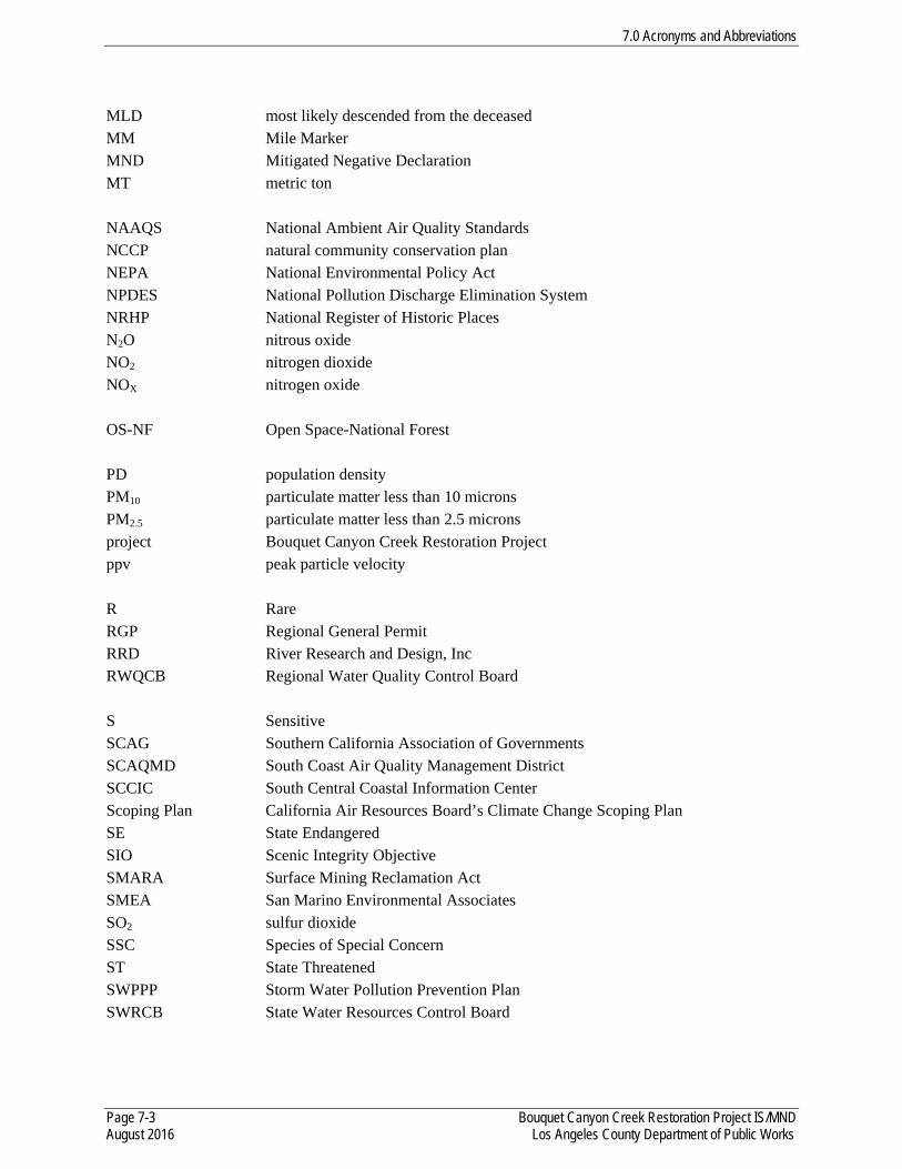
7.0 Acronyms and Abbreviations
Page 7-3 Bouquet Canyon Creek Restoration Project IS/MND August 2016 Los Angeles County Department of Public Works
MLD most likely descended from the deceased MM Mile Marker MND Mitigated Negative Declaration MT metric ton NAAQS National Ambient Air Quality Standards NCCP natural community conservation plan NEPA National Environmental Policy Act NPDES National Pollution Discharge Elimination System NRHP National Register of Historic Places N2O nitrous oxide NO2 nitrogen dioxide NOX nitrogen oxide OS-NF Open Space-National Forest PD population density PM10 particulate matter less than 10 microns PM2.5 particulate matter less than 2.5 microns project Bouquet Canyon Creek Restoration Project ppv peak particle velocity R Rare RGP Regional General Permit RRD River Research and Design, Inc RWQCB Regional Water Quality Control Board S Sensitive SCAG Southern California Association of Governments SCAQMD South Coast Air Quality Management District SCCIC South Central Coastal Information Center Scoping Plan California Air Resources Board’s Climate Change Scoping Plan SE State Endangered SIO Scenic Integrity Objective SMARA Surface Mining Reclamation Act SMEA San Marino Environmental Associates SO2 sulfur dioxide SSC Species of Special Concern ST State Threatened SWPPP Storm Water Pollution Prevention Plan SWRCB State Water Resources Control Board
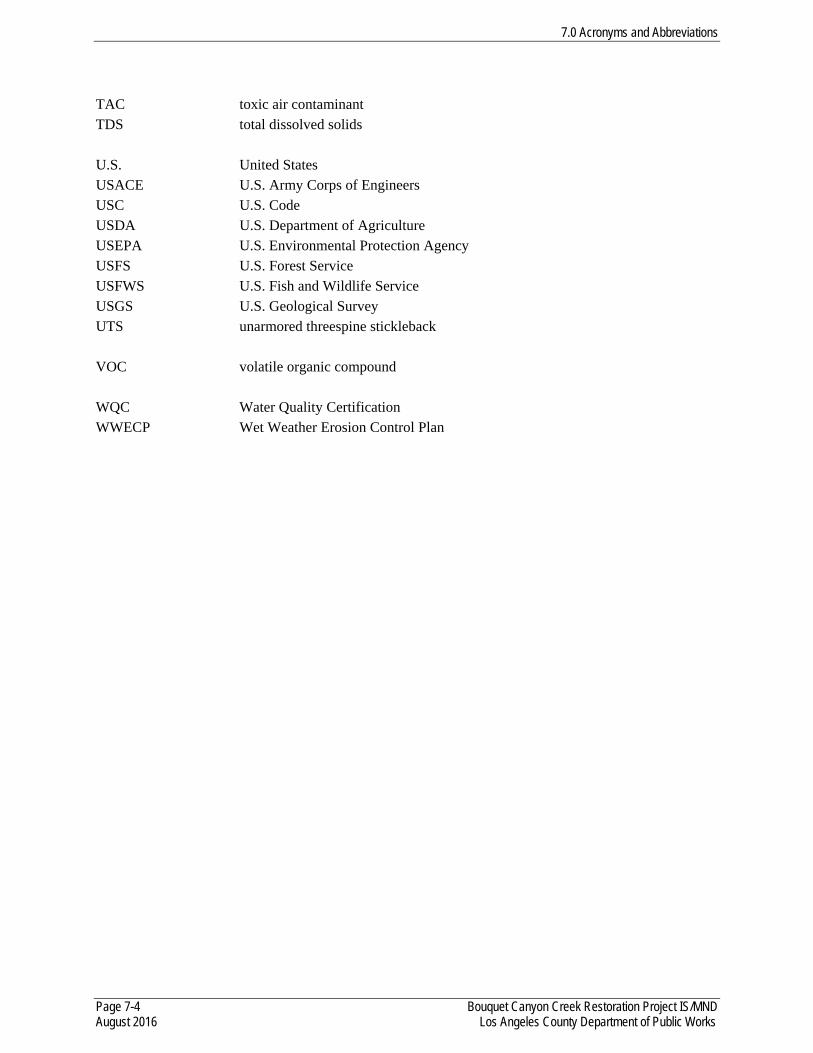
7.0 Acronyms and Abbreviations
Page 7-4 Bouquet Canyon Creek Restoration Project IS/MND August 2016 Los Angeles County Department of Public Works
TAC toxic air contaminant TDS total dissolved solids U.S. United States USACE U.S. Army Corps of Engineers USC U.S. Code USDA U.S. Department of Agriculture USEPA U.S. Environmental Protection Agency USFS U.S. Forest Service USFWS U.S. Fish and Wildlife Service USGS U.S. Geological Survey UTS unarmored threespine stickleback VOC volatile organic compound WQC Water Quality Certification WWECP Wet Weather Erosion Control Plan

APPENDICES

APPENDIX A AIR QUALITY MODELING OUTPUT
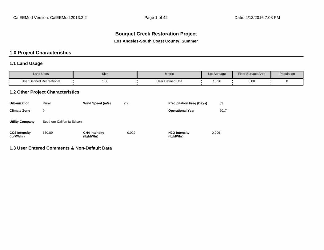
Los Angeles-South Coast County, Summer
Bouquet Creek Restoration Project
1.1 Land Usage
Land Uses Size Metric Lot Acreage Floor Surface Area Population
User Defined Recreational 1.00 User Defined Unit 10.26 0.00 0
1.2 Other Project Characteristics
Urbanization
Climate Zone
Rural
9
Wind Speed (m/s) Precipitation Freq (Days)2.2 33
1.3 User Entered Comments & Non-Default Data
1.0 Project Characteristics
Utility Company Southern California Edison
2017Operational Year
CO2 Intensity (lb/MWhr)
630.89 0.029CH4 Intensity (lb/MWhr)
0.006N2O Intensity (lb/MWhr)
CalEEMod Version: CalEEMod.2013.2.2 Date: 4/13/2016 7:08 PMPage 1 of 42
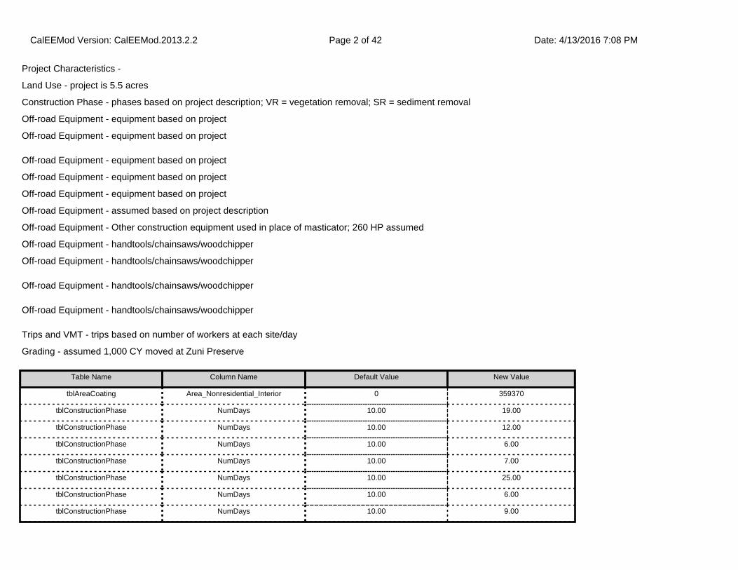
Project Characteristics -
Land Use - project is 5.5 acres
Construction Phase - phases based on project description; VR = vegetation removal; SR = sediment removal
Off-road Equipment - equipment based on project
Off-road Equipment - equipment based on project
Off-road Equipment - equipment based on project
Off-road Equipment - equipment based on project
Off-road Equipment - equipment based on project
Off-road Equipment - assumed based on project description
Off-road Equipment - Other construction equipment used in place of masticator; 260 HP assumed
Off-road Equipment - handtools/chainsaws/woodchipper
Off-road Equipment - handtools/chainsaws/woodchipper
Off-road Equipment - handtools/chainsaws/woodchipper
Off-road Equipment - handtools/chainsaws/woodchipper
Trips and VMT - trips based on number of workers at each site/day
Grading - assumed 1,000 CY moved at Zuni Preserve
Table Name Column Name Default Value New Value
tblAreaCoating Area_Nonresidential_Interior 0 359370
tblConstructionPhase NumDays 10.00 19.00
tblConstructionPhase NumDays 10.00 12.00
tblConstructionPhase NumDays 10.00 6.00
tblConstructionPhase NumDays 10.00 7.00
tblConstructionPhase NumDays 10.00 25.00
tblConstructionPhase NumDays 10.00 6.00
tblConstructionPhase NumDays 10.00 9.00
CalEEMod Version: CalEEMod.2013.2.2 Date: 4/13/2016 7:08 PMPage 2 of 42
tblConstructionPhase NumDays 10.00 6.00
tblConstructionPhase NumDays 10.00 7.00
tblConstructionPhase NumDays 10.00 7.00
tblConstructionPhase NumDays 10.00 6.00
tblConstructionPhase NumDays 10.00 13.00
tblConstructionPhase PhaseEndDate 8/31/2016 8/30/2016
tblConstructionPhase PhaseStartDate 7/28/2016 7/27/2016
tblGrading AcresOfGrading 0.00 3.00
tblGrading AcresOfGrading 3.50 0.00
tblGrading MaterialExported 0.00 3,500.00
tblGrading MaterialExported 0.00 1,000.00
tblGrading MaterialExported 0.00 2,000.00
tblGrading MaterialExported 0.00 1,900.00
tblGrading MaterialExported 0.00 1,000.00
tblGrading MaterialExported 0.00 1,900.00
tblGrading PhaseName Site Preparation - VR Zuni Preserve Site Preparation - VR Site 6 [Zuni Preserve]
tblGrading PhaseName Site Preparation - SR Zuni Preserve Site Preparation - SR Site 6 [Zuni Preserve]
tblLandUse LotAcreage 0.00 10.26
tblOffRoadEquipment HorsePower 255.00 0.00
tblOffRoadEquipment HorsePower 255.00 0.00
tblOffRoadEquipment HorsePower 255.00 0.00
tblOffRoadEquipment HorsePower 255.00 0.00
tblOffRoadEquipment HorsePower 255.00 0.00
tblOffRoadEquipment HorsePower 255.00 0.00
tblOffRoadEquipment HorsePower 255.00 0.00
tblOffRoadEquipment HorsePower 255.00 0.00
tblOffRoadEquipment HorsePower 255.00 0.00
CalEEMod Version: CalEEMod.2013.2.2 Date: 4/13/2016 7:08 PMPage 3 of 42
tblOffRoadEquipment HorsePower 255.00 0.00
tblOffRoadEquipment HorsePower 255.00 0.00
tblOffRoadEquipment HorsePower 255.00 0.00
tblOffRoadEquipment HorsePower 97.00 0.00
tblOffRoadEquipment HorsePower 97.00 0.00
tblOffRoadEquipment HorsePower 97.00 0.00
tblOffRoadEquipment HorsePower 97.00 0.00
tblOffRoadEquipment HorsePower 97.00 0.00
tblOffRoadEquipment HorsePower 97.00 0.00
tblOffRoadEquipment HorsePower 97.00 0.00
tblOffRoadEquipment HorsePower 81.00 0.00
tblOffRoadEquipment HorsePower 162.00 0.00
tblOffRoadEquipment HorsePower 162.00 0.00
tblOffRoadEquipment HorsePower 174.00 0.00
tblOffRoadEquipment HorsePower 171.00 260.00
tblOffRoadEquipment LoadFactor 0.40 0.00
tblOffRoadEquipment LoadFactor 0.40 0.00
tblOffRoadEquipment LoadFactor 0.40 0.00
tblOffRoadEquipment LoadFactor 0.40 0.00
tblOffRoadEquipment LoadFactor 0.40 0.00
tblOffRoadEquipment LoadFactor 0.40 0.00
tblOffRoadEquipment LoadFactor 0.40 0.00
tblOffRoadEquipment LoadFactor 0.40 0.00
tblOffRoadEquipment LoadFactor 0.40 0.00
tblOffRoadEquipment LoadFactor 0.40 0.00
tblOffRoadEquipment LoadFactor 0.40 0.00
tblOffRoadEquipment LoadFactor 0.37 0.00
tblOffRoadEquipment LoadFactor 0.37 0.00
CalEEMod Version: CalEEMod.2013.2.2 Date: 4/13/2016 7:08 PMPage 4 of 42
tblOffRoadEquipment LoadFactor 0.37 0.00
tblOffRoadEquipment LoadFactor 0.37 0.00
tblOffRoadEquipment LoadFactor 0.37 0.00
tblOffRoadEquipment LoadFactor 0.37 0.00
tblOffRoadEquipment LoadFactor 0.37 0.00
tblOffRoadEquipment LoadFactor 0.73 0.00
tblOffRoadEquipment LoadFactor 0.38 0.00
tblOffRoadEquipment LoadFactor 0.38 0.00
tblOffRoadEquipment LoadFactor 0.41 0.00
tblOffRoadEquipment OffRoadEquipmentUnitAmount 3.00 0.00
tblOffRoadEquipment OffRoadEquipmentUnitAmount 3.00 0.00
tblOffRoadEquipment OffRoadEquipmentUnitAmount 3.00 0.00
tblOffRoadEquipment OffRoadEquipmentUnitAmount 3.00 0.00
tblOffRoadEquipment OffRoadEquipmentUnitAmount 3.00 0.00
tblOffRoadEquipment OffRoadEquipmentUnitAmount 3.00 0.00
tblOffRoadEquipment OffRoadEquipmentUnitAmount 3.00 0.00
tblOffRoadEquipment OffRoadEquipmentUnitAmount 3.00 0.00
tblOffRoadEquipment OffRoadEquipmentUnitAmount 3.00 0.00
tblOffRoadEquipment OffRoadEquipmentUnitAmount 3.00 0.00
tblOffRoadEquipment OffRoadEquipmentUnitAmount 3.00 0.00
tblOffRoadEquipment OffRoadEquipmentUnitAmount 3.00 0.00
tblOffRoadEquipment OffRoadEquipmentUnitAmount 4.00 0.00
tblOffRoadEquipment OffRoadEquipmentUnitAmount 4.00 1.00
tblOffRoadEquipment OffRoadEquipmentUnitAmount 4.00 0.00
tblOffRoadEquipment OffRoadEquipmentUnitAmount 4.00 1.00
tblOffRoadEquipment OffRoadEquipmentUnitAmount 4.00 1.00
tblOffRoadEquipment OffRoadEquipmentUnitAmount 4.00 0.00
tblOffRoadEquipment OffRoadEquipmentUnitAmount 4.00 0.00
CalEEMod Version: CalEEMod.2013.2.2 Date: 4/13/2016 7:08 PMPage 5 of 42
tblOffRoadEquipment OffRoadEquipmentUnitAmount 4.00 0.00
tblOffRoadEquipment OffRoadEquipmentUnitAmount 4.00 1.00
tblOffRoadEquipment OffRoadEquipmentUnitAmount 4.00 0.00
tblOffRoadEquipment OffRoadEquipmentUnitAmount 4.00 1.00
tblOffRoadEquipment OffRoadEquipmentUnitAmount 4.00 0.00
tblOffRoadEquipment PhaseName Site Preparation - VR Zuni Preserve Site Preparation - VR Site 6 [Zuni Preserve]
tblOffRoadEquipment PhaseName Site Preparation - SR Zuni Preserve Site Preparation - SR Site 6 [Zuni Preserve]
tblOffRoadEquipment PhaseName Site Preparation - VR Zuni Preserve Site Preparation - VR Site 6 [Zuni Preserve]
tblOffRoadEquipment PhaseName Site Preparation - SR Zuni Preserve Site Preparation - SR Site 6 [Zuni Preserve]
tblOffRoadEquipment UsageHours 8.00 0.00
tblOffRoadEquipment UsageHours 8.00 0.00
tblOffRoadEquipment UsageHours 8.00 0.00
tblOffRoadEquipment UsageHours 8.00 0.00
tblOffRoadEquipment UsageHours 8.00 0.00
tblOffRoadEquipment UsageHours 8.00 0.00
tblOffRoadEquipment UsageHours 8.00 0.00
tblOffRoadEquipment UsageHours 8.00 0.00
tblOffRoadEquipment UsageHours 8.00 0.00
tblOffRoadEquipment UsageHours 8.00 0.00
tblOffRoadEquipment UsageHours 8.00 0.00
tblOffRoadEquipment UsageHours 8.00 0.00
tblOffRoadEquipment UsageHours 8.00 0.00
tblOffRoadEquipment UsageHours 8.00 0.00
tblOffRoadEquipment UsageHours 8.00 0.00
tblOffRoadEquipment UsageHours 8.00 0.00
tblOffRoadEquipment UsageHours 8.00 0.00
tblOffRoadEquipment UsageHours 8.00 0.00
CalEEMod Version: CalEEMod.2013.2.2 Date: 4/13/2016 7:08 PMPage 6 of 42
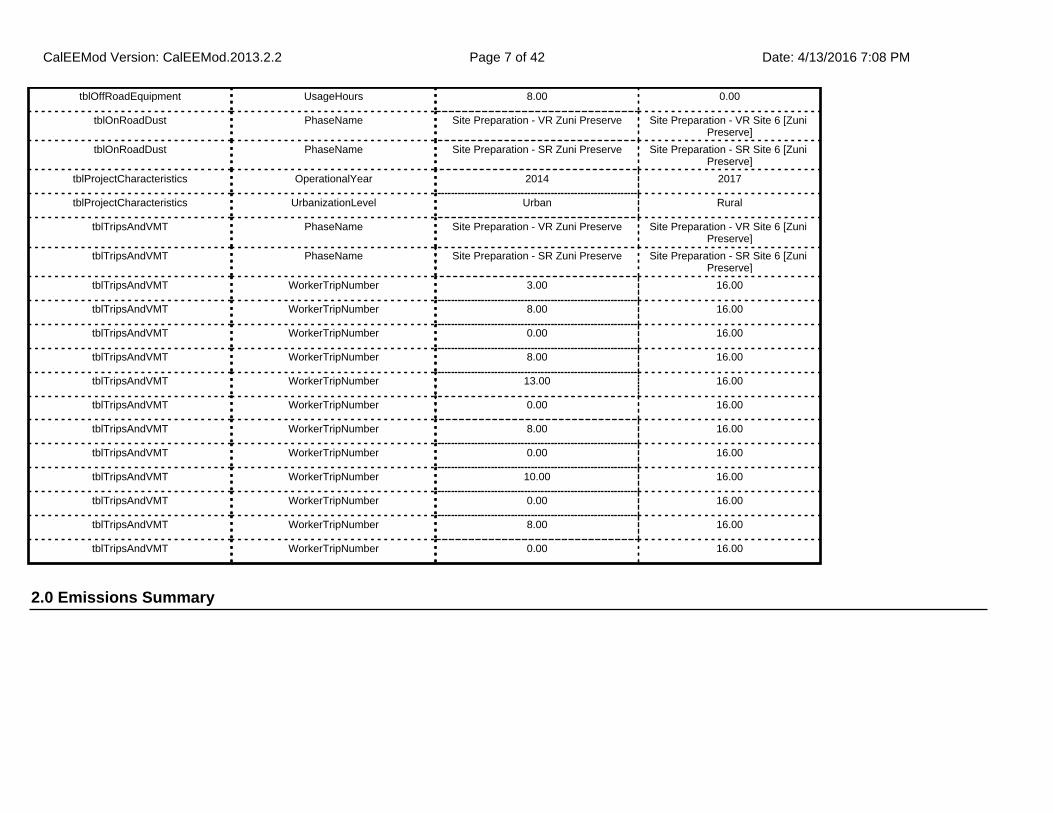
2.0 Emissions Summary
tblOffRoadEquipment UsageHours 8.00 0.00
tblOnRoadDust PhaseName Site Preparation - VR Zuni Preserve Site Preparation - VR Site 6 [Zuni Preserve]
tblOnRoadDust PhaseName Site Preparation - SR Zuni Preserve Site Preparation - SR Site 6 [Zuni Preserve]
tblProjectCharacteristics OperationalYear 2014 2017
tblProjectCharacteristics UrbanizationLevel Urban Rural
tblTripsAndVMT PhaseName Site Preparation - VR Zuni Preserve Site Preparation - VR Site 6 [Zuni Preserve]
tblTripsAndVMT PhaseName Site Preparation - SR Zuni Preserve Site Preparation - SR Site 6 [Zuni Preserve]
tblTripsAndVMT WorkerTripNumber 3.00 16.00
tblTripsAndVMT WorkerTripNumber 8.00 16.00
tblTripsAndVMT WorkerTripNumber 0.00 16.00
tblTripsAndVMT WorkerTripNumber 8.00 16.00
tblTripsAndVMT WorkerTripNumber 13.00 16.00
tblTripsAndVMT WorkerTripNumber 0.00 16.00
tblTripsAndVMT WorkerTripNumber 8.00 16.00
tblTripsAndVMT WorkerTripNumber 0.00 16.00
tblTripsAndVMT WorkerTripNumber 10.00 16.00
tblTripsAndVMT WorkerTripNumber 0.00 16.00
tblTripsAndVMT WorkerTripNumber 8.00 16.00
tblTripsAndVMT WorkerTripNumber 0.00 16.00
CalEEMod Version: CalEEMod.2013.2.2 Date: 4/13/2016 7:08 PMPage 7 of 42
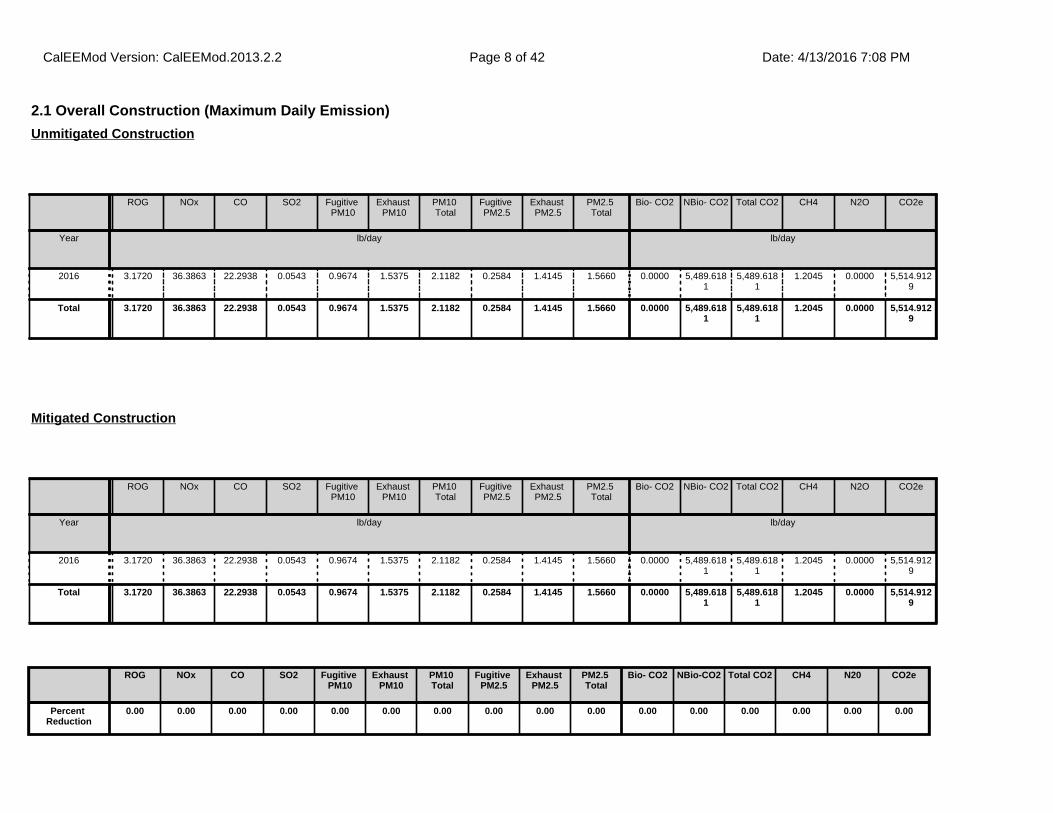
2.1 Overall Construction (Maximum Daily Emission)
ROG NOx CO SO2 Fugitive PM10
Exhaust PM10
PM10 Total
Fugitive PM2.5
Exhaust PM2.5
PM2.5 Total
Bio- CO2 NBio- CO2 Total CO2 CH4 N2O CO2e
Year lb/day lb/day
2016 3.1720 36.3863 22.2938 0.0543 0.9674 1.5375 2.1182 0.2584 1.4145 1.5660 0.0000 5,489.6181
5,489.6181
1.2045 0.0000 5,514.9129
Total 3.1720 36.3863 22.2938 0.0543 0.9674 1.5375 2.1182 0.2584 1.4145 1.5660 0.0000 5,489.6181
5,489.6181
1.2045 0.0000 5,514.9129
Unmitigated Construction
ROG NOx CO SO2 Fugitive PM10
Exhaust PM10
PM10 Total
Fugitive PM2.5
Exhaust PM2.5
PM2.5 Total
Bio- CO2 NBio- CO2 Total CO2 CH4 N2O CO2e
Year lb/day lb/day
2016 3.1720 36.3863 22.2938 0.0543 0.9674 1.5375 2.1182 0.2584 1.4145 1.5660 0.0000 5,489.6181
5,489.6181
1.2045 0.0000 5,514.9129
Total 3.1720 36.3863 22.2938 0.0543 0.9674 1.5375 2.1182 0.2584 1.4145 1.5660 0.0000 5,489.6181
5,489.6181
1.2045 0.0000 5,514.9129
Mitigated Construction
ROG NOx CO SO2 Fugitive PM10
Exhaust PM10
PM10 Total
Fugitive PM2.5
Exhaust PM2.5
PM2.5 Total
Bio- CO2 NBio-CO2 Total CO2 CH4 N20 CO2e
Percent Reduction
0.00 0.00 0.00 0.00 0.00 0.00 0.00 0.00 0.00 0.00 0.00 0.00 0.00 0.00 0.00 0.00
CalEEMod Version: CalEEMod.2013.2.2 Date: 4/13/2016 7:08 PMPage 8 of 42
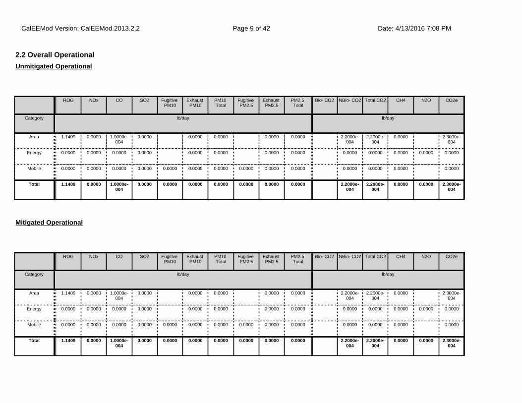
2.2 Overall Operational
ROG NOx CO SO2 Fugitive PM10
Exhaust PM10
PM10 Total
Fugitive PM2.5
Exhaust PM2.5
PM2.5 Total
Bio- CO2 NBio- CO2 Total CO2 CH4 N2O CO2e
Category lb/day lb/day
Area 1.1409 0.0000 1.0000e-004
0.0000 0.0000 0.0000 0.0000 0.0000 2.2000e-004
2.2000e-004
0.0000 2.3000e-004
Energy 0.0000 0.0000 0.0000 0.0000 0.0000 0.0000 0.0000 0.0000 0.0000 0.0000 0.0000 0.0000 0.0000
Mobile 0.0000 0.0000 0.0000 0.0000 0.0000 0.0000 0.0000 0.0000 0.0000 0.0000 0.0000 0.0000 0.0000 0.0000
Total 1.1409 0.0000 1.0000e-004
0.0000 0.0000 0.0000 0.0000 0.0000 0.0000 0.0000 2.2000e-004
2.2000e-004
0.0000 0.0000 2.3000e-004
Unmitigated Operational
ROG NOx CO SO2 Fugitive PM10
Exhaust PM10
PM10 Total
Fugitive PM2.5
Exhaust PM2.5
PM2.5 Total
Bio- CO2 NBio- CO2 Total CO2 CH4 N2O CO2e
Category lb/day lb/day
Area 1.1409 0.0000 1.0000e-004
0.0000 0.0000 0.0000 0.0000 0.0000 2.2000e-004
2.2000e-004
0.0000 2.3000e-004
Energy 0.0000 0.0000 0.0000 0.0000 0.0000 0.0000 0.0000 0.0000 0.0000 0.0000 0.0000 0.0000 0.0000
Mobile 0.0000 0.0000 0.0000 0.0000 0.0000 0.0000 0.0000 0.0000 0.0000 0.0000 0.0000 0.0000 0.0000 0.0000
Total 1.1409 0.0000 1.0000e-004
0.0000 0.0000 0.0000 0.0000 0.0000 0.0000 0.0000 2.2000e-004
2.2000e-004
0.0000 0.0000 2.3000e-004
Mitigated Operational
CalEEMod Version: CalEEMod.2013.2.2 Date: 4/13/2016 7:08 PMPage 9 of 42
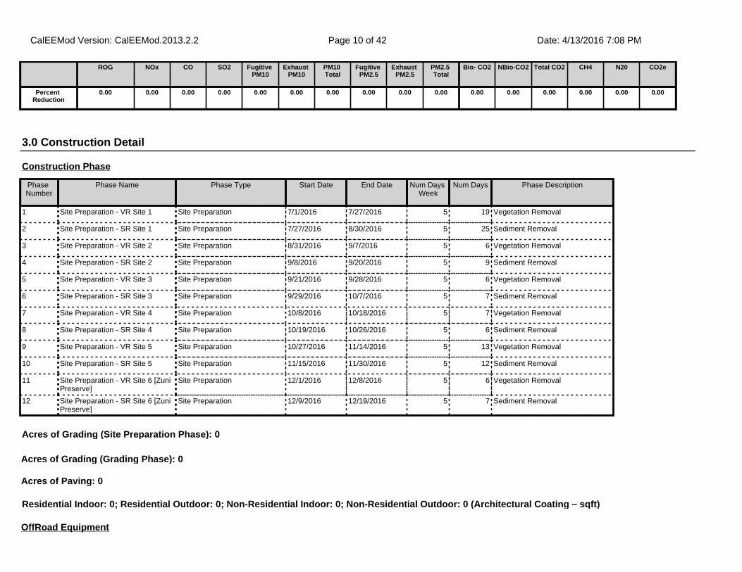
3.0 Construction Detail
Construction Phase
Phase Number
Phase Name Phase Type Start Date End Date Num Days Week
Num Days Phase Description
1 Site Preparation - VR Site 1 Site Preparation 7/1/2016 7/27/2016 5 19 Vegetation Removal
2 Site Preparation - SR Site 1 Site Preparation 7/27/2016 8/30/2016 5 25 Sediment Removal
3 Site Preparation - VR Site 2 Site Preparation 8/31/2016 9/7/2016 5 6 Vegetation Removal
4 Site Preparation - SR Site 2 Site Preparation 9/8/2016 9/20/2016 5 9 Sediment Removal
5 Site Preparation - VR Site 3 Site Preparation 9/21/2016 9/28/2016 5 6 Vegetation Removal
6 Site Preparation - SR Site 3 Site Preparation 9/29/2016 10/7/2016 5 7 Sediment Removal
7 Site Preparation - VR Site 4 Site Preparation 10/8/2016 10/18/2016 5 7 Vegetation Removal
8 Site Preparation - SR Site 4 Site Preparation 10/19/2016 10/26/2016 5 6 Sediment Removal
9 Site Preparation - VR Site 5 Site Preparation 10/27/2016 11/14/2016 5 13 Vegetation Removal
10 Site Preparation - SR Site 5 Site Preparation 11/15/2016 11/30/2016 5 12 Sediment Removal
11 Site Preparation - VR Site 6 [Zuni Preserve]
Site Preparation 12/1/2016 12/8/2016 5 6 Vegetation Removal
12 Site Preparation - SR Site 6 [Zuni Preserve]
Site Preparation 12/9/2016 12/19/2016 5 7 Sediment Removal
OffRoad Equipment
ROG NOx CO SO2 Fugitive PM10
Exhaust PM10
PM10 Total
Fugitive PM2.5
Exhaust PM2.5
PM2.5 Total
Bio- CO2 NBio-CO2 Total CO2 CH4 N20 CO2e
Percent Reduction
0.00 0.00 0.00 0.00 0.00 0.00 0.00 0.00 0.00 0.00 0.00 0.00 0.00 0.00 0.00 0.00
Residential Indoor: 0; Residential Outdoor: 0; Non-Residential Indoor: 0; Non-Residential Outdoor: 0 (Architectural Coating – sqft)
Acres of Grading (Site Preparation Phase): 0
Acres of Grading (Grading Phase): 0
Acres of Paving: 0
CalEEMod Version: CalEEMod.2013.2.2 Date: 4/13/2016 7:08 PMPage 10 of 42
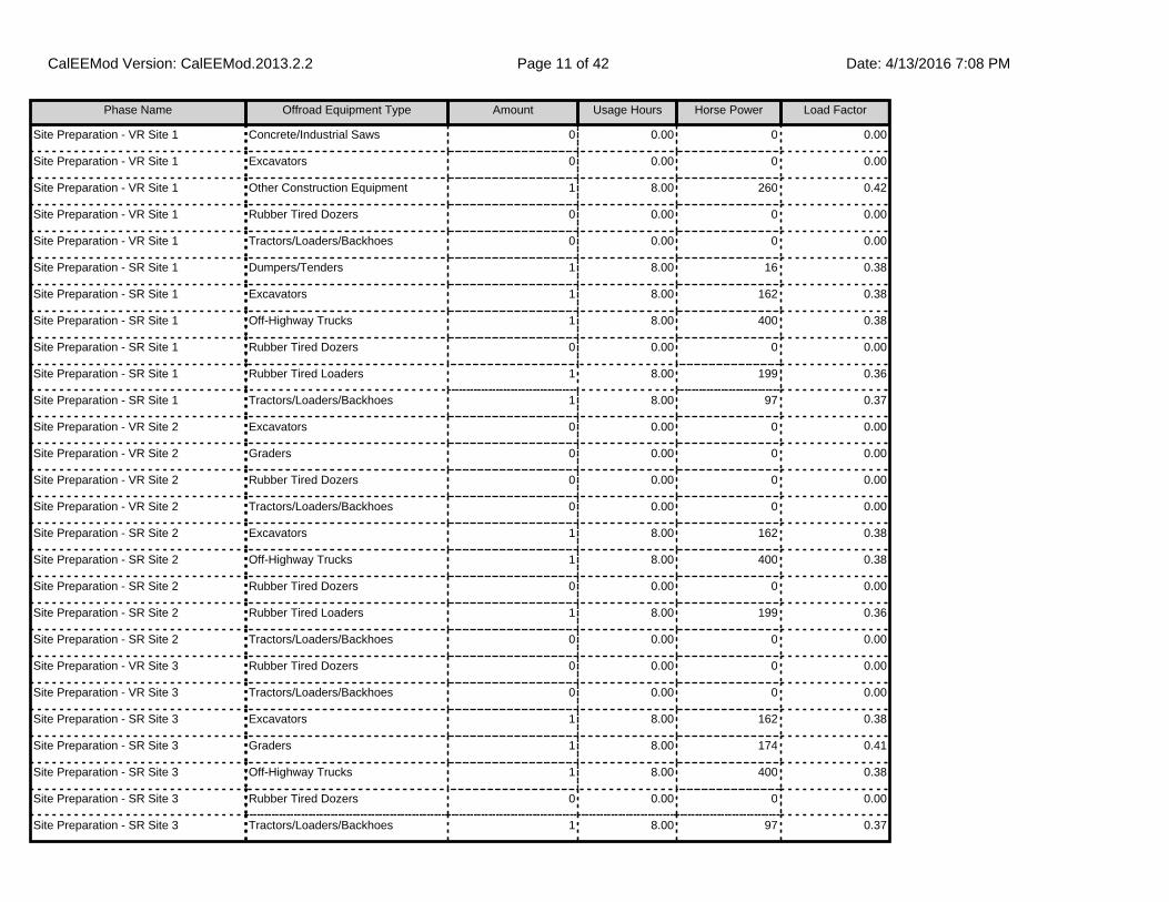
Phase Name Offroad Equipment Type Amount Usage Hours Horse Power Load Factor
Site Preparation - VR Site 1 Concrete/Industrial Saws 0 0.00 0 0.00
Site Preparation - VR Site 1 Excavators 0 0.00 0 0.00
Site Preparation - VR Site 1 Other Construction Equipment 1 8.00 260 0.42
Site Preparation - VR Site 1 Rubber Tired Dozers 0 0.00 0 0.00
Site Preparation - VR Site 1 Tractors/Loaders/Backhoes 0 0.00 0 0.00
Site Preparation - SR Site 1 Dumpers/Tenders 1 8.00 16 0.38
Site Preparation - SR Site 1 Excavators 1 8.00 162 0.38
Site Preparation - SR Site 1 Off-Highway Trucks 1 8.00 400 0.38
Site Preparation - SR Site 1 Rubber Tired Dozers 0 0.00 0 0.00
Site Preparation - SR Site 1 Rubber Tired Loaders 1 8.00 199 0.36
Site Preparation - SR Site 1 Tractors/Loaders/Backhoes 1 8.00 97 0.37
Site Preparation - VR Site 2 Excavators 0 0.00 0 0.00
Site Preparation - VR Site 2 Graders 0 0.00 0 0.00
Site Preparation - VR Site 2 Rubber Tired Dozers 0 0.00 0 0.00
Site Preparation - VR Site 2 Tractors/Loaders/Backhoes 0 0.00 0 0.00
Site Preparation - SR Site 2 Excavators 1 8.00 162 0.38
Site Preparation - SR Site 2 Off-Highway Trucks 1 8.00 400 0.38
Site Preparation - SR Site 2 Rubber Tired Dozers 0 0.00 0 0.00
Site Preparation - SR Site 2 Rubber Tired Loaders 1 8.00 199 0.36
Site Preparation - SR Site 2 Tractors/Loaders/Backhoes 0 0.00 0 0.00
Site Preparation - VR Site 3 Rubber Tired Dozers 0 0.00 0 0.00
Site Preparation - VR Site 3 Tractors/Loaders/Backhoes 0 0.00 0 0.00
Site Preparation - SR Site 3 Excavators 1 8.00 162 0.38
Site Preparation - SR Site 3 Graders 1 8.00 174 0.41
Site Preparation - SR Site 3 Off-Highway Trucks 1 8.00 400 0.38
Site Preparation - SR Site 3 Rubber Tired Dozers 0 0.00 0 0.00
Site Preparation - SR Site 3 Tractors/Loaders/Backhoes 1 8.00 97 0.37
CalEEMod Version: CalEEMod.2013.2.2 Date: 4/13/2016 7:08 PMPage 11 of 42
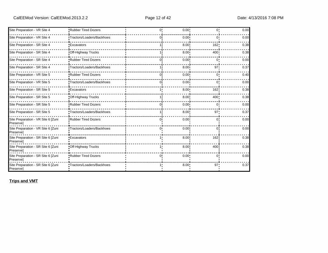
Site Preparation - VR Site 4 Rubber Tired Dozers 0 0.00 0 0.00
Site Preparation - VR Site 4 Tractors/Loaders/Backhoes 0 0.00 0 0.00
Site Preparation - SR Site 4 Excavators 1 8.00 162 0.38
Site Preparation - SR Site 4 Off-Highway Trucks 1 8.00 400 0.38
Site Preparation - SR Site 4 Rubber Tired Dozers 0 0.00 0 0.00
Site Preparation - SR Site 4 Tractors/Loaders/Backhoes 1 8.00 97 0.37
Site Preparation - VR Site 5 Rubber Tired Dozers 0 0.00 0 0.40
Site Preparation - VR Site 5 Tractors/Loaders/Backhoes 0 0.00 0 0.00
Site Preparation - SR Site 5 Excavators 1 8.00 162 0.38
Site Preparation - SR Site 5 Off-Highway Trucks 1 8.00 400 0.38
Site Preparation - SR Site 5 Rubber Tired Dozers 0 0.00 0 0.00
Site Preparation - SR Site 5 Tractors/Loaders/Backhoes 1 8.00 97 0.37
Site Preparation - VR Site 6 [Zuni Preserve]
Rubber Tired Dozers 0 0.00 0 0.00
Site Preparation - VR Site 6 [Zuni Preserve]
Tractors/Loaders/Backhoes 0 0.00 0 0.00
Site Preparation - SR Site 6 [Zuni Preserve]
Excavators 1 8.00 162 0.38
Site Preparation - SR Site 6 [Zuni Preserve]
Off-Highway Trucks 1 8.00 400 0.38
Site Preparation - SR Site 6 [Zuni Preserve]
Rubber Tired Dozers 0 0.00 0 0.00
Site Preparation - SR Site 6 [Zuni Preserve]
Tractors/Loaders/Backhoes 1 8.00 97 0.37
Trips and VMT
CalEEMod Version: CalEEMod.2013.2.2 Date: 4/13/2016 7:08 PMPage 12 of 42

3.1 Mitigation Measures Construction
Phase Name Offroad Equipment Count
Worker Trip Number
Vendor Trip Number
Hauling Trip Number
Worker Trip Length
Vendor Trip Length
Hauling Trip Length
Worker Vehicle Class
Vendor Vehicle Class
Hauling Vehicle Class
Site Preparation - VR Site 1
1 16.00 0.00 0.00 19.80 7.90 20.00 LD_Mix HDT_Mix HHDT
Site Preparation - SR Site 1
5 16.00 0.00 250.00 19.80 7.90 20.00 LD_Mix HDT_Mix HHDT
Site Preparation - VR Site 2
0 16.00 0.00 0.00 19.80 7.90 20.00 LD_Mix HDT_Mix HHDT
Site Preparation - SR Site 2
3 16.00 0.00 238.00 19.80 7.90 20.00 LD_Mix HDT_Mix HHDT
Site Preparation - VR Site 3
0 16.00 0.00 0.00 19.80 7.90 20.00 LD_Mix HDT_Mix HHDT
Site Preparation - SR Site 3
4 16.00 0.00 125.00 19.80 7.90 20.00 LD_Mix HDT_Mix HHDT
Site Preparation - VR Site 4
0 16.00 0.00 0.00 19.80 7.90 20.00 LD_Mix HDT_Mix HHDT
Site Preparation - SR Site 4
3 16.00 0.00 238.00 19.80 7.90 20.00 LD_Mix HDT_Mix HHDT
Site Preparation - VR Site 5
0 16.00 0.00 0.00 19.80 7.90 20.00 LD_Mix HDT_Mix HHDT
Site Preparation - SR Site 5
3 16.00 0.00 438.00 19.80 7.90 20.00 LD_Mix HDT_Mix HHDT
Site Preparation - VR Site 6 [Zuni Preserve]
0 16.00 0.00 0.00 19.80 7.90 20.00 LD_Mix HDT_Mix HHDT
Site Preparation - SR Site 6 [Zuni Preserve]
3 16.00 0.00 125.00 19.80 7.90 20.00 LD_Mix HDT_Mix HHDT
CalEEMod Version: CalEEMod.2013.2.2 Date: 4/13/2016 7:08 PMPage 13 of 42

3.2 Site Preparation - VR Site 1 - 2016
ROG NOx CO SO2 Fugitive PM10
Exhaust PM10
PM10 Total
Fugitive PM2.5
Exhaust PM2.5
PM2.5 Total
Bio- CO2 NBio- CO2 Total CO2 CH4 N2O CO2e
Category lb/day lb/day
Fugitive Dust 0.0000 0.0000 0.0000 0.0000 0.0000 0.0000 0.0000 0.0000
Off-Road 0.5923 7.8766 4.4006 9.4500e-003
0.2902 0.2902 0.2669 0.2669 981.6728 981.6728 0.2961 987.8911
Total 0.5923 7.8766 4.4006 9.4500e-003
0.0000 0.2902 0.2902 0.0000 0.2669 0.2669 981.6728 981.6728 0.2961 987.8911
Unmitigated Construction On-Site
ROG NOx CO SO2 Fugitive PM10
Exhaust PM10
PM10 Total
Fugitive PM2.5
Exhaust PM2.5
PM2.5 Total
Bio- CO2 NBio- CO2 Total CO2 CH4 N2O CO2e
Category lb/day lb/day
Hauling 0.0000 0.0000 0.0000 0.0000 0.0000 0.0000 0.0000 0.0000 0.0000 0.0000 0.0000 0.0000 0.0000 0.0000
Vendor 0.0000 0.0000 0.0000 0.0000 0.0000 0.0000 0.0000 0.0000 0.0000 0.0000 0.0000 0.0000 0.0000 0.0000
Worker 0.0810 0.1181 1.4615 3.1200e-003
0.2408 2.2300e-003
0.2431 0.0639 2.0500e-003
0.0659 263.5301 263.5301 0.0142 263.8287
Total 0.0810 0.1181 1.4615 3.1200e-003
0.2408 2.2300e-003
0.2431 0.0639 2.0500e-003
0.0659 263.5301 263.5301 0.0142 263.8287
Unmitigated Construction Off-Site
CalEEMod Version: CalEEMod.2013.2.2 Date: 4/13/2016 7:08 PMPage 14 of 42

3.2 Site Preparation - VR Site 1 - 2016
ROG NOx CO SO2 Fugitive PM10
Exhaust PM10
PM10 Total
Fugitive PM2.5
Exhaust PM2.5
PM2.5 Total
Bio- CO2 NBio- CO2 Total CO2 CH4 N2O CO2e
Category lb/day lb/day
Fugitive Dust 0.0000 0.0000 0.0000 0.0000 0.0000 0.0000 0.0000 0.0000
Off-Road 0.5923 7.8766 4.4006 9.4500e-003
0.2902 0.2902 0.2669 0.2669 0.0000 981.6728 981.6728 0.2961 987.8911
Total 0.5923 7.8766 4.4006 9.4500e-003
0.0000 0.2902 0.2902 0.0000 0.2669 0.2669 0.0000 981.6728 981.6728 0.2961 987.8911
Mitigated Construction On-Site
ROG NOx CO SO2 Fugitive PM10
Exhaust PM10
PM10 Total
Fugitive PM2.5
Exhaust PM2.5
PM2.5 Total
Bio- CO2 NBio- CO2 Total CO2 CH4 N2O CO2e
Category lb/day lb/day
Hauling 0.0000 0.0000 0.0000 0.0000 0.0000 0.0000 0.0000 0.0000 0.0000 0.0000 0.0000 0.0000 0.0000 0.0000
Vendor 0.0000 0.0000 0.0000 0.0000 0.0000 0.0000 0.0000 0.0000 0.0000 0.0000 0.0000 0.0000 0.0000 0.0000
Worker 0.0810 0.1181 1.4615 3.1200e-003
0.2408 2.2300e-003
0.2431 0.0639 2.0500e-003
0.0659 263.5301 263.5301 0.0142 263.8287
Total 0.0810 0.1181 1.4615 3.1200e-003
0.2408 2.2300e-003
0.2431 0.0639 2.0500e-003
0.0659 263.5301 263.5301 0.0142 263.8287
Mitigated Construction Off-Site
CalEEMod Version: CalEEMod.2013.2.2 Date: 4/13/2016 7:08 PMPage 15 of 42

3.3 Site Preparation - SR Site 1 - 2016
ROG NOx CO SO2 Fugitive PM10
Exhaust PM10
PM10 Total
Fugitive PM2.5
Exhaust PM2.5
PM2.5 Total
Bio- CO2 NBio- CO2 Total CO2 CH4 N2O CO2e
Category lb/day lb/day
Fugitive Dust 9.0500e-003
0.0000 9.0500e-003
1.3700e-003
0.0000 1.3700e-003
0.0000 0.0000
Off-Road 2.2416 25.4703 12.9809 0.0284 1.1172 1.1172 1.0294 1.0294 2,937.7540
2,937.7540
0.8744 2,956.1164
Total 2.2416 25.4703 12.9809 0.0284 9.0500e-003
1.1172 1.1263 1.3700e-003
1.0294 1.0307 2,937.7540
2,937.7540
0.8744 2,956.1164
Unmitigated Construction On-Site
ROG NOx CO SO2 Fugitive PM10
Exhaust PM10
PM10 Total
Fugitive PM2.5
Exhaust PM2.5
PM2.5 Total
Bio- CO2 NBio- CO2 Total CO2 CH4 N2O CO2e
Category lb/day lb/day
Hauling 0.1761 2.8032 1.9893 7.4700e-003
0.1741 0.0415 0.2157 0.0477 0.0382 0.0859 752.6844 752.6844 5.5700e-003
752.8013
Vendor 0.0000 0.0000 0.0000 0.0000 0.0000 0.0000 0.0000 0.0000 0.0000 0.0000 0.0000 0.0000 0.0000 0.0000
Worker 0.0810 0.1181 1.4615 3.1200e-003
0.2408 2.2300e-003
0.2431 0.0639 2.0500e-003
0.0659 263.5301 263.5301 0.0142 263.8287
Total 0.2571 2.9213 3.4508 0.0106 0.4150 0.0437 0.4587 0.1115 0.0402 0.1518 1,016.2145
1,016.2145
0.0198 1,016.6300
Unmitigated Construction Off-Site
CalEEMod Version: CalEEMod.2013.2.2 Date: 4/13/2016 7:08 PMPage 16 of 42

3.3 Site Preparation - SR Site 1 - 2016
ROG NOx CO SO2 Fugitive PM10
Exhaust PM10
PM10 Total
Fugitive PM2.5
Exhaust PM2.5
PM2.5 Total
Bio- CO2 NBio- CO2 Total CO2 CH4 N2O CO2e
Category lb/day lb/day
Fugitive Dust 9.0500e-003
0.0000 9.0500e-003
1.3700e-003
0.0000 1.3700e-003
0.0000 0.0000
Off-Road 2.2416 25.4703 12.9809 0.0284 1.1172 1.1172 1.0294 1.0294 0.0000 2,937.7540
2,937.7540
0.8744 2,956.1164
Total 2.2416 25.4703 12.9809 0.0284 9.0500e-003
1.1172 1.1263 1.3700e-003
1.0294 1.0307 0.0000 2,937.7540
2,937.7540
0.8744 2,956.1164
Mitigated Construction On-Site
ROG NOx CO SO2 Fugitive PM10
Exhaust PM10
PM10 Total
Fugitive PM2.5
Exhaust PM2.5
PM2.5 Total
Bio- CO2 NBio- CO2 Total CO2 CH4 N2O CO2e
Category lb/day lb/day
Hauling 0.1761 2.8032 1.9893 7.4700e-003
0.1741 0.0415 0.2157 0.0477 0.0382 0.0859 752.6844 752.6844 5.5700e-003
752.8013
Vendor 0.0000 0.0000 0.0000 0.0000 0.0000 0.0000 0.0000 0.0000 0.0000 0.0000 0.0000 0.0000 0.0000 0.0000
Worker 0.0810 0.1181 1.4615 3.1200e-003
0.2408 2.2300e-003
0.2431 0.0639 2.0500e-003
0.0659 263.5301 263.5301 0.0142 263.8287
Total 0.2571 2.9213 3.4508 0.0106 0.4150 0.0437 0.4587 0.1115 0.0402 0.1518 1,016.2145
1,016.2145
0.0198 1,016.6300
Mitigated Construction Off-Site
CalEEMod Version: CalEEMod.2013.2.2 Date: 4/13/2016 7:08 PMPage 17 of 42

3.4 Site Preparation - VR Site 2 - 2016
ROG NOx CO SO2 Fugitive PM10
Exhaust PM10
PM10 Total
Fugitive PM2.5
Exhaust PM2.5
PM2.5 Total
Bio- CO2 NBio- CO2 Total CO2 CH4 N2O CO2e
Category lb/day lb/day
Fugitive Dust 0.5303 0.0000 0.5303 0.0573 0.0000 0.0573 0.0000 0.0000
Total 0.5303 0.0000 0.5303 0.0573 0.0000 0.0573 0.0000 0.0000
Unmitigated Construction On-Site
ROG NOx CO SO2 Fugitive PM10
Exhaust PM10
PM10 Total
Fugitive PM2.5
Exhaust PM2.5
PM2.5 Total
Bio- CO2 NBio- CO2 Total CO2 CH4 N2O CO2e
Category lb/day lb/day
Hauling 0.0000 0.0000 0.0000 0.0000 0.0000 0.0000 0.0000 0.0000 0.0000 0.0000 0.0000 0.0000 0.0000 0.0000
Vendor 0.0000 0.0000 0.0000 0.0000 0.0000 0.0000 0.0000 0.0000 0.0000 0.0000 0.0000 0.0000 0.0000 0.0000
Worker 0.0810 0.1181 1.4615 3.1200e-003
0.2408 2.2300e-003
0.2431 0.0639 2.0500e-003
0.0659 263.5301 263.5301 0.0142 263.8287
Total 0.0810 0.1181 1.4615 3.1200e-003
0.2408 2.2300e-003
0.2431 0.0639 2.0500e-003
0.0659 263.5301 263.5301 0.0142 263.8287
Unmitigated Construction Off-Site
CalEEMod Version: CalEEMod.2013.2.2 Date: 4/13/2016 7:08 PMPage 18 of 42

3.4 Site Preparation - VR Site 2 - 2016
ROG NOx CO SO2 Fugitive PM10
Exhaust PM10
PM10 Total
Fugitive PM2.5
Exhaust PM2.5
PM2.5 Total
Bio- CO2 NBio- CO2 Total CO2 CH4 N2O CO2e
Category lb/day lb/day
Fugitive Dust 0.5303 0.0000 0.5303 0.0573 0.0000 0.0573 0.0000 0.0000
Total 0.5303 0.0000 0.5303 0.0573 0.0000 0.0573 0.0000 0.0000
Mitigated Construction On-Site
ROG NOx CO SO2 Fugitive PM10
Exhaust PM10
PM10 Total
Fugitive PM2.5
Exhaust PM2.5
PM2.5 Total
Bio- CO2 NBio- CO2 Total CO2 CH4 N2O CO2e
Category lb/day lb/day
Hauling 0.0000 0.0000 0.0000 0.0000 0.0000 0.0000 0.0000 0.0000 0.0000 0.0000 0.0000 0.0000 0.0000 0.0000
Vendor 0.0000 0.0000 0.0000 0.0000 0.0000 0.0000 0.0000 0.0000 0.0000 0.0000 0.0000 0.0000 0.0000 0.0000
Worker 0.0810 0.1181 1.4615 3.1200e-003
0.2408 2.2300e-003
0.2431 0.0639 2.0500e-003
0.0659 263.5301 263.5301 0.0142 263.8287
Total 0.0810 0.1181 1.4615 3.1200e-003
0.2408 2.2300e-003
0.2431 0.0639 2.0500e-003
0.0659 263.5301 263.5301 0.0142 263.8287
Mitigated Construction Off-Site
CalEEMod Version: CalEEMod.2013.2.2 Date: 4/13/2016 7:08 PMPage 19 of 42

3.5 Site Preparation - SR Site 2 - 2016
ROG NOx CO SO2 Fugitive PM10
Exhaust PM10
PM10 Total
Fugitive PM2.5
Exhaust PM2.5
PM2.5 Total
Bio- CO2 NBio- CO2 Total CO2 CH4 N2O CO2e
Category lb/day lb/day
Fugitive Dust 0.0239 0.0000 0.0239 3.6200e-003
0.0000 3.6200e-003
0.0000 0.0000
Off-Road 1.8270 21.7458 10.3172 0.0246 0.8479 0.8479 0.7800 0.7800 2,553.1364
2,553.1364
0.7701 2,569.3089
Total 1.8270 21.7458 10.3172 0.0246 0.0239 0.8479 0.8717 3.6200e-003
0.7800 0.7836 2,553.1364
2,553.1364
0.7701 2,569.3089
Unmitigated Construction On-Site
ROG NOx CO SO2 Fugitive PM10
Exhaust PM10
PM10 Total
Fugitive PM2.5
Exhaust PM2.5
PM2.5 Total
Bio- CO2 NBio- CO2 Total CO2 CH4 N2O CO2e
Category lb/day lb/day
Hauling 0.4658 7.4129 5.2606 0.0198 0.4605 0.1098 0.5703 0.1261 0.1010 0.2271 1,990.4321
1,990.4321
0.0147 1,990.7412
Vendor 0.0000 0.0000 0.0000 0.0000 0.0000 0.0000 0.0000 0.0000 0.0000 0.0000 0.0000 0.0000 0.0000 0.0000
Worker 0.0810 0.1181 1.4615 3.1200e-003
0.2408 2.2300e-003
0.2431 0.0639 2.0500e-003
0.0659 263.5301 263.5301 0.0142 263.8287
Total 0.5468 7.5310 6.7221 0.0229 0.7013 0.1120 0.8133 0.1900 0.1030 0.2930 2,253.9622
2,253.9622
0.0289 2,254.5699
Unmitigated Construction Off-Site
CalEEMod Version: CalEEMod.2013.2.2 Date: 4/13/2016 7:08 PMPage 20 of 42

3.5 Site Preparation - SR Site 2 - 2016
ROG NOx CO SO2 Fugitive PM10
Exhaust PM10
PM10 Total
Fugitive PM2.5
Exhaust PM2.5
PM2.5 Total
Bio- CO2 NBio- CO2 Total CO2 CH4 N2O CO2e
Category lb/day lb/day
Fugitive Dust 0.0239 0.0000 0.0239 3.6200e-003
0.0000 3.6200e-003
0.0000 0.0000
Off-Road 1.8270 21.7458 10.3172 0.0246 0.8479 0.8479 0.7800 0.7800 0.0000 2,553.1364
2,553.1364
0.7701 2,569.3089
Total 1.8270 21.7458 10.3172 0.0246 0.0239 0.8479 0.8717 3.6200e-003
0.7800 0.7836 0.0000 2,553.1364
2,553.1364
0.7701 2,569.3089
Mitigated Construction On-Site
ROG NOx CO SO2 Fugitive PM10
Exhaust PM10
PM10 Total
Fugitive PM2.5
Exhaust PM2.5
PM2.5 Total
Bio- CO2 NBio- CO2 Total CO2 CH4 N2O CO2e
Category lb/day lb/day
Hauling 0.4658 7.4129 5.2606 0.0198 0.4605 0.1098 0.5703 0.1261 0.1010 0.2271 1,990.4321
1,990.4321
0.0147 1,990.7412
Vendor 0.0000 0.0000 0.0000 0.0000 0.0000 0.0000 0.0000 0.0000 0.0000 0.0000 0.0000 0.0000 0.0000 0.0000
Worker 0.0810 0.1181 1.4615 3.1200e-003
0.2408 2.2300e-003
0.2431 0.0639 2.0500e-003
0.0659 263.5301 263.5301 0.0142 263.8287
Total 0.5468 7.5310 6.7221 0.0229 0.7013 0.1120 0.8133 0.1900 0.1030 0.2930 2,253.9622
2,253.9622
0.0289 2,254.5699
Mitigated Construction Off-Site
CalEEMod Version: CalEEMod.2013.2.2 Date: 4/13/2016 7:08 PMPage 21 of 42

3.6 Site Preparation - VR Site 3 - 2016
ROG NOx CO SO2 Fugitive PM10
Exhaust PM10
PM10 Total
Fugitive PM2.5
Exhaust PM2.5
PM2.5 Total
Bio- CO2 NBio- CO2 Total CO2 CH4 N2O CO2e
Category lb/day lb/day
Fugitive Dust 0.0000 0.0000 0.0000 0.0000 0.0000 0.0000 0.0000 0.0000
Total 0.0000 0.0000 0.0000 0.0000 0.0000 0.0000 0.0000 0.0000
Unmitigated Construction On-Site
ROG NOx CO SO2 Fugitive PM10
Exhaust PM10
PM10 Total
Fugitive PM2.5
Exhaust PM2.5
PM2.5 Total
Bio- CO2 NBio- CO2 Total CO2 CH4 N2O CO2e
Category lb/day lb/day
Hauling 0.0000 0.0000 0.0000 0.0000 0.0000 0.0000 0.0000 0.0000 0.0000 0.0000 0.0000 0.0000 0.0000 0.0000
Vendor 0.0000 0.0000 0.0000 0.0000 0.0000 0.0000 0.0000 0.0000 0.0000 0.0000 0.0000 0.0000 0.0000 0.0000
Worker 0.0810 0.1181 1.4615 3.1200e-003
0.2408 2.2300e-003
0.2431 0.0639 2.0500e-003
0.0659 263.5301 263.5301 0.0142 263.8287
Total 0.0810 0.1181 1.4615 3.1200e-003
0.2408 2.2300e-003
0.2431 0.0639 2.0500e-003
0.0659 263.5301 263.5301 0.0142 263.8287
Unmitigated Construction Off-Site
CalEEMod Version: CalEEMod.2013.2.2 Date: 4/13/2016 7:08 PMPage 22 of 42
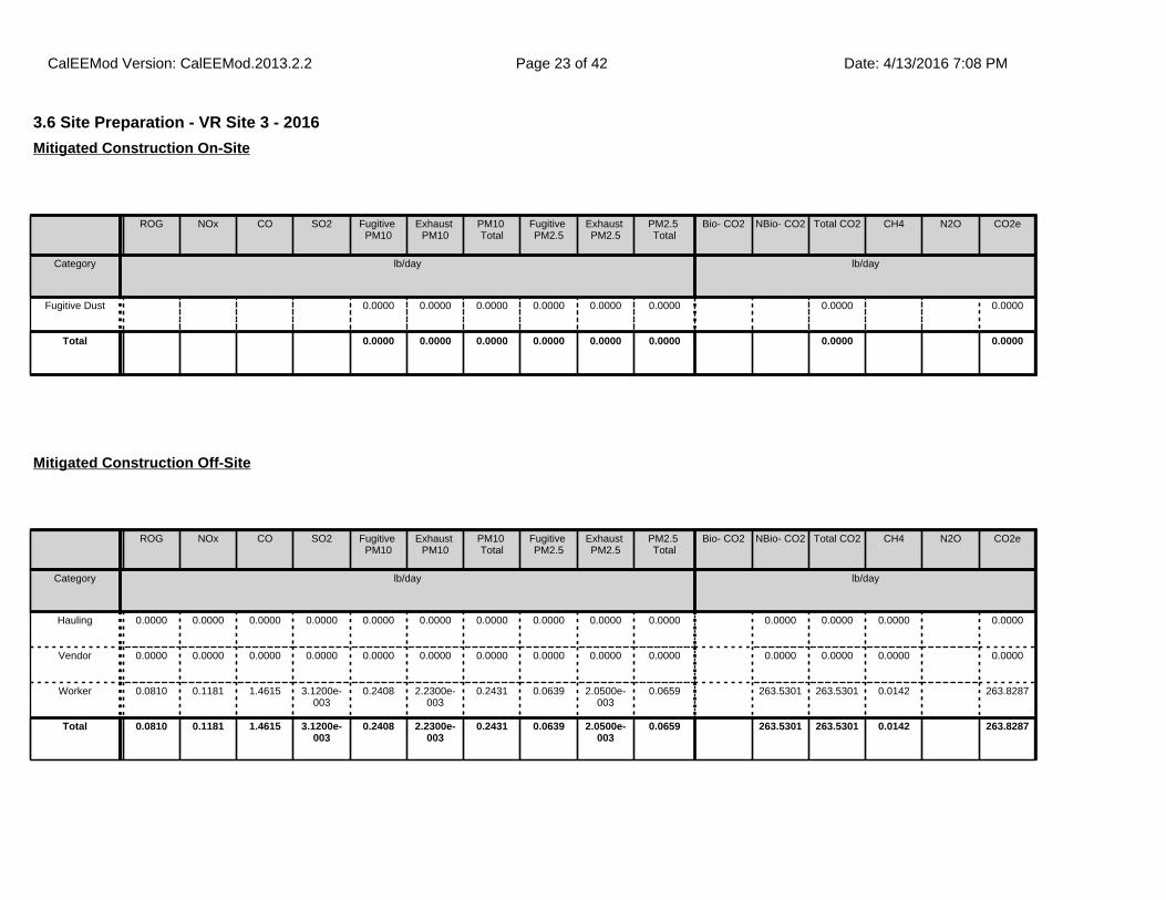
3.6 Site Preparation - VR Site 3 - 2016
ROG NOx CO SO2 Fugitive PM10
Exhaust PM10
PM10 Total
Fugitive PM2.5
Exhaust PM2.5
PM2.5 Total
Bio- CO2 NBio- CO2 Total CO2 CH4 N2O CO2e
Category lb/day lb/day
Fugitive Dust 0.0000 0.0000 0.0000 0.0000 0.0000 0.0000 0.0000 0.0000
Total 0.0000 0.0000 0.0000 0.0000 0.0000 0.0000 0.0000 0.0000
Mitigated Construction On-Site
ROG NOx CO SO2 Fugitive PM10
Exhaust PM10
PM10 Total
Fugitive PM2.5
Exhaust PM2.5
PM2.5 Total
Bio- CO2 NBio- CO2 Total CO2 CH4 N2O CO2e
Category lb/day lb/day
Hauling 0.0000 0.0000 0.0000 0.0000 0.0000 0.0000 0.0000 0.0000 0.0000 0.0000 0.0000 0.0000 0.0000 0.0000
Vendor 0.0000 0.0000 0.0000 0.0000 0.0000 0.0000 0.0000 0.0000 0.0000 0.0000 0.0000 0.0000 0.0000 0.0000
Worker 0.0810 0.1181 1.4615 3.1200e-003
0.2408 2.2300e-003
0.2431 0.0639 2.0500e-003
0.0659 263.5301 263.5301 0.0142 263.8287
Total 0.0810 0.1181 1.4615 3.1200e-003
0.2408 2.2300e-003
0.2431 0.0639 2.0500e-003
0.0659 263.5301 263.5301 0.0142 263.8287
Mitigated Construction Off-Site
CalEEMod Version: CalEEMod.2013.2.2 Date: 4/13/2016 7:08 PMPage 23 of 42
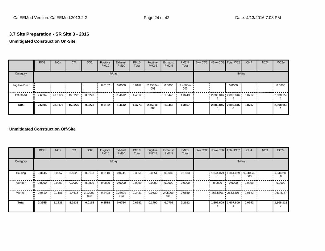
3.7 Site Preparation - SR Site 3 - 2016
ROG NOx CO SO2 Fugitive PM10
Exhaust PM10
PM10 Total
Fugitive PM2.5
Exhaust PM2.5
PM2.5 Total
Bio- CO2 NBio- CO2 Total CO2 CH4 N2O CO2e
Category lb/day lb/day
Fugitive Dust 0.0162 0.0000 0.0162 2.4500e-003
0.0000 2.4500e-003
0.0000 0.0000
Off-Road 2.6894 28.9177 15.8225 0.0278 1.4612 1.4612 1.3443 1.3443 2,889.8468
2,889.8468
0.8717 2,908.1521
Total 2.6894 28.9177 15.8225 0.0278 0.0162 1.4612 1.4773 2.4500e-003
1.3443 1.3467 2,889.8468
2,889.8468
0.8717 2,908.1521
Unmitigated Construction On-Site
ROG NOx CO SO2 Fugitive PM10
Exhaust PM10
PM10 Total
Fugitive PM2.5
Exhaust PM2.5
PM2.5 Total
Bio- CO2 NBio- CO2 Total CO2 CH4 N2O CO2e
Category lb/day lb/day
Hauling 0.3145 5.0057 3.5523 0.0133 0.3110 0.0741 0.3851 0.0851 0.0682 0.1533 1,344.0793
1,344.0793
9.9400e-003
1,344.2880
Vendor 0.0000 0.0000 0.0000 0.0000 0.0000 0.0000 0.0000 0.0000 0.0000 0.0000 0.0000 0.0000 0.0000 0.0000
Worker 0.0810 0.1181 1.4615 3.1200e-003
0.2408 2.2300e-003
0.2431 0.0639 2.0500e-003
0.0659 263.5301 263.5301 0.0142 263.8287
Total 0.3955 5.1238 5.0138 0.0165 0.5518 0.0764 0.6282 0.1490 0.0702 0.2192 1,607.6094
1,607.6094
0.0242 1,608.1167
Unmitigated Construction Off-Site
CalEEMod Version: CalEEMod.2013.2.2 Date: 4/13/2016 7:08 PMPage 24 of 42

3.7 Site Preparation - SR Site 3 - 2016
ROG NOx CO SO2 Fugitive PM10
Exhaust PM10
PM10 Total
Fugitive PM2.5
Exhaust PM2.5
PM2.5 Total
Bio- CO2 NBio- CO2 Total CO2 CH4 N2O CO2e
Category lb/day lb/day
Fugitive Dust 0.0162 0.0000 0.0162 2.4500e-003
0.0000 2.4500e-003
0.0000 0.0000
Off-Road 2.6894 28.9177 15.8225 0.0278 1.4612 1.4612 1.3443 1.3443 0.0000 2,889.8468
2,889.8468
0.8717 2,908.1521
Total 2.6894 28.9177 15.8225 0.0278 0.0162 1.4612 1.4773 2.4500e-003
1.3443 1.3467 0.0000 2,889.8468
2,889.8468
0.8717 2,908.1521
Mitigated Construction On-Site
ROG NOx CO SO2 Fugitive PM10
Exhaust PM10
PM10 Total
Fugitive PM2.5
Exhaust PM2.5
PM2.5 Total
Bio- CO2 NBio- CO2 Total CO2 CH4 N2O CO2e
Category lb/day lb/day
Hauling 0.3145 5.0057 3.5523 0.0133 0.3110 0.0741 0.3851 0.0851 0.0682 0.1533 1,344.0793
1,344.0793
9.9400e-003
1,344.2880
Vendor 0.0000 0.0000 0.0000 0.0000 0.0000 0.0000 0.0000 0.0000 0.0000 0.0000 0.0000 0.0000 0.0000 0.0000
Worker 0.0810 0.1181 1.4615 3.1200e-003
0.2408 2.2300e-003
0.2431 0.0639 2.0500e-003
0.0659 263.5301 263.5301 0.0142 263.8287
Total 0.3955 5.1238 5.0138 0.0165 0.5518 0.0764 0.6282 0.1490 0.0702 0.2192 1,607.6094
1,607.6094
0.0242 1,608.1167
Mitigated Construction Off-Site
CalEEMod Version: CalEEMod.2013.2.2 Date: 4/13/2016 7:08 PMPage 25 of 42

3.8 Site Preparation - VR Site 4 - 2016
ROG NOx CO SO2 Fugitive PM10
Exhaust PM10
PM10 Total
Fugitive PM2.5
Exhaust PM2.5
PM2.5 Total
Bio- CO2 NBio- CO2 Total CO2 CH4 N2O CO2e
Category lb/day lb/day
Fugitive Dust 0.0000 0.0000 0.0000 0.0000 0.0000 0.0000 0.0000 0.0000
Total 0.0000 0.0000 0.0000 0.0000 0.0000 0.0000 0.0000 0.0000
Unmitigated Construction On-Site
ROG NOx CO SO2 Fugitive PM10
Exhaust PM10
PM10 Total
Fugitive PM2.5
Exhaust PM2.5
PM2.5 Total
Bio- CO2 NBio- CO2 Total CO2 CH4 N2O CO2e
Category lb/day lb/day
Hauling 0.0000 0.0000 0.0000 0.0000 0.0000 0.0000 0.0000 0.0000 0.0000 0.0000 0.0000 0.0000 0.0000 0.0000
Vendor 0.0000 0.0000 0.0000 0.0000 0.0000 0.0000 0.0000 0.0000 0.0000 0.0000 0.0000 0.0000 0.0000 0.0000
Worker 0.0810 0.1181 1.4615 3.1200e-003
0.2408 2.2300e-003
0.2431 0.0639 2.0500e-003
0.0659 263.5301 263.5301 0.0142 263.8287
Total 0.0810 0.1181 1.4615 3.1200e-003
0.2408 2.2300e-003
0.2431 0.0639 2.0500e-003
0.0659 263.5301 263.5301 0.0142 263.8287
Unmitigated Construction Off-Site
CalEEMod Version: CalEEMod.2013.2.2 Date: 4/13/2016 7:08 PMPage 26 of 42

3.8 Site Preparation - VR Site 4 - 2016
ROG NOx CO SO2 Fugitive PM10
Exhaust PM10
PM10 Total
Fugitive PM2.5
Exhaust PM2.5
PM2.5 Total
Bio- CO2 NBio- CO2 Total CO2 CH4 N2O CO2e
Category lb/day lb/day
Fugitive Dust 0.0000 0.0000 0.0000 0.0000 0.0000 0.0000 0.0000 0.0000
Total 0.0000 0.0000 0.0000 0.0000 0.0000 0.0000 0.0000 0.0000
Mitigated Construction On-Site
ROG NOx CO SO2 Fugitive PM10
Exhaust PM10
PM10 Total
Fugitive PM2.5
Exhaust PM2.5
PM2.5 Total
Bio- CO2 NBio- CO2 Total CO2 CH4 N2O CO2e
Category lb/day lb/day
Hauling 0.0000 0.0000 0.0000 0.0000 0.0000 0.0000 0.0000 0.0000 0.0000 0.0000 0.0000 0.0000 0.0000 0.0000
Vendor 0.0000 0.0000 0.0000 0.0000 0.0000 0.0000 0.0000 0.0000 0.0000 0.0000 0.0000 0.0000 0.0000 0.0000
Worker 0.0810 0.1181 1.4615 3.1200e-003
0.2408 2.2300e-003
0.2431 0.0639 2.0500e-003
0.0659 263.5301 263.5301 0.0142 263.8287
Total 0.0810 0.1181 1.4615 3.1200e-003
0.2408 2.2300e-003
0.2431 0.0639 2.0500e-003
0.0659 263.5301 263.5301 0.0142 263.8287
Mitigated Construction Off-Site
CalEEMod Version: CalEEMod.2013.2.2 Date: 4/13/2016 7:08 PMPage 27 of 42

3.9 Site Preparation - SR Site 4 - 2016
ROG NOx CO SO2 Fugitive PM10
Exhaust PM10
PM10 Total
Fugitive PM2.5
Exhaust PM2.5
PM2.5 Total
Bio- CO2 NBio- CO2 Total CO2 CH4 N2O CO2e
Category lb/day lb/day
Fugitive Dust 0.0358 0.0000 0.0358 5.4200e-003
0.0000 5.4200e-003
0.0000 0.0000
Off-Road 1.6707 18.5378 10.8950 0.0216 0.8781 0.8781 0.8078 0.8078 2,240.4399
2,240.4399
0.6758 2,254.6316
Total 1.6707 18.5378 10.8950 0.0216 0.0358 0.8781 0.9139 5.4200e-003
0.8078 0.8132 2,240.4399
2,240.4399
0.6758 2,254.6316
Unmitigated Construction On-Site
ROG NOx CO SO2 Fugitive PM10
Exhaust PM10
PM10 Total
Fugitive PM2.5
Exhaust PM2.5
PM2.5 Total
Bio- CO2 NBio- CO2 Total CO2 CH4 N2O CO2e
Category lb/day lb/day
Hauling 0.6987 11.1194 7.8908 0.0296 0.6908 0.1646 0.8554 0.1891 0.1514 0.3406 2,985.6482
2,985.6482
0.0221 2,986.1118
Vendor 0.0000 0.0000 0.0000 0.0000 0.0000 0.0000 0.0000 0.0000 0.0000 0.0000 0.0000 0.0000 0.0000 0.0000
Worker 0.0810 0.1181 1.4615 3.1200e-003
0.2408 2.2300e-003
0.2431 0.0639 2.0500e-003
0.0659 263.5301 263.5301 0.0142 263.8287
Total 0.7797 11.2375 9.3523 0.0328 0.9316 0.1669 1.0985 0.2530 0.1535 0.4065 3,249.1782
3,249.1782
0.0363 3,249.9405
Unmitigated Construction Off-Site
CalEEMod Version: CalEEMod.2013.2.2 Date: 4/13/2016 7:08 PMPage 28 of 42

3.9 Site Preparation - SR Site 4 - 2016
ROG NOx CO SO2 Fugitive PM10
Exhaust PM10
PM10 Total
Fugitive PM2.5
Exhaust PM2.5
PM2.5 Total
Bio- CO2 NBio- CO2 Total CO2 CH4 N2O CO2e
Category lb/day lb/day
Fugitive Dust 0.0358 0.0000 0.0358 5.4200e-003
0.0000 5.4200e-003
0.0000 0.0000
Off-Road 1.6707 18.5378 10.8950 0.0216 0.8781 0.8781 0.8078 0.8078 0.0000 2,240.4399
2,240.4399
0.6758 2,254.6316
Total 1.6707 18.5378 10.8950 0.0216 0.0358 0.8781 0.9139 5.4200e-003
0.8078 0.8132 0.0000 2,240.4399
2,240.4399
0.6758 2,254.6316
Mitigated Construction On-Site
ROG NOx CO SO2 Fugitive PM10
Exhaust PM10
PM10 Total
Fugitive PM2.5
Exhaust PM2.5
PM2.5 Total
Bio- CO2 NBio- CO2 Total CO2 CH4 N2O CO2e
Category lb/day lb/day
Hauling 0.6987 11.1194 7.8908 0.0296 0.6908 0.1646 0.8554 0.1891 0.1514 0.3406 2,985.6482
2,985.6482
0.0221 2,986.1118
Vendor 0.0000 0.0000 0.0000 0.0000 0.0000 0.0000 0.0000 0.0000 0.0000 0.0000 0.0000 0.0000 0.0000 0.0000
Worker 0.0810 0.1181 1.4615 3.1200e-003
0.2408 2.2300e-003
0.2431 0.0639 2.0500e-003
0.0659 263.5301 263.5301 0.0142 263.8287
Total 0.7797 11.2375 9.3523 0.0328 0.9316 0.1669 1.0985 0.2530 0.1535 0.4065 3,249.1782
3,249.1782
0.0363 3,249.9405
Mitigated Construction Off-Site
CalEEMod Version: CalEEMod.2013.2.2 Date: 4/13/2016 7:08 PMPage 29 of 42
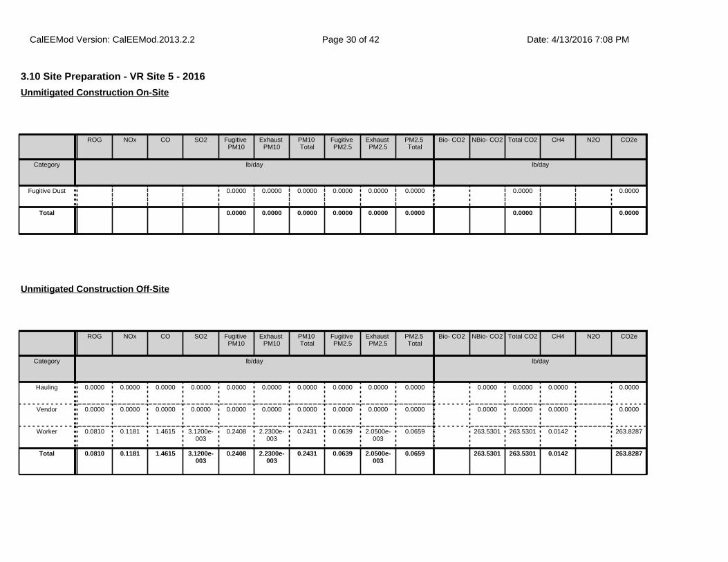
3.10 Site Preparation - VR Site 5 - 2016
ROG NOx CO SO2 Fugitive PM10
Exhaust PM10
PM10 Total
Fugitive PM2.5
Exhaust PM2.5
PM2.5 Total
Bio- CO2 NBio- CO2 Total CO2 CH4 N2O CO2e
Category lb/day lb/day
Fugitive Dust 0.0000 0.0000 0.0000 0.0000 0.0000 0.0000 0.0000 0.0000
Total 0.0000 0.0000 0.0000 0.0000 0.0000 0.0000 0.0000 0.0000
Unmitigated Construction On-Site
ROG NOx CO SO2 Fugitive PM10
Exhaust PM10
PM10 Total
Fugitive PM2.5
Exhaust PM2.5
PM2.5 Total
Bio- CO2 NBio- CO2 Total CO2 CH4 N2O CO2e
Category lb/day lb/day
Hauling 0.0000 0.0000 0.0000 0.0000 0.0000 0.0000 0.0000 0.0000 0.0000 0.0000 0.0000 0.0000 0.0000 0.0000
Vendor 0.0000 0.0000 0.0000 0.0000 0.0000 0.0000 0.0000 0.0000 0.0000 0.0000 0.0000 0.0000 0.0000 0.0000
Worker 0.0810 0.1181 1.4615 3.1200e-003
0.2408 2.2300e-003
0.2431 0.0639 2.0500e-003
0.0659 263.5301 263.5301 0.0142 263.8287
Total 0.0810 0.1181 1.4615 3.1200e-003
0.2408 2.2300e-003
0.2431 0.0639 2.0500e-003
0.0659 263.5301 263.5301 0.0142 263.8287
Unmitigated Construction Off-Site
CalEEMod Version: CalEEMod.2013.2.2 Date: 4/13/2016 7:08 PMPage 30 of 42

3.10 Site Preparation - VR Site 5 - 2016
ROG NOx CO SO2 Fugitive PM10
Exhaust PM10
PM10 Total
Fugitive PM2.5
Exhaust PM2.5
PM2.5 Total
Bio- CO2 NBio- CO2 Total CO2 CH4 N2O CO2e
Category lb/day lb/day
Fugitive Dust 0.0000 0.0000 0.0000 0.0000 0.0000 0.0000 0.0000 0.0000
Total 0.0000 0.0000 0.0000 0.0000 0.0000 0.0000 0.0000 0.0000
Mitigated Construction On-Site
ROG NOx CO SO2 Fugitive PM10
Exhaust PM10
PM10 Total
Fugitive PM2.5
Exhaust PM2.5
PM2.5 Total
Bio- CO2 NBio- CO2 Total CO2 CH4 N2O CO2e
Category lb/day lb/day
Hauling 0.0000 0.0000 0.0000 0.0000 0.0000 0.0000 0.0000 0.0000 0.0000 0.0000 0.0000 0.0000 0.0000 0.0000
Vendor 0.0000 0.0000 0.0000 0.0000 0.0000 0.0000 0.0000 0.0000 0.0000 0.0000 0.0000 0.0000 0.0000 0.0000
Worker 0.0810 0.1181 1.4615 3.1200e-003
0.2408 2.2300e-003
0.2431 0.0639 2.0500e-003
0.0659 263.5301 263.5301 0.0142 263.8287
Total 0.0810 0.1181 1.4615 3.1200e-003
0.2408 2.2300e-003
0.2431 0.0639 2.0500e-003
0.0659 263.5301 263.5301 0.0142 263.8287
Mitigated Construction Off-Site
CalEEMod Version: CalEEMod.2013.2.2 Date: 4/13/2016 7:08 PMPage 31 of 42

3.11 Site Preparation - SR Site 5 - 2016
ROG NOx CO SO2 Fugitive PM10
Exhaust PM10
PM10 Total
Fugitive PM2.5
Exhaust PM2.5
PM2.5 Total
Bio- CO2 NBio- CO2 Total CO2 CH4 N2O CO2e
Category lb/day lb/day
Fugitive Dust 0.0330 0.0000 0.0330 4.9900e-003
0.0000 4.9900e-003
0.0000 0.0000
Off-Road 1.6707 18.5378 10.8950 0.0216 0.8781 0.8781 0.8078 0.8078 2,240.4399
2,240.4399
0.6758 2,254.6316
Total 1.6707 18.5378 10.8950 0.0216 0.0330 0.8781 0.9110 4.9900e-003
0.8078 0.8128 2,240.4399
2,240.4399
0.6758 2,254.6316
Unmitigated Construction On-Site
ROG NOx CO SO2 Fugitive PM10
Exhaust PM10
PM10 Total
Fugitive PM2.5
Exhaust PM2.5
PM2.5 Total
Bio- CO2 NBio- CO2 Total CO2 CH4 N2O CO2e
Category lb/day lb/day
Hauling 0.6429 10.2317 7.2609 0.0273 0.6356 0.1515 0.7871 0.1740 0.1394 0.3134 2,747.2981
2,747.2981
0.0203 2,747.7247
Vendor 0.0000 0.0000 0.0000 0.0000 0.0000 0.0000 0.0000 0.0000 0.0000 0.0000 0.0000 0.0000 0.0000 0.0000
Worker 0.0810 0.1181 1.4615 3.1200e-003
0.2408 2.2300e-003
0.2431 0.0639 2.0500e-003
0.0659 263.5301 263.5301 0.0142 263.8287
Total 0.7239 10.3498 8.7224 0.0304 0.8765 0.1537 1.0302 0.2379 0.1414 0.3793 3,010.8281
3,010.8281
0.0345 3,011.5534
Unmitigated Construction Off-Site
CalEEMod Version: CalEEMod.2013.2.2 Date: 4/13/2016 7:08 PMPage 32 of 42
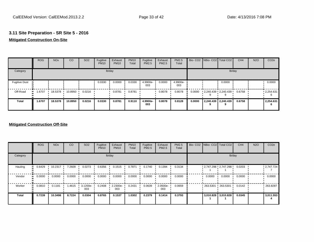
3.11 Site Preparation - SR Site 5 - 2016
ROG NOx CO SO2 Fugitive PM10
Exhaust PM10
PM10 Total
Fugitive PM2.5
Exhaust PM2.5
PM2.5 Total
Bio- CO2 NBio- CO2 Total CO2 CH4 N2O CO2e
Category lb/day lb/day
Fugitive Dust 0.0330 0.0000 0.0330 4.9900e-003
0.0000 4.9900e-003
0.0000 0.0000
Off-Road 1.6707 18.5378 10.8950 0.0216 0.8781 0.8781 0.8078 0.8078 0.0000 2,240.4399
2,240.4399
0.6758 2,254.6316
Total 1.6707 18.5378 10.8950 0.0216 0.0330 0.8781 0.9110 4.9900e-003
0.8078 0.8128 0.0000 2,240.4399
2,240.4399
0.6758 2,254.6316
Mitigated Construction On-Site
ROG NOx CO SO2 Fugitive PM10
Exhaust PM10
PM10 Total
Fugitive PM2.5
Exhaust PM2.5
PM2.5 Total
Bio- CO2 NBio- CO2 Total CO2 CH4 N2O CO2e
Category lb/day lb/day
Hauling 0.6429 10.2317 7.2609 0.0273 0.6356 0.1515 0.7871 0.1740 0.1394 0.3134 2,747.2981
2,747.2981
0.0203 2,747.7247
Vendor 0.0000 0.0000 0.0000 0.0000 0.0000 0.0000 0.0000 0.0000 0.0000 0.0000 0.0000 0.0000 0.0000 0.0000
Worker 0.0810 0.1181 1.4615 3.1200e-003
0.2408 2.2300e-003
0.2431 0.0639 2.0500e-003
0.0659 263.5301 263.5301 0.0142 263.8287
Total 0.7239 10.3498 8.7224 0.0304 0.8765 0.1537 1.0302 0.2379 0.1414 0.3793 3,010.8281
3,010.8281
0.0345 3,011.5534
Mitigated Construction Off-Site
CalEEMod Version: CalEEMod.2013.2.2 Date: 4/13/2016 7:08 PMPage 33 of 42
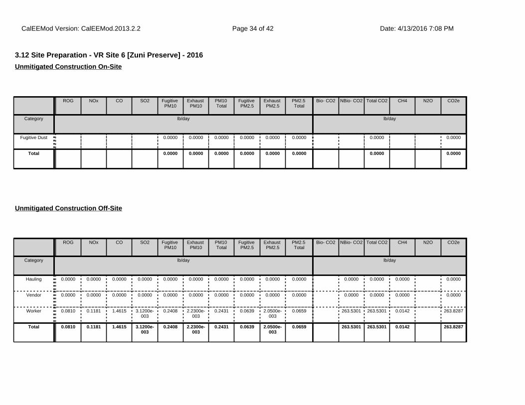
3.12 Site Preparation - VR Site 6 [Zuni Preserve] - 2016
ROG NOx CO SO2 Fugitive PM10
Exhaust PM10
PM10 Total
Fugitive PM2.5
Exhaust PM2.5
PM2.5 Total
Bio- CO2 NBio- CO2 Total CO2 CH4 N2O CO2e
Category lb/day lb/day
Fugitive Dust 0.0000 0.0000 0.0000 0.0000 0.0000 0.0000 0.0000 0.0000
Total 0.0000 0.0000 0.0000 0.0000 0.0000 0.0000 0.0000 0.0000
Unmitigated Construction On-Site
ROG NOx CO SO2 Fugitive PM10
Exhaust PM10
PM10 Total
Fugitive PM2.5
Exhaust PM2.5
PM2.5 Total
Bio- CO2 NBio- CO2 Total CO2 CH4 N2O CO2e
Category lb/day lb/day
Hauling 0.0000 0.0000 0.0000 0.0000 0.0000 0.0000 0.0000 0.0000 0.0000 0.0000 0.0000 0.0000 0.0000 0.0000
Vendor 0.0000 0.0000 0.0000 0.0000 0.0000 0.0000 0.0000 0.0000 0.0000 0.0000 0.0000 0.0000 0.0000 0.0000
Worker 0.0810 0.1181 1.4615 3.1200e-003
0.2408 2.2300e-003
0.2431 0.0639 2.0500e-003
0.0659 263.5301 263.5301 0.0142 263.8287
Total 0.0810 0.1181 1.4615 3.1200e-003
0.2408 2.2300e-003
0.2431 0.0639 2.0500e-003
0.0659 263.5301 263.5301 0.0142 263.8287
Unmitigated Construction Off-Site
CalEEMod Version: CalEEMod.2013.2.2 Date: 4/13/2016 7:08 PMPage 34 of 42

3.12 Site Preparation - VR Site 6 [Zuni Preserve] - 2016
ROG NOx CO SO2 Fugitive PM10
Exhaust PM10
PM10 Total
Fugitive PM2.5
Exhaust PM2.5
PM2.5 Total
Bio- CO2 NBio- CO2 Total CO2 CH4 N2O CO2e
Category lb/day lb/day
Fugitive Dust 0.0000 0.0000 0.0000 0.0000 0.0000 0.0000 0.0000 0.0000
Total 0.0000 0.0000 0.0000 0.0000 0.0000 0.0000 0.0000 0.0000
Mitigated Construction On-Site
ROG NOx CO SO2 Fugitive PM10
Exhaust PM10
PM10 Total
Fugitive PM2.5
Exhaust PM2.5
PM2.5 Total
Bio- CO2 NBio- CO2 Total CO2 CH4 N2O CO2e
Category lb/day lb/day
Hauling 0.0000 0.0000 0.0000 0.0000 0.0000 0.0000 0.0000 0.0000 0.0000 0.0000 0.0000 0.0000 0.0000 0.0000
Vendor 0.0000 0.0000 0.0000 0.0000 0.0000 0.0000 0.0000 0.0000 0.0000 0.0000 0.0000 0.0000 0.0000 0.0000
Worker 0.0810 0.1181 1.4615 3.1200e-003
0.2408 2.2300e-003
0.2431 0.0639 2.0500e-003
0.0659 263.5301 263.5301 0.0142 263.8287
Total 0.0810 0.1181 1.4615 3.1200e-003
0.2408 2.2300e-003
0.2431 0.0639 2.0500e-003
0.0659 263.5301 263.5301 0.0142 263.8287
Mitigated Construction Off-Site
CalEEMod Version: CalEEMod.2013.2.2 Date: 4/13/2016 7:08 PMPage 35 of 42
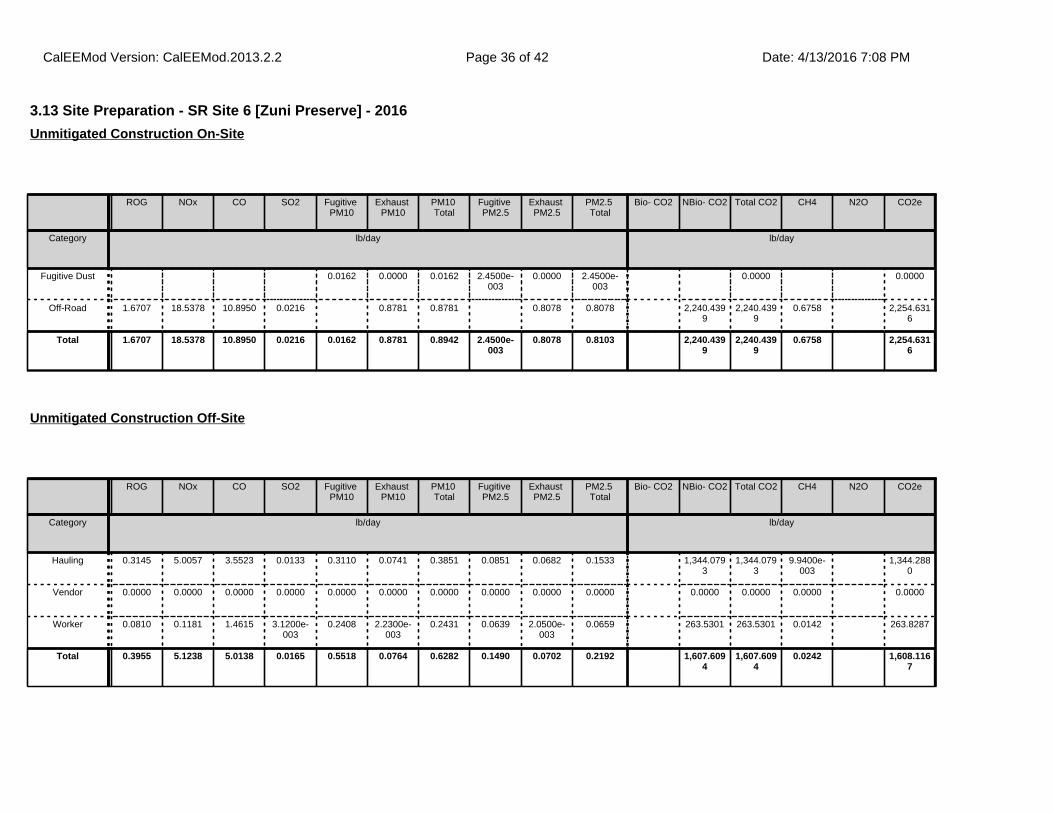
3.13 Site Preparation - SR Site 6 [Zuni Preserve] - 2016
ROG NOx CO SO2 Fugitive PM10
Exhaust PM10
PM10 Total
Fugitive PM2.5
Exhaust PM2.5
PM2.5 Total
Bio- CO2 NBio- CO2 Total CO2 CH4 N2O CO2e
Category lb/day lb/day
Fugitive Dust 0.0162 0.0000 0.0162 2.4500e-003
0.0000 2.4500e-003
0.0000 0.0000
Off-Road 1.6707 18.5378 10.8950 0.0216 0.8781 0.8781 0.8078 0.8078 2,240.4399
2,240.4399
0.6758 2,254.6316
Total 1.6707 18.5378 10.8950 0.0216 0.0162 0.8781 0.8942 2.4500e-003
0.8078 0.8103 2,240.4399
2,240.4399
0.6758 2,254.6316
Unmitigated Construction On-Site
ROG NOx CO SO2 Fugitive PM10
Exhaust PM10
PM10 Total
Fugitive PM2.5
Exhaust PM2.5
PM2.5 Total
Bio- CO2 NBio- CO2 Total CO2 CH4 N2O CO2e
Category lb/day lb/day
Hauling 0.3145 5.0057 3.5523 0.0133 0.3110 0.0741 0.3851 0.0851 0.0682 0.1533 1,344.0793
1,344.0793
9.9400e-003
1,344.2880
Vendor 0.0000 0.0000 0.0000 0.0000 0.0000 0.0000 0.0000 0.0000 0.0000 0.0000 0.0000 0.0000 0.0000 0.0000
Worker 0.0810 0.1181 1.4615 3.1200e-003
0.2408 2.2300e-003
0.2431 0.0639 2.0500e-003
0.0659 263.5301 263.5301 0.0142 263.8287
Total 0.3955 5.1238 5.0138 0.0165 0.5518 0.0764 0.6282 0.1490 0.0702 0.2192 1,607.6094
1,607.6094
0.0242 1,608.1167
Unmitigated Construction Off-Site
CalEEMod Version: CalEEMod.2013.2.2 Date: 4/13/2016 7:08 PMPage 36 of 42
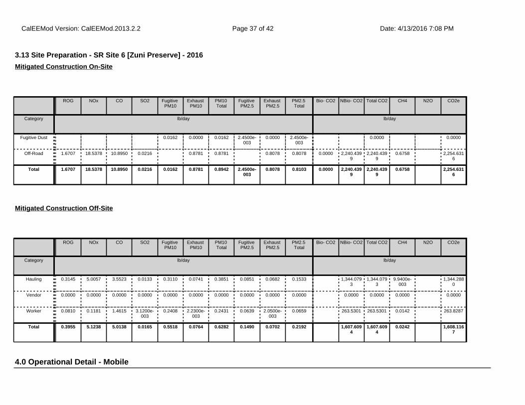
4.0 Operational Detail - Mobile
3.13 Site Preparation - SR Site 6 [Zuni Preserve] - 2016
ROG NOx CO SO2 Fugitive PM10
Exhaust PM10
PM10 Total
Fugitive PM2.5
Exhaust PM2.5
PM2.5 Total
Bio- CO2 NBio- CO2 Total CO2 CH4 N2O CO2e
Category lb/day lb/day
Fugitive Dust 0.0162 0.0000 0.0162 2.4500e-003
0.0000 2.4500e-003
0.0000 0.0000
Off-Road 1.6707 18.5378 10.8950 0.0216 0.8781 0.8781 0.8078 0.8078 0.0000 2,240.4399
2,240.4399
0.6758 2,254.6316
Total 1.6707 18.5378 10.8950 0.0216 0.0162 0.8781 0.8942 2.4500e-003
0.8078 0.8103 0.0000 2,240.4399
2,240.4399
0.6758 2,254.6316
Mitigated Construction On-Site
ROG NOx CO SO2 Fugitive PM10
Exhaust PM10
PM10 Total
Fugitive PM2.5
Exhaust PM2.5
PM2.5 Total
Bio- CO2 NBio- CO2 Total CO2 CH4 N2O CO2e
Category lb/day lb/day
Hauling 0.3145 5.0057 3.5523 0.0133 0.3110 0.0741 0.3851 0.0851 0.0682 0.1533 1,344.0793
1,344.0793
9.9400e-003
1,344.2880
Vendor 0.0000 0.0000 0.0000 0.0000 0.0000 0.0000 0.0000 0.0000 0.0000 0.0000 0.0000 0.0000 0.0000 0.0000
Worker 0.0810 0.1181 1.4615 3.1200e-003
0.2408 2.2300e-003
0.2431 0.0639 2.0500e-003
0.0659 263.5301 263.5301 0.0142 263.8287
Total 0.3955 5.1238 5.0138 0.0165 0.5518 0.0764 0.6282 0.1490 0.0702 0.2192 1,607.6094
1,607.6094
0.0242 1,608.1167
Mitigated Construction Off-Site
CalEEMod Version: CalEEMod.2013.2.2 Date: 4/13/2016 7:08 PMPage 37 of 42
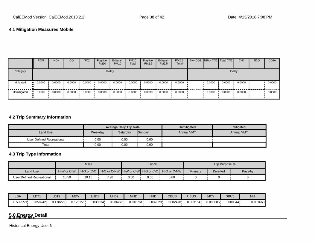
ROG NOx CO SO2 Fugitive PM10
Exhaust PM10
PM10 Total
Fugitive PM2.5
Exhaust PM2.5
PM2.5 Total
Bio- CO2 NBio- CO2 Total CO2 CH4 N2O CO2e
Category lb/day lb/day
Mitigated 0.0000 0.0000 0.0000 0.0000 0.0000 0.0000 0.0000 0.0000 0.0000 0.0000 0.0000 0.0000 0.0000 0.0000
Unmitigated 0.0000 0.0000 0.0000 0.0000 0.0000 0.0000 0.0000 0.0000 0.0000 0.0000 0.0000 0.0000 0.0000 0.0000
4.1 Mitigation Measures Mobile
4.2 Trip Summary Information
4.3 Trip Type Information
Average Daily Trip Rate Unmitigated Mitigated
Land Use Weekday Saturday Sunday Annual VMT Annual VMT
User Defined Recreational 0.00 0.00 0.00
Total 0.00 0.00 0.00
Miles Trip % Trip Purpose %
Land Use H-W or C-W H-S or C-C H-O or C-NW H-W or C-W H-S or C-C H-O or C-NW Primary Diverted Pass-by
User Defined Recreational 18.50 10.10 7.90 0.00 0.00 0.00 0 0 0
5.0 Energy Detail4.4 Fleet Mix
LDA LDT1 LDT2 MDV LHD1 LHD2 MHD HHD OBUS UBUS MCY SBUS MH
0.532559 0.058242 0.178229 0.125155 0.038934 0.006273 0.016761 0.032323 0.002478 0.003154 0.003685 0.000544 0.001663
Historical Energy Use: N
CalEEMod Version: CalEEMod.2013.2.2 Date: 4/13/2016 7:08 PMPage 38 of 42
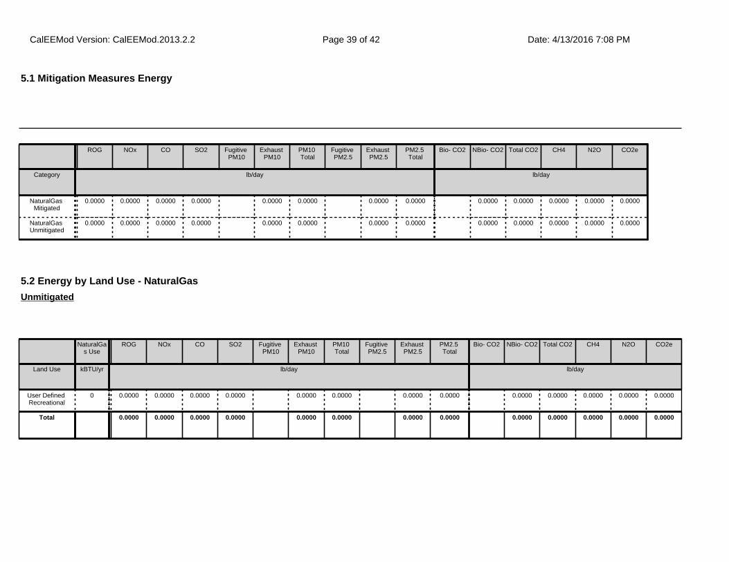
ROG NOx CO SO2 Fugitive PM10
Exhaust PM10
PM10 Total
Fugitive PM2.5
Exhaust PM2.5
PM2.5 Total
Bio- CO2 NBio- CO2 Total CO2 CH4 N2O CO2e
Category lb/day lb/day
NaturalGas Mitigated
0.0000 0.0000 0.0000 0.0000 0.0000 0.0000 0.0000 0.0000 0.0000 0.0000 0.0000 0.0000 0.0000
NaturalGas Unmitigated
0.0000 0.0000 0.0000 0.0000 0.0000 0.0000 0.0000 0.0000 0.0000 0.0000 0.0000 0.0000 0.0000
5.2 Energy by Land Use - NaturalGas
NaturalGas Use
ROG NOx CO SO2 Fugitive PM10
Exhaust PM10
PM10 Total
Fugitive PM2.5
Exhaust PM2.5
PM2.5 Total
Bio- CO2 NBio- CO2 Total CO2 CH4 N2O CO2e
Land Use kBTU/yr lb/day lb/day
User Defined Recreational
0 0.0000 0.0000 0.0000 0.0000 0.0000 0.0000 0.0000 0.0000 0.0000 0.0000 0.0000 0.0000 0.0000
Total 0.0000 0.0000 0.0000 0.0000 0.0000 0.0000 0.0000 0.0000 0.0000 0.0000 0.0000 0.0000 0.0000
Unmitigated
5.1 Mitigation Measures Energy
Historical Energy Use: N
CalEEMod Version: CalEEMod.2013.2.2 Date: 4/13/2016 7:08 PMPage 39 of 42
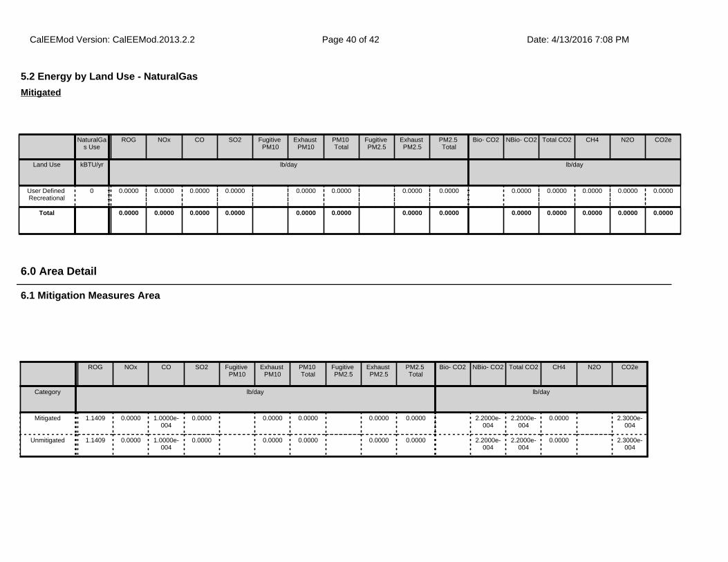
6.1 Mitigation Measures Area
6.0 Area Detail
ROG NOx CO SO2 Fugitive PM10
Exhaust PM10
PM10 Total
Fugitive PM2.5
Exhaust PM2.5
PM2.5 Total
Bio- CO2 NBio- CO2 Total CO2 CH4 N2O CO2e
Category lb/day lb/day
Mitigated 1.1409 0.0000 1.0000e-004
0.0000 0.0000 0.0000 0.0000 0.0000 2.2000e-004
2.2000e-004
0.0000 2.3000e-004
Unmitigated 1.1409 0.0000 1.0000e-004
0.0000 0.0000 0.0000 0.0000 0.0000 2.2000e-004
2.2000e-004
0.0000 2.3000e-004
5.2 Energy by Land Use - NaturalGas
NaturalGas Use
ROG NOx CO SO2 Fugitive PM10
Exhaust PM10
PM10 Total
Fugitive PM2.5
Exhaust PM2.5
PM2.5 Total
Bio- CO2 NBio- CO2 Total CO2 CH4 N2O CO2e
Land Use kBTU/yr lb/day lb/day
User Defined Recreational
0 0.0000 0.0000 0.0000 0.0000 0.0000 0.0000 0.0000 0.0000 0.0000 0.0000 0.0000 0.0000 0.0000
Total 0.0000 0.0000 0.0000 0.0000 0.0000 0.0000 0.0000 0.0000 0.0000 0.0000 0.0000 0.0000 0.0000
Mitigated
CalEEMod Version: CalEEMod.2013.2.2 Date: 4/13/2016 7:08 PMPage 40 of 42
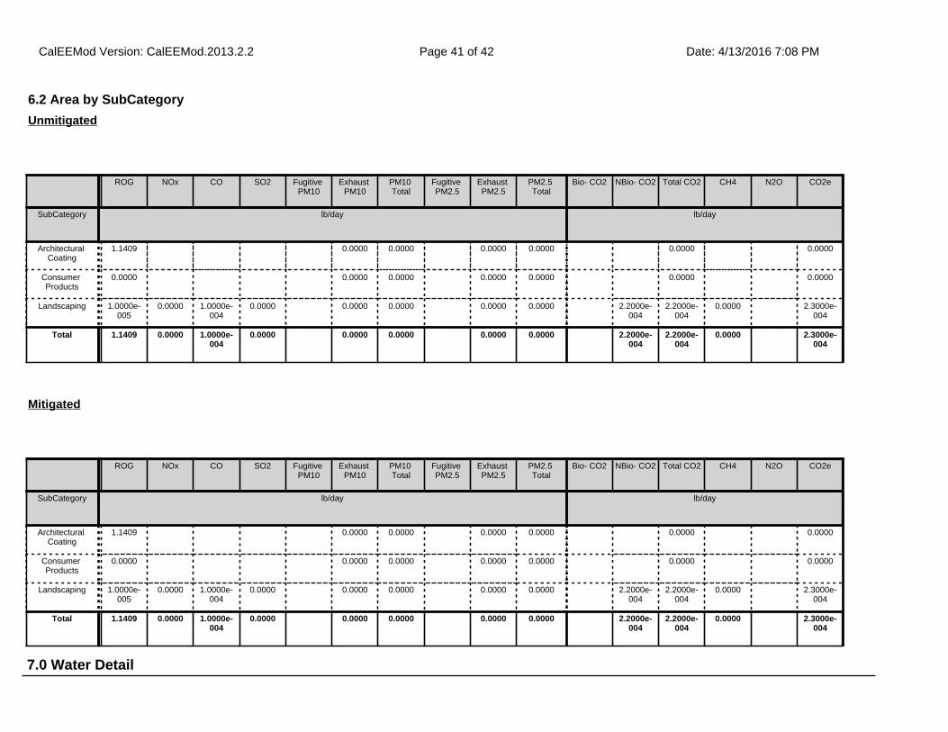
7.0 Water Detail
6.2 Area by SubCategory
ROG NOx CO SO2 Fugitive PM10
Exhaust PM10
PM10 Total
Fugitive PM2.5
Exhaust PM2.5
PM2.5 Total
Bio- CO2 NBio- CO2 Total CO2 CH4 N2O CO2e
SubCategory lb/day lb/day
Architectural Coating
1.1409 0.0000 0.0000 0.0000 0.0000 0.0000 0.0000
Consumer Products
0.0000 0.0000 0.0000 0.0000 0.0000 0.0000 0.0000
Landscaping 1.0000e-005
0.0000 1.0000e-004
0.0000 0.0000 0.0000 0.0000 0.0000 2.2000e-004
2.2000e-004
0.0000 2.3000e-004
Total 1.1409 0.0000 1.0000e-004
0.0000 0.0000 0.0000 0.0000 0.0000 2.2000e-004
2.2000e-004
0.0000 2.3000e-004
Unmitigated
ROG NOx CO SO2 Fugitive PM10
Exhaust PM10
PM10 Total
Fugitive PM2.5
Exhaust PM2.5
PM2.5 Total
Bio- CO2 NBio- CO2 Total CO2 CH4 N2O CO2e
SubCategory lb/day lb/day
Architectural Coating
1.1409 0.0000 0.0000 0.0000 0.0000 0.0000 0.0000
Consumer Products
0.0000 0.0000 0.0000 0.0000 0.0000 0.0000 0.0000
Landscaping 1.0000e-005
0.0000 1.0000e-004
0.0000 0.0000 0.0000 0.0000 0.0000 2.2000e-004
2.2000e-004
0.0000 2.3000e-004
Total 1.1409 0.0000 1.0000e-004
0.0000 0.0000 0.0000 0.0000 0.0000 2.2000e-004
2.2000e-004
0.0000 2.3000e-004
Mitigated
CalEEMod Version: CalEEMod.2013.2.2 Date: 4/13/2016 7:08 PMPage 41 of 42
8.1 Mitigation Measures Waste
7.1 Mitigation Measures Water
8.0 Waste Detail
10.0 Vegetation
9.0 Operational Offroad
Equipment Type Number Hours/Day Days/Year Horse Power Load Factor Fuel Type
CalEEMod Version: CalEEMod.2013.2.2 Date: 4/13/2016 7:08 PMPage 42 of 42

Los Angeles-South Coast County, Annual
Bouquet Creek Restoration Project
1.1 Land Usage
Land Uses Size Metric Lot Acreage Floor Surface Area Population
User Defined Recreational 1.00 User Defined Unit 10.26 0.00 0
1.2 Other Project Characteristics
Urbanization
Climate Zone
Rural
9
Wind Speed (m/s) Precipitation Freq (Days)2.2 33
1.3 User Entered Comments & Non-Default Data
1.0 Project Characteristics
Utility Company Southern California Edison
2017Operational Year
CO2 Intensity (lb/MWhr)
630.89 0.029CH4 Intensity (lb/MWhr)
0.006N2O Intensity (lb/MWhr)
CalEEMod Version: CalEEMod.2013.2.2 Date: 4/13/2016 6:53 PMPage 1 of 47

Project Characteristics -
Land Use - project is 5.5 acres
Construction Phase - phases based on project description; VR = vegetation removal; SR = sediment removal
Off-road Equipment - equipment based on project
Off-road Equipment - equipment based on project
Off-road Equipment - equipment based on project
Off-road Equipment - equipment based on project
Off-road Equipment - equipment based on project
Off-road Equipment - assumed based on project description
Off-road Equipment - Other construction equipment used in place of masticator; 260 HP assumed
Off-road Equipment - handtools/chainsaws/woodchipper
Off-road Equipment - handtools/chainsaws/woodchipper
Off-road Equipment - handtools/chainsaws/woodchipper
Off-road Equipment - handtools/chainsaws/woodchipper
Trips and VMT - trips based on number of workers at each site/day
Grading - assumed 1,000 CY moved at Zuni Preserve
Table Name Column Name Default Value New Value
tblAreaCoating Area_Nonresidential_Interior 0 359370
tblConstructionPhase NumDays 10.00 19.00
tblConstructionPhase NumDays 10.00 12.00
tblConstructionPhase NumDays 10.00 6.00
tblConstructionPhase NumDays 10.00 7.00
tblConstructionPhase NumDays 10.00 25.00
tblConstructionPhase NumDays 10.00 6.00
tblConstructionPhase NumDays 10.00 9.00
CalEEMod Version: CalEEMod.2013.2.2 Date: 4/13/2016 6:53 PMPage 2 of 47

tblConstructionPhase NumDays 10.00 6.00
tblConstructionPhase NumDays 10.00 7.00
tblConstructionPhase NumDays 10.00 7.00
tblConstructionPhase NumDays 10.00 6.00
tblConstructionPhase NumDays 10.00 13.00
tblConstructionPhase PhaseEndDate 8/31/2016 8/30/2016
tblConstructionPhase PhaseStartDate 7/28/2016 7/27/2016
tblGrading AcresOfGrading 0.00 3.00
tblGrading AcresOfGrading 3.50 0.00
tblGrading MaterialExported 0.00 3,500.00
tblGrading MaterialExported 0.00 1,000.00
tblGrading MaterialExported 0.00 2,000.00
tblGrading MaterialExported 0.00 1,900.00
tblGrading MaterialExported 0.00 1,000.00
tblGrading MaterialExported 0.00 1,900.00
tblGrading PhaseName Site Preparation - VR Zuni Preserve Site Preparation - VR Site 6 [Zuni Preserve]
tblGrading PhaseName Site Preparation - SR Zuni Preserve Site Preparation - SR Site 6 [Zuni Preserve]
tblLandUse LotAcreage 0.00 10.26
tblOffRoadEquipment HorsePower 255.00 0.00
tblOffRoadEquipment HorsePower 255.00 0.00
tblOffRoadEquipment HorsePower 255.00 0.00
tblOffRoadEquipment HorsePower 255.00 0.00
tblOffRoadEquipment HorsePower 255.00 0.00
tblOffRoadEquipment HorsePower 255.00 0.00
tblOffRoadEquipment HorsePower 255.00 0.00
tblOffRoadEquipment HorsePower 255.00 0.00
tblOffRoadEquipment HorsePower 255.00 0.00
CalEEMod Version: CalEEMod.2013.2.2 Date: 4/13/2016 6:53 PMPage 3 of 47

tblOffRoadEquipment HorsePower 255.00 0.00
tblOffRoadEquipment HorsePower 255.00 0.00
tblOffRoadEquipment HorsePower 255.00 0.00
tblOffRoadEquipment HorsePower 97.00 0.00
tblOffRoadEquipment HorsePower 97.00 0.00
tblOffRoadEquipment HorsePower 97.00 0.00
tblOffRoadEquipment HorsePower 97.00 0.00
tblOffRoadEquipment HorsePower 97.00 0.00
tblOffRoadEquipment HorsePower 97.00 0.00
tblOffRoadEquipment HorsePower 97.00 0.00
tblOffRoadEquipment HorsePower 81.00 0.00
tblOffRoadEquipment HorsePower 162.00 0.00
tblOffRoadEquipment HorsePower 162.00 0.00
tblOffRoadEquipment HorsePower 174.00 0.00
tblOffRoadEquipment HorsePower 171.00 260.00
tblOffRoadEquipment LoadFactor 0.40 0.00
tblOffRoadEquipment LoadFactor 0.40 0.00
tblOffRoadEquipment LoadFactor 0.40 0.00
tblOffRoadEquipment LoadFactor 0.40 0.00
tblOffRoadEquipment LoadFactor 0.40 0.00
tblOffRoadEquipment LoadFactor 0.40 0.00
tblOffRoadEquipment LoadFactor 0.40 0.00
tblOffRoadEquipment LoadFactor 0.40 0.00
tblOffRoadEquipment LoadFactor 0.40 0.00
tblOffRoadEquipment LoadFactor 0.40 0.00
tblOffRoadEquipment LoadFactor 0.40 0.00
tblOffRoadEquipment LoadFactor 0.37 0.00
tblOffRoadEquipment LoadFactor 0.37 0.00
CalEEMod Version: CalEEMod.2013.2.2 Date: 4/13/2016 6:53 PMPage 4 of 47

tblOffRoadEquipment LoadFactor 0.37 0.00
tblOffRoadEquipment LoadFactor 0.37 0.00
tblOffRoadEquipment LoadFactor 0.37 0.00
tblOffRoadEquipment LoadFactor 0.37 0.00
tblOffRoadEquipment LoadFactor 0.37 0.00
tblOffRoadEquipment LoadFactor 0.73 0.00
tblOffRoadEquipment LoadFactor 0.38 0.00
tblOffRoadEquipment LoadFactor 0.38 0.00
tblOffRoadEquipment LoadFactor 0.41 0.00
tblOffRoadEquipment OffRoadEquipmentUnitAmount 3.00 0.00
tblOffRoadEquipment OffRoadEquipmentUnitAmount 3.00 0.00
tblOffRoadEquipment OffRoadEquipmentUnitAmount 3.00 0.00
tblOffRoadEquipment OffRoadEquipmentUnitAmount 3.00 0.00
tblOffRoadEquipment OffRoadEquipmentUnitAmount 3.00 0.00
tblOffRoadEquipment OffRoadEquipmentUnitAmount 3.00 0.00
tblOffRoadEquipment OffRoadEquipmentUnitAmount 3.00 0.00
tblOffRoadEquipment OffRoadEquipmentUnitAmount 3.00 0.00
tblOffRoadEquipment OffRoadEquipmentUnitAmount 3.00 0.00
tblOffRoadEquipment OffRoadEquipmentUnitAmount 3.00 0.00
tblOffRoadEquipment OffRoadEquipmentUnitAmount 3.00 0.00
tblOffRoadEquipment OffRoadEquipmentUnitAmount 3.00 0.00
tblOffRoadEquipment OffRoadEquipmentUnitAmount 4.00 0.00
tblOffRoadEquipment OffRoadEquipmentUnitAmount 4.00 1.00
tblOffRoadEquipment OffRoadEquipmentUnitAmount 4.00 0.00
tblOffRoadEquipment OffRoadEquipmentUnitAmount 4.00 1.00
tblOffRoadEquipment OffRoadEquipmentUnitAmount 4.00 1.00
tblOffRoadEquipment OffRoadEquipmentUnitAmount 4.00 0.00
tblOffRoadEquipment OffRoadEquipmentUnitAmount 4.00 0.00
CalEEMod Version: CalEEMod.2013.2.2 Date: 4/13/2016 6:53 PMPage 5 of 47
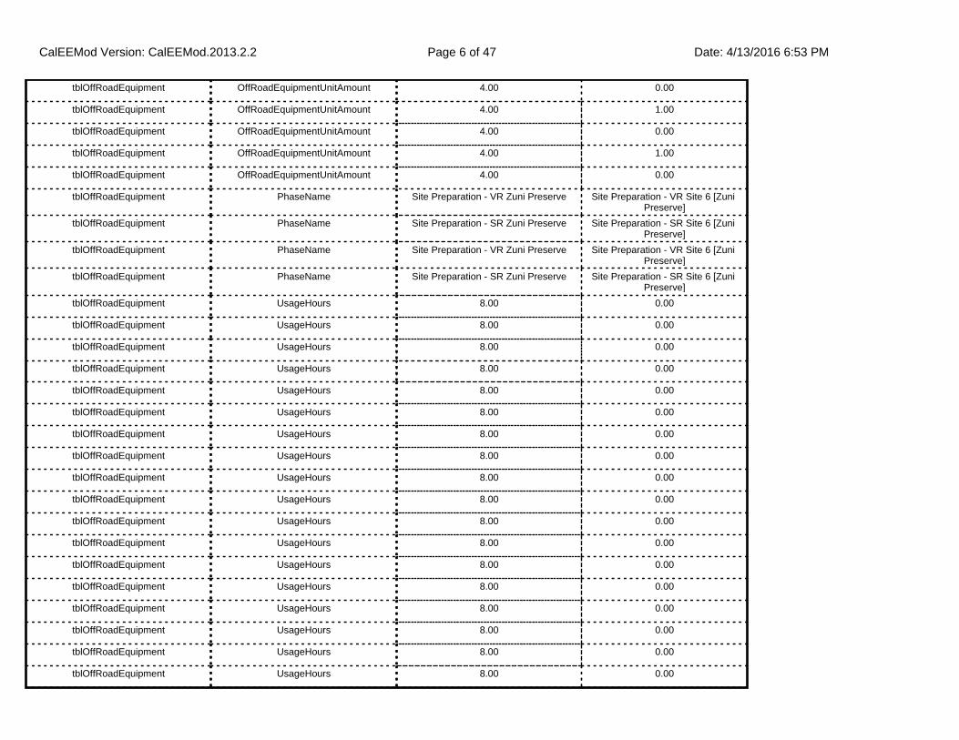
tblOffRoadEquipment OffRoadEquipmentUnitAmount 4.00 0.00
tblOffRoadEquipment OffRoadEquipmentUnitAmount 4.00 1.00
tblOffRoadEquipment OffRoadEquipmentUnitAmount 4.00 0.00
tblOffRoadEquipment OffRoadEquipmentUnitAmount 4.00 1.00
tblOffRoadEquipment OffRoadEquipmentUnitAmount 4.00 0.00
tblOffRoadEquipment PhaseName Site Preparation - VR Zuni Preserve Site Preparation - VR Site 6 [Zuni Preserve]
tblOffRoadEquipment PhaseName Site Preparation - SR Zuni Preserve Site Preparation - SR Site 6 [Zuni Preserve]
tblOffRoadEquipment PhaseName Site Preparation - VR Zuni Preserve Site Preparation - VR Site 6 [Zuni Preserve]
tblOffRoadEquipment PhaseName Site Preparation - SR Zuni Preserve Site Preparation - SR Site 6 [Zuni Preserve]
tblOffRoadEquipment UsageHours 8.00 0.00
tblOffRoadEquipment UsageHours 8.00 0.00
tblOffRoadEquipment UsageHours 8.00 0.00
tblOffRoadEquipment UsageHours 8.00 0.00
tblOffRoadEquipment UsageHours 8.00 0.00
tblOffRoadEquipment UsageHours 8.00 0.00
tblOffRoadEquipment UsageHours 8.00 0.00
tblOffRoadEquipment UsageHours 8.00 0.00
tblOffRoadEquipment UsageHours 8.00 0.00
tblOffRoadEquipment UsageHours 8.00 0.00
tblOffRoadEquipment UsageHours 8.00 0.00
tblOffRoadEquipment UsageHours 8.00 0.00
tblOffRoadEquipment UsageHours 8.00 0.00
tblOffRoadEquipment UsageHours 8.00 0.00
tblOffRoadEquipment UsageHours 8.00 0.00
tblOffRoadEquipment UsageHours 8.00 0.00
tblOffRoadEquipment UsageHours 8.00 0.00
tblOffRoadEquipment UsageHours 8.00 0.00
CalEEMod Version: CalEEMod.2013.2.2 Date: 4/13/2016 6:53 PMPage 6 of 47

2.0 Emissions Summary
tblOffRoadEquipment UsageHours 8.00 0.00
tblOnRoadDust PhaseName Site Preparation - VR Zuni Preserve Site Preparation - VR Site 6 [Zuni Preserve]
tblOnRoadDust PhaseName Site Preparation - SR Zuni Preserve Site Preparation - SR Site 6 [Zuni Preserve]
tblProjectCharacteristics OperationalYear 2014 2017
tblProjectCharacteristics UrbanizationLevel Urban Rural
tblTripsAndVMT PhaseName Site Preparation - VR Zuni Preserve Site Preparation - VR Site 6 [Zuni Preserve]
tblTripsAndVMT PhaseName Site Preparation - SR Zuni Preserve Site Preparation - SR Site 6 [Zuni Preserve]
tblTripsAndVMT WorkerTripNumber 3.00 16.00
tblTripsAndVMT WorkerTripNumber 8.00 16.00
tblTripsAndVMT WorkerTripNumber 0.00 16.00
tblTripsAndVMT WorkerTripNumber 8.00 16.00
tblTripsAndVMT WorkerTripNumber 13.00 16.00
tblTripsAndVMT WorkerTripNumber 0.00 16.00
tblTripsAndVMT WorkerTripNumber 8.00 16.00
tblTripsAndVMT WorkerTripNumber 0.00 16.00
tblTripsAndVMT WorkerTripNumber 10.00 16.00
tblTripsAndVMT WorkerTripNumber 0.00 16.00
tblTripsAndVMT WorkerTripNumber 8.00 16.00
tblTripsAndVMT WorkerTripNumber 0.00 16.00
CalEEMod Version: CalEEMod.2013.2.2 Date: 4/13/2016 6:53 PMPage 7 of 47
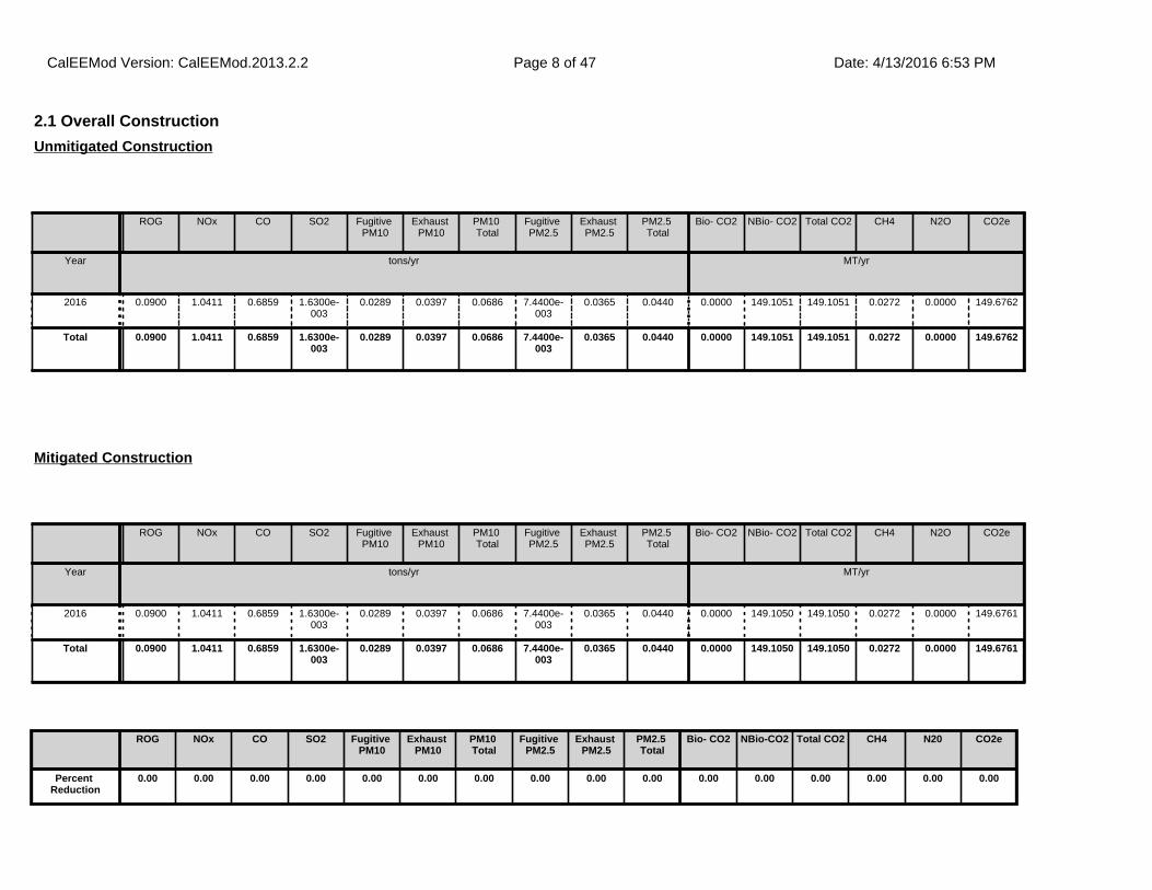
2.1 Overall Construction
ROG NOx CO SO2 Fugitive PM10
Exhaust PM10
PM10 Total
Fugitive PM2.5
Exhaust PM2.5
PM2.5 Total
Bio- CO2 NBio- CO2 Total CO2 CH4 N2O CO2e
Year tons/yr MT/yr
2016 0.0900 1.0411 0.6859 1.6300e-003
0.0289 0.0397 0.0686 7.4400e-003
0.0365 0.0440 0.0000 149.1051 149.1051 0.0272 0.0000 149.6762
Total 0.0900 1.0411 0.6859 1.6300e-003
0.0289 0.0397 0.0686 7.4400e-003
0.0365 0.0440 0.0000 149.1051 149.1051 0.0272 0.0000 149.6762
Unmitigated Construction
ROG NOx CO SO2 Fugitive PM10
Exhaust PM10
PM10 Total
Fugitive PM2.5
Exhaust PM2.5
PM2.5 Total
Bio- CO2 NBio- CO2 Total CO2 CH4 N2O CO2e
Year tons/yr MT/yr
2016 0.0900 1.0411 0.6859 1.6300e-003
0.0289 0.0397 0.0686 7.4400e-003
0.0365 0.0440 0.0000 149.1050 149.1050 0.0272 0.0000 149.6761
Total 0.0900 1.0411 0.6859 1.6300e-003
0.0289 0.0397 0.0686 7.4400e-003
0.0365 0.0440 0.0000 149.1050 149.1050 0.0272 0.0000 149.6761
Mitigated Construction
ROG NOx CO SO2 Fugitive PM10
Exhaust PM10
PM10 Total
Fugitive PM2.5
Exhaust PM2.5
PM2.5 Total
Bio- CO2 NBio-CO2 Total CO2 CH4 N20 CO2e
Percent Reduction
0.00 0.00 0.00 0.00 0.00 0.00 0.00 0.00 0.00 0.00 0.00 0.00 0.00 0.00 0.00 0.00
CalEEMod Version: CalEEMod.2013.2.2 Date: 4/13/2016 6:53 PMPage 8 of 47
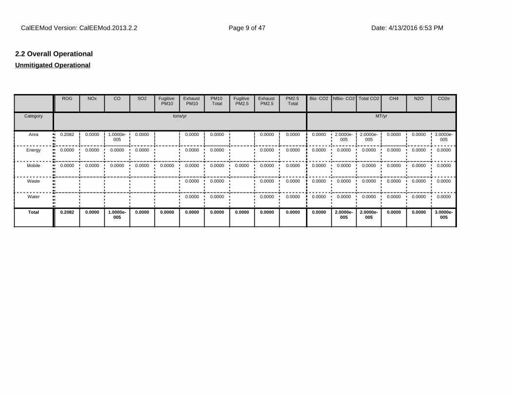
2.2 Overall Operational
ROG NOx CO SO2 Fugitive PM10
Exhaust PM10
PM10 Total
Fugitive PM2.5
Exhaust PM2.5
PM2.5 Total
Bio- CO2 NBio- CO2 Total CO2 CH4 N2O CO2e
Category tons/yr MT/yr
Area 0.2082 0.0000 1.0000e-005
0.0000 0.0000 0.0000 0.0000 0.0000 0.0000 2.0000e-005
2.0000e-005
0.0000 0.0000 3.0000e-005
Energy 0.0000 0.0000 0.0000 0.0000 0.0000 0.0000 0.0000 0.0000 0.0000 0.0000 0.0000 0.0000 0.0000 0.0000
Mobile 0.0000 0.0000 0.0000 0.0000 0.0000 0.0000 0.0000 0.0000 0.0000 0.0000 0.0000 0.0000 0.0000 0.0000 0.0000 0.0000
Waste 0.0000 0.0000 0.0000 0.0000 0.0000 0.0000 0.0000 0.0000 0.0000 0.0000
Water 0.0000 0.0000 0.0000 0.0000 0.0000 0.0000 0.0000 0.0000 0.0000 0.0000
Total 0.2082 0.0000 1.0000e-005
0.0000 0.0000 0.0000 0.0000 0.0000 0.0000 0.0000 0.0000 2.0000e-005
2.0000e-005
0.0000 0.0000 3.0000e-005
Unmitigated Operational
CalEEMod Version: CalEEMod.2013.2.2 Date: 4/13/2016 6:53 PMPage 9 of 47
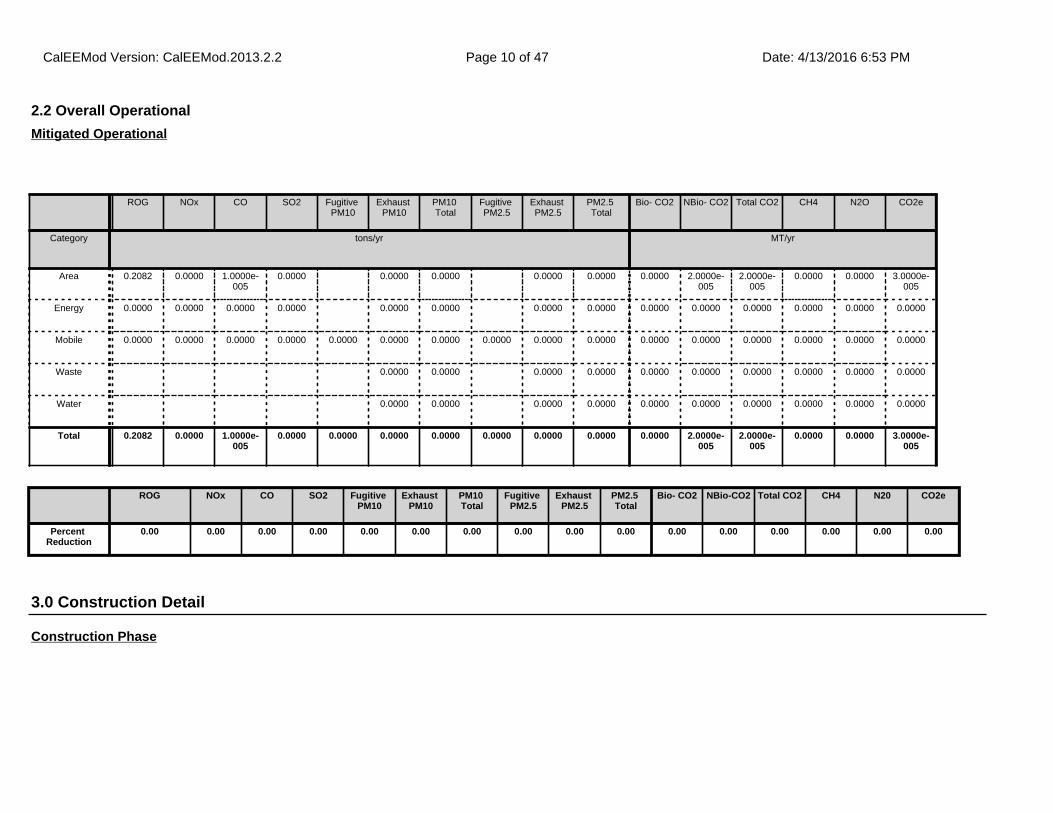
2.2 Overall Operational
ROG NOx CO SO2 Fugitive PM10
Exhaust PM10
PM10 Total
Fugitive PM2.5
Exhaust PM2.5
PM2.5 Total
Bio- CO2 NBio- CO2 Total CO2 CH4 N2O CO2e
Category tons/yr MT/yr
Area 0.2082 0.0000 1.0000e-005
0.0000 0.0000 0.0000 0.0000 0.0000 0.0000 2.0000e-005
2.0000e-005
0.0000 0.0000 3.0000e-005
Energy 0.0000 0.0000 0.0000 0.0000 0.0000 0.0000 0.0000 0.0000 0.0000 0.0000 0.0000 0.0000 0.0000 0.0000
Mobile 0.0000 0.0000 0.0000 0.0000 0.0000 0.0000 0.0000 0.0000 0.0000 0.0000 0.0000 0.0000 0.0000 0.0000 0.0000 0.0000
Waste 0.0000 0.0000 0.0000 0.0000 0.0000 0.0000 0.0000 0.0000 0.0000 0.0000
Water 0.0000 0.0000 0.0000 0.0000 0.0000 0.0000 0.0000 0.0000 0.0000 0.0000
Total 0.2082 0.0000 1.0000e-005
0.0000 0.0000 0.0000 0.0000 0.0000 0.0000 0.0000 0.0000 2.0000e-005
2.0000e-005
0.0000 0.0000 3.0000e-005
Mitigated Operational
3.0 Construction Detail
Construction Phase
ROG NOx CO SO2 Fugitive PM10
Exhaust PM10
PM10 Total
Fugitive PM2.5
Exhaust PM2.5
PM2.5 Total
Bio- CO2 NBio-CO2 Total CO2 CH4 N20 CO2e
Percent Reduction
0.00 0.00 0.00 0.00 0.00 0.00 0.00 0.00 0.00 0.00 0.00 0.00 0.00 0.00 0.00 0.00
CalEEMod Version: CalEEMod.2013.2.2 Date: 4/13/2016 6:53 PMPage 10 of 47
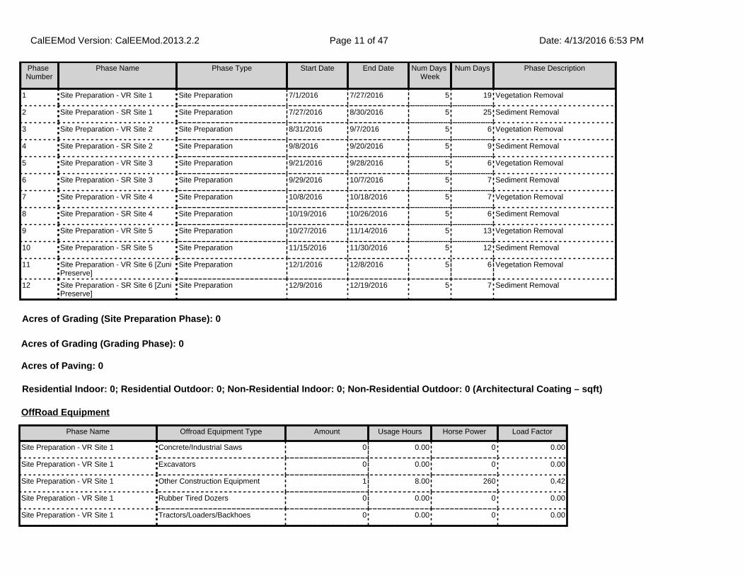
Phase Number
Phase Name Phase Type Start Date End Date Num Days Week
Num Days Phase Description
1 Site Preparation - VR Site 1 Site Preparation 7/1/2016 7/27/2016 5 19 Vegetation Removal
2 Site Preparation - SR Site 1 Site Preparation 7/27/2016 8/30/2016 5 25 Sediment Removal
3 Site Preparation - VR Site 2 Site Preparation 8/31/2016 9/7/2016 5 6 Vegetation Removal
4 Site Preparation - SR Site 2 Site Preparation 9/8/2016 9/20/2016 5 9 Sediment Removal
5 Site Preparation - VR Site 3 Site Preparation 9/21/2016 9/28/2016 5 6 Vegetation Removal
6 Site Preparation - SR Site 3 Site Preparation 9/29/2016 10/7/2016 5 7 Sediment Removal
7 Site Preparation - VR Site 4 Site Preparation 10/8/2016 10/18/2016 5 7 Vegetation Removal
8 Site Preparation - SR Site 4 Site Preparation 10/19/2016 10/26/2016 5 6 Sediment Removal
9 Site Preparation - VR Site 5 Site Preparation 10/27/2016 11/14/2016 5 13 Vegetation Removal
10 Site Preparation - SR Site 5 Site Preparation 11/15/2016 11/30/2016 5 12 Sediment Removal
11 Site Preparation - VR Site 6 [Zuni Preserve]
Site Preparation 12/1/2016 12/8/2016 5 6 Vegetation Removal
12 Site Preparation - SR Site 6 [Zuni Preserve]
Site Preparation 12/9/2016 12/19/2016 5 7 Sediment Removal
OffRoad Equipment
Phase Name Offroad Equipment Type Amount Usage Hours Horse Power Load Factor
Site Preparation - VR Site 1 Concrete/Industrial Saws 0 0.00 0 0.00
Site Preparation - VR Site 1 Excavators 0 0.00 0 0.00
Site Preparation - VR Site 1 Other Construction Equipment 1 8.00 260 0.42
Site Preparation - VR Site 1 Rubber Tired Dozers 0 0.00 0 0.00
Site Preparation - VR Site 1 Tractors/Loaders/Backhoes 0 0.00 0 0.00
Residential Indoor: 0; Residential Outdoor: 0; Non-Residential Indoor: 0; Non-Residential Outdoor: 0 (Architectural Coating – sqft)
Acres of Grading (Site Preparation Phase): 0
Acres of Grading (Grading Phase): 0
Acres of Paving: 0
CalEEMod Version: CalEEMod.2013.2.2 Date: 4/13/2016 6:53 PMPage 11 of 47
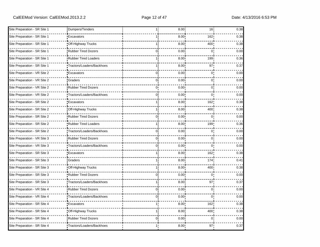
Site Preparation - SR Site 1 Dumpers/Tenders 1 8.00 16 0.38
Site Preparation - SR Site 1 Excavators 1 8.00 162 0.38
Site Preparation - SR Site 1 Off-Highway Trucks 1 8.00 400 0.38
Site Preparation - SR Site 1 Rubber Tired Dozers 0 0.00 0 0.00
Site Preparation - SR Site 1 Rubber Tired Loaders 1 8.00 199 0.36
Site Preparation - SR Site 1 Tractors/Loaders/Backhoes 1 8.00 97 0.37
Site Preparation - VR Site 2 Excavators 0 0.00 0 0.00
Site Preparation - VR Site 2 Graders 0 0.00 0 0.00
Site Preparation - VR Site 2 Rubber Tired Dozers 0 0.00 0 0.00
Site Preparation - VR Site 2 Tractors/Loaders/Backhoes 0 0.00 0 0.00
Site Preparation - SR Site 2 Excavators 1 8.00 162 0.38
Site Preparation - SR Site 2 Off-Highway Trucks 1 8.00 400 0.38
Site Preparation - SR Site 2 Rubber Tired Dozers 0 0.00 0 0.00
Site Preparation - SR Site 2 Rubber Tired Loaders 1 8.00 199 0.36
Site Preparation - SR Site 2 Tractors/Loaders/Backhoes 0 0.00 0 0.00
Site Preparation - VR Site 3 Rubber Tired Dozers 0 0.00 0 0.00
Site Preparation - VR Site 3 Tractors/Loaders/Backhoes 0 0.00 0 0.00
Site Preparation - SR Site 3 Excavators 1 8.00 162 0.38
Site Preparation - SR Site 3 Graders 1 8.00 174 0.41
Site Preparation - SR Site 3 Off-Highway Trucks 1 8.00 400 0.38
Site Preparation - SR Site 3 Rubber Tired Dozers 0 0.00 0 0.00
Site Preparation - SR Site 3 Tractors/Loaders/Backhoes 1 8.00 97 0.37
Site Preparation - VR Site 4 Rubber Tired Dozers 0 0.00 0 0.00
Site Preparation - VR Site 4 Tractors/Loaders/Backhoes 0 0.00 0 0.00
Site Preparation - SR Site 4 Excavators 1 8.00 162 0.38
Site Preparation - SR Site 4 Off-Highway Trucks 1 8.00 400 0.38
Site Preparation - SR Site 4 Rubber Tired Dozers 0 0.00 0 0.00
Site Preparation - SR Site 4 Tractors/Loaders/Backhoes 1 8.00 97 0.37
CalEEMod Version: CalEEMod.2013.2.2 Date: 4/13/2016 6:53 PMPage 12 of 47
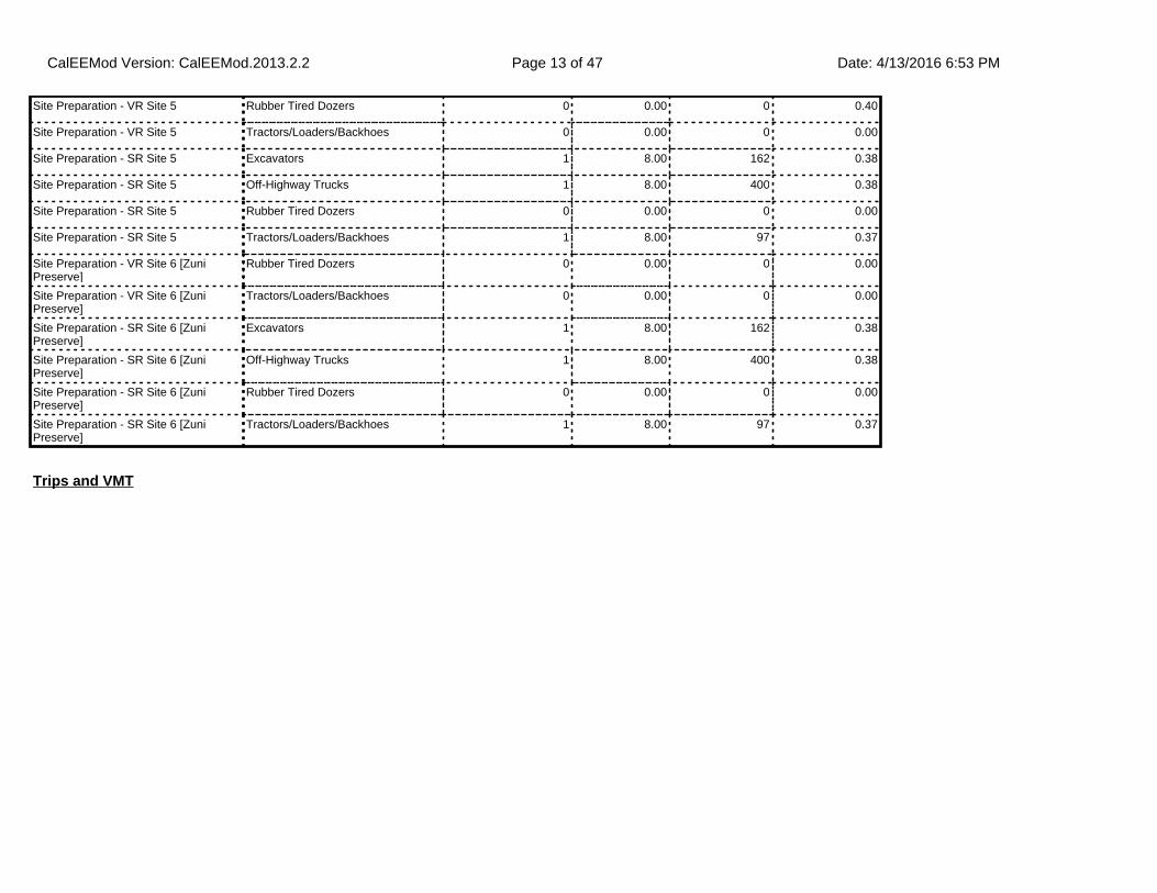
Site Preparation - VR Site 5 Rubber Tired Dozers 0 0.00 0 0.40
Site Preparation - VR Site 5 Tractors/Loaders/Backhoes 0 0.00 0 0.00
Site Preparation - SR Site 5 Excavators 1 8.00 162 0.38
Site Preparation - SR Site 5 Off-Highway Trucks 1 8.00 400 0.38
Site Preparation - SR Site 5 Rubber Tired Dozers 0 0.00 0 0.00
Site Preparation - SR Site 5 Tractors/Loaders/Backhoes 1 8.00 97 0.37
Site Preparation - VR Site 6 [Zuni Preserve]
Rubber Tired Dozers 0 0.00 0 0.00
Site Preparation - VR Site 6 [Zuni Preserve]
Tractors/Loaders/Backhoes 0 0.00 0 0.00
Site Preparation - SR Site 6 [Zuni Preserve]
Excavators 1 8.00 162 0.38
Site Preparation - SR Site 6 [Zuni Preserve]
Off-Highway Trucks 1 8.00 400 0.38
Site Preparation - SR Site 6 [Zuni Preserve]
Rubber Tired Dozers 0 0.00 0 0.00
Site Preparation - SR Site 6 [Zuni Preserve]
Tractors/Loaders/Backhoes 1 8.00 97 0.37
Trips and VMT
CalEEMod Version: CalEEMod.2013.2.2 Date: 4/13/2016 6:53 PMPage 13 of 47
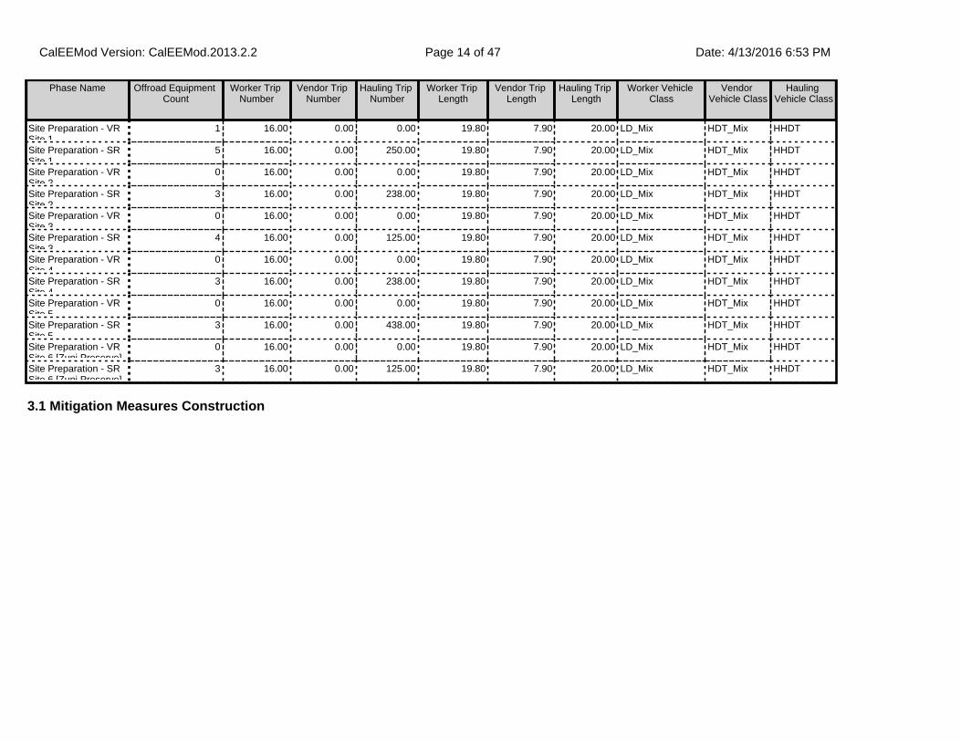
3.1 Mitigation Measures Construction
Phase Name Offroad Equipment Count
Worker Trip Number
Vendor Trip Number
Hauling Trip Number
Worker Trip Length
Vendor Trip Length
Hauling Trip Length
Worker Vehicle Class
Vendor Vehicle Class
Hauling Vehicle Class
Site Preparation - VR Site 1
1 16.00 0.00 0.00 19.80 7.90 20.00 LD_Mix HDT_Mix HHDT
Site Preparation - SR Site 1
5 16.00 0.00 250.00 19.80 7.90 20.00 LD_Mix HDT_Mix HHDT
Site Preparation - VR Site 2
0 16.00 0.00 0.00 19.80 7.90 20.00 LD_Mix HDT_Mix HHDT
Site Preparation - SR Site 2
3 16.00 0.00 238.00 19.80 7.90 20.00 LD_Mix HDT_Mix HHDT
Site Preparation - VR Site 3
0 16.00 0.00 0.00 19.80 7.90 20.00 LD_Mix HDT_Mix HHDT
Site Preparation - SR Site 3
4 16.00 0.00 125.00 19.80 7.90 20.00 LD_Mix HDT_Mix HHDT
Site Preparation - VR Site 4
0 16.00 0.00 0.00 19.80 7.90 20.00 LD_Mix HDT_Mix HHDT
Site Preparation - SR Site 4
3 16.00 0.00 238.00 19.80 7.90 20.00 LD_Mix HDT_Mix HHDT
Site Preparation - VR Site 5
0 16.00 0.00 0.00 19.80 7.90 20.00 LD_Mix HDT_Mix HHDT
Site Preparation - SR Site 5
3 16.00 0.00 438.00 19.80 7.90 20.00 LD_Mix HDT_Mix HHDT
Site Preparation - VR Site 6 [Zuni Preserve]
0 16.00 0.00 0.00 19.80 7.90 20.00 LD_Mix HDT_Mix HHDT
Site Preparation - SR Site 6 [Zuni Preserve]
3 16.00 0.00 125.00 19.80 7.90 20.00 LD_Mix HDT_Mix HHDT
CalEEMod Version: CalEEMod.2013.2.2 Date: 4/13/2016 6:53 PMPage 14 of 47

3.2 Site Preparation - VR Site 1 - 2016
ROG NOx CO SO2 Fugitive PM10
Exhaust PM10
PM10 Total
Fugitive PM2.5
Exhaust PM2.5
PM2.5 Total
Bio- CO2 NBio- CO2 Total CO2 CH4 N2O CO2e
Category tons/yr MT/yr
Fugitive Dust 0.0000 0.0000 0.0000 0.0000 0.0000 0.0000 0.0000 0.0000 0.0000 0.0000 0.0000 0.0000
Off-Road 5.6300e-003
0.0748 0.0418 9.0000e-005
2.7600e-003
2.7600e-003
2.5400e-003
2.5400e-003
0.0000 8.4603 8.4603 2.5500e-003
0.0000 8.5139
Total 5.6300e-003
0.0748 0.0418 9.0000e-005
0.0000 2.7600e-003
2.7600e-003
0.0000 2.5400e-003
2.5400e-003
0.0000 8.4603 8.4603 2.5500e-003
0.0000 8.5139
Unmitigated Construction On-Site
ROG NOx CO SO2 Fugitive PM10
Exhaust PM10
PM10 Total
Fugitive PM2.5
Exhaust PM2.5
PM2.5 Total
Bio- CO2 NBio- CO2 Total CO2 CH4 N2O CO2e
Category tons/yr MT/yr
Hauling 0.0000 0.0000 0.0000 0.0000 0.0000 0.0000 0.0000 0.0000 0.0000 0.0000 0.0000 0.0000 0.0000 0.0000 0.0000 0.0000
Vendor 0.0000 0.0000 0.0000 0.0000 0.0000 0.0000 0.0000 0.0000 0.0000 0.0000 0.0000 0.0000 0.0000 0.0000 0.0000 0.0000
Worker 7.5000e-004
1.2800e-003
0.0132 3.0000e-005
2.2400e-003
2.0000e-005
2.2600e-003
6.0000e-004
2.0000e-005
6.2000e-004
0.0000 2.1778 2.1778 1.2000e-004
0.0000 2.1804
Total 7.5000e-004
1.2800e-003
0.0132 3.0000e-005
2.2400e-003
2.0000e-005
2.2600e-003
6.0000e-004
2.0000e-005
6.2000e-004
0.0000 2.1778 2.1778 1.2000e-004
0.0000 2.1804
Unmitigated Construction Off-Site
CalEEMod Version: CalEEMod.2013.2.2 Date: 4/13/2016 6:53 PMPage 15 of 47

3.2 Site Preparation - VR Site 1 - 2016
ROG NOx CO SO2 Fugitive PM10
Exhaust PM10
PM10 Total
Fugitive PM2.5
Exhaust PM2.5
PM2.5 Total
Bio- CO2 NBio- CO2 Total CO2 CH4 N2O CO2e
Category tons/yr MT/yr
Fugitive Dust 0.0000 0.0000 0.0000 0.0000 0.0000 0.0000 0.0000 0.0000 0.0000 0.0000 0.0000 0.0000
Off-Road 5.6300e-003
0.0748 0.0418 9.0000e-005
2.7600e-003
2.7600e-003
2.5400e-003
2.5400e-003
0.0000 8.4603 8.4603 2.5500e-003
0.0000 8.5139
Total 5.6300e-003
0.0748 0.0418 9.0000e-005
0.0000 2.7600e-003
2.7600e-003
0.0000 2.5400e-003
2.5400e-003
0.0000 8.4603 8.4603 2.5500e-003
0.0000 8.5139
Mitigated Construction On-Site
ROG NOx CO SO2 Fugitive PM10
Exhaust PM10
PM10 Total
Fugitive PM2.5
Exhaust PM2.5
PM2.5 Total
Bio- CO2 NBio- CO2 Total CO2 CH4 N2O CO2e
Category tons/yr MT/yr
Hauling 0.0000 0.0000 0.0000 0.0000 0.0000 0.0000 0.0000 0.0000 0.0000 0.0000 0.0000 0.0000 0.0000 0.0000 0.0000 0.0000
Vendor 0.0000 0.0000 0.0000 0.0000 0.0000 0.0000 0.0000 0.0000 0.0000 0.0000 0.0000 0.0000 0.0000 0.0000 0.0000 0.0000
Worker 7.5000e-004
1.2800e-003
0.0132 3.0000e-005
2.2400e-003
2.0000e-005
2.2600e-003
6.0000e-004
2.0000e-005
6.2000e-004
0.0000 2.1778 2.1778 1.2000e-004
0.0000 2.1804
Total 7.5000e-004
1.2800e-003
0.0132 3.0000e-005
2.2400e-003
2.0000e-005
2.2600e-003
6.0000e-004
2.0000e-005
6.2000e-004
0.0000 2.1778 2.1778 1.2000e-004
0.0000 2.1804
Mitigated Construction Off-Site
CalEEMod Version: CalEEMod.2013.2.2 Date: 4/13/2016 6:53 PMPage 16 of 47
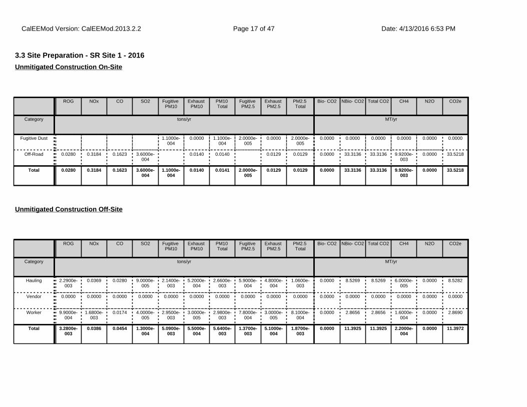
3.3 Site Preparation - SR Site 1 - 2016
ROG NOx CO SO2 Fugitive PM10
Exhaust PM10
PM10 Total
Fugitive PM2.5
Exhaust PM2.5
PM2.5 Total
Bio- CO2 NBio- CO2 Total CO2 CH4 N2O CO2e
Category tons/yr MT/yr
Fugitive Dust 1.1000e-004
0.0000 1.1000e-004
2.0000e-005
0.0000 2.0000e-005
0.0000 0.0000 0.0000 0.0000 0.0000 0.0000
Off-Road 0.0280 0.3184 0.1623 3.6000e-004
0.0140 0.0140 0.0129 0.0129 0.0000 33.3136 33.3136 9.9200e-003
0.0000 33.5218
Total 0.0280 0.3184 0.1623 3.6000e-004
1.1000e-004
0.0140 0.0141 2.0000e-005
0.0129 0.0129 0.0000 33.3136 33.3136 9.9200e-003
0.0000 33.5218
Unmitigated Construction On-Site
ROG NOx CO SO2 Fugitive PM10
Exhaust PM10
PM10 Total
Fugitive PM2.5
Exhaust PM2.5
PM2.5 Total
Bio- CO2 NBio- CO2 Total CO2 CH4 N2O CO2e
Category tons/yr MT/yr
Hauling 2.2900e-003
0.0369 0.0280 9.0000e-005
2.1400e-003
5.2000e-004
2.6600e-003
5.9000e-004
4.8000e-004
1.0600e-003
0.0000 8.5269 8.5269 6.0000e-005
0.0000 8.5282
Vendor 0.0000 0.0000 0.0000 0.0000 0.0000 0.0000 0.0000 0.0000 0.0000 0.0000 0.0000 0.0000 0.0000 0.0000 0.0000 0.0000
Worker 9.9000e-004
1.6800e-003
0.0174 4.0000e-005
2.9500e-003
3.0000e-005
2.9800e-003
7.8000e-004
3.0000e-005
8.1000e-004
0.0000 2.8656 2.8656 1.6000e-004
0.0000 2.8690
Total 3.2800e-003
0.0386 0.0454 1.3000e-004
5.0900e-003
5.5000e-004
5.6400e-003
1.3700e-003
5.1000e-004
1.8700e-003
0.0000 11.3925 11.3925 2.2000e-004
0.0000 11.3972
Unmitigated Construction Off-Site
CalEEMod Version: CalEEMod.2013.2.2 Date: 4/13/2016 6:53 PMPage 17 of 47

3.3 Site Preparation - SR Site 1 - 2016
ROG NOx CO SO2 Fugitive PM10
Exhaust PM10
PM10 Total
Fugitive PM2.5
Exhaust PM2.5
PM2.5 Total
Bio- CO2 NBio- CO2 Total CO2 CH4 N2O CO2e
Category tons/yr MT/yr
Fugitive Dust 1.1000e-004
0.0000 1.1000e-004
2.0000e-005
0.0000 2.0000e-005
0.0000 0.0000 0.0000 0.0000 0.0000 0.0000
Off-Road 0.0280 0.3184 0.1623 3.6000e-004
0.0140 0.0140 0.0129 0.0129 0.0000 33.3135 33.3135 9.9200e-003
0.0000 33.5218
Total 0.0280 0.3184 0.1623 3.6000e-004
1.1000e-004
0.0140 0.0141 2.0000e-005
0.0129 0.0129 0.0000 33.3135 33.3135 9.9200e-003
0.0000 33.5218
Mitigated Construction On-Site
ROG NOx CO SO2 Fugitive PM10
Exhaust PM10
PM10 Total
Fugitive PM2.5
Exhaust PM2.5
PM2.5 Total
Bio- CO2 NBio- CO2 Total CO2 CH4 N2O CO2e
Category tons/yr MT/yr
Hauling 2.2900e-003
0.0369 0.0280 9.0000e-005
2.1400e-003
5.2000e-004
2.6600e-003
5.9000e-004
4.8000e-004
1.0600e-003
0.0000 8.5269 8.5269 6.0000e-005
0.0000 8.5282
Vendor 0.0000 0.0000 0.0000 0.0000 0.0000 0.0000 0.0000 0.0000 0.0000 0.0000 0.0000 0.0000 0.0000 0.0000 0.0000 0.0000
Worker 9.9000e-004
1.6800e-003
0.0174 4.0000e-005
2.9500e-003
3.0000e-005
2.9800e-003
7.8000e-004
3.0000e-005
8.1000e-004
0.0000 2.8656 2.8656 1.6000e-004
0.0000 2.8690
Total 3.2800e-003
0.0386 0.0454 1.3000e-004
5.0900e-003
5.5000e-004
5.6400e-003
1.3700e-003
5.1000e-004
1.8700e-003
0.0000 11.3925 11.3925 2.2000e-004
0.0000 11.3972
Mitigated Construction Off-Site
CalEEMod Version: CalEEMod.2013.2.2 Date: 4/13/2016 6:53 PMPage 18 of 47
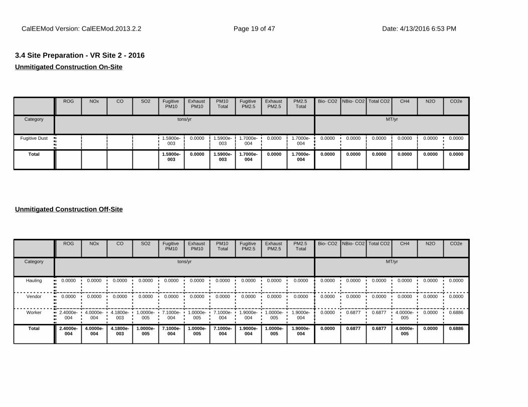
3.4 Site Preparation - VR Site 2 - 2016
ROG NOx CO SO2 Fugitive PM10
Exhaust PM10
PM10 Total
Fugitive PM2.5
Exhaust PM2.5
PM2.5 Total
Bio- CO2 NBio- CO2 Total CO2 CH4 N2O CO2e
Category tons/yr MT/yr
Fugitive Dust 1.5900e-003
0.0000 1.5900e-003
1.7000e-004
0.0000 1.7000e-004
0.0000 0.0000 0.0000 0.0000 0.0000 0.0000
Total 1.5900e-003
0.0000 1.5900e-003
1.7000e-004
0.0000 1.7000e-004
0.0000 0.0000 0.0000 0.0000 0.0000 0.0000
Unmitigated Construction On-Site
ROG NOx CO SO2 Fugitive PM10
Exhaust PM10
PM10 Total
Fugitive PM2.5
Exhaust PM2.5
PM2.5 Total
Bio- CO2 NBio- CO2 Total CO2 CH4 N2O CO2e
Category tons/yr MT/yr
Hauling 0.0000 0.0000 0.0000 0.0000 0.0000 0.0000 0.0000 0.0000 0.0000 0.0000 0.0000 0.0000 0.0000 0.0000 0.0000 0.0000
Vendor 0.0000 0.0000 0.0000 0.0000 0.0000 0.0000 0.0000 0.0000 0.0000 0.0000 0.0000 0.0000 0.0000 0.0000 0.0000 0.0000
Worker 2.4000e-004
4.0000e-004
4.1800e-003
1.0000e-005
7.1000e-004
1.0000e-005
7.1000e-004
1.9000e-004
1.0000e-005
1.9000e-004
0.0000 0.6877 0.6877 4.0000e-005
0.0000 0.6886
Total 2.4000e-004
4.0000e-004
4.1800e-003
1.0000e-005
7.1000e-004
1.0000e-005
7.1000e-004
1.9000e-004
1.0000e-005
1.9000e-004
0.0000 0.6877 0.6877 4.0000e-005
0.0000 0.6886
Unmitigated Construction Off-Site
CalEEMod Version: CalEEMod.2013.2.2 Date: 4/13/2016 6:53 PMPage 19 of 47

3.4 Site Preparation - VR Site 2 - 2016
ROG NOx CO SO2 Fugitive PM10
Exhaust PM10
PM10 Total
Fugitive PM2.5
Exhaust PM2.5
PM2.5 Total
Bio- CO2 NBio- CO2 Total CO2 CH4 N2O CO2e
Category tons/yr MT/yr
Fugitive Dust 1.5900e-003
0.0000 1.5900e-003
1.7000e-004
0.0000 1.7000e-004
0.0000 0.0000 0.0000 0.0000 0.0000 0.0000
Total 1.5900e-003
0.0000 1.5900e-003
1.7000e-004
0.0000 1.7000e-004
0.0000 0.0000 0.0000 0.0000 0.0000 0.0000
Mitigated Construction On-Site
ROG NOx CO SO2 Fugitive PM10
Exhaust PM10
PM10 Total
Fugitive PM2.5
Exhaust PM2.5
PM2.5 Total
Bio- CO2 NBio- CO2 Total CO2 CH4 N2O CO2e
Category tons/yr MT/yr
Hauling 0.0000 0.0000 0.0000 0.0000 0.0000 0.0000 0.0000 0.0000 0.0000 0.0000 0.0000 0.0000 0.0000 0.0000 0.0000 0.0000
Vendor 0.0000 0.0000 0.0000 0.0000 0.0000 0.0000 0.0000 0.0000 0.0000 0.0000 0.0000 0.0000 0.0000 0.0000 0.0000 0.0000
Worker 2.4000e-004
4.0000e-004
4.1800e-003
1.0000e-005
7.1000e-004
1.0000e-005
7.1000e-004
1.9000e-004
1.0000e-005
1.9000e-004
0.0000 0.6877 0.6877 4.0000e-005
0.0000 0.6886
Total 2.4000e-004
4.0000e-004
4.1800e-003
1.0000e-005
7.1000e-004
1.0000e-005
7.1000e-004
1.9000e-004
1.0000e-005
1.9000e-004
0.0000 0.6877 0.6877 4.0000e-005
0.0000 0.6886
Mitigated Construction Off-Site
CalEEMod Version: CalEEMod.2013.2.2 Date: 4/13/2016 6:53 PMPage 20 of 47

3.5 Site Preparation - SR Site 2 - 2016
ROG NOx CO SO2 Fugitive PM10
Exhaust PM10
PM10 Total
Fugitive PM2.5
Exhaust PM2.5
PM2.5 Total
Bio- CO2 NBio- CO2 Total CO2 CH4 N2O CO2e
Category tons/yr MT/yr
Fugitive Dust 1.1000e-004
0.0000 1.1000e-004
2.0000e-005
0.0000 2.0000e-005
0.0000 0.0000 0.0000 0.0000 0.0000 0.0000
Off-Road 8.2200e-003
0.0979 0.0464 1.1000e-004
3.8200e-003
3.8200e-003
3.5100e-003
3.5100e-003
0.0000 10.4228 10.4228 3.1400e-003
0.0000 10.4888
Total 8.2200e-003
0.0979 0.0464 1.1000e-004
1.1000e-004
3.8200e-003
3.9300e-003
2.0000e-005
3.5100e-003
3.5300e-003
0.0000 10.4228 10.4228 3.1400e-003
0.0000 10.4888
Unmitigated Construction On-Site
ROG NOx CO SO2 Fugitive PM10
Exhaust PM10
PM10 Total
Fugitive PM2.5
Exhaust PM2.5
PM2.5 Total
Bio- CO2 NBio- CO2 Total CO2 CH4 N2O CO2e
Category tons/yr MT/yr
Hauling 2.1800e-003
0.0352 0.0266 9.0000e-005
2.0400e-003
4.9000e-004
2.5300e-003
5.6000e-004
4.5000e-004
1.0100e-003
0.0000 8.1176 8.1176 6.0000e-005
0.0000 8.1189
Vendor 0.0000 0.0000 0.0000 0.0000 0.0000 0.0000 0.0000 0.0000 0.0000 0.0000 0.0000 0.0000 0.0000 0.0000 0.0000 0.0000
Worker 3.6000e-004
6.1000e-004
6.2600e-003
1.0000e-005
1.0600e-003
1.0000e-005
1.0700e-003
2.8000e-004
1.0000e-005
2.9000e-004
0.0000 1.0316 1.0316 6.0000e-005
0.0000 1.0328
Total 2.5400e-003
0.0358 0.0329 1.0000e-004
3.1000e-003
5.0000e-004
3.6000e-003
8.4000e-004
4.6000e-004
1.3000e-003
0.0000 9.1492 9.1492 1.2000e-004
0.0000 9.1517
Unmitigated Construction Off-Site
CalEEMod Version: CalEEMod.2013.2.2 Date: 4/13/2016 6:53 PMPage 21 of 47

3.5 Site Preparation - SR Site 2 - 2016
ROG NOx CO SO2 Fugitive PM10
Exhaust PM10
PM10 Total
Fugitive PM2.5
Exhaust PM2.5
PM2.5 Total
Bio- CO2 NBio- CO2 Total CO2 CH4 N2O CO2e
Category tons/yr MT/yr
Fugitive Dust 1.1000e-004
0.0000 1.1000e-004
2.0000e-005
0.0000 2.0000e-005
0.0000 0.0000 0.0000 0.0000 0.0000 0.0000
Off-Road 8.2200e-003
0.0979 0.0464 1.1000e-004
3.8200e-003
3.8200e-003
3.5100e-003
3.5100e-003
0.0000 10.4227 10.4227 3.1400e-003
0.0000 10.4888
Total 8.2200e-003
0.0979 0.0464 1.1000e-004
1.1000e-004
3.8200e-003
3.9300e-003
2.0000e-005
3.5100e-003
3.5300e-003
0.0000 10.4227 10.4227 3.1400e-003
0.0000 10.4888
Mitigated Construction On-Site
ROG NOx CO SO2 Fugitive PM10
Exhaust PM10
PM10 Total
Fugitive PM2.5
Exhaust PM2.5
PM2.5 Total
Bio- CO2 NBio- CO2 Total CO2 CH4 N2O CO2e
Category tons/yr MT/yr
Hauling 2.1800e-003
0.0352 0.0266 9.0000e-005
2.0400e-003
4.9000e-004
2.5300e-003
5.6000e-004
4.5000e-004
1.0100e-003
0.0000 8.1176 8.1176 6.0000e-005
0.0000 8.1189
Vendor 0.0000 0.0000 0.0000 0.0000 0.0000 0.0000 0.0000 0.0000 0.0000 0.0000 0.0000 0.0000 0.0000 0.0000 0.0000 0.0000
Worker 3.6000e-004
6.1000e-004
6.2600e-003
1.0000e-005
1.0600e-003
1.0000e-005
1.0700e-003
2.8000e-004
1.0000e-005
2.9000e-004
0.0000 1.0316 1.0316 6.0000e-005
0.0000 1.0328
Total 2.5400e-003
0.0358 0.0329 1.0000e-004
3.1000e-003
5.0000e-004
3.6000e-003
8.4000e-004
4.6000e-004
1.3000e-003
0.0000 9.1492 9.1492 1.2000e-004
0.0000 9.1517
Mitigated Construction Off-Site
CalEEMod Version: CalEEMod.2013.2.2 Date: 4/13/2016 6:53 PMPage 22 of 47

3.6 Site Preparation - VR Site 3 - 2016
ROG NOx CO SO2 Fugitive PM10
Exhaust PM10
PM10 Total
Fugitive PM2.5
Exhaust PM2.5
PM2.5 Total
Bio- CO2 NBio- CO2 Total CO2 CH4 N2O CO2e
Category tons/yr MT/yr
Fugitive Dust 0.0000 0.0000 0.0000 0.0000 0.0000 0.0000 0.0000 0.0000 0.0000 0.0000 0.0000 0.0000
Total 0.0000 0.0000 0.0000 0.0000 0.0000 0.0000 0.0000 0.0000 0.0000 0.0000 0.0000 0.0000
Unmitigated Construction On-Site
ROG NOx CO SO2 Fugitive PM10
Exhaust PM10
PM10 Total
Fugitive PM2.5
Exhaust PM2.5
PM2.5 Total
Bio- CO2 NBio- CO2 Total CO2 CH4 N2O CO2e
Category tons/yr MT/yr
Hauling 0.0000 0.0000 0.0000 0.0000 0.0000 0.0000 0.0000 0.0000 0.0000 0.0000 0.0000 0.0000 0.0000 0.0000 0.0000 0.0000
Vendor 0.0000 0.0000 0.0000 0.0000 0.0000 0.0000 0.0000 0.0000 0.0000 0.0000 0.0000 0.0000 0.0000 0.0000 0.0000 0.0000
Worker 2.4000e-004
4.0000e-004
4.1800e-003
1.0000e-005
7.1000e-004
1.0000e-005
7.1000e-004
1.9000e-004
1.0000e-005
1.9000e-004
0.0000 0.6877 0.6877 4.0000e-005
0.0000 0.6886
Total 2.4000e-004
4.0000e-004
4.1800e-003
1.0000e-005
7.1000e-004
1.0000e-005
7.1000e-004
1.9000e-004
1.0000e-005
1.9000e-004
0.0000 0.6877 0.6877 4.0000e-005
0.0000 0.6886
Unmitigated Construction Off-Site
CalEEMod Version: CalEEMod.2013.2.2 Date: 4/13/2016 6:53 PMPage 23 of 47

3.6 Site Preparation - VR Site 3 - 2016
ROG NOx CO SO2 Fugitive PM10
Exhaust PM10
PM10 Total
Fugitive PM2.5
Exhaust PM2.5
PM2.5 Total
Bio- CO2 NBio- CO2 Total CO2 CH4 N2O CO2e
Category tons/yr MT/yr
Fugitive Dust 0.0000 0.0000 0.0000 0.0000 0.0000 0.0000 0.0000 0.0000 0.0000 0.0000 0.0000 0.0000
Total 0.0000 0.0000 0.0000 0.0000 0.0000 0.0000 0.0000 0.0000 0.0000 0.0000 0.0000 0.0000
Mitigated Construction On-Site
ROG NOx CO SO2 Fugitive PM10
Exhaust PM10
PM10 Total
Fugitive PM2.5
Exhaust PM2.5
PM2.5 Total
Bio- CO2 NBio- CO2 Total CO2 CH4 N2O CO2e
Category tons/yr MT/yr
Hauling 0.0000 0.0000 0.0000 0.0000 0.0000 0.0000 0.0000 0.0000 0.0000 0.0000 0.0000 0.0000 0.0000 0.0000 0.0000 0.0000
Vendor 0.0000 0.0000 0.0000 0.0000 0.0000 0.0000 0.0000 0.0000 0.0000 0.0000 0.0000 0.0000 0.0000 0.0000 0.0000 0.0000
Worker 2.4000e-004
4.0000e-004
4.1800e-003
1.0000e-005
7.1000e-004
1.0000e-005
7.1000e-004
1.9000e-004
1.0000e-005
1.9000e-004
0.0000 0.6877 0.6877 4.0000e-005
0.0000 0.6886
Total 2.4000e-004
4.0000e-004
4.1800e-003
1.0000e-005
7.1000e-004
1.0000e-005
7.1000e-004
1.9000e-004
1.0000e-005
1.9000e-004
0.0000 0.6877 0.6877 4.0000e-005
0.0000 0.6886
Mitigated Construction Off-Site
CalEEMod Version: CalEEMod.2013.2.2 Date: 4/13/2016 6:53 PMPage 24 of 47

3.7 Site Preparation - SR Site 3 - 2016
ROG NOx CO SO2 Fugitive PM10
Exhaust PM10
PM10 Total
Fugitive PM2.5
Exhaust PM2.5
PM2.5 Total
Bio- CO2 NBio- CO2 Total CO2 CH4 N2O CO2e
Category tons/yr MT/yr
Fugitive Dust 6.0000e-005
0.0000 6.0000e-005
1.0000e-005
0.0000 1.0000e-005
0.0000 0.0000 0.0000 0.0000 0.0000 0.0000
Off-Road 9.4100e-003
0.1012 0.0554 1.0000e-004
5.1100e-003
5.1100e-003
4.7000e-003
4.7000e-003
0.0000 9.1757 9.1757 2.7700e-003
0.0000 9.2338
Total 9.4100e-003
0.1012 0.0554 1.0000e-004
6.0000e-005
5.1100e-003
5.1700e-003
1.0000e-005
4.7000e-003
4.7100e-003
0.0000 9.1757 9.1757 2.7700e-003
0.0000 9.2338
Unmitigated Construction On-Site
ROG NOx CO SO2 Fugitive PM10
Exhaust PM10
PM10 Total
Fugitive PM2.5
Exhaust PM2.5
PM2.5 Total
Bio- CO2 NBio- CO2 Total CO2 CH4 N2O CO2e
Category tons/yr MT/yr
Hauling 1.1400e-003
0.0185 0.0140 5.0000e-005
1.0700e-003
2.6000e-004
1.3300e-003
2.9000e-004
2.4000e-004
5.3000e-004
0.0000 4.2634 4.2634 3.0000e-005
0.0000 4.2641
Vendor 0.0000 0.0000 0.0000 0.0000 0.0000 0.0000 0.0000 0.0000 0.0000 0.0000 0.0000 0.0000 0.0000 0.0000 0.0000 0.0000
Worker 2.8000e-004
4.7000e-004
4.8700e-003
1.0000e-005
8.3000e-004
1.0000e-005
8.3000e-004
2.2000e-004
1.0000e-005
2.3000e-004
0.0000 0.8024 0.8024 5.0000e-005
0.0000 0.8033
Total 1.4200e-003
0.0189 0.0189 6.0000e-005
1.9000e-003
2.7000e-004
2.1600e-003
5.1000e-004
2.5000e-004
7.6000e-004
0.0000 5.0658 5.0658 8.0000e-005
0.0000 5.0674
Unmitigated Construction Off-Site
CalEEMod Version: CalEEMod.2013.2.2 Date: 4/13/2016 6:53 PMPage 25 of 47
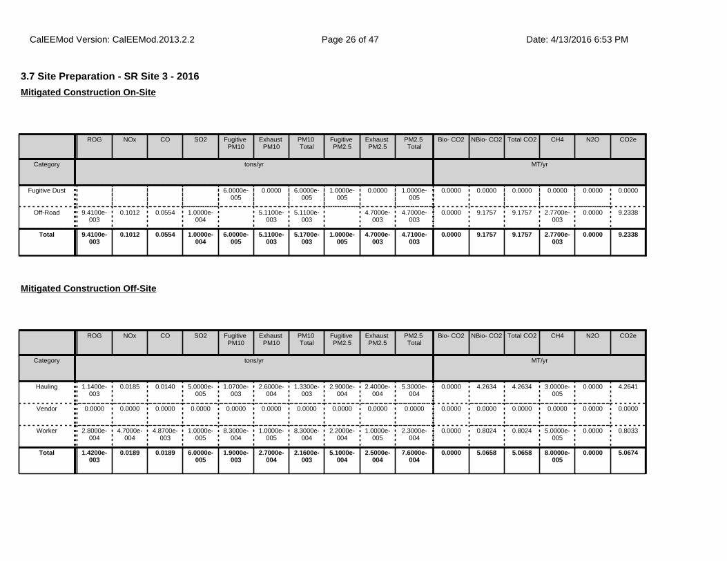
3.7 Site Preparation - SR Site 3 - 2016
ROG NOx CO SO2 Fugitive PM10
Exhaust PM10
PM10 Total
Fugitive PM2.5
Exhaust PM2.5
PM2.5 Total
Bio- CO2 NBio- CO2 Total CO2 CH4 N2O CO2e
Category tons/yr MT/yr
Fugitive Dust 6.0000e-005
0.0000 6.0000e-005
1.0000e-005
0.0000 1.0000e-005
0.0000 0.0000 0.0000 0.0000 0.0000 0.0000
Off-Road 9.4100e-003
0.1012 0.0554 1.0000e-004
5.1100e-003
5.1100e-003
4.7000e-003
4.7000e-003
0.0000 9.1757 9.1757 2.7700e-003
0.0000 9.2338
Total 9.4100e-003
0.1012 0.0554 1.0000e-004
6.0000e-005
5.1100e-003
5.1700e-003
1.0000e-005
4.7000e-003
4.7100e-003
0.0000 9.1757 9.1757 2.7700e-003
0.0000 9.2338
Mitigated Construction On-Site
ROG NOx CO SO2 Fugitive PM10
Exhaust PM10
PM10 Total
Fugitive PM2.5
Exhaust PM2.5
PM2.5 Total
Bio- CO2 NBio- CO2 Total CO2 CH4 N2O CO2e
Category tons/yr MT/yr
Hauling 1.1400e-003
0.0185 0.0140 5.0000e-005
1.0700e-003
2.6000e-004
1.3300e-003
2.9000e-004
2.4000e-004
5.3000e-004
0.0000 4.2634 4.2634 3.0000e-005
0.0000 4.2641
Vendor 0.0000 0.0000 0.0000 0.0000 0.0000 0.0000 0.0000 0.0000 0.0000 0.0000 0.0000 0.0000 0.0000 0.0000 0.0000 0.0000
Worker 2.8000e-004
4.7000e-004
4.8700e-003
1.0000e-005
8.3000e-004
1.0000e-005
8.3000e-004
2.2000e-004
1.0000e-005
2.3000e-004
0.0000 0.8024 0.8024 5.0000e-005
0.0000 0.8033
Total 1.4200e-003
0.0189 0.0189 6.0000e-005
1.9000e-003
2.7000e-004
2.1600e-003
5.1000e-004
2.5000e-004
7.6000e-004
0.0000 5.0658 5.0658 8.0000e-005
0.0000 5.0674
Mitigated Construction Off-Site
CalEEMod Version: CalEEMod.2013.2.2 Date: 4/13/2016 6:53 PMPage 26 of 47

3.8 Site Preparation - VR Site 4 - 2016
ROG NOx CO SO2 Fugitive PM10
Exhaust PM10
PM10 Total
Fugitive PM2.5
Exhaust PM2.5
PM2.5 Total
Bio- CO2 NBio- CO2 Total CO2 CH4 N2O CO2e
Category tons/yr MT/yr
Fugitive Dust 0.0000 0.0000 0.0000 0.0000 0.0000 0.0000 0.0000 0.0000 0.0000 0.0000 0.0000 0.0000
Total 0.0000 0.0000 0.0000 0.0000 0.0000 0.0000 0.0000 0.0000 0.0000 0.0000 0.0000 0.0000
Unmitigated Construction On-Site
ROG NOx CO SO2 Fugitive PM10
Exhaust PM10
PM10 Total
Fugitive PM2.5
Exhaust PM2.5
PM2.5 Total
Bio- CO2 NBio- CO2 Total CO2 CH4 N2O CO2e
Category tons/yr MT/yr
Hauling 0.0000 0.0000 0.0000 0.0000 0.0000 0.0000 0.0000 0.0000 0.0000 0.0000 0.0000 0.0000 0.0000 0.0000 0.0000 0.0000
Vendor 0.0000 0.0000 0.0000 0.0000 0.0000 0.0000 0.0000 0.0000 0.0000 0.0000 0.0000 0.0000 0.0000 0.0000 0.0000 0.0000
Worker 2.8000e-004
4.7000e-004
4.8700e-003
1.0000e-005
8.3000e-004
1.0000e-005
8.3000e-004
2.2000e-004
1.0000e-005
2.3000e-004
0.0000 0.8024 0.8024 5.0000e-005
0.0000 0.8033
Total 2.8000e-004
4.7000e-004
4.8700e-003
1.0000e-005
8.3000e-004
1.0000e-005
8.3000e-004
2.2000e-004
1.0000e-005
2.3000e-004
0.0000 0.8024 0.8024 5.0000e-005
0.0000 0.8033
Unmitigated Construction Off-Site
CalEEMod Version: CalEEMod.2013.2.2 Date: 4/13/2016 6:53 PMPage 27 of 47
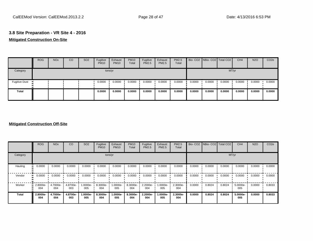
3.8 Site Preparation - VR Site 4 - 2016
ROG NOx CO SO2 Fugitive PM10
Exhaust PM10
PM10 Total
Fugitive PM2.5
Exhaust PM2.5
PM2.5 Total
Bio- CO2 NBio- CO2 Total CO2 CH4 N2O CO2e
Category tons/yr MT/yr
Fugitive Dust 0.0000 0.0000 0.0000 0.0000 0.0000 0.0000 0.0000 0.0000 0.0000 0.0000 0.0000 0.0000
Total 0.0000 0.0000 0.0000 0.0000 0.0000 0.0000 0.0000 0.0000 0.0000 0.0000 0.0000 0.0000
Mitigated Construction On-Site
ROG NOx CO SO2 Fugitive PM10
Exhaust PM10
PM10 Total
Fugitive PM2.5
Exhaust PM2.5
PM2.5 Total
Bio- CO2 NBio- CO2 Total CO2 CH4 N2O CO2e
Category tons/yr MT/yr
Hauling 0.0000 0.0000 0.0000 0.0000 0.0000 0.0000 0.0000 0.0000 0.0000 0.0000 0.0000 0.0000 0.0000 0.0000 0.0000 0.0000
Vendor 0.0000 0.0000 0.0000 0.0000 0.0000 0.0000 0.0000 0.0000 0.0000 0.0000 0.0000 0.0000 0.0000 0.0000 0.0000 0.0000
Worker 2.8000e-004
4.7000e-004
4.8700e-003
1.0000e-005
8.3000e-004
1.0000e-005
8.3000e-004
2.2000e-004
1.0000e-005
2.3000e-004
0.0000 0.8024 0.8024 5.0000e-005
0.0000 0.8033
Total 2.8000e-004
4.7000e-004
4.8700e-003
1.0000e-005
8.3000e-004
1.0000e-005
8.3000e-004
2.2000e-004
1.0000e-005
2.3000e-004
0.0000 0.8024 0.8024 5.0000e-005
0.0000 0.8033
Mitigated Construction Off-Site
CalEEMod Version: CalEEMod.2013.2.2 Date: 4/13/2016 6:53 PMPage 28 of 47

3.9 Site Preparation - SR Site 4 - 2016
ROG NOx CO SO2 Fugitive PM10
Exhaust PM10
PM10 Total
Fugitive PM2.5
Exhaust PM2.5
PM2.5 Total
Bio- CO2 NBio- CO2 Total CO2 CH4 N2O CO2e
Category tons/yr MT/yr
Fugitive Dust 1.1000e-004
0.0000 1.1000e-004
2.0000e-005
0.0000 2.0000e-005
0.0000 0.0000 0.0000 0.0000 0.0000 0.0000
Off-Road 5.0100e-003
0.0556 0.0327 6.0000e-005
2.6300e-003
2.6300e-003
2.4200e-003
2.4200e-003
0.0000 6.0975 6.0975 1.8400e-003
0.0000 6.1361
Total 5.0100e-003
0.0556 0.0327 6.0000e-005
1.1000e-004
2.6300e-003
2.7400e-003
2.0000e-005
2.4200e-003
2.4400e-003
0.0000 6.0975 6.0975 1.8400e-003
0.0000 6.1361
Unmitigated Construction On-Site
ROG NOx CO SO2 Fugitive PM10
Exhaust PM10
PM10 Total
Fugitive PM2.5
Exhaust PM2.5
PM2.5 Total
Bio- CO2 NBio- CO2 Total CO2 CH4 N2O CO2e
Category tons/yr MT/yr
Hauling 2.1800e-003
0.0352 0.0266 9.0000e-005
2.0400e-003
4.9000e-004
2.5300e-003
5.6000e-004
4.5000e-004
1.0100e-003
0.0000 8.1176 8.1176 6.0000e-005
0.0000 8.1189
Vendor 0.0000 0.0000 0.0000 0.0000 0.0000 0.0000 0.0000 0.0000 0.0000 0.0000 0.0000 0.0000 0.0000 0.0000 0.0000 0.0000
Worker 2.4000e-004
4.0000e-004
4.1800e-003
1.0000e-005
7.1000e-004
1.0000e-005
7.1000e-004
1.9000e-004
1.0000e-005
1.9000e-004
0.0000 0.6877 0.6877 4.0000e-005
0.0000 0.6886
Total 2.4200e-003
0.0356 0.0308 1.0000e-004
2.7500e-003
5.0000e-004
3.2400e-003
7.5000e-004
4.6000e-004
1.2000e-003
0.0000 8.8053 8.8053 1.0000e-004
0.0000 8.8074
Unmitigated Construction Off-Site
CalEEMod Version: CalEEMod.2013.2.2 Date: 4/13/2016 6:53 PMPage 29 of 47

3.9 Site Preparation - SR Site 4 - 2016
ROG NOx CO SO2 Fugitive PM10
Exhaust PM10
PM10 Total
Fugitive PM2.5
Exhaust PM2.5
PM2.5 Total
Bio- CO2 NBio- CO2 Total CO2 CH4 N2O CO2e
Category tons/yr MT/yr
Fugitive Dust 1.1000e-004
0.0000 1.1000e-004
2.0000e-005
0.0000 2.0000e-005
0.0000 0.0000 0.0000 0.0000 0.0000 0.0000
Off-Road 5.0100e-003
0.0556 0.0327 6.0000e-005
2.6300e-003
2.6300e-003
2.4200e-003
2.4200e-003
0.0000 6.0975 6.0975 1.8400e-003
0.0000 6.1361
Total 5.0100e-003
0.0556 0.0327 6.0000e-005
1.1000e-004
2.6300e-003
2.7400e-003
2.0000e-005
2.4200e-003
2.4400e-003
0.0000 6.0975 6.0975 1.8400e-003
0.0000 6.1361
Mitigated Construction On-Site
ROG NOx CO SO2 Fugitive PM10
Exhaust PM10
PM10 Total
Fugitive PM2.5
Exhaust PM2.5
PM2.5 Total
Bio- CO2 NBio- CO2 Total CO2 CH4 N2O CO2e
Category tons/yr MT/yr
Hauling 2.1800e-003
0.0352 0.0266 9.0000e-005
2.0400e-003
4.9000e-004
2.5300e-003
5.6000e-004
4.5000e-004
1.0100e-003
0.0000 8.1176 8.1176 6.0000e-005
0.0000 8.1189
Vendor 0.0000 0.0000 0.0000 0.0000 0.0000 0.0000 0.0000 0.0000 0.0000 0.0000 0.0000 0.0000 0.0000 0.0000 0.0000 0.0000
Worker 2.4000e-004
4.0000e-004
4.1800e-003
1.0000e-005
7.1000e-004
1.0000e-005
7.1000e-004
1.9000e-004
1.0000e-005
1.9000e-004
0.0000 0.6877 0.6877 4.0000e-005
0.0000 0.6886
Total 2.4200e-003
0.0356 0.0308 1.0000e-004
2.7500e-003
5.0000e-004
3.2400e-003
7.5000e-004
4.6000e-004
1.2000e-003
0.0000 8.8053 8.8053 1.0000e-004
0.0000 8.8074
Mitigated Construction Off-Site
CalEEMod Version: CalEEMod.2013.2.2 Date: 4/13/2016 6:53 PMPage 30 of 47

3.10 Site Preparation - VR Site 5 - 2016
ROG NOx CO SO2 Fugitive PM10
Exhaust PM10
PM10 Total
Fugitive PM2.5
Exhaust PM2.5
PM2.5 Total
Bio- CO2 NBio- CO2 Total CO2 CH4 N2O CO2e
Category tons/yr MT/yr
Fugitive Dust 0.0000 0.0000 0.0000 0.0000 0.0000 0.0000 0.0000 0.0000 0.0000 0.0000 0.0000 0.0000
Total 0.0000 0.0000 0.0000 0.0000 0.0000 0.0000 0.0000 0.0000 0.0000 0.0000 0.0000 0.0000
Unmitigated Construction On-Site
ROG NOx CO SO2 Fugitive PM10
Exhaust PM10
PM10 Total
Fugitive PM2.5
Exhaust PM2.5
PM2.5 Total
Bio- CO2 NBio- CO2 Total CO2 CH4 N2O CO2e
Category tons/yr MT/yr
Hauling 0.0000 0.0000 0.0000 0.0000 0.0000 0.0000 0.0000 0.0000 0.0000 0.0000 0.0000 0.0000 0.0000 0.0000 0.0000 0.0000
Vendor 0.0000 0.0000 0.0000 0.0000 0.0000 0.0000 0.0000 0.0000 0.0000 0.0000 0.0000 0.0000 0.0000 0.0000 0.0000 0.0000
Worker 5.2000e-004
8.7000e-004
9.0500e-003
2.0000e-005
1.5300e-003
1.0000e-005
1.5500e-003
4.1000e-004
1.0000e-005
4.2000e-004
0.0000 1.4901 1.4901 8.0000e-005
0.0000 1.4919
Total 5.2000e-004
8.7000e-004
9.0500e-003
2.0000e-005
1.5300e-003
1.0000e-005
1.5500e-003
4.1000e-004
1.0000e-005
4.2000e-004
0.0000 1.4901 1.4901 8.0000e-005
0.0000 1.4919
Unmitigated Construction Off-Site
CalEEMod Version: CalEEMod.2013.2.2 Date: 4/13/2016 6:53 PMPage 31 of 47

3.10 Site Preparation - VR Site 5 - 2016
ROG NOx CO SO2 Fugitive PM10
Exhaust PM10
PM10 Total
Fugitive PM2.5
Exhaust PM2.5
PM2.5 Total
Bio- CO2 NBio- CO2 Total CO2 CH4 N2O CO2e
Category tons/yr MT/yr
Fugitive Dust 0.0000 0.0000 0.0000 0.0000 0.0000 0.0000 0.0000 0.0000 0.0000 0.0000 0.0000 0.0000
Total 0.0000 0.0000 0.0000 0.0000 0.0000 0.0000 0.0000 0.0000 0.0000 0.0000 0.0000 0.0000
Mitigated Construction On-Site
ROG NOx CO SO2 Fugitive PM10
Exhaust PM10
PM10 Total
Fugitive PM2.5
Exhaust PM2.5
PM2.5 Total
Bio- CO2 NBio- CO2 Total CO2 CH4 N2O CO2e
Category tons/yr MT/yr
Hauling 0.0000 0.0000 0.0000 0.0000 0.0000 0.0000 0.0000 0.0000 0.0000 0.0000 0.0000 0.0000 0.0000 0.0000 0.0000 0.0000
Vendor 0.0000 0.0000 0.0000 0.0000 0.0000 0.0000 0.0000 0.0000 0.0000 0.0000 0.0000 0.0000 0.0000 0.0000 0.0000 0.0000
Worker 5.2000e-004
8.7000e-004
9.0500e-003
2.0000e-005
1.5300e-003
1.0000e-005
1.5500e-003
4.1000e-004
1.0000e-005
4.2000e-004
0.0000 1.4901 1.4901 8.0000e-005
0.0000 1.4919
Total 5.2000e-004
8.7000e-004
9.0500e-003
2.0000e-005
1.5300e-003
1.0000e-005
1.5500e-003
4.1000e-004
1.0000e-005
4.2000e-004
0.0000 1.4901 1.4901 8.0000e-005
0.0000 1.4919
Mitigated Construction Off-Site
CalEEMod Version: CalEEMod.2013.2.2 Date: 4/13/2016 6:53 PMPage 32 of 47

3.11 Site Preparation - SR Site 5 - 2016
ROG NOx CO SO2 Fugitive PM10
Exhaust PM10
PM10 Total
Fugitive PM2.5
Exhaust PM2.5
PM2.5 Total
Bio- CO2 NBio- CO2 Total CO2 CH4 N2O CO2e
Category tons/yr MT/yr
Fugitive Dust 2.0000e-004
0.0000 2.0000e-004
3.0000e-005
0.0000 3.0000e-005
0.0000 0.0000 0.0000 0.0000 0.0000 0.0000
Off-Road 0.0100 0.1112 0.0654 1.3000e-004
5.2700e-003
5.2700e-003
4.8500e-003
4.8500e-003
0.0000 12.1950 12.1950 3.6800e-003
0.0000 12.2722
Total 0.0100 0.1112 0.0654 1.3000e-004
2.0000e-004
5.2700e-003
5.4700e-003
3.0000e-005
4.8500e-003
4.8800e-003
0.0000 12.1950 12.1950 3.6800e-003
0.0000 12.2722
Unmitigated Construction On-Site
ROG NOx CO SO2 Fugitive PM10
Exhaust PM10
PM10 Total
Fugitive PM2.5
Exhaust PM2.5
PM2.5 Total
Bio- CO2 NBio- CO2 Total CO2 CH4 N2O CO2e
Category tons/yr MT/yr
Hauling 4.0100e-003
0.0647 0.0490 1.6000e-004
3.7500e-003
9.1000e-004
4.6600e-003
1.0300e-003
8.4000e-004
1.8700e-003
0.0000 14.9391 14.9391 1.1000e-004
0.0000 14.9414
Vendor 0.0000 0.0000 0.0000 0.0000 0.0000 0.0000 0.0000 0.0000 0.0000 0.0000 0.0000 0.0000 0.0000 0.0000 0.0000 0.0000
Worker 4.8000e-004
8.1000e-004
8.3500e-003
2.0000e-005
1.4200e-003
1.0000e-005
1.4300e-003
3.8000e-004
1.0000e-005
3.9000e-004
0.0000 1.3755 1.3755 8.0000e-005
0.0000 1.3771
Total 4.4900e-003
0.0655 0.0574 1.8000e-004
5.1700e-003
9.2000e-004
6.0900e-003
1.4100e-003
8.5000e-004
2.2600e-003
0.0000 16.3146 16.3146 1.9000e-004
0.0000 16.3185
Unmitigated Construction Off-Site
CalEEMod Version: CalEEMod.2013.2.2 Date: 4/13/2016 6:53 PMPage 33 of 47

3.11 Site Preparation - SR Site 5 - 2016
ROG NOx CO SO2 Fugitive PM10
Exhaust PM10
PM10 Total
Fugitive PM2.5
Exhaust PM2.5
PM2.5 Total
Bio- CO2 NBio- CO2 Total CO2 CH4 N2O CO2e
Category tons/yr MT/yr
Fugitive Dust 2.0000e-004
0.0000 2.0000e-004
3.0000e-005
0.0000 3.0000e-005
0.0000 0.0000 0.0000 0.0000 0.0000 0.0000
Off-Road 0.0100 0.1112 0.0654 1.3000e-004
5.2700e-003
5.2700e-003
4.8500e-003
4.8500e-003
0.0000 12.1949 12.1949 3.6800e-003
0.0000 12.2722
Total 0.0100 0.1112 0.0654 1.3000e-004
2.0000e-004
5.2700e-003
5.4700e-003
3.0000e-005
4.8500e-003
4.8800e-003
0.0000 12.1949 12.1949 3.6800e-003
0.0000 12.2722
Mitigated Construction On-Site
ROG NOx CO SO2 Fugitive PM10
Exhaust PM10
PM10 Total
Fugitive PM2.5
Exhaust PM2.5
PM2.5 Total
Bio- CO2 NBio- CO2 Total CO2 CH4 N2O CO2e
Category tons/yr MT/yr
Hauling 4.0100e-003
0.0647 0.0490 1.6000e-004
3.7500e-003
9.1000e-004
4.6600e-003
1.0300e-003
8.4000e-004
1.8700e-003
0.0000 14.9391 14.9391 1.1000e-004
0.0000 14.9414
Vendor 0.0000 0.0000 0.0000 0.0000 0.0000 0.0000 0.0000 0.0000 0.0000 0.0000 0.0000 0.0000 0.0000 0.0000 0.0000 0.0000
Worker 4.8000e-004
8.1000e-004
8.3500e-003
2.0000e-005
1.4200e-003
1.0000e-005
1.4300e-003
3.8000e-004
1.0000e-005
3.9000e-004
0.0000 1.3755 1.3755 8.0000e-005
0.0000 1.3771
Total 4.4900e-003
0.0655 0.0574 1.8000e-004
5.1700e-003
9.2000e-004
6.0900e-003
1.4100e-003
8.5000e-004
2.2600e-003
0.0000 16.3146 16.3146 1.9000e-004
0.0000 16.3185
Mitigated Construction Off-Site
CalEEMod Version: CalEEMod.2013.2.2 Date: 4/13/2016 6:53 PMPage 34 of 47
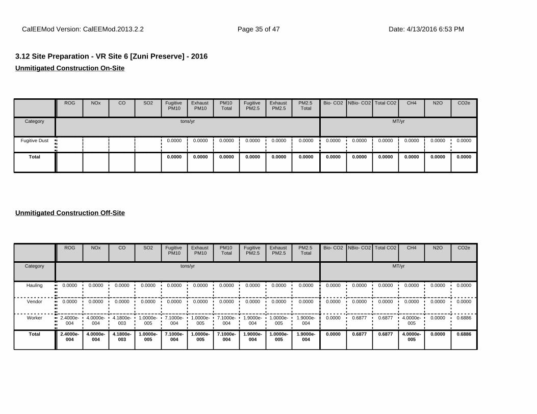
3.12 Site Preparation - VR Site 6 [Zuni Preserve] - 2016
ROG NOx CO SO2 Fugitive PM10
Exhaust PM10
PM10 Total
Fugitive PM2.5
Exhaust PM2.5
PM2.5 Total
Bio- CO2 NBio- CO2 Total CO2 CH4 N2O CO2e
Category tons/yr MT/yr
Fugitive Dust 0.0000 0.0000 0.0000 0.0000 0.0000 0.0000 0.0000 0.0000 0.0000 0.0000 0.0000 0.0000
Total 0.0000 0.0000 0.0000 0.0000 0.0000 0.0000 0.0000 0.0000 0.0000 0.0000 0.0000 0.0000
Unmitigated Construction On-Site
ROG NOx CO SO2 Fugitive PM10
Exhaust PM10
PM10 Total
Fugitive PM2.5
Exhaust PM2.5
PM2.5 Total
Bio- CO2 NBio- CO2 Total CO2 CH4 N2O CO2e
Category tons/yr MT/yr
Hauling 0.0000 0.0000 0.0000 0.0000 0.0000 0.0000 0.0000 0.0000 0.0000 0.0000 0.0000 0.0000 0.0000 0.0000 0.0000 0.0000
Vendor 0.0000 0.0000 0.0000 0.0000 0.0000 0.0000 0.0000 0.0000 0.0000 0.0000 0.0000 0.0000 0.0000 0.0000 0.0000 0.0000
Worker 2.4000e-004
4.0000e-004
4.1800e-003
1.0000e-005
7.1000e-004
1.0000e-005
7.1000e-004
1.9000e-004
1.0000e-005
1.9000e-004
0.0000 0.6877 0.6877 4.0000e-005
0.0000 0.6886
Total 2.4000e-004
4.0000e-004
4.1800e-003
1.0000e-005
7.1000e-004
1.0000e-005
7.1000e-004
1.9000e-004
1.0000e-005
1.9000e-004
0.0000 0.6877 0.6877 4.0000e-005
0.0000 0.6886
Unmitigated Construction Off-Site
CalEEMod Version: CalEEMod.2013.2.2 Date: 4/13/2016 6:53 PMPage 35 of 47

3.12 Site Preparation - VR Site 6 [Zuni Preserve] - 2016
ROG NOx CO SO2 Fugitive PM10
Exhaust PM10
PM10 Total
Fugitive PM2.5
Exhaust PM2.5
PM2.5 Total
Bio- CO2 NBio- CO2 Total CO2 CH4 N2O CO2e
Category tons/yr MT/yr
Fugitive Dust 0.0000 0.0000 0.0000 0.0000 0.0000 0.0000 0.0000 0.0000 0.0000 0.0000 0.0000 0.0000
Total 0.0000 0.0000 0.0000 0.0000 0.0000 0.0000 0.0000 0.0000 0.0000 0.0000 0.0000 0.0000
Mitigated Construction On-Site
ROG NOx CO SO2 Fugitive PM10
Exhaust PM10
PM10 Total
Fugitive PM2.5
Exhaust PM2.5
PM2.5 Total
Bio- CO2 NBio- CO2 Total CO2 CH4 N2O CO2e
Category tons/yr MT/yr
Hauling 0.0000 0.0000 0.0000 0.0000 0.0000 0.0000 0.0000 0.0000 0.0000 0.0000 0.0000 0.0000 0.0000 0.0000 0.0000 0.0000
Vendor 0.0000 0.0000 0.0000 0.0000 0.0000 0.0000 0.0000 0.0000 0.0000 0.0000 0.0000 0.0000 0.0000 0.0000 0.0000 0.0000
Worker 2.4000e-004
4.0000e-004
4.1800e-003
1.0000e-005
7.1000e-004
1.0000e-005
7.1000e-004
1.9000e-004
1.0000e-005
1.9000e-004
0.0000 0.6877 0.6877 4.0000e-005
0.0000 0.6886
Total 2.4000e-004
4.0000e-004
4.1800e-003
1.0000e-005
7.1000e-004
1.0000e-005
7.1000e-004
1.9000e-004
1.0000e-005
1.9000e-004
0.0000 0.6877 0.6877 4.0000e-005
0.0000 0.6886
Mitigated Construction Off-Site
CalEEMod Version: CalEEMod.2013.2.2 Date: 4/13/2016 6:53 PMPage 36 of 47
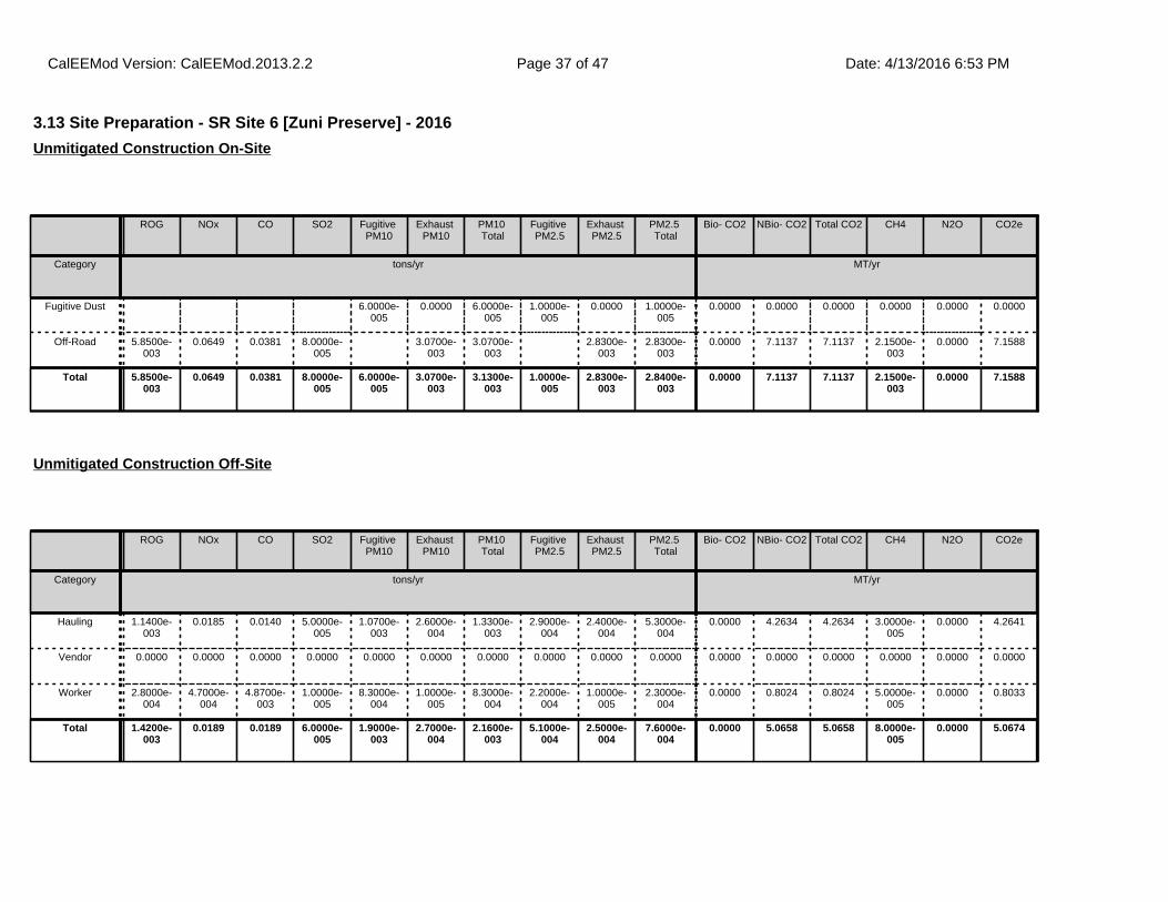
3.13 Site Preparation - SR Site 6 [Zuni Preserve] - 2016
ROG NOx CO SO2 Fugitive PM10
Exhaust PM10
PM10 Total
Fugitive PM2.5
Exhaust PM2.5
PM2.5 Total
Bio- CO2 NBio- CO2 Total CO2 CH4 N2O CO2e
Category tons/yr MT/yr
Fugitive Dust 6.0000e-005
0.0000 6.0000e-005
1.0000e-005
0.0000 1.0000e-005
0.0000 0.0000 0.0000 0.0000 0.0000 0.0000
Off-Road 5.8500e-003
0.0649 0.0381 8.0000e-005
3.0700e-003
3.0700e-003
2.8300e-003
2.8300e-003
0.0000 7.1137 7.1137 2.1500e-003
0.0000 7.1588
Total 5.8500e-003
0.0649 0.0381 8.0000e-005
6.0000e-005
3.0700e-003
3.1300e-003
1.0000e-005
2.8300e-003
2.8400e-003
0.0000 7.1137 7.1137 2.1500e-003
0.0000 7.1588
Unmitigated Construction On-Site
ROG NOx CO SO2 Fugitive PM10
Exhaust PM10
PM10 Total
Fugitive PM2.5
Exhaust PM2.5
PM2.5 Total
Bio- CO2 NBio- CO2 Total CO2 CH4 N2O CO2e
Category tons/yr MT/yr
Hauling 1.1400e-003
0.0185 0.0140 5.0000e-005
1.0700e-003
2.6000e-004
1.3300e-003
2.9000e-004
2.4000e-004
5.3000e-004
0.0000 4.2634 4.2634 3.0000e-005
0.0000 4.2641
Vendor 0.0000 0.0000 0.0000 0.0000 0.0000 0.0000 0.0000 0.0000 0.0000 0.0000 0.0000 0.0000 0.0000 0.0000 0.0000 0.0000
Worker 2.8000e-004
4.7000e-004
4.8700e-003
1.0000e-005
8.3000e-004
1.0000e-005
8.3000e-004
2.2000e-004
1.0000e-005
2.3000e-004
0.0000 0.8024 0.8024 5.0000e-005
0.0000 0.8033
Total 1.4200e-003
0.0189 0.0189 6.0000e-005
1.9000e-003
2.7000e-004
2.1600e-003
5.1000e-004
2.5000e-004
7.6000e-004
0.0000 5.0658 5.0658 8.0000e-005
0.0000 5.0674
Unmitigated Construction Off-Site
CalEEMod Version: CalEEMod.2013.2.2 Date: 4/13/2016 6:53 PMPage 37 of 47
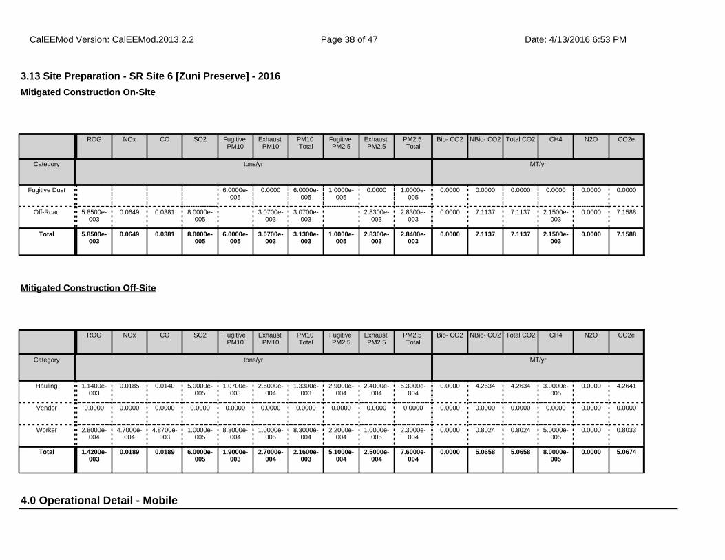
4.0 Operational Detail - Mobile
3.13 Site Preparation - SR Site 6 [Zuni Preserve] - 2016
ROG NOx CO SO2 Fugitive PM10
Exhaust PM10
PM10 Total
Fugitive PM2.5
Exhaust PM2.5
PM2.5 Total
Bio- CO2 NBio- CO2 Total CO2 CH4 N2O CO2e
Category tons/yr MT/yr
Fugitive Dust 6.0000e-005
0.0000 6.0000e-005
1.0000e-005
0.0000 1.0000e-005
0.0000 0.0000 0.0000 0.0000 0.0000 0.0000
Off-Road 5.8500e-003
0.0649 0.0381 8.0000e-005
3.0700e-003
3.0700e-003
2.8300e-003
2.8300e-003
0.0000 7.1137 7.1137 2.1500e-003
0.0000 7.1588
Total 5.8500e-003
0.0649 0.0381 8.0000e-005
6.0000e-005
3.0700e-003
3.1300e-003
1.0000e-005
2.8300e-003
2.8400e-003
0.0000 7.1137 7.1137 2.1500e-003
0.0000 7.1588
Mitigated Construction On-Site
ROG NOx CO SO2 Fugitive PM10
Exhaust PM10
PM10 Total
Fugitive PM2.5
Exhaust PM2.5
PM2.5 Total
Bio- CO2 NBio- CO2 Total CO2 CH4 N2O CO2e
Category tons/yr MT/yr
Hauling 1.1400e-003
0.0185 0.0140 5.0000e-005
1.0700e-003
2.6000e-004
1.3300e-003
2.9000e-004
2.4000e-004
5.3000e-004
0.0000 4.2634 4.2634 3.0000e-005
0.0000 4.2641
Vendor 0.0000 0.0000 0.0000 0.0000 0.0000 0.0000 0.0000 0.0000 0.0000 0.0000 0.0000 0.0000 0.0000 0.0000 0.0000 0.0000
Worker 2.8000e-004
4.7000e-004
4.8700e-003
1.0000e-005
8.3000e-004
1.0000e-005
8.3000e-004
2.2000e-004
1.0000e-005
2.3000e-004
0.0000 0.8024 0.8024 5.0000e-005
0.0000 0.8033
Total 1.4200e-003
0.0189 0.0189 6.0000e-005
1.9000e-003
2.7000e-004
2.1600e-003
5.1000e-004
2.5000e-004
7.6000e-004
0.0000 5.0658 5.0658 8.0000e-005
0.0000 5.0674
Mitigated Construction Off-Site
CalEEMod Version: CalEEMod.2013.2.2 Date: 4/13/2016 6:53 PMPage 38 of 47
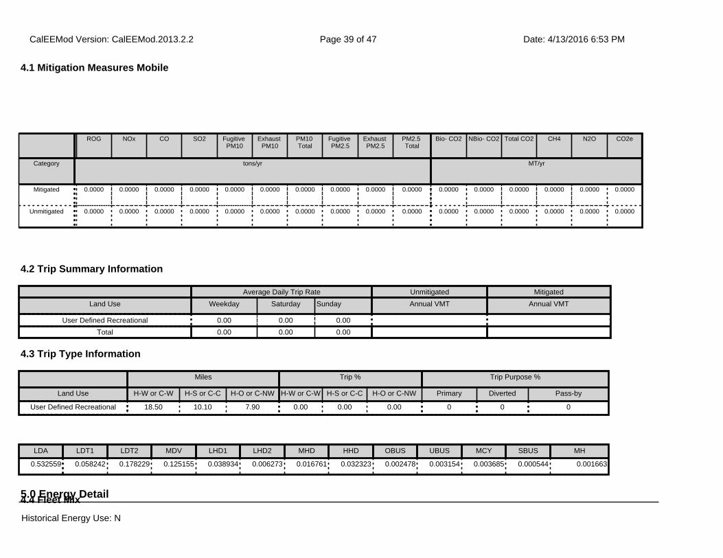
ROG NOx CO SO2 Fugitive PM10
Exhaust PM10
PM10 Total
Fugitive PM2.5
Exhaust PM2.5
PM2.5 Total
Bio- CO2 NBio- CO2 Total CO2 CH4 N2O CO2e
Category tons/yr MT/yr
Mitigated 0.0000 0.0000 0.0000 0.0000 0.0000 0.0000 0.0000 0.0000 0.0000 0.0000 0.0000 0.0000 0.0000 0.0000 0.0000 0.0000
Unmitigated 0.0000 0.0000 0.0000 0.0000 0.0000 0.0000 0.0000 0.0000 0.0000 0.0000 0.0000 0.0000 0.0000 0.0000 0.0000 0.0000
4.1 Mitigation Measures Mobile
4.2 Trip Summary Information
4.3 Trip Type Information
Average Daily Trip Rate Unmitigated Mitigated
Land Use Weekday Saturday Sunday Annual VMT Annual VMT
User Defined Recreational 0.00 0.00 0.00
Total 0.00 0.00 0.00
Miles Trip % Trip Purpose %
Land Use H-W or C-W H-S or C-C H-O or C-NW H-W or C-W H-S or C-C H-O or C-NW Primary Diverted Pass-by
User Defined Recreational 18.50 10.10 7.90 0.00 0.00 0.00 0 0 0
5.0 Energy Detail4.4 Fleet Mix
LDA LDT1 LDT2 MDV LHD1 LHD2 MHD HHD OBUS UBUS MCY SBUS MH
0.532559 0.058242 0.178229 0.125155 0.038934 0.006273 0.016761 0.032323 0.002478 0.003154 0.003685 0.000544 0.001663
Historical Energy Use: N
CalEEMod Version: CalEEMod.2013.2.2 Date: 4/13/2016 6:53 PMPage 39 of 47
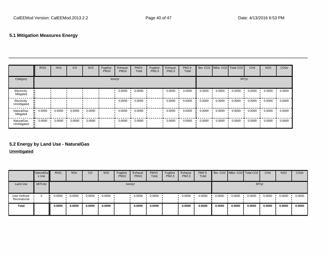
ROG NOx CO SO2 Fugitive PM10
Exhaust PM10
PM10 Total
Fugitive PM2.5
Exhaust PM2.5
PM2.5 Total
Bio- CO2 NBio- CO2 Total CO2 CH4 N2O CO2e
Category tons/yr MT/yr
Electricity Mitigated
0.0000 0.0000 0.0000 0.0000 0.0000 0.0000 0.0000 0.0000 0.0000 0.0000
Electricity Unmitigated
0.0000 0.0000 0.0000 0.0000 0.0000 0.0000 0.0000 0.0000 0.0000 0.0000
NaturalGas Mitigated
0.0000 0.0000 0.0000 0.0000 0.0000 0.0000 0.0000 0.0000 0.0000 0.0000 0.0000 0.0000 0.0000 0.0000
NaturalGas Unmitigated
0.0000 0.0000 0.0000 0.0000 0.0000 0.0000 0.0000 0.0000 0.0000 0.0000 0.0000 0.0000 0.0000 0.0000
5.2 Energy by Land Use - NaturalGas
NaturalGas Use
ROG NOx CO SO2 Fugitive PM10
Exhaust PM10
PM10 Total
Fugitive PM2.5
Exhaust PM2.5
PM2.5 Total
Bio- CO2 NBio- CO2 Total CO2 CH4 N2O CO2e
Land Use kBTU/yr tons/yr MT/yr
User Defined Recreational
0 0.0000 0.0000 0.0000 0.0000 0.0000 0.0000 0.0000 0.0000 0.0000 0.0000 0.0000 0.0000 0.0000 0.0000
Total 0.0000 0.0000 0.0000 0.0000 0.0000 0.0000 0.0000 0.0000 0.0000 0.0000 0.0000 0.0000 0.0000 0.0000
Unmitigated
5.1 Mitigation Measures Energy
Historical Energy Use: N
CalEEMod Version: CalEEMod.2013.2.2 Date: 4/13/2016 6:53 PMPage 40 of 47
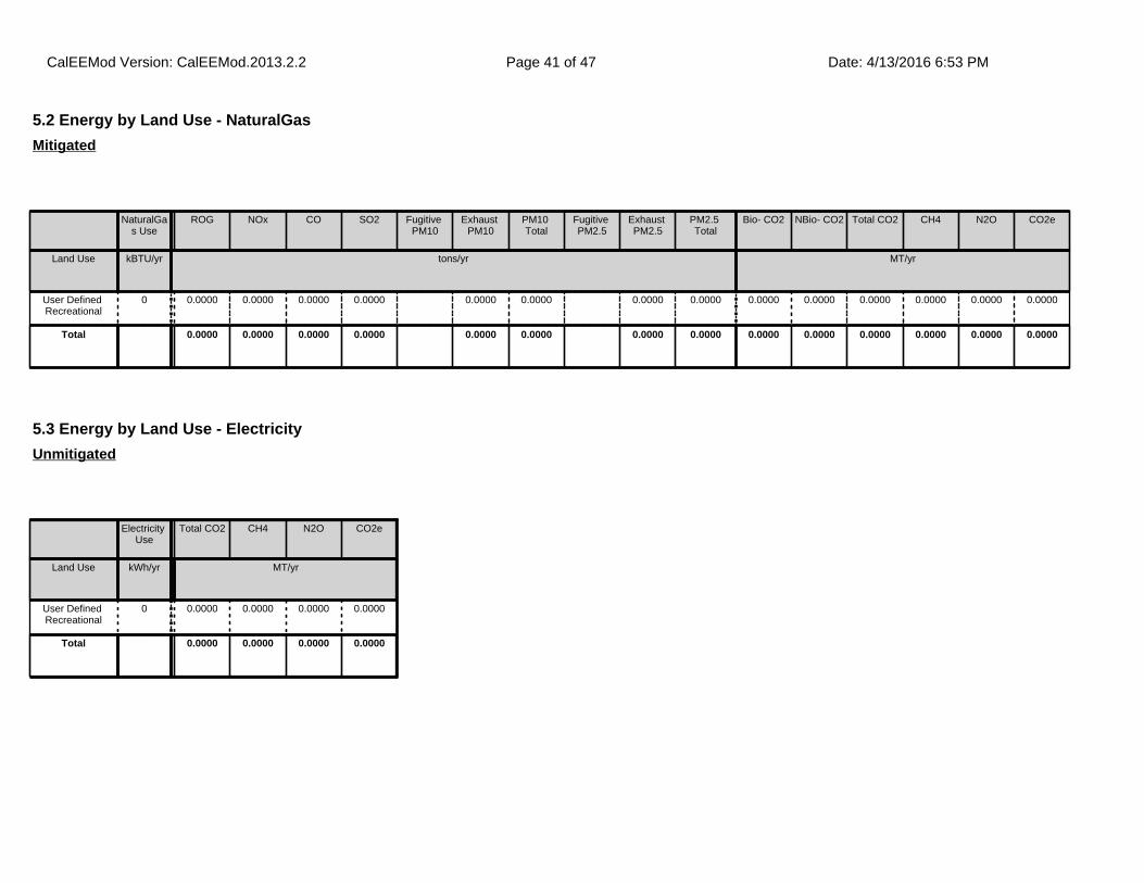
5.2 Energy by Land Use - NaturalGas
NaturalGas Use
ROG NOx CO SO2 Fugitive PM10
Exhaust PM10
PM10 Total
Fugitive PM2.5
Exhaust PM2.5
PM2.5 Total
Bio- CO2 NBio- CO2 Total CO2 CH4 N2O CO2e
Land Use kBTU/yr tons/yr MT/yr
User Defined Recreational
0 0.0000 0.0000 0.0000 0.0000 0.0000 0.0000 0.0000 0.0000 0.0000 0.0000 0.0000 0.0000 0.0000 0.0000
Total 0.0000 0.0000 0.0000 0.0000 0.0000 0.0000 0.0000 0.0000 0.0000 0.0000 0.0000 0.0000 0.0000 0.0000
Mitigated
5.3 Energy by Land Use - Electricity
Electricity Use
Total CO2 CH4 N2O CO2e
Land Use kWh/yr MT/yr
User Defined Recreational
0 0.0000 0.0000 0.0000 0.0000
Total 0.0000 0.0000 0.0000 0.0000
Unmitigated
CalEEMod Version: CalEEMod.2013.2.2 Date: 4/13/2016 6:53 PMPage 41 of 47
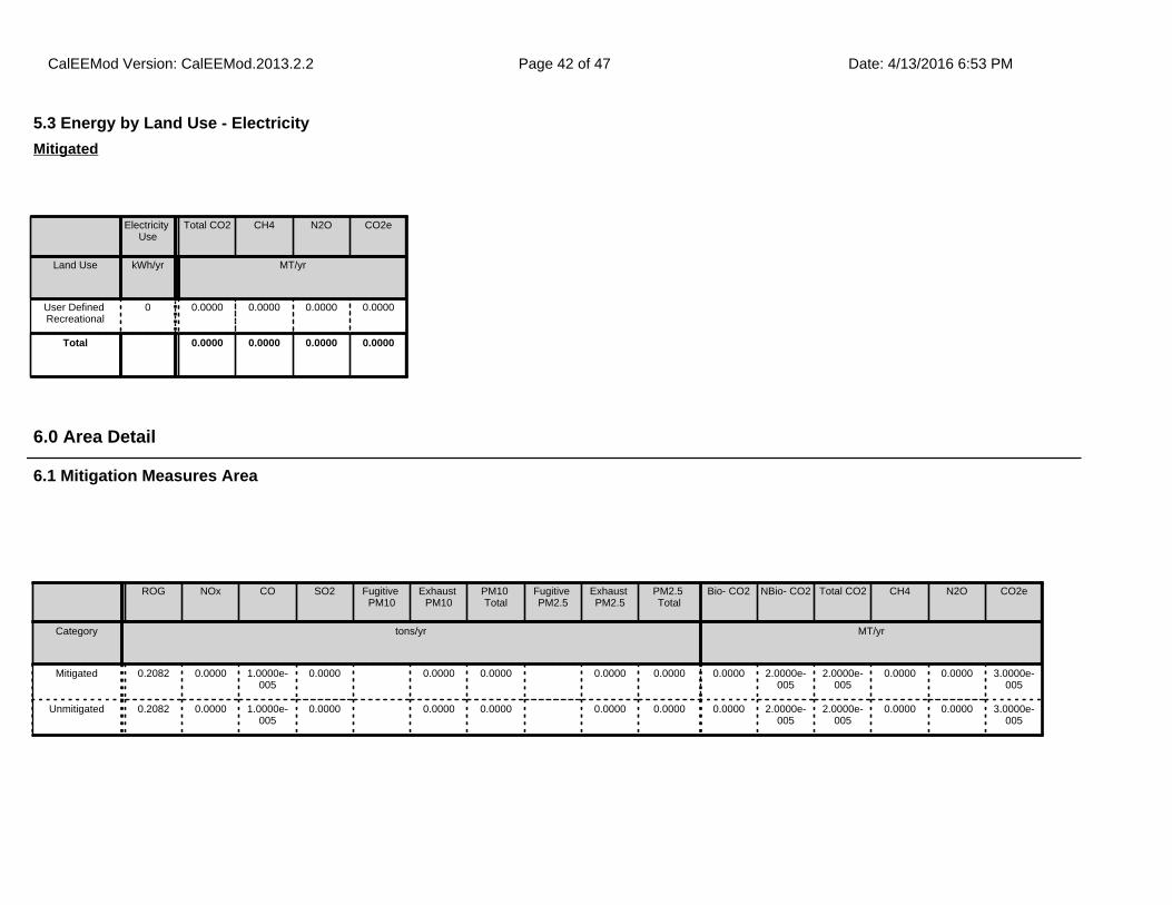
6.1 Mitigation Measures Area
6.0 Area Detail
ROG NOx CO SO2 Fugitive PM10
Exhaust PM10
PM10 Total
Fugitive PM2.5
Exhaust PM2.5
PM2.5 Total
Bio- CO2 NBio- CO2 Total CO2 CH4 N2O CO2e
Category tons/yr MT/yr
Mitigated 0.2082 0.0000 1.0000e-005
0.0000 0.0000 0.0000 0.0000 0.0000 0.0000 2.0000e-005
2.0000e-005
0.0000 0.0000 3.0000e-005
Unmitigated 0.2082 0.0000 1.0000e-005
0.0000 0.0000 0.0000 0.0000 0.0000 0.0000 2.0000e-005
2.0000e-005
0.0000 0.0000 3.0000e-005
5.3 Energy by Land Use - Electricity
Electricity Use
Total CO2 CH4 N2O CO2e
Land Use kWh/yr MT/yr
User Defined Recreational
0 0.0000 0.0000 0.0000 0.0000
Total 0.0000 0.0000 0.0000 0.0000
Mitigated
CalEEMod Version: CalEEMod.2013.2.2 Date: 4/13/2016 6:53 PMPage 42 of 47
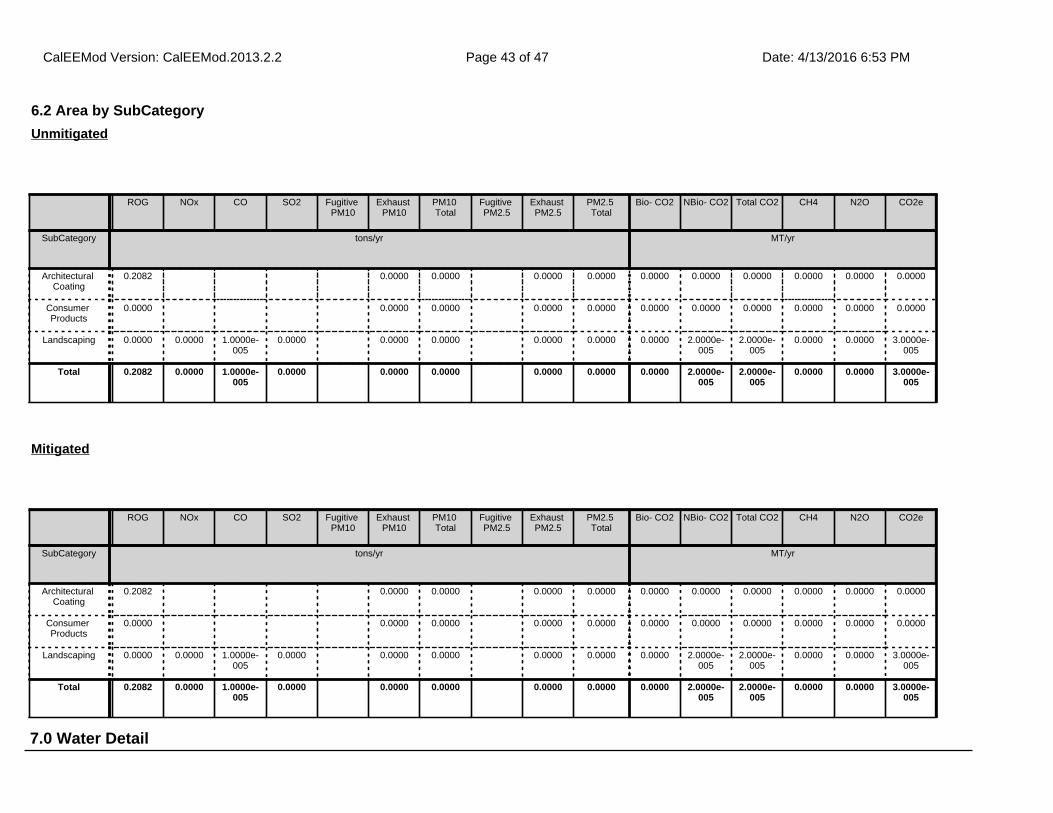
7.0 Water Detail
6.2 Area by SubCategory
ROG NOx CO SO2 Fugitive PM10
Exhaust PM10
PM10 Total
Fugitive PM2.5
Exhaust PM2.5
PM2.5 Total
Bio- CO2 NBio- CO2 Total CO2 CH4 N2O CO2e
SubCategory tons/yr MT/yr
Architectural Coating
0.2082 0.0000 0.0000 0.0000 0.0000 0.0000 0.0000 0.0000 0.0000 0.0000 0.0000
Consumer Products
0.0000 0.0000 0.0000 0.0000 0.0000 0.0000 0.0000 0.0000 0.0000 0.0000 0.0000
Landscaping 0.0000 0.0000 1.0000e-005
0.0000 0.0000 0.0000 0.0000 0.0000 0.0000 2.0000e-005
2.0000e-005
0.0000 0.0000 3.0000e-005
Total 0.2082 0.0000 1.0000e-005
0.0000 0.0000 0.0000 0.0000 0.0000 0.0000 2.0000e-005
2.0000e-005
0.0000 0.0000 3.0000e-005
Unmitigated
ROG NOx CO SO2 Fugitive PM10
Exhaust PM10
PM10 Total
Fugitive PM2.5
Exhaust PM2.5
PM2.5 Total
Bio- CO2 NBio- CO2 Total CO2 CH4 N2O CO2e
SubCategory tons/yr MT/yr
Architectural Coating
0.2082 0.0000 0.0000 0.0000 0.0000 0.0000 0.0000 0.0000 0.0000 0.0000 0.0000
Consumer Products
0.0000 0.0000 0.0000 0.0000 0.0000 0.0000 0.0000 0.0000 0.0000 0.0000 0.0000
Landscaping 0.0000 0.0000 1.0000e-005
0.0000 0.0000 0.0000 0.0000 0.0000 0.0000 2.0000e-005
2.0000e-005
0.0000 0.0000 3.0000e-005
Total 0.2082 0.0000 1.0000e-005
0.0000 0.0000 0.0000 0.0000 0.0000 0.0000 2.0000e-005
2.0000e-005
0.0000 0.0000 3.0000e-005
Mitigated
CalEEMod Version: CalEEMod.2013.2.2 Date: 4/13/2016 6:53 PMPage 43 of 47
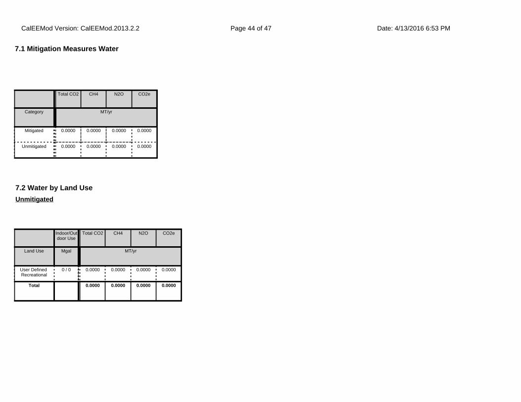
7.1 Mitigation Measures Water
Total CO2 CH4 N2O CO2e
Category MT/yr
Mitigated 0.0000 0.0000 0.0000 0.0000
Unmitigated 0.0000 0.0000 0.0000 0.0000
7.2 Water by Land Use
Indoor/Outdoor Use
Total CO2 CH4 N2O CO2e
Land Use Mgal MT/yr
User Defined Recreational
0 / 0 0.0000 0.0000 0.0000 0.0000
Total 0.0000 0.0000 0.0000 0.0000
Unmitigated
CalEEMod Version: CalEEMod.2013.2.2 Date: 4/13/2016 6:53 PMPage 44 of 47
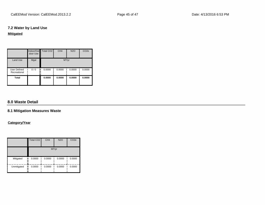
8.1 Mitigation Measures Waste
7.2 Water by Land Use
Indoor/Outdoor Use
Total CO2 CH4 N2O CO2e
Land Use Mgal MT/yr
User Defined Recreational
0 / 0 0.0000 0.0000 0.0000 0.0000
Total 0.0000 0.0000 0.0000 0.0000
Mitigated
8.0 Waste Detail
Total CO2 CH4 N2O CO2e
MT/yr
Mitigated 0.0000 0.0000 0.0000 0.0000
Unmitigated 0.0000 0.0000 0.0000 0.0000
Category/Year
CalEEMod Version: CalEEMod.2013.2.2 Date: 4/13/2016 6:53 PMPage 45 of 47
8.2 Waste by Land Use
Waste Disposed
Total CO2 CH4 N2O CO2e
Land Use tons MT/yr
User Defined Recreational
0 0.0000 0.0000 0.0000 0.0000
Total 0.0000 0.0000 0.0000 0.0000
Unmitigated
Waste Disposed
Total CO2 CH4 N2O CO2e
Land Use tons MT/yr
User Defined Recreational
0 0.0000 0.0000 0.0000 0.0000
Total 0.0000 0.0000 0.0000 0.0000
Mitigated
9.0 Operational Offroad
Equipment Type Number Hours/Day Days/Year Horse Power Load Factor Fuel Type
CalEEMod Version: CalEEMod.2013.2.2 Date: 4/13/2016 6:53 PMPage 46 of 47
10.0 Vegetation
CalEEMod Version: CalEEMod.2013.2.2 Date: 4/13/2016 6:53 PMPage 47 of 47

APPENDIX B BIOLOGICAL RESOURCES ASSESSMENT
Biological Resources Assessment
and
Preliminary Jurisdictional Delineation
for
Bouquet Canyon Creek Restoration Project
Angeles National Forest
Santa Clara/Mojave River Ranger District
Los Angeles County, California
Prepared for:
Los Angeles County Department of Public Works Programs Development Division
900 South Fremont Ave, 11th Floor Alhambra, CA 91803-1331
Contact: Ed Dingman
Prepared by:
AECOM 999 Town and Country Road
Orange, CA 92868
Contact: Arthur Popp
May 2016

Bouquet Canyon Creek Restoration Project Biological Resources Assessment i
TABLE OF CONTENTS
1.0 INTRODUCTION ...........................................................................................................1
1.1 PROJECT DESCRIPTION................................................................................................4 1.2 FIELD SURVEYS ........................................................................................................17
2.0 EXISTING CONDITIONS ..........................................................................................19
2.1 SETTING ....................................................................................................................19 2.2 VEGETATION COMMUNITIES .....................................................................................19 2.3 WILDLIFE SPECIES ....................................................................................................27 2.4 WILDLIFE MOVEMENT CORRIDOR ............................................................................27
3.0 SPECIAL-STATUS BIOLOGICAL RESOURCES .....................................................29
3.1 SPECIAL-STATUS PLANTS .........................................................................................30 3.2 SPECIAL-STATUS WILDLIFE ......................................................................................39 3.3 SENSITIVE NATURAL COMMUNITIES .........................................................................59
4.0 PRELIMINARY JURISDICTIONAL DELINEATION ..............................................61
4.1 REGULATORY SETTING .............................................................................................61 4.2 STUDY METHODS .....................................................................................................62 4.3 EXISTING JURISDICTIONAL WATERS IN THE BSA .....................................................63 4.4 JURISDICTIONAL DELINEATION .................................................................................67 4.5 POTENTIAL IMPACTS TO JURISDICTIONAL WATERS ..................................................69 4.6 POTENTIAL JURISDICTIONAL WATERS MITIGATION..................................................70
5.0 APPLICABLE REGULATIONS .................................................................................71
5.1 FEDERAL REGULATIONS AND STANDARDS ...............................................................71 5.2 STATE REGULATIONS AND STANDARDS ....................................................................72
6.0 IMPACTS ON BIOLOGICAL RESOURCES ...........................................................75
6.1 VEGETATION ............................................................................................................75 6.2 WILDLIFE ..................................................................................................................79 6.3 WILDLIFE MOVEMENT CORRIDOR ............................................................................84
7.0 AVOIDANCE, MINIMIZATION, AND MITIGATION MEASURES .......................85
7.1 BMPS .......................................................................................................................85 7.2 MITIGATION MEASURES – SPECIAL-STATUS SPECIES ...............................................92 7.3 MITIGATION MEASURES – JURISDICTIONAL WATERS ...............................................92
8.0 CONCLUSIONS ..........................................................................................................95
9.0 REFERENCES ............................................................................................................97
Bouquet Canyon Creek Restoration Project Biological Resources Assessment ii
LIST OF FIGURES
FIGURE 1-1 REGIONAL LOCATION MAP ............................................................................... 2 FIGURE 1-2 PROJECT SITES MAP ........................................................................................ 3 FIGURE 2-1 VEGETATION COMMUNITIES, COVER TYPES, AND LARGE TREES IN SITE 1 BSA ........................................................................................................ 21 FIGURE 2-2 VEGETATION COMMUNITIES, COVER TYPES, AND LARGE TREES IN SITES 2 THROUGH 4 AND SITE 6 (ZUNI PRESERVE) BSA ............................ 22 FIGURE 2-3 VEGETATION COMMUNITIES, COVER TYPES, AND LARGE TREES IN SITE 5 BSA ........................................................................................................ 23
FIGURE 4-1 WATERS OF THE U.S. AND STATE IN SITE 1 ................................................. 64 FIGURE 4-2 WATERS OF THE U.S. AND STATE IN SITES 2 THROUGH 4 AND SITE 6 (ZUNI PRESERVE) ................................................................................ 65 FIGURE 4-3 WATERS OF THE U.S. AND STATE IN SITE 5 ................................................. 66
LIST OF TABLES
TABLE 2-1 VEGETATION COMMUNITIES AND COVER TYPES MAPPED WITHIN THE BSA SITES 1-6 AND SEDIMENT PLACEMENT SITE (ACRES) ................ 20
TABLE 3-1 SPECIAL-STATUS PLANT SPECIES WITH POTENTIAL TO OCCUR IN
THE BSA ........................................................................................................... 31 TABLE 3-2 SENSITIVE WILDLIFE SPECIES WITH POTENTIAL TO OCCUR WITHIN THE BSA .............................................................................................. 41
TABLE 4-1 BOUQUET CANYON CREEK DELINEATION RESULTS .................................. 67 TABLE 4-2 POTENTIAL PROJECT IMPACTS IN ACRES TO WATERS OF THE U.S. AND STATE ............................................................................................... 69 TABLE 4-3 POTENTIAL PROJECT IMPACTS IN ACRES TO WATERS OF THE STATE EXCLUSIVELY ...................................................................................... 70
TABLE 6-1 DIRECT IMPACTS TO RIPARIAN COMMUNITIES WITHIN SITES 1-5 AND SITE 6 (ZUNI PRESERVE) (ACRES) ........................................................ 77 TABLE 6-2 ESTIMATED POPULATION OF UTS WITHIN THE PROJECT SITE ................. 81

Bouquet Canyon Creek Restoration Project Biological Resources Assessment iii
LIST OF APPENDICES A PROJECT PLANS B SITE PHOTOGRAPHS C REGIONAL SPECIAL-STATUS PLANT SPECIES D REGIONAL SPECIAL-STATUS WILDLIFE SPECIES E WETLAND DETERMINATION DATA FORMS
Bouquet Canyon Creek Restoration Project Biological Resources Assessment 1
1.0 INTRODUCTION AECOM was contracted by Los Angeles County Department of Public Works (LACDPW) to document existing biological resources along Bouquet Canyon Creek and conduct a jurisdictional delineation of the creek in support of the Bouquet Canyon Creek Restoration Project (project). Major storms and fires in Bouquet Canyon have led to accelerated deposition of sediment in the creek, reducing its capacity to move water and causing the invert of the creek at several locations to be at a higher elevation than that of the adjacent Bouquet Canyon Road. As a result, even at very low flow rates within the creek, water seeps through dirt berms constructed to hold the creek back away from the roadway, or it seeps up through cracks in the roadway at locations where there is sufficient hydrostatic pressure. Both conditions cause potentially hazardous driving conditions for motorists due to flooding of the roadway. This situation is of concern to the City of Los Angeles' Department of Water and Power (DWP), which regulates flows within the creek at the dam on Bouquet Reservoir at the top of Bouquet Canyon. Through an agreement with the United Water Conservation District, DWP is to release 5 cubic feet per second (cfs) into Bouquet Canyon Creek between April 1 and September 30, and 1 cfs during the period between October 1 and March 31. However, due to current creek conditions, DWP is reluctant to release the stipulated outflow at the dam due to the perceived liability issues caused by roadway flooding. This has resulted in only a fraction of the stipulated flows being released into the creek. As a result of the reduced flows, riparian habitat at the lower end of Bouquet Canyon is dying or has died, due to an apparent lack of water in the creek. LACDPW proposes to restore Bouquet Canyon Creek by lowering the creek invert to restore stream capacity, which would prevent future flooding across Bouquet Canyon Road, restore stream flows to lower portions of the watershed, and restore stream and riparian habitats. This biological resources assessment and jurisdictional delineation report (JDR) summarizes the results of field surveys completed at six locations along Bouquet Canyon Creek where LACDPW proposes project activities. The six locations occur in the Angeles National Forest (ANF), north of Santa Clarita, California (see Figure 1-1, Regional Location Map, and Figure 1-2, Project Sites Map).
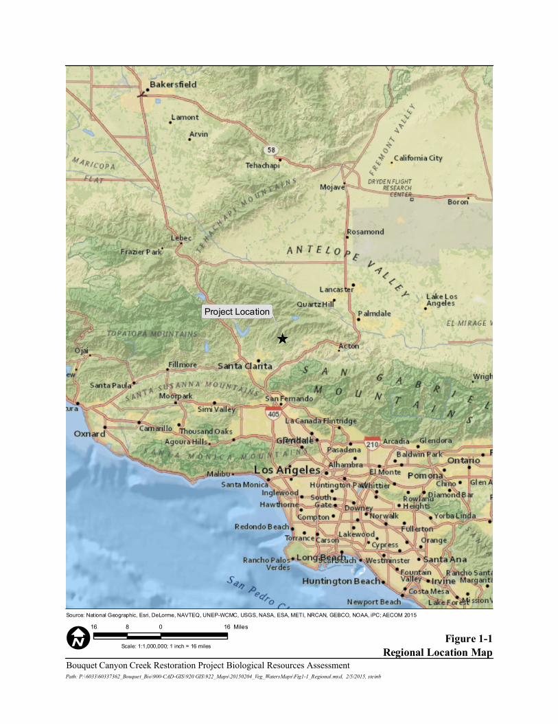
_̂
Project Location
Figure 1-1Regional Location Map
Source: National Geographic, Esri, DeLorme, NAVTEQ, UNEP-WCMC, USGS, NASA, ESA, METI, NRCAN, GEBCO, NOAA, iPC; AECOM 2015
Scale: 1:1,000,000; 1 inch = 16 miles
Bouquet Canyon Creek Restoration Project Biological Resources AssessmentPath: P:\6033\60337362_Bouquet_Bio\900-CAD-GIS\920 GIS\922_Maps\20150204_Veg_WatersMaps\Fig1-1_Regional.mxd, 2/5/2015, steinb
16 0 168 Miles
I
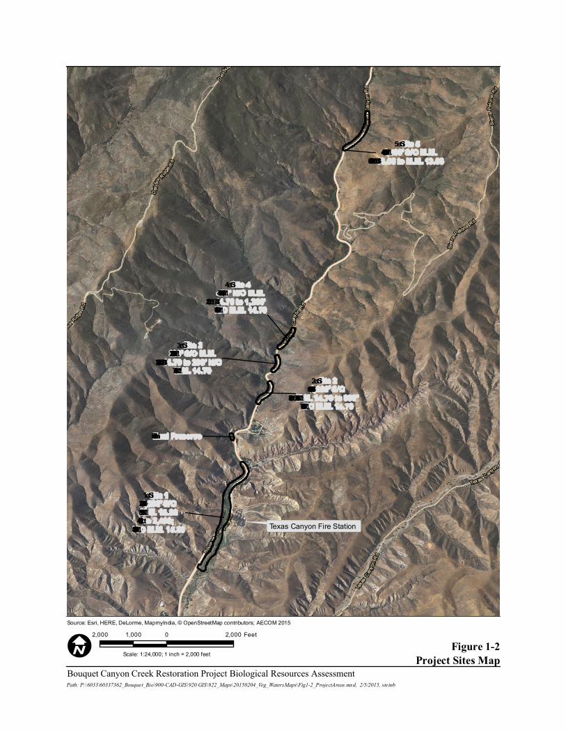
Texas Canyon Fire Station
Site 11,200’ S/OM.M. 15.89to 2,400;
N/O M.M. 15.89
Zuni Preserve
Site 21,600’ S/O
M.M. 14.70 to 800’S/O M.M. 14.70
Site 3320’ S/O M.M.14.70 to 200’ N/OM.M. 14.70
Site 4470’ N/O M.M.14.70 to 1,200’N/O M.M. 14.70
Site 51,400’ S/O M.M.13.06 to M.M. 13.06
Figure 1-2Project Sites Map
Source: Esri, HERE, DeLorme, MapmyIndia, © OpenStreetMap contributors; AECOM 2015
Scale: 1:24,000; 1 inch = 2,000 feet
Bouquet Canyon Creek Restoration Project Biological Resources AssessmentPath: P:\6033\60337362_Bouquet_Bio\900-CAD-GIS\920 GIS\922_Maps\20150204_Veg_WatersMaps\Fig1-2_ProjectAreas.mxd, 2/5/2015, steinb
2,000 0 2,0001,000 Feet
I
Bouquet Canyon Creek Restoration Project Biological Resources Assessment 4
1.1 Project Description
1.1.1 Overview of the Project Prior to creating the plans and scope of this project, LACDPW surveyed the existing conditions of Bouquet Canyon Creek from the southern boundary of the ANF to MM 11.59, to identify locations where it was apparent that flooding was frequent or had occurred in the past. This survey identified five areas (from downstream to upstream, labeled as Sites 1 through 5) where work is needed in order to achieve the desired goals. Locations of the five project sites have been identified using existing MM posted along Bouquet Canyon Road. Additionally, at a sixth site in the abandoned Zuni Campground (as depicted on Figure 2-4), which lies between Sites 1 and 2, LACDPW proposes to construct a fish preserve by excavating a small channel off the existing creek, northeast into the former campground where a small pond would be constructed to serve as an aquatic refuge in times of high or rapid water flow; this pond may also provide an area that USFWS can use as a holding site for fish or other aquatic species.
1.1.2 Project Construction Construction Schedule, Access, and Parking Construction at each project site would commence after receipt of all regulatory permits and approvals. Construction would require approximately six months, with a start in late November 2016. Due to projected heavy truck traffic and transport of heavy equipment on Bouquet Canyon Road during the project, Bouquet Canyon Road may be closed above and below the project area (MM13.06 to the Angeles National Forest boundary) between the hours of 7:00a.m. and 4:00p.m., when work is scheduled (primarily Monday through Friday until the project is completed). Emergency responders have been provided keys to the gates to allow for emergency access whenever closed. Construction parking would occur along Bouquet Canyon Road and/or at Site 1. Construction Activities Overview Prior to initiation of work at each project site, the project work limits would be delineated. Flagging would delineate boundaries of the work limits and extent of the future stream channel. Proposed vegetation removal would require consultation with USFS regarding the disposition of any oak trees greater than a 6-inches diameter and any live non-oak trees greater than 12-inches diameter. In general, trees of this size and greater would be avoided when feasible. Vegetation and seed would be harvested from within the project area as available, and stored for restoration work. Smaller vegetation would be cut or mowed where feasible, to
Bouquet Canyon Creek Restoration Project Biological Resources Assessment 5
preserve the root and stems of riparian vegetation to allow for more rapid revegetation of the project area. Many species of riparian vegetation have the ability to produce adventitious roots. Willow, cottonwood, and mulefat are native to the area and found extensively in the project area. This vegetation would be cut and stored for restoration work immediately following sediment removal and channel creation. This vegetation can be stored for up to four months and used as bioengineering material. Bioengineering techniques would be utilized, providing stream bank stability, stream roughness, and shade. New vegetation would reduce soil moisture through transpiration and provide flood protection and soil stability for other vegetation to grow.
Root masses that come from the excavation of the creek and side slopes would be temporarily stored near Site 1 at the proposed sediment placement site near MM15.89. Final disposition of root masses would be determined by USFS, but would likely require being hauled to a dump. Construction Activities by Project Site Project details regarding vegetation removal and sediment removal proposed at each project site are provided below. Site 1: 1,200 feet South of MM 15.89 to 2,400 feet North of MM 15.89 Project activities are expected to begin at Site 1 due to the absence of water, either flowing or pooling, in this lower reach. The approximate project limits of Site 1 are depicted in Figure 1-2 and have a total area of approximately 5.31 acres. Work at this project site would begin in the reach from the culvert under Bouquet Canyon Road at MM 15.89, south (downstream) for 1,200 feet. Work would then be conducted from the culvert north (upstream) for 2,400 feet. Culvert MM 15.89 to 1, 200 feet south of MM 15.89 Vegetation Removal Work would start at the outlet of the culvert located beneath Bouquet Canyon Road. LACDPW would conduct vegetation removal activities and clear an approximate 50 to 70-foot wide path for a distance of 1,200 south (downstream) of the culvert. The use of a masticator which would grind up, and leave in place existing brush and trees. All brush, dead trees, non-oak trees smaller than a 12-inch diameter-at-breast-height (dbh), and oak trees smaller than a 6-inch dbh would be masticated. Vegetation removal with a masticator would take approximately seven days.
Bouquet Canyon Creek Restoration Project Biological Resources Assessment 6
Sediment Removal
Following vegetation removal, the site would be surveyed and grade stakes set every 50 to 100 feet on the east side of the creek to indicate the depth of excavation. An all-wheel drive 3,500-gallon capacity water truck would be positioned on the east side of the creek, and starting at the culvert outlet would move south within the cleared path to spray water on the work area immediately preceding the excavator. The excavator would also begin at the culvert outlet, straddle the creek, and begin excavating accumulated sediment and trimmed vegetation, and working its way 1,200 feet south (downstream). The depth of excavation varies in this reach and would be deepest just downstream of the culvert outlet. The restored creek bottom in this reach would be 9-feet wide, with 3-foot horizontal to 1-foot vertical (3:1) side slopes so that the creek would be able to convey flows from upstream through the site. Excavated material would be spread out along both sides of the creek within the work area and left uncompacted, or used to provide contour. Large rocks, boulders and large tree stems would be set aside on the periphery of the project area for post-sediment removal restoration use. Once excavation of the creek channel and vegetation removal work is complete, the excavator and water truck would utilize the access path to exit the work area. The removal of sediment through this reach would take approximately seven days. Culvert MM 15.89 to 2,400 feet north of MM 15.89 Vegetation Removal Work would start at the inlet of the culvert located beneath Bouquet Canyon Road. LACDPW would conduct vegetation removal activities and clear an approximate 50 to 70-foot wide path for a distance of 2,400 feet north (upstream) using masticator to clear the path, as described above. Utilizing a masticator for vegetation removal in this reach would take approximately 12 days. Sediment Removal A major obstacle in Site 1, north of MM 15.89, is the existence of overhead power lines. The existing creek meanders under the power lines and is very close to existing power poles at some locations. LACDPW is required by California Code of Regulations to be no closer than 20 feet to the vertical projection of the nearest overhead line. Since an excavator is proposed for sediment removal activities, LACDPW have adjusted the proposed alignment of the creek to be in compliance with the code. Sediment removal activities and preparation for Site 1, north of MM 15.89, would closely mirror activities as they were described for Site 1, south of MM 15.89. The excavator would be positioned at the culvert outlet as if it were straddling the creek and begin excavating the
Bouquet Canyon Creek Restoration Project Biological Resources Assessment 7
accumulated sediment and vegetation, working its way 2,400 feet northerly. The depth of the excavation varies in this reach and progressively gets deeper to the north. The proposed creek cross section from the culvert inlet to 1,000 feet northerly would have a 7.5 foot wide creek bottom with 3:1 side slopes, where feasible, in order to maintain the existing creek capacity (182 cfs) from further upstream. From 1,000 to 2,400 feet north of the culvert inlet, the creek cross section would be a 6-foot wide bottom with 3:1 side slopes. Centered at 1,200 feet north of the culvert would be a 100 foot long transition of the creek bottom from a width of 7.5 feet to 6 feet. In areas under the power lines, where use of the excavator would be prohibited, a track loader would be used to remove sediment from the creek bed. Between 1,400-1,800 feet north of MM 15.89 the stream would be widened and pools would be incorporated where possible. Excavated material would be spread out over areas away from the creek on both sides and left uncompacted from the culvert inlet to a distance of 1,700 feet north. Large rocks, boulders and large tree stems would be set aside on the periphery of the project area for post-sediment removal restoration use. Between 1,700 and 2,400 feet north of the culvert inlet, approximately 2,000 cubic yards (CY) of excavated material would be deposited on the shoulder of the roadway. A loader with rubber tires would then load the material into dump trucks to be taken to the designated sediment placement site at MM 15.89. Pending approval from USFS, LACDPW proposes to utilize an area along the east side of Bouquet Canyon Road and just north of the culvert at MM 15.89 as a sediment placement site for the project (see Figure 2-3). The area requested is 2.2 acres and is estimated to have a capacity of 32,000 CY. Without this site, LACDPW would have to remove the estimated 10,400 CY (15,600 tons) of material from this project and dispose of it at the Chiquita Canyon Landfill, located approximately 15 miles southwest of Site 1. A backhoe with rubber tires would also work from the roadway to restore one “overshot” located at 1,400 feet north of MM 15.89. Overshots are areas, usually paved with asphalt, that are intended to direct water on Bouquet Canyon Road into Bouquet Canyon Creek. This area is currently blocked by sediment and vegetation, and water is not able to flow into the creek. Sediment removal would take approximately 18 days. Site 2 (1,600 Feet South of MM14.70 to 800 Feet South of MM 14.70) Flowing water is generally present in Bouquet Canyon Creek at Site 2, and water has been observed along the flow line of the roadway between 1,350 and 1,450 feet south of MM 14.70. The approximate project limits of Site 2 are depicted in Figure 1-2 and have a total area of approximately 0.67 acre.
Bouquet Canyon Creek Restoration Project Biological Resources Assessment 8
Vegetation Removal Work would start at 1,600 feet south of MM 14.70 and proceed 800 feet north to 800 feet south of MM 14.70. LACDPW would conduct vegetation removal activities to clear an approximate 40-foot wide path for 800 feet through the site. A trained crew would use chainsaws and other hand tools to clear vegetation. All existing brush, dead trees, non-oak trees smaller than a 12 inch dbh, and oak trees smaller than a 6 inch dbh would be removed and run through a wood chipper and the chips spread over the site. Vegetation removal would take approximately six days. Sediment Removal Sediment removal activities would commence at Site 2 following vegetation removal. Throughout this site, the proposed creek bed would be a minimum of four feet below the existing edge of pavement or paved inverted flow line. The grade would be checked using a hand level as work progresses. A 3,500 gallon capacity water truck would be positioned on the shoulder of the roadway and a hose would be used to spray water on the work area immediately preceding the excavator. The excavator would be positioned adjacent to the creek and work alongside the creek utilizing the area between the creek and Bouquet Canyon Road. The depth of the excavation is fairly consistent at four feet through this reach. The proposed creek cross section in this reach would have a 6 foot wide creek bottom with 3:1 side slopes on the east side and 1:1 side slopes or shallower, if possible, on the west side in order to maintain existing creek capacity. Excavated material, approximately 1,900 CY, would be deposited on the shoulder of the Bouquet Canyon Road. A loader with rubber tires would then load the material into dump trucks to be taken to the designated sediment placement site at Site 1. Once this work is completed, the excavator would exit the work area to the adjacent roadway. A rubber tire backhoe would also work from the roadway to restore one overshot located at 1,460 feet south of MM 14.70 which is currently blocked by sediment and vegetation. Sediment removal would take approximately nine days. Site 3 (320 Feet South of MM 14.70 to 200 Feet North of MM 14.70) Site 3 contains flowing water in the existing creek bed, and water has been observed along the flow line of the road way from MM 14.70 to 100 feet southerly. The approximate project limits of Site 3 are depicted in Figure 1-2 and have a total area of approximately 0.32 acre.
Bouquet Canyon Creek Restoration Project Biological Resources Assessment 9
Vegetation Removal Work would start at 320 feet south of MM 14.70 and progress 520 feet northerly. LACDPW would conduct vegetation removal activities and clear an approximate 40 foot wide path for a distance of 520 feet through the site. A trained crew would use chainsaws and other hand tools to clear the path. All existing brush, dead trees, non-oak trees smaller than a 12-inch dbh, and oak trees smaller than a 6-inch dbh would be removed and run through a wood chipper and the chips spread over the site. Vegetation removal would take approximately six days. Sediment Removal Sediment removal activities at Site 3 would commence upon vegetation removal. Throughout this site, the proposed creek bed would be a minimum of four feet below the existing edge of pavement or paved inverted flow line. The grade would be checked using a hand level as work progresses. A 3,500 gallon capacity water truck would be positioned on the shoulder of the roadway and a hose would be used to spray water on the work area immediately preceding the excavator. The excavator would be positioned adjacent to the creek and work alongside the creek utilizing the area between the creek and Bouquet Canyon Road. The depth of the excavation is fairly consistent at 2 to 3 feet throughout this reach. The proposed creek cross section in this reach would have a 6-foot wide creek bottom with 3:1 side slopes on the east side and 1:1 side slopes or shallower, if possible, on the west side in order to maintain existing creek capacity. The excavated material, approximately 1,000 CY, would be deposited on the shoulder of the roadway. A rubber tire loader would then load the material into dump trucks to be taken to the designated sediment placement site at Site 1. Once work is completed, the excavator would exit the work area to the adjacent roadway. A backhoe with rubber tires would also work from the roadway to restore one overshot located at 1,460 feet south of MM 14.70 which is currently blocked by sediment and vegetation. A motor grader would be utilized for grading activities along the shoulder of the roadway to direct flows from the roadway into the creek at 330 feet south of MM 14.70. Sediment removal would take approximately seven days. Site 4 (470 Feet North of MM 14.70 to 1,200 Feet North of MM 14.70) Site 4 contains flowing water in the existing creek bed, and water has been observed to be present and flowing along the asphalt invert between 700 and 580 feet north of MM 14.70. Flows on the roadway exit the roadway back into the stream channel at an overshot located at 580 feet north of MM 14.70. The approximate project limits of Site 4 are depicted in Figure 1-2 and have a total area of approximately 0.56 acre.
Bouquet Canyon Creek Restoration Project Biological Resources Assessment 10
Vegetation Removal Work would start at 470 feet north of MM 14.70 and progress 730 feet north. LACDPW would conduct vegetation removal activities and clear an approximate 40-foot wide path for a distance of 730 feet through the site. A trained crew would use chainsaws and other hand tools to clear the path. All existing brush, dead trees, non-oak trees smaller than a 12-inch dbh, and oak trees smaller than a 6-inch dbh would be removed and run through a wood chipper and the chips spread over the site. Vegetation removal would take approximately seven days. Sediment Removal Sediment removal activities would commence at Site 4 following vegetation removal. Throughout this site, the proposed creek bed would be a minimum of 4 feet below the existing edge of pavement or paved inverted flow line. The grade would be checked using a hand level as work progresses. A 3,500 gallon capacity water truck would be positioned on the shoulder of the roadway and a hose would be used to spray water on the work area immediately preceding the excavator. The excavator would be positioned adjacent to the creek and work alongside the creek utilizing the area between the creek and Bouquet Canyon Road. The depth of the excavation varies throughout Site 4 and has sections that would require 6 to 7 feet of excavation. The proposed creek cross section in this reach would have a 6-foot wide creek bottom with 3:1 side slopes on the east side and 1:1 side slopes or shallower, if possible, on the west side in order to maintain existing creek capacity. The excavated material, approximately 1,900 CY, would be deposited on the shoulder of the roadway. A loader with rubber tires would then load the material into dump trucks to be taken to the designated sediment placement site at Site 1. Once the work is completed, the excavator would exit the work area to the immediately adjacent roadway. A backhoe with rubber tires would also work from the roadway to restore one overshot located at 580 feet north of MM 14.70 that conveys surface flows from the roadway into the adjacent creek. This overshot is currently blocked by sediment and vegetation. Sediment removal would take approximately six days. Site 5 (1,400 Feet South of MM 13.06 to MM 13.06) Site 5 contains flowing water in the existing creek bed, and water has been observed to be present and flowing along the asphalt invert between 700 and 1,250 feet south of MM 13.06. The water exits Bouquet Canyon Road at an overshot located at 1,250 feet south of MM 13.60. The approximate project limits of Site 5 are depicted in Figure 1-2 and have a total area of approximately 1.17 acres. Work at this project site would begin 1,400 feet
Bouquet Canyon Creek Restoration Project Biological Resources Assessment 11
south of MM 13.06 and progress toward the culvert. Work would then be performed at the culvert inlet, within the two 72- inch culvert pipes, and 300 feet northerly along the creek. 1,400 Feet South of MM 13.06 to MM 13.06 Vegetation Removal Work would start at 1,400 feet south of the culvert outlet at MM 13.60 and progress toward the culvert. LACDPW would conduct vegetation removal activities and clear an approximate 40 foot wide path for a distance of 1,400 feet. A trained crew would use chainsaws and other hand tools to clear the path. All existing brush, dead trees, non-oak trees smaller than a 12-inch dbh, and oak trees smaller than a 6-inch dbh would be removed and run through a wood chipper and the chips spread over the site. Vegetation removal would take approximately 11 days. Sediment Removal Sediment removal activities would commence at Site 5 following vegetation removal. Throughout this site, the proposed creek bed would be a minimum of 4 feet below the existing edge of pavement or paved inverted flow line. The grade would be checked using a hand level as work progresses. A 3,500 gallon capacity water truck would be positioned on the shoulder of the roadway and a hose would be used to spray water on the work area immediately preceding the excavator. The excavator would be positioned adjacent to the creek and work alongside the creek utilizing the area between the creek and Bouquet Canyon Road. The depth of the excavation is fairly consistent at 4 feet throughout Site 5. The proposed cross section from the culvert to 500 feet south would have a 6-foot wide creek bottom with 1:1 side slopes. Within this reach, 3:1 side slopes are not feasible due to the creek’s proximity to the roadway and adjacent hillside. Between 500 and 1,400 feet south of the culvert, the proposed creek cross section would have a 6-foot wide creek bottom with 3:1 side slopes on the east side and 1:1 side slopes or shallower, if possible, on the west side in order to maintain existing creek capacity. The excavated material, approximately 3,500 CY, would be deposited on the shoulder of the roadway. A loader with rubber tires would then load the material into dump trucks to be taken to the designated sediment placement site at Site 1. Once the work is completed, the excavator would exit the work area to the immediately adjacent roadway. A backhoe with rubber tires would also work from the roadway to restore two overshots within the reach that convey surface flows from the roadway into the adjacent creek. These overshots are currently blocked by sediment and vegetation. Sediment removal would take approximately ten days.
Bouquet Canyon Creek Restoration Project Biological Resources Assessment 12
Culvert MM 13.06 to 300 Feet North of MM 13.06 Vegetation Removal LACDPW would conduct vegetation removal activities and clear an approximate 40 foot wide path for a distance of 300 feet north of the culvert at MM 13.06. A trained crew would use chainsaws and other hand tools to remove overgrown vegetation and trees and any fallen debris that may be in the stream channel. Brush and dead trees removed from the channel would be run through a wood chipper and the chips spread over the site. Vegetation removal would take approximately two days. Sediment Removal No sediment would be removed from the channel within the 300-foot reach upstream of the culvert. Only sediment directly in front of the culvert inlet would be excavated using a rubber tire backhoe staged on Bouquet Canyon Road. This material would be loaded into dump trucks to be taken to the sediment placement site. Sediment removal would take approximately two days. Site 6: Zuni Preserve The proposed location for the Zuni Preserve is located within the former Zuni Campground (now abandoned), which occurs between Sites 1 and 2, on the west side of Bouquet Canyon Road. LACDPW proposes to excavate a small channel off the existing creek, northeast into the former campground where a small pond would be constructed to serve as an aquatic refuge in times of high or rapid water flow; this pond may also provide an area that USFWS can use as a holding site for fish or other aquatic species. USFWS is conducting a separate project to recover UTS in Bouquet Canyon Creek and this preserve is intended to aid in execution of the USFWS’s recovery project. The approximate project limits for the Zuni Preserve are depicted in Figure 1-2 and have a total rea of approximately 0.03 acre.
1.1.3 Project Restoration Program Restoration Program Overview A restoration plan (the Habitat Mitigation and Monitoring Plan [HMMP]) would be included in the submittal of regulatory permit applications required by the project (see Section 2.6, Required Project Approvals) and would require approval prior to the issuance of regulatory permits to conduct project activities in Bouquet Canyon Creek. The HMMP would include the restoration work plan, details on container plants and seeding materials, site-specific performance standards, and a site maintenance and monitoring plan that will be
Bouquet Canyon Creek Restoration Project Biological Resources Assessment 13
implemented. After construction is completed, the restoration program would be implemented and maintained until all HMMP performance standards are met. The HMMP performance standards relate mainly to wetland/riparian vegetation, rather than specific goals and objectives for the design of UTS habitat. The UTS-specific goals and objectives will be included in the HMMP, but the regulatory monitoring requirements are tied to vegetation parameters such as survival of container plants and cuttings, germination of native seed mix, and percent cover of vegetation. A qualified biologist would be present during restoration activities or available for consultation regarding restoration activities. LACDPW staff would be available with equipment to perform restoration activities, as directed by USFS staff and/or a qualified biological monitor. The anticipated duration of restoration activities at each site is approximately two to three weeks. The following restoration activities are anticipated for implementation. Restoration Program Activities The restoration program will include replanting of wetland/riparian areas impacted by sediment removal and stream re-contouring. Vegetation will consist of native species in the form of cuttings (from nearby native trees and shrubs), container plants, and appropriate seed mixes. In addition to wetland/riparian vegetation, some areas may warrant the inclusion of a riparian-upland transition area. Rocks will be used within the channel to create areas of slower-flowing water and pools. Vegetation will be planted around most of the rock in order to stabilize sediments around the rock and provide additional structure for shading UTS. Bio-engineering structures such as vertical bundles, willow fascines, joint plantings, jute netting, and vegetated silt trenches would be installed, as needed, to restore riparian function, minimize erosion, facilitate vegetative recovery and protect Bouquet Canyon Road. Additional details on these techniques and locations where these methods would be implemented will be included in the forthcoming HMMP. General riparian habitat considerations include:
• Install boulder clusters, bio-engineering elements, and other salvaged materials to provide channel structure, minimize erosion, and reduce the potential of flooding events to create habitat for aquatic biota, including UTS, and protect Bouquet Canyon Road.
• Increase stream velocity through the culvert at MM 15.89 to minimize sedimentation within the existing culvert.
• Excavate to bedrock in the constructed channel when possible to increase water retention (reduce infiltration).
Bouquet Canyon Creek Restoration Project Biological Resources Assessment 14
• Increase stream shade/cover, potentially with added contours (bank slopes) and vegetation using excavated materials when possible.
• Install harvested native vegetation to restore riparian vegetation (e.g., willow, muelfat, cottonwood cuttings).
• Where tributaries impinge on the work area, excavate and provide 3:1 slopes at confluence. Install erosion control measures on constructed slopes, where needed.
• Bio-engineering structures such as vertical bundles, willow fascines, pole plantings, erosion control fabric, transplanted sedges, and vegetated slit trenches would be installed, as needed, to restore riparian function, minimize erosion, facilitate vegetative recovery and protect Bouquet Canyon Road.
An objective of this project is to provide suitable stream habitat for UTS upon project completion. Habitat requirements for UTS are described in the Unarmored Threespine Stickleback (Gasterosteus aculeatus williamsoni) 5-Year Review: Summary and Evaluation (USFWS 2009) as: “…slow-moving reaches or quit-water microhabitats in streams and rivers. Favorable habitats are usually shaded by dense and abundant vegetation. In more open reaches, algal mats or barriers (e.g., sand bars, floating vegetation, low-flow crossings) may provide refuge for the species.” Stream channelization is documented in the UTS Recovery Plan (USFWS 1985) as a threat to UTS, as it “increases water velocity in pools, eliminates shallow backwaters and reduces aquatic vegetation.” Therefore, the preservation and restoration/establishment of pools, shallow backwater areas, and aquatic vegetation in Bouquet Canyon Creek upon completion of sediment removal is important for preservation of the post-project UTS population. Critical riparian habitat features for UTS to be implemented include:
• Maintain total length of 1.0 - 1.5 percent gradient of the currently existing stream bed. Currently, approximately 2,800 feet of Bouquet Canyon Creek is less than or equal to 1.5% gradient within the project area. The majority of existing low gradient stream conditions exists at Sites 1 and 2.
• In areas with greater than one percent existing stream bottom, restore riffle habitat and decrease the stream gradient, where feasible.
Bouquet Canyon Creek Restoration Project Biological Resources Assessment 15
• Manipulate the longitudinal, lateral and vertical profile of the stream to lower stream gradient, create areas of slower flow (e.g. placement of rocks and vegetation to create pools) and enhance habitat favorable for UTS.
• Construct stream channel refugia (backwater areas) for UTS when high flows (10-182 cfs) are flowing within the channel.
• The Zuni Preserve (Site 6) would undergo enhancement to create a large (1,500 square foot minimum) backwater preserve for UTS breeding habitat. At least one side of the channel would be created with large slow-moving pools, created as UTS habitat. An updated design of this site will be included in the HMMP.
Riparian Restoration Methods Riparian restoration efforts would focus on both the stream bank and project area impacted by project work. Restoration methods on the stream bank would focus on re-establishing riparian vegetation to provide soil stability, shade, trap runoff sedimentation from entering the stream and provide protection from stream bank erosion. Restoration methods within the stream channel would help guide the desired course for the stream, provide roughness, eddies, and habitat features with the creek itself for aquatic biota. Riparian habitat is an important component of the landscape and it is used by many species of wildlife, in addition to protection against flooding events and providing clean water. The restoration plan will include bio-engineering techniques (as discussed above) in order to provide natural bank stabilization and greater habitat structure (i.e., complexity).
1.1.4 Project Operations and Maintenance Activities In order to be able to maintain Bouquet Canyon Road, it would be necessary in the future to be able to perform maintenance within Bouquet Canyon Creek in the immediate vicinity of culverts and overshots to remove obstructions and sediment build-up, and clear culverts and overshots whenever there is observed creek flows in the roadway, road drainage cannot get into the creek, or culverts are plugged more than 25 percent of their diameter. LACDPW maintenance capabilities would occur within the area between the southern boundary of the ANF, near Site 1, upstream for approximately 7 miles to Bouquet Reservoir. LACDPW foresees that future requests to do work in the creek would be difficult, very costly, and time consuming due to the need for agreement between and permission from all of the regulatory agencies. This being the case, LACDPW seeks agreement from the agencies and proposes that future maintenance within the creek in the immediate vicinity of culverts and overshots be handled through one of the two following scenarios:
Bouquet Canyon Creek Restoration Project Biological Resources Assessment 16
Non-Emergency or Planned Work During non-storm periods where LACDPW needs to perform work within the creek such as during annual culvert and overshot cleaning, LACDPW would implement the following.
• LACDPW would notify USFS, USFWS, CDFW, and the Regional Water Quality Control Board (RWQCB) of the work and its schedule.
• LACDPW would have a fisheries biologist present to net both upstream and downstream of the project area and then clear/relocate any aquatic species present in the project area.
• LACDPW would consult with USFS regarding any vegetation or tree removals that would be required to access the project area.
• LACDPW would then perform the needed maintenance using powered equipment.
• A Fisheries biologist would remove the nets when the work is completed. This process is accepted procedure for working in areas where special-status species other than UTS are present. This process has been performed in recent requests to perform work within the creek during periods when water is flowing in the stream and was agreed to by all federal and state agencies. Additionally, no mitigation is anticipated to be required by any of the regulatory agencies, as any work that LACDPW conducts to maintain flows within the creek is beneficial to riparian habitat of the canyon and aquatic species. During consultation, USFWS would include any terms and conditions included in the issuance of a Biological Opinion and CDFW in an Incidental Take Permit (ITP), pursuant to California Fish and Game Code (CFGC) Section 2081. Potential impacts to UTS would be mitigated per Assembly Bill (AB) 353, approved by California Governor Jerry Brown on October 8, 2015, which permits CDFW to authorize the take of UTS resulting from impacts attributable to the restoration project to restore, maintain, and improve riparian habitat on public lands in the Bouquet Canyon Creek area. CDFW would authorize an ITP for the incidental take of any UTS (hybrid or pure strain) during project implementation. An Adaptive Management Plan, prepared per requirements of the AB, would include measures to avoid impacts to UTS during maintenance of the creek. Informal consultation prior to the initiation of formal consultation is anticipated to be the most appropriate way to avoid the need for future environmental review. Emergency Work During severe storm situations, silted runoff and/or mudslides from the adjacent hillsides can cause sediment build-up in Bouquet Canyon Creek and may cause the creek to leave its defined creek bed and flow onto Bouquet Canyon Road. During these times, LACDPW would deem this an emergency and would request an RGP 63 permit from the U.S. Army Corps of Engineers (USACE) to proceed with the necessary work on an emergency basis.
Bouquet Canyon Creek Restoration Project Biological Resources Assessment 17
Declaration of an “emergency” would require USFS concurrence that an emergency exists and would entail a separate permitting effort with USACE to obtain approval to conduct necessary work to address the emergency situation. LACDPW would expect that the agencies would not place any additional requirements on the permit that would prevent LACDPW from proceeding in an expeditious manner to correct the situation. As the amount of creek flow during these periods would be well above the norm and likely outside of the defined creek bed, it is impractical to require LACDPW to perform the work as outlined under the non-emergency scenario. Under this scenario, LACDPW would take immediate action to correct the problem which would likely include the use of heavy equipment such as an excavator to re-establish the creek bed to its normal location and depth. The adaptive management plan prepared pursuant to AB 353 would include measures to avoid impacts to UTS during emergency work and would provide mitigation for potential impacts to UTS. Potential impacts and take of special-status species other than UTS would be addressed in regulatory permits issued for the emergency work.
1.2 Field Surveys Prior to conducting fieldwork, USFWS, California Department of Fish and Wildlife (CDFW), and California Native Plant Society (CNPS) sensitive species occurrence databases were reviewed for the project vicinity. These sources are cited in relevant sections of this biological resources assessment. AECOM biologists Donna Germann and John Parent met with LACDPW representatives Ronald Castaneda and Steve Smotherman on December 22, 2014 to clarify the project details including project boundaries, access issues, the Zuni Preserve, and determine the limits of the biological study area (BSA). The BSA is defined as the project limits plus a designated buffer, generally measuring 50 feet in width. Vegetation mapping in the buffer was increased to approximately 100 feet in two locations to include habitat that may be traversed during access from Bouquet Canyon Road to project site. The BSA of Sites 1 through 5 and Site 6 (Zuni Preserve) are depicted in figures in Section 2.0, Existing Conditions, of this biological resources assessment. AECOM biologist Lance Woolley conducted site surveys on December 29-30, 2014 to document existing vegetation communities and plant species, and to assess the potential for on-site habitats in the project area to support special-status plant species. Mr. Woolley also recorded the location of oak tree species with a dbh of 6 inches or greater, and all non-oak species with a dbh of 12 inches or greater. AECOM biologist Julie Stout concurrently conducted surveys at Sites 1 through 6 to delineate the extent of federal and state jurisdictional limits of Bouquet Canyon Creek, and to document field indicators of the jurisdictional limits. Ms. Germann conducted a site survey on December 29, 2014 to document existing wildlife and to evaluate the potential of on-site habitats to support special-status wildlife species. A follow up survey was conducted by Ms. Germann and another AECOM biologist (Andrew Fisher) on January 8, 2015 to further record existing
Bouquet Canyon Creek Restoration Project Biological Resources Assessment 18
wildlife and assess habitat. A site visit to collect additional site photographs was conducted by Ms. Germann on February 4, 2015. In 2016, a survey was conducted on March 18 to review the sediment placement site and to observe stream flow conditions. Site photographs are included in Appendix B of this biological resources assessment. This biological resources assessment presents results of the database review and the field surveys, and is intended to assist LACDPW during the environmental review and regulatory permitting process for the project. Seasonal, species-specific botanical and wildlife surveys were not conducted as part of the site evaluations. The methods employed would not necessarily rule out some special-status species; however, based on the survey conducted and an assessment of habitats on-site, certain special-status plant and wildlife species are not expected to occur or can be entirely ruled out.
Bouquet Canyon Creek Restoration Project Biological Resources Assessment 19
2.0 EXISTING CONDITIONS
2.1 Setting The project site is located on the southern slope of the San Gabriel Mountains, within the southern part of the Santa Clara portion of the USFS’ Santa Clara/Mojave Rivers Rangers District of the ANF. The project site occurs within an approximate 7.25-mile stretch of Bouquet Canyon Creek between the southern boundary of the ANF (near Site 1), upstream to the vicinity of Bouquet Reservoir (near Site 5). Site 1 lies at approximately 1,650 feet above mean sea level (amsl) and Site 5 at approximately 2,075 feet amsl, representing a drop in elevation of 425 feet across the project area with an average slope of approximately 2.50 percent. Site 5 downstream to the upper portion of Site 1 occurs on the U.S. Geological Survey (USGS)’s 7.5-minute Green Valley, California quadrangle. The lower portion of Site 1 extends south into the Mint Canyon quadrangle. From Site 5 downstream to the middle portion of Site 1 at MM 15.89, Bouquet Canyon Creek is located along the west side of Bouquet Canyon Road. From MM 15.89 downstream through the remainder of Site 1, Bouquet Canyon Creek is on the east side of the road. From Site 5 downstream to the vicinity of Site 1, the creek and road are confined in a narrow canyon with steep slopes to the west and a constructed berm between the creek and road to the east. As a result, the creek’s riparian habitat and floodplain are generally limited to a narrow area between steep canyon walls and Bouquet Canyon Road. At Site 1, the canyon opens and the creek’s floodplain increases in width; however, riparian habitat is more disturbed, reflecting human influences that occur in lower reaches. Bouquet Canyon Creek is a tributary of the Santa Clara River, with the confluence occurring approximately eight miles downstream of Site 1. During the site visits, upper reaches of the creek had flowing water, while the lower reach, from Site 6 (Zuni Preserve) downstream through Site 1, was dry. Riparian vegetation in Site 1 downstream of MM 15.89 appeared stressed, as evidenced by peeling bark and leaf drop greatly exceeding that seen on the same tree and shrub species growing in upstream reaches of the creek. Upper reaches likely sustain perennial flow while the lower reach has only intermittent flow. Based on the establishment of obligate hydrophytic vegetation along the stream, Bouquet Canyon Creek likely conveys sufficient flow to be considered relatively permanent water. As previously stated, upstream water sources are artificially controlled at Bouquet Reservoir, where headwater reaches collect. The creek also conveys some natural, unimpeded flow from smaller tributaries that confluence with the creek south of the reservoir.
2.2 Vegetation Communities Vegetation communities were classified and mapped in the field based on the dominant and characteristic plant species. Vegetation mapping was done directly on topographic aerial
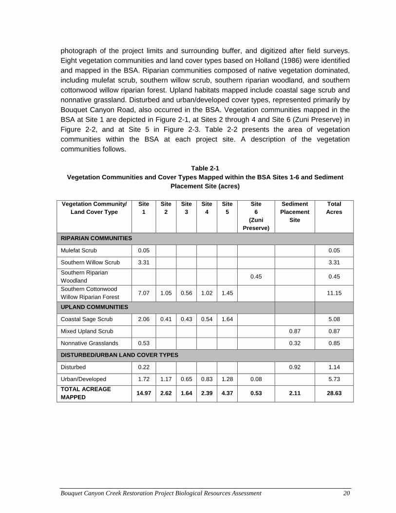
Bouquet Canyon Creek Restoration Project Biological Resources Assessment 20
photograph of the project limits and surrounding buffer, and digitized after field surveys. Eight vegetation communities and land cover types based on Holland (1986) were identified and mapped in the BSA. Riparian communities composed of native vegetation dominated, including mulefat scrub, southern willow scrub, southern riparian woodland, and southern cottonwood willow riparian forest. Upland habitats mapped include coastal sage scrub and nonnative grassland. Disturbed and urban/developed cover types, represented primarily by Bouquet Canyon Road, also occurred in the BSA. Vegetation communities mapped in the BSA at Site 1 are depicted in Figure 2-1, at Sites 2 through 4 and Site 6 (Zuni Preserve) in Figure 2-2, and at Site 5 in Figure 2-3. Table 2-2 presents the area of vegetation communities within the BSA at each project site. A description of the vegetation communities follows.
Table 2-1
Vegetation Communities and Cover Types Mapped within the BSA Sites 1-6 and Sediment Placement Site (acres)
Vegetation Community/
Land Cover Type Site
1 Site
2 Site
3 Site
4 Site
5 Site
6 (Zuni
Preserve)
Sediment Placement
Site
Total Acres
RIPARIAN COMMUNITIES
Mulefat Scrub 0.05 0.05
Southern Willow Scrub 3.31 3.31
Southern Riparian Woodland
0.45 0.45
Southern Cottonwood Willow Riparian Forest
7.07 1.05 0.56 1.02 1.45 11.15
UPLAND COMMUNITIES
Coastal Sage Scrub 2.06 0.41 0.43 0.54 1.64 5.08
Mixed Upland Scrub 0.87 0.87
Nonnative Grasslands 0.53 0.32 0.85
DISTURBED/URBAN LAND COVER TYPES
Disturbed 0.22 0.92 1.14
Urban/Developed 1.72 1.17 0.65 0.83 1.28 0.08 5.73
TOTAL ACREAGE MAPPED
14.97 2.62 1.64 2.39 4.37 0.53 2.11 28.63
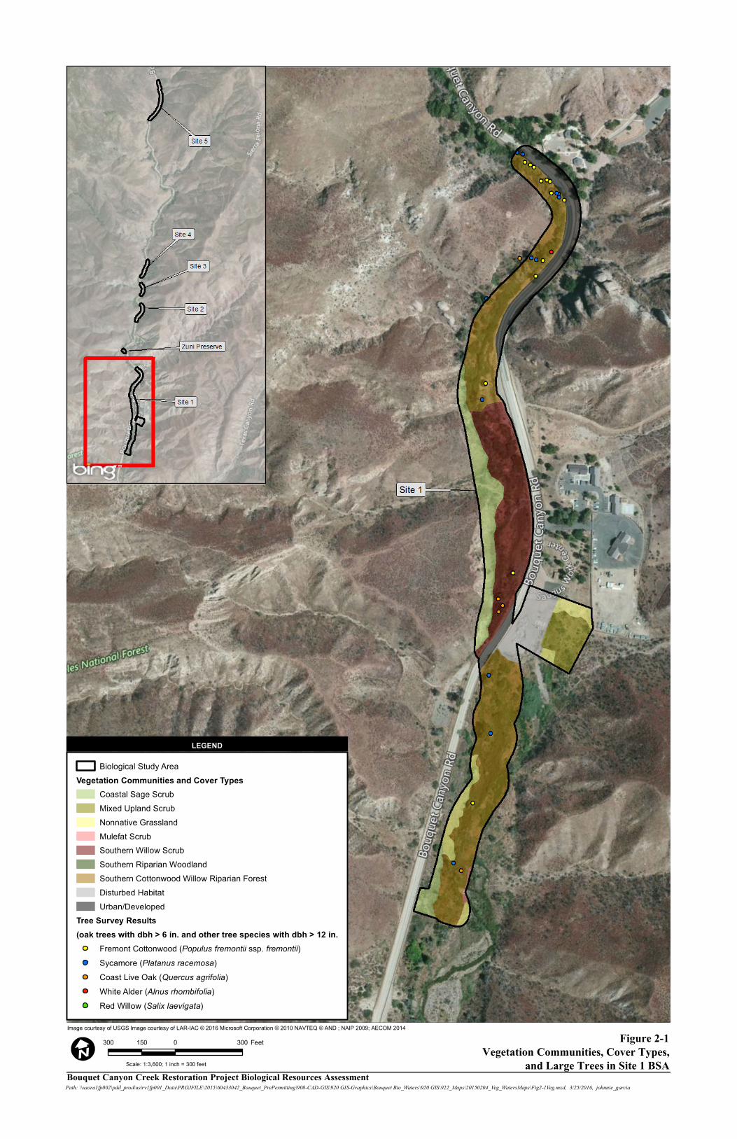
Figure 2-1Vegetation Communities, Cover Types,
and Large Trees in Site 1 BSA
Image courtesy of USGS Image courtesy of LAR-IAC © 2016 Microsoft Corporation © 2010 NAVTEQ © AND ; NAIP 2009; AECOM 2014
Bouquet Canyon Creek Restoration Project Biological Resources AssessmentPath: \\usora1fp002\pdd_prod\usirv1fp001_Data\PROJFILE\2015\60433042_Bouquet_PrePermitting\900-CAD-GIS\920 GIS-Graphics\Bouquet Bio_Waters\920 GIS\922_Maps\20150204_Veg_WatersMaps\Fig2-1Veg.mxd, 3/25/2016, johnnie_garcia
300 0 300150 Feet
LEGEND
Scale: 1:3,600; 1 inch = 300 feet
Biological Study AreaVegetation Communities and Cover Types
Coastal Sage ScrubMixed Upland ScrubNonnative GrasslandMulefat ScrubSouthern Willow ScrubSouthern Riparian WoodlandSouthern Cottonwood Willow Riparian ForestDisturbed HabitatUrban/Developed
Tree Survey Results(oak trees with dbh > 6 in. and other tree species with dbh > 12 in.
Fremont Cottonwood (Populus fremontii ssp. fremontii) Sycamore (Platanus racemosa)Coast Live Oak (Quercus agrifolia)White Alder (Alnus rhombifolia)Red Willow (Salix laevigata)
LEGEND
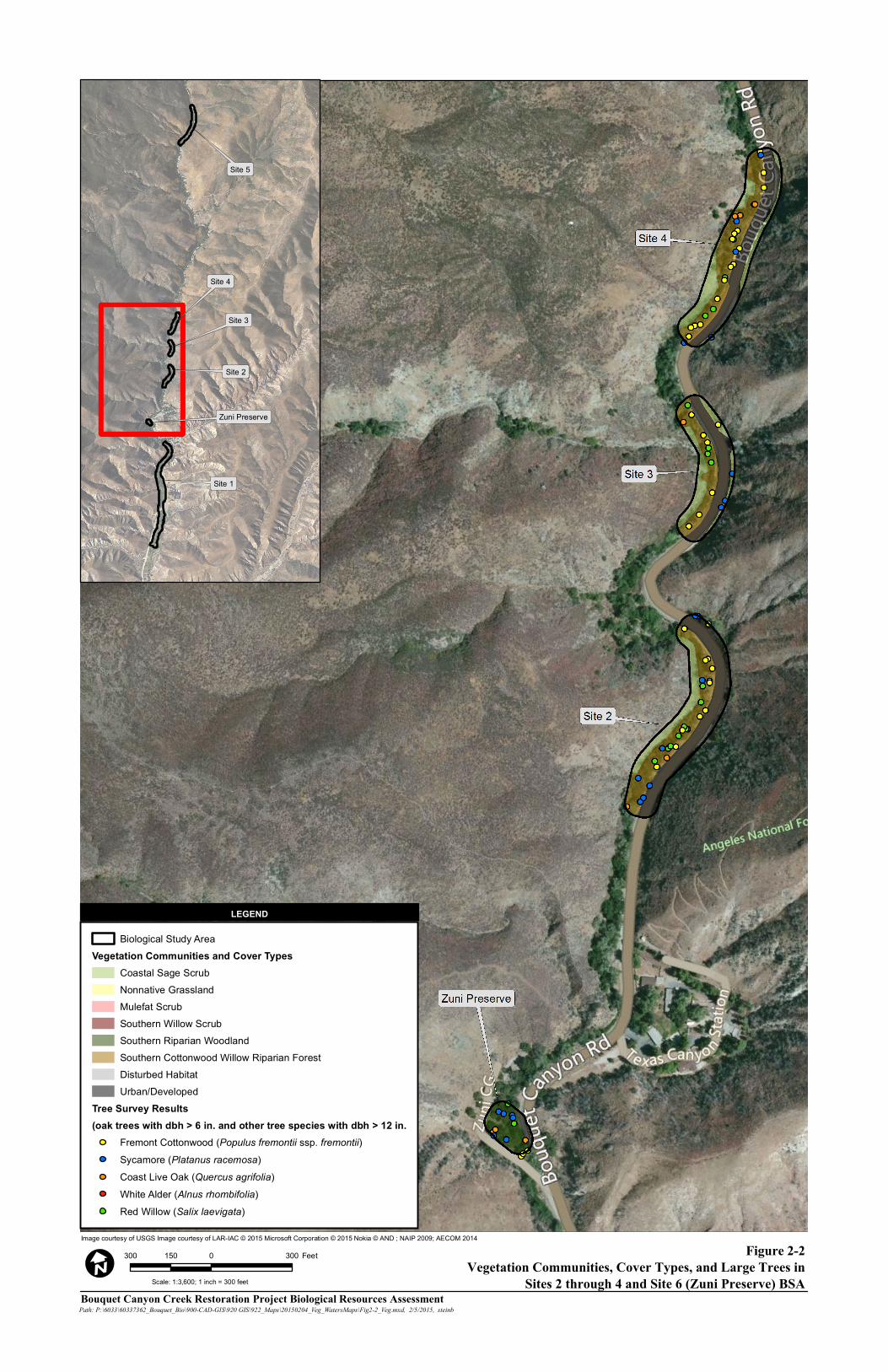
Figure 2-2Vegetation Communities, Cover Types, and Large Trees in
Sites 2 through 4 and Site 6 (Zuni Preserve) BSA
Image courtesy of USGS Image courtesy of LAR-IAC © 2015 Microsoft Corporation © 2015 Nokia © AND ; NAIP 2009; AECOM 2014
Bouquet Canyon Creek Restoration Project Biological Resources AssessmentPath: P:\6033\60337362_Bouquet_Bio\900-CAD-GIS\920 GIS\922_Maps\20150204_Veg_WatersMaps\Fig2-2_Veg.mxd, 2/5/2015, steinb
300 0 300150 Feet
I
LEGEND
Scale: 1:3,600; 1 inch = 300 feet
Biological Study AreaVegetation Communities and Cover Types
Coastal Sage ScrubNonnative GrasslandMulefat ScrubSouthern Willow ScrubSouthern Riparian WoodlandSouthern Cottonwood Willow Riparian ForestDisturbed HabitatUrban/Developed
Tree Survey Results(oak trees with dbh > 6 in. and other tree species with dbh > 12 in.
Fremont Cottonwood (Populus fremontii ssp. fremontii) Sycamore (Platanus racemosa)Coast Live Oak (Quercus agrifolia)White Alder (Alnus rhombifolia)Red Willow (Salix laevigata)
LEGEND
Site 5
Site 4
Site 3
Site 2
Zuni Preserve
Site 1
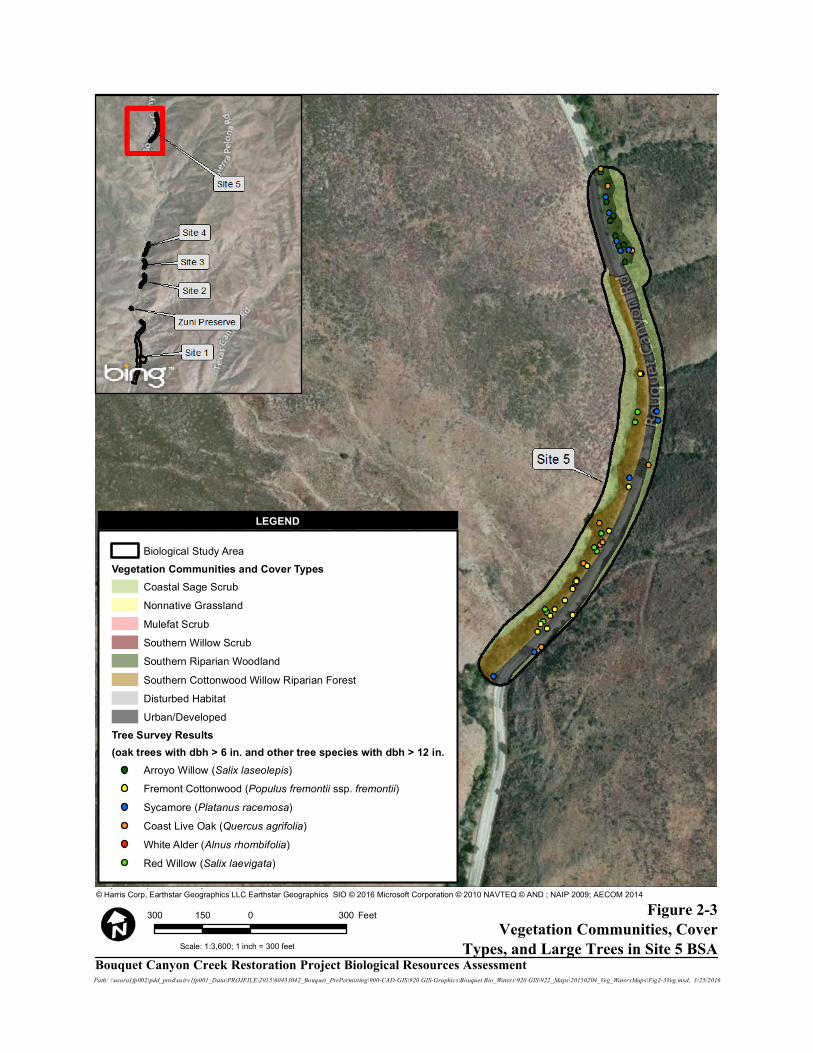
Figure 2-3Vegetation Communities, Cover
Types, and Large Trees in Site 5 BSA
Image courtesy of USGS Image courtesy of LAR-IAC © 2016 Microsoft Corporation © 2010 NAVTEQ © AND © Harris Corp, Earthstar Geographics LLC Earthstar Geographics SIO © 2016 Microsoft Corporation © 2010 NAVTEQ © AND ; NAIP 2009; AECOM 2014
Path: \\usora1fp002\pdd_prod\usirv1fp001_Data\PROJFILE\2015\60433042_Bouquet_PrePermitting\900-CAD-GIS\920 GIS-Graphics\Bouquet Bio_Waters\920 GIS\922_Maps\20150204_Veg_WatersMaps\Fig2-3Veg.mxd, 3/25/2016
300 0 300150 Feet
Scale: 1:3,600; 1 inch = 300 feet
Biological Study AreaVegetation Communities and Cover Types
Coastal Sage ScrubNonnative GrasslandMulefat ScrubSouthern Willow ScrubSouthern Riparian WoodlandSouthern Cottonwood Willow Riparian ForestDisturbed HabitatUrban/Developed
Tree Survey Results(oak trees with dbh > 6 in. and other tree species with dbh > 12 in.
Arroyo Willow (Salix laseolepis)Fremont Cottonwood (Populus fremontii ssp. fremontii) Sycamore (Platanus racemosa)Coast Live Oak (Quercus agrifolia)White Alder (Alnus rhombifolia)Red Willow (Salix laevigata)
Bouquet Canyon Creek Restoration Project Biological Resources Assessment
LEGEND

Bouquet Canyon Creek Restoration Project Biological Resources Assessment 24
2.2.1 Riparian Communities Four riparian communities were mapped in the BSA and are described below. Mulefat Scrub (Holland Code 63310) Mulefat scrub is defined by Holland (1986) as a depauperate, tall, herbaceous riparian scrub strongly dominated by mulefat (Baccharis salicifolia). This habitat is an intermediate successional community maintained by frequent flooding that, absent of such disturbances, generally would succeed to a willow or cottonwood-dominated riparian forest. Mulefat scrub is present in both basins along edges of riparian southern willow scrub. A small area of this vegetative community was mapped in the southern portion of the BSA at Site 1 (Figure 2-1). The community consisted of mulefat shrubs with some arroyo willow (Salix lasioleps) shrubs also present. Southern Willow Scrub (63320) Southern willow scrub, as described by Holland (1986), is a dense, broad-leafed, winter-deciduous riparian thicket dominated by several willow species with scattered emergent Fremont cottonwood (Populous fremontii subspecies [ssp.] fremontii) and California sycamore (Platanus racemosa). Typical stands are too dense to allow much understory development. Southern willow scrub occurs in loose, sandy, or gravelly alluvium deposited near stream channels during flood flows. This intermediate successional community requires repeated flooding to prevent succession to riparian forest. A large stand of this vegetative community is present upstream of the culvert at MM 15.89, in the Site 1 BSA (Figure 2-1). Arroyo and red (S. laevigata) willow dominate this community. Mulefat shrubs, small Fremont cottonwood, sycamore, and coast live oak (Quercus agrifolia) trees were also present. Southern Riparian Woodland (62000) This woodland community generally consists of a mix of riparian tree species, and was mapped within the Site 1 BSA (Figure 2-1). Tree species included sycamore, Fremont cottonwood, red willow, and coast live oak. The understory generally consisted of mulefat and mugwort (Artemisia douglasiana), with Smilo grass (Stipa miliceum) and stinging nettle (Urtica dioica) occurring as common herbaceous species. Southern Cottonwood-Willow Riparian Forest (61330) Southern cottonwood-willow riparian forest is described by Holland (1986) as a tall, open, broad-leafed, winter-deciduous riparian forest dominated by cottonwood and willow trees,
Bouquet Canyon Creek Restoration Project Biological Resources Assessment 25
with an understory of shrubby willows. Riparian habitats in the BSA at Sites 2 through 5 and Site 6 (Zuni Preserve) were dominated by this community (Figures 2-2 and 2-3). Tree species included Fremont cottonwood and arroyo willow, with sycamore and coast live oak. A number of large trees (oaks with 6-inch or greater dbh and non-oaks with 12-inch or greater dbh) were mapped in this habitat; Fremont cottonwood was the most common. The understory of this riparian community included mulefat, mugwort, narrow-leaved willow (S. exigua), black elderberry (Sambucus nigra), white alder (Alnus rhombifolia), and boxelder (Acer negundo). A number of herbaceous species typical of wet areas were documented in this community, including species of cattail (Typha species [spp.]) and rushes (Juncus spp.), with water mint (Mentha aquatic), and paleyellow iris (Iris pseudacorus). A variety of native and nonnative herbaceous vegetation associated with upland areas was also present in the understory and included stinging nettle, Smilo grass, redstem filaree (Erodium cicutarium), lamb’s quarter (Chenopodium album), wild oat (Avena barbata), western ragweed (Ambrosia psilostachya), and leather root (Hoita macrostachya). Two vines, blackberry (Rubus ursinus) and poison oak (Toxicodendron diversilobum), were also documented in this community.
2.2.2 Upland Communities Three upland vegetation communities were mapped in the BSA and are described below. Coastal Sage Scrub (32000) Coastal sage scrub occurs adjacent to riparian areas on the steep hillsides that flank the stream and adjacent roadway. This community was mapped in the BSA of Sites 1 through 5 (Figures 2-1 through 2-3). Composition of the coastal sage scrub community at more upstream sites, in particular Site 5, included a mix of species typical of both sage scrub and chaparral communities, reflecting a transition from chaparral to coastal sage scrub from Site 5 downstream through the other project sites. The native shrubs observed in coastal sage scrub communities across all BSA included California buckwheat (Eriogonum fasciculatum), chamise (Adenostema fasiculata), California sagescrub (Artemisia californica), black sage (Salvia mellifera), thick-leaved Yerba Santa (Eriodictyon crassifolium), shadscale (Atriplex canescens), deerweed (Acmispon glaber), chaparral mallow (Malocothamnus fasciculatus), hollyleaf redberry (Rhamnus ilicifolia), chaparral yucca (Hesperoyucca whiplei), and woolly leaf ceanothus (Ceanothus tomentosus). Areas of nonnative ruderal species occur within the coastal sage scrub community, in particular at more downstream sites. The species observed included short-pod mustard (Hirschfeldia incana), red brome (Bromus madritensis), tocalote (Centaurea melitensis), and Russian thistle (Salsola tragus).
Bouquet Canyon Creek Restoration Project Biological Resources Assessment 26
Mixed Upland Scrub An upland community of mixed scrub species occurs in what is the western half of the sediment placement site. No one species dominates this community, making it difficult to classify the community according to Holland (1986). As a result this community has been given a generic vegetation community designation. The community is a mix of shrubs with patchy dominance by a number of species including, elderberry (Sambucus nigra), chamisse, thick-leaved yerba santa, hollyleaf redberry, and mulefat. Although it appears that this area was more disturbed in the past, the scrub community has evolved to cover the area, leaving only small patches of bare ground and/or ruderal vegetation. Nonnative Grassland (42200) Nonnative grassland communities are composed of a variety of nonnative grassland species, and often include native annuals. This community was mapped within the sediment placement site and adjacent to riparian habitats within the Site 1 BSA (Figure 2-1). Within the sediment placement site, this community consisted primarily of ripgut brome (B. diandrus), barley (Hordeum sp.), erodium (Erodium cicutarium), and London rocket (Sysimbrium irio). Within the Site 1 BSA, red brome, short-pod mustard, Russian thistle, lamb’s quarters, tumble mustard (Sisymbrium altissimum), and caterpillar phacelia (Phacelia cicutarium) dominate.
2.2.3 Disturbed/Urban Land Cover Types Two cover types associated with disturbed and urban conditions were mapped in the BSA and are described below. No habitat-equivalent of these cover types are described by Holland (1986). Disturbed Disturbed habitat is generally any land on which the native vegetation has been significantly altered by construction, agriculture, or other land-clearing activities, and the species composition and site conditions are not characteristic of the “disturbed” phase of natural community succession. The western half of the approximate 2-acre sediment placement site adjacent to Site 1 consists of disturbed habitat. This portion of the site is adjacent to Bouquet Canyon Road and consists of bare ground and a pile of stone, soil, and wood debris that covers approximately 0.03 acre of the sediment placement site. Urban/Developed Areas considered urban/developed include buildings, roads, associated infrastructure, and landscaped areas. No attempt has been made to distinguish between the various forms of
Bouquet Canyon Creek Restoration Project Biological Resources Assessment 27
urban/developed lands, because the focus is on native biodiversity. This cover type is represented in the BSA by Bouquet Canyon Road (Figures 2-1 through 2-3).
2.3 Wildlife Species Wildlife identified in the vicinity of each site during the field survey of the project site included species typical of a wooded, scrub, and riverine environment. Wildlife species identified in the vicinity of the project sites included oak titmouse (Baeolophus inornatus), western scrub jay (Aphelocoma californica), lesser goldfinch (Carduelis psaltria), American crow (Corvus brachyrhynchos), common raven (Corvus corax), northern flicker (Colaptes auratus), bushtit (Psaltriparus minimus), song sparrow (Melospiza melodia), wrentit (Chamaea fasciata), white-crowned sparrow (Zonotrichia leucophrys), California thrasher (Toxostoma redivivum), house finch (Haemorhous mexicanus), Anna’s hummingbird (Calypte anna), California quail (Callipepla californica), Bewick’s wren (Thryomanes bewickii), California towhee (Melozone crissalis), spotted towhee (Pipilo maculatus), dark-eyed junco (Junco hyemalis), ruby-crowned kinglet (Regulus calendula), downy woodpecker (Dryobates pubescens), acorn woodpecker (Melanerpes formicivorus), golden-crowned sparrow (Zonotrichia atricapilla), blue-gray gnatcatcher (Polioptila caerulea), western bluebird (Sialia mexicana), white-crowned sparrow (Zonotrichia leucophrys), hermit thrush (Catharus guttatus), rock wren (Salpinctes obsoletus), southern California rufous-crowned sparrow (Aimophila ruficeps canescans), and sign of mule deer (Odocoileus hemionus). Woodrat (Neotoma sp.) middens were also observed within Site 1, downstream of the culvert at MM 15.89.
2.4 Wildlife Movement Corridor Within the ANF, stream/riparian habitats such as Bouquet Canyon Creek, serve as wildlife movement corridors for a variety of stream and riparian species, including fish, amphibians, reptiles, birds, and bats. Except where human disturbances are evident in the vicinity of Site 1, the riparian corridor along Bouquet Canyon Creek is relatively intact and includes a variety of plant and habitat layers (i.e., mature trees, shrubs, and herbaceous vegetation) that facilitate wildlife movement along the stream. Perennial flows through upper reaches facilitate fish movement, while seasonal flows during winter/spring extend the range for fish further downstream.

Bouquet Canyon Creek Restoration Project Biological Resources Assessment 28
This page intentionally left blank.
Bouquet Canyon Creek Restoration Project Biological Resources Assessment 29
3.0 SPECIAL-STATUS BIOLOGICAL RESOURCES Prior to conducting the fieldwork, the California Natural Diversity Data Base (CNDDB) (CDFW 2014), was reviewed for the most recent distribution information for special-status plant and wildlife species, and sensitive natural communities within the Green Valley and surrounding eight quadrangles, including: Mint Canyon, Newhall, Warm Springs Mountain, Burnt Peak, Lake Hughes, Del Sur, Sleepy Valley, and Agua Dulce. An updated review of the CNDDB (2016a) database was conducted in March 2016 to determine if any new special-status species were identified that were not identified during the December 2014 database reviews. Additionally, the Information for Planning and Conservation (IPaC) (USFWS 2016) database was reviewed for federally-listed species known from the project vicinity. Information on special-status plant and wildlife species was also compiled through a review of:
• Inventory of Rare and Endangered Plants of California (CNPS 2014, 2016)
• State and Federally Listed Endangered, Threatened, and Rare Plants of California (CDFW 2016b)
• Special Vascular Plants, Bryophytes, and Lichens List (CDFW 2016c)
• State and Federally Listed Endangered and Threatened Animals of California (CDFW 2016d)
• Special Animals List (CDFW 2016e) The potential for special-status plant and wildlife species identified during the CNDDB search to occur within the BSA were classified as “Not Expected,” “Low,” “Moderate,” “High,” or “Present.” These classifications were derived from an evaluation comparing existing habitat in the basins to the presence and suitability of habitat preferred by the species of interest. The potential for occurrence classifications are described below.
• Not Expected. Habitat preferred by the species is absent or very marginal due to disturbances, fragmentation, and/or isolation.
• Low. Habitat preferred by the species is marginal due to disturbances, fragmentation, and/or isolation.
• Moderate. Species previously reported from within 1-5 miles, but suitable habitat is of only moderate quality due to disturbances, fragmentation, and/or isolation.
• High. Species previously reported from within 1 mile of the project site, and large areas of contiguous, high-quality habitat preferred by the species is present.
• Present. Species detected during field surveys or currently known from the project site.
Bouquet Canyon Creek Restoration Project Biological Resources Assessment 30
3.1 Special-Status Plants Special-status plant species include those listed as endangered, threatened, or rare, or those species proposed for listing by USFWS under the federal Endangered Species Act (FESA) and CDFW under the California Endangered Species Act (CESA) (CDFW 2016b), and CNPS (2016). Five plant species known from the Green Valley and surrounding eight quadrangles are federally listed or state-listed as threatened or endangered and include the following: Braunton’s milk-vetch (Astragalus brauntonii), Nevin’s barberry (Berberis nevinii), San Fernando Valley spineflower (Chorizanthe parryi var. fernandina), spreading navarretia (Navarretia fossalis), and California Orcutt grass (Orcuttia californica). The CNPS listing is sanctioned by CDFW and serves essentially as the list of candidate plant species for state listing. CNPS’ California Rare Plant Ranks (CRPR) (formerly CNPS List) 1B and 2 species are considered eligible for state listing as endangered or threatened. Additionally, USFS lists “sensitive” plant species identified by a regional forester in each region; California is in the USFS’ Pacific Southwest Region (Region 5). USFS sensitive plant species are not listed or proposed for listing under the Federal Endangered Species Act (FESA). They are species for which population viability is a concern, as evidenced by significant current or predicted downward trends in population numbers or density, or significant current or predicted downward trends in habitat capability that would reduce a species’ existing distribution (U.S. Department of Agriculture, Forest Service [USDA-FS] 2015). A total of 37 special-status plant species were identified from a search of the CNDDB (CDFW 2014) and CNPS (2014) databases for the Green Valley and surrounding eight quadrangles. These species, their status, and habitat requirements are provided in Appendix C of this biological resources assessment. No additional special-status plant species to those found during the 2014 database review were identified during the 2016 database reviews (CDFW 2016a and CNPS 2016). Fifteen of the 37 special-status plant species were considered to have at least some potential (low, moderate, or high) to occur within the BSA or close proximity. These 15 species and their status are listed below. Moderate Potential:
• Nevin’s barberry (Berberis nevinii) – USFWS endangered, CDFW Endangered, and CRPR 1B.1
• Slender mariposa lily (Calochortus clavatus var. gracilis) – USFS Sensitive and CRPR 1B.2
• Peirson’s morning-glory (Calystegia peirsonii) – CRPR 4.2
• Parry’s spineflower (Chorizanthe parryi var. parryi) – USFS Sensitive and CRPR 3.2
• Slender-horned spineflower (Dodecahema leptoceras) – USFWS endangered, CDFW endangered, and CRPR 1B.1
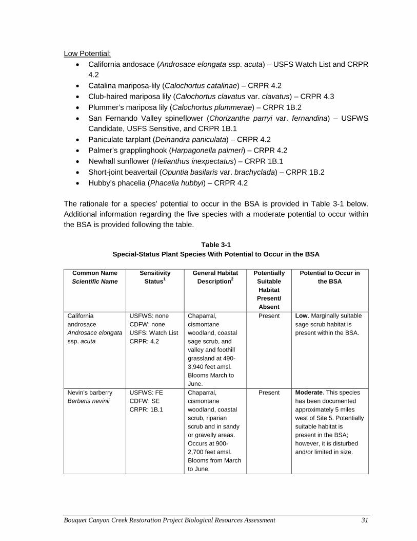
Bouquet Canyon Creek Restoration Project Biological Resources Assessment 31
Low Potential:
• California andosace (Androsace elongata ssp. acuta) – USFS Watch List and CRPR 4.2
• Catalina mariposa-lily (Calochortus catalinae) – CRPR 4.2
• Club-haired mariposa lily (Calochortus clavatus var. clavatus) – CRPR 4.3
• Plummer’s mariposa lily (Calochortus plummerae) – CRPR 1B.2
• San Fernando Valley spineflower (Chorizanthe parryi var. fernandina) – USFWS Candidate, USFS Sensitive, and CRPR 1B.1
• Paniculate tarplant (Deinandra paniculata) – CRPR 4.2
• Palmer’s grapplinghook (Harpagonella palmeri) – CRPR 4.2
• Newhall sunflower (Helianthus inexpectatus) – CRPR 1B.1
• Short-joint beavertail (Opuntia basilaris var. brachyclada) – CRPR 1B.2
• Hubby’s phacelia (Phacelia hubbyi) – CRPR 4.2 The rationale for a species’ potential to occur in the BSA is provided in Table 3-1 below. Additional information regarding the five species with a moderate potential to occur within the BSA is provided following the table.
Table 3-1
Special-Status Plant Species With Potential to Occur in the BSA
Common Name Scientific Name
Sensitivity Status1
General Habitat Description2
Potentially Suitable Habitat
Present/ Absent
Potential to Occur in the BSA
California androsace Androsace elongata ssp. acuta
USFWS: none CDFW: none USFS: Watch List CRPR: 4.2
Chaparral, cismontane woodland, coastal sage scrub, and valley and foothill grassland at 490-3,940 feet amsl. Blooms March to June.
Present Low. Marginally suitable
sage scrub habitat is present within the BSA.
Nevin’s barberry Berberis nevinii
USFWS: FE CDFW: SE CRPR: 1B.1
Chaparral, cismontane woodland, coastal scrub, riparian scrub and in sandy or gravelly areas. Occurs at 900-2,700 feet amsl. Blooms from March to June.
Present Moderate. This species
has been documented approximately 5 miles west of Site 5. Potentially suitable habitat is present in the BSA; however, it is disturbed and/or limited in size.
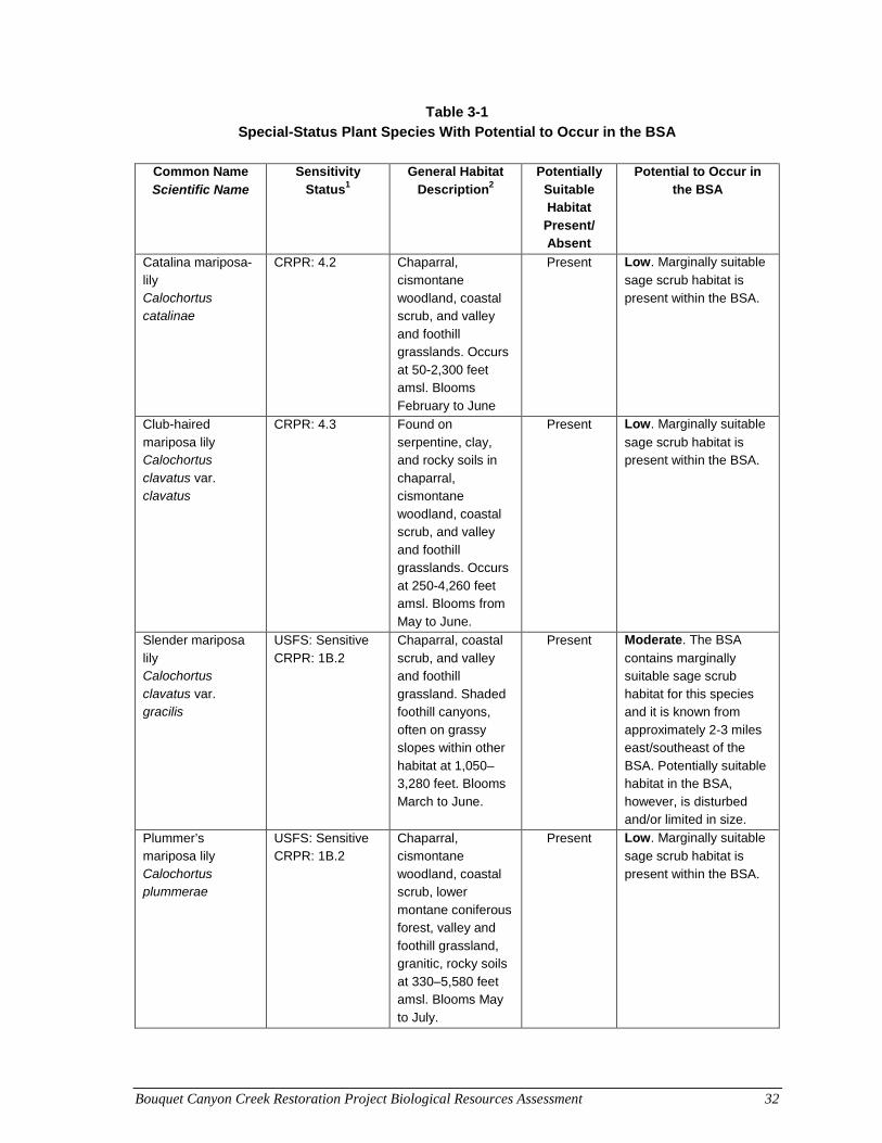
Bouquet Canyon Creek Restoration Project Biological Resources Assessment 32
Table 3-1 Special-Status Plant Species With Potential to Occur in the BSA
Common Name
Scientific Name Sensitivity
Status1 General Habitat
Description2 Potentially
Suitable Habitat
Present/ Absent
Potential to Occur in the BSA
Catalina mariposa-lily Calochortus catalinae
CRPR: 4.2 Chaparral, cismontane woodland, coastal scrub, and valley and foothill grasslands. Occurs at 50-2,300 feet amsl. Blooms February to June
Present Low. Marginally suitable
sage scrub habitat is present within the BSA.
Club-haired mariposa lily Calochortus clavatus var. clavatus
CRPR: 4.3 Found on serpentine, clay, and rocky soils in chaparral, cismontane woodland, coastal scrub, and valley and foothill grasslands. Occurs at 250-4,260 feet amsl. Blooms from May to June.
Present Low. Marginally suitable
sage scrub habitat is present within the BSA.
Slender mariposa lily Calochortus clavatus var. gracilis
USFS: Sensitive CRPR: 1B.2
Chaparral, coastal scrub, and valley and foothill grassland. Shaded foothill canyons, often on grassy slopes within other habitat at 1,050–3,280 feet. Blooms March to June.
Present Moderate. The BSA
contains marginally suitable sage scrub habitat for this species and it is known from approximately 2-3 miles east/southeast of the BSA. Potentially suitable habitat in the BSA, however, is disturbed and/or limited in size.
Plummer’s mariposa lily Calochortus plummerae
USFS: Sensitive CRPR: 1B.2
Chaparral, cismontane woodland, coastal scrub, lower montane coniferous forest, valley and foothill grassland, granitic, rocky soils at 330–5,580 feet amsl. Blooms May to July.
Present Low. Marginally suitable
sage scrub habitat is present within the BSA.
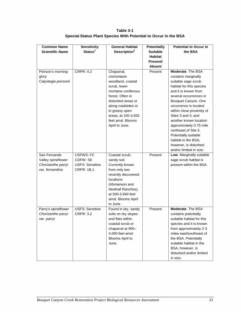
Bouquet Canyon Creek Restoration Project Biological Resources Assessment 33
Table 3-1 Special-Status Plant Species With Potential to Occur in the BSA
Common Name
Scientific Name Sensitivity
Status1 General Habitat
Description2 Potentially
Suitable Habitat
Present/ Absent
Potential to Occur in the BSA
Peirson’s morning-glory Calystegia peirsonii
CRPR: 4.2
Chaparral, cismontane woodland, coastal scrub, lower montane coniferous forest. Often in disturbed areas or along roadsides or in grassy open areas, at 100-4,920 feet amsl. Blooms April to June.
Present Moderate. The BSA
contains marginally suitable sage scrub habitat for this species and it is known from several occurrences in Bouquet Canyon. One occurrence is located within close proximity of Sites 3 and 4, and another known location approximately 0.75 mile northeast of Site 5. Potentially suitable habitat in the BSA; however, is disturbed and/or limited in size.
San Fernando Valley spineflower Chorizanthe parryi var. fernandina
USFWS: FC CDFW: SE USFS: Sensitive CRPR: 1B.1
Coastal scrub, sandy soil. Currently known from only two recently discovered locations (Ahmanson and Newhall Ranches), at 500-3,940 feet amsl. Blooms April to June.
Present Low. Marginally suitable
sage scrub habitat is present within the BSA.
Parry’s spineflower Chorizanthe parryi var. parryi
USFS: Sensitive CRPR: 3.2
Found in dry, sandy soils on dry slopes and flats within coastal scrub or chaparral at 900–4,000 feet amsl. Blooms April to June.
Present Moderate. The BSA
contains potentially suitable habitat for this species and it is known from approximately 2-3 miles east/southeast of the BSA. Potentially suitable habitat in the BSA, however, is disturbed and/or limited in size.
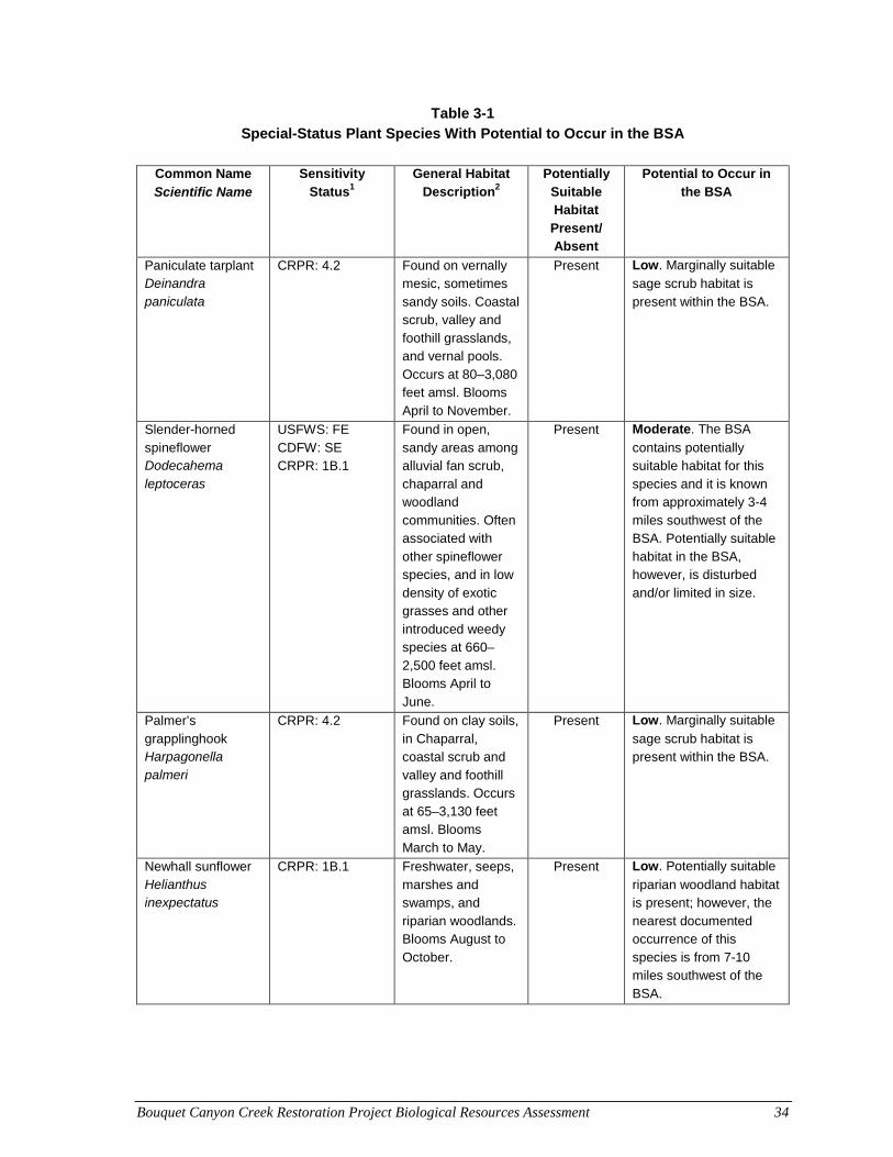
Bouquet Canyon Creek Restoration Project Biological Resources Assessment 34
Table 3-1 Special-Status Plant Species With Potential to Occur in the BSA
Common Name
Scientific Name Sensitivity
Status1 General Habitat
Description2 Potentially
Suitable Habitat
Present/ Absent
Potential to Occur in the BSA
Paniculate tarplant Deinandra paniculata
CRPR: 4.2 Found on vernally mesic, sometimes sandy soils. Coastal scrub, valley and foothill grasslands, and vernal pools. Occurs at 80–3,080 feet amsl. Blooms April to November.
Present Low. Marginally suitable
sage scrub habitat is present within the BSA.
Slender-horned spineflower Dodecahema leptoceras
USFWS: FE CDFW: SE CRPR: 1B.1
Found in open, sandy areas among alluvial fan scrub, chaparral and woodland communities. Often associated with other spineflower species, and in low density of exotic grasses and other introduced weedy species at 660–2,500 feet amsl. Blooms April to June.
Present Moderate. The BSA
contains potentially suitable habitat for this species and it is known from approximately 3-4 miles southwest of the BSA. Potentially suitable habitat in the BSA, however, is disturbed and/or limited in size.
Palmer’s grapplinghook Harpagonella palmeri
CRPR: 4.2 Found on clay soils, in Chaparral, coastal scrub and valley and foothill grasslands. Occurs at 65–3,130 feet amsl. Blooms March to May.
Present Low. Marginally suitable
sage scrub habitat is present within the BSA.
Newhall sunflower Helianthus inexpectatus
CRPR: 1B.1 Freshwater, seeps, marshes and swamps, and riparian woodlands. Blooms August to October.
Present Low. Potentially suitable
riparian woodland habitat is present; however, the nearest documented occurrence of this species is from 7-10 miles southwest of the BSA.
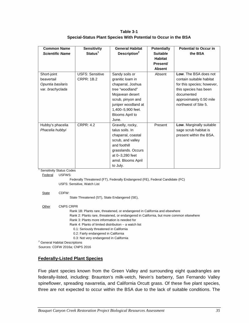
Bouquet Canyon Creek Restoration Project Biological Resources Assessment 35
Table 3-1 Special-Status Plant Species With Potential to Occur in the BSA
Common Name
Scientific Name Sensitivity
Status1 General Habitat
Description2 Potentially
Suitable Habitat
Present/ Absent
Potential to Occur in the BSA
Short-joint beavertail Opuntia basilaris var. brachyclada
USFS: Sensitive CRPR: 1B.2
Sandy soils or granitic loam in chaparral, Joshua tree “woodland” Mojavean desert scrub, pinyon and juniper woodland at 1,400–5,900 feet. Blooms April to June.
Absent Low. The BSA does not
contain suitable habitat for this species; however, this species has been documented approximately 0.50 mile northwest of Site 5.
Hubby’s phacelia Phacelia hubbyi
CRPR: 4.2 Gravelly, rocky, talus soils. In chaparral, coastal scrub, and valley and foothill grasslands. Occurs at 0–3,280 feet amsl. Blooms April to July.
Present Low. Marginally suitable
sage scrub habitat is present within the BSA.
1 Sensitivity Status Codes Federal USFWS:
Federally Threatened (FT), Federally Endangered (FE), Federal Candidate (FC) USFS: Sensitive, Watch List State CDFW:
State Threatened (ST), State Endangered (SE),
Other CNPS CRPR Rank 1B: Plants rare, threatened, or endangered in California and elsewhere Rank 2: Plants rare, threatened, or endangered in California, but more common elsewhere Rank 3: Plants more information is needed for Rank 4: Plants of limited distribution – a watch list
0.1: Seriously threatened in California 0.2: Fairly endangered in California 0.3: Not very endangered in California
2 General Habitat Descriptions Sources: CDFW 2016a; CNPS 2016
Federally-Listed Plant Species Five plant species known from the Green Valley and surrounding eight quadrangles are federally-listed, including: Braunton’s milk-vetch, Nevin’s barberry, San Fernando Valley spineflower, spreading navarretia, and California Orcutt grass. Of these five plant species, three are not expected to occur within the BSA due to the lack of suitable conditions. The
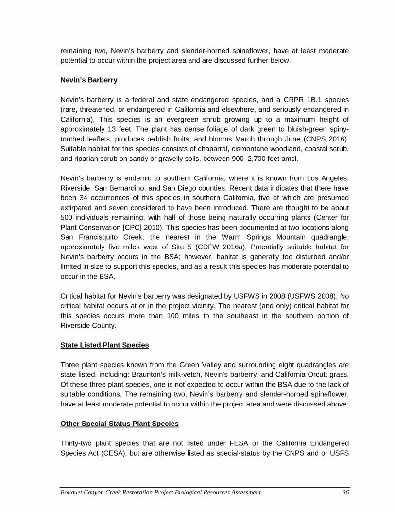
Bouquet Canyon Creek Restoration Project Biological Resources Assessment 36
remaining two, Nevin’s barberry and slender-horned spineflower, have at least moderate potential to occur within the project area and are discussed further below. Nevin’s Barberry Nevin’s barberry is a federal and state endangered species, and a CRPR 1B.1 species (rare, threatened, or endangered in California and elsewhere, and seriously endangered in California). This species is an evergreen shrub growing up to a maximum height of approximately 13 feet. The plant has dense foliage of dark green to bluish-green spiny-toothed leaflets, produces reddish fruits, and blooms March through June (CNPS 2016). Suitable habitat for this species consists of chaparral, cismontane woodland, coastal scrub, and riparian scrub on sandy or gravelly soils, between 900–2,700 feet amsl. Nevin’s barberry is endemic to southern California, where it is known from Los Angeles, Riverside, San Bernardino, and San Diego counties. Recent data indicates that there have been 34 occurrences of this species in southern California, five of which are presumed extirpated and seven considered to have been introduced. There are thought to be about 500 individuals remaining, with half of those being naturally occurring plants (Center for Plant Conservation [CPC] 2010). This species has been documented at two locations along San Francisquito Creek, the nearest in the Warm Springs Mountain quadrangle, approximately five miles west of Site 5 (CDFW 2016a). Potentially suitable habitat for Nevin’s barberry occurs in the BSA; however, habitat is generally too disturbed and/or limited in size to support this species, and as a result this species has moderate potential to occur in the BSA. Critical habitat for Nevin’s barberry was designated by USFWS in 2008 (USFWS 2008). No critical habitat occurs at or in the project vicinity. The nearest (and only) critical habitat for this species occurs more than 100 miles to the southeast in the southern portion of Riverside County. State Listed Plant Species Three plant species known from the Green Valley and surrounding eight quadrangles are state listed, including: Braunton’s milk-vetch, Nevin’s barberry, and California Orcutt grass. Of these three plant species, one is not expected to occur within the BSA due to the lack of suitable conditions. The remaining two, Nevin’s barberry and slender-horned spineflower, have at least moderate potential to occur within the project area and were discussed above. Other Special-Status Plant Species Thirty-two plant species that are not listed under FESA or the California Endangered Species Act (CESA), but are otherwise listed as special-status by the CNPS and or USFS
Bouquet Canyon Creek Restoration Project Biological Resources Assessment 37
are known from the Green Valley and surrounding eight quadrangles. Of these 32 plant species, 17 are not expected to occur within the BSA due to the lack of suitable conditions. Of the remaining 15, four have a moderate potential to occur within the project area and 11 have low potential to occur. Those with moderate potential are discussed further below. Slender Mariposa-Lily Slender mariposa-lily is a USFS Sensitive species and a CRPR 1B.2 species (rare, threatened, or endangered in California and elsewhere, and fairly endangered in California) in the lily (Liliaceae) family. This species is a perennial bulbiferous herb with a slender and straight stem, growing to about 12 feet tall. The leaves are linear and grass-like, and 1-6 large showy deep-yellow flowers rise from a common terminal point on the stem. Slender mariposa-lily blooms from March through June and is known only from Los Angeles and Ventura counties. This species occurs in chaparral, coastal scrub, and valley and foothill grassland, and prefers shaded foothill canyons where it occurs on grassy slopes within other habitat, between 1,050-3,280 feet amsl. Slender mariposa-lily has been documented at a location approximately 2-3 miles east-southeast of the project sites in Texas Canyon, a tributary to Bouquet Canyon Creek. An additional record is from approximately three miles south of Site 1 (CDFW 2016a). Coastal scrub habitat potentially suitable for slender mariposa lily occurs in the BSA; however, habitat is generally too disturbed and/or limited in size to support this species, and as a result this species has moderate potential to occur in the BSA. Pierson’s Morning Glory Pierson’s morning glory, a CRPR 4.2 species (plants of limited distribution – watch list, fairly endangered in California), is a perennial rhizomatous herb in the morning glory (Convolvulaceae) family that is endemic to California. Plants of the morning glory family are twining or trailing herbs with alternate leaves and large showy flowers that have five petals that are fused into lobed bells or trumpets (Dale 2000). This species is known to occur in chaparral, chenopod scrub, cismontane woodland, and lower montane coniferous forest. It is often found in disturbed areas or along roadsides or in grassy, open areas, between 100-4,920 feet amsl, and blooms from April through June (CDFW 2016a). It is known only from Los Angeles County, primarily from the San Gabriel Mountains in the northwest portion of the county. This species is known from several locations in Bouquet Canyon. One occurrence is located within a few hundred feet of Sites 3 and 4 and another approximately 0.75 mile northeast of Site 5. Additional records of this species are from canyons east-southeast of Site 1 including, Texas Canyon, approximately 0.80 mile to the east and several populations in Vasquez Canyon, approximately 1.5–2.5 miles to the east-southeast (CDFW
Bouquet Canyon Creek Restoration Project Biological Resources Assessment 38
2016a). Coastal scrub habitat and disturbed roadside conditions, which may be suitable for this species, occur in the BSA and as a result, this species has moderate potential to occur in the BSA. Parry’s Spineflower Parry’s spineflower, a CRPR 3.2 species (plants more information is needed for, fairly endangered in California), is a spreading annual herb in the buckwheat (Polygonaceae) family. This species has small, hairy white flowers, with leaves confined to a basal rosette. Parry’s spineflower is found in open, sandy soil on dry slopes and flats within coastal scrub or chaparral habitats. This species blooms April to June, and is known from elevations between 900-4,000 feet amsl (CDFW 2016a). Parry’s spineflower is primarily known from western Riverside County and the southwest portion of San Bernardino County, but also occurs at scattered locations in Los Angeles County. The nearest occurrence of Parry’s spineflower was from 1995 in the same general vicinity as slender mariposa-lily, approximately 2-3 miles east-southeast of the project sites in Texas Canyon. Additional occurrences are from 4-5 miles south of the project sites (CDFW 2016a). Coastal scrub habitat potentially suitable for slender mariposa lily occurs in the BSA; however, habitat is generally too disturbed and/or limited in size to support this species, and as a result this species has moderate potential to occur in the BSA. Slender-Horned Spineflower Slender-horned spineflower is a state and federal endangered species and a CRPR 1B.1 species. Similar to Parry’s spineflower, this species is a spreading annual herb in the buckwheat family, with small, hairy, white or pink flowers (Hickman 1993). Slender-horned spineflower is found in open, sandy areas among alluvial fan scrub, chaparral and woodland communities, and is often associated with other spineflower species, and in low density of exotic grasses and other introduced weedy species. Slender-horned spineflower generally blooms from April to June and its known elevation range is 660-2,500 feet amsl (CDFW 2016a). A significant population of slender-horned spineflower was documented in the early 1990’s in Bee Canyon, in the vicinity of Soledad Canyon Road, approximately 3-4 miles southwest of Site 1. A large population was also recorded in 1937 in Mint Canyon, 3.5–5 miles southeast of Site 1; this population is possibly extirpated (CDFW 2016a). Coastal sage scrub habitat, which may be suitable for this species, occurs in the BSA; however, it is disturbed and/or limited in size to support this species, and as a result this species has moderate potential to occur in the BSA.
Bouquet Canyon Creek Restoration Project Biological Resources Assessment 39
There is no critical habitat that has been designated by USFWS for slender-horned spineflower.
3.2 Special-Status Wildlife Special-status wildlife species include those listed by the USFWS under FESA and by CDFW under CESA (2016d). USFWS officially lists species as either threatened, endangered, or as Candidates for listing. Eight wildlife species known from the Green Valley and surrounding eight quadrangles are federally-listed or State-listed as threatened or endangered: Santa Ana sucker (Castostomus santannae), unarmored threespine stickleback (Gasterosteus aculeatus williamsoni), arroyo toad (Anaxyrus californicus), California red-legged frog (Rana aurora draytoni), southwestern willow flycatcher (Empidonax traillii extimus), bald eagle (Haliaeetus leucocephalus), coastal California gnatcatcher (Polioptila californica californica), and least Bell’s vireo (Vireo bellii pusilus). Additional species receive federal protection under the Bald Eagle Protection Act (e.g., bald eagle, golden eagle), the Migratory Bird Treaty Act (MBTA), and State protection under the California Environmental Quality Act (CEQA) §15380(d). Two additional special-status wildlife species, Crotch bumble bee (Bombus crotchii) and vernal pool fairy shrimp (Branchinecta lynchi) were identified during the updated database reviews. All birds, except European starlings, English house sparrows, rock doves (pigeons), and non-migratory game birds such as quail, pheasant, and grouse, are protected under the MBTA. However, non-migratory game birds are protected under California Fish and Game Code (CFGC) §3503. Many other species are considered by CDFW to be California species of special concern (SCC), listed in Remsen (1978), Williams (1986), and CDFW (2016e), and others are on a CDFW Watch List (CDFW 2016e). In addition, the CNDDB tracks species within California for which there is conservation concern, including many which are not formally listed, and assigns them a CNDDB Rank (CDFW 2016e). Although California SSC, CDFW Watch List species, and species that are tracked by the CNDDB but not formally listed are afforded no official legal status, they may receive special consideration during the CEQA review process. CDFW further classifies some species under the following categories: "Fully Protected", "Protected birds" (CDFW Code §3511), "Protected mammals" (CFGC §4700), "Protected amphibian" (CFGC §5050 and Chapter 5, §41), "Protected reptile" (CFGC §5050 and Chapter 5, §42), and "Protected fish" (CFGC §5515). The designation "Protected" indicates that a species may not be taken or possessed except under special permit from CDFW; "Fully Protected" indicates that a species can be taken for scientific purposes by permit only (CDFW 2016e). CFGC §§3503, 3505, and 3800 prohibit the take, destruction or possession of any bird, nest or egg of any bird except English house sparrows and European starlings unless express authorization is obtained from CDFW. USFS also lists “sensitive” wildlife species identified by a regional forester in each region.
Bouquet Canyon Creek Restoration Project Biological Resources Assessment 40
Similar to USFS-sensitive plant species, USFS-sensitive wildlife species are not listed or proposed for listing under FESA and are species for which population viability is a concern (USDA-FS 2015). Based on the CNDDB review conducted in 2014 (CDFW 2014), a total 37 special-status wildlife species were known to occur within the general vicinity of the BSA. With the addition of Crotch bumble bee and vernal pool fairy shrimp identified during the 2016 database review (CDFW 2016a), a total of 39 special-status wildlife species are previously known from the Green Valley and surrounding eight quadrangles. Sixteen of these 39 species were considered to have at least some (low, moderate, or high) potential to occur within the vicinity of the project sites. Two were observed within one or more project sites, six have a moderate potential to occur within the BSA, and eight have a low potential to occur within the BSA. Habitat requirements and the likelihood of on-site occurrence for all regional special-status wildlife species from the Green Valley and surrounding eight quadrangles considered in this evaluation are detailed further in Appendix D of this biological resources assessment. Special-status species with potential to occur within the project vicinity are summarized below and described further below in Table 3-2. Present:
• Unarmored threespine stickleback (Gasterosteus aculeatus williamsoni) – USFWS and CDFW Endangered and CDFW Fully Protected
• Southern California rufous-crowned sparrow – CDFW Watch List
Moderate Potential:
• Two-striped garter snake (Thamnophis hammondii) – USFS Sensitive, CDFW SSC
• Rosy boa (Charina trivirgata) – USFS Sensitive, CDFW SSC
• Cooper’s hawk (Accipiter cooperii) – CDFW Watch List
• Bell’s sage sparrow (Artemisiospiza belli belli) – USFWS Birds of Conservation Concern, CDFW Watch List
• Pallid bat (Antrozous pallidus) – USFS Sensitive, CDFW SSC, Western Bat Working Group (WBWG): High Priority
• Hoary Bat (Lasiurus cinereus) - CDFW tracked on the CNDDB, WBWG: Medium Priority
Low Potential:
• California red-legged frog (Rana aurora draytoni) – USFWS Threatened, CDFW SSC
• Silvery legless lizard (Anniella pulchra pulchra) – USFS Sensitive, CDFW SSC
• Coastal whiptail (Aspidoscelis tigris stejnegeri) – CDFW tracked on the CNDDB
• Coast horned lizard (Phrynosoma blainvillii) – CDFW SSC
• White-tailed kite (Elanus leucurus) – CDFW Fully Protected
• Coastal California gnatcatcher (Polioptila californica californica) – USFWS
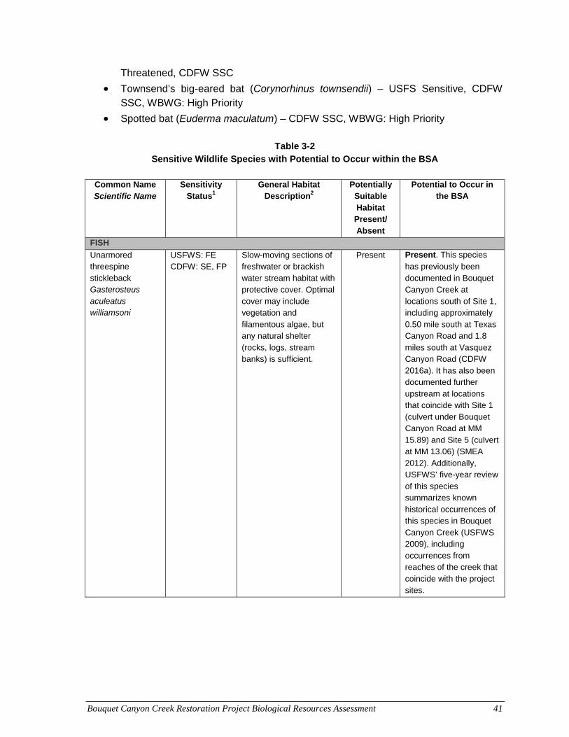
Bouquet Canyon Creek Restoration Project Biological Resources Assessment 41
Threatened, CDFW SSC
• Townsend’s big-eared bat (Corynorhinus townsendii) – USFS Sensitive, CDFW SSC, WBWG: High Priority
• Spotted bat (Euderma maculatum) – CDFW SSC, WBWG: High Priority
Table 3-2 Sensitive Wildlife Species with Potential to Occur within the BSA
Common Name Scientific Name
Sensitivity Status1
General Habitat Description2
Potentially Suitable Habitat
Present/ Absent
Potential to Occur in the BSA
FISH
Unarmored threespine stickleback Gasterosteus aculeatus williamsoni
USFWS: FE CDFW: SE, FP
Slow-moving sections of freshwater or brackish water stream habitat with protective cover. Optimal cover may include vegetation and filamentous algae, but any natural shelter (rocks, logs, stream banks) is sufficient.
Present Present. This species
has previously been documented in Bouquet Canyon Creek at locations south of Site 1, including approximately 0.50 mile south at Texas Canyon Road and 1.8 miles south at Vasquez Canyon Road (CDFW 2016a). It has also been documented further upstream at locations that coincide with Site 1 (culvert under Bouquet Canyon Road at MM 15.89) and Site 5 (culvert at MM 13.06) (SMEA 2012). Additionally, USFWS’ five-year review of this species summarizes known historical occurrences of this species in Bouquet Canyon Creek (USFWS 2009), including occurrences from reaches of the creek that coincide with the project sites.
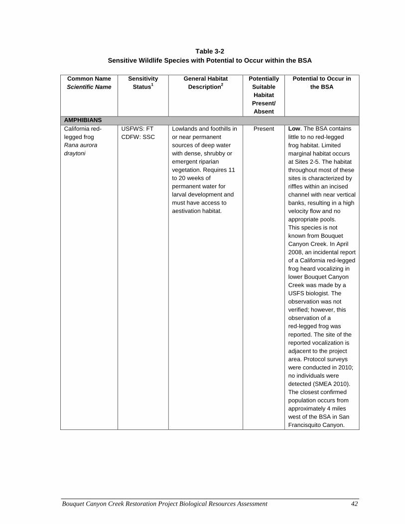
Bouquet Canyon Creek Restoration Project Biological Resources Assessment 42
Table 3-2 Sensitive Wildlife Species with Potential to Occur within the BSA
Common Name
Scientific Name Sensitivity
Status1 General Habitat
Description2 Potentially
Suitable Habitat
Present/ Absent
Potential to Occur in the BSA
AMPHIBIANS
California red-legged frog Rana aurora draytoni
USFWS: FT CDFW: SSC
Lowlands and foothills in or near permanent sources of deep water with dense, shrubby or emergent riparian vegetation. Requires 11 to 20 weeks of permanent water for larval development and must have access to aestivation habitat.
Present Low. The BSA contains
little to no red‐legged
frog habitat. Limited marginal habitat occurs at Sites 2-5. The habitat throughout most of these sites is characterized by riffles within an incised channel with near vertical banks, resulting in a high velocity flow and no appropriate pools. This species is not known from Bouquet Canyon Creek. In April 2008, an incidental report of a California red-legged frog heard vocalizing in lower Bouquet Canyon Creek was made by a USFS biologist. The observation was not verified; however, this observation of a red‐legged frog was
reported. The site of the reported vocalization is adjacent to the project area. Protocol surveys were conducted in 2010; no individuals were detected (SMEA 2010). The closest confirmed population occurs from approximately 4 miles west of the BSA in San Francisquito Canyon.
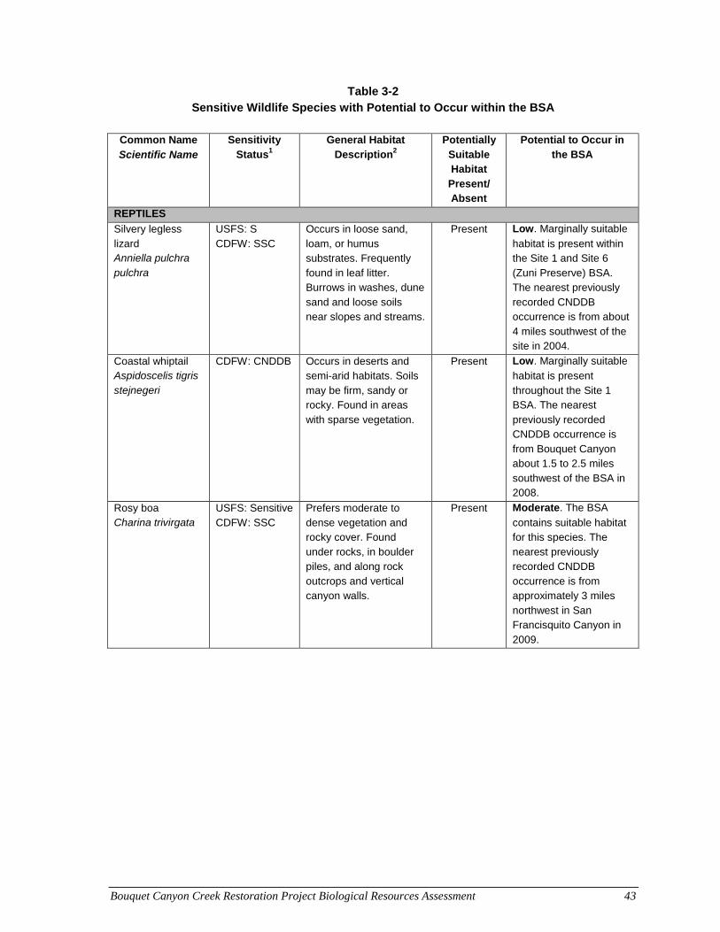
Bouquet Canyon Creek Restoration Project Biological Resources Assessment 43
Table 3-2 Sensitive Wildlife Species with Potential to Occur within the BSA
Common Name
Scientific Name Sensitivity
Status1 General Habitat
Description2 Potentially
Suitable Habitat
Present/ Absent
Potential to Occur in the BSA
REPTILES
Silvery legless lizard Anniella pulchra pulchra
USFS: S CDFW: SSC
Occurs in loose sand, loam, or humus substrates. Frequently found in leaf litter. Burrows in washes, dune sand and loose soils near slopes and streams.
Present Low. Marginally suitable
habitat is present within the Site 1 and Site 6 (Zuni Preserve) BSA. The nearest previously recorded CNDDB occurrence is from about 4 miles southwest of the site in 2004.
Coastal whiptail Aspidoscelis tigris stejnegeri
CDFW: CNDDB Occurs in deserts and semi-arid habitats. Soils may be firm, sandy or rocky. Found in areas with sparse vegetation.
Present Low. Marginally suitable
habitat is present throughout the Site 1 BSA. The nearest previously recorded CNDDB occurrence is from Bouquet Canyon about 1.5 to 2.5 miles southwest of the BSA in 2008.
Rosy boa Charina trivirgata
USFS: Sensitive CDFW: SSC
Prefers moderate to dense vegetation and rocky cover. Found under rocks, in boulder piles, and along rock outcrops and vertical canyon walls.
Present Moderate. The BSA
contains suitable habitat for this species. The nearest previously recorded CNDDB occurrence is from approximately 3 miles northwest in San Francisquito Canyon in 2009.
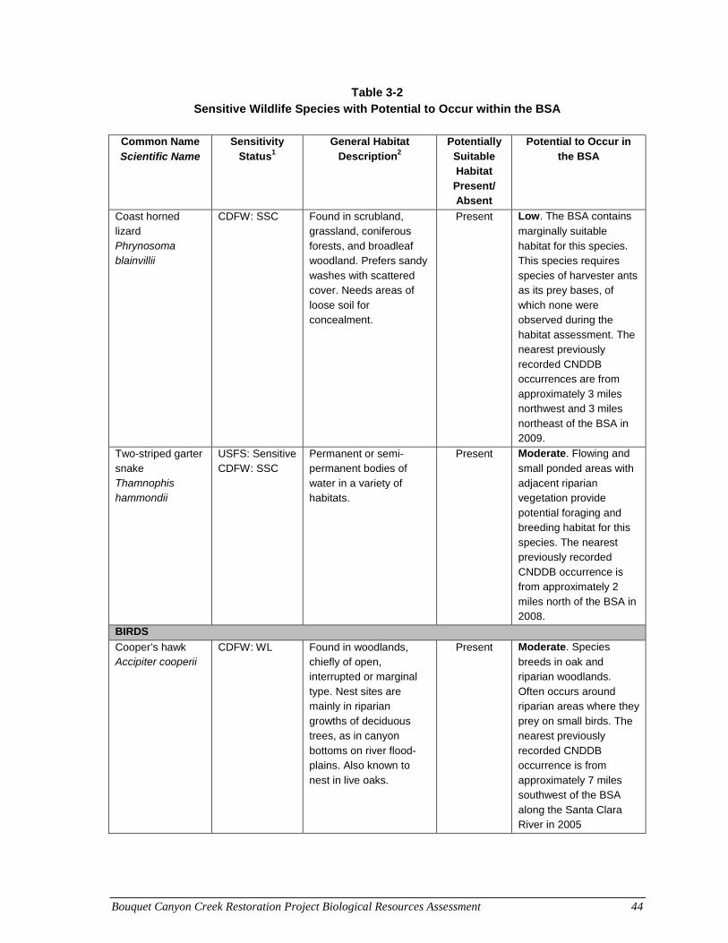
Bouquet Canyon Creek Restoration Project Biological Resources Assessment 44
Table 3-2 Sensitive Wildlife Species with Potential to Occur within the BSA
Common Name
Scientific Name Sensitivity
Status1 General Habitat
Description2 Potentially
Suitable Habitat
Present/ Absent
Potential to Occur in the BSA
Coast horned lizard Phrynosoma blainvillii
CDFW: SSC
Found in scrubland, grassland, coniferous forests, and broadleaf woodland. Prefers sandy washes with scattered cover. Needs areas of loose soil for concealment.
Present Low. The BSA contains
marginally suitable habitat for this species. This species requires species of harvester ants as its prey bases, of which none were observed during the habitat assessment. The nearest previously recorded CNDDB occurrences are from approximately 3 miles northwest and 3 miles northeast of the BSA in 2009.
Two-striped garter snake Thamnophis hammondii
USFS: Sensitive CDFW: SSC
Permanent or semi-permanent bodies of water in a variety of habitats.
Present Moderate. Flowing and
small ponded areas with adjacent riparian vegetation provide potential foraging and breeding habitat for this species. The nearest previously recorded CNDDB occurrence is from approximately 2 miles north of the BSA in 2008.
BIRDS
Cooper’s hawk Accipiter cooperii
CDFW: WL Found in woodlands, chiefly of open, interrupted or marginal type. Nest sites are mainly in riparian growths of deciduous trees, as in canyon bottoms on river flood-plains. Also known to nest in live oaks.
Present Moderate. Species
breeds in oak and riparian woodlands. Often occurs around riparian areas where they prey on small birds. The nearest previously recorded CNDDB occurrence is from approximately 7 miles southwest of the BSA along the Santa Clara River in 2005
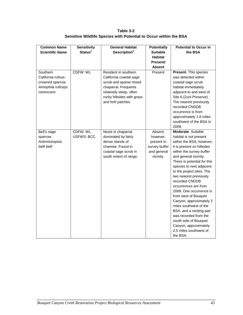
Bouquet Canyon Creek Restoration Project Biological Resources Assessment 45
Table 3-2 Sensitive Wildlife Species with Potential to Occur within the BSA
Common Name
Scientific Name Sensitivity
Status1 General Habitat
Description2 Potentially
Suitable Habitat
Present/ Absent
Potential to Occur in the BSA
Southern California rufous-crowned sparrow Aimophila ruficeps canescans
CDFW: WL Resident in southern California coastal sage scrub and sparse mixed chaparral. Frequents relatively steep, often rocky hillsides with grass and forb patches.
Present Present. This species
was detected within coastal sage scrub habitat immediately adjacent to and west of Site 6 (Zuni Preserve). The nearest previously recorded CNDDB occurrence is from approximately 1.8 miles southwest of the BSA in 2008.
Bell’s sage sparrow Artemisiospiza belli belli
CDFW: WL USFWS: BCC
Nests in chaparral dominated by fairly dense stands of chamise. Found in coastal sage scrub in south extent of range.
Absent; however, present in
survey buffer and general
vicinity.
Moderate. Suitable
habitat is not present within the BSA, however, it is present on hillsides within the survey buffer and general vicinity. There is potential for this species to nest adjacent to the project sites. The two nearest previously recorded CNDDB occurrences are from 2008. One occurrence is from west of Bouquet Canyon, approximately 2 miles southwest of the BSA, and a nesting pair was recorded from the south side of Bouquet Canyon, approximately 2.5 miles southwest of the BSA.
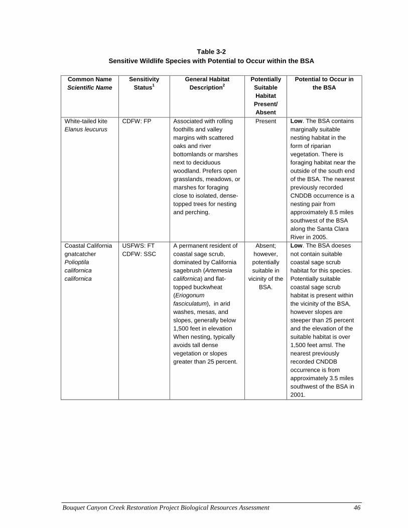
Bouquet Canyon Creek Restoration Project Biological Resources Assessment 46
Table 3-2 Sensitive Wildlife Species with Potential to Occur within the BSA
Common Name
Scientific Name Sensitivity
Status1 General Habitat
Description2 Potentially
Suitable Habitat
Present/ Absent
Potential to Occur in the BSA
White-tailed kite Elanus leucurus
CDFW: FP Associated with rolling foothills and valley margins with scattered oaks and river bottomlands or marshes next to deciduous woodland. Prefers open grasslands, meadows, or marshes for foraging close to isolated, dense-topped trees for nesting and perching.
Present Low. The BSA contains
marginally suitable nesting habitat in the form of riparian vegetation. There is foraging habitat near the outside of the south end of the BSA. The nearest previously recorded CNDDB occurrence is a nesting pair from approximately 8.5 miles southwest of the BSA along the Santa Clara River in 2005.
Coastal California gnatcatcher Polioptila californica californica
USFWS: FT CDFW: SSC
A permanent resident of coastal sage scrub, dominated by California sagebrush (Artemesia californica) and flat-
topped buckwheat (Eriogonum fasciculatum), in arid washes, mesas, and slopes, generally below 1,500 feet in elevation When nesting, typically avoids tall dense vegetation or slopes greater than 25 percent.
Absent; however, potentially suitable in
vicinity of the BSA.
Low. The BSA doeses
not contain suitable coastal sage scrub habitat for this species. Potentially suitable coastal sage scrub habitat is present within the vicinity of the BSA, however slopes are steeper than 25 percent and the elevation of the suitable habitat is over 1,500 feet amsl. The nearest previously recorded CNDDB occurrence is from approximately 3.5 miles southwest of the BSA in 2001.
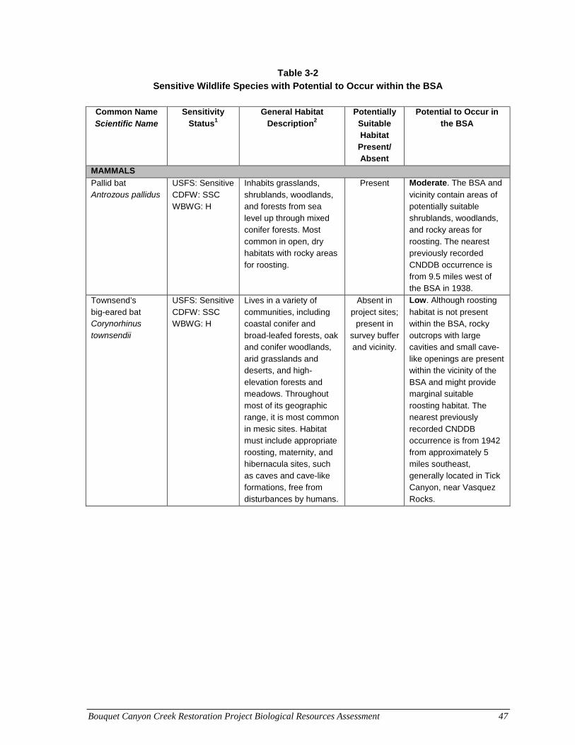
Bouquet Canyon Creek Restoration Project Biological Resources Assessment 47
Table 3-2 Sensitive Wildlife Species with Potential to Occur within the BSA
Common Name
Scientific Name Sensitivity
Status1 General Habitat
Description2 Potentially
Suitable Habitat
Present/ Absent
Potential to Occur in the BSA
MAMMALS
Pallid bat Antrozous pallidus
USFS: Sensitive CDFW: SSC WBWG: H
Inhabits grasslands, shrublands, woodlands, and forests from sea level up through mixed conifer forests. Most common in open, dry habitats with rocky areas for roosting.
Present Moderate. The BSA and
vicinity contain areas of potentially suitable shrublands, woodlands, and rocky areas for roosting. The nearest previously recorded CNDDB occurrence is from 9.5 miles west of the BSA in 1938.
Townsend’s big-eared bat Corynorhinus townsendii
USFS: Sensitive CDFW: SSC WBWG: H
Lives in a variety of communities, including coastal conifer and broad-leafed forests, oak and conifer woodlands, arid grasslands and deserts, and high-elevation forests and meadows. Throughout most of its geographic range, it is most common in mesic sites. Habitat must include appropriate roosting, maternity, and hibernacula sites, such as caves and cave-like formations, free from disturbances by humans.
Absent in project sites;
present in survey buffer and vicinity.
Low. Although roosting
habitat is not present within the BSA, rocky outcrops with large cavities and small cave-like openings are present within the vicinity of the BSA and might provide marginal suitable roosting habitat. The nearest previously recorded CNDDB occurrence is from 1942 from approximately 5 miles southeast, generally located in Tick Canyon, near Vasquez Rocks.
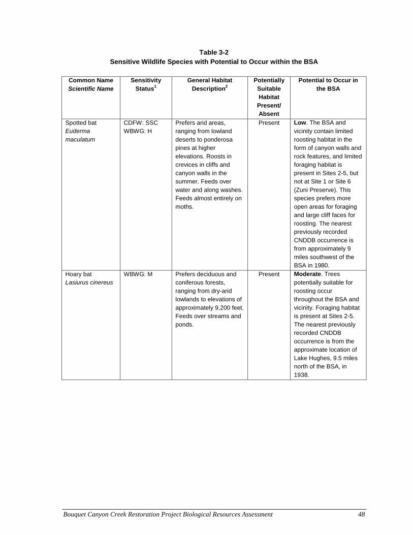
Bouquet Canyon Creek Restoration Project Biological Resources Assessment 48
Table 3-2 Sensitive Wildlife Species with Potential to Occur within the BSA
Common Name
Scientific Name Sensitivity
Status1 General Habitat
Description2 Potentially
Suitable Habitat
Present/ Absent
Potential to Occur in the BSA
Spotted bat Euderma maculatum
CDFW: SSC WBWG: H
Prefers arid areas, ranging from lowland deserts to ponderosa pines at higher elevations. Roosts in crevices in cliffs and canyon walls in the summer. Feeds over water and along washes. Feeds almost entirely on moths.
Present Low. The BSA and
vicinity contain limited roosting habitat in the form of canyon walls and rock features, and limited foraging habitat is present in Sites 2-5, but not at Site 1 or Site 6 (Zuni Preserve). This species prefers more open areas for foraging and large cliff faces for roosting. The nearest previously recorded CNDDB occurrence is from approximately 9 miles southwest of the BSA in 1980.
Hoary bat Lasiurus cinereus
WBWG: M Prefers deciduous and coniferous forests, ranging from dry-arid lowlands to elevations of approximately 9,200 feet. Feeds over streams and ponds.
Present Moderate. Trees
potentially suitable for roosting occur throughout the BSA and vicinity. Foraging habitat is present at Sites 2-5. The nearest previously recorded CNDDB occurrence is from the approximate location of Lake Hughes, 9.5 miles north of the BSA, in 1938.
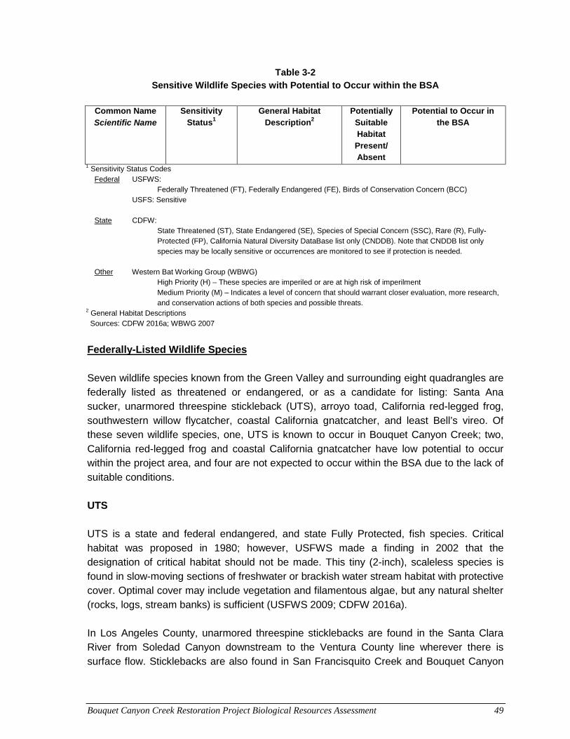
Bouquet Canyon Creek Restoration Project Biological Resources Assessment 49
Table 3-2 Sensitive Wildlife Species with Potential to Occur within the BSA
Common Name
Scientific Name Sensitivity
Status1 General Habitat
Description2 Potentially
Suitable Habitat
Present/ Absent
Potential to Occur in the BSA
1 Sensitivity Status Codes Federal USFWS:
Federally Threatened (FT), Federally Endangered (FE), Birds of Conservation Concern (BCC) USFS: Sensitive State CDFW:
State Threatened (ST), State Endangered (SE), Species of Special Concern (SSC), Rare (R), Fully-Protected (FP), California Natural Diversity DataBase list only (CNDDB). Note that CNDDB list only species may be locally sensitive or occurrences are monitored to see if protection is needed.
Other Western Bat Working Group (WBWG) High Priority (H) – These species are imperiled or are at high risk of imperilment Medium Priority (M) – Indicates a level of concern that should warrant closer evaluation, more research, and conservation actions of both species and possible threats.
2 General Habitat Descriptions Sources: CDFW 2016a; WBWG 2007
Federally-Listed Wildlife Species Seven wildlife species known from the Green Valley and surrounding eight quadrangles are federally listed as threatened or endangered, or as a candidate for listing: Santa Ana sucker, unarmored threespine stickleback (UTS), arroyo toad, California red-legged frog, southwestern willow flycatcher, coastal California gnatcatcher, and least Bell’s vireo. Of these seven wildlife species, one, UTS is known to occur in Bouquet Canyon Creek; two, California red-legged frog and coastal California gnatcatcher have low potential to occur within the project area, and four are not expected to occur within the BSA due to the lack of suitable conditions. UTS UTS is a state and federal endangered, and state Fully Protected, fish species. Critical habitat was proposed in 1980; however, USFWS made a finding in 2002 that the designation of critical habitat should not be made. This tiny (2-inch), scaleless species is found in slow-moving sections of freshwater or brackish water stream habitat with protective cover. Optimal cover may include vegetation and filamentous algae, but any natural shelter (rocks, logs, stream banks) is sufficient (USFWS 2009; CDFW 2016a). In Los Angeles County, unarmored threespine sticklebacks are found in the Santa Clara River from Soledad Canyon downstream to the Ventura County line wherever there is surface flow. Sticklebacks are also found in San Francisquito Creek and Bouquet Canyon
Bouquet Canyon Creek Restoration Project Biological Resources Assessment 50
Creek (CDFG 2000). Past documentation of this species in Bouquet Canyon Creek includes observations south of Site 1, including approximately 0.50 mile south at Texas Canyon Road and 1.8 miles south at Vasquez Canyon Road (CDFW 2016a). A study by SMEA (2011) documented occurrences of the species at the culvert at MM 15.89, and in reaches with suitable habitat upstream of Site 1. SMEA (2012) again documented it at MM 15.89 (Site 1) and at the culvert at MM 13.06 (Site 5). USFWS’ five-year review of this species summarizes known historical occurrences of this species in Bouquet Canyon Creek (USFWS 2009), including occurrences from reaches of the creek that coincide with the project sites. During the field survey, freshwater stream habitat suitable for this species was present in the segment of Bouquet Canyon Creek occurring within Sites 2-5 BSA. Red-legged Frog This species is listed as federally threatened and is a state SSC. In 2010, USFWS published a final rule designating revised critical habitat for the California red-legged frog (USFWS 2010). The closest critical habitat is located approximately 5 miles west of the BSA, in the San Francisquito Canyon. This species is associated with lowlands and foothills in or near permanent sources of deep water with dense, shrubby, or emergent riparian vegetation (CDFW 2016a). The red-legged frog requires 11 to 20 weeks of permanent water for larval development and must have access to aestivation habitat. It breeds in ponded water, but outside of the breeding season it may also be found in a variety of upland habitats (Stebbins 2003). This species is not known from Bouquet Canyon. In April 2008, there was an incidental report of a California red-legged frog heard vocalizing in lower Bouquet Canyon by a USFS biologist. An observation to confirm its presence was not obtained, but this observation was reported. Protocol surveys for this species conducted in 2010 in the immediate vicinity of the project did not result in observations of this species (SMEA 2010). This species was not observed during field surveys, and the closest confirmed population occurs from approximately four miles west of the BSA in San Francisquito Canyon. The
BSA contains little to no red‐legged frog habitat. Limited marginal habitat occurs at the
northern four sites. The habitat throughout most of those sites and their BSA is characterized by riffles within an incised channel with near vertical banks, resulting in a high velocity flow and no appropriate pools. This species has moderate potential to occur in the BSA. Coastal California Gnatcatcher The coastal California gnatcatcher is a federal threatened species and a state SSC. In 2007, USFWS published a final rule designating revised critical habitat for the CAGN (USFWS 2007). The closest critical habitat is located approximately 6 miles south of the BSA. The coastal California gnatcatcher is a local and uncommon year-round resident of
Bouquet Canyon Creek Restoration Project Biological Resources Assessment 51
southern California. This species is found in the six southern-most California counties located within the coastal plain (San Bernardino, Ventura, Los Angeles, Orange, San Diego, and Riverside). The coastal California gnatcatcher generally inhabits Diegan coastal sage scrub and Riversidian coastal sage scrub dominated by California sagebrush (Artemesia californica) and flat-topped buckwheat (Eriogonum fasciculatum) generally below 1,500 feet amsl along the coastal slope. When nesting, this species typically avoids slopes greater than 25 percent that includes dense, tall vegetation. This species was not observed during field surveys and the nearest historic records are known from approximately 3.5 miles southwest of the BSA in 2001 (CDFW 2016a). The BSA doeses not contain suitable habitat for this species, but potentially suitable coastal sage scrub habitat is present on hillsides within the vicinity of the BSA. However, adjacent slopes are steeper than 25 percent and the elevation of the suitable habitat is over 1,500 feet amsl. This species has low potential to occur in the vicinity of the BSA, based on historic records and marginal habitat present in the vicinity. State-Listed Wildlife Species Four wildlife species known from the Green Valley and surrounding eight quadrangles are state listed as threatened or endangered: UTS, southwestern willow flycatcher, bald eagle, and least Bell’s vireo. Of these four wildlife species, three are not expected to occur within the BSA due to the lack of suitable conditions. The remaining species, UTS, was discussed above. Other Special-Status Wildlife Species Thirteen wildlife species that are not listed under FESA or CESA, but are otherwise listed as special-status by CDFW or USFS, are known from the Green Valley and surrounding eight quadrangles to have some potential to occur within the project area. These species are discussed below. Reptiles Two-Striped Garter Snake Two-striped garter snake, a state SSC, is highly aquatic and is found in or near permanent freshwater from sea level to approximately 6,900 feet amsl. It prefers streams with rocky beds and riparian growth (CDFW 2016a) where it feeds on tadpoles, frogs, amphibians, larvae, and fish, but it is known to take refuge in upland habitats, including use of small mammal burrows (Rathburn et al. 1993). Two-striped garter snakes have been observed in riparian, freshwater marsh, coastal sage scrub, chaparral, oak woodland, and grassland habitats. This species is normally active from April to October and may become primarily
Bouquet Canyon Creek Restoration Project Biological Resources Assessment 52
nocturnal or crepuscular during summer months. This species was not observed during field surveys, and the nearest known historic record is from approximately 2 miles north of the BSA in 2008 (CDFW 2016a). Flowing and small ponded areas with adjacent riparian vegetation provide potential foraging and breeding habitat for this species. This species has moderate potential to occur in the BSA. Rosy Boa The rosy boa is a USFS Sensitive species and state SSC. The range of this species extends from southern California and south-central Arizona, south throughout Baja California, Mexico and Guaymas, Sonora, excluding low deserts. (Stebbins 2003). The rosy boa inhabits rocky shrubland and desert habitats ranging in elevation from sea level to approximately 4,500 feet amsl. Although it does not require permanent water, this species is attracted to oases and streams (Stebbins 2003). This species was not observed during field surveys, and the nearest known historic record is from San Francisquito Canyon, approximately 3 miles northwest of the BSA, in 2009 (CDFW 2016a). The BSA contains suitable stream and shrub habitat for this species. This species has moderate potential to occur in the BSA. Silvery Legless Lizard The silvery legless lizard maintains no federal designation, but is a state SSC. The species occurs in areas of sparse vegetative cover within coastal sage scrub, chaparral, pine-oak woodlands, riparian areas, and occasionally desert scrub habitats (Stebbins 2003). Loose, moist soil is an important habitat component for this fossorial species (Stebbins 2003; CDFW 2016a). They are frequently found in leaf litter and are known to burrow in washes, dune sand, and loose soils near slopes and streams (CDFW 2016a). Diet consists of small insects, beetles, termites, and spiders around the bases of shrubs (Californiaherps 2015). The range in which silvery legless lizards are commonly found includes the coastal ranges from Contra Costa County south to the Mexican border. This species was not observed during field surveys, and the nearest known historic record is from approximately 4 miles southwest of the BSA in 2004. Marginally suitable habitat for this species is present within the Site 1 and Site 6 (Zuni Preserve) BSA. This species has low potential to occur in the BSA, based on historic records and the presence of marginally suitable habitat.
Bouquet Canyon Creek Restoration Project Biological Resources Assessment 53
Coastal Whiptail The coastal western whiptail is tracked by the CNDDB (CDFW 2016a). The coastal western whiptail is found in coastal southern California, mostly west of Peninsular Ranges and south of Transverse Ranges, and north into Ventura County. Within the species’ range it is found in open areas with little vegetation or sunny microhabitats within shrub or grassland associations where soils may be firm, sandy, or rocky (Benes 1969, CDFW 2016a). This species was not observed during field surveys, and the nearest known historic record is in Bouquet Canyon, approximately 1.5 to 2.5 miles southwest of the BSA, in 2008. Marginally suitable habitat is present within the Site 1 BSA and within the survey buffers for the other five sites. Based on historic records and the presence of marginally suitable habitat, this species has low potential to occur in the BSA. Coast Horned Lizard The coast horned lizard is a state SSC. It inhabits a variety of habitats including sage scrub, chaparral, and coniferous and broad-leaf woodlands (CDFW 2016a). It is most common along lowland sandy washes with scattered bushes, and requires an abundant supply of ants and other insects, open areas, and friable soils (CDFW 2016a). This species was not observed during field surveys and the nearest historic record is from approximately 3 miles northwest of the BSA in 2009. Potentially suitable sandy wash habitat is present within Site 1 and semi-desert chaparral and woodland habitat is present within the vicinity of the remaining five project sites. This species requires species of harvester ants as its prey base, of which none were observed during the habitat assessment. This species has a low potential to occur within the BSA, based on historic records, suitable habitat, and lack of observed prey base. Birds Raptors Most raptors such as golden eagle (Aquila chrysaetos), white-tailed kite (Elanus leucurus), red-tailed hawk, red-shouldered hawk (Buteo lineatus), and Cooper’s hawk (Accipiter cooperii) nest in mature, large coniferous or deciduous trees and use twigs or branches as nesting material. Smaller raptors such as American kestrel (Falco sparverius) and western screech-owl (Otus kennicottii) may nest in cavities in anthropogenic structures and trees. Short-eared owls (Asio flammeus) and northern harriers (Circus cyaneus) nest on the ground in grassland, marshes, and agricultural fields with tall vegetation. Common raptors such as American kestrels and red-tailed hawks could nest in the vicinity of the project sites and are afforded protection under the MBTA and CFGC. The nesting period for raptors
Bouquet Canyon Creek Restoration Project Biological Resources Assessment 54
generally occurs between December 15 and August 31. As presented in Section 2.2, large Fremont cottonwood, sycamore, coast live oak, white alder, and red willow were documented in the BSA (see Figures 2-1 through 2-3). Large trees in and around the BSA have potential to support nesting raptors such as Cooper’s hawk and white-tailed kite, among other species. Cooper’s Hawk Cooper’s hawk is a state Watch List species. This species is a breeding resident throughout most of the wooded portion of California, ranging in elevation from sea level to above 8,860 feet amsl. Outside of the breeding season, it disperses widely from southern Canada to northern Mexico and locally occurs less frequently in mountain areas than at lower elevations. In natural environments, Cooper's hawk nests primarily in oaks, eucalyptus, and riparian willows (Asay 1987), where it builds high in trees, but beneath the canopy. It forages in broken woodland and habitat edges, hunting mammals, birds, amphibians, and reptiles. A recent study in Orange County, California, has demonstrated that this species has successfully adapted to nesting and foraging in urban environments, where smaller birds are plentiful, and tall trees and buildings provide nesting sites (Chiang et al. 2012). This species was not observed during field surveys and the nearest historic record is from approximately 7 miles southwest of the BSA along the Santa Clara River, in 2005 (CDFW 2016a). Based on the presence of tall mature trees for nesting, a sufficient supply of prey (i.e., small birds and mammals), and open water, this species has moderate potential to occur in the BSA, based on historic records and the presence of potential nesting and foraging habitat. White-tailed Kite The white-tailed kite is a state Fully Protected species within its breeding range. In North America, it occurs along the Pacific Coast from Washington south to Baja California, Mexico. This species inhabits riparian or oak woodland adjacent to grassland or open fields where it hunts its primary prey species, the California vole (Microtus californicus) (Unitt 2004). Nests are typically placed in the crowns of oaks or other densely foliaged trees. Species decline is attributed to individual mortality from rodent-poisoning, loss of habitat, and proliferation of crows and ravens competing for prey (Unitt 2004). This species was not observed during field surveys and the nearest historic record is known from approximately 8.5 miles southwest of the BSA along the Santa Clara River, in 2005 (CDFW 2016a). The BSA contains marginally suitable nesting habitat in the form of riparian vegetation. Foraging habitat is present near the southern extent of the BSA. This species
Bouquet Canyon Creek Restoration Project Biological Resources Assessment 55
has low potential to occur in the BSA, based on historic records and marginally suitable nesting habitat. Special-Status Passerine and Non-Passerine Landbirds Passerines (perching birds) are a taxonomic grouping that consists of several families including swallows (Hirundinidae), larks (Alaudidae), crows, ravens and jays (Corvidae), shrikes (Laniidae), vireos (Vireonidae), finches (Fringillidae) and Emberizids (Emberizidae; warblers, sparrows, blackbirds, etc.), among others. Non-passerine land birds are a non-taxonomic based grouping typically used by ornithologists to categorize a loose assemblage of birds. Families grouped into this category include kingfishers (Alcedinidae), woodpeckers (Picidae), swifts (Apodidae), hummingbirds (Trochilidae), and pigeons and doves (Columbidae), among others. Habitat, nesting, and foraging requirements for these species are wide ranging, therefore, outlining generic habitat requirements for this grouping is difficult. These species typically use most habitat types and are known to nest on the ground, in shrubs and trees, on buildings, under bridges, and within cavities, crevices, and manmade structures. Many of these species migrate long distances and all species except starlings, English house sparrows, and rock doves (pigeons), are protected under the federal MBTA and CFGC. The nesting period for passerines and non-passerine land birds generally occurs between March 15 and August 31. Suitable nesting and foraging habitat is present within the six project sites and their vicinity for passerines and non-passerine land birds found in scrub and riparian vegetation such as oak titmouse, spotted towhee, lesser goldfinch, American crow, common raven, woodpecker species, Anna’s hummingbird, wren species, and southern California rufous-crowned sparrow, which were observed during the surveys. Southern California Rufous-crowned Sparrow Southern California rufous-crowned sparrow is a state Watch List species and is one of the three Pacific coastal subspecies of the rufous-crowned sparrow (Pyle 1997). The rufous-crowned sparrow is a resident of the southwestern U.S. and Mexico. This secretive species prefers moderate to steep, dry, rocky hillsides vegetated with coastal sage scrub and chaparral, scattered with grassy areas, forbs, and bare ground (Collins 1999). This species was observed during field surveys in coastal sage scrub habitat immediately adjacent to, and west of, the proposed location for the Zuni Preserve. The nearest known historic record is from approximately 3 miles northwest of the BSA, in 2009 (CDFW 2016a).
Bouquet Canyon Creek Restoration Project Biological Resources Assessment 56
Bell’s Sage Sparrow Bell’s sage sparrow is a federal Bird of Conservation Concern and a state Watch List species. One of five subspecies, all endemic to western North America, this race is a year-round resident ranging from Marin County (coastally) and Trinity County (inland) south through western California to northern Baja California. Here A. b. belli is uncommon to locally fairly common in dry chaparral and coastal sage scrub communities along coastal lowlands, inland valleys, and in lower foothills of local mountains. This species spends a significant portion of its time running and foraging on the ground and so prefers coastal sage scrub and open chaparral habitat that is not too dense or cluttered with leaf litter; partially recovered burned areas offer suitable habitat for this species (Martin and Carlson 1998; Unitt 2004). This species was not observed during field surveys and the nearest historic records are known from approximately 2008. One occurrence is from west of Bouquet Canyon, approximately 2 miles southwest of the BSA, and a nesting pair was recorded from the south side of Bouquet Canyon, approximately 2.5 miles southwest of the BSA. Suitable habitat is not present within the project sites. However, it is present on hillsides within the BSA survey buffer and general vicinity. There is potential for this species to nest adjacent to the project sites. This species has moderate potential to occur in the BSA, based on historic records and the presence of suitable habitat. Mammals Special-Status Bats Pallid Bat Pallid bat is a state SCC and is listed as High priority by the Western Bat Working Group (WBWG). This group consists of agencies, organizations, and individuals interested in bat research, management, and conservation from 13 western states and Canadian provinces. Species designated as “high priority” by WBWG are imperiled or are at high risk of imperilment based on available information on distribution, status, ecology, and known threats (WBWG 2007). This species ranges throughout western North America, from British Columbia, south to Queretaro and Jalisco, and east to Texas. It is most abundant in xeric ecosystems, including the Great Basin, Mojave, and Sonoran Deserts, and prefers dry habitats with rocky areas for roosting. It is also known from grasslands, shrublands, and woodlands in dry areas. Roosting sites include crevices in rocky outcrops and cliffs, caves, mines and trees, and various human structures such as bridges. Roosts generally have unobstructed entrances/exits and are high above the ground, warm, and inaccessible to terrestrial predators. Winter habits are poorly known, but this species does not migrate long distances between summer and winter sites. In coastal California, males and females
Bouquet Canyon Creek Restoration Project Biological Resources Assessment 57
overwinter in a primary roost but occasionally use alternate roosts throughout the winter. Pallid bats' relative sensitivity to disturbance makes them vulnerable to mass displacement. Roosts can be damaged or destroyed by vandalism; mine closures and reclamation; forestry practices such as timber harvest; and where man-made structures are demolished, modified, or where chemical treatment has occurred. Maternity colonies and hibernating bats are especially susceptible to disturbance. Loss or modification of foraging habitat due to prescribed fire, urban development, agricultural expansion, and/or pesticide use poses potential threats. This is especially true in coastal California, where urbanization has reduced roosting and foraging habitat (WBWG 2005a). The species was not observed during field surveys. The nearest historic record is from 9.5 miles west of the BSA in 1938 (CDFW 2016a). The BSA and vicinity contain areas of potentially suitable shrublands, woodlands, and rocky areas for roosting. Therefore, this species has moderate potential to occur in the BSA and vicinity. Hoary Bat Hoary bat is tracked by the CNDDB and is listed as Medium priority by WBWG. Medium priority indicates a level of concern that should warrant closer evaluation, more research, and conservation actions of both the species and possible threats (WBWG 2007). This species is the most widespread of all North American bats, ranging from near the limit of trees in Canada, southward at least to Guatemala, and from Brazil to Argentina and Chile in South America. In the U.S., hoary bats are more common in the prairie states and Pacific Northwest, where they are highly associated with forested habitats. They may be found at any location in California, although distribution is patchy in southeastern deserts. Habitats suitable for bearing young include all woodlands and forests with medium to large trees and dense foliage. During migration in southern California, males are found in foothills, deserts, and mountains; females in lowlands and coastal valleys (Vaughan and Krutzsch 1954). They are solitary bats and roost primarily in trees along the edges of both coniferous and deciduous forests, near the ends of branches. Loss of roosting habitat due to timber harvest is the biggest threat to this species. Use of pesticides on public forest lands may also be a potential source of mortality to roosting bats and their insect prey. In suburban settings, where jays thrive in association with humans, this bird may pose a major threat to sleeping or hibernating hoary bats (WBWG 2005b). This species was not observed during field surveys and the nearest historic record is from the approximate location of Lake Hughes, 9.5 miles north of the BSA, in 1938. Trees, potentially suitable for roosting, are present throughout the BSA and vicinity. Foraging habitat is present at Sites 2-5. This species has moderate potential to occur in the BSA and vicinity based on historic records and the presence of potentially suitable roosting habitat in the vicinity.
Bouquet Canyon Creek Restoration Project Biological Resources Assessment 58
Townsend’s Big-eared Bat Townsend’s western big-eared bat is a state SSC and is listed as High priority by the WBWG (CDFW 2016a, WBWG 2007). This species occurs throughout the west and is distributed from the British Columbia south along the Pacific coast to central Mexico and east into the great Plains (WBWG 2005c). It occurs throughout California, but information on the details of its distribution is limited. It lives in a variety of communities, including coastal conifer and broad-leafed forests, oak and conifer woodlands, grasslands and deserts, and high elevation forests and meadows. Roosting sites are the most important limiting resource; this species requires caves, mines, tunnels, buildings, or other human-made structures for roosting. The species forages over habitat edges or in forest and woodland habitats within approximately 9 miles of roost sites. The species is relatively specialized for feeding on moths (Harris 2000). No major populations have been designated within the vicinity of the BSA, and, although there are no known active roosts sites, any found would be considered critical locations. This species was not observed during field surveys and the most recent historic record is from 1943 from approximately 5 miles southeast of the BSA, in the general location of Tick Canyon, near Vasquez Rocks. Suitable roosting habitat does not occur within the project sites, but rocky outcrops with large cavities and small cave-like openings are present within the vicinity of the BSA and may provide suitable roosting habitat. This species has low potential to occur in the BSA and vicinity based on historic records and the presence of marginal roosting habitat in the vicinity. Spotted Bat The spotted bat is a state SSC and is listed as High priority by the WBWG (CDFW 2016a, WBWG 2007). This species is known from all states west of the Rocky Mountains; however it is rarely common. Spotted bats have been found from below sea level to 8,850 feet amsl, occurring in arid areas, ranging from lowland deserts to ponderosa pines at higher elevations (WBWG 2005d). It is known to roost in crevices in cliffs and canyon walls in the summer. The spotted bat’s diet consists almost entirely of moths and it feeds over water and along washes. This species was not observed during field surveys and the most recent historic record is from 1890 from approximately 9 miles southwest of the BSA. Although suitable foraging habitat is present within the Project sites, no roosting habitat is present. Rocky outcrops are present within the vicinity of the BSA and could provide suitable roosting habitat. This species has low potential to occur in the BSA and vicinity based on historic records and the presence of marginal habitat.
Bouquet Canyon Creek Restoration Project Biological Resources Assessment 59
3.3 Sensitive Natural Communities Sensitive natural communities are those that are designated as rare in the region by the CNDDB, support special-status plant or wildlife species, or receive regulatory protection (i.e., §404 of the Clean Water Act and/or §1600 et seq. of the CFGC). Rare communities are given the highest inventory priority (Holland 1986, CDFW 2010). Based on the database review, one sensitive vegetation community, southern cottonwood willow riparian forest, coincides with the project sites, extending from the upper portion of Site 1, upstream through all project sites to Bouquet Reservoir. This community was mapped at all project sites, except at Site 6 (Zuni Preserve) (see Figures 2-1 through 2-3). Large cottonwood and willow trees were documented within this community, along with other large tree species including sycamore, coast live oak, and white alder. Four sensitive communities have been documented in adjacent canyons within a five-mile radius of the project sites, but do not coincide with them, including southern riparian scrub, southern coast live oak riparian forest, southern sycamore alder riparian woodland, and southern California UTS stream. Species composition documented at the project sites reflects elements from more than one of these natural riparian communities. An additional seven sensitive vegetative communities have been recorded within the Green Valley and surrounding eight quadrangles, but not within 5 miles of the project site, including: southern mixed riparian forest, valley needlegrass grassland, mainland cherry forest, California walnut woodland, valley oak woodland, southern riparian woodland, and Riversidian alluvial fan sage scrub.

Bouquet Canyon Creek Restoration Project Biological Resources Assessment 60
This page intentionally left blank.
Bouquet Canyon Creek Restoration Project Biological Resources Assessment 61
4.0 PRELIMINARY JURISDICTIONAL DELINEATION This section presents an assessment and delineation of USACE jurisdictional waters of the U.S. (including wetlands), waters of the State subject to the permitting authority of the Los Angeles (Region 4) Regional Water Quality Control Board (RWQCB), and CDFW jurisdictional stream and riparian habitat.
4.1 Regulatory Setting
4.1.1 Waters of the U.S. USACE and Environmental Protection Agency (EPA) may not assert jurisdiction over small washes characterized by low volume, infrequent, or short duration flow. A jurisdictional tributary to a traditional navigable water has a significant effect (more than speculative or insubstantial) on the chemical, physical, and biological integrity of a traditional navigable water. If an Approved Jurisdictional Determination is requested, USACE and EPA will apply the significant nexus standard to assess the flow characteristics and functions of the tributary drainage to determine if it significantly affects the chemical, physical and biological integrity of downstream traditional navigable waters. However, as allowed by USACE Regulatory Guidance Letter 08-02, the project applicant may proceed under a Preliminary Jurisdictional Determination and presume that all waters on-site may be waters of the U.S. Based on the Rapanos guidance, the USACE and EPA will decide jurisdiction over non-navigable tributaries to traditional navigable waters that are not relatively permanent based on a fact-specific analysis to determine whether they have a significant nexus with the traditional navigable water.
4.1.2 Waters of the State Pursuant to Section 401 of the Clean Water Act (CWA), the RWQCB certifies that the discharge will comply with state water quality standards. The RWQCB, as delegated by USEPA, has the principal authority to issue a CWA Section 401 water quality certifications or waiver.
4.1.3 CDFW Under CFGC Section 1600 et seq., CDFW’s jurisdiction extends over the bed, bank, or channel of a river, stream, or lake for activities that would disrupt the natural flow or alter the channel, bed, or bank of any lake, river, or stream. Substantially diverting or obstructing the natural flow or substantially changing the bed, channel or bank of any river, stream, or lake resulting in a substantial effect on a fish or wildlife resource requires notification to the
Bouquet Canyon Creek Restoration Project Biological Resources Assessment 62
CDFW and completion of the Streambed Alteration Agreement (SAA) process. CDFW jurisdiction encompasses the physical bed and bank of the channel, as well as all associated riparian vegetation.
4.2 Study Methods As indicated in Section 1.2, Field Surveys, of this biological resources assessment, a jurisdictional delineation was conducted in the field on December 29 and 30, 2014 by AECOM biologists Julie Stout and Lance Woolley. Points were recorded in the field to mark USACE and CDFW jurisdictional boundaries using a Trimble sub-meter accuracy Global Positioning System (GPS) unit. Field data points were used in combination with aerial imagery to delineate jurisdictional boundaries. Where field points did not correlate precisely with aerial imagery due to the limitations of GPS unit accuracy, the delineation was adjusted to align with aerial imagery. Representative photographs of each project site were taken during the field visit on February 4, 2015, and are presented in Appendix B of this biological resources assessment.
4.2.1 Waters of the U.S. USACE jurisdictional boundary points were based on EPA and USACE guidance for implementing the Supreme Court’s decision in the Rapanos case, which addresses the jurisdiction over waters of the U.S. under the CWA. The jurisdictional delineation was conducted pursuant to the following standard methods and guidance:
• Waters of the U.S., including wetlands: USACE Wetland Delineation Manual (EL 1987)
• USACE Regional Supplement to the USACE of Engineers Wetland Delineation Manual: Arid West Region (Version 2.0; USACE 2008a)
• A Field Guide to the Identification of the Ordinary High Water Mark (OHWM) in the Arid West Region of the Western United States (Lichvar and McColley 2008)
• Rapanos and Carabell guidance (e.g., JD Handbook, USACE 2007a, b), and other applicable resources (USACE 2008b)
• Wetland plant list: National Wetland Plant List, version 3.2, and State of California 2014 Wetland Plant List (USACE 2014a,b)
• Hydric soils: Field Indicators of Hydric Soils in the United States, version 7.0 (USDA-NRCS 2010); Hydric Soils- Criteria and 2014 State List for California (USDA-NRCS 2014)
• CDFW streambed and riparian areas: A Field Guide to Lake and Streambed Alteration Agreements Sections 1600-1607 (CDFG 1994)
Bouquet Canyon Creek Restoration Project Biological Resources Assessment 63
During the field survey, GPS points were taken along the ordinary high water mark (OHWM) and wetland boundaries as access permitted, approximately every 100 feet or when changes in the direction or width of boundaries was observed. Where the outer bank was inaccessible due to dense riparian vegetation, a visual estimate was made of the OHWM and wetland widths. Wetland and upland areas were verified by completion of Wetland Determination Data Forms where changes were noted in plant community composition topography, and/or hydrology. These forms are included in Appendix E of this biological resources assessment. Waters of the U.S. were mapped based on the extent of the outermost channels where multiple braided channels were present, with only larger upland channel bars being excluded. Following completion of the field survey, field data points and aerial imagery were used in ArcMap to create polygons representing wetland and non-wetland waters of the U.S. Aerial imagery and maps were reviewed to ascertain whether waters identified in the field were tributary to navigable waters. All waters meeting the physical definitions of waters of the U.S. were treated as jurisdictional; a significant nexus test was not applied.
4.2.2 Waters of the State The extent of waters of the State subject to the authority of the Los Angeles RWQCB under the Porter-Cologne Water Quality Control Act was considered to include all waters of the U.S. and any additional surface waters not included as waters of the U.S.
4.2.3 CDFW The extent of streambeds falling under the jurisdiction of the CDFW pursuant to Section 1600 et seq. of the CFGC was determined based on the presence of a defined physical bed, bank, or channel, or the outer edge of riparian vegetation contiguous with the bank of the watercourse. GPS points marking CDFW jurisdictional boundaries were recorded where the CDFW boundary extended beyond that of the USACE. Following the field visit, the outer extent of CDFW jurisdiction was mapped based on the outer limits of riparian vegetation associated with the stream because riparian vegetation extended beyond outer bank limits.
4.3 Existing Jurisdictional Waters in the BSA The BSA included 7.75 acres of waters of the U.S. including 2.06 acres of non-wetland waters and 5.69 acres of wetland waters. CDFW jurisdictional streambed and riparian habitat totaled 15.41 acres, including 7.75 acres overlapping with wetland and non-wetland waters of the U.S. (see Table 4-1 presented further below). Waters of the U.S. and State, and waters of the State exclusively under CDFW jurisdiction are depicted in Figures 4-1 through 4-3.
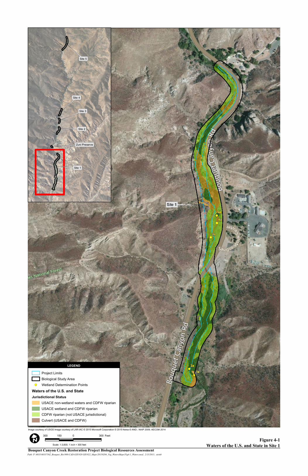
Figure 4-1Waters of the U.S. and State in Site 1
Image courtesy of USGS Image courtesy of LAR-IAC © 2015 Microsoft Corporation © 2015 Nokia © AND ; NAIP 2009; AECOM 2014
Bouquet Canyon Creek Restoration Project Biological Resources AssessmentPath: P:\6033\60337362_Bouquet_Bio\900-CAD-GIS\920 GIS\922_Maps\20150204_Veg_WatersMaps\Fig4-1_Waters.mxd, 2/13/2015, steinb
300 0 300150 Feet
I
LEGEND
Scale: 1:3,600; 1 inch = 300 feet
Project LimitsBiological Study Area
!( Wetland Determination PointsWaters of the U.S. and StateJurisdictional Status
USACE non-wetland waters and CDFW riparianUSACE wetland and CDFW riparianCDFW riparian (not USACE jurisdictional)Culvert (USACE and CDFW)
LEGEND
Site 5
Site 4
Site 3
Site 2
Zuni Preserve
Site 1
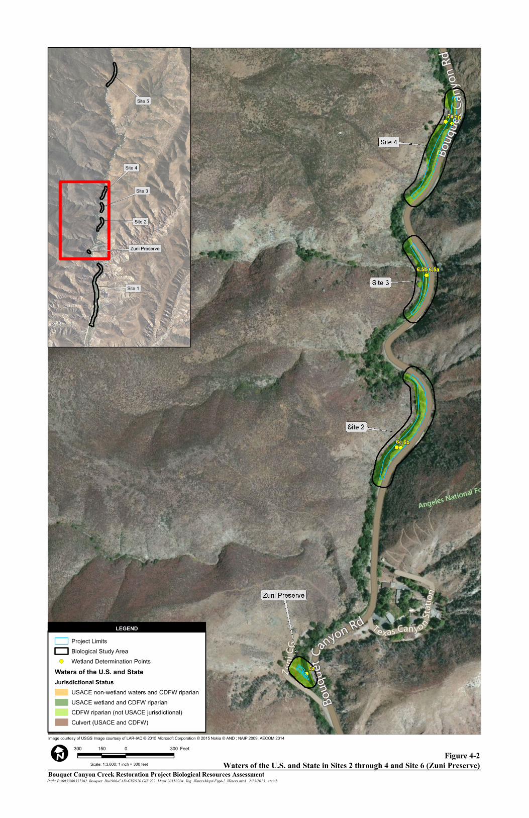
Figure 4-2 Waters of the U.S. and State in Sites 2 through 4 and Site 6 (Zuni Preserve)
Image courtesy of USGS Image courtesy of LAR-IAC © 2015 Microsoft Corporation © 2015 Nokia © AND ; NAIP 2009; AECOM 2014
Bouquet Canyon Creek Restoration Project Biological Resources AssessmentPath: P:\6033\60337362_Bouquet_Bio\900-CAD-GIS\920 GIS\922_Maps\20150204_Veg_WatersMaps\Fig4-2_Waters.mxd, 2/13/2015, steinb
300 0 300150 Feet
I
LEGEND
Scale: 1:3,600; 1 inch = 300 feet
Project LimitsBiological Study Area
!( Wetland Determination PointsWaters of the U.S. and StateJurisdictional Status
USACE non-wetland waters and CDFW riparianUSACE wetland and CDFW riparianCDFW riparian (not USACE jurisdictional)Culvert (USACE and CDFW)
LEGEND
Site 5
Site 4
Site 3
Site 2
Zuni Preserve
Site 1
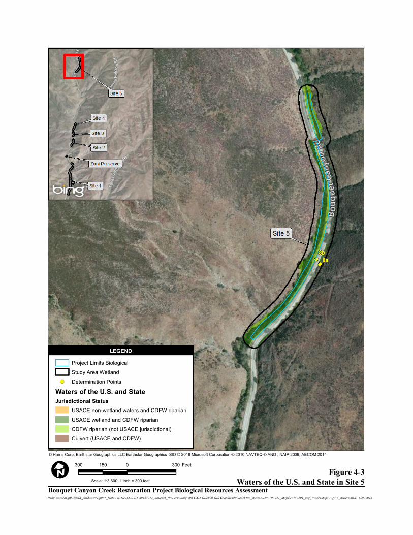
Figure 4-3 Waters of the U.S. and State in Site 5
Image courtesy of USGS Image courtesy of LAR-IAC © 2016 Microsoft Corporation © 2010 NAVTEQ © AND © Harris Corp, Earthstar Geographics LLC Earthstar Geographics SIO © 2016 Microsoft Corporation © 2010 NAVTEQ © AND ; NAIP 2009; AECOM 2014
Path: \\usora1fp002\pdd_prod\usirv1fp001_Data\PROJFILE\2015\60433042_Bouquet_PrePermitting\900-CAD-GIS\920 GIS-Graphics\Bouquet Bio_Waters\920 GIS\922_Maps\20150204_Veg_WatersMaps\Fig4-3_Waters.mxd, 3/25/2016
300 0 300150 Feet
Scale: 1:3,600; 1 inch = 300 feet
Project Limits Biological Study Area Wetland Determination Points
Waters of the U.S. and StateJurisdictional Status
USACE non-wetland waters and CDFW riparianUSACE wetland and CDFW riparianCDFW riparian (not USACE jurisdictional)Culvert (USACE and CDFW)
LEGEND
Bouquet Canyon Creek Restoration Project Biological Resources Assessment
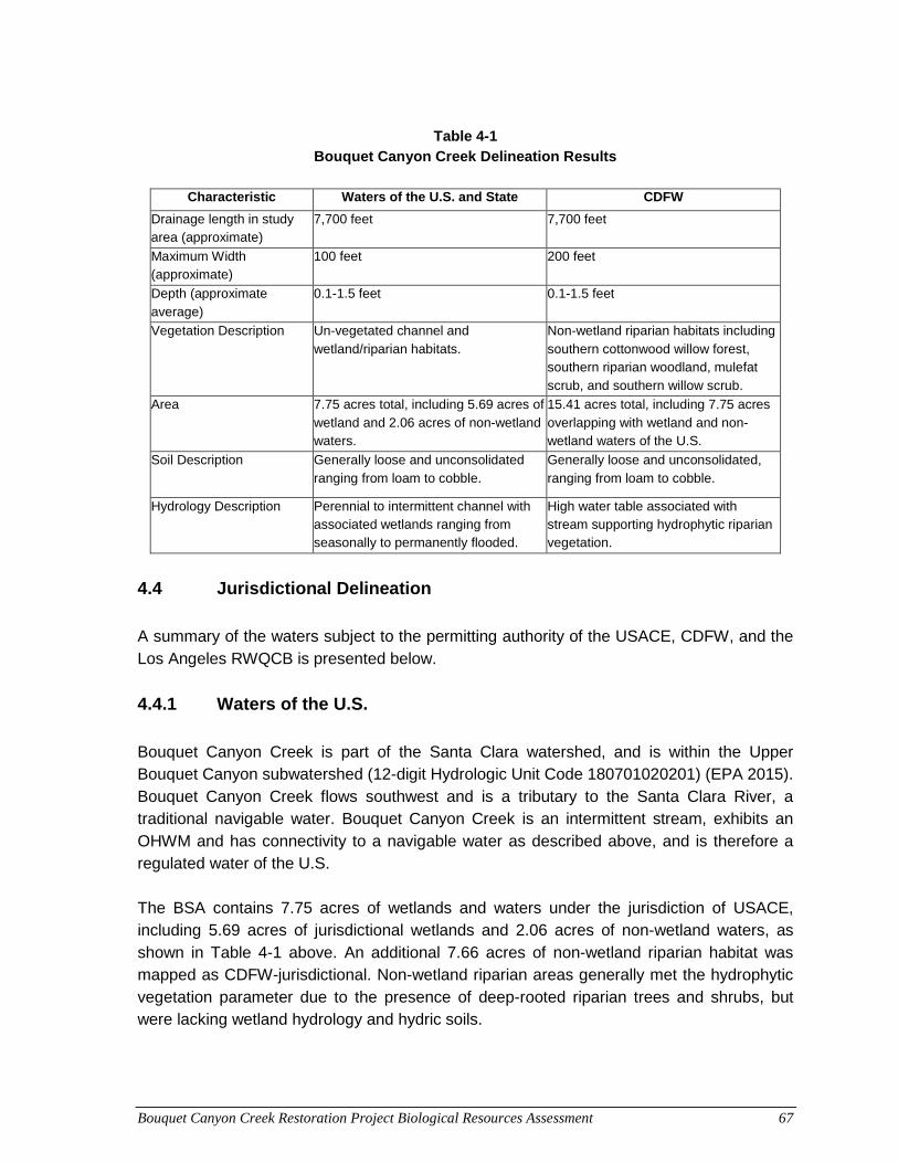
Bouquet Canyon Creek Restoration Project Biological Resources Assessment 67
Table 4-1
Bouquet Canyon Creek Delineation Results
Characteristic Waters of the U.S. and State CDFW
Drainage length in study area (approximate)
7,700 feet 7,700 feet
Maximum Width (approximate)
100 feet 200 feet
Depth (approximate average)
0.1-1.5 feet 0.1-1.5 feet
Vegetation Description Un-vegetated channel and wetland/riparian habitats.
Non-wetland riparian habitats including southern cottonwood willow forest, southern riparian woodland, mulefat scrub, and southern willow scrub.
Area 7.75 acres total, including 5.69 acres of wetland and 2.06 acres of non-wetland waters.
15.41 acres total, including 7.75 acres overlapping with wetland and non-wetland waters of the U.S.
Soil Description Generally loose and unconsolidated ranging from loam to cobble.
Generally loose and unconsolidated, ranging from loam to cobble.
Hydrology Description Perennial to intermittent channel with associated wetlands ranging from seasonally to permanently flooded.
High water table associated with stream supporting hydrophytic riparian vegetation.
4.4 Jurisdictional Delineation A summary of the waters subject to the permitting authority of the USACE, CDFW, and the Los Angeles RWQCB is presented below.
4.4.1 Waters of the U.S. Bouquet Canyon Creek is part of the Santa Clara watershed, and is within the Upper Bouquet Canyon subwatershed (12-digit Hydrologic Unit Code 180701020201) (EPA 2015). Bouquet Canyon Creek flows southwest and is a tributary to the Santa Clara River, a traditional navigable water. Bouquet Canyon Creek is an intermittent stream, exhibits an OHWM and has connectivity to a navigable water as described above, and is therefore a regulated water of the U.S. The BSA contains 7.75 acres of wetlands and waters under the jurisdiction of USACE, including 5.69 acres of jurisdictional wetlands and 2.06 acres of non-wetland waters, as shown in Table 4-1 above. An additional 7.66 acres of non-wetland riparian habitat was mapped as CDFW-jurisdictional. Non-wetland riparian areas generally met the hydrophytic vegetation parameter due to the presence of deep-rooted riparian trees and shrubs, but were lacking wetland hydrology and hydric soils.
Bouquet Canyon Creek Restoration Project Biological Resources Assessment 68
The excavation and/or placement of fill material proposed under the restoration project would require authorization from the USACE. Project activities are anticipated to be eligible for authorization under Nationwide Permit (NWP) 27, which applies to aquatic habitat restoration, establishments, and enhancement activities. Activities authorized by this NWP include, but are not limited to: the removal of accumulated sediments; the installation, removal, and maintenance of small water control structures, dikes, and berms, the enhancement, restoration, or establishment of riffle and pool stream structure; and the installation of structures or fills necessary to establish or re-establish wetland or stream hydrology. This NWP does not authorize stream channelization. Compensatory mitigation is not required for activities authorized by this NWP since these activities must result in net increases in aquatic resource functions and services. Should USACE determine that impacts to waters of the U.S. are significant, resulting in net adverse effects to the environment, they may instruct the permittee (LACDPW) to apply for an individual permit.
4.4.2 Waters of the State The boundaries of waters of the State under the jurisdiction of the Los Angeles RWQCB were congruent with waters of the U.S., due to the absence of any aquatic features (i.e. hydrologically isolated wetlands) that would be under the jurisdiction of one agency but not the other. The Los Angeles RWQCB has responsibility (delegated by the State Water Resources Control Board) for regulating pollutant discharges into waters in the project vicinity. Bouquet Canyon Creek and its associated wetlands are assumed to be under federal jurisdiction; therefore, proposed activities impacting congruent waters of the State would be authorized by the Los Angeles RWQCB by granting a Section 401 Water Quality Certification.
4.4.3 CDFW Bouquet Canyon Creek exhibits a defined bed, bank, and channel and is therefore subject to CDFW’s permitting authority under Section 1600 et seq. of the CFGC. Where channel banks were steep and no riparian vegetation extended beyond the banks, the CDFW jurisdictional boundary was congruent with that of USACE. Where the top of bank extended laterally beyond the OHWM or riparian vegetation was growing beyond the top of bank, the CDFW boundary included a larger area than the USACE boundary. Riparian habitat under CDFW jurisdiction included 7.67 acres, which is in addition to the 7.75 acres of wetlands and streambed that fall under the jurisdiction of both CDFW and USACE, for a total of 15.41 acres under CDFW jurisdiction. Impacts to CDFW jurisdictional streambed and associated riparian habitat would require authorization in the form of a SSA from CDFW. The SSA issued for the project would contain terms and conditions governing the nature of the impacts allowed, and may include restrictions on the locations, methods, or timing of project activities affecting the stream.
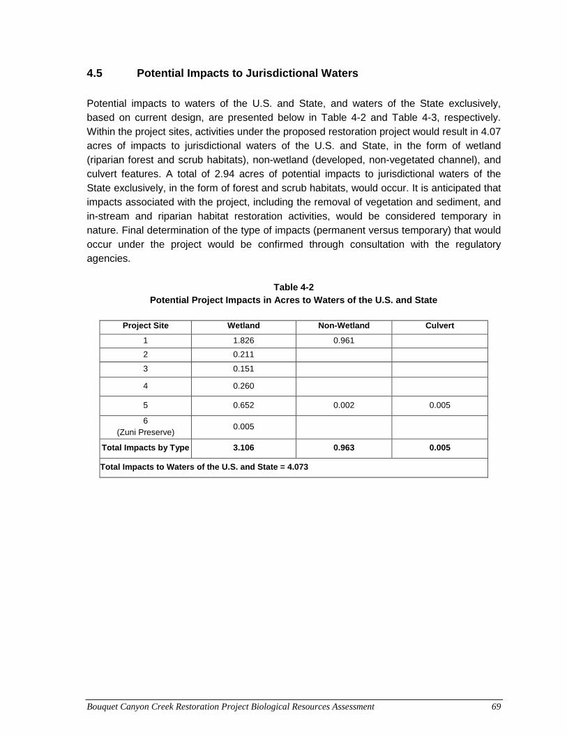
Bouquet Canyon Creek Restoration Project Biological Resources Assessment 69
4.5 Potential Impacts to Jurisdictional Waters Potential impacts to waters of the U.S. and State, and waters of the State exclusively, based on current design, are presented below in Table 4-2 and Table 4-3, respectively. Within the project sites, activities under the proposed restoration project would result in 4.07 acres of impacts to jurisdictional waters of the U.S. and State, in the form of wetland (riparian forest and scrub habitats), non-wetland (developed, non-vegetated channel), and culvert features. A total of 2.94 acres of potential impacts to jurisdictional waters of the State exclusively, in the form of forest and scrub habitats, would occur. It is anticipated that impacts associated with the project, including the removal of vegetation and sediment, and in-stream and riparian habitat restoration activities, would be considered temporary in nature. Final determination of the type of impacts (permanent versus temporary) that would occur under the project would be confirmed through consultation with the regulatory agencies.
Table 4-2
Potential Project Impacts in Acres to Waters of the U.S. and State
Project Site Wetland Non-Wetland Culvert
1 1.826 0.961
2 0.211
3 0.151
4 0.260
5 0.652 0.002 0.005
6 (Zuni Preserve)
0.005
Total Impacts by Type 3.106 0.963 0.005
Total Impacts to Waters of the U.S. and State = 4.073
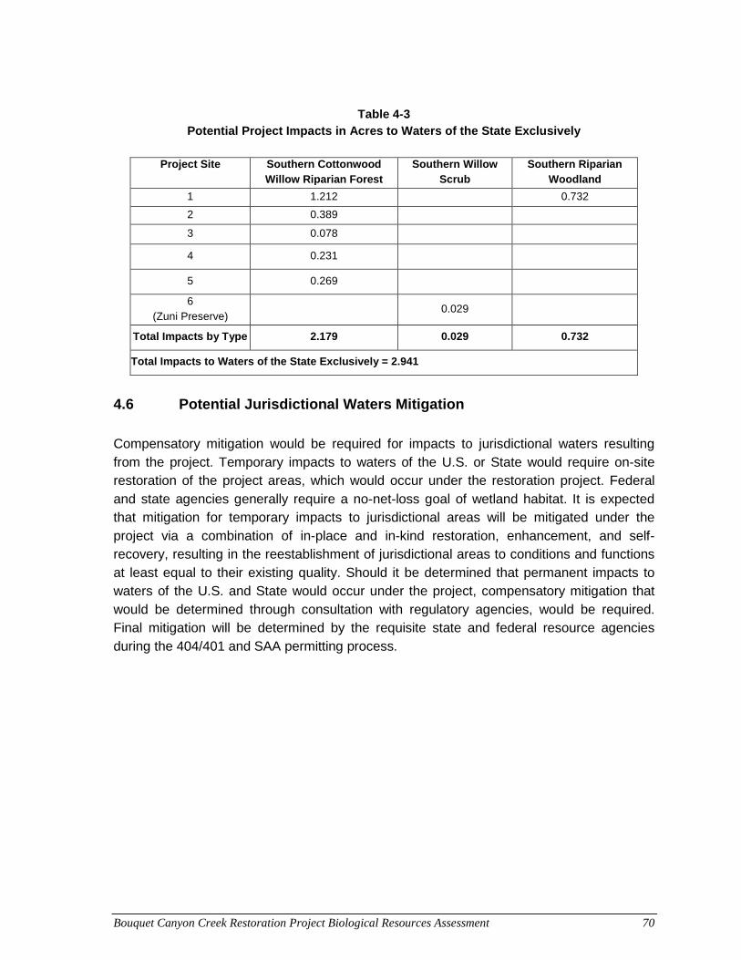
Bouquet Canyon Creek Restoration Project Biological Resources Assessment 70
Table 4-3
Potential Project Impacts in Acres to Waters of the State Exclusively
Project Site Southern Cottonwood Willow Riparian Forest
Southern Willow Scrub
Southern Riparian Woodland
1 1.212 0.732
2 0.389
3 0.078
4 0.231
5 0.269
6 (Zuni Preserve)
0.029
Total Impacts by Type 2.179 0.029 0.732
Total Impacts to Waters of the State Exclusively = 2.941
4.6 Potential Jurisdictional Waters Mitigation Compensatory mitigation would be required for impacts to jurisdictional waters resulting from the project. Temporary impacts to waters of the U.S. or State would require on-site restoration of the project areas, which would occur under the restoration project. Federal and state agencies generally require a no-net-loss goal of wetland habitat. It is expected that mitigation for temporary impacts to jurisdictional areas will be mitigated under the project via a combination of in-place and in-kind restoration, enhancement, and self-recovery, resulting in the reestablishment of jurisdictional areas to conditions and functions at least equal to their existing quality. Should it be determined that permanent impacts to waters of the U.S. and State would occur under the project, compensatory mitigation that would be determined through consultation with regulatory agencies, would be required. Final mitigation will be determined by the requisite state and federal resource agencies during the 404/401 and SAA permitting process.
Bouquet Canyon Creek Restoration Project Biological Resources Assessment 71
5.0 APPLICABLE REGULATIONS As presented in previous sections, several regulations have been established by federal, state, and local agencies to protect and conserve biological resources. The descriptions below provide a brief overview of agency regulations that may be applicable to the resources that occur within the project site, and their respective requirements. The final determination of whether permits are required is made by the regulating agencies.
5.1 Federal Regulations and Standards Federal Endangered Species Act0F
1 Enacted in 1973, FESA provides for the conservation of threatened and endangered species and their ecosystems. The FESA prohibits the “take” of threatened and endangered species except under certain circumstances and only with authorization from USFWS through a permit under Section 4(d), 7 or 10(a) of the FESA. “Take” under the FESA is defined as “to harass, harm, pursue, hunt, shoot, wound, kill, trap, capture, or collect, or to attempt to engage in any such conduct.” Formal consultation with USFWS under Section 7 of the FESA would be required if the project had the potential to affect a federally listed species that has been detected within or adjacent to the project’s components. LACDPW has been in contact with USFWS regarding the project, and would initiate formal consultation; however, it is anticipated that with the absence of UTS in the stream, no federally-listed species would be affected by the project. Migratory Bird Treaty Act1F
2 Congress passed the MBTA in 1918 to prohibit the kill or transport of native migratory birds, or any part, nest, or egg of any such bird unless allowed by another regulation adopted in accordance with the MBTA. The prohibition applies to birds included in the respective international conventions between the U.S. and Great Britain, the U.S. and Mexico, the U.S. and Japan, and the U.S. and Russia. No permit is issued under the MBTA; however, the project would need to employ measures that would avoid or minimize effects on protected migratory birds.
1 U.S.C. Title 16, Chapter 35, Sections 1531-1544. 2 U.S.C. Title 16, Chapter 7, Subchapter II, Sections 703-712.
Bouquet Canyon Creek Restoration Project Biological Resources Assessment 72
Clean Water Act2 F
3 Under Section 404 of the CWA, USACE regulates the discharge of dredged or fill material into jurisdictional waters of the U.S., which include those waters listed in 33 CFR 328.3 (Definitions). Section 401 of the CWA requires a water quality certification from the state for all permits issued by USACE under Section 404 of the CWA. RWQCB is the state agency in charge of issuing a CWA Section 401 water quality certification or waiver. A Section 404 permit from USACE is required for the proposed restoration project. It is anticipated that a NWP 27 permit will be appropriate for the project. Waters falling under jurisdiction of USACE and associated permitting is discussed in Section 4.0, Preliminary Jurisdictional Delineation, of this biological resources assessment. Coordination and Consultation with USFS USFS manages the ANF. Prior to initiating the proposed restoration project in the national forest, LACPW must consult with USFS regarding the project. USFS would authorize LACDPW to proceed with this project under a special use permit, which would be contingent to adherence by LACDPW to all environmental protection measures attached to the permit.
5.2 State Regulations and Standards CFGC The CFGC regulates the taking or possession of birds, mammals, fish, amphibians, and reptiles, as well as natural resources such as wetlands and waters of the State. It includes the CESA (Sections 2050-2115) and SSA regulations (Section 1600 et seq.). Wildlife “take” is defined by CDFW as “to hunt, pursue, catch, capture, or kill, or attempt to hunt, pursue, catch, capture, or kill.” Protection extends to the animals, dead or alive, and all their body parts. Section 2081 of CESA allows CDFW to issue an incidental take permit (ITP) for state-listed threatened or endangered species, should the project have the potential to “take” a state-listed species that has been detected within or adjacent to the project. Certain criteria are required under CESA prior to the issuance of such a permit, including the requirement that impacts of the take are minimized and fully mitigated.
3 U.S.C. Title 33, Chapter 26, Sections 101–607
Bouquet Canyon Creek Restoration Project Biological Resources Assessment 73
An ITP issued by CDFW is anticipated for impacts to UTS and is discussed further in Section 6.0, Impacts on Biological Resources, of this biological resources assessment. Additionally, since project activities are proposed to occur within stream and riparian habitat falling under CDFW jurisdiction, and as presented in Section 4.0, Preliminary Jurisdictional Delineation, of this biological resources assessment, an SSA is anticipated and would be required prior to project initiation. Porter-Cologne Water Quality Control Act Under Section 13000 et seq., of the Porter-Cologne Water Quality Control Act (Porter-Cologne), the RWQCB is the agency that regulates discharges of waste and fill material within any region that could affect a water of the state (Water Code 13260[a]), (including wetlands and isolated waters) as defined by the California Water Code (CWC) Section 13050(e). As presented in Section 4.0, Preliminary Jurisdictional Delineation, of this biological resources assessment, Section 401 certification from the RWQCB is anticipated and would be required prior to project initiation. CEQA3F
4 CEQA requires that biological resources be considered when assessing the environmental impacts resulting from proposed actions. CEQA does not specifically define what constitutes an “adverse effect” on a biological resource. Instead, lead agencies are charged with determining what specifically should be considered an impact. LACDPW anticipates that the proposed restoration project would qualify for an exemption under CEQA, and would coordinate with CDFW to determine if the project would qualify for an exemption.
4 PRC Section 21000 et seq. and the State CEQA Guidelines, California Code of Regulations, Section 15000 et seq.

Bouquet Canyon Creek Restoration Project Biological Resources Assessment 74
This page intentionally left blank.
Bouquet Canyon Creek Restoration Project Biological Resources Assessment 75
6.0 IMPACTS ON BIOLOGICAL RESOURCES Biological resources may be either directly or indirectly impacted by a project. Direct and indirect impacts may be either permanent or temporary in nature. These impact categories are defined below.
• Direct: Any alteration, physical disturbance, or destruction of biological resources that would result from project-related activities is considered a direct impact. Examples include clearing vegetation, encroaching into wetlands or a stream, and the loss of individual species and/or their habitats.
• Indirect: As a result of project-related activities, biological resources may also be affected in a manner that is ancillary to physical impacts. Examples include elevated noise and dust levels, soil compaction, increased human activity, decreased water quality, and the introduction of invasive wildlife (domestic cats and dogs) and plants.
• Permanent: All impacts that result in the long-term or irreversible removal of biological resources are considered permanent. Examples include constructing a building or permanent road on an area containing biological resources.
• Temporary: Any impacts considered to have reversible effects on biological resources can be viewed as temporary. Examples include the generation of fugitive dust during construction; or removing vegetation for the preparation of stream bank stabilization activities, and either allowing the natural vegetation to recolonize or actively revegetating the impact area. Surface disturbance that removes vegetation and disturbs the soil is considered a long-term temporary impact because of slow natural recovery in arid ecosystems.
Anticipated impacts on biological resources due to construction and operation activities are described in this section. Impacts on biological resources during construction include such effects as habitat loss due to vegetation and sediment removal, vehicle strikes by construction crews, and elevated noise and dust levels.
6.1 Vegetation Riparian Vegetation Riparian vegetation is present at the project sites. Implementation of the proposed restoration project could result in both direct and indirect effects on riparian trees, saplings, and shrubs within the project sites. The riparian trees also comprise sensitive natural riparian communities along the stream, including those discussed in Section 3.3, Sensitive Natural Communities, of this biological resources assessment. Project activities would also result in direct and indirect effects to these communities.
Bouquet Canyon Creek Restoration Project Biological Resources Assessment 76
Direct Effects Direct impacts would occur upon removal of riparian vegetation during construction activities. The project would avoid removing large trees to the extent possible; however, riparian vegetation would be removed, which would also result in direct impacts to sensitive natural communities. LACDPW would obtain a permit under Section 404 and 401 of the CWA, and a SSA from CDFW for impacts to riparian trees falling in habitats under federal and state jurisdiction. Temporary impacts to waters of the U.S. or State would require on-site restoration of these areas. Exact compensation/restoration requirements would be negotiated with USACE and CDFW. Federal and state agencies generally require a no-net-loss goal of wetland habitat. It is expected that mitigation for temporary impacts to jurisdictional areas will be mitigated through the restoration project via a combination of in-place and in-kind restoration, enhancement, and self-recovery, resulting in the reestablishment of jurisdictional areas to conditions and functions at least equal to their existing quality. Final mitigation would be determined by the requisite state and federal resource agencies (in concert with applicant negotiations) for impacts to jurisdictional waters. Should it be determined that permanent impacts to waters of the U.S. and State would occur under the project, some form of compensatory mitigation that would be determined through consultation with regulatory agencies would be required. With implementation of the measures and recommendations presented in Section 7.0, Avoidance, Minimization, and Mitigation Measures, of this biological resources assessment, direct effects to riparian habitat would be avoided and minimized to the greatest extent possible. Impacts occurring to these habitats would be appropriately mitigated for through consultation with federal and state agencies during the Section 404/401 and SSA process, reducing direct effects that would occur to less than a significant level. Riparian habitats occurring within the project sites are provided in Table 6-1 below. Large, mature riparian trees (non-oak trees larger than a 12-inch dbh and oak trees larger than a 6-inch dbh) will not be removed by the project; however, other riparian vegetation would be removed within the project sites. Although mapped within the BSA (Site 1), mulefat scrub will not be impacted by the project.
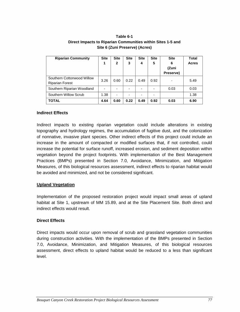
Bouquet Canyon Creek Restoration Project Biological Resources Assessment 77
Table 6-1
Direct Impacts to Riparian Communities within Sites 1-5 and Site 6 (Zuni Preserve) (Acres)
Riparian Community Site
1 Site
2 Site
3 Site
4 Site
5 Site
6 (Zuni
Preserve)
Total Acres
Southern Cottonwood Willow Riparian Forest
3.26 0.60 0.22 0.49 0.92 - 5.49
Southern Riparian Woodland - - - - - 0.03 0.03
Southern Willow Scrub 1.38 - - - - 1.38
TOTAL 4.64 0.60 0.22 0.49 0.92 0.03 6.90
Indirect Effects Indirect impacts to existing riparian vegetation could include alterations in existing topography and hydrology regimes, the accumulation of fugitive dust, and the colonization of nonnative, invasive plant species. Other indirect effects of this project could include an increase in the amount of compacted or modified surfaces that, if not controlled, could increase the potential for surface runoff, increased erosion, and sediment deposition within vegetation beyond the project footprints. With implementation of the Best Management Practices (BMPs) presented in Section 7.0, Avoidance, Minimization, and Mitigation Measures, of this biological resources assessment, indirect effects to riparian habitat would be avoided and minimized, and not be considered significant. Upland Vegetation Implementation of the proposed restoration project would impact small areas of upland habitat at Site 1, upstream of MM 15.89, and at the Site Placement Site. Both direct and indirect effects would result. Direct Effects Direct impacts would occur upon removal of scrub and grassland vegetation communities during construction activities. With the implementation of the BMPs presented in Section 7.0, Avoidance, Minimization, and Mitigation Measures, of this biological resources assessment, direct effects to upland habitat would be reduced to a less than significant level.
Bouquet Canyon Creek Restoration Project Biological Resources Assessment 78
Indirect Effects Indirect effects to upland vegetation would be similar to that described above for riparian vegetation. Upon implementation of the BMPs presented in Section 7.0, Avoidance, Minimization, and Mitigation Measures, of this biological resources assessment, indirect effects to riparian trees and sensitive natural communities would be avoided and minimized, and not be considered significant. Special-Status Plant Species No federal or state-listed plant species have been identified in the BSA; however, six special-status species have moderate potential and nine have low potential to occur in the BSA. Species with moderate potential include California andosace, Nevin’s barberry, slender mariposa lily, Peirson’s morning-glory, Parry’s spineflower, and slender-horned spineflower. Species with low potential include Catalina mariposa-lily, club-haired mariposa lily, Plummer’s mariposa lily, San Fernando Valley spineflower, paniculate tarplant, Palmer’s grapplinghook, Newhall sunflower, short joint beavertail, and Hubby’s phacelia. Bouquet Canyon Creek and its associated riparian habitat provide potentially suitable habitat for these species. An evaluation of potential direct and indirect effects to special-status plant species is provided below. Direct Effects Individual special-status plant species could be damaged or destroyed from crushing or trampling during vegetation and sediment removal activities proposed under the stream restoration project. However, no special-status plant species were observed during the field survey and as a result, no direct effects on special-status plant species are anticipated. Direct effects would further be avoided by implementation of the BMPs presented in Section 7.0, Avoidance, Minimization, and Mitigation Measures, of this biological resources assessment. Indirect Effects Indirect impacts on special-status species could result from construction-related habitat loss and modification of sensitive natural communities, and through the potential spread of noxious and invasive plant species into these communities. However, by implementing and adhering to the BMPs presented in Section 7.0, Avoidance, Minimization, and Mitigation Measures, of this biological resources assessment,, indirect effects to special-status plant species would not be significant.
Bouquet Canyon Creek Restoration Project Biological Resources Assessment 79
6.2 Wildlife Elements of the project could potentially affect wildlife and wildlife habitat, including construction-related noise disturbance and disruption of movement and potential wildlife mortality. Short-term effects of construction on wildlife resources would result from wildlife avoidance of the immediate construction zone. Noise and other disturbances caused by heavy equipment and construction crews may cause wildlife to move away from the construction zone. Vegetation and sediment removal activities could result in the mortality of individual wildlife species. Species with limited mobility or that occupy burrows within the construction zones could be crushed during project activities. Special-Status Wildlife Species One federal and state listed wildlife species, the UTS, and one state Watch List species, southern California rufous-crowned sparrow, have been identified in the BSA. Six special-status species have moderate potential and eight have low potential to occur within the BSA or the immediate vicinity (see Section 3.2, Special-Status Wildlife, of this biological resources assessment). Species with moderate potential include two-striped garter snake, rosy boa, Cooper’s hawk, Bell’s sage sparrow, pallid bat, and hoary bat. Species with low potential include California red-legged frog, silvery legless lizard, coastal western whiptail, coast horned lizard, white-tailed kite, coastal California gnatcatcher, Townsend’s big-eared bat, and spotted bat. No indications of the presence of these species were observed during the site visit. In addition, birds protected under the MBTA and CFGC (including the aforementioned avian species), have the potential to nest on-site or in proximity to the project sites. Fish Although not observed during the field survey, the UTS is known to occur in all project sites, depending on flow conditions. As a CDFW Fully Protected species, “take” of this species is not allowed by CDFW. A detailed discussion of this species is provided in Section 3.2, Special-Status Wildlife, of this biological resources assessment. It was initially anticipated that UTS would be removed from the project sites under a separate species recovery project conducted by USFWS prior to the proposed restoration project. In September 2015, the USFWS Ventura office approved a Categorical Exclusion for proposed efforts to recover UTS in Bouquet Canyon (USFWS 2015), in the reach between Bouquet Reservoir and the southern boundary of the ANF (hereafter referred to as the “UTS recovery project”). The UTS recovery project’s intent would be to remove partially armored threespine stickleback (Gasterosteus aculeatus microcephalus) and hybridized
Bouquet Canyon Creek Restoration Project Biological Resources Assessment 80
threespine stickleback (Gasterosteus aculeatus williamsoni x Gasterosteus aculeatus microcephalus) from Bouquet Canyon Creek in the ANF for the conservation and recovery of the species. An authorized amendment to USFWS Sub Permit to recover the species from Bouquet Canyon Creek would authorize the incidental take of UTS, while removing partially armored UTS and hybridized UTS, and re-introducing UTS to Bouquet Canyon Creek from the Santa Clara River. In order to distinguish UTS from hybridized threespine sticklebacks, a genetic analysis must be conducted. Based on an analysis of stickleback species in Bouquet Canyon Creek by Richmond et al. (2014), USFWS anticipates that few, if any non-hybridized UTS remain in the stream below Bouquet Reservoir. The effort to genetically analyze each individual removed from the stream would therefore not be reasonable, and as a result, all Gasterosteus spp. would be removed to ensure no hybridized strain is returned to the stream to potentially hybridize with reintroduced pure-strain UTS from the Santa Clara. With approval of the Categorical Exclusion, no further documentation in compliance with the National Environmental Protect Act (NEPA) would be prepared. However, in compliance with FESA, USFWS released an Intra-Service Biological Opinion for the project in October 2015 (USFWS 2015) detailing incidental take of UTS during the UTS recovery project implementation. Although unable to secure an agreement to temporary halt releases from Bouquet Reservoir to remove UTS, USFWS initiated efforts to remove Gasterosteus spp. while flows continued. Efforts in December 2015 to remove UTS from a stream reach at MM 13.06 were generally unsuccessful. USFWS biologists conducting the removal effort with backpack electrofishers concluded that fish were able to avoid electrical currents, largely due to significant amounts of aquatic vegetation in the channel inhibiting the effectiveness of the electrofisher to stun fish for removal. UTS removal efforts have since been suspended and would resume during the removal of vegetation under the Bouquet Canyon Creek Restoration Project. As a result, implementation of the Bouquet Canyon Creek Restoration Project would result in incidental take of UTS, since they would have not been removed prior to initiation of this project. To determine an estimate of the number of UTS anticipated to occur within the project site during implementation of the restoration project, UTS data recorded from a survey conducted in 2007 by San Marino Environmental Associates (SMEA) (2008) will be used as a base population within the project sites. The SMEA report indicates that 64 UTS were collected from an 82-foot reach from Bouquet Canyon Creek near the former Zuni Campground, resulting in an estimated population density (PD) of 0.78 UTS/foot. Extrapolating this estimate across the length of the project sites would result in an estimate of the UTS populations present in the project sites. However, considering that surface flow does not reach downstream to Site 1 during summer months (when the project is anticipated to start), only the lengths of Sites 2 through 5 were used to estimate the UTS population (potential take numbers). Site 6 (Zuni Preserve) will be an off-stream site that
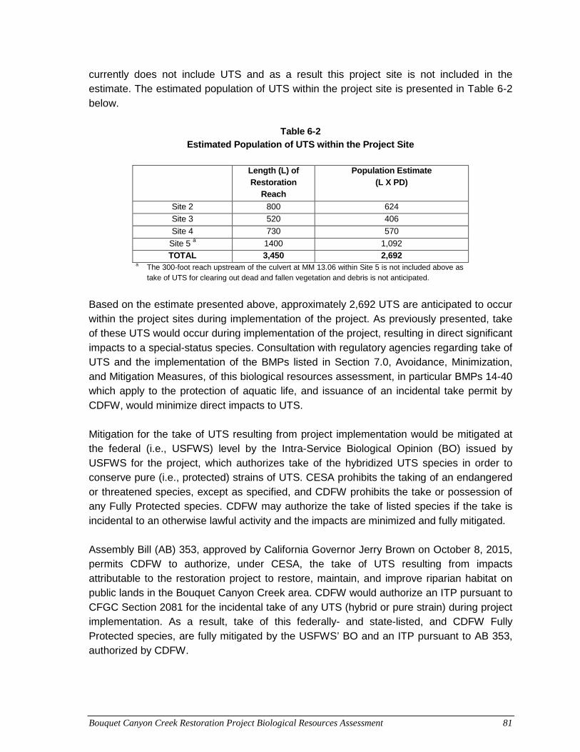
Bouquet Canyon Creek Restoration Project Biological Resources Assessment 81
currently does not include UTS and as a result this project site is not included in the estimate. The estimated population of UTS within the project site is presented in Table 6-2 below.
Table 6-2 Estimated Population of UTS within the Project Site
Length (L) of
Restoration Reach
Population Estimate (L X PD)
Site 2 800 624
Site 3 520 406
Site 4 730 570
Site 5 a 1400 1,092
TOTAL 3,450 2,692 a The 300-foot reach upstream of the culvert at MM 13.06 within Site 5 is not included above as take of UTS for clearing out dead and fallen vegetation and debris is not anticipated.
Based on the estimate presented above, approximately 2,692 UTS are anticipated to occur within the project sites during implementation of the project. As previously presented, take of these UTS would occur during implementation of the project, resulting in direct significant impacts to a special-status species. Consultation with regulatory agencies regarding take of UTS and the implementation of the BMPs listed in Section 7.0, Avoidance, Minimization, and Mitigation Measures, of this biological resources assessment, in particular BMPs 14-40 which apply to the protection of aquatic life, and issuance of an incidental take permit by CDFW, would minimize direct impacts to UTS. Mitigation for the take of UTS resulting from project implementation would be mitigated at the federal (i.e., USFWS) level by the Intra-Service Biological Opinion (BO) issued by USFWS for the project, which authorizes take of the hybridized UTS species in order to conserve pure (i.e., protected) strains of UTS. CESA prohibits the taking of an endangered or threatened species, except as specified, and CDFW prohibits the take or possession of any Fully Protected species. CDFW may authorize the take of listed species if the take is incidental to an otherwise lawful activity and the impacts are minimized and fully mitigated. Assembly Bill (AB) 353, approved by California Governor Jerry Brown on October 8, 2015, permits CDFW to authorize, under CESA, the take of UTS resulting from impacts attributable to the restoration project to restore, maintain, and improve riparian habitat on public lands in the Bouquet Canyon Creek area. CDFW would authorize an ITP pursuant to CFGC Section 2081 for the incidental take of any UTS (hybrid or pure strain) during project implementation. As a result, take of this federally- and state-listed, and CDFW Fully Protected species, are fully mitigated by the USFWS’ BO and an ITP pursuant to AB 353, authorized by CDFW.
Bouquet Canyon Creek Restoration Project Biological Resources Assessment 82
Indirect impacts, such as increased human presence in the area and potential erosion, runoff, and sedimentation into aquatic habitat could occur. Project design features and the implementation of BMPs to avoid and minimize degradation of water quality for both turbidity/sedimentation and contaminant runoff, as listed in Section 7.0, Avoidance, Minimization, and Mitigation Measures, of this biological resources assessment, under BMPs 14-40 would minimize potential indirect impacts. Amphibians and Reptiles Reptile species with moderate potential to occur within the BSA include two-striped garter snake and rosy boa. Amphibian and reptile species with low potential to occur include California red-legged frog, silvery legless lizard, coastal whiptail, and coast horned lizard. Direct Impacts If present within the project sites, direct impacts could occur from proposed vegetation and sediment removal activities. If present within Site 1, direct impacts could occur from vegetation clearing and sediment removal, as well as during construction equipment access to Site 1 from locations other than the culvert located at MM 15.89. Direct impacts to the coastal western whiptail or coast horned lizard are not expected within Sites 2-5 or the Site 6 (Zuni Preserve). By adhering to the BMPs presented in Section 7.0, Avoidance, Minimization, and Mitigation Measures, of this biological resources assessment, direct impacts to these species are not anticipated. Indirect Effects If present within the project sites, indirect impacts to these special-status reptiles and amphibian are not anticipated. Nesting Birds Birds protected by the MBTA and CFGC have the potential to nest on-site and within proximity. Detailed discussion of special-status birds with potential to nest within the BSA or vicinity is provided in Section 3.2, Special-Status Wildlife, of this biological resources assessment. Vegetative cover is moderate to dense within the project sites. Implementation of the project could result in both direct and indirect effects on nesting birds. Direct Effects The project has been designed to avoid the removal of large oak and non-oak trees; however, direct impacts to nesting birds could occur upon removal of other vegetation during construction activities. Section 7.0, Avoidance, Minimization, and Mitigation
Bouquet Canyon Creek Restoration Project Biological Resources Assessment 83
Measures, of this biological resources assessment, outlines BMPs that would substantially reduce direct effects on nesting birds potentially occurring within the project site and its vicinity, and as a result, the project’s effects on nesting birds or their associated habitat are not considered significant. Indirect Effects Indirect impacts to nesting birds within the vicinity of the project sites could occur as a result of noise, increased human presence, and vibrations resulting from construction activities. Disturbances related to construction could result in increased nestling mortality due to nest abandonment or decreased feeding frequency. By adhering to BMPs presented in Section 7.0, Avoidance, Minimization, and Mitigation Measures, of this biological resources assessment, indirect impacts to nesting birds are not anticipated. Special-Status Bats The potential for bats to roost within the vicinity of the project sites is considered moderate for pallid and hoary bats, and low for Townsend’s big-eared and spotted bats, dependent on species requirements and given the presence of trees and rock formations. Structures and caves are absent from the project sites; therefore, it is unlikely that colonial roost sites are present. Bouquet Canyon Creek provides foraging opportunities. Implementation of the project could result in both direct and indirect effects to special-status bat species. Direct Effects The project has been designed to avoid the removal of large oak and non-oak trees. Such trees would provide the most likely roosting habitat for tree-roosting bats. Although large mature trees will not be removed during project implementation, some trees will be removed, resulting in potential direct impacts to special-status bats and their habitat. No roosting habitat is present within the BSA for species which might roost in rocky outcrops, crevices, large cavities, and small cave-like openings. By adhering to BMPs and mitigation measure BIO-1 presented in Section 7.0, Avoidance, Minimization, and Mitigation Measures, of this biological resources assessment, direct impacts to bats are not anticipated. Indirect Effects Indirect impacts to special-status bats roosting within the vicinity of the project sites could occur as a result of noise, increased human presence, and vibrations resulting from construction activities. Disturbances related to construction could result in displacement from daytime roosts. Disruption of night-time roosts is not anticipated as construction will not occur during dusk or evening hours. Additionally, by adhering to BMPs and mitigation
Bouquet Canyon Creek Restoration Project Biological Resources Assessment 84
measure BIO-1 presented in Section 7.0, Avoidance, Minimization, and Mitigation Measures, of this biological resources assessment, indirect impacts to bats are not anticipated.
6.3 Wildlife Movement Corridor
Within ANF, stream and riparian habitats likely serve as wildlife movement corridors for a variety of stream and riparian species, including fish, birds, and bats. The riparian corridor along Bouquet Canyon Creek, in particular at Sites 2-5 and Site 6 (Zuni Preserve) are relatively intact and include a variety of plant and habitat layers (i.e., mature trees, shrubs, and herbaceous vegetation) that facilitate bird movement along the stream. Vegetation removal would result in direct and indirect effects to Bouquet Canyon Creek’s function as a wildlife movement corridor. Direct Effects The project sites represent a small area of the overall riparian corridor along the stream, and restoration activities proposed under the project would be temporary in nature. Upon completion, the project would restore stream and riparian habitats and associated functions. As a result, direct impacts to a wildlife movement corridor would be temporary in nature, and functions of the corridor to facilitate wildlife movement would be restored upon project completion and regrowth of riparian vegetation in restored areas. Implementation of the BMPs and mitigation measures presented in Section 7.0, Avoidance, Minimization, and Mitigation Measures, of this biological resources assessment, would reduce direct effects to wildlife movement. Indirect Effects Project construction activities (i.e., increased dust and noise) would likely result in riparian bird species avoiding the immediate vicinity of the project sites. However, indirect effects of construction on wildlife movement corridors would be temporary in nature, restricted to the project construction time period. Project construction activities would not occur at dusk or overnight, and are therefore not expected to indirectly affect special-status bat species. The stream/riparian corridor’s function and value as a wildlife movement corridor would be unchanged from current conditions upon project completion. Implementation of the BMPs and mitigation measures presented in Section 7.0, Avoidance, Minimization, and Mitigation Measures, of this biological resources assessment, would reduce indirect effects to wildlife movement.
.
Bouquet Canyon Creek Restoration Project Biological Resources Assessment 85
7.0 AVOIDANCE, MINIMIZATION, AND MITIGATION MEASURES These measures are based on project design, background research, and the field studies. If conditions within the project change or further information about biological resources are generated, additional BMPs, studies, and surveys may become necessary.
7.1 BMPs The project would incorporate the most effective and appropriate combination of resource avoidance and monitoring to be employed during construction and operation, including implementation of the following BMPs, as applicable. The following BMP would be implemented as general housekeeping measures to avoid and minimize impacts to biological resources.
1. The project shall minimize new disturbance, erosion on manufactured slopes, and off-site degradation from accelerated sedimentation.
2. Potential hydrologic impacts shall be minimized through the use of BMPs, such as water bars, silt fences, staked straw bales, and mulching and seeding of disturbed areas as appropriate. These measures shall be implemented to minimize ponding, eliminate flood hazards, and avoid erosion and siltation into any creeks, streams, or other bodies of water.
3. Prior to conducting construction activities, the boundaries of approved work limits shall be delineated with clearly visible flagging to prevent impacts beyond those authorized.
4. Construction activities shall be conducted in such a manner to minimize acreage of vegetation removal. The project includes erosion-control BMPs to minimize soil influx into Bouquet Canyon Creek during construction.
5. Where erosion control is necessary, the use of coconut coir matting or tackified hydroseeding compounds is preferred, instead of plastic monofilament netting, to avoid wildlife entanglement or entrapment.
6. “Fueling zones” shall be designated prior to conducting construction activities and shall be located at least 50 feet from all drainage features/wetlands and shall be flagged by a biologist.
The following BMP would be implemented to avoid and minimize impacts to general wildlife species.
Bouquet Canyon Creek Restoration Project Biological Resources Assessment 86
7. During site clearing, unnecessary damage to ground burrows, holes, and tunnels,
which provide shelter for many small animals (snakes, lizards, toads, rodents, and squirrels), shall be avoided.
8. No wildlife, including rattlesnakes, shall be harmed except to prevent serious injury or death.
9. In order to avoid unnecessary impacts, should any non-listed species be found within the property, a qualified biologist shall relocate them outside of the project sites or they shall be avoided and allowed to leave the project sites of their own volition.
10. Construction workers shall be prohibited from bringing domestic pets to the construction site to ensure they would not affect wildlife through harassment or predation in adjacent natural habitats.
11. A biological monitor shall be onsite during clearing/grubbing and excavation activities.
The following BMP would be implemented to avoid and minimize impacts to bird species protected under the Migratory Bird Treaty Act (MBTA) and CFGC.
12. All vegetation clearing should occur outside of the nesting season, generally
considered by CDFW to occur February 1 through September 1. If avoiding the nesting season is not practicable, then the following additional measures shall be employed:
o A pre-construction nesting survey shall be conducted by a qualified biologist within 3 days prior to the start of construction activities to determine whether active nests are present within 500 feet of proposed work.
o If construction activities must occur within 300 feet of an active nest of any passerine bird or within 500 feet of an active nest of any raptor, with the exception of an emergency, then a qualified biologist would monitor the nest to determine if construction activities can occur without disturbing nesting behaviors and activities. If the qualified biologist determines that construction activities within the avoidance zone is not feasible without disturbance to nesting, all work would cease within the avoidance buffer zone until the biologist determines that the adults and young are no longer reliant on the nest site.
Fisheries Protection – The following measures shall be used to assure protection of UTS and their habitat:
Bouquet Canyon Creek Restoration Project Biological Resources Assessment 87
13. A qualified fisheries biologist shall survey proposed works area to verify the presence/absence of the UTS. The results of these surveys shall be provided to CDFW, along with copies of all field notes, prior to the initiation of work. CDFW-approved survey techniques and exclusion plan shall be conducted, as provided in the following conditions. Any variations from these techniques shall be approved by CDFW, in writing. The qualified fishery biologist shall have the required state and federal permits.
14. An “exclusion plan” shall be submitted to CDFW for review and approval. If found to be adequate to prevent “take” of UTS, it shall be implemented.
15. The exclusion of UTS from work areas within the Bouquet Canyon Creek shall including the following:
o A survey shall be conducted immediately before the prescribed work is to be carried out. Nets used for surveys shall be 1/8-inch maximum mesh. The entire area of impact would be seined. Fish would be removed from the large pool downstream of the culverts using minnow traps as depth and soft substrate may preclude seining.
o Any fishes found, would be moved out of the area and held until they are relocated. Removal efforts would continue until seine hauls fail to capture fish. If necessary, fishes would be held in insulated coolers with aerators to assure their survival.
o Prior to the removal survey, blocking nets, similar to those used in the survey, shall be placed upstream and downstream of the impact area to insure that no fish swim into the impact area which would be cleared of fish to the extent practical. If necessary, a 1/4-inch mesh net would be installed just upstream of the upstream blocking net to capture debris that might threaten the integrity of the upstream blocking net.
o If a stream diversion is intended in the work area, qualified biologists would patrol all impacted reaches of the creek to rescue any fishes stranded by diversion of the stream water.
o When all work is completed, the blocking nets would be removed when turbidity in the work area has returned to within 10 percent of baseline levels (as measured during the removal survey).
o A report of all activities and findings shall be submitted to CDFW.
16. Should the blocking nets be compromised by high flows, construction activity or vandalism, qualified fisheries biologist should be immediately contacted so that the blocking nets can be re-established and fish removed from the area of impact.
17. Fish distribution should be monitored in any cleared stream reach 1 hour, 24 hours and 48 hours after blocking net removal to document recolonization.
Bouquet Canyon Creek Restoration Project Biological Resources Assessment 88
18. The project applicant shall ensure that the project site is revegetated in a manner
suitable for UTS. Planting plans, including planting palette, shall be reviewed by USFWS and/or CDFW prior to implementation of restoration activities.
19. Channels modified by the project shall be designed and reconfigured to maximize stickleback habitat.
20. A fisheries biologist should monitor all work where flowing water may be potentially impacted.
21. Where the creek flows close to the current road alignment, silt fencing should be installed to prevent sediment-laden runoff from entering the flowing water.
22. When any artificial obstruction is being constructed, maintained, or placed in operation, sufficient water shall at all times be allowed to pass downstream to maintain aquatic life below the obstruction pursuant to Fish and Game Code section 5937. No permanent barrier that obstructs fish passage would be incorporated.
23. If flowing or ponded water occurs within the proposed work limits, the construction crew shall notify the CDFW fishery biologist prior to commencing activities within the bed, bank, and channel. The construction crew shall leave his/her name, date and time called, telephone number, the stream name, work location, nature of planned activities and proposed schedule.
24. All fish mortalities should immediately be reported to the CDFW fishery biologist.
25. No bark; slash; sawdust; rubbish; construction waste; cement or concrete or washings thereof; asphalt; paint; oil or other petroleum products; or any other substances that could be hazardous to aquatic life, other organic or earthen material from any logging, construction, or other associated project-related activity shall be allowed to contaminate the soil and/or enter into or be placed where it may be washed by rainfall or runoff into waters of the state. Any of these materials placed within or where they may enter a stream or lake by the construction contractor or any party working under contract or with the permission of LACDPW shall be removed immediately. When construction is complete, any excess materials or debris shall be removed from the work area. No rubbish shall be deposited within 150 feet of the high water mark of any stream or lake.
26. The construction crew shall comply with all litter and pollution laws. All contractors, subcontractors, and employees shall also obey these laws, and it shall be the responsibility of the operator to ensure compliance.
Bouquet Canyon Creek Restoration Project Biological Resources Assessment 89
27. Any equipment or vehicles driven and/or operated within or adjacent to the stream
shall be checked and maintained daily to prevent leaks of materials that, if introduced to water, could be deleterious to aquatic life.
28. Stationary equipment such as motors, pumps, generators, and welders located within or adjacent to the stream shall be positioned over drip pans. Stationary heavy equipment shall have suitable containment to handle a catastrophic spill/leak. Clean-up equipment such as extra boom, absorbent pads, and skimmers shall be on-site prior to the start of construction.
29. No equipment maintenance and refueling shall be done within or near any stream channel where petroleum products or other pollutants from the equipment may enter these areas under any flow.
30. The clean-up of all spills shall begin immediately. CDFW shall be notified immediately of any spills and shall be consulted regarding clean-up procedures.
31. Preparation shall be made so that runoff from steep, erodible surfaces shall be diverted into stable areas with little erosion potential. Frequent water checks shall be placed on dirt roads, cat tracks, or other work trails to control erosion.
32. Water containing mud, silt, or other pollutants from equipment washing or other activities shall not be allowed to enter the creek or placed in locations that may be subjected to high storm flows.
33. The construction contractor shall only work when no rain is predicted within a 24-hour period. If work in the flowing stream is unavoidable, the entire stream flow shall be diverted around the work area by a barrier, temporary culvert, new channel, or other means approved by USFWS/CDFW. Location of the upstream and downstream diversion points shall be approved prior to diversion. Construction of the barrier and/or the new channel shall normally begin in the downstream area and continue in an upstream direction, and the flow shall be diverted only when construction of the diversion is completed. Channel bank or barrier construction shall be adequate to prevent seepage into or from the work area. Diversion berms shall be constructed of onsite alluvium of low silt content, inflatable dams, sand bags, or other approved materials. Channel banks or barriers shall not be made of earth or other substances subject to erosion unless first enclosed by sheet piling, rock rip-rap, or other protective material. The enclosure and the supportive material shall be removed when the work is completed and removal shall normally proceed from downstream
Bouquet Canyon Creek Restoration Project Biological Resources Assessment 90
in an upstream direction. LACDPW shall obtain all written approvals from the CDFW prior to initiation of construction activities.
34. Flow diversions shall be done in a manner that shall prevent pollution and/or siltation and which shall provide flows to downstream reaches.
35. Silty/turbid water from dewatering or other activities shall not be discharged into the stream. Such water shall be settled, filtered, or otherwise treated prior to discharge. LACDPW’s ability to minimize turbidity/siltation shall be the subject of pre-construction planning and future implementation.
36. The construction contractor shall place a sediment curtain(s) in or immediately downstream of the project site or create a sediment trap within the streambed to trap discharged sediment if flow is present in the stream. A suction dredge shall be used to remove accumulated sediments from the sediment trap. Sediment shall be trucked and disposed of properly.
37. When re-watering the newly constructed stream, the stream shall not have an increase in turbidity greater than 10 percent above “current” baseline conditions. The current baseline conditions shall be determined during preconstruction surveys. An initial elevated turbidity would exist, but within 72 hours turbidity levels shall meet the baseline or additional measures shall be incorporated to reduce turbidity to downstream resources.
The following are examples of additional BMPs that could be used during project construction, as applicable (LACDPW 2005):
• Temporary soil stabilization controls such as: o Scheduling management o Preservation of existing vegetation o Hydraulic mulch o Hydroseeding o Soil binders o Straw mulch o Geotextiles, plastic covers, and erosion control blankets/mats o Wood mulching o Earth dikes/drainage swales and ditches o Outlet protection/velocity dissipation devices o Slope drains o Streambank stabilization
• Temporary sediment controls such as:
Bouquet Canyon Creek Restoration Project Biological Resources Assessment 91
o Silt fence o Sediment/desilting basin o Sediment trap o Fiber rolls o Street sweeping and vacuuming o Gravel bag berm o Sandbag barrier o Straw bale barrier o Storm drain protection o Wind erosion control
• Tracking controls such as: o Stabilized construction entrance/exit o Stabilized construction roadway o Entrance/outlet tire wash
• Non-Storm-Water management controls for: o Dewatering operations o Paving and grinding operations o Vehicle equipment cleaning o Vehicle equipment fueling o Vehicle equipment maintenance o Concrete curing o Structure demolition over or adjacent to water
• Waste management and material pollution controls such as: o Material delivery o Material use o Stockpile management o Spill prevention and control o Solid waste management o Hazardous waste management o Contaminated soil management o Concrete waste management o Sanitary/septic waste management o Liquid waste management
The project would also conform to the following LACDPW requirements:
• Sediments shall not be discharged to a storm drain system or receiving waters.
• Sediments generated shall be contained within the project site using appropriate BMPs.
Bouquet Canyon Creek Restoration Project Biological Resources Assessment 92
• No construction-related materials, waste, spills, or residue shall be discharged from the project site to streets, drainage facilities, receiving waters, or adjacent property by wind or runoff.
• Non-storm-water runoff from equipment, vehicle washing, or any other activity shall be contained within the project site using appropriate BMPs.
• Erosion from exposed topsoil slopes and channels shall be prevented.
• Grading during the wet season shall be minimized. All erosion-susceptible slopes shall be covered, planted, or protected in any way that prevents sediment discharge from the project site.
• If the project may be active during the rainy season (October 1 to April 15), the contractor shall prepare an accumulated precipitation procedure (APP) for review and approval by the County engineering department before any discharge from the project. The APP shall describe the location of proposed discharges, the BMPs to prevent pollution, and the actual equipment to be used. The APP shall be prepared and submitted in accordance with the LACDPW Construction Site BMPs Manual (BMP Manual) and the SWPPP Preparation Manual.
7.2 Mitigation Measures – Special-Status Species The following mitigation measure should be implemented to avoid and minimize impacts to sensitive bat species: BIO-1 Prior to the start of construction, a survey for roosting bats or maternity roosts shall
be performed by a qualified biologist at the appropriate time of day to maximize detectability, within seven (7) days of the start of construction for all proposed work areas adjacent to appropriate roosting habitat. The survey shall include areas within 250 feet of the project site that contain suitable roosting habitat. Where physical access to the entire project site is unavailable, alternate, appropriate survey techniques should be used to compensate for limited physical access.
If an active roost is found, or survey data provides evidence of an active roost, within 100 feet of a work area, or if a maternity roost is found, or survey data provides evidence of a maternity roost, within 250 feet of a work area, the limits of the work area will be clearly marked and a qualified biologist shall remain on-site during construction activities within the vicinity of the roost or maternity roost. The biologist will ensure that construction activities do not encroach upon the 100-foot buffer around an active roost or 250-foot buffer around a maternity colony site.
7.3 Mitigation Measures – Jurisdictional Waters BIO-2: The following measures shall be implemented to mitigate impacts to riparian habitat and other aquatic resources.
Bouquet Canyon Creek Restoration Project Biological Resources Assessment 93
1. Prior to project construction, LACDPW shall coordinate with the USACE to obtain authorization pursuant to Section 404 of the CWA and the RWQCB to obtain a Water Quality Certification (WQC) pursuant to Section 401 of the CWA. Additionally, LACDPW shall obtain a Lake or Streambed Alteration Agreement (LSAA) from the CDFW pursuant to Section 1600 et seq. of CFGC.
2. The Project Applicant shall implement a project-specific Habitat Mitigation and Monitoring Plan (HMMP) as required by the permit authorizations. The HMMP shall be prepared and approved by the applicable agencies before the commencement of construction. The HMMP shall be prepared and implemented consistent with applicable requirements set for in any applicable regulatory permits (e.g., USACE 2015 Regional Mitigation Guidelines, and the USACE and USEPA 2008 Mitigation Rule). In addition, the HMMP would include the following topics: responsible parties for implementing the HMMP; the timeframe for implementation; methodology for site preparation and planting; procedures for soil and plant salvage (as applicable); the proposed native plant palette, using plant stock of local origin; methods for monitoring and maintaining the site for five years; performance standards used for judging implementation success; remedial measures that would be implemented (should restoration performance standards not be met); and specifies (through either a qualitative or quantitative assessment method) how the functions and values of all the wetland/riparian habitat would be/have been replaced.

Bouquet Canyon Creek Restoration Project Biological Resources Assessment 94
This page intentionally left blank.
Bouquet Canyon Creek Restoration Project Biological Resources Assessment 95
8.0 CONCLUSIONS Based on the analysis presented above regarding anticipated effects of the project, the following determinations have been made for special-status species that have been detected or have at least a moderate potential to occur within the BSA, and for aquatic and riparian habitats under federal and/or state jurisdiction. Effects on Special-Status Plants
The project would not significantly affect Nevin’s barberry, slender mariposa-lily, Pierson’s morning glory, Parry’s spineflower, and slender-horned spineflower.
• No individuals of these species were found during the general survey conducted in 2014/2015, nor are any of the known locations of these species within the BSA. Potential habitat for these species in the project sites is limited and of moderate or marginal quality.
• Due to the BMPs presented in Section 7.0, Avoidance, Minimization, and Mitigation Measures, of this biological resources assessment, effects to potential habitat for special-status wildlife species that occurs within and adjacent to the project sites would be not be significantly affected.
Effects on Special-Status Wildlife
The project would not significantly affect UTS, southern California rufous-crowned sparrow, two-striped garter snake, rosy boa, Cooper’s hawk, Bell’s sage sparrow, pallid bat, and hoary bat.
• UTS is currently common in the BSA; however, upon implementation of the BMPs presented in Section 7.0, Avoidance, Minimization, and Mitigation Measures, of this biological resources assessment, and issuance of an ITP by CDFW, as described in Section 6.2, Wildlife, of this biological resources assessment, effects on this species would be mitigated to a level less than significant.
• Southern California rufous-crowned sparrow was detected during the general survey conducted in 2014/2105. Implementation of the BMPs presented in Section 7.0, Avoidance, Minimization, and Mitigation Measures, of this biological resources assessment, would ensure that affects to this species would be less than significant.
• No individuals of two-striped garter snake, rosy boa, Cooper’s hawk, Bell’s sage sparrow, pallid bat, or hoary bat were detected during the general survey conducted in 2014/2015, nor are any of the known locations of these species within the BSA. Potential habitat for these species in the project site is limited and of moderate or marginal quality.
Bouquet Canyon Creek Restoration Project Biological Resources Assessment 96
• Due to the BMPs presented in Section 7.0, Avoidance, Minimization, and Mitigation Measures, of this biological resources assessment, effects to potential habitat for special-status wildlife species that occurs within and adjacent to the project sites would be not be significantly affected.
Effects on Jurisdictional Waters
Unavoidable impacts to waters of the U.S. and State would be mitigated upon implementation of mitigation measure BIO-2. Under this mitigation measure, LACDPW will coordinate with the USACE to obtain authorization pursuant to Section 404 of the CWA and the RWQCB to obtain a WQC pursuant to Section 401 of the CWA. Additionally, LACDPW will obtain a LSAA from the CDFW pursuant to Section 1600 et seq. of CFGC. It is anticipated that implementation of a project-specific HMMP, as required by the permit authorizations, would mitigate impacts to jurisdictional waters to a level less than significant.
Bouquet Canyon Creek Restoration Project Biological Resources Assessment 97
9.0 REFERENCES Asay, C.E.
1987 Habitat and Productivity of Cooper’s Hawks Nesting in California. California Fish and Game. 73:80.
Benes, E.S. 1969 Behavioral Evidence of Color Discrimination by the Whiptail Lizard,
Cnemidophorus Copeia. 1969: 717-722. California Department of Fish and Game (CDFG) 2000 Habitat Conservation Planning Branch: California’s Plants and Animals. The
Status of Rare, Threatened, and Endangered Animals and Plants of California.
1994 Environmental Services Division. A Field Guide to Lake and Streambed
Alteration Agreements Sections 1600-1607, California Fish and Game Code. Sacramento, California. January.
California Department of Fish and Wildlife (CDFW) 2016a California Natural Diversity Data Base (CNDDB). Full condensed report for
the Green Valley, Mint Canyon, Newhall, Warm Springs Mountain, Burnt Peak, Lake Hughes, Del Sur, Sleepy Valley, and Agua Dulce USGS Quadrangles. Generated March 17, 2016.
2016b State and Federally Listed Endangered, Threatened, and Rare Plants of
California. Biogeographic Data Branch. California Natural Diversity Database (CNDDB). January.
2016c Special Vascular Plants, Bryophytes, and Lichens List. California Natural
Diversity Database (CNDDB). January. 2016d State and Federally Listed Endangered and Threatened Animals of
California. Biogeographic Data Branch. California Natural Diversity Database. January.
2016e Special Animals. California Natural Diversity Database (CNDDB). January. 2014 CNDDB. Full condensed report for the Green Valley, Mint Canyon,
Newhall, Warm Springs Mountain, Burnt Peak, Lake Hughes, Del Sur, Sleepy Valley, and Agua Dulce USGS Quadrangles. Generated December 2014.
Bouquet Canyon Creek Restoration Project Biological Resources Assessment 98
2010 List of California Terrestrial Natural Communities Recognized by the Natural
Diversity Data Base. Natural Heritage Division. The Resources Agency. September. Available at http://www.dfg.ca.gov/biogeodata/vegcamp/pdfs/natcomlist.pdf. Accessed January 2015.
Californiaherps.com (Californiaherps) 2015 Southern California Legless Lizard – Anniella stebbinsi. Available at
http://www.californiaherps.com/lizards/pages/a.stebbinsi.html. Accessed February 2015.
California Native Plant Society (CNPS) 2014 Rare Plant Program. Inventory of Rare and Endangered Plants (online
edition, v8-02). California Native Plant Society. Sacramento, CA. Available at http://www.cnps.org/inventory. Accessed December 2014.
2016 Rare Plant Program. Inventory of Rare and Endangered Plants (online
edition, v8-02). California Native Plant Society. Sacramento, CA. Available at http://www.rareplants.cnps.org. Accessed March 17 2016.
Center for Plant Conservation (CPC)
2010 CPC National Collection Plant Profile. Berberis nevinii. Available at http://www.centerforplantconservation.org/collection/CPC_ViewProfile.asp?C PCNum=2777. Accessed January 2015.
Chiang, S. N., P. H. Bloom, A. M. Bartuszevige, and S. E. Thomas.
2012. Home range and habitat use of Cooper’s Hawks in urban and natural areas. Online (www.ucpress.edu/go/sab) in C. A. Lepczyk and P. S. Warren (editors). Urban bird ecology and conservation. Studies in Avian Biology (no. 45), University of California Press, Berkeley, CA
Collins, Paul W.
1999. Rufous-crowned Sparrow (Aimophila ruficeps), The Birds of North America Online (A. Poole, Ed.). Ithaca: Cornell Lab of Ornithology; Retrieved from the Birds of North America Online: http://bna.birds.cornell.edu/bna/species/472.
Dale, N. 2000 Flowering Plants. The Santa Monica Mountains, Coastal & Chaparral
Regions of Southern California. California Native Plant Society. Sacramento, CA. 240 pp.
Bouquet Canyon Creek Restoration Project Biological Resources Assessment 99
Environmental Laboratory (EL) 1987 USACE Wetlands Delineation Manual. Technical Report Y-87-1.
U.S. Army Engineer Waterways Experiment Station. Vicksburg, Mississippi. Environmental Protection Agency (EPA) 2015 My Waters Mapper. Accessed at http://watersgeo.epa.gov/mwm/ on 01/09/15.
Accessed January 2015. Harris, J.
2000 Life History Account for Townsend’s Big-eared Bat. California Wildlife Habitat Relationships (CWHR) System. California Department of Fish and Game and California Interagency Wildlife Task Group.
Hickman, J.C. 1993 The Polygonaceae. In: The Jepson Manual. J.C. Hickman (ed.). University of
California Press, Berkeley, Los Angeles, London. Holland, R. 1986 Preliminary Descriptions of the Terrestrial Natural Communities of
California. California Department of Fish and Game, The Resources Agency. 156 pp.
Lichvar, R.W. and S.M. McColley (Lichvar and McColley) 2008 A Field Guide to the Identification of the Ordinary High Water Mark (OHWM)
in the Arid West Region of the Western United States: A Delineation Manual. ERDC/CRREL Technical Report 08-12.
Martin, John W. and Barbara A. Carlson.
1998. Sage Sparrow (Amphispiza belli), The Birds of North America Online (A. Poole, Ed.). Ithaca: Cornell Lab of Ornithology; Retrieved from the Birds of North America Online: http://bna.birds.cornell.edu/bna/species/326.
Pyle, P. 1997 Identification guide to North American Birds, part 1. Slate Creek Press,
Bolinas, CA Rathburn, G.B., M.R. Jennings, T.G. Murphey, and N.R. Siepel
1993 Status and ecology of sensitive aquatic vertebrates in lower San Simeon and Pico Creeks, San Luis Obisbo County, California. Unpublished report, National Ecology Reserarch Center, Piedras Blancas Research Station, San Simeon, California, under Cooperative Agreement (14-16-0009-91-1909).
Bouquet Canyon Creek Restoration Project Biological Resources Assessment 100
Remsen, H.V. 1978 Bird Species of Special Concern in California: an Annotated List of
Declining or Vulnerable Bird Species. California Department of Fish and Game, The Resources Agency.
San Marino Environmental Associates (SMEA) 2012 Memo on Stickleback Monitoring During the Clearing of Culverts in Bouquet
Canyon Creek, December 2011. Prepared for Los Angeles Department of Public Works. March 6.
2011 Memo on Survey for Threespine Sticklebacks in Bouquet Canyon Creek
Within the Los Angeles County Department of Public Works Bouquet Canyon Road Realignment Project and Recommended Fish Protection and Impact Avoidance Procedures.
2010 Bouquet Canyon Red-Legged Frog Survey 2010. Prepared for Los Angeles
County Department of Public Works. 2008 Santa Clara River Stickleback Survey – Progress Report Memo. January 5. Stebbins, R.C. 2003. A Field Guide to Western Reptiles and Amphibians. 3rd ed. Boston,
Massachusetts: Houghton Mifflin Company. Unitt, Philip.
2004. San Diego County Bird Atlas. San Diego Natural History Museum. San Diego, CA.
U.S. Army Corps of Engineers (USACE) 2014a National Wetland Plant List, version 3.2. ERDC/CRREL, Hanover, NH.
Available at http://wetland_plants.usace.army.mil/. Accessed January 2015. 2014b State of California 2014 Wetland Plant List. ERDC/CRREL, Hanover, NH.
Available at http://rsgisias.crrel.usace.army.mil/nwpl_static/data/DOC/lists_2014/
States/pdf/CA 2014v1.pdf. Accessed January 2015.
Bouquet Canyon Creek Restoration Project Biological Resources Assessment 101
2012 Regulatory Division of Los Angeles District (Corps-SPL). Special Public Notice: Reissuance of the Nationwide Permits and Issuance of Final Regional Conditions for the Los Angeles District (Effective March 19, 2012). Issued 15 March 2012. Available at http://www.spl.usace.army.mil/Portals/17/docs/regulatory/ 2012%20NWP%20Final%20Public%20Notice%20SPL.pdf.
2008a Regional supplement to the Corps of Engineers Wetland Delineation
Manual: Arid West Region (Version 2.0). ERDC/EL TR-08-28. 133p. September. Available at http://www.usace.army.mil/CECW/Documents/cecwo/reg/trel08-28.pdf; http://www.usace.army.mil/Portals/2/docs/civilworks/regulatory/ reg_supp/trel08-28.pdf.
2008b Regulatory Guidance Letter (RGL) No. 08-02 - Preliminary Jurisdictional
Determinations. June 26, 2008. Available at http://www.usace.army.mil/CECW/Documents/cecwo/reg/rgls/rgl08-02.pdf; http://www.spl.usace.army.mil/regulatory/PreliminaryJDform.pdf
2007a U.S. Army Corps of Engineers Jurisdictional Determination (JD) Form
Instructional Guidebook. 60p. + Appendices A – H. Available at http://www.usace.army.mil/cw/cecwo/reg/cwa_guide/jd_guidebook_ 051207final.pdf.
2007b Memorandum Re: CWA Jurisdiction Following U.S. Supreme Court
discussion in Rapanos v. United States. 12p. Available at http://www.usace.army.mil/cw/cecwo/reg/cwa_guide/rapanos_guide_
memo.pdf. 2007c U.S. Army Corps of Engineers Questions and Answers for Rapanos and
Carabell Decision. 21p. Available at http://www.usace.army.mil/cw/cecwo/reg/cwa_guide/rapanos_qa _06-05-07.pdf.
U. S. Department of Agriculture, Forest Service (USDA-FS) 2015 Pacific Southwest Region. Plants and Animals. Available at
http://www.fs.usda.gov/main/r5/plants-animals. Accessed January 2015. U. S. Department of Agriculture, Natural Resources Conservation Service (USDA-NRCS) 2014 Hydric Soils- Criteria and 2014 State List for California. Available at
http://www.nrcs.usda.gov/wps/portal/nrcs/main/soils/use/hydric/.
Bouquet Canyon Creek Restoration Project Biological Resources Assessment 102
U.S. Fish and Wildlife Service (USFWS) 2016 Information for Planning and Conservation. Available at
https://ecos.fws.gov/ipac/. Accessed March 16, 2016. 2010 Endangered and Threatened Wildlife and Plants: Revised Designation of
Critical Habitat for the California Red-Legged Frog (Rana aurora draytoni); Final Rule. 50 CFR Part 17. Vol 75 (51): 12816-12959. March 17.
2009 Unarmored Threespine Stickleback (Gasterosteus aculeatus williamsoni). 5-
Year Review: Summary and Evaluation. Ventura Fish and Wildlife Office. Ventura, California. May 29.
2008 Endangered and Threatened Wildlife and Plants; Designation of Critical
Habitat for Berberis nevinii (Nevin’s barberry); Final Rule. 50 CFR Part 17. Vol. 73: 8412-8440. February 13.
2007 Revised Designation of Critical Habitat for the Coastal California Gnatcatcher (Polioptila californica californica); 72010 Federal Register / Vol. 72, No. 243 /Wednesday, December 19, 2007 / Rules and Regulations.
Unitt, P. A. 1984 Birds of San Diego County. Memoir No. 13. San Diego Society of Natural
History. Vaughan, T.A., and P.H. Krutzsch (Vaughan and Krutzsch) 1954 Seasonal Distribution of the Hoary Bat in Southern California. Journal of
Mammalogy 35:431-432. Western Bat Working Group (WBWG) 2007 Regional Bat Species Priority Matrix. Available at
http://www.wbwg.org/speciesinfo/species_matrix/spp_matrix.pdf. Accessed December 2014. 2005a Species Accounts. Antrozous pallidus. Pallid Bat. Available at
http://www.wbwg.org/speciesinfo/species_accounts/ vespertilonidae/anpa.pdf. Accessed February 2015. 2005b Species Accounts. Lasiurus cinereus. Hoary Bat. Prepared by B.C. Bolster.
Available at http://www.wbwg.org/speciesinfo/species_accounts/vespertilonidae/laci.pdf. Accessed February 2015.
Bouquet Canyon Creek Restoration Project Biological Resources Assessment 103
2005c Species Accounts. Corynorhinus townsendii. Townsend’s Big-Eared bat. Prepared by A. Piaggio and R. Sherwin. Available at http://www.wbwg.org/speciesinfo/species_accounts/vespertilonidae/coto.pdf. Accessed February 2015.
2005d Species Accounts. Euderma maculatum. Spotted Bat. Prepared by C.
Chambers, M. Herder, and B. Luce. Available at http:/www.wbwg.org/speciesinfo/species_accounts/vespertilonidae/ euma.pdf. Accessed February 2015. Williams, D.F. 1986 Mammalian Species of Special Concern in California. California Department
of Fish and Game. Wildlife Management Division Administrative Report 86- 1. 112 pp.

Bouquet Canyon Creek Biological Resources Assessment - Appendix A
APPENDIX A
Project Plans
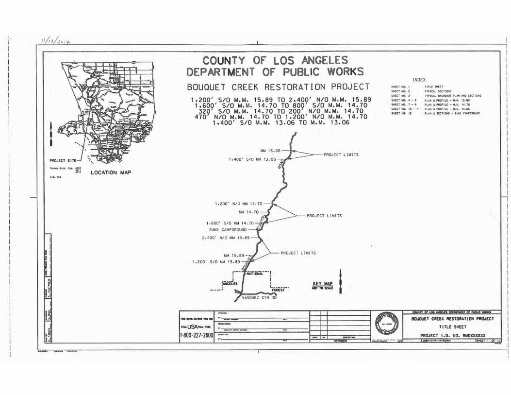
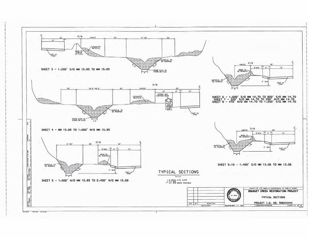
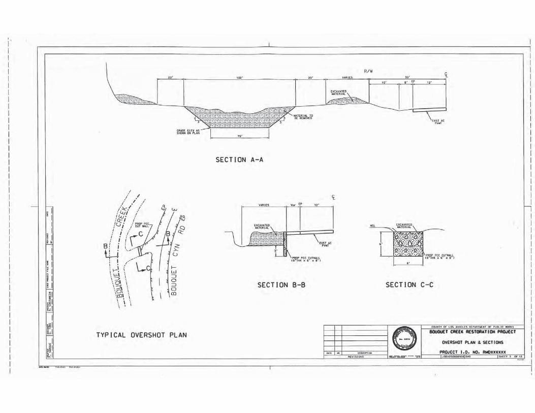
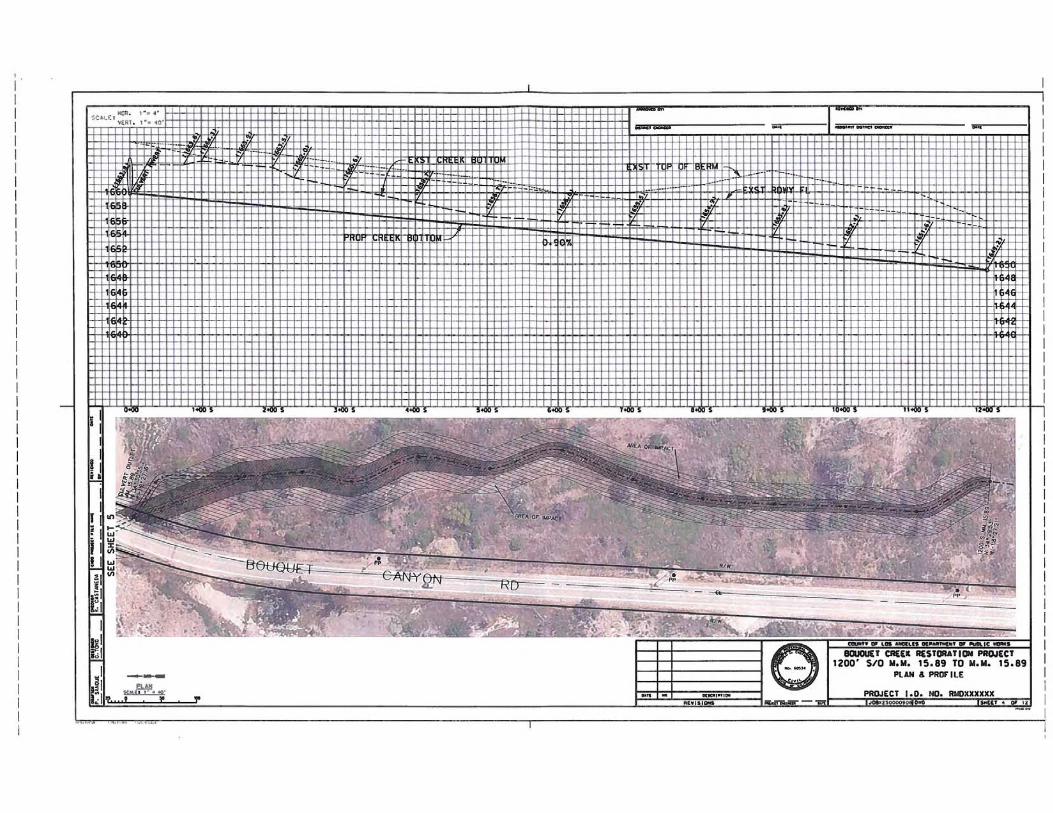
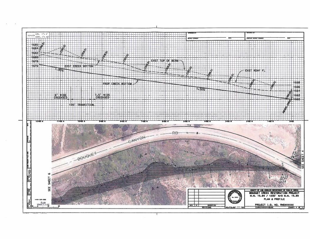
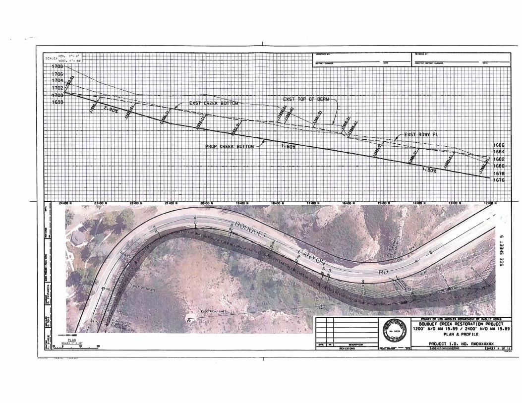
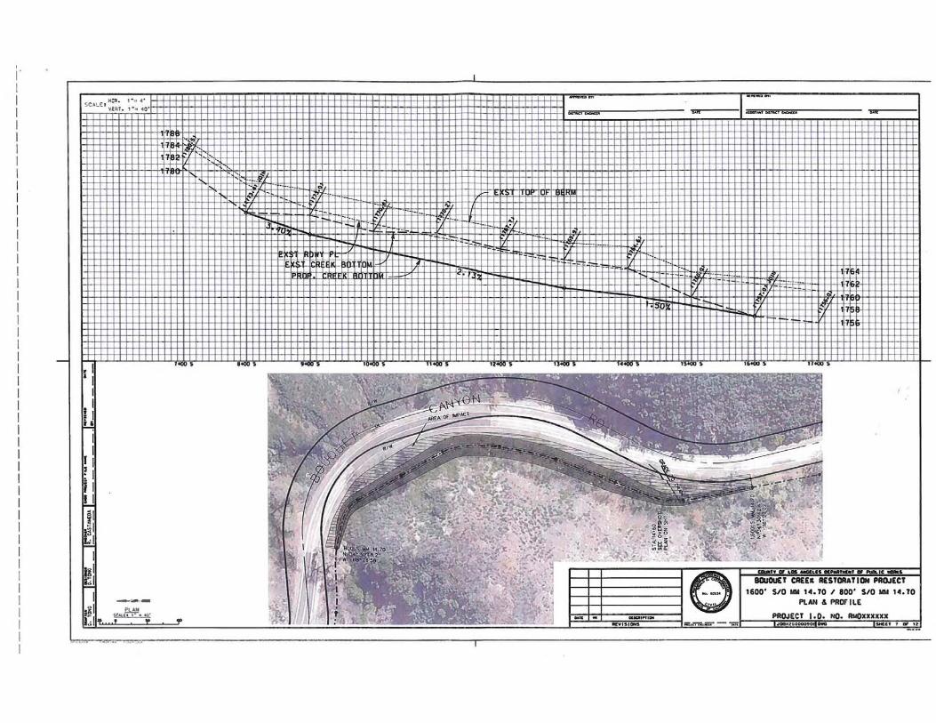
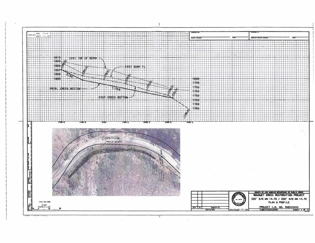
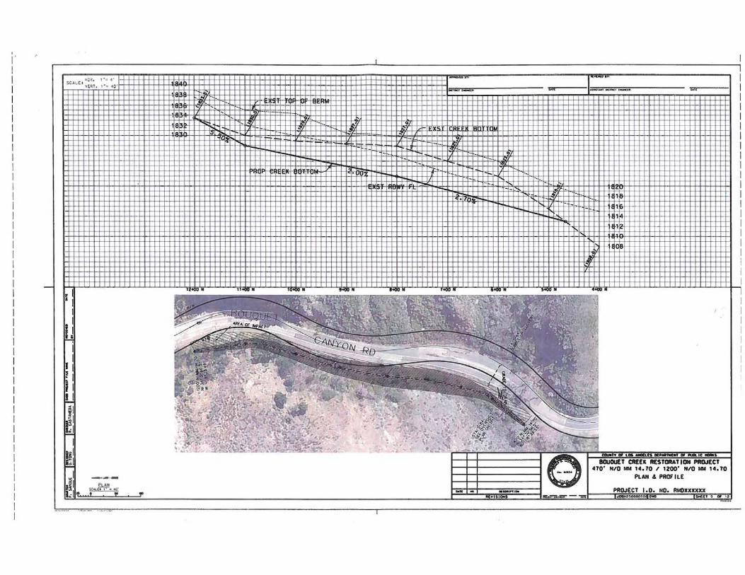
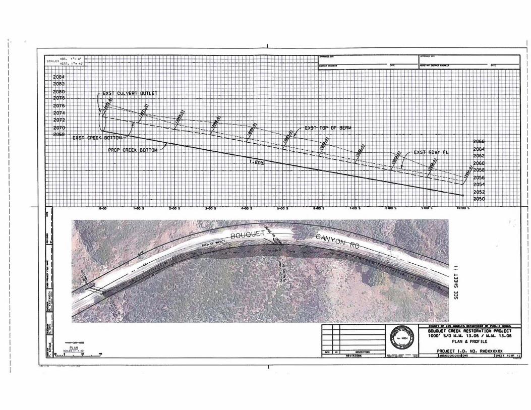
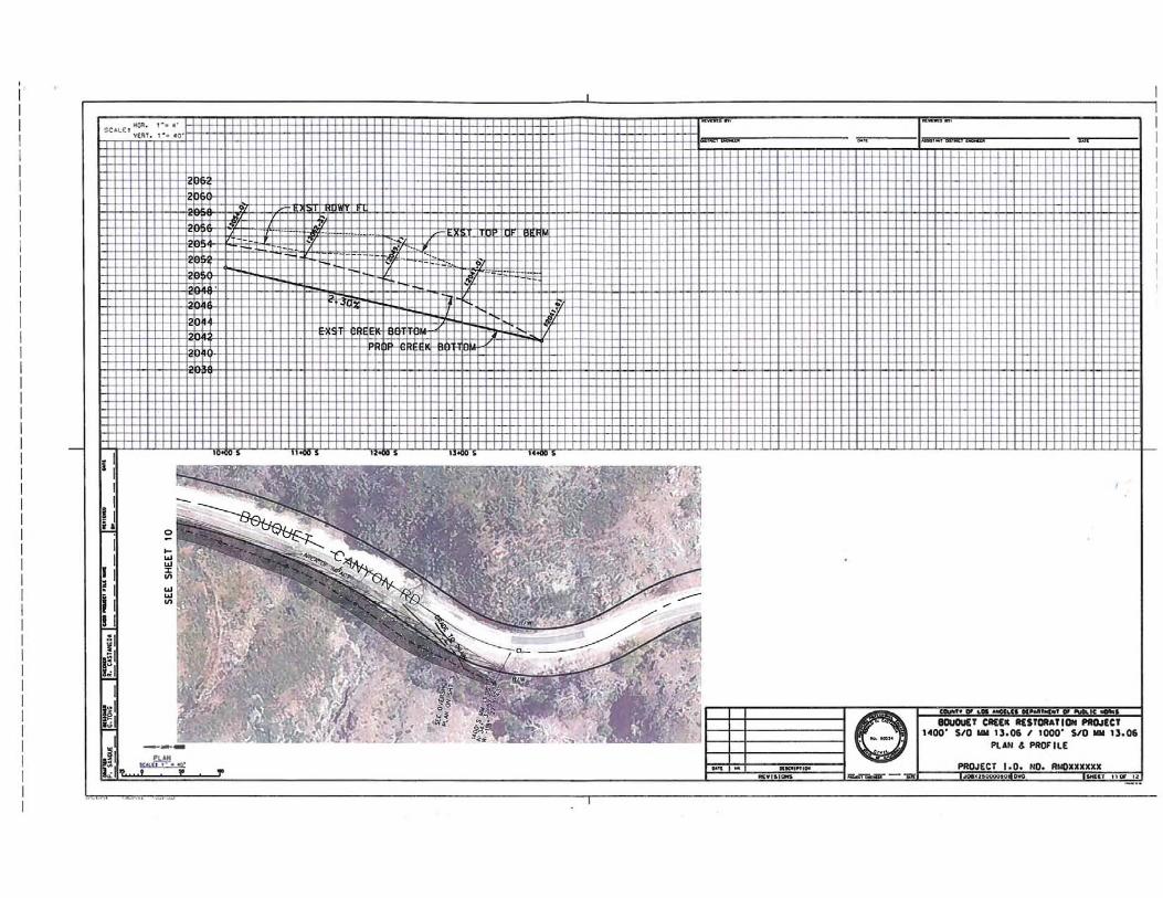
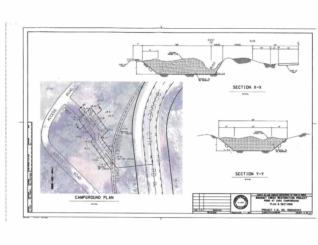

Bouquet Canyon Creek Restoration Project Biological Resources Assessment – Appendix B
APPENDIX B
Site Photographs
Bouquet Canyon Creek Sites 1 through 5 and Site 6 (Zuni Preserve)
February 4, 2015
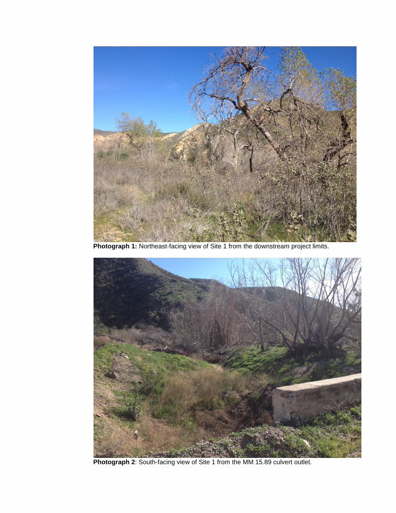
Photograph 1: Northeast-facing view of Site 1 from the downstream project limits.
Photograph 2: South-facing view of Site 1 from the MM 15.89 culvert outlet.
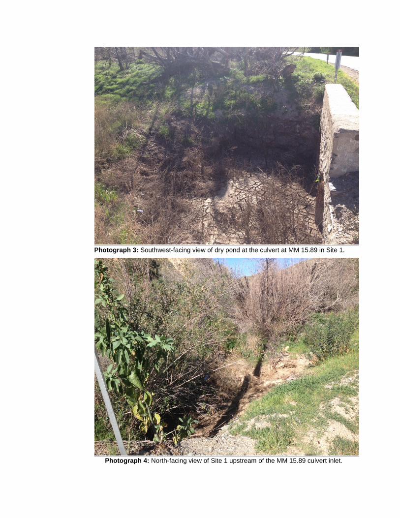
Photograph 3: Southwest-facing view of dry pond at the culvert at MM 15.89 in Site 1.
Photograph 4: North-facing view of Site 1 upstream of the MM 15.89 culvert inlet.
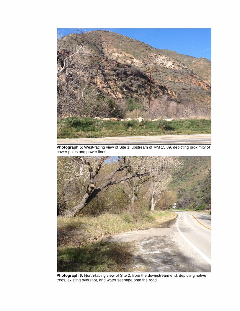
Photograph 5: West-facing view of Site 1, upstream of MM 15.89, depicting proximity of power poles and power lines.
Photograph 6: North-facing view of Site 2, from the downstream end, depicting native trees, existing overshot, and water seepage onto the road.
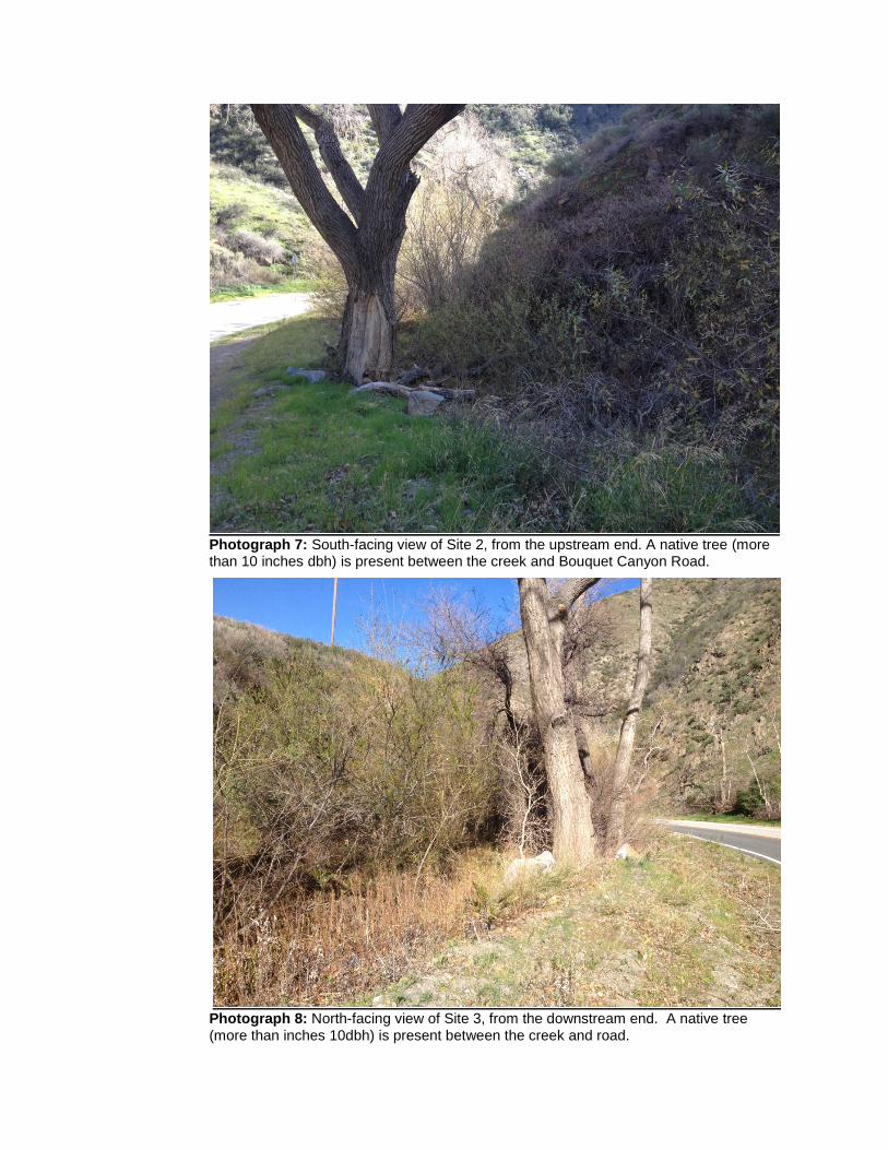
Photograph 7: South-facing view of Site 2, from the upstream end. A native tree (more than 10 inches dbh) is present between the creek and Bouquet Canyon Road.
Photograph 8: North-facing view of Site 3, from the downstream end. A native tree (more than inches 10dbh) is present between the creek and road.
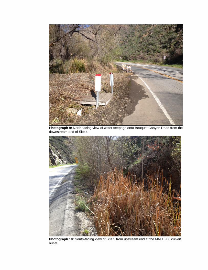
Photograph 9: North-facing view of water seepage onto Bouquet Canyon Road from the downstream end of Site 4.
Photograph 10: South-facing view of Site 5 from upstream end at the MM 13.06 culvert outlet.
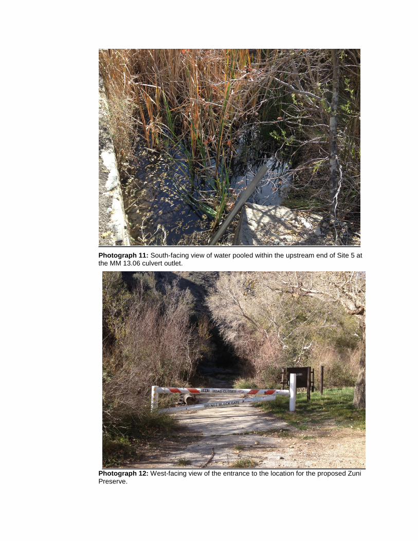
Photograph 11: South-facing view of water pooled within the upstream end of Site 5 at the MM 13.06 culvert outlet.
Photograph 12: West-facing view of the entrance to the location for the proposed Zuni Preserve.
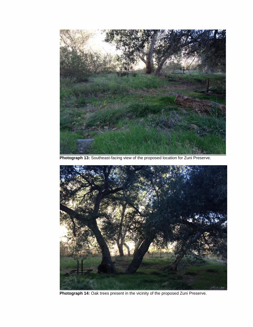
Photograph 13: Southeast-facing view of the proposed location for Zuni Preserve.
Photograph 14: Oak trees present in the vicinity of the proposed Zuni Preserve.
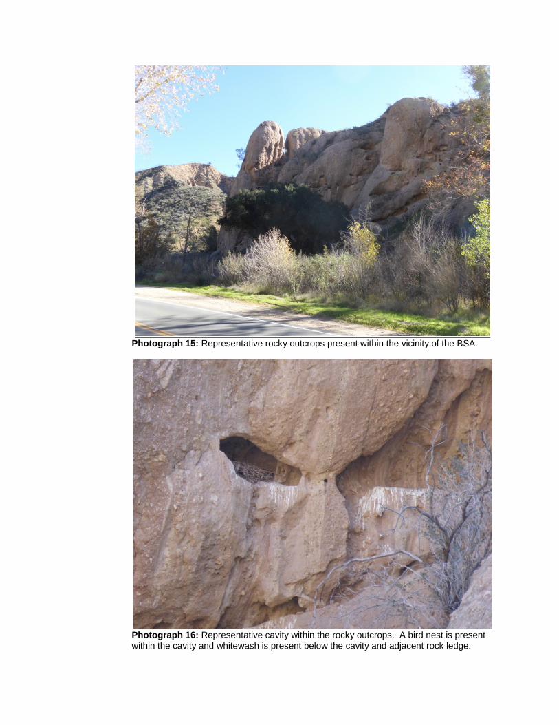
Photograph 15: Representative rocky outcrops present within the vicinity of the BSA.
Photograph 16: Representative cavity within the rocky outcrops. A bird nest is present within the cavity and whitewash is present below the cavity and adjacent rock ledge.
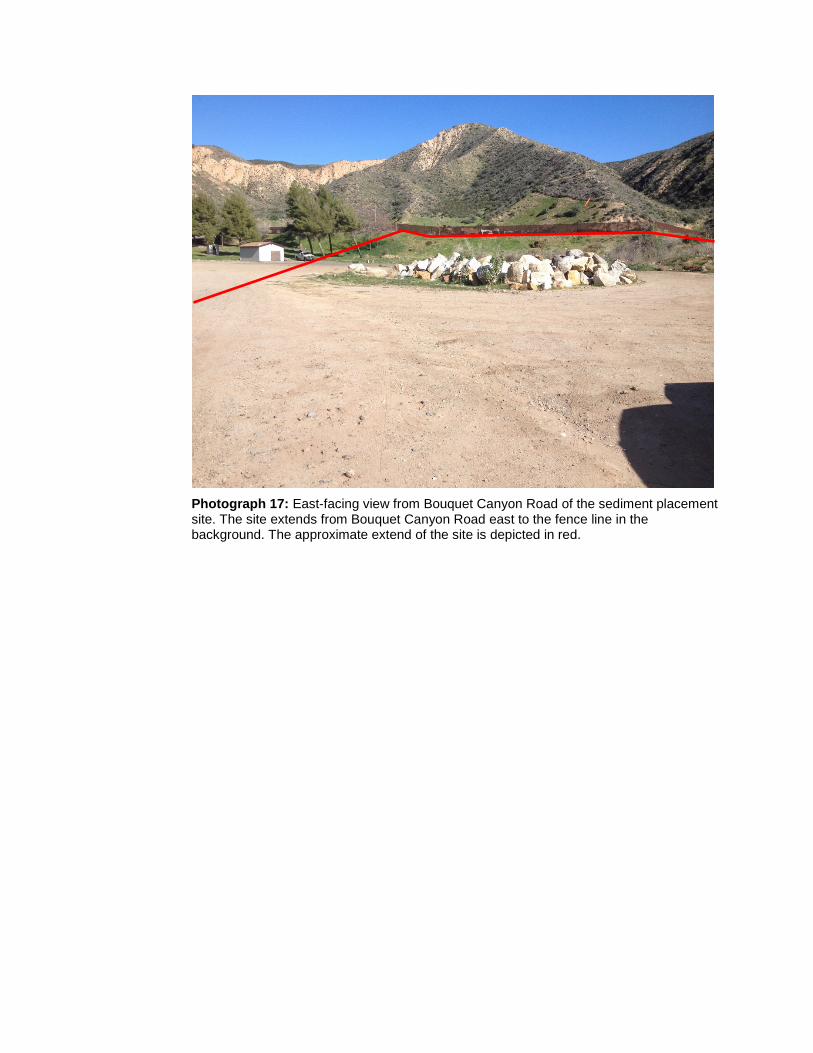
Photograph 17: East-facing view from Bouquet Canyon Road of the sediment placement site. The site extends from Bouquet Canyon Road east to the fence line in the background. The approximate extend of the site is depicted in red.

Bouquet Canyon Creek Restoration Project Biological Resources Assessment – Appendix C
APPENDIX C
Regional Special-Status Plant Species
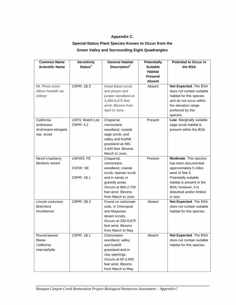
Bouquet Canyon Creek Restoration Project Biological Resources Assessment – Appendix C
Appendix C.
Special-Status Plant Species Known to Occur from the
Green Valley and Surrounding Eight Quadrangles
Common Name
Scientific Name Sensitivity
Status1 General Habitat
Description2 Potentially
Suitable Habitat
Present/ Absent
Potential to Occur in the BSA
Mt. Pinos onion Allium howellii var. clokeyi
CRPR: 1B.3 Great Basin scrub and pinyon and juniper woodland at 4,260-6,070 feet amsl. Blooms from April to June.
Absent Not Expected. The BSA
does not contain suitable habitat for this species and do not occur within the elevation range preferred by this species.
California androsace Androsace elongata ssp. acuta
USFS: Watch List CRPR: 4.2
Chaparral, cismontane woodland, coastal sage scrub, and valley and foothill grassland at 490-3,940 feet. Blooms March to June.
Present Low. Marginally suitable
sage scrub habitat is present within the BSA.
Nevin’s barberry Berberis nevinii
USFWS: FE CDFW: SE CRPR: 1B.1
Chaparral, cismontane woodland, coastal scrub, riparian scrub and in sandy or gravelly areas. Occurs at 900-2,700 feet amsl. Blooms from March to June.
Present Moderate. This species
has been documented approximately 5 miles west of Site 5. Potentially suitable habitat is present in the BSA; however, it is disturbed and/or limited in size.
Lincoln rockcress Boechera lincolnensis
CRPR: 2B.3 Found on carbonate soils, in Chenopod and Mojavean desert scrubs. Occurs at 330-8,870 feet amsl. Blooms from March to May
Absent Not Expected. The BSA
does not contain suitable habitat for this species.
Round-leaved filaree California macrophylla
CRPR: 1B.1 Cismontane woodland, valley and foothill grassland and in clay openings. Occurs at 50-3,940 feet amsl. Blooms from March to May.
Absent Not Expected. The BSA
does not contain suitable habitat for this species.
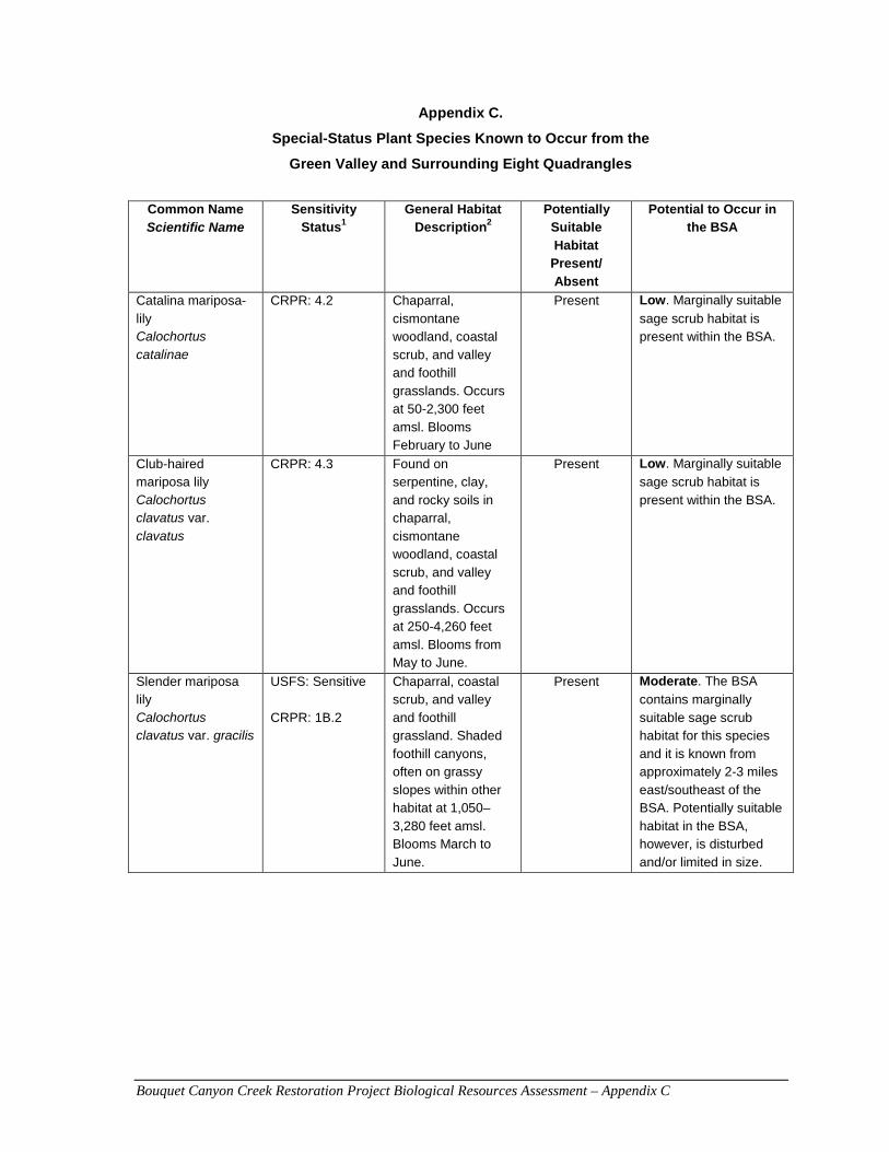
Bouquet Canyon Creek Restoration Project Biological Resources Assessment – Appendix C
Appendix C.
Special-Status Plant Species Known to Occur from the
Green Valley and Surrounding Eight Quadrangles
Common Name Scientific Name
Sensitivity Status1
General Habitat Description2
Potentially Suitable Habitat
Present/ Absent
Potential to Occur in the BSA
Catalina mariposa-lily Calochortus catalinae
CRPR: 4.2 Chaparral, cismontane woodland, coastal scrub, and valley and foothill grasslands. Occurs at 50-2,300 feet amsl. Blooms February to June
Present Low. Marginally suitable
sage scrub habitat is present within the BSA.
Club-haired mariposa lily Calochortus clavatus var. clavatus
CRPR: 4.3 Found on serpentine, clay, and rocky soils in chaparral, cismontane woodland, coastal scrub, and valley and foothill grasslands. Occurs at 250-4,260 feet amsl. Blooms from May to June.
Present Low. Marginally suitable
sage scrub habitat is present within the BSA.
Slender mariposa lily Calochortus clavatus var. gracilis
USFS: Sensitive CRPR: 1B.2
Chaparral, coastal scrub, and valley and foothill grassland. Shaded foothill canyons, often on grassy slopes within other habitat at 1,050–3,280 feet amsl. Blooms March to June.
Present Moderate. The BSA
contains marginally suitable sage scrub habitat for this species and it is known from approximately 2-3 miles east/southeast of the BSA. Potentially suitable habitat in the BSA, however, is disturbed and/or limited in size.
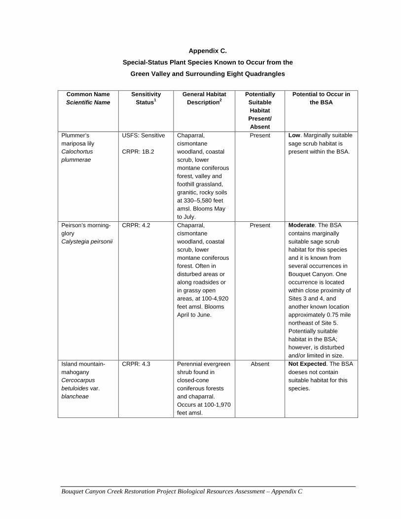
Bouquet Canyon Creek Restoration Project Biological Resources Assessment – Appendix C
Appendix C.
Special-Status Plant Species Known to Occur from the
Green Valley and Surrounding Eight Quadrangles
Common Name Scientific Name
Sensitivity Status1
General Habitat Description2
Potentially Suitable Habitat
Present/ Absent
Potential to Occur in the BSA
Plummer’s mariposa lily Calochortus plummerae
USFS: Sensitive CRPR: 1B.2
Chaparral, cismontane woodland, coastal scrub, lower montane coniferous forest, valley and foothill grassland, granitic, rocky soils at 330–5,580 feet amsl. Blooms May to July.
Present Low. Marginally suitable
sage scrub habitat is present within the BSA.
Peirson’s morning-glory Calystegia peirsonii
CRPR: 4.2
Chaparral, cismontane woodland, coastal scrub, lower montane coniferous forest. Often in disturbed areas or along roadsides or in grassy open areas, at 100-4,920 feet amsl. Blooms April to June.
Present Moderate. The BSA
contains marginally suitable sage scrub habitat for this species and it is known from several occurrences in Bouquet Canyon. One occurrence is located within close proximity of Sites 3 and 4, and another known location approximately 0.75 mile northeast of Site 5. Potentially suitable habitat in the BSA; however, is disturbed and/or limited in size.
Island mountain-mahogany Cercocarpus betuloides var. blancheae
CRPR: 4.3 Perennial evergreen shrub found in closed-cone coniferous forests and chaparral. Occurs at 100-1,970 feet amsl.
Absent Not Expected. The BSA
doeses not contain suitable habitat for this species.
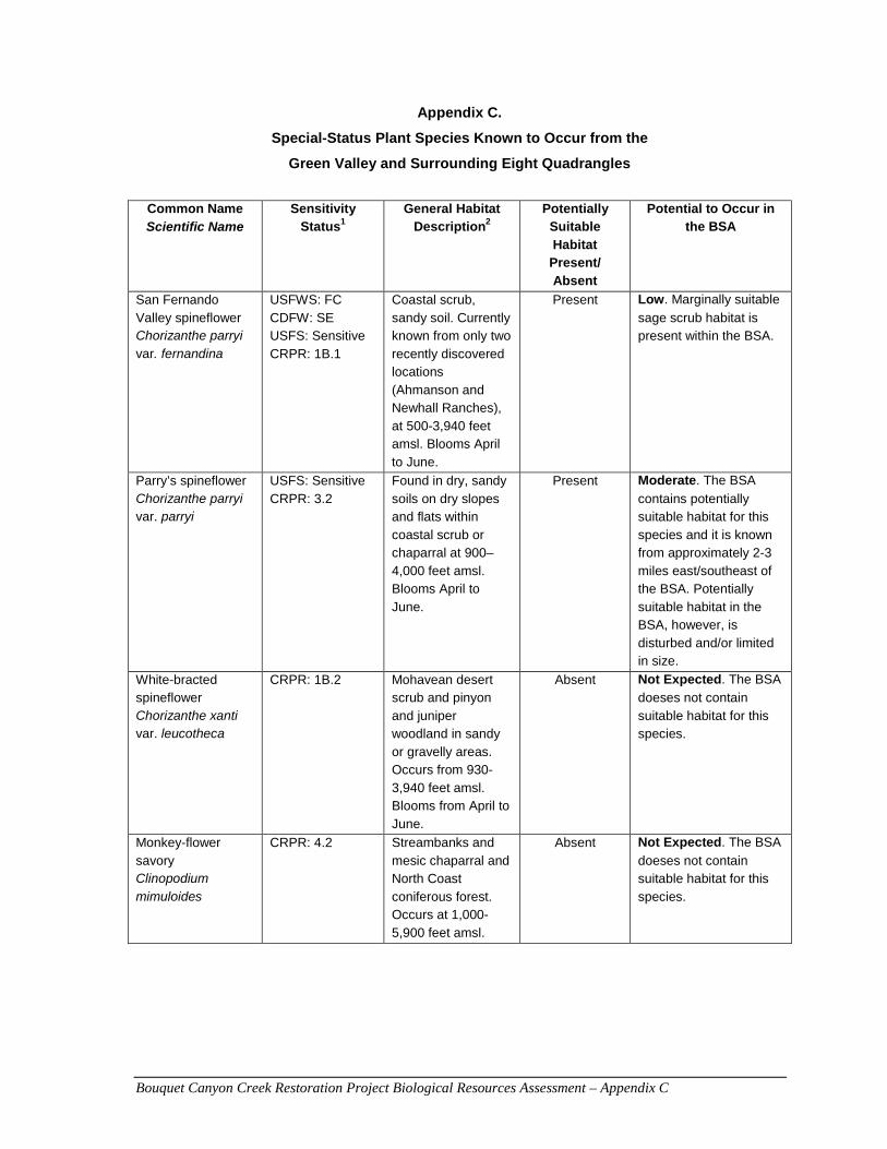
Bouquet Canyon Creek Restoration Project Biological Resources Assessment – Appendix C
Appendix C.
Special-Status Plant Species Known to Occur from the
Green Valley and Surrounding Eight Quadrangles
Common Name Scientific Name
Sensitivity Status1
General Habitat Description2
Potentially Suitable Habitat
Present/ Absent
Potential to Occur in the BSA
San Fernando Valley spineflower Chorizanthe parryi var. fernandina
USFWS: FC CDFW: SE USFS: Sensitive CRPR: 1B.1
Coastal scrub, sandy soil. Currently known from only two recently discovered locations (Ahmanson and Newhall Ranches), at 500-3,940 feet amsl. Blooms April to June.
Present Low. Marginally suitable
sage scrub habitat is present within the BSA.
Parry’s spineflower Chorizanthe parryi var. parryi
USFS: Sensitive CRPR: 3.2
Found in dry, sandy soils on dry slopes and flats within coastal scrub or chaparral at 900–4,000 feet amsl. Blooms April to June.
Present Moderate. The BSA
contains potentially suitable habitat for this species and it is known from approximately 2-3 miles east/southeast of the BSA. Potentially suitable habitat in the BSA, however, is disturbed and/or limited in size.
White-bracted spineflower Chorizanthe xanti var. leucotheca
CRPR: 1B.2 Mohavean desert scrub and pinyon and juniper woodland in sandy or gravelly areas. Occurs from 930-3,940 feet amsl. Blooms from April to June.
Absent Not Expected. The BSA
doeses not contain suitable habitat for this species.
Monkey-flower savory Clinopodium mimuloides
CRPR: 4.2 Streambanks and mesic chaparral and North Coast coniferous forest. Occurs at 1,000-5,900 feet amsl.
Absent Not Expected. The BSA
doeses not contain suitable habitat for this species.
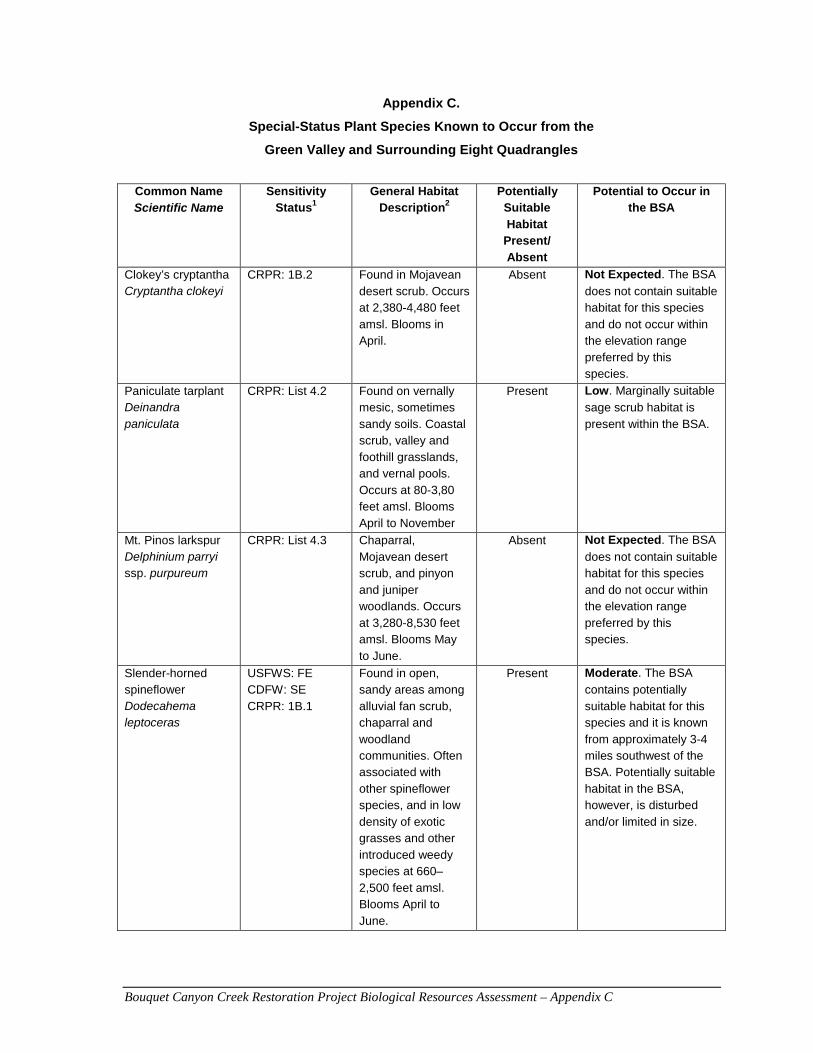
Bouquet Canyon Creek Restoration Project Biological Resources Assessment – Appendix C
Appendix C.
Special-Status Plant Species Known to Occur from the
Green Valley and Surrounding Eight Quadrangles
Common Name Scientific Name
Sensitivity Status1
General Habitat Description2
Potentially Suitable Habitat
Present/ Absent
Potential to Occur in the BSA
Clokey’s cryptantha Cryptantha clokeyi
CRPR: 1B.2 Found in Mojavean desert scrub. Occurs at 2,380-4,480 feet amsl. Blooms in April.
Absent Not Expected. The BSA
does not contain suitable habitat for this species and do not occur within the elevation range preferred by this species.
Paniculate tarplant Deinandra paniculata
CRPR: List 4.2 Found on vernally mesic, sometimes sandy soils. Coastal scrub, valley and foothill grasslands, and vernal pools. Occurs at 80-3,80 feet amsl. Blooms April to November
Present Low. Marginally suitable
sage scrub habitat is present within the BSA.
Mt. Pinos larkspur Delphinium parryi ssp. purpureum
CRPR: List 4.3 Chaparral, Mojavean desert scrub, and pinyon and juniper woodlands. Occurs at 3,280-8,530 feet amsl. Blooms May to June.
Absent Not Expected. The BSA
does not contain suitable habitat for this species and do not occur within the elevation range preferred by this species.
Slender-horned spineflower Dodecahema leptoceras
USFWS: FE CDFW: SE CRPR: 1B.1
Found in open, sandy areas among alluvial fan scrub, chaparral and woodland communities. Often associated with other spineflower species, and in low density of exotic grasses and other introduced weedy species at 660–2,500 feet amsl. Blooms April to June.
Present Moderate. The BSA
contains potentially suitable habitat for this species and it is known from approximately 3-4 miles southwest of the BSA. Potentially suitable habitat in the BSA, however, is disturbed and/or limited in size.
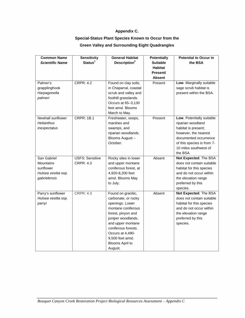
Bouquet Canyon Creek Restoration Project Biological Resources Assessment – Appendix C
Appendix C.
Special-Status Plant Species Known to Occur from the
Green Valley and Surrounding Eight Quadrangles
Common Name Scientific Name
Sensitivity Status1
General Habitat Description2
Potentially Suitable Habitat
Present/ Absent
Potential to Occur in the BSA
Palmer’s grapplinghook Harpagonella palmeri
CRPR: 4.2 Found on clay soils, in Chaparral, coastal scrub and valley and foothill grasslands. Occurs at 65–3,130 feet amsl. Blooms March to May.
Present Low. Marginally suitable
sage scrub habitat is present within the BSA.
Newhall sunflower Helianthus inexpectatus
CRPR: 1B.1 Freshwater, seeps, marshes and swamps, and riparian woodlands. Blooms August – October.
Present Low. Potentially suitable
riparian woodland habitat is present; however, the nearest documented occurrence of this species is from 7-10 miles southwest of the BSA.
San Gabriel Mountains sunflower Hulsea vestita ssp. gabrielensis
USFS: Sensitive CRPR: 4.3
Rocky sites in lower and upper montane coniferous forest, at 4,920-8,200 feet amsl. Blooms May to July.
Absent Not Expected. The BSA
does not contain suitable habitat for this species and do not occur within the elevation range preferred by this species.
Parry’s sunflower Hulsea vestita ssp. parryi
CRPR: 4.3 Found on granitic, carbonate, or rocky openings. Lower montane coniferous forest, pinyon and juniper woodlands, and upper montane coniferous forests. Occurs at 4,490-9,500 feet amsl. Blooms April to August.
Absent Not Expected. The BSA
does not contain suitable habitat for this species and do not occur within the elevation range preferred by this species.
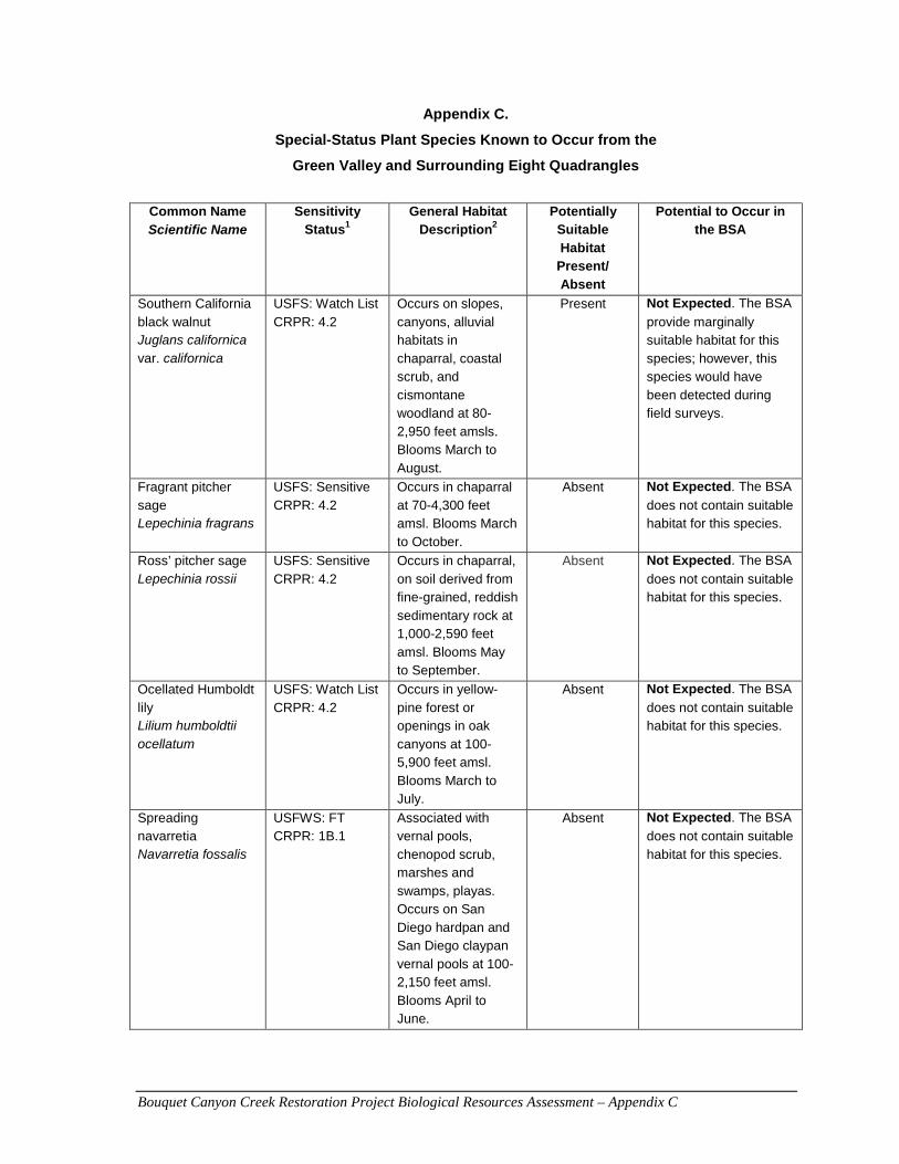
Bouquet Canyon Creek Restoration Project Biological Resources Assessment – Appendix C
Appendix C.
Special-Status Plant Species Known to Occur from the
Green Valley and Surrounding Eight Quadrangles
Common Name Scientific Name
Sensitivity Status1
General Habitat Description2
Potentially Suitable Habitat
Present/ Absent
Potential to Occur in the BSA
Southern California black walnut Juglans californica var. californica
USFS: Watch List CRPR: 4.2
Occurs on slopes, canyons, alluvial habitats in chaparral, coastal scrub, and cismontane woodland at 80-2,950 feet amsls. Blooms March to August.
Present Not Expected. The BSA
provide marginally suitable habitat for this species; however, this species would have been detected during field surveys.
Fragrant pitcher sage Lepechinia fragrans
USFS: Sensitive CRPR: 4.2
Occurs in chaparral at 70-4,300 feet amsl. Blooms March to October.
Absent Not Expected. The BSA
does not contain suitable habitat for this species.
Ross’ pitcher sage Lepechinia rossii
USFS: Sensitive CRPR: 4.2
Occurs in chaparral, on soil derived from fine-grained, reddish sedimentary rock at 1,000-2,590 feet amsl. Blooms May to September.
Absent Not Expected. The BSA
does not contain suitable habitat for this species.
Ocellated Humboldt lily Lilium humboldtii ocellatum
USFS: Watch List CRPR: 4.2
Occurs in yellow-pine forest or openings in oak canyons at 100-5,900 feet amsl. Blooms March to July.
Absent Not Expected. The BSA
does not contain suitable habitat for this species.
Spreading navarretia Navarretia fossalis
USFWS: FT CRPR: 1B.1
Associated with vernal pools, chenopod scrub, marshes and swamps, playas. Occurs on San Diego hardpan and San Diego claypan vernal pools at 100-2,150 feet amsl. Blooms April to June.
Absent Not Expected. The BSA
does not contain suitable habitat for this species.
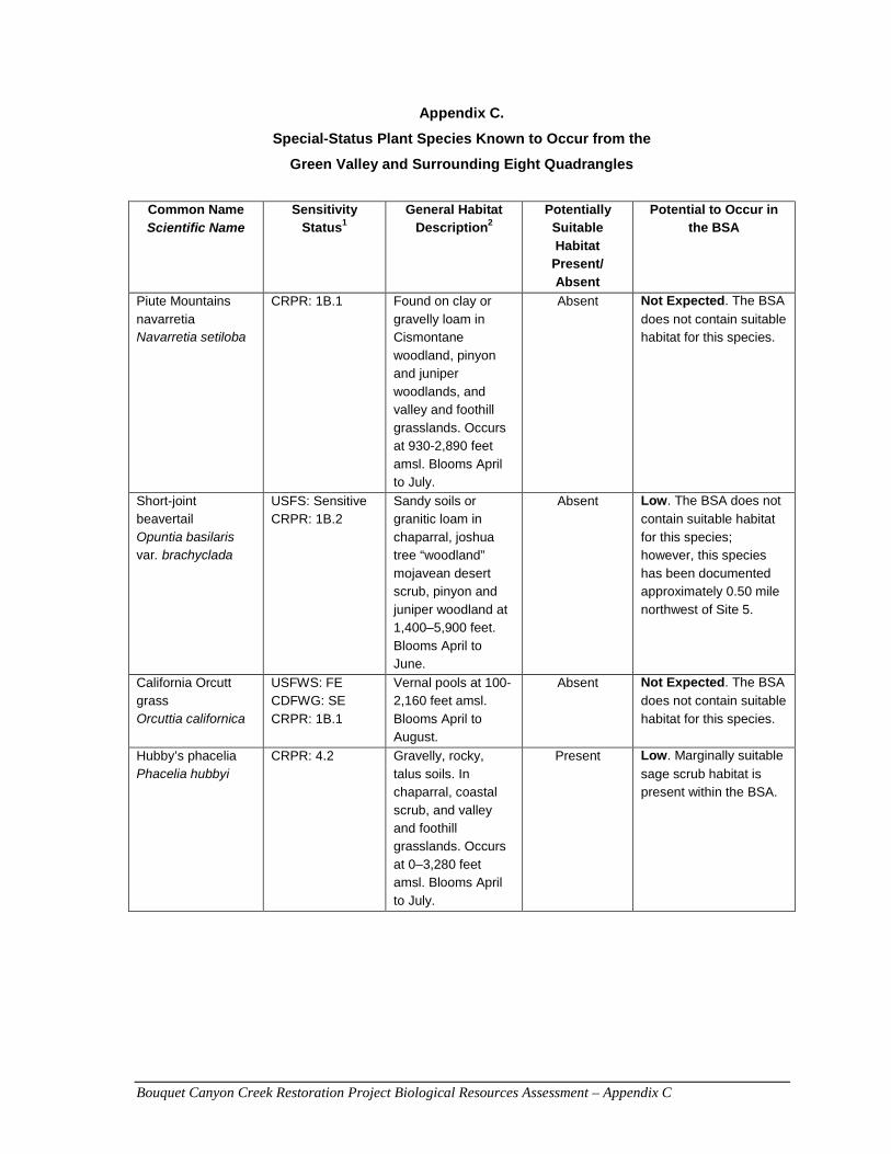
Bouquet Canyon Creek Restoration Project Biological Resources Assessment – Appendix C
Appendix C.
Special-Status Plant Species Known to Occur from the
Green Valley and Surrounding Eight Quadrangles
Common Name Scientific Name
Sensitivity Status1
General Habitat Description2
Potentially Suitable Habitat
Present/ Absent
Potential to Occur in the BSA
Piute Mountains navarretia Navarretia setiloba
CRPR: 1B.1 Found on clay or gravelly loam in Cismontane woodland, pinyon and juniper woodlands, and valley and foothill grasslands. Occurs at 930-2,890 feet amsl. Blooms April to July.
Absent Not Expected. The BSA
does not contain suitable habitat for this species.
Short-joint beavertail Opuntia basilaris var. brachyclada
USFS: Sensitive CRPR: 1B.2
Sandy soils or granitic loam in chaparral, joshua tree “woodland” mojavean desert scrub, pinyon and juniper woodland at 1,400–5,900 feet. Blooms April to June.
Absent Low. The BSA does not
contain suitable habitat for this species; however, this species has been documented approximately 0.50 mile northwest of Site 5.
California Orcutt grass Orcuttia californica
USFWS: FE CDFWG: SE CRPR: 1B.1
Vernal pools at 100-2,160 feet amsl. Blooms April to August.
Absent Not Expected. The BSA
does not contain suitable habitat for this species.
Hubby’s phacelia Phacelia hubbyi
CRPR: 4.2 Gravelly, rocky, talus soils. In chaparral, coastal scrub, and valley and foothill grasslands. Occurs at 0–3,280 feet amsl. Blooms April to July.
Present Low. Marginally suitable
sage scrub habitat is present within the BSA.
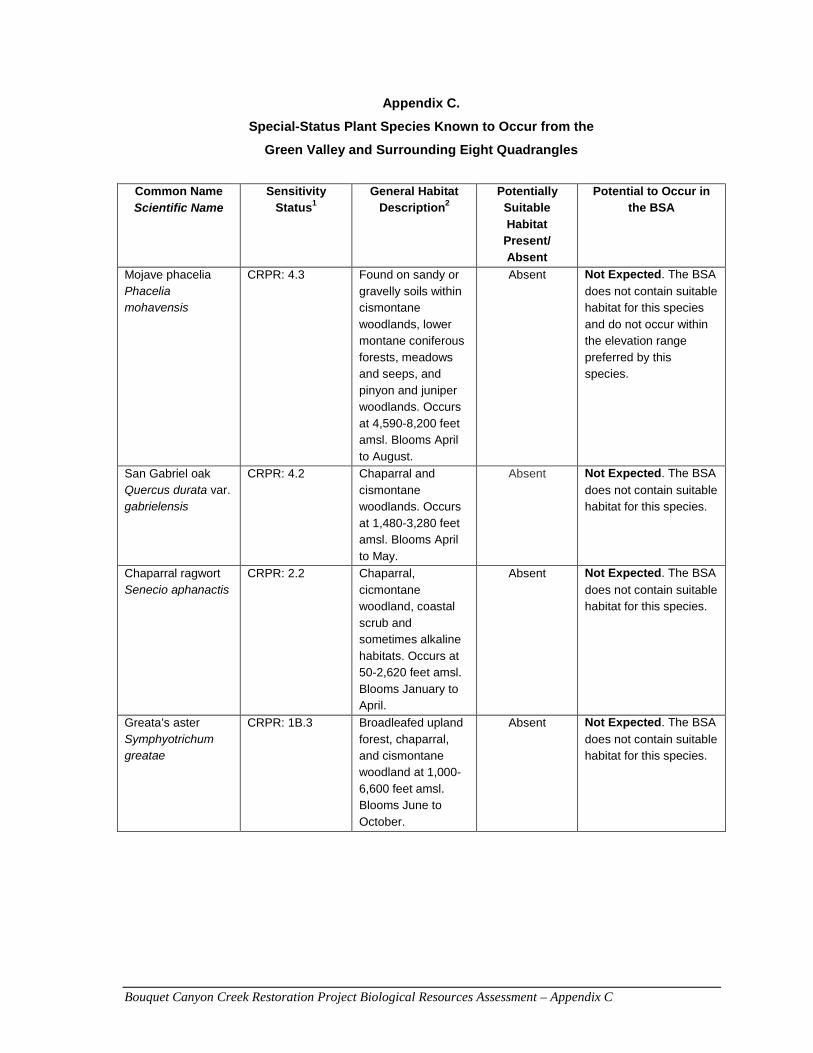
Bouquet Canyon Creek Restoration Project Biological Resources Assessment – Appendix C
Appendix C.
Special-Status Plant Species Known to Occur from the
Green Valley and Surrounding Eight Quadrangles
Common Name Scientific Name
Sensitivity Status1
General Habitat Description2
Potentially Suitable Habitat
Present/ Absent
Potential to Occur in the BSA
Mojave phacelia Phacelia mohavensis
CRPR: 4.3 Found on sandy or gravelly soils within cismontane woodlands, lower montane coniferous forests, meadows and seeps, and pinyon and juniper woodlands. Occurs at 4,590-8,200 feet amsl. Blooms April to August.
Absent Not Expected. The BSA
does not contain suitable habitat for this species and do not occur within the elevation range preferred by this species.
San Gabriel oak Quercus durata var. gabrielensis
CRPR: 4.2 Chaparral and cismontane woodlands. Occurs at 1,480-3,280 feet amsl. Blooms April to May.
Absent Not Expected. The BSA
does not contain suitable habitat for this species.
Chaparral ragwort Senecio aphanactis
CRPR: 2.2 Chaparral, cicmontane woodland, coastal scrub and sometimes alkaline habitats. Occurs at 50-2,620 feet amsl. Blooms January to April.
Absent Not Expected. The BSA
does not contain suitable habitat for this species.
Greata’s aster Symphyotrichum greatae
CRPR: 1B.3 Broadleafed upland forest, chaparral, and cismontane woodland at 1,000-6,600 feet amsl. Blooms June to October.
Absent Not Expected. The BSA
does not contain suitable habitat for this species.
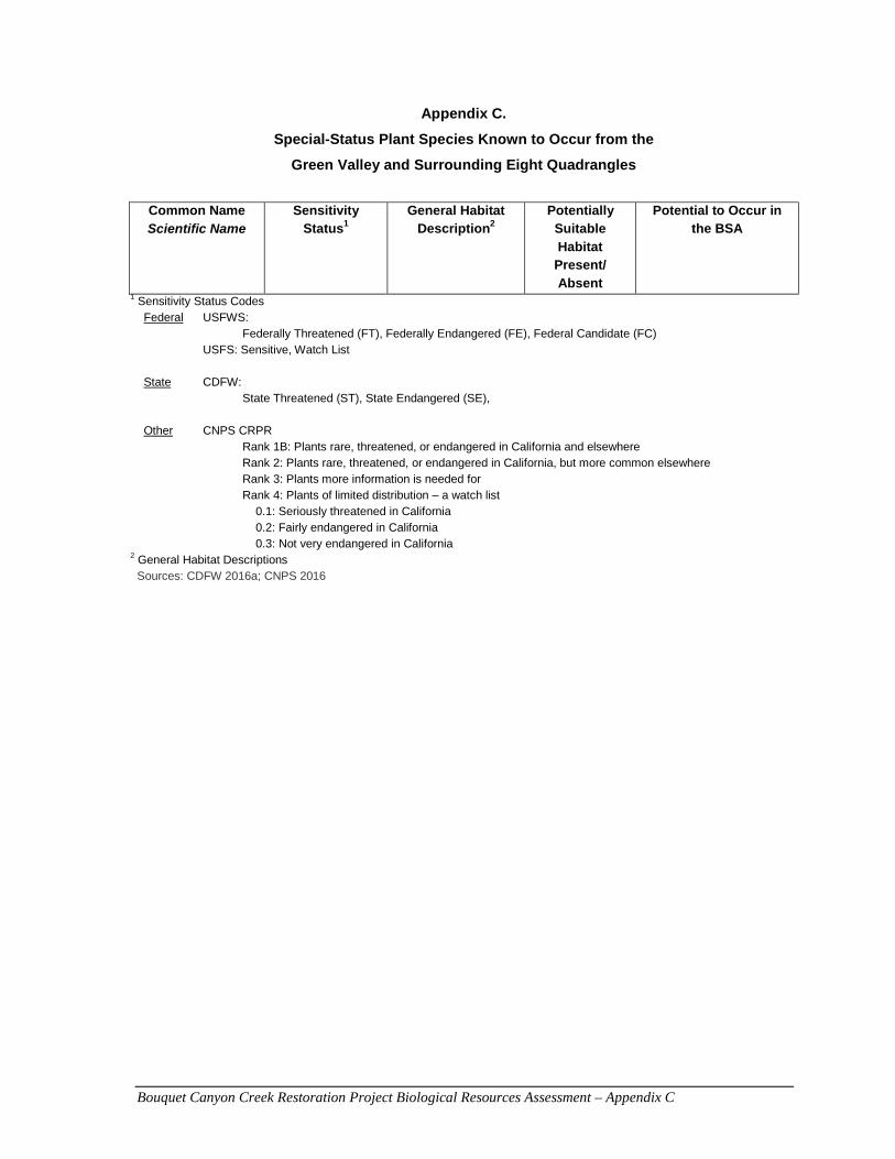
Bouquet Canyon Creek Restoration Project Biological Resources Assessment – Appendix C
Appendix C.
Special-Status Plant Species Known to Occur from the
Green Valley and Surrounding Eight Quadrangles
Common Name Scientific Name
Sensitivity Status1
General Habitat Description2
Potentially Suitable Habitat
Present/ Absent
Potential to Occur in the BSA
1 Sensitivity Status Codes Federal USFWS:
Federally Threatened (FT), Federally Endangered (FE), Federal Candidate (FC) USFS: Sensitive, Watch List State CDFW:
State Threatened (ST), State Endangered (SE),
Other CNPS CRPR Rank 1B: Plants rare, threatened, or endangered in California and elsewhere Rank 2: Plants rare, threatened, or endangered in California, but more common elsewhere Rank 3: Plants more information is needed for Rank 4: Plants of limited distribution – a watch list
0.1: Seriously threatened in California 0.2: Fairly endangered in California 0.3: Not very endangered in California
2 General Habitat Descriptions Sources: CDFW 2016a; CNPS 2016

Bouquet Canyon Creek Restoration Project Biological Resources Assessment – Appendix D
APPENDIX D
Regional Special-Status Wildlife Species
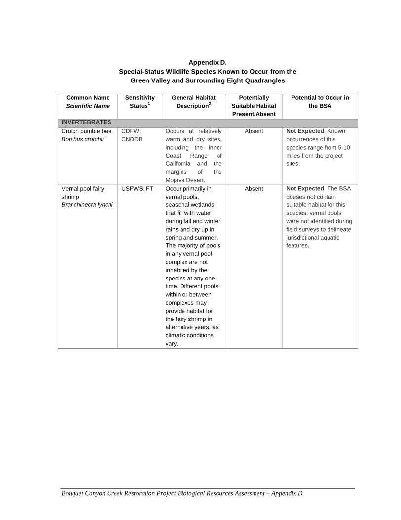
Bouquet Canyon Creek Restoration Project Biological Resources Assessment – Appendix D
Appendix D. Special-Status Wildlife Species Known to Occur from the
Green Valley and Surrounding Eight Quadrangles
Common Name
Scientific Name Sensitivity
Status1 General Habitat
Description2 Potentially
Suitable Habitat Present/Absent
Potential to Occur in the BSA
INVERTEBRATES
Crotch bumble bee Bombus crotchii
CDFW: CNDDB
Occurs at relatively warm and dry sites, including the inner Coast Range of California and the margins of the Mojave Desert.
Absent Not Expected. Known
occurrences of this species range from 5-10 miles from the project sites.
Vernal pool fairy shrimp Branchinecta lynchi
USFWS: FT Occur primarily in vernal pools, seasonal wetlands that fill with water during fall and winter rains and dry up in spring and summer. The majority of pools in any vernal pool complex are not inhabited by the species at any one time. Different pools within or between complexes may provide habitat for the fairy shrimp in alternative years, as climatic conditions vary.
Absent Not Expected. The BSA
doeses not contain suitable habitat for this species; vernal pools were not identified during field surveys to delineate jurisdictional aquatic features.
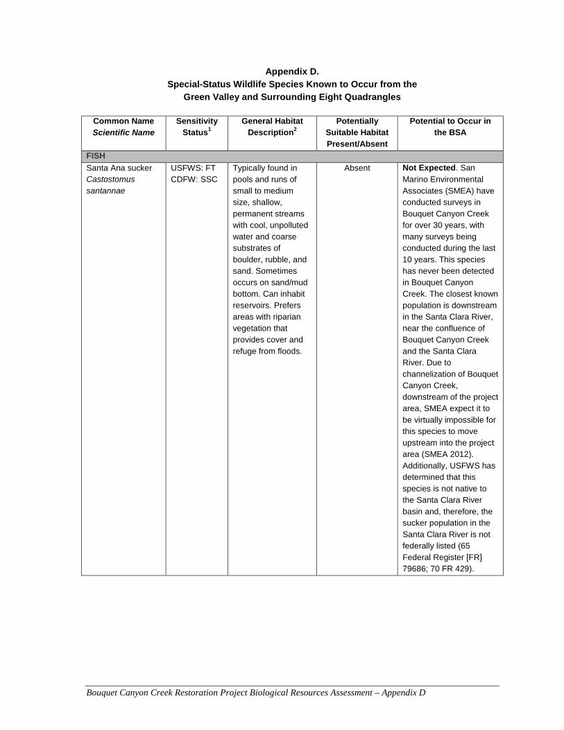
Bouquet Canyon Creek Restoration Project Biological Resources Assessment – Appendix D
Appendix D. Special-Status Wildlife Species Known to Occur from the
Green Valley and Surrounding Eight Quadrangles
Common Name Scientific Name
Sensitivity Status1
General Habitat Description2
Potentially Suitable Habitat Present/Absent
Potential to Occur in the BSA
FISH
Santa Ana sucker Castostomus santannae
USFWS: FT CDFW: SSC
Typically found in pools and runs of small to medium size, shallow, permanent streams with cool, unpolluted water and coarse substrates of boulder, rubble, and sand. Sometimes occurs on sand/mud bottom. Can inhabit reservoirs. Prefers areas with riparian vegetation that provides cover and refuge from floods.
Absent Not Expected. San
Marino Environmental Associates (SMEA) have conducted surveys in Bouquet Canyon Creek for over 30 years, with many surveys being conducted during the last 10 years. This species has never been detected in Bouquet Canyon Creek. The closest known population is downstream in the Santa Clara River, near the confluence of Bouquet Canyon Creek and the Santa Clara River. Due to channelization of Bouquet Canyon Creek, downstream of the project area, SMEA expect it to be virtually impossible for this species to move upstream into the project area (SMEA 2012). Additionally, USFWS has determined that this species is not native to the Santa Clara River basin and, therefore, the sucker population in the Santa Clara River is not federally listed (65 Federal Register [FR] 79686; 70 FR 429).
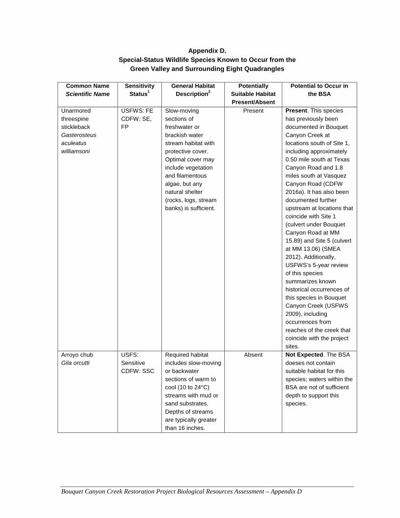
Bouquet Canyon Creek Restoration Project Biological Resources Assessment – Appendix D
Appendix D. Special-Status Wildlife Species Known to Occur from the
Green Valley and Surrounding Eight Quadrangles
Common Name Scientific Name
Sensitivity Status1
General Habitat Description2
Potentially Suitable Habitat Present/Absent
Potential to Occur in the BSA
Unarmored threespine stickleback Gasterosteus aculeatus williamsoni
USFWS: FE CDFW: SE, FP
Slow-moving sections of freshwater or brackish water stream habitat with protective cover. Optimal cover may include vegetation and filamentous algae, but any natural shelter (rocks, logs, stream banks) is sufficient.
Present Present. This species
has previously been documented in Bouquet Canyon Creek at locations south of Site 1, including approximately 0.50 mile south at Texas Canyon Road and 1.8 miles south at Vasquez Canyon Road (CDFW 2016a). It has also been documented further upstream at locations that coincide with Site 1 (culvert under Bouquet Canyon Road at MM 15.89) and Site 5 (culvert at MM 13.06) (SMEA 2012). Additionally, USFWS’s 5-year review of this species summarizes known historical occurrences of this species in Bouquet Canyon Creek (USFWS 2009), including occurrences from reaches of the creek that coincide with the project sites.
Arroyo chub Gila orcutti
USFS: Sensitive CDFW: SSC
Required habitat includes slow-moving or backwater sections of warm to cool (10 to 24°C) streams with mud or sand substrates. Depths of streams are typically greater than 16 inches.
Absent Not Expected. The BSA
doeses not contain suitable habitat for this species; waters within the BSA are not of sufficient depth to support this species.
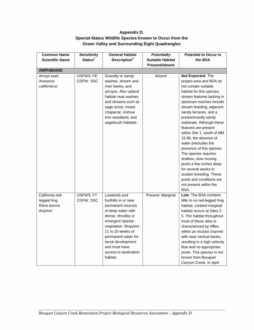
Bouquet Canyon Creek Restoration Project Biological Resources Assessment – Appendix D
Appendix D. Special-Status Wildlife Species Known to Occur from the
Green Valley and Surrounding Eight Quadrangles
Common Name Scientific Name
Sensitivity Status1
General Habitat Description2
Potentially Suitable Habitat Present/Absent
Potential to Occur in the BSA
AMPHIBIANS
Arroyo toad Anaxyrus californicus
USFWS: FE CDFW: SSC
Gravelly or sandy washes, stream and river banks, and arroyos. Also upland habitat near washes and streams such as sage scrub, mixed chaparral, Joshua tree woodland, and sagebrush habitats.
Absent Not Expected. The
project area and BSA do not contain suitable habitat for this species; stream features lacking in upstream reaches include stream braiding, adjacent sandy terraces, and a predominantly sandy substrate. Although these features are present within Site 1, south of MM 15.86, the absence of water precludes the presence of this species. The species requires shallow, slow moving pools a few inches deep for several weeks to sustain breeding. These pools and conditions are not present within the BSA.
California red-legged frog Rana aurora draytoni
USFWS: FT CDFW: SSC
Lowlands and foothills in or near permanent sources of deep water with dense, shrubby or emergent riparian vegetation. Requires 11 to 20 weeks of permanent water for larval development and must have access to aestivation habitat.
Present: Marginal Low. The BSA contains
little to no red‐legged frog
habitat. Limited marginal habitat occurs at Sites 2-5. The habitat throughout most of these sites is characterized by riffles within an incised channel with near vertical banks, resulting in a high velocity flow and no appropriate pools. This species is not known from Bouquet Canyon Creek. In April
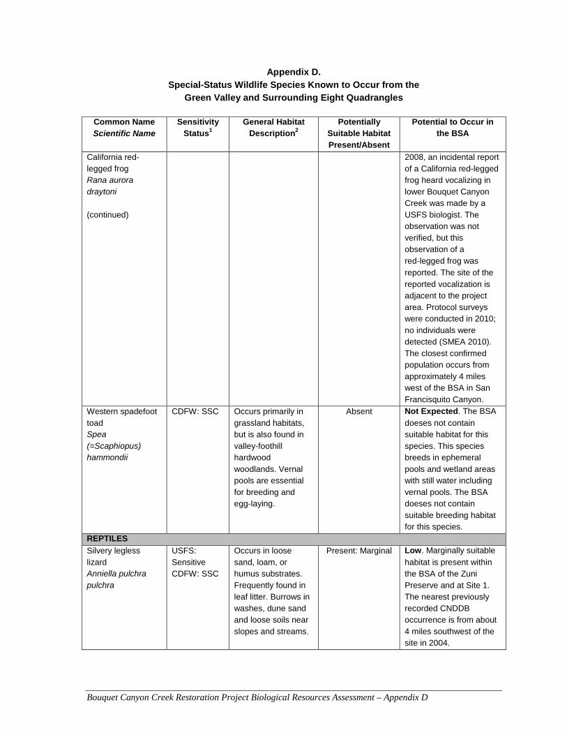
Bouquet Canyon Creek Restoration Project Biological Resources Assessment – Appendix D
Appendix D. Special-Status Wildlife Species Known to Occur from the
Green Valley and Surrounding Eight Quadrangles
Common Name Scientific Name
Sensitivity Status1
General Habitat Description2
Potentially Suitable Habitat Present/Absent
Potential to Occur in the BSA
California red-legged frog Rana aurora draytoni (continued)
2008, an incidental report of a California red-legged frog heard vocalizing in lower Bouquet Canyon Creek was made by a USFS biologist. The observation was not verified, but this observation of a red‐legged frog was
reported. The site of the reported vocalization is adjacent to the project area. Protocol surveys were conducted in 2010; no individuals were detected (SMEA 2010). The closest confirmed population occurs from approximately 4 miles west of the BSA in San Francisquito Canyon.
Western spadefoot toad Spea (=Scaphiopus) hammondii
CDFW: SSC Occurs primarily in grassland habitats, but is also found in valley-foothill hardwood woodlands. Vernal pools are essential for breeding and egg-laying.
Absent Not Expected. The BSA
doeses not contain suitable habitat for this species. This species breeds in ephemeral pools and wetland areas with still water including vernal pools. The BSA doeses not contain suitable breeding habitat for this species.
REPTILES
Silvery legless lizard Anniella pulchra pulchra
USFS: Sensitive CDFW: SSC
Occurs in loose sand, loam, or humus substrates. Frequently found in leaf litter. Burrows in washes, dune sand and loose soils near slopes and streams.
Present: Marginal Low. Marginally suitable
habitat is present within the BSA of the Zuni Preserve and at Site 1. The nearest previously recorded CNDDB occurrence is from about 4 miles southwest of the site in 2004.
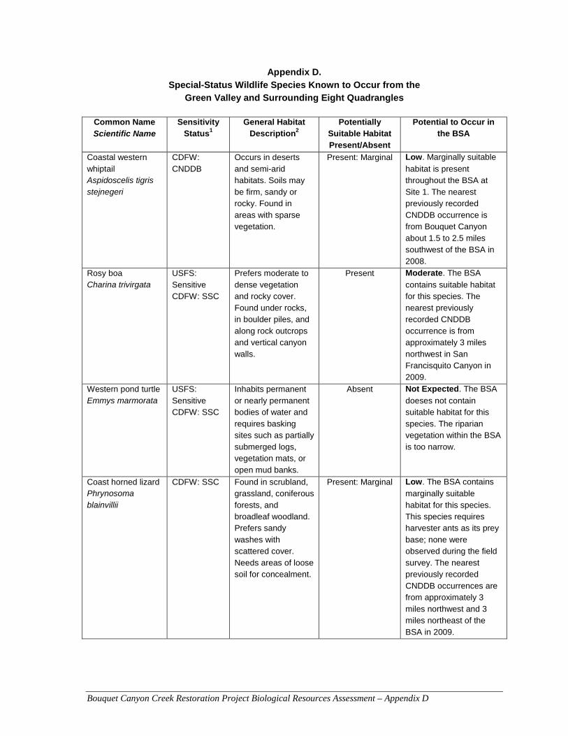
Bouquet Canyon Creek Restoration Project Biological Resources Assessment – Appendix D
Appendix D. Special-Status Wildlife Species Known to Occur from the
Green Valley and Surrounding Eight Quadrangles
Common Name Scientific Name
Sensitivity Status1
General Habitat Description2
Potentially Suitable Habitat Present/Absent
Potential to Occur in the BSA
Coastal western whiptail Aspidoscelis tigris stejnegeri
CDFW: CNDDB
Occurs in deserts and semi-arid habitats. Soils may be firm, sandy or rocky. Found in areas with sparse vegetation.
Present: Marginal Low. Marginally suitable
habitat is present throughout the BSA at Site 1. The nearest previously recorded CNDDB occurrence is from Bouquet Canyon about 1.5 to 2.5 miles southwest of the BSA in 2008.
Rosy boa Charina trivirgata
USFS: Sensitive CDFW: SSC
Prefers moderate to dense vegetation and rocky cover. Found under rocks, in boulder piles, and along rock outcrops and vertical canyon walls.
Present Moderate. The BSA
contains suitable habitat for this species. The nearest previously recorded CNDDB occurrence is from approximately 3 miles northwest in San Francisquito Canyon in 2009.
Western pond turtle Emmys marmorata
USFS: Sensitive CDFW: SSC
Inhabits permanent or nearly permanent bodies of water and requires basking sites such as partially submerged logs, vegetation mats, or open mud banks.
Absent Not Expected. The BSA
doeses not contain suitable habitat for this species. The riparian vegetation within the BSA is too narrow.
Coast horned lizard Phrynosoma blainvillii
CDFW: SSC
Found in scrubland, grassland, coniferous forests, and broadleaf woodland. Prefers sandy washes with scattered cover. Needs areas of loose soil for concealment.
Present: Marginal Low. The BSA contains
marginally suitable habitat for this species. This species requires harvester ants as its prey base; none were observed during the field survey. The nearest previously recorded CNDDB occurrences are from approximately 3 miles northwest and 3 miles northeast of the BSA in 2009.
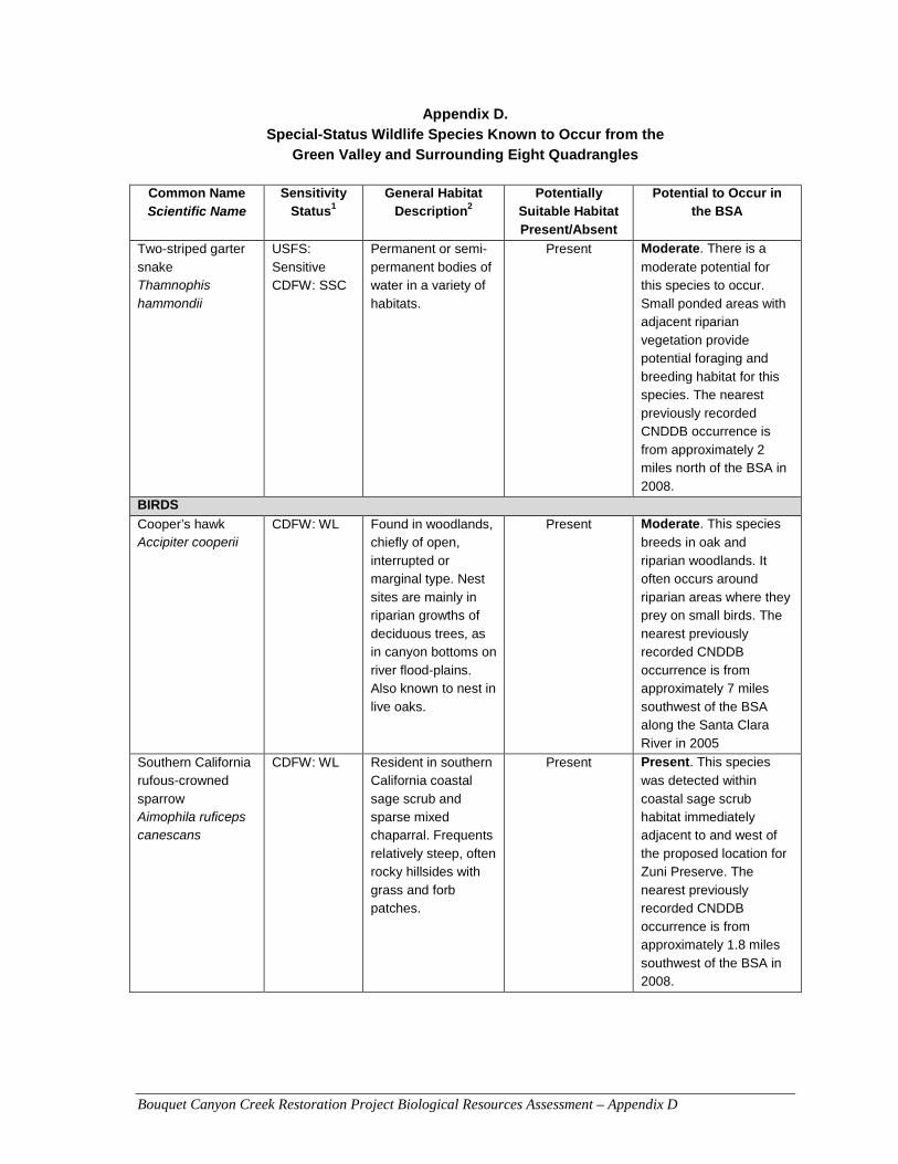
Bouquet Canyon Creek Restoration Project Biological Resources Assessment – Appendix D
Appendix D. Special-Status Wildlife Species Known to Occur from the
Green Valley and Surrounding Eight Quadrangles
Common Name Scientific Name
Sensitivity Status1
General Habitat Description2
Potentially Suitable Habitat Present/Absent
Potential to Occur in the BSA
Two-striped garter snake Thamnophis hammondii
USFS: Sensitive CDFW: SSC
Permanent or semi-permanent bodies of water in a variety of habitats.
Present Moderate. There is a
moderate potential for this species to occur. Small ponded areas with adjacent riparian vegetation provide potential foraging and breeding habitat for this species. The nearest previously recorded CNDDB occurrence is from approximately 2 miles north of the BSA in 2008.
BIRDS
Cooper’s hawk Accipiter cooperii
CDFW: WL Found in woodlands, chiefly of open, interrupted or marginal type. Nest sites are mainly in riparian growths of deciduous trees, as in canyon bottoms on river flood-plains. Also known to nest in live oaks.
Present Moderate. This species
breeds in oak and riparian woodlands. It often occurs around riparian areas where they prey on small birds. The nearest previously recorded CNDDB occurrence is from approximately 7 miles southwest of the BSA along the Santa Clara River in 2005
Southern California rufous-crowned sparrow Aimophila ruficeps canescans
CDFW: WL Resident in southern California coastal sage scrub and sparse mixed chaparral. Frequents relatively steep, often rocky hillsides with grass and forb patches.
Present Present. This species
was detected within coastal sage scrub habitat immediately adjacent to and west of the proposed location for Zuni Preserve. The nearest previously recorded CNDDB occurrence is from approximately 1.8 miles southwest of the BSA in 2008.
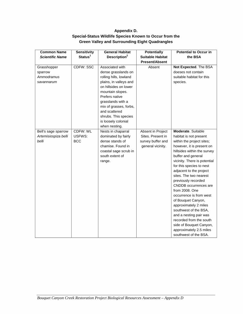
Bouquet Canyon Creek Restoration Project Biological Resources Assessment – Appendix D
Appendix D. Special-Status Wildlife Species Known to Occur from the
Green Valley and Surrounding Eight Quadrangles
Common Name Scientific Name
Sensitivity Status1
General Habitat Description2
Potentially Suitable Habitat Present/Absent
Potential to Occur in the BSA
Grasshopper sparrow Ammodramus savannarum
CDFW: SSC Associated with dense grasslands on rolling hills, lowland plains, in valleys and on hillsides on lower mountain slopes. Prefers native grasslands with a mix of grasses, forbs, and scattered shrubs. This species is loosely colonial when nesting.
Absent Not Expected. The BSA
doeses not contain suitable habitat for this species.
Bell’s sage sparrow Artemisiospiza belli belli
CDFW: WL USFWS: BCC
Nests in chaparral dominated by fairly dense stands of chamise. Found in coastal sage scrub in south extent of range.
Absent in Project Sites. Present in survey buffer and general vicinity.
Moderate. Suitable
habitat is not present within the project sites; however, it is present on hillsides within the survey buffer and general vicinity. There is potential for this species to nest adjacent to the project sites. The two nearest previously recorded CNDDB occurrences are from 2008. One occurrence is from west of Bouquet Canyon, approximately 2 miles southwest of the BSA, and a nesting pair was recorded from the south side of Bouquet Canyon, approximately 2.5 miles southwest of the BSA.
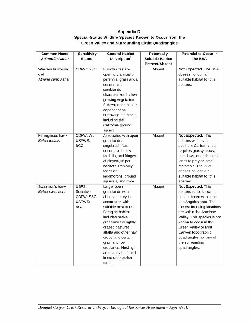
Bouquet Canyon Creek Restoration Project Biological Resources Assessment – Appendix D
Appendix D. Special-Status Wildlife Species Known to Occur from the
Green Valley and Surrounding Eight Quadrangles
Common Name Scientific Name
Sensitivity Status1
General Habitat Description2
Potentially Suitable Habitat Present/Absent
Potential to Occur in the BSA
Western burrowing owl Athene cunicularia
CDFW: SSC Burrow sites are open, dry annual or perennial grasslands, deserts and scrublands characterized by low-growing vegetation. Subterranean nester dependent on burrowing mammals, including the California ground squirrel.
Absent Not Expected. The BSA
doeses not contain suitable habitat for this species.
Ferruginous hawk Buteo regalis
CDFW: WL USFWS: BCC
Associated with open grasslands, sagebrush flats, desert scrub, low foothills, and fringes of pinyon-juniper habitats. Primarily feeds on lagomorphs, ground squirrels, and mice.
Absent Not Expected. This
species winters in southern California, but requires grassy areas, meadows, or agricultural lands to prey on small mammals. The BSA doeses not contain suitable habitat for this species.
Swainson’s hawk Buteo swainsoni
USFS: Sensitive CDFW: SSC USFWS: BCC
Large, open grasslands with abundant prey in association with suitable nest trees. Foraging habitat includes native grasslands or lightly grazed pastures, alfalfa and other hay crops, and certain grain and row croplands. Nesting areas may be found in mature riparian forest.
Absent Not Expected. This
species is not known to nest or breed within the Los Angeles area. The closest breeding locations are within the Antelope Valley. This species is not known to occur in the Green Valley or Mint Canyon topographic quadrangles nor any of the surrounding quadrangles.
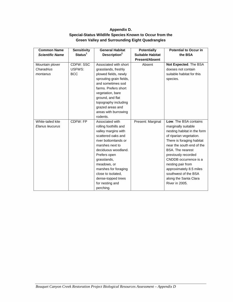
Bouquet Canyon Creek Restoration Project Biological Resources Assessment – Appendix D
Appendix D. Special-Status Wildlife Species Known to Occur from the
Green Valley and Surrounding Eight Quadrangles
Common Name Scientific Name
Sensitivity Status1
General Habitat Description2
Potentially Suitable Habitat Present/Absent
Potential to Occur in the BSA
Mountain plover Charadrius montanus
CDFW: SSC USFWS: BCC
Associated with short grasslands, freshly plowed fields, newly sprouting grain fields, and sometimes sod farms. Prefers short vegetation, bare ground, and flat topography including grazed areas and areas with burrowing rodents.
Absent Not Expected. The BSA
doeses not contain suitable habitat for this species.
White-tailed kite Elanus leucurus
CDFW: FP Associated with rolling foothills and valley margins with scattered oaks and river bottomlands or marshes next to deciduous woodland. Prefers open grasslands, meadows, or marshes for foraging close to isolated, dense-topped trees for nesting and perching.
Present: Marginal Low. The BSA contains
marginally suitable nesting habitat in the form of riparian vegetation. There is foraging habitat near the south end of the BSA. The nearest previously recorded CNDDB occurrence is a nesting pair from approximately 8.5 miles southwest of the BSA along the Santa Clara River in 2005.
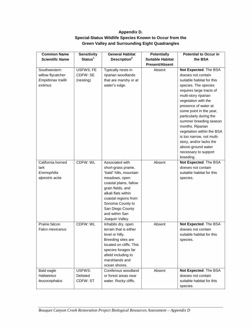
Bouquet Canyon Creek Restoration Project Biological Resources Assessment – Appendix D
Appendix D. Special-Status Wildlife Species Known to Occur from the
Green Valley and Surrounding Eight Quadrangles
Common Name Scientific Name
Sensitivity Status1
General Habitat Description2
Potentially Suitable Habitat Present/Absent
Potential to Occur in the BSA
Southwestern willow flycatcher Empidonax traillii extimus
USFWS: FE CDFW: SE (nesting)
Typically nests in riparian woodlands that are marshy or at water’s edge.
Absent Not Expected. The BSA
doeses not contain suitable habitat for this species. The species requires large tracts of multi-story riparian vegetation with the presence of water at some point in the year, particularly during the summer breeding season months. Riparian vegetation within the BSA is too narrow, not multi-story, and/or lacks the above-ground water necessary to support breeding.
California horned lark Eremophilia alpestris actia
CDFW: WL Associated with short-grass prairie, “bald” hills, mountain meadows, open coastal plains, fallow grain fields, and alkali flats within coastal regions from Sonoma County to San Diego County and within San Joaquin Valley.
Absent Not Expected. The BSA
doeses not contain suitable habitat for this species.
Prairie falcon Falco mexicanus
CDFW: WL Inhabits dry, open terrain that is either level or hilly. Breeding sites are located on cliffs. This species forages far afield including to marshlands and ocean shores.
Absent Not Expected. The BSA
doeses not contain suitable habitat for this species.
Bald eagle Haliaeetus leucocephalus
USFWS: Delisted CDFW: ST
Coniferous woodland or forest areas near water. Rocky cliffs.
Absent Not Expected. The BSA
doeses not contain suitable habitat for this species.
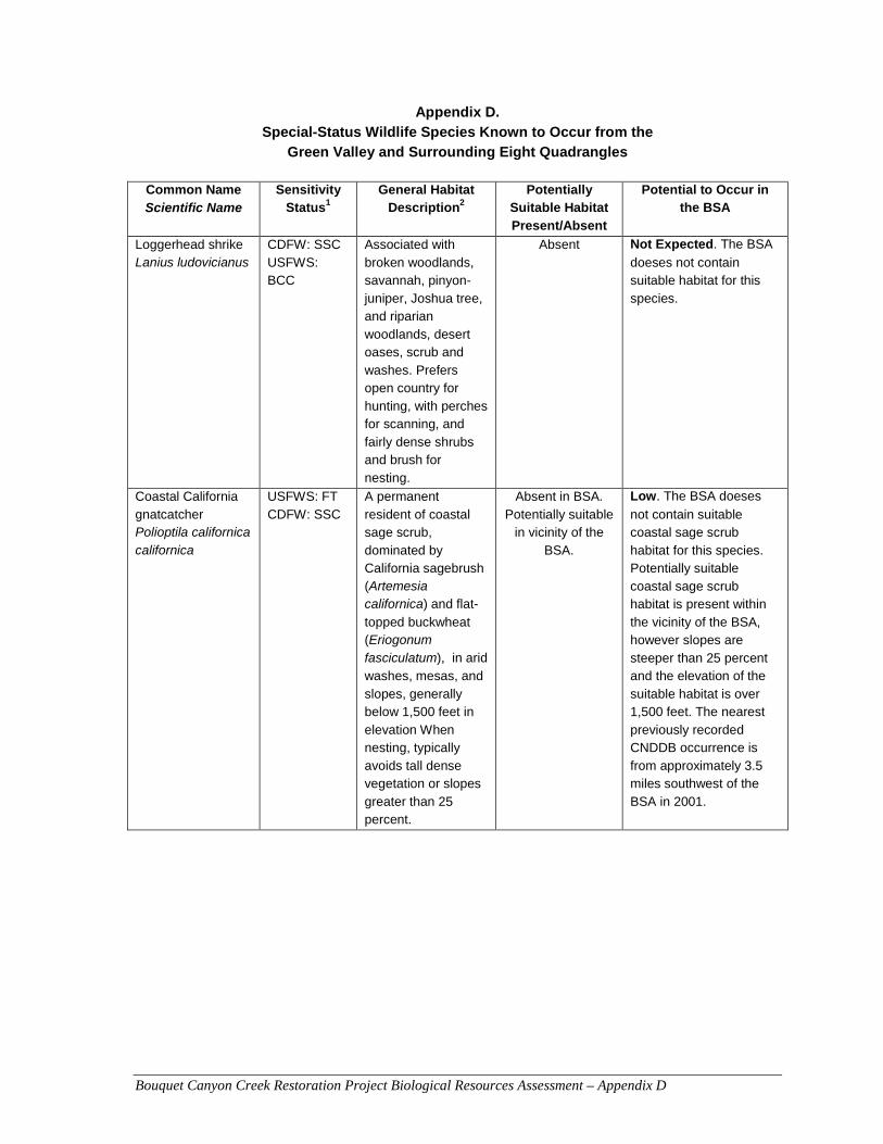
Bouquet Canyon Creek Restoration Project Biological Resources Assessment – Appendix D
Appendix D. Special-Status Wildlife Species Known to Occur from the
Green Valley and Surrounding Eight Quadrangles
Common Name Scientific Name
Sensitivity Status1
General Habitat Description2
Potentially Suitable Habitat Present/Absent
Potential to Occur in the BSA
Loggerhead shrike Lanius ludovicianus
CDFW: SSC USFWS: BCC
Associated with broken woodlands, savannah, pinyon-juniper, Joshua tree, and riparian woodlands, desert oases, scrub and washes. Prefers open country for hunting, with perches for scanning, and fairly dense shrubs and brush for nesting.
Absent Not Expected. The BSA
doeses not contain suitable habitat for this species.
Coastal California gnatcatcher Polioptila californica californica
USFWS: FT CDFW: SSC
A permanent resident of coastal sage scrub, dominated by California sagebrush (Artemesia californica) and flat-
topped buckwheat (Eriogonum fasciculatum), in arid washes, mesas, and slopes, generally below 1,500 feet in elevation When nesting, typically avoids tall dense vegetation or slopes greater than 25 percent.
Absent in BSA. Potentially suitable
in vicinity of the BSA.
Low. The BSA doeses
not contain suitable coastal sage scrub habitat for this species. Potentially suitable coastal sage scrub habitat is present within the vicinity of the BSA, however slopes are steeper than 25 percent and the elevation of the suitable habitat is over 1,500 feet. The nearest previously recorded CNDDB occurrence is from approximately 3.5 miles southwest of the BSA in 2001.
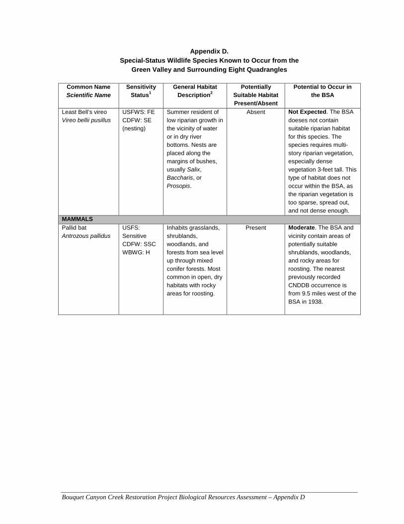
Bouquet Canyon Creek Restoration Project Biological Resources Assessment – Appendix D
Appendix D. Special-Status Wildlife Species Known to Occur from the
Green Valley and Surrounding Eight Quadrangles
Common Name Scientific Name
Sensitivity Status1
General Habitat Description2
Potentially Suitable Habitat Present/Absent
Potential to Occur in the BSA
Least Bell’s vireo Vireo bellii pusillus
USFWS: FE CDFW: SE (nesting)
Summer resident of low riparian growth in the vicinity of water or in dry river bottoms. Nests are placed along the margins of bushes, usually Salix, Baccharis, or Prosopis.
Absent Not Expected. The BSA
doeses not contain suitable riparian habitat for this species. The species requires multi-story riparian vegetation, especially dense vegetation 3-feet tall. This type of habitat does not occur within the BSA, as the riparian vegetation is too sparse, spread out, and not dense enough.
MAMMALS
Pallid bat Antrozous pallidus
USFS: Sensitive CDFW: SSC WBWG: H
Inhabits grasslands, shrublands, woodlands, and forests from sea level up through mixed conifer forests. Most common in open, dry habitats with rocky areas for roosting.
Present Moderate. The BSA and
vicinity contain areas of potentially suitable shrublands, woodlands, and rocky areas for roosting. The nearest previously recorded CNDDB occurrence is from 9.5 miles west of the BSA in 1938.
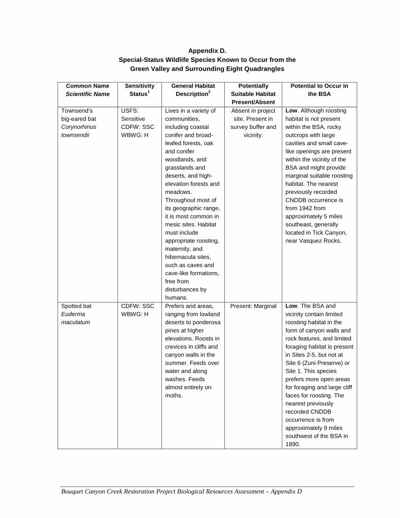
Bouquet Canyon Creek Restoration Project Biological Resources Assessment – Appendix D
Appendix D. Special-Status Wildlife Species Known to Occur from the
Green Valley and Surrounding Eight Quadrangles
Common Name Scientific Name
Sensitivity Status1
General Habitat Description2
Potentially Suitable Habitat Present/Absent
Potential to Occur in the BSA
Townsend’s big-eared bat Corynorhinus townsendii
USFS: Sensitive CDFW: SSC WBWG: H
Lives in a variety of communities, including coastal conifer and broad-leafed forests, oak and conifer woodlands, arid grasslands and deserts, and high-elevation forests and meadows. Throughout most of its geographic range, it is most common in mesic sites. Habitat must include appropriate roosting, maternity, and hibernacula sites, such as caves and cave-like formations, free from disturbances by humans.
Absent in project site. Present in
survey buffer and vicinity.
Low. Although roosting
habitat is not present within the BSA, rocky outcrops with large cavities and small cave-like openings are present within the vicinity of the BSA and might provide marginal suitable roosting habitat. The nearest previously recorded CNDDB occurrence is from 1942 from approximately 5 miles southeast, generally located in Tick Canyon, near Vasquez Rocks.
Spotted bat Euderma maculatum
CDFW: SSC WBWG: H
Prefers arid areas, ranging from lowland deserts to ponderosa pines at higher elevations. Roosts in crevices in cliffs and canyon walls in the summer. Feeds over water and along washes. Feeds almost entirely on moths.
Present: Marginal Low. The BSA and
vicinity contain limited roosting habitat in the form of canyon walls and rock features, and limited foraging habitat is present in Sites 2-5, but not at Site 6 (Zuni Preserve) or Site 1. This species prefers more open areas for foraging and large cliff faces for roosting. The nearest previously recorded CNDDB occurrence is from approximately 9 miles southwest of the BSA in 1890.
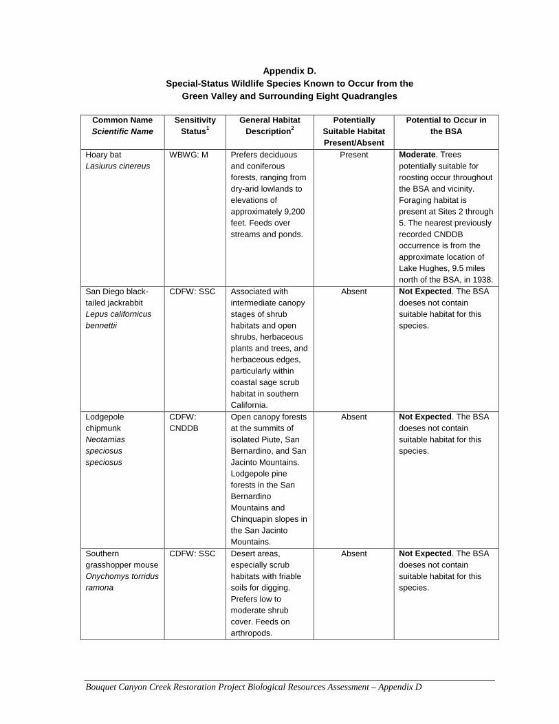
Bouquet Canyon Creek Restoration Project Biological Resources Assessment – Appendix D
Appendix D. Special-Status Wildlife Species Known to Occur from the
Green Valley and Surrounding Eight Quadrangles
Common Name Scientific Name
Sensitivity Status1
General Habitat Description2
Potentially Suitable Habitat Present/Absent
Potential to Occur in the BSA
Hoary bat Lasiurus cinereus
WBWG: M Prefers deciduous and coniferous forests, ranging from dry-arid lowlands to elevations of approximately 9,200 feet. Feeds over streams and ponds.
Present Moderate. Trees
potentially suitable for roosting occur throughout the BSA and vicinity. Foraging habitat is present at Sites 2 through 5. The nearest previously recorded CNDDB occurrence is from the approximate location of Lake Hughes, 9.5 miles north of the BSA, in 1938.
San Diego black-tailed jackrabbit Lepus californicus bennettii
CDFW: SSC Associated with intermediate canopy stages of shrub habitats and open shrubs, herbaceous plants and trees, and herbaceous edges, particularly within coastal sage scrub habitat in southern California.
Absent Not Expected. The BSA
doeses not contain suitable habitat for this species.
Lodgepole chipmunk Neotamias speciosus speciosus
CDFW: CNDDB
Open canopy forests at the summits of isolated Piute, San Bernardino, and San Jacinto Mountains. Lodgepole pine forests in the San Bernardino Mountains and Chinquapin slopes in the San Jacinto Mountains.
Absent Not Expected. The BSA
doeses not contain suitable habitat for this species.
Southern grasshopper mouse Onychomys torridus ramona
CDFW: SSC Desert areas, especially scrub habitats with friable soils for digging. Prefers low to moderate shrub cover. Feeds on arthropods.
Absent Not Expected. The BSA
doeses not contain suitable habitat for this species.
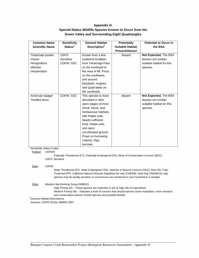
Bouquet Canyon Creek Restoration Project Biological Resources Assessment – Appendix D
Appendix D. Special-Status Wildlife Species Known to Occur from the
Green Valley and Surrounding Eight Quadrangles
Common Name Scientific Name
Sensitivity Status1
General Habitat Description2
Potentially Suitable Habitat Present/Absent
Potential to Occur in the BSA
Tehachapi pocket mouse Perognathus alticolus inexpectatus
USFS: Sensitive CDFW: SSC
Known from a few scattered localities from Tehachapi Pass on the northeast to the area of Mt. Pinos on the southwest, and around Elizabeth, Hughes, and Quail lakes on the southeast.
Absent Not Expected. The BSA
doeses not contain suitable habitat for this species.
American badger Taxidea taxus
CDFW: SSC This species is most abundant in drier open stages of most shrub, forest, and herbaceous habitats, with friable soils. Needs sufficient food, friable soils, and open, uncultivated ground. Preys on burrowing rodents. Digs burrows.
Absent Not Expected. The BSA
doeses not contain suitable habitat for this species.
1 Sensitivity Status Codes Federal USFWS:
Federally Threatened (FT), Federally Endangered (FE), Birds of Conservation Concern (BCC) USFS: Sensitive State CDFW:
State Threatened (ST), State Endangered (SE), Species of Special Concern (SSC), Rare (R), Fully-Protected (FP), California Natural Diversity DataBase list only (CNDDB). Note that CNDDB list only species may be locally sensitive or occurrences are monitored to see if protection is needed.
Other Western Bat Working Group (WBWG) High Priority (H) – These species are imperiled or are at high risk of imperilment Medium Priority (M) – Indicates a level of concern that should warrant closer evaluation, more research, and conservation actions of both species and possible threats.
2 General Habitat Descriptions Sources: CDFW 2016a; WBWG 2007

Bouquet Canyon Creek Restoration Project Biological Resources Assessment – Appendix E
APPENDIX E
Wetland Determination Data Forms

US Army Corps of Engineers Arid West – Version 2.0
WETLAND DETERMINATION DATA FORM – Arid West Region
Project/Site: City/County: Sampling Date:
Applicant/Owner: State: Sampling Point:
Investigator(s): Section, Township, Range:
Landform (hillslope, terrace, etc.): Local relief (concave, convex, none): Slope (%):
Subregion (LRR): Lat: Long: Datum:
Soil Map Unit Name: NWI classification:
Are climatic / hydrologic conditions on the site typical for this time of year? Yes No (If no, explain in Remarks.)
Are Vegetation , Soil , or Hydrology significantly disturbed? Are “Normal Circumstances” present? Yes No
Are Vegetation , Soil , or Hydrology naturally problematic? (If needed, explain any answers in Remarks.)
SUMMARY OF FINDINGS – Attach site map showing sampling point locations, transects, important features, etc.
Hydrophytic Vegetation Present? Yes No
Hydric Soil Present? Yes No
Wetland Hydrology Present? Yes No
Is the Sampled Area
within a Wetland? Yes No
Remarks:
VEGETATION – Use scientific names of plants.
Dominance Test worksheet:
Number of Dominant Species That Are OBL, FACW, or FAC: (A)
Total Number of Dominant Species Across All Strata: (B)
Percent of Dominant Species That Are OBL, FACW, or FAC: (A/B)
Prevalence Index worksheet:
Total % Cover of: Multiply by:
OBL species x 1 =
FACW species x 2 =
FAC species x 3 =
FACU species x 4 =
UPL species x 5 =
Column Totals: (A) (B)
Prevalence Index = B/A =
Hydrophytic Vegetation Indicators:
Dominance Test is >50%
Prevalence Index is 3.01
Morphological Adaptations1 (Provide supporting data in Remarks or on a separate sheet)
Problematic Hydrophytic Vegetation1 (Explain)
1Indicators of hydric soil and wetland hydrology must be present, unless disturbed or problematic.
Absolute Dominant Indicator Tree Stratum (Plot size: ) % Cover Species? Status
1.
2.
3.
4.
= Total Cover Sapling/Shrub Stratum (Plot size: )
1.
2.
3.
4.
5.
= Total Cover Herb Stratum (Plot size: )
1.
2.
3.
4.
5.
6.
7.
8.
= Total Cover Woody Vine Stratum (Plot size: )
1.
2.
= Total Cover
% Bare Ground in Herb Stratum % Cover of Biotic Crust
Hydrophytic Vegetation Present? Yes No
Remarks:
Bouquet Creek Restoration Project County of Los Angeles 12/29/2014
Los Angeles Department of Public Works CA 1a
Julie Stout 05N15W21
floodplain concave 2
C-Mediterranean California -118.455678 34.498136 WGS 84
Cortina sandy loam, 2 to 9 percent slopes na
x x
x*
xx
x
Hydrophytic shrubs appear stressed and are dying. Site is impacted by water holding and releasefrom upstream dam.
3
1
75
Baccharis salicifolia
Salix lasiolepis
15
5
20
y
y
FAC
FACW
Salsola tragus
Bromus madritensis ssp. rubens
Hirschfeldia incana
25
7
30
8
70
y
n
y
n
FAC
FACU
not listed
not listed
Urtica dioica
30 x
Salix and Baccharis shrubs that are at least 5-10 years old appear to be stressed and dying(dropped leaves, pealing bark).
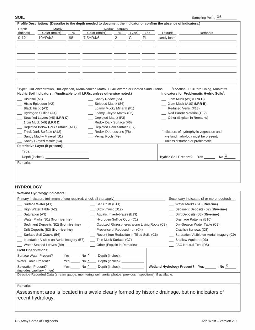
US Army Corps of Engineers Arid West – Version 2.0
SOIL Sampling Point:
Profile Description: (Describe to the depth needed to document the indicator or confirm the absence of indicators.)
Depth Matrix Redox Features (inches) Color (moist) % Color (moist) % Type1 Loc2 Texture Remarks
1Type: C=Concentration, D=Depletion, RM=Reduced Matrix, CS=Covered or Coated Sand Grains. 2Location: PL=Pore Lining, M=Matrix.Hydric Soil Indicators: (Applicable to all LRRs, unless otherwise noted.) Indicators for Problematic Hydric Soils3:
Histosol (A1) Sandy Redox (S5) 1 cm Muck (A9) (LRR C)
Histic Epipedon (A2) Stripped Matrix (S6) 2 cm Muck (A10) (LRR B)
Black Histic (A3) Loamy Mucky Mineral (F1) Reduced Vertic (F18)
Hydrogen Sulfide (A4) Loamy Gleyed Matrix (F2) Red Parent Material (TF2)
Stratified Layers (A5) (LRR C) Depleted Matrix (F3) Other (Explain in Remarks)
1 cm Muck (A9) (LRR D) Redox Dark Surface (F6)
Depleted Below Dark Surface (A11) Depleted Dark Surface (F7)
Thick Dark Surface (A12) Redox Depressions (F8) 3Indicators of hydrophytic vegetation and
Sandy Mucky Mineral (S1) Vernal Pools (F9) wetland hydrology must be present,
Sandy Gleyed Matrix (S4) unless disturbed or problematic.
Restrictive Layer (if present):
Type:
Depth (inches): Hydric Soil Present? Yes No
Remarks:
HYDROLOGY
Wetland Hydrology Indicators:
Primary Indicators (minimum of one required; check all that apply) Secondary Indicators (2 or more required)
Surface Water (A1) Salt Crust (B11) Water Marks (B1) (Riverine)
High Water Table (A2) Biotic Crust (B12) Sediment Deposits (B2) (Riverine)
Saturation (A3) Aquatic Invertebrates (B13) Drift Deposits (B3) (Riverine)
Water Marks (B1) (Nonriverine) Hydrogen Sulfide Odor (C1) Drainage Patterns (B10)
Sediment Deposits (B2) (Nonriverine) Oxidized Rhizospheres along Living Roots (C3) Dry-Season Water Table (C2)
Drift Deposits (B3) (Nonriverine) Presence of Reduced Iron (C4) Crayfish Burrows (C8)
Surface Soil Cracks (B6) Recent Iron Reduction in Tilled Soils (C6) Saturation Visible on Aerial Imagery (C9)
Inundation Visible on Aerial Imagery (B7) Thin Muck Surface (C7) Shallow Aquitard (D3)
Water-Stained Leaves (B9) Other (Explain in Remarks) FAC-Neutral Test (D5)
Field Observations:
Surface Water Present? Yes No Depth (inches):
Water Table Present? Yes No Depth (inches):
Saturation Present? Yes No Depth (inches): (includes capillary fringe)
Wetland Hydrology Present? Yes No
Describe Recorded Data (stream gauge, monitoring well, aerial photos, previous inspections), if available:
Remarks:
1a
0-12 10YR4/2 98 7.5YR4/6 2 C PL sandy loam
x
x
x
x x
Assessment area is located in a swale clearly formed by historic drainage, but no indicators ofrecent hydrology.

US Army Corps of Engineers Arid West – Version 2.0
WETLAND DETERMINATION DATA FORM – Arid West Region
Project/Site: City/County: Sampling Date:
Applicant/Owner: State: Sampling Point:
Investigator(s): Section, Township, Range:
Landform (hillslope, terrace, etc.): Local relief (concave, convex, none): Slope (%):
Subregion (LRR): Lat: Long: Datum:
Soil Map Unit Name: NWI classification:
Are climatic / hydrologic conditions on the site typical for this time of year? Yes No (If no, explain in Remarks.)
Are Vegetation , Soil , or Hydrology significantly disturbed? Are “Normal Circumstances” present? Yes No
Are Vegetation , Soil , or Hydrology naturally problematic? (If needed, explain any answers in Remarks.)
SUMMARY OF FINDINGS – Attach site map showing sampling point locations, transects, important features, etc.
Hydrophytic Vegetation Present? Yes No
Hydric Soil Present? Yes No
Wetland Hydrology Present? Yes No
Is the Sampled Area
within a Wetland? Yes No
Remarks:
VEGETATION – Use scientific names of plants.
Dominance Test worksheet:
Number of Dominant Species That Are OBL, FACW, or FAC: (A)
Total Number of Dominant Species Across All Strata: (B)
Percent of Dominant Species That Are OBL, FACW, or FAC: (A/B)
Prevalence Index worksheet:
Total % Cover of: Multiply by:
OBL species x 1 =
FACW species x 2 =
FAC species x 3 =
FACU species x 4 =
UPL species x 5 =
Column Totals: (A) (B)
Prevalence Index = B/A =
Hydrophytic Vegetation Indicators:
Dominance Test is >50%
Prevalence Index is 3.01
Morphological Adaptations1 (Provide supporting data in Remarks or on a separate sheet)
Problematic Hydrophytic Vegetation1 (Explain)
1Indicators of hydric soil and wetland hydrology must be present, unless disturbed or problematic.
Absolute Dominant Indicator Tree Stratum (Plot size: ) % Cover Species? Status
1.
2.
3.
4.
= Total Cover Sapling/Shrub Stratum (Plot size: )
1.
2.
3.
4.
5.
= Total Cover Herb Stratum (Plot size: )
1.
2.
3.
4.
5.
6.
7.
8.
= Total Cover Woody Vine Stratum (Plot size: )
1.
2.
= Total Cover
% Bare Ground in Herb Stratum % Cover of Biotic Crust
Hydrophytic Vegetation Present? Yes No
Remarks:
x
Bouquet Creek Restoration Project County of Los Angeles 12/29/2014
Los Angeles Department of Public Works CA 2a
Julie Stout 05N15W21
floodplain concave 2
C-Mediterranean California -118.455803 34.498349 WGS 84
Cortina sandy loam, 2 to 9 percent slopes na
x
x x
x
xx
x
Site is impacted by water holding and release from upstream dam.
30' radius
10
10
y FACPlantanus racemosa 4
5
15' radius80
Salix lasiolepis 20
20
y FACW
5' radius
Typha latifolia
Bromus madritensis
Hirschfeldia incana
Ambrosia psilostachya
Chenopodium album
40
15
5
15
5
10
90
y
y
n
y
n
n
FAC
OBL
not listed
not listed
FACU
FACU
Urtica dioica
10 x
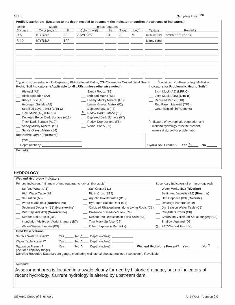
US Army Corps of Engineers Arid West – Version 2.0
SOIL Sampling Point:
Profile Description: (Describe to the depth needed to document the indicator or confirm the absence of indicators.)
Depth Matrix Redox Features (inches) Color (moist) % Color (moist) % Type1 Loc2 Texture Remarks
1Type: C=Concentration, D=Depletion, RM=Reduced Matrix, CS=Covered or Coated Sand Grains. 2Location: PL=Pore Lining, M=Matrix.Hydric Soil Indicators: (Applicable to all LRRs, unless otherwise noted.) Indicators for Problematic Hydric Soils3:
Histosol (A1) Sandy Redox (S5) 1 cm Muck (A9) (LRR C)
Histic Epipedon (A2) Stripped Matrix (S6) 2 cm Muck (A10) (LRR B)
Black Histic (A3) Loamy Mucky Mineral (F1) Reduced Vertic (F18)
Hydrogen Sulfide (A4) Loamy Gleyed Matrix (F2) Red Parent Material (TF2)
Stratified Layers (A5) (LRR C) Depleted Matrix (F3) Other (Explain in Remarks)
1 cm Muck (A9) (LRR D) Redox Dark Surface (F6)
Depleted Below Dark Surface (A11) Depleted Dark Surface (F7)
Thick Dark Surface (A12) Redox Depressions (F8) 3Indicators of hydrophytic vegetation and
Sandy Mucky Mineral (S1) Vernal Pools (F9) wetland hydrology must be present,
Sandy Gleyed Matrix (S4) unless disturbed or problematic.
Restrictive Layer (if present):
Type:
Depth (inches): Hydric Soil Present? Yes No
Remarks:
HYDROLOGY
Wetland Hydrology Indicators:
Primary Indicators (minimum of one required; check all that apply) Secondary Indicators (2 or more required)
Surface Water (A1) Salt Crust (B11) Water Marks (B1) (Riverine)
High Water Table (A2) Biotic Crust (B12) Sediment Deposits (B2) (Riverine)
Saturation (A3) Aquatic Invertebrates (B13) Drift Deposits (B3) (Riverine)
Water Marks (B1) (Nonriverine) Hydrogen Sulfide Odor (C1) Drainage Patterns (B10)
Sediment Deposits (B2) (Nonriverine) Oxidized Rhizospheres along Living Roots (C3) Dry-Season Water Table (C2)
Drift Deposits (B3) (Nonriverine) Presence of Reduced Iron (C4) Crayfish Burrows (C8)
Surface Soil Cracks (B6) Recent Iron Reduction in Tilled Soils (C6) Saturation Visible on Aerial Imagery (C9)
Inundation Visible on Aerial Imagery (B7) Thin Muck Surface (C7) Shallow Aquitard (D3)
Water-Stained Leaves (B9) Other (Explain in Remarks) FAC-Neutral Test (D5)
Field Observations:
Surface Water Present? Yes No Depth (inches):
Water Table Present? Yes No Depth (inches):
Saturation Present? Yes No Depth (inches): (includes capillary fringe)
Wetland Hydrology Present? Yes No
Describe Recorded Data (stream gauge, monitoring well, aerial photos, previous inspections), if available:
Remarks:
x
x
2a
0-5
5-12
10YR3/2
10YR4/2
80
100
7.5YR3/6 10 C M sandy clay loam
loamy sand
prominent redox
x
x
x
x x
Assessment area is located in a swale clearly formed by historic drainage, but no indicators ofrecent hydrology. Current hydrology is altered by upstream dam.

US Army Corps of Engineers Arid West – Version 2.0
WETLAND DETERMINATION DATA FORM – Arid West Region
Project/Site: City/County: Sampling Date:
Applicant/Owner: State: Sampling Point:
Investigator(s): Section, Township, Range:
Landform (hillslope, terrace, etc.): Local relief (concave, convex, none): Slope (%):
Subregion (LRR): Lat: Long: Datum:
Soil Map Unit Name: NWI classification:
Are climatic / hydrologic conditions on the site typical for this time of year? Yes No (If no, explain in Remarks.)
Are Vegetation , Soil , or Hydrology significantly disturbed? Are “Normal Circumstances” present? Yes No
Are Vegetation , Soil , or Hydrology naturally problematic? (If needed, explain any answers in Remarks.)
SUMMARY OF FINDINGS – Attach site map showing sampling point locations, transects, important features, etc.
Hydrophytic Vegetation Present? Yes No
Hydric Soil Present? Yes No
Wetland Hydrology Present? Yes No
Is the Sampled Area
within a Wetland? Yes No
Remarks:
VEGETATION – Use scientific names of plants.
Dominance Test worksheet:
Number of Dominant Species That Are OBL, FACW, or FAC: (A)
Total Number of Dominant Species Across All Strata: (B)
Percent of Dominant Species That Are OBL, FACW, or FAC: (A/B)
Prevalence Index worksheet:
Total % Cover of: Multiply by:
OBL species x 1 =
FACW species x 2 =
FAC species x 3 =
FACU species x 4 =
UPL species x 5 =
Column Totals: (A) (B)
Prevalence Index = B/A =
Hydrophytic Vegetation Indicators:
Dominance Test is >50%
Prevalence Index is 3.01
Morphological Adaptations1 (Provide supporting data in Remarks or on a separate sheet)
Problematic Hydrophytic Vegetation1 (Explain)
1Indicators of hydric soil and wetland hydrology must be present, unless disturbed or problematic.
Absolute Dominant Indicator Tree Stratum (Plot size: ) % Cover Species? Status
1.
2.
3.
4.
= Total Cover Sapling/Shrub Stratum (Plot size: )
1.
2.
3.
4.
5.
= Total Cover Herb Stratum (Plot size: )
1.
2.
3.
4.
5.
6.
7.
8.
= Total Cover Woody Vine Stratum (Plot size: )
1.
2.
= Total Cover
% Bare Ground in Herb Stratum % Cover of Biotic Crust
Hydrophytic Vegetation Present? Yes No
Remarks:
x
Bouquet Creek Restoration Project County of Los Angeles 12/29/2014
Los Angeles Department of Public Works CA 3a
Julie Stout 05N15W21
floodplain convex 1
C-Mediterranean California -118.453874 34.501933 WGS 84
Modesto, moderately deep-Trigo families complex, 25 to 75 percent slopes na
x
x x
x
xx
x
Site is impacted by water holding and release from upstream dam.
30' radius
1
1
15' radius100
5' radius
Phacelia distans
Salsola tragus
Hirschfeldia incana
Chenopodium album
65
5
1
15
5
91
y
n
n
n
n
FAC
OBL
FACU
not listed
FACU
Urtica dioica
9 x
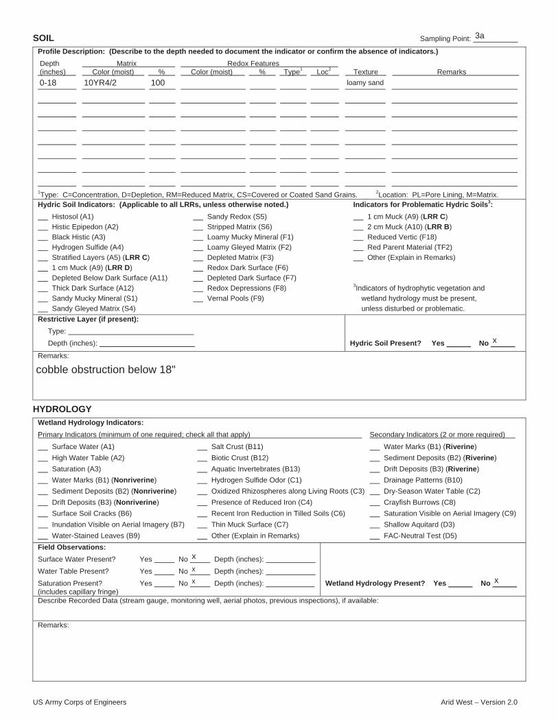
US Army Corps of Engineers Arid West – Version 2.0
SOIL Sampling Point:
Profile Description: (Describe to the depth needed to document the indicator or confirm the absence of indicators.)
Depth Matrix Redox Features (inches) Color (moist) % Color (moist) % Type1 Loc2 Texture Remarks
1Type: C=Concentration, D=Depletion, RM=Reduced Matrix, CS=Covered or Coated Sand Grains. 2Location: PL=Pore Lining, M=Matrix.Hydric Soil Indicators: (Applicable to all LRRs, unless otherwise noted.) Indicators for Problematic Hydric Soils3:
Histosol (A1) Sandy Redox (S5) 1 cm Muck (A9) (LRR C)
Histic Epipedon (A2) Stripped Matrix (S6) 2 cm Muck (A10) (LRR B)
Black Histic (A3) Loamy Mucky Mineral (F1) Reduced Vertic (F18)
Hydrogen Sulfide (A4) Loamy Gleyed Matrix (F2) Red Parent Material (TF2)
Stratified Layers (A5) (LRR C) Depleted Matrix (F3) Other (Explain in Remarks)
1 cm Muck (A9) (LRR D) Redox Dark Surface (F6)
Depleted Below Dark Surface (A11) Depleted Dark Surface (F7)
Thick Dark Surface (A12) Redox Depressions (F8) 3Indicators of hydrophytic vegetation and
Sandy Mucky Mineral (S1) Vernal Pools (F9) wetland hydrology must be present,
Sandy Gleyed Matrix (S4) unless disturbed or problematic.
Restrictive Layer (if present):
Type:
Depth (inches): Hydric Soil Present? Yes No
Remarks:
HYDROLOGY
Wetland Hydrology Indicators:
Primary Indicators (minimum of one required; check all that apply) Secondary Indicators (2 or more required)
Surface Water (A1) Salt Crust (B11) Water Marks (B1) (Riverine)
High Water Table (A2) Biotic Crust (B12) Sediment Deposits (B2) (Riverine)
Saturation (A3) Aquatic Invertebrates (B13) Drift Deposits (B3) (Riverine)
Water Marks (B1) (Nonriverine) Hydrogen Sulfide Odor (C1) Drainage Patterns (B10)
Sediment Deposits (B2) (Nonriverine) Oxidized Rhizospheres along Living Roots (C3) Dry-Season Water Table (C2)
Drift Deposits (B3) (Nonriverine) Presence of Reduced Iron (C4) Crayfish Burrows (C8)
Surface Soil Cracks (B6) Recent Iron Reduction in Tilled Soils (C6) Saturation Visible on Aerial Imagery (C9)
Inundation Visible on Aerial Imagery (B7) Thin Muck Surface (C7) Shallow Aquitard (D3)
Water-Stained Leaves (B9) Other (Explain in Remarks) FAC-Neutral Test (D5)
Field Observations:
Surface Water Present? Yes No Depth (inches):
Water Table Present? Yes No Depth (inches):
Saturation Present? Yes No Depth (inches): (includes capillary fringe)
Wetland Hydrology Present? Yes No
Describe Recorded Data (stream gauge, monitoring well, aerial photos, previous inspections), if available:
Remarks:
3a
0-18 10YR4/2 100 loamy sand
x
cobble obstruction below 18"
x
x
x x

US Army Corps of Engineers Arid West – Version 2.0
WETLAND DETERMINATION DATA FORM – Arid West Region
Project/Site: City/County: Sampling Date:
Applicant/Owner: State: Sampling Point:
Investigator(s): Section, Township, Range:
Landform (hillslope, terrace, etc.): Local relief (concave, convex, none): Slope (%):
Subregion (LRR): Lat: Long: Datum:
Soil Map Unit Name: NWI classification:
Are climatic / hydrologic conditions on the site typical for this time of year? Yes No (If no, explain in Remarks.)
Are Vegetation , Soil , or Hydrology significantly disturbed? Are “Normal Circumstances” present? Yes No
Are Vegetation , Soil , or Hydrology naturally problematic? (If needed, explain any answers in Remarks.)
SUMMARY OF FINDINGS – Attach site map showing sampling point locations, transects, important features, etc.
Hydrophytic Vegetation Present? Yes No
Hydric Soil Present? Yes No
Wetland Hydrology Present? Yes No
Is the Sampled Area
within a Wetland? Yes No
Remarks:
VEGETATION – Use scientific names of plants.
Dominance Test worksheet:
Number of Dominant Species That Are OBL, FACW, or FAC: (A)
Total Number of Dominant Species Across All Strata: (B)
Percent of Dominant Species That Are OBL, FACW, or FAC: (A/B)
Prevalence Index worksheet:
Total % Cover of: Multiply by:
OBL species x 1 =
FACW species x 2 =
FAC species x 3 =
FACU species x 4 =
UPL species x 5 =
Column Totals: (A) (B)
Prevalence Index = B/A =
Hydrophytic Vegetation Indicators:
Dominance Test is >50%
Prevalence Index is 3.01
Morphological Adaptations1 (Provide supporting data in Remarks or on a separate sheet)
Problematic Hydrophytic Vegetation1 (Explain)
1Indicators of hydric soil and wetland hydrology must be present, unless disturbed or problematic.
Absolute Dominant Indicator Tree Stratum (Plot size: ) % Cover Species? Status
1.
2.
3.
4.
= Total Cover Sapling/Shrub Stratum (Plot size: )
1.
2.
3.
4.
5.
= Total Cover Herb Stratum (Plot size: )
1.
2.
3.
4.
5.
6.
7.
8.
= Total Cover Woody Vine Stratum (Plot size: )
1.
2.
= Total Cover
% Bare Ground in Herb Stratum % Cover of Biotic Crust
Hydrophytic Vegetation Present? Yes No
Remarks:
x
Bouquet Creek Restoration Project County of Los Angeles 12/29/2014
Los Angeles Department of Public Works CA 3b
Julie Stout 05N15W21
floodplain concave 2
C-Mediterranean California -118.453901 34.502006 WGS 84
Modesto, moderately deep-Trigo families complex, 25 to 75 percent slopes na
x
x x
x
xx
x
Site is impacted by water holding and release from upstream dam.
30' radius
2
4
15' radius50
Salix lasiolepis
Baccharis salicifolia
40
10
50
y
y
FACW
FAC
40 80
10 30
5' radius15 60
Lepidium virginicum
10
5
15
y
y
FACU
FACU
Chenopodium album 65 170
2.62
85 x

US Army Corps of Engineers Arid West – Version 2.0
SOIL Sampling Point:
Profile Description: (Describe to the depth needed to document the indicator or confirm the absence of indicators.)
Depth Matrix Redox Features (inches) Color (moist) % Color (moist) % Type1 Loc2 Texture Remarks
1Type: C=Concentration, D=Depletion, RM=Reduced Matrix, CS=Covered or Coated Sand Grains. 2Location: PL=Pore Lining, M=Matrix.Hydric Soil Indicators: (Applicable to all LRRs, unless otherwise noted.) Indicators for Problematic Hydric Soils3:
Histosol (A1) Sandy Redox (S5) 1 cm Muck (A9) (LRR C)
Histic Epipedon (A2) Stripped Matrix (S6) 2 cm Muck (A10) (LRR B)
Black Histic (A3) Loamy Mucky Mineral (F1) Reduced Vertic (F18)
Hydrogen Sulfide (A4) Loamy Gleyed Matrix (F2) Red Parent Material (TF2)
Stratified Layers (A5) (LRR C) Depleted Matrix (F3) Other (Explain in Remarks)
1 cm Muck (A9) (LRR D) Redox Dark Surface (F6)
Depleted Below Dark Surface (A11) Depleted Dark Surface (F7)
Thick Dark Surface (A12) Redox Depressions (F8) 3Indicators of hydrophytic vegetation and
Sandy Mucky Mineral (S1) Vernal Pools (F9) wetland hydrology must be present,
Sandy Gleyed Matrix (S4) unless disturbed or problematic.
Restrictive Layer (if present):
Type:
Depth (inches): Hydric Soil Present? Yes No
Remarks:
HYDROLOGY
Wetland Hydrology Indicators:
Primary Indicators (minimum of one required; check all that apply) Secondary Indicators (2 or more required)
Surface Water (A1) Salt Crust (B11) Water Marks (B1) (Riverine)
High Water Table (A2) Biotic Crust (B12) Sediment Deposits (B2) (Riverine)
Saturation (A3) Aquatic Invertebrates (B13) Drift Deposits (B3) (Riverine)
Water Marks (B1) (Nonriverine) Hydrogen Sulfide Odor (C1) Drainage Patterns (B10)
Sediment Deposits (B2) (Nonriverine) Oxidized Rhizospheres along Living Roots (C3) Dry-Season Water Table (C2)
Drift Deposits (B3) (Nonriverine) Presence of Reduced Iron (C4) Crayfish Burrows (C8)
Surface Soil Cracks (B6) Recent Iron Reduction in Tilled Soils (C6) Saturation Visible on Aerial Imagery (C9)
Inundation Visible on Aerial Imagery (B7) Thin Muck Surface (C7) Shallow Aquitard (D3)
Water-Stained Leaves (B9) Other (Explain in Remarks) FAC-Neutral Test (D5)
Field Observations:
Surface Water Present? Yes No Depth (inches):
Water Table Present? Yes No Depth (inches):
Saturation Present? Yes No Depth (inches): (includes capillary fringe)
Wetland Hydrology Present? Yes No
Describe Recorded Data (stream gauge, monitoring well, aerial photos, previous inspections), if available:
Remarks:
3b
0-20 10YR4/2 100 loamy sand
x
cobble obstruction below 20"
x
x
x x

US Army Corps of Engineers Arid West – Version 2.0
WETLAND DETERMINATION DATA FORM – Arid West Region
Project/Site: City/County: Sampling Date:
Applicant/Owner: State: Sampling Point:
Investigator(s): Section, Township, Range:
Landform (hillslope, terrace, etc.): Local relief (concave, convex, none): Slope (%):
Subregion (LRR): Lat: Long: Datum:
Soil Map Unit Name: NWI classification:
Are climatic / hydrologic conditions on the site typical for this time of year? Yes No (If no, explain in Remarks.)
Are Vegetation , Soil , or Hydrology significantly disturbed? Are “Normal Circumstances” present? Yes No
Are Vegetation , Soil , or Hydrology naturally problematic? (If needed, explain any answers in Remarks.)
SUMMARY OF FINDINGS – Attach site map showing sampling point locations, transects, important features, etc.
Hydrophytic Vegetation Present? Yes No
Hydric Soil Present? Yes No
Wetland Hydrology Present? Yes No
Is the Sampled Area
within a Wetland? Yes No
Remarks:
VEGETATION – Use scientific names of plants.
Dominance Test worksheet:
Number of Dominant Species That Are OBL, FACW, or FAC: (A)
Total Number of Dominant Species Across All Strata: (B)
Percent of Dominant Species That Are OBL, FACW, or FAC: (A/B)
Prevalence Index worksheet:
Total % Cover of: Multiply by:
OBL species x 1 =
FACW species x 2 =
FAC species x 3 =
FACU species x 4 =
UPL species x 5 =
Column Totals: (A) (B)
Prevalence Index = B/A =
Hydrophytic Vegetation Indicators:
Dominance Test is >50%
Prevalence Index is 3.01
Morphological Adaptations1 (Provide supporting data in Remarks or on a separate sheet)
Problematic Hydrophytic Vegetation1 (Explain)
1Indicators of hydric soil and wetland hydrology must be present, unless disturbed or problematic.
Absolute Dominant Indicator Tree Stratum (Plot size: ) % Cover Species? Status
1.
2.
3.
4.
= Total Cover Sapling/Shrub Stratum (Plot size: )
1.
2.
3.
4.
5.
= Total Cover Herb Stratum (Plot size: )
1.
2.
3.
4.
5.
6.
7.
8.
= Total Cover Woody Vine Stratum (Plot size: )
1.
2.
= Total Cover
% Bare Ground in Herb Stratum % Cover of Biotic Crust
Hydrophytic Vegetation Present? Yes No
Remarks:
Bouquet Creek Restoration Project County of Los Angeles 12/29/2014
Los Angeles Department of Public Works CA 4a
Julie Stout 05N15W21
floodplain concave 1
C-Mediterranean California -118.453533 34.502295 WGS 84
Modesto, moderately deep-Trigo families complex, 25 to 75 percent slopes na
x
x x
x
xx
x
Site is impacted by water holding and release from upstream dam.
30' radius
1
1
15' radius100
5' radius
Bromus madritensis
Rumex crispus
10
10
55
75
n
n
y
FACU
not listed
FAC
Chenopodium album
25 x

US Army Corps of Engineers Arid West – Version 2.0
SOIL Sampling Point:
Profile Description: (Describe to the depth needed to document the indicator or confirm the absence of indicators.)
Depth Matrix Redox Features (inches) Color (moist) % Color (moist) % Type1 Loc2 Texture Remarks
1Type: C=Concentration, D=Depletion, RM=Reduced Matrix, CS=Covered or Coated Sand Grains. 2Location: PL=Pore Lining, M=Matrix.Hydric Soil Indicators: (Applicable to all LRRs, unless otherwise noted.) Indicators for Problematic Hydric Soils3:
Histosol (A1) Sandy Redox (S5) 1 cm Muck (A9) (LRR C)
Histic Epipedon (A2) Stripped Matrix (S6) 2 cm Muck (A10) (LRR B)
Black Histic (A3) Loamy Mucky Mineral (F1) Reduced Vertic (F18)
Hydrogen Sulfide (A4) Loamy Gleyed Matrix (F2) Red Parent Material (TF2)
Stratified Layers (A5) (LRR C) Depleted Matrix (F3) Other (Explain in Remarks)
1 cm Muck (A9) (LRR D) Redox Dark Surface (F6)
Depleted Below Dark Surface (A11) Depleted Dark Surface (F7)
Thick Dark Surface (A12) Redox Depressions (F8) 3Indicators of hydrophytic vegetation and
Sandy Mucky Mineral (S1) Vernal Pools (F9) wetland hydrology must be present,
Sandy Gleyed Matrix (S4) unless disturbed or problematic.
Restrictive Layer (if present):
Type:
Depth (inches): Hydric Soil Present? Yes No
Remarks:
HYDROLOGY
Wetland Hydrology Indicators:
Primary Indicators (minimum of one required; check all that apply) Secondary Indicators (2 or more required)
Surface Water (A1) Salt Crust (B11) Water Marks (B1) (Riverine)
High Water Table (A2) Biotic Crust (B12) Sediment Deposits (B2) (Riverine)
Saturation (A3) Aquatic Invertebrates (B13) Drift Deposits (B3) (Riverine)
Water Marks (B1) (Nonriverine) Hydrogen Sulfide Odor (C1) Drainage Patterns (B10)
Sediment Deposits (B2) (Nonriverine) Oxidized Rhizospheres along Living Roots (C3) Dry-Season Water Table (C2)
Drift Deposits (B3) (Nonriverine) Presence of Reduced Iron (C4) Crayfish Burrows (C8)
Surface Soil Cracks (B6) Recent Iron Reduction in Tilled Soils (C6) Saturation Visible on Aerial Imagery (C9)
Inundation Visible on Aerial Imagery (B7) Thin Muck Surface (C7) Shallow Aquitard (D3)
Water-Stained Leaves (B9) Other (Explain in Remarks) FAC-Neutral Test (D5)
Field Observations:
Surface Water Present? Yes No Depth (inches):
Water Table Present? Yes No Depth (inches):
Saturation Present? Yes No Depth (inches): (includes capillary fringe)
Wetland Hydrology Present? Yes No
Describe Recorded Data (stream gauge, monitoring well, aerial photos, previous inspections), if available:
Remarks:
4a
0-20 10YR4/2 100 clay loam
x
cobble obstruction below 20"
x
x
x x

US Army Corps of Engineers Arid West – Version 2.0
WETLAND DETERMINATION DATA FORM – Arid West Region
Project/Site: City/County: Sampling Date:
Applicant/Owner: State: Sampling Point:
Investigator(s): Section, Township, Range:
Landform (hillslope, terrace, etc.): Local relief (concave, convex, none): Slope (%):
Subregion (LRR): Lat: Long: Datum:
Soil Map Unit Name: NWI classification:
Are climatic / hydrologic conditions on the site typical for this time of year? Yes No (If no, explain in Remarks.)
Are Vegetation , Soil , or Hydrology significantly disturbed? Are “Normal Circumstances” present? Yes No
Are Vegetation , Soil , or Hydrology naturally problematic? (If needed, explain any answers in Remarks.)
SUMMARY OF FINDINGS – Attach site map showing sampling point locations, transects, important features, etc.
Hydrophytic Vegetation Present? Yes No
Hydric Soil Present? Yes No
Wetland Hydrology Present? Yes No
Is the Sampled Area
within a Wetland? Yes No
Remarks:
VEGETATION – Use scientific names of plants.
Dominance Test worksheet:
Number of Dominant Species That Are OBL, FACW, or FAC: (A)
Total Number of Dominant Species Across All Strata: (B)
Percent of Dominant Species That Are OBL, FACW, or FAC: (A/B)
Prevalence Index worksheet:
Total % Cover of: Multiply by:
OBL species x 1 =
FACW species x 2 =
FAC species x 3 =
FACU species x 4 =
UPL species x 5 =
Column Totals: (A) (B)
Prevalence Index = B/A =
Hydrophytic Vegetation Indicators:
Dominance Test is >50%
Prevalence Index is 3.01
Morphological Adaptations1 (Provide supporting data in Remarks or on a separate sheet)
Problematic Hydrophytic Vegetation1 (Explain)
1Indicators of hydric soil and wetland hydrology must be present, unless disturbed or problematic.
Absolute Dominant Indicator Tree Stratum (Plot size: ) % Cover Species? Status
1.
2.
3.
4.
= Total Cover Sapling/Shrub Stratum (Plot size: )
1.
2.
3.
4.
5.
= Total Cover Herb Stratum (Plot size: )
1.
2.
3.
4.
5.
6.
7.
8.
= Total Cover Woody Vine Stratum (Plot size: )
1.
2.
= Total Cover
% Bare Ground in Herb Stratum % Cover of Biotic Crust
Hydrophytic Vegetation Present? Yes No
Remarks:
x
Bouquet Creek Restoration Project County of Los Angeles 12/29/2014
Los Angeles Department of Public Works CA 4b
Julie Stout 05N15W21
floodplain concave
C-Mediterranean California -118.453475 34.502507 WGS 84
Modesto, moderately deep-Trigo families complex, 25 to 75 percent slopes na
x x x
x
xx
x
Site is impacted by water holding and release from upstream dam. A constructed berm is present betweenthe stream channel and this wetland depressional area, indicated it has been disturbed in the past.
30' radius
1
1
15' radius100
505' radius
Hirschfeldia incana
Typha cf. latifolia
15
5
75
n
n
y
FACU
not listed
OBL
Chenopodium album
95
5 x

US Army Corps of Engineers Arid West – Version 2.0
SOIL Sampling Point:
Profile Description: (Describe to the depth needed to document the indicator or confirm the absence of indicators.)
Depth Matrix Redox Features (inches) Color (moist) % Color (moist) % Type1 Loc2 Texture Remarks
1Type: C=Concentration, D=Depletion, RM=Reduced Matrix, CS=Covered or Coated Sand Grains. 2Location: PL=Pore Lining, M=Matrix.Hydric Soil Indicators: (Applicable to all LRRs, unless otherwise noted.) Indicators for Problematic Hydric Soils3:
Histosol (A1) Sandy Redox (S5) 1 cm Muck (A9) (LRR C)
Histic Epipedon (A2) Stripped Matrix (S6) 2 cm Muck (A10) (LRR B)
Black Histic (A3) Loamy Mucky Mineral (F1) Reduced Vertic (F18)
Hydrogen Sulfide (A4) Loamy Gleyed Matrix (F2) Red Parent Material (TF2)
Stratified Layers (A5) (LRR C) Depleted Matrix (F3) Other (Explain in Remarks)
1 cm Muck (A9) (LRR D) Redox Dark Surface (F6)
Depleted Below Dark Surface (A11) Depleted Dark Surface (F7)
Thick Dark Surface (A12) Redox Depressions (F8) 3Indicators of hydrophytic vegetation and
Sandy Mucky Mineral (S1) Vernal Pools (F9) wetland hydrology must be present,
Sandy Gleyed Matrix (S4) unless disturbed or problematic.
Restrictive Layer (if present):
Type:
Depth (inches): Hydric Soil Present? Yes No
Remarks:
HYDROLOGY
Wetland Hydrology Indicators:
Primary Indicators (minimum of one required; check all that apply) Secondary Indicators (2 or more required)
Surface Water (A1) Salt Crust (B11) Water Marks (B1) (Riverine)
High Water Table (A2) Biotic Crust (B12) Sediment Deposits (B2) (Riverine)
Saturation (A3) Aquatic Invertebrates (B13) Drift Deposits (B3) (Riverine)
Water Marks (B1) (Nonriverine) Hydrogen Sulfide Odor (C1) Drainage Patterns (B10)
Sediment Deposits (B2) (Nonriverine) Oxidized Rhizospheres along Living Roots (C3) Dry-Season Water Table (C2)
Drift Deposits (B3) (Nonriverine) Presence of Reduced Iron (C4) Crayfish Burrows (C8)
Surface Soil Cracks (B6) Recent Iron Reduction in Tilled Soils (C6) Saturation Visible on Aerial Imagery (C9)
Inundation Visible on Aerial Imagery (B7) Thin Muck Surface (C7) Shallow Aquitard (D3)
Water-Stained Leaves (B9) Other (Explain in Remarks) FAC-Neutral Test (D5)
Field Observations:
Surface Water Present? Yes No Depth (inches):
Water Table Present? Yes No Depth (inches):
Saturation Present? Yes No Depth (inches): (includes capillary fringe)
Wetland Hydrology Present? Yes No
Describe Recorded Data (stream gauge, monitoring well, aerial photos, previous inspections), if available:
Remarks:
xx
x
4b
0-18 10YR4/2 100 sandy clay loam
x
Wetland hydrology and soils were considered problematic and the determination of this site being a wetland was based solely on vegetation. Recent soil deposition or disturbance may nothave allowed time for Redox features to develop. The presence of a berm adjacent to this location and the absence of willows or older shrubs indicate the area was disturbed. Presence ofhydric soils is based on the assumption the soil would have to have been saturated for a duration long enough for a significant patch of wetland obligate vegetation to become established.It appears the depression where the wetland is located may be the result of digging out soil to form the berm and that soils in the depression may have eroded from the berm. The continuedfilling of the depression with eroded material may eventually cause it to become a non-wetland.
x
x
x x
Based on the strong dominance of wetland obligate vegetation growing at this point, evidence of local disturbance, and hydrological disturbance in the form of upstreamwater release and withholding at Bouquet Canyon Reservoir, it is assumed that wetland hydrology indicators are missing or undetectable. Recent soil deposition ordisturbance may not have allowed time for Redox features to develop and the dense layer of dead cattails did not allow for a thorough examination of the soil surfacefor common indicators such as water marks, a biotic crust, or water-stained leaves. Presence of hydrology is based on the assumption the soil would have to have beensaturated for a duration long enough for a significant patch of wetland obligate to become established. It is unclear why no hydrology was present at the time of theinvestigation but possible reasons include there being an unusually low water table due to the drought and lack of water release from the dam.

US Army Corps of Engineers Arid West – Version 2.0
WETLAND DETERMINATION DATA FORM – Arid West Region
Project/Site: City/County: Sampling Date:
Applicant/Owner: State: Sampling Point:
Investigator(s): Section, Township, Range:
Landform (hillslope, terrace, etc.): Local relief (concave, convex, none): Slope (%):
Subregion (LRR): Lat: Long: Datum:
Soil Map Unit Name: NWI classification:
Are climatic / hydrologic conditions on the site typical for this time of year? Yes No (If no, explain in Remarks.)
Are Vegetation , Soil , or Hydrology significantly disturbed? Are “Normal Circumstances” present? Yes No
Are Vegetation , Soil , or Hydrology naturally problematic? (If needed, explain any answers in Remarks.)
SUMMARY OF FINDINGS – Attach site map showing sampling point locations, transects, important features, etc.
Hydrophytic Vegetation Present? Yes No
Hydric Soil Present? Yes No
Wetland Hydrology Present? Yes No
Is the Sampled Area
within a Wetland? Yes No
Remarks:
VEGETATION – Use scientific names of plants.
Dominance Test worksheet:
Number of Dominant Species That Are OBL, FACW, or FAC: (A)
Total Number of Dominant Species Across All Strata: (B)
Percent of Dominant Species That Are OBL, FACW, or FAC: (A/B)
Prevalence Index worksheet:
Total % Cover of: Multiply by:
OBL species x 1 =
FACW species x 2 =
FAC species x 3 =
FACU species x 4 =
UPL species x 5 =
Column Totals: (A) (B)
Prevalence Index = B/A =
Hydrophytic Vegetation Indicators:
Dominance Test is >50%
Prevalence Index is 3.01
Morphological Adaptations1 (Provide supporting data in Remarks or on a separate sheet)
Problematic Hydrophytic Vegetation1 (Explain)
1Indicators of hydric soil and wetland hydrology must be present, unless disturbed or problematic.
Absolute Dominant Indicator Tree Stratum (Plot size: ) % Cover Species? Status
1.
2.
3.
4.
= Total Cover Sapling/Shrub Stratum (Plot size: )
1.
2.
3.
4.
5.
= Total Cover Herb Stratum (Plot size: )
1.
2.
3.
4.
5.
6.
7.
8.
= Total Cover Woody Vine Stratum (Plot size: )
1.
2.
= Total Cover
% Bare Ground in Herb Stratum % Cover of Biotic Crust
Hydrophytic Vegetation Present? Yes No
Remarks:
x
Bouquet Creek Restoration Project County of Los Angeles 12/29/2014
Los Angeles Department of Public Works CA 5a
Julie Stout 05N15W21
channel concave
C-Mediterranean California -118.453032 34.508911 WGS 84
Exchequer family, 30 to 60 percent slopes na
x
x x
x
xx
x
Site is impacted by water holding and release from upstream dam.
30' radius
30
30
y FACPlantanus racemosa 4
5
15' radius75
Baccharis salicifolia
Toxicodendron diversilobum
Salix laevigata
Salix lasiolepis
10
5
15
5
35
y
n
y
n
FAC
not listed
FACW
FACW
5' radius
Stipa (Piptatherum) miliacea
Iris pseudacorus
5
15
1
21
y
y
n
FAC
not listed
OBL
Rubus ursinus
79 x

US Army Corps of Engineers Arid West – Version 2.0
SOIL Sampling Point:
Profile Description: (Describe to the depth needed to document the indicator or confirm the absence of indicators.)
Depth Matrix Redox Features (inches) Color (moist) % Color (moist) % Type1 Loc2 Texture Remarks
1Type: C=Concentration, D=Depletion, RM=Reduced Matrix, CS=Covered or Coated Sand Grains. 2Location: PL=Pore Lining, M=Matrix.Hydric Soil Indicators: (Applicable to all LRRs, unless otherwise noted.) Indicators for Problematic Hydric Soils3:
Histosol (A1) Sandy Redox (S5) 1 cm Muck (A9) (LRR C)
Histic Epipedon (A2) Stripped Matrix (S6) 2 cm Muck (A10) (LRR B)
Black Histic (A3) Loamy Mucky Mineral (F1) Reduced Vertic (F18)
Hydrogen Sulfide (A4) Loamy Gleyed Matrix (F2) Red Parent Material (TF2)
Stratified Layers (A5) (LRR C) Depleted Matrix (F3) Other (Explain in Remarks)
1 cm Muck (A9) (LRR D) Redox Dark Surface (F6)
Depleted Below Dark Surface (A11) Depleted Dark Surface (F7)
Thick Dark Surface (A12) Redox Depressions (F8) 3Indicators of hydrophytic vegetation and
Sandy Mucky Mineral (S1) Vernal Pools (F9) wetland hydrology must be present,
Sandy Gleyed Matrix (S4) unless disturbed or problematic.
Restrictive Layer (if present):
Type:
Depth (inches): Hydric Soil Present? Yes No
Remarks:
HYDROLOGY
Wetland Hydrology Indicators:
Primary Indicators (minimum of one required; check all that apply) Secondary Indicators (2 or more required)
Surface Water (A1) Salt Crust (B11) Water Marks (B1) (Riverine)
High Water Table (A2) Biotic Crust (B12) Sediment Deposits (B2) (Riverine)
Saturation (A3) Aquatic Invertebrates (B13) Drift Deposits (B3) (Riverine)
Water Marks (B1) (Nonriverine) Hydrogen Sulfide Odor (C1) Drainage Patterns (B10)
Sediment Deposits (B2) (Nonriverine) Oxidized Rhizospheres along Living Roots (C3) Dry-Season Water Table (C2)
Drift Deposits (B3) (Nonriverine) Presence of Reduced Iron (C4) Crayfish Burrows (C8)
Surface Soil Cracks (B6) Recent Iron Reduction in Tilled Soils (C6) Saturation Visible on Aerial Imagery (C9)
Inundation Visible on Aerial Imagery (B7) Thin Muck Surface (C7) Shallow Aquitard (D3)
Water-Stained Leaves (B9) Other (Explain in Remarks) FAC-Neutral Test (D5)
Field Observations:
Surface Water Present? Yes No Depth (inches):
Water Table Present? Yes No Depth (inches):
Saturation Present? Yes No Depth (inches): (includes capillary fringe)
Wetland Hydrology Present? Yes No
Describe Recorded Data (stream gauge, monitoring well, aerial photos, previous inspections), if available:
Remarks:
x
x
x
5a
0+ cobble
x
Digging restricted by dense cobble. Hydric soils assumed based on predominance of hydrophyticvegetation and wetland hydrology.
x
x
x x
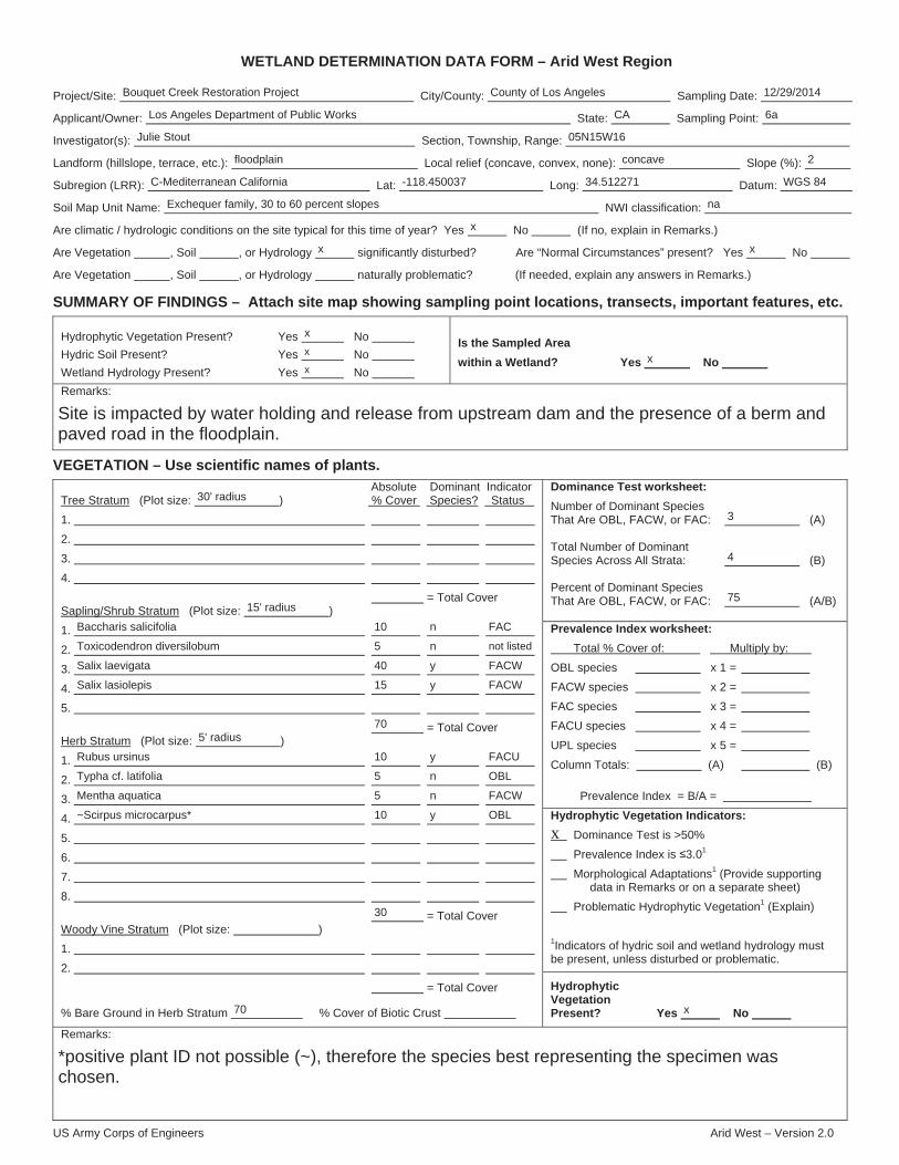
US Army Corps of Engineers Arid West – Version 2.0
WETLAND DETERMINATION DATA FORM – Arid West Region
Project/Site: City/County: Sampling Date:
Applicant/Owner: State: Sampling Point:
Investigator(s): Section, Township, Range:
Landform (hillslope, terrace, etc.): Local relief (concave, convex, none): Slope (%):
Subregion (LRR): Lat: Long: Datum:
Soil Map Unit Name: NWI classification:
Are climatic / hydrologic conditions on the site typical for this time of year? Yes No (If no, explain in Remarks.)
Are Vegetation , Soil , or Hydrology significantly disturbed? Are “Normal Circumstances” present? Yes No
Are Vegetation , Soil , or Hydrology naturally problematic? (If needed, explain any answers in Remarks.)
SUMMARY OF FINDINGS – Attach site map showing sampling point locations, transects, important features, etc.
Hydrophytic Vegetation Present? Yes No
Hydric Soil Present? Yes No
Wetland Hydrology Present? Yes No
Is the Sampled Area
within a Wetland? Yes No
Remarks:
VEGETATION – Use scientific names of plants.
Dominance Test worksheet:
Number of Dominant Species That Are OBL, FACW, or FAC: (A)
Total Number of Dominant Species Across All Strata: (B)
Percent of Dominant Species That Are OBL, FACW, or FAC: (A/B)
Prevalence Index worksheet:
Total % Cover of: Multiply by:
OBL species x 1 =
FACW species x 2 =
FAC species x 3 =
FACU species x 4 =
UPL species x 5 =
Column Totals: (A) (B)
Prevalence Index = B/A =
Hydrophytic Vegetation Indicators:
Dominance Test is >50%
Prevalence Index is 3.01
Morphological Adaptations1 (Provide supporting data in Remarks or on a separate sheet)
Problematic Hydrophytic Vegetation1 (Explain)
1Indicators of hydric soil and wetland hydrology must be present, unless disturbed or problematic.
Absolute Dominant Indicator Tree Stratum (Plot size: ) % Cover Species? Status
1.
2.
3.
4.
= Total Cover Sapling/Shrub Stratum (Plot size: )
1.
2.
3.
4.
5.
= Total Cover Herb Stratum (Plot size: )
1.
2.
3.
4.
5.
6.
7.
8.
= Total Cover Woody Vine Stratum (Plot size: )
1.
2.
= Total Cover
% Bare Ground in Herb Stratum % Cover of Biotic Crust
Hydrophytic Vegetation Present? Yes No
Remarks:
x
Bouquet Creek Restoration Project County of Los Angeles 12/29/2014
Los Angeles Department of Public Works CA 6a
Julie Stout 05N15W16
floodplain concave 2
C-Mediterranean California -118.450037 34.512271 WGS 84
Exchequer family, 30 to 60 percent slopes na
x
x x
x
xx
x
Site is impacted by water holding and release from upstream dam and the presence of a berm andpaved road in the floodplain.
30' radius
3
4
15' radius75
Baccharis salicifolia
Toxicodendron diversilobum
Salix laevigata
Salix lasiolepis
10
5
40
15
70
n
n
y
y
FAC
not listed
FACW
FACW
5' radius
Typha cf. latifolia
Mentha aquatica
~Scirpus microcarpus*
10
5
5
10
30
y
n
n
y
FACU
OBL
FACW
OBL
Rubus ursinus
70 x
*positive plant ID not possible (~), therefore the species best representing the specimen waschosen.

US Army Corps of Engineers Arid West – Version 2.0
SOIL Sampling Point:
Profile Description: (Describe to the depth needed to document the indicator or confirm the absence of indicators.)
Depth Matrix Redox Features (inches) Color (moist) % Color (moist) % Type1 Loc2 Texture Remarks
1Type: C=Concentration, D=Depletion, RM=Reduced Matrix, CS=Covered or Coated Sand Grains. 2Location: PL=Pore Lining, M=Matrix.Hydric Soil Indicators: (Applicable to all LRRs, unless otherwise noted.) Indicators for Problematic Hydric Soils3:
Histosol (A1) Sandy Redox (S5) 1 cm Muck (A9) (LRR C)
Histic Epipedon (A2) Stripped Matrix (S6) 2 cm Muck (A10) (LRR B)
Black Histic (A3) Loamy Mucky Mineral (F1) Reduced Vertic (F18)
Hydrogen Sulfide (A4) Loamy Gleyed Matrix (F2) Red Parent Material (TF2)
Stratified Layers (A5) (LRR C) Depleted Matrix (F3) Other (Explain in Remarks)
1 cm Muck (A9) (LRR D) Redox Dark Surface (F6)
Depleted Below Dark Surface (A11) Depleted Dark Surface (F7)
Thick Dark Surface (A12) Redox Depressions (F8) 3Indicators of hydrophytic vegetation and
Sandy Mucky Mineral (S1) Vernal Pools (F9) wetland hydrology must be present,
Sandy Gleyed Matrix (S4) unless disturbed or problematic.
Restrictive Layer (if present):
Type:
Depth (inches): Hydric Soil Present? Yes No
Remarks:
HYDROLOGY
Wetland Hydrology Indicators:
Primary Indicators (minimum of one required; check all that apply) Secondary Indicators (2 or more required)
Surface Water (A1) Salt Crust (B11) Water Marks (B1) (Riverine)
High Water Table (A2) Biotic Crust (B12) Sediment Deposits (B2) (Riverine)
Saturation (A3) Aquatic Invertebrates (B13) Drift Deposits (B3) (Riverine)
Water Marks (B1) (Nonriverine) Hydrogen Sulfide Odor (C1) Drainage Patterns (B10)
Sediment Deposits (B2) (Nonriverine) Oxidized Rhizospheres along Living Roots (C3) Dry-Season Water Table (C2)
Drift Deposits (B3) (Nonriverine) Presence of Reduced Iron (C4) Crayfish Burrows (C8)
Surface Soil Cracks (B6) Recent Iron Reduction in Tilled Soils (C6) Saturation Visible on Aerial Imagery (C9)
Inundation Visible on Aerial Imagery (B7) Thin Muck Surface (C7) Shallow Aquitard (D3)
Water-Stained Leaves (B9) Other (Explain in Remarks) FAC-Neutral Test (D5)
Field Observations:
Surface Water Present? Yes No Depth (inches):
Water Table Present? Yes No Depth (inches):
Saturation Present? Yes No Depth (inches): (includes capillary fringe)
Wetland Hydrology Present? Yes No
Describe Recorded Data (stream gauge, monitoring well, aerial photos, previous inspections), if available:
Remarks:
x
x
x
6a
0-4
4+
10YR2/1 mucky sandy clay loam
cobble
x
Digging restricted by dense cobble.
x 2
x

US Army Corps of Engineers Arid West – Version 2.0
WETLAND DETERMINATION DATA FORM – Arid West Region
Project/Site: City/County: Sampling Date:
Applicant/Owner: State: Sampling Point:
Investigator(s): Section, Township, Range:
Landform (hillslope, terrace, etc.): Local relief (concave, convex, none): Slope (%):
Subregion (LRR): Lat: Long: Datum:
Soil Map Unit Name: NWI classification:
Are climatic / hydrologic conditions on the site typical for this time of year? Yes No (If no, explain in Remarks.)
Are Vegetation , Soil , or Hydrology significantly disturbed? Are “Normal Circumstances” present? Yes No
Are Vegetation , Soil , or Hydrology naturally problematic? (If needed, explain any answers in Remarks.)
SUMMARY OF FINDINGS – Attach site map showing sampling point locations, transects, important features, etc.
Hydrophytic Vegetation Present? Yes No
Hydric Soil Present? Yes No
Wetland Hydrology Present? Yes No
Is the Sampled Area
within a Wetland? Yes No
Remarks:
VEGETATION – Use scientific names of plants.
Dominance Test worksheet:
Number of Dominant Species That Are OBL, FACW, or FAC: (A)
Total Number of Dominant Species Across All Strata: (B)
Percent of Dominant Species That Are OBL, FACW, or FAC: (A/B)
Prevalence Index worksheet:
Total % Cover of: Multiply by:
OBL species x 1 =
FACW species x 2 =
FAC species x 3 =
FACU species x 4 =
UPL species x 5 =
Column Totals: (A) (B)
Prevalence Index = B/A =
Hydrophytic Vegetation Indicators:
Dominance Test is >50%
Prevalence Index is 3.01
Morphological Adaptations1 (Provide supporting data in Remarks or on a separate sheet)
Problematic Hydrophytic Vegetation1 (Explain)
1Indicators of hydric soil and wetland hydrology must be present, unless disturbed or problematic.
Absolute Dominant Indicator Tree Stratum (Plot size: ) % Cover Species? Status
1.
2.
3.
4.
= Total Cover Sapling/Shrub Stratum (Plot size: )
1.
2.
3.
4.
5.
= Total Cover Herb Stratum (Plot size: )
1.
2.
3.
4.
5.
6.
7.
8.
= Total Cover Woody Vine Stratum (Plot size: )
1.
2.
= Total Cover
% Bare Ground in Herb Stratum % Cover of Biotic Crust
Hydrophytic Vegetation Present? Yes No
Remarks:
Bouquet Creek Restoration Project County of Los Angeles 12/29/2014
Los Angeles Department of Public Works CA 6b
Julie Stout 05N15W16
berm convex
C-Mediterranean California -118.449954 34.512271 WGS 84
Exchequer family, 30 to 60 percent slopes na
x
x x x
x
xx
x
Site hydrology is impacted by water holding and release from upstream dam. Soils are comprised ofberm/fill material.
30' radius
0
1
15' radius0
5' radius
Artemisia douglasiana
Artemisia californica
Melilotus albus
50
3
2
5
60
y
n
n
n
not listed
FAC
not listed
FACU
Stipa (Piptatherum) miliacea
40 x
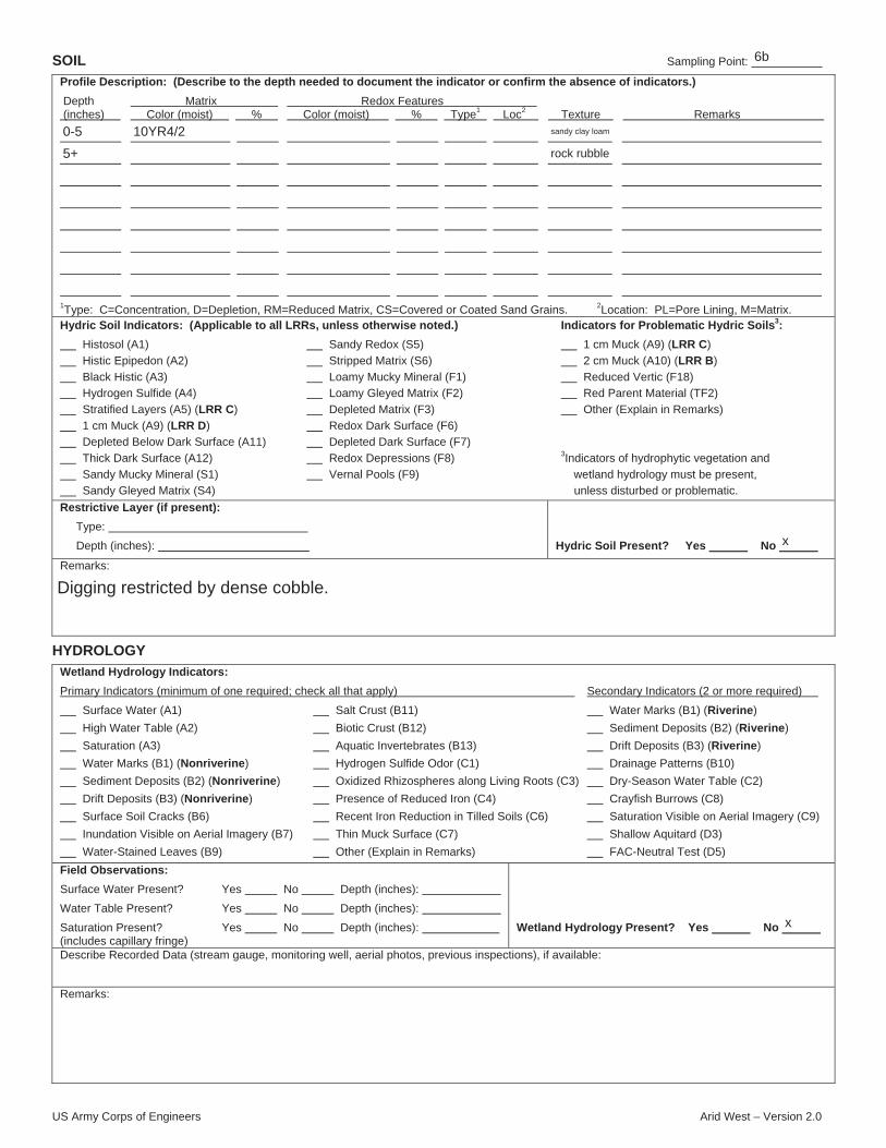
US Army Corps of Engineers Arid West – Version 2.0
SOIL Sampling Point:
Profile Description: (Describe to the depth needed to document the indicator or confirm the absence of indicators.)
Depth Matrix Redox Features (inches) Color (moist) % Color (moist) % Type1 Loc2 Texture Remarks
1Type: C=Concentration, D=Depletion, RM=Reduced Matrix, CS=Covered or Coated Sand Grains. 2Location: PL=Pore Lining, M=Matrix.Hydric Soil Indicators: (Applicable to all LRRs, unless otherwise noted.) Indicators for Problematic Hydric Soils3:
Histosol (A1) Sandy Redox (S5) 1 cm Muck (A9) (LRR C)
Histic Epipedon (A2) Stripped Matrix (S6) 2 cm Muck (A10) (LRR B)
Black Histic (A3) Loamy Mucky Mineral (F1) Reduced Vertic (F18)
Hydrogen Sulfide (A4) Loamy Gleyed Matrix (F2) Red Parent Material (TF2)
Stratified Layers (A5) (LRR C) Depleted Matrix (F3) Other (Explain in Remarks)
1 cm Muck (A9) (LRR D) Redox Dark Surface (F6)
Depleted Below Dark Surface (A11) Depleted Dark Surface (F7)
Thick Dark Surface (A12) Redox Depressions (F8) 3Indicators of hydrophytic vegetation and
Sandy Mucky Mineral (S1) Vernal Pools (F9) wetland hydrology must be present,
Sandy Gleyed Matrix (S4) unless disturbed or problematic.
Restrictive Layer (if present):
Type:
Depth (inches): Hydric Soil Present? Yes No
Remarks:
HYDROLOGY
Wetland Hydrology Indicators:
Primary Indicators (minimum of one required; check all that apply) Secondary Indicators (2 or more required)
Surface Water (A1) Salt Crust (B11) Water Marks (B1) (Riverine)
High Water Table (A2) Biotic Crust (B12) Sediment Deposits (B2) (Riverine)
Saturation (A3) Aquatic Invertebrates (B13) Drift Deposits (B3) (Riverine)
Water Marks (B1) (Nonriverine) Hydrogen Sulfide Odor (C1) Drainage Patterns (B10)
Sediment Deposits (B2) (Nonriverine) Oxidized Rhizospheres along Living Roots (C3) Dry-Season Water Table (C2)
Drift Deposits (B3) (Nonriverine) Presence of Reduced Iron (C4) Crayfish Burrows (C8)
Surface Soil Cracks (B6) Recent Iron Reduction in Tilled Soils (C6) Saturation Visible on Aerial Imagery (C9)
Inundation Visible on Aerial Imagery (B7) Thin Muck Surface (C7) Shallow Aquitard (D3)
Water-Stained Leaves (B9) Other (Explain in Remarks) FAC-Neutral Test (D5)
Field Observations:
Surface Water Present? Yes No Depth (inches):
Water Table Present? Yes No Depth (inches):
Saturation Present? Yes No Depth (inches): (includes capillary fringe)
Wetland Hydrology Present? Yes No
Describe Recorded Data (stream gauge, monitoring well, aerial photos, previous inspections), if available:
Remarks:
6b
0-5
5+
10YR4/2 sandy clay loam
rock rubble
x
Digging restricted by dense cobble.
x

US Army Corps of Engineers Arid West – Version 2.0
WETLAND DETERMINATION DATA FORM – Arid West Region
Project/Site: City/County: Sampling Date:
Applicant/Owner: State: Sampling Point:
Investigator(s): Section, Township, Range:
Landform (hillslope, terrace, etc.): Local relief (concave, convex, none): Slope (%):
Subregion (LRR): Lat: Long: Datum:
Soil Map Unit Name: NWI classification:
Are climatic / hydrologic conditions on the site typical for this time of year? Yes No (If no, explain in Remarks.)
Are Vegetation , Soil , or Hydrology significantly disturbed? Are “Normal Circumstances” present? Yes No
Are Vegetation , Soil , or Hydrology naturally problematic? (If needed, explain any answers in Remarks.)
SUMMARY OF FINDINGS – Attach site map showing sampling point locations, transects, important features, etc.
Hydrophytic Vegetation Present? Yes No
Hydric Soil Present? Yes No
Wetland Hydrology Present? Yes No
Is the Sampled Area
within a Wetland? Yes No
Remarks:
VEGETATION – Use scientific names of plants.
Dominance Test worksheet:
Number of Dominant Species That Are OBL, FACW, or FAC: (A)
Total Number of Dominant Species Across All Strata: (B)
Percent of Dominant Species That Are OBL, FACW, or FAC: (A/B)
Prevalence Index worksheet:
Total % Cover of: Multiply by:
OBL species x 1 =
FACW species x 2 =
FAC species x 3 =
FACU species x 4 =
UPL species x 5 =
Column Totals: (A) (B)
Prevalence Index = B/A =
Hydrophytic Vegetation Indicators:
Dominance Test is >50%
Prevalence Index is 3.01
Morphological Adaptations1 (Provide supporting data in Remarks or on a separate sheet)
Problematic Hydrophytic Vegetation1 (Explain)
1Indicators of hydric soil and wetland hydrology must be present, unless disturbed or problematic.
Absolute Dominant Indicator Tree Stratum (Plot size: ) % Cover Species? Status
1.
2.
3.
4.
= Total Cover Sapling/Shrub Stratum (Plot size: )
1.
2.
3.
4.
5.
= Total Cover Herb Stratum (Plot size: )
1.
2.
3.
4.
5.
6.
7.
8.
= Total Cover Woody Vine Stratum (Plot size: )
1.
2.
= Total Cover
% Bare Ground in Herb Stratum % Cover of Biotic Crust
Hydrophytic Vegetation Present? Yes No
Remarks:
x
Bouquet Creek Restoration Project County of Los Angeles 12/29/2014
Los Angeles Department of Public Works CA 6.5a
Julie Stout 05N15W15
Canyon concave 2
C-Mediterranean California -118.448535 34.514991 WGS 84
Lodo-Modesto families complex, 30 to 70 percent slopes na
x
x x
x
xx
x
Site is impacted by water holding and release from upstream dam.
30' radius
15' radius
60 60
5 10
5 15
5' radius5 20
Apium graveolens
Cyperus cf. erythrorhizos
Artemisia douglasiana
Mentha aquatica
Cynodon dactylon
10
20
50
5
5
5
95
n
y
y
n
n
n
OBL
not listed*
OBL
FAC
FACW
FACU
20* 100Typha latifolia 95 205
2.16
5 x
*Apium graveolens is not listed on the 2014 Arid West wetland indicator plant list which does notnecessarily indicate that it's status is "upland"; however, the site passes the prevalence indexregardless of this species' status.
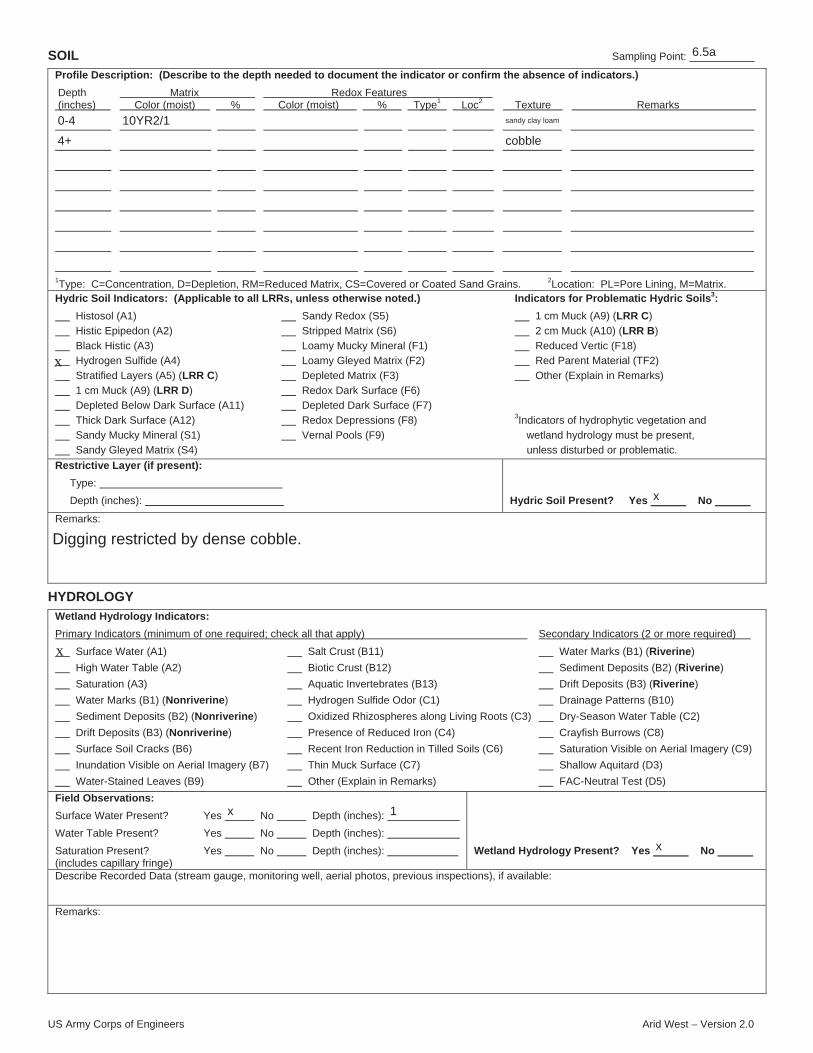
US Army Corps of Engineers Arid West – Version 2.0
SOIL Sampling Point:
Profile Description: (Describe to the depth needed to document the indicator or confirm the absence of indicators.)
Depth Matrix Redox Features (inches) Color (moist) % Color (moist) % Type1 Loc2 Texture Remarks
1Type: C=Concentration, D=Depletion, RM=Reduced Matrix, CS=Covered or Coated Sand Grains. 2Location: PL=Pore Lining, M=Matrix.Hydric Soil Indicators: (Applicable to all LRRs, unless otherwise noted.) Indicators for Problematic Hydric Soils3:
Histosol (A1) Sandy Redox (S5) 1 cm Muck (A9) (LRR C)
Histic Epipedon (A2) Stripped Matrix (S6) 2 cm Muck (A10) (LRR B)
Black Histic (A3) Loamy Mucky Mineral (F1) Reduced Vertic (F18)
Hydrogen Sulfide (A4) Loamy Gleyed Matrix (F2) Red Parent Material (TF2)
Stratified Layers (A5) (LRR C) Depleted Matrix (F3) Other (Explain in Remarks)
1 cm Muck (A9) (LRR D) Redox Dark Surface (F6)
Depleted Below Dark Surface (A11) Depleted Dark Surface (F7)
Thick Dark Surface (A12) Redox Depressions (F8) 3Indicators of hydrophytic vegetation and
Sandy Mucky Mineral (S1) Vernal Pools (F9) wetland hydrology must be present,
Sandy Gleyed Matrix (S4) unless disturbed or problematic.
Restrictive Layer (if present):
Type:
Depth (inches): Hydric Soil Present? Yes No
Remarks:
HYDROLOGY
Wetland Hydrology Indicators:
Primary Indicators (minimum of one required; check all that apply) Secondary Indicators (2 or more required)
Surface Water (A1) Salt Crust (B11) Water Marks (B1) (Riverine)
High Water Table (A2) Biotic Crust (B12) Sediment Deposits (B2) (Riverine)
Saturation (A3) Aquatic Invertebrates (B13) Drift Deposits (B3) (Riverine)
Water Marks (B1) (Nonriverine) Hydrogen Sulfide Odor (C1) Drainage Patterns (B10)
Sediment Deposits (B2) (Nonriverine) Oxidized Rhizospheres along Living Roots (C3) Dry-Season Water Table (C2)
Drift Deposits (B3) (Nonriverine) Presence of Reduced Iron (C4) Crayfish Burrows (C8)
Surface Soil Cracks (B6) Recent Iron Reduction in Tilled Soils (C6) Saturation Visible on Aerial Imagery (C9)
Inundation Visible on Aerial Imagery (B7) Thin Muck Surface (C7) Shallow Aquitard (D3)
Water-Stained Leaves (B9) Other (Explain in Remarks) FAC-Neutral Test (D5)
Field Observations:
Surface Water Present? Yes No Depth (inches):
Water Table Present? Yes No Depth (inches):
Saturation Present? Yes No Depth (inches): (includes capillary fringe)
Wetland Hydrology Present? Yes No
Describe Recorded Data (stream gauge, monitoring well, aerial photos, previous inspections), if available:
Remarks:
x
x
6.5a
0-4
4+
10YR2/1 sandy clay loam
cobble
x
Digging restricted by dense cobble.
x 1
x

US Army Corps of Engineers Arid West – Version 2.0
WETLAND DETERMINATION DATA FORM – Arid West Region
Project/Site: City/County: Sampling Date:
Applicant/Owner: State: Sampling Point:
Investigator(s): Section, Township, Range:
Landform (hillslope, terrace, etc.): Local relief (concave, convex, none): Slope (%):
Subregion (LRR): Lat: Long: Datum:
Soil Map Unit Name: NWI classification:
Are climatic / hydrologic conditions on the site typical for this time of year? Yes No (If no, explain in Remarks.)
Are Vegetation , Soil , or Hydrology significantly disturbed? Are “Normal Circumstances” present? Yes No
Are Vegetation , Soil , or Hydrology naturally problematic? (If needed, explain any answers in Remarks.)
SUMMARY OF FINDINGS – Attach site map showing sampling point locations, transects, important features, etc.
Hydrophytic Vegetation Present? Yes No
Hydric Soil Present? Yes No
Wetland Hydrology Present? Yes No
Is the Sampled Area
within a Wetland? Yes No
Remarks:
VEGETATION – Use scientific names of plants.
Dominance Test worksheet:
Number of Dominant Species That Are OBL, FACW, or FAC: (A)
Total Number of Dominant Species Across All Strata: (B)
Percent of Dominant Species That Are OBL, FACW, or FAC: (A/B)
Prevalence Index worksheet:
Total % Cover of: Multiply by:
OBL species x 1 =
FACW species x 2 =
FAC species x 3 =
FACU species x 4 =
UPL species x 5 =
Column Totals: (A) (B)
Prevalence Index = B/A =
Hydrophytic Vegetation Indicators:
Dominance Test is >50%
Prevalence Index is 3.01
Morphological Adaptations1 (Provide supporting data in Remarks or on a separate sheet)
Problematic Hydrophytic Vegetation1 (Explain)
1Indicators of hydric soil and wetland hydrology must be present, unless disturbed or problematic.
Absolute Dominant Indicator Tree Stratum (Plot size: ) % Cover Species? Status
1.
2.
3.
4.
= Total Cover Sapling/Shrub Stratum (Plot size: )
1.
2.
3.
4.
5.
= Total Cover Herb Stratum (Plot size: )
1.
2.
3.
4.
5.
6.
7.
8.
= Total Cover Woody Vine Stratum (Plot size: )
1.
2.
= Total Cover
% Bare Ground in Herb Stratum % Cover of Biotic Crust
Hydrophytic Vegetation Present? Yes No
Remarks:
Bouquet Creek Restoration Project County of Los Angeles 12/29/2014
Los Angeles Department of Public Works CA 6.5b
Julie Stout 05N15W15
berm concave 2
C-Mediterranean California -118.448506 34.514987 WGS 84
Lodo-Modesto families complex, 30 to 70 percent slopes na
x
x x x
x
xx
x
Site hydrology is impacted by water holding and release from upstream dam. Soils are comprised ofberm/fill material.
30' radius
0
4
15' radius0
5' radius
Stipa (Piptatherum) miliacea
Bromus diandrus
Bromus madritensis
Populus fremontii
Cynodon dactylon
10
5
15
15
5
10
60
y
n
y
y
n
y
not listed
not listed
not listed
not listed
not listed
FACU
Yerba buena
40 x
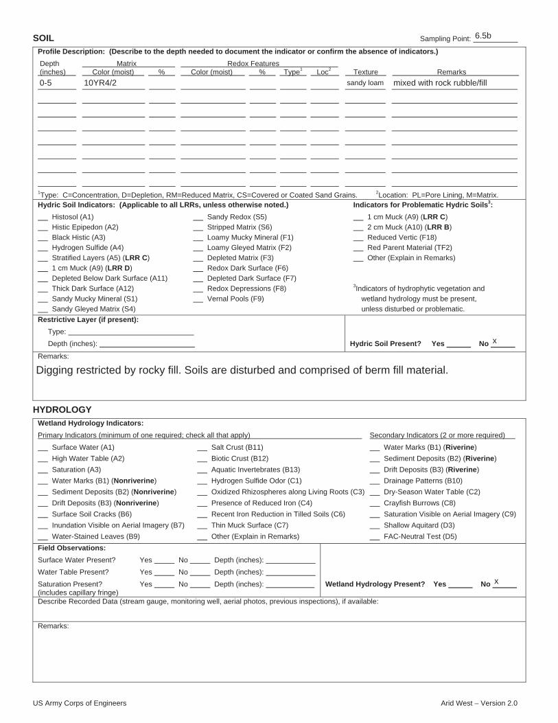
US Army Corps of Engineers Arid West – Version 2.0
SOIL Sampling Point:
Profile Description: (Describe to the depth needed to document the indicator or confirm the absence of indicators.)
Depth Matrix Redox Features (inches) Color (moist) % Color (moist) % Type1 Loc2 Texture Remarks
1Type: C=Concentration, D=Depletion, RM=Reduced Matrix, CS=Covered or Coated Sand Grains. 2Location: PL=Pore Lining, M=Matrix.Hydric Soil Indicators: (Applicable to all LRRs, unless otherwise noted.) Indicators for Problematic Hydric Soils3:
Histosol (A1) Sandy Redox (S5) 1 cm Muck (A9) (LRR C)
Histic Epipedon (A2) Stripped Matrix (S6) 2 cm Muck (A10) (LRR B)
Black Histic (A3) Loamy Mucky Mineral (F1) Reduced Vertic (F18)
Hydrogen Sulfide (A4) Loamy Gleyed Matrix (F2) Red Parent Material (TF2)
Stratified Layers (A5) (LRR C) Depleted Matrix (F3) Other (Explain in Remarks)
1 cm Muck (A9) (LRR D) Redox Dark Surface (F6)
Depleted Below Dark Surface (A11) Depleted Dark Surface (F7)
Thick Dark Surface (A12) Redox Depressions (F8) 3Indicators of hydrophytic vegetation and
Sandy Mucky Mineral (S1) Vernal Pools (F9) wetland hydrology must be present,
Sandy Gleyed Matrix (S4) unless disturbed or problematic.
Restrictive Layer (if present):
Type:
Depth (inches): Hydric Soil Present? Yes No
Remarks:
HYDROLOGY
Wetland Hydrology Indicators:
Primary Indicators (minimum of one required; check all that apply) Secondary Indicators (2 or more required)
Surface Water (A1) Salt Crust (B11) Water Marks (B1) (Riverine)
High Water Table (A2) Biotic Crust (B12) Sediment Deposits (B2) (Riverine)
Saturation (A3) Aquatic Invertebrates (B13) Drift Deposits (B3) (Riverine)
Water Marks (B1) (Nonriverine) Hydrogen Sulfide Odor (C1) Drainage Patterns (B10)
Sediment Deposits (B2) (Nonriverine) Oxidized Rhizospheres along Living Roots (C3) Dry-Season Water Table (C2)
Drift Deposits (B3) (Nonriverine) Presence of Reduced Iron (C4) Crayfish Burrows (C8)
Surface Soil Cracks (B6) Recent Iron Reduction in Tilled Soils (C6) Saturation Visible on Aerial Imagery (C9)
Inundation Visible on Aerial Imagery (B7) Thin Muck Surface (C7) Shallow Aquitard (D3)
Water-Stained Leaves (B9) Other (Explain in Remarks) FAC-Neutral Test (D5)
Field Observations:
Surface Water Present? Yes No Depth (inches):
Water Table Present? Yes No Depth (inches):
Saturation Present? Yes No Depth (inches): (includes capillary fringe)
Wetland Hydrology Present? Yes No
Describe Recorded Data (stream gauge, monitoring well, aerial photos, previous inspections), if available:
Remarks:
6.5b
0-5 10YR4/2 sandy loam mixed with rock rubble/fill
x
Digging restricted by rocky fill. Soils are disturbed and comprised of berm fill material.
x

US Army Corps of Engineers Arid West – Version 2.0
WETLAND DETERMINATION DATA FORM – Arid West Region
Project/Site: City/County: Sampling Date:
Applicant/Owner: State: Sampling Point:
Investigator(s): Section, Township, Range:
Landform (hillslope, terrace, etc.): Local relief (concave, convex, none): Slope (%):
Subregion (LRR): Lat: Long: Datum:
Soil Map Unit Name: NWI classification:
Are climatic / hydrologic conditions on the site typical for this time of year? Yes No (If no, explain in Remarks.)
Are Vegetation , Soil , or Hydrology significantly disturbed? Are “Normal Circumstances” present? Yes No
Are Vegetation , Soil , or Hydrology naturally problematic? (If needed, explain any answers in Remarks.)
SUMMARY OF FINDINGS – Attach site map showing sampling point locations, transects, important features, etc.
Hydrophytic Vegetation Present? Yes No
Hydric Soil Present? Yes No
Wetland Hydrology Present? Yes No
Is the Sampled Area
within a Wetland? Yes No
Remarks:
VEGETATION – Use scientific names of plants.
Dominance Test worksheet:
Number of Dominant Species That Are OBL, FACW, or FAC: (A)
Total Number of Dominant Species Across All Strata: (B)
Percent of Dominant Species That Are OBL, FACW, or FAC: (A/B)
Prevalence Index worksheet:
Total % Cover of: Multiply by:
OBL species x 1 =
FACW species x 2 =
FAC species x 3 =
FACU species x 4 =
UPL species x 5 =
Column Totals: (A) (B)
Prevalence Index = B/A =
Hydrophytic Vegetation Indicators:
x Dominance Test is >50%
Prevalence Index is 3.01
Morphological Adaptations1 (Provide supporting data in Remarks or on a separate sheet)
Problematic Hydrophytic Vegetation1 (Explain)
1Indicators of hydric soil and wetland hydrology must be present, unless disturbed or problematic.
Absolute Dominant Indicator Tree Stratum (Plot size: ) % Cover Species? Status
1.
2.
3.
4.
= Total Cover Sapling/Shrub Stratum (Plot size: )
1.
2.
3.
4.
5.
= Total Cover Herb Stratum (Plot size: )
1.
2.
3.
4.
5.
6.
7.
8.
= Total Cover Woody Vine Stratum (Plot size: )
1.
2.
= Total Cover
% Bare Ground in Herb Stratum % Cover of Biotic Crust
Hydrophytic Vegetation Present? Yes No
Remarks:
Bouquet Creek Restoration Project County of Los Angeles 12/29/2014
Los Angeles Department of Public Works CA 7a
Julie Stout 05N15W15
hillslope convex 45
C-Mediterranean California -118.447344 34.517449 WGS 84
Lodo-Modesto families complex, 30 to 70 percent slopes na
x
x x
x
xx
x
Site is impacted by water holding and release from upstream dam. Site represent stream fringewetland.
30' radius
25
25
y FACPlantanus racemosa 3
5
15' radius60
Phoenix canariensis 5
5
y not listed
5' radius
Hedera helix
Mentha aquatica
Apium graveolens
Juncus cf. acutus
Cyperus involucratus
10
1
5
1
25
10
52
y
n
n
n
y
y
FACU
not listed
FACW
not listed
FACW
FACW
Rubus ursinus
48 x
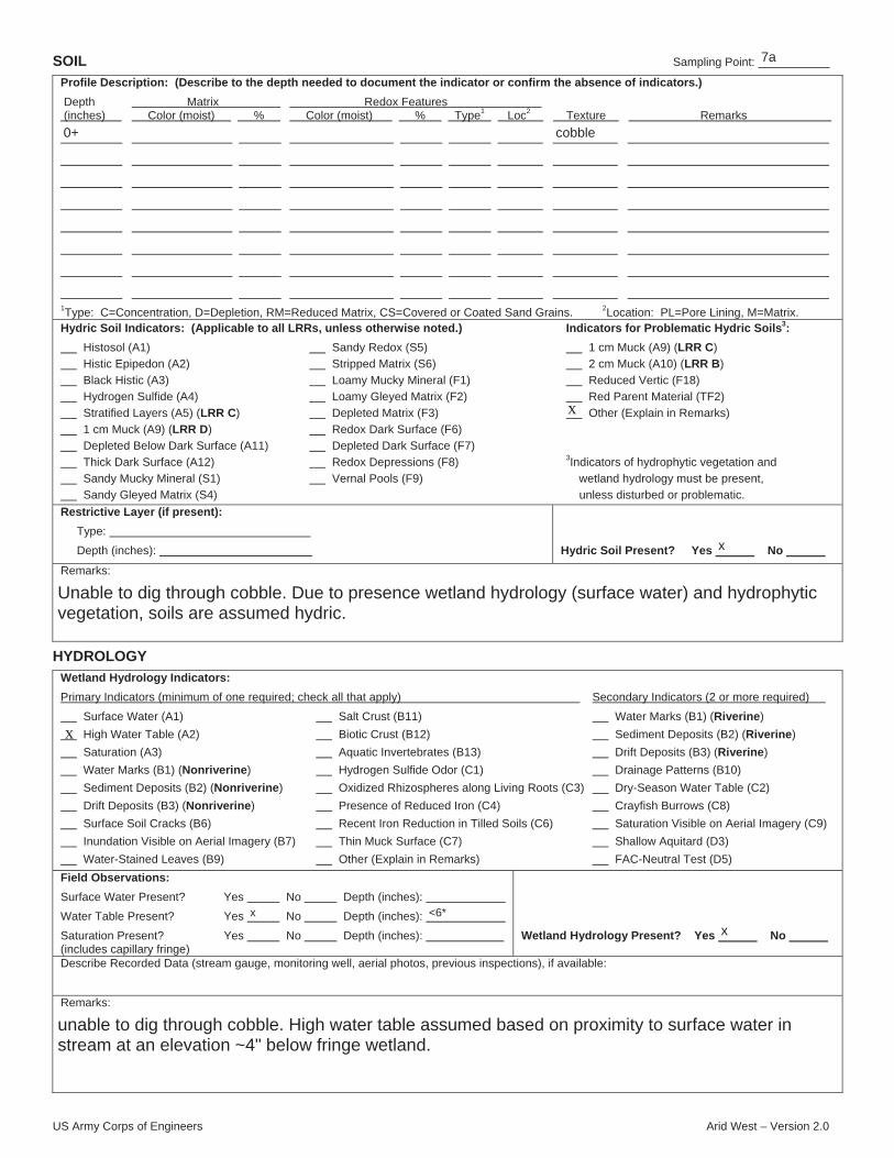
US Army Corps of Engineers Arid West – Version 2.0
SOIL Sampling Point:
Profile Description: (Describe to the depth needed to document the indicator or confirm the absence of indicators.)
Depth Matrix Redox Features (inches) Color (moist) % Color (moist) % Type1 Loc2 Texture Remarks
1Type: C=Concentration, D=Depletion, RM=Reduced Matrix, CS=Covered or Coated Sand Grains. 2Location: PL=Pore Lining, M=Matrix.Hydric Soil Indicators: (Applicable to all LRRs, unless otherwise noted.) Indicators for Problematic Hydric Soils3:
Histosol (A1) Sandy Redox (S5) 1 cm Muck (A9) (LRR C)
Histic Epipedon (A2) Stripped Matrix (S6) 2 cm Muck (A10) (LRR B)
Black Histic (A3) Loamy Mucky Mineral (F1) Reduced Vertic (F18)
Hydrogen Sulfide (A4) Loamy Gleyed Matrix (F2) Red Parent Material (TF2)
Stratified Layers (A5) (LRR C) Depleted Matrix (F3) Other (Explain in Remarks)
1 cm Muck (A9) (LRR D) Redox Dark Surface (F6)
Depleted Below Dark Surface (A11) Depleted Dark Surface (F7)
Thick Dark Surface (A12) Redox Depressions (F8) 3Indicators of hydrophytic vegetation and
Sandy Mucky Mineral (S1) Vernal Pools (F9) wetland hydrology must be present,
Sandy Gleyed Matrix (S4) unless disturbed or problematic.
Restrictive Layer (if present):
Type:
Depth (inches): Hydric Soil Present? Yes No
Remarks:
HYDROLOGY
Wetland Hydrology Indicators:
Primary Indicators (minimum of one required; check all that apply) Secondary Indicators (2 or more required)
Surface Water (A1) Salt Crust (B11) Water Marks (B1) (Riverine)
High Water Table (A2) Biotic Crust (B12) Sediment Deposits (B2) (Riverine)
Saturation (A3) Aquatic Invertebrates (B13) Drift Deposits (B3) (Riverine)
Water Marks (B1) (Nonriverine) Hydrogen Sulfide Odor (C1) Drainage Patterns (B10)
Sediment Deposits (B2) (Nonriverine) Oxidized Rhizospheres along Living Roots (C3) Dry-Season Water Table (C2)
Drift Deposits (B3) (Nonriverine) Presence of Reduced Iron (C4) Crayfish Burrows (C8)
Surface Soil Cracks (B6) Recent Iron Reduction in Tilled Soils (C6) Saturation Visible on Aerial Imagery (C9)
Inundation Visible on Aerial Imagery (B7) Thin Muck Surface (C7) Shallow Aquitard (D3)
Water-Stained Leaves (B9) Other (Explain in Remarks) FAC-Neutral Test (D5)
Field Observations:
Surface Water Present? Yes No Depth (inches):
Water Table Present? Yes No Depth (inches):
Saturation Present? Yes No Depth (inches): (includes capillary fringe)
Wetland Hydrology Present? Yes No
Describe Recorded Data (stream gauge, monitoring well, aerial photos, previous inspections), if available:
Remarks:
x
x
7a
0+ cobble
x
Unable to dig through cobble. Due to presence wetland hydrology (surface water) and hydrophyticvegetation, soils are assumed hydric.
x <6*
x
unable to dig through cobble. High water table assumed based on proximity to surface water instream at an elevation ~4" below fringe wetland.

US Army Corps of Engineers Arid West – Version 2.0
WETLAND DETERMINATION DATA FORM – Arid West Region
Project/Site: City/County: Sampling Date:
Applicant/Owner: State: Sampling Point:
Investigator(s): Section, Township, Range:
Landform (hillslope, terrace, etc.): Local relief (concave, convex, none): Slope (%):
Subregion (LRR): Lat: Long: Datum:
Soil Map Unit Name: NWI classification:
Are climatic / hydrologic conditions on the site typical for this time of year? Yes No (If no, explain in Remarks.)
Are Vegetation , Soil , or Hydrology significantly disturbed? Are “Normal Circumstances” present? Yes No
Are Vegetation , Soil , or Hydrology naturally problematic? (If needed, explain any answers in Remarks.)
SUMMARY OF FINDINGS – Attach site map showing sampling point locations, transects, important features, etc.
Hydrophytic Vegetation Present? Yes No
Hydric Soil Present? Yes No
Wetland Hydrology Present? Yes No
Is the Sampled Area
within a Wetland? Yes No
Remarks:
VEGETATION – Use scientific names of plants.
Dominance Test worksheet:
Number of Dominant Species That Are OBL, FACW, or FAC: (A)
Total Number of Dominant Species Across All Strata: (B)
Percent of Dominant Species That Are OBL, FACW, or FAC: (A/B)
Prevalence Index worksheet:
Total % Cover of: Multiply by:
OBL species x 1 =
FACW species x 2 =
FAC species x 3 =
FACU species x 4 =
UPL species x 5 =
Column Totals: (A) (B)
Prevalence Index = B/A =
Hydrophytic Vegetation Indicators:
Dominance Test is >50%
Prevalence Index is 3.01
Morphological Adaptations1 (Provide supporting data in Remarks or on a separate sheet)
Problematic Hydrophytic Vegetation1 (Explain)
1Indicators of hydric soil and wetland hydrology must be present, unless disturbed or problematic.
Absolute Dominant Indicator Tree Stratum (Plot size: ) % Cover Species? Status
1.
2.
3.
4.
= Total Cover Sapling/Shrub Stratum (Plot size: )
1.
2.
3.
4.
5.
= Total Cover Herb Stratum (Plot size: )
1.
2.
3.
4.
5.
6.
7.
8.
= Total Cover Woody Vine Stratum (Plot size: )
1.
2.
= Total Cover
% Bare Ground in Herb Stratum % Cover of Biotic Crust
Hydrophytic Vegetation Present? Yes No
Remarks:
Bouquet Creek Restoration Project County of Los Angeles 12/29/2014
Los Angeles Department of Public Works CA 7b
Julie Stout 05N15W15
berm convex 30
C-Mediterranean California -118.447219 34.517392 WGS 84
Lodo-Modesto families complex, 30 to 70 percent slopes na
x
x x x
x
xx
x
Site hydrology is impacted by water holding and release from upstream dam. Soils are comprised ofberm/fill material.
30' radius
0
2
15' radius0
5' radius
Bromus diandrus
10
25
35
y
y
not listed
not listed
Stipa (Piptatherum) miliacea
65 x
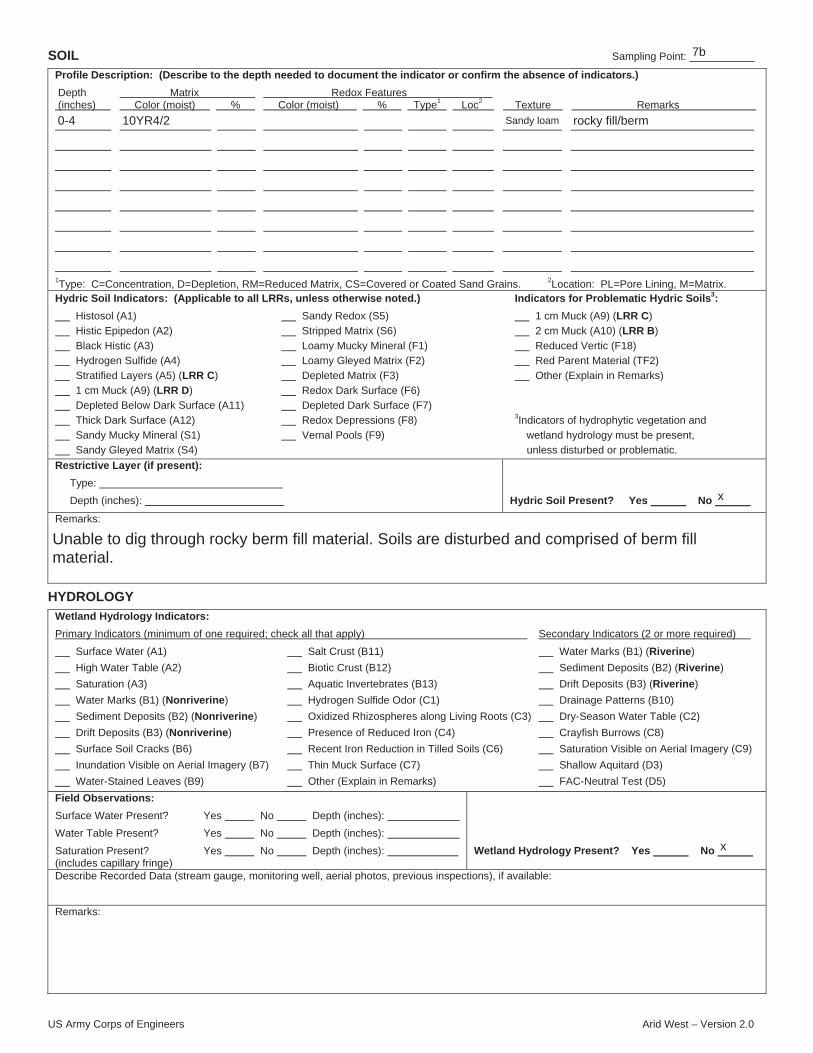
US Army Corps of Engineers Arid West – Version 2.0
SOIL Sampling Point:
Profile Description: (Describe to the depth needed to document the indicator or confirm the absence of indicators.)
Depth Matrix Redox Features (inches) Color (moist) % Color (moist) % Type1 Loc2 Texture Remarks
1Type: C=Concentration, D=Depletion, RM=Reduced Matrix, CS=Covered or Coated Sand Grains. 2Location: PL=Pore Lining, M=Matrix.Hydric Soil Indicators: (Applicable to all LRRs, unless otherwise noted.) Indicators for Problematic Hydric Soils3:
Histosol (A1) Sandy Redox (S5) 1 cm Muck (A9) (LRR C)
Histic Epipedon (A2) Stripped Matrix (S6) 2 cm Muck (A10) (LRR B)
Black Histic (A3) Loamy Mucky Mineral (F1) Reduced Vertic (F18)
Hydrogen Sulfide (A4) Loamy Gleyed Matrix (F2) Red Parent Material (TF2)
Stratified Layers (A5) (LRR C) Depleted Matrix (F3) Other (Explain in Remarks)
1 cm Muck (A9) (LRR D) Redox Dark Surface (F6)
Depleted Below Dark Surface (A11) Depleted Dark Surface (F7)
Thick Dark Surface (A12) Redox Depressions (F8) 3Indicators of hydrophytic vegetation and
Sandy Mucky Mineral (S1) Vernal Pools (F9) wetland hydrology must be present,
Sandy Gleyed Matrix (S4) unless disturbed or problematic.
Restrictive Layer (if present):
Type:
Depth (inches): Hydric Soil Present? Yes No
Remarks:
HYDROLOGY
Wetland Hydrology Indicators:
Primary Indicators (minimum of one required; check all that apply) Secondary Indicators (2 or more required)
Surface Water (A1) Salt Crust (B11) Water Marks (B1) (Riverine)
High Water Table (A2) Biotic Crust (B12) Sediment Deposits (B2) (Riverine)
Saturation (A3) Aquatic Invertebrates (B13) Drift Deposits (B3) (Riverine)
Water Marks (B1) (Nonriverine) Hydrogen Sulfide Odor (C1) Drainage Patterns (B10)
Sediment Deposits (B2) (Nonriverine) Oxidized Rhizospheres along Living Roots (C3) Dry-Season Water Table (C2)
Drift Deposits (B3) (Nonriverine) Presence of Reduced Iron (C4) Crayfish Burrows (C8)
Surface Soil Cracks (B6) Recent Iron Reduction in Tilled Soils (C6) Saturation Visible on Aerial Imagery (C9)
Inundation Visible on Aerial Imagery (B7) Thin Muck Surface (C7) Shallow Aquitard (D3)
Water-Stained Leaves (B9) Other (Explain in Remarks) FAC-Neutral Test (D5)
Field Observations:
Surface Water Present? Yes No Depth (inches):
Water Table Present? Yes No Depth (inches):
Saturation Present? Yes No Depth (inches): (includes capillary fringe)
Wetland Hydrology Present? Yes No
Describe Recorded Data (stream gauge, monitoring well, aerial photos, previous inspections), if available:
Remarks:
7b
0-4 10YR4/2 Sandy loam rocky fill/berm
x
Unable to dig through rocky berm fill material. Soils are disturbed and comprised of berm fillmaterial.
x
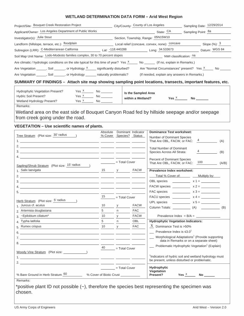
US Army Corps of Engineers Arid West – Version 2.0
WETLAND DETERMINATION DATA FORM – Arid West Region
Project/Site: City/County: Sampling Date:
Applicant/Owner: State: Sampling Point:
Investigator(s): Section, Township, Range:
Landform (hillslope, terrace, etc.): Local relief (concave, convex, none): Slope (%):
Subregion (LRR): Lat: Long: Datum:
Soil Map Unit Name: NWI classification:
Are climatic / hydrologic conditions on the site typical for this time of year? Yes No (If no, explain in Remarks.)
Are Vegetation , Soil , or Hydrology significantly disturbed? Are “Normal Circumstances” present? Yes No
Are Vegetation , Soil , or Hydrology naturally problematic? (If needed, explain any answers in Remarks.)
SUMMARY OF FINDINGS – Attach site map showing sampling point locations, transects, important features, etc.
Hydrophytic Vegetation Present? Yes No
Hydric Soil Present? Yes No
Wetland Hydrology Present? Yes No
Is the Sampled Area
within a Wetland? Yes No
Remarks:
VEGETATION – Use scientific names of plants.
Dominance Test worksheet:
Number of Dominant Species That Are OBL, FACW, or FAC: (A)
Total Number of Dominant Species Across All Strata: (B)
Percent of Dominant Species That Are OBL, FACW, or FAC: (A/B)
Prevalence Index worksheet:
Total % Cover of: Multiply by:
OBL species x 1 =
FACW species x 2 =
FAC species x 3 =
FACU species x 4 =
UPL species x 5 =
Column Totals: (A) (B)
Prevalence Index = B/A =
Hydrophytic Vegetation Indicators:
Dominance Test is >50%
Prevalence Index is 3.01
Morphological Adaptations1 (Provide supporting data in Remarks or on a separate sheet)
Problematic Hydrophytic Vegetation1 (Explain)
1Indicators of hydric soil and wetland hydrology must be present, unless disturbed or problematic.
Absolute Dominant Indicator Tree Stratum (Plot size: ) % Cover Species? Status
1.
2.
3.
4.
= Total Cover Sapling/Shrub Stratum (Plot size: )
1.
2.
3.
4.
5.
= Total Cover Herb Stratum (Plot size: )
1.
2.
3.
4.
5.
6.
7.
8.
= Total Cover Woody Vine Stratum (Plot size: )
1.
2.
= Total Cover
% Bare Ground in Herb Stratum % Cover of Biotic Crust
Hydrophytic Vegetation Present? Yes No
Remarks:
x
Bouquet Creek Restoration Project County of Los Angeles 12/29/2014
Los Angeles Department of Public Works CA 8a
Julie Stout 05N15W10
floodplain concave 3
C-Mediterranean California -118.440288 34.533673 WGS 84
Lodo-Modesto families complex, 30 to 70 percent slopes na
x
x x
x
xx
x
Wetland area on the east side of Bouquet Canyon Road fed by hillside seepage and/or seepagefrom creek going under the road.
30' radius
4
4
15' radius100
Salix laevigata 15
15
y FACW
5' radius
Artemisia douglasiana
~Epilobium ciliatum*
Typha latifolia
Rumex crispus
10
5
10
5
10
40
y
n
y
n
y
FACW
FAC
FACW
OBL
FAC
Juncus cf. acutus
60 x
*positive plant ID not possible (~), therefore the species best representing the specimen waschosen.
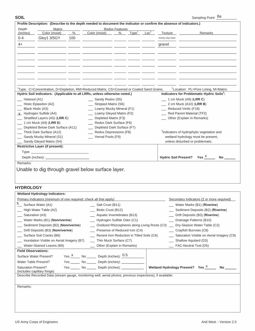
US Army Corps of Engineers Arid West – Version 2.0
SOIL Sampling Point:
Profile Description: (Describe to the depth needed to document the indicator or confirm the absence of indicators.)
Depth Matrix Redox Features (inches) Color (moist) % Color (moist) % Type1 Loc2 Texture Remarks
1Type: C=Concentration, D=Depletion, RM=Reduced Matrix, CS=Covered or Coated Sand Grains. 2Location: PL=Pore Lining, M=Matrix.Hydric Soil Indicators: (Applicable to all LRRs, unless otherwise noted.) Indicators for Problematic Hydric Soils3:
Histosol (A1) Sandy Redox (S5) 1 cm Muck (A9) (LRR C)
Histic Epipedon (A2) Stripped Matrix (S6) 2 cm Muck (A10) (LRR B)
Black Histic (A3) Loamy Mucky Mineral (F1) Reduced Vertic (F18)
Hydrogen Sulfide (A4) Loamy Gleyed Matrix (F2) Red Parent Material (TF2)
Stratified Layers (A5) (LRR C) Depleted Matrix (F3) Other (Explain in Remarks)
1 cm Muck (A9) (LRR D) Redox Dark Surface (F6)
Depleted Below Dark Surface (A11) Depleted Dark Surface (F7)
Thick Dark Surface (A12) Redox Depressions (F8) 3Indicators of hydrophytic vegetation and
Sandy Mucky Mineral (S1) Vernal Pools (F9) wetland hydrology must be present,
Sandy Gleyed Matrix (S4) unless disturbed or problematic.
Restrictive Layer (if present):
Type:
Depth (inches): Hydric Soil Present? Yes No
Remarks:
HYDROLOGY
Wetland Hydrology Indicators:
Primary Indicators (minimum of one required; check all that apply) Secondary Indicators (2 or more required)
Surface Water (A1) Salt Crust (B11) Water Marks (B1) (Riverine)
High Water Table (A2) Biotic Crust (B12) Sediment Deposits (B2) (Riverine)
Saturation (A3) Aquatic Invertebrates (B13) Drift Deposits (B3) (Riverine)
Water Marks (B1) (Nonriverine) Hydrogen Sulfide Odor (C1) Drainage Patterns (B10)
Sediment Deposits (B2) (Nonriverine) Oxidized Rhizospheres along Living Roots (C3) Dry-Season Water Table (C2)
Drift Deposits (B3) (Nonriverine) Presence of Reduced Iron (C4) Crayfish Burrows (C8)
Surface Soil Cracks (B6) Recent Iron Reduction in Tilled Soils (C6) Saturation Visible on Aerial Imagery (C9)
Inundation Visible on Aerial Imagery (B7) Thin Muck Surface (C7) Shallow Aquitard (D3)
Water-Stained Leaves (B9) Other (Explain in Remarks) FAC-Neutral Test (D5)
Field Observations:
Surface Water Present? Yes No Depth (inches):
Water Table Present? Yes No Depth (inches):
Saturation Present? Yes No Depth (inches): (includes capillary fringe)
Wetland Hydrology Present? Yes No
Describe Recorded Data (stream gauge, monitoring well, aerial photos, previous inspections), if available:
Remarks:
x
x
8a
0-4
4+
Gley1 3/5GY 100 mucky clay loam
gravel
x
Unable to dig through gravel below surface layer.
x 0.5
x
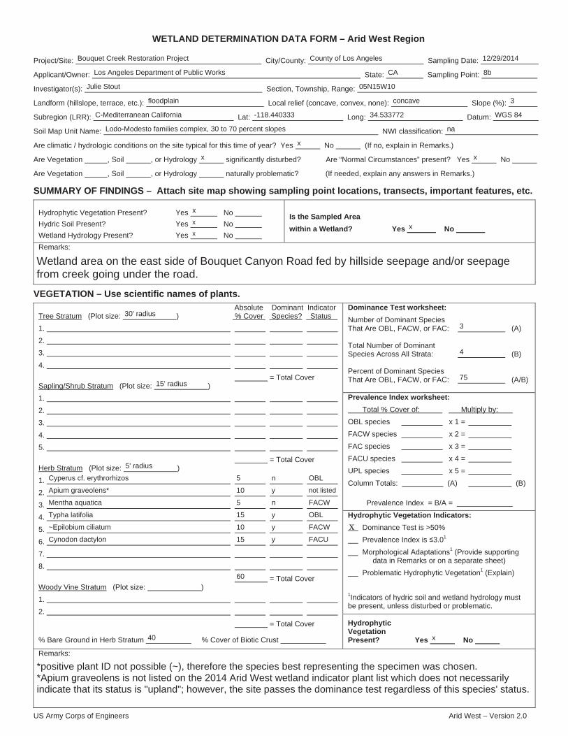
US Army Corps of Engineers Arid West – Version 2.0
WETLAND DETERMINATION DATA FORM – Arid West Region
Project/Site: City/County: Sampling Date:
Applicant/Owner: State: Sampling Point:
Investigator(s): Section, Township, Range:
Landform (hillslope, terrace, etc.): Local relief (concave, convex, none): Slope (%):
Subregion (LRR): Lat: Long: Datum:
Soil Map Unit Name: NWI classification:
Are climatic / hydrologic conditions on the site typical for this time of year? Yes No (If no, explain in Remarks.)
Are Vegetation , Soil , or Hydrology significantly disturbed? Are “Normal Circumstances” present? Yes No
Are Vegetation , Soil , or Hydrology naturally problematic? (If needed, explain any answers in Remarks.)
SUMMARY OF FINDINGS – Attach site map showing sampling point locations, transects, important features, etc.
Hydrophytic Vegetation Present? Yes No
Hydric Soil Present? Yes No
Wetland Hydrology Present? Yes No
Is the Sampled Area
within a Wetland? Yes No
Remarks:
VEGETATION – Use scientific names of plants.
Dominance Test worksheet:
Number of Dominant Species That Are OBL, FACW, or FAC: (A)
Total Number of Dominant Species Across All Strata: (B)
Percent of Dominant Species That Are OBL, FACW, or FAC: (A/B)
Prevalence Index worksheet:
Total % Cover of: Multiply by:
OBL species x 1 =
FACW species x 2 =
FAC species x 3 =
FACU species x 4 =
UPL species x 5 =
Column Totals: (A) (B)
Prevalence Index = B/A =
Hydrophytic Vegetation Indicators:
Dominance Test is >50%
Prevalence Index is 3.01
Morphological Adaptations1 (Provide supporting data in Remarks or on a separate sheet)
Problematic Hydrophytic Vegetation1 (Explain)
1Indicators of hydric soil and wetland hydrology must be present, unless disturbed or problematic.
Absolute Dominant Indicator Tree Stratum (Plot size: ) % Cover Species? Status
1.
2.
3.
4.
= Total Cover Sapling/Shrub Stratum (Plot size: )
1.
2.
3.
4.
5.
= Total Cover Herb Stratum (Plot size: )
1.
2.
3.
4.
5.
6.
7.
8.
= Total Cover Woody Vine Stratum (Plot size: )
1.
2.
= Total Cover
% Bare Ground in Herb Stratum % Cover of Biotic Crust
Hydrophytic Vegetation Present? Yes No
Remarks:
x
Bouquet Creek Restoration Project County of Los Angeles 12/29/2014
Los Angeles Department of Public Works CA 8b
Julie Stout 05N15W10
floodplain concave 3
C-Mediterranean California -118.440333 34.533772 WGS 84
Lodo-Modesto families complex, 30 to 70 percent slopes na
x
x x
x
xx
x
Wetland area on the east side of Bouquet Canyon Road fed by hillside seepage and/or seepagefrom creek going under the road.
30' radius
3
4
15' radius75
5' radius
Apium graveolens*
Mentha aquatica
Typha latifolia
~Epilobium ciliatum
Cynodon dactylon
5
10
5
15
10
15
60
n
y
n
y
y
y
OBL
not listed
FACW
OBL
FACW
FACU
Cyperus cf. erythrorhizos
40 x
*positive plant ID not possible (~), therefore the species best representing the specimen was chosen.*Apium graveolens is not listed on the 2014 Arid West wetland indicator plant list which does not necessarilyindicate that its status is "upland"; however, the site passes the dominance test regardless of this species' status.

US Army Corps of Engineers Arid West – Version 2.0
SOIL Sampling Point:
Profile Description: (Describe to the depth needed to document the indicator or confirm the absence of indicators.)
Depth Matrix Redox Features (inches) Color (moist) % Color (moist) % Type1 Loc2 Texture Remarks
1Type: C=Concentration, D=Depletion, RM=Reduced Matrix, CS=Covered or Coated Sand Grains. 2Location: PL=Pore Lining, M=Matrix.Hydric Soil Indicators: (Applicable to all LRRs, unless otherwise noted.) Indicators for Problematic Hydric Soils3:
Histosol (A1) Sandy Redox (S5) 1 cm Muck (A9) (LRR C)
Histic Epipedon (A2) Stripped Matrix (S6) 2 cm Muck (A10) (LRR B)
Black Histic (A3) Loamy Mucky Mineral (F1) Reduced Vertic (F18)
Hydrogen Sulfide (A4) Loamy Gleyed Matrix (F2) Red Parent Material (TF2)
Stratified Layers (A5) (LRR C) Depleted Matrix (F3) Other (Explain in Remarks)
1 cm Muck (A9) (LRR D) Redox Dark Surface (F6)
Depleted Below Dark Surface (A11) Depleted Dark Surface (F7)
Thick Dark Surface (A12) Redox Depressions (F8) 3Indicators of hydrophytic vegetation and
Sandy Mucky Mineral (S1) Vernal Pools (F9) wetland hydrology must be present,
Sandy Gleyed Matrix (S4) unless disturbed or problematic.
Restrictive Layer (if present):
Type:
Depth (inches): Hydric Soil Present? Yes No
Remarks:
HYDROLOGY
Wetland Hydrology Indicators:
Primary Indicators (minimum of one required; check all that apply) Secondary Indicators (2 or more required)
Surface Water (A1) Salt Crust (B11) Water Marks (B1) (Riverine)
High Water Table (A2) Biotic Crust (B12) Sediment Deposits (B2) (Riverine)
Saturation (A3) Aquatic Invertebrates (B13) Drift Deposits (B3) (Riverine)
Water Marks (B1) (Nonriverine) Hydrogen Sulfide Odor (C1) Drainage Patterns (B10)
Sediment Deposits (B2) (Nonriverine) Oxidized Rhizospheres along Living Roots (C3) Dry-Season Water Table (C2)
Drift Deposits (B3) (Nonriverine) Presence of Reduced Iron (C4) Crayfish Burrows (C8)
Surface Soil Cracks (B6) Recent Iron Reduction in Tilled Soils (C6) Saturation Visible on Aerial Imagery (C9)
Inundation Visible on Aerial Imagery (B7) Thin Muck Surface (C7) Shallow Aquitard (D3)
Water-Stained Leaves (B9) Other (Explain in Remarks) FAC-Neutral Test (D5)
Field Observations:
Surface Water Present? Yes No Depth (inches):
Water Table Present? Yes No Depth (inches):
Saturation Present? Yes No Depth (inches): (includes capillary fringe)
Wetland Hydrology Present? Yes No
Describe Recorded Data (stream gauge, monitoring well, aerial photos, previous inspections), if available:
Remarks:
x
x
8b
0-2
2+
Gley1 3/5GY 100 Clay loam
gravel
mucky
x
Unable to dig through gravel below surface layer.
x 0.5
x

APPENDIX C PHASE I CULTURAL RESOURCES ASSESSMENT
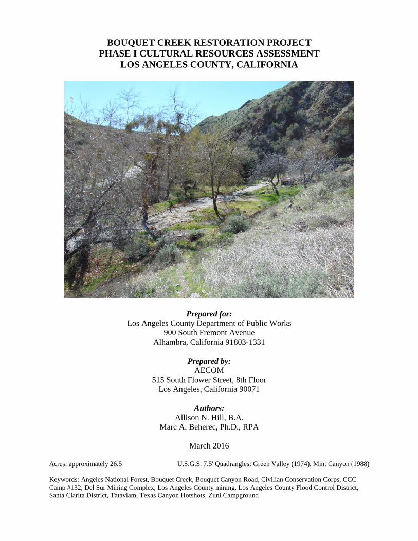
BOUQUET CREEK RESTORATION PROJECT PHASE I CULTURAL RESOURCES ASSESSMENT
LOS ANGELES COUNTY, CALIFORNIA
Prepared for: Los Angeles County Department of Public Works
900 South Fremont Avenue Alhambra, California 91803-1331
Prepared by:
AECOM 515 South Flower Street, 8th Floor
Los Angeles, California 90071
Authors: Allison N. Hill, B.A.
Marc A. Beherec, Ph.D., RPA
March 2016
Acres: approximately 26.5 U.S.G.S. 7.5' Quadrangles: Green Valley (1974), Mint Canyon (1988) Keywords: Angeles National Forest, Bouquet Creek, Bouquet Canyon Road, Civilian Conservation Corps, CCC Camp #132, Del Sur Mining Complex, Los Angeles County mining, Los Angeles County Flood Control District, Santa Clarita District, Tataviam, Texas Canyon Hotshots, Zuni Campground

TABLE OF CONTENTS Section Page
MANAGEMENT SUMMARY ...................................................................................................... v
INTRODUCTION .......................................................................................................................... 1 Project Personnel ................................................................................................................ 1 Report Organization ............................................................................................................ 1
PROJECT DESCRIPTION ............................................................................................................. 3 Project Location .................................................................................................................. 3 Proposed Project ................................................................................................................. 3
Site 1 (1,200 Feet South of MM 15.89 to 2,400 Feet North of MM 15.89) ........... 6 Site 2 (1,600 Feet South of MM 14.70 to 800 Feet South of MM 14.70) .............. 8 Site 3 (320 Feet South of MM 14.70 to 200 Feet North of MM 14.70) ................. 8 Site 4 (470 Feet North of MM 14.70 to 1,200 Feet North of MM 14.70) .............. 9 Site 5 (1,400 Feet South of MM 13.06 to 300 Feet North of MM 13.06) .............. 9 Zuni Preserve ........................................................................................................ 10
ENVIRONMENTAL SETTING .................................................................................................. 13 Natural Setting .................................................................................................................. 13 Cultural Setting ................................................................................................................. 13
Prehistoric Overview ............................................................................................ 13 Ethnohistoric Overview ........................................................................................ 15 Regional Historic Overview ................................................................................. 15 Project Area Historic Overview ............................................................................ 16
ARCHIVAL RESEARCH ............................................................................................................ 19 Previous Cultural Resources Investigations...................................................................... 19 Previously Recorded Cultural Resources .......................................................................... 21
Land Patents .......................................................................................................... 23 Mineral Claims Study ........................................................................................... 24 California Historic Landmarks ............................................................................. 24 Caltrans Bridge Survey ......................................................................................... 24
Summary ........................................................................................................................... 24
NATIVE AMERICAN CONTACT ............................................................................................. 27
CULTURAL RESOURCES SURVEY ........................................................................................ 29 Methods............................................................................................................................. 29 Results ............................................................................................................................... 29
Site 1 (1,200 Feet South of MM 15.89 to 2,400 Feet North of MM 15.89) ......... 29 Site 2 (1,600 Feet South of MM14.70 to 800 Feet South of MM 14.70) ............. 32 Site 3 (320 Feet South of MM 14.70 to 200 Feet North of MM 14.70) ............... 32 Site 4 (470 Feet North of MM 14.70 to 1,200 Feet North of MM 14.70) ............ 33 Site 5 (1,400 Feet South of MM 13.06 to MM 13.06) .......................................... 33
Bouquet Creek Restoration Project Phase I Cultural Resources Assessment Page i 60433042 Bouquet Creek Phase I Cultural Report.docx 3/9/16
Section Page
Zuni Preserve ........................................................................................................ 35
MANAGEMENT RECOMMENDATIONS ................................................................................ 39 Significance Criteria ......................................................................................................... 39
National Register of Historic Places ..................................................................... 39 California Register of Historical Resources ......................................................... 40
Application of the NRHP and CRHR Criteria .................................................................. 40 NRHP Criterion A and CRHR Criterion 1 ........................................................... 40 NRHP Criterion B and CRHR Criterion 2 ............................................................ 41 NRHP Criterion C and CRHR Criterion 3 ............................................................ 41 NRHP Criterion D and CRHR Criterion 4 ........................................................... 41
Archaeological Sensitivity and Recommendations .......................................................... 41
REFERENCES ............................................................................................................................. 45 APPENDICES A Resumes B California State Department of Parks and Recreation (DPR) Site Forms (Confidential) C Native American Contact (Confidential)
Page ii Bouquet Creek Restoration Project Phase I Cultural Resources Assessment 60433042 Bouquet Creek Phase I Cultural Report.docx 3/9/16
LIST OF FIGURES Figure Page 1 Regional Location Map........................................................................................................4 2 Project Sites Map .................................................................................................................5
LIST OF PLATES Plate Page 1 Project Site 1, Overview, View South ...............................................................................30 2 MAB20160208-1, Culvert, East Side, View Northwest ....................................................31 3 MAB20160208-1, Culvert, West Side, View Southeast ....................................................31 4 Overview of Modern Culvert in Project Site 3, View Southeast .......................................32 5 Historic Culvert MAB20160208-2, Overview, View Northwest ......................................35 6 Abandoned Zuni Campground, View Southeast ...............................................................36 7 Isolate MAB20160208-3 ...................................................................................................37
LIST OF TABLES Table Page 1 Previous Investigations Conducted within a 0.25-Mile Radius of the Project Area .........19 2 Previously Recorded Cultural Resource Sites within a 0.25-Mile Radius of the
Project Site .........................................................................................................................21 3 Historic Mining Claims in Project Vicinity .......................................................................24
Bouquet Creek Restoration Project Phase I Cultural Resources Assessment Page iii 60433042 Bouquet Creek Phase I Cultural Report.docx 3/9/16

Page iv Bouquet Creek Restoration Project Phase I Cultural Resources Assessment 60433042 Bouquet Creek Phase I Cultural Report.docx 3/9/16
MANAGEMENT SUMMARY AECOM was retained by the Los Angeles County Department of Public Works to conduct a Phase I cultural resources assessment for the Bouquet Creek Restoration Project (project). The cultural resources assessment was conducted in compliance with Section 106 of the National Historic Preservation Act (NHPA), 16 U.S. Code Section 470f and its implementing regulations 36 Code of Federal Regulations Part 800, and with the California Environmental Quality Act (CEQA), Public Resources Code (PRC) Section 21000 et seq. and the State CEQA Guidelines, California Code of Regulations (CCR) Section 15000 et seq. The project proposes to restore Bouquet Creek by lowering the creek invert to restore stream capacity, which would prevent future flooding across Bouquet Canyon Road, restore stream flows to lower portions of the watershed, and restore stream and riparian habitats. The area of potential effects (APE) is divided into six segments that extend 7.25 miles along Bouquet Canyon Road. A Native American contact program was implemented as part of the cultural resources assessment for this project. The Native American Heritage Commission (NAHC) was contacted to request that a Sacred Lands File check be conducted for the project and that contact information be provided for Native American groups or individuals that may have concerns about cultural resources in the project APE. An informational letter, response form, and map were sent to local Native American representatives designated by the NAHC. Six Native American individuals were identified by the NAHC as having traditional lands in the project area were contacted. In addition, eight individuals not identified by the NAHC, but known by AECOM to have interest in the area, were also contacted. Two of those individuals identified by the NAHC responded via letter. One other individual not identified by the NAHC responded via email. Three of these individuals commented on the project. As a result of follow up phone calls, one additional response was received from an individual identified by the NAHC and two responses were received from the additional individuals contacted. For more information of the Native American contact program, see confidential Appendix C. A records search in connection with this project was conducted at the Angeles National Forest Headquarters and the South Central Coastal Information Center housed at California State University, Fullerton. The records search revealed that six cultural resources were identified within a 0.25-mile radius of the proposed project area. These resources include three historical can scatters (FS-05-01-53-00366, FS-05-01-53-00368, and FS-05-01-53-00369); one mining complex (FS-05-01-53-00276 / CA-LAN-276); one mining resource with features and artifacts (FS-05-01-53-00216 / CA-LAN-3082H); and one multicomponent resource located at the Texas Canyon Fire Station (FS-05-01-53-00024 / CA-LAN-426). The prehistoric component of CA-LAN-426 included the buried remains of a human child and a surface scatter of prehistoric artifacts. The historic component of the resource consists of Civilian Conservation Corps Camp #132. One previously recorded resource, the Del Sur Mining Complex (CA-LAN-276), extends into two portions of the APE. However, no evidence of this resource was observed within the APE in the course of this investigation. Additionally, a field survey was conducted as part of this assessment to identify the presence of cultural resources in the project APE. This field investigation was conducted in the Angeles
Bouquet Creek Restoration Project Phase I Cultural Resources Assessment Page v 60433042 Bouquet Creek Phase I Cultural Report.docx 3/9/16
National Forest under a permit (Authorization ID SCM83) issued by the U.S. Forest Service in accordance with the Archaeological Resources Protection Act of 1979. The survey focused on areas that would be potentially impacted by the project, defined as the APE. The field work included an archaeological survey, an investigation of the built environment, and documentation of observed cultural resources. These efforts primarily focused on areas with exposed ground surface, with the intention of identifying any visible evidence of cultural resources associated with the project APE. As a result of this survey, three cultural resources were identified. These include two historic culverts (MAB20160208-1 and MAB20160208-2) and one historic isolate (MAB20160208-3). These resources do not appear eligible for the California Register of Historical Resources or the National Register of Historic Places. Despite the steep topography and the presence of the project in waterways, the APE is believed to have moderate to high potential for archaeological resources for the following reasons: three historical resources were located within the project APE, one resource was previously recorded within the APE, there are other archaeological resources with subsurface components in proximity of the APE, and the project is in an area with ample resources used by Native Americans in the past. Therefore, it is recommended that initial ground-disturbing activities associated with the project be monitored by a qualified archaeologist. If archaeological material is uncovered in the course of ground-disturbing activities, work will be temporarily halted in the vicinity of the find until appropriate treatment of the resource is determined by a qualified archaeologist in accordance with the provisions of Section 106 of the NHPA and with CEQA Guidelines CCR Title 14, Section 15064.5. If any Native American cultural material is encountered within the project site, consultation with interested Native American parties will be conducted to apprise them of any such findings and solicit any comments they may have regarding appropriate treatment and disposition of the resources. If the qualified archaeologist determines during the course of excavations that there is a low sensitivity for cultural remains, monitoring in that area may be reduced or eliminated. If human remains are discovered, work in the immediate vicinity of the discovery will be suspended and the Los Angeles County Coroner contacted. If the remains are deemed Native American in origin, the Coroner will contact the NAHC and identify a Most Likely Descendant pursuant to PRC Section 5097.98 and CCR Section 15064.5. Work may be resumed at the landowner’s discretion but will only commence after consultation and treatment have been concluded. Work may continue on other parts of the project while consultation and treatment are conducted.
Page vi Bouquet Creek Restoration Project Phase I Cultural Resources Assessment 60433042 Bouquet Creek Phase I Cultural Report.docx 3/9/16
INTRODUCTION AECOM was contracted by the Los Angeles County Department of Public Works (LACDPW) to conduct a cultural resources assessment of the Bouquet Creek Restoration Project (project) in support of an Initial Study and Mitigated Negative Declaration in compliance with Section 106 of the National Historic Preservation Act (NHPA), 16 U.S. Code Section 470f) and its implementing regulations (36 Code of Federal Regulations Part 800), and with the California Environmental Quality Act (CEQA), Public Resources Code (PRC) Section 21000 et seq. and the State CEQA Guidelines, California Code of Regulations (CCR) Section 15000 et seq. The archaeological survey was conducted under a Permit for Archaeological Investigations (Authorization ID SCM83) issued by the Angeles National Forest (ANF), U.S. Department of Agriculture, on February 1, 2016. As a result of this cultural resources investigation, three newly identified cultural resources have been documented. PROJECT PERSONNEL AECOM personnel involved in the cultural resources assessment are as follows: Allison Hill, B.A., conducted archival research, conducted archaeological survey, and served as report author; Marc Beherec, Ph.D., RPA, performed the archaeological survey and served as report author; Christy Dolan, M.A., RPA, performed senior review; and Alec Stevenson, B.A., provided graphics and geographic information system support. Resumes of key personnel are included in Appendix A. REPORT ORGANIZATION This report is organized following the 1990 Archaeological Resource Management Reports (ARMR): Recommended Contents and Format guidelines, Department of Parks and Recreation, Office of Historic Preservation, State of California. These guidelines provide a standardized format and suggested report content, scaled to the size of the project. The organization of this report includes the following sections. First, a project description including project location and setting, and proposed project work is provided. Next, the environmental and cultural settings are presented along with a detailed historical context of the project area. A description of the Sacred Lands File (SLF) search and results, including the Native American Contact Program, is then provided. This is followed by the archival and field survey research methods and results. The final section summarizes the results of the cultural resources assessment and provides recommendations for resource eligibility and recommendations for further work.
Bouquet Creek Restoration Project Phase I Cultural Resources Assessment Page 1 60433042 Bouquet Creek Phase I Cultural Report.docx 3/9/16

Page 2 Bouquet Creek Restoration Project Phase I Cultural Resources Assessment 60433042 Bouquet Creek Phase I Cultural Report.docx 3/9/16
PROJECT DESCRIPTION PROJECT LOCATION The project involves five predefined reaches of Bouquet Creek where restoration activities would occur (from downstream to upstream, labeled as Sites 1 through 5), and a sixth site in the abandoned Zuni Campground, where a fish preserve would be constructed. The project sites are located within an unincorporated area of northern Los Angeles County and within the southern part of the Santa Clara portion of the U.S. Forest Services’ (USFS) Santa Clara/Mojave Rivers Rangers District of the ANF (Figure 1). The sites occur within an approximate 7.25-mile stretch of Bouquet Creek between the southern boundary of the ANF (near Site 1), upstream to the vicinity of Bouquet Reservoir (near Site 5). The upper portion of Site 1 upstream through Site 5 occurs on the U.S. Geological Survey’s (USGS) 7.5-minute Green Valley, California quadrangle (USGS 1995) in Township 5 North, Range 15 West, Sections 10 (Site 5), 15 (Sites 3 and 4), 16 (Site 2) and 21 (Site 1 and Zuni Preserve [Site 6]), with the lower portion of Site 1 extending south into Township 5 North, Range 15 West, Section 21 of the Mint Canyon, California quadrangle (USGS 1995). Figure 2 presents the project vicinity. The six site locations are as follows:
• Site 1: 1,200 feet south of Mile Marker (MM ) 15.89 to 2,400 feet north of MM 15.89 • Site 2: 1,600 feet south of MM 14.70 to 800 feet south of MM 14.70 • Site 3: 320 feet south of MM 14.70 to 200 feet north of MM 14.70 • Site 4: 470 feet north of MM 14.70 to 1,200 feet north of MM 14.70 • Site 5: 1,400 feet south of MM 13.06 to 300 feet north of MM 13.06 • Site 6: Zuni Preserve, located within the former Zuni Campground (now abandoned),
between Sites 1 and 2, on the west side of Bouquet Canyon Road PROPOSED PROJECT The effects of disastrous storms combined with fires over the years in Bouquet Canyon have resulted in sediment deposition within Bouquet Creek reducing its capacity to move water and causing the invert of the creek to be at a higher elevation than that of adjacent Bouquet Canyon Road at several locations. Even at very low flow rates within the creek, water seeps through dirt berms constructed to hold the creek back away from the roadway, or it seeps up through cracks in the roadway at locations where there is sufficient hydrostatic pressure. As a result of siltation and reduced flows in the stream, less discharge is reaching the lower end of Bouquet Canyon, contributing to a decline of in-stream and riparian habitat quality. Current stream conditions also pose potentially hazardous driving conditions for motorists due to flooding of the roadway. This situation is of concern to City of Los Angeles' Department of Water and Power (DWP), which regulates flows within the creek from the dam at Bouquet Reservoir, at the top of Bouquet Canyon. DWP, through an agreement with the United Water Conservation District is to release 5 cubic feet per second (cfs) every year into Bouquet Creek during the period between April 1 and September 30, and 1 cfs during the period between October 1 and March 31. However, due to the current condition of the creek, DWP is reluctant to
Bouquet Creek Restoration Project Phase I Cultural Resources Assessment Page 3 60433042 Bouquet Creek Phase I Cultural Report.docx 3/9/16
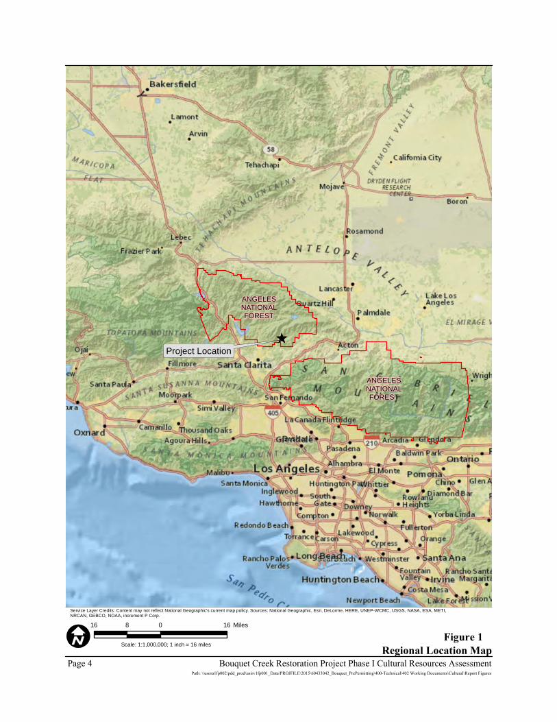
Project Location
ANGELESNATIONALFOREST
ANGELESNATIONALFOREST
Figure 1Regional Location Map
Scale: 1:1,000,000; 1 inch = 16 miles
Page 4 Bouquet Creek Restoration Project Phase I Cultural Resources AssessmentPath: \\usora1fp002\pdd_prod\usirv1fp001_Data\PROJFILE\2015\60433042_Bouquet_PrePermitting\400-Technical\402 Working Documents\Cultural\Report Figures
16 0 168 Miles
Service Layer Credits: Content may not reflect National Geographic's current map policy. Sources: National Geographic, Esri, DeLorme, HERE, UNEP-WCMC, USGS, NASA, ESA, METI,NRCAN, GEBCO, NOAA, increment P Corp.
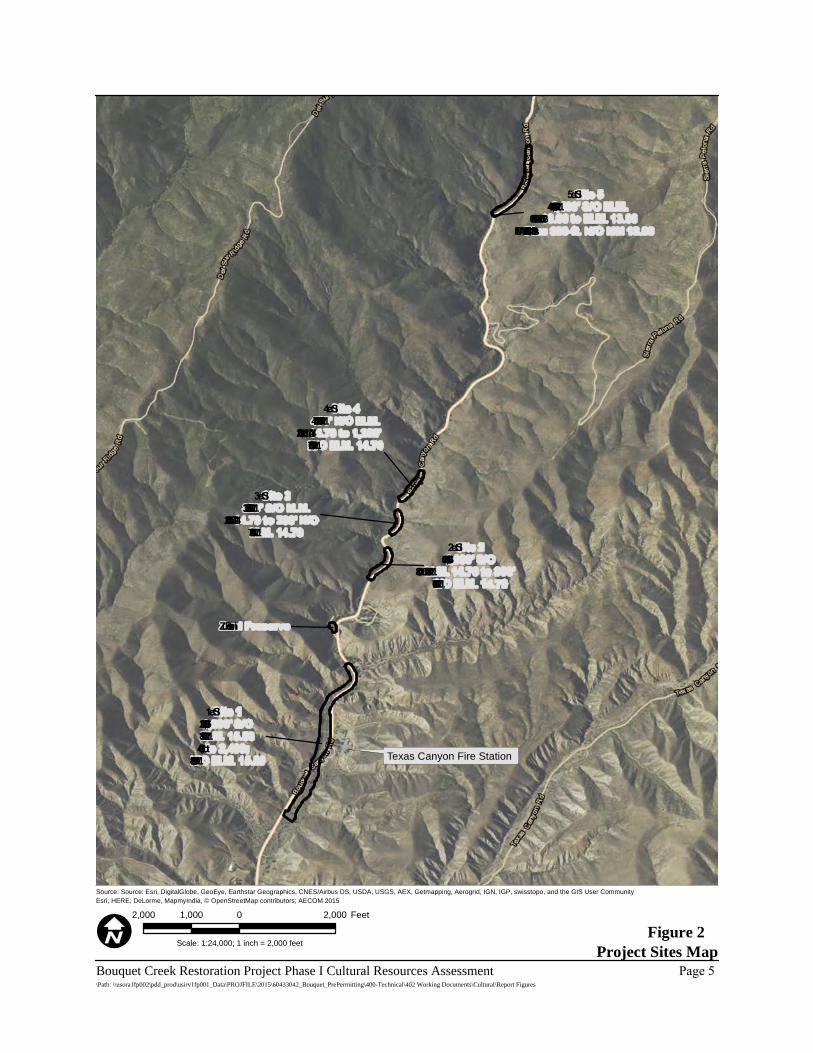
Texas Canyon Fire Station
Site 11,200’ S/OM.M. 15.89to 2,400;
N/O M.M. 15.89
Zu ni Preserve
Site 21,600’ S/O
M.M. 14.70 to 800’S/O M.M. 14.70
Site 3320’ S/O M.M.14.70 to 200’ N/OM.M. 14.70
Site 4470’ N/O M.M.14.70 to 1,200’N/O M.M. 14.70
Site 51,400’ S/O M.M.13.06 to M.M. 13.06
Plu s 300-ft. N/O MM 13.06
Figure 2Project Sites Map
Source: Source: Esri, DigitalGlobe, GeoEye, Earthstar Geographics, CNES/Airbus DS, USDA, USGS, AEX, Getmapping, Aerogrid, IGN, IGP, swisstopo, and the GIS User CommunityEsri, HERE, DeLorme, MapmyIndia, © OpenStreetMap contributors; AECOM 2015
Scale: 1:24,000; 1 inch = 2,000 feet
Bouquet Creek Restoration Project Phase I Cultural Resources Assessment Page 5\Path: \\usora1fp002\pdd_prod\usirv1fp001_Data\PROJFILE\2015\60433042_Bouquet_PrePermitting\400-Technical\402 Working Documents\Cultural\Report Figures
2,000 0 2,0001,000 Feet
release the stipulated amounts due to perceived liability issues caused by roadway flooding. This has resulted in only a fraction of the stipulated flows being released into the creek, which has well owners at the lower end of Bouquet Canyon concerned as their wells are going dry. Well owners perceive this as a direct correlation to decreased flows from the dam. LACDPW proposes to restore Bouquet Creek by lowering the creek invert to restore stream capacity at five locations, which would prevent future flooding across Bouquet Canyon Road, restore stream flows to lower portions of the watershed, and restore stream and riparian habitats. Additionally, the project proposes to construct a fish preserve at the abandoned Zuni Campground. Construction at each site would commence after receipt of all regulatory permits and approvals. For ease of discussion and identification, AECOM has labeled the stream reaches from downstream to upstream as Sites 1 through 5, and the site for the fish preserve as Zuni Preserve (Figure 2). Project details regarding vegetation removal and sediment removal by site are discussed below, followed by a discussion of proposed creek restoration activities. Pending approval from the USFS, LACDPW proposes to utilize an area along the east side of Bouquet Canyon Road and just north of the culvert at MM 15.89 as a sediment placement site for the project. The area requested is 2.2 acres and is estimated to have a capacity of 32,000 cubic yards (CY). Without this site, LACDPW would have to remove the estimated 10,400 CY (15,600 tons) of material from this project and dispose of it at the Chiquita Canyon Landfill, located approximately 15 miles southwest of Site 1. Site 1 (1,200 Feet South of MM 15.89 to 2,400 Feet North of MM 15.89) Culvert MM 15.89 to 1, 200 feet south of MM 15.89 Vegetation Removal LACDPW would conduct vegetation removal activities and clear an approximate 50- to 70-foot-wide path for a distance of 1,200 feet south (downstream) of the culvert using one of two options. Option A requires the use of a masticator that would grind up, and leave in place, existing brush and trees. All brush, dead trees, non-oak trees smaller than a 12-inch diameter-at-breast-height (dbh), and oak trees smaller than a 6-inch dbh would be masticated. Sediment Removal Following vegetation removal, the site would be surveyed and grade stakes set every 50 to 100 feet on the east side of the creek to indicate the depth of excavation. The depth of excavation varies in this reach and would be deepest just downstream of the culvert outlet. The restored creek bottom in this reach would be 9 feet wide, with 3-foot horizontal to 1-foot vertical (3:1) side slopes so that the creek would be able to convey flows from upstream through the site. Excavated material would be spread out along both sides of the creek and left uncompacted or used to provide contour. Large rocks, boulders, and large tree stems would be set aside on the periphery of the project area for post-sediment removal restoration use. Once excavation of the
Page 6 Bouquet Creek Restoration Project Phase I Cultural Resources Assessment 60433042 Bouquet Creek Phase I Cultural Report.docx 3/9/16
creek channel and vegetation removal work is complete, the excavator and water truck would utilize the access path to exit the work area. Culvert MM 15.89 to 2,400 feet north of MM 15.89 Vegetation Removal LACDPW would conduct vegetation removal activities and clear an approximate 50- to 70-foot-wide path for a distance of 2,400 feet north (upstream) using a masticator or a crew with hand tools to clear the path, as described above. Utilizing a masticator for vegetation removal in this reach would take approximately 12 days; use of a crew with hand tools would take approximately 24 days. Sediment Removal Sediment removal activities and preparation for Site 1, north of MM 15.89, would closely mirror activities as they were described for Site 1, south of MM 15.89. The excavator would be positioned at the culvert outlet as if it were straddling the creek and begin excavating the accumulated sediment and vegetation, working its way 2,400 feet northerly. The depth of the excavation varies in this reach and progressively gets deeper to the north. The proposed creek cross section form the culvert inlet to 1,000 feet northerly would have a 7.5-foot creek bottom with 3:1 side slopes, where feasible, in order to maintain the existing creek capacity (182 cfs) from farther upstream. From 1,000 to 2,400 feet north of the culvert inlet, the creek cross section would be a 6-foot-wide bottom with 3:1 side slopes. Centered at 1,200 feet north of the culvert would be a 100-foot-long transition of the creek bottom from a width of 7.5 feet to 6 feet. In areas under the power lines, where use of the excavator would be prohibited, a track loader would be used to remove sediment from the creek bed. Between 1,400 to 1,800 feet north of MM 15.89, the stream would be widened, and pools and braided channels would be incorporated where possible. Excavated material would be spread out over areas away from the creek on both sides and left uncompacted from the culvert inlet to a distance of 1,700 feet north. Large rocks, boulders, and large tree stems would be set aside on the periphery of the project area for post-sediment removal restoration use. Between 1,700 and 2,400 feet north of the culvert inlet, approximately 2,000 CY of excavated material would be deposited on the shoulder of the roadway. A loader with rubber tires would then load the material into dump trucks to be taken to a designated sediment placement location. A backhoe with rubber tires would also work from the roadway to restore one “overshot” located at 1,400 feet north of MM 15.89. Overshots are areas, usually paved with asphalt, intended to direct water on Bouquet Canyon Road into Bouquet Creek. This area is currently blocked by sediment and vegetation, and water is not able to flow into the creek. Sediment removal would take approximately 18 days.
Bouquet Creek Restoration Project Phase I Cultural Resources Assessment Page 7 60433042 Bouquet Creek Phase I Cultural Report.docx 3/9/16
Site 2 (1,600 Feet South of MM 14.70 to 800 Feet South of MM 14.70) Vegetation Removal LACDPW would conduct vegetation removal activities to clear an approximate 40-foot-wide path for 800 feet through the site. A trained crew would use chainsaws and other hand tools to clear vegetation. All existing brush, dead trees, non-oak trees smaller than a 12-inch dbh, and oak trees smaller than a 6-inch dbh would be removed and run through a wood chipper and the chips spread over the site. Sediment Removal Sediment removal activities would commence at Site 2 following vegetation removal. Throughout this site, the proposed creek bed would be a minimum of 4 feet below the existing edge of pavement or paved inverted flow line. The grade would be checked using a hand level as work progresses. The depth of the excavation is fairly consistent at 4 feet through this reach. The proposed creek cross section in this reach would have a 6-foot creek bottom with 3:1 side slopes on the east side and 1:1 side slopes or shallower, if possible, on the west side in order to maintain existing creek capacity. Excavated material, approximately 1,900 CY, would be deposited on the shoulder of Bouquet Canyon Road. A loader with rubber tires would then load the material into dump trucks to be taken to the designated sediment placement location at Site 1. Once this work is completed, the excavator would exit the work area to the adjacent roadway. A rubber-tire backhoe would also work from the roadway to restore one overshot located 1,460 feet south of MM 14.70, which is currently blocked by sediment and vegetation. Site 3 (320 Feet South of MM 14.70 to 200 Feet North of MM 14.70) Vegetation Removal LACDPW would conduct vegetation removal activities and clear an approximate 40-foot-wide path for a distance of 520 feet through the site. A trained crew would use chainsaws and other hand tools to clear the path. All existing brush, dead trees, non-oak trees smaller than a 12-inch dbh, and oak trees smaller than a 6-inch dbh would be removed and run through a wood chipper and the chips spread over the site. Sediment Removal Sediment removal activities at Site 3 would commence upon vegetation removal. Throughout this site, the proposed creek bed would be a minimum of 4 feet below the existing edge of pavement or paved inverted flow line. The grade would be checked using a hand level as work progresses. The depth of the excavation is fairly consistent at 2 to 3 feet throughout this reach. The proposed creek cross section in this reach would have a 6-foot-wide creek bottom with 3:1 side slopes on the east side and 1:1 side slopes or shallower, if possible, on the west side in order to maintain existing creek capacity.
Page 8 Bouquet Creek Restoration Project Phase I Cultural Resources Assessment 60433042 Bouquet Creek Phase I Cultural Report.docx 3/9/16
The excavated material, approximately 1,000 CY, would be deposited on the shoulder of the roadway. A rubber-tire loader would then load the material into dump trucks to be taken to the designated sediment placement location at Site 1. Once work is completed, the excavator would exit the work area to the adjacent roadway. A backhoe with rubber tires would also work from the roadway to restore one overshot located 1,460 feet south of MM 14.70, which is currently blocked by sediment and vegetation. A motor grader would be utilized for grading activities along the shoulder of the roadway to direct flows from the roadway into the creek at 330 feet south of MM 14.70. Site 4 (470 Feet North of MM 14.70 to 1,200 Feet North of MM 14.70) Vegetation Removal LACDPW would conduct vegetation removal activities and clear an approximate 40-foot-wide path for a distance of 730 feet through the site. A trained crew would use chainsaws and other hand tools to clear the path. All existing brush, dead trees, non-oak trees smaller than a 12-inch dbh, and oak trees smaller than a 6-inch dbh would be removed and run through a wood chipper and the chips spread over the site. Sediment Removal Sediment removal activities would commence at Site 4 following vegetation removal. Throughout this site, the proposed creek bed would be a minimum of 4 feet below the existing edge of pavement or paved inverted flow line. The grade would be checked using a hand level as work progresses. The depth of the excavation varies throughout Site 4 and has sections that would require 6 to 7 feet of excavation. The proposed creek cross section in this reach would have a 6-foot-wide creek bottom with 3:1 side slopes on the east side and 1:1 side slopes or shallower, if possible, on the west side in order to maintain existing creek capacity. The excavated material, approximately 1,900 CY, would be deposited on the shoulder of the roadway. A loader with rubber tires would then load the material into dump trucks to be taken to the designated sediment placement location at Site 1. Once the work is completed, the excavator would exit the work area to the immediately adjacent roadway. A backhoe with rubber tires would also work from the roadway to restore one overshot located 580 feet north of MM 14.70 that conveys surface flows from the roadway into the adjacent creek. This overshot is currently blocked by sediment and vegetation. Site 5 (1,400 Feet South of MM 13.06 to 300 Feet North of MM 13.06) Vegetation Removal LACDPW would conduct vegetation removal activities and clear an approximate 40-foot-wide path for a distance of 1,400 feet. A trained crew would use chainsaws and other hand tools to clear the path. All existing brush, dead trees, non-oak trees smaller than a 12-inch dbh, and oak trees smaller than a 6-inch dbh would be removed and run through a wood chipper and the chips spread over the site.
Bouquet Creek Restoration Project Phase I Cultural Resources Assessment Page 9 60433042 Bouquet Creek Phase I Cultural Report.docx 3/9/16
Sediment Removal Sediment removal activities would commence at Site 5 following vegetation removal. Throughout this site, the proposed creek bed would be a minimum of 4 feet below the existing edge of pavement or paved inverted flow line. The grade would be checked using a hand level as work progresses. The depth of the excavation is fairly consistent at 4 feet throughout Site 5. The proposed cross section from the culvert to 500 feet south would have a 6-foot-wide creek bottom with 1:1 side slopes. Within this reach, 3:1 side slopes are not feasible due to the creek’s proximity to the roadway and adjacent hillside. Between 500 and 1,400 feet south of the culvert, the proposed creek cross section would have a 6-foot-wide creek bottom with 3:1 side slopes on the east side and 1:1 side slopes or shallower, if possible, on the west side in order to maintain existing creek capacity. The excavated material, approximately 3,500 CY, would be deposited on the shoulder of the roadway. A loader with rubber tires would then load the material into dump trucks to be taken to the designated sediment placement location at Site 1. Once the work is completed, the excavator would exit the work area to the immediately adjacent roadway. A backhoe with rubber tires would also work from the roadway to restore two overshots within the reach that convey surface flows from the roadway into the adjacent creek. These overshots are currently blocked by sediment and vegetation. Culvert MM 13.06 to 300 feet north of MM 13.06 Vegetation Removal LACDPW would conduct vegetation removal activities and clear an approximate 40-foot-wide path for a distance of 300 feet north of the culvert at MM 13.06. A trained crew would use chainsaws and other hand tools to remove overgrown vegetation and trees and any fallen debris that may be in the stream channel. Brush and dead trees removed from the channel would be run through a wood chipper and the chips spread over the site. Sediment Removal No sediment would be removed from the channel within the 300-foot reach upstream of the culvert. Only sediment directly in front of the culvert inlet would be excavated using a rubber-tire backhoe staged on Bouquet Canyon Road. This material would be loaded into dump trucks to be taken to the sediment placement location. Zuni Preserve LACDPW proposes to excavate a small channel off the existing creek, northeast into the former campground where a small pond will be constructed to serve as an aquatic refuge in times of high or rapid water flow; this pond may also provide an area that U.S. Fish and Wildlife Service can use as a holding site for fish or other aquatic species.
Page 10 Bouquet Creek Restoration Project Phase I Cultural Resources Assessment 60433042 Bouquet Creek Phase I Cultural Report.docx 3/9/16
RESTORATION PROGRAM ACTIVITIES Harvested cuttings, root masses, and other organic and inorganic materials set aside during sediment removal would be added back into the excavated channel to create root wad revetments, engineered rock riffles with vegetated keys, longitudinal peaked stone toe protection, and boulder clusters to create habitat with the new stream channel. Portions of this work may be conducted during the sediment removal phase for increased efficiency. Vertical bundles, willow fascines, joint plantings, jute netting, and vegetated silt trenches would be installed, as needed, to restore riparian function, minimize erosion, facilitate vegetative recovery, and protect Bouquet Canyon Road. General riparian habitat considerations include:
• Install boulder clusters, root wad revetments with native vegetation, and other salvaged materials to provide channel structure, minimize erosion, and reduce the potential of flooding events to create habitat for aquatic biota, and protect Bouquet Canyon Road.
• Increase stream velocity through the culvert at MM 15.89 to minimize sedimentation within the existing culvert.
• Excavate to bedrock in the constructed channel when possible to increase water retention (reduce infiltration).
• Increase stream shade/cover, potentially with added contours (bank slopes) and vegetation using excavated materials when possible.
• Install harvested native vegetation to restore riparian vegetation.
• Where tributaries impinge on the work area, excavate and provide 3:1 slopes at confluence. Install erosion control measures on constructed slopes, where needed.
• Vertical bundles, willow fascines, pole plantings, erosion control fabric, transplanted sedges, and vegetated slit trenches would be installed, as needed, to restore riparian function, minimize erosion, facilitate vegetative recovery, and protect Bouquet Canyon Road.
Critical riparian habitat features for UTS to be implemented include:
• Maintain total length of 1 to 1.5 percent gradient of the currently existing stream bed. Currently, approximately 2,800 feet of Bouquet Creek is 1.5 percent gradient, or less within the project area. The majority of existing low-gradient stream conditions exist at Sites 1 and 2.
• In areas with >1 percent existing stream bottom, restore riffle habitat and decrease the stream gradient, where feasible.
• Manipulate the longitudinal, lateral, and vertical profile of the stream to lower stream gradient, create areas of slower flow and enhance habitat favorable for UTS.
Bouquet Creek Restoration Project Phase I Cultural Resources Assessment Page 11 60433042 Bouquet Creek Phase I Cultural Report.docx 3/9/16
• Within the project area near MM 15.89 (Site 1), construct mid-channel bars and islands to increase complexity, and allow other vegetation plantings to provide shade.
• Construct stream channel refugia (backwater areas) for UTS when high flows (10 to 182 cfs) are being released from Bouquet Reservoir. This should be considered when creating overshot drains to ensure connectivity to the stream channel.
The Zuni Preserve (Site 6) would undergo enhancement to create a large (1,500-square-foot minimum) backwater preserve for UTS breeding habitat. At least one side of the channel would be created with large slow-moving pools, created as UTS habitat.
Page 12 Bouquet Creek Restoration Project Phase I Cultural Resources Assessment 60433042 Bouquet Creek Phase I Cultural Report.docx 3/9/16
ENVIRONMENTAL SETTING NATURAL SETTING The project APE is located on the southern slope of the San Gabriel Mountains, within the southern part of the Santa Clara portion of the Santa Clara/Mojave Rivers Rangers District of the ANF. Elevation of the project area is between approximately 1,650 feet above mean sea level (amsl) and 2,075 feet amsl, representing a drop in elevation of 425 feet across the project area with an average slope of approximately 2.50 percent. Bouquet Creek is a tributary of the Santa Clara River, with the confluence occurring approximately 8 miles downstream of the southern extent of the project. Upper reaches of the creek likely sustain perennial flow while the lower reach has only intermittent flow. Based on the establishment of obligate hydrophytic vegetation along the stream, Bouquet Creek likely conveys sufficient flow to be considered relatively permanent water. The project vicinity enjoys a Mediterranean climate with dry hot summers and mild wet winters. Most of the precipitation falls in the form of light to moderate rain between November and March. A total of eight vegetation communities and cover types are present in the project area. A majority of the proposed work sites are characterized by a Southern Cottonwood Willow Riparian Forest plant community as well as Urban and Developed land cover types. The soils are coarse sands and fine gravels eroded from local bedrock exposures. CULTURAL SETTING As a framework for discussing the types of cultural resources that might be encountered in the vicinity of the proposed project, the following section summarizes our current understanding of major prehistoric and historic developments in southern California. This is followed by a more focused discussion of the history of the project area itself. Prehistoric Overview Following the seminal work of William Wallace (1955) and Claude Warren (1968), the prehistory of southern California is typically divided into Early, Middle, and Late Periods, with an initial Paleo-Indian period dating to the late Pleistocene and early Holocene. Relatively little archaeological work has been conducted in mountainous interior areas, including the project area. Recent research projects are largely cultural resources management studies associated with the construction or management of transportation features, utilities, and ANF natural resources (see Archival Research section, below). In the southern California region, the earliest evidence of human occupation comes from a handful of sites with early tools and some human remains that have been dated from 7,000 years ago to greater than 10,000 years old. These include the Baldwin Hills (“Early Man”) and Los Angeles Mesa (“Haverty Collection”) sites where construction activities in the 1920s and 1930s uncovered human remains in deep alluvial deposits. The human remains were tentatively dated to
Bouquet Creek Restoration Project Phase I Cultural Resources Assessment Page 13 60433042 Bouquet Creek Phase I Cultural Report.docx 3/9/16
between 10,000 years old to more than 20,000 years old (Moratto 1984:53). Recent research into the Los Angeles Mesa materials suggests that the early dates should be considered tentative and, further, that some studies suggest dates of no more than 5,000 years old (Sheilagh et al. 1990). The Early Period (5000 to 3000 BC) in southern California is often described as the Millingstone Horizon. In this period, milling implements such as manos and metates became increasingly common at habitation sites. Sites from this time period typically contain large numbers of milling implements, crude core and cobble tools, flaked stone tools, distinctive cogged stone implements, and infrequent side-notched dart points (Fenenga 1953). The focus at inland sites appears to be on plant food processing and hunting. Along the coast, populations invested in maritime food gathering strategies including close-shore and deep-sea fishing, as well as shellfish collection (Grenda 1997). The first earliest uncontestable sites in the ANF date to the Early Period. Radiocarbon dates from cooking features at CA-LAN-3013, a midden site along Cruthers Creek in the northern San Gabriel Mountains, yielded radiocarbon dates of 7675 cal. BP (Milburn et al. 2009). These are the earliest radiocarbon dates obtained from sites in the Transverse Ranges. The Middle Period (3000 BC to AD 1000) is a long cultural period also sometimes referred to as the Intermediate Horizon or the Hunting Period. The mortar and pestle were introduced during this period suggesting an increased reliance on hard plant foods like acorns (Altschul and Grenda 2002). Acorns became an important food source for many southern and central California groups during this time (Warren 1968). Hunting and fishing continued to be significant subsistence activities with gradual advances in technology. Bone, antler, and shell tools and ornaments became more common along the coast and inland. Many more projectile points were manufactured throughout this period, suggesting that hunting was a more significant activity at this time. Projectile points from the Middle Period are typically relatively large, dart-sized items (Erlandson 1991). The Late Period (AD 1000 to 1782) is notable for a dramatic increase in the number of sites and for an increase in regional specialization. In general, Late Period southern California sites include more bone tools, numerous types of Olivella sp. (dwarf olive) shell beads, circular fishhooks, and occasional pottery vessels (Miller 1991) Along the coast, groups became more focused on fish and shellfish, whereas inland groups became more involved in the processing and storage of key staple foods like acorns and piñon nuts. Between AD 1000 and 1250, small arrow-sized projectile points, of the Desert side-notched and Cottonwood triangular series, were adopted throughout southern California (Altschul and Grenda 2002). Following European contact, glass trade beads and metal items appeared in the archaeological record. On the mainland, burial practices shifted to cremation in the Los Angeles Basin and northern Orange County. At many coastal and most Channel Island sites, though, interment remained the common practice (Moratto 1984). Some researchers suggest that the changes seen at the beginning of the Late Period reflect the movement of Shoshonean speakers from the eastern deserts into southern California. Other scholars, though, have argued that the movement of desert-adapted Shoshonean speakers occurred as much as 2,000 years earlier (Bean and Smith 1978; Sutton 2009).
Page 14 Bouquet Creek Restoration Project Phase I Cultural Resources Assessment 60433042 Bouquet Creek Phase I Cultural Report.docx 3/9/16
Ethnohistoric Overview At the time of European contact, ANF was a boundary land used and occupied by three distinct cultural and linguistic groups: the Gabrielino, the Chumash, and the Tataviam (Kroeber 1925). Far south of the project lived the Fernandeño branch of the Gabrielino who controlled San Fernando and San Gabriel Valleys, Los Angeles Basin, and northern Orange County down to Aliso Creek (Kroeber 1925). West and north of the project, the Castac and Emigdiano Chumash groups maintained villages along Pastoria Creek and near Mount Abel-Tecuya (King and Blackburn 1978). These Chumash groups were missionized at the Santa Ynez Mission, which later became a Native American reservation. Today, the Santa Ynez Band of Chumash Indians is the only federally recognized tribal group of the Chumash people. In the immediate project vicinity, the Tataviam, also historically known as the Alliklik, maintained some habitation and gathering sites, although their primary villages were located at lower elevations to the south along the Santa Clara River (Johnson and Earle 1990; King and Blackburn 1978; Kroeber 1925). The closest known Tataviam village, Tsawayung, was a major habitation site several miles southwest of the project along the southern bank of the Santa Clara River (Johnson and Earle 1990; Kroeber 1925: Plate 48). Little is known about the specifics of Tataviam culture although they are often described as a mountain-adapted people similar in language and culture to the neighboring Serrano who inhabited Antelope Valley and the San Gabriel and San Bernardino Mountains (Johnson and Earle 1990; Krober 1925:613–614). In an early documentation of the area, Pedro Fages, a member of the 1769 Portola expedition, passed through this region and noted that there were a numerous native villages. In his diary, Fages noted a small canyon with a grove of oaks and an ample supply of water, which may have been Bouquet Canyon or nearby Francisquito Canyon (Vance 2000). In his accounts traveling through the region in 1776, missionary and explorer Fray Francisco Garces noted that the Tataviam were at war with the neighboring Kitanemuk, who had killed a chief on the Santa Clara River (Scharlatta 2014:233). By the early 1800s, most of the Tataviam people had been baptized at the San Fernando Mission, where they lived and intermarried with Gabrielino (Fernandeño) and Chumash neophytes (Kroeber 1925:613). In 1921, the last known speaker of the Tataviam language died. Although very few Tataviam words are known, the place names Castaic (Kashtuk) and Piru (Piiouku) are thought to be derived from their Tataviam names (Worden 1998). The tribe is recognized by the State of California and is currently petitioning the Office of Federal Acknowledgment for Federal recognition. Regional Historic Overview Early European exploration of the coastal and inland trade routes of California began in the 1500s, but more than a century passed before Spain mounted a concerted colonization effort in California. The historical era in California begins with Spanish exploration and is often divided into three distinctive chronological and historical periods: the Spanish or Mission Period (1542 to 1821), the Mexican or Rancho Period (1821 to 1848), and the American Period (1848 to present). The following section provides a brief synopsis of early regional history and a review of history directly associated with the project area.
Bouquet Creek Restoration Project Phase I Cultural Resources Assessment Page 15 60433042 Bouquet Creek Phase I Cultural Report.docx 3/9/16
Before direct Spanish settlement, more than two centuries of sporadic European exploration had spread disease and European goods throughout native southern California from the coasts and bays to the mountains and deserts. Introduced diseases reduced Native American populations in California by as much as 75 percent (Larson et al. 1994). The Portola Expedition of 1769 was likely the first time that Europeans made direct contact with the people living in the vicinity of the project (Smith 1965; Scharlotta 2014). Subsequently, the Fages expedition of 1770 and the Garces expedition of 1776 crossed over the Tejon Pass and encountered the Tataviam in the vicinity of the project. It was on this expedition that Garces became the first European to identify the people inhabiting the project area as a distinct cultural group (Johnson and Earle 1990). Missions were established in the years that followed the Portola expedition, the fourth being the Mission San Gabriel Archangel founded in 1771 near the present-day city of Montebello. By the early 1800s, the majority of the surviving Gabrielino and Tataviam population had entered the mission system. The Native American populations inhabiting Los Angeles County were under the jurisdiction of either Mission San Gabriel or Mission San Fernando. Alta California became a state, with its capital at Monterey, when Mexico won its independence from Spain in 1821. The authority and profitability of the California missions gradually declined, culminating with their secularization in 1834. Former mission lands were quickly divided and granted to private citizens for use as agricultural and pastoral land (Reid 1977 [1851]). As the possibility of a takeover of California by the United States loomed large in the 1840s, the Mexican government increased the number of land grants in an effort to keep the land in Mexican hands, and more than 600 ranchos were created between 1833 and 1846. In 1839, Antonio del Valle, an officer in the Mexican Army, was granted the deed to the Asistencia del San Fernando Xavier by Juan Alvarado, the Governor of California. This parcel of land eventually became Rancho San Francisco. The expansive 48,000-acre Rancho extended northeast to encompass the southern end of Bouquet Canyon (Vance 2001). California was captured by the United States during the Mexican-American War of 1846–1848. The discovery of gold in northern California led to an enormous influx of American citizens in the 1850s and 1860s, and these settlers rapidly displaced the old rancho families. In 1873, the U.S. government confirmed legal title to old Rancho ex-Mission San Fernando at 116,858.43 acres, the largest private land parcel in California. The Southern Pacific Railroad extended its line from San Francisco to Los Angeles in 1876, passing through the San Fernando Valley thanks to a new tunnel through Newhall Pass. Newcomers continued to pour into southern California and the population increased dramatically between 1870 and 1880 (Meyer 1981:45). Project Area Historic Overview As discussed above, the first probable account of Bouquet Canyon comes from Pedro Fages, who in 1769 referred to the place as Canada de los Muertos or Canyon of the Dead. The origin of this name is currently unknown but may reference some unfortunate events in the area during the initial colonization period (Vance 2001). In 1845, a French sailor by the name of Francois “Francisco” Chari built an adobe in the same canyon and named the property Rancho del Buque or Ship Ranch, derived from the Spanish nickname El Buque, given to him due to his ample seafaring tales. Later, American surveyors mistook the name of the canyon for French,
Page 16 Bouquet Creek Restoration Project Phase I Cultural Resources Assessment 60433042 Bouquet Creek Phase I Cultural Report.docx 3/9/16
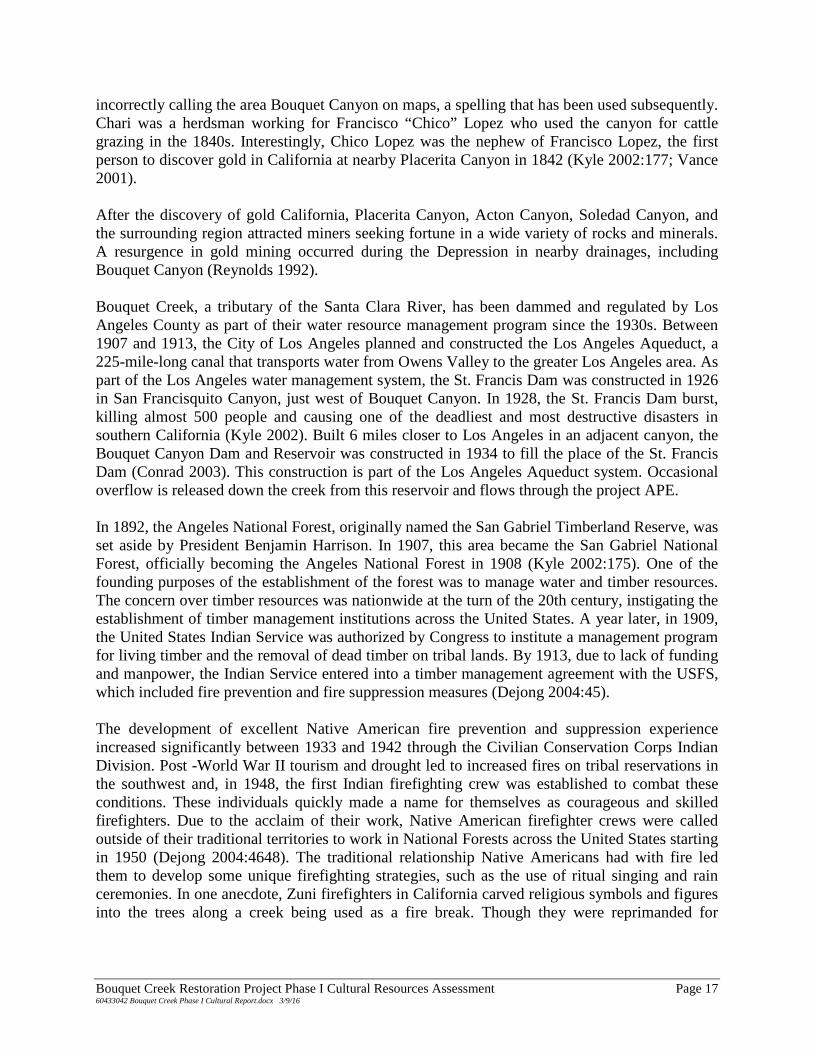
incorrectly calling the area Bouquet Canyon on maps, a spelling that has been used subsequently. Chari was a herdsman working for Francisco “Chico” Lopez who used the canyon for cattle grazing in the 1840s. Interestingly, Chico Lopez was the nephew of Francisco Lopez, the first person to discover gold in California at nearby Placerita Canyon in 1842 (Kyle 2002:177; Vance 2001). After the discovery of gold California, Placerita Canyon, Acton Canyon, Soledad Canyon, and the surrounding region attracted miners seeking fortune in a wide variety of rocks and minerals. A resurgence in gold mining occurred during the Depression in nearby drainages, including Bouquet Canyon (Reynolds 1992). Bouquet Creek, a tributary of the Santa Clara River, has been dammed and regulated by Los Angeles County as part of their water resource management program since the 1930s. Between 1907 and 1913, the City of Los Angeles planned and constructed the Los Angeles Aqueduct, a 225-mile-long canal that transports water from Owens Valley to the greater Los Angeles area. As part of the Los Angeles water management system, the St. Francis Dam was constructed in 1926 in San Francisquito Canyon, just west of Bouquet Canyon. In 1928, the St. Francis Dam burst, killing almost 500 people and causing one of the deadliest and most destructive disasters in southern California (Kyle 2002). Built 6 miles closer to Los Angeles in an adjacent canyon, the Bouquet Canyon Dam and Reservoir was constructed in 1934 to fill the place of the St. Francis Dam (Conrad 2003). This construction is part of the Los Angeles Aqueduct system. Occasional overflow is released down the creek from this reservoir and flows through the project APE. In 1892, the Angeles National Forest, originally named the San Gabriel Timberland Reserve, was set aside by President Benjamin Harrison. In 1907, this area became the San Gabriel National Forest, officially becoming the Angeles National Forest in 1908 (Kyle 2002:175). One of the founding purposes of the establishment of the forest was to manage water and timber resources. The concern over timber resources was nationwide at the turn of the 20th century, instigating the establishment of timber management institutions across the United States. A year later, in 1909, the United States Indian Service was authorized by Congress to institute a management program for living timber and the removal of dead timber on tribal lands. By 1913, due to lack of funding and manpower, the Indian Service entered into a timber management agreement with the USFS, which included fire prevention and fire suppression measures (Dejong 2004:45). The development of excellent Native American fire prevention and suppression experience increased significantly between 1933 and 1942 through the Civilian Conservation Corps Indian Division. Post -World War II tourism and drought led to increased fires on tribal reservations in the southwest and, in 1948, the first Indian firefighting crew was established to combat these conditions. These individuals quickly made a name for themselves as courageous and skilled firefighters. Due to the acclaim of their work, Native American firefighter crews were called outside of their traditional territories to work in National Forests across the United States starting in 1950 (Dejong 2004:4648). The traditional relationship Native Americans had with fire led them to develop some unique firefighting strategies, such as the use of ritual singing and rain ceremonies. In one anecdote, Zuni firefighters in California carved religious symbols and figures into the trees along a creek being used as a fire break. Though they were reprimanded for
Bouquet Creek Restoration Project Phase I Cultural Resources Assessment Page 17 60433042 Bouquet Creek Phase I Cultural Report.docx 3/9/16
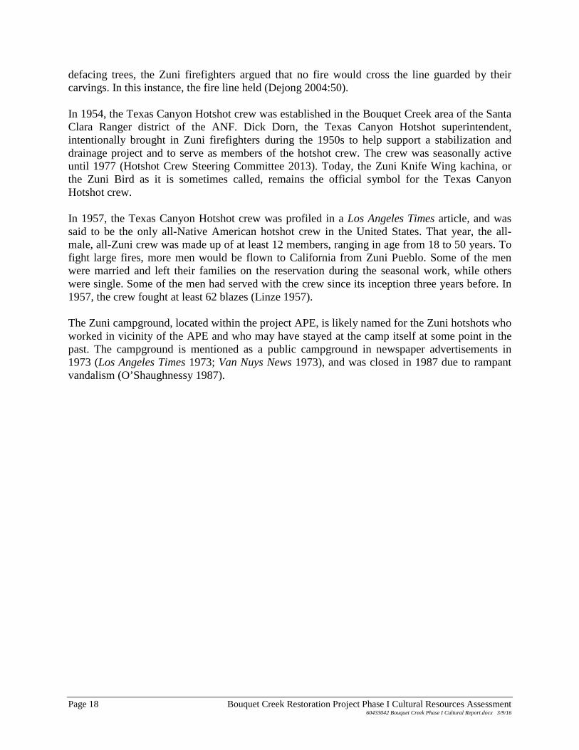
defacing trees, the Zuni firefighters argued that no fire would cross the line guarded by their carvings. In this instance, the fire line held (Dejong 2004:50). In 1954, the Texas Canyon Hotshot crew was established in the Bouquet Creek area of the Santa Clara Ranger district of the ANF. Dick Dorn, the Texas Canyon Hotshot superintendent, intentionally brought in Zuni firefighters during the 1950s to help support a stabilization and drainage project and to serve as members of the hotshot crew. The crew was seasonally active until 1977 (Hotshot Crew Steering Committee 2013). Today, the Zuni Knife Wing kachina, or the Zuni Bird as it is sometimes called, remains the official symbol for the Texas Canyon Hotshot crew. In 1957, the Texas Canyon Hotshot crew was profiled in a Los Angeles Times article, and was said to be the only all-Native American hotshot crew in the United States. That year, the all-male, all-Zuni crew was made up of at least 12 members, ranging in age from 18 to 50 years. To fight large fires, more men would be flown to California from Zuni Pueblo. Some of the men were married and left their families on the reservation during the seasonal work, while others were single. Some of the men had served with the crew since its inception three years before. In 1957, the crew fought at least 62 blazes (Linze 1957). The Zuni campground, located within the project APE, is likely named for the Zuni hotshots who worked in vicinity of the APE and who may have stayed at the camp itself at some point in the past. The campground is mentioned as a public campground in newspaper advertisements in 1973 (Los Angeles Times 1973; Van Nuys News 1973), and was closed in 1987 due to rampant vandalism (O’Shaughnessy 1987).
Page 18 Bouquet Creek Restoration Project Phase I Cultural Resources Assessment 60433042 Bouquet Creek Phase I Cultural Report.docx 3/9/16
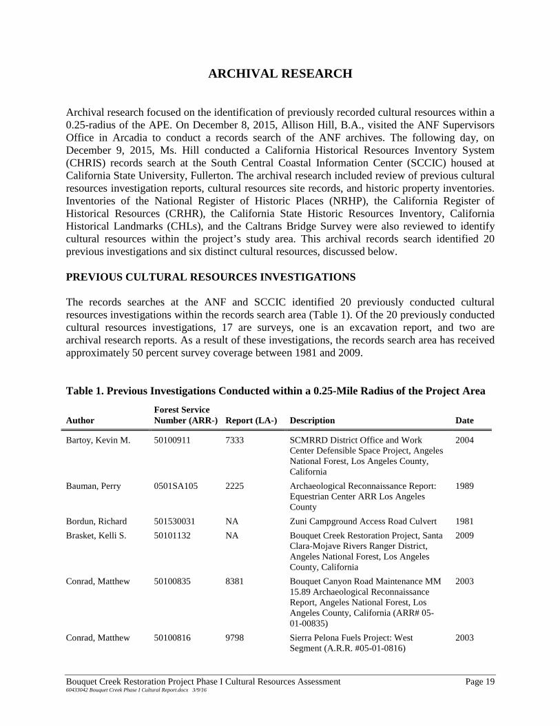
ARCHIVAL RESEARCH Archival research focused on the identification of previously recorded cultural resources within a 0.25-radius of the APE. On December 8, 2015, Allison Hill, B.A., visited the ANF Supervisors Office in Arcadia to conduct a records search of the ANF archives. The following day, on December 9, 2015, Ms. Hill conducted a California Historical Resources Inventory System (CHRIS) records search at the South Central Coastal Information Center (SCCIC) housed at California State University, Fullerton. The archival research included review of previous cultural resources investigation reports, cultural resources site records, and historic property inventories. Inventories of the National Register of Historic Places (NRHP), the California Register of Historical Resources (CRHR), the California State Historic Resources Inventory, California Historical Landmarks (CHLs), and the Caltrans Bridge Survey were also reviewed to identify cultural resources within the project’s study area. This archival records search identified 20 previous investigations and six distinct cultural resources, discussed below. PREVIOUS CULTURAL RESOURCES INVESTIGATIONS The records searches at the ANF and SCCIC identified 20 previously conducted cultural resources investigations within the records search area (Table 1). Of the 20 previously conducted cultural resources investigations, 17 are surveys, one is an excavation report, and two are archival research reports. As a result of these investigations, the records search area has received approximately 50 percent survey coverage between 1981 and 2009. Table 1. Previous Investigations Conducted within a 0.25-Mile Radius of the Project Area
Author Forest Service Number (ARR-) Report (LA-) Description Date
Bartoy, Kevin M. 50100911 7333 SCMRRD District Office and Work Center Defensible Space Project, Angeles National Forest, Los Angeles County, California
2004
Bauman, Perry 0501SA105 2225 Archaeological Reconnaissance Report: Equestrian Center ARR Los Angeles County
1989
Bordun, Richard 501530031 NA Zuni Campground Access Road Culvert 1981
Brasket, Kelli S. 50101132 NA Bouquet Creek Restoration Project, Santa Clara-Mojave Rivers Ranger District, Angeles National Forest, Los Angeles County, California
2009
Conrad, Matthew 50100835 8381 Bouquet Canyon Road Maintenance MM 15.89 Archaeological Reconnaissance Report, Angeles National Forest, Los Angeles County, California (ARR# 05-01-00835)
2003
Conrad, Matthew 50100816 9798 Sierra Pelona Fuels Project: West Segment (A.R.R. #05-01-0816)
2003
Bouquet Creek Restoration Project Phase I Cultural Resources Assessment Page 19 60433042 Bouquet Creek Phase I Cultural Report.docx 3/9/16
Author Forest Service Number (ARR-) Report (LA-) Description Date
Damann, John C. 0501SA120 3378 Los Cantilles Day Use Area, Leach Field, Los Angeles
1992
McIntyre, Michael J. 0501SA74 1528 Archaeological Reconnaissance Report: District Office Relocation ARR No. 05-01-SA-74
1985
McKale, George 50100961 NA Archaeological Survey Report: Bouquet Circuit Southern California Edison Angeles National Forest Los Angeles County, California
2005
Milburn, Douglas H. NA 9986 Archaeological Resource Inventory - Sierra Pelona Ridge Range Allotment permit Reissuance, Santa Clara-Mojave Rivers Ranger District, Angeles National Forest
1999
Milburn, Douglas H. 50101015 NA Archaeological Resource Inventory for Proposed Sheep Grazing at Sierra Pelona, Del Sur, and Drinkwater Ridges, Santa Clara-Mojave Rivers Ranger District, Angeles National Forest (Report No. 05-01-01015)
2006
Peebles, David S. 5015300024 8380 Heritage Resource Assessment of Proposed Trenchline at CA-LAN-426, Texas Canyon Fire Station: San Gabriel Mountains, Los Angeles County, California
2006
Peebles, David S. 5010101028 8382 Los Cantilles Storm Damage Cleanup and Repairs Project. Santa Clara-Mojave Rivers Ranger District, Angeles National Forest, Los Angeles County, California
2006
Schmidt, James J. and June A. Schmidt
050100615 NA Archaeological Survey Report: Santa Clara Campgrounds Maintenance Project, Angeles National Forest, Los Angeles County (ARR# 05-01-00-616
2000
Vance, Darrell W. 50100800 6154 Heritage Resource Evaluation of the Department of Public Works, Road Maintenance Division Bouquet Canyon Culverts Maintenance Project, Santa Clara-Mojave Rivers Ranger District, Angeles National Forest, Los Angeles County
2002
Vance, Darrell W. 50100610 NA Cultural Resource Evaluation of the Texas Canyon Fire Station, Angeles National Forest (A.R.R. #05-01-00610)
2000
Vance, Darrell W. 50100658 NA Stable Fire Suppression and Rehabilitation Archaeological Reconnaissance Report (#05-01-00658) Angeles National Forest, Los Angeles County, California
2001
Page 20 Bouquet Creek Restoration Project Phase I Cultural Resources Assessment 60433042 Bouquet Creek Phase I Cultural Report.docx 3/9/16
Author Forest Service Number (ARR-) Report (LA-) Description Date
Vance, Darrell W. 50100895 NA Texas Canyon Station/Penny Pines Vicinity Fuels Reduction, Santa Clara-Mojave Rivers Ranger District, Angeles National Forest, Los Angeles County, California
2004
Wessel, Richard L. and Michael J. McInture
NA 2217 Proposed Sewer System Renovation at Texas Canyon Fire Station, Saugus Ranger District, Angeles National Forest, and Its Possible Effect on LAN-426
1990
Wlodarski, Robert J. 50100679 NA Final Archaeological Reconnaissance Report (ARR) for the Angeles National Forest ROW Surveys Angeles National Forest, Los Angeles County, California
200
NA = not applicable PREVIOUSLY RECORDED CULTURAL RESOURCES The ANF and SCCIC records searches identified six previously recorded cultural resources within 0.25 mile of the APE (Table 2). Of these six previously recorded cultural resources, three are historical can scatters, one is an expansive mining complex, one is a mining resource with features and artifacts, and one is a multicomponent resource located at the Texas Canyon Fire Station. The prehistoric component included female adolescent remains and a surface scatter of prehistoric artifacts. The historic component of the resource consists of Civilian Conservation Core Camp #132. Table 2. Previously Recorded Cultural Resource Sites within a 0.25-Mile Radius of the Project Site
Trinomial (CA-LAN-)
Primary Number (P-19-)
Forest Service Designation Resource Type Time Period Eligibility
Location in Study Area
3082H 3082 5015300216 Bouquet Canyon Placers
1930s to 1960s NA Not in APE
3299 3299 5015300276 Del Sur Mining Complex
Historical 6Z In Site 4 and Site 5 of APE
NA 3929 5015300366 Historic can scatter Early 20th century NA Not in APE
NA NA 5015300368 Historic can scatter Mid 1930s to late 1950s
NA Not in APE
NA NA 5015300369 Historic can scatter Mid 1930s to late 1950s
NA Not in APE
426 000426 5015300024 Prehistoric burial site and CCC Camp 132
Prehistoric; 1930s to 1950s
NA Not in APE
NA = not applicable
Bouquet Creek Restoration Project Phase I Cultural Resources Assessment Page 21 60433042 Bouquet Creek Phase I Cultural Report.docx 3/9/16
Cultural resource FS-05-01-53-00216 / CA-LAN-3082, also known as the Bouquet Canyon Placers, was originally recorded in 2001 by an ANF archaeologist (Vance 2001). The resource is located in a southeast-trending drainage that terminates at Bouquet Canyon Road about 30 meters west from the southern extent of Site 1. The resource measures approximately 450 meters northwest-southeast by 300 meters northeast-southeast and consists of approximately 15 placer pits, a small adit, four possible structure foundations, a linear rock wall feature, at least three large berms, historical artifact concentrations, and a diffuse scatter of historical debris including cans and bottles. In December 2004 and January 2005, road repair activities in the canyon directly impacted the resource, removing a large amount of soil that contained historical refuse. The resource is interpreted to be a small-scale mining operation and historical camp. The associated artifacts indicate a range of use between the 1930s to the 1960s while land patent records indicate that people have been using the vicinity since the late 19th century. The Del Sur Mining Complex (FS-05-01-53-00276 / CA-LAN-3299) was originally recorded by Compass Rose Archaeological, Inc. in 2002 as the Del Sur Ridge Steatite Quarry, a moderately sized mining operation situated along the top of Del Sur Ridge located far outside of the study area. The resource measured 800 meters southwest-northeast by 400 meters northwest-southeast and consisted of a series of road cuts and terraces created in the removal of talc schist, steatite, and serpentine from the Pelona Schist formation. In 2006, the resource was revisited by archaeologists with ECORP. At this time, it was discovered that the location map and sketch map from the original record were drawn at two different scales and the resource was remapped and updated. The new resource dimensions were 120 meters southwest-northeast by 80 meters northwest-southeast. In 2008, the resource was visited again by Compass Rose Archaeological, Inc. Additional field surveys after area brush fires and further review of historic and contemporary maps, documents, and aerial photographs resulted in the identification of multiple excavations and terraces associated within mining across the eastern face of the Del Sur Ridge. The most recently defined dimensions for this complex of mining features are 5500 meters southwest-northeast by 1850 meters northwest-southeast, with Bouquet Creek forming the southeast boundary of the resource. Site 4 and Site 5 intersect this southern boundary. The Del Sur Mining Complex was evaluated for eligibility for listing in the NRHP and CRHR in 2008 by Wendy Tinsley with Urbana Preservation and Planning. It was determined that the Del Sur Mining Complex is not eligible for inclusion in these lists. Cultural resource FS-05-01-53-00366, also recorded as April’s Historic Can Scatter, was originally documented in 2008 by an ANF archaeologist. This resource consists of a diffuse historic artifact scatter dispersed across the toe of two slopes above the current Texan Canyon Fire Station approximately 750 feet east of the APE. The resource measures 350 feet north-south by 150 feet east-west. Artifacts include over 20 beer cans, one coffee can, an iron axe head, and a broken clear glass bottles. The artifacts date the resource to between 1940 and 1955, and the locus is interpreted to be a secondary dumping location from the early 20th century. Recorded in 2009 by ANF archaeologists, resource FS-05-01-53-00368, known as the Beavertail Cactus Historic Site, is located approximately 900 feet north of the Bouquet Canyon Placers resource. This historical resource measures 623 feet east-west by 98 feet north-south and consists of a small can scatter and associated glass fragments located in the northern portion of a southeast-trending drainage that terminates in Bouquet Creek near the center of Site 1. The
Page 22 Bouquet Creek Restoration Project Phase I Cultural Resources Assessment 60433042 Bouquet Creek Phase I Cultural Report.docx 3/9/16
eastern extent of the resource appears to be located approximately 17 meters from the APE. The artifacts consist predominantly of beer cans that date from 1935 to the 1950s. A known Civilian Conservation Corps (CCC) camp (CA-LAN-426) was located 1 mile north from 1935 to 1937. In addition, Bouquet Canyon Road was initially constructed in 1915 to allow easier access for recreation activities. This resource likely represents recreation activities related to CCC camp inhabitants or to general recreational activities related to forest visitors in the first half of the 20th century. Cultural resource FS-05-01-53-00369, recorded in 2009 by ANF archaeologists as the Stickleback Can Scatter, is a small historic artifact scatter located in a small canyon approximately 200 feet west of the APE. The resource consists of multiple steel-bodied flat-top and cone-top beer cans, one large food can, white ceramic dishware fragments, and broken glass. This small resource measures 206 feet north-south by 184 feet east-west. Artifacts date the resource to between 1935 and the late 1950s. Cultural resource FS-05-01-53-00024 / CA-LAN-426 consists of a prehistoric burial with associated artifacts and CCC Camp #132, located approximately 600 feet east of the APE. This resource was originally identified some time prior to encountering the burial when USFS workers found a sandstone pestle in the course of trenching activities at the Texas Canyon Station. In 1965, additional construction activities led to the identification of a burial approximately 5 feet below current ground surface and about 200 feet from the pestle that was first observed at the resource. The interment was that of a child, estimated to be around six years old. The body had been placed in a tightly flexed position lying on its right side with the head facing to the northwest. No artifacts were found in direct association with the burial although some of the sediment was screened. This resource was determined to be a temporary seed gathering local that had been heavily disturbed by historic use and subsequent construction. The cultural resource record was updated in 1976 to transfer the information about the resource to an appropriate recording form. No additional work was conducted on the resource at this time. In 2000, the resource was revisited for evaluation by ANF archaeologists. A survey of the property identified one previously unrecorded schist milling slab and one quartz core. Additionally, an old stone shed and a green glass coke bottle were identified within the resource boundaries and are thought to be associated with the CCC occupation of the area between 1935 and 1937. Land Patents Archival records housed at the ANF headquarters and the Bureau of Land Management General Land Office Records database indicate that two land patents were issued in the project area. In 1900, under the Homestead Act of 1862, Augustus B. Johnson was issued a land patent for 160 acres along Bouquet Canyon in the vicinity of Site 1. These land patents overlay historical archaeological resources FS- 05-01-53-00216, FS- 05-01-53-00368, and FS- 05-01-53-00366. The only other land patent for the project area was issued to the State of California under the 1853 California Enabling Act (10 Stat. 244), which granted Section 16 and 36 of every township to be used for the purpose of building schools. The southern half of APE Site 2 is located in Section 16.
Bouquet Creek Restoration Project Phase I Cultural Resources Assessment Page 23 60433042 Bouquet Creek Phase I Cultural Report.docx 3/9/16
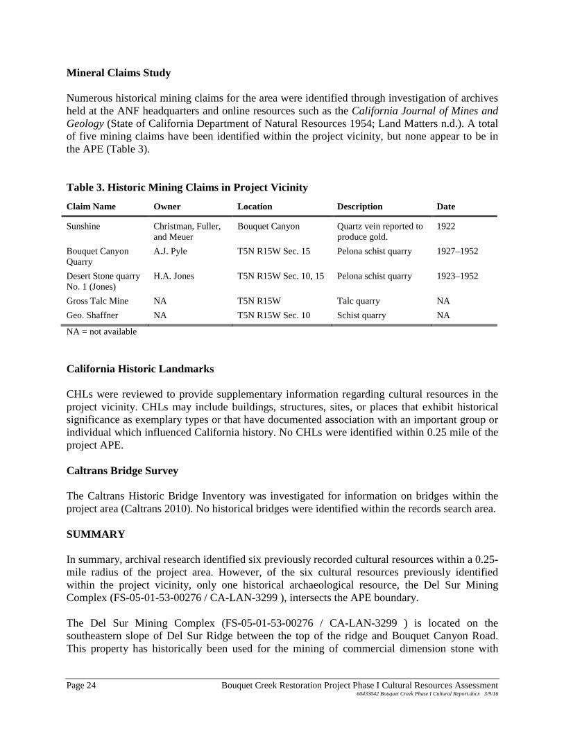
Mineral Claims Study Numerous historical mining claims for the area were identified through investigation of archives held at the ANF headquarters and online resources such as the California Journal of Mines and Geology (State of California Department of Natural Resources 1954; Land Matters n.d.). A total of five mining claims have been identified within the project vicinity, but none appear to be in the APE (Table 3). Table 3. Historic Mining Claims in Project Vicinity
Claim Name Owner Location Description Date
Sunshine Christman, Fuller, and Meuer
Bouquet Canyon Quartz vein reported to produce gold.
1922
Bouquet Canyon Quarry
A.J. Pyle T5N R15W Sec. 15 Pelona schist quarry 1927–1952
Desert Stone quarry No. 1 (Jones)
H.A. Jones T5N R15W Sec. 10, 15 Pelona schist quarry 1923–1952
Gross Talc Mine NA T5N R15W Talc quarry NA
Geo. Shaffner NA T5N R15W Sec. 10 Schist quarry NA
NA = not available California Historic Landmarks CHLs were reviewed to provide supplementary information regarding cultural resources in the project vicinity. CHLs may include buildings, structures, sites, or places that exhibit historical significance as exemplary types or that have documented association with an important group or individual which influenced California history. No CHLs were identified within 0.25 mile of the project APE. Caltrans Bridge Survey The Caltrans Historic Bridge Inventory was investigated for information on bridges within the project area (Caltrans 2010). No historical bridges were identified within the records search area. SUMMARY In summary, archival research identified six previously recorded cultural resources within a 0.25-mile radius of the project area. However, of the six cultural resources previously identified within the project vicinity, only one historical archaeological resource, the Del Sur Mining Complex (FS-05-01-53-00276 / CA-LAN-3299 ), intersects the APE boundary. The Del Sur Mining Complex (FS-05-01-53-00276 / CA-LAN-3299 ) is located on the southeastern slope of Del Sur Ridge between the top of the ridge and Bouquet Canyon Road. This property has historically been used for the mining of commercial dimension stone with
Page 24 Bouquet Creek Restoration Project Phase I Cultural Resources Assessment 60433042 Bouquet Creek Phase I Cultural Report.docx 3/9/16
documented mining claims dating to as early as 1880. This resource was initially recorded in 2002 as the Del Sur Ridge Steatite Quarry, located on top of the ridge hundreds of meters from the project APE. Later considerations expanded the resource to encompass a larger swath of the landscape thought to exhibit similar quarrying activities. Survey and evaluation of the area in 2008 determined that the complex does not appear eligible for inclusion in the NRHP or the CRHR due to a dearth of physical evidence to support the historical documentation of mining in the area. The eastern extent of the Del Sur Mining Complex boundary extends into the western edge of Site 4 and Site 5 of the project APE. Currently, no distinct mining resources have been documented in these project areas. The Department of Parks and Recreation (DPR) site form for this resource is included in Appendix B.
Bouquet Creek Restoration Project Phase I Cultural Resources Assessment Page 25 60433042 Bouquet Creek Phase I Cultural Report.docx 3/9/16

Page 26 Bouquet Creek Restoration Project Phase I Cultural Resources Assessment 60433042 Bouquet Creek Phase I Cultural Report.docx 3/9/16
NATIVE AMERICAN CONTACT As part of this assessment, AECOM conducted a Native American contact program on behalf of LACDPW, to inform interested parties of the proposed project and to request any information that may indicate an impact to cultural resources within the project area. The program involved contacting Native American representatives provided by the Native American Heritage Commission (NAHC) to solicit comments regarding the project. Documents pertaining to the Native American contact program are attached as Appendix C. A letter was prepared and mailed to the NAHC on December 15, 2015. The letter requested that an SLF check be conducted for the project and that contact information be provided for Native American groups or individuals that may have concerns about cultural resources in the project APE. AECOM has extensive experience conducting archaeological investigations in the vicinity of the project area and has developed a working relationship with local Native American representatives. Because of this, letters were mailed on December 16, 2015, to individuals anticipated to be interested parties in order to facilitate a streamlined and cooperative consultation program. The letters requested that recipients provide any information they have regarding cultural resources in the project vicinity. Information about the project, maps depicting the project APE, and response forms were attached to each letter. The NAHC response letter, dated January 20, 2016, provided six individuals who might have information concerning cultural resources in the project area. Four of these individuals were sent letters on December 16, 2016, and two individuals were contacted after the NAHC letter was received on January 21, 2016. Six Native American individuals identified by the NAHC as having traditional lands in the project area were contacted. In addition, eight individuals not identified by the NAHC, but known by AECOM to have interest in the area, were also contacted. Two of those individuals identified by the NAHC responded via letter. One other individual not identified by the NAHC responded via email. Follow-up phone calls were made on December 30, 2015, January 14, 2016, and February 10, 2016, to those individuals who did not respond to the letters. These phone calls led to three additional comments. To protect the privacy of those contacted, in compliance with Assembly Bill 52, details of these responses are confidential. Further details of the Native American contact program are contained in confidential Appendix C.
Bouquet Creek Restoration Project Phase I Cultural Resources Assessment Page 27 60433042 Bouquet Creek Phase I Cultural Report.docx 3/9/16

Page 28 Bouquet Creek Restoration Project Phase I Cultural Resources Assessment 60433042 Bouquet Creek Phase I Cultural Report.docx 3/9/16
CULTURAL RESOURCES SURVEY On February 8, 2016, AECOM archaeologists Marc Beherec, Ph.D., and Allison Hill conducted an intensive pedestrian survey of the six work locations for project APE. In accordance with Archaeological Resources Protection Act, the survey was conducted under a Permit for Archaeological Investigations (Authorization ID SCM83) issued by the USFS on February 1, 2016. One previously recorded resource was investigated within the APE and the archaeological survey identified three previously unrecorded cultural resources within the project area. METHODS The cultural resources survey focused on the identification of any surface evidence of archaeological materials and assessment of any structures of historic age within the project area. The intent was to locate any known and unknown archaeological or historical resources within the vicinity of the project area localities. The intensive pedestrian survey was conducted within all portions of the project APE where there was no paving, vegetation density was not prohibitive, and slope was less than 50 degrees. Transects were walked at 15-meter intervals. When cultural resources were identified during the survey, locational information was taken, attributes were photographed, and the resources were documented using appropriate DPR 523 forms (Appendix B). RESULTS The APE comprises six distinct locations, which were surveyed. Below is a discussion of the results of the survey organized by APE site location. Site 1 (1,200 Feet South of MM 15.89 to 2,400 Feet North of MM 15.89) This location is the longest segment of creek restoration and represents the southern extent of the project APE (Plate 1). This survey area was located in the moderately wide mouth of the canyon, and soils consisted of heavily disturbed sandy alluvial deposits with high amounts of granitic and quartz cobble inclusions. Vegetation density throughout Site 1 was high with approximately 5 percent ground surface visibility. Vegetation observed included willow, mule fat, yucca, oak, sycamore, invasive grasses, buckwheat, wild rye, and cottonwood trees. Due to a high density of brush in and around the creek in the northern portion of the site, a section of approximately 50 meters was not surveyed.
Bouquet Creek Restoration Project Phase I Cultural Resources Assessment Page 29 60433042 Bouquet Creek Phase I Cultural Report.docx 3/9/16
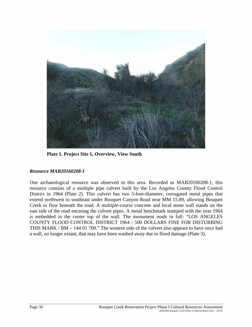
Plate 1. Project Site 1, Overview, View South Resource MAB20160208-1 One archaeological resource was observed in this area. Recorded as MAB20160208-1, this resource consists of a multiple pipe culvert built by the Los Angeles County Flood Control District in 1964 (Plate 2). This culvert has two 5-foot-diameter, corrugated metal pipes that extend northwest to southeast under Bouquet Canyon Road near MM 15.89, allowing Bouquet Creek to flow beneath the road. A multiple-course concrete and local stone wall stands on the east side of the road encasing the culvert pipes. A metal benchmark stamped with the year 1964 is embedded in the center top of the wall. The monument reads in full: “LOS ANGELES COUNTY FLOOD CONTROL DISTRICT 1964 / 500 DOLLARS FINE FOR DISTURBING THIS MARK / BM – 144 01 700.” The western side of the culvert also appears to have once had a wall, no longer extant, that may have been washed away due to flood damage (Plate 3).
Page 30 Bouquet Creek Restoration Project Phase I Cultural Resources Assessment 60433042 Bouquet Creek Phase I Cultural Report.docx 3/9/16
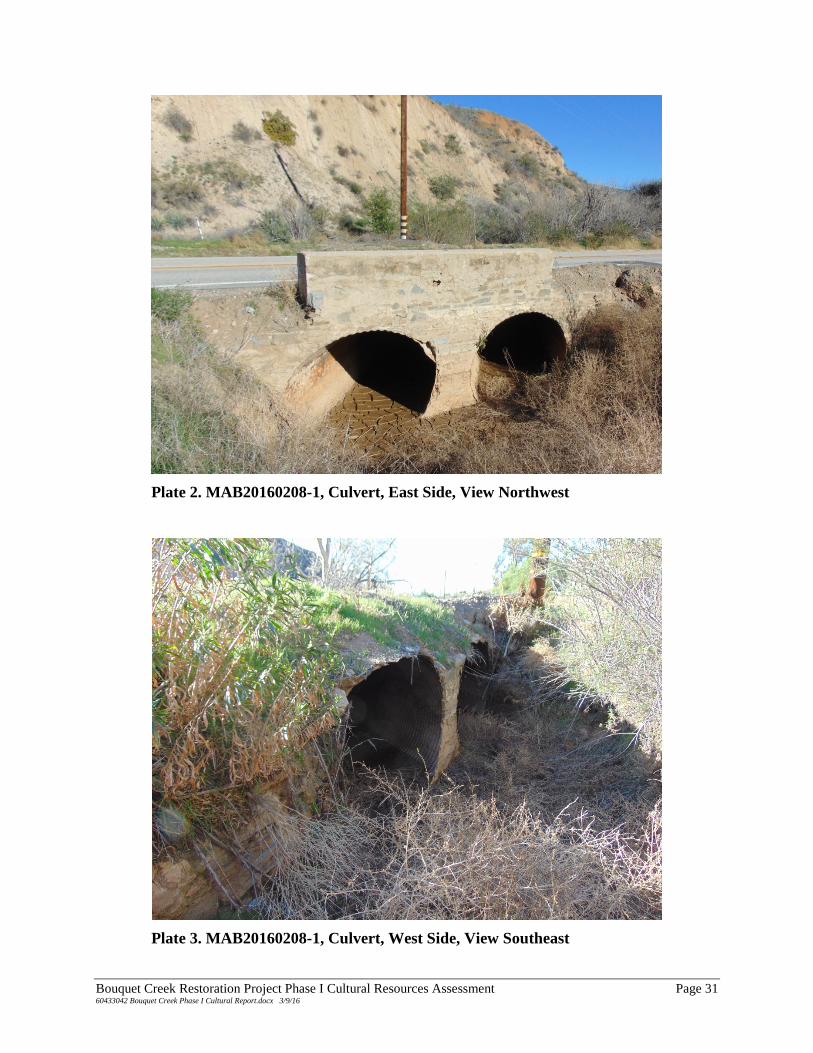
Plate 2. MAB20160208-1, Culvert, East Side, View Northwest
Plate 3. MAB20160208-1, Culvert, West Side, View Southeast
Bouquet Creek Restoration Project Phase I Cultural Resources Assessment Page 31 60433042 Bouquet Creek Phase I Cultural Report.docx 3/9/16
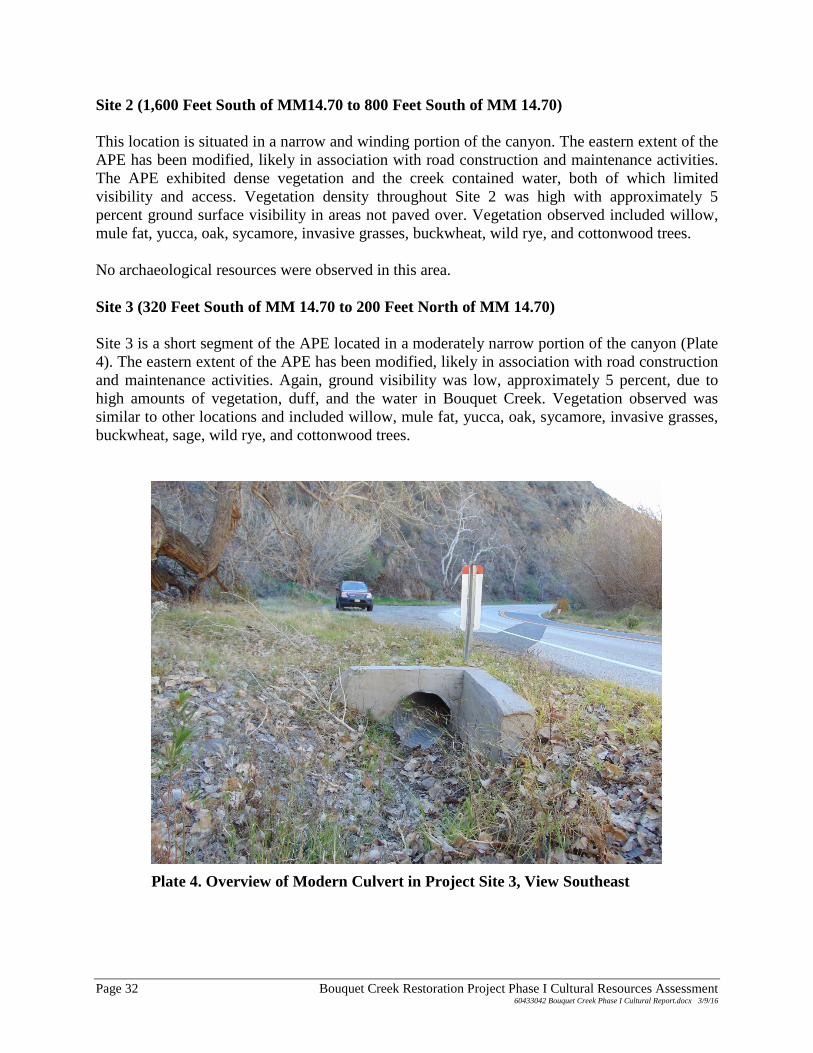
Site 2 (1,600 Feet South of MM14.70 to 800 Feet South of MM 14.70) This location is situated in a narrow and winding portion of the canyon. The eastern extent of the APE has been modified, likely in association with road construction and maintenance activities. The APE exhibited dense vegetation and the creek contained water, both of which limited visibility and access. Vegetation density throughout Site 2 was high with approximately 5 percent ground surface visibility in areas not paved over. Vegetation observed included willow, mule fat, yucca, oak, sycamore, invasive grasses, buckwheat, wild rye, and cottonwood trees. No archaeological resources were observed in this area. Site 3 (320 Feet South of MM 14.70 to 200 Feet North of MM 14.70) Site 3 is a short segment of the APE located in a moderately narrow portion of the canyon (Plate 4). The eastern extent of the APE has been modified, likely in association with road construction and maintenance activities. Again, ground visibility was low, approximately 5 percent, due to high amounts of vegetation, duff, and the water in Bouquet Creek. Vegetation observed was similar to other locations and included willow, mule fat, yucca, oak, sycamore, invasive grasses, buckwheat, sage, wild rye, and cottonwood trees.
Plate 4. Overview of Modern Culvert in Project Site 3, View Southeast
Page 32 Bouquet Creek Restoration Project Phase I Cultural Resources Assessment 60433042 Bouquet Creek Phase I Cultural Report.docx 3/9/16
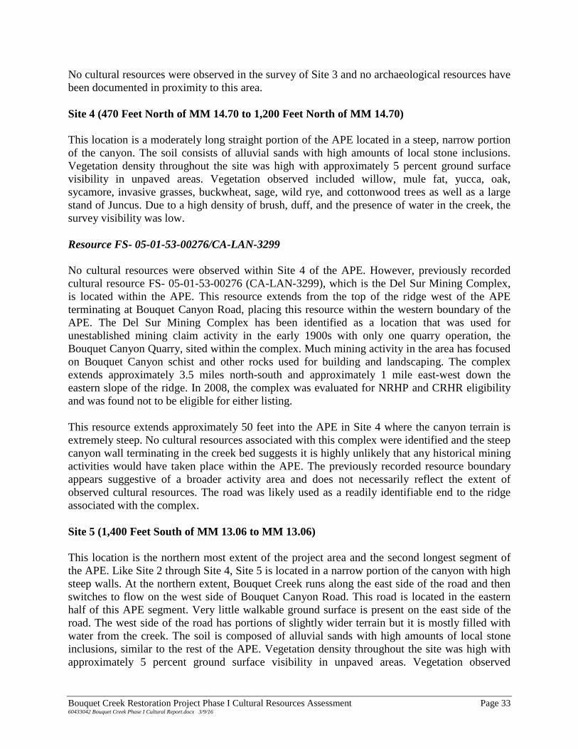
No cultural resources were observed in the survey of Site 3 and no archaeological resources have been documented in proximity to this area. Site 4 (470 Feet North of MM 14.70 to 1,200 Feet North of MM 14.70) This location is a moderately long straight portion of the APE located in a steep, narrow portion of the canyon. The soil consists of alluvial sands with high amounts of local stone inclusions. Vegetation density throughout the site was high with approximately 5 percent ground surface visibility in unpaved areas. Vegetation observed included willow, mule fat, yucca, oak, sycamore, invasive grasses, buckwheat, sage, wild rye, and cottonwood trees as well as a large stand of Juncus. Due to a high density of brush, duff, and the presence of water in the creek, the survey visibility was low. Resource FS- 05-01-53-00276/CA-LAN-3299 No cultural resources were observed within Site 4 of the APE. However, previously recorded cultural resource FS- 05-01-53-00276 (CA-LAN-3299), which is the Del Sur Mining Complex, is located within the APE. This resource extends from the top of the ridge west of the APE terminating at Bouquet Canyon Road, placing this resource within the western boundary of the APE. The Del Sur Mining Complex has been identified as a location that was used for unestablished mining claim activity in the early 1900s with only one quarry operation, the Bouquet Canyon Quarry, sited within the complex. Much mining activity in the area has focused on Bouquet Canyon schist and other rocks used for building and landscaping. The complex extends approximately 3.5 miles north-south and approximately 1 mile east-west down the eastern slope of the ridge. In 2008, the complex was evaluated for NRHP and CRHR eligibility and was found not to be eligible for either listing. This resource extends approximately 50 feet into the APE in Site 4 where the canyon terrain is extremely steep. No cultural resources associated with this complex were identified and the steep canyon wall terminating in the creek bed suggests it is highly unlikely that any historical mining activities would have taken place within the APE. The previously recorded resource boundary appears suggestive of a broader activity area and does not necessarily reflect the extent of observed cultural resources. The road was likely used as a readily identifiable end to the ridge associated with the complex. Site 5 (1,400 Feet South of MM 13.06 to MM 13.06) This location is the northern most extent of the project area and the second longest segment of the APE. Like Site 2 through Site 4, Site 5 is located in a narrow portion of the canyon with high steep walls. At the northern extent, Bouquet Creek runs along the east side of the road and then switches to flow on the west side of Bouquet Canyon Road. This road is located in the eastern half of this APE segment. Very little walkable ground surface is present on the east side of the road. The west side of the road has portions of slightly wider terrain but it is mostly filled with water from the creek. The soil is composed of alluvial sands with high amounts of local stone inclusions, similar to the rest of the APE. Vegetation density throughout the site was high with approximately 5 percent ground surface visibility in unpaved areas. Vegetation observed
Bouquet Creek Restoration Project Phase I Cultural Resources Assessment Page 33 60433042 Bouquet Creek Phase I Cultural Report.docx 3/9/16
included willow, mule fat, yucca, oak, sycamore, invasive grasses, buckwheat, wild rye, and cottonwood trees as well as a moderately sized stand of Juncus. Due to a high density of brush, duff, and the presence of water in the creek, the overall survey visibility was low. Resource FS- 05-01-53-00276/CA-LAN-3299 One previously recorded cultural resource is located within a small portion of this APE and one unrelated previously unrecorded cultural resource was identified in this section of the APE. As discussed in APE Site 4, previously recorded cultural resource Forest Service # 05-01-53-00276 (CA-LAN-3299), the Del Sur Mining Complex, extends from the top of the ridge west of the APE terminating at Bouquet Canyon Road, placing this resource within the boundaries of the APE. For a more thorough discussion of this resource, see the Site 4 survey results presented above. This resource boundary extends approximately 50 feet into the western side of the Site 5 APE area along the extent of the segment. No cultural resources associated with historic mining activity were observed in Site 5. Similar to observations at Site 4, the previously recorded resource boundary appears suggestive of a broader activity area and does not necessarily reflect the extent of observed cultural resources. It is likely that the road was used as a readily identifiable end to the ridge associated with the complex. Resource MAB20160208-2 One historic age multiple-pipe culvert was identified at the northern extent of the Site 5 APE, recorded as MAB20160208-2 (Plate 5). Located in - proximity to MM 13.06, this culvert contains two corrugated metal pipes that extend parallel east to west underneath Bouquet Canyon Road, terminating on either side of the road, and one corrugated metal pipe that extends southward under the ground surface on the east side of the road for an undetermined distance. The pipes are 5 feet in diameter and are of similar construction to those noted in MAB20160208-1 (described under Site 1). The metal conduits are encased in a set of multiple-course walls made of cement and local stone, similar in construction to the culvert located in Site 1 of the APE. The walls vary in height based on depth of the ground surface, but are approximately 6 feet tall. On the east side of the road, the walls are built against the natural bank and the bedrock canyon wall to form a high tank where water pools. The southern wall that encases the south-trending pipe is approximately 6 feet long and the walls encasing the two east-west-trending pipes are approximately 11 feet in length. A metal marker is cemented to the canyon wall near the culvert on the eastern side of the road. This marker reads “COUNTY ENGINEER / R.E. 5869 / BM 209-30 / 1969.” However, based on the similarity between the construction methods used in this culvert to those utilized in MAB20160208-1, it is presumed that this culvert was constructed at the same time as the other recorded culvert, in 1964, by the Los Angeles Flood Control District.
Page 34 Bouquet Creek Restoration Project Phase I Cultural Resources Assessment 60433042 Bouquet Creek Phase I Cultural Report.docx 3/9/16
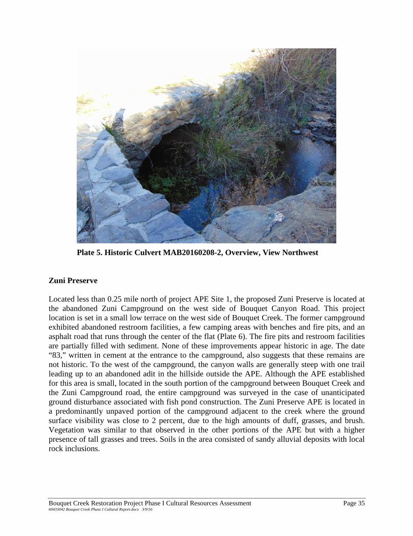
Plate 5. Historic Culvert MAB20160208-2, Overview, View Northwest Zuni Preserve Located less than 0.25 mile north of project APE Site 1, the proposed Zuni Preserve is located at the abandoned Zuni Campground on the west side of Bouquet Canyon Road. This project location is set in a small low terrace on the west side of Bouquet Creek. The former campground exhibited abandoned restroom facilities, a few camping areas with benches and fire pits, and an asphalt road that runs through the center of the flat (Plate 6). The fire pits and restroom facilities are partially filled with sediment. None of these improvements appear historic in age. The date “83,” written in cement at the entrance to the campground, also suggests that these remains are not historic. To the west of the campground, the canyon walls are generally steep with one trail leading up to an abandoned adit in the hillside outside the APE. Although the APE established for this area is small, located in the south portion of the campground between Bouquet Creek and the Zuni Campground road, the entire campground was surveyed in the case of unanticipated ground disturbance associated with fish pond construction. The Zuni Preserve APE is located in a predominantly unpaved portion of the campground adjacent to the creek where the ground surface visibility was close to 2 percent, due to the high amounts of duff, grasses, and brush. Vegetation was similar to that observed in the other portions of the APE but with a higher presence of tall grasses and trees. Soils in the area consisted of sandy alluvial deposits with local rock inclusions.
Bouquet Creek Restoration Project Phase I Cultural Resources Assessment Page 35 60433042 Bouquet Creek Phase I Cultural Report.docx 3/9/16
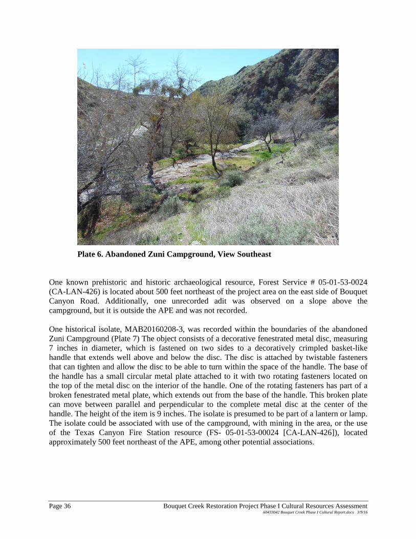
Plate 6. Abandoned Zuni Campground, View Southeast One known prehistoric and historic archaeological resource, Forest Service # 05-01-53-0024 (CA-LAN-426) is located about 500 feet northeast of the project area on the east side of Bouquet Canyon Road. Additionally, one unrecorded adit was observed on a slope above the campground, but it is outside the APE and was not recorded. One historical isolate, MAB20160208-3, was recorded within the boundaries of the abandoned Zuni Campground (Plate 7) The object consists of a decorative fenestrated metal disc, measuring 7 inches in diameter, which is fastened on two sides to a decoratively crimpled basket-like handle that extends well above and below the disc. The disc is attached by twistable fasteners that can tighten and allow the disc to be able to turn within the space of the handle. The base of the handle has a small circular metal plate attached to it with two rotating fasteners located on the top of the metal disc on the interior of the handle. One of the rotating fasteners has part of a broken fenestrated metal plate, which extends out from the base of the handle. This broken plate can move between parallel and perpendicular to the complete metal disc at the center of the handle. The height of the item is 9 inches. The isolate is presumed to be part of a lantern or lamp. The isolate could be associated with use of the campground, with mining in the area, or the use of the Texas Canyon Fire Station resource (FS- 05-01-53-00024 [CA-LAN-426]), located approximately 500 feet northeast of the APE, among other potential associations.
Page 36 Bouquet Creek Restoration Project Phase I Cultural Resources Assessment 60433042 Bouquet Creek Phase I Cultural Report.docx 3/9/16
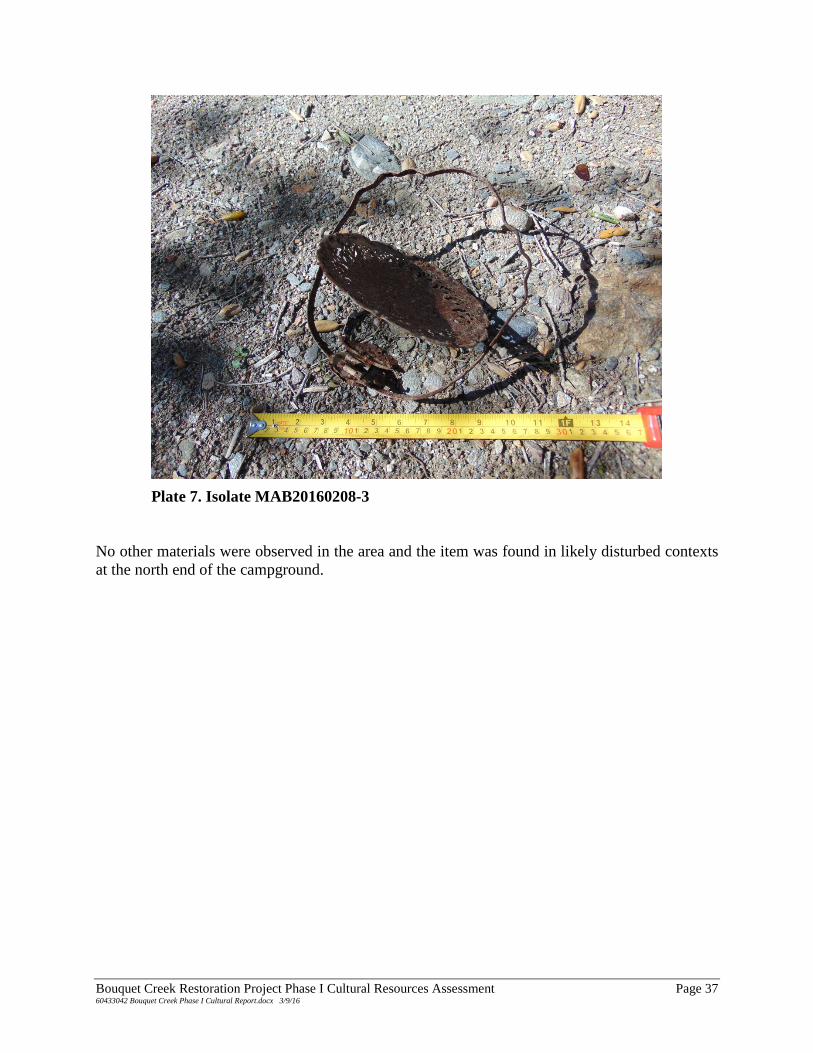
Plate 7. Isolate MAB20160208-3 No other materials were observed in the area and the item was found in likely disturbed contexts at the north end of the campground.
Bouquet Creek Restoration Project Phase I Cultural Resources Assessment Page 37 60433042 Bouquet Creek Phase I Cultural Report.docx 3/9/16

Page 38 Bouquet Creek Restoration Project Phase I Cultural Resources Assessment 60433042 Bouquet Creek Phase I Cultural Report.docx 3/9/16
MANAGEMENT RECOMMENDATIONS As a result of the archival records search and archaeological survey, one previously recorded historical archaeological resource, the Del Sur Mining Complex (Forest Service # 05-01-53-00276 / CA-LAN-3299), has been identified in the APE and one newly identified historical isolate and two newly identified cultural resources were recorded within the project area. The Del Sur Mining Complex was not recorded or evaluated as a part of the cultural resources assessment for the Bouquet Creek Restoration Project because the APE intersected the easternmost fringe of the resource boundary in a topographically steep area where no associated mining activity was observed and no associated mining activity is anticipated to be observed. Therefore, proposed work for the project will not have a negative effect on the cultural resource as it currently exists. Further, this resource was recently evaluated in 2008 when it was determined ineligible for nomination to the NRHP and the CRHR. The assessment below considers the two historic-age culverts identified as part of this cultural resources investigation. SIGNIFICANCE CRITERIA National Register of Historic Places The quality of significance in American history, architecture, archaeology, engineering, and culture is present in districts, sites, buildings, structures, and objects that possess integrity of location, design, setting, materials, workmanship, feeling, and association and
A. that are associated with events that have made a significant contribution to the broad patterns of our history; or
B. that are associated with the lives of persons significant in our past; or
C. that embody the distinctive characteristics of a type, period, or method of construction or that represent the work of a master, or that possess high artistic values, or that represent a significant and distinguishable entity whose components may lack individual distinction; or
D. that have yielded, or may be likely to yield, information important in prehistory or history.
A resource meeting one or more of the NRHP criteria must also retain the essential physical features that enable it to convey its historic identity. The quality of significance is present in districts, sites, buildings, structures, and objects that possess integrity of location, design, setting, materials, workmanship, feeling, and association. To retain historic integrity a property will always possess several, and usually most, of the aspects.
Bouquet Creek Restoration Project Phase I Cultural Resources Assessment Page 39 60433042 Bouquet Creek Phase I Cultural Report.docx 3/9/16
California Register of Historical Resources The CRHR was created to identify resources deemed worthy of preservation on a state level and was modeled closely after the NRHP. The criteria are nearly identical to those of the NRHP but focus on resources of statewide, rather than national, significance. The CRHR consists of properties that are listed automatically as well as those that must be nominated through an application and public hearing process. The criteria for eligibility of listing in the CRHR are based on NRHP criteria, but are identified as 1 through 4 instead of A through D. To be eligible for listing in the CRHR, a property must be at least 50 years of age and possess significance at the local, state, or national level, under one or more of the following four criteria:
1. It is associated with events that have made a significant contribution to the broad patterns of local or regional history, or the cultural heritage of California or the United States; or
2. It is associated with the lives of persons important to local, California, or national history; or
3. It embodies the distinctive characteristics of a type, period, or method of construction or represents the work of a master, or possesses high artistic values; or
4. It has yielded, or has the potential to yield, information important in the prehistory or history of the local area, California, or the nation.
Historic resources eligible for listing in the CRHR may include buildings, sites, structures, objects, and historic districts. A resource less than 50 years of age may be eligible if it can be demonstrated that sufficient time has passed to understand its historic importance. While the enabling legislation for the CRHR is less rigorous with regard to the issue of integrity, there is the expectation that properties reflect their appearance during their period of significance. APPLICATION OF THE NRHP AND CRHR CRITERIA NRHP Criterion A and CRHR Criterion 1 Both MAB20160208-1 and MAB20160208-2 are associated with water retrieval and conveyance systems of the 20th century. The Bouquet Reservoir, which occasionally feeds Bouquet Creek where these culverts are located, was built 1933 in response to the St. Francis Dam disaster of 1928. Although the exact date of construction cannot be proven, the presence of the 1964 benchmark set in the masonry on MAB20160208-1 suggests that these culverts were constructed in 1964, well after the period of significance for the Bouquet Reservoir. Additionally, these culverts do not appear to have played a significant individual role in local, state, or national history individually because they are representative of such structures built throughout California in the 20th century. They do not meet NRHP Criterion A or CRHR Criterion 1.
Page 40 Bouquet Creek Restoration Project Phase I Cultural Resources Assessment 60433042 Bouquet Creek Phase I Cultural Report.docx 3/9/16
NRHP Criterion B and CRHR Criterion 2 Research has not revealed a direct association with any locally or nationally important individuals involved with the construction or design of the features. The culverts have no known association with important historic persons and, thus, do not meet NRHP Criterion A or CRHR Criterion 2. NRHP Criterion C and CRHR Criterion 3 Both MAB20160208-1 and MAB20160208-2 are multiple-pipe culverts encased in multiple-course, concrete and local stone retaining walls, common structures throughout California. They were likely designed and constructed by the Los Angeles Flood Control District but they have no known associations with individual engineers and do not represent the work of a master. These structures do not possess high artistic values because they consist of basic multiple-pipe culverts designed for function and utility and not for aesthetic quality. In summary, MAB20160208-1 and MAB20160208-2 do not have distinctive engineering or architectural features to meet NRHP Criterion C or CRHR Criterion 3. NRHP Criterion D and CRHR Criterion 4 MAB20160208-1 and MAB20160208-2 were built specifically for the purpose of allowing water from Bouquet Creek to flow beneath Bouquet Canyon Road. These structures are not likely to yield further information important to history or prehistory. Therefore, they do not meet NRHP Criterion D or CRHR Criterion 4. Although these structures do not appear eligible for the NRHP or the CRHR under any criterion, MAB20160208-1 and MAB20160208-2 retain integrity of location, design, materials, workmanship, and setting. These culverts are in their original locations and retain their functionality. Additionally, the design of MAB20160208-1 and MAB20160208-2 has not been substantially altered. Integrity of workmanship is also considered retained because the structures have not been altered with modern construction methods. However, the east side of culvert MAB20160208-1 appears to have suffered flood damage, resulting in collapse of the stone wall rising above street level on this side. In summary, these culverts do not meet any NRHP or CRHR criteria for designation and do not appear eligible for the NRHP or CRHR. ARCHAEOLOGICAL SENSITIVITY AND RECOMMENDATIONS Based on the results of the archival research and survey, archaeological resources may be encountered during ground-disturbing activities for the proposed project. Particularly, Site 1, Site 4, Site 5, and the Zuni Preserve have moderate to high potential for prehistoric and historic resources. Site 2 and Site 3 have low potential to yield historic or prehistoric archaeological deposits.
Bouquet Creek Restoration Project Phase I Cultural Resources Assessment Page 41 60433042 Bouquet Creek Phase I Cultural Report.docx 3/9/16
Although no cultural resources were identified in the course of survey at Site 1, the area is located in proximity to several known historical archaeological resources (FS-05-01-53-00216, FS-05-01-53-00366, and FS-05-01-53-00368). The poor ground visibility at the time of survey combined with proposed ground-disturbing activities in the area suggest potential for encountering these resources during project work. Both Site 4 and Site 5 overlap the southern boundary of the Del Sur Mining Complex (FS-05-01-53-00276 / CA-LAN-3299). Although no artifacts or features associated with this resource were encountered in the survey area and the probability of encountering such resources is low, the resource boundary is present in the APE. Additionally, these two locations contained large to moderate stands of Juncus, a plant commonly used by southern California Native American tribes to make basketry and other fiber-based artifacts. These plant communities were often the property of individual families or communities who would practice horticultural strategies to maintain the amount and quality of these resources (Timbrook 2008; Anderson 1999; Farmer 2010). The location of a known prehistoric resource (FS-05-01-53-00024 / CA-LAN-426) south of these locations in Bouquet Canyon and closely associated with the APE suggests that these areas may have been used by Native Californians in the past. The proposed Zuni Preserve is located only 500 feet southwest of this prehistoric resource. Additionally, one historic isolate was recorded in the Zuni Campground. An unrecorded adit was also observed on the hillside west of the APE. Further, this location, likely named for the Zuni firefighters who were part of the Texas Canyon Hotshot crew, may exhibit use by this group. The recent toilet structure in the Zuni Campground is partially buried by sediment deposition, suggesting that historical deposits may also be buried in this area. Finally, low ground visibility at the time of the survey, combined with proposed ground-disturbing activities and the close association of cultural resources, suggests that additional resources may be encountered during the project. Because the potential to encounter archaeological resources exists for this project, full-time archaeological monitoring is recommended during initial ground-disturbing activities in undisturbed native soils, including sediment removal, channel excavation and pond excavation, and, if necessary, vegetation removal and mastication. This monitoring should be done by, or under the direction of, an archaeologist who meets Secretary of the Interior’s Standards. The archaeological monitor would have the authority to redirect construction equipment in the event that potential archaeological resources are encountered. If archaeological resources are encountered, work in the vicinity of the discovery will halt until appropriate treatment or further investigation of the resource is determined by a qualified archaeologist in accordance with the provisions of Section 106 of the NHPA and CEQA Guidelines Section 15064.5. If the qualified archaeologist determines during the course of excavations that there is a low sensitivity for cultural remains, monitoring in that area may be reduced or eliminated. Native Americans contacted for this study indicate a cultural sensitivity for the APE. In addition, human remains, which may be Native American in origin, were discovered on a previous project within 0.25 mile of the APE. If any Native American cultural material is encountered within the project site, consultation with interested Native American parties will be conducted to apprise
Page 42 Bouquet Creek Restoration Project Phase I Cultural Resources Assessment 60433042 Bouquet Creek Phase I Cultural Report.docx 3/9/16

them of any such findings and solicit any comments they may have regarding appropriate treatment and disposition of the resources. If human remains are discovered, work in the immediate vicinity of the discovery will be suspended and the Los Angeles County Coroner contacted. If the remains are deemed Native American in origin, the Coroner will contact the NAHC and identify a Most Likely Descendant pursuant to PRC Section 5097.98 and CCR Section 15064.5. Work may be resumed at the landowner’s discretion but will only commence after consultation and treatment have been concluded. Work may continue on other parts of the project while consultation and treatment are conducted.
Bouquet Creek Restoration Project Phase I Cultural Resources Assessment Page 43 60433042 Bouquet Creek Phase I Cultural Report.docx 3/9/16

Page 44 Bouquet Creek Restoration Project Phase I Cultural Resources Assessment 60433042 Bouquet Creek Phase I Cultural Report.docx 3/9/16
REFERENCES Altschul, Jeffrey H., and Donn R. Grenda 2002 Islanders and Mainlanders: Prehistoric Context for the Southern California
Bight. SRI Press, Tucson, Arizona. Anderson, M Kat 1999 The Fire, Pruning, and Coppice Management of Temperate Ecosystems for
Basketry Material by California Indian Tribes. In Human Ecology 27(1):79–113. Bean, Lowell John, and Charles R. Smith 1978 Gabrielino. In California, edited by Robert F. Heizer, pp. 538–549. Handbook of
North American Indians, Vol. 8. Smithsonian Institution, Washington D.C. California Department of Transportation 2010 Structure Maintenance and Investigations, Historical Significance – Stage Agency
Bridges. Conrad, Mathew 2003 Sierra Pelona Fuels Project: West Segment (A.R.R. #05-01-0816).Prepared for
the Angeles National Forest. Dejong, David H. 2004 Fire Warriors: American Indian Firefighters in the Southwest. In Forest History
Today. Pp. 45–54. Erlandson, Jon M. 1991 Early Maritime Adaptations on the Northern Channel Islands. In Hunter-
Gatherers of Early Holocene Coastal California, edited by Jon M. Erlandson and Roger H. Colten, pp. 101–111. Institute of Archaeology, University of California, Los Angeles.
Farmer, Justin 2010 Basketry Plants Used by Western American Indians: A Study of Traditional North
American Indian Basketry and Plant Materials Used to Create Them with Photos Showing Characteristics of the Major Plant Materials Used by Basket Makers. Fullerton: The Justin Farmer Foundation.
Fenenga, Franklin 1953 The Weights of Chipped Stone Points: A Clue to their Functions. Southwestern
Journal of Anthropology 9(3):309–323. Grenda, Donn R. 1997 Continuity and Change: 8,000 Years of Lacustrine Adaptation on the Shores of
Lake Elsinore. Technical Series 59. Statistical Research, Tucson, Arizona.
Bouquet Creek Restoration Project Phase I Cultural Resources Assessment Page 45 60433042 Bouquet Creek Phase I Cultural Report.docx 3/9/16
Hotshot Crew Steering Committee 2013 Hotshot Crew History in America. Electronic Document, available at https://gacc.
nifc.gov/swcc/dc/nmsdc/documents/Crews/NMSDC_Hotshot_Crew_History_2013.pdf. Accessed February 9, 2016.
Johnson, John R., and David Earle 1990 Tataviam Geography and Ethnohistory. In Journal of California and Great Basin
Anthropology 12(2):191–214. King, Chester, and Thomas C. Blackburn 1978 Tataviam. In California, edited by Robert F. Heizer, pp. 535–537. Handbook of
North American Indians, William C. Sturtevant, general editor, Vol. 8. Smithsonian Institution, Washington, D.C.
Kroeber, Alfred L. 1925 Handbook of the Indians of California. Bureau of American Ethnology Bulletin
78. Smithsonian Institution, Washington D.C. Reprinted 1976, Dover Publications, New York.
Kyle, Douglas E. 2002 Historic Spots in California. Stanford University Press. Stanford California. Land Matters, Mining Claims Maps, Historical mining claims n.d. Available at http://www.mylandmatters.org/Maps/ClaimsHist/GetMap. Accessed
December 15, 2015. Larson, Daniel O., John R. Johnson, and Joel C. Michaelsen 1994 Missionization among the Coastal Chumash of Central California: A Study of
Risk Minimization Strategies. American Anthropologist 96:263–299. Linze, Dewey 1957 Zuni Indian Hotshots Follow Proud Tradition as Forest Fire Fighters. Los Angeles
Times, 16 September: 3, 16. Los Angeles, California. Los Angeles Times 1973 Display Ad: Bouquet Canyon Village. 27 May: B7. Los Angeles, California. Meyer, L. 1981 Los Angeles, 1781–1981. A special bicentennial issue of California history,
Spring 1981. California Historical Society, Los Angeles. Milburn, Douglas H., U.K. Doan, and Joanna Huckabee 2009 Spatial and temporal Distributions of Archaeological Heated-Rock Cooking
Structures in the Transverse Mountain Ranges: Proposed Markers of Land-Use Shifts since the Early Holocene. Society for California Archaeology Proceedings 22. 21 pp.
Page 46 Bouquet Creek Restoration Project Phase I Cultural Resources Assessment 60433042 Bouquet Creek Phase I Cultural Report.docx 3/9/16
Miller, Bruce W. 1991 The Gabrielino. Sand River Press, Los Osos, California. Moratto, Michael J. 1984 California Archaeology. Academic Press, New York. O’Shaughnessy, Lynn 1987 Breaking Camp: Rampant Vandalism Forces Sites in Angeles National Forest to
Close. Los Angeles Times, 4 July: V6, 11. Los Angeles, California. Reid, Hugo 1977 [1851] The Decay of the Mission. In Los Angeles, Biography of a City, edited by
John Caughey and LaRee Caughey, pp. 102–104. University of California Press. Berkeley.
Reynolds, Gerold 1992 Santa Clarita, Valley of the Golden Dream: an Illustrated History. American
Historical Press. Scharlotta, Ian 2014 Trade Routes and Contradictory Spheres of Influence: Movement of Rhyolite
Through the Heart of the Western Mojave Desert. In California Archaeology 6(2):219–246.
Sheilagh, Brooks, Richard H. Brooks, G. E. Kennedy, J. Austin, James R. Firby, Louis A. Payen, Peter J. Slota, Jr., Christine A. Prior, and R. E. Taylor 1990 The Haverty Human Skeletons: Morphological, Depositional, and
Geochronological Characteristics. Journal of California and Great Basin Anthropology 12(1):60–83.
Smith, Helen 1965 The Portola Camps Revisited. Pacific Coast Archaeological Society Quarterly
1(4):28–33. State of California Department of Natural Resources 1954 California Journal of Mines and Geology. 50(1). Available at https://archive.
org/details/californiajourna50cali. Accessed December 15, 2015. Sutton, Mark Q. 2009 People and Language: Defining the Takic Expansion into Southern California.
Pacific Coast Archaeological Society Quarterly 41(2&3):31–93. Timbrook, Jan 2007 Chumash Ethnobotany: Plant Knowledge among the Chumash People of
Southern California. Santa Barbara Museum of Natural History, Monograph No. 5, Publications in Anthropology No. 1. Heyday Books, Berkeley.
Bouquet Creek Restoration Project Phase I Cultural Resources Assessment Page 47 60433042 Bouquet Creek Phase I Cultural Report.docx 3/9/16

United States Department of the Interior, Bureau of Land Management n.d. General Land Office Records, available at http://www.glorecords.blm.gov/
search/default.aspx Accessed December 15, 2015. United States Geological Survey 1995 Green Valley, California Quadrangle Map Series, 1:24,000 Scale, NIMA 2353 III
SW-Series V895. Denver: U.S. Geological Survey. Van Nuys News 1973 Display Ad: Bouquet Canyon Village. 27 May: 35. Van Nuys, California. Vance, Darrell W. 2000 Cultural Resource Evaluation of the Texas Canyon Fire Station, Angeles National
Forest (A.R.R. #05-01-00610). Prepared for Angeles National Forest. 2001 Stable Fire Suppression and Rehabilitation Archaeological Reconnaissance
Report (#05-01-00658) Angeles National Forest, Los Angeles County, California. Prepared for Angeles National Forest.
Wallace, William J. 1955 A Suggested Chronology for Southern California Coastal Archaeology.
Southwestern Journal of Anthropology 11:214–230. Warren, Claude N. 1968 Cultural Tradition and Ecological Adaptation on the Southern California Coast. In
Archaic Prehistory in the Western United States, edited by C. Irwin-Williams, pp. 1–14. Eastern New Mexico University Contributions in Anthropology, Portales, New Mexico.
Worden, Leon 1998 Ancient Santa Clarita Valley Women Did All the Work. Santa Clarita Valley
History. Article available online at http://www.scvhistory.com/scvhistory/signal/ worden/lw061495.htm. Accessed February 29, 2016.
Page 48 Bouquet Creek Restoration Project Phase I Cultural Resources Assessment 60433042 Bouquet Creek Phase I Cultural Report.docx 3/9/16

APPENDIX A
RESUMES

1
Allison Hill Archaeologist │[email protected]│(909)-684-3610│7336 Meade Ct. Fontana CA, 92336
Education MA Candidate,
Public Archaeology California State University, Northridge Expected Graduation Date: May 2016
BA, Anthropology/History
California State University, Fullerton Graduation Date May 2011.
Years of Experience CRM 4 years
Curation 1 year
Technical Specialties Field Survey & Excavation
Construction Monitoring
Data Management
CHRIS Record Searches
Technical Writing
Lithic Analysis
Microwear Analysis
Reflective Transformation
Imaging (RTI) Photography
Curation & Museum Studies
Flint Knapping
Professional Summary
With five years of experience as a North American archaeologist and a museum curation assistant working on projects in California and Colorado, I have participated in major monitoring, survey, and excavation efforts as a crew member, supervisor, and data manager. I have assisted in the management of large artifact collections and associated electronic data sets. I have conducted numerous record searches using the California Historical Research Information System (CHRIS). Further, I have contributed to technical
report writing efforts and have experience completing Department of Parks and Recreation site recording forms for several projects.
Work Experience
Aug. 2015- Sept. 2015 Topanga Underground Utilities District Project. Archaeological
Technician with AECOM. Assisted with data recovery as part of mitigation for impacts to cultural resources within the project area. Tasks included excavation, dry screening, water screening and field documentation. Client: Los Angeles County Department of Public Works.
Feb. 2015- Present Los Angeles Metropolitan Authority (Metro) Crenshaw/LAX Transit Corridor Project. Archaeological Technician with AECOM. Assisting with
the management and organization of documentation from field monitoring efforts as well as working as an on-call archaeological monitor for construction activities associated with the project. Experience includes updating and maintaining databases, writing technical monthly updates, monitoring excavations in urban settings, documenting work activities and results of monitoring, and completing monitoring log forms. Client: Los Angeles County Metropolitan Transportation Authority.
May 2015 Mount Lee Pumping Station and Pipe Line Project Phase I Archaeological Assessment, Los Angeles County, California.
Archaeological Technician with AECOM. Performed pedestrian survey within all portions of the project area not previously paved or landscaped and contributed to the technical report. Client: Los Angeles Bureau of Engineers.
Aug. 2014- Present Los Angeles Metropolitan Authority (Metro) Regional Connector Project. Archaeological Technician with AECOM. Assisting with the
management and organization of documentation from field monitoring efforts as well as working as an on-call archaeological monitor for construction activities associated with the project. Experience includes updating and maintaining databases, writing technical monthly updates, monitoring excavations in urban settings, documenting work activities and results of monitoring, and completing monitoring log forms. Client: Los Angeles County Metropolitan Transportation Authority.
October 2014 Native American Cultural Resource Specialist Field School, Chemehuevi Indian Reservation, California. Instructional Assistant.
Provided instructional and logistical support to a one week Native American monitor training workshop located on the Chemehuevi Indian Reservation. Assisted in teaching students how to read topographic maps, use a compass, identify archaeological sites, conduct pedestrian surveys, and document sites in accordance with professional industry standards.
2
Professional Affiliations Society for American
Archaeology
Society for California
Archaeology
Lambda Alpha Anthropology
Honors Society
Training and Certifications OSHA 10 Hour Safety Training
Honors and Awards Antonio Gilman Award for
Excellence in Archaeology,
CSU, Northridge, May 2015
James A. Bennyhoff Award,
Society for California
Archaeology, March 2015
Professional Achievement
Award, CSU, Fullerton, May
2011
Community Engagement Medal,
CSU, Fullerton, May 2011
Marshalltown Award,
San Bernardino National Forest,
August 2010
July 2014 - Aug. 2014; July 2015 - Aug. 2015
Applied Archaeology Field School sponsored by San Bernardino National Forest Service, San Manuel Band of Mission Indians, and CSU, San Bernardino. Assistant Instructor with San Bernardino National
Forest. Provided instructional support for a five week archaeological field school located in the Cahuilla traditional use area of the San Jacinto and Santa Rosa Mountains. Aided students in learning how to read topographic maps, use a compass, identify artifacts and archaeological sites, conduct pedestrian surveys, draw site maps, and record sites on DPR forms. Supervised student field crews in pedestrian survey and site recording.
June 2014 - July 2014 Wind Wolves Preserve Archaeological Project, Kern County, California.
Field school supervisor with University of Central Lancashire and International Field Research. Provided instructional support for a four week field school held at the Wind Wolves Preserve, Kern County, California. Aided in instructing students on standard excavation techniques, proper documentation of excavations, artifact identification, artifact collection, and sampling strategies. Supervised students in archaeological excavation and large scale environmental sampling.
Feb. 2014 - May 2014 San Bernardino National Forest Collections Curation at the San Bernardino County Museum. Intern with the San Bernardino National
Forest. Repackaged and updated older collections from Forest Service property to meet present museum curation standards. Sorted and identified archaeological materials, inventoried collections and entered information into a computerized database.
Feb. 2014 - Mar. 2014 RTI Rock Art Documentation at Vasquez Rocks Natural Area Park.
Volunteer with County of Los Angeles Department of Parks and Recreation. Assisted in documenting various rock art sites within the Vasquez Rocks Cultural Area, using the Reflective Transformation Imaging (RTI) photography method to capture extreme detail of the Tataviam rock art and boulder surfaces.
Jan 2014 -May 2014 Instructional Student Assistant. Anthropology Department at California State University, Northridge. Provided grading and paper editing assistance to professors teaching undergraduate level anthropology courses at CSU, Northridge.
Oct. 2013 - Dec. 2013 Santa Susanna Field Laboratory Survey, Los Angeles County, California. Archaeological Technician with JMA. Crew member on an
intensive pedestrian survey intended to identify prehistoric cultural resources within a proposed environmental cleanup area. Participated in pedestrian field surveys of project area, recording of archaeological sites, and writing numerous Department of Parks and Recreation site forms. Client: Boeing.
June 2013 - July 2013 Cultural Resources Phase II Mitigation Survey for the Genesis Solar Energy Project, Riverside County, California. Archaeological Technician
with AECOM. Crew member participating in a pedestrian survey along the shore lines of Ford Dry Lake, Riverside County, California. Client: Genesis Solar, LLC.
Mar. 2013 - Aug. 2013 Environmental Impact Report for Six San Joaquin Valley Oil Fields.
Archaeological Technician with AECOM. Conducted several record searches at numerous California Historical Resource Information System locations, museums, and BLM offices. Wrote substantial sections of the Environmental Impact Report. Assisted in the data management and technical editing process for this project. Client: Chevron.
3
May 2012 - Feb. 2013 Unexpected Discovery Mitigation Treatment for the North Sky River Wind Farm, Kern County, California. Archaeological Technician with
AECOM. Supported extensive surveys, data recovery excavations, and construction monitoring. Coordinated site-recording data for over 100 sites identified during the field effort. Wrote significant sections of the report and all required Department of Parks and Recreation site forms. Client: NextEra Energy.
April 2012 Cel-Syl Transmission Line Archaeological Survey, Highway 395, California. Archaeological Technician with Power Engineers, Inc. Crew
member surveying along a transmission corridor. Client: Los Angeles Department of Water and Power.
Feb. 2012 - Mar. 2012 Archaeological Monitoring, Old Top Removal Project, LA Aqueduct, Coso Junction, California. Archaeological Technician with Power Engineers,
Inc. Monitored road repair along the Los Angeles Aqueduct. Client: LADWP.
Dec. 2011 - Feb. 2012 Archaeological Survey of the Blythe II Solar Power Project, Blythe, California. Archaeological Technician with Power Engineers, Inc. Crew
member on an intensive pedestrian survey within the proposed solar development project aimed at identifying and recording cultural resources. Client: RRG Solar.
June 2011- Sep. 2011 Archaeological Excavations at Crow Canyon Archaeological Center, Cortez, Colorado. Field Research Intern. Instructed and supervised field
school students in basic excavation techniques and archaeological concepts. Assisted in the excavation and recording of the Dillard Site, a Basket Maker III village located on Indian Camp Ranch.
May 2011 - June 2011 Archaeological Survey of Panamint Project, Tehachapi, California.
Archaeological Technician with AECOM. Crew member on an intensive pedestrian survey aimed at identifying and recording cultural resources within the proposed project area.
Jan. 2011 - May 2011 Curation Upgrade at the Cooper Center Orange County Curation Facility, Fullerton, California. Curation Assistant. Repacked older collections to meet
modern museum curation standards. Also cataloged collections, sorted and identified archaeological materials, inventoried collections, entered information into a computerized database, and scanned and organized documentation related to the collections.
April 2011 Introduction to Flint Knapping and Stone Tools Course at CSU, Dominguez Hills. Instructional Assistant.
Provided assistance to flint knapping expert and instructor Daniel Reeves during a two day course at CSUDH. Aided students in understanding concepts and skills involved in stone tool manufacture through hands on guidance and instruction. The course covered basic principles of stone tool production, including stone fracture patterns, flake and tool attributes, percussion and pressure reduction strategies, and artifacts types.
Aug. 2010 - May 2011 Artifact Management at the California State University, Fullerton Archaeology Laboratory, California. Student Laboratory Technician in
Archaeological Science. Repacked older collections to meet modern museum curation standards. Also cataloged collections, sorted and identified archaeological materials, inventoried collections, entered information into a computerized database, and scanned and organized documentation related to the collections. Assisted in educational outreach programs for students and the community.
4
Field School Training
July 2010 - Aug. 2010
San Bernardino National Forest and CSU, San Bernardino Applied Archaeology Field School. Student in applied archaeology. In depth training
in methods essential to public archaeology and cultural resource management careers. Skills learned include: correct use of a compass and topographic map, identification of artifacts and archaeological features, documenting sites on DRP forms, proper site mapping techniques, and cataloging collections.
July 2010 Mojave Desert Lithic Procurement and Production Research Project.
Volunteer with CSU, Fullerton. Participated in a pedestrian survey of two lithic quarry sites and strategically selected sample surveys of Soda Lake and Silver Lake in the western Mojave Desert, California. Assisted in updating an analyzing data from Mojave lithic quarry sites.
Jan. 2010 - May 2010
CSU, Fullerton Archaeology Field Class, Abalone Cover State Beach, Rancho Palos Verdes, California. Student with CSU, Fullerton.
Participated in a semester long field class which provided training in archaeological survey and excavation techniques.
Papers and Publications
Contributing Author
Garfinkel, Alan Gold, Christopher Aquino, Arrie Bachrach, Allison Hill, Angela Keller, Linda Kry, and Jennifer Munoz. 2012 North Sky River Wind Energy Project Cultural Resources Compliance Program, Kelso Valley, Kern County, California. Submitted to Kern County Department of Planning and Development. Bakersfield, California. Beherec, Marc A., M.K. Meiser, and Allison Hill 2015 Mount Lee Pumping Station and Pipe Line Project Phase I Archaeological Assessment, Los Angeles County, California. Submitted to Los Angeles Bureau of Engineering, Los Angeles, California.
Conference Paper Hill, Allison 2015 Assessing the Use of Lithic Artifacts in the Manufacture of Fiber Technologies at Cache Cave, Bakersfield, California. Paper presented at the 80th Annual Meeting of the Society for American Archaeology, San Francisco.
Environment Resume
Education PhD, Anthropology, University of California, San Diego, La Jolla, CA, 2011 MA, Anthropology, University of California, San Diego, La Jolla, CA, 2004 BA, Anthropology (Geology minor), University of Texas, Austin, Austin, TX, 2000 Professional Affiliations Member, Register of Professional Archaeologists Member, Society for American Archaeology Member, Soceity for California Archaeology
Dr. Marc Beherec is an archaeologist who has been involved in the field of cultural resources management for fifteen years. He has worked throughout the southwest on projects within Federal and State regulatory framework, and is experienced in the identification and analysis of both prehistoric and historic era artifacts. Dr. Beherec also has extensive experience in Paleoindian and Archaic period sites in the western US and has taken part in large-scale excavations in Jordan. Since 2011, he has served as Monitoring Coordinator and Lead Monitor for the NextEra Genesis Solar Energy Project and for the Los Angeles Metropolitan Transportation Authority’s large Regional Connector and Crenshaw rail projects, overseeing both archaeological and paleontological monitoring. At the same time, he has written cultural resources assessments for several clients. Dr. Beherec also serves as Cultural Resources team leader for Los Angeles. In this capacity he manages a team of three full-time archaeologists and numerous project-specific part-time employees and subcontractors conducting work across the Greater Los Angeles area. Selected Project Experience Cultural Resources Compliance Monitoring, 2012-2016 Client: Los Angeles County Metropolitan Transportation Authority (Metro) Monitoring Coordinator for the cultural resrouces compliance monitoring, including paleontological and archaeological monitoring, of multiple projects within the greater Los Angeles area, including the 8.5-mile Crenshaw light rail transit corridor and associated stations and the 1.9-mile Regional Connector subway corridor and associated stations. Tasks involve instructing construction teams in cultural resources compliance; the scheduling and coordination of multiple concurrent archaeoligcal monitors on diverse construction efforts throughout the metropolitan area; compilation, QA/QC, and delivery of daily monitoring logs and other documentation for all on-site monitors; serving as a liason between archaeological monitors, construction crew, and client project team; assessing
Marc A. Beherec, PhD, RPA
Project Archaeologist
Marc Beherec, PhD Resume
finds for inclusion on the California Register of Historical Resources (CRHR) and the National Register of Historic Places (NRHP); assisting client with State Historic Preservation Officer consultation; ensuring overall cultural resources compliance within the permitted conditions of the project. Archaeological Mitigation Excavation, 2015-2016 Client: County of Los Angeles Department of Public Works Served as field and laboratory director on excavations at LAN-8, a large prehistoric site in Topanga Canyon. Tasks included directing excavations and processing of artifacts and served as a liason between archaeological crew, client, construction workers, Most Likely Descendant, and other Native American groups. Cultural Resources Assessments, 2012-2016 Selected Clients: City of Santa Ana; County of Orange; Long Beach Department of Public Works; Los Angeles County Metropolitan Transportation Authority; Los Angeles Department of Public Works, Bureau of Engineering Los Angeles Department of Water and Power; Port of Long Beach Assessed sites for pumping stations, pipelines, and other infrastructure improvements in compliance with CEQA and Section 106 of the National Historic Preservaiton Act (NHPA). Tasks included archival research including researching known sites at the South Central Coastal Information Center (SCCIC) at California State Univeristy, Fullerton; conducting archaeological and built environment surveys; assessing finds for inclusion on the California Register of Historical Resources (CRHR) and the National Register of Historic Places (NRHP); writing reports of findings. Cultural Resources Compliance Monitoring, 2011-2012 Client: NextEra Genesis Solar Energy Project Cultural Resources Monitoring Coordinator and Lead Monitor for the cultural resources compliance monitoring of a 2000-acre solar power project under the jurisdiction of the California Energy Commission and Bureau of Land Management (BLM) on BLM land in the western Mojave Desert. Tasks involve the scheduling and coordination of between 5 and 25 concurrent archaeological monitors on diverse construction efforts throughout the project site; compilation, QA/QC, and delivery of daily monitoring logs for all on-site monitors; attending project construction scheduling and Health and Safety meetings; conducting and documenting daily monitoring crew Health and Safety meetings; serving as liaison between archaeological monitors, construction crew and client project team; ensuring
overall cultural resources compliance with the permitted conditions of the project. San Bernardino National Forest (San Jacinto District) Archaeologist, Idyllwild, CA, 2008-2009 Archaeologist assigned to Idyllwild Ranger Station, San Jacinto District, San Bernardino National Forest, Riverside County, California. Assisted District Archaeologist in cultural resources efforts, including supervision of crews conducting cultural resources inventories of mountainous terrain, GPS documentation of resources, preparation of DPR 523 forms, research of prehistoric and historic artifact parallels, including projectile point typologies, makers' marks, and tin can typologies, and authoring technical reports. Work was performed before joining this firm. Border Field State Park, San Diego County, CA, 2008 Excavated coastal Early Archaic sites in and adjacent to Border Field State Park. Work was performed before joining this firm. Lake Meredith National Recreational Area Cultural Resources Surveys, Amarillo, TX, 2006 Archaeologist for intensive pedestrian surveys of the Lake Meredith National Recreational Area, an area along the the Canadian River with documented human occupation for over 12,000 years. Relocated previously documented archaeological sites and documented newly identified sites. Work was performed before joining this firm. East Texas Pipeline Survey, Austin, TX, 2005 Crew Chief for intensive pedestrian survey of a new east Texas pipeline corridor. Efforts included field survey, shovel testing, site recordation, and GPS operation. Work was performed before joining this firm. Camp Swift Archaeological Project, Bastrop, TX, 2002 Archaeologist for test excavations at Camp Swift Army National Guard Base. Excavated test units at eighteen sites, documented excavations, and drilled rock cores for archaeomagnetic dating research. Work was performed before joining this firm. Gault Site Archaeological Project, Bell County, TX, 2001 Excavated at the Gault Paleoindian site (41BL323), completed documents (unit forms and maps, profile maps, Munsell notations, artifact catalogs), conducted preliminary lithic analysis, measured lithic blades for statistical studies, and supervised student volunteers in washing lithics. Work was performed before joining this firm.
APPENDIX B
CALIFORNIA STATE DEPARTMENT OF PARKS AND RECREATION (DPR) SITE FORMS
(CONFIDENTIAL)

APPENDIX C
NATIVE AMERICAN CONTACT PROGRAM
(CONFIDENTIAL)


APPENDIX D HYDRAULIC AND SEDIMENT TRANSPORT STUDY
Hydraulic and Sediment Transport Study
for
Bouquet Canyon Creek Restoration Project
Angeles National Forest
Santa Clara/Mojave River Ranger District
Los Angeles County, California
Prepared for:
Los Angeles County Department of Public Works Programs Development Division

Hydraulic and Sediment Transport Study
for
Bouquet Canyon Creek Restoration Project
Angeles National Forest
Santa Clara/Mojave River Ranger District
Los Angeles County, California
Prepared for:
Los Angeles County Department of Public Works Programs Development Division
900 South Fremont Ave, 11th Floor Alhambra, CA 91803-1331
Contact: Ed Dingman
Prepared by:
AECOM 999 Town and Country Road
Orange, CA 92868
Contact: Arthur Popp
May 2016

Bouquet Canyon Creek Restoration Project Hydraulic and Sediment Transport Study i
TABLE OF CONTENTS
1.0 BACKGROUND ............................................................................................................ 1
2.0 STUDY PURPOSE ...................................................................................................... 3
3.0 STUDY REACH DESCRIPTION ............................................................................... 3
4.0 HYDROLOGY ............................................................................................................... 4
5.0 HYDRAULIC ANALYSIS ............................................................................................. 6
5.1 MANNING'S ROUGHNESS COEFFICIENTS ................................................................. 6 5.2 GEOMETRIC DATA ..................................................................................................... 7 5.3 EXISTING CONDITIONS ANALYSIS RESULTS ............................................................. 9 5.4 PROJECT CONDITIONS ANALYSIS RESULTS ........................................................... 18
6.0 SEDIMENT TRANSPORT ANALYSIS ................................................................... 29
6.1 BED MATERIAL SEDIMENT SAMPLES ...................................................................... 29 6.2 SEDIMENT TRANSPORT MODELS ............................................................................ 33 6.3 EXISTING CONDITIONS ANALYSIS RESULTS ........................................................... 33 6.4 PROJECT CONDITIONS ANALYSIS RESULTS ........................................................... 43
7.0 CONCLUSION ............................................................................................................ 54
8.0 REFERENCES ........................................................................................................... 55
Bouquet Canyon Creek Restoration Project Hydraulic and Sediment Transport Study ii
LIST OF FIGURES
FIGURE 1. PROJECT SITES MAP ................................................................................................1
FIGURE 2. LOCATION MAP OF THE STUDY REACH HYDROLOGIC DATA ...................................5
FIGURE 3. STUDY REACH HYDRAULIC ANALYSIS CROSS-SECTIONS LOCATION MAP .............8
FIGURE 4. BOUQUET CANYON CREEK 2-YEAR FLOOD FLOW VELOCITY PROFILE UNDER
EXISTING CONDITIONS ..........................................................................................9
FIGURE 5. BOUQUET CANYON CREEK 5-YEAR FLOOD FLOW VELOCITY PROFILE UNDER
EXISTING CONDITIONS ..........................................................................................9
FIGURE 6. BOUQUET CANYON CREEK 10-YEAR FLOOD FLOW VELOCITY PROFILE UNDER
EXISTING CONDITIONS ........................................................................................10
FIGURE 7. BOUQUET CANYON CREEK 25-YEAR FLOOD FLOW VELOCITY PROFILE UNDER
EXISTING CONDITIONS ........................................................................................10
FIGURE 8. BOUQUET CANYON CREEK 50-YEAR FLOOD FLOW VELOCITY PROFILE UNDER
EXISTING CONDITIONS ........................................................................................11
FIGURE 9. BOUQUET CANYON CREEK 2-YEAR FLOOD WATER SURFACE PROFILE UNDER
EXISTING CONDITIONS (SITES 1 AND 2) .............................................................11
FIGURE 10. BOUQUET CANYON CREEK 2-YEAR FLOOD WATER SURFACE PROFILE UNDER
EXISTING CONDITIONS (SITES 3 AND 4) .............................................................12
FIGURE 11. BOUQUET CANYON CREEK 2-YEAR FLOOD WATER SURFACE PROFILE UNDER
EXISTING CONDITIONS (SITE 5) .........................................................................12
FIGURE 12. BOUQUET CANYON CREEK 5-YEAR FLOOD WATER SURFACE PROFILE UNDER
EXISTING CONDITIONS (SITES 1 AND 2) .............................................................13
FIGURE 13. BOUQUET CANYON CREEK 5-YEAR FLOOD WATER SURFACE PROFILE UNDER
EXISTING CONDITIONS (SITES 3 AND 4) .............................................................13
FIGURE 14. BOUQUET CANYON CREEK 5-YEAR FLOOD WATER SURFACE PROFILE UNDER
EXISTING CONDITIONS (SITE 5) .........................................................................14
FIGURE 15. BOUQUET CANYON CREEK 10-YEAR FLOOD WATER SURFACE PROFILE UNDER
EXISTING CONDITIONS (SITES 1 AND 2) .............................................................14
FIGURE 16. BOUQUET CANYON CREEK 10-YEAR FLOOD WATER SURFACE PROFILE UNDER
EXISTING CONDITIONS (SITES 3 AND 4) .............................................................15
FIGURE 17. BOUQUET CANYON CREEK 10-YEAR FLOOD WATER SURFACE PROFILE UNDER
EXISTING CONDITIONS (SITE 5) .........................................................................15
FIGURE 18. BOUQUET CANYON CREEK 25-YEAR FLOOD WATER SURFACE PROFILE UNDER
EXISTING CONDITIONS (SITES 1 AND 2) .............................................................16
FIGURE 19. BOUQUET CANYON CREEK 25-YEAR FLOOD WATER SURFACE PROFILE UNDER
EXISTING CONDITIONS (SITES 3 AND 4) .............................................................16
Bouquet Canyon Creek Restoration Project Hydraulic and Sediment Transport Study iii
FIGURE 20. BOUQUET CANYON CREEK 25-YEAR FLOOD WATER SURFACE PROFILE UNDER
EXISTING CONDITIONS (SITE 5) .........................................................................17
FIGURE 21. BOUQUET CANYON CREEK 50-YEAR FLOOD WATER SURFACE PROFILE UNDER
EXISTING CONDITIONS (SITES 1 AND 2) .............................................................17
FIGURE 22. BOUQUET CANYON CREEK 50-YEAR FLOOD WATER SURFACE PROFILE UNDER
EXISTING CONDITIONS (SITES 3 AND 4) .............................................................18
FIGURE 23. BOUQUET CANYON CREEK 50-YEAR FLOOD WATER SURFACE PROFILE UNDER
EXISTING CONDITIONS (SITE 5) .........................................................................18
FIGURE 24. BOUQUET CANYON CREEK 2-YEAR FLOOD FLOW VELOCITY PROFILE UNDER
PROJECT CONDITIONS ........................................................................................19
FIGURE 25. BOUQUET CANYON CREEK 5-YEAR FLOOD FLOW VELOCITY PROFILE UNDER
PROJECT CONDITIONS ........................................................................................19
FIGURE 26. BOUQUET CANYON CREEK 10-YEAR FLOOD FLOW VELOCITY PROFILE UNDER
PROJECT CONDITIONS ........................................................................................20
FIGURE 27. BOUQUET CANYON CREEK 25-YEAR FLOOD FLOW VELOCITY PROFILE UNDER
PROJECT CONDITIONS ........................................................................................20
FIGURE 28. BOUQUET CANYON CREEK 50-YEAR FLOOD FLOW VELOCITY PROFILE UNDER
PROJECT CONDITIONS ........................................................................................21
FIGURE 29 BOUQUET CANYON CREEK 2-YEAR FLOOD WATER SURFACE PROFILE UNDER
PROJECT CONDITIONS (SITES 1 AND 2) .............................................................22
FIGURE 30. BOUQUET CANYON CREEK 2-YEAR FLOOD WATER SURFACE PROFILE UNDER
PROJECT CONDITIONS (SITES 3 AND 4) .............................................................22
FIGURE 31. BOUQUET CANYON CREEK 2-YEAR FLOOD WATER SURFACE PROFILE UNDER
PROJECT CONDITIONS (SITE 5) .........................................................................23
FIGURE 32. BOUQUET CANYON CREEK 5-YEAR FLOOD WATER SURFACE PROFILE UNDER
PROJECT CONDITIONS (SITES 1 AND 2) .............................................................23
FIGURE 33. BOUQUET CANYON CREEK 5-YEAR FLOOD WATER SURFACE PROFILE UNDER
PROJECT CONDITIONS (SITES 3 AND 4) .............................................................24
FIGURE 34. BOUQUET CANYON CREEK 5-YEAR FLOOD WATER SURFACE PROFILE UNDER
PROPOSED CONDITIONS (SITE 5) ......................................................................24
FIGURE 35. BOUQUET CANYON CREEK 10-YEAR FLOOD WATER SURFACE PROFILE UNDER
PROJECT CONDITIONS (SITES 1 AND 2) .............................................................25
FIGURE 36. BOUQUET CANYON CREEK 10-YEAR FLOOD WATER SURFACE PROFILE UNDER
PROJECT CONDITIONS (SITES 3 AND 4) .............................................................25
FIGURE 37. BOUQUET CANYON CREEK 10-YEAR FLOOD WATER SURFACE PROFILE UNDER
PROJECT CONDITIONS (SITE 5) .........................................................................26
FIGURE 38. BOUQUET CANYON CREEK 25-YEAR FLOOD WATER SURFACE PROFILE UNDER
PROJECT CONDITIONS (SITES 1 AND 2) .............................................................26
Bouquet Canyon Creek Restoration Project Hydraulic and Sediment Transport Study iv
FIGURE 39. BOUQUET CANYON CREEK 25-YEAR FLOOD WATER SURFACE PROFILE UNDER
PROJECT CONDITIONS (SITES 3 AND 4) .............................................................27
FIGURE 40. BOUQUET CANYON CREEK 25-YEAR FLOOD WATER SURFACE PROFILE UNDER
PROJECT CONDITIONS (SITE 5) .........................................................................27
FIGURE 41. BOUQUET CANYON CREEK 50-YEAR FLOOD WATER SURFACE PROFILE UNDER
PROJECT CONDITIONS (SITES 1 AND 2) .............................................................28
FIGURE 42. BOUQUET CANYON CREEK 50-YEAR FLOOD WATER SURFACE PROFILE UNDER
PROJECT CONDITIONS (SITES 3 AND 4) .............................................................28
FIGURE 43. BOUQUET CANYON CREEK 2-YEAR FLOOD WATER SURFACE PROFILE UNDER
PROJECT CONDITIONS (SITE 5) .........................................................................29
FIGURE 44. SEDIMENT GRADATION OF BED MATERIAL SAMPLE (S01) NEAR MILE MARKER
10.10 ..................................................................................................................30
FIGURE 45. SEDIMENT GRADATION OF BED MATERIAL SAMPLE (S02) NEAR MILE MARKER
13.06 ..................................................................................................................30
FIGURE 46. SEDIMENT GRADATION OF BED MATERIAL SAMPLE (S03) NEAR MILE MARKER
14.00 ..................................................................................................................31
FIGURE 47. SEDIMENT GRADATION OF BED MATERIAL SAMPLE (S04) NEAR MILE MARKER
15.00 ..................................................................................................................31
FIGURE 48. SEDIMENT GRADATION OF BED MATERIAL SAMPLE (S05) NEAR MILE MARKER
15.50 ..................................................................................................................32
FIGURE 49. SEDIMENT GRADATION OF BED MATERIAL SAMPLE (S06) NEAR MILE MARKER
15.90 ..................................................................................................................32
FIGURE 50. BOUQUET CANYON CREEK 2-YEAR FLOOD BED AGGRADATION/DEGRADATION
DEPTHS UNDER EXISTING CONDITIONS .............................................................33
FIGURE 51. BOUQUET CANYON CREEK 5-YEAR FLOOD BED AGGRADATION/DEGRADATION
DEPTHS UNDER EXISTING CONDITIONS .............................................................34
FIGURE 52. BOUQUET CANYON CREEK 10-YEAR FLOOD BED AGGRADATION/DEGRADATION
DEPTHS UNDER EXISTING CONDITIONS .............................................................34
FIGURE 53. BOUQUET CANYON CREEK 25-YEAR FLOOD BED AGGRADATION/DEGRADATION
DEPTHS UNDER EXISTING CONDITIONS .............................................................35
FIGURE 54. BOUQUET CANYON CREEK 50-YEAR FLOOD BED AGGRADATION/DEGRADATION
DEPTHS UNDER EXISTING CONDITIONS .............................................................35
FIGURE 55. BOUQUET CANYON CREEK 2-YEAR FLOOD STREAM BED PROFILES UNDER
EXISTING CONDITIONS (SITES 1 AND 2) .............................................................36
FIGURE 56. BOUQUET CANYON CREEK 2-YEAR FLOOD STREAM BED PROFILES UNDER
EXISTING CONDITIONS (SITES 3 AND 4) .............................................................36
FIGURE 57. BOUQUET CANYON CREEK 2-YEAR FLOOD STREAM BED PROFILES UNDER
EXISTING CONDITIONS (SITE 5) .........................................................................37
Bouquet Canyon Creek Restoration Project Hydraulic and Sediment Transport Study v
FIGURE 58. BOUQUET CANYON CREEK 5-YEAR FLOOD STREAM BED PROFILES UNDER
EXISTING CONDITIONS (SITES 1 AND 2) .............................................................37
FIGURE 59. BOUQUET CANYON CREEK 5-YEAR FLOOD STREAM BED PROFILES UNDER
EXISTING CONDITIONS (SITES 3 AND 4) .............................................................38
FIGURE 60. BOUQUET CANYON CREEK 5-YEAR FLOOD STREAM BED PROFILES UNDER
EXISTING CONDITIONS (SITE 5) .........................................................................38
FIGURE 61. BOUQUET CANYON CREEK 10-YEAR FLOOD STREAM BED PROFILES UNDER
EXISTING CONDITIONS (SITES 1 AND 2) .............................................................39
FIGURE 62. BOUQUET CANYON CREEK 10-YEAR FLOOD STREAM BED PROFILES UNDER
EXISTING CONDITIONS (SITES 3 AND 4) .............................................................39
FIGURE 63. BOUQUET CANYON CREEK 10-YEAR FLOOD STREAM BED PROFILES UNDER
EXISTING CONDITIONS (SITE 5) .........................................................................40
FIGURE 64. BOUQUET CANYON CREEK 25-YEAR FLOOD STREAM BED PROFILES UNDER
EXISTING CONDITIONS (SITES 1 AND 2) .............................................................40
FIGURE 65. BOUQUET CANYON CREEK 25-YEAR FLOOD STREAM BED PROFILES UNDER
EXISTING CONDITIONS (SITES 3 AND 4) .............................................................41
FIGURE 66. BOUQUET CANYON CREEK 25-YEAR FLOOD STREAM BED PROFILES UNDER
EXISTING CONDITIONS (SITE 5) .........................................................................41
FIGURE 67. BOUQUET CANYON CREEK 50-YEAR FLOOD STREAM BED PROFILES UNDER
EXISTING CONDITIONS (SITES 1 AND 2) .............................................................42
FIGURE 68. BOUQUET CANYON CREEK 50-YEAR FLOOD STREAM BED PROFILES UNDER
EXISTING CONDITIONS (SITES 3 AND 4) .............................................................42
FIGURE 69. BOUQUET CANYON CREEK 50-YEAR FLOOD STREAM BED PROFILES UNDER
EXISTING CONDITIONS (SITE 5) .........................................................................43
FIGURE 70. BOUQUET CANYON CREEK 2-YEAR FLOOD BED AGGRADATION/DEGRADATION
DEPTHS UNDER PROJECT CONDITIONS .............................................................44
FIGURE 71. BOUQUET CANYON CREEK 5-YEAR FLOOD BED AGGRADATION/DEGRADATION
DEPTHS UNDER PROJECT CONDITIONS .............................................................44
FIGURE 72. BOUQUET CREEK CANYON 10-YEAR FLOOD BED AGGRADATION/DEGRADATION
DEPTHS UNDER PROJECT CONDITIONS .............................................................45
FIGURE 73. BOUQUET CREEK CANYON 25-YEAR FLOOD BED AGGRADATION/DEGRADATION
DEPTHS UNDER PROJECT CONDITIONS .............................................................45
FIGURE 74. BOUQUET CREEK CANYON 50-YEAR FLOOD BED AGGRADATION/DEGRADATION
DEPTHS UNDER PROJECT CONDITIONS .............................................................46
FIGURE 75. BOUQUET CANYON CREEK 2-YEAR FLOOD STREAM BED PROFILES UNDER
PROJECT CONDITIONS (SITES 1 AND 2) ............................................................46
FIGURE 76. BOUQUET CANYON CREEK 2-YEAR FLOOD STREAM BED PROFILES UNDER
PROJECT CONDITIONS (SITES 3 AND 4) .............................................................47
Bouquet Canyon Creek Restoration Project Hydraulic and Sediment Transport Study vi
FIGURE 77. BOUQUET CANYON CREEK 2-YEAR FLOOD STREAM BED PROFILES UNDER
PROJECT CONDITIONS (SITE 5) .........................................................................47
FIGURE 78. BOUQUET CANYON CREEK 5-YEAR FLOOD STREAM BED PROFILES UNDER
PROJECT CONDITIONS (SITES 1 AND 2) .............................................................48
FIGURE 79. BOUQUET CANYON CREEK 5-YEAR FLOOD STREAM BED PROFILES UNDER
PROJECT CONDITIONS (SITES 3 AND 4) .............................................................48
FIGURE 80. BOUQUET CANYON CREEK 5-YEAR FLOOD STREAM BED PROFILES UNDER
PROJECT CONDITIONS (SITE 5) .........................................................................49
FIGURE 81. BOUQUET CANYON CREEK 10-YEAR FLOOD STREAM BED PROFILES UNDER
PROJECT CONDITIONS (SITES 1 AND 2) ............................................................49
FIGURE 82. BOUQUET CANYON CREEK 10-YEAR FLOOD STREAM BED PROFILES UNDER
PROJECT CONDITIONS (SITES 3 AND 4) .............................................................50
FIGURE 83. BOUQUET CANYON CREEK 10-YEAR FLOOD STREAM BED PROFILES UNDER
PROJECT CONDITIONS (SITE 5) .........................................................................50
FIGURE 84. BOUQUET CANYON CREEK 25-YEAR FLOOD STREAM BED PROFILES UNDER
PROJECT CONDITIONS (SITES 1 AND 2) .............................................................51
FIGURE 85. BOUQUET CANYON CREEK 25-YEAR FLOOD STREAM BED PROFILES UNDER
PROJECT CONDITIONS (SITES 3 AND 4) .............................................................51
FIGURE 86. BOUQUET CANYON CREEK 25-YEAR FLOOD STREAM BED PROFILES UNDER
PROJECT CONDITIONS (SITE 5) .........................................................................52
FIGURE 87. BOUQUET CANYON CREEK 50-YEAR FLOOD STREAM BED PROFILES UNDER
PROJECT CONDITIONS (SITES 1 AND 2) .............................................................52
FIGURE 88. BOUQUET CANYON CREEK 50-YEAR FLOOD STREAM BED PROFILES UNDER
PROJECT CONDITIONS (SITES 3 AND 4) .............................................................53
FIGURE 89. BOUQUET CANYON CREEK 50-YEAR FLOOD STREAM BED PROFILES UNDER
PROJECT CONDITIONS (SITE 5) .........................................................................53

Bouquet Canyon Creek Restoration Project Hydraulic and Sediment Transport Study vii
LIST OF TABLES
Table 1. Bouquet Canyon Creek Restoration Project Summary ................................... 2
Table 2. Estimated Bouquet Canyon Creek Flood Peak Flow Rates ........................... 4
Table 3. Estimated Manning’s “n” Values for the Study Reach ..................................... 6
Table 4. Averaged Manning’s “n” Values for the Project ................................................ 7
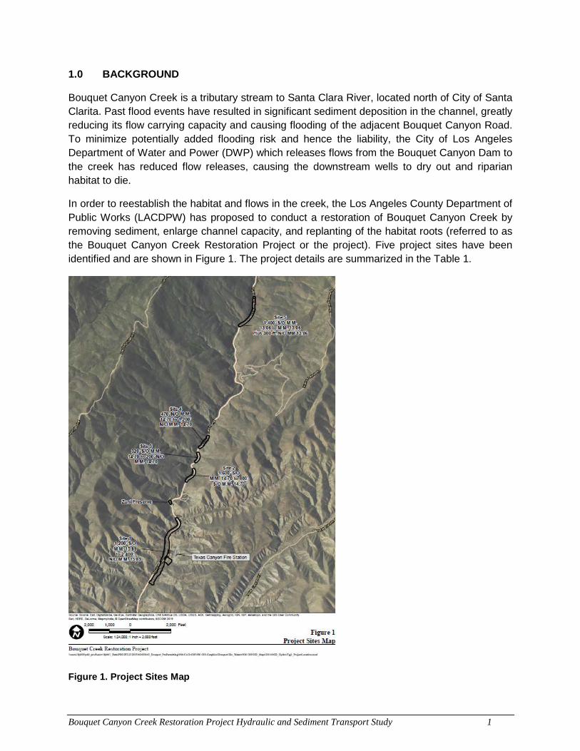
Bouquet Canyon Creek Restoration Project Hydraulic and Sediment Transport Study 1
1.0 BACKGROUND
Bouquet Canyon Creek is a tributary stream to Santa Clara River, located north of City of Santa Clarita. Past flood events have resulted in significant sediment deposition in the channel, greatly reducing its flow carrying capacity and causing flooding of the adjacent Bouquet Canyon Road. To minimize potentially added flooding risk and hence the liability, the City of Los Angeles Department of Water and Power (DWP) which releases flows from the Bouquet Canyon Dam to the creek has reduced flow releases, causing the downstream wells to dry out and riparian habitat to die.
In order to reestablish the habitat and flows in the creek, the Los Angeles County Department of Public Works (LACDPW) has proposed to conduct a restoration of Bouquet Canyon Creek by removing sediment, enlarge channel capacity, and replanting of the habitat roots (referred to as the Bouquet Canyon Creek Restoration Project or the project). Five project sites have been identified and are shown in Figure 1. The project details are summarized in the Table 1.
Figure 1. Project Sites Map
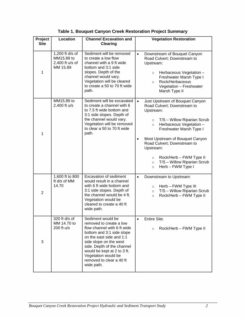
Bouquet Canyon Creek Restoration Project Hydraulic and Sediment Transport Study 2
Table 1. Bouquet Canyon Creek Restoration Project Summary
Project Site
Location Channel Excavation and Clearing
Vegetation Restoration
1
1,200 ft d/s of MM15.89 to 2,400 ft u/s of MM 15.89
Sediment will be removed to create a low flow channel with a 9 ft wide bottom and 3:1 side slopes. Depth of the channel would vary. Vegetation will be cleared to create a 50 to 70 ft wide path.
• Downstream of Bouquet Canyon Road Culvert; Downstream to Upstream:
o Herbaceous Vegetation – Freshwater Marsh Type I
o Rock/Herbaceous Vegetation – Freshwater Marsh Type II
1
MM15.89 to 2,400 ft u/s
Sediment will be excavated to create a channel with 6 to 7.5 ft wide bottom and 3:1 side slopes. Depth of the channel would vary. Vegetation will be removed to clear a 50 to 70 ft wide path.
• Just Upstream of Bouquet Canyon Road Culvert; Downstream to Upstream:
o T/S – Willow Riparian Scrub o Herbaceous Vegetation –
Freshwater Marsh Type I
• Most Upstream of Bouquet Canyon Road Culvert; Downstream to Upstream:
o Rock/Herb – FWM Type II o T/S – Willow Riparian Scrub o Herb – FWM Type I
2
1,600 ft to 800 ft d/s of MM 14.70
Excavation of sediment would result in a channel with 6 ft wide bottom and 3:1 side slopes. Depth of the channel would be 4 ft. Vegetation would be cleared to create a 40 ft wide path.
• Downstream to Upstream:
o Herb – FWM Type III o T/S – Willow Riparian Scrub o Rock/Herb – FWM Type II
3
320 ft d/s of MM 14.70 to 200 ft u/s
Sediment would be removed to create a low flow channel with 6 ft wide bottom and 3:1 side slope on the east side and 1:1 side slope on the west side. Depth of the channel would be kept at 2 to 3 ft. Vegetation would be removed to clear a 40 ft wide path.
• Entire Site:
o Rock/Herb – FWM Type II
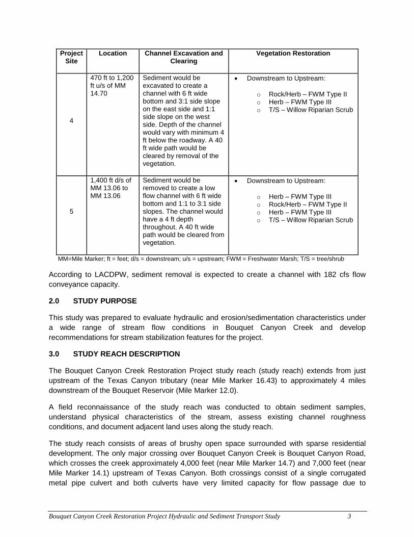
Bouquet Canyon Creek Restoration Project Hydraulic and Sediment Transport Study 3
Project Site
Location Channel Excavation and Clearing
Vegetation Restoration
4
470 ft to 1,200 ft u/s of MM 14.70
Sediment would be excavated to create a channel with 6 ft wide bottom and 3:1 side slope on the east side and 1:1 side slope on the west side. Depth of the channel would vary with minimum 4 ft below the roadway. A 40 ft wide path would be cleared by removal of the vegetation.
• Downstream to Upstream:
o Rock/Herb – FWM Type II o Herb – FWM Type III o T/S – Willow Riparian Scrub
5
1,400 ft d/s of MM 13.06 to MM 13.06
Sediment would be removed to create a low flow channel with 6 ft wide bottom and 1:1 to 3:1 side slopes. The channel would have a 4 ft depth throughout. A 40 ft wide path would be cleared from vegetation.
• Downstream to Upstream:
o Herb – FWM Type III o Rock/Herb – FWM Type II o Herb – FWM Type III o T/S – Willow Riparian Scrub
MM=Mile Marker; ft = feet; d/s = downstream; u/s = upstream; FWM = Freshwater Marsh; T/S = tree/shrub
According to LACDPW, sediment removal is expected to create a channel with 182 cfs flow conveyance capacity.
2.0 STUDY PURPOSE
This study was prepared to evaluate hydraulic and erosion/sedimentation characteristics under a wide range of stream flow conditions in Bouquet Canyon Creek and develop recommendations for stream stabilization features for the project.
3.0 STUDY REACH DESCRIPTION
The Bouquet Canyon Creek Restoration Project study reach (study reach) extends from just upstream of the Texas Canyon tributary (near Mile Marker 16.43) to approximately 4 miles downstream of the Bouquet Reservoir (Mile Marker 12.0).
A field reconnaissance of the study reach was conducted to obtain sediment samples, understand physical characteristics of the stream, assess existing channel roughness conditions, and document adjacent land uses along the study reach.
The study reach consists of areas of brushy open space surrounded with sparse residential development. The only major crossing over Bouquet Canyon Creek is Bouquet Canyon Road, which crosses the creek approximately 4,000 feet (near Mile Marker 14.7) and 7,000 feet (near Mile Marker 14.1) upstream of Texas Canyon. Both crossings consist of a single corrugated metal pipe culvert and both culverts have very limited capacity for flow passage due to
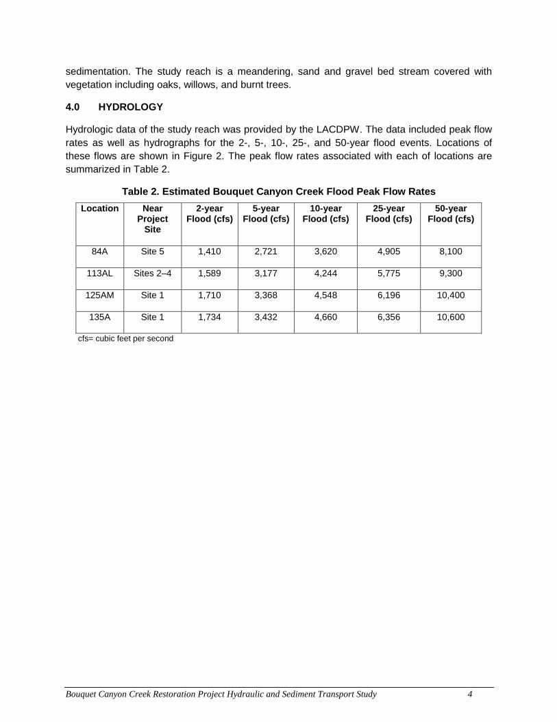
Bouquet Canyon Creek Restoration Project Hydraulic and Sediment Transport Study 4
sedimentation. The study reach is a meandering, sand and gravel bed stream covered with vegetation including oaks, willows, and burnt trees.
4.0 HYDROLOGY
Hydrologic data of the study reach was provided by the LACDPW. The data included peak flow rates as well as hydrographs for the 2-, 5-, 10-, 25-, and 50-year flood events. Locations of these flows are shown in Figure 2. The peak flow rates associated with each of locations are summarized in Table 2.
Table 2. Estimated Bouquet Canyon Creek Flood Peak Flow Rates
Location Near Project
Site
2-year Flood (cfs)
5-year Flood (cfs)
10-year Flood (cfs)
25-year Flood (cfs)
50-year Flood (cfs)
84A Site 5 1,410 2,721 3,620 4,905 8,100
113AL Sites 2–4 1,589 3,177 4,244 5,775 9,300
125AM Site 1 1,710 3,368 4,548 6,196 10,400
135A Site 1 1,734 3,432 4,660 6,356 10,600
cfs= cubic feet per second
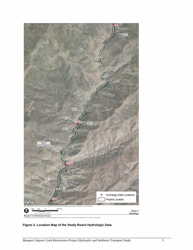
Bouquet Canyon Creek Restoration Project Hydraulic and Sediment Transport Study 5
Figure 2. Location Map of the Study Reach Hydrologic Data
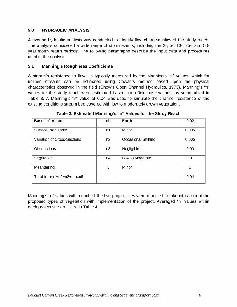
Bouquet Canyon Creek Restoration Project Hydraulic and Sediment Transport Study 6
5.0 HYDRAULIC ANALYSIS
A riverine hydraulic analysis was conducted to identify flow characteristics of the study reach. The analysis considered a wide range of storm events, including the 2-, 5-, 10-, 25-, and 50-year storm return periods. The following paragraphs describe the input data and procedures used in the analysis:
5.1 Manning's Roughness Coefficients
A stream’s resistance to flows is typically measured by the Manning’s “n” values, which for unlined streams can be estimated using Cowan’s method based upon the physical characteristics observed in the field (Chow’s Open Channel Hydraulics, 1973). Manning’s “n” values for the study reach were estimated based upon field observations, as summarized in Table 3. A Manning’s “n” value of 0.04 was used to simulate the channel resistance of the existing conditions stream bed covered with low to moderately grown vegetation.
Table 3. Estimated Manning’s “n” Values for the Study Reach
Base “n” Value nb Earth 0.02
Surface Irregularity n1 Minor 0.005
Variation of Cross-Sections n2 Occasional Shifting 0.005
Obstructions n3 Negligible 0.00
Vegetation n4 Low to Moderate 0.01
Meandering 5 Minor 1
Total (nb+n1+n2+n3+n4)xn5 0.04
Manning’s “n” values within each of the five project sites were modified to take into account the proposed types of vegetation with implementation of the project. Averaged “n” values within each project site are listed in Table 4.
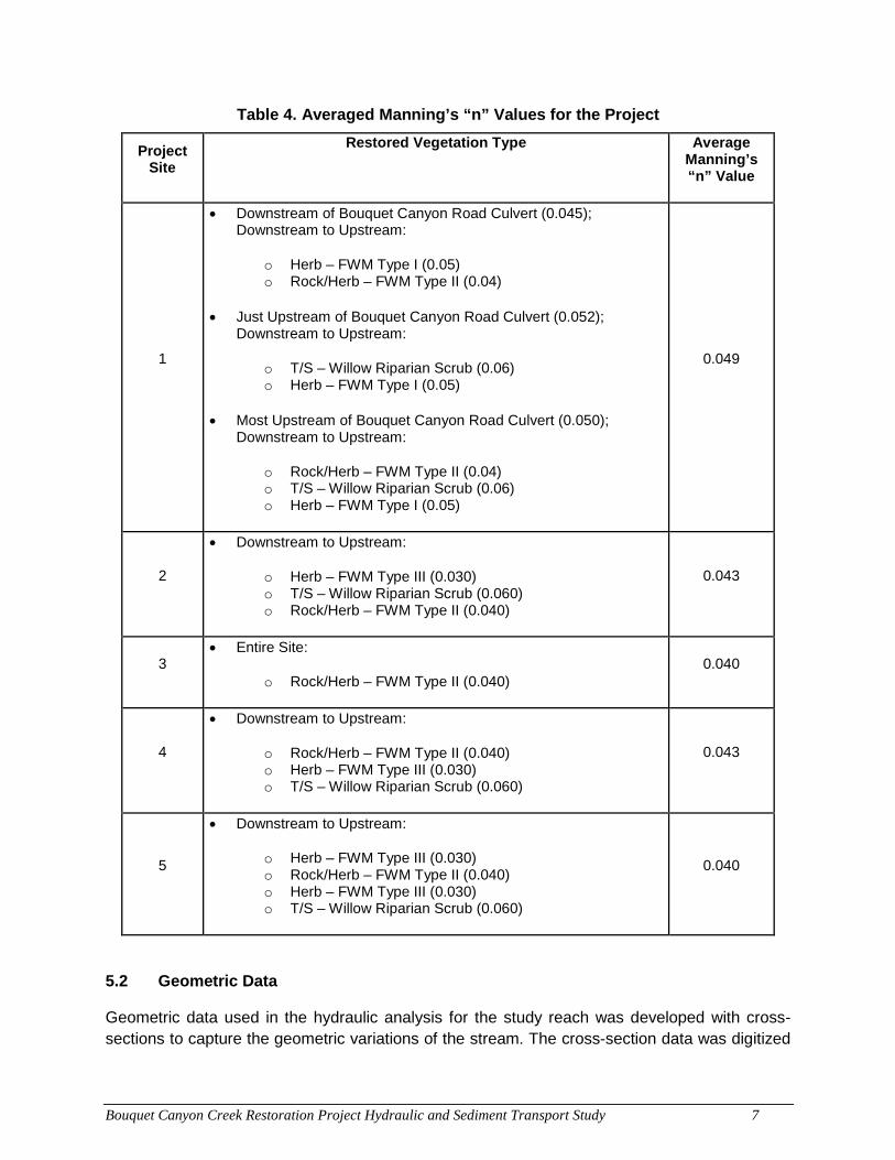
Bouquet Canyon Creek Restoration Project Hydraulic and Sediment Transport Study 7
Table 4. Averaged Manning’s “n” Values for the Project
Project Site
Restored Vegetation Type Average Manning’s “n” Value
1
• Downstream of Bouquet Canyon Road Culvert (0.045); Downstream to Upstream:
o Herb – FWM Type I (0.05) o Rock/Herb – FWM Type II (0.04)
• Just Upstream of Bouquet Canyon Road Culvert (0.052); Downstream to Upstream:
o T/S – Willow Riparian Scrub (0.06) o Herb – FWM Type I (0.05)
• Most Upstream of Bouquet Canyon Road Culvert (0.050); Downstream to Upstream:
o Rock/Herb – FWM Type II (0.04) o T/S – Willow Riparian Scrub (0.06) o Herb – FWM Type I (0.05)
0.049
2
• Downstream to Upstream:
o Herb – FWM Type III (0.030) o T/S – Willow Riparian Scrub (0.060) o Rock/Herb – FWM Type II (0.040)
0.043
3 • Entire Site:
o Rock/Herb – FWM Type II (0.040) 0.040
4
• Downstream to Upstream:
o Rock/Herb – FWM Type II (0.040) o Herb – FWM Type III (0.030) o T/S – Willow Riparian Scrub (0.060)
0.043
5
• Downstream to Upstream:
o Herb – FWM Type III (0.030) o Rock/Herb – FWM Type II (0.040) o Herb – FWM Type III (0.030) o T/S – Willow Riparian Scrub (0.060)
0.040
5.2 Geometric Data
Geometric data used in the hydraulic analysis for the study reach was developed with cross-sections to capture the geometric variations of the stream. The cross-section data was digitized
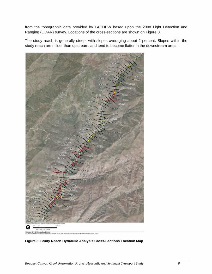
Bouquet Canyon Creek Restoration Project Hydraulic and Sediment Transport Study 8
from the topographic data provided by LACDPW based upon the 2008 Light Detection and Ranging (LiDAR) survey. Locations of the cross-sections are shown on Figure 3.
The study reach is generally steep, with slopes averaging about 2 percent. Slopes within the study reach are milder than upstream, and tend to become flatter in the downstream area.
Figure 3. Study Reach Hydraulic Analysis Cross-Sections Location Map
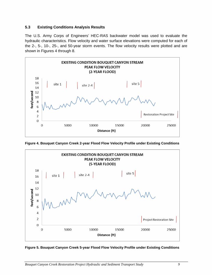
Bouquet Canyon Creek Restoration Project Hydraulic and Sediment Transport Study 9
5.3 Existing Conditions Analysis Results
The U.S. Army Corps of Engineers’ HEC-RAS backwater model was used to evaluate the hydraulic characteristics. Flow velocity and water surface elevations were computed for each of the 2-, 5-, 10-, 25-, and 50-year storm events. The flow velocity results were plotted and are shown in Figures 4 through 8.
Figure 4. Bouquet Canyon Creek 2-year Flood Flow Velocity Profile under Existing Conditions
Figure 5. Bouquet Canyon Creek 5-year Flood Flow Velocity Profile under Existing Conditions
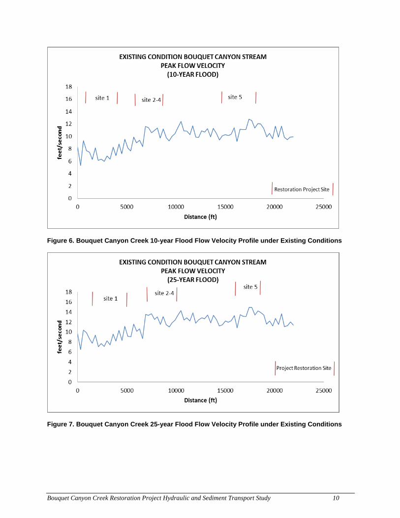
Bouquet Canyon Creek Restoration Project Hydraulic and Sediment Transport Study 10
Figure 6. Bouquet Canyon Creek 10-year Flood Flow Velocity Profile under Existing Conditions
Figure 7. Bouquet Canyon Creek 25-year Flood Flow Velocity Profile under Existing Conditions
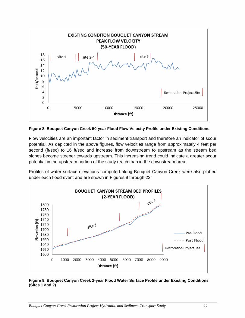
Bouquet Canyon Creek Restoration Project Hydraulic and Sediment Transport Study 11
Figure 8. Bouquet Canyon Creek 50-year Flood Flow Velocity Profile under Existing Conditions
Flow velocities are an important factor in sediment transport and therefore an indicator of scour potential. As depicted in the above figures, flow velocities range from approximately 4 feet per second (ft/sec) to 16 ft/sec and increase from downstream to upstream as the stream bed slopes become steeper towards upstream. This increasing trend could indicate a greater scour potential in the upstream portion of the study reach than in the downstream area.
Profiles of water surface elevations computed along Bouquet Canyon Creek were also plotted under each flood event and are shown in Figures 9 through 23.
Figure 9. Bouquet Canyon Creek 2-year Flood Water Surface Profile under Existing Conditions (Sites 1 and 2)
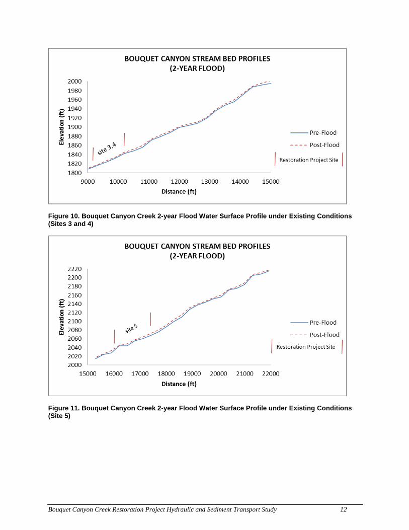
Bouquet Canyon Creek Restoration Project Hydraulic and Sediment Transport Study 12
Figure 10. Bouquet Canyon Creek 2-year Flood Water Surface Profile under Existing Conditions (Sites 3 and 4)
Figure 11. Bouquet Canyon Creek 2-year Flood Water Surface Profile under Existing Conditions (Site 5)
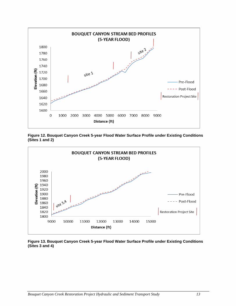
Bouquet Canyon Creek Restoration Project Hydraulic and Sediment Transport Study 13
Figure 12. Bouquet Canyon Creek 5-year Flood Water Surface Profile under Existing Conditions (Sites 1 and 2)
Figure 13. Bouquet Canyon Creek 5-year Flood Water Surface Profile under Existing Conditions (Sites 3 and 4)
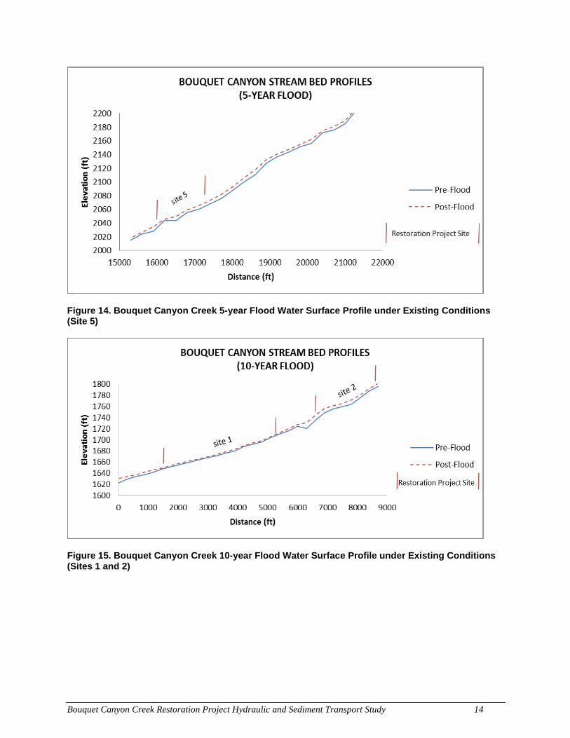
Bouquet Canyon Creek Restoration Project Hydraulic and Sediment Transport Study 14
Figure 14. Bouquet Canyon Creek 5-year Flood Water Surface Profile under Existing Conditions (Site 5)
Figure 15. Bouquet Canyon Creek 10-year Flood Water Surface Profile under Existing Conditions (Sites 1 and 2)
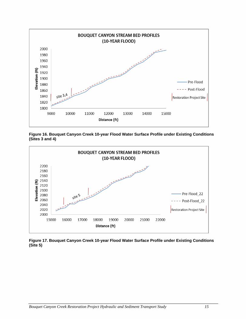
Bouquet Canyon Creek Restoration Project Hydraulic and Sediment Transport Study 15
Figure 16. Bouquet Canyon Creek 10-year Flood Water Surface Profile under Existing Conditions (Sites 3 and 4)
Figure 17. Bouquet Canyon Creek 10-year Flood Water Surface Profile under Existing Conditions (Site 5)
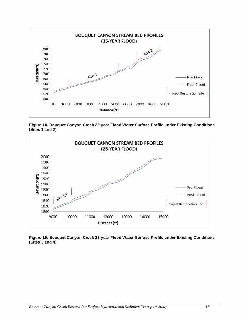
Bouquet Canyon Creek Restoration Project Hydraulic and Sediment Transport Study 16
Figure 18. Bouquet Canyon Creek 25-year Flood Water Surface Profile under Existing Conditions (Sites 1 and 2)
Figure 19. Bouquet Canyon Creek 25-year Flood Water Surface Profile under Existing Conditions (Sites 3 and 4)
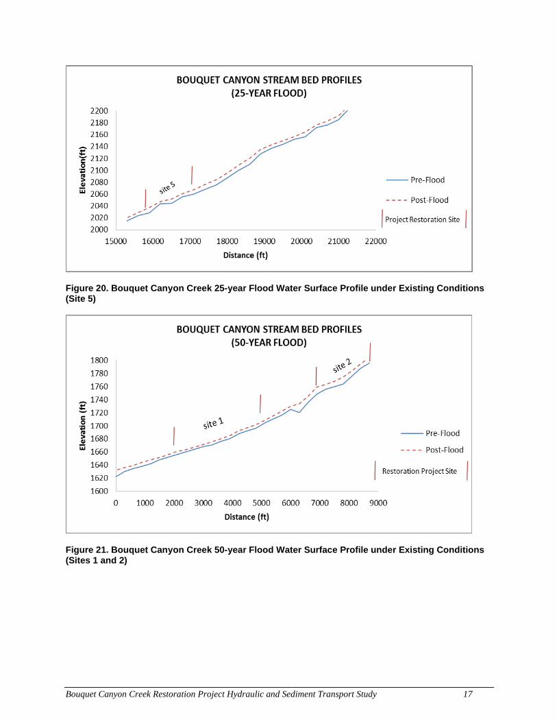
Bouquet Canyon Creek Restoration Project Hydraulic and Sediment Transport Study 17
Figure 20. Bouquet Canyon Creek 25-year Flood Water Surface Profile under Existing Conditions (Site 5)
Figure 21. Bouquet Canyon Creek 50-year Flood Water Surface Profile under Existing Conditions (Sites 1 and 2)
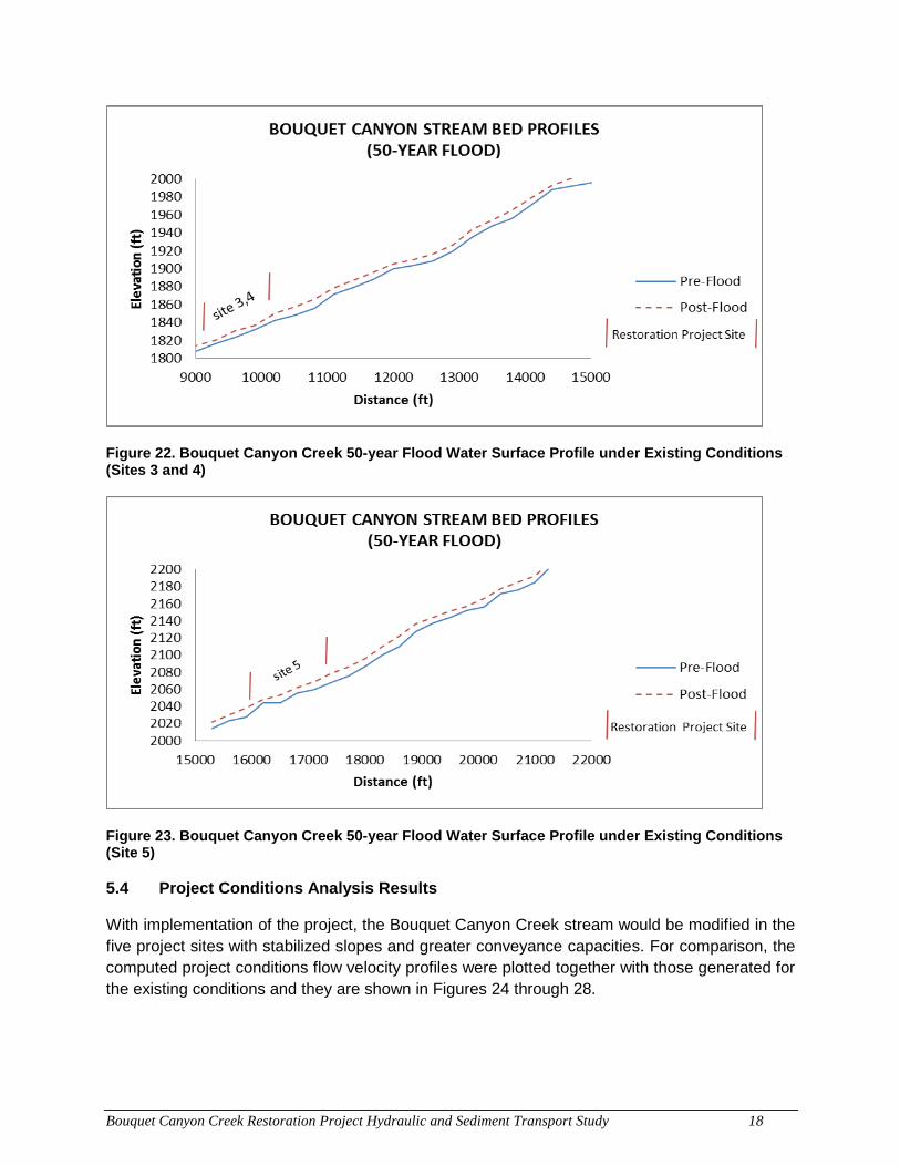
Bouquet Canyon Creek Restoration Project Hydraulic and Sediment Transport Study 18
Figure 22. Bouquet Canyon Creek 50-year Flood Water Surface Profile under Existing Conditions (Sites 3 and 4)
Figure 23. Bouquet Canyon Creek 50-year Flood Water Surface Profile under Existing Conditions (Site 5)
5.4 Project Conditions Analysis Results
With implementation of the project, the Bouquet Canyon Creek stream would be modified in the five project sites with stabilized slopes and greater conveyance capacities. For comparison, the computed project conditions flow velocity profiles were plotted together with those generated for the existing conditions and they are shown in Figures 24 through 28.
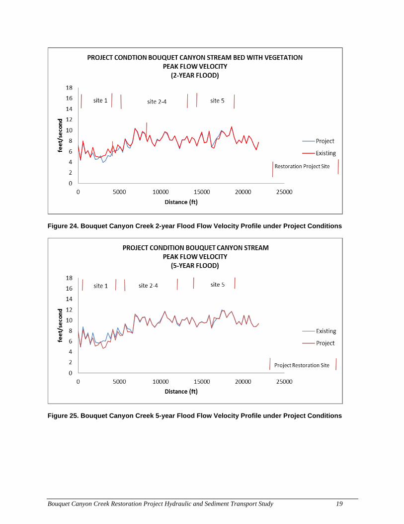
Bouquet Canyon Creek Restoration Project Hydraulic and Sediment Transport Study 19
Figure 24. Bouquet Canyon Creek 2-year Flood Flow Velocity Profile under Project Conditions
Figure 25. Bouquet Canyon Creek 5-year Flood Flow Velocity Profile under Project Conditions
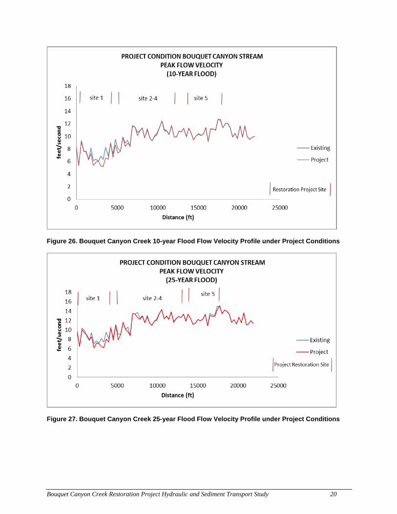
Bouquet Canyon Creek Restoration Project Hydraulic and Sediment Transport Study 20
Figure 26. Bouquet Canyon Creek 10-year Flood Flow Velocity Profile under Project Conditions
Figure 27. Bouquet Canyon Creek 25-year Flood Flow Velocity Profile under Project Conditions
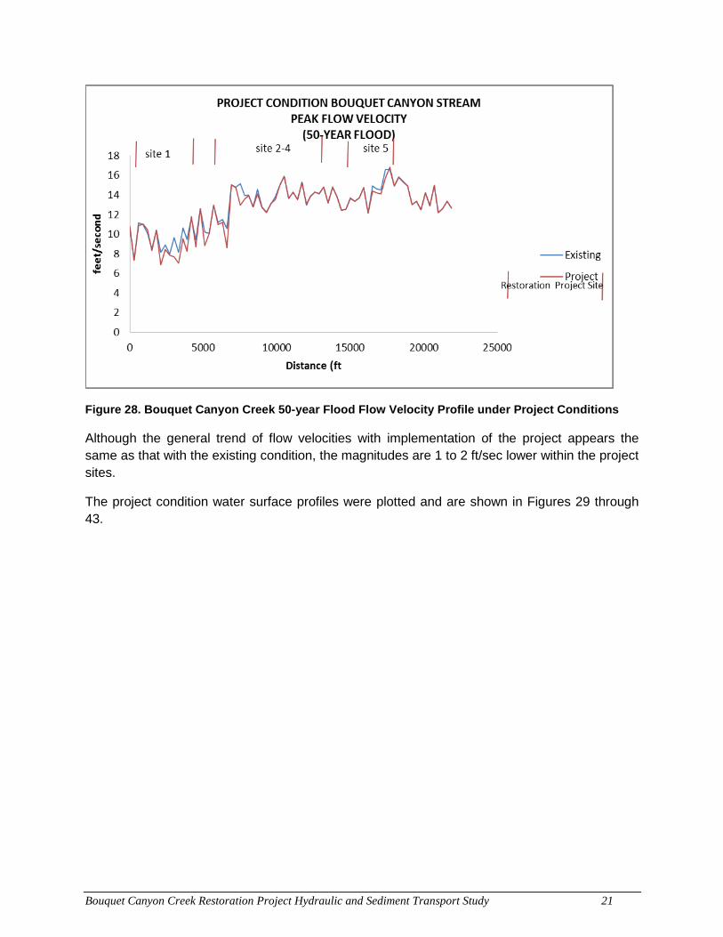
Bouquet Canyon Creek Restoration Project Hydraulic and Sediment Transport Study 21
Figure 28. Bouquet Canyon Creek 50-year Flood Flow Velocity Profile under Project Conditions
Although the general trend of flow velocities with implementation of the project appears the same as that with the existing condition, the magnitudes are 1 to 2 ft/sec lower within the project sites.
The project condition water surface profiles were plotted and are shown in Figures 29 through 43.
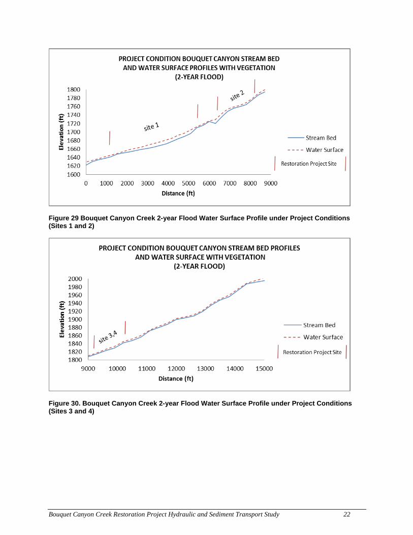
Bouquet Canyon Creek Restoration Project Hydraulic and Sediment Transport Study 22
Figure 29 Bouquet Canyon Creek 2-year Flood Water Surface Profile under Project Conditions (Sites 1 and 2)
Figure 30. Bouquet Canyon Creek 2-year Flood Water Surface Profile under Project Conditions (Sites 3 and 4)
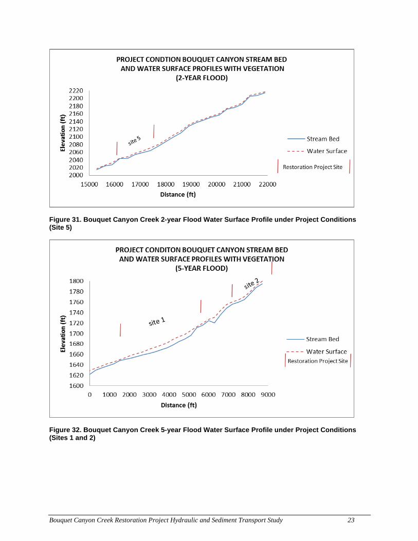
Bouquet Canyon Creek Restoration Project Hydraulic and Sediment Transport Study 23
Figure 31. Bouquet Canyon Creek 2-year Flood Water Surface Profile under Project Conditions (Site 5)
Figure 32. Bouquet Canyon Creek 5-year Flood Water Surface Profile under Project Conditions (Sites 1 and 2)
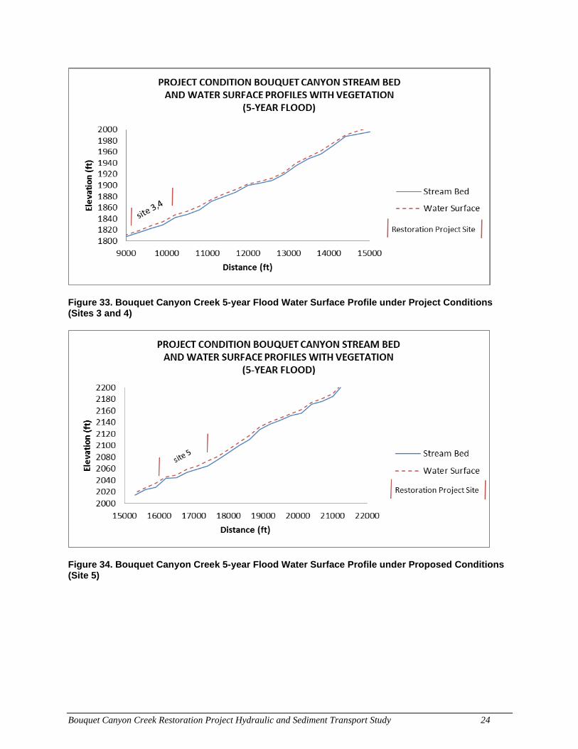
Bouquet Canyon Creek Restoration Project Hydraulic and Sediment Transport Study 24
Figure 33. Bouquet Canyon Creek 5-year Flood Water Surface Profile under Project Conditions (Sites 3 and 4)
Figure 34. Bouquet Canyon Creek 5-year Flood Water Surface Profile under Proposed Conditions (Site 5)
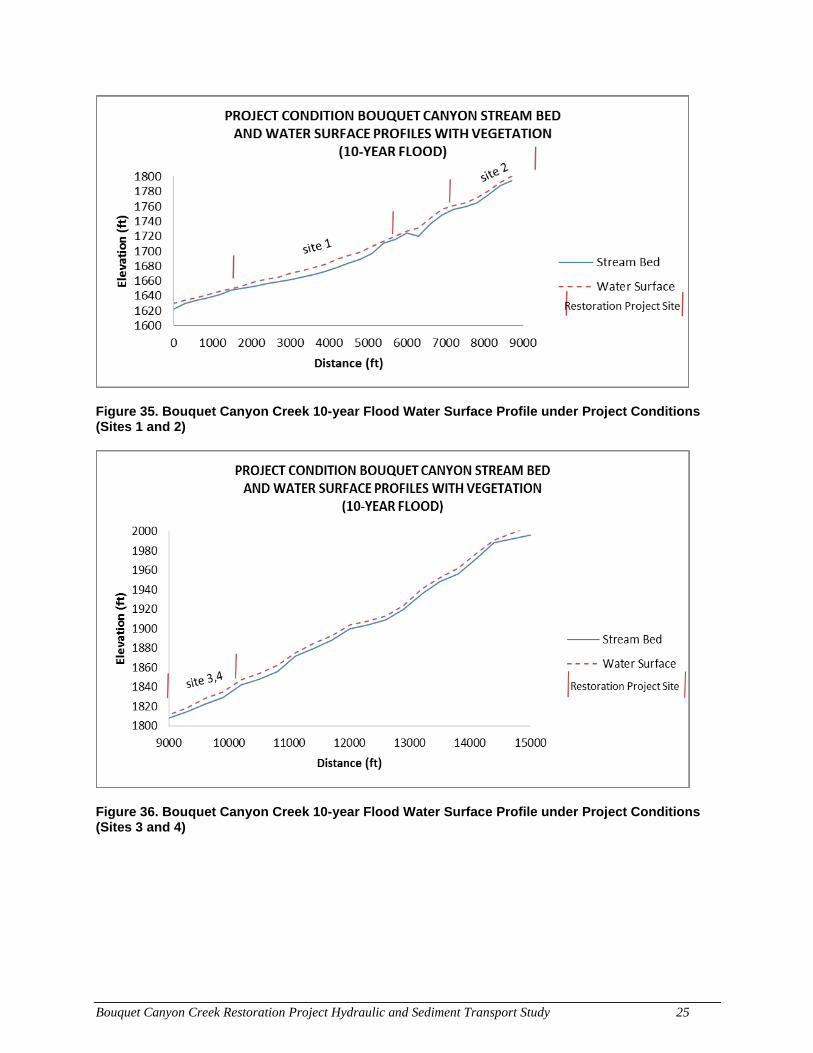
Bouquet Canyon Creek Restoration Project Hydraulic and Sediment Transport Study 25
Figure 35. Bouquet Canyon Creek 10-year Flood Water Surface Profile under Project Conditions (Sites 1 and 2)
Figure 36. Bouquet Canyon Creek 10-year Flood Water Surface Profile under Project Conditions (Sites 3 and 4)
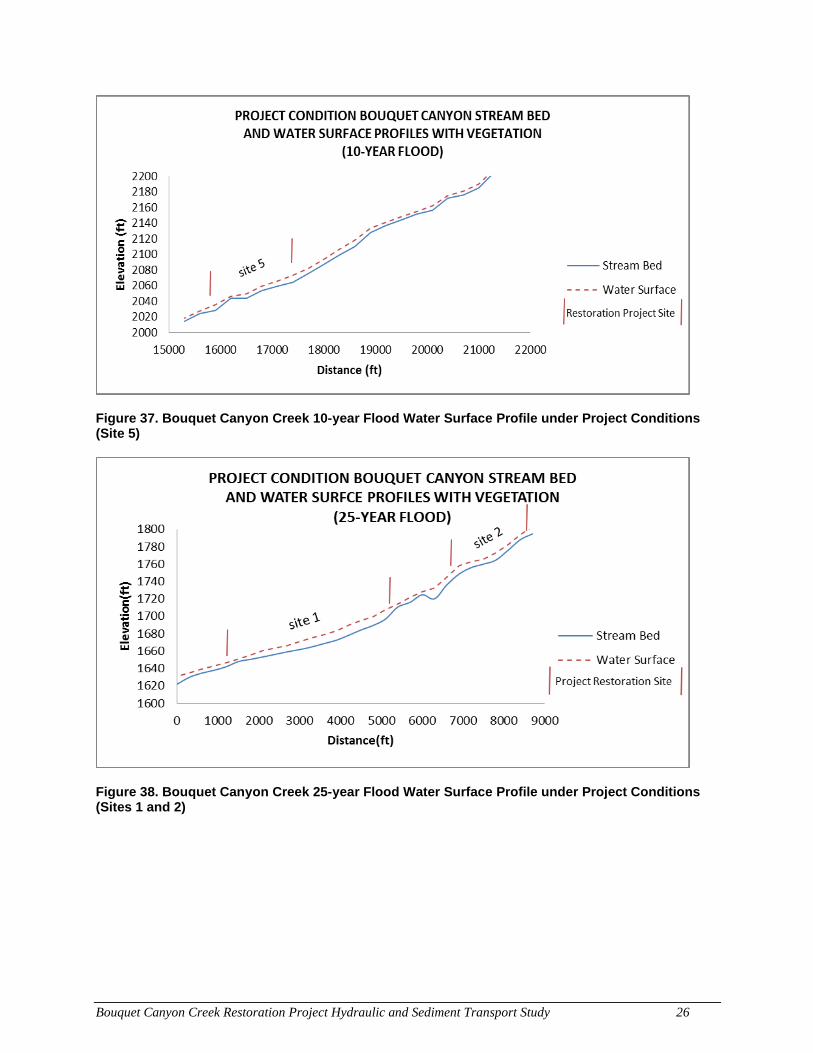
Bouquet Canyon Creek Restoration Project Hydraulic and Sediment Transport Study 26
Figure 37. Bouquet Canyon Creek 10-year Flood Water Surface Profile under Project Conditions (Site 5)
Figure 38. Bouquet Canyon Creek 25-year Flood Water Surface Profile under Project Conditions (Sites 1 and 2)
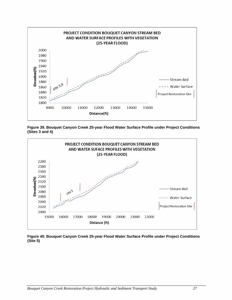
Bouquet Canyon Creek Restoration Project Hydraulic and Sediment Transport Study 27
Figure 39. Bouquet Canyon Creek 25-year Flood Water Surface Profile under Project Conditions (Sites 3 and 4)
Figure 40. Bouquet Canyon Creek 25-year Flood Water Surface Profile under Project Conditions (Site 5)
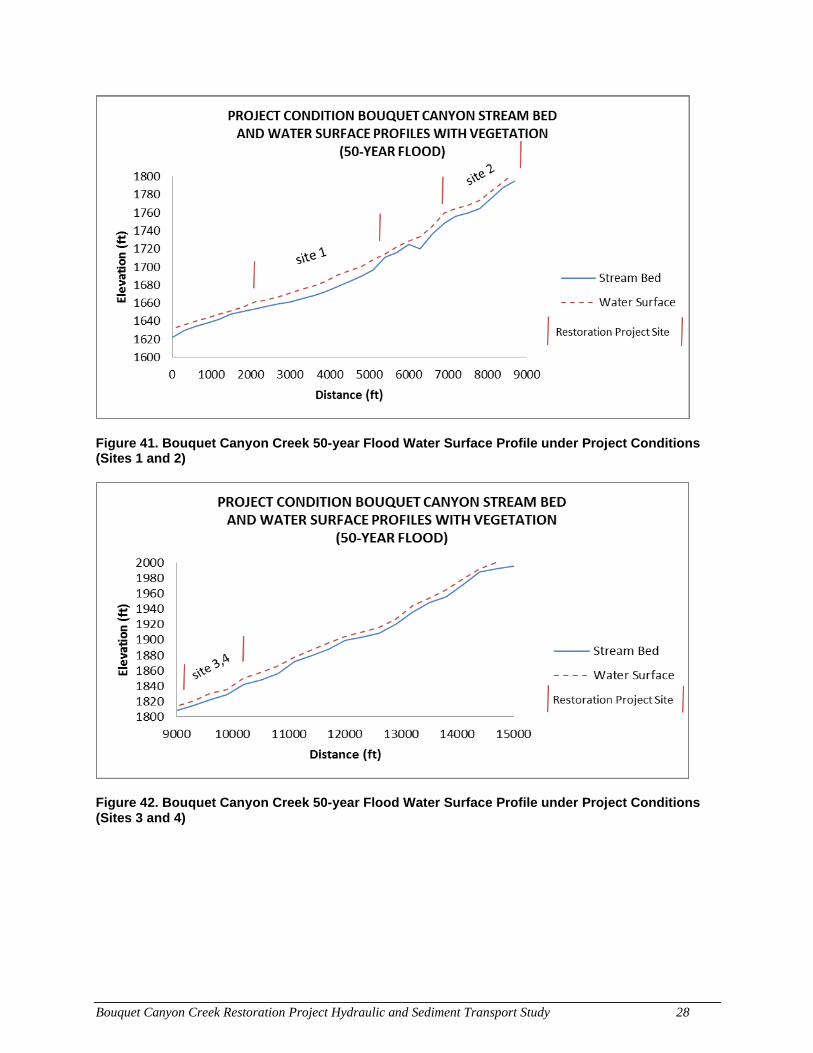
Bouquet Canyon Creek Restoration Project Hydraulic and Sediment Transport Study 28
Figure 41. Bouquet Canyon Creek 50-year Flood Water Surface Profile under Project Conditions (Sites 1 and 2)
Figure 42. Bouquet Canyon Creek 50-year Flood Water Surface Profile under Project Conditions (Sites 3 and 4)
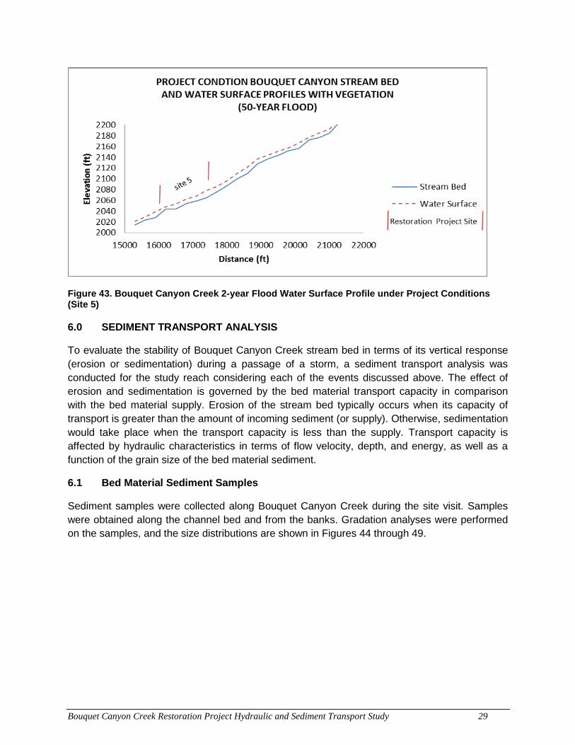
Bouquet Canyon Creek Restoration Project Hydraulic and Sediment Transport Study 29
Figure 43. Bouquet Canyon Creek 2-year Flood Water Surface Profile under Project Conditions (Site 5)
6.0 SEDIMENT TRANSPORT ANALYSIS
To evaluate the stability of Bouquet Canyon Creek stream bed in terms of its vertical response (erosion or sedimentation) during a passage of a storm, a sediment transport analysis was conducted for the study reach considering each of the events discussed above. The effect of erosion and sedimentation is governed by the bed material transport capacity in comparison with the bed material supply. Erosion of the stream bed typically occurs when its capacity of transport is greater than the amount of incoming sediment (or supply). Otherwise, sedimentation would take place when the transport capacity is less than the supply. Transport capacity is affected by hydraulic characteristics in terms of flow velocity, depth, and energy, as well as a function of the grain size of the bed material sediment.
6.1 Bed Material Sediment Samples
Sediment samples were collected along Bouquet Canyon Creek during the site visit. Samples were obtained along the channel bed and from the banks. Gradation analyses were performed on the samples, and the size distributions are shown in Figures 44 through 49.
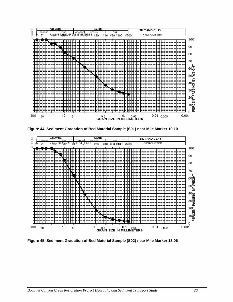
Bouquet Canyon Creek Restoration Project Hydraulic and Sediment Transport Study 30
Figure 44. Sediment Gradation of Bed Material Sample (S01) near Mile Marker 10.10
Figure 45. Sediment Gradation of Bed Material Sample (S02) near Mile Marker 13.06
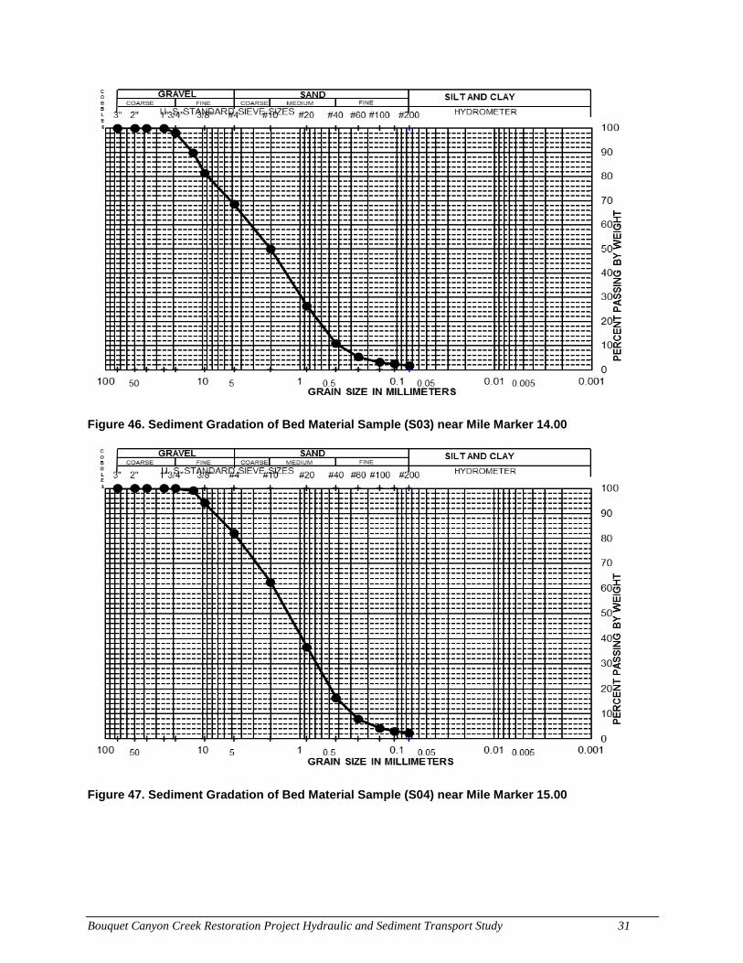
Bouquet Canyon Creek Restoration Project Hydraulic and Sediment Transport Study 31
Figure 46. Sediment Gradation of Bed Material Sample (S03) near Mile Marker 14.00
Figure 47. Sediment Gradation of Bed Material Sample (S04) near Mile Marker 15.00
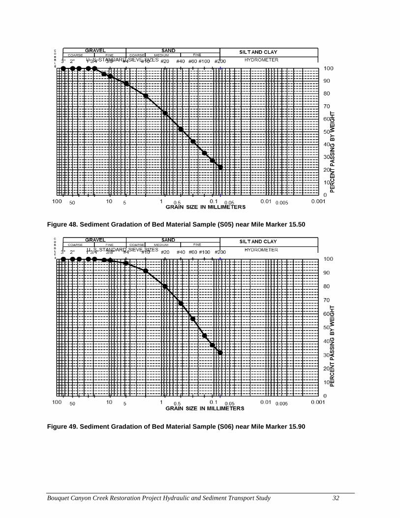
Bouquet Canyon Creek Restoration Project Hydraulic and Sediment Transport Study 32
Figure 48. Sediment Gradation of Bed Material Sample (S05) near Mile Marker 15.50
Figure 49. Sediment Gradation of Bed Material Sample (S06) near Mile Marker 15.90
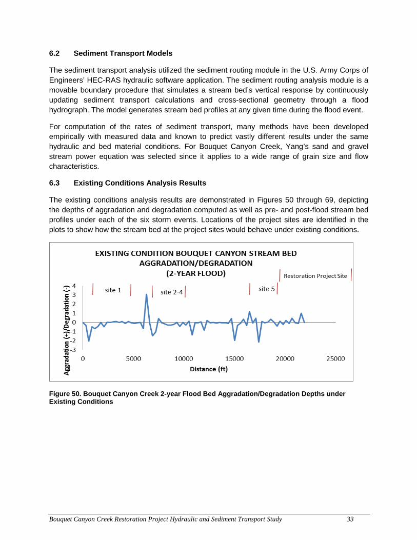
Bouquet Canyon Creek Restoration Project Hydraulic and Sediment Transport Study 33
6.2 Sediment Transport Models
The sediment transport analysis utilized the sediment routing module in the U.S. Army Corps of Engineers’ HEC-RAS hydraulic software application. The sediment routing analysis module is a movable boundary procedure that simulates a stream bed’s vertical response by continuously updating sediment transport calculations and cross-sectional geometry through a flood hydrograph. The model generates stream bed profiles at any given time during the flood event.
For computation of the rates of sediment transport, many methods have been developed empirically with measured data and known to predict vastly different results under the same hydraulic and bed material conditions. For Bouquet Canyon Creek, Yang’s sand and gravel stream power equation was selected since it applies to a wide range of grain size and flow characteristics.
6.3 Existing Conditions Analysis Results
The existing conditions analysis results are demonstrated in Figures 50 through 69, depicting the depths of aggradation and degradation computed as well as pre- and post-flood stream bed profiles under each of the six storm events. Locations of the project sites are identified in the plots to show how the stream bed at the project sites would behave under existing conditions.
Figure 50. Bouquet Canyon Creek 2-year Flood Bed Aggradation/Degradation Depths under Existing Conditions
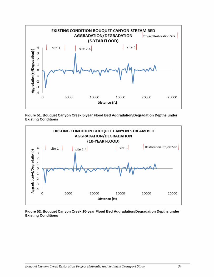
Bouquet Canyon Creek Restoration Project Hydraulic and Sediment Transport Study 34
Figure 51. Bouquet Canyon Creek 5-year Flood Bed Aggradation/Degradation Depths under Existing Conditions
Figure 52. Bouquet Canyon Creek 10-year Flood Bed Aggradation/Degradation Depths under Existing Conditions
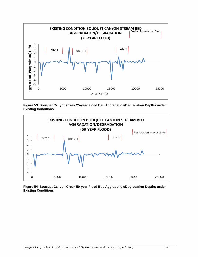
Bouquet Canyon Creek Restoration Project Hydraulic and Sediment Transport Study 35
Figure 53. Bouquet Canyon Creek 25-year Flood Bed Aggradation/Degradation Depths under Existing Conditions
Figure 54. Bouquet Canyon Creek 50-year Flood Bed Aggradation/Degradation Depths under Existing Conditions
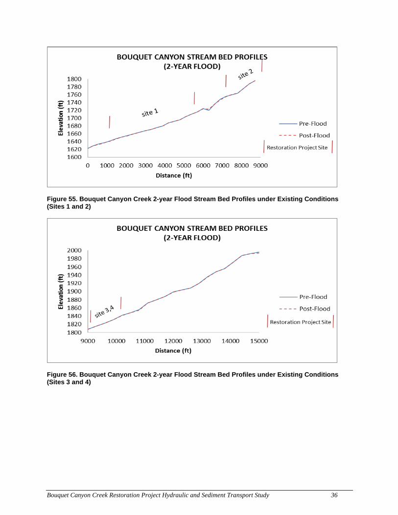
Bouquet Canyon Creek Restoration Project Hydraulic and Sediment Transport Study 36
Figure 55. Bouquet Canyon Creek 2-year Flood Stream Bed Profiles under Existing Conditions (Sites 1 and 2)
Figure 56. Bouquet Canyon Creek 2-year Flood Stream Bed Profiles under Existing Conditions (Sites 3 and 4)
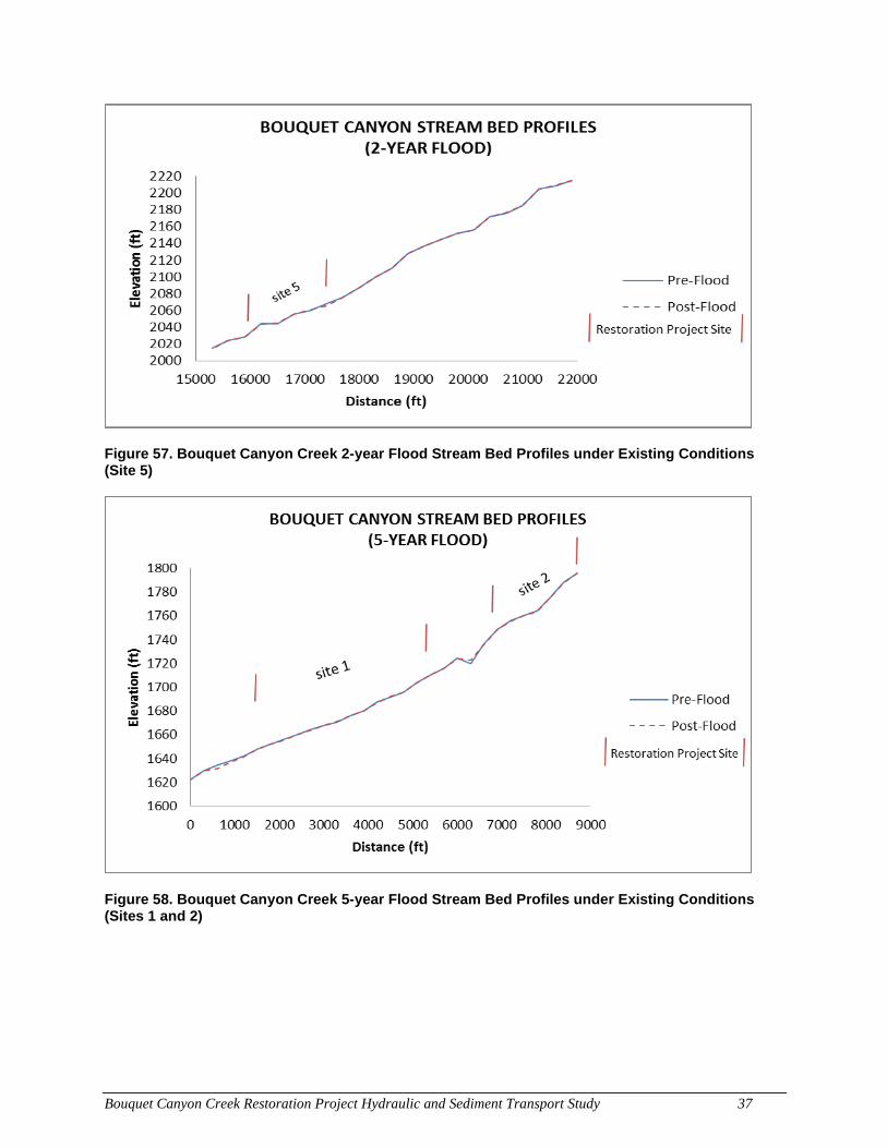
Bouquet Canyon Creek Restoration Project Hydraulic and Sediment Transport Study 37
Figure 57. Bouquet Canyon Creek 2-year Flood Stream Bed Profiles under Existing Conditions (Site 5)
Figure 58. Bouquet Canyon Creek 5-year Flood Stream Bed Profiles under Existing Conditions (Sites 1 and 2)
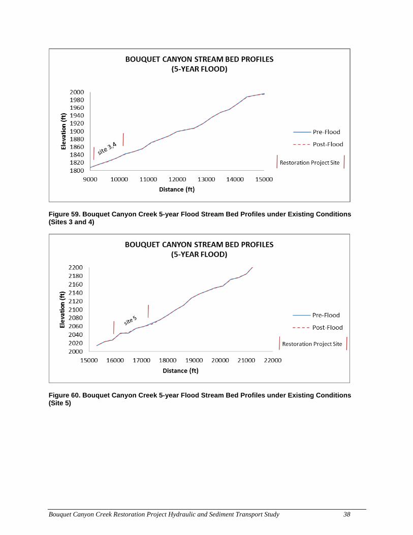
Bouquet Canyon Creek Restoration Project Hydraulic and Sediment Transport Study 38
Figure 59. Bouquet Canyon Creek 5-year Flood Stream Bed Profiles under Existing Conditions (Sites 3 and 4)
Figure 60. Bouquet Canyon Creek 5-year Flood Stream Bed Profiles under Existing Conditions (Site 5)
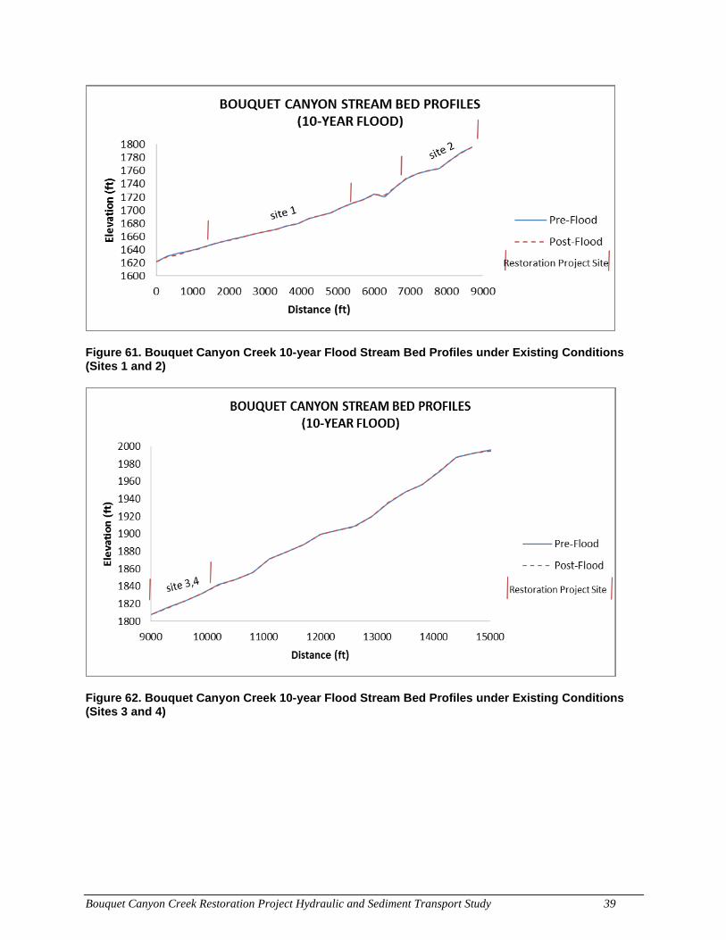
Bouquet Canyon Creek Restoration Project Hydraulic and Sediment Transport Study 39
Figure 61. Bouquet Canyon Creek 10-year Flood Stream Bed Profiles under Existing Conditions (Sites 1 and 2)
Figure 62. Bouquet Canyon Creek 10-year Flood Stream Bed Profiles under Existing Conditions (Sites 3 and 4)
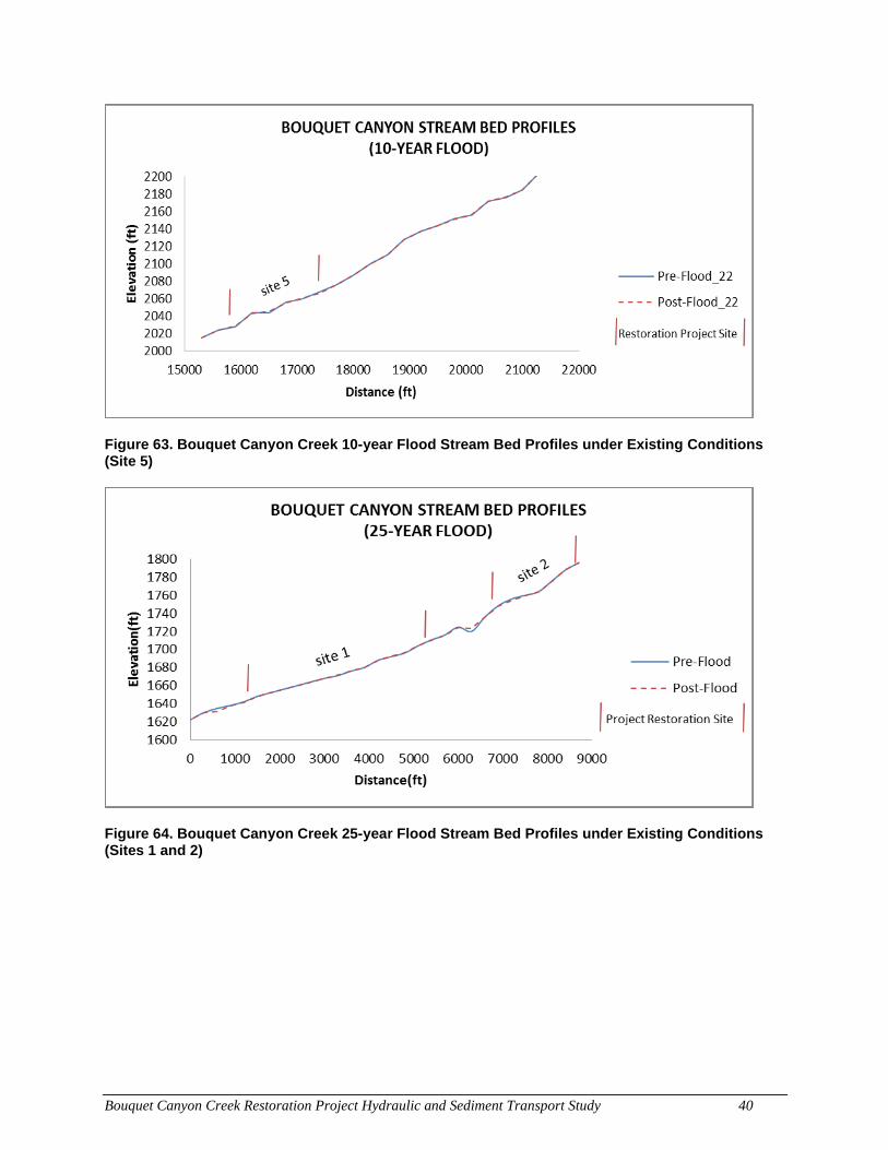
Bouquet Canyon Creek Restoration Project Hydraulic and Sediment Transport Study 40
Figure 63. Bouquet Canyon Creek 10-year Flood Stream Bed Profiles under Existing Conditions (Site 5)
Figure 64. Bouquet Canyon Creek 25-year Flood Stream Bed Profiles under Existing Conditions (Sites 1 and 2)
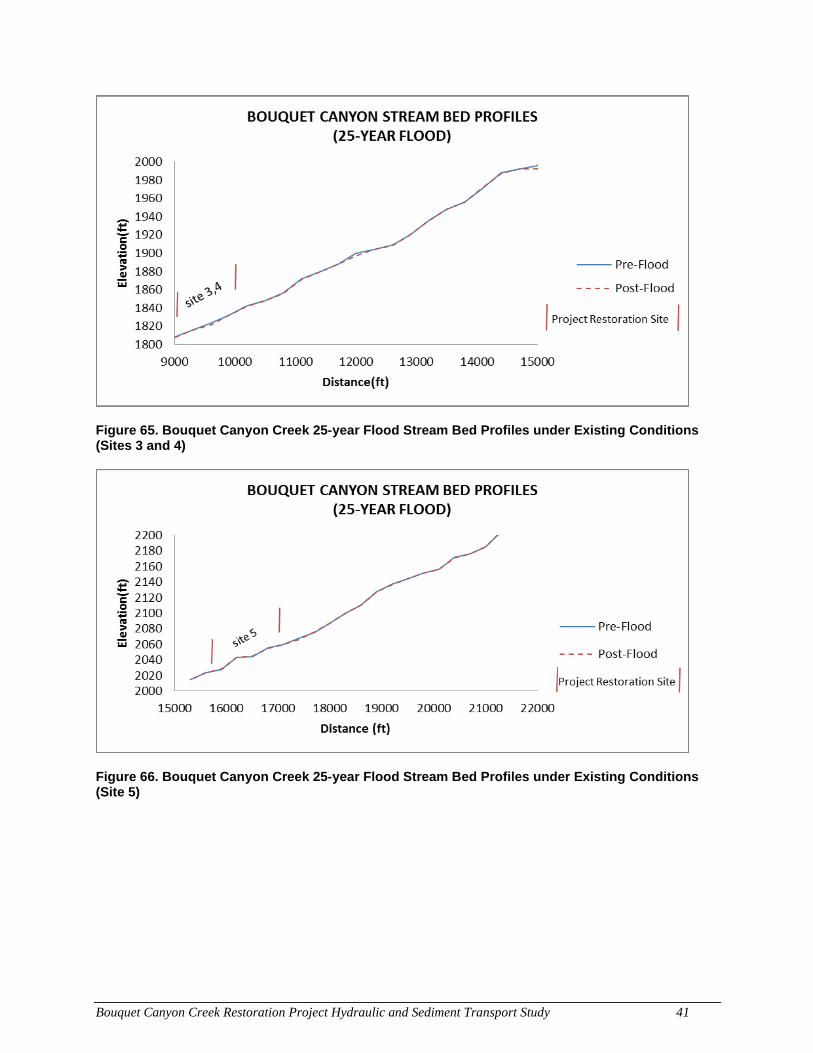
Bouquet Canyon Creek Restoration Project Hydraulic and Sediment Transport Study 41
Figure 65. Bouquet Canyon Creek 25-year Flood Stream Bed Profiles under Existing Conditions (Sites 3 and 4)
Figure 66. Bouquet Canyon Creek 25-year Flood Stream Bed Profiles under Existing Conditions (Site 5)
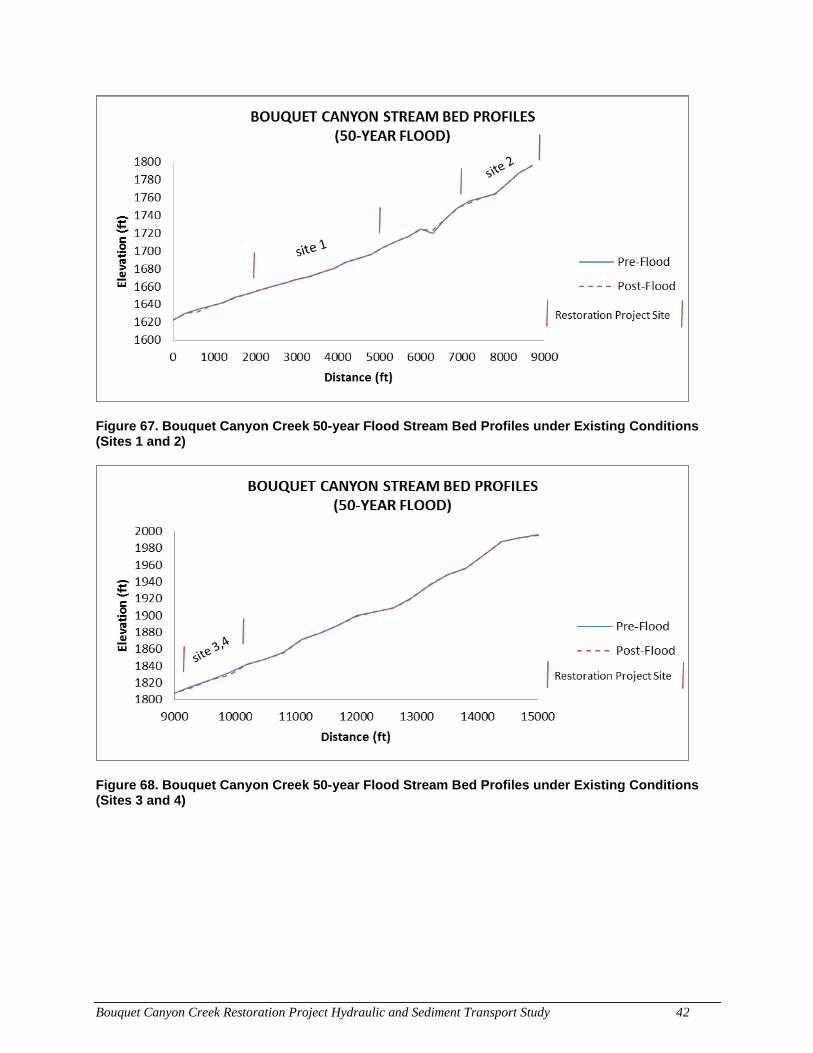
Bouquet Canyon Creek Restoration Project Hydraulic and Sediment Transport Study 42
Figure 67. Bouquet Canyon Creek 50-year Flood Stream Bed Profiles under Existing Conditions (Sites 1 and 2)
Figure 68. Bouquet Canyon Creek 50-year Flood Stream Bed Profiles under Existing Conditions (Sites 3 and 4)
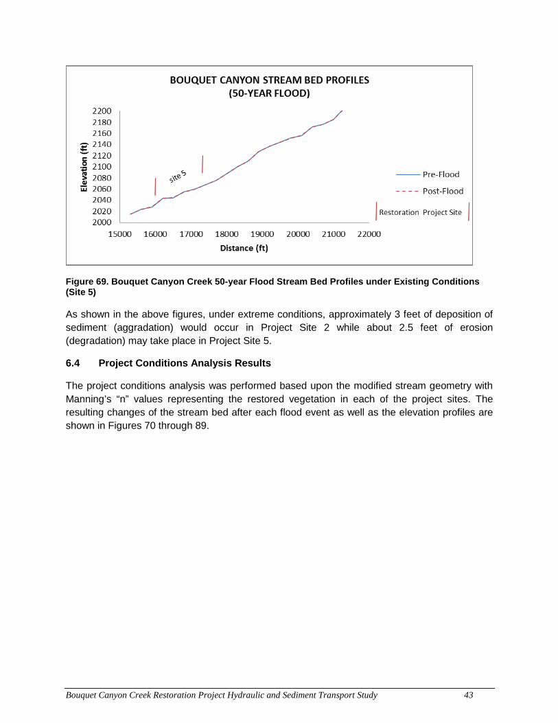
Bouquet Canyon Creek Restoration Project Hydraulic and Sediment Transport Study 43
Figure 69. Bouquet Canyon Creek 50-year Flood Stream Bed Profiles under Existing Conditions (Site 5)
As shown in the above figures, under extreme conditions, approximately 3 feet of deposition of sediment (aggradation) would occur in Project Site 2 while about 2.5 feet of erosion (degradation) may take place in Project Site 5.
6.4 Project Conditions Analysis Results
The project conditions analysis was performed based upon the modified stream geometry with Manning’s “n” values representing the restored vegetation in each of the project sites. The resulting changes of the stream bed after each flood event as well as the elevation profiles are shown in Figures 70 through 89.
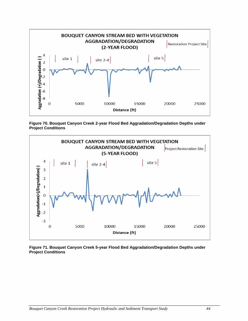
Bouquet Canyon Creek Restoration Project Hydraulic and Sediment Transport Study 44
Figure 70. Bouquet Canyon Creek 2-year Flood Bed Aggradation/Degradation Depths under Project Conditions
Figure 71. Bouquet Canyon Creek 5-year Flood Bed Aggradation/Degradation Depths under Project Conditions
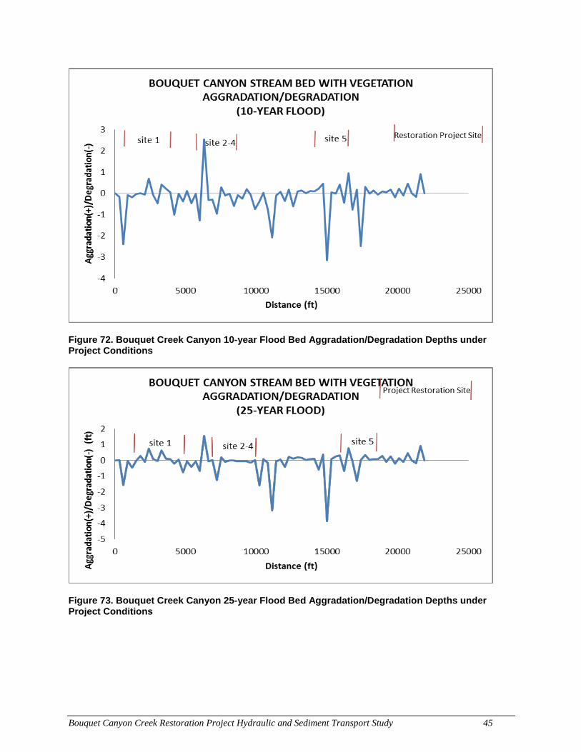
Bouquet Canyon Creek Restoration Project Hydraulic and Sediment Transport Study 45
Figure 72. Bouquet Creek Canyon 10-year Flood Bed Aggradation/Degradation Depths under Project Conditions
Figure 73. Bouquet Creek Canyon 25-year Flood Bed Aggradation/Degradation Depths under Project Conditions
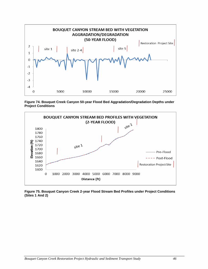
Bouquet Canyon Creek Restoration Project Hydraulic and Sediment Transport Study 46
Figure 74. Bouquet Creek Canyon 50-year Flood Bed Aggradation/Degradation Depths under Project Conditions
Figure 75. Bouquet Canyon Creek 2-year Flood Stream Bed Profiles under Project Conditions (Sites 1 And 2)
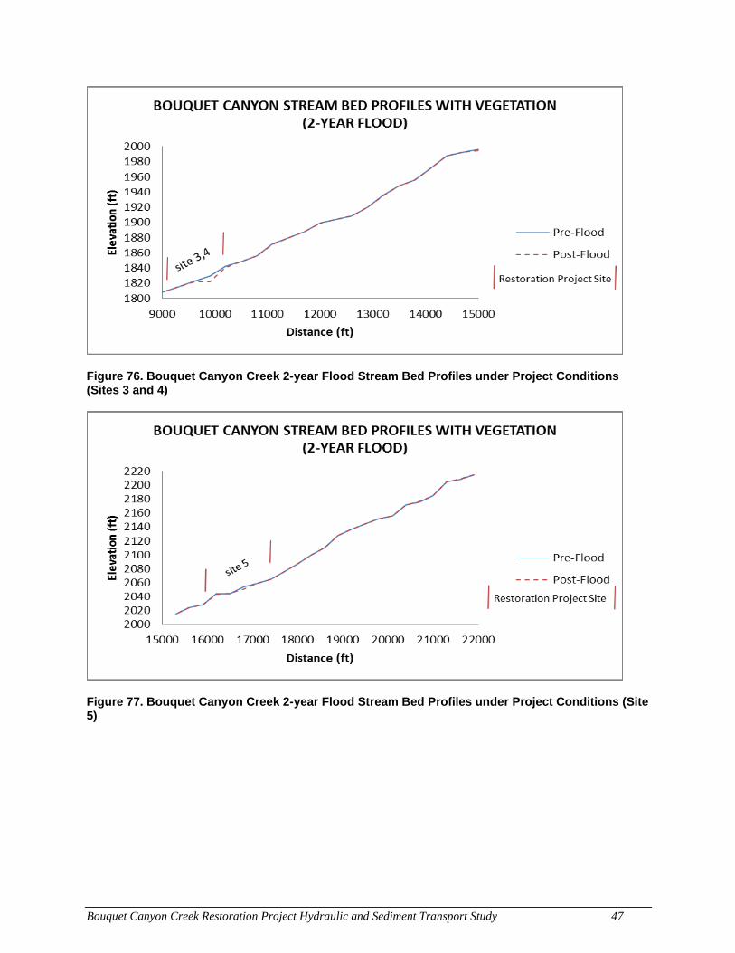
Bouquet Canyon Creek Restoration Project Hydraulic and Sediment Transport Study 47
Figure 76. Bouquet Canyon Creek 2-year Flood Stream Bed Profiles under Project Conditions (Sites 3 and 4)
Figure 77. Bouquet Canyon Creek 2-year Flood Stream Bed Profiles under Project Conditions (Site 5)
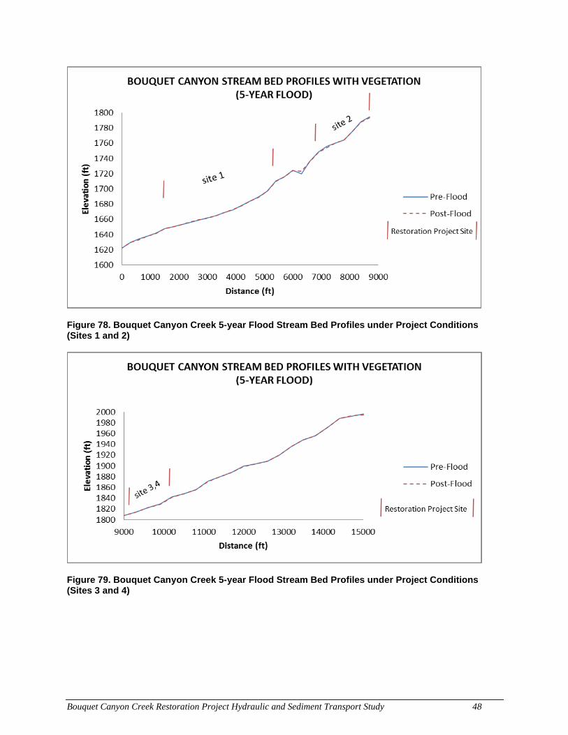
Bouquet Canyon Creek Restoration Project Hydraulic and Sediment Transport Study 48
Figure 78. Bouquet Canyon Creek 5-year Flood Stream Bed Profiles under Project Conditions (Sites 1 and 2)
Figure 79. Bouquet Canyon Creek 5-year Flood Stream Bed Profiles under Project Conditions (Sites 3 and 4)
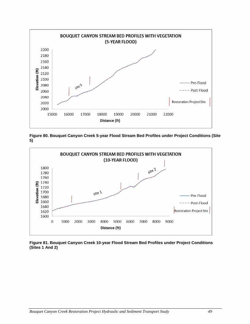
Bouquet Canyon Creek Restoration Project Hydraulic and Sediment Transport Study 49
Figure 80. Bouquet Canyon Creek 5-year Flood Stream Bed Profiles under Project Conditions (Site 5)
Figure 81. Bouquet Canyon Creek 10-year Flood Stream Bed Profiles under Project Conditions (Sites 1 And 2)
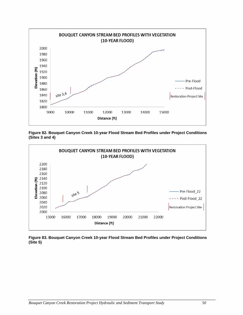
Bouquet Canyon Creek Restoration Project Hydraulic and Sediment Transport Study 50
Figure 82. Bouquet Canyon Creek 10-year Flood Stream Bed Profiles under Project Conditions (Sites 3 and 4)
Figure 83. Bouquet Canyon Creek 10-year Flood Stream Bed Profiles under Project Conditions (Site 5)
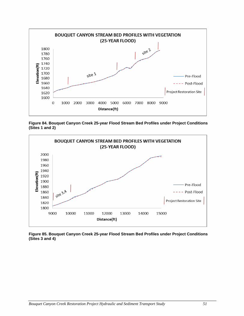
Bouquet Canyon Creek Restoration Project Hydraulic and Sediment Transport Study 51
Figure 84. Bouquet Canyon Creek 25-year Flood Stream Bed Profiles under Project Conditions (Sites 1 and 2)
Figure 85. Bouquet Canyon Creek 25-year Flood Stream Bed Profiles under Project Conditions (Sites 3 and 4)
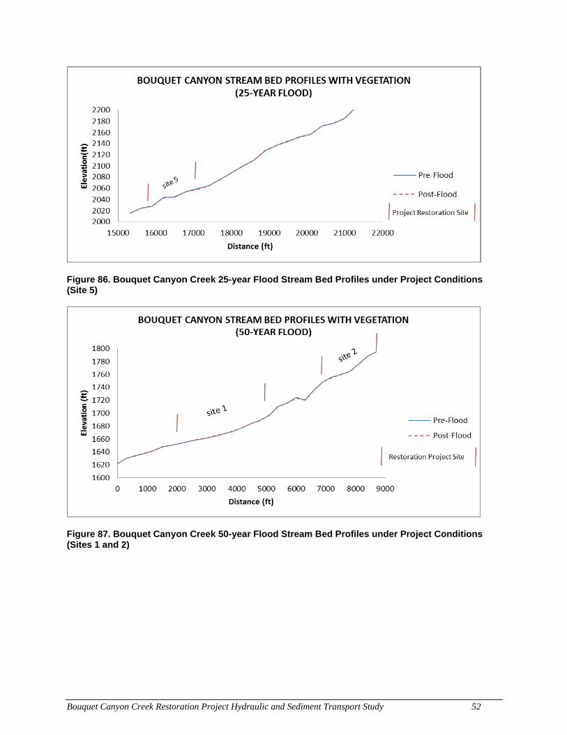
Bouquet Canyon Creek Restoration Project Hydraulic and Sediment Transport Study 52
Figure 86. Bouquet Canyon Creek 25-year Flood Stream Bed Profiles under Project Conditions (Site 5)
Figure 87. Bouquet Canyon Creek 50-year Flood Stream Bed Profiles under Project Conditions (Sites 1 and 2)
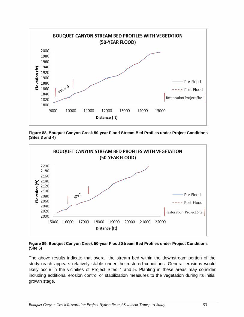
Bouquet Canyon Creek Restoration Project Hydraulic and Sediment Transport Study 53
Figure 88. Bouquet Canyon Creek 50-year Flood Stream Bed Profiles under Project Conditions (Sites 3 and 4)
Figure 89. Bouquet Canyon Creek 50-year Flood Stream Bed Profiles under Project Conditions (Site 5)
The above results indicate that overall the stream bed within the downstream portion of the study reach appears relatively stable under the restored conditions. General erosions would likely occur in the vicinities of Project Sites 4 and 5. Planting in these areas may consider including additional erosion control or stabilization measures to the vegetation during its initial growth stage.
Bouquet Canyon Creek Restoration Project Hydraulic and Sediment Transport Study 54
7.0 CONCLUSION
Key conclusions of the hydraulic and sediment transport analyses of the project provided in this study are summarized below.
• Flow velocities along the study reach under existing conditions increase from downstream to upstream with the average values ranging from approximately 7 ft/sec during a 2-year flood event to 12 ft/sec during a 50-year flood event. Under the proposed condition, the general trend and magnitudes of flow velocities would stay close to those under existing conditions, although there is a slight decrease in the lower reach.
• Flow depths range from about 2 ft with the 2-year event to about 10 ft with the 50-year event under existing conditions. The project would increase flow depths within the project sites providing greater flood storage and thus reducing potential flooding in the surrounding areas.
• Most of the stream bed within the study reach of Bouquet Canyon Creek under appears to be generally stable after the passage of a flood under existing conditions. Local aggradation of sediment occurs in the lower reach while degradation in the upper reach. The maximum depths of adjustments are 3 to 4 ft.
• Sediment transport of the study reach was evaluated under the proposed condition. The roughness characteristics of the project sites reflected a variety of replanted vegetation categories. The results show that under most flood events, the stream bed would aggrade in the lower reach and degrade in the upper reach, similar to the trend shown under existing conditions. Most of the project sites seem to be stable whereas the stream bed immediately downstream of the project sites shows degradations, an effect most likely caused by trapping of sediment in the vegetated areas.
• The stream bed degradation as shown by the sediment transport analysis near or within the project sites could result in the loss of soil in the planted areas during flood events. Locally high flow velocities could also cause local scour holes exposing the roots of the planted vegetation. In these areas, it is recommended to consider soil stabilization measures to enhance stability and minimize the potential loss of the plants during a major flood event.
Bouquet Canyon Creek Restoration Project Hydraulic and Sediment Transport Study 55
8.0 REFERENCES
Chow, Ven Te. Open-Channel Hydraulics. McGraw-Hill, Inc., 1973.
Los Angeles County Department of Public Works (LACDPW). Lower Bouquet Canyon Study
dated 2005, Flow Rate Maps for 2-, 5-, 10-, 25-, and Capital Flood. 2015.
----. LiDAR Survey Data. 2008.
----. Bouquet Creek Restoration Project Plans. No date.
U.S. Army Corps of Engineers. Hydrologic Engineering Center. HEC-RAS River
Analysis System User’s Manual, V4.1. 2010a.
----. HEC-RAS River Analysis System V4.1.0. 2010b.