project deliverable d45b 3rd demonstration ... - archimer
TRANSCRIPT

Project contract no. 036851 ESONET European Seas Observatory Network
Instrument: Network of Excellence (NoE)
Thematic Priority: 1.1.6.3 – Climate Change and Ecosystems Sub Priority: III – Global Change and Ecosystems
Project Deliverable D45b
3rd Demonstration Mission Periodic ReportsDue date of deliverable: August 2008
Actual submission date of report: July 2010 Start of project: 1st March 2007 Duration: 48 months Work Packages 4Organization name of lead contractor for this deliverable: INGV Lead Author for this deliverable: Laura BERANZOLI Revision [1.0]
Project co-funded by the European Commission within the Sixth Framework Programme (2002-2006)Dissemination Level
PU Public PP Restricted to other programme participants (including the Commission Services) XRE Restricted to a group specified by the consortium (including the Commission Services) CO Confidential, only for members of the consortium (including the Commission Services)

Deliverable D45b 2

Table of Content
EXECUTIVE SUMMARY.........................................................................................3
1. MAJOR ACHIEVEMENTS OF THE ESONET DEMO MISSIONS ...................4
1.1 LIDO......................................................................................................................4
2.2 LOOME.................................................................................................................6
2.3 MARMARA-DM ..................................................................................................8
2.4 MOMAR-D .........................................................................................................10
2.5 MODOO..............................................................................................................11
2.6 AOEM .................................................................................................................13
Conclusions ...............................................................................................................14
Annex - DM Periodic Reports
LIDO ..........................................................................................................................19
LOOME.......................................................................................................................87
MARMARA-DM.......................................................................................................163
MODOO.....................................................................................................................361
MOMAR D................................................................................................................ 455
AOEM ....................................................................................................................... 527
Deliverable D45B - DM Periodic Reports
3

Deliverable D45B - DM Periodic Reports
4

EXECUTIVE SUMMARY Aim of this document is the reporting of the activities developing over the period June 2009 – December 2009 in the frame of WP4 the ESONET Demonstration Missions (DM, ref. ESONET NoE DoW). In addition, critical aspects for each DM are pointed out and suggestions are give in order to improve the mpact of the DMs work on ESONET and to help in the fully completion of the DM activities and achievements of the results. In this period, the DMs approved in the 1st call (LIDO, LOOME, Marmara-DM, MOMAR-D, Fig.1)) are either at the completion of the first year or in the second year of activity. The DM implementation plans have in general a first work phase which include a significant effort of the partners for the integration/adaptation of the instrumentation and devices managed by each of them. This phase is completed for most of the DM and three of these DMs are presently in the phase of the development and follow-up of the sea experiments: LiDO in the Gulf of Cadiz, LOOME around the Hakon Mosby mud volcano (Norwegian margin) and MARMARA-DM in the Marmara Sea. The first results of this experiment phase are mainly represented by the technical achievement which are in turn related to the assessment/validation of the performance of the instrumentations/platforms. The logistics involved in the sea operations (e.g., research vessels, ROVs, etc.) has been made available by the partners in the frame of a high level collaboration and coordination effort. The running sea experiments are progressing with the acquisition of long-term measurements in the sub-sea, seafloor and water column. In particular the DMs LIDO, LOOME and Marmara-DM have been testing multisensor-platforms, either new or improved, and have been producing a significant amount of long-term multidisciplinary time series acquired in three ESONET key-sites (Hakon Mosby, Gulf of Cadiz, Marmara Sea) and related to seismic activity, heat-flow and fluid emissions, water-column temperature, etc. The work progress presents delays for some DMs depending from the lab work or from ship time availability. The technical results obtained so far by LIDO, LOOME and Marmara-DM are the premise for successful experiments and for the collection of long-term multidisciplinary high-quality data. The status of MOMAR-D is delayed with respect to the original implementation plan and the sea experiment is foreseen by 2010. In the period June 2009 – December 2010 the DMs approved in the 2nd Call (MODOO, and AOEM) have started their activities of preparation of the instruments and platforms. At the time of this report, The Grant Agreement (GA) signature process has been completed for MODOO while ESONET coordinator and AOEM coordinator are still negotiating some of the articles of the GA.
Fig. 1 – Sites of the ESONET Demo Missions (see legend)
1nd Call: a) LIDO b) LOOME c) Marmara-DM d) MOMAR-D 2nd Call: e) AOEM f) MODOO
aa
b
c d
f
e
Deliverable D45B - DM Periodic Reports
5
1. MAJOR ACHIEVEMENTS OF THE ESONET DEMO MISSIONS This section give a short description of the first results of the operative phase of the Demo Mission in order to highlight the achievements within the scientific objective of ESONET NoE. demo missions LIDO, LOOME, Marmara, started in 2008, got into the pivotal moment of their operative phase. These Demo Missions have either started sea operation with the deployment of instrumented modules or collected the first data acquired on the seafloor. 1.1 LIDO
Coordinator: Universitat Politècnica de Catalunya (UPC) Michel Andrè
Start date
01.09.2008
End date
31.08.2010
Duration
24 months
Present Month
16
Participants: UPC, UB-Marum, FFCUL/ CGUL , INGV, ISMAR, INFN, CSIC-UTM, dBS, CIBRA Univ. of Pavia, TFH, TEC. Scientific and Technological Objectives: extension of the present capabilities of the observatories working in the ESONET key-sites of Eastern Sicily (NEMO-SN1) and of the Gulf of Cadiz (GEOSTAR configured for NEAREST pilot experiment) by installing not-already-included sensor equipments related to Bioacoustics and Geohazards; Major achievements in the reporting period WP1- Recovery, Refurbishment and Deployment of Observatories (resp.: INGV)
The GEOSTAR observatory was tested and newly deployed in the Iberian Margin ESONET site for a new long-term mission in collaboration with NEAREST EC Project and with the support of MODUS deployment/recovery vehicle provided by TFH and Sarmiento de Gamboa R/V provided by CISIC. GEOSTAR is operating from 10 November 2009 in acoustic transmission to a surface buoy and in satellite transmission to land. The observatory has been sending periodical messages containing part of the data acquired and the warning messages of seismic events and water pressure events. From the collaboration between ESONET and NEAREST, GEOSTAR provides to LIDO an original tsunami detection algorithm. The refurbishment and upgrading of SN-1 observatory have advanced and the observatory is ready to undergo to a test phase before the deployment foreseen by summer 2010. The observatory now includes the same tsunami detection algorithm as GEOSTAR.
WP2 - Standardisation and spreading of acoustic sensors and tsunami detectors (resp.: dBs)
D2.4 will further develop the description of the SWE framework implementation concept meant to serve as an architectural guidance candidate to the LIDO Data Management and hardware interface development teams With respect to D2.5 the first SensorML instance for hydrophone available today is being developed and inputs are being collected from ESONET and LIDO partners. This instance will be used as a guide for and implemented within the ESONET Sensor Registry (ESONET WP2 & WP9) hydrophone registration interface.
WP3 - Public Outreach (resp.: FFCUL)
The website for the public outreach is online (with simulated data for the Iberian Margin) at http://listentothedeep.com http://listentothedeep.org http://listentothedeep.net The design the publication and display of the website in OCEANOPOLIS, Brest, France Input for ESONET-WP7
Deliverable D45B - DM Periodic Reports
6

WP4 - RT Software Development (resp.; UPC)
Modules for the automated detection, classification and localizations of biological and anthropogenic acoustic sources have been developed, tested and validated through simulations with acoustic data made available from previous experiments in deep sea (e.g. NEMO-OnDE ) to reveal the presence of sperm whale clicks, ship impulses or ultrasonic cetacean clicks The partners have been investigating the development of efficient and accurate techniques to be used as the basis of a localisation module for an automated real-time Passive Acoustic Monitoring system. Broadband space-time methods were implemented and allowed to map the sound radiated during the detected clicks and to consequently localise both sperm whales and vessels. Hybrid methods were also developed which improved the robustness of space-time methods to noise and reverberation and reduced computation time. The capacities of the approach were validated by consistent tracks of both sperm whales and vessels. The Real-Time Acoustic Data Management architecture was tested and validated on previous recordings at SN-1 and is now ready to be implemented.
WP5 - Technical assessment (resp.: INFN) Test and validation of low cost acoustic arrays and recording systems to be implemented in additional locations to extend the monitoring network. The data flow from sensors to public access (low resolution data) and to authorised users (high resolution data).
WP6 - Project management (resp.: UPC) This WP is not documented in the report Deliverables status at 31 Dec. 2009 (month 15)
Deliverable n.
Deliverable name Corresponding WP n.
Responsible Institution
Status at 31 Dec. 2009
D1.1 Procedures for sea operations: recovery and deployment of SN-1 and Oνde stations (East Sicily)
WP1 INGV Delivered 29 feb 2009*
D1.2. Status of the SN-1 and Oνde stations, new requirements and technical specifications of the enhancements
WP1 INGV Delivered 29 feb 2009*
D1.3. Developments of the enhancements and tests
WP1 INGV Delayed to June 2010
D1.4. Sea operations procedures for recovery and deployment of GEOSTAR (Gulf of Cadiz) and refurbishment
WP1 INGV Delivered 29 feb 2009*
D1.5. New requirements and technical specifications of the enhancements of the GEOSTAR surface buoy
WP1 INGV Delivered 29 feb 2009*
D1.6. Demo mission planning, development and follow-up
WP1 INGV Expected first draft DELIVERED
D 3.1 Website with real-time transmission of marine mammal acoustic signals and acoustic images from seafloor cabled observatory to public institutions
WP3 FFCUL-UPC Expected In dealy
D 4.1 Report on functioning/misfunctioning Parts and subsystems of the recovered instrumentation
WP5 TEC Delivered to 29 Feb. 2009 (predated)*
D 4.2 TDR of new hydrophone arrays; TDR of data acquisition, Power and data transmission systems, sea operations
WP5 INFN Delivered to 29 Feb. 2009 (predated )*
D 4.3 Reports on testing activity WP5 INFN Delayed to June 2010*
Deliverable D45B - DM Periodic Reports
7
D 4.4 Reports on integration activity WP5 INFN Delayed to June 2010* D4.6. Periodic reports of underwater stations,
on-shore and offshore systems under activity (up-dating)
WP5 INFN Delayed to June 2010*
D5.1.a Six month based reports WP6 UPC Delivered 29 feb 2009* D5.1.b Six month based reports (up-dating) WP6 UPC Expected
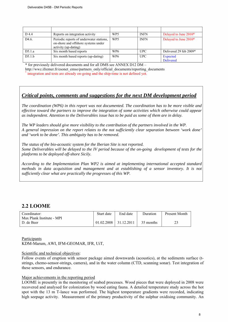
Delivered * for previously delivered documents and for all DMS see ANNEX D12 DM –http://wwz.ifremer.fr/esonet_emso/partners_only/official_documents/reporting_documents * integration and tests are already on-going and the ship-time is not defined yet.
Critical points, comments and suggestions for the next DM development period The coordination (WP6) in this report was not documented. The coordination has to be more visible and effective toward the partners to improve the integration of some activities which otherwise could appear as independent. Attention to the Deliverables issue has to be paid as some of them are in delay. The WP leaders should give more visibility to the contribution of the partners involved in the WP. A general impression on the report relates to the not sufficiently clear separation between ‘work done’ and ‘work to be done’. This ambiguity has to be removed. The status of the bio-acoustic system for the Iberian Site is not reported. Some Deliverables will be delayed to the IV period because of the on-going development of tests for the platforms to be deployed off-shore Sicily. According to the Implementation Plan WP2 is aimed at implementing international accepted standard methods in data acquisition and management and at establishing of a sensor inventory. It is not sufficiently clear what are practically the progresses of this WP. 2.2 LOOME
Participants KDM-Marum, AWI, IFM-GEOMAR, IFR, UiT, Scientific and technical objectives: Follow events of eruption with sensor package aimed downwards (acoustics), at the sediments surface (t-strings, chemo-sensor-strings, camera), and in the water column (CTD, scanning sonar). Test integration of these sensors, and endurance. Major achievements in the reporting period LOOME is presently in the monitoring of seabed processes. Wood pieces that were deployed in 2008 were recovered and analysed for colonization by wood eating fauna. A detailed temperature study across the hot spot with the 13 m T-lance was performed. The highest temperature gradients were recorded, indicating high seepage activity. Measurement of the primary productivity of the sulphur oxidising community. An
Coordinator: Max Plank Institute - MPI D. de Beer
Start date
01.02.2008
End date
31.12.2011
Duration
35 months
Present Month
23
Deliverable D45B - DM Periodic Reports
8
experiment with a photon counter was done, to test the hypothesis that bioluminescence is particularly high near the cold seep. The hypothesis had to be rejected. The recovery cruise is planned for September 2010. WP1 – Seismic detection of eruptive events After the recovery of Aug. 2009 the module was again deployed near an hot sport in opposite position respect to the LOOME frame in September 2009. WP2 - Monitoring of fluid chemistry The sensors were deployed WP3 – Monitoring of physical sediment properties Temperature and pore pressure in the sub-surface and sea bed (resp.: IFM-GEOMAR). The T-lance was redeployed near the hot spot. The temperature lance and the pore-pressure lance were recovered. The temperature lance was re-deployed. Temperature and bottom water pressure sensing systems were integrated into the LOOME frame and deployed as a part of the main observatory module. All sensors were installed at the planned positions at the seafloor. First data was obtained via the ROV using the CLSI. WP4 - Detection and quantification of gas flares. Due to the electronic failure, the sonar is now operating autonomously. The sonar is deployed together with the frame. WP5 - Construction of the central frame/platform Platform is presently operating at seabed WP6 - Underwater communication Not clear status WP7 - Deployment frame COSTOFF is presently operating to acquire T-signals. WP8 - Standardization and interoperability Not documented WP9 - LOOME management Not clear status Deliverables status at 31 Dec. 2009 (month 15)
Deliverable n. Deliverable name Corresponding WP n. Responsible
Institution
Status at 31 Dec. 2009
1 Long-term seismometer 1, 10, 13
UiT
Delivered 29 Feb. 2009 *
2 Long-term chemical sensors (pH, O2, sulfide, redoX)
2
MPI-MM
Delivered 29 Feb. 2009 *
3 Long-term temperature sensors on surface. Temperature and pore pressure in the subsurface seabed 2
IFREMER/IFM-GEOMAR
Delivered 29 Feb. 2009 *
4 Scanning sonar for gas flares detection
4
MARUM Delivered 29 Feb. 2009 *
5 Design of sensor network and 7 MPI Expected
Deliverable D45B - DM Periodic Reports
9
operation platform DELIVERED 6 Deployment and recovery procedures
for instruments and data 8 Marum Expected DELIVERED
7 Design of underwater communication 9
MARUM /Ifremer/UiT
Expected DELIVERED
8 Documentation of inter-operability and standardization 14
MARUM Expected DELIVERED
9 Cruise report Jan Mayen 2008, Polarstern 2009
10
MPI/UiT/Ifremer
Delivered 21 Nov. 2008 * Delivered 5 Feb 2010 *
Critical points, comments and suggestions for the next DM development period End date is over the end of ESONET; it should be reported to 31.10.2010. WP titles are different from the implementation plan and this could cause misunderstanding in the assessment of the work status. It would be advisable to stick to the original titles. The WP description of the status of activities is too synthetic and some time not comprehensible. The reports should be understandable to external readers. WP6 and WP8 (both Responsibility of MARUM) are not documented. According to the implementation plan, WP9 is ‘Management’ while it is referred to as ‘Scientific Report’. Nothing is give about the management status. The deliverable reports should bring on the cover page the title of the deliverables according to the implementation plan to avoid misunderstanding. 2.3 MARMARA-DM
Participants ITU, ISMAR-CNR, INGV, CNRS, DEU/IMAST Scientific and technical objectives: The goal of MARMARA-DM is to contribute to the establishment of optimized permanent seafloor observatory stations for earthquake monitoring in the Marmara Sea (MS) and investigate the submarine segment of the North Anatolia Fault with respect to fluids and seismicity possible relation. Major achievements in the reporting period MARMARA-DM has been performing seafloor and ship-based data acquisition of multiple masurements in time (time-series) and space (bathymetry).
Coordinator: IFR – Ifremer L. Geli
Start date
01.04.2008
End date
30.09.2010
Duration
30 months
Present Month
22
Deliverable D45B - DM Periodic Reports
10
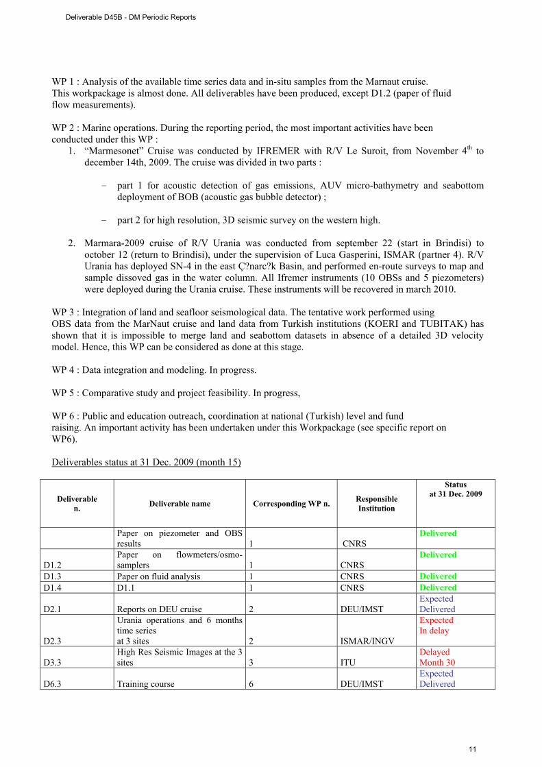
WP 1 : Analysis of the available time series data and in-situ samples from the Marnaut cruise. This workpackage is almost done. All deliverables have been produced, except D1.2 (paper of fluid flow measurements). WP 2 : Marine operations. During the reporting period, the most important activities have been conducted under this WP :
1. “Marmesonet” Cruise was conducted by IFREMER with R/V Le Suroit, from November 4th to december 14th, 2009. The cruise was divided in two parts :
- part 1 for acoustic detection of gas emissions, AUV micro-bathymetry and seabottom deployment of BOB (acoustic gas bubble detector) ;
- part 2 for high resolution, 3D seismic survey on the western high.
2. Marmara-2009 cruise of R/V Urania was conducted from september 22 (start in Brindisi) to
october 12 (return to Brindisi), under the supervision of Luca Gasperini, ISMAR (partner 4). R/V Urania has deployed SN-4 in the east Ç?narc?k Basin, and performed en-route surveys to map and sample dissoved gas in the water column. All Ifremer instruments (10 OBSs and 5 piezometers) were deployed during the Urania cruise. These instruments will be recovered in march 2010.
WP 3 : Integration of land and seafloor seismological data. The tentative work performed using OBS data from the MarNaut cruise and land data from Turkish institutions (KOERI and TUBITAK) has shown that it is impossible to merge land and seabottom datasets in absence of a detailed 3D velocity model. Hence, this WP can be considered as done at this stage. WP 4 : Data integration and modeling. In progress. WP 5 : Comparative study and project feasibility. In progress, WP 6 : Public and education outreach, coordination at national (Turkish) level and fund raising. An important activity has been undertaken under this Workpackage (see specific report on WP6). Deliverables status at 31 Dec. 2009 (month 15)
Deliverable n. Deliverable name Corresponding WP n. Responsible
Institution
Status at 31 Dec. 2009
Paper on piezometer and OBS results 1 CNRS
Delivered
D1.2 Paper on flowmeters/osmo-samplers 1 CNRS
Delivered
D1.3 Paper on fluid analysis 1 CNRS Delivered D1.4 D1.1 1 CNRS Delivered
D2.1 Reports on DEU cruise 2 DEU/IMST Expected Delivered
D2.3
Urania operations and 6 months time series at 3 sites 2 ISMAR/INGV
Expected In delay
D3.3 High Res Seismic Images at the 3 sites 3 ITU
Delayed Month 30
D6.3 Training course 6 DEU/IMST Expected Delivered
Deliverable D45B - DM Periodic Reports
11
Critical points, comments and suggestions for the next DM development period The report is detailed and the activities are very well documented as well as the resources (man-power and funds). The deliverables have to be identified according to the implementation plan while they are often submitted without the correct title or identification number. This can cause misunderstandings. The DM is expected to give very interesting results. 2.4 MOMAR-D
Participants DOP/UAÇ, FFCUL/CGUL, IPGP, NOC, CNRS – F, CNRS – C, Univ. Bremen, Ifremer, SOPAB Scientific and technical objectives: To study the temporal variability of active processes such as hydro-thermalism, ecosystem dynamics, volcanism, seismicity and ground deformation, in order to constrain the dynamics of mid-ocean ridge hydrothermal ecosystems.To deploy a multidisciplinary acoustically linked observing system, with satellite connection to shore. To demonstrate the overall management of this system during 1 month even if its operation will actually continue during 12 months. Major achievements in the reporting period Wp1, WP2, Wp7 seem to be the presently active WPs. The cruise is now scheduled in September 2010, on the Pourquoi pas ? with the ROV Victor 6000. Due to logistic constraints of the fleet, the duration of the first cruise was reduced from 19 to 13 days to implement the observatory infrastructure on Lucky Strike. After the meeting in Brest in March 2009 and the final definition of the observatory, this period was used to start the technological work. The design and building of the sensors and nodes is in progress as well as the software adaptation of the sensors to the SEAMON technology. The objective is to start the trial step in Brest in Spring 2010. Shipping is planned during Summer 2010. In parallel, a draft of the data management policy is circulating among the partners (see draft of D3). The MoMAR-D project was presented during the 4th International symposium on Chemosynthetic Based Ecosystems in Okinawa (Jpn), the ESONET All region workshop in Paris, the ESONET Best practices workshop in Brest and the Ocean Biology Observatory Workshop in Mestre (It). The next 6 month period will be devoted to the on shore integration and trial of the system in Ifremer in Spring 2010. D3 and D4 will be finalized before the cruise. The cruise preparation reports (Agreement to work in the Portuguese waters and Technological description of the cruise) will be delivered to the French Fleet in March 2010.
Coordinator: IFR – Ifremer P.-M. Sarradin
Start date
01.09.2008
End date
30.09.2010
Duration
24 months
Present Month
16
Deliverable D45B - DM Periodic Reports
12
Deliverables status at 31 Dec. 2009 (month 15)
Deliverable Name WP Lead contractor STATUS D1 Cruise proposal submission WP6 M. Cannat (P#3) J.
Blandin and P.M. Sarradin (P#7)
DELIVERED
D2 Report Description of the operational system : interface specifications, sensors, localisation
WP2 J. Blandin (P#7) Delivered
D3 Signed agreement Data management policy
WP3
T. Carval (P#7) Delayed 07/2010
D4 Communication plan WP5
J. Sarrazin (P#7) Delayed 07/2010
D5 On shore integration and test report WP2
J. Blandin (P#7) Delayed 06/2010
Critical points, comments and suggestions for the next DM development period Some parts of the periodic report do not follow the requested template and this cause lack of clarity with respect to the work done. The description of the activity is not clear when compared to the original implementation plan and some parts are too generic. The WP leaders has to make a larger effort of synthesis instead of reporting the individual contribution of each partner. The coordination has to be stronger in order to favour an actual integration of the partners. The DM is affected by a significant delayed that according to the report should be recovered in 2010. A check is necessary on the next six-month report. 2.5 MODOO
Participants: NERC-NOCS, IM, NIOZ, UniAbdn, AWI Scientific and technical Objectives: This DM will demonstrate the functioning of a Modular and mObile Deep Ocean Observatory (MODOO) with real-time data access. The MODOO concept is that of linking and operating stand-alone observatory modules (lander, mooring) in such a way that they merge into a single observatory. The MODOO concept shall be applicable to any non-cabled environment as well as to link non-cabled with a cables site. Major achievements in the reporting period The first 8 month of the DM have been concentrated on outlying and building the hardware, in particular the Data Collection and Dissemination (DCD) node that connect lander and mooring. This activity is still
Coordinator: IFM-GEOMAR J. Karstensen
Start date
01.05.2009
End date
30.09.2010
Duration
17 months
Present Month
8
Deliverable D45B - DM Periodic Reports
13
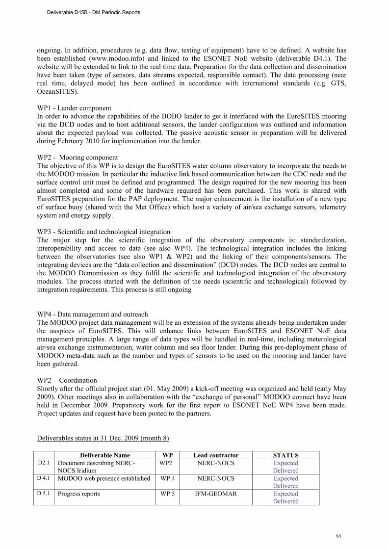
ongoing. In addition, procedures (e.g. data flow, testing of equipment) have to be defined. A website has been established (www.modoo.info) and linked to the ESONET NoE website (deliverable D4.1). The website will be extended to link to the real time data. Preparation for the data collection and dissemination have been taken (type of sensors, data streams expected, responsible contact). The data processing (near real time, delayed mode) has been outlined in accordance with international standards (e.g. GTS, OceanSITES). WP1 - Lander component In order to advance the capabilities of the BOBO lander to get it interfaced with the EuroSITES mooring via the DCD nodes and to host additional sensors, the lander configuration was outlined and information about the expected payload was collected. The passive acoustic sensor in preparation will be delivered during February 2010 for implementation into the lander. WP2 - Mooring component The objective of this WP is to design the EuroSITES water column observatory to incorporate the needs to the MODOO mission. In particular the inductive link based communication between the CDC node and the surface control unit must be defined and programmed. The design required for the new mooring has been almost completed and some of the hardware required has been purchased. This work is shared with EuroSITES preparation for the PAP deployment. The major enhancement is the installation of a new type of surface buoy (shared with the Met Office) which host a variety of air/sea exchange sensors, telemetry system and energy supply. WP3 - Scientific and technological integration The major step for the scientific integration of the observatory components is: standardization, interoperability and access to data (see also WP4). The technological integration includes the linking between the observatories (see also WP1 & WP2) and the linking of their components/sensors. The integrating devices are the “data collection and dissemination” (DCD) nodes. The DCD nodes are central to the MODOO Demomission as they fulfil the scientific and technological integration of the observatory modules. The process started with the definition of the needs (scientific and technological) followed by integration requirements. This process is still ongoing WP4 - Data management and outreach The MODOO project data management will be an extension of the systems already being undertaken under the auspices of EuroSITES. This will enhance links between EuroSITES and ESONET NoE data management principles. A large range of data types will be handled in real-time, including meterological air/sea exchange instrumentation, water column and sea floor lander. During this pre-deployment phase of MODOO meta-data such as the number and types of sensors to be used on the mooring and lander have been gathered. WP2 - Coordination Shortly after the official project start (01. May 2009) a kick-off meeting was organized and held (early May 2009). Other meetings also in collaboration with the “exchange of personal” MODOO connect have been held in December 2009. Preparatory work for the first report to ESONET NoE WP4 have been made. Project updates and request have been posted to the partners. Deliverables status at 31 Dec. 2009 (month 8)
Deliverable Name WP Lead contractor STATUS D2.1 Document describing NERC-
NOCS Iridium WP2 NERC-NOCS Expected
Delivered D 4.1
MODOO web presence established
WP 4 NERC-NOCS Expected
Delivered D 5.1
Progress reports
WP 5 IFM-GEOMAR Expected Delivered
Deliverable D45B - DM Periodic Reports
14

Critical points, comments and suggestions for the next DM development period The report, despite of an error of paging, is very clear and accurate and account for the major activities and achievements of the DM. In particular the achievements are given in a very assessable way through time-line and tables clear updating. Some delay have been reported, justified and corrective action have been identified. 2.6 AOEM
Participants: AWI, FoRTH, Leibniz Institute of Marine Sciences, Nansen Environmental and Remote Sensing Center, UiT Scientific and technical Objectives: Demonstrate and deploy observatory lander technology for dissociating hydrate studies in high-latitude, but warming Arctic Ocean shelf sites. Design and evaluate data acquisition and real-time transmission methodologies for Fram Strait oceanography, including an acoustic network for future ocean tomography and glider navigation and docking. Develop the scientific and policy case for the Arctic ESONET site to become a sustained cabled observatory network within ESONET / EMSO initiatives, and Norwegian SIAOS and EU ESFRI programmes. Major achievements in the reporting period Although some activities have been started by the partners of this DM, the workplan reports the starting of the activity by January 2010 when the problems related to the agreement on the arrangement of some parts of the Grant Agreement between the DM partnership and the ESONET Coordiator are expected to be completed. Deliverables status at 31 Dec. 2009 (month 15) The deliverables issue is foreseen starting from May2010. Critical points, cComments and suggestions for the next DM development period Because of the early stage of the DM, comments and suggestion are not applicable. The recommendation is however that the formalities within ESONET NoE be completed soon to allow the DM to have its course and be completed in due time.
Coordinator: NERC-NOCS I. Wright
Start date
01.07.2009
End date
31.10.2010
Duration
16 months
Present Month
8
Deliverable D45B - DM Periodic Reports
15
Conclusions Three sea experiment are running within LIDO, LOOME and MARMARA Demo Missions. Three experiments are in preparation for the 2010 within MOMAR, MODOO and AOEM. The next 6 months will be important to check the tipology and quality of the data acquired and the data management by the running experiments and to verify the work of preparation and the actual cruise plan for the foreseen experiments. While some of the DMs (Marmara and MODOO) are well documented and the work is easily assessable, for other DMs, such as LIDO LOOME and MOMAR, a major effort has to be in this sense. Deliverables have to issue in agreement to the implementation plan and eventual delay have to be explained and the new delivery dates indicated. In addition, the deliverables have to be clearly indicated with the title and identification number reported in the original implementation plan to avoid misunderstanding. For MOMAR and AOEM the next months will be crucial to check the achievement of the implementation plan within October 2010.
Deliverable D45B - DM Periodic Reports
16
ANNEX – DM Periodic Reports
Deliverable D45B - DM Periodic Reports
17

Deliverable D45B - DM Periodic Reports
18

Project contract no. 036851
ESONET
European Seas Observatory Network
Instrument: Network of Excellence (NoE) Thematic Priority: 1.1.6.3 – Climate Change and Ecosystems
Sub Priority: III – Global Change and Ecosystems
LIDO Demonstration Mission Periodic Reports
Start date of project: March 2007 Duration: 48 months Start date of the Demonstration Mission: September 2008 Duration: 24 months Project co-funded by the European Commission within the Sixth Framework Programme (2002-2006) Dissemination Level PU Public PP Restricted to other programme participants (including the Commission Services RE Restricted to a group specified by the consortium (including the Commission
Services)
CO Confidential, only for members of the consortium (including the Commission Services)
Deliverable D45B - LIDO DM Periodic Reports
19

Deliverable D45B - LIDO DM Periodic Reports
20
ESONET Demonstration Missions
1st Periodic Activity Report
The Periodic Activity Report contains an overview of the activities carried out during the reporting period, describes the progress in relation to the project objectives, the progress towards the milestones and deliverables set for the period, and any problems encountered and corrective actions taken. This document has to be filled in with reference to the DM Implementation plan. This means that Deliverables, Milestones and WPs have to be the same as in the DM Implementation plan. The Periodic Report contains 2 parts: - Part I: it is addressed to the coordinator with minimum input from the partners - Part II: it is addressed to each WP Leader and reports a detailed update of each WP activity at task level. The report includes a rough justification of the costs incurred and of the resources deployed by each contractor linking them to activities implemented and justifying their necessity. Finally the report contains information on use and dissemination activities. Reporting period: B.1. September 2008
Deliverable D45B - LIDO DM Periodic Reports
21
Part I DM acronym: LIDO
DM title: LISTENING TO THE DEEP-OCEAN ENVIRONMENT
ESONET Site: EAST-SICILY & GULF OF CADIZ
Scientific Area(s): GEOPHYSICS & BIOACOUSTICS
Technological Area(s): GEOPHYSICS & BIOACOUSTICS
DM Start date: 1 SEPTEMBER 2008
DM duration: 24 MONTHS
Period of the reporting from 1 to 30 September 2008
Partner Num. Partner Institution Name Principal Investigator (PI)
for the Demo Mission
PI coordinates (Address, Email, Telephone, fax..)
1. UPC Universitat Politècnica de Catalunya
Michel André
2. UB* University of Bremen (Marum) Christoph Waldmann waldmann@maru
m.de
3.
FFCUL/ CGUL* Fundação da Faculdade de Ciências da Universidade de Lisboa Centro de Geofísica da Universidade de Lisboa
Jorge Miguel Miranda [email protected]
4. INGV Istituto Nazionale di Geofisica e Vulcanologia
Paolo Favali [email protected]
5. ISMAR Consiglio Nazionale delle Ricerche Istituto Scienze Marine, Dipartimento di Bologna
Nevio Zitellini [email protected]
6. Istituto Nazionale di Fisica Nucleare INFN* Giorgio Riccobene [email protected]
n.it
7.
Consejo Superior de Investigaciones CSIC* Cientificas – Unitat de Tecnologia Marina - Centre Mediterrani d’Investigacions Marines i Ambientals
Juan Josè Danobeitia [email protected]
8. dBScale dBS* Eric Delory [email protected]
9.
Centro Interdisciplinare di Bioacustica e CIBRA Ricerche Ambientali, Università degli Studi di Pavia
Gianni Pavan [email protected]
10. Technische Fachhochschule Berlin -FB VIII TFH* - Maschinenbau, Verfahrens- und Umwelttechnik - AG Tiefseesysteme
Hans W. Gerber
[email protected] [email protected]
Deliverable D45B - LIDO DM Periodic Reports
22
11. Tecnomare-ENI S.p.A. TEC* Francesco Gasparoni francesco.gasparon
[email protected] Executive summary (max one page) LIDO (Listening to the Deep Ocean environment) proposes to establish a first nucleus of a regional network of multidisciplinary seafloor observatorios contributing to the coordination of high quality research in the ESONET NoE by allowing the long-term monitoring of Geohazards and Marine Ambient Noise in the Mediterranean Sea and the adjacent Atlantic waters. Specific activities are addressed to a long-term monitoring of earthquakes and tsunamis and the characterisation of ambient noise induced by marine mammals (Bioacoustics) and anthropogenic noise. The objective of the proposal will be achieved through the extension of the present capabilities of the observatories working in the ESONET key-sites of Eastern Sicily (NEMO-SN1) and of the Gulf of Cadiz (GEOSTAR configured for NEAREST pilot experiment) by installing not-already-included sensor equipments related to Bioacoustics and Geohazards; Scientific Objectives Geo-Hazards: LIDO aims at improving the real-time and near-real-time detection of signals by a multiparameter seafloor observatory network at regional scale for the characterisation of potential tsunamigenic sources. Its methodological approach is based on the cross-checking of geophysical, oceanographic and environmental time series acquired on the seafloor and in the water column. LIDO will provide real-time and nearto-real-time seismological and water-pressure comparative time series from near-shore sources and operational tools (e.g., prototype of tsunameters) integrated in seafloor observation systems, and in the terrestrial Networks LIDO follows the recommendation of the Intergovernmental Coordination Group of the Intergovernmental Oceanographic Commission (UNESCO) for the North-Eastern Atlantic and Mediterranean Tsunami Warning System (ICG/NEAMTWS) for the urgent deployment of a tsunami warning system in the related areas with special regard to the definition of trans-national seismic and sea level monitoring networks. Bioacoustics: LIDO will evaluate the human and natural contributions to marine ambient noise and for the first time describe the long-term trends in ambient Boise levels, especially from human activities (influenced for example by increasing shipping) and in marine mammals populations (migration patterns, presence, and habitat use of key species, like sperm -, fin - and beaked whales). LIDO will allow real-time and near real-time long-term acoustic monitoring of marine mammals at regional level, as well as noise propagation that could be in the next years correlated with the effects of anthropogenic impacts and climate changes, using the same infrastructure defined above. Technological objectives The technological objective of LIDO is the development of the first nucleus of a regional multiparameter seafloor network of homogeneous observatories (same sensors) and its long-term operability beyond the duration of LIDO demo mission in two ESONET key-sites, East Sicily (cabled) and Gulf of Cadiz (acoustically linked with a surface buoy). Table 1: Deliverables List
Deliverable D45B - LIDO DM Periodic Reports
23
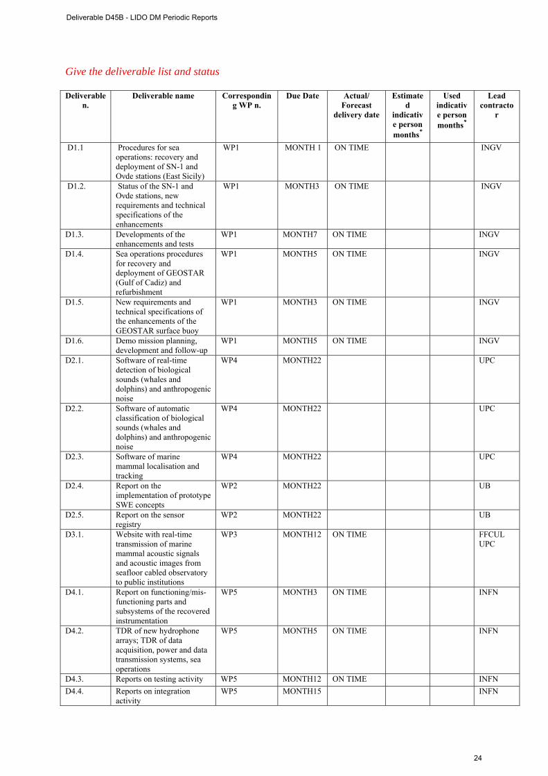
Give the deliverable list and status Deliverable
n. Deliverable name Correspondin
g WP n. Due Date Actual/
Forecast delivery date
Estimated
indicative person months*
Used indicative person months*
Lead contracto
r
D1.1 Procedures for sea operations: recovery and deployment of SN-1 and Oνde stations (East Sicily)
WP1 MONTH 1 ON TIME INGV
D1.2. Status of the SN-1 and Oνde stations, new requirements and technical specifications of the enhancements
WP1 MONTH3 ON TIME INGV
D1.3. Developments of the enhancements and tests
WP1 MONTH7 ON TIME INGV
D1.4. Sea operations procedures for recovery and deployment of GEOSTAR (Gulf of Cadiz) and refurbishment
WP1 MONTH5 ON TIME INGV
D1.5. New requirements and technical specifications of the enhancements of the GEOSTAR surface buoy
WP1 MONTH3 ON TIME INGV
D1.6. Demo mission planning, development and follow-up
WP1 MONTH5 ON TIME INGV
D2.1. Software of real-time detection of biological sounds (whales and dolphins) and anthropogenic noise
WP4 MONTH22 UPC
D2.2. Software of automatic classification of biological sounds (whales and dolphins) and anthropogenic noise
WP4 MONTH22 UPC
D2.3. Software of marine mammal localisation and tracking
WP4 MONTH22 UPC
D2.4. Report on the implementation of prototype SWE concepts
WP2 MONTH22 UB
D2.5. Report on the sensor registry
WP2 MONTH22 UB
D3.1. Website with real-time transmission of marine mammal acoustic signals and acoustic images from seafloor cabled observatory to public institutions
WP3 MONTH12 ON TIME FFCUL UPC
D4.1. Report on functioning/mis-functioning parts and subsystems of the recovered instrumentation
WP5 MONTH3 ON TIME INFN
D4.2. TDR of new hydrophone arrays; TDR of data acquisition, power and data transmission systems, sea operations
WP5 MONTH5 ON TIME INFN
D4.3. Reports on testing activity WP5 MONTH12 ON TIME INFN D4.4. Reports on integration
activity WP5 MONTH15 INFN
Deliverable D45B - LIDO DM Periodic Reports
24
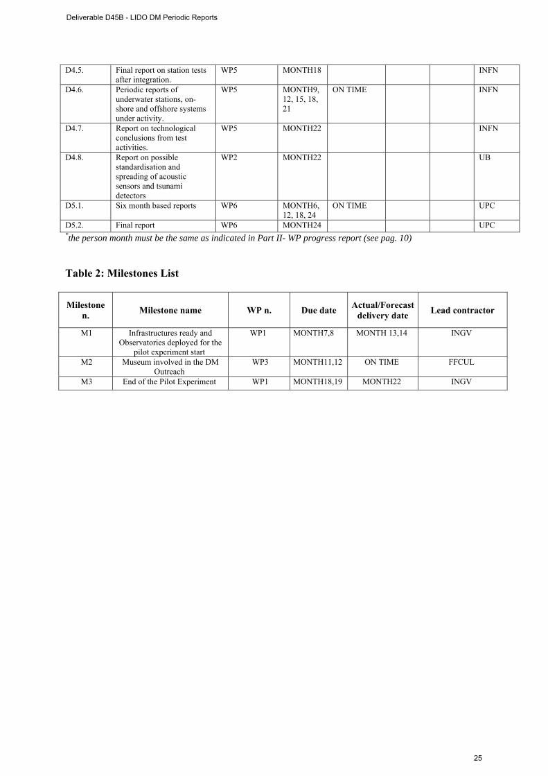
D4.5. Final report on station tests after integration.
WP5 MONTH18 INFN
D4.6. Periodic reports of underwater stations, on-shore and offshore systems under activity.
WP5 MONTH9, 12, 15, 18, 21
ON TIME INFN
D4.7. Report on technological conclusions from test activities.
WP5 MONTH22 INFN
D4.8. Report on possible standardisation and spreading of acoustic sensors and tsunami detectors
WP2 MONTH22 UB
D5.1. Six month based reports WP6 MONTH6, 12, 18, 24
ON TIME UPC
D5.2. Final report WP6 MONTH24 UPC *the person month must be the same as indicated in Part II- WP progress report (see pag. 10)
Table 2: Milestones List
Milestone n. Milestone name WP n. Due date Actual/Forecast
delivery date Lead contractor
M1 Infrastructures ready and Observatories deployed for the
pilot experiment start
WP1 MONTH7,8 MONTH 13,14 INGV
M2 Museum involved in the DM Outreach
WP3 MONTH11,12 ON TIME FFCUL
M3 End of the Pilot Experiment WP1 MONTH18,19 MONTH22 INGV
Deliverable D45B - LIDO DM Periodic Reports
25
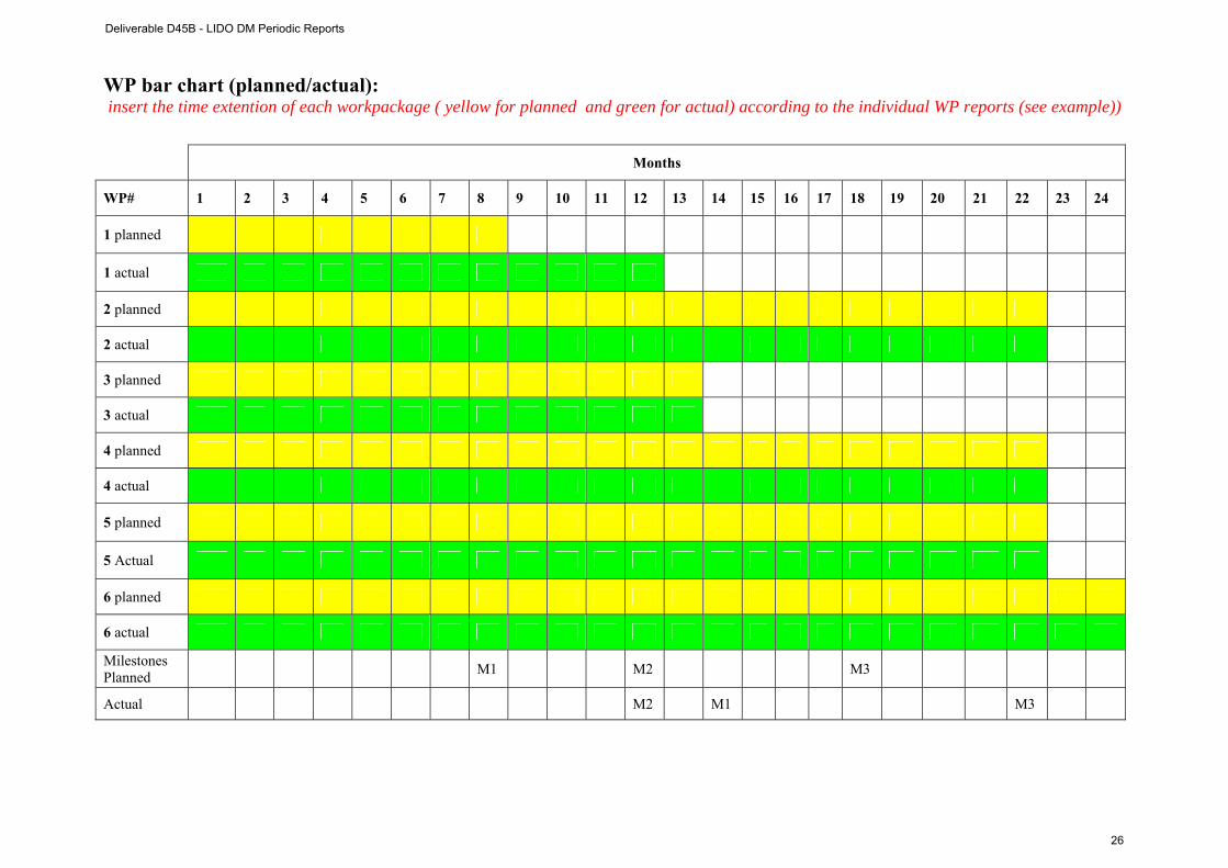
WP bar chart (planned/actual): insert the time extention of each workpackage ( yellow for planned and green for actual) according to the individual WP reports (see example))
Months
WP# 1 2 3 4 5 6 7 8 9 10 11 12 13 14 15 16 17 18 19 20 21 22 23 24
1 planned
1 actual
2 planned
2 actual
3 planned
3 actual
4 planned
4 actual
5 planned
5 Actual
6 planned
6 actual
Milestones Planned M1 M2 M3
Actual M2 M1 M3
Deliverable D45B - LIDO DM Periodic Reports
26

1 s t P e r i o d i c R e p o r t E S O N E T N o E - LIDO
Link with ESONET main activities: please update the dates and contents of the foreseen activities
Inputs to the DM from ESONET WPs :
Expected period mm/yy
Actual period mm/yy
Comments
WP1 01/06/2009 31/12/2009 Activity 1a4 Activity 1b4, 1b5 Task d: LIDO is currently collaborating with NEPTUNE and VENUS to implement in Canada the LIDO RT analysis softwares.
WP2 01/10/2008 31/03/2010 Activities 2b2, 2a2, 2b3, 2c2 WP3 Activities 3a1, 3a2, 3a3 WP4 01/09/2008 31/05/2010 Activities LIDO 1-5 WP5 Task b: LIDO is particularly
sensitive on the effects of noise on marine organisms and will participate in the development and approval of ethical guidelines and procedures. This latter point constitutes a major criteria to award the ESONET LABEL to the observatories.
WP6 Activity 6a2 Activity 6b1, 6b2
WP7 Task a, b & c
Outputs to ESONET WPs :
Starting date: dd/mm/yy
Ending date: dd/mm/yy
Comments
WP4 - Deliverable D12 01/09/2008 31/01/2009 18 month WP3 - Deliverable D13 01/09/2008 31/01/2009 18 month WP6 - Deliverable D15 01/09/2008 31/01/2009 18month WP7 - Deliverable D18 01/09/2008 31/01/2009 18 month WP1 - Deliverable D19 01/09/2008 31/01/2009 18 month WP8 - Deliverable D29 01/09/2008 - 12,24,36,48 months
Deliverable D45B - LIDO DM Periodic Reports
27

1 s t P e r i o d i c R e p o r t E S O N E T N o E - LIDO
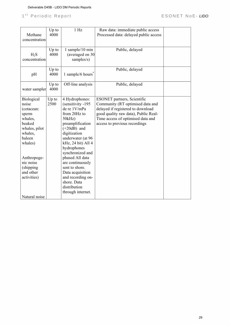
B.1.1.1. Sensors & data management plan: please update the following table: follow the guidelines issued from the ESONET Best Practice workshop
Measured parameters
Depth Sampling/storage/acquisition frequency
Access restriction / unrestriction (esonet partners, public, immediately or delayed, to raw data, processed data …) please note that EC ask Esonet community to provide data in easy and free access
comments
three-
component ground velocity
Up to 4000
20 ÷ 100 Hz Raw data: immediate public access Processed data: delayed public access
Pressure
perturbations in water
Up to 4000
80 ÷ 100 Hz
Raw data: immediate public access Processed data: delayed public access
gravity acceleration
Up to 4000
0.01 ÷ 1 Hz
Raw data: immediate public access Processed data: delayed public access
magnetic
field (scalar and three
components)
Up to 4000
1 sample/min
1 sample/s
Raw data: immediate public access Processed data: delayed public access
Seafloor
water current (three
components)
Up to 4000
2 Hz
Raw data: immediate public access Processed data: delayed public access
ADCP
Up to 4000
Raw data: immediate public access Processed data: delayed public access
Light
transmission
Up to 4000
1 sample/hour
Raw data: immediate public access Processed data: delayed public access
Conductivity
Up to 4000
1 sample/10 min (or 1 sample/hour)
Raw data: immediate public access Processed data: delayed public access
Temperature Up to 4000
1 sample/10 min (or 1 sample/hour)
Raw data: immediate public access Processed data: delayed public access
Static Pressure
Up to 4000
1 sample/10 min (or 1 sample/hour)
Raw data: immediate public access Processed data: delayed public access
Deliverable D45B - LIDO DM Periodic Reports
28
1 s t P e r i o d i c R e p o r t E S O N E T N o E - LIDO
Methane
concentration
Up to 4000
1 Hz Raw data: immediate public access Processed data: delayed public access
H2S
concentration
Up to 4000
1 sample/10 min (averaged on 30
samples/s)
Public, delayed
pH
Up to 4000
1 sample/6 hours*
Public, delayed
water sampler
Up to 4000
Off-line analysis Public, delayed
Biological noise (cetacean: sperm whales, beaked whales, pilot whales, baleen whales) Anthropoge-nic noise (shipping and other activities) Natural noise
Up to 2500
4 Hydrophones: (sensitivity -195 de re 1V/mPa from 20Hz to 50kHz) preamplification (+20dB) and digitization underwater (at 96 kHz, 24 bit) All 4 hydrophones synchronized and phased All data are continuously sent to shore. Data acquisition and recording on-shore. Data distribution through internet.
ESONET partners, Scientific Community (RT optimised data and delayed if registered to download good quality raw data), Public Real-Time access of optimised data and access to previous recordings
Deliverable D45B - LIDO DM Periodic Reports
29
1 s t P e r i o d i c R e p o r t E S O N E T N o E - LIDO
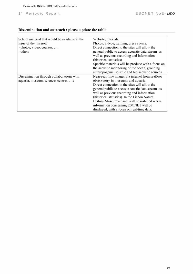
Dissemination and outreach : please update the table School material that would be available at the issue of the mission: -photos, video, courses, … -others
Website, tutorials, Photos, videos, training, press events. Direct connection to the sites will allow the general public to access acoustic data stream as well as previous recording and information (historical statistics) Specific materials will be produce with a focus on the acoustic monitoring of the ocean, grouping anthropogenic, seismic and bio acoustic sources
Dissemination through collaborations with aquaria, museum, sciences centres, …?
Near-real time images via internet from seafloor observatory in museums and aquaria. Direct connection to the sites will allow the general public to access acoustic data stream as well as previous recording and information (historical statistics). In the Lisbon Natural History Museum a panel will be installed where information concerning ESONET will be displayed, with a focus on real-time data.
Deliverable D45B - LIDO DM Periodic Reports
30
1 s t P e r i o d i c R e p o r t E S O N E T N o E - LIDO
Part II DM acronym: LIDO
Scientific Area(s): GEOPHYSISCS & BIOACOUSTICS
Technological Area(s): GEOPHYSISCS & BIOACOUSTICS
DM Start date: 01/09/2008
DM duration: 24 MONTHS
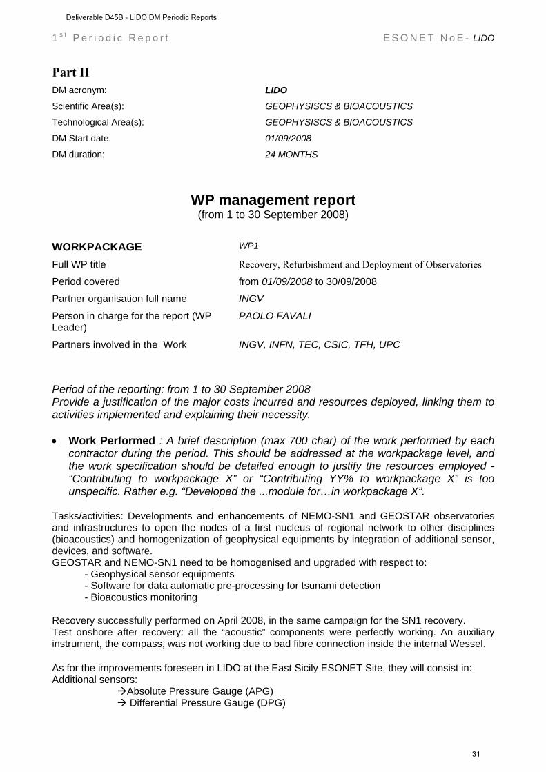
WP management report (from 1 to 30 September 2008)
WORKPACKAGE WP1 Full WP title Recovery, Refurbishment and Deployment of Observatories Period covered from 01/09/2008 to 30/09/2008
Partner organisation full name INGV Person in charge for the report (WP Leader)
PAOLO FAVALI
Partners involved in the Work INGV, INFN, TEC, CSIC, TFH, UPC
Period of the reporting: from 1 to 30 September 2008 Provide a justification of the major costs incurred and resources deployed, linking them to activities implemented and explaining their necessity. • Work Performed : A brief description (max 700 char) of the work performed by each
contractor during the period. This should be addressed at the workpackage level, and the work specification should be detailed enough to justify the resources employed - “Contributing to workpackage X” or “Contributing YY% to workpackage X” is too unspecific. Rather e.g. “Developed the ...module for…in workpackage X”.
Tasks/activities: Developments and enhancements of NEMO-SN1 and GEOSTAR observatories and infrastructures to open the nodes of a first nucleus of regional network to other disciplines (bioacoustics) and homogenization of geophysical equipments by integration of additional sensor, devices, and software. GEOSTAR and NEMO-SN1 need to be homogenised and upgraded with respect to: - Geophysical sensor equipments - Software for data automatic pre-processing for tsunami detection - Bioacoustics monitoring Recovery successfully performed on April 2008, in the same campaign for the SN1 recovery. Test onshore after recovery: all the “acoustic” components were perfectly working. An auxiliary instrument, the compass, was not working due to bad fibre connection inside the internal Wessel. As for the improvements foreseen in LIDO at the East Sicily ESONET Site, they will consist in: Additional sensors: Absolute Pressure Gauge (APG) Differential Pressure Gauge (DPG)
Deliverable D45B - LIDO DM Periodic Reports
31
1 s t P e r i o d i c R e p o r t E S O N E T N o E - LIDO
Acoustics Doppler Current Profiler (ADCP) Fluxgate magnetometer High sampling hydrophones for Bioacoustics - Data acquisition and automatic processing at seafloor: data digitalisation for seismological sensor package (seismometers + hydrophones) on land: time series synchronisation + overall data acquisition + Tsunami detection algorithm + RT acoustic data management • Rough Estimation of Major Cost: Explanatory note on any major cost roughly
estimated of items such as major travel costs, large consumable items etc., justifying their necessity to the project.
• Overview of the Actual Costs, by major cost item including personnel (fill in the Table
here below)
Type of expenditure
Actual costs( Euro) First period
Total person-months Personnel costs Subcontracting Travels Consumables Other costs
Total Costs WORKPACKAGE WP2 Full WP title Standardisation and spreading of acoustic sensors and tsunami
detectors Period covered from 01/09/2008 to 30/09/2008
Partner organisation full name UB Person in charge for the report (WP Leader)
CHRISTOPH WALDMANN
Partners involved in the Work UB, DBSCALE
Period of the reporting: from 1 to 30 September 2008 Provide a justification of the major costs incurred and resources deployed, linking them to activities implemented and explaining their necessity. • Work Performed : A brief description (max 700 char) of the work performed by each
contractor during the period. This should be addressed at the workpackage level, and the work specification should be detailed enough to justify the resources employed -
Deliverable D45B - LIDO DM Periodic Reports
32
1 s t P e r i o d i c R e p o r t E S O N E T N o E - LIDO
“Contributing to workpackage X” or “Contributing YY% to workpackage X” is too unspecific. Rather e.g. “Developed the ...module for…in workpackage X”.
In LIDO observatories, as well as for ESONET observatories at large, the Data Management workpackage partners have focused on identifying primary hotspots for interoperability, at the physical interfacing layer and at the data access and presentation layer. So, here we will also give a primary set of possible standard solutions. It is thought prioritary to focus the effort for the implementation of interoperability concepts: at the physical layer sensor interface, at the main station’s data servers, and in the encoding of hydrophones in standard format. The latter will imply agreement on a common vocabulary for ocean acoustic sensors and the contribution to and collaboration with ocean-related ontology initiatives One approach consists in opening a local directory to the public with a catalog service available and standard data and metadata formats. It is rather proven approach for data servers, and as a generic approach it lacks the specificities that ocean observatories may call for. For example there is no protocol companion for sensor control (it is about data and data only). Approach B, which is currently evolving (these standards have been recently fully-approved), answers a broader set of needs although due to its rather recent release it is more complex and risky to implement. One neat advantage as regards the sensor web approach is that it will evolve in close collaboration with the ocean community and ESONET is already contributing actively to its development. WORKPACKAGE WP3
Full WP title Public Outreach Period covered from 01/09/2008 to 30/09/2008 Partner organisation full name FFCUL
Person in charge for the report (WP Leader)
JORGE MIGUEL MIRANDA
Partners involved in the Work UPC
Period of the reporting: from 1 to 30 September 2008 Provide a justification of the major costs incurred and resources deployed, linking them to activities implemented and explaining their necessity. • Work Performed : A brief description (max 700 char) of the work performed by each
contractor during the period. This should be addressed at the workpackage level, and the work specification should be detailed enough to justify the resources employed - “Contributing to workpackage X” or “Contributing YY% to workpackage X” is too unspecific. Rather e.g. “Developed the ...module for…in workpackage X”.
WORKPACKAGE
WP4
Full WP title RT Software Development
Deliverable D45B - LIDO DM Periodic Reports
33
1 s t P e r i o d i c R e p o r t E S O N E T N o E - LIDO
Period covered from 01/09/2008 to 30/09/2008
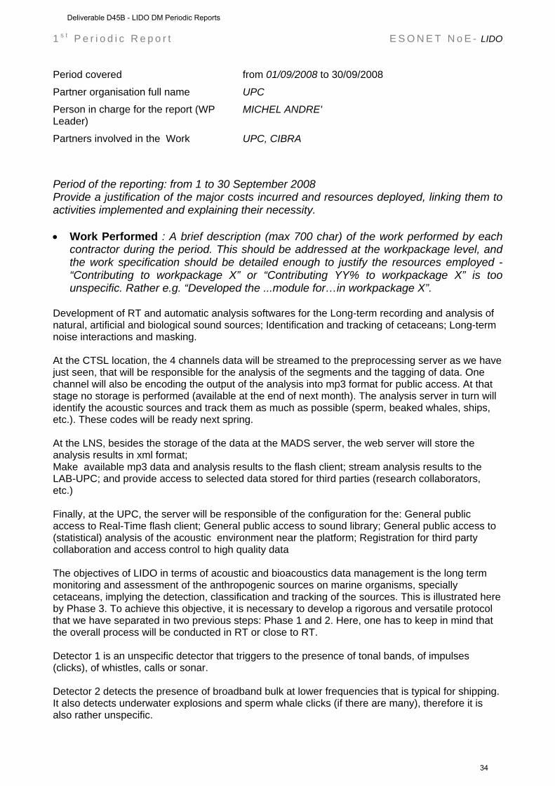
Partner organisation full name UPC Person in charge for the report (WP Leader)
MICHEL ANDRE'
Partners involved in the Work UPC, CIBRA
Period of the reporting: from 1 to 30 September 2008 Provide a justification of the major costs incurred and resources deployed, linking them to activities implemented and explaining their necessity. • Work Performed : A brief description (max 700 char) of the work performed by each
contractor during the period. This should be addressed at the workpackage level, and the work specification should be detailed enough to justify the resources employed - “Contributing to workpackage X” or “Contributing YY% to workpackage X” is too unspecific. Rather e.g. “Developed the ...module for…in workpackage X”.
Development of RT and automatic analysis softwares for the Long-term recording and analysis of natural, artificial and biological sound sources; Identification and tracking of cetaceans; Long-term noise interactions and masking. At the CTSL location, the 4 channels data will be streamed to the preprocessing server as we have just seen, that will be responsible for the analysis of the segments and the tagging of data. One channel will also be encoding the output of the analysis into mp3 format for public access. At that stage no storage is performed (available at the end of next month). The analysis server in turn will identify the acoustic sources and track them as much as possible (sperm, beaked whales, ships, etc.). These codes will be ready next spring. At the LNS, besides the storage of the data at the MADS server, the web server will store the analysis results in xml format; Make available mp3 data and analysis results to the flash client; stream analysis results to the LAB-UPC; and provide access to selected data stored for third parties (research collaborators, etc.) Finally, at the UPC, the server will be responsible of the configuration for the: General public access to Real-Time flash client; General public access to sound library; General public access to (statistical) analysis of the acoustic environment near the platform; Registration for third party collaboration and access control to high quality data The objectives of LIDO in terms of acoustic and bioacoustics data management is the long term monitoring and assessment of the anthropogenic sources on marine organisms, specially cetaceans, implying the detection, classification and tracking of the sources. This is illustrated here by Phase 3. To achieve this objective, it is necessary to develop a rigorous and versatile protocol that we have separated in two previous steps: Phase 1 and 2. Here, one has to keep in mind that the overall process will be conducted in RT or close to RT. Detector 1 is an unspecific detector that triggers to the presence of tonal bands, of impulses (clicks), of whistles, calls or sonar. Detector 2 detects the presence of broadband bulk at lower frequencies that is typical for shipping. It also detects underwater explosions and sperm whale clicks (if there are many), therefore it is also rather unspecific.
Deliverable D45B - LIDO DM Periodic Reports
34
1 s t P e r i o d i c R e p o r t E S O N E T N o E - LIDO
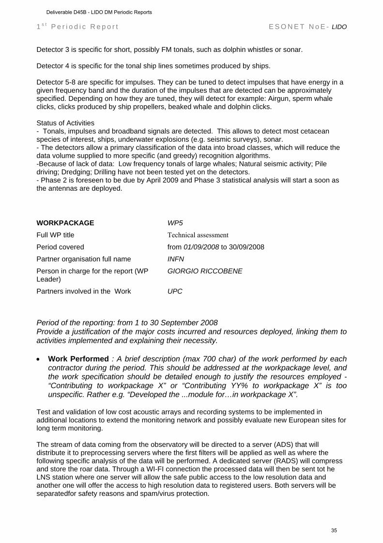
Detector 3 is specific for short, possibly FM tonals, such as dolphin whistles or sonar. Detector 4 is specific for the tonal ship lines sometimes produced by ships. Detector 5-8 are specific for impulses. They can be tuned to detect impulses that have energy in a given frequency band and the duration of the impulses that are detected can be approximately specified. Depending on how they are tuned, they will detect for example: Airgun, sperm whale clicks, clicks produced by ship propellers, beaked whale and dolphin clicks. Status of Activities - Tonals, impulses and broadband signals are detected. This allows to detect most cetacean species of interest, ships, underwater explosions (e.g. seismic surveys), sonar. - The detectors allow a primary classification of the data into broad classes, which will reduce the data volume supplied to more specific (and greedy) recognition algorithms. -Because of lack of data: Low frequency tonals of large whales; Natural seismic activity; Pile driving; Dredging; Drilling have not been tested yet on the detectors. - Phase 2 is foreseen to be due by April 2009 and Phase 3 statistical analysis will start a soon as the antennas are deployed. WORKPACKAGE WP5 Full WP title Technical assessment Period covered from 01/09/2008 to 30/09/2008
Partner organisation full name INFN Person in charge for the report (WP Leader)
GIORGIO RICCOBENE
Partners involved in the Work UPC
Period of the reporting: from 1 to 30 September 2008 Provide a justification of the major costs incurred and resources deployed, linking them to activities implemented and explaining their necessity. • Work Performed : A brief description (max 700 char) of the work performed by each
contractor during the period. This should be addressed at the workpackage level, and the work specification should be detailed enough to justify the resources employed - “Contributing to workpackage X” or “Contributing YY% to workpackage X” is too unspecific. Rather e.g. “Developed the ...module for…in workpackage X”.
Test and validation of low cost acoustic arrays and recording systems to be implemented in additional locations to extend the monitoring network and possibly evaluate new European sites for long term monitoring. The stream of data coming from the observatory will be directed to a server (ADS) that will distribute it to preprocessing servers where the first filters will be applied as well as where the following specific analysis of the data will be performed. A dedicated server (RADS) will compress and store the roar data. Through a WI-FI connection the processed data will then be sent tot he LNS station where one server will allow the safe public access to the low resolution data and another one will offer the access to high resolution data to registered users. Both servers will be separatedfor safety reasons and spam/virus protection.
Deliverable D45B - LIDO DM Periodic Reports
35
1 s t P e r i o d i c R e p o r t E S O N E T N o E - LIDO
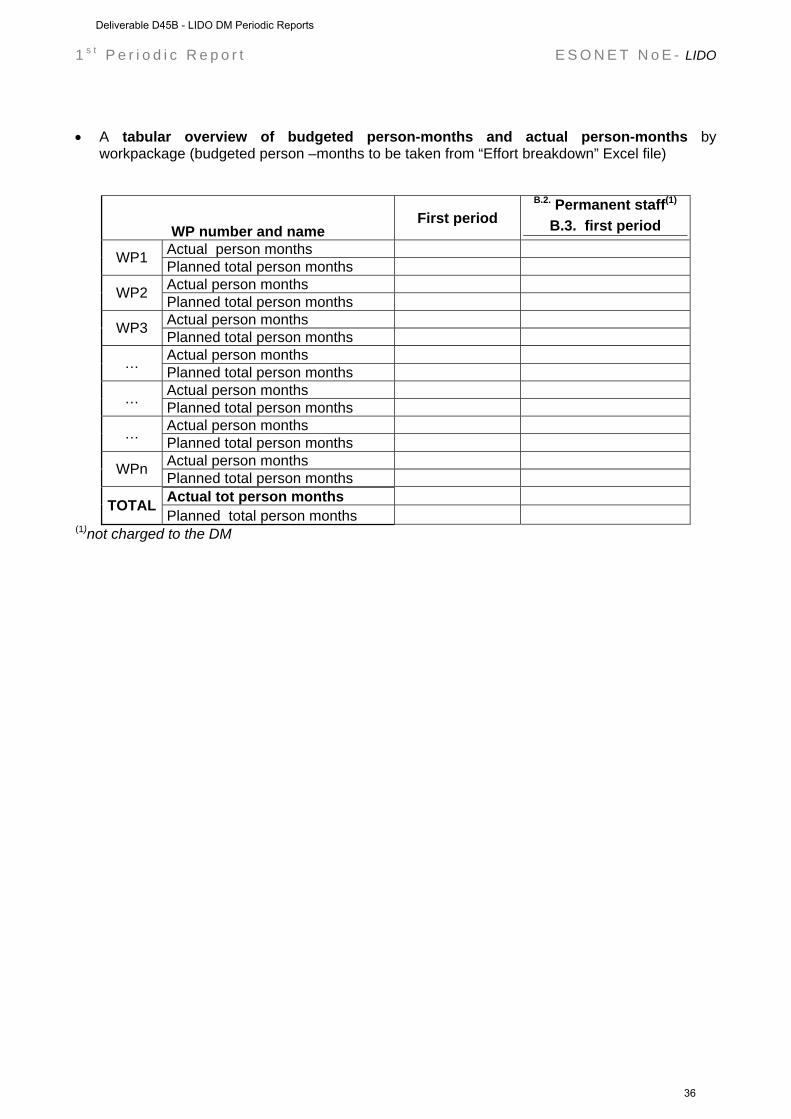
• A tabular overview of budgeted person-months and actual person-months by
workpackage (budgeted person –months to be taken from “Effort breakdown” Excel file)
WP number and name First period
B.2. Permanent staff(1)
B.3. first period Actual person months WP1 Planned total person months Actual person months WP2 Planned total person months Actual person months WP3 Planned total person months Actual person months … Planned total person months Actual person months … Planned total person months Actual person months … Planned total person months Actual person months WPn Planned total person months Actual tot person months TOTAL Planned total person months
(1)not charged to the DM
Deliverable D45B - LIDO DM Periodic Reports
36
1 s t P e r i o d i c R e p o r t E S O N E T N o E - LIDO
Workpackage progress (from 1 to 30 September 2008)
Workpackage objectives and starting point (max 500 characters)
Progress towards objectives – (short description about Tasks status; each task has to be referred as Task n.m where n is the WP number and m is a progressive number) Task 1.1: Developments of enhancements of NEMO-SN1 and GEOSTAR observatories and infrastructures
to open the nodes of a first nucleus of regional network to other disciplines (bioacoustics) and homogenization of geophysical equipments by integration of additional sensor, devices, and software.
contractors involved : INGV, INFN, TEC, ISMAR, CSIC, TFH, UPC Task 2.1: Standardisation of ocean observatory measurements by implementing international accepted
standard methods in data acquisition and management; Establishment of a sensor inventory; Long- term seismometric measurements and analysis.
contractors involved : UB, dBSCALE Task 3.1: Real-time transmission of marine mammal acoustic signals and acoustic images from seafloor cabled observatory to public institutions (e.g., Scientific Museums, Aquaria) where the whole ESONET network will be presented together with the “sonic imagery” of the LIDO stations.
contractors involved : FFCUL, UPC
Task 4.1: Development of RT and automatic analysis softwares: Long-term recording and analysis of natural, artificial and biological sound sources; Identification and tracking of cetaceans; Long-term noise interactions and masking.
contractors involved : UPC, CIBRA
Task 5.1: Test and validation of low cost acoustic arrays and recording systems to be implemented in additional locations to extend the monitoring network and possibly evaluate new European sites for long term monitoring.
contractors involved : INFN, UPC
Task 6.1: Implementation of the administrative and financial decisions of the SC, within the framework set by the European Commission and under the authority of the ESONET NoE. The Activity Leaders are advised by the Advisory Council.
contractors involved : UPC
Deviations from the project work programme, and corrective actions taken/suggested (identify the nature and the reason for the problem, identify partners involved)
Deliverable D45B - LIDO DM Periodic Reports
37
1 s t P e r i o d i c R e p o r t E S O N E T N o E - LIDO
A) insert the name of the cause of deviation and explain why this cause has determined deviation. max 500 characters
Corrective actions: insert description of the corrective actions max 500 characters
B) insert the name of the cause of deviation and explain why this cause has determined deviation. max 500 characters
Corrective action: insert description of the corrective actions max 500 characters
Deliverable D45B - LIDO DM Periodic Reports
38
1 s t P e r i o d i c R e p o r t E S O N E T N o E - LIDO
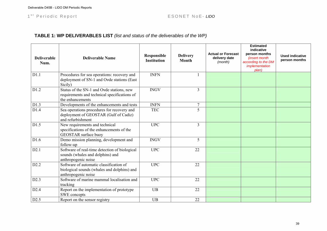
TABLE 1: WP DELIVERABLES LIST (list and status of the deliverables of the WP)
Deliverable
Num. Deliverable Name Responsible
Institution Delivery Month
Actual or Forecast delivery date
(month)
Estimated indicative
person months (insert month
according to the DM implementation
plan)
Used indicative person months
D1.1 Procedures for sea operations: recovery and deployment of SN-1 and Oνde stations (East Sicily)
INFN 1
D1.2 Status of the SN-1 and Oνde stations, new requirements and technical specifications of the enhancements
INGV 3
D1.3 Developments of the enhancements and tests INFN 7
D1.4 Sea operations procedures for recovery and deployment of GEOSTAR (Gulf of Cadiz) and refurbishment
TEC 5
D1.5 New requirements and technical specifications of the enhancements of the GEOSTAR surface buoy
UPC 3
D1.6 Demo mission planning, development and follow-up
INGV 5
D2.1 Software of real-time detection of biological sounds (whales and dolphins) and anthropogenic noise
UPC 22
D2.2 Software of automatic classification of biological sounds (whales and dolphins) and anthropogenic noise
UPC 22
D2.3 Software of marine mammal localisation and tracking
UPC 22
D2.4 Report on the implementation of prototype SWE concepts
UB 22
D2.5 Report on the sensor registry UB 22
Deliverable D45B - LIDO DM Periodic Reports
39
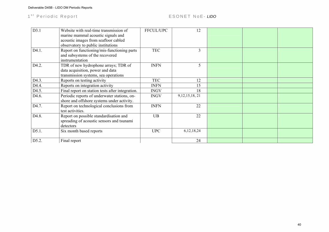
1 s t P e r i o d i c R e p o r t E S O N E T N o E - LIDO
D3.1 Website with real-time transmission of marine mammal acoustic signals and acoustic images from seafloor cabled observatory to public institutions
FFCUL/UPC 12
D4.1. Report on functioning/mis-functioning parts and subsystems of the recovered instrumentation
TEC 3
D4.2. TDR of new hydrophone arrays; TDR of data acquisition, power and data transmission systems, sea operations
INFN 5
D4.3. Reports on testing activity TEC 12
D4.4. Reports on integration activity INFN 15
D4.5. Final report on station tests after integration. INGV 18
D4.6. Periodic reports of underwater stations, on-shore and offshore systems under activity.
INGV 9,12,15,18, 21
D4.7. Report on technological conclusions from test activities.
INFN 22
D4.8. Report on possible standardisation and spreading of acoustic sensors and tsunami detectors
UB 22
D5.1. Six month based reports UPC 6,12,18,24
D5.2. Final report 24
Deliverable D45B - LIDO DM Periodic Reports
40
1 s t P e r i o d i c R e p o r t E S O N E T N o E - LIDO
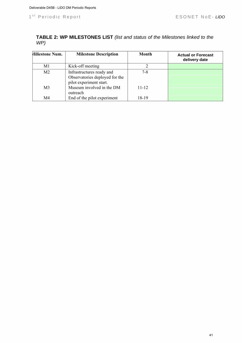
TABLE 2: WP MILESTONES LIST (list and status of the Milestones linked to the WP)
Miliestone Num. Milestone Description Month Actual or Forecast
delivery date M1 Kick-off meeting 2 M2 Infrastructures ready and
Observatories deployed for the pilot experiment start.
7-8
M3 Museum involved in the DM outreach
11-12
M4 End of the pilot experiment 18-19
Deliverable D45B - LIDO DM Periodic Reports
41

1 s t P e r i o d i c R e p o r t E S O N E T N o E - LIDO
UPDATED GANTT for all the WP tasks: fill in the ’Provisional’ cells of the following table in yellow according to the time duration of the tasks as described in the implementation for the tasks to be developed in the period of this report: fill in the ‘Actual’ cells of the following table in green according to the actual or forecast duration of the tasks. (Example is reported below)
project months
1 2 3 4 5 6 7 8 9 10 11 12 13 14 15 16 17 18 19 20 21 22 23 24 25 26 27 28 29 30 31 32 33 34 35 36
WPn Task 1.1 Provisional Task 1.1 Actual Task 2.1 Provisional Task 2.1 Actual
Task 3.1 Provisional Task 3.1 Actual
Task 4.1 Provisional Task 4.1 Actual Task 5.1 Provisional Task 5.1 Actual Task 6.1 Provisional Task 6.1 Actual
Deliverable D45B - LIDO DM Periodic Reports
42
LIDO (Listening to the Deep-Ocean environment)
ESONET Demonstration Missions
2nd Periodic Activity Report
The Periodic Activity Report contains an overview of the activities carried out during the reporting period, describes the progress in relation to the project objectives, the progress towards the milestones and deliverables set for the period, and any problems encountered and corrective actions taken. This document has to be filled in with reference to the DM Implementation plan. This means that Deliverables, Milestones and WPs have to be the same as in the DM Implementation plan. The Periodic Report contains 2 parts: - Part I: it is addressed to the coordinator with minimum input from the partners - Part II: it is addressed to each WP Leader and reports a detailed update of each WP activity at task level. The report includes a rough justification of the costs incurred and of the resources deployed by each contractor linking them to activities implemented and justifying their necessity. Finally the report contains information on use and dissemination activities. Reporting period: 30 September 2008 30 May 2009
Deliverable D45B - LIDO DM Periodic Reports
43

Part I DM acronym: LIDO
DM title: LISTENING TO THE DEEP-OCEAN ENVIRONMENT
ESONET Site: EAST-SICILY & GULF OF CADIZ
Scientific Area(s): GEOPHYSICS & BIOACOUSTICS
Technological Area(s): GEOPHYSICS & BIOACOUSTICS
DM Start date: 1 SEPTEMBER 2008
DM duration: 24 MONTHS
Period of the reporting from 1 October 2008 to 30 May 2009
Partner Num. Partner Institution Name Principal Investigator (PI)
for the Demo Mission
PI coordinates (Address, Email, Telephone, fax..)
1. UPC Universitat Politècnica de Catalunya
Michel André
2. UB* University of Bremen (Marum) Christoph Waldmann waldmann@maru
m.de
3.
FFCUL/ CGUL* Fundação da Faculdade de Ciências da Universidade de Lisboa Centro de Geofísica da Universidade de Lisboa
Jorge Miguel Miranda [email protected]
4. INGV Istituto Nazionale di Geofisica e Vulcanologia
Paolo Favali [email protected]
5. ISMAR Consiglio Nazionale delle Ricerche Istituto Scienze Marine, Dipartimento di Bologna
Nevio Zitellini [email protected]
6. Istituto Nazionale di Fisica Nucleare INFN* Giorgio Riccobene [email protected]
n.it
7.
Consejo Superior de Investigaciones CSIC* Cientificas – Unitat de Tecnologia Marina - Centre Mediterrani d’Investigacions Marines i Ambientals
Juan Josè Danobeitia [email protected]
8. dBScale dBS* Eric Delory [email protected]
9.
Centro Interdisciplinare di Bioacustica e CIBRA Ricerche Ambientali, Università degli Studi di Pavia
Gianni Pavan [email protected]
10. Technische Fachhochschule Berlin -FB VIII TFH* - Maschinenbau, Verfahrens- und Umwelttechnik - AG Tiefseesysteme
Hans W. Gerber
[email protected] [email protected]
11. Tecnomare-ENI S.p.A. TEC* Francesco Gasparoni francesco.gasparon
Deliverable D45B - LIDO DM Periodic Reports
44

Executive summary (max one page) LIDO (Listening to the Deep Ocean environment) proposes to establish a first nucleus of a regional network of multidisciplinary seafloor observatories contributing to the coordination of high quality research in the ESONET NoE by allowing the long-term monitoring of Geohazards and Marine Ambient Noise in the Mediterranean Sea and the adjacent Atlantic waters. Specific activities are addressed to a long-term monitoring of earthquakes and tsunamis and the characterisation of ambient noise induced by marine mammals (Bioacoustics) and anthropogenic noise. The objective of the proposal will be achieved through the extension of the present capabilities of the observatories working in the ESONET key-sites of Eastern Sicily (NEMO-SN1) and of the Gulf of Cadiz (GEOSTAR configured for NEAREST pilot experiment) by installing not-already-included sensor equipments related to Bioacoustics and Geohazards; Scientific Objectives Geo-Hazards: LIDO aims at improving the real-time and near-real-time detection of signals by a multiparameter seafloor observatory network at regional scale for the characterisation of potential tsunamigenic sources. Its methodological approach is based on the cross-checking of geophysical, oceanographic and environmental time series acquired on the seafloor and in the water column. LIDO will provide real-time and nearto-real-time seismological and water-pressure comparative time series from near-shore sources and operational tools (e.g., prototype of tsunameters) integrated in seafloor observation systems, and in the terrestrial Networks LIDO follows the recommendation of the Intergovernmental Coordination Group of the Intergovernmental Oceanographic Commission (UNESCO) for the North-Eastern Atlantic and Mediterranean Tsunami Warning System (ICG/NEAMTWS) for the urgent deployment of a tsunami warning system in the related areas with special regard to the definition of trans-national seismic and sea level monitoring networks. Bioacoustics: LIDO will evaluate the human and natural contributions to marine ambient noise and for the first time describe the long-term trends in ambient Boise levels, especially from human activities (influenced for example by increasing shipping) and in marine mammals populations (migration patterns, presence, and habitat use of key species, like sperm -, fin - and beaked whales). LIDO will allow real-time and near real-time long-term acoustic monitoring of marine mammals at regional level, as well as noise propagation that could be in the next years correlated with the effects of anthropogenic impacts and climate changes, using the same infrastructure defined above. Technological objectives The technological objective of LIDO is the development of the first nucleus of a regional multiparameter seafloor network of homogeneous observatories (same sensors) and its long-term operability beyond the duration of LIDO demo mission in two ESONET key-sites, East Sicily (cabled) and Gulf of Cadiz (acoustically linked with a surface buoy).
Deliverable D45B - LIDO DM Periodic Reports
45

Table 1: Deliverables List of the LIDO Demonstration Mission
LIDO Deliverable
n.
Deliverable name Corresponding WP n.
Due Date Actual/ Forecast
delivery date
Estimated
indicative person months*
Used indicative person months*
Lead contracto
r
D1.1 Procedures for sea operations: recovery and deployment of SN-1 and Oνde stations (East Sicily)
WP1 MONTH 1 ON TIME INGV
D1.2. Status of the SN-1 and Oνde stations, new requirements and technical specifications of the enhancements
WP1 MONTH3 ON TIME INGV
D1.3. Developments of the enhancements and tests
WP1 MONTH7 ON TIME Not received
INGV
D1.4. Sea operations procedures for recovery and deployment of GEOSTAR (Gulf of Cadiz) and refurbishment
WP1 MONTH5 ON TIME INGV
D1.5. New requirements and technical specifications of the enhancements of the GEOSTAR surface buoy
WP1 MONTH3 ON TIME INGV
D1.6. Demo mission planning, development and follow-up
WP1 MONTH5 ON TIME Not received, oneyear of delay!!!
INGV
D2.1. Software of real-time detection of biological sounds (whales and dolphins) and anthropogenic noise
WP4 MONTH22 UPC
D2.2. Software of automatic classification of biological sounds (whales and dolphins) and anthropogenic noise
WP4 MONTH22 UPC
D2.3. Software of marine mammal localisation and tracking
WP4 MONTH22 UPC
D2.4. Report on the implementation of prototype SWE concepts
WP2 MONTH22 UB
D2.5. Report on the sensor registry
WP2 MONTH22 UB
D3.1. Website with real-time transmission of marine mammal acoustic signals and acoustic images from seafloor cabled observatory to public institutions
WP3 MONTH12 ON TIME Not received
FFCUL UPC
D4.1. Report on functioning/mis-functioning parts and subsystems of the recovered instrumentation
WP5 MONTH3 ON TIME INFN
D4.2. TDR of new hydrophone arrays; TDR of data
WP5 MONTH5 ON TIME INFN
Deliverable D45B - LIDO DM Periodic Reports
46
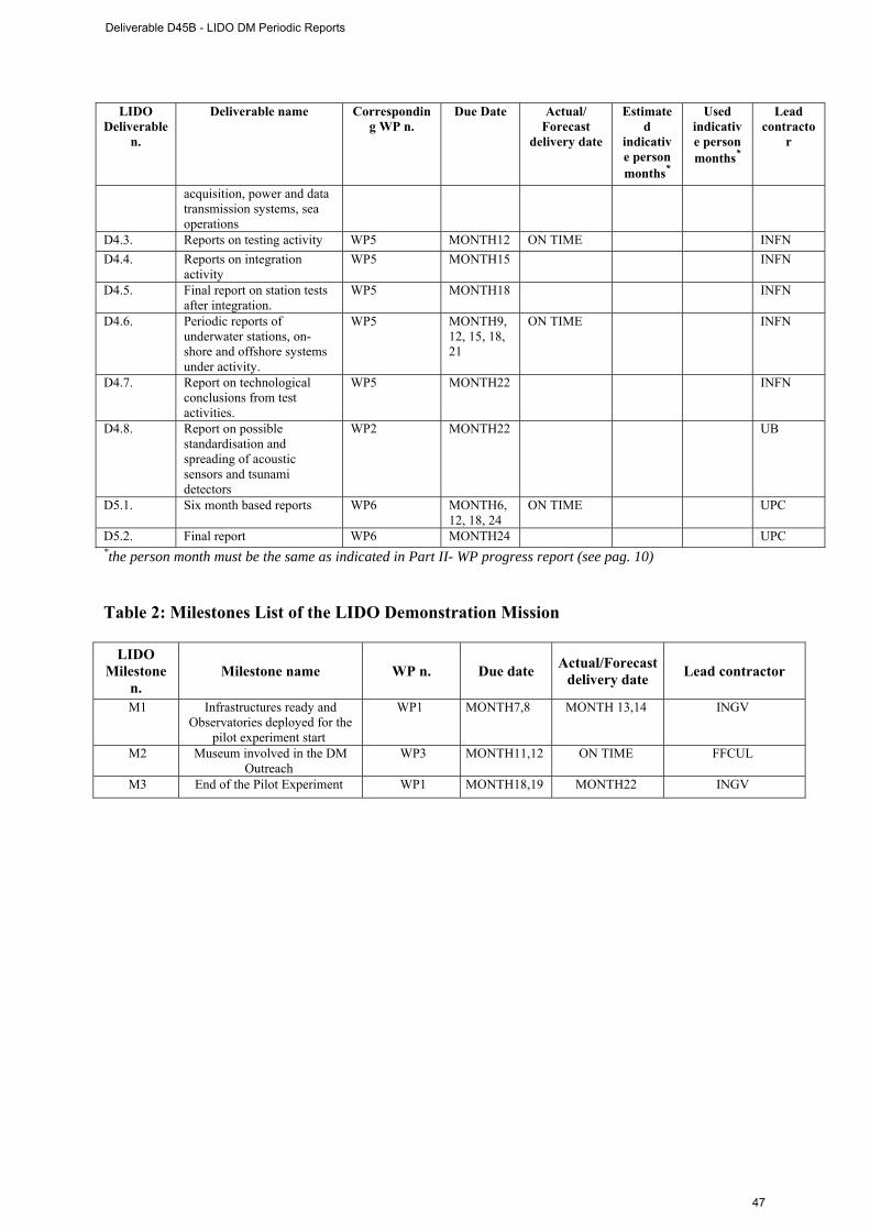
LIDO Deliverable
n.
Deliverable name Corresponding WP n.
Due Date Actual/ Forecast
delivery date
Estimated
indicative person months*
Used indicative person months*
Lead contracto
r
acquisition, power and data transmission systems, sea operations
D4.3. Reports on testing activity WP5 MONTH12 ON TIME INFN D4.4. Reports on integration
activity WP5 MONTH15 INFN
D4.5. Final report on station tests after integration.
WP5 MONTH18 INFN
D4.6. Periodic reports of underwater stations, on-shore and offshore systems under activity.
WP5 MONTH9, 12, 15, 18, 21
ON TIME INFN
D4.7. Report on technological conclusions from test activities.
WP5 MONTH22 INFN
D4.8. Report on possible standardisation and spreading of acoustic sensors and tsunami detectors
WP2 MONTH22 UB
D5.1. Six month based reports WP6 MONTH6, 12, 18, 24
ON TIME UPC
D5.2. Final report WP6 MONTH24 UPC *the person month must be the same as indicated in Part II- WP progress report (see pag. 10)
Table 2: Milestones List of the LIDO Demonstration Mission
LIDO Milestone
n. Milestone name WP n. Due date Actual/Forecast
delivery date Lead contractor
M1 Infrastructures ready and Observatories deployed for the
pilot experiment start
WP1 MONTH7,8 MONTH 13,14 INGV
M2 Museum involved in the DM Outreach
WP3 MONTH11,12 ON TIME FFCUL
M3 End of the Pilot Experiment WP1 MONTH18,19 MONTH22 INGV
Deliverable D45B - LIDO DM Periodic Reports
47
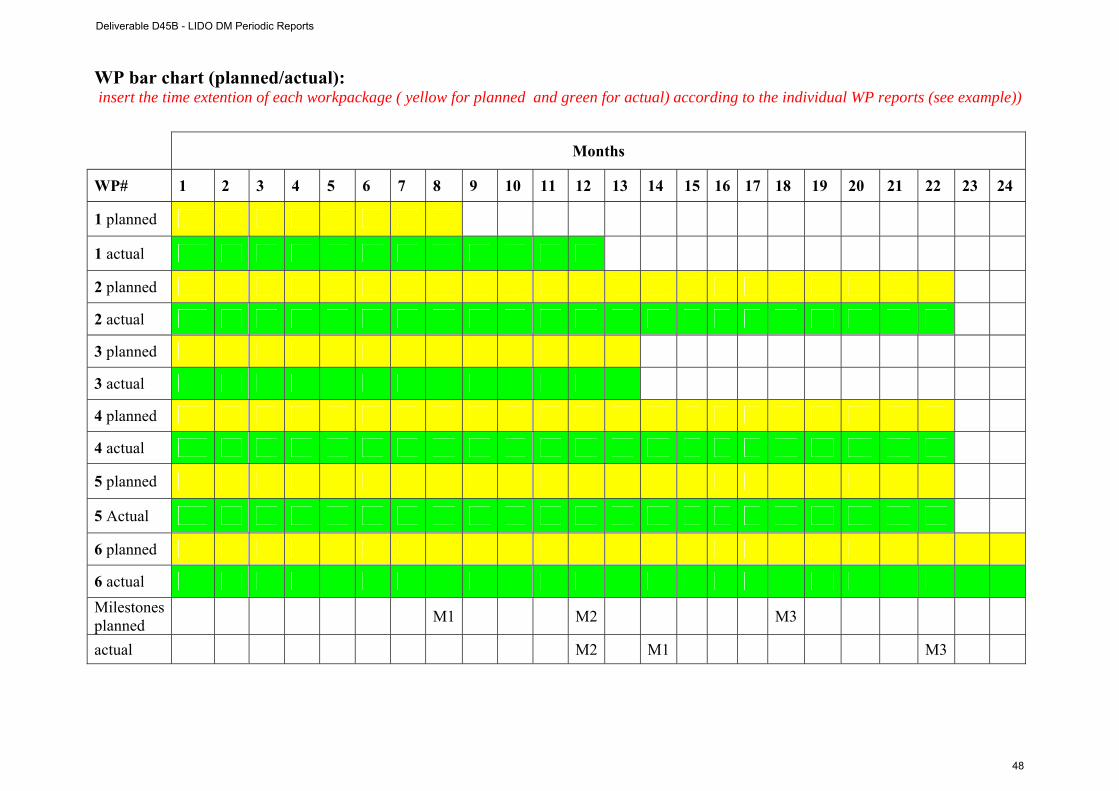
WP bar chart (planned/actual): insert the time extention of each workpackage ( yellow for planned and green for actual) according to the individual WP reports (see example))
Months
WP# 1 2 3 4 5 6 7 8 9 10 11 12 13 14 15 16 17 18 19 20 21 22 23 24
1 planned
1 actual
2 planned
2 actual
3 planned
3 actual
4 planned
4 actual
5 planned
5 Actual
6 planned
6 actual Milestonesplanned M1 M2 M3
actual M2 M1 M3
Deliverable D45B - LIDO DM Periodic Reports
48
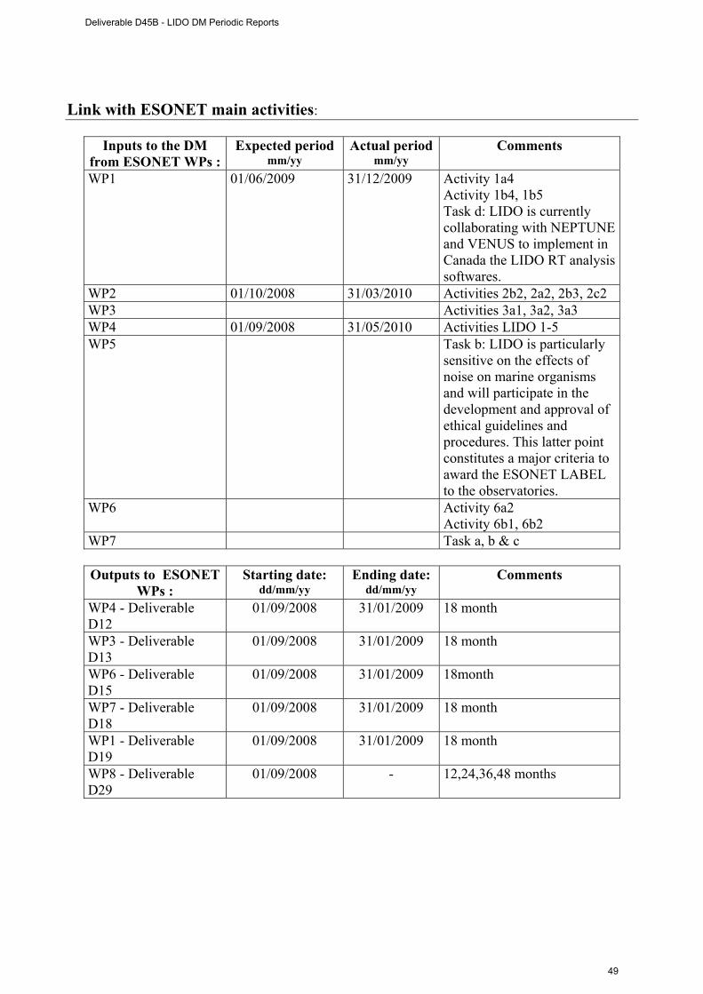
Link with ESONET main activities:
Inputs to the DM from ESONET WPs :
Expected period mm/yy
Actual period mm/yy
Comments
WP1 01/06/2009 31/12/2009 Activity 1a4 Activity 1b4, 1b5 Task d: LIDO is currently collaborating with NEPTUNE and VENUS to implement in Canada the LIDO RT analysis softwares.
WP2 01/10/2008 31/03/2010 Activities 2b2, 2a2, 2b3, 2c2 WP3 Activities 3a1, 3a2, 3a3 WP4 01/09/2008 31/05/2010 Activities LIDO 1-5 WP5 Task b: LIDO is particularly
sensitive on the effects of noise on marine organisms and will participate in the development and approval of ethical guidelines and procedures. This latter point constitutes a major criteria to award the ESONET LABEL to the observatories.
WP6 Activity 6a2 Activity 6b1, 6b2
WP7 Task a, b & c
Outputs to ESONET WPs :
Starting date: dd/mm/yy
Ending date: dd/mm/yy
Comments
WP4 - Deliverable D12
01/09/2008 31/01/2009 18 month
WP3 - Deliverable D13
01/09/2008 31/01/2009 18 month
WP6 - Deliverable D15
01/09/2008 31/01/2009 18month
WP7 - Deliverable D18
01/09/2008 31/01/2009 18 month
WP1 - Deliverable D19
01/09/2008 31/01/2009 18 month
WP8 - Deliverable D29
01/09/2008 - 12,24,36,48 months
Deliverable D45B - LIDO DM Periodic Reports
49
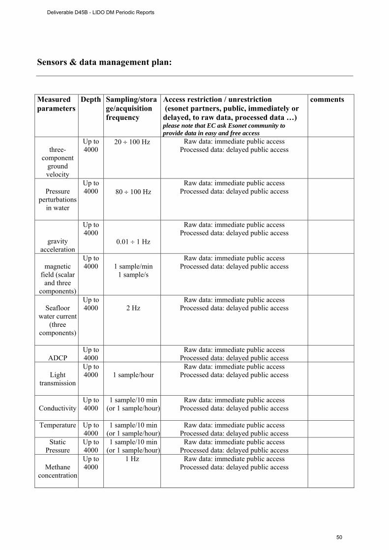
Sensors & data management plan: Measured parameters
Depth Sampling/storage/acquisition frequency
Access restriction / unrestriction (esonet partners, public, immediately or delayed, to raw data, processed data …) please note that EC ask Esonet community to provide data in easy and free access
comments
three-
component ground velocity
Up to 4000
20 ÷ 100 Hz Raw data: immediate public access Processed data: delayed public access
Pressure
perturbations in water
Up to 4000
80 ÷ 100 Hz
Raw data: immediate public access Processed data: delayed public access
gravity acceleration
Up to 4000
0.01 ÷ 1 Hz
Raw data: immediate public access Processed data: delayed public access
magnetic
field (scalar and three
components)
Up to 4000
1 sample/min
1 sample/s
Raw data: immediate public access Processed data: delayed public access
Seafloor
water current (three
components)
Up to 4000
2 Hz
Raw data: immediate public access Processed data: delayed public access
ADCP
Up to 4000
Raw data: immediate public access Processed data: delayed public access
Light
transmission
Up to 4000
1 sample/hour
Raw data: immediate public access Processed data: delayed public access
Conductivity
Up to 4000
1 sample/10 min (or 1 sample/hour)
Raw data: immediate public access Processed data: delayed public access
Temperature Up to 4000
1 sample/10 min (or 1 sample/hour)
Raw data: immediate public access Processed data: delayed public access
Static Pressure
Up to 4000
1 sample/10 min (or 1 sample/hour)
Raw data: immediate public access Processed data: delayed public access
Methane
concentration
Up to 4000
1 Hz Raw data: immediate public access Processed data: delayed public access
Deliverable D45B - LIDO DM Periodic Reports
50
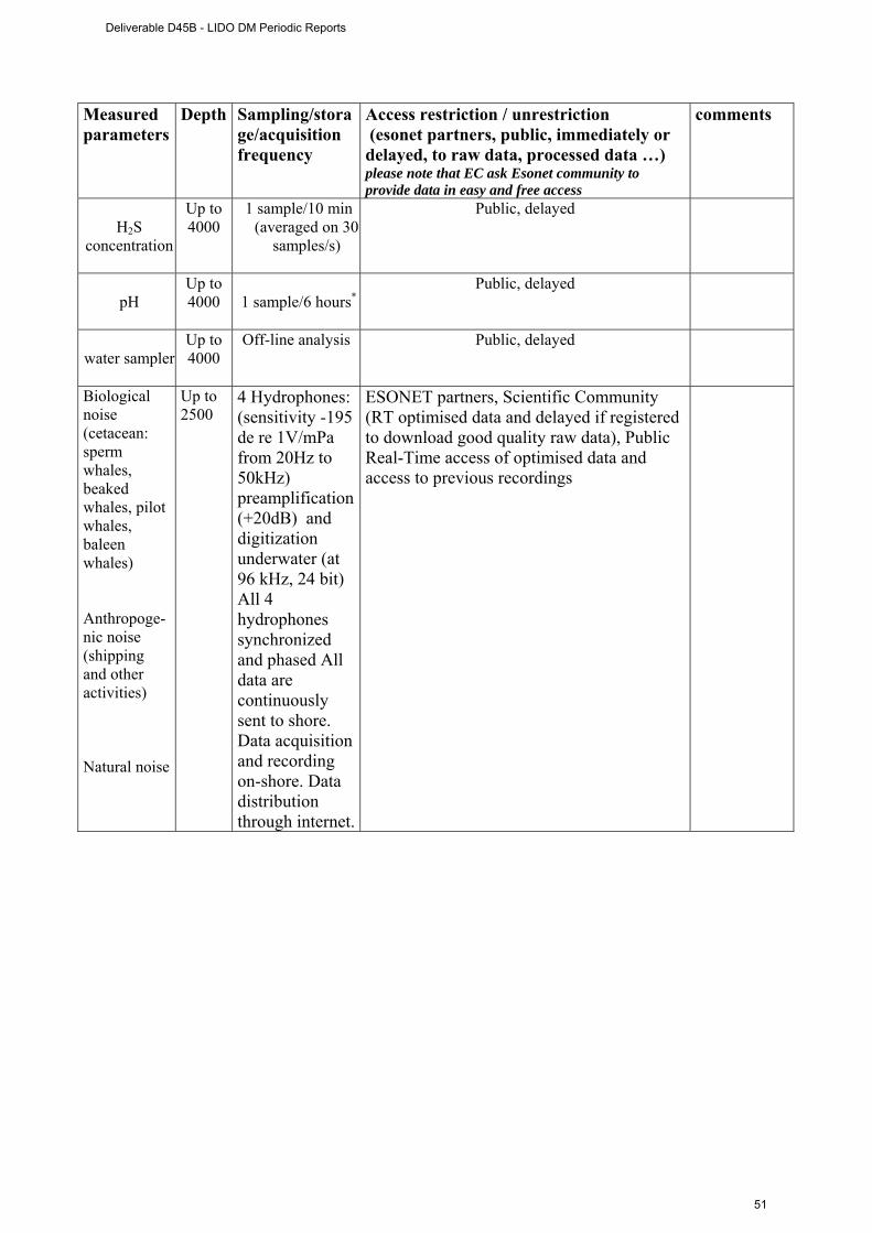
Measured parameters
Depth Sampling/storage/acquisition frequency
Access restriction / unrestriction (esonet partners, public, immediately or delayed, to raw data, processed data …) please note that EC ask Esonet community to provide data in easy and free access
comments
H2S
concentration
Up to 4000
1 sample/10 min (averaged on 30
samples/s)
Public, delayed
pH
Up to 4000
1 sample/6 hours*
Public, delayed
water sampler
Up to 4000
Off-line analysis Public, delayed
Biological noise (cetacean: sperm whales, beaked whales, pilot whales, baleen whales) Anthropoge-nic noise (shipping and other activities) Natural noise
Up to 2500
4 Hydrophones: (sensitivity -195 de re 1V/mPa from 20Hz to 50kHz) preamplification (+20dB) and digitization underwater (at 96 kHz, 24 bit) All 4 hydrophones synchronized and phased All data are continuously sent to shore. Data acquisition and recording on-shore. Data distribution through internet.
ESONET partners, Scientific Community (RT optimised data and delayed if registered to download good quality raw data), Public Real-Time access of optimised data and access to previous recordings
Deliverable D45B - LIDO DM Periodic Reports
51

Dissemination and outreach : School material that would be available at the issue of the mission: -photos, video, courses, … -others
Website, tutorials, Photos, videos, training, press events. Direct connection to the sites will allow the general public to access acoustic data stream as well as previous recording and information (historical statistics) Specific materials will be produce with a focus on the acoustic monitoring of the ocean, grouping anthropogenic, seismic and bio acoustic sources
Dissemination through collaborations with aquaria, museum, sciences centres, …?
Near-real time images via internet from seafloor observatory in museums and aquaria. Direct connection to the sites will allow the general public to access acoustic data stream as well as previous recording and information (historical statistics). In the Lisbon Natural History Museum a panel will be installed where information concerning ESONET will be displayed, with a focus on real-time data.
Deliverable D45B - LIDO DM Periodic Reports
52
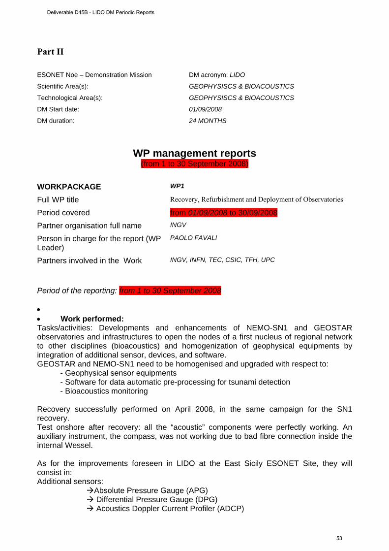
Part II ESONET Noe – Demonstration Mission DM acronym: LIDO
Scientific Area(s): GEOPHYSISCS & BIOACOUSTICS
Technological Area(s): GEOPHYSISCS & BIOACOUSTICS
DM Start date: 01/09/2008
DM duration: 24 MONTHS
WP management reports (from 1 to 30 September 2008)
WORKPACKAGE WP1
Full WP title Recovery, Refurbishment and Deployment of Observatories Period covered from 01/09/2008 to 30/09/2008 Partner organisation full name INGV
Person in charge for the report (WP Leader)
PAOLO FAVALI
Partners involved in the Work INGV, INFN, TEC, CSIC, TFH, UPC
Period of the reporting: from 1 to 30 September 2008 • • Work performed: Tasks/activities: Developments and enhancements of NEMO-SN1 and GEOSTAR observatories and infrastructures to open the nodes of a first nucleus of regional network to other disciplines (bioacoustics) and homogenization of geophysical equipments by integration of additional sensor, devices, and software. GEOSTAR and NEMO-SN1 need to be homogenised and upgraded with respect to: - Geophysical sensor equipments - Software for data automatic pre-processing for tsunami detection - Bioacoustics monitoring Recovery successfully performed on April 2008, in the same campaign for the SN1 recovery. Test onshore after recovery: all the “acoustic” components were perfectly working. An auxiliary instrument, the compass, was not working due to bad fibre connection inside the internal Wessel. As for the improvements foreseen in LIDO at the East Sicily ESONET Site, they will consist in: Additional sensors:
Absolute Pressure Gauge (APG) Differential Pressure Gauge (DPG) Acoustics Doppler Current Profiler (ADCP)
Deliverable D45B - LIDO DM Periodic Reports
53
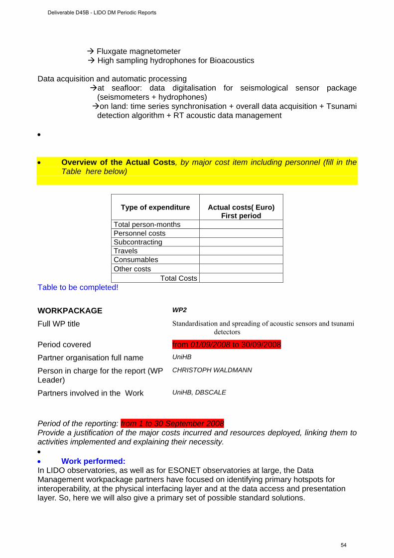
Fluxgate magnetometer High sampling hydrophones for Bioacoustics
Data acquisition and automatic processing
at seafloor: data digitalisation for seismological sensor package (seismometers + hydrophones)
on land: time series synchronisation + overall data acquisition + Tsunami detection algorithm + RT acoustic data management
• • Overview of the Actual Costs, by major cost item including personnel (fill in the
Table here below)
Type of expenditure
Actual costs( Euro) First period
Total person-months Personnel costs Subcontracting Travels Consumables Other costs
Total Costs Table to be completed! WORKPACKAGE WP2
Full WP title Standardisation and spreading of acoustic sensors and tsunami detectors
Period covered from 01/09/2008 to 30/09/2008 Partner organisation full name UniHB
Person in charge for the report (WP Leader)
CHRISTOPH WALDMANN
Partners involved in the Work UniHB, DBSCALE
Period of the reporting: from 1 to 30 September 2008 Provide a justification of the major costs incurred and resources deployed, linking them to activities implemented and explaining their necessity. • • Work performed: In LIDO observatories, as well as for ESONET observatories at large, the Data Management workpackage partners have focused on identifying primary hotspots for interoperability, at the physical interfacing layer and at the data access and presentation layer. So, here we will also give a primary set of possible standard solutions.
Deliverable D45B - LIDO DM Periodic Reports
54
It is thought prioritary to focus the effort for the implementation of interoperability concepts: at the physical layer sensor interface, at the main station’s data servers, and in the encoding of hydrophones in standard format. The latter will imply agreement on a common vocabulary for ocean acoustic sensors and the contribution to and collaboration with ocean-related ontology initiatives One approach consists in opening a local directory to the public with a catalogue service available and standard data and metadata formats. It is rather proven approach for data servers, and as a generic approach it lacks the specificities that ocean observatories may call for. For example there is no protocol companion for sensor control (it is about data and data only). Approach B, which is currently evolving (these standards have been recently fully-approved), answers a broader set of needs although due to its rather recent release it is more complex and risky to implement. One neat advantage as regards the sensor web approach is that it will evolve in close collaboration with the ocean community and ESONET is already contributing actively to its development. WORKPACKAGE WP3
Full WP title Public Outreach Period covered from 01/09/2008 to 30/09/2008 Partner organisation full name FFCUL
Person in charge for the report (WP Leader)
JORGE MIGUEL MIRANDA
Partners involved in the Work UPC
Period of the reporting: from 1 to 30 September 2008 • There is no WP3 description, please, explain! WORKPACKAGE WP4
Full WP title RT Software Development Period covered from 01/09/2008 to 30/09/2008 Partner organisation full name UPC
Person in charge for the report (WP Leader)
MICHEL ANDRÉ
Partners involved in the Work UPC, CIBRA
Deliverable D45B - LIDO DM Periodic Reports
55
Period of the reporting: from 1 to 30 September 2008 • • Work performed: Development of RT and automatic analysis softwares for the Long-term recording and analysis of natural, artificial and biological sound sources; Identification and tracking of cetaceans; Long-term noise interactions and masking. At the CTSL location, the 4 channels data will be streamed to the preprocessing server as we have just seen, that will be responsible for the analysis of the segments and the tagging of data. One channel will also be encoding the output of the analysis into mp3 format for public access. At that stage no storage is performed (available at the end of next month). The analysis server in turn will identify the acoustic sources and track them as much as possible (sperm, beaked whales, ships, etc.). These codes will be ready next spring. At the LNS, besides the storage of the data at the MADS server, the web server will store the analysis results in xml format; Make available mp3 data and analysis results to the flash client; stream analysis results to the LAB-UPC; and provide access to selected data stored for third parties (research collaborators, etc.) Finally, at the UPC, the server will be responsible of the configuration for the: General public access to Real-Time flash client; General public access to sound library; General public access to (statistical) analysis of the acoustic environment near the platform; Registration for third party collaboration and access control to high quality data
Deliverable D45B - LIDO DM Periodic Reports
56
The objectives of LIDO in terms of acoustic and bioacoustics data management is the long term monitoring and assessment of the anthropogenic sources on marine organisms, specially cetaceans, implying the detection, classification and tracking of the sources. This is illustrated here by Phase 3. To achieve this objective, it is necessary to develop a rigorous and versatile protocol that we have separated in two previous steps: Phase 1 and 2. Here, one has to keep in mind that the overall process will be conducted in RT or close to RT. Detector 1 is an unspecific detector that triggers to the presence of tonal bands, of impulses (clicks), of whistles, calls or sonar. Detector 2 detects the presence of broadband bulk at lower frequencies that is typical for shipping. It also detects underwater explosions and sperm whale clicks (if there are many), therefore it is also rather unspecific. Detector 3 is specific for short, possibly FM tonals, such as dolphin whistles or sonar. Detector 4 is specific for the tonal ship lines sometimes produced by ships. Detector 5-8 are specific for impulses. They can be tuned to detect impulses that have energy in a given frequency band and the duration of the impulses that are detected can be approximately specified. Depending on how they are tuned, they will detect for example: Airgun, sperm whale clicks, clicks produced by ship propellers, beaked whale and dolphin clicks. Status of Activities • Tonals, impulses and broadband signals are detected. This allows to detect most
cetacean species of interest, ships, underwater explosions (e.g. seismic surveys), sonar.
• The detectors allow a primary classification of the data into broad classes, which will reduce the data volume supplied to more specific (and greedy) recognition algorithms.
• Because of lack of data: Low frequency tonals of large whales; Natural seismic activity; Pile driving; Dredging; Drilling have not been tested yet on the detectors.
• Phase 2 is foreseen to be due by September 2009 and Phase 3 statistical analysis will start a soon as the antennas are deployed.
WORKPACKAGE WP5
Full WP title Technical assessment Period covered from 01/09/2008 to 30/09/2008 Partner organisation full name INFN
Person in charge for the report (WP Leader)
GIORGIO RICCOBENE
Partners involved in the Work UPC
Period of the reporting: from 1 to 30 September 2008
Deliverable D45B - LIDO DM Periodic Reports
57

• . • Work performed: Test and validation of low cost acoustic arrays and recording systems to be implemented in additional locations to extend the monitoring network and possibly evaluate new European sites for long term monitoring. The stream of data coming from the observatory will be directed to a server (ADS) that will distribute it to preprocessing servers where the first filters will be applied as well as where the following specific analysis of the data will be performed. A dedicated server (RADS) will compress and store the roar data. Through a WI-FI connection the processed data will then be sent tot he LNS station where one server will allow the safe public access to the low resolution data and another one will offer the access to high resolution data to registered users. Both servers will be separatedfor safety reasons and spam/virus protection. • A tabular overview of budgeted person-months and actual person-months by
workpackage (budgeted person –months to be taken from “Effort breakdown” Excel file) Too much complicated for partner to complete every 6 months
WP number and name First period Permanent staff(1)
first period Actual person months WP1 Planned total person months Actual person months WP2 Planned total person months Actual person months WP3 Planned total person months Actual person months … Planned total person months Actual person months … Planned total person months Actual person months … Planned total person months Actual person months WPn Planned total person months Actual tot person months TOTAL Planned total person months
(1)not charged to the DM Table to be completed
Deliverable D45B - LIDO DM Periodic Reports
58

Workpackage progress (from 1 to 30 September 2008)
Progress towards objectives: Task 1.1: Developments of enhancements of NEMO-SN1 and GEOSTAR observatories and
infrastructures to open the nodes of a first nucleus of regional network to other disciplines (bioacoustics) and homogenization of geophysical equipments by integration of additional sensor, devices, and software.
Contractors involved : INGV, INFN, TEC, ISMAR, CSIC, TFH, UPC Task 2.1: Standardisation of ocean observatory measurements by implementing international
accepted standard methods in data acquisition and management; Establishment of a sensor inventory; Long- term seismometric measurements and analysis.
contractors involved : ULB, dBSCALE Task 3.1: Real-time transmission of marine mammal acoustic signals and acoustic images from seafloor
cabled observatory to public institutions (e.g., Scientific Museums, Aquaria) where the whole ESONET network will be presented together with the “sonic imagery” of the LIDO stations.
contractors involved : FFCUL, UPC
Task 4.1: Development of RT and automatic analysis softwares: Long-term recording and analysis of
natural, artificial and biological sound sources; Identification and tracking of cetaceans; Long-term noise interactions and masking.
contractors involved : UPC, CIBRA
Task 5.1: Test and validation of low cost acoustic arrays and recording systems to be implemented in
additional locations to extend the monitoring network and possibly evaluate new European sites for long term monitoring.
contractors involved : INFN, UPC
Task 6.1: Implementation of the administrative and financial decisions of the SC, within the framework
set by the European Commission and under the authority of the ESONET NoE. The Activity Leaders are advised by the Advisory Council.
contractors involved : UPC
Deliverable D45B - LIDO DM Periodic Reports
59
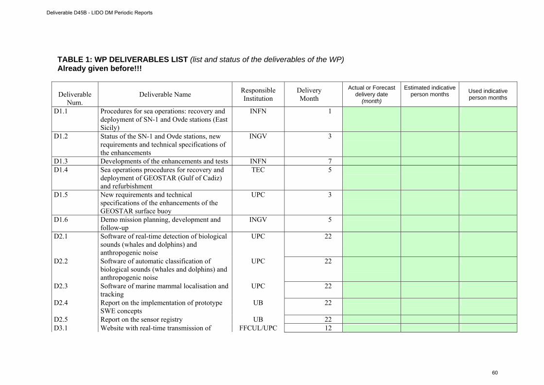
TABLE 1: WP DELIVERABLES LIST (list and status of the deliverables of the WP) Already given before!!!
Deliverable
Num. Deliverable Name Responsible
Institution Delivery Month
Actual or Forecast delivery date
(month)
Estimated indicative person months
Used indicative person months
D1.1 Procedures for sea operations: recovery and deployment of SN-1 and Oνde stations (East Sicily)
INFN 1
D1.2 Status of the SN-1 and Oνde stations, new requirements and technical specifications of the enhancements
INGV 3
D1.3 Developments of the enhancements and tests INFN 7
D1.4 Sea operations procedures for recovery and deployment of GEOSTAR (Gulf of Cadiz) and refurbishment
TEC 5
D1.5 New requirements and technical specifications of the enhancements of the GEOSTAR surface buoy
UPC 3
D1.6 Demo mission planning, development and follow-up
INGV 5
D2.1 Software of real-time detection of biological sounds (whales and dolphins) and anthropogenic noise
UPC 22
D2.2 Software of automatic classification of biological sounds (whales and dolphins) and anthropogenic noise
UPC 22
D2.3 Software of marine mammal localisation and tracking
UPC 22
D2.4 Report on the implementation of prototype SWE concepts
UB 22
D2.5 Report on the sensor registry UB 22
D3.1 Website with real-time transmission of FFCUL/UPC 12
Deliverable D45B - LIDO DM Periodic Reports
60
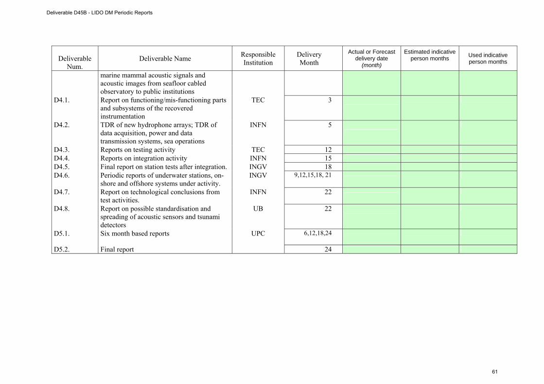
Deliverable
Num. Deliverable Name Responsible
Institution Delivery Month
Actual or Forecast delivery date
(month)
Estimated indicative person months
Used indicative person months
marine mammal acoustic signals and acoustic images from seafloor cabled observatory to public institutions
D4.1. Report on functioning/mis-functioning parts and subsystems of the recovered instrumentation
TEC 3
D4.2. TDR of new hydrophone arrays; TDR of data acquisition, power and data transmission systems, sea operations
INFN 5
D4.3. Reports on testing activity TEC 12
D4.4. Reports on integration activity INFN 15
D4.5. Final report on station tests after integration. INGV 18
D4.6. Periodic reports of underwater stations, on-shore and offshore systems under activity.
INGV 9,12,15,18, 21
D4.7. Report on technological conclusions from test activities.
INFN 22
D4.8. Report on possible standardisation and spreading of acoustic sensors and tsunami detectors
UB 22
D5.1. Six month based reports UPC 6,12,18,24
D5.2. Final report 24
Deliverable D45B - LIDO DM Periodic Reports
61
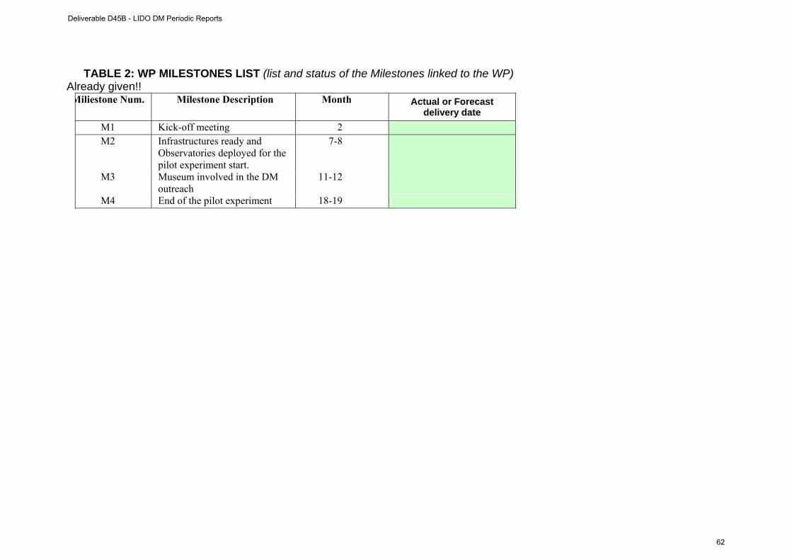
TABLE 2: WP MILESTONES LIST (list and status of the Milestones linked to the WP) Already given!! Miliestone Num. Milestone Description Month Actual or Forecast
delivery date M1 Kick-off meeting 2 M2 Infrastructures ready and
Observatories deployed for the pilot experiment start.
7-8
M3 Museum involved in the DM outreach
11-12
M4 End of the pilot experiment 18-19
Deliverable D45B - LIDO DM Periodic Reports
62

UPDATED GANTT
project months
1 2 3 4 5 6 7 8 9 10 11 12 13 14 15 16 17 18 19 20 21 22 23 24 25 26 27 28 29 30 31 32 33 34 35 36
WPn
Task 1.1 Provisional
Task 1.1 Actual
Task 2.1 Provisional
Task 2.1 Actual
Task 3.1 Provisional
Task 3.1 Actual
Task 4.1 Provisional
Task 4.1 Actual
Task 5.1 Provisional
Task 5.1 Actual
Task 6.1 Provisional
Task 6.1 Actual
Deliverable D45B - LIDO DM Periodic Reports
63

Deliverable D45B - LIDO DM Periodic Reports
64
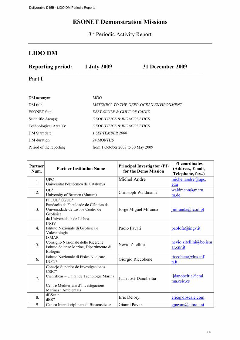
ESONET Demonstration Missions
3rd Periodic Activity Report
LIDO DM Reporting period: 1 July 2009 31 December 2009 ________________________________________________________________________ Part I DM acronym: LIDO
DM title: LISTENING TO THE DEEP-OCEAN ENVIRONMENT
ESONET Site: EAST-SICILY & GULF OF CADIZ
Scientific Area(s): GEOPHYSICS & BIOACOUSTICS
Technological Area(s): GEOPHYSICS & BIOACOUSTICS
DM Start date: 1 SEPTEMBER 2008
DM duration: 24 MONTHS
Period of the reporting from 1 October 2008 to 30 May 2009
Partner Num. Partner Institution Name Principal Investigator (PI)
for the Demo Mission
PI coordinates (Address, Email, Telephone, fax..)
1. UPC Universitat Politècnica de Catalunya
Michel André
2. UB* University of Bremen (Marum) Christoph Waldmann waldmann@maru
m.de
3.
FFCUL/ CGUL* Fundação da Faculdade de Ciências da Universidade de Lisboa Centro de Geofísica da Universidade de Lisboa
Jorge Miguel Miranda [email protected]
4. INGV Istituto Nazionale di Geofisica e Vulcanologia
Paolo Favali [email protected]
5. ISMAR Consiglio Nazionale delle Ricerche Istituto Scienze Marine, Dipartimento di Bologna
Nevio Zitellini [email protected]
6. Istituto Nazionale di Fisica Nucleare INFN* Giorgio Riccobene [email protected]
n.it
7.
Consejo Superior de Investigaciones CSIC* Cientificas – Unitat de Tecnologia Marina - Centre Mediterrani d’Investigacions Marines i Ambientals
Juan Josè Danobeitia [email protected]
8. dBScale dBS* Eric Delory [email protected]
9. Centro Interdisciplinare di Bioacustica e Gianni Pavan [email protected]
Deliverable D45B - LIDO DM Periodic Reports
65
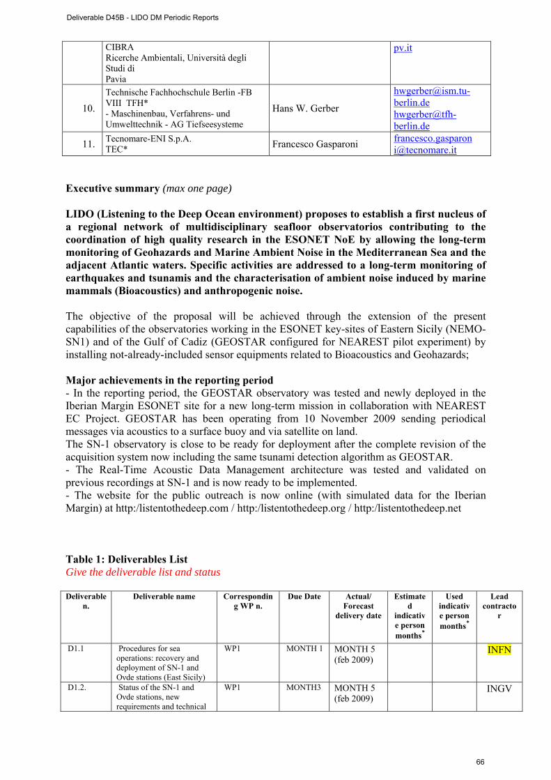
CIBRA Ricerche Ambientali, Università degli Studi di Pavia
pv.it
10. Technische Fachhochschule Berlin -FB VIII TFH* - Maschinenbau, Verfahrens- und Umwelttechnik - AG Tiefseesysteme
Hans W. Gerber
[email protected] [email protected]
11. Tecnomare-ENI S.p.A. TEC* Francesco Gasparoni francesco.gasparon
[email protected] Executive summary (max one page) LIDO (Listening to the Deep Ocean environment) proposes to establish a first nucleus of a regional network of multidisciplinary seafloor observatorios contributing to the coordination of high quality research in the ESONET NoE by allowing the long-term monitoring of Geohazards and Marine Ambient Noise in the Mediterranean Sea and the adjacent Atlantic waters. Specific activities are addressed to a long-term monitoring of earthquakes and tsunamis and the characterisation of ambient noise induced by marine mammals (Bioacoustics) and anthropogenic noise. The objective of the proposal will be achieved through the extension of the present capabilities of the observatories working in the ESONET key-sites of Eastern Sicily (NEMO-SN1) and of the Gulf of Cadiz (GEOSTAR configured for NEAREST pilot experiment) by installing not-already-included sensor equipments related to Bioacoustics and Geohazards; Major achievements in the reporting period - In the reporting period, the GEOSTAR observatory was tested and newly deployed in the Iberian Margin ESONET site for a new long-term mission in collaboration with NEAREST EC Project. GEOSTAR has been operating from 10 November 2009 sending periodical messages via acoustics to a surface buoy and via satellite on land. The SN-1 observatory is close to be ready for deployment after the complete revision of the acquisition system now including the same tsunami detection algorithm as GEOSTAR. - The Real-Time Acoustic Data Management architecture was tested and validated on previous recordings at SN-1 and is now ready to be implemented. - The website for the public outreach is now online (with simulated data for the Iberian Margin) at http:/listentothedeep.com / http:/listentothedeep.org / http:/listentothedeep.net Table 1: Deliverables List Give the deliverable list and status Deliverable
n. Deliverable name Correspondin
g WP n. Due Date Actual/
Forecast delivery date
Estimated
indicative person months*
Used indicative person months*
Lead contracto
r
D1.1 Procedures for sea operations: recovery and deployment of SN-1 and Oνde stations (East Sicily)
WP1 MONTH 1 MONTH 5 (feb 2009)
INFN
D1.2. Status of the SN-1 and Oνde stations, new requirements and technical
WP1 MONTH3 MONTH 5 (feb 2009)
INGV
Deliverable D45B - LIDO DM Periodic Reports
66

specifications of the enhancements
D1.3. Developments of the enhancements and tests
WP1 MONTH7 DEC 2009-MONTH 16 (1st draft)
INFN
D1.4. Sea operations procedures for recovery and deployment of GEOSTAR (Gulf of Cadiz) and refurbishment
WP1 MONTH5 MONTH 5 (feb 2009)
TEC
D1.5. New requirements and technical specifications of the enhancements of the GEOSTAR surface buoy
WP1 MONTH3 MONTH 5 (feb 2009)
UPC
D1.6. Demo mission planning, development and follow-up
WP1 MONTH5 MONTH 16 DEC 2009 (1st draft)
INGV
D2.1. Software of real-time detection of biological sounds (whales and dolphins) and anthropogenic noise
WP4 MONTH22 UPC/INFN
D2.2. Software of automatic classification of biological sounds (whales and dolphins) and anthropogenic noise
WP4 MONTH22 UPC/CIBRA
D2.3. Software of marine mammal localisation and tracking
WP4 MONTH22 UPC/CIBRA
D2.4. Report on the implementation of prototype SWE concepts
WP2 MONTH22 UB
D2.5. Report on the sensor registry
WP2 MONTH22 UB
D3.1. Website with real-time transmission of marine mammal acoustic signals and acoustic images from seafloor cabled observatory to public institutions
WP3 MONTH12 MONTH 16 DEC 2009-
FFCUL/UPC
D4.1. Report on functioning/mis-functioning parts and subsystems of the recovered instrumentation
WP5 MONTH3 MONTH 5 (feb 2009)
TEC
D4.2. TDR of new hydrophone arrays; TDR of data acquisition, power and data transmission systems, sea operations
WP5 MONTH5 MONTH 5 (feb 2009)
INFN
D4.3. Reports on testing activity WP5 MONTH12 MONTH 22
TEC
D4.4. Reports on integration activity
WP5 MONTH15 MONTH 22 INFN
D4.5. Final report on station tests after integration.
WP5 MONTH18 INGV
D4.6. Periodic reports of underwater stations, on-shore and offshore systems under activity.
WP5 MONTH9, 12, 15, 18, 21
MONTH 24
INGV
D4.7. Report on technological conclusions from test activities.
WP5 MONTH22 UB
D4.8. Report on possible standardisation and spreading of acoustic sensors and tsunami detectors
WP2 MONTH22 INFN
Deliverable D45B - LIDO DM Periodic Reports
67

D 4.9 Report on possible standardisation and spreading of acoustic sensors and tsunami detectors
WP5 MONTH 22
UB
D5.1. Six month based reports WP6 MONTH6, 12, 18, 24
MONTH 16 UPC
D5.2. Final report WP6 MONTH24 UPC *the person month must be the same as indicated in Part II- WP progress report (see pag. 10)
Table 2: Milestones List
Milestone n. Milestone name WP n. Due date Actual/Forecast
delivery date Lead contractor
M1 Infrastructures ready and Observatories deployed for the
pilot experiment start
WP1 MONTH7,8 MONTH 13,14 INGV
M2 Museum involved in the DM Outreach
WP3 MONTH11,12 ON TIME FFCUL
M3 End of the Pilot Experiment WP1 MONTH18,19 MONTH22 INGV
Deliverable D45B - LIDO DM Periodic Reports
68
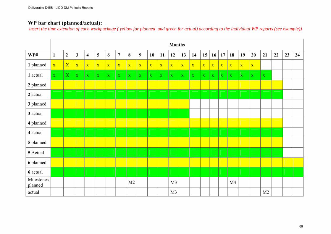
WP bar chart (planned/actual): insert the time extention of each workpackage ( yellow for planned and green for actual) according to the individual WP reports (see example))
Months
WP# 1 2 3 4 5 6 7 8 9 10 11 12 13 14 15 16 17 18 19 20 21 22 23 24
1 planned x X x x x x x x x x x x x x x x x x x x
1 actual x X x x x x x x x x x x x x x x x x x x x
2 planned
2 actual
3 planned
3 actual
4 planned
4 actual
5 planned
5 Actual
6 planned
6 actual Milestonesplanned M2 M3 M4
actual M3 M2
Deliverable D45B - LIDO DM Periodic Reports
69
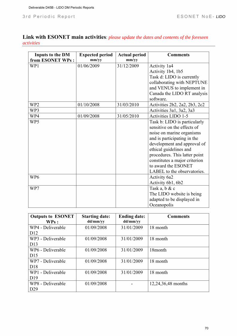
3 r d P e r i o d i c R e p o r t E S O N E T N o E - LIDO
Link with ESONET main activities: please update the dates and contents of the foreseen activities
Inputs to the DM from ESONET WPs :
Expected period mm/yy
Actual period mm/yy
Comments
WP1 01/06/2009 31/12/2009 Activity 1a4 Activity 1b4, 1b5 Task d: LIDO is currently collaborating with NEPTUNE and VENUS to implement in Canada the LIDO RT analysis software.
WP2 01/10/2008 31/03/2010 Activities 2b2, 2a2, 2b3, 2c2 WP3 Activities 3a1, 3a2, 3a3 WP4 01/09/2008 31/05/2010 Activities LIDO 1-5 WP5 Task b: LIDO is particularly
sensitive on the effects of noise on marine organisms and is participating in the development and approval of ethical guidelines and procedures. This latter point constitutes a major criterion to award the ESONET LABEL to the observatories.
WP6 Activity 6a2 Activity 6b1, 6b2
WP7 Task a, b & c The LIDO website is being adapted to be displayed in Oceanopolis
Outputs to ESONET
WPs : Starting date:
dd/mm/yy Ending date:
dd/mm/yy Comments
WP4 - Deliverable D12
01/09/2008 31/01/2009 18 month
WP3 - Deliverable D13
01/09/2008 31/01/2009 18 month
WP6 - Deliverable D15
01/09/2008 31/01/2009 18month
WP7 - Deliverable D18
01/09/2008 31/01/2009 18 month
WP1 - Deliverable D19
01/09/2008 31/01/2009 18 month
WP8 - Deliverable D29
01/09/2008 - 12,24,36,48 months
Deliverable D45B - LIDO DM Periodic Reports
70
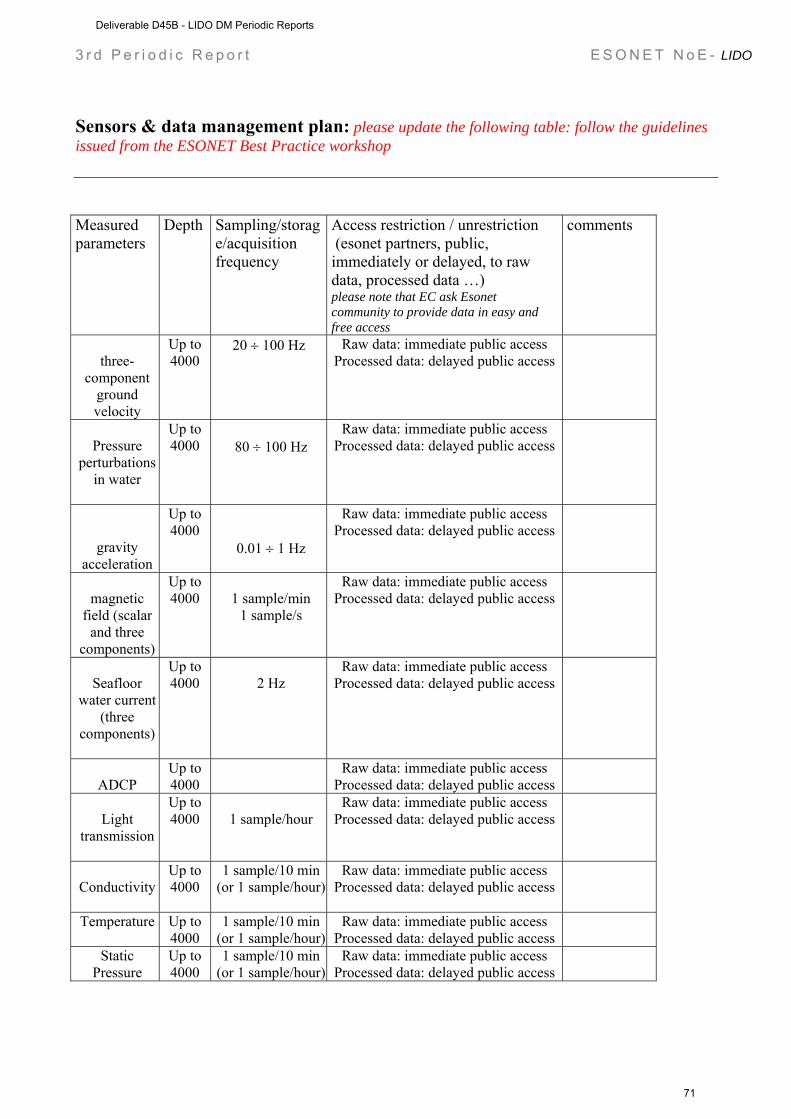
3 r d P e r i o d i c R e p o r t E S O N E T N o E - LIDO
Sensors & data management plan: please update the following table: follow the guidelines issued from the ESONET Best Practice workshop Measured parameters
Depth Sampling/storage/acquisition frequency
Access restriction / unrestriction (esonet partners, public, immediately or delayed, to raw data, processed data …) please note that EC ask Esonet community to provide data in easy and free access
comments
three-
component ground velocity
Up to 4000
20 ÷ 100 Hz Raw data: immediate public access Processed data: delayed public access
Pressure
perturbations in water
Up to 4000
80 ÷ 100 Hz
Raw data: immediate public access Processed data: delayed public access
gravity acceleration
Up to 4000
0.01 ÷ 1 Hz
Raw data: immediate public access Processed data: delayed public access
magnetic
field (scalar and three
components)
Up to 4000
1 sample/min
1 sample/s
Raw data: immediate public access Processed data: delayed public access
Seafloor
water current (three
components)
Up to 4000
2 Hz
Raw data: immediate public access Processed data: delayed public access
ADCP
Up to 4000
Raw data: immediate public access Processed data: delayed public access
Light
transmission
Up to 4000
1 sample/hour
Raw data: immediate public access Processed data: delayed public access
Conductivity
Up to 4000
1 sample/10 min (or 1 sample/hour)
Raw data: immediate public access Processed data: delayed public access
Temperature Up to 4000
1 sample/10 min (or 1 sample/hour)
Raw data: immediate public access Processed data: delayed public access
Static Pressure
Up to 4000
1 sample/10 min (or 1 sample/hour)
Raw data: immediate public access Processed data: delayed public access
Deliverable D45B - LIDO DM Periodic Reports
71

3 r d P e r i o d i c R e p o r t E S O N E T N o E - LIDO
Methane
concentration
Up to 4000
1 Hz Raw data: immediate public access Processed data: delayed public access
H2S
concentration
Up to 4000
1 sample/10 min (averaged on 30
samples/s)
Public, delayed
pH
Up to 4000
1 sample/6 hours*
Public, delayed
water sampler
Up to 4000
Off-line analysis Public, delayed
Biological noise (cetacean: sperm whales, beaked whales, pilot whales, baleen whales) Anthropoge-nic noise (shipping and other activities) Natural noise
Up to 2500
4 Hydrophones: (sensitivity -195 de re 1V/mPa from 20Hz to 50kHz) preamplification (+20dB) and digitization underwater (at 96 kHz, 24 bit) All 4 hydrophones synchronized and phased All data are continuously sent to shore. Data acquisition and recording on-shore. Data distribution through internet.
ESONET partners, Scientific Community (RT optimised data and delayed if registered to download good quality raw data), Public Real-Time access of optimised data and access to previous recordings
Deliverable D45B - LIDO DM Periodic Reports
72
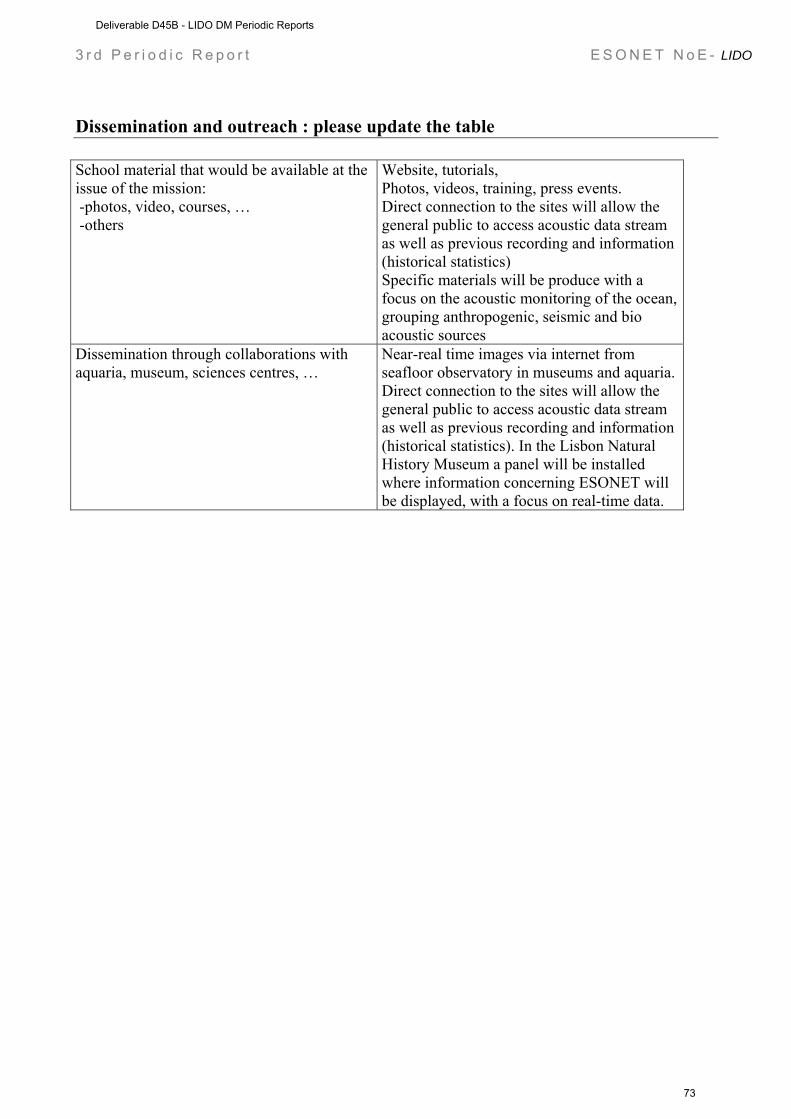
3 r d P e r i o d i c R e p o r t E S O N E T N o E - LIDO
Dissemination and outreach : please update the table School material that would be available at the issue of the mission: -photos, video, courses, … -others
Website, tutorials, Photos, videos, training, press events. Direct connection to the sites will allow the general public to access acoustic data stream as well as previous recording and information (historical statistics) Specific materials will be produce with a focus on the acoustic monitoring of the ocean, grouping anthropogenic, seismic and bio acoustic sources
Dissemination through collaborations with aquaria, museum, sciences centres, …
Near-real time images via internet from seafloor observatory in museums and aquaria. Direct connection to the sites will allow the general public to access acoustic data stream as well as previous recording and information (historical statistics). In the Lisbon Natural History Museum a panel will be installed where information concerning ESONET will be displayed, with a focus on real-time data.
Deliverable D45B - LIDO DM Periodic Reports
73

3 r d P e r i o d i c R e p o r t E S O N E T N o E - LIDO
Part II (to be filled by each partners) ESONET Noe – Demonstration Mission DM acronym: LIDO
Scientific Area(s): GEOPHYSISCS & BIOACOUSTICS
Technological Area(s): GEOPHYSISCS & BIOACOUSTICS
DM Start date: 01/09/2008
DM duration: 24 MONTHS
WP management report (from 1 to 30 September 2008)
WORKPACKAGE WP1
Full WP title Recovery, Refurbishment and Deployment of Observatories Period covered from 01/09/2008 to 30/09/2008 Partner organisation full name INGV
Person in charge for the report (WP Leader)
PAOLO FAVALI, GIUDITTA MARINARO, DAVIDE EMBRIACO
Partners involved in the Work INGV, INFN, TEC, CSIC, TFH, UPC
Period of the reporting: from 1 to 30 September 2008 Provide a justification of the major costs incurred and resources deployed, linking them to activities implemented and explaining their necessity. • Work Performed : A brief description (max 700 char) of the work performed by each
contractor during the period. This should be addressed at the workpackage level, and the work specification should be detailed enough to justify the resources employed - “Contributing to workpackage X” or “Contributing YY% to workpackage X” is too unspecific. Rather e.g. “Developed the ...module for…in workpackage X”.
Tasks/activities: Developments and enhancements of NEMO-SN1 and GEOSTAR observatories and infrastructures to open the nodes of a first nucleus of regional network to other disciplines (bioacoustics) and homogenization of geophysical equipments by integration of additional sensor, devices, and software. Catania site The on shore acquisition system for all the geophysical instruments of SN1 observatory was detailed projected in order to upgrade to the new configuration: the sensor management is now performed on shore. Data management was organized in order to locally store all data, make them available to the same data server which manages also the bio-acoustic data from the hydrophones for mammal sound recording. The development of the software procedures to perform data acquisition with syncronized time stamp, storage, and sharing is quite completed and implemented on the server unit that will be installed in the CTSL-INFN facility and connected to the off shore observatory
Deliverable D45B - LIDO DM Periodic Reports
74
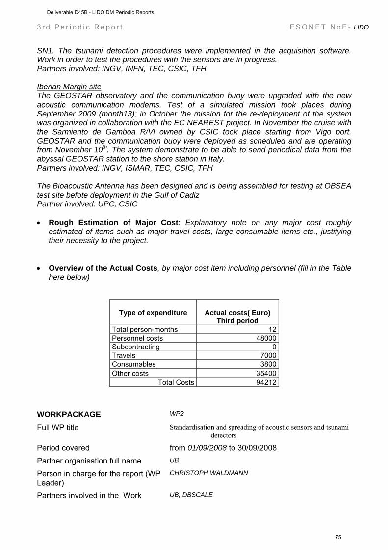
3 r d P e r i o d i c R e p o r t E S O N E T N o E - LIDO
SN1. The tsunami detection procedures were implemented in the acquisition software. Work in order to test the procedures with the sensors are in progress. Partners involved: INGV, INFN, TEC, CSIC, TFH Iberian Margin site The GEOSTAR observatory and the communication buoy were upgraded with the new acoustic communication modems. Test of a simulated mission took places during September 2009 (month13); in October the mission for the re-deployment of the system was organized in collaboration with the EC NEAREST project. In November the cruise with the Sarmiento de Gamboa R/Vl owned by CSIC took place starting from Vigo port. GEOSTAR and the communication buoy were deployed as scheduled and are operating from November 10th. The system demonstrate to be able to send periodical data from the abyssal GEOSTAR station to the shore station in Italy. Partners involved: INGV, ISMAR, TEC, CSIC, TFH The Bioacoustic Antenna has been designed and is being assembled for testing at OBSEA test site befote deployment in the Gulf of Cadiz Partner involved: UPC, CSIC • Rough Estimation of Major Cost: Explanatory note on any major cost roughly
estimated of items such as major travel costs, large consumable items etc., justifying their necessity to the project.
• Overview of the Actual Costs, by major cost item including personnel (fill in the Table
here below)
Type of expenditure
Actual costs( Euro) Third period
Total person-months 12 Personnel costs 48000 Subcontracting 0 Travels 7000 Consumables 3800 Other costs 35400
Total Costs 94212 WORKPACKAGE WP2
Full WP title Standardisation and spreading of acoustic sensors and tsunami detectors
Period covered from 01/09/2008 to 30/09/2008 Partner organisation full name UB
Person in charge for the report (WP Leader)
CHRISTOPH WALDMANN
Partners involved in the Work UB, DBSCALE
Deliverable D45B - LIDO DM Periodic Reports
75
3 r d P e r i o d i c R e p o r t E S O N E T N o E - LIDO
Period of the reporting: from 1 to 30 September 2008 Provide a justification of the major costs incurred and resources deployed, linking them to activities implemented and explaining their necessity. DBSCALE: -0- men months for this period Reminder: Total men months planned for whole project: 3 UB: [TBD] • Work Performed : A brief description (max 700 char) of the work performed by each
contractor during the period. This should be addressed at the workpackage level, and the work specification should be detailed enough to justify the resources employed - “Contributing to workpackage X” or “Contributing YY% to workpackage X” is too unspecific. Rather e.g. “Developed the ...module for…in workpackage X”.
This period: Following LIDO kick-off meeting in Barcelona where we have been working on the following deliverables: D2.4. Report on the implementation of prototype SWE concepts D2.5. Report on the sensor registry
In particular: Some progress is underway on D2.4, in particular to adapt the content with a specific example of acoustic transducer characteristics SML encoding. As a reminder, as part of the LIDO mission, architecture concepts in D2.4 were published in the following conference paper (Delory et al., Passive 08 - Hyères, 2008). D2.4 will further develop the description of the SWE framework implementation concept meant to serve as an architectural guidance candidate to the LIDO Data Management and hardware interface development teams: A proposed architecture for marine mammal tracking from globally distributed ocean acoustic observatories E. Delory (1) , C. Waldmann (2), J. Fredericks (3) (1) dBscale Environmental Sensing, C/ Leon y Castillo 25 Telde, Spain, [email protected] (2) University of Bremen/MARUM Leobener Strasse P.O. Box 330440 28334 Bremen Germany (3) Woods Hole Oceanographic Institution, 266 Woods Hole Road, Woods Hole, MA 02543, USA With respect to D2.5 the first SensorML instance for hydrophone available today is being developed and inputs are being collected from ESONET and LIDO partners. This instance will be used as a guide for and implemented within the ESONET Sensor Registry (ESONET WP2 & WP9) hydrophone registration interface. Both D 2.4 and D2.5 are still to be delivered on Month 22 as they may need to be updated in the remaining course of the LIDO project. WORKPACKAGE WP3
Full WP title Public Outreach Period covered from 01/09/2008 to 30/09/2008 Partner organisation full name FFCUL
Person in charge for the report (WP Leader)
JORGE MIGUEL MIRANDA
Deliverable D45B - LIDO DM Periodic Reports
76
3 r d P e r i o d i c R e p o r t E S O N E T N o E - LIDO
Partners involved in the Work UPC
Period of the reporting: from 1 to 30 September 2008 Provide a justification of the major costs incurred and resources deployed, linking them to activities implemented and explaining their necessity. • Work Performed : A brief description (max 700 char) of the work performed by each
contractor during the period. This should be addressed at the workpackage level, and the work specification should be detailed enough to justify the resources employed - “Contributing to workpackage X” or “Contributing YY% to workpackage X” is too unspecific. Rather e.g. “Developed the ...module for…in workpackage X”.
The major input for this period of this workpackage was the improvement and online publication of the website for the public outreach (http://listentothedeep.com , .org, .net), as well as the work in conjunction with WP7 to design the publication and display of the website in OCEANOPOLIS, Brest, France. WORKPACKAGE WP4
Full WP title RT Software Development Period covered from 01/09/2008 to 30/09/2008 Partner organisation full name UPC
Person in charge for the report (WP Leader)
MICHEL ANDRÉ
Partners involved in the Work UPC, CIBRA
Period of the reporting: from 1 to 30 September 2008 Provide a justification of the major costs incurred and resources deployed, linking them to activities implemented and explaining their necessity. • Work Performed : A brief description (max 700 char) of the work performed by each
contractor during the period. This should be addressed at the workpackage level, and the work specification should be detailed enough to justify the resources employed - “Contributing to workpackage X” or “Contributing YY% to workpackage X” is too unspecific. Rather e.g. “Developed the ...module for…in workpackage X”.
RT Software Development. Improvement of the RT and automatic analysis software: Long-term recording and analysis of natural, artificial and biological sound sources; Identification and tracking of cetaceans; Long-term noise interactions and masking. In the context of the WP3 and WP4 of Lido we contributed to the Data infrastructure of Esonet see activities of WP9, task a. Overview: Several modules for the automated classification and localizations of biological and anthropogenic acoustic sources have been developed, tested and validated with data from deep sea observatories (e.g. from the NEMO-onde observatory) . These modules
Deliverable D45B - LIDO DM Periodic Reports
77

3 r d P e r i o d i c R e p o r t E S O N E T N o E - LIDO
were specifically designed to process the outputs from the detection modules that were developed in the previous periods. Classification modules: The automated real-time detection and classification of cetacean and anthropogenic sounds from deep-sea observatories can play a key role to study cetaceans in the field, to quantify the impact of anthropogenic sounds or to initiate mitigation measures during potentially harmful human activities. In the area of the NEMO-onde deep-sea observatory, sperm whales are often present together with heavy shipping. The spatial coincidence of both sound sources allows for the long term monitoring of their interaction. Some ships produce impulsive sounds and the automated separation of these impulses from sperm whale clicks is not a trivial task. As part of a detection, classification and localisation system for acoustic data from marine observatories, we developed several modules performing the automated real-time classification of clicks from sperm whales, impulsive sounds produced by ships and ultrasonic cetacean clicks. First, the detection modules detect segments that contain impulsive sounds within a specifiable frequency band and return the impulse positions. Then, the classification modules classify the detected impulses as sperm whale click, ship impulse or ultrasonic cetacean click. Finally, at the level of 22 second segments, the outputs from individual impulses are combined into a decision on the presence of sperm whale clicks, ship impulses or ultrasonic cetacean clicks. The modules’ reliability was tested on data from the NEMO ONDE observatory. Training and testing data were separated by more than 2 months, enabling to assess the consistency of the system’s predictions over the long term. The automated separation between segments with sperm whale clicks and ship impulses was high with Area Under the ROC Curve (AUC) values between 0.94 and 0.98. The automated separation between segments with ultrasonic cetacean clicks and the two former classes was nearly perfect. Localization modules: In the frame of the European network ESONET (European Sea-floor Observatory Network) and the Demonstration Mission LIDO (Listening to the Deep-Ocean Environment), vocalising sperm whales were detected offshore the port of Catania (Sicily) with a bottom-mounted (around 2080m depth) tetrahedral compact array intended for the automated real-time detection, classification and localisation of cetaceans. Such Passive Acoustic Monitoring techniques have the potential to play a key role in cetaceans’ conservation for they allow a non-invasive study of their behaviour, a better knowledge of their population dynamics, and a better understanding of their dynamic relationship with their environment. We investigated the development of efficient and accurate techniques to be used as the basis of a localisation module for an automated real-time Passive Acoustic Monitoring system. A well-known class of methods for acoustic source localisation is based on time differences of arrival (TDOA). Its capabilities have shown to be appreciable even in adverse situations (i.e. few sensors, high noise levels and/or poor calibration). A second class of methods, the space-time methods, originated in underwater applications such as sonar but reached its most significant achievements over the last twenty years in digital communications with recent progress in the treatment of broadband signals. These developments were revisited under the scope of the localisation and tracking of cetacean vocalisations. Various broadband space-time methods were implemented and allowed to map the sound radiated during the detected clicks and to consequently localise both sperm whales and vessels. Hybrid methods were also developed which improved the robustness of space-time methods to noise and reverberation and reduced computation time. In most cases, the small variance obtained for these estimates lessened the necessity of additional
Deliverable D45B - LIDO DM Periodic Reports
78

3 r d P e r i o d i c R e p o r t E S O N E T N o E - LIDO
statistical clustering. The capacities of the approach were validated by consistent tracks of both sperm whales and vessels. WORKPACKAGE WP5
Full WP title Technical assessment Period covered from 01/09/2008 to 30/09/2008 Partner organisation full name INFN
Person in charge for the report (WP Leader)
GIORGIO RICCOBENE
Partners involved in the Work UPC
Period of the reporting: from 1 to 30 September 2008 Provide a justification of the major costs incurred and resources deployed, linking them to activities implemented and explaining their necessity. • Work Performed : A brief description (max 700 char) of the work performed by each
contractor during the period. This should be addressed at the workpackage level, and the work specification should be detailed enough to justify the resources employed - “Contributing to workpackage X” or “Contributing YY% to workpackage X” is too unspecific. Rather e.g. “Developed the ...module for…in workpackage X”.
Test and validation of low cost acoustic arrays and recording systems to be implemented in additional locations to extend the monitoring network and possibly evaluate new European sites for long term monitoring. The stream of data coming from the observatory will be directed to a server (ADS) that will distribute it to preprocessing servers where the first filters will be applied as well as where the following specific analysis of the data will be performed. A dedicated server (RADS) will compress and store the roar data. Through a WI-FI connection the processed data will then be sent tot he LNS station where one server will allow the safe public access to the low resolution data and another one will offer the access to high resolution data to registered users. Both servers will be separatedfor safety reasons and spam/virus protection.
- setup a workstation with 1Gbit link to a GARR node for fast data transfer from Catania
- setup a 8TB storage space for incoming data tested FLAC algorithms on NEMO-ONDE datasets provided NEMO-ONDE datasets for developing and testing detection, localization and tracking algorithms for sperm whales
- initiated the development of an FTP front-end to make data sharing easy - initiated the development of a pulses/whistles discriminator and of a whistle
classificator • A tabular overview of budgeted person-months and actual person-months by
workpackage (budgeted person –months to be taken from “Effort breakdown” Excel file)
Deliverable D45B - LIDO DM Periodic Reports
79
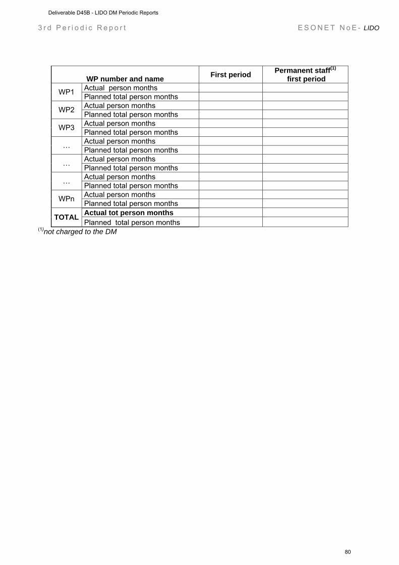
3 r d P e r i o d i c R e p o r t E S O N E T N o E - LIDO
WP number and name First period Permanent staff(1)
first period Actual person months WP1 Planned total person months Actual person months WP2 Planned total person months Actual person months WP3 Planned total person months Actual person months … Planned total person months Actual person months … Planned total person months Actual person months … Planned total person months Actual person months WPn Planned total person months Actual tot person months TOTAL Planned total person months
(1)not charged to the DM
Deliverable D45B - LIDO DM Periodic Reports
80
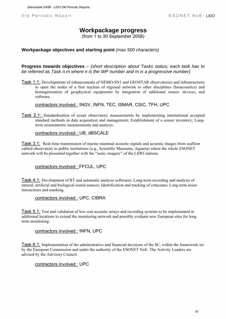
3 r d P e r i o d i c R e p o r t E S O N E T N o E - LIDO
Workpackage progress (from 1 to 30 September 2008)
Workpackage objectives and starting point (max 500 characters)
Progress towards objectives – (short description about Tasks status; each task has to be referred as Task n.m where n is the WP number and m is a progressive number) Task 1.1: Developments of enhancements of NEMO-SN1 and GEOSTAR observatories and infrastructures
to open the nodes of a first nucleus of regional network to other disciplines (bioacoustics) and homogenization of geophysical equipments by integration of additional sensor, devices, and software.
contractors involved : INGV, INFN, TEC, ISMAR, CSIC, TFH, UPC Task 2.1: Standardisation of ocean observatory measurements by implementing international accepted
standard methods in data acquisition and management; Establishment of a sensor inventory; Long- term seismometric measurements and analysis.
contractors involved : UB, dBSCALE Task 3.1: Real-time transmission of marine mammal acoustic signals and acoustic images from seafloor cabled observatory to public institutions (e.g., Scientific Museums, Aquaria) where the whole ESONET network will be presented together with the “sonic imagery” of the LIDO stations.
contractors involved : FFCUL, UPC
Task 4.1: Development of RT and automatic analysis softwares: Long-term recording and analysis of natural, artificial and biological sound sources; Identification and tracking of cetaceans; Long-term noise interactions and masking.
contractors involved : UPC, CIBRA
Task 5.1: Test and validation of low cost acoustic arrays and recording systems to be implemented in additional locations to extend the monitoring network and possibly evaluate new European sites for long term monitoring.
contractors involved : INFN, UPC
Task 6.1: Implementation of the administrative and financial decisions of the SC, within the framework set by the European Commission and under the authority of the ESONET NoE. The Activity Leaders are advised by the Advisory Council.
contractors involved : UPC
Deliverable D45B - LIDO DM Periodic Reports
81
3 r d P e r i o d i c R e p o r t E S O N E T N o E - LIDO
Deviations from the project work programme, and corrective actions taken/suggested (identify the nature and the reason for the problem, identify partners involved)
A) insert the name of the cause of deviation and explain why this cause has determined deviation. max 500 characters
Corrective actions: insert description of the corrective actions max 500 characters
B) insert the name of the cause of deviation and explain why this cause has determined deviation. max 500 characters
Corrective action: insert description of the corrective actions max 500 characters
Deliverable D45B - LIDO DM Periodic Reports
82
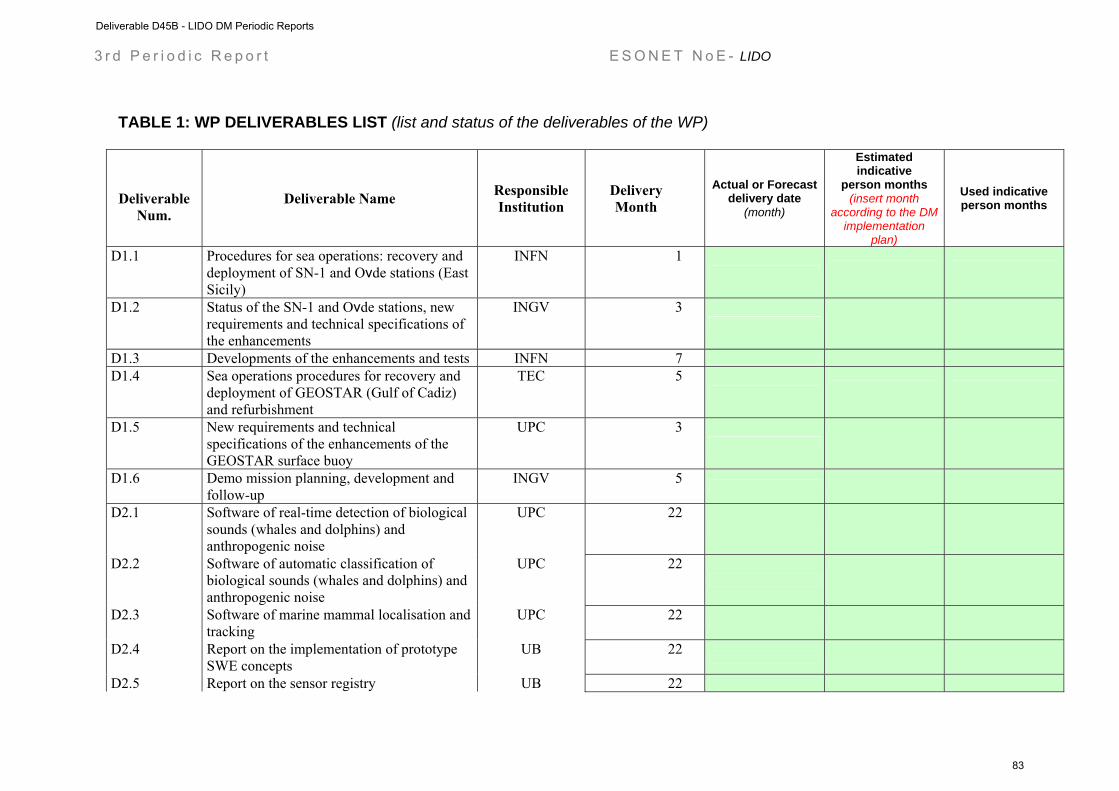
3 r d P e r i o d i c R e p o r t E S O N E T N o E - LIDO
TABLE 1: WP DELIVERABLES LIST (list and status of the deliverables of the WP)
Deliverable
Num. Deliverable Name Responsible
Institution Delivery Month
Actual or Forecast delivery date
(month)
Estimated indicative
person months (insert month
according to the DM implementation
plan)
Used indicative person months
D1.1 Procedures for sea operations: recovery and deployment of SN-1 and Oνde stations (East Sicily)
INFN 1
D1.2 Status of the SN-1 and Oνde stations, new requirements and technical specifications of the enhancements
INGV 3
D1.3 Developments of the enhancements and tests INFN 7
D1.4 Sea operations procedures for recovery and deployment of GEOSTAR (Gulf of Cadiz) and refurbishment
TEC 5
D1.5 New requirements and technical specifications of the enhancements of the GEOSTAR surface buoy
UPC 3
D1.6 Demo mission planning, development and follow-up
INGV 5
D2.1 Software of real-time detection of biological sounds (whales and dolphins) and anthropogenic noise
UPC 22
D2.2 Software of automatic classification of biological sounds (whales and dolphins) and anthropogenic noise
UPC 22
D2.3 Software of marine mammal localisation and tracking
UPC 22
D2.4 Report on the implementation of prototype SWE concepts
UB 22
D2.5 Report on the sensor registry UB 22
Deliverable D45B - LIDO DM Periodic Reports
83
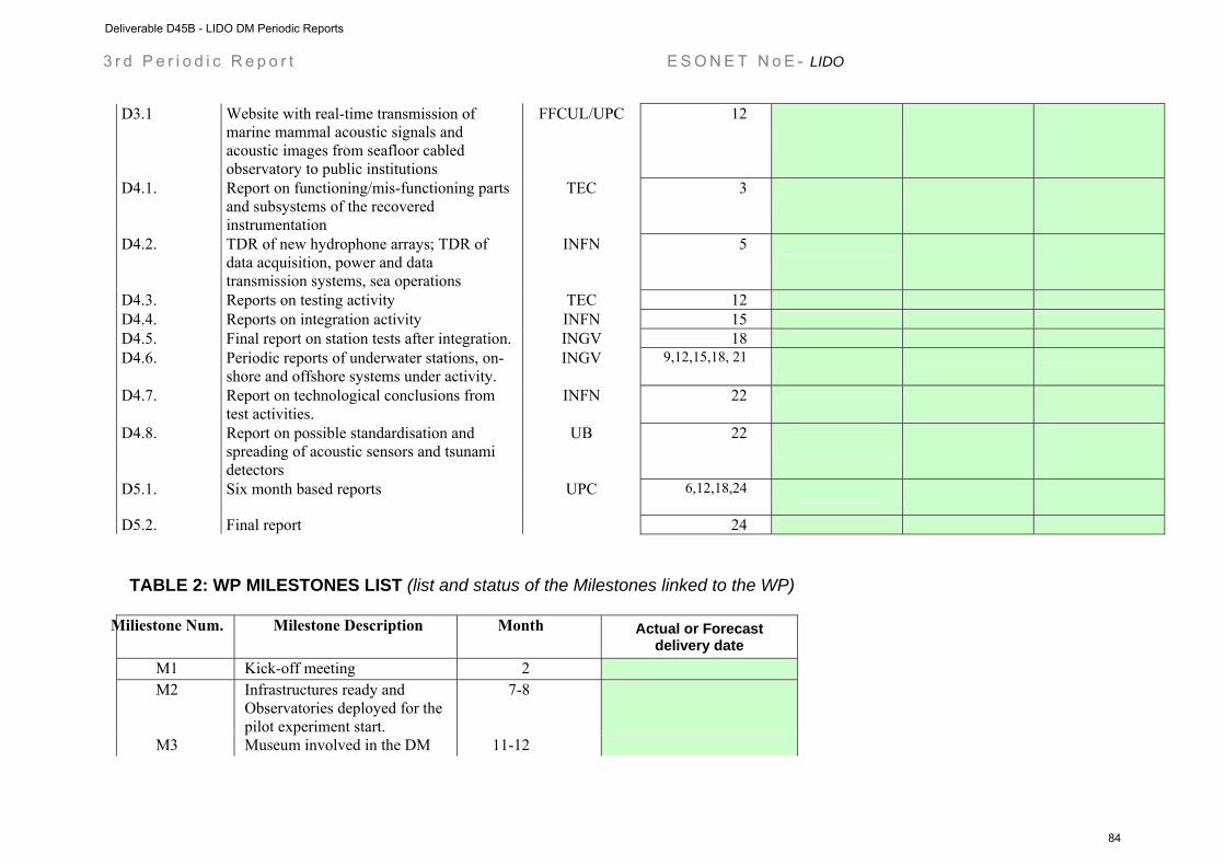
3 r d P e r i o d i c R e p o r t E S O N E T N o E - LIDO
D3.1 Website with real-time transmission of marine mammal acoustic signals and acoustic images from seafloor cabled observatory to public institutions
FFCUL/UPC 12
D4.1. Report on functioning/mis-functioning parts and subsystems of the recovered instrumentation
TEC 3
D4.2. TDR of new hydrophone arrays; TDR of data acquisition, power and data transmission systems, sea operations
INFN 5
D4.3. Reports on testing activity TEC 12
D4.4. Reports on integration activity INFN 15
D4.5. Final report on station tests after integration. INGV 18
D4.6. Periodic reports of underwater stations, on-shore and offshore systems under activity.
INGV 9,12,15,18, 21
D4.7. Report on technological conclusions from test activities.
INFN 22
D4.8. Report on possible standardisation and spreading of acoustic sensors and tsunami detectors
UB 22
D5.1. Six month based reports UPC 6,12,18,24
D5.2. Final report 24
TABLE 2: WP MILESTONES LIST (list and status of the Milestones linked to the WP)
Miliestone Num. Milestone Description Month Actual or Forecast
delivery date M1 Kick-off meeting 2 M2 Infrastructures ready and
Observatories deployed for the pilot experiment start.
7-8
M3 Museum involved in the DM 11-12
Deliverable D45B - LIDO DM Periodic Reports
84
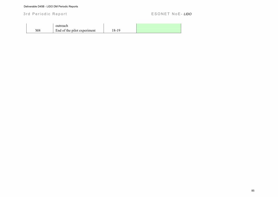
3 r d P e r i o d i c R e p o r t E S O N E T N o E - LIDO
outreach M4 End of the pilot experiment 18-19
Deliverable D45B - LIDO DM Periodic Reports
85
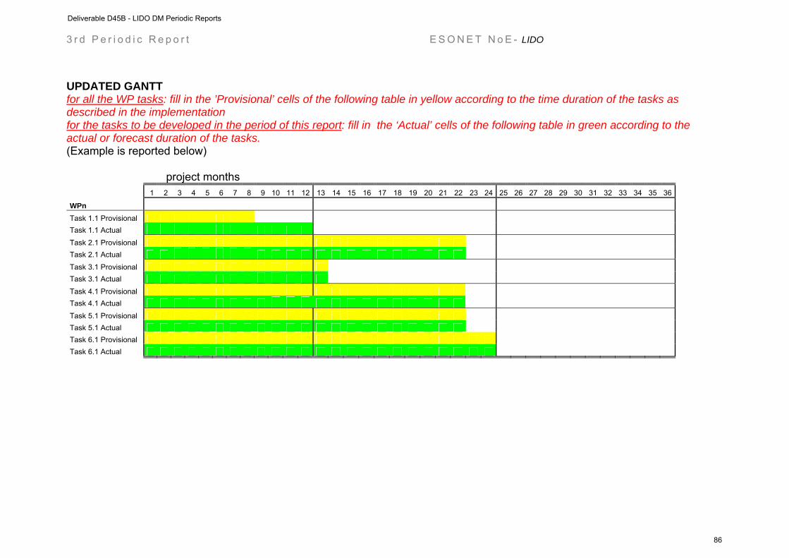
3 r d P e r i o d i c R e p o r t E S O N E T N o E - LIDO
UPDATED GANTT for all the WP tasks: fill in the ’Provisional’ cells of the following table in yellow according to the time duration of the tasks as described in the implementation for the tasks to be developed in the period of this report: fill in the ‘Actual’ cells of the following table in green according to the actual or forecast duration of the tasks. (Example is reported below)
project months
1 2 3 4 5 6 7 8 9 10 11 12 13 14 15 16 17 18 19 20 21 22 23 24 25 26 27 28 29 30 31 32 33 34 35 36
WPn
Task 1.1 Provisional Task 1.1 Actual
Task 2.1 Provisional Task 2.1 Actual Task 3.1 Provisional Task 3.1 Actual
Task 4.1 Provisional Task 4.1 Actual
Task 5.1 Provisional Task 5.1 Actual Task 6.1 Provisional Task 6.1 Actual
Deliverable D45B - LIDO DM Periodic Reports
86

Project contract no. 036851
ESONET
European Seas Observatory Network
Instrument: Network of Excellence (NoE) Thematic Priority: 1.1.6.3 – Climate Change and Ecosystems
Sub Priority: III – Global Change and Ecosystems
LOOME Demonstration Mission Periodic Reports
Start date of project: March 2007 Duration: 48 months Start date of the Demonstration Mission: February 2008 Duration: 35 months Project co-funded by the European Commission within the Sixth Framework Programme (2002-2006) Dissemination Level PU Public PP Restricted to other programme participants (including the Commission Services RE Restricted to a group specified by the consortium (including the Commission
Services)
CO Confidential, only for members of the consortium (including the Commission Services)
Deliverable D45B - LOOME DM Periodic Reports
87

Deliverable D45B - LOOME DM Periodic Reports
88
ESONET Demonstration Missions
1st Periodic Activity Report
The Periodic Activity Report contains an overview of the activities carried out during the reporting period, describes the progress in relation to the project objectives, the progress towards the milestones and deliverables set for the period, and any problems encountered and corrective actions taken. This document has to be filled in with reference to the DM Implementation plan. This means that Deliverables, Milestones and WPs have to be the same as in the DM Implementation plan. The Periodic Report contains 2 parts: - Part I: it is addressed to the coordinator with minimum input from the partners - Part II: it is addressed to each WP Leader and reports a detailed update of each WP activity at task level. The report includes a rough justification of the costs incurred and of the resources deployed by each contractor linking them to activities implemented and justifying their necessity. Finally the report contains information on use and dissemination activities. Reporting period: 1 February 2008 – 30 September 2008 Please indicate your DM starting date 1 February 2008
Deliverable D45B - LOOME DM Periodic Reports
89
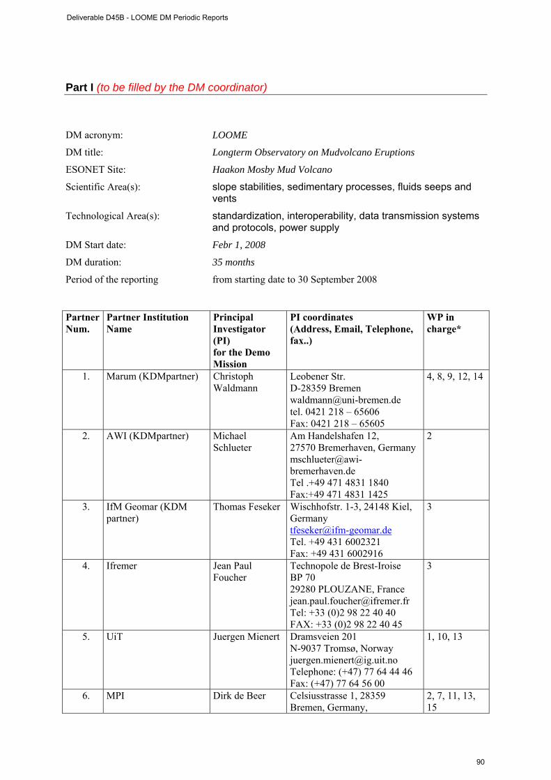
Part I (to be filled by the DM coordinator) DM acronym: LOOME
DM title: Longterm Observatory on Mudvolcano Eruptions
ESONET Site: Haakon Mosby Mud Volcano
Scientific Area(s): slope stabilities, sedimentary processes, fluids seeps and vents
Technological Area(s): standardization, interoperability, data transmission systems and protocols, power supply
DM Start date: Febr 1, 2008
DM duration: 35 months
Period of the reporting from starting date to 30 September 2008 Partner Num.
Partner Institution Name
Principal Investigator (PI) for the Demo Mission
PI coordinates (Address, Email, Telephone, fax..)
WP in charge*
1. Marum (KDMpartner) Christoph Waldmann
Leobener Str. D-28359 Bremen [email protected] tel. 0421 218 – 65606 Fax: 0421 218 – 65605
4, 8, 9, 12, 14
2. AWI (KDMpartner) Michael Schlueter
Am Handelshafen 12, 27570 Bremerhaven, Germany [email protected] Tel .+49 471 4831 1840 Fax:+49 471 4831 1425
2
3. IfM Geomar (KDM partner)
Thomas Feseker Wischhofstr. 1-3, 24148 Kiel, Germany [email protected] Tel. +49 431 6002321 Fax: +49 431 6002916
3
4. Ifremer Jean Paul Foucher
Technopole de Brest-Iroise BP 70 29280 PLOUZANE, France [email protected] Tel: +33 (0)2 98 22 40 40 FAX: +33 (0)2 98 22 40 45
3
5. UiT Juergen Mienert Dramsveien 201 N-9037 Tromsø, Norway [email protected] Telephone: (+47) 77 64 44 46 Fax: (+47) 77 64 56 00
1, 10, 13
6. MPI Dirk de Beer Celsiusstrasse 1, 28359 Bremen, Germany,
2, 7, 11, 13, 15
Deliverable D45B - LOOME DM Periodic Reports
90

tel. +494212028802 fax +494212028690
* of original proposal. Several WPs were dropped due to the budget restrictions. Executive summary (max one page) Brief description of the objective of the DM and brief description of the work status All components are purchased and seen by our engineers. Current progress: 1) the building of the frame. 2) the integration of the sonar, COSTOFF and the T-sensors. 3) the optimization of the sonar programming. 4) the pressure and temperature lances, and the geophones have been deployed at the Haakon Mosby Mud Volcano as planned. Recovery is planned in July 2009, followed by immediate redeployment. Table 1: Deliverables List Give the deliverable list and status
Deliverable n. Deliverable name Corresponding
WP n. Due Date Actual/
Forecast delivery date
Estimated indicative
person months
**
Used indicative
person months*
Lead contractor
1 Long-term
seismometer 1, 10, 13 6, 12*** 6, 12***
16 5 UiT
2 Long-term chemical sensors (pH, O2, sulfide, redoX) 2
12 12
16 1
MPI-MM
3 Long-term temperature sensors on surface. Temperature and pore pressure in the subsurface seabed 2
12 12
11 2
IFREMER/IFM-GEOMAR
4 Scanning sonar for gas flares detection 4
12 12 16 2
MARUM
5 Design of sensor network and operation platform 7
6 6
19 6
MPI
6 Deployment and recovery procedures for instruments and data 8
12 12
8 3
Marum
7 Design of underwater communication
9
9 9
17 4
MARUM/Ifremer/UiT
8 Documentation of inter-operability and standardization 14
24 24
7 2
MARUM
9 Cruise report Jan Mayen 2008, 10
6, 24****
6, 24**** 15 5
MPI/UiT/Ifrem
Deliverable D45B - LOOME DM Periodic Reports
91
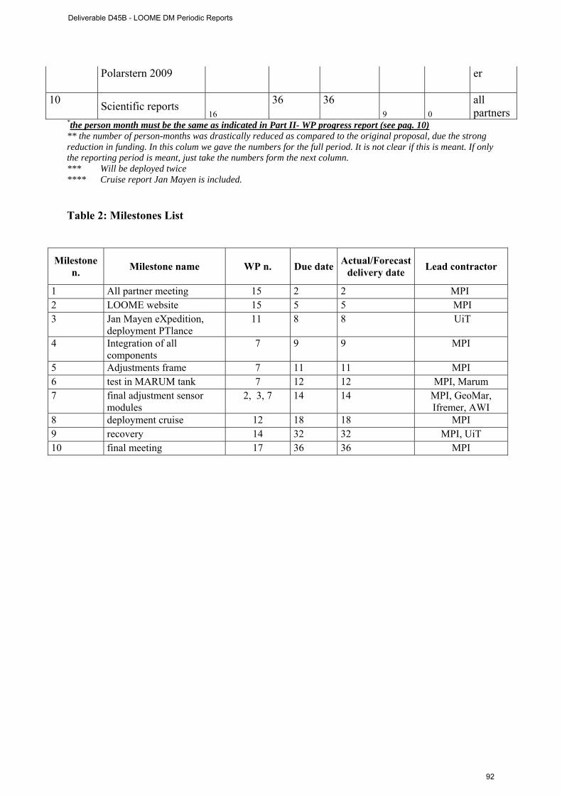
Polarstern 2009 er
10 Scientific reports 16
36 36 9 0
all partners
*the person month must be the same as indicated in Part II- WP progress report (see pag. 10) ** the number of person-months was drastically reduced as compared to the original proposal, due the strong reduction in funding. In this colum we gave the numbers for the full period. It is not clear if this is meant. If only the reporting period is meant, just take the numbers form the next column. *** Will be deployed twice **** Cruise report Jan Mayen is included.
Table 2: Milestones List
Milestone n. Milestone name WP n. Due date Actual/Forecast
delivery date Lead contractor
1 All partner meeting 15 2 2 MPI 2 LOOME website 15 5 5 MPI 3 Jan Mayen eXpedition,
deployment PTlance 11 8 8 UiT
4 Integration of all components
7 9 9 MPI
5 Adjustments frame 7 11 11 MPI 6 test in MARUM tank 7 12 12 MPI, Marum 7 final adjustment sensor
modules 2, 3, 7 14 14 MPI, GeoMar,
Ifremer, AWI 8 deployment cruise 12 18 18 MPI 9 recovery 14 32 32 MPI, UiT 10 final meeting 17 36 36 MPI
Deliverable D45B - LOOME DM Periodic Reports
92
WP bar chart (planned/actual): This bar chart does not work for our project, as it will last 35 months. Anyway, all WPs are exactly on track, and they have to be exactly on track due to the absolutely fixed dates of deployments. The cruises are with big ships, and thus planned long in advance.
Deliverable D45B - LOOME DM Periodic Reports
93
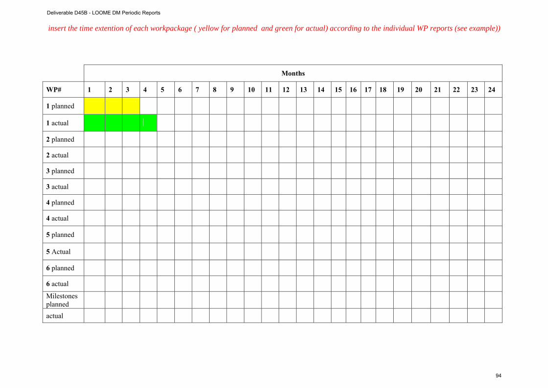
insert the time extention of each workpackage ( yellow for planned and green for actual) according to the individual WP reports (see example))
Months
WP# 1 2 3 4 5 6 7 8 9 10 11 12 13 14 15 16 17 18 19 20 21 22 23 24
1 planned
1 actual
2 planned
2 actual
3 planned
3 actual
4 planned
4 actual
5 planned
5 Actual
6 planned
6 actual
Milestones planned
actual
Deliverable D45B - LOOME DM Periodic Reports
94

1 s t P e r i o d i c R e p o r t E S O N E T N o E - DM acronym
Link with ESONET main activities: please update the dates and contents of the foreseen activities NONE
Inputs to the DM from ESONET WPs :
Expected period mm/yy
Actual period mm/yy
Comments
Outputs of the DM
activity to ESONET WPs :
Expected period mm/yy
Actual period mm/yy
Comments
Deliverable D45B - LOOME DM Periodic Reports
95
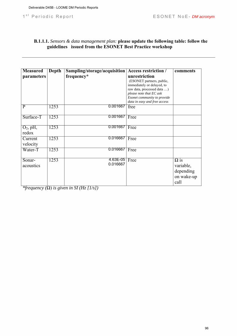
1 s t P e r i o d i c R e p o r t E S O N E T N o E - DM acronym
B.1.1.1. Sensors & data management plan: please update the following table: follow the guidelines issued from the ESONET Best Practice workshop
Measured parameters
Depth Sampling/storage/acquisition frequency*
Access restriction / unrestriction (ESONET partners, public, immediately or delayed, to raw data, processed data …) please note that EC ask Esonet community to provide data in easy and free access
comments
P 1253 0.001667
free
Surface-T 1253 0.001667
Free
O2, pH, redox
1253 0.001667
Free
Current velocity
1253 0.016667
Free
Water-T 1253 0.016667
Free
Sonar-acoustics
1253 4.63E-050.016667
Free Ω is variable, depending on wake-up call
*frequency (Ω) is given in SI (Hz [1/s])
Deliverable D45B - LOOME DM Periodic Reports
96
1 s t P e r i o d i c R e p o r t E S O N E T N o E - DM acronym
Dissemination and outreach: please update the table NONE
Type of school material available at the issue of the mission
(photos, video, courses,…others)
Description
Type of dissemination (through collaborations with aquaria,
museum, sciences centres, etc.)
Description
Deliverable D45B - LOOME DM Periodic Reports
97
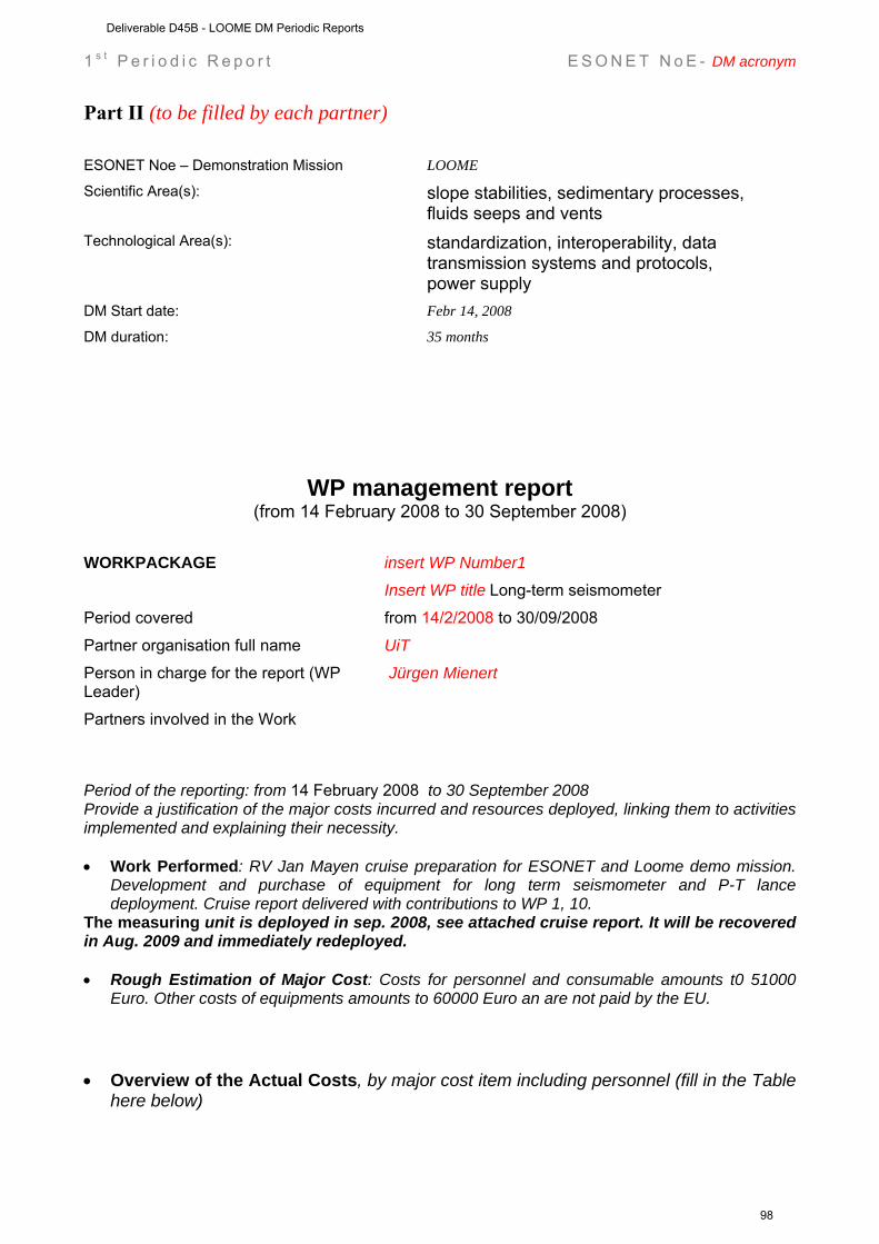
1 s t P e r i o d i c R e p o r t E S O N E T N o E - DM acronym
Part II (to be filled by each partner) ESONET Noe – Demonstration Mission LOOME
Scientific Area(s): slope stabilities, sedimentary processes, fluids seeps and vents
Technological Area(s): standardization, interoperability, data transmission systems and protocols, power supply
DM Start date: Febr 14, 2008
DM duration: 35 months
WP management report (from 14 February 2008 to 30 September 2008)
WORKPACKAGE insert WP Number1 Insert WP title Long-term seismometer
Period covered from 14/2/2008 to 30/09/2008
Partner organisation full name UiT Person in charge for the report (WP Leader)
Jürgen Mienert
Partners involved in the Work
Period of the reporting: from 14 February 2008 to 30 September 2008 Provide a justification of the major costs incurred and resources deployed, linking them to activities implemented and explaining their necessity. • Work Performed: RV Jan Mayen cruise preparation for ESONET and Loome demo mission.
Development and purchase of equipment for long term seismometer and P-T lance deployment. Cruise report delivered with contributions to WP 1, 10.
The measuring unit is deployed in sep. 2008, see attached cruise report. It will be recovered in Aug. 2009 and immediately redeployed. • Rough Estimation of Major Cost: Costs for personnel and consumable amounts t0 51000
Euro. Other costs of equipments amounts to 60000 Euro an are not paid by the EU. • Overview of the Actual Costs, by major cost item including personnel (fill in the Table
here below)
Deliverable D45B - LOOME DM Periodic Reports
98
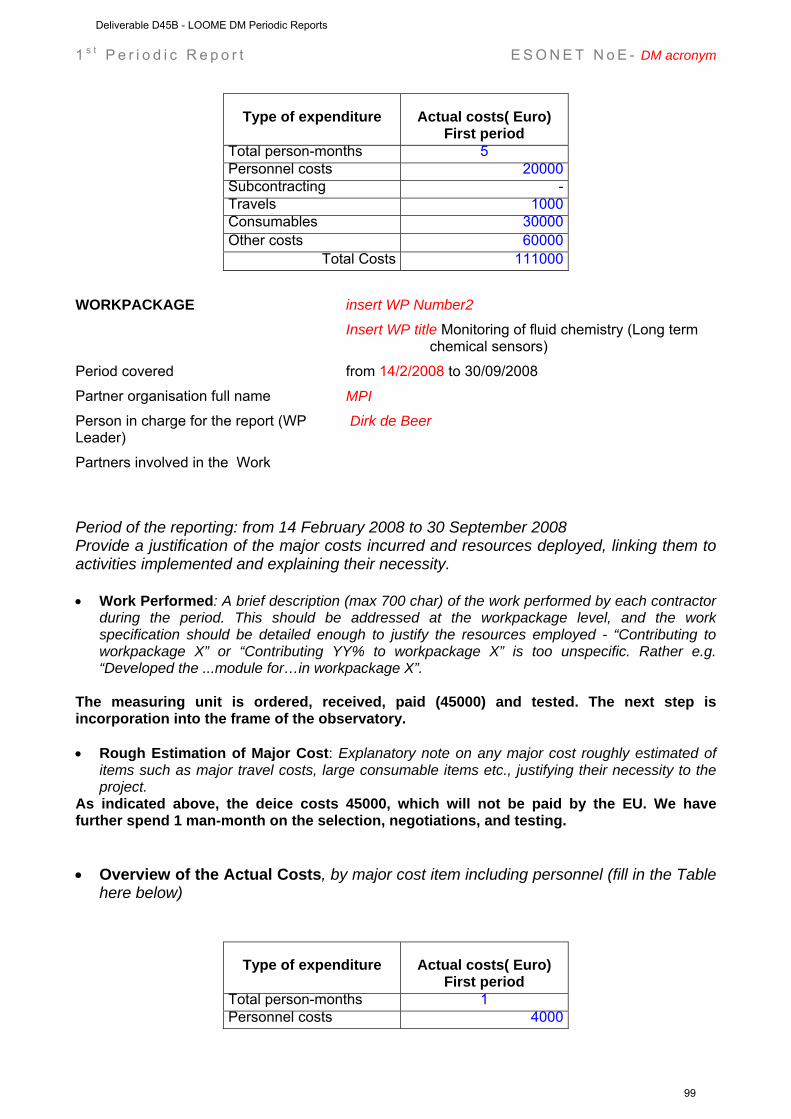
1 s t P e r i o d i c R e p o r t E S O N E T N o E - DM acronym
Type of expenditure
Actual costs( Euro) First period
Total person-months 5 Personnel costs 20000 Subcontracting - Travels 1000 Consumables 30000 Other costs 60000
Total Costs 111000 WORKPACKAGE insert WP Number2 Insert WP title Monitoring of fluid chemistry (Long term
chemical sensors)
Period covered from 14/2/2008 to 30/09/2008
Partner organisation full name MPI Person in charge for the report (WP Leader)
Dirk de Beer
Partners involved in the Work
Period of the reporting: from 14 February 2008 to 30 September 2008 Provide a justification of the major costs incurred and resources deployed, linking them to activities implemented and explaining their necessity. • Work Performed: A brief description (max 700 char) of the work performed by each contractor
during the period. This should be addressed at the workpackage level, and the work specification should be detailed enough to justify the resources employed - “Contributing to workpackage X” or “Contributing YY% to workpackage X” is too unspecific. Rather e.g. “Developed the ...module for…in workpackage X”.
The measuring unit is ordered, received, paid (45000) and tested. The next step is incorporation into the frame of the observatory. • Rough Estimation of Major Cost: Explanatory note on any major cost roughly estimated of
items such as major travel costs, large consumable items etc., justifying their necessity to the project.
As indicated above, the deice costs 45000, which will not be paid by the EU. We have further spend 1 man-month on the selection, negotiations, and testing. • Overview of the Actual Costs, by major cost item including personnel (fill in the Table
here below)
Type of expenditure
Actual costs( Euro) First period
Total person-months 1 Personnel costs 4000
Deliverable D45B - LOOME DM Periodic Reports
99
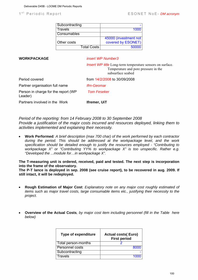
1 s t P e r i o d i c R e p o r t E S O N E T N o E - DM acronym
Subcontracting - Travels 1000 Consumables
Other costs 45000 (investment not covered by ESONET)
Total Costs 50000 WORKPACKAGE insert WP Number3 Insert WP title Long-term temperature sensors on surface.
Temperature and pore pressure in the subsurface seabed
Period covered from 14/2/2008 to 30/09/2008
Partner organisation full name Ifm-Geomar Person in charge for the report (WP Leader)
Tom Feseker
Partners involved in the Work Ifremer, UiT
Period of the reporting: from 14 February 2008 to 30 September 2008 Provide a justification of the major costs incurred and resources deployed, linking them to activities implemented and explaining their necessity. • Work Performed: A brief description (max 700 char) of the work performed by each contractor
during the period. This should be addressed at the workpackage level, and the work specification should be detailed enough to justify the resources employed - “Contributing to workpackage X” or “Contributing YY% to workpackage X” is too unspecific. Rather e.g. “Developed the ...module for…in workpackage X”.
The T-measuring unit is ordered, received, paid and tested. The next step is incorporation into the frame of the observatory. The P-T lance is deployed in sep. 2008 (see cruise report), to be recovered in aug. 2009. If still intact, it will be redeployed. • Rough Estimation of Major Cost: Explanatory note on any major cost roughly estimated of
items such as major travel costs, large consumable items etc., justifying their necessity to the project.
• Overview of the Actual Costs, by major cost item including personnel (fill in the Table here
below)
Type of expenditure
Actual costs( Euro) First period
Total person-months 2 Personnel costs 8000 Subcontracting - Travels 1000
Deliverable D45B - LOOME DM Periodic Reports
100
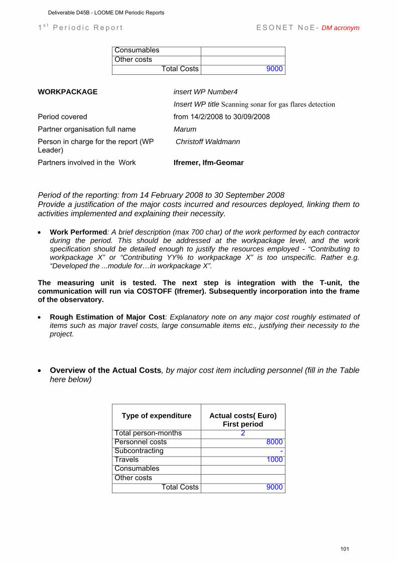
1 s t P e r i o d i c R e p o r t E S O N E T N o E - DM acronym
Consumables Other costs
Total Costs 9000 WORKPACKAGE insert WP Number4 Insert WP title Scanning sonar for gas flares detection
Period covered from 14/2/2008 to 30/09/2008
Partner organisation full name Marum Person in charge for the report (WP Leader)
Christoff Waldmann
Partners involved in the Work Ifremer, Ifm-Geomar
Period of the reporting: from 14 February 2008 to 30 September 2008 Provide a justification of the major costs incurred and resources deployed, linking them to activities implemented and explaining their necessity. • Work Performed: A brief description (max 700 char) of the work performed by each contractor
during the period. This should be addressed at the workpackage level, and the work specification should be detailed enough to justify the resources employed - “Contributing to workpackage X” or “Contributing YY% to workpackage X” is too unspecific. Rather e.g. “Developed the ...module for…in workpackage X”.
The measuring unit is tested. The next step is integration with the T-unit, the communication will run via COSTOFF (Ifremer). Subsequently incorporation into the frame of the observatory. • Rough Estimation of Major Cost: Explanatory note on any major cost roughly estimated of
items such as major travel costs, large consumable items etc., justifying their necessity to the project.
• Overview of the Actual Costs, by major cost item including personnel (fill in the Table
here below)
Type of expenditure
Actual costs( Euro) First period
Total person-months 2 Personnel costs 8000 Subcontracting - Travels 1000 Consumables Other costs
Total Costs 9000
Deliverable D45B - LOOME DM Periodic Reports
101
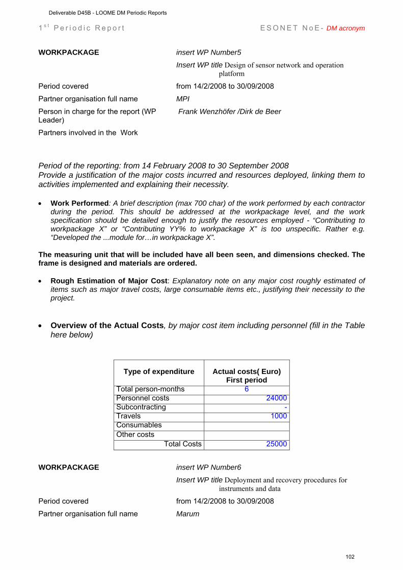
1 s t P e r i o d i c R e p o r t E S O N E T N o E - DM acronym
WORKPACKAGE insert WP Number5 Insert WP title Design of sensor network and operation
platform
Period covered from 14/2/2008 to 30/09/2008
Partner organisation full name MPI Person in charge for the report (WP Leader)
Frank Wenzhöfer /Dirk de Beer
Partners involved in the Work
Period of the reporting: from 14 February 2008 to 30 September 2008 Provide a justification of the major costs incurred and resources deployed, linking them to activities implemented and explaining their necessity. • Work Performed: A brief description (max 700 char) of the work performed by each contractor
during the period. This should be addressed at the workpackage level, and the work specification should be detailed enough to justify the resources employed - “Contributing to workpackage X” or “Contributing YY% to workpackage X” is too unspecific. Rather e.g. “Developed the ...module for…in workpackage X”.
The measuring unit that will be included have all been seen, and dimensions checked. The frame is designed and materials are ordered. • Rough Estimation of Major Cost: Explanatory note on any major cost roughly estimated of
items such as major travel costs, large consumable items etc., justifying their necessity to the project.
• Overview of the Actual Costs, by major cost item including personnel (fill in the Table
here below)
Type of expenditure
Actual costs( Euro) First period
Total person-months 6 Personnel costs 24000 Subcontracting - Travels 1000 Consumables Other costs
Total Costs 25000 WORKPACKAGE insert WP Number6 Insert WP title Deployment and recovery procedures for
instruments and data
Period covered from 14/2/2008 to 30/09/2008
Partner organisation full name Marum
Deliverable D45B - LOOME DM Periodic Reports
102
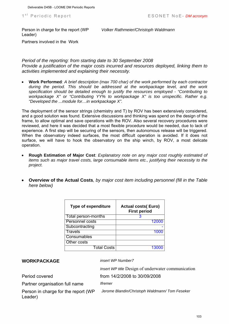
1 s t P e r i o d i c R e p o r t E S O N E T N o E - DM acronym
Person in charge for the report (WP Leader)
Volker Rathmeier/Christoph Waldmann
Partners involved in the Work
Period of the reporting: from starting date to 30 September 2008 Provide a justification of the major costs incurred and resources deployed, linking them to activities implemented and explaining their necessity. • Work Performed: A brief description (max 700 char) of the work performed by each contractor
during the period. This should be addressed at the workpackage level, and the work specification should be detailed enough to justify the resources employed - “Contributing to workpackage X” or “Contributing YY% to workpackage X” is too unspecific. Rather e.g. “Developed the ...module for…in workpackage X”.
The deployment of the sensor strings (chemistry and T) by ROV has been extensively considered, and a good solution was found. Extensive discussions and thinking was spend on the design of the frame, to allow optimal and save operations with the ROV. Also several recovery procedures were reviewed, and here it was decided that a most flexible procedure would be needed, due to lack of experience. A first step will be securing of the sensors, then autonomous release will be triggered. When the observatory indeed surfaces, the most difficult operation is avoided. If it does not surface, we will have to hook the observatory on the ship winch, by ROV, a most delicate operation. • Rough Estimation of Major Cost: Explanatory note on any major cost roughly estimated of
items such as major travel costs, large consumable items etc., justifying their necessity to the project.
• Overview of the Actual Costs, by major cost item including personnel (fill in the Table
here below)
Type of expenditure
Actual costs( Euro) First period
Total person-months 3 Personnel costs 12000 Subcontracting - Travels 1000 Consumables Other costs
Total Costs 13000 WORKPACKAGE insert WP Number7
Insert WP title Design of underwater communication
Period covered from 14/2/2008 to 30/09/2008 Partner organisation full name Ifremer
Person in charge for the report (WP Leader)
Jerome Blandin/Christoph Waldmann/ Tom Feseker
Deliverable D45B - LOOME DM Periodic Reports
103
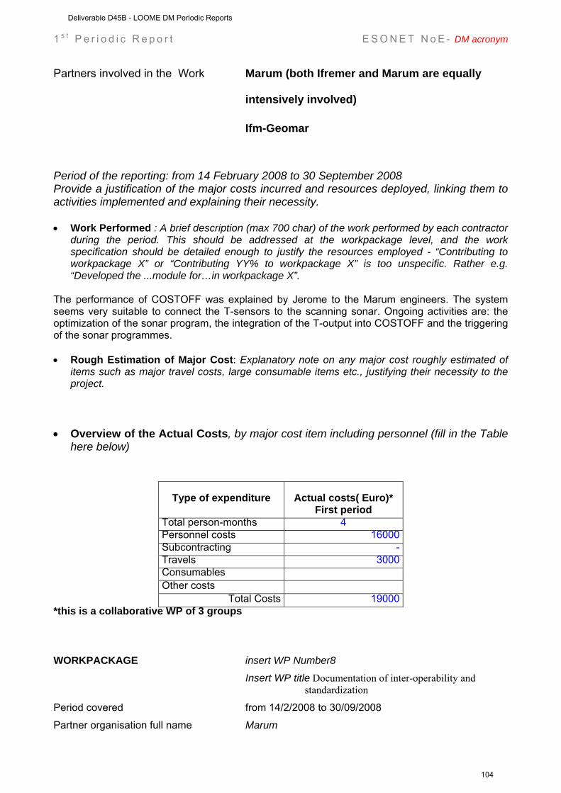
1 s t P e r i o d i c R e p o r t E S O N E T N o E - DM acronym
Partners involved in the Work Marum (both Ifremer and Marum are equally
intensively involved)
Ifm-Geomar
Period of the reporting: from 14 February 2008 to 30 September 2008 Provide a justification of the major costs incurred and resources deployed, linking them to activities implemented and explaining their necessity. • Work Performed : A brief description (max 700 char) of the work performed by each contractor
during the period. This should be addressed at the workpackage level, and the work specification should be detailed enough to justify the resources employed - “Contributing to workpackage X” or “Contributing YY% to workpackage X” is too unspecific. Rather e.g. “Developed the ...module for…in workpackage X”.
The performance of COSTOFF was explained by Jerome to the Marum engineers. The system seems very suitable to connect the T-sensors to the scanning sonar. Ongoing activities are: the optimization of the sonar program, the integration of the T-output into COSTOFF and the triggering of the sonar programmes. • Rough Estimation of Major Cost: Explanatory note on any major cost roughly estimated of
items such as major travel costs, large consumable items etc., justifying their necessity to the project.
• Overview of the Actual Costs, by major cost item including personnel (fill in the Table
here below)
Type of expenditure
Actual costs( Euro)* First period
Total person-months 4 Personnel costs 16000 Subcontracting - Travels 3000 Consumables Other costs
Total Costs 19000 *this is a collaborative WP of 3 groups WORKPACKAGE insert WP Number8 Insert WP title Documentation of inter-operability and
standardization
Period covered from 14/2/2008 to 30/09/2008
Partner organisation full name Marum
Deliverable D45B - LOOME DM Periodic Reports
104
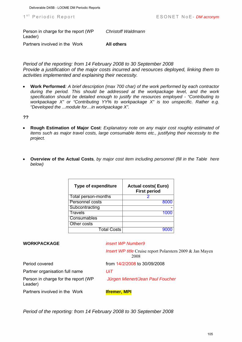
1 s t P e r i o d i c R e p o r t E S O N E T N o E - DM acronym
Person in charge for the report (WP Leader)
Christoff Waldmann
Partners involved in the Work All others
Period of the reporting: from 14 February 2008 to 30 September 2008 Provide a justification of the major costs incurred and resources deployed, linking them to activities implemented and explaining their necessity. • Work Performed: A brief description (max 700 char) of the work performed by each contractor
during the period. This should be addressed at the workpackage level, and the work specification should be detailed enough to justify the resources employed - “Contributing to workpackage X” or “Contributing YY% to workpackage X” is too unspecific. Rather e.g. “Developed the ...module for…in workpackage X”.
?? • Rough Estimation of Major Cost: Explanatory note on any major cost roughly estimated of
items such as major travel costs, large consumable items etc., justifying their necessity to the project.
• Overview of the Actual Costs, by major cost item including personnel (fill in the Table here
below)
Type of expenditure
Actual costs( Euro) First period
Total person-months 2 Personnel costs 8000 Subcontracting - Travels 1000 Consumables Other costs
Total Costs 9000 WORKPACKAGE insert WP Number9 Insert WP title Cruise report Polarstern 2009 & Jan Mayen
2008
Period covered from 14/2/2008 to 30/09/2008
Partner organisation full name UiT Person in charge for the report (WP Leader)
Jürgen Mienert/Jean Paul Foucher
Partners involved in the Work Ifremer, MPI
Period of the reporting: from 14 February 2008 to 30 September 2008
Deliverable D45B - LOOME DM Periodic Reports
105
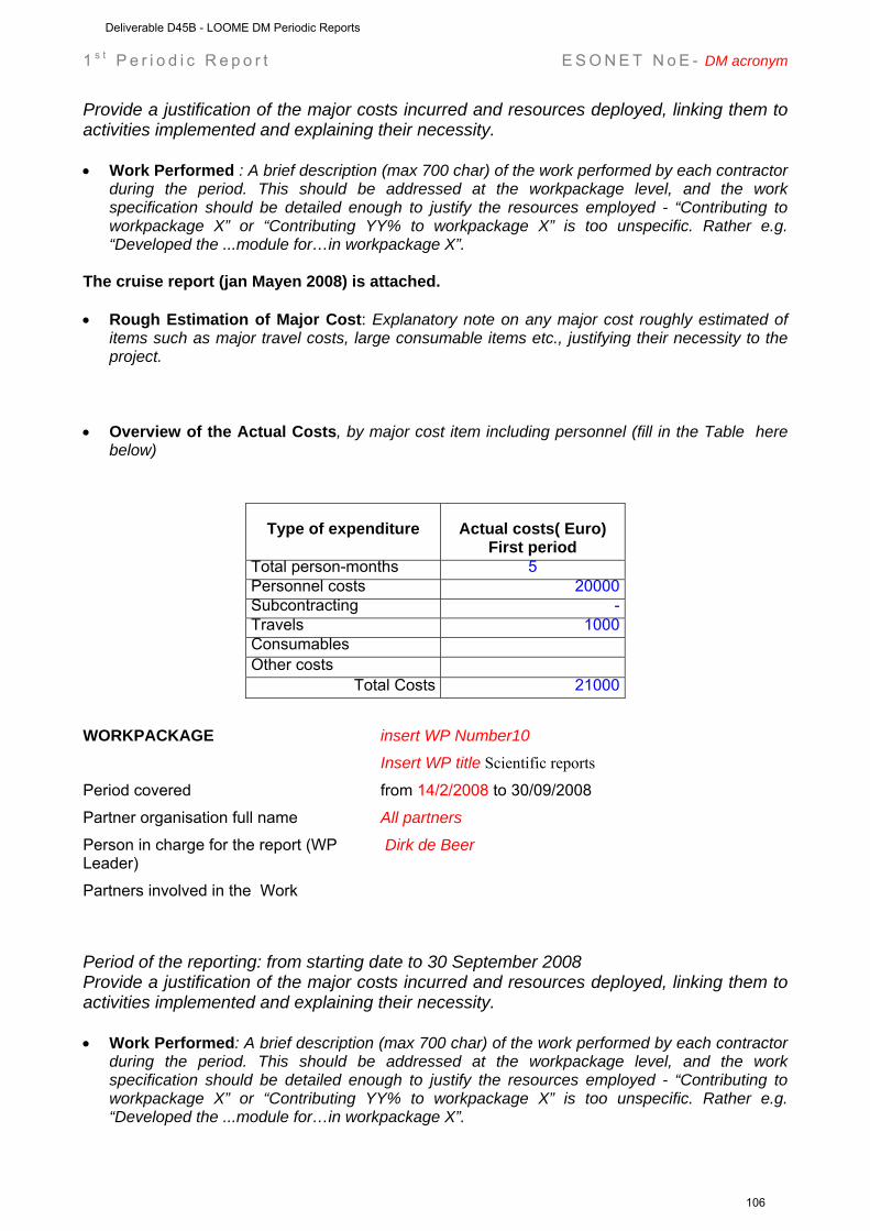
1 s t P e r i o d i c R e p o r t E S O N E T N o E - DM acronym
Provide a justification of the major costs incurred and resources deployed, linking them to activities implemented and explaining their necessity. • Work Performed : A brief description (max 700 char) of the work performed by each contractor
during the period. This should be addressed at the workpackage level, and the work specification should be detailed enough to justify the resources employed - “Contributing to workpackage X” or “Contributing YY% to workpackage X” is too unspecific. Rather e.g. “Developed the ...module for…in workpackage X”.
The cruise report (jan Mayen 2008) is attached. • Rough Estimation of Major Cost: Explanatory note on any major cost roughly estimated of
items such as major travel costs, large consumable items etc., justifying their necessity to the project.
• Overview of the Actual Costs, by major cost item including personnel (fill in the Table here
below)
Type of expenditure
Actual costs( Euro) First period
Total person-months 5 Personnel costs 20000 Subcontracting - Travels 1000 Consumables Other costs
Total Costs 21000 WORKPACKAGE insert WP Number10 Insert WP title Scientific reports
Period covered from 14/2/2008 to 30/09/2008
Partner organisation full name All partners Person in charge for the report (WP Leader)
Dirk de Beer
Partners involved in the Work
Period of the reporting: from starting date to 30 September 2008 Provide a justification of the major costs incurred and resources deployed, linking them to activities implemented and explaining their necessity. • Work Performed: A brief description (max 700 char) of the work performed by each contractor
during the period. This should be addressed at the workpackage level, and the work specification should be detailed enough to justify the resources employed - “Contributing to workpackage X” or “Contributing YY% to workpackage X” is too unspecific. Rather e.g. “Developed the ...module for…in workpackage X”.
Deliverable D45B - LOOME DM Periodic Reports
106
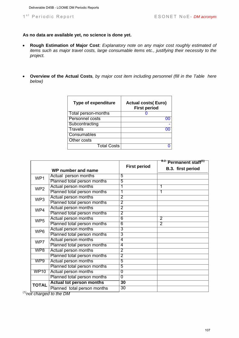
1 s t P e r i o d i c R e p o r t E S O N E T N o E - DM acronym
As no data are available yet, no science is done yet. • Rough Estimation of Major Cost: Explanatory note on any major cost roughly estimated of
items such as major travel costs, large consumable items etc., justifying their necessity to the project.
• Overview of the Actual Costs, by major cost item including personnel (fill in the Table here
below)
Type of expenditure
Actual costs( Euro) First period
Total person-months 0 Personnel costs 00 Subcontracting - Travels 00 Consumables Other costs
Total Costs 0
WP number and name First period
B.2. Permanent staff(1)
B.3. first period Actual person months 5 WP1 Planned total person months 5 Actual person months 1 1 WP2 Planned total person months 1 1 Actual person months 2 WP3 Planned total person months 2 Actual person months 2 WP4 Planned total person months 2 Actual person months 6 2 WP5 Planned total person months 6 2 Actual person months 3 WP6 Planned total person months 3 Actual person months 4 WP7 Planned total person months 4
WP8 Actual person months 2 Planned total person months 2
WP9 Actual person months 5 Planned total person months 5 WP10 Actual person months 0
Planned total person months 0 Actual tot person months 30 TOTAL Planned total person months 30
(1)not charged to the DM
Deliverable D45B - LOOME DM Periodic Reports
107
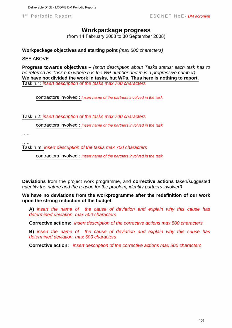
1 s t P e r i o d i c R e p o r t E S O N E T N o E - DM acronym
Workpackage progress (from 14 February 2008 to 30 September 2008)
Workpackage objectives and starting point (max 500 characters)
SEE ABOVE
Progress towards objectives – (short description about Tasks status; each task has to be referred as Task n.m where n is the WP number and m is a progressive number) We have not divided the work in tasks, but WPs. Thus here is nothing to report. Task n.1: insert description of the tasks max 700 characters
contractors involved : Insert name of the partners involved in the task
Task n.2: insert description of the tasks max 700 characters
contractors involved : Insert name of the partners involved in the task
…..
….. Task n.m: insert description of the tasks max 700 characters
contractors involved : Insert name of the partners involved in the task
Deviations from the project work programme, and corrective actions taken/suggested (identify the nature and the reason for the problem, identify partners involved)
We have no deviations from the workprogramme after the redefinition of our work upon the strong reduction of the budget.
A) insert the name of the cause of deviation and explain why this cause has determined deviation. max 500 characters
Corrective actions: insert description of the corrective actions max 500 characters
B) insert the name of the cause of deviation and explain why this cause has determined deviation. max 500 characters
Corrective action: insert description of the corrective actions max 500 characters
Deliverable D45B - LOOME DM Periodic Reports
108
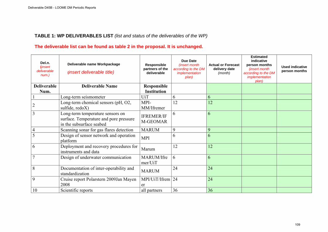
TABLE 1: WP DELIVERABLES LIST (list and status of the deliverables of the WP) The deliverable list can be found as table 2 in the proposal. It is unchanged.
Del.n. (insert
deliverable num.)
Deliverable name Workpackage
(insert deliverable title)
Responsible partners of the
deliverable
Due Date (insert month
according to the DM implementation
plan)
Actual or Forecast delivery date
(month)
Estimated indicative
person months (insert month
according to the DM implementation
plan)
Used indicative person months
Deliverable Num.
Deliverable Name Responsible Institution
1 Long-term seismometer UiT 6 6
2 Long-term chemical sensors (pH, O2, sulfide, redoX)
MPI-MM/Ifremer
12 12
3 Long-term temperature sensors on surface. Temperature and pore pressure in the subsurface seabed
IFREMER/IFM-GEOMAR
6 6
4 Scanning sonar for gas flares detection MARUM 9 9
5 Design of sensor network and operation platform MPI 6 6
6 Deployment and recovery procedures for instruments and data Marum 12 12
7 Design of underwater communication MARUM/Ifremer/UiT
6 6
8 Documentation of inter-operability and standardization MARUM 24 24
9 Cruise report Polarstern 2009Jan Mayen 2008
MPI/UiT/Ifremer
24 24
10 Scientific reports all partners 36 36
Deliverable D45B - LOOME DM Periodic Reports
109
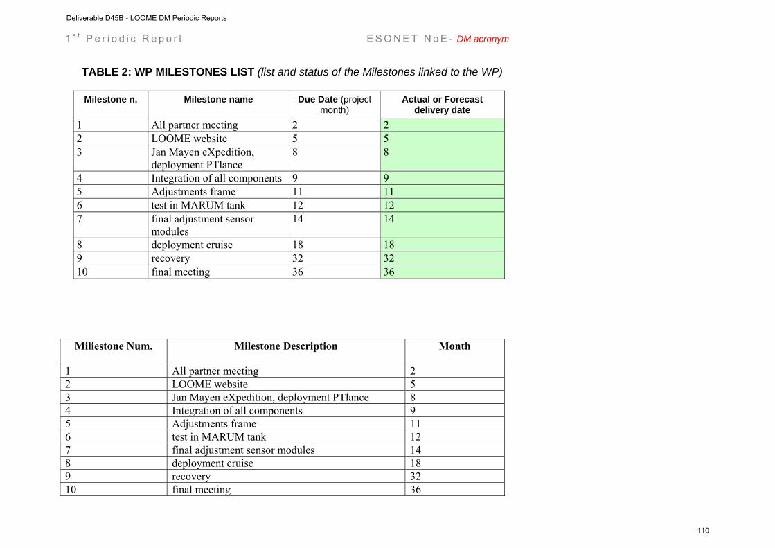
1 s t P e r i o d i c R e p o r t E S O N E T N o E - DM acronym
TABLE 2: WP MILESTONES LIST (list and status of the Milestones linked to the WP)
Milestone n. Milestone name Due Date (project month)
Actual or Forecast delivery date
1 All partner meeting 2 2 2 LOOME website 5 5 3 Jan Mayen eXpedition,
deployment PTlance 8 8
4 Integration of all components 9 9 5 Adjustments frame 11 11 6 test in MARUM tank 12 12 7 final adjustment sensor
modules 14 14
8 deployment cruise 18 18 9 recovery 32 32 10 final meeting 36 36
Miliestone Num. Milestone Description Month
1 All partner meeting 2 2 LOOME website 5 3 Jan Mayen eXpedition, deployment PTlance 8 4 Integration of all components 9 5 Adjustments frame 11 6 test in MARUM tank 12 7 final adjustment sensor modules 14 8 deployment cruise 18 9 recovery 32 10 final meeting 36
Deliverable D45B - LOOME DM Periodic Reports
110
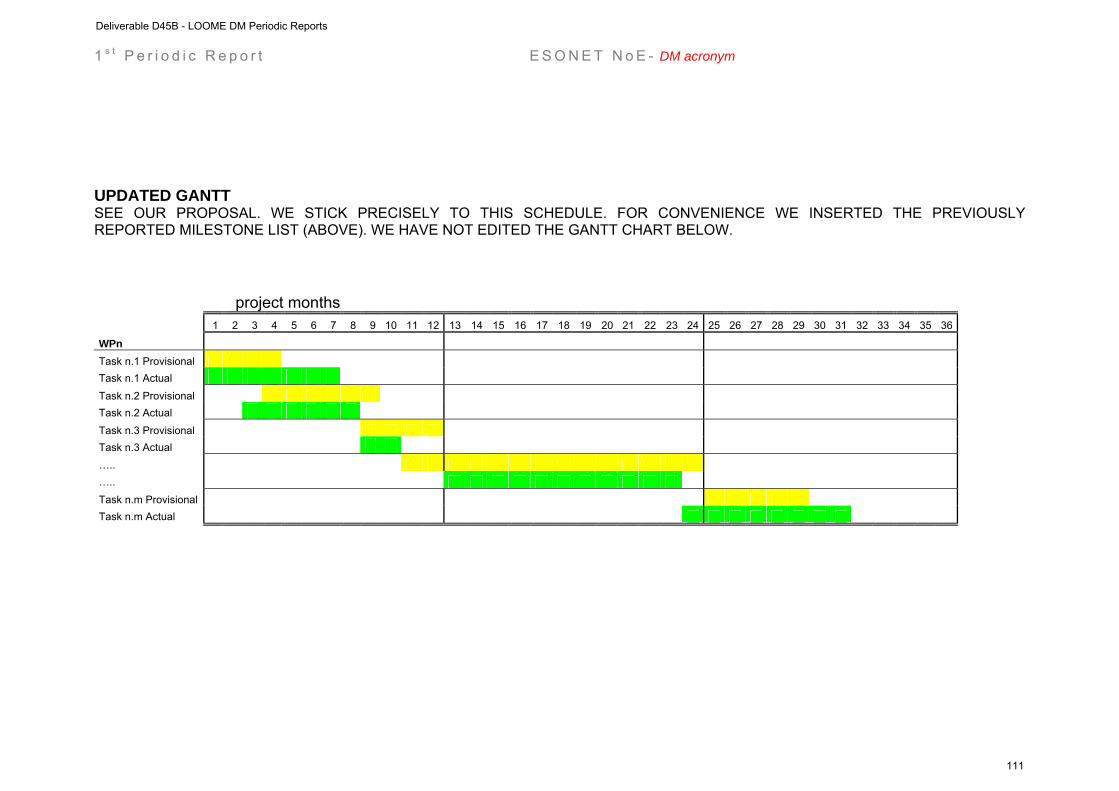
1 s t P e r i o d i c R e p o r t E S O N E T N o E - DM acronym
UPDATED GANTT SEE OUR PROPOSAL. WE STICK PRECISELY TO THIS SCHEDULE. FOR CONVENIENCE WE INSERTED THE PREVIOUSLY REPORTED MILESTONE LIST (ABOVE). WE HAVE NOT EDITED THE GANTT CHART BELOW.
project months
1 2 3 4 5 6 7 8 9 10 11 12 13 14 15 16 17 18 19 20 21 22 23 24 25 26 27 28 29 30 31 32 33 34 35 36
WPn Task n.1 Provisional Task n.1 Actual
Task n.2 Provisional Task n.2 Actual Task n.3 Provisional Task n.3 Actual ….. …..
Task n.m Provisional Task n.m Actual
Deliverable D45B - LOOME DM Periodic Reports
111

Deliverable D45B - LOOME DM Periodic Reports
112
LOOME (Longterm Observatory on Mudvolcano Eruptions)
ESONET Demonstration Missions
2nd Periodic Activity Report
The Periodic Activity Report contains an overview of the activities carried out during the reporting period, describes the progress in relation to the project objectives, the progress towards the milestones and deliverables set for the period, and any problems encountered and corrective actions taken. This document has to be filled in with reference to the DM Implementation plan. This means that Deliverables, Milestones and WPs have to be the same as in the DM Implementation plan. The Periodic Report contains 2 parts: - Part I: it is addressed to the coordinator with minimum input from the partners - Part II: it is addressed to each WP Leader and reports a detailed update of each WP activity at task level. The report includes a rough justification of the costs incurred and of the resources deployed by each contractor linking them to activities implemented and justifying their necessity. Finally the report contains information on use and dissemination activities. Reporting period:30 sept 2008 – 30 may 2009 DM starting date 1 February 2008
Deliverable D45B - LOOME DM Periodic Reports
113
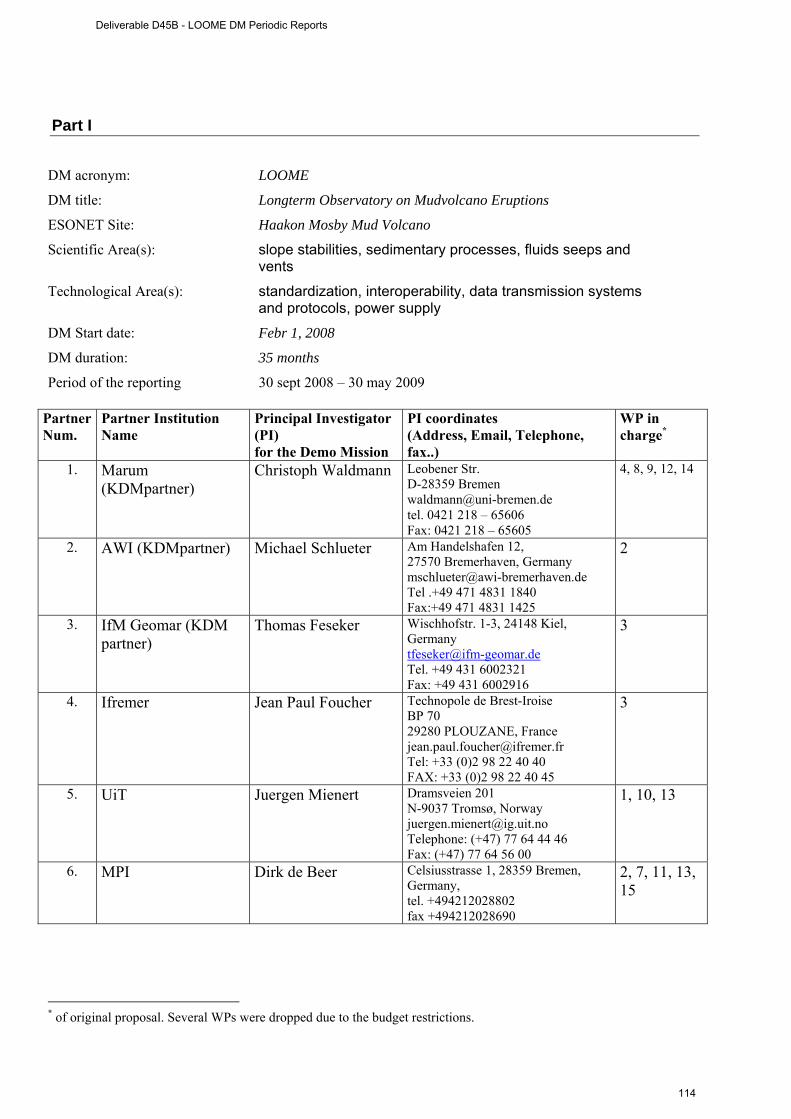
Part I DM acronym: LOOME
DM title: Longterm Observatory on Mudvolcano Eruptions
ESONET Site: Haakon Mosby Mud Volcano
Scientific Area(s): slope stabilities, sedimentary processes, fluids seeps and vents
Technological Area(s): standardization, interoperability, data transmission systems and protocols, power supply
DM Start date: Febr 1, 2008
DM duration: 35 months
Period of the reporting 30 sept 2008 – 30 may 2009
Partner Num.
Partner Institution Name
Principal Investigator (PI) for the Demo Mission
PI coordinates (Address, Email, Telephone, fax..)
WP in charge*
1. Marum (KDMpartner)
Christoph Waldmann Leobener Str. D-28359 Bremen [email protected] tel. 0421 218 – 65606 Fax: 0421 218 – 65605
4, 8, 9, 12, 14
2. AWI (KDMpartner) Michael Schlueter Am Handelshafen 12, 27570 Bremerhaven, Germany [email protected] Tel .+49 471 4831 1840 Fax:+49 471 4831 1425
2
3. IfM Geomar (KDM partner)
Thomas Feseker Wischhofstr. 1-3, 24148 Kiel, Germany [email protected] Tel. +49 431 6002321 Fax: +49 431 6002916
3
4. Ifremer Jean Paul Foucher Technopole de Brest-Iroise BP 70 29280 PLOUZANE, France [email protected] Tel: +33 (0)2 98 22 40 40 FAX: +33 (0)2 98 22 40 45
3
5. UiT Juergen Mienert Dramsveien 201 N-9037 Tromsø, Norway [email protected] Telephone: (+47) 77 64 44 46 Fax: (+47) 77 64 56 00
1, 10, 13
6. MPI Dirk de Beer Celsiusstrasse 1, 28359 Bremen, Germany, tel. +494212028802 fax +494212028690
2, 7, 11, 13, 15
* of original proposal. Several WPs were dropped due to the budget restrictions.
Deliverable D45B - LOOME DM Periodic Reports
114

Executive summary (max one page) All components are purchased and seen by our engineers. Current progress: 1) the frame is build and weighed in air and seawater. 2) the sonar, COSTOFF and the T-sensors are electronically integrated. 3) the sonar program is finished. 4) the instruments have all arrived in Bremen and are now mounted on the frame. 5) june 8 to 11 all functions of the observatory were tested in the test tank of MARUM: all is working as it should. The testing was a joined task of engineers from Ifremer, Ifm-Geomar, Marum and the MPI. 6) Then LOOME will be brought on the Polarstern (Bremerhaven). 7) The recovery cruise in 2010 is now approved and fixed. It will be done with the RV Heinke. Table 1: Deliverables List of the LOOME Demonstration Mission
LOOME Deliverable
n. Deliverable name Corresponding
WP n. Due Date Actual/
Forecast delivery date
Estimated indicative
person months
**
Used indicative
person months*
Lead contractor
1 Long-term
seismometer 1, 10, 13 6, 12*** 6, 12***
16 5 UiT
2 Long-term chemical sensors (pH, O2, sulfide, redoX) 2
12 12
16 1
MPI-MM
3 Long-term temperature sensors on surface. Temperature and pore pressure in the subsurface seabed 2
12 12
11 2
IFREMER/IFM-GEOMAR
4 Scanning sonar for gas flares detection 4
12 12 16 2
MARUM
5 Design of sensor network and operation platform 7
6 6
19 6
MPI
6 Deployment and recovery procedures for instruments and data 8
12 12
8 3
Marum
7 Design of underwater communication 9
9 9 17 4
MARUM/Ifremer/UiT
8 Documentation of inter-operability and standardization 14
24 24
7 2
MARUM
9 Cruise report Jan Mayen 2008, Polarstern 2009 10
6, 24 6, 24
15 5
MPI/UiT/Ifremer
Deliverable D45B - LOOME DM Periodic Reports
115
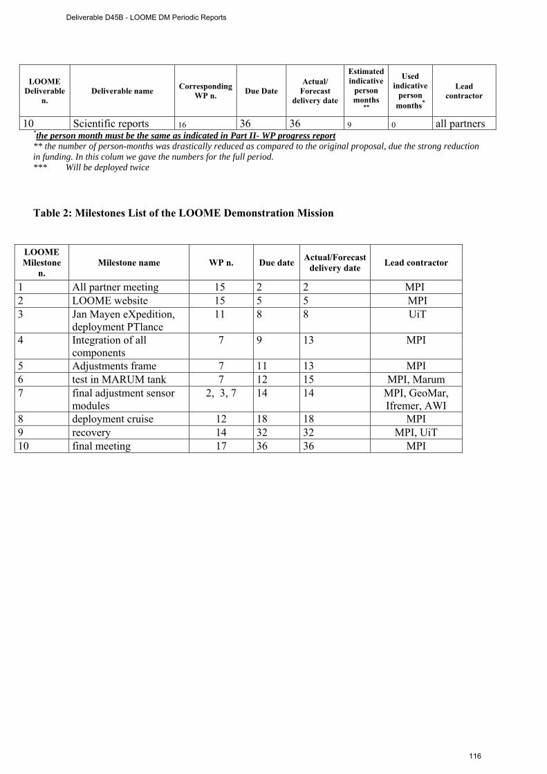
LOOME Deliverable
n. Deliverable name Corresponding
WP n. Due Date Actual/
Forecast delivery date
Estimated indicative
person months
**
Used indicative
person months*
Lead contractor
10 Scientific reports 16 36 36 9 0 all partners *the person month must be the same as indicated in Part II- WP progress report ** the number of person-months was drastically reduced as compared to the original proposal, due the strong reduction in funding. In this colum we gave the numbers for the full period. *** Will be deployed twice
Table 2: Milestones List of the LOOME Demonstration Mission
LOOME Milestone
n. Milestone name WP n. Due date Actual/Forecast
delivery date Lead contractor
1 All partner meeting 15 2 2 MPI 2 LOOME website 15 5 5 MPI 3 Jan Mayen eXpedition,
deployment PTlance 11 8 8 UiT
4 Integration of all components
7 9 13 MPI
5 Adjustments frame 7 11 13 MPI 6 test in MARUM tank 7 12 15 MPI, Marum 7 final adjustment sensor
modules 2, 3, 7 14 14 MPI, GeoMar,
Ifremer, AWI 8 deployment cruise 12 18 18 MPI 9 recovery 14 32 32 MPI, UiT 10 final meeting 17 36 36 MPI
Deliverable D45B - LOOME DM Periodic Reports
116

WP bar chart (planned/actual): Months
WP# 1 2 3 4 5 6 7 8 9 10 11 12 13 14 15 16 17 18 30 31 32 33 34 35
1 planned x x x x x x x x x x x x x x x x x
1 actual x x x x x x x x x x x x x x x x x
2 planned x x x x x x x x x x x x x x x x x
2 actual x x x x x x x x x x x x x x x x x
3 planned x x x x x x x x x x x x x x x x x
3 actual x x x x x x x x x x x x x x x x x
4 planned x x x x x x x x x x x x x x x x x
4 actual x x x x x x x x x x x x x x x x x
5 planned x x x x x x x
5 Actual x x x x x x x
6 planned x x x x x
6 actual x x x x x
7 planned x
7 actual x
8 planned x x x x x
8 Actual x x x x x
9 planned x
9 actual x
Milestones planned 1 2 3 4 5 6 7 8 9 10
actual 1 2 3 4 5 6 7 8 9 10
Deliverable D45B - LOOME DM Periodic Reports
117
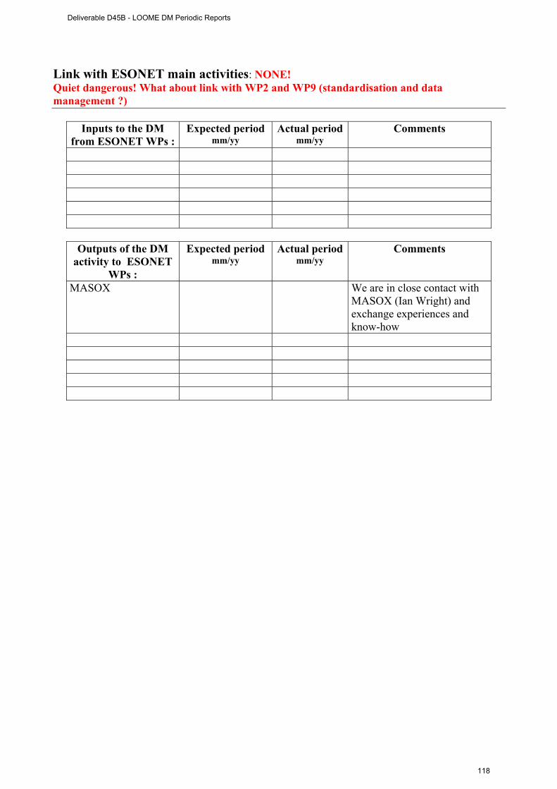
Link with ESONET main activities: NONE! Quiet dangerous! What about link with WP2 and WP9 (standardisation and data management ?)
Inputs to the DM from ESONET WPs :
Expected period mm/yy
Actual period mm/yy
Comments
Outputs of the DM
activity to ESONET WPs :
Expected period mm/yy
Actual period mm/yy
Comments
MASOX We are in close contact with MASOX (Ian Wright) and exchange experiences and know-how
Deliverable D45B - LOOME DM Periodic Reports
118
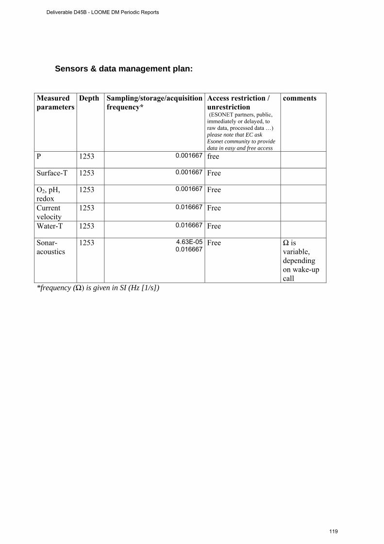
Sensors & data management plan: Measured parameters
Depth Sampling/storage/acquisition frequency*
Access restriction / unrestriction (ESONET partners, public, immediately or delayed, to raw data, processed data …) please note that EC ask Esonet community to provide data in easy and free access
comments
P 1253 0.001667
free
Surface-T 1253 0.001667
Free
O2, pH, redox
1253 0.001667
Free
Current velocity
1253 0.016667
Free
Water-T 1253 0.016667
Free
Sonar-acoustics
1253 4.63E-050.016667
Free Ω is variable, depending on wake-up call
*frequency (Ω) is given in SI (Hz [1/s])
Deliverable D45B - LOOME DM Periodic Reports
119
Dissemination and outreach: please update the table NONE
Type of school material available at the issue of the mission
(photos, video, courses,…others)
Description
And the loome video?
Type of dissemination (through collaborations with aquaria,
museum, sciences centres, etc.)
Description
Seminars and visits to our institute during Oceans 2009, demonstartion of LOOME
Deliverable D45B - LOOME DM Periodic Reports
120
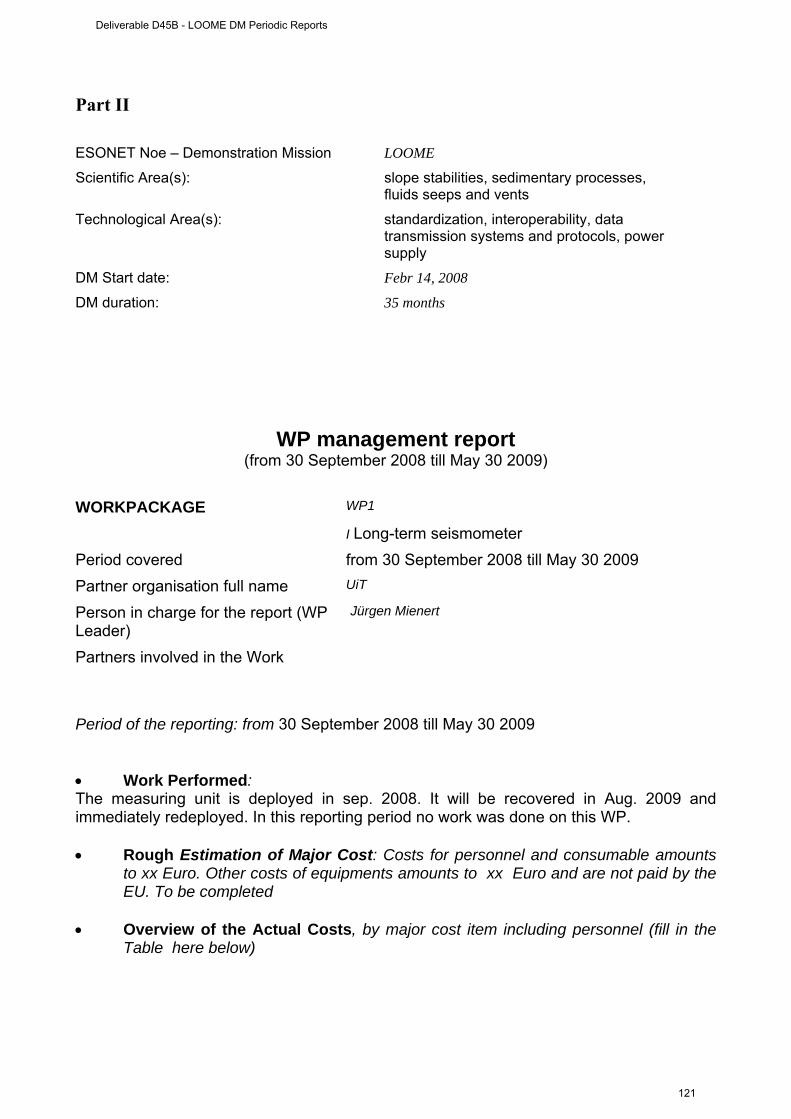
Part II ESONET Noe – Demonstration Mission LOOME
Scientific Area(s): slope stabilities, sedimentary processes, fluids seeps and vents
Technological Area(s): standardization, interoperability, data transmission systems and protocols, power supply
DM Start date: Febr 14, 2008
DM duration: 35 months
WP management report (from 30 September 2008 till May 30 2009)
WORKPACKAGE WP1
I Long-term seismometer Period covered from 30 September 2008 till May 30 2009 Partner organisation full name UiT
Person in charge for the report (WP Leader)
Jürgen Mienert
Partners involved in the Work
Period of the reporting: from 30 September 2008 till May 30 2009 • Work Performed: The measuring unit is deployed in sep. 2008. It will be recovered in Aug. 2009 and immediately redeployed. In this reporting period no work was done on this WP. • Rough Estimation of Major Cost: Costs for personnel and consumable amounts
to xx Euro. Other costs of equipments amounts to xx Euro and are not paid by the EU. To be completed
• Overview of the Actual Costs, by major cost item including personnel (fill in the
Table here below)
Deliverable D45B - LOOME DM Periodic Reports
121

Type of expenditure
Actual costs( Euro) Second period
Total person-months Personnel costs Subcontracting Travels Consumables Other costs
Total Costs Table to be completed WORKPACKAGE WP 2
Monitoring of fluid chemistry (Long term chemical sensors)
Period covered from 30 September 2008 till May 30 2009 Partner organisation full name MPI
Person in charge for the report (WP Leader)
Dirk de Beer
Partners involved in the Work
Period of the reporting: from 30 September 2008 till May 30 2009 • • Work performed: The measuring unit is tested and incorporated into the frame of the observatory. All units are now tested while integrated on the frame in a test tank, and deployment. • Rough Estimation of Major Cost: We have spend 1 man-month on the testing and incorporation into the frame. We further developed and build a deep-sea photon counter for detection of bioluminescence on and around the HMMV (6 man-months). • Overview of the Actual Costs, by major cost item including personnel (fill in the
Table here below)
Type of expenditure
Actual costs( Euro) Second period
Total person-months 7 Personnel costs 4000 Subcontracting - Travels 1000 Consumables
Deliverable D45B - LOOME DM Periodic Reports
122

Other costs
18000 (3000 material costs LOOME, 15000
deep-sea light sensor) Total Costs 23000
WORKPACKAGE WP3
Long-term temperature sensors on surface. Temperature and pore pressure in the subsurface seabed
Period covered from 30 September 2008 till May 30 2009 Partner organisation full name Ifm-Geomar
Person in charge for the report (WP Leader)
Tom Feseker
Partners involved in the Work Ifremer, UiT
Period of the reporting: from 30 September 2008 till May 30 2009 Provide a justification of the major costs incurred and resources deployed, linking them to activities implemented and explaining their necessity. • Work Performed: The T-measuring unit is tested and incorporated into the frame of the observatory. The T-lance is electronically incorporated with COSTOFF, and a wake-up call algorithm is designed. The wake-up call by a T-dynamics is tested and functional. The P-T lance is deployed in sep. 2008 , to be recovered in aug. 2009. If still intact, it will be redeployed. • • Overview of the Actual Costs, by major cost item including personnel (fill in the
Table here below)
Type of expenditure
Actual costs( Euro) Second period
Total person-months 2 Personnel costs 8000 Subcontracting - Travels 1000 Consumables Other costs
Total Costs 9000
Deliverable D45B - LOOME DM Periodic Reports
123
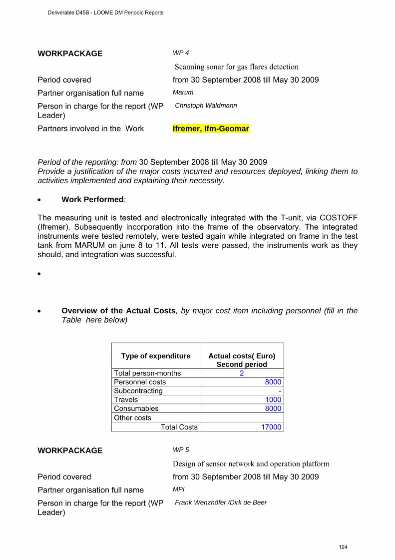
WORKPACKAGE WP 4
Scanning sonar for gas flares detection
Period covered from 30 September 2008 till May 30 2009 Partner organisation full name Marum
Person in charge for the report (WP Leader)
Christoph Waldmann
Partners involved in the Work Ifremer, Ifm-Geomar
Period of the reporting: from 30 September 2008 till May 30 2009 Provide a justification of the major costs incurred and resources deployed, linking them to activities implemented and explaining their necessity. • Work Performed: The measuring unit is tested and electronically integrated with the T-unit, via COSTOFF (Ifremer). Subsequently incorporation into the frame of the observatory. The integrated instruments were tested remotely, were tested again while integrated on frame in the test tank from MARUM on june 8 to 11. All tests were passed, the instruments work as they should, and integration was successful. • • Overview of the Actual Costs, by major cost item including personnel (fill in the
Table here below)
Type of expenditure
Actual costs( Euro) Second period
Total person-months 2 Personnel costs 8000 Subcontracting - Travels 1000 Consumables 8000 Other costs
Total Costs 17000 WORKPACKAGE WP 5
Design of sensor network and operation platform
Period covered from 30 September 2008 till May 30 2009 Partner organisation full name MPI
Person in charge for the report (WP Leader)
Frank Wenzhöfer /Dirk de Beer
Deliverable D45B - LOOME DM Periodic Reports
124
Partners involved in the Work ???
Period of the reporting: from 30 September 2008 till May 30 2009 Provide a justification of the major costs incurred and resources deployed, linking them to activities implemented and explaining their necessity. • Work Performed: The frame is ready. All measuring units have arrived and were incorporated onto the frame. The frame is weighed and physically tested. At some points re-enforcements were made. • • Overview of the Actual Costs, by major cost item including personnel (fill in the
Table here below)
Type of expenditure
Actual costs( Euro) Second period
Total person-months 9 Personnel costs 36000 Subcontracting - Travels 1000
Consumables 30000 (frame materials,
chains, releasers) Other costs
Total Costs 67000 WORKPACKAGE WP 6
Deployment and recovery procedures for instruments and data
Period covered from 30 September 2008 till May 30 2009 Partner organisation full name Marum
Person in charge for the report (WP Leader)
Volker Rathmeier/Christoph Waldmann
Partners involved in the Work ???
Period of the reporting: from 30 September 2008 till May 30 2009 Provide a justification of the major costs incurred and resources deployed, linking them to activities implemented and explaining their necessity. • Work Performed:
Deliverable D45B - LOOME DM Periodic Reports
125
The deployment was further discussed and refined. Recovery by winch is prepared. The ROV is prepared for the special tasks, deployment of the LOOME and various instruments. The deployment of instruments from AWI (Jutta Wollenburg) was designed. • • Overview of the Actual Costs, by major cost item including personnel (fill in the
Table here after)
Deliverable D45B - LOOME DM Periodic Reports
126
•
Type of expenditure
Actual costs( Euro) Second period
Total person-months 1 Personnel costs 4000 Subcontracting - Travels 1000 Consumables Other costs
Total Costs 5000 WORKPACKAGE WP 7
IDesign of underwater communication
Period covered from 30 September 2008 till May 30 2009 Partner organisation full name Ifremer
Person in charge for the report (WP Leader)
Jerome Blandin/Christoph Waldmann/ Tom Feseker
Partners involved in the Work Marum, Ifremer (both Ifremer and Marum are
equally intensively involved)
Ifm-Geomar
Period of the reporting: from 30 September 2008 till May 30 2009 Provide a justification of the major costs incurred and resources deployed, linking them to activities implemented and explaining their necessity. • Work Performed : The optimization of the sonar program, the integration of the T-output into COSTOFF and the triggering of the sonar programmes is done and finished. The testing of the integrated instruments while physically integrated on the frame is finished. • • Overview of the Actual Costs, by major cost item including personnel (fill in the
Table here below)
Deliverable D45B - LOOME DM Periodic Reports
127
Type of expenditure
Actual costs( Euro)* Second period
Total person-months 4 Personnel costs 16000
Subcontracting
8000 (programming of links between
COSTOFF and T.lance and COSTOFF and
Sonar)Travels 1000Consumables Other costs
Total Costs 25000 WORKPACKAGE
WP 8
Documentation of inter-operability and standardization
Period covered from 30 September 2008 till May 30 2009 Partner organisation full name Marum
Person in charge for the report (WP Leader)
Christoff Waldmann
Partners involved in the Work All others
Period of the reporting: from 30 September 2008 till May 30 2009 Provide a justification of the major costs incurred and resources deployed, linking them to activities implemented and explaining their necessity. • Work Performed: A list of all instruments that are going to be deployed with all relevant specifications has been set up. This list will be entering the ESONET sensor registry for being able to document the variety of parameters that are collected and how they can be accessed. The ultimate goal of the sensor registry is to keep track on all measurements that are currently done within ESONET and here particularly within the LOOME demo mission. Within WP2 of ESONET suggestions has been made on how to harmonise the lists between different observatory sites (see deliverables on “recommendations for demo missions”). Within LOOME we are committed to follow these guidelines and we will implement them in a next step. • • Overview of the Actual Costs, by major cost item including personnel (fill in the
Table here below)
* this is a collaborative WP of 3 groups
Deliverable D45B - LOOME DM Periodic Reports
128
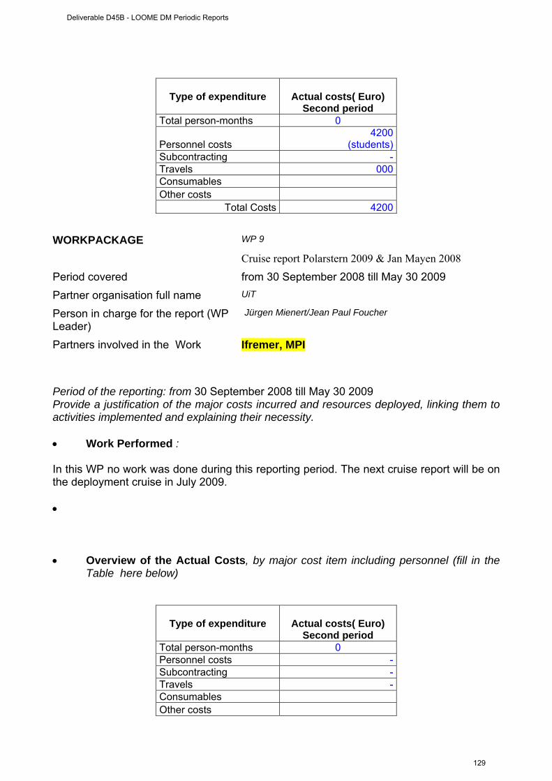
Type of expenditure
Actual costs( Euro) Second period
Total person-months 0
Personnel costs 4200
(students) Subcontracting - Travels 000 Consumables Other costs
Total Costs 4200 WORKPACKAGE WP 9
Cruise report Polarstern 2009 & Jan Mayen 2008
Period covered from 30 September 2008 till May 30 2009 Partner organisation full name UiT
Person in charge for the report (WP Leader)
Jürgen Mienert/Jean Paul Foucher
Partners involved in the Work Ifremer, MPI
Period of the reporting: from 30 September 2008 till May 30 2009 Provide a justification of the major costs incurred and resources deployed, linking them to activities implemented and explaining their necessity. • Work Performed : In this WP no work was done during this reporting period. The next cruise report will be on the deployment cruise in July 2009. • • Overview of the Actual Costs, by major cost item including personnel (fill in the
Table here below)
Type of expenditure
Actual costs( Euro) Second period
Total person-months 0 Personnel costs - Subcontracting - Travels - Consumables Other costs
Deliverable D45B - LOOME DM Periodic Reports
129
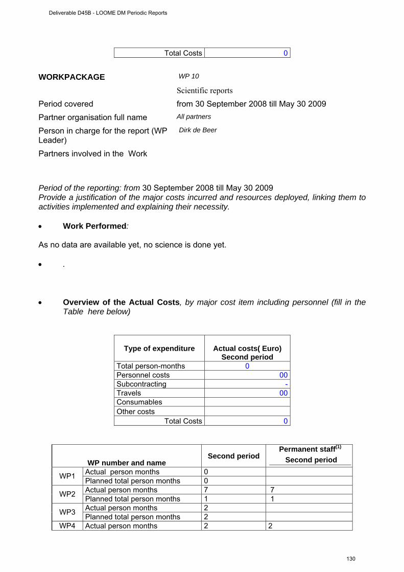
Total Costs 0 WORKPACKAGE WP 10
Scientific reports
Period covered from 30 September 2008 till May 30 2009 Partner organisation full name All partners
Person in charge for the report (WP Leader)
Dirk de Beer
Partners involved in the Work
Period of the reporting: from 30 September 2008 till May 30 2009 Provide a justification of the major costs incurred and resources deployed, linking them to activities implemented and explaining their necessity. • Work Performed: As no data are available yet, no science is done yet. • . • Overview of the Actual Costs, by major cost item including personnel (fill in the
Table here below)
Type of expenditure
Actual costs( Euro) Second period
Total person-months 0 Personnel costs 00 Subcontracting - Travels 00 Consumables Other costs
Total Costs 0
WP number and name Second period
Permanent staff(1)
Second period Actual person months 0 WP1 Planned total person months 0 Actual person months 7 7 WP2 Planned total person months 1 1 Actual person months 2 WP3 Planned total person months 2
WP4 Actual person months 2 2
Deliverable D45B - LOOME DM Periodic Reports
130
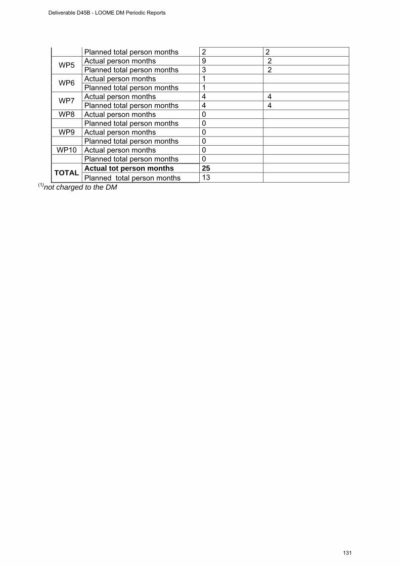
Planned total person months 2 2 Actual person months 9 2 WP5 Planned total person months 3 2 Actual person months 1 WP6 Planned total person months 1 Actual person months 4 4 WP7 Planned total person months 4 4
WP8 Actual person months 0 Planned total person months 0
WP9 Actual person months 0 Planned total person months 0 WP10 Actual person months 0
Planned total person months 0 Actual tot person months 25 TOTAL Planned total person months 13
(1)not charged to the DM
Deliverable D45B - LOOME DM Periodic Reports
131
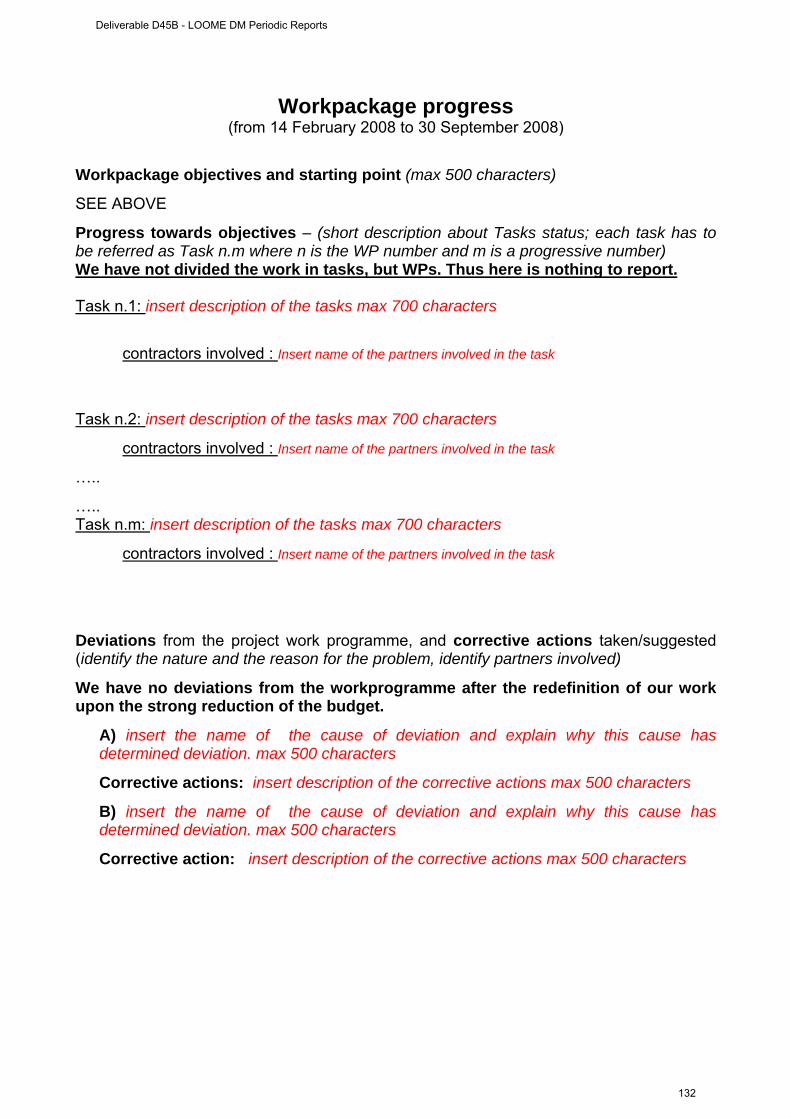
Workpackage progress (from 14 February 2008 to 30 September 2008)
Workpackage objectives and starting point (max 500 characters)
SEE ABOVE
Progress towards objectives – (short description about Tasks status; each task has to be referred as Task n.m where n is the WP number and m is a progressive number) We have not divided the work in tasks, but WPs. Thus here is nothing to report. Task n.1: insert description of the tasks max 700 characters
contractors involved : Insert name of the partners involved in the task
Task n.2: insert description of the tasks max 700 characters
contractors involved : Insert name of the partners involved in the task
…..
….. Task n.m: insert description of the tasks max 700 characters
contractors involved : Insert name of the partners involved in the task
Deviations from the project work programme, and corrective actions taken/suggested (identify the nature and the reason for the problem, identify partners involved)
We have no deviations from the workprogramme after the redefinition of our work upon the strong reduction of the budget.
A) insert the name of the cause of deviation and explain why this cause has determined deviation. max 500 characters
Corrective actions: insert description of the corrective actions max 500 characters
B) insert the name of the cause of deviation and explain why this cause has determined deviation. max 500 characters
Corrective action: insert description of the corrective actions max 500 characters
Deliverable D45B - LOOME DM Periodic Reports
132

TABLE 1: WP DELIVERABLES LIST (list and status of the deliverables of the WP) The deliverable list can be found as table 2 in the proposal. It is unchanged.
Del.n. (insert
deliverable num.)
Deliverable name Workpackage
(insert deliverable title)
Responsible partners of the
deliverable
Due Date (insert month
according to the DM implementation
plan)
Actual or Forecast delivery date
(month)
Estimated indicative
person months (insert month
according to the DM implementation
plan)
Used indicative person months
Deliverable Num.
Deliverable Name Responsible Institution
1 Long-term seismometer UiT
6 6
2 Long-term chemical sensors (pH, O2, sulfide, redoX)
MPI-MM/Ifremer
12 12
3 Long-term temperature sensors on surface. Temperature and pore pressure in the subsurface seabed
IFREMER/IFM-GEOMAR
6 6
4 Scanning sonar for gas flares detection MARUM 9 9
5 Design of sensor network and operation platform
MPI
6 6
6 Deployment and recovery procedures for instruments and data Marum 12 12
7 Design of underwater communication MARUM/Ifremer/UiT
6 6
8 Documentation of inter-operability and standardization
MARUM
24 24
9 Cruise report Polarstern 2009Jan Mayen 2008
MPI/UiT/Ifremer
24 24
10 Scientific reports all partners 36 36
Deliverable D45B - LOOME DM Periodic Reports
133
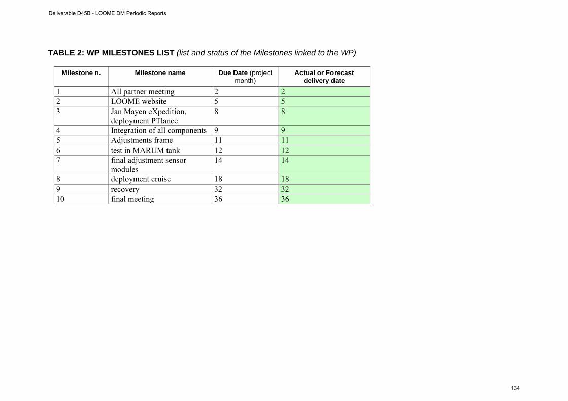
TABLE 2: WP MILESTONES LIST (list and status of the Milestones linked to the WP)
Milestone n. Milestone name Due Date (project month)
Actual or Forecast delivery date
1 All partner meeting 2 2 2 LOOME website 5 5 3 Jan Mayen eXpedition,
deployment PTlance 8 8
4 Integration of all components 9 9 5 Adjustments frame 11 11 6 test in MARUM tank 12 12 7 final adjustment sensor
modules 14 14
8 deployment cruise 18 18 9 recovery 32 32 10 final meeting 36 36
Deliverable D45B - LOOME DM Periodic Reports
134
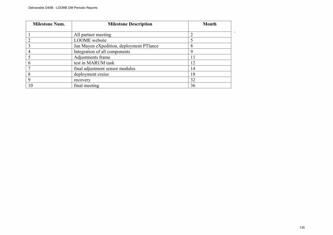
.
Milestone Num. Milestone Description Month
1 All partner meeting 2 2 LOOME website 5 3 Jan Mayen eXpedition, deployment PTlance 8 4 Integration of all components 9 5 Adjustments frame 11 6 test in MARUM tank 12 7 final adjustment sensor modules 14 8 deployment cruise 18 9 recovery 32 10 final meeting 36
Deliverable D45B - LOOME DM Periodic Reports
135
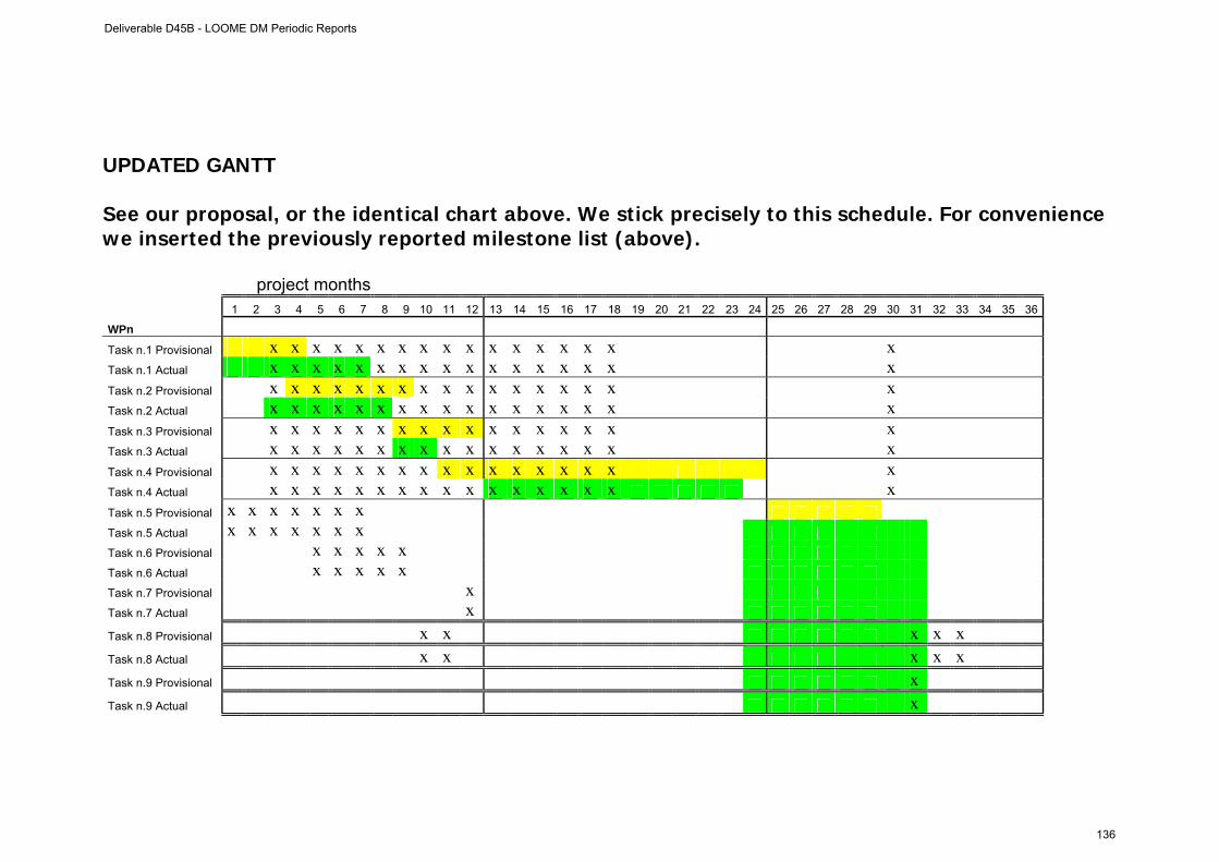
UPDATED GANTT See our proposal, or the identical chart above. We stick precisely to this schedule. For convenience we inserted the previously reported milestone list (above).
project months 1 2 3 4 5 6 7 8 9 10 11 12 13 14 15 16 17 18 19 20 21 22 23 24 25 26 27 28 29 30 31 32 33 34 35 36
WPn
Task n.1 Provisional x x x x x x x x x x x x x x x x x
Task n.1 Actual x x x x x x x x x x x x x x x x x
Task n.2 Provisional x x x x x x x x x x x x x x x x x
Task n.2 Actual x x x x x x x x x x x x x x x x x
Task n.3 Provisional x x x x x x x x x x x x x x x x x
Task n.3 Actual x x x x x x x x x x x x x x x x x
Task n.4 Provisional x x x x x x x x x x x x x x x x x
Task n.4 Actual x x x x x x x x x x x x x x x x x
Task n.5 Provisional x x x x x x x
Task n.5 Actual x x x x x x x
Task n.6 Provisional x x x x x
Task n.6 Actual x x x x x
Task n.7 Provisional x
Task n.7 Actual x
Task n.8 Provisional x x x x x
Task n.8 Actual x x x x x
Task n.9 Provisional x
Task n.9 Actual x
Deliverable D45B - LOOME DM Periodic Reports
136
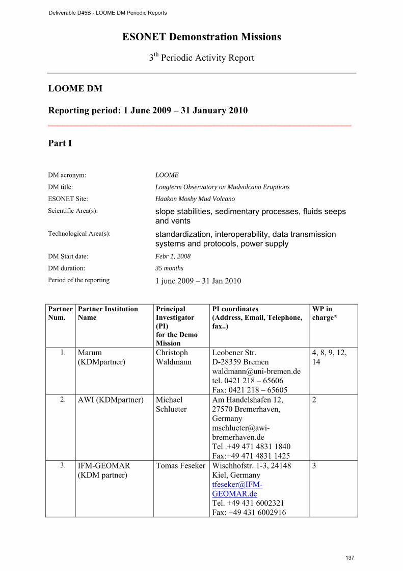
ESONET Demonstration Missions
3th Periodic Activity Report
LOOME DM Reporting period: 1 June 2009 – 31 January 2010 ________________________________________________________________ Part I DM acronym: LOOME
DM title: Longterm Observatory on Mudvolcano Eruptions
ESONET Site: Haakon Mosby Mud Volcano
Scientific Area(s): slope stabilities, sedimentary processes, fluids seeps and vents
Technological Area(s): standardization, interoperability, data transmission systems and protocols, power supply
DM Start date: Febr 1, 2008
DM duration: 35 months
Period of the reporting 1 june 2009 – 31 Jan 2010 Partner Num.
Partner Institution Name
Principal Investigator (PI) for the Demo Mission
PI coordinates (Address, Email, Telephone, fax..)
WP in charge*
1. Marum (KDMpartner)
Christoph Waldmann
Leobener Str. D-28359 Bremen [email protected] tel. 0421 218 – 65606 Fax: 0421 218 – 65605
4, 8, 9, 12, 14
2. AWI (KDMpartner) Michael Schlueter
Am Handelshafen 12, 27570 Bremerhaven, Germany [email protected] Tel .+49 471 4831 1840 Fax:+49 471 4831 1425
2
3. IFM-GEOMAR (KDM partner)
Tomas Feseker Wischhofstr. 1-3, 24148 Kiel, Germany [email protected] Tel. +49 431 6002321 Fax: +49 431 6002916
3
Deliverable D45B - LOOME DM Periodic Reports
137
4. Ifremer Jean Paul Foucher
Technopole de Brest-Iroise BP 70 29280 PLOUZANE, France [email protected] Tel: +33 (0)2 98 22 40 40 FAX: +33 (0)2 98 22 40 45
3
5. UiT Juergen Mienert
Dramsveien 201 N-9037 Tromsø, Norway [email protected] Telephone: (+47) 77 64 44 46 Fax: (+47) 77 64 56 00
1, 10, 13
6. MPI Dirk de Beer Celsiusstrasse 1, 28359 Bremen, Germany, tel. +494212028802 fax +494212028690
2, 7, 11, 13, 15
* of original proposal. Several WPs were dropped due to the budget restrictions. Executive summary (max one page) All components are purchased and seen by our engineers. Current progress: The P- and T-lances were recovered. The whole observatory, as described in the previous report is deployed on the Hakon Mosby Mud Volcano. Deployment was done during the ARK XXIV/2; 10. July - 03. August 2009. Duirng the testing on board an electronic board of the sonar became damaged. The board accepted commands from COSTOFF, and could awake the sonar for scanning. It was replaced by a board that could awake the sonar for scanning, but cannot communicate. Thus the sonar could operate at preprogrammed time intervals, but could not be activated by COSTOFF, in response to a T-signal. It now scans twice per day for 10 minutes. The remaining instruments functioned good. The deployment went, as planned, by lowering the frame by winch, positioning the frame by ROV at the desired position near the hot spot, pulling out the T-string and chemosensor cables. On the next dive the camera was positioned in front of LOOME on the edge of hydrates near the hot spot. It will take video synchronous with the sonar. During the workon the deployment, the site was visited by a Norwegian party on the RV Jan Mayen. They deployed the OBS, that was then inspected by the ROV. The position was ideal, near the hot spot, on a location opposite of the LOOME frame. However, the geophone appeared not to make contact with the seabottom. Therefore, the OBS was redeployed at the same spot in September 2009. The T-lance was redeployed near the hot spot. Additional measurements: Wood pieces that were deployed in 2008 were recovered and analysed for colonization by wood eating fauna. A detailed temperature study across the hot spot with the 13 m T-lance was performed. The highest temperature gradients were recorded, indicating high seepage activity. A variety of geochemical and microbial analyses. An in situ incubation with Insinc with 13CO2 as tracer was performed on Beggiatoa mats for 48 hours, to measure the primary productivity of the sulfur oxidising community. An experiment with a photon counter was done, to test the hypothesis that bioluminescence is particularly high near the cold seep. The hypothesis had to be rejected. The recovery cruise will be with the RV Merian in september 2010.
Deliverable D45B - LOOME DM Periodic Reports
138
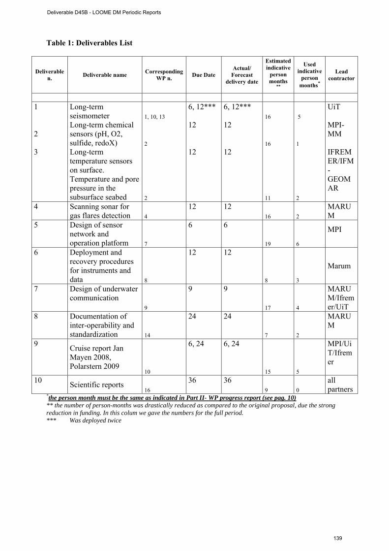
Table 1: Deliverables List
Deliverable n. Deliverable name Corresponding
WP n. Due Date Actual/
Forecast delivery date
Estimated indicative
person months
**
Used indicative
person months*
Lead contractor
1 Long-term
seismometer 1, 10, 13 6, 12*** 6, 12***
16 5 UiT
2 Long-term chemical sensors (pH, O2, sulfide, redoX) 2
12 12
16 1
MPI-MM
3 Long-term temperature sensors on surface. Temperature and pore pressure in the subsurface seabed 2
12 12
11 2
IFREMER/IFM-GEOMAR
4 Scanning sonar for gas flares detection 4
12 12 16 2
MARUM
5 Design of sensor network and operation platform 7
6 6
19 6
MPI
6 Deployment and recovery procedures for instruments and data 8
12 12
8 3
Marum
7 Design of underwater communication
9
9 9
17 4
MARUM/Ifremer/UiT
8 Documentation of inter-operability and standardization 14
24 24
7 2
MARUM
9 Cruise report Jan Mayen 2008, Polarstern 2009
10
6, 24 6, 24
15 5
MPI/UiT/Ifremer
10 Scientific reports 16
36 36 9 0
all partners
*the person month must be the same as indicated in Part II- WP progress report (see pag. 10) ** the number of person-months was drastically reduced as compared to the original proposal, due the strong reduction in funding. In this colum we gave the numbers for the full period. *** Was deployed twice
Deliverable D45B - LOOME DM Periodic Reports
139

Table 2: Milestones List
Milestone n. Milestone name WP n. Due date Actual/Forecast
delivery date Lead contractor
1 All partner meeting 15 2 2 MPI 2 LOOME website 15 5 5 MPI 3 Jan Mayen expedition,
deployment PTlance 11 8 8 UiT
4 Integration of all components
7 9 13 MPI
5 Adjustments frame 7 11 13 MPI 6 test in MARUM tank 7 12 15 MPI, Marum 7 final adjustment sensor
modules 2, 3, 7 14 14 MPI, GeoMar,
Ifremer, AWI 8 deployment cruise 12 18 18 MPI 9 recovery 14 32 32 MPI, UiT 10 final meeting 17 36 36 MPI
Deliverable D45B - LOOME DM Periodic Reports
140

WP bar chart (planned/actual):
Months
WP# 1 2 3 4 5 6 7 8 9 10 11 12 13 14 15 16 17 18 30 31 321 332 34 35
1 planned x x x x x x x x x x x x x x x x x
1 actual x x x x x x x x x x x x x x x x x
2 planned x x x x x x x x x x x x x x x x x
2 actual x x x x x x x x x x x x x x x x x
3 planned x x x x x x x x x x x x x x x x x
3 actual x x x x x x x x x x x x x x x x x
4 planned x x x x x x x x x x x x x x x x x
4 actual x x x x x x x x x x x x x x x x x
5 planned x x x x x x x
5 Actual x x x x x x x
6 planned x x x x x
6 actual * x x x x x
7 planned x
7 actual x
8 planned x x x x x
8 Actual x x x x x
9 planned x
9 actual x Milestonesplanned 1 2 3 4 5 6 7 8 9 10
actual 1 2 3 4 5 6 7 8 9 10
Deliverable D45B - LOOME DM Periodic Reports
141

* The integration was build succesfully, but the electronics became damaged. As a consequence, COSTOFF and the sonar can no longer communicate. Thus the sonar is now operating autonomously. insert the time extention of each workpackage ( yellow for planned and green for actual) according to the individual WP reports (see example))
Deliverable D45B - LOOME DM Periodic Reports
142
3 r d P e r i o d i c R e p o r t E S O N E T N o E - DM acronym
Link with ESONET main activities:
Inputs to the DM from ESONET WPs :
Expected period mm/yy
Actual period mm/yy
Comments
Outputs of the DM
activity to ESONET WPs :
Expected period mm/yy
Actual period mm/yy
Comments
MASOX We are in close contact with MASOX (Ian Wright) and exchange experiences and know-how
Deliverable D45B - LOOME DM Periodic Reports
143
3 r d P e r i o d i c R e p o r t E S O N E T N o E - DM acronym
Sensors & data management plan: Measured parameters
Depth Sampling/storage/acquisition frequency*
Access restriction / unrestriction (ESONET partners, public, immediately or delayed, to raw data, processed data …) please note that EC ask Esonet community to provide data in easy and free access
comments
P 1253 0.001667
free
Surface-T 1253 0.001667
Free
O2, pH, redox
1253 0.001667
Free
Current velocity
1253 0.016667
Free
Water-T 1253 0.016667
Free
Sonar-acoustics
1253 4.63E-05 Free
*frequency (Ω) is given in SI (Hz [1/s])
Deliverable D45B - LOOME DM Periodic Reports
144
3 r d P e r i o d i c R e p o r t E S O N E T N o E - DM acronym
Dissemination and outreach: please update the table NONE
Type of school material available at the issue of the mission
(photos, video, courses,…others)
Description
Type of dissemination (through collaborations with aquaria,
museum, sciences centres, etc.)
Description
Seminars and visits to our institute during Oceans 2009, demonstration of LOOME
Deliverable D45B - LOOME DM Periodic Reports
145
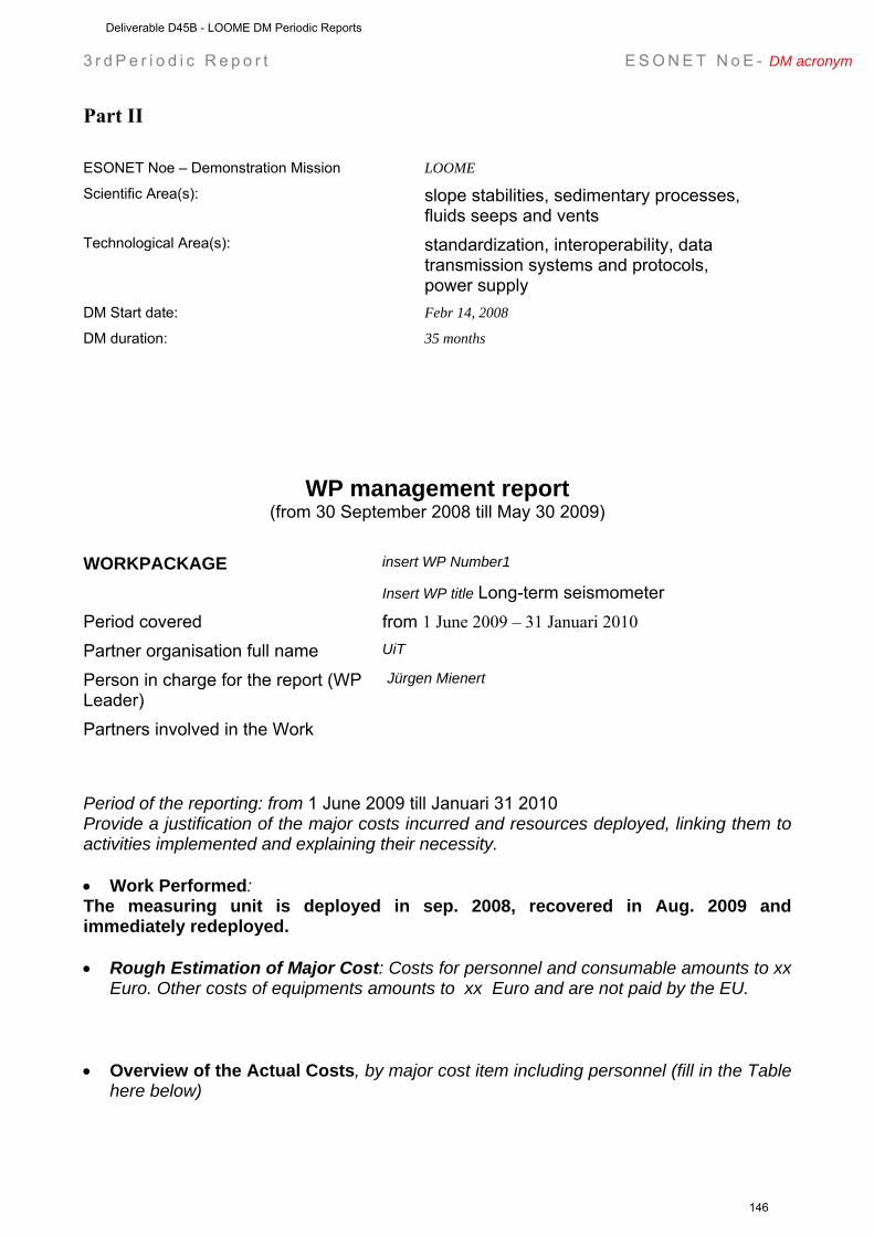
3 r d P e r i o d i c R e p o r t E S O N E T N o E - DM acronym
Part II ESONET Noe – Demonstration Mission LOOME
Scientific Area(s): slope stabilities, sedimentary processes, fluids seeps and vents
Technological Area(s): standardization, interoperability, data transmission systems and protocols, power supply
DM Start date: Febr 14, 2008
DM duration: 35 months
WP management report (from 30 September 2008 till May 30 2009)
WORKPACKAGE insert WP Number1
Insert WP title Long-term seismometer Period covered from 1 June 2009 – 31 Januari 2010 Partner organisation full name UiT
Person in charge for the report (WP Leader)
Jürgen Mienert
Partners involved in the Work
Period of the reporting: from 1 June 2009 till Januari 31 2010 Provide a justification of the major costs incurred and resources deployed, linking them to activities implemented and explaining their necessity. • Work Performed: The measuring unit is deployed in sep. 2008, recovered in Aug. 2009 and immediately redeployed. • Rough Estimation of Major Cost: Costs for personnel and consumable amounts to xx
Euro. Other costs of equipments amounts to xx Euro and are not paid by the EU. • Overview of the Actual Costs, by major cost item including personnel (fill in the Table
here below)
Deliverable D45B - LOOME DM Periodic Reports
146
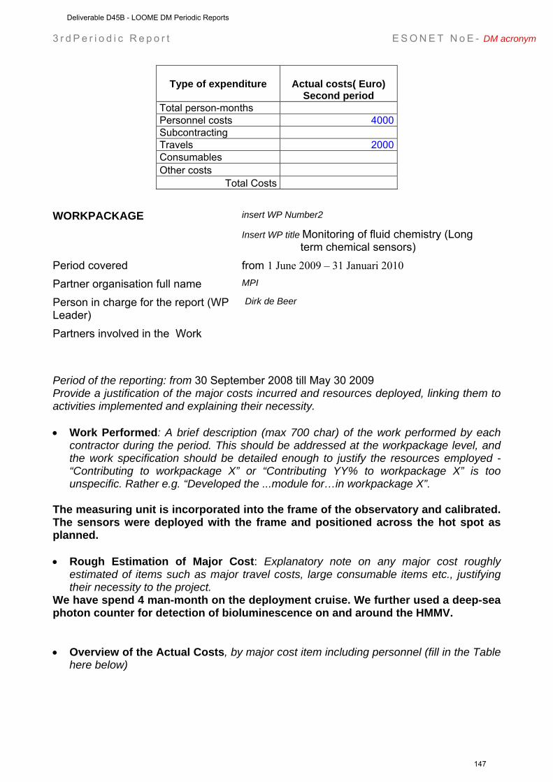
3 r d P e r i o d i c R e p o r t E S O N E T N o E - DM acronym
Type of expenditure
Actual costs( Euro) Second period
Total person-months Personnel costs 4000 Subcontracting Travels 2000 Consumables Other costs
Total Costs WORKPACKAGE insert WP Number2
Insert WP title Monitoring of fluid chemistry (Long term chemical sensors)
Period covered from 1 June 2009 – 31 Januari 2010 Partner organisation full name MPI
Person in charge for the report (WP Leader)
Dirk de Beer
Partners involved in the Work
Period of the reporting: from 30 September 2008 till May 30 2009 Provide a justification of the major costs incurred and resources deployed, linking them to activities implemented and explaining their necessity. • Work Performed: A brief description (max 700 char) of the work performed by each
contractor during the period. This should be addressed at the workpackage level, and the work specification should be detailed enough to justify the resources employed - “Contributing to workpackage X” or “Contributing YY% to workpackage X” is too unspecific. Rather e.g. “Developed the ...module for…in workpackage X”.
The measuring unit is incorporated into the frame of the observatory and calibrated. The sensors were deployed with the frame and positioned across the hot spot as planned. • Rough Estimation of Major Cost: Explanatory note on any major cost roughly
estimated of items such as major travel costs, large consumable items etc., justifying their necessity to the project.
We have spend 4 man-month on the deployment cruise. We further used a deep-sea photon counter for detection of bioluminescence on and around the HMMV. • Overview of the Actual Costs, by major cost item including personnel (fill in the Table
here below)
Deliverable D45B - LOOME DM Periodic Reports
147
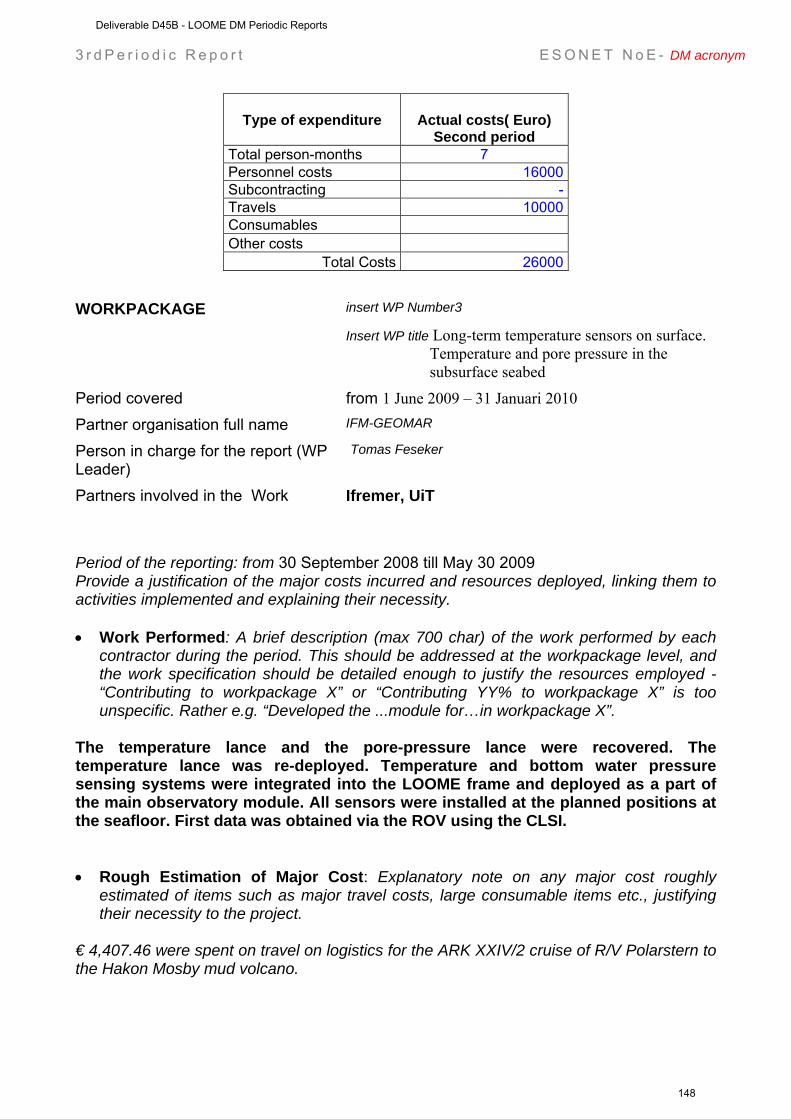
3 r d P e r i o d i c R e p o r t E S O N E T N o E - DM acronym
Type of expenditure
Actual costs( Euro) Second period
Total person-months 7 Personnel costs 16000 Subcontracting - Travels 10000 Consumables Other costs
Total Costs 26000 WORKPACKAGE insert WP Number3
Insert WP title Long-term temperature sensors on surface. Temperature and pore pressure in the subsurface seabed
Period covered from 1 June 2009 – 31 Januari 2010 Partner organisation full name IFM-GEOMAR
Person in charge for the report (WP Leader)
Tomas Feseker
Partners involved in the Work Ifremer, UiT
Period of the reporting: from 30 September 2008 till May 30 2009 Provide a justification of the major costs incurred and resources deployed, linking them to activities implemented and explaining their necessity. • Work Performed: A brief description (max 700 char) of the work performed by each
contractor during the period. This should be addressed at the workpackage level, and the work specification should be detailed enough to justify the resources employed - “Contributing to workpackage X” or “Contributing YY% to workpackage X” is too unspecific. Rather e.g. “Developed the ...module for…in workpackage X”.
The temperature lance and the pore-pressure lance were recovered. The temperature lance was re-deployed. Temperature and bottom water pressure sensing systems were integrated into the LOOME frame and deployed as a part of the main observatory module. All sensors were installed at the planned positions at the seafloor. First data was obtained via the ROV using the CLSI. • Rough Estimation of Major Cost: Explanatory note on any major cost roughly
estimated of items such as major travel costs, large consumable items etc., justifying their necessity to the project.
€ 4,407.46 were spent on travel on logistics for the ARK XXIV/2 cruise of R/V Polarstern to the Hakon Mosby mud volcano.
Deliverable D45B - LOOME DM Periodic Reports
148
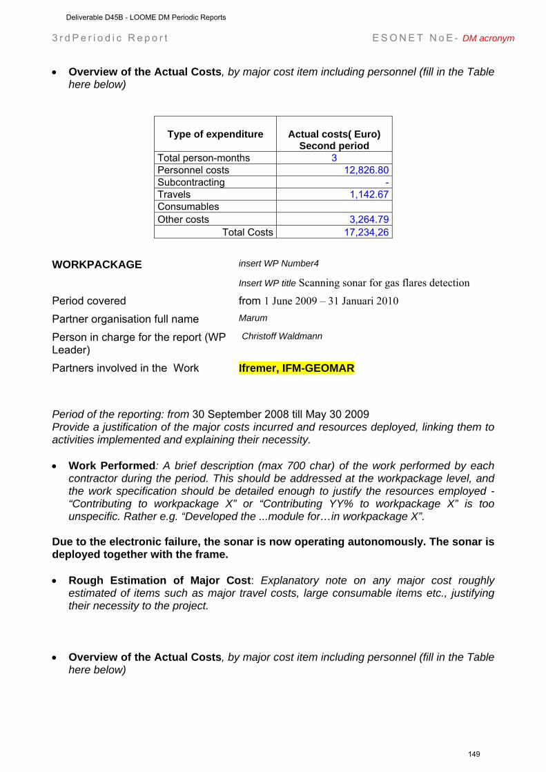
3 r d P e r i o d i c R e p o r t E S O N E T N o E - DM acronym
• Overview of the Actual Costs, by major cost item including personnel (fill in the Table here below)
Type of expenditure
Actual costs( Euro) Second period
Total person-months 3 Personnel costs 12,826.80 Subcontracting - Travels 1,142.67 Consumables Other costs 3,264.79
Total Costs 17,234,26 WORKPACKAGE insert WP Number4
Insert WP title Scanning sonar for gas flares detection
Period covered from 1 June 2009 – 31 Januari 2010 Partner organisation full name Marum
Person in charge for the report (WP Leader)
Christoff Waldmann
Partners involved in the Work Ifremer, IFM-GEOMAR
Period of the reporting: from 30 September 2008 till May 30 2009 Provide a justification of the major costs incurred and resources deployed, linking them to activities implemented and explaining their necessity. • Work Performed: A brief description (max 700 char) of the work performed by each
contractor during the period. This should be addressed at the workpackage level, and the work specification should be detailed enough to justify the resources employed - “Contributing to workpackage X” or “Contributing YY% to workpackage X” is too unspecific. Rather e.g. “Developed the ...module for…in workpackage X”.
Due to the electronic failure, the sonar is now operating autonomously. The sonar is deployed together with the frame. • Rough Estimation of Major Cost: Explanatory note on any major cost roughly
estimated of items such as major travel costs, large consumable items etc., justifying their necessity to the project.
• Overview of the Actual Costs, by major cost item including personnel (fill in the Table
here below)
Deliverable D45B - LOOME DM Periodic Reports
149
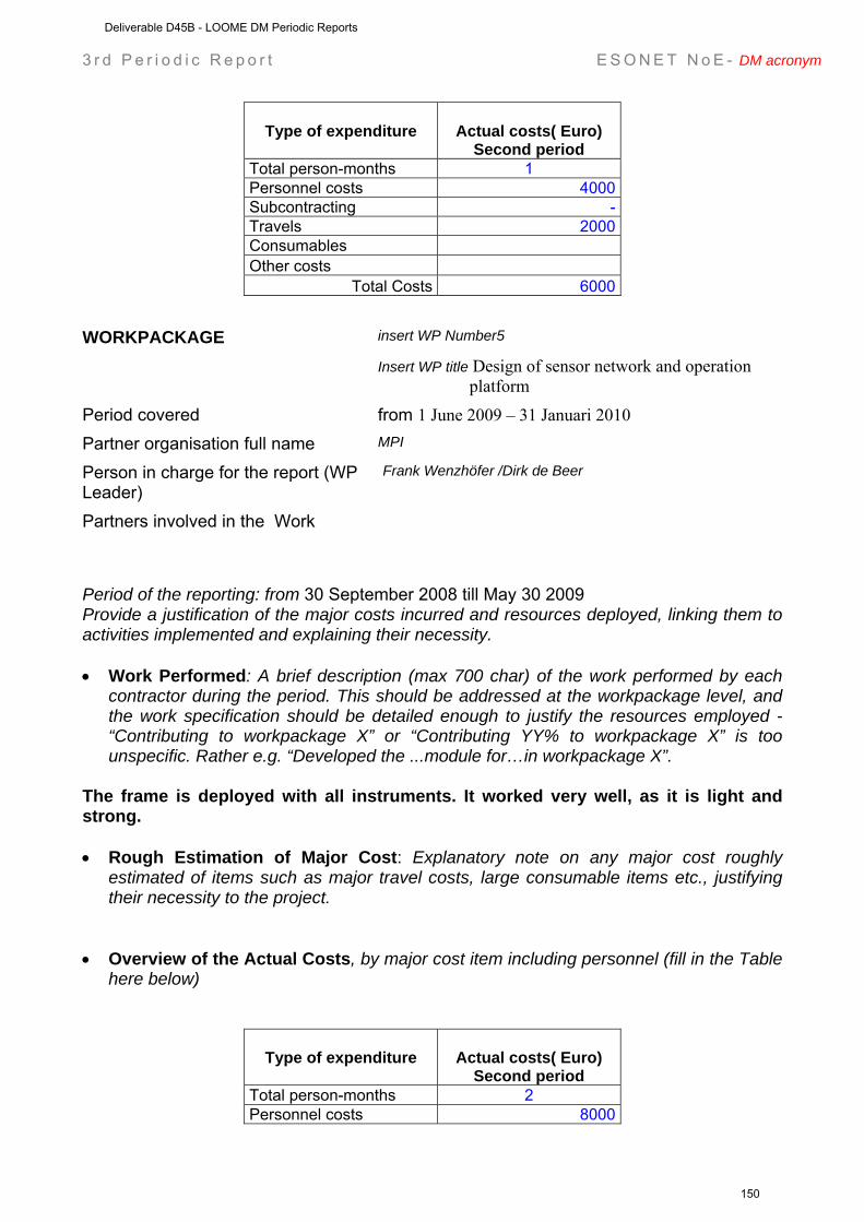
3 r d P e r i o d i c R e p o r t E S O N E T N o E - DM acronym
Type of expenditure
Actual costs( Euro) Second period
Total person-months 1 Personnel costs 4000 Subcontracting - Travels 2000 Consumables Other costs
Total Costs 6000 WORKPACKAGE insert WP Number5
Insert WP title Design of sensor network and operation platform
Period covered from 1 June 2009 – 31 Januari 2010 Partner organisation full name MPI
Person in charge for the report (WP Leader)
Frank Wenzhöfer /Dirk de Beer
Partners involved in the Work
Period of the reporting: from 30 September 2008 till May 30 2009 Provide a justification of the major costs incurred and resources deployed, linking them to activities implemented and explaining their necessity. • Work Performed: A brief description (max 700 char) of the work performed by each
contractor during the period. This should be addressed at the workpackage level, and the work specification should be detailed enough to justify the resources employed - “Contributing to workpackage X” or “Contributing YY% to workpackage X” is too unspecific. Rather e.g. “Developed the ...module for…in workpackage X”.
The frame is deployed with all instruments. It worked very well, as it is light and strong. • Rough Estimation of Major Cost: Explanatory note on any major cost roughly
estimated of items such as major travel costs, large consumable items etc., justifying their necessity to the project.
• Overview of the Actual Costs, by major cost item including personnel (fill in the Table
here below)
Type of expenditure
Actual costs( Euro) Second period
Total person-months 2 Personnel costs 8000
Deliverable D45B - LOOME DM Periodic Reports
150
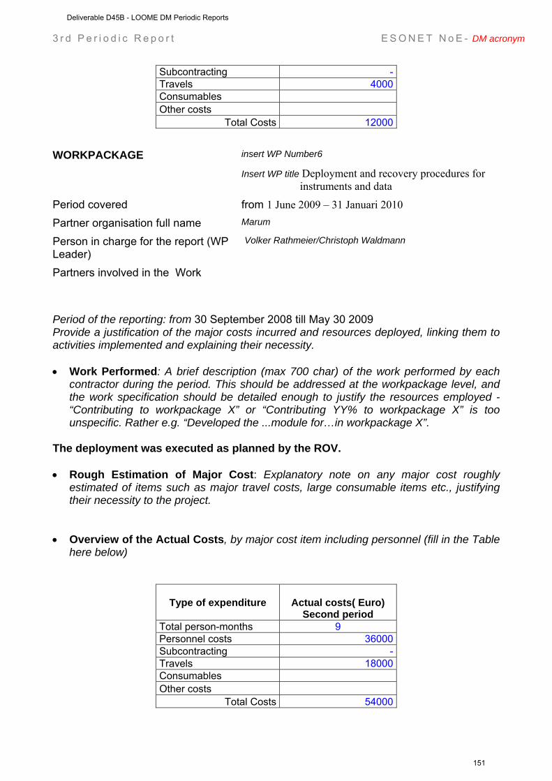
3 r d P e r i o d i c R e p o r t E S O N E T N o E - DM acronym
Subcontracting - Travels 4000 Consumables Other costs
Total Costs 12000 WORKPACKAGE insert WP Number6
Insert WP title Deployment and recovery procedures for instruments and data
Period covered from 1 June 2009 – 31 Januari 2010 Partner organisation full name Marum
Person in charge for the report (WP Leader)
Volker Rathmeier/Christoph Waldmann
Partners involved in the Work
Period of the reporting: from 30 September 2008 till May 30 2009 Provide a justification of the major costs incurred and resources deployed, linking them to activities implemented and explaining their necessity. • Work Performed: A brief description (max 700 char) of the work performed by each
contractor during the period. This should be addressed at the workpackage level, and the work specification should be detailed enough to justify the resources employed - “Contributing to workpackage X” or “Contributing YY% to workpackage X” is too unspecific. Rather e.g. “Developed the ...module for…in workpackage X”.
The deployment was executed as planned by the ROV. • Rough Estimation of Major Cost: Explanatory note on any major cost roughly
estimated of items such as major travel costs, large consumable items etc., justifying their necessity to the project.
• Overview of the Actual Costs, by major cost item including personnel (fill in the Table
here below)
Type of expenditure
Actual costs( Euro) Second period
Total person-months 9 Personnel costs 36000 Subcontracting - Travels 18000 Consumables Other costs
Total Costs 54000
Deliverable D45B - LOOME DM Periodic Reports
151
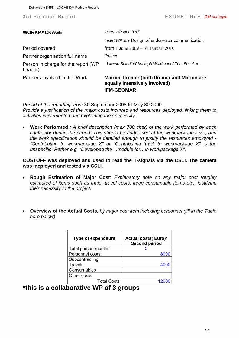
3 r d P e r i o d i c R e p o r t E S O N E T N o E - DM acronym
WORKPACKAGE insert WP Number7
Insert WP title Design of underwater communication
Period covered from 1 June 2009 – 31 Januari 2010 Partner organisation full name Ifremer
Person in charge for the report (WP Leader)
Jerome Blandin/Christoph Waldmann/ Tom Feseker
Partners involved in the Work Marum, Ifremer (both Ifremer and Marum are equally intensively involved) IFM-GEOMAR
Period of the reporting: from 30 September 2008 till May 30 2009 Provide a justification of the major costs incurred and resources deployed, linking them to activities implemented and explaining their necessity. • Work Performed : A brief description (max 700 char) of the work performed by each
contractor during the period. This should be addressed at the workpackage level, and the work specification should be detailed enough to justify the resources employed - “Contributing to workpackage X” or “Contributing YY% to workpackage X” is too unspecific. Rather e.g. “Developed the ...module for…in workpackage X”.
COSTOFF was deployed and used to read the T-signals via the CSLI. The camera was deployed and tested via CSLI. • Rough Estimation of Major Cost: Explanatory note on any major cost roughly
estimated of items such as major travel costs, large consumable items etc., justifying their necessity to the project.
• Overview of the Actual Costs, by major cost item including personnel (fill in the Table
here below)
Type of expenditure
Actual costs( Euro)* Second period
Total person-months 2 Personnel costs 8000 Subcontracting Travels 4000 Consumables Other costs
Total Costs 12000 *this is a collaborative WP of 3 groups
Deliverable D45B - LOOME DM Periodic Reports
152
3 r d P e r i o d i c R e p o r t E S O N E T N o E - DM acronym
WORKPACKAGE insert WP Number8
Insert WP title Documentation of inter-operability and standardization
Period covered from 1 June 2009 – 31 Januari 2010 Partner organisation full name Marum
Person in charge for the report (WP Leader)
Christoff Waldmann
Partners involved in the Work All others
Period of the reporting: from 30 September 2008 till May 30 2009 Provide a justification of the major costs incurred and resources deployed, linking them to activities implemented and explaining their necessity. • Work Performed: A brief description (max 700 char) of the work performed by each
contractor during the period. This should be addressed at the workpackage level, and the work specification should be detailed enough to justify the resources employed - “Contributing to workpackage X” or “Contributing YY% to workpackage X” is too unspecific. Rather e.g. “Developed the ...module for…in workpackage X”.
TEXT CHRISTOPH WALDMANN • Rough Estimation of Major Cost: Explanatory note on any major cost roughly
estimated of items such as major travel costs, large consumable items etc., justifying their necessity to the project.
• Overview of the Actual Costs, by major cost item including personnel (fill in the Table
here below)
Type of expenditure
Actual costs( Euro) Second period
Total person-months 0 Personnel costs Subcontracting - Travels 000 Consumables Other costs
Total Costs
Deliverable D45B - LOOME DM Periodic Reports
153

3 r d P e r i o d i c R e p o r t E S O N E T N o E - DM acronym
WORKPACKAGE Insert WP title Cruise report Polarstern 2009 & Jan Mayen
2008
Period covered from 1 June 2009 – 31 Januari 2010 Partner organisation full name UiT
Person in charge for the report (WP Leader)
Jürgen Mienert/Jean Paul Foucher
Partners involved in the Work Ifremer, MPI
Period of the reporting: from 30 September 2008 till May 30 2009 Provide a justification of the major costs incurred and resources deployed, linking them to activities implemented and explaining their necessity. • Work Performed : A brief description (max 700 char) of the work performed by each
contractor during the period. This should be addressed at the workpackage level, and the work specification should be detailed enough to justify the resources employed - “Contributing to workpackage X” or “Contributing YY% to workpackage X” is too unspecific. Rather e.g. “Developed the ...module for…in workpackage X”.
The cruise report of the deployment mission in July 2009 is included. • Rough Estimation of Major Cost: Explanatory note on any major cost roughly
estimated of items such as major travel costs, large consumable items etc., justifying their necessity to the project.
• Overview of the Actual Costs, by major cost item including personnel (fill in the Table
here below)
Type of expenditure
Actual costs( Euro) Second period
Total person-months 1 Personnel costs 4000 Subcontracting - Travels - Consumables Other costs
Total Costs 4000
Deliverable D45B - LOOME DM Periodic Reports
154
3 r d P e r i o d i c R e p o r t E S O N E T N o E - DM acronym
WORKPACKAGE Insert WP title Scientific reports
Period covered from 1 June 2009 – 31 Januari 2010 Partner organisation full name All partners
Person in charge for the report (WP Leader)
Dirk de Beer
Partners involved in the Work
Period of the reporting: from 30 September 2008 till May 30 2009 Provide a justification of the major costs incurred and resources deployed, linking them to activities implemented and explaining their necessity. • Work Performed: A brief description (max 700 char) of the work performed by each
contractor during the period. This should be addressed at the workpackage level, and the work specification should be detailed enough to justify the resources employed - “Contributing to workpackage X” or “Contributing YY% to workpackage X” is too unspecific. Rather e.g. “Developed the ...module for…in workpackage X”.
As no data are available yet, no science is done yet. • Rough Estimation of Major Cost: Explanatory note on any major cost roughly
estimated of items such as major travel costs, large consumable items etc., justifying their necessity to the project.
• Overview of the Actual Costs, by major cost item including personnel (fill in the Table
here below)
Type of expenditure
Actual costs( Euro) Second period
Total person-months 0 Personnel costs 00 Subcontracting - Travels 00 Consumables Other costs
Total Costs 0
Deliverable D45B - LOOME DM Periodic Reports
155
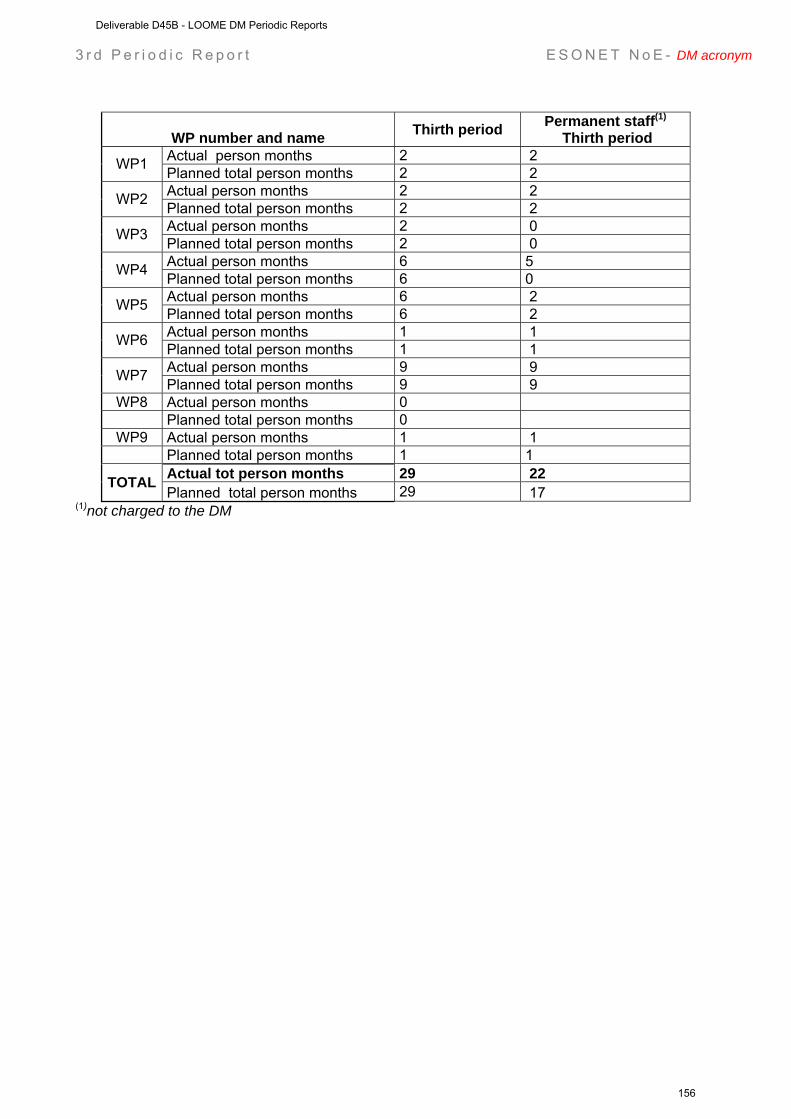
3 r d P e r i o d i c R e p o r t E S O N E T N o E - DM acronym
WP number and name Thirth period Permanent staff(1)
Thirth period Actual person months 2 2 WP1 Planned total person months 2 2 Actual person months 2 2 WP2 Planned total person months 2 2 Actual person months 2 0 WP3 Planned total person months 2 0 Actual person months 6 5 WP4 Planned total person months 6 0 Actual person months 6 2 WP5 Planned total person months 6 2 Actual person months 1 1 WP6 Planned total person months 1 1 Actual person months 9 9 WP7 Planned total person months 9 9
WP8 Actual person months 0 Planned total person months 0
WP9 Actual person months 1 1 Planned total person months 1 1
Actual tot person months 29 22 TOTAL Planned total person months 29 17
(1)not charged to the DM
Deliverable D45B - LOOME DM Periodic Reports
156
3 r d P e r i o d i c R e p o r t E S O N E T N o E - DM acronym
Workpackage progress (from 14 February 2008 to 30 September 2008)
Workpackage objectives and starting point (max 500 characters)
SEE ABOVE
Progress towards objectives – (short description about Tasks status; each task has to be referred as Task n.m where n is the WP number and m is a progressive number) We have not divided the work in tasks.
Deviations from the project work programme, and corrective actions taken/suggested (identify the nature and the reason for the problem, identify partners involved)
We have no deviations from the workprogramme after the redefinition of our work upon the strong reduction of the budget.
A)
Corrective actions:
B)
Corrective action:
Deliverable D45B - LOOME DM Periodic Reports
157
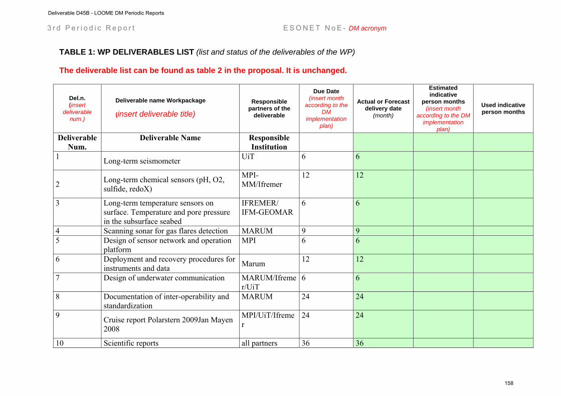
3 r d P e r i o d i c R e p o r t E S O N E T N o E - DM acronym
TABLE 1: WP DELIVERABLES LIST (list and status of the deliverables of the WP) The deliverable list can be found as table 2 in the proposal. It is unchanged.
Del.n. (insert
deliverable num.)
Deliverable name Workpackage
(insert deliverable title)
Responsible partners of the
deliverable
Due Date (insert month
according to the DM
implementation plan)
Actual or Forecast delivery date
(month)
Estimated indicative
person months (insert month
according to the DM implementation
plan)
Used indicative person months
Deliverable Num.
Deliverable Name Responsible Institution
1 Long-term seismometer UiT
6 6
2 Long-term chemical sensors (pH, O2, sulfide, redoX)
MPI-MM/Ifremer
12 12
3 Long-term temperature sensors on surface. Temperature and pore pressure in the subsurface seabed
IFREMER/ IFM-GEOMAR
6 6
4 Scanning sonar for gas flares detection MARUM 9 9
5 Design of sensor network and operation platform
MPI
6 6
6 Deployment and recovery procedures for instruments and data Marum 12 12
7 Design of underwater communication MARUM/Ifremer/UiT
6 6
8 Documentation of inter-operability and standardization
MARUM
24 24
9 Cruise report Polarstern 2009Jan Mayen 2008
MPI/UiT/Ifremer
24 24
10 Scientific reports all partners 36 36
Deliverable D45B - LOOME DM Periodic Reports
158
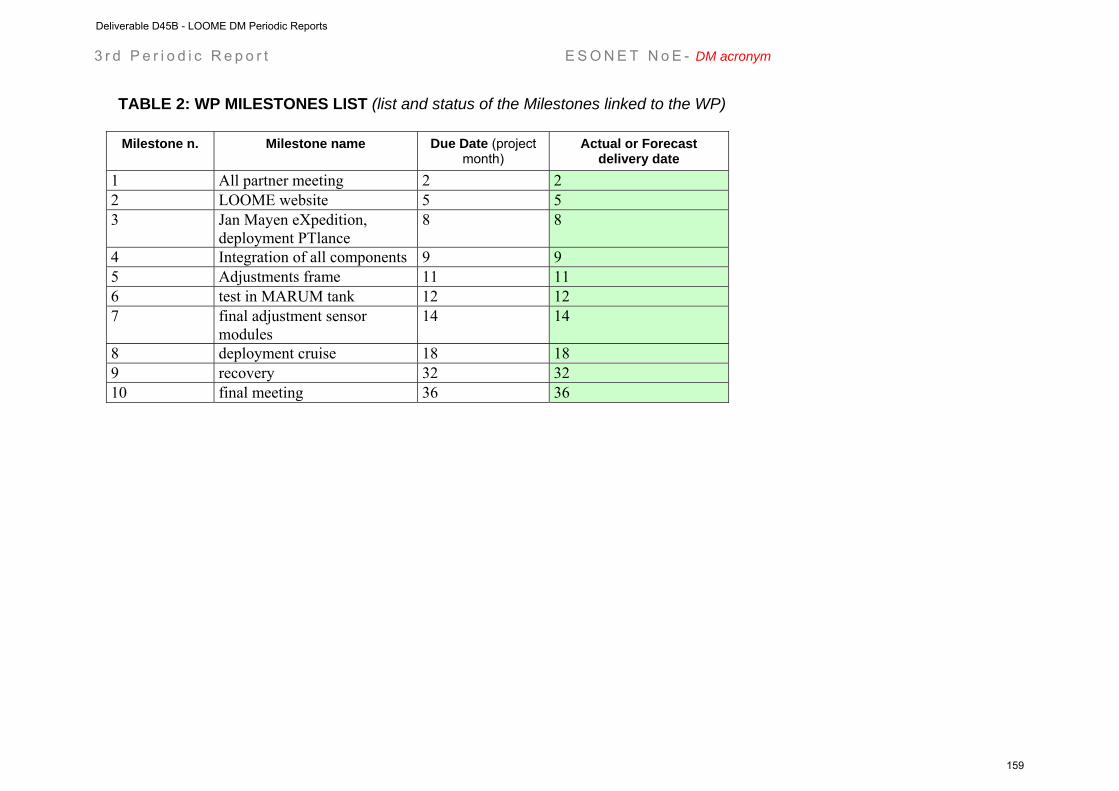
3 r d P e r i o d i c R e p o r t E S O N E T N o E - DM acronym
TABLE 2: WP MILESTONES LIST (list and status of the Milestones linked to the WP)
Milestone n. Milestone name Due Date (project month)
Actual or Forecast delivery date
1 All partner meeting 2 2 2 LOOME website 5 5 3 Jan Mayen eXpedition,
deployment PTlance 8 8
4 Integration of all components 9 9 5 Adjustments frame 11 11 6 test in MARUM tank 12 12 7 final adjustment sensor
modules 14 14
8 deployment cruise 18 18 9 recovery 32 32 10 final meeting 36 36
Deliverable D45B - LOOME DM Periodic Reports
159
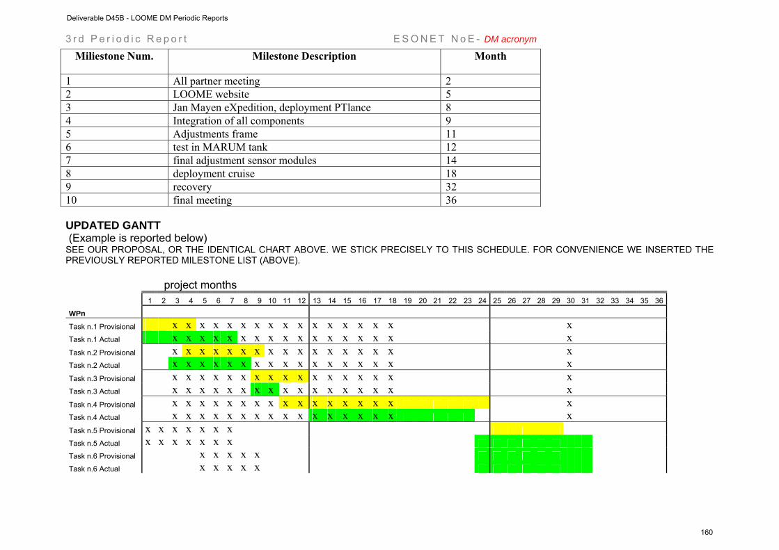
3 r d P e r i o d i c R e p o r t E S O N E T N o E - DM acronym
UPDATED GANTT (Example is reported below) SEE OUR PROPOSAL, OR THE IDENTICAL CHART ABOVE. WE STICK PRECISELY TO THIS SCHEDULE. FOR CONVENIENCE WE INSERTED THE PREVIOUSLY REPORTED MILESTONE LIST (ABOVE).
project months 1 2 3 4 5 6 7 8 9 10 11 12 13 14 15 16 17 18 19 20 21 22 23 24 25 26 27 28 29 30 31 32 33 34 35 36
WPn
Task n.1 Provisional x x x x x x x x x x x x x x x x x
Task n.1 Actual x x x x x x x x x x x x x x x x x
Task n.2 Provisional x x x x x x x x x x x x x x x x x
Task n.2 Actual x x x x x x x x x x x x x x x x x
Task n.3 Provisional x x x x x x x x x x x x x x x x x
Task n.3 Actual x x x x x x x x x x x x x x x x x
Task n.4 Provisional x x x x x x x x x x x x x x x x x
Task n.4 Actual x x x x x x x x x x x x x x x x x
Task n.5 Provisional x x x x x x x
Task n.5 Actual x x x x x x x
Task n.6 Provisional x x x x x
Task n.6 Actual x x x x x
Miliestone Num. Milestone Description Month
1 All partner meeting 2 2 LOOME website 5 3 Jan Mayen eXpedition, deployment PTlance 8 4 Integration of all components 9 5 Adjustments frame 11 6 test in MARUM tank 12 7 final adjustment sensor modules 14 8 deployment cruise 18 9 recovery 32 10 final meeting 36
Deliverable D45B - LOOME DM Periodic Reports
160
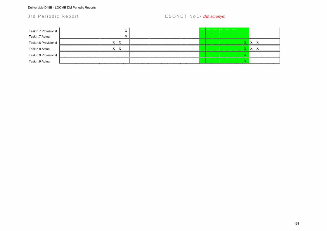
3 r d P e r i o d i c R e p o r t E S O N E T N o E - DM acronym
Task n.7 Provisional x
Task n.7 Actual x
Task n.8 Provisional x x x x x
Task n.8 Actual x x x x x
Task n.9 Provisional x
Task n.9 Actual x
Deliverable D45B - LOOME DM Periodic Reports
161

Deliverable D45B - LOOME DM Periodic Reports
162
Project contract no. 036851
ESONET
European Seas Observatory Network
Instrument: Network of Excellence (NoE) Thematic Priority: 1.1.6.3 – Climate Change and Ecosystems
Sub Priority: III – Global Change and Ecosystems
MARMARA Demonstration Mission Periodic Reports
Start date of project: March 2007 Duration: 48 months Start date of the Demonstration Mission: April 2008 Duration: 30 months Project co-funded by the European Commission within the Sixth Framework Programme (2002-2006) Dissemination Level PU Public PP Restricted to other programme participants (including the Commission Services RE Restricted to a group specified by the consortium (including the Commission
Services)
CO Confidential, only for members of the consortium (including the Commission Services)
Deliverable D45B - MARMARA DM Periodic Reports
163

Deliverable D45B - MARMARA DM Periodic Reports
164
ESONET Demonstration Missions
1st Periodic Activity Report
The Periodic Activity Report contains an overview of the activities carried out during the reporting period, describes the progress in relation to the project objectives, the progress towards the milestones and deliverables set for the period, and any problems encountered and corrective actions taken. This document has to be filled in with reference to the DM Implementation plan. This means that Deliverables, Milestones and WPs have to be the same as in the DM Implementation plan. The Periodic Report contains 2 parts: - Part I: it is addressed to the coordinator with minimum input from the partners - Part II: it is addressed to each WP Leader and reports a detailed update of each WP activity at task level. The report includes a rough justification of the costs incurred and of the resources deployed by each contractor linking them to activities implemented and justifying their necessity. Finally the report contains information on use and dissemination activities. Reporting period: From April 1st, 2008 to 30 September 2008
Deliverable D45B - MARMARA DM Periodic Reports
165

Part I (to be filled by the DM coordinator) DM acronym: MARMARA-DM
DM title: Multidisciplinary Seafloor Observatories for Seismogenic Hazards Monitoring in the Marmara Sea
ESONET Site: MARMARA SEA, Turkey
Scientific Area(s): - Earthquake hazards
- Relations between fluids and seismicity
- Processess at fluid controlled ecosystems
Technological Area(s): Lon-term, permanent monitoring of seismicity, sediment pore fluid, fluid geochemistry and gas emission activity
DM Start date: April 1st, 2008
DM duration: 30
Period of the reporting from April 1st to 30 September 2008 Partner Num.
Partner institution short name
Principal Investigator (PI)
for the Demo Mission
WP in charge (insert WP num. and title)
1. IFREMER Géli, Louis WP2. Marine Operations with Ifremer facilities WP5. Comparative and feasibility studies
2. ITU Çağatay, Namık WP6. Public Outreach, education, coordination at Turkish level and fund rising
3. ISMAR Gasperini, Luca WP4. Data Integration and modelling
4. INGV Favali, Paolo WP3. Land and Seabottom Integration; WP2. Marine operations with INGV facilities (SN-4 station)
5. CNRS Henry, Pierre WP1. MarNaut data integration 6. DEU/IMST Çifçi, Günay WP2. Marine operations with DEU
facilities
Deliverable D45B - MARMARA DM Periodic Reports
166

Executive summary (max one page) Brief description of the objective of the DM and brief description of the work status The goal of MARMARA-DM is to contribute to the establishment of optimized permanent seafloor observatory stations for earthquake monitoring in the Marmara Sea (MS), as part of ESONET NoE. Workpackages description and status are: WP 1 : Analysis of the available time series data and in-situ samples from the Marnaut cruise. This workpackage is in progress. One paper has already been published [Zitter et al, 2008 ; Géli et al, 2008], and many abstracts presented at international conferences [Geological Congress of Turkey, 2008 ; EUG 2008 ; 9th International Conference on Gas in marine Sediments, Bremerhaven, 2008 ; AGU 2008]. One Ph. D. Thesis, co-funded by Ifremer, Total and Bakerhughes is currently under way, conducted by Jean-Baptiste Tary. WP 2 : Marine operations. A number of cruises are planned for 2009 :
R/V Le Suroît cruise by IFREMER, scheduled from august 23rd to october 2nd, 2009. This cruise will comprise three parts : part 1 for acoustic dectection of gas emissions and AUV microbathymetry ; part 2 for high resolution, 3D seismic survey at one observatory site ; part 3 for instrument deployments
R/V Piri Reis cruise by DEU/IMST of Izmir, to carry out HR resolution seismics and
bathymetry in the east Çınarcık Basin. In addition 3 proposals will be submitted for additional shiptime in 2009 :
R/V Urania : in east Çınarcık Basin (proposal to be submitted to CNR by ISMAR) for the deployment of the SN-4 observatory
R/V Piri Reis : proposal to be submitted to TUBITAK in January 2009 for extra site
suveys in Central High and Çınarcık areas.
R/V Yunus (İU Fisheries): one week of survey with the Medusa system to decide the best location for SN4 deployment in east Çınarcık Basin.
The activity includes the preparation and deployment of a seafloor observatory (SN-4; INGV facility) for long-term monitoring of fluid seepage and seismic activity. WP 3 : Integration of land and seafloor seismological data. This workpackage has started with the merging of OBS data from the MarNaut cruise and land data from Turkish institutions (KOERI and TUBITAK). WP 4 : Data integration and modeling. This work under this WP has not started yet. It will start as soon as the data from the MarNaut piezometer and flowmeters have been processed. The work will continue after the 2009 cruises. WP 5 : Comparative study and project feasibility. Not started yet WP 6 : Public and education outreach, coordination at national (Turkish) level and fund raising. Two project meetings were conducted with participation of collaborating Turkish institutions : the kick-off meeting in Istanbul (June 2008) was held KOERI, Tubitak and MTA ; the cruise preparation meeting in Brest (29-30 october, 2008) with KOERI. Contacts with Turkish Petroleum (TPAO) are planned in 2009. TV interviews and articles in science magazines were given in the Turkish press in june 2008. A special Marmara session
Deliverable D45B - MARMARA DM Periodic Reports
167
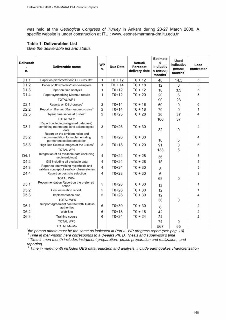
was held at the Geological Congress of Turkey in Ankara during 23-27 March 2008. A specific website is under construction at ITU : www. esonet-marmara-dm.itu.edu.tr Table 1: Deliverables List Give the deliverable list and status
Deliverab.
n. Deliverable name WP
n. Due Date Actual/
Forecast delivery date
Estimated
indicative person months*
Used indicative
person months*
Lead contractor
D1.1 Paper on piezometer and OBS resultsa 1 T0 + 12 T0 + 12 48 14,5 5 D1.2 Paper on flowmeters/osmo-samplers 1 T0 + 14 T0 + 18 12 0 5 D1.3 Paper on fluid analysis 1 T0+12 T0 + 12 10 3,5 5 D1.4 Paper synthetizing Marnaut results 1 T0+12 T0 + 20 20 5 5
TOTAL WP1 90 23 D2.1 Reports on DEU cruisesb 2 T0+14 T0 + 18 60 0 6 D2.2 Report on Ifremer (Marmesonet) cruiseb 2 T0+14 T0 + 18 70 0 1 D2.3 1-year time series at 3 sitesc 2 T0+23 T0 + 28 36 37 4
TOTAL WP2 166 37
D3.1 Report (including integrated database)
combining marine and land seismological data
3 T0+26 T0 + 30 32 0
2
D3.2 Report on the ambient noise and
recommendation for implementating permanent seabottom station
3 T0+26 T0 + 30 10 5
4
D3.3 High Res Seismic Images at the 3 sitesa 3 T0+18 T0 + 20 91 0 6 TOTAL WP3 133 5
D4.1 Integration of all available data (including sedimentology) 4 T0+24 T0 + 28 36 3
D4.2 GIS including all available data 4 T0+24 T0 + 28 18 5
D4.3 Report to test working hypothesis and validate concept of seafloor observatories 4 T0+24 T0 + 30 8 5
D4.4 Report on best site selection 4 T0+28 T0 + 30 6 3 TOTAL WP4 68 0
D5.1 Recommendation Report on the preferred option 5 T0+28 T0 + 30 12 1
D5.2 Cost estimation report 5 T0+28 T0 + 30 12 1 D5.3 Implementation plan 5 T0+28 T0 + 30 12 4
TOTAL WP5 36 0
D6.1 Support agreement contract with Turkish authorities 6 T0+30 T0 + 30 8 2
D6.2 Web Site 6 T0+18 T0 + 18 42 2 D6.3 Training course 6 T0+24 T0 + 24 24 2
TOTAL WP6 74 0 TOTAL Ma-Mo 567 65 *the person month must be the same as indicated in Part II- WP progress report (see pag. 10) a Time in men-month here corresponds to a 3-years Ph. D. Thesis and supervisor’s time b Time in men-month includes instrument preparation, cruise preparation and realization, and reporting c Time in men-month includes OBS data reduction and analysis, include earthquakes characterization
Deliverable D45B - MARMARA DM Periodic Reports
168
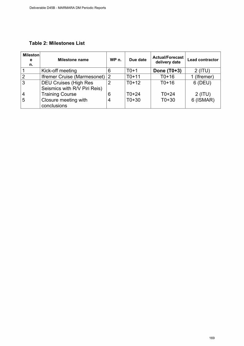
Table 2: Milestones List
Milestone n.
Milestone name WP n. Due date Actual/Forecast delivery date Lead contractor
1 Kick-off meeting 6 T0+1 Done (T0+3) 2 (ITU) 2 Ifremer Cruise (Marmesonet) 2 T0+11 T0+16 1 (Ifremer) 3 DEU Cruises (High Res
Seismics with R/V Piri Reis) 2
T0+12 T0+16 6 (DEU)
4 Training Course 6 T0+24 T0+24 2 (ITU) 5 Closure meeting with
conclusions 4 T0+30 T0+30 6 (ISMAR)
Deliverable D45B - MARMARA DM Periodic Reports
169
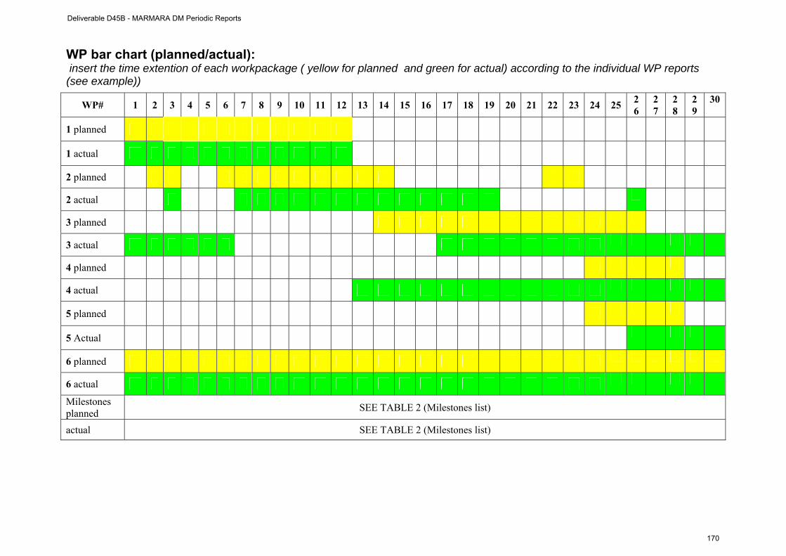
WP bar chart (planned/actual): insert the time extention of each workpackage ( yellow for planned and green for actual) according to the individual WP reports (see example))
WP# 1 2 3 4 5 6 7 8 9 10 11 12 13 14 15 16 17 18 19 20 21 22 23 24 25 26
27
28
29
30
1 planned
1 actual
2 planned
2 actual
3 planned
3 actual
4 planned
4 actual
5 planned
5 Actual
6 planned
6 actual
Milestones planned SEE TABLE 2 (Milestones list)
actual SEE TABLE 2 (Milestones list)
Deliverable D45B - MARMARA DM Periodic Reports
170
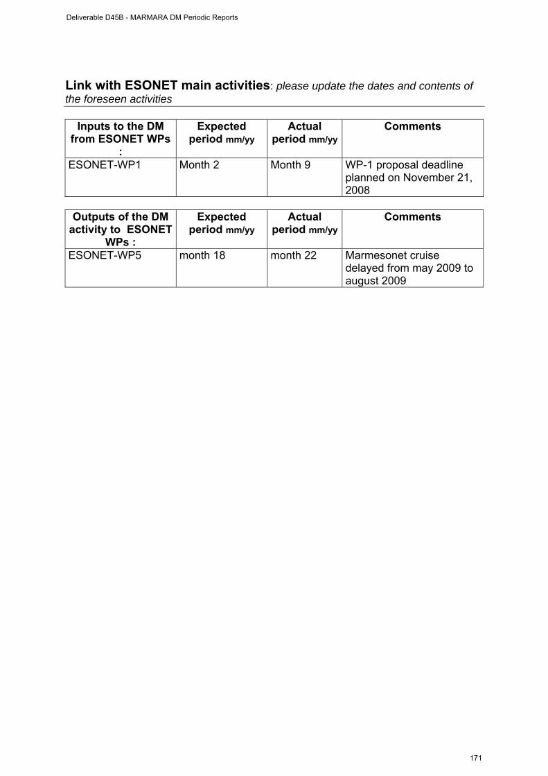
Link with ESONET main activities: please update the dates and contents of the foreseen activities
Inputs to the DM from ESONET WPs
:
Expected period mm/yy
Actual period mm/yy
Comments
ESONET-WP1 Month 2 Month 9 WP-1 proposal deadline planned on November 21, 2008
Outputs of the DM
activity to ESONET WPs :
Expected period mm/yy
Actual period mm/yy
Comments
ESONET-WP5 month 18 month 22 Marmesonet cruise delayed from may 2009 to august 2009
Deliverable D45B - MARMARA DM Periodic Reports
171
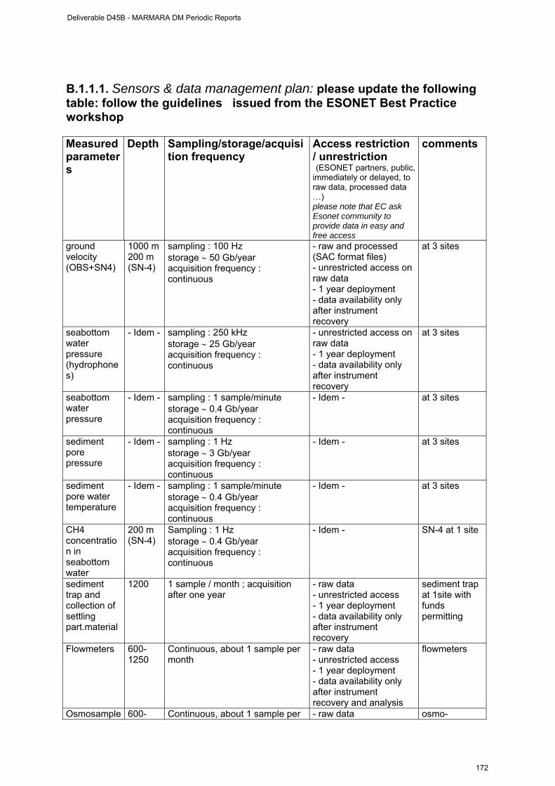
B.1.1.1. Sensors & data management plan: please update the following table: follow the guidelines issued from the ESONET Best Practice workshop Measured parameters
Depth Sampling/storage/acquisition frequency
Access restriction / unrestriction (ESONET partners, public, immediately or delayed, to raw data, processed data …) please note that EC ask Esonet community to provide data in easy and free access
comments
ground velocity (OBS+SN4)
1000 m 200 m (SN-4)
sampling : 100 Hz storage ∼ 50 Gb/year acquisition frequency : continuous
- raw and processed (SAC format files) - unrestricted access on raw data - 1 year deployment - data availability only after instrument recovery
at 3 sites
seabottom water pressure (hydrophones)
- Idem - sampling : 250 kHz storage ∼ 25 Gb/year acquisition frequency : continuous
- unrestricted access on raw data - 1 year deployment - data availability only after instrument recovery
at 3 sites
seabottom water pressure
- Idem - sampling : 1 sample/minute storage ∼ 0.4 Gb/year acquisition frequency : continuous
- Idem - at 3 sites
sediment pore pressure
- Idem - sampling : 1 Hz storage ∼ 3 Gb/year acquisition frequency : continuous
- Idem - at 3 sites
sediment pore water temperature
- Idem - sampling : 1 sample/minute storage ∼ 0.4 Gb/year acquisition frequency : continuous
- Idem - at 3 sites
CH4 concentration in seabottom water
200 m (SN-4)
Sampling : 1 Hz storage ∼ 0.4 Gb/year acquisition frequency : continuous
- Idem - SN-4 at 1 site
sediment trap and collection of settling part.material
1200 1 sample / month ; acquisition after one year
- raw data - unrestricted access - 1 year deployment - data availability only after instrument recovery
sediment trap at 1site with funds permitting
Flowmeters 600-1250
Continuous, about 1 sample per month
- raw data - unrestricted access - 1 year deployment - data availability only after instrument recovery and analysis
flowmeters
Osmosample 600- Continuous, about 1 sample per - raw data osmo-
Deliverable D45B - MARMARA DM Periodic Reports
172

rs 1250 month - unrestricted access - 1 year deployment - data availability only after instrument recovery and analysis
samplers
bubbling activity using an acoustic detector of gas bubbles
sampling : 1 sample/minute during 60 minutes 1 sample = 1 acoustic image 3 Mb per sample storage ∼ 65 Gb/year acquisition frequency : 2 per day
1 site, funds permitting
Currentmeter 200 m (SN-4)
5 Hz - unrestricted access on raw data - 1 year deployment - data availability only after instrument recovery
SN-4 at 1 site
CTD 200 m (SN-4)
1 sample/10 minute idem SN-4 at 1 site
Turbidimeter 200 m (SN-4)
1 sample/10 minute idem SN-4 at 1 site
oxigen 200 m (SN-4)
1 Hz idem SN-4 at 1 site
• A tabular overview of budgeted person-months and actual person-months
by workpackage (budgeted person –months to be taken from “Effort breakdown” Excel file)
WP number and name First period B.2. Permanent staff(1)
B.3. first period Actual person months 7
91 WP1
Planned total person months 91 Actual person months 13 WP2 Planned total person months 168 Actual person months 29,5 WP3 Planned total person months 128 Actual person months 0 WP4 Planned total person months 58 Actual person months 0 WP5 Planned total person months 75 Actual person months 3 WP6 Planned total person months 47 Actual tot person months 71,5 TOTAL Planned total person months 567
(1)not charged to the DM
Deliverable D45B - MARMARA DM Periodic Reports
173

Dissemination and outreach : please update the table
Type of school material available at the issue of the mission
(photos, video, courses,…others)
Description
TRAINING COURSE PLANNED FOR SCIENTISTS AND ENGINEERS in TURKEY ON DEEP SEAFLOOR OBSERVATORIES
Type of dissemination (through collaborations with aquaria,
museum, sciences centres, etc.)
Description
WEB SITE UNDER CONSTRUCTION AT ITU
www. esonet-marmara-dm.itu.edu.tr
Deliverable D45B - MARMARA DM Periodic Reports
174

Part II (to be filled by each partners) ESONET Noe – Demonstration Mission DM acronym: MARMARA-DM
Scientific Area(s): - Earthquake hazards
- Relations between fluids and seismicity
- Processess at fluid controlled ecosystems
Technological Area(s): Lon-term, permanent monitoring of seismicity, sediment pore fluid, fluid geochemistry and gas emission activity
DM Start date: April 1st, 2008
DM duration: 30
Note : Only WP1, WP2, WP3 and WP6 have started before September 30, 2008
Hence no management report is provided for WP4 and WP5
Deliverable D45B - MARMARA DM Periodic Reports
175
WP1 management report
(from April 1st to 30 September 2008) WORKPACKAGE WP1
Full WP title ANALYSIS OF DATA FROM MARNAUT CRUISE
Period covered from 01/04/2008 to 30/09/2008
Partner organisation full name CNRS / CEREGE / Chaire de Géodynamique du Collège de France
Person in charge for the report (WP Leader)
Pierre Henry
Partners involved in the Work 5, 1, 2, 3
Period of the reporting: from starting date to 30 September 2008 Provide a justification of the major costs incurred and resources deployed, linking them to activities implemented and explaining their necessity. • Work Performed : A brief description (max 700 char) of the work performed by each
contractor during the period. The work performed under WP1 consist in analyzing the data collected during the MarNaut cruise. Major results concern :
- the acoustic detection of gas emissions [Géli et al, EPSL, 274, 34-39, 2008] - the analysis of deep sea eco-systems [Lara et al, Environ. Microbiol., doi:
10.1111/j.1462-2920.2008.01737.x, Sep 18, 2008]. - the analysis of heat flow data [André, Mastère 2, Université de Bretagne Occidentale,
Juin 2008] - the geochemical analysis of gases [Bourris et al, 9th International Conference of Gas
in Marine Sediments, September 2008] - the pore fluid chemistry of cold seeps [Tryon et al, AGU Fall Meeting] - the analysis of Ocean Bottom Seismometers [J. B. Tary, Ph. D. Thesis]
• Rough Estimation of Major Cost: Explanatory note on any major cost roughly
estimated of items such as major travel costs, large consumable items etc., justifying their necessity to the project.
Person-Months
Ifremer : 14,5 Ma-Mo ITU : 1,5 Ma- Mo INGV : 0 Ma-Mo ISMAR : 2 Ma-Mo Cnrs : 5 Ma-Mo DEU : 0 Ma-Mo
Travels :
Ifremer : 2500 € L. Géli : 9th International Conference on Gas in Marine Sediments 2 x 1000 = 700 €
Deliverable D45B - MARMARA DM Periodic Reports
176

C. André : Visit to CEREGE ; 1 travel round trip from Brest to Aix en Provence : 500 €
CNRS: 1615,12 €
T Zitter: 9th International Conference on Gas in Marine Sediments, Bremen, Sept 15-19, 2008. Cost: 1137.47 E
P Henry: Geological Society of London meeting: Subsurface sediment remobilization and fluid flow in sedimentary basins, Oct 21-22, 2008. Cost: 477.65 E
Other costs :
ITU : 2611 Euros for rental of RV Yunus for two days WP2
• Overview of the Actual Costs, by major cost item including personnel (fill in the Table here below)
Type of expenditure
Actual costs( Euro) First period
Total person-months 23 Ma-Mo Personnel costs 120900€ Subcontracting Travels 2815,12 € Consumables Other costs 2611 €
Total Costs 126326 €
Deliverable D45B - MARMARA DM Periodic Reports
177
WP-1 progress
(from start date to 30 September 2008)
Workpackage objectives and starting point (max 500 characters)
Progress towards objectives – (short description about Tasks status; each task has to be referred as Task n.m where n is the WP number and m is a progressive number) Task WP1.T1: Analyze OBS and Piezometers (Ph. D. Thesis of J. B. Tary started in
November 2008, with supervision of Louis Géli, Ifremer, and Pierre Henry, Cnrs)
Contractors involved : Ifremer, Cnrs, ITU (including Tubitak) and support from KOERI
The data from four OBSs deployed for 2,5 months in the eastern Sea of Marmara were analyzed together with land stations data provided by KOERI. The recorded events are distributed in two groups. The first is a cluster of events located below the Western Ridge, below a zone where gas and oil seeps where found at the seafloor. Events of the second group are located deep in the crust and aligned along a NNE direction crossing the northern escarpment of the Tekirdag Basin. Gas emissions occur through NNE oriented tensile cracks near the base of this escarpment. These cracks could well be the surface expression of a deep seated active fault.
Task WP1.T2: Analyze flowmeters and osmo-sampler data from MarNaut
Contractors involved : ITU (including SIO), Cnrs
Seven flowmeters / osmosamplers from the Scripps Insitution of Oceanography were deployed during the Marnaut cruise in May/June 2007. The instruments were recovered in June 2008 with a research vessel from ITU. However, due to customs problems, the equipment is still in Istanbul. Hence, the data have not been analyzed yet. Task WP1.T3 : Analyze sediment cores, rock and fluid samples, heat flow data
Contractors involved : ITU (including SIO), Cnrs, Ifremer, Ismar
Analysis of pore fluids from Marnaut were done at Scripps Institute of Oceanography (SIO). These results, as well as earlier analyses performed at CEREGE show convective mixing of brackish pore fluid and present day seawater occurs within the first 5 m of sediment, with non-steady state profiles. This mixing is attributed to episodic gas expulsion, which may be enhanced by earthquake activity. Advection diffusion modelling was performed to constrain the timing of seawater downflow into the sediment. At one site, brines influenced by upward fluid advection from deeper levels (and associated with oil) were sampled and analysed.
A total of 45 heat flow measurements were carried out during the MarNaut cruise, exhibiting heat flow values ranging between about 15 and 55 mW.m-2, except at one single location near the northern Cinarcik Basin escarpment, where heat flow reaches 120 mW.m-2 in response to deep, upward fluid flow. Corrections were made to account for blanketing and basement topography effects. Results provide constraints to estimate the age of initiation of the North Anatolian Fault within what is now the Sea of Marmara.
Deliverable D45B - MARMARA DM Periodic Reports
178
ISMAR staff reprocessed most of the available geophysical data collected in the areas potentially interesting for the purposes of the DM. Multibeam bathymetry, chirp-sonar profiles and side-scan sonar mosaics were processed and analysed to find evidence of earthquake related surface ruptures and fuid emission in the water column. Sediment cores available were also studied to find evidence of earthquake relate mass-wasting events in the sedimentary sequence. Luca Gasperini and Giovanni Bortoluzzi worked on geophysical data processing and interpretation. Alina Polonia worked on geophysical data and core analysis. Luca Giorgio Belluci worked on core analysis.
Deviations from the project work programme, and corrective actions taken/suggested (identify the nature and the reason for the problem, identify partners involved)
A) Deviation : Insert the name of the cause of deviation and explain why this cause has determined deviation. max 500 characters
Customs delays. Deviation from the project work programme concerns Task WP1-T2. The 7 flowmeters / osmosamplers that were deployed during the MarNaut cruise were recovered in June 2008. But, custom problems prevented us to transfer the equipment from Istanbul back to Scripps Institution of Oceanography in San Diego, where the data are expected to be processed.
Partnership limitations from ESONET contract. Part of the analysis of sediments, cores, rock and fluid done by CNRS are taking place in laboratories not included in the original ESONET contract (noble gasses at CRPG, carbonates at LOCEAN).
B) Corrective actions: insert description of the corrective actions max 500 characters
Our Turkish colleagues from ITU have multiplied the interventions to obtain custom clearance. Clearance is now expected hopefully before November 15th, 2008.
The partnership limitations from ESONET contract did not impact the science results. Laboratories involved in Marnaut cruise performed the analyses planned (CRPG, LOCEAN), but do not report to ESONET.
Deliverable D45B - MARMARA DM Periodic Reports
179
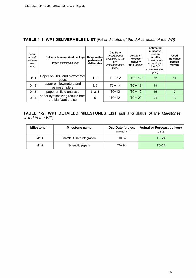
TABLE 1-1: WP1 DELIVERABLES LIST (list and status of the deliverables of the WP)
Del.n. (insert
deliverable
num.)
Deliverable name Workpackage
(insert deliverable title)
Responsible partners of deliverable
Due Date (insert month
according to the DM
implementation plan)
Actual or Forecast delivery
date (month)
Estimated indicative
person months
(insert month according to
the DM implementation
plan)
Used indicative
person months
D1-1 Paper on OBS and piezometer results 1, 5 T0 + 12 T0 + 12 72 14
D1-2 paper on flowmeters and osmosamplers 2, 5 T0 + 14 T0 + 18 18
D1-3 paper on fluid analysis 5, 2, 1 T0+12 T0 + 12 15 2
D1-4 paper synthesizing results fromthe MarNaut cruise 5 T0+12 T0 + 20 24 12
TABLE 1-2: WP1 DETAILED MILESTONES LIST (list and status of the Milestones linked to the WP)
Milestone n. Milestone name Due Date (project month)
Actual or Forecast delivery date
M1-1 MarNaut Data integration T0+24 T0+24
M1-2 Scientific papers T0+24 T0+24
Deliverable D45B - MARMARA DM Periodic Reports
180

WP2 management report
(from start date to 30 September 2008)
• Work Performed : A brief description (max 700 char) of the work performed by each
contractor during the period. ITU. ITU rented the RV Yunus of the Faculty of Fisheries of the Istanbul University for the recovery of osmometers-flowmeters deployed during the MARNAUT cruise one year earlier. The equipment recovery cruise took place during 20-21 June 2008. Dursun Acar (engineer) of ITU-EMCOL and Mike Tryon of Scripps Institution of Oceanography (SIO) participated in the cruise. ITU-EMCOL is still trying to send the equipment to SIO. There are difficulties with customs because there is no record of the entry of these equipment onboard RV L’Atalnte into Turkey. We are still trying to solve the customs problem. INGV. As foreseen in the task WP2-T1 (Appendix 1 of DM proposal), INGV performed the upgrade of SN4 observatory adding new sensors to the basic SN-4 configuration. This upgrade was made in order to execute a multiparametric monitoring requested by the project objectives (gas seepage and seismicity). SN-4 will be able to assess the temporal relationships between fluid expulsion, related environmental effects (e.g. temperature, oxygen variations) and seismic activity. The station will be deployed in a selected site (200 m deep) as recommended in a technical note (cf Notes on SN-4 Observatory deployment in the Sea of Marmara by INGV and ISMAR issued on October 2008 for the Brest meeting). The deployment will be done by using a mechanical rope and an acoustic release; the recovery will be based on the use of a recall buoy canister actuated by an acoustic release. To facilitate the recovery procedure the total weight in water is going to be reduced to 1.5 kN installing 8 benthospheres on the frame and adopting new lighter vessels for batteries and electronics. As the Lithium battery pack will guarantee 6 months of autonomy, this procedure for recovery should make easier the battery pack replacement for next missions. ISMAR. A proposal for the use of R/V Urania during the 2009 Spring/Summer was submitted by ISMAR to the Ship-Office of the Italian CNR. IFREMER. Ifremer started with the preparation of the instruments that will be deplyed during the Marmesonet cruise in september 2009. The development of an autonomous seafloor observatory was initiated for the monitoring of bubble emissions, using high frequency (38 kHz) active acoustics. Some improvements were also made on Ifremer OBSs to measure the orientation of the OBSs sensors. DEU. DEU-Seislab performed Marmara Cruise in July 2008 onboard R/V K. Piri Reis, in the frame of a colloborative research (Basin evolution along continental transforms: Nested Hi-Resolution Multichannel Survey in the Marmara Sea,Turkey) between Lamont-Doherty Earth Observatory(LDEO) of Columbia University and Institute of Marine Sciences and Technology. The primary goal of acquiring high-resolution seismic data was to provide stratigraphic ties between subbasins in the Marmara Sea and details on shallow stratigraphy and structure, which can be used to reconstruct the recent history of the Marmara basin.
Deliverable D45B - MARMARA DM Periodic Reports
181
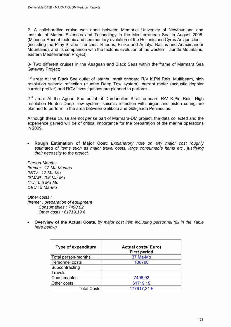
2- A colloborative cruise was done between Memorial University of Newfounland and Institute of Marine Sciences and Technology in the Mediterranean Sea in August 2008. (Miocene-Recent tectonic and sedimentary evolution of the Hellenic and Cyrus Arc junction (including the Pliny-Strabo Trenches, Rhodes, Finike and Antalya Basins and Anaximander Mountains), and its comparison with the tectonic evolution of the western Tauride Mountains, eastern Mediterranean Project). 3- Two different cruises in the Aeagean and Black Seas within the frame of Marmara Sea Gateway Project; 1st area: At the Black Sea outlet of İstanbul strait onboard R/V K.Piri Reis. Multibeam, high resolution seismic reflection (Huntec Deep Tow system), current meter (acoustic doppler current profiler) and ROV investigations are planned to perform. 2nd area: At the Agean Sea outlet of Dardanelles Strait onboard R/V K.Piri Reis; High resolution Huntec Deep Tow system, seismic reflection with airgun and piston coring are planned to perform in the area between Gelibolu and Gökçeada Peninsulas. Although these cruise are not per se part of Marmara-DM project, the data collected and the experience gained will be of critical importance for the preparation of the marine operations in 2009. • Rough Estimation of Major Cost: Explanatory note on any major cost roughly
estimated of items such as major travel costs, large consumable items etc., justifying their necessity to the project.
Person-Months Ifremer : 12 Ma-Months INGV : 12 Ma-Mo ISMAR : 0.5 Ma-Mo ITU : 0,5 Ma-Mo DEU : 9 Ma-Mo Other costs : Ifremer : preparation of equipment
Consumables : 7498,02 Other costs : 61719,19 €
• Overview of the Actual Costs, by major cost item including personnel (fill in the Table
here below)
Type of expenditure
Actual costs( Euro) First period
Total person-months 37 Ma-Mo Personnel costs 108700 Subcontracting Travels Consumables 7498,02 Other costs 61719,19
Total Costs 177917,21 €
Deliverable D45B - MARMARA DM Periodic Reports
182

WP3 management report (from April 1st, 2008 to 30 September 2008)
WORKPACKAGE WP3
Full WP title INTEGRATION OF LAND AND SEAFLOOR SEISMOLOGICAL DATA
Period covered from April 1st, 1008 to 30/09/2008
Partner organisation full name INGV
Person in charge for the report (WP Leader)
Paolo Favali
Partners involved in the Work 4, 1, 5, 2
Period of the reporting: from starting date to 30 September 2008 Provide a justification of the major costs incurred and resources deployed, linking them to activities implemented and explaining their necessity. • Work Performed : A brief description (max 700 char) of the work performed by each
contractor during the period. The work consisted in integrating the data from the OBSs that were deployed during the MarNaut cruise and the land data recorded from KOERI and from TUBITAK between may 14th and august 12th 2008. The land data from KOERI can improve the characterization of the seismic events (location, magnitude) recorded by the OBSs. The integration of TUBITAK data is in progress. This work will considerably speed up the process that will be done at the end of 2009 to integrate the data that will be collected after the Marmesonet Cruise and after SN-4 observatory recovery. • Rough Estimation of Major Cost: Explanatory note on any major cost roughly
estimated of items such as major travel costs, large consumable items etc., justifying their necessity to the project.
Person-Months
Ifremer : 2 Ma-Months ITU : 1,5 Ma-Mo CEREGE : 0,5 Ma-Mo
Travels :
Ifremer : Visit to Magnitude/Baker-Hughes (2 travels from Brest to Manosque round-trip) : 1000 €
• Overview of the Actual Costs, by major cost item including personnel (fill in the Table
here below)
Type of expenditure
Actual costs( Euro) First period
Deliverable D45B - MARMARA DM Periodic Reports
183
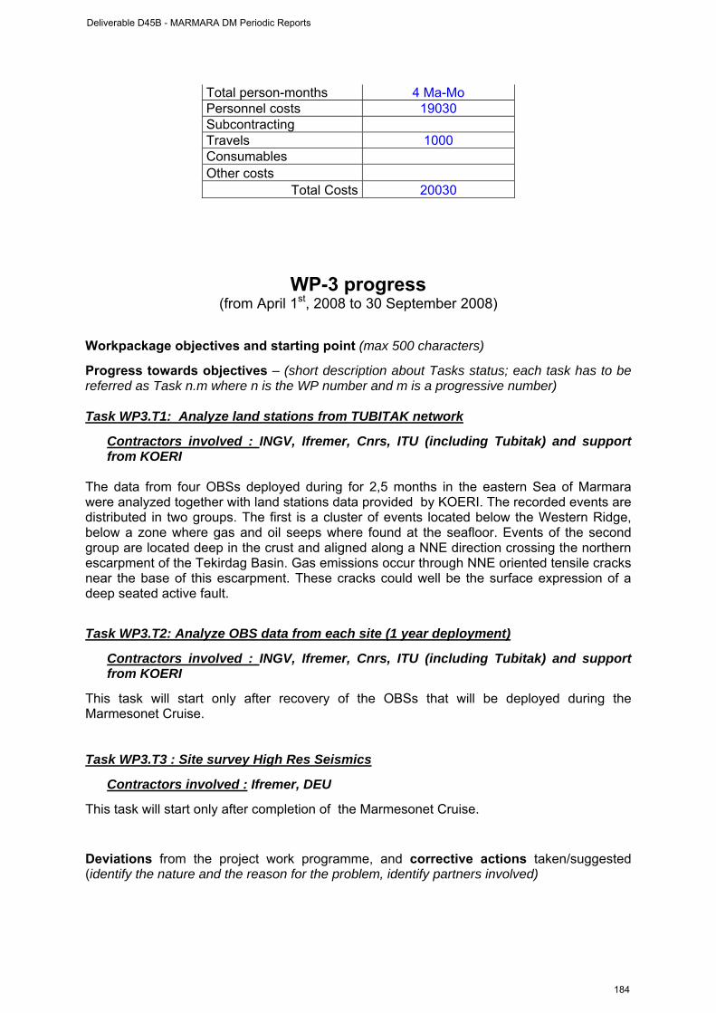
Total person-months 4 Ma-Mo Personnel costs 19030 Subcontracting Travels 1000 Consumables Other costs
Total Costs 20030
WP-3 progress (from April 1st, 2008 to 30 September 2008)
Workpackage objectives and starting point (max 500 characters)
Progress towards objectives – (short description about Tasks status; each task has to be referred as Task n.m where n is the WP number and m is a progressive number) Task WP3.T1: Analyze land stations from TUBITAK network
Contractors involved : INGV, Ifremer, Cnrs, ITU (including Tubitak) and support from KOERI
The data from four OBSs deployed during for 2,5 months in the eastern Sea of Marmara were analyzed together with land stations data provided by KOERI. The recorded events are distributed in two groups. The first is a cluster of events located below the Western Ridge, below a zone where gas and oil seeps where found at the seafloor. Events of the second group are located deep in the crust and aligned along a NNE direction crossing the northern escarpment of the Tekirdag Basin. Gas emissions occur through NNE oriented tensile cracks near the base of this escarpment. These cracks could well be the surface expression of a deep seated active fault.
Task WP3.T2: Analyze OBS data from each site (1 year deployment)
Contractors involved : INGV, Ifremer, Cnrs, ITU (including Tubitak) and support from KOERI
This task will start only after recovery of the OBSs that will be deployed during the Marmesonet Cruise. Task WP3.T3 : Site survey High Res Seismics
Contractors involved : Ifremer, DEU
This task will start only after completion of the Marmesonet Cruise.
Deviations from the project work programme, and corrective actions taken/suggested (identify the nature and the reason for the problem, identify partners involved)
Deliverable D45B - MARMARA DM Periodic Reports
184
NO DEVIATION.
Deliverable D45B - MARMARA DM Periodic Reports
185
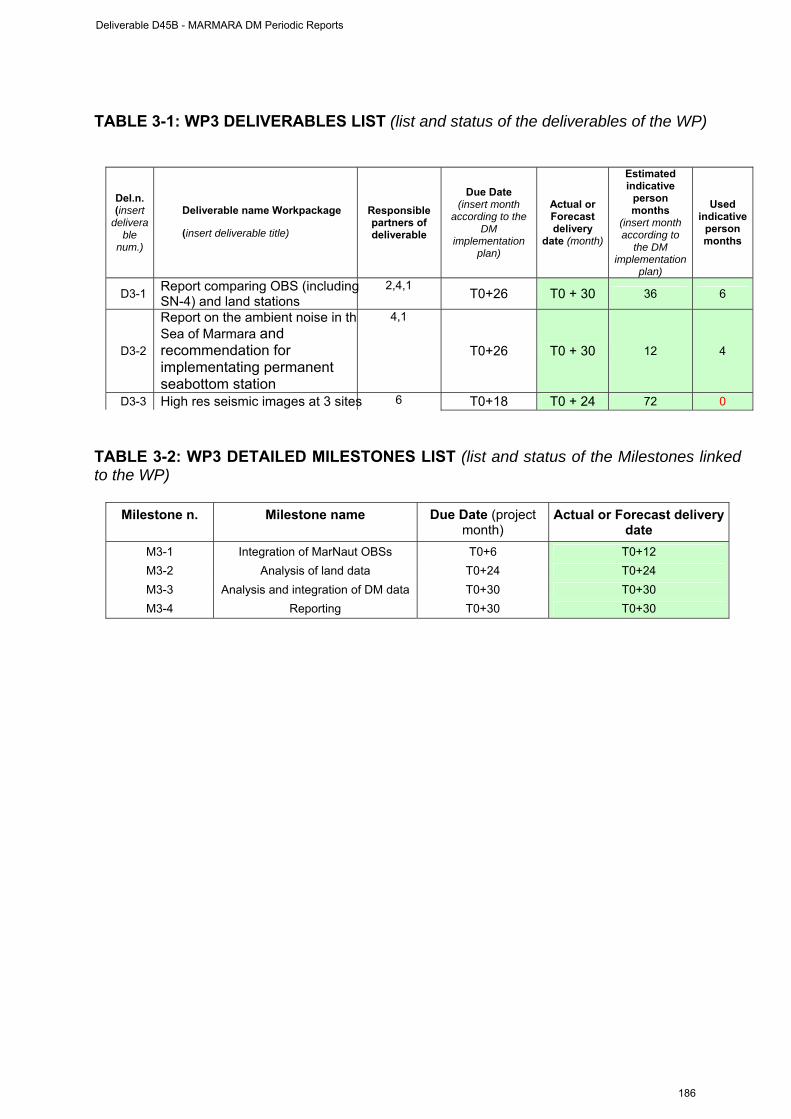
TABLE 3-1: WP3 DELIVERABLES LIST (list and status of the deliverables of the WP)
Del.n. (insert
deliverable
num.)
Deliverable name Workpackage
(insert deliverable title)
Responsible partners of deliverable
Due Date (insert month
according to the DM
implementation plan)
Actual or Forecast delivery
date (month)
Estimated indicative
person months
(insert month according to
the DM implementation
plan)
Used indicative
person months
D3-1 Report comparing OBS (includingSN-4) and land stations
2,4,1 T0+26 T0 + 30 36 6
D3-2
Report on the ambient noise in thSea of Marmara and recommendation for implementating permanent seabottom station
4,1
T0+26 T0 + 30 12 4
D3-3 High res seismic images at 3 sites 6 T0+18 T0 + 24 72 0
TABLE 3-2: WP3 DETAILED MILESTONES LIST (list and status of the Milestones linked to the WP)
Milestone n. Milestone name Due Date (project month)
Actual or Forecast delivery date
M3-1 Integration of MarNaut OBSs T0+6 T0+12 M3-2 Analysis of land data T0+24 T0+24 M3-3 Analysis and integration of DM data T0+30 T0+30 M3-4 Reporting T0+30 T0+30
Deliverable D45B - MARMARA DM Periodic Reports
186
WP6 management report
(from april 1st, 2008 to 30 September 2008) WORKPACKAGE WP6
Full WP title PUBLIC AND EDUCATION OUTREACH. FUND RISING.
Period covered from April 1st, 1008 to 30/09/2008
Partner organisation full name ITU
Person in charge for the report (WP Leader)
Namik Çagatay
Partners involved in the Work 2, 6, and all partners
Period of the reporting: from starting date to 30 September 2008 Provide a justification of the major costs incurred and resources deployed, linking them to activities implemented and explaining their necessity.
MARMARA-DM PROJECT WP6 ACTIVITIES FOR THE FIRST 6 MONTHS
WP 6 : Public and education outreach, coordination at national (Turkish) level and
fund raising COORDINATION (Tasks WP6.T2 and WP6.T3) At present coordination efforts are in progress between different Turkish organizations, such as TPAO (Turkish Petroleum Company), TUBITAK (Scientific and Technological Council of Turkey) and MTA (Geological Suvey of Turkey), for permanent seafloor observartories in the Sea of Marmara. These efforts are explained below.
1. KOERI’s Project for cabled seafloor seismological observatories funded by Turkish
Authorities independently of ESONET. Talks are in progress with KOERI and GURALP regarding collaboration with multidisciplinary ESONET and Marmara-DM observatory studies in the Sea of Marmara. Regarding this issue, ESONET and EMSO representatives met with KOERI management in Istanbul on March 28th, 2008 (see Minutes of the meeting attached as Appendix I).
2. Turkish marine research community was informed of the ESONET and ESONET Marmara-DM activities in the Sea of Marmara in the Annual Coordination Meeting of Marine Research in Turkey, convened by the Department of Navigation Hydrography and Ocenaography of the Turkish Navy (SHOD) in KOERI during 29-30 May 2008.
3. An invitation letter was sent to MTA (Geological Survey of Turkey) by Namık Çağatay and Naci Görür on 10 July 2008 for MTA’s collaboration in the ESONET activities in the Sea of Marmara. Namık Çağatay visited MTA on 29 August 2008 and had a meeting with Dr. Ziya (Deputy Director General) and Mr. Kerim Sarıkavak (Head of the Marine Geology Department). The MTA officials were informed about the ESONET, MarmaraDM and EMSO projects. MTA would like to provide logistic support for the activities in the Sea of Marmara node. It was agreed that MTA would
Deliverable D45B - MARMARA DM Periodic Reports
187
participate in these activities and include such activities in their annual work plan for the next year with a budget for the marine operations. MTA is constructing a new 22 m vessel which could be used for Marmara-DM marine surveys and equipment deployment /recovery. MTA is also planning to buy a research vessel for marine geological and geophysical all surveys, which could be operational in about two years. (See Appendix II for invitation letter).
4. Namık Çağatay contacted TPAO on 17 October 2008 and informed them of the results MARNAUT cruise and ESONET Marmara-DM project. It was agreed that a short written document on the Marmara-DM project be prepared and sent to TPAO by Namık Çağatay. This will be followed by a presentation of the project in the TPAO headquarters in Ankara and discussions on TPAO’s participations in the ESONET activities in the Sea of Marmara node.
DISSEMINATION OF RESULTS (Task WP6.T1) 1. Scientific workshop on MarNaut results : A workshop was organized in ITU during 16-17 June 2008, before the kick-off meeting of the Marmara-DM project. The purpose was mainly to review the scientific results of the MARNAUT cruise carried in the Sea of Marmara one year earlier during May-June 2007. A total of 17 high quality scientific papers were presented during the workshop. Most of the out presentations were on Marnaut Cruise results, with a couple of presentations on the planned KOERI seafloor seismological network and seafloor radon monitoring. The workshop presentations set up the scene for an efficient discussion of the planning of activities for the Marmara-DM project during the kick-off meeting. The workshop programme is appended as Appendix III. The workshop was attended also by the representatives of TPAO, MTA, TUBITAK Marmara Research Centre, KOERI and Istanbul University. It was widely covered by the Turkish media (TV channels, newspapers, popular science magazines). Louis Geli, Pierre Henry, Luca Gasperinin, Naci Görür and Namık Çağatay held press conference on 16 June 2008 before the startof the press conference. Several interviews were held on Turkish TV channels: Namık Çağatay on CNN Turk and Radio ChannelTRT FM 1 and Naci Görür on ATV and Show TV during 16 - 17 June, 2008. See Appendix IV for the newspaper news item. 2. “Sea of Marmara Special Session” of the Geological Congress of Turkey: A special Marmara session of the Geological Congress of Turkey was held in Ankara during 23-27 March 2008. The session was convened by Namık Çağatay, Naci Görür and Celal Şengör of ITU. Louis Geli, Pierre Henry, Celal Şengör, Naci Görür, and Namık Çağatay presented the results of the Marnaut cruise. The programme of the session is appended as Appendix V. 3. Publications Peer-reviewed publications on Marnaut cruise results: 1. Géli, L., Henry, P., Zitter, T.. Dupré, S., Tryon, M., Çagatay, M. N., de Lépinay, B.
Mercier, Le Pichon, X., Sengör, A. M. C., Görür, N., Natalin, B., Uçarkus, G., Özeren, S., Volker, D., Gasperini, L., Burnard, P., Bourlange, S., the Marnaut Scientific, Party, 2008. Gas emissions and active tectonics within the submerged section of the North Anatolian Fault zone in the Sea of Marmara. Earth and Planetary Science Letters, 274(1-2): 34-39.
2.
Deliverable D45B - MARMARA DM Periodic Reports
188
Two articles were published in Turkish in the weekly popular science magazine Cumhuriyet Bilim ve Teknoloji (CBT), summarizing the workshop results, and informing the general public on the ESONET studies in the Sea of Marmara. 1. Naci Görür : Seafloor earthquake studies in the Sea of Marmara. Cumhuriyet Bilim
ve Teknoloji (CBT), 1112/10, 11 July 2008. 2. Namık Çağatay: Results of the Sea of Marmara Workshop. Cumhuriyet Bilim ve
Teknoloji (CBT), 1114/21, 25 July 2008. See attached JPG images of these articles (Appendix V). Papers presented at scientific meetings:
1. Çağatay, M.N., Belucci, L. Polonia, A. Sancar, U. Dikçe, D. Eriş, K. Damci, E., Gasperini, L. Gorur, N. Henry, P. Zitter, T.A.C. Geli, L. Tryon, M., 2008. Sedimentary earhquake records in the Sea of Marmara, Presented at EGU meeting, Vienna, 2008.
2. Çağatay, M.N., Sancar, Ü. Henry, P. Gasperini, L. Tryon, M. Dikçe, D. and the Marnaut Scientific Party, Origin of the black Sulphidic Patches Along the Main Marmara Fault and their tectonic and paleoseismological implications. Presented at Geological Congress of Turkey 2008, Ankara, Turkey.
3. Geli, L. Henry,P. Dupré , S. Volker, D. Zitter, T. Le Pichon, X. Tryon, M. Çağatay, N. and the Marnaut Scientific Party, 2008. Acoustic detection of gas emissions within the submerged section of the North Anatolian Fault zone in the Sea of Marmara. Presented at Geological Congress of Turkey 2008, Ankara, Turkey.
4. Görür, N., Özeren, S., Çağatay, N., Şengör, C., and the Marnaut Scientific Party, 2008. Geological observations of the Marnaut dives north of the Çınarcık Basin and their implications. Presented at Geological Congress of Turkey 2008, Ankara, Turkey.
5. Henry, P. Zitter, T.A.C., Le Pichon, X., Geli, L., Tryon, M. D., Mercier de Lepinay, B., Cagatay, M. N., Sengor, A.M.C., Gorur, N., Bourlange S. and the Marnaut Scientific Party, Cold seeps in the North Anatolian Fault zone, Sea of Marmara: hints for a deep connection. Presented at EGU meeting, Vienna, 2008.
6. Henry, P. Zitter, T.A.C., Le Pichon, X., Sengor, A.M.C., Gorur, N. Cagatay, N. Gasperini, L. Geli, L., Tryon, M. D., Mercier de Lepinay, B., and the Marnaut Scientific Party, Manned submersible observations at cold seeps in the North Anatolian Fault zone, Sea of Marmara. Presented at Geological Congress of Turkey 2008, Ankara, Turkey.
7. Özeren, M. S. Çağatay, N. Şengör, A.M. C. Görür, N. Zitter, T, Henry, P., Gasperini, L., Eris, K., Postacioglu, N., Geli, L., Sultan, N. 2008. Submarine landslide risk in the Sea of Marmara revisited after Marnaut cruise. Presented at EGU meeting,Vienna, 2008.
MARMARA-DM KICK-OFF MEETING (All Tasks WP6) Kick-off meeting with participation representatives of all the Marmara-DM project partners, KOERI, TUBITAK-Marmara Research Centre, TPAO, MTA and Istanbul University was held in ITU, Istanbul during June, 18, 2008, following the two-day workshop. During the meeting the results of the workshop were summarized, type of useful sensors to be used for the Marmara-DM projects was discussed and the preliminary cruise planning was made. It was decided to have second workshop and coordination meeting in Ifremer, Brest during October, 29-30, 2008. Minutes of the Istanbul Marmara-DM kick-off meeting is attached as Appendix VI.
Deliverable D45B - MARMARA DM Periodic Reports
189
MARMARA-DM WEB SITE (Task WP6.T5) A web-site was initiated at ITU : www.esonet-marmara-dm.itu.edu.tr. This web site is both in Turkish and English, includes all news items announcements, workshop presentations and data concerning the project results. This activities are big step forward achieving the deliverable D6.2 “Web Site” of the Marmara-DM project.
• Rough Estimation of Major Cost: Explanatory note on any major cost roughly estimated of items such as major travel costs, large consumable items etc., justifying their necessity to the project.
Person-Months
Ifremer : 1 Ma-Month (L. Géli) ITU : 3,5 months (1,5 for permanent + 2 for non permanent) Cnrs : 1.5 Ma-Mo DEU : 9 Ma-Mo INGV : 1.0 Ma-Mo ISMAR : 0.5 Ma-Mo
Travels :
Ifremer : Géli, Tary, Bourris, Charlou : Kick-Off meeting, Istanbul, June 16-18, 2008. Cost ~ 3200 € INGV : G. Etiope, G. Marinaro, F. Italiano : Kick-Off meeting, Istanbul. Cost ~ 2400 € ISMAR : L. Gasperini : Kick-Off meeting, Istanbul, June 16-18, 2008. Cost 800 € CNRS : P. Henry, T. Zitter, B. Mercier de Lepinay: Kick-Off meeting, Istanbul. Cost ~1621.19 E DEU :Mustafa Ergün : Kick-Off meeting, Istanbul, June 16-18, 2008. Cost ~ 700 €
Other costs :
ITU = 511 € (Expenditure for the Workshop and Kick off meeting in Istanbul) • Overview of the Actual Costs, by major cost item including personnel (fill in the Table
here below)
Type of expenditure
Actual costs( Euro) First period
Total person-months 15,5 Ma-Mo Personnel costs 37220 Subcontracting Travels 8721 Consumables Other costs 511
Total Costs 46452 €
Deviations from the project work programme, and corrective actions taken/suggested (identify the nature and the reason for the problem, identify partners involved)
NO DEVIATION
Deliverable D45B - MARMARA DM Periodic Reports
190
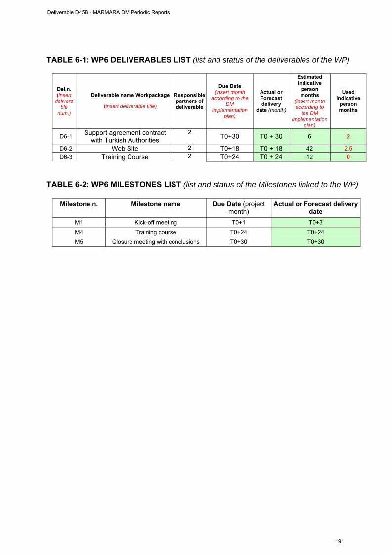
TABLE 6-1: WP6 DELIVERABLES LIST (list and status of the deliverables of the WP)
Del.n. (insert
deliverable
num.)
Deliverable name Workpackage
(insert deliverable title)
Responsible partners of deliverable
Due Date (insert month
according to the DM
implementation plan)
Actual or Forecast delivery
date (month)
Estimated indicative
person months
(insert month according to
the DM implementation
plan)
Used indicative
person months
D6-1 Support agreement contract with Turkish Authorities
2 T0+30 T0 + 30 6 2
D6-2 Web Site 2 T0+18 T0 + 18 42 2,5 D6-3 Training Course 2 T0+24 T0 + 24 12 0
TABLE 6-2: WP6 MILESTONES LIST (list and status of the Milestones linked to the WP)
Milestone n. Milestone name Due Date (project month)
Actual or Forecast delivery date
M1 Kick-off meeting T0+1 T0+3 M4 Training course T0+24 T0+24 M5 Closure meeting with conclusions T0+30 T0+30
Deliverable D45B - MARMARA DM Periodic Reports
191
APPENDICES
I. Report of meeting at KOERI on seafloor observatories in the Sea of
Marmara, March 28, 2008
II. SEA OF MARMARA SESSION, The Geological Congress of Turkey,
26 March, 2008, Ankara (Session Conveners: Namık Çağatay, Naci Görür and Celal Sengör) : Programme
III. Press release by ITU/EMCOL on ESONET (in Turkish)
IV. Press articles in Turkish national newspapers
V. ESONET / MARMARA Workshop, June 16-17, 2008 : Programme
VI. Full report of Marmara-DM Kick-Off meeting, ITU, June 18, 2008.
Deliverable D45B - MARMARA DM Periodic Reports
192
APPENDIX I
Meeting at KOERI on seafloor observatories in the Sea of Marmara, March 28, 2008
Gülay Altay, KOERI Director Cemil Gürbüz, KOERI, Marmara region land and sea bottom seismic project coordinator, Esonet expert Doğan Kalafat, KOERI Mehmet Yilmazer, KOERI Roland Person, Ifremer, Brest, Esonet coordinator Paolo Favali, INGV, Roma, EMSO coordinator Namik Çagatay, ITU, Esonet steering committee member and coordinator for Turkey Louis Geli, Ifremer, Brest, Marmara-DM coordinator, member of Esonet science council Pierre Henry, CEREGE (CNRS), Aix-en-Provence, MarNaut coordinator, member of Esonet science council. 1. Gülay Altay opens the meeting and presents the project of KOERI "Marmara
region land and sea bottom seismic project". The goal of this project (coordinated by Cemil Gürbüz) is to extend and densify the existing network of broadband seismometers and accelerometers around the Sea of Marmara: - Installation of 10 new land stations on the southern shore of the Marmara Sea
is planned for ~ may-june 2008. - Installation of 5 offshore stations is planned within 1 year.
Each offshore station comprises pressure and temperature sensors, current meter, hydrophone, three component broadband, pressure gauge, seismometer and accelerometers. Each station will be connected to land with a fiber optic and DC power cable. The total length of cable is 60 km. Guralp will provide the sensors and data logger and Turkish Telecom will provide the cables. A third company is developing the interface in Turkey. C. Gürbüz mentions that the KOERI project is part of an early warning system for earthquake and tsunami, and therefore will include sea-level monitoring. Bathymetric data along cable route will also be acquired prior to cable deployment. The exact location of the offshore stations is not decided yet and could be subject to slight modifications, within the limits of the available budget.
2. Pierre Henry presents a summary of the major scientific results from previous work
on fluid emissions associated with the North Anatolian fault system in the Sea of Marmara (Marmascarps, MarmaraVT and Marnaut scientific cruises), the scientific
Deliverable D45B - MARMARA DM Periodic Reports
193
objectives of the Marmara node of Esonet, the MarmaraDM observatory demonstration mission and the Marmesonet cruise, planned for 2009.
The scientific question underlying the Esonet observatory project in the Sea of Marmara is whether fluid expulsion is influenced by physical and chemical processes occurring at the depth of the seismogenic zone. Brackish water, brines, gas and oil are expelled through the seafloor and sustain cold seep ecosystems and carbonate precipitation. Marnaut cruise brought evidence that gas expulsion sites are generally located on deep rooted tectonic structures and that several of them involve relatively deep fluid sources (T > 120°C – z > 4 km), originating near the upper limit of the seismogenic zone. The distribution of gas emission sites may also relate with the history of earthquake slip. Remarkably, the Kumburgaz fault segment has few gas seeps and did not rupture for the last 240 years. The primary goal of deploying long term instrumentation is thus to investigate temporal relationships between seismicity and fluid emission. During Marnaut, a mini network of 4 OBSs and a piezometer were deployed for 3 months at a fluid emission site in the Tekirdag basin. 7 flowmeters and osmosamplers (from Scripps Institution of Oceanography, San Diego) were deployed for one year at this site, as well as at two others on the Western High and in Çinarcik basin. More deployments of similar instruments are planned (Marmara Demonstration Mission and Marmesonet cruise). Instruments for acoustic monitoring of gas seeps are under development at Ifremer and new site surveys are planned: systematic mapping of gas emission sites using multibeam sonar data and AUVs, AUV microbathymetry, and HR seismic imaging of fluid conduits. Other objectives of MarmaraDM are to involve Turkish authorities, notably for public outreach and education and for fund raising, and to integrate resources and expertise at EU level.
3. R. Person presents ESONET, a European Network of Excellence active from
March 2007 to February 2011. The goal of Esonet is the conception, demonstration and implementation of seafloor observatories for geohazards, global change and biodiversity. Eleven key sites were designated: Arctic, Norwegian Margin, Nordic Sea, Porcupine basin, Azores, Iberian Margin, Ligurian Sea, Eastern Sicily, Hellenic trenches, Sea of Marmara and Black Sea. Cables exist at neutrino telescope sites (Antares near the Ligurian margin, Eastern Sicily, Hellenic trench) and at an additional, shallow water site in Denmark. Esonet comprises 50 partners. ESONET main issues are:
i. Standardization of procedures for data collection & transfer processing, data dissemination & exchange format, data processing & quality control
ii. Definition of an Esonet label to guarantee data quality, accessibility, long term measurements and open access to new sensors
iii. Regional implementation by Regional Legal Entity (RLE) iv. Definition of a permanent structure linked to RLE
RLE comprises scientists, end users and one Esonet representative (e. g. Namik Cagatay, ITU, for Turkey). Objectives of RLEs are i) define scientific objectives of the observatory, ii) organize programs to collect complementary data, iii) propose
Deliverable D45B - MARMARA DM Periodic Reports
194
an implementation plan of the observatory with the support of ESONET technical groups, iv) lobby to find regional, national and international funds, v) identify tools (ships, ROVs, submersibles,..) which could be used for deployment and maintenance, vi) identify and apply the legal context for implementation.
4. P Favali presents EMSO (European Multidisciplinary Seafloor Observatory), which is one of the 35 new large Research Infrastructures defined in the European Strategy Forum for Research Infrastructures (ESFRI) report (Sept 2006). The objectives of the EMSO preparatory phase (2008-1012) are :
i. To establish the governance entity for the EMSO: infrastructure serving scientists and stakeholders in and outside Europe for long-term deep water observations and investigations
ii. To enable the deployment of the infrastructure and its long-term management, including the solution of technical bottlenecks
iii. To promote the catalytic process and synergic effort at EC and national levels, coordinating and harmonising all available resources.
EMSO-PP participants are 12, one per country involved, eight of them are ESONET core partners. The participants do not all have an observatory status (e.g. Ifremer), their role is coordination and representation for their country. They will have to work directly with ministries and funding agencies. ITU-EMCOL is the Turkish participant. The EMSO structure will comprise the Regional Legal Entities and a single coordination entity (CLE-Core Legal Entity). Incentive funding will come from the European Commission, but the Member States, and other stakeholders (e.g. industry) will have to cover most of the cost of observatory implementation and maintenance. However, the EIB (European Investment Bank) can provide long term, low interest, loans for up to 50% of the costs. 5. Discussion
5.1 Gülay Altay reminds that the KOERI observatory project was planned before ESONET was launched and funded independently of ESONET/EMSO. It should remain an independent project run exclusively by KOERI. Gülay Altay also points out that communication should be improved between ESONET partners.
5.2 Roland Person and Paolo Favali remind that in practice, the main Turkish
institution involved in Esonet and EMSO in the Sea of Marmara are ITU, DEU (Izmir), and KOERI, ITU being coordinator. Main institutions involved in other countries are Ifremer and CNRS in France, ISMAR and INGV in Italy, SCIO in USA, but this list is not exclusive. Although Tubitak MRC was not involved in ESONET NoE, it joined the Marmara-DM project as associated partner through ITU. GFZ in Germany, is not an ESONET partner either but its participation to Marmesonet cruise is considered if all other parties agree.
5.3 Pierre Henry points out that the monitoring of fluid processes does not require
a real time cable connection at this stage (see § 5.5.5 here below). Existing instruments are autonomous, although a cable connection could be considered in the long term (2011 and beyond).
Deliverable D45B - MARMARA DM Periodic Reports
195
5.4 Once the points above are well understood, there should remain no obstacle to exchange of information and to collaboration on scientific as well as technical issues.
5.5 Hence, meeting participants readily identify several possibilities of interaction
:
5.5.1 Instrument location. The KOERI observatory offshore site locations are not final. They could be refined taking into account all technical constrains and scientific objectives. Marmesonet/MarmaraDM sites are also subject to discussion. The high resolution seismic and high resolution bathymetric data that will be collected with R/V le Suroit hopefully in 2009 could be used to optimize the implementation of the cabled observatories.
5.5.2 Cruises. Participation of KOERI to future research cruises is open (but,
of course, limited by the number of bench on ships). 5.5.3 Data sharing. Data from KOERI seismic network are public. Data and
results acquired by ESONET are available to KOERI, which is a partner. 5.5.4 Observatory concepts. Currently, monitoring of slope instability is neither
included in the KOERI project, nor in MarmaraDM. This objective is potentially important, but the monitoring strategy still needs to be defined.
5.5.5 Future observatory design and maintenance. Ideally, a port might be left
open on the KOERI instrumental package for connecting EMSO instruments in the future. As the KOERI system is still under development, the KOERI partners kindly accept - upon ESONET request - to ask Guralp (which is developing the sensor and data logger package), and the Turkish company (name ?) which is developing the instrument-cable interface if this is feasible with minimal consequences.
5.5.6 KOERI is invited to participate to the Marnaut post-cruise and
MarmaraDM kick off meeting, which will take place week 25 (June 16-20) in Istanbul. It is also proposed that KOERI invites Guralp and/or Turkish company (name ?) to join the meeting.
Deliverable D45B - MARMARA DM Periodic Reports
196
APPENDIX II
SEA OF MARMARA SESSION The Geological Congress of Turkey
26 March, 2008, Ankara
Session Conveners: Namık Çağatay, Naci Görür and Celal Sengör 1. A.M.C. Şengör: Recent tectonics and paleogeography of the Marmara Sea 2. P. Henry, T.A.C Zitter, X. Le Pichon, A.M.C. Sengor, N. Gorur, N. Cagatay, L. Gasperini, L. Geli, M. D. Tryon, B. Mercier de Lepinay, and the Marnaut Scientific Party: Manned submersible observations at cold seeps in the North Anatolian Fault zone, Sea of Marmara. . 3. L. Geli, P. Henry, S. Dupré , D. Volker, T. Zitter, X. Le Pichon, M. Tryon, N. Çağatay and the Marnaut Scientific Party: Acoustic detection of gas emissions within the submerged section of the North Anatolian Fault zone in the Sea of Marmara. 4. Naci Görür, Celal Şengör, Namık Çağatay, and the Marnaut Scientific Party, Geological observations of the Marnaut dives north of the Çınarcık Basin and their implications. 5. N. Çağatay, Ü. Sancar, P. Henry, L. Gasperini, M. Tryon, D. Dikçe, and the Marnaut Scientific Party: Aktif Marmara Fayı Boyunca İzlenen Siyah Sülfidli Zonların Kökeni ve Tektonik ve Paleosismolojik Açıdan Önemi 6. Mustafa Ergin, Alper Sakitaş: Sediment Mass Flows On The Slopes Of The Çınarcık Basin (Eastern Marmara Sea) 7. Engin Meriç, Doğan Perinçek, Niyazi Avşar, Atike Nazik, Fulya Yücesoy-Eryılmaz, İpek F. Barut, Mutlu Özdoğan, Feyza Dinçer: Determination of environmental pollution of Yenikapı (Southern Istanbul) ancient coastline between 5th and 12th centuries using benthic foraminifera. 8. Füsun Yiğit-Faritfathi, Mustafa Ergin: Manganese Distribution in Deep Sea Sediments from the Tekirdağ Basin
Deliverable D45B - MARMARA DM Periodic Reports
197
APPENDIX III
Doğu Akdeniz Oşinografi ve Limnoloji Araştırmaları Merkezi
Eastern Mediterranean Centre for Oceanography and Limnology İstanbul Teknik Üniversitesi
10 Temmuz 2008 Maden Tetkik ve Arama Genel Müdürlüğü 06520 Ankara Bilindiği gibi, Marmara Denizi, AB 6.Çerçeve ESONET NoE projesi (European Seafloor Observatory Network) tarafından depremsellik ile ilgili deniz çalışmaları için önemli bir araştırma alanı olarak seçilmiştir. Bu projenin Marmara denizi ayağı ile ilgili ilk çalıştayı İTÜ-EMCOL’de 16-18 Haziran 2008 tarihlerinde yapılmıştır. İkinci çalıştay IFREMER’de (Fransız Deniz Araştırmaları Estitüsü’nde, Brest, Fransa) 29-30 Ekim 2008 tarihlerinde yapılacaktır. Bu çalıştayda gelecek iki yılda Marmara Denizin’de yapılacak deniz tabanı gözlemleri ile ilgili deprem araştırmalarının ayrıntılı planlaması gerçekleştirilecektir. Aynı konu ile ilgili olarak benzer amaçlı bir toplantı da “2nd Euro-Mediterranean International Symposium”adı altında İtalya’nın Messina kentinde yapılacaktır. Bu toplantıda Marmara Denizi ile ilgili bir oturum planlanmaktadır. Anılan toplantıların nihai amacı Marmara Denizi’nde deprem araştırmalarına yönelik çok parametreli ve gerçek zamanlı veri elde edebilen deniz tabanı gözlem istasyonlarının kurulmasıdır. Ülkemiz açısından hayati öneme haiz olan bu faaliyetlerin MTA Genel Müdürülüğü’nün ilgi alanına girdiği gerçektir. Bu nedenle kurumunuzun ortak bir proje kapsamında İTÜ-EMCOL ile birlikte anılan faaliyet ve projelerde yeralması arzu edilmektedir. Yukarıda belirtilen toplantılara birlikte katılımın uygun olacağı mütalaa edilmektedir. Bilgilerinize saygılarımızla arz ederiz. Prof.Dr. Namık Çağatay Prof.Dr. Naci Görür İTÜ-EMCOL Müdürü Genel Koordinatör ve AB 6. Çerçeve ESONET Projesi Yönetim Kurulu Üyesi
___________________________________________________________________________
EMCOL, İTÜ Maden Fakültesi, 34469 Maslak, İstanbul Tel: 90-212-2856211, Fax: 90-212-285
Deliverable D45B - MARMARA DM Periodic Reports
198
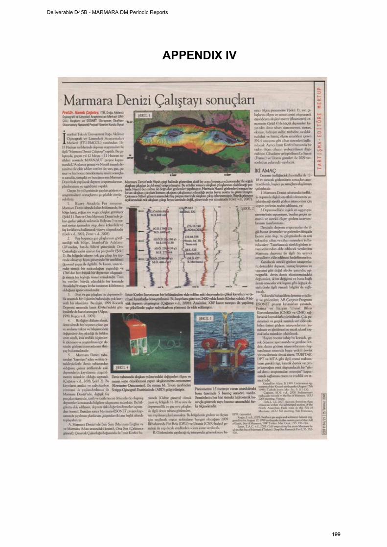
APPENDIX IV
Deliverable D45B - MARMARA DM Periodic Reports
199
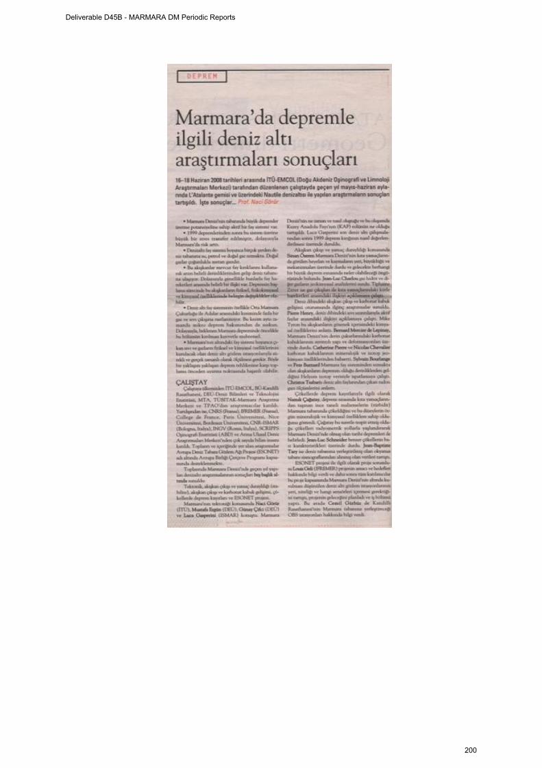
Deliverable D45B - MARMARA DM Periodic Reports
200
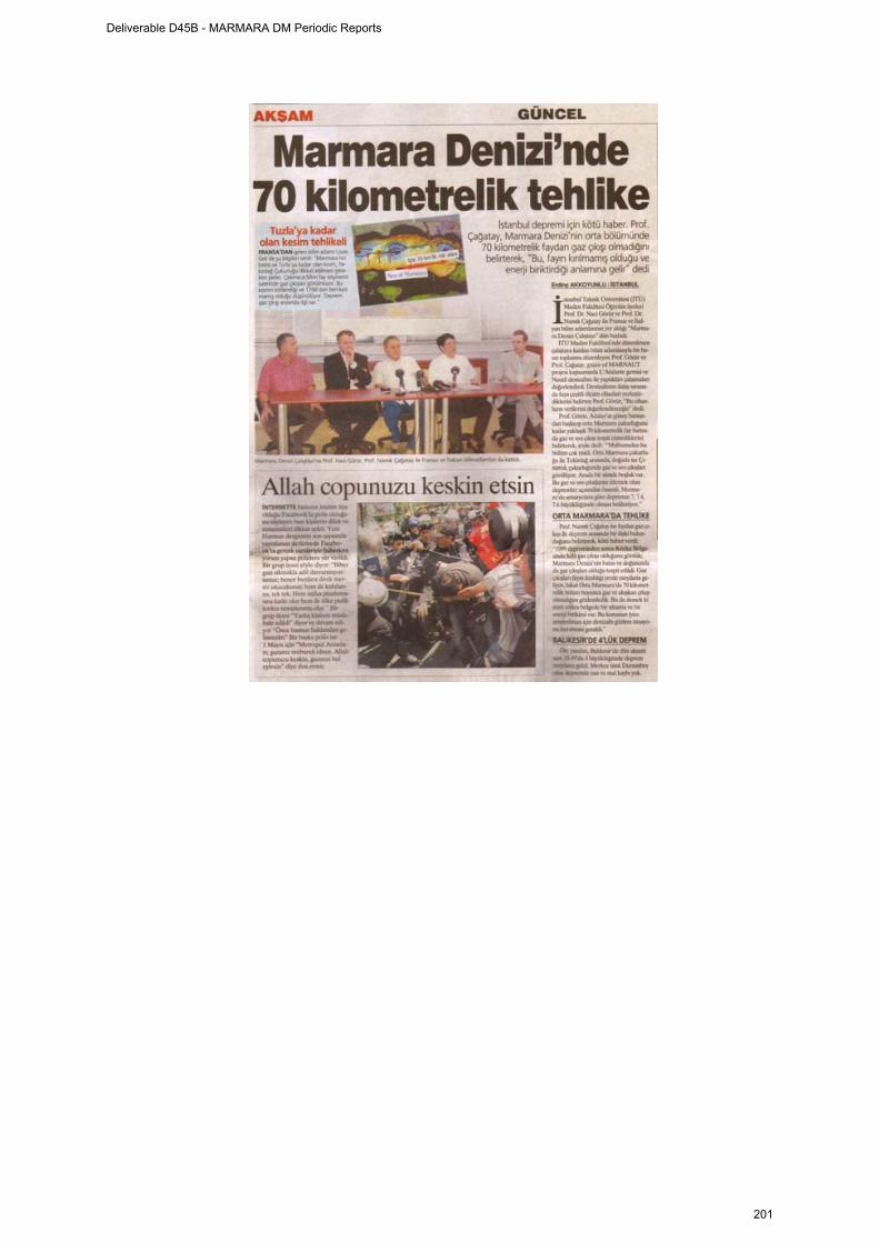
Deliverable D45B - MARMARA DM Periodic Reports
201
APPENDIX V
ESONET-MARMARA WORKSHOP
PROGRAMME Venue: İhsan Ketin Conference Hall in Faculty of Mining building, ITU Maslak Campus Monday, 16 June 2008 MORNING SESSION Tectonics 9:30 - 10:00 Opening 10:00-10:30 Naci Görür and Namık Çağatay: Tectonic and paleogeographic evolution of the Sea of Marmara 10:30 - 11:00 Luca Gasperini: The 1999 surface rupture: what we think after MARNAUT. 11:00 – 11:30 Coffee break 11:30 – 12:00 Mustafa Ergun: General tectonics of the Marmara Sea deduced from gravity and tectonic data. 12:00 – 12:30 Günay Çifci: Geophysical studies offshore Ambarlı-Silivri in the Sea of
Marmara. 12:30 – 14:00 Lunch break AFTERNOON SESSION Slope stability and fluids 14:00 – 14:30 Jean-Luc Charlou : Geochemical analysis of gas hydrates and gas sampled
with PEGAZ 14:30 – 15:00 Sinan Özeren: Slope Stability issues in the Sea of Marmara under the light of Marnaut and possible projections for the future work 15:00–15:30 Tiphaine Zittter: Relationships between fluid seepage and mass movement deposits in the Sea of Marmara". 15:30-16:00 Coffee break
Deliverable D45B - MARMARA DM Periodic Reports
202
Cold seeps, fluids, carbonate crusts 16:00–16:30 Pierre Henry: Cold seeps in the Sea of Marmara and their relationships with active faults. 16:30 – 17:00 Mike Tryon: Pore fluid chemistry of Sea of Marmara cold seeps 17:00–17:30 Louis Géli: MARNAUT heat flow data Tuesday, 17 June 2008 MORNING SESSION 9:30–10:00 Bernard Mercier de Lepinay: Detailed structure and deformation of superficial
sediments on the deep basins of the Sea of Marmara: Implications for fluid circulation.
10:00 - 10:30 Sylvain Bourlange and Pete Burnard: Helium isotope evidence for a deep source of fluids on the Marmara Fault. 10:30 – 11:00 Jean-Luc Schneider: Some characteristics of the Late Quaternary co-seismic
sedimentation in the deep basins of the Sea of Marmara". 11:00 – 11:30 Coffee break 11:30 – 12:00 Namık Çağatay: Sedimentary records of earthquakes in the Sea of Marmara 12:00 - 12:30 Catherine Pierre and Nicolas Chevalier: Mineralogy and isotope geochemistry of the carbonate crusts. 12:30 – 14:00 Lunch break AFTERNOON SESSION 14:00-14:30 Jean-Baptiste Tary: Preliminary results from the OBS data 14:30-15:00 ChristosTsabaris: In-Situ radon progeny measurement on Submarine Faults 15:00-15:30 Cemil Gürbüz: Seafloor observatory project in the Marmara Sea: Land and seafloor observation stations. Wednesday, 18 June 2008 ESONET Marmara-DM Project: Kick-off meeting Whole day: Starting at 9:30
Deliverable D45B - MARMARA DM Periodic Reports
203

Issues to be discussed:
1) Project objectives 2) Observation sites 3) Site surveys 4) Sensors and instruments to be deployed 5) Cruise planning 6) Tasks and responsibilites
Deliverable D45B - MARMARA DM Periodic Reports
204
APPENDIX VI
MarmaraDM Kick Off Meeting ITU, June 18, 2008.
Participants Namık Çagatay <[email protected]> Naci Görür <[email protected]> Pierre Henry <[email protected]> Louis Geli <[email protected]> Sedat İnan [email protected] Jean-Luc Charlou [email protected] Bernard Mercier de Lepinay <[email protected]> Pete Burnard <[email protected]> Tiphaine Zitter <[email protected]> Christos Tsabaris <[email protected]> Luca Gasperini <[email protected]> Mike Tryon <[email protected]> Cemil Gurbuz <[email protected]> Mustafa Ergün <[email protected]> Sinan Mehmet Özeren <[email protected]> Ekrem Hacıoğlu <[email protected]> Galip Yuce <[email protected]> Sena Akçer [email protected] Ümmühan Sancar [email protected] Jean-Baptiste [email protected] Nicolas Chevalier <[email protected]> Yıldız Altınok <[email protected]> Bedri Alpar <[email protected]> M. Levent ARTÜZ [email protected] Emre Damci [email protected] Umut Barış Ulgen: [email protected] Context: The MarmaraDM kick off meeting took place at İhsan Ketin Conference Hall in Faculty of Mining building, ITU Maslak Campus in Istanbul after the post-cruise meeting of the Marnaut cruise (held June 16-17 at the same place). Marnaut is a cruise of RV Atalante with manned submersible Nautile, which took place May 12- June 12, 2007. General information on this cruise and related projects can be found at http://www.cdf.u-3mrs.fr/~henry/marmara/ Meeting Report: 1) Project objectives
Deliverable D45B - MARMARA DM Periodic Reports
205
Louis Geli presents the initial projects objectives: MarmaraDM is a Demonstration Mission funded by the ESONET European Network of Excellence, with its end goal being the implementation of permanent seafloor observatories in European seas, including the sea of Marmara. As a demonstration mission, MarmaraDM can only cover part of the expenses related to the seafloor observatory operations. The initial description of MarmaraDM is available at: http://www.cdf.u-3mrs.fr/~henry/marmara/public/MarmaraDM_13200.pdf The initial objectives of MarmaraDM were: 1. To characterize the temporal and spatial relations between fluids and seismic activity in the Marmara Sea (MS) 2. To test the relevance of long-term seafloor observatories for an innovative monitoring of earthquake related hazards 3. To propose the technological option (cable, buoys, etc) that is the most adapted for the Sea of Marmara 4. To involve the local authorities in Turkey ; public outreach and education ; fund rising 5. Integration of existing resources at national and EU level The Marmara Sea Bottom Observatory (MSBO) project of KOERI is funded independent of the ESONET. However, coordination with MSBO is essential for the objectives of MarmaraDM and a meeting was organized at KOERI March 28, 2008. The meeting report is available at: http://www.cdf.u-3mrs.fr/~henry/marmara/public/rapport_KOERI_ESONET_final.doc) The implementation of MSBO has obvious implications for the choice of technological option (objective 3). However, the most adapted technological option may depend on the type of parameter to be measured (e.g.: hydrogeochemistry vs. seismology). Aside from the main objectives, other issues will have to be considered in the science plan: –Slope instability and their consequences, with obvious implications for the societal impact. –Tectonic evolution of the Sea of Marmara fault system, as good understanding of this aspect will be essential for the interpretation of fluid processes and seismic activity.
Deliverable D45B - MARMARA DM Periodic Reports
206
2) Information on cruise planning a)R/V Le Suroît cruise Marmesonet will most likely be scheduled in the second half of 2009. The cruise proposal is available here: http://www.cdf.u-3mrs.fr/~henry/marmara/public/MARMESONET.pdf Le Suroît is a 55 m ship operated by Ifremer/Genavir, offering 13 berths for both scientists and technical team. The cruise will comprise three parts:
Part 1 (21 days): EM 300 for the detection of bubble emissions. AUV for micro-bathymetry, chirp and EK-60 bubble detection.
Part 2 (14 days): High resolution seismics: 3D survey at one site Part 3 (5 days): Instrument deployments
b)R/V Piri Reis: 10 days of survey will be funded by MarmaraDM in 2009, comprising
-HR resolution seismics -Deep tow chirp
The cruise plan still needs to be defined with DEU / Izmir University 3) Instrumentation a)Available instruments
-OBSs: Ifremer can provide 12 OBSs, 6-8 OBS from Scripps IO will be requested by Mike Tryon in a collaboration with LeRoy Dorman. Additionnally SN-4 INGV station comprises a broad band three component seismometer. -Piezometers: Ifremer can provide 6 piezometers. -Flowmeters: ScrippsIO flowmeters will be integrated into the base of the OBSs (as previously done for on the Costa Rica margin (Brown et al., 2005). 8 instruments should be available, as all instruments deployed during Marnaut were recovered in good conditions. -SN4 Station comprises seismological, environmental, and hydrochemical sensors (see Table 1). Deployment methods impose depth limitations. On Urania, Camera assisted deployment is possible down to 200 m water depth. ROV assisted deployment is possible down to 600 m water depth. The hydrochemical sensors used (Methane and Oxygen) would be best used at a site with relatively low background activity (e.g. black patches without visible bubble emissions) as the dynamics of bubble emissions will make measurements more difficult to interpret. -A system for acoustic monitoring of bubble emissions, based on a scanning sonar with a range of about 100 m is currently under development at Ifremer. A prototype should be available for deployment during Marmesonet. b) Koeri instruments The KOERI plans to deploy 5 cabled seafloor seismological stations in 2009 equipped with 3 component accelerometers and broadband seismometers. The preliminary coordinates are given in Table 2 and locations in Figure 1.
Deliverable D45B - MARMARA DM Periodic Reports
207
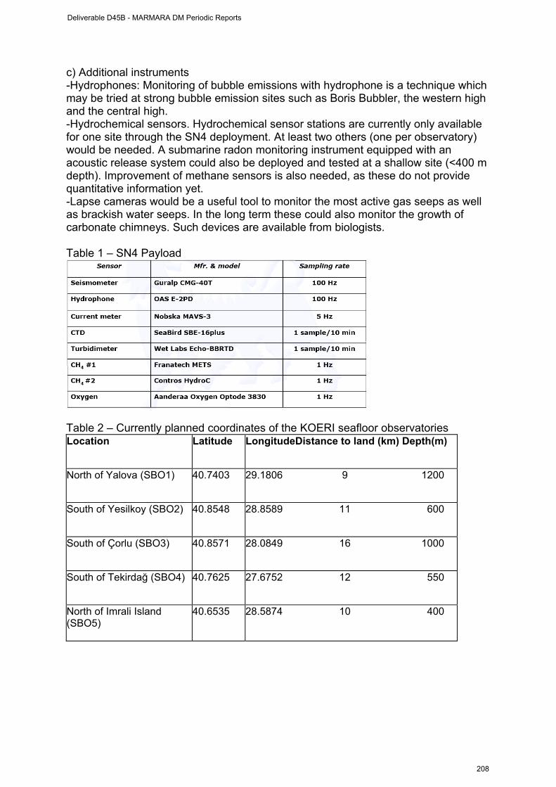
c) Additional instruments -Hydrophones: Monitoring of bubble emissions with hydrophone is a technique which may be tried at strong bubble emission sites such as Boris Bubbler, the western high and the central high. -Hydrochemical sensors. Hydrochemical sensor stations are currently only available for one site through the SN4 deployment. At least two others (one per observatory) would be needed. A submarine radon monitoring instrument equipped with an acoustic release system could also be deployed and tested at a shallow site (<400 m depth). Improvement of methane sensors is also needed, as these do not provide quantitative information yet. -Lapse cameras would be a useful tool to monitor the most active gas seeps as well as brackish water seeps. In the long term these could also monitor the growth of carbonate chimneys. Such devices are available from biologists. Table 1 – SN4 Payload
Table 2 – Currently planned coordinates of the KOERI seafloor observatories Location
Latitude
LongitudeDistance to land (km) Depth(m)
North of Yalova (SBO1)
40.7403
29.1806 9 1200
South of Yesilkoy (SBO2)
40.8548
28.8589 11 600
South of Çorlu (SBO3)
40.8571
28.0849 16 1000
South of Tekirdağ (SBO4)
40.7625
27.6752 12 550
North of Imrali Island (SBO5)
40.6535
28.5874 10 400
Deliverable D45B - MARMARA DM Periodic Reports
208
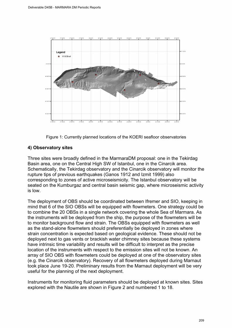
Figure 1: Currently planned locations of the KOERI seafloor observatories
4) Observatory sites Three sites were broadly defined in the MarmaraDM proposal: one in the Tekirdag Basin area, one on the Central High SW of Istanbul, one in the Cinarcik area. Schematically, the Tekirdag observatory and the Cinarcik observatory will monitor the rupture tips of previous earthquakes (Ganos 1912 and Izmit 1999) also corresponding to zones of active microseismicity. The Istanbul observatory will be seated on the Kumburgaz and central basin seismic gap, where microseismic activity is low. The deployment of OBS should be coordinated between Ifremer and SIO, keeping in mind that 6 of the SIO OBSs will be equipped with flowmeters. One strategy could be to combine the 20 OBSs in a single network covering the whole Sea of Marmara. As the instruments will be deployed from the ship, the purpose of the flowmeters will be to monitor background flow and strain. The OBSs equipped with flowmeters as well as the stand-alone flowmeters should preferentially be deployed in zones where strain concentration is expected based on geological evidence. These should not be deployed next to gas vents or brackish water chimney sites because these systems have intrinsic time variability and results will be difficult to interpret as the precise location of the instruments with respect to the emission sites will not be known. An array of SIO OBS with flowmeters could be deployed at one of the observatory sites (e.g. the Cinarcik observatory). Recovery of all flowmeters deployed during Marnaut took place June 19-20. Preliminary results from the Marnaut deployment will be very useful for the planning of the next deployment. Instruments for monitoring fluid parameters should be deployed at known sites. Sites explored with the Nautile are shown in Figure 2 and numbered 1 to 18.
Deliverable D45B - MARMARA DM Periodic Reports
209
-SN4 should preferentially be deployed at relatively shallow depths because of operational constraints.
Primary site is Site 18 at 190 m depth at the bottom of a canyon near the entrance of the Izmit Gulf. This site has advantages that the fault zone is well defined and that the crustal strain can be monitored with GPS land stations. One objection is that manifestations of fluid outflow are very limited at this site. A preliminary study to identify anomalies in the water column is recommended.
An alternate site is Site 10a on the central high at less than 400m depth. Most manifestations of fluid outflow are located on the anticlinal ridge south of the main fault trace. There is very little evidence for fluid emission along the fault trace itself.
A second alternate Site is Site 6a at 600-700 m depth. The context is similar but black patches appear more abundant on the fault trace and were mapped. -The ifremer acoustic monitoring device should be deployed on a flat bottom at a site where bubble emissions occur through fractures, and ideally are associated with crustal microseismicity. Site 16 fits all requirements. -Pete Burnard reported that Boris'Bubbler at Site 2 has very high 3He/4He ratio, implying a component of fluid migration from the mantle (70% of the Helium). This situation is exceptional in the Sea of Marmara and Boris'Bubbler should be designated as a monitoring site. Hydrophones and cameras are considered for monitoring the vigorous bubble emission at this site. -Piezometers should be deployed in pairs (or more) in order to assess whether recorded anomalies are local (and possibly instrumental artifacts) or regional. -On the highs comparing pressure variations in the fault valley and within gas outflow zones at the top of the anticlines could be performed by pairing piezometers at 6a and 6b, and/or at 10a and 10 b. -In the basins, the western end of the Cinarcik Basin. GPS data suggest that strain rates have not relaxed to background values after the Izmit earthquake and this area is considered as the most likely zone of nucleation for the next earthquake (according to stress transfer models). Furthermore, we expect that at this location, slip on strike slip faults at a crustal level cause extensional strain in the sediment within the basin. This, and its consequence on fluid pressure can be computed from poroelastic models. This area has thus the best potential to yield understandable records, leading to quantitative modeling. Ideally, a transect of piezometer and flowmeters could be installed across the basin.
Deliverable D45B - MARMARA DM Periodic Reports
210

Figure 2: Location in the Sea of Marmara of sites explored with the Nautile submersible during Marnaut. White circles are sites with no manifestation of fluid outflow, all other sites have seafloor manifestations (bacterial mats, authigenic carbonates, water and/or gas emissions). Site 18 (yellow) is the site of INGV SN-4 deployment in the Gulf of Izmit. Sites 3, 6b and 13a (green) were instrumented during Marnaut. Sites 16 and 10b (purple) should be instrumented during MARMESONET in 2009. Blue dots are planned locations for KOERI Seafloor Stations. A preliminary observatory layout can here be proposed based on the discussions 1) Cinarcik observatory -6 OBSs with flowmeters + 2 OBSs without flowmeters -Piezometers at 13b and 16 -Acoustic monitoring station at 16 -SN4 and Rn probe at 18 (provided a signal can be detected in the water column) 2) Tekirdag-Western High observatory: -6 OBSs + 3 flowmeters -Hydrophones at Site 2 -Lapse camera at Sites 2 and 3. -Piezometers at 6a and 6b 3) Istanbul Observatory -6 OBSs + 3 flowmeters -Piezometers at 10a and 10b
Deliverable D45B - MARMARA DM Periodic Reports
211
5) Site surveys Detailed site surveys should be performed around observatory sites to image fluid conduits and their relationships with structures. These surveys may be performed either by surface high resolution seismics or with broad band deep tow chirps (e.g. Ifremer SYSIF 250-1000Hz). Both systems can well image gas conduits in the sediment, deep tow systems have higher resolution but less penetration. Such surveys are required at each observatory site: Western High, Central High and Cinarcik Basin. -The main objective of a Western High 3D survey would be to determine the nature of the conduits feeding the main hydrocarbon seeps several hundreds of meter northward of the main fault zone. -The Cinarcik basin has dense MCS profiles from seismarmara cruise, Chirp data from Marmarascarps and Marnaut cruises as well as some HR coverage from Marmara Suroît cruise. However the imagery of gas migration pathways can be improved, either with a deep tow chirp or with surface HR. The relationships between landslides and faults near the entrance of Izmit Gulf may also be addressed with these tools. -The Central High seeps are located on an anticlinal ridge south of the main fault zone. The Kumburgaz basin to the west and the transition toward Cinarcik basin to the east also appear as interesting targets where sediment deformation is not fully understood. A grid covering a wider area may thus be considered. Any dense survey in this area would require protection from coast guards. -A 14 day 3D survey is planned during Marmesonet cruise, corresponding to a 10.8 by 3.6 km box. -A 10 day cruise of Piri Reis funded by MarmaraDM could be used for a 3D survey (or a dense grid, details should be decided later). -A proposal to survey a 3rd site with the Piri Reis should be submitted by DEU to the Turkish system for a cruise in 2009. -Assuming Urania is used for the deployment of SN-4, a site survey could also be performed in the Cinarcik-Izmit area during the Urania cruise. A series of HR profiles will be shot in August 2007 as collaboration between Lamont-Doherty Earth Observatory and Dokuz Eylül University. Contacts should be taken for coordination and to identify possible collaborations. -One week of water column measurements and sampling is required to decide the best location for SN4 deployment. Some measurement were already performed during previous cruise and need to be taken into account. Methane concentrations in seawater were determined by JC Caprais (Ifremer, Environnement Profond) at several of the Marnaut CTD sites and these data are available from the Marnaut website. (http://www.cdf.u-3mrs.fr/~henry/marmara/data/MarNaut_data/Chemistry/MARNNCH4.xls).
Deliverable D45B - MARMARA DM Periodic Reports
212
Similar sampling with CTD-rosette were performed during Meteor cruise M44/1 in Feb 1999 and methane anomalies were found on the western high and in the western part of the central basin. Measurements at site 18 are needed and additional measurements will be useful at sites 10 and 6, as well as in Çinarcik basin. The ITU fisheries ship could be used for 1 week of survey with the Medusa system. This cruise could be funded by MarmaraDM (estimated ship cost is 1500 Euro/day) -Both Suroît and Urania have coring capabilities. Cores will be needed for geotechnical assessment and pore fluid chemistry determination prior to piezometer deployment. Decisions regarding site survey responsibilities are still pending. According to one scenario, a 3D HR survey on the Western High could be performed with the Suroît during Marmesonet Cruise. The Eastern Cinarcik area could be surveyed with RV Piri Reis with MarmaraDM funding and coverage extended toward Izmit Gulf with Urania. A survey covering the Central High south of Istanbul and Kumburgaz basin may be done with RV Piri Reis provided more shiptime is obtained. 6) Additional tasks and responsibilities a) Cruise chief scientists should take care of cruise authorization and contact with Turkish Navy b) ITU has primary responsibility for public outreach c) Additional instrumentation. Adaptation and deployment of existing instruments can be covered by MarmaraDM, but new developments need to be funded from other sources. -Cerege, Ifremer and Geosciences Montpellier submitted proposal OFMOGH to ANR, which includes development of an acoustic monitoring system prototype for Marmesonet and prospective studies for simultaneous monitoring of pore pressure and pore fluid conductivity in the sediment. -INGV in responsible for providing additional chemical sensors. -HCMR is responsible for the implementation of radon sensors. One of the existing systems could be adapted and deployed with SN4 in 2009. d) Additional shiptime should be requested: -L. Gasperini will organize 1 week of Medusa survey on ITU fisheries vessel, and investigate the use of Urania for the deployment of SN4 and a site survey in the Cinarcik-Izmit area. Alternatively SN4 could be deployed with Le Suroît during Marmesonet cruise. -DEU will request Piri Reis Shiptime for a 3D HR site survey (September 2008 or January 2009 call) at one of the observatory sites. e) Involvment of oil industry Contact will be taken by ITU with TPAO and, possibly, other companies. Collaboration with the industry will be particularly valuable for the development and implementation of better hydrocarbon sensors.
Deliverable D45B - MARMARA DM Periodic Reports
213
f) Next meeting A meeting will be organized at Ifremer Brest in fall for the detailled planning of cruises, notably of Marmesonet and Piri Reis cruises. Preliminary cruise plans should be prepared before these meeting.
Deliverable D45B - MARMARA DM Periodic Reports
214
ESONET Demonstration Missions
2nd Periodic Activity Report
The Periodic Activity Report contains an overview of the activities carried out during the reporting period, describes the progress in relation to the project objectives, the progress towards the milestones and deliverables set for the period, and any problems encountered and corrective actions taken. This document has to be filled in with reference to the DM Implementation plan. This means that Deliverables, Milestones and WPs have to be the same as in the DM Implementation plan. The Periodic Report contains 2 parts: - Part I: it is addressed to the coordinator with minimum input from the partners - Part II: it is addressed to each WP Leader and reports a detailed update of each WP activity at task level. The report includes a rough justification of the costs incurred and of the resources deployed by each contractor linking them to activities implemented and justifying their necessity. Finally the report contains information on use and dissemination activities. Reporting period: From October 1st, 2008 to May, 31st, 2009
Deliverable D45B - MARMARA DM Periodic Reports
215
Part I (to be filled by the DM coordinator) DM acronym: MARMARA-DM DM title: Multidisciplinary Seafloor Observatories for
Seismogenic Hazards Monitoring in the Marmara Sea ESONET Site: MARMARA SEA, Turkey Scientific Area(s): - Earthquake hazards
- Relations between fluids and seismicity - Processess at fluid controlled ecosystems
Technological Area(s): Lon-term, permanent monitoring of seismicity, sediment pore fluid, fluid geochemistry and gas emission activity
DM Start date: April 1st, 2008
DM duration: 30
Period of the reporting from September 1st, 2008 to May 31st, 2009 Partner Num.
Partner institution short name
Principal Investigator (PI)
for the Demo Mission
WP in charge (insert WP num. and title)
1. IFREMER Géli, Louis WP2. Marine Operations with Ifremer facilities WP5. Comparative and feasibility studies
2. ITU Çağatay, Namık WP6. Public Outreach, education, coordination at Turkish level and fund rising
3. ISMAR Gasperini, Luca WP4. Data Integration and modelling
4. INGV Favali, Paolo WP3. Land and Seabottom Integration; WP2. Marine operations with INGV facilities (SN-4 station)
5. CNRS Henry, Pierre WP1. MarNaut data integration 6. DEU/IMST Çifçi, Günay WP2. Marine operations with DEU
facilities
Deliverable D45B - MARMARA DM Periodic Reports
216
Executive summary (max one page) Brief description of the objective of the DM and brief description of the work status The goal of MARMARA-DM is to contribute to the establishment of optimized permanent seafloor observatory stations for earthquake monitoring in the Marmara Sea (MS), as part of ESONET NoE. Workpackages description and status are: WP 1 : Analysis of the available time series data and in-situ samples from the Marnaut cruise. This workpackage is in progress. Three papers have been published [Zitter et al, 2008 ; Géli et al, 2008 ; Bourry et al, 2009]. One Ph. D. Thesis, co-funded by Ifremer, Total and Bakerhughes is currently under way, conducted by Jean-Baptiste Tary. Funding for a second Ph. D. has been obtained from Ifremer and CNRS, to start on September 1st, 2009, by Céline Grall, under the supervision of Pierre Henry. Deliverable WP 2 : Marine operations. A number of cruises are planned for 2009 :
R/V Le Suroît cruise (named “Marmesonet”) by IFREMER, was initially scheduled from august 23rd to october 2nd, 2009, divided in two parts : part 1 for acoustic detection of gas emissions and AUV microbathymetry ; part 2 for high resolution, 3D seismic survey at one observatory site. Due to the crash of AirFrance flight off Brazil on june 1st, 2009, Ifremer was requested to contribute to the deep-sea search operations of the remains of the aircraft. In consequence, the agenda of the Ifremer’s fleet was changed, hence the “Marmesonet” cruise was postponed. Part 1 is now scheduled from november 5th to november 29th, 2009. Part 2 will occur on march-april, 2010.
R/V Piri Reis cruise by DEU/IMST of Izmir, will carry out HR resolution
seismics and bathymetry in the east Çınarcık Basin, between october 1st to october 10th, 2009.
R/V Urania will deploy instruments, from september 22 (start in Brindisi) to
october 12 (return to Brindisi), under supervision of Luca Gasperini, ISMAR (partner 4). R/V Urania will deploy SN-4 in the east Çınarcık Basin and all Ifremer instruments (10 OBSs and 5 piezometers).
The activity under WP2 include the preparation of all marine operations. WP 3 : Integration of land and seafloor seismological data. This workpackage has started with the merging (work done) of OBS data from the MarNaut cruise and land data from Turkish institutions (KOERI and TUBITAK). WP 4 : Data integration and modeling. This work is in process and will continue after the next cruises (fall 2009 and spring 2010). WP 5 : Comparative study and project feasibility. In progress, under supervision of Yves Auffret (Ifremer). WP 6 : Public and education outreach, coordination at national (Turkish) level
Deliverable D45B - MARMARA DM Periodic Reports
217
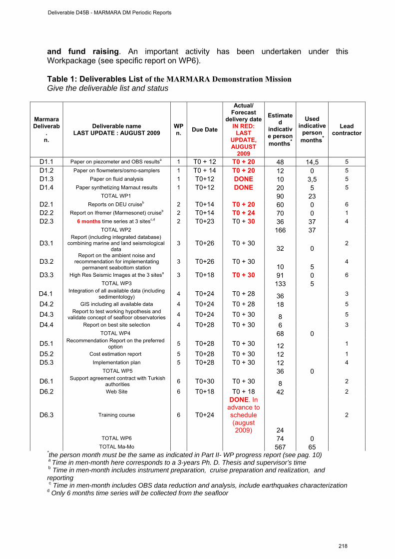
and fund raising. An important activity has been undertaken under this Workpackage (see specific report on WP6). Table 1: Deliverables List of the MARMARA Demonstration Mission Give the deliverable list and status
Marmara Deliverab
. n.
Deliverable name LAST UPDATE : AUGUST 2009
WP n. Due Date
Actual/ Forecast
delivery dateIN RED:
LAST UPDATE, AUGUST
2009
Estimated
indicative person months*
Used indicative
person months*
Lead contractor
D1.1 Paper on piezometer and OBS resultsa 1 T0 + 12 T0 + 20 48 14,5 5 D1.2 Paper on flowmeters/osmo-samplers 1 T0 + 14 T0 + 20 12 0 5 D1.3 Paper on fluid analysis 1 T0+12 DONE 10 3,5 5 D1.4 Paper synthetizing Marnaut results 1 T0+12 DONE 20 5 5
TOTAL WP1 90 23 D2.1 Reports on DEU cruiseb 2 T0+14 T0 + 20 60 0 6 D2.2 Report on Ifremer (Marmesonet) cruiseb 2 T0+14 T0 + 24 70 0 1 D2.3 6 months time series at 3 sitesc,d 2 T0+23 T0 + 30 36 37 4
TOTAL WP2 166 37
D3.1 Report (including integrated database)
combining marine and land seismological data
3 T0+26 T0 + 30 32 0
2
D3.2 Report on the ambient noise and
recommendation for implementating permanent seabottom station
3 T0+26 T0 + 30 10 5
4
D3.3 High Res Seismic Images at the 3 sitesa 3 T0+18 T0 + 30 91 0 6 TOTAL WP3 133 5
D4.1 Integration of all available data (including sedimentology) 4 T0+24 T0 + 28 36 3
D4.2 GIS including all available data 4 T0+24 T0 + 28 18 5
D4.3 Report to test working hypothesis and validate concept of seafloor observatories 4 T0+24 T0 + 30 8 5
D4.4 Report on best site selection 4 T0+28 T0 + 30 6 3 TOTAL WP4 68 0
D5.1 Recommendation Report on the preferred option 5 T0+28 T0 + 30 12 1
D5.2 Cost estimation report 5 T0+28 T0 + 30 12 1 D5.3 Implementation plan 5 T0+28 T0 + 30 12 4
TOTAL WP5 36 0
D6.1 Support agreement contract with Turkish authorities 6 T0+30 T0 + 30 8 2
D6.2 Web Site 6 T0+18 T0 + 18 42 2
D6.3 Training course 6 T0+24
DONE. In advance to schedule (august 2009) 24
2
TOTAL WP6 74 0 TOTAL Ma-Mo 567 65 *the person month must be the same as indicated in Part II- WP progress report (see pag. 10) a Time in men-month here corresponds to a 3-years Ph. D. Thesis and supervisor’s time b Time in men-month includes instrument preparation, cruise preparation and realization, and reporting c Time in men-month includes OBS data reduction and analysis, include earthquakes characterization d Only 6 months time series will be collected from the seafloor
Deliverable D45B - MARMARA DM Periodic Reports
218
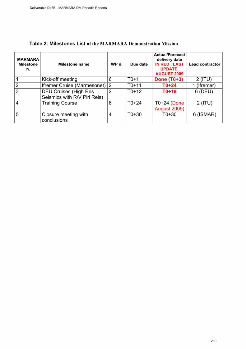
Table 2: Milestones List of the MARMARA Demonstration Mission
MARMARA Milestone
n. Milestone name WP n. Due date
Actual/Forecast delivery date
IN RED : LAST UPDATE,
AUGUST 2009
Lead contractor
1 Kick-off meeting 6 T0+1 Done (T0+3) 2 (ITU) 2 Ifremer Cruise (Marmesonet) 2 T0+11 T0+24 1 (Ifremer) 3 DEU Cruises (High Res
Seismics with R/V Piri Reis) 2
T0+12 T0+19 6 (DEU)
4 Training Course 6 T0+24 T0+24 (Done August 2009)
2 (ITU)
5 Closure meeting with conclusions
4 T0+30 T0+30 6 (ISMAR)
Deliverable D45B - MARMARA DM Periodic Reports
219
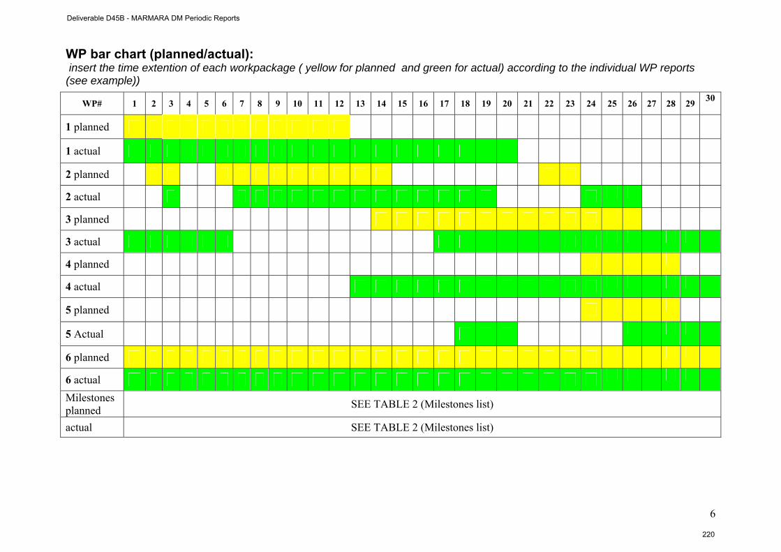
6
WP bar chart (planned/actual): insert the time extention of each workpackage ( yellow for planned and green for actual) according to the individual WP reports (see example))
WP# 1 2 3 4 5 6 7 8 9 10 11 12 13 14 15 16 17 18 19 20 21 22 23 24 25 26 27 28 29 30
1 planned
1 actual
2 planned
2 actual
3 planned
3 actual
4 planned
4 actual
5 planned
5 Actual
6 planned
6 actual
Milestones planned SEE TABLE 2 (Milestones list)
actual SEE TABLE 2 (Milestones list)
Deliverable D45B - MARMARA DM Periodic Reports
220
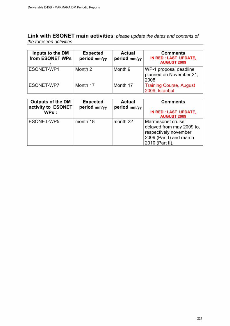
Link with ESONET main activities: please update the dates and contents of the foreseen activities
Inputs to the DM from ESONET WPs
:
Expected period mm/yy
Actual period mm/yy
Comments IN RED : LAST UPDATE,
AUGUST 2009 ESONET-WP1 Month 2 Month 9 WP-1 proposal deadline
planned on November 21, 2008
ESONET-WP7 Month 17 Month 17 Training Course, August 2009, Istanbul
Outputs of the DM
activity to ESONET WPs :
Expected period mm/yy
Actual period mm/yy
Comments
IN RED : LAST UPDATE, AUGUST 2009
ESONET-WP5 month 18 month 22 Marmesonet cruise delayed from may 2009 to, respectively november 2009 (Part I) and march 2010 (Part II).
Deliverable D45B - MARMARA DM Periodic Reports
221
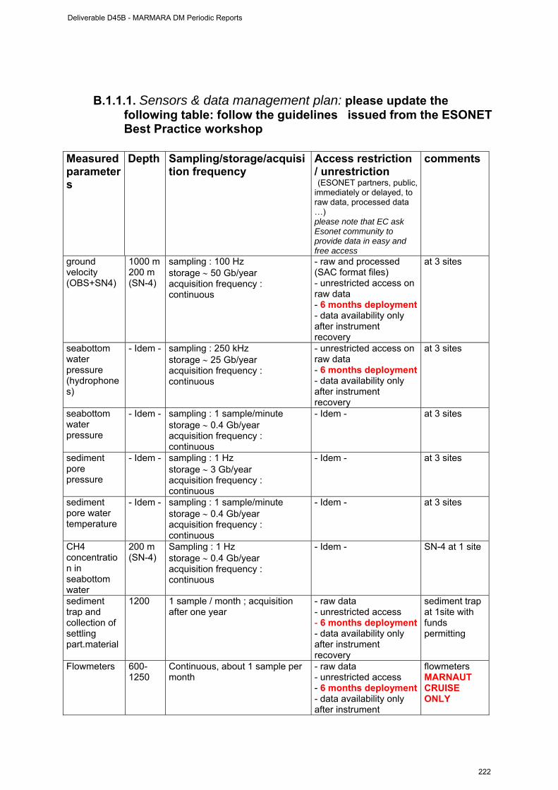
B.1.1.1. Sensors & data management plan: please update the following table: follow the guidelines issued from the ESONET Best Practice workshop
Measured parameters
Depth Sampling/storage/acquisition frequency
Access restriction / unrestriction (ESONET partners, public, immediately or delayed, to raw data, processed data …) please note that EC ask Esonet community to provide data in easy and free access
comments
ground velocity (OBS+SN4)
1000 m 200 m (SN-4)
sampling : 100 Hz storage ∼ 50 Gb/year acquisition frequency : continuous
- raw and processed (SAC format files) - unrestricted access on raw data - 6 months deployment - data availability only after instrument recovery
at 3 sites
seabottom water pressure (hydrophones)
- Idem - sampling : 250 kHz storage ∼ 25 Gb/year acquisition frequency : continuous
- unrestricted access on raw data - 6 months deployment - data availability only after instrument recovery
at 3 sites
seabottom water pressure
- Idem - sampling : 1 sample/minute storage ∼ 0.4 Gb/year acquisition frequency : continuous
- Idem - at 3 sites
sediment pore pressure
- Idem - sampling : 1 Hz storage ∼ 3 Gb/year acquisition frequency : continuous
- Idem - at 3 sites
sediment pore water temperature
- Idem - sampling : 1 sample/minute storage ∼ 0.4 Gb/year acquisition frequency : continuous
- Idem - at 3 sites
CH4 concentration in seabottom water
200 m (SN-4)
Sampling : 1 Hz storage ∼ 0.4 Gb/year acquisition frequency : continuous
- Idem - SN-4 at 1 site
sediment trap and collection of settling part.material
1200 1 sample / month ; acquisition after one year
- raw data - unrestricted access - 6 months deployment - data availability only after instrument recovery
sediment trap at 1site with funds permitting
Flowmeters 600-1250
Continuous, about 1 sample per month
- raw data - unrestricted access - 6 months deployment - data availability only after instrument
flowmeters MARNAUT CRUISE ONLY
Deliverable D45B - MARMARA DM Periodic Reports
222
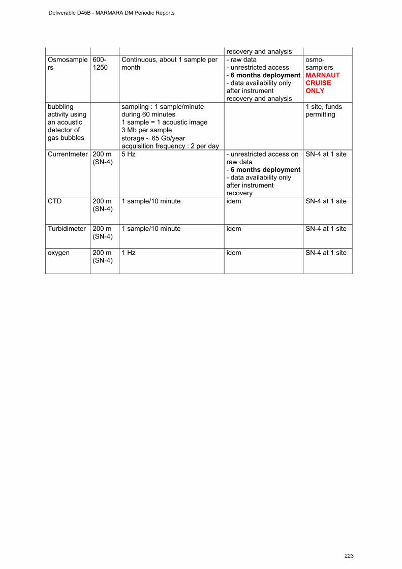
recovery and analysis Osmosamplers
600-1250
Continuous, about 1 sample per month
- raw data - unrestricted access - 6 months deployment - data availability only after instrument recovery and analysis
osmo-samplers MARNAUT CRUISE ONLY
bubbling activity using an acoustic detector of gas bubbles
sampling : 1 sample/minute during 60 minutes 1 sample = 1 acoustic image 3 Mb per sample storage ∼ 65 Gb/year acquisition frequency : 2 per day
1 site, funds permitting
Currentmeter 200 m (SN-4)
5 Hz - unrestricted access on raw data - 6 months deployment - data availability only after instrument recovery
SN-4 at 1 site
CTD 200 m (SN-4)
1 sample/10 minute idem SN-4 at 1 site
Turbidimeter 200 m (SN-4)
1 sample/10 minute idem SN-4 at 1 site
oxygen 200 m (SN-4)
1 Hz idem SN-4 at 1 site
Deliverable D45B - MARMARA DM Periodic Reports
223
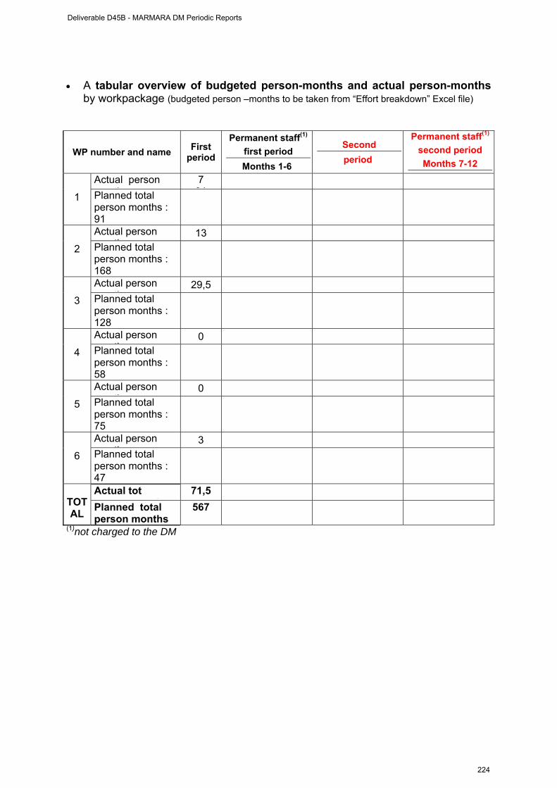
• A tabular overview of budgeted person-months and actual person-months
by workpackage (budgeted person –months to be taken from “Effort breakdown” Excel file)
WP number and name First period
Permanent staff(1)
first period Months 1-6
Second period
Permanent staff(1)
second period Months 7-12
Actual person th
7 91
1 Planned total
person months : 91
Actual person th
13 2 Planned total
person months : 168
Actual person th
29,5 3 Planned total
person months : 128
Actual person th
0 4 Planned total
person months : 58
Actual person th
0 5 Planned total
person months : 75
Actual person th
3 6 Planned total
person months : 47
Actual tot
th71,5
TOTAL Planned total
person months 567
(1)not charged to the DM
Deliverable D45B - MARMARA DM Periodic Reports
224

Dissemination and outreach : please update the table
Type of school material available at the issue of the mission
(photos, video, courses,…others)
Description
TRAINING COURSE PLANNED FOR SCIENTISTS AND ENGINEERS in TURKEY ON DEEP SEAFLOOR OBSERVATORIES : AUGUST 2009
Type of dissemination (through collaborations with aquaria,
museum, sciences centres, etc.)
Description
WEB SITE UNDER CONSTRUCTION AT ITU
www. esonet-marmara-dm.itu.edu.tr
Deliverable D45B - MARMARA DM Periodic Reports
225
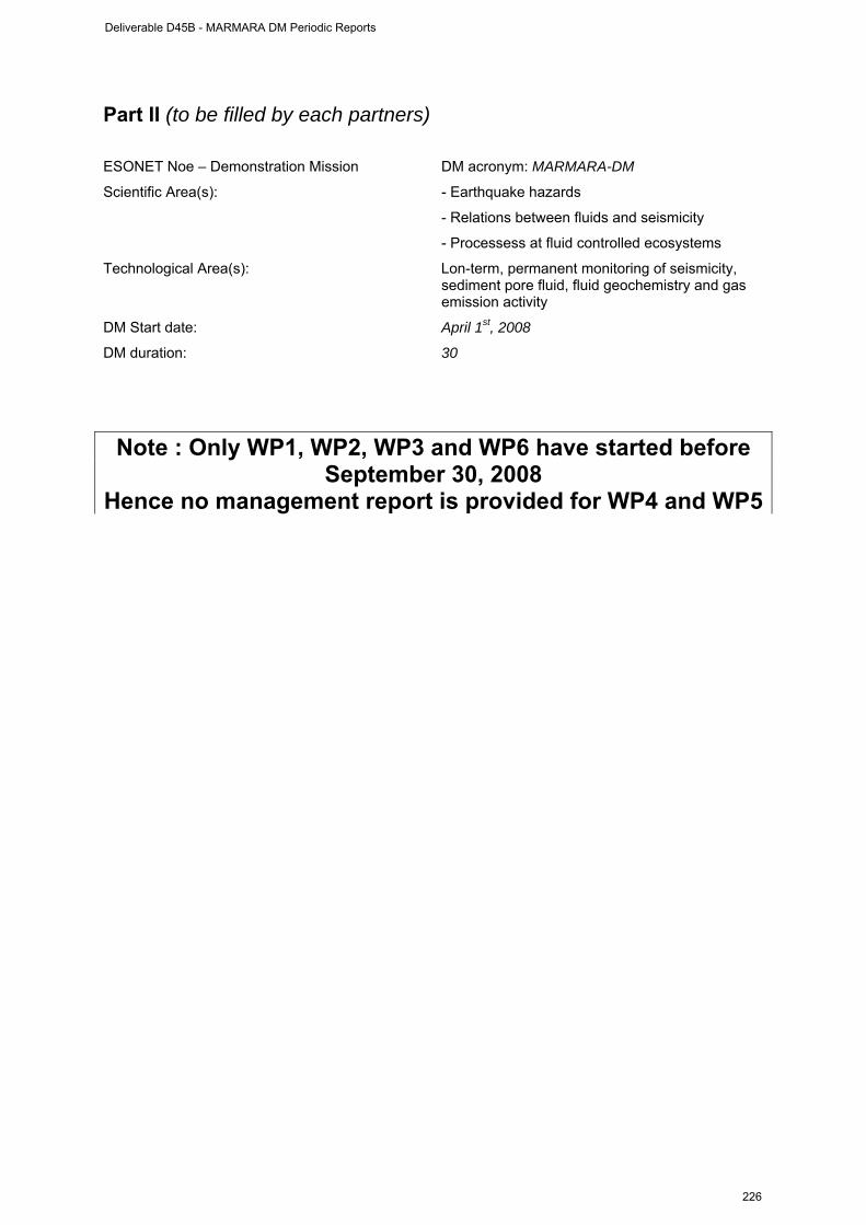
Part II (to be filled by each partners) ESONET Noe – Demonstration Mission DM acronym: MARMARA-DM
Scientific Area(s): - Earthquake hazards
- Relations between fluids and seismicity
- Processess at fluid controlled ecosystems
Technological Area(s): Lon-term, permanent monitoring of seismicity, sediment pore fluid, fluid geochemistry and gas emission activity
DM Start date: April 1st, 2008
DM duration: 30
Note : Only WP1, WP2, WP3 and WP6 have started before September 30, 2008
Hence no management report is provided for WP4 and WP5
Deliverable D45B - MARMARA DM Periodic Reports
226
WP1 management report
(from April 1st to 30 September 2008) WORKPACKAGE WP1
Full WP title ANALYSIS OF DATA FROM MARNAUT CRUISE
Period covered from September 1st, 2008 to 30/05/2009 Partner organisation full name CNRS / CEREGE / Chaire de Géodynamique du Collège
de France
Person in charge for the report (WP Leader)
Pierre Henry
Partners involved in the Work 5, 1, 2, 3
Period of the reporting: from starting date to 30 September 2008 • Work Performed : The work performed under WP1 consist in analyzing the data collected during the MarNaut cruise. During the reporting period, the following work was performed1 :
- On the analysis of deep sea eco-systems [Ritt et al, submitted]. - On the analysis of heat flow data ([Grall, Mastère 2, Université d’Aix-Marseille, Juin 2009]) - On the geochemical analysis of gases [Bourry, C., et al., Free gas and gas hydrates from the
Sea of Marmara, Turkey, Chemical Geology (2009), doi:10.1016/ j.chemgeo.2009.03.007 ] - On the analysis of Ocean Bottom Seismometers [Tary et al, in prep].
In addition, a number of papers presented at scientific meetings:
• P Henry, L Géli, T. Zitter, S. Dupré, M. Tryon, M.N. Cagatay, B. Mercier de Lépinay, X. Le Pichon, A.M.C. Şengör, N. Görûr, B. Natalin, G. Uçarkuş, S. Özeren, S. Bourlange, P. Burnard, D. Völker, and the Marnaut Scientific Party, Gas emissions and active tectonics within the submerged section of the North Anatolian Fault Zone in the Sea of Marmara, Subsurface sediment remobilization and fluid flow in sedimentary basins, Geol. Soc., Burlington House, Piccadilly, London, Oct. 21-22, 2008.
• J Tary, T Bardainne, *L Geli, P Henry, M Yilmazer, M Tryon, B Natalin, N Cagatay, P Burnard, S Bourlange, Micro-seismicity of the submerged section of the North-Anatolian Fault within the Sea of Marmara : results from Ocean Bottom Seismometers, AGU Fall meeting, San Francisco 15-19 Décembre 2008
1 During the first reporting period, the following papers were published :
- On the acoustic detection of gas emissions [Géli et al, EPSL, 274, 34-39, 2008] - On the relations between faults and cold seeps [Zitter et al, Deep Sea Research, Part 1, 55(4),
552-570, doi:10.1016/j.dsr.2008.01.002, 2008] - On the analysis of deep sea eco-systems [Lara et al, Environ. Microbiol., doi: 10.1111/j.1462-
2920.2008.01737.x, Sep 18, 2008 ]. - On the analysis of heat flow data : [André, Mastère 2, Université de Bretagne Occidentale,
Juin 2008]
Deliverable D45B - MARMARA DM Periodic Reports
227

• *L Geli, P Henry, C Andre, T Zitter, N Cagatay, B Mercier de Lepinay, Marine Heat flow measurements from the submerged section of the North Anatolian Fault, in the Sea of Marmara, AGU Fall meeting, San Francisco 15-19 Décembre 2008
• *M Cagatay, L Belucci, A Polonia, U Sancar, K Eris, L Gasperini, N Gorur, P Henry, T A Zitter, L Geli, M D Tryon, Sedimentological and Geochemical Characteristics of Turbidites Related to Earthquake Activity in the Sea of Marmara, AGU Fall meeting, San Francisco 15-19 Décembre 2008
• T A Zitter, *P Henry, S M Özeren, N M Çağatay, L Géli, B Mercier de Lepinay, L Gasperini, N Sultan, Slope Instabilities Along the North Anatolian Fault System in the Sea of Marmara, AGU Fall meeting, San Francisco 15-19 Décembre 2008
• *P Burnard, S Bourlange, P Henry, L Geli, B Marty, B Natalin, C Sengor, Fluid Sources on the North Anatolian Fault in the Sea of Marmara From He Isotope Measurements, AGU Fall meeting, San Francisco 15-19 Décembre 2008
Ifremer Work (Partner 1) Ifremer contributed to the interpretation of the different datasets. The OBS data collected during the MarNaut cruises were analyzed by Jean-Baptiste Tary, Ph. D. student. The major result concerns the detection of an earthquake swarm located on the Ganos escarpment, in the north of the Tekirdag Basin, likely to be related to fluids. The gas hydrates samples were analyzed by Cristophe Bourry, Ph. D. Student, who showed the existence of Type II Gas Hydrates below the Western High. Bourry et al [2009] have also shown that gases from the Western High and from the Central High are of thermogenic origin, while gases from the Cinarçik Basin are biogenic. The microbiological samples from the marNaut dives are presently analyzed by Bénédicte Ritt, Ph. D. student. A paper, by Ritt et al should be submitted before the end of October 2009. INGV work (Partner 4) INGV contributed to the interpretation of data on molecular and isotopic composition of gas sampled in the Marmara seeps (Western High, Central High, Cinarcik). A first set of data were published (Chemical Geology). INGV proposed a further data elaboration which is needed to improve the interpretation of gas origin and the recognition of secondary post-genetic processes which are important for a complete characterization of the seeps, and their eventual potential of being influenced by seismicity. A second paper is in progress. CEREGE work (Partner 5) CEREGE led the Marnaut cruise of RV L'Atalante with Nautile submersible in the Sea of Marmara in 2007 and thus is responsible of the integration of the results from Marnaut cruise in the planning of MarmaraDM (WP1 of the demonstration mission). Marnaut cruise set long term instruments (OBSs, osmosamplers, piezometer) and thus initiated simultaneous monitoring of fluids and microseismicity in the Sea of Marmara. At this date, post-cruise work resulted in two publications on subjects relevant to the MarmaraDM objectives (Geli et al., 2008; Bourry et al., 2009). The main effort over the reporting period was to pursue the analysis of Marnaut cruise data:
Integration of Marnaut data (submersible observations, sub-bottom profiler) in GIS database and synchronization with Ifremer database (T. Zitter).
Interpretation of video observations: mapping cold seeps and submarine landslides (T Zitter). OBS data analysis: co-direction of doctoral student (JB Tary) with Ifremer. Heat flow data analysis: direction of master project (C Grall) Opening and description of sediment cores from Marnaut cruise.
Within the reporting period, results of Marnaut were presented at a Geological Society Meeting in London by Pierre Henry, and 5 presentations were given at the AGU Fall meeting in San Francisco.
Deliverable D45B - MARMARA DM Periodic Reports
228
• Rough Estimation of Major Cost: Person-Months
Ifremer : xx Ma-Mo ITU : 0 Ma- Mo INGV : 0,5 Ma-Mo (~1,8 k€ , personnel costs) ISMAR : xx Ma-Mo Cnrs : 4 Ma-Mo (2 permanent ; 2 non permanent) DEU : 0 Ma-Mo
Other costs :
Ifremer : xx ITU : 0 ISMAR : 0 INGV: 0 DEU : 0 CNRS :
2,5 k€ (travel for scientific exchange with other partners ; participation of PH to AGU) 1 k€ for lab and office consumables Total : 2.5 k€
• Overview of the Actual Costs, by major cost item including personnel (fill in the Table here below)
Type of expenditure
Actual costs( Euro) First period
Total person-months Personnel costs Subcontracting Travels Consumables Other costs
Total Costs Table to be completed
Deliverable D45B - MARMARA DM Periodic Reports
229
WP-1 progress
(from start date to 30 September 2008)
Workpackage objectives and starting point (max 500 characters)
Progress towards objectives: Task WP1.T1: Analyze OBS and Piezometers (Ph. D. Thesis of J. B. Tary started
in November 2008, with supervision of Louis Géli, Ifremer, and Pierre Henry, Cnrs)
Contractors involved : Ifremer, Cnrs, ITU (including Tubitak) and support from KOERI
The data from four OBSs deployed for 2,5 months in the eastern Sea of Marmara were analyzed together with land stations data provided by KOERI. OBS analysis was slowed down by technical difficulties regarding earthquake location. Delivery is forceast at T0+24.
Task WP1.T2: Analyze flowmeters and osmo-sampler data from MarNaut
Contractors involved : ITU (including SIO), Cnrs
Seven flowmeters / osmosamplers from the Scripps Institution of Oceanography were deployed during the Marnaut cruise in May/June 2007. The instruments were recovered in June 2008 arrived in april 2009 in La Jolla. Hence, the data have not been analyzed yet. Task WP1.T3 : Analyze sediment cores, rock and fluid samples, heat flow data
Contractors involved : ITU (including SIO), Cnrs, Ifremer, Ismar
Paper on fluid analysis was published T0+12, by Bourry et al [2009]. Other papers are presently in progress (Ruffine et al, in prep). An important work on heat flow was also achieved by Parner 5 and presented by Pierre Henry in august 2009, during the international symposium organized for the Xth anniversary of the 1999 Koaceli earthquakes.
Deviations from the project work programme, and corrective actions taken/suggested (identify the nature and the reason for the problem, identify partners involved)
A) Deviation : Insert the name of the cause of deviation and explain why this cause has determined deviation. max 500 characters
Deliverable D45B - MARMARA DM Periodic Reports
230
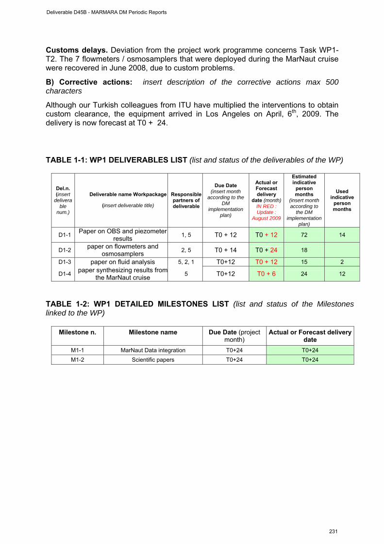
Customs delays. Deviation from the project work programme concerns Task WP1-T2. The 7 flowmeters / osmosamplers that were deployed during the MarNaut cruise were recovered in June 2008, due to custom problems.
B) Corrective actions: insert description of the corrective actions max 500 characters
Although our Turkish colleagues from ITU have multiplied the interventions to obtain custom clearance, the equipment arrived in Los Angeles on April, 6th, 2009. The delivery is now forecast at T0 + 24.
TABLE 1-1: WP1 DELIVERABLES LIST (list and status of the deliverables of the WP)
Del.n. (insert
deliverable
num.)
Deliverable name Workpackage
(insert deliverable title)
Responsible partners of deliverable
Due Date (insert month
according to the DM
implementation plan)
Actual or Forecast delivery
date (month) IN RED : Update :
August 2009
Estimated indicative
person months
(insert month according to
the DM implementation
plan)
Used indicative
person months
D1-1 Paper on OBS and piezometer results 1, 5 T0 + 12 T0 + 12 72 14
D1-2 paper on flowmeters and osmosamplers 2, 5 T0 + 14 T0 + 24 18
D1-3 paper on fluid analysis 5, 2, 1 T0+12 T0 + 12 15 2
D1-4 paper synthesizing results fromthe MarNaut cruise 5 T0+12 T0 + 6 24 12
TABLE 1-2: WP1 DETAILED MILESTONES LIST (list and status of the Milestones linked to the WP)
Milestone n. Milestone name Due Date (project month)
Actual or Forecast delivery date
M1-1 MarNaut Data integration T0+24 T0+24 M1-2 Scientific papers T0+24 T0+24
Deliverable D45B - MARMARA DM Periodic Reports
231
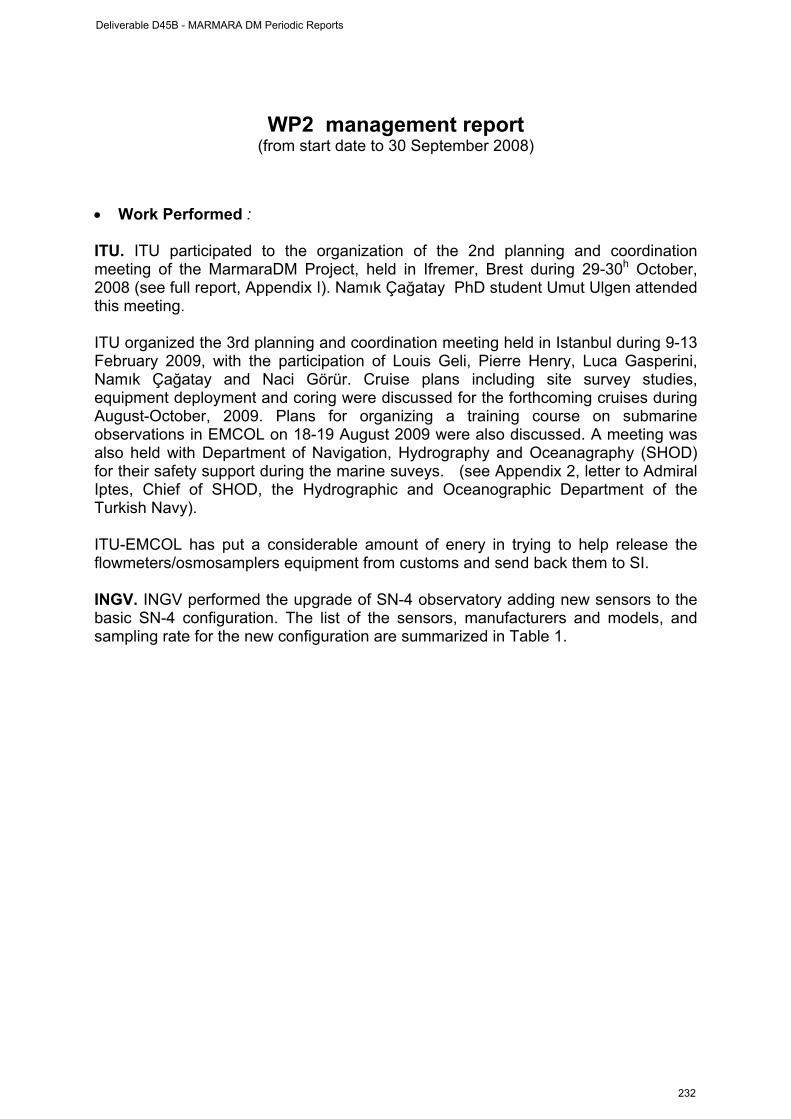
WP2 management report
(from start date to 30 September 2008)
• Work Performed : ITU. ITU participated to the organization of the 2nd planning and coordination meeting of the MarmaraDM Project, held in Ifremer, Brest during 29-30h October, 2008 (see full report, Appendix I). Namık Çağatay PhD student Umut Ulgen attended this meeting. ITU organized the 3rd planning and coordination meeting held in Istanbul during 9-13 February 2009, with the participation of Louis Geli, Pierre Henry, Luca Gasperini, Namık Çağatay and Naci Görür. Cruise plans including site survey studies, equipment deployment and coring were discussed for the forthcoming cruises during August-October, 2009. Plans for organizing a training course on submarine observations in EMCOL on 18-19 August 2009 were also discussed. A meeting was also held with Department of Navigation, Hydrography and Oceanagraphy (SHOD) for their safety support during the marine suveys. (see Appendix 2, letter to Admiral Iptes, Chief of SHOD, the Hydrographic and Oceanographic Department of the Turkish Navy). ITU-EMCOL has put a considerable amount of enery in trying to help release the flowmeters/osmosamplers equipment from customs and send back them to SI. INGV. INGV performed the upgrade of SN-4 observatory adding new sensors to the basic SN-4 configuration. The list of the sensors, manufacturers and models, and sampling rate for the new configuration are summarized in Table 1.
Deliverable D45B - MARMARA DM Periodic Reports
232
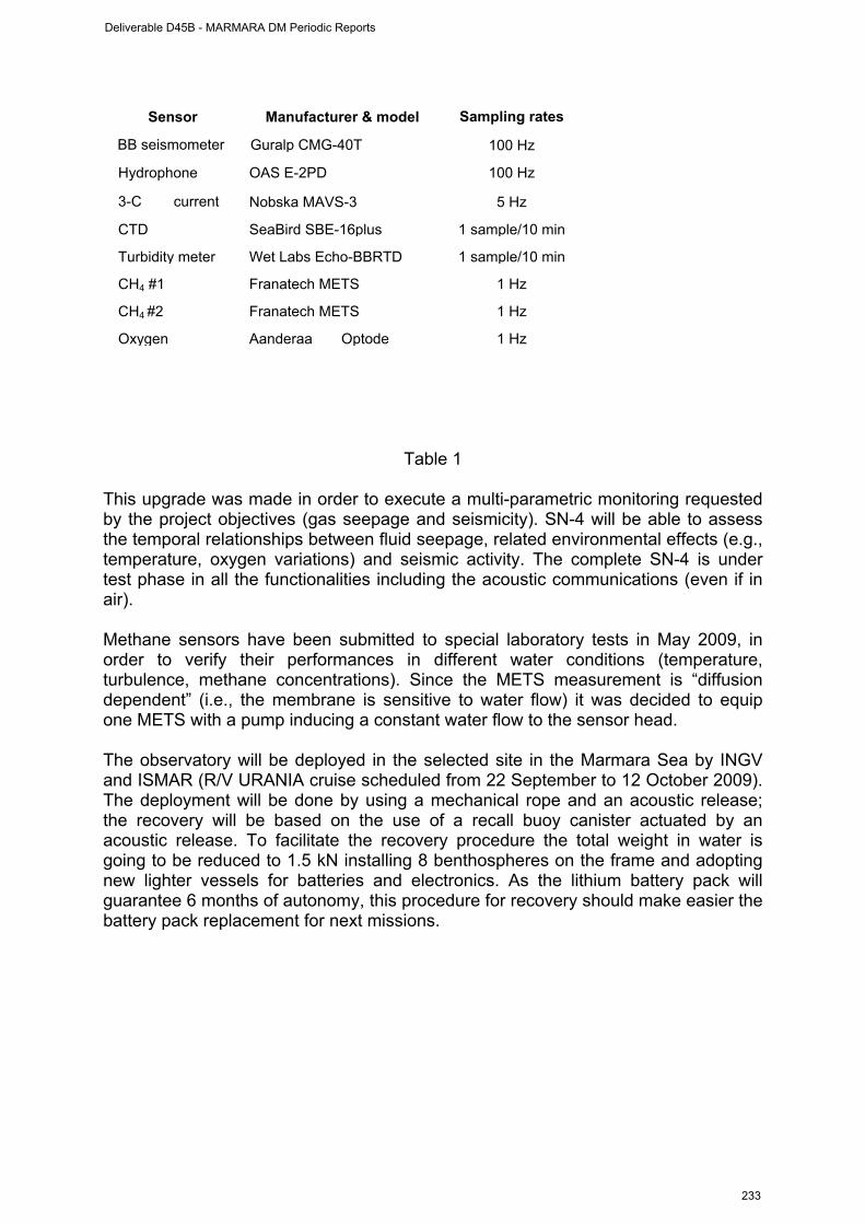
Table 1
This upgrade was made in order to execute a multi-parametric monitoring requested by the project objectives (gas seepage and seismicity). SN-4 will be able to assess the temporal relationships between fluid seepage, related environmental effects (e.g., temperature, oxygen variations) and seismic activity. The complete SN-4 is under test phase in all the functionalities including the acoustic communications (even if in air). Methane sensors have been submitted to special laboratory tests in May 2009, in order to verify their performances in different water conditions (temperature, turbulence, methane concentrations). Since the METS measurement is “diffusion dependent” (i.e., the membrane is sensitive to water flow) it was decided to equip one METS with a pump inducing a constant water flow to the sensor head. The observatory will be deployed in the selected site in the Marmara Sea by INGV and ISMAR (R/V URANIA cruise scheduled from 22 September to 12 October 2009). The deployment will be done by using a mechanical rope and an acoustic release; the recovery will be based on the use of a recall buoy canister actuated by an acoustic release. To facilitate the recovery procedure the total weight in water is going to be reduced to 1.5 kN installing 8 benthospheres on the frame and adopting new lighter vessels for batteries and electronics. As the lithium battery pack will guarantee 6 months of autonomy, this procedure for recovery should make easier the battery pack replacement for next missions.
1 HzAanderaa OptodeOxygen
1 HzFranatech METSCH4 #2
1 HzFranatech METSCH4 #1
1 sample/10 minWet Labs Echo-BBRTDTurbidity meter
1 sample/10 minSeaBird SBE-16plusCTD
5 HzNobska MAVS-3 3-C current
100 Hz OAS E-2PD Hydrophone
100 HzGuralp CMG-40TBB seismometer
Sampling ratesManufacturer & model Sensor
Deliverable D45B - MARMARA DM Periodic Reports
233
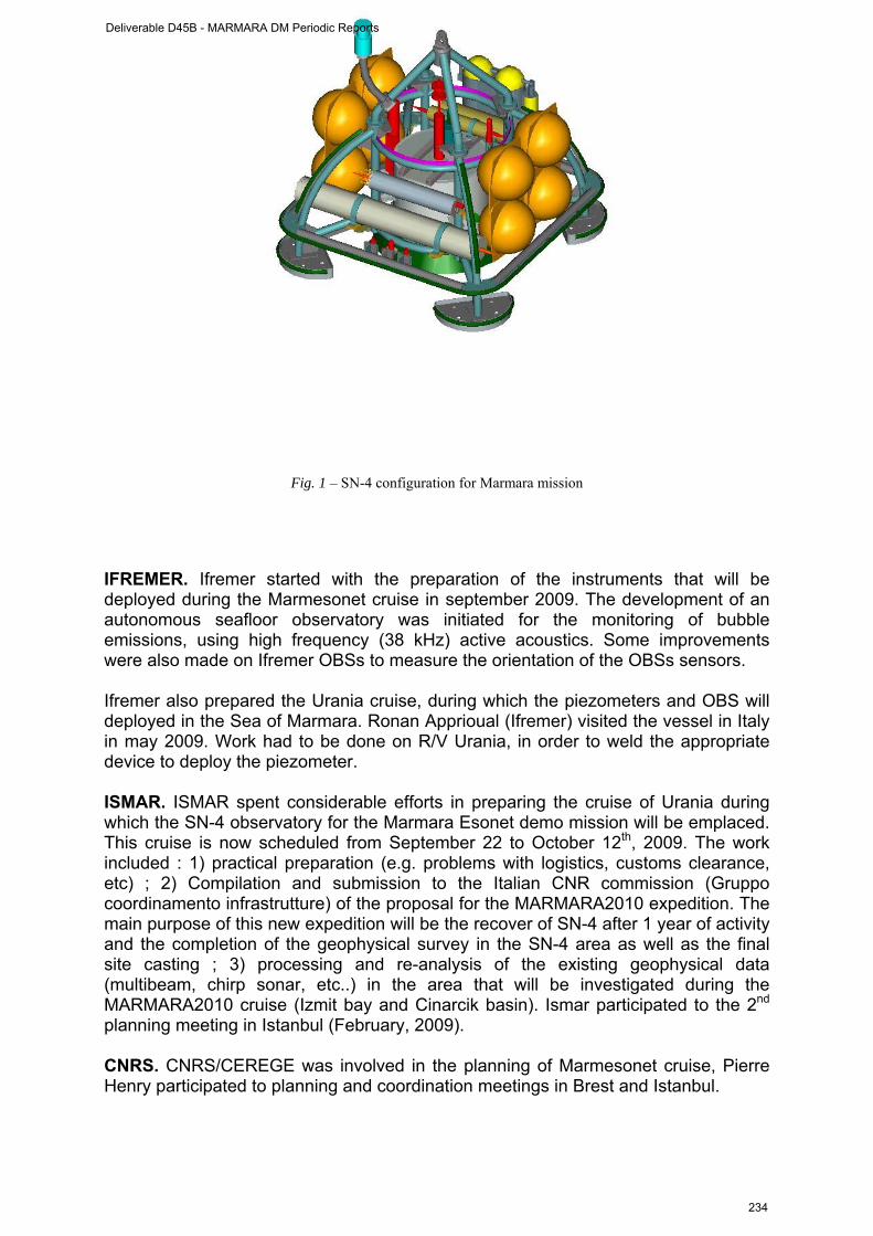
Fig. 1 – SN-4 configuration for Marmara mission IFREMER. Ifremer started with the preparation of the instruments that will be deployed during the Marmesonet cruise in september 2009. The development of an autonomous seafloor observatory was initiated for the monitoring of bubble emissions, using high frequency (38 kHz) active acoustics. Some improvements were also made on Ifremer OBSs to measure the orientation of the OBSs sensors. Ifremer also prepared the Urania cruise, during which the piezometers and OBS will deployed in the Sea of Marmara. Ronan Apprioual (Ifremer) visited the vessel in Italy in may 2009. Work had to be done on R/V Urania, in order to weld the appropriate device to deploy the piezometer. ISMAR. ISMAR spent considerable efforts in preparing the cruise of Urania during which the SN-4 observatory for the Marmara Esonet demo mission will be emplaced. This cruise is now scheduled from September 22 to October 12th, 2009. The work included : 1) practical preparation (e.g. problems with logistics, customs clearance, etc) ; 2) Compilation and submission to the Italian CNR commission (Gruppo coordinamento infrastrutture) of the proposal for the MARMARA2010 expedition. The main purpose of this new expedition will be the recover of SN-4 after 1 year of activity and the completion of the geophysical survey in the SN-4 area as well as the final site casting ; 3) processing and re-analysis of the existing geophysical data (multibeam, chirp sonar, etc..) in the area that will be investigated during the MARMARA2010 cruise (Izmit bay and Cinarcik basin). Ismar participated to the 2nd planning meeting in Istanbul (February, 2009). CNRS. CNRS/CEREGE was involved in the planning of Marmesonet cruise, Pierre Henry participated to planning and coordination meetings in Brest and Istanbul.
Deliverable D45B - MARMARA DM Periodic Reports
234
DEU. Günay Çifçi and Mustafa Ergun participated in the organization and attended the first project meeting held in Brest on October 28-29, 2008. Günay Çifçi and Nano Seeber (LDEO) have represented the project Turkish-American project “TAMAM“. This project allowed the collection of an unique dataset of high-quality, high resolution multi-channel seismics in the Sea of Marmara. First results of the data and the facilities of the Seismic Laboratory (SeisLab) in DEU-IMST were discussed during the presentations. The difficulties of the selection of the sites also were evaluated because of heavy maritime traffic. In addition, different technical actions were undertaken : 1) Hakan Sarıtaş participated to the ESONET subsea observatory meeting with industrial companies and SMEs which place during the IEEE OCEANS'09 BREMEN ; 2) Günay Çifçi and Derman Dondurur made a technical meeting with Hydroscience Inc Tech. in Huston for the extension of streamer from 96 channels to 240 channels as 1500m ; 3) Technician Erdal Özcan proceeded to the maintenance and installation of seismic data processing Promax software. • Rough Estimation of Major Cost: E Person-Months
Ifremer : xx Ma-Months ITU 1,5 Ma-Mo (0,5 non-permanent ; 1 permanent) INGV : 6 Ma-Mo ISMAR : xx Ma-Mo CNRS : 1,5 Ma-Mo (0,5 non pemanent ; 1 permanent) DEU : 4 Ma-Mo (2 permanent ; 2 non-permanent)
Other costs : Ifremer : ITU
Travel : 2nd project meeting, Brest : participation of Namık Çağatay: 1074,61 € Travel : 2nd project meeting, Brest : participation of Umut B. Ülgen: 1069,62 € Total: 2144.23 €
INGV
SN-4 observatory components and sensor tests, Total cost : 20 k€ (EC share : 7.5 k€) DEU
Travel : 2nd project meeting, Brest : participation of Günay Çifçi: 2400 € Travel : 2nd project meeting, Brest : participation of Mustafa Ergun : 2400 € Travel : reporting workshop in Paris : participation of Seda Okay : 950 € Participation of Hakan Sarıtaş to IEEE OCEANS'09 BREMEN event: 810 € Participation of Günay Çifçi and Derman Dondurur to a technical meeting with Hydroscience
Inc Tech. in Houston : 750 € Maintenance and installation of Promax software : 500 € Lab and office consumables: 1000 € Total : 8810 €
CNRS
Travel : participation of P. Henry to the Brest (oct 08) and Istanbul (feb 09) meetings : 2 k€
Deliverable D45B - MARMARA DM Periodic Reports
235

• Overview of the Actual Costs, by major cost item including personnel (fill in the Table here below)
Type of expenditure
Actual costs( Euro) First period
Total person-months Personnel costs Subcontracting Travels Consumables Other costs
Total Costs Table to be completed
Deliverable D45B - MARMARA DM Periodic Reports
236
WP3 management report (from October 1st, 2008 to 30 May 2009)
WORKPACKAGE WP3
Full WP title INTEGRATION OF LAND AND SEAFLOOR SEISMOLOGICAL DATA
Period covered f from September 1st, 2008 to 30/05/2009 Partner organisation full name INGV
Person in charge for the report (WP Leader)
Paolo Favali
Partners involved in the Work 4, 1, 5, 2
Period of the reporting: from starting date to 30 September 2008 • Work Performed : The main work performed during the reporting period under the present WP consisted in merging land and seabottom seismological data. Due to the limited number of OBSs deployed during MarNaut, merging data from land and seabottom stations has proven to be very challenging, if not merely impossible, in absence of a detailed 3D velocity model from the deep offshore domain encompassing the rims of the Sea of Marmara. From this work, we have learned that the only way to merge land and seabottom stations consists in using the combination of two models :
- for the deep levels, the 3D velocity model of Bécel (in press), based on the data collected in 2001 during the Seismarmara Cruise of R/V L’Atalante
- for the uppermost layers (< 2 s-twt), a detailed velocity model based on the velocity model of all MCS data available in the Sea of Marmara. The TAMAM dataset would be ideal for deriving such model, through a collaborative project with LDEO.
Ifremer. Attempts for merging the seismological datasets were mainly performed at Ifremer, in collaboration with KOERI, through the Ph. D. Thesis of J. B. Tary. ITU. Land data from the TUBITAK seismological network were extracted for the duration of the MarNaut deployment, processed and examined (Note : TUBITAK Is ITU’s sub-contractor). • Rough Estimation of Major Cost: Person-Months
Ifremer : 7 Ma-Months (1 permanent ; 6 non-permanent) ITU : 1,5 Ma-Mo (0,5 permanent ; 1 non permanent) INGV : 0 Ma-Mo
Deliverable D45B - MARMARA DM Periodic Reports
237

ISMAR : xx Ma-Mo CEREGE : xx Ma-Mo DEU : 0 Ma-Mo
Other costs :
• Overview of the Actual Costs, by major cost item including personnel (fill in the
Table here below)
Type of expenditure
Actual costs( Euro) First period
Total person-months Personnel costs Subcontracting Travels Consumables Other costs
Total Costs Table to be completed
WP-3 progress
(from October 1st, 2008 to 30 May 2009)
Workpackage objectives and starting point (max 500 characters)
Progress towards objectives : Task WP3.T1: Analyze land stations from TUBITAK network
Contractors involved : INGV, Ifremer, Cnrs, ITU (including Tubitak) and support from KOERI
The data from four OBSs deployed during for 2,5 months in the eastern Sea of Marmara were analyzed together with land stations data provided by KOERI and TUBITAK, respectively. Due to the limited number of OBSs deployed during MarNaut, merging data from land and seabottom stations has proven to be very challenging, if not merely impossible, in absence of a detailed 3D velocity model from the deep offshore domain encompassing the rims of the Sea of Marmara. It appears necessary to undertake an huge work to determine the most appropriate velocity model, which consist in combining the 3D velocity model of Bécel (in press), based on deep refraction seismic studies and a shallower model (yet to be built), based on the velocity analysis of the available, 2D, MCS lines.
Task WP3.T2: Analyze OBS data from each site (1 year deployment)
Contractors involved : INGV, Ifremer, Cnrs, ITU (including Tubitak) and support from KOERI
Deliverable D45B - MARMARA DM Periodic Reports
238
This task will start only after recovery of the OBSs that will be deployed during the Urania Cruise and recovered in march-april 2010. Task WP3.T3 : Site survey High Res Seismics
Contractors involved : Ifremer, DEU
This task will start only after completion of the Marmesonet Cruise, in march-april 2010.
Deviations from the project work programme, and corrective actions taken/suggested (identify the nature and the reason for the problem, identify partners involved)
The Marmesonet seismic cruise (leg II) is postponed, from September 2009 to March 2010. The corresponding actions are thus 6 months-delayed.
Deliverable D45B - MARMARA DM Periodic Reports
239
TABLE 3-1: WP3 DELIVERABLES LIST (list and status of the deliverables of the WP)
Del.n. (insert
deliverable
num.)
Deliverable name Workpackage
(insert deliverable title)
Responsible partners of deliverable
Due Date (insert month
according to the DM
implementation plan)
Actual or Forecast delivery
date (month) In red : last
update august 2009
Estimated indicative
person months
(insert month according to
the DM implementation
plan)
Used indicative
person months
D3-1 Report comparing OBS (includingSN-4) and land stations
2,4,1 T0+26 T0 + 30 36 7
D3-2
Report on the ambient noise in thSea of Marmara and recommendation for implementating permanent seabottom station
4,1
T0+26 T0 + 30 12 0
D3-3 High res seismic images at 3 sites 6 T0+18 T0 + 30 72 0
TABLE 3-2: WP3 DETAILED MILESTONES LIST (list and status of the Milestones linked to the WP)
Milestone n. Milestone name Due Date (project month)
Actual or Forecast delivery date
In red : Last update, August 2009
M3-1 Integration of MarNaut OBSs T0+6 T0+12 (DONE) M3-2 Analysis of land data T0+24 T0+30 M3-3 Analysis and integration of DM data T0+30 T0+30 M3-4 Reporting T0+30 T0+30
Deliverable D45B - MARMARA DM Periodic Reports
240
WP4 management report (from October 1st, 2008 to 30 May 2009)
WORKPACKAGE WP4 Full WP title DATA Integration and modelling Period covered from September 1st, 2008 to 30/05/2009 Partner organisation full name ISMAR
Person in charge for the report (WP Leader)
Luca Gasperini
Partners involved in the Work All
Period of the reporting: from October, 1st 2008 to May, 30th, 2009 • Work Performed : ITU. ITU staff continued to work on the sediment cores collected in the area, particularly during the MARNAUT cruise. All 18 piston and 5 interface cores were analyzed at 1 cm resolution by multisensor core logger (MSCL) for physical properties. 4 piston and 5 interface cores were opened, described and analyzed at 1 mm resolution for chemical composition and X-ray radiography using Itrax Core Scanner. Ifremer. Ifremer participated to the WP by modelling the geochemical data collected during the MarNaut cruise. The gas hydratesthat were collected on the Western High at a water depth of 666 m were shown to be of Type II, with a large concentration in ethane. The complete modelling explains why these gas hydrates are stable at such a shallow depth. A paper is presently under way (Rufine et al, 2009). This modelling appears to be of critical importance, as it helps understand the relations between the Thrace Basin and the fault zone below the Western High. ISMAR. ISMAR carried out several activities towards data integration, mostly related to the emplacement of the SN-4 station, in the area that will be investigated during the MARMARA2010 cruise (Izmit bay and Cinarcik basin). The re-processing and re-analysis of the the existing geophysical data (multibeam, chirp sonar, etc..) consisted mainly in the attempt of determining the actual environment of the SN-4 area in terms of presence of gas in the sediment and seismic character (facies) of the sediment to infer possible geotechnical properties. The presence or the absence of gas in the sediment is of crucial importance to the final success of the Marmara Esonet demo mission, as also discussed in the recent Istanbul 2009 meeting: “An overview of the research in the Sea of Marmara region over the last 10 years”, on the 10th Anniversary of 17 August 1999 Izmit Earthquake. CEREGE. CEREGE provided all data available in GIS from Marnaut to partners. Three GIS with comparable contents are currently maintained at ITU, Ifremer and
Deliverable D45B - MARMARA DM Periodic Reports
241
Cerege. Modeling of heat flow data in the Sea of Marmara has been given a special effort, with the involvement of a masters student at CEREGE. Results have implications on the tectonic history of the basins and on the estimation of fluid fluxes. DEU. DEU contributed to the TAMAM cruise in the Sea of Marmara, conducted in July 2008 with the R/V K. Piri Reis operated by Institute of Marine Sciences and Technology at Dokuz Eylül University in Izmir. This cruise collected more than 2700 km of high-resolution MCS data plus shallow-penetration chirp profiles. Safety issues from the dense ship traffic in the Marmara Sea prevented coverage of the area close to Istanbul and required several deviations in the tracks. Data analysis and interpretation is being shared among the collaborating institutes and involves four Turkish students and one post-doctoral researcher. All five spent between one and three months working at Lamont-Doherty Earth Observatory (LDEO) or the University of Missouri. A one-week workshop was held at LDEO attended by three students, four Turkish professors and 3 students, and five American research scientists. • Rough Estimation of Major Cost: Person-Months
Ifremer : xx Ma-Months ITU : 14 Ma-Mo (2 permanent ; 12 non permanent) INGV : 0 Ma-Mo ISMAR : xx Ma-Mo CEREGE : 7 Ma-Mo (1 permanent ; 2 non-permanent ; 4 master student) DEU : 10,5 Ma-Mo (5 permanent ; 5.5 non-permanent)
Travels :
• Overview of the Actual Costs, by major cost item including personnel (fill in the
Table here below)
Type of expenditure
Actual costs( Euro) First period
Total person-months Personnel costs Subcontracting Travels Consumables Other costs
Total Costs Table to be completed
WP-4 progress
(from October 1st, 2008 to 30 May 2009)
Workpackage objectives and starting point (max 500 characters)
Deliverable D45B - MARMARA DM Periodic Reports
242
The objective of the present WP is to carry out a careful analysis and integration of all multidisciplinary data, in order to test wether the pore fluid properties (geophysical and geochemical) are related to the seismic activity of the Marmara Sea fault zone (Hypoth. 1). The integration and modelling of the long time series will also enable us to test if : 1) strain rate variations induce pore pressure variations in surface sediments ; and 2) fluids from the seismogenic depth reach -locally and episodically- the sediment surface. The main deliverables are :
1. validation of the concept of observatory based on all available time-series data (old and new)
2. Selection of the best sites and parameters for seafloor monitoring of seismogenic risk in the Marmara Sea
Progress towards objectives – The available time series were collected during MarNaut cruise, hence the results are presented in WP1. The work performed under the present WP4 during the reporting period is described above.
Deliverable D45B - MARMARA DM Periodic Reports
243
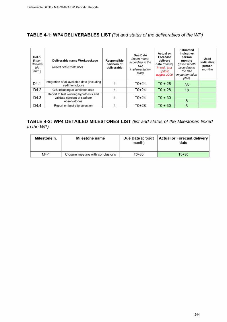
TABLE 4-1: WP4 DELIVERABLES LIST (list and status of the deliverables of the WP)
Del.n. (insert
deliverable
num.)
Deliverable name Workpackage
(insert deliverable title)
Responsible partners of deliverable
Due Date (insert month
according to the DM
implementation plan)
Actual or Forecast delivery
date (month) In red : last
update august 2009
Estimated indicative
person months
(insert month according to
the DM implementation
plan)
Used indicative
person months
D4.1 Integration of all available data (including sedimentology) 4 T0+24 T0 + 28 36
D4.2 GIS including all available data 4 T0+24 T0 + 28 18
D4.3 Report to test working hypothesis and
validate concept of seafloor observatories
4 T0+24 T0 + 30 8
D4.4 Report on best site selection 4 T0+28 T0 + 30 6
TABLE 4-2: WP4 DETAILED MILESTONES LIST (list and status of the Milestones linked to the WP)
Milestone n. Milestone name Due Date (project month)
Actual or Forecast delivery date
M4-1 Closure meeting with conclusions T0+30 T0+30
Deliverable D45B - MARMARA DM Periodic Reports
244
WP6 management report
(from October 1st, 2008 to 30 May 2009) WORKPACKAGE WP6
Full WP title PUBLIC AND EDUCATION OUTREACH. FUND RISING.
Period covered from September 1st, 2008 to 30/05/2009 Partner organisation full name ITU
Person in charge for the report (WP Leader)
Namik Çagatay
Partners involved in the Work All partners
Period of the reporting: October, 1st, 2008 to May 30th, 2009 .
MARMARA-DM PROJECT WP6 ACTIVITIES FOR THE FIRST 6 MONTHS
WP 6 : Public and education outreach, coordination at national (Turkish) level
and fund raising
COORDINATION (Task WP6.1)
The coordination efforts between different Turkish organizations, such as TPAO (Turkish Petroleum Corporation), TUBITAK (Scientific and Technological Council of Turkey) and MTA (Geological Suvey of Turkey), and possible stakeholders continued for permanent seafloor observartories in the Sea of Marmara. These efforts are explained below. 1. Meeting with TPAO (Turkish Petroleum Corporation; http://www.tpao.gov.tr):
TPAO is a possible funding organization in Turkey for seafloor observatories in the Sea of Marmara (SoM), because the Thrace natural gas and oil field extends southward into into SoM, where the MarNaut cruise discovered HC gas and oil seeps and gas hydrates. Namık Çağatay contacted TPAO officially on 9 January 2008 and informed them of the ESONET Marmara-DM project activities and results of the MarNaut cruise (Appendix III). He was then invited to TPAO headquarters in Ankara for a presentation and discussions 19 February 2009. A meeting was held with Halit Alkan Director of the Exploration Department and Chief Geologist Muzaffer Siyako from TPAO (Turkish Petroleum Corporation) for TPAO’s collaboration in the project activities. Their official answer in 19 March 2009 was that TPAO had no exploration permits in the SoM, and therefore was not interested in the project collaboration in SoM (Appendix IV), which allows us to contact any other private company.
Deliverable D45B - MARMARA DM Periodic Reports
245
2. 3rd planning and coordination meeting was held at ITU during 9-13 February 2009, with the participation of Louis Geli, Pierre Henry, Luca Gasperini and Namık Çağatay. Cruise plans, site survey studies, equipment deployment plans were discussed for the forthcoming cruises during August-October, 2009. Plans for organizing a training course on submarine observations in EMCOL on 18-19 August 2009 were also discussed. A meeting was also held with Department of Navigation, Hydrography and Oceanagraphy (SHOD) for their safety support during the marine suveys (see Appendix II).
3. Namık Çağatay was invited on 27 February 2009 by the Dokuz Eylül Üniversitesi, İzmir to present ESONET Marmara-DM and EMSO activities in the Sea of Marmara.
4. On June 20, 2009, we contacted and sought possible project collaborations with private petroleum companies with exploration rights in the SoM and sent them an invitation and an explanatory document about the ESONET Marmara-DM project and its findings regarding the HCs (Apendix V). These companies included:
a. Merty Enerji Petrol Arama, Eğitim ve Servis Hizmetleri Anonim Şirketi ([email protected])
b. Toreador Turkey Ltd. ([email protected]) c. Thrace Basin Natural Gas Türkiye Corporation ([email protected])
5. We have identified the following stakeholders for sea observations for the Marmara Node: 1. ITU-EMCOL (Eastern Mediterranean Centre for Oceranography and Limnology (http://www.emcol.itu.edu.tr/). 2. General Directorate of Mineral Research and Exploration (MTA) (http://www.mta.gov.tr). 3. Petroleum Company (TPAO) (http://www.tpao.gov.tr) 4. Turkish Navy Office of Navigation, Hydrography and Oceanography (TN-ONHO) (http://www.shodb.gov.tr/english.html) 5. Turkish Coast Guard Command (http://www.sgk.tsk.tr/en_index.htm) 6. Kandilli Earth Obsevatory of the Bosphorus Universitiy (KOERI) (http://www.koeri.boun.edu.tr/) 7. Marine Sciences Institute of the Middle East Technical University (http://www.ims.metu.edu.tr/) 8. Earth and Marine Sciences Institute of TUBITAK-MAM (http://www.mam.gov.tr/YDBE/index.html) 9. Marine Sciences and Management Institute of the Dokuz Eylül University (İzmirMiddle East Technical University (http://www.deu.edu.tr/DEUWeb/Icerik/Icerik.php?KOD=74) 10. Marine Sciences and Management Institute of the Istanbul Univeristy (http://www.istanbul.edu.tr/enstituler/denizbilimleri/turkce/turkish.htm) 11. Turkish Marine Research Foundation (http://www.tudav.org/new/eng/) 12. İnönü Vakfı Marine Research Centre (www.ismetinonu.org.tr/)
Deliverable D45B - MARMARA DM Periodic Reports
246
We invited representative of the above organizations to a meeting at ITÜ on 29 May 2009. After a presentation on the EMSO and ESONET project and their activities at the Marmara node and discussion: A concensus was reached between key stakeholders in this meeting on the following issues: 1) the importance of the EMSO and ESONET projects and multidisciplinary seafloor observatories for the Sea of Marmara; 2) Acting of all stakeholders as a unified front for establishment of the seafloor observatories in the SoM under EMSO and ESONET umbrella, 3) Presentation of a proposal to Turkish Prime Ministry State Planning Organization (main funding organization for science infrastructures) with a purpose to initiate the establishment of multidisciplinary seafloor observatories in the SoM.
6. ITU coordinated the Exchange of Personnel for the Marmara Node during November 2009.
DISSEMINATION OF RESULTS (Task WP6.2) 1. “Sea of Marmara Special Session” of the Geological Congress of Turkey: Joint “Geohazards in Marine Environments” and “Marine Geology” sessions at the 62.Geological Congress of Turkey was held in Ankara during 23-27 April 2008. The session was convened by Namık Çağatay and Naci Görür of ITU. Naci Görür, Luca Gasperini, Sinan Özeren and Namık Çağatay, presented papers related to the ESONET Marmara-DM and related cruises and marine activities (see below for the list of abstracts under publications) 2. Training course and Symposium: A training course on “Seafloor Observatory Techniques for Marine Geohazard Monitoring” is being organized at ITU in İstanbul on 18-19 August 2009. This course is intended for engineers and scientists from marine institutes, other related governmental and private organizations are invited to participate. The training workshop will follow a one-day symposium on “An overview of the research in the Sea of Marmara region over the last 10 years”, on the 10th Anniversary of 17 August 1999 Izmit Earthquake. Invited scientists will present the results of earthquake research in the region carried out by them and their groups. 3. Publications Peer-reviewed publication on Marnaut cruise results: Bourry, C., Chazallon, B., Charlou, J-L, Donval J.P, Ruffine, L., Henry, P., Geli, L., Çagatay, M.N., Sedat, İ, Moreau, M., (2009). Free gas and gas hydrates from the Sea of Marmara, Turkey: Chemical and structural characterization. Chemical Geology, doi:10.1016/j.chemgeo.2009.03.007. Article on the Marmara-DM project in ESONEWS: Çağatay, M.N., and Geli, L. and Marmara-DM scientists, 2009. L. Marmara-DM project: Recent activities. ESONEWS volume 3, Issue 1.
Deliverable D45B - MARMARA DM Periodic Reports
247
Peer-reviewed publications unrelated to Marnaut cruise, but important for geohazard and oceanographic studies in the Sea of Marmara: 1. Çağatay, M. N., Eriş, K., Ryan, W.B.F., Sancar, Ü., Polonia, A., Akçer, S.
Biltekin, D., Gasperini, L., Görür, N. Lericolais G., Bard, E. 2009. Late Pliestocene-Holocene evolutıon of the northern shelf of the Sea of Marmara. In Press in Marine Geology. doi: 10.1016/j.margeo.2009.06.011.
2. Irvalı, N., Çağatay, M.N. (2008). Late Pleistocene-Holocene history of the Golden Horn Estuary, İstanbul. Geo-Marine Letters, 29:151-160.
Papers presented at scientific meetings: 1. Tryon, M. D., Çağatay, M. N., Henry, P., Zitter, T.A.C., Geli, L. Charlou J.-L.
and the Marnaut Scientific Party, Pore fluid chemistry of cold seeps in the Sea of Marmara, AGU Fall meeting, San Francisco, 10-14 December, 2008.
2. Zitter, T.A.C. Henry, P. Özeren, M.S. Cagatay, M.N. Geli, L. Mercier de Lepinay, B. Gasperini, L., Sultan, N.,.2008. Slope Instabilities Along the North Anatolian Fault System in the Sea of Marmara. AGU Fall meeting, San Francisco, 10-14 December, 2008.
3. Çağatay MN, Belucci L, Polonia A, Sancar U, Eriş K, Gasperini, L, Görür, N, P Henry P, Zitter TAC, Geli G, Tryon,T. (2008). Geochemical and Sedimentological Characteristics of the Turbidites Related to Earthquake Activity in the Sea of Marmara. American Geophysical Unon (AGU) Fall Meeting, San Francisco, December 2008.
4. Zitter TAC, Henry P, Özeren MS, Çağatay MN, Geli L, Mercier de Lepinay B., Gasperini L, Sultan, N. (2008). Slope Instabilities Along the North Anatolian Fault System in the Sea of Marmara. American Geophysical Unon (AGU) Fall Meeting, San Francisco, December 2008
5. Géli L, Henry P, André C, Zitter , T, Çağatay N, B. Mercier de Lépinay B (2008). Marine Heat flow measurements from the submerged section of the North Anatolian Fault, in the Sea of Marmara. American Geophysical Unon (AGU) Fall Meeting, San Francisco, December 2008.
6. Çağatay M.N., Çifci, G., Gürbüz, C. 2009. ESONET NoE and EMSO Infrastucture Projects and Their Importance for Geohazard Monitoring in the Sea of Marmara. 62. Geological Congress of Turkey, Ankara 13-17 April 2009. Abstract no.: 8MD-2009-325].
7. Görür, N. and Çağatay, M.N., 2009 Geohazards rooted from the northern margin of the Sea of Marmara since the late Pliestocene. A review of recent results. 62. Geological Congress of Turkey, Ankara 13-17 April 2009. Abstract no.:MD-2009-575.
8. Eriş, K.K. , Beck, C. , Çağatay, N., 2009. Defining Late Quaternary Seismo-türbidites in the Sea of Marmara; Evidence from High-resolution Core and Seismic studies. 62. Geological Congress of Turkey, Ankara 13-17 April 2009. Abstract no.: MD-2009-389.
9. Polonia, A., Gasperini L. et al., 2009. Displaced Sedimentary Features along Middle and Northern strands of the North Anatolian Fault in the Marmara Sea: Implications for Slip Rates, Styles of Deformation and Basin Development. 62.
Deliverable D45B - MARMARA DM Periodic Reports
248
Geological Congress of Turkey, Ankara 13-17 April 2009. Abstract no.: MD-2009-346.
10. Seeber, L., Sorlien,C., Shillington, D., Dondurur, D, Gürçay,S., Diebold, J., Imren, C., Kurt, H., Steckler, M. Çifçi, G., Demirbağ, E. and Scientific Party of TAMAM08 Cruise, 2009. Basin Growth Along the North Anatolian Continental Transform: The TAMAM08 High-Resolution Multichannel Survey in the Marmara Sea. 62. Geological Congress of Turkey, Ankara 13-17 April 2009. Abstract no.: MD-2009-571.
MARMARA-DM WEB SITE (Task WP6.T5) A web-site was constructed at ITU : www.esonet-marmara-dm.itu.edu.tr. This web site is both in Turkish and English, includes all news items announcements, workshop presentations and data concerning the project results. These activities are a big step forward achieving the deliverable D6.2 “Web Site” of the Marmara-DM project.
Deliverable D45B - MARMARA DM Periodic Reports
249
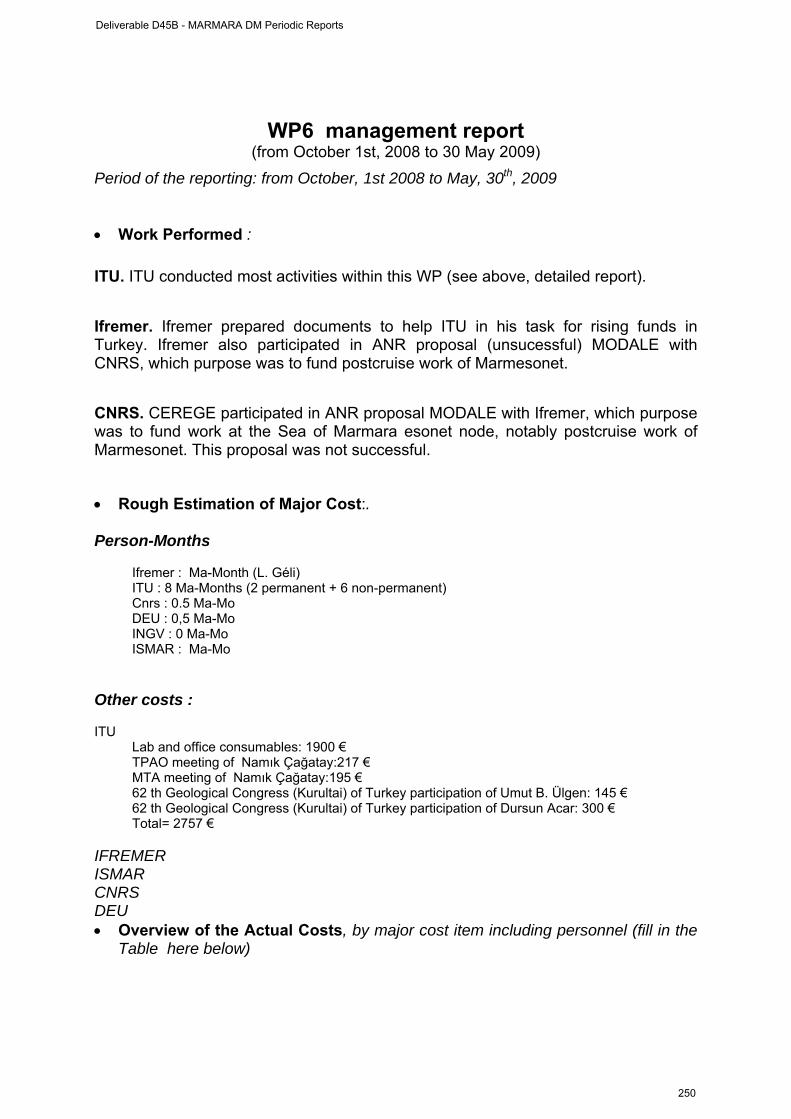
WP6 management report
(from October 1st, 2008 to 30 May 2009) Period of the reporting: from October, 1st 2008 to May, 30th, 2009 • Work Performed : ITU. ITU conducted most activities within this WP (see above, detailed report). Ifremer. Ifremer prepared documents to help ITU in his task for rising funds in Turkey. Ifremer also participated in ANR proposal (unsucessful) MODALE with CNRS, which purpose was to fund postcruise work of Marmesonet. CNRS. CEREGE participated in ANR proposal MODALE with Ifremer, which purpose was to fund work at the Sea of Marmara esonet node, notably postcruise work of Marmesonet. This proposal was not successful. • Rough Estimation of Major Cost:. Person-Months
Ifremer : Ma-Month (L. Géli) ITU : 8 Ma-Months (2 permanent + 6 non-permanent) Cnrs : 0.5 Ma-Mo DEU : 0,5 Ma-Mo INGV : 0 Ma-Mo ISMAR : Ma-Mo
Other costs :
ITU
Lab and office consumables: 1900 € TPAO meeting of Namık Çağatay:217 € MTA meeting of Namık Çağatay:195 € 62 th Geological Congress (Kurultai) of Turkey participation of Umut B. Ülgen: 145 € 62 th Geological Congress (Kurultai) of Turkey participation of Dursun Acar: 300 € Total= 2757 €
IFREMER ISMAR CNRS DEU • Overview of the Actual Costs, by major cost item including personnel (fill in the
Table here below)
Deliverable D45B - MARMARA DM Periodic Reports
250
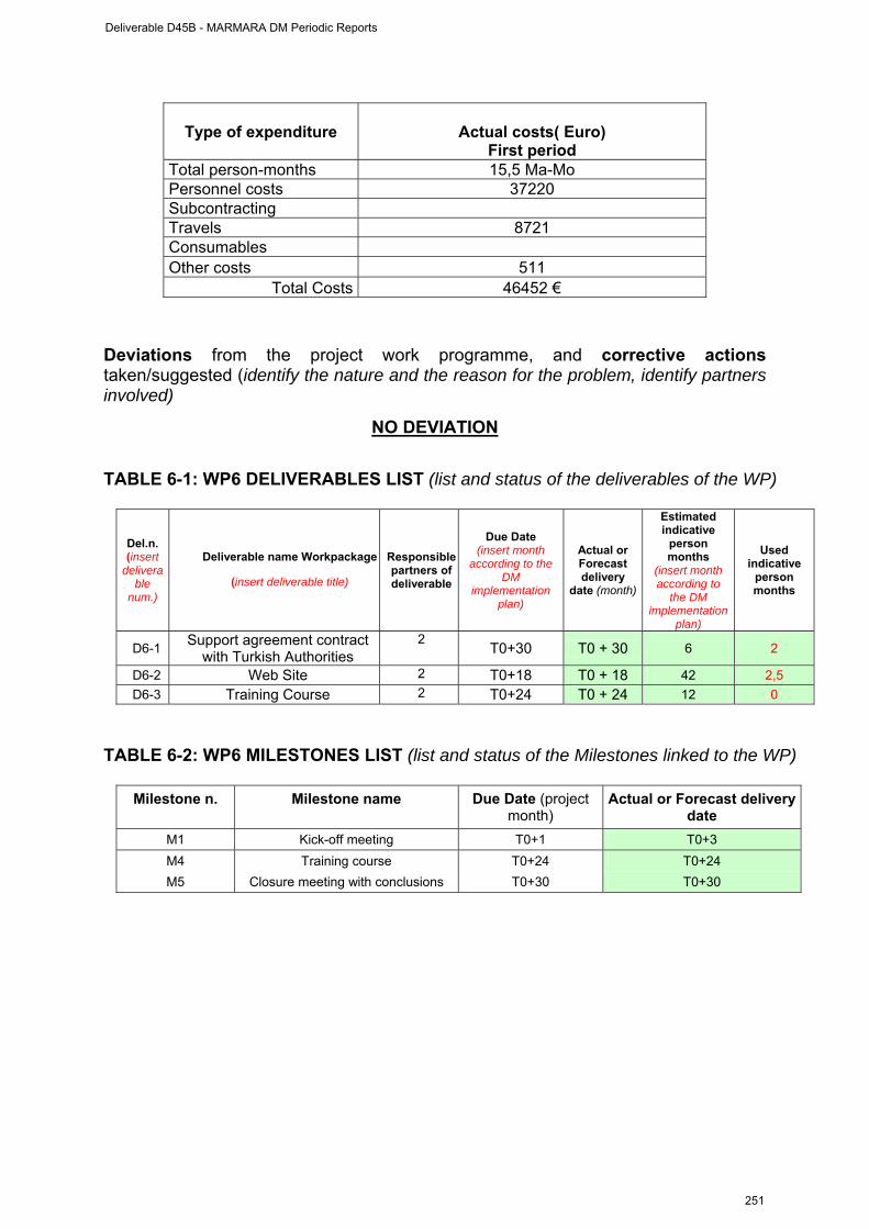
Type of expenditure
Actual costs( Euro) First period
Total person-months 15,5 Ma-Mo Personnel costs 37220 Subcontracting Travels 8721 Consumables Other costs 511
Total Costs 46452 €
Deviations from the project work programme, and corrective actions taken/suggested (identify the nature and the reason for the problem, identify partners involved)
NO DEVIATION
TABLE 6-1: WP6 DELIVERABLES LIST (list and status of the deliverables of the WP)
Del.n. (insert
deliverable
num.)
Deliverable name Workpackage
(insert deliverable title)
Responsible partners of deliverable
Due Date (insert month
according to the DM
implementation plan)
Actual or Forecast delivery
date (month)
Estimated indicative
person months
(insert month according to
the DM implementation
plan)
Used indicative
person months
D6-1 Support agreement contract with Turkish Authorities
2 T0+30 T0 + 30 6 2
D6-2 Web Site 2 T0+18 T0 + 18 42 2,5 D6-3 Training Course 2 T0+24 T0 + 24 12 0
TABLE 6-2: WP6 MILESTONES LIST (list and status of the Milestones linked to the WP)
Milestone n. Milestone name Due Date (project month)
Actual or Forecast delivery date
M1 Kick-off meeting T0+1 T0+3 M4 Training course T0+24 T0+24 M5 Closure meeting with conclusions T0+30 T0+30
Deliverable D45B - MARMARA DM Periodic Reports
251
APPENDICES
I. Full Report of the MarmaraDM 2nd Meeting held at
Ifremer Research Center, Brest, on October 28th-29th, 2008
II. Letter requesting support vessel from SHOD (Turkish
Department for Navigation, Hydrography and Oceanography)
III. Letter sent by ITU to TPAO (Turkisk Petroleum
Corporation), Halit Halkan, Director of Exploration, on January 9th, 2009
IV. Answer of TPAO to ITU, dated March, 19th, 2009
V. Letter sent by ITU to Turkish private petroleum
companies on ESONET Marmara-DM Project and its findings regarding hydrocarbons in the Sea of Marmara
Deliverable D45B - MARMARA DM Periodic Reports
252
APPENDIX I
MarmaraDM 2nd Meeting Report2
Ifremer, Brest Research Center, October 29th and 30th, 2008
Contents : I. General context / Meeting objectives II. Synthesis of scientific presentations III. Update3 on the operations at sea scheduled for 2009
III.1 Ship scheduled in 2009 in the Sea of Marmara
III.2 Priorities on site survey locations III.3 Coordinates of KOERI seafloor observatories III.4 Instruments deployments
IV. Actions to be taken V. Next meeting
***
Sub-Appendixes
S-A.1 List of participants S-A2. Meeting agenda S-A3. Note prepared by the Italian partners (L. Gasperini, ISMAR) & P. Favali (INGV) S-A.4 Timing constraints for AUV and high resolution seismics with R/V Le Suroit A.5 Maps of seismic lines shot during TAMAM cruise
2 This is not a verbatim report strico sensu, but a synthesis of the discussions held during the meeting. It also includes new elements that were not known at the time of the meeting. 3 This chapter is an update of the conclusions that resulted from the Marmara-Dm kick-off that was held in Istanbul, on june 18th, 2008 (see meeting report on http://www.cdf.u-3mrs.fr/~henry/marmara/).
Deliverable D45B - MARMARA DM Periodic Reports
253
I. General context / Meeting objectives At present, there are two separate initiatives to implement seafloor observatories in the Sea of Marmara :
- The KOERI (Kandilli Observatory and Earthquake Research Initiative) project. Funded by the Turkish authorities, this project (called MBSO : Marmara Sea Bottom Observatory project) aims at implementing cabled Ocean-Bottom Seismometers, Accelerometers, Hydrophones, Current meters and Temperature meters in the Sea of Marmara, as part of the turkish national network for earthquake and tsunami hazards monitoring that is operated by the KOERI. A total of 5 cabled broad-band Sea-Bottom Observatories (SBO) with broad-band OBSs will be deployed during the spring of 2009.
- The Marmara-DM demonstration mission4, funded within ESONET-NoE, aims at implementing multi-disciplinary, permanent observatories in the Sea of Marmara, with special focus on fluid and seismicity interactions.
The major objective of the meeting held in Brest on october 29 and 30th, 2008 was to demonstrate that these two initiatives are actually complementary, although they have been initiated separately : the KOERI project has an operational and research finality, while the ESONET-NoE project is research-oriented. The former aims at being integrated into the national Turkish seismic network. The latter aims at testing the hypothesis that the physical and geochemical properties of the fluids change within the fault throughout an earthquake cycle and that these changes can be recorded at the seafloor. If true, this hypothesis would open new perspectives to determine whether water and gas circulation in subseafloor environments can generate detectable signals related to the stress-building process before large earthquakes, an issue of direct, societal importance.
To demonstrate this, the Brest meeting offered a forum for scientific presentations, which attempted to describe fluid and seismicity interactions in the Sea of Marmara and their possible bearing to earthquake hazards monitoring.
Three representatives of the MBSO project participated to the meeting : Gülay Altay, Dogan Kalafat and Mehmet Yilmazer. Cansu Guralp, industrial contractor for the MBSO project, was also present during the first day of the meeting.
The Italian partners of the Marmara-DM project were unfortunately unable to attend the meeting, but sent a note (see Appendix 3). All other partners of the Mamara-DM project were represented.
In addition, two experts involved in the study of the North Anatolian Fault in the Marmara Region kindly accepted to participate :
4 The initial description of MarmaraDM is available at: http://www.cdf.u-3mrs.fr/~henry/marmara/public/MarmaraDM_13200.pdf The initial objectives of MarmaraDM were: 1. To characterize the temporal and spatial relations between fluids and seismic activity in the Sea of Marmara 2. To test the relevance of long-term seafloor, multidisciplinary observatories for an innovative monitoring of earthquake related hazards 3. To propose the technological option (cable, buoys, etc) that is the most adapted for the Sea of Marmara 4. To involve the local authorities in Turkey ; public outreach and education ; fund rising 5. Integration of existing resources at national and EU level
Deliverable D45B - MARMARA DM Periodic Reports
254
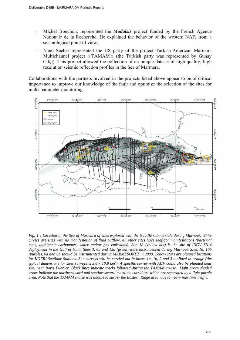
- Michel Bouchon, represented the Modalsis project funded by the French Agence Nationale de la Recherche. He explained the behavior of the western NAF, from a seismological point of view.
- Nano Seeber represented the US party of the project Turkish-American Marmara Multichannel project « TAMAM » (the Turkish party was represented by Günay Cifçi). This project allowed the collection of an unique dataset of high-quality, high resolution seismic reflection profiles in the Sea of Marmara.
Collaborations with the partners involved in the projects listed above appear to be of critical importance to improve our knowledge of the fault and optimize the selection of the sites for multi-parameter monitoring.
Fig. 1 : Location in the Sea of Marmara of sites explored with the Nautile submersible during Marnaut. White circles are sites with no manifestation of fluid outflow, all other sites have seafloor manifestations (bacterial mats, authigenic carbonates, water and/or gas emissions). Site 18 (yellow dot) is the site of INGV SN-4 deployment in the Gulf of Izmit. Sites 3, 6b and 13a (green) were instrumented during Marnaut. Sites 16, 10b (purple), 6a and 6b should be instrumented during MARMESONET in 2009. Yellow stars are planned locations for KOERI Seafloor Stations. Site surveys will be carried out in boxes 1a, 1b, 2 and 3 outlined in orange (the typical dimensions for sites surveys is 3.6 x 10.8 km2). A specific survey with AUV could also be planned near site, near Boris Bubbler. Black lines indicate tracks followed during the TAMAM cruise. Light green shaded areas indicate the northeastward and southwestward maritime corridors, which are separated by a light purple area. Note that the TAMAM cruise was unable to survey the Eastern Ridge area, due to heavy maritime traffic.
Deliverable D45B - MARMARA DM Periodic Reports
255
II. Synthesis of scientific presentations The full presentations (see list in Appendix 1) can be found at: http://www.cdf.u-3mrs.fr/~henry/marmara/ The major results are summarized in Fig. 1. Fluid emissions in the Sea of Marmara have been successfully mapped and sampled during the MarNaut cruise and a correlation with active faults is clearly established :
- The locked fault segment forming a seismic gap south of Istanbul exhibits relatively less gas emissions than the adjacent segments.
- Gas emissions sites that have been detected in 2000 were still active when revisited 7 years later.
- In the Çınarcık Basin, active gas emissions have been found above a buried transtensional fault zone, which extends westward, 40 to 60 km the zone where 1999 aftershocks were observed.
- Methane of thermogenic origin (based on Carbon isotopes) have been sampled at sites 6 and 10 (Fig. 1) but also traces of thermogenic ethane at Site 16 in the Çınarcık Basin, indicating fluid migration occurs through the syntectonics basins. Mantle helium was detected in gas escaping out of tension gashes at site 2 (Fig.
1), indicating migration of gases from the mantle to the seafloor Gas hydrates discovered on top of the western high (site 6, Fig. 1) exhibit a
signature indicating a connection with the Thrace basin hydrocarbon field; - Gas of dominantly bacterial origin have been sampled in the Çınarcık Basin (site 16,
Fig. 1), indicating a dominantly superficial origin.
- The analysis of OBSs data indicates that, in the absence of detailed station corrections, it is almost impossible to merge land and seafloor seismological datasets. This work underlines the critical necessity to improve the 3D-velocity models for integrating the land and seafloor networks.
- The presentation of Michel Bouchon suggests a new hypothesis to explain why no gas escapes have been detected on the locked fault segment located south of Istanbul. This segment could be characterized by low permeabilities within the fault zone, due to a relatively a narrow damage zone. It could have characteristics similar to those of the super-shear segments that ruptured during the Koaceli, 1999 earthquakes sequence.
In conclusion, all the ingredients are present for a fruitful, long-term collaboration between the KOERI/MSBO and the ESONET/MARMARA-DM projects. While seismometers are remote sensors that can monitor seismicity a few kilometers away from the earthquake source, the sensors used for monitoring the fluid properties need to be located precisely, near fluid escapes. Hence, it is critical to have a very good knowledge of the hydrogeological system, a major objective of the Marmara-DM project. In addition :
The KOERI project is of critical importance for the Marmara-DM project, as it will :
provide top-quality, real-time, broad-band seismological data pave the road for cabled, seafloor observatories in the Sea of Marmara
Deliverable D45B - MARMARA DM Periodic Reports
256

On the other hand, the Marmara-DM project is also important for the KOERI project, as it will :
provide site surveys at two KOERI sites (SBO-1 and SBO-2), including : i) the
micro-bathymetric mapping and ii) the fine-scale imagery of the fluid conduits beneath these observatory sites (see chapter III).
provide a better understanding of the hydro-geological system and its interaction with seismicity
help improve the 3D velocity model for the whole Marmara-Sea (by deploying short-period -4.5 Hz- OBSs during one year) , a critical issue for combining land and seafloor data.
III. Update5 on the operations at sea scheduled for 2009
III.1 Ship scheduled in 2009 in the Sea of Marmara a) R/V Le Suroit (Marmesonet cruise). This cruise is scheduled from august 23 (Istanbul) to October 2nd, 2009 (Istanbul). It will consist in 2 parts :
- Part 1 (21 days): EM 300 for the detection of bubble emissions over the whole Marmara Sea. AUV for micro-bathymetry, chirp and EK-60 bubble detection at three sites.
- Part 2 (14 days): High resolution seismics: 3D survey at one site - Part 3 (5 days): Instrument deployments
b) R/V Urania. The Italian CNR funded 4 weeks of R/V Urania (from Italy, on 22/09/09 to Italy, on 12/10/09) to conduct a high resolution side-scan sonar, chirp and multibeam data prior to the deployment of SN-4, the multi-parameter seafloor observatory developed by INGV. The site selected for SN-4 deployment in located in waters shallower than 200 m, at the entrance of the Gulf of Izmit. c) R/V Piri Reis: 10 are presently funded in 2009, to conduct high resolution seismic surveys at sites not covered with R/V Le Suroit. d) 3) R/V Yunus (İU Fisheries Faculty): one week of ship time has been required by ITU to use the Medusa system to decide the best location for SN4 deployment in east Çınarcık Basin or on the Eastern high (Site 10a). This cruise could be funded by MarmaraDM (estimated cost is 1500 €/day).
5 This chapter is an update of the conclusions that resulted from the Marmara-Dm kick-off that was held in Istanbul, on june 18th, 2008 (see meeting report on http://www.cdf.u-3mrs.fr/~henry/marmara/).
Deliverable D45B - MARMARA DM Periodic Reports
257
III.2 Priorities on site survey locations
High resolution (< 1 m), microbathymetric surveys will be conducted at three or four sites during the Marmesonet cruise, using the Ifremer AUV (see box coordinates, Table 1) :
Box 1a (Çinarcık Basin) is located where active gas emission sites have been found (in 2000 and 2007), above a buried transtensional zone that extends in the prolongation of the fault that ruptured in 1999. Box 1b, located at the entrance of the Gulf of Izmit, will be surveyed with R/V Urania, prior to the deployment of SN-4.
Box 2 (Istanbul) is centered on the Central High, less than 20 km to the SW of
Istanbul. This site is located on the “seismic gap”, a fault segment that did not rupture since at least 1766. Most manifestations of fluid outflow have been found on top of the anticlinal ridge, south of the main fault trace. There is little evidence for fluid emission along the fault trace itself.
Box 3 (Western High) is centered on the site where gas hydrates have been
discovered in 2007 with R/V L’Atalante. The box is located on the Western High that is cut by the main fault trace, between the Tekirdag and the Central basins.
Box 4 (Tekirdag Ganos) is centered on site 2, located on a secondary fault at the base
of the Ganos slope where strong bubbling of gas with Helium composition indicates a mantle contribution.
1a, 1b, 2 and 3 require detailed HR seismic site surveys. For the 3D, high-resolution seismic survey with R/V Le Suroi6t, the top priority target is Box2, south of Istanbul. Site surveys on the other sites will presumably be conducted with R/V Piri Reis. The Istanbul site, however, is located near the entrance of Bosphorus Straight in the navigation corridor, where the maritime traffic is known to be particularly intensive. Günay Çifçi mentions that seismic surveying in this area was not possible during the TAMAM cruise. Hence, high resolution seismics may simply not be feasible there. Additionally, the quality of imagery that may be expected from a HR seismic survey at this site should be assessed before performing 3D acquisition.
6 The experience of Ifremer-AS concerning 3HR survey is that there is no manoeuvrability of the vessel when the equipment is deployed :
it takes about 4 hours to deploy at sea or to take back on board the streamers and the source arrays minimum/maximum speed : 2/3 knots;
survey parameters : vessel speed 4-5 knots (max 6 knots; the swinging booms could not bear higher strength); maximum angle of rotation : 10°/minute maximum "emergency" depth of the streamers: around 5 meters for the head, around 15-20
meters for the tail (due to tail buoys) ; The final quality of the 3D data set relies greatly on the ability to follow, as far as possible, the navigation lines 25 meters apart.
Deliverable D45B - MARMARA DM Periodic Reports
258
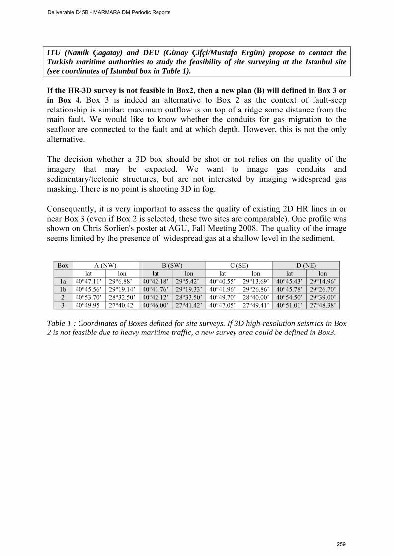
ITU (Namik Çagatay) and DEU (Günay Çifçi/Mustafa Ergün) propose to contact the Turkish maritime authorities to study the feasibility of site surveying at the Istanbul site (see coordinates of Istanbul box in Table 1). If the HR-3D survey is not feasible in Box2, then a new plan (B) will defined in Box 3 or in Box 4. Box 3 is indeed an alternative to Box 2 as the context of fault-seep relationship is similar: maximum outflow is on top of a ridge some distance from the main fault. We would like to know whether the conduits for gas migration to the seafloor are connected to the fault and at which depth. However, this is not the only alternative. The decision whether a 3D box should be shot or not relies on the quality of the imagery that may be expected. We want to image gas conduits and sedimentary/tectonic structures, but are not interested by imaging widespread gas masking. There is no point is shooting 3D in fog. Consequently, it is very important to assess the quality of existing 2D HR lines in or near Box 3 (even if Box 2 is selected, these two sites are comparable). One profile was shown on Chris Sorlien's poster at AGU, Fall Meeting 2008. The quality of the image seems limited by the presence of widespread gas at a shallow level in the sediment.
Box A (NW) B (SW) C (SE) D (NE) lat lon lat lon lat lon lat lon
1a 40°47.11’ 29°6.88’ 40°42.18’ 29°5.42’ 40°40.55’ 29°13.69’ 40°45.43’ 29°14.96’ 1b 40°45.56’ 29°19.14’ 40°41.76’ 29°19.33’ 40°41.96’ 29°26.86’ 40°45.78’ 29°26.70’ 2 40°53.70’ 28°32.50’ 40°42.12’ 28°33.50’ 40°49.70’ 28°40.00’ 40°54.50’ 29°39.00’ 3 40°49.95 27°40.42 40°46.00’ 27°41.42’ 40°47.05’ 27°49.41’ 40°51.01’ 27°48.38’
Table 1 : Coordinates of Boxes defined for site surveys. If 3D high-resolution seismics in Box 2 is not feasible due to heavy maritime traffic, a new survey area could be defined in Box3.
Deliverable D45B - MARMARA DM Periodic Reports
259
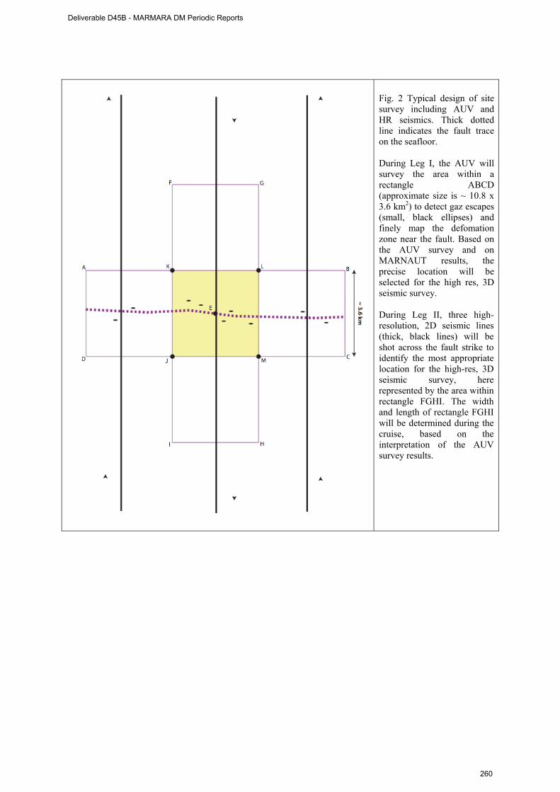
Fig. 2 Typical design of site survey including AUV and HR seismics. Thick dotted line indicates the fault trace on the seafloor. During Leg I, the AUV will survey the area within a rectangle ABCD (approximate size is ~ 10.8 x 3.6 km2) to detect gaz escapes (small, black ellipses) and finely map the defomation zone near the fault. Based on the AUV survey and on MARNAUT results, the precise location will be selected for the high res, 3D seismic survey. During Leg II, three high-resolution, 2D seismic lines (thick, black lines) will be shot across the fault strike to identify the most appropriate location for the high-res, 3D seismic survey, here represented by the area within rectangle FGHI. The width and length of rectangle FGHI will be determined during the cruise, based on the interpretation of the AUV survey results.
Deliverable D45B - MARMARA DM Periodic Reports
260
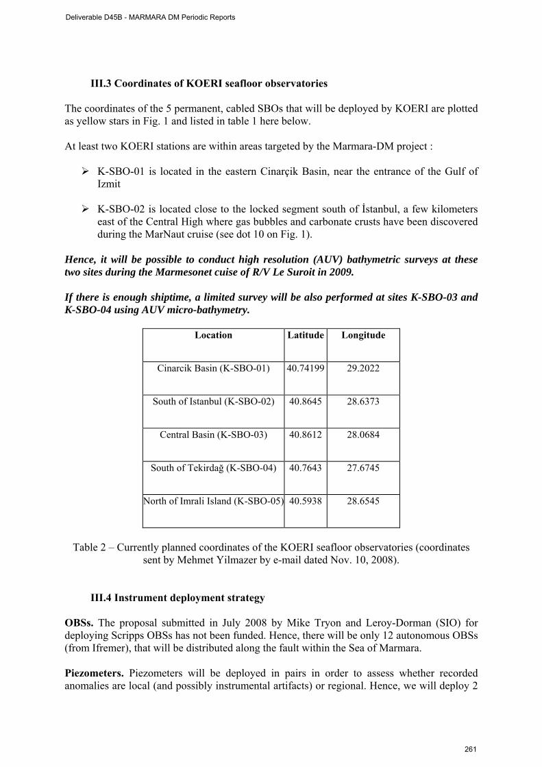
III.3 Coordinates of KOERI seafloor observatories
The coordinates of the 5 permanent, cabled SBOs that will be deployed by KOERI are plotted as yellow stars in Fig. 1 and listed in table 1 here below. At least two KOERI stations are within areas targeted by the Marmara-DM project :
K-SBO-01 is located in the eastern Cinarçik Basin, near the entrance of the Gulf of Izmit
K-SBO-02 is located close to the locked segment south of İstanbul, a few kilometers
east of the Central High where gas bubbles and carbonate crusts have been discovered during the MarNaut cruise (see dot 10 on Fig. 1).
Hence, it will be possible to conduct high resolution (AUV) bathymetric surveys at these two sites during the Marmesonet cuise of R/V Le Suroit in 2009. If there is enough shiptime, a limited survey will be also performed at sites K-SBO-03 and K-SBO-04 using AUV micro-bathymetry.
Location
Latitude
Longitude
Cinarcik Basin (K-SBO-01)
40.74199
29.2022
South of Istanbul (K-SBO-02)
40.8645
28.6373
Central Basin (K-SBO-03)
40.8612
28.0684
South of Tekirdağ (K-SBO-04)
40.7643
27.6745
North of Imrali Island (K-SBO-05)
40.5938
28.6545
Table 2 – Currently planned coordinates of the KOERI seafloor observatories (coordinates
sent by Mehmet Yilmazer by e-mail dated Nov. 10, 2008).
III.4 Instrument deployment strategy
OBSs. The proposal submitted in July 2008 by Mike Tryon and Leroy-Dorman (SIO) for deploying Scripps OBSs has not been funded. Hence, there will be only 12 autonomous OBSs (from Ifremer), that will be distributed along the fault within the Sea of Marmara. Piezometers. Piezometers will be deployed in pairs in order to assess whether recorded anomalies are local (and possibly instrumental artifacts) or regional. Hence, we will deploy 2
Deliverable D45B - MARMARA DM Periodic Reports
261
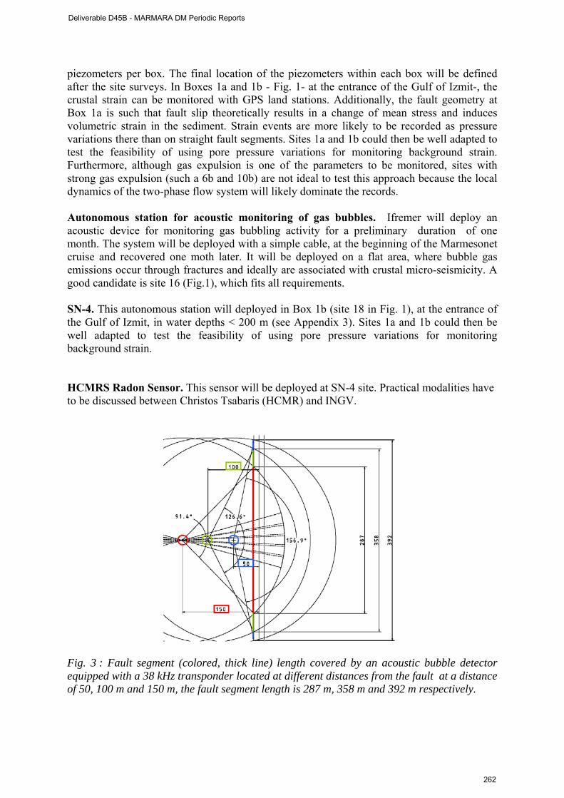
piezometers per box. The final location of the piezometers within each box will be defined after the site surveys. In Boxes 1a and 1b - Fig. 1- at the entrance of the Gulf of Izmit-, the crustal strain can be monitored with GPS land stations. Additionally, the fault geometry at Box 1a is such that fault slip theoretically results in a change of mean stress and induces volumetric strain in the sediment. Strain events are more likely to be recorded as pressure variations there than on straight fault segments. Sites 1a and 1b could then be well adapted to test the feasibility of using pore pressure variations for monitoring background strain. Furthermore, although gas expulsion is one of the parameters to be monitored, sites with strong gas expulsion (such a 6b and 10b) are not ideal to test this approach because the local dynamics of the two-phase flow system will likely dominate the records. Autonomous station for acoustic monitoring of gas bubbles. Ifremer will deploy an acoustic device for monitoring gas bubbling activity for a preliminary duration of one month. The system will be deployed with a simple cable, at the beginning of the Marmesonet cruise and recovered one moth later. It will be deployed on a flat area, where bubble gas emissions occur through fractures and ideally are associated with crustal micro-seismicity. A good candidate is site 16 (Fig.1), which fits all requirements. SN-4. This autonomous station will deployed in Box 1b (site 18 in Fig. 1), at the entrance of the Gulf of Izmit, in water depths < 200 m (see Appendix 3). Sites 1a and 1b could then be well adapted to test the feasibility of using pore pressure variations for monitoring background strain. HCMRS Radon Sensor. This sensor will be deployed at SN-4 site. Practical modalities have to be discussed between Christos Tsabaris (HCMR) and INGV.
Fig. 3 : Fault segment (colored, thick line) length covered by an acoustic bubble detector equipped with a 38 kHz transponder located at different distances from the fault at a distance of 50, 100 m and 150 m, the fault segment length is 287 m, 358 m and 392 m respectively.
Deliverable D45B - MARMARA DM Periodic Reports
262
IV. Actions to be taken :
1) Ifremer : require authorization for work in the SoM, via the Ministry of Foreign Affairs 2) ITU : action for support of the Turkish Navy. Determine feasibility of site surveying on
Esonet sites 2 (SW Istanbul) and 3 (Eastern high). See box coordinates in Table 1. 3) DEU : require shiptime survey for Esonet sites 1 and 2 4) Ifremer, Ismar, DEU : coordinate ship operations in 2009 5) KOERI & Guralp : Provide cost estimation for deploying one cable to Istanbul seafloor
observatory site (Box2, Fig. 1). 6) ITU and all partners : fund rising for deploying a cable, from land to the Istanbul
seafloor observatory site. 6) LDEO : provide a few selected lines that could help preparing the lay-out of the site
surveys scheduled in 2009. The requested lines that could be very useful at this stage are7 : Lines 22b, 24c across the locked segment fault SW of Istanbul ; Lines 34 and 30 across the fault segment that joins the Tekirdag and Central Basins, cutting the Western Ridge.
7) All partners are invited to participate to the ESONET Exchange Programme (this was
actually done ; proposals were sent on November 21st, 2009).
V. Next meeting : Bilateral meetings will be needed in early 2009, for coordinating the marine
operations and to examine available data, most particularly the seismic data from the TAMAM cruise (the Marmara-Dm partners and KOERI have thus submitted a significant number of proposals to participate to the Esonet Exchange programme call, which closed on November 21st, 2008). EUG meeting in Vienna (April 2009) could be a good opportunity for a general
project meeting8, if needed.
7 This selection of lines was discussed during the Marmara-DM meeting in Brest. 8 Idem. This is a mere suggestion that was not discussed in Brest.
Deliverable D45B - MARMARA DM Periodic Reports
263
Sub-Appendix 1
Marmara-DM Second Meeting, Brest, October 29-30, 2008 Room : Salle de l’Océan
Agenda DAY 1 : Science Meeting
Morning Session : Fluids along the Sea of Marmara / Results from the MarNaut cruise 0830-0900 Icebreaker Coffee 0900-0915 L. Géli : Introduction 0915-0935 N. Cagatay : Geological hazards in the Sea of Marmara 0935-1020 P. Henry : General synthesis of MarNaut results 1020-1040 Coffee Break 1040-1140 M. Bouchon : Seismological characteristics and fine scale structure of the North Anatolian Fault 1140-1230 M. Ylmazer/D. Kalafat/G. Altay : KOERI’s Cabled Observatory Project : description and technical
constraints 1230-1300 Discussion 1300-1400 Lunch Afternoon session : Related projects 1400-1430 Y. Auffret : Technical options for multi-parameter seafloor observatories 1430-1450 JB Tary : Microseismicity in the Tekirdag Basin : updated results 1450-1510 S. Bourlange/P. Burnard : Updated Helium Isotopes results and geodynamic implications 1510-1530 L. Rufine/C. Bourry / JL Charlou / Gaz hydrates geochemistry : updated results and connexion with
the Thrace basin hydrocarbons 1530-1550 C. Pierre : Methane related carbonates from the Marmara sea 1550-1610 Discussion 1610-1630 Coffee break 1630-1730 Gunay Cifçi & Leonardo Seeber : Recent results from the TAMAM Cruise collected with DEU/HR
seismics facilities (2 presentations) 1730-1815 Discussion DAY 2 : Marmesonet 2009 Cruise planning 0900-0915 L. Géli : Marmesonet and ESONET/Marmara-DM general objectives 0915-0945 Patrice Lubin : AUV description and technical constraints 0945-1015 Y. Thomas / S. Ker : Ifremer HR Seismics, description and technical constraints 1015-1030 Coffee Break 1100-1130 C. Saclabrin, N. Lanteri P. Pelleau, R. Apprioual : constraints imposed by instrumentation (discussion) 1130-1230 Discussion on Observatory Sites and Site Surveys strategy 1230-1330 Lunch 1330-1600 Discussion on Finalized cruise plan 1600-1615 Coffee break 1615-1715 L. Géli : MARMARA-DM road map 1715-1745 What’s next : task distribution (who does what), data processing, PhD Thesis, personnel exchange,
fund rising, etc 1745-1800 Final Conclusions
Deliverable D45B - MARMARA DM Periodic Reports
264

Sub-Appendix 2
List of participants
Altay Gülay KOERI (Istanbul) [email protected]
Auffret Yves Ifremer (Brest) [email protected]
Bouchon Michel LGIT (Grenoble) [email protected]
Bourlange Sylvain CRPG (Nancy) [email protected]
Bourry Christophe Ifremer (Brest) [email protected]
Cagatay M.Namık ITU (Istanbul) [email protected]
Charlou Jean-Luc Ifremer (Brest) [email protected]
Çifçi Günay DEU (Izmir) [email protected]
Dupré Stéphanie UPMC/Locéan (Paris) [email protected]
Ergun Mustafa DEU (Izmir) [email protected]
Géli Louis Ifremer (Brest) [email protected]
Guralp Cansu GURALP Systems Ltd (Reading, UK) [email protected]
Henry Pierre CEREGE/CNRS (Aix en P.) [email protected]
Kalafat Dogan KOERI (Istanbul) [email protected]
Ker Stéphane Ifremer (Brest) [email protected]
Lanteri Nadine Ifremer (Brest) [email protected]
Le Ricolais Gilles Ifremer (Brest) [email protected]
Lubin Patrice Genavir (Toulon) [email protected]
Person Roland Ifremer (Brest) [email protected]
Pierre Catherine UPMC/Locéan (Paris) [email protected]
Ruffine Livio Ifremer (Brest) [email protected]
Rolin Jean-François Ifremer (Brest) [email protected]
Scalabrin Carla Ifremer (Brest) [email protected]
Seeber Leonardo LDEO [email protected]
Tary Jean-Baptiste Ifremer (Brest) [email protected]
Thomas Yannick Ifremer (Brest) [email protected]
Tsabaris Christos HCMR (Athens) [email protected]
ÜLgen Umut ITU (Istanbul) [email protected]
Yilmazer Mehmet KOERI (Istanbul) [email protected]
Deliverable D45B - MARMARA DM Periodic Reports
265
Sub-Appendix 3 - Note Prepared by the Italian partners
SOME NOTES ON SN-4 OBSERVATORY DEPLOYMENT IN THE SEA OF MARMARA (ESONET Demo-Mission project) – October 2008
L. Gasperini, ISMAR-CNR, Bologna
P. Favali, G. Marinaro, G. Etiope, INGV, Roma 1. Site selection After several years of geo-marine studies, which include collection and interpretation of high-resolution morhobathymetric maps, chirp-sonar profiles, side-scan sonar images, MCS profiles and tens of well-targeted gravity and piston cores, we can conclude that that the Gulf of Izmit is characterized by the presence of a wide (>10 km) deformation zone across the trace of the NAF system. However, during the last 10,000 years, where accurate stratigraphic constraints are available, we are able to locate some areas where the PDF (principal deformation zone) is extremely narrow and shows an almost pure strike-slip deformation pattern. Due to the presence of piercing- points, we were able to estimate very accurately horizontal and vertical deformation rates along these fault strands during the Holocene (10 mm/y, Polonia et al., 2004).
Deliverable D45B - MARMARA DM Periodic Reports
266
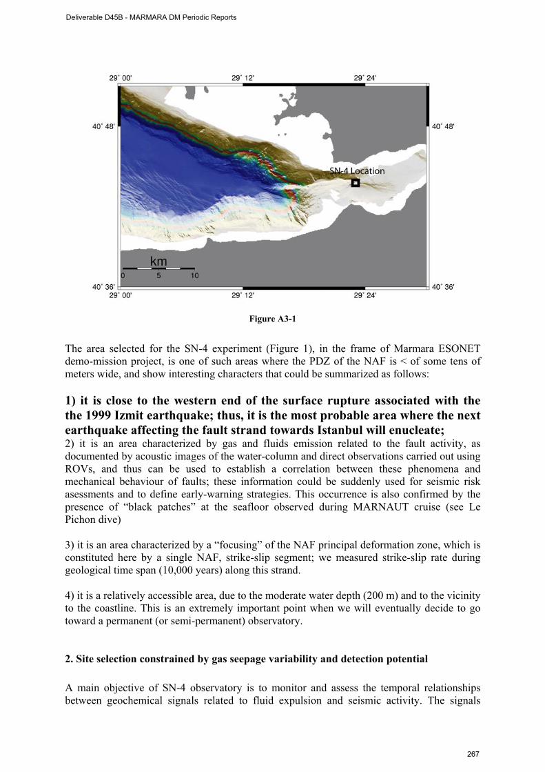
Figure A3-1
The area selected for the SN-4 experiment (Figure 1), in the frame of Marmara ESONET demo-mission project, is one of such areas where the PDZ of the NAF is < of some tens of meters wide, and show interesting characters that could be summarized as follows: 1) it is close to the western end of the surface rupture associated with the the 1999 Izmit earthquake; thus, it is the most probable area where the next earthquake affecting the fault strand towards Istanbul will enucleate; 2) it is an area characterized by gas and fluids emission related to the fault activity, as documented by acoustic images of the water-column and direct observations carried out using ROVs, and thus can be used to establish a correlation between these phenomena and mechanical behaviour of faults; these information could be suddenly used for seismic risk asessments and to define early-warning strategies. This occurrence is also confirmed by the presence of “black patches” at the seafloor observed during MARNAUT cruise (see Le Pichon dive) 3) it is an area characterized by a “focusing” of the NAF principal deformation zone, which is constituted here by a single NAF, strike-slip segment; we measured strike-slip rate during geological time span (10,000 years) along this strand. 4) it is a relatively accessible area, due to the moderate water depth (200 m) and to the vicinity to the coastline. This is an extremely important point when we will eventually decide to go toward a permanent (or semi-permanent) observatory. 2. Site selection constrained by gas seepage variability and detection potential A main objective of SN-4 observatory is to monitor and assess the temporal relationships between geochemical signals related to fluid expulsion and seismic activity. The signals
Deliverable D45B - MARMARA DM Periodic Reports
267
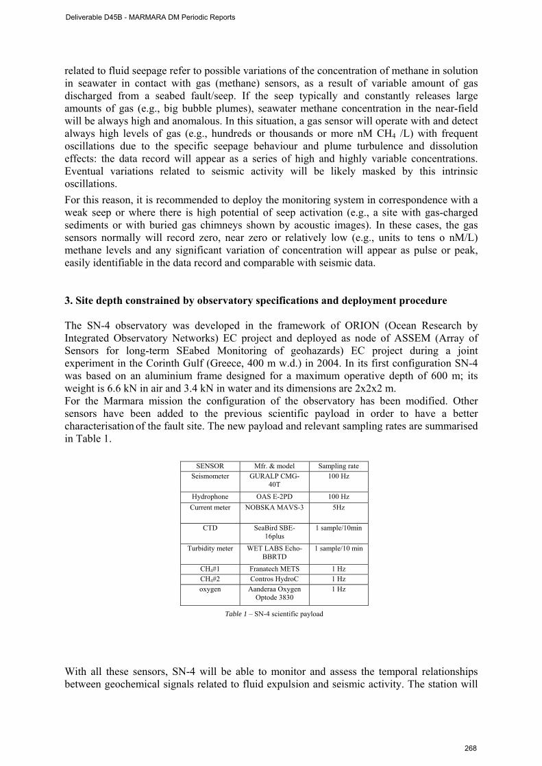
related to fluid seepage refer to possible variations of the concentration of methane in solution in seawater in contact with gas (methane) sensors, as a result of variable amount of gas discharged from a seabed fault/seep. If the seep typically and constantly releases large amounts of gas (e.g., big bubble plumes), seawater methane concentration in the near-field will be always high and anomalous. In this situation, a gas sensor will operate with and detect always high levels of gas (e.g., hundreds or thousands or more nM CH4 /L) with frequent oscillations due to the specific seepage behaviour and plume turbulence and dissolution effects: the data record will appear as a series of high and highly variable concentrations. Eventual variations related to seismic activity will be likely masked by this intrinsic oscillations. For this reason, it is recommended to deploy the monitoring system in correspondence with a weak seep or where there is high potential of seep activation (e.g., a site with gas-charged sediments or with buried gas chimneys shown by acoustic images). In these cases, the gas sensors normally will record zero, near zero or relatively low (e.g., units to tens o nM/L) methane levels and any significant variation of concentration will appear as pulse or peak, easily identifiable in the data record and comparable with seismic data. 3. Site depth constrained by observatory specifications and deployment procedure The SN-4 observatory was developed in the framework of ORION (Ocean Research by Integrated Observatory Networks) EC project and deployed as node of ASSEM (Array of Sensors for long-term SEabed Monitoring of geohazards) EC project during a joint experiment in the Corinth Gulf (Greece, 400 m w.d.) in 2004. In its first configuration SN-4 was based on an aluminium frame designed for a maximum operative depth of 600 m; its weight is 6.6 kN in air and 3.4 kN in water and its dimensions are 2x2x2 m. For the Marmara mission the configuration of the observatory has been modified. Other sensors have been added to the previous scientific payload in order to have a better characterisation of the fault site. The new payload and relevant sampling rates are summarised in Table 1.
With all these sensors, SN-4 will be able to monitor and assess the temporal relationships between geochemical signals related to fluid expulsion and seismic activity. The station will
SENSOR Mfr. & model Sampling rate Seismometer GURALP CMG-
40T 100 Hz
Hydrophone OAS E-2PD 100 Hz Current meter NOBSKA MAVS-3 5Hz
CTD SeaBird SBE-16plus
1 sample/10min
Turbidity meter WET LABS Echo-BBRTD
1 sample/10 min
CH4#1 Franatech METS 1 Hz CH4#2 Contros HydroC 1 Hz oxygen Aanderaa Oxygen
Optode 3830 1 Hz
Table 1 – SN-4 scientific payload
Deliverable D45B - MARMARA DM Periodic Reports
268
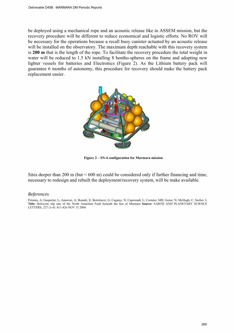
be deployed using a mechanical rope and an acoustic release like in ASSEM mission, but the recovery procedure will be different to reduce economical and logistic efforts. No ROV will be necessary for the operations because a recall buoy canister actuated by an acoustic release will be installed on the observatory. The maximum depth reachable with this recovery system is 200 m that is the length of the rope. To facilitate the recovery procedure the total weight in water will be reduced to 1.5 kN installing 8 bentho-spheres on the frame and adopting new lighter vessels for batteries and Electronics (Figure 2). As the Lithium battery pack will guarantee 6 months of autonomy, this procedure for recovery should make the battery pack replacement easier.
Figure 2 – SN-4 configuration for Marmara mission
Sites deeper than 200 m (but < 600 m) could be considered only if further financing and time, necessary to redesign and rebuilt the deployment/recovery system, will be make available. References Polonia, A; Gasperini, L; Amorosi, A; Bonatti, E; Bortoluzzi, G; Cagatay, N; Capotondi, L; Cormier, MH; Gorur, N; McHugh, C; Seeber, L Title: Holocene slip rate of the North Anatolian Fault beneath the Sea of Marmara Source: EARTH AND PLANETARY SCIENCE LETTERS, 227 (3-4): 411-426 NOV 15 2004
Deliverable D45B - MARMARA DM Periodic Reports
269
Sub-Appendix 4 : Timing constraints for AUV and high resolution seismics with R/V Le Suroit
AUV
- Weight: 800kg - Length: 4.5m - Payload Capacity: 100kg (in water) with dimension constraints - Capacity: 12Kwh (Li/ion) - Autonomy: 80km (without payload, 3 Knots) - Maximum Depth:
• AsterX: 2650m • IdefX: 1500m ( 2800m for 2010)
- Speed: 1 –5knots - Profile follow-up: 35° of slope - Team: 3 pers without payload post-processing
- Payloads : • EK60 70KHz ( IXSEA) • EK60 200KHz (IXSEA) • CTD SBE 49/25/19 (SEABIRD) ( SBE -49 always on auv) • MultiBeams Sounder EM2000 (KONGSBERG) • ADCP 300/600/1200 Khz(RDI) • Fluorimeter • Sub-BottomProfiler ECHOES (IXSEA)
- Two out of 3 main payloads (multibeam echosounder EM2000, EK60 sounder and
Sub-bottom profiler) can work together on the same dive Pratical specifications on cruise
- Only one container with the auv and all its equipment - Need only a place for 2-3 computers in a scientific lab - Time of dive-preparation: 2 hours (mission plan, check-list, launching) - Time of dive : 10-11 hours( depends on the payload) at ~3 Knots (optimum speed) - Ship following: 3 knots max with GAPS - Recovery: ~ 3-4 hours - End dive Check-list: 1/2 hours - Batteries charging time: 12 hours
Surveying a 10.6 x 3.8 km2 area with lines spaced by about 125 m takes about 5 days
Deliverable D45B - MARMARA DM Periodic Reports
270

High Resolution seismics : 3D-acquisition system :
- Two arrays of sources (1 or 2 airguns per array) - Two streamers of 48 traces, 25 m apart - Maximum offset : 380 m - Source positioning - Depth controllers - Ship speed : 4 to 5 knots - Line spacing : 25 m - Streamer immersion : 3 m - Source immersion : 1.5 m - Shooting rate : 3 s
2D-acquisition system :
- One source array (up to 6 airguns) - One streamer up to 120 traces (6.25 m) - Maximum offset : 830 m - Ship speed : 4 to 5 knots - Line spacing : 25 m - Streamer immersion : 3 m - Source immersion : 1.5 m - Shooting rate : 3 to 6 s
Signal characteristics :
- frequency bandwidth: 30-250 Hz - vertical resolution ≈1.5-2.0 m - lateral resolution ≈6 m - several 100 m of penetration in sediments (typically 500-1000 m) - target depth including water column : best 200-500 m, reasonable 150-1200 m,
hazardous> 1500 m 3D Acquisition strategy :
- distance between sailed lines: 25 m - vessel speed : ~4-5 5 kts - min-maximum turning circle ≈30’ - optimization of sailed lines acquisition + in-fill - optimal size of the survey: 5 x 2 miles (34 km2) - 148 nominal sailed lines + ≈37 in-fill lines ≈ 1h45 per sailed line (4.5 1h45 per sailed
line (4.5 kts, including giration) - 13.5 days of 3D-acquisition
- Adding 1 day for :
vertical profiles of celerimetry 2D acquisition: regional profiles + accurate velocity estimation
Total : 14.5 days for full coverage of box 5 x 2 miles (34 km2)
Deliverable D45B - MARMARA DM Periodic Reports
271

Sub-Appendix 5 :
MAPS OF SEISMIC LINES SHOT DURING TAMAM Cruise, July/August 2008
Bathymetry in the center of the Marmara Sea from multibeam data (Rangin et al., 2001), and other bathymetry and onshore elevation from the GEBCO 1-minute atlas (IOC IHO BODC, 2003). Profile locations indicated with black lines. Every 200th shot is labeled with a black circle and text. Line numbers indicated in largerbold face type. Courtesy John Diebold, LDEO.
Deliverable D45B - MARMARA DM Periodic Reports
272
APPENDIX II
Letter requesting support vessel from SHOD (Turkish Department for Navigation, Hydrography and Oceanography)
Deliverable D45B - MARMARA DM Periodic Reports
273

APPENDIX 3
Letter sent by ITU to TPAO (Turkisk Petroleum Corporation),
Halit Halkan, Director of Exploration, on January 9th, 2009
Deliverable D45B - MARMARA DM Periodic Reports
274
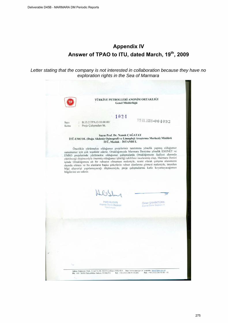
Appendix IV Answer of TPAO to ITU, dated March, 19th, 2009
Letter stating that the company is not interested in collaboration because they have no
exploration rights in the Sea of Marmara
Deliverable D45B - MARMARA DM Periodic Reports
275

Appendix V
Document sent by ITU to Turkish private petroleum companies explaining ESONET Marmara-DM Project and describing recent
findings regarding hydrocarbons in the Sea of Marmara
ESONET NoE (European Seas Observatory Network of Excellence)
Avrupa Denizleri Gözlem Ağı Mükemmeliyet Projesi ve Marmara Denizi Çalışmaları
ESONET Projesi
ESONET Avrupa Komisyonu (EC) tarafından 6. Çerçeve Programı projesi ile desteklenen bir mükemmelliyet ağı projesidir (http://www.esonet-emso.org/esonet-noe/). Bu projede 14 Ülke 50 değişik kurum tarafından temsil edilmektedir. Türkiye bu projede, İTÜ-EMCOL (İstanbul Teknik Üniversitesi-Eastern Mediterranean Centre for Oceanography and Limnology), Boğaziçi Üniversitesi Kandilli Rasathanesi ve Dokuz Eyül Üniversitesi Deniz Bilimleri ve Teknolojisi Enstitüsü tarafından temsil edilmektedir. İTÜ’den Prof.Dr. Namık Çağatay projenin yönetim kurulu üyesidir. Projenin koordinatörlüğünü Fransız Deniz Araştırmaları Enstitüsü IFREMER’den Dr. Roland Person yapmaktadır. ESONET Projenin AB tarafından sağlanan bütçesi 7,200.000 Euro’dur. Projenin bütçesinin yarısına yakını Avrupa Denizlerinde denizaltı gözlemleri ile ilgili tanıtım “demonstration mission” (DM) projelerine ayrılmıştır.
ESONET projesinin bilimsel amacı Avrupa ölçeğinde Kuzey Buz Denizi’nden Karadeniz’e dek uzanan denizlerde yer-biyosfer-hidrosfer etkileşim süreçleri ile ilgili uzun süreli ve gerçek zamanlı, çok-disiplinli deniz gözlemleri yapacak bir gözlem istasyonu mükemmelliyet ağının oluşturulmasıdır (Şekil 1). Böylece ESONET, uzun süreli bilgiler toplayarak, yerkürenin iç süreçleri, derin deniz biyolojisi, kimyası ve genel olarak oşinografi süreçlerini daha iyi anlamamıza bilimsel ufuklar açacaktır. Bu şekilde ESONET, GMES (Global Monitoring for Environment and Security: Küresel Çevre ve Güvenliğin İzlenmesi, http://www.gmes.info/) tarafından belirtilen “yerinde” ve “uydu” izleme sisteminin deniz ayağını oluşturarak, GMES’e önemli bir katkıda bulunma amacı gütmektedir. Bu tür gözlem istasyonlarının özellikle doğal afetlerin (deprem, deniz-altı yamaç kaymaları ve bunlara bağlı tsunami gibi) izlenmesi açısından ülkemiz için önemi büyüktür. ABD, Kanada and Japanya gibi ülkelerde deniz ve okyanuslarda doğal afetler, iklim ve çevresel değişim ve biyo-çeşitlilik gibi konularda gerçek zamanlı bilimsel gözlemler yapmak üzere
Deliverable D45B - MARMARA DM Periodic Reports
276
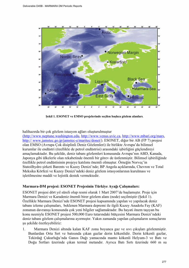
Şekil 1. ESONET ve EMSO projelerinde seçilen başlıca gözlem alanları.
halihazırda bir çok gözlem istasyon ağları oluşturulmuştur (http://www.neptune.washington.edu, http://www.venus.uvic.ca, http://www.mbari.org/mars, http:// www.jamstec.go.jp/jamstec-e/maritec/donet/). ESONET, diğer bir AB (FP 7) projesi olan EMSO (Avrupa Çok disiplinli Deniz Gözlemleri) ile birlikte Avrupa’da bilimsel kurumlar ile endüstri (özellikle de petrol endüstrisi) arasındaki işbirliğini güçlendireyi amaçlamaktadır. Bu şekilde, deniz tabanı gözlemleri konusunda Avrupa’nın ABD, Kanada, Japonya gibi ülkelerle olan rekabetinde önemli bir görev de üstlenmiştir. Bilimsel işbiriliğinde özellikle petrol endüstisinin projeye katılımı önemli olmuştur. Örneğin Norveç’in Statoilhydro şirketi Barents ve Kuzey Denizi’nde; BP Angola açıklarında, Chevron ve Total Meksika Körfezi ve Kuzey Denizi’ndeki deniz gözlem istasyonlarının kurulması ve işletilmesine maddi ve lojistik destek vermektedir.
Marmara-DM projesi: ESONET Projesinin Türkiye Ayağı Çalışmaları: ESONET projesi dört yıl süreli olup resmi olarak 1 Mart 2007’de başlamıştır. Proje için Marmara Denizi ve Karadeniz önemli birer gözlem alanı (node) seçilmiştir (Şekil 1). Özellikle Marmara Denizi’nde ESONET projesi kapsamında yapılan ve yapılacak deniz tabanı izleme çalışmaları, beklenen Marmara depremi ile ilgili Kuzey Anadolu Fay (KAF) zonunun davranışı konusunda çok yeni bilgiler sağlamaktadır. Bu hayati önem taşıyan bu konu neeniyle ESONET projesi 500,000 Euro tutarındaki bütçesini Marmara Denizi’ndeki deniz tabanı gözlem çalışmalarına ayırmıştır. Yakın zamanda yapılan çalışmaların sonuçlarını şu şekilde özetleyebiliriz: 1. Marmara Denizi altında kalan KAF zonu boyunca gaz ve sıvı çıkışları gözlenmiştir.
Bunlardan Orta Sırt ve batısında çıkan gazlar derin kökenlidir. Derin kökenli gazlar, Tekirdağ Çukurluğu’nda Ganos Dağı yamacında manto kökenli Helyum-3 ve Batı ve Doğu Sırtları üzerinde çıkan termal metandır. Ayrıca Batı Sırtı üzerinde 660 m su
Deliverable D45B - MARMARA DM Periodic Reports
277
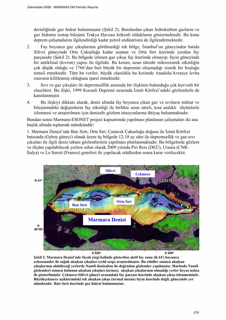
derinliğinde gaz hidrat bulunmuştur (Şekil 2). Buralardan çıkan hidrokarbon gazların ve gaz hidratın izotop bileşimi Trakya Havzası kökenli olduklarını göstermektedir. Bu konu deprem çalışmalarını ilgilendirdiği kadar petrol endüstrisini de ilgilendirmektedir.
2. Fay boyunca gaz çıkışlarının görülmediği tek bölge, İstanbul’un güneyinden batıda Silivri güneyinde Orta Çukurluğa kadar uzanan ve Orta Sırt üzerinde yeralan fay parçasıdır (Şekil 2). Bu bölgede izlenen gaz çıkışı fay üzerinde olmayıp; fayın güneyinde bir antiklinal (kıvrım) yapısı ile ilgilidir. Bu kesim, uzun süredir mikrosismik etkinliğin çok düşük olduğu ve 1766’dan beri büyük bir depremin oluşmadığı sismik bir boşluğu temsil etmektedir. Tüm bu veriler, büyük olasılıkla bu kesimde Anadolu/Avrasya levha sınırının kilitlenmiş olduğuna işaret etmektedir.
3. Sıvı ve gaz çıkışları ile depremselllik arasında bir ilişkinin bulunduğu çok kuvvetli bir olasılıktır. Bu ilişki, 1999 Kocaeli Depremi sırasında İzmit Körfezi’ndeki gözlemlerle de kanıtlanmıştır.
4. Bu ilişkiyi dikkate alarak, deniz altında fay boyunca çıkan gaz ve sıvıların miktar ve bileşimindeki değişimlerin fay etkinliği ile birlikte uzun süreli, kısa aralıklı ölçümlerle izlenmesi ve araştırılması için denizaltı gözlem istasyonlarına ihtiyaç bulunmaktadır.
Bundan sonra Marmara-ESONET projesi kapsamında yapılması planlanan çalışmaları iki ana başlık altında toplamak mümkündür: 1. Marmara Denizi’nde Batı Sırtı, Orta Sırt, Çınarcık Çukurluğu doğusu ile İzmit Körfezi batısında (Gebze güneyi) olmak üzere üç bölgede 12-18 ay süre ile depremsellik ve gaz-sıvı çıkışları ile ilgili deniz tabanı gözlemlerinin yapılması planlanmaktadır. Bu bölgelerde gözlem ve ölçüm yapılabilecek yerlere nihai olarak 2009 yılında Piri Reis (DEÜ), Urania (CNR-İtalya) ve Le Suroit (Fransız) gemileri ile yapılacak etüdlerden sonra karar verilecektir.
Şekil 2. Marmara Denizi’nde Siyah çizgi halinde gösterilen aktif fay zonu (KAF) boyunca echosounder ile soğuk akışkan çıkışları (cold seep) araştırılmıştır. Bu etüdler sonucu akışkan çıkışlarının olabileceği yerlerde Nautil denizaltısı ile doğrudan gözlemler yapılmıştır. Haritada Nautil gözlemleri sonucu bulunan akışkan çıkışları kırmızı; akışkan çıkışlarının olmadığı yerler beyaz nokta ile gösterilmiştir. Çekmece-Silivri güneyi arasındaki fay parçası üzerinde akışkan çıkışı izlenmemiştir. Büyükçekmece açıklarındaki tek akışkan çıkışı (termal metan) fayın üzerinde değil, güneyinde yer almaktadır. Batı Sırtı üzerinde gaz hidrat bulunmuştur.
Marmara Denizi
SilivriÇekmece
Orta SırtBatı Sırtı
Deliverable D45B - MARMARA DM Periodic Reports
278
2. Gözlemlerin yapılacağı üç istasyonda; gözenek suyu basıncı ölçen piezometre, sıvı çıkışlarını ölçen ve zaman serisi oluşturarak örnekleyen akışkan metre (flowmeter)-ozmometre (Şekil 4) ile küçük depremleri kayıt eden deniz tabanı sismometresi, metan, oksijen, hidrojen sülfür, türbidite, sıcaklık, tuzluluk ve basınç ölçen sensörleri içeren SN-4 istasyonu gibi cihaz ve sistemler kullanılacaktır. Ayrıca İzmit Körfezi batısında bir radon ölçen cihazın yerleştirilmesi düşünülmektedir. Cihazların yerleştirilmesi Le Suroit (Fransız) ve Urania gemileri ile 2009 yaz-sonbahar aylarında yapılacaktır. Gözlem istasyonlardan gerçek zamanlı veri elde etmek ve uzun süreli sorunsuz işletmek için karaya kablo ile bağlanması ve bunun için de ek kaynağa ihtiyaç bulunmaktedır. Deneme özelliğindeki bu etüdler ile en az 12 ay sürecek gözlemlerin sonuçları analiz edilerek, başlıca şu amaçlara ulaşılmaya çalışılacaktır: 1. Marmara Denizi tabanında özellikle depremle ilişkili en etkili izlemenin
yapılabileceği sürekli gözlem istasyonları için uygun yerlerin tesbit edilmesi, ve 2. Depremsellikle ilişkili en uygun parametrelerin saptanması, bunların ölçümü için
gerçek zamanlı ve sürekli ölçüm yapabilen gözlem istasyonlarının tasarlanması. Denizaltı deprem araştırmaları ile ilgili bu tür denemeler ve gözlemler dünyada henüz yeni olup, bu çalışmalarda yurtdışından getirilecek en son teknoloji cihaz ve cihaz sistemleri kullanılacaktır. Tasarlanacak sürekli gözlem istasyonlarından elde edilecek verilerden Marmara depremi ile ilgili ön uyarıcı sinyallerin elde edilmesi hedeflenmektedir. Ancak, bu hedefe ulaşmada henüz çalışmaların başlangıç aşamasında olduğumuzun bilincindeyiz. Kurulacak sürekli gözlem istasyonları; denizdeki deprem, yamaç kayması ve tsunami gibi doğal afetler yanında; oşinografik, derin deniz ekosistemindeki değişimler, iklim değişimi ve buna bağlı deniz-atmosfer etkileşimi gibi değişik disiplinlerle ilgili önemli bilgiler de sağlıyacaktır. ESONET Marmara-DM proje çalışmalarından bağımsız olarak Boğaziçi Üniversitesi Kandilli Rasathanesinin ulusal kaynaklarla başlattığı bir proje ile Marmara Denizi tabanında beş ayrı istasyon kurulacaktır. Bu deniz tabanı istasyonları ; üç bileşenli genişbantlı sismometre, ivme, sıcaklık, basınç ve akıntı ölçer sensörleri ile hidrofon içerecektir. Kıyıya fiber optic ve doğru-akım güç kablosu ile bağlanacak isasyonlardan gerçek zamanlı veriler elde edilecektir. Bu deniz-tabanı istasyonların yeni 10 adet kara istasyonu ile birlikte 2009 yılı ilkbaharında işletilmeye başlaması beklenilmektedir. Denizaltı Gözlemlerinin Petrol Endüstrisi ile İlişkisi
Deliverable D45B - MARMARA DM Periodic Reports
279
Denizaltı gözlemleri yamaç, şev duraylılığı açısından petrol sondajlarının yapılması ve işletilmesi sırasında petrol platformlarının güvenliği açısından önemlidir. Bu tür sakıncalı bölgelerin mikrosismik etkinliğinin sürekli izlenmesi gerekir. Benzer bir izleme, hidrokarbon rezervuarlarının dört boyutlu (4-D) izlenmesi için de yapılmaktadır. Özellikle sıvı enjeksiyonu sırasında mikrosismik etkinliğin izlenmesi önemlidir. Ayrıca oşinografik ölçümler, HC üretiminden doğacak olası çevre kirliliğinin erken teşhisi ve etkilerinin izlenmesi için de gereklidir. Daha küresel anlamda atmosfere olan fosil-yakıt kökenli karbon diyoksit salımlarıının iklim değişimi ve bunun denizlerdeki etkileri petrol endüstrisinin duyarlılık gösterdiği bir konu olup, bu konudaki araştırmalar petrol şirketleri tarafından desteklemektedir. Yukarıda belirtilen nedenlerle Fransız Deniz Araştırmaları Enstitüsü IREMER, TOTAL ve EXXON gibi petrol şirketleri ile işbirliği içerisinde offshore petrol arama-işletme etkinliklerinin olduğu bölgelere (Nijerya ve Kuzey Denizi gibi) OBS’ler ve gözenek suyu basıncı ölçen piezometreler yerleştirmiştir. Adı geçen petrol şirketleri bu çalışmaların altyapısını desteklemekte ve verilerinin işlenmesi için lisanüstü burslar vermektedir. Benzer şekilde BP, Aberdeen Üniversitesi (Ocean Lab) ile birlikte Angola açıklarındaki petrol işletim alanında, 1400 m su derinliğmde DELOS (Deep-ocean Environmental Long-term Observatory System) projesi (http://www.delos-project.org) kapsamında iki gözlem istasyonu işletmektedir. Norveç’in STATOILHYDRO şirketi Barents ve Kuzey Denizi’ndeki denizaltı gözlem projelerine bilimsel kurumlarla işbirliği yaparak destek olmuştur (http://www.serpentproject.com). CHEVRON, Meksika körfezi ve Kuzey Deniz’de Britanya sularında ve TOTAL Faroe-Şetland Kanalı civarında derin deniz gözlemleri ve gözlem istasyonlarının kurulması ve işletilmesine katkıda bulunmuştur.
Deliverable D45B - MARMARA DM Periodic Reports
280
1
ESONET Demonstration Missions
3rd Periodic Activity Report
The Periodic Activity Report contains an overview of the activities carried out during the reporting period, describes the progress in relation to the project objectives, the progress towards the milestones and deliverables set for the period, and any problems encountered and corrective actions taken. This document has to be filled in with reference to the DM Implementation plan. This means that Deliverables, Milestones and WPs have to be the same as in the DM Implementation plan. The Periodic Report contains 2 parts: - Part I: it is addressed to the coordinator with minimum input from the partners - Part II: it is addressed to each WP Leader and reports a detailed update of each WP activity at task level. The report includes a rough justification of the costs incurred and of the resources deployed by each contractor linking them to activities implemented and justifying their necessity. Finally the report contains information on use and dissemination activities. •Reporting period: •From June 1st, 2009 to January, 31st, 2010
Deliverable D45B - MARMARA DM Periodic Reports
281
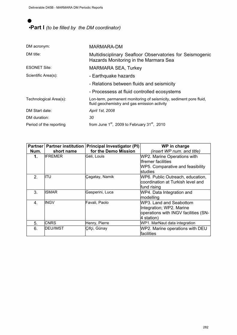
2
• •Part I (to be filled by the DM coordinator)
DM acronym: MARMARA-DM DM title: Multidisciplinary Seafloor Observatories for Seismogenic
Hazards Monitoring in the Marmara Sea ESONET Site: MARMARA SEA, Turkey Scientific Area(s): - Earthquake hazards
- Relations between fluids and seismicity - Processess at fluid controlled ecosystems
Technological Area(s): Lon-term, permanent monitoring of seismicity, sediment pore fluid, fluid geochemistry and gas emission activity
DM Start date: April 1st, 2008
DM duration: 30
Period of the reporting from June 1st, 2009 to February 31st, 2010 Partner Num.
Partner institution short name
Principal Investigator (PI) for the Demo Mission
WP in charge (insert WP num. and title)
1. IFREMER Géli, Louis WP2. Marine Operations with Ifremer facilities WP5. Comparative and feasibility studies
2. ITU Çagatay, Namik WP6. Public Outreach, education, coordination at Turkish level and fund rising
3. ISMAR Gasperini, Luca WP4. Data Integration and modelling
4. INGV Favali, Paolo WP3. Land and Seabottom Integration; WP2. Marine operations with INGV facilities (SN-4 station)
5. CNRS Henry, Pierre WP1. MarNaut data integration 6. DEU/IMST Çifçi, Günay WP2. Marine operations with DEU
facilities
Deliverable D45B - MARMARA DM Periodic Reports
282
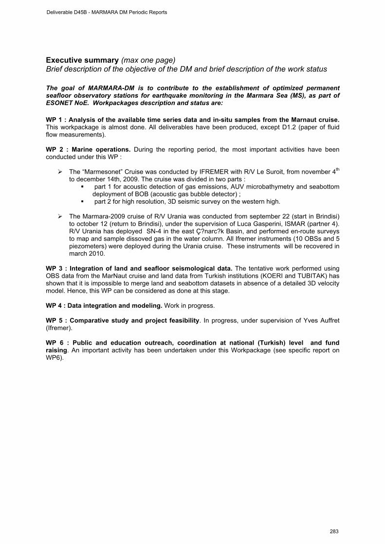
3
Executive summary (max one page) Brief description of the objective of the DM and brief description of the work status The goal of MARMARA-DM is to contribute to the establishment of optimized permanent seafloor observatory stations for earthquake monitoring in the Marmara Sea (MS), as part of ESONET NoE. Workpackages description and status are: WP 1 : Analysis of the available time series data and in-situ samples from the Marnaut cruise. This workpackage is almost done. All deliverables have been produced, except D1.2 (paper of fluid flow measurements). WP 2 : Marine operations. During the reporting period, the most important activities have been conducted under this WP :
The “Marmesonet” Cruise was conducted by IFREMER with R/V Le Suroit, from november 4th to december 14th, 2009. The cruise was divided in two parts :
part 1 for acoustic detection of gas emissions, AUV microbathymetry and seabottom deployment of BOB (acoustic gas bubble detector) ;
part 2 for high resolution, 3D seismic survey on the western high.
The Marmara-2009 cruise of R/V Urania was conducted from september 22 (start in Brindisi) to october 12 (return to Brindisi), under the supervision of Luca Gasperini, ISMAR (partner 4). R/V Urania has deployed SN-4 in the east Ç?narc?k Basin, and performed en-route surveys to map and sample dissoved gas in the water column. All Ifremer instruments (10 OBSs and 5 piezometers) were deployed during the Urania cruise. These instruments will be recovered in march 2010.
WP 3 : Integration of land and seafloor seismological data. The tentative work performed using OBS data from the MarNaut cruise and land data from Turkish institutions (KOERI and TUBITAK) has shown that it is impossible to merge land and seabottom datasets in absence of a detailed 3D velocity model. Hence, this WP can be considered as done at this stage. WP 4 : Data integration and modeling. Work in progress. WP 5 : Comparative study and project feasibility. In progress, under supervision of Yves Auffret (Ifremer). WP 6 : Public and education outreach, coordination at national (Turkish) level and fund raising. An important activity has been undertaken under this Workpackage (see specific report on WP6).
Deliverable D45B - MARMARA DM Periodic Reports
283
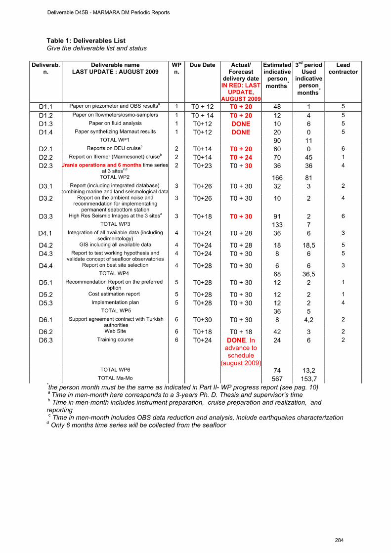
4
Table 1: Deliverables List Give the deliverable list and status
Deliverab. n.
Deliverable name LAST UPDATE : AUGUST 2009
WP n.
Due Date Actual/ Forecast
delivery date IN RED: LAST
UPDATE, AUGUST 2009
Estimated indicative
person months*
3rd period Used
indicative person
months*
Lead contractor
D1.1 Paper on piezometer and OBS resultsa 1 T0 + 12 T0 + 20 48 1 5 D1.2 Paper on flowmeters/osmo-samplers 1 T0 + 14 T0 + 20 12 4 5 D1.3 Paper on fluid analysis 1 T0+12 DONE 10 6 5 D1.4 Paper synthetizing Marnaut results 1 T0+12 DONE 20 0 5
TOTAL WP1 90 11 D2.1 Reports on DEU cruiseb 2 T0+14 T0 + 20 60 0 6 D2.2 Report on Ifremer (Marmesonet) cruiseb 2 T0+14 T0 + 24 70 45 1 D2.3 Urania operations and 6 months time series
at 3 sitesc,d 2 T0+23 T0 + 30 36 36 4
TOTAL WP2 166 81 D3.1 Report (including integrated database)
combining marine and land seismological data 3 T0+26 T0 + 30 32 3 2
D3.2 Report on the ambient noise and recommendation for implementating
permanent seabottom station
3 T0+26 T0 + 30 10 2 4
D3.3 High Res Seismic Images at the 3 sitesa 3 T0+18 T0 + 30 91 2 6 TOTAL WP3 133 7
D4.1 Integration of all available data (including sedimentology)
4 T0+24 T0 + 28 36 6 3
D4.2 GIS including all available data 4 T0+24 T0 + 28 18 18,5 5 D4.3 Report to test working hypothesis and
validate concept of seafloor observatories 4 T0+24 T0 + 30 8 6 5
D4.4 Report on best site selection 4 T0+28 T0 + 30 6 6 3 TOTAL WP4 68 36,5
D5.1 Recommendation Report on the preferred option
5 T0+28 T0 + 30 12 2 1
D5.2 Cost estimation report 5 T0+28 T0 + 30 12 2 1 D5.3 Implementation plan 5 T0+28 T0 + 30 12 2 4
TOTAL WP5 36 5 D6.1 Support agreement contract with Turkish
authorities 6 T0+30 T0 + 30 8 4,2 2
D6.2 Web Site 6 T0+18 T0 + 18 42 3 2 D6.3 Training course 6 T0+24 DONE. In
advance to schedule
(august 2009)
24 6 2
TOTAL WP6 74 13,2 TOTAL Ma-Mo 567 153,7 *the person month must be the same as indicated in Part II- WP progress report (see pag. 10) a Time in men-month here corresponds to a 3-years Ph. D. Thesis and supervisor’s time b Time in men-month includes instrument preparation, cruise preparation and realization, and reporting c Time in men-month includes OBS data reduction and analysis, include earthquakes characterization d Only 6 months time series will be collected from the seafloor
Deliverable D45B - MARMARA DM Periodic Reports
284

5
Man-Month DISTRIBUTION BY WP, 3rd reporting period (June 1st, 2009 - January 31st, 2010) WP1 WP2 WP3 WP4 WP5 WP6 TOTAL
3rd P. Total
3rd P. Total
3rd P.s Total
3rd P. Total
3rd P. Total
3rd P. Total
Total 3rd
Total 1s+2ndt
+3rd Total
Expect. ITU 2,5 12 5,5 15 0,5 8 10,5 10 3 10 11,5 36 33,5 65,5 91 DEU 0 0 5,5 60 0,5 72 21 14 0 10 0,2 12 27,2 60,2 168
Ifremer 1 36 20 42 2 16 1 14 2 8 1 12 27 82,8 128 CNRS 4 30 4 7 1 10 3 8 0 0 0,5 3 12,5 32,5 58 INGV 3 4 24 30 1 15 0 12 0 7 0 7 28 47,5 75
ISMAR 0,5 8 12 12 2 12 1 10 0 1 0 4 15,5 22,5 47 Total 11 90 71 166 7 133 36,5 68 5 36 13,2 74 143,7 301 567
Ma-Mo by deliverable
PR
EV
ISIO
NA
L
US
ED
(1st
per
iod)
US
ED
(2nd
per
iod)
US
ED
(3rd
per
iod)
D1.1 48 10 2 1 D1.2 12 0 0 4 D1.3 10 3 2 6 D1.4 20 10 2,5 0
SUM WP1 90 23 6,5 11 D2.1 60 10 0 0 D2.2 70 20 0 40 D2.3 36 4 24,3 31
SUM WP2 166 34 24,3 71 D3.1 32 2 0 3 D3.2 10 2 3,5 2 D3.3 91 0 0 2
SUM WP3 133 4 3,5 7 D4.1 36 17 6 D4.2 18 17,5 18,5 D4.3 8 0 6 D4.4 6 0 6
SUM WP4 68 0 34,5 36,5 D5.1 12 0 2 D5.2 12 0 2 D5.3 12 0 1
SUM WP5 36 0 0 5 D6.1 8 4 4 4,2 D6.2 42 8 4 3 D6.3 24 4,5 3 6
SUM WP6 74 16,5 11 13,2 TOTAL 567 77,5 79,8 143,7
Deliverable D45B - MARMARA DM Periodic Reports
285
6
Part II (to be filled by each partners)
ESONET Noe – Demonstration Mission DM acronym: MARMARA-DM
Scientific Area(s): - Earthquake hazards
- Relations between fluids and seismicity
- Processess at fluid controlled ecosystems
Technological Area(s): Lon-term, permanent monitoring of seismicity, sediment pore fluid, fluid geochemistry and gas emission activity
DM Start date: April 1st, 2008
DM duration: 30
Deliverable D45B - MARMARA DM Periodic Reports
286
7
WP1 management report from June 1st, 2009 to February 31st, 2010
WORKPACKAGE WP1
Full WP title ANALYSIS OF DATA FROM MARNAUT CRUISE
Period covered from September 1st, 2008 to 30/05/2009 Partner organisation full name CNRS / CEREGE / Chaire de Géodynamique du Collège de
France
Person in charge for the report (WP Leader)
Pierre Henry
Partners involved in the Work 5, 1, 2, 3
WP1: Integrate data collected during MarNaut cruise ; publish scientific results ; produce recommendations for the present demonstration mission
- D1.1 Paper on piezometer and OBS results - D1.2 Paper on flowmeters /osmo-samplers - D1.3 Paper on fluid analysis D1.4 Paper synthezing Marnaut results
Period of reporting: from June 1st, 2009 to February 31st, 2010. Provide a justification of the major costs incurred and resources deployed, linking them to activities implemented and explaining their necessity. • Work Performed : A brief description (max 700 char) of the work performed by
each contractor during the period.
Analysis of the OBS data from Marnaut identified a cluster of microearthquake below the western edge of Tekirdag Basin, and focal mechanisms were determined. An article was submitted in January 2010 (Tary et al., see D1.1). Piezometer data analyses requires oedometer tests on core samples. These are currently performed at IFREMER. Hydrocarbon gas analysis showed the presence of thermogenic gasses originating from Thrace Basin source rocks, which are part of the pre-tectonic basement of the Sea-of Marmara Basins. The presence of gases coming from below the recent sedimentary layers is one argument to favor the Western High site for monitoring fluid outflow in relation with crustal deformation. Analytical data of gas sampled in the Marmara seeps have been elaborated in collaboration with IFREMER researchers. New interpretative models on the origin of gas have been provided and integrated in a work (IFREMER-INGV co-autorship) presently submitted for publication in a peer-reviewed journal. After an initial delay caused by custom problems during the transfer of the instruments, preliminary results from osmotic flow meter were provided by Mike Tryon (SIO). Variations of water fluxes with time were reccorded. Manuscript submission is expected this fall (Deliverable D1.2). Seven flowmeters / osmosamplers from the Scripps Institution of Oceanography were deployed during the Marnaut cruise in May/June 2007. The instruments were recovered in June 2008 arrived in april 2009 in La Jolla. Hence, the work is still in progress. Preliminary results are : Tekirdag site : The instrument in the basin (not near the fault scarp) and near OBS shows very slow downflow that slows even more on about Oct 1, 2007. The instrument near the fault scarp on a microbial mat patch indicated slow upflow with a higher flow event starting about Oct 1, 2007 and lasting 5-6 weeks and another smaller and shorter event in early January 2008.
Deliverable D45B - MARMARA DM Periodic Reports
287
8
Western High hydrocarbon seep : The instrument in the bubble field indicated no net flow. May just be a lot of rapid oscillations due to gas. The instrument on the large seep with the white flow pattern downslope had low flow for most of the time but there was high flow event that ramped up quickly in early Nov, lasted a couple weeks, then diminished and was over by mid Dec. Cinarcik north scarp : one instrument had very very slow upflow and the other had moderate flow at first that starting to diminish rapidly about Sep 15, 2007 and then stayed at low flow for the rest of the deployment. Looks like this area may have very widely distributed flow that is quite low but the completely anoxic bottom water keeps the seep black patches from oxidizing so things look a bit more active than it appeared. The copper coils on these two instruments still looked like new when they were recovered so there is no oxygen in this water (the area is known for being anoxic). Observations made at fluid emission sites and fault outcrops with Nautile during Marnaut cruise will be integrated with AUV microbathymetric data and reflectivity images from Marmesonet cruise (see WP2) and interpreted in the PhD work of Celine Grall (at CEREGE and IFREMER). The work performed under WP1 consist in analyzing the data collected during the MarNaut cruise. Three papers that have been already published :
- On the acoustic detection of gas emissions [Géli et al, EPSL, 274, 34-39, 2008] - On the relations between faults and cold seeps [Zitter et al, Deep Sea Research, Part 1, 55(4),
552-570, doi:10.1016/j.dsr.2008.01.002, 2008] - On the geochemical analysis of gases [Bourry, C., et al., Chemical Geology, doi:10.1016/
j.chemgeo.2009.03.007, 2009 ] During the reporting period, the following papers were published or submitted :
- On geohazards in the Sea of Marmara : [Görür, N., Çagatay, M.N., 2009. Geohazards rooted from the northern margin of the Sea of Marmara since the late Pleistocene: a review of recent results. Natural Hazards. DOI 10.1007/s11069-009-9469-x].
- On seafloor observatories in the Sea of Marmara : Çagatay, M.N., Geli, L., Gasperini, L., Henry, P., Gürbüz, C., Görür, N. The Sea of Marmara. Chapter to be published in a book edited by P. Favali et al.
- On the analysis of OBS data from the Tekirdag Basin [Tary et al, Bull. Seism. Soc., submitted jan 2010]
- On the analysis of gas hydrates [Ruffine et al, submitted] • Rough Estimation of Major Cost: Explanatory note on any major cost roughly estimated of items
such as major travel costs, large consumable items etc., justifying their necessity to the project. Person-Months
Ifremer : 1 Ma-Mo (permanent) ITU : 2.5 Ma-Mo ( 2.0 permanent, 0.5 non-permanent) Cnrs : 4 Ma-Mo (2 permanent ; 2 non permanent) INGV : 3 Ma-Mo Ismar : 0,5 ma-Mo
Total : 11 Ma-Mo
Other costs :
Ifremer : 0 k€ CNRS : 0 k€ INGV : 7,2 k€
Total : 7,2 k€
Deliverable D45B - MARMARA DM Periodic Reports
288

9
WP2 management report
(from June, 1st, 2009 to January, 31st, 2010)
WORKPACKAGE WP2
Full WP title Operations at Sea
Period covered from June, 1st, 2009 to January, 31st, 2010 Partner organisation full name CNRS / CEREGE / Chaire de Géodynamique du Collège de
France
Person in charge for the report (WP Leader)
Louis Géli
Partners involved in the Work 1, 3, 4, 6
WP 2 Preparation and completion of the following cruises : - Marmesonet cruise with Le Suroit, with 2 legs for : i) acoustic mapping water column ; 2) high-res bathymetric survey using AUV at 3 sites ; 3) high-res seismic survey at site 1.
- DEU cruises with R/V Piri Reis : high-res seismics at sites 2 & 3
- D2.1 Cruise reports for DEU cruises - D2.2 cruise report for Ifremer cruise (Marmesonet)
- D2.3 Urania operations and 1-year time series at 3 sites
Period of the reporting: from June 1st, 2009 to February 31st, 2010. Provide a justification of the major costs incurred and resources deployed, linking them to activities implemented and explaining their necessity. • Work Performed : A brief description (max 700 char) of the work performed by
each contractor during the period. Note : Title of deliverable D2.3 has been modified so as to include all time spent for Urania opérations, the objectives of which were to deploy instruments in order to collect 6-months time series. ITU. Several scientists and some engineers (Namik Çagatay, Naci Görür, Remzi Akkök, Sinan Özeren, Caner Imren, Ziyadin Çakir, Umut Ulgen, Dursun Acar, Ümmühan Sancar ve Demet Biltekin) from ITU participated in different legs the cruises. The work involved detailed site surveys (3-D Seismics, Multi Beam Bathymetry, Medusa survey), coring and deployment of monitoring equipment (e.g., OBSs, piezometers, SN-4 station, bubble-meter). Namik Çagatay of ITU acted as the Turkish coordinator, which implied considerable work on practical details, including the obtention of work permits from turkish authorities. IFREMER. Ifremer spent a considerable effort to prepare and conduct the Marmesonet Cruise of R/V Le Suroit. This work included : cruise planning, equipment transfer, contact with Turkish authorities, instrument (BOB) preparation, etc and cruise achievement. The cruise report is on the Marmara-DM project website. Ifremer also prepared and participated (Ronan Apprioual, Pascal Pelleau and Louis Géli) to the Urania cruise, during which the piezometers and OBS were deployed. INGV. INGV completed the upgrade of SN4 observatory adding new sensors to the basic SN-4 configuration. This upgrade was made in order to perform a multiparametric monitoring requested by
Deliverable D45B - MARMARA DM Periodic Reports
289
10
the project objectives (gas seepage and seismicity). SN-4 was then deployed, as scheduled, in the Marmara Sea site selected for the long-term monitoring. The deployment operations were successfully performed on October 4th, 2010, in collaboration with ISMAR, from the Italian R/V Urania. Although selected prior of the cruise, the SN4-observatory site has been surveyed before deployment with geophysical imaging techniques and direct observations with a deep towed system, MEDUSA, that provided oceanographic data (CTD), methane content in the water column and visual inspection through a high-resolution video camera. MEDUSA exploration surveys were performed in different sites in order to detect methane anomalies and have direct observations of the seabed where SN-4 was planned to be deployed. The SN-4 station was then deployed in a narrow rectilinear valley that dissect the Darica basin and mark the North Anatolian Fault trace. The site is characterised by a relatively flat bottom, presence of a CH4 anomalies in seawater, and it is a shelter against fishing nets trowling. After some tests with acoustic transponder we were able to communicate with the SN4 station verifying its functioning and attitude. A first recovery of the SN-4 station, with data download is scheduled in March 2010. ISMAR. ISMAR spent considerable efforts in preparing and conducting the cruise of Urania during which the SN-4 observatory for the Marmara Esonet demo mission has be emplaced. This cruise was conducted from September 22 to October 12th, 2009. The work included : 1) practical preparation (e.g. problems with logistics, customs clearance, etc) ; 2) Compilation and submission to the Italian CNR commission (Gruppo coordinamento infrastrutture) of the proposal for the MARMARA2010 expedition. The main purpose of this new expedition will be the recover of SN-4 after 1 year of activity and the completion of the geophysical survey in the SN-4 area as well as the final site casting ; 3) processing and re-analysis of the existing geophysical data (multibeam, chirp sonar, etc..) in the area that will be investigated during the MARMARA2010 cruise (Izmit bay and Cinarcik basin). CNRS. CNRS/CEREGE was involved in the planning of Marmesonet cruise, Pierre Henry participated to planning and coordination meetings in Brest and Istanbul. Pierre Henry and Céline Grall participated to the Marmesonet Cruise, Leg I (nov 4th – december 14th, 2009). DEU. DEU organized a preparation meeting at the Institute of Marine Sciences and Technology of Dokuz Eylul University in Izmir between 1 and 6 June 2009.The purpose of the meeting was : I) to help defining the geological targets of the High Resolution seismic 2D/3D survey during the Marmara-DM Survey ; ii) to prepare the methodology of high resolution site surveys prior to the implementation of Seabottom Observatories. Gunay Cifci visited to Office of Navigation, Hydrography and Oceanography (ONHO) in Istanbul to find out another vessel for the cruise in 2010 (PirESONET cruise) between 31 August-2 September 2009, in case Piri Reis research vessel wouldn’t available. Hakan Saritas participated to both legs of the MARMESONET cruise onboard Le Suroit. Gunay C?fci, Orhan Atg?n and Selin Deniz Akhun participated to Leg II for 3D sesimic survey between 28 November-15 December, Gunay Cifci acted as the Turkish Coordinator. • Rough Estimation of Major Cost: Explanatory note on any major cost roughly estimated of items
such as major travel costs, large consumable items etc., justifying their necessity to the project.
Person-Months Ifremer : 20 Ma-Months ITU 5.5 Ma-Mo (1,2 non-permanent ; 3,8 permanent) INGV : 24 Ma-Mo ISMAR : 12 Ma-Mo CNRS : 4 Ma-Mo (2,5 non pemanent ; 1,5 permanent) DEU : 5,5 Ma-Mo (4 permanent ; 1,5 non-permanent)
Total : 71 Ma-Mo Other costs :
Deliverable D45B - MARMARA DM Periodic Reports
290
11
Ifremer : 54,715 k€ (expenses related to Marmesonet) INGV : 90 k€ DEU : 1,606 k€ ISMAR : 15,801 k€ CNRS : 1,9 k€ (Marmesonet travel expenses) + 10 k€ (SOACSY sub-contracting)
Total WP2 Other Costs : 164,02 k€
Deliverable D45B - MARMARA DM Periodic Reports
291
12
WP3 management report
(from June 1st, 2009 to january 31st, 2010)
WORKPACKAGE WP3
Full WP title INTEGRATION OF LAND AND SEAFLOOR SEISMOLOGICAL DATA
Period covered from June 1st, 2009 to January, 31st, 2010
Partner organisation full name INGV
Person in charge for the report (WP Leader) Paolo Favali
Partners involved in the Work 4, 1, 5, 2
WP3 Integrate the marine and land seismological data in order to : assess the true benefit of deploying seafloor stations in the
MS; assess the ambient noise in the Marmara Sea ; better identify the active segments of the MS Sea fault system
- D3.1 Report (including data base) combining marine and land seismological data in the Marmara Sea
- D3.2 Report on the ambient noise in the MS and recommendation for the implementation of permanent seabottom stations
- D3.3 High res seismic images at 3 sites
Period of the reporting: from starting date to 30 September 2008 Provide a justification of the major costs incurred and resources deployed, linking them to activities implemented and explaining their necessity. • Work Performed : A brief description (max 700 char) of the work performed by each contractor
during the period. The main work performed during the reporting period under the present WP consisted in merging land and seabottom seismological data. Due to the limited number of OBSs deployed during MarNaut, merging data from land and seabottom stations has proven to be very challenging, if not merely impossible, in absence of a detailed 3D velocity model from the deep offshore domain encompassing the rims of the Sea of Marmara. From this work, we have learned that the only way to merge land and seabottom stations consists in using the combination of two models :
- for the deep levels, the 3D velocity model of Bécel (in press), based on the data collected in 2001 during the Seismarmara Cruise of R/V L’Atalante
- for the uppermost layers (< 2 s-twt), a detailed velocity model based on the velocity model of all MCS data available in the Sea of Marmara. The TAMAM dataset would be ideal for deriving such model, through a collaborative project with LDEO.
Ifremer. Attempts for merging the seismological datasets were mainly performed at Ifremer, in collaboration with KOERI, through the Ph. D. Thesis of J. B. Tary. ITU. Land data from the TUBITAK seismological network were extracted for the duration of the MarNaut deployment, processed and examined (Note : TUBITAK Is ITU’s sub-contractor). INGV. A preliminary plan has been established between INGV and ITU personnel for a detailed work on integration of land and marine seismological data. An exchange of personnel is foreseen; it is already fixed a visit of an INGV researcher to ITU, after the first seismological data of the SN-4 observatory will be available. ISMAR. Ismar integrated submarine observations collected during the Urania2009 cruise with results from land-based seismological and geodetic data, in order to define the most suitable location of seafloor observatories at the entrance of the Gulf of Izmit.
Deliverable D45B - MARMARA DM Periodic Reports
292
13
Deliverables :
- D3.1. This work has been completed for the MarNaut data and a paper has been submitted to Bull. Seism. Soc. America (Tary et al, 2010).
- D3.2. A report on the ambient noise in the Sea of Marmara is under progress. The inital results show that part of the noise is due to gas escape, in addition to maritime ship traffic. This result opens a new field of research for monitoring gas seepage from the active faults.
- D3.3. During Marmesonet cruise of RV Le Suroit, the western high was surveyed by high resolution 3-D seismics. The results show the 3-D image of the fluid chimneys and the fault geometry. The results of this study can be found in the cruise report.
• Rough Estimation of Major Cost: Explanatory note on any major cost roughly estimated of items such as major travel costs, large consumable items etc., justifying their necessity to the project.
Person-Months
Ifremer : 2 Ma-Months ITU : 0,5 Ma-Mo (0,5 permanent) DEU : 0,5 Ma-Mo Cnrs/Cerege : 1 Ma-Mo (permanent) Ismar : 2 Ma-Mo INGV : 1 Ma-Mo
Total WP3 : 7,5 Ma-Mo Other costs WP3 : NONE
Deliverable D45B - MARMARA DM Periodic Reports
293
14
WP4 management report (from June 1st, 2009 to january 31st, 2010)
WORKPACKAGE WP4 Full WP title DATA Integration and modelling Period covered from June 1st, 2009 to january 31st, 2010 Partner organisation full name ISMAR
Person in charge for the report (WP Leader)
Luca Gasperini
Partners involved in the Work All
WP4
- Analyze, integrate and model all available data (seismology, geophysics and geochemistry of pore fluids, sedimentology, acoustics)
- Test the working hypothesis (according which some of the physical and chemical changes in the properties of the fluids
- within the fault zone change can be detected in surface sediments) by interpreting pore fluid pressure and chemistry variations.
- Validate the concept of seafloor observatories - Select the best site for permanent seafloor monitoring
- D4.1 Report integrating all available data - D4.2 GIS including all available data - D4.3 Report validating the concept of seafloor observatories
- D4.4 Report on best site selection
Period of the reporting: from June 1st, 2009 to january 31st, 2010 Provide a justification of the major costs incurred and resources deployed, linking them to activities implemented and explaining their necessity. • Work Performed : A brief description (max 700 char) of the work performed by
each contractor during the period.
- D4.1 This work is still on-going at CEREGE, ITU, IFREMER and ISMAR. Some work regarding core studies has been done at ITU studying seismoturbidites as past earthquake records. ITU obtained a complete earthquake records from the Izmit Gulf and a publication using the data is under progress. ITU analyzed new cores from Ç?narc?k Basin and Gemlik Gulf using MSCL and XRF core scanning. CEREGE studied some cores from different part of the Sea of Marmara for records of past fluid and seismic activity. XRD analysis of the cores were made and samples collected for dating by radiocarbon analysis. Part of the work at CEREGE was carried out during a ESONET personnel exchange program involving the visit of Namik Çagatay (ITU-EMCOL, Turkey) during 6-11 September 2009.
- The following scientists took part in the core studies and sampling: Namik Çagatay (ITU),
Pierre Henry (CNRS, CEREGE), Tiphaine Zitter ((CNRS, CEREGE), Celine Grall (PhD student, CNRS, CEREGE) and Ioanna Bouloubassi (CNRS, LOCEAN). An important finding is the presence of several layers of authigenic carbonates interbedded with hemipelagic sediment at cold seeps. The authigenic carbonate layers are presumably. the analysis of the carbonate and of biomarkers in the sediment is taking place at UPMC, which was subcontracted for this purpose. A work report prepared by Namik Çagatay was submitted to the WP leader and ESONET Coordination team.
- A report integrating all available data will be submitted before the end of the Marmara-DM
project (Month 30, September 2010).
Deliverable D45B - MARMARA DM Periodic Reports
294

15
D4.2 Studies are underway at CEREGE and IFREMER to input all Marmara-DM data into a one single GIS. Regarding this effort Devrim Tezcan visited CEREGE, CNRS, Aix en provence, France during 25 September- 25 October 2009 and input the Marnaut Cruise data into the GIS database. Stephanie Dupré at IFREMER is currently inputing the Marmesonet data into the same GIS.
D4.3 Report validating the concept of seafloor observatories.
Work done regarding this deliverable has already been presented in reports and papers:
1. Görür, N., Çagatay, M.N., 2009. Geohazards rooted from the northern margin of the Sea of Marmara since the late Pleistocene: a review of recent results. Natural Hazards. DOI 10.1007/s11069-009-9469-x.
2. Çagatay, M.N., Geli, L., Gasperini, L., Henry, P., Gürbüz, C., Görür, N. The Sea of Marmara. Chapter to be published in a book edited by P. Favali et al.
3. Gasperini, L., Polonia, A., Bortoluzzi, G., Henry, P., Le Pichon, X., Tryon, M. çagatay, N., Géli, L., How far did the surface rupture of the 1999 Izmit earthquake reach in Sea of Marmara ?, submitted to Earth Plan. Sci. Let., March 2010
The concepts developed so far are being used in a project proposal that is being prepared by ITU for submittal the Turkish Government in May 2010. The project proposal aims to establish permanent seafloor observatoires in the Sea of Marmara by the year 2011-2012.
A detailed report on validating the concept of seafloor observatories in the Sea of Marmara will be finalized by IFREMER.
D4.4 Report on best site selection
Three sites have been selected for seafloor observatories in the Sea of Marmara for earthquake, environmental and oceanographic research and monitoring. The sites selected after the detailed surveys during the Marnaut, Marmesonet and RV Urania-2009 cruises, include: 1) SW Istanbul, where the fault segment has not ruptured since 1766 and has little or no fluid activity, 2) The western high where there is dense fluid activity of deep origin and gas hydrates were discovered. Here the fault cut through the Tertiary gas field and provide the transport pathways for thermal HC gases, and 3) Izmit Gulf where the fault is confined into a single strand where the 1999 earthquake rupture ended. These sites are also interesting for monitoring the Mediterranean deep water in the Sea of Marmara and for environmental monitoring.
Arguments to determine the location o the Seafloor observatory at the entrance of the Gulf of Izmit are developed in the paper by Gasperini et al.
• Rough Estimation of Major Cost: Explanatory note on any major cost roughly estimated of items such as major travel costs, large consumable items etc., justifying their necessity to the project.
Person-Months
Ifremer : 1 Ma-Months ITU : 10,5 Ma-Mo (5 permanent ; 5.5 non-permanent) INGV : 0 Ma-Mo ISMAR : 1 Ma-Mo Cnrs/CEREGE : 3 Ma-Mo (1 permanent ; 2 non-permanent ; 4 master student) DEU : 21 Ma-Mo (10,7 permanent ; 10.3 non-permanent)
Total WP4 : 36,5 Ma-Mo Other costs :
Cnrs/CEREGE : 0,627 k€ (lab consumables and samples shipment) +4,7 k€ (sample analysis)
Deliverable D45B - MARMARA DM Periodic Reports
295
16
WP5 management report (from June 1st, 2009 to 31 february 2010)
WORKPACKAGE WP5
Full WP title PUBLIC AND EDUCATION OUTREACH. FUND RISING.
Period covered from June 1st, 2009 to 31 february 2010 Partner organisation full name Ifremer
Person in charge for the report (WP Leader)
Yves Auffret
Partners involved in the Work 1, 2 and All partners
WP5 - Compare fiber optic cabled observatories vs permanent observatories linked to a sea-surface buoy equipped with energy supply and telecommunications systems.
- Provide approximate costs on investments, maintenance and personnel, based on the local situation.
- D5.1 Recommendations report for the preferred option
- D5.2 Cost estimation report - D5.3 Implementation plan
Deliverable D45B - MARMARA DM Periodic Reports
296
17
D5.1 Recommendations report for the preferred option
Different observatory designs for the Sea of Marmara have been compared and analyzed by IFREMER. On the basis of the detailed analysis summarized below, it is concluded that for earthquake and environmental research and monitoring the seafloor observatories cabled to the shore with a junction box technology is best suited to the Sea of Marmara.
A) Comparison of multidisciplinary observatory vs. specific observatory
Specific observatory: • Proprietary system, usually oriented for geophysical measurements • Closed architecture, not suited for the integration of other types of sensors Multidisciplinary observatory: • “Internet extension under the sea” • Open and scalable architecture based on standards (Ethernet, serial interface, clock synchronization…) • Integration of different types of sensors / instruments including geophysical instrument
B) Sea bottom observatory architectures: Comparison of cabled, buoy-based, and autonomous observatories without power and without data transmission
Cabled observatories (ex: Antares, VENUS & NEPTUNE, Canada) • Real-time, huge power available >kilowatt, bandwidth >terabyte/day • Very light cabled observatories without power (ex: DeepSeaNet) • Real-time, batteries limitation (few watts), bandwidh >gigabyte/day Buoy-based observatories with a cable between surface and seafloor • Real-time, few tens of watts, between few KBytes/day and few MBytes/day • Buoy-based observatories with an acoustic link between surface and seafloor (ex: Samo,
Assem,…) • Real-time, batteries limitation (few watts), limited data transmission: between few KBytes/day and
few MBytes/day • Advantage: free from trawling and ship anchorage hazards Autonomous observatories without power and without data transmission No real-time, batteries limitation (few watts), no data transmission, local recording Main design rules
• Simple as possible, but not simpler • Internet extension under the sea • Open and scalable architecture based on standards (Ethernet, serial interface, clock synchronization…) • Integration of different types of sensors / instruments • Compatibility and interoperability with existing cabled observatories (Neptune, Venus, Mars, Antares extension…)
D5.2 Cost estimation report
The preliminary cost estimation for some elements of the seafloor observatory in the Sea of Marmara is shown in Table 2. The total cost also including instrumentation and cable deployment is estimated at about 10.4 M€. The operational and maintenance costs are estimated to be around 15% of the capital expenditure (Table 3).
Deliverable D45B - MARMARA DM Periodic Reports
297
18
D5.3 Implementation plan
The main cost of the infrastructure is expected to come from the Turkish Government with the main funding organization for science infrastructures is the Turkish Prime Ministry State Planning Department (DPT). The other possible sources are EC, Ifremer, INSU, INGV, ISMAR, national and multinational petroleum companies, MTA, Istanbul Greater City Municipality.
Person-Months
Ifremer : 2 Ma-Months ITU : 3 Ma-Mo (3 permanent)
Total WP4 : 5 Ma-Mo Other costs :
NONE
Deliverable D45B - MARMARA DM Periodic Reports
298
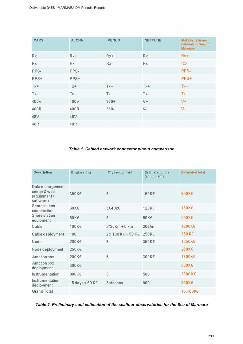
19
Table 1. Cabled network connector pinout comparison
Table 2. Preliminary cost estimation of the seafloor observatories for the Sea of Marmara
Deliverable D45B - MARMARA DM Periodic Reports
299
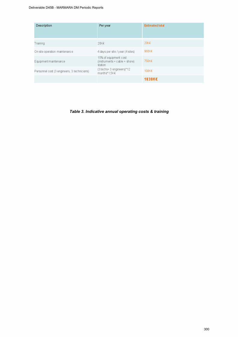
20
Table 3. Indicative annual operating costs & training
Deliverable D45B - MARMARA DM Periodic Reports
300

21
WP6 management report
(from June 1st, 2009 to 31 January 2010)
WORKPACKAGE WP6
Full WP title PUBLIC AND EDUCATION OUTREACH. FUND RISING.
Period covered from June 1st, 2009 to 31 January 2010 Partner organisation full name ITU
Person in charge for the report (WP Leader)
Namik Çagatay
Partners involved in the Work All partners
WP 6.Public outreach, education and fund raising
ITU-DEU - Disseminate results among Turkish authorities and policy makers
- Propose a coordination structure and managing scheme for the implementation of the seafloor observatory.
- Disseminate results among the scientific community and the public (thorugh web site, training courses and public seminars)
- D6.1 Support agreement contract with Turkish authorities
- D6.2 Web Site - D6.3 Training course
Period of the reporting: from June 1st, 2009 to 31 January 2010 Provide a justification of the major costs incurred and resources deployed, linking them to activities implemented and explaining their necessity.
WP 6 : Public and education outreach, coordination at national (Turkish) level
and fund raising
Deliverable D45B - MARMARA DM Periodic Reports
301

22
D6.1 Support agreement contract with Turkish authorities
ITU is preparing a science infrastucture project proposal to be submitted to the Turkish Government (DPT) in May 2010 for the establishment of seafloor observatoires in the Sea of Marmara. The meetings with Istanbul Municipality, petroleum companies, insurance companies are underway for thier contribution to the operational and maintenance expenses. Regarding the public and education outreach, coordination at national (Turkish) level and fund raising the following activities were performed:
1. The coordination efforts between different Turkish organizations continued during this period. Istanbul Governorship, Istanbul Municipality, TPAO (Turkish Petroleum Corporation), TUBITAK (Scientific and Technological Council of Turkey) and MTA (Geological Suvey of Turkey) participated in the ESONET training course and Earthquake Symposium organized at ITU during 17-19 August 2009. The State Minister for Science and Technology, Prof. Mehmet Aydin, presented the opening speech at the Symposium and was informed about the ESONET and EMSO activities at the Marmara Node.
2. 4rd planning and coordination meeting was held at ITU during 19 August 2009, with the participation of Louis Geli, Pierre Henry, Luca Gasperini, Namik Çagatay, Yves Aufrett, Carla Scalabrin, Sinan Özeren and Günay Çifci. Cruise plans, site survey studies, equipment deployment plans were discussed for the forthcoming cruises of RV Urania and Le Suroit September-December 2009.
3. A project proposal “Permanent Multidisciplinary Seafloor Observatories in the Sea of Marmara” is being currently prepared for submitting in May 2010 to the Turkish State Planning Organization (DPT) for funding.
4. An invitation letter was written to MTA on 15 December 2009 for their collaboration in the DPT project proposal. MTA is acquiring new research vessels and ROVs that are important for the operation and maintenance of the observatories. A separate invitation to MTA was made for personnel training in marine surveys and technology involving MTA-ITU-IFREMER collaboration.
Peer-reviewed publications on the Sea of Marmara Node:
1. Çagatay, M. N., Eriş, K., Ryan, W.B.F., Sancar, Ü., Polonia, A., Akçer, S. Biltekin, D., Gasperini, L., Görür, N. Lericolais G., Bard, E. 2009. Late Pliestocene-Holocene evolut?on of the northern shelf of the Sea of Marmara. Marine Geology, 265: 87-100.
2. Görür, N., Çagatay, M.N., 2009. Geohazards rooted from the northern margin of the Sea of Marmara since the late Pleistocene: a review of recent results. Natural Hazards. DOI 10.1007/s11069-009-9469-x.
3. Bourry, C., Chazallon, B., Charlou, J-L, Donval J.P, Ruffine, L., Henry, P., Geli, L., Çagatay, M.N., Sedat, I. Moreau, M., (2009). Free gas and gas hydrates from the Sea of Marmara, Turkey: Chemical and structural characterization. Chemical Geology, 264, 197–206 .
Book Chapters:
4. Çagatay, Balkis,N., Sancar, Ü., Çakir, Z. et al... (2009). Sediment Geochemistry Atlas of the Sea of Marmara and its importance in pollution and ecological studies. In: Özerler, M. and Sayin, E. (eds.), The Role of Climatic and Anthropogenic Changes in Marine Ecosytems, Ecosystems’07, Izmir – Turkey, pp. 165-182.
5. Çagatay, M.N., Geli, L., Gasperini, L., Henry, P., Gürbüz, C., Görür, N. The Sea of Marmara. Chapter to be published in a book edited by P. Favali et al.
Deliverable D45B - MARMARA DM Periodic Reports
302

23
D6.2 Marmara-DM Website
The Marmara-DM web-site (www.esonet-marmara-dm.itu.edu.tr) now includes the abstracts and presentations of the 17-19 August ESONET trainingCourse and Earthquake Symposium. A data server is established for the input of Marmara-DM cruise and lab data. Links were made from the Web Page to the data server for easy access of the Marmara-DM partners.
Person-Months
Ifremer : 1 Ma-Month ITU : 11,5 Ma-Months (3 permanent) Cnrs : 0.5 Ma-Mo DEU : 0,2 Ma-Mo INGV : 0 Ma-Mo ISMAR : 0,0 Ma-Mo Total : 13,2 Ma-Mo
Other costs :
Deliverable D45B - MARMARA DM Periodic Reports
303
APENDICES
Deliverable D45B - MARMARA DM Periodic Reports
304
Eastern Mediterranean Centre for Oceanography and Limnology
Doğu Akdeniz Oşinografi ve Limnoloji Araştırmaları Merkezi
İstanbul Teknik Üniversitesi
15 Aralık 2009
MTA Genel Müdürlüğü Ankara
Bildiğiniz gibi Avrupa Birliği 7. Çerçeve Programı, EMSO: “European Multidisciplinary Seafloor Observatory (Avrupa Çok Disiplinli Deniztabanı Gözlemevi)” Bilim Altyapısı projesi kapsamında Marmara Denizi önemli bir gözlem alanı olarak seçilmiştir. MTA Genel Müdürlüğü’nün de katıldığı İTÜ’de 29 Mayıs 2009 tarihinde yapılan toplantıda EMSO projesinin Marmara Denizi ayağını oluşturmak için bir karar alınmıştır.
Bu bağlamda Marmara Denizi’nde doğal afet (deprem, sualtı heyelanı, tsunami), çevresel değişim ve oşinografi gibi çok disiplinli konularda sürekli gözlemler yapacak ulusal bir bilim araştırma altyapısı proje önerisinin hazırlanarak Mayıs 2009’da Devlet Planlama Teşkilatına (DPT) sunulması planlanmıştır.
Bu ulusal projenin önerisinin hazırlanmasında ve kabul gördüğü taktirde uygulanmasında MTA Genel Müdürlüğü’nün kurumsal olarak eleman ve altyapısı ile ektin olarak yeralması için gereğini saygılarımla arz ederim.
Prof.Dr. Namık ÇAĞATAY EMCOL Müdürü ve EMSO
projesi Yönetim Kurulu Üyesi
___________________________________________________________________________
EMCOL, İTÜ Maden Fakültesi, 34469 Maslak, İstanbul
Deliverable D45B - MARMARA DM Periodic Reports
305

Tel: 90-212-2856211, Fax: 90-212-2856080
Eastern Mediterranean Centre for Oceanography and Limnology
Doğu Akdeniz Oşinografi ve Limnoloji Araştırmaları Merkezi
İstanbul Teknik Üniversitesi
15 Aralık 2009 MTA Genel Müdürlüğü Ankara
Bilindiği gibi, Avrupa Birliği Çerçeve Programı ESONET “Eurpean Sea Observations Network of Excellence” ve EMSO: “European Multidisciplinary Seafloor Observatory” Bilim Altyapı projeleri ülkemizi çevreleyen Marmara Denizi, Karadeniz ve Akdeniz’i de önemli araştırma alanı olarak seçmiştir. Denizlerde gözlem ve araştırmalar yapmak yeni teknolojiler ve bu teknolojilerin kullanımını gerekmektedir. Bu bağlamda 3-D sismik, multi-beam batimetri, yüksek çözünürlü fiziksel ve jeokimyasal karot analizleri, sensör teknolojisi, gözlem istasyonlarının kurulması, bakımı ve işletilmesi gibi konularda eleman eğitimi ülkemiz için acil bir önem taşımaktadır
Değişik deniz araştırmaları konularında eleman eğitiminin ESONET ve EMSO projelerinin ortağı olan kurumlarla işbirliği anlaşmaları çerçevesinde yapılması mümkündür. Bu çerçevede IFREMER (Fransa), ISMAR (Bologna, İtalya) ve INGV (Roma, İtalya) gibi kurumlarda elemanlarınızın değişik disiplinlerde eğitimi olumlu karşılanmaktadır. Benzer şekilde İTÜ-EMCOL’de; deprem, iklim, çevresel değişim gibi konulardaki deniz ve göl araştırmaları, yüksek çözünürlü karot analizleri ve uygulamaları konularında elemanlarınızın bizzat projelerimizde yeralıp, laboratuvarlarımızı kullanarak eğitilmesi mümkündür.
Eleman eğitimi konusunda bu işbirliği olanaklarını bilgilerinize saygılarımla arz ederim.
Prof.Dr. Namık ÇAĞATAY EMCOL Müdürü
_____________________________________________________________________ EMCOL, İTÜ Maden Fakültesi, 34469 Maslak, İstanbul
Tel: 90-212-2856211, Fax: 90-212-2856080
Deliverable D45B - MARMARA DM Periodic Reports
306
IFREMER Acoustic and Seismic Department Y. Thomas and B. Marsset
Deliverable D45B - MARMARA DM Periodic Reports
307
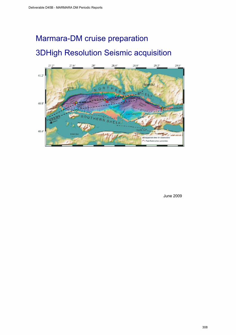
Marmara-DM cruise preparation
3DHigh Resolution Seismic acquisition
June 2009
Deliverable D45B - MARMARA DM Periodic Reports
308
Introduction The purpose of this short note is to help defining the geological targets of the High Resolution seismic 3D survey during the Marmara-DM survey (R/V Le Suroît, september 2009, leg 2). We use the opportunity of existing 2D HR data on the area recorded in 2008 on board the R/V K. Piri Reis by the Dokuz Eylül University (DEU, Izmir, Turkey). We are grateful to Dr Günay Çifçi from the Marine Seismic Laboratory SeisLab of DEU and to Dr. Michael S. Steckler from the Lamont-Doherty Earth Observatory (Columbia University, NY, USA) who gave us access to raw seismic data from 4 profiles of the TAMAM cruise (Turkish-American MArmara Multichannel). These sections were selected during the meeting held at the Dokuz Eylül University (Izmir), 2d-5th of June, with the main following attendees:
- DEU (Izmir): Prof. Dr. Gunay ÇIFÇI, Doc. Dr. Derman DONDURUR, Res. Assist. Dr. Seda OKAY, Res. Assist. Savas GURCAY, Geop. Eng. Selin Deniz AKHUN
- IFREMER (Brest) : Dr. Louis GELI, Dr. Bruno MARSSET, Geop. Eng. Yannick THOMAS
- videoconference from CEREGE (Aix-en-Provence): Dr. Pierre Henry The TAMAM profiles have been analysed using Ifremer's standard QC software, mainly:
- processing of GPS vessel data, computation of sources and receiver positions (offset of first trace fixed to 43 meters);
- SEGY pre-processing (source delay correction 32 ms, band-pass filter 30-300 Hz);
- binning 6.25 meters, stack (1510 m/s for water column, and Vrms gradient of 150 m/s s-1 within sediments), Stolt migration;
Reference to TAMAM data:
Steckler M. S., Çifçi G. et al. (2008), High Resolution Multichannel Imaging of Basin Growth Along a Continental Transform: The Marmara Sea Along the North Anatolian Fault in NW Turkey, EOS Trans. AGU, 89(53), Fall Meet. Suppl., Abstract T21A-1921.
The Marmara-DM cruise is funded by the European Esonet-Noe project (European Commission in the framework program FP6).
Deliverable D45B - MARMARA DM Periodic Reports
309
Main observations See figures:
- time migrated sections are displayed using AGC (100 ms window); - corridor limit stand for the northern boundary of the Marmara maritime
corridor; The area selected during the meeting is located in the western part of the Sea of Marmara. The area is centered on the western ridge, between the Tekirdag and Central basins, it includes the North Anatolian Fault. One of the major constraints regarding seismic acquisition in the Marmara Sea is the intense maritime traffic between the Bosphore and the Dardanelles straits. One of the major geological interest is the area close to the North Anatolian Fault (NAF) where evidence of gas hydrates and fluid escapes have been observed during previous scientific cruises (See Marnaut cruise report, 2007 - P. Henry from CEREGE Aix-en-Provence, A. M. Celal Şengör and M. Namik Çagatay from ITU Istanbul) Proposed area for 3D High Resolution seismic survey of 3.6 x 10 km² is oriented ESE-WNW along the NAF, parallel to the corridor lines; the southern part of the area may penetrate 1000 meters within the maritime corridor if feasible. Main observations from the TAMAM seismic lines within the 3D box: Southern side of the "NAF valley":
- western to central parts: evidence of amplitude anomalies and possibly pockmarks; upper sediment cover with good Signal to Noise ratio: 100-200 ms; underlying sediments: highly folded layers, poor SN ratio; half part of this area is located within the navigation corridor ;
- eastern part:: no more "NAF valley", rather slope of the central basin with no sedimentary penetration;
Nothern side of the "NAF valley":
- western part: outcrop of highly folded sediments (zero penetration); - central and eastern parts: upper sediment cover increases between the two
local tops of the ridge; upper sediment cover with good Signal to Noise ratio: 100-400 ms;
Main targets within the 3D box may be:
- amplitude anomalies and structures within the upper sedimentary cover; - morphology of the sedimentary "basement" (top of the highly folded
sediments);
Deliverable D45B - MARMARA DM Periodic Reports
310

3D box coordinates WGS84 coordinates: A) 27°42.381 40°47.447 B) 27°49.414 40°48.251 C) 27°49.033 40°50.175 D) 27°42.000 40°49.371 Size: 9999 x 3600 m² Box parallel to the corridor (heading 81.44°) Magnetic declination (june 2009) : +4.4°
A
B
C
D
Deliverable D45B - MARMARA DM Periodic Reports
311

Proposed 3D HR box location (10 x 3.6 km²), southern part 1 km within maritime corridor;
Location of Tamam sections, CMP numbers (Dokuz Eylül Universitesi, Izmir - Lamont) Yellow star: Koeri observatory location; red star: MD04-2741/MD01-2430 coring site
p36
p34
p33
p57
corridor
Deliverable D45B - MARMARA DM Periodic Reports
312
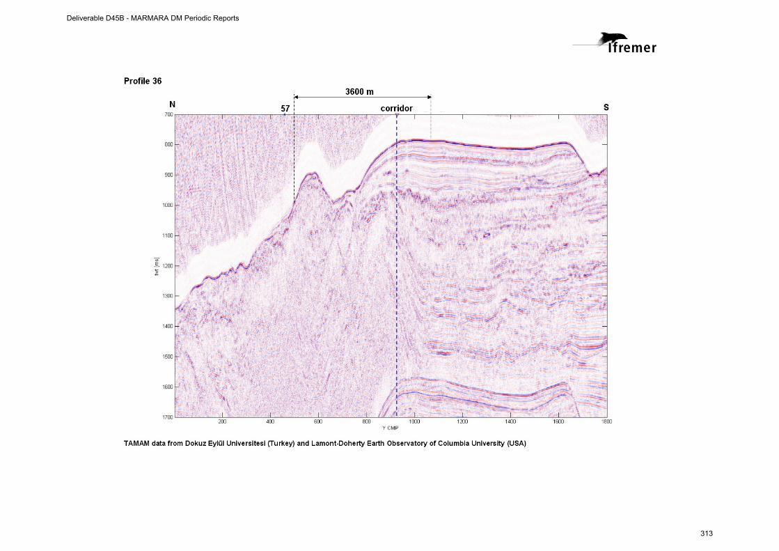
Deliverable D45B - MARMARA DM Periodic Reports
313
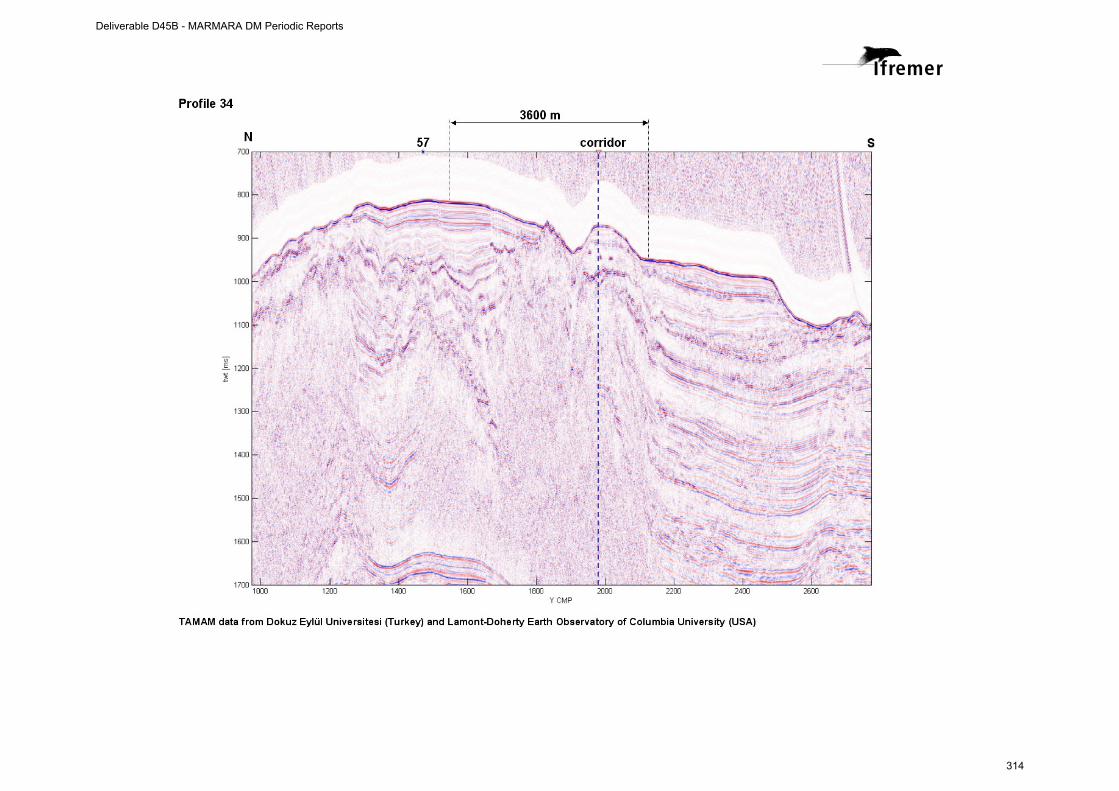
Deliverable D45B - MARMARA DM Periodic Reports
314
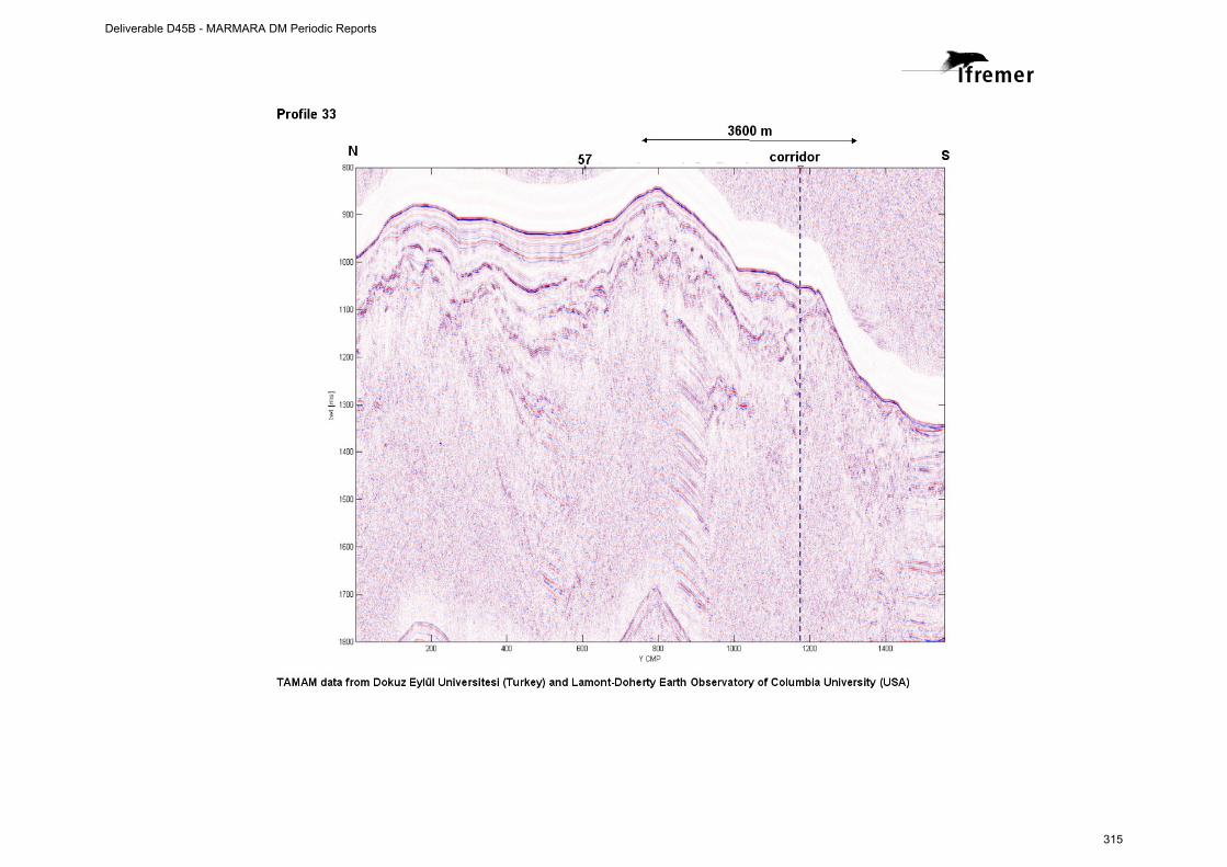
Deliverable D45B - MARMARA DM Periodic Reports
315
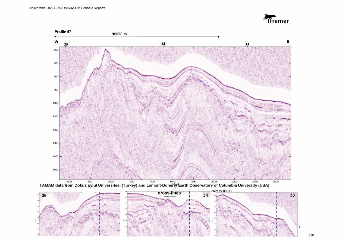
13
TAMAM data from Dokuz Eylül Universitesi (Turkey) and Lamont-Doherty Earth Observatory of Columbia University (USA)
Deliverable D45B - MARMARA DM Periodic Reports
316

W E
Deliverable D45B - MARMARA DM Periodic Reports
317
Minutes of “EMSO Introduction and Consensus meeting” of the Turkish Marine Organizations held at ITU during 29 May 2009
EMSO (European Multidisciplinary Seafloor Observatory) Projesi Tanıtım Toplantısı Tutanağı
EMSO projesi tanıtım toplantısı İTÜ Maden Fakültesi Yönetim Kurulu Salonunda 29 Mayıs 2009 Cuma günü saat 10:30 da başlamıştır. Toplantıya isim listesi ekte verilen katılımcılar katılmıştır (Ek-1).
Toplantı, EMSO projesinin İTÜ Yürütücüsü Prof.Dr. Namık Çağatay’ın sunumu ile başlamıştır. Sunumda EMSO projesinin Avrupa Birliği’nin ESFRI (European Strategy Forum on Research Infrastructures) yol haritası listesinde yeralan bir bilim altyapı projesi olarak, hazırlık aşamasındaki amacının Avrupa Çok-disiplinli Deniztabanı Gözlem Ağının yönetimsel, hukuksal ve finansal altyapısını oluşturmak olduğunu belirtilmiştir. EMSO projesi 8 iş paketinden oluşmaktadır. Bunlar sırası ile 1) EMSO Proje yönetimi, 2) Yönetim Çalışması, 3) Yasal Çalışma, 4) Finans çalışması, 5) İşletme planı, 6) Lojistik çalışması, 7) Strateji belirleme çalışması, ve 8) Teknik çalışma’dır. Bu projenin gözlem bölgeleri arasında Marmara Denizi, Karadeniz ve Akdeniz’nin bulunması nedeniyle Türkiye için önemi anlatılmış ve Marmara Denizi bölgesel ayağının oluşturulması için gerekli öneriler sunulmuştur.
Toplantının ikinci kısmında karşılıklı görüş alış-verişi sonucunda aşağıdaki kararlar alınmıştır:
1. EMSO Avrupa Bilim Altyapısı projesi; ülkemizin bir iç denizi olan Marmara Denizi’ni bölgesel bir gözlem alanı seçmiş olması nedeniyle önemlidir. Zira Marmara Denizi’nde deprem ve tsunami gibi doğal afetler, Ege Denizi ve Karadeniz arasındaki oşinografik su kütlesi hareketleri ile tanker kazaları ve bunlar sonucu oluşacak kirliliğin gerçek zamanlı, sürekli ve uzun süreli izlenmesi çok önemlidir.
2. EMSO’nun Marmara Denizi Bölgesel Altyapısının oluşturulması süreci, ulusal bir proje olarak ele alınmalıdır. Bu bağlamda Türkiye’deki ilgili bilimsel kurumlar bir konsorsiyum oluşturmalı ve altyapı çalışmaları ulusal bir politika çerçevesinde bilimsel kurum temsilcilerinin yeraldığı bir kurul tarafından yürütülmelidir.
3. Bu tür bir ulusal projenin birinci derecede kaynağı, bu proje için niyet mektubu vermiş Başbakanlık Devlet Planlama Teşkilatıdır (DPT). Bu nedenle 2010’da DPT’ye sunulmak üzere, amaçları, kapsamı ve sürdürülebilirliği iyi açıklanmış, İTÜ Rektörlüğü desteğinde bir altyapı proje önerisi hazırlanmalıdır.
4. Dünyadaki benzer örnekleri dikkate alınarak, Deniz Tabanı Gözlem İstasyonu verilerine ihtiyacı olan pertrol endüstrisi ve sigorta şirketleri ile işbirliği ve mali kaynak yaratma olanakları araştırılmalıdır.
Deliverable D45B - MARMARA DM Periodic Reports
318
5. Proje ilgi alanı bakımından İBB, Marmara Belediyeler Birliği, İstanbul Valiliği İstanbul Özel İdaresi, Afet İşleri Genel Müdürlüğü gibi kamu kurumlarını ilgilendirmektedir. Bu nedenle bu kurumlarla gerekli işbirliği yapılmalıdır.
6. Projenin yeni teknoloji geliştirme ve uygulama potansiyeli bulunmaktadır. Bu nedenle teknokentler ve KOBİ’lerle işbirliği olanakları araştırılmalıır.
7. Denizaltı gözlem istasyonlarının oluşturulmasında yasal mevzuat için D.K.K. SHOD, Sahil Güvenlik Komutanlığı, Kıyı Emniyeti ve Gemi Kurtarma Genel Müdürlüğü gibi kurumlara danışılacaktır.
Ek 1:
EMSO Toplantısı Katılım Listesi
İTÜ, 29 Mayıs 2009
İsim Kurum Telefon e-posta
Prof.Dr.Mehmet Karaca
İTÜ Araştırmadan Sorumlu Rektör Yard.
212 285 33 31
Prof.Dr. Namık Çağatay
İTÜ EMCOL Müdürü
212 285 62 11
Prof.Dr. Naci Görür
İTÜ EMCOL Projeler Koordinatörü
212 286 06 88
Prof.Dr.Bayram Öztürk
TÜDAV
424 07 72- 514 03 88/16404 [email protected]
Prof.Dr.Hüseyin Avni Benli
D.E.Ü. Deniz Bilimleri ve Teknolojisi Enst. Müdürü 232 278 51 12 [email protected]
Doç.Dr.Semih Ergintav
TÜBİTAK MAM, YDBE
216 677 28 50
Dilek Günaydın
Sahil Güvenlik Marmara ve Boğazlar Bölge K.lığı
242 97 10
Aylin Ergin Kıyı Emniyeti Genel Müdürlüğü 292 52 80/ 639 [email protected]
Hilal Burcu Çalışır
Kıyı Emniyeti Genel Müdürlüğü 252 22 94 [email protected]
Barbaros Şimşek
MTA Genel Müdürlüğü, Dnz. Araş. Koordiatörlüğü
0 312 287 34 30 / 1651 [email protected]
Dr. Özden İleri
MTA Genel Müdürlüğü, Dnz.Araş. Koordinatörlüğü
0 312 287 34 30 / 1419
Deliverable D45B - MARMARA DM Periodic Reports
319

Deliverable D45B - MARMARA DM Periodic Reports
320

1
Project contract no. 036851
ESONET
European Seas Observatory Network
Instrument: Network of Excellence (NoE)
Thematic Priority: 1.1.6.3 – Climate Change and Ecosystems
Sub Priority: III – Global Change and Ecosystems
ESONET WP4 - Demonstration Missions
MARMARA-DM
FINAL REPORT
Start date of project: 1st March 2007 Duration: 48 months
Revision [draft]
Project co-funded by the European Commission within the Sixth Framework Programme (2002-2006) Dissemination Level
PU Public PP Restricted to other programme participants (including the Commission Services RE Restricted to a group specified by the consortium (including the Commission Services) CO Confidential, only for members of the consortium (including the Commission Services) X
Deliverable D45B - MARMARA DM Periodic Reports
321

Deliverable D45B - MARMARA DM Periodic Reports
322
2
Table of Content
1. General information .................................................................................................3
1.1 PARTNERSHIP...................................................................................................... 3 1.2 WORK PACKAGES ACTIVITIES AND TASKS SHORT DESCRIPTION ................................ 4
2. Introduction..............................................................................................................6 3. Work Description .....................................................................................................7
3.1 WORK DESCRIPTION AT WORK PACKAGE LEVEL ...................................................... 7 3.2 WORK DONE BY EACH PARTNER .......................................................................... 15
3.2.1 Partner 1 : IFREMER. ............................................................................... 15 3.2.2 Partner 2 : ITU........................................................................................... 15 3.2.3 Partner 3 : ISMAR..................................................................................... 16 3.2.4 Partner 4 : INGV........................................................................................ 17 3.2.5 Partner 5 : CNRS ..................................................................................... 17 3.2.6 Partner 6 : DEU......................................................................................... 18
3.3 INPUT TO AND FROM ESONET WORK PACKAGES................................................. 19 4. Data Management .................................................................................................21
4.1 MARMARA-DM DATA MANAGEMENT .................................................................. 21 4.2 THE FUTURE OBSERVATORY DATA MANAGEMENT AND ARCHIVING SYSTEM ............... 21
5. Project Management .............................................................................................22 6. Results ..................................................................................................................23
6.1 INTRODUCTION.................................................................................................. 23 6.2 RELATIONS WITH FLUIDS AND GAS EMISSIONS ....................................................... 24 6.3 DATASET USED IN THE MARMARA-DM PROJECT.................................................... 25 6.4 BEST SITE SELECTION (D4.4) .............................................................................. 25 6.5 CONCEPT .......................................................................................................... 25 6.6 DESIGN OF FUTURE MULTI-DISCIPLINARY SEAFLOOR OBSERVATORIES (MDSOS)... 26 6.7 AUTONOMOUS, MOBILE SEAFLOOR EQUIPMENTS TO ENHANCE THE MULTI-PARAMETER APPROACH .............................................................................................................. 29
6.12 Outreach and communication .................................................................... 32 6.13 List of publications resulting from the MARMARA-DM project ................... 33
7. Conclusion and perspectives................................................................................35 8. References ...........................................................................................................36
Deliverable D45B - MARMARA DM Periodic Reports
323

Deliverable D45B - MARMARA DM Periodic Reports
324
3
1. General information
1.1 Partnership (institutions, people, e-mails, addresses), duration (start/end dates)
DM acronym: MARMARA-DM
DM title: Multidisciplinary Seafloor Observatories for Seismogenic HazardsMonitoring in the Marmara Sea
ESONET Site: MARMARA SEA, Turkey
Scientific Area(s): - Earthquake hazards
- Relations between fluids and seismicity
- Processess at fluid controlled ecosystems
Technological Area(s): Long-term, permanent monitoring of seismicity, sediment pore fluid, fluid geochemistry and gas emission activity
DM Start and End date: from April1st, 2008 to September 30st, 2010
DM duration: 30 months Partners Contact Partner Num.
Partner Institution Name
Principal Investigator (PI) for the Demo Mission
PI coordinates (Address, Email, Telephone, fax..)
1. IFREMER Géli, Louis (Coordinator) IFREMER Marine Geosciences Department BP 70, 29280 Plouzané, France T. 33 (0) 2 98 22 42 27 / F. 33 (0) 2 98 22 45 49 E-mail : [email protected]
2. ITU Çağatay, Namık (Prof.) Istanbul Technical University Faculty of Mines Geology Department Maslak 34469 Istanbul, Turkey T. +90-2122856211 / F. +90-2122856080 Email : [email protected]
3. ISMAR Gasperini, Luca ISMAR (Istituto di Scienze Marine), Sezione di Geologia Marina, CNR, Via Gobetti, 101, Bologna, Bo 40129 Italy T. +39 041 2404761 / F. +39 041 5204126 : [email protected]
4. INGV Favali, Paolo Istituto Nazionale di Geofisica e Vulcanologia (INGV), Via di Vigna Murata, 605 - 00143 Roma (Italy) T. +39-06-51860-341 / F. +39-06-51860-338 E-mail : [email protected]
5. CNRS Henry, Pierre CNRS/ CEREGE - College de France Europole de l'Arbois, Bat Trocadero BP 80, 13545 Aix en Provence Cedex 04 T. +33 (0)4 42 50 74 04 / F. +33 (0)4 42 50 74 01E-mail : [email protected]
6. DEU/IMST Çifçi, Günay (Prof.) Institute of Marine Sciences and Technology Dokuz Eylul University Izmir, 35340 Turkey GSM: +90 - 532 513 59 16 Phone: +90 - 232 - 278 55 65 ext. 126 Fax: +90 - 232- 278 50 82
Deliverable D45B - MARMARA DM Periodic Reports
325
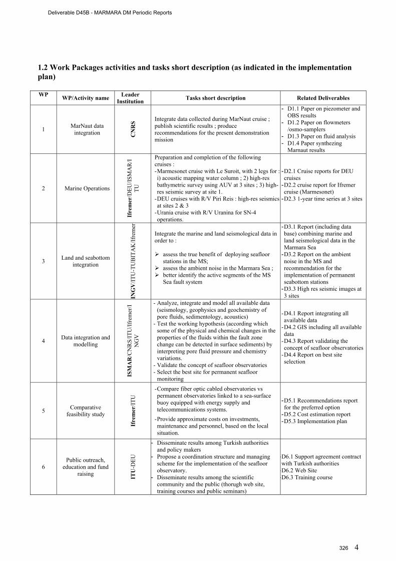
4
1.2 Work Packages activities and tasks short description (as indicated in the implementation plan) WP
WP/Activity name Leader Institution Tasks short description Related Deliverables
1 MarNaut data integration C
NR
S Integrate data collected during MarNaut cruise ; publish scientific results ; produce recommendations for the present demonstration mission
- D1.1 Paper on piezometer and OBS results
- D1.2 Paper on flowmeters /osmo-samplers
- D1.3 Paper on fluid analysis - D1.4 Paper synthezing
Marnaut results
2 Marine Operations
Ifre
mer
/DEU
/ISM
AR
/ITU
Preparation and completion of the following cruises : - Marmesonet cruise with Le Suroit, with 2 legs for : i) acoustic mapping water column ; 2) high-res bathymetric survey using AUV at 3 sites ; 3) high-res seismic survey at site 1.
- DEU cruises with R/V Piri Reis : high-res seismics at sites 2 & 3
- Urania cruise with R/V Uranina for SN-4 operations.
- D2.1 Cruise reports for DEU cruises
- D2.2 cruise report for Ifremer cruise (Marmesonet)
- D2.3 1-year time series at 3 sites
3 Land and seabottom integration
ING
V/IT
U-T
UB
ITA
K/If
rem
er
Integrate the marine and land seismological data in order to :
assess the true benefit of deploying seafloor stations in the MS;
assess the ambient noise in the Marmara Sea ; better identify the active segments of the MS
Sea fault system
- D3.1 Report (including data base) combining marine and land seismological data in the Marmara Sea
- D3.2 Report on the ambient noise in the MS and recommendation for the implementation of permanent seabottom stations
- D3.3 High res seismic images at 3 sites
4 Data integration and modelling
ISM
AR
/CN
RS/
ITU
/Ifre
mer
/IN
GV
- Analyze, integrate and model all available data (seismology, geophysics and geochemistry of pore fluids, sedimentology, acoustics)
- Test the working hypothesis (according which some of the physical and chemical changes in the properties of the fluids within the fault zone change can be detected in surface sediments) by interpreting pore fluid pressure and chemistry variations.
- Validate the concept of seafloor observatories - Select the best site for permanent seafloor
monitoring
- D4.1 Report integrating all available data
- D4.2 GIS including all available data
- D4.3 Report validating the concept of seafloor observatories
- D4.4 Report on best site selection
5 Comparative feasibility study
Ifre
mer
/ITU
- Compare fiber optic cabled observatories vs permanent observatories linked to a sea-surface buoy equipped with energy supply and telecommunications systems.
- Provide approximate costs on investments, maintenance and personnel, based on the local situation.
- D5.1 Recommendations report for the preferred option
- D5.2 Cost estimation report - D5.3 Implementation plan
6 Public outreach,
education and fund raising IT
U-D
EU
- Disseminate results among Turkish authorities and policy makers
- Propose a coordination structure and managing scheme for the implementation of the seafloor observatory.
- Disseminate results among the scientific community and the public (thorugh web site, training courses and public seminars)
- D6.1 Support agreement contract with Turkish authorities
- D6.2 Web Site - D6.3 Training course
Deliverable D45B - MARMARA DM Periodic Reports
326

5
1.3 Deliverables description
Deliverables have all been achieved and accessible on the data repository system of the Marmara-Dm project websit : http://www.esonet.marmara-dm.itu.edu.tr/
Deliverable N
°
Deliverable nam
e
Lead contractor
WP1 D1.1 Report on piezometer and OBS resultsa
Including Tary et al, Bull. Seism. Soc. Am., Vol. 101, No. 2, doi: 10.1785/0120100014, 2011 5
D1.2 Report on Fluid flux rates through the Marmara seafloor : Results from flowmeters and osmo-samplers
Including paper by Tryon et al, submitted to Marine Geology on March 2011
5
D1.3 Report on the origin of fluids escaping from the Marmara seafloor Including paperss by Bourry et al, Chem. Geol., doi: 10.1016/j.chemgeo.2009.03.007, 2009 and Tryon et al., Geochem. Geophys. Geosyst., 11, Q0AD03, DOI: 10.1029/2010gc003177, 2010
5
D1.4 Paper synthetizing Marnaut results Géli et al, Earth Plan. Sci. Let., 274, 34–39, doi:10.1016/j.epsl.2008.06.047, 2008
5
WP2 D2.1
Cruise report of DEU (PirMarmara) Cruise with R/V Piri Reis (June 2010)
6
D2.2a Cruise Report on Ifremer (Marmesonet) cruise, Leg I (Oct. 4th – Oct. 25, 2009) 1 D2.2b Cruise Report on Ifremer (Marmesonet) cruise, Leg I (Oct. 28th – Dec. 14, 2009) 1 D2.3
Cruise reports of SN4-related operations : i) Marmara 2009 Cruise with R/V Urania (october 2009); ii) Recovery and redeployment operations with R/V Yunuz (march 2010) ; Marmara 2010 Cruise
with R/V Urania (october 2010).
Including brief, preliminary report on SN-4 time series (6 months)
4
WP3 D3.1 Report combining marine and land seismological datasets 1 D3.2 Report on the ambient noise and recommendation for implementing permanent seabottom stations 4 D3.3 3D, High Res Seismic Images at Western High Site 6
WP4 D4.1 Report on data repository system integrating all available data 3 D4.2 GIS including all available data 5 D4.3 Report to test working hypothesis and validate concept of seafloor observatories 5 D4.4 Report on best site selection 3
WP5 D5.1 Recommendation Report on the preferred option 1 D5.2 Cost estimation report 1 D5.3 Implementation plan 4
WP6 D6.1 Support agreement contract with Turkish authorities 2 D6.2 Web Site 2 D6.3 Training course 2
Deliverable D45B - MARMARA DM Periodic Reports
327
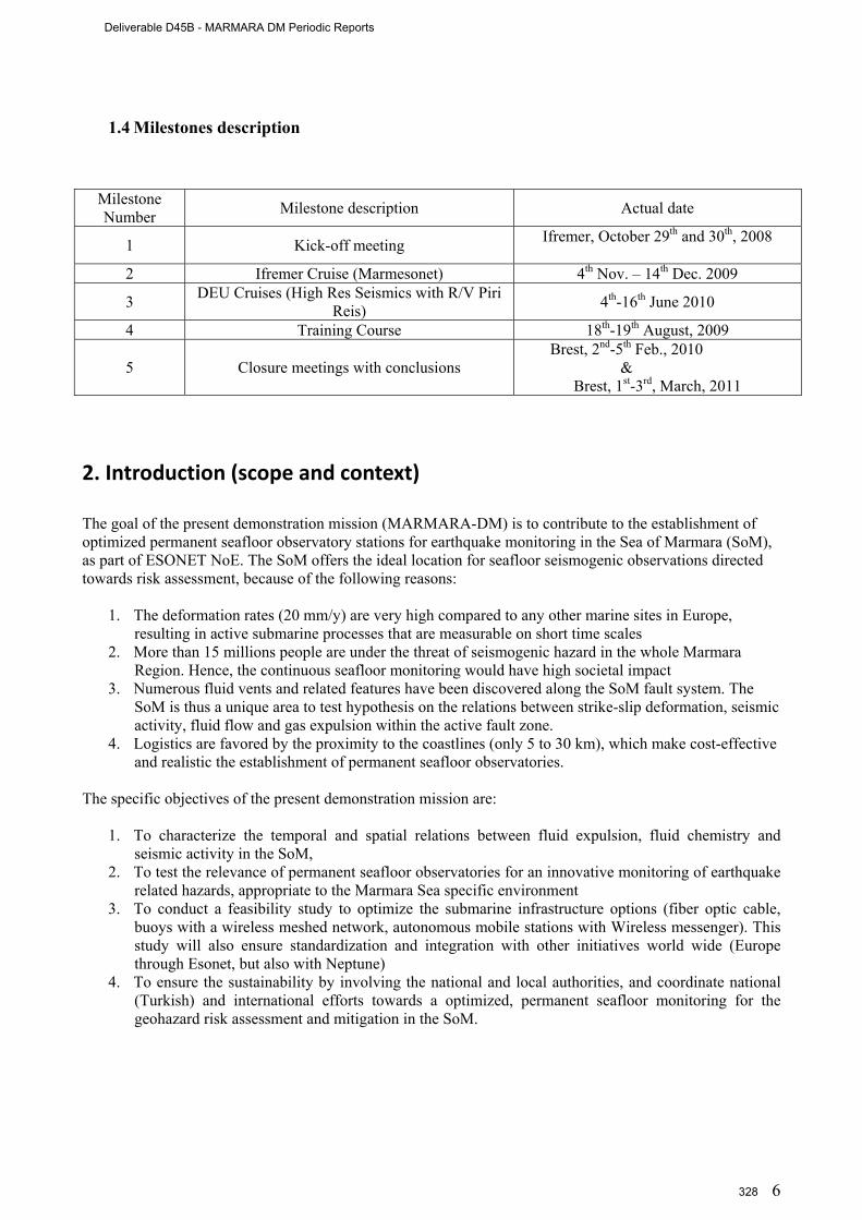
6
1.4 Milestones description
Milestone Number Milestone description Actual date
1 Kick-off meeting Ifremer, October 29th and 30th, 2008
2 Ifremer Cruise (Marmesonet) 4th Nov. – 14th Dec. 2009
3 DEU Cruises (High Res Seismics with R/V Piri Reis) 4th-16th June 2010
4 Training Course 18th-19th August, 2009
5 Closure meetings with conclusions Brest, 2nd-5th Feb., 2010
& Brest, 1st-3rd, March, 2011
2. Introduction (scope and context) The goal of the present demonstration mission (MARMARA-DM) is to contribute to the establishment of optimized permanent seafloor observatory stations for earthquake monitoring in the Sea of Marmara (SoM), as part of ESONET NoE. The SoM offers the ideal location for seafloor seismogenic observations directed towards risk assessment, because of the following reasons:
1. The deformation rates (20 mm/y) are very high compared to any other marine sites in Europe, resulting in active submarine processes that are measurable on short time scales
2. More than 15 millions people are under the threat of seismogenic hazard in the whole Marmara Region. Hence, the continuous seafloor monitoring would have high societal impact
3. Numerous fluid vents and related features have been discovered along the SoM fault system. The SoM is thus a unique area to test hypothesis on the relations between strike-slip deformation, seismic activity, fluid flow and gas expulsion within the active fault zone.
4. Logistics are favored by the proximity to the coastlines (only 5 to 30 km), which make cost-effective and realistic the establishment of permanent seafloor observatories.
The specific objectives of the present demonstration mission are:
1. To characterize the temporal and spatial relations between fluid expulsion, fluid chemistry and
seismic activity in the SoM, 2. To test the relevance of permanent seafloor observatories for an innovative monitoring of earthquake
related hazards, appropriate to the Marmara Sea specific environment 3. To conduct a feasibility study to optimize the submarine infrastructure options (fiber optic cable,
buoys with a wireless meshed network, autonomous mobile stations with Wireless messenger). This study will also ensure standardization and integration with other initiatives world wide (Europe through Esonet, but also with Neptune)
4. To ensure the sustainability by involving the national and local authorities, and coordinate national (Turkish) and international efforts towards a optimized, permanent seafloor monitoring for the geohazard risk assessment and mitigation in the SoM.
Deliverable D45B - MARMARA DM Periodic Reports
328
7
3. Work Description
3.1 Work Description at work package level WP 1 : Analysis of the available time series data and in-situ samples from the Marnaut cruise. D1.1 Report on piezometer and OBS results from the MarNaut cruise. The piezometer deployed during the MarNaut cruise presented unexplained features that could be interpreted as artifacts. Therefore, deliverable D1.1 is based on OBS data. We present two case studies from the Sea of Marmara :
The first case study concerns the relation between the micro-seismicity and other observations we
had from the seafloor (anlysis of in-situ sampled fluid sampling and detailed micro-bathymetry (based on AUV data collected in 2009 during the Marmesonet cruise). This work clearly shows that tectonic strain below the western slope of the Tekirdag Basin contributes to maintain a high permeability in faults zones, and that the fault network provides conduits for deep-seated fluids to rise up to the seafloor [Tary et al, Bull. Seism. Soc. Am., Vol. 101, No. 2, doi: 10.1785/0120100014, 2011].
The second case study, is focused on the detailed analysis of non-seismic micro-events recorded
with Ocean Bottom Seismometers and hypothetically attributed to degassing episodes from the upper sediment layers. Our analysis unambiguously confirms our hypothesis and provide insights on how gas is expelled from the uppermost sediment layers: the recorded micro-events are related to natural degassing from the seafloor and to the building and collapsing process of gas chimneys near the subsurface.
D1.2 Report on Fluid flux rates through the Marmara seafloor: results from flowmeters and osmo-samplers. The objective of the 2007 MarNaut project was to quantify the level of activity of venting sites near the fault, and the source of the fluids emitted, with the goal of understanding the processes involved and setting a baseline for long-term studies of the relationship between seismic activity and fluid migration/expulsion processes. Sites for flow meter and fluid sampler deployment and coring included basin bounding transtensional faults and strike-slip faults cutting through the topographic highs. Significant fluid flow appears to be primarily an episodic phenomenon at all sites with background rates on the order of mm/yr to cm/yr except at or very near rare focused vents. Basin bounding faults expel primarily shallow sourced fluid with a strong influence of brackish Pleistocene Lake Marmara water. Expulsion sites where the main fault crosses topographic highs are more complex with evidence for deep-sourced fluids including thermogenic gas. One site on the Western High displayed two mound structures that appear to be chemoherms atop a deep-seated fluid conduit. The fluids being expelled are brines with an exotic fluid chemistry along with thermogenic gas and oil [Tryon et al, submitted to Marine Geology on March 2011].
D1.3 Report on the origin of fluids escaping from the Marmara seafloor. Gas hydrates were sampled during the MARNAUT cruise (May–June 2007) on the Western High, and three gas-bubble samples were recovered on the Western High, the Central High and in the Çinarcik Basin. Methane is the major component of hydrates (66.1%), but heavier gases such as C2, C3, and i-C4 are also present in relatively high concentration. The methane contained within gas hydrate is clearly thermogenic, with a geochemical signature similar to the one found for the natural gas from K-Marmara-af field in the Thrace Basin. Gas bubbles from Central High show also a thermogenic origin, whereas those from the Çinarcik Basin have a primarily microbial origin. UV-Raman spectroscopy reveals structure II for gas hydrates. Hydrate composition is in good agreement with equilibrium calculations, which confirm the genetic link between the gas hydrate and gas bubbles at Western High and the K-Marmara-af offshore gas field located north of the Western High. The base of the structure II hydrate stability field is at about 100 m depth below the seafloor at the Western High site, whereas in the Çinarcik Basin, P–T conditions at the seafloor correspond to the uppermost range for structure I hydrate formation from microbial gas. References : [Bourry et al, Chem. Geol., doi: 10.1016/j.chemgeo.2009.03.007, 2009] and [Tryon et al, (2010), Pore fluid in the North Anatolian Fault in the Sea of Marmara : a diversity of sources and processes, Geochem. Geophys. Geosystems, 10 (11), doi : 10.1029/2010GC003].
Deliverable D45B - MARMARA DM Periodic Reports
329
8
D1.4 Paper synthetizing Marnaut results. The submerged section of the North Anatolian fault within the Marmara Sea was investigated during the MarNaut cruise, using acoustic techniques and submersible dives. Most gas emissions in the water column were found near the surface expression of known active faults. Gas emissions are unevenly distributed. The linear fault segment crossing the Central High and forming a seismic gap – as it has not ruptured since 1766, based on historical seismicity, exhibits relatively less gas emissions than the adjacent segments. In the eastern Sea of Marmara, active gas emissions are also found above a buried transtensional fault zone, which displayed micro-seismic activity after the 1999 events. Remarkably, this zone of gas emission extends westward all along the southern edge of Cinarcik basin, well beyond the zone where 1999 aftershocks were observed. The long term monitoring of gas seeps could hence be highly valuable for the understanding of the evolution of the fluid-fault coupling processes during the earthquake cycle within the Marmara Sea [Géli et al, Earth Plan. Sci. Let., 274, 34–39, doi:10.1016/j.epsl.2008.06.047, 2008]. WP 2: Marine operations. A total of 6 cruises were conducted during the Marmara-Dm Demonstration Mission:
1. Marmara-2009 cruise with R/V Urania (sept 23 – oct 12, 2009), during which the INGV-SN4 station was first deployed, together with 10 OBS and 5 piezometers from Ifremer (D2.3).
2. Marmesonet cruise of R/V Le Suroit, Leg I (from november 4th to november 25th, 2009), mainly dedicated to: i) the high resolution bathymetry at potential sites of interest for future permanent instrumentation using the Autonomous Unmanned Vehicle (AUV) Asterx of Ifremer/Insu; ii) e.g. the systematic mapping of the gas emissions sites on the Marmara seafloor (e.g.) Fig. 3.1); iii) the deployment of the Bubble Observatory Module (BOB) in the Çinarçik basin (D2.2a).
3. Marmesonet cruise of R/V Le Suroit, Leg II (from november 28th november to december 14th, 2009), for 3D, High Resolution Seismic imagery (e. g. Fig. 3.3) of the fluid conduits below the observatory site planned at the Western High (D2.2b).
4. Yunuz-2010 cruise with R/V Yunuz for: i)recovering and redeploying SN4, after a 6 months long deployment; ii) recovering Ifremer instruments (10 OBS and 5 piezometers) and 2 Geomar instruments which were previously deployed during the Marmesonet Cruise of R/V Le Suroit (D2.3).
5. The Pirmarmara cruise was conducted from June 2 to June 12, 2010, on board R/V K. Piri Reis from Dokuz Eylül University (DEU, Izmir, Turkey), to record 2D long offset seismic profiles using a 1500 m long streamer (240 traces) in the HR-3D box, in order to provide better velocity constrains and improve the 3D seismic imaging. The recent upgrade of DEU High Resolution seismic equipment, which now include a 1500 meters length streamer (240 traces), will certainly ease to constrain velocities for deep horizons.
6. Marmara-2010 cruise with R/V Urania (sept 29-oct 18, 2010), during which SN4 was finally recovered (e.g. Fig. 3.3 and D2.3), after the second, 6-months deployment.
Deliverable D45B - MARMARA DM Periodic Reports
330

9
Fig. 3.1 Geographical distribution of acoustically detected gas emissions sites in the Sea of Marmara. Acoustic detection was performed using multibeam echo-sounder of R/V ME Suroit during Marmesonet cruise, Leg I.
WP 3 : Integration of land and seafloor seismological data. D3.1 Report combining marine and land seismological datasets. The present delivrable was addressed during Jean-Baptiste Tary’s PhD work (defended on march 15th, 2011). Part of this work is subject to a publication in press: Tary et al (2011), Sea-bottom observations from the western escarpment of the Sea of Marmara, Bull. Seism. Soc. Am., in press (april 2011). Available at: http://wwz.ifremer.fr/drogm/Presentation-GM/Pages-perso/Louis-Geli/Publications. Because the basins of the Sea of Marmara are filled with more than 5 km of Plio-Quaternary soft (“slow”) sediments, the velocity structure of the offshore domain is drastically different from the one onshore. Therefore, merging land and sea-bottom datasets has proven to be very challenging, if not hopeless. To improve the real-time, absolute locations of hypocenters near the submerged fault zone and enhance the search for seismic tremors [Bouchon et al., 2011], specific networks of permanent, cabled sea-bottom seismometers are required. Each network should be consistent per se, and allow the high-resolution characterization of earthquakes below the Sea of Marmara. In addition, it is of critical importance to create an high-resolution, 3D velocity model. This could be achieved by performing velocity analysis using the numerous multi-channel that cover the Sea of Marmara. D3.2 Report on the ambient noise and recommendation for implementing permanent seabottom stations. This delivrable was addressed during by Jean-Baptiste Tary’s PhD work (see reference in above paragraph) and by the INGV group who worked on the data recorded with SN-4. The analysis on the ambient noise was focused on the detailed study of non-seismic events recorded with the Ocean Bottom Seismometers. High resolution, seismic data collected with the sediment penetrator (3.5 kHz) during the Marmesonet cruises of R/V Le Suroit (from October 4th to December 14th, 2009 clearly indicate that gas occurrence is ubiquitous in the sub- surface sediments covering the Marmara seafloor. Therefore, we propose that the recorded micro-events are related to natural degassing from the seafloor and to the building and collapsing process of gas chimneys near the subsurface. The Broad-Band OBS data recorded in the Gulf of Izmit with SN-4 indicate that these non-seismic degassing events are correlated to a long duration (~3 hours) phase observed on the vertical component, preceded by long period (~ 30 s) signals recorded on the horizontal component. We propose that this phase is likely related to the progressive build-up of mounds due to gas migration and outbursts from the seafloor. Our study clearly shows that OBSs represent powerful tools to study natural degassing processes from the seafloor. For permanent, multi-disciplinary seafloor observatories for earthquake monitoring in the Sea of Marmara,
Deliverable D45B - MARMARA DM Periodic Reports
331
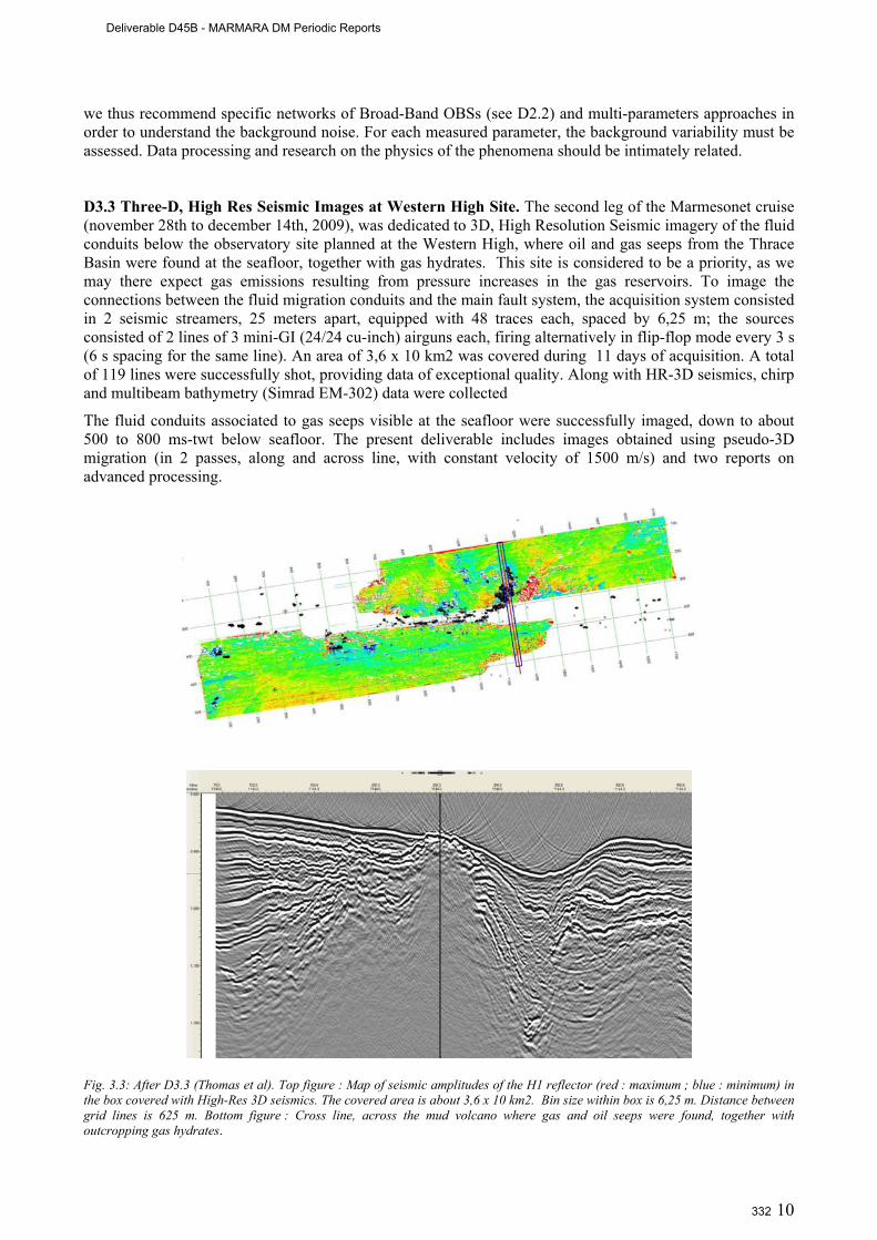
10
we thus recommend specific networks of Broad-Band OBSs (see D2.2) and multi-parameters approaches in order to understand the background noise. For each measured parameter, the background variability must be assessed. Data processing and research on the physics of the phenomena should be intimately related. D3.3 Three-D, High Res Seismic Images at Western High Site. The second leg of the Marmesonet cruise (november 28th to december 14th, 2009), was dedicated to 3D, High Resolution Seismic imagery of the fluid conduits below the observatory site planned at the Western High, where oil and gas seeps from the Thrace Basin were found at the seafloor, together with gas hydrates. This site is considered to be a priority, as we may there expect gas emissions resulting from pressure increases in the gas reservoirs. To image the connections between the fluid migration conduits and the main fault system, the acquisition system consisted in 2 seismic streamers, 25 meters apart, equipped with 48 traces each, spaced by 6,25 m; the sources consisted of 2 lines of 3 mini-GI (24/24 cu-inch) airguns each, firing alternatively in flip-flop mode every 3 s (6 s spacing for the same line). An area of 3,6 x 10 km2 was covered during 11 days of acquisition. A total of 119 lines were successfully shot, providing data of exceptional quality. Along with HR-3D seismics, chirp and multibeam bathymetry (Simrad EM-302) data were collected
The fluid conduits associated to gas seeps visible at the seafloor were successfully imaged, down to about 500 to 800 ms-twt below seafloor. The present deliverable includes images obtained using pseudo-3D migration (in 2 passes, along and across line, with constant velocity of 1500 m/s) and two reports on advanced processing.
Fig. 3.3: After D3.3 (Thomas et al). Top figure : Map of seismic amplitudes of the H1 reflector (red : maximum ; blue : minimum) in the box covered with High-Res 3D seismics. The covered area is about 3,6 x 10 km2. Bin size within box is 6,25 m. Distance between grid lines is 625 m. Bottom figure : Cross line, across the mud volcano where gas and oil seeps were found, together with outcropping gas hydrates.
Deliverable D45B - MARMARA DM Periodic Reports
332

11
WP 4 : Data integration and modeling. D4.1 Report on integration of all available data in a data repository system. All data collected during the Marmara-DM project were deposited on ITU-EMCOL Network Attached Storage (NAS). NAS is a solution for safe and platform independent file storage over Internet. According to Wikipedia, “NAS is a file-level computer data storage connected to a computer network providing data access to heterogeneous network clients”. The characteristics of ITU-EMCOL NAS and the connexion procedures (in terms of both SSH and FTP protocols ) are given in Deliverable 4.1. Each MARMARA-DM member has been notified about his or her username or password. Further instructions about data repository can also be found in the Marmara_DM web page (http://www.esonet.marmara-dm.itu.edu.tr/) EMCOL-NAS section. D4.2 GIS including all available data collected during the Marmara-DM project. The GIS data is presently stored both in IFREMER and ITU’s servers. ITU Eastern Mediterranean Centre for Oceanography and Limnology (EMCOL) has dedicated a Network Attached System (NAS) to share all available and classified data between partners of the project (D4.1). The copy of GIS files will be stored in this restricted system and be available among only allowed users via ftp (ftp://160.75.30.57) and ssh (ssh server 160.75.30.57). Usernames and their passwords have been already sent to the project partners. Other users should apply to the project coordinator Dr. Louis Geli ([email protected]) or Umut B. Ülgen ([email protected]) to get their login details. D4.3 Report to test working hypothesis and validate concept of seafloor observatories. Marmara-DM was driven by the 3 following hypothesis: H1): Physical and chemical properties of the fluids and deformation within the fault zone change systematically with time throughout an earthquake cycle, and some of these changes, or their consequences, can be recorded at the seafloor; H2) Strain rate variations induce pore pressure variations in subsurface sediments; H3) Fluids from the seismogenic depth reach (locally and episodically) the sediment surface. The objective of D4.3 was to assess the results of the Marmara-DM with respect to this hypothesis testing approach, and conclude on future observatory planning.
Hypothesis H1 does little more than stating that seafloor observatories can record signals linked to seismogenic zone processes. Marmara-DM demonstrated the possibility to monitor variations of fluid fluxes and composition, and defined sites where coupling with strain in the NAF seismogenic zone is hypothesized. As formulated, (H1) refers primarily to variations over the time scale of the earthquake cycle. However, this time scale may be considered long even for an observatory project, and it is also unclear whether progressive changes –resulting for example from interseismic loading and fault healing at depth– can be recorded at the seafloor and resolved among the shorter term variations that could result from a variety of processes occurring near the seafloor, or from transient events affecting the crust. Setting aside the fluid component, results obtained from a re-analysis of foreshock data from the Izmit 1999 earthquake [Bouchon et al., 2011] lead to consider that seismometers set close to an active fault could be used to detect the nucleation of large earthquakes. Hence, the objectives of setting an offshore observatory in the SoM should be extended to include the improvement of the predictability of earthquakes in the Istanbul area.
D4.4 Report on best site selection. The detection of transient crustal events now appears as a scientific objective per se. The identification of seismic tremors and low frequency earthquakes –and of their relation with episodic “silent” slip– has been progressing very rapidly, first at subduction zones [e.g. Shelly et al., 2006], and now at strike-slip faults [Nadeau and Dolenc, 2009; Bouchon et al., 2011]. These progresses lead to consider the identification of slipping zones on the edges of seismic gaps or at the upper/lower limits of the seismogenic zone, as the next objectives to be achieved in the SoM. Work performed on Marmara-DM data met difficulties in the precise determination of the depth of offshore earthquakes and in the identification of tremors from noise analysis in the marine environment. Emphasis could now be given to focused, small-scale networks and to the identification of repeating earthquakes. Best targets for this approach are microseismically active zones that also appear as hypothetical nucleation sites for a rupture on the Istanbul-Silivri segment:
1. The Istanbul-Silivri segment: although there is little microseismic activity, the eastern end of the seismic gap (toward Cinarcik Basin) should, however, be monitored. Furthermore, South of Istanbul,
Deliverable D45B - MARMARA DM Periodic Reports
333
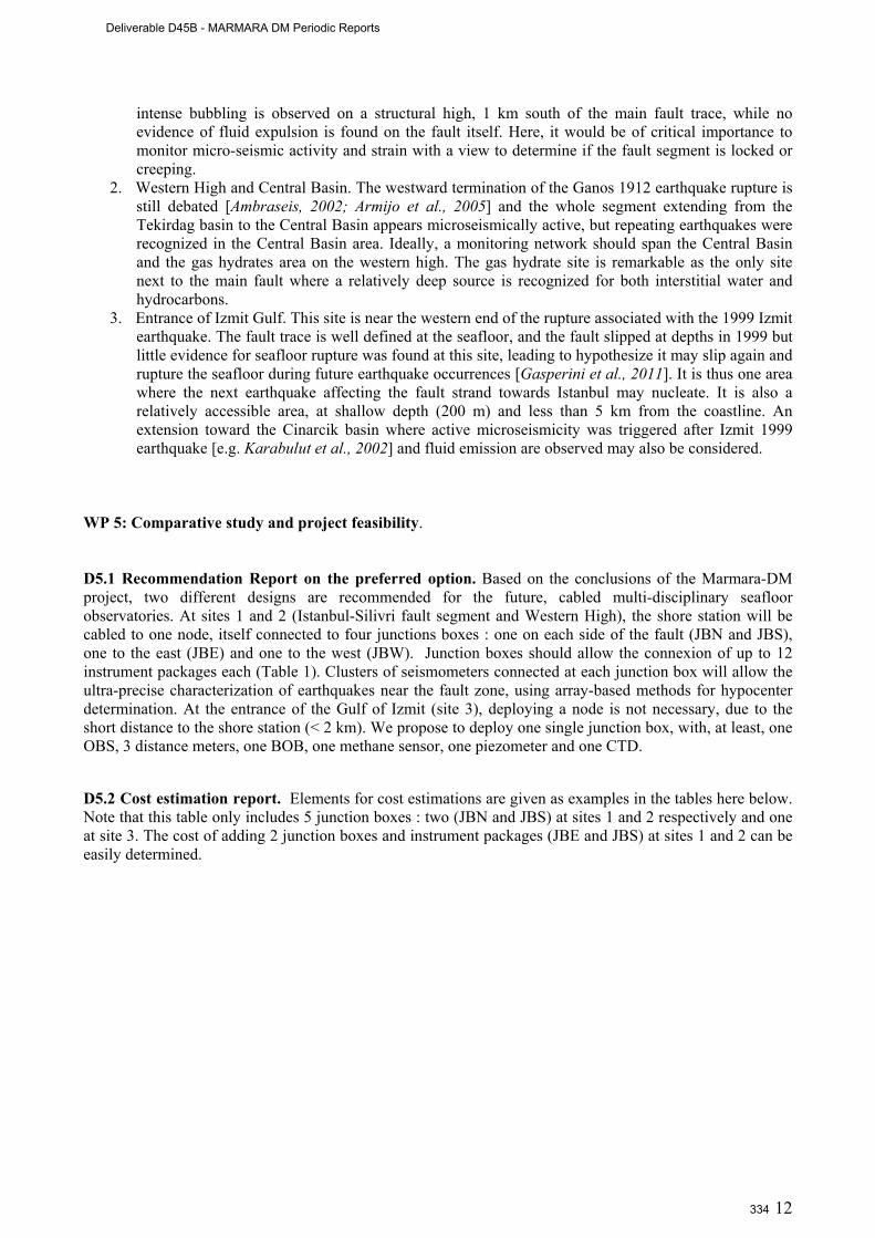
12
intense bubbling is observed on a structural high, 1 km south of the main fault trace, while no evidence of fluid expulsion is found on the fault itself. Here, it would be of critical importance to monitor micro-seismic activity and strain with a view to determine if the fault segment is locked or creeping.
2. Western High and Central Basin. The westward termination of the Ganos 1912 earthquake rupture is still debated [Ambraseis, 2002; Armijo et al., 2005] and the whole segment extending from the Tekirdag basin to the Central Basin appears microseismically active, but repeating earthquakes were recognized in the Central Basin area. Ideally, a monitoring network should span the Central Basin and the gas hydrates area on the western high. The gas hydrate site is remarkable as the only site next to the main fault where a relatively deep source is recognized for both interstitial water and hydrocarbons.
3. Entrance of Izmit Gulf. This site is near the western end of the rupture associated with the 1999 Izmit earthquake. The fault trace is well defined at the seafloor, and the fault slipped at depths in 1999 but little evidence for seafloor rupture was found at this site, leading to hypothesize it may slip again and rupture the seafloor during future earthquake occurrences [Gasperini et al., 2011]. It is thus one area where the next earthquake affecting the fault strand towards Istanbul may nucleate. It is also a relatively accessible area, at shallow depth (200 m) and less than 5 km from the coastline. An extension toward the Cinarcik basin where active microseismicity was triggered after Izmit 1999 earthquake [e.g. Karabulut et al., 2002] and fluid emission are observed may also be considered.
WP 5: Comparative study and project feasibility. D5.1 Recommendation Report on the preferred option. Based on the conclusions of the Marmara-DM project, two different designs are recommended for the future, cabled multi-disciplinary seafloor observatories. At sites 1 and 2 (Istanbul-Silivri fault segment and Western High), the shore station will be cabled to one node, itself connected to four junctions boxes : one on each side of the fault (JBN and JBS), one to the east (JBE) and one to the west (JBW). Junction boxes should allow the connexion of up to 12 instrument packages each (Table 1). Clusters of seismometers connected at each junction box will allow the ultra-precise characterization of earthquakes near the fault zone, using array-based methods for hypocenter determination. At the entrance of the Gulf of Izmit (site 3), deploying a node is not necessary, due to the short distance to the shore station (< 2 km). We propose to deploy one single junction box, with, at least, one OBS, 3 distance meters, one BOB, one methane sensor, one piezometer and one CTD. D5.2 Cost estimation report. Elements for cost estimations are given as examples in the tables here below. Note that this table only includes 5 junction boxes : two (JBN and JBS) at sites 1 and 2 respectively and one at site 3. The cost of adding 2 junction boxes and instrument packages (JBE and JBS) at sites 1 and 2 can be easily determined.
Deliverable D45B - MARMARA DM Periodic Reports
334
13
Des
crip
tion
Eng
inee
ring
Est
imat
ed
pric
e pe
r eq
uipm
ent
Qty
of
equi
pmen
ts
Est
imat
ed
tota
l
Data management center & web (equipment + software) 350K€ 150K€ 3 800K€
Construction of shore station 30K€ 40K€ 3 150K€
Shore station equipment 50K€ 50K€ 3 200K€
Cable 100K€ 20€/m 2*25Km + 5 1200K€
Cable deployment 100 (2x)1000 k€ +(1x) 500 k€ 3 3500
Node 200K€ 350K€ 3 1250K€
Node deployment 250K€ 250K€
Junction box 200K€ 300K€ 5 1700K€
Junction box deployment 300K€ 300K€
Instrumentation 800K€ 500K€ 5 3300K€
Instrumentation deployment 3 days per site 60K€ / day 15 days 900K€
13050K€
Table 3.2 Cost of investments for multi-parameter observatories including 2 junction boxes only at deep sites (Western high and Istabul-Siliviri) and one junction box at shallow site (entrance of Izmit Gulf). Each JB is connected to the instrument package listed in Table 3.1.
Description Per year Estimated total
Training 20K€ 20K€
On site operation maintenance 4 days per site / year (4 sites) 960K€
Equipment maintenance 15% of equipment cost (instruments + cable + shore) station 750K€
Personnel cost (3 engineers, 3 technicians) (3 techs+ 3 engineers)*12 months*1,5K€ 108K€
1838K€
Table 3.3 Indicative annual maintenance and training costs for the equipment and investment listed in Tables 3.1 and 3.2.
D5.3 Implementation plan. The conclusions of the Marmara-DM project were used to build a full implementation plan, submitted to two funding agencies as 2 different proposals, respectively MARQUAKE and MARDEP:
- the MARQUAKE Proposal was submitted on november, 16th, 2010, to the FP7 Cooperation Work Programme 2011for Environment, Sub-Activity 6.1.3 « Natural Hazards », Area 6.1.3.1 « Hazard assessment, triggering factors and forecasting », Topic ENV.2011.1.3.1-1 « Towards real-time earthquake risk reduction ». Partners re : Ifremer (coodinator), ITU, AFAD, Ismar-CNR, CNRS and DEU. This proposal (see appendix in deliverable D5.3) received a mark of 10 out of
Deliverable D45B - MARMARA DM Periodic Reports
335
14
15, the negociation phase is still pending. - The MARDEP Proposal will be submitted in june 2011 to the Disaster and Emergency
Management Presidency (AFAD) of the Republic of Turkey (see Deliverable 6.1). WP 6: Public and education outreach, coordination at national (Turkish) level and fund raising. D6.1 Support agreement contract with Turkish authorities. The major effort to fulfill this deliverable was the preparation of a project proposal “MARDEP project: Marmara Seafloor Observatory Infrastructure for Earthquake and Environmental Research and Modeling” by June 2010 to obtain funding for the establishment of the permanent seafloor observatories in the Sea of Marmara. The proposal was prepared by consensus among the main Turkish Marine institutions after two important meetings in İstanbul. However, the submittal of the proposal was delayed the next call in 2011, which appeared to be the most opportune period because of the political reasons. We will submit the MARDEP Project proposal for funding to the Prime Ministry of Turkey State Planning Department’s (DPT) next call that will be either April or June 2011. The proposal will then be evaluated, and the final decision will be made by the DPT sometime during June to September 2011, depending on the time of the call. This deliverable will be fully realized if and when the Mardep proposal is funded. The chances of funding have increased by the support letters provided by Turkish and European institutions and public organizations.
During the 30 months of the Marmara-DM project several activities were carried out for fund rising within WP6. First we increased the visibility of the ESONET and EMSO projects’ activities in the Sea of Marmara by special presentations in scientific meetings and by organizing an ESONET training course and a symposium in August 2009. Second, we held meetings of Turkish institutions of marine and geohazard studies to reach a consensus for the preparation of MARDEP. MARDEP is designed as a national project with participation of all concerned marine institutions, as well as the Turkish Geological Survey (MTA), Undersecretariat for Maritime Affairs, Department of Hydrography Navigation Oceanography (SHOD), Istanbul Metropolitan Municipality (IBB), and Coast Guards General Command in the meetings. The Istanbul Metropolitan Municipality will be a user of the MARDEP project (see Annex 2). MTA (Mineral Research and Exploration General Directorate: Turkish Geological Survey) also strongly supports the project (Annex 3). If funded, we plan the completion of the infrastructure by 2014, and thereafter start its operation as regional department of the EMSO science infrastructure. In Turkey there are 11 stakeholders in the MARDEP proposal including the MTA (Turkish Geological Survey), Istanbul Municipality, and all Marine Sciences Institutes. The European partners include: IFREMER, CNRS, INGV and ISMAR, (French EMSO and Italian EMSO) all providing support letters (Annexes 4 and 5). Furthermore the ESONET and EMSO partners of the Marmara node applied to a recent EC FP 7 call: ENV.2011.1.3.1-1: Towards real-time earthquake risk reduction with a proposal: “MARQUAKE: Earthquake Predictability in the Sea of Marmara areas” in November, 2010.
D6.2 Web Site. www.esonet.marmara-dm.itu.edu.tr Note : A window in turkish may open, asking for a certificate (İTÜ Güvenlik Sertifikası). In which case, just click on the cross in the upper-right corner to close the window. D6.3 Training course. The Marmara-DSM Training Course was given in Istanbul, on august 18-19, 1999, on “Seafloor Observation Techniques for Marine Geohazard Monitoring”.
Deliverable D45B - MARMARA DM Periodic Reports
336
15
3.2 Work done by each partner The project was a full success mainly because all partners contributed far beyond their initial commitment. Each partner conducted the task he was initially assigned and provided valuable input to improve the observatory design and implementation strategy for multi-parameter, cabled observatories in the Sea of Marmara. The main contribution of each partner is listed hereafter. 3.2.1 Partner 1 : IFREMER. Project coordination. This task consisted in reporting (on a 6-months basis), organizing project meetings, interfacing with the ESONET administration, scientific animation, etc. Marmesonet cruises (D2.2a and D2.2b). Ifremer organized and conducted the two Marmesonet Cruises with R/V Le Suroit :
Leg I (november 4th to november 25th, 2009) was mainly dedicated to: i) the high resolution bathymetry at potential sites of interest for future permanent instrumentation using the Autonomous Unmanned Vehicle (AUV) Asterx of Ifremer/Insu; ii) the systematic mapping of the gas emissions sites on the Marmara seafloor; iii) the deployment of the Bubble Observatory Module (BOB) in the Çinarçik basin.
Leg II (november 28th to december 14th, 2009), for 3D, High Resolution Seismic imagery of the fluid conduits below the observatory site planned at the Western High.
Observatory design, comparative study and project feasibility (WP5). Considerable work was conducted under this work package, namely: i) to design the future multi-parameter observatories; ii) to estimate costs; ii) and to prepare implementation plans. This work was used to build a full implementation plan (D5.3 and D6.1), submitted to two funding agencies as 2 different proposals, respectively MARQUAKE and MARDEP (see D5.3 and D6.1). Project GIS (D4.2). Ifremer coordinated the work to finalize the Project Geographical System which now includes all meta-data and part of the data collected during the Marmara-DM Project. The full dataset is available on the project data repository system, hosted by the ITU’s server (D4.1). Contribution on OBS data. Ifremer contributed to D1.1 (Report on piezometer and OBS results from MarNaut cruise, D3.1 (Report combining marine and land seismological datasets) and D3.2 (Report on the ambient noise and recommendation for implementing permanent seabottom stations), mainly through the PhD Thesis of Jean-Baptiste Tary. Participation to observatory concept validation (D4.3). Ifremer contributed to almost all workpackages, particularly for validating the concept of permanent, cabled, multi-parameter observatories for earthquake predictability in the Sea of Marmara. 3.2.2 Partner 2 : ITU. Coordinating Marine Operations (WP2; D2.1 and D2.2). ITU organized, coordinated and actively participated in the all the cruises, and contributed to the cruise reports Namik Çagatay of ITU acted as the Turkish coordinator, which implied considerable work on practical details, particularly for logistics, administration, customs and autorizations, etc. ITU therefore contributed to deliverables D2.1-D2.2.: Cruises and cruise reports.
Integration of all available data and development of data repository system (D4.1). ITU (Umut Ülgen and Cengiz Zabci) contributed to integration of all Marmara-DM project data, and developed the project data repository system. It consists of a server system called ‘EMCOL-NAS’ (Network Attached System) presently hosted by ITU. It can be reached by an ftp connection for uploading and and receiving data by the partners.
Deliverable D45B - MARMARA DM Periodic Reports
337
16
Contribution to the GIS Project (D4.2). Cengiz Zabci participated in the finalization of the GIS system, which includes all data collected during the Marmara-DM project. Earlier, Devrim Tezcan developed a GIS system and incorporated some cruise data into the system.
Report on best site selection (D4.4). This task has been completed as a result of site surveys carried out during several Marmara-DM cruises in the Sea of Marmara. Three main sites have been selected for observatories. The specifics of these sites have been reported in the MARDEP proposal prepared by ITU with help from IFREMER, CEREGE, ISMAR, DEU-IMST, INGV.
Comparative feasibility studies (WP5; D5.1, D5.2, 5.3). ITU contributed deliverables related to the comparative feasibility studies of establishing permanent multidisciplinary seafloor observatories in the Sea of Marmara. These involve recommendation for a cabled observatory option with node and junction box technology (D5.1), cost estimation (D.5.2) and an implementation plan (D.5.3). All these deliverables were incorporated into the MARDEP project proposal prepared under the leadership of ITU (see below).
Support agreement contract with Turkish authorities (D6.1). ITU built up a Turkish consortium and prepared a project proposal entitled “MARDEP”: Marmara Seafloor Observatory Infrastructure for Earthquake and Environmental Research and Modeling, to obtain funding from Turkish Governement for the establishment of permanent seafloor observatories in the Sea of Marmara. The ‘MARDEP’ project proposal will be presented to the Prime Ministry of Turkey State Planning Department (DPT) in June 2011, for funding. Public outreach - Project website (D6.2): Umut Ülgen and Cengiz Zabci of ITU created the Marmara-DM Project website (http://www.esonet.marmara-dm.itu.edu.tr/). Public outreach - Training course (D6.3) : ITU organized and hosted a short course on “Seafloor Observation Techniques for Marine Geohazard Monitoring” during 17-19 August 2009. About 40 engineers and scientists participated in the short course from Turkey and Europe. ITU also organized a one-day symposium on “An overview of the research in the Sea of Marmara region over the last 10 years” on the 10th Anniversary of 17 August 1999 İzmit Earthquake. The workshop and symposium were important public outreach events, as well having scientific importance. 3.2.3 Partner 3 : ISMAR Organizing and conducting URANIA Cruises, 2009 and 2010 (WP2). ISMAR spent considerable efforts in two cruises of R/V Urania and one cruise of R/V Yunuz which were critical for the Marmara demo mission :
- during the Marmara-2009 cruise (September 22 to October 12th, 2009), SN4 was deployed at the entrance of the Gulf of Izmit, together with 10 OBSs and 5 piezometers of Ifremer covering the whole Sea of Marmara. In addition, new geophysical and geological data were collected from the eastern part of the Sea of Marmara.
- During the R/V Yunuz cruise in march 2010, all instruments were recovered, and SN-4 was redeployed
- during the Marmara-2010 cruise (September 25th to October 15th, 2010), SN-4 was eventually recovered and new geophysical and sedimentological data were collected.
For each cruise, the work conducted by ISMAR included : 1) Compilation and submission to the Italian CNR commission (Gruppo coordinamento infrastrutture) of the proposal for the MARMARA 2009 and 2010 expeditions; 2) Practical preparation (e.g. problems with logistics, customs clearance, etc); 3) processing and re-analysis of the existing geophysical data (multibeam, chirp sonar, etc..) in the area of SN-4 deployment (Izmit bay and Cinarcik basin). Integration of the geological data at site 3 (entrance of Izmit Gulf).
Deliverable D45B - MARMARA DM Periodic Reports
338

17
3.2.4 Partner 4 : INGV Preparation, deployment and recovery of SN-4. INGV completed the upgrade of SN4 observatory adding new sensors to the basic SN-4 configuration. This upgrade was made in order to perform a multiparametric monitoring requested by the project objectives (gas seepage and seismicity). SN-4 was then deployed, as scheduled, in the Marmara Sea site selected for the long-term monitoring. The first deployment operations were successfully performed on October 4th, 2009, in collaboration with ISMAR, who coordinated the operations of R/V Urania. Although selected prior of the cruise, the SN4-observatory site has been surveyed before deployment with geophysical imaging techniques and direct observations with a deep towed system, MEDUSA, that provided oceanographic data (CTD), methane content in the water column and visual inspection through a high-resolution video camera. MEDUSA exploration surveys were performed in different sites in order to detect methane anomalies and have direct observations of the seabed where SN-4 was planned to be deployed. Recovery and redeployment of SN-4 (D2.2). INGV successfully recovered, re-conditionned and immediately redeployed SN-4 with R/V Yunuz in march 2010. SN-4 was eventually recovered in October 2010 with Urania, shortly after the official end of the Marmara-DM project, in order to collect a full year of data (Note : the R/V Yunuz, used for the second SN-4 deployment, had not dynamic positioning system and the capability to keep the position during the operations, so it was not possible to deploy SN-4 in the same site of the previous period, which was in a protected area inside a canyon. SN-4 station was therefore deployed in a narrow rectilinear valley that dissect the Darica basin and mark the North Anatolian Fault trace). Data reduction and processing and preliminary interpretation of SN-4 (D2.3). Regarding the first mission, SN-4 station successfully recorded data from all sensors except current meter (10.5 Gbyte of data from methane and oxygen sensors, CTD, transmissometer and broad-band seismometer). The interpretation work of these data is presently under progress at INGV, mobilizing a group of 5 persons. During the first SN-4 monitoring mission, there were no significant earthquakes (M>3.4) within 100 km. SN-4 however revealed local microseismicity not recorded by land stations (Turkish network). Preliminary analysis shows an apparent correlation between non-seismic signals recorded on the Broad-Band seismometer and variations in bottom water temperature drop, methane concentration and turbidity. All data converge towards an hypothesis of episodic degassing from sediments in the SN-4 near field. Waiting for detailed and complete data elaboration and interpretation, we can anticipate that the SN-4 mission in Marmara Sea represented the longest monitoring of temperature + gas + seismicity at seabed, ever done. The success of the Marmara-DM project is thus now far beyond the initial expectations. 3.2.5 Partner 5 : CNRS Coordination of WP1 (Marnaut data integration). Pierre Henry (CNRS) coordinated the Marnaut cruise which was conducted in 2007 with R/V L’Atalante and manned submersible Nautile. The data and samples acquired during Marnaut cruise were included in the Marmara-DM data set. These included processing of echo-sounder data, analysis of interstitial water and gas composition and deployments of flow meters, piezometers and of a mini OBS network. Analysis of these data was in great part funded by Marmara-DM as WP1 and conducted under the scientific supervision of Pierre Henry. 4 articles included in delivrables D1.1, D1.3 and D1.4 were published and one article, included in delivrable D1.2, is submitted. GIS including all available data (D4.2). Data available to the CEREGE group were included in a GIS by Tiphaine Zitter. These included data from Marnaut (L’Atalante and Nautile), MarmaraVT (Marion-Dusfresne), Marmara 1 (Le Suroît), and part of the data from Marmarascarps (L’Atalante and ROV Victor) cruise. After Marmesonet cruise, the GIS was transferred to Ifremer for standardization and integration of Mamesonet data (AUV and Shipboard multibeam, sediment sounder). Testing working hypotheses and validating concept of observatory (D4.3). Marmara-DM was driven by the following hypothesis: H1) Physical and chemical properties of the fluids and deformation within the fault zone change systematically with time throughout an earthquake cycle, and some of these changes, or their consequences, can be recorded at the seafloor; H2) Strain rate variations induce pore pressure variations in
Deliverable D45B - MARMARA DM Periodic Reports
339
18
subsurface sediments; H3) Fluids from the seismogenic depth reach (locally and episodically) the sediment surface. Pierre Henry (CNRS) supervised the work to assess the results of the Marmara-DM with respect to this hypothesis testing approach, and to conclude on future observatory planning. 3.2.6 Partner 6 : DEU Pirmarmara Cruise of Piri Reis (WP2, D2.1). The main contribution of DEU consisted in organizing and conducting the Pirmara Cruise of R/V Piri Reis, from June 4th to June 14th, 2011, to collect additional high resolution seismic data at the implementation sites of the future multidisciplinary seafloor observatories. Günay Çifçi was the coordinator of the PirMarmara Cruise, Bruno Marsset and Yannick Thomas from Ifremer and Dr. Seda Okay and also 12 researchers participated to the cruise. High Resolution (HR) seismic profiles were collected over the 3D box covered during the Marmesonet Cruise (Leg II) with a 1500-m long streamer having 240 traces, recently acquired by DEU, to provide velocity constrains and hence to improve 3D seismic imaging. The second leg of the PirMarmara cruise aimed to complete the former 2D HR acquisition close to Istanbul, mainly in the Çınarcık basin. The Central High, Central Basin and Çınarcık Basin (area 4) where the Tamam data set recorded in 2008 on board R/V Piri Reis was completed. The southern shelf of the Marmara Sea (areas 1 and 3), with the investigation of the Messinian unconformity. Processing of TAMAM data (WP2, D2.1 and D2.2b). The TAMAM cruise was carried out in june 2008 with R/V Piri Reis, in collaboration between DEU and Lamont Doherty Earth Observatory (LDEO). Although the TAMAM cruise is not part of MARMARA-DM, DEU spent considerable efforts in seismic data processing. This work helped the interpretation of the TAMAM lines, which, indirectly, helped the planning of the MARMARA-DM operations, most particularly the planning of the Marmesonet HR-3D seismic survey conducted with Le Suroit in december 2009 on the Western High (gas hydrates sites). Interpretation of HR-3D seismic survey at site 3 (D3.3). Hakan Saritas (DEU) spent 10 months at Ifremer research center in Brest, from August 2010 to June 2011 to work on the interpretation of the HR-3D seismic seismic data, using Kingdom Suite for the seafloor imagery maps and drawing of first inperpretation of superficial horizons of 3D-cube in time domain and simultaneously comparison with chirp data of MarmEsonet data. This work also constitutes his Phd thesis and includes processing of long offset HR 2D seismic data provide by DEU new streamer and 3D time migration using the updated velocity model. Burcu Barin and Orhan Atgin visited IFREMER during 17 October-17 November 2010 and worked with Bruno Marset and Yannick Thomas on PirMarmara data. The main objective of the visits was, the fundamentals of 3D high resolution Marine Seismic Acquisition, Quality Control and 3D High Resolution Seismic Data Pre-Processing and Quality Control. During the visits, the QC sequence for 2D HR DEU seismic equipment was adopted which derives from the one developed by using Matlab for its DEU seismic equipment. Also they have started to study on the data for their MSc Thesis in Sea of Marmara using PirMarmara data. Gunay Cifci, Seda Okay, Burcu Barin, Orhan Atgin, have visited IFREMER Brest between last week of February and beginning of March for the 4th call Exchange of personel. The aim of the visit is, to work on the Marmara-DM project to evaluate the first results of MarmEsonet and PirMarmara data combining both data sets.
Deliverable D45B - MARMARA DM Periodic Reports
340
19
3.3 Input to and from ESONET Work Packages The Marmara-DM demonstration mission greatly benefited from the input of ESONET WP1, WP3 and WP5. For WP1 (Programme for Exchange and Training of personnel, within ESONET Work Package 1) the exchanges performed during Marmara-DM are listed in the table hereafter:
Institutions concerned
FROM
Institutions concerned
FROM
Name of scientist Date Objective and Marmara-
DM Work Package
ITU Ifremer Cengiz Cabzi Jan-feb 2011
Completion of Project GIS (WP6)
ITU Ifremer Namik Cagatay Umut B. Ülgen Dursun Acar
Jan-Feb 2010
- Work on seafloor observatory design ( WP5) - Work on GIS, Project database and project web page (WP4). - Training on sediment coring and preparation of cores for analyses (WP1).
Namik Cagatay September 2009
Work on core samples and integration of all data (WP4)
Umut B. Ülgen Dursun Acar
December 2010
Work on core samples and integration of all data (WP4)
Devrim Tezcan January 2011
Work on GIS database for the Sea of Marmara and transfer the available data obtained
during various cruises (WP6)
ITU
CNRS-CEREGE
Caner Imren January 2011
Work on seismic data and data integration (WP4)
Namik Cagatay Umut B. Ülgen Dursun Acar
May 2010
- Discussion on URANIA 2010 cruise plan - Review of the results of SN-4 station and its recovery and possible redeployment in October 2010 - Work on 2 papers : 1) Sedimentary; 2) slip rate along NAF
ITU ISMAR
Namik Cagatay Emre Dabci Gülsen Uçarkus
Feb 2011 Work on core samples from Marmara 2010 cruise and integration of all data (WP4)
Umut B. Ülgen Dursun Acar May 2010
Land and marine seismological data integration from the Sea of Marmara region (WP3)
ITU INGV Namik Cagatay Emre Dabci Gülsen Uçarkus
Feb 2011
- discussed the MARDEP project proposal - work on SN-4 data obtained during one year of deployment, with INGV scientists - compare the earthquake and tsunami record results of core studies in the Sea of Marmara and Ionian Sea
- work on database management system to be built up for Marmara Sea Observatory.
Deliverable D45B - MARMARA DM Periodic Reports
341
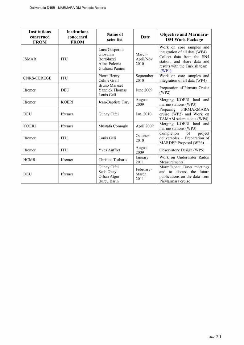
20
Institutions concerned
FROM
Institutions concerned
FROM
Name of scientist Date Objective and Marmara-
DM Work Package
ISMAR ITU
Luca Gasperini Giovanni Bortoluzzi Alina Polonia Giuliana Panieri
March-April/Nov 2010
Work on core samples and integration of all data (WP4) Collect data from the SN4 station, and share data and results with the Turkish team (WP1)
CNRS-CEREGE ITU Pierre Henry Céline Grall
September 2010
Work on core samples and integration of all data (WP4)
Ifremer DEU Bruno Marsset Yannick Thomas Louis Géli
June 2009 Preparation of Pirmara Cruise (WP2)
Ifremer KOERI Jean-Baptiste Tary August 2009
Merging KOERI land and marine stations (WP3)
DEU Ifremer Günay Cifci Jan. 2010 Preparing PIRMARMARA cruise (WP2) and Work on TAMAM seismic data (WP4)
KOERI Ifremer Mustafa Comoglu April 2009 Merging KOERI land and marine stations (WP3)
Ifremer ITU Louis Géli October 2010
Completion of project deliverables – Preparation of MARDEP Proposal (WP6)
Ifremer ITU Yves Auffret August 2009 Observatory Design (WP5)
HCMR Ifremer Christos Tsabaris January 2011
Work on Underwater Radon Measurements
DEU Ifremer
Günay Cifci Seda Okay Orhan Atgın Burcu Barin
February-March 2011
MarmEsonet Days meetings and to discuss the future publications on the data from PirMarmara cruise
Deliverable D45B - MARMARA DM Periodic Reports
342
21
4. Data Management
4.1 MARMARA-DM Data Management The main objective of the Marmara-DM Demo Mission was to conduct site surveys and preliminary studies to test the feasibility of multi-parameters seafloor observatories for monitoring earthquake hazards in the Sea of Marmara. Only a few continuous, short-term (< 6 months) time series were collected using MARMARA-DM using autonomous instruments:
- SN-4 recorded 12 months of data, including: oxygen, methane, 3 component broad-band seismometers (D2.3)
- 4 short-period (4.5 Hz) OBSs and one piezometer recorded data continuously during 3 months (may-september 2007).
All data collected during the Marmara-DM project were deposited on ITU-EMCOL Network Attached Storage (NAS). NAS is a solution for safe and platform independent file storage over Internet. According to Wikipedia, “NAS is a file-level computer data storage connected to a computer network providing data access to heterogeneous network clients”. ITU-EMCOL NAS allows SSH and FTP protocols for sake of security and can be accessed from any kind of OS (Windows, Linux, Unix, Mac OS X). Each MARMARA-DM member has been notified about his or her username or password. The procedure to connect to ITU-EMCOL NAS is described hereafter in terms of both SSH and FTP protocols. Username and password may be provided on request to the project coordinator Dr. Louis Geli ([email protected]).
4.2 Design of the future observatory Data Center / Data management and archiving system To prepare the MARDEP Proposal, a preliminary, undisclosed study was made by Ocean Works Canada (www.oceanworks.com) to determine the main characteristics and costs of the data management and archiving system, based on the experience acquired for the Neptune Project (www.neptunecanada.ca). These characteristics are described in Deliverables D5.1, D5.2 and D5.3. The Observatory Data Center (ODC) consists of the hardware and software elements required to sustain long term observatory operations and user interaction with the data. The ODC computer hardware includes a system server to host the Data Management and Archiving System (DMAS) software, database, and web applications. The DMAS is a scalable operational software system, which consists of two main components:
1) The Data Acquisition Framework (DAF) takes care of the interaction with instruments in terms of control, monitoring as well as data acquisition and storage. The framework also contains operation control tools. Those functions are typically run at the shore station. The other key element of the DAF is its archival function. The archival function gathers all the data produced by the various instruments and stores them either in the database for selected scalar values or in a structured file system for all other data.
2) The user interaction features (UIFs) include data search and retrieval, data distribution. Current developments in the Web 2.0 area will provide a complete research environment where users will have the ability to work and interact on‐line with colleagues, process and visualize data, establish observation schedules and pre‐program autonomous, event detection and reaction.
DMAS provides services that perform both user functions (such as data retrieval, data visualization, metadata discovery) and observatory operation support functions such as: observatory maintenance and management (monitor and control of junction boxes and instruments from a power point of view and monitor and control of instruments from a data flow point of view); science users interfacing; service segmentation (if special categories of instruments need to be isolated from one another for security reasons); system security (to prevent accidental damage to the infrastructure and limit malevolent activities); etc.
Deliverable D45B - MARMARA DM Periodic Reports
343
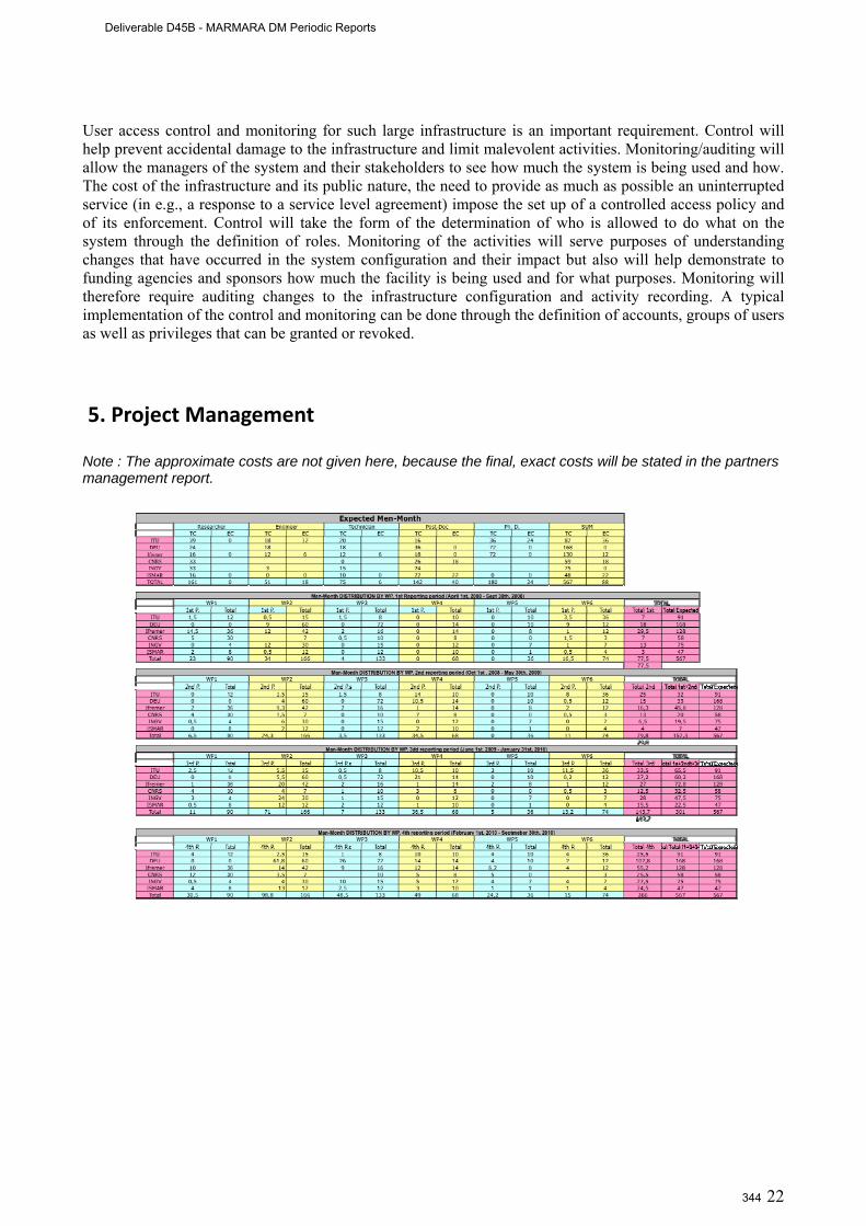
22
User access control and monitoring for such large infrastructure is an important requirement. Control will help prevent accidental damage to the infrastructure and limit malevolent activities. Monitoring/auditing will allow the managers of the system and their stakeholders to see how much the system is being used and how. The cost of the infrastructure and its public nature, the need to provide as much as possible an uninterrupted service (in e.g., a response to a service level agreement) impose the set up of a controlled access policy and of its enforcement. Control will take the form of the determination of who is allowed to do what on the system through the definition of roles. Monitoring of the activities will serve purposes of understanding changes that have occurred in the system configuration and their impact but also will help demonstrate to funding agencies and sponsors how much the facility is being used and for what purposes. Monitoring will therefore require auditing changes to the infrastructure configuration and activity recording. A typical implementation of the control and monitoring can be done through the definition of accounts, groups of users as well as privileges that can be granted or revoked.
5. Project Management
Note : The approximate costs are not given here, because the final, exact costs will be stated in the partners management report.
Deliverable D45B - MARMARA DM Periodic Reports
344
23
6. Results
6.1 Introduction The major result of the Marmara-DM is to have collected important data to address the question on the predictability of earthquakes in the Istanbul area, one of the most exposed to earthquake hazards in Europe. The predictability of earthquakes is per se a subject that needs massive efforts and adapted, large-scale means concentrated on one well-studied seismic area, where the probability of occurrence is high. For many reasons, the Istanbul area is one of the most suitable areas for this purpose. The first two reasons are well known: i) there is a high probability that an earthquake of Mw > 7.0 will strike within the next decades along the NAF in the Sea of Marmara, directly affecting the heavily populated Istanbul area; ii) the segment having the highest probability to rupture is relatively well determined (Fig. 6.1).
The two other reasons are less known, both result from recent findings :
1) Recent work has reported the observation of the nucleation phase of the Mw 7.4 Izmit earthquake, which devastated part of northwestern Turkey in 1999, and the fact that this nucleation was accompanied by tremors at least 44 minutes before the main shock [Bouchon et al, 2011].
2) Gas emissions were found in the water column near the surface expression of known active faults [Géli et al, 2008]. Based on geochemical analysis, it is shown that the NAF in the Sea of Marmara strikes across hydrocarbon gas reservoirs from the Thrace Basin gas province [Bourry et al, 2009].
The first discovery is of fundamental importance, as the presence of very characteristics tremors during the nucleation phase of a large earthquake may yield direct information on the timing and location of the preparing rupture, before the earthquake strikes [Bouchon et al, 2011]. This clearly supports the imperious necessity to deploy ocean bottom seismometers close to the fault zone, most particularly close to the fault segment having the highest probability to rupture. This discovery and the finding that gas reservoirs are connected to the fault zone opens new perspectives that were not even imaginable a few years ago, and supports the necessity to monitor gas emission activity along with seismicity. If seismic tremors are found to be associated with clear anomalies in gas emission activity, then we will have more criteria for characterizing and identifying the recorded signals as indicators that the probability of occurrence of an impending earthquake is increasing. In this respect, the work proposed is meant to improve the preparedness of the authorities in charge of civil protection. Hence the concept: to improve the predictability of the next large earthquake in the Istanbul area, we propose to continuously collect geochemical and geophysical data from the immediate vicinity of the fault zone, most particularly by implementing permanent seafloor observatories in the Sea of Marmara and developing methods and tools for data processing, integration and analysis. The submarine stations deployed during the Marquake Project will provide high quality data from the close vicinity of the submerged fault, within the Sea of Marmara and benefit to the improvement of the ongoing early warning systems in the Istanbul area [e. g. Oth et al, 2010].
Deliverable D45B - MARMARA DM Periodic Reports
345
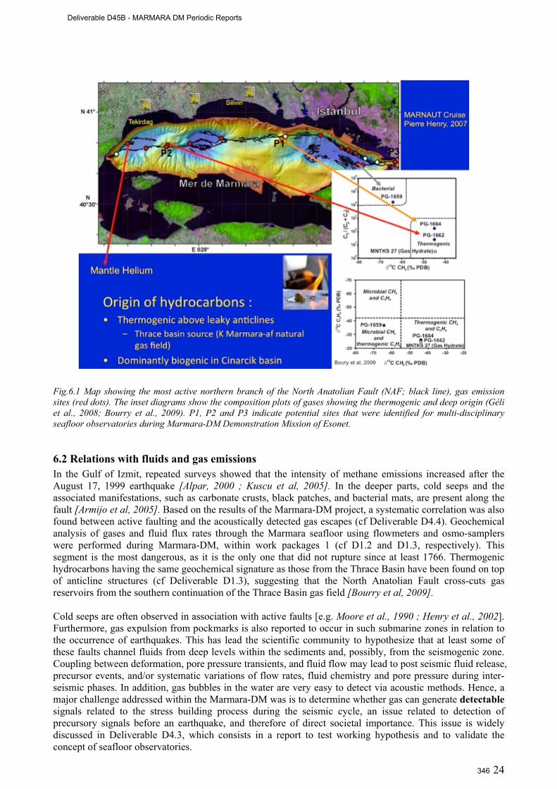
24
Fig.6.1 Map showing the most active northern branch of the North Anatolian Fault (NAF; black line), gas emission sites (red dots). The inset diagrams show the composition plots of gases showing the thermogenic and deep origin (Géli et al., 2008; Bourry et al., 2009). P1, P2 and P3 indicate potential sites that were identified for multi-disciplinary seafloor observatories during Marmara-DM Demonstration Mission of Esonet.
6.2 Relations with fluids and gas emissions In the Gulf of Izmit, repeated surveys showed that the intensity of methane emissions increased after the August 17, 1999 earthquake [Alpar, 2000 ; Kuscu et al, 2005]. In the deeper parts, cold seeps and the associated manifestations, such as carbonate crusts, black patches, and bacterial mats, are present along the fault [Armijo et al, 2005]. Based on the results of the Marmara-DM project, a systematic correlation was also found between active faulting and the acoustically detected gas escapes (cf Deliverable D4.4). Geochemical analysis of gases and fluid flux rates through the Marmara seafloor using flowmeters and osmo-samplers were performed during Marmara-DM, within work packages 1 (cf D1.2 and D1.3, respectively). This segment is the most dangerous, as it is the only one that did not rupture since at least 1766. Thermogenic hydrocarbons having the same geochemical signature as those from the Thrace Basin have been found on top of anticline structures (cf Deliverable D1.3), suggesting that the North Anatolian Fault cross-cuts gas reservoirs from the southern continuation of the Thrace Basin gas field [Bourry et al, 2009]. Cold seeps are often observed in association with active faults [e.g. Moore et al., 1990 ; Henry et al., 2002]. Furthermore, gas expulsion from pockmarks is also reported to occur in such submarine zones in relation to the occurrence of earthquakes. This has lead the scientific community to hypothesize that at least some of these faults channel fluids from deep levels within the sediments and, possibly, from the seismogenic zone. Coupling between deformation, pore pressure transients, and fluid flow may lead to post seismic fluid release, precursor events, and/or systematic variations of flow rates, fluid chemistry and pore pressure during inter-seismic phases. In addition, gas bubbles in the water are very easy to detect via acoustic methods. Hence, a major challenge addressed within the Marmara-DM was is to determine whether gas can generate detectable signals related to the stress building process during the seismic cycle, an issue related to detection of precursory signals before an earthquake, and therefore of direct societal importance. This issue is widely discussed in Deliverable D4.3, which consists in a report to test working hypothesis and to validate the concept of seafloor observatories.
Deliverable D45B - MARMARA DM Periodic Reports
346
25
6.3 Dataset used in the Marmara-DM project The results of the Marmara-DM are based on the data collected during the 6 following cruises, which were conducted within Work Package 2:
• 2 Cruises with R/V Le Suroit of Ifremer, from november 4th to december 14th, 2009. The first for
acoustic detection of gas emissions, AUV microbathymetry and seabottom deployment of BOB (acoustic gas bubble detector); the second cuise for high resolution, 3D seismic site survey on the Western High.
• 2 cruises with R/V Urania (Italy) in september 2009 and september 2010, for deploying and recovering the multiparameter sea-bottom observatory SN-4 of INGV at the entrance of the Gulf of Izmit, together with autonomous OBSs and piezometers from Ifremer.
• 2 cruises with Turkish vessels, respectively R/V Yunuz (from ITU) and R/V Piri Reis (from DEU) were respectively conducted in march 2010 to recover and redeploy SN-4 and to recover the Ifremer instruments and in june 2010 to collect additional high resolution, 2D seismic profiles to complete the different site surveys.
In addition, data and samples acquired in 2007 with R/V L’Atalante and manned submersible Nautile during Marnaut cruise were included in the Marmara-DM data set. These included echo-sounder data, analysis of interstitial water and gas composition and deployments of flow meters, piezometers and of a mini OBS network.
6.4 Best site selection (D4.4)
Three sites are identified as priorities for the future multi-parameters sea-floor observatories (Fig. 6.1):
1) The Istanbul-Silivri segment, in the seismic gap immediately south of Istanbul 2) The Western High / Gas Hydrates area. 3) Entrance of Izmit Gulf.
It is important to note that the detection of transient crustal events now appears as a scientific objective per se. The identification of seismic tremors and low frequency earthquakes –and of their relation with episodic “silent” slip– has been progressing very rapidly, first at subduction zones [e.g. Shelly et al., 2006], and now at strike-slip faults [Nadeau and Dolenc, 2009; Bouchon et al., 2011]. These progresses lead to consider the identification of slipping zones on the edges of seismic gaps or at the upper/lower limits of the seismogenic zone, as the next objectives to be achieved in the SoM. Work performed on Marmara-DM data met difficulties in the precise determination of the depth of offshore earthquakes and in the identification of tremors from noise analysis in the marine environment. Emphasis could now be given to focused, small-scale networks and to the identification of repeating earthquakes. Repeating earthquakes were recognized in the Central Basin area, which appears as an hypothetical nucleation site for a rupture on the Istanbul-Silivri segment. The gas hydrate site is remarkable as the only site next to the main fault where a relatively deep source is recognized for both interstitial water and hydrocarbons. The ideal monitoring network at Site 2 should span the Central Basin and the gas hydrates area on the western high.
6.5 Concept Based on the Marmara-DM results, the MARDEP project is to be proposed to the Turkish authorities in June 2011 (Deliverable D6.1). The concept behind the MARDEP project is to improve earthquake predictability by combining microseismic monitoring (including the search for tremors) and fluid emission monitoring (including gas released in the water column). • The tremor-like signal that was recently documented by [Bouchon et al, 2011] prior to the Izmit earthquake shows the existence for that earthquake of a nucleation phase which is both detectable and identifiable. The search of seismic tremors in the Istanbul area is hence a challenge of dramatic importance,
Deliverable D45B - MARMARA DM Periodic Reports
347
26
which requires not only the collection of seismological data from the near vicinity of the fault, but also the development of specific methods, including the precise, real-time location and characterization of events and the real-time identification of tremors. We still must learn on these tremors. The context in which they occur needs to be analyzed and understood, in order to draw general conclusions on their capacity to provide clear indications on the occurrence of an impending earthquake. • The fact that emissions of thermogenic gases, and, in some places, hydrocarbon seepages have been found on the seafloor in the close vicinity of the main fault, within the fault valley or on top of neighbouring anticlines, clearly indicates that there is a direct connexion between the sediment surface and the hydrocarbon reservoirs at depth. In addition, high-resolution 3D seismic data reveal a 300 meters wide, chimney-like conduit, rising from below the Western High, up to the site where gas hydrates were sampled at the sea surface. The existence of this structure, located less than 600 m away from the main fault suggest that shear movement along the fault perturbs the hydrogeological system, likely affecting the precarious equilibrium of over-pressured units, and thereby allowing fluids to be flushed along the fault pathway.
More generally, focused fluid expulsion structures (such as vent complexes, pockmarks and mud volcanoes) are often associated with faults in various geological settings. To explain these observations, it has been proposed that the critical fluid pressure required to induce sediment deformation is reduced when strike-slip faulting is active [Mazzini et al, 2009]. Fluid expulsion then occurs when overpressure at depth is sufficient to fracture the overburden sedimentary units [e.g. Kopf, 2002 and references therein]. When a threshold is reached due to continuous generation of fluids (e.g. water, hydrocarbons, gas) at depth, a system of fractures propagates towards the surface breaching the seal.
Inversely, one can reasonably expect that when the total stress approaches the failure strength immediately prior to an earthquake (reaching 90 to 95 % of the yield stress), the critical overpressure to fracture the overburden layers is reduced, causing fluids to escape along the fault. We hypothesize that the intensity of thermogenic hydrocarbon emission is related to the coulomb stress on the fault, and that information of fault criticality, and hence earthquake probability, could be derived from long-term records. On a shorter time-scale, observation of precursory fluid emissions during earthquake nucleation would presumably require interaction between the slipping patch and the fluid reservoir or conduit. Coupled seismological and fluid monitoring would be needed to detect such events.
6.6 Design of future Multi-Disciplinary Seafloor Observatories (MDSOs)
• At sites 1 and 2 (both located on anticlines where numerous sites of gas emissions of thermogenic origin were found), the shore station will be cabled to one node, itself connected to four junctions boxes : one on each side of the fault (JBN and JBS), one to the east (JBE) and one to the west (JBW) of Central High. Junction boxes will have the same requirements 1 as those produced by Oceanworks 2 (Canada), the provider of the Neptune Project 3 , allowing the connexion of 10 instrument packages each (Table 1). At JBE and JBW, we will deploy, respectively: an array of 4 seismometers, at distances < 500 from the junction box; one piezometer, one BOB, one methane
1 Junction Box Requirements Depth requirements : 200, 450,700m Maximum power : 1800W Input voltage : 375VDC (nominal) Input data interface : 100 BaseTX Number of ports : 8 science, 2 expansion/high power Science power interface : software configurable 12, 15, 24VDC at 75W Science data interface : ideally RS232/485 and Ethernet ports on same connector Expansion port : 375VDC at 1800W, 100BaseTX (allows connection of high power instrument system or another junction box for expansion) Monitoring capabilities : voltage, current, ground fault (internal and science interfaces) Science control/monitoring : fully integrated, secure operator web interface ; disconnect breakers for each Science port Operating distance from Node : 70m without additional media converter modules. 2 http://www.oceanworks.com/ 3 http://www.neptunecanada.ca/
Deliverable D45B - MARMARA DM Periodic Reports
348
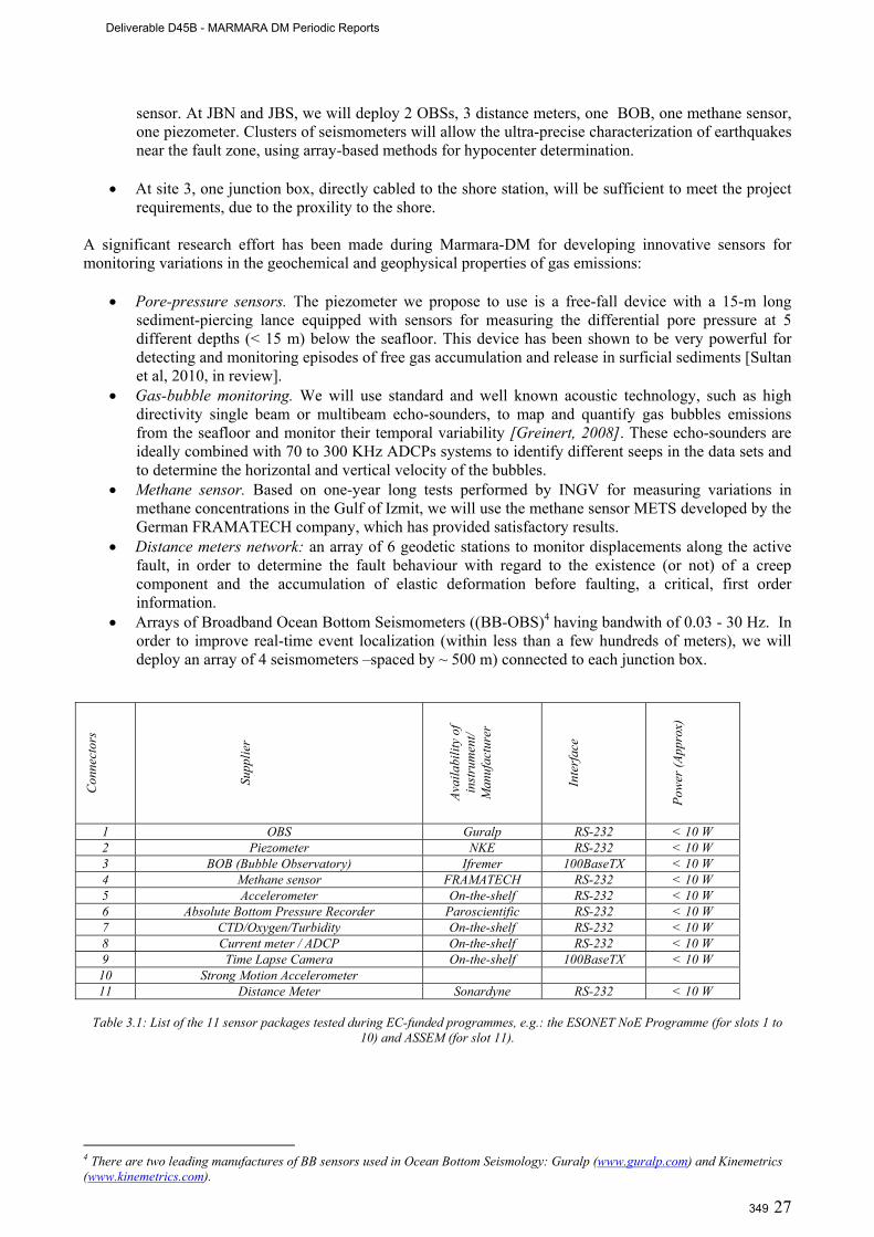
27
sensor. At JBN and JBS, we will deploy 2 OBSs, 3 distance meters, one BOB, one methane sensor, one piezometer. Clusters of seismometers will allow the ultra-precise characterization of earthquakes near the fault zone, using array-based methods for hypocenter determination.
• At site 3, one junction box, directly cabled to the shore station, will be sufficient to meet the project
requirements, due to the proxility to the shore. A significant research effort has been made during Marmara-DM for developing innovative sensors for monitoring variations in the geochemical and geophysical properties of gas emissions:
• Pore-pressure sensors. The piezometer we propose to use is a free-fall device with a 15-m long sediment-piercing lance equipped with sensors for measuring the differential pore pressure at 5 different depths (< 15 m) below the seafloor. This device has been shown to be very powerful for detecting and monitoring episodes of free gas accumulation and release in surficial sediments [Sultan et al, 2010, in review].
• Gas-bubble monitoring. We will use standard and well known acoustic technology, such as high directivity single beam or multibeam echo-sounders, to map and quantify gas bubbles emissions from the seafloor and monitor their temporal variability [Greinert, 2008]. These echo-sounders are ideally combined with 70 to 300 KHz ADCPs systems to identify different seeps in the data sets and to determine the horizontal and vertical velocity of the bubbles.
• Methane sensor. Based on one-year long tests performed by INGV for measuring variations in methane concentrations in the Gulf of Izmit, we will use the methane sensor METS developed by the German FRAMATECH company, which has provided satisfactory results.
• Distance meters network: an array of 6 geodetic stations to monitor displacements along the active fault, in order to determine the fault behaviour with regard to the existence (or not) of a creep component and the accumulation of elastic deformation before faulting, a critical, first order information.
• Arrays of Broadband Ocean Bottom Seismometers ((BB-OBS)4 having bandwith of 0.03 - 30 Hz. In order to improve real-time event localization (within less than a few hundreds of meters), we will deploy an array of 4 seismometers –spaced by ~ 500 m) connected to each junction box.
Con
nect
ors
Su
pplie
r
Av
aila
bilit
y of
in
stru
men
t/ M
anuf
actu
rer
In
terf
ace
Po
wer
(App
rox)
1 OBS Guralp RS-232 < 10 W 2 Piezometer NKE RS-232 < 10 W 3 BOB (Bubble Observatory) Ifremer 100BaseTX < 10 W 4 Methane sensor FRAMATECH RS-232 < 10 W 5 Accelerometer On-the-shelf RS-232 < 10 W 6 Absolute Bottom Pressure Recorder Paroscientific RS-232 < 10 W 7 CTD/Oxygen/Turbidity On-the-shelf RS-232 < 10 W 8 Current meter / ADCP On-the-shelf RS-232 < 10 W 9 Time Lapse Camera On-the-shelf 100BaseTX < 10 W
10 Strong Motion Accelerometer 11 Distance Meter Sonardyne RS-232 < 10 W
Table 3.1: List of the 11 sensor packages tested during EC-funded programmes, e.g.: the ESONET NoE Programme (for slots 1 to
10) and ASSEM (for slot 11).
4 There are two leading manufactures of BB sensors used in Ocean Bottom Seismology: Guralp (www.guralp.com) and Kinemetrics (www.kinemetrics.com).
Deliverable D45B - MARMARA DM Periodic Reports
349
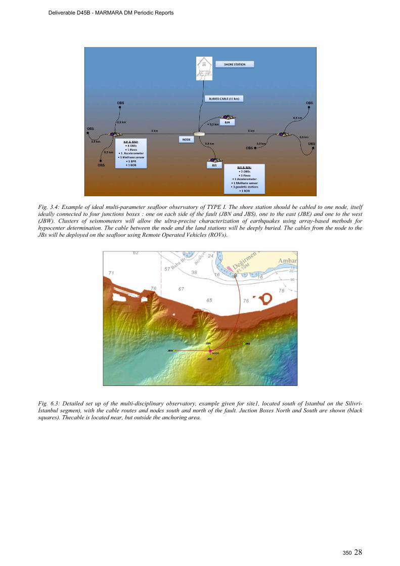
28
Fig. 3.4: Example of ideal multi-parameter seafloor observatory of TYPE I. The shore station should be cabled to one node, itself ideally connected to four junctions boxes : one on each side of the fault (JBN and JBS), one to the east (JBE) and one to the west (JBW). Clusters of seismometers will allow the ultra-precise characterization of earthquakes using array-based methods for hypocenter determination. The cable between the node and the land stations will be deeply buried. The cables from the node to the JBs will be deployed on the seafloor using Remote Operated Vehicles (ROVs).
Fig. 6.3: Detailed set up of the multi-disciplinary observatory, example given for site1, located south of Istanbul on the Silivri-İstanbul segmen), with the cable routes and nodes south and north of the fault. Juction Boxes North and South are shown (black squares). Thecable is located near, but outside the anchoring area.
Deliverable D45B - MARMARA DM Periodic Reports
350
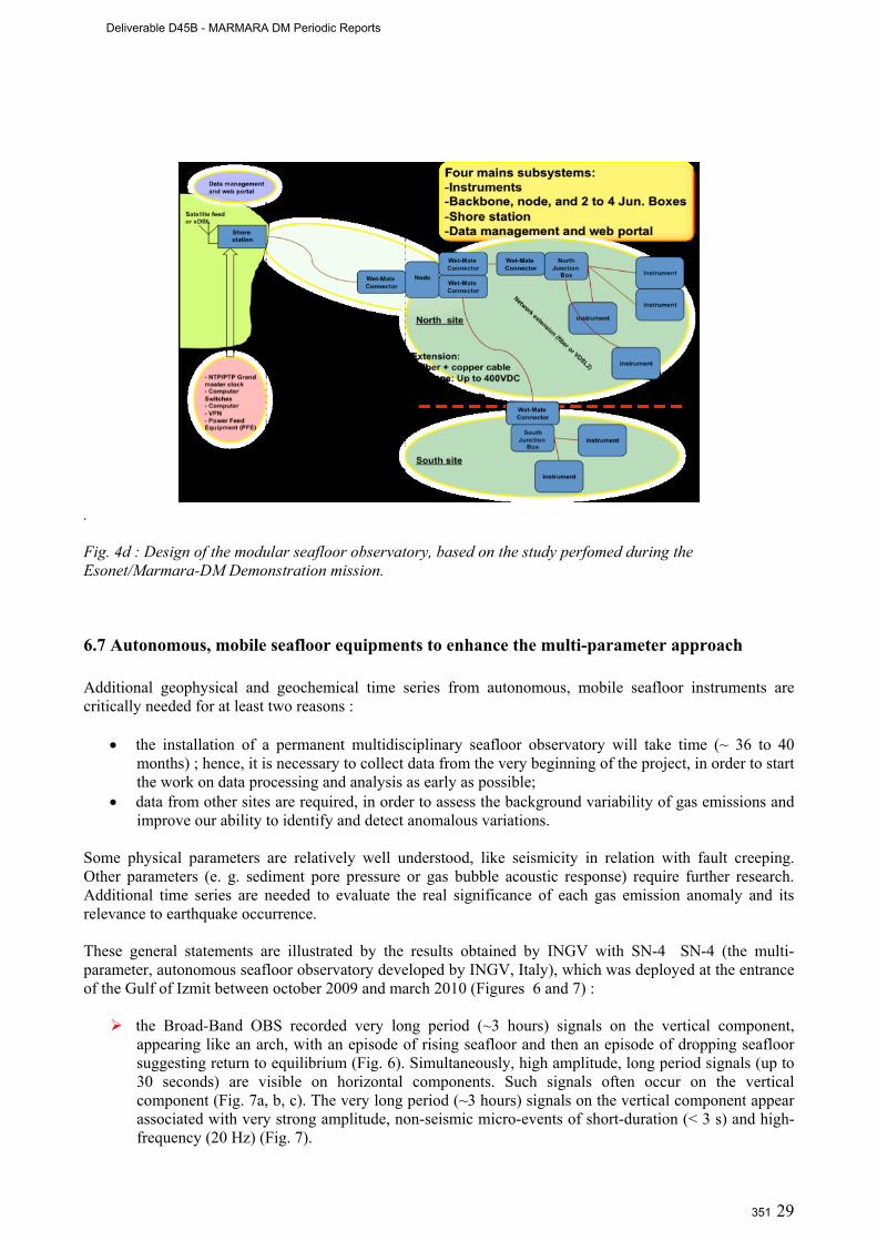
29
.
Fig. 4d : Design of the modular seafloor observatory, based on the study perfomed during the Esonet/Marmara-DM Demonstration mission.
6.7 Autonomous, mobile seafloor equipments to enhance the multi-parameter approach Additional geophysical and geochemical time series from autonomous, mobile seafloor instruments are critically needed for at least two reasons :
• the installation of a permanent multidisciplinary seafloor observatory will take time (~ 36 to 40 months) ; hence, it is necessary to collect data from the very beginning of the project, in order to start the work on data processing and analysis as early as possible;
• data from other sites are required, in order to assess the background variability of gas emissions and improve our ability to identify and detect anomalous variations.
Some physical parameters are relatively well understood, like seismicity in relation with fault creeping. Other parameters (e. g. sediment pore pressure or gas bubble acoustic response) require further research. Additional time series are needed to evaluate the real significance of each gas emission anomaly and its relevance to earthquake occurrence. These general statements are illustrated by the results obtained by INGV with SN-4 SN-4 (the multi-parameter, autonomous seafloor observatory developed by INGV, Italy), which was deployed at the entrance of the Gulf of Izmit between october 2009 and march 2010 (Figures 6 and 7) :
the Broad-Band OBS recorded very long period (~3 hours) signals on the vertical component, appearing like an arch, with an episode of rising seafloor and then an episode of dropping seafloor suggesting return to equilibrium (Fig. 6). Simultaneously, high amplitude, long period signals (up to 30 seconds) are visible on horizontal components. Such signals often occur on the vertical component (Fig. 7a, b, c). The very long period (~3 hours) signals on the vertical component appear associated with very strong amplitude, non-seismic micro-events of short-duration (< 3 s) and high-frequency (20 Hz) (Fig. 7).
Deliverable D45B - MARMARA DM Periodic Reports
351
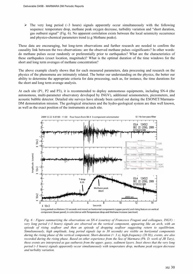
30
The very long period (~3 hours) signals apparently occur simultaneously with the following sequence: temperature drop, methane peak oxygen decrease, turbidity variation and “short duration, gas outburst signal” (Fig. 6). No apparent correlation exists between the local seismicity occurrence and physico-chemical parameters trend (e.g Methane peaks).
These data are encouraging, but long-term observations and further research are needed to confirm the causality link between the two observations: are the observed methane pulses «significant»? In other words: do methane pulses occur randomly or preferentially prior to earthquakes? What are the characteristics of these earthquakes (exact location, magnitude)? What is the optimal duration of the time windows for the short and long term averages of methane concentration? The above example clearly shows that for each measured parameters, data processing and research on the physics of the phenomena are intimately related. The better our understanding on the physics, the better our ability to determine the appropriate criteria for data processing, such as, for instance, the time durations for the short and long term average analysis. At each site (P1, P2 and P3), it is recommended to deploy autonomous equipments, including SN-4 (the autonomous, multi-parameter observatory developed by INGV), additional seismometers, piezometers, and acoustic bubble detector. Detailed site surveys have already been carried out during the ESONET/Marmara-DM demonstration mission. The geological structures and the hydro-geological system are thus well known, as well as the exact position of the instruments at each site.
Fig. 6 : Figure summarizing the observations on SN-4 (courtesy of Francesco Frugoni and colleagues, INGV) : very long period (~3 hours) signals are observed on the vertical component, appearing like an arch, with an episode of rising seafloor and then an episode of dropping seafloor suggesting return to equilibrium. Simultaneously, high amplitude, long period signals (up to 30 seconds) are visible on horizontal components during the rising phase of the vertical component. Short-duration (< 3 s), high-frequency (20 Hz), events, are also recorded during the rising phase. Based on other experience from the Sea of Marmara (Ph. D. work of JB Tary), these events are interpreted as gas outbursts from the upper, gassy, sediment layers. Inset shows that the very long period (~3 hours) signals apparently occur simultaneously with temperature drop, methane peak oxygen decrease and turbidity variation.
Deliverable D45B - MARMARA DM Periodic Reports
352
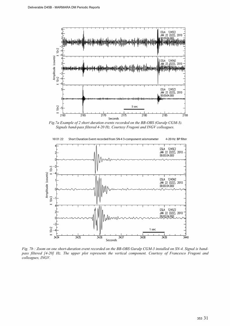
31
Fig.7a Example of 2 short duration events recorded on the BB-OBS (Guralp CGM-3).
Signals band-pass filtered 4-20 Hz. Courtesy Frugoni and INGV colleagues.
Fig. 7b : Zoom on one short-duration event recorded on the BB-OBS Guralp CGM-3 installed on SN-4. Signal is band-pass filtered [4-20] Hz. The upper plot represents the vertical component. Courtesy of Francesco Frugoni and colleagues, INGV.
Deliverable D45B - MARMARA DM Periodic Reports
353
32
6.12 Outreach and communication
During the 30 months of the Marmara-DM project several activities were carried out in Turkey to obtain funding for the establishment of seafloor observatories in the Sea of Marmara. For this, first we increased the visibility of the ESONET and EMSO projects’ activities in the Sea of Marmara by special presentations in scientific meetings and by organizing an ESONET training course and a symposium in August 2009 (Deliverable D6.3). A public conference gathering the principal mass media in Turkey was held at the French General Consultate in Istanbul on December 15th, 2009. A public project website is now hosted at the Istanbul Technical University (Deliverable D6.2).
Second, we held meetings of Turkish institutions of marine and geohazard studies to reach a consensus on the establishment of the seafloor observatories and agree on a project proposal to obtain funding from the Turkish authorities, under the acronym “MARDEP”(Marmara Seafloor Observatory Infrastructure for Earthquake and Environmental Research and Modeling). This proposal was ready to be submitted to the Turkish authorities (initially TUBITAK) by June 2010 (Deliverable D6.1). However, the submittal was postponed, to be submitted for funding to the Prime Ministry of Turkey State Planning Department’s (DPT) call that will be either in April or June 2011.
The MARDEP project is designed as a national project with participation of all concerned marine institutions, as well as the Turkish Geological Survey (MTA), Undersecretariat for Maritime Affairs, Department of Hydrography Navigation Oceanography (SHOD), Istanbul Metropolitan Municipality (IBB), and Coast Guards General Command in the meetings. The Istanbul Metropolitan Municipality will be a user of the MARDEP project (see Annex 2). MTA (Mineral Research and Exploration General Directorate: Turkish Geological Survey) also strongly supports the project (Annex 3) If funded, we plan the completion of the infrastructure by 2014, and thereafter start its operation as regional department of the EMSO science infrastructure. In Turkey there are 11 stakeholders in the MARDEP proposal including the MTA (Turkish Geological Survey), Istanbul Municipality, and all Marine Sciences Institutes. The European partners include: IFREMER, CNRS, INGV and ISMAR, (French EMSO and Italian EMSO) all providing support letters (Annexes 4 and 5). Furthermore the ESONET and EMSO partners of the Marmara node applied to a recent EC FP 7 call: ENV.2011.1.3.1-1: Towards real-time earthquake risk reduction with a proposal: “MARQUAKE: Earthquake Predictability in the Sea of Marmara areas” in November, 2010.
The details of the activities concerning fund raising and preparation of the MARDEP project are extensively described in D6.1 The Sea of Marmara Node group (ITU, AFAD, IFREMER, CEREGE, ISMAR, DEU-IMST) also applied on 16 November 2010 to call ENV.2011.1.3.1-1 Towards real-time earthquake risk reduction with the MARQUAKE: Earthquake Predictability in the Sea of Marmara areas proposal.
Deliverable D45B - MARMARA DM Periodic Reports
354

33
6.13 List of publications resulting from the MARMARA-DM project Peer Reviewed, International Journals Bourry, C., Chazallon, B., Charlou, J-L, Donval J.P, Ruffine, L., Henry, P., Geli, L., Çagatay, M.N., Sedat, I. Moreau,
M., (2009). Free gas and gas hydrates from the Sea of Marmara, Turkey: Chemical and structural characterization, Chemical Geology, 264, 197–206.
Cagatay, MN; Eris, K; Ryan, WBF; Sancar, U; Polonia, A; Akcer, S.; Biltekin, D; Gasperini, L.; Gorur, N.; Lericolais, G.; Bard, E. Late Pleistocene-Holocene evolution of the northern shelf of the Sea of Marmara, MARINE GEOLOGY, 265 (3-4): 87-100 SEP 15 2009
Gasperini, L., A. Polonia, G. Bortoluzzi, P. Henry, X. Le Pichon, M. Tryon, M.N. Cagatay, L. Geli (2011) How far did the surface rupture of the 1999 Izmit earthquake reach in Sea of Marmara?, Tectonics, doi:10.1029/2010TC002726, in press.
Géli L., P. Henry, T. Zitter, S. Dupré, M. Tryon, M.N. Çağatay, B. Mercier de Lépinay, X. Le Pichon, A.M.C. Şengör, N. Görür, B. Natalin, G. Uçarkuş, S. Özeren, D. Volker, L. Gasperini, P. Burnard, S. Bourlange and the Marnaut Scientific Party. Gas emissions and active tectonics within the submerged section of the North Anatolian Fault zone in the Sea of Marmara, Earth Planet. Sci. Lett., 274, 34-39, doi:10.1016/j.epsl.2008.06.047, 2008.
Görür, N., Çagatay, M.N., 2010. Geohazards rooted from the northern margin of the Sea of Marmara since the late Pleistocene: a review of recent results. Natural Hazards. 54(2):583-603.
Özeren, M.S., Çağatay, M.N., Postacıoğlu, N., Şengör, A.M.C., Görür, N., Eriş, K., 2010.Mathematical modelling of a potential tsunami associated with a lateglacial submarine landslide in the Sea of Marmara. Geo-Mar Lett. doi 10.1007/s00367-010-0191-1
Ritt, B., J. Sarrazin, J.−C. Caprais, P. Noel, O. Gauthier, C. Pierre, P. Henry and D. Desbruyères (2010) First insights into the structure and environmental setting of cold−seep communities in the Marmara Sea, Deep-Sea Res. Part I, 57, 1120-1136.
Tary, J.B., L. Géli, P. Henry, B. Natalin, L. Gasperini, M. Çomoglu, N. Çagatay and T. Bardainne (2011), Sea bottom observations from the Western escarpment of the Sea of Marmara, Bull. Seism. Soc. Am., 101, No. 2, , doi: 10.1785/0120100014
Tryon, M.D., Henry, Çağatay, M.N., Zitter, T.A.C. Géli, L., Gasperini, L,. Burnard P., Bourlange, S., Grall, C., 2010. Porefluidchemistry of the North AnatolianFaultZone in theSea of Marmara: A diversity of sources and processes. Geochemistry, Geophysics, Geosystems, 11, dx.doi.org/10.1029/ 2010GC003177.
Peer reviewed, national journals Sarı, E Çağatay, N. 2010. Sediment core studies on the North Anatolian Fault in the eastern Sea of Marmara: Evidence
for sealevel changes and fault activity. Bulletin of Mineral Research and Exploration of Turkey, 140: 1-20. Çağatay, M.N.and Marnaut Cruise Party, 2010. Origin of the Black Sulphidic sediments and carbonate crusts associated
with the North Anatolian Fault beaneath the Sea of Marmara and their Relation with the earthquake activity. Marmara Sea Symposium 2010, 15 pages, TÜDAV Publications, İstanbul.
Conference/Workshop Abstracts : Çağatay, M.N. Görür, G. Geli, L., Henry, P., Aufrett, Y., Gasperini, L., Favali, P., Çifçi, G., and ESONET Marmara-
DM Scientific party, 2010. Towards establishment of permanent multidisciplinary seafloor observatories in theSea of Marmara. Geophysical Research Abstracts, Vol. 12, EGU2010-9395, 2010 EGU General Assembly 2010, Vienna.
Çağatay M. N. 2010. Paleoseismology and long-term monitoring in the Marmara Sea. European Science Foundation (ESF) Submarine Paleoseismology Conference, Ubergurgl, 11-16 September, 2010
Çağatay, M.N. 2010. Paleoceanography and earthquake sedimentary records in the Sea of Marmara. European Science
Foundation (ESF) Real-time Amphibic Monitoring & Borehole Observatories (Rambo) Workshop, Bremen, 14-15 October 2010.
Çifçi G., Géli L., Çağatay M.N., Henry P., Gasperini L., Favali P., Gürbüz C. Examining North Anatolian Fault with European Sea Floor Observatory Network (ESONET) Marmara DM Project, 19th İnternational Geophysical Congress and Exhibition of Turkey, Ankara,Turkey, 23-26 November 2010.
Çifçi, G., Steckler, M.S., Sorlien, C., Seeber, L., Dondurur, D., Gürçay, S., Diebold, J., Shillington, D., Okay, S., Akhun, S.D., Timur, D., Perinçek, E., İmren, C., Kurt, H., Demirbağ, E., “TAMAM” Seismic Study in the Marmara Sea for High Resolution Mapping of the North Anatolian Fault, 63rd Geological Congress of Turkey, Ankara, 5-9 April 2010.
Deliverable D45B - MARMARA DM Periodic Reports
355
34
Shillington, D., Seeber, L., Sorlien, C, Steckler, M.S., Kurt, H., Çifçi, G., İmren, C., Dondurur, D., Gürçay, S. and Timur, D., Demirbağ, E., 2010. Slow-motion gravitational collapse on the flanks of a rapidly subsiding transform basin: the Marmara Sea, Turkey, AGU Fall Meeting, San Francisco, 13–17 December 2010
Çifçi, G., Multiple Seismic Studies in the Marmara Sea for High Resolution Mapping of the North Anatolian Fault: TAMAM and ESONET Projects, Pukyong National University, Busan, South Korea, 21-29 March 2010.
Dupré, S.,Scalabrin, C., Géli, L., Henry, P., Grall, C., Tary, J-B, Çağatay, M.N., İmren, C., andthe MARMESONET Scientific Party Team Widespread gas emissions in the Sea of Marmara in relation with the tectonic and sedimentary environments: Results from shipborne multibeam echosounder water column imagery (MARMESONET expedition, 2009)., Geophysical Research Abstracts, Vol. 12, EGU2010-9429-2, 2010, EGU General Assembly 2010
Gasperini L.,Polonia, A., Favali P., Çağatay, M.N., Marinaro G., Etiope G. Selection of a suitable site for monitoring gas emissions and seismicity in the Sea of Marmara. Geophysical Research Abstracts, Vol. 12, EGU2010-12008, 2010, EGU General Assembly 2010, Vienna
Géli, L., Henry, P., Cagatay, N., Cifçi, G., Gasperini, L., Favali, P. & the Marmara-DM party, 2010. Preliminary results from the Marmara Demonstration Mission of ESONET. Geophysical Research Abstracts, Vol. 12, EGU2010, EGU General Assembly 2010, Vienna.
Grall, C., Henry, P., Dupre, S., Geli, L., Scalabrin, C., Çağatay, M.N., Çakır, Z., Özeren, S., Normand, A., Guerinb, C.,, and the Marmesonet Scientific Party, 2000. Observations of seafloor deformations and fluid emissions from AUV and submersible surveys in the Sea of Marmara. Geophysical Research Abstracts, Vol. 12, EGU2010-PREVIEW, EGU General Assembly 2010, Vienna.
Görür, N.,Çağatay, M.N. 2010. Marmara Seafloor observatory proposal. ESF Real-time Amphibic Monitoring & Borehole Observatories (Rambo) Workshop, Bremen, 14-15 October 2010.
Marinaro G., Etiope G., Favali P., Beranzoli G., Gasperini L., Gasparoni F., Furlan F. Géli L., Henry P., , & Namik Çagatay (2008) SN-4 seafloor observatory in Marmara Sea. RENDICONTI ONLINE SOC. GEOL. IT., VOL. 2 (2008), 1-3
Polonia, A., Bortoluzzi, G., Cagatay, M. N., Ferrante, V., Gasperini, L., & Sengor, A. M. C. (2009). displaced sedimentary features along middle and northern strands of the north anatolian fault in the marmara sea; implications for slip rates, styles of deformation and basin development; Abstract of the Geological Congress of Turkey, 62, 50-51.
Özeren, M.S., Postacıoğlu, N; Çağatay, N.; Henry, P., 2010. Mathematical treatment of post-tsunami seiche-like oscillations in small basins: what can they tell us about seismoturbidites? Geophysical Research Abstracts, Vol. 12, EGU2010, EGU General Assembly 2010, Vienna.
Book Chapter Çagatay, M.N., Geli, L., Gasperini, L., Henry, P., Gürbüz, C., Görür, N. The Sea of Marmara. Chapter to be published
in a book edited by P. Favali et al. Outreach (Press Media) : H. Constanty, C. Gerigk, "Nautile, un sous-marin au secours d'Istanbul", Geo Découverte, Hors Série, 23, 2007. I. Possemeyer, C. Gerigk, "Mission am meeresgrund", Geo Magazine, German and international editions (13 countries
including Turkiye), Sept. 2008. "Fluide rime-t-il avec séisme?" Printemps des Chercheurs 2008: Regional outreach activities in PACA (France), press
articles (P. Lima), workhops for general public and children, conference in Marseille. P. Henry, "Les hydrates de gaz, un rouage du climat ?", Pour la Science, 372, 84-88, Sept. 2008.
Deliverable D45B - MARMARA DM Periodic Reports
356

35
7. Conclusion and perspectives
The Marmara Demonstration Mission (april 2008 to september 2010) was conducted within the EU-funded
ESONET Network of Excellence programme: i) to characterize the temporal and spatial relations between
fluid expulsion, fluid chemistry and seismic activity in the SoM ; ii) to test the relevance of permanent
seafloor observatories for an innovative monitoring of earthquake related hazards, appropriate to the
Marmara Sea specific environment ; and iii) to conduct a feasibility study to optimize the submarine
infrastructure options (fiber optic cable, buoys with a wireless meshed network, autonomous mobile stations
with wireless messenger). A total of 6 cruises were conducted, allowing the selection of the optimum sites
for the future multi-parameters sea-floor observatories: i) on the Istanbul-Silivri segment, located in the
seismic gap immediately south of Istanbul where intense bubbling is observed; ii) on the Western High,
where gas hydrates, oil and gas seeps from the Thrace Basin were found; and iii) at the entrance of Izmit
Gulf near the western end of the surface rupture associated with the 1999 Izmit earthquake. A significant
research effort has also been made during Marmara-DM for testing innovative sensors for monitoring
variations in the geochemical and geophysical properties of gas emissions.
The conclusions of the Marmara-DM project were used to build a full implementation plan, submitted to two
funding agencies as 2 different proposals, respectively MARQUAKE and MARDEP:
- the MARQUAKE Proposal was submitted on november, 16th, 2010, to the FP7 Cooperation
Work Programme 2011for Environment, Sub-Activity 6.1.3 « Natural Hazards », Area 6.1.3.1
« Hazard assessment, triggering factors and forecasting », Topic ENV.2011.1.3.1-1 « Towards
real-time earthquake risk reduction ». Partners re : Ifremer (coodinator), ITU, AFAD, Ismar-CNR,
CNRS and DEU. This proposal (see appendix in deliverable D5.3) received a mark of 10 out of
15, the negociation phase is still pending.
- The MARDEP Proposal will be submitted in june 2011 to the Disaster and Emergency
Management Presidency (AFAD) of the Republic of Turkey (see Deliverable 6.1).
Deliverable D45B - MARMARA DM Periodic Reports
357
36
8. References
Aktar, M., Özalaybey, S., Ergin, M., Karabulut, H., Tapırdamaz, C., Yörük, A. and F. Biçmen, Fault Zone Heterogeneity and Variations of Seismicity Parameters across 1999 İzmit-Düzce Earthquake Sequence, Tectonophysics, 391, 325-334, 2004
Alpar B. (1999), Underwater signatures of the Kocaeli Earthquake (August 17th 1999), Turkish Journal of Marine Sciences, 5, 111-129.
Ambraseys, N.N. (2002). The Seismic Activity of the Marmara Sea Region over the last 2000 years. Bull Seismo Soc Am, 92: 1-18
Ambraseys, N.N. & Finkel, C., (1995), The Seismicity of Turkey and Adjacent Areas 1500-1800, Eren publishers, Istanbul. Ambraseys N.N., Jackson, J.A., (2000). Seismicity of the Sea of Marmara (Turkey) since 1500, Geophys. J. Int., 141, F1 – F6. Armijo R., Pondard, N., Meyer, B., Mercier de Lapinay, B., Ucarkus, G. and the MARMARASCARPS Cruise Party (2005).
Submarine fault scarps in the Sea of Marmara pull-apart (North Anatolian Fault): implicationsfor seismic hazard in Istanbul, Geochem. Geophys. Geosyst., 6, 1-29.
Ballu V, Ammann J, Pot O, et al., A seafloor experiment to monitor vertical deformation at the Lucky Strike volcano, Mid-Atlantic Ridge (2009a), Journal of Geodesy, 83(2), 147-159
Ballu V., Bouin M-N., Calmant S., Folcher E., Bore M., Ammann J., Pot O., Diament M., Pelletier B. (2009b), Absolute seafloor vertical positioning using combined pressure gauge and kinematic GPS data, J. of Geodesy. DOI : 10.1007/s00190-009-0345-y
Barka, A. (1996). Slip distribution along the North Anatolian Fault associated with large earthquakes of the period 1939 to 1967. Bull. Seismol. Soc. Am., 86:1238-1254.
Bernard, P., (2001), From the search of precursors to the research of crustal transients, Tectonophysics, 338, 225-232 Bouchon, M. & Karabulut, H., (2003), A note on seismic activity near the eastern termination of the Izmit rupture in the hours
preceding the Düzce earthquake, Bull. Seism. Soc. Am., 92, 406-410 Bouchon, M. & Karabulut, H., (2008), The Aftershock Signature of Supershear Earthquakes, Science, 320, 1323-1325,
10.1126/science.1155030 Bouchon, M. Karabulut, H., Aktar, M., Ozalabey, S., Schmittbuhl, Bouin, M.-P., (2011), Observation of Tremors Before a
Large Earthquake, Science, 331, 877 (2011); doi: 10.1126/science.1197341 Bourry, C., Chazallon, B., Charlou, J-L, Donval J.P, Ruffine, L., Henry, P., Geli, L., Çagatay, M.N., Sedat, İ, Moreau, M.,
(2009). Free gas and gas hydrates from the Sea of Marmara, Turkey: Chemical and structural characterization. Chem. Geol., doi:10.1016/j.chemgeo.2009.03.007
Durand, V., M. Bouchon, H. Karabulut, D. Marsan, J. Schmittbuhl, M.-P. Bouin, M. Aktar, and G. Daniel (2010), Seismic interaction and delayed triggering along the North Anatolian Fault, Geophys. Res. Lett., 37, L18310, doi:10.1029/2010GL044688
Géli, L., Henry, P., Zitter, T.. Dupré, S., Tryon, M., Çağatay, M. N., de Lépinay, B. Mercier, Le Pichon, X., Sengör, A. M. C., Görür, N., Natalin, B., Uçarkus, G., Özeren, S., Volker, D., Gasperini, L., Burnard, P., Bourlange, S., the Marnaut Scientific, Party, 2008. Gas emissions and active tectonics within the submerged section of the North Anatolian Fault zone in the Sea of Marmara. Earth Planet. Sci. Lett., 274(1-2): 34-39.
Görür, N., Çağatay, M.N., 2010. Geohazards rooted from the northern margin of the Sea of Marmara since the late Pleistocene: a review of recent results. Natural Hazards, 54(2):583-603.
Greinert, J. (2008): Monitoring temporal variability of bubble release at seeps: The hydroacoustic swath system GasQuant. J. Geophys. Res., 113, C07048, doi:10.1029/2007JC004704.
Henry, P., Lallemant, S.J. , Nakamura, K. , Tsunogai, U. , Mazzotti S. and Kobayashi K., (2002), Surface expression of fluid venting at the toe of the Nankai wedge and implications for flow paths, Marine Geology, 187, 119-143.
Hough, S., (2009), Predicting the unpredictable: the tumultuous science of earthquake prediction, Princeton University Press, 272 pp
Karabulut, H., Bouin, M.-P., Bouchon, M., Dietrich, M., Cornou, C., Aktar, M., (2002), The seismicity in the Eastern Marmara Sea after the 17 August 1999 Izmit earthquake, Bull. Seismol. Soc. Am., 92: 387-393
Kopf, A.J., 2002. Significance of mud volcanism. Review of Geophysics 40 (2), 1–52. Kuşçu, I., Okamura, M., Matsuoka, H., Gokasan, E., Awata, Y., Tur, H. and Şimşek, M., (2005), Seafloor gas seeps and
sediment failures triggered by the August 17, 1999 earthquake in the Eastern part of the Gulf of Izmit, Sea of Marmara, NW Turkey. Marine Geology, 215: 193-214
Le Pichon, X., Chamot-Rooke, N., Rangin, C. and Şengör, A.M. C. (2003). The North Anatolian fault in the Sea of Marmara, J. Geophys. Res., 108 (B4), 2179, doi: 10.1029/2002JB001862.
Lomax, A. and A. Michelini (2010), Tsunami early warning using earthquake rupture duration and P-wve dominant period: the importance of length and depth of faulting, Geophysical J. Int., submitted 2 Apr 2010, revised 17 Sep 2010.
Lomax, A. and A. Michelini (2009), Tsunami early warning using earthquake rupture duration, Geophys. Res. Lett., 36, L09306, doi:10.1029/2009GL037223. (http://www.agu.org/journals/gl/gl0909/2009GL037223 login & password: 50757847)
Deliverable D45B - MARMARA DM Periodic Reports
358
37
Moore, J.C., Orange, D. and Kulm, L.D. (1990), Interrelationship of Fluid Venting and Structural Evolution - Alvin Observations from the Frontal Accretionary Prism, Oregon. J. Geophys. Res., 95 (B6), 8795-8808
Muir-Wood, R., King, G.C.P. (1993). Hydrological signature of earthquake strain ; J. Geoph. Res., 98, B12, 22035-22068. Nadeau R. M., and Dolenc, A. (2009), Nonvolcanic Tremor Evolution and the San Simeon and Parkfield, California,
Earthquakes, Science, 325, 191-193 Osada Y., Kido M., Fujimoto H., Kaneda Y. (2008), Development of a seafloor acoustic ranging system towards the seafloor
cable network system, Ocean engineering, 35, no14-15, pp. 1401-1405 Parson T. (2004). Recalculated probability of M>7 earthquakes beneath the Sea of Marmara. J. Geophys. Res., 109,
doi:10.1029/2003JB002667. Phillips, K.A., C.D. Chadwell, J. A. Hildebrand, (2008), Vertical deformation measurements on the submerged south flank of
Kilauea volcano, Hawaii reveal seafloor motion associated with volcanic collapse, J. Geophys. Res., 113, B05106 Pondard, N., Armijo, R., King, G. C. P., Meyer, B., Flerit, F. (2007). Fault interactions in the Sea of Marmara pull-apart
(North Anatolian Fault) : earthquake clustering and propagating earthquake sequences, Geophys. J. Int., 171, 1185-1197, doi :10 ;1111/j.1365-246X.2007.03580.x
Stein, R. S., Barka, A. and Dieterich, J. H., 1997, Progressive failure on the North Anatolian fault since 1939 by earthquake stress triggering, Geophys. J. Int., 128, 594-604.
Sultan, N., Voisset, M., Marsset, B., Marsset, T., Cauquil, E., Colliat, J.-L. (2006). Potential role of compressional structures in generating submarine slope failures in the Niger delta, Marine Geology, doi:10.1016/j.margeo.2006.11.002
Sykes, L. R., Shaw, B. E., Scholz, C. H., (1999), Rethinking earthquake prediction, Pure Appl. Geophys., 1555, 207-232 Zitter, T.A.C., Henry, P., Aloisi, G., Delaygue, G., Çağatay, M.N., Mercier de Lepinay, B., Al-Samir, M.F., Fornacciari, M.,
Pekdeger A., Wallmann, K., Lericolais, G. (2008). Cold seeps along the main Marmara fault in the Sea of Marmara (Turkey), Deep Sea Research, Part I, Volume 55:552-570.
Deliverable D45B - MARMARA DM Periodic Reports
359

Deliverable D45B - MARMARA DM Periodic Reports
360

Project contract no. 036851
ESONET
European Seas Observatory Network
Instrument: Network of Excellence (NoE) Thematic Priority: 1.1.6.3 – Climate Change and Ecosystems
Sub Priority: III – Global Change and Ecosystems
MODOO Demonstration Mission Periodic Reports
Start date of project: March 2007 Duration: 48 months Start date of the Demonstration Mission: May 2009 Duration: 17 months Project co-funded by the European Commission within the Sixth Framework Programme (2002-2006) Dissemination Level PU Public PP Restricted to other programme participants (including the Commission Services RE Restricted to a group specified by the consortium (including the Commission
Services)
CO Confidential, only for members of the consortium (including the Commission Services)
Deliverable D45B - MODOO DM Periodic Reports
361

Deliverable D45B - MODOO DM Periodic Reports
362

ESONET Demonstration Missions1st Periodic Activity Report
( WP4/MODOO/ Deliverable D5.1. )
Part I
DM acronym: MODOO
DM title: MOdular and mobile Deep Ocean Observatory (MODOO) and its application in the Porcupine Abyssal Plain area
ESONET Site: Porcupine
Scientific Area(s): SArea 1, SArea2, SArea 3, SArea 4
Technological Area(s): TArea 1, TArea 2, TArea 4
DM Start date: 1st, May 2009
DM duration: 17 month
Period of the reporting 01.05.2009 to 31.12.2009
Partner
Num.
Partner institution short name
Principal Investigator (PI)
for the Demo Mission
WP in charge
1. IFM-GEOMAR (KDM)
Johannes Karstensen IFM-GEOMARDüsternbrooker Weg 2024105 Kiel, Germany, [email protected], tel. ++49 431 6004156fax. ++49 431 6004102
2. NERC-NOCS Richard Lampitt Natural Environment Research Council-NOCS, University of Southampton Waterfront Campus, European Way, Southampton, SO14 3ZH, UK, [email protected] tel. +44 (0)2380 596347fax. +44 (0)2380 596247
3. MI Fiona Grant Marine Institute, RinvilleOranmoreCo. Galway, [email protected]
Deliverable D45B - MODOO DM Periodic Reports
363

tel. +353 (0)91 387 370fax. +353 (0)91 387 201
4. NIOZ Jens Greinert NIOZP.O. Box 591790 AB Den Burg, TexelThe [email protected] tel. +31 222 369397fax.+31 222 319674
5. UNIABDN Imants Priede University of Aberdeen, OceanlabMain StreetNewburgh,AB41 6AA, [email protected] tel. +44 (0)1224 274408fax.+44 (0)1224 274408
6. AWI Michael Klages AWIAm Handelshafen 1227570 [email protected]. +49(471)4831-1302 fax. +49(471)4831-1776
Deliverable D45B - MODOO DM Periodic Reports
364
Executive summary (max one page)
This DM will demonstrate the functioning of a Modular and mObile Deep Ocean Observatory (MODOO) with real-time data access. The MODOO concept is that of linking and operating stand-alone observatory modules (lander, mooring) in such a way that they merge into a single observatory. The MODOO concept shall be applicable to any non-cabled environment as well as to link non-cabled with a cables site.
The first 8 month of the DM have been concentrated on outlying and building the hardware, in particular the Data Collection and Dissemination (DCD) node that connect lander and mooring. This activity is still ongoing. In addition, procedures (e.g. data flow, testing of equipment) have to be defined.
In respect to deliverables: A reference document for implementing the existing telemetry system (Iridium) with the DCD node has been created (D2.1). Information from the at-sea operations for both the deployment and recovery cruises will now be incorporated in D3.1, now scheduled for delivery in Month 17. Milestone 1 (Purchase of DCD node) has been achieved. One milestone (M3) has been redefined as it turned out that more efficient and save testing procedures needed to be established. A website has been established (www.modoo.info) and linked to the ESONET NoE website (deliverable D4.1). The website will be extended to link to the real time data. Preparation for the data collection and dissemination have been taken (type of sensors, data streams expected, responsible contact). The data processing (near real time, delayed mode) has been outlined in accordance with international standards (e.g. GTS, OceanSITES).
The deployment and the recovery cruise for the first MODOO installation at the Porcupine Abyssal Plain (PAP), 350 nm off southwest Ireland have been applied for and approved. The deployment will take place in May/June 2010 with the RRS James Clark Ross. A second 9 day recovery cruise has now been planned for September 2010 on board the Celtic Explorer and is provisionally approved. The water column observatory at PAP is part of the EuroSITES project. MODOO fosters the synergistic between ESONET NoE and EuroSITES – e.g. in respect to standardization, data dissemination, networking of expertise and the use of common infrastructure and servicing facilities.
MODOO is well on track. This is to a large part because of additional projects (EuroSITES, national projects) that provide significant resources (men month, infrastructure) through synergistic effects.
Deliverable D45B - MODOO DM Periodic Reports
365
Table 1: Deliverables List
Deliverable
n.Deliverable name
Corresponding WP n.
Due Date
Actual/Foreca
st delivery date
Estimated
indicative
person month
s*
Used indicative person
months*
Lead contractor
D 1.1
Adapted BOBO lander to host extra instruments (including DCD node) WP 1 9 11 9.5 8.25 NIOZ
D 1.2
Test BOBO lander for deployment including data records and telemetry WP 1 12 12 0.5 0 NIOZ
D 1.3
Integration and expectation of passive acoustics with other sensors on the BOBO lander WP 1 18 18 0.5 0 UNIABDN
D 2.1
Document describing NERC-NOCS Iridium telemetry system WP 2 2 2 0.5 0.5
NERC-NOCS
D 2.2
Telemetry buoy modified to communicate with DCD nodes WP 2 10 12 2 0
NERC-NOCS
D 3.1
Report on procedures for sea operations WP 3 14 17 7 0.25 MI
D 3.2
Report on technological development in MODOO DM (including DCD nodes) WP 3 14 17 4 0
IFM-GEOMAR
D 4.1MODOO web presence established WP 4 4 1 0.1 0.1
NERC-NOCS
D 4.2 Test data processed WP 4 12 12 0.4 0.4NERC-NOCS
D 4.3
Test outputs from data received via satellite WP 4 15 13 0.75 0
NERC-NOCS
D 4.4
Live data processed and presented on web/ftp WP 4 17 14 0.5 0
NERC-NOCS
D 5.18/17 month progress reports WP 5 8,17 8 & 17 2 1
IFM-GEOMAR
Deliverable D45B - MODOO DM Periodic Reports
366
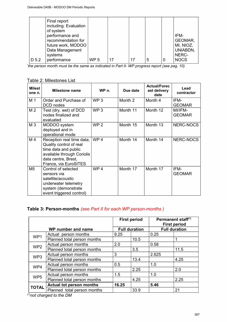
D 5.2
Final report including: Evaluation of system performance and recommendation for future work, MODOO Data Management systems performance WP 5 17 17 5 0
IFM-GEOMAR, MI, NIOZ, UNIABDN, NERC-NOCS
*the person month must be the same as indicated in Part II- WP progress report (see pag. 10)
Table 2: Milestones List
Milestone n.
Milestone name WP n. Due dateActual/Forecast delivery
date
Lead contractor
M 1 Order and Purchase of DCD nodes
WP 3 Month 2 Month 4 IFM-GEOMAR
M 2 Test (dry, wet) of DCD nodes finalized and evaluated
WP 3 Month 11 Month 12 MI/IFM-GEOMAR
M 3 MODOO system deployed and in operational mode
WP 2 Month 15 Month 13 NERC-NOCS
M 4 Reception real time data; Quality control of real time data and public available through Coriolis data centre, Brest, France, via EuroSITES
WP 4 Month 14 Month 14 NERC-NOCS
M5 Control of selected sensors via satellite/acoustic underwater telemetry system (demonstrate event triggered control)
WP 4 Month 17 Month 17 IFM-GEOMAR
Table 3: Person-months (see Part II for each WP person-months )
WP number and name
First period Permanent staff(1)
First periodFull duration Full duration
WP1Actual person months 9.25 0.25Planned total person months 10.5 1
WP2Actual person months 2.0 0.58Planned total person months 3.5 11.5
WP3Actual person months 3 2.625Planned total person months 13.4 4.25
WP4Actual person months 0.5 1.0Planned total person months 2.25 2.0
WP5Actual person months 1.5 1.0Planned total person months 4.25 2.25
TOTALActual tot person months 16.25 5.46Planned total person months 33.9 21
(1)not charged to the DM
Deliverable D45B - MODOO DM Periodic Reports
367
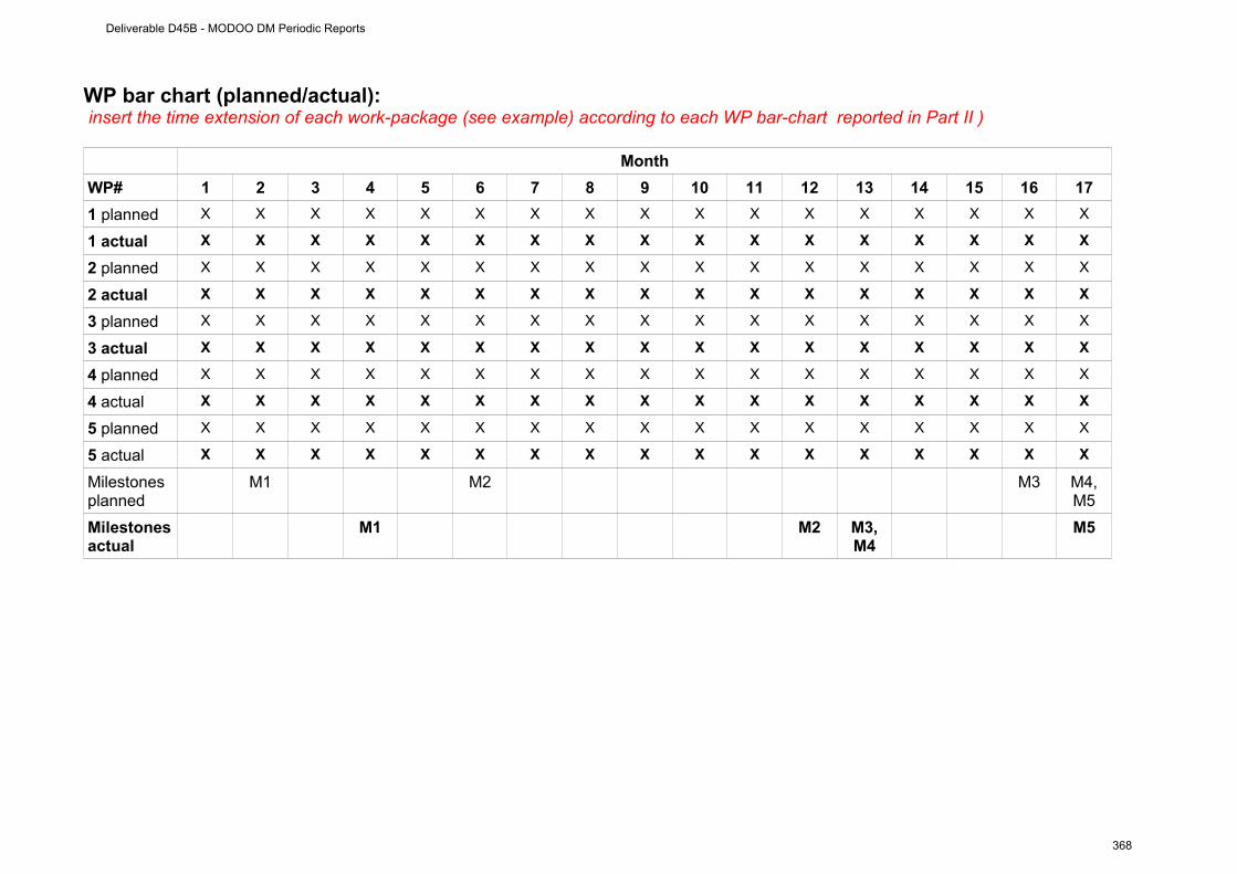
WP bar chart (planned/actual): insert the time extension of each work-package (see example) according to each WP bar-chart reported in Part II )
Month
WP# 1 2 3 4 5 6 7 8 9 10 11 12 13 14 15 16 17
1 planned X X X X X X X X X X X X X X X X X
1 actual X X X X X X X X X X X X X X X X X
2 planned X X X X X X X X X X X X X X X X X
2 actual X X X X X X X X X X X X X X X X X
3 planned X X X X X X X X X X X X X X X X X
3 actual X X X X X X X X X X X X X X X X X
4 planned X X X X X X X X X X X X X X X X X
4 actual X X X X X X X X X X X X X X X X X
5 planned X X X X X X X X X X X X X X X X X
5 actual X X X X X X X X X X X X X X X X X
Milestonesplanned
M1 M2 M3 M4, M5
Milestonesactual
M1 M2 M3, M4
M5
Deliverable D45B - MODOO DM Periodic Reports
368
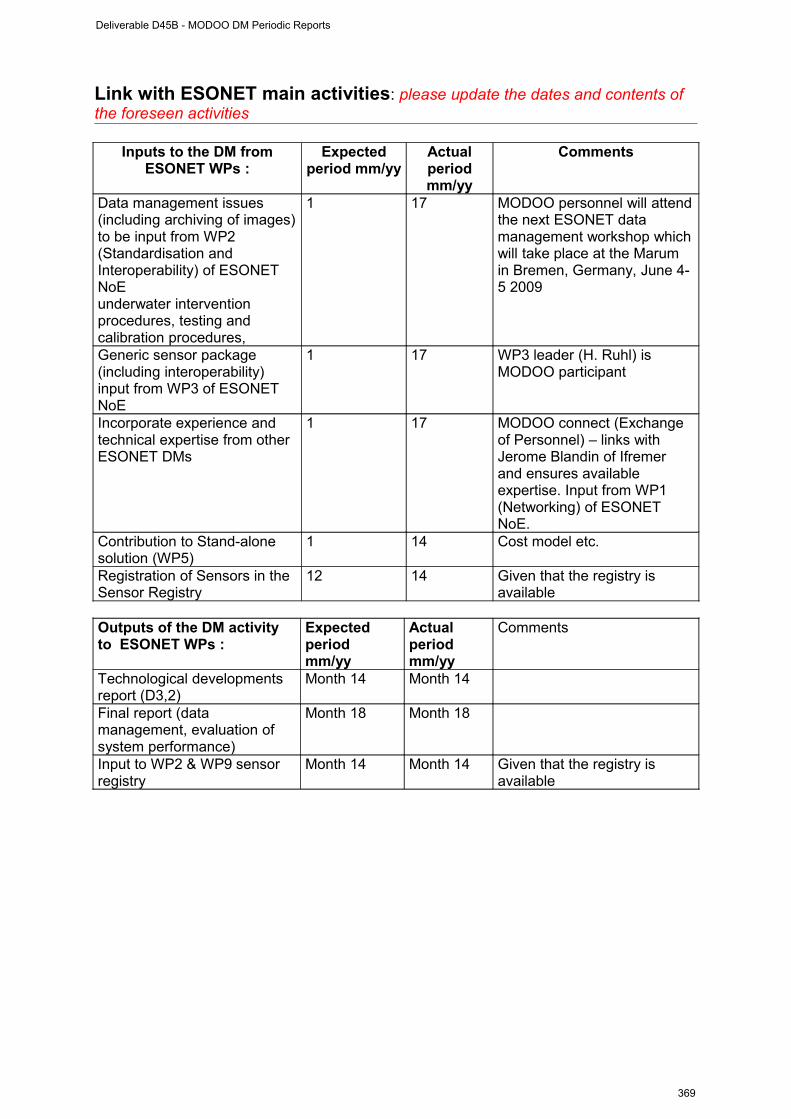
Link with ESONET main activities: please update the dates and contents of the foreseen activities
Inputs to the DM from ESONET WPs :
Expected period mm/yy
Actual period mm/yy
Comments
Data management issues (including archiving of images) to be input from WP2 (Standardisation and Interoperability) of ESONET NoEunderwater intervention procedures, testing and calibration procedures,
1 17 MODOO personnel will attend the next ESONET data management workshop which will take place at the Marum in Bremen, Germany, June 4-5 2009
Generic sensor package (including interoperability) input from WP3 of ESONET NoE
1 17 WP3 leader (H. Ruhl) is MODOO participant
Incorporate experience and technical expertise from other ESONET DMs
1 17 MODOO connect (Exchange of Personnel) – links with Jerome Blandin of Ifremer and ensures available expertise. Input from WP1 (Networking) of ESONET NoE.
Contribution to Stand-alone solution (WP5)
1 14 Cost model etc.
Registration of Sensors in the Sensor Registry
12 14 Given that the registry is available
Outputs of the DM activity to ESONET WPs :
Expected period mm/yy
Actual period mm/yy
Comments
Technological developments report (D3,2)
Month 14 Month 14
Final report (data management, evaluation of system performance)
Month 18 Month 18
Input to WP2 & WP9 sensor registry
Month 14 Month 14 Given that the registry is available
Deliverable D45B - MODOO DM Periodic Reports
369

Sensors & data management plan:
Measured parameters
Depth range of the measurements
Sampling/storage/acquisition frequency
Access restriction / unrestriction (ESONET partners, public, immediately or delayed, to raw data, processed data …) please note that EC ask Esonet community to provide data in easy and free access
Comments
Temperature Several in water column
Real time: 24hours;Delayed mode: 60 minutes
Real-time data immediately public available
Delayed mode after recovery of systems
All data is shared and distributed via GDAC Coriolis (EuroSITES data policy)
Real time data available via EuroSITES website – input to GEOSS via Coriolis data centre
Salinity (Conductivity)
Several in water column
Real time: 24hours;Delayed mode: 60 minutes
Pressure Several in water column
Real time: 24hours;Delayed mode: 60 minutes
Oxygen Several in water column & Sea floor
Real time: 24hours;Delayed mode: 120 minutes
Ocean currents
Upper 400m & lower 10m of water column
Real time: 24hours;Delayed mode: 120 minutes
In part real time (lander)
Turbidity 40m & Sea floor
Real time: 24hours;Delayed mode: 120 minutes
Real time data available via EuroSITES website – input to GEOSS via Coriolis data centre
Nitrate 40m delayed mode: 120 minutes
pCO2 40m delayed mode: 120 minutes
Fluorescence 40 m delayed mode: 120 minutes
Passive acoustic
Positioned at sea floor, sources unknown
240h available, sampling may be synchronized with photo
Delayed mode only
Seismicity Sub-sea floor 1 Minute subsample available on request (e.g. event) Suppressed real-
time data on demandPhotography Sea floor On demand
Deliverable D45B - MODOO DM Periodic Reports
370

Dissemination and outreach: please update the table
Type of school material available at the issue of the mission
(photos, video, courses,…others)
Description
Introduction of the MODOO mission at outreach site
ESONET NoE (http://mars-srv.oceanlab.iu-bremen.de/)
Introduction of the MODOO mission at outreach site
EuroSITES (http://outreach.eurosites.info/)outreach activities
Type of dissemination(through collaborations with
aquaria, museum, sciences centres, etc.)
Description
Information on MODOO Mission ESONET NoE (http://mars-srv.oceanlab.iu-bremen.de/)
Information on MODOO Mission EuroSITES (http://outreach.eurosites.info/)outreach activities
Press Release(Maine Institute, January 2010)
http://www.marine.ie/home/aboutus/newsroom/news/NewDecadeofDiscoveryforIrishMarineScience.htm
Deliverable D45B - MODOO DM Periodic Reports
371
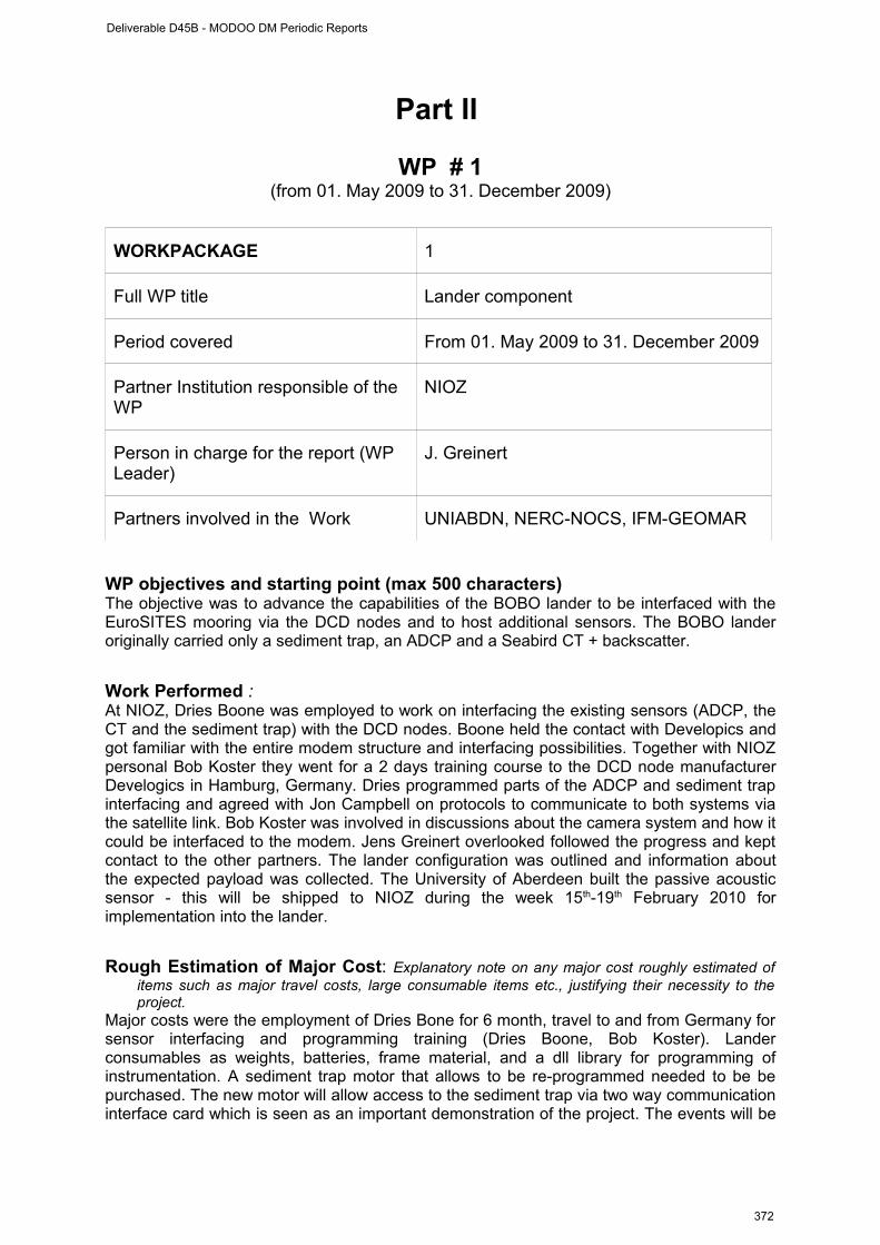
Part II
WP # 1(from 01. May 2009 to 31. December 2009)
WORKPACKAGE 1
Full WP title Lander component
Period covered From 01. May 2009 to 31. December 2009
Partner Institution responsible of the WP
NIOZ
Person in charge for the report (WP Leader)
J. Greinert
Partners involved in the Work UNIABDN, NERC-NOCS, IFM-GEOMAR
WP objectives and starting point (max 500 characters) The objective was to advance the capabilities of the BOBO lander to be interfaced with the EuroSITES mooring via the DCD nodes and to host additional sensors. The BOBO lander originally carried only a sediment trap, an ADCP and a Seabird CT + backscatter.
Work Performed : At NIOZ, Dries Boone was employed to work on interfacing the existing sensors (ADCP, the CT and the sediment trap) with the DCD nodes. Boone held the contact with Developics and got familiar with the entire modem structure and interfacing possibilities. Together with NIOZ personal Bob Koster they went for a 2 days training course to the DCD node manufacturer Develogics in Hamburg, Germany. Dries programmed parts of the ADCP and sediment trap interfacing and agreed with Jon Campbell on protocols to communicate to both systems via the satellite link. Bob Koster was involved in discussions about the camera system and how it could be interfaced to the modem. Jens Greinert overlooked followed the progress and kept contact to the other partners. The lander configuration was outlined and information about the expected payload was collected. The University of Aberdeen built the passive acoustic sensor - this will be shipped to NIOZ during the week 15th-19th February 2010 for implementation into the lander.
Rough Estimation of Major Cost: Explanatory note on any major cost roughly estimated of items such as major travel costs, large consumable items etc., justifying their necessity to the project.
Major costs were the employment of Dries Bone for 6 month, travel to and from Germany for sensor interfacing and programming training (Dries Boone, Bob Koster). Lander consumables as weights, batteries, frame material, and a dll library for programming of instrumentation. A sediment trap motor that allows to be re-programmed needed to be be purchased. The new motor will allow access to the sediment trap via two way communication interface card which is seen as an important demonstration of the project. The events will be
Deliverable D45B - MODOO DM Periodic Reports
372

monitored with a fluorometer/turbidity sonde with two way communication access that was required to be purchased as well.
Overview of the Actual Major Costs, by major cost item including personnel (fill in the Table here below)
Type of expenditure
Actual costs( Euro)First period
# Person-month Planned Used
Personnel costs
IFM-GEOMAR: 0MI: 0
NIOZ:25651,00NERC-NOCS:0
UNIABDN:15000 40,651.00 €
IFM-GEOMAR: 1MI: 0
NIOZ: 7.5NERC-NOCS: 1
UNIABDN: 1
IFM-GEOMAR: 0.25MI: 0
NIOZ: 8NERC-NOCS: 0
UNIABDN: 110.5 9.25
Subcontracting
IFM-GEOMAR: 0MI: 0
NIOZ: 0NERC-NOCS: 0
UNIABDN: 0 0.00 €
Travels
IFM-GEOMAR: 0MI: 0
NIOZ: 3641,00NERC-NOCS: 0
UNIABDN: 2000,00 5,641.00 €
Consumables
IFM-GEOMAR: 0MI: 0
NIOZ: 3939,00NERC-NOCS: 0
UNIABDN: 11000 14,939.00 €
Other costs
IFM-GEOMAR: 0MI: 7339,00
NIOZ: 0NERC-NOCS: 0
UNIABDN: 0 7,339.00 €Total Costs 68,570.00 €
Deliverable D45B - MODOO DM Periodic Reports
373
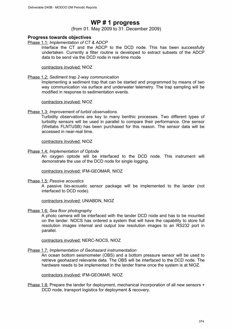
WP # 1 progress (from 01. May 2009 to 31. December 2009)
Progress towards objectives Phase 1.1: Implementation of CT & ADCP
Interface the CT and the ADCP to the DCD node. This has been successfully undertaken. Currently a filter routine is developed to extract subsets of the ADCP data to be send via the DCD node in real-time mode
contractors involved: NIOZ
Phase 1.2: Sediment trap 2-way communicationImplementing a sediment trap that can be started and programmed by means of two way communication via surface and underwater telemetry. The trap sampling will be modified in response to sedimentation events.
contractors involved: NIOZ
Phase 1.3: Improvement of turbid observations.Turbidity observations are key to many benthic processes. Two different types of turbidity sensors will be used in parallel to compare their performance. One sensor (Wetlabs FLNTUSB) has been purchased for this reason. The sensor data will be accessed in near-real time.
contractors involved: NIOZ
Phase 1.4: Implementation of OptodeAn oxygen optode will be interfaced to the DCD node. This instrument will demonstrate the use of the DCD node for single logging.
contractors involved: IFM-GEOMAR, NIOZ
Phase 1.5: Passive acousticsA passive bio-acoustic sensor package will be implemented to the lander (not interfaced to DCD node).
contractors involved: UNIABDN, NIOZ
Phase 1. 6: Sea floor photographyA photo camera will be interfaced with the lander DCD node and has to be mounted on the lander. NOCS has ordered a system that will have the capability to store full resolution images internal and output low resolution images to an RS232 port in parallel.
contractors involved: NERC-NOCS, NIOZ
Phase 1.7: Implementation of Geohazard instrumentation An ocean bottom seismometer (OBS) and a bottom pressure sensor will be used to retrieve geohazard relevante data. The OBS will be interfaced to the DCD node. The hardware needs to be implemented in the lander frame once the system is at NIOZ.
contractors involved: IFM-GEOMAR, NIOZ
Phase 1.8: Prepare the lander for deployment, mechanical incorporation of all new sensors + DCD node, transport logistics for deployment & recovery.
Deliverable D45B - MODOO DM Periodic Reports
374
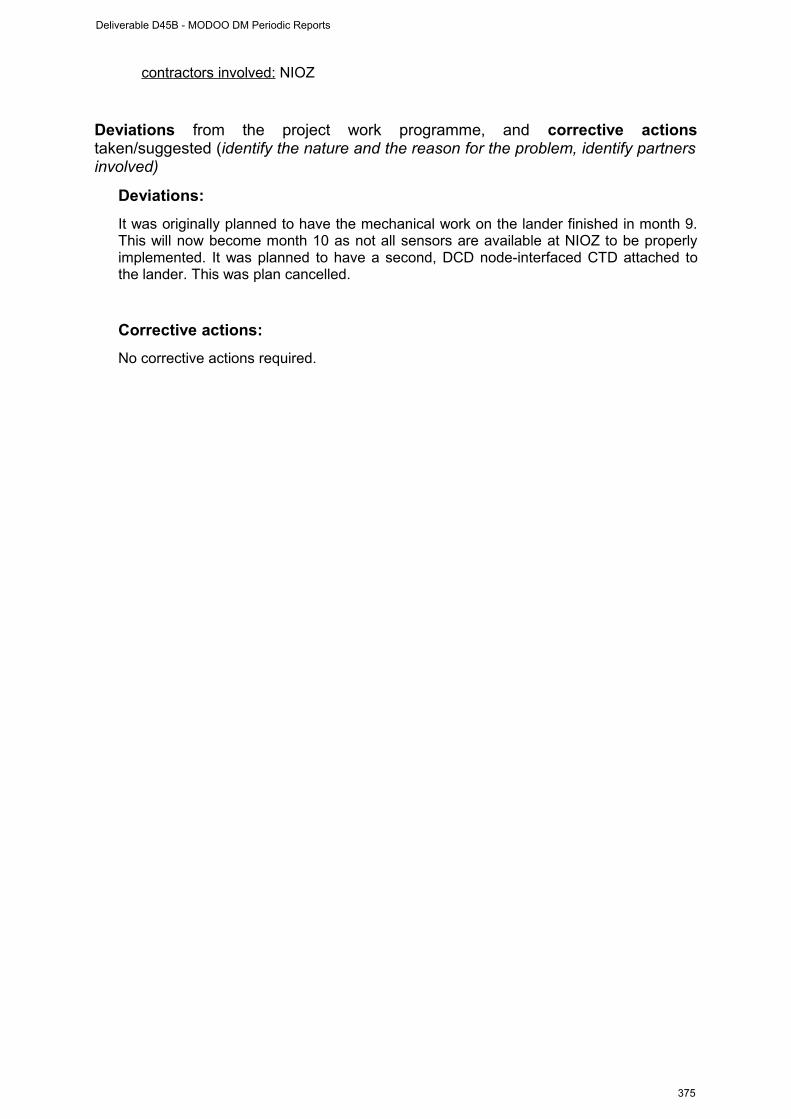
contractors involved: NIOZ
Deviations from the project work programme, and corrective actions taken/suggested (identify the nature and the reason for the problem, identify partners involved)
Deviations:
It was originally planned to have the mechanical work on the lander finished in month 9. This will now become month 10 as not all sensors are available at NIOZ to be properly implemented. It was planned to have a second, DCD node-interfaced CTD attached to the lander. This was plan cancelled.
Corrective actions:
No corrective actions required.
Deliverable D45B - MODOO DM Periodic Reports
375
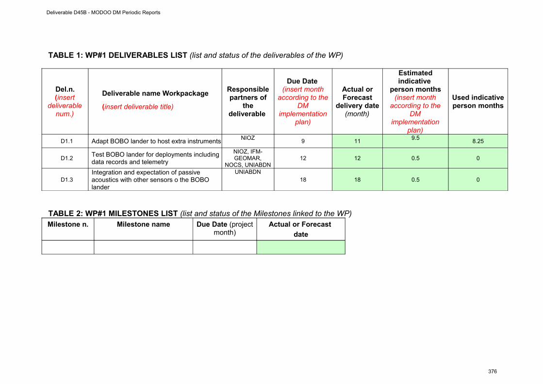
TABLE 1: WP#1 DELIVERABLES LIST (list and status of the deliverables of the WP)
Del.n.(insert
deliverable num.)
Deliverable name Workpackage
(insert deliverable title)
Responsible partners of
the deliverable
Due Date (insert month
according to the DM
implementation plan)
Actual or Forecast
delivery date (month)
Estimated indicative
person months(insert month
according to the DM
implementation plan)
Used indicative person months
D1.1 Adapt BOBO lander to host extra instruments NIOZ9 11
9.58.25
D1.2Test BOBO lander for deployments including data records and telemetry
NIOZ, IFM-GEOMAR,
NOCS, UNIABDN12 12 0.5 0
D1.3Integration and expectation of passive acoustics with other sensors o the BOBO lander
UNIABDN18 18 0.5 0
TABLE 2: WP#1 MILESTONES LIST (list and status of the Milestones linked to the WP)Milestone n. Milestone name Due Date (project
month)Actual or Forecast
date
Deliverable D45B - MODOO DM Periodic Reports
376
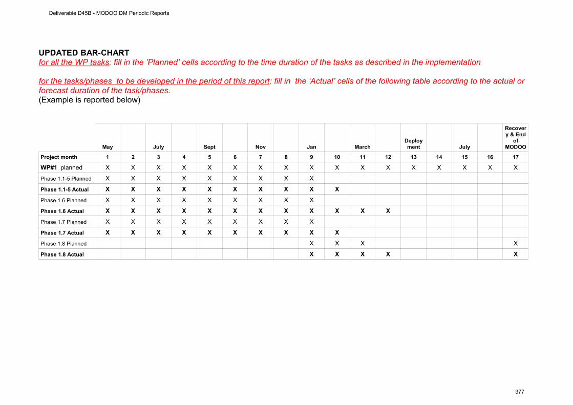
UPDATED BAR-CHARTfor all the WP tasks: fill in the ’Planned’ cells according to the time duration of the tasks as described in the implementation
for the tasks /phases to be developed in the period of this report : fill in the ‘Actual’ cells of the following table according to the actual or forecast duration of the task/phases.(Example is reported below)
May July Sept Nov Jan MarchDeployment July
Recovery & End
of MODOO
Project month 1 2 3 4 5 6 7 8 9 10 11 12 13 14 15 16 17
WP#1 planned X X X X X X X X X X X X X X X X X
Phase 1.1-5 Planned X X X X X X X X X
Phase 1.1-5 Actual X X X X X X X X X X
Phase 1.6 Planned X X X X X X X X X
Phase 1.6 Actual X X X X X X X X X X X X
Phase 1.7 Planned X X X X X X X X X
Phase 1.7 Actual X X X X X X X X X X
Phase 1.8 Planned X X X X
Phase 1.8 Actual X X X X X
Deliverable D45B - MODOO DM Periodic Reports
377

WP # 2(from 01. May 2009 to 31. December 2009)
WORKPACKAGE 2
Full WP title Mooring component
Period covered From 01. May 2009 to 31. December 2009
Partner Institution responsible of the WP
NERC-NOCS
Person in charge for the report (WP Leader)
R. Lampitt
Partners involved in the Work NERC-NOCS, IFM-GEOMAR, NIOZ
WP objectives and starting point (max 500 characters)
The objective of this WP is to design the EuroSITES water column observatory to incorporate the needs to the MODOO mission. In particular the inductive link based communication between the CDC node and the surface control unit must be defined and programmed.
The data logging and telemetry system on the PAP mooring has already been used for the PAP mooring (first time in 2007). The system is based around a Persistor CF2 computer board linked to an Iridium 9522 modem, a Seabird inductive modem, a GPS receiver, a compass/pitch/roll unit and internal voltage/current/temperature monitors.
Work Performed :
Much of the design required for the new mooring has been completed and some of the hardware required has been purchased. This work is shared with EuroSITES preparation for the PAP deployment. The major enhancement is the installation of a new type of surface buoy (shared with the Met Office) which host a variety of air/sea exchange sensors, telemetry system and energy supply.
A document describing NERC-NOCS Iridium telemetry system has been written and delivered (D2.1). This document is the base to create a suitable interface of the Mooring and Lander DCD node.
Rough Estimation of Major Cost: Explanatory note on any major cost roughly estimated of items such as major travel costs, large consumable items etc., justifying their necessity to the project.
The main component of this project so far has been to design and develop the mooring. As a consequence most of the costs have been for labour and a much smaller part for procurement of hardware required.
Deliverable D45B - MODOO DM Periodic Reports
378
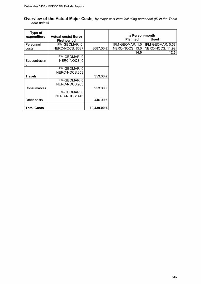
Overview of the Actual Major Costs, by major cost item including personnel (fill in the Table here below)
Type of expenditure Actual costs( Euro)
First period
# Person-month Planned Used
Personnel costs
IFM-GEOMAR: 0 NERC-NOCS: 8687 8687.00 €
IFM-GEOMAR: 1.0NERC-NOCS: 13.0
IFM-GEOMAR: 0.58NERC-NOCS: 11.92
14.0 12.5
Subcontracting
IFM-GEOMAR: 0NERC-NOCS: 0
Travels
IFM-GEOMAR: 0NERC-NOCS:353
353.00 €
Consumables
IFM-GEOMAR: 0NERC-NOCS:953
953.00 €
Other costs
IFM-GEOMAR: 0NERC-NOCS: 446
446.00 €
Total Costs 10,439.00 €
Deliverable D45B - MODOO DM Periodic Reports
379
WP # 2 progress (from 01. May 2009 to 31. December 2009)
Progress towards objectives
Phase 2.1 : Implementation of inductive linked DCD node into surface telemetry systemtelemetry A review of the PAP telemetry system was performed (see deliverable D2.1) to evaluate the compatibility and technical requirements for the DCD nodes with the telemetry. The mooring mounted DCD node will be integrated into the “standard” mooring inductive loop. The challenge is that the DCD node does not only send data to the surface telemetry on request but receives data (commands) from the surface buoy (event control/ two-way communication). In the upcoming months the integration will be continued and system will be tested.
contractors involved: . NERC-NOCS, NIOZ
Phase 2.2 : Mooring designThe design of the PAP mooring was developed (in collaboration with EuroSITES). The mooring now has a large surface buoy with own energy supply (solar panel) and several engineering option. The original plan to place the mooring DCD node at 1000m water depth has been revised for reasons of mooring construction, now the nodes are placed at nominal 40m depth in dedicated frame.
contractors involved: NERC-NOCS
Phase 2.3 : Mooring cruise preparationPreparation of the deployment and recovery cruises were made. An arrangement with the British Antarctic Survey (BAS) was made to deploy the mooring (and the lander WP1) with James Clarke Ross in May/June 2010. Cruise planning meetings and other related work must be done (documents as risk assessment, logostics etc.). The preparation for the recovery of the MODOO system by September 2010 (Celtic Explorer) requires more preparations.
contractors involved: NERC-NOCS, NIOZ, MI, IFM-GEOMAR
Deliverable D45B - MODOO DM Periodic Reports
380

Deviations from the project work programme, and corrective actions taken/suggested (identify the nature and the reason for the problem, identify partners involved)
Deviations:
NA
Corrective actions:
NA
Deliverable D45B - MODOO DM Periodic Reports
381

TABLE 1: WP#2 DELIVERABLES LIST (list and status of the deliverables of the WP)
Del.n.(insert
deliverable num.)
Deliverable name Workpackage
(insert deliverable title)
Responsible partners of
the deliverable
Due Date (insert month
according to the DM
implementation plan)
Actual or Forecast
delivery date (month)
Estimated indicative
person months(insert month
according to the DM
implementation plan)
Used indicative person months
D 2.1Document describing NERC-NOCS Iridium telemetry system
NERC-NOCS2 2 0.5 0.5
D 2.2Telemetry buoy modified to communicate with DCD nodes.
NERC-NOCS 10 12 2 0
TABLE 2: WP#2 MILESTONES LIST (list and status of the Milestones linked to the WP)Milestone n. Milestone name Due Date (project month) Actual or Forecast
date
Deliverable D45B - MODOO DM Periodic Reports
382
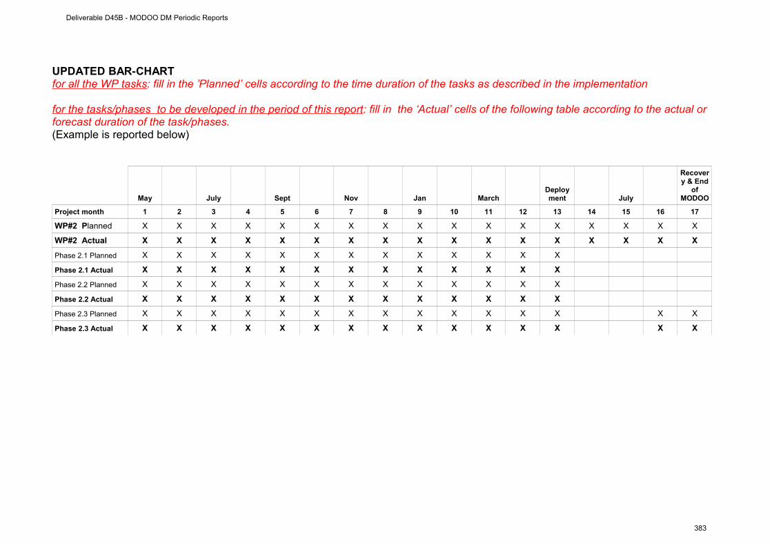
UPDATED BAR-CHARTfor all the WP tasks: fill in the ’Planned’ cells according to the time duration of the tasks as described in the implementation
for the tasks /phases to be developed in the period of this report : fill in the ‘Actual’ cells of the following table according to the actual or forecast duration of the task/phases.(Example is reported below)
May July Sept Nov Jan MarchDeployment July
Recovery & End
of MODOO
Project month 1 2 3 4 5 6 7 8 9 10 11 12 13 14 15 16 17
WP#2 Planned X X X X X X X X X X X X X X X X X
WP#2 Actual X X X X X X X X X X X X X X X X X
Phase 2.1 Planned X X X X X X X X X X X X X
Phase 2.1 Actual X X X X X X X X X X X X X
Phase 2.2 Planned X X X X X X X X X X X X X
Phase 2.2 Actual X X X X X X X X X X X X X
Phase 2.3 Planned X X X X X X X X X X X X X X X
Phase 2.3 Actual X X X X X X X X X X X X X X X
Deliverable D45B - MODOO DM Periodic Reports
383
WP # 3(from 01. May 2009 to 31. December 2009)
WORKPACKAGE 3
Full WP title Scientific and technological integration
Period covered From 01. May 2009 to 31. December 2009
Partner Institution responsible of the WP
MI & IFM-GEOMAR
Person in charge for the report (WP Leader)
F. Grant & J. Karstensen
Partners involved in the Work NIOZ, NOCS, MI, IFM-GEOMAR
WP objectives and starting point (max 500 characters)
The major step for the scientific integration of the observatory components is: standardization, interoperability and access to data (see also WP4). The technological integration includes the linking between the observatories (see also WP1 & WP2) and the linking of their components/sensors. The integrating geostatistical variable is “time of observation” and synchronization is required. The integrating devices are the “data collection and dissemination” (DCD) nodes. The DCD nodes host an acoustic modem, a precise clock and a data storage that logs connected instrumentation and tags a common time stamp to their data. The DCD nodes are central to the MODOO Demomission as they fulfil the scientific and technological integration of the observatory modules. Financial and men month effort has been invested in creating/defining the DCD node requirements and in helping to adapt existing modems to fit the MODOO needs. The process started by letting the whole MODOO consortium defining its needs (scientific and technological) followed by integrating the requirements with the help of MODOO engineers (NIOZ, NERC-NOCS, IFM-GEOMAR). This process is still ongoing – while the main objective for the next month of the DM is on testing the performance of the DCD nodes under laboratory and water conditions before the installation takes place in May/June 2010. The tests will not concentrate on the hardware but in parallel will be used to test the data access and distribution concepts.
Work Performed :
The DCD nodes are central to the MODOO Demomission as they fulfil the scientific and technological integration of the observatory modules. Financial and men month effort has been invested in creating/defining the DCD node requirements and in helping to adapt existing modems to fit the MODOO needs. The process started by letting the whole MODOO consortium defining its needs (scientific and technological) followed by integrating the requirements with the help of MODOO engineers (NIOZ, NERC-NOCS, IFM-GEOMAR) and a company (Develogic). This process is still ongoing – while the main objective for the next month of the DM is on testing the performance of the DCD nodes under laboratory and water conditions before the installation takes place in May/June 2010. The tests will not concentrate on the hardware but in parallel will be used to test the data access and distribution concepts.
Deliverable D45B - MODOO DM Periodic Reports
384
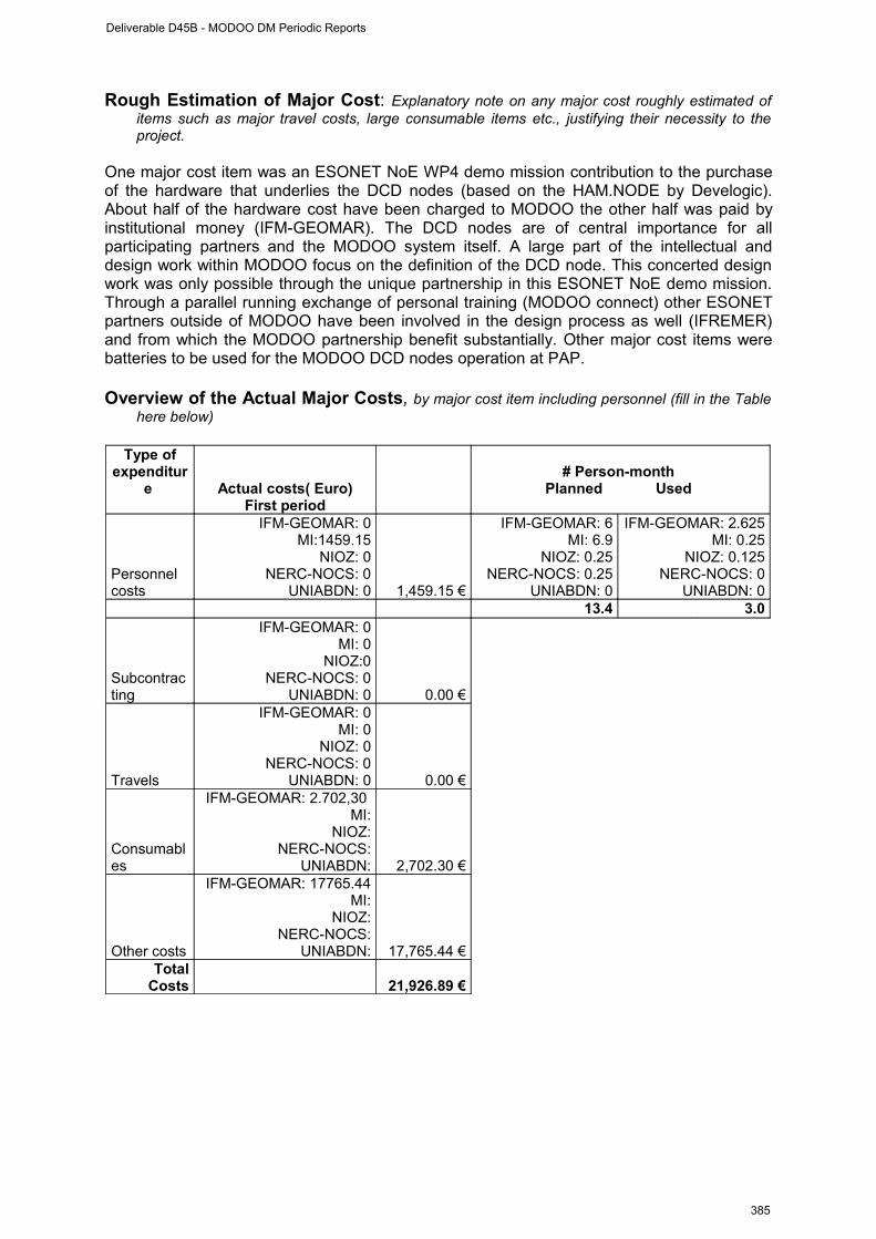
Rough Estimation of Major Cost: Explanatory note on any major cost roughly estimated of items such as major travel costs, large consumable items etc., justifying their necessity to the project.
One major cost item was an ESONET NoE WP4 demo mission contribution to the purchase of the hardware that underlies the DCD nodes (based on the HAM.NODE by Develogic). About half of the hardware cost have been charged to MODOO the other half was paid by institutional money (IFM-GEOMAR). The DCD nodes are of central importance for all participating partners and the MODOO system itself. A large part of the intellectual and design work within MODOO focus on the definition of the DCD node. This concerted design work was only possible through the unique partnership in this ESONET NoE demo mission. Through a parallel running exchange of personal training (MODOO connect) other ESONET partners outside of MODOO have been involved in the design process as well (IFREMER) and from which the MODOO partnership benefit substantially. Other major cost items were batteries to be used for the MODOO DCD nodes operation at PAP.
Overview of the Actual Major Costs, by major cost item including personnel (fill in the Table here below)
Type of expenditur
e Actual costs( Euro)First period
# Person-month Planned Used
Personnel costs
IFM-GEOMAR: 0MI:1459.15
NIOZ: 0NERC-NOCS: 0
UNIABDN: 0 1,459.15 €
IFM-GEOMAR: 6MI: 6.9
NIOZ: 0.25NERC-NOCS: 0.25
UNIABDN: 0
IFM-GEOMAR: 2.625MI: 0.25
NIOZ: 0.125NERC-NOCS: 0
UNIABDN: 013.4 3.0
Subcontracting
IFM-GEOMAR: 0MI: 0
NIOZ:0NERC-NOCS: 0
UNIABDN: 0 0.00 €
Travels
IFM-GEOMAR: 0MI: 0
NIOZ: 0NERC-NOCS: 0
UNIABDN: 0 0.00 €
Consumables
IFM-GEOMAR: 2.702,30 MI:
NIOZ:NERC-NOCS:
UNIABDN: 2,702.30 €
Other costs
IFM-GEOMAR: 17765.44MI:
NIOZ:NERC-NOCS:
UNIABDN: 17,765.44 €Total
Costs 21,926.89 €
Deliverable D45B - MODOO DM Periodic Reports
385
WP # 3 progress (from 01. May 2009 to 31. December 2009)
Progress towards objectives
Phase 3.1 : Definition of the scientific requirements for designing the DCD nodes. To ensure that the DCD node design can help to facilitate the concerted scientific interpretation of the data we collected basic information on required sampling interval, sampling depth, accuracy of clock, etc. This information is used for Phase 3.2. One other important action was in phase 3.1. was to identify individuals that act as a contact for sensors (also in respect to ESONET NoE sensor registry).
contractors involved: IFM-GEOMAR, NERC-NOCS, NIOZ, MI, UNIABDN, AWI
Phase 3.2 : Definition of the technological requirements for designing the DCD nodes. In this phase we collected specification of the instrumentation that will be mounted on the lander and mooring. Based on the specifications we selected a set of devices (also in reflection to Phase 3.1.) that is most useful in achieving the MODOO goals.
contractors involved: IFM-GEOMAR, NERC-NOCS, NIOZ, MI, UNIABDN, AWI
Phase 3.3 : Implementation of Phase 3.1. and Phase 3.2. results in DCD nodes design and programming This is an on-going phase which includes the definition of the instrument ports, implementation of re-programming capabilities for certain instrumentation via telemetry, implementation of inductive link for data real time access and event control. This phase includes work for deliverable D3.2 (Report on technological development in MODOO DM (including DCD nodes)).
contractors involved: IFM-GEOMAR, NERC-NOCS, NIOZ, MI
Phase 3.4 : Preparation for deployment considering scientific and technological integration This is an on-going phase and comprises the work towards Milestone M2 (test procedures finalized and evaluated) and M3 (). It considers the work in WP1 (lander component), WP2 (mooring component), and WP4 (data management). This phase includes work for deliverable D3.1 (Report on procedures for sea operations).
contractors involved: IFM-GEOMAR, NERC-NOCS, NIOZ, MI, UNIABDN
Phase 3.5 : Preparation for recovery and evaluationIn this final phase preparation for a successful recovery will be done. The final evaluation of the system in terms of scientific and technological aspects will be done
contractors involved: IFM-GEOMAR, NERC-NOCS, NIOZ, MI, UNIABDN
Deliverable D45B - MODOO DM Periodic Reports
386
Deviations from the project work programme, and corrective actions taken/suggested (identify the nature and the reason for the problem, identify partners involved)
Deviations:
The milestone M3 (Shallow water test of DCD nodes with RV ALKOR, Baltic Sea/Gotland: Test of communication between submerged and near-surface DCD nodes: data retrieval, two way communication – due: month 6) has been redefined as it turned out that more efficient and save testing procedures can be applied for the benefit of the project. Responsible partner for deviation: IFM-GEOMAR.
As a second recovery cruise is now planned for September 2010, it was decided by the WP3 leaders that delivery of D3.1 (Report on procedures for sea operations) should be deferred to Month 17 (from Month 12). The resulting report will now incorporate both deployment and recovery at-sea operations information which will prove useful to the ESONET project. Responsible partner for deviation: MI.
Corrective actions:
The milestone M3 has been redefined (Test procedures (dry, wet) for the DCD nodes finalized and evaluated) but with a focus now on thorough tests of the system under more idealized conditions. This new testing strategy allows modification and intervention in case it is needed. It will although allow to take appropriate actions in case of failures. The due date was set to 12 – which is shortly before the deployment of the system.
D3.1 will now incorporate more information than previously planned due to a second recovery cruise for the MODOO system.
Deliverable D45B - MODOO DM Periodic Reports
387
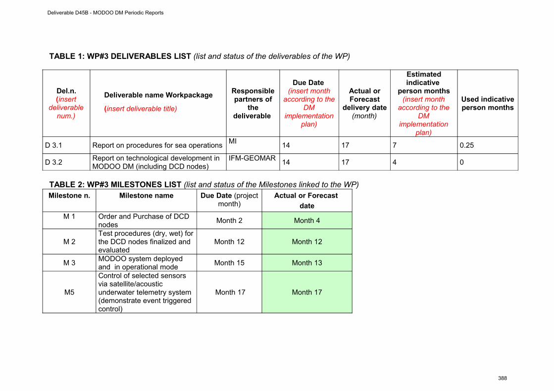
TABLE 1: WP#3 DELIVERABLES LIST (list and status of the deliverables of the WP)
Del.n.(insert
deliverable num.)
Deliverable name Workpackage
(insert deliverable title)
Responsible partners of
the deliverable
Due Date (insert month
according to the DM
implementation plan)
Actual or Forecast
delivery date (month)
Estimated indicative
person months(insert month
according to the DM
implementation plan)
Used indicative person months
D 3.1 Report on procedures for sea operations MI
14 17 7 0.25
D 3.2Report on technological development in MODOO DM (including DCD nodes)
IFM-GEOMAR14 17 4 0
TABLE 2: WP#3 MILESTONES LIST (list and status of the Milestones linked to the WP)Milestone n. Milestone name Due Date (project
month)Actual or Forecast
date
M 1 Order and Purchase of DCD nodes
Month 2 Month 4
M 2Test procedures (dry, wet) for the DCD nodes finalized and evaluated
Month 12 Month 12
M 3MODOO system deployed and in operational mode
Month 15 Month 13
M5
Control of selected sensors via satellite/acoustic underwater telemetry system (demonstrate event triggered control)
Month 17 Month 17
Deliverable D45B - MODOO DM Periodic Reports
388
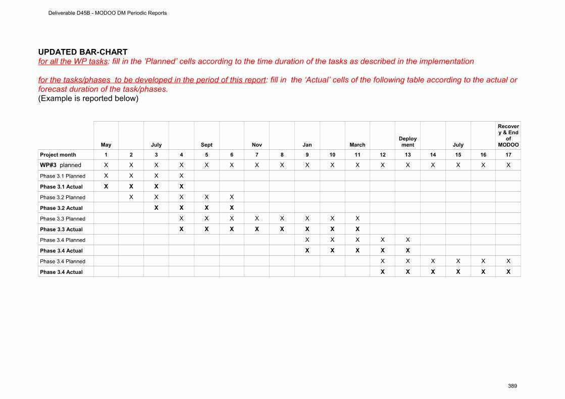
UPDATED BAR-CHARTfor all the WP tasks: fill in the ’Planned’ cells according to the time duration of the tasks as described in the implementation
for the tasks /phases to be developed in the period of this report : fill in the ‘Actual’ cells of the following table according to the actual or forecast duration of the task/phases.(Example is reported below)
May July Sept Nov Jan MarchDeployment July
Recovery & End
of MODOO
Project month 1 2 3 4 5 6 7 8 9 10 11 12 13 14 15 16 17
WP#3 planned X X X X X X X X X X X X X X X X X
Phase 3.1 Planned X X X X
Phase 3.1 Actual X X X X
Phase 3.2 Planned X X X X X
Phase 3.2 Actual X X X X
Phase 3.3 Planned X X X X X X X X
Phase 3.3 Actual X X X X X X X X
Phase 3.4 Planned X X X X X
Phase 3.4 Actual X X X X X
Phase 3.4 Planned X X X X X X
Phase 3.4 Actual X X X X X X
Deliverable D45B - MODOO DM Periodic Reports
389
WP # 4(from 01. May 2009 to 31. December 2009)
WORKPACKAGE 4
Full WP title Data management and outreach
Period covered From 01. May 2009 to 31. December 2009
Partner Institution responsible of the WP
NERC-NOCS
Person in charge for the report (WP Leader)
M Pagnani
Partners involved in the Work NERC-NOCS
WP objectives and starting point (max 500 characters) The MODOO project data management will be an extension of the systems already being undertaken under the auspices of EuroSITES. This will enhance links between EuroSITES and ESONET NoE data management principles. A large range of data types will be handled in real-time, including meterological air/sea exchange instrumentation, water column and sea floor lander. Real-time data will be quality controlled and displayed on the MODOO and EuroSITES’s websites. If appropriate, data will also be made available to scientists via the GTS (Global Telecommunication System) and in the OceanSITES data format.
After recovery of the system (planned for September 2010), the delayed mode datawill be processed by the nominated Principal Investigator for each sensor or instrument. Quality controlled outputs will then be made available to the general public in OceanSITES format.
Work Performed :
During this pre-deployment phase of MODOO links with the Principal Investigators have been establish and meta-data such as the number and types of sensors to be used on the mooring and lander have been gathered. The serial numbers of the hardware, which is planned to be used, have also been recorded.Recording logs for use during the deployment cruise have also been developed to ease the task of recording significant events during the cruise and to collate this essential metadata in one place. Searching for and collecting metadata after deployment can be time-consuming. Requirements for reading GTS data (meteorological variables) and placing data (water column variables) on the GTS system are being specified.
Rough Estimation of Major Cost: Explanatory note on any major cost roughly estimated of items such as major travel costs, large consumable items etc., justifying their necessity to the project.
This package does not plan to buy any MODOO specific items.
Deliverable D45B - MODOO DM Periodic Reports
390
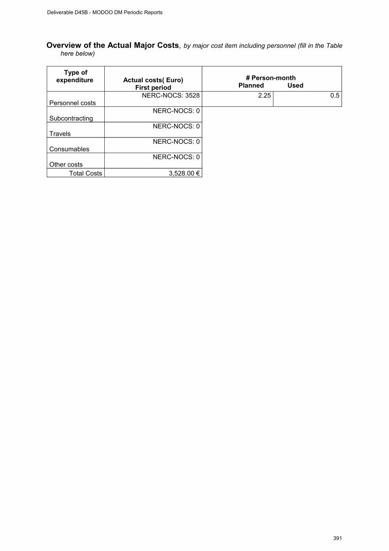
Overview of the Actual Major Costs, by major cost item including personnel (fill in the Table here below)
Type of expenditure Actual costs( Euro)
First period
# Person-month Planned Used
Personnel costs NERC-NOCS: 3528 2.25 0.5
SubcontractingNERC-NOCS: 0
TravelsNERC-NOCS: 0
ConsumablesNERC-NOCS: 0
Other costsNERC-NOCS: 0
Total Costs 3,528.00 €
Deliverable D45B - MODOO DM Periodic Reports
391
WP # 4 progress (from 01. May 2009 to 31. December 2009)
Progress towards objectives
Phase 4.1: Web siteCreate web design and populate with project information. Continue updating web pages as project develops.
contractors involved :NERC-NOCS
Phase 4.2: Meta-data collection and processing preparationCollate pre-deployment meta-data. Identify MODOO data sets and create systems to process.
contractors involved : NERC-NOCS
Phase 4.3: Test dataProcess test data.
contractors involved : NERC-NOCS
Phase 4.4: Data interoperabilityCollate deployment meta-data. Collate calibration data. Process real-time data. Publish data via web and ftp.
contractors involved : NERC-NOCS
Phase 4.5: Documentation on interoperabilityFinalize documentation ready for post-recovery processing, and inclusion in final project report.
contractors involved : NERC-NOCS
Deliverable D45B - MODOO DM Periodic Reports
392
Deviations from the project work programme, and corrective actions taken/suggested (identify the nature and the reason for the problem, identify partners involved)
Deviations:
NA
Corrective actions:
NA
Deliverable D45B - MODOO DM Periodic Reports
393
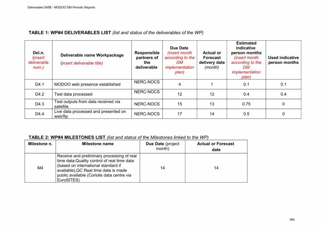
TABLE 1: WP#4 DELIVERABLES LIST (list and status of the deliverables of the WP)
Del.n.(insert
deliverable num.)
Deliverable name Workpackage
(insert deliverable title)
Responsible partners of
the deliverable
Due Date (insert month
according to the DM
implementation plan)
Actual or Forecast
delivery date (month)
Estimated indicative
person months(insert month
according to the DM
implementation plan)
Used indicative person months
D4.1 MODOO web presence establishedNERC-NOCS
4 1 0.1 0.1
D4.2 Test data processedNERC-NOCS
12 12 0.4 0.4
D4.3Test outputs from data received via satellite
NERC-NOCS 15 13 0.75 0
D4.4Live data processed and presented on web/ftp
NERC-NOCS 17 14 0.5 0
TABLE 2: WP#4 MILESTONES LIST (list and status of the Milestones linked to the WP)Milestone n. Milestone name Due Date (project
month)Actual or Forecast
date
M4
Receive and preliminary processing of real time data:Quality control of real time data (based on international standard if available),QC Real time data is made public available (Coriolis data centre via EuroSITES)
14 14
Deliverable D45B - MODOO DM Periodic Reports
394
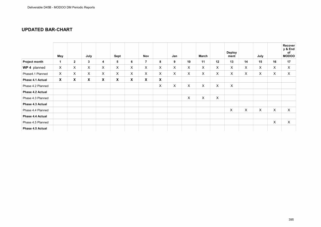
UPDATED BAR-CHART
May July Sept Nov Jan MarchDeployment July
Recovery & End
of MODOO
Project month 1 2 3 4 5 6 7 8 9 10 11 12 13 14 15 16 17
WP 4 planned X X X X X X X X X X X X X X X X X
Phase4.1 Planned X X X X X X X X X X X X X X X X X
Phase 4.1 Actual X X X X X X X X
Phase 4.2 Planned X X X X X X
Phase 4.2 Actual
Phase 4.3 Planned X X X
Phase 4.3 Actual
Phase 4.4 Planned X X X X X
Phase 4.4 Actual
Phase 4.5 Planned X X
Phase 4.5 Actual
Deliverable D45B - MODOO DM Periodic Reports
395

WP # 5(from 01. May 2009 to 31. December 2009)
WORKPACKAGE 2
Full WP title Coordination
Period covered From 01. May 2009 to 31. December 2009
Partner Institution responsible of the WP
IFM-GEOMAR
Person in charge for the report (WP Leader)
J. Karstensen
Partners involved in the Work NERC-NOCS, IFM-GEOMAR, NIOZ
WP objectives and starting point (max 500 characters)
The WP 5 objective is managing the DM MODOO. This includes reporting, coordinating communication internal & external, meetings, teleconferences etc.
Work Performed :
Shortly after the official project start (01. May 2009) a kick-off meeting was organized and held from the 07. May to 08. May 2009 at NERC-NOCS Southampton (see attached agenda & meeting notes). Other meetings (also in collaboration with the “exchange of personal” MODOO connect) have been held in December 2009). Preparatory work for the first report to ESONET NoE WP4 have been made. Project updates and request have been posted to the partners.
Rough Estimation of Major Cost: Explanatory note on any major cost roughly estimated of items such as major travel costs, large consumable items etc., justifying their necessity to the project.
No major costs are associated with this WP
Deliverable D45B - MODOO DM Periodic Reports
396
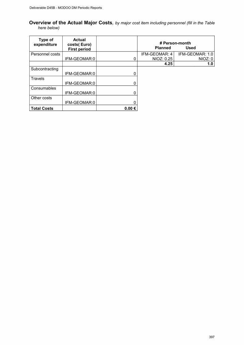
Overview of the Actual Major Costs, by major cost item including personnel (fill in the Table here below)
Type of expenditure
Actual costs( Euro)First period
# Person-month Planned Used
Personnel costs IFM-GEOMAR:0 0
IFM-GEOMAR: 4NIOZ: 0.25
IFM-GEOMAR: 1.0NIOZ: 0
4.25 1.0Subcontracting
IFM-GEOMAR:0 0Travels
IFM-GEOMAR:0 0Consumables
IFM-GEOMAR:0 0Other costs
IFM-GEOMAR:0 0
Total Costs 0.00 €
Deliverable D45B - MODOO DM Periodic Reports
397
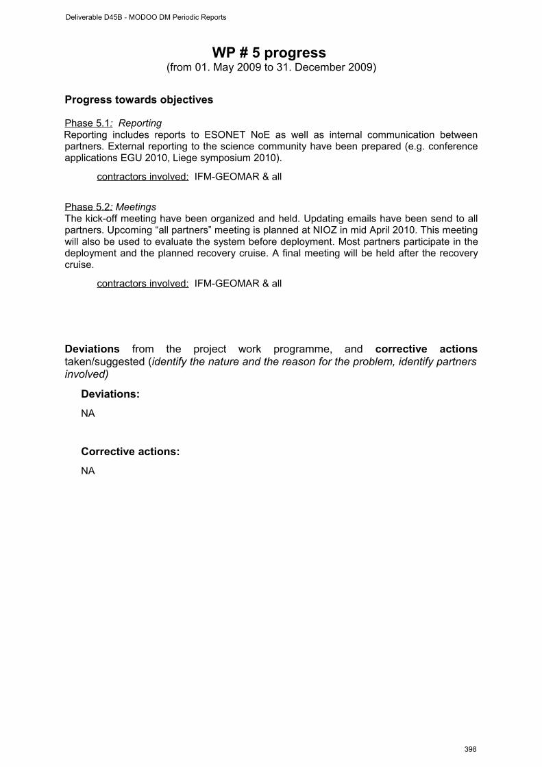
WP # 5 progress (from 01. May 2009 to 31. December 2009)
Progress towards objectives
Phase 5.1 : Reporting Reporting includes reports to ESONET NoE as well as internal communication between partners. External reporting to the science community have been prepared (e.g. conference applications EGU 2010, Liege symposium 2010).
contractors involved: IFM-GEOMAR & all
Phase 5.2 : MeetingsThe kick-off meeting have been organized and held. Updating emails have been send to all partners. Upcoming “all partners” meeting is planned at NIOZ in mid April 2010. This meeting will also be used to evaluate the system before deployment. Most partners participate in the deployment and the planned recovery cruise. A final meeting will be held after the recovery cruise.
contractors involved: IFM-GEOMAR & all
Deviations from the project work programme, and corrective actions taken/suggested (identify the nature and the reason for the problem, identify partners involved)
Deviations:
NA
Corrective actions:
NA
Deliverable D45B - MODOO DM Periodic Reports
398
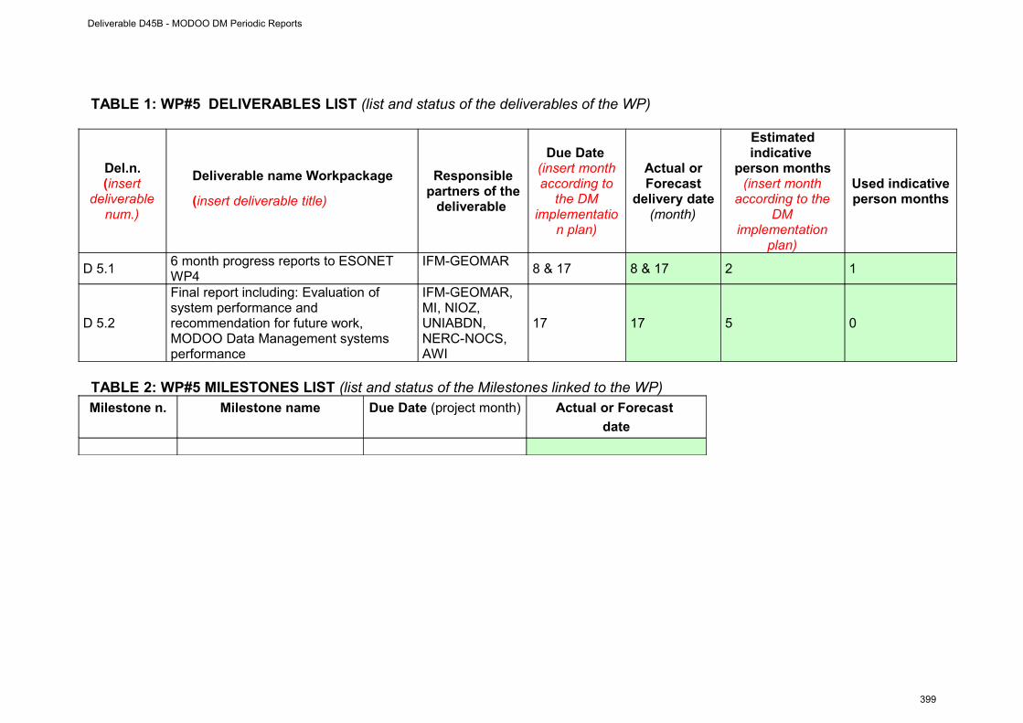
TABLE 1: WP#5 DELIVERABLES LIST (list and status of the deliverables of the WP)
Del.n.(insert
deliverable num.)
Deliverable name Workpackage
(insert deliverable title)
Responsible partners of the
deliverable
Due Date (insert month according to
the DM implementatio
n plan)
Actual or Forecast
delivery date (month)
Estimated indicative
person months(insert month
according to the DM
implementation plan)
Used indicative person months
D 5.16 month progress reports to ESONET WP4
IFM-GEOMAR8 & 17 8 & 17 2 1
D 5.2
Final report including: Evaluation of system performance and recommendation for future work, MODOO Data Management systems performance
IFM-GEOMAR, MI, NIOZ, UNIABDN, NERC-NOCS, AWI
17 17 5 0
TABLE 2: WP#5 MILESTONES LIST (list and status of the Milestones linked to the WP)Milestone n. Milestone name Due Date (project month) Actual or Forecast
date
Deliverable D45B - MODOO DM Periodic Reports
399

UPDATED BAR-CHART
May July Sept Nov Jan MarchDeployment July
Recovery & End
of MODOO
Project month 1 2 3 4 5 6 7 8 9 10 11 12 13 14 15 16 17
WP#5 Planned X X X X X X X X X X X X X X X X X
WP#5 Actual X X X X X X X X X X X X X X X X X
Phase 5.1 Planned X X X X X X X X X X X X X
Phase 5.1 Actual X X X X X X X X X X X X X
Phase 5.2 Planned X X X X X X X X X X X X X
Phase 5.2 Actual X X X X X X X X X X X X X
Phase 5.3 Planned X X X X X X X X X X X X X X X
Phase 5.3 Actual X X X X X X X X X X X X X X X
Deliverable D45B - MODOO DM Periodic Reports
400

Appendix
Deliverable D45B - MODOO DM Periodic Reports
401

Meeting notes:
Agenda Kick-off MODOO and MODOO connect NOCS, 7. May 2009 (09:00-17:30) – 8. May 2009 (09:00-12:00)
Day 1: Thursday 7. May 2009Conference Room 344/32 (Level 4 near cafeteria)
08:30 Meet at NOCS reception/main entrance 09:00 Welcome
Introduction of ParticipantsLogisticsObjectives of MeetingAgenda ModificationsMODOO and MODOO connect: Overview
Presentation of MODOO Science09:30 Science core mission (Henry, Jens, Johannes) Science guest missions:
• Deep Sea Marine Life (Acoustic, Camera) (Jens, Anne)• Geohazard (NN POL, Johannes)
Discussion on requirements/expectations for successful science missions:• data availability and science requirement on data availability (with input from Maureen) including data retrieval from moving platforms: ship, AUV –
opportunities?• two - way communication: which instruments needs to be controlled?• Expertise in programming of instruments (e.g. MODE 12 on 1200kHz ADCP,
minimum sampling requirement to resolve tidal signals), list of “sensor” contacts/expertise
• interaction with ESONET WP1 & WP 3 (Henry)• How long is a time series?
Discussion on long term visions – MODOO@PAP and beyond...In between: Coffee break (room next door 344/38)
Administrative aspects (MODOO & MODOO connect)11:30 Finances:
- MODOO (as part of ESONET NoE WP4 task a & b)- MODOO connect (as part of ESONET NoE WP1 task a)
12:00 – 13:00 Lunch break in NOCS canteen – own expenses
Presentation of MODOO Technology (shared with MODOO connect)13:00 Discussion on technological aspects of MODOO
MODOO components (with current status)- BOBO Lander (Jens & Dries)- PAP Mooring (Richard, Jon)
More details on platform payload: - seismometer/bottom pressure- camera systems
Deliverable D45B - MODOO DM Periodic Reports
402
- surface telemetry system at PAP (Jon) - Generic sensor package (Henry, Jens)- status of DCD nodes (integration of camera!!!) and Underwater acoustic modems:
experiences, tests
Standardization, quality control, calibration (with link to WP2 of ESONET)
Interaction with ESONET WP5 (stand-alone observatories)
15:00-15:30 Coffee break (room next door 344/38)
Time line of project15:30 Review and update of timing of the project
• Implementation plan• Milestones, deliverables• Update cruise schedule – possibilities of cruise participation, required
technical expertise on board• Meetings (ESONET, others) – Bremen IEEE session Thursday
afternoon• web page
17:30 End of first day
19:00 Dinner at: tba. (own expenses)
Day 2: Friday 8. May 2009Meeting room 1/Plate 251 (Ground floor/entrance level)
Continuation of Technology (shared with MODOO connect)08:30 Meet at NOCS reception 09:00 Summary of first day in respect to technological requirements
Discussion on technical issues:7. The DCD node in more details (requirements, ports, …)8. Integration of camera(s)9. Integration of DCD node into surface telemetry10. two-way communication with instruments (camera, seismometer)
In between: Coffee break (in room)
11. Sensor list (XLS file)12. mooring requirement (steel wire, break load of DCD frame, launching procedure) 13. Lander requirements (maximum payload, specific launching e.g. which crane is
available for deployment/recovery ship dependent... )14. Underwater modem manufacturer
Summary of tasks, define action items – planning for next MODOO connect exchange 12:00 End of second day and end of meeting
Deliverable D45B - MODOO DM Periodic Reports
403

Update on MODOO after 7./8. May 2009 meeting at NOC Southampton.
Table of ContentsReporting period:...........................................................................................................2Part I (to be filled by the DM coordinator)....................................................................2Permanent staff(1).........................................................................................................6 first period.....................................................................................................................6
Sensors & data management plan: please update the following table: follow the guidelines issued from the ESONET Best Practice workshop...........................9
Dissemination and outreach : please update the table ..........................................10 ................................................................................................................................10
Infrastructure and sensors...........................................................................................20BOBO lander...........................................................................................................20PAP Mooring...........................................................................................................21DCD nodes..............................................................................................................21Specific Instrumentation..........................................................................................22
Passive acoustics:..............................................................................................22Seismometer (OBS) & Ocean bottom pressure sensor (OBP):.........................22ADCP:.................................................................................................................22Sediment trap:.....................................................................................................22
Cruises.........................................................................................................................23Data Management and accessibility:..........................................................................23Outreach:.....................................................................................................................23Deliverables and concepts to satisfy ESONET NoE needs........................................23Future perspective.......................................................................................................24Finances......................................................................................................................24
Infrastructure and sensorsBOBO landerFor operation at sea at well as for deployment calculations the exact dimensions (length, weight, etc..) of instruments and batteries are required. This information is requested for:
• Deliverables 'calibration, test, deployment and recovery' aka 'operation at sea'
Easiest would be a list of sensor weights, both “in air” and “in water” to estimate the total weight + dimension of the lander for deployment and to do the buoyancy calculations.
Sensor list needs one “responsible” for each instrument + column with dimensions.
Table: Specification of MODOO sensors
Deliverable D45B - MODOO DM Periodic Reports
404
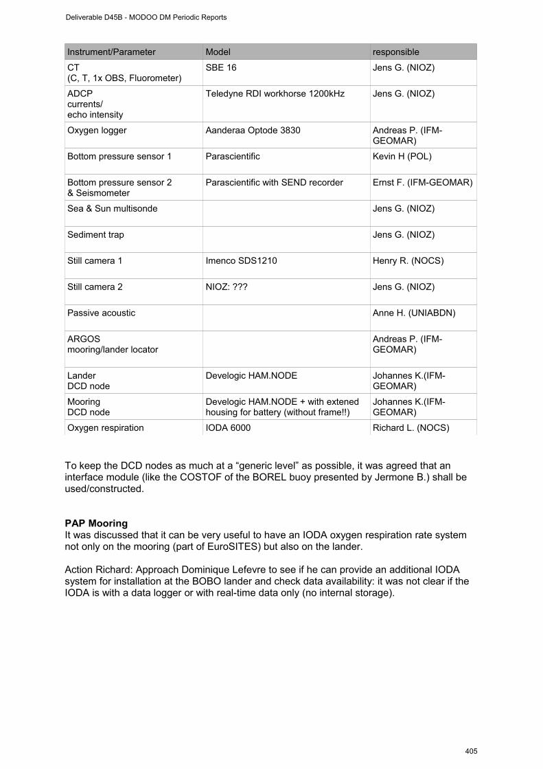
Instrument/Parameter Model responsible
CT (C, T, 1x OBS, Fluorometer)
SBE 16 Jens G. (NIOZ)
ADCP currents/echo intensity
Teledyne RDI workhorse 1200kHz Jens G. (NIOZ)
Oxygen logger Aanderaa Optode 3830 Andreas P. (IFM-GEOMAR)
Bottom pressure sensor 1 Parascientific
Kevin H (POL)
Bottom pressure sensor 2& Seismometer
Parascientific with SEND recorder Ernst F. (IFM-GEOMAR)
Sea & Sun multisonde Jens G. (NIOZ)
Sediment trap Jens G. (NIOZ)
Still camera 1 Imenco SDS1210 Henry R. (NOCS)
Still camera 2 NIOZ: ??? Jens G. (NIOZ)
Passive acoustic Anne H. (UNIABDN)
ARGOS mooring/lander locator
Andreas P. (IFM-GEOMAR)
LanderDCD node
Develogic HAM.NODE Johannes K.(IFM-GEOMAR)
Mooring DCD node
Develogic HAM.NODE + with extened housing for battery (without frame!!)
Johannes K.(IFM-GEOMAR)
Oxygen respiration IODA 6000 Richard L. (NOCS)
To keep the DCD nodes as much at a “generic level” as possible, it was agreed that an interface module (like the COSTOF of the BOREL buoy presented by Jermone B.) shall be used/constructed.
PAP MooringIt was discussed that it can be very useful to have an IODA oxygen respiration rate system not only on the mooring (part of EuroSITES) but also on the lander.
Action Richard: Approach Dominique Lefevre to see if he can provide an additional IODA system for installation at the BOBO lander and check data availability: it was not clear if the IODA is with a data logger or with real-time data only (no internal storage).
Deliverable D45B - MODOO DM Periodic Reports
405
Components of the PAP mooring have been shown to us (surface buoy, biogeochemical sensor frame).
DCD nodesJerome reported on tests performed at the IFREMER with underwater acoustic modems. Also the results have been kept anonymous it interesting to hear about the different methods to evaluate the instrumentation.NIOZ will design an interface board
It is expected that the communication strategy between PAP telemetry and MDCD node will require quite a bit of exchange between NOCS and the modem manufacturer (very likely Develogics http://www.develogic.de/en/products/ham_node/index.php).
Specific InstrumentationPassive acoustics:dimension of device 35kg, 50cm longsampling: 240 hours with 24 bit, typical operation frequency: 16kHz (1Hz – 96kHz possible)
Action Anne: Provide more details about passive acoustic
Seismometer (OBS) & Ocean bottom pressure sensor (OBP):POL (Kevin Horsburgh) will provide an OBP which, if real time access is requested, will connect to the LDCD node via cable/RS232. As the scientific core mission of the MODOO application at PAP is not on geohazards only a subset of the data will be transferred. The size of the data that will finally be transferred depends on the availability of bandwidth after all core mission data has been considered.
IFM-GEOMAR will provide a combined OBS/OBP instrument. The data can be accessed sequentially and for arbitrary time intervals. The instrument needs to be decoupled from the lander (e.g. time triggered release or corrosion wire) to ensure high quality data. Exact this instrument has been used for Geohazard monitoring with acoustic real time telemetry several times before (GITEWS).
Action Kevin: provide details about OBP, including interface requirements, protocols. Is a sequential and targeted data retrieval possible (e.g. retrieval of data collected at a certain time interval, say 5 minutes, 3 weeks ago between 21:00 and 21:05) or only a complete set of data? Can the OBP be installed directly on the lander or does it need to be separated? If both systems (POL and IFM-GEOMAR) are installed the coherence of the measurements can be investigated – particularly an assessment of the initial drift, which often hampers the use to determine long term trends, would be of scientific interest.
ADCP:It would be useful to switch between water current and turbulence measurements (Mode 12 Teledyne- RDI 1200kHz) for boundary layer investigations.
Action Jens: Check if boundary layer turbulence measurements are of use (With NIOZ Hans van Haarem) and investigate if switch between the normal and the mode 12 can be done via two-way-telemetry/RS232 port of ADCP and what the mode 12 requires in terms of a 1 year deployment period.
Deliverable D45B - MODOO DM Periodic Reports
406
The 75kHz (??) ADCP from MI should for reasons of the mooring design not installed on the PAP mooring – is an installation on the BOBO lander (upward looking) possible of use? And technically feasible (pressure rating of housing)?
Action Fiona: Communicate ADCP pressure rating.
Sediment trap:The BOBO Lander will have a sediment trap on board. It was discussed if this makes sense because of unknown/degraded trapping efficiency. NIOZ will decide if they want to deploy or not.
CruisesThe PAP cruise proposal for July 2010, where a short activity was the installation of MODOO, has been rejected. However, it is very likely that a shorter (maybe a few days only) cruise to the PAP site for the PAP/MODOO installation will be possible. This is currently under negotiation. A second possibility is using the Irish “Celtic Explorer”. As Fiona told us before and also in a recent email, the MI can apply for ship time on rather short notice.
Mainly for weather reasons the time window for the cruise shall be between 1. June – 15. August. In case of a dedicated MODOO cruise more partners could attend (if needed). The following advantages/disadvantages were identified for earlier and later deployment:
Earlier deployment• Less time for preparations (not good)• Longer time series of observations (good)• Having the installation at place during the spring bloom – which might be nice to have
in the data (good)Later deployment
• More time for preparations (good)• Shorter time series (not good)
There will be no extra recovery cruise of the MODOO system before the “official” exchange in Summer 2011.
Action Richard: Please inform us about any outcome of the ship time negotiations for summer 2010.
Data Management and accessibility:
Initial access point for data is the EuroSITES data centre at NOCS. The existing real time data quality control protocols will be extended to handle the new (non EuroSITES) types of data.
Action all: Instruments need to be registered at the ESONET sensor registry. Found link at http://dataportals.pangaea.de/esonet/index.php/sensor but so far not accessible.
Outreach:MODOO website will be installed (draft at http://www.noc.soton.ac.uk/eurosites/modoo/ - ask for username/password)
Deliverable D45B - MODOO DM Periodic Reports
407

Action Maureen: Reserve an http://www.modoo.info/, maybe at http://www.europeregistry.com/?? 18 Euros a year (two years minimum) and transfer website to it.
Deliverables and concepts with feedback to ESONET NoEHenry mentioned that it is useful to test the functioning of a generic sensor package. The DCD nodes can be seen like such a “package” - as all data from connected sensors are merged and a dedicated time stamp is added. As part of ESONET NoE WP3 (task b) Henry & Jens have been part of a group which considered the following variables to be “generic” (D13). As passive acoustics is irrelevant for biogeochemistry (and to my knowledge also for Physical Oceanography) this has to be see with a question mark.
Table: Generic variables list.
Variable Geosciences
Physical Oceanography
Biogeochemistry
Marine Ecology
Temperature X X X X
Conductivity X X X X
Pressure X X X X
Dissolved O2 X X X X
Turbidity X X X X
Ocean currents X X X X
Passive acoustics X - - X
Unfortunately it was not possible to have MODOO being represented at the IEEE09 in Bremen. For the next “All Regions” workshop in Paris and the “Best Practice” workshop in Brest MODOO will be represented as probably most of us will be at one or the other (I will attend both workshops).
Future perspective
Discuss further plans at the PAP site at a workshop before the ESONET all regions workshop 5.-7.10.2009 Paris, further details to be defined. Requires a regional implementation committee (RIC – WP3 task a)Next EU call “Deep Sea Frontier” (expected 2010/2011) - shall MODOO be part of potential proposalsOther possible installations of MODOO:A possible installation at the CIS site in the Central Irminger Sea should be discussed. The site is potentially shared by US/OOI and the European programm.
In respect to a tropical ocean application, Doug Wallace (IFM-GEOMAR) expressed his interest during a recent EuroSITES meeting to have a MODOO application at the Cape Verde observatory (part of EuroSITES).
FinancesThe so called Grant agreement has been send out to all. It is requested from all to have it signed by the “representative” of the institute and to be send back. It is very important that each partner quickly arranges for the signature.The ESONET coordinator notified us that we can not expect to have the “advance money” before Sept. 2009.
Deliverable D45B - MODOO DM Periodic Reports
408
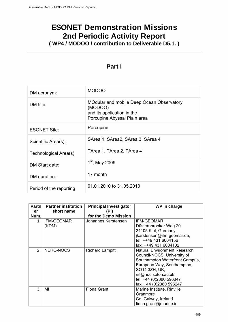
ESONET Demonstration Missions 2nd Periodic Activity Report
( WP4 / MODOO / contribution to Deliverable D5.1. )
Part I
DM acronym: MODOO
DM title: MOdular and mobile Deep Ocean Observatory (MODOO) and its application in the Porcupine Abyssal Plain area
ESONET Site: Porcupine
Scientific Area(s): SArea 1, SArea2, SArea 3, SArea 4
Technological Area(s): TArea 1, TArea 2, TArea 4
DM Start date: 1st, May 2009
DM duration: 17 month
Period of the reporting 01.01.2010 to 31.05.2010
Partner
Num.
Partner institution short name
Principal Investigator (PI)
for the Demo Mission
WP in charge
1. IFM-GEOMAR (KDM)
Johannes Karstensen IFM-GEOMAR Düsternbrooker Weg 20 24105 Kiel, Germany, [email protected], tel. ++49 431 6004156 fax. ++49 431 6004102
2. NERC-NOCS Richard Lampitt Natural Environment Research Council-NOCS, University of Southampton Waterfront Campus, European Way, Southampton, SO14 3ZH, UK, [email protected] tel. +44 (0)2380 596347 fax. +44 (0)2380 596247
3. MI Fiona Grant Marine Institute, Rinville Oranmore Co. Galway, Ireland [email protected]
Deliverable D45B - MODOO DM Periodic Reports
409
tel. +353 (0)91 387 370 fax. +353 (0)91 387 201
4. NIOZ Jens Greinert NIOZ P.O. Box 59 1790 AB Den Burg, Texel The Netherlands [email protected] tel. +31 222 369397 fax.+31 222 319674
5. UNIABDN Imants Priede University of Aberdeen, Oceanlab Main Street Newburgh, AB41 6AA, U.K. [email protected] tel. +44 (0)1224 274408 fax.+44 (0)1224 274408
6. AWI Michael Klages AWI Am Handelshafen 12 27570 Bremerhaven Germany [email protected] tel. +49(471)4831-1302 fax. +49(471)4831-1776
Deliverable D45B - MODOO DM Periodic Reports
410
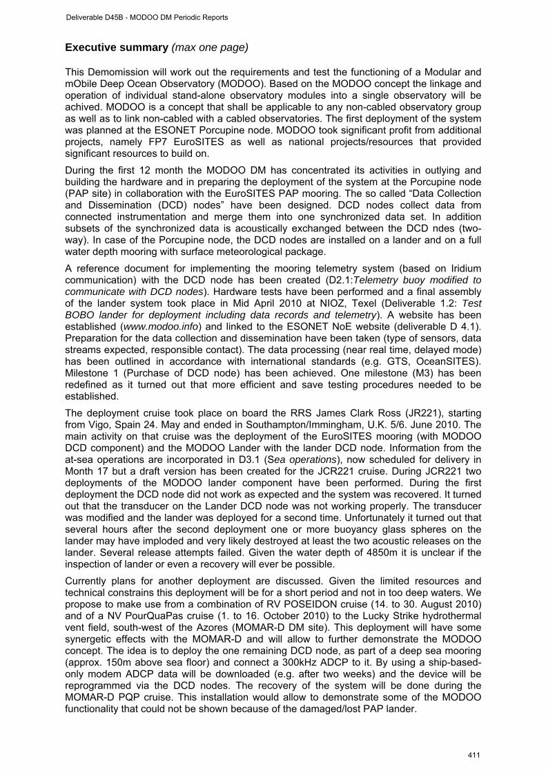
Executive summary (max one page) This Demomission will work out the requirements and test the functioning of a Modular and mObile Deep Ocean Observatory (MODOO). Based on the MODOO concept the linkage and operation of individual stand-alone observatory modules into a single observatory will be achived. MODOO is a concept that shall be applicable to any non-cabled observatory group as well as to link non-cabled with a cabled observatories. The first deployment of the system was planned at the ESONET Porcupine node. MODOO took significant profit from additional projects, namely FP7 EuroSITES as well as national projects/resources that provided significant resources to build on.
During the first 12 month the MODOO DM has concentrated its activities in outlying and building the hardware and in preparing the deployment of the system at the Porcupine node (PAP site) in collaboration with the EuroSITES PAP mooring. The so called “Data Collection and Dissemination (DCD) nodes” have been designed. DCD nodes collect data from connected instrumentation and merge them into one synchronized data set. In addition subsets of the synchronized data is acoustically exchanged between the DCD ndes (two-way). In case of the Porcupine node, the DCD nodes are installed on a lander and on a full water depth mooring with surface meteorological package.
A reference document for implementing the mooring telemetry system (based on Iridium communication) with the DCD node has been created (D2.1:Telemetry buoy modified to communicate with DCD nodes). Hardware tests have been performed and a final assembly of the lander system took place in Mid April 2010 at NIOZ, Texel (Deliverable 1.2: Test BOBO lander for deployment including data records and telemetry). A website has been established (www.modoo.info) and linked to the ESONET NoE website (deliverable D 4.1). Preparation for the data collection and dissemination have been taken (type of sensors, data streams expected, responsible contact). The data processing (near real time, delayed mode) has been outlined in accordance with international standards (e.g. GTS, OceanSITES). Milestone 1 (Purchase of DCD node) has been achieved. One milestone (M3) has been redefined as it turned out that more efficient and save testing procedures needed to be established.
The deployment cruise took place on board the RRS James Clark Ross (JR221), starting from Vigo, Spain 24. May and ended in Southampton/Immingham, U.K. 5/6. June 2010. The main activity on that cruise was the deployment of the EuroSITES mooring (with MODOO DCD component) and the MODOO Lander with the lander DCD node. Information from the at-sea operations are incorporated in D3.1 (Sea operations), now scheduled for delivery in Month 17 but a draft version has been created for the JCR221 cruise. During JCR221 two deployments of the MODOO lander component have been performed. During the first deployment the DCD node did not work as expected and the system was recovered. It turned out that the transducer on the Lander DCD node was not working properly. The transducer was modified and the lander was deployed for a second time. Unfortunately it turned out that several hours after the second deployment one or more buoyancy glass spheres on the lander may have imploded and very likely destroyed at least the two acoustic releases on the lander. Several release attempts failed. Given the water depth of 4850m it is unclear if the inspection of lander or even a recovery will ever be possible.
Currently plans for another deployment are discussed. Given the limited resources and technical constrains this deployment will be for a short period and not in too deep waters. We propose to make use from a combination of RV POSEIDON cruise (14. to 30. August 2010) and of a NV PourQuaPas cruise (1. to 16. October 2010) to the Lucky Strike hydrothermal vent field, south-west of the Azores (MOMAR-D DM site). This deployment will have some synergetic effects with the MOMAR-D and will allow to further demonstrate the MODOO concept. The idea is to deploy the one remaining DCD node, as part of a deep sea mooring (approx. 150m above sea floor) and connect a 300kHz ADCP to it. By using a ship-based-only modem ADCP data will be downloaded (e.g. after two weeks) and the device will be reprogrammed via the DCD nodes. The recovery of the system will be done during the MOMAR-D PQP cruise. This installation would allow to demonstrate some of the MODOO functionality that could not be shown because of the damaged/lost PAP lander.
Deliverable D45B - MODOO DM Periodic Reports
411
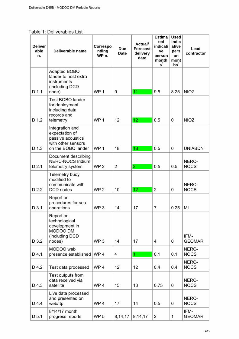
Table 1: Deliverables List
Deliverable
n. Deliverable name
Corresponding WP n.
Due Date
Actual/ Forecast delivery
date
Estimated
indicative
person month
s*
Used indicative person
months*
Lead contractor
D 1.1
Adapted BOBO lander to host extra instruments (including DCD node) WP 1 9 11 9.5 8.25 NIOZ
D 1.2
Test BOBO lander for deployment including data records and telemetry WP 1 12 12 0.5 0 NIOZ
D 1.3
Integration and expectation of passive acoustics with other sensors on the BOBO lander WP 1 18 18 0.5 0 UNIABDN
D 2.1
Document describing NERC-NOCS Iridium telemetry system WP 2 2 2 0.5 0.5
NERC-NOCS
D 2.2
Telemetry buoy modified to communicate with DCD nodes WP 2 10 12 2 0
NERC-NOCS
D 3.1
Report on procedures for sea operations WP 3 14 17 7 0.25 MI
D 3.2
Report on technological development in MODOO DM (including DCD nodes) WP 3 14 17 4 0
IFM-GEOMAR
D 4.1 MODOO web presence established WP 4 4 1 0.1 0.1
NERC-NOCS
D 4.2 Test data processed WP 4 12 12 0.4 0.4 NERC-NOCS
D 4.3
Test outputs from data received via satellite WP 4 15 13 0.75 0
NERC-NOCS
D 4.4
Live data processed and presented on web/ftp WP 4 17 14 0.5 0
NERC-NOCS
D 5.1 8/14/17 month progress reports WP 5 8,14,17 8,14,17 2 1
IFM-GEOMAR
Deliverable D45B - MODOO DM Periodic Reports
412

D 5.2
Final report including: Evaluation of system performance and recommendation for future work, MODOO Data Management systems performance WP 5 17 17 5 0
IFM-GEOMAR, MI, NIOZ, UNIABDN, NERC-NOCS
*the person month must be the same as indicated in Part II- WP progress report (see pag. 10)
Table 2: Milestones List
Milestone n. Milestone name WP n. Due date
Actual/Forecast delivery
date Lead
contractor
M 1 Order and Purchase of DCD nodes
WP 3 Month 2 Month 4 IFM-GEOMAR
M 2 Test (dry, wet) of DCD nodes finalized and evaluated
WP 3 Month 11 Month 12 MI/IFM-GEOMAR
M 3 MODOO system deployed and in operational mode
WP 2 Month 15 Month 13 NERC-NOCS
M 4 Reception real time data; Quality control of real time data and public available through Coriolis data centre, Brest, France, via EuroSITES
WP 4 Month 14 Month 14 NERC-NOCS
M5 Control of selected sensors via satellite/acoustic underwater telemetry system (demonstrate event triggered control)
WP 4 Month 17 Month 17 IFM-GEOMAR
Table 3: Person-months (see Part II for each WP person-months )
First period
Permanent staff(1)
First period WP number and name Full duration Full duration
Actual person months 9.25 0.25 WP1 Planned total person months 10.5 1 Actual person months 2.0 0.58 WP2 Planned total person months 3.5 11.5 Actual person months 3 2.625 WP3 Planned total person months 13.4 4.25 Actual person months 0.5 1.0 WP4 Planned total person months 2.25 2.0 Actual person months 1.5 1.0 WP5 Planned total person months 4.25 2.25 Actual tot person months 16.25 5.46 TOTAL Planned total person months 33.9 21
(1)not charged to the DM
Deliverable D45B - MODOO DM Periodic Reports
413
WP bar chart (planned/actual): insert the time extension of each work-package (see example) according to each WP bar-chart reported in Part II ) Month WP# 1 2 3 4 5 6 7 8 9 10 11 12 13 14 15 16 17 1 planned X X X X X X X X X X X X X X X X X
1 actual X X X X X X X X X X X X X X X X X
2 planned X X X X X X X X X X X X X X X X X
2 actual X X X X X X X X X X X X X X X X X
3 planned X X X X X X X X X X X X X X X X X
3 actual X X X X X X X X X X X X X X X X X
4 planned X X X X X X X X X X X X X X X X X
4 actual X X X X X X X X X X X X X X X X X
5 planned X X X X X X X X X X X X X X X X X
5 actual X X X X X X X X X X X X X X X X X
Milestones planned
M1 M2 M3 M4, M5
Milestones actual
M1 M2 M3, M4
M5
Deliverable D45B - MODOO DM Periodic Reports
414
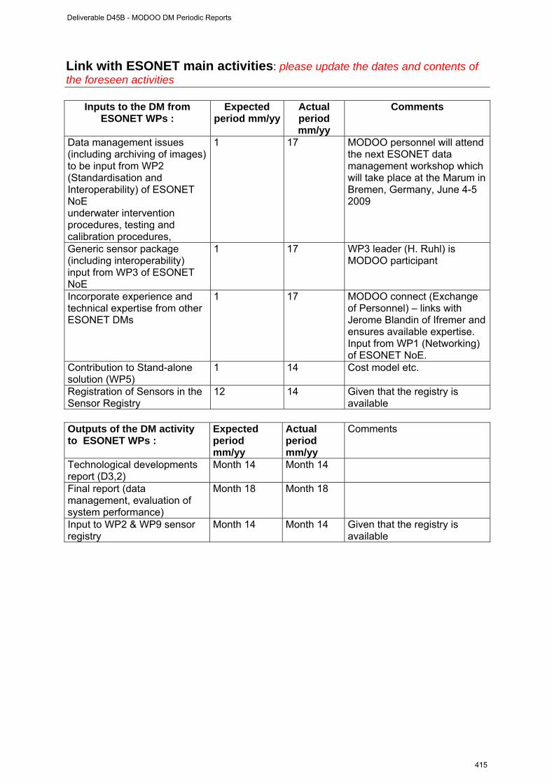
Link with ESONET main activities: please update the dates and contents of the foreseen activities
Inputs to the DM from ESONET WPs :
Expected period mm/yy
Actual period mm/yy
Comments
Data management issues (including archiving of images) to be input from WP2 (Standardisation and Interoperability) of ESONET NoE underwater intervention procedures, testing and calibration procedures,
1 17
MODOO personnel will attend the next ESONET data management workshop which will take place at the Marum in Bremen, Germany, June 4-5 2009
Generic sensor package (including interoperability) input from WP3 of ESONET NoE
1 17 WP3 leader (H. Ruhl) is MODOO participant
Incorporate experience and technical expertise from other ESONET DMs
1 17 MODOO connect (Exchange of Personnel) – links with Jerome Blandin of Ifremer and ensures available expertise. Input from WP1 (Networking) of ESONET NoE.
Contribution to Stand-alone solution (WP5)
1 14 Cost model etc.
Registration of Sensors in the Sensor Registry
12 14 Given that the registry is available
Outputs of the DM activity to ESONET WPs :
Expected period mm/yy
Actual period mm/yy
Comments
Technological developments report (D3,2)
Month 14 Month 14
Final report (data management, evaluation of system performance)
Month 18 Month 18
Input to WP2 & WP9 sensor registry
Month 14 Month 14 Given that the registry is available
Deliverable D45B - MODOO DM Periodic Reports
415
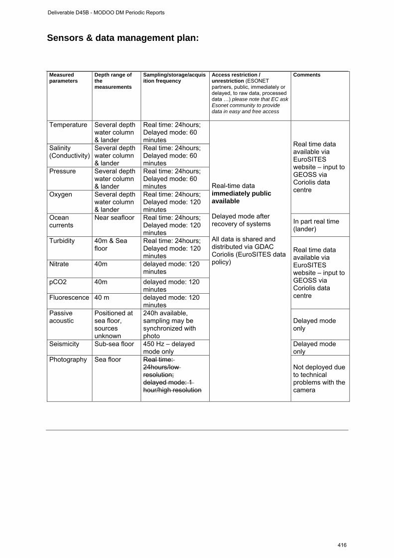
Sensors & data management plan: Measured parameters
Depth range of the measurements
Sampling/storage/acquisition frequency
Access restriction / unrestriction (ESONET partners, public, immediately or delayed, to raw data, processed data …) please note that EC ask Esonet community to provide data in easy and free access
Comments
Temperature Several depth water column & lander
Real time: 24hours; Delayed mode: 60 minutes
Salinity (Conductivity)
Several depth water column & lander
Real time: 24hours; Delayed mode: 60 minutes
Pressure Several depth water column & lander
Real time: 24hours; Delayed mode: 60 minutes
Oxygen Several depth water column & lander
Real time: 24hours; Delayed mode: 120 minutes
Real time data available via EuroSITES website – input to GEOSS via Coriolis data centre
Ocean currents
Near seafloor Real time: 24hours; Delayed mode: 120 minutes
In part real time (lander)
Turbidity 40m & Sea floor
Real time: 24hours; Delayed mode: 120 minutes
Nitrate 40m
delayed mode: 120 minutes
pCO2 40m delayed mode: 120 minutes
Fluorescence 40 m
delayed mode: 120 minutes
Real time data available via EuroSITES website – input to GEOSS via Coriolis data centre
Passive acoustic
Positioned at sea floor, sources unknown
240h available, sampling may be synchronized with photo
Delayed mode only
Seismicity Sub-sea floor 450 Hz – delayed mode only
Delayed mode only
Photography Sea floor Real time: 24hours/low resolution; delayed mode: 1 hour/high resolution
Real-time data immediately public available Delayed mode after recovery of systems All data is shared and distributed via GDAC Coriolis (EuroSITES data policy)
Not deployed due to technical problems with the camera
Deliverable D45B - MODOO DM Periodic Reports
416
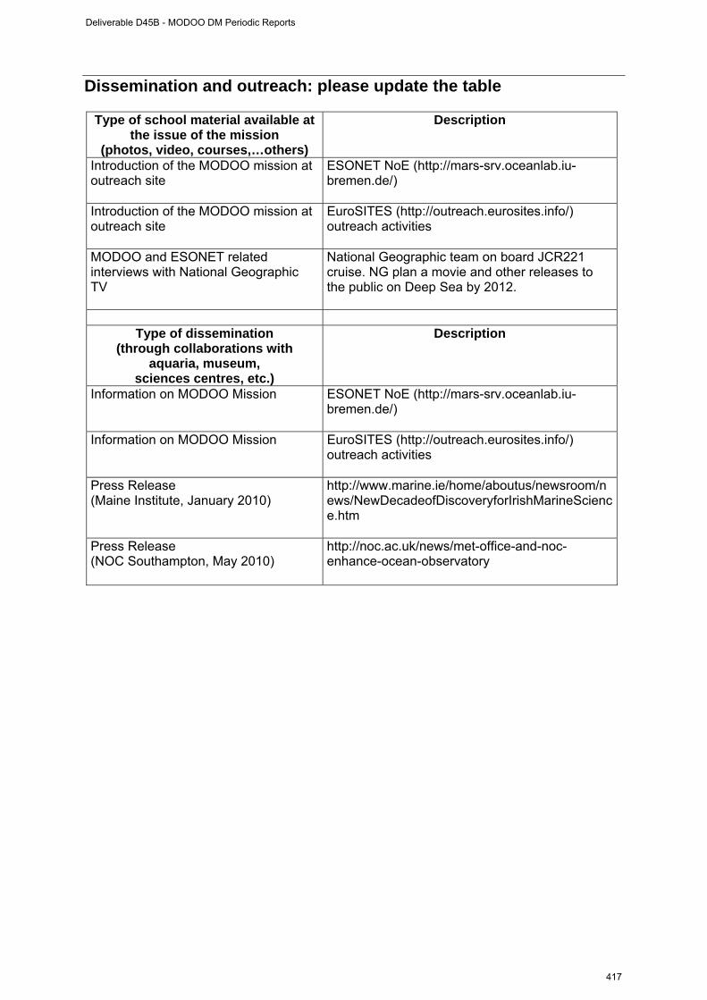
Dissemination and outreach: please update the table
Type of school material available at the issue of the mission
(photos, video, courses,…others)
Description
Introduction of the MODOO mission at outreach site
ESONET NoE (http://mars-srv.oceanlab.iu-bremen.de/)
Introduction of the MODOO mission at outreach site
EuroSITES (http://outreach.eurosites.info/) outreach activities
MODOO and ESONET related interviews with National Geographic TV
National Geographic team on board JCR221 cruise. NG plan a movie and other releases to the public on Deep Sea by 2012.
Type of dissemination
(through collaborations with aquaria, museum,
sciences centres, etc.)
Description
Information on MODOO Mission ESONET NoE (http://mars-srv.oceanlab.iu-bremen.de/)
Information on MODOO Mission EuroSITES (http://outreach.eurosites.info/) outreach activities
Press Release (Maine Institute, January 2010)
http://www.marine.ie/home/aboutus/newsroom/news/NewDecadeofDiscoveryforIrishMarineScience.htm
Press Release (NOC Southampton, May 2010)
http://noc.ac.uk/news/met-office-and-noc-enhance-ocean-observatory
Deliverable D45B - MODOO DM Periodic Reports
417
Part II
WP # 1 (from 01. May 2009 to 31. May 2010)
WORKPACKAGE 1
Full WP title Lander component
Period covered From 01. May 2009 to 31. May 2010
Partner Institution responsible of the WP
NIOZ
Person in charge for the report (WP Leader)
J. Greinert
Partners involved in the Work UNIABDN, NERC-NOCS, IFM-GEOMAR
WP objectives and starting point (max 500 characters) The objective was to advance the capabilities of the BOBO lander to be interfaced with the EuroSITES mooring via the DCD nodes and to host additional sensors. The BOBO lander originally carried only a sediment trap, an ADCP and a Seabird CT + backscatter.
Work Performed : At NIOZ, Dries Boone was employed to work on interfacing the existing sensors (ADCP, the CT and the sediment trap) with the DCD nodes. Boone held the contact with Develogics and got familiar with the entire modem structure and interfacing possibilities. Together with NIOZ personal Bob Koster they went for a 2 days training course to the DCD node manufacturer Develogics in Hamburg, Germany. Dries programmed parts of the ADCP and sediment trap interfacing and agreed with Jon Campbell on protocols to communicate to both systems via the satellite link. Bob Koster was involved in discussions about the camera system and how it could be interfaced to the modem. Jens Greinert overlooked followed the progress and kept contact to the other partners. The lander configuration was outlined and information about the expected payload was collected. The University of Aberdeen built the passive acoustic sensor - this will be shipped to NIOZ during the week 15th-19th February 2010 for implementation into the lander.
Rough Estimation of Major Cost: Explanatory note on any major cost roughly estimated of
items such as major travel costs, large consumable items etc., justifying their necessity to the project.
Major costs were the employment of Dries Bone for 6 month, travel to and from Germany for sensor interfacing and programming training (Dries Boone, Bob Koster). Lander consumables as weights, batteries, frame material, and a dll library for programming of instrumentation. A sediment trap motor that allows to be re-programmed needed to be be purchased. The new motor will allow access to the sediment trap via two way communication
Deliverable D45B - MODOO DM Periodic Reports
418
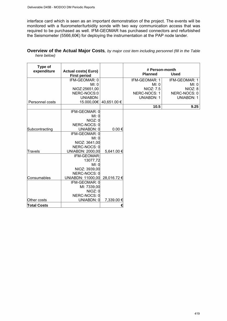
interface card which is seen as an important demonstration of the project. The events will be monitored with a fluorometer/turbidity sonde with two way communication access that was required to be purchased as well. IFM-GEOMAR has purchased connectors and refurbished the Seismometer (5566,60€) for deploying the instrumentation at the PAP node lander. Overview of the Actual Major Costs, by major cost item including personnel (fill in the Table
here below)
Type of expenditure
Actual costs( Euro)
First period
# Person-month
Planned Used
Personnel costs
IFM-GEOMAR: 0MI: 0
NIOZ:25651,00NERC-NOCS:0
UNIABDN:15.000,00€ 40,651.00 €
IFM-GEOMAR: 1MI: 0
NIOZ: 7.5NERC-NOCS: 1
UNIABDN: 1
IFM-GEOMAR: 1MI: 0
NIOZ: 8NERC-NOCS: 0
UNIABDN: 1
10.5 9.25
Subcontracting
IFM-GEOMAR: 0MI: 0
NIOZ: 0NERC-NOCS: 0
UNIABDN: 0 0.00 €
Travels
IFM-GEOMAR: 0MI: 0
NIOZ: 3641,00NERC-NOCS: 0
UNIABDN: 2000,00 5,641.00 €
Consumables
IFM-GEOMAR:13077,72
MI: 0NIOZ: 3939,00
NERC-NOCS: 0UNIABDN: 11000,00 28,016.72 €
Other costs
IFM-GEOMAR: 0MI: 7339,00
NIOZ: 0NERC-NOCS: 0
UNIABDN: 0 7,339.00 €
Total Costs €
Deliverable D45B - MODOO DM Periodic Reports
419
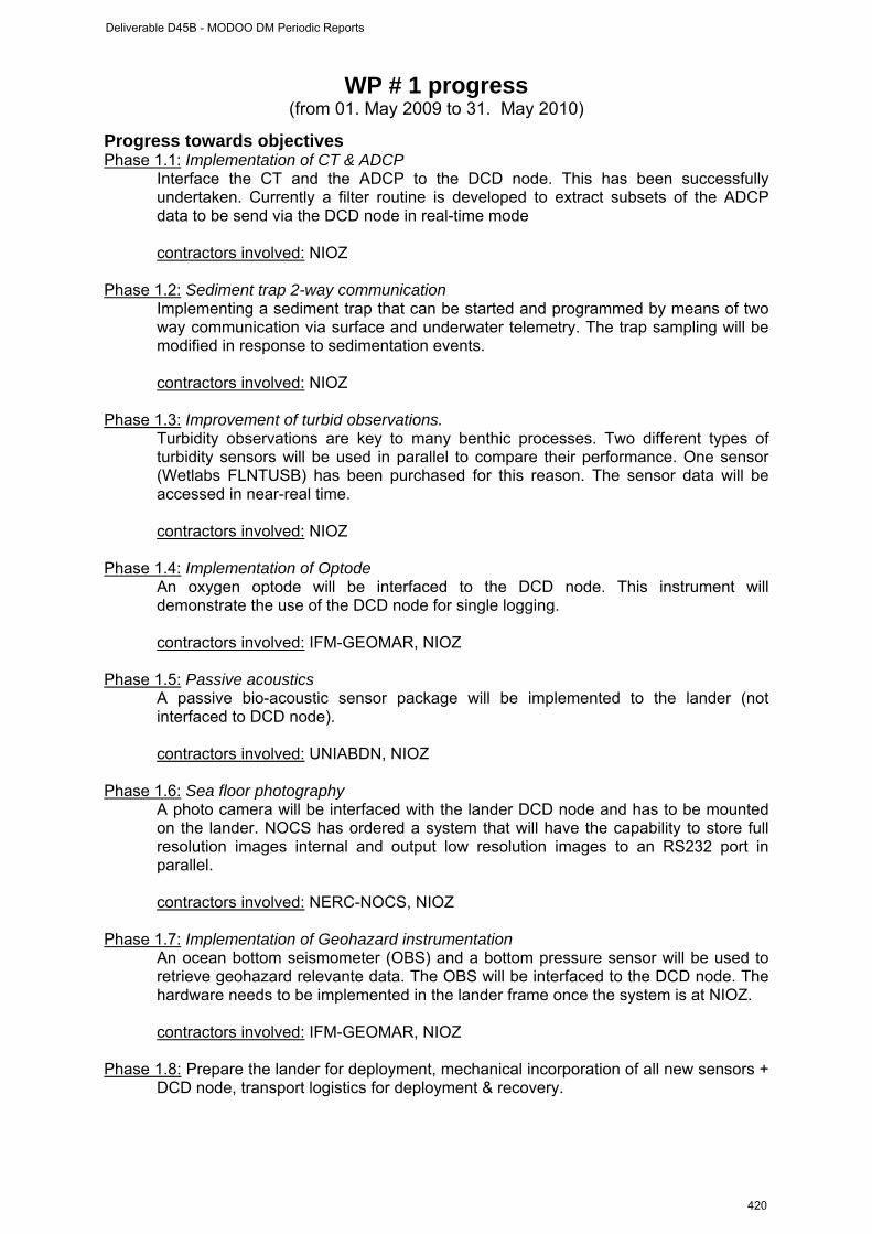
WP # 1 progress (from 01. May 2009 to 31. May 2010)
Progress towards objectives Phase 1.1: Implementation of CT & ADCP Interface the CT and the ADCP to the DCD node. This has been successfully
undertaken. Currently a filter routine is developed to extract subsets of the ADCP data to be send via the DCD node in real-time mode
contractors involved: NIOZ Phase 1.2: Sediment trap 2-way communication Implementing a sediment trap that can be started and programmed by means of two
way communication via surface and underwater telemetry. The trap sampling will be modified in response to sedimentation events.
contractors involved: NIOZ Phase 1.3: Improvement of turbid observations. Turbidity observations are key to many benthic processes. Two different types of
turbidity sensors will be used in parallel to compare their performance. One sensor (Wetlabs FLNTUSB) has been purchased for this reason. The sensor data will be accessed in near-real time.
contractors involved: NIOZ Phase 1.4: Implementation of Optode An oxygen optode will be interfaced to the DCD node. This instrument will
demonstrate the use of the DCD node for single logging. contractors involved: IFM-GEOMAR, NIOZ Phase 1.5: Passive acoustics A passive bio-acoustic sensor package will be implemented to the lander (not
interfaced to DCD node). contractors involved: UNIABDN, NIOZ Phase 1.6: Sea floor photography A photo camera will be interfaced with the lander DCD node and has to be mounted
on the lander. NOCS has ordered a system that will have the capability to store full resolution images internal and output low resolution images to an RS232 port in parallel.
contractors involved: NERC-NOCS, NIOZ Phase 1.7: Implementation of Geohazard instrumentation An ocean bottom seismometer (OBS) and a bottom pressure sensor will be used to
retrieve geohazard relevante data. The OBS will be interfaced to the DCD node. The hardware needs to be implemented in the lander frame once the system is at NIOZ.
contractors involved: IFM-GEOMAR, NIOZ Phase 1.8: Prepare the lander for deployment, mechanical incorporation of all new sensors +
DCD node, transport logistics for deployment & recovery.
Deliverable D45B - MODOO DM Periodic Reports
420
contractors involved: NIOZ
Deviations from the project work programme, and corrective actions taken/suggested (identify the nature and the reason for the problem, identify partners involved)
Deviations:
It was originally planned to have the mechanical work on the lander finished in month 9. This will now become month 10 as not all sensors are available at NIOZ to be properly implemented. It was planned to have a second, DCD node-interfaced CTD attached to the lander. This was plan cancelled.
Corrective actions:
No corrective actions required.
Deliverable D45B - MODOO DM Periodic Reports
421

TABLE 1: WP#1 DELIVERABLES LIST (list and status of the deliverables of the WP)
Del.n. (insert
deliverable num.)
Deliverable name Workpackage
(insert deliverable title)
Responsible partners of
the deliverable
Due Date (insert month
according to the DM
implementation plan)
Actual or Forecast
delivery date (month)
Estimated indicative
person months (insert month
according to the DM implementation
plan)
Used indicative person months
D1.1 Adapt BOBO lander to host extra instruments NIOZ 9 11 9.5 8.25
D1.2 Test BOBO lander for deployments including data records and telemetry
NIOZ, IFM-GEOMAR,
NOCS, UNIABDN12 12 0.5 0
D1.3 Integration and expectation of passive acoustics with other sensors o the BOBO lander
UNIABDN 18 18 0.5 0
TABLE 2: WP#1 MILESTONES LIST (list and status of the Milestones linked to the WP) Milestone n. Milestone name Due Date (project
month) Actual or Forecast
date
Deliverable D45B - MODOO DM Periodic Reports
422
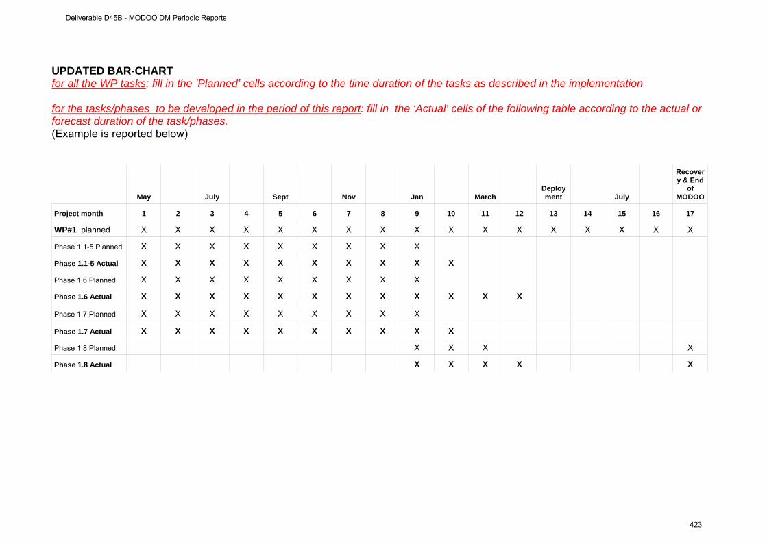
UPDATED BAR-CHART for all the WP tasks: fill in the ’Planned’ cells according to the time duration of the tasks as described in the implementation for the tasks/phases to be developed in the period of this report: fill in the ‘Actual’ cells of the following table according to the actual or forecast duration of the task/phases. (Example is reported below)
May July Sept Nov Jan March Deployment July
Recovery & End
of MODOO
Project month 1 2 3 4 5 6 7 8 9 10 11 12 13 14 15 16 17
WP#1 planned X X X X X X X X X X X X X X X X X
Phase 1.1-5 Planned X X X X X X X X X
Phase 1.1-5 Actual X X X X X X X X X X
Phase 1.6 Planned X X X X X X X X X
Phase 1.6 Actual X X X X X X X X X X X X
Phase 1.7 Planned X X X X X X X X X
Phase 1.7 Actual X X X X X X X X X X
Phase 1.8 Planned X X X X
Phase 1.8 Actual X X X X X
Deliverable D45B - MODOO DM Periodic Reports
423
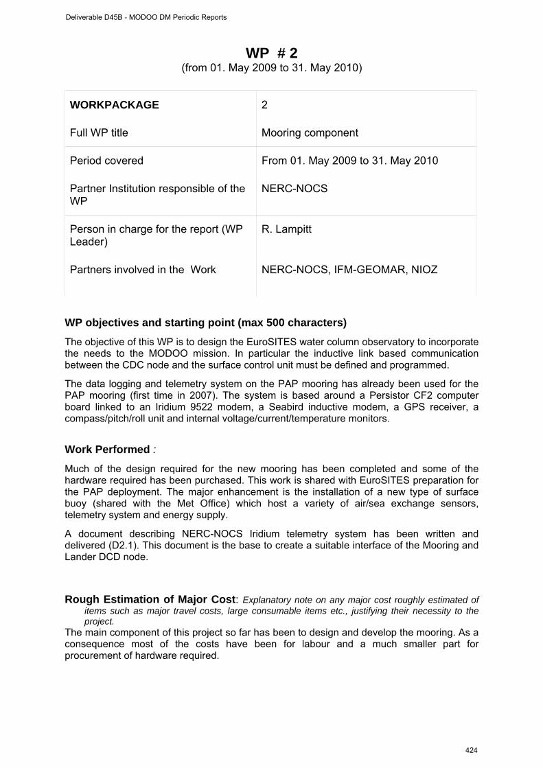
WP # 2 (from 01. May 2009 to 31. May 2010)
WORKPACKAGE 2
Full WP title Mooring component
Period covered From 01. May 2009 to 31. May 2010
Partner Institution responsible of the WP
NERC-NOCS
Person in charge for the report (WP Leader)
R. Lampitt
Partners involved in the Work NERC-NOCS, IFM-GEOMAR, NIOZ
WP objectives and starting point (max 500 characters)
The objective of this WP is to design the EuroSITES water column observatory to incorporate the needs to the MODOO mission. In particular the inductive link based communication between the CDC node and the surface control unit must be defined and programmed.
The data logging and telemetry system on the PAP mooring has already been used for the PAP mooring (first time in 2007). The system is based around a Persistor CF2 computer board linked to an Iridium 9522 modem, a Seabird inductive modem, a GPS receiver, a compass/pitch/roll unit and internal voltage/current/temperature monitors.
Work Performed :
Much of the design required for the new mooring has been completed and some of the hardware required has been purchased. This work is shared with EuroSITES preparation for the PAP deployment. The major enhancement is the installation of a new type of surface buoy (shared with the Met Office) which host a variety of air/sea exchange sensors, telemetry system and energy supply.
A document describing NERC-NOCS Iridium telemetry system has been written and delivered (D2.1). This document is the base to create a suitable interface of the Mooring and Lander DCD node.
Rough Estimation of Major Cost: Explanatory note on any major cost roughly estimated of
items such as major travel costs, large consumable items etc., justifying their necessity to the project.
The main component of this project so far has been to design and develop the mooring. As a consequence most of the costs have been for labour and a much smaller part for procurement of hardware required.
Deliverable D45B - MODOO DM Periodic Reports
424

Overview of the Actual Major Costs, by major cost item including personnel (fill in the Table here below)
Type of
expenditure
Actual costs( Euro) First period
# Person-month
Planned Used Personnel costs
IFM-GEOMAR: 0 NERC-NOCS: 8687 8687.00 €
IFM-GEOMAR: 1.0NERC-NOCS: 13.0
IFM-GEOMAR: 1.0NERC-NOCS: 11.92
14.0 12.92
Subcontracting
IFM-GEOMAR: 0NERC-NOCS: 0
Travels
IFM-GEOMAR: 0NERC-NOCS:353
353.00 €
Consumables
IFM-GEOMAR: 0NERC-NOCS:953
953.00 €
Other costs
IFM-GEOMAR: 0NERC-NOCS: 446
446.00 €
Total Costs 1,752.00 €
Deliverable D45B - MODOO DM Periodic Reports
425
WP # 2 progress (from 01. May 2009 to 31. May 2010)
Progress towards objectives Phase 2.1: Implementation of inductive linked DCD node into surface telemetry system telemetry A review of the PAP telemetry system was performed (see deliverable D2.1) to evaluate the compatibility and technical requirements for the DCD nodes with the telemetry. The mooring mounted DCD node will be integrated into the “standard” mooring inductive loop. The challenge is that the DCD node does not only send data to the surface telemetry on request but receives data (commands) from the surface buoy (event control/ two-way communication). In the upcoming months the integration will be continued and system will be tested.
contractors involved: . NERC-NOCS, NIOZ, IFM-GEOMAR
Phase 2.2:Mooring design The design of the PAP mooring was developed (in collaboration with EuroSITES). The mooring now has a large surface buoy with own energy supply (solar panel) and several engineering option. The original plan to place the mooring DCD node at 1000m water depth has been revised for reasons of mooring construction, now the nodes are placed at nominal 40m depth in dedicated frame.
contractors involved: NERC-NOCS Phase 2.3: Mooring cruise preparation Preparation of the deployment and recovery cruises were made. An arrangement with the British Antarctic Survey (BAS) was made to deploy the mooring (and the lander WP1) with James Clarke Ross in May/June 2010. Cruise planning meetings and other related work must be done (documents as risk assessment, logistics etc.).
contractors involved: NERC-NOCS, NIOZ, MI, IFM-GEOMAR
Deliverable D45B - MODOO DM Periodic Reports
426
Deviations from the project work programme, and corrective actions taken/suggested (identify the nature and the reason for the problem, identify partners involved)
Deviations:
NA
Corrective actions:
NA
Deliverable D45B - MODOO DM Periodic Reports
427
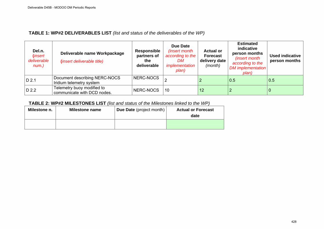
TABLE 1: WP#2 DELIVERABLES LIST (list and status of the deliverables of the WP)
Del.n. (insert
deliverable num.)
Deliverable name Workpackage
(insert deliverable title)
Responsible partners of
the deliverable
Due Date (insert month
according to the DM
implementation plan)
Actual or Forecast
delivery date (month)
Estimated indicative
person months (insert month
according to the DM implementation
plan)
Used indicative person months
D 2.1 Document describing NERC-NOCS Iridium telemetry system
NERC-NOCS 2 2 0.5 0.5
D 2.2 Telemetry buoy modified to communicate with DCD nodes. NERC-NOCS 10 12 2 0
TABLE 2: WP#2 MILESTONES LIST (list and status of the Milestones linked to the WP) Milestone n. Milestone name Due Date (project month) Actual or Forecast
date
Deliverable D45B - MODOO DM Periodic Reports
428
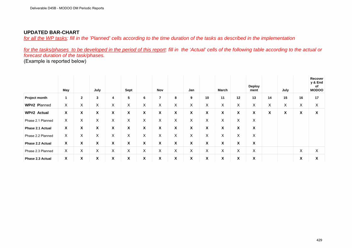
UPDATED BAR-CHART for all the WP tasks: fill in the ’Planned’ cells according to the time duration of the tasks as described in the implementation for the tasks/phases to be developed in the period of this report: fill in the ‘Actual’ cells of the following table according to the actual or forecast duration of the task/phases. (Example is reported below)
May July Sept Nov Jan March Deployment July
Recovery & End
of MODOO
Project month 1 2 3 4 5 6 7 8 9 10 11 12 13 14 15 16 17
WP#2 Planned X X X X X X X X X X X X X X X X X
WP#2 Actual X X X X X X X X X X X X X X X X X
Phase 2.1 Planned X X X X X X X X X X X X X
Phase 2.1 Actual X X X X X X X X X X X X X
Phase 2.2 Planned X X X X X X X X X X X X X
Phase 2.2 Actual X X X X X X X X X X X X X
Phase 2.3 Planned X X X X X X X X X X X X X X X
Phase 2.3 Actual X X X X X X X X X X X X X X X
Deliverable D45B - MODOO DM Periodic Reports
429
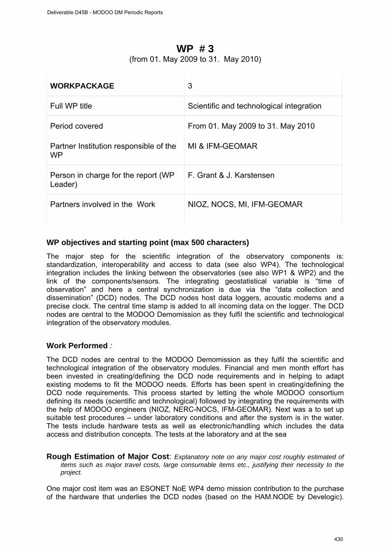
WP # 3
(from 01. May 2009 to 31. May 2010) WORKPACKAGE 3
Full WP title Scientific and technological integration
Period covered From 01. May 2009 to 31. May 2010
Partner Institution responsible of the WP
MI & IFM-GEOMAR
Person in charge for the report (WP Leader)
F. Grant & J. Karstensen
Partners involved in the Work NIOZ, NOCS, MI, IFM-GEOMAR
WP objectives and starting point (max 500 characters)
The major step for the scientific integration of the observatory components is: standardization, interoperability and access to data (see also WP4). The technological integration includes the linking between the observatories (see also WP1 & WP2) and the link of the components/sensors. The integrating geostatistical variable is “time of observation” and here a central synchronization is due via the “data collection and dissemination” (DCD) nodes. The DCD nodes host data loggers, acoustic modems and a precise clock. The central time stamp is added to all incoming data on the logger. The DCD nodes are central to the MODOO Demomission as they fulfil the scientific and technological integration of the observatory modules.
Work Performed :
The DCD nodes are central to the MODOO Demomission as they fulfil the scientific and technological integration of the observatory modules. Financial and men month effort has been invested in creating/defining the DCD node requirements and in helping to adapt existing modems to fit the MODOO needs. Efforts has been spent in creating/defining the DCD node requirements. This process started by letting the whole MODOO consortium defining its needs (scientific and technological) followed by integrating the requirements with the help of MODOO engineers (NIOZ, NERC-NOCS, IFM-GEOMAR). Next was a to set up suitable test procedures – under laboratory conditions and after the system is in the water. The tests include hardware tests as well as electronic/handling which includes the data access and distribution concepts. The tests at the laboratory and at the sea
Rough Estimation of Major Cost: Explanatory note on any major cost roughly estimated of
items such as major travel costs, large consumable items etc., justifying their necessity to the project.
One major cost item was an ESONET NoE WP4 demo mission contribution to the purchase of the hardware that underlies the DCD nodes (based on the HAM.NODE by Develogic).
Deliverable D45B - MODOO DM Periodic Reports
430

About half of the hardware cost have been charged to MODOO the other half was paid by institutional money (IFM-GEOMAR). The DCD nodes are of central importance for all participating partners and the MODOO system itself. A large part of the intellectual and design work within MODOO focus on the definition of the DCD node. This concerted design work was only possible through the unique partnership in this ESONET NoE demo mission. Through a parallel running exchange of personal training (MODOO connect) other ESONET partners outside of MODOO have been involved in the design process as well (IFREMER) and from which the MODOO partnership benefit substantially. Other major cost items were batteries to be used for the MODOO DCD nodes operation at PAP, communication costs to test the telemetry protocols of the Optode and travel costs for the deployment cruises. Overview of the Actual Major Costs, by major cost item including personnel (fill in the Table
here below)
Type of expenditur
e
Actual costs( Euro) First period
# Person-month
Planned Used
Personnel costs
IFM-GEOMAR: 5596,03MI:1459,15
NIOZ: 0NERC-NOCS: 0
UNIABDN: 0 1,459.15 €
IFM-GEOMAR: 6MI: 6.9
NIOZ: 0.25NERC-NOCS: 0.25
UNIABDN: 0
IFM-GEOMAR: 2.625MI: 0.25
NIOZ: 0.125NERC-NOCS: 0
UNIABDN: 0 13.4 3.0
Subcontracting
IFM-GEOMAR: 0MI: 0
NIOZ:0NERC-NOCS: 0
UNIABDN: 0 0.00 €
Travels
IFM-GEOMAR:1194,00: MI: 0
NIOZ: 0NERC-NOCS: 0
UNIABDN: 0 1194.00 €
Consumables
IFM-GEOMAR: 641,47MI:
NIOZ:NERC-NOCS:
UNIABDN: 641.47 €
Other costs
IFM-GEOMAR: 17765.44MI:
NIOZ:NERC-NOCS:
UNIABDN: 17,765.44 €
Total Costs €
Deliverable D45B - MODOO DM Periodic Reports
431
WP # 3 progress (from 01. May 2009 to 31. May 2010)
Progress towards objectives
Phase 3.1: Definition of the scientific requirements for designing the DCD nodes. To ensure
that the DCD node design can help to facilitate the concerted scientific interpretation of the data we collected basic information on required sampling interval, sampling depth, accuracy of clock, etc. This information is used for Phase 3.2. One other important action was in phase 3.1. was to identify individuals that act as a contact for sensors (also in respect to ESONET NoE sensor registry).
contractors involved: IFM-GEOMAR, NERC-NOCS, NIOZ, MI, UNIABDN, AWI
Phase 3.2: Definition of the technological requirements for designing the DCD nodes. In this
phase we collected specification of the instrumentation that will be mounted on the lander and mooring. Based on the specifications we selected a set of devices (also in reflection to Phase 3.1.) that is most useful in achieving the MODOO goals.
contractors involved: IFM-GEOMAR, NERC-NOCS, NIOZ, MI, UNIABDN, AWI
Phase 3.3: Implementation of Phase 3.1. and Phase 3.2. results in DCD nodes design and
programming This is an on-going phase which includes the definition of the instrument ports, implementation of re-programming capabilities for certain instrumentation via telemetry, implementation of inductive link for data real time access and event control. This phase includes work for deliverable D3.2 (Report on technological development in MODOO DM (including DCD nodes)).
contractors involved: IFM-GEOMAR, NERC-NOCS, NIOZ, MI
Phase 3.4: Preparation for deployment considering scientific and technological integration
This work is central in working towards Milestone M2 (test procedures finalized and evaluated) and M3 (MODOO system deployed and in operational mode). It considers the work in WP1 (lander component), WP2 (mooring component), and WP4 (data management). This phase includes work for deliverable D3.1 (Report on procedures for sea operations).
contractors involved: IFM-GEOMAR, NERC-NOCS, NIOZ, MI, UNIABDN
Phase 3.5: Preparation for recovery and evaluation In this final phase preparation for a successful recovery will be done. The final
evaluation of the system in terms of scientific and technological aspects will be done
contractors involved: IFM-GEOMAR, NERC-NOCS, NIOZ, MI, UNIABDN
Deliverable D45B - MODOO DM Periodic Reports
432
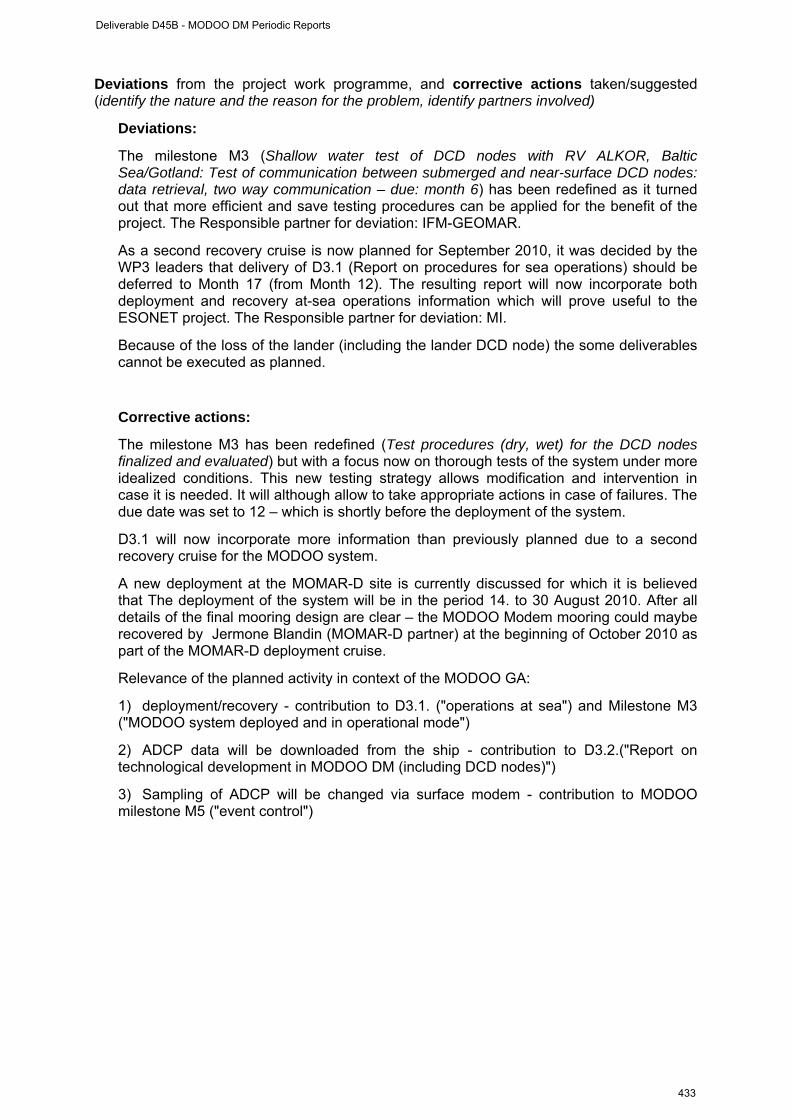
Deviations from the project work programme, and corrective actions taken/suggested (identify the nature and the reason for the problem, identify partners involved)
Deviations:
The milestone M3 (Shallow water test of DCD nodes with RV ALKOR, Baltic Sea/Gotland: Test of communication between submerged and near-surface DCD nodes: data retrieval, two way communication – due: month 6) has been redefined as it turned out that more efficient and save testing procedures can be applied for the benefit of the project. The Responsible partner for deviation: IFM-GEOMAR.
As a second recovery cruise is now planned for September 2010, it was decided by the WP3 leaders that delivery of D3.1 (Report on procedures for sea operations) should be deferred to Month 17 (from Month 12). The resulting report will now incorporate both deployment and recovery at-sea operations information which will prove useful to the ESONET project. The Responsible partner for deviation: MI.
Because of the loss of the lander (including the lander DCD node) the some deliverables cannot be executed as planned.
Corrective actions:
The milestone M3 has been redefined (Test procedures (dry, wet) for the DCD nodes finalized and evaluated) but with a focus now on thorough tests of the system under more idealized conditions. This new testing strategy allows modification and intervention in case it is needed. It will although allow to take appropriate actions in case of failures. The due date was set to 12 – which is shortly before the deployment of the system.
D3.1 will now incorporate more information than previously planned due to a second recovery cruise for the MODOO system.
A new deployment at the MOMAR-D site is currently discussed for which it is believed that The deployment of the system will be in the period 14. to 30 August 2010. After all details of the final mooring design are clear – the MODOO Modem mooring could maybe recovered by Jermone Blandin (MOMAR-D partner) at the beginning of October 2010 as part of the MOMAR-D deployment cruise.
Relevance of the planned activity in context of the MODOO GA:
1) deployment/recovery - contribution to D3.1. ("operations at sea") and Milestone M3 ("MODOO system deployed and in operational mode")
2) ADCP data will be downloaded from the ship - contribution to D3.2.("Report on technological development in MODOO DM (including DCD nodes)")
3) Sampling of ADCP will be changed via surface modem - contribution to MODOO milestone M5 ("event control")
Deliverable D45B - MODOO DM Periodic Reports
433
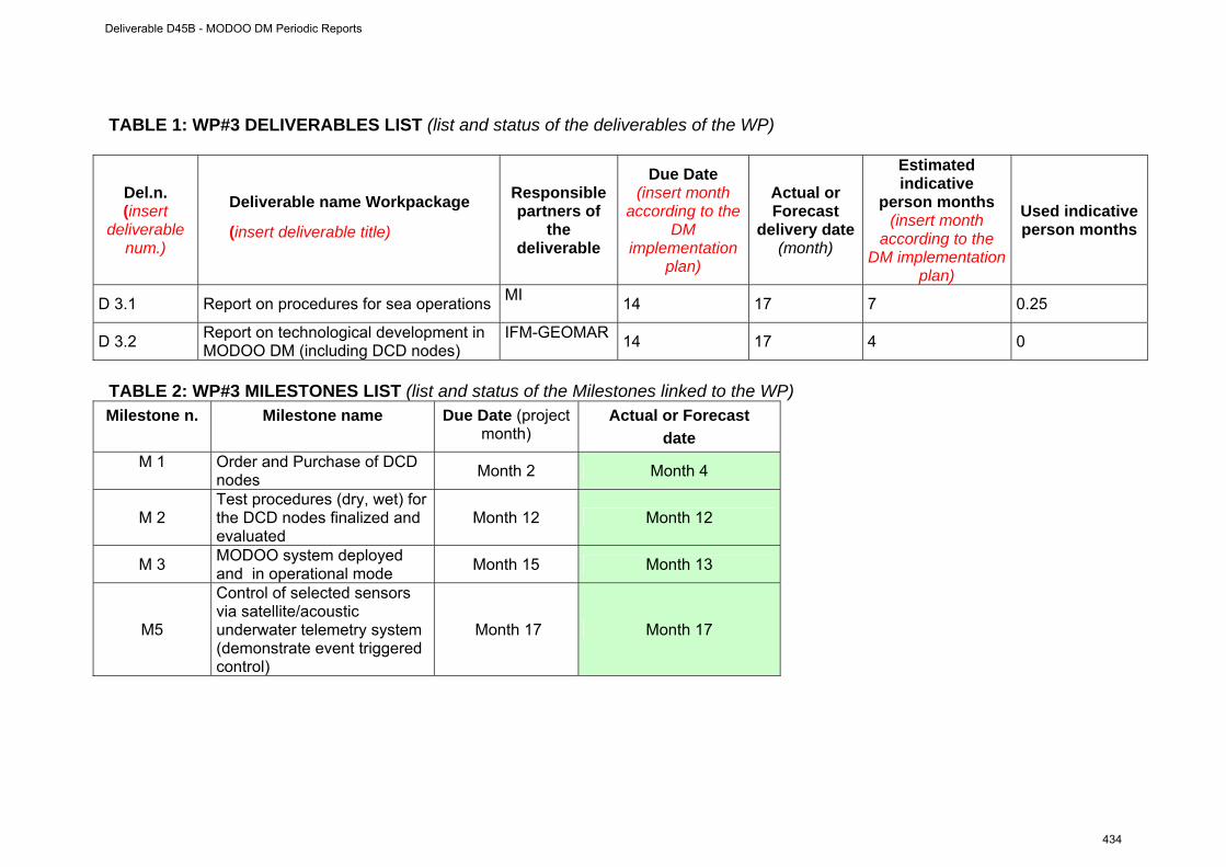
TABLE 1: WP#3 DELIVERABLES LIST (list and status of the deliverables of the WP)
Del.n. (insert
deliverable num.)
Deliverable name Workpackage
(insert deliverable title)
Responsible partners of
the deliverable
Due Date (insert month
according to the DM
implementation plan)
Actual or Forecast
delivery date (month)
Estimated indicative
person months (insert month
according to the DM implementation
plan)
Used indicative person months
D 3.1 Report on procedures for sea operations MI 14 17 7 0.25
D 3.2 Report on technological development in MODOO DM (including DCD nodes)
IFM-GEOMAR 14 17 4 0
TABLE 2: WP#3 MILESTONES LIST (list and status of the Milestones linked to the WP) Milestone n. Milestone name Due Date (project
month) Actual or Forecast
date M 1
Order and Purchase of DCD nodes Month 2 Month 4
M 2 Test procedures (dry, wet) for the DCD nodes finalized and evaluated
Month 12 Month 12
M 3 MODOO system deployed and in operational mode Month 15 Month 13
M5
Control of selected sensors via satellite/acoustic underwater telemetry system (demonstrate event triggered control)
Month 17 Month 17
Deliverable D45B - MODOO DM Periodic Reports
434
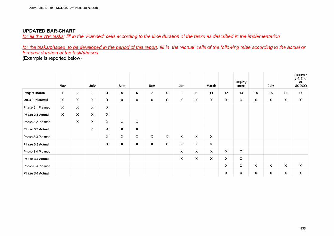
UPDATED BAR-CHART for all the WP tasks: fill in the ’Planned’ cells according to the time duration of the tasks as described in the implementation for the tasks/phases to be developed in the period of this report: fill in the ‘Actual’ cells of the following table according to the actual or forecast duration of the task/phases. (Example is reported below)
May July Sept Nov Jan March Deployment July
Recovery & End
of MODOO
Project month 1 2 3 4 5 6 7 8 9 10 11 12 13 14 15 16 17
WP#3 planned X X X X X X X X X X X X X X X X X
Phase 3.1 Planned X X X X
Phase 3.1 Actual X X X X
Phase 3.2 Planned X X X X X
Phase 3.2 Actual X X X X
Phase 3.3 Planned X X X X X X X X
Phase 3.3 Actual X X X X X X X X
Phase 3.4 Planned X X X X X
Phase 3.4 Actual X X X X X
Phase 3.4 Planned X X X X X X
Phase 3.4 Actual X X X X X X
Deliverable D45B - MODOO DM Periodic Reports
435

WP # 4 (from 01. May 2009 to 31. May 2010)
WORKPACKAGE 4
Full WP title Data management and outreach
Period covered From 01. May 2009 to 31. May 2010
Partner Institution responsible of the WP
NERC-NOCS
Person in charge for the report (WP Leader)
M Pagnani
Partners involved in the Work NERC-NOCS
WP objectives and starting point (max 500 characters) The MODOO project data management will be an extension of the systems already being undertaken under the auspices of EuroSITES. This will enhance links between EuroSITES and ESONET NoE data management principles. A large range of data types will be handled in real-time, including meterological air/sea exchange instrumentation, water column and sea floor lander. Real-time data will be quality controlled and displayed on the MODOO and EuroSITES’s websites. If appropriate, data will also be made available to scientists via the GTS (Global Telecommunication System) and in the OceanSITES data format. After recovery of the system (planned for September 2010), the delayed mode datawill be processed by the nominated Principal Investigator for each sensor or instrument. Quality controlled outputs will then be made available to the general public in OceanSITES format.
Work Performed :
During this pre-deployment phase of MODOO links with the Principal Investigators have been establish and meta-data such as the number and types of sensors to be used on the mooring and lander have been gathered. The serial numbers of the hardware, which is planned to be used, have also been recorded.Recording logs for use during the deployment cruise have also been developed to ease the task of recording significant events during the cruise and to collate this essential metadata in one place. Searching for and collecting metadata after deployment can be time-consuming. Requirements for reading GTS data (meteorological variables) and placing data (water column variables) on the GTS system are being specified.
Rough Estimation of Major Cost: Explanatory note on any major cost roughly estimated of
items such as major travel costs, large consumable items etc., justifying their necessity to the project.
This package does not plan to buy any MODOO specific items.
Deliverable D45B - MODOO DM Periodic Reports
436
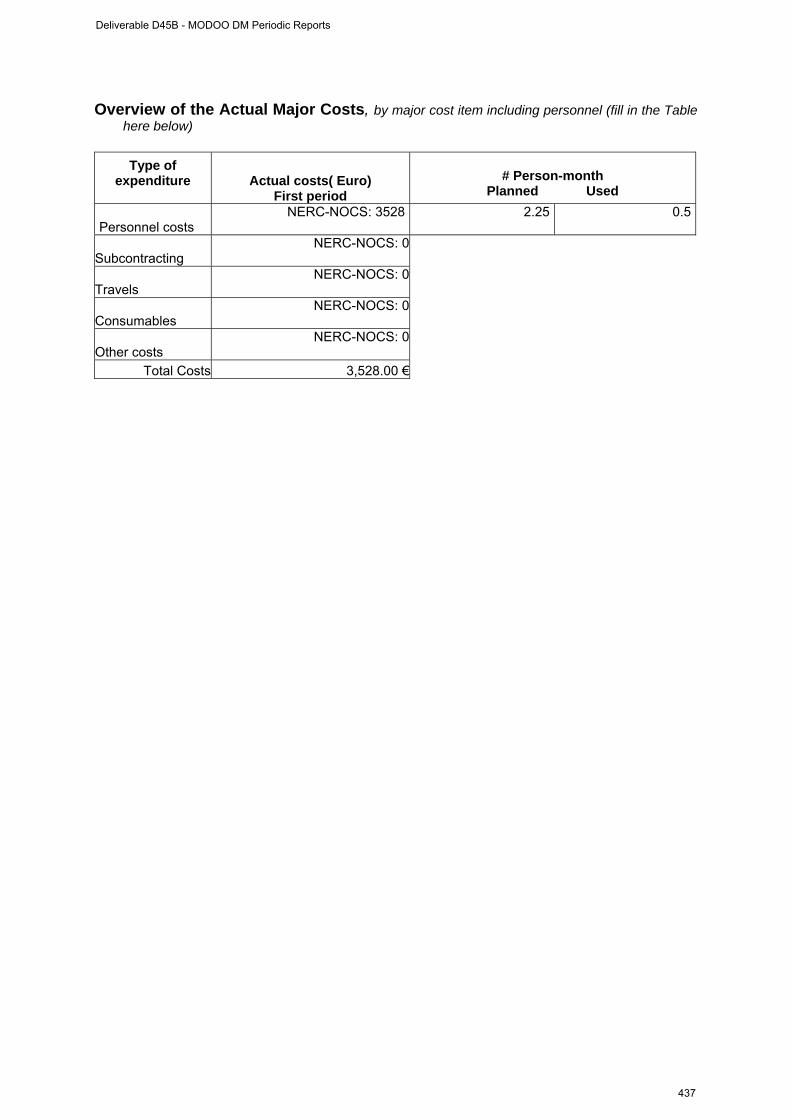
Overview of the Actual Major Costs, by major cost item including personnel (fill in the Table
here below)
Type of expenditure
Actual costs( Euro)
First period
# Person-month
Planned Used
Personnel costs NERC-NOCS: 3528 2.25 0.5
Subcontracting NERC-NOCS: 0
Travels NERC-NOCS: 0
Consumables NERC-NOCS: 0
Other costs NERC-NOCS: 0
Total Costs 3,528.00 €
Deliverable D45B - MODOO DM Periodic Reports
437
WP # 4 progress (from 01. May 2009 to 31. May 2010)
Progress towards objectives Phase 4.1: Web site Create web design and populate with project information. Continue updating web
pages as project develops.
contractors involved :NERC-NOCS
Phase 4.2: Meta-data collection and processing preparation Collate pre-deployment meta-data. Identify MODOO data sets and create systems to
process.
contractors involved : NERC-NOCS
Phase 4.3: Test data Process test data.
contractors involved : NERC-NOCS Phase 4.4: Data interoperability Collate deployment meta-data. Collate calibration data. Process real-time data.
Publish data via web and ftp.
contractors involved : NERC-NOCS
Phase 4.5: Documentation on interoperability Finalize documentation ready for post-recovery processing, and inclusion in final
project report.
contractors involved : NERC-NOCS
Deliverable D45B - MODOO DM Periodic Reports
438

Deviations from the project work programme, and corrective actions taken/suggested (identify the nature and the reason for the problem, identify partners involved)
Deviations:
NA
Corrective actions:
NA
Deliverable D45B - MODOO DM Periodic Reports
439
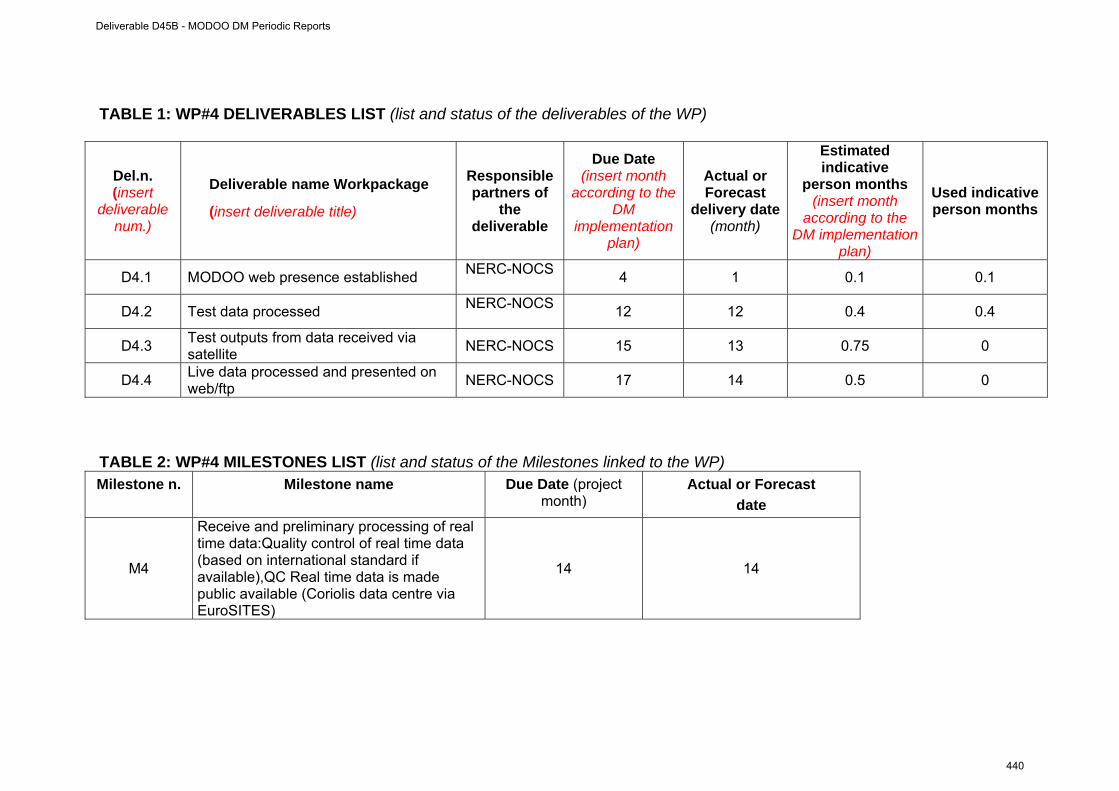
TABLE 1: WP#4 DELIVERABLES LIST (list and status of the deliverables of the WP)
Del.n. (insert
deliverable num.)
Deliverable name Workpackage
(insert deliverable title)
Responsible partners of
the deliverable
Due Date (insert month
according to the DM
implementation plan)
Actual or Forecast
delivery date (month)
Estimated indicative
person months (insert month
according to the DM implementation
plan)
Used indicative person months
D4.1 MODOO web presence established NERC-NOCS 4 1 0.1 0.1
D4.2 Test data processed NERC-NOCS 12 12 0.4 0.4
D4.3 Test outputs from data received via satellite NERC-NOCS 15 13 0.75 0
D4.4 Live data processed and presented on web/ftp NERC-NOCS 17 14 0.5 0
TABLE 2: WP#4 MILESTONES LIST (list and status of the Milestones linked to the WP) Milestone n. Milestone name Due Date (project
month) Actual or Forecast
date
M4
Receive and preliminary processing of real time data:Quality control of real time data (based on international standard if available),QC Real time data is made public available (Coriolis data centre via EuroSITES)
14 14
Deliverable D45B - MODOO DM Periodic Reports
440
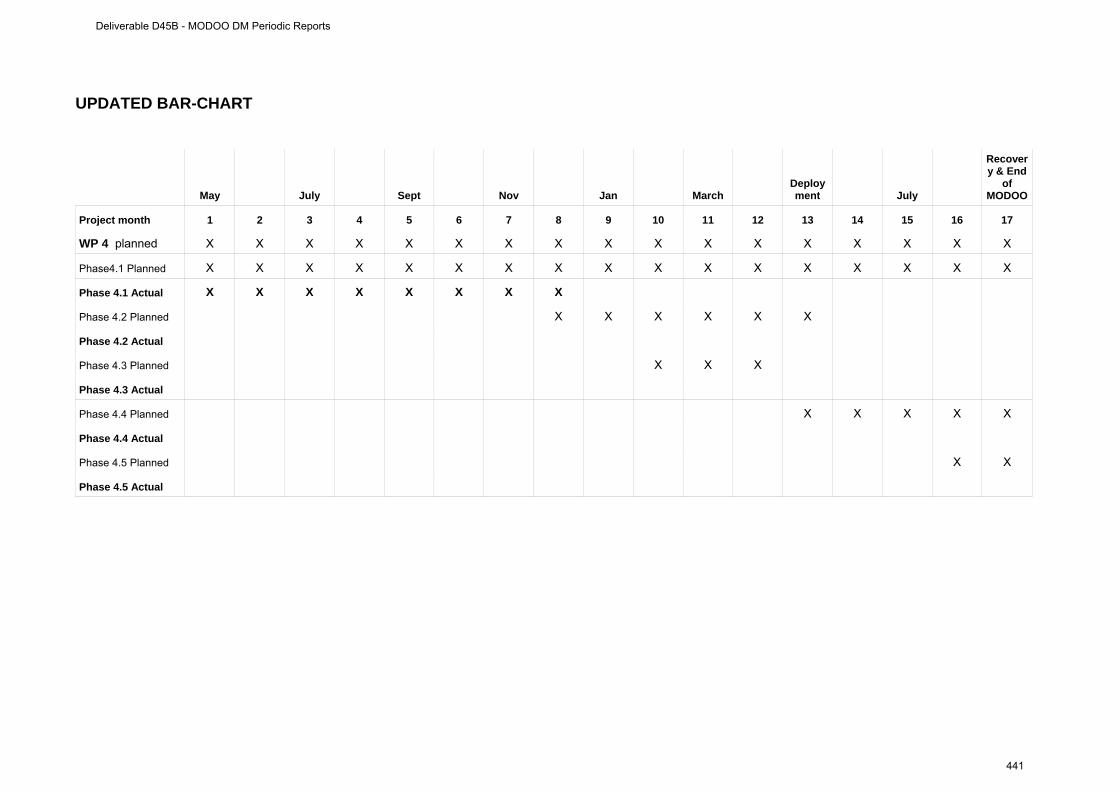
UPDATED BAR-CHART
May July Sept Nov Jan March Deployment July
Recovery & End
of MODOO
Project month 1 2 3 4 5 6 7 8 9 10 11 12 13 14 15 16 17
WP 4 planned X X X X X X X X X X X X X X X X X
Phase4.1 Planned X X X X X X X X X X X X X X X X X
Phase 4.1 Actual X X X X X X X X
Phase 4.2 Planned X X X X X X
Phase 4.2 Actual
Phase 4.3 Planned X X X
Phase 4.3 Actual
Phase 4.4 Planned X X X X X
Phase 4.4 Actual
Phase 4.5 Planned X X
Phase 4.5 Actual
Deliverable D45B - MODOO DM Periodic Reports
441
WP # 5 (from 01. May 2009 to 31. May 2010)
WORKPACKAGE 2
Full WP title Coordination
Period covered From 01. May 2009 to 31. May 2010
Partner Institution responsible of the WP
IFM-GEOMAR
Person in charge for the report (WP Leader)
J. Karstensen
Partners involved in the Work NERC-NOCS, IFM-GEOMAR, NIOZ
WP objectives and starting point (max 500 characters)
The WP 5 objective is managing the DM MODOO. This includes reporting, coordinating communication internal & external, meetings, teleconferences etc.
Work Performed :
Shortly after the official project start (01. May 2009) a kick-off meeting was organized and held from the 07. May to 08. May 2009 at NERC-NOCS Southampton (see attached agenda & meeting notes). Other meetings (also in collaboration with the “exchange of personal” MODOO connect) have been held in December 2009, April 2010. Preparatory work for the reports to ESONET NoE WP4 have been made. Project updates and request have been posted to the partners.
Rough Estimation of Major Cost: Explanatory note on any major cost roughly estimated of
items such as major travel costs, large consumable items etc., justifying their necessity to the project.
No major costs are associated with this WP
Deliverable D45B - MODOO DM Periodic Reports
442
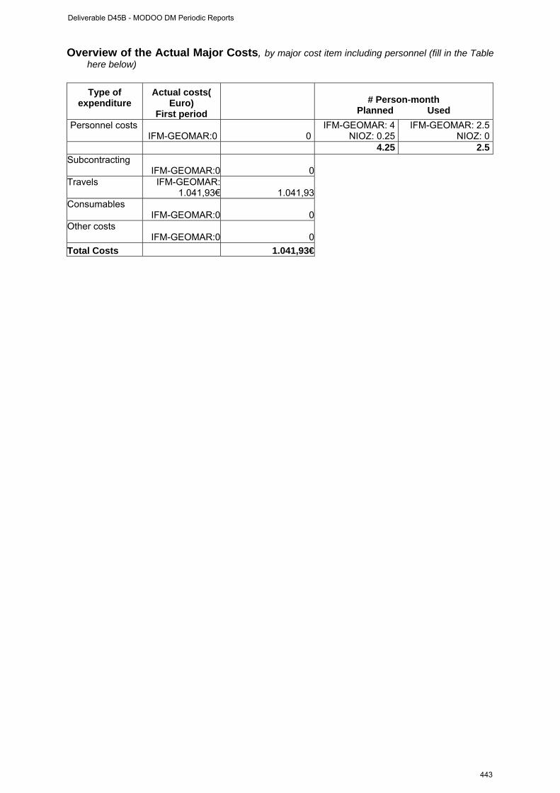
Overview of the Actual Major Costs, by major cost item including personnel (fill in the Table here below)
Type of
expenditure
Actual costs( Euro)
First period
# Person-month
Planned Used Personnel costs IFM-GEOMAR:0 0
IFM-GEOMAR: 4NIOZ: 0.25
IFM-GEOMAR: 2.5NIOZ: 0
4.25 2.5Subcontracting IFM-GEOMAR:0 0Travels
IFM-GEOMAR: 1.041,93€ 1.041,93
Consumables IFM-GEOMAR:0 0Other costs IFM-GEOMAR:0 0Total Costs 1.041,93€
Deliverable D45B - MODOO DM Periodic Reports
443
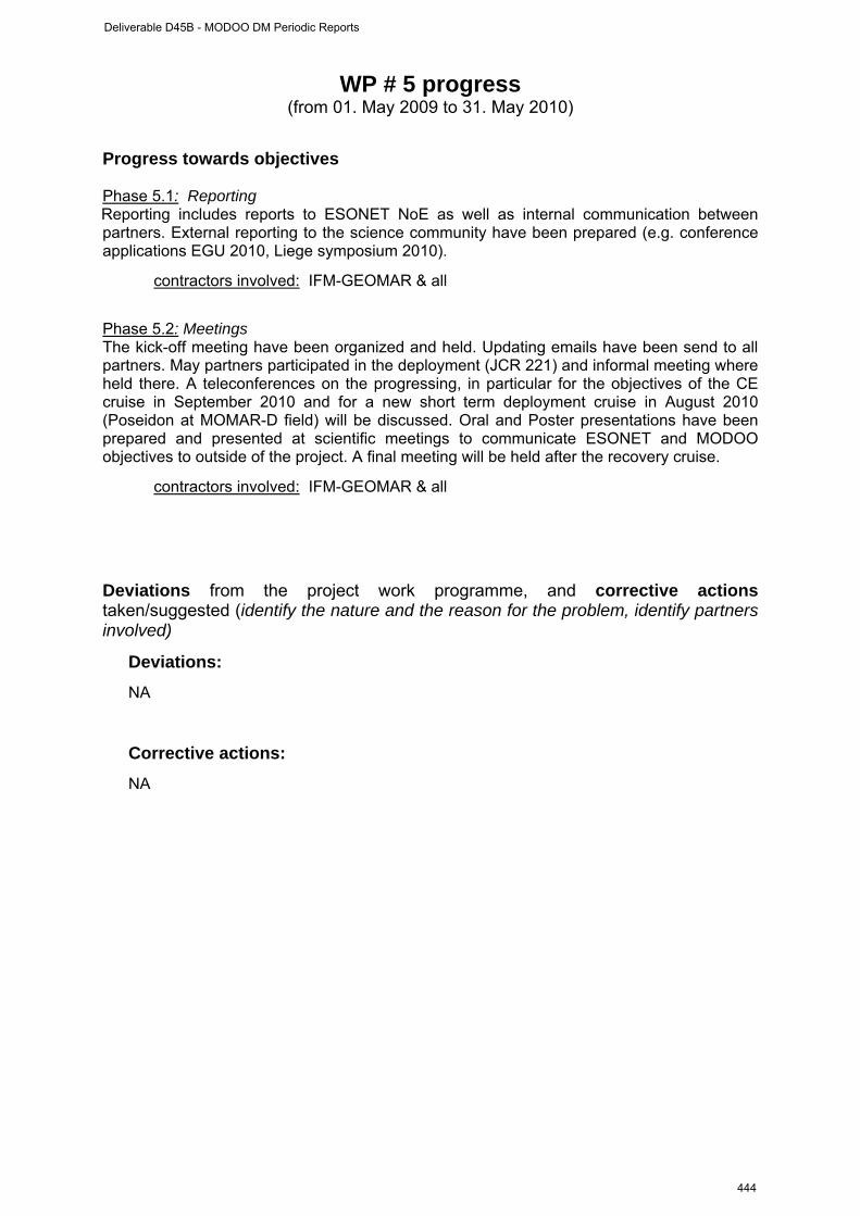
WP # 5 progress (from 01. May 2009 to 31. May 2010)
Progress towards objectives Phase 5.1: Reporting Reporting includes reports to ESONET NoE as well as internal communication between partners. External reporting to the science community have been prepared (e.g. conference applications EGU 2010, Liege symposium 2010).
contractors involved: IFM-GEOMAR & all
Phase 5.2: Meetings The kick-off meeting have been organized and held. Updating emails have been send to all partners. May partners participated in the deployment (JCR 221) and informal meeting where held there. A teleconferences on the progressing, in particular for the objectives of the CE cruise in September 2010 and for a new short term deployment cruise in August 2010 (Poseidon at MOMAR-D field) will be discussed. Oral and Poster presentations have been prepared and presented at scientific meetings to communicate ESONET and MODOO objectives to outside of the project. A final meeting will be held after the recovery cruise.
contractors involved: IFM-GEOMAR & all
Deviations from the project work programme, and corrective actions taken/suggested (identify the nature and the reason for the problem, identify partners involved)
Deviations:
NA
Corrective actions:
NA
Deliverable D45B - MODOO DM Periodic Reports
444
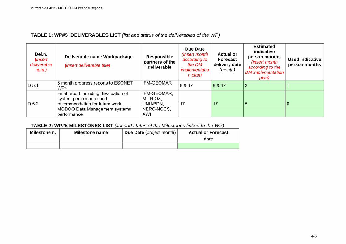
TABLE 1: WP#5 DELIVERABLES LIST (list and status of the deliverables of the WP)
Del.n. (insert
deliverable num.)
Deliverable name Workpackage
(insert deliverable title)
Responsible partners of the
deliverable
Due Date (insert month according to
the DM implementatio
n plan)
Actual or Forecast
delivery date (month)
Estimated indicative
person months (insert month
according to the DM implementation
plan)
Used indicative person months
D 5.1 6 month progress reports to ESONET WP4
IFM-GEOMAR 8 & 17 8 & 17 2 1
D 5.2
Final report including: Evaluation of system performance and recommendation for future work, MODOO Data Management systems performance
IFM-GEOMAR, MI, NIOZ, UNIABDN, NERC-NOCS, AWI
17 17 5 0
TABLE 2: WP#5 MILESTONES LIST (list and status of the Milestones linked to the WP) Milestone n. Milestone name Due Date (project month) Actual or Forecast
date
Deliverable D45B - MODOO DM Periodic Reports
445
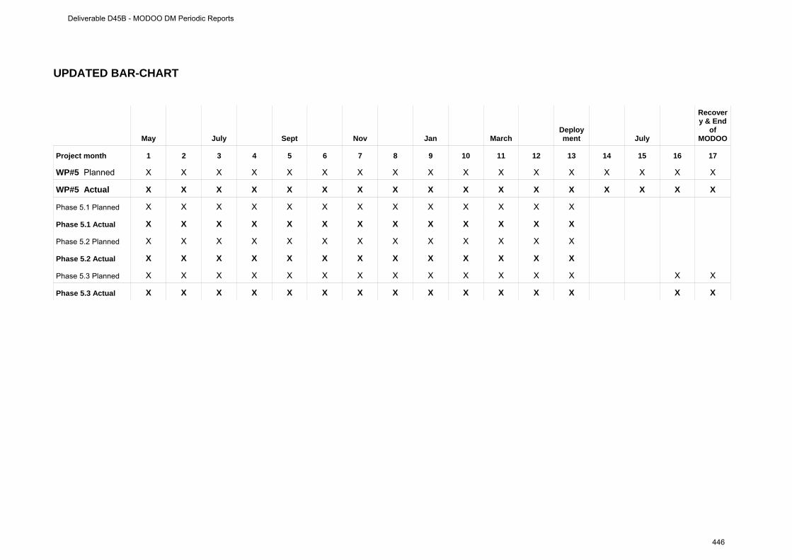
UPDATED BAR-CHART
May July Sept Nov Jan March Deployment July
Recovery & End
of MODOO
Project month 1 2 3 4 5 6 7 8 9 10 11 12 13 14 15 16 17
WP#5 Planned X X X X X X X X X X X X X X X X X
WP#5 Actual X X X X X X X X X X X X X X X X X
Phase 5.1 Planned X X X X X X X X X X X X X
Phase 5.1 Actual X X X X X X X X X X X X X
Phase 5.2 Planned X X X X X X X X X X X X X
Phase 5.2 Actual X X X X X X X X X X X X X
Phase 5.3 Planned X X X X X X X X X X X X X X X
Phase 5.3 Actual X X X X X X X X X X X X X X X
Deliverable D45B - MODOO DM Periodic Reports
446
Appendix
Deliverable D45B - MODOO DM Periodic Reports
447
Meeting notes:
Agenda Kick-off MODOO and MODOO connect NOCS, 7. May 2009 (09:00-17:30) – 8. May 2009 (09:00-12:00)
Day 1: Thursday 7. May 2009
Conference Room 344/32 (Level 4 near cafeteria) 08:30 Meet at NOCS reception/main entrance 09:00 Welcome Introduction of Participants Logistics Objectives of Meeting Agenda Modifications MODOO and MODOO connect: Overview Presentation of MODOO Science 09:30 Science core mission (Henry, Jens, Johannes) Science guest missions:
• Deep Sea Marine Life (Acoustic, Camera) (Jens, Anne) • Geohazard (NN POL, Johannes)
Discussion on requirements/expectations for successful science missions: • data availability and science requirement on data availability (with input from Maureen) including data retrieval from moving platforms: ship, AUV –
opportunities? • two - way communication: which instruments needs to be controlled? • Expertise in programming of instruments (e.g. MODE 12 on 1200kHz ADCP,
minimum sampling requirement to resolve tidal signals), list of “sensor” contacts/expertise
• interaction with ESONET WP1 & WP 3 (Henry) • How long is a time series?
Discussion on long term visions – MODOO@PAP and beyond... In between: Coffee break (room next door 344/38)
Administrative aspects (MODOO & MODOO connect) 11:30 Finances:
- MODOO (as part of ESONET NoE WP4 task a & b) - MODOO connect (as part of ESONET NoE WP1 task a)
12:00 – 13:00 Lunch break in NOCS canteen – own expenses
Presentation of MODOO Technology (shared with MODOO connect) 13:00 Discussion on technological aspects of MODOO MODOO components (with current status)
- BOBO Lander (Jens & Dries) - PAP Mooring (Richard, Jon)
More details on platform payload: - seismometer/bottom pressure - camera systems
Deliverable D45B - MODOO DM Periodic Reports
448
- surface telemetry system at PAP (Jon) - Generic sensor package (Henry, Jens) - status of DCD nodes (integration of camera!!!) and Underwater acoustic modems:
experiences, tests Standardization, quality control, calibration (with link to WP2 of ESONET) Interaction with ESONET WP5 (stand-alone observatories)
15:00-15:30 Coffee break (room next door 344/38)
Time line of project 15:30 Review and update of timing of the project
• Implementation plan • Milestones, deliverables • Update cruise schedule – possibilities of cruise participation, required
technical expertise on board • Meetings (ESONET, others) – Bremen IEEE session Thursday
afternoon • web page
17:30 End of first day 19:00 Dinner at: tba. (own expenses)
Day 2: Friday 8. May 2009 Meeting room 1/Plate 251 (Ground floor/entrance level)
Continuation of Technology (shared with MODOO connect) 08:30 Meet at NOCS reception 09:00 Summary of first day in respect to technological requirements Discussion on technical issues:
7. The DCD node in more details (requirements, ports, …) 8. Integration of camera(s) 9. Integration of DCD node into surface telemetry 10. two-way communication with instruments (camera, seismometer)
In between: Coffee break (in room)
11. Sensor list (XLS file) 12. mooring requirement (steel wire, break load of DCD frame, launching procedure) 13. Lander requirements (maximum payload, specific launching e.g. which crane is
available for deployment/recovery ship dependent... ) 14. Underwater modem manufacturer
Summary of tasks, define action items – planning for next MODOO connect exchange 12:00 End of second day and end of meeting
Deliverable D45B - MODOO DM Periodic Reports
449

Update on MODOO after 7./8. May 2009 meeting at NOC Southampton.
Table of ContentsPart I ............................................................................................................................1 First period..................................................................................................................5 Part II ........................................................................................................................10 WP # 1......................................................................................................................10 WP # 2......................................................................................................................16 WP # 3......................................................................................................................22 WP # 4......................................................................................................................28 WP # 5......................................................................................................................34 Appendix....................................................................................................................39 Meeting notes: ...........................................................................................................40
BOBO lander .........................................................................................................42 PAP Mooring .........................................................................................................43 DCD nodes............................................................................................................44 Specific Instrumentation ........................................................................................44
Passive acoustics:.............................................................................................44 Seismometer (OBS) & Ocean bottom pressure sensor (OBP):.........................44 ADCP: ...............................................................................................................44 Sediment trap:...................................................................................................45
Infrastructure and sensors BOBO lander For operation at sea at well as for deployment calculations the exact dimensions (length, weight, etc..) of instruments and batteries are required. This information is requested for:
• Deliverables 'calibration, test, deployment and recovery' aka 'operation at sea' Easiest would be a list of sensor weights, both “in air” and “in water” to estimate the total weight + dimension of the lander for deployment and to do the buoyancy calculations. Sensor list needs one “responsible” for each instrument + column with dimensions. Table: Specification of MODOO sensors Instrument/Parameter Model responsible
CT (C, T, 1x OBS, Fluorometer)
SBE 16 Jens G. (NIOZ)
ADCP currents/ echo intensity
Teledyne RDI workhorse 1200kHz Jens G. (NIOZ)
Oxygen logger Aanderaa Optode 3830 Andreas P. (IFM-GEOMAR)
Bottom pressure sensor 1 Parascientific
Kevin H (POL)
Bottom pressure sensor 2 & Seismometer
Parascientific with SEND recorder Ernst F. (IFM-GEOMAR)
Deliverable D45B - MODOO DM Periodic Reports
450
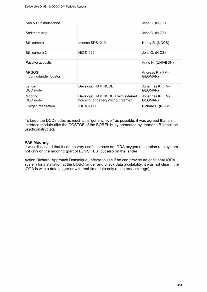
Sea & Sun multisonde
Jens G. (NIOZ)
Sediment trap
Jens G. (NIOZ)
Still camera 1
Imenco SDS1210
Henry R. (NOCS)
Still camera 2
NIOZ: ??? Jens G. (NIOZ)
Passive acoustic Anne H. (UNIABDN)
ARGOS mooring/lander locator
Andreas P. (IFM-GEOMAR)
Lander DCD node
Develogic HAM.NODE Johannes K.(IFM-GEOMAR)
Mooring DCD node
Develogic HAM.NODE + with extened housing for battery (without frame!!)
Johannes K.(IFM-GEOMAR)
Oxygen respiration IODA 6000 Richard L. (NOCS) To keep the DCD nodes as much at a “generic level” as possible, it was agreed that an interface module (like the COSTOF of the BOREL buoy presented by Jermone B.) shall be used/constructed. PAP Mooring It was discussed that it can be very useful to have an IODA oxygen respiration rate system not only on the mooring (part of EuroSITES) but also on the lander. Action Richard: Approach Dominique Lefevre to see if he can provide an additional IODA system for installation at the BOBO lander and check data availability: it was not clear if the IODA is with a data logger or with real-time data only (no internal storage).
Deliverable D45B - MODOO DM Periodic Reports
451

Components of the PAP mooring have been shown to us (surface buoy, biogeochemical sensor frame). DCD nodes Jerome reported on tests performed at the IFREMER with underwater acoustic modems. Also the results have been kept anonymous it interesting to hear about the different methods to evaluate the instrumentation. NIOZ will design an interface board It is expected that the communication strategy between PAP telemetry and MDCD node will require quite a bit of exchange between NOCS and the modem manufacturer (very likely Develogics http://www.develogic.de/en/products/ham_node/index.php). Specific Instrumentation Passive acoustics: dimension of device 35kg, 50cm long sampling: 240 hours with 24 bit, typical operation frequency: 16kHz (1Hz – 96kHz possible) Action Anne: Provide more details about passive acoustic Seismometer (OBS) & Ocean bottom pressure sensor (OBP): POL (Kevin Horsburgh) will provide an OBP which, if real time access is requested, will connect to the LDCD node via cable/RS232. As the scientific core mission of the MODOO application at PAP is not on geohazards only a subset of the data will be transferred. The size of the data that will finally be transferred depends on the availability of bandwidth after all core mission data has been considered. IFM-GEOMAR will provide a combined OBS/OBP instrument. The data can be accessed sequentially and for arbitrary time intervals. The instrument needs to be decoupled from the lander (e.g. time triggered release or corrosion wire) to ensure high quality data. Exact this instrument has been used for Geohazard monitoring with acoustic real time telemetry several times before (GITEWS). Action Kevin: provide details about OBP, including interface requirements, protocols. Is a sequential and targeted data retrieval possible (e.g. retrieval of data collected at a certain time interval, say 5 minutes, 3 weeks ago between 21:00 and 21:05) or only a complete set of data? Can the OBP be installed directly on the lander or does it need to be separated? If both systems (POL and IFM-GEOMAR) are installed the coherence of the measurements can be investigated – particularly an assessment of the initial drift, which often hampers the use to determine long term trends, would be of scientific interest. ADCP: It would be useful to switch between water current and turbulence measurements (Mode 12 Teledyne- RDI 1200kHz) for boundary layer investigations. Action Jens: Check if boundary layer turbulence measurements are of use (With NIOZ Hans van Haarem) and investigate if switch between the normal and the mode 12 can be done via two-way-telemetry/RS232 port of ADCP and what the mode 12 requires in terms of a 1 year deployment period.
Deliverable D45B - MODOO DM Periodic Reports
452
The 75kHz (??) ADCP from MI should for reasons of the mooring design not installed on the PAP mooring – is an installation on the BOBO lander (upward looking) possible of use? And technically feasible (pressure rating of housing)? Action Fiona: Communicate ADCP pressure rating. Sediment trap: The BOBO Lander will have a sediment trap on board. It was discussed if this makes sense because of unknown/degraded trapping efficiency. NIOZ will decide if they want to deploy or not. Cruises The PAP cruise proposal for July 2010, where a short activity was the installation of MODOO, has been rejected. However, it is very likely that a shorter (maybe a few days only) cruise to the PAP site for the PAP/MODOO installation will be possible. This is currently under negotiation. A second possibility is using the Irish “Celtic Explorer”. As Fiona told us before and also in a recent email, the MI can apply for ship time on rather short notice. Mainly for weather reasons the time window for the cruise shall be between 1. June – 15. August. In case of a dedicated MODOO cruise more partners could attend (if needed). The following advantages/disadvantages were identified for earlier and later deployment: Earlier deployment
• Less time for preparations (not good) • Longer time series of observations (good) • Having the installation at place during the spring bloom – which might be nice to have
in the data (good) Later deployment
• More time for preparations (good) • Shorter time series (not good)
There will be no extra recovery cruise of the MODOO system before the “official” exchange in Summer 2011. Action Richard: Please inform us about any outcome of the ship time negotiations for summer 2010. Data Management and accessibility: Initial access point for data is the EuroSITES data centre at NOCS. The existing real time data quality control protocols will be extended to handle the new (non EuroSITES) types of data. Action all: Instruments need to be registered at the ESONET sensor registry. Found link at http://dataportals.pangaea.de/esonet/index.php/sensor but so far not accessible. Outreach: MODOO website will be installed (draft at http://www.noc.soton.ac.uk/eurosites/modoo/ - ask for username/password)
Deliverable D45B - MODOO DM Periodic Reports
453
Action Maureen: Reserve an http://www.modoo.info/, maybe at http://www.europeregistry.com/?? 18 Euros a year (two years minimum) and transfer website to it. Deliverables and concepts with feedback to ESONET NoE Henry mentioned that it is useful to test the functioning of a generic sensor package. The DCD nodes can be seen like such a “package” - as all data from connected sensors are merged and a dedicated time stamp is added. As part of ESONET NoE WP3 (task b) Henry & Jens have been part of a group which considered the following variables to be “generic” (D13). As passive acoustics is irrelevant for biogeochemistry (and to my knowledge also for Physical Oceanography) this has to be see with a question mark. Table: Generic variables list. Variable Geoscience
s Physical Oceanography
Biogeochemistry
Marine Ecology
Temperature X X X X Conductivity X X X X Pressure X X X X Dissolved O2 X X X X Turbidity X X X X Ocean currents X X X X Passive acoustics X - - X Unfortunately it was not possible to have MODOO being represented at the IEEE09 in Bremen. For the next “All Regions” workshop in Paris and the “Best Practice” workshop in Brest MODOO will be represented as probably most of us will be at one or the other (I will attend both workshops). Future perspective Discuss further plans at the PAP site at a workshop before the ESONET all regions workshop 5.-7.10.2009 Paris, further details to be defined. Requires a regional implementation committee (RIC – WP3 task a) Next EU call “Deep Sea Frontier” (expected 2010/2011) - shall MODOO be part of potential proposals Other possible installations of MODOO: A possible installation at the CIS site in the Central Irminger Sea should be discussed. The site is potentially shared by US/OOI and the European programm. In respect to a tropical ocean application, Doug Wallace (IFM-GEOMAR) expressed his interest during a recent EuroSITES meeting to have a MODOO application at the Cape Verde observatory (part of EuroSITES). Finances The so called Grant agreement has been send out to all. It is requested from all to have it signed by the “representative” of the institute and to be send back. It is very important that each partner quickly arranges for the signature. The ESONET coordinator notified us that we can not expect to have the “advance money” before Sept. 2009.
Deliverable D45B - MODOO DM Periodic Reports
454
Project contract no. 036851
ESONET
European Seas Observatory Network
Instrument: Network of Excellence (NoE) Thematic Priority: 1.1.6.3 – Climate Change and Ecosystems
Sub Priority: III – Global Change and Ecosystems
MoMAR-D Demonstration Mission Periodic Reports
Start date of project: March 2007 Duration: 48 months Start date of the Demonstration Mission: February 2008 Duration: 36 months Project co-funded by the European Commission within the Sixth Framework Programme (2002-2006) Dissemination Level PU Public PP Restricted to other programme participants (including the Commission Services RE Restricted to a group specified by the consortium (including the Commission
Services)
CO Confidential, only for members of the consortium (including the Commission Services)
Deliverable D45B - MOMAR-D DM Periodic Reports
455

Deliverable D45B - MOMAR-D DM Periodic Reports
456
ESONET Demonstration Missions
1st Periodic Activity Report
The Periodic Activity Report contains an overview of the activities carried out during the reporting period, describes the progress in relation to the project objectives, the progress towards the milestones and deliverables set for the period, and any problems encountered and corrective actions taken. This document has to be filled in with reference to the DM Implementation plan. This means that Deliverables, Milestones and WPs have to be the same as in the DM Implementation plan. The Periodic Report contains 2 parts: - Part I: it is addressed to the coordinator with minimum input from the partners - Part II: it is addressed to each WP Leader and reports a detailed update of each WP activity at task level. The report includes a rough justification of the costs incurred and of the resources deployed by each contractor linking them to activities implemented and justifying their necessity. Finally the report contains information on use and dissemination activities. Reporting period: 30 September 2008
Deliverable D45B - MOMAR-D DM Periodic Reports
457
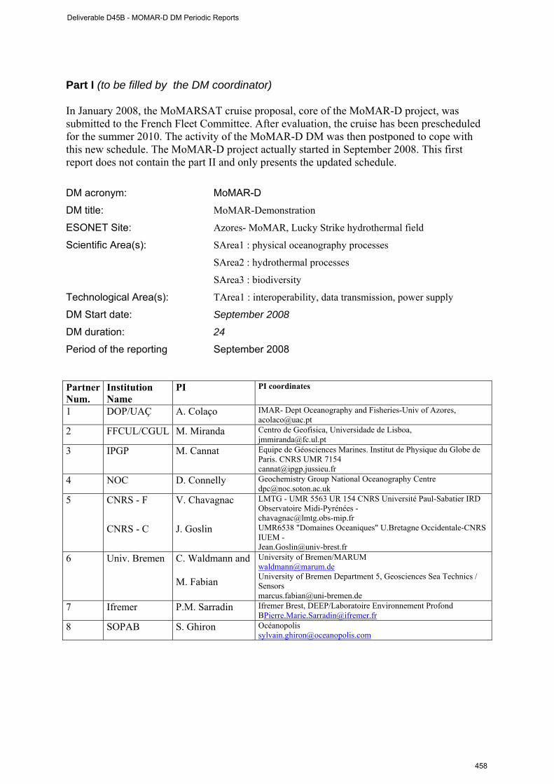
Part I (to be filled by the DM coordinator) In January 2008, the MoMARSAT cruise proposal, core of the MoMAR-D project, was submitted to the French Fleet Committee. After evaluation, the cruise has been prescheduled for the summer 2010. The activity of the MoMAR-D DM was then postponed to cope with this new schedule. The MoMAR-D project actually started in September 2008. This first report does not contain the part II and only presents the updated schedule. DM acronym: MoMAR-D
DM title: MoMAR-Demonstration
ESONET Site: Azores- MoMAR, Lucky Strike hydrothermal field
Scientific Area(s): SArea1 : physical oceanography processes
SArea2 : hydrothermal processes
SArea3 : biodiversity
Technological Area(s): TArea1 : interoperability, data transmission, power supply
DM Start date: September 2008
DM duration: 24
Period of the reporting September 2008 Partner Num.
Institution Name
PI PI coordinates
1 DOP/UAÇ A. Colaço IMAR- Dept Oceanography and Fisheries-Univ of Azores, [email protected]
2 FFCUL/CGUL M. Miranda Centro de Geofisica, Universidade de Lisboa, [email protected]
3 IPGP M. Cannat Equipe de Géosciences Marines. Institut de Physique du Globe de Paris. CNRS UMR 7154 [email protected]
4 NOC D. Connelly Geochemistry Group National Oceanography Centre [email protected]
5 CNRS - F V. Chavagnac LMTG - UMR 5563 UR 154 CNRS Université Paul-Sabatier IRD Observatoire Midi-Pyrénées - [email protected]
CNRS - C J. Goslin UMR6538 "Domaines Oceaniques" U.Bretagne Occidentale-CNRS IUEM - [email protected]
6 Univ. Bremen C. Waldmann and M. Fabian
University of Bremen/MARUM [email protected] University of Bremen Department 5, Geosciences Sea Technics / Sensors [email protected]
7 Ifremer P.M. Sarradin Ifremer Brest, DEEP/Laboratoire Environnement Profond [email protected]
8 SOPAB S. Ghiron Océanopolis [email protected]
Deliverable D45B - MOMAR-D DM Periodic Reports
458
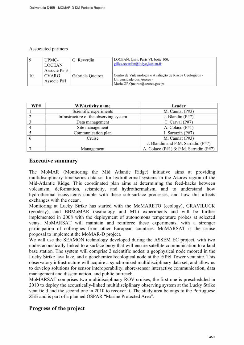
Associated partners 9 UPMC-
LOCEAN Associé P# 3
G. Reverdin LOCEAN, Univ. Paris VI, boite 100, [email protected]
10 CVARG Associé P#1
Gabriela Queiroz
Centro de Vulcanologia e Avaliação de Riscos Geológicos - Universidade dos Açores - [email protected]
WP# WP/Activity name Leader
1 Scientific experiments M. Cannat (P#3) 2 Infrastructure of the observing system J. Blandin (P#7) 3 Data management T. Carval (P#7) 4 Site management A. Colaço (P#1) 5 Communication plan J. Sarrazin (P#7) 6 Cruise M. Cannat (P#3)
J. Blandin and P.M. Sarradin (P#7) 7 Management A. Colaço (P#1) & P.M. Sarradin (P#7) Executive summary The MoMAR (Monitoring the Mid Atlantic Ridge) initiative aims at providing multidisciplinary time-series data set for hydrothermal systems in the Azores region of the Mid-Atlantic Ridge. This coordinated plan aims at determining the feed-backs between volcanism, deformation, seismicity, and hydrothermalism, and to understand how hydrothermal ecosystems couple with these sub-surface processes, and how this affects exchanges with the ocean. Monitoring at Lucky Strike has started with the MoMARETO (ecology), GRAVILUCK (geodesy), and BBMoMAR (sismology and MT) experiments and will be further implemented in 2008 with the deployment of autonomous temperature probes at selected vents. MoMARSAT will maintain and reinforce these experiments, with a stronger participation of colleagues from other European countries. MoMARSAT is the cruise proposal to implement the MoMAR-D project. We will use the SEAMON technology developed during the ASSEM EC project, with two nodes acoustically linked to a surface buoy that will ensure satellite communication to a land base station. The system will comprise 2 scientific nodes: a geophysical node moored in the Lucky Strike lava lake, and a geochemical/ecological node at the Eiffel Tower vent site. This observatory infrastructure will acquire a synchronized multidisciplinary data set, and allow us to develop solutions for sensor interoperability, shore-sensor interactive communication, data management and dissemination, and public outreach. MoMARSAT comprises two multidisciplinary ROV cruises, the first one is prescheduled in 2010 to deploy the acoustically-linked multidisciplinary observing system at the Lucky Strike vent field and the second one in 2010 to recover it. The study area belongs to the Portuguese ZEE and is part of a planned OSPAR “Marine Protected Area”. Progress of the project
Deliverable D45B - MOMAR-D DM Periodic Reports
459
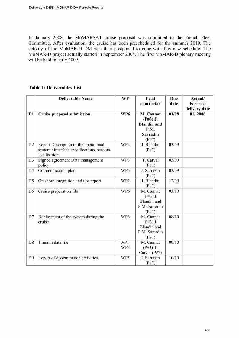
In January 2008, the MoMARSAT cruise proposal was submitted to the French Fleet Committee. After evaluation, the cruise has been prescheduled for the summer 2010. The activity of the MoMAR-D DM was then postponed to cope with this new schedule. The MoMAR-D project actually started in September 2008. The first MoMAR-D plenary meeting will be held in early 2009. Table 1: Deliverables List
Deliverable Name WP Lead contractor
Due date
Actual/ Forecast
delivery date D1 Cruise proposal submission WP6 M. Cannat
(P#3) J. Blandin and
P.M. Sarradin
(P#7)
01/08 01/ 2008
D2 Report Description of the operational system : interface specifications, sensors, localisation
WP2 J. Blandin (P#7)
03/09
D3 Signed agreement Data management policy
WP3
T. Carval (P#7)
03/09
D4 Communication plan WP5
J. Sarrazin (P#7)
03/09
D5 On shore integration and test report WP2
J. Blandin (P#7)
12/09
D6 Cruise preparation file WP6
M. Cannat (P#3) J.
Blandin and P.M. Sarradin
(P#7)
03/10
D7 Deployment of the system during the cruise
WP6
M. Cannat (P#3) J.
Blandin and P.M. Sarradin
(P#7)
08/10
D8 1 month data file WP1- WP3
M. Cannat (P#3) T.
Carval (P#7)
09/10
D9 Report of dissemination activities WP5 J. Sarrazin (P#7)
10/10
Deliverable D45B - MOMAR-D DM Periodic Reports
460
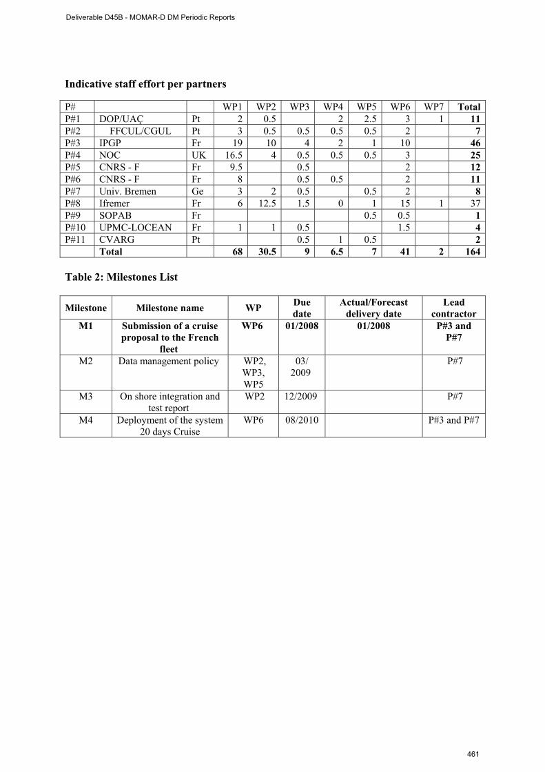
Indicative staff effort per partners P# WP1 WP2 WP3 WP4 WP5 WP6 WP7 TotalP#1 DOP/UAÇ Pt 2 0.5 2 2.5 3 1 11P#2 FFCUL/CGUL Pt 3 0.5 0.5 0.5 0.5 2 7P#3 IPGP Fr 19 10 4 2 1 10 46P#4 NOC UK 16.5 4 0.5 0.5 0.5 3 25P#5 CNRS - F Fr 9.5 0.5 2 12P#6 CNRS - F Fr 8 0.5 0.5 2 11P#7 Univ. Bremen Ge 3 2 0.5 0.5 2 8P#8 Ifremer Fr 6 12.5 1.5 0 1 15 1 37P#9 SOPAB Fr 0.5 0.5 1P#10 UPMC-LOCEAN Fr 1 1 0.5 1.5 4P#11 CVARG Pt 0.5 1 0.5 2 Total 68 30.5 9 6.5 7 41 2 164 Table 2: Milestones List
Milestone Milestone name WP Due date
Actual/Forecast delivery date
Lead contractor
M1 Submission of a cruise proposal to the French
fleet
WP6 01/2008 01/2008 P#3 and P#7
M2 Data management policy WP2, WP3, WP5
03/ 2009
P#7
M3 On shore integration and test report
WP2 12/2009 P#7
M4 Deployment of the system 20 days Cruise
WP6 08/2010 P#3 and P#7
Deliverable D45B - MOMAR-D DM Periodic Reports
461

Deliverable D45B - MOMAR-D DM Periodic Reports
462
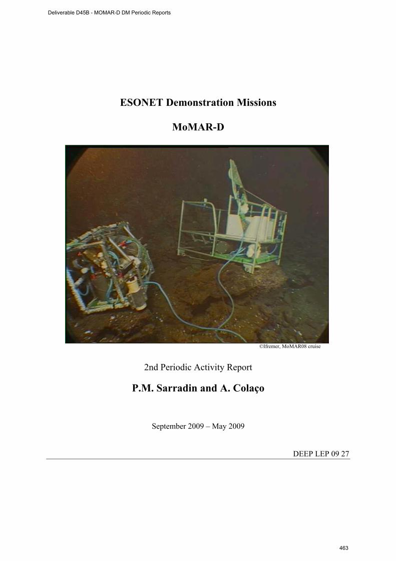
ESONET Demonstration Missions
MoMAR-D
©Ifremer, MoMAR08 cruise
2nd Periodic Activity Report
P.M. Sarradin and A. Colaço
September 2009 – May 2009
DEEP LEP 09 27
Deliverable D45B - MOMAR-D DM Periodic Reports
463
Part I DM acronym: MoMAR-D
DM title: MoMAR-Demonstration
ESONET Site: Azores- MoMAR, Lucky Strike hydrothermal field
Scientific Area(s): SArea1 : physical oceanography processes
SArea2 : hydrothermal processes
SArea3 : biodiversity
Technological Area(s): TArea1 : interoperability, data transmission, power supply
DM Start date: September 2008
DM duration: 24
Period of the reporting September 2008 – May 2009 Partner Num.
Institution Name
PI PI coordinates
1 DOP/UAÇ A. Colaço IMAR- Dept Oceanography and Fisheries-Univ of Azores, [email protected]
2 FFCUL/CGUL M. Miranda Centro de Geofisica, Universidade de Lisboa, [email protected]
3 IPGP M. Cannat Equipe de Géosciences Marines. Institut de Physique du Globe de Paris. CNRS UMR 7154 [email protected]
4 NOC D. Connelly Geochemistry Group National Oceanography Centre [email protected]
5 CNRS - F V. Chavagnac LMTG - UMR 5563 UR 154 CNRS Université Paul-Sabatier IRD Observatoire Midi-Pyrénées - [email protected]
CNRS - C J. Goslin UMR6538 "Domaines Oceaniques" U.Bretagne Occidentale-CNRS IUEM - [email protected]
6 Univ. Bremen C. Waldmann and M. Fabian
University of Bremen/MARUM [email protected] University of Bremen Department 5, Geosciences Sea Technics / Sensors [email protected]
7 Ifremer P.M. Sarradin Ifremer Brest, DEEP/Laboratoire Environnement Profond [email protected]
8 SOPAB S. Ghiron Océanopolis [email protected]
Associated partners 9 UPMC-
LOCEAN with P# 3
G. Reverdin LOCEAN, Univ. Paris VI, boite 100, [email protected]
10 CVARG with P#1
Gabriela Queiroz
Centro de Vulcanologia e Avaliação de Riscos Geológicos - Universidade dos Açores - [email protected]
Deliverable D45B - MOMAR-D DM Periodic Reports
464
Executive summary The MoMAR (Monitoring the Mid-Atlantic Ridge) project was initiated 10 years ago by the InterRidge Program to promote and coordinate long-term multidisciplinary monitoring of hydrothermal vents in the Azores region of the Mid-Atlantic Ridge This coordinated plan aims at determining the feed-backs between volcanism, deformation, seismicity, and hydrothermalism, and to understand how hydrothermal ecosystems couple with these sub-surface processes, and how this affects exchanges with the ocean. Monitoring at Lucky Strike has started with the MoMARETO (ecology), GRAVILUCK (geodesy), and BBMoMAR (sismology and MT) experiments and will be further implemented in 2008 with the deployment of autonomous temperature probes at selected vents. The MoMAR-D project was selected by ESONET as a demonstration mission to deploy and manage a multidisciplinary observing system at Lucky Strike during one year. Lucky Strike is a large hydrothermal field located in the center of one of the most volcanically active segment of the MAR. Monitoring this field offers a high probability of capturing evidence for volcanic events, observing interactions between faulting, magmatism and hydrothermal circulations and, evaluating their links with the dynamics of hydrothermal fauna. We will use the SEAMON technology developed during the ASSEM EC project, with two nodes acoustically linked to a surface buoy that will ensure satellite communication to a land base station. The system will comprise 2 scientific nodes: a geophysical node moored in the Lucky Strike lava lake, and a geochemical/ecological node at the Eiffel Tower vent site. This observatory infrastructure will acquire a synchronized multidisciplinary data set, and allow us to develop solutions for sensor interoperability, shore-sensor interactive communication, data management and dissemination, and public outreach. The project comprises two multidisciplinary ROV cruises (MoMARSAT), the first one in 2010 to deploy the acoustically-linked multidisciplinary observing system at the Lucky Strike vent field and the second one in 2010 to recover it. The study area belongs to the Portuguese ZEE and is part of a planned OSPAR “Marine Protected Area”. Progress of the project In January 2008, the MoMARSAT cruise proposal was submitted to the French Fleet Committee. After evaluation, the cruise has been prescheduled for the summer 2010. Unfortunately, the preliminary schedule was withdrawn and the cruise proposal had to be submitted once again to the French Fleet Committee. We are waiting for the results of this evaluation and the new 2010-2011 schedule. Nevertheless, the first MoMAR-D plenary meeting took place in March (17-18) 2009 in Ifremer centre de Brest and gathered around 20 scientists and engineers from France, Germany and Portugal. The objectives of this meeting were:
1- The scientific and technological presentation of the different planned experiments by each partner, chair M. Cannat,
2- A description of the operational system by J. Blandin 3- The preparation of interfacing and shore trial step by J. Blandin (see Deliverable 2) 4- The preparation of the data management policy chaired by T. Carval and P.M. Sarradin,
deliverable 3. 5- The preparation of the communication plan (regional, national and EU initiatives) by J.
Sarrazin (deliverable 4). This meeting allowed proposing a new planning for the interfacing and shore trial step:
• Development, adaptations and testing of sensors should be finalized by the end of December 2009.
• Integration to SEAMON is planned in January 2010. • A test of the whole system should be carried out by the end of February 2010. • Shipping is planned for May 2010.
A first draft of the data management policy (deliverable 3) is circulating among the partners. A final version agreed by everybody is awaited in September 2009.
Deliverable D45B - MOMAR-D DM Periodic Reports
465
Table 1: Deliverables List
Deliverable Name WP Lead contractor Due date
Actual/ Forecast delivery
date D1 Cruise proposal submission WP6 M. Cannat (P#3) J.
Blandin and P.M. Sarradin (P#7)
01/08 01/ 2008 New one in January
2009 D2 Report Description of the
operational system : interface specifications, sensors, localisation
WP2 J. Blandin (P#7) 03/09 04/2009
D3 Signed agreement Data management policy
WP3
T. Carval (P#7) 03/09 A draft version is circulating among the
partners, 09/2009 D4 Communication plan WP5
J. Sarrazin (P#7) 03/09 Delayed 07/2009
D5 On shore integration and test report WP2
J. Blandin (P#7) 12/09
D6 Cruise preparation file WP6
M. Cannat (P#3) J. Blandin and P.M.
Sarradin (P#7)
03/10
D7 Deployment of the system during the cruise
WP6
M. Cannat (P#3) J. Blandin and P.M.
Sarradin (P#7)
08/10
D8 1 month data file WP1- WP3
M. Cannat (P#3) T. Carval (P#7)
09/10
D9 Report of dissemination activities WP5 J. Sarrazin (P#7) 10/10 Table 2: Milestones List Milestone Milestone name WP Due
date Actual/Forecast
delivery date Lead
contractor M1 Submission of a cruise proposal to
the French fleet WP6 01/08 01/08
01/09 P#3 and P#7
M2 Data management policy WP2, WP3, WP5
03/ 09 Delayed 09/09 P#7
M3 On shore integration and test report WP2 12/09 P#7 M4 Deployment of the system 20 days
Cruise WP6 08/10 P#3 and P#7
Deliverable D45B - MOMAR-D DM Periodic Reports
466
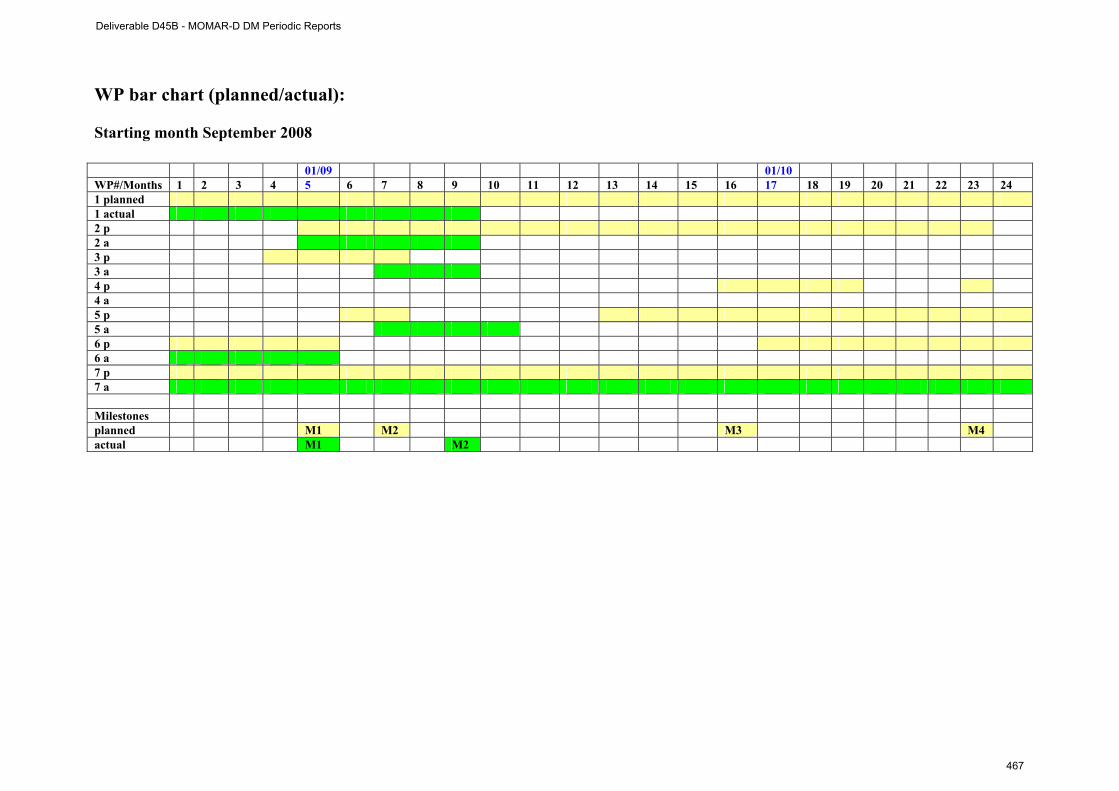
WP bar chart (planned/actual): Starting month September 2008 01/09 01/10 WP#/Months 1 2 3 4 5 6 7 8 9 10 11 12 13 14 15 16 17 18 19 20 21 22 23 24 1 planned 1 actual 2 p 2 a 3 p 3 a 4 p 4 a 5 p 5 a 6 p 6 a 7 p 7 a Milestones planned M1 M2 M3 M4 actual M1 M2
Deliverable D45B - MOMAR-D DM Periodic Reports
467
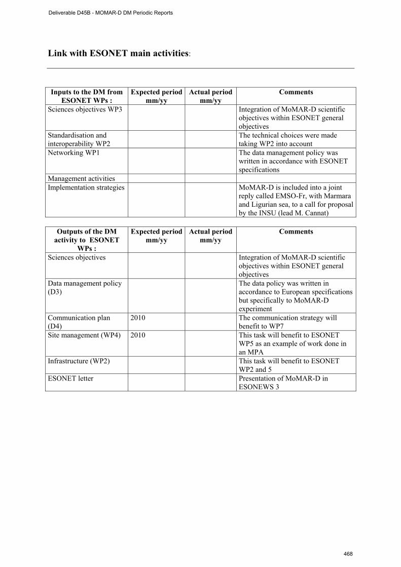
Link with ESONET main activities: Inputs to the DM from
ESONET WPs : Expected period
mm/yy Actual period
mm/yy Comments
Sciences objectives WP3 Integration of MoMAR-D scientific objectives within ESONET general objectives
Standardisation and interoperability WP2
The technical choices were made taking WP2 into account
Networking WP1 The data management policy was written in accordance with ESONET specifications
Management activities Implementation strategies MoMAR-D is included into a joint
reply called EMSO-Fr, with Marmara and Ligurian sea, to a call for proposal by the INSU (lead M. Cannat)
Outputs of the DM
activity to ESONET WPs :
Expected period mm/yy
Actual period mm/yy
Comments
Sciences objectives Integration of MoMAR-D scientific objectives within ESONET general objectives
Data management policy (D3)
The data policy was written in accordance to European specifications but specifically to MoMAR-D experiment
Communication plan (D4)
2010 The communication strategy will benefit to WP7
Site management (WP4) 2010 This task will benefit to ESONET WP5 as an example of work done in an MPA
Infrastructure (WP2) This task will benefit to ESONET WP2 and 5
ESONET letter Presentation of MoMAR-D in ESONEWS 3
Deliverable D45B - MOMAR-D DM Periodic Reports
468
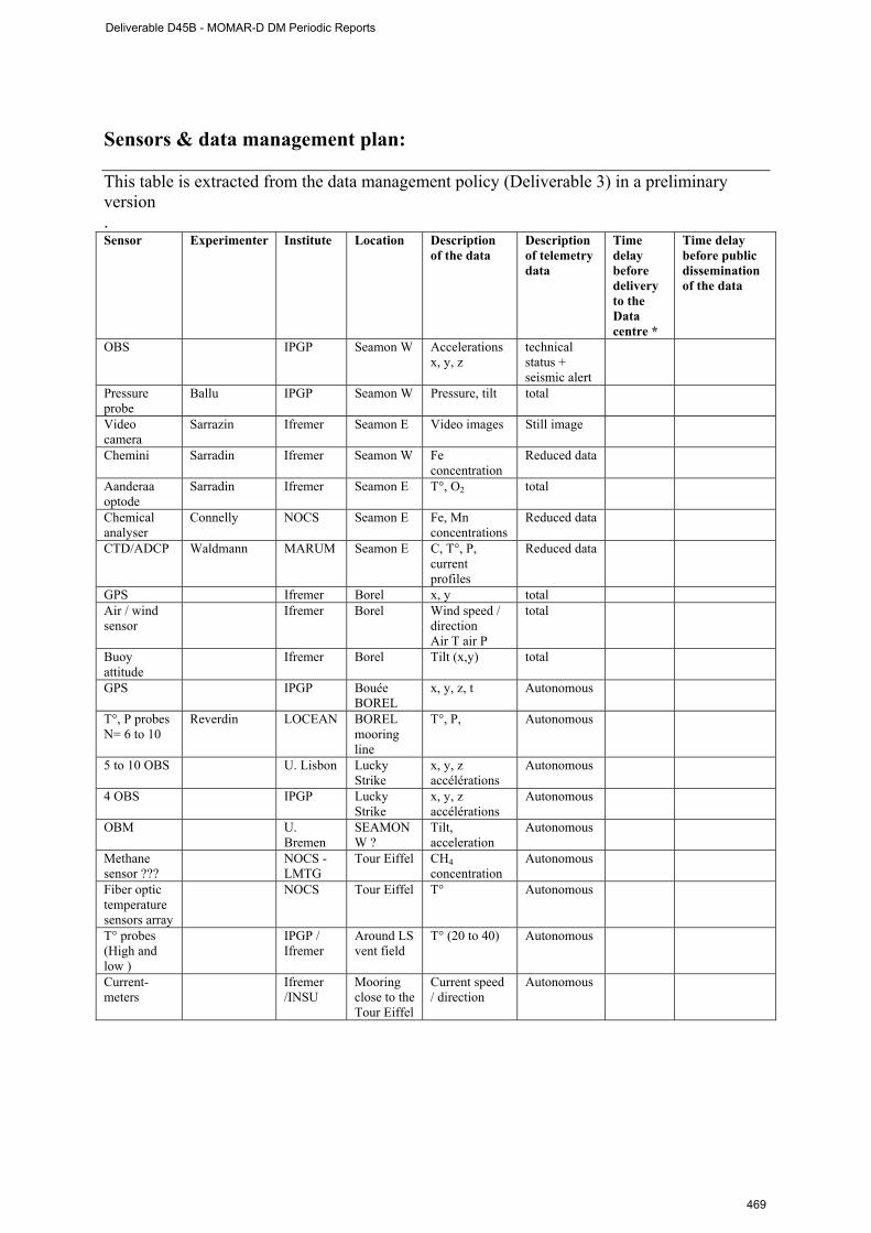
Sensors & data management plan: This table is extracted from the data management policy (Deliverable 3) in a preliminary version . Sensor Experimenter Institute Location Description
of the data Description of telemetry data
Time delay before delivery to the Data centre *
Time delay before public dissemination of the data
OBS IPGP Seamon W Accelerations x, y, z
technical status + seismic alert
Pressure probe
Ballu IPGP Seamon W Pressure, tilt total
Video camera
Sarrazin Ifremer Seamon E Video images Still image
Chemini Sarradin Ifremer Seamon W Fe concentration
Reduced data
Aanderaa optode
Sarradin Ifremer Seamon E T°, O2 total
Chemical analyser
Connelly NOCS Seamon E Fe, Mn concentrations
Reduced data
CTD/ADCP Waldmann MARUM Seamon E C, T°, P, current profiles
Reduced data
GPS Ifremer Borel x, y total Air / wind sensor
Ifremer Borel Wind speed / direction Air T air P
total
Buoy attitude
Ifremer Borel Tilt (x,y) total
GPS IPGP Bouée BOREL
x, y, z, t Autonomous
T°, P probes N= 6 to 10
Reverdin LOCEAN BOREL mooring line
T°, P, Autonomous
5 to 10 OBS
U. Lisbon
Lucky Strike
x, y, z accélérations
Autonomous
4 OBS IPGP Lucky Strike
x, y, z accélérations
Autonomous
OBM U. Bremen
SEAMON W ?
Tilt, acceleration
Autonomous
Methane sensor ???
NOCS - LMTG
Tour Eiffel CH4 concentration
Autonomous
Fiber optic temperature sensors array
NOCS Tour Eiffel T° Autonomous
T° probes (High and low )
IPGP / Ifremer
Around LS vent field
T° (20 to 40) Autonomous
Current-meters
Ifremer /INSU
Mooring close to the Tour Eiffel
Current speed / direction
Autonomous
Deliverable D45B - MOMAR-D DM Periodic Reports
469

Dissemination and outreach: Type of school material available at the issue of
the mission (photos, video, courses,…others)
Description
Development of a didactic game in progress by UAç.
Oral presentations in international workshop and symposiums Sarradin, P.M., M. Cannat, A. Colaço & J. Blandin.(2008) News in the MoMAR-D project. Faro,
ESONET General assembly, meeting, october 2008. Sarrazin J., J. Blandin, L. Delauney, S. Dentrecolas, J. Dupont, C. Le Gall, J. Legrand, P. Léon, J.P.
Lévèque, L. Peton, P. Rodier, R. Vuillemin, P.M. Sarradin A glimpse into the deep 45 days in the life of a vent mussel assemblage. ICES International symposium, Horta (Azores, Pt), April 27-30 2009.
Colaço A. (UAç); M. Cannat (IPGP), J. Blandin (Ifremer);P.M. Sarradin (Ifremer). MoMAR-D- A technological challenge to monitor in real time Lucky Strike hydrothermal vent field. ICES International symposium, Horta (Azores, Pt), April 27-30 2009.
Publications (non referred papers) Sarrazin J. et al. 2009, MoMAR/D: A demonstration mission to establish a multidisciplinary
observatory at hydrothermal vents on the Mid-Atlantic Ridge. ESONEWS n°3 Miscellaneous Cannat M. et al. 2009. « EMSO-Fr », réponse à l’appel d’offre pour la labellisation par l’Insu de «
Sites instrumentés » en Terre Interne.
Deliverable D45B - MOMAR-D DM Periodic Reports
470
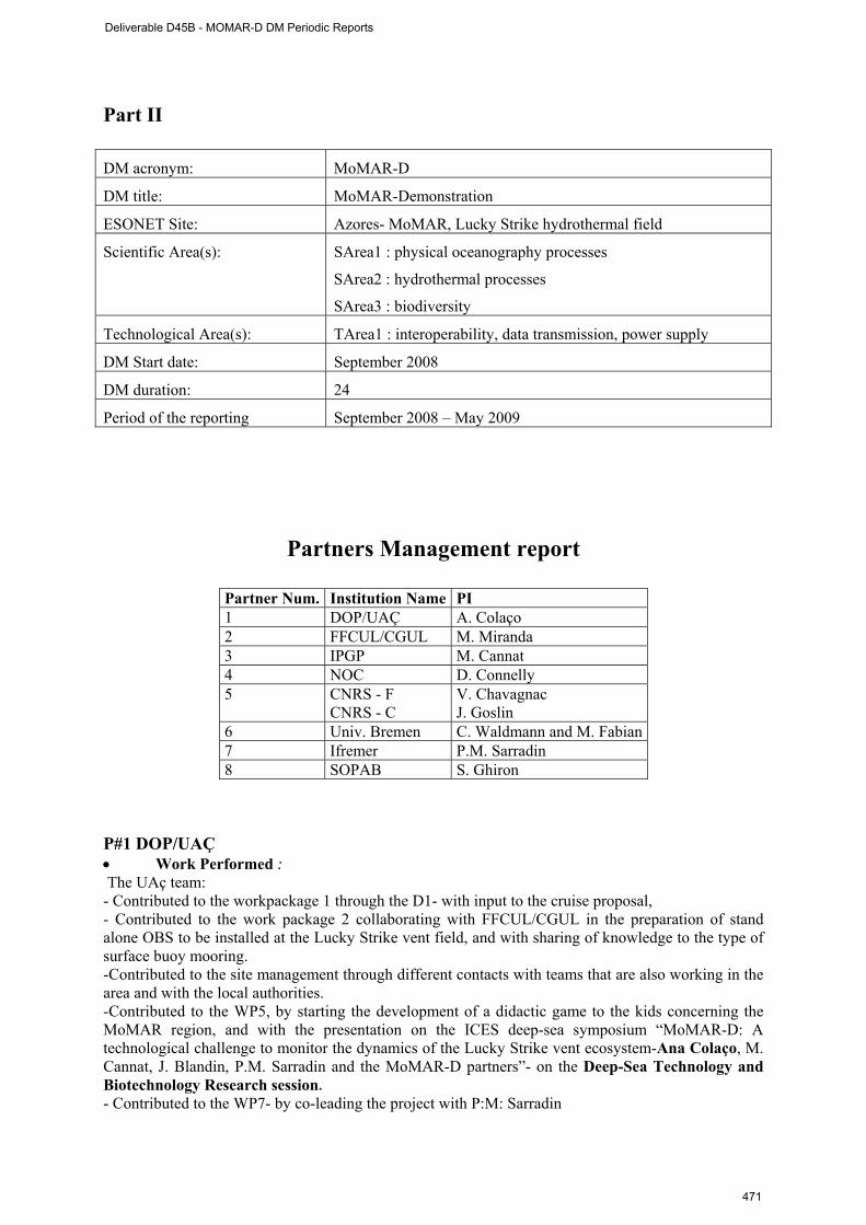
Part II DM acronym: MoMAR-D
DM title: MoMAR-Demonstration
ESONET Site: Azores- MoMAR, Lucky Strike hydrothermal field
Scientific Area(s): SArea1 : physical oceanography processes
SArea2 : hydrothermal processes
SArea3 : biodiversity
Technological Area(s): TArea1 : interoperability, data transmission, power supply
DM Start date: September 2008
DM duration: 24
Period of the reporting September 2008 – May 2009
Partners Management report
Partner Num. Institution Name PI 1 DOP/UAÇ A. Colaço 2 FFCUL/CGUL M. Miranda 3 IPGP M. Cannat 4 NOC D. Connelly 5 CNRS - F V. Chavagnac CNRS - C J. Goslin 6 Univ. Bremen C. Waldmann and M. Fabian 7 Ifremer P.M. Sarradin 8 SOPAB S. Ghiron
P#1 DOP/UAÇ • Work Performed : The UAç team: - Contributed to the workpackage 1 through the D1- with input to the cruise proposal, - Contributed to the work package 2 collaborating with FFCUL/CGUL in the preparation of stand alone OBS to be installed at the Lucky Strike vent field, and with sharing of knowledge to the type of surface buoy mooring. -Contributed to the site management through different contacts with teams that are also working in the area and with the local authorities. -Contributed to the WP5, by starting the development of a didactic game to the kids concerning the MoMAR region, and with the presentation on the ICES deep-sea symposium “MoMAR-D: A technological challenge to monitor the dynamics of the Lucky Strike vent ecosystem-Ana Colaço, M. Cannat, J. Blandin, P.M. Sarradin and the MoMAR-D partners”- on the Deep-Sea Technology and Biotechnology Research session. - Contributed to the WP7- by co-leading the project with P:M: Sarradin
Deliverable D45B - MOMAR-D DM Periodic Reports
471

• Rough Estimation of Major Cost: The travel costs were to attend the kick off meeting (3
persons), one from the Department of Oceanography and Fisheries, and the other two from the Centre of Volcanology and Geological Risks Assessment
• Overview of the Actual Costs,
Type of expenditure
Actual costs( Euro) First period
Total person-months 0 Personnel costs 0 Subcontracting 0 Travels 4600 Consumables Other costs
Total Costs 4600 P#2 FFCUL/CGUL No input during this period. P#3 IPGP • Work Performed : WP1 and 2: We have participated in the March 09 kick-off meeting in Brest. We have done significant work toward integration of the SEAMON-connected sensors our institute has taken responsibility for (pressure probes and OBS). We have also made progress on processing of seismic monitoring of the area in 2007-2008. These results are critical for the calibration of the seismic alert system for the SEAMON-connected OBS. WP3: we have contributed to the MoMAR-Demo Data management policy document which is now nearly ready to be signed by all partners. WP4: we have made progress in building the GIS database for the MoMar sites. We plan to release a simplified version of this database on a web-based interface later this year. • Overview of the Actual Costs,
Type of expenditure
Actual costs( Euro) First period
Total person-months 11.5 Personnel costs Subcontracting Travels 2103,02 Consumables 9720,02 Other costs 35,00
Total Costs 11858,04
Deliverable D45B - MOMAR-D DM Periodic Reports
472
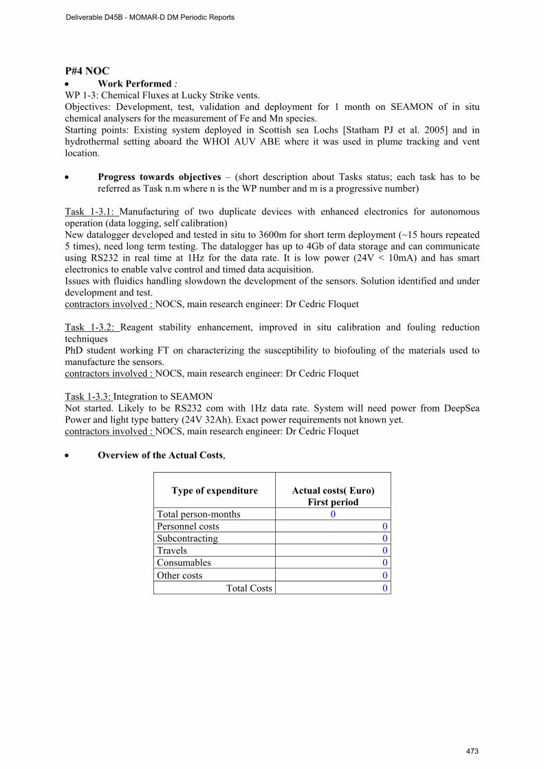
P#4 NOC • Work Performed : WP 1-3: Chemical Fluxes at Lucky Strike vents. Objectives: Development, test, validation and deployment for 1 month on SEAMON of in situ chemical analysers for the measurement of Fe and Mn species. Starting points: Existing system deployed in Scottish sea Lochs [Statham PJ et al. 2005] and in hydrothermal setting aboard the WHOI AUV ABE where it was used in plume tracking and vent location. • Progress towards objectives – (short description about Tasks status; each task has to be
referred as Task n.m where n is the WP number and m is a progressive number) Task 1-3.1: Manufacturing of two duplicate devices with enhanced electronics for autonomous operation (data logging, self calibration) New datalogger developed and tested in situ to 3600m for short term deployment (~15 hours repeated 5 times), need long term testing. The datalogger has up to 4Gb of data storage and can communicate using RS232 in real time at 1Hz for the data rate. It is low power (24V < 10mA) and has smart electronics to enable valve control and timed data acquisition. Issues with fluidics handling slowdown the development of the sensors. Solution identified and under development and test. contractors involved : NOCS, main research engineer: Dr Cedric Floquet Task 1-3.2: Reagent stability enhancement, improved in situ calibration and fouling reduction techniques PhD student working FT on characterizing the susceptibility to biofouling of the materials used to manufacture the sensors. contractors involved : NOCS, main research engineer: Dr Cedric Floquet Task 1-3.3: Integration to SEAMON Not started. Likely to be RS232 com with 1Hz data rate. System will need power from DeepSea Power and light type battery (24V 32Ah). Exact power requirements not known yet. contractors involved : NOCS, main research engineer: Dr Cedric Floquet • Overview of the Actual Costs,
Type of expenditure
Actual costs( Euro) First period
Total person-months 0 Personnel costs 0 Subcontracting 0 Travels 0 Consumables 0 Other costs 0
Total Costs 0
Deliverable D45B - MOMAR-D DM Periodic Reports
473
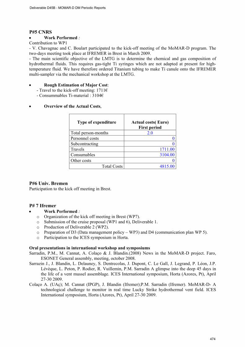
P#5 CNRS • Work Performed : Contribution to WP1 - V. Chavagnac and C. Boulart participated to the kick-off meeting of the MoMAR-D program. The two-days meeting took place at IFREMER in Brest in March 2009. - The main scientific objective of the LMTG is to determine the chemical and gas composition of hydrothermal fluids. This requires gas-tight Ti syringes which are not adapted at present for high-temperature fluid. We have therefore ordered Titanium tubing to make Ti canule onto the IFREMER multi-sampler via the mechanical workshop at the LMTG. • Rough Estimation of Major Cost:
- Travel to the kick-off meeting: 1711€ - Consummables Ti-material : 3104€
• Overview of the Actual Costs,
Type of expenditure
Actual costs( Euro) First period
Total person-months 2.0 Personnel costs 0 Subcontracting 0 Travels 1711.00 Consumables 3104.00 Other costs 0
Total Costs 4815.00 P#6 Univ. Bremen Participation to the kick off meeting in Brest. P# 7 Ifremer • Work Performed :
o Organization of the kick off meeting in Brest (WP7). o Submission of the cruise proposal (WP1 and 6), Deliverable 1. o Production of Deliverable 2 (WP2). o Preparation of D3 (Data management policy – WP3) and D4 (communication plan WP 5). o Participation to the ICES symposium in Horta.
Oral presentations in international workshop and symposiums Sarradin, P.M., M. Cannat, A. Colaço & J. Blandin.(2008) News in the MoMAR-D project. Faro,
ESONET General assembly, meeting, october 2008. Sarrazin J., J. Blandin, L. Delauney, S. Dentrecolas, J. Dupont, C. Le Gall, J. Legrand, P. Léon, J.P.
Lévèque, L. Peton, P. Rodier, R. Vuillemin, P.M. Sarradin A glimpse into the deep 45 days in the life of a vent mussel assemblage. ICES International symposium, Horta (Azores, Pt), April 27-30 2009.
Colaço A. (UAç); M. Cannat (IPGP), J. Blandin (Ifremer);P.M. Sarradin (Ifremer). MoMAR-D- A technological challenge to monitor in real time Lucky Strike hydrothermal vent field. ICES International symposium, Horta (Azores, Pt), April 27-30 2009.
Deliverable D45B - MOMAR-D DM Periodic Reports
474
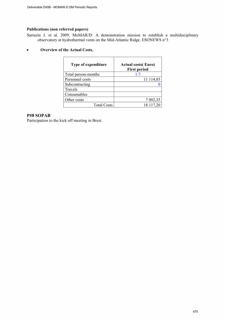
Publications (non referred papers) Sarrazin J. et al. 2009, MoMAR/D: A demonstration mission to establish a multidisciplinary
observatory at hydrothermal vents on the Mid-Atlantic Ridge. ESONEWS n°3 • Overview of the Actual Costs,
Type of expenditure
Actual costs( Euro) First period
Total person-months 1.7 Personnel costs 11 114,85 Subcontracting 0 Travels Consumables Other costs 7 002,35
Total Costs 18 117,20 P#8 SOPAB Participation to the kick off meeting in Brest.
Deliverable D45B - MOMAR-D DM Periodic Reports
475

WP management report (From 30 September 2008 to May 2009)
WP WP leader WP1 Scientific experiments M. Cannat WP2 Infrastructure of the observing system J. Blandin WP3 Data management T. Carval WP4 Site management A. Colaço WP5 Communication plan, Public outreach J. Sarrazin WP6 Cruise P.M. Sarradin WP7 Project management A. Colaço, P.M. Sarradin
WORKPACKAGE WP1
Full WP title Scientific experiments
Period covered from 30/09/2008 to May 2009
Partner organisation full name IPGP
Person in charge for the report (WP Leader)
M. Cannat
Partners involved in the Work DOP, FFCUL, NOCS, CNRS C & F, Univ. Bremen,
Ifremer
Workpackage objectives and starting point WP1. This workpackage concerns the scientific coordination of the multidisciplinary experiments planned at Lucky Strike as part of the demo mission. All demo partners are involved in this WP.
Progress towards objectives – The experiment is still in its preparation stage, because the cruise for the initial deployment of the system has been scheduled provisionally in the summer of 2010 only. We have used the additional year to progress on technological developments made in order to insure the connection of sensor packages to the SEAMON system, but have officially launched the demo at the kick-off meeting in Brest in march 2009.
Deviations from the project work programm, and corrective actions taken/suggested (identify the nature and the reason for the problem, identify partners involved) We will not be able to go ahead with the temperature array (partner NOC) we were hoping to deploy to monitor changes in the temperature at diffuse venting areas.
Corrective actions: We are looking at other means to get some of these diffuse venting temperature data, including use of a sensor deployed previously in the Gulf of Cadiz.
Deliverable D45B - MOMAR-D DM Periodic Reports
476
WORKPACKAGE WP2
Full WP title Infrastructure of the observing system
Period covered from 30/09/2008 to May 2009
Partner organisation full name Ifremer
Person in charge for the report (WP Leader)
J. Blandin
Partners involved in the Work DOP, FFCUL, IPGP, NOCS, Univ. Bremen, Ifremer
• Workpackage objectives and starting point The objective of this WP is to provide the infrastructure of the deep sea observatory based on Seamon nodes and Borel buoy. • Work Performed : This first period was devoted to the redaction of deliverable 2. This document provides the description of the operational system in terms of interface specifications, sensors and localisation. This document was presented during the kick off meeting in Brest as well as an actualized schedule forecasting the preparation of the infrastructure, the integration of the sensors, the shore trials of the whole system in Brest.
Deliverable D45B - MOMAR-D DM Periodic Reports
477
WORKPACKAGE WP3
Full WP title Data management
Period covered from 30/09/2008 to May 2009
Partner organisation full name Ifremer
Person in charge for the report (WP Leader)
T. Carval
Partners involved in the Work DOP, FFCUL, IPGP, NOCS, CNRS C & F, Univ.
Bremen, SOPAB
Workpackage objectives and starting point (max 500 characters) i) The objective of this WP is to establish and define a data management policy and procedure agreed by all the partners. The principles to be specified are: i) the definition of the data to be acquired, ii) the procedures of control for these data and the definition of metadata in accordance with the standards recommendations on data documentation, and finally iii) the dissemination level.
ii) An important task will be to develop links between the MoMAR-D and the data management systems currently used for volcanic and seismic monitoring, and for ecosystem inventory and surveillance, at and near the Azores Islands. To this aim, we have secured the participation of colleagues from the Centro de Vulcanologia e Avaliação de Riscos Geológicos, and from the Department of Oceanography and Fisheries of the University of the Azores.
Progress towards objectives –
i) Data management principles were discussed during the first meeting in Brest (March 209). A draft document, based on documents issued from Neptune Canada, ESONET and Eurosites, has been written by T. Carval and P.M. Sarradin and is circulating amongst the partners for modifications. A final document (Deliverable 3) agreed by all the partners should be available in autumn 2009.
ii) The Centro de Vulcanologia e Avaliação de Riscos Geológicos was present in Brest for the first meeting and presented us their work.
Deviations from the project work programme,
D3 was planned in March 2009. Data management was discussed during the first MoMAR D meeting in Brest in March 2009. We have delayed the delivery of D3 in autumn 2009.
Deliverable D45B - MOMAR-D DM Periodic Reports
478
WORKPACKAGE WP4
Full WP title Site management
Period covered from 30/09/2008 to May 2009
Partner organisation full name DOP UAC
Person in charge for the report (WP Leader)
A. Colaço
Partners involved in the Work DOP, FFCUL, IPGP, NOCS, CNRS F, Ifremer
Workpackage objectives and starting point The MoMAR-D demonstration will undertake to comply with the MPA rules and develop a coherent experimental site management plan. This plan will include a set of rules for PI’s, based on the MPA code of conduct and on the InterRidge code of conduct. These rules will aim at minimizing the impact of research on the environment, and at ensuring the compatibility of all the experiments planned.
To enforce these regulations, we will make provision in the MoMAR-D demonstration project for a coordinating MoMAR office, probably at Horta (but a centralized ESONET site management office may also be envisioned) and develop formal links with the Portuguese maritime authorities (the Hydrographic Institute), with the MPA managing authorities, and with the Azores Regional Government. Partners from the Centro de Vulcanologia e Avaliação de Riscos Geológicos, and from the Department of Oceanography and Fisheries of the University of the Azores will play a leading role in this task.
Work Performed : Participation to the ICES meeting in Horta. Colaço A. (UAç); M. Cannat (IPGP), J. Blandin (Ifremer);P.M. Sarradin (Ifremer). MoMAR-D- A
technological challenge to monitor in real time Lucky Strike hydrothermal vent field. ICES International symposium, Horta (Azores, Pt), April 27-30 2009.
Deliverable D45B - MOMAR-D DM Periodic Reports
479
WORKPACKAGE WP5
Full WP title Communication plan, Public outreach
Period covered from 30/09/2008 to May 2009
Partner organisation full name Ifremer
Person in charge for the report (WP Leader)
J. Sarrazin
Partners involved in the Work DOP, FFCUL, IPGP, NOCS, Univ. Bremen, SOPAB
Workpackage objectives and starting point Near real time transmission of data (and video images) from the vents will open new opportunities for public outreach. The public outreach strategy will include press conferences before the cruises, maintenance of a cruise web site, and organization of a live event from the vessel, with video conferences and transmission of live images from the seafloor, participation of journalists interested in making a movie out of this seafloor observatory adventure. Our plan is to have a permanent exhibit, with access to the most recent data and images from the seafloor, at the Oceanopolis aquarium in Brest. Mirror sites and exhibit material could also be set in other large aquariums in Europe. The strategy will cover international to regional initiatives such as the production of a didactic kit, in Portuguese, on hydrothermal vents and seafloor observatories for the different school levels, in connection with in the Azores University.
Progress towards objectives – The public outreach strategy was discussed during the first meeting in Brest in March 2009. The communication plan will be available in July 2009 (Deliverable 4). Sarrazin J. et al. 2009, MoMAR/D: A demonstration mission to establish a multidisciplinary
observatory at hydrothermal vents on the Mid-Atlantic Ridge. ESONEWS n°3
Deliverable D45B - MOMAR-D DM Periodic Reports
480

WORKPACKAGE WP6
Full WP title Cruise
Period covered from 30/09/2008 to May 2009
Partner organisation full name Ifremer
Person in charge for the report (WP Leader)
P.M. Sarradin
Partners involved in the Work DOP, FFCUL, IPGP, NOCS, CNRS C& F, Univ.
Bremen, SOPAB
Workpackage objectives and starting point
The objective of this WP is to submit a cruise proposal to the French Fleet Committee (D1). This proposal gathers 2 20 days cruises using the French ROV Victor 6000. The first cruise will be dedicated to the implementation of the observatory infrastructure in the Lucky Strike vent field, the second one to its recovery 12 month later. Site studies will be performed during both cruises.
Progress towards objectives –
In January 2008, the MoMARSAT cruise proposal was submitted to the French Fleet Committee. After evaluation, the cruise has been prescheduled for the summer 2010. Unfortunately, this preliminary schedule was withdrawn and the cruise proposal had to be submitted once again in January 2009. We are waiting for the results of this evaluation and the new 2010-2011 schedule. Deviations from the project work programme The MoMARSAT cruise proposal was submitted 3 times to the French Fleet committee. In June 2009, we have not got any certainty on the scheduling of the cruise in 2010 and 2011. This uncertainty led us to delay the starting date of the MoMAR-D DM (September 2008), and to slow down the shore work. With the new agenda, only the first cruise in would 2010 fit in the ESONET calendar. If the cruise is delayed once again to 2011-2012, the project will be shifted out of the ESONET time schedule setting the question of the future of the project and of the ESONET grant. In such a case, the objectives within ESONET could be reduced to a shore trial of the complete observatory infrastructure. Deliverable D1: Cannat M., Sarradin, P.M., Blandin, J. January 2009. MoMARSAT 1 & 2 cruise proposals
Deliverable D45B - MOMAR-D DM Periodic Reports
481
WORKPACKAGE WP7
Full WP title Project management
Period covered from 30/09/2008 to May 2009
Partner organisation full name Ifremer and DOP
Person in charge for the report (WP Leader)
P.M. Sarradin and A. Colaço
Partners involved in the Work
Workpackage objectives and starting point
The objective of MoMAR-D proposal is the deployment of an acoustically-linked multidisciplinary observing system at the Lucky Strike vent field, with satellite connection to shore, and its management during 1 year.
Progress towards objectives – The first MoMAR-D plenary meeting took place in March (17-18) 2009 in Ifremer centre de Brest and gathered around 20 scientists and engineers from France, Germany and Portugal. The objectives of this meeting were:
The scientific and technological presentation of the different planned experiments by each partner, chair M. Cannat,
• A description of the operational system by J. Blandin • The preparation of interfacing and shore trial step by J. Blandin (see Deliverable 2) • The preparation of the data management policy chaired by T. Carval and P.M. Sarradin,
deliverable 3. • The preparation of the communication plan (regional, national and EU initiatives) by J.
Sarrazin (deliverable 4). This meeting allowed proposing a new planning for the interfacing and shore trial step:
• Development, adaptations and testing of sensors should be finalized by the end of December 2009.
• Integration to SEAMON is planned in January 2010. • A test of the whole system should be carried out by the end of February 2010. • Shipping is planned for May 2010.
Deviations from the project work programme This project is directly linked to the realization of 2 cruises to deploy and recover the observatory infrastructure. In January 2008, the MoMARSAT cruise proposal was submitted to the French Fleet Committee and prescheduled for the summer 2010. Unfortunately, this preliminary schedule was withdrawn and the cruise proposal had to be submitted once again in January 2009. We are waiting for the results of this evaluation and the new 2010-2011 schedule. In June 2009, we have not got any certainty on the scheduling of the cruise in 2010 and 2011. This uncertainty led us to delay the starting date of the MoMAR-D DM (September 2008), and to slow down the shore work. With the new agenda, only the first cruise in would 2010 fit in the ESONET calendar. If the cruise is delayed once again to 2011-2012, the project will be shifted out of the ESONET time schedule setting the question of the future of the project and of the ESONET grant. In such a case, the objectives within ESONET could be reduced to a shore trial of the complete observatory infrastructure.
Sarradin, P.M., M. Cannat, A. Colaço & J. Blandin.(2008) News in the MoMAR-D project. Faro,
ESONET General assembly, meeting, October 2008.
Deliverable D45B - MOMAR-D DM Periodic Reports
482
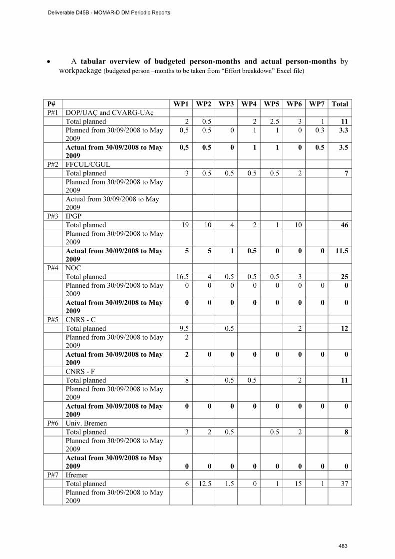
• A tabular overview of budgeted person-months and actual person-months by
workpackage (budgeted person –months to be taken from “Effort breakdown” Excel file)
P# WP1 WP2 WP3 WP4 WP5 WP6 WP7 TotalP#1 DOP/UAÇ and CVARG-UAç Total planned 2 0.5 2 2.5 3 1 11 Planned from 30/09/2008 to May
2009 0,5 0.5 0 1 1 0 0.3 3.3
Actual from 30/09/2008 to May 2009
0,5 0.5 0 1 1 0 0.5 3.5
P#2 FFCUL/CGUL Total planned 3 0.5 0.5 0.5 0.5 2 7 Planned from 30/09/2008 to May
2009
Actual from 30/09/2008 to May 2009
P#3 IPGP Total planned 19 10 4 2 1 10 46 Planned from 30/09/2008 to May
2009
Actual from 30/09/2008 to May 2009
5 5 1 0.5 0 0 0 11.5
P#4 NOC Total planned 16.5 4 0.5 0.5 0.5 3 25 Planned from 30/09/2008 to May
2009 0 0 0 0 0 0 0 0
Actual from 30/09/2008 to May 2009
0 0 0 0 0 0 0 0
P#5 CNRS - C Total planned 9.5 0.5 2 12 Planned from 30/09/2008 to May
2009 2
Actual from 30/09/2008 to May 2009
2 0 0 0 0 0 0 0
CNRS - F Total planned 8 0.5 0.5 2 11 Planned from 30/09/2008 to May
2009
Actual from 30/09/2008 to May 2009
0 0 0 0 0 0 0 0
P#6 Univ. Bremen Total planned 3 2 0.5 0.5 2 8 Planned from 30/09/2008 to May
2009 Actual from 30/09/2008 to May
2009 0 0 0 0 0 0 0 0P#7 Ifremer Total planned 6 12.5 1.5 0 1 15 1 37 Planned from 30/09/2008 to May
2009
Deliverable D45B - MOMAR-D DM Periodic Reports
483
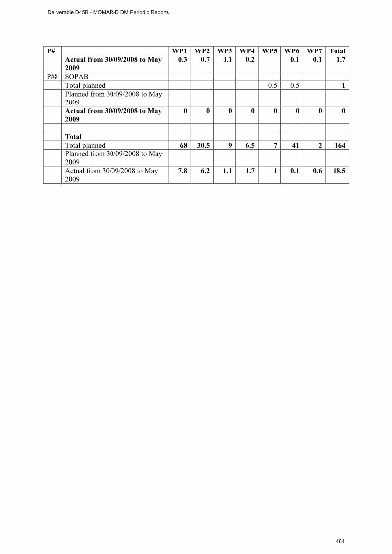
P# WP1 WP2 WP3 WP4 WP5 WP6 WP7 Total Actual from 30/09/2008 to May
2009 0.3 0.7 0.1 0.2 0.1 0.1 1.7
P#8 SOPAB Total planned 0.5 0.5 1 Planned from 30/09/2008 to May
2009
Actual from 30/09/2008 to May 2009
0 0 0 0 0 0 0 0
Total Total planned 68 30.5 9 6.5 7 41 2 164 Planned from 30/09/2008 to May
2009
Actual from 30/09/2008 to May 2009
7.8 6.2 1.1 1.7 1 0.1 0.6 18.5
Deliverable D45B - MOMAR-D DM Periodic Reports
484
ESONET MoMAR-D 3rd Periodic Activity Report, January 2010
ESONET Demonstration Missions
MoMAR-D
Periodic Activity Report
P.M. Sarradin and A. Colaço
1st July 2009 – 31 December 2009
DEEP LEP 10 XX
Deliverable D45B - MOMAR-D DM Periodic Reports
485
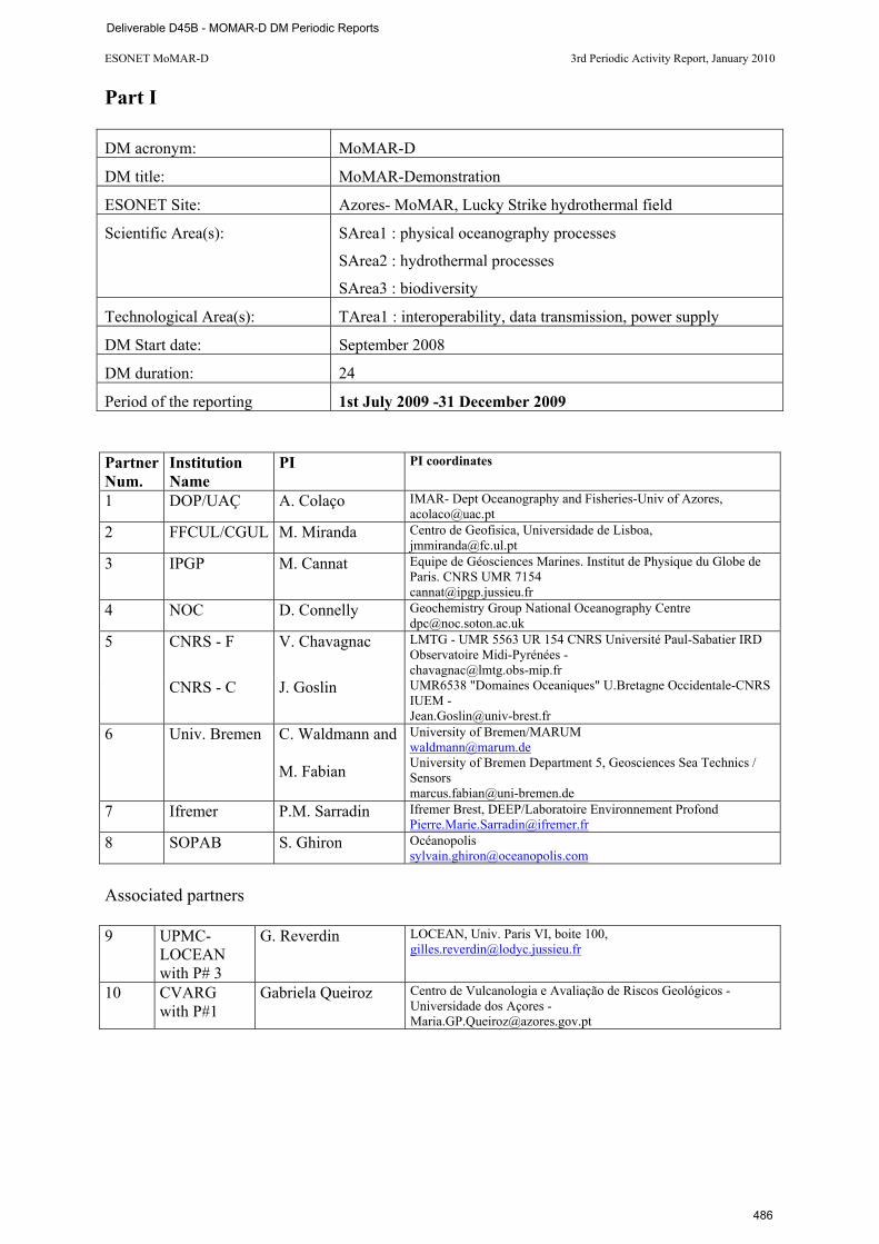
ESONET MoMAR-D 3rd Periodic Activity Report, January 2010
Part I DM acronym: MoMAR-D
DM title: MoMAR-Demonstration
ESONET Site: Azores- MoMAR, Lucky Strike hydrothermal field
Scientific Area(s): SArea1 : physical oceanography processes
SArea2 : hydrothermal processes
SArea3 : biodiversity
Technological Area(s): TArea1 : interoperability, data transmission, power supply
DM Start date: September 2008
DM duration: 24
Period of the reporting 1st July 2009 -31 December 2009 Partner Num.
Institution Name
PI PI coordinates
1 DOP/UAÇ A. Colaço IMAR- Dept Oceanography and Fisheries-Univ of Azores, [email protected]
2 FFCUL/CGUL M. Miranda Centro de Geofisica, Universidade de Lisboa, [email protected]
3 IPGP M. Cannat Equipe de Géosciences Marines. Institut de Physique du Globe de Paris. CNRS UMR 7154 [email protected]
4 NOC D. Connelly Geochemistry Group National Oceanography Centre [email protected]
5 CNRS - F V. Chavagnac LMTG - UMR 5563 UR 154 CNRS Université Paul-Sabatier IRD Observatoire Midi-Pyrénées - [email protected]
CNRS - C J. Goslin UMR6538 "Domaines Oceaniques" U.Bretagne Occidentale-CNRS IUEM - [email protected]
6 Univ. Bremen C. Waldmann and M. Fabian
University of Bremen/MARUM [email protected] University of Bremen Department 5, Geosciences Sea Technics / Sensors [email protected]
7 Ifremer P.M. Sarradin Ifremer Brest, DEEP/Laboratoire Environnement Profond [email protected]
8 SOPAB S. Ghiron Océanopolis [email protected]
Associated partners 9 UPMC-
LOCEAN with P# 3
G. Reverdin LOCEAN, Univ. Paris VI, boite 100, [email protected]
10 CVARG with P#1
Gabriela Queiroz
Centro de Vulcanologia e Avaliação de Riscos Geológicos - Universidade dos Açores - [email protected]
Deliverable D45B - MOMAR-D DM Periodic Reports
486

ESONET MoMAR-D 3rd Periodic Activity Report, January 2010
Executive summary The MoMAR (Monitoring the Mid-Atlantic Ridge) project was initiated 10 years ago by the InterRidge Program to promote and coordinate long-term multidisciplinary monitoring of hydrothermal vents in the Azores region of the Mid-Atlantic Ridge This coordinated plan aims at determining the feed-backs between volcanism, deformation, seismicity, and hydrothermalism, and to understand how hydrothermal ecosystems couple with these sub-surface processes, and how this affects exchanges with the ocean. Monitoring at Lucky Strike has started with the MoMARETO (ecology), GRAVILUCK (geodesy), and BBMoMAR (sismology and MT) experiments and will be further implemented in 2008 with the deployment of autonomous temperature probes at selected vents. The MoMAR-D project was selected by ESONET as a demonstration mission to deploy and manage a multidisciplinary observing system at Lucky Strike during one year. Lucky Strike is a large hydrothermal field located in the center of one of the most volcanically active segment of the MAR. Monitoring this field offers a high probability of capturing evidence for volcanic events, observing interactions between faulting, magmatism and hydrothermal circulations and, evaluating their links with the dynamics of hydrothermal fauna. We will use the SEAMON technology developed during the ASSEM EC project, with two nodes acoustically linked to a surface buoy that will ensure satellite communication to a land base station. The system will comprise 2 scientific nodes: a geophysical node moored in the Lucky Strike lava lake, and a geochemical/ecological node at the Eiffel Tower vent site. This observatory infrastructure will acquire a synchronized multidisciplinary data set, and allow us to develop solutions for sensor interoperability, shore-sensor interactive communication, data management and dissemination, and public outreach. The project comprises two multidisciplinary ROV cruises (MoMARSAT), the first one in 2010 to deploy the acoustically-linked multidisciplinary observing system at the Lucky Strike vent field and the second one in 2010 to recover it. The study area belongs to the Portuguese ZEE and is part of a planned OSPAR “Marine Protected Area”. Progress of the project In January 2008, the MoMARSAT cruise proposal was submitted to the French Fleet Committee. After evaluation, the cruise has been prescheduled for the summer 2010. Unfortunately, the preliminary schedule was withdrawn and the cruise proposal had to be submitted once again to the French Fleet Committee. The cruise is now scheduled in September 2010, on the Pourquoi pas ? with the ROV Victor 6000. Due to logistic constraints of the fleet, the duration of the first cruise was reduced from 19 to 13 days to implement the observatory infrastructure on Lucky Strike. After the meeting in Brest in March 2009 and the final definition of the observatory, this period was used to start the technological work. The design and building of the sensors and nodes is in progress as well as the software adaptation of the sensors to the SEAMON technology. The objective is to start the trial step in Brest in Spring 2010. Shipping is planned during Summer 2010. In parallel, a draft of the data management policy is circulating among the partners (see draft of D3). The MoMAR-D project was presented during the 4th International symposium on Chemosynthetic Based Ecosystems in Okinawa (Jpn), the ESONET All region workshop in Paris, the ESONET Best practices workshop in Brest and the Ocean Biology Observatory Workshop in Mestre (It). The next 6 month period will be devoted to the on shore integration and trial of the system in Ifremer in Spring 2010. D3 and D4 will be finalized before the cruise. The cruise preparation reports (Agreement to work in the Portuguese waters and Technological description of the cruise) will be delivered to the French Fleet in March 2010.
Deliverable D45B - MOMAR-D DM Periodic Reports
487
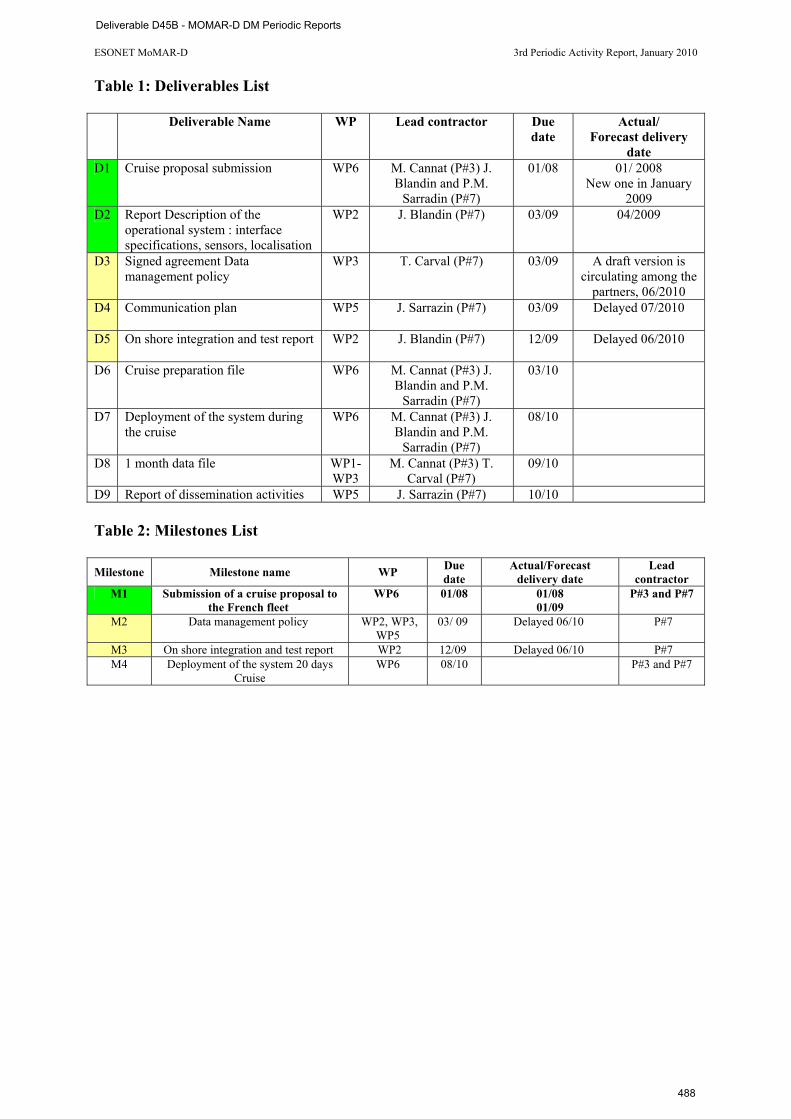
ESONET MoMAR-D 3rd Periodic Activity Report, January 2010
Table 1: Deliverables List
Deliverable Name WP Lead contractor Due date
Actual/ Forecast delivery
date D1 Cruise proposal submission WP6 M. Cannat (P#3) J.
Blandin and P.M. Sarradin (P#7)
01/08 01/ 2008 New one in January
2009 D2 Report Description of the
operational system : interface specifications, sensors, localisation
WP2 J. Blandin (P#7) 03/09 04/2009
D3 Signed agreement Data management policy
WP3
T. Carval (P#7) 03/09 A draft version is circulating among the
partners, 06/2010 D4 Communication plan WP5
J. Sarrazin (P#7) 03/09 Delayed 07/2010
D5 On shore integration and test report WP2
J. Blandin (P#7) 12/09 Delayed 06/2010
D6 Cruise preparation file WP6
M. Cannat (P#3) J. Blandin and P.M.
Sarradin (P#7)
03/10
D7 Deployment of the system during the cruise
WP6
M. Cannat (P#3) J. Blandin and P.M.
Sarradin (P#7)
08/10
D8 1 month data file WP1- WP3
M. Cannat (P#3) T. Carval (P#7)
09/10
D9 Report of dissemination activities WP5 J. Sarrazin (P#7) 10/10 Table 2: Milestones List Milestone Milestone name WP Due
date Actual/Forecast
delivery date Lead
contractor M1 Submission of a cruise proposal to
the French fleet WP6 01/08 01/08
01/09 P#3 and P#7
M2 Data management policy WP2, WP3, WP5
03/ 09 Delayed 06/10 P#7
M3 On shore integration and test report WP2 12/09 Delayed 06/10 P#7 M4 Deployment of the system 20 days
Cruise WP6 08/10 P#3 and P#7
Deliverable D45B - MOMAR-D DM Periodic Reports
488
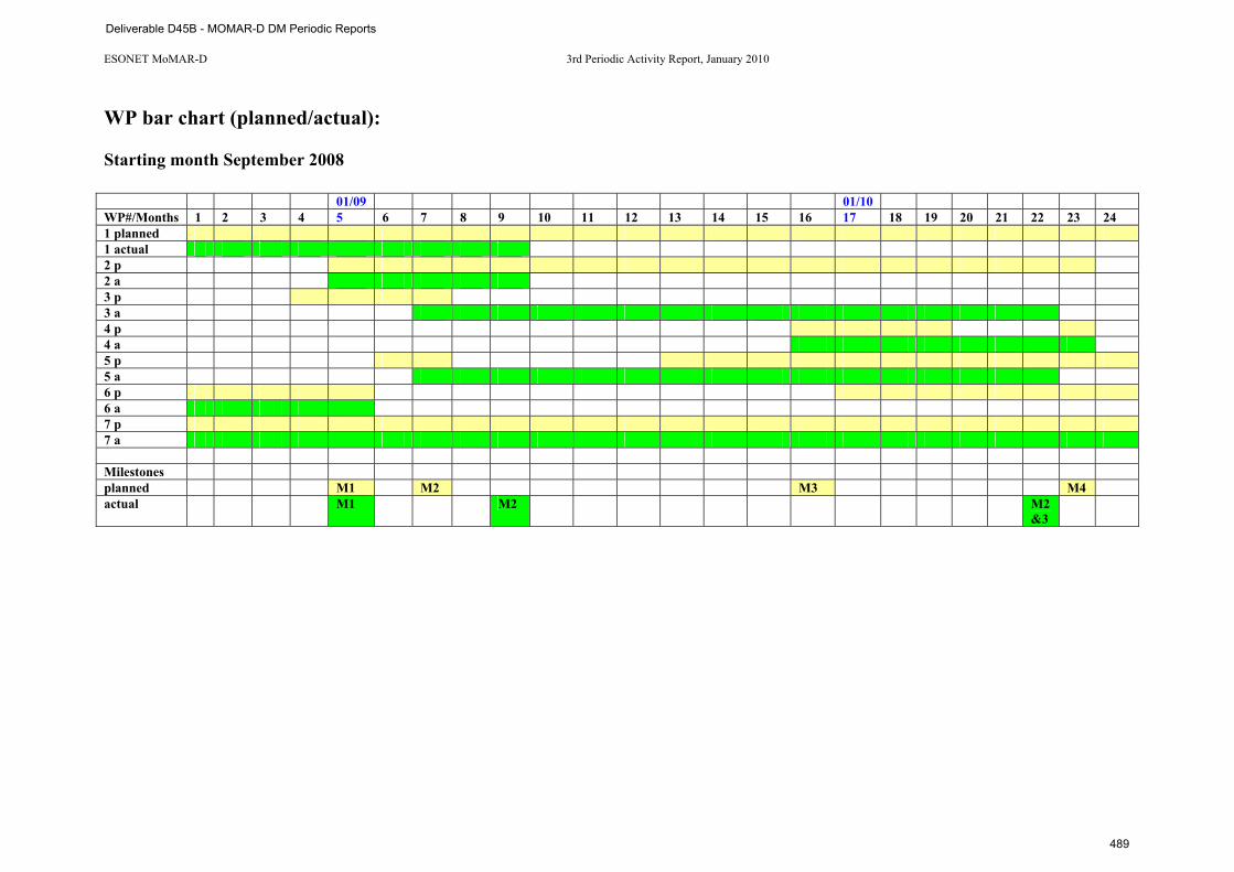
ESONET MoMAR-D 3rd Periodic Activity Report, January 2010
WP bar chart (planned/actual): Starting month September 2008 01/09 01/10 WP#/Months 1 2 3 4 5 6 7 8 9 10 11 12 13 14 15 16 17 18 19 20 21 22 23 24 1 planned 1 actual 2 p 2 a 3 p 3 a 4 p 4 a 5 p 5 a 6 p 6 a 7 p 7 a Milestones planned M1 M2 M3 M4 actual M1 M2 M2
&3
Deliverable D45B - MOMAR-D DM Periodic Reports
489
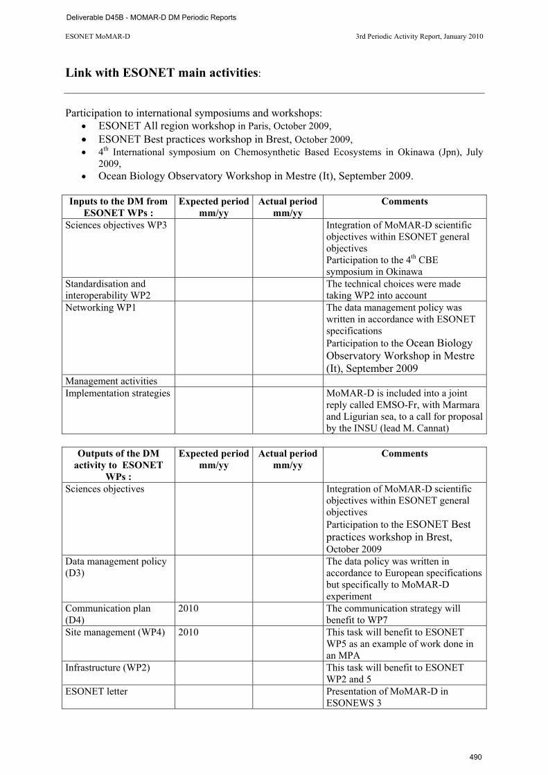
ESONET MoMAR-D 3rd Periodic Activity Report, January 2010
Link with ESONET main activities: Participation to international symposiums and workshops:
• ESONET All region workshop in Paris, October 2009, • ESONET Best practices workshop in Brest, October 2009, • 4th International symposium on Chemosynthetic Based Ecosystems in Okinawa (Jpn), July
2009, • Ocean Biology Observatory Workshop in Mestre (It), September 2009.
Inputs to the DM from
ESONET WPs : Expected period
mm/yy Actual period
mm/yy Comments
Sciences objectives WP3 Integration of MoMAR-D scientific objectives within ESONET general objectives Participation to the 4th CBE symposium in Okinawa
Standardisation and interoperability WP2
The technical choices were made taking WP2 into account
Networking WP1 The data management policy was written in accordance with ESONET specifications Participation to the Ocean Biology Observatory Workshop in Mestre (It), September 2009
Management activities Implementation strategies MoMAR-D is included into a joint
reply called EMSO-Fr, with Marmara and Ligurian sea, to a call for proposal by the INSU (lead M. Cannat)
Outputs of the DM
activity to ESONET WPs :
Expected period mm/yy
Actual period mm/yy
Comments
Sciences objectives Integration of MoMAR-D scientific objectives within ESONET general objectives Participation to the ESONET Best practices workshop in Brest, October 2009
Data management policy (D3)
The data policy was written in accordance to European specifications but specifically to MoMAR-D experiment
Communication plan (D4)
2010 The communication strategy will benefit to WP7
Site management (WP4) 2010 This task will benefit to ESONET WP5 as an example of work done in an MPA
Infrastructure (WP2) This task will benefit to ESONET WP2 and 5
ESONET letter Presentation of MoMAR-D in ESONEWS 3
Deliverable D45B - MOMAR-D DM Periodic Reports
490
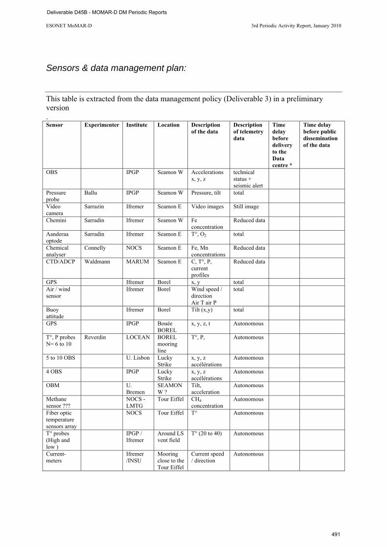
ESONET MoMAR-D 3rd Periodic Activity Report, January 2010
Sensors & data management plan:
This table is extracted from the data management policy (Deliverable 3) in a preliminary version . Sensor Experimenter Institute Location Description
of the data Description of telemetry data
Time delay before delivery to the Data centre *
Time delay before public dissemination of the data
OBS IPGP Seamon W Accelerations x, y, z
technical status + seismic alert
Pressure probe
Ballu IPGP Seamon W Pressure, tilt total
Video camera
Sarrazin Ifremer Seamon E Video images Still image
Chemini Sarradin Ifremer Seamon W Fe concentration
Reduced data
Aanderaa optode
Sarradin Ifremer Seamon E T°, O2 total
Chemical analyser
Connelly NOCS Seamon E Fe, Mn concentrations
Reduced data
CTD/ADCP Waldmann MARUM Seamon E C, T°, P, current profiles
Reduced data
GPS Ifremer Borel x, y total Air / wind sensor
Ifremer Borel Wind speed / direction Air T air P
total
Buoy attitude
Ifremer Borel Tilt (x,y) total
GPS IPGP Bouée BOREL
x, y, z, t Autonomous
T°, P probes N= 6 to 10
Reverdin LOCEAN BOREL mooring line
T°, P, Autonomous
5 to 10 OBS
U. Lisbon
Lucky Strike
x, y, z accélérations
Autonomous
4 OBS IPGP Lucky Strike
x, y, z accélérations
Autonomous
OBM U. Bremen
SEAMON W ?
Tilt, acceleration
Autonomous
Methane sensor ???
NOCS - LMTG
Tour Eiffel CH4 concentration
Autonomous
Fiber optic temperature sensors array
NOCS Tour Eiffel T° Autonomous
T° probes (High and low )
IPGP / Ifremer
Around LS vent field
T° (20 to 40) Autonomous
Current-meters
Ifremer /INSU
Mooring close to the Tour Eiffel
Current speed / direction
Autonomous
Deliverable D45B - MOMAR-D DM Periodic Reports
491
ESONET MoMAR-D 3rd Periodic Activity Report, January 2010
Dissemination and outreach:
Type of school material available at the issue of
the mission (photos, video, courses,…others)
Description
Development of a didactic game in progress by UAç.
Oral presentations in international workshop and symposiums Blandin J. & P.M. Sarradin. Deployment and recovery of a non cabled system with data
transmission capacity : The MoMAR case. ESONET Best practices workshop, octobre 2009-Brest.
Colaço Ana (IMAR/DOP-Uaç), M. Cannat (IPGP), J. Blandin (IFREMER),P.M. Sarradin (IFREMER) and the MoMAR-D partners. MoMAR-D: A technological challenge to monitor the dynamics of the Lucky Strike vent ecosystem. ESONET All region workshop-Paris- 5-7 October.
CuvelierD., A first decadal study (1994-2008) of community dynamics on an Atlantic hydrothermal edifice as revealed by high-resolution video image analysis A first decadal study (1994-2008) of community dynamics on an Atlantic hydrothermal edifice as revealed by high-resolution video image analysis. 4th International symposium on Chemosynthetic Based Ecosystems in Okinawa (Jpn), July 2009,
Gauthier O, J Sarrazin, PM Sarradin. 2009. Development of an automated protocol to analyse the temporal dynamics of hydrothermal ecosystems from video imagery and temperature time-series part II: Untangling spatio-temporal temperature variations, first insights from a novel approach. European Sea Observatory Network of Excellence 2nd Best Practices Workshop, Ifremer, Brest, France, 8-9 octobre.
Mercier G., J Sarrazin, PM Sarradin. 2009. Development of an automated protocol to analyse the temporal dynamics of hydrothermal ecosystems from video imagery and temperature time-series part I: Automated image processing. European Sea Observatory Network of Excellence 2nd Best Practices Workshop, Ifremer, Brest, France, 8-9 octobre.
Sarradin P.M. (IFREMER), Ana Colaço (IMAR/DOP-Uaç), M. Cannat (IPGP), J. Blandin (IFREMER), and the MoMAR-D partners. Implementing the Azores Node. ESONET All region workshop-Paris- 5-7 October.
Sarradin P.M. (IFREMER), Ana Colaço (IMAR/DOP-Uaç), M. Cannat (IPGP), J. Blandin (IFREMER), J. Sarrazin and the MoMAR-D partners.The MoMAR-D project : A challenge to monitor the Lucky Strike hydrothermal vent in real time. Poster. Ocean Biology Observatory Workshop, Mestre (It), September 2009, 16-18.
Sarradin P.M., M. Waeles, C. Le Gall, P. Rodier, J. Sarrazin, D. Cuvelier, F. De Busseroles, R. Riso. Heterogeneity of habitats within a single hydrothermal edifice, MAR. 4th International symposium on Chemosynthetic Based Ecosystems in Okinawa (Jpn), July 2009.
Sarrazin J., C. Le Gall, L. Peton, PM Sarradin. A glimpse into the deep: Mussel community changes and environmental dynamics at Tour Eiffel, MAR. 4th International symposium on Chemosynthetic Based Ecosystems in Okinawa (Jpn), July 2009,
Publications Larkin, K.E., Ruhl, H.A., Bagley, P., Benn, A., Bett, B.J., Billett, D.S.M., Boetius A.,
Chevaldonné,P., Colaço, A., Copley, J., Danovaro, R., Escobar-Briones, E., Glover A.,
Deliverable D45B - MOMAR-D DM Periodic Reports
492
ESONET MoMAR-D 3rd Periodic Activity Report, January 2010
Gooday, A.J, Hughes,J.A., Kalogeropoulou, V., Kelly-Gerreyn, B.A., Kitazato H., Klages, M., Lampadariou, N., Lejeusne, C., Perez, T., Priede., I.G., Rogers A., Sarradin, P.M, Sarrazin, J., Soltwedel, T., Soto, E.H., Thatje, S., Tselepides, A., Tyler, P.A., van den Hove, S., Vanreusel, A., Wenzhöfer, F. 2009: Benthic biology time-series in the deep sea: Indicators of change. OceanObs’09 benthic time-series white paper
Glover, A G, A J Gooday, D M Bailey, D S M Billett, P Chevaldonné, A Colaço, J Copley, D Cuvelier, D Desbruyères, V Kalogeropoulou, M Klages, N Lampadariou, C Lejeusne, N C Mestre, G L J Paterson, T Perez, H A Ruhl, J Sarrazin, T Soltwedel, E H Soto, S Thatje, A Tselepides, S Van Gaever, and A Vanreusel, Climatic and geological drivers of long-term temporal change in deep-sea ecosystems, Advances in Marine Biology, (submitted).
Colaço A.; M. Cannat , J. Blandin ;P.M. Sarradin (subm). MoMAR-D- A technological challenge to monitor in real time Lucky Strike hydrothermal vent field. ICES Journal of Marine Science
Ruhl H.A., Karstensen J., Géli L., Colaço A., Lampitt R., André M. (subm). Societal need for improved understanding of climate change, anthropogenic impacts, and geohazrd warning drive development of ocean observatories in European Seas. Progress in Oceanography
Cuvelier, D, Sarrazin J., Colaço A., Copley J. T., Glover A., Tyler P., Serrão Santos R., and Desbruyères D. (Subm) Community dynamics over 14 years at the Eiffel Tower hydrothermal edifice on the Mid-Atlantic Ridge. Journal of Limnology and Oceanography
Deliverable D45B - MOMAR-D DM Periodic Reports
493
ESONET MoMAR-D 3rd Periodic Activity Report, January 2010
Part II DM acronym: MoMAR-D
DM title: MoMAR-Demonstration
ESONET Site: Azores- MoMAR, Lucky Strike hydrothermal field
Scientific Area(s): SArea1 : physical oceanography processes
SArea2 : hydrothermal processes
SArea3 : biodiversity
Technological Area(s): TArea1 : interoperability, data transmission, power supply
DM Start date: September 2008
DM duration:
Period of the reporting 1 July-31 December 2009
Partners Management report
Partner Num. Institution Name PI 1 DOP/UAÇ A. Colaço 2 FFCUL/CGUL M. Miranda 3 IPGP M. Cannat 4 NOC D. Connelly 5 CNRS - F V. Chavagnac CNRS - C J. Goslin 6 Univ. Bremen C. Waldmann and M. Fabian 7 Ifremer P.M. Sarradin 8 SOPAB S. Ghiron
P#1 DOP/UAÇ • Work Performed : • Rough Estimation of Major Cost: Overview of the Actual Costs, P#1 DOP/UAÇ • Work Performed : The UAç team: - Contributed to the : WP4: - Contributed to the site management through different contacts with teams that are also working in the area and with the local authorities. At the 22nd of December 2009 the European Communitty integrated the Lucky Strike and Menez Gwen hydrothermal vents on the list of sites of Community importance for the Macaronesian biogeographical region.
Deliverable D45B - MOMAR-D DM Periodic Reports
494
ESONET MoMAR-D 3rd Periodic Activity Report, January 2010
WP5: - Conception of a didactic game. - Participation on the SCOR Workshop on Ocean Biology Observatories in Mestre - Submission of the scientific publications: Larkin, K.E., Ruhl, H.A., Bagley, P., Benn, A., Bett, B.J., Billett, D.S.M., Boetius A.,
Chevaldonné,P., Colaço, A., Copley, J., Danovaro, R., Escobar-Briones, E., Glover A., Gooday, A.J, Hughes,J.A., Kalogeropoulou, V., Kelly-Gerreyn, B.A., Kitazato H., Klages, M., Lampadariou, N., Lejeusne, C., Perez, T., Priede., I.G., Rogers A., Sarradin, P.M, Sarrazin, J., Soltwedel, T., Soto, E.H., Thatje, S., Tselepides, A., Tyler, P.A., van den Hove, S., Vanreusel, A., Wenzhöfer, F. 2009: Benthic biology time-series in the deep sea: Indicators of change. OceanObs’09 benthic time-series white paper
-Glover, A G, A J Gooday, D M Bailey, D S M Billett, P Chevaldonné, A Colaço, J Copley, D Cuvelier, D Desbruyères, V Kalogeropoulou, M Klages, N Lampadariou, C Lejeusne, N C Mestre, G L J Paterson, T Perez, H A Ruhl, J Sarrazin, T Soltwedel, E H Soto, S Thatje, A Tselepides, S Van Gaever, and A Vanreusel, Climatic and geological drivers of long-term temporal change in deep-sea ecosystems, Advances in Marine Biology, (submitted).
-Colaço A.; M. Cannat , J. Blandin ;P.M. Sarradin (subm). MoMAR-D- A technological challenge to monitor in real time Lucky Strike hydrothermal vent field. ICES Journal of Marine Science
-Ruhl H.A., Karstensen J., Géli L., Colaço A., Lampitt R., André M. (subm). Societal need for improved understanding of climate change, anthropogenic impacts, and geohazrd warning drive development of ocean observatories in European Seas. Progress in Oceanography
-Cuvelier, D, Sarrazin J., Colaço A., Copley J. T., Glover A., Tyler P., Serrão Santos R., and Desbruyères D. (Subm) Community dynamics over 14 years at the Eiffel Tower hydrothermal edifice on the Mid-Atlantic Ridge. Journal of Limnology and Oceanography
-Contributed to the site management through different contacts with teams that are also working in the area and with the local authorities. WP7: Co-leading the project with P:M: Sarradin • Rough Estimation of Major Cost: • Overview of the Actual Costs, Type of expenditure During this period no major costs were performed Actual costs( Euro) Second period
Type of expenditure
Actual costs( Euro) First period
Total person-months
Deliverable D45B - MOMAR-D DM Periodic Reports
495
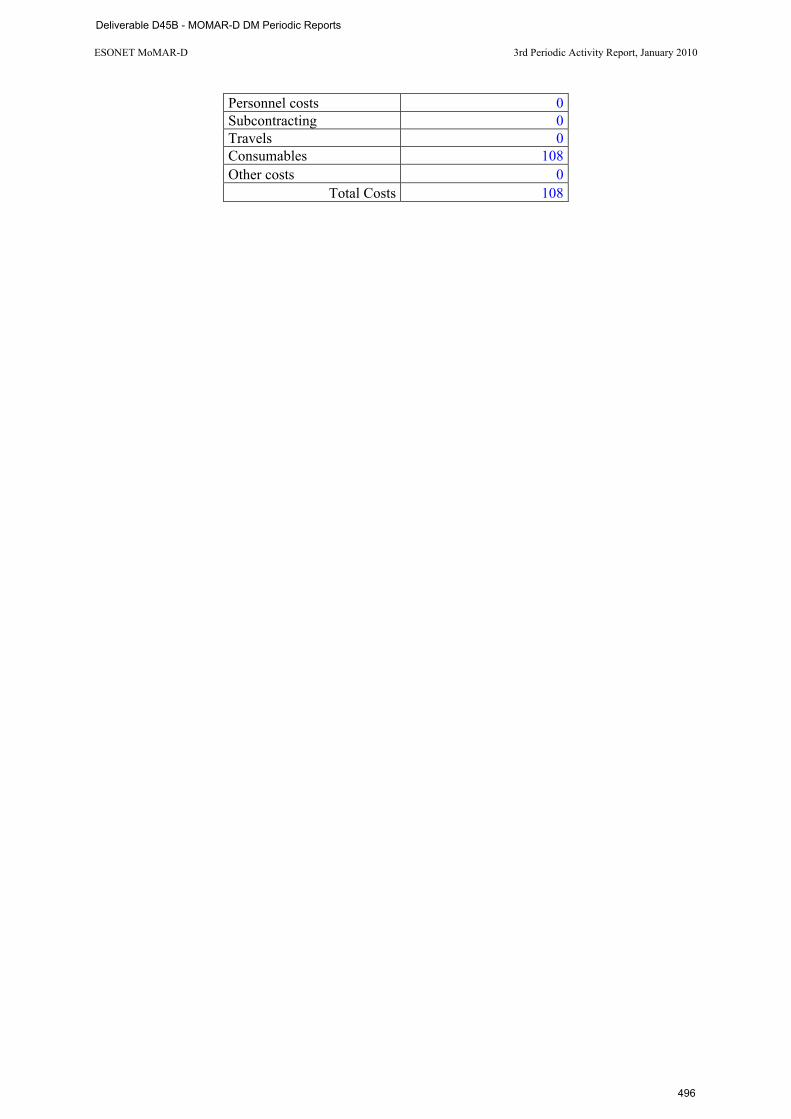
ESONET MoMAR-D 3rd Periodic Activity Report, January 2010
Personnel costs 0 Subcontracting 0 Travels 0 Consumables 108 Other costs 0
Total Costs 108
Deliverable D45B - MOMAR-D DM Periodic Reports
496
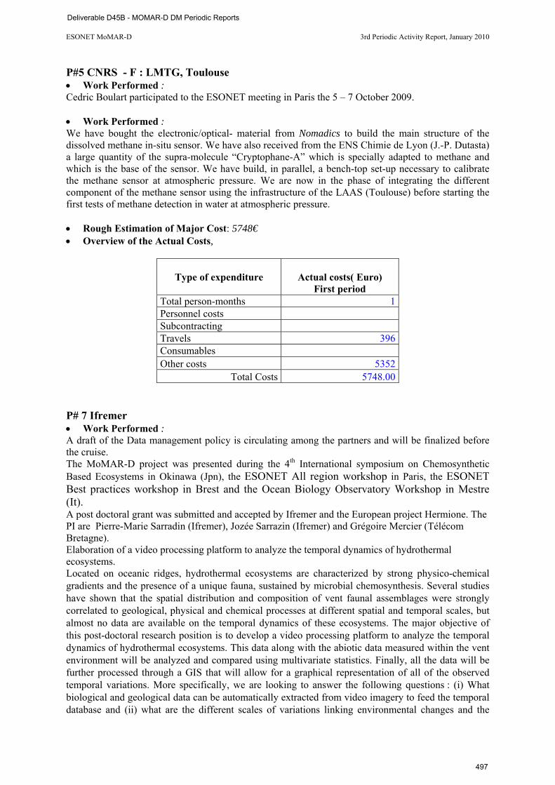
ESONET MoMAR-D 3rd Periodic Activity Report, January 2010
P#5 CNRS - F : LMTG, Toulouse • Work Performed : Cedric Boulart participated to the ESONET meeting in Paris the 5 – 7 October 2009. • Work Performed : We have bought the electronic/optical- material from Nomadics to build the main structure of the dissolved methane in-situ sensor. We have also received from the ENS Chimie de Lyon (J.-P. Dutasta) a large quantity of the supra-molecule “Cryptophane-A” which is specially adapted to methane and which is the base of the sensor. We have build, in parallel, a bench-top set-up necessary to calibrate the methane sensor at atmospheric pressure. We are now in the phase of integrating the different component of the methane sensor using the infrastructure of the LAAS (Toulouse) before starting the first tests of methane detection in water at atmospheric pressure. • Rough Estimation of Major Cost: 5748€ • Overview of the Actual Costs,
Type of expenditure
Actual costs( Euro) First period
Total person-months 1 Personnel costs Subcontracting Travels 396 Consumables Other costs 5352
Total Costs 5748.00 P# 7 Ifremer • Work Performed : A draft of the Data management policy is circulating among the partners and will be finalized before the cruise. The MoMAR-D project was presented during the 4th International symposium on Chemosynthetic Based Ecosystems in Okinawa (Jpn), the ESONET All region workshop in Paris, the ESONET Best practices workshop in Brest and the Ocean Biology Observatory Workshop in Mestre (It). A post doctoral grant was submitted and accepted by Ifremer and the European project Hermione. The PI are Pierre-Marie Sarradin (Ifremer), Jozée Sarrazin (Ifremer) and Grégoire Mercier (Télécom Bretagne). Elaboration of a video processing platform to analyze the temporal dynamics of hydrothermal ecosystems. Located on oceanic ridges, hydrothermal ecosystems are characterized by strong physico-chemical gradients and the presence of a unique fauna, sustained by microbial chemosynthesis. Several studies have shown that the spatial distribution and composition of vent faunal assemblages were strongly correlated to geological, physical and chemical processes at different spatial and temporal scales, but almost no data are available on the temporal dynamics of these ecosystems. The major objective of this post-doctoral research position is to develop a video processing platform to analyze the temporal dynamics of hydrothermal ecosystems. This data along with the abiotic data measured within the vent environment will be analyzed and compared using multivariate statistics. Finally, all the data will be further processed through a GIS that will allow for a graphical representation of all of the observed temporal variations. More specifically, we are looking to answer the following questions : (i) What biological and geological data can be automatically extracted from video imagery to feed the temporal database and (ii) what are the different scales of variations linking environmental changes and the
Deliverable D45B - MOMAR-D DM Periodic Reports
497
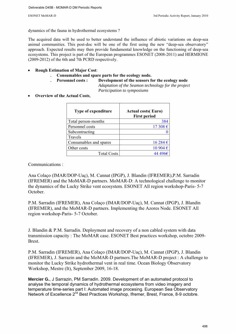
ESONET MoMAR-D 3rd Periodic Activity Report, January 2010
dynamics of the fauna in hydrothermal ecosystems ?
The acquired data will be used to better understand the influence of abiotic variations on deep-sea animal communities. This post-doc will be one of the first using the new “deep-sea observatory” approach. Expected results may then provide fundamental knowledge on the functioning of deep-sea ecosystems. This project is part of the European programmes ESONET (2008-2011) and HERMIONE (2009-2012) of the 6th and 7th PCRD respectively. • Rough Estimation of Major Cost:
. Consumables and spare parts for the ecology node.
. Personnel costs : Development of the sensors for the ecology node Adaptation of the Seamon technology for the project Participation to symposiums
• Overview of the Actual Costs,
Type of expenditure
Actual costs( Euro) First period
Total person-months 384 Personnel costs 17 308 € Subcontracting 0 Travels Consumables and spares 16 284 € Other costs 10 904 €
Total Costs 44 496€ Communications : Ana Colaço (IMAR/DOP-Uaç), M. Cannat (IPGP), J. Blandin (IFREMER),P.M. Sarradin (IFREMER) and the MoMAR-D partners. MoMAR-D: A technological challenge to monitor the dynamics of the Lucky Strike vent ecosystem. ESONET All region workshop-Paris- 5-7 October. P.M. Sarradin (IFREMER), Ana Colaço (IMAR/DOP-Uaç), M. Cannat (IPGP), J. Blandin (IFREMER), and the MoMAR-D partners. Implementing the Azores Node. ESONET All region workshop-Paris- 5-7 October. J. Blandin & P.M. Sarradin. Deployment and recovery of a non cabled system with data transmission capacity : The MoMAR case. ESONET Best practices workshop, octobre 2009-Brest. P.M. Sarradin (IFREMER), Ana Colaço (IMAR/DOP-Uaç), M. Cannat (IPGP), J. Blandin (IFREMER), J. Sarrazin and the MoMAR-D partners.The MoMAR-D project : A challenge to monitor the Lucky Strike hydrothermal vent in real time. Ocean Biology Observatory Workshop, Mestre (It), September 2009, 16-18. Mercier G., J Sarrazin, PM Sarradin. 2009. Development of an automated protocol to analyse the temporal dynamics of hydrothermal ecosystems from video imagery and temperature time-series part I: Automated image procesing. European Sea Observatory Network of Excellence 2nd Best Practices Workshop, Ifremer, Brest, France, 8-9 octobre.
Deliverable D45B - MOMAR-D DM Periodic Reports
498
ESONET MoMAR-D 3rd Periodic Activity Report, January 2010
Gauthier O, J Sarrazin, PM Sarradin. 2009. Development of an automated protocol to analyse the temporal dynamics of hydrothermal ecosystems from video imagery and temperature time-series part II: Untangling spatio-temporal temperature variations, first insights from a novel approach. European Sea Observatory Network of Excellence 2nd Best Practices Workshop, Ifremer, Brest, France, 8-9 octobre.
Deliverable D45B - MOMAR-D DM Periodic Reports
499

Deliverable D45B - MOMAR-D DM Periodic Reports
500
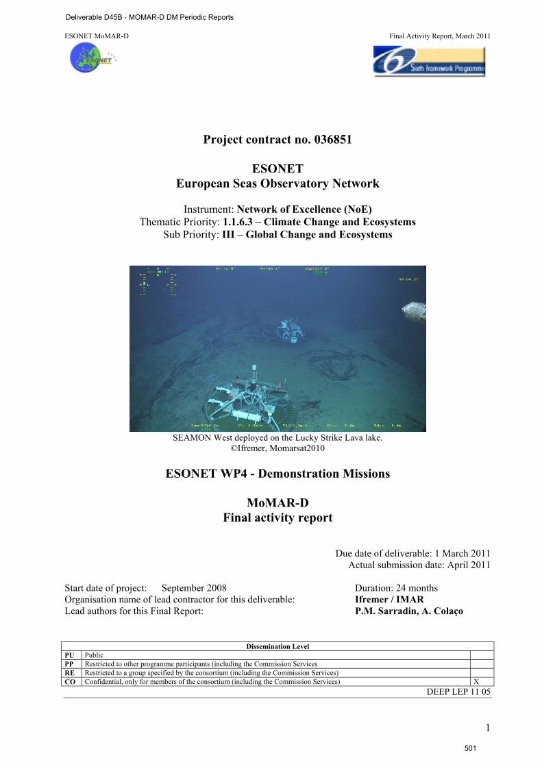
ESONET MoMAR-D Final Activity Report, March 2011
1
Project contract no. 036851
ESONET
European Seas Observatory Network
Instrument: Network of Excellence (NoE) Thematic Priority: 1.1.6.3 – Climate Change and Ecosystems
Sub Priority: III – Global Change and Ecosystems
SEAMON West deployed on the Lucky Strike Lava lake.
©Ifremer, Momarsat2010
ESONET WP4 - Demonstration Missions
MoMAR-D Final activity report
Due date of deliverable: 1 March 2011 Actual submission date: April 2011
Start date of project: September 2008 Duration: 24 months Organisation name of lead contractor for this deliverable: Ifremer / IMAR Lead authors for this Final Report: P.M. Sarradin, A. Colaço
Dissemination Level PU Public PP Restricted to other programme participants (including the Commission Services RE Restricted to a group specified by the consortium (including the Commission Services) CO Confidential, only for members of the consortium (including the Commission Services) X
DEEP LEP 11 05
Deliverable D45B - MOMAR-D DM Periodic Reports
501
Table of Content
Section 1: General information 3
Section 2. Executive summary 5
Section 3. Work Description 63.1 WP1 Scientific experiments 6
3.2 WP2 Observatory infrastructure 10
3.3 WP3 Data management 11
3.4 WP4 Site management 12
3.5 WP5 Communication plan, Public outreach 12
3.6 WP6 The MoMARSAT cruise 13
3.7 WP7 Project management 14
Section 4. Data Management 154.1 Data management policy 15
4.2 Data management 15
4.3 Conclusion 15
Section 5. Results 165.1 Context 16
5.2 Deployment 16
5.3 Preliminary results 19
5.4 The HYDROBS-MOMAR Experiment 20
Section 6. Conclusion and perspectives 22
Section 7. References 23
2
Deliverable D45B - MOMAR-D DM Periodic Reports
502
Section 1: General information DM acronym: MoMAR-D
DM title: MoMAR-Demonstration
ESONET Site: Azores- MoMAR, Lucky Strike hydrothermal field
Scientific Area(s): SArea1 : physical oceanography processes
SArea2 : hydrothermal processes
SArea3 : biodiversity
Technological Area(s): TArea1 : interoperability, data transmission, power supply
DM Start date: September 2008
DM duration: 24
Period of the reporting Final report Partner Num.
Institution Name
PI PI coordinates
1 DOP/UAÇ A. Colaço IMAR- Dept Oceanography and Fisheries-Univ of Azores, [email protected]
2 FFCUL/CGUL M. Miranda Centro de Geofisica, Universidade de Lisboa, [email protected]
3 IPGP M. Cannat Equipe de Géosciences Marines. Institut de Physique du Globe de Paris. CNRS UMR 7154 [email protected]
4 NOC D. Connelly Geochemistry Group National Oceanography Centre [email protected]
5 CNRS - F V. Chavagnac LMTG - UMR 5563 UR 154 CNRS Université Paul-Sabatier IRD Observatoire Midi-Pyrénées - [email protected]
CNRS - C J. Goslin UMR6538 "Domaines Oceaniques" U.Bretagne Occidentale-CNRS IUEM - [email protected]
6 Univ. Bremen C. Waldmann and H. Villinger
University of Bremen/MARUM [email protected] of Bremen Department 5, Geosciences Sea Technics / Sensors [email protected]
7 Ifremer P.M. Sarradin Ifremer Brest, DEEP/Laboratoire Environnement Profond [email protected]
8 SOPAB S. Ghiron Océanopolis [email protected]
Associated partners 9 UPMC-
LOCEAN with P# 3
G. Reverdin LOCEAN, Univ. Paris VI, boite 100, [email protected]
10 CVARG with P#1
Gabriela Queiroz
Centro de Vulcanologia e Avaliação de Riscos Geológicos - Universidade dos Açores - [email protected]
3
Deliverable D45B - MOMAR-D DM Periodic Reports
503
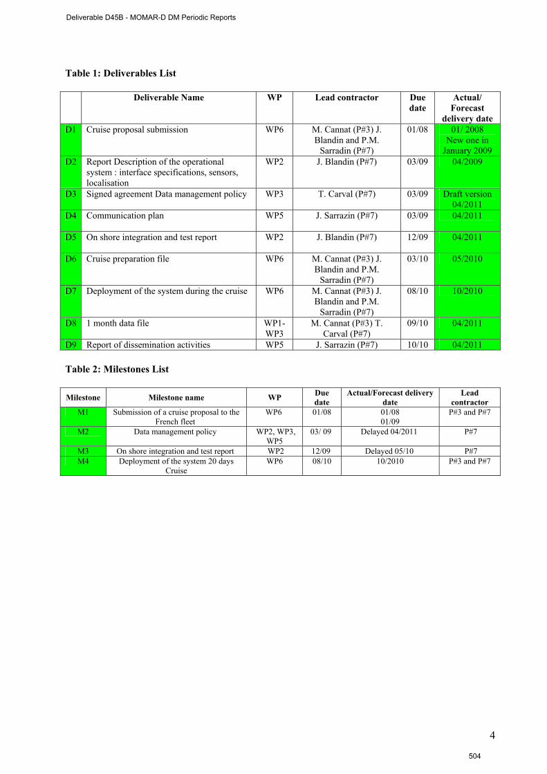
Table 1: Deliverables List
Deliverable Name WP Lead contractor Due date
Actual/ Forecast
delivery date D1 Cruise proposal submission WP6 M. Cannat (P#3) J.
Blandin and P.M. Sarradin (P#7)
01/08 01/ 2008 New one in
January 2009 D2 Report Description of the operational
system : interface specifications, sensors, localisation
WP2 J. Blandin (P#7) 03/09 04/2009
D3 Signed agreement Data management policy WP3
T. Carval (P#7) 03/09 Draft version 04/2011
D4 Communication plan WP5
J. Sarrazin (P#7) 03/09 04/2011
D5 On shore integration and test report WP2
J. Blandin (P#7) 12/09 04/2011
D6 Cruise preparation file WP6
M. Cannat (P#3) J. Blandin and P.M.
Sarradin (P#7)
03/10 05/2010
D7 Deployment of the system during the cruise WP6
M. Cannat (P#3) J. Blandin and P.M.
Sarradin (P#7)
08/10 10/2010
D8 1 month data file WP1- WP3
M. Cannat (P#3) T. Carval (P#7)
09/10 04/2011
D9 Report of dissemination activities WP5 J. Sarrazin (P#7) 10/10 04/2011 Table 2: Milestones List Milestone Milestone name WP Due
date Actual/Forecast delivery
date Lead
contractor M1 Submission of a cruise proposal to the
French fleet WP6 01/08 01/08
01/09 P#3 and P#7
M2 Data management policy WP2, WP3, WP5
03/ 09 Delayed 04/2011 P#7
M3 On shore integration and test report WP2 12/09 Delayed 05/10 P#7 M4 Deployment of the system 20 days
Cruise WP6 08/10 10/2010 P#3 and P#7
4
Deliverable D45B - MOMAR-D DM Periodic Reports
504
Section 2. Executive summary:
THE MOMAR-D- PROJECT: A CHALLENGE TO MONITOR THE LUCKY STRIKE HYDROTHERMAL VENT FIELD IN REAL TIME.
Hydrothermal circulation at mid-ocean ridges is a fundamental process that impacts the transfer of energy and matter from the interior of the Earth to the crust, hydrosphere and biosphere. The unique faunal communities that develop near these vents are sustained by chemosynthetic micro-organisms that use the hot fluid chemicals as a source of energy. Environmental instability resulting from active mid-ocean ridge processes create changes in the flux, composition and temperature of emitted vent fluids and influence the associated hydrothermal communities. The MoMAR (which stands for Monitoring the Mid-Atlantic Ridge) project was initiated 10 years ago by the InterRidge Program to promote and coordinate long-term multidisciplinary monitoring of hydrothermal vents at MAR. It aims at studying vent environmental dynamics from geophysics to microbiology. More recently, the MoMAR area has been chosen as one of the 11 key sites of the European project ESONET NoE. MoMAR-D was selected as a demonstration mission to deploy and manage a deep sea observatory at Lucky Strike for one year. Monitoring this large hydrothermal field, located in the centre of one of the most volcanically active segment of the MAR, will offer a high probability of capturing evidence for volcanic events, observing interactions between faulting, magmatism; hydrothermal circulation and, evaluating their impact on the ecosystem. The observatory infrastructure is composed of two Sea Monitoring Nodes (SEAMON) acoustically linked to a surface relay buoy (BOREL), ensuring satellite communication to the land base station in Brest (France). The entire system was deployed during the MoMARSAT cruise (The Pourquoi Pas ? /Victor6000, http://www.ifremer.fr/momarsat2010/ ) in October 2010. A first SEAMON node, dedicated to large scale geophysical studies, was moored in the centre of the large lava lake present in the Lucky Strike vent field. This node hosts an Ocean Bottom Sismometer (OBS) and a permanent pressure gauge (JPP) that were connected underwater using wet matable connectors. A second node was deployed at the base of the Tour Eiffel active edifice to study the links between faunal dynamics and variations of physico-chemical factors. This node is composed of a High Definition (HD) video camera, 6 LED lights, an Aanderaa optode (oxygen, temperature) and two in situ chemical analysers. These two nodes communicate via underwater acoustics to a BOREL buoy that is moored on the ocean surface within acoustic range of the SEAMON stations. This buoy is equipped with two identical and back up data transmission channels to ensure uninterrupted data flow. Scientific and technical data (including a low-resolution photo) are transmitted daily to the data centre in Brest. Autonomous instruments (OBS, ocean bottom tiltmeter, current meters, particle trap, colonisation experiments and temperature probes) were also deployed in the LS vent field. They will store their data for the whole duration of the experiment (1 year). Treatment of data sets will be conducted in two stages: in near real time for the subset that is transmitted through the SEAMON system; and after the 12 months for the whole data set. The near real time data will serve both as support for scientific interpretation, and as an indicator that an event is occurring. Volcanic (eruption, underground diking event, or rapid degassing of the magma chamber), tectonic (displacement along axial faults), or hydrothermal events are all expected to occur on the MAR. Understanding the impact of these events on biological communities is one of our key objectives. The data can be viewed online, according to ESONET data policy and European directives (now, temporary access through http://www.ifremer.fr/WC2en/allEulerianNetworks). The system will be recovered and redeployed in summer 2011.
5
Deliverable D45B - MOMAR-D DM Periodic Reports
505
Section 3. Work Description
The project is structured into seven workpackages. Management constitutes a specific work package (WP7), coordination was be done by A. Colaço from the DOP/UAÇ and P.M. Sarradin from Ifremer. WP WP leader WP1 Scientific experiments M. Cannat WP2 Infrastructure of the observing system J. Blandin WP3 Data management T. Carval WP4 Site management A. Colaço WP5 Communication plan, Public outreach J. Sarrazin WP6 Cruise P.M. Sarradin WP7 Project management A. Colaço, P.M. Sarradin 3.1 WP1 Scientific experiments – M. Cannat
Monitoring at Lucky Strike aims at determining the feed-backs between volcanism, deformation, seismicity, and hydrothermalism, and to understand how the hydrothermal ecosystem couples with these sub-surface processes. Experiments planned at the Lucky Strike vent field as part of this demonstration mission belong to 5 thematic packages exploring the dynamics of the geosphere, its impact on the hydrothermal fluid temperature and composition, and on the associated fauna and finally the exchange with the ocean.
The experimental design combines autonomous instruments which will store data over the duration of the mission, and instruments connected to shore via the SEAMON system [Blandin J. & Rolin J.F.. 2005]. Two SEAMON nodes will be deployed in the Lucky Strike vent field, one to the west of the lava lake primarily for geophysical instruments (the “geophysical node”), and one at the bottom of the Tour Eiffel edifice in the east, primarily for fluid chemistry and ecology (the “Tour Eiffel node”). A site survey will be performed before the implementation and after the recovery of the observatory infrastructure to validate the time series obtained during 12 months and to increase the spatial representativeness of the time series.
3.1.1 Thematic Package 1:Seismicity and hydrothermal activity Hydrothermal circulations are primarily controlled by the permeability structure of the substratum, and by the distribution of heat sources. Mid ocean ridges, and particularly slow-spreading ones, are active extensional areas where cracks, fissures and faults play a major role to control the spatial and temporal evolution of permeabilities [Wilcock and Delaney, 1996]. Cracking and displacements along faults are expressed by seismicity. Magmatic events such as dyking, and other forms of magma displacement within the crust, control the distribution of heat sources, and may also trigger seismicity. Tectonic and magmatic seismic events have specific characteristics, particularly in terms of the stochastic distribution of magnitudes. Seismic monitoring of hydrothermal fields and their surroundings is therefore an efficient method to study the tectonic and magmatic events that likely control hydrothermal dynamics. The link between seismicity and vent fluid temperatures has been used before as a powerful constraint on numerical models of the permeability distribution at hydrothermal sites in the Pacific [Sohn et al., 1998; Wilcock, 2004]. We plan to adopt a similar monitoring and modelling approach at Lucky Strike.
The local seismicity record will be processed to determine hypocenter locations and to model magnitude and focal mechanisms. Excellent characterization of near site seismic velocity structure is available for this purpose from the SISMOMAR cruise [Seher et al., in prep]. Interpretation will be reinforced by integrating these local data with the regional hydrophone seismicity record (J. Goslin et al.). Tidal forcing on fluid temperatures will also be analyzed, and modelled in terms of crustal permeability [Schultz and Elderfield, 1997].
The experimental design consists in arrays of OBSs (Ocean Bottom Seismometer), and of temperature probes to monitor fluid temperature. Four autonomous OBSs will be deployed around the Lucky Strike volcano, complementing the autonomous Broad-band OBS station operated since 2007 and for 3 years by the NERIES program (Crawford and Singh).
One modified OBS (IPGP) and a subset of temperature probes will be connected to the SEAMON system. T° data will be sent to shore on a near-real time basis. Only a subset of the seismic data will be sent via
6
Deliverable D45B - MOMAR-D DM Periodic Reports
506
satellite. Our objective is to obtain near-real time information on the level and intensity of seismic activity to serve as a guide for our strategy of shore-sensors interactions (ex: increase sampling rate of fluid chemical sensors or video camera in the event of a seismic crisis).
# Partners Work performed Deviation 3 IPGP Deployment of autonomous T probes
Deployment of 4 autonomous OBS Deployment of 1 OBS on SEAMON East Coordination of the deployment
T probes were not connected
2 FFCUL/CGUL Deployment of 4 autonomous OBS
5 CNRS-C regional hydrophone seismicity record 3.1.2 Thematic Package 2: Vertical deformation of the seafloor at the Lucky Strike volcano
Vertical deformation on active terrestrial volcanoes varies with the type of volcano, and with its state in the eruptive cycle. Surface deformation and mass movements are used at terrestrial volcanoes as powerful constraints on models of magmatic and tectonic processes [e.g. Poland, 2006]. In a seafloor spreading context, strong extensional tectonics are superimposed on these volcanic cycles. The deformation of active volcanoes in non-marine spreading rift contexts is often in the order of a few centimeters per year, as seen for instance in Iceland [Jouanne et al., 2006; Sturkell et al., 2006]. It can, however, also be of the order of 1 meter or more, in dyke injection crisis such as the recent one in Ethiopia [Kendall et al., 2005], or the 1978 crisis in the Asal rift [Ruegg et al., 1979]. The tectonic setting at Lucky Strike presents many similarities with that of the Ehiopian-Afar rift system, vertical motions associated with volcanic events could therefore have the same order of magnitude.
A linear array of 10 geodetic benchmark, and one autonomous pressure sensor, has been deployed at Lucky Strike in 2006. As part of the MoMAR-D project, we plan to collect continuous pressure data both on the volcano summit, and at the base of the volcano to monitor its deformation by a differential analysis. We will investigate the links between these vertical motions and tectonic and hydrothermal activity by integrating vertical ground motion information with seismic data, and with fluid temperature and chemistry data.
The volcano summit pressure gauge will be connected to the SEAMON system for near real time data transmission. We will also collect data from an autonomous GPS station installed on the SEAMON buoy, in order to get the best continuous estimate of the sea surface height above the volcano. A series of temperature sensors along the mooring line (see § 2.5 Physical oceanography) will be useful to convert the sea level variations (buoy vertical movements) into pressure changes. This will be used to discriminate in the pressure signal a vertical motion from a sea level change.
Pressure data will be complemented by tiltmeter data acquired with the OBM of the University of Bremen. This instrument is an integration of existing parts of the Bremen Ocean Bottom Tiltmeter and the Bremen Ocean Bottom Accelerometer (OBA), which are currently deployed at the Logatchev Hydrothermal Vent Field at Mid-Atlantic Ridge (Fabian and Villinger, 2007) and already collected excellent data over almost one year. The OBM will have the sensors of OBT and OBA, a high resolution absolute pressure-gauge and a temperature data logger. The data will be collected by a low-power high-resolution data logger, which is able to locally store data on a non volatile CompactFlash card and can also transfer the data via an external interface to a sensor network.
Finally, the experimental design also includes repeated measurements of the Lucky Strike array of geodetic benchmarks. These have been measured for the first time during GRAVILUCK06, with an estimated precision better than ±1 cm. We therefore plan to measure the Lucky Strike array in 2008 and during the MoMAR-D recovery cruise in 2010.
# Partners Work performed Deviation 3 IPGP Deployment of 1 JPP on SEAMON East
Deployment of 1 autonomous JPP Instrumentation of the buoy (GPS) Geodetic benchmarks measurements
To be done in 2012
6 U. Bremen Deployment of an autonomous OBM The OBM is autonomous
7
Deliverable D45B - MOMAR-D DM Periodic Reports
507
3.1.3 Thematic Package 3: Chemical fluxes at Lucky Strike vents
The behaviour of chemical species in hot hydrothermal fluid end-members provides critical information on fluid rock interactions in the hydrothermal cell, and on the conditions of these interactions [Charlou et al. 1991]. These are susceptible to change with time, due to geological processes (volcanism, tectonics), or to instabilities inherent to the hydrothermal system [Baker et al. 1995]. Our planned experimental design aims at a good integration between fluid characteristics and their evolution through time, and the ecological approach developed in § 2.1.4. For that purpose, we favour a small scale deployment of sensors, centred on the “ecology” node at Tour Eiffel. We will deploy a set of chemical sensors, some of which will be connected to SEAMON for near real time data transmission. This will include an in situ chemical analyser developed for the measurement of Fe and Mn species.
Under the MoMAR-D project, two duplicate devices will be manufactured and characterised, and new electronics constructed that will provide enhanced autonomous operation (e.g. data logging and self calibration), and interface directly with the SEAMON node. In addition, methods for long term operation (e.g. reagent stability enhancement, improved in situ calibration and fouling reduction techniques) will be developed – previous deployments have all been of short duration. The long term deployment of these sensors is novel, and particularly so in a hydrothermal setting. Networked operation is preferred, but autonomous operation is equally possible.
In addition, we will perform repeated sampling of the hot vent and diffuse fluids and analyze their composition (traces and major elements, stable and radiogenic isotopic ratios, gases, including methane) on board the ship or back on shore depending on the elements. Fluid sampling will also occur during the Bathyluck cruise in the same area (2008). Time-series data from the connected sensors and geochemical data on discrete fluid samples will be analyzed jointly with in situ geochemical data collected as part of the ecology experiments.
# Partners Work performed Deviation 4 NOCS Deployment of a iron manganese
chemical analyser connected to Seamon West
The Mn analyser was not deployed, breakdown during the cruise
5 CNRS - F Sampling of the hot vent and diffuse fluids Development of an in situ CH4 sensor
7 Ifremer Sampling of diffuse fluids Fe chemical analyser, O2 optode connected to SEAMON W
3.1.4 Thematic Package 4: Ecology at Lucky Strike vents Several studies in these ecosystems have shown that they were strongly dependant upon geological and geochemical processes happening at different scales. The spatial distribution of the fauna was correlated to fluid characteristics, to the concentrations of chemicals (methane, sulphide), to the type of substratum and also, to water depth [Sarradin et al. 1999; Sarrazin et al. 1999; Desbruyères et al. 2000, Le Bris et al. 2003]. In response to this variability, the biological communities present different spatial organizations characterized by the presence of gradients and of aggregative structures that vary from the segment to the structure scale.
TEMPO [Sarrazin et al. 2007] is a long-term imaging module equipped with a deep-sea video camera and two LED lights. An efficient biofouling protection is installed on the camera port hole and on the lights. A CHEMINI Fe in situ analyzer and 3 temperature probes are coupled to the TEMPO module to monitor environmental changes in parallel to community dynamics. The whole system is powered by a SEAMON node [Blandin et al. 2005]. The objective within MoMAR-D is to duplicate this experiment on the same mussel assemblage at the basis of the Tour Eiffel hydrothermal edifice with the added benefit of a near real time connection to shore, allowing for transmission of a subset of the data (mainly chemical data), with the possibility to modify sampling rates during the experiment. The bandwidth limitation constrained by the use of acoustic transmission will not allow us to transmit video imagery. However, the transmission of still images will be tested at a low frequency.
The characterization, distribution and evolution of the microfauna is also an important aim of deep sea hydrothermal ecosystem studies. For the MoMAR-D project, we plan to deploy a set of microbial colonization devices in the immediate vicinity of chemical and temperature sensors, around the Tour
8
Deliverable D45B - MOMAR-D DM Periodic Reports
508
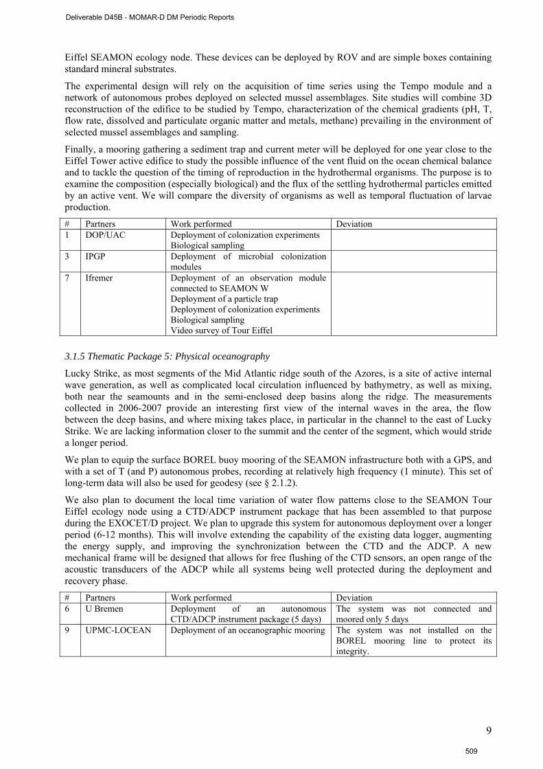
Eiffel SEAMON ecology node. These devices can be deployed by ROV and are simple boxes containing standard mineral substrates.
The experimental design will rely on the acquisition of time series using the Tempo module and a network of autonomous probes deployed on selected mussel assemblages. Site studies will combine 3D reconstruction of the edifice to be studied by Tempo, characterization of the chemical gradients (pH, T, flow rate, dissolved and particulate organic matter and metals, methane) prevailing in the environment of selected mussel assemblages and sampling.
Finally, a mooring gathering a sediment trap and current meter will be deployed for one year close to the Eiffel Tower active edifice to study the possible influence of the vent fluid on the ocean chemical balance and to tackle the question of the timing of reproduction in the hydrothermal organisms. The purpose is to examine the composition (especially biological) and the flux of the settling hydrothermal particles emitted by an active vent. We will compare the diversity of organisms as well as temporal fluctuation of larvae production.
# Partners Work performed Deviation 1 DOP/UAC Deployment of colonization experiments
Biological sampling
3 IPGP Deployment of microbial colonization modules
7 Ifremer Deployment of an observation module connected to SEAMON W Deployment of a particle trap Deployment of colonization experiments Biological sampling Video survey of Tour Eiffel
3.1.5 Thematic Package 5: Physical oceanography
Lucky Strike, as most segments of the Mid Atlantic ridge south of the Azores, is a site of active internal wave generation, as well as complicated local circulation influenced by bathymetry, as well as mixing, both near the seamounts and in the semi-enclosed deep basins along the ridge. The measurements collected in 2006-2007 provide an interesting first view of the internal waves in the area, the flow between the deep basins, and where mixing takes place, in particular in the channel to the east of Lucky Strike. We are lacking information closer to the summit and the center of the segment, which would stride a longer period.
We plan to equip the surface BOREL buoy mooring of the SEAMON infrastructure both with a GPS, and with a set of T (and P) autonomous probes, recording at relatively high frequency (1 minute). This set of long-term data will also be used for geodesy (see § 2.1.2).
We also plan to document the local time variation of water flow patterns close to the SEAMON Tour Eiffel ecology node using a CTD/ADCP instrument package that has been assembled to that purpose during the EXOCET/D project. We plan to upgrade this system for autonomous deployment over a longer period (6-12 months). This will involve extending the capability of the existing data logger, augmenting the energy supply, and improving the synchronization between the CTD and the ADCP. A new mechanical frame will be designed that allows for free flushing of the CTD sensors, an open range of the acoustic transducers of the ADCP while all systems being well protected during the deployment and recovery phase.
# Partners Work performed Deviation 6 U Bremen Deployment of an autonomous
CTD/ADCP instrument package (5 days) The system was not connected and moored only 5 days
9 UPMC-LOCEAN Deployment of an oceanographic mooring The system was not installed on the BOREL mooring line to protect its integrity.
9
Deliverable D45B - MOMAR-D DM Periodic Reports
509
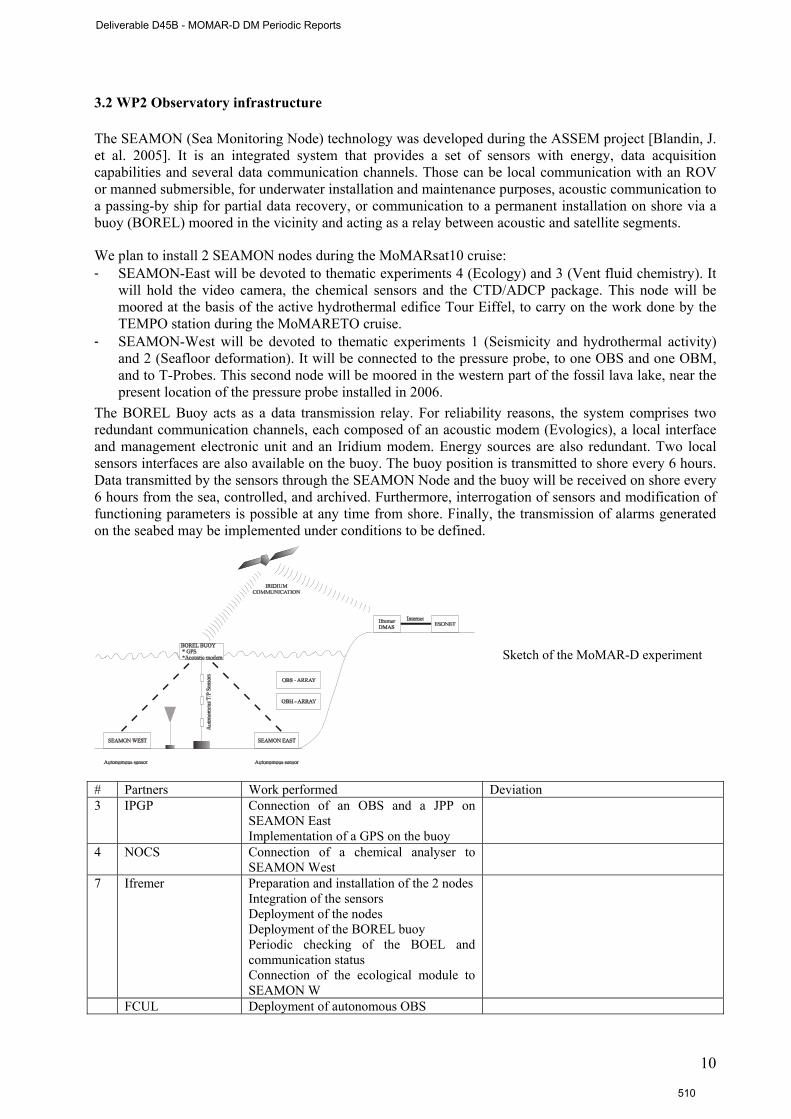
3.2 WP2 Observatory infrastructure
The SEAMON (Sea Monitoring Node) technology was developed during the ASSEM project [Blandin, J. et al. 2005]. It is an integrated system that provides a set of sensors with energy, data acquisition capabilities and several data communication channels. Those can be local communication with an ROV or manned submersible, for underwater installation and maintenance purposes, acoustic communication to a passing-by ship for partial data recovery, or communication to a permanent installation on shore via a buoy (BOREL) moored in the vicinity and acting as a relay between acoustic and satellite segments.
We plan to install 2 SEAMON nodes during the MoMARsat10 cruise: - SEAMON-East will be devoted to thematic experiments 4 (Ecology) and 3 (Vent fluid chemistry). It
will hold the video camera, the chemical sensors and the CTD/ADCP package. This node will be moored at the basis of the active hydrothermal edifice Tour Eiffel, to carry on the work done by the TEMPO station during the MoMARETO cruise.
- SEAMON-West will be devoted to thematic experiments 1 (Seismicity and hydrothermal activity) and 2 (Seafloor deformation). It will be connected to the pressure probe, to one OBS and one OBM, and to T-Probes. This second node will be moored in the western part of the fossil lava lake, near the present location of the pressure probe installed in 2006.
The BOREL Buoy acts as a data transmission relay. For reliability reasons, the system comprises two redundant communication channels, each composed of an acoustic modem (Evologics), a local interface and management electronic unit and an Iridium modem. Energy sources are also redundant. Two local sensors interfaces are also available on the buoy. The buoy position is transmitted to shore every 6 hours. Data transmitted by the sensors through the SEAMON Node and the buoy will be received on shore every 6 hours from the sea, controlled, and archived. Furthermore, interrogation of sensors and modification of functioning parameters is possible at any time from shore. Finally, the transmission of alarms generated on the seabed may be implemented under conditions to be defined.
Sketch of the MoMAR-D experiment
# Partners Work performed Deviation 3 IPGP Connection of an OBS and a JPP on
SEAMON East Implementation of a GPS on the buoy
4 NOCS Connection of a chemical analyser to SEAMON West
7 Ifremer Preparation and installation of the 2 nodes Integration of the sensors Deployment of the nodes Deployment of the BOREL buoy Periodic checking of the BOEL and communication status Connection of the ecological module to SEAMON W
FCUL Deployment of autonomous OBS
10
Deliverable D45B - MOMAR-D DM Periodic Reports
510
3.3 WP3 Data management (T. Carval)
Data management and dissemination is a key task in the implementation of a multidisciplinary long term observatory. Principles of data management and dissemination were discussed at the beginning of the MoMAR-D project (Spring 2008) to obtain a formal participant agreement. The data management policy and procedure was defined taking benefit of the experience gained by Neptune Canada. The principles to be specified are: i) the definition of the data to be acquired, ii) the procedures of control for these data and the definition of metadata in accordance with the standards recommendations on data documentation, and finally iii) the dissemination level. The framework for this discussion is defined in the ESONET Description of Work. Data management procedures should be fully compatible with international recommendations and standards in order to improve interoperability with other systems and to ease comparison with other datasets: ISO standards for metadata, COI/WMO standards for quality flag scale. During the project, SISMER will collect, archive and distribute the data (in real time and after the recovery) according to the MoMAR-D data policy.
The MoMAR-D demonstration will also produce data from autonomous sensors or complementary site studies. These data will also be archived and part of the demonstration will be to design appropriate procedures for control and dissemination of these data. Site survey data acquired during the cruises will be available through the BIOCEAN database.
An important task of our data management WG will be to develop links between the MoMAR-D data management system, and the data management systems currently used for volcanic and seismic monitoring, and for ecosystem inventory and surveillance, at and near the Azores Islands. To this aim, we have secured the participation of colleagues from the Centro de Vulcanologia e Avaliação de Riscos Geológicos, and from the Department of Oceanography and Fisheries of the University of the Azores.
Scientific integration of collected data sets will be conducted in two stages: in near real time for the subset of data transmitted through the SEAMON system; and after the 12 months of the demonstration for the whole data set. The near real time data will serve both as support for scientific interpretation, and as an indicator that an “event” is occurring. Events at Lucky Strike may be volcanic (eruption, underground dyking event, or rapid degassing of the magma chamber), tectonic (displacement along axial faults), or hydrothermal. The response or the impact of these events on biological communities (micro organism bloom, composition, structure,) is one of the key scientific questions behind this proposal.
One objective of the MoMAR-D project was to demonstrate our capacity to manage a deep sea observatory. The project allowed us to write a draft data management policy, taking into account the specificity of our prototype instrumentation. This draft version will be discussed and validated after the first recovery of the system in June 2011. Anyhow, we have set the main principles of data access.
Data transfer is a key stage in the project. The development was performed by Ifremer including the coding / decoding steps of the data for their transfer (MOMAR-D: Format des trames de données IRIDIUM, J. Legrand, T. Bescond, RDT/EIM/10-032), the collection and archiving steps and the data validation by the scientists. This phase of data transfer is currently under progress at each step.
Finally, a subset of data can be viewed through the temporary internet site : http://www.ifremer.fr/WC2en/allEulerianNetworks.
# Partners Work performed Deviation all Participation to the elaboration of the data
management policy Scientific integration of the data
Draft version Delayed 2011
3 IPGP Data transfer and validation 4 NOCS Data transfer and validation The analyser is not working 7 Ifremer Elaboration of the data management
procedures Data transfer, archive and distribution
In progress
10 CVARG Links with volcanic and seismic monitoring in the Azores
Delayed to the second cruise
11
Deliverable D45B - MOMAR-D DM Periodic Reports
511

3.4 WP4 Site management – A. Colaço The growing interest and the increased number of science activities at the MoMAR vent fields have led the Portuguese and Regional administration to propose, in 2006, the area as a Marine Protected Area (MPA) within the OSPAR network. This proposal followed a workshop organized in Horta in 2002 [Santos et al, 2003], to reconcile the requirements for an MPA, with the constraints of the MoMAR project and other on-going research activities. The Lucky Strike vent field in particular, is identified in the MPA proposal «with the aim of promoting knowledge, monitoring and conservation of an area that best represents species, habitats and ecological processes in deep-sea hydrothermal vents in the OSPAR area, while enabling sustainable scientific research and promoting education and environmental public awareness and interest ».
The MoMAR-D demonstration will undertake to comply with the MPA rules and develop a coherent experimental site management plan. This plan will include a set of rules for PI’s, based on the MPA code of conduct and on the InterRidge code of conduct. These rules will aim at minimizing the impact of research on the environment, and at ensuring the compatibility of all the experiments planned. In this context, we also plan to devote one dive to clean the area around our experimental network of the abundant non-native material left over the years of scientific work. As the procedure to recover old dead weight are not validated yet, this dive has been delayed to 2011.
To enforce these regulations, we will make provision in the MoMAR-D demonstration project for a coordinating MoMAR office, probably at Horta (but a centralized ESONET site management office may also be envisioned) and develop formal links with the Portuguese maritime authorities (the Hydrographic Institute), with the MPA managing authorities, and with the Azores Regional Government. Partners from the Centro de Vulcanologia e Avaliação de Riscos Geológicos, and from the Department of Oceanography and Fisheries of the University of the Azores will play a leading role in this task. This objective has been delayed to the EMSO PP project.
# Partners Work performed Deviation 1 DOP UAC coordinating MoMAR office Delayed, EMSO PP ? 3 IPGP coordinating MoMAR office Delayed, EMSO PP ? 7 Ifremer coordinating MoMAR office
cleaning dive Delayed, EMSO PP ? MoMARSAT 2011
10 CVARG Links with volcanic and seismic monitoring in the Azores
Delayed to the second cruise
3.5 WP5 Communication plan, Public outreach - J. Sarrazin The communication plan was prepared in collaboration with the leading b institutions of the project (IPGP, IMAR and Ifremer). The first press release before the cruise was available on the following web sites :
• http://www.insu.cnrs.fr/a3596,campagne-momarsat-2010-sources-hydrothermalesatlantique-
• sous-observation-pendant-toute-annee.html • http://www2.cnrs.fr/presse/communique/2006.htm • http://www.ipgp.fr/pages/040405.php?langue=2
During the Momarsat cruise, 2 press releases were written on board the vessel describing the work performed, and translated in English and Portuguese. A press release was also written by Evologics, the provider of the acoustic modems.
• http://www.evologics.de/en/news.html?newsman_news_id=36
The cruise was presented to the general public in specific web site daily updated. The coordination of the editorial team was done by J. Sarrazin, with the help of other scientists and engineers on board. The web site was available in English and Portuguese. The translation in English has been subcontracted, the Portuguese version has been done by A. Colaço.
• http://www.ifremer.fr/momarsat2010/
12
Deliverable D45B - MOMAR-D DM Periodic Reports
512
The report of the dissemination action is presented in D4. # Partners Work performed Deviation 1 DOP UAC Conception of a didactic game
General public dissemination
IPGP General public dissemination Ifremer General public dissemination
Coordination of the communication plan Coordination of the cruise web site
All Participation to symposiums and workshops
3.6 WP6 Cruise – P.M. Sarradin
The MoMARsat cruise was held on the research vessel Pourquoi pas ? with the ROV Victor6000 from the 1st to the 10th of october 2010. The port calls were on the Faïal Island (Azores). The recovery of the system is scheduled in summer 2011.
The following table gathers the list of scientists onboard involved in the MoMAR D project.
Name Institute 1 Sarradin, Pierre Marie Ifremer DEEP Chief scientist 2 Blandin, Jérôme Ifremer RDT Coordination infrastructure 3 Escartin , Javier IPGP Coordination Geology / Geophysics 4 Colaço, Ana IMAR DOP 5 Sarrazin, Jozée Ifremer DEEP 6 C. Le Gall Ifremer DEEP 7 P. Briand Ifremer DEEP 8 Michael Aron Ifremer DEEP 9 Aumond Virginie IUEM / Ifremer 10 Khripounoff, A. Ifremer DEEP 11 Legrand, Julien Ifremer RDT 12 Bescond Tanguy Ifremer RDT 13 Gérard Guyader Ifremer RDT 14 Pascal Pichavant Ifremer RDT 15 Blin Alexandre IPGP 16 Barreyre, Thibaut IPGP 17 Christophe Courrier IPGP 18 Romuald Daniel IPGP 19 Lecomte, Benoît IPGP 20 Rommevaux Jestin, Céline IPGP 21 Louranço Antonio LOCEAN 22 Cedric Boulart LMTG, Toulouse 23 Valérie Chavagnac LMTG, Toulouse 24 Ricarda Dziadek Univ. Bremen 25 Ambra Milani NOC, Southampton 26 Cedric Floquet NOC, Southampton 27 Carlos Corela FFCUL/CGU Lisbon The list of operations performed during the cruise is listed in the following table. Day Date hh :mm Operation
08 :30 Transit to Lucky Strike, 2 02/10/2010 16 :00 Trial of the acoustic releases (1000m) 3 03/10/2010 05 :00 Mooring OBSP01, OBSP04, OBSP03, OBSP02, OBSP06, OBSP05 08 :30 Mooring NASA1 10 :00 Dive 414-1
4 04/10/2010 08 :40 Recovery NASA1 09 :50 End Dive 414-1 11 :10 Mooring SEAMON W 14 :50 Mooring e OBS/JPP 18 :10 Mooring NASA2
13
Deliverable D45B - MOMAR-D DM Periodic Reports
513
20 :10 Dive 415-2 5 05/10/2010 8 :33 Recovery of the buoyancy of SEAMON W 09 :50 End dive 415-2 11 :20 Recovery NASA2 12 :50 Recovery of the buoyancy of OBS/JPP 14 :30 Mooring SEAMON E 18 :13 Mooring NASA3 20 :00 Mooring SEAMON E, 2nd trial
6 06/10/2010 00 :40 Dive 416-3 19 :10 End dive 416-3
7 07/10/2010 Bad weather, no dive, CTD casts 8 08/10/2010 Bad weather, no dive, OBS localisation, CTD casts 9 09/10/2010 Bad weather, no dive, 8 :00 Recovery of OBS C3 and C1 13 :00 Localisation of OBS3 14 :30 Recovery of OBS C2 and D2 18 :00 Dive 417-4
10 10/10/2010 16 :00 Mooring Particle trap 18 :00 Mooring OBT
11 11/10/2010 17 :00 End dive 417-4 18 :30 Localisation of OBS P05, P04, P01, P02, P03, P06
12 12/10/2010 03 :30 CTD casts 08 :00 Recovery of NASA3 10 :15 Mooring of the BOREL buoy 12 :20 Recovery of OBS C4, 14 :50 Recovery of OBS C7 17 :00 Mooring NASA4 18 :00 repatriation on medical grounds, transit to Horta
13 13/10/2010 9 :00 landing, Horta, transit to Lucky Strike 14 14/10/2010 01 :00 Dive 418-5 Recovery NASA4 Recovery of the buoyancy of SEAMON E Recovery of the buoyancy of OBT Recovery of 2 oceanographic Moorings Mooring of NASA5 Recovery of NASA5
15 15/10/2010 9 :00 End dive 418-5 9 :30 Moorings OBS1 et 6 10 :30 Deployment oceanographic Mooring 14 :00 Transit to Horta
16 15/10/2010 8 :00 Horta, end of cruise # Partners Work performed Deviation all Participation to the cruise IPGP Coordination of the cruise proposal and of
the cruise
Ifremer Coordination of the cruise proposal and the cruise Coordination of the infrastructure deployment
3.7 WP7 project management # Partners Work performed Deviation 1 DOP UAC Management of the MoMAR-D project IPGP Overall coordination of the project
Coordination of the cruise proposal and of the cruise
Ifremer Coordination of the project, the cruise proposal and the cruise Management of the MoMAR-D project
14
Deliverable D45B - MOMAR-D DM Periodic Reports
514
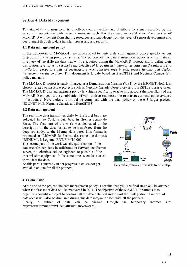
Section 4. Data Management The aim of data management is to collect, control, archive and distribute the signals recorded by the sensors in association with relevant metadata such that they become useful data. Each partner of MoMAR-D will benefit from sharing resources and knowledge from the level of sensor development and deployment through to data transfer, processing and security.
4.1 Data management policy
In the framework of MoMAR-D, we have started to write a data management policy specific to our project, mainly using prototype sensors. The purpose of this data management policy is to maintain an inventory of the different data that will be acquired during the MoMAR-D project, and to define their distribution level so as to reconcile the objective of large dissemination of the data with the interests and intellectual property rights of investigators who conceive experiments, secure funding and deploy instruments on the seafloor. This document is largely based on EuroSITES and Neptune Canada data policy manuals.
The MoMAR-D project is partly financed as a Demonstration Mission (WP4) by the ESONET NoE. It is closely related to associate projects such as Neptune Canada observatory and EuroSITES observatories. The MoMAR-D data management policy is written specifically to take into account the specificity of the MoMAR-D project i.e. the combination of various deep-sea measuring prototypes around an observatory infrastructure. Nevertheless, it should be compliant with the data policy of these 3 larger projects (ESONET NoE, Neptune Canada and EuroSITES).
4.2 Data management
The real time data transmitted daily by the Borel buoy are collected in the Coriolis data base in Ifremer centre de Brest. The first part of the work was dedicated to the description of the data format to be transferred from the deep sea nodes to the Ifremer data base. This format is presented in “MOMAR-D: Format des trames de données IRIDIUM”, J. Legrand, RDT/EIM/10-002. The second part of the work was the qualification of the data transfer step done in collaboration between the Ifremer server, the scientists and the engineers responsible of the transmission equipment. In the same time, scientists started to validate the data. As this part is currently under progress, data are not yet available on line for all the partners.
Schematic pathway of the data transfer step .
4.3 Conclusion:
At the end of the project, the data management policy is not finalized yet. The final stage will be attained when the first set of data will be recovered in 2011. The objective of the MoMAR-D partners is to organize a scientific project to confront all the data obtained and to start their integration. The level of data access will also be discussed during this data integration step with all the partners. Finally, a subset of data can be viewed through the temporary internet site: http://www.ifremer.fr/WC2en/allEulerianNetworks.
15
Deliverable D45B - MOMAR-D DM Periodic Reports
515
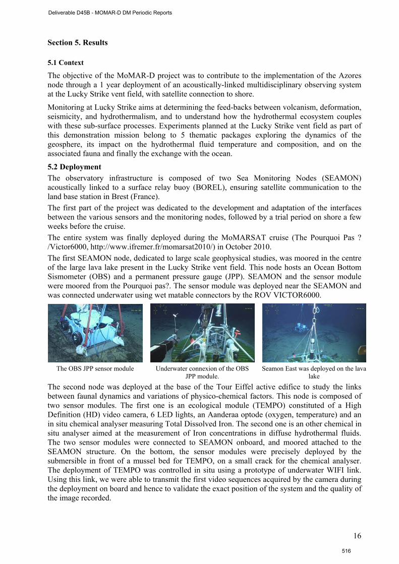
Section 5. Results 5.1 Context
The objective of the MoMAR-D project was to contribute to the implementation of the Azores node through a 1 year deployment of an acoustically-linked multidisciplinary observing system at the Lucky Strike vent field, with satellite connection to shore.
Monitoring at Lucky Strike aims at determining the feed-backs between volcanism, deformation, seismicity, and hydrothermalism, and to understand how the hydrothermal ecosystem couples with these sub-surface processes. Experiments planned at the Lucky Strike vent field as part of this demonstration mission belong to 5 thematic packages exploring the dynamics of the geosphere, its impact on the hydrothermal fluid temperature and composition, and on the associated fauna and finally the exchange with the ocean.
5.2 Deployment The observatory infrastructure is composed of two Sea Monitoring Nodes (SEAMON) acoustically linked to a surface relay buoy (BOREL), ensuring satellite communication to the land base station in Brest (France). The first part of the project was dedicated to the development and adaptation of the interfaces between the various sensors and the monitoring nodes, followed by a trial period on shore a few weeks before the cruise. The entire system was finally deployed during the MoMARSAT cruise (The Pourquoi Pas ? /Victor6000, http://www.ifremer.fr/momarsat2010/) in October 2010. The first SEAMON node, dedicated to large scale geophysical studies, was moored in the centre of the large lava lake present in the Lucky Strike vent field. This node hosts an Ocean Bottom Sismometer (OBS) and a permanent pressure gauge (JPP). SEAMON and the sensor module were moored from the Pourquoi pas?. The sensor module was deployed near the SEAMON and was connected underwater using wet matable connectors by the ROV VICTOR6000.
The OBS JPP sensor module Underwater connexion of the OBS
JPP module. Seamon East was deployed on the lava
lake The second node was deployed at the base of the Tour Eiffel active edifice to study the links between faunal dynamics and variations of physico-chemical factors. This node is composed of two sensor modules. The first one is an ecological module (TEMPO) constituted of a High Definition (HD) video camera, 6 LED lights, an Aanderaa optode (oxygen, temperature) and an in situ chemical analyser measuring Total Dissolved Iron. The second one is an other chemical in situ analyser aimed at the measurement of Iron concentrations in diffuse hydrothermal fluids. The two sensor modules were connected to SEAMON onboard, and moored attached to the SEAMON structure. On the bottom, the sensor modules were precisely deployed by the submersible in front of a mussel bed for TEMPO, on a small crack for the chemical analyser. The deployment of TEMPO was controlled in situ using a prototype of underwater WIFI link. Using this link, we were able to transmit the first video sequences acquired by the camera during the deployment on board and hence to validate the exact position of the system and the quality of the image recorded.
16
Deliverable D45B - MOMAR-D DM Periodic Reports
516
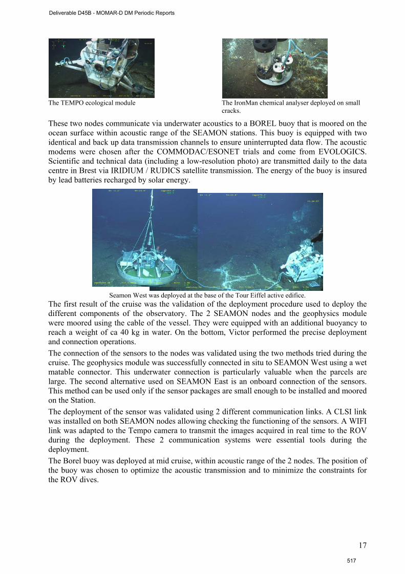
The TEMPO ecological module The IronMan chemical analyser deployed on small
cracks.
These two nodes communicate via underwater acoustics to a BOREL buoy that is moored on the ocean surface within acoustic range of the SEAMON stations. This buoy is equipped with two identical and back up data transmission channels to ensure uninterrupted data flow. The acoustic modems were chosen after the COMMODAC/ESONET trials and come from EVOLOGICS. Scientific and technical data (including a low-resolution photo) are transmitted daily to the data centre in Brest via IRIDIUM / RUDICS satellite transmission. The energy of the buoy is insured by lead batteries recharged by solar energy.
Seamon West was deployed at the base of the Tour Eiffel active edifice.
The first result of the cruise was the validation of the deployment procedure used to deploy the different components of the observatory. The 2 SEAMON nodes and the geophysics module were moored using the cable of the vessel. They were equipped with an additional buoyancy to reach a weight of ca 40 kg in water. On the bottom, Victor performed the precise deployment and connection operations. The connection of the sensors to the nodes was validated using the two methods tried during the cruise. The geophysics module was successfully connected in situ to SEAMON West using a wet matable connector. This underwater connection is particularly valuable when the parcels are large. The second alternative used on SEAMON East is an onboard connection of the sensors. This method can be used only if the sensor packages are small enough to be installed and moored on the Station. The deployment of the sensor was validated using 2 different communication links. A CLSI link was installed on both SEAMON nodes allowing checking the functioning of the sensors. A WIFI link was adapted to the Tempo camera to transmit the images acquired in real time to the ROV during the deployment. These 2 communication systems were essential tools during the deployment. The Borel buoy was deployed at mid cruise, within acoustic range of the 2 nodes. The position of the buoy was chosen to optimize the acoustic transmission and to minimize the constraints for the ROV dives.
17
Deliverable D45B - MOMAR-D DM Periodic Reports
517
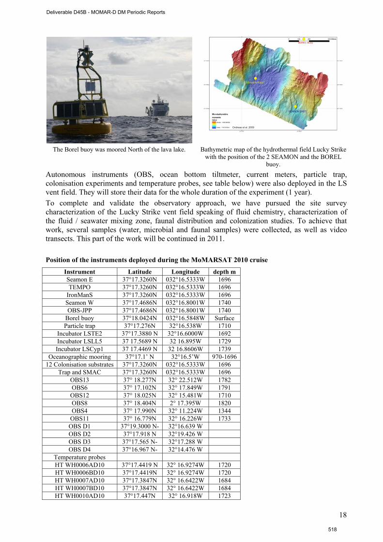
Ondreas et al. 2009
SEAMON WEST
SEAMON EAST
BOREL Buoy
The Borel buoy was moored North of the lava lake. Bathymetric map of the hydrothermal field Lucky Strike with the position of the 2 SEAMON and the BOREL
buoy. Autonomous instruments (OBS, ocean bottom tiltmeter, current meters, particle trap, colonisation experiments and temperature probes, see table below) were also deployed in the LS vent field. They will store their data for the whole duration of the experiment (1 year). To complete and validate the observatory approach, we have pursued the site survey characterization of the Lucky Strike vent field speaking of fluid chemistry, characterization of the fluid / seawater mixing zone, faunal distribution and colonization studies. To achieve that work, several samples (water, microbial and faunal samples) were collected, as well as video transects. This part of the work will be continued in 2011. Position of the instruments deployed during the MoMARSAT 2010 cruise
Instrument Latitude Longitude depth m Seamon E 37°17.3260N 032°16.5333W 1696 TEMPO 37°17.3260N 032°16.5333W 1696
IronManS 37°17.3260N 032°16.5333W 1696 Seamon W 37°17.4686N 032°16.8001W 1740 OBS-JPP 37°17.4686N 032°16.8001W 1740
Borel buoy 37°18.0424N 032°16.5848W Surface Particle trap 37°17.276N 32°16.538W 1710
Incubator LSTE2 37°17.3880 N 32°16.6000W 1692 Incubator LSLL5 37 17.5689 N 32 16.895W 1729 Incubator LSCyp1 37 17.4469 N 32 16.8606W 1739
Oceanographic mooring 37°17.1’ N 32°16.5’W 970-1696 12 Colonisation substrates 37°17.3260N 032°16.5333W 1696
Trap and SMAC 37°17.3260N 032°16.5333W 1696 OBS13 37° 18.277N 32° 22.512W 1782 OBS6 37° 17.102N 32° 17.849W 1791 OBS12 37° 18.025N 32° 15.481W 1710 OBS8 37° 18.404N 2° 17.395W 1820 OBS4 37° 17.990N 32° 11.224W 1344 OBS11 37° 16.779N 32° 16.226W 1733 OBS D1 37°19.3000 N- 32°16.639 W OBS D2 37°17.918 N 32°19.426 W OBS D3 37°17.565 N- 32°17.288 W OBS D4 37°16.967 N- 32°14.476 W
Temperature probes HT WH0006AD10 37°17.4419 N 32° 16.9274W 1720 HT WH0006BD10 37°17.4419N 32° 16.9274W 1720 HT WH0007AD10 37°17.3847N 32° 16.6422W 1684 HT WH0007BD10 37°17.3847N 32° 16.6422W 1684 HT WH0010AD10 37°17.447N 32° 16.918W 1723
18
Deliverable D45B - MOMAR-D DM Periodic Reports
518
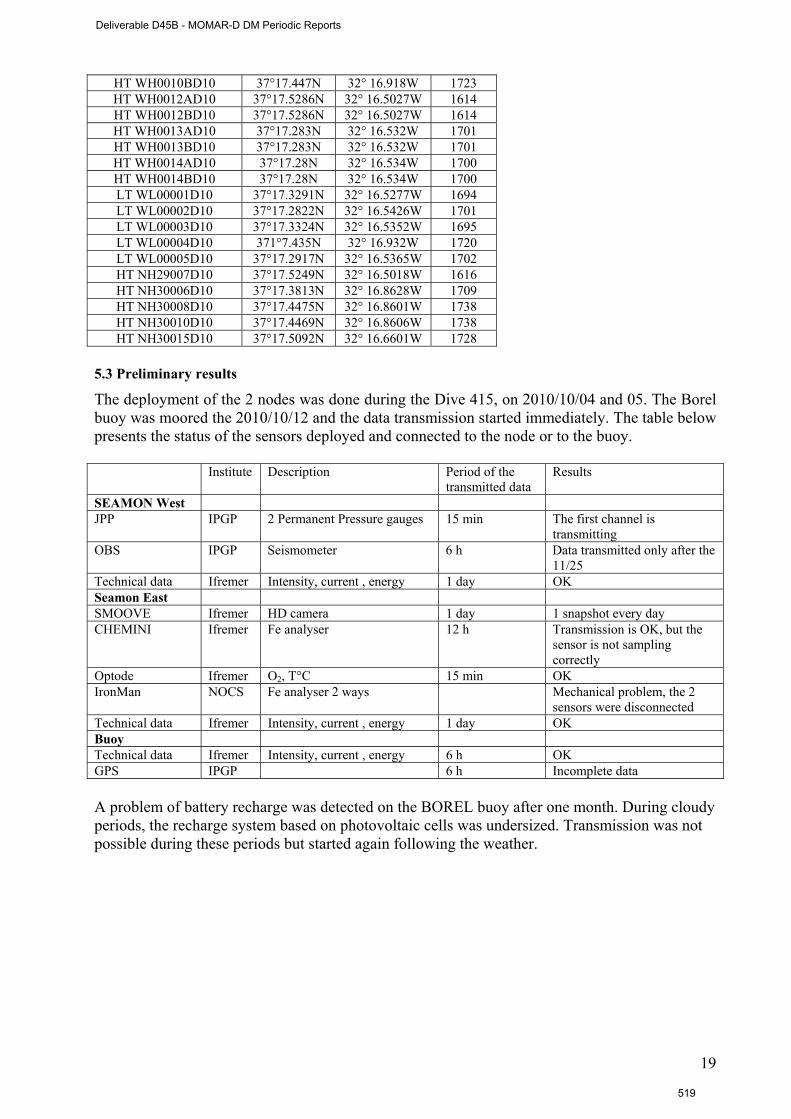
HT WH0010BD10 37°17.447N 32° 16.918W 1723 HT WH0012AD10 37°17.5286N 32° 16.5027W 1614 HT WH0012BD10 37°17.5286N 32° 16.5027W 1614 HT WH0013AD10 37°17.283N 32° 16.532W 1701 HT WH0013BD10 37°17.283N 32° 16.532W 1701 HT WH0014AD10 37°17.28N 32° 16.534W 1700 HT WH0014BD10 37°17.28N 32° 16.534W 1700 LT WL00001D10 37°17.3291N 32° 16.5277W 1694 LT WL00002D10 37°17.2822N 32° 16.5426W 1701 LT WL00003D10 37°17.3324N 32° 16.5352W 1695 LT WL00004D10 371°7.435N 32° 16.932W 1720 LT WL00005D10 37°17.2917N 32° 16.5365W 1702 HT NH29007D10 37°17.5249N 32° 16.5018W 1616 HT NH30006D10 37°17.3813N 32° 16.8628W 1709 HT NH30008D10 37°17.4475N 32° 16.8601W 1738 HT NH30010D10 37°17.4469N 32° 16.8606W 1738 HT NH30015D10 37°17.5092N 32° 16.6601W 1728
5.3 Preliminary results
The deployment of the 2 nodes was done during the Dive 415, on 2010/10/04 and 05. The Borel buoy was moored the 2010/10/12 and the data transmission started immediately. The table below presents the status of the sensors deployed and connected to the node or to the buoy. Institute Description Period of the
transmitted data Results
SEAMON West JPP IPGP 2 Permanent Pressure gauges 15 min The first channel is
transmitting OBS IPGP Seismometer 6 h Data transmitted only after the
11/25 Technical data Ifremer Intensity, current , energy 1 day OK Seamon East SMOOVE Ifremer HD camera 1 day 1 snapshot every day CHEMINI Ifremer Fe analyser 12 h Transmission is OK, but the
sensor is not sampling correctly
Optode Ifremer O2, T°C 15 min OK IronMan NOCS Fe analyser 2 ways Mechanical problem, the 2
sensors were disconnected Technical data Ifremer Intensity, current , energy 1 day OK Buoy Technical data Ifremer Intensity, current , energy 6 h OK GPS IPGP 6 h Incomplete data A problem of battery recharge was detected on the BOREL buoy after one month. During cloudy periods, the recharge system based on photovoltaic cells was undersized. Transmission was not possible during these periods but started again following the weather.
19
Deliverable D45B - MOMAR-D DM Periodic Reports
519

A snapshot of the mussel assemblage studied by Tempo is sent every day.
The energy recharge of the BOREL batteries was undersized during the cloudy weather periods.
Data transmitted are stored in Ifremer. The final step of data decoding and validation are currently in progress. Part of the data can be viewed online, according to ESONET data policy and European directives http://www.ifremer.fr/WC2en/allEulerianNetworks.
Treatment of data sets will be conducted in two stages: in near real time for the subset that is transmitted through the SEAMON system; and after the 12 months for the whole data set. The near real time data will serve both as support for scientific interpretation, and as an indicator that an event is occurring. Volcanic (eruption, underground diking event, or rapid degassing of the magma chamber), tectonic (displacement along axial faults), or hydrothermal events are all expected to occur on the MAR. Understanding the impact of these events on biological communities is one of our key objectives.
5.4 The HYDROBS-MOMAR Experiment (IUEM)
The main objective of the HYDROBS-MOMAR cruise was to increase the length of the hydroacoustic data series of observation over the MoMAR area, at a regional scale. We deployed 5 hydrophones (Figure 1) during the first week of August 2010 (from the 1st to the 8th) for one year around the MoMAR area. This experiment is complementary to the MoMARSAT project and leaded by IUEM.
Map showing the localization of the five hydrophones. Four hydrophones (M2, M6new, M7new and M8new) are located around the MoMAR area, the fifth one is located near the Lucky Strike Segment (LS).
The detection and localization of the numerous low-magnitude earthquakes occurring along active oceanic ridges provide important insights into the various magmatic, tectonic or hydrothermal processes which generate theses earthquakes. However, these processes mainly generate low-magnitude seismic events that are not detected - or in any case, poorly located- by land-based seismological global networks. The deployment of autonomous hydrophone arrays, moored within the SOFAR channel, a wave-guide in which acoustic waves propagate over long distances with little attenuation, overcomes this difficulty: hydrophone arrays have shown their
20
Deliverable D45B - MOMAR-D DM Periodic Reports
520

capability to detect and precisely locate (< 2 km) typically 30 to 40 times more events than those listed in global catalogs. The interpretation of acoustic data recorded by two large hydrophone arrays deployed north of the Azores (the SIRENA array) and south of 35°N (the ''South Azores'' array) has evidenced the low seismicity rate of most of the section of the Mid-Atlantic Ridge which encompasses the MoMAR area: only very few seismic swarms were observed, separated by long periods of quiescence. Acoustic data recorded by the first array dedicated to the monitoring of the MoMAR area (the four-instrument MARCHE array) shows an important magmatic activity where only few tectonic swarms are observed.
In the following table, are listed the coordinates, the depth and the line length of each hydrophones after ranging.
HYDROBS-MOMAR Latitude Longitude Ranging Depth Line length
LS 31°55.210' E 037°04.810' N After deployement 2170 m 1100 m
M2 39°25.280' N 034°06.380' W After deployment 3670 m 2700 m
M6new 37°35.570' N 038°21.610' W After deployment 3871 m 2900 m
M7new 32°27.170' N 032°27.300' W After deployment 3529 m 2400 m
M8new 36°15.030'N 029°19.850' W After deployment 3470 m 2500 m
The depth of the sea at the mooring sites is ca 3500 to 4000 m, therefore the line length for the hydrophones to be located in the SOFAR channel is around 3000 except for the LS mooring located near the ridge at 2000 m with a line length of 1100.
Expected results
The mooring of five instruments in the south and west of the Azores Plateau (LS, M2, M6new, M7new and M8new) is specifically designed to achieve long-term acoustic monitoring at the regional scale of the MoMAR area. The catalog of this seismogenic zone will be extended to a 3-year period since 2010 and a period of 5 years taking into account the MARCHE cruise and the HYDROBS-MOMAR2 cruise scheduled for 2012. A catalog with many years of observations will characterize the deformation process-related accretion and, therefore, it will be possible to establish an energy balance of the oceanic ridge in the MoMAR region. Moreover, the MoMAR site offers the possibility to correlate results of seismic catalogs with other methods implemented in this area including, OBS catalog of the BBMOMAR and BATHYLUCK experiments and the microbathymetry, magnetism and gravimetry from BATHYLUCK, and physicochemical measurements near the hydrothermal vents: all these results correlated will bring new insights to a global geodynamic model of ridges.
21
Deliverable D45B - MOMAR-D DM Periodic Reports
521
Section 6. Conclusion and perspectives
The objectives of the MoMAR-D project were to deploy and manage a multidisciplinary observatory in the Lucky Strike vent field, during 1 month.
The observatory infrastructure is composed of two Sea Monitoring Nodes (SEAMON) acoustically linked to a surface relay buoy (BOREL), ensuring satellite communication to the land base station in Brest (France). The system was deployed during the MoMARSAT cruise (The Pourquoi Pas ? /Victor6000, http://www.ifremer.fr/momarsat2010/ ) in October 2010. A first SEAMON node, dedicated to large scale geophysical studies, was moored in the centre of the large lava lake present in the Lucky Strike vent field. This node hosts an Ocean Bottom Sismometer (OBS) and a permanent pressure gauge (JPP). A second node was deployed at the base of the Tour Eiffel active edifice to study the links between faunal dynamics and variations of physico-chemical factors. This node is composed of a High Definition (HD) video camera, 6 LED lights, an Aanderaa optode (oxygen, temperature) and two in situ chemical analysers. These two nodes communicate via underwater acoustics to a BOREL buoy that is moored on the ocean surface within acoustic range of the SEAMON stations. Scientific and technical data are transmitted daily to the data centre in Brest.
This first deployment highlighted also a few technical problems linked either to the functioning of some sensors or to the energy consumption of the nodes and buoy.
Autonomous instruments (OBS, ocean bottom tiltmeter, current meters, particle trap, colonisation experiments and temperature probes) were also deployed in the LS vent field. They will store their data for the whole duration of the experiment (1 year).
Treatment of data sets will be conducted in two stages: in near real time for the subset that is transmitted through the SEAMON system; and after the 12 months for the whole data set. The near real time data will serve both as support for scientific interpretation, and as an indicator that an event is occurring. Volcanic (eruption, underground diking event, or rapid degassing of the magma chamber), tectonic (displacement along axial faults), or hydrothermal events are all expected to occur on the MAR. Understanding the impact of these events on biological communities is one of our key objectives. The data can be viewed online, according to ESONET data policy and European directives (now, temporary access through http://www.ifremer.fr/WC2en/allEulerianNetworks).
In January 2010, it was decided to extend the deployment of the observatory for 1 year. The system will be recovered during the Momarsat 2 cruise, planned in summer 2011. The instruments, nodes and buoy will be maintained during the first part of the cruise and deployed at the end. The maintenance of the system will also concern the following points to improve or correct : i) the functioning of the chemical analysers (Chemini and Ironmans), ii) the data transmission (OBS and JPP), iii) the energy recharge on the buoy and finally iv) the reduction of the energy consumption of the whole system.
The recovery should be done in 2012 within the EMSO framework.
22
Deliverable D45B - MOMAR-D DM Periodic Reports
522

Section 7. Dissemination and outreach Peer reviewed publications
Colaço A.; M. Cannat , J. Blandin ;P.M. Sarradin MoMAR-D- (2010) A technological challenge to monitor in real time Lucky Strike hydrothermal vent field. ICES Journal of Marine Science 68(2): 416-424
Cuvelier, D, Sarradin, PM. Sarrazin J, Colaço A., Copley J, Desbruyères D; Glover A, Serrão Santos R, Tyler P (2011) Hydrothermal faunal assemblages and habitat characterisation at the Atlantic Eiffel Tower edifice (Lucky Strike vent field) Marine Ecology
Cuvelier, D, Sarrazin J., Colaço A., Copley J. T., Glover A., Tyler P., Serrão Santos R., and Desbruyères D. (Subm) Community dynamics over 14 years at the Eiffel Tower hydrothermal edifice on the Mid-Atlantic Ridge. Journal of Limnology and Oceanography
Glover, A.G, Gooday, A.J., Bailey, D.M., Billett, D.S.M., Chevaldonné, P., Colaço, A., Copley, J., Cuvelier, D., Desbruyères, D., Kalogeropoulou, V., Klages, M., Lampadariou, N., Lejeusne, C., Mestre, N.C., Paterson, G.L.J., Perez, T., Ruhl, H., Sarrazin, J., Soltwedel, T., Soto, E.H., Thatje, S., Tselepides, A., Van Gaever, S., Vanreusel, A. (2010). Temporal Change in Deep-Sea Benthic Ecosystems: A Review of the Evidence From Recent Time-Series Studies Advances in Marine Biology 58 : 1-95.
Martins I, Cosson R.P., Riou V., Sarradin P-M., Sarrazin J., Santos RS and Colaço A. (2011). Relationship between the chemical characteristics of Bathymodiolus azoricus microhabitat and its metal load at Eiffel Tower (MAR, Lucky Strike) Deep-Sea Research 58, (3): 306-315.
Ruhl Henry A., Johannes Karstensen, Louis Géli, Michel André,Laura Beranzoli, M. Namik Çağatay, Ana Colaço, Mathilde Cannat, Juanjo J. Dañobeitia, Paolo Favali, Michael Gillooly, Jens Greinert, Per O.J. Hall, Robert Huber, Richard S. Lampitt,Vasilios Lykousis, Jürgen Mienert, J. Miguel Miranda, Roland Person, Imants G. Priede, Ingrid Puillat, Laurenz Thomsen, Christoph Waldmann (conditionally accepted). Societal need for improved understanding of climate change, anthropogenic impacts, and geo-hazard warning drive development of ocean observatories in European Seas Progress in Oceanography
Conference proceedings
Larkin, K.E., Ruhl, H.A., Bagley, P., Benn, A., Bett, B.J., Billett, D.S.M., Boetius A., Chevaldonné,P., Colaço, A., Copley, J., Danovaro, R., Escobar-Briones, E., Glover A., Gooday, A.J, Hughes,J.A., Kalogeropoulou, V., Kelly-Gerreyn, B.A., Kitazato H., Klages, M., Lampadariou, N., Lejeusne, C., Perez, T., Priede., I.G., Rogers A., Sarradin, P.M, Sarrazin, J., Soltwedel, T., Soto, E.H., Thatje, S., Tselepides, A., Tyler, P.A., van den Hove, S., Vanreusel, A., Wenzhöfer, F. 2009: Benthic biology time-series in the deep sea: Indicators of change. in Proceedings of OceanObs’09: Sustained Ocean Observations and Information for Society (Vol. 2), Venice, Italy, 21-25 September 2009, Hall, J., Harrison D.E. & Stammer, D., Eds., ESA Publication WPP-306.
Reports Blandin J. Programme des essais en bassin des 23, 24 et 25 juin 2010. RDT/IPR/10/089, Juin 2010 Cannat M., Sarradin, P.M., Blandin, J. January 2009. MoMARSAT 1 & 2 cruise proposals Le Flour Denise, Paul Jégou, MOMAR-D – Compte rendu de revue des matériels avant deployment,
RDT-DSMI-2010-100 Legrand J., Rapport d’essai du line Wifi sous l’eau, RDT/IEM /10-011 Legrand J., T.Bescond, MOMAR-D: Format des trames de données IRIDIUM, RDT/EIM/10-032 Sarradin P.M., Colaço A. MoMAR D periodic report, September 2008. Sarradin P.M., Colaço A. MoMAR D periodic report, May 2009 .DEEP LEP 09/27. Sarradin P.M., Colaço A. MoMAR D periodic report, January 2010.DEEP LEP 10 08. Sarradin P.M., Colaço A. MoMAR D periodic report, December 2010.DEEP LEP 10 13. Sarradin PM, J. Blandin, M. Cannat,Dossier de preparation de la campagne Momarsat,
R.INT.DEEP/LEP10-10-05, mai 2010 Sarradin PM, J. Blandin, M. Cannat, A. Colaço, Demande d’autorisation de travaux de recherche
scientifique dans la ZEE sous jurisdiction du Portugal, R.INT.DEEP/LEP10-10-03, mars 2010
23
Deliverable D45B - MOMAR-D DM Periodic Reports
523
Sarradin PM, Blandin J, Escartin (2010) Rapport technique de fin de campagne MoMarsat. Ifremer, Plouzané
Conferences, workshops
Auffret, Yves, Jean-Yves Coail, Laurent Delauney, Julien Legrand, Jacky Dupont, Loic Dussud, Gérard Guyader, Anthony Ferrant, Stéphane Barbot, Agathe Laes, Karen Bucas, Jozée Sarrazin, Pierre-Marie Sarradin. TEMPO-Mini: a custom-designed instrument for real-time monitoring of hydrothermal vent ecosystems. Third international workshop on marine technology MARTECH, 19-20 Novembre 2009, VILANOVA I LA GELTRÚ- Barcelona.
Blandin J. & P.M. Sarradin. Deployment and recovery of a non cabled system with data transmission capacity : The MoMAR case. ESONET Best practices workshop, octobre 2009-Brest.
Colaço, A.; Cannat, M.; Blandin, J.; Sarradin P.M. and the MoMAR-D partners (2009) MoMAR-D: A technological challenge to monitor the dynamics of the Lucky Strike vent ecosystem. ICES Symposium Issues Confronting the Deep Oceans: The Economic, Scientific, and Governance Challenges and Opportunities of Working in the Deep Sea Amor da Pátria Hall, Horta, Faial Island, Azores, Portugal April 27 – 30, 2009
Colaço, A.; Bettencourt R.; Costa, V. ; Lopes, H. ; Martins, I. ; Pires, L. ; Prieto, C.; Santos, R. S. (2009) Porque cheiram os mexilhões hidrotermais a ovos podres?. I Congresso dos Biólogos dos Açores 26 a 31 de Outubro de 2009, Lajes do Pico [invited talk].
Colaço Ana (IMAR/DOP-Uaç), M. Cannat (IPGP), J. Blandin (IFREMER),P.M. Sarradin (IFREMER) and the MoMAR-D partners. (2009). MoMAR-D: A technological challenge to monitor the dynamics of the Lucky Strike vent ecosystem. ESONET All region workshop-Paris- 5-7 October.
Colaço, A. (2010) Oásis do Mar profundo. Encerramento das XV Olimpiadas do Ambiente. 8 de Maio, Horta, Faial. [invited talk].
Colaço, A. (2010). «OSEA- Observatório para o Mar Profundo e Crista Média Atlântica» Projecto MaReS (Macaronesia Research Strategy) Sessão pública de apresentação 6 de Julho 2010, Madeira
Colaço, A. (2010). Long term biological research on hydrothermal vents. Ciência 2010 – Encontro com a Ciência e Tecnologia em Portugal. 4-7 Julho Lisboa, Portugal.
Cuvelier, D.; Sarrazin J.; Colaço A.; Copley J. ; Desbruyères, D.; Glover, A.; Tyler, P. ; Serrão Santos, R. (2009). A first decadal study (1994-2008) of community dynamics on an Atlantic hydrothermal edifice as revealed by high-resolution video image analysis. 4th International Symposium on Chemosynthesis-Based Ecosystems, Okinawa, Japan, 29June-3July 2009
Cuvelier D., Sarrazin J., Colaço A., Copley J.T., Desbruyères D., Glover A., Tyler P.A. and Serrão Santos R. (2010). 14 years of community dynamics at the Atlantic Eiffel Tower hydrothermal edifice.12th Deep-sea Biology Symposium Reykjavík, Iceland, 7-11 June 2010.
Floquet Cedric F.A., Vincent J. Sieben, Ambra. Milani, Etienne. P. Joly, Iain R.G. Ogilvie, Hywel Morgan, and Matthew C. Mowlem. Nanomolar detection with high sensitivity microfluidic absorption cells for chemical analysis. Challenger 2010, SENSOR workshop, Microfluidic and sensor technology for oceanographic application and environmental science applications. (poster)
Gauthier O, J Sarrazin, PM Sarradin. 2009. Development of an automated protocol to analyse the temporal dynamics of hydrothermal ecosystems from video imagery and temperature time-series part II: Untangling spatio-temporal temperature variations, first insights from a novel approach. European Sea Observatory Network of Excellence 2nd Best Practices Workshop, Ifremer, Brest, France, 8-9 octobre.
Mercier G., J Sarrazin, PM Sarradin. 2009. Development of an automated protocol to analyse the temporal dynamics of hydrothermal ecosystems from video imagery and temperature time-series part I: Automated image processing. European Sea Observatory Network of Excellence 2nd Best Practices Workshop, Ifremer, Brest, France, 8-9 octobre.
Milani A., Cedric F.A. Floquet, Vincent J. Sieben, Samer Kaed-Bey, Edward M. Waugh, Robin Brown, Lee Fowler, Peter J. Statham, Doug Connelly, Hywel Morgan, and Matthew C. Mowlem. Micros-sensing technology for in-situ low level detection of Fe and Mn in seawater. Challenger 2010: the 14th Biennial Challenger Conference for Marine Science.(invited talk)
Milani Ambra, Cedric F.A. Floquet, Vincent J. Sieben, Samer Kaed-Bey, Edward M. Waugh, Robin Brown, Lee Fowler, Peter J. Statham, Doug Connelly, Hywel Morgan, and Matthew C. Mowlem. Challenger 2010, SENSOR workshop Micros-sensing technology for in-situ low level detection of Fe and Mn in seawater.(poster)
24
Deliverable D45B - MOMAR-D DM Periodic Reports
524
Ruhl, H A, L Géli, J Karstensen, A Colaço, R S Lampitt, J Greinert, O Phannkuche, and Y Auffret, Science Objectives and Design of the European Seas Observatory NETwork (ESONET), European Geophysical Union General Assembly, Vienna, Austria, 2009. [invited talk].
Sarradin, P.M., M. Cannat, A. Colaço & J. Blandin.(2008) News in the MoMAR-D project. Faro, ESONET General assembly, meeting, October 2008.
Sarradin P.M., M. Waeles, C. Le Gall, P. Rodier, J. Sarrazin, D. Cuvelier, F. De Busseroles, R. Riso. Heterogeneity of habitats within a single hydrothermal edifice, MAR. 4th International symposium on Chemosynthetic Based Ecosystems in Okinawa (Jpn), July 2009.
Sarradin P.M. (IFREMER), Ana Colaço (IMAR/DOP-Uaç), M. Cannat (IPGP), J. Blandin (IFREMER), and the MoMAR-D partners. (2009).Implementing the Azores Node. ESONET All region workshop-Paris- 5-7 October.
Sarradin P.M. (IFREMER), Ana Colaço (IMAR/DOP-Uaç), M. Cannat (IPGP), J. Blandin (IFREMER), J. Sarrazin and the MoMAR-D partners.The MoMAR-D project : A challenge to monitor the Lucky Strike hydrothermal vent in real time. Poster. Ocean Biology Observatory Workshop, Mestre (It), September 2009, 16-18.
Sarradin P.M., A Colaço, M. Cannat, J. Blandin,and the MoMAR-D partners (2010). MoMARSAT : A first integrated observatory to monitor the dynamics of the Lucky Strike vent (eco)system. Oral presenttaion, ESONET General Assembly, Marseille 13-16 december 2010.
Sarrazin J., C. Le Gall, L. Peton, PM Sarradin. A glimpse into the deep: Mussel community changes and environmental dynamics at Tour Eiffel, MAR. 4th International symposium on Chemosynthetic Based Ecosystems in Okinawa (Jpn), July 2009,
Sarrazin J., J. Blandin, L. Delauney, S. Dentrecolas, J. Dupont, C. Le Gall, J. Legrand, P. Léon, J.P. Lévèque, L. Peton, P. Rodier, R. Vuillemin, P.M. Sarradin A glimpse into the deep 45 days in the life of a vent mussel assemblage. ICES International symposium, Horta (Azores, Pt), April 27-30 2009.
Sieben V.J., C. F. A. Floquet, The development of autonomous microfluidic sensors for nutrient and trace metal detection. Challenger 2010, SENSOR workshop, Microfluidic and sensor technology for oceanographic application and environmental science applications.(invited talk)
Publications (non referred papers) Sarrazin J. et al. 2009, MoMAR/D: A demonstration mission to establish a multidisciplinary observatory
at hydrothermal vents on the Mid-Atlantic Ridge. ESONEWS n°3 Ricardo Serrão Santos , Raul Bettencourt e Ana Colaço (in press). Os Campos Hidrotermais e a sua
Biosfera. Proceedings of the Conference: Congresso dos Mares da Lusofonia - Comissão D. Carlos – 100 Anos. Lisboa
Miscellaneous Cannat M. et al. 2009. « EMSO-Fr », réponse à l’appel d’offre pour la labellisation par l’Insu de « Sites
instrumentés » en Terre Interne. Public outreach (The communication plan is detailed in D4) Colaço, A.- supervision of a 10º grade student’s group project on “Ethics on Hydrothermal vent
Ecosystems Research and Exploitation” as part of the Philosophy course at Manuel de Arriaga Highschool (May-June 2010)
Colaco, A. - lecture on "OÁSIS DO MAR PROFUNDO- Deep-Sea Oasis" at the workshop “Explorando o Oceano na Escola” (Exploring the Ocean in School). The objective of this workshop was to give background information on ocean conservation to highschool teachers in the Azores. The workshop was part of the collaborative project “Ocean Exploration in the International Education Community” (EXPLORE) among the IMAR/DOP-UAz, Oceanoscópio - private agency of Marine Education, Ocean Technology Foundation (USA) and the National Oceanic and Atmospheric Administration (USA) (19-05-2010)
Colaço, A. Oásis do Mar profundo. Encerramento das XV Olimpiadas do Ambiente. 8 de Maio, Horta, Faial. [invited talk].
Colaço, A. -Tecnologia Marinha – Universidade Sénior da Horta “Mar dos Açores: caracterização, investigação, usos e conservação” (1:30h)
Colaço, A. -Diversidade de habitats - ambientes oceânicos – Universidade Sénior da Horta “Mar dos Açores: caracterização, investigação, usos e conservação” (1:30h)
25
Deliverable D45B - MOMAR-D DM Periodic Reports
525
Serrão Santos, R.- Os Açores e a Fronteira do Mar Profundo. Seminário “Os Açores na Geopolítica do Atlântico” (Comemorações do 17º Aniversário do Comando Operacional dos Açores), 25-26 Janeiro, Ponta Delgada, Portugal (invited speaker).
Serrão Santos, R.- Hands on Hot Deep Seafloor - Advances in the Deep-sea Research in the Azores: Scenarios on Blue Biotechnology from Extremophyles. Conference The Atlantic: An Ocean of Opportunities, 28 of January, Brussels, Belgium (invited speaker).
Serrão Santos, R.- Os Campos Hidrotermais e a sua Biosfera. II Congresso dos Mares da Lusofonia - Comissão D. Carlos – 100 Anos -, Centro Cultural de Cascais, 21 – 22 de Outubro, Cascais, Portugal (invited speaker).
Serrão Santos, R.- Potencialidades e Recursos Naturais do Espaço Marítimo Português do Mar Profundo. IV Seminário de Secção: Gestão e Ordenamento das Actividades Litorâneas Potencialidades e Recursos do Espaço Marítimo Português, Academia de Marinha, 30 de Novembro, Lisboa, Portugal (invited speaker).
Serrão Santos, R.- Lucky Strike, Menez Gwen & Rainbow MPAs Rationale and Design. Workshop on Design of MPAs for Hydrothermal Vent and Cold Seep Ecosystem: Potentially Threatened by Human Activities in the Deep Sea. CRESCO, 1st to 4th of June, Dinard, France ( invited participant).
Serrão Santos, R.- Prospecção e Exploração dos Fundos Marinhos: A Nova Fronteira. Conferência “Jornal Expresso” Portugal e o Mar, a nossa aposta no século XXI, Hotel ‘The Oitavos’, 21 de Outubro, Cascais, Portugal (invited speaker).
Serrão Santos, R.- DOP - Universidade dos Açores: Onde as Ciências do Mar se Aprofundam. A Investigação Científica no Espaço Marítimo Português Cinquenta Anos do Instituto Hidrográfico. Academia de Marinha, 28 de Setembro, Lisboa, Portugal (invited speaker).
Serrão Santos, R.- Deeper than Light: Touching the Bottom of the Ocean. 2nd International School Congress – Natural Resources, Sustainability and Humanity, Braga, 5-8 May, Braga, Portugal (invited speaker).
26
Deliverable D45B - MOMAR-D DM Periodic Reports
526
Project contract no. 036851
ESONET
European Seas Observatory Network
Instrument: Network of Excellence (NoE) Thematic Priority: 1.1.6.3 – Climate Change and Ecosystems
Sub Priority: III – Global Change and Ecosystems
AOEM Demonstration Mission Periodic Reports
Start date of project: March 2007 Duration: 48 months Start date of the Demonstration Mission: July 2009 Duration: 8 months Project co-funded by the European Commission within the Sixth Framework Programme (2002-2006) Dissemination Level PU Public PP Restricted to other programme participants (including the Commission Services RE Restricted to a group specified by the consortium (including the Commission
Services)
CO Confidential, only for members of the consortium (including the Commission Services)
Deliverable D45B - AOEM DM Periodic Reports
527

Deliverable D45B - AOEM DM Periodic Reports
528
ESONET Demonstration Missions Request of additional information
Update of planned activities and financial issues
Please send this form back to [email protected] NB: this intends to summarise information in no more than 10-11 pages.
Reference info and documents of ESONET NoE are available on http://wwz.ifremer.fr/esonet_emso Contact references DM acronym: AOEM (Arctic Ocean ESONET Mission) DM title: Arctic Ocean ESONET Mission – combining ARCOONE (Arctic
Operational Oceanography Network in ESONET) and MASOX (Monitoring Arctic Seafloor – Ocean Exchange).
Coordinator name + address, Email, telephone, fax
Professor Ian Wright National Oceanography Centre, Southampton European Way Southampton, SO14 3ZH UK Tel: + 44 23 8059 6017 Fax: + 44 23 8059 6554 Mobile: + 44 777 0538 133 Email: [email protected]
ESONET Site: Arctic Ocean Scientific Area(s): SA1, Geosciences (cold seeps and vents, fluid flow, gas hydrates
and carbon release); SA2, Physical Oceanography (changes in Arctic seas related to biogeochemisty, global change affect upper-ocean circulation); and SA3, Biogeochemistry (aspect of biogeochemistry sensitive to global change, feedback of global change).
Technological Area(s):
TA1, Underwater sensors; TA2, Observatory capabilities; TA3, Sea operations and telemetry buoys; and TA4, Data Management and infrastructure.
Key words: (scientific topics, technology topics,)
Arctic Ocean, Fram Strait, western Svalbard shelf, operational oceanography, acoustic tomography, hydrate dissociation, seafloor lander observatory
Estimated DM Start date:
1 July 2009
Estimated DM duration:
31 October 2010 (16 months)
Partner Num.
Partner Institution Name
Principal Investigator (PI) for the Demo Mission
PI coordinates (Address, Email, Telephone, fax..)
1. Alfred Wegener Institute for Polar
Dr Eberhard Fahrbach, Postfach 12 01 61, 27515 Bremerhaven,
Deliverable D45B - AOEM DM Periodic Reports
529

and Marine Research
Germany Tel : +49 471 4831-1820 Fax : +49 471 4831-1797 Email: [email protected]
2. The Foundation for Research and Technology – Hellas
Dr Emmanuel Skarsoulis P.O. Box 1385, GR - 711 10, Heraklion, Crete, Greece Tel : +30-2810-391776 Fax : +30-2810-391801 Email: [email protected]
3. Leibniz Institute of Marine Sciences, Sciences
Professor Christian Berndt East Shore Campus, Wischhofstr. 1-3, D-24148 Kiel, Germany Tel: + 49 431-600-2273, Fax: + 49 431-600-2922 Email: [email protected]
4. Nansen Environmental and Remote Sensing Center
Dr Stein Sandven Thormoehlensgate 47, N-5006 Bergen, Norway Tel : +47 5520 5838 Fax : +47 5520 5801 Email: [email protected]
5. University of Tromsø
Professor Jürgen Mienert
NO- 9037 Tromsø, Norway Tel : + 47 776 44446 Fax : + 47 77645600 Email: [email protected]
Deliverable D45B - AOEM DM Periodic Reports
530
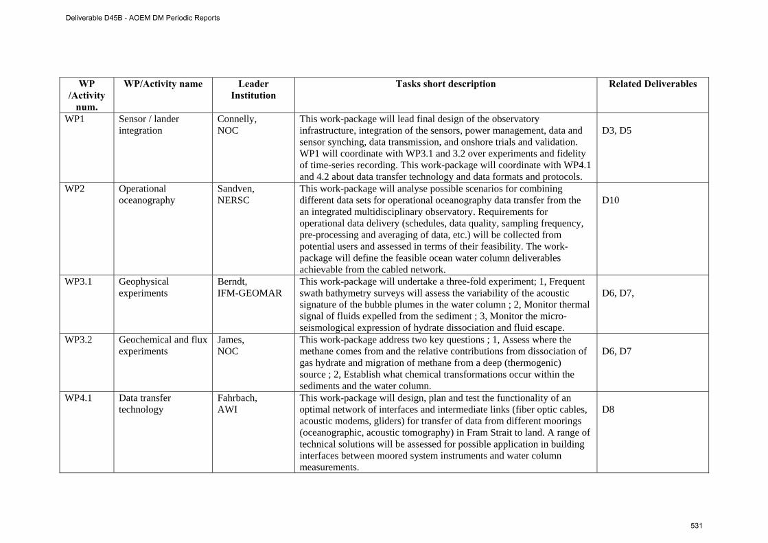
WP
/Activity num.
WP/Activity name Leader Institution
Tasks short description Related Deliverables
WP1 Sensor / lander integration
Connelly, NOC
This work-package will lead final design of the observatory infrastructure, integration of the sensors, power management, data and sensor synching, data transmission, and onshore trials and validation. WP1 will coordinate with WP3.1 and 3.2 over experiments and fidelity of time-series recording. This work-package will coordinate with WP4.1 and 4.2 about data transfer technology and data formats and protocols.
D3, D5
WP2 Operational oceanography
Sandven, NERSC
This work-package will analyse possible scenarios for combining different data sets for operational oceanography data transfer from the an integrated multidisciplinary observatory. Requirements for operational data delivery (schedules, data quality, sampling frequency, pre-processing and averaging of data, etc.) will be collected from potential users and assessed in terms of their feasibility. The work-package will define the feasible ocean water column deliverables achievable from the cabled network.
D10
WP3.1 Geophysical experiments
Berndt, IFM-GEOMAR
This work-package will undertake a three-fold experiment; 1, Frequent swath bathymetry surveys will assess the variability of the acoustic signature of the bubble plumes in the water column ; 2, Monitor thermal signal of fluids expelled from the sediment ; 3, Monitor the micro-seismological expression of hydrate dissociation and fluid escape.
D6, D7,
WP3.2 Geochemical and flux experiments
James, NOC
This work-package address two key questions ; 1, Assess where the methane comes from and the relative contributions from dissociation of gas hydrate and migration of methane from a deep (thermogenic) source ; 2, Establish what chemical transformations occur within the sediments and the water column.
D6, D7
WP4.1 Data transfer technology
Fahrbach, AWI
This work-package will design, plan and test the functionality of an optimal network of interfaces and intermediate links (fiber optic cables, acoustic modems, gliders) for transfer of data from different moorings (oceanographic, acoustic tomography) in Fram Strait to land. A range of technical solutions will be assessed for possible application in building interfaces between moored system instruments and water column measurements.
D8
Deliverable D45B - AOEM DM Periodic Reports
531
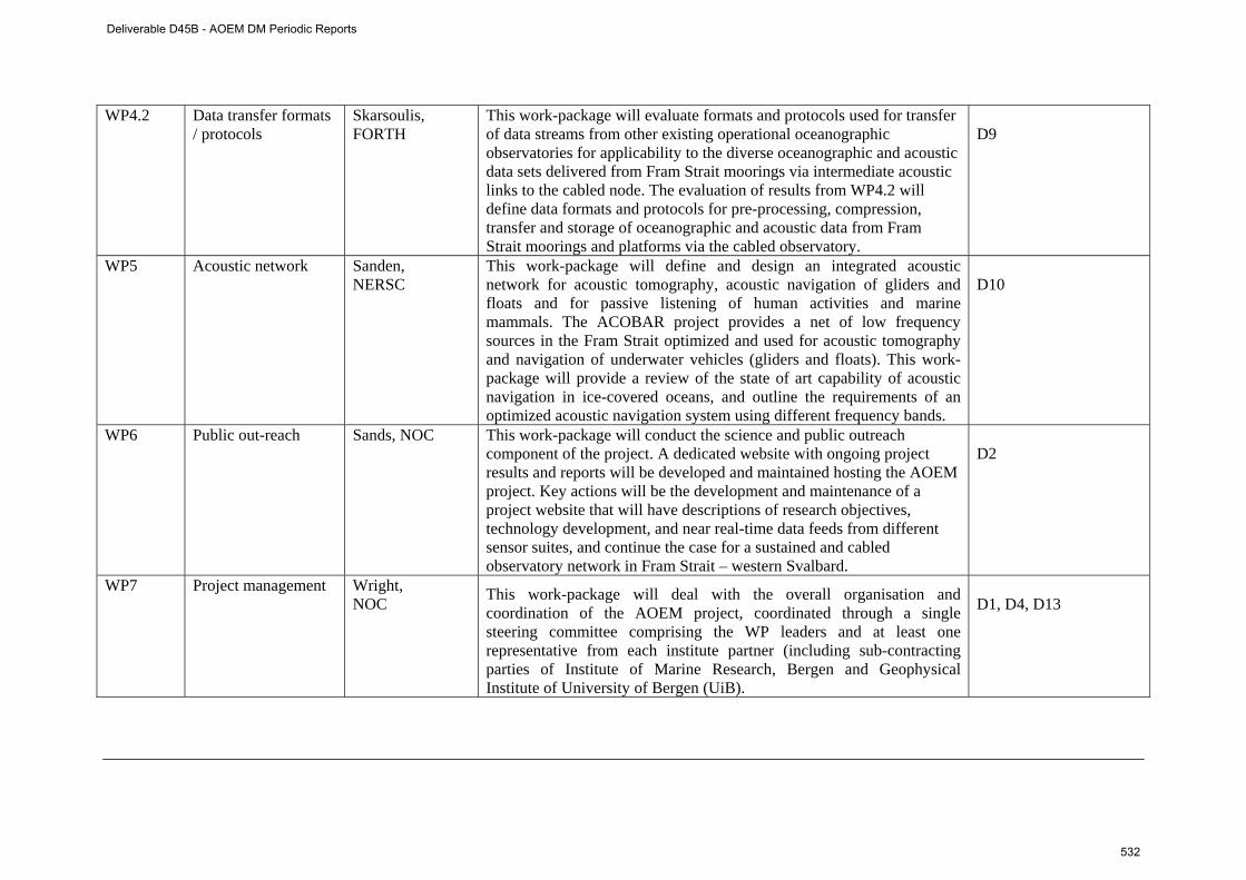
WP4.2 Data transfer formats / protocols
Skarsoulis, FORTH
This work-package will evaluate formats and protocols used for transfer of data streams from other existing operational oceanographic observatories for applicability to the diverse oceanographic and acoustic data sets delivered from Fram Strait moorings via intermediate acoustic links to the cabled node. The evaluation of results from WP4.2 will define data formats and protocols for pre-processing, compression, transfer and storage of oceanographic and acoustic data from Fram Strait moorings and platforms via the cabled observatory.
D9
WP5 Acoustic network Sanden, NERSC
This work-package will define and design an integrated acoustic network for acoustic tomography, acoustic navigation of gliders and floats and for passive listening of human activities and marine mammals. The ACOBAR project provides a net of low frequency sources in the Fram Strait optimized and used for acoustic tomography and navigation of underwater vehicles (gliders and floats). This work-package will provide a review of the state of art capability of acoustic navigation in ice-covered oceans, and outline the requirements of an optimized acoustic navigation system using different frequency bands.
D10
WP6 Public out-reach Sands, NOC This work-package will conduct the science and public outreach component of the project. A dedicated website with ongoing project results and reports will be developed and maintained hosting the AOEM project. Key actions will be the development and maintenance of a project website that will have descriptions of research objectives, technology development, and near real-time data feeds from different sensor suites, and continue the case for a sustained and cabled observatory network in Fram Strait – western Svalbard.
D2
WP7 Project management Wright, NOC This work-package will deal with the overall organisation and
coordination of the AOEM project, coordinated through a single steering committee comprising the WP leaders and at least one representative from each institute partner (including sub-contracting parties of Institute of Marine Research, Bergen and Geophysical Institute of University of Bergen (UiB).
D1, D4, D13
Deliverable D45B - AOEM DM Periodic Reports
532
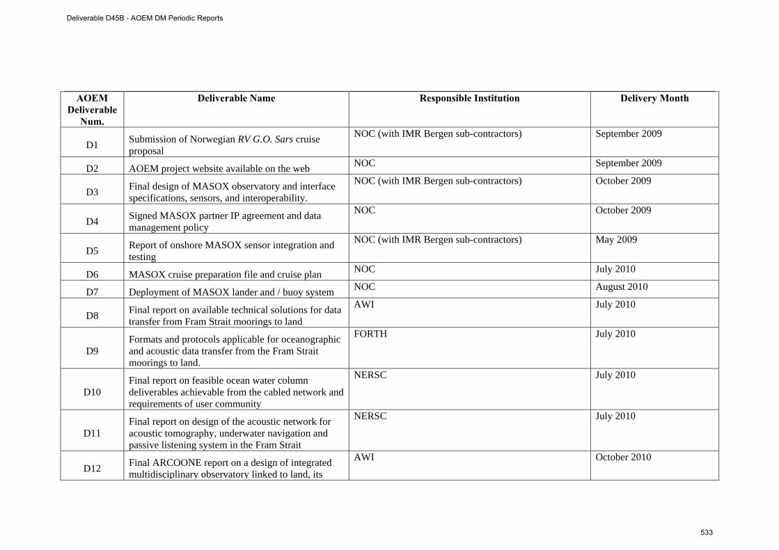
AOEM Deliverable
Num.
Deliverable Name Responsible Institution Delivery Month
D1 Submission of Norwegian RV G.O. Sars cruise proposal
NOC (with IMR Bergen sub-contractors) September 2009
D2 AOEM project website available on the web NOC September 2009
D3 Final design of MASOX observatory and interface specifications, sensors, and interoperability.
NOC (with IMR Bergen sub-contractors) October 2009
D4 Signed MASOX partner IP agreement and data management policy
NOC October 2009
D5 Report of onshore MASOX sensor integration and testing
NOC (with IMR Bergen sub-contractors) May 2009
D6 MASOX cruise preparation file and cruise plan NOC July 2010
D7 Deployment of MASOX lander and / buoy system NOC August 2010
D8 Final report on available technical solutions for data transfer from Fram Strait moorings to land
AWI July 2010
D9 Formats and protocols applicable for oceanographic and acoustic data transfer from the Fram Strait moorings to land.
FORTH July 2010
D10 Final report on feasible ocean water column deliverables achievable from the cabled network and requirements of user community
NERSC July 2010
D11 Final report on design of the acoustic network for acoustic tomography, underwater navigation and passive listening system in the Fram Strait
NERSC July 2010
D12 Final ARCOONE report on a design of integrated multidisciplinary observatory linked to land, its
AWI October 2010
Deliverable D45B - AOEM DM Periodic Reports
533
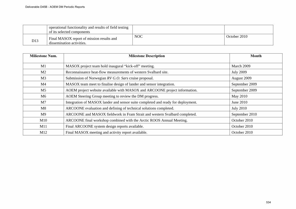
operational functionality and results of field testing of its selected components
D13 Final MASOX report of mission results and dissemination activities.
NOC October 2010
Miliestone Num. Milestone Description Month
M1 MASOX project team hold inaugural “kick-off” meeting. March 2009 M2 Reconnaissance heat-flow measurements of western Svalbard site. July 2009 M3 Submission of Norwegian RV G.O. Sars cruise proposal. August 2009 M4 MASOX team meet to finalise design of lander and sensor integration. September 2009 M5 AOEM project website available with MASOX and ARCOONE project information. September 2009 M6 AOEM Steering Group meeting to review the DM progress. May 2010 M7 Integration of MASOX lander and sensor suite completed and ready for deployment. June 2010 M8 ARCOONE evaluation and defining of technical solutions completed. July 2010 M9 ARCOONE and MASOX fieldwork in Fram Strait and western Svalbard completed. September 2010
M10 ARCOONE final workshop combined with the Arctic ROOS Annual Meeting. October 2010 M11 Final ARCOONE system design reports available. October 2010 M12 Final MASOX meeting and activity report available. October 2010
Deliverable D45B - AOEM DM Periodic Reports
534
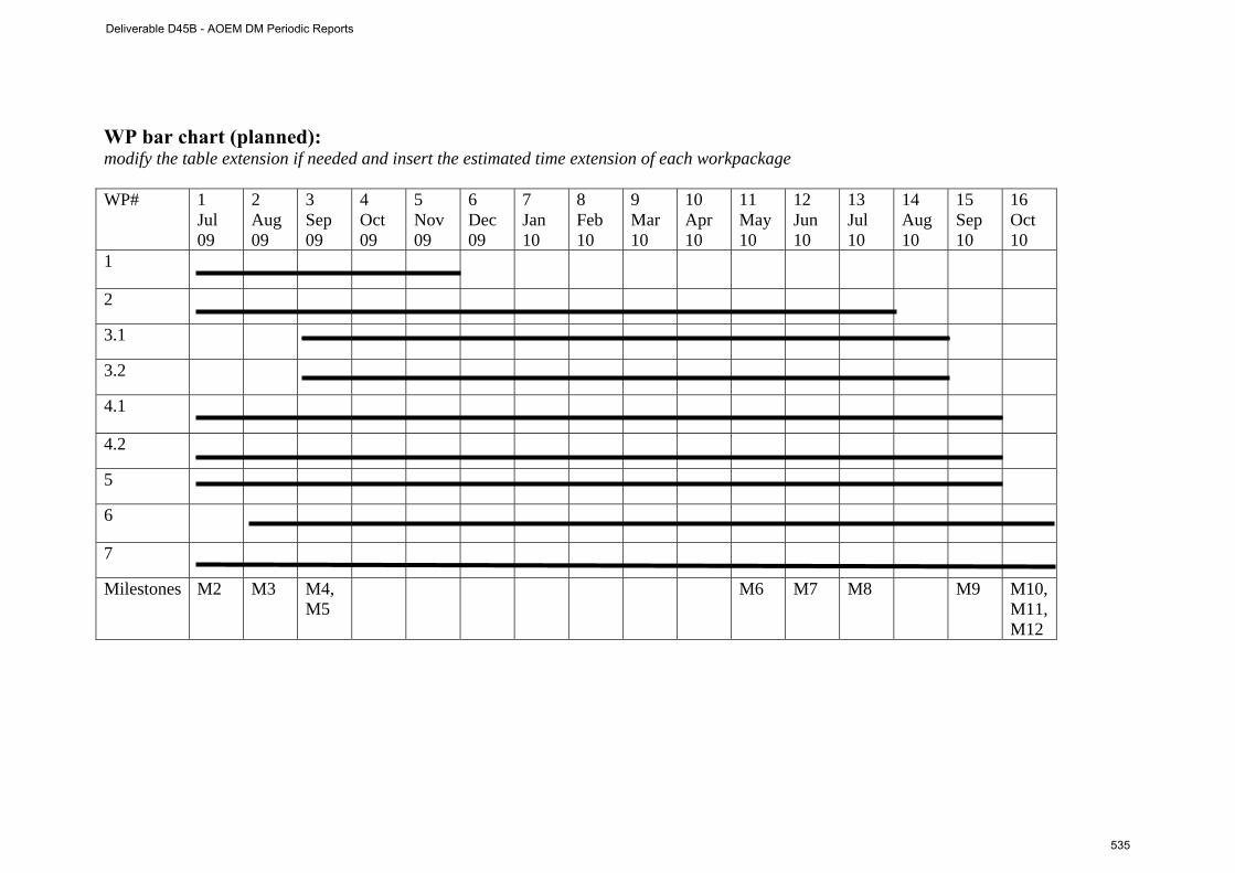
WP bar chart (planned): modify the table extension if needed and insert the estimated time extension of each workpackage WP# 1
Jul 09
2 Aug 09
3 Sep 09
4 Oct 09
5 Nov 09
6 Dec 09
7 Jan 10
8 Feb 10
9 Mar 10
10 Apr 10
11 May 10
12 Jun 10
13 Jul 10
14 Aug 10
15 Sep 10
16 Oct 10
1
2
3.1
3.2
4.1
4.2
5
6
7
Milestones M2 M3 M4, M5
M6 M7 M8 M9 M10,M11, M12
Deliverable D45B - AOEM DM Periodic Reports
535
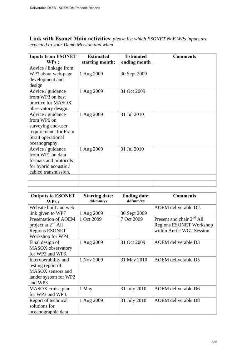
Link with Esonet Main activities: please list which ESONET NoE WPs inputs are expected to your Demo Mission and when Inputs from ESONET
WPs : Estimated
starting month: Estimated
ending monthComments
Advice / linkage from WP7 about web-page development and design
1 Aug 2009
30 Sept 2009
Advice / guidance from WP3 on best practice for MASOX observatory design.
1 Aug 2009 31 Oct 2009
Advice / guidance from WP6 on surveying end-user requirements for Fram Strait operational oceanography.
1 Aug 2009 31 Jul 2010
Advice / guidance from WP1 on data formats and protocols for hybrid acoustic / cabled transmission.
1 Aug 2009 31 Jul 2010
Outputs to ESONET
WPs : Starting date:
dd/mm/yy Ending date:
dd/mm/yy Comments
Website built and web- link given to WP7
1 Aug 2009
30 Sept 2009
AOEM deliverable D2.
Presentation of AOEM project at 2nd All Regions ESONET Workshop for WP4.
1 Oct 2009 7 Oct 2009 Present and chair 2nd All Regions ESONET Workshop within Arctic WG2 Session
Final design of MASOX observatory for WP2 and WP3.
1 Aug 2009 31 Oct 2009 AOEM deliverable D3
Interoperability and testing report of MASOX sensors and lander system for WP2 and WP3.
1 Nov 2009 31 May 2010 AOEM deliverable D5
MASOX cruise plan for WP3 and WP4.
1 May 31 July 2010 AOEM deliverable D6
Report of technical solutions for oceanographic data
1 Aug 2009 31 July 2010 AOEM deliverable D8
Deliverable D45B - AOEM DM Periodic Reports
536
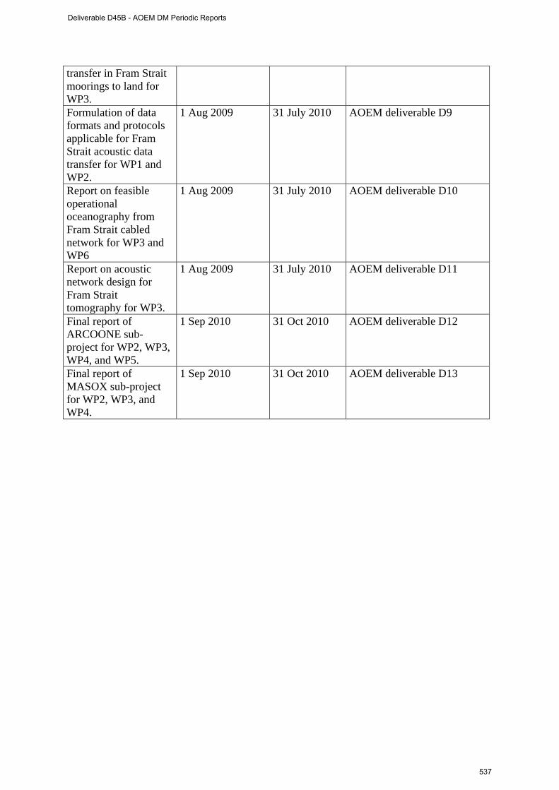
transfer in Fram Strait moorings to land for WP3. Formulation of data formats and protocols applicable for Fram Strait acoustic data transfer for WP1 and WP2.
1 Aug 2009 31 July 2010 AOEM deliverable D9
Report on feasible operational oceanography from Fram Strait cabled network for WP3 and WP6
1 Aug 2009 31 July 2010 AOEM deliverable D10
Report on acoustic network design for Fram Strait tomography for WP3.
1 Aug 2009 31 July 2010 AOEM deliverable D11
Final report of ARCOONE sub-project for WP2, WP3, WP4, and WP5.
1 Sep 2010 31 Oct 2010 AOEM deliverable D12
Final report of MASOX sub-project for WP2, WP3, and WP4.
1 Sep 2010 31 Oct 2010 AOEM deliverable D13
Deliverable D45B - AOEM DM Periodic Reports
537
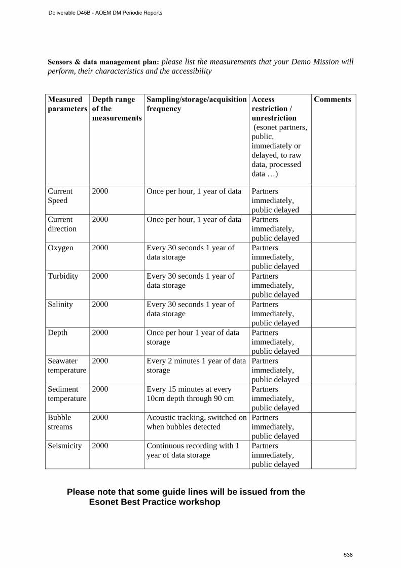
Sensors & data management plan: please list the measurements that your Demo Mission will perform, their characteristics and the accessibility Measured parameters
Depth range of the measurements
Sampling/storage/acquisition frequency
Access restriction / unrestriction (esonet partners, public, immediately or delayed, to raw data, processed data …)
Comments
Current Speed
2000 Once per hour, 1 year of data Partners immediately, public delayed
Current direction
2000 Once per hour, 1 year of data Partners immediately, public delayed
Oxygen 2000 Every 30 seconds 1 year of data storage
Partners immediately, public delayed
Turbidity 2000 Every 30 seconds 1 year of data storage
Partners immediately, public delayed
Salinity 2000 Every 30 seconds 1 year of data storage
Partners immediately, public delayed
Depth 2000 Once per hour 1 year of data storage
Partners immediately, public delayed
Seawater temperature
2000 Every 2 minutes 1 year of data storage
Partners immediately, public delayed
Sediment temperature
2000 Every 15 minutes at every 10cm depth through 90 cm
Partners immediately, public delayed
Bubble streams
2000 Acoustic tracking, switched on when bubbles detected
Partners immediately, public delayed
Seismicity 2000 Continuous recording with 1 year of data storage
Partners immediately, public delayed
Please note that some guide lines will be issued from the Esonet Best Practice workshop
Deliverable D45B - AOEM DM Periodic Reports
538

Dissemination and outreach: please describe in a synthetic way which kind of material will be available for your Demo Mission according to the mentioned categories School material that would be available at the issue of the mission: -photos, video, courses, … -others
Website with synopsis of research objectives, technology development, and near real-time data feeds from different sensor suites, and blog sites during research cruises in 2010, 2011, and 2012, and access to photos and video clips, and podcasts.
Dissemination through collaborations with aquaria, museum, sciences centres,
Dissemination will occur in participation with the Virtual Institute of Sustained Observing (VISO), the Norwegian through collaborations with the Norwegian ARCTOS network, regular news items on the NOC and AWI websites, the University of Southampton Science Open days and secondary school out-reach, and through ESONET WP7.
Deliverable D45B - AOEM DM Periodic Reports
539
Financial issues: please update the financial budget according to the recently allocated ESONET allowance 1/ please compile the attached budget request form (split the budget to each involved partner on 3 months periods) (see Annex 1) comments: The spend profile for the AOEM Demonstration Mission is detailed in the attached Annex 1. 2/ do you intend to sub-contract any activity to some non-Esonet partners? Y/N The Institute of Marine Research, Bergen will be sub-contracted within the MASOX sub-project to the value of €105,000 to integrate sensors and IMR lander infrastructure. The University of Bergen will be sub-contracted within the ARCOONE sub-project to the value of €38,000. 3/ is an exchange of personnel foreseen? or any collaborative work of an engineer/researcher/technician to an institute different from the origin institute? (implying travel + journey longer than 1 week) ? Y/N 4/ other
Deliverable D45B - AOEM DM Periodic Reports
540

Budget distribution: please indicate the budget distribution per partner and WP
Deliverable D45B - AOEM DM Periodic Reports
541
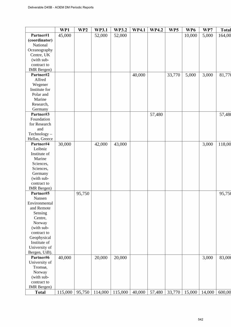
WP1 WP2 WP3.1 WP3.2 WP4.1 WP4.2 WP5 WP6 WP7 TotalPartner#1
(coordinator) National
Oceanography Centre, UK (with sub-contract to
IMR Bergen)
45,000 52,000 52,000 10,000 5,000 164,00
Partner#2 Alfred
Wegener Institute for Polar and Marine
Research, Germany
40,000 33,770 5,000 3,000 81,770
Partner#3 Foundation
for Research and
Technology – Hellas, Greece
57,480 57,480
Partner#4 Leibniz
Institute of Marine
Sciences, Sciences, Germany (with sub-contract to
IMR Bergen)
30,000 42,000 43,000 3,000 118,00
Partner#5 Nansen
Environmental and Remote
Sensing Centre, Norway
(with sub-contract to
Geophysical Institute of
University of Bergen, UiB).
95,750 95,750
Partner#6 University of
Tromsø, Norway
(with sub-contract to
IMR Bergen)
40,000 20,000 20,000 3,000 83,000
Total 115,000 95,750 114,000 115,000 40,000 57,480 33,770 15,000 14,000 600,00
Deliverable D45B - AOEM DM Periodic Reports
542
Any comment or additional information you judge useful:
There are no further comments.
Deliverable D45B - AOEM DM Periodic Reports
543