proceedings of the cambridge antiquarian society vol xcix, 2010
TRANSCRIPT
Published by the Cambridge Antiquarian Society 2010ISSN 0309-3606
Proceedings of the Cambridge Antiquarian Society
(incorporating the Cambs and Hunts Archaeological Society)
Volume XCVIXfor 2010
EditorsDavid A BarrowcloughMary Chester-Kadwell
Assistant Editor Richard Halliday
Associate Editor (Archaeology) Professor Stephen Upex
President Carenza Lewis MA, ScD, FSA
Vice-PresidentsSusan Oosthuizen MA, PhD, PGCE
Alison Taylor BA, MIFA, FSAProfessor A J Legge, MA
Disney Professor of ArchaeologyProfessor Graeme Barker MA, PhD, FBA, FSA, MIFA
Curator of the University Museum of Archaeology and AnthropologyProfessor Nicholas Thomas BA, PhD, FAHA, FBA
Senior County Archaeological OfficerQuinton Carroll MA MIFA
Ordinary Members of Council
Officers & Council, 2009–2010
Secretary Chris Michaelides BA, PGCE, MCLIP
86 Harvey Goodwin Court, French’s Road, Cambridge CB4 3JR
Tel: 07884 431012email: [email protected]
Co-Editors David Barrowclough MA PhD
Mary Chester-Kadwell MA PhDEmail: [email protected]
Hon. LibrarianJohn Pickles MA, PhD, FSA
c/o Haddon LibraryFaculty of Archaeology and Anthropology
Downing Street, Cambridge CB2 3DZ
TreasurerCyril Pritchett MA
66 Gough WayCambridge CB3 9LN
RegistrarValory Hurst
43 South End, BassingbournRoyston, Hertfordshire SG8 5NLemail: [email protected]
Conference SecretaryMark Hinman BA, MIFA
26 Newton Road, Whittlesford Cambridgeshire CB2 4PF
email: [email protected]
Alan Akeroyd BA, MArAd(Hunts Loc Hist Soc)
Sarah Bendall MA, PhD, FSA, MCLIPDerek Booth BSc, PhD, CBiol, MSB
Michelle Bullivant, Dip Archae, PIFA
Alison Dickens BA, MIFAChristopher Jakes, MCLIP
Stephen Macaulay, BA, MPhil, MIFAJanet Morris BA
Shirley Wittering, M St
Representative of the Cambridgeshire Association for Local History Tom Doig PGCE
Hon. AuditorR E Seaton CIPFA, IIA
Membership: there are now 382 members, 49 Affiliated Societies and 67 subscribing institutions.Meetings: There were 4 Council meetings and 9 Ordinary meetings, at which the following lectures were given:
Gabriel Moshenska The School Air Raid Shelter: History, Archaeology and Memory
Prof. Stephen Oakley How Latin Texts Survived from Antiquity to the Age of Printing (In association with the Society for the Promotion of Roman Studies)
Richard Buckley A Tale of Two Towns: recent discoveries from Roman and Medieval Leicester
Prof. Ronald Hutton The History of Prehistory: Megaliths and the Modern Imagination
Dr Catherine Hills Skeletons in the Garden – Romans and Anglo Saxons at Newnham College
Ben Robinson Revealing Peterborough – New Explorations in an Ancient Cathedral City
Dr Stephen Alford Finding Nicholas Berden: the career of an Elizabethan spy
Prof. Simon Keynes John Mitchell Kemble (1807–57): Apostle, Revolutionary, and Anglo-Saxonist
Richard Mortimer & Further Excavations at the War Ditches, Cherry Hinton, Cambridge Alex Pickstone (In association with the Prehistoric Society)
In addition the following two conferences were held: 21st November 2009 Recent archaeological work in Cambridgeshire
17th April 2010 Past Relations: different approaches to the dead over time
Excursions: The Programme for 2010 consisted of the following visits:Chatham Historic Dockyard, Saturday 15 May: One of the country’s foremost naval dockyards for 300 years, Chatham has been in the care of the Historic Dockyard Trust since 1985. As well as three historic vessels -– HMS Gannet (1878), HMS Cavalier (1944) and HM Submarine Ocelot (1962) – it has a spectacular Victorian Ropery and a galaxy of other permanent and temporary exhibitions and displays, including ‘The Wooden Walls’ (a recreation of the dockyard in 1758) and the RNLI Lifeboat Collection. It also has the largest single concentration of listed buildings (military, civil and religious) in the UK.Cherry Hinton, Saturday 26 June. A morning was spent exploring the historical and archaeological landscape of Cherry Hinton Hall and its surround-ings, under the guidance of Ms Michelle Bullivant. Outwardly Victorian, the park nonetheless has many features that bear witness to former land uses and industrial activity. Also investigated was the Lime Kiln Hill area and the newly-open to the public East Pit. Spalding, Lincolnshire, Wednesday 14 July. The highlight of this excursion was a visit to the Spalding Gentlemen’s Society, founded in 1710 and one of the oldest learned societies in the country. The Society has the UK’s second oldest museum collection, containing many rare items of both local and national interest, and a fine library. The medieval riverside at Ely, Wednesday 15 September. The riverside was a centre of activity in the Middle Ages attracting trades dependent on the river, and those requir-ing water such as brewing. The area was developed after the diversion of the river to its present course, probably in the twelfth century, thereby incorporating Ely into the fenland river network. This walk, led by Mrs Anne Holton-Krayenbuhl, explored the area between the river and Broad Street, bounded by Waterside to the north, looking at sites of former watercourses, hithes, and buildings. The tour also included two medieval houses in Broad Street. Moggerhanger Park, Bedfordshire, Wednesday 6 October.Relatively little-known, perhaps due to its long period of use as a local authority TB sanatorium and then orthopae-dic hospital (from 1919 to 1987), Moggerhanger was designed by Sir John Soane for Sir Godfrey Thornton, a director of the Bank of England, and built between 1790 and 1816. Listed Grade 1, it is regarded as perhaps the best complete surviving example of Soane’s work, and epitomises many of his architectural ideas. The grounds were laid out by Humphry Repton. Now in the care of a Trust, which stepped in to avert the threatened demolition of the house and construction of a housing estate on the site, this excursion enabled members to see the current state of an ongoing and ambitious programme of restoration.
Cambridge Antiquarian Society
Report for the Year 2009
4
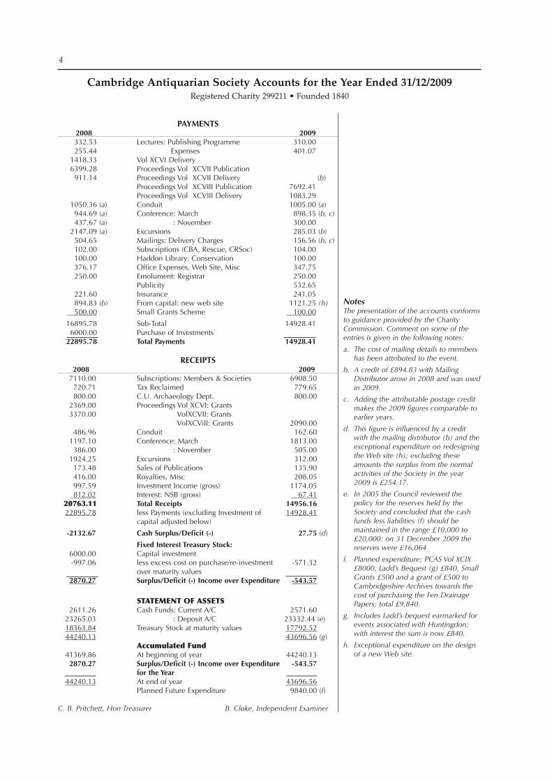
NotesThe presentation of the accounts conforms to guidance provided by the Charity Commission. Comment on some of the entries is given in the following notes:
a. The cost of mailing details to members has been attributed to the event.
b. A credit of £894.83 with Mailing Distributor arose in 2008 and was used in 2009.
c. Adding the attributable postage credit makes the 2009 figures comparable to earlier years.
d. This figure is influenced by a credit with the mailing distributor (b) and the exceptional expenditure on redesigning the Web site (h); excluding these amounts the surplus from the normal activities of the Society in the year 2009 is £254.17.
e. In 2005 the Council reviewed the policy for the reserves held by the Society and concluded that the cash funds less liabilities (f) should be maintained in the range £10,000 to £20,000: on 31 December 2009 the reserves were £16,064
f. Planned expenditure; PCAS Vol XCIX £8000, Ladd’s Bequest (g) £840, Small Grants £500 and a grant of £500 to Cambridgeshire Archives towards the cost of purchasing the Fen Drainage Papers; total £9,840.
g. Includes Ladd’s bequest earmarked for events associated with Huntingdon; with interest the sum is now £840.
h. Exceptional expenditure on the design of a new Web site.
Cambridge Antiquarian Society Accounts for the Year Ended 31/12/2009Registered Charity 299211 • Founded 1840
Payments 2008 2009 332.53 Lectures:PublishingProgramme 310.00 255.44 Expenses 401.07 1418.33 VolXCVIDelivery 6399.28 ProceedingsVolXCVIIPublication 911.14 ProceedingsVolXCVIIDelivery(b) ProceedingsVolXCVIIIPublication 7692.41 ProceedingsVolXCVIIIDelivery 1083.29 1050.36(a) Conduit 1005.00(a) 944.69(a) Conference:March 898.35(b, c) 437.67(a) :November 300.00 2147.09(a) Excursions 285.03(b) 504.65 Mailings:DeliveryCharges 156.56(b, c) 102.00 Subscriptions(CBA,Rescue,CRSoc) 104.00 100.00 HaddonLibrary:Conservation 100.00 376.17 OfficeExpenses,WebSite,Misc 347.75 250.00 Emolument:Registrar 250.00 Publicity 532.65 221.60 Insurance 241.05 894.83(b) Fromcapital:newwebsite 1121.25(h) 500.00 SmallGrantsScheme 100.00
16895.78 Sub-Total 14928.41 6000.00 PurchaseofInvestments 22895.78 total Payments 14928.41
ReCeIPts 2008 2009 7110.00 Subscriptions:Members&Societies 6908.50 720.71 TaxReclaimed 779.65 800.00 C.U.ArchaeologyDept. 800.00 2369.00 ProceedingsVolXCVI:Grants 3370.00 VolXCVII:Grants VolXCViII:Grants 2090.00 486.96 Conduit 162.60 1197.10 Conference:March 1813.00 386.00 :November 505.00 1924.25 Excursions 312.00 173.48 SalesofPublications 135.90 416.00 Royalties,Misc 208.05 997.59 InvestmentIncome(gross) 1174.05 812.02 Interest:NSB(gross) 67.41 20763.11 total Receipts 14956.16 22895.78 lessPayments(excludingInvestmentof 14928.41 capitaladjustedbelow)
-2132.67 Cash surplus/Deficit (-) 27.75 (d)
Fixed Interest treasury stock: 6000.00 Capitalinvestment -997.06 lessexcesscostonpurchase/re-investment -571.32 overmaturityvalues 2870.27 surplus/Deficit (-) Income over expenditure -543.57
STATEMENT OF ASSETS 2611.26 CashFunds:CurrentA/C 2571.60 23265.03 :DepositA/C 23332.44(e) 18363.84 TreasuryStockatmaturityvalues 17792.52 44240.13 43696.56(g) Accumulated Fund 41369.86 Atbeginningofyear 44240.13 2870.27 surplus/Deficit (-) Income over expenditure -543.57 for the year 44240.13 Atendofyear 43696.56 PlannedFutureExpenditure 9840.00(f)C. B. Pritchett, Hon Treasurer B. Cloke, Independent Examiner
Contents
Note on ‘Mary Desborough Cra’ster, 1928–2008’ published in PCAS XCVIII (2009), pp. 7-10 6
A Middle Bronze Age Cremation Cemetery on the Western Claylands at Papworth Everard 7 Nicholas Gilmour, Natasha Dodwell and Elizabeth Popescu
Further excavation of a late Iron Age settlement at Scotland Farm, Dry Drayton 25 David Ingham
Excavations at Castle Street 35 Christopher Evans and Letty Ten Harkel
Early Bronze Age, Iron Age and Roman pit deposits at Bluntisham, Cambridgeshire 61 Adrian Burrow and Andrew Mudd
Roman, Anglo-Saxon and medieval settlement at Stow Longa and Tilbrook (Huntingdonshire) 75 Rob Atkins
Earthwork Survey at Huntingdon Mill Common 89 Michael Fradley
Saxon and Medieval activity at Scotts Close, Hilton 97 Thomas Woolhouse
A medieval clunch-working site at Fordham Road, Isleham, Cambridgeshire 103 Andrew A. S. Newton
Small sites in Cambridgeshire 113 Pip Stone for Archaeological Solutions
Medieval enclosures and trackways at Coles Lane, Oakington, Cambridgeshire 121 Andrew B Powell
The medieval network of navigable Fenland waterways I: Crowland 125 Michael Chisholm
The Old Rectory Kingston: A Short Note on its Origins 139 Susan Oosthuizen
Tea and Delicious Cakes: in conversation with Dr Pamela Jane Smith author of A ‘Splendid Idiosyncrasy’: Prehistory at Cambridge 1915–50 145 David A. Barrowclough
The CAS Collection of Cambridgeshire ‘Sketches’: Part 2 155 John Pickles
Fieldwork in Cambridgeshire 2009 161 Sally Thompson, Hazel White, and Elizabeth Shepherd Popescu
Index 173
Abbreviations 180
Recent Accessions to the Cambridgeshire Collection 181 Chris Jakes
‘Mary Desborough Cra’ster, 1928–2008’ PCAS XCVIII (2009), pp. 7–10
The photograph is of Mary with the Prince of Wales at the opening of the refurbished Museum of Archaeology & Anthropology, Cambridge, in 1984.
The paragraphs headed ‘The Museum’ (p. 8) are by Peter Gathercole, formerly Curator of the Museum, and those headed ‘Local Archaeology’ (p. 9) are by Alison Taylor, formerly Cambridge County Archaeologist.
Note
Cover: Iron Age inhumation, Bluntisham
The clay uplands of Cambridgeshire, upon which the village of Papworth Everard lies, are beginning to be recognised as fertile areas that attracted populations from the earliest times. A Bronze Age cremation cemetery containing 41 identifiable individuals found close to a stream is amongst the largest of its type known in the region. The cremation vessels are of the Middle Bronze Age Deverel-Rimbury tra-dition. Bayesian analysis of radiocarbon dates suggests that the cemetery was in use from 1430–1310 cal BC (95% prob-ability) to 1380–1240 cal BC (95% probability). Of note is the fact that, where two individuals were identified within a cremation deposit, these were always an adult buried with an infant or juvenile.
Introduction
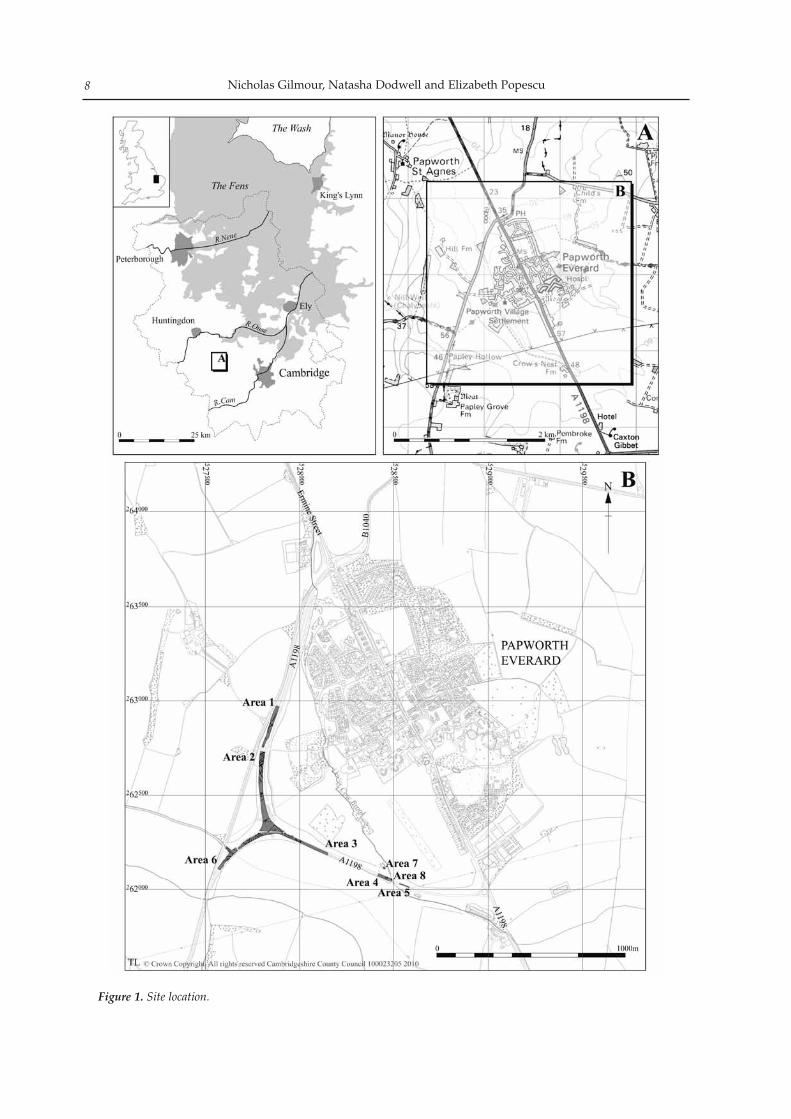
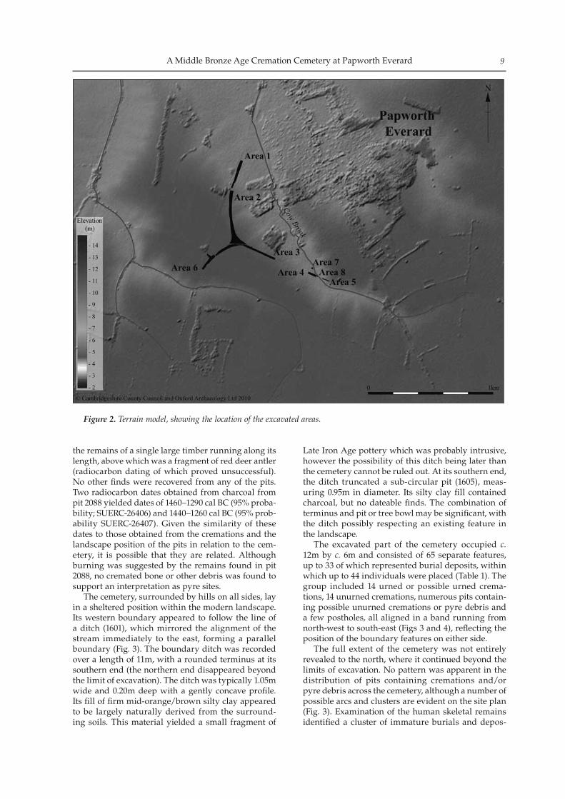
Between December 2005 and April 2006 Cambridgeshire County Council’s Archaeological Field Unit, CAM ARC (now Oxford Archaeology East) carried out excavations along the line of a pro-posed bypass which now runs around the village of Papworth Everard, c. 16km to the north-west of Cambridge (Fig. 1). The southern end of the bypass forms a junction with Ermine Street (the modern A1198; at TL 278 627), while its northern end joins the same road just to the north-west of the village (at TL 290 620). The bypassed section of Ermine Street runs through the centre of the village. Eight areas forming a rough T-shape were exam-ined during the excavation and revealed the remains of a substantial Iron Age and Roman field system in the western part of the site. A single Iron Age crema-tion and a probable Roman inhumation were found either within or near Area 2. Further to the south-east lay an area of thick colluvial and alluvial deposits within a narrow stream valley. During evaluation it was not feasible to excavate through the complete depth of this material, which was therefore targeted for further work during the excavation (Area 4). It was here that the Bronze Age cremation cemetery was found.
Geology & Topography
The cemetery lay at a height of c. 40m OD, just above the base of a gentle valley in which a small stream known as the Cow Brook flows (Fig. 2). The crema-tions were placed within a series of deposits related to the filling of a channel, 2.2m in depth, consisting of a thin topsoil and two fairly thick subsoils. The upper subsoil was a substantial (c. 1m thick) layer of colluvial material and the lower subsoil a mixture of material washed into the bottom of the valley from further up slope together with other deposits possi-bly introduced by the periodic flooding of the stream. Below this the natural geology of the valley consists of exposed upper Jurassic clays and limestones which are overlain by glacial deposits and grey mudstone. The later glacial deposits are predominantly chalky Boulder Clays (British Geological Survey 1993). The level from which the cremations were cut was difficult to determine, although they may have been dug from a level at the base of the subsoil, some 1.2m below the present ground surface. It is highly probable that the cremations were cut into an actively eroding slope and that similar processes to those which bur-ied them could have truncated them: the fact that one urned burial survived to only 0.10m deep indicates the degree of truncation and highlights the possibility that some burials may have been completely removed. Medieval and post-medieval agricultural activity may have increased the down slope movement of material.
Cemetery Layout and Position
On the top of the slope overlooking the cremation cemetery a series of rectangular pits were identified in Areas 2 and 3. Four of these ran in a line from north-east to south-west, with a fifth pit lying parallel fur-ther to the east. The pits were between 2.5m and 3.45m long, 0.50m and 0.63m wide and between 0.14m and 0.44m deep. While most examples had been truncat-ed by ploughing, pit 2088 was better preserved. This contained a significant quantity of charcoal, including
A Middle Bronze Age Cremation Cemetery on the Western Claylands at Papworth Everard
by Nicholas Gilmour, Natasha Dodwell and Elizabeth Popescu
with contributions from Emily Edwards, Val Fryer and P. D. Marshall. Illustrations by Crane Begg and Séverine Bézie
Proceedings of the Cambridge Antiquarian Society XCVIX pp. 7–24
Nicholas Gilmour, Natasha Dodwell and Elizabeth Popescu8
Figure 1. Site location.
A Middle Bronze Age Cremation Cemetery at Papworth Everard 9
the remains of a single large timber running along its length, above which was a fragment of red deer antler (radiocarbon dating of which proved unsuccessful). No other finds were recovered from any of the pits. Two radiocarbon dates obtained from charcoal from pit 2088 yielded dates of 1460–1290 cal BC (95% proba-bility; SUERC-26406) and 1440–1260 cal BC (95% prob-ability SUERC-26407). Given the similarity of these dates to those obtained from the cremations and the landscape position of the pits in relation to the cem-etery, it is possible that they are related. Although burning was suggested by the remains found in pit 2088, no cremated bone or other debris was found to support an interpretation as pyre sites. The cemetery, surrounded by hills on all sides, lay in a sheltered position within the modern landscape. Its western boundary appeared to follow the line of a ditch (1601), which mirrored the alignment of the stream immediately to the east, forming a parallel boundary (Fig. 3). The boundary ditch was recorded over a length of 11m, with a rounded terminus at its southern end (the northern end disappeared beyond the limit of excavation). The ditch was typically 1.05m wide and 0.20m deep with a gently concave profile. Its fill of firm mid-orange/brown silty clay appeared to be largely naturally derived from the surround-ing soils. This material yielded a small fragment of
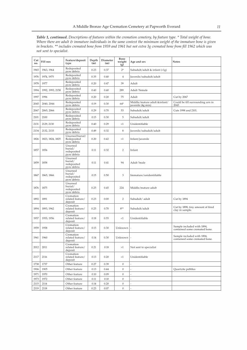
Late Iron Age pottery which was probably intrusive, however the possibility of this ditch being later than the cemetery cannot be ruled out. At its southern end, the ditch truncated a sub-circular pit (1605), meas-uring 0.95m in diameter. Its silty clay fill contained charcoal, but no dateable finds. The combination of terminus and pit or tree bowl may be significant, with the ditch possibly respecting an existing feature in the landscape. The excavated part of the cemetery occupied c. 12m by c. 6m and consisted of 65 separate features, up to 33 of which represented burial deposits, within which up to 44 individuals were placed (Table 1). The group included 14 urned or possible urned crema-tions, 14 unurned cremations, numerous pits contain-ing possible unurned cremations or pyre debris and a few postholes, all aligned in a band running from north-west to south-east (Figs 3 and 4), reflecting the position of the boundary features on either side. The full extent of the cemetery was not entirely revealed to the north, where it continued beyond the limits of excavation. No pattern was apparent in the distribution of pits containing cremations and/or pyre debris across the cemetery, although a number of possible arcs and clusters are evident on the site plan (Fig. 3). Examination of the human skeletal remains identified a cluster of immature burials and depos-
Figure 2. Terrain model, showing the location of the excavated areas.
Nicholas Gilmour, Natasha Dodwell and Elizabeth Popescu10
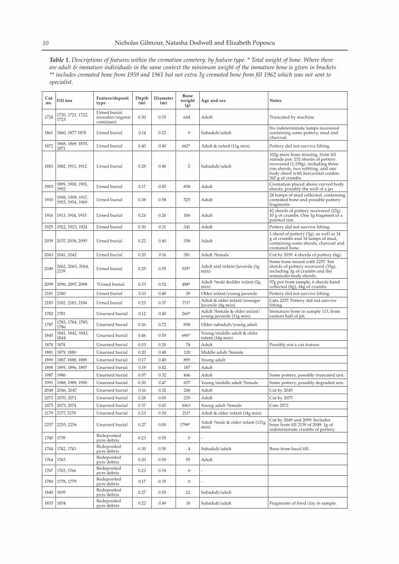
Cut no. Fill nos Feature/deposit
typeDepth
(m)Diameter
(m)
Bone weight
(g)Age and sex Notes
1724 1720, 1721, 1722, 1723
Urned burial (wooden/organic container)
0.30 0.35 644 Adult Truncated by machine.
1861 1860, 1877 1878 Urned burial 0.14 0.22 9 Subadult/adultSix indeterminate lumps recovered containing some pottery, mud and charcoal.
1872 1868, 1869, 1870, 1871 Urned burial 0.40 0.40 662* Adult & infant (11g min) Pottery did not survive lifting.
1883 1882, 1911, 1912 Urned burial 0.28 0.40 2 Subadult/adult
102g more bone missing, from fill outside pot. 232 sherds of pottery recovered (1,339g), including three rim sherds, two refitting, and one body sherd with horizontal cordon. 362 g of crumbs.
1903 1899, 1900, 1901, 1902 Urned burial 0.17 0.45 838 Adult Cremation placed above curved body
sherds, possibly the wall of a jar.
1910 1908, 1909, 1917, 1953, 1954, 1969 Urned burial 0.38 0.58 525 Adult
28 lumps of mud collected, containing cremated bone and possible pottery fragments.
1916 1913, 1914, 1915 Urned burial 0.24 0.26 106 Adult42 sherds of pottery recovered (27g). 10 g of crumbs. One 1g fragment of a pointed rim.
1925 1922, 1923, 1924 Urned burial 0.30 0.31 341 Adult Pottery did not survive lifting.
2039 2037, 2038, 2095 Urned burial 0.22 0.40 338 Adult
1 sherd of pottery (3g), as well as 14 g of crumbs and 14 lumps of mud, containing some sherds, charcoal and cremated bone.
2043 2041, 2042 Urned burial 0.20 0.16 381 Adult ?female Cut by 2039. 4 sherds of pottery (6g).
2049 2062, 2063, 2064, 2139 Urned burial 0.25 0.35 355* Adult and infant/juvenile (1g
min)
Some bone mixed with 2257. Ten sherds of pottery recovered (35g), including 3g of crumbs and the remainder body sherds.
2099 2096, 2097, 2098 ?Urned burial 0.33 0.52 488* Adult ?male &older infant (2g min)
97g pot from sample, 6 sherds hand collected (8g), 44g of crumbs.
2181 2180 Urned burial 0.10 0.40 39 Older infant/young juvenile Pottery did not survive lifting.
2185 2182, 2183, 2184 Urned burial 0.25 0.37 711* Adult & older infant/younger Juvenile (8g min)
Cuts 2257. Pottery did not survive lifting.
1782 1781 Unurned burial 0.12 0.40 260* Adult ?female & older infant/young juvenile (11g min)
Immature bone in sample 113, from eastern half of pit.
1787 1783, 1784, 1785, 1786 Unurned burial 0.26 0.72 858 Older subadult/young adult
1845 1841, 1842, 1843, 1844 Unurned burial 0.46 0.50 690* Young/middle adult & older
infant (14g min)
1874 1874 Unurned burial 0.03 0.20 74 Adult Possibly not a cut feature.
1881 1879, 1880 Unurned burial 0.20 0.48 120 Middle adult ?female
1890 1887, 1888, 1889 Unurned burial 0.17 0.40 895 Young adult
1898 1895, 1896, 1897 Unurned burial 0.19 0.42 187 Adult
1987 1986 Unurned burial 0.07 0.32 446 Adult Some pottery, possibly truncated urn.
1991 1988, 1989, 1990 Unurned burial 0.30 0.47 657 Young/middle adult ?female Some pottery, possibly degraded urn.
2048 2046, 2047 Unurned burial 0.16 0.32 248 Adult Cut by 2045
2072 2070, 2071 Unurned burial 0.28 0.00 229 Adult Cut by 2075
2075 2073, 2074 Unurned burial 0.37 0.45 1063 Young adult ?female Cuts 2072
2179 2177, 2178 Unurned burial 0.23 0.30 211* Adult & older infant (14g min)
2257 2255, 2256 Unurned burial 0.27 0.00 1798* Adult ?male & older infant (121g min)
Cut by 2049 and 2099. Includes bone from fill 2139 of 2049. 1g of indeterminate crumbs of pottery.
1740 1739 Redeposited pyre debris 0.23 0.55 0 -
1744 1742, 1743 Redeposited pyre debris 0.30 0.50 4 Subadult/adult Bone from basal fill.
1764 1763 Redeposited pyre debris 0.20 0.50 55 Adult
1767 1765, 1766 Redeposited pyre debris 0.23 0.54 0 -
1780 1778, 1779 Redeposited pyre debris 0.17 0.35 0 -
1840 1839 Redeposited pyre debris 0.27 0.50 22 Subadult/adult
1855 1854 Redeposited pyre debris 0.22 0.49 18 Subadult/adult Fragments of fired clay in sample.
Table 1. Descriptions of features within the cremation cemetery, by feature type. * Total weight of bone. Where there are adult & immature individuals in the same context the minimum weight of the immature bone is given in brackets** includes cremated bone from 1959 and 1961 but not extra 3g cremated bone from fill 1962 which was not sent to specialist.
A Middle Bronze Age Cremation Cemetery at Papworth Everard 11
Cut no. Fill nos Feature/deposit
typeDepth
(m)Diameter
(m)
Bone weight
(g)Age and sex Notes
1965 1963, 1964 Redeposited pyre debris 0.23 0.37 2* Subadult/adult & infant (<1g)
1976 1974, 1975 Redeposited pyre debris 0.35 0.40 4 Juvenile/subadult/adult
1978 1977 Redeposited pyre debris 0.20 0.47 39 Adult
1994 1992, 1993, 2158 Redeposited pyre debris 0.40 0.40 289 Adult ?female
1997 1996 Redeposited pyre debris 0.20 0.20 75 Adult Cut by 2067
2045 2040, 2044 Redeposited pyre debris 0.19 0.30 64* Middle/mature adult &infant/
juvenile (4g min)Could be fill surrounding urn in 2043
2067 2065, 2066 Redeposited pyre debris 0.29 0.70 53 Subadult/adult Cuts 1998 and 2101.
2101 2100 Redeposited pyre debris 0.15 0.30 5 Subadult/adult
2131 2129, 2130 Redeposited pyre debris 0.40 0.29 <1 Unidentifiable
2134 2132, 2133 Redeposited pyre debris 0.49 0.32 8 Juvenile/subadult/adult
1826 1823, 1824, 1825Unurned burial/Redeposited pyre debris
0.20 0.42 >1 Infant/juvenile
1857 1856
Unurned burial/ redeposited pyre debris
0.11 0.32 2 Infant
1859 1858
Unurned burial/ redeposited pyre debris
0.11 0.41 94 Adult ?male
1867 1865, 1866
Unurned burial/ redeposited pyre debris
0.15 0.50 3 Immature/unidentifiable
1876 1875
Unurned burial/ redeposited pyre debris
0.25 0.45 224 Middle/mature adult
1892 1891Cremation related feature/deposit
0.23 0.00 2 Subadult/ adult Cut by 1894
1894 1893, 1962Cremation related feature/deposit
0.25 0.70 8** Subadult/adult Cut by 1898, tiny amount of fired clay in sample.
1957 1955, 1956Cremation related feature/deposit
0.18 0.55 <1 Unidentifiable
1959 1958Cremation related feature/deposit
0.15 0.30 Unknown - Sample included with 1894, contained some cremated bone.
1961 1960Cremation related feature/deposit
0.14 0.30 Unknown - Sample included with 1894, contained some cremated bone.
2012 2011Cremation related feature/deposit
0.21 0.18 >1 Not sent to specialist
2117 2116Cremation related feature/deposit
0.13 0.20 <1 Unidentifiable
1738 1737 Other feature 0.27 0.39 0 -
1906 1905 Other feature 0.13 0.44 0 - Quartzite pebbles
1971 1970 Other feature 0.10 0.09 0 -
1973 1972 Other feature 0.11 0.10 0 -
2115 2114 Other feature 0.14 0.20 0 -
2119 2118 Other feature 0.23 0.07 0 -
Table 1, continued. Descriptions of features within the cremation cemetery, by feature type. * Total weight of bone. Where there are adult & immature individuals in the same context the minimum weight of the immature bone is given in brackets. ** includes cremated bone from 1959 and 1961 but not extra 3g cremated bone from fill 1962 which was not sent to specialist.
Nicholas Gilmour, Natasha Dodwell and Elizabeth Popescu12
Figure 3. Plan of the cremation cemetery.
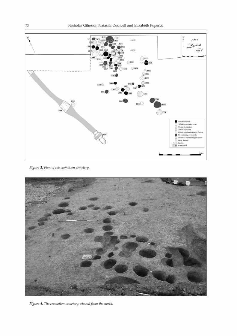
Figure 4. The cremation cemetery, viewed from the north.
A Middle Bronze Age Cremation Cemetery at Papworth Everard 13
its of pyre debris, including immature individuals in double burials, forming an arc to the south-east (1782, 1826, 1845, 1857, 1867 and 1872), and a mirror arc 5m to the north-west (1916, 1957, 2048 and 2181). Features were generally more dense in the north-western part of the area examined, where many intercut each other. While it is possible that these intercutting examples represent family groups, the density of features in this part of the site makes this suggestion highly tentative. The general lack of inter-cutting amongst the other cremations suggests that the graves would have been marked in some way, for instance with small mounds, stakes or stone markers. The cremations and related deposits are discussed below with reference to the classifications defined by McKinley (2004).
The Cremation Pits and Pyre Debris
Urned burialsThis category encompasses burials where the burnt bone is contained within a vessel or probable vessel, or placed on sherds of pottery, although the fragile nature of the majority of urns at Papworth Everard meant that in some cases they were difficult to identi-fy. Some 14 examples were identified (13 in or associ-ated with ceramic vessels, one in a possible wooden/organic container; Figs 5–7). The urned examples were set within steep-sided and flat-based roughly circular cuts, between 0.10m and 0.40m deep and be-tween 0.16m and 0.58m in diameter, with fairly steep, concave, sides and steep U-shaped profiles (e.g. pit 1885, Fig. 8, Section 354). Generally, the pits into which the urns had been placed were slightly larger than the urns themselves, although in some instances the pot fitted snugly against the cut edge. Distinguishing between natural and redeposited natural backfilling the cut was often problematic and in some instances the true cut may not have been identified. Where it existed, the gap between the cremation vessel and the pit cut was backfilled with either redeposited natural or pyre debris. Typically each cremation (both urned and un-urned) consisted of a lower layer of dark, fine ash, mixed with the underlying silty clay, containing little cremated bone. This layer may have resulted from the smaller, finer particles migrating downward through the main cremation fill and becoming mixed with the underlying natural deposit through post-deposition-al processes. Above this layer was the true cremation deposit consisting of heavy black ash mixed with sub-stantial quantities of very burnt and calcined, white, fairly fragmented human bone. This was usually sealed by a dark black/orange, ashy, clayey silt, con-sisting of the surrounding natural colluvial/alluvial soil, incidentally mixed with ash from the cremation.
Unurned burialsUnurned burials are defined as those in which the burnt bone is deposited in a small pit. The bone is
usually found in a concentration, often at the base of the pit, suggesting that it was originally placed in an organic container such as a bag or basket which did not survive. This concentration is normally sealed with redeposited pyre debris or natural sub-soils. A total of 14 examples of unurned burials were iden-tified and again were all roughly circular in plan, between 0.20m and 0.72m in diameter and between 0.03m and 0.46m deep with fairly steep, concave, sides and steep U-shaped profiles.
Redeposited pyre debrisPyre debris is predominantly charcoal with small quantities of burnt bone, burnt flint, fired clay and sometimes fuel ash slag (McKinley 1997, 137), often described on site as ‘ash dumps’. This was found in the backfills of urned and unurned cremation burials and as formal deposits in intentionally cut features. Distinguishing between redeposited pyre debris and disturbed or truncated unurned burials can be difficult. Nineteen features were identified as rede-posited pyre debris, contained within pits of broadly the same size and shape as the cremation burials, al-though appearing to have served a different function. These features were filled with deposits of black ash that contained very little burnt bone and which were sometimes, but not always, sealed by a layer of rede-posited natural soil. It seems likely that these features were dug to contain pyre debris, collected and delib-erately buried within the cremation cemetery.
Unurned burial/redeposited pyre debrisThis category includes features within the cemetery where there is no adequate description on the context sheet, or where there was no concentration of bone but the deposit had been seriously truncated. Five such features were identified at Papworth Everard, again in the form of circular or sub-circular pits with depths ranging from 0.11m to 0.25m.
Cremation related feature/depositThis deposit type includes redeposited cremated bone, but where the circumstances of deposition are uncertain. Seven such examples, again in the form of fills of circular or sub-circular pits, were found at Papworth Everard.
Other featuresSix features contained neither significant quantities of charcoal nor cremated bone and may represent post-holes. Most of these ‘structural’ features consisted of a concave pit with a central, well-defined post-pipe that comprised decayed and burnt, ashy wood. They measured between 0.07m and 0.44m in diameter and 0.10m and 0.27m deep. It is possible that these fea-tures indicate the position of pyres, although they did not appear to form any obvious pattern. Alternatively, they may have acted as markers.
Nicholas Gilmour, Natasha Dodwell and Elizabeth Popescu14
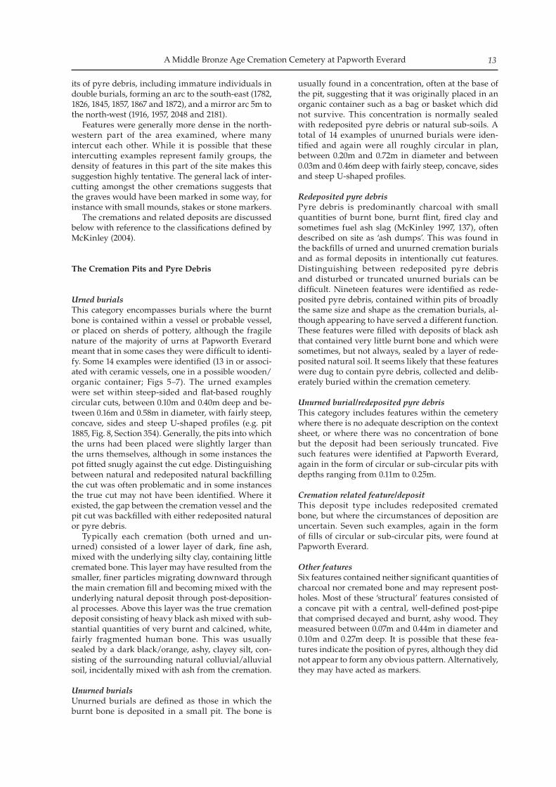
Above, Figure 5. Cremation pit 1883 during excavation.
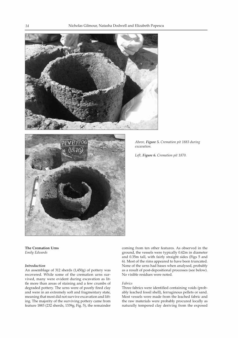
Left, Figure 6. Cremation pit 1870.
The Cremation Urns Emily Edwards
IntroductionAn assemblage of 312 sherds (1,450g) of pottery was recovered. While some of the cremation urns sur-vived, many were evident during excavation as lit-tle more than areas of staining and a few crumbs of degraded pottery. The urns were of poorly fired clay and were in an extremely soft and fragmentary state, meaning that most did not survive excavation and lift-ing. The majority of the surviving pottery came from feature 1883 (232 sherds, 1339g; Fig. 5), the remainder
coming from ten other features. As observed in the ground, the vessels were typically 0.42m in diameter and 0.35m tall, with fairly straight sides (Figs 5 and 6). Most of the rims appeared to have been truncated. None of the urns had bases when analysed, probably as a result of post-depositional processes (see below). No visible residues were noted.
FabricsThree fabrics were identified containing voids (prob-ably leached fossil shell), ferruginous pellets or sand. Most vessels were made from the leached fabric and the raw materials were probably procured locally as naturally tempered clay deriving from the exposed
A Middle Bronze Age Cremation Cemetery at Papworth Everard 15
fossiliferous Upper Jurassic clays that form the nar-row valley within which the site lies. The opening materials within the other fabrics are also likely to have been derived locally. The identification of Middle Bronze Age vesicular fabrics is paralleled at Newark Road, Fengate (30km north of Papworth Everard), where the solid geology consists of the same Upper Jurassic clays. Here, sherds from ditch deposits were analysed and thin-sectioned and found to have been manufactured from soft friable vesicular fabrics (Williams 1980, 87–104). One of these fabrics had originally derived from fossiliferous clay such as Kimmeridge or Oxford (Upper Jurassic clays). Shell fabrics also formed a significant proportion of the Middle Bronze Age assemblage from Grimes Grave in Norfolk (Ellison 1988, 40).
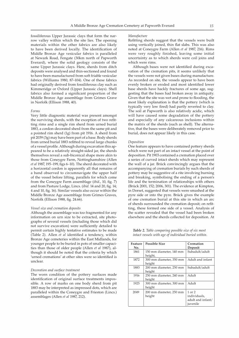
FormsVery little diagnostic material was present amongst the surviving sherds, with the exception of two refit-ting rims and a single rim sherd from urned burial 1883, a cordon-decorated sherd from the same pit and a pointed rim sherd (1g) from pit 1916. A sherd from pit 2039 (3g) may have been part of a base. Body sherds from urned burial 1883 refitted to reveal large chunks of a vessel profile. Although during excavation this ap-peared to be a relatively straight-sided jar, the sherds themselves reveal a sub-biconical shape more akin to those from Coneygre Farm, Nottinghamshire (Allen et al 1987, 195–199, figs 6–10). The sherd decorated with a horizontal cordon is apparently all that remains of a band observed to circumnavigate the upper half of the vessel before lifting, parallels for which come from the Coneygre Farm assemblage (ibid., 10, fig. 7) and from Pasture Lodge, Lincs. (ibid. 14 and 20, fig. 14; 4 and 10, fig. 16). Similar vessels also occur within the Middle Bronze Age assemblage from Grimes Graves, Norfolk (Ellison 1988, fig. 24.66).
Vessel size and cremation depositsAlthough the assemblage was too fragmented for any information on urn size to be extracted, site photo-graphs of several vessels (including those which did not survive excavation) were sufficiently detailed to permit certain highly tentative estimates to be made (Table 2). Allen et al identified a tendency, within Bronze Age cemeteries within the East Midlands, for younger people to be buried in pots of smaller capaci-ties than those of older people (Allen et al 1987), al-though it should be noted that the criteria by which ‘urned cremations’ at other sites were so identified is unclear.
Decoration and surface treatmentThe worn condition of the pottery surfaces made identification of original surface treatments impos-sible. A row of marks on one body sherd from pit 1883 may be interpreted as impressed dots, which are paralleled within the Coneygre and Frieston (Lincs.) assemblages (Allen et al 1987, 212).
ManufactureRefitting sherds suggest that the vessels were built using vertically joined, thin flat slabs. This was also noted at Coneygre Farm (Allen et al 1987, 216). Rims were very roughly finished, leaving some initial uncertainty as to which sherds were coil joins and which were rims. Although bases were not identified during exca-vation of the cremation pits, it seems unlikely that the vessels were not given bases during manufacture. As recorded on site, the vessels appear to have been evenly broken or eroded and most identified lower base sherds have hackly fractures of some age, sug-gesting that the bases had broken away in antiquity. Given that the site was wet and prone to flooding, the most likely explanation is that the pottery (which is typically very low fired) had partly reverted to clay. The soil at Papworth is also relatively acidic, which will have caused some degradation of the pottery and especially of any calcareous inclusions within the matrix of the sherds (such as shell). The alterna-tive, that the bases were deliberately removed prior to burial, does not appear likely in this case.
Deposition One feature appears to have contained pottery sherds which were not part of an intact vessel at the point of deposition. Pit 1903 contained a cremation placed over a series of curved intact sherds which may represent the wall of a jar. Brück convincingly argues that the accompanying of cremation burials by such sherds of pottery may be suggestive of a rite involving burning and breaking, symbolising the ending of a person’s life and the termination of relationships with others (Brück 2001, 152; 2006, 301). The evidence at Kimpton, in Dorset, suggested that vessels were smashed at the pyre side or into the pyre. Brück gives the example of one cremation burial at this site in which an arc of sherds surrounded the cremation deposit; on refit-ting, these formed one side of a vessel. Analysis of the scatter revealed that the vessel had been broken elsewhere and the sherds collected for deposition. At
Feature No.
Possible Size Cremation Deposit
1861 150 mm diameter, 140 mm height,
Subadult/adult
1872 300 mm diameter, 350 mm height
Adult and infant
1883 200 mm diameter, 250 mm height
Subadult/adult
1916 250 mm diameter, 240 mm height
Adult
1925 300 mm diameter, 300 mm height
Adult
2049 200 mm diameter, 250 mm height
1 or 2 individuals, adult and infant/juvenile
Table 2. Table comparing possible size of six most intact vessels with age of individual buried within.
Nicholas Gilmour, Natasha Dodwell and Elizabeth Popescu16
Itford Hill, East Sussex an incomplete vessel accom-panying a burial was matched with a sherd from the contemporary settlement 90m to the south.
DatingThe pottery recovered from Papworth Everard is con-sidered to be related to the later middle Bronze Age Deverel-Rimbury Tradition, largely understood to have a currency stretching from 1500 to 1000 BC.
ConclusionsThe pottery from Papworth is very fragmented and in a fragile condition. Those few diagnostic sherds present within the assemblage as analysed, in con-junction with the fabrics described above, find par-allels within other Middle Bronze Age cemeteries within the region. The variable degree of complete-ness of the ceramic deposits at Papworth is typical of many strands of evidence associated with crema-tion deposits as described by Brück and others (Brück 2006, 30–9; Parker Pearson 2005, 108; Bradley 2007, 197–202; McKinley 1997).
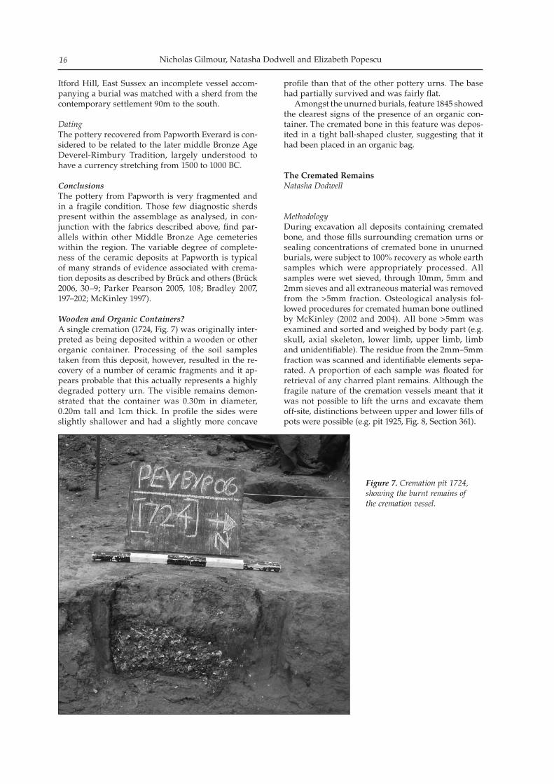
Wooden and Organic Containers?A single cremation (1724, Fig. 7) was originally inter-preted as being deposited within a wooden or other organic container. Processing of the soil samples taken from this deposit, however, resulted in the re-covery of a number of ceramic fragments and it ap-pears probable that this actually represents a highly degraded pottery urn. The visible remains demon-strated that the container was 0.30m in diameter, 0.20m tall and 1cm thick. In profile the sides were slightly shallower and had a slightly more concave
profile than that of the other pottery urns. The base had partially survived and was fairly flat. Amongst the unurned burials, feature 1845 showed the clearest signs of the presence of an organic con-tainer. The cremated bone in this feature was depos-ited in a tight ball-shaped cluster, suggesting that it had been placed in an organic bag.
The Cremated Remains Natasha Dodwell
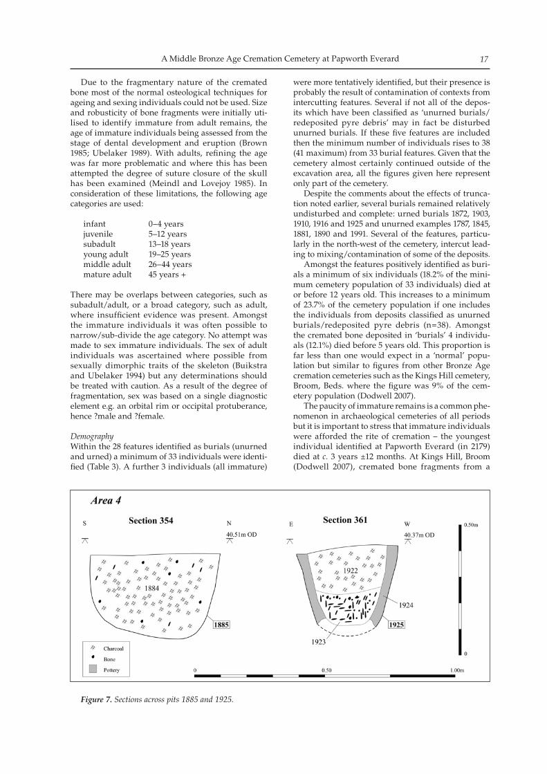
MethodologyDuring excavation all deposits containing cremated bone, and those fills surrounding cremation urns or sealing concentrations of cremated bone in unurned burials, were subject to 100% recovery as whole earth samples which were appropriately processed. All samples were wet sieved, through 10mm, 5mm and 2mm sieves and all extraneous material was removed from the >5mm fraction. Osteological analysis fol-lowed procedures for cremated human bone outlined by McKinley (2002 and 2004). All bone >5mm was examined and sorted and weighed by body part (e.g. skull, axial skeleton, lower limb, upper limb, limb and unidentifiable). The residue from the 2mm–5mm fraction was scanned and identifiable elements sepa-rated. A proportion of each sample was floated for retrieval of any charred plant remains. Although the fragile nature of the cremation vessels meant that it was not possible to lift the urns and excavate them off-site, distinctions between upper and lower fills of pots were possible (e.g. pit 1925, Fig. 8, Section 361).
Figure 7. Cremation pit 1724, showing the burnt remains of the cremation vessel.
A Middle Bronze Age Cremation Cemetery at Papworth Everard 17
Due to the fragmentary nature of the cremated bone most of the normal osteological techniques for ageing and sexing individuals could not be used. Size and robusticity of bone fragments were initially uti-lised to identify immature from adult remains, the age of immature individuals being assessed from the stage of dental development and eruption (Brown 1985; Ubelaker 1989). With adults, refining the age was far more problematic and where this has been attempted the degree of suture closure of the skull has been examined (Meindl and Lovejoy 1985). In consideration of these limitations, the following age categories are used:
infant 0–4 yearsjuvenile 5–12 yearssubadult 13–18 yearsyoung adult 19–25 yearsmiddle adult 26–44 yearsmature adult 45 years +
There may be overlaps between categories, such as subadult/adult, or a broad category, such as adult, where insufficient evidence was present. Amongst the immature individuals it was often possible to narrow/sub-divide the age category. No attempt was made to sex immature individuals. The sex of adult individuals was ascertained where possible from sexually dimorphic traits of the skeleton (Buikstra and Ubelaker 1994) but any determinations should be treated with caution. As a result of the degree of fragmentation, sex was based on a single diagnostic element e.g. an orbital rim or occipital protuberance, hence ?male and ?female.
Demography Within the 28 features identified as burials (unurned and urned) a minimum of 33 individuals were identi-fied (Table 3). A further 3 individuals (all immature)
were more tentatively identified, but their presence is probably the result of contamination of contexts from intercutting features. Several if not all of the depos-its which have been classified as ‘unurned burials/redeposited pyre debris’ may in fact be disturbed unurned burials. If these five features are included then the minimum number of individuals rises to 38 (41 maximum) from 33 burial features. Given that the cemetery almost certainly continued outside of the excavation area, all the figures given here represent only part of the cemetery. Despite the comments about the effects of trunca-tion noted earlier, several burials remained relatively undisturbed and complete: urned burials 1872, 1903, 1910, 1916 and 1925 and unurned examples 1787, 1845, 1881, 1890 and 1991. Several of the features, particu-larly in the north-west of the cemetery, intercut lead-ing to mixing/contamination of some of the deposits. Amongst the features positively identified as buri-als a minimum of six individuals (18.2% of the mini-mum cemetery population of 33 individuals) died at or before 12 years old. This increases to a minimum of 23.7% of the cemetery population if one includes the individuals from deposits classified as unurned burials/redeposited pyre debris (n=38). Amongst the cremated bone deposited in ‘burials’ 4 individu-als (12.1%) died before 5 years old. This proportion is far less than one would expect in a ‘normal’ popu-lation but similar to figures from other Bronze Age cremation cemeteries such as the Kings Hill cemetery, Broom, Beds. where the figure was 9% of the cem-etery population (Dodwell 2007). The paucity of immature remains is a common phe-nomenon in archaeological cemeteries of all periods but it is important to stress that immature individuals were afforded the rite of cremation – the youngest individual identified at Papworth Everard (in 2179) died at c. 3 years ±12 months. At Kings Hill, Broom (Dodwell 2007), cremated bone fragments from a
Figure 7. Sections across pits 1885 and 1925.
Nicholas Gilmour, Natasha Dodwell and Elizabeth Popescu18
neonate/young infant were identified and it is possible that individuals of a similarly young age lie amongst the unidentifiable fragments at Papworth Everard. In addition, the fragility of immature bone may predis-pose it to destruction in acidic soil or loss as a result of disturbance. Interestingly the small quantities (1–3g) of immature bone fragments which were identified in features 1826, 1857 and 1867 (all classified as unurned burials/redeposited pyre debris) were mixed with large quantities of charcoal suggesting that the frag-ments were difficult to collect from the pyre site and were scooped up with a quantity of pyre debris. This phenomenon was also observed in one of the features at the King’s Hill cremation cemetery. Amongst the features positively identified as buri-als, one (c. 3%) individual was an older subadult/young adult, two (c. 6%) were subadult/adult and 24 (73%) were adult. The proportions are near-identical, one (c. 2%), two (c. 5%) and 28 (68%) respectively if the individuals identified in the deposits classed as unurned/pyre debris are included. These crude demographic figures show that pro-portionately fewer immature individuals and more adults have been recorded here than at two other contemporary cremation cemeteries. Amongst the burials at Papworth Everard c. 18% of the individuals identified died before 12 years old and 73% as adults, compared to 30% and 48% at Pasture Lodge Farm, Lincs. (Allen et al 1987), and 32% and 48% at Kings Hill, Broom, Beds. (Dodwell 2007). These differences are unlikely to be significant given the fragility of immature remains, their presence in potentially non-burial contexts and the large quantity of unidentifi-able bone.
SexingThe small quantities of bone, the lack of diagnostic el-ements and the degree of fragmentation greatly inhib-ited the sexing of the deposits containing adult bone. It must be stressed that the sexing is tentative and based on a single diagnostic element. Bone from only nine features could be tentatively sexed; six as ?fe-male (1782, 1881, 1991, 1994, 2043 and 2075) and three as ?male (1859, 2099, 2257). Amongst the features con-taining ?female burnt bone, one is an urned burial, four are unurned burials and one is redeposited pyre debris. Amongst the features containing ?male burnt bone one is an urned burial, one is an unurned burial and one is unurned/redeposited pyre debris.
Double BurialsUnfortunately it is not possible to distinguish be-tween deliberate dual cremation or burial, and the ac-cidental inclusion of fragments of burnt bone, which were not collected from an earlier cremation on the same pyre. At Papworth Everard, eight burials con-tained the cremated remains of two individuals (see Table 4). It could be argued that three of these (2049, 2099 and 2185) have been contaminated with strati-graphically earlier material from an adjacent burial (2257) however the other five (1782, 1845, 1872, 2179 and 2257) would appear to be confirmed examples. All of the confirmed examples are unurned burials except for 1872. In addition to the burials the remains of two indi-viduals were identified in 1965 and 2045, deposits of pyre debris. Where two individuals were identified in a single deposit, it was always an adult buried with an infant or juvenile, and given the limits of sexing cre-mated remains, where it was possible to assign a sex,
Age Category Urned burials Unurned burialsTotal no. from burials
Unurned/ pyre debris
Total No. of individuals from all features
Foetus/neonate - - - - -
Neonate/young infant - - - - -
Infant 1 - 1 1 2
Older infant 0 (1) 3 3 (4) - 3 (4)
Older infant/young juvenile 1 (2) 1 2 (3) - 2 (3)
Young juvenile - - - - -
Infant/juvenile 0 (1) - 0 (1) 11(2)
Juvenile
Older juvenile/young subadult - - - - -
Immature 1 1
Subadult - - - -
Older subadult/young adult - 1 1 - 1
Subadult/adult 2 - 2 2
Young adult - 2 2 - 2
Young/middle adult - 2 2 2
Middle adult - 1 1 - 1
Middle/mature adult - - - 11
Mature adult - - - - -
adult 118 19 1 20
Total no. of individuals 15 (18) 18 33 (36) 5 38 (41)
Table 3. The number of individuals identified in each age category by feature type. The figure in brackets includes individuals identified in deposits that could derive from an earlier features and therefore represents a maximum figure.
A Middle Bronze Age Cremation Cemetery at Papworth Everard 19
one of the adults was ?female and two were ?male. It is relatively easy to distinguish adult from immature bones, however the adult/child burial phenomenon may be real and if so raises interesting questions with regard to funerary practices and the social organisa-tion of the living. Given the fragmentary nature of the burnt bone it is possible that burials containing the remains of two or more adults were present on the site but were not recognised. In addition second individuals, or more of the second individual identi-fied, may be present in the ‘unidentified’ human bone recovered from most of the features.
Pyre technology and cremation ritualMost of the bone fragments recovered were a creamy, buff-white colour, indicative of full oxidation. A few fragments from six deposits (features 1910, 2045, 2049, 2075, 2099 and 2185) showed slight variations in col-our from grey to blue/black (charred). The bone most often identified as charred was the femoral shaft. The variations in colour suggest minor inconsistencies in the degree of oxidation; either fragments falling away from the main heat source to the edge of the pyre or becoming buried in fuel ash. The bone fragments in 1782 and 1859 have a weathered, chalky appearance.
Weight of boneStudies of modern western cremation practices have determined that the weight of collectable (>2mm fraction) cremated bone anticipated from an adult cremation ranges from 1000g to 2400g depending on the sex and build of the individual (McKinley 1993). McKinley (1989) has outlined the numerous factors, such as the efficiency of collection from the pyre and the depositional environment, which may affect the quantity of bone recovered, but it is generally recog-nised that the entire burnt body was very rarely, if ever, collected for burial. At Papworth Everard only bone >5mm was sorted from the heavy residue and weighed. This will obviously mean that the weights of bone analysed will be less than those expected
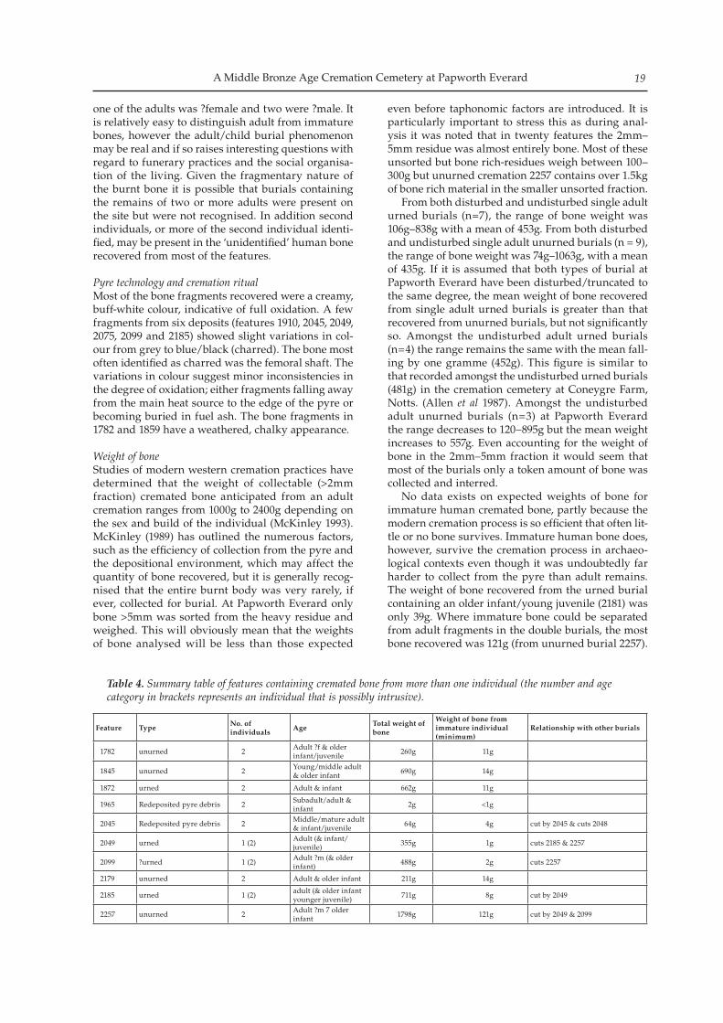
even before taphonomic factors are introduced. It is particularly important to stress this as during anal-ysis it was noted that in twenty features the 2mm–5mm residue was almost entirely bone. Most of these unsorted but bone rich-residues weigh between 100–300g but unurned cremation 2257 contains over 1.5kg of bone rich material in the smaller unsorted fraction. From both disturbed and undisturbed single adult urned burials (n=7), the range of bone weight was 106g–838g with a mean of 453g. From both disturbed and undisturbed single adult unurned burials (n = 9), the range of bone weight was 74g–1063g, with a mean of 435g. If it is assumed that both types of burial at Papworth Everard have been disturbed/truncated to the same degree, the mean weight of bone recovered from single adult urned burials is greater than that recovered from unurned burials, but not significantly so. Amongst the undisturbed adult urned burials (n=4) the range remains the same with the mean fall-ing by one gramme (452g). This figure is similar to that recorded amongst the undisturbed urned burials (481g) in the cremation cemetery at Coneygre Farm, Notts. (Allen et al 1987). Amongst the undisturbed adult unurned burials (n=3) at Papworth Everard the range decreases to 120–895g but the mean weight increases to 557g. Even accounting for the weight of bone in the 2mm–5mm fraction it would seem that most of the burials only a token amount of bone was collected and interred. No data exists on expected weights of bone for immature human cremated bone, partly because the modern cremation process is so efficient that often lit-tle or no bone survives. Immature human bone does, however, survive the cremation process in archaeo-logical contexts even though it was undoubtedly far harder to collect from the pyre than adult remains. The weight of bone recovered from the urned burial containing an older infant/young juvenile (2181) was only 39g. Where immature bone could be separated from adult fragments in the double burials, the most bone recovered was 121g (from unurned burial 2257).
Table 4. Summary table of features containing cremated bone from more than one individual (the number and age category in brackets represents an individual that is possibly intrusive).
Feature TypeNo. of individuals
AgeTotal weight of bone
Weight of bone from immature individual (minimum)
Relationship with other burials
1782 unurned 2 Adult ?f & older infant/juvenile 260g 11g
1845 unurned 2 Young/middle adult & older infant 690g 14g
1872 urned 2 Adult & infant 662g 11g
1965 Redeposited pyre debris 2 Subadult/adult & infant 2g <1g
2045 Redeposited pyre debris 2 Middle/mature adult & infant/juvenile 64g 4g cut by 2045 & cuts 2048
2049 urned 1 (2) Adult (& infant/juvenile) 355g 1g cuts 2185 & 2257
2099 ?urned 1 (2) Adult ?m (& older infant) 488g 2g cuts 2257
2179 unurned 2 Adult & older infant 211g 14g
2185 urned 1 (2) adult (& older infant younger juvenile) 711g 8g cut by 2049
2257 unurned 2 Adult ?m 7 older infant 1798g 121g cut by 2049 & 2099
Nicholas Gilmour, Natasha Dodwell and Elizabeth Popescu20
It is highly probable that more immature bone is present amongst the unidentifiable bone fragments.
FragmentationMcKinley (1994) has argued convincingly that bone fragment size is dependent on factors such as the ef-ficiency of the pyre, the depositional environment and methods the excavation and post-excavation processing. Amongst the urned burials the maxi-mum dimension of bone fragment recorded was 60mm (from 2185) and amongst the unurned buri-als the maximum fragment was 63mm (from 1890). The maximum from most of the burial deposits was relatively low at <40mm. Amongst all of the urned adult burials, both disturbed and undisturbed (n=7) the majority of bone was recovered from the 5–10mm residue (51–74%). The exception to this was burial 1724 where 52% was recovered from the 10mm sieve fraction. Similarly, amongst all of the unurned adult burials (n=8), the majority of the bone was recovered from the 5–10mm residue (54–75%). These figures are almost identical in terms of the ‘undisturbed adult burials’; 51–67% of the bone in urned burials (n=4) and 54–75% in unurned burials (n=3) was recovered from the 5–10mm sieve fraction. The true percentages are likely to be slightly lower since only teeth and identifiable skeletal elements from the 2mm fraction were included in the total weights. These figures highlight two points. Firstly, that the bone from all contexts was extremely fragmentary, restricting more precise identification of individuals and skeletal elements. There is almost no evidence for the deliberate post-depositional fragmentation of cremated bone from burials of any period in Britain (McKinley pers. comm.) and the chalky appearance of some of the bone fragments and the poor survival of trabecular bone suggest that the small fragment size is the result of taphonomic processes, namely the acidic nature of the burial soil. Secondly, there is no difference in the bone fragment size in the urned and unurned burials; one might expect that the bone fragment size might be larger in the urned burials as a vessel should afford some protection from the surrounding soil. However, given the extremely poor survival of the cremation urns (some survive only as stains in the ground) it could be argued that their presence, in terms of protection against the acidic soil is inconsequential.
ConclusionsCremated human bone was identified in both urned and unurned burials, and adults of both sexes and immature individuals were interred. No pyre site was identified in the area of excavation but several features containing pyre debris were recognised, which suggests that its deliberate disposal was sig-nificant in the funerary ritual. The funerary rite re-lating to children is interesting; immature remains were identified in all categories of funerary feature, however only one true single burial was identified, the urned burial (2181). All other burials were double ones; adult and immature remains interred in vessels
or as unurned burials. Very small quantities of im-mature remains were identified in features classified as unurned/redeposited pyre debris (1826, 1857 and 1867) suggesting that collecting the bone fragments from the pyre was difficulty but necessary.
Radiocarbon Dating P. D. Marshall
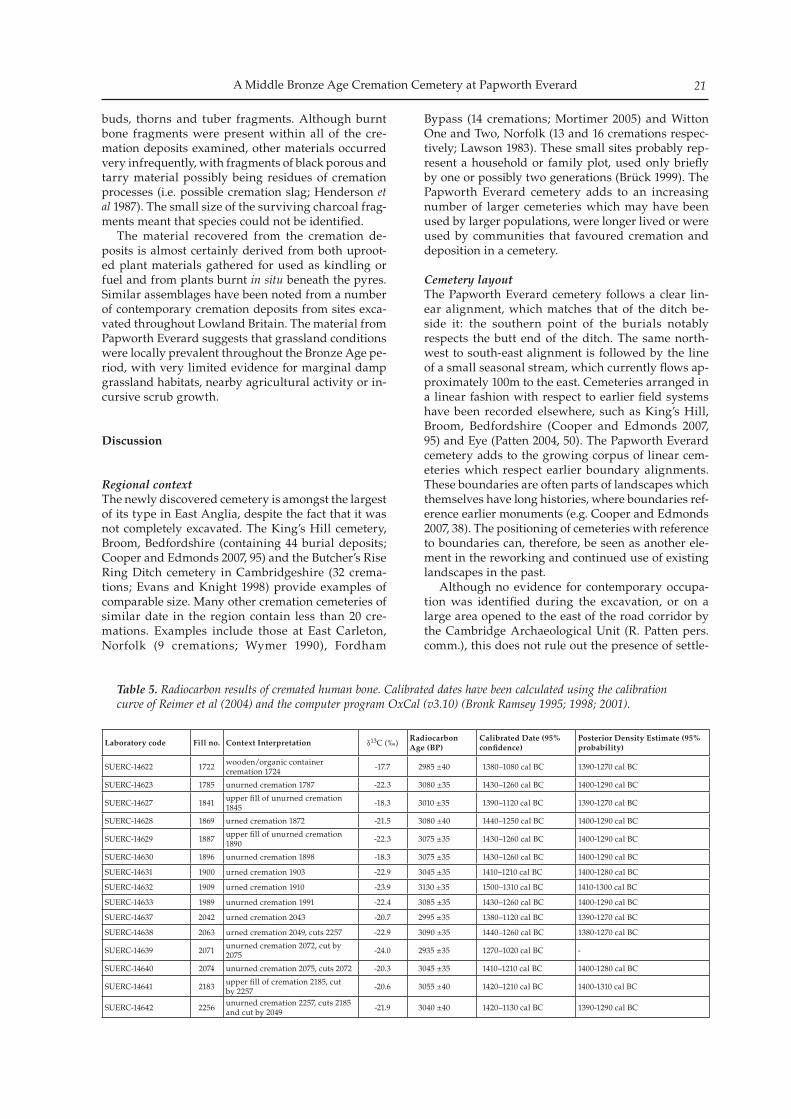
Fifteen radiocarbon age determinations were ob-tained on samples of the cremated human bone. The samples were submitted to the Scottish Universities Environmental Research Centre (SUERC), East Kilbride, and prepared following the method outlined in Lanting et al (2001). The results are given in Table 5, and are quoted in accordance with the interna-tional standard known as the Trondheim convention (Stuiver and Kra 1986). They are conventional radio-carbon ages (Stuiver and Polach 1977). A Bayesian ap-proach has been adopted for the interpretation of the chronology of these samples (Buck et al 1996). This approach incorporated stratigraphic data to attempt to give a chronology to the burials within the cem-etery. The model employed excluded SUERC-14639 as a statistical outlier. This model provides estimates for the start of cremation activity of 1430–1310 cal BC (95% probability) and probably 1410–1340 cal BC (68% probability) and the end of activity of 1380–1240 cal BC (95% probability) and probably 1350–1270 cal BC (68% probability). The span of use of the cemetery is estimated at 1–140 years (95% probability) and probably 1–80 years (68% probability). It is likely, however, that the esti-mate for the use of the cemetery tends to suggest that activity continues for longer than it really did; the ‘wiggle’ in the calibration curve between c. 1400–1300 cal BC (Reimer et al 2004) means that it is not possi-ble to distinguish between activity only being in the early or later part of that period.
Environmental Evidence Val Fryer
Plant remains from the cremations and related pyre debris were relatively sparse, although tubers of onion couch (Arrhenatherum sp.) did occur within all but three of the thirty samples studied. Seeds/fruits of grasses and grassland herbs, including indetermi-nate small legumes (Fabaceae), goosegrass (Galium aparine), persicaria (Persicaria maculosa/lapathifolia), ribwort plantain (Plantago lanceolata), dock (Rumex sp.) and vetch/vetchling (Vicia/Lathyrus sp.), were also recorded along with three very poorly preserved cereal grains. Three samples (from cremations 1840, 1859 and 2048) contained wetland plant macrofossils including spike-rush (Eleocharis sp.) fruits and blinks (Montia fontana) seeds. Charcoal/charred wood frag-ments were common or abundant throughout, along with indeterminate root, rhizome or stem fragments. Other plant macrofossils included indeterminate
A Middle Bronze Age Cremation Cemetery at Papworth Everard 21
buds, thorns and tuber fragments. Although burnt bone fragments were present within all of the cre-mation deposits examined, other materials occurred very infrequently, with fragments of black porous and tarry material possibly being residues of cremation processes (i.e. possible cremation slag; Henderson et al 1987). The small size of the surviving charcoal frag-ments meant that species could not be identified. The material recovered from the cremation de-posits is almost certainly derived from both uproot-ed plant materials gathered for used as kindling or fuel and from plants burnt in situ beneath the pyres. Similar assemblages have been noted from a number of contemporary cremation deposits from sites exca-vated throughout Lowland Britain. The material from Papworth Everard suggests that grassland conditions were locally prevalent throughout the Bronze Age pe-riod, with very limited evidence for marginal damp grassland habitats, nearby agricultural activity or in-cursive scrub growth.
Discussion
Regional contextThe newly discovered cemetery is amongst the largest of its type in East Anglia, despite the fact that it was not completely excavated. The King’s Hill cemetery, Broom, Bedfordshire (containing 44 burial deposits; Cooper and Edmonds 2007, 95) and the Butcher’s Rise Ring Ditch cemetery in Cambridgeshire (32 crema-tions; Evans and Knight 1998) provide examples of comparable size. Many other cremation cemeteries of similar date in the region contain less than 20 cre-mations. Examples include those at East Carleton, Norfolk (9 cremations; Wymer 1990), Fordham
Bypass (14 cremations; Mortimer 2005) and Witton One and Two, Norfolk (13 and 16 cremations respec-tively; Lawson 1983). These small sites probably rep-resent a household or family plot, used only briefly by one or possibly two generations (Brück 1999). The Papworth Everard cemetery adds to an increasing number of larger cemeteries which may have been used by larger populations, were longer lived or were used by communities that favoured cremation and deposition in a cemetery.
Cemetery layoutThe Papworth Everard cemetery follows a clear lin-ear alignment, which matches that of the ditch be-side it: the southern point of the burials notably respects the butt end of the ditch. The same north-west to south-east alignment is followed by the line of a small seasonal stream, which currently flows ap-proximately 100m to the east. Cemeteries arranged in a linear fashion with respect to earlier field systems have been recorded elsewhere, such as King’s Hill, Broom, Bedfordshire (Cooper and Edmonds 2007, 95) and Eye (Patten 2004, 50). The Papworth Everard cemetery adds to the growing corpus of linear cem-eteries which respect earlier boundary alignments. These boundaries are often parts of landscapes which themselves have long histories, where boundaries ref-erence earlier monuments (e.g. Cooper and Edmonds 2007, 38). The positioning of cemeteries with reference to boundaries can, therefore, be seen as another ele-ment in the reworking and continued use of existing landscapes in the past. Although no evidence for contemporary occupa-tion was identified during the excavation, or on a large area opened to the east of the road corridor by the Cambridge Archaeological Unit (R. Patten pers. comm.), this does not rule out the presence of settle-
Laboratory code Fill no. Context Interpretation δ13C (‰)Radiocarbon Age (BP)
Calibrated Date (95% confidence)
Posterior Density Estimate (95% probability)
SUERC-14622 1722 wooden/organic container cremation 1724 -17.7 2985 ±40 1380–1080 cal BC 1390-1270 cal BC
SUERC-14623 1785 unurned cremation 1787 -22.3 3080 ±35 1430–1260 cal BC 1400-1290 cal BC
SUERC-14627 1841 upper fill of unurned cremation 1845 -18.3 3010 ±35 1390–1120 cal BC 1390-1270 cal BC
SUERC-14628 1869 urned cremation 1872 -21.5 3080 ±40 1440–1250 cal BC 1400-1290 cal BC
SUERC-14629 1887 upper fill of unurned cremation 1890 -22.3 3075 ±35 1430–1260 cal BC 1400-1290 cal BC
SUERC-14630 1896 unurned cremation 1898 -18.3 3075 ±35 1430–1260 cal BC 1400-1290 cal BC
SUERC-14631 1900 urned cremation 1903 -22.9 3045 ±35 1410–1210 cal BC 1400-1280 cal BC
SUERC-14632 1909 urned cremation 1910 -23.9 3130 ±35 1500–1310 cal BC 1410-1300 cal BC
SUERC-14633 1989 unurned cremation 1991 -22.4 3085 ±35 1430–1260 cal BC 1400-1290 cal BC
SUERC-14637 2042 urned cremation 2043 -20.7 2995 ±35 1380–1120 cal BC 1390-1270 cal BC
SUERC-14638 2063 urned cremation 2049, cuts 2257 -22.9 3090 ±35 1440–1260 cal BC 1380-1270 cal BC
SUERC-14639 2071 unurned cremation 2072, cut by 2075 -24.0 2935 ±35 1270–1020 cal BC -
SUERC-14640 2074 unurned cremation 2075, cuts 2072 -20.3 3045 ±35 1410–1210 cal BC 1400-1280 cal BC
SUERC-14641 2183 upper fill of cremation 2185, cut by 2257 -20.6 3055 ±40 1420–1210 cal BC 1400-1310 cal BC
SUERC-14642 2256 unurned cremation 2257, cuts 2185 and cut by 2049 -21.9 3040 ±40 1420–1130 cal BC 1390-1290 cal BC
Table 5. Radiocarbon results of cremated human bone. Calibrated dates have been calculated using the calibration curve of Reimer et al (2004) and the computer program OxCal (v3.10) (Bronk Ramsey 1995; 1998; 2001).
Nicholas Gilmour, Natasha Dodwell and Elizabeth Popescu22
ment nearby. The fabric of the vessels in which the cremations were contained suggest local manufac-ture, the cemetery probably serving a relatively local community. It is possible that the location of the cemetery or specific deposits within it, were marked by posts. Notches cut into the side of four of the burial pits in the cremation cemetery at King’s Hill, Broom were in-terpreted as markers, allowing subsequent burials to be positioned immediately adjacent to them (Cooper and Edmonds 2007, 98). While none of the possible postholes identified at Papworth Everard appeared to be directly related to an individual deposit, four of the six possible postholes occur in the vicinity of a tight cluster of inter-cutting features. Although effectively hidden in the modern landscape, the cemetery’s posi-tion next to a boundary ditch and potentially marked by posts suggests that it was not intended to be con-cealed. The rectangular pits in Areas 2 and 3 are difficult to parallel in Middle Bronze Age contexts. Two pits of similar date and dimension, containing significant quantities of charcoal and burnt stone, have recently been recorded at Brigg’s Farm, Thorney (Pickstone and Mortimer, in prep.). They were interpreted as having an industrial function, perhaps related to salt making. Other similar pits, although of Late Iron Age date, were recorded in direct association with a crema-tion cemetery on the route of the A27 Westhampnett Bypass, West Sussex (Fitzpatrick 1997, 18–32). Here they were shown to be pyre sites, with trenches acting as flues helping to increase the temperature of the fire (ibid, 18). The pits at Papworth may be related to the cremation process, although no cremated bone was recovered from them: in this respect, it is of note that one of the pyre features identified at Westhampnett contained as little as 0.8g of bone (ibid, 29) and not all of the fill of the Papworth features was retained for environmental processing. Alternatively, they may have served some industrial process, though evi-dently very unlikely to be salt making so far from a source of salt water. It is also possible that these pits formed a segmented boundary feature, or even sup-ported structures of some kind. Whatever their true function, they appear to have formed part of the same landscape of which the cemetery was a part and their location on the top of the slope overlooking the cre-mation cemetery may well be significant.
The BurialsIt has been shown that, in southern England, the ma-jority of cremation cemeteries comprise fewer than 40 burials, with an average of between 10 to 30 (Ellison 1980, 117). Bearing in mind that the entire extent of the cemetery at Papworth Everard was not excavated, the total number of burials here is high. Similarly, the total proportion of burials within vessels (42%) is high, given the average of 24% for contemporary cemeteries calculated by Robinson (2007, 22). Whilst it is tempting to suggest some sort of special status for the individuals provided with a pottery vessel in the grave, this does not appear to be based on age and it
was not possible to determine sex. It is interesting to note, however, that the majority of the urned burials occur in clusters (2049, 2185 and 2099; 2039, 2043 and 1916; 1883, 1903 and 1861) which may indicate a rela-tionship between these burials. Similar clusters were evident in the cremated remains, with double burials restricted to the southern arc (1782, 1845 and 1872) and the cluster of urned burials at the northern limit of excavation (2049, 2185 and 2099). This latter clus-ter may, however, be the result of pits 2049, 2185 and 2099 cutting pit 2257, which contained the strongest evidence for a double burial, redistributing bone into these features. If this is the case, the only instance of a double burial within a vessel is that from 1872. This may indicate a degree of chronological patterning with unurned and double burials predating urned burials, although the evidence for this is slight. While the identification of a wooden/organic ves-sel remains equivocal, it is likely that in some of the deposits referred to as unurned burials the cremated bone was deposited within an organic container. The cremated bone in feature 1845 was tightly packed, suggesting that it had been deposited in a bag. Similar deposits have been identified in other Middle Bronze Age cremation cemeteries, such as that at Butcher’s Rise, Cambridgeshire (Evans and Knight 1998, 25) . At Sutton, an Early Bronze Age cremation burial and adjacent pit were found beneath a mound. The pit had a void around the sides and base of the cut, perhaps indicating the presence of an organic container, with-in which possible pyre debris had been placed in a basket(s) or wooden bowl(s) (Connor 2009, 40). There were no grave or pyre goods noted across the cemetery at Papworth Everard, apart from three fragments of unidentifiable burnt animal bone, pos-sibly sheep/goat, recovered from the upper fill of un-urned burial 2072. Similar deposits of animal bone have been noted at other Middle Bronze Age cem-eteries, such as that at Butcher’s Rise, Cambridgeshire (Evans and Knight 1998, 31) and King’s Hill, Broom (Cooper and Edmonds 2007, 97). A large number of radiocarbon dates were ob-tained for the burials at Papworth Everard and this allowed for meaningful statistical analysis to deter-mine the use life of the cemetery. This was estimated at between 1–140 years (95% probability) and prob-ably 1–80 years (68% probability). The lack of other sites in this region with such comprehensive dates prevents comparison of this use-life. It is of note that this cemetery was perhaps in use for a maximum of six generations and probably considerably less then this. If further cemeteries were subjected to such sci-entific dating techniques, then some of the assump-tions inherent in population modelling (e.g. Evans and Knight 2001, 101) could be addressed.
The Western Claylands during the Bronze AgeIt has traditionally been assumed that clay soils were not heavily exploited in the past, due to their perceived poor quality (Mills and Palmer 2007, 7). Recent archaeological investigations have, however, started to demonstrate the extensive use of clay soils
A Middle Bronze Age Cremation Cemetery at Papworth Everard 23
for both farming and habitation during the Iron Age and Roman period. This is particularly true of the western claylands of Cambridgeshire, seen tradition-ally as the ‘cold wet claylands’ (Fox 1923, 7), outside the preferred areas of habitation along the river grav-els and fen edge. This view was still current until quite recently. Several recent large scale excavations have, however, provided ample evidence for Iron Age and Roman habitation, although such evidence has not yet been forthcoming for the Bronze Age. For ex-ample, although a large area of c. 30ha was stripped at Loves Farm, St Neots, no significant Bronze Age remains were identified (Hinman in prep.). Large scale excavations in advance of the development of Cambourne and along the route of the new A428 also failed to identify evidence for Bronze Age activity be-yond two possible pits (Wright et al 2003, 91; Abrams and Ingham 2008, 17). The general lack of extensive field systems and vis-ible settlement activity in this part of Cambridgeshire does not necessarily imply that the area was not oc-cupied during the Bronze Age: the paucity of remains may simply reflect the fact that the area was less densely populated. Several narrow undated ditches identified in other parts of the Papworth Everard site may in fact represent the remains of a Bronze Age field system. The presence of a relatively large crema-tion cemetery initially appears incongruous. The site is, however, located at the head of a valley, providing ready access to the Great Ouse Valley. This is a loca-tion which has long been identified as that most likely to have sustained early occupation (Fox 1923, 63). It is also possible that the lack of field systems iden-tified on the claylands relates to the type of agricul-ture being practised. With heavy clay soil being more difficult to work for arable crops before the advent of new farming techniques, it is possible that the clay-lands were instead used for grazing. The act of creat-ing field systems is frequently interpreted as a way to increase the productivity of land (e.g. Yates 2007, 120). In the case of livestock farming, this is achieved as ac-cess to overgrazed land can be restricted in order to allow the grasslands to recover, although such a sys-tem is only necessary when livestock numbers reach a level where overgrazing may become a problem (Pryor 2001, 82–83). If there was no such pressure on the more sparsely inhabited western claylands then the need for field systems would be reduced.
Conclusions
While in many ways the Papworth Everard crema-tion cemetery is typical of other Middle Bronze Age cremation cemeteries known in the region, its loca-tion on Cambridgeshire’s western claylands is thus far unique. While these clay uplands were fertile and reliable, arable agriculture here was hard, labour intensive work. As a result it is likely that this area only became permanently settled over a long period of time and that there may well have been low level, temporary and/or seasonal use of the landscape
by a small group of people. The Papworth Everard cemetery may then indicate repeated use by small to moderate populations of socially tightly knitted mo-bile and seasonal agriculturalists. This concept tal-lies with the suggestion that Bronze Age cremation cemeteries reflect wider social changes, particularly in terms of alterations in agriculture and settlement (Bradley 1981, 103). Bradley has suggested that in-creasing pressure on land at this time led to the opening up of new agricultural areas (such as this clay upland region) and that cemeteries, often used as ‘social markers’, began to be placed on this type of land as the concept of land ownership became more established (1981, 104).
Acknowledgements
The authors would like to thank W. S. Atkins Consultants Ltd who commissioned the archaeo-logical works and the Department of Transport, Cambridgeshire County Council who funded the ex-cavations. Thanks are also extended to Jacksons Ltd, the on-site contractors, who greatly assisted during the course of the works. The project was managed by James Drummond-Murray. Dan Hounsell directed the field work with the assistance of Emma Nordstrum, Kathy Grant, Gareth Rees, Louise Bush, Tom Eley, Tom Lyons, Gemma Tully, Adam Loden, Chris Faine, Ian Hogg, Dave Brown, Dave Strachan, Spencer Cooper, Claire Martin, Helen Stocks, Andy Corrigan and James Fairbairn. Thanks are also extended to Dave Mullins (Oxford Archaeology South) for his comments on early drafts of this paper. This article was prepared for pub-lication by Elizabeth Popescu.
Cambridge Antiquarian Society is grateful to Cambridgeshire County Council for a grant to-wards the publication of this paper.
Bibliography
Abrams, J and D Ingham 2008 Farming on the Edge: archaeo-logical evidence from the clay uplands west of Cambridge. EAA123
Allen, CSM, MN Harmen and H Wheeler 1987 Bronze Age Cremation Cemeteries in the East Midlands. PPS 53: 187–221
Bradley, R 1981 ‘Various Styles of Urn: Cemeteries and Settlement in Southern England c. 1400–1000BC’, in R Chapman, I Kinnes and K Randsborg (eds), The Archaeology of Death: 93–104. Cambridge: CUP
Bradley, R 2007 The Prehistory of Britain and Ireland. Cambridge: CUP
British Geological Survey 1993 Huntingdon, England and Wales Sheet 187, Drift edition. 1:50 000 Series
Bronk Ramsey, C 1995 Radiocarbon Calibration and Analysis of Stratigraphy: The OxCal Program, Radiocarbon 37: 425–30
Bronk Ramsey, C 1998 Probability and dating, Radiocarbon 40: 461–74
Bronk Ramsey, C 2001 Development of the Radiocarbon Program OxCal, Radiocarbon 43 (2A): 355–363
Nicholas Gilmour, Natasha Dodwell and Elizabeth Popescu24
Brown, WAB 1985 Identification of Human Teeth. Dorking: Adlard & Son Ltd, Bartholomew Press
Brück, J 1999 Houses, Lifecycles and Deposition on Middle Bronze Age Settlements in Southern England, PPS 65: 145–166
Brück, J (ed) 2001 Bronze Age Landscapes: Tradition and Transformations. Oxford: Oxbow
Brück, J 2006 Fragmentation, Personhood and the Social Construction of Technology in Middle and Late Bronze Age Britain. Cambridge Archaeol J 16:3: 207–315
Buck, CE, WG Cavanagh and CD Litton 1996 Bayesian Approach to Interpreting Archaeological Data, Chichester: Wiley
Buikstra, JE and Ubelaker DH (eds) 1994 Standards for the collection from human skeletal remains. Arkansas Archaeological Survey. Research Series No. 44. Fayetteville: Arkansas Archaeological Survey
Connor, A 2009 A fen island burial: excavation of an Early Bronze Age round barrow at North Fen, Sutton. PCAS XCVIII: 37–46
Cooper A and M Edmonds 2007 Past and Present. Excavations at Broom, Bedfordshire. 1996–2000. Oxford: Oxbow
Dodwell, N 2007 Bronze Age cremation burials. In Cooper, A. and Edmunds, M. Past & Present, Excavations at Broom Bedfordshire. Oxford: Oxbow Books: 91–98
Ellison, AB 1980 Deverel-Rimbury Urn Cemeteries: The Evidence for Social Organisation. In JC Barrett, and R Bradley (eds) Settlement and Society in the Later British Bronze Age. Brit Archaeol Rep Brit Ser 83: 115–126
Ellison, A 1988 ‘Bucket-Shaped Vessels of the Deverel-Rimbury Tradition’. In Clutton Brock, J. Excavations at Grimes Graves, Norfolk 1972–1976. Fascicule 2. British Museum. 25–51
Evans, C and M Knight 1998 The Butcher’s Rise Ring-Ditches: Excavations at Barleycroft Farm, Cambridgeshire 1996. Cambridge Archaeological Unit Report No. 283
Evans, C and M Knight 2001 ‘The ‘Community of Builders’: The Barleycroft Post Alignments’ in Brück, J (ed). Bronze Age Landscapes: Tradition and Transformations. Oxford: Oxbow. 83–98
Fitzpatrick, AP 1997 Archaeological Excavations on the route of the A27 Westhampnett Bypass, West Sussex, 1992 Volume 2: the cemeteries. Salisbury: Wessex Archaeology Report No. 12
Fox, C 1923 The Archaeology of the Cambridge Region. Cambridge: CUP
Henderson, J, RC Janaway and JR Richards 1987 ‘Cremation slag: a substance found in funerary urns’, in A Boddington, AN Garland and RC Janaway, Death, Decay and Reconstruction: approaches to archaeology and forensic science. Manchester: Manchester University Press: 81–100
Hinman, M in prep. Iron Age to Early Saxon Settlement at Love’s Farm, St Neots, Cambridgeshire. EAA
Lanting, JN, AT Aerts-Bijma, and J van der Plicht 2001 Dating of cremated bones, Radiocarbon 43: 249–54
Lawson, AJ 1983 The Archaeology of Witton, Near North Walsham, Norfolk. Gressenhall: EAA 18
McKinley, JI 1989 ‘Cremations: expectations, methodolo-gies and realities’. In CA Roberts, F Lee, and J Bintliff, (eds) Burial Archaeology. Current research, methods and developments. Oxford: Brit Archaeol Rep Brit Ser 211: 65–76
McKinley, JI 1993 Bone Fragment Size and Weights of Bone from Modern British Cremations and the Implications for the Interpretation of Archaeological Cremations. Int J Osteoarchaeology 3: 283–287
McKinley, JI 1994 Bone Fragment Size in British Cremation Burials and its Implications for Pyre Technology and Ritual. J Archaeol Sci 21: 339–342
McKinley, JI 1997 Bronze Age ‘Barrows’ and Funerary Rites and Rituals of Cremation. PPS 63: 129–145
McKinley, JI 2002 ‘The analysis of cremated bone’. In M Cox and S Mays (eds). Human Osteology in Archaeology and Forensic Science. London: Greenwich Medical Media Ltd. 403–421
McKinley, JI 2004 ‘Compiling a skeletal inventory: cremat-ed human bone. In M Brickley and JI Mckinley (eds) Guidelines to the Standards for Recording Human Remains. IFA Paper No. 7: 9–13
Meindl RS and CO Lovejoy 1985 Ectocranial Suture Closure: a revised method for the determination of Skeletal Age at Death Based on the Lateral-Anterior Sutures. American J Physical Anthropology 68: 57–66
Mills, J and R Palmer 2007 Populating Clay Landscapes. Stroud: The History Press Ltd
Mortimer, R 2005 Neolithic, Bronze Age, Iron Age and Romano-British Occupation Along the Route of The Fordham Bypass, Fordham, Cambridgeshire. Post exca-vation assessment. Cambridgeshire County Council Archaeological Field Unit Report No. 816
Parker Pearson, M 2005 Bronze Age Britain. London: Batsford
Patten, R 2004 Bronze Age & Romano-British Activity at Eye Quarry, Peterborough: Phase Three. Cambridge Archaeological Unit Report No.268
Pickstone and Mortimer in prep. The Archaeology of Brigg’s Farm, Prior’s Fen, Thorney, Peterborough. Oxford Archaeology East Report No. 1094
Pryor, F 2001 The Flag Fen Basin. Archaeology and Environment of a Fenland Landscape. Swindon: English Heritage.
Reimer, PJ, MGL Baillie, E Bard, A Bayliss, JW Beck, CJH Bertrand, PG Blackwell, CE Buck, GS Burr, KB Cutler, PE Damon, RL Edwards, RG Fairbanks, M Friedrich, TP Guilderson, AG Hogg, KA Hughen, B Kromer, G McCormac, S Manning, C Bronk Ramsey, RW Reimer, S Remmele, JR Southon, M Stuiver, S Talamo, FW Taylor, J van der Plicht, and CE Weyhenmeyer 2004 IntCal04 Terrestrial radiocarbon age calibration, 0–26 Cal Kyr BP, Radiocarbon 46: 1029–58
Robinson, I 2007 Middle Bronze Age cremation Practice in East Anglia: Continuity and Change in Cemetery form and Development. Unpublished Masters Thesis for the University of Cambridge
Stuiver, M and RS Kra, 1986 Editorial comment, Radiocarbon 28(2B): ii
Stuiver, M and HA Polach, 1977 Reporting of 14C data, Radiocarbon 19: 355–63
Ubelaker, DH 1989 Human Skeletal Remains: Excavation, Analysis, and Interpretation. Washington DC: Taraxacum Press
Williams, D 1980 Pottery. In Pryor, FMM Excavations at Fengate, Peterborough, England: The Third Report. Northamptonshire Archaeological Society Monograph 1, Royal Ontario Museum Archaeology Monograph 6
Wright, J, M Leivers, R Seager Smith and CJ Stevens 2003 Cambourne New Settlement – Iron Age and Romano-British settlement on the clay uplands of west Cambridgeshire. Salisbury: Wessex Archaeology Ltd
Wymer, JJ 1990 A Later Bronze Age Cremation Cemetery and Beaker Pits at East Carleton, Norfolk Archaeol 41: 74–83
Yates, DT 2007 Land, Power and Prestige: Bronze Age Field Systems in Southern England. Oxford: Oxbow
In 2009 Albion Archaeology carried out further excavation of a late Iron Age settlement enclosure at Scotland Farm, south-west of Dry Drayton, that was first investigated in 2007. The results of the two excavations correlate strongly, with the latest work revealing further structural remains and evidence of partitioning within the enclosure. Ceramic evidence continues to indicate that the settlement had a short lifespan around the turn of the first century AD, al-though it is clear that the layout of the enclosure developed during that time.
Introduction
An excavation carried out by Albion Archaeology in 2007 at Scotland Farm, south-west of Dry Drayton (Fig. 1), revealed the southern end of a late Iron Age settlement enclosure within the footprint of a new grain store (Ingham 2008). The excavated part of the enclosure contained a non-domestic roundhouse and a small number of settlement-related features (Fig. 2), which produced a tightly dated pottery assemblage from the late first century BC to the first century AD. This settlement may have been a successor to a mid-dle to late Iron Age farmstead located c. 250m to the south-west along the Dam Brook (Abrams & Ingham 2008, 20–33). Plans to extend the grain store led to a further ex-cavation in March 2009. Although the southern exten-sion area contained only furrows and a post-medieval ditch, the northern area revealed more of the Iron Age settlement. Unfortunately, landscaping work associat-ed with construction of the grain store in 2007 had led to a reduction in ground levels within the footprint of the extension that was increasingly severe towards the north-western end of the site. As a consequence, the enclosure ditch and a partition ditch both suffered substantial vertical truncation in places, although the Iron Age remains lay primarily beyond the affected area. The estimated original extent of these two ditch-es has been reconstructed on Figure 2.
Late Iron Age settlement (Fig. 2)
Remains dating to the late Iron Age were confined to the eastern half of the northern excavation area. More of the enclosure ditch (2528) was exposed; at 3.6m wide and 1.4m deep its dimensions were similar to those previously recorded. The infill of the ditch was mostly light in colour and fairly sterile, with the ex-ception of a concentration of animal bone in the base. Excavation revealed the majority of ditch 2524 that separated off the southern end of the enclosure, al-though its full profile was not seen. Its southern edge lay just within the area of the 2007 excavations, al-though this had not fully been recognised at the time; its upper fill — probably colluvial in origin, filling in a hollow left in the top of the ditch — had mistakenly been interpreted as a layer, unassociated with any cut features. It also now seems probable that the ditch was contemporary with enclosure ditch 2528, rather than a later addition or a re-cut of an earlier subdivid-ing ditch, as previously thought. Landscaping in 2007 had truncated ditch 2524 with increasing severity towards its western end; its surviv-ing extent was 3.5m wide and 0.85m deep, but extrapo-lation of the recorded profile suggests dimensions in the region of 4.1m wide and 1.05m deep. The terminus of the ditch was slightly shallower, but also wider. At the western end of the ditch, its infill was light in colour and sterile, like that of 2528; darker deposits suggestive of occupation debris were only recorded towards the terminus, which produced the bulk of the feature’s artefact assemblage. The enclosure was further subdivided by ditches 2513/2516 and possibly 2507, which is thought to represent the terminus of a ditch. Evidence of reorganisation was apparent at the eastern end of the excavated area, although the nar-row date span of the pottery assemblage suggests that the changes took place in quick succession. Pit 2534 was stratigraphically earliest, and was cut through by possible roundhouse gully 2525, which constituted slightly less than a semicircle. Its circuit may origi-nally have been continued by 2508, with a gap of 2m
Further excavation of a late Iron Age settlement at Scotland Farm, Dry Drayton
David Ingham
with contributions by Jennifer Browning, Holly Duncan, John Giorgi, Sarah Percival and Jackie Wells. Illustrations by David Ingham and Cecily Marshall
Proceedings of the Cambridge Antiquarian Society XCVIX pp. 25–34
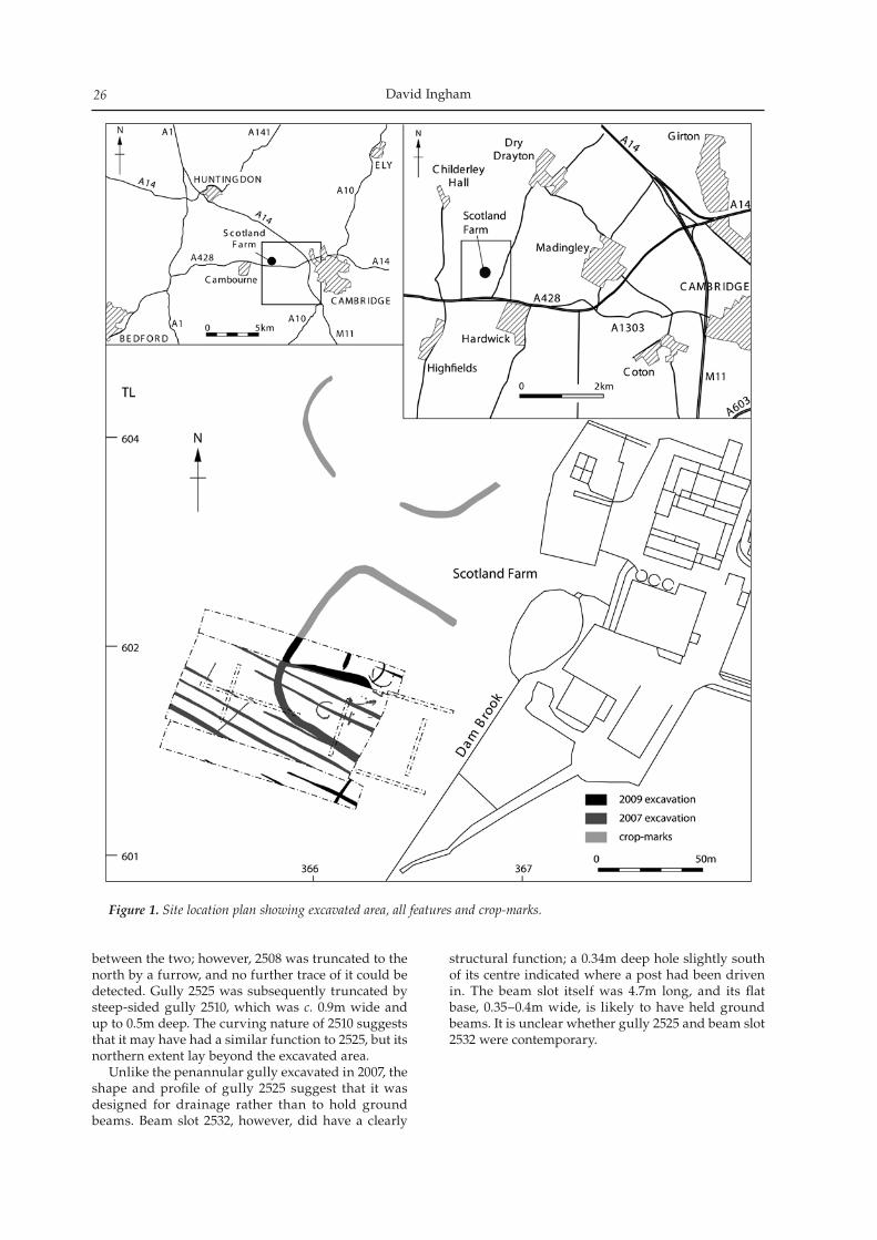
David Ingham26
Figure 1. Site location plan showing excavated area, all features and crop-marks.
between the two; however, 2508 was truncated to the north by a furrow, and no further trace of it could be detected. Gully 2525 was subsequently truncated by steep-sided gully 2510, which was c. 0.9m wide and up to 0.5m deep. The curving nature of 2510 suggests that it may have had a similar function to 2525, but its northern extent lay beyond the excavated area. Unlike the penannular gully excavated in 2007, the shape and profile of gully 2525 suggest that it was designed for drainage rather than to hold ground beams. Beam slot 2532, however, did have a clearly
structural function; a 0.34m deep hole slightly south of its centre indicated where a post had been driven in. The beam slot itself was 4.7m long, and its flat base, 0.35–0.4m wide, is likely to have held ground beams. It is unclear whether gully 2525 and beam slot 2532 were contemporary.
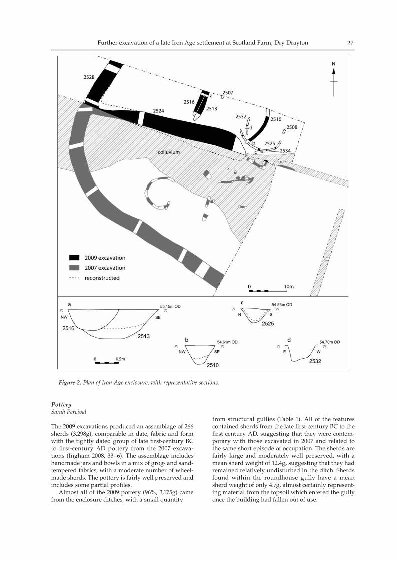
Further excavation of a late Iron Age settlement at Scotland Farm, Dry Drayton 27
PotterySarah Percival
The 2009 excavations produced an assemblage of 266 sherds (3,298g), comparable in date, fabric and form with the tightly dated group of late first-century BC to first-century AD pottery from the 2007 excava-tions (Ingham 2008, 33–6). The assemblage includes handmade jars and bowls in a mix of grog- and sand-tempered fabrics, with a moderate number of wheel-made sherds. The pottery is fairly well preserved and includes some partial profiles. Almost all of the 2009 pottery (96%, 3,175g) came from the enclosure ditches, with a small quantity
from structural gullies (Table 1). All of the features contained sherds from the late first century BC to the first century AD, suggesting that they were contem-porary with those excavated in 2007 and related to the same short episode of occupation. The sherds are fairly large and moderately well preserved, with a mean sherd weight of 12.4g, suggesting that they had remained relatively undisturbed in the ditch. Sherds found within the roundhouse gully have a mean sherd weight of only 4.7g, almost certainly represent-ing material from the topsoil which entered the gully once the building had fallen out of use.
Figure 2. Plan of Iron Age enclosure, with representative sections.
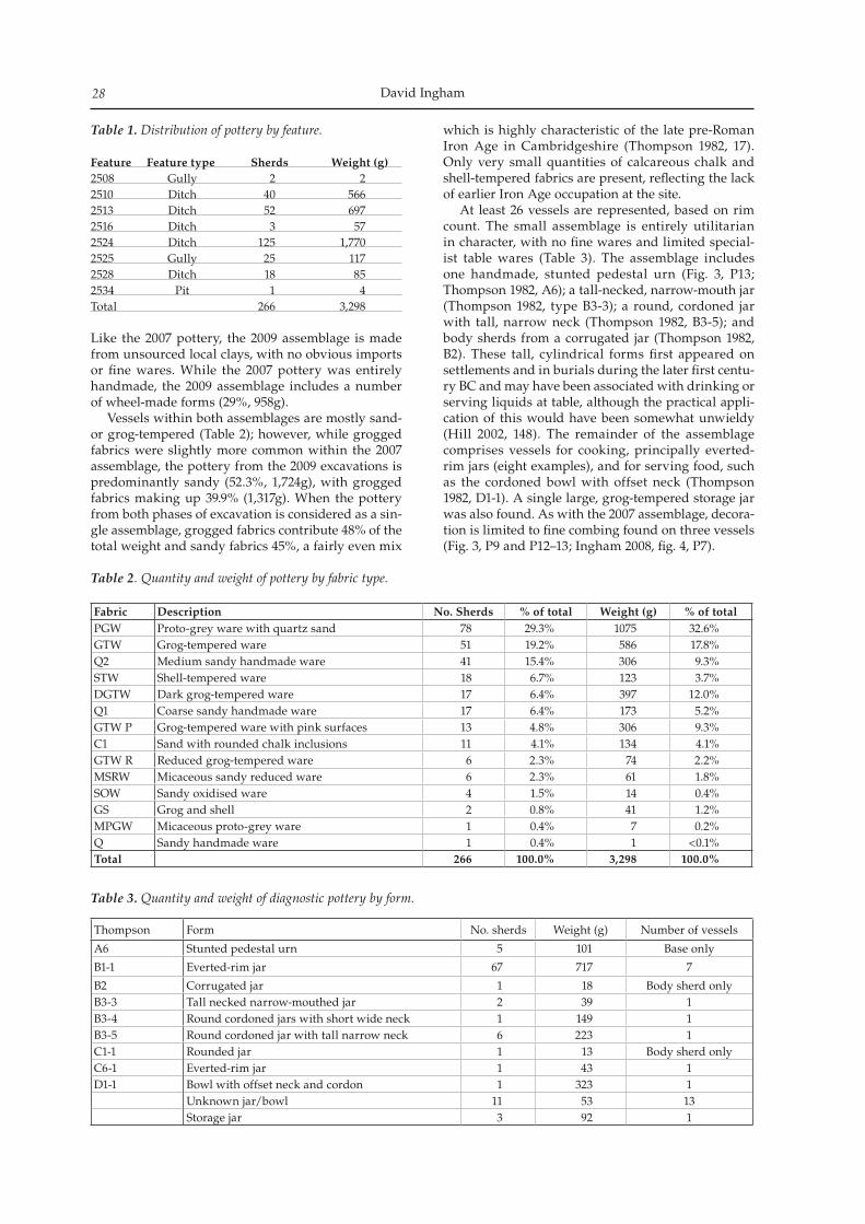
David Ingham28
Table 1. Distribution of pottery by feature. Feature Feature type Sherds Weight (g)2508 Gully 2 22510 Ditch 40 5662513 Ditch 52 6972516 Ditch 3 572524 Ditch 125 1,7702525 Gully 25 1172528 Ditch 18 852534 Pit 1 4Total 266 3,298
Like the 2007 pottery, the 2009 assemblage is made from unsourced local clays, with no obvious imports or fine wares. While the 2007 pottery was entirely handmade, the 2009 assemblage includes a number of wheel-made forms (29%, 958g). Vessels within both assemblages are mostly sand- or grog-tempered (Table 2); however, while grogged fabrics were slightly more common within the 2007 assemblage, the pottery from the 2009 excavations is predominantly sandy (52.3%, 1,724g), with grogged fabrics making up 39.9% (1,317g). When the pottery from both phases of excavation is considered as a sin-gle assemblage, grogged fabrics contribute 48% of the total weight and sandy fabrics 45%, a fairly even mix
which is highly characteristic of the late pre-Roman Iron Age in Cambridgeshire (Thompson 1982, 17). Only very small quantities of calcareous chalk and shell-tempered fabrics are present, reflecting the lack of earlier Iron Age occupation at the site. At least 26 vessels are represented, based on rim count. The small assemblage is entirely utilitarian in character, with no fine wares and limited special-ist table wares (Table 3). The assemblage includes one handmade, stunted pedestal urn (Fig. 3, P13; Thompson 1982, A6); a tall-necked, narrow-mouth jar (Thompson 1982, type B3-3); a round, cordoned jar with tall, narrow neck (Thompson 1982, B3-5); and body sherds from a corrugated jar (Thompson 1982, B2). These tall, cylindrical forms first appeared on settlements and in burials during the later first centu-ry BC and may have been associated with drinking or serving liquids at table, although the practical appli-cation of this would have been somewhat unwieldy (Hill 2002, 148). The remainder of the assemblage comprises vessels for cooking, principally everted-rim jars (eight examples), and for serving food, such as the cordoned bowl with offset neck (Thompson 1982, D1-1). A single large, grog-tempered storage jar was also found. As with the 2007 assemblage, decora-tion is limited to fine combing found on three vessels (Fig. 3, P9 and P12–13; Ingham 2008, fig. 4, P7).
Fabric Description No. Sherds % of total Weight (g) % of total PGW Proto-grey ware with quartz sand 78 29.3% 1075 32.6%GTW Grog-tempered ware 51 19.2% 586 17.8%Q2 Medium sandy handmade ware 41 15.4% 306 9.3%STW Shell-tempered ware 18 6.7% 123 3.7%DGTW Dark grog-tempered ware 17 6.4% 397 12.0%Q1 Coarse sandy handmade ware 17 6.4% 173 5.2%GTW P Grog-tempered ware with pink surfaces 13 4.8% 306 9.3%C1 Sand with rounded chalk inclusions 11 4.1% 134 4.1%GTW R Reduced grog-tempered ware 6 2.3% 74 2.2%MSRW Micaceous sandy reduced ware 6 2.3% 61 1.8%SOW Sandy oxidised ware 4 1.5% 14 0.4%GS Grog and shell 2 0.8% 41 1.2%MPGW Micaceous proto-grey ware 1 0.4% 7 0.2%Q Sandy handmade ware 1 0.4% 1 <0.1%Total 266 100.0% 3,298 100.0%
Table 2. Quantity and weight of pottery by fabric type.
Thompson Form No. sherds Weight (g) Number of vessels
A6 Stunted pedestal urn 5 101 Base only
B1-1 Everted-rim jar 67 717 7
B2 Corrugated jar 1 18 Body sherd onlyB3-3 Tall necked narrow-mouthed jar 2 39 1B3-4 Round cordoned jars with short wide neck 1 149 1B3-5 Round cordoned jar with tall narrow neck 6 223 1C1-1 Rounded jar 1 13 Body sherd onlyC6-1 Everted-rim jar 1 43 1D1-1 Bowl with offset neck and cordon 1 323 1
Unknown jar/bowl 11 53 13Storage jar 3 92 1
Table 3. Quantity and weight of diagnostic pottery by form.
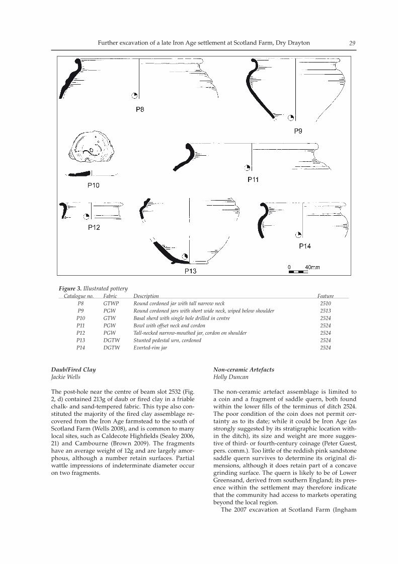
Further excavation of a late Iron Age settlement at Scotland Farm, Dry Drayton 29
Daub/Fired ClayJackie Wells
The post-hole near the centre of beam slot 2532 (Fig. 2, d) contained 213g of daub or fired clay in a friable chalk- and sand-tempered fabric. This type also con-stituted the majority of the fired clay assemblage re-covered from the Iron Age farmstead to the south of Scotland Farm (Wells 2008), and is common to many local sites, such as Caldecote Highfields (Sealey 2006, 21) and Cambourne (Brown 2009). The fragments have an average weight of 12g and are largely amor-phous, although a number retain surfaces. Partial wattle impressions of indeterminate diameter occur on two fragments.
Non-ceramic ArtefactsHolly Duncan
The non-ceramic artefact assemblage is limited to a coin and a fragment of saddle quern, both found within the lower fills of the terminus of ditch 2524. The poor condition of the coin does not permit cer-tainty as to its date; while it could be Iron Age (as strongly suggested by its stratigraphic location with-in the ditch), its size and weight are more sugges-tive of third- or fourth-century coinage (Peter Guest, pers. comm.). Too little of the reddish pink sandstone saddle quern survives to determine its original di-mensions, although it does retain part of a concave grinding surface. The quern is likely to be of Lower Greensand, derived from southern England; its pres-ence within the settlement may therefore indicate that the community had access to markets operating beyond the local region. The 2007 excavation at Scotland Farm (Ingham
Figure 3. Illustrated potteryCatalogue no. Fabric Description Feature P8 GTWP Round cordoned jar with tall narrow neck 2510 P9 PGW Round cordoned jars with short wide neck, wiped below shoulder 2513 P10 GTW Basal sherd with single hole drilled in centre 2524 P11 PGW Bowl with offset neck and cordon 2524 P12 PGW Tall-necked narrow-mouthed jar, cordon on shoulder 2524 P13 DGTW Stunted pedestal urn, cordoned 2524 P14 DGTW Everted-rim jar 2524
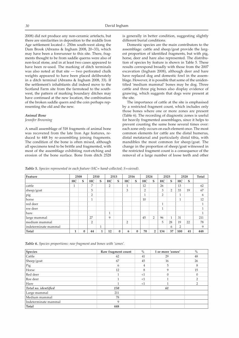
David Ingham30
2008) did not produce any non-ceramic artefacts, but there are similarities in deposition to the middle Iron Age settlement located c. 250m south-west along the Dam Brook (Abrams & Ingham 2008, 20–33), which may have been a forerunner to this site. There, frag-ments thought to be from saddle querns were also of non-local stone, and in at least two cases appeared to have been re-used. The marking of ditch terminals was also noted at that site — two perforated chalk weights appeared to have been placed deliberately in a ditch terminal (Abrams & Ingham 2008, 33). If the settlement’s inhabitants did indeed move to the Scotland Farm site from the farmstead to the south-west, the pattern of marking boundary ditches may have continued at the new location, the combination of the broken saddle quern and the coin perhaps rep-resenting the old and the new.
Animal BoneJennifer Browning
A small assemblage of 518 fragments of animal bone was recovered from the late Iron Age features, re-duced to 448 by re-assembling joining fragments. The condition of the bone is often mixed, although all specimens tend to be brittle and fragmented, with most of the assemblage exhibiting root-etching and erosion of the bone surface. Bone from ditch 2528
is generally in better condition, suggesting slightly different burial conditions. Domestic species are the main contributors to the assemblage: cattle and sheep/goat provide the larg-est proportion of identified fragments, but with pig, horse, deer and hare also represented. The distribu-tion of species by feature is shown in Table 5. These results correspond broadly with those from the 2007 excavation (Ingham 2008), although deer and hare have replaced dog and domestic fowl in the assem-blage. However, it is possible that some of the uniden-tified ‘medium mammal’ bones may be dog. Three cattle and three pig bones also display evidence of gnawing, which suggests that dogs were present at the site. The importance of cattle at the site is emphasised by a restricted fragment count, which includes only those bones where one or more zones are present (Table 6). The recording of diagnostic zones is useful for heavily fragmented assemblages, since it helps to prevent counting the same bone several times over: each zone only occurs on each element once. The most common elements for cattle are the distal humerus, distal metatarsal and particularly distal tibia, with mandibles the most common for sheep/goat. The change in the proportion of sheep/goat witnessed in the restricted fragment count is a consequence of the removal of a large number of loose teeth and other
Feature 2508 2510 2513 2516 2524 2525 2528 TotalHC S HC S HC S HC S HC S HC S HC S
cattle 1 7 2 1 12 26 13 62sheep/goat 5 3 2 3 2 33 19 67pig 2 1 2 1 6horse 1 10 1 12red deer 1 1roe deer 1 1hare 1 1large mammal 27 9 45 2 96 1 31 211medium mammal 2 2 5 28 19 22 78indeterminate mammal 1 6 2 9Total 1 0 44 1 12 0 6 0 70 2 134 37 100 41 448
Table 5. Species represented in each feature (HC= hand-collected; S=sieved).
Species Raw fragment count % 1 or more ‘zones’ %Cattle 62 41 29 48Sheep/goat 67 45 16 26Pig 6 4 5 8Horse 12 8 9 15Red deer 1 <1 0 0Roe deer 1 <1 1 2Hare 1 <1 1 2Total no. identified 150 61Large mammal 211Medium mammal 78Indeterminate mammal 9Total 448
Table 6. Species proportions: raw fragment and bones with ‘zones’.
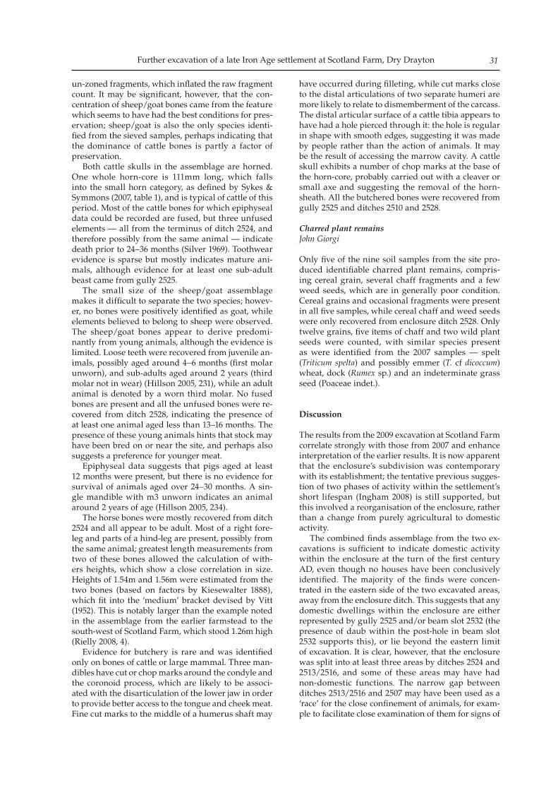
Further excavation of a late Iron Age settlement at Scotland Farm, Dry Drayton 31
un-zoned fragments, which inflated the raw fragment count. It may be significant, however, that the con-centration of sheep/goat bones came from the feature which seems to have had the best conditions for pres-ervation; sheep/goat is also the only species identi-fied from the sieved samples, perhaps indicating that the dominance of cattle bones is partly a factor of preservation. Both cattle skulls in the assemblage are horned. One whole horn-core is 111mm long, which falls into the small horn category, as defined by Sykes & Symmons (2007, table 1), and is typical of cattle of this period. Most of the cattle bones for which epiphyseal data could be recorded are fused, but three unfused elements — all from the terminus of ditch 2524, and therefore possibly from the same animal — indicate death prior to 24–36 months (Silver 1969). Toothwear evidence is sparse but mostly indicates mature ani-mals, although evidence for at least one sub-adult beast came from gully 2525. The small size of the sheep/goat assemblage makes it difficult to separate the two species; howev-er, no bones were positively identified as goat, while elements believed to belong to sheep were observed. The sheep/goat bones appear to derive predomi-nantly from young animals, although the evidence is limited. Loose teeth were recovered from juvenile an-imals, possibly aged around 4–6 months (first molar unworn), and sub-adults aged around 2 years (third molar not in wear) (Hillson 2005, 231), while an adult animal is denoted by a worn third molar. No fused bones are present and all the unfused bones were re-covered from ditch 2528, indicating the presence of at least one animal aged less than 13–16 months. The presence of these young animals hints that stock may have been bred on or near the site, and perhaps also suggests a preference for younger meat. Epiphyseal data suggests that pigs aged at least 12 months were present, but there is no evidence for survival of animals aged over 24–30 months. A sin-gle mandible with m3 unworn indicates an animal around 2 years of age (Hillson 2005, 234). The horse bones were mostly recovered from ditch 2524 and all appear to be adult. Most of a right fore-leg and parts of a hind-leg are present, possibly from the same animal; greatest length measurements from two of these bones allowed the calculation of with-ers heights, which show a close correlation in size. Heights of 1.54m and 1.56m were estimated from the two bones (based on factors by Kiesewalter 1888), which fit into the ‘medium’ bracket devised by Vitt (1952). This is notably larger than the example noted in the assemblage from the earlier farmstead to the south-west of Scotland Farm, which stood 1.26m high (Rielly 2008, 4). Evidence for butchery is rare and was identified only on bones of cattle or large mammal. Three man-dibles have cut or chop marks around the condyle and the coronoid process, which are likely to be associ-ated with the disarticulation of the lower jaw in order to provide better access to the tongue and cheek meat. Fine cut marks to the middle of a humerus shaft may
have occurred during filleting, while cut marks close to the distal articulations of two separate humeri are more likely to relate to dismemberment of the carcass. The distal articular surface of a cattle tibia appears to have had a hole pierced through it: the hole is regular in shape with smooth edges, suggesting it was made by people rather than the action of animals. It may be the result of accessing the marrow cavity. A cattle skull exhibits a number of chop marks at the base of the horn-core, probably carried out with a cleaver or small axe and suggesting the removal of the horn-sheath. All the butchered bones were recovered from gully 2525 and ditches 2510 and 2528.
Charred plant remainsJohn Giorgi
Only five of the nine soil samples from the site pro-duced identifiable charred plant remains, compris-ing cereal grain, several chaff fragments and a few weed seeds, which are in generally poor condition. Cereal grains and occasional fragments were present in all five samples, while cereal chaff and weed seeds were only recovered from enclosure ditch 2528. Only twelve grains, five items of chaff and two wild plant seeds were counted, with similar species present as were identified from the 2007 samples — spelt (Triticum spelta) and possibly emmer (T. cf dicoccum) wheat, dock (Rumex sp.) and an indeterminate grass seed (Poaceae indet.).
Discussion
The results from the 2009 excavation at Scotland Farm correlate strongly with those from 2007 and enhance interpretation of the earlier results. It is now apparent that the enclosure’s subdivision was contemporary with its establishment; the tentative previous sugges-tion of two phases of activity within the settlement’s short lifespan (Ingham 2008) is still supported, but this involved a reorganisation of the enclosure, rather than a change from purely agricultural to domestic activity. The combined finds assemblage from the two ex-cavations is sufficient to indicate domestic activity within the enclosure at the turn of the first century AD, even though no houses have been conclusively identified. The majority of the finds were concen-trated in the eastern side of the two excavated areas, away from the enclosure ditch. This suggests that any domestic dwellings within the enclosure are either represented by gully 2525 and/or beam slot 2532 (the presence of daub within the post-hole in beam slot 2532 supports this), or lie beyond the eastern limit of excavation. It is clear, however, that the enclosure was split into at least three areas by ditches 2524 and 2513/2516, and some of these areas may have had non-domestic functions. The narrow gap between ditches 2513/2516 and 2507 may have been used as a ‘race’ for the close confinement of animals, for exam-ple to facilitate close examination of them for signs of
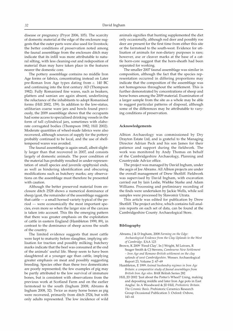
David Ingham32
disease or pregnancy (Pryor 2006, 105). The scarcity of domestic material at the edge of the enclosure sug-gests that the outer parts were also used for livestock; the better conditions of preservation noted among the faunal assemblage from the enclosure ditch may indicate that its infill was more attributable to natu-ral silting, with less cleaning-out and redeposition of material than may have taken place in the features nearer the domestic core. The pottery assemblage contains no middle Iron Age forms or fabrics, concentrating instead on Later pre-Roman Iron Age types dating from c. 140 BC and continuing into the first century AD (Thompson 1982). Fully Romanised fine wares, such as beakers, platters and samian are again absent, underlining the reluctance of the inhabitants to adopt Romanised forms (Hill 2002, 159). In addition to the low-status, utilitarian coarse ware jars and bowls found previ-ously, the 2009 assemblage shows that the occupants had some access to specialised drinking vessels in the form of tall cylindrical jars, sometimes with elabo-rate corrugated bodies (Thompson 1982; Hill 2002). Moderate quantities of wheel-made fabrics were also recovered, although sources of supply for the pottery probably continued to be local, and the use of shell-tempered wares was avoided. The faunal assemblage is again small, albeit slight-ly larger than that recovered in 2007, and consists largely of domestic animals. The poor condition of the material has probably resulted in under-represen-tation of small species and juvenile epiphysial ends, as well as hindering identification and obscuring modifications such as butchery marks; any observa-tions on the assemblage must therefore be presented with caution. Although the better preserved material from en-closure ditch 2528 shows a numerical dominance of sheep/goat, the remainder of the assemblage suggests that cattle — a small horned variety typical of the pe-riod — were economically the most important spe-cies, even more so when the larger size of the carcass is taken into account. This fits the emerging pattern that there was greater emphasis on the exploitation of cattle in eastern England (Hambleton 1999, 89), in contrast to the dominance of sheep across the south of the country. The limited evidence suggests that most cattle were kept to maturity before slaughter, implying uti-lisation for traction and possibly milking; butchery marks indicate that the beef was consumed at the end of the animals’ useful life. Sheep seem to have been slaughtered at a younger age than cattle, implying greater emphasis on meat and possibly suggesting breeding. Species other than these two domesticates are poorly represented; the few examples of pig may be partly attributed to the low survival of immature bones, but is consistent with observations from the previous work at Scotland Farm and on the earlier farmstead to the south (Ingham 2008; Abrams & Ingham 2008, 32). Twice as many horse bones as pig were recovered, primarily from ditch 2524, but with only adults represented. The low incidence of wild
animals signifies that hunting supplemented the diet only occasionally, although red deer and possibly roe deer are present for the first time from either this site or the farmstead to the south-west. Evidence for uti-lisation of animals for non-dietary purposes is rare; however, axe or cleaver marks at the base of a cat-tle horn-core suggest that the horn-sheath had been separated for working. The smaller 2007 faunal assemblage was similar in composition, although the fact that the species rep-resentation occurred in differing proportions may indicate that the composition of the assemblage was not homogenous throughout the settlement. This is further demonstrated by concentrations of sheep and horse bones among the 2009 material. Examination of a larger sample from the site as a whole may be able to suggest particular patterns of disposal, although some of the differences may be attributable to vary-ing conditions of preservation.
Acknowledgements
Albion Archaeology was commissioned by Dry Drayton Estate Ltd, and is grateful to the Managing Director Adrian Peck and his son James for their patience and support during the fieldwork. The work was monitored by Andy Thomas on behalf of the Cambridgeshire Archaeology, Planning and Countryside Advice office. The project was managed by David Ingham, under the aegis of Joe Abrams. All Albion projects are under the overall management of Drew Shotliff. Fieldwork was supervised by David Ingham, with excavation carried out by Iain Leslie, Wiebke Starke and Adam Williams. Processing and preliminary recording of the finds were undertaken by Jackie Wells, while soil samples were processed by Slawomir Utrata. This article was edited for publication by Drew Shotliff. The project archive, which contains full anal-ysis reports on each set of data, can be found at the Cambridgeshire County Archaeological Store.
Bibliography
Abrams, J & D Ingham, 2008 Farming on the Edge: Archaeological Evidence from the Clay Uplands to the West of Cambridge. EAA 123
Brown, K 2009 ‘Fired Clay’. In J Wright, M Leivers, R Seager Smith & CJ Stevens, Cambourne New Settlement – Iron Age and Romano-British settlement on the clay uplands of west Cambridgeshire. Wessex Archaeological Report 23, Volume 2: 67–69
Hambleton, E 1999 Animal husbandry regimes in Iron Age Britain: a comparative study of faunal assemblages from British Iron Age sites. BAR British Series 282
Hill, JD 2002 ‘Just about the Potter’s Wheel? Using, making and depositing middle and later Iron Age pots in East Anglia’. In A Woodward & JD Hill, Prehistoric Britain. The Ceramic Basis. Prehistoric Ceramics Research Group Occasional Publication 3. Oxford: Oxbow, 143–61
Further excavation of a late Iron Age settlement at Scotland Farm, Dry Drayton 33
Hillson, S 2005 Teeth, 2nd edn, Cambridge Manuals in Archaeology. CUP
Ingham, D 2008 ‘Iron Age settlement by the Dam Brook at Scotland Farm, Dry Drayton’. PCAS 97: 31–40
Kiesewalter. L 1888 Skelettmessungen am Pferde als Beitrag zur theoretischen Grundlage der Beurteilungslehre der Pferdes Dissertation. University of Leipzig
Pryor, F 2006 Farmers in Prehistoric Britain. Stroud, TempusRielly, K 2008 ‘Animal Bone’. In J Abrams & D Ingham,
Farming on the Edge: Archaeological Evidence from the Clay Uplands to the West of Cambridge. EAA 123, Appendix 13
Sealey, PR 2006 Reports on the Late Iron Age Pottery and Fired Clay, Roman Pottery and Roman Brick and Tile from Caldecote, Highfields. Cambridgeshire County Council Archaeological Field Unit, unpublished
Silver, IA 1969 ‘The ageing of domestic animals’. In D Brothwell & ES Higgs, Science in Archaeology
Sykes, N & R Symmons, 2007 ‘Sexing cattle horn-cores: problems and progress’. International Journal of Osteoarchaeology 17, Issue 5: 514–23
Thompson, I 1982 Grog-Tempered ‘Belgic’ Pottery of South-Eastern England. BAR British Series 108
Vitt, VO 1952 ‘Horses of the Pazyrykh kurgans’. Soviet Archaeology 16: 163–205
Wells, J 2008 ‘Ceramic Building Material and Fired Clay’, in J Abrams & D Ingham, Farming on the Edge: Archaeological Evidence from the Clay Uplands to the West of Cambridge. EAA 123, Appendix 9

David Ingham34
Located within the core of Roman Cambridge, the results of the 2006 Castle Street excavations are presented. Based on the evidence of pottery imports, the site’s Late Iron Age settlement phase would appear to have been of a high status. Its Roman strata allowed for the determination of the route of Cambridge’s Via Devana and, as is also reported, the line of the conjoining Godmanchester Road has now been established. To augment Alexander and Pullinger’s Roman Cambridge excavations (2000), full presentation is made of the site’s economic data. Finally, there is a review of the results of the previous volume, as well as further consider-ation of the issue of Cambridge’s status as a Roman town.
The principal aim of the 2006 Castle Street excavations was to obtain a ‘modern standard’ sample of the core of Roman Cambridge’s upper town; among its prima-ry objectives was the recovery of environmental and economic evidence to augment the results of earlier investigations (Alexander & Pullinger 2000; Fig. 1). As outlined in a previous paper concerned with the site’s post-Roman phases (Cessford 2008), we were some-what thwarted by the fact that the town’s Civil War ditch effectively removed half of the area under in-vestigation and, in effect, reduced the exposure of its Iron Age/Roman strata to only c. 60m2 (with that also seeing extensive truncation by post-Medieval cellars and modern service trenches, etc; Figs 2 and 5). Sound results were, nonetheless, achieved, especially con-cerning the hill-top’s early economy and roads, and the excavations provided major insights regarding the character of its Late Iron Age and Early Roman/Conquest Period settlements. The site’s publication also enables us to draw together and appraise facets of Castle Hill’s first century AD sequence, which now benefits from the sheer quantity of excavation that has recently occurred in the town’s wider environs (e.g. Evans et al. 2008). This review is particularly appo-site, as this year marks a decade since the Society pub-lished Roman Cambridge (Alexander & Pullinger 2000). Occurring in advance of housing, the Castle Street excavations were undertaken by the University’s Cambridge Archaeology Unit (CAU) and directed by Letty Ten Harkel (2006a); it followed evaluation trial trenching by the Hertfordshire Archaeological Unit
five years previously (Crank & Murray 2001). The site lay at c. 20m OD, with its geology consisting of Lower Chalk Marl locally overlain with sandy gravels (TL 440592). Attention had first been drawn to the locale’s po-tential when, in 2003, the County Council Field Unit conducted renovation-related investigations in the cel-lars of two adjacent properties on its west side (Nos. 68–70; Fig. 2; Hickling 2004). With its horizontal strata truncated, this only revealed two major features, one of which was a third-century AD pit that cut a north-west–southeast-oriented ditch (2.30m wide and 1.20m deep), running along the property’s frontage. The lat-ter produced early to mid second-century pottery, and was thought to represent a roadside boundary relat-ing to the Roman Godmanchester Road. As its direct continuation/equivalents were identified within the 2006 CAU site, this interpretation has proven correct. The site lay opposite Haigh’s 1988 Castle Street Site, where what was thought to be a small, third-century AD quasi-pentagonal shrine was exposed (Fig. 2; Alexander & Pullinger 2000, 57, figs 5.16–17). Subsequently in 1994, straddling Haigh’s site, the CAU undertook an evaluation trenching exercise at 75–85 Castle Street (Butler 1994). Though evidence of first- and second-century AD timber buildings was recovered, little excavation then occurred, as the de-cision was made to preserve the site’s c. 0.80m-deep strata in situ beneath geo-textile matting. Beside that site, at 71 Castle Street, a fourth-century AD pit was exposed in 1997 when an evaluation test pit was dug (Heawood 1997).
Background Matters
Alexander and Pullinger’s 2000 volume documented the upper town’s Roman investigations up to the later 1980s, and it also included an overview of relevant fieldwork between that date and the mid 1990s (Evans 2000). Since then there have been a number of fur-ther investigations in the area; indeed, too many to summarise here and, instead, only the results of most relevant can be briefly reviewed (see Evans & Lucas
Roman Cambridge’s Early Settlement and Via Devana: Excavations at Castle Street
Christopher Evans and Letty Ten Harkel
With contributions by Martin Allen, Katie Anderson, Matt Brudenell, Adrian Challands, Vida Rajkovača and Anne de Vareilles
Proceedings of the Cambridge Antiquarian Society XCVIX pp. 35–60
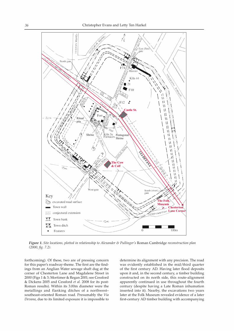
Christopher Evans and Letty Ten Harkel36
forthcoming). Of these, two are of pressing concern for this paper’s roadway-theme. The first are the find-ings from an Anglian Water sewage shaft dug at the corner of Chesterton Lane and Magdalene Street in 2000 (Figs 1 & 3; Mortimer & Regan 2001; see Cessford & Dickens 2005 and Cessford et al. 2008 for its post-Roman results). Within its 3.00m diameter were the metallings and flanking ditches of a northwest–southeast-oriented Roman road. Presumably the Via Devana, due to its limited exposure it is impossible to
determine its alignment with any precision. The road was evidently established in the mid/third quarter of the first century AD. Having later flood deposits upon it and, in the second century, a timber building constructed on its north side, this route-alignment apparently continued in use throughout the fourth century (despite having a Late Roman inhumation inserted into it). Nearby, the excavations two years later at the Folk Museum revealed evidence of a later first-century AD timber building with accompanying
Figure 1. Site locations, plotted in relationship to Alexander & Pullinger’s Roman Cambridge reconstruction plan (2000, fig. 7.2).
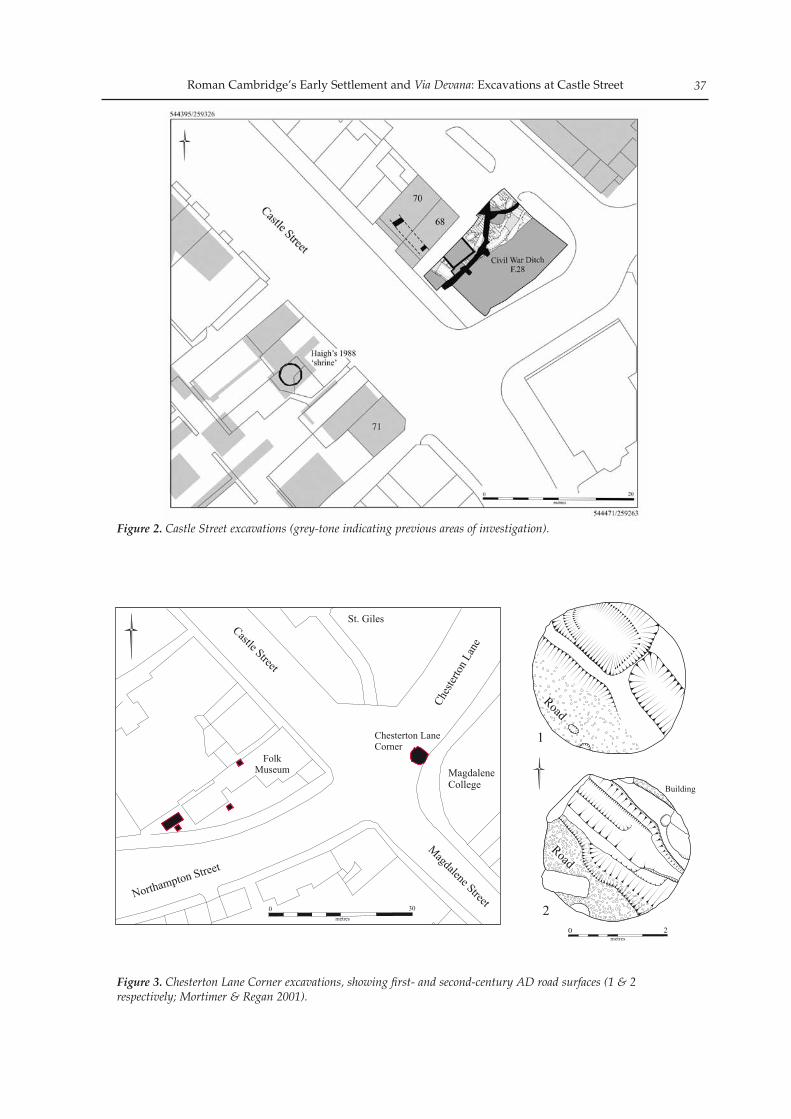
Roman Cambridge’s Early Settlement and Via Devana: Excavations at Castle Street 37
Figure 2. Castle Street excavations (grey-tone indicating previous areas of investigation).
0 2em t se r
ge
e t
Madal n
Stree
Castle S reett
t
t
Nor hampton Stree
Ches
terto
n Lan
e
St. Giles
FolkMuseum Magdalene
College
0t eme r s
03
Road
Rd
oa
Building
1
2
Chesterton LaneCorner
Figure 3. Chesterton Lane Corner excavations, showing first- and second-century AD road surfaces (1 & 2 respectively; Mortimer & Regan 2001).
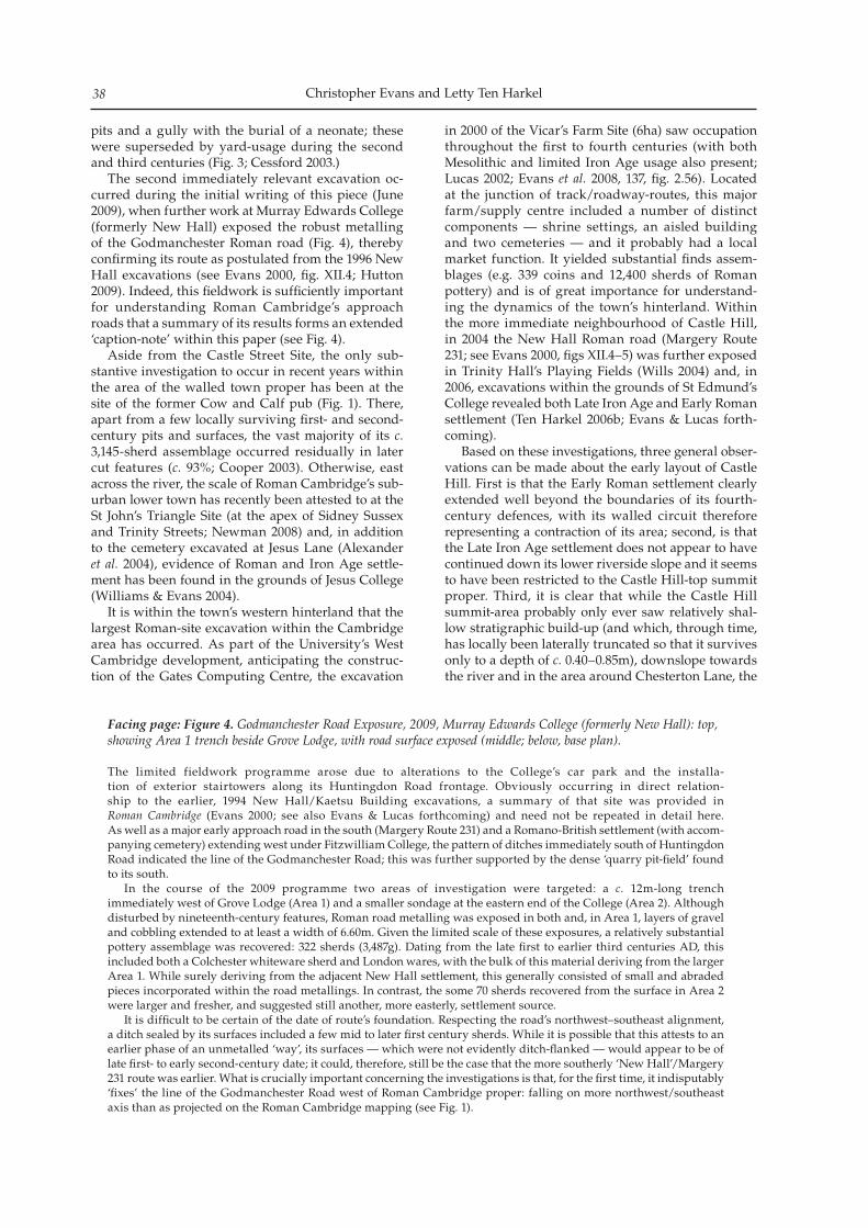
Christopher Evans and Letty Ten Harkel38
pits and a gully with the burial of a neonate; these were superseded by yard-usage during the second and third centuries (Fig. 3; Cessford 2003.) The second immediately relevant excavation oc-curred during the initial writing of this piece (June 2009), when further work at Murray Edwards College (formerly New Hall) exposed the robust metalling of the Godmanchester Roman road (Fig. 4), thereby confirming its route as postulated from the 1996 New Hall excavations (see Evans 2000, fig. XII.4; Hutton 2009). Indeed, this fieldwork is sufficiently important for understanding Roman Cambridge’s approach roads that a summary of its results forms an extended ‘caption-note’ within this paper (see Fig. 4). Aside from the Castle Street Site, the only sub-stantive investigation to occur in recent years within the area of the walled town proper has been at the site of the former Cow and Calf pub (Fig. 1). There, apart from a few locally surviving first- and second-century pits and surfaces, the vast majority of its c. 3,145-sherd assemblage occurred residually in later cut features (c. 93%; Cooper 2003). Otherwise, east across the river, the scale of Roman Cambridge’s sub-urban lower town has recently been attested to at the St John’s Triangle Site (at the apex of Sidney Sussex and Trinity Streets; Newman 2008) and, in addition to the cemetery excavated at Jesus Lane (Alexander et al. 2004), evidence of Roman and Iron Age settle-ment has been found in the grounds of Jesus College (Williams & Evans 2004). It is within the town’s western hinterland that the largest Roman-site excavation within the Cambridge area has occurred. As part of the University’s West Cambridge development, anticipating the construc-tion of the Gates Computing Centre, the excavation
in 2000 of the Vicar’s Farm Site (6ha) saw occupation throughout the first to fourth centuries (with both Mesolithic and limited Iron Age usage also present; Lucas 2002; Evans et al. 2008, 137, fig. 2.56). Located at the junction of track/roadway-routes, this major farm/supply centre included a number of distinct components — shrine settings, an aisled building and two cemeteries — and it probably had a local market function. It yielded substantial finds assem-blages (e.g. 339 coins and 12,400 sherds of Roman pottery) and is of great importance for understand-ing the dynamics of the town’s hinterland. Within the more immediate neighbourhood of Castle Hill, in 2004 the New Hall Roman road (Margery Route 231; see Evans 2000, figs XII.4–5) was further exposed in Trinity Hall’s Playing Fields (Wills 2004) and, in 2006, excavations within the grounds of St Edmund’s College revealed both Late Iron Age and Early Roman settlement (Ten Harkel 2006b; Evans & Lucas forth-coming). Based on these investigations, three general obser-vations can be made about the early layout of Castle Hill. First is that the Early Roman settlement clearly extended well beyond the boundaries of its fourth-century defences, with its walled circuit therefore representing a contraction of its area; second, is that the Late Iron Age settlement does not appear to have continued down its lower riverside slope and it seems to have been restricted to the Castle Hill-top summit proper. Third, it is clear that while the Castle Hill summit-area probably only ever saw relatively shal-low stratigraphic build-up (and which, through time, has locally been laterally truncated so that it survives only to a depth of c. 0.40–0.85m), downslope towards the river and in the area around Chesterton Lane, the
Facing page: Figure 4. Godmanchester Road Exposure, 2009, Murray Edwards College (formerly New Hall): top, showing Area 1 trench beside Grove Lodge, with road surface exposed (middle; below, base plan).
The limited fieldwork programme arose due to alterations to the College’s car park and the installa-tion of exterior stairtowers along its Huntingdon Road frontage. Obviously occurring in direct relation-ship to the earlier, 1994 New Hall/Kaetsu Building excavations, a summary of that site was provided in Roman Cambridge (Evans 2000; see also Evans & Lucas forthcoming) and need not be repeated in detail here. As well as a major early approach road in the south (Margery Route 231) and a Romano-British settlement (with accom-panying cemetery) extending west under Fitzwilliam College, the pattern of ditches immediately south of Huntingdon Road indicated the line of the Godmanchester Road; this was further supported by the dense ‘quarry pit-field’ found to its south. In the course of the 2009 programme two areas of investigation were targeted: a c. 12m-long trench immediately west of Grove Lodge (Area 1) and a smaller sondage at the eastern end of the College (Area 2). Although disturbed by nineteenth-century features, Roman road metalling was exposed in both and, in Area 1, layers of gravel and cobbling extended to at least a width of 6.60m. Given the limited scale of these exposures, a relatively substantial pottery assemblage was recovered: 322 sherds (3,487g). Dating from the late first to earlier third centuries AD, this included both a Colchester whiteware sherd and London wares, with the bulk of this material deriving from the larger Area 1. While surely deriving from the adjacent New Hall settlement, this generally consisted of small and abraded pieces incorporated within the road metallings. In contrast, the some 70 sherds recovered from the surface in Area 2 were larger and fresher, and suggested still another, more easterly, settlement source. It is difficult to be certain of the date of route’s foundation. Respecting the road’s northwest–southeast alignment, a ditch sealed by its surfaces included a few mid to later first century sherds. While it is possible that this attests to an earlier phase of an unmetalled ‘way’, its surfaces — which were not evidently ditch-flanked — would appear to be of late first- to early second-century date; it could, therefore, still be the case that the more southerly ‘New Hall’/Margery 231 route was earlier. What is crucially important concerning the investigations is that, for the first time, it indisputably ‘fixes’ the line of the Godmanchester Road west of Roman Cambridge proper: falling on more northwest/southeast axis than as projected on the Roman Cambridge mapping (see Fig. 1).
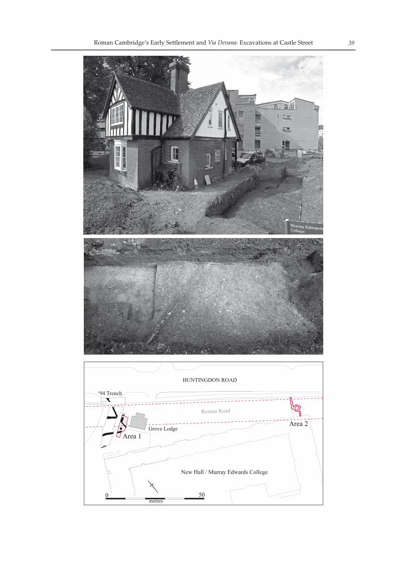
Roman Cambridge’s Early Settlement and Via Devana: Excavations at Castle Street 39
HUNTINGDON ROAD
0 50metres
New Hall / Murray Edwards College
Grove Lodge
an RRom oad
e Ar a 1
Area 2
‘94 Trench
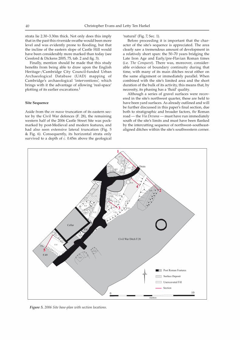
Christopher Evans and Letty Ten Harkel40
strata lie 2.30–3.30m thick. Not only does this imply that in the past this riverside swathe would been more level and was evidently prone to flooding, but that the incline of the eastern slope of Castle Hill would have been considerably more marked than today (see Cessford & Dickens 2005, 75, tab. 2 and fig. 3). Finally, mention should be made that this study benefits from being able to draw upon the English Heritage-/Cambridge City Council-funded Urban Archaeological Database (UAD) mapping of Cambridge’s archaeological ‘interventions’, which brings with it the advantage of allowing ‘real-space’ plotting of its earlier excavations.1
Site Sequence
Aside from the en masse truncation of its eastern sec-tor by the Civil War defences (F. 28), the remaining western half of the 2006 Castle Street Site was pock-marked by post-Medieval and modern features, and had also seen extensive lateral truncation (Fig. 5 & Fig. 6). Consequently, its horizontal strata only survived to a depth of c. 0.45m above the geological
‘natural’ (Fig. 7, Sec. 1). Before proceeding it is important that the char-acter of the site’s sequence is appreciated. The area clearly saw a tremendous amount of development in a relatively short span: the 50–70 years bridging the Late Iron Age and Early/pre-Flavian Roman times (i.e. The Conquest). There was, moreover, consider-able evidence of boundary continuity during that time, with many of its main ditches recut either on the same alignment or immediately parallel. When combined with the site’s limited area and the short duration of the bulk of its activity, this means that, by necessity, its phasing has a ‘fluid’ quality. Although a series of gravel surfaces were recov-ered in the site’s northwest quarter, these are held to have been yard surfaces. As already outlined and will be further discussed in this paper’s final section, due both to stratigraphic and broader factors, the Roman road — the Via Devana — must have run immediately south of the site’s limits and must have been flanked by the intercutting sequence of northwest–southeast-aligned ditches within the site’s southwestern corner.
F.26
F.24
F.47
F.48
[321-24]
F.58 F.62
[471]
[483]
[481-4]
F.26
F.51
F.24
F.47
F.44
F.60
F.48
[321-24]
F.58 F.62
[471]
[483]
[481-4]
[467]
[482][482]
[455]
[370]
[320]
F.23
[234]
F.27
F.30
F.61
[467]
[482][482]
[455]
[370]
[320]
F.23
[234]
F.27
F.33
F.30
F.31F.12
F.9
F.18
F.19
F.22
[309]
[308]
F.40 F.45
F.46F.36
F.43
F.39
F.56
F.59
F.11
F.12
F.9
F.18F.50
F.20
F.19
F.22
[309]
[308]
F.40 F.45
F.46F.36
F.43
F.53F.39
F.56
F.59
Cellar
Pipeline
F.49
Civil War Ditch F.28
F.6
Drain
Post Roman Features
Surface Deposit
Unexcavated Fill
01
sm tree
0
1
2
3
4
5
Section
Figure 5. 2006 Site base-plan with section locations.
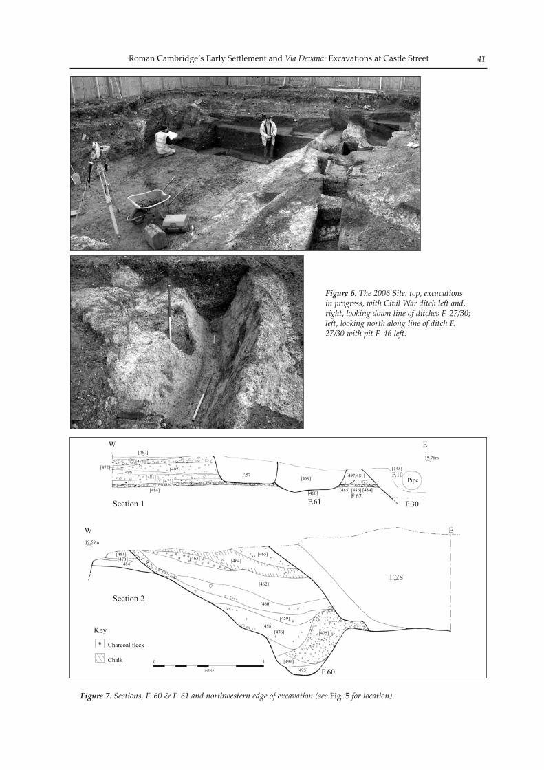
Roman Cambridge’s Early Settlement and Via Devana: Excavations at Castle Street 41
Figure 7. Sections, F. 60 & F. 61 and northwestern edge of excavation (see Fig. 5 for location).
Figure 6. The 2006 Site: top, excavations in progress, with Civil War ditch left and, right, looking down line of ditches F. 27/30; left, looking north along line of ditch F. 27/30 with pit F. 46 left.
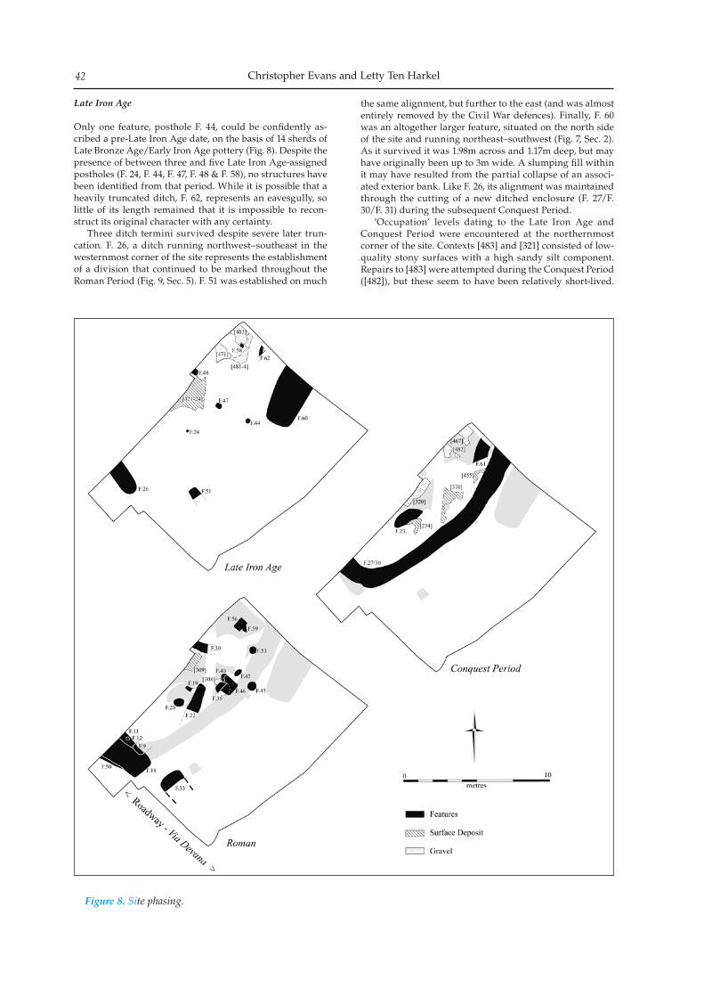
Christopher Evans and Letty Ten Harkel42
Late Iron Age
Only one feature, posthole F. 44, could be confidently as-cribed a pre-Late Iron Age date, on the basis of 14 sherds of Late Bronze Age/Early Iron Age pottery (Fig. 8). Despite the presence of between three and five Late Iron Age-assigned postholes (F. 24, F. 44, F. 47, F. 48 & F. 58), no structures have been identified from that period. While it is possible that a heavily truncated ditch, F. 62, represents an eavesgully, so little of its length remained that it is impossible to recon-struct its original character with any certainty. Three ditch termini survived despite severe later trun-cation. F. 26, a ditch running northwest–southeast in the westernmost corner of the site represents the establishment of a division that continued to be marked throughout the Roman Period (Fig. 9, Sec. 5). F. 51 was established on much
the same alignment, but further to the east (and was almost entirely removed by the Civil War defences). Finally, F. 60 was an altogether larger feature, situated on the north side of the site and running northeast–southwest (Fig. 7, Sec. 2). As it survived it was 1.98m across and 1.17m deep, but may have originally been up to 3m wide. A slumping fill within it may have resulted from the partial collapse of an associ-ated exterior bank. Like F. 26, its alignment was maintained through the cutting of a new ditched enclosure (F. 27/F. 30/F. 31) during the subsequent Conquest Period. ‘Occupation’ levels dating to the Late Iron Age and Conquest Period were encountered at the northernmost corner of the site. Contexts [483] and [321] consisted of low-quality stony surfaces with a high sandy silt component. Repairs to [483] were attempted during the Conquest Period ([482]), but these seem to have been relatively short-lived.
Figure 8. Site phasing.
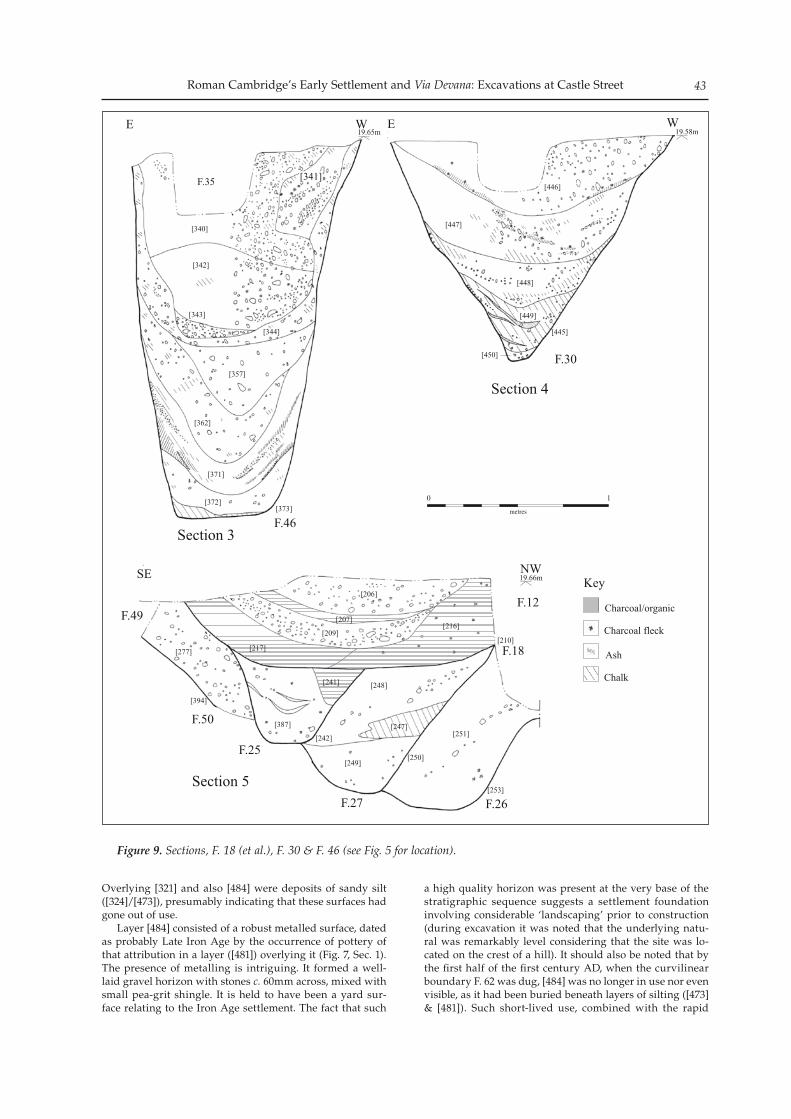
Roman Cambridge’s Early Settlement and Via Devana: Excavations at Castle Street 43
Overlying [321] and also [484] were deposits of sandy silt ([324]/[473]), presumably indicating that these surfaces had gone out of use. Layer [484] consisted of a robust metalled surface, dated as probably Late Iron Age by the occurrence of pottery of that attribution in a layer ([481]) overlying it (Fig. 7, Sec. 1). The presence of metalling is intriguing. It formed a well-laid gravel horizon with stones c. 60mm across, mixed with small pea-grit shingle. It is held to have been a yard sur-face relating to the Iron Age settlement. The fact that such
a high quality horizon was present at the very base of the stratigraphic sequence suggests a settlement foundation involving considerable ‘landscaping’ prior to construction (during excavation it was noted that the underlying natu-ral was remarkably level considering that the site was lo-cated on the crest of a hill). It should also be noted that by the first half of the first century AD, when the curvilinear boundary F. 62 was dug, [484] was no longer in use nor even visible, as it had been buried beneath layers of silting ([473] & [481]). Such short-lived use, combined with the rapid
Figure 9. Sections, F. 18 (et al.), F. 30 & F. 46 (see Fig. 5 for location).
Christopher Evans and Letty Ten Harkel44
encroachment of domestic structures upon it, suggests that this surface related to the origins of the earliest significant settlement on Castle Hill.
Conquest Period
A series of features yielded ‘Romanising-type’ pottery and can, therefore, be dated to c. AD 30–60. The Conquest Period, in the main, appears to have involved continuity rather than change on the Castle Street Site (Fig. 8). Late Iron Age sur-faces were repaired ([482] & [467]) and the ditch lines estab-lished by F. 26 and F. 60 were re-emphasised and brought together with a new enclosure boundary (F. 27/30/31). The latter was steeply ‘V’-shaped for much of its profile and up to 1.15m deep; the relationship between this feature and ditch F. 60 was not entirely clear (Figs 6 & 9, Secs 4 & 5). It is during the Conquest Period that the first persuasive evidence of structures occurred: F. 61 was a curvilinear fea-ture, probably a roundhouse eavesgully. It is, in fact, possi-ble that this was the re-establishment of an earlier building represented by F. 62 (Fig. 7, Sec. 1), but unfortunately the latter had been so severely truncated that its original form could not be determined. F. 61 consisted of a truncated gully 1.36m long, which contained a quantity of finds: over 1800g of pottery, along with 267g of animal bone. All the iden-tifiable sherds could be dated to the Late Iron Age/Early Roman Period transition. The presence of daub and mortar within the fill supports the interpretation that F. 61 related to a building, though the continuation of its line should have crossed the large ditch F. 60 and there is no indication that this was the case. Further features assigned to the Conquest Period were two pits or possible ditch termini (F. 23 & F. 33), which had been severely truncated by post-Medieval ditches, and sev-eral occupation layers ([234], [320], [342], [370] & [455]).
Early Roman
During the Early Roman Period the Castle Street site saw significant changes; the F. 27 (et al.) enclosure had been filled in by this time and a new series of pits and ditches were dug (Fig. 8). Most Roman features excavated can be attributed to the first century AD, but some ascribed as ‘Early Roman’ were perhaps as late as mid-second century AD. Despite a lessening in horizontal stratigraphy at this period — or, at least, the survival thereof — there appears to have been a marked increase in activity within the area. The most significant features from this time were three northwest–southeast-oriented ditch termini (F. 18, F. 25 & F. 50), located at the southwestern corner of the site and trun-cating the line of the former F. 27 enclosure (Fig. 5, Fig. 9 Sec. 5 & Fig. 10). As outlined above, these represent three succes-sive cuts of what was arguably the northern flanking ditch of a road and it was notable that all terminated in much the same spot as the Late Iron Age boundary, F. 26. Although on a somewhat more southerly orientation, after approximately a metre’s interruption its line may have continued in that of F. 33, a ditch whose upper profile (and southern extent) had largely been truncated away by the Civil War ditch. Some nine metres to the northeast of the F. 18/F. 25/F. 50 ditch-sequence was a 2m-deep pit, F. 46 (Fig. 9, Sec. 3). Although its profile and size are similar to the ‘ritual shafts’ identified nearby in Alexander and Pullinger’s excavations, there were no traces of ritual deposits within it and all the pottery from its fills dated to the first century AD. Given its date and position, it is possible that F. 46 represents a latrine pit. Its lower fills consisted of cessy material, whilst the upper fills comprised a charcoal-rich garden-type soil (a
comparable ‘soil-like’ deposit, [309], was also present c. 2m to the northwest of F. 46). Feature 46 was one of a number of features truncating F. 30 and, dating to the Early Roman Period (others were F. 36 & F. 43); this truncation confirmed that the line of F. 30 had been backfilled by this point. A number of small pits in the northernmost portion of the site probably had domestic functions and may have been dug for rubbish disposal (F. 36, F. 40, F. 43, F. 45, F. 53, F. 56 & F. 59). An exception was F. 43, which contained a charcoal-rich fill with burnt bone and first- to third-century AD pottery. All of these features were severely truncated by later landscaping, which ham-pered their interpretation. The rectangular shape of F. 56, with vertical sides and flat base tends to suggest that it was a later feature, but Late Iron Age and mid to late first-century AD pottery was the only dating evidence recovered from it. Several additional ditch and gully segments yielded first-century AD pottery, suggesting that they dated from the Early Roman Period (F. 19, F. 22 & F. 39). Of these, F. 22 represents a relatively substantial terminal of a NNE–SSW ditch (0.82m wide; 0.41m deep). It must have been dug in the Early Roman Period, but may have remained open until the second century AD.
Later Roman
Evidence of Late Roman activity was relatively limited. This may either relate to extensive later landscaping, which had severely truncated subsequent Roman features, or may rep-resent a real hiatus in the area’s sequence (Fig. 8). It is worth noting that later Roman pottery did not frequently occur re-sidually within post-Roman features, as would be expected had there been substantive local occupation at that time. Only four cut features could be assigned to this period. Two were dated by the presence of first- to third-century AD pottery (pits F. 12 & F. 20), whereas a posthole (F. 11) and another pit (F. 9) were assigned based on stratigraphic rela-tionships (both cut F. 12) and may be significantly later. Pit F. 12 contained the highest density of in situ Romano-British material of any feature on the site and may have been a rub-bish pit. This was situated on top of the (by then backfilled) ditch terminal F. 18 and may indicate the siting of rubbish pits along the line of property boundaries. Late Roman pottery occurred residually in a number of post-Roman features, including 12 sherds from an Anglo-Saxon pit (F. 6) and 11 sherds from the Civil War ditch (F. 28; Fig. 5).
Material Culture
Apart from the finds categories outlined below, rela-tively little other material was forthcoming from the site’s early phases. Aside from two, three, ten and 19 fragments of mortar, brick/tile, stone and burnt clay respectively, some 60 oyster shells were recovered. In total, 21 metalwork pieces were present; apart from the copper alloy items described below, these vari-ously include iron nails and small ‘lumps’, and a piece of scrap lead (a slag fragment and piece of fuel ash were, respectively retrieved from F. 27 & F. 30).
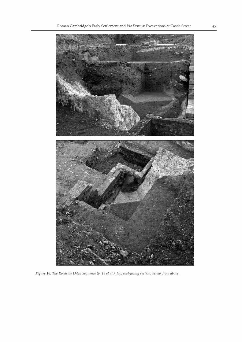
Roman Cambridge’s Early Settlement and Via Devana: Excavations at Castle Street 45
Figure 10. The Roadside Ditch Sequence (F. 18 et al.): top, east-facing section; below, from above.
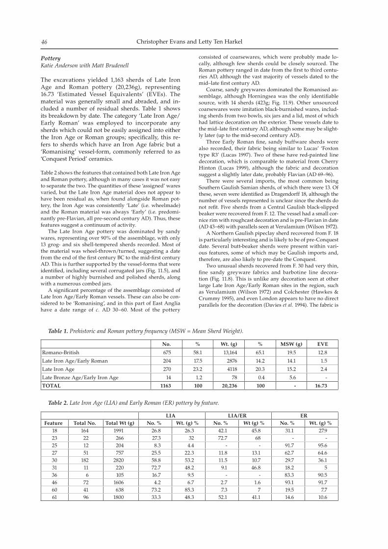
Christopher Evans and Letty Ten Harkel46
Pottery Katie Anderson with Matt Brudenell
The excavations yielded 1,163 sherds of Late Iron Age and Roman pottery (20,236g), representing 16.73 ‘Estimated Vessel Equivalents’ (EVEs). The material was generally small and abraded, and in-cluded a number of residual sherds. Table 1 shows its breakdown by date. The category ‘Late Iron Age/Early Roman’ was employed to incorporate any sherds which could not be easily assigned into either the Iron Age or Roman groups; specifically, this re-fers to sherds which have an Iron Age fabric but a ‘Romanising’ vessel-form, commonly referred to as ‘Conquest Period’ ceramics.
Table 2 shows the features that contained both Late Iron Age and Roman pottery, although in many cases it was not easy to separate the two. The quantities of these ‘assigned’ wares varied, but the Late Iron Age material does not appear to have been residual as, when found alongside Roman pot-tery, the Iron Age was consistently ‘Late’ (i.e. wheelmade) and the Roman material was always ‘Early’ (i.e. predomi-nantly pre-Flavian, all pre-second century AD). Thus, these features suggest a continuum of activity. The Late Iron Age pottery was dominated by sandy wares, representing over 90% of the assemblage, with only 13 grog- and six shell-tempered sherds recorded. Most of the material was wheel-thrown/turned, suggesting a date from the end of the first century BC to the mid-first century AD. This is further supported by the vessel-forms that were identified, including several corrugated jars (Fig. 11.5), and a number of highly burnished and polished sherds, along with a numerous combed jars. A significant percentage of the assemblage consisted of Late Iron Age/Early Roman vessels. These can also be con-sidered to be ‘Romanising’, and in this part of East Anglia have a date range of c. AD 30–60. Most of the pottery
consisted of coarsewares, which were probably made lo-cally, although few sherds could be closely sourced. The Roman pottery ranged in date from the first to third centu-ries AD, although the vast majority of vessels dated to the mid–late first century AD. Coarse, sandy greywares dominated the Romanised as-semblage, although Horningsea was the only identifiable source, with 14 sherds (423g; Fig. 11.9). Other unsourced coarsewares were imitation black-burnished wares, includ-ing sherds from two bowls, six jars and a lid, most of which had lattice decoration on the exterior. These vessels date to the mid–late first century AD, although some may be slight-ly later (up to the mid-second century AD). Three Early Roman fine, sandy buffware sherds were also recorded, their fabric being similar to Lucas’ ‘Foxton type R3’ (Lucas 1997). Two of these have red-painted line decoration, which is comparable to material from Cherry Hinton (Lucas 1999), although the fabric and decoration suggest a slightly later date, probably Flavian (AD 69–96). There were several imports, the most common being Southern Gaulish Samian sherds, of which there were 13. Of these, seven were identified as Dragendorff 18, although the number of vessels represented is unclear since the sherds do not refit. Five sherds from a Central Gaulish black-slipped beaker were recovered from F. 12. The vessel had a small cor-nice rim with roughcast decoration and is pre-Flavian in date (AD 43–68) with parallels seen at Verulamium (Wilson 1972). A Northern Gaulish pipeclay sherd recovered from F. 18 is particularly interesting and is likely to be of pre-Conquest date. Several butt-beaker sherds were present within vari-ous features, some of which may be Gaulish imports and, therefore, are also likely to pre-date the Conquest. Two unusual sherds recovered from F. 30 had very thin, fine sandy greyware fabrics and barbotine line decora-tion (Fig. 11.8). This is unlike any decoration seen at other large Late Iron Age/Early Roman sites in the region, such as Verulamium (Wilson 1972) and Colchester (Hawkes & Crummy 1995), and even London appears to have no direct parallels for the decoration (Davies et al. 1994). The fabric is
No. % Wt. (g) % MSW (g) EVE
Romano-British 675 58.1 13,164 65.1 19.5 12.8
Late Iron Age/Early Roman 204 17.5 2876 14.2 14.1 1.5
Late Iron Age 270 23.2 4118 20.3 15.2 2.4
Late Bronze Age/Early Iron Age 14 1.2 78 0.4 5.6 -
TOTAL 1163 100 20,236 100 - 16.73
Table 1. Prehistoric and Roman pottery frequency (MSW = Mean Sherd Weight).
LIA LIA/ER ERFeature Total No. Total Wt (g) No. % Wt. (g) % No. % Wt (g) % No. % Wt. (g) %
18 164 1991 26.8 26.3 42.1 45.8 31.1 27.923 22 266 27.3 32 72.7 68 - -25 12 204 8.3 4.4 - - 91.7 95.627 51 757 25.5 22.3 11.8 13.1 62.7 64.630 182 2820 58.8 53.2 11.5 10.7 29.7 36.131 11 220 72.7 48.2 9.1 46.8 18.2 536 6 105 16.7 9.5 - - 83.3 90.546 72 1606 4.2 6.7 2.7 1.6 93.1 91.760 41 638 73.2 85.3 7.3 7 19.5 7.761 96 1800 33.3 48.3 52.1 41.1 14.6 10.6
Table 2. Late Iron Age (LIA) and Early Roman (ER) pottery by feature.
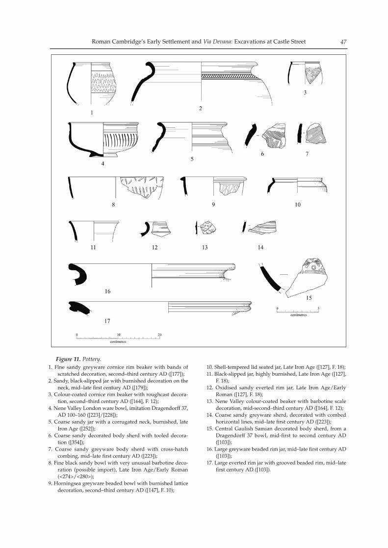
Roman Cambridge’s Early Settlement and Via Devana: Excavations at Castle Street 47
Figure 11. Pottery.1. Fine sandy greyware cornice rim beaker with bands of
scratched decoration, second–third century AD ([177]); 2. Sandy, black-slipped jar with burnished decoration on the
neck, mid–late first century AD ([179]); 3. Colour-coated cornice rim beaker with roughcast decora-
tion, second–third century AD ([164], F. 12); 4. Nene Valley London ware bowl, imitation Dragendorff 37,
AD 100–160 ([223]/[228]); 5. Coarse sandy jar with a corrugated neck, burnished, late
Iron Age ([252]); 6. Coarse sandy decorated body sherd with tooled decora-
tion ([354]);7. Coarse sandy greyware body sherd with cross-hatch
combing, mid–late first century AD ([223]); 8. Fine black sandy bowl with very unusual barbotine deco-
ration (possible import), Late Iron Age/Early Roman (<274>/<280>);
9. Horningsea greyware beaded bowl with burnished lattice decoration, second–third century AD ([147], F. 10);
10. Shell-tempered lid seated jar, Late Iron Age ([127], F. 18);11. Black-slipped jar, highly burnished, Late Iron Age ([127],
F. 18); 12. Oxidised sandy everted rim jar, Late Iron Age/Early
Roman ([127], F. 18); 13. Nene Valley colour-coated beaker with barbotine scale
decoration, mid-second–third century AD ([164], F. 12); 14. Coarse sandy greyware sherd, decorated with combed
horizontal lines, mid–late first century AD ([223]); 15. Central Gaulish Samian decorated body sherd, from a
Dragendorff 37 bowl, mid-first to second century AD ([103]);
16. Large greyware beaded rim jar, mid–late first century AD ([103]);
17. Large everted rim jar with grooved beaded rim, mid–late first century AD ([103]).
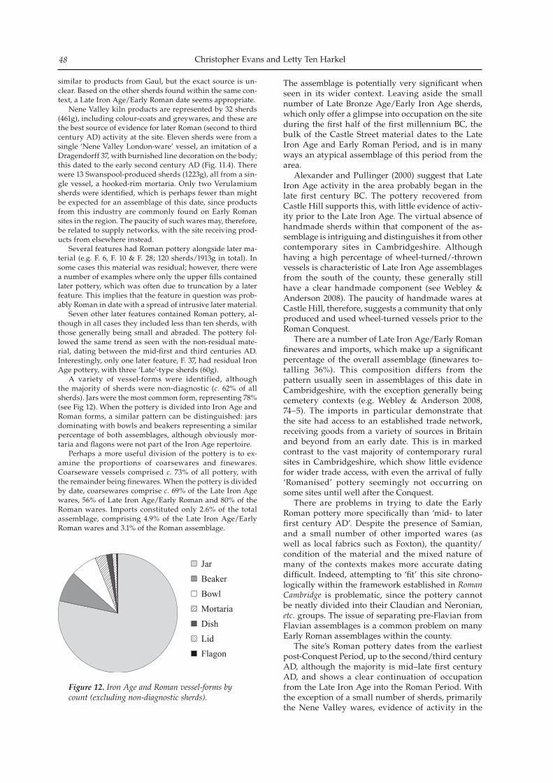
Christopher Evans and Letty Ten Harkel48
similar to products from Gaul, but the exact source is un-clear. Based on the other sherds found within the same con-text, a Late Iron Age/Early Roman date seems appropriate. Nene Valley kiln products are represented by 32 sherds (461g), including colour-coats and greywares, and these are the best source of evidence for later Roman (second to third century AD) activity at the site. Eleven sherds were from a single ‘Nene Valley London-ware’ vessel, an imitation of a Dragendorff 37, with burnished line decoration on the body; this dated to the early second century AD (Fig. 11.4). There were 13 Swanspool-produced sherds (1223g), all from a sin-gle vessel, a hooked-rim mortaria. Only two Verulamium sherds were identified, which is perhaps fewer than might be expected for an assemblage of this date, since products from this industry are commonly found on Early Roman sites in the region. The paucity of such wares may, therefore, be related to supply networks, with the site receiving prod-ucts from elsewhere instead. Several features had Roman pottery alongside later ma-terial (e.g. F. 6, F. 10 & F. 28; 120 sherds/1913g in total). In some cases this material was residual; however, there were a number of examples where only the upper fills contained later pottery, which was often due to truncation by a later feature. This implies that the feature in question was prob-ably Roman in date with a spread of intrusive later material. Seven other later features contained Roman pottery, al-though in all cases they included less than ten sherds, with those generally being small and abraded. The pottery fol-lowed the same trend as seen with the non-residual mate-rial, dating between the mid-first and third centuries AD. Interestingly, only one later feature, F. 37, had residual Iron Age pottery, with three ‘Late’-type sherds (60g). A variety of vessel-forms were identified, although the majority of sherds were non-diagnostic (c. 62% of all sherds). Jars were the most common form, representing 78% (see Fig 12). When the pottery is divided into Iron Age and Roman forms, a similar pattern can be distinguished: jars dominating with bowls and beakers representing a similar percentage of both assemblages, although obviously mor-taria and flagons were not part of the Iron Age repertoire. Perhaps a more useful division of the pottery is to ex-amine the proportions of coarsewares and finewares. Coarseware vessels comprised c. 73% of all pottery, with the remainder being finewares. When the pottery is divided by date, coarsewares comprise c. 69% of the Late Iron Age wares, 56% of Late Iron Age/Early Roman and 80% of the Roman wares. Imports constituted only 2.6% of the total assemblage, comprising 4.9% of the Late Iron Age/Early Roman wares and 3.1% of the Roman assemblage.
Figure 12. Iron Age and Roman vessel-forms by count (excluding non-diagnostic sherds).
The assemblage is potentially very significant when seen in its wider context. Leaving aside the small number of Late Bronze Age/Early Iron Age sherds, which only offer a glimpse into occupation on the site during the first half of the first millennium BC, the bulk of the Castle Street material dates to the Late Iron Age and Early Roman Period, and is in many ways an atypical assemblage of this period from the area. Alexander and Pullinger (2000) suggest that Late Iron Age activity in the area probably began in the late first century BC. The pottery recovered from Castle Hill supports this, with little evidence of activ-ity prior to the Late Iron Age. The virtual absence of handmade sherds within that component of the as-semblage is intriguing and distinguishes it from other contemporary sites in Cambridgeshire. Although having a high percentage of wheel-turned/-thrown vessels is characteristic of Late Iron Age assemblages from the south of the county, these generally still have a clear handmade component (see Webley & Anderson 2008). The paucity of handmade wares at Castle Hill, therefore, suggests a community that only produced and used wheel-turned vessels prior to the Roman Conquest. There are a number of Late Iron Age/Early Roman finewares and imports, which make up a significant percentage of the overall assemblage (finewares to-talling 36%). This composition differs from the pattern usually seen in assemblages of this date in Cambridgeshire, with the exception generally being cemetery contexts (e.g. Webley & Anderson 2008, 74–5). The imports in particular demonstrate that the site had access to an established trade network, receiving goods from a variety of sources in Britain and beyond from an early date. This is in marked contrast to the vast majority of contemporary rural sites in Cambridgeshire, which show little evidence for wider trade access, with even the arrival of fully ‘Romanised’ pottery seemingly not occurring on some sites until well after the Conquest. There are problems in trying to date the Early Roman pottery more specifically than ‘mid- to later first century AD’. Despite the presence of Samian, and a small number of other imported wares (as well as local fabrics such as Foxton), the quantity/condition of the material and the mixed nature of many of the contexts makes more accurate dating difficult. Indeed, attempting to ‘fit’ this site chrono-logically within the framework established in Roman Cambridge is problematic, since the pottery cannot be neatly divided into their Claudian and Neronian, etc. groups. The issue of separating pre-Flavian from Flavian assemblages is a common problem on many Early Roman assemblages within the county. The site’s Roman pottery dates from the earliest post-Conquest Period, up to the second/third century AD, although the majority is mid–late first century AD, and shows a clear continuation of occupation from the Late Iron Age into the Roman Period. With the exception of a small number of sherds, primarily the Nene Valley wares, evidence of activity in the
Roman Cambridge’s Early Settlement and Via Devana: Excavations at Castle Street 49
second century AD was limited, with there being even less Late Roman ceramic evidence (third to fourth centuries AD). The paucity of later Roman wares is potentially significant, with only a very small number of sherds (30 in total) that could be broadly dated to the second to fourth centuries AD. There was no definite Late Roman pottery (third to fourth centuries AD), which suggests that a second- to mid third-century AD attribution is more appropriate for this material. The later material was found both in Roman features and residually within later features. Two Roman pits, F. 6 and F. 7, both had some later material, but in all cases it was found alongside earlier Roman pottery. The Civil War ditch generated 27 sherds of Roman pottery in total, 11 of which were dated to the second to fourth century AD. In order to understand the context of the Castle Street assemblage, it is necessary to consider other sites in the vicinity. Alexander and Pullinger’s ex-cavations produced over 250,000 sherds (see below); however, little detailed information on the assem-blages is available, this being confined to basic data on pottery sources. There is no accurate information about the quantity and nature of Late Roman mate-rial from the area, thereby restricting the extent of any comparison. A series of third- to fourth-century features were excavated at Ridgeons Garden North, although this included a number of quarry pits sug-gesting that earlier areas of settlement activity had by then ceased to be occupied. Several large rubbish pits with later pottery (several thousand late sec-ond- to third-century AD sherds from Pit 26) were, however, also present and these were interpreted as evidence that later settlement ‘flourished’ in the area (Alexander & Pullinger 2000, 49). Two Conquest Period assemblages from Cambridgeshire provide a relevant comparison as they can be considered ‘rural’ and may highlight the differences between town and country. The first was recovered from a Guided Busway-route site to the north of Longstanton, which produced c. 890 sherds of pottery (9,409g; see Collins & Dickens 2009). The second came from the Hutchison Site, Addenbrooke’s, which had a very large assemblage of 20,876 sherds of Late Iron Age and Early Roman pottery, although much of it was kiln-derived (Webley & Anderson 2008). The most apparent difference with Castle Street is in the number of imported and fineware sherds, with Longstanton having no imports and the Hutchison Site only having a limited number of Samian sherds and one body sherd from an amphora. It may be argued that the overall lack of Samian (usu-ally the most commonly occurring imported ware) at the Hutchison Site and Longstanton is a reflection of date, since the latter did not appear to continue after c. AD 60 and the bulk of the Hutchison Site’s deposits were of pre-Flavian date. Castle Street had, however, several pre-Conquest imported wares, in-cluding North Gaulish pipeclay wares, thus demon-strating that this site had access to imported wares at a relatively early date. The paucity of imports at the
other two sites may be a result of the fact that each settlement operated within its own trade networks. This view is further supported by the difference in fabric types between all three sites, implying differ-ent sources and suppliers of pottery. The differences highlighted between these three assemblages dem-onstrate that the site at Castle Street, at least from the first century AD, differed from contemporary rural settlements. A substantial quantity of Roman pottery (6,000+ sherds) has recently been recovered from numerous other sites in the area of Chesterton Lane Corner, the Cow and Calf and The Folk Museum, etc. (see above); however, most of the sherds from these excavations were residual (over 90%) and virtually no later pre-historic material was recovered. Interestingly, from their assemblages, just 50 sherds were dated as being Late Roman (third to fourth centuries AD), with a further 283 broadly dating to the second to fourth centuries AD; at most, this would only represent just over 5% of the collective material. Other excavations in the hinterland of the town include the New Hall excavations (Evans 1996; Evans & Lucas forthcoming), which yielded a substantial assemblage of Roman pottery (168kg). This included only a small quantity of later prehistoric wares, while the Roman pottery showed evidence of occupation throughout the period. It, however, appears to have peaked between the mid-first to second centuries AD, with greatly reduced activity after AD 200 and similar pottery profiles were also found on the recent Trinity Hall Playing Fields and St Edmund’s College Sites (with the latter also having a substantial Late Iron Age component). There are only a small number of sites in the area that contrast with this pattern, including Vicar’s Farm, West Cambridge. It produced an assemblage of c. 13,000 sherds of Roman pottery, of which the major-ity dated to the third to fourth century AD, when ac-tivity at the site is described as being intensive (Lucas 2002; Evans & Lucas forthcoming). Similarly, second- to fourth-century AD assemblages seem more wide-spread in the lower Roman town, east across the river, and have been recovered in the St John’s ‘Triangle’ and Jesus Lane area (see Hartley 1960; Newman 2008; Monteil 2004). Overall, the pottery from the Castle Street excava-tion is particularly useful for understanding the Late Iron Age/Roman transition in Cambridge. This is perhaps best expressed through its changing pottery forms, which reflects changes in technology and food consumption (and ultimately in social practices). That the Late Iron Age and earliest Roman component of the assemblage is different in composition to con-temporary sites in the area suggests that the Castle Street’s usage was more than a typical ‘rural-type’ settlement at this time, with the range of finewares and imports indicative of an elevated level of status and wealth. Otherwise, the paucity of Late Roman pottery at the site is intriguing and has implications for understanding the nature and function of the later Roman town.
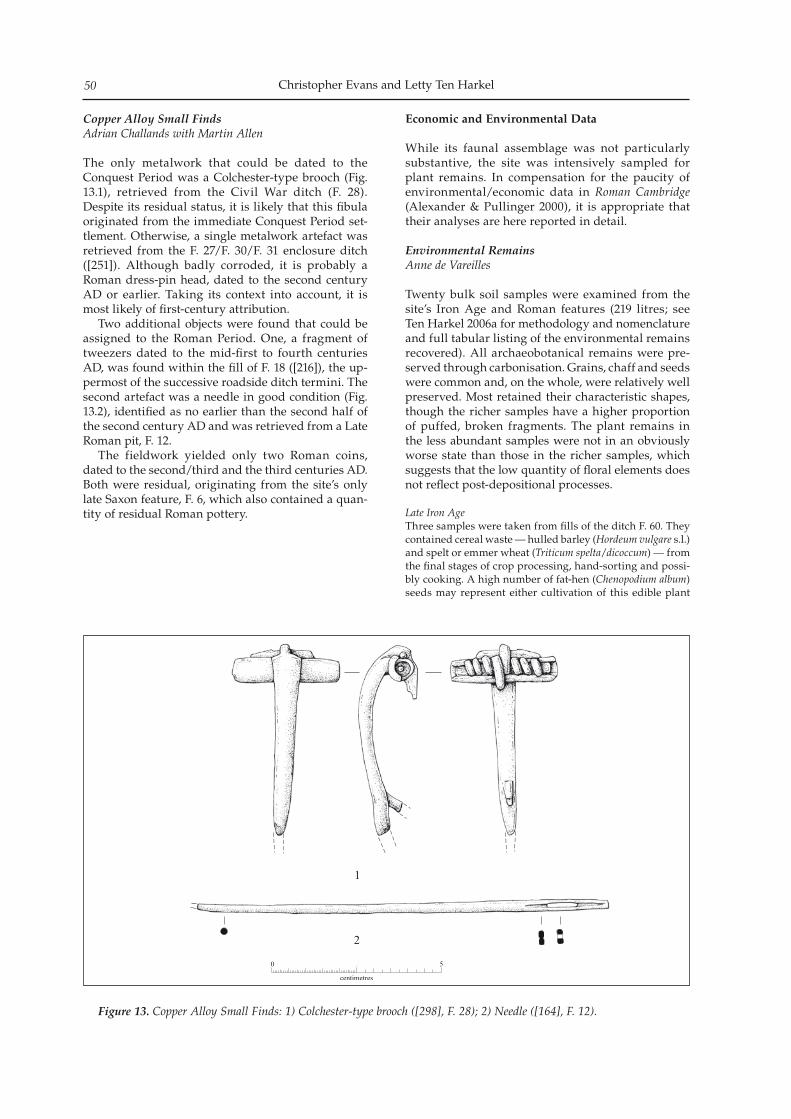
Christopher Evans and Letty Ten Harkel50
Copper Alloy Small Finds Adrian Challands with Martin Allen
The only metalwork that could be dated to the Conquest Period was a Colchester-type brooch (Fig. 13.1), retrieved from the Civil War ditch (F. 28). Despite its residual status, it is likely that this fibula originated from the immediate Conquest Period set-tlement. Otherwise, a single metalwork artefact was retrieved from the F. 27/F. 30/F. 31 enclosure ditch ([251]). Although badly corroded, it is probably a Roman dress-pin head, dated to the second century AD or earlier. Taking its context into account, it is most likely of first-century attribution. Two additional objects were found that could be assigned to the Roman Period. One, a fragment of tweezers dated to the mid-first to fourth centuries AD, was found within the fill of F. 18 ([216]), the up-permost of the successive roadside ditch termini. The second artefact was a needle in good condition (Fig. 13.2), identified as no earlier than the second half of the second century AD and was retrieved from a Late Roman pit, F. 12. The fieldwork yielded only two Roman coins, dated to the second/third and the third centuries AD. Both were residual, originating from the site’s only late Saxon feature, F. 6, which also contained a quan-tity of residual Roman pottery.
Economic and Environmental Data
While its faunal assemblage was not particularly substantive, the site was intensively sampled for plant remains. In compensation for the paucity of environmental/economic data in Roman Cambridge (Alexander & Pullinger 2000), it is appropriate that their analyses are here reported in detail.
Environmental Remains Anne de Vareilles
Twenty bulk soil samples were examined from the site’s Iron Age and Roman features (219 litres; see Ten Harkel 2006a for methodology and nomenclature and full tabular listing of the environmental remains recovered). All archaeobotanical remains were pre-served through carbonisation. Grains, chaff and seeds were common and, on the whole, were relatively well preserved. Most retained their characteristic shapes, though the richer samples have a higher proportion of puffed, broken fragments. The plant remains in the less abundant samples were not in an obviously worse state than those in the richer samples, which suggests that the low quantity of floral elements does not reflect post-depositional processes.
Late Iron AgeThree samples were taken from fills of the ditch F. 60. They contained cereal waste — hulled barley (Hordeum vulgare s.l.) and spelt or emmer wheat (Triticum spelta/dicoccum) — from the final stages of crop processing, hand-sorting and possi-bly cooking. A high number of fat-hen (Chenopodium album) seeds may represent either cultivation of this edible plant
Figure 13. Copper Alloy Small Finds: 1) Colchester-type brooch ([298], F. 28); 2) Needle ([164], F. 12).
Roman Cambridge’s Early Settlement and Via Devana: Excavations at Castle Street 51
or its presence as an arable weed. The range of arable weeds in the sample indicates cultivation of two soil types: a light nitrogenous soil (indicated by white campion, Silene latifolia) and a heavy clay-rich nitrogenous soil (indicated by red bar-tsia, Odontites vernus). Damp soil conditions are indicated by the presence of blinks (Montia fontana), sedges (Carex sp. and Claudium mariscus) and spike-rushes (Eleocharis sp.). As sedges cannot tolerate arable conditions, these species may have been growing on damp field margins.
Conquest PeriodTen samples were taken from four features (F. 23, F. 27, F. 30 & F. 61). These contained a range of arable weeds and grains similar to the Late Iron Age ditch F. 60 and represent crop-processing waste. The presence of small wild plant seeds in F. 27 suggests that this material had not undergone final processing, as they would usually be removed at this stage. The major crop present in samples of this period was spelt (Triticum spelta), with smaller quantities of hulled bar-ley (Hordeum vulgare s.l.). Rye (Triticum/Secale) may have been cultivated (single grains were recovered from F. 23 & F. 30). Oats were also present in minor quantities, but their rarity may indicate that they were not cultivated as an in-tentional crop. Free-threshing cereals (T. aestivum s.l.) are represented by six grains in F. 61. As well as the wild plants of damp soils mentioned for the Late Iron Age features, stinking chamomile (Anthemis cotula) was found in four of the samples. This species is common in the Romano-British Period, where it indicates increased farming upon damp, clay-rich soils (cf. Jones 1978). The features continue to present a range of species from damp to better drained soils. The most commonly occurring specimen in the Early Roman and Late Iron Age samples is clover (Trifolium sp.). This low-growing plant rarely reached heights over 50cm and its presence, along with other small plants such as red bartsia and lamb’s lettuce (Valerianella dentata), suggests that the ears were harvested together with the straw.
Early RomanSix samples were retrieved from three Early Roman features (F. 18, F. 22 & F. 46). Those from F. 18 and F. 22 both con-tained high quantities of grain, chaff and wild plant seeds, suggesting that the assemblages are fine-sieving waste. Within F. 22 glumed wheat was present in larger propor-tions than barley; one possible rye grain was found. Most of the weeds present could be arable weeds; great fen-sedge was represented by only a single seed. Three samples retrieved from F. 46 saw lower numbers of grain seeds, although spelt and possibly emmer and barley were present. The samples were predominantly composed of micro-aggregated (heavily bioturbated) organic-rich top-soil or humus, abundantly mixed with charcoal powder. Charcoal improves the mineral composition of soils and would have made the sediment within F. 46 an excellent garden soil for growing vegetables and/or other crops. The same charcoal-rich sediment was found at the nearby Romano-British settlement at New Hall, where it seems to have been an extensive layer of industry-generated waste (Evans 1996; Evans & Lucas forthcoming).
Late RomanThe single sample from this period derived from pit F. 12. The eight whole cereal grains, four wheat glume bases and five whole seeds from this feature probably represent fine sieving waste. The five seeds are all of different taxa and would have grown on damp soils.
The fact that only the final stages of crop process-ing are represented at the site during the Late Iron Age and Roman Periods indicates that grain was being brought into the site partially processed, either for local consumption or surrounding markets. The mixture of seeds within the samples may indicate that crops from different areas were being processed in the same locale or that households acquired semi-clean grain from a number of sources. The location of any major grain storage remains unknown. The appearance of small water-pepper (Persicaria minor) and the increase of legumes and black bind-weed (Fallopia convolvulus) in features that extend into the Roman Period may point to worsening soil condi-tions or the expansion of cultivation onto poorer soils.
Faunal RemainsVida Rajkovača
With the material displaying only moderate levels of preservation, the quantity of animal bones recov-ered totalled some 825 fragments; however, this re-port will be concerned with those pieces from firmly dated Iron Age and Roman contexts. In this contribu-tion standard sources have been used for the identi-fication (Boessneck 1969, Schmid 1972, Hillson 1999 and Halstead et al. 2002), ageing (Silver 1969, Payne 1973 and 1987, Grant 1982 and O’Connor 1989) and the mesurement of species (Von den Driesch 1976; Von den Driesch & Boessneck 1974); details of meth-odology applied are kept with the project’s archives. Taphonomic criteria including indications of butch-ery, pathology, gnawing activity and surface modifi-cations as a result of weathering were also recorded when evident.
Iron AgeThe majority of the bone from this phase was recovered from F. 60. This yielded 64 bone specimens, of which 62 (97%) could be assigned to element and a further 26 (41%) to species. The sub-set is comprised entirely of domestic species, where ovicaprids slightly dominate the assemblage (Table 3). This, coupled with the number of unidentified me-dium-sized mammal fragments, could indicate the impor-tance of sheep/goat in the Iron Age. This is, though, a very small assemblage and any inferences can only be tentative.
Table 3. Number Identified to Species (NISP) and Minimum Number of Individuals (MNI) counts for the Iron Age contexts (n.f.i. denotes that a specimen could not be further identified).
Taxon NISP NISP % MNIOvicaprids 9 34.6 1Cow 8 30.8 1Horse 4 15.4 1Pig 4 15.4 2Dog 1 3.8 1Cattle-sized 10 - -Sheep-sized 26 - -Mammal n.f.i. 2 - -Total 64 - -
One sheep/goat humerus was aged to 0–10 months (Silver
Christopher Evans and Letty Ten Harkel52
1969). Three instances of butchery were recorded, demon-strating disarticulation or bone splitting for marrow remov-al. A complete cattle metacarpal was recovered from F. 60 (greatest length = 181mm) and the withers estimate came at 109–115cm, which are at the upper end of the size-range for Iron Age cattle (Harcourt 1979).
Conquest PeriodThe results in this case show some Iron Age traits, but also hint of Romanising aspects, such as the occurrence of pheas-ant that is thought to have been a Roman introduction. The assemblage is clearly dominated by livestock species and especially the three main ‘food species’, (Table 4) followed by horse and dog; Red deer and pheasant represent the only evidence for the use of wild resources at the time. Out of 240 bones analysed, 224 (93%) were identified to element and a further 71 (30%) to species. The presence of sheep was confirmed based on a com-plete humerus and a mandible. The latter was aged to 6–8 years and a further three ovicaprid specimens were aged demonstrating that they were slaughtered in their first year. Two more ageable specimens were recorded: a pig scapula, aged to 0–1 years, and a cow femur that gave the age at death around its fourth year.
Table 4. NISP and MNI counts for the Conquest Period contexts.
Taxon NISP NISP % MNIOvicaprids 37 52.1 3Sheep 2 2.8 1Cow 19 26.8 2Pig 9 12.7 2Horse 1 1.4 1Dog 1 1.4 1Red deer 1 1.4 1Pheasant 1 1.4 1Cattle-sized 28 - -Sheep-sized 132 - -Mammal n.f.i. 9 - -Total 240 - -
Butchery was recorded on 11 bones (c. 5%), mainly ribs or vertebra, possibly implying ‘pot-sizing’ or separating left and right portions of meat. In addition, an example of bone-working was noted: an ovicaprid metacarpal shaft was slightly polished with wide shallow grooves (F. 27; [248]); this seems to have been used as a weaving or leather processing tool.
Early Roman Animal bone from this phase was recovered from ditches and gullies, as well as from pits F. 43 and F. 46. The assem-blage is, again, dominated by domesticates with a couple of wild species such as red deer and frog/toad, as well as a fish specimen (Table 5). The sheep/goat category accounted for six individual animals, followed by cattle and chicken with MNI count of two. The unidentified mammal fragment count also shows the prevalence of medium- or sheep-sized mammals on site. It was possible to age nine specimens and the majority were identified as sheep/goat or sheep. Two groups could be recognised: one where the cull happened at the earlier stages (i.e. during their first year) and, the other, thereaf-ter. Five aged ovicaprid mandibles fell into the first group, one aged to 2–6 months and four to 6–12 months; other-wise, an ovicaprid radius was aged to 1–3 years and a sheep mandible to 8–10 years. This early slaughter is somewhat
surprising since ovicaprids tend to be kept for various sec-ondary products such as wool or milk. A number of ele-ments allowed differentiation to be made between sheep and goat, and both species were identified within this sub-set (Halstead et al. 2002, 548). A case of partial anodontia was noted on a sheep maxilla where one of the premolars was missing.
Table 5. NISP and MNI counts for Early Roman contexts.
Taxon NISP NISP % MNIOvicaprids 38 52 3Sheep 4 5.5 2Goat 2 2.7 1Cow 11 15.1 2Domestic fowl 6 8.2 2Pig 3 4.1 1Dog 3 4.1 1Horse 1 1.4 1Red deer 1 1.4 1Frog/toad 4 5.5 1Cattle-sized 33 - -Sheep-sized 94 - -Mammal n.f.i. 6 - -Fish n.f.i. 1 - -Bird n.f.i. 1 - -Total 208 - -
Butchery practices identified mainly relate to meat removal and axial splitting for marrow extraction. The exception to this was a cattle scapula with the chop-marks characteristic of dry/brine curing (Dobney 2001). This is a typical feature of Roman butchery practices. In addition, a number of chop-marks were noted on ribs and vertebra, supporting the no-tion that carcasses were commonly hung in urban contexts in the Romano-British Period (Seetah 2006, 111). Another typically Romano-British characteristic that was noted in this sub-set is the use of a cleaver (ibid, 109). A chicken tarso-metatarsus with spur was identified as male (Cohen & Serjeantson 1996, 79). Based on a complete metatarsal, a shoulder height estimate could be made for the horse and it came in at 133cm or 13 hands; by modern standards this would be considered a pony.
Later RomanTwo features were dated to the Late Roman Period (F. 11 & F. 12) and only produced a small quantity of bone, with five specimens (14%) identified to species (Table 6). Cow is present with three, ovicaprids with one and there was a pike bone. Of 35 bones recovered, 13 (37%) had signs of butchery and the majority had been split for marrow extraction. A cattle scapula showed signs characteristic of dry curing: removal of the processus coracoideus and spina, with cut- or nick-marks on the dorsal aspect of the neck. The same scapula was damaged by a butcher’s hook and indicates that it might have been suspended during a dry curing process.
Table 6. NISP and MNI counts for Late Roman contexts.
Taxon NISP NISP % MNICow 3 60 1Ovicaprid 1 20 1Pike 1 20 1Cattle-sized 19 - -Sheep-sized 11 - -Total 35 - -
The faunal material recovered from Late Iron Age
Roman Cambridge’s Early Settlement and Via Devana: Excavations at Castle Street 53
features did not demonstrate a great variety of spe-cies, but did yield some ageing and measurement data; however, the portion of the assemblage dated to the Conquest and Early Roman Periods showed a varied species-representation with there being evi-dence for the use of wild faunal resources (Table 4 & 5). Both sheep and goat were identified in these two sub-sets, with sheep being dominant. This could sug-gest that the sheep were being kept in larger numbers with the environmental conditions favouring sheep husbandry, though this is based on a small assem-blage and must be taken with caution. High levels of sheep consumption in the Early Roman Period are considered to be an indication of a continuation of Iron Age foodways. King (1991) has described a ‘gradient’ of early Romano-British sites whereby the more ‘Romanised’ a site is, the less likely it is to have a diet high in sheep meat. He suggests that military and Romanised sites are likely to have higher pro-portions of cattle and, to a lesser extent, pig than rural sites still continuing with the Iron Age tradition (1999). These two sub-sets have, however, generated significant results gained from the analysis of the butchery practices. First, chop- and cut-marks were noted on ribs and vertebrae, supporting the idea that the carcasses were hung in Roman times; secondly, the use of the cleaver was demonstrated and, finally, characteristic butchery marks on cattle scapulae were indicative of curing. All these aspects are thought to be typically Roman (Seetah 2006), when butchers em-ployed practices to speed the butchery processes as demand became greater. Also, a number of long bone shafts were split axially (longitudinally), possibly for processing of marrowfat. This type of butchery has been recognised at a number of Roman sites in the country (Maltby 1985), many of which were military in type. Some authors suggest that standard butchery practices were being established for the purpose of supplying the military and that professional butchers practicing in rural areas adopted this habit (Maltby 1989). As for the body part distribution in these sub-sets, there is an even representation of elements/parts of carcasses suggesting immediately local/domestic-level slaughter and consumption.
Discussion
It would generally have to be said that, as a whole, the archaeology of Roman Cambridge has something of an ‘underwhelming’ quality. Lacking deep stratig-raphy and public/masonry buildings (the mansio and the Kettle’s Yard rammed-footing aside; Alexander & Pullinger 2000, 39–40 and 255–6), and even hav-ing some industry apparently occur within its core, it could be questioned whether its designation as a ‘town’ is at all warranted. This is an issue that will be returned to below. Given this perspective, it is nev-ertheless appropriate that we begin the site’s discus-sion with base-line matters: was there anything that distinguishes its early settlement-phases from other rural sites of the period and did they amount to any-
thing more than a developed farming complex? Of the site’s economic data, as discussed by Rajkovača above, skeletal-part representation within its faunal assemblage would not seem to indicate the importation of meat. Having said that, the Early Roman Period saw practices typical of more intense ‘Roman’/’ised’ butchery. Yet, while attesting to great-er specialist processing, there is nothing particularly ‘special’ or characteristically urban in this, and it has now also been demonstrated on a number of rural settlements in the region (see Higbee forthcoming). Certainly, given the limited scale of the excavations (and the assemblage) we must be wary of over-in-terpreting its results. What is, though, of particular interest is the increase in sheep in the Early Roman features, when a rise in cattle-based production is generally held to be a hallmark of Romanisation per se (King 1999). There could be two interrelated read-ings of this: a lingering continuity of Late Iron Age economic ‘lifeways’ and/or a decline in the status of the area during the second half of the first century AD. Concerning whether the early Castle Hill settle-ments were something other than just ‘farms’, more informative is the evidence of the site’s plant remains, especially its arable weeds and wild plant assemblag-es. As discussed by de Vareilles, the Late Iron Age samples indicate cultivation on two types of soil. On the one hand, there were weeds of light nitrogenous soils, such as could have been potentially found with-in the immediate Castle Hill environs. On the other hand, especially in the Conquest Period samples, the weeds attest to cultivation on damp clay-rich soils. Indeed, the occurrence of sedges in both phase’s sam-ples, probably growing on the edges of fields, would certainly attest to wet soil conditions, which would not have been present on the hill-top. Instead, this points to the importation of partially processed grain, probably from West Cambridge’s claylands and such ‘producer’ sites as Vicar’s Farm. While this may not be unexpected in the case of Early Roman Cambridge proper, it is potentially of major significance for un-derstanding the nature of its Late Iron Age precursor. As emphasised by Andersen and Brudenell above, the frequency of imports within the site’s Late Iron Age pottery assemblage further tells of the status of the wider settlement. To this could also be added the recovery of its Colchester-type brooch. Admittedly, as a single-find its presence could always be considered ‘incidental’; however, as indicated in Table 7, it adds to the considerable corpus of first-century brooches recovered from Cambridge. As listed in that table (whose results are obviously contingent upon the quantity of fieldwork in each instance, but which can-not be readily qualified), lying on the northern fring-es of the Aylesford-Swarling zone (see Hill et al. 1999), Cambridge would certainly rank as a significant local regional centre during the Late Iron Age/Conquest Period. Yet, it falls far short of the more major centres within its southern core area (e.g. Baldock). In reference to Alexander’s earlier excavations, Castle Hill’s Iron Age settlement appears to have
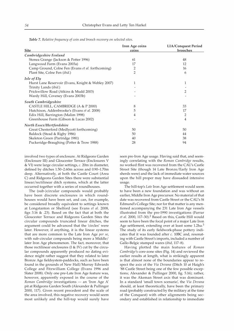
Christopher Evans and Letty Ten Harkel54
involved two types of enclosure. At Ridgeons Garden (Enclosure III) and Gloucester Terrace (Enclosures V & VI) were large circular settings, c. 20m in diameter, defined by ditches 1.50–2.60m across and 0.90–1.70m deep. Alternatively, at both the Castle Court (Area C) and Ridgeons Garden Sites there were substantial linear/rectilinear ditch systems, which at the latter occurred together with a series of roundhouses. The (sub-)circular compounds would probably have been discrete enclosures in which round-houses would have been set, and can, for example, be considered broadly equivalent to settings known at Longstanton or Shelford (see Evans et al. 2008, figs 3.16 & .23). Based on the fact that at both the Gloucester Terrace and Ridgeons Garden Sites the circular compounds truncated linear ditches, the argument could be advanced that the ‘circles’ were later. However, if anything, it is the linear systems that are more common to the Late Iron Age per se, with sub-circular compounds being more a Middle/later Iron Age phenomenon. The fact, moreover, that those rectilinear enclosures (I & IV) cut by the circu-lar compounds apparently produced no dating evi-dence might rather suggest that they related to later Bronze Age fieldsystem-paddocks, such as have been found in the grounds of New Hall/Murray Edwards College and Fitzwilliam College (Evans 1996 and Slater 2008). Only one pre-Late Iron Age feature was, however, apparently exposed in the course of the Roman Cambridge investigations — an ‘Iron Age A’ pit at Ridgeons Garden South (Alexander & Pullinger 2000, 117). Given recent precedent and the scale of the area involved, this negative recovery would seem most unlikely and the hill-top would surely have
seen pre-Iron Age usage. Having said that, and seem-ingly correlating with the Roman Cambridge results, no worked flint was recovered from the CAU’s Castle Street Site (though 14 Late Bronze/Early Iron Age sherds were) and the lack of immediate water sources upon the hill proper may have dissuaded intensive usage. The hill-top’s Late Iron Age settlement would seem to have been a new foundation and was without an earlier, Middle Iron Age precursor. No material of that date was recovered from Castle Street or the CAU’s St Edmund’s College Site; nor for that matter is any men-tioned accompanying the 231 Late Iron Age vessels illustrated from the pre-1990 investigations (Farrar et al. 2000, 117–30).2 Based on this, Castle Hill would seem to have been the focal point of a major Late Iron Age settlement, extending over at least some 1.2ha.3 The study of its early fieldwork-phase pottery indi-cates that it was founded after c. 10BC and, resonat-ing with Castle Street’s imports, included a number of Gallo-Belgic stamped wares (ibid, 117–8). Having plotted the main features of Roman Cambridge’s core-zone sites (Fig. 14) and reviewed the earlier results at length, what is strikingly apparent is that almost none of the boundaries appear to re-spect the axis of the Via Devana (Ditch 10 at Haigh’s ’88 Castle Street being one of the few possible excep-tions; Alexander & Pullinger 2000, fig. 5.16); rather, it was the Akeman Street axis that was dominant. In a standard ‘small town scenario’, the Via Devana should, at least theoretically, have been the primary road (probably constructed by the military at the time of the Conquest) with other alignments being sec-ondary and established in relationship to immediate
Table 7. Relative frequency of coin and brooch recovery on selected sites.
Iron Age coins LIA/Conquest PeriodSite coins broochesCambridgeshire Fenland
Stonea Grange (Jackson & Potter 1996) 61 48Langwood Farm (Evans 2003a) 17 12Camp Ground, Colne Fen (Evans et al. forthcoming) 2 16Plant Site, Colne Fen (ibid.) 2 6
Isle of ElyHurst Lane Reservoir (Evans, Knight & Webley 2007) 1 1Trinity Lands (ibid.) - -Prickwillow Road (Atkins & Mudd 2003) - 2Wardy Hill, Coveney (Evans 2003b) - -
South CambridgeshireCASTLE HILL, CAMBRIDGE (A & P 2000) 8 33Hutchison, Addenbrooke’s (Evans et al. 2008) 5 17Edix Hill, Barrington (Malim 1998) 4 2Greenhouse Farm (Gibson & Lucas 2002) - 4
North Essex/HertfordshireGreat Chesterford (Medlycott forthcoming) 50 50Baldock (Stead & Rigby 1986) 50 44Skeleton Green (Partridge 1981) 40 38Puckeridge-Braughing (Potter & Trow 1988) 28 94
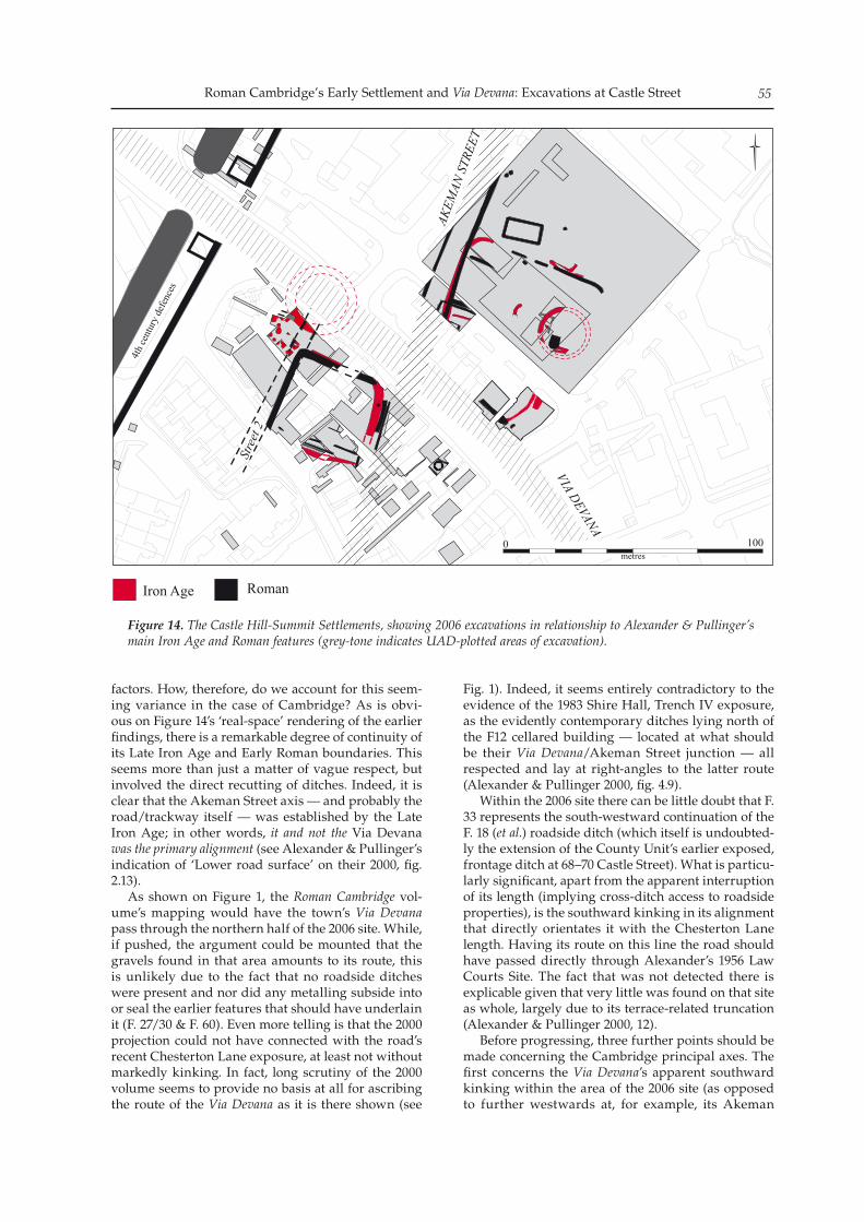
Roman Cambridge’s Early Settlement and Via Devana: Excavations at Castle Street 55
factors. How, therefore, do we account for this seem-ing variance in the case of Cambridge? As is obvi-ous on Figure 14’s ‘real-space’ rendering of the earlier findings, there is a remarkable degree of continuity of its Late Iron Age and Early Roman boundaries. This seems more than just a matter of vague respect, but involved the direct recutting of ditches. Indeed, it is clear that the Akeman Street axis — and probably the road/trackway itself — was established by the Late Iron Age; in other words, it and not the Via Devana was the primary alignment (see Alexander & Pullinger’s indication of ‘Lower road surface’ on their 2000, fig. 2.13). As shown on Figure 1, the Roman Cambridge vol-ume’s mapping would have the town’s Via Devana pass through the northern half of the 2006 site. While, if pushed, the argument could be mounted that the gravels found in that area amounts to its route, this is unlikely due to the fact that no roadside ditches were present and nor did any metalling subside into or seal the earlier features that should have underlain it (F. 27/30 & F. 60). Even more telling is that the 2000 projection could not have connected with the road’s recent Chesterton Lane exposure, at least not without markedly kinking. In fact, long scrutiny of the 2000 volume seems to provide no basis at all for ascribing the route of the Via Devana as it is there shown (see
Fig. 1). Indeed, it seems entirely contradictory to the evidence of the 1983 Shire Hall, Trench IV exposure, as the evidently contemporary ditches lying north of the F12 cellared building — located at what should be their Via Devana/Akeman Street junction — all respected and lay at right-angles to the latter route (Alexander & Pullinger 2000, fig. 4.9). Within the 2006 site there can be little doubt that F. 33 represents the south-westward continuation of the F. 18 (et al.) roadside ditch (which itself is undoubted-ly the extension of the County Unit’s earlier exposed, frontage ditch at 68–70 Castle Street). What is particu-larly significant, apart from the apparent interruption of its length (implying cross-ditch access to roadside properties), is the southward kinking in its alignment that directly orientates it with the Chesterton Lane length. Having its route on this line the road should have passed directly through Alexander’s 1956 Law Courts Site. The fact that was not detected there is explicable given that very little was found on that site as whole, largely due to its terrace-related truncation (Alexander & Pullinger 2000, 12). Before progressing, three further points should be made concerning the Cambridge principal axes. The first concerns the Via Devana’s apparent southward kinking within the area of the 2006 site (as opposed to further westwards at, for example, its Akeman
Figure 14. The Castle Hill-Summit Settlements, showing 2006 excavations in relationship to Alexander & Pullinger’s main Iron Age and Roman features (grey-tone indicates UAD-plotted areas of excavation).
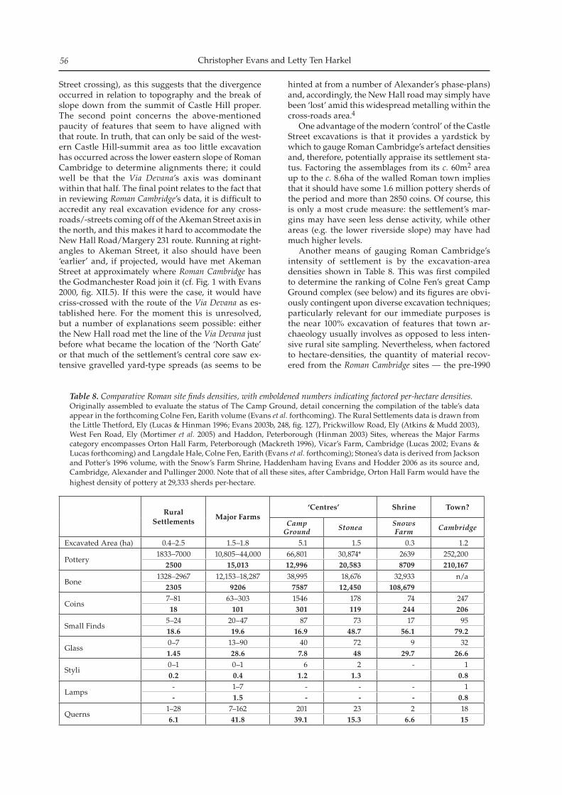
Christopher Evans and Letty Ten Harkel56
Street crossing), as this suggests that the divergence occurred in relation to topography and the break of slope down from the summit of Castle Hill proper. The second point concerns the above-mentioned paucity of features that seem to have aligned with that route. In truth, that can only be said of the west-ern Castle Hill-summit area as too little excavation has occurred across the lower eastern slope of Roman Cambridge to determine alignments there; it could well be that the Via Devana’s axis was dominant within that half. The final point relates to the fact that in reviewing Roman Cambridge’s data, it is difficult to accredit any real excavation evidence for any cross-roads/-streets coming off of the Akeman Street axis in the north, and this makes it hard to accommodate the New Hall Road/Margery 231 route. Running at right-angles to Akeman Street, it also should have been ‘earlier’ and, if projected, would have met Akeman Street at approximately where Roman Cambridge has the Godmanchester Road join it (cf. Fig. 1 with Evans 2000, fig. XII.5). If this were the case, it would have criss-crossed with the route of the Via Devana as es-tablished here. For the moment this is unresolved, but a number of explanations seem possible: either the New Hall road met the line of the Via Devana just before what became the location of the ‘North Gate’ or that much of the settlement’s central core saw ex-tensive gravelled yard-type spreads (as seems to be
hinted at from a number of Alexander’s phase-plans) and, accordingly, the New Hall road may simply have been ‘lost’ amid this widespread metalling within the cross-roads area.4 One advantage of the modern ‘control’ of the Castle Street excavations is that it provides a yardstick by which to gauge Roman Cambridge’s artefact densities and, therefore, potentially appraise its settlement sta-tus. Factoring the assemblages from its c. 60m2 area up to the c. 8.6ha of the walled Roman town implies that it should have some 1.6 million pottery sherds of the period and more than 2850 coins. Of course, this is only a most crude measure: the settlement’s mar-gins may have seen less dense activity, while other areas (e.g. the lower riverside slope) may have had much higher levels. Another means of gauging Roman Cambridge’s intensity of settlement is by the excavation-area densities shown in Table 8. This was first compiled to determine the ranking of Colne Fen’s great Camp Ground complex (see below) and its figures are obvi-ously contingent upon diverse excavation techniques; particularly relevant for our immediate purposes is the near 100% excavation of features that town ar-chaeology usually involves as opposed to less inten-sive rural site sampling. Nevertheless, when factored to hectare-densities, the quantity of material recov-ered from the Roman Cambridge sites — the pre-1990
Rural Settlements
Major Farms‘Centres’ Shrine Town?
Camp Ground Stonea Snows
Farm Cambridge
Excavated Area (ha) 0.4–2.5 1.5–1.8 5.1 1.5 0.3 1.2
Pottery1833–7000 10,805–44,000 66,801 30,874* 2639 252,200
2500 15,013 12,996 20,583 8709 210,167
Bone1328–2967 12,153–18,287 38,995 18,676 32,933 n/a
2305 9206 7587 12,450 108,679
Coins7–81 63–303 1546 178 74 24718 101 301 119 244 206
Small Finds5–24 20–47 87 73 17 9518.6 19.6 16.9 48.7 56.1 79.2
Glass0–7 13–90 40 72 9 321.45 28.6 7.8 48 29.7 26.6
Styli0–1 0–1 6 2 - 10.2 0.4 1.2 1.3 0.8
Lamps- 1–7 - - - 1- 1.5 - - - 0.8
Querns1–28 7–162 201 23 2 186.1 41.8 39.1 15.3 6.6 15
Table 8. Comparative Roman site finds densities, with emboldened numbers indicating factored per-hectare densities. Originally assembled to evaluate the status of The Camp Ground, detail concerning the compilation of the table’s data appear in the forthcoming Colne Fen, Earith volume (Evans et al. forthcoming). The Rural Settlements data is drawn from the Little Thetford, Ely (Lucas & Hinman 1996; Evans 2003b, 248, fig. 127), Prickwillow Road, Ely (Atkins & Mudd 2003), West Fen Road, Ely (Mortimer et al. 2005) and Haddon, Peterborough (Hinman 2003) Sites, whereas the Major Farms category encompasses Orton Hall Farm, Peterborough (Mackreth 1996), Vicar’s Farm, Cambridge (Lucas 2002; Evans & Lucas forthcoming) and Langdale Hale, Colne Fen, Earith (Evans et al. forthcoming); Stonea’s data is derived from Jackson and Potter’s 1996 volume, with the Snow’s Farm Shrine, Haddenham having Evans and Hodder 2006 as its source and, Cambridge, Alexander and Pullinger 2000. Note that of all these sites, after Cambridge, Orton Hall Farm would have the highest density of pottery at 29,333 sherds per-hectare.
Roman Cambridge’s Early Settlement and Via Devana: Excavations at Castle Street 57
excavations that collectively extended over only c. 1.2ha — can be considered high. Indeed, given the lack of metal-detecting its coinage levels are certainly ‘respectable’.5 It has, in fact, the highest density of small finds and its pottery values seem staggering, all of which challenges what otherwise seems to be the ‘modest’ character of Roman Cambridge’s ar-chaeology. Yet, while its density figures seem appro-priate to a ‘small town-level’, this need not necessarily imply that Roman Cambridge was in any way partic-ularly ‘urban’. Indeed, as matters currently stand, it is other criteria (i.e. ‘non-urban’) that variously bracket and characterise Roman Cambridge’s sequence: its early ‘fort’, late defences and second-century shrine complex. Only one artefact of military attribution has been recovered from any of the sites: the iron calthrop from Shire Hall, 1983 (Trench IV, F156; Alexander & Pullinger 2000, pl. XVII.151). Taylor, in Roman Cambridge, admits that the evidence for the early fort is far from conclusive (2000, 77). Dating to Flavian times, it seems unlikely that the army would then have been in residence (unless one resorts to Boudiccan Rebellion-aftermath arguments). Albeit impressive, its ‘V’-shaped ditch (3.60m wide and 1.50m deep; ibid, 36, fig. 3.6) cannot be held as a distinctly ‘military-type’; a major enclosure with a boundary of compa-rable size and form was found extending under New Hall, but there seems to be no particular reason to as-cribe it a military function (Evans 2000, Enclosure B, fig. XII.4). Also of relevance is that when the Ridgeons Garden North’s main Iron Age and Early Roman fea-tures are plotted together (Fig. 14) comes the realisa-tion that the arrangement of the earlier, Late Iron Age boundaries effectively closes the ‘square’ of the later putative fort and suggests that there are unappreci-ated complications within its sequence; this seriously undermines any role of an early fort. Although the second-century shrine complex at Ridgeons Garden South/Comet Place, with its array of votive animal deposits and later ritual shafts (with their dog and infant burials), certainly attests to cult activity (see Taylor 2000, 78–80), this does not provide any kind of raison d’etre for ‘the town’ as a whole. There is, for example, no real grounds to see it as any kind of major ceremonial centre, as has been proposed for Verlamion/Verulamium and other large Hertfordshire settlements (see Bryant & Niblett 1997 and Haselgrove & Millett 1997). Finally, there is the matter of Cambridge’s fourth-century defences: effectively, its ‘last act’, but the one that seems to attest most convincingly to its town status. Here it is important to realise that a number of very large Roman settlements, equal to and even exceeding Roman Cambridge, have recently been investigated within Cambridgeshire. Of these, per-haps the most relevant is the first- to early fifth-cen-tury barge-port, The Camp Ground, at Colne Fen, Earith (Evans & Regan 2005; Evans et al. forthcom-ing). Extending in total over some 7.4ha and having more than 60 buildings within the c. 5ha of it that was excavated in 2001–2, during the third century a
polygonal embanked enclosure was cast up around its core-area. While perhaps embanked for the pur-poses of taxation and/or flood defence, if its banks were hedge-capped it might well have also served as a defended perimeter generally (see also Site 19 at Longstanton, at least two of whose sides may have been similarly protected; Evans et al. 2008, fig. 3.22). In Roman Cambridge Taylor noted that Cambridge’s Late Roman defences might be viewed in the manner of the Saxon Shore forts (2000, 82–3). The crucial point here is that this may have had little to do with the ac-tual character or scale of Cambridge’s Roman settle-ment per se, but was rather determined by its hill-top topography. If, once a decision had been made that one of the settlements within the area of the south-western Fens was to be defended (perhaps to ensure Car Dyke-transported grain supply), then of the re-gion’s major settlements only Cambridge would have been readily defendable; The Camp Ground, Stonea or Waterbeach/Horningsea’s locales all, for example, being too low-lying and without sufficient relief for this purpose. Weighing the evidence, whether Roman Cambridge amounted to a ‘town’ cannot be readily adjudicated. Certainly it is tempting to see it as no more than a significant Late Iron Age centre and Early Roman cross-roads settlement, that subsequently — due to immediate topographic factors and broader political and historical circumstances generally — happened to be later defended. Yet, aside possibly from its finds densities, there remains one other factor that leaves it as a serious ‘town-candidate’ and that is the evidence of its apparent street grid (see Streets 1–3 on Fig. 1), as this kind of layout would not be normally found on rural and/or roadside (-only) settlements. While surely destined to attract further specula-tion, pending more detailed review of the earlier ex-cavation results and further excavation, the jury must unfortunately remain out on the issue of Cambridge’s status as a Roman town. This situation is unlikely to be rectified in the near future. As is strikingly ap-parent in Roman Cambridge’s figure 1.1, upwards of a third of the walled hill-top settlement’s archaeology was destroyed, to varying degrees, by development during the latter half of the last century with only minimum excavation. In truth, there were only three major excavations prior to the 1980s — Ridgeons Gardens/Comet Place, Castle Row and the Law Courts — and, otherwise, only very limited trench in-vestigation (the ‘fracturing’ of its archaeology seem-ing all the greater due to Alexander’s application of a ‘Wheeler box’ digging technique). This is perfectly understandable given the conditions of the day. What must, in hindsight, be considered a disaster is the scale of the destruction wrought by the expansion of the County Council’s Shire Hall facilities during the 1980s, when very limited excavation took place. Approaching nearly a quarter of Roman Cambridge’s hill-top, with it was lost the one recent opportunity for sufficiently large-scale excavation to come to terms with its sequence. Since then, the area has only seen small-scale interventions and, relative to which,
Christopher Evans and Letty Ten Harkel58
only the 2006 Castle Street Site can be counted as a significant excavation. Given the nature of the area, this situation — and, with it, our state of knowledge of its early settlements — seems unlikely to change in the foreseeable future.
Acknowledgements
The fieldwork phase of the Castle Street excavation was directed by Letty Ten Harkel and, at the Unit, was managed by Robin Standring and Christopher Evans. Many thanks must go to the developer, Ashwell’s Homes and especially Nick Jones their project man-ager, and also Andy Thomas who monitored the work on behalf of the County Council. It is pleasure to be able to acknowledge the efforts of the CAU’s excava-tion and post-excavation teams. This paper’s graphics are by Andrew Hall, with Vicki Herring and Bryan Crossan; Grahame Appleby greatly assisted with its editorial production. Managed by Emma Beadsmoore (CAU) and David Emond (RH Partnership Architects), Jacqui Hutton directed the Murray Edwards College fieldwork, and we are grateful for the co-operation of the College’s fellowship and its bursar, Nicholas Wright. Alison Dickens provided access to the City’s UAD intervention-mapping. Evans is grateful for now long-term mulling over of Cambridge issues with John Alexander, Stewart Bryant, Colin Haselgrove and Martin Millett, and thanks Maria Medlycott for providing a preview of her forthcoming Great Chesterford volume. Finally, although matters relat-ing to Roman Cambridge have been greatly furthered by discussions with Steve Macaulay, this paper has not benefited from the results of his and Evans & Mills’ forthcoming Horningsea study (J. Evans et al. forthcoming). Sadly, just before this volume went to press, the news was received of John Alexander’s death. A good friend and colleague, with characteristic insight, charm and good-humour, since the ‘50s he more than any one else fostered the ‘archaeology of the Cambridge region’.
End-notes
1. This is as opposed to the rather cartoon-like quality of the town-wide phase plans in the 2000 volume, which comparison shows has up to 10–15m displacement in the plotting of major features; compare, for example, Figures 1 & 14’s positioning of the Huntingdon/Godmanchester Roads’ ‘North Gate’. Equally, by this displacement the line of Akeman Street and Alexander and Pullinger’s southerly Street 5 are probably directly connected.
2. Given the manner of percentage-presentation of vessel-forms (Farrar et al. 2000, 118), this would appear to equate to some 600 pottery EVEs; compare this to Castle Street’s 2.4 EVEs only of Late Iron Age wares (see Table 1 above).
3. If the hill-top area’s Late Iron Age occupation extended south-westwards to conjoin with the St Edmund’s College settlement of that date, then it would have covered as
much as c. 3ha. Certainly, it does not extend continuously as far west as is depicted in Roman Cambridge’s figure 7.1; the Iron Age occupation at both New Hall and Marion Close was evidently discrete (Evans 2000 and Evans & Lucas forthcoming).
4. Another alternative is that if east of its New Hall exposure the road’s line kinked somewhat southward, then it might equate with the metalling shown flanking the northern side of the earlier, would-be fort (Alexander & Pullinger 2000, fig. 3.5).
5. Employing Roman Cambridge’s coin-list (see Sekulla & Thoday 2000), locally its densities would seem far higher. Fifty-four coins are attributed to Shire Hall’s Trench VI/Car Park’s c. 195m2-area (see Alexander & Pullinger 2000, 15, figs 1.1 & 1.7 and 2.13). Dug in 1983 (presumably then aided by metal-detecting) and sited adjacent to the settle-ment’s main cross-roads, this would equate to 2754 coins per hectare.
Bibliography
Alexander, J & J Pullinger 2000 Roman Cambridge: Excavations on Castle Hill, 1956–1988. PCAS 88 (for 1999).
Alexander, M, N Dodwell & C Evans 2004 A Roman Cemetery in Jesus Lane, Cambridge. PCAS 93: 67–94.
Atkins, R & A Mudd 2003 An Iron Age and Romano-British settlement at Prickwillow Road, Ely, Cambridgeshire: Excavations 1999–2000. PCAS 92: 5–55.
Boessneck, J 1969 ‘Osteological difference between Sheep (Ovis aries Linné) and Goat (Capra hircus Linné)’. In DR Brothwell & E Higgs (eds), Science in Archaeology; a survey of progress and research. Bristol: Thames and Hudson, 331–58.
Bryant, SR & BRK Niblett 1997 ‘The late Iron Age in Hertfordshire and the north Chilterns’. In A Gwilt and C Haselgrove (eds), Reconstructing Iron Age Societies. Oxbow Monograph 71. Oxford: Oxbow, 270–81.
Butler, R 1994 Archaeological Investigations at 75, 83 and 85 Castle Street, Cambridge, 1994. CAU Report 103.
Cessford, C 2003 Cambridge & County Folk Museum: An Archaeological Excavation. CAU Report 574.
Cessford, C 2008 Excavation of the Civil War bastion ditch of Cambridge Castle. PCAS 97: 137–48.
Cessford, C & A Dickens 2005 Cambridge Castle Hill, Cambridge: Excavation of Saxon, Medieval and post-Medieval deposits, Saxon execution site and a Medieval coinhoard. PCAS 94: 73–101.
Cessford, C, with A Dickens, N Dodwell & A Reynolds 2008 Middle Anglo-Saxon Justice: the Chesterton Lane Corner execution cemetery and related sequence, Cambridge. Arch. J. 164: 197–226.
Cohen, A & D Serjeantson 1996 A Manual for the Identification of Bird Bones from Archaeological Sites, re-vised edition. London: Archetype Publications Ltd.
Collins, M & A Dickens 2009 Tracing the Line: Archaeological Investigations along the Cambridgeshire Guided Busway, Part 1. CAU Report No. 883.
Cooper, A 2003 Former Cow and Calf Public House: Archaeological Watching Brief. CAU Report 587.
Crank, NA & J Murray 2001 Land Adjoining 68 Castle Street, Cambridge: An Archaeological Evaluation. HAT Report 904.
Roman Cambridge’s Early Settlement and Via Devana: Excavations at Castle Street 59
Davies, B, B Richardson & R Tomber 1994 The Archaeology of Roman London volume 5: A Dated Corpus of the Early Roman Pottery from the City of London. CBA Research Report 98. London: Museum of London.
Dobney, K 2001 ‘A place at the table: the role of vertebrate zooarchaeology within a Roman research agenda for Britain’. In S James & M Millett (eds), Britons and Romans: advancing an archaeological agenda. CBA. Res. Rep. 125, 36–45.
Evans, C 1996 New Hall Cambridge: Prehistoric Land Use and Roman Hinterland Excavations. CAU Report 190.
Evans, C 2000 ‘Summary of Excavations post-1988’. In J Alexander & J Pullinger, Roman Cambridge: Excavations on Castle Hill 1956–1988. PCAS 88: 255–60.
Evans, C 2003a Britons and Romans at Chatteris: Investigations at Langwood Farm, Cambridgeshire. Britannia 34: 175–264.
Evans, C 2003b Power and Island Communities: Excavations at the Wardy Hill Ringwork, Coveney, Ely. EAA 103. Cambridge: CAU and English Heritage.
Evans, C, with G Appleby, S Lucy & R Regan Forthcoming Process and History: Romano-British Communities at Colne Fen, Earith (The Archaeology of the Lower Ouse Valley, Volume II). Cambridge: McDonald Institute Monograph.
Evans, C & I Hodder 2006 Marshland Communities and Cultural Landscape from the Bronze Age to the Present Day. (The Haddenham Project: Vol. II.) McDonald Institute Monograph. Cambridge: McDonald Institute for Archaeological Research.
Evans, C, M Knight & L Webley 2007 Iron Age settlement and Romanization on the Isle of Ely: The Hurst Lane Reservoir Site. PCAS 96: 41–78.
Evans, C & G Lucas Forthcoming Hinterlands: the Archaeology of West Cambridge. Cambridge (CAU Landscape Archives: New Archaeologies of the Cambridge Region Series) Oxford: CAU/Oxbow Books.
Evans, C, with D Mackay & L Webley 2008 Borderlands – The Archaeology of the Addenbrooke’s Environs, South Cambridge. (CAU Landscape Archives: New Archaeologies of the Cambridge Region Series) Oxford: CAU/Oxbow Books.
Evans, C & R Regan 2005. ‘The Roman Camp Ground, Colne Fen, Earith’. In T Malim, Stonea and the Roman Fens. Stroud, Glous. Tempus Pub, 164–66.
Evans J, S Macaulay & P Mills Forthcoming. The Horningsea Roman Pottery Industry in context: An area study of ce-ramic supply in the Cambridgeshire region.
Farrar, RAH, MR Hull & J Pullinger 2000 ‘The Iron Age pottery’. In J Alexander & J Pullinger, Roman Cambridge: Excavations on Castle Hill 1956–1988. PCAS 88: 117–30.
Gibson, D & G Lucas 2002 Pre-Flavian kilns at Greenhouse Farm and the social context of Early Roman pottery production in Cambridgeshire. Britannia 33: 95–127.
Grant A. 1982 ‘The use of tooth wear as a guide to the age of domestic animals’. In B Wilson, C Grigson & S Payne (eds), Ageing and Sexing Animal Bones from Archaeological Sites. (BAR British Series 109.) Oxford: BAR, 91–108.
Halstead, P, P Collins & V Issakidou 2002 Sorting the sheep from the goats: morphological distinctions be-tween the mandibles and mandibular teeth of adult Ovis and Capra. Journal of Archaeological Science 29: 545–53.
Harcourt, RA 1979 ‘The animal bones’. In GJ Wainwright, Gussage All Saints: an Iron Age settlement in Dorset.
Department of the Environment Archaeology Reports 10. London: HMSO, 150–60.
Hartley, B 1960 Notes on pottery from Romano-British kilns in the Cambridge Area. PCAS 53: 23–8.
Haselgrove C & M Millett 1997 ‘Verulamion reconsidered’. In A Gwilt and C Haselgrove (eds), Reconstructing Iron Age Societies. Oxbow Monograph 71. Oxford: Oxbow, 282–96.
Hawkes, CFC & P Crummy 1995 Colchester Archaeological Report 11: Camulodunum 2. Colchester: Colchester Archaeological Trust.
Heawood, R 1997 Romano-British Features at 71 Castle Street, Cambridge: An Archaeological Evaluation. Cambridgeshire County Council Archaeological Field Unit Report No. B010.
Hickling, S 2004 Excavations at 68–70 Castle Street, Cambridge. Cambridgeshire County Council Archaeological Field Unit Report No. 746.
Higbee, L. Forthcoming ‘Faunal Remains’ In C Evans, et al, Process and History: Romano-British Communities at Colne Fen, Earith (The Archaeology of the Lower Ouse Valley, Volume II). Cambridge: McDonald Institute Monograph.
Hill JD, C Evans & M Alexander 1999 The Hinxton Rings – A Late Iron Age cemetery at Hinxton, Cambridgeshire, with a reconsideration of northern Aylesford-Swarling distribution. PPS 65: 243–74.
Hillson, S 1999 Mammal Bones and Teeth: An Introductory Guide to Methods of Identification. University College of London: Institute for Archaeology.
Hinman, M 2003 A Late Iron Age Farmstead and Romano-British Site at Haddon, Peterborough. British Archaeological Reports 358. Oxford: John and Erica Hedges Ltd.
Hutton, J 2009 Orchard Court, Murray Edwards College, Cambridge: An Archaeological Investigation. CAU Report 901.
Jackson, RPJ & TW Potter 1996 Excavations at Stonea, Cambridgeshire 1980–85. London: British Museum Press.
Jones, MK, 1978 ‘The Plant Remains’. In M Parrington (ed.), The Excavation of an Iron Age Settlement, Bronze Age Ring-ditches and Roman Features at Ashville Trading Estate, Abingdon (Oxfordshire), 1974–76. (CBA Research Report 28.) London: CBA, 93–110.
King, A 1991 ‘Food Production and Consumption – Meat’. In RFJ Jones (ed), Britain in the Roman Period: Recent Trends. Sheffield: Department of Archaeology and Prehistory, University of Sheffield.
King, A 1999 Diet in the Roman world: a regional inter-site comparison of the mammal bones. J. Roman Archaeol. 12: 168–202.
Lucas, G 1997 ‘Prehistoric, Roman and Post-Roman Pottery’. In Price, J, IP Brooks, & DJ Maynard, The Archaeology of the St Neots to Duxford Gas Pipeline 1994. BAR British Series 255. Oxford: Tempus Reparatum.
Lucas, G 1999 Roman Pottery Production in Cambridgeshire. Supplementary Report to CUMAA/Crowther-Benyon Fund.
Lucas, G 2002 Excavations at Vicar’s Farm, West Cambridge. CAU. CAU Mss.
Lucas, G & M Hinman, 1996 Archaeological Excavations of an Iron Age Settlement and Romano-British Enclosures at Watson’s Lane, Little, Thetford, Ely, Cambridgeshire. CAU Report 194.
Mackreth, DF 1996 Orton Hall Farm: a Roman and Early Anglo-Saxon Farmstead. EAA Report 76. Manchester: Nene Valley Archaeological Trust.
Christopher Evans and Letty Ten Harkel60
Malim, T 1998 Prehistoric and Roman remains at Edix Hill, Barrington, Cambridgeshire. PCAS 86: 13–56.
Maltby, M 1985 ‘Assessing variations in Iron Age and Roman butchery practices: the need for quantification’. In NJR Fieller, DD Gilbertson & NGA Ralph (eds), Palaeobiological Investigations: Research Design, Methods and Data Analysis. Oxford: Brit. Archaeol. Rep. (Int. Ser. 266), 19–32.
Maltby, M. 1989. ‘Urban-rural variations in the butchery of cattle in Romano-British Hampshire’. In D. Serjeantson and T. Waldron (eds.), Diet and Crafts in Towns. Brit. Archaeol. Rep. Brit. Ser. 199, 75–106
Medlycott, M Forthcoming The Roman Town of Great Chesterford. EAA.
Monteil, G 2004 ‘The Roman Pottery’. In Alexander, M, N Dodwell and C Evans, A Roman Cemetery in Jesus Lane, Cambridge. PCAS 93: 67–94.
Mortimer, R & R Regan 2001 Chesterton Lane Corner, Cambridge: Archaeological Excavations at Anglia Water sewage shaft M5. CAU Report 420.
Mortimer, R, R Regan & S Lucy 2005 West Fen Road. EAA Report 110. Cambridge: CAU.
Newman, R 2008 St John’s Triangle, Cambridge: An Archaeological Excavation and Watching Brief. CAU Report 851.
O’Connor, TP 1989 Bones from Anglo-Scandinavian Levels at 16–22 Coppergate. The Archaeology of York 15 (3). London: CBA, 137–207.
Partridge, C 1981 Skeleton Green: A Late Iron Age and Romano-British Site. Britannia Monograph Series No. 2. London: Society for the Promotion of Roman Studies.
Payne, S 1973 Kill-off patterns in sheep and goats: the mandibles from Asvan Kale. Anatolian Studies 23: 281–303.
Payne, S 1987 Reference codes for wear states in the man-dibular cheek teeth of sheep and goats. Journal of Archaeological Science 14: 609–14.
Potter, TW & SD Trow 1988 Puckeridge-Braughing, Hertfordshire. The Ermine Street Excavations, 1971–1972. The Late Iron Age and Roman Settlement, HAT 10. Hertford: HAT.
Schmid, E 1972 Atlas of Animal Bones. Amsterdam: Elsevier.Seetah, K 2006 ‘Multidisciplinary approach to Romano-
British cattle butchery’. In M Maltby (ed.), Integrating Zooarchaeology. Oxford: Oxbow Books, 109–116.
Sekulla, MF and GF Thoday 2000 ‘The coins’. In J Alexander & J Pullinger, Roman Cambridge: Excavations on Castle Hill 1956–1988. PCAS 88: 109–12.
Silver IA 1969 ‘The ageing of domestic animals’ In D Brothwell & E Higgs (eds), Science in Archaeology (Second ed.). London: Thames and Hudson, 283–301.
Slater, A 2008 Fitzwilliam College Library: An Archaeological Excavation. CAU Report 817.
Stead, IM & V Rigby 1986. Baldock. The Excavation of a Roman and Pre-Roman Settlement 1968–72. Britannia Monograph 7. London: Society for the Promotion of Roman Studies.
Taylor, A 2000 ‘Discussion and conclusions’. In J Alexander & J Pullinger, Roman Cambridge: Excavations on Castle Hill 1956–1988. PCAS 88: 75–88.
Ten Harkel, L 2006a Archaeological Excavations at Castle Street, Cambridge. CAU Report No. 739.
Ten Harkel, L 2006b Excavations at St Edmund’s College, Cambridge: Part Two. CAU Report 741.
Von den Driesch, A 1976 A guide to the measurement of ani-mal bones from archaeological sites. Peabody Museum Bulletin 1. Cambridge Mass: Harvard University.
Von den Driesch, A & J Boessneck 1974 Kritische an-
merkungen zur widerristhohenberechnung aus Langenmassen vor- und fruhgeschichtlicher Tierknochen. Saugetierkundliche Mitteilungen 22: 325–48.
Webley, L & K Anderson 2008 ‘Late Iron Age and Roman pottery’. In C Evans, with D Mackay & L Webley, Borderlands: The Archaeology of the Addenbrooke’s Environs, South Cambridge. (CAU Landscape Archives: New Archaeologies of the Cambridge Region Series) Oxford: CAU/Oxbow Books, 63–75.
Williams, S and C Evans 2004 Excavations at Jesus College: The Workshop Site. CAU Report 618.
Wills, J 2004 Trinity Hall Playing Fields, Storey’s Way, Cambridge: An Archaeological Excavation. Cambridge Archaeological Report No. 637.
Wilson, MG 1972 ‘The other pottery’. In SS Frere, Verulamium Excavations, Volume 1. Reports of the Research Committee of the Society of Antiquaries of London No. 28. London: Society of Antiquaries of London.
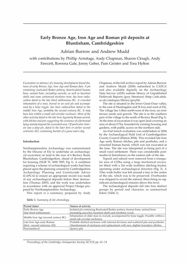
Excavation in advance of a housing development found fea-tures of early Bronze Age, Iron Age and Roman date. A pit containing rusticated Beaker pottery, disarticulated human bone, animal bone, including aurochs, as well as hazelnut shells and some carbonised mistletoe stem, has been radio-carbon dated to the late third millennium BC. A crouched inhumation of a man, buried in an oval pit and accompa-nied by a bone toggle, has been radiocarbon dated to the middle Iron Age, probably the second century BC. It may have lain within a small sub-circular enclosure. Most of the other activity dated to the late Iron Age/early Roman period, with ditches and pits suggesting the existence of a farmstead lying mainly beyond the excavated area. Of particular inter-est was a deep pit, dated to the later first or earlier second centuries AD, containing burials of a goose and a dog.
Introduction
Northamptonshire Archaeology was commissioned by the Diocese of Ely to undertake an archaeologi-cal excavation on land to the rear of 6 Rectory Road, Bluntisham, Cambridgeshire, ahead of development for housing (NGR TL 3690 7455, Fig 1). A condition requiring a scheme of archaeological works had been placed upon the planning consent by Cambridgeshire Archaeology Planning and Countryside Advice (CAPCA) to ensure an appropriate record was made of any archaeological deposits before their destruc-tion (Thomas 2005), and the work was undertaken in accordance with an approved Project Design pre-pared by Northamptonshire Archaeology. This report is a summary, prepared by Andy
Chapman, of the full archive report by Adrian Burrow and Andrew Mudd (2008) submitted to CAPCA and also available digitally on the Archaeology Data Service (ADS) website library of Unpublished Fieldwork Reports (grey literature) (http://ads.ahds.ac.uk/catalogue/library/greylit). The site is situated in the lower Great Ouse valley, to the east of Huntingdon and St Ives and west of Ely. The village lies 1.0km north-west of the river, on river terrace sands and gravels. The site is in the southern part of the village to the north of Rectory Road (Fig 1). At the time of excavation it was open land covering an area of about 0.7ha, bounded by existing housing and gardens, with public access on the northern side. An trial trench evaluation was undertaken in 2004 by the Archaeological Field Unit of Cambridgeshire County Council (Hatton 2004). This revealed late Iron Age–early Roman ditches, pits and postholes, and a crouched human burial, which was not excavated at the time. The site was interpreted as being part of a small rural settlement. There was considerable post-medieval disturbance on the eastern side of the site. Topsoil and subsoil were removed from a triangu-lar area of 0.25ha using a large mechanical excava-tor fitted with a 2m–wide toothless ditching bucket, operating under archaeological direction (Fig. 2). A 3.0m–wide buffer was left around a tree in the centre of the site, which was to be preserved. Overburden was stripped to reveal the natural, there being no sig-nificant archaeological remains above this level. The archaeological deposits fall into four distinct groups by period and character, as summarised below (Table 1).
Early Bronze Age, Iron Age and Roman pit deposits at Bluntisham, Cambridgeshire
Adrian Burrow and Andrew Mudd
with contributions by Phillip Armitage, Andy Chapman, Sharon Clough, Andy Fawcett, Rowena Gale, Jonny Geber, Pam Grinter and Tora Hylton
Proceedings of the Cambridge Antiquarian Society XCVIX pp. 61–74
Period (date) Nature of activityEarly Bronze Age (late third millennium)
Isolated pit containing Rusticated Beaker pottery, human bone, animal bone (including aurochs), hazelnut shells and mistletoe wood.
Middle Iron Age (second century BC)Inhumation of older man in oval pit, accompanied by bone toggle. Possibly within a small sub-circular enclosure.
Late Iron Age-early Roman(first - second centuries AD)
Probable ditched enclosure with internal divisions and scattered pits and postholes. Abandonment of enclosure and replacement with new, slighter boundary ditches.
Post-medieval Quarry pits
Table 1. Summary of site chronology.
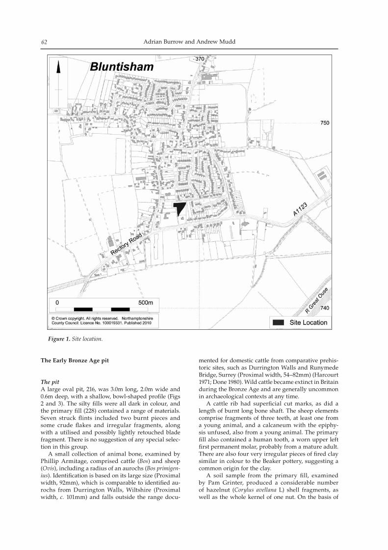
Adrian Burrow and Andrew Mudd62
The Early Bronze Age pit
The pitA large oval pit, 216, was 3.0m long, 2.0m wide and 0.6m deep, with a shallow, bowl-shaped profile (Figs 2 and 3). The silty fills were all dark in colour, and the primary fill (228) contained a range of materials. Seven struck flints included two burnt pieces and some crude flakes and irregular fragments, along with a utilised and possibly lightly retouched blade fragment. There is no suggestion of any special selec-tion in this group. A small collection of animal bone, examined by Phillip Armitage, comprised cattle (Bos) and sheep (Ovis), including a radius of an aurochs (Bos primigen-ius). Identification is based on its large size (Proximal width, 92mm), which is comparable to identified au-rochs from Durrington Walls, Wiltshire (Proximal width, c. 101mm) and falls outside the range docu-
mented for domestic cattle from comparative prehis-toric sites, such as Durrington Walls and Runymede Bridge, Surrey (Proximal width, 54–82mm) (Harcourt 1971; Done 1980). Wild cattle became extinct in Britain during the Bronze Age and are generally uncommon in archaeological contexts at any time. A cattle rib had superficial cut marks, as did a length of burnt long bone shaft. The sheep elements comprise fragments of three teeth, at least one from a young animal, and a calcaneum with the epiphy-sis unfused, also from a young animal. The primary fill also contained a human tooth, a worn upper left first permanent molar, probably from a mature adult. There are also four very irregular pieces of fired clay similar in colour to the Beaker pottery, suggesting a common origin for the clay. A soil sample from the primary fill, examined by Pam Grinter, produced a considerable number of hazelnut (Corylus avellana L) shell fragments, as well as the whole kernel of one nut. On the basis of
Figure 1. Site location.
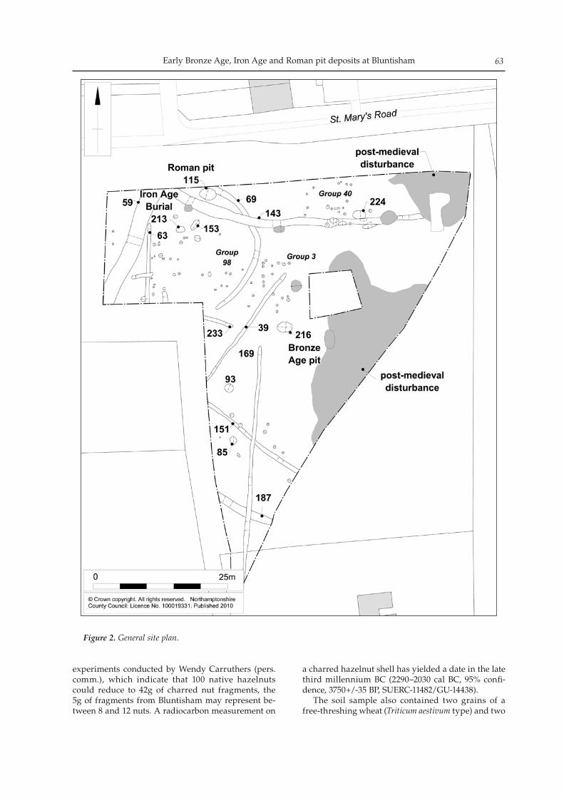
Early Bronze Age, Iron Age and Roman pit deposits at Bluntisham 63
experiments conducted by Wendy Carruthers (pers. comm.), which indicate that 100 native hazelnuts could reduce to 42g of charred nut fragments, the 5g of fragments from Bluntisham may represent be-tween 8 and 12 nuts. A radiocarbon measurement on
a charred hazelnut shell has yielded a date in the late third millennium BC (2290–2030 cal BC, 95% confi-dence, 3750+/-35 BP, SUERC-11482/GU-14438). The soil sample also contained two grains of a free-threshing wheat (Triticum aestivum type) and two
Figure 2. General site plan.
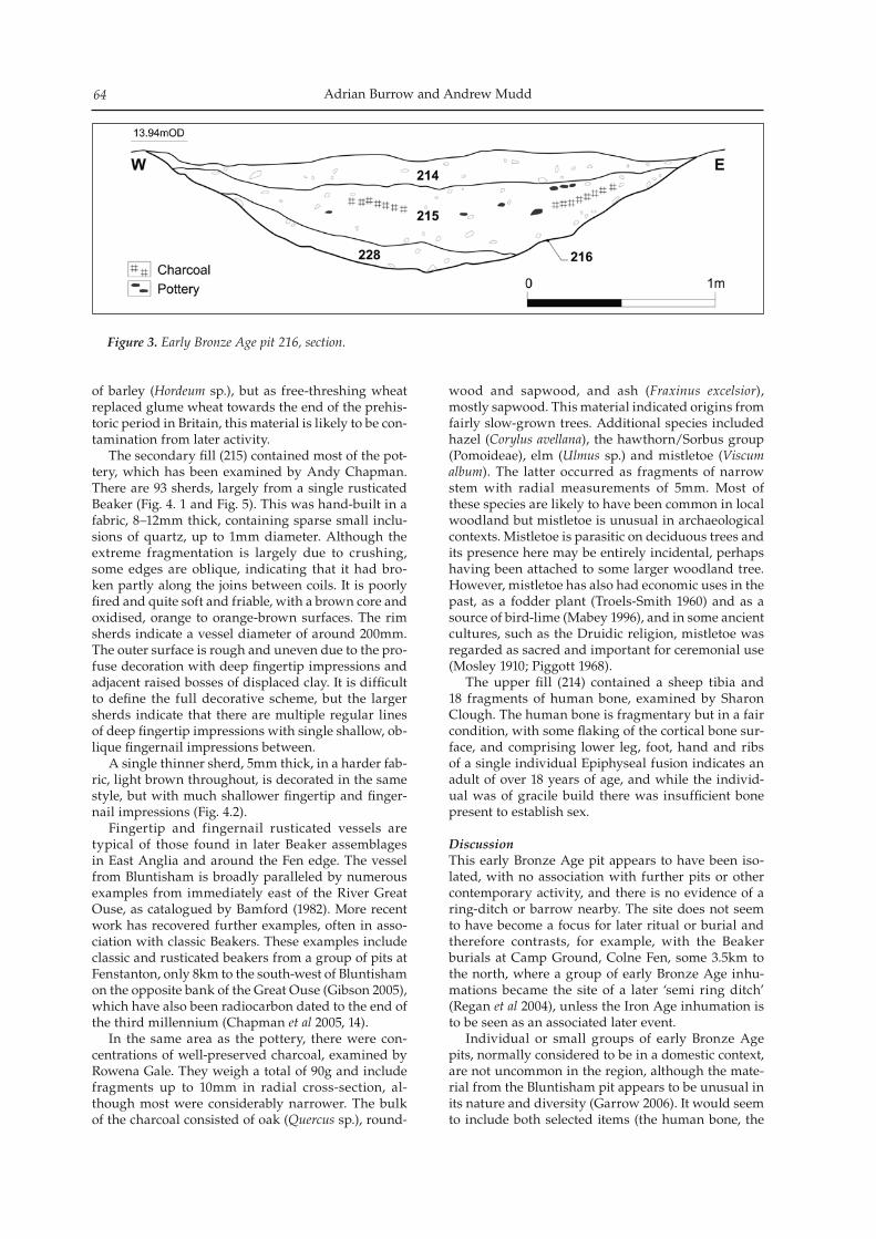
Adrian Burrow and Andrew Mudd64
of barley (Hordeum sp.), but as free-threshing wheat replaced glume wheat towards the end of the prehis-toric period in Britain, this material is likely to be con-tamination from later activity. The secondary fill (215) contained most of the pot-tery, which has been examined by Andy Chapman. There are 93 sherds, largely from a single rusticated Beaker (Fig. 4. 1 and Fig. 5). This was hand-built in a fabric, 8–12mm thick, containing sparse small inclu-sions of quartz, up to 1mm diameter. Although the extreme fragmentation is largely due to crushing, some edges are oblique, indicating that it had bro-ken partly along the joins between coils. It is poorly fired and quite soft and friable, with a brown core and oxidised, orange to orange-brown surfaces. The rim sherds indicate a vessel diameter of around 200mm. The outer surface is rough and uneven due to the pro-fuse decoration with deep fingertip impressions and adjacent raised bosses of displaced clay. It is difficult to define the full decorative scheme, but the larger sherds indicate that there are multiple regular lines of deep fingertip impressions with single shallow, ob-lique fingernail impressions between. A single thinner sherd, 5mm thick, in a harder fab-ric, light brown throughout, is decorated in the same style, but with much shallower fingertip and finger-nail impressions (Fig. 4.2). Fingertip and fingernail rusticated vessels are typical of those found in later Beaker assemblages in East Anglia and around the Fen edge. The vessel from Bluntisham is broadly paralleled by numerous examples from immediately east of the River Great Ouse, as catalogued by Bamford (1982). More recent work has recovered further examples, often in asso-ciation with classic Beakers. These examples include classic and rusticated beakers from a group of pits at Fenstanton, only 8km to the south-west of Bluntisham on the opposite bank of the Great Ouse (Gibson 2005), which have also been radiocarbon dated to the end of the third millennium (Chapman et al 2005, 14). In the same area as the pottery, there were con-centrations of well-preserved charcoal, examined by Rowena Gale. They weigh a total of 90g and include fragments up to 10mm in radial cross-section, al-though most were considerably narrower. The bulk of the charcoal consisted of oak (Quercus sp.), round-
wood and sapwood, and ash (Fraxinus excelsior), mostly sapwood. This material indicated origins from fairly slow-grown trees. Additional species included hazel (Corylus avellana), the hawthorn/Sorbus group (Pomoideae), elm (Ulmus sp.) and mistletoe (Viscum album). The latter occurred as fragments of narrow stem with radial measurements of 5mm. Most of these species are likely to have been common in local woodland but mistletoe is unusual in archaeological contexts. Mistletoe is parasitic on deciduous trees and its presence here may be entirely incidental, perhaps having been attached to some larger woodland tree. However, mistletoe has also had economic uses in the past, as a fodder plant (Troels-Smith 1960) and as a source of bird-lime (Mabey 1996), and in some ancient cultures, such as the Druidic religion, mistletoe was regarded as sacred and important for ceremonial use (Mosley 1910; Piggott 1968). The upper fill (214) contained a sheep tibia and 18 fragments of human bone, examined by Sharon Clough. The human bone is fragmentary but in a fair condition, with some flaking of the cortical bone sur-face, and comprising lower leg, foot, hand and ribs of a single individual Epiphyseal fusion indicates an adult of over 18 years of age, and while the individ-ual was of gracile build there was insufficient bone present to establish sex.
DiscussionThis early Bronze Age pit appears to have been iso-lated, with no association with further pits or other contemporary activity, and there is no evidence of a ring-ditch or barrow nearby. The site does not seem to have become a focus for later ritual or burial and therefore contrasts, for example, with the Beaker burials at Camp Ground, Colne Fen, some 3.5km to the north, where a group of early Bronze Age inhu-mations became the site of a later ‘semi ring ditch’ (Regan et al 2004), unless the Iron Age inhumation is to be seen as an associated later event. Individual or small groups of early Bronze Age pits, normally considered to be in a domestic context, are not uncommon in the region, although the mate-rial from the Bluntisham pit appears to be unusual in its nature and diversity (Garrow 2006). It would seem to include both selected items (the human bone, the
Figure 3. Early Bronze Age pit 216, section.
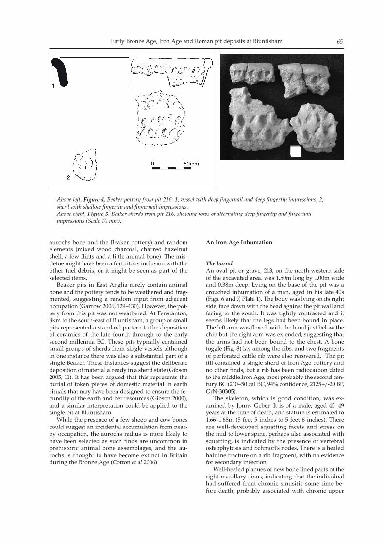
Early Bronze Age, Iron Age and Roman pit deposits at Bluntisham 65
aurochs bone and the Beaker pottery) and random elements (mixed wood charcoal, charred hazelnut shell, a few flints and a little animal bone). The mis-tletoe might have been a fortuitous inclusion with the other fuel debris, or it might be seen as part of the selected items. Beaker pits in East Anglia rarely contain animal bone and the pottery tends to be weathered and frag-mented, suggesting a random input from adjacent occupation (Garrow 2006, 129–130). However, the pot-tery from this pit was not weathered. At Fenstanton, 8km to the south-east of Bluntisham, a group of small pits represented a standard pattern to the deposition of ceramics of the late fourth through to the early second millennia BC. These pits typically contained small groups of sherds from single vessels although in one instance there was also a substantial part of a single Beaker. These instances suggest the deliberate deposition of material already in a sherd state (Gibson 2005, 11). It has been argued that this represents the burial of token pieces of domestic material in earth rituals that may have been designed to ensure the fe-cundity of the earth and her resources (Gibson 2000), and a similar interpretation could be applied to the single pit at Bluntisham. While the presence of a few sheep and cow bones could suggest an incidental accumulation from near-by occupation, the aurochs radius is more likely to have been selected as such finds are uncommon in prehistoric animal bone assemblages, and the au-rochs is thought to have become extinct in Britain during the Bronze Age (Cotton et al 2006).
An Iron Age Inhumation
The burialAn oval pit or grave, 213, on the north-western side of the excavated area, was 1.50m long by 1.00m wide and 0.38m deep. Lying on the base of the pit was a crouched inhumation of a man, aged in his late 40s (Figs. 6 and 7, Plate 1). The body was lying on its right side, face down with the head against the pit wall and facing to the south. It was tightly contracted and it seems likely that the legs had been bound in place. The left arm was flexed, with the hand just below the chin but the right arm was extended, suggesting that the arms had not been bound to the chest. A bone toggle (Fig. 8) lay among the ribs, and two fragments of perforated cattle rib were also recovered. The pit fill contained a single sherd of Iron Age pottery and no other finds, but a rib has been radiocarbon dated to the middle Iron Age, most probably the second cen-tury BC (210–50 cal BC, 94% confidence, 2125+/-20 BP, GrN-30305). The skeleton, which is good condition, was ex-amined by Jonny Geber. It is of a male, aged 45–49 years at the time of death, and stature is estimated to 1.66–1.68m (5 feet 5 inches to 5 feet 6 inches). There are well-developed squatting facets and stress on the mid to lower spine, perhaps also associated with squatting, is indicated by the presence of vertebral osteophytosis and Schmorl’s nodes. There is a healed hairline fracture on a rib fragment, with no evidence for secondary infection. Well-healed plaques of new bone lined parts of the right maxillary sinus, indicating that the individual had suffered from chronic sinusitis some time be-fore death, probably associated with chronic upper
Above left, Figure 4. Beaker pottery from pit 216: 1, vessel with deep fingernail and deep fingertip impressions; 2, sherd with shallow fingertip and fingernail impressions.Above right, Figure 5. Beaker sherds from pit 216, showing rows of alternating deep fingertip and fingernail impressions (Scale 10 mm).
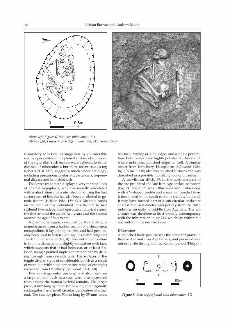
Adrian Burrow and Andrew Mudd66
respiratory infection, as suggested by considerable reactive periostitis on the pleural surface of a number of the right ribs. Such lesions were believed to be in-dicative of tuberculosis, but more recent studies (eg Roberts et al 1998) suggest a much wider aetiology, including pneumonia, metastatic carcinoma, trepone-mal disease and bronchiectasis. The lower front teeth displayed very marked lines of enamel hypoplasia, which is usually associated with malnutrition and acute infection during the first seven years of life, but has also been attributed to ge-netic factors (Hillson 1986, 129–130). Multiple bands on the teeth of this individual indicate that he had suffered two independent episodes of physical stress: the first around the age of two years and the second around the age of four years. A plain bone toggle, examined by Tora Hylton, is manufactured from a hollow section of a sheep/goat metapodium. It lay among the ribs, and had presum-ably been used to fasten clothing. It is 40mm long and 12–14mm in diameter (Fig. 8). The central perforation is 3mm in diameter and slightly conical on each face, which suggests that it had been cut, or at least fin-ished, using a pointed implement rather than by drill-ing through from one side only. The surfaces of the toggle display signs of considerable polish as a result of wear. It is within the upper size range of examples recovered from Danebury (Sellwood 1984, 378). Two bone fragments from lengths of rib bones from a large animal, such as a cow, were also recovered from among the human skeletal remains. The larger piece, 70mm long by up to 38mm wide, and originally rectangular has a small circular perforation at either end. The smaller piece, 50mm long by 35 mm wide,
has no surviving original edges and a single perfora-tion. Both pieces have highly polished surfaces and, where unbroken, polished edges as well. A similar object from Danebury, Hampshire (Sellwood 1984, fig. 7.39 no. 3.2.10) also has polished surfaces and was described as a possible modelling tool or burnisher. A curvilinear ditch, 69, in the northern part of the site pre-dated the late Iron Age enclosure system (Fig. 2). The ditch was 1.10m wide and 0.50m deep, with a V-shaped profile and a narrow rounded base, it terminated to the south-east in a shallow butt-end. It may have formed part of a sub-circular enclosure at least 25m in diameter, and pottery from the ditch indicates an early to middle Iron Age date. The en-closure was therefore at least broadly contemporary with the inhumation in pit 213, which lay within but not central to the enclosed area.
DiscussionA crouched body posture was the standard praxis in Bronze Age and Iron Age burials, and persisted as a minority rite throughout the Roman period (Philpott
Above left, Figure 6. Iron Age inhumation, 211.Above right, Figure 7. Iron Age inhumation, 211, (scale 0.5m).
Figure 8. Bone toggle found with inhumation 211.
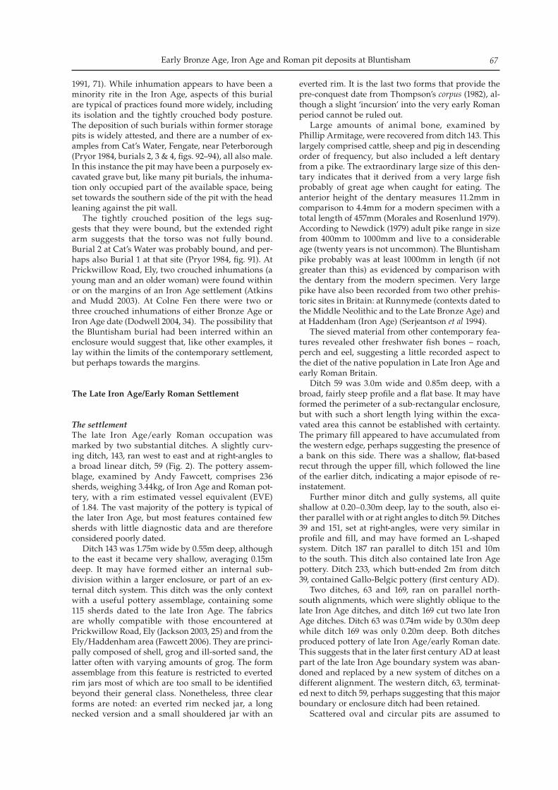
Early Bronze Age, Iron Age and Roman pit deposits at Bluntisham 67
1991, 71). While inhumation appears to have been a minority rite in the Iron Age, aspects of this burial are typical of practices found more widely, including its isolation and the tightly crouched body posture. The deposition of such burials within former storage pits is widely attested, and there are a number of ex-amples from Cat’s Water, Fengate, near Peterborough (Pryor 1984, burials 2, 3 & 4, figs. 92–94), all also male. In this instance the pit may have been a purposely ex-cavated grave but, like many pit burials, the inhuma-tion only occupied part of the available space, being set towards the southern side of the pit with the head leaning against the pit wall. The tightly crouched position of the legs sug-gests that they were bound, but the extended right arm suggests that the torso was not fully bound. Burial 2 at Cat’s Water was probably bound, and per-haps also Burial 1 at that site (Pryor 1984, fig. 91). At Prickwillow Road, Ely, two crouched inhumations (a young man and an older woman) were found within or on the margins of an Iron Age settlement (Atkins and Mudd 2003). At Colne Fen there were two or three crouched inhumations of either Bronze Age or Iron Age date (Dodwell 2004, 34). The possibility that the Bluntisham burial had been interred within an enclosure would suggest that, like other examples, it lay within the limits of the contemporary settlement, but perhaps towards the margins.
The Late Iron Age/Early Roman Settlement
The settlementThe late Iron Age/early Roman occupation was marked by two substantial ditches. A slightly curv-ing ditch, 143, ran west to east and at right-angles to a broad linear ditch, 59 (Fig. 2). The pottery assem-blage, examined by Andy Fawcett, comprises 236 sherds, weighing 3.44kg, of Iron Age and Roman pot-tery, with a rim estimated vessel equivalent (EVE) of 1.84. The vast majority of the pottery is typical of the later Iron Age, but most features contained few sherds with little diagnostic data and are therefore considered poorly dated. Ditch 143 was 1.75m wide by 0.55m deep, although to the east it became very shallow, averaging 0.15m deep. It may have formed either an internal sub-division within a larger enclosure, or part of an ex-ternal ditch system. This ditch was the only context with a useful pottery assemblage, containing some 115 sherds dated to the late Iron Age. The fabrics are wholly compatible with those encountered at Prickwillow Road, Ely (Jackson 2003, 25) and from the Ely/Haddenham area (Fawcett 2006). They are princi-pally composed of shell, grog and ill-sorted sand, the latter often with varying amounts of grog. The form assemblage from this feature is restricted to everted rim jars most of which are too small to be identified beyond their general class. Nonetheless, three clear forms are noted: an everted rim necked jar, a long necked version and a small shouldered jar with an
everted rim. It is the last two forms that provide the pre-conquest date from Thompson’s corpus (1982), al-though a slight ‘incursion’ into the very early Roman period cannot be ruled out. Large amounts of animal bone, examined by Phillip Armitage, were recovered from ditch 143. This largely comprised cattle, sheep and pig in descending order of frequency, but also included a left dentary from a pike. The extraordinary large size of this den-tary indicates that it derived from a very large fish probably of great age when caught for eating. The anterior height of the dentary measures 11.2mm in comparison to 4.4mm for a modern specimen with a total length of 457mm (Morales and Rosenlund 1979). According to Newdick (1979) adult pike range in size from 400mm to 1000mm and live to a considerable age (twenty years is not uncommon). The Bluntisham pike probably was at least 1000mm in length (if not greater than this) as evidenced by comparison with the dentary from the modern specimen. Very large pike have also been recorded from two other prehis-toric sites in Britain: at Runnymede (contexts dated to the Middle Neolithic and to the Late Bronze Age) and at Haddenham (Iron Age) (Serjeantson et al 1994). The sieved material from other contemporary fea-tures revealed other freshwater fish bones – roach, perch and eel, suggesting a little recorded aspect to the diet of the native population in Late Iron Age and early Roman Britain. Ditch 59 was 3.0m wide and 0.85m deep, with a broad, fairly steep profile and a flat base. It may have formed the perimeter of a sub-rectangular enclosure, but with such a short length lying within the exca-vated area this cannot be established with certainty. The primary fill appeared to have accumulated from the western edge, perhaps suggesting the presence of a bank on this side. There was a shallow, flat-based recut through the upper fill, which followed the line of the earlier ditch, indicating a major episode of re-instatement. Further minor ditch and gully systems, all quite shallow at 0.20–0.30m deep, lay to the south, also ei-ther parallel with or at right angles to ditch 59. Ditches 39 and 151, set at right-angles, were very similar in profile and fill, and may have formed an L-shaped system. Ditch 187 ran parallel to ditch 151 and 10m to the south. This ditch also contained late Iron Age pottery. Ditch 233, which butt-ended 2m from ditch 39, contained Gallo-Belgic pottery (first century AD). Two ditches, 63 and 169, ran on parallel north-south alignments, which were slightly oblique to the late Iron Age ditches, and ditch 169 cut two late Iron Age ditches. Ditch 63 was 0.74m wide by 0.30m deep while ditch 169 was only 0.20m deep. Both ditches produced pottery of late Iron Age/early Roman date. This suggests that in the later first century AD at least part of the late Iron Age boundary system was aban-doned and replaced by a new system of ditches on a different alignment. The western ditch, 63, terminat-ed next to ditch 59, perhaps suggesting that this major boundary or enclosure ditch had been retained. Scattered oval and circular pits are assumed to
Adrian Burrow and Andrew Mudd68
be of contemporary date, although only a few pro-duced datable pottery. In the northern part of the site, oval pit 153 contained Iron Age pottery. Three pits at the southern end of the site, including pit 85, had similar steep-sided and flat bottomed profiles and similar dark grey silty clay fills. There were several clusters of postholes across the northern part of the site. Fifteen postholes (Group 40) formed a square structure roughly 7m across. The plan form, and a nail with tapered rectangular-sectioned shank and T-shaped head nail from one of the postholes, sug-gests a Roman date, but the evidence is too meagre to be conclusive. A rectangular arrangement of four postholes (Group 98) formed a small structure 2.5m long and 1.0m wide, perhaps a rack for hanging or drying cloth or skins. To the east there was a large irregular cluster of postholes (Group 3), which in-cluded a line of five postholes running north-south, possibly forming a fence-line.
Early Roman pit with goose burialOn the northern edge of the site there was a large, sub-circular pit, 115, 2.4m wide and 1.9m deep with steep, well-formed edges and a curved base (Figs. 9 and 10). This pit holds the best verification of an early Roman presence on the site. The pit fills contained small amounts of Iron Age and early Roman pot-tery, but the only diagnostic element is a small reed-rimmed bowl. On top of the primary silting there was an articu-lated goose skeleton (Fig. 11), presumably deliberately deposited. Above this there was a complex sequence of fills, including redeposited gravel, 113 and 114, which was probably a result of rapid backfilling. Within the dumped gravel there was a jumbled par-tial dog skeleton. Both the goose and the dog have been examined by Phillip Armitage. Virtually all the major parts of the articulated skeleton of a mature goose are present apart from the cervical vertebrae and extremities of the feet (Fig. 9). There is some post-depositional damage to the skull, mandibles, and the sternum (all anciently broken) and part of the pelvis is eroded/leached, possibly from contact with groundwater during burial. There is no evidence of butchery/de-fleshing/cooking or con-sumption and it would appear the entire goose had been disposed of uneaten in the pit. Such complete/semi-complete goose skeletons are rare archaeologi-cal finds in any period. There is a reference to “several partial goose skeletons” from a late 10th-century pit in Lincoln (O’Connor 1982, 41) and a nearly complete skeleton of goose/grey-lag from an early 14th-century rubbish dump at Alkmaar, The Netherlands (Clason 1972, 101). As discussed by O’Connor (1982, 42) the modern domestic goose is larger and more heavily built than the modern wild grey-lag but these differences may not be so apparent in early archaeological specimens. It is therefore not possible to say with any degree of certainty whether the Bluntisham goose was a do-mestic locally-reared bird or a wild grey-lag hunted in surrounding marshes.
Of particular interest in the Bluntisham specimen is the evidence of animal gnawing on proximal and distal ends of conjoining (articulated) bones: distal radius/ulna and proximal humerus; distal femur and proximal tibiotarsus; distal tibiotarsus and proximal tarsometatarsus. The epiphyseal ends of these bone elements exhibit tooth (cusp) puncture marks and small areas of surface destruction, with the most se-vere destruction of bone structure seen in the distal articular (condylar) ends of the two tarsometatarsi. This type and pattern of damage is observed in bones chewed/gnawed/crunched by cats (see O’Connor 2000, 49 and Moran and O’Connor 1992) but could also be attributed to polecat (Somerville pers. comm.). The skull and the virtually complete skeleton of a dog was also recovered from pit 115, but, unlike the goose, the bones were not articulated but were jum-bled up, as if parts of a semi-decomposed carcass had been deposited in the pit. No cause of death could be established from the skeletal remains but it is noteworthy that two of the cervical vertebrae exhibit chopping marks suggesting repeated blows to the left side of the neck. Whatever the sharp implement used (axe, chopper or large knife) the blows apparently had not been delivered with sufficient force to cause decapitation. The dog was a fully-grown adult at time of death, as indicated by the full dentition and the fusion in all epiphyses of the long bones. The surface markings on the skull indicate the animal was male, and this iden-tification is confirmed by the presence of an os penis. Based on the length measurements in the limb bones, the shoulder height in the Bluntisham dog is estimated to have been 608mm (method of Harcourt 1974) and therefore taller than the Iron Age dogs from Gussage All Saints, Dorset, documented by Harcourt (1974) (360 to 580mm) but comparable to the tallest dog (shoulder height 605mm) at Ashville Trading Estate, Oxfordshire, recorded by Wilson (1978). In terms of head shape, the Bluntisham animal would have conformed to what Harcourt (1974) clas-sified as a “plain dog”; characterised by an unmodi-fied cranium with fairly broad zygomatic arches (cephalic index 45.5), and with a snout of moderate length (snout index 51.3). The Bluntisham dog, how-ever, had a relatively narrow muzzle (snout width index 37.6) unlike the fairly broad form seen in most other Iron Age dogs. There is a prominent sagittal crest and parietal ridge, which are cranial features found in modern terriers. From the generally poor condition of its teeth, the Bluntisham dog apparently had a rough diet. There is a considerable degree of wear in the lower and upper carnassials/molar teeth and ante-mortem loss of lower premolar cheek teeth with healed over (bone filled) alveoli. The point of the left canine is broken off and the remaining stump is much worn down/rounded. Further evidence of the unfortunate life his-tory of the Bluntisham dog is provided by the pres-ence of a healed traumatic injury to the right side of the skull just above and behind the eye socket – there is an impacted elliptical (22.2 x 12.1mm) area of the
Early Bronze Age, Iron Age and Roman pit deposits at Bluntisham 69
Figure 9. Roman pit 215, plan of goose burial and diagram of bones present.
Figure 10. Section of Roman pit 215.

Adrian Burrow and Andrew Mudd70
frontal bone located just posterior to the zygomatic process and immediately below the temporal line. Owing to the thickness/robustness of the bone in the affected cranial region, this injury apparently did not penetrate through to the brain cavity. In time the ex-ternal wound healed over but the impact injury left in its wake a shallow crater-like depression in the skull. Similar traumatic lesions have been recorded in early Neolithic to Roman dogs from other archaeo-logical sites, which have been interpreted as caused by humans striking at the head of dogs “to stave off aggressive behaviour on the part of the animals or for other reasons of control or rebuke” (see Baker and Brothwell 1980, 93–94). There is perhaps an al-ternative explanation, which may be advanced if the Bluntisham dog had been a working dog deployed in herding livestock. Whilst the dog was assisting its owner in moving cattle, one of the cows could have become sufficiently agitated to kick out at the head of the dog in a defensive or aggressive action, causing the observed lesion.
Discussion
Nature of the settlementLittle can be said about the nature of the late Iron Age/early Roman settlement due to the limited area available and the generally mundane nature of the ex-cavated material. The pottery is generally within the late Iron Age tradition and there is also some early
Roman pottery, so it appears that the occupation last-ed into later first century AD, if not beyond. The site is likely to have been part of a farming settlement. The charred plant remains included cereal grains, but these were poorly preserved. The animal bones showed the usual range of domestic animals for this period, although there were also fish bones, which are unusual before the Roman period (Serjeantson et al 1994).
Goose and dog burialsThe discovery of a goose and a dog burial within the same pit is an interesting addition to the corpus of animal burials recorded from the early Roman pe-riod in Britain. While the burial of a complete goose may be the first recorded instance of this practice in Roman Britain, there are several examples of buried bird remains from both Iron Age and Roman sites, and stray goose bones are even more common, hav-ing been recovered from in excess of 30 sites across Roman Britain (Parker 1988, table 1). Dog burials are relatively common in both pe-riods. As with many animal burials, particularly where the skeletons occur as individuals in an ap-parently mundane context, it is problematic deciding whether these particular burials followed a natural or accidental death, or whether the animals were par-ticipants in some kind of ritual activity. It is perhaps pertinent to add that the goose and the dog were from different contexts within the pit – the goose being a
Figure 11. The Roman goose skeleton in Pit 215, with wings raised (scale 10 mm intervals).
Early Bronze Age, Iron Age and Roman pit deposits at Bluntisham 71
primary deposit while the dog was found within the later fills – but it is probable that the pit was filled-in relatively rapidly, so it is possible that both burials took place within a short space of time. There is no particular indication as to the purpose of the pit, but it is of the form demonstrated elsewhere to have been suitable for grain storage, and that may have been its original function. The much discussed examples of animal burials and other ‘special deposits’ from Danebury hillfort in Hampshire show that, in the Iron Age, the dep-osition of animal carcases and parts of animal car-cases in pits, rather than being a result the disposal of rubbish or butchery waste, can be considered part of common ritual practices on settlements (Cunliffe 1984, Hill 1996, Green 1992). At Danebury, a small but significant quantity of bird bones was also re-covered. These were overwhelmingly (74%) bones of raven, several being represented by the burials of complete skeletons (Cunliffe 1984, tables 83–86; Serjeantson 1991, 479–81). This may represent a delib-erate selection of birds that did not form part of the diet of the settlement’s inhabitants. It was considered likely that the birds were buried as ‘special deposits’, a hypothesis supported by the statistical association between bird bones and special deposits of animals (Cunliffe op. cit. 540). Ravens have also been found in Romano-British pits or wells, one curious exam-ple being at the Romano-Celtic temple at Jordan Hill, near Weymouth, Dorset, where 16 ravens’ skeletons were found between pairs of tiles within a dry well (quoted in Green 1992, 126). While the significance of ravens in Celtic mythology is widely attested, there is little to suggest what significance geese might have had. Miranda Green notes that in Celtic iconography they were commonly associated with war, and there are continental examples of geese as companions to warriors and warrior-gods (Green 1992, 214). It is un-clear whether this has relevance to Roman Britain. Dog burials are found on Iron Age and Roman sites with varying frequency. There is no doubt that they occur more frequently than other domestic animals, but this may be more to do with the fact that they sel-dom occur as food debris, rather than their being sin-gled out for special or ritual treatment, although there are also many specific examples of special treatment and unusual associations. A recent review by Kate Smith (2006) has drawn together much of the evi-dence. One of the more remarkable collections of bur-ials is the deposition of over 100 complete dogs in the area of a mansio in Godmanchester, Huntingdonshire. Many were buried in pairs, and one pit contained over 20 individuals. It is considered likely that the burials were foundation offerings, and this may have been the common motive for a number of dog burials else-where (Smith 2006, 21–22; Woodward and Woodward 2004). The early deposits from one of the central insu-lae in Dorchester, Dorset, contained several pits con-taining large numbers of dogs, including decapitated animals. Numerous dogs, including one buried in an upright position, have come from pits in Insula IX at Silchester (Smith 2006, 17–19). The subterranean sec-
ond-century shrine at Ridgeon’s Gardens, Cambridge included the burials of three dogs laid out in a circu-lar formation, with iron chains radiating from their necks, around a central pottery vessel (Alexander and Pullinger 1999). Other ritual deposits in the shrine included the skeleton of a complete horse, a bull and a sheep, as well as numerous vessels. The association of a dog and a bird is found among one of the number of animal burials lining a first-century road at the Roman temple complex at Springhead, Kent (Smith 2006, 30). The reasons why dogs were chosen for ritual at-tention is not straightforward and there are a number of possible associations, including a role as symbolic guardians. Burials in grain storage pits may relate to offerings of gratitude for the safekeeping of grain (Green 1992, 103), although in the Roman period the remains of dogs are frequently found in association with shafts and wells and there may be an association with water and chthonic deities (ibid, 197–8). There is also as strong Romano-Celtic association with heal-ing. The temple and curative establishment at Lydney, Gloucestershire, dedicated to the god Nodens, yielded a large number of representations of dogs including a bronze statuette of a deer-hound. Miranda Green has suggested that hunting and healing may have been conceptually linked with the notion of death and re-generation. The fact that the dog buried in the pit at Bluntisham showed evidence of maltreatment during its life has been remarked upon, but pathologies resulting from physical abuse have been commonly noted on Iron Age and Roman dog skeletons, and the situation can-not be considered unusual (Smith 2006, 15). Indeed, Kate Smith’s assessment of the dog burials from Insula IX Silchester concludes that the most striking feature of the dog remains is the number of severe patholo-gies on the skeletons, to an extent which suggests that the dogs were victims of gratuitous violence (ibid, 18). Although the circumstances of the burials of the goose and dog at Bluntisham remain obscure, their deposition can be seen to fall within a category of ‘special deposits’, commonly recorded on a range of later prehistoric and Roman sites, which appear to be an expression of Celtic-based rituals concerned with offerings and sacrifice.
Regional settlementThe settlement at Bluntisham lies within a region where Iron Age and Roman settlements are common if little understood (Fig. 12). Most information comes from the gravel areas on the fen skirtland to the east and south, from cropmarks, finds made casually or unsystematically (in gravel quarries in particular), and from modern excavations. There is less informa-tion from the higher ground where the records relate mostly to occasional finds. There are reported findings of Iron Age pottery in Bluntisham, about 300m north-east of the present site, and third to fourth-century Roman coins from a similar area. These finds encompass a wide range of date and there is no reason to suspect a link with
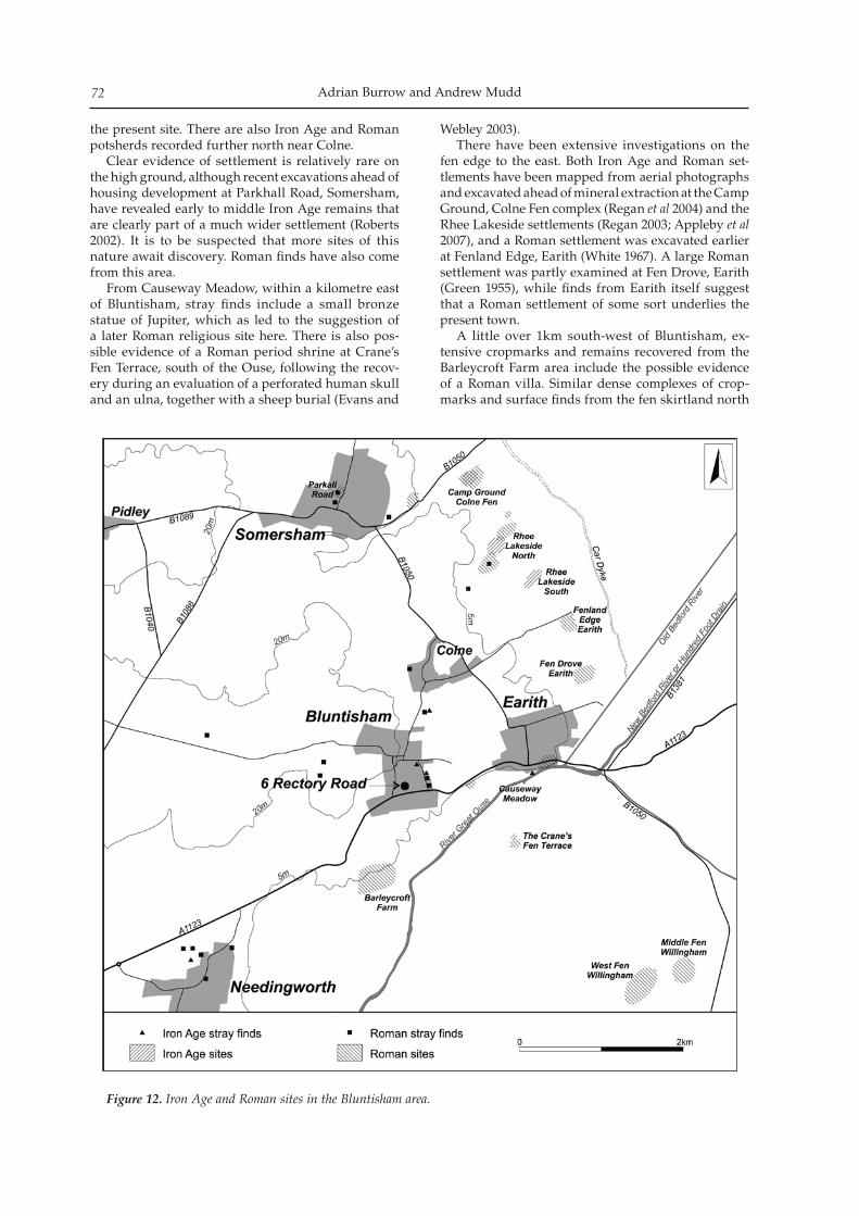
Adrian Burrow and Andrew Mudd72
the present site. There are also Iron Age and Roman potsherds recorded further north near Colne. Clear evidence of settlement is relatively rare on the high ground, although recent excavations ahead of housing development at Parkhall Road, Somersham, have revealed early to middle Iron Age remains that are clearly part of a much wider settlement (Roberts 2002). It is to be suspected that more sites of this nature await discovery. Roman finds have also come from this area. From Causeway Meadow, within a kilometre east of Bluntisham, stray finds include a small bronze statue of Jupiter, which as led to the suggestion of a later Roman religious site here. There is also pos-sible evidence of a Roman period shrine at Crane’s Fen Terrace, south of the Ouse, following the recov-ery during an evaluation of a perforated human skull and an ulna, together with a sheep burial (Evans and
Webley 2003). There have been extensive investigations on the fen edge to the east. Both Iron Age and Roman set-tlements have been mapped from aerial photographs and excavated ahead of mineral extraction at the Camp Ground, Colne Fen complex (Regan et al 2004) and the Rhee Lakeside settlements (Regan 2003; Appleby et al 2007), and a Roman settlement was excavated earlier at Fenland Edge, Earith (White 1967). A large Roman settlement was partly examined at Fen Drove, Earith (Green 1955), while finds from Earith itself suggest that a Roman settlement of some sort underlies the present town. A little over 1km south-west of Bluntisham, ex-tensive cropmarks and remains recovered from the Barleycroft Farm area include the possible evidence of a Roman villa. Similar dense complexes of crop-marks and surface finds from the fen skirtland north
Figure 12. Iron Age and Roman sites in the Bluntisham area.
Early Bronze Age, Iron Age and Roman pit deposits at Bluntisham 73
of Willingham suggest a villa at West Fen, and there also enclosures and droveways at Middle Fen. The present site contributes to the developing pic-ture of prehistoric and Roman settlement in the fen hinterland, although this small intervention is ill-equipped to contribute to an understanding of the detail and trajectory of settlement and landscape de-velopment. There is considerable research interest in assessing the degree of continuity from the Iron Age to Roman periods, and examining the influence of the Roman military and administrative system upon the indigenous population, particularly in a region where historical records indicate a marked degree of friction at the time of the conquest and there is continued ar-chaeological debate about the status of the fenland in Roman times.
Acknowledgements
Northamptonshire Archaeology gratefully acknowl-edges the Diocese of Ely for funding the archaeologi-cal project. The fieldwork was managed by Andrew Mudd and was supervised by Adrian Burrow, as-sisted by Rob Smith, Peter Haynes, Mark Patenall, Andrew Parkin, Rachel Kershaw, Gemma Quinn and Kate Spencer, with metal detecting by Steve Critchley. The report was prepared by Adrian Burrow and Andrew Mudd, and has been reorganised and edited for publication by Andy Chapman. The Illustrations are by Jacqueline Harding and Pat Walsh. The specialist reports, which are available in full in archive and within the digital copy of the re-port deposited with the Archaeology Data Service (ADS), were prepared by the following: worked flint, Andrew Mudd; Bronze Age pottery, Andy Chapman; Iron Age and Roman pottery, Andy Fawcett; Bone toggle, Tora Hylton; human bone, Sharon Clough and Jonny Geber; animal bone, Philip Armitage, who would like to thank Polydora Baker, Research Dept. English Heritage (Fort Cumberland) for providing the goose template; charcoal, Rowena Gale and charred plant remains, Pam Grinter. Any errors in summaris-ing their work are the responsibility of the editor. The project archive, both finds and records, have been donated to Cambridge County Archaeology Office.
Bibliography
Alexander, J, & J Pullinger 1999 Roman Cambridge: Excavations on Castle Hill 1956–1988. PCAS 88
Appleby, G N, N Armour & C Evans 2007 Rhee Lakeside North. Archaeological Excavations at Colne Fen, Earith. Cambridge Archaeology Unit Report 777
Atkins, R & A Mudd 2003 An Iron Age and Romano-British settlement at Prickwillow Road, Ely, Cambridgeshire: Excavations 1999–2000. PCAS 92: 5–55
Aufderheide, A C, & C Rodríguez-Martín 1998 Cambridge Encyclopaedia of Palaeopathology. Cambridge: CUP
Baker, J, & D Brothwell 1980 Animal Diseases in Archaeology.
London: Academic PressBamford, H M 1982 Beaker Domestic Sites in the Fen Edge and
East Anglia. EAA 16Burrow, A, & A Mudd 2008 An Early Bronze Age pit, an
Iron Age burial and late Iron Age/early Roman settle-ment at Bluntisham, Cambridgeshire: Excavations 2005, Northamptonshire Archaeology Report 08/54
Chapman, A, S Carlyle & D Leigh 2005 Neolithic and Beaker pits and a Bronze Age landscape at Fenstanton, Cambridgeshire. PCAS 44: 5–20
Clason, A T 1972 Dieren in Middeleeuws Alkmaar. Alkmaar, van Boerderu tot Middeleeuwse Stad. Alkmaarse Studien 1: 98–104
Cotton, J, N Elsden, A Pipe and L Rayner 2006 ‘Taming the Wild: A Final Neolithic/Earlier Bronze Age Aurochs Deposit from West London’. In D Serjeantson & D Field (eds), Animals in the Neolithic of Britain and Europe. Neolithic Studies Seminar Papers 7: 153–166
Cunliffe, B 1984 Danebury an Iron Age Hill Fort: Vol 2 The Excavations 1969–1978: the finds. London: CBA Research Report 52
Cunliffe, B, & C Poole 1991 Danebury, an Iron Age hillfort in Hampshire, Vol. 5 The Excavations 1979–88: the finds. London: CBA Research Report 73
Dodwell, N 2004 ‘Human Remains’. In R Regan C Evans & L Webley, The Camp Ground Excavations, Colne Fen, Earith: Assessment Report Vol. 1. Cambridge Archaeology Unit, Report 654: 27–35
Done, G 1980 ‘The animal bone’. In D Longley, Runnymede Bridge 1976: Excavations on the site of a later Bronze Age settlement. Surrey Archaeological Society Research 6: 74 – 79
Evans, C & L Webley 2003 A Delta Landscape. The Over Lowland Investigations (ii): The 2001 Evaluation. Cambridge Archaeology Unit Report 556
Fawcett, A R 2000 The Roman Pottery from Lancaster Way Business Park, Ely, Cambridgeshire. Hertfordshire Archaeological Trust Evaluation Report, Hat 456
Fawcett, A R 2006 The Late Iron Age & Roman Pottery from the Ely to Haddenham Pipeline, Cambridgeshire, ASC Evaluation Report, EHP 737
Gale, R & D Cutler 2000 Plants in Archaeology. Otley/London: Westbury/Royal Botanic Gardens, Kew
Garrow, D 2006 Pits, Settlement and Deposition during the Neolithic and Early Bronze Age in East Anglia. Oxford: BAR, British Series 414
Gibson, A 2000 The Walton Basin Project: Excavation and Survey in a Prehistoric Landscape 1993–97. London: CBA Research Report 118
Gibson, A 2005 ‘Neolithic and Beaker pottery’. In A Chapman S Carlyle & D Leigh, Neolithic and Beaker pits and a Bronze Age landscape at Fenstanton, Cambridgeshire. PCAS 44: 9–12
Godwin, H 1956 The History of the British Flora. Cambridge: University Press
Going, C J 1987 The Mansio and Other Sites in the South-Eastern Sector of Caesaromagus: The Roman Pottery. London: CBA Research Report 62: 3–120
Green, M 1955 Roman pottery kiln at Earith, PCAS 47: 45–6
Green, M 1992 Animals in Celtic Life and Myth. London: Routledge
Hall, A R & C Fischer 1986 Plant macrofossil remains from the 1984–85 excavations at Flag Fen, Cambridgeshire. Ancient Monument Laboratory Report, New Series, 49/86
Harcourt, R A 1971 ‘Animal bones from Durrington Walls’. In G Wainwright & I Longworth Durrington Walls 1966–68. Research Report for Society of Antiquaries
Adrian Burrow and Andrew Mudd74
London 29: 338–350Harcourt, R A 1974 The dog in Prehistoric and early his-
toric Britain. Journal of Archaeological Science 1: 151–175Hatton, A 2004 Iron Age and Roman Activity at 6 Rectory
Road, Bluntisham, Archaeological Field Unit, Cambridgeshire County Council, Report 740
Hill, J D 1996 ‘The identification of ritual deposits of ani-mal bone. A general perspective from a specific study of ‘special animal deposits’ from the Southern English Iron Age’. In S Anderson & K Boyle (eds), Ritual Treatment of human and animal remains. Proceedings of the first meeting of the Osteoarchaeological Research Group held in Cambridge on 8th October 1994
Hillson, S 1986 Teeth, Cambridge, Cambridge Manuals in Archaeology
Jackson, D 2003 ‘Iron Age Pottery’. In R Atkins & A Mudd 2003, An Iron Age and Romano-British settlement at Prickwillow Road, Ely, Cambridgeshire: Excavations 1999–2000. PCAS 92: 22–31
Jones, G 2000 Evaluating the importance of cultivation and collecting in Neolithic Britain. In A S Fairbairn (ed), Plants in Neolithic Britain and Beyond. Oxford: Oxbow Books
Mabey, R 1996 Flora Britannica, London: Sinclair-Stevenson Mehmet Yaşar ĺşcan and Kennedy, K A R (eds) 1989
Reconstruction of life from the skeleton. New York: Wiley-Liss
Mitchell, A 1974 A Field Guide to the Trees of Britain and Northern Europe. London: Collins
Morales, A, & K Rosenlund 1979 Fish Bone Measurements. Copenhagen: Steenstrupia
Moran, N C & T P O’Connor 1992 Bones that cats gnawed upon: a case study in bone modification. Circaea 9 (1): 27–34
Mosley, C 1910 The Oak: its Natural history, Antiquity and Folk-lore. London: Elliot Stock
Newdick, J 1979 The Complete Freshwater Fishes of the British Isles. London: Adam & Charles Black
O’Connor, T P 1982 Animal Bones from Flaxengate, Lincoln c. 870–1500. Lincoln Archaeological Trust, The Archaeology of Lincoln 18–1. London: CBA
O’Connor, T P 2000 The Archaeology of Animal Bones. Stroud, Gloucestershire: Sutton Publishing
Parker, A J 1988 The Birds of Roman Britain, Oxford Journal of Archaeology 7 (2): 197–226
Philpott, R 1991 Burial practices in Roman Britain, Oxford: BAR, British Series 219
Piggott, S 1968 The Druids. London: Thames and HudsonPollard, J (ed) 1996 Iron Age riverside pit alignments at St.
Ives, Cambridgeshire. PPS 62: 93–115Pryor, F 1984 Excavation at Fengate, Peterborough, England.
The Fourth Report, Northamptonshire Archaeological Society Monograph 2 /Royal Ontario Museum Archaeological Monograph 7
Regan, R 2003 An Archaeological Excavation at Colne Fen, Earith: Sites V and VI Langdale Hale, Cambridge Archaeology Unit Report 537
Regan, R, C Evans & L Webley 2004 The Camp Ground Excavations, Colne Fen, Earith: Assessment Report Vol. 1. Cambridge Archaeology Unit Report 654
Roberts, C, A Boylson, L Buckley, A C Chamberlain & E M Murphy 1998 Rib lesions and tuberculosis: the pal-aeopathological evidence. Tubercle and Lung Disease 79 (1): 55–60
Roberts, J 2002 Iron Age occupation at 14 Parkhall Road, Somersham. Archaeological Field Unit, Cambridgeshire County Council, Report 182
Sellwood, L 1984 ‘Object of bone and antler’. In B Cunliffe,
Danebury an Iron Age Hill Fort: Vol 2, The Excavations 1969–1978: the finds. London: CBA Research Report 52: 371–395
Serjeantson, D 1991 ‘The bird bones’. In B Cunliffe & C Poole, Danebury, an Iron Age hillfort in Hampshire, Vol. 5, The Excavations 1979–88: the finds. London: CBA Research Report 73:
Serjeantson, D, S Wales & J Evans 1994 Fish in later pre-historic Britain. Archaeo-Ichthyological Studies. Papers presented at the 6th meeting of the ICAZ Fish Remains Working Group
Shawcross, F W & E S Higgs 1961 The excavation of a Bos primigenius at Lowe’s Farm, Littleport. PCAS 54: 3–16
Smith, K 2006 Guides, Guards and Gifts to the Gods: Domesticated Dogs in the Art and Archaeology of Iron Age and Roman Britain. Oxford: BAR, British Series 422
Sparks, B W 1973 Plant and microfaunal remains, in I Davidson & G J Curtis (eds), An Iron Age site in the Land of the Plant Breeding Institute, Trumpington. Proceedings of the Cambridgeshire Antiquaries Society 64: 1–14
Steward, T D (ed) 1970 Personal identification in mass disas-ters. Washington: Smithsonian Institute
Thomas, A 2005 Brief for Archaeological Investigation. Cambridgeshire Archaeology Planning and Countryside Advice, 27 July 2005
Thompson, I 1982 Grog-tempered ‘Belgic’ Pottery of South-eastern England Parts I, II & III. Oxford: BAR, British Series, 108
Tomber, R, & J Dore 1998 The National Roman Fabric Reference Collection: A Handbook, MoLAS Monograph 2. London: Museum of London Archaeology Service
Troels-Srnith, J 1960 Ivy, mistletoe and elm. Climate indica-tors – Fodder plants. Danmarks Geologiske Undersøgelse 2, Series 4: 4:1–32
Tutin, T G, V H Heywood et al 1964–80 Flora Europaea, 1–5. Cambridge: CUP
von den Driesch, A 1976 A Guide to the Measurement of Animal Bones from Archaeological Sites. Peabody Museum Bulletin 1. New Haven, Yale University
Webley, L 2005 Evaluation Survey and Excavation at Wandlebury Ringwork, Cambridgeshire, 1994–97: Part II, The Iron Age Pottery. PCAS 94: 39–47
White, D A 1967 Excavations on a Romano-British Settlement on the Fenland Edge at Earith. PCAS 60: 1–18
Wilson, B 1978 ‘The animal bones’. In M Parrington 1978, The Excavation of an Iron Age settlement, Bronze Age ring-ditches and Roman feature at Ashville Trading Estate, Abingdon (Oxfordshire) 1974–76. London: CBA Research Report 28: 110–139
Woodward, P & A Woodward 2004 Dedicating the Town: urban foundation deposits in Roman Britain. World Archaeology 36 (1): 68–86
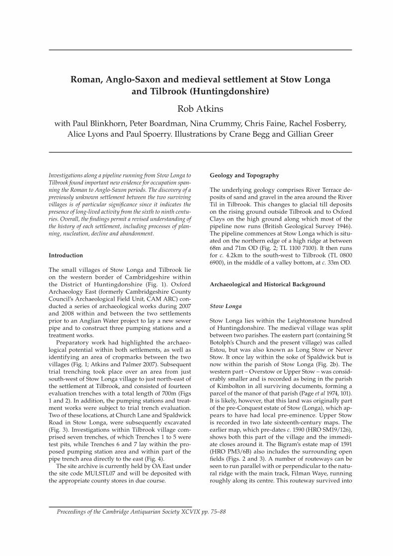
Investigations along a pipeline running from Stow Longa to Tilbrook found important new evidence for occupation span-ning the Roman to Anglo-Saxon periods. The discovery of a previously unknown settlement between the two surviving villages is of particular significance since it indicates the presence of long-lived activity from the sixth to ninth centu-ries. Overall, the findings permit a revised understanding of the history of each settlement, including processes of plan-ning, nucleation, decline and abandonment.
Introduction
The small villages of Stow Longa and Tilbrook lie on the western border of Cambridgeshire within the District of Huntingdonshire (Fig. 1). Oxford Archaeology East (formerly Cambridgeshire County Council’s Archaeological Field Unit, CAM ARC) con-ducted a series of archaeological works during 2007 and 2008 within and between the two settlements prior to an Anglian Water project to lay a new sewer pipe and to construct three pumping stations and a treatment works. Preparatory work had highlighted the archaeo-logical potential within both settlements, as well as identifying an area of cropmarks between the two villages (Fig. 1; Atkins and Palmer 2007). Subsequent trial trenching took place over an area from just south-west of Stow Longa village to just north-east of the settlement at Tilbrook, and consisted of fourteen evaluation trenches with a total length of 700m (Figs 1 and 2). In addition, the pumping stations and treat-ment works were subject to trial trench evaluation. Two of these locations, at Church Lane and Spaldwick Road in Stow Longa, were subsequently excavated (Fig. 3). Investigations within Tilbrook village com-prised seven trenches, of which Trenches 1 to 5 were test pits, while Trenches 6 and 7 lay within the pro-posed pumping station area and within part of the pipe trench area directly to the east (Fig. 4). The site archive is currently held by OA East under the site code MULSTL07 and will be deposited with the appropriate county stores in due course.
Geology and Topography
The underlying geology comprises River Terrace de-posits of sand and gravel in the area around the River Til in Tilbrook. This changes to glacial till deposits on the rising ground outside Tilbrook and to Oxford Clays on the high ground along which most of the pipeline now runs (British Geological Survey 1946). The pipeline commences at Stow Longa which is situ-ated on the northern edge of a high ridge at between 68m and 71m OD (Fig. 2; TL 1100 7100). It then runs for c. 4.2km to the south-west to Tilbrook (TL 0800 6900), in the middle of a valley bottom, at c. 33m OD.
Archaeological and Historical Background
Stow Longa
Stow Longa lies within the Leightonstone hundred of Huntingdonshire. The medieval village was split between two parishes. The eastern part (containing St Botolph’s Church and the present village) was called Estou, but was also known as Long Stow or Never Stow. It once lay within the soke of Spaldwick but is now within the parish of Stow Longa (Fig. 2b). The western part – Overstow or Upper Stow – was consid-erably smaller and is recorded as being in the parish of Kimbolton in all surviving documents, forming a parcel of the manor of that parish (Page et al 1974, 101). It is likely, however, that this land was originally part of the pre-Conquest estate of Stow (Longa), which ap-pears to have had local pre-eminence. Upper Stow is recorded in two late sixteenth-century maps. The earlier map, which pre-dates c. 1590 (HRO SM19/126), shows both this part of the village and the immedi-ate closes around it. The Bigram’s estate map of 1591 (HRO PM3/6B) also includes the surrounding open fields (Figs. 2 and 3). A number of routeways can be seen to run parallel with or perpendicular to the natu-ral ridge with the main track, Filman Waye, running roughly along its centre. This routeway survived into
Roman, Anglo-Saxon and medieval settlement at Stow Longa and Tilbrook (Huntingdonshire)
Rob Atkins
with Paul Blinkhorn, Peter Boardman, Nina Crummy, Chris Faine, Rachel Fosberry, Alice Lyons and Paul Spoerry. Illustrations by Crane Begg and Gillian Greer
Proceedings of the Cambridge Antiquarian Society XCVIX pp. 75–88
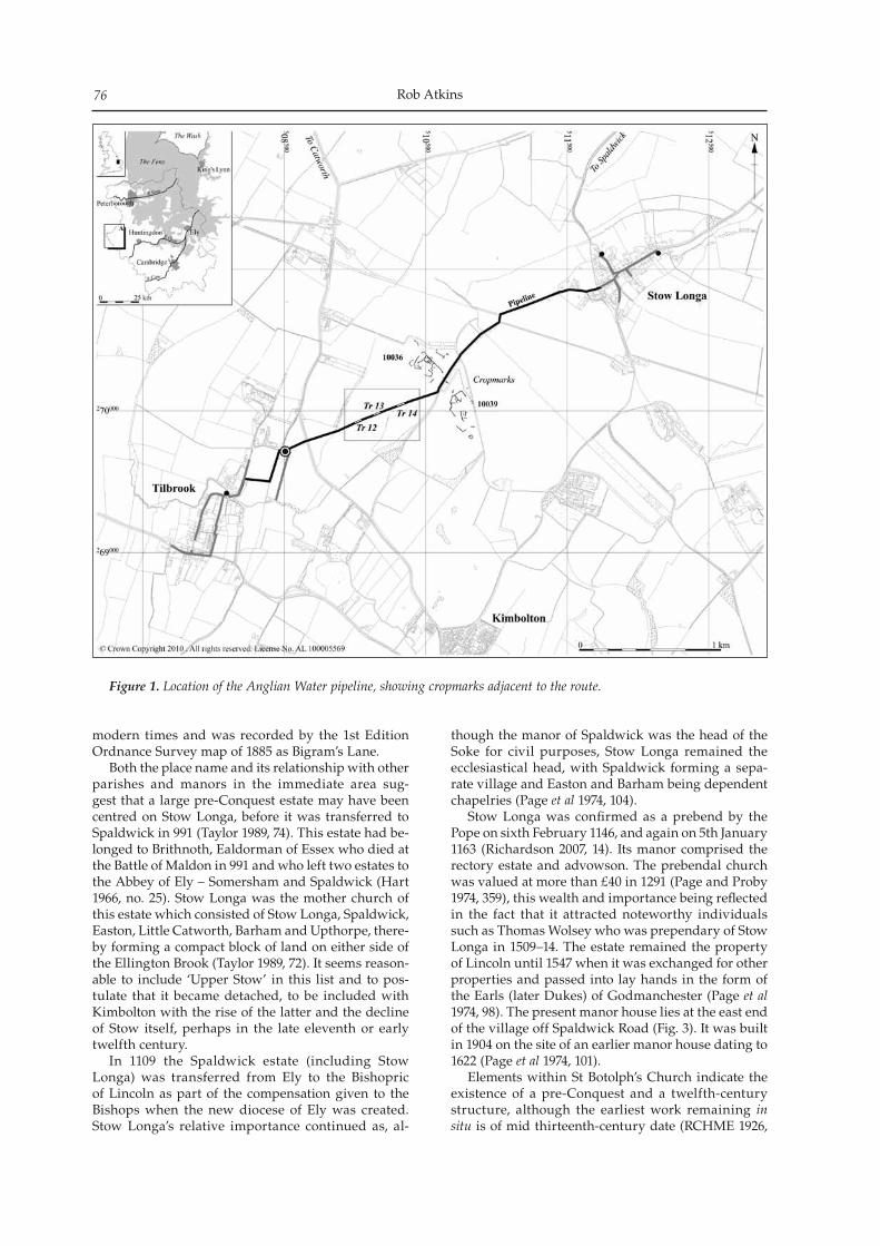
Rob Atkins76
modern times and was recorded by the 1st Edition Ordnance Survey map of 1885 as Bigram’s Lane. Both the place name and its relationship with other parishes and manors in the immediate area sug-gest that a large pre-Conquest estate may have been centred on Stow Longa, before it was transferred to Spaldwick in 991 (Taylor 1989, 74). This estate had be-longed to Brithnoth, Ealdorman of Essex who died at the Battle of Maldon in 991 and who left two estates to the Abbey of Ely – Somersham and Spaldwick (Hart 1966, no. 25). Stow Longa was the mother church of this estate which consisted of Stow Longa, Spaldwick, Easton, Little Catworth, Barham and Upthorpe, there-by forming a compact block of land on either side of the Ellington Brook (Taylor 1989, 72). It seems reason-able to include ‘Upper Stow’ in this list and to pos-tulate that it became detached, to be included with Kimbolton with the rise of the latter and the decline of Stow itself, perhaps in the late eleventh or early twelfth century. In 1109 the Spaldwick estate (including Stow Longa) was transferred from Ely to the Bishopric of Lincoln as part of the compensation given to the Bishops when the new diocese of Ely was created. Stow Longa’s relative importance continued as, al-
though the manor of Spaldwick was the head of the Soke for civil purposes, Stow Longa remained the ecclesiastical head, with Spaldwick forming a sepa-rate village and Easton and Barham being dependent chapelries (Page et al 1974, 104). Stow Longa was confirmed as a prebend by the Pope on sixth February 1146, and again on 5th January 1163 (Richardson 2007, 14). Its manor comprised the rectory estate and advowson. The prebendal church was valued at more than £40 in 1291 (Page and Proby 1974, 359), this wealth and importance being reflected in the fact that it attracted noteworthy individuals such as Thomas Wolsey who was prependary of Stow Longa in 1509–14. The estate remained the property of Lincoln until 1547 when it was exchanged for other properties and passed into lay hands in the form of the Earls (later Dukes) of Godmanchester (Page et al 1974, 98). The present manor house lies at the east end of the village off Spaldwick Road (Fig. 3). It was built in 1904 on the site of an earlier manor house dating to 1622 (Page et al 1974, 101). Elements within St Botolph’s Church indicate the existence of a pre-Conquest and a twelfth-century structure, although the earliest work remaining in situ is of mid thirteenth-century date (RCHME 1926,
Figure 1. Location of the Anglian Water pipeline, showing cropmarks adjacent to the route.
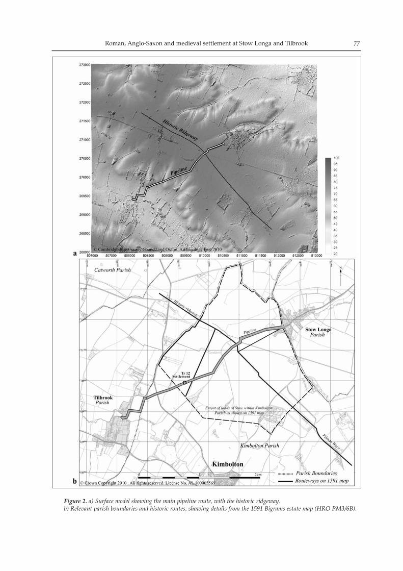
Roman, Anglo-Saxon and medieval settlement at Stow Longa and Tilbrook 77
Figure 2. a) Surface model showing the main pipeline route, with the historic ridgeway.b) Relevant parish boundaries and historic routes, showing details from the 1591 Bigrams estate map (HRO PM3/6B).
Rob Atkins78
260). Amongst the early remains is a pre-Conquest stone decorated with interlaced work (Page et al 1974, 103). Both of the sixteenth-century maps indicate a medium-sized green (forming a sub-rectangular enclosure, measuring c. 260m by 200m) with streets projecting off it in four directions. The position of St Botolph’s Church on its northern side was mirrored by a large building to the south of the green that might represent the location of an early estate or ma-norial centre. This village layout has largely survived into the modern period. The two small excavations were located adjacent to two of the roads leading off the green (Fig. 3). Investigations on the east side of Church Lane were situated where the 1591 map showed a building, al-though by the time of the 1839 Apportionment Map this had disappeared to be replaced by an open area (HRO 2196/39). The second excavation area lay some distance to the east, just south of Spaldwick Road within an empty parcel of land.
Tilbrook
Tilbrook is first mentioned in the Domesday Book where it is recorded as Tilebrok meaning ‘Til(l)a’s stream’ (Mawer and Stenton 1969, 248). In 1086 it be-longed to William de Warenne, a major landholder at this time who also controlled, for example, the manor of Kimbolton (Page et al 1974, 79; Page 1972, 171). The VCH records that ‘documentary evidence is wanting concerning the early history of Tilbrook, but as William de Warenne also held the manor of Kimbolton … it is probable that their early history is identical, and that by 1199 Tilbrook, like Kimbolton, was in the hands of Geoffrey Fitz Piers Earl of Essex, the husband of the heiress of the Mandevilles’ (Page 1972, 171). Tilbrook was later owned by the de Bohun family, after which it was divided into three man-ors. The main manorial site (Cambridge Historic Environment Record (CHER) 399728/9) appears to have been located to the north of the River Til from at least the early seventeenth century although whether it was moved from elsewhere is unclear. The origins of the village’s second manor – Hardwick – can be traced to the 8 virgates held (as
Figure 3. Stow Longa, showing evidence from the Bigrams estate map (1591, HRO PM3/6B) overlain on the modern street plan.
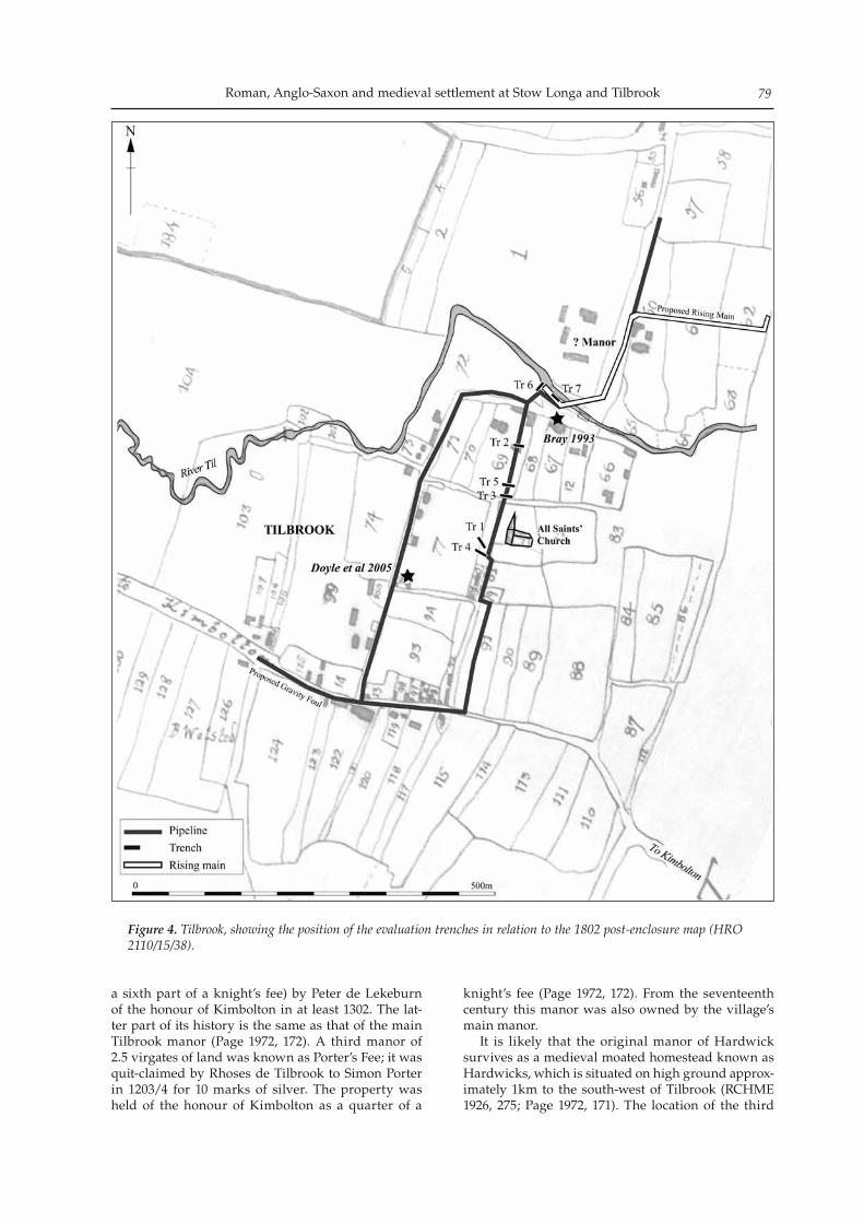
Roman, Anglo-Saxon and medieval settlement at Stow Longa and Tilbrook 79
a sixth part of a knight’s fee) by Peter de Lekeburn of the honour of Kimbolton in at least 1302. The lat-ter part of its history is the same as that of the main Tilbrook manor (Page 1972, 172). A third manor of 2.5 virgates of land was known as Porter’s Fee; it was quit-claimed by Rhoses de Tilbrook to Simon Porter in 1203/4 for 10 marks of silver. The property was held of the honour of Kimbolton as a quarter of a
knight’s fee (Page 1972, 172). From the seventeenth century this manor was also owned by the village’s main manor. It is likely that the original manor of Hardwick survives as a medieval moated homestead known as Hardwicks, which is situated on high ground approx-imately 1km to the south-west of Tilbrook (RCHME 1926, 275; Page 1972, 171). The location of the third
Figure 4. Tilbrook, showing the position of the evaluation trenches in relation to the 1802 post-enclosure map (HRO 2110/15/38).
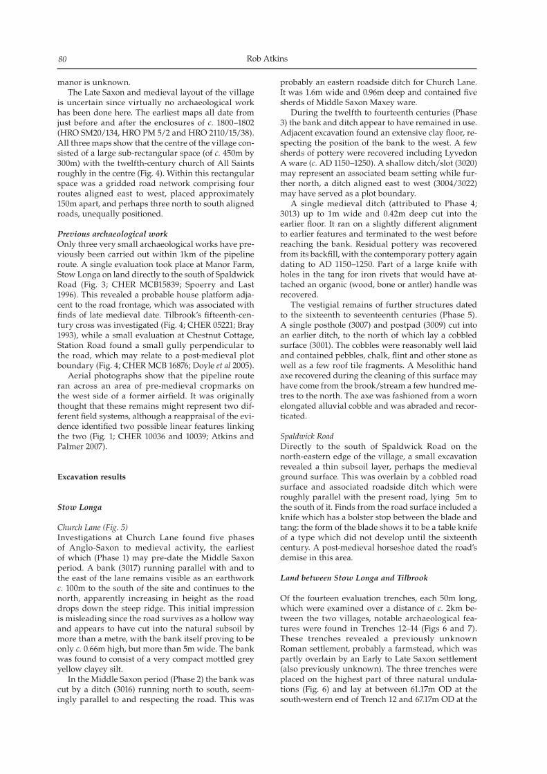
Rob Atkins80
manor is unknown. The Late Saxon and medieval layout of the village is uncertain since virtually no archaeological work has been done here. The earliest maps all date from just before and after the enclosures of c. 1800–1802 (HRO SM20/134, HRO PM 5/2 and HRO 2110/15/38). All three maps show that the centre of the village con-sisted of a large sub-rectangular space (of c. 450m by 300m) with the twelfth-century church of All Saints roughly in the centre (Fig. 4). Within this rectangular space was a gridded road network comprising four routes aligned east to west, placed approximately 150m apart, and perhaps three north to south aligned roads, unequally positioned.
Previous archaeological workOnly three very small archaeological works have pre-viously been carried out within 1km of the pipeline route. A single evaluation took place at Manor Farm, Stow Longa on land directly to the south of Spaldwick Road (Fig. 3; CHER MCB15839; Spoerry and Last 1996). This revealed a probable house platform adja-cent to the road frontage, which was associated with finds of late medieval date. Tilbrook’s fifteenth-cen-tury cross was investigated (Fig. 4; CHER 05221; Bray 1993), while a small evaluation at Chestnut Cottage, Station Road found a small gully perpendicular to the road, which may relate to a post-medieval plot boundary (Fig. 4; CHER MCB 16876; Doyle et al 2005). Aerial photographs show that the pipeline route ran across an area of pre-medieval cropmarks on the west side of a former airfield. It was originally thought that these remains might represent two dif-ferent field systems, although a reappraisal of the evi-dence identified two possible linear features linking the two (Fig. 1; CHER 10036 and 10039; Atkins and Palmer 2007).
Excavation results
Stow Longa
Church Lane (Fig. 5)Investigations at Church Lane found five phases of Anglo-Saxon to medieval activity, the earliest of which (Phase 1) may pre-date the Middle Saxon period. A bank (3017) running parallel with and to the east of the lane remains visible as an earthwork c. 100m to the south of the site and continues to the north, apparently increasing in height as the road drops down the steep ridge. This initial impression is misleading since the road survives as a hollow way and appears to have cut into the natural subsoil by more than a metre, with the bank itself proving to be only c. 0.66m high, but more than 5m wide. The bank was found to consist of a very compact mottled grey yellow clayey silt. In the Middle Saxon period (Phase 2) the bank was cut by a ditch (3016) running north to south, seem-ingly parallel to and respecting the road. This was
probably an eastern roadside ditch for Church Lane. It was 1.6m wide and 0.96m deep and contained five sherds of Middle Saxon Maxey ware. During the twelfth to fourteenth centuries (Phase 3) the bank and ditch appear to have remained in use. Adjacent excavation found an extensive clay floor, re-specting the position of the bank to the west. A few sherds of pottery were recovered including Lyvedon A ware (c. AD 1150–1250). A shallow ditch/slot (3020) may represent an associated beam setting while fur-ther north, a ditch aligned east to west (3004/3022) may have served as a plot boundary. A single medieval ditch (attributed to Phase 4; 3013) up to 1m wide and 0.42m deep cut into the earlier floor. It ran on a slightly different alignment to earlier features and terminated to the west before reaching the bank. Residual pottery was recovered from its backfill, with the contemporary pottery again dating to AD 1150–1250. Part of a large knife with holes in the tang for iron rivets that would have at-tached an organic (wood, bone or antler) handle was recovered. The vestigial remains of further structures dated to the sixteenth to seventeenth centuries (Phase 5). A single posthole (3007) and postpad (3009) cut into an earlier ditch, to the north of which lay a cobbled surface (3001). The cobbles were reasonably well laid and contained pebbles, chalk, flint and other stone as well as a few roof tile fragments. A Mesolithic hand axe recovered during the cleaning of this surface may have come from the brook/stream a few hundred me-tres to the north. The axe was fashioned from a worn elongated alluvial cobble and was abraded and recor-ticated.
Spaldwick RoadDirectly to the south of Spaldwick Road on the north-eastern edge of the village, a small excavation revealed a thin subsoil layer, perhaps the medieval ground surface. This was overlain by a cobbled road surface and associated roadside ditch which were roughly parallel with the present road, lying 5m to the south of it. Finds from the road surface included a knife which has a bolster stop between the blade and tang: the form of the blade shows it to be a table knife of a type which did not develop until the sixteenth century. A post-medieval horseshoe dated the road’s demise in this area.
Land between Stow Longa and Tilbrook
Of the fourteen evaluation trenches, each 50m long, which were examined over a distance of c. 2km be-tween the two villages, notable archaeological fea-tures were found in Trenches 12–14 (Figs 6 and 7). These trenches revealed a previously unknown Roman settlement, probably a farmstead, which was partly overlain by an Early to Late Saxon settlement (also previously unknown). The three trenches were placed on the highest part of three natural undula-tions (Fig. 6) and lay at between 61.17m OD at the south-western end of Trench 12 and 67.17m OD at the
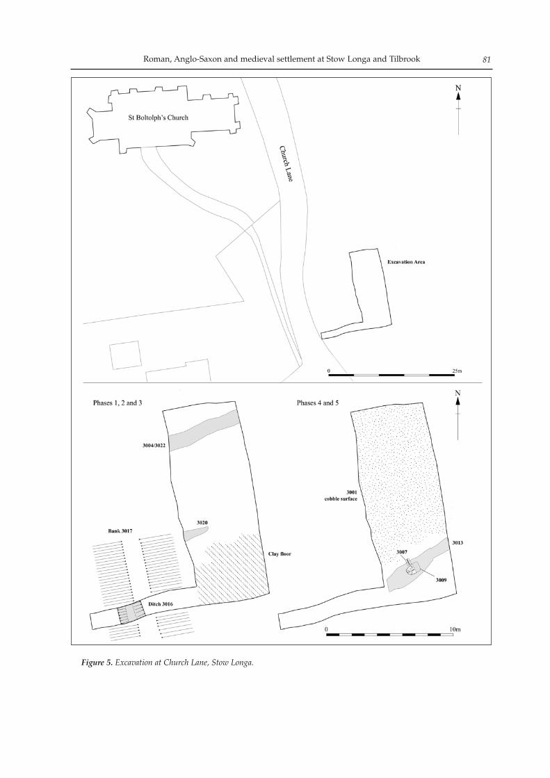
Roman, Anglo-Saxon and medieval settlement at Stow Longa and Tilbrook 81
Figure 5. Excavation at Church Lane, Stow Longa.
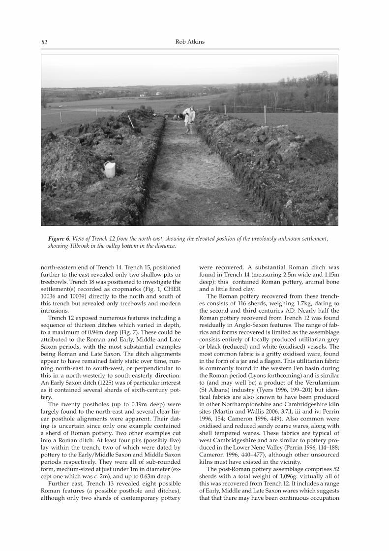
Rob Atkins82
north-eastern end of Trench 14. Trench 15, positioned further to the east revealed only two shallow pits or treebowls. Trench 18 was positioned to investigate the settlement(s) recorded as cropmarks (Fig. 1; CHER 10036 and 10039) directly to the north and south of this trench but revealed only treebowls and modern intrusions. Trench 12 exposed numerous features including a sequence of thirteen ditches which varied in depth, to a maximum of 0.94m deep (Fig. 7). These could be attributed to the Roman and Early, Middle and Late Saxon periods, with the most substantial examples being Roman and Late Saxon. The ditch alignments appear to have remained fairly static over time, run-ning north-east to south-west, or perpendicular to this in a north-westerly to south-easterly direction. An Early Saxon ditch (1225) was of particular interest as it contained several sherds of sixth-century pot-tery. The twenty postholes (up to 0.19m deep) were largely found to the north-east and several clear lin-ear posthole alignments were apparent. Their dat-ing is uncertain since only one example contained a sherd of Roman pottery. Two other examples cut into a Roman ditch. At least four pits (possibly five) lay within the trench, two of which were dated by pottery to the Early/Middle Saxon and Middle Saxon periods respectively. They were all of sub-rounded form, medium-sized at just under 1m in diameter (ex-cept one which was c. 2m), and up to 0.63m deep. Further east, Trench 13 revealed eight possible Roman features (a possible posthole and ditches), although only two sherds of contemporary pottery
were recovered. A substantial Roman ditch was found in Trench 14 (measuring 2.5m wide and 1.15m deep): this contained Roman pottery, animal bone and a little fired clay. The Roman pottery recovered from these trench-es consists of 116 sherds, weighing 1.7kg, dating to the second and third centuries AD. Nearly half the Roman pottery recovered from Trench 12 was found residually in Anglo-Saxon features. The range of fab-rics and forms recovered is limited as the assemblage consists entirely of locally produced utilitarian grey or black (reduced) and white (oxidised) vessels. The most common fabric is a gritty oxidised ware, found in the form of a jar and a flagon. This utilitarian fabric is commonly found in the western Fen basin during the Roman period (Lyons forthcoming) and is similar to (and may well be) a product of the Verulamium (St Albans) industry (Tyers 1996, 199–201) but iden-tical fabrics are also known to have been produced in other Northamptonshire and Cambridgeshire kiln sites (Martin and Wallis 2006, 3.7.1, iii and iv; Perrin 1996, 154; Cameron 1996, 449). Also common were oxidised and reduced sandy coarse wares, along with shell tempered wares. These fabrics are typical of west Cambridgeshire and are similar to pottery pro-duced in the Lower Nene Valley (Perrin 1996, 114–188; Cameron 1996, 440–477), although other unsourced kilns must have existed in the vicinity. The post-Roman pottery assemblage comprises 52 sherds with a total weight of 1,096g: virtually all of this was recovered from Trench 12. It includes a range of Early, Middle and Late Saxon wares which suggests that that there may have been continuous occupation
Figure 6. View of Trench 12 from the north-east, showing the elevated position of the previously unknown settlement, showing Tilbrook in the valley bottom in the distance.
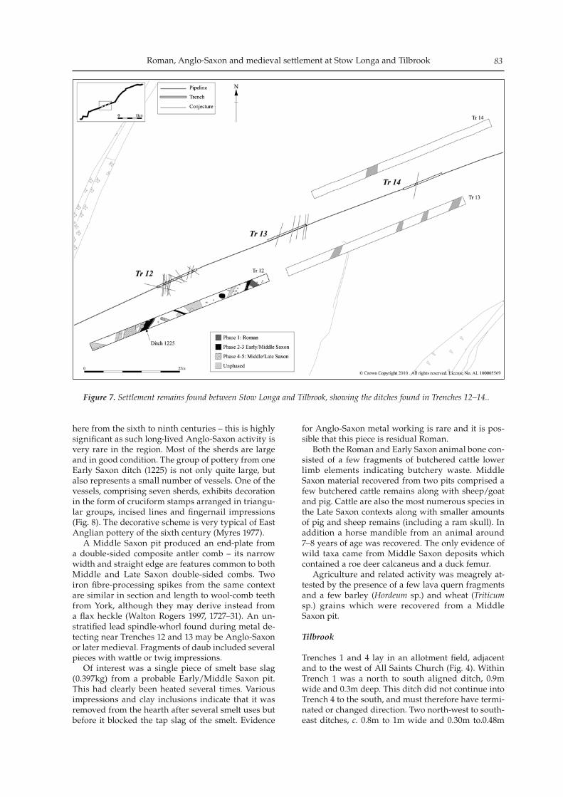
Roman, Anglo-Saxon and medieval settlement at Stow Longa and Tilbrook 83
here from the sixth to ninth centuries – this is highly significant as such long-lived Anglo-Saxon activity is very rare in the region. Most of the sherds are large and in good condition. The group of pottery from one Early Saxon ditch (1225) is not only quite large, but also represents a small number of vessels. One of the vessels, comprising seven sherds, exhibits decoration in the form of cruciform stamps arranged in triangu-lar groups, incised lines and fingernail impressions (Fig. 8). The decorative scheme is very typical of East Anglian pottery of the sixth century (Myres 1977). A Middle Saxon pit produced an end-plate from a double-sided composite antler comb – its narrow width and straight edge are features common to both Middle and Late Saxon double-sided combs. Two iron fibre-processing spikes from the same context are similar in section and length to wool-comb teeth from York, although they may derive instead from a flax heckle (Walton Rogers 1997, 1727–31). An un-stratified lead spindle-whorl found during metal de-tecting near Trenches 12 and 13 may be Anglo-Saxon or later medieval. Fragments of daub included several pieces with wattle or twig impressions. Of interest was a single piece of smelt base slag (0.397kg) from a probable Early/Middle Saxon pit. This had clearly been heated several times. Various impressions and clay inclusions indicate that it was removed from the hearth after several smelt uses but before it blocked the tap slag of the smelt. Evidence
for Anglo-Saxon metal working is rare and it is pos-sible that this piece is residual Roman. Both the Roman and Early Saxon animal bone con-sisted of a few fragments of butchered cattle lower limb elements indicating butchery waste. Middle Saxon material recovered from two pits comprised a few butchered cattle remains along with sheep/goat and pig. Cattle are also the most numerous species in the Late Saxon contexts along with smaller amounts of pig and sheep remains (including a ram skull). In addition a horse mandible from an animal around 7–8 years of age was recovered. The only evidence of wild taxa came from Middle Saxon deposits which contained a roe deer calcaneus and a duck femur. Agriculture and related activity was meagrely at-tested by the presence of a few lava quern fragments and a few barley (Hordeum sp.) and wheat (Triticum sp.) grains which were recovered from a Middle Saxon pit.
Tilbrook
Trenches 1 and 4 lay in an allotment field, adjacent and to the west of All Saints Church (Fig. 4). Within Trench 1 was a north to south aligned ditch, 0.9m wide and 0.3m deep. This ditch did not continue into Trench 4 to the south, and must therefore have termi-nated or changed direction. Two north-west to south-east ditches, c. 0.8m to 1m wide and 0.30m to.0.48m
Figure 7. Settlement remains found between Stow Longa and Tilbrook, showing the ditches found in Trenches 12–14..
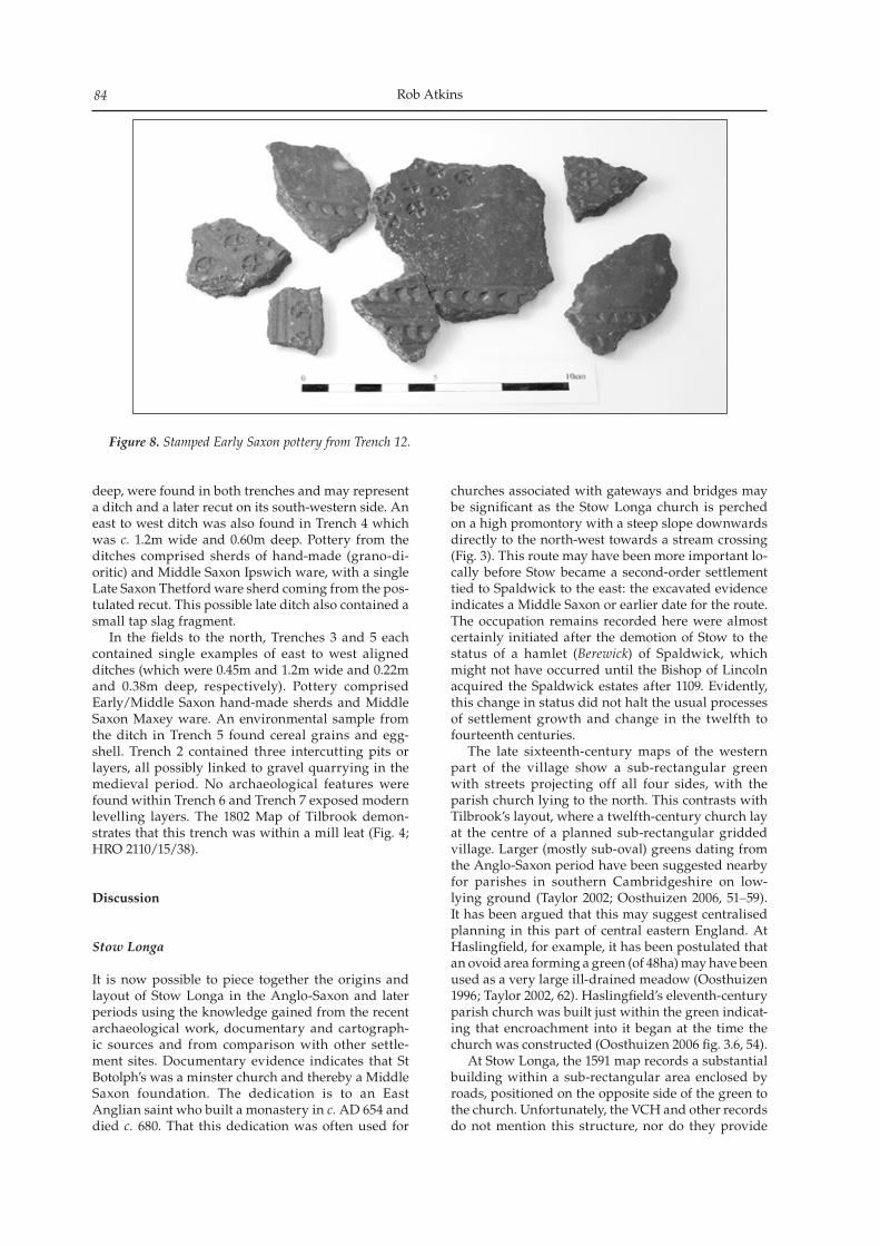
Rob Atkins84
deep, were found in both trenches and may represent a ditch and a later recut on its south-western side. An east to west ditch was also found in Trench 4 which was c. 1.2m wide and 0.60m deep. Pottery from the ditches comprised sherds of hand-made (grano-di-oritic) and Middle Saxon Ipswich ware, with a single Late Saxon Thetford ware sherd coming from the pos-tulated recut. This possible late ditch also contained a small tap slag fragment. In the fields to the north, Trenches 3 and 5 each contained single examples of east to west aligned ditches (which were 0.45m and 1.2m wide and 0.22m and 0.38m deep, respectively). Pottery comprised Early/Middle Saxon hand-made sherds and Middle Saxon Maxey ware. An environmental sample from the ditch in Trench 5 found cereal grains and egg-shell. Trench 2 contained three intercutting pits or layers, all possibly linked to gravel quarrying in the medieval period. No archaeological features were found within Trench 6 and Trench 7 exposed modern levelling layers. The 1802 Map of Tilbrook demon-strates that this trench was within a mill leat (Fig. 4; HRO 2110/15/38).
Discussion
Stow Longa
It is now possible to piece together the origins and layout of Stow Longa in the Anglo-Saxon and later periods using the knowledge gained from the recent archaeological work, documentary and cartograph-ic sources and from comparison with other settle-ment sites. Documentary evidence indicates that St Botolph’s was a minster church and thereby a Middle Saxon foundation. The dedication is to an East Anglian saint who built a monastery in c. AD 654 and died c. 680. That this dedication was often used for
churches associated with gateways and bridges may be significant as the Stow Longa church is perched on a high promontory with a steep slope downwards directly to the north-west towards a stream crossing (Fig. 3). This route may have been more important lo-cally before Stow became a second-order settlement tied to Spaldwick to the east: the excavated evidence indicates a Middle Saxon or earlier date for the route. The occupation remains recorded here were almost certainly initiated after the demotion of Stow to the status of a hamlet (Berewick) of Spaldwick, which might not have occurred until the Bishop of Lincoln acquired the Spaldwick estates after 1109. Evidently, this change in status did not halt the usual processes of settlement growth and change in the twelfth to fourteenth centuries. The late sixteenth-century maps of the western part of the village show a sub-rectangular green with streets projecting off all four sides, with the parish church lying to the north. This contrasts with Tilbrook’s layout, where a twelfth-century church lay at the centre of a planned sub-rectangular gridded village. Larger (mostly sub-oval) greens dating from the Anglo-Saxon period have been suggested nearby for parishes in southern Cambridgeshire on low-lying ground (Taylor 2002; Oosthuizen 2006, 51–59). It has been argued that this may suggest centralised planning in this part of central eastern England. At Haslingfield, for example, it has been postulated that an ovoid area forming a green (of 48ha) may have been used as a very large ill-drained meadow (Oosthuizen 1996; Taylor 2002, 62). Haslingfield’s eleventh-century parish church was built just within the green indicat-ing that encroachment into it began at the time the church was constructed (Oosthuizen 2006 fig. 3.6, 54). At Stow Longa, the 1591 map records a substantial building within a sub-rectangular area enclosed by roads, positioned on the opposite side of the green to the church. Unfortunately, the VCH and other records do not mention this structure, nor do they provide
Figure 8. Stamped Early Saxon pottery from Trench 12.
Roman, Anglo-Saxon and medieval settlement at Stow Longa and Tilbrook 85
any interpretation of the layout of Stow Longa village. Although the exact location for the original Anglo-Saxon estate centre before it moved to Spaldwick in the late tenth century is not known (Taylor 1989, 74), a position here would be likely. A manor and church set on opposite sides of the green was a common layout within villages and there was also often a close rela-tionship between lordly centres and Saxon churches (Roberts 1982, fig. 1; Lewis et al 2001, 87–88). A survey of three settlements in Cambridgeshire found that in the Saxon period the manor occupied a commanding position in relation to the entrance to the common (Oosthuizen 1993, 100). The Anglo-Saxon manorial location at Stow Longa is therefore unlikely to have been where the later medieval/post-medieval manor was situated, 300m along Spaldwick road (Fig. 3), since this lay away from the centre of the village and was positioned along a route that only became impor-tant when Spaldwick rose in status at a later date. The evidence suggests that the green, church and manor may have been created together in the Middle Saxon period. This accords with findings at other sites with major estate centres such as Higham Ferrers and Raunds in Northamptonshire, both of which had presumably coalesced and certainly experienced deliberate development before AD 850 (Hardy et al 2007; Audouy and Chapman 2009). In contrast, in lesser settlements within the Whittlewood part of Northamptonshire, the date tended to be after AD 850 (Jones and Page 2006, 103). The date of nucleation is probably similar in Cambridgeshire. At Cottenham, the indications are that the village became nucleated at or before the arrival of Middle Saxon Ipswich ware pottery on the site (Mortimer 2000, 21). While the excavations at Stow Longa were too small to give an indication of overall dating for the layout, it is now clear that Church Lane dates to at least the Middle Saxon period. No evidence was found that houses fronted Church Lane in the Anglo-Saxon period, the earliest building remains here being dated to the twelfth and thirteenth centuries. The presence of Middle Saxon finds, however, clearly indicates settlement close by in this period. The final structure on the site shown on the 1591 map fell from use in the seventeenth century. The Spaldwick Road site did not indicate occupa-tion before the medieval period. The road surface examined here ran roughly parallel to the present road, at a distance of c. 5m to the south, indicating either that the road was once much wider or that it ran along a slightly different course in the medieval to early post-medieval period. The present anomaly of Stow Longa lying within two parishes (Kimbolton and Stow Longa itself) was probably the result of post-conquest re-organisation, either as William de Warrene expanded the honour of Kimbolton, or in 1109 when the Spaldwick estate was transferred from Ely to Lincoln. It is unlikely to have occurred earlier in 991 when Stow Longa and adjacent centres including Spaldwick were given en bloc to Ely as Stow was at that time almost certainly the primary centre in these estates. The hiving off
of Upper Stow indicates Stow Longa’s decline in im-portance, in contrast to the rise of Kimbolton on one side and Spaldwick on the other. It should perhaps be noted that the sixteenth-century maps record land at Upper Stow at a point when it had probably been part of Kimbolton parish for over 400 years. This may suggest that even in the post-medieval period, this area was still being treated as a ‘separate’ entity and important in its own right.
The area between Stow Longa and Tilbrook
Roman features recorded over a distance of 400m may indicate the presence of a farmstead. Such small settlements may have existed every few hundred me-tres along the ridge, as is perhaps suggested by the presence of the adjacent enclosure systems recorded as cropmarks (CHER 10036 and CHER 10039; Fig. 1). Early to Late Saxon activity overlay these Roman re-mains on a promontory at the edge of the high ridge (Trench 12). Given that only a tiny percentage of the overall settlement has now been sampled, continuity of occupation from the Roman to Late Saxon periods is not proven but remains a possibility. Sites show-ing continuity from the Roman to Anglo-Saxon pe-riods have become far more common in this region in recent years, with examples being found at, for ex-ample, Love’s Farm, St Neots (Hinman forthcoming) and Boxworth (Connor 2008, 116). Clear evidence of further continuity onwards into the Middle and Late Saxon periods is, however, much less common. The new results demonstrate that there were at least two contemporary Anglo-Saxon settlements within the former Stow Longa parish, on opposing sides of the natural ridge. The density of Anglo-Saxon features found in Trench 12 indicates domestic settle-ment from at least the sixth to the late ninth centuries. This site would have lain within Upper Stow’s open fields where there is no cartographic evidence to in-dicate the presence of a former settlement. This newly identified settlement may represent a typical example of a small settlement in a dispersed landscape. Where statistics have been generated to indicate how many Middle Saxon sites may have been abandoned in the Late Saxon period, the numbers vary depending on the sub-region, and the method of analysis (Lewis et al 2001, 82). The abandonment of a significant pro-portion of Middle Saxon settlements was, however, undoubtedly a key feature of areas where nucleated villages became the characteristic later medieval set-tlement form. The results of the new work reflect previous sug-gestions that this natural ridge was important in the establishment of early settlements, also providing a favourable position for the siting of several villages in the post-Roman period (Spoerry and Last 1996, 1). One of the routes known to have led off from Filman Waye ran to a position about 100m to the east of Trench 12, perhaps forming the access way to the settlement. The Roman and Anglo-Saxon ditch alignments found within Trenches 12–14 reflect the course of both this routeway and Filman Waye, indicating a possible ori-
Rob Atkins86
gin before the Anglo-Saxon period. On the basis of comparison with other better known ridgeway tracks in southern England, they may even be prehistoric in date. It may be significant that the alignment of the routes on either side of this Roman and Anglo-Saxon site, Upper Stow’s north-western and south-western ‘parish’ boundary, and the ditches within Trench 12 follow the same direction as the ‘ancient alignments’ recorded in a recent study of the Bourn Valley in south-west Cambridgeshire (Oosthuizen 2006, fig. 4.1). As indicated above, the abandonment of this site and the putative nucleation at Stow Longa form part of a well-attested trend seen in the midland counties from the ninth century onwards. When an Early/Middle Saxon farmstead was abandoned, its inhab-itants seem to have moved to a single larger and perhaps higher status settlement within the same ter-ritory (Jones and Page 2006, 81). The likelihood is that the open fields of this ‘Upper Stow’ settlement would have been integrated into the expanded settlement at Stow Longa as part of this re-organisation. These changes have been observed elsewhere leading to the prognosis that ‘archaeological evidence suggests that the open fields were re-planned in the Late Saxon period ... contemporary with the replanning of their associated settlements’ (Jones and Page 2006, 82). The period AD 850 to 1150 saw each vill having two or more extensive arable fields which were cultivated in common by their inhabitants (Taylor 1983, 130–131). It is tempting to see this Upper Stow area as one of these two very large fields of the former Stow Longa parish. In terms of area it is just smaller than the present Stow Longa parish adjacent to the east (Fig. 2). Alternatively, the two halves of the nucleated set-tlement at Stow may have cultivated separate groups of smaller open fields to the east and west of the vil-lage.
Tilbrook
Archaeological work at Tilbrook, near the twelfth-century All Saints Church, found several Middle Saxon ditches and one Late Saxon example. The ditches ran in various directions, with one example leading towards the churchyard boundary. This lay-out is at odds with the gridded plan recorded by the 1802 map of the village and the earlier arrangement may be similar to that identified at Cottenham where excavation found settlement starting in the seventh or eighth century within a large open enclosure (Mortimer 2000). The name Til(l)a’s stream suggests Early Saxon settlement in the area and it would be normal for one of the elements in this earlier dis-persed settlement landscape to retain or acquire the local territorial name and act as a pre-village nuclei, around which Middle or Late Saxon expansion, nu-cleation and/or planning was focused. The recovery of a Thetford ware pottery sherd from one ditch hints that the later planned charac-ter of the village may have occurred sometime from the later ninth century onwards, but whether this
was a Late Saxon re-ordering or planning attribut-able to new Norman overlords in the later eleventh or twelfth century (in this case the powerful William de Warenne who also owned the honour of Kimbolton) is not clear. Regional examples of Late Saxon settlement plan-ning from the mid-ninth century onwards include the Burystead at Raunds (Audouy and Chapman 2009) and Isham (Lewis et al 2001, 105), both in Northamptonshire. In the post-conquest period many villages seem to have been deliberately planned or replanned with peasant houses laid out along a vil-lage street on house plots of uniform or near-uniform size (Faith 1997, 225). Known, or inferred, post-con-quest examples of re-planning or the creation of new planned village elements are much more common, particularly in some of the larger ‘market villages’ of parts of Cambridgeshire and Northamptonshire. A recent excavated example in a smaller settlement can be found at Botolph Bridge on the south bank of the River Nene in former Huntingdonshire, where a completely new planned layout was established in the post-conquest period on the site of the former Late Saxon settlement (Atkins with Kemp forthcoming).
Conclusions
Discovery of previously unknown Roman settlements is becoming common – indeed in Cambridgeshire alone over the last 20 or so years, the number of Roman sites has increased several fold, with the dif-ference being particularly marked in clayland areas where previous estimates of numbers of sites, and hence population, were very low (Mills and Palmer 2007). The recent work at Stow Longa and Tilbrook has uncovered important information concerning when and why settlements were founded and why some sites were abandoned. The location of the three Anglo-Saxon settlement sites, all dating from at least the Middle Saxon period, supports prior expectations of a dispersed landscape giving way to greater nucle-ation, and helpfully the date of abandonment of this newly discovered settlement can perhaps be placed after AD 850. Tilbrook was built in the middle of a valley bottom at the junction of two roads and the River Til. The newly identified Anglo-Saxon settlement and Stow Longa were both within the former Stow Longa par-ish. They were also mirror images, built respectively on a promontory at the south-western and north-eastern edge of a high ridge, with both sites seem-ingly acting as gateways onto the ridgeway. Probably contemporary, or even a prehistoric or Roman relict, was Filman Waye which the 1591 map and the 1st Edition OS map show as a routeway running down the centre of the ridge, with minor trackways lead-ing off it to both Stow Longa and the new settlement at Upper Stow and presumably to other settlements also. The abandonment of the Upper Stow farmstead in the Late Saxon period, the decline of Stow Longa
Roman, Anglo-Saxon and medieval settlement at Stow Longa and Tilbrook 87
(perhaps during control by Ely Abbey), and later its demotion in favour of Spaldwick under the Bishops of Lincoln, and wholesale replanning of Tilbrook (per-haps in the Norman period by William de Warenne), shows how all three villages were affected by the policies of both lay and secular overlords.
Acknowledgements
The author would like to thank Anglian Water who commissioned and funded the archaeological work especially Ian Boon and Karl Morrison who organ-ised the scheme. The project was managed by James Drummond-Murray and this report was revised and commented on by Paul Spoerry. Rob Atkins direct-ed the fieldwork with Jon House and Sarah Henley supervising various parts of the project. Hannah Bosworth, Louis Budworth, Caoimhín Ó Coileáin, Zoe Uí Choileáin, Anna Finesilver, Nick Gilmour, Steve Graham, Jonathon Lay, Ross Lilley, Tom Lyons and Rachelle Wood assisted. Ann and John Jarzabek kindly volunteered on site. Steve Critchley is thanked for contributing his knowledge on the geology of the area. He also metal detected the main evaluation and excavation areas. The photograph of the stamped pottery was taken by Andrew Corrigan. This article was prepared for pub-lication by Elizabeth Popescu.
Cambridge Antiquarian Society is grateful to Anglian Water for a grant towards the publication of this paper.
Bibliography
Atkins, R, 2009 Roman and medieval settlement remains along the Stow Longa to Anglian Water pipeline. Oxford Archaeology East Report No 990 (unpublished)
Atkins, R, with S Kemp, forthcoming, Rise and fall of a Late Saxon village and medieval manor: excavations at Botolph Bridge, Peterborough 1987 and 1999/2000. EAA
Atkins, R, and R Palmer, 2007 Stow Longa to Tilbrook (Huntingdonshire), Anglian Water Pipeline (Phase 2). CAM ARC Report No 964 (unpublished)
Audouy, M and A Chapman, 2009 Raunds: The origin and growth of a midland village AD 450–1500. Oxford: Oxbow Books
British Geological Survey (BGS) 1946 1:50000 Series Solid and Drift Sheet 186. Wellingborough
Bray, S, 1993 Excavation of a fifteenth century village cross in Tilbrook, Cambridgeshire. Cambridgeshire County Council Archaeological Field Unit Report No A11 (un-published)
Cameron, F, 1996, ‘Other Roman Pottery’ in Jackson, R.P.J., and Potter, T.W., Excavations at Stonea, Cambridgeshire 1980–85. London: British Museums Press
Connor, A, 2008 Community excavations at Spring Close, Boxworth, TL 350 645 Cambridgeshire PCAS XCVII: 111–119
Doyle, K, I Williamson, and T Woolhouse, 2005 Chestnut Cottage, Station Road, Tilbrook, Cambridgeshire: An archae-ological trial trench evaluation. Archaeological Solutions
Report No 1868 (unpublished)Faith, R, 1997 The English Peasantry and the Growth of
Lordship. Leicester: Leicester University Press Hardy, A, B Mair Charles, and R Williams, 2007 Death and
Taxes; The archaeology of a Middle Saxon estate centre at Higham Ferrers, Northamptonshire. Oxford Archaeology
Hart, CR, 1966 The Early Charters of Eastern England. Leicester: Leicester University Press
Hinman, M, forthcoming, Colonisation, conquest and conti-nuity on the Cambridgeshire clay lands. EAA
Jones, R, and Page, M, 2006 Medieval villages in an English landscape: beginnings and ends. Macclesfield: Windgather Press
Lewis, C, Mitchell-Fox P, and Dyer, C 2001 Village, Hamlet and Field. Changing medieval settlements in central England. Macclesfield: Windgather Press
Lyons, A.L., forthcoming, Appendix 15. The Roman Pottery (on CD-ROM) in J Abrams, and D Ingham, Farming on the edge: archaeological remains on the clay uplands to the west of Cambridge. EAA
Martin, S and C Wallis, 1997, A Research Design for the Study of Roman Pottery in the East Midlands and East Anglia, sgrp.org.uk
Mawer, A, and FM Stenton, 1969 The Place-Names of Bedfordshire and Huntingdonshire. Cambridge: CUP
Mills, J, and R Palmer, (eds.) 2007 Populating Clay Landscapes. Stroud: Tempus
Mortimer, R, 2000 Village development and ceramic se-quence: the Middle to Late Saxon village at Lordship Lane, Cottenham, Cambridgeshire. PCAS LXXXIX: 5–33
Myres, JNL, 1977 A Corpus of Anglo-Saxon pottery of the pagan period. Cambridge: CUP, 2 vols
Oosthuizen, S, 1993 Saxon Commons in Cambridgeshire. PCAS LXXXII: 93–100
Oosthuizen, S, 1996 Discovering the Haslingfield Landscape. Haslingfield Village Society
Oosthuizen, S, 2006 Landscapes Decoded The origins and development of Cambridgeshire’s medieval fields. Hatfield: University of Hertfordshire Press
Page, W (ed.), 1972 The Victoria History of the County of Bedford, Volume III. Folkestone and London: University of London
Page, W, and G Proby, (eds.), 1974 The Victoria History of the County of Huntingdonshire, Volume I. Folkestone and London: University of London
Page, W, G Proby, and S Inskip Ladds, (eds.), 1974 The Victoria History of the County of Huntingdonshire, Volume III. Folkestone and London: University of London
Perrin JR, 1996, ‘The Roman Pottery’ in Mackreth, DF, Orton Hall Farm: A Roman and Early Saxon Farmstead. EAA 76: 114–204
RCHME 1926 An Inventory of the Historical Monuments in Huntingdonshire. Royal Commission on Historical Monuments (England)
Richardson, A, 2007 The Ecclesiastical Peculiars of Huntingdonshire 1660–1852. Huntingdon: Just Print It Publications
Roberts, BK, 1982 Village Plans. Shire Archaeology: Aylesbury
Spoerry, P, and J Last, 1996 Earthwork platforms at Manor Farm, Stow Longa. Cambridgeshire County Council Archaeological Field Unit Report No A96 (unpub-lished)
Taylor, CC, 1983 Village and farmstead. London: PhilipTaylor, CC, 1989 ‘Spaldwick’ PCAS LXXVIII: 71–5Taylor, CC, 2002 ‘Nucleated settlement: a view from the
frontier’, Landscape History, 24, 53–71
Rob Atkins88
Tyers, P, 1996 Roman Pottery in Britain. London: BatsfordWalton Rogers, P, 1997 Textile production at 16–22 Coppergate,
The Archaeology of York 17/11. York: CBA for York Archaeological Trust
Maps Tilbrook 1800 Enclosure Map (HRO SM20/134)Tilbrook 1800 Enclosure map (HRO PM 5/2)Tilbrook 1802 Post-Enclosure Map (HRO 2110/15/38)Tilbrook and Stow Longa 1st Edition 1887 Ordnance Survey map Stow Longa Upper Stow pre 1590 map (HRO SM19/126)Stow Longa and Bigrams estate map, Kimbolton 1591 (HRO PM3/6B and HRO 2408)Stow Longa 1839 Apportionment and plan (HRO 2196/39)
An analytical earthwork survey of Mill Common in Huntingdon was undertaken during April 2009. The sur-vey results potentially stem from the pre-medieval period to the present, whilst the sub-surface archaeological remains could feasibly stretch back further in time. The following report will therefore outline and interpret the breadth of this landscape development in order to direct future investiga-tions in Mill Common, with discussion focusing specifically on its impact on the interpretation of the medieval town-scape.
Background
The open area of Mill Common measures roughly 6.17ha in area (Fig.1), but prior to encroachment dur-ing the nineteenth and twentieth centuries it encom-passed a much greater extent of land. Currently it is used as light pasture on the perimeter of the town centre and is open to the general public. The history of the town and the archaeological potential of Mill Common, particularly in relation to the early medi-eval development of the settlement has been covered extensively and need not be repeated (Spoerry 2000).
Pre-later medieval (Fig.2)
Several linear features were identified as pre-dating the establishment of the medieval open field system. A short 2m wide south-facing scarp, surviving in three short sections was identified in the furrowed area beneath the later medieval plough ridging (Fig.2: a), indicative of a linear feature orientated a little off E-W and measuring 40m in length and a probably related small section of scarp was located on a similar align-ment 7m to the north. The surviving ridge and furrow to the west is orientated WSW-ENE which would sug-gest that these scarps were not part of an earlier form of the open field system with longer ploughing tracts continuing eastwards into this area. The importance of this identification is height-ened by the fact it appears to correspond to a larger
complex to the south. The linear feature matches the orientation of the headland 17m to the south at the end of the furlong, although this alignment is heav-ily disturbed to both the east and west by later post-medieval activity. The implication of this relationship is that the layout of the medieval field system may have been influenced in part by an arrangement of earlier features. Immediately south of the headland is a terraced 4m wide track way (Fig.2: b). Of particu-lar interest is that the alignment of this track appears to link with that of St. Mary’s Lane whose line ends somewhat abruptly a little over 100m to the east. The intervening area between these routes has been heav-ily disturbed by post-medieval activity, and so it re-mains a distinct possibility that the two features were part of the same track in the medieval period. To the south-east another fragment of a medieval furlong survives, but to the south-west is a large rec-tilinear cut feature, potentially a complex of early settlement (Fig.2: c). Measuring 35m by at least 35m and up to 1m deep, the southern end of this feature is encased by the embankment of the A14 carriage-way. It too matches the alignment of the pre-ridge and furrow linear feature to the north, while internally a number of low linear scarps were recorded, princi-pally on an N-S alignment. On first inspection is was assumed that such a deep cut feature related to some form of quarrying, but the neat square form of the earthwork would suggest a more complex function as would its internal features, although the latter give lit-tle immediate indication of that function. A building platform terrace was recorded on the north-west side of the feature measuring 12m by 10m, while demar-cating the southern side of the terraced track way on both the east and west side of the principal rectilinear depression are two sections of low bank measuring roughly 30m in length respectively. This combines to form an interesting complex of earthworks, the date and function of which are not immediately apparent. Unfortunately there is no clear relationship surviving with the medieval ridge and furrow to the east and north, which may in itself imply a construction date after the abandonment of
Earthwork Survey at Huntingdon Mill Common
Michael Fradley
Proceedings of the Cambridge Antiquarian Society XCVIX pp. 89–96
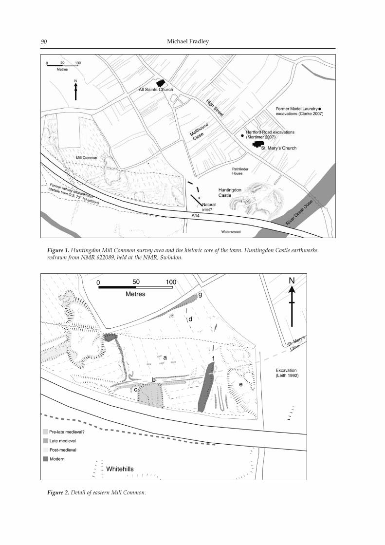
Michael Fradley90
Figure 1. Huntingdon Mill Common survey area and the historic core of the town. Huntingdon Castle earthworks redrawn from NMR 622089, held at the NMR, Swindon.
Figure 2. Detail of eastern Mill Common.
Earthwork Survey at Huntingdon Mill Common 91
the open field system. However, this complex does mirror the alignment of the pre-ridge and furrow lin-ear to the north, and the proposed link between the track way and St. Mary’s Lane whose curving route leading directly toward the early church of St. Mary would support the interpretation that it formed an early component of medieval Huntingdon’s settle-ment form. If this track to the earthwork complex had been abandoned by the early post-medieval period, as implied by depictions of cartographers from John Speed onwards, then it lends itself to the interpreta-tion that this earthwork complex is indeed of medi-eval date and potentially part of an early settlement focus.
The Bar Dyke (Fig.3)
The earthwork feature known as the Bar Dyke is lo-cated at the western end of the survey area, consist-ing of a large ditch principally orientated NNW-SSE. Recent excavation across the feature has confirmed the existence of multiple phases of construction on this alignment, including two medieval ditches pre-dating the extant ditch earthwork (Mortimer 2006, 20–2). The ditch as it survives at present fades out before reaching the northern limit of the survey area. The ditch itself can be divided into distinct sections; a sharply cut, straight southern segment and a more amorphous northern stretch. The degraded northern section of ditch is the older of the two and relates to its development in the medieval and early post-medieval period. The ditch is about 70m in length, 12–20m in width and slightly meandering in its course before fading out at its northern end. A large break in the eastern side of the ditch (Fig.3: a) about 23m wide was recorded, and there is no indication that this branch of the ditch continued further eastwards. The form of the present ditch has been tentatively dated to the Civil War pe-riod by excavation, and in this context it is possible to suggest that the ditch in this area was cut in order to protect a series of independent bastions and thus the break separates these two units. This interpreta-tion has the added benefit of explaining why there is no evidence of the ditch continuing further north as it would suggest that it never did, but in fact curved around the northern flank of the bastion. It would also imply that there was never an internal bank to the ditch, with these features instead functioning as slightly raised, open platforms. Parallels of simi-larly crude Civil War defences can be identified as sites such as at Northampton Castle and the northern perimeter of Wallingford Castle (Oxon.), providing entrenched positions for artillery units (Christie et al 2008, 53–4; Chapman 1985, 51). At Newark amongst the more sophisticated fortified position identified are a number of simple raised battery positions which could also be viewed as a possible parallel with those recorded at Huntingdon (RCHME 1964). As with the defences of the medieval settlement it is not necessary to consider the Civil War defences of Huntingdon as
a single, continuous perimeter, but instead may be a heterogeneous combination of elements such as these potential fortifications. A number of small, amorphous earthworks were recorded to the east and west of the Bar Dyke feature. Few can be interpreted with any confidence and the majority may be contemporary with or post-date the construction of the Civil War-period Bar Dyke. To the north of the surviving section of the Bar Dyke the ground drops down before rising up once more at the southern edge of the modern road embankment. Explaining this drop in ground is difficult as it is not linked directly to the Bar Dyke system. Within this area a low meandering linear east-facing scarp aligned roughly N-S survives and is apparently matched by a smaller raise of ground some 7m to the east on the edge of the survey area which may represent the two sides of a degraded ditch feature (Fig.3: c). The Bar Dyke excavation revealed that the Civil War-period ditch followed the line of a late medieval ditch. This in turn followed the alignment of a hol-low-way immediately to the east whose date of origin could lie anywhere between the seventh and the thir-teenth century and may link to the slight linear ditch feature identified to the north (Fig.3: c; Mortimer 2006, 21, 28). Importantly, while confirming the prob-able antiquity of this alignment the excavations dem-onstrate conclusively that the Bar Dyke does not form part an earlier burh enclosure associated with an em-bryonic urban focus. Instead it only appears to have become a significant boundary in the thirteenth or fourteenth century at a time when it would have ap-parently been contemporary with and enclosed the extensive arable fields to the east, before being used as a hollow way. The excavated evidence is ambigu-ous as to whether the earlier lane and later medieval ditch were utilised at least for a time together, as what dating evidence exists for the later stages of use of the hollow-way may be intrusive (Mortimer 2006, 21). Given that the two are apparently aligned so care-fully in parallel it is highly suggestive that they did function together for a period, which in turn provides weight to the proposition that there was never a bank on the eastern side of the medieval ditch. In contrast the southern section of the Bar Dyke ditch (Fig.3: b) is prominent and sharply cut, measur-ing about 12m in width with a corresponding bank on its eastern side 10m wide. This section of the earth-work runs for a length of 80m, although by including the evidence of the Ordnance Survey 25” 1st edition (1888) it is possible to demonstrate that it continued for a further 50m, at which point it was joined at a right angle by a linear feature to the east aligned WSW-ENE. The latter feature (Fig.3: d) appears to have originated as a long medieval track way run-ning between furlongs of medieval ridge and furrow, but at a later date this western section was deepened, widened and linked into the Bar Dyke ditch, which created an embankment on its north-western side. The rectangular form of this layout, with its appar-ent internal embankment has led to speculation as to whether it may be a surviving remnant of a Danish
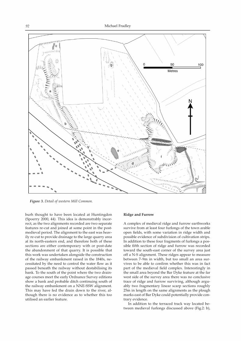
Michael Fradley92
burh thought to have been located at Huntingdon (Spoerry 2000, 44). This idea is demonstrably incor-rect, as the two alignments recorded are two separate features re-cut and joined at some point in the post-medieval period. The alignment to the east was heav-ily re-cut to provide drainage to the large quarry area at its north-eastern end, and therefore both of these sections are either contemporary with or post-date the abandonment of that quarry. It is possible that this work was undertaken alongside the construction of the railway embankment raised in the 1840s, ne-cessitated by the need to control the water flow as it passed beneath the railway without destabilising its bank. To the south of the point where the two drain-age courses meet the early Ordnance Survey editions show a bank and probable ditch continuing south of the railway embankment on a NNE-SSW alignment. This may have fed the drain down to the river, al-though there is no evidence as to whether this too utilised an earlier feature.
Ridge and Furrow
A complex of medieval ridge and furrow earthworks survive from at least four furlongs of the town arable open fields, with some variation in ridge width and possible evidence of subdivision of cultivation strips. In addition to these four fragments of furlongs a pos-sible fifth section of ridge and furrow was recorded toward the south-east corner of the survey area just off a N-S alignment. These ridges appear to measure between 7–9m in width, but too small an area sur-vives to be able to confirm whether this was in fact part of the medieval field complex. Interestingly in the small area beyond the Bar Dyke feature at the far west side of the survey area there was no conclusive trace of ridge and furrow surviving, although argu-ably two fragmentary linear scarp sections roughly 25m in length on the same alignments as the plough marks east of Bar Dyke could potentially provide con-trary evidence. In addition to the terraced track way located be-tween medieval furlongs discussed above (Fig.2: b),
Figure 3. Detail of western Mill Common.
Earthwork Survey at Huntingdon Mill Common 93
a second long track (Fig.2: g), again running between arable furlongs was identified running across a large section of Mill Common. Beginning in the north-east corner of the survey area as a shallow hollow-way measuring 9m in width, the track continues south-west for 80m at which point it merges with a modern pathway. It is unclear why the course of the modern path, in its present position from at least the later nineteenth century, has diverged so slightly from the course of the earlier hollow-way. The path continues to the south-west for a further 60m where its course is abruptly cut by a large open post-medieval quarry, at which point the present surface track turns and con-tinues to the north-west. A large causeway of prob-able twentieth century date crosses the quarry, but is aligned E-W and joins with an informal track way continuing westwards. However, to the south-west on the far side of the quarry the line of the medie-val track way can be seen continuing on its original alignment. At this stage its form has been heavily al-tered as it has been adapted as part of a post-medieval drainage system as discussed above in relation to the Bar Dyke. The route of the track beyond its meeting with the Bar Dyke is unknown. In total the course of this track way runs for a dis-tance of nearly 300m. It is presumed that given its close relationship with the medieval field system that it is near contemporary, and there is currently no evi-dence to suggest that it pre-dates the later medieval period. An interesting addition to this picture is that the line of the track way if continued to the north-east appears to align with a passageway leading directly on to the High Street. This possibly follows the line of an earlier, informal passage that is today elaborat-ed in the form of the made road of Malthouse Close and the access way of Literary Walk alongside the Commemoration Hall. This would suggest that this access route may have been carefully laid out in rela-tion to, and perhaps even simultaneous to the formal laying out of the medieval High Street. A direct link is therefore provided between the commercial hub of Huntingdon’s main street and the arable holdings of the towns inhabitants through which we can begin to understand in detail how the latter moved between the two seemingly distinct zones.
Quarrying
Mineral extraction has had a dramatic impact on the earthwork evidence of Mill Common, most notably in the form of the large open quarry pit in the centre of the survey area. Earlier small scale quarrying can possibly be detected in the form of a small oval pit (Fig.3: e). It is possible that the pit was quarried when there was a partial abandonment of arable cultivation in this area at a time when the strips were still in-dividually owned, and its confinement to this single ridge may be explained by it being dug by the owner of the strip. The major quarry in the centre of the survey area (Fig.3: f) is of a completely different scale, and con-
sists of a large central pit with several minor pits dug at its edge to the north and south. The earthwork of this quarry measures around 100m in length, 40m in width and 2m in depth. The quarry, at least in its present enlarged form, post-dates the abandon-ment of individual strip ownership of the medieval fields as it cuts through a swathe of the visible ridge and furrow earthworks. The Ordnance Survey 25” 1st edition (1888) suggests that quarrying may have continued further to the north in an area at present developed with residential housing. As discussed above the former track way that continued through this area on a NE-SW alignment was heavily re-cut to the south-west in order to provide drainage for the quarry which would otherwise have presumably held water. One final area of significant quarrying has been identified on the eastern periphery of the survey area (Fig.2: e), although contrary to earlier views on the basis of the present survey work it is argued that its form may be the combined result of quarrying, natu-ral topography and possible earlier archaeological fea-tures. There has been significant earth movement in this area, principally evidenced by spoil heaps rather than discrete quarry pits. However, the principal fea-ture in this area, consisting of a broad scarp up to 12m wide beginning in the extreme south-east corner of the survey area and heading out on a north-wester-ly alignment, is probably natural in origin. Adjoining on the west side of this scarp is an L-shaped terrace measuring 8m by 10m which may even the remnant of a building platform overlooking this slope rather than evidence of quarrying. To the north evidence of quarrying and spoil is more marked; a minor ar-chaeological trench was excavated in this area which demonstrated the extent of dumped material in the vicinity from the medieval period onwards, but failed to reach a natural surface and ultimately was too small to contribute significantly to the interpretation of the area (Mortimer 2006, 22–3). To the east of the survey area on the far side of this depression archaeo-logical evaluation has demonstrated that the present topography is in many places the result of post-medi-eval ground make-up, and that occupation layers and at least one ditch with dates potentially spanning the tenth-thirteenth centuries have been identified below (Leith 1992, 7–10; Fig.1). This demonstrates clearly that the fall on the eastern side of this area relates to natural topography rather than extensive quarrying, and this is likely to also be the case on the west side of the survey area. The overall impression presented by this topographical evidence is that this area was marked by the existence of a large bulbous inlet of land leading south to the river and perhaps linked to a now-redundant water course (Fig.1). An arrange-ment of wide channels and water management dat-ing from the medieval and Romano-British periods has also been revealed by excavation to the east of Mill Common around Hartford Road and the west end of Montagu Road (Clarke 2007; Mortimer 2007). This work has highlighted a lack of understanding of the hydrology and river tributaries around the urban
Michael Fradley94
core of Huntingdon and how this may have influ-enced settlement development. The features identi-fied on the east side of Mill Common suggest similar evidence of water systems and river inlets.
Landscaping
To the east of the County Hospital site a number of linear features were recorded that have been inter-preted as part of a garden landscape attached to the former hospital building. A number of these features were previously identified by geophysical survey in this area but were construed to be land drains (Mortimer 2006, 14). However at the northern end of and integrated into this complex is a large, bulbous earthwork with exposed areas revealing what ap-pears to be a brick-chambered rabbit warren (Fig.3: g). The majority of the scarps aligned N-S may rep-resent the remains of slight former garden terraces. One land drain was encountered during excavation but was aligned on the same orientation as the ridge and furrow to the east and south (Mortimer 2006). Importantly this suggests that the grounds to the County Hospital plot formerly extended further east-wards and included an ornate garden system and a small managed rabbit warren, although whether this relates to the construction of the present structure in the mid-nineteenth century or an earlier building is not clear. The present study was not able to identify any cartographic material that would support this interpretation, although the form of the surviving earthworks is relatively conclusive.
Transport
A major development in the later nineteenth century was the construction of the railway line, encasing a linear swathe of land with its embankment and divid-ing what remained of the Mill Common area into two discrete sections. The southern section has been the subject of increasing development during the course of the twentieth century to the extent that no large open areas survive at present. Following the closure of the railway line in the 1960s the A14 carriageway was developed in the early 1970s, further encasing part of Mill Common. One particularly interesting use of the Mill Common in the modern period has been the sta-tioning of a squadron of the Royal Flying Corps in this area in the latter stages of World War One. This squadron was primarily based to the east of the sur-vey area on land that has now been largely developed. However, they may have been responsible for some of the activity in the eastern extremity of the survey area, including fragments of a low, broad embank-ment measuring up to 12m wide, aligned NNE-SSW and apparently running over all visible earlier fea-tures and largely ignorant of their orientations (Fig.2: f). The fragmentary remains suggest a length of at least 130m; possibly the remains of a crude runway.
Discussion
The measured analytical earthwork survey of Mill Common has enabled a detailed analysis of its sur-viving archaeotopography. Despite the increasing en-croachment of this area since the nineteenth century, this earthwork survey has still been able to make an important contribution to current understanding of both the site and its relationship with the wider land-scape. Previous absence of evidence of the prehistoric period is notable, to which this survey can make lit-tle significant contribution. Excavation has provided limited evidence of the era on Mill Common, equat-ing to little more than the encroachment of agricul-tural regimes into this area, although the limited scale of excavation may belie more intensive and ex-tensive patterns of prehistoric activity. More substantial evidence is available for the Romano-British period, which is unsurprising given the proximity of the town of Godmanchester and the course of Ermine Street. Notable amongst this evi-dence is the excavation of the villa site at Whitehills and the cemetery and agricultural evidence from the Watersmeet area (Grant and Wilkins 2003; Cooper 2003; Cooper and Spoerry 2000; Nicholson 2004; 2006; Woodhouse and Sparrow 2007). Unfortunately due to the extent of the later medieval field system over the survey area it has not been possible to identify any specific features that can be tied into this earlier phase of settlement. One point of interest is that pre-vious investigations, namely those at the Pathfinder House site identified a spur road from Ermine Street which was presumed to lead to the Whitehills villa site with a conjectured course crossing the south-eastern corner of the survey area. No evidence of any such road was identified, unless it related to the fragments of terraced E-W track way identified by the survey which in turn could suggest that elements of the earthwork complex identified in this area could potentially relate to Romano-British settlement rather than early medieval as asserted in the present study (Fig.2:b). Those features north of the Whitehills site appear to pre-date the later medieval field system, although their more detailed interpretation is currently conjec-tural. The Whitehills villa was subsequently redevel-oped as a medieval burial ground and church site, with radiocarbon dating of the cemetery evidence recording the majority as tenth or eleventh century inhumations, in addition to a small number of ear-lier eighth and ninth century internments (Vincent and Mays 2009). There is a strong indication that this was the focus of early medieval settlement, albeit one apparently in decline by the post-Conquest period. The proximity of this site to the earthwork complex to the north in Mill Common is highly suggestive that the two are linked. This may therefore be character-ised as a small focal settlement to the north of the Whitehills site and connected to the core of the later medieval town by a continuation of St. Mary’s Lane. The position of a pre-Conquest church above
Earthwork Survey at Huntingdon Mill Common 95
the river terrace is mirrored by the location of an-other burial ground identified on the eastern side of the castle site during rescue recording in the 1970s (CHER: 01774). Traditionally this Christian burial ground has been interpreted as being linked to a documented castle chapel, but such an establishment is highly unlikely to have had burial rites, while there are numerous documented examples of urban cas-tles being constructed over pre-Conquest church sites as at Cambridge, Norwich and Newark (Carroll and Spoerry 2004, 13–4, 18; Ayers 1985, 18–25; Marshall and Samuels 1994, 53–4; RCHME 1959, 306–7). It therefore seems probable that this little-studied fea-ture in fact relates to a pre-Conquest burial ground and an as yet unidentified church. The archaeologi-cal evidence however does not suggest a continuous swathe of early urban settlement along the riverfront but two elements of a likely multi-foci settlement pat-tern at the castle and Whitehills site, as well as includ-ing other identified areas of pre-Conquest settlement such as the area around St. Mary’s Church. The major development during the later medieval phase was the creation of an arable open field system consisting within the survey area of fragments of a number of furlongs and their constituent ridge and furrow. In part this field system incorporated frag-ments of existing features such as the terraced track way and possible contemporary earthwork complex north of the Whitehills site. New track ways were also created within the field system such as the long ENE-WSW track way which survives in fragments across the survey area and apparently leads through the field system on to the medieval High Street. There is also differentiation in the size of ridges within the furlongs, although the exact chronological or func-tional implications of this variability are not clear. The abandonment of the open field system may have occurred at least in part from the later fourteenth cen-tury as the excavated evidence indicates a dramatic fall in manuring spreads from this period onwards, with the area presumably having been given over to pasturage and localised quarrying. The line of the Bar Dyke was first established by a pre-thirteenth century track way to the east of the present earthwork, and a section of this route was possibly recorded at the northern edge of the survey area. Contrary to the conjectured excavation interpre-tation, it is the opinion of the present survey that this track way remained in use contemporaneously with a later medieval ditch whose heavily truncated re-mains were identified during the excavation of a sec-tion across the Bar Dyke. It is difficult to reconstruct the scale, extent and function of this ditch given its almost complete destruction by the post-medieval cutting of the Bar Dyke, but it seems unlikely to have functioned as an urban perimeter given that it would have enclosed such a large area of arable land. This is also a date by which any vestige of settlement in the vicinity of the Whitehills site is likely to have been abandoned. Instead the later medieval ditch may have been a division between arable regimes or a drainage feature, although the excavated evidence
suggests that it quickly filled and was itself used as a track way, presumably replacing the smaller parallel track to the east. Excavations in the north-eastern part of the sur-vey area did reveal a large ditch (Fig.2: d) whose line has been confirmed by investigations to the north be-yond the survey area and dated tentatively to the later twelfth century (Mortimer 2006). The line of this fea-ture was not identified during the earthwork survey in an area dominated by broad ridge and furrow, in part because the line of the ditch appears to quickly fall into the alignment of the ploughing regime. The ditch as it was recorded in Mill Common may have been as much as 4m wide and 2.5m deep with a broad V-shaped profile, and continued to the south-east, presumably feeding into the wide channel located on the eastern periphery of the survey area. The relation-ship between this ditch and the open field system is not immediately clear: did it cut through an extant system before being infilled and returned to cultiva-tion; did it immediately precede the laying out of the field system; or did it even remain open for a time while the field system remained in use before finally being levelled and ploughed over? Burnt material has been recovered from the base of the ditch which has attracted the suggestion that it may be linked to de-fences created in the context of the conflict between Henry II and his sons in 1173–4 which culminated in the partial demolition of the castle. It may be more profitable however to consider this ditch as part of a sequence of elements that were created to enclose and define the spatially and temporally fluid urban settle-ment of medieval Huntingdon. Subsequently the arable cultivation on Mill Common would be abandoned, potentially as early as the fourteenth century. In the aftermath Mill Common would appear to have become a less central element in the lives of the inhabitants of Huntingdon. Instead the area is marked by sporadic and occasion-ally dramatic events, as can be identified in its use as a quarry and in housing the Royal Flying Corps. It is this shift in intensity that has enabled the survival of fragments of earlier activity and settlement that have allowed this reinterpretation.
Conclusion
Measured earthwork survey of the Mill Common area has enabled for the first time a detailed assess-ment of its historic environment and a preliminary account of its history, and builds on recent work that has flagged the archaeological potential of urban commons (Bowden et al 2009). Of all the elements identified a number of areas can be highlighted where further research may help develop understanding of Huntingdon prior to the late medieval period. Foremost amongst these is the complex of earthworks on the southern edge of the survey area which stands out with regard to their scale of preservation and po-sition. The large broad channel conjectured on the east side of the survey area warrants further atten-
Michael Fradley96
tion, not least in the sense of how such a large, natural feature influenced the development of settlement in Huntingdon across all periods. The northern section of the Bar Dyke also requires more detailed investiga-tion to ascertain its relationship with the settlement of medieval Huntingdon. Finally it is worth noting how effective and efficient the method of analytical earthwork survey has been in assessing the archaeo-logical potential of Mill Common. Contemporary archaeological projects rarely undertake such work, even where earthwork evidence is clearly visible, and it is to their detriment that this highly effective and accessible methodology goes unutilised.
Acknowledgements
The analytical earthwork survey was funded by a fieldwork grant by the Arts and Humanities Research Council (AHRC). Encouragement and support were provided by Wayne Cocroft and Sarah Newsome of English Heritage’s Archaeological Survey and Investigation Team (AS&I), Richard Mortimer, Rachael Clarke and staff at Oxford East, and by David Cozens, Alison Taylor and Claire Jacklin. Sarah Poppy and staff at Cambridgeshire’s Historic Environment Record helped access the range of archaeological grey literature relating to Huntingdon. Permission to un-dertake the fieldwork was generously granted by the Freemen of Huntingdon and their agents Alexanders.
Bibliography
Ayers, B 1985 Excavations in the North-East Bailey of Norwich Castle, 1979. Dereham: EAA 28
Bowden, M, G Brown and N Smith 2009 An Archaeology of Town Commons in England: ‘a very fair field indeed’. Swindon: English Heritage
Carroll, Q and P Spoerry 2004 The Historic Towns of Cambridgeshire: An extensive urban survey: Huntingdon. Cambridgeshire Archaeology, unpublished report
Chapman, A 1985 Northampton Castle: A Review of the Evidence. Northamptonshire County Council, unpub-lished report
Christie, N, M Edgeworth, O Creighton and H Hamerow 2008 Wallingford: charting early medieval expansion and contraction. Medieval Settlement Research 23, 53–7
Clarke, R 2007 A Roman ditch, Late Saxon water management and Medieval occupation at the former Model Laundry, Ouse Walk, Huntingdon, Cambridgeshire: An extended ar-chaeological evaluation. CAM ARC, unpublished report 828
Cooper, S 2003 Roman remains at Glendower, Mill Common, Huntingdon. Cambridgeshire County Council Archaeological Field Unit, unpublished report A220.
Cooper, S and P Spoerry 2000. Roman and medieval remainsat Watersmeet, Mill Common, Huntingdon. Cambridgeshire County Council Archaeological Field Unit, unpublished report 169
Grant, J and B Wilkins 2003 Land adjacent to Edward House, 4 Mill Common, Huntingdon, Cambridgeshire: An archaeo-logical evaluation. Hertfordshire Archaeological Trust, unpublished report 1268
Leith, S 1992 Mill Common, Huntingdon: An archaeological as-sessment. Cambridgeshire County Council Archaeology Section, unpublished report 59
Marshall, P and J Samuels 1994. Recent Excavations at Newark Castle, Nottinghamshire Transactions of the Thoroton Society of Nottinghamshire 98, 49–57
Mortimer, R 2006 Mill Common, Huntingdon, Cambridgeshire: Trench Evaluation and Community Archaeology Project. Cambridgeshire County Council Archaeological Field Unit, unpublished report 823
Mortimer, R 2007 Late Saxon to Post-Medieval occupation and industry at the junction of Hartford Road and High Street, Huntingdon, Cambridgeshire: Post-excavation assessment and updated project design. CAM ARC, unpublished report 915
Nicholson, K 2004 Watersmeet, Mill Common, Huntingdon, Cambridgeshire: Archaeological excavation archive report. AS, unpublished report 1780
Nicholson, K 2006 A late Roman Cemetery at Watersmeet, Mill Common, Huntingdon. PCAS 95, 57–90
RCHME 1959 An Inventory of the Historical Monuments in the City of Cambridge: Part II. London: HMSO
RCHME 1964 Newark-on-Trent: The Civil War Siegeworks. London: HMSO
Spoerry, P 2000 The Topography of Anglo-Saxon Huntingdon: a survey of the archaeological and his-torical evidence. PCAS 89, 35–47
Vincent, S and S Mays, S 2009 Huntingdon Castle Mound, Cambridgeshire: Osteological Analysis of the Huntingdon Castle population. Portsmouth: English Heritage Research Report Series 8/2009.
Woodhouse, T and P Sparrow 2007 Whitehills, Huntingdon, Cambridgeshire: An archaeological desk-based assessment. AS, unpublished report 2935
Archaeological investigations at Scotts Close, Hilton, Cambridgeshire (NGR TL 2900 6635), revealed a system of late Saxon and early medieval boundary/drainage ditches demarcating backyard plots or small areas of home pasture attached to individual peasant holdings. Clusters of con-temporary pits were also found; most are thought to have functioned as drainage sumps or watering holes. The most intriguing feature of the site was an early–middle Saxon inhumation, apparently accidentally disturbed and then re-buried with a degree of care in the tenth to twelfth century.
Introduction and background
Between October 2001 and July 2004, Archaeological Solutions Ltd. carried out a programme of archaeo-logical work comprising a desk-based assessment and trial trench evaluation (O’Brien & Crank 2001), followed by an open area excavation (Crank et al. 2004) (Fig. 1). The investigations were commissioned by Woods Hardwick on behalf of Berkeley Homes (evaluation), and by Campbell, Melhuish & Buchanan Limited (excavation) to comply with a planning con-dition attached to planning permission for a proposed residential development. Hilton is a small village 7km south-east of Huntingdon on the south-eastern edge of the former county of Huntingdonshire. It is situated on ground (10–17m OD) above the valley of the Great Ouse to the north. The West Brook passes a short distance north and west of the village, while a canalised drain, a former tributary of the Ouse, lies approximately 200m to the south of the site. The site at Scotts Close is at an elevation of approximately 15m OD and covers an area of c. 0.7ha (Fig. 2). It lies in the centre of the modern village and was formerly in agricultural use. The medieval parish church of St Mary Magdalene and the village green are a few hundred metres to the south and east, respectively. The research archive excavation report with spe-cialist reports is available at the Cambridge Historical Environment Record (Woolhouse 2006).
Archaeological and historical background
Medieval Hilton was part of the manor of Fenstanton, a monastic holding (Simkins 1974, 315). The Church of St Mary Magdalene is not mentioned in Domesday Book, but parts of the surviving fabric date to the twelfth century, when Hilton is first recorded in doc-umentary sources as Hiltone (Feet of fines for Hunts. 1196). Hilton may mean ‘Hill Farm’ (Mills 1991, 172). Scotts Close lies within the northern part of the vil-lage’s presumed medieval core, a few hundred metres north of the church and west of the village green, a former common (Fig. 1). Aerial photographic survey has also revealed traces of medieval ridge and furrow 200m north and west of the site (ibid), indicating that agricultural land extended right up to the edges of, and possibly also into, the medieval settlement.
Results
Roman activity
Possible Roman features, principally ditches, were identified during the earlier evaluation of the site and dated on ceramic grounds. However, given the residu-al nature of the Roman finds from the excavation area, it seems unsafe to assume that the Roman features from the trial trenches were accurately dated.
Late Saxon to medieval activity
Possible grubenhausA possible sunken-featured building was partially re-vealed in Evaluation Trench 7, just beyond the south-western limit of the excavation area. This comprised a rectangular pit (F1015) with steeply sloping to near-vertical sides and a flattish, slightly concave base. The only diagnostic find associated with the possible structure was a single (5g) sherd of ninth to twelfth century Stamford ware recovered from F1017 (L1018). Given its partial excavation and the absence of any other Saxon structural remains on the site, this identi-
Saxon and Medieval activity at Scotts Close, Hilton
Thomas Woolhouse
Proceedings of the Cambridge Antiquarian Society XCVIX pp. 97–102
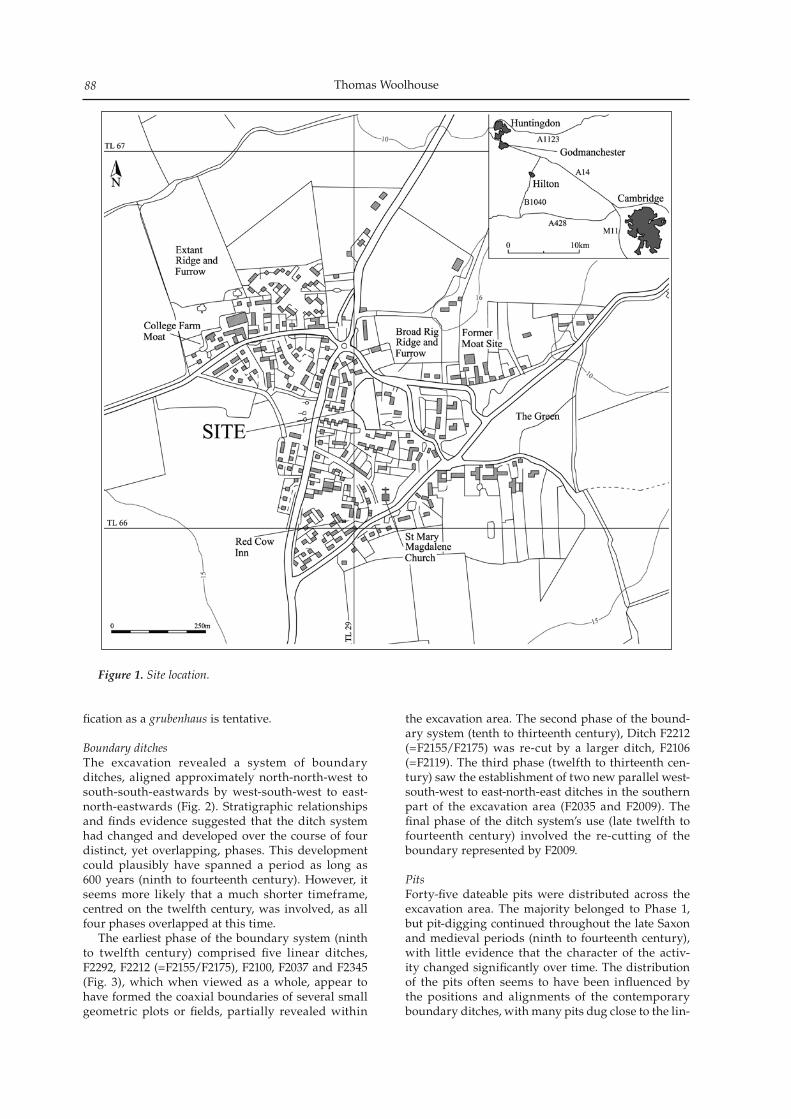
Thomas Woolhouse88
fication as a grubenhaus is tentative.
Boundary ditchesThe excavation revealed a system of boundary ditches, aligned approximately north-north-west to south-south-eastwards by west-south-west to east-north-eastwards (Fig. 2). Stratigraphic relationships and finds evidence suggested that the ditch system had changed and developed over the course of four distinct, yet overlapping, phases. This development could plausibly have spanned a period as long as 600 years (ninth to fourteenth century). However, it seems more likely that a much shorter timeframe, centred on the twelfth century, was involved, as all four phases overlapped at this time. The earliest phase of the boundary system (ninth to twelfth century) comprised five linear ditches, F2292, F2212 (=F2155/F2175), F2100, F2037 and F2345 (Fig. 3), which when viewed as a whole, appear to have formed the coaxial boundaries of several small geometric plots or fields, partially revealed within
the excavation area. The second phase of the bound-ary system (tenth to thirteenth century), Ditch F2212 (=F2155/F2175) was re-cut by a larger ditch, F2106 (=F2119). The third phase (twelfth to thirteenth cen-tury) saw the establishment of two new parallel west-south-west to east-north-east ditches in the southern part of the excavation area (F2035 and F2009). The final phase of the ditch system’s use (late twelfth to fourteenth century) involved the re-cutting of the boundary represented by F2009.
PitsForty-five dateable pits were distributed across the excavation area. The majority belonged to Phase 1, but pit-digging continued throughout the late Saxon and medieval periods (ninth to fourteenth century), with little evidence that the character of the activ-ity changed significantly over time. The distribution of the pits often seems to have been influenced by the positions and alignments of the contemporary boundary ditches, with many pits dug close to the lin-
Figure 1. Site location.
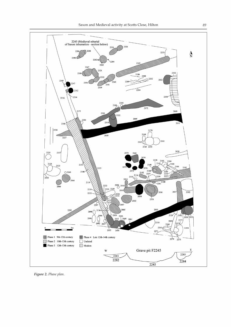
Saxon and Medieval activity at Scotts Close, Hilton 89
Figure 2. Phase plan.
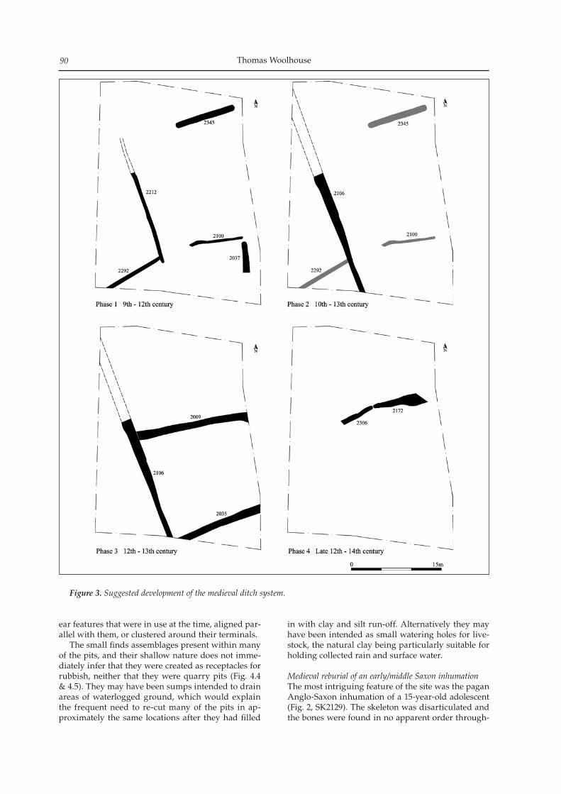
Thomas Woolhouse90
ear features that were in use at the time, aligned par-allel with them, or clustered around their terminals. The small finds assemblages present within many of the pits, and their shallow nature does not imme-diately infer that they were created as receptacles for rubbish, neither that they were quarry pits (Fig. 4.4 & 4.5). They may have been sumps intended to drain areas of waterlogged ground, which would explain the frequent need to re-cut many of the pits in ap-proximately the same locations after they had filled
in with clay and silt run-off. Alternatively they may have been intended as small watering holes for live-stock, the natural clay being particularly suitable for holding collected rain and surface water.
Medieval reburial of an early/middle Saxon inhumationThe most intriguing feature of the site was the pagan Anglo-Saxon inhumation of a 15-year-old adolescent (Fig. 2, SK2129). The skeleton was disarticulated and the bones were found in no apparent order through-
Figure 3. Suggested development of the medieval ditch system.
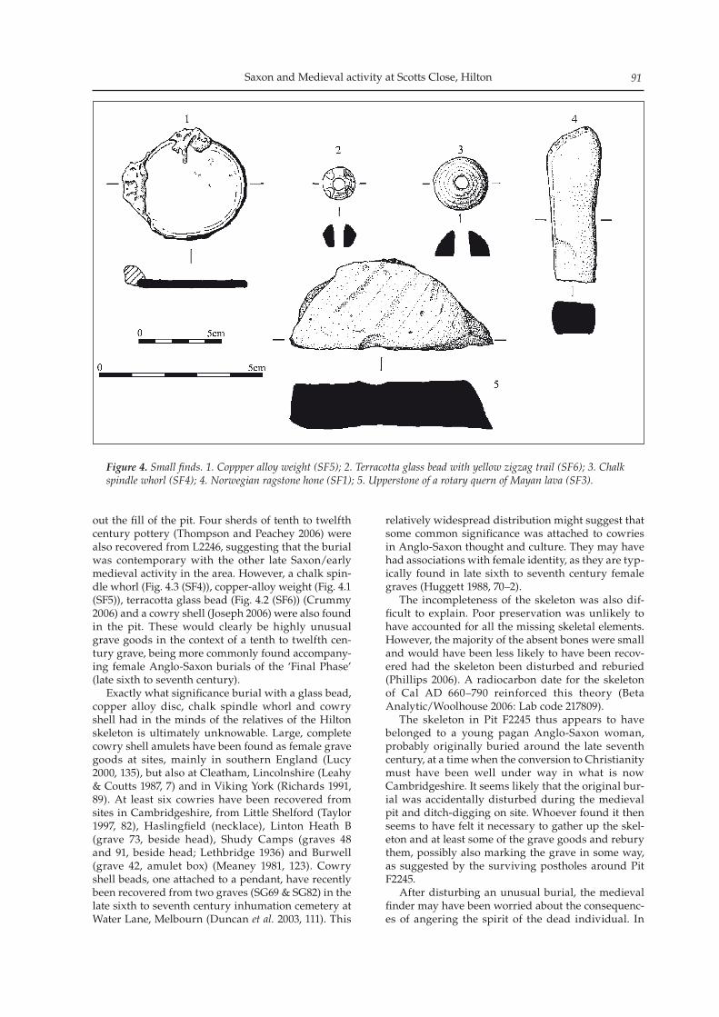
Saxon and Medieval activity at Scotts Close, Hilton 91
out the fill of the pit. Four sherds of tenth to twelfth century pottery (Thompson and Peachey 2006) were also recovered from L2246, suggesting that the burial was contemporary with the other late Saxon/early medieval activity in the area. However, a chalk spin-dle whorl (Fig. 4.3 (SF4)), copper-alloy weight (Fig. 4.1 (SF5)), terracotta glass bead (Fig. 4.2 (SF6)) (Crummy 2006) and a cowry shell (Joseph 2006) were also found in the pit. These would clearly be highly unusual grave goods in the context of a tenth to twelfth cen-tury grave, being more commonly found accompany-ing female Anglo-Saxon burials of the ‘Final Phase’ (late sixth to seventh century). Exactly what significance burial with a glass bead, copper alloy disc, chalk spindle whorl and cowry shell had in the minds of the relatives of the Hilton skeleton is ultimately unknowable. Large, complete cowry shell amulets have been found as female grave goods at sites, mainly in southern England (Lucy 2000, 135), but also at Cleatham, Lincolnshire (Leahy & Coutts 1987, 7) and in Viking York (Richards 1991, 89). At least six cowries have been recovered from sites in Cambridgeshire, from Little Shelford (Taylor 1997, 82), Haslingfield (necklace), Linton Heath B (grave 73, beside head), Shudy Camps (graves 48 and 91, beside head; Lethbridge 1936) and Burwell (grave 42, amulet box) (Meaney 1981, 123). Cowry shell beads, one attached to a pendant, have recently been recovered from two graves (SG69 & SG82) in the late sixth to seventh century inhumation cemetery at Water Lane, Melbourn (Duncan et al. 2003, 111). This
relatively widespread distribution might suggest that some common significance was attached to cowries in Anglo-Saxon thought and culture. They may have had associations with female identity, as they are typ-ically found in late sixth to seventh century female graves (Huggett 1988, 70–2). The incompleteness of the skeleton was also dif-ficult to explain. Poor preservation was unlikely to have accounted for all the missing skeletal elements. However, the majority of the absent bones were small and would have been less likely to have been recov-ered had the skeleton been disturbed and reburied (Phillips 2006). A radiocarbon date for the skeleton of Cal AD 660–790 reinforced this theory (Beta Analytic/Woolhouse 2006: Lab code 217809). The skeleton in Pit F2245 thus appears to have belonged to a young pagan Anglo-Saxon woman, probably originally buried around the late seventh century, at a time when the conversion to Christianity must have been well under way in what is now Cambridgeshire. It seems likely that the original bur-ial was accidentally disturbed during the medieval pit and ditch-digging on site. Whoever found it then seems to have felt it necessary to gather up the skel-eton and at least some of the grave goods and rebury them, possibly also marking the grave in some way, as suggested by the surviving postholes around Pit F2245. After disturbing an unusual burial, the medieval finder may have been worried about the consequenc-es of angering the spirit of the dead individual. In
Figure 4. Small finds. 1. Coppper alloy weight (SF5); 2. Terracotta glass bead with yellow zigzag trail (SF6); 3. Chalk spindle whorl (SF4); 4. Norwegian ragstone hone (SF1); 5. Upperstone of a rotary quern of Mayan lava (SF3).
Thomas Woolhouse92
early medieval thought and folklore, the evil dead could physically rise up from the grave and haunt the living. William of Newburgh (writing c. 1198) record-ed four contemporary accounts of physically active and malevolent corpses in various parts of Britain (Stevenson 1856/1996, 656–61). Whatever the motivation of those responsible for the reburial of SK2129, the skeleton and grave goods themselves are interesting for the light they shed on early–middle Saxon burial customs in the region. Although much cannot be known about the circumstances and character of the original burial, the grave goods and radiocarbon date of AD 660– 790 suggest that it belonged to the ‘Final Phase’ of pagan furnished inhumations, when the conversion to Christianity was gaining momentum and the cus-tom of accompanied burial gradually dying out.
Acknowledgements
Archaeological Solutions would like to thank Campbell, Melhuish and Buchanan Limited for their funding and cooperation of the excavation, and Woods Hardwick and Berkeley Homes for com-missioning and funding the evaluation. AS would also like to acknowledge the input and advice of Ms Kasia Gdaniec, Development Control Archaeologist for Cambridgeshire County Council County Archaeology Office (CCC CAO). Andy Thomas and Jeremy Parsons (CCC CAO) provided valuable input and advice during the evaluation stage of the project. The author is grateful to Sarah Poppy at the Cambridgeshire Historic Environment Record Office for her assistance with research.
Bibliography
Beta Analytic & T Woolhouse ‘Radiocarbon dating’ in Woolhouse T 2006 Saxon and Medieval Activity at Scotts Close, Hilton. Archaeological Excavation. AS Unpublished Report No. 2113
Crank, N, K Manning, K Nicholson and R Rennell 2004 Residential Development, Scotts Close, Hilton, Cambridgeshire: an archaeological investigation interim site narrative. AS unpublished report 1653
Crummy, N ‘Small Finds’ in Woolhouse, T 2006 Saxon and Medieval Activity at Scotts Close, Hilton. Archaeological Excavation. AS Unpublished Report No. 2113
Duncan, H, C Duhig and M Phillips 2003 ‘A Late Migration/Final Phase cemetery at Water Lane, Melbourn’, PCAS 92: 57–134
Huggett, JW 1988 ‘Imported grave goods and the early Anglo-Saxon economy’, Medieval Archaeology 32: 63–96
Joseph, J ‘The Cowry Shell’ in Woolhouse, T 2006 Saxon and Medieval Activity at Scotts Close, Hilton. Archaeological Excavation. AS Unpublished Report No. 2113
Leahy, K and CM Coutts 1987 The Lost Kingdom: the search for Anglo-Saxon Lindsey. Scunthorpe Borough Museum & Art Gallery, Scunthorpe
Lethbridge, TC 1936 A Cemetery at Shudy Camps, Cambridgeshire. Report of the excavation of a cemetery of the Christian Anglo-Saxon period in 1933. CAS Quarto Publications, New Series No. 5
Lucy, S 2000 The Anglo-Saxon Way of Death. Burial rites in early England. Sutton, Stroud
Meaney, AL 1981 Anglo-Saxon Amulets and Curing Stones. BAR British Series 96, Oxford
Mills, AD 1991 The Popular Dictionary of English Place-Names. Parragon
O’Brien, L and N Crank 2001 Scotts Close, Hilton Cambridgeshire: an archaeological desk-based assessment and field evaluation. Hertfordshire Archaeological Trust unpublished report 980
Phillips, C ‘Human Bone’ in Woolhouse, T 2006 Saxon and Medieval Activity at Scotts Close, Hilton. Archaeological Excavation. AS Unpublished Report No. 2113
Richards, JD 1991 Viking Age England. English Heritage/Batsford
Simkins, ME 1974 ‘Hilton’ in Page W, G Proby, and S Inskip Ladds (eds.) VCH Huntingdon. Vol. II. University of London Institute of Historical Research (reprint from original edition of 1932, Dawsons of Pall Mall): 315–18
Stevenson, J 1856/1996 The History of William of Newburgh. Reprint, Llanerch Publishers, Felinfach
Taylor, A 1997 Archaeology of Cambridgeshire Vol. 1: South West Cambridgeshire. Cambridgeshire County Council
Thompson, P and A Peachey ‘The Pottery’ in Woolhouse, T 2006 Saxon and Medieval Activity at Scotts Close, Hilton. Archaeological Excavation. AS Unpublished Report No. 2113
Woolhouse, T 2006 Saxon and Medieval Activity at Scotts Close, Hilton. Archaeological Excavation. AS Unpublished Report No. 2113
Excavation at this site revealed two early, possibly Saxon, features considered to represent small structures or build-ings. Later features indicated that the digging and working of clunch, a hard variety of chalk, had been carried out at this site. Dating evidence suggests that this activity contin-ued throughout much of the medieval period and indicates that this is one of the earliest identified incidences of the digging and working of clunch in Isleham. Isleham became known for its clunch industry in the early modern period.
Introduction
Between January and March 2005, Archaeological Solutions Ltd (AS) undertook a programme of ar-chaeological excavation at Fordham Road, Isleham, Cambridgeshire (NGR TL 6438 7390; Fig. 1). The project was commissioned by Hereward Housing Limited in response to a planning condition placed on the residential redevelopment of the site. The primary aim of the excavation was to preserve the archaeologi-cal evidence contained within the site by record and to attempt a reconstruction of the history and land use of the site. Full descriptions of all features and contexts, complete specialist reports and further discussion can be found in the interim report (Williamson et al. 2005) and the archive report (Newton 2006). An archaeological evaluation (Kenney 2004) carried out prior to excavation found a number of postholes, several pits, a ditch and a quarry pit, all of medieval date. Post-medieval levelling was noted at the western edge of the site. The evaluation suggested that the site represented an early medieval croft, similar to later examples known from elsewhere in Isleham.
The site
The site is located at the southern end of the histor-ic core of the village of Isleham. The excavation site occupied the eastern part of the area that was to be developed. It consisted of a sub rectangular area of approximately 1800m2 aligned north-west to south-east. The site was bounded by Fordham and Station
Roads but separated from both by a narrow strip of land approximately 1.5m wide. The central part of the site was slightly reduced in size to comply with a 10m exclusion zone surrounding a live Transco Gas sub-station. The village of Isleham is located at the south-eastern edge of the Cambridgeshire fens, close to the foot of the Lower Cretaceous Chalk ridge, which runs along the south of the county before sweeping north-wards into Norfolk (Hall 1996). The chalk ridge rises from the fens to c. 11m OD at the site; the surround-ing fenland lies partly on Lower Cretaceous Chalk, and partly on Gault Clay. This solid geology is over-lain by the chalky drift and chalk-derived soils of the Wantage 2 association (Soil Survey of England and Wales 1983a & b).
Results
Phase 1: Undated Features and Features of eleventh to twelfth century date
The features assigned to Phase 1 were dateable as eleventh to twelfth century in origin. Also regarded as being of Phase 1 are two undated features whose characteristics suggest that they may significantly predate other features assigned to this phase. These features were assigned to Phase 1 on the basis of their stratigraphic relationships to Phase 2 features; neither contained datable finds.
Undated Phase 1 featuresThe first of the undated Phase 1 structures (S1330), although severely truncated, was rectangular in plan with a steep sided, flat-based profile, suggesting that it was a Sunken-Featured Building (SFB) or grubenhaus. The lower fills of the structure were markedly layered and are interpreted as successive floor and occupa-tion deposits. These were overlain by a final backfill. The feature was cut by a number of later features, in-dicating that it was constructed prior to the twelfth century.
A medieval clunch-working site at Fordham Road, Isleham, Cambridgeshire
Andrew A. S. Newton
Proceedings of the Cambridge Antiquarian Society XCVIX pp. 103–112
Andrew Newton94
Figure 1. Site location.
A medieval clunch-working site at Fordham Road, Isleham 95
Figu
re 2
. Pha
se p
lan.
Andrew Newton96
The second Phase 1 feature lay at the north-west-ern end of the site. This feature, F1670, was semi-cir-cular in plan though its full form was not identifiable as it extended beyond the limits of the excavated area. It consisted of a gully or foundation trench surround-ing three successive floor layers. The lowest of these layers (L1474) was of rammed chalk. This was over-lain by a floor composed of reused Roman ceramic building materials (L1439), which was in turn sealed by a second rammed chalk layer (L1438). The two undated Phase 1 features represent activ-ity prior to the use of the site for industrial clunch extraction and processing. No evidence exists to de-termine whether these features were contemporary with one another; they were in different parts of the site and shared no stratigraphic relationship. Their morphology, construction and possible uses suggest that they are not the kind of structures that would be found on an industrial site and may therefore be considered to be significantly earlier than other Phase 1 features. These features appear to represent build-ings used for occupation or storage. The semi-circular shape and the re-use of Roman tile in F1670 mark it as an unusual and slightly enigmatic feature; its func-tion remains uncertain without investigation of the portion of it that lay beyond the limits of the excava-tion area.
Eleventh to twelfth century Phase 1 structuresTwo possible buildings were represented by datable Phase 1 features. These were S1029, a post built struc-ture located towards the south-eastern end of the site and S1614, a second sunken-featured building located
at the north-western end. S1029 (Fig. 3) comprised 16 postholes (F1114, F1138, F1155, F1153, F1176, F1251, F1144, F1161, F1118, F1116, F1159, F1112, F1076, F1074, F1072 and F1070) which formed the plan of a rectangular structure, measur-ing approximately 7.4 x 4.3m, with possible internal subdivisions. It is thought that the western wall of this structure was rebuilt slightly later, suggesting repairs or alteration, and indicating that it was still standing, and in use, during the second phase of ac-tivity at the site. The position of the building, within the later Phase 2 enclosure reinforces this notion. On the basis of the size, depth and location of the post-holes, it is likely that building S1029 was similar in construction to the archaic timber framing of the 13th century, with straight timbers strengthened by cross bracing (Wood 1981, 222). To the south-west of building S1029 were two fur-ther lines of postholes (see Fig. 3). These ran paral-lel to one another and parallel/perpendicular to the walls of the building and are considered to represent fence lines. A further fence line may have existed sub-dividing the space between the building and one of the features comprising part of the Phase 2 enclosure. The sub-rectangular plan, steeply sloping sides and almost-flat base mark S1614 as a possible Sunken-Featured Building, though its date would indicates that it was not a grubenhaus of the Anglo-Saxon tradi-tion. The primary fill of this feature (L1617) has been interpreted as the initial accumulation of a silty de-posit in the space beneath the building’s suspended floor; the ten sherds of pottery recovered from this deposit may have fallen through gaps in the floor. The
Figure 3. Plan of post-built structure and fence lines.
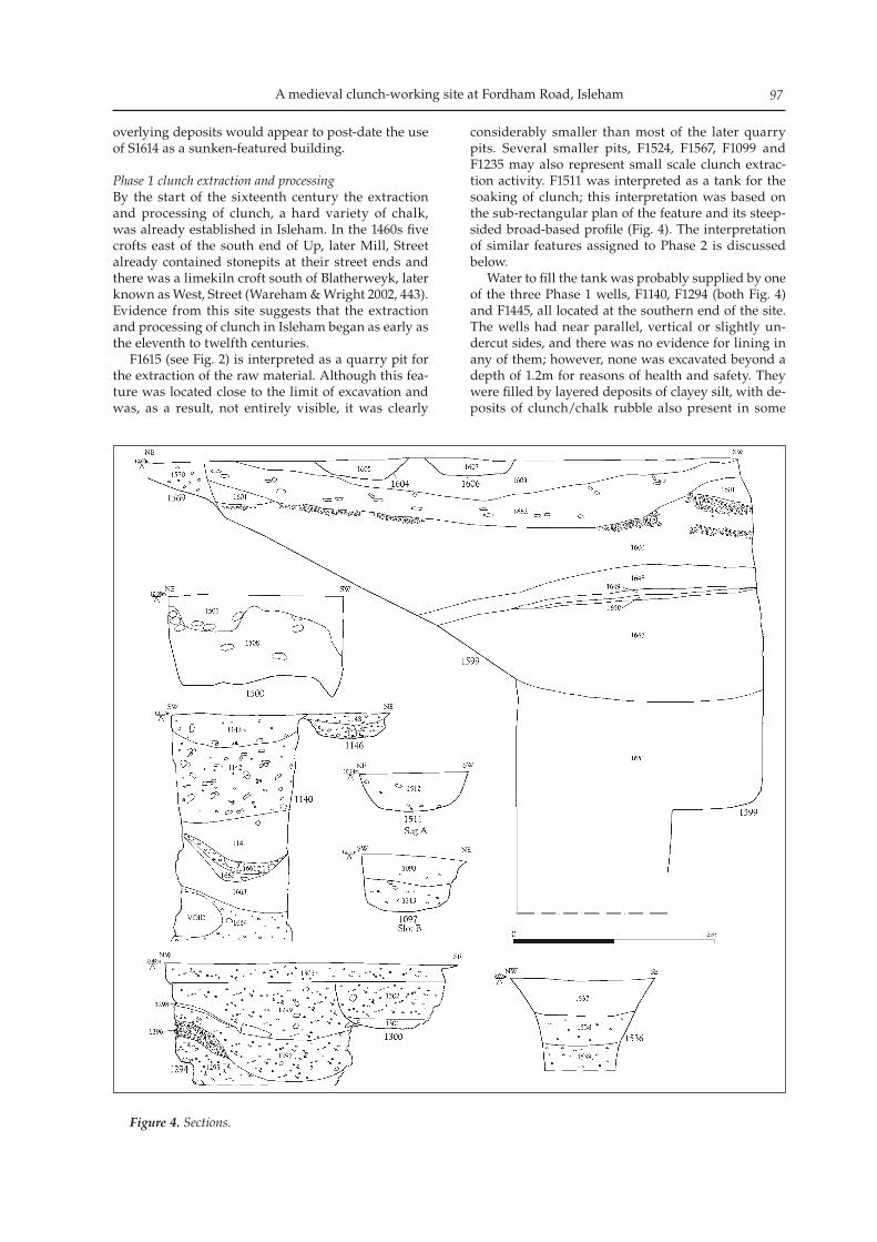
A medieval clunch-working site at Fordham Road, Isleham 97
overlying deposits would appear to post-date the use of S1614 as a sunken-featured building.
Phase 1 clunch extraction and processingBy the start of the sixteenth century the extraction and processing of clunch, a hard variety of chalk, was already established in Isleham. In the 1460s five crofts east of the south end of Up, later Mill, Street already contained stonepits at their street ends and there was a limekiln croft south of Blatherweyk, later known as West, Street (Wareham & Wright 2002, 443). Evidence from this site suggests that the extraction and processing of clunch in Isleham began as early as the eleventh to twelfth centuries. F1615 (see Fig. 2) is interpreted as a quarry pit for the extraction of the raw material. Although this fea-ture was located close to the limit of excavation and was, as a result, not entirely visible, it was clearly
considerably smaller than most of the later quarry pits. Several smaller pits, F1524, F1567, F1099 and F1235 may also represent small scale clunch extrac-tion activity. F1511 was interpreted as a tank for the soaking of clunch; this interpretation was based on the sub-rectangular plan of the feature and its steep-sided broad-based profile (Fig. 4). The interpretation of similar features assigned to Phase 2 is discussed below. Water to fill the tank was probably supplied by one of the three Phase 1 wells, F1140, F1294 (both Fig. 4) and F1445, all located at the southern end of the site. The wells had near parallel, vertical or slightly un-dercut sides, and there was no evidence for lining in any of them; however, none was excavated beyond a depth of 1.2m for reasons of health and safety. They were filled by layered deposits of clayey silt, with de-posits of clunch/chalk rubble also present in some
Figure 4. Sections.
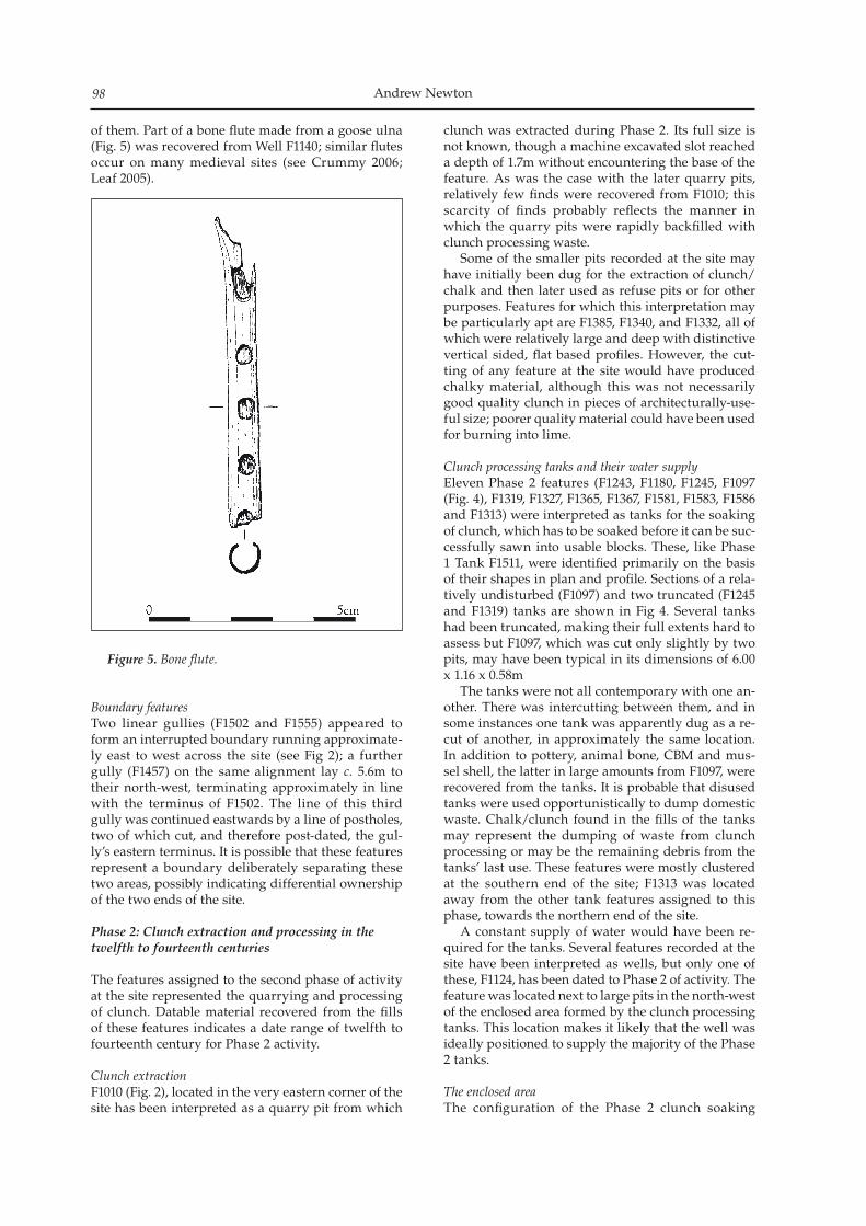
Andrew Newton98
of them. Part of a bone flute made from a goose ulna (Fig. 5) was recovered from Well F1140; similar flutes occur on many medieval sites (see Crummy 2006; Leaf 2005).
Boundary featuresTwo linear gullies (F1502 and F1555) appeared to form an interrupted boundary running approximate-ly east to west across the site (see Fig 2); a further gully (F1457) on the same alignment lay c. 5.6m to their north-west, terminating approximately in line with the terminus of F1502. The line of this third gully was continued eastwards by a line of postholes, two of which cut, and therefore post-dated, the gul-ly’s eastern terminus. It is possible that these features represent a boundary deliberately separating these two areas, possibly indicating differential ownership of the two ends of the site.
Phase 2: Clunch extraction and processing in the twelfth to fourteenth centuries
The features assigned to the second phase of activity at the site represented the quarrying and processing of clunch. Datable material recovered from the fills of these features indicates a date range of twelfth to fourteenth century for Phase 2 activity.
Clunch extractionF1010 (Fig. 2), located in the very eastern corner of the site has been interpreted as a quarry pit from which
clunch was extracted during Phase 2. Its full size is not known, though a machine excavated slot reached a depth of 1.7m without encountering the base of the feature. As was the case with the later quarry pits, relatively few finds were recovered from F1010; this scarcity of finds probably reflects the manner in which the quarry pits were rapidly backfilled with clunch processing waste. Some of the smaller pits recorded at the site may have initially been dug for the extraction of clunch/chalk and then later used as refuse pits or for other purposes. Features for which this interpretation may be particularly apt are F1385, F1340, and F1332, all of which were relatively large and deep with distinctive vertical sided, flat based profiles. However, the cut-ting of any feature at the site would have produced chalky material, although this was not necessarily good quality clunch in pieces of architecturally-use-ful size; poorer quality material could have been used for burning into lime.
Clunch processing tanks and their water supplyEleven Phase 2 features (F1243, F1180, F1245, F1097 (Fig. 4), F1319, F1327, F1365, F1367, F1581, F1583, F1586 and F1313) were interpreted as tanks for the soaking of clunch, which has to be soaked before it can be suc-cessfully sawn into usable blocks. These, like Phase 1 Tank F1511, were identified primarily on the basis of their shapes in plan and profile. Sections of a rela-tively undisturbed (F1097) and two truncated (F1245 and F1319) tanks are shown in Fig 4. Several tanks had been truncated, making their full extents hard to assess but F1097, which was cut only slightly by two pits, may have been typical in its dimensions of 6.00 x 1.16 x 0.58m The tanks were not all contemporary with one an-other. There was intercutting between them, and in some instances one tank was apparently dug as a re-cut of another, in approximately the same location. In addition to pottery, animal bone, CBM and mus-sel shell, the latter in large amounts from F1097, were recovered from the tanks. It is probable that disused tanks were used opportunistically to dump domestic waste. Chalk/clunch found in the fills of the tanks may represent the dumping of waste from clunch processing or may be the remaining debris from the tanks’ last use. These features were mostly clustered at the southern end of the site; F1313 was located away from the other tank features assigned to this phase, towards the northern end of the site. A constant supply of water would have been re-quired for the tanks. Several features recorded at the site have been interpreted as wells, but only one of these, F1124, has been dated to Phase 2 of activity. The feature was located next to large pits in the north-west of the enclosed area formed by the clunch processing tanks. This location makes it likely that the well was ideally positioned to supply the majority of the Phase 2 tanks.
The enclosed areaThe configuration of the Phase 2 clunch soaking
Figure 5. Bone flute.
A medieval clunch-working site at Fordham Road, Isleham 99
tanks (except for F1313) suggests that they formed the north-east and north-west sides of an enclosure at the south eastern end of the site. The south-east side of this enclosure was formed by ditch F1110. It is possible that Phase 1 Structure S1029 was still standing when the enclosure was constructed around it. Certain pits within the enclosure, to the east of Structure S1029, contained finds assemblages consistent with the deposition of domestic refuse (c.f. Phillips 2006). It seems unlikely that there was a sole-ly domestic structure in this location; it is more likely that the building was used by the people working at the site, perhaps for administration, possibly for temporary occupation, and almost certainly for the preparation and/or consumption of meals, but that no one lived in it on a permanent basis.
Phase 3: Continuation of clunch-working in the 14th to 16th centuries
Quarry PitsThree large Phase 3 quarry pits (F1599, F1665 and F1667) were identified around the perimeter of the site. Two further, undated, quarry pits may have been contemporary with these. Because the Phase 3 quarry pits extended beyond the excavated area, their full extents were not apparent, but all were conspicuous-ly large in plan (up to 8.5 x 7.5m). The large size of these features was matched by their depth; F1599 was found by machine excavation to be more than 4.5m deep (Fig. 4). Most of the quarry pits contained multiple lay-ered fills, many of which comprised large amounts of chalk/clunch rubble. This probably represents waste material from the clunch processing carried out at the site deliberately used to back fill the quarry pits, pos-sibly when they were abandoned having become too large for safe quarrying. Some quarry pit fills, such as L1648 in Pit F1599, may represent episodes of natu-ral silting. Few finds were recovered from the quarry pits, although surprisingly large pottery assemblages were recovered, without excavation, from the upper slump fills of F1665 and F1667.
WellsFour of the features assigned to Phase 3 (F1536 (Fig. 4), F1500 (Fig. 4), F1487 and F1552) were considered to be wells. These features were circular or sub-circular in plan but, like the quarry pits, were too deep to safely excavate in full. Despite the presence of more wells and more quarry pits in Phase 3 than in any of the preceding phases, possibly suggesting that more clunch was being extracted and processed at the site, there are no Phase 3 features representing clunch processing tanks. This may represent a shift away from soaking clunch in features cut into the ground, possibly to the use of wooden vats or similar objects for this stage of the process. An alternative explana-tion may be that Phase 3 clunch soaking tanks were present at the site but exist outside of the limits of the excavated area.
Discussion
The development of the Fordham Road clunch working siteThe dated features assigned to Phases 1, 2 and 3 attest a site where the quarrying and processing of clunch was carried out. The picture of events represented by these features appears to demonstrate the develop-ment of the site from apparent small scale industrial activity to a seemingly more complex operation. The dating and stratigraphic evidence indicates that activ-ity was carried out during a period from the eleventh to sixteenth century. The site represents a significant medieval precursor to the later clunch extraction and lime-burning industries for which Isleham became known (Williamson et al. 2005, 62). The size of the six large quarry pits demonstrates that during the lifespan of the site, a considerable amount of clunch was extracted. It appears that clunch extraction start-ed at the site with the excavation of a smaller quarry pit during Phase 1, before techniques, or market forc-es, allowed, or demanded, extraction on a larger scale in later phases. Phase 3 appears to represent the peak of clunch extraction at this site. Clunch is easily workable with a large-toothed, two-handled saw when it is wet but it hardens as it dries. After extraction, the clunch was moved to the tanks for soaking. The processing tanks would have required constant supplies of water, presumably sup-plied by the six wells identified at the site. Only one Phase 1 tank has been identified, supporting the no-tion that clunch processing was a small scale industry at this time. The water supply for this tank may have come from one of the three Phase 1 wells located at the opposite end of the site. This would seem to be a problematic arrangement due to the distance water would have had to have been carried. It is, however, possible that further wells of a Phase 1 date exist be-yond the limits of the excavated area. The logistics of water supply appear to have been arranged more effectively during Phase 2. All but one of the clunch soaking tanks dated to this period are clustered at the southern end of the site, with the single Phase 2 well located close-by. Water may have drained easily from the processing tanks as they were dug into the porous chalk geology of the site. It is possible that they were lined with leather or tight wickerwork to counter this, although no signs of any lining were encountered during excavation. There are no clunch soaking tanks dated to Phase 3, despite an apparent increase in the quantity of clunch being extracted. This may suggest that the excavated tanks were replaced with wooden vats or similar containers. Several of the Phase 2 clunch processing tanks form two sides of an enclosure that contained the Phase 1 post-built building, S1029. There is evidence to suggest that this building was still in use when the tanks forming the enclosure were dug. Muir (2004, 216) states that at old quarry sites a search should be made for an administrative area, where stone was stacked prior to removal; it seems possible that this was one of the functions of S1029.
Andrew Newton100
The Clunch quarrying industry in the medieval periodThe only industries that developed to any magnitude during the medieval period in England were the pri-mary crafts of cloth-making and building (Holmes 1974, 37). By extension, developments in building would have created pressure on the quarrying in-dustries of medieval England to improve techniques and output. Any small medieval community that had access to a supply of passable building stone would have a local quarry. The stone could be of low qual-ity but would be exploited nonetheless (Muir 2004, 216). However, French stone, perhaps most notably from Caen, originally imported for Norman building projects, continued to be imported until the late 1440s despite the development of the English quarrying in-dustry (Parsons 1990, 9). The Victoria County History indicates that clunch quarrying was carried out in Isleham from the me-dieval period onwards stating that “in the 1460s five crofts east of the south end of Up, later Mill, Street…already contained stonepits at their street ends” (Wareham & Wright 2002, 443). This strongly sug-gests that the Fordham Road site, with an earliest date of c. eleventh century, may represent one of the earlier clunch extraction sites in Isleham. Clunch was already in common use, mainly in the areas close to its sources, at around the same time quarrying ap-pears to have been started at the Fordham Road site (Harris 1990). Isleham, along with Cherry Hinton, Reach and Burwell, formed one of two main groups of clunch quarries in Cambridgeshire (Purcell 1967, 26). The best clunch for use as a building material is considered to be that from the Burwell clunch beds (Purcell 1967, 25). Nearly all of Cambridge’s pre-1500 stone build-ings were of clunch (Clifton Taylor 1972, 63). Clunch was also used in the building of Ely Cathedral (Darby 1977, 43) and Dunstable Priory in Bedfordshire, built in 1132 (Harris 1990). The effectiveness of clunch as a building material is compromised as it erodes com-paratively quickly. Many of the medieval clunch-built buildings in Cambridge eventually had to be re-faced. Christ’s College, built of alternating courses of brick and clunch in the sixteenth century, eroded so badly that its appearance reportedly deterred people from entering their sons at the college (Clifton Taylor 1972, 63). However, due to its softness clunch can be eas-ily carved; it lends itself well to sculpture and there are several examples of its use for internal decorative work. A number of the older Cambridge colleges have sixteenth and seventeenth century fireplaces carved from clunch but some of the finest examples can be seen in the fourteenth century Lady Chapel and the Chantry chapels of Bishops Alcock and West in Ely Cathedral as well as in the churches of Burwell and Isleham (Purcell 1967, 28).
Isleham’s clunch industries: their role in the settlement’s economyAlthough Harris (1990) states that clunch was used commonly in the twelfth century in areas close to its sources, an eleventh century date for the start of
clunch extraction activity at Fordham Road may in-dicate that it was one of the earlier sites of industrial extraction of the material. This may be why the ex-traction techniques displayed at the Fordham Road site appear to be somewhat primitive in comparison to those used later at the clunch quarries at Totternhoe in Bedfordshire, which produced stone similar to that from Burwell, where a system of adits was cut in to the rock face (Roberts 1974). The chalk and flint mines of Norwich started initially in the eleventh or twelfth century based on an opencast system of stone extrac-tion but eventually methods changed and tunnelling into the strata became the preferred approach. That clunch extraction at Fordham Road did not follow this pattern of development may have more to do with the positioning of the clunch deposits in relation to the surface but it may also indicate that clunch extraction at Fordham Road remained a relatively small-scale activity throughout the duration of the site’s use for this purpose. Clunch extraction at Fordham Road may have re-mained a comparatively small scale endeavour due to economic factors; Isleham was competing with other fen-edge settlements all with similar resources and access to the fenland waterways that made rising above the others on an economic and financial basis difficult (Oosthuizen 1993). Additionally, the main markets for clunch, the big towns and regional cen-tres, where major building works were carried out, all had other sources of the material much closer than Isleham, suggesting that the output from Fordham Road was only sold on a particularly localised mar-ket. The Medieval manorial land holding system sug-gests that any industrial activity was probably con-trolled by the lords of the manor, which in the case of Isleham may have, at varying times, been a lay indi-vidual or one of the religious establishments that held land in the village. It is possible that manorial con-trol took the form of issuing clunch working crofts to tenants; in Reach, where Ely Priory owned land, priory tenants were, from the 1420s, given leave to dig clunch in crofts located close to limekilns rented out by the priory (Wareham & Wright 2002, 226). Such a state of affairs at the Fordham Road site is suggested by the presence of the possible Phase 1 boundary fea-tures. The founding of Isleham Priory in the early twelfth century coincides with the start of Phase 2 activity at the site and a shift from what appears to be quite small scale activity to what appears to be a more efficiently organised and probably larger scale operation. This raises the possibility that clunch was extracted from Fordham Road for the construction of the priory buildings. The only surviving part of the priory, Isleham Chapel, is constructed of clunch set in a herringbone pattern (Wareham & Wright 2002, 447) and it seems reasonable to suggest that other priory buildings would have been of similar construction. It is therefore extremely possible that the already-existing clunch working site at Fordham Road was identified as a source of materials for the new priory
A medieval clunch-working site at Fordham Road, Isleham 101
and this provided the financial impetus that allowed it to develop from the 12th century onwards. How the quarry remained operating, and indeed contin-ued to develop, after the priory moved to Linton in the early thirteenth century is difficult to identify. It may have continued to supply stone for the repair of existing priory buildings or for other local building projects, but its distance from centres such as Ely and Cambridge, and the proximity of other clunch pro-ducing settlements to these places, probably restrict-ed the use of Isleham clunch in these towns. There was, however, evidently enough demand to keep the Fordham Road site producing clunch until the end of the medieval period and the beginning of the post-medieval period when other clunch producing sites in Isleham came to the fore.
In conclusionThe main research value of the site lies in the infor-mation that it provides regarding the development of medieval Isleham and of the medieval clunch in-dustry in this part of Cambridgeshire. The role of the clunch-working site at Fordham Road in the local economy does not appear to have been one of mon-umental importance but the site adds much to the understanding of the character of medieval Isleham. Its presence suggests that clunch-working was estab-lished in the settlement possibly significantly earlier than previously considered. The lower end of the date range established for Phase 2 features coincides with some of the earliest dates mentioned for the use of clunch in the East Anglia region. This suggests that there was a local market, at least, for clunch quarried in Isleham at this time. Given the ecclesiastical pres-ence in Isleham throughout the medieval period, it seems likely that there must have been a connection between the clunch-working site at Fordham Road and the estate and buildings of the Church.
Acknowledgements
Archaeological Solutions Ltd is grateful to Hereward Housing Limited for commissioning and funding this project, and in particular Ms. Sarah Brind for all her help and assistance during the archaeological in-vestigation. AS is grateful to Mr Quinton Carroll (Cambridgeshire Historic Environment Record) for his assistance and input, and also the staff at the Cambridge County Record Office. AS would like to ac-knowledge the input and advice of Ms Kasia Gdaniec, Development Control Archaeologist, Cambridgeshire County Council County Archaeology Office. The flint from the site was analysed by Martin Tingle, the pottery by Peter Thompson, the ceramic building materials by Andrew Peachey, the small finds and metalwork by Nina Crummy, the slag by Jane Cowgill, the animal bone and shell by Carina Phillips and the environmental samples by Val Fryer. The excavation was directed by Iain Williamson and managed by Jon Murray, both on behalf of AS.
Finds were co-ordinated by Claire Wallace.Author: Andrew A. S. Newton, Archaeological Solutions Ltd, 98-100 Fore St, Hertford, SG14 1AB
Bibliography
Clifton-Taylor, A 1972, The Pattern of English Building, London: Faber,
Crummy, N 2006, ‘The Small Finds and bulk metalwork’ in A A S Newton, Archaeological Excavations at Fordham Road, Isleham, Cambridgeshire, Archaeological Solutions unpublished report no. 2090
Darby, H C 1977, Medieval Cambridgeshire, Cambridge: Oleander Press
Hall, D 1996, The Fenland Project, Number 10; Cambridgeshire Survey, Isle of Ely and Wisbech, Cambridge: EAA 79/Cambridgeshire County Council
Harris, A P 1990, ‘Building Stone in Norfolk’ in D. Parsons (ed.) Stone: Quarrying and Building in England, AD43–1525, London: Phillimore in association with the Royal Archaeological Institute
Holmes, G 1974, The Later Middle Ages 1272–1485, London: Cardinal
Kenney, S 2004, A Medieval Croft at the Former Allotments, Fordham Road, Isleham: An Archaeological Evaluation, Cambridgeshire County Council Archaeological Field Unit unpublished report no. 756
Leaf, H 2005, Medieval Flutes. Paper given at Cambridge University Conference: Breaking & Shaping Beastly Bodies. Animals as Material Culture in the Middle Ages. March 2005
Muir, R 2004, Landscape Encyclopaedia: A reference guide to the historic landscape, Macclesfield: Windgather Press
Newton, A A S 2006, Archaeological Excavations at Fordham Road, Isleham, Cambridgeshire, Archaeological Solutions unpublished report no. 2090
Oosthuizen, S 1993, ‘Isleham: a medieval inland port’, Landscape History 15; 29-35
Parsons, D 1990, ‘Review & Prospect: The Stone Industry in Roman, Anglo-Saxon and Medieval England’ in D. Parsons (ed.) Stone: Quarrying and Building in England, AD43–1525, London: Phillimore in association with the Royal Archaeological Institute
Phillips, C 2006, ‘The animal bone’ in A A S Newton, Archaeological Excavations at Fordham Road, Isleham, Cambridgeshire, Archaeological Solutions unpublished report no. 2090
Purcell, D 1967, Cambridge Stone, London: Faber & FaberRoberts, E 1974, ‘Totternhoe Stone and Flint in
Hertfordshire Churches’, Medieval Archaeology 18; 66-89Soil Survey of England and Wales 1983, Sheet 4:Soils of
Eastern England. (Scale 1:250 000) HarpendenSoil Survey of England and Wales 1983, Legend for the
1:250,000 Soil Map of England and Wales, HarpendenWareham, A F & A P M Wright 2002, VCH Cambridge and
the Isle of Ely, Vol. 10, Oxford: The Institute of Historical Research/Oxford University Press
Williamson, I, K Doyle, K Nicholson & T Collins 2005, Fordham Road, Isleham, Cambridge; an Interim Report, Archaeological Solutions Ltd unpublished report no. 1870

Andrew Newton102
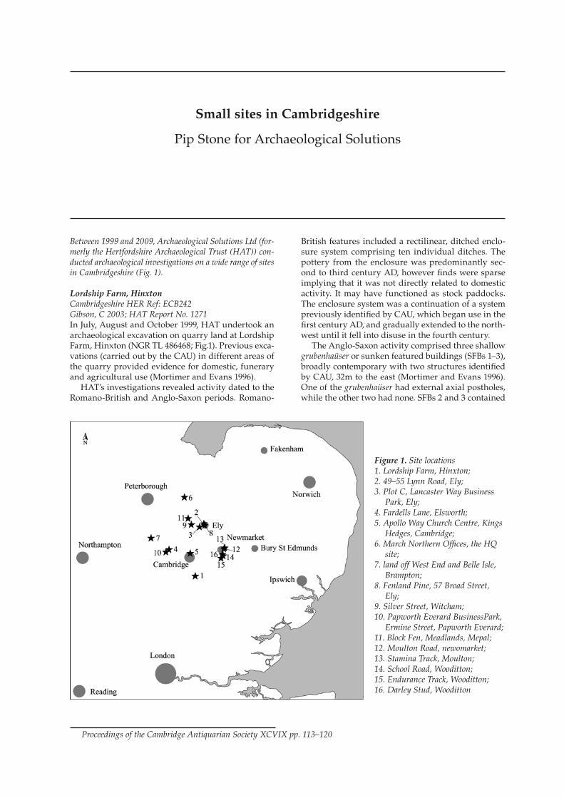
Between 1999 and 2009, Archaeological Solutions Ltd (for-merly the Hertfordshire Archaeological Trust (HAT)) con-ducted archaeological investigations on a wide range of sites in Cambridgeshire (Fig. 1).
Lordship Farm, HinxtonCambridgeshire HER Ref: ECB242Gibson, C 2003; HAT Report No. 1271In July, August and October 1999, HAT undertook an archaeological excavation on quarry land at Lordship Farm, Hinxton (NGR TL 486468; Fig.1). Previous exca-vations (carried out by the CAU) in different areas of the quarry provided evidence for domestic, funerary and agricultural use (Mortimer and Evans 1996). HAT’s investigations revealed activity dated to the Romano-British and Anglo-Saxon periods. Romano-
British features included a rectilinear, ditched enclo-sure system comprising ten individual ditches. The pottery from the enclosure was predominantly sec-ond to third century AD, however finds were sparse implying that it was not directly related to domestic activity. It may have functioned as stock paddocks. The enclosure system was a continuation of a system previously identified by CAU, which began use in the first century AD, and gradually extended to the north-west until it fell into disuse in the fourth century. The Anglo-Saxon activity comprised three shallow grubenhaüser or sunken featured buildings (SFBs 1–3), broadly contemporary with two structures identified by CAU, 32m to the east (Mortimer and Evans 1996). One of the grubenhaüser had external axial postholes, while the other two had none. SFBs 2 and 3 contained
Small sites in Cambridgeshire
Pip Stone for Archaeological Solutions
Proceedings of the Cambridge Antiquarian Society XCVIX pp. 113–120
Figure 1. Site locations1. Lordship Farm, Hinxton;2. 49–55 Lynn Road, Ely;3. Plot C, Lancaster Way Business
Park, Ely;4. Fardells Lane, Elsworth;5. Apollo Way Church Centre, Kings
Hedges, Cambridge;6. March Northern Offices, the HQ
site;7. land off West End and Belle Isle,
Brampton;8. Fenland Pine, 57 Broad Street,
Ely;9. Silver Street, Witcham;10. Papworth Everard BusinessPark,
Ermine Street, Papworth Everard;11. Block Fen, Meadlands, Mepal;12. Moulton Road, newomarket;13. Stamina Track, Moulton;14. School Road, Wooditton;15. Endurance Track, Wooditton;16. Darley Stud, Wooditton
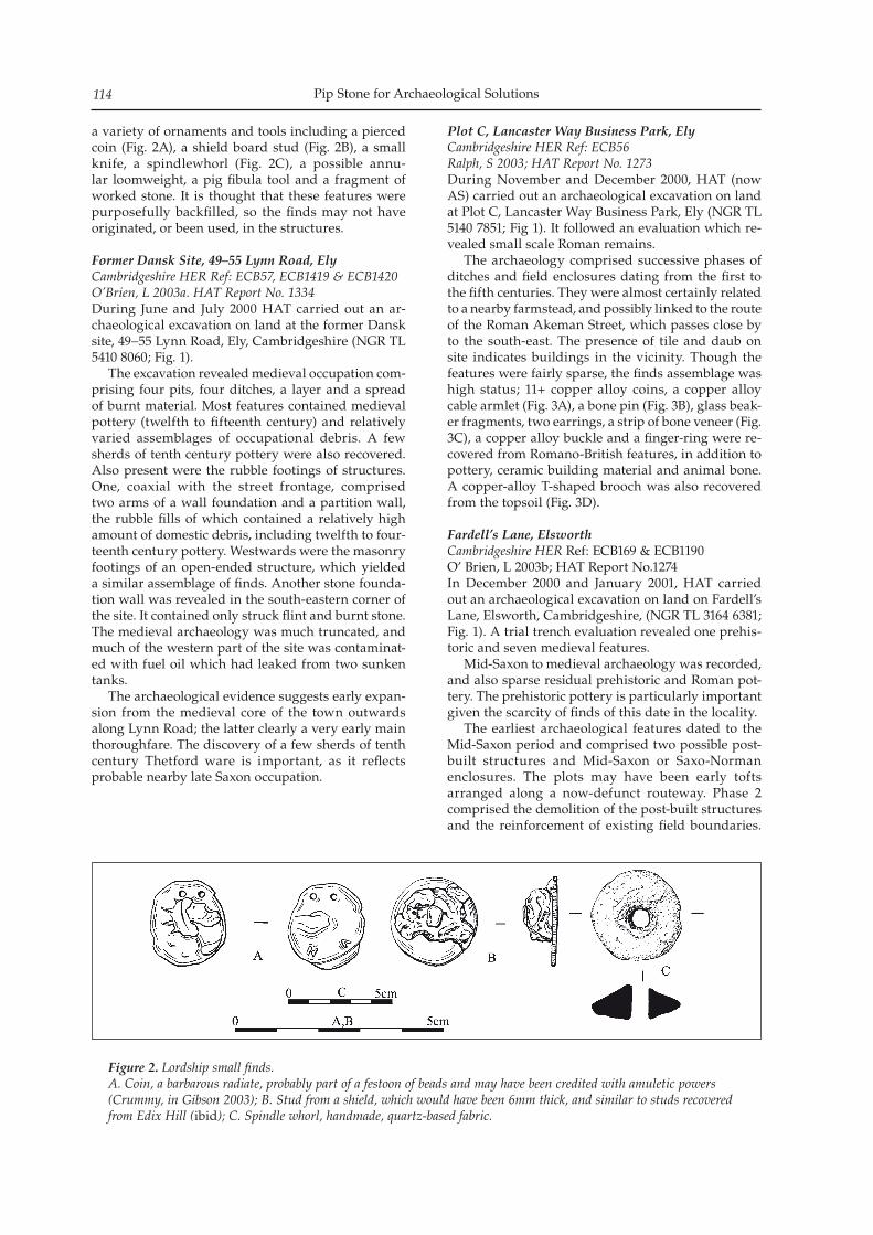
Pip Stone for Archaeological Solutions114
a variety of ornaments and tools including a pierced coin (Fig. 2A), a shield board stud (Fig. 2B), a small knife, a spindlewhorl (Fig. 2C), a possible annu-lar loomweight, a pig fibula tool and a fragment of worked stone. It is thought that these features were purposefully backfilled, so the finds may not have originated, or been used, in the structures.
Former Dansk Site, 49–55 Lynn Road, ElyCambridgeshire HER Ref: ECB57, ECB1419 & ECB1420O’Brien, L 2003a. HAT Report No. 1334During June and July 2000 HAT carried out an ar-chaeological excavation on land at the former Dansk site, 49–55 Lynn Road, Ely, Cambridgeshire (NGR TL 5410 8060; Fig. 1). The excavation revealed medieval occupation com-prising four pits, four ditches, a layer and a spread of burnt material. Most features contained medieval pottery (twelfth to fifteenth century) and relatively varied assemblages of occupational debris. A few sherds of tenth century pottery were also recovered. Also present were the rubble footings of structures. One, coaxial with the street frontage, comprised two arms of a wall foundation and a partition wall, the rubble fills of which contained a relatively high amount of domestic debris, including twelfth to four-teenth century pottery. Westwards were the masonry footings of an open-ended structure, which yielded a similar assemblage of finds. Another stone founda-tion wall was revealed in the south-eastern corner of the site. It contained only struck flint and burnt stone. The medieval archaeology was much truncated, and much of the western part of the site was contaminat-ed with fuel oil which had leaked from two sunken tanks. The archaeological evidence suggests early expan-sion from the medieval core of the town outwards along Lynn Road; the latter clearly a very early main thoroughfare. The discovery of a few sherds of tenth century Thetford ware is important, as it reflects probable nearby late Saxon occupation.
Plot C, Lancaster Way Business Park, ElyCambridgeshire HER Ref: ECB56Ralph, S 2003; HAT Report No. 1273During November and December 2000, HAT (now AS) carried out an archaeological excavation on land at Plot C, Lancaster Way Business Park, Ely (NGR TL 5140 7851; Fig 1). It followed an evaluation which re-vealed small scale Roman remains. The archaeology comprised successive phases of ditches and field enclosures dating from the first to the fifth centuries. They were almost certainly related to a nearby farmstead, and possibly linked to the route of the Roman Akeman Street, which passes close by to the south-east. The presence of tile and daub on site indicates buildings in the vicinity. Though the features were fairly sparse, the finds assemblage was high status; 11+ copper alloy coins, a copper alloy cable armlet (Fig. 3A), a bone pin (Fig. 3B), glass beak-er fragments, two earrings, a strip of bone veneer (Fig. 3C), a copper alloy buckle and a finger-ring were re-covered from Romano-British features, in addition to pottery, ceramic building material and animal bone. A copper-alloy T-shaped brooch was also recovered from the topsoil (Fig. 3D).
Fardell’s Lane, ElsworthCambridgeshire HER Ref: ECB169 & ECB1190O’ Brien, L 2003b; HAT Report No.1274In December 2000 and January 2001, HAT carried out an archaeological excavation on land on Fardell’s Lane, Elsworth, Cambridgeshire, (NGR TL 3164 6381; Fig. 1). A trial trench evaluation revealed one prehis-toric and seven medieval features. Mid-Saxon to medieval archaeology was recorded, and also sparse residual prehistoric and Roman pot-tery. The prehistoric pottery is particularly important given the scarcity of finds of this date in the locality. The earliest archaeological features dated to the Mid-Saxon period and comprised two possible post-built structures and Mid-Saxon or Saxo-Norman enclosures. The plots may have been early tofts arranged along a now-defunct routeway. Phase 2 comprised the demolition of the post-built structures and the reinforcement of existing field boundaries.
Figure 2. Lordship small finds.A. Coin, a barbarous radiate, probably part of a festoon of beads and may have been credited with amuletic powers (Crummy, in Gibson 2003); B. Stud from a shield, which would have been 6mm thick, and similar to studs recovered from Edix Hill (ibid); C. Spindle whorl, handmade, quartz-based fabric.
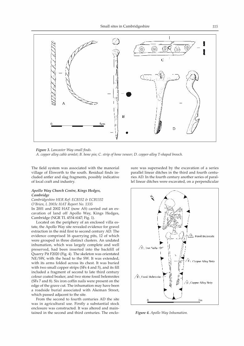
Small sites in Cambridgeshire 115
The field system was associated with the manorial village of Elsworth to the south. Residual finds in-cluded antler and slag fragments, possibly indicative of local craft and industry.
Apollo Way Church Centre, Kings Hedges, CambridgeCambridgeshire HER Ref: ECB352 & ECB1332O’Brien, L 2003c HAT Report No. 1335In 2001 and 2002 HAT (now AS) carried out an ex-cavation of land off Apollo Way, Kings Hedges, Cambridge (NGR TL 4534 6147; Fig. 1). Located on the periphery of an enclosed villa es-tate, the Apollo Way site revealed evidence for gravel extraction in the mid first to second century AD. The evidence comprised 16 quarrying pits, 12 of which were grouped in three distinct clusters. An undated inhumation, which was largely complete and well preserved, had been inserted into the backfill of Quarry Pit F2020 (Fig. 4). The skeleton was orientated NE/SW, with the head to the SW. It was extended, with its arms folded across its chest. It was buried with two small copper strips (SFs 4 and 5), and its fill included a fragment of second to late third century colour coated beaker, and two stone fossil belemnites (SFs 7 and 8). Six iron coffin nails were present on the edge of the grave cut. The inhumation may have been a roadside burial associated with Akeman Street, which passed adjacent to the site. From the second to fourth centuries AD the site was in agricultural use. Firstly a substantial stock enclosure was constructed. It was altered and main-tained in the second and third centuries. The enclo-
sure was superseded by the excavation of a series parallel linear ditches in the third and fourth centu-ries AD. In the fourth century another series of paral-lel linear ditches were excavated, on a perpendicular
Figure 3. Lancaster Way small finds.A. copper alloy cable armlet; B. bone pin; C. strip of bone veneer; D. copper-alloy T-shaped brooch.
Figure 4. Apollo Way Inhumation.
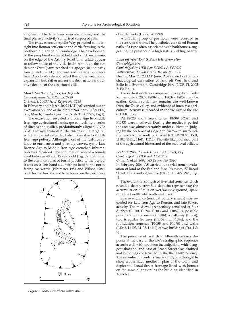
Pip Stone for Archaeological Solutions116
alignment. The latter was soon abandoned, and the final phase of activity comprised dispersed pits. The excavations at Apollo Way provided some in-sight into Roman settlement and cattle farming in the northern hinterland of Cambridge. The development of the peripheral series of field and stock enclosures on the edge of the Arbury Road villa estate appear to follow those of the villa itself. Although the set-tlement Duroliponte reached its apogee in the early fourth century AD, land use and material evidence from Apollo Way do not reflect this wider wealth and expansion, but, rather mirror the destruction and rel-ative decline of the associated villa.
March Northern Offices, the HQ siteCambridgeshire HER Ref: ECB928O’Brien, L 2003d HAT Report No. 1269In February and March 2002 HAT (AS) carried out an excavation on land at the March Northern Offices HQ Site, March, Cambridgeshire (NGR TL 416 977; Fig.1). The excavation revealed a Bronze Age to Middle Iron Age agricultural landscape comprising a series of ditches and gullies, predominantly aligned NNE/SSW. The westernmost of the ditches cut a large pit, which contained a sherd of Late Bronze Age to Middle Iron Age pottery. Although most of the features re-lated to enclosures and possibly droveways, a Late Bronze Age to Middle Iron Age crouched inhuma-tion was recorded. The inhumation was of a female aged between 40 and 45 years old (Fig. 5). It adhered to the common form of burial practice of the period; it was on its left hand side with its head to the north, facing eastwards (Whimster 1981 and Wilson 1981). Such formal burials tend to be found on the periphery
of settlements (Hey et al. 1999). A circular group of postholes were recorded in the centre of the site. The postholes contained Roman nails of a type often associated with bathhouses, sug-gesting the presence of a high status building nearby.
Land off West End & Belle Isle, Brampton, Cambridgeshire Cambridgeshire HER Ref: ECB924 & ECB927Wotherspoon, M 2003; HAT Report No. 1336During May 2002 HAT (now AS) carried out an ar-chaeological excavation of land off West End and Belle Isle, Brampton, Cambridgeshire (NGR TL 2005 7115; Fig. 1). The earliest evidence comprised three pits of likely Roman date (F2007, F2009 and F2037); F2037 may be earlier. Roman settlement remains are well-known from the Ouse valley, and evidence of intensive agri-cultural activity is recorded in the vicinity of the site (CHER 10172). Pit F2023 and three ditches (F1009, F2025 and F1033) were medieval. During the medieval period the area was almost certainly under cultivation, judg-ing by the presence of ridge and furrow in surround-ing fields to the south and west (CHER 2059, 11501, 11502, 11610, 11611, 11612). The site likely formed part of the agricultural hinterland of the medieval village.
Fenland Pine Premises, 57 Broad Street, ElyCambridgeshire HER Ref: ECB1909Crank, N et al. 2004; AS Report No. 1510In February 2004, AS carried out a trial trench evalu-ation of land at the Fenland Pine Premises, 57 Broad Street, Ely, Cambridgeshire (NGR TL 5427 7979; Fig. 1). The evaluation comprised five trial trenches which revealed deeply stratified deposits representing the accumulation of silts on wet/marshy ground, span-ning the twelfth –fifteenth centuries. Sparse evidence (residual pottery sherds) was re-corded for Late Iron Age to Roman, and late Saxon, activity. The medieval archaeology consisted of four ditches (F1010, F1094, F1103 and F1067), a possible pond or ditch terminus (F1016), a pathway (F1064), two irregular features (F1066 and F1074), and the foundation trenches (F1055 and F1070) and walls (L1062, L1107, L1108, L1110) of two buildings (Trs. 1 & 5). The presence of twelfth to fifteenth century de-posits at the base of the site’s stratigraphic sequence accords well with previous investigations which sug-gest that the land east of Broad Street was drained and buildings constructed in the thirteenth century. The seventeenth century maps of Ely are thought to show a fossilized medieval plan of the town, and depict the Broad Street frontage lined with houses on the same alignment as the building identified in Trench 1.
Figure 5. March Northern Inhumation.
Small sites in Cambridgeshire 117
30 Silver Street, WitchamCambridgeshire HER Ref: ECB1846Woolhouse, T & K Nicholson, 2006; AS Report No. 1896In January 2005 AS carried out excavation at 30 Silver Street, Witcham, Cambridgeshire (NGR TL 4608 7999; Fig. 1). The excavation revealed medieval and post-medi-eval features comprising boundary ditches (aligned E/W), rubbish pits, cobbled yard surfaces and prob-able drainage gullies. The alignment of the boundary ditches was not appropriate to plots fronting modern Silver Street, and the ditches may relate to an earlier, unknown route. One of the post-medieval boundary ditches contained the remains of a very large dog. The latter was broadly similar in dimensions to a modern Irish Wolfhound or Great Dane, both of which are scent hunters, and ancestors of which are known to have been used in the hunting of large game (Almond 2003). Three cobbled surfaces (medieval, post-medieval and undated) are thought to have been open yard surfaces rather than enclosed building floors. Given the quantities of CBM and tile present, it is likely that buildings were present just outside the excavated area. Prior to the investigation, no evidence of medieval activity was known on the west side of Witcham, the nearest recorded medieval site being that of the ‘old manor’, c. 250m to the east. The parallel boundary ditches appear to point to an earlier layout of the vil-lage prior to the existence of Silver Street.
Papworth Everard Business Park, Ermine Street, Papworth EverardCambridgeshire HER Ref: ECB2565Newton, A A S 2008. AS Report No. 3100Between August and October 2004, AS conducted an archaeological excavation at Papworth Everard Business Park, Cambridgeshire (NGR TL 291 624; Fig. 1). The excavation revealed an Iron Age settlement, which was enclosed by a large penannular ditch, c. 80m in diameter. Within the north-western sector of enclosure was a smaller enclosure defined by a ‘C’-shaped ditch (Fig. 6). The two ditches are thought to have been contemporary. The smaller enclosure en-compassed four large pits, of which two were possible hearths (F2085 and F2112). Hearth F2112 contained redeposited burnt material including iron-smithing waste, vitrified clay, pottery and lumps of slag. A con-centration of finds, including slag, occurred within the ‘C’-shaped enclosure ditch and within the area it encompassed. The presence of slag and two hearths, and the more widespread evidence of burning in the area, suggests that the area defined by the ‘C’-shaped enclosure ditch was assigned to industrial activity. Four roundhouses were present within the larger enclosure ditch. They were represented by fragment-ed circular, or penannular, eaves-drip gullies. Their preservation was very poor, though internal features, including a posthole, a stakehole and a beamslot, were recorded in Roundhouses 1, 2 and 4.
Extraneous pits and postholes, some with stone packing, were located between the roundhouses and surrounding enclosure ditch. Some, like the align-ment of three postholes to the south of Roundhouse 1 (F2061, F2063 and F2028), may have been wooden fencelines. Other clusters of pits or postholes may represent groups of two-post structures of a type often recorded on Iron Age sites, and identified as ‘drying racks’ for grain or skins (Megaw and Simpson 1981, 382). Seven cooking pits, containing burnt sand-stone cobbles and flint, were found to the rear of the buildings. Although slag was recovered from several features, no in situ industrial hearths survived. There were no storage pits or well-defined post-built gra-nary structures. Several long, linear coaxial ditches were present beyond the enclosure, and are thought to have been indicative of a larger enclosed landscape evidenced by cropmarks and observed in the area surrounding the site (Eddisford et al. 2004).
ConclusionThe Iron Age settlement site at the Papworth Everard Business Park adds to developing knowledge regard-ing late prehistoric settlement on the clay uplands of south-west Cambridgeshire. It differs somewhat from previously recorded Iron Age settlement sites in the same region of the county. The variation in settlement types of this period in this part of Cambridgeshire, highlighted by the Papworth site, is more similar to the pattern of settlement seen in Northamptonshire, where a wide variation in settlement pattern and types has been noted. The concentration of iron-smithing slag in the ‘C’-shaped enclosure and the lack of environmental evidence for arable agricultural activity, suggests that the economy of the settlement may have been dominated by industrial activities. However, broadly contemporary field systems recorded to the north-east (Eddisford et al. 2004) may represent agricultural activity associated with the settlement. The animal bone report for Papworth describes the presence of draught animals, which may have been used for transporting tradable goods, possibly the produce of the iron-smithing activity. The surrounding field en-closures may therefore represent paddocks.
Block Fen (Eastern), Meadlands, MepalCambridgeshire HER Ref: ECB2593Stone, P 2008; AS Report No. 3091Between July and September 2007, AS conducted an archaeological excavation of land at Block Fen, Meadlands, Mepal, Cambridgeshire (NGR TL 4400 8400; Fig. 1). The excavation revealed six Neolithic/early Bronze Age features. A possible watering-hole (F2034), which contained late Neolithic/early Bronze Age pottery and animal bone (6195g), was present in the centre of the site. The feature was surrounded by an ero-sion area (c. 2m radius) (F2042). Erosion areas sur-rounding watering-holes have been identified at many other fenland sites including Bradley Fen, near
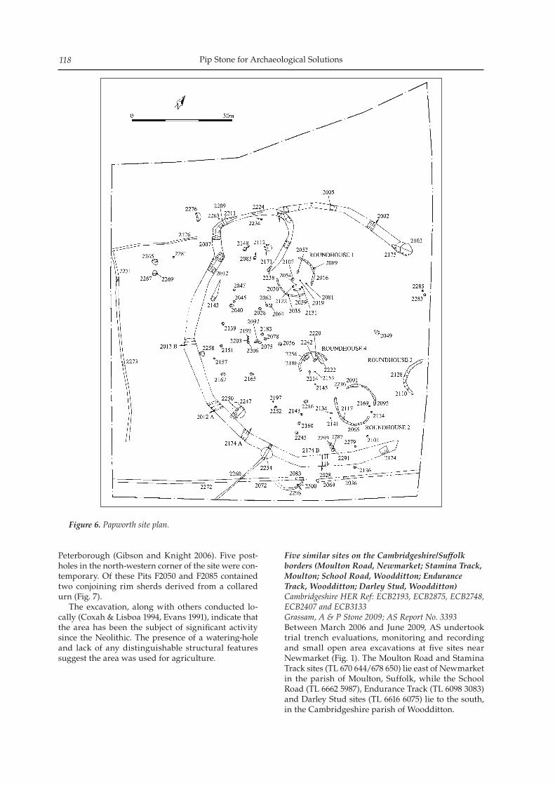
Pip Stone for Archaeological Solutions118
Peterborough (Gibson and Knight 2006). Five post-holes in the north-western corner of the site were con-temporary. Of these Pits F2050 and F2085 contained two conjoining rim sherds derived from a collared urn (Fig. 7). The excavation, along with others conducted lo-cally (Coxah & Lisboa 1994, Evans 1991), indicate that the area has been the subject of significant activity since the Neolithic. The presence of a watering-hole and lack of any distinguishable structural features suggest the area was used for agriculture.
Five similar sites on the Cambridgeshire/Suffolk borders (Moulton Road, Newmarket; Stamina Track, Moulton; School Road, Woodditton; Endurance Track, Woodditton; Darley Stud, Woodditton)Cambridgeshire HER Ref: ECB2193, ECB2875, ECB2748, ECB2407 and ECB3133Grassam, A & P Stone 2009; AS Report No. 3393Between March 2006 and June 2009, AS undertook trial trench evaluations, monitoring and recording and small open area excavations at five sites near Newmarket (Fig. 1). The Moulton Road and Stamina Track sites (TL 670 644/678 650) lie east of Newmarket in the parish of Moulton, Suffolk, while the School Road (TL 6662 5987), Endurance Track (TL 6098 3083) and Darley Stud sites (TL 6616 6075) lie to the south, in the Cambridgeshire parish of Woodditton.
Figure 6. Papworth site plan.
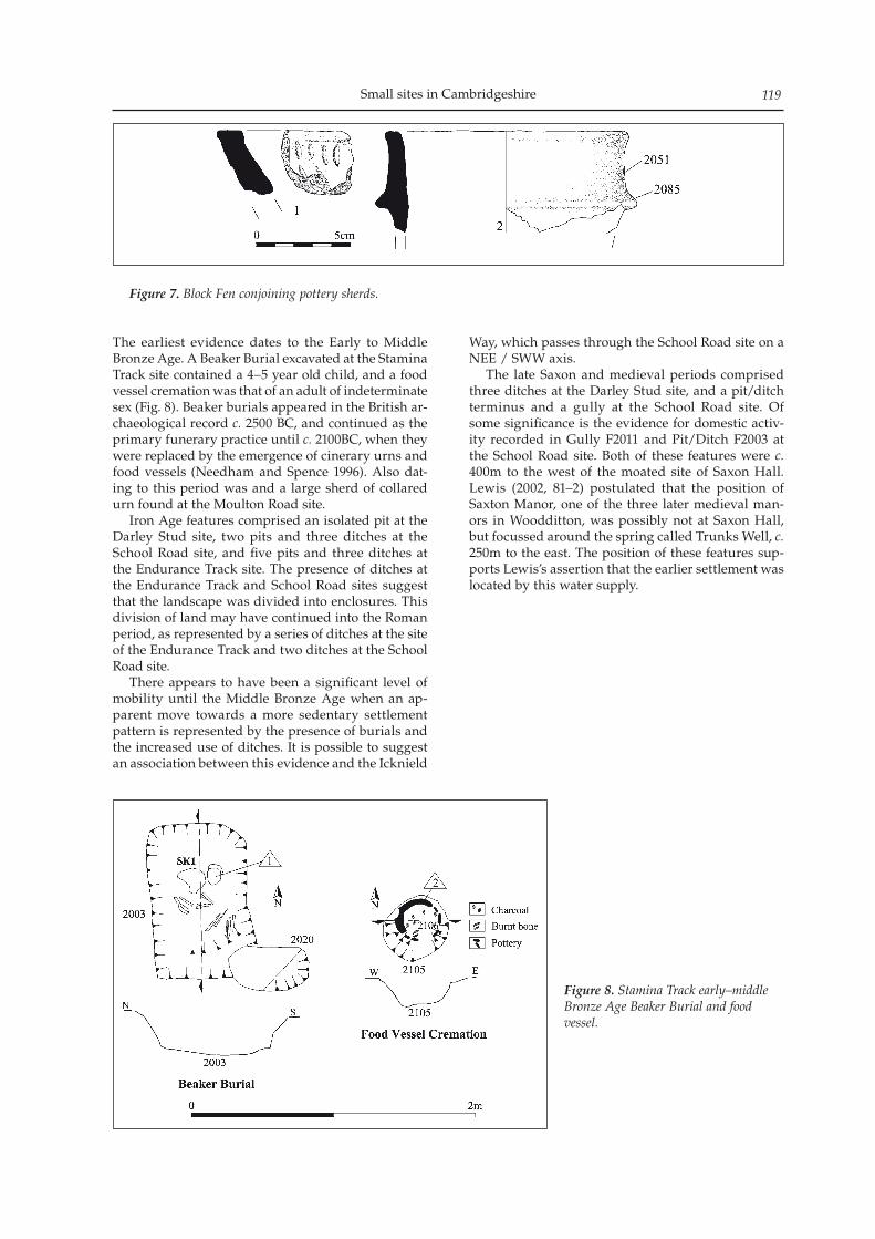
Small sites in Cambridgeshire 119
The earliest evidence dates to the Early to Middle Bronze Age. A Beaker Burial excavated at the Stamina Track site contained a 4–5 year old child, and a food vessel cremation was that of an adult of indeterminate sex (Fig. 8). Beaker burials appeared in the British ar-chaeological record c. 2500 BC, and continued as the primary funerary practice until c. 2100BC, when they were replaced by the emergence of cinerary urns and food vessels (Needham and Spence 1996). Also dat-ing to this period was and a large sherd of collared urn found at the Moulton Road site. Iron Age features comprised an isolated pit at the Darley Stud site, two pits and three ditches at the School Road site, and five pits and three ditches at the Endurance Track site. The presence of ditches at the Endurance Track and School Road sites suggest that the landscape was divided into enclosures. This division of land may have continued into the Roman period, as represented by a series of ditches at the site of the Endurance Track and two ditches at the School Road site. There appears to have been a significant level of mobility until the Middle Bronze Age when an ap-parent move towards a more sedentary settlement pattern is represented by the presence of burials and the increased use of ditches. It is possible to suggest an association between this evidence and the Icknield
Way, which passes through the School Road site on a NEE / SWW axis. The late Saxon and medieval periods comprised three ditches at the Darley Stud site, and a pit/ditch terminus and a gully at the School Road site. Of some significance is the evidence for domestic activ-ity recorded in Gully F2011 and Pit/Ditch F2003 at the School Road site. Both of these features were c. 400m to the west of the moated site of Saxon Hall. Lewis (2002, 81–2) postulated that the position of Saxton Manor, one of the three later medieval man-ors in Woodditton, was possibly not at Saxon Hall, but focussed around the spring called Trunks Well, c. 250m to the east. The position of these features sup-ports Lewis’s assertion that the earlier settlement was located by this water supply.
Figure 7. Block Fen conjoining pottery sherds.
Figure 8. Stamina Track early–middle Bronze Age Beaker Burial and food vessel.
Pip Stone for Archaeological Solutions120
Bibliography
Almond, R 2003 Medieval Hunting. London: Sutton Publishing Ltd
Coxah, M and I M G Lisboa 1994 Archaeological Field Evaluation Phase 2, Block Fen B, Pearson’s Land, Mepal, Cambridgeshire. Tempus Reparatum unpublished report TR 31010 DFA.
Crank, N, K Doyle, A Grassam, K Nicholson and L O’Brien et al, 2004. Fenland Pine Premises, 57 Broad Street, Ely, Cambridgeshire. AS Report No. 1510
Crummy, N ‘The Small Finds’ in Gibson, C., 2003. Lordship Farm, Hinxton, Cambridgeshire. An Archaeological Excavation. Final Report. HAT Report No. 1271
Eddisford, D, L O’Brien, A Peachey and J Williams 2004 Land North and South of Farm Lane and at Stirling Way Papworth Everard, Cambridgeshire: An archaeological evaluation. AS Report No. 1692
Evans, C 1991 The Archaeology of Langwood Fen, Chatteris. A desktop archaeological study. CAU
Gibson, C 2003. Lordship Farm, Hinxton, Cambridgeshire. An Archaeological Excavation. Final Report. HAT Report No. 1271
Gibson, D and M Knight 2006 Bradley Fen Excavations. Whittlesey, Cambridgeshire 2001–2004. CAU Report 733
Grassam, A., and P Stone 2009. Activity in the Neolithic–Medieval Periods at Five Sites on the Suffolk / Cambridgeshire Border. AS Report No. 3393
Hey, G, A Bayliss, and A Boyle 1999 ‘Iron Age burials at Yarnton, Oxfordshire’ in Ant. 73. P. 551–562
Lewis, C P 2002 ‘Woodditton’ in Wareham, A F and A P M Wright (eds.) VCH Cambridgeshire and the Isle of Ely, Volume X. University of London Institute of Historical Research/Oxford University Press, 78–98
Megaw, J V S and D D A Simpson, (eds.) 1981 Introduction to British Prehistory, Leicester University Press, Leicester
Mortimer, R. & Evans, C. 1996, Archaeological Excavations at Hinxton Quarry Cambridgeshire; The North Field, CAU Report 168.
Needham, S. P. and T Spence 1996 Refuse and disposal at Area 16 East, Runnymede, Runnymede Bridge Research Excavations 2 (London)
Newton, A A S 2008. An Archaeological Investigation of Land off Ermine Street (Unit 5), Papworth Everard, Cambridgeshire. AS Report No. 3100
O’Brien, L 2003a Former Dansk Site, 49–55 Lynn Road, Ely, Cambridgeshire. An Archaeological Excavation. Final Report. HAT Report No. 1334
O’Brien, L 2003b. Fardell’s Lane, Elsworth, Cambridgeshire. An Archaeological Excavation. Final Report. HAT Report No. 1274
O’Brien, L 2003c. Apollo Way Church Centre, Kings Hedges, Cambridge. An Archaeological Excavation. Final Report. HAT Report No. 1335
O’Brien, L 2003d. March Northern Offices The HQ Site. An Archaeological Excavation. Final Report. HAT Report No. 1269
Ralph, S 2003. Plot C, Lancaster Way Business Park, Ely. An Archaeological Excavation. Final Report. HAT Report No. 1273
Stone, P 2008. Block Fen, Meadlands, Cambridgeshire Phase II. Research Archive Report. AS Report No. 3091
Whimster, R 1981 Burial Practices in Britain: a discussion and gazetteer of the evidence c. 700BC–AD43. BAR British Series 90 (2 vols): Oxford
Wilson, C E 1981 ‘Burials within settlements in southern Britain during the pre-Roman Iron Age’ Institute of
Archaeology Bulletin of London 18: 127 – 169Wotherspoon, M 2003. Land off West End & Belle Isle,
Brampton, Cambridgeshire. HAT Report No. 1336 Woolhouse, T & K Nicholson, 2006. Medieval and
Post-Medieval Features at 30 Silver Street, Witcham, Cambridgeshire. AS Report No. 1896
Excavations on the north side of Oakington revealed a sequence of medieval enclosures and trackways dating pos-sibly from the twelfth to the fourteenth century. The site also produced some evidence of domestic occupation in the form of hearths, pits and possible structures, and the finds suggests low status and possibly temporary activity on the margins of settlement. The enclosures and trackways sug-gest the control of animals, and the excavation produced the remains of farm animals, including cattle and sheep. Crops included wheat, barley, oats and rye, as well as peas and beans, confirming information provided by documentary sources.
Excavations in 2003 of a site bordering Coles Lane and High Street (formerly Church Lane), on the north side of Oakington (covering c. 0.75ha centred on NGR 541198 264704) (Fig. 1), revealed two phases of medi-eval enclosures and trackways (and a small number of Romano-British and post-medieval features). The limited evidence of Romano-British activity, comprising residual pottery, three pits (16, 24 and 33) and a gully (3.3), confirms previous findings in the area (Taylor et al. 1997), the site lying c. 2.5km north-east of the Via Devana, the Roman road between Cambridge and Godmanchester The first medieval phase comprised part of a rec-tangular enclosure defined by broad right-angled ditch (2), with a second ditch (4), parallel to the en-closure’s western side, defining a probable trackway, c. 4m wide. Two narrow gullies (7 and 8) within the trackway suggest modifications to this boundary. West of the enclosure was a line of three small, evenly spaced pits (22.1, 22.3 and 22.5), and there were three more widely dispersed pits (23, 15 and 30) of varying dimensions, and all of uncertain function. Together, these features produced a relatively restricted range of pottery suggesting a twelfth–early thirteenth cen-tury date, although the only clearly diagnostic form was the complete profile of a shouldered jar in a micaceous sandy ware, with finger impressed rim, from pit 15. The same pit produced parts of matching cattle mandibles and maxillae that had been chopped by a heavy implement, while ditch 4 produced depos-its of articulated cattle, sheep/goat and horse bones.
These features were replaced by a more extensive arrangement of enclosures and trackways, having a slightly altered alignment. A metalled road ran north-east/south-west along the eastern edge of the excava-tion, with a bank and then a 4.1m wide ditch (6.1) on its west side. The road appears to have been aligned on the location of the medieval manorial farmstead at Manor Farm. On approximately the same alignment as the road, some 45m to the west, was a narrow gully (17) that cut across earlier features, while a second trackway, defined by two broad, deep ditches (9 and 10), c. 6m apart, ran at a right angle to the road (al-though ditch 9 did not continue up to the road). The road-side ditch and ditch 10 both contained further deposits of articulated horse bones, the former also containing part of a cattle foetus. A number of other ditches and gullies (11, 12 and 20) may have formed a small enclosure abutting the north side of the trackway, within which was a heav-ily truncated curved feature (18), possibly part of a temporary shelter, enclosing a small hearth (18.1). Another small hearth (21), a pit (31) and three lengths of gully (13, 14 and 19) were also recorded in the southern part of the excavation. A wider range of pottery wares was present in the second phase features, including wares from Ely, Thetford, Hedingham and other Essex types, indicat-ing a wide-ranging supply from a number of different local and regional sources. However, diagnostic forms remained scarce – only jar rims, one bowl rim, and one or two jug handles, are represented; most jar rims are in developed forms characteristic of the thirteenth century or later, suggesting a date range for this phase of the thirteenth century, possibly extending into the fourteenth century. The site provided little evidence of post-medieval activity; the enclosure ditches were silted up and the site was largely given over to pasture, although the roadside ditch remained open. Subsequently a drain cut into the fills of the ditch ran into a pond created to its immediate west, supplied also by a drain running from the north. The finds assemblage from the excavation (sum-marised in Table 1) is relatively small and, apart from
Medieval enclosures and trackways at Coles Lane, Oakington, Cambridgeshire
Andrew B Powell
Proceedings of the Cambridge Antiquarian Society XCVIX pp. 121–124
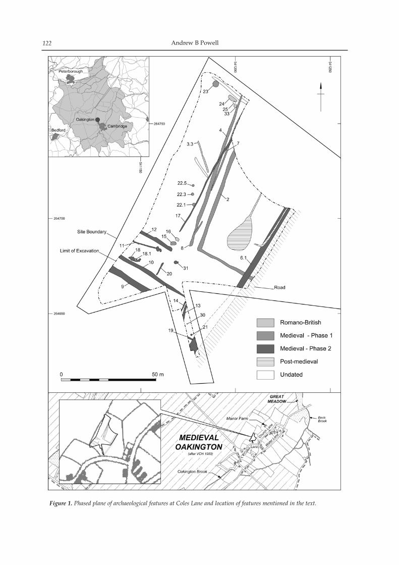
Andrew B Powell122
Figure 1. Phased plane of archaeological features at Coles Lane and location of features mentioned in the text.
Medieval enclosures and trackways at Coles Lane, Oakington 123
the pottery and animal bone, is restricted in the range and quantity of materials represented. It is largely of medieval date, although there is a small amount of Romano-British material and a few post-medieval objects. The overall pottery assemblage (as with the finds in general) is predominantly utilitarian, con-taining only a small proportion of glazed tablewares, possibly indicating relatively low status settlement in the vicinity of the site. Several different sources or source areas for the medieval pottery are represent-ed, with South Cambridgeshire wares augmented by Huntingdon/Fens and Ely types from at least the 13th century.
Table 1. Finds totals by material type.
Material type Number Weight (g)Pottery 666 8205Romano-British 46 537Medieval 572 6275Post-medieval/modern 48 1393
Metalwork 7 -Copper alloy 4 -Iron 3 -
Animal bone 240 11831Slag 3 646Ceramic building material 20 3129Mortar 5 103Fired clay 17 778Clay pipe 1 1Stone 1 98Flint 1 2Shell 3 30
The site lay within the area of ancient closes sur-rounding Oakington, and the orientation of the re-corded features reflects the wider general layout of the enclosure boundaries, and the village as a whole. The Domesday Book of 1086 records that the vill at Oakington was divided into three manors, the largest being that owned by Crowland Abbey, whose Manor Farm lay 200–300m north-east of the site (VCH 1989, 194–5). Water Lane, along which medieval house plat-forms have been recorded (VCH 1989, 193), may have been the original road running north-east to south-west through the village, flanking Oakington Brook to the south-east. However, High Street, running along the higher ground to the north-west, provided the focus of the medieval village, with the church on one side and Manor Farm on the other. The ancient closes flanking the road through the village were surrounded by open fields, with a stretch of meadow along the Beck Brook to the north-east. The trackways and enclosures revealed by the ex-cavation may initially have been used for the move-ment and penning of livestock. Most of the animal bone, which ranged in age from foetal and juvenile to adult, consisted of domesticates: cattle, horse, sheep/goat and dog. The notable absence of pig may reflect the shortage of woodland in the vicinity; no wood-land was recorded in the Domesday Book (ibid, 192). No remains of wild animals were found. The cattle
and sheep/goat assemblages all comprise meatless bones, suggesting that the assemblage reflects dis-card of butchery waste, although, apart from a cattle skull (from pit 15), the bones lack butchering marks. The cattle bone may represent plough animals kept until they died of disease and so were no longer suit-able for consumption. Although sheep flocks are doc-umented in the 13th and 14th centuries, local pasture was in short supply, with Crowland Abbey’s Manor Farm recorded as buying up the meadows along Beck Brook from the early 13th century (ibid, 200–1). The remains of ridge-and-furrow recorded on the site prior to the excavation suggest the enclosures were subsequently given over to cultivation, possibly by the fourteenth century. Environmental samples from the hearths 18.1 and 23 and ditch 6.1 provided evidence for the cultivation of free-threshing wheat, barley and rye, and it is possible that cultivated oats were also present, although no floret bases were pre-served that might allow cultivated and wild oats to be distinguished. Broad bean and garden pea were also identified, and three seeds may have been of lentil. A very poorly preserved specimen was tentatively iden-tified as flax. This assemblage largely confirms the general char-acter of the arable regime as described in documents relating to Crowland Abbey, which refer to wheat and oats being grown in the mid 13th century, but with the proportion of oats falling by 1270 and then largely replaced by barley after c. 1280 (ibid, 200–1). After 1290 barley and oats were combined as dredge, and from 1300 there was also an increase in the cultivation of rye, as found in the two hearths. It is also recorded that peas were increasingly grown from the 1280s, and the recovery of pea and bean seeds from ditch 6.1, may indicate the sowing of leguminous crops to improve soil fertility. The weed species probably grew among and were harvested with the crops. Seeds of leguminous spe-cies, vetches, tares, grass peas, medick and clover were very common, along with dock, stinking may-weed and red bartsia. Most of these are associated with neutral to calcareous soils, although smooth tare is frequently associated with lighter sandier, often slightly acidic soils, and stinking mayweed may in-dicate the cultivation of heavy clay soil, possibly the ridge-and-furrow cultivation noted as earthworks on the site. Stinking mayweed is commonly record-ed from Saxon and medieval sites (Greig 1991), and probably owes much to the introduction of the heavy mouldboard ploughs (Stevens with Robinson 2004). Charcoal from the hearths was dominated by alder, which favours damp woodland and wetland edges, indicating that such environments, as found locally along Oakington Brook and Beck Brook, would have been important sources of wood for fuel, perhaps due to the clearance of woodland from areas of drier land more useful for cultivation. Hawthorn-type poma-ceous fruit wood was the second most common type, with horse chestnut, birch and willow/poplar also represented. Given the absence of woodland recorded in the Domesday Book, it is of note that none of the
Andrew B Powell124
larger mixed deciduous woodland trees, such as oak, ash or elm, were present.
Acknowledgements
The fieldwork, undertaken by Wessex Archaeology in February and March 2005, was commissioned by CgMs and funded by Taylor Woodrow Homes Ltd. Wessex Archaeology would like to thank Duncan Hawkins of CgMs for his assistance and support. The work was monitored on behalf of Cambridgeshire County Council by Andy Thomas, Cambridgeshire County Council Planning Archaeologist. The project was managed for Wessex Archaeology by Reuben Thorpe and was directed in the field by Cornelius Barton. The illustration is by Mark Roughley and S E James.. The finds were analysed by Lorraine Mepham, the charcoal by Catherine Barnett, the charred plant remains by Chris J Stevens, and the animal bone by Jessica Grimm. All the specialists finds and environ-mental reports are held in the project archive (Wessex Archaeology codes 53735 and 58720) which will be deposited with Cambridgeshire County Council.
BibliographyGreig, J 1991 ‘The British Isles’. In W van Zeist, K
Wasylikowa & K-E. Behre (eds), Progress in Old World Palaeoethnobotany, 229–334. Rotterdam: Balkema
Stevens, CJ with M Robinson 2004 ‘Production and con-sumption: plant cultivation, 81–82. In G Hey (ed.), Yarnton: Saxon and Medieval Settlement and Landscape. Thames Valley Landscape Monograph. Oxford: Oxford Archaeology
Taylor, A, C Duhig & J Hines 1997 An Anglo-Saxon cem-etery at Oakington, Cambridgeshire.PCAS 86: 57–90
VCH 1989 Cambridgeshire and the Isle of Ely Volume 9. London: Institute of Historical Research
That rivers were the medieval ‘highways’ of the Fens is not in doubt (Darby 1940, pp. 100–01). However, al-though several diagrams have been published por-traying the network of navigable rivers, there appears to have been no systematic attempt to map the ‘high-way’ network and how it evolved during the long period from Saxon-Norman times to the early seven-teenth century, immediately prior to the major land drainage schemes that transformed the Fens. Few land routes existed in the medieval Fens and wheeled traffic over any distance was also lim-ited by the soft terrain and dearth of bridges. Small boats were ubiquitous, but larger craft for heavy and bulky freight, probably carrying some ten tonnes or thereabouts, measuring some nine metres in length and three in the beam (see Part II), would have been restricted to the larger watercourses. It is upon these channels that this paper concentrates. The notable early work on Fenland rivers by Fowler (1933, 1934a and b) and Astbury (1957) does not pro-vide a coherent picture for the medieval period. They considered a longer time period and believed that any channel identified as artificial should be regarded as Roman unless there is positive evidence to the con-trary. With the accumulation of new information, it has become apparent that this assumption must be revised (e.g. Blair 2007). Published diagrams reveal agreement among scholars about some of the important elements of the medieval Fenland river network, and also disagree-ment about other significant parts of the system (see Tables 1 and 2 and Figure 1). I consider that the easiest way to try to work out the main ‘highway’ map is the following. William Hayward compiled a map of the entire Fens at a scale of one inch to the mile in 1604, but the original version has disappeared and we are reliant upon copies. Of these, the one by Payler Smyth in 1727 appears to be that of a map drawn for the pur-pose of planning a comprehensive drainage scheme and has a clearer provenance, from the Fen Office in Ely, than the other copies, which include detail not shown on Smyth’s version (Cambridgeshire Archives R59/31/40/1; see Chisholm and Stickler in prepara-tion). A facsimile copy of the Smyth map, supplied by
Cambridgeshire Archives, has been used, simplified to show the main relevant watercourses (Figure 1).
Table 1. Authors whose diagrams exclude specified waterways in the Fenland network.The authors whose diagrams have been examined are: Astbury 1957; Barley 1938; Bond 2007; Darby 1936, 1940 and 1983; Edwards and Hindle 1991; Gardiner 2007; Jones 2000; Sayer 2009; Spoerry 2005. All of these authors include the waterways listed below in their diagrams, except the authors listed below.*Jones shows Crowland Cut and South Eau to Guyhirn but does not show the remainder of Astbury’s ‘original’ Nene from Clough’s Cross to Tydd St Mary.
Waterway Not mentioned in
Car DykeBarley; Darby (1936, 1940, 1983); Gardiner; Jones; Spoerry
Crowland Cut (Crowland to Cat’s Water)
Astbury; Bond; Darby (1940, 1983); Gardiner
Astbury’s ‘original’ Nene (Cat’s Water and South Eau to Tydd St Mary)
Jones*
Plant Water/Hobs riverAstbury; Bond; Darby (1936, 1940, 1983); Gardiner; Jones; Sayer; Spoerry
South Eau (Cloughs Cross to Guyhirn)
Astbury; Bond; Darby (1940, 1983); Gardiner; Sayer; Spoerry
WellandAstbury; Darby (1940); Gardiner.
The names applied to watercourses have changed over time in a manner that can be very confusing. We will use modern terminology and Table 2 has been constructed to identify the channels of interest, with these terms and those used by Hayward, supplement-ed as appropriate by other usages found in the litera-ture. The modern river system bears little relationship to that which existed some thousand years ago and a fundamental leap of imagination is required. The
The medieval network of navigable Fenland waterways I: Crowland
Michael Chisholm
Proceedings of the Cambridge Antiquarian Society XCVIX pp. 125–138
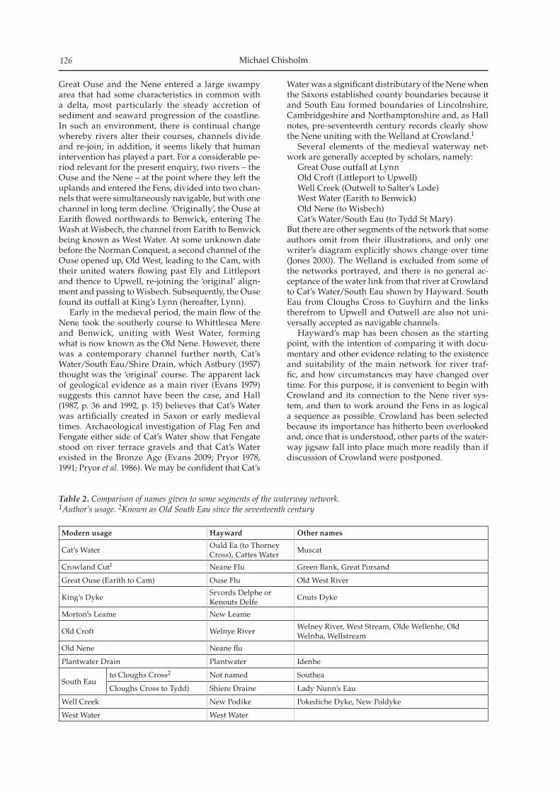
Michael Chisholm126
Great Ouse and the Nene entered a large swampy area that had some characteristics in common with a delta, most particularly the steady accretion of sediment and seaward progression of the coastline. In such an environment, there is continual change whereby rivers alter their courses, channels divide and re-join; in addition, it seems likely that human intervention has played a part. For a considerable pe-riod relevant for the present enquiry, two rivers – the Ouse and the Nene – at the point where they left the uplands and entered the Fens, divided into two chan-nels that were simultaneously navigable, but with one channel in long term decline. ‘Originally’, the Ouse at Earith flowed northwards to Benwick, entering The Wash at Wisbech, the channel from Earith to Benwick being known as West Water. At some unknown date before the Norman Conquest, a second channel of the Ouse opened up, Old West, leading to the Cam, with their united waters flowing past Ely and Littleport and thence to Upwell, re-joining the ‘original’ align-ment and passing to Wisbech. Subsequently, the Ouse found its outfall at King’s Lynn (hereafter, Lynn). Early in the medieval period, the main flow of the Nene took the southerly course to Whittlesea Mere and Benwick, uniting with West Water, forming what is now known as the Old Nene. However, there was a contemporary channel further north, Cat’s Water/South Eau/Shire Drain, which Astbury (1957) thought was the ‘original’ course. The apparent lack of geological evidence as a main river (Evans 1979) suggests this cannot have been the case, and Hall (1987, p. 36 and 1992, p. 15) believes that Cat’s Water was artificially created in Saxon or early medieval times. Archaeological investigation of Flag Fen and Fengate either side of Cat’s Water show that Fengate stood on river terrace gravels and that Cat’s Water existed in the Bronze Age (Evans 2009; Pryor 1978, 1991; Pryor et al. 1986). We may be confident that Cat’s
Water was a significant distributary of the Nene when the Saxons established county boundaries because it and South Eau formed boundaries of Lincolnshire, Cambridgeshire and Northamptonshire and, as Hall notes, pre-seventeenth century records clearly show the Nene uniting with the Welland at Crowland.1
Several elements of the medieval waterway net-work are generally accepted by scholars, namely: Great Ouse outfall at Lynn Old Croft (Littleport to Upwell) Well Creek (Outwell to Salter’s Lode) West Water (Earith to Benwick) Old Nene (to Wisbech) Cat’s Water/South Eau (to Tydd St Mary)But there are other segments of the network that some authors omit from their illustrations, and only one writer’s diagram explicitly shows change over time (Jones 2000). The Welland is excluded from some of the networks portrayed, and there is no general ac-ceptance of the water link from that river at Crowland to Cat’s Water/South Eau shown by Hayward. South Eau from Cloughs Cross to Guyhirn and the links therefrom to Upwell and Outwell are also not uni-versally accepted as navigable channels. Hayward’s map has been chosen as the starting point, with the intention of comparing it with docu-mentary and other evidence relating to the existence and suitability of the main network for river traf-fic, and how circumstances may have changed over time. For this purpose, it is convenient to begin with Crowland and its connection to the Nene river sys-tem, and then to work around the Fens in as logical a sequence as possible. Crowland has been selected because its importance has hitherto been overlooked and, once that is understood, other parts of the water-way jigsaw fall into place much more readily than if discussion of Crowland were postponed.
Table 2. Comparison of names given to some segments of the waterway network.1Author’s usage. 2Known as Old South Eau since the seventeenth century
Modern usage Hayward Other names
Cat’s WaterOuld Ea (to Thorney Cross), Cattes Water
Muscat
Crowland Cut1 Neane Flu Green Bank, Great Porsand
Great Ouse (Earith to Cam) Ouse Flu Old West River
King’s DykeSrvords Delphe or Kenouts Delfe
Cnuts Dyke
Morton’s Leame New Leame
Old Croft Welnye RiverWelney River, West Stream, Olde Wellenhe, Old Welnha, Wellstream
Old Nene Neane flu
Plantwater Drain Plantwater Idenhe
South Eauto Cloughs Cross2 Not named Southea
Cloughs Cross to Tydd) Shiere Draine Lady Nunn’s Eau
Well Creek New Podike Pokediche Dyke, New Poldyke
West Water West Water
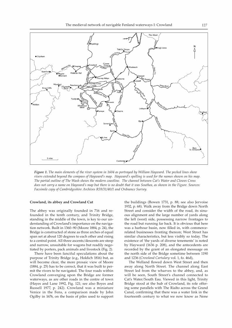
The medieval network of navigable Fenland waterways I: Crowland 127
Crowland, its abbey and Crowland Cut
The abbey was originally founded in 716 and re-founded in the tenth century, and Trinity Bridge, standing in the middle of the town, is key to our un-derstanding of Crowland’s importance on the naviga-tion network. Built in 1360–90 (Moore 1884, p. 24), the Bridge is constructed of stone as three arches of equal span set at about 120 degrees to each other and rising to a central point. All three ascents/descents are steep and narrow, unsuitable for wagons but readily nego-tiated by porters, pack animals and livestock (Fig. 2). There have been fanciful speculations about the purpose of Trinity Bridge (e.g., Holdich 1816) but, as will become clear, the more prosaic view of Moore (1884, p. 25) has to be correct, that it was built to per-mit the rivers to be navigated. The four roads within Crowland converging upon the Bridge are former waterways, as are other roads in the centre of town (Hayes and Lane 1992, Fig. 121; see also Boyes and Russell 1977, p. 242). Crowland was a miniature Venice in the Fens, a comparison made by John Ogilby in 1676, on the basis of piles used to support
the buildings (Bowen 1731, p. 88; see also Jervoise 1932, p. 68). Walk away from the Bridge down North Street and consider the width of the road, its sinu-ous alignment and the large number of yards along the left (west) side, possessing narrow frontages to the road but running far back. It is obvious that here was a harbour basin, now filled in, with commerce-related businesses fronting thereon; West Street has similar characteristics, but less visibly so today. The existence of ‘the yards of diverse tenements’ is noted by Hayward (1636 p. 208), and the antecedents are recorded by the grant of an elongated messuage on the north side of the Bridge sometime between 1190 and 1236 (Crowland Cartulary vol. 1, fo. 46d), The Welland flowed down West Street and then away along North Street. The channel along East Street led from the wharves to the abbey, and, as will be seen, South Street’s channel connected to Cat’s Water/South Eau. Viewed in this light, Trinity Bridge stood at the hub of Crowland, its role offer-ing some parallels with The Rialto across the Grand Canal, confirming that there was a water link in the fourteenth century to what we now know as Nene
Figure 1. The main elements of the river system in 1604 as portrayed by William Hayward. The pecked lines show rivers extended beyond the compass of Hayward’s map. Hayward’s spelling is used for the names shown on his map. The partial outline of The Wash shows the modern coastline. The channel between Cat’s Water and Clowes Cross does not carry a name on Hayward’s map but there is no doubt that it was Southea, as shown in the Figure. Sources: Facsimile copy of Cambridgeshire Archives R59/31/40/1 and Ordnance Survey.
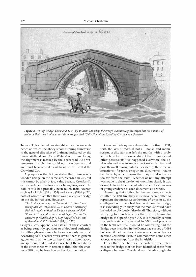
Michael Chisholm128
Terrace. This channel ran straight across the low emi-nence on which the abbey stood, running transverse to the general direction of drainage indicated by the rivers Welland and Cat’s Water/South Eau; today, the alignment is marked by the B1040 road. As a wa-tercourse, this channel could not have been natural and must be accepted as artificial; we will call it the Crowland Cut. A plaque on the Bridge states that there was a wooden bridge on the same site, recorded in 943, but this cannot be taken at face value because Crowland’s early charters are notorious for being ‘forgeries’. The date of 943 has probably been taken from sources such as Holdich (1816, p. 134) and Moore (1884, p. 24), both of whom state that there was a triangular bridge on the site in that year. However:
The first mention of the Triangular Bridge ‘pons triangulus’ at Croyland is … in Eadred’s charter of 948; it is again noticed in Eadgar’s charter of 966. ‘Pons de Croyland’ is mentioned before this in the charters of Æthelbald of 716, of Wiglaff of 833, and of Bertulph of 851. (Searle 1894, p. 127.)
Sawyer (1998, Appendix 5) lists all of these charters as being ‘certainly spurious or of doubtful authentic-ity, although some may be based on early records’. According to his earlier work (1968), there is general agreement that the two earliest charters noted above are spurious, and divided views about the reliability of the other three, with reason to think that the char-ter of 948 may be based on earlier documentation.
Crowland Abbey was devastated by fire in 1091, with the loss of most, if not all, books and manu-scripts, a disaster that left the monks with a prob-lem – how to prove ownership of their manors and other possessions? As happened elsewhere, the de-vice adopted was to re-construct early charters and pass them off as originals. Self-evidently, these recon-structions – forgeries or spurious documents – had to be plausible, which means that they could not stray too far from the truth. Whether or not any attempt was made to cheat we do not know, but clearly it was desirable to include uncontentious detail as a means of giving credence to each document as a whole. Assuming that all five charters were re-construct-ed after the 1091 fire, they must have been drafted to represent circumstances at the time of, or prior to, the conflagration. If there had been no triangular bridge, it is exceedingly unlikely that the monks would have included an obviously false detail. Therefore, without worrying too much whether there was a triangular bridge in the specific year 948, it is virtually certain that such a structure existed in 1091, and probably in the tenth century. It would be comforting had the Bridge been included in the Domesday survey of 1086 but, even it had met the criteria, no such record exists because Crowland itself, in common with some other abbeys, was exempt from the inquisition. Other than the charters, the earliest direct refer-ence to the Bridge that has been identified arose from a dispute between Crowland and Peterborough ab-
Figure 2. Trinity Bridge, Crowland 1724, by William Stukeley. the bridge is accurately protrayed but the amount of water at that time is almost certainly exaggerated (Collection of the Spalding Gentlemen’s Society).
The medieval network of navigable Fenland waterways I: Crowland 129
beys about the ownership of Alderland, a marshy area immediately southwest of Crowland, which had begun before 1206. The Abbot of Crowland ob-jected to interference by the Abbot of Peterborough regarding market tolls (stallage) and control of the Bridge (Fenland Notes and Queries 5 1901–03, p. 84). Agreement was finally reached in 1247, allowing the Abbot of Crowland and his men free access over the Bridge with their cattle (Crowland Cartulary vol. 1, fo. 42). That Crowland Cut existed in the first half of the twelfth century is directly demonstrated:
Stephen [1135–54] had confirmed to that mon-astery [Crowland] among other possessions the marsh ‘from the water of Crowland, which is called Nene, to the place which is called Fynset, and from that place to Greynes, and from Greynes to Feldwardstaking, and thence to Southlake, where it falls into the Welland’. (VCH 1970, p. 422)
This is a clockwise progression from Crowland, iden-tifying a parcel of land south of the Abbey, Fynset being St Vincents’s Cross at its original location (TF 258 076), hard by the village now known as Nene Terrace. Reference to the ‘water of Crowland called Nene’ describes the Cut, along which water flowed from Cat’s Water/South Eau. Peterborough refused to accept this ruling and in 1206 agreement was reached between the two mon-asteries, the land being recognised as belonging to Peterborough but to be leased to Crowland. A later charter confirmed this arrangement:
The land ‘between the waters of the Nene and the waters of the Welland as they meet at Crowland’, and on the west to ‘the great road from Wansford, to Stamford’, was what Peterborough always claimed, and those boundaries appear in a charter of John, dated 1215 (VCH 1970, p. 421).
The territorial dispute was not finally settled until 1583, after the Dissolution, the parties then being Elizabeth I, as the lady of Crowland manor, and ten-ants of the Soke of Peterborough. There is a charter dated 972, by which it was agreed between the abbeys at Ramsey and Peterborough to exchange some land and also granting Peterborough the right of toll over a substantial area. This char-ter is almost certainly spurious but is thought to contain authentic information. The area over which Peterborough was to have toll rights was defined in part as follows:
… from Wansford to Stamford, and from Stamford along the water course to Crowland, and from Crowland to the Muscat … (Hart 1966, p. 26).
Muscat is an alternative name for Cat’s Water. This definition implies obvious landscape features be-tween Wansford and Stamford, and likewise from Crowland to Cat’s Water, respectively Ermine Street and, it may be supposed, Crowland Cut. Direct evidence for the existence of Crowland Cut confirms inference from the Bridge; the Cut clearly existed in 1091 and almost certainly in the tenth century. A court case in 1362 establishes that it was navigable, and had been so ‘from time immemorial’
(see Appendix). The key passage in the translation has been checked by Diana Honeybone against the original Latin and she is confident that the scribe in-tended to convey that there was a continuous chan-nel, navigable in both directions, from South Eau through Crowland to Waldram Hall on the Welland. Presumably, the owner of the Hall held land along South Eau, but this is not stated in the record. The significance of Crowland Cut for the Abbey is demonstrated by a map, held by the Public Record Office (MPCC 1/7 Pinchbeck Map), probably mid-fifteenth century in date but possibly earlier (Mitchell and Crook 1999 pp. 46–7; Silvester 2002, p. 10); a fac-simile copy is possessed by the Spalding Gentlemen’s Society. With Crowland towards the southeast corner, this map has three main components: the settlements east and west of the Welland, identified by name and realistically depicted by their respective churches; a large area, mostly west of the Welland, shown as uninhabited, being the river’s washland; and the Welland joined by a channel from the east, the con-fluence straddled by the stone triangular bridge. All three waterways are shown equally large and bold, signifying the importance of Crowland Cut relative to the Welland at the time the map was made. Why did the monks dig the channel linking the Welland and Cat’s Water/South Eau? In common with monasteries elsewhere in England, Crowland held manors and other resources that were widely scattered geographically. In 1086, its possessions included the manor of Holbeach and Whaplode to the northeast, three fisheries at Wisbech, and prop-erties in Leicestershire, Northamptonshire and Cambridgeshire (Page 1934, p. 10 and facing table; Raban 1977, Appendix 1; VCH 1906, p. 106). In the last of these counties, the possessions included Cottenham, Dry Drayton and Oakington, for which the Ouse was the nearest waterway. Although we do not know in detail when the manorial specialisations developed, note that the Cambridgeshire manors despatched malt to the abbey by water, while other manors specialised in cattle, for meat and for dairy products, and flocks of sheep grazed the fens around Crowland and elsewhere (Holmes 1962, p. 118; Page 1929, 1934; Platts 1985, p. 102; Ravensdale 1974, p. 32). There was a high degree of central control of these properties, as Page makes clear with the management of the sheep flocks, including transport to the Abbey of wool and lambs, and the dispatch of stock from the demesne properties, a system perfected from 1276 but obviously with a significant prior history. Although it was usual until the late twelfth century for estates to be farmed for their revenues rather than managed in hand, manorial specialisation was common in the tenth century and religious houses needed access to their properties for provisions and elsewhere for other necessities, such as building materials. There was a high degree of inter-dependence across the Fens from the tenth century onwards. Bishop Aethelwold re-founded abbeys at Ely, Peterborough and Thorney in the tenth century and:
As late as 1000–25, Ely was supplying Thorney
Michael Chisholm130
with various commodities including manpower and equipment … Only gradually did each house emerge as an independent entity. (Raban 1977, p. 8.)
These and other links depended upon water com-munications, as between Peterborough and Thorney along Cat’s Water from the time that the first religious settlement was established at Thorney in the seventh century, not long after the original Peterborough foundation (Mellows 1927, pp. 3–4). Likewise, Cat’s Water provided the means for passengers to travel be-tween Thorney Abbey and its Stanground property (Halliday 1986, p. 2). Early in the thirteenth century, three records from Peterborough Abbey accounts show the upper part of Cat’s Water to Thorney Cross was used to transport stone to Eye for a new grange.2
The channel was still used in 1414, when a cord of timber was purchased for Singlesole grange (TF 254 069) to construct a substantial barge (Greatrex 1984, p. 142), about the time of a record showing the collection of ferry tolls on Cat’s Water for cattle being driven from Whittlesey to Peterborough (Halliday 1986, p. 2). Crowland’s need for good communications into the Fens was reinforced by the general geography of religious houses after the devastation wrought by Danish invaders in the ninth century. At the time of the Norman Conquest, Crowland was the only abbey ‘in the shires of Lincoln, Leicester, Nottingham, Derby and York’ (Stenton 1984, p. 456). Crowland was on the northern edge of a remarkable cluster of powerful religious houses, a fact underlined by the following observations about Peterborough, re-founded in 966 by Bishop Aethelwold:
In Ethelwold’s lifetime, and for a period thereaf-ter, Peterborough’s fortunes were closely bound up with those of the other monasteries in his ‘connex-ion’ – Abingdon, Ely, Thorney, Crowland, the two Winchester houses and (probably) St Albans … These houses had a common origin, a common in-terest, and perhaps a common record. (King 1973, pp. 6–7.)
The evidence mentioned above indicates that the early Crowland charters are correct: a triangular bridge existed by 1091, and probably earlier. Likewise, we know that Crowland Cut existed early in the twelfth century and, independently of evidence about the Bridge, it probably existed in the tenth century. This conclusion is consistent with the date given by Hayes and Lane (1992, Fig. 121) for Crowland’s waterways, the Cut included, namely ‘Late Saxon-Medieval’. Water communication from Crowland to Peterborough, the Old Nene, Whittlesea Mere and thus to Wisbech was possible. We know that South Eau was navigable in 1362 and had been for some considerable time previously, offering a shorter route to Wisbech.
South Eau
Place-name records trace South Eau back to the thir-teenth century. The original suffix was ‘ea’, later ‘ee’, Anglo-Saxon for a river or stream, consistent with
the early existence of Cat’s Water as a distributary of the Nene, and the use of the channel as the south-ern boundary of Lincolnshire. The ‘eau’ version of the suffix was rarely used in England until the nine-teenth century (Owen 1986, p. 93 fn. 1). The name Cloughs Cross, first recorded in 1438, signifies the cross that marked the county boundary near a ‘clow’, a Middle English word that includes the meaning of a dam. Hayward’s map shows a chan-nel from Cloughs Cross to Guyhirn with the name South Eau, a usage recorded in 1313. This channel is straight and transverse to the general drainage direc-tion and must be artificial; and its name was clearly derived from the original South Eau that drained to the sea near Tydd St Mary. If Woodgate (1934, p. 5) is correct, this artificial channel ‘anciently was 40 feet in breadth and six feet deep’. We may infer that the dam at Cloughs Cross was built to divert South Eau. So when was the diversion engineered, and why? Moore (c.1658) records this channel as ‘new opened’, from which we may infer that any archae-ological evidence for its existence prior to the sev-enteenth century had been destroyed (compare the problem at March, where the diverted Old Nene was drained and scoured to the chalk bed about 1900, as recorded by Astbury 1957, p. 166). In the absence of identified documentary evidence for the South Eau diversion antedating 1313, it is necessary to turn to other sources of information for its earlier history. Tydd St Mary is recorded in the 1086 Domesday Survey, and nearby Tydd Gote in 1361, marking the point at which South Eau entered the Wisbech out-fall. ‘Tydd’ is to be interpreted as a slight hill, while ‘gote’ comes from the Old English word for a sluice (see Wheeler 1990, Appendix IV). Tydd Gote lies on the landward side of the Great Bank (the so-called Roman Bank) that formerly kept the seas at bay, and the existence of a sluice at this point means that pro-vision had been made for the discharge of land water through the bank while preventing incursions of salt water. Such an arrangement would not have been possible at that time if South Eau had been a flowing river. Therefore, when the sluice was built, South Eau at this point was already little more than a land drain. In this area of Lincolnshire, there are several other place-name elements ‘gote’ and ‘gowt’, testifying to the widespread practice of managing the outfalls of small channels through sea embankments. One such sluice through Great Bank, a little south of Tydd Gote, was excavated in the 1970s. It consisted of three mas-sive hollowed-out tree trunks, fitted into each other to form a culvert. The radio carbon date for this struc-ture is 1250+40, consistent with serious sea flooding in 1251 (Taylor 1977). There would have been no point in constructing this sluice if the sea could spread onto the land from South Eau, which implies either that the river was embanked or that Great Bank continued across the outfall, with a sluice. Great Bank runs along both sides of the Wisbech outfall. On the basis of carefully argued evidence, Hallam (1965, p. 4ff.) considers that the Lincolnshire side had probably been completed as ‘one unit of de-
The medieval network of navigable Fenland waterways I: Crowland 131
fence’ before the Norman Conquest. He notes that earlier embankments protected the Elloe wapentake, ‘sealing off’ the minor estuaries along the former coastline, but there is no evidence shown for any such embayment for South Eau and Great Bank runs straight across the outfall at Tydd Gote. The inference is clear, that South Eau was already a drain rather than a flowing river before 1066, because the volume of water to be discharged was sufficiently small that the then existing sluice technology was able to cope. Therefore, we may be sure that South Eau had been diverted no later than 1066. We know that there was substantial reclamation of valuable silt lands from the sea before the Conquest, which would have necessi-tated the management of land water. We also know that Crowland had possessions at Holbeach and Whaplode in 1086, and that other properties were ac-quired in the vicinity by both Crowland and Thorney (Hallam 1965, pp. 7 and 9; Raban 1977, Appendices 1 and 3). There would have been a collective inter-est of landowners, private and ecclesiastical, to assist land reclamation by ensuring that as little ‘upland’ water as possible entered areas being improved. Diversion of South Eau, with an embankment along the east side, would have achieved that aim and Old Southeau Bank is first recorded as a place-name in 1313. The alternative name of Fen Dyke is used by Woodgate (1934, pp. 4–5), who emphasises its impor-tance as the landward flood defence for the silt fens. Note that Hall (1987, p. 52) considers a Saxon embank-ment was built along the north side of South Eau and Shire Drain to prevent flood waters in Thorney fens penetrating into Lincolnshire. There is, therefore, one reason for engineering the diversion at an early date, consistent with the co-operative nature of drainage works noted by Raftis (1957, p. 155). The other reason is that South Eau did not ‘originally’ flow to a seaport of any importance, whereas the Ouse-Nene river system led to Wisbech, which ‘was sufficiently important to possess the only coastal Norman royal castle in the region’ (Spoerry 2005, p. 102). Although Crowland Cut allowed ac-cess to Wisbech by Cat’s Water to Peterborough and then down the Old Nene, this would have been a circuitous route to achieve a seaward outlet alterna-tive to Spalding. Diversion of South Eau to Guyhirn would have given Crowland direct access to Wisbech. Therefore, the full benefit of the Cut could only be obtained if South Eau were diverted. The combined effect of Crowland Cut and the diversion of South Eau was to create a continuous and reasonably direct wa-terway from Crowland to Wisbech, presumably navi-gable all the way, open in the eleventh century and probably in the tenth.
From Guyhirn to the Old Nene
Guyhirn as a place-name is recorded in 1275, the two components meaning ‘guide’ and ‘angle, corner’, the latter plausibly describing the right angle union of South Eau and Plant Water. As Reaney (1943, p. 293)
observes:Guyhirn must always have been a critical point on the drainage of this part of the fens … and long before the construction of Moreton’s Leam [1478–86], the meeting here of the fresh waters and the tides [salt water] probably led to the construction of works for the safe guidance of their flow at this corner.
Plant Water is recorded as early as 1251 (as Idenhe), and as late as 1618 it was described as a ‘principal river’ and as ‘the body of Neane and Ouze united’ (Atkins 1618, p. 83). Plant Water is portrayed by Hayward as dividing, to make a second channel, Hobs River; both are likely to have been natural channels that may have been modified to some degree by engineering works. By means of Plant Water there was access from Guyhirn to the Old Nene above March, and to a point below that town by using Hobs River, in both cases giving water access to Upwell and Outwell. It is rea-sonable to suppose that these two channels existed long before 1251. Upwell and Outwell, built upon rodhams or river levees, offered access to the Ouse and Lynn along Old Croft to Littleport and then, as we shall see below, via Well Creek to Salter’s Lode (Fig. 3). The early im-portance of the two places is evident in several ways (VCH 1967, pp. 208–10). Upwell, first recorded as a place-name in 963, was a very important fishery be-cause, eleven years later, the grant of 60,000 eels an-nually for the newly founded Abbey at Ramsey was confirmed, and river traffic was evidently important because ‘as late as 1490 many of the [Ely] bishop’s ten-ants’ in Upwell and Outwell made their living that way. The Abbott of Ramsey was granted a market in 1202, and in 1291 no fewer that sixteen religious houses had interests in the villages, whose thirteenth century churches attest to their wealth – both church-es are included in Jenkins’ book England’s Thousand Best Churches (1999). Remarkably, nearby March has a thirteenth century church that is also included in this volume (March occupies a small eminence or ‘island’ rising above the surrounding fens). It is a reasonable inference that river trade on the Old Nene and Old Croft must have been important in the twelfth cen-tury, and probably from considerably earlier, a con-clusion consistent with the idea that the South Eau diversion to Guyhirn existed by 1066.
Old Nene-Ouse
The Ouse has been as changeable as the Nene in its choice of channel to the sea. The first known course, equivalent to the Cat’s Water/South Eau channel of the Nene, flowed northward from Earith and so to Wisbech; this channel is generally known as West Water. It existed before the Old Nene came into exist-ence, the Old Nene joining West Water at Benwick, giving its name to the pre-existing channel it occu-pied from that point downstream. At some unknown time before the Norman Conquest, the Ouse divided at Earith, a new chan-
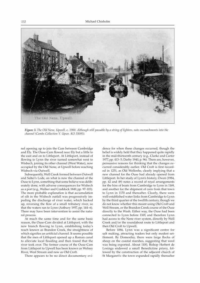
Michael Chisholm132
nel opening up to join the Cam between Cambridge and Ely. The Ouse-Cam flowed near Ely but a little to the east and on to Littleport. At Littleport, instead of flowing to Lynn the river turned somewhat west to Wisbech, joining its other channel (West Water), now occupied by the Old Nene, at Upwell before reaching Wisbech via Outwell. Subsequently, Well Creek formed between Outwell and Salter’s Lode, on what is now the channel of the Ouse to Lynn, something that some believe was delib-erately done, with adverse consequences for Wisbech as a port (e.g., Walker and Craddock 1849, pp. 97–103). The more probable explanation is that accumulation of silt in the Wisbech outfall was progressively im-peding the discharge of river water, which backed up, reversing the flow of a small tributary river, so that the waters ran to Lynn (Astbury 1957, pp. 144–6). There may have been intervention to assist the natu-ral process. At much the same time and for the same basic reason, the Ouse-Cam divided at Littleport, with the new branch flowing to Lynn, establishing today’s reach known as Brandon Creek, the straightness of which signifies an artificial channel. It seems possible that the men of Littleport opened up a Roman canal to alleviate local flooding and then found that the river took over. The former course of the Ouse-Cam from Littleport to Upwell has been known as Welney River, West Stream and now as Old Croft. There appears to be no direct documentary evi-
dence for when these changes occurred, though the belief is widely held that they happened quite rapidly in the mid-thirteenth century (e.g., Clarke and Carter 1977, pp. 413–5; Darby 1940, p. 96). There are, however, persuasive reasons for thinking that the changes oc-curred considerably earlier. Old Croft is first record-ed in 1251, as Old Wellenhe, clearly implying that a new channel for the Ouse had already opened from Littleport. In her study of Lynn’s history, Owen (1984, pp. 42 and 49) notes a record of royal arrangements for the hire of boats from Cambridge to Lynn in 1169, and another for the shipment of corn from that town to Lynn in 1170 and thereafter. Clearly, there were well-established water links from Cambridge to Lynn by the third quarter of the twelfth century, though we do not know whether this meant using Old Croft and Well Stream, or the Brandon Creek course of the Ouse directly to the Wash. Either way, the Ouse had been connected to Lynn before 1169, and therefore Lynn had access to the Nene river system, directly by Well Creek and/or the roundabout route to Littleport and then Old Croft to Upwell. Before 1086, Lynn was a significant centre for salt making, attracting traders but only modest set-tlement. By Domesday, there were large flocks of sheep on the coastal marshes, suggesting that wool was being exported. About 1100, Bishop Herbert de Losinga endowed a small Benedictine priory, fol-lowed by the construction of the adjacent church of St Margaret’s: the town expanded rapidly thereafter
Figure 3. The Old Nene, Upwell, c. 1900. Although still passable by a string of lighters, note encroachments into the channel (Cambs Collection Y. Upwe. KO 35093).
The medieval network of navigable Fenland waterways I: Crowland 133
(Owen 1984, p. 9; Richards 2006, p. 1). The first charter of Bishop Losinga, dated 1101, refers to an inhabitant of Yaxley market resident in Lynn. Although Owen suggests that this person was dealing with coastal shipping to Wisbech, the more probable explanation is that one of the Ouse/Nene connections already existed at the turn of the centu-ry. Perhaps more telling is the 1184 record of a coast-wise shipment from Lynn of lead originating from Derbyshire (Owen 1984, p. 42), implying continuous water links from the port to the Welland – presum-ably to Stamford, the head of navigation from before the Norman Conquest (Jones 2000, p. 70). Towards the end of the twelfth century, the King’s purveyors were buying spices, wines, hawks and falcons at Lynn, and by 1204 ‘Lynn was for all practical purposes fully grown’ (Owen 1984, pp. 41–2). The early history of Lynn throws further light upon the medieval waterway network:
Well Stream was … easily obstructed, to the dam-age of Yaxley, Holme and Peterborough. Complaints about it began about 1251, and were frequent in the fourteenth century, especially after the Lord Treasurer, Walter Langton, Bishop of Lichfield, had drawn off some of the water by his drainage works at Coldham so that in 1331 the merchants from these towns, and even from South Lincolnshire, were driven to take a long detour via Old Welnha [Old Croft] and Littleport, to reach the Ouse and Lynn. (Owen 1984, pp. 49–50.)
There was widespread agreement across the Fens that damming Well Stream was having seriously adverse effects, causing flooding and impeding river trade, leading jurors in Lincolnshire to complain that:
There used to be a common way of passage for ships and boats carrying grain and other merchandise from Crowland through Outwell to Lynn, and be-cause of the dam it was now necessary to go around through Old Welney and Littleport, a route fifty leagues longer than the old route (Sutherland 1983, pp. 228–9).
Dugdale (1772, pp. 304–05) translates ‘league’ as ‘mile’, consistent with the Seebohm’s view (1914, Part II) that it was the old Gallic ‘leuga’ of 2,220 metres, and the 2,000 paces referred to in the Crowland Cartulary (vol. 1, fo. 24) as constituting a league. Measured from Hayward’s map, the detour added about eighteen statute miles (1,760 yards), so it is clear that the jurors exaggerated the inconvenience. The obstruction was removed and the existence of the through waterway is confirmed in 1373 (Darby 1940, p. 98 fn; Salzman 1964, p. 209). Stamford pro-vides earlier confirmation of a through waterway to Lynn, presumably via Well Creek. It was a prosper-ous and important town, one of whose functions in post-Norman England was acting as the collecting point for wool that was then shipped to both Boston and Lynn (Roffe 1994, p. 54; Rogers 1965, p. 44). West Water, from Benwick to Earith, offered an alternative route from the Old Nene to Lynn and we know the channel was navigable in the early post-Conquest years. The bishopric of Ely was established
in 1109 and the incumbents frequently travelled by water to the summer palace at Somersham, a journey up the Ouse to Earith and then along West Water to Somersham Lode (VCH 1974, p. 225). This practice continued at least until 1341/42 (Chapman 1907, p. 120). Further north, Chatteris was connected by lode to West Water in the thirteenth century (Hall 1992, p. 94 and Fig. 56), showing that it was passable by boats. However, by comparison with Well Creek, there ap-pears to be no direct evidence that West Water was much used for long distance traffic, and the indirect evidence suggests that it cannot have been regularly employed on any scale. Earith occupied a potentially strategic position on that part of the river system but West Water does not seem to have been important for the inhabitants’ livelihoods. The first place-name record for Earith’s existence is comparatively late, 1244, preceded by Earith Bridge in 1219. The very name Earith implies the relative unimportance of river traffic, denoting a muddy landing place. The bridge formed a cru-cial link across West Water in the land route from Haddenham to the east and St Ives to the west and is the main medieval economic feature of the settle-ment noted by the VCH (1974, pp. 153–8). The first and only mention of early river traffic in that volume is for 1425, a sixty-ton consignment of corn to Lynn. Benwick is the other settlement that one would ex-pect to have been important in Anglo-Norman times if West Water were a major thoroughfare, but again the place-name evidence (1221) suggests the relatively late establishment of the village. Neither village pos-sesses churches to compare with the architectural gems at March, Upwell and Outwell, noted above. The other indirect evidence has already been men-tioned, namely, that when there were problems over the use of Well Stream in the early fourteenth centu-ry, the merchants of Yaxley, Holme and Peterborough did not use West Water to reach Lynn, but instead used Old Croft to Littleport. Although West Water was navigable in the early years after the Conquest, it appears that its role was for local use, presumably by relatively small boats, and not for long distance trade. This conclusion is consistent with the development of large-scale sheep pasturing on the Fens around West Water following a ‘decisive drop in water level’ in the thirteenth century; sheep are less able to cope with sodden pasture than are cattle (Raftis 1957, p. 155).
Deterioration of watercourses
It is generally accepted that many rivers became less navigable towards the end of the medieval period, and that one reason was the construction of water mills, but the Fenland rivers have very gentle gradi-ents and, prior to the seventeenth century draining, were subject to seasonal inundation and were tidal far inland, circumstances that precluded mill construc-tion (Jones 2000; Langdon 2004, Map 1.1). Therefore, reasons for any decline must lie with other causes. Probably the single most important event that
Michael Chisholm134
has not so far been discussed was the construction of Morton’s Leam (1478–1486), a channel that would have been suitable for vessels but would have had ad-verse effects upon the two former Nene channels. By substantially shortening the distance to the sea, the velocity of the water would have been increased and the water level at the point where it took off from the Old Nene would have been lowered, drawing water away from Cat’s Water and the Old Nene downstream of the Leam’s divergence. We know that Cat’s Water had ceased to be navi-gable by the seventeenth century. Commissioners of Sewers toured the Fens in 1605 and found that the ‘ancient sewer’ was:
So grown up with earth and weeds, as that it serveth neither for passage with boats, nor drain-ing, and so hath been of long time; which ought and had been wont to be for the ordinary passage to and from Spalding, and other places in Holland [Lincolnshire], to Peterburrow (Dugdale 1772, p. 380).
This assessment was confirmed in 1618 by Edmond and Atkins (both 1618, respectively pp. 63–4 and p. 73), the latter noting that the Welland flowed into South Eau. When, after 1414, did Cat’s Water cease to be navi-gable? According to Gaches (1901–03, p. 97), the open-ing of Morton’s Leam so diminished the channel that ‘it afforded no passage by boat’ (see also Godwin 1615, p. 277), but this probably exaggerates the imme-diate impact. Four ‘foders’ of lime (four loads, prob-ably each of one ton), were purchased in 1502–03 for Singlesole (Greatrex 1984, p. 93), and it seems unlikely that overland transport would have been used from the probable source near Peterborough. There are rea-sons for thinking that Crowland Cut and South Eau remained open until about 1536. In 1508, work was re-sumed on King’s College chapel and in the two years 1509/10 and 1510/11 some 3,000 tons of Weldon stone were purchased and a similar quantity of Clipsham stone (Woodman 1986, p. 233). Clipsham stone was also used for Great St Mary’s in Cambridge, built between 1478 and 1536 (Purcell 1967, p. 41). In both cases, it is probable that Clipsham stone was brought down the Welland from Stamford (see Part II). However, it is clear that navigation had ceased by 1579. Corpus Christi began the construction of its chapel, buying second hand stone from Thorney (following the Dissolution), stone that had to be transported overland to Guyhirn for onward ship-ment by barge to Cambridge (Purcell 1967, pp. 32–3). If Thorney’s local waterways had been passable, it is reasonable to suppose they would have been used in preference to the land haul. This conclusion is consistent with the fact that the upper Welland had ceased to be navigable by 1570 (Harrod 1785, pages following p. 534; Jones 2000, p. 70; Thirsk 1965, p. 70). Between Stamford and Market Deeping, outside the Fens, six or seven mills had been constructed, not all of which would necessarily have impeded vessels, but the sources noted do not spec-ify when the mills were built. However, the fact of a
petition resulting in legislation in 1570 implies that the loss of navigation had been relatively recent. The navigation was not in fact restored until about 1670, as the Stamford Canal (Boyes and Russell 1977, p. 240). Shortly after Vermuyden had completed the drain-age works that he undertook following the 1649 drainage Act, Dodson published his design for a more perfect scheme, in which he stated that Crowland Cut had always been a navigation ‘which is now obstruct-ed’, arguing that it should be re-opened (Dodson 1665, p. 8; see also Wheeler 1990, p. 292). The absence of navigable water in Crowland Cut is clearly shown cartographically by Jonas Moore (c. 1658). Instead of flowing through Crowland, the Welland is shown further west, with an embankment across two drains diverging from Trinity Bridge, drains that represent the former inflowing and outflowing river channels. One of these drains is shown as passing through the embankment, whereas the other stops at the bank but presumably also passed through it. A drain is also shown from Crowland to Cat’s Water/South Eau, diverging south of Crowland Cut to the head of the then recently dug New South Eau. Two maps confirm the change: one shows Crowland as a little Venice at some date after 1588; the other shows the Fens as drained (Dugdale 1772, facing pp. 218 and 416 re-spectively). Further confirmation, albeit qualified, is provided by Featherstone’s 1763 map of Deeping Fen, which claims to represent the situation as surveyed by Vincent Grant about 1670. By the mid-seventeenth century, the Welland did not flow through Crowland and Crowland Cut had been reduced to a land drain. The 1618 report by Atkins (pp. 76–9) contains an interesting discussion of Cloughs Cross, the point at issue being the following. From a drainage perspec-tive, there was a case for allowing water from South Eau to resume its original course to the sea, along Shire Drain, supposedly because this was shorter than by Guyhirn. On the other hand, Wisbech was anxious to have as much fresh water as possible enter-ing its outfall, in the belief that this would help scour the channel and so improve access to the port. This provides independent confirmation that the clow at Cloughs Cross was indeed built to divert South Eau, for a purpose or purposes other than land drainage in the peat fens. According to Atkins, Bishop Morton had a grand scheme in mind when digging his Leam (1478–86), namely to concentrate as much water as possible upon the Wisbech outfall, to help keep it clear of silt. The Leam would necessarily divert water from the Old Nene that hitherto found its way to the Ouse from Outwell along Well Creek. At the same time, it may be that he wanted to collect Welland water to augment the flow of South Eau to Guyhirn; that he blocked up the sluice at Cloughs Cross formerly permitting con-trolled amounts of water to enter Shire Drain is sug-gestive (Gaches 1901–03, p. 99). So it may be that the flow along Crowland Cut had already been reversed by the late fifteenth century, consistent with the state-ment on the plaque attached to Crowland’s Trinity Bridge that it marks the spot where the Welland di-
The medieval network of navigable Fenland waterways I: Crowland 135
vided. Other parts of the waterway network also declined as navigations. As early as 1342, Monks Lode to Sawtry Abbey had ceased to be navigable, principally because seven paths had been established across it. The Abbot undertook to restore the navigation, pri-marily, it appears, for the benefit of local townspeo-ple (Inskip Ladds 1914, pp. 367–8). Whether the works were carried out, and with what success, is not clear. There were similar problems with other lodes on the edge of the Fens at Walton and Conington (Darby 1940, p. 150 fn). Atkins (1618, p. 86) records that West Water ‘is utterly decayed from Erith to Benwick’, while Edmond (1618, p.62) notes that it had reversed its flow, draining into the Ouse at Earith instead of the other way, ‘for want of cleanseing and dike-ing.’3 This reversal of flow would be consistent with the progressive shift of the Ouse from its outlet at Wisbech via West Water and the associated reduction of the distance to the sea, accentuated by the channel being shortened when the Ouse was re-aligned at Ely early in the twelfth century. Decline is also visible on Hayward’s 1604 map, be-tween Outwell and Wisbech; the Old Nene channel is shown as petering out at Elm and as having a dam across the section that remained. Hayward’s map also provides a strong hint that Old Croft between Littleport and Welney had ceased to be a major wa-terway. Although he identifies the channel as Welnye River, it is shown with a weir across it and with most of the land on either side taken into private owner-ship as ‘severals’, unlike channels elsewhere. Moore’s map (c. 1658) shows Old Croft as existing all the way from Littleport to Upwell, identified as Welnye River, but not as a channel fit for navigation, except a short section immediately north of Littleport, where it formed the lower reaches of Grunty Fen Drain. At the confluence of this drain with the Ouse is the double chevron symbol for a lock, implying that part of the drain was still navigable. The rest of Old Croft is shown as a snaking ribbon of land proper-ties either side of a small stream, interrupted by the Old Bedford and New Bedford rivers; at these points, Moore does not show the sasses or locks that would be needed to allow traffic along Old Croft. This carto-graphic evidence indicates that Old Croft had ceased to be a commercial artery by the 1650s. In conjunction with Hayward’s evidence, it seems clear that virtually all of Old Croft had ceased to be navigable before the seventeenth century, except for access to Littleport from the Ouse. Other parts of the river system remained naviga-ble, as at March, where eight boats were recorded in 1566 (Elye et al. 1909, p. 95). An account of building expenses for Gonville and Caius, 1564–73, records the purchase of freestone and rubble from Ramsey, among other sources (RCHM 1959, p. 73). In the ab-sence of any hint to the contrary, we may infer that Ramsey’s lode or lodes were still in use, or could be readily cleared, and that transit from that point to Cambridge was not a problem. Second hand Ramsey materials were used by Corpus Christi in 1673,
and also for church towers at Godmanchester and Holywell in the same century (Pevsner 1974, p. 330: Purcell 1967, p. 33), showing that waterways from the abbey site to the Ouse via Well Creek were still in use. Another example is that of new stone from the Weldon quarries (west of Oundle) brought to Trinity College in 1560–1, having been taken overland to the Nene at Gunwade Ferry above Peterborough and then by barge to Cambridge (Purcell 1967, p. 41). Yaxley was a significant inland port until the sev-enteenth century, coal being transported thence to Northamptonshire as late as 1628 (Hall 1992, p. 22). This traffic depended on a lode from Whittlesea Mere, to which goods may have been brought up the Old Nene, or along Morton’s Leam to near Peterborough and then past Stanground down the upper reaches of the Old Nene. Moore’s cartography provides an interesting con-trast between Well Creek and West Water, showing the former to be a continuing thoroughfare; the New Poldyke, is shown with the chevron symbol for a sasse or lock at the point where it joins the Ouse at Salter’s Lode. This channel had survived as a navi-gation, sufficiently important to be protected by pro-viding a lock to prevent tides penetrating the interior drainage network. By comparison, the only part of West Water given prominence is the link from Earith to Somersham Lode, but the Lode itself is portrayed as being somewhat degraded. From there to Benwick, West Water is shown as a minor watercourse, inter-rupted by what is now known as the Forty Foot Drain (Vermuyden’s Drain), with no provision for boats to pass.
Conclusion
On the basis of the preceding discussion, limited to main watercourses, it is clear that Hayward’s map is accurate in showing channels that were navigable in the early medieval period but that they were not nec-essarily still usable early in the seventeenth century. This is not altogether surprising when attention is paid to the embankments he identifies. Those shown in red are sea banks, banks between which rivers passed to the sea, and fen banks, i.e., the major flood defences. Lesser banks ‘serving for more particular uses’ are in light green. Evidently, the map was com-piled with the interests of land drainage foremost, and is to be thought of as a map of relevant landscape features, including visible watercourses that had less water in them than hitherto. Therefore, although Hayward does not provide a snapshot of the func-tioning rivers and drains, he does record the visible ones. Consequently, he gives us a precious starting point from which to investigate the medieval river system, but it is essential to seek out independent evidence to ascertain whether specific watercourses were in use, for navigation or otherwise, at identifi-able dates, and also watercourses that had ceased to be significant features of the landscape. While the picture that has been described for main
Michael Chisholm136
watercourses is likely to bear scrutiny, it is clear that much further work remains to be done, on the chan-nels discussed in this paper and on the innumera-ble others that have not been mentioned. Meantime, there can be no doubt that Crowland Cut existed from very early times, probably the tenth century, and that connections along the diverted South Eau and then Well Creek existed earlier than has hitherto been thought, thereby linking the Welland to the Nene and Ouse river systems. The more southerly link between the Nene and Ouse along West Water manifestly did exist, but appears not to have been much used for long-distance heavy freight, and evidently had ceased to be used before the seventeenth century – consistent with the decline noted by Jones (2000, Fig. 2). Cat’s Water/South Eau and Crowland Cut had also become impassable for vessels before 1600. It is a matter for speculation what the main causes were for the decline of the watercourses. How far were the changes due to natural causes, such as silt accumulation and changes in climate, and deliberate human intervention? To what extent did the Black Death reduce the need for water transport and the ability to main the channels? Was the Dissolution the primary factor? Or was it the spread of road access within the Fens, associated with medieval embank-ments and land drainage? Meantime, credit must be given to Gras (1915, p. 62) for recognising the existence of Crowland Cut and its significance for trade in corn, whereas later writ-ers have overlooked this short waterway. Its existence enables us to understand historical circumstances that otherwise seem opaque, such as: the dispatch of 7,284 fleeces from Crowland to Lynn in 1298–9 (Wretts-Smith 1932, p. 185); scholars from King’s Hall travelled by boat from Cambridge to Spalding in 1319, taking two days (Stenton 1936, p. 20); and in 1467, Edward IV ‘took boat’ from Crowland on his way to Fotheringhay (Perry 1887, p. 126), almost certainly along Crowland Cut to the Nene. Finally, as will be seen in Part II, the existence of the Cut has major im-plications for the manner in which Barnack stone was moved across the Fens, and it may be that this traffic provided one of the reasons for creating the channel.
Acknowledgements
I have a special debt of gratitude to my wife, Judith, for taking me to Trinity Bridge, Crowland, and her continuing support; to Diana and Michael Honeybone for introducing me to the Spalding Gentlemen’s Society; and also to Tim Halliday and Sandra Raban for their considerable assistance. Others have also been generous with their time and knowledge: Alan Dawn, Keith Hinde, Brian Jones, Ernie Jones, Nicholas Karn, Sue Oosthuizen, and Michael Young. Members of staff at Cambridge University Library, Cambridgeshire Archives and the Cambridgeshire Collection have been very helpful in numerous ways, as have officers of King’s College Library and the Spalding Gentlemen’s Society. Figure 1 has been
drawn by Philip Stickler, Department of Geography, University of Cambridge.
Footnotes
1 Although pre-seventeenth century documents refer to the Nene joining the Welland at Crowland, the plaque on Trinity Bridge states that this was where the Welland di-vided, meaning that Welland waters joined the Nene. As shown in the text, there is evidence that the flow along Crowland Cut had reversed by the early seventeenth cen-tury but when this happened and why has not been as-certained. This problem does not affect the discussion in this paper.
2 Northamptonshire Record Office F(M) 2388.m.lr, the Abbot of Peterborough’s Receiver’s Account 1300–01, 1303–04 and 1307–08, translated by Sandra Raban.
3 There is a discrepancy of testimony to note. Fowler (1933, p. 120) cites Badeslade (1766, pp. 77 and 78) for a report by Atkins in 1604, to the effect that most of the Ouse wa-ters reaching Earith passed along West Water. Badeslade is not specific about the 1604 report by Atkins, which has not been located (see Little 1891, p. 289). Badeslade is not a very reliable source of information (Chisholm 2007); therefore, the 1618 testimony of Atkins and Edmond should be accepted.
Appendices
Crowland Abbey Cartulary
The Spalding Gentlemen’s Society holds the original Crowland Cartulary, known as the Wrest Park Cartulary, and a manuscript translation thereof entitled Crowland Abbey Cartulary, from which the following account of a 1362 court case is taken (vol. 1, fo. 1d.3).
At the court at Depyng. Monday after St. Hilary 36 Edw. III. All the boatmen of Croyland, to wit Henry del Mershe (Merks), Roger Moreby, John Crane, John Wyttelsey, John Presteman, John Kelby, Thomas Marche, John Gryme, John Freend, William Bate, Peter Haske, John Fower, John Mylner, Geoffrey Wyttleseye, Robert Gobende, Roger Goode, William Gryme, the wife of Thomas Carter, Hugh Slade, Henry Grymesman and William Fyssher, came into the court before John Depynghale, steward of Dame Blanche Wake, and before Sir Walter Carleton, Sir John Colne, John Thame and others of the counsel of Dame Wake, because they had been amerced at 16s. 5d. unlaw-fully for breaking the dyke (fossat) on le Southee with their boats, and demand remedy therein because they say that the river is common by the watercourse of le Southee from Croyland to Walleramhalle, and vice versa, and has been so from time immemorial; and that they have never until now been molested or disturbed. An inqui-sition was taken thereupon ex officio by the oath of John Harel, William de Burgh, William Freman,
The medieval network of navigable Fenland waterways I: Crowland 137
William Baret, Roger Cotell, Simon Rose, Geoffrey Illeford, John Cunleys, Simon Spenser, Andrew Lytcester, John Henry, Robert Bate, Robert Gylberd and John Bydell, who say that neither in the time of Sir Thomas Wake, nor in other time of which they have recollection, were the boatmen amerced or molested for fishing with their boats on the said dyke, and that it is their right to fish and fowl with their boats wherever they chose on the said dyke. Therefore it is considered by the said steward and counsel that the said boatmen shall go, and be quit thereof.
Place-name information
Information cited in the text has been taken from the following sources as appropriate unless otherwise indicated:Cameron K 1998 A Dictionary of Lincolnshire Place-Names.
Nottingham: English Place-Name SocietyGover J E B, A Mawer and F M Stenton 1933 The Place-
Names of Northamptonshire. Cambridge: CUPMawer A and F M Stenton 1969 The Place-Names of
Bedfordshire and Huntingdonshire. Cambridge: CUP. First published 1926
Reaney P H 1943 The Place-Names of Cambridgeshire and the Isle of Ely. Cambridge: English Place-Name Society
Bibliography
Astbury A K 1957 The Black Fens. Cambridge: The Golden Head
Atkins R 1618 ‘Mr Atkyns’s Reports’, reproduced in S Wells 1830, The History of the Drainage of the Great Level of the Fens called the Bedford Level, vol. 2, Appendix 11, 71–97. London: R Pheney
Badeslade T 1766 The History of the Ancient and Present State of the Navigation of the Port of King’s Lynn, and of Cambridge. London: L Davis. First published 1725
Barley M W 1938 ‘Lincolnshire rivers in the Middle Ages’. The Architectural and Archaeological Society of the County of Lincoln, Report 93, 1–22
Blair J (ed.) 2007 Waterways and Canal-Building in Medieval England. Oxford: OUP
Bond J 2007 ‘Canal construction in the early middle Ages: an introductory review’, in J Blair (ed.) Waterways and Canal-Building in Medieval England, 153–206. Oxford: OUP
Bowen E 1731 Britannia Depicta or Ogilby Improved, 4th edi-tion. London
Boyes J and R Russell 1977 The Canals of Eastern England. Newton Abbot: David and Charles
Chapman F R 1907 Sacrist Rolls of Ely vol. 2. Cambridge: CUP
Chisholm M 2007 ‘Re-assessing the navigation impact of draining the Fens in the seventeenth century’. PCAS 96, 175–92
Chisholm M and P Stickler (in preparation) ‘William Hayward’s 1604 map of the Fens’.
Clarke H and A Carter 1977 Excavations in King’s Lynn 1963–1970. Monograph Series no. 7. London: Society for Medieval Archaeology
Crowland Cartulary. The Spalding Gentlemen’s Society holds the original cartulary, commonly called the Wrest Cartulary, and also a bound manuscript transla-
tion in two volumes, entitled Translation of the Crowland Cartulary. The translation has been used
Darby H C 1936 The Middle Level of the Fens and its reclama-tion. VCH Huntingdonshire vol. 3, 249–90. Reprinted 1974. London: Dawsons
Darby H C 1940 The Medieval Fenland. Cambridge: CUPDarby H C 1983 The Changing Fenland. Cambridge: CUPDodson W 1665 The Designe for the Perfect Draining of
the Bedford Level of the Fens. London. Reproduced as Appendix XX, 426–73, in S Wells The History of the Drainage of the Great Level of the Fens called the Bedford Level 1830, vol. 2
Dugdale W 1772 The History of the Imbanking and Draining of Diverse Fens and Marshes both in Foreign Parts and in this Kingdom. London: W Bowyer and J Nichols. First published in 1662
Edmond C 1618 ‘Sir Clement Edmond’s Report’, repro-duced in S Wells 1830 The History of the Drainage of the Great Level of the Fens called the Bedford Level, vol. 2, Appendix 10, 60–70. London: R Pheney
Edwards J F and B P Hindle 1991 ‘The transportation system of medieval England and Wales’. Journal of Historical Geography 17, 123–34
Elye R, H Pepper, E Beaupre and R Balam 1909 ‘Shipping in the Isle of Ely’. Fenland Notes and Queries 7, 93–6
Evans R 1979 ‘The early courses of the River Nene’. Durobrivae: a Review of Nene Valley Archaeology 7, 8–10
Evans C 2009 Fengate Revisited. Cambridge: CAU Landscape Archives Series
Featherstone J 1763 ‘A Map of Deeping Fen in the County of Lincoln’, supposedly as surveyed by Vincent Grant about 1670. Scale about 0.95 inch to the mile
Fowler G 1933 ‘Fenland waterways, past and present. South Level District’ part 1. PCAS 33, 108–28
Fowler G 1934a ‘Fenland waterways, past and present. South Level District’ part 2. PCAS 34, 17–33
Fowler G 1934b ‘The extinct waterways of the Fens’. Geographical Journal 83, 30–39
Gaches L 1901–03 ‘The drainage of the Great Level (No. 3)’. Fenland Notes and Queries V, 97–106
Gardiner M 2007 ‘Hythes, small ports and other land-ing places in later medieval England’, in J Blair (ed.) Waterways and Canal-Building in Medieval England, 85–109. Oxford: OUP
Godwin F 1615 A Catalogue of the Bishops of England. Thomas Adams. First published 1601
Gras N S B 1915 The Evolution of the English Corn Market. Cambridge (Mass.): Harvard University Press
Greatrex J 1984 Account Rolls of the Obedientiaries of Peterborough. Northampton: Northamptonshire Record Society
Hall D 1987 Fenland Landscapes and Settlement between Peterborough and March. The Fenland Project no. 2, EAA Report no. 35. Cambridge: Cambridgeshire Archaeological Committee
Hall D 1992 The South-Western Cambridgeshire Fenlands. The Fenland Project no. 6, EAA Report no. 56. Cambridgeshire Archaeological Committee
Hallam H E 1965 Settlement and Society. A study of the early agrarian history of South Lincolnshire. Cambridge: CUP
Halliday T M 1986 ‘A note on the Flag Fen site and its re-cent history’. PPS 52, p. 2
Harrod W (ed.) 1785 The Antiquities of Stamford and St Martin’s, vol. 2. Stamford: W Harrod
Hart C R 1966 The Early Charters of Eastern England. Leicester: Leicester University Press
Hayes P P and T W Lane 1992 Lincolnshire Survey, the South-West Fens, The Fenland Project no. 5, EAA Report no.
Michael Chisholm138
55. Sleaford: Heritage Trust of LincolnshireHayward W 1636 ‘The contents of the Fennes by statute
measure both of commons and severalls’, in S Wells The History of the Drainage of the Great Level of the Fens called the Bedford Level 1830 vol. 2, Appendix XV, 141–221
Holdich H 1816 The History of Crowland Abbey. Stamford: J Drakard
Holmes G 1962 The Later Middle Ages, 1272–1485. Edinburgh: Thomas Nelson and Sons Ltd
Inskip Ladds S 1914 ‘Sawtry Abbey, Huntingdonshire’. Transactions of the Cambridgeshire and Huntingdonshire Archaeological Society 111, 295–322 and 339–74
Jervoise E 1932 The Ancient Bridges of Mid and Eastern England. London: The Architectural Press
Jones E T 2000 ‘River navigation in Medieval England’. Journal of Historical Geography 26, 60–75
King E 1973 Peterborough Abbey 1086–1310. A study in the land market. Cambridge: CUP
Langdon J 2004 Mills in the Medieval Economy. England 1300–1540. Oxford: OUP
Little W C 1891 ‘Fen pumps No. 4’. Fenland Notes and Queries 1, 289
Mellows W T (ed.) 1927 . Henry Pychley’s Book of Fees. Northampton: Northamptonshire Record Society
Mitchell R and D Crook 1999 ‘The Pinchbeck Map: a fif-teenth-century map of the Lincolnshire fenland’. Imago Mundi 51, 40–50
Moore E 1884 Croyland. The Abbey, bridge and Saint Guthlac. Spalding: R Appleby
Moore J C c.1658 ‘A Mapp of the Great Levell of the Fenns’, scale 1:31,680 (two inches to the mile). Reprinted 1684
Owen A E B 1986 ‘Isle of Ely, Cambridgeshire, and Holland, Lincolnshire’, in R A Skelton and P D A Harvey (eds), Local Maps and Plans from Medieval England, 89–98. Oxford: Clarendon Press
Owen D M (ed.) 1984 The Making of King’s Lynn. A documen-tary survey. London: OUP
Page F M 1929 ‘”Bidentes Hoylandie”: a mediaeval sheep run’. Economic History 1, 603–13
Page F M 1934 The Estates of Crowland Abbey. A study of ma-norial organisation. Cambridge: CUP
Perry G G 1887 Croyland Abbey: an historical sketch. London: Society for Promoting Christian Knowledge
Pevsner N 1974 Bedfordshire, Huntingdonshire and Peterborough. Harmondsworth: Penguin Books. First published 1968
Platts G 1985 Land and People in Medieval Lincolnshire. Lincoln: Society for Lincolnshire History and Archaeology
Pryor F 1978 Excavation at Fengate, Peterborough, England: the second report. Archaeology Monograph 5, Royal Ontario Museum, Toronto
Pryor F 1991 English Heritage Book of Flag Fen Prehistoric Fenland Centre. London: Batsford
Pryor F, C French and M Taylor 1986 ‘Flag Fen, Fengate, Peterborough 1: discovery, reconnaissance and initial excavation (1982–85)’. PPS 52, 1–24
Purcell D 1967 Cambridge Stone. London: FaberRaban S 1977 The Estates of Thorney and Crowland. A study
in medieval monastic land tenure. Occasional Paper no. 7, Department of Land Economy, University of Cambridge
Raftis J A 1957 The Estates of Ramsey Abbey. A study in economic growth and organization. Toronto: Pontifical Institute of Medieval Studies
Ravensdale J R 1974 Liable to Floods. Village landscape on the edge of the fens A.D. 450–1850. Cambridge: CUP
Richards P 2006 King’s Lynn. Chichester: Phillimore. First published 1990
Roffe D 1994 Stamford in the Thirteenth Century. Two inquisi-tions from the reign of Edward I. Stamford: Paul Watkins
Rogers A 1965 ‘Medieval Stamford’, in A Rogers (ed.), The Making of Stamford, 34–57. London: Leicester University Press
RCHME 1959 City of Cambridge, vol. 1. London: HMSOSalzman L F 1964 English Trade in the Middle Ages. London:
H Pordes. First published 1931Sawyer P H (ed.) 1968 Anglo-Saxon Charters. An annotated
list and bibliography. London: Royal Historical SocietySawyer P H 1998 Anglo-Saxon Lincolnshire. Lincoln: Society
for Lincolnshire History and ArchaeologySayer D 2009 ‘Medieval waterways and hydraulic econom-
ics: monasteries, towns and the East Anglian Fen’. World Archaeology 41, 134–50
Searle W G 1894 Ingulf and the Historia Croylandensis. Cambridge: Cambridge Antiquarian Society
Seebohm F 1914 Customary Acres and their Historical Importance Part II The Old British Mile. London: Longmans, Green and Co
Silvester R 2002 ‘Some early maps of the Fens’, in T Lane and J Coles (eds) Through Wet and Dry, 10–17. Lincolnshire Archaeology and Heritage Reports Series no. 5
Spoerry P 2005 ‘Town and country in medieval Fenland’, in K Giles and C Dyer (eds), Town and Country in the Middle Ages. Contrasts, contacts and interconnections, 85–110. Leeds: Maney Publishing
Stenton F M 1936 ‘The road system of medieval England’. Economic History Review VII, 1–21
Stenton F M 1984 Anglo-Saxon England, 3rd edition. Oxford: Clarendon Press. First published 1943
Sutherland D W (ed.) 1983 The Northamptonshire Eyre. 3–4 Edward III, A.D. 1329–30 vol. 1. London: Selden Society
Taylor A 1977, ‘”Roman Bank”: a medieval sea-wall 1. A culvert beneath Sea Bank at Newton, near Wisbech’. PCAS 67, 63–6
Thirsk J 1965 ‘Stamford in the sixteenth and seventeenth centuries’, in A Rogers (ed.) The Making of Stamford, 58–76. London: Leicester University Press
VCH 1906 Lincolnshire vol. 2. London: J StreetVCH 1967 Cambridgeshire and the Isle of Ely vol. 4. London:
DawsonsVCH 1970 Northamptonshire vol. 2. London: Dawsons. First
published 1906VCH 1974 Huntingdon vol. 2. London: Dawsons. First pub-
lished 1926Walker N and T Craddock 1849 The History of Wisbech and
the Fens. Wisbech: Richard WalkerWheeler W H 1990 A History of the Fens of South Lincolnshire.
Stamford: Paul Atkins. First published 1868Woodgate G M G 1934 ‘The Hundred Map of Wisbech in
1597’. Lecture given to the Wisbech Working Men’s Institute. CUL, Maps.53(1).93.27
Woodman F 1986 The Architectural History of King’s College Chapel. London: Routledge and Kegan Paul
Wretts-Smith M 1932 ‘Organization of farming at Croyland Abbey, 1257–1321’. Journal of Economic and Business History 4.1, 168–92
Summary
The importance of symbolising lordly authority in the landscape through buildings and the landscapes that surround them has become an archaeological com-mon-place. Very wealthy medieval lords constructed moated ‘castles’, while the lesser nobility and gentry more frequently had to be content with a large tim-ber-framed (or, for the more affluent, stone) house fre-quently also surrounded by a moat (cf. RCHM 1968, lxi–lxvi; Liddiard 2005, 97–100). The landscape around such buildings was as carefully designed, with manor and church strategically placed in relation to depend-ent tenements in order to showcase and emphasise a lord’s power, wealth and status (cf. Everson et al. 1991, 22–5). This short note explores the relevance of this archaeological context in interpreting the origin of buildings. The Old Rectory at Kingston in west Cambridgeshire stands immediately east of Kingston parish church (Plate 2), at the northern end of a small rectangular green (Plate 3, Figure 1). It was interpreted in 1968 as a medieval aisled hall to which a stone cross-wing was added in the fourteenth century, and which was later modernised by the insertion of a central chimney-stack with two hearths in the late sixteenth or early seventeenth century (RCHM 1968, 155–6; see below for later views) (Plate 4). ‘Old’ was probably added to the name of the building when it was secularised in 1931 (VCH 5, 118). On the basis of its name, and for lack of any other evidence, it has been assumed always to have been in the hands of the church. There are, however, some problems with the iden-tification of the building as a medieval rectory. This short note will describe the building, and then outline the problems concerning its origin; it will in conclu-sion suggest that the house was originally construct-ed for a secular owner, and only later acquired a new purpose as a rectory.
Description
The most imposing component of the Old Rectory during the middle ages was a fine stone-built struc-ture of two stories and three-and-a-half bays (Figure 2a).1 It was built to the highest standards of medieval luxury, including ground and first floor fireplaces with chimneys (rebuilt in the sixteenth century), a stone spiral stair to the first floor, and a first-floor gar-derobe (in the half-bay). The structure was originally interpreted as a cross-wing added to an earlier hall in the early to mid-fourteenth century, but it has since been suggested that it may in fact have been the earli-est building on the site, constructed in the late twelfth or early thirteenth century (Beacon Planning 2010, 5). A timber aisled hall with outer stone walls stands at right angles to the stone hall. It was at first thought to have been constructed in the mid-thirteenth or fourteenth centuries, but later revision has suggested dates a century earlier, that is, the mid-twelfth or thir-teenth centuries (DoE 1984, 65). Two and a half bays of the original open-hall structure survive – parts of two arcade posts have been identified, and the crown- or king-post roof shows general signs of smoke blacken-ing. It is at present uncertain whether the aisled hall or the stone hall is the earliest part of the house. Around 1600, a brick chimney was inserted into the central bay of the aisled hall, dividing it into two rooms. The fireplace in the new central room has a fine carved clunch surround with a substantial over-mantel, and that in the room above it at first floor level also has a clunch surround (Mr J. Wilkinson 2002, pers. comm.).
Problems with an identification as a medieval rectory
The Old Rectory at Kingston was undoubtedly a high status building throughout the medieval period. The stone cross-wing in particular is outstanding not only
1 Unless otherwise noted, this section is based on RCHM 1968, 155–6 and DoE 1984, 65.
The Old Rectory Kingston: A Short Note on its Origins
Susan Oosthuizen
Proceedings of the Cambridge Antiquarian Society XCVIX pp. 139–144
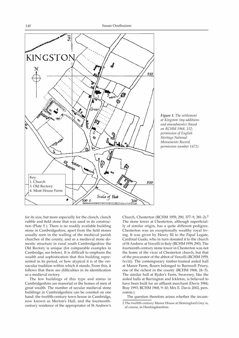
Susan Oosthuizen140
for its size, but more especially for the clunch, clunch rubble and field stone that was used in its construc-tion (Plate 5 ). There is no readily available building stone in Cambridgeshire, apart from the field stones usually seen in the walling of the medieval parish churches of the county, and as a medieval stone do-mestic structure in rural south Cambridgeshire the Old Rectory is unique (for comparable examples in Cambridge, see below). It is difficult to emphasis the wealth and sophistication that this building repre-sented in its period, or how atypical it is of the ver-nacular tradition within which it stands. From this, it follows that there are difficulties in its identification as a medieval rectory. The few buildings of this type and status in Cambridgeshire are manorial or the homes of men of great wealth. The number of secular medieval stone buildings in Cambridgeshire can be counted on one hand: the twelfth-century town house in Cambridge, now known as Merton’s Hall, and the fourteenth-century residence of the appropriator of St Andrew’s
Church, Chesterton (RCHM 1959, 290, 377–9, 381–2).2 The stone tower at Chesterton, although superficial-ly of similar origin, has a quite different pedigree. Chesterton was an exceptionally wealthy royal liv-ing. It was given by Henry III to the Papal Legate, Cardinal Gualo, who in turn donated it to the church of St Andrew at Vercelli in Italy (RCHM 1959, 290). The fourteenth-century stone tower in Chesterton was not the home of the vicar of Chesterton church, but that of the procurator of the abbot of Vercelli (RCHM 1959, lxviii). The contemporary timber-framed aisled hall at Manor Farm, Bourn belonged to Barnwell Priory, one of the richest in the county (RCHM 1968, 24–5). The similar hall at Ryder’s Farm, Swavesey, like the aisled halls at Barrington and Ickleton, is believed to have been built for an affluent merchant (Davis 1984; Bray 1993; RCHM 1968, 9–10; Mrs E. Davis 2002, pers. comm.). The question therefore arises whether the incum-
2 The twelfth-century Manor House at Hemingford Grey is, of course, in Huntingdonshire.
Figure 1. The settlement at Kingston (my additions and amendments) (based on RCHM 1968, 152; permission of English Heritage National Monuments Record, permission number 1472).
Key1. Church3. Old Rectory4. Moat House Farm
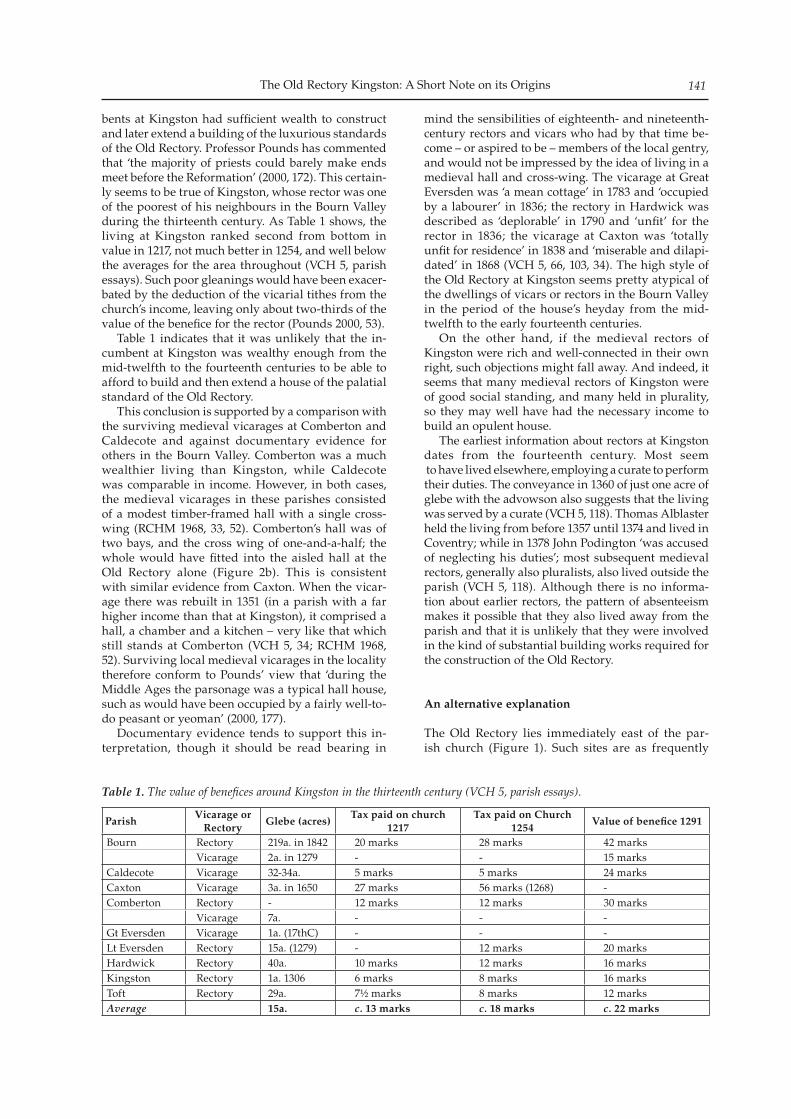
The Old Rectory Kingston: A Short Note on its Origins 141
bents at Kingston had sufficient wealth to construct and later extend a building of the luxurious standards of the Old Rectory. Professor Pounds has commented that ‘the majority of priests could barely make ends meet before the Reformation’ (2000, 172). This certain-ly seems to be true of Kingston, whose rector was one of the poorest of his neighbours in the Bourn Valley during the thirteenth century. As Table 1 shows, the living at Kingston ranked second from bottom in value in 1217, not much better in 1254, and well below the averages for the area throughout (VCH 5, parish essays). Such poor gleanings would have been exacer-bated by the deduction of the vicarial tithes from the church’s income, leaving only about two-thirds of the value of the benefice for the rector (Pounds 2000, 53). Table 1 indicates that it was unlikely that the in-cumbent at Kingston was wealthy enough from the mid-twelfth to the fourteenth centuries to be able to afford to build and then extend a house of the palatial standard of the Old Rectory. This conclusion is supported by a comparison with the surviving medieval vicarages at Comberton and Caldecote and against documentary evidence for others in the Bourn Valley. Comberton was a much wealthier living than Kingston, while Caldecote was comparable in income. However, in both cases, the medieval vicarages in these parishes consisted of a modest timber-framed hall with a single cross-wing (RCHM 1968, 33, 52). Comberton’s hall was of two bays, and the cross wing of one-and-a-half; the whole would have fitted into the aisled hall at the Old Rectory alone (Figure 2b). This is consistent with similar evidence from Caxton. When the vicar-age there was rebuilt in 1351 (in a parish with a far higher income than that at Kingston), it comprised a hall, a chamber and a kitchen – very like that which still stands at Comberton (VCH 5, 34; RCHM 1968, 52). Surviving local medieval vicarages in the locality therefore conform to Pounds’ view that ‘during the Middle Ages the parsonage was a typical hall house, such as would have been occupied by a fairly well-to-do peasant or yeoman’ (2000, 177). Documentary evidence tends to support this in-terpretation, though it should be read bearing in
mind the sensibilities of eighteenth- and nineteenth-century rectors and vicars who had by that time be-come – or aspired to be – members of the local gentry, and would not be impressed by the idea of living in a medieval hall and cross-wing. The vicarage at Great Eversden was ‘a mean cottage’ in 1783 and ‘occupied by a labourer’ in 1836; the rectory in Hardwick was described as ‘deplorable’ in 1790 and ‘unfit’ for the rector in 1836; the vicarage at Caxton was ‘totally unfit for residence’ in 1838 and ‘miserable and dilapi-dated’ in 1868 (VCH 5, 66, 103, 34). The high style of the Old Rectory at Kingston seems pretty atypical of the dwellings of vicars or rectors in the Bourn Valley in the period of the house’s heyday from the mid-twelfth to the early fourteenth centuries. On the other hand, if the medieval rectors of Kingston were rich and well-connected in their own right, such objections might fall away. And indeed, it seems that many medieval rectors of Kingston were of good social standing, and many held in plurality, so they may well have had the necessary income to build an opulent house. The earliest information about rectors at Kingston dates from the fourteenth century. Most seem to have lived elsewhere, employing a curate to perform their duties. The conveyance in 1360 of just one acre of glebe with the advowson also suggests that the living was served by a curate (VCH 5, 118). Thomas Alblaster held the living from before 1357 until 1374 and lived in Coventry; while in 1378 John Podington ‘was accused of neglecting his duties’; most sub sequent medieval rectors, generally also pluralists, also lived outside the parish (VCH 5, 118). Although there is no informa-tion about earlier rectors, the pattern of absenteeism makes it possible that they also lived away from the parish and that it is unlikely that they were involved in the kind of substantial building works required for the construction of the Old Rectory.
An alternative explanation
The Old Rectory lies immediately east of the par-ish church (Figure 1). Such sites are as frequently
ParishVicarage or
Rectory Glebe (acres)
Tax paid on church 1217
Tax paid on Church 1254
Value of benefice 1291
Bourn Rectory 219a. in 1842 20 marks 28 marks 42 marksVicarage 2a. in 1279 - - 15 marks
Caldecote Vicarage 32-34a. 5 marks 5 marks 24 marksCaxton Vicarage 3a. in 1650 27 marks 56 marks (1268) -Comberton Rectory - 12 marks 12 marks 30 marks
Vicarage 7a. - - -Gt Eversden Vicarage 1a. (17thC) - - -Lt Eversden Rectory 15a. (1279) - 12 marks 20 marksHardwick Rectory 40a. 10 marks 12 marks 16 marksKingston Rectory 1a. 1306 6 marks 8 marks 16 marksToft Rectory 29a. 7½ marks 8 marks 12 marksAverage 15a. c. 13 marks c. 18 marks c. 22 marks
Table 1. The value of benefices around Kingston in the thirteenth century (VCH 5, parish essays).
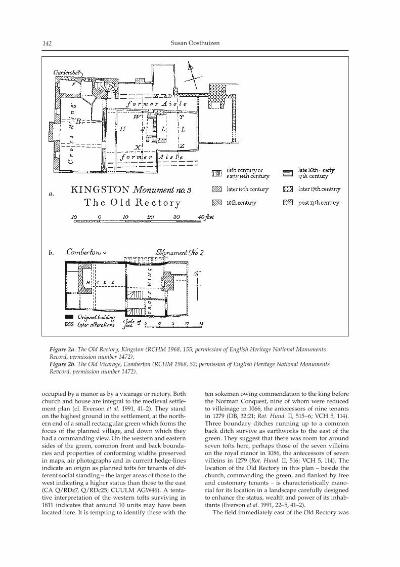
Susan Oosthuizen142
occupied by a manor as by a vicarage or rectory. Both church and house are integral to the medieval settle-ment plan (cf. Everson et al. 1991, 41–2). They stand on the highest ground in the settlement, at the north-ern end of a small rectangular green which forms the focus of the planned village, and down which they had a commanding view. On the western and eastern sides of the green, common front and back bounda-ries and properties of conforming widths preserved in maps, air photographs and in current hedge-lines indicate an origin as planned tofts for tenants of dif-ferent social standing – the larger areas of those to the west indicating a higher status than those to the east (CA Q/RDz7, Q/RDc25; CUULM AGW46). A tenta-tive interpretation of the western tofts surviving in 1811 indicates that around 10 units may have been located here. It is tempting to identify these with the
ten sokemen owing commendation to the king before the Norman Conquest, nine of whom were reduced to villeinage in 1066, the antecessors of nine tenants in 1279 (DB, 32:21; Rot. Hund. II, 515–6; VCH 5, 114). Three boundary ditches running up to a common back ditch survive as earthworks to the east of the green. They suggest that there was room for around seven tofts here, perhaps those of the seven villeins on the royal manor in 1086, the antecessors of seven villeins in 1279 (Rot. Hund. II, 516; VCH 5, 114). The location of the Old Rectory in this plan – beside the church, commanding the green, and flanked by free and customary tenants – is characteristically mano-rial for its location in a landscape carefully designed to enhance the status, wealth and power of its inhab-itants (Everson et al. 1991, 22–5, 41–2). The field immediately east of the Old Rectory was
a.
b.
Figure 2a. The Old Rectory, Kingston (RCHM 1968, 155; permission of English Heritage National Monuments Record, permission number 1472).Figure 2b. The Old Vicarage, Comberton (RCHM 1968, 52; permission of English Heritage National Monuments Revcord, permission number 1472).
The Old Rectory Kingston: A Short Note on its Origins 143
known as Bustage in 1791 and as the Burystead in 1680 (CUL QC 17/18; P. Reynolds 2002, pers. comm.). The name is a compound of burh (often associated with a manorial site) and stead ‘place’ (Reaney 1943, 314, 344). If this were the site of a medieval manor, which one was it? It cannot be that of Kingston Wood, established immediately after the Norman Conquest, which appears to have lain from the time of its crea-tion on its present location some way to the south of the village (Taylor 1973, 85, 99; VCH 5, 114). The only other possibility is the manor of the king, which was already ‘ancient demesne’ in 1086, and seems to have come into the hands of the St George family by the later twelfth century at the latest (DB, 1:5; VCH 5, 114). On the other hand, it has been suggested that the royal manor was located at Moat House Farm (RCHM 1968, 160; VCH 5, 115; see Figure 2). No evidence is given to support this proposal, however, and it may be that it was made on the assumption that the Old Rectory had always been in the hands of the church. That is unlikely since Moat House Farm has been identified with the manor of Debden’s which was cre-ated by the family of Geoffrey of Soham, a prosper-ous thirteenth-century freeman, in a period in which moat-building was at its peak (Rot. Hund. II, 514; Evelyn-White n.d., 52–3; VCH 5, 114–5). The geogra-phy of the site supports this interpretation. The moat around Moat House Farm appears to have been dug across several consolidated customary or freeman properties in a peripheral location which appears to be a later addition to the existing settlement, rather than integrated into it as one might expect the royal manor to have been (especially as the latter predated the Norman Conquest). By 1182 the royal demesne at Kingston appears to have passed into the hands of the St George family, perhaps after some time in administration by Picot, the Norman sheriff of Cambridge, and his descend-ents, the Peverels (VCH 5, 114). The St Georges were substantial landowners in Cambridgeshire. They lived at Kingston, and appear to have had considera-ble social pretensions. They were frequently grantors of land to monastic houses, and apparently enjoyed the perquisites of wealth: in 1269, for example, Baldwin St George held a deer park in Kingston (al-most certainly in the south of the parish and detached from his manor, which was not unusual) (VCH 5, 114; see also Rot. Hund. II, 515). They continued to hold the manor until it was sold in 1556, and in 1559 another sale amalgamated it with Kingston Wood Manor. The medieval grandeur of the Old Rectory would provide an adequate foil for what is known about the social ambitions of the St George family, whose appearance at Kingston is roughly contemporary with the con-struction of the earliest parts of the Old Rectory. It is possible, therefore, that the splendid stone hall at the Old Rectory was built by members of the St George family on the site of the former royal manor in Kingston, either before or after the aisled hall, the two together providing a sumptuous setting. Perhaps after the amalgamation of their manor with that of Kingston Wood in the mid-sixteenth century, the
building – increasingly old-fashioned but nonethe-less substantial – was no longer required as a lordly dwelling, and was sold or given to house the rec-tor or his curate after the Reformation. Clerical liv-ing standards rose after 1549 and incumbents might expect to be better educated, and ‘to live in a better house than the cottager or even the more substantial husbandman or yeoman’ (Pounds 2000, 180, 159). This interpretation of the house and its landscape deals adequately with the problems outlined above: the high status implied by the building itself com-pared with the low income of the living; the centrality of the house to the planned settlement with which it is integrated; the location of the most ancient manor in the parish, that originally belonging to the king; and the Burystead field-name. It also encapsulates the reasons for the survival of the Old Rectory into the modern period: from the mid-twelfth century it was occupied by those rich enough to be able to afford a degree of opulence which was still enviable by the end of the middle ages; and from the mid-sixteenth century by those who were too poor to change it substantially. This small case study may, too, make a small contribution to the argument that an analysis of the history of buildings of all kinds benefits from an exploration of the wider landscapes within which they stand.
Acknowledgements
I am very grateful to Mr John Wilkinson (since sadly passed away), to Mr Peter Reynolds, to Mrs Beth Davis and Mrs Barbara Clarke for the generous spirit in which they have shared their expert knowl-edge of Kingston and the Old Rectory, and for their comments on this note. Miss Charmain Hawkins of Beacon Planning kindly allowed me access to the building and provided me with a report on the struc-ture. Miss Isabel Tacq took the photographs. It goes without saying that the conclusions drawn here, and any mistakes and misunderstandings, are entirely my own.
Sources
Primary SourcesUnpublished sourcesCUL QC 17/18 Terrier of Queens’ College lands in
Kingston, 1781Cambridgeshire Archives Q/RDz Kingston, Parliamentary Enclosure award 1811 Q/RDc Kingston, Parliamentary Enclosure map 1811CUULM AGW46 Kingston, oblique air photograph, 23
April 1963
Printed sourcesEvelyn-White, C (ed) n.d. 1327 Lay Subsidy. Private printingRumble, A. (ed) 1981 Domesday Book: Cambridgeshire.
Chichester: Phillimore.Rotuli Hundredorum 1279, Volume II (Rot. Hund.) 1818
Susan Oosthuizen144
London.
Secondary sourcesBeacon Planning 2010 The Old Rectory, Kingston Historic
Building and Archaeological Assessment. Unpublished report
Bray, D 1993 Ryder’s Farm: An archaeological investigation of a thirteenth-century farmhouse in Swavesey, Cambridgeshire 1993. Cambridge: Cambridgeshire County Council
Davis, E M 1984 ‘Ryder’s Farm, Swavesey: A late thirteenth century timber-framed building’. PCAS 72, 59–61
Department of the Environment 1984 List of buildings of spe-cial architectural or historic interest (South Cambridgeshire). London: HMSO
VCH Cambridgeshire Volume 5. Oxford: OUPEverson, P, Taylor, C and Dunn, C 1991 Change and continu-
ity: rural settlement in north-west Lincolnshire. London: HMSO
Liddiard, R 2005 Castles in context. Macclesfield: Windgather
Pounds, N G 2000 A history of the English parish. Cambridge: CUP
Reaney, P H 1943 Place-names of Cambridgeshire and the Isle of Ely. Cambridge: CUP
Reynolds, P n.d. History of Kingston parish. Kingston: Kingston Parish Council
RCHM 1959 City of Cambridge Volume 1. London: HMSORCHM 1968 West Cambridgeshire. London: HMSOTaylor, C 1973 The Cambridgeshire Landscape. London:
Hodder & Stoughton
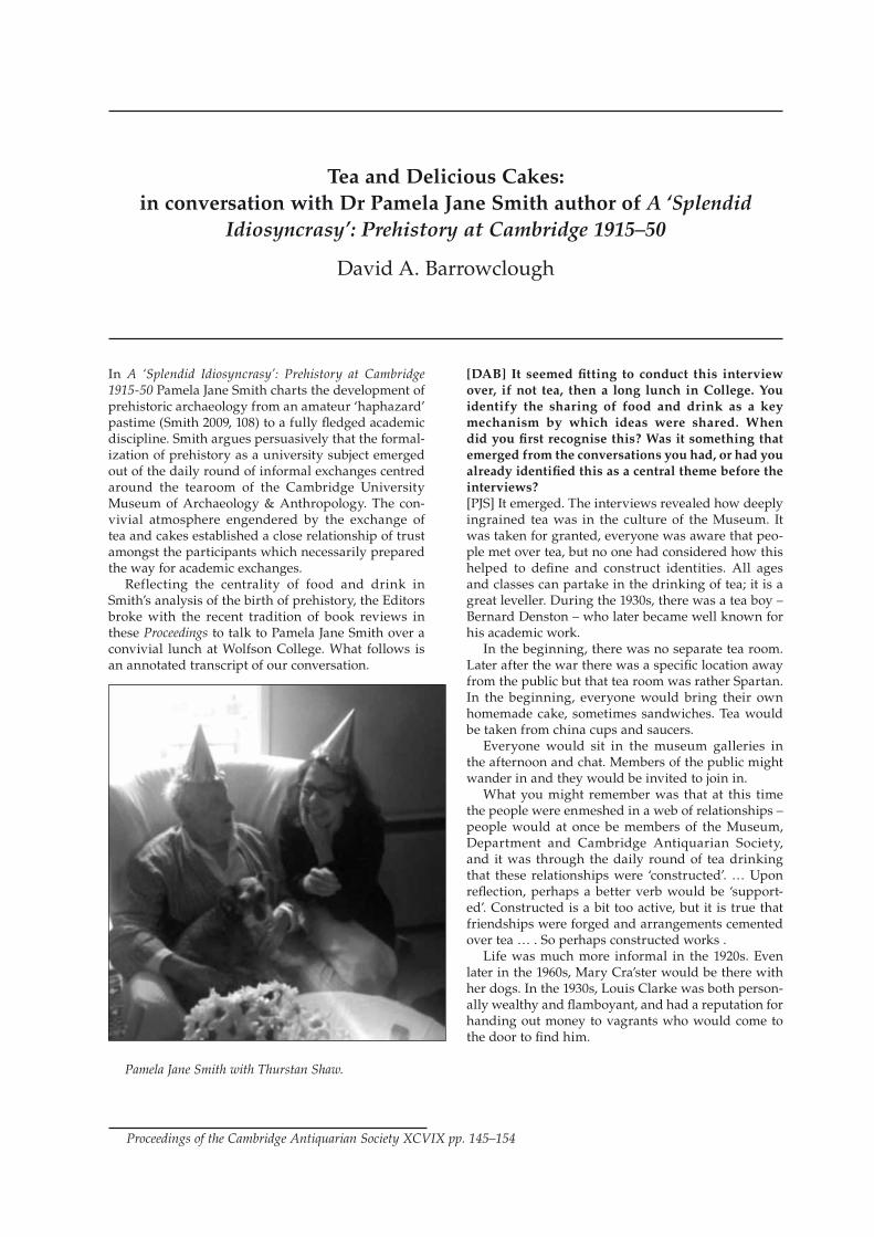
In A ‘Splendid Idiosyncrasy’: Prehistory at Cambridge 1915-50 Pamela Jane Smith charts the development of prehistoric archaeology from an amateur ‘haphazard’ pastime (Smith 2009, 108) to a fully fledged academic discipline. Smith argues persuasively that the formal-ization of prehistory as a university subject emerged out of the daily round of informal exchanges centred around the tearoom of the Cambridge University Museum of Archaeology & Anthropology. The con-vivial atmosphere engendered by the exchange of tea and cakes established a close relationship of trust amongst the participants which necessarily prepared the way for academic exchanges. Reflecting the centrality of food and drink in Smith’s analysis of the birth of prehistory, the Editors broke with the recent tradition of book reviews in these Proceedings to talk to Pamela Jane Smith over a convivial lunch at Wolfson College. What follows is an annotated transcript of our conversation.
[DAB] It seemed fitting to conduct this interview over, if not tea, then a long lunch in College. You identify the sharing of food and drink as a key mechanism by which ideas were shared. When did you first recognise this? Was it something that emerged from the conversations you had, or had you already identified this as a central theme before the interviews?[PJS] It emerged. The interviews revealed how deeply ingrained tea was in the culture of the Museum. It was taken for granted, everyone was aware that peo-ple met over tea, but no one had considered how this helped to define and construct identities. All ages and classes can partake in the drinking of tea; it is a great leveller. During the 1930s, there was a tea boy – Bernard Denston – who later became well known for his academic work. In the beginning, there was no separate tea room. Later after the war there was a specific location away from the public but that tea room was rather Spartan. In the beginning, everyone would bring their own homemade cake, sometimes sandwiches. Tea would be taken from china cups and saucers. Everyone would sit in the museum galleries in the afternoon and chat. Members of the public might wander in and they would be invited to join in. What you might remember was that at this time the people were enmeshed in a web of relationships – people would at once be members of the Museum, Department and Cambridge Antiquarian Society, and it was through the daily round of tea drinking that these relationships were ‘constructed’. … Upon reflection, perhaps a better verb would be ‘support-ed’. Constructed is a bit too active, but it is true that friendships were forged and arrangements cemented over tea … . So perhaps constructed works . Life was much more informal in the 1920s. Even later in the 1960s, Mary Cra’ster would be there with her dogs. In the 1930s, Louis Clarke was both person-ally wealthy and flamboyant, and had a reputation for handing out money to vagrants who would come to the door to find him.
Tea and Delicious Cakes:in conversation with Dr Pamela Jane Smith author of A ‘Splendid
Idiosyncrasy’: Prehistory at Cambridge 1915–50
David A. Barrowclough
Proceedings of the Cambridge Antiquarian Society XCVIX pp. 145–154
Pamela Jane Smith with Thurstan Shaw.
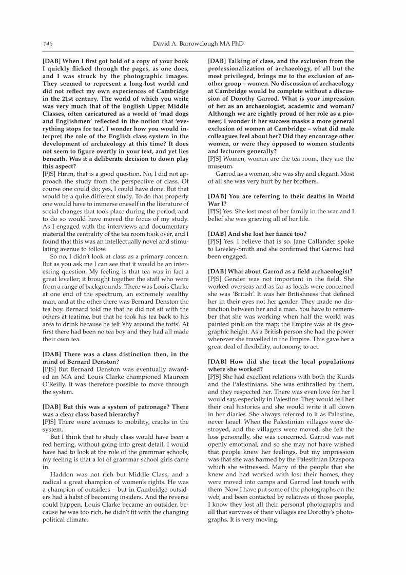
David A. Barrowclough MA PhD146
[DAB] When I first got hold of a copy of your book I quickly flicked through the pages, as one does, and I was struck by the photographic images. They seemed to represent a long-lost world and did not reflect my own experiences of Cambridge in the 21st century. The world of which you write was very much that of the English Upper Middle Classes, often caricatured as a world of ‘mad dogs and Englishmen’ reflected in the notion that ‘eve-rything stops for tea’. I wonder how you would in-terpret the role of the English class system in the development of archaeology at this time? It does not seem to figure overtly in your text, and yet lies beneath. Was it a deliberate decision to down play this aspect?[PJS] Hmm, that is a good question. No, I did not ap-proach the study from the perspective of class. Of course one could do; yes, I could have done. But that would be a quite different study. To do that properly one would have to immerse oneself in the literature of social changes that took place during the period, and to do so would have moved the focus of my study. As I engaged with the interviews and documentary material the centrality of the tea room took over, and I found that this was an intellectually novel and stimu-lating avenue to follow. So no, I didn’t look at class as a primary concern. But as you ask me I can see that it would be an inter-esting question. My feeling is that tea was in fact a great leveller; it brought together the staff who were from a range of backgrounds. There was Louis Clarke at one end of the spectrum, an extremely wealthy man, and at the other there was Bernard Denston the tea boy. Bernard told me that he did not sit with the others at teatime, but that he took his tea back to his area to drink because he felt ‘shy around the toffs’. At first there had been no tea boy and they had all made their own tea.
[DAB] There was a class distinction then, in the mind of Bernard Denston?[PJS] But Bernard Denston was eventually award-ed an MA and Louis Clarke championed Maureen O’Reilly. It was therefore possible to move through the system.
[DAB] But this was a system of patronage? There was a clear class based hierarchy?[PJS] There were avenues to mobility, cracks in the system. But I think that to study class would have been a red herring, without going into great detail. I would have had to look at the role of the grammar schools; my feeling is that a lot of grammar school girls came in. Haddon was not rich but Middle Class, and a radical a great champion of women’s rights. He was a champion of outsiders – but in Cambridge outsid-ers had a habit of becoming insiders. And the reverse could happen, Louis Clarke became an outsider, be-cause he was too rich, he didn’t fit with the changing political climate.
[DAB] Talking of class, and the exclusion from the professionalization of archaeology, of all but the most privileged, brings me to the exclusion of an-other group – women. No discussion of archaeology at Cambridge would be complete without a discus-sion of Dorothy Garrod. What is your impression of her as an archaeologist, academic and woman? Although we are rightly proud of her role as a pio-neer, I wonder if her success masks a more general exclusion of women at Cambridge – what did male colleagues feel about her? Did they encourage other women, or were they opposed to women students and lecturers generally?[PJS] Women, women are the tea room, they are the museum. Garrod as a woman, she was shy and elegant. Most of all she was very hurt by her brothers.
[DAB] You are referring to their deaths in World War I?[PJS] Yes. She lost most of her family in the war and I belief she was grieving all of her life.
[DAB] And she lost her fiancé too?[PJS] Yes. I believe that is so. Jane Callander spoke to Loveley-Smith and she confirmed that Garrod had been engaged.
[DAB] What about Garrod as a field archaeologist?[PJS] Gender was not important in the field. She worked overseas and as far as locals were concerned she was ‘British’. It was her Britishness that defined her in their eyes not her gender. They made no dis-tinction between her and a man. You have to remem-ber that she was working when half the world was painted pink on the map; the Empire was at its geo-graphic height. As a British person she had the power wherever she travelled in the Empire. This gave her a great deal of flexibility, autonomy, to act.
[DAB] How did she treat the local populations where she worked?[PJS] She had excellent relations with both the Kurds and the Palestinians. She was enthralled by them, and they respected her. There was even love for her I would say, especially in Palestine. They would tell her their oral histories and she would write it all down in her diaries. She always referred to it as Palestine, never Israel. When the Palestinian villages were de-stroyed, and the villagers were moved, she felt the loss personally, she was concerned. Garrod was not openly emotional, and so she may not have wished that people knew her feelings, but my impression was that she was harmed by the Palestinian Diaspora which she witnessed. Many of the people that she knew and had worked with lost their homes, they were moved into camps and Garrod lost touch with them. Now I have put some of the photographs on the web, and been contacted by relatives of those people, I know they lost all their personal photographs and all that survives of their villages are Dorothy’s photo-graphs. It is very moving.
Tea and Delicious Cakes: in conversation with Dr Pamela Jane Smith 147
Dorothy Garrod with Yusra, who found Tabun 1, an adult Neanderthal skeleton.
[DAB] And how about life in Cambridge?[PJS] Back in Cambridge Garrod found it much tougher. She was unable to come to terms with what was needed to function successfully within the University. The University was not accustomed to women, for the purposes of the bureaucracy she was a man, an honorary man. In order to deal with her the University had to treat her as if she were a man.For her it was very difficult. After the freedom she had enjoyed working overseas to return to Cambridge was stifling. She was used to working in the field and was not prepared for the politicking of Cambridge. She couldn’t play the game. Remember that she had never been to school; she had been educated at home, and she was completely unprepared for the male-dominated public school educated men that she en-countered in the administration. The faculty men were accepting and supportive! It was still a chilly climate within the university. Garrod didn’t frequent the tearoom in the 1940s perhaps because there was too much ‘shop talk’. She would have been more at home there earlier in the 1930s when the talk was less structured.
[DAB] Can you explain what you mean by ‘shop talk’?[PJS] ‘shop talk’ … When someone discusses the nu-ance of isotope analyses with colleagues, that would be ‘shop talk’. When someone arranges the dull details of an academic committee agreement, that would be shop talk. It is business as usual. Practical language; deal making language; committee language.
But then Mary Cras’ter still described witnessing gentlemanly discussions over tea when she arrived later. So I could be wrong about the shop talk analy-sis; that was my sense however. People describe tea time as, whatever generation, as lively with loads of ideas kicking about. .. What historians describe as a ‘knowledge making space’. There is this quote from my book: The straight academic road into science is clearly more likely travelled by men. This statement is also true of Garrod’s entrance into the academic world, which differed greatly from Clark’s, who advanced from undergradu-ate to Bye-Fellow, Faculty Assistant Lecturer, University Lecturer and finally to Professor, all within the same uni-versity system. Women post-graduates in Sonnert and Holton’s study had more difficulty establishing collegiate networks of important contacts once within the university; earlier lack of appropriate institutional education could have adversely affected them. Most women interviewed found that the university environment was not supportive and was sometimes frightening. They tended to feel exclud-ed from informal social events such as going for drinks and feel out-of-place in predominantly male groups. These findings may suggest the reason why Garrod never participated in Faculty gatherings. According to Bruce Howe, she did not frequent the tea-room. ‘The Museum coffee and teas were very stimulating shop-talk occasions. Daniel, Bushnell, Phillips, Lethbridge, Clark were the regulars; Garrod not at all … O’Reilly saw the pot was brewing, contributed cakes, cookies without fail.’ Garrod might have felt reluctant as a professor to behave as a woman must, contributing tea and cake; there may have been a sense of informal exclusion. In addition, since so many Faculty and research plans were informally con-cocted over tea, Garrod might have had difficulty remain-ing up-to-date on the definition of Faculty issues and the formulation of subsequent decisions.
[DAB] So she was most at home when digging?[PJS] Yes, digging was where she was at ease. But hav-ing said that, when she became Disney Professor she ate separately from the others in the field. Becoming Disney professor changed her – I think she felt she had to engender ‘respect’ .
[DAB] Do you think that things have changed?[PJS] The next Disney Professor will be a woman!
[DAB] You seem very sure?[PJS] 80% of the archaeology students are women, women are in the majority. After all these years it is time we had a woman.
[DAB] I can see your point, but when I look at the people in archaeology who hold professorships I still see relatively few women.[PJS] Yes, ‘where are the women’? When I organised the first personal history lectures one of the com-ments I got afterwards was, ‘where are the women?’. It still seems difficult; it’s as if women haven’t yet re-alised they are in the majority.
David A. Barrowclough MA PhD148
[DAB] In a sense your book is a three act play: Burkitt, Clark and Garrod. What were the similari-ties between the three and what the biggest differ-ences? How did these shape the development of archaeology?
[PJS] Laughs Well it didn’t start out that way. I knew Bruce Trigger in Canada (he was in McGill and I was in Victoria) and it was he who suggested I study Clark. No one had studied Clark yet at then in the early 1990s and the time was ripe. Bruce found him-self sitting next to Paul Mellars at dinner and he mentioned me. Paul subsequently introduced him-self to me and asked if I were serious about studying Clark, which I was as I had already written an MA about him. So I arrived in Cambridge ready to study Clark, and in the process I came across Garrod. Then I thought that I really couldn’t leave out Burkitt. So that’s how I got my three main protagonists. At that point Paul Mellars jumped in and told me to stop and cement what I had.
[DAB] What was Burkitt’s primary success/contri-bution? What was his weakness?[PJS] refers to her book Surviving students from the 1920s and 1930s recalled how much they appreci-ated Burkitt’s personal approach to prehistory in the ‘small and intimate’ Archaeology and Anthropology Faculty. ‘Miles’ great ability was to make prehistory exciting with his memories of sites and prehistorians’ his lectures were ‘enlivened and enriched by his great store of amusing anecdotes . . . I was much attached to Miles,’ said Desmond Clark, who was perhaps one of Burkitt’s most famous students. Burkitt was proud to communicate the knowledge he had learned as the sole young pupil of the Abbé Breuil. He prepared to teach prehistory while lying in the mud at Gargas and digging by the light of an acetylene lamp with honoured intellectual guard-ians. His mentors were gentlemen. Cartailhac was consistently charming and cultured, and according to Burkitt, Teilhard de Chardin was courteous and ‘well-bred . . . a Christian mystic and gentleman com-bined’ (Burkitt as quoted by Cuénot 1965: 20). ‘One’s first emotion was affection’ (Burkitt 1922a: 43) for the prehistorians he met in Spain and France. In an un-critical way, when Burkitt began to teach, one of his firm desires was to communicate his feeling of excite-ment and to demonstrate his devotion to Obermaier and Breuil’s ideas. He never aspired to be the charis-matic researcher described by Morrell and Geison.Before formalised controls over recruitment, insti-tutionalised avenues of entry and established quali-fying standards, ‘spirit’ was made ‘flesh’ through personal attachment and companionship. Knowledge was gained over the nightly camp fires, at which Burkitt ‘had much conversation’ or on the back of a horse while travelling through acres of waterlilied la-goons in Spain. Archaeological knowledge was pack-aged within an individual, trade-like apprenticeship based on loyalty. If Burkitt were applying for his post today, with
the current stress on original research, he would like-ly not be short-listed. He may not have even qualified for Cambridge if the Previous were mandatory before coming up from Eton. In an era before a standardised qualifying entry examination, before self-conscious attempts at ‘meritocracy’ and before paid positions, Burkitt’s comparative wealth and place as a male child of the University allowed him to contribute freely on his own terms. As recorded in the Faculty Minutes, the Board felt fortunate to have him. He was precisely the right man, a fine historical fit. Without Burkitt, prehistoric archaeology may never have been taught to undergraduates. The subject may not have been introduced in Cambridge. Burkitt is criticised by some (Daniel 1986) for his apparent lack of profes-sional ambition and for his rumoured refusal to ac-cept the new Abercromby Professorship of Prehistoric Archaeology at Edinburgh before V.G. Childe in the late 1920s. Yet he is remembered with great affection. Thurstan Shaw clearly described a ‘generous man of good will’ and Desmond Clark stated that Burkitt was ‘a dedicated lecturer’ obviously happiest while teaching Cambridge introductory courses on the Palaeolithic. Burkitt remained as a non-professional lecturer in the Faculty until 1958 when he retired in order to commit himself more fully to local govern-ment. Over the years, he was particularly well thought of as the Chairman of the Education Committee of the County Council for Cambridgeshire where he fought for the inclusion of archaeology in secondary school curricula. However, his dream of a united world run by judicious, historically-informed men, resulting in peace among nations, has eluded us.
[DAB] What was Clark’s primary success/contribu-tion? What his weakness?[PJS] referring to her book again In order to understand Clark we need to begin with Miles Burkitt, an in-dependently wealthy man who shared his private library, lithics collections and wide knowledge with students in an atmosphere of generosity and good will. He was motivated by the belief that archaeol-ogy, as part of a liberal education, would produce Godly men of value and sound judgement who would justly administer an Empire. Archaeology was not to be seen as a career. It was a humane study to better mankind not individual desires. Men of ‘ambition’ were suspect; they could easily be corrupted by the seduction of power, money and fame. Those who put their own academic ambitions before the common good were ‘rude’. Research was not the prime goal of Burkitt’s academic life; the Ph.D was still, in the 1920s, a questionable, even at times disreputable, degree. Such a degree was too narrow and could be viewed as self-serving. ‘No one took a Ph.D because that was considered vulgar,’ observed Mary Cra’ster. Research for its own sake was still an ‘ungentlemanly, boorish, and even foolish German idea’ (Morrell 1993: 122). In contrast, Burkitt’s most famous Ph.D student, Grahame Clark, was a self-proclaimed man of Science. Matriculating in 1926, he achieved First Class Honours in the Archaeology and Anthropology Tripos, concen-
Tea and Delicious Cakes: in conversation with Dr Pamela Jane Smith 149
trating on north-western European prehistory, a spe-cialisation specifically set up at his request. Motivated by his love of science, Clark became one of the first research students in archaeology in the new Faculty of Archaeology and Anthropology. Upon hearing of his decision to pursue a Ph.D in prehistoric archaeology, Clark’s guardian approached his super-visor, Miles Burkitt, and Disney Professor Ellis Minns to enquire about employment possibilities. He was promptly told that Clark had no employment future. Although Clark came from a very respectable middle class background, he did not have a private income. He was, nevertheless, very determined to become a ‘professional archaeologist’. Clark’s wish to be a ‘professional’ would have been an impossible dream when Burkitt dug with Obermaier in 1913. However, during Clark’s under-graduate years, Cyril Fox had already become a suc-cessful professional role model. With Louis Clarke’s support, Fox had secured the post of Keeper of Archaeology at the National Museum of Wales in 1924. On completion of his Ph.D, Clark began to achieve his dream of being a professional archaeologist, begin-ning his long and distinguished career with the ten-ure of a Bye-Fellowship at Peterhouse. Following this, he was successively: Faculty Assistant Lecturer (1935–46), University Lecturer (1946–52), Disney Professor of Archaeology (1952–74), Head of the Department of Archaeology and Anthropology (1956–61 and 1968–71), and Master of Peterhouse (1973–80). As for his primary contribution Trigger (1989: 269) states that, by the 1940s and 1950s, Clark had begun to pioneer an ecologically oriented, functionalist ap-proach to prehistory, the first scholar to apply A.G. Tansley’s (1935) concept of an ecosystem to archaeo-logical evidence. Willey (1990: 371) agrees that Clark developed the ecosystem concept, introducing to English archaeology a view of culture which attempt-ed ‘to say something about the interrelationship of environment, technology, social forms, and idea sys-tems’. It is generally thought that Clark’s stress upon an interdisciplinary approach led to the development in England of the subdisciplines of bio- and zooar-chaeology as well as palaeoeconomy and palaeoeth-nobotany. Looking at his contribution critically I think we can say that during the 1930s, Clark was a successful intellectual entrepreneur who, more than any other individual in Cambridge archaeology, personified the new generation of prehistorians who believed that ar-chaeology was a profession. Whereas Burkitt felt that archaeology was an amateur avocation which must serve the Empire and promote world peace, Clark felt that archaeology was a professional endeavour which must become academically institutionalised. Without doubt, he was responsible for gaining increased sta-tus for prehistory as a specialisation at Cambridge. Thinking now about his ‘weaknesses’. According to many I interviewed, Clark was the embodiment of the ‘Young Man in a Hurry’ from F.M. Cornford’s well-known 1908 satire of Cambridge University poli-tics, Microcosmographia Academica: Being a Guide for the
Young Academic Politician. Clark also appears to have been one of Cornford’s Adullamites who inhabited ‘a series of caves near Downing Street’. Adullamites were dangerous because they knew what they wanted; ‘and that is, [where] all the money is going’. By 1914, Downing Street had become the build-ing site for the new science Tripos courses, labo-ratories and museums. Among these were the famous Cavendish Laboratory as well as Chemistry, Engineering, Zoology, Mineralogy, Geology, Botany and the new University Museum of Archaeology and Ethnology. In keeping with the location, the Faculty of Archaeology and Anthropology had consistently fought to be classified on the Science rather than the Arts side of the General Board of the Faculties. Adullamites were indeed men of Science who ‘It will be seen … are not refined, like Classical men’ (all quo-tations, Cornford 1908: 3). Clark was a self-focused, very ambitious, deter-mined young man. Apparently aloof, cold and driven, and stories describing his inscrutable, difficult-to-know nature abound. Undergraduate Warwick Bray, ‘Thinking about my days, I have come to the conclu-sion that Clark as a person was irrelevant. What he had to say was up-to-date, exciting, clearly and well argued. The books were fabulous; I used to read them for pure pleasure. It didn’t matter that the man him-self was cold as a crocodile’. Personal magnetism, or lack thereof, was not an issue. Instead of personality, Clark’s innovative intel-lectual approach and how it evolved are crucial to understanding Cambridge prehistory in the 1930s. During this period, Clark changed his definitions, goals, methods, research questions and subjects studied. In order to examine the cause and effect of Clark’s changing intellectual agenda, it is best to start with his conception and approach to archaeology prior to the establishment of the Fenland Research Committee. To sum up, Clark was brilliant. Students realised that and followed his intellectual lead despite his dis-tant personality.
[DAB] What was Garrod’s primary success/contri-bution? What was her weakness?[PJS] referring to her book Garrod’s own words describe her character. At the end of her life, an acquaintance suggested to Garrod that she had been lucky. ‘Pas la chance,’ Garrod replied, ‘c’est courage et perseverance’. Where Clark had been a successful, professional-izing, intellectual entrepreneur who rapidly changed archaeological theory and method during the 1930s, and consequently dramatically altered the Faculty’s archaeological curriculum; Garrod, a female outsider, a woman professor in a university that still barred her from full membership, was well-known for her non-university based archaeological research in England, Gibraltar, Palestine, Kurdistan and Bulgaria. She suf-fered personally when elected to the oldest and most prestigious university chair of archaeology in Great Britain. Her experiences reveal the gendered opera-
David A. Barrowclough MA PhD150
tion of academic careers. Dorothy Garrod’s difficulty in being Professor was that she found distasteful exactly the type of behaviour that had resulted in her election. She was untrained in the types of political manoeuvres that F.M. Cornford’s famous satire of 1908 on Cambridge University politics, Microcosmographia Academica so accurately describes. The ‘political activity’ of casu-ally negotiating deals while strolling King’s Parade was alien to her. ‘Remember this:’ Cornford (1908: 42) warns, ‘the men who get things done are the men who walk up and down the King’s Parade, from 2 to 4, every day of their lives.’ In addition, Garrod’s lack of full membership in the University before 1948 and also the fact that she was a woman barred her from some behind-the-scenes in-teractions and also from social settings where deals might have been struck. Women were not allowed, for example, to dine at the men’s colleges where issues were broached and resolved during conversations at High Table. She would not have been present at im-portant informal discussions where bureaucratic ma-noeuvrings might have been agreed upon. Negotiating scrimmages with powerful bureau-cratic officers or committees was difficult partly because some members of the General Board of the Faculties were particularly hard to deal with. She was unaccustomed to the often sharp style of Cambridge institutional interactions and was uncomfortable with the verbal sparring and sarcastic retorts which were an acceptable part of the negotiating process. Garrod had no experience in hierarchical, insti-tutional settings, where she would have been under a General Board, yet over undergraduates. She had never gone to a public school such as Marlborough, as had her brothers, or entered Cambridge and stayed there to build her career, as had Grahame Clark. She was accustomed to leading small, egalitarian re-search teams where she had control of funding and final decisions, or to supervising one or two students over tea; Garrod was ill-prepared for the University’s ranked system. Throughout, Garrod seems to have been operat-ing on the more co-operative, reasoned, and even dignified mode of behaviour she had enjoyed in the practice of research. This behaviour was maladaptive within Cambridge’s arcane institutional, hierarchi-cal arena where control and manipulation of scarce resources were critical and where bureaucratic effec-tiveness required a tacit knowledge of how to act. Garrod adequately fulfilled the formal require-ments of her office. Her diligent service on the Faculty was well-appreciated. She conscientiously worked on Faculty committees and with Burkitt, Clark and Daniel to formulate regulations and to establish a curriculum for the new Tripos course. According to Daniel (1986), Garrod insisted, while serving on the committee to revise and expand the course, that students be required to gain experience excavating abroad and that the new curriculum stress world pre-history. Daniel considered this to be Garrod’s most valuable contribution, commemorated today by the
Department’s Garrod Fund established specifically to pay students’ travel expenses. Garrod thus wished to encourage non-Eurocentric perspectives, hoping that with experience abroad and knowledge of the pre-history of other nations, students could consider the place of prehistoric England within a broader context. However, Garrod never seemed to have tried to institutionalise her own research agenda. In compari-son to Clark, who immediately taught his own mate-rial, pushed an ecological approach to archaeological analysis and who also fought to institutionalise what was to become known world-wide as environmen-tal and palaeoeconomic archaeology, Garrod did not suggest that her many outstanding discoveries or her views on the evolution of Homo sapiens should be-come part of the required curriculum. Papers on the prehistory of the Near East and on the Levantine cor-ridor were conspicuously absent from the newly es-tablished Part II. Although she made it clear that she wanted world prehistory to be taught at Cambridge, Garrod seemed completely incapable of ‘blowing her own trumpet’ or championing her own material. In addition, she simply did not appear to under-stand the importance of attracting students in order to further her own research agenda. Garrod never became acculturated to the type of informal behaviour needed to be a ‘Cambridge man’. All indications are that she was uncomfortable in her Professorial role and left as soon as her sense of duty allowed. She did a competent job but longed to return to her field research. Clare Fell, who was Assistant Curator of the Museum of Archaeology and Ethnology from 1948–53, remembered ‘how shocked and saddened eve-ryone was when she resigned. Dorothy was one of the few women professors and the female academ-ics thought it terrible she should resign. But she was right, as she wanted to finish her research and not get bogged down in administration.’ Although she did not function happily within the University hierarchy and certainly was not an intellectual careerist or entrepreneur as was Clark, Garrod was very well-liked by her Archaeology and Anthropology staff colleagues. ‘Oh, we loved her. She was quite awe-inspiring’ remembered Mary Thatcher. According to Daniel (1986: 211), in personal situa-tions, ‘Dorothy Garrod had been easy to get on with; she was a generous, lovable, outgoing person.’ Upon retirement, thirty-four members of the Faculty Board presented her with an ornate scroll, inscribed in Latin, which reveals their sadness and respect, which can be translated as: To Dorothy Annie Elizabeth Garrod most illustri-ous teacher and indefatigable explorer of antiquity, who for thirteen years professed the science of archaeology in Cambridge with such great learning, such great splendour, such great friendliness and humanity, her colleagues, ac-quaintances, friends, whose names are written beneath, joyfully giving thanks for so many things well done, ear-nestly mourning her sad and premature departure, follow-ing her in all excellent things, moved not only by love but
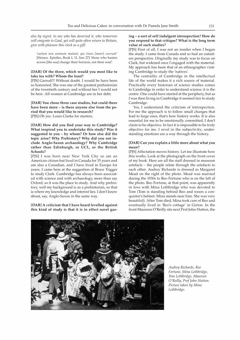
Tea and Delicious Cakes: in conversation with Dr Pamela Jane Smith 151
also by regret, to one who has deserved it, who tomorrow will emigrate to Gaul, yet will quite often return to Britain, give with pleasure this clock as a gift.
‘caelum non animum mutant, qui trans [mare] currunt’ [Horace. Epistles, Book I, 11, line 27] ‘those who hasten across [the sea] change their horizon, not their soul’.
[DAB] Of the three, which would you most like to take tea with? Whom the least?[PJS] Garrod!!! Without doubt. I would be have been so honoured. She was one of the greatest prehistorian of the twentieth century and without her I would not be here. All women at Cambridge are in her debt.
[DAB] You chose three case studies, but could there have been more – is there anyone else from the pe-riod that you would like to research? [PJS] Oh yes. Louis Clarke for starters.
[DAB] How did you find your way to Cambridge? What inspired you to undertake this study? Was it suggested to you – by whom? Or how else did the topic arise? Why Prehistory? Why did you not in-clude Anglo-Saxon archaeology? Why Cambridge rather than Edinburgh, or UCL, or the British Schools?[PJS] I was born near New York City so am an American citizen but lived in Canada for 35 years and am also a Canadian, and I have lived in Europe for years. I came here at the suggestion of Bruce Trigger to study Clark. Cambridge has always been associat-ed with science and with archaeology, more than say Oxford, so it was the place to study. And why prehis-tory, well my background is as a prehistorian, so that is where my knowledge and interest lies. I don’t know about, say, Anglo-Saxon in the same way.
[DAB] A criticism that I have heard levelled against this kind of study is that it is in effect navel gaz-
ing – a sort of self indulgent introspection? How do you respond to that critique? What is the long term value of such studies?[PJS] First of all, I was not an insider when I began the study. I came from Canada and so had an outsid-ers perspective. Originally my study was to focus on Clark, but widened once I engaged with the material. My approach has been that of an ethnographer visit-ing Cambridge to study the ‘natives’. The centrality of Cambridge in the intellectual life of the world makes it a rich source of material. Practically every historian of science studies comes to Cambridge in order to understand science; it is the centre. One could have started at the periphery, but as I was then living in Cambridge it seemed fair to study Cambridge. Yes, I understand the criticism of introspection. For me the approach is to follow small changes that lead to large ones, that’s how history works. It is also essential for me to be emotionally committed; I don’t claim to be objective. In fact it is impossible to be truly objective for me. I revel in the subjectivity; under-standing emotions are a way through the history.
[DAB] Can you explain a little more about what you mean?[PJS] Affectation moves history. Let me illustrate how this works. Look at the photograph on the front cover of my book. Here are all the staff dressed in museum artefacts – the people relate through the artefacts to each other. Audrey Richards is dressed as Margaret Mead on the right of the photo. Mead was married during the 1930s to Reo Fortune who is on the left of the photo. Reo Fortune, at that point, was apparently in love with Mina Lethbridge who was devoted to Tom (Tom is standing behind Reo and wears a con-quistor’s helmet. Mina stands near him. She was very beautiful). After Tom died, Mina took care of Reo and eventually lived in ‘Reo’s cottage’ in Girton. In the front Maureen O’Reilly sits next Prof John Hutton, the
Audrey Richards, Reo Fortune, Mina Lethbridge, Tom Lethbridge, Maureen O’Reilly, Prof John Hutton. Picture taken by Mina Lethbridge.
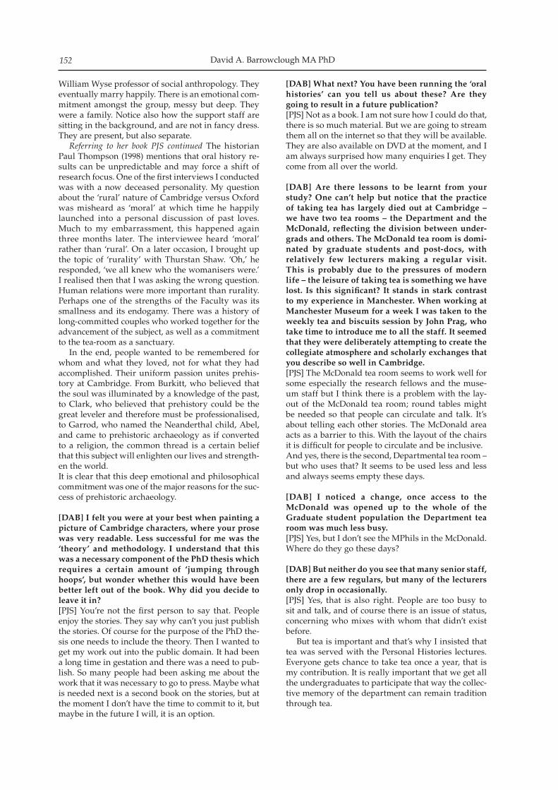
David A. Barrowclough MA PhD152
William Wyse professor of social anthropology. They eventually marry happily. There is an emotional com-mitment amongst the group, messy but deep. They were a family. Notice also how the support staff are sitting in the background, and are not in fancy dress. They are present, but also separate. Referring to her book PJS continued The historian Paul Thompson (1998) mentions that oral history re-sults can be unpredictable and may force a shift of research focus. One of the first interviews I conducted was with a now deceased personality. My question about the ‘rural’ nature of Cambridge versus Oxford was misheard as ‘moral’ at which time he happily launched into a personal discussion of past loves. Much to my embarrassment, this happened again three months later. The interviewee heard ‘moral’ rather than ‘rural’. On a later occasion, I brought up the topic of ‘rurality’ with Thurstan Shaw. ‘Oh,’ he responded, ‘we all knew who the womanisers were.’ I realised then that I was asking the wrong question. Human relations were more important than rurality. Perhaps one of the strengths of the Faculty was its smallness and its endogamy. There was a history of long-committed couples who worked together for the advancement of the subject, as well as a commitment to the tea-room as a sanctuary. In the end, people wanted to be remembered for whom and what they loved, not for what they had accomplished. Their uniform passion unites prehis-tory at Cambridge. From Burkitt, who believed that the soul was illuminated by a knowledge of the past, to Clark, who believed that prehistory could be the great leveler and therefore must be professionalised, to Garrod, who named the Neanderthal child, Abel, and came to prehistoric archaeology as if converted to a religion, the common thread is a certain belief that this subject will enlighten our lives and strength-en the world. It is clear that this deep emotional and philosophical commitment was one of the major reasons for the suc-cess of prehistoric archaeology.
[DAB] I felt you were at your best when painting a picture of Cambridge characters, where your prose was very readable. Less successful for me was the ‘theory’ and methodology. I understand that this was a necessary component of the PhD thesis which requires a certain amount of ‘jumping through hoops’, but wonder whether this would have been better left out of the book. Why did you decide to leave it in?[PJS] You’re not the first person to say that. People enjoy the stories. They say why can’t you just publish the stories. Of course for the purpose of the PhD the-sis one needs to include the theory. Then I wanted to get my work out into the public domain. It had been a long time in gestation and there was a need to pub-lish. So many people had been asking me about the work that it was necessary to go to press. Maybe what is needed next is a second book on the stories, but at the moment I don’t have the time to commit to it, but maybe in the future I will, it is an option.
[DAB] What next? You have been running the ‘oral histories’ can you tell us about these? Are they going to result in a future publication?[PJS] Not as a book. I am not sure how I could do that, there is so much material. But we are going to stream them all on the internet so that they will be available. They are also available on DVD at the moment, and I am always surprised how many enquiries I get. They come from all over the world.
[DAB] Are there lessons to be learnt from your study? One can’t help but notice that the practice of taking tea has largely died out at Cambridge – we have two tea rooms – the Department and the McDonald, reflecting the division between under-grads and others. The McDonald tea room is domi-nated by graduate students and post-docs, with relatively few lecturers making a regular visit. This is probably due to the pressures of modern life – the leisure of taking tea is something we have lost. Is this significant? It stands in stark contrast to my experience in Manchester. When working at Manchester Museum for a week I was taken to the weekly tea and biscuits session by John Prag, who take time to introduce me to all the staff. It seemed that they were deliberately attempting to create the collegiate atmosphere and scholarly exchanges that you describe so well in Cambridge.[PJS] The McDonald tea room seems to work well for some especially the research fellows and the muse-um staff but I think there is a problem with the lay-out of the McDonald tea room; round tables might be needed so that people can circulate and talk. It’s about telling each other stories. The McDonald area acts as a barrier to this. With the layout of the chairs it is difficult for people to circulate and be inclusive.And yes, there is the second, Departmental tea room – but who uses that? It seems to be used less and less and always seems empty these days.
[DAB] I noticed a change, once access to the McDonald was opened up to the whole of the Graduate student population the Department tea room was much less busy.[PJS] Yes, but I don’t see the MPhils in the McDonald. Where do they go these days?
[DAB] But neither do you see that many senior staff, there are a few regulars, but many of the lecturers only drop in occasionally.[PJS] Yes, that is also right. People are too busy to sit and talk, and of course there is an issue of status, concerning who mixes with whom that didn’t exist before. But tea is important and that’s why I insisted that tea was served with the Personal Histories lectures. Everyone gets chance to take tea once a year, that is my contribution. It is really important that we get all the undergraduates to participate that way the collec-tive memory of the department can remain tradition through tea.
Tea and Delicious Cakes: in conversation with Dr Pamela Jane Smith 153
[DAB] Your study traces the advent of professional archaeology – the sense that without a degree one could not really assert archaeological authority. [PJS] For Clark the degree, the Cambridge degree, was the mark of the professional. Nothing else would do. And for him to be a professional was key. Of course for much of the time Cambridge was the only place to go if one wanted to study archaeology, there were no alternative courses. Then by the time there were, Cambridge had firmly established itself. As many of my interviewees said ‘where else would I go?’ A common factor amongst many of the people I interviewed that motivated them to study archaeol-ogy were strong personal experiences. I can think of Norman Hammond, Paul Mellars, Peter Rowley-Conwy, Grahame Clark, Thurstan Shaw – they had all gained early experiences of archaeology, usually when at school. Clark had been at Marlborough where he had dug. The perception was that Cambridge was the only place to go to study.
[DAB] Before I came up to Cambridge I consid-ered the alternatives, and it seemed to me that the Archaeology and Anthropology degree was the gold standard.[PJS] Yes, that was the perception then. I think it is true.
[DAB] In recent years the division has widened, with the advent of the commercial archaeologi-cal units, we now have a tripartite divide between amateur, commercial and academic archaeologists. Some of us feel that this has been a mixed blessing. New tensions have developed between academ-ics and commercial archaeologists, whilst exist-ing ones between amateur and professional have deepened. Having given this much thought for your thesis I wonder what your reflections are on the amateur, professional and academic divide that has emerged?[PJS] I think Cambridge is better at bridging the gap than other places. The Cambridge Archaeological Unit has clear links to the Department and the McDonald. This bridges the gap, but there are divisions, I think with the Cambridge Antiquarian Society. I am not quite sure why. There are Carenza Lewis and John Pickles, Sue Oosthuizen and Nick James and yourself, but otherwise you don’t see Cambridge Antiquarian Society people in the McDonald at lectures or drink-ing coffee.
[DAB] What more could be said of the relation-ship of the Department, Museum and Cambridge Antiquarian Society?[PJS] Perhaps it is necessary as the Faculty has grown that fragmentation has become the dominant reality. But in my study, the Museum, Faculty and Cambridge Antiquarian Society were still merged. The same people were involved in all three organisations. The Museum and Faculty were still one. Students loved it. It worked. As Joan Lillico (class of 1935) said in an interview ‘Small really was beautiful!’
As the interview came to an end and Pamela depart-ed I [DAB] was left to reflect on the appropriateness of a comment reported to have been made by I.M.R. Summers, ‘The Anthropology and Archaeology Department was far more interesting than any primi-tive tribe’ (Smith 2009, 109). The interview with Pamela Jane Smith was con-ducted on the 5th May 2010, at Wolfson College, Cambridge. Her book is published by Archaeopress of Oxford under the following reference:A ‘Splendid Idiosyncrasy’: Prehistory at Cambridge 1915-50. Smith, P. J. 2009. Oxford: BAR British Series 485. ISBN 978 1 4073 0430 4

David A. Barrowclough MA PhD154
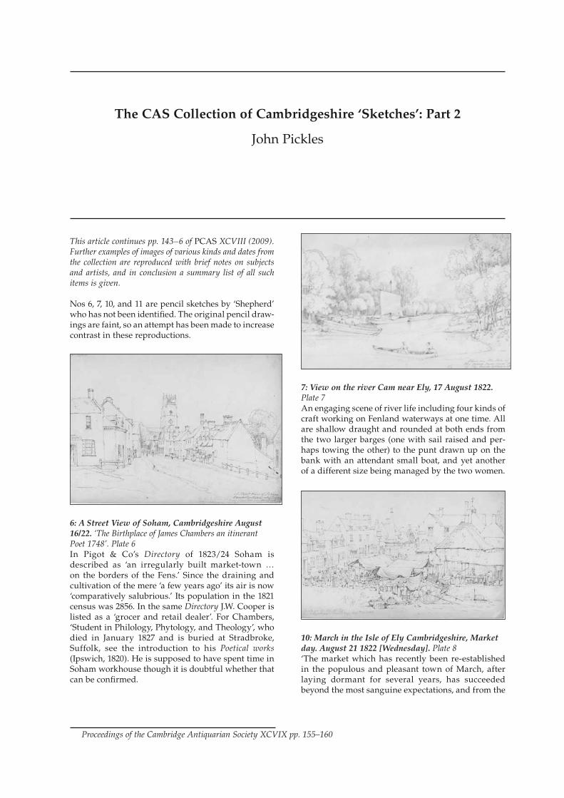
This article continues pp. 143–6 of PCAS XCVIII (2009). Further examples of images of various kinds and dates from the collection are reproduced with brief notes on subjects and artists, and in conclusion a summary list of all such items is given.
Nos 6, 7, 10, and 11 are pencil sketches by ‘Shepherd’ who has not been identified. The original pencil draw-ings are faint, so an attempt has been made to increase contrast in these reproductions.
6: A Street View of Soham, Cambridgeshire August 16/22. ‘The Birthplace of James Chambers an itinerant Poet 1748’. Plate 6In Pigot & Co’s Directory of 1823/24 Soham is described as ‘an irregularly built market-town … on the borders of the Fens.’ Since the draining and cultivation of the mere ‘a few years ago’ its air is now ‘comparatively salubrious.’ Its population in the 1821 census was 2856. In the same Directory J.W. Cooper is listed as a ‘grocer and retail dealer’. For Chambers, ‘Student in Philology, Phytology, and Theology’, who died in January 1827 and is buried at Stradbroke, Suffolk, see the introduction to his Poetical works (Ipswich, 1820). He is supposed to have spent time in Soham workhouse though it is doubtful whether that can be confirmed.
7: View on the river Cam near Ely, 17 August 1822. Plate 7An engaging scene of river life including four kinds of craft working on Fenland waterways at one time. All are shallow draught and rounded at both ends from the two larger barges (one with sail raised and per-haps towing the other) to the punt drawn up on the bank with an attendant small boat, and yet another of a different size being managed by the two women.
10: March in the Isle of Ely Cambridgeshire, Market day. August 21 1822 [Wednesday]. Plate 8‘The market which has recently been re-established in the populous and pleasant town of March, after laying dormant for several years, has succeeded beyond the most sanguine expectations, and from the
The CAS Collection of Cambridgeshire ‘Sketches’: Part 2
John Pickles
Proceedings of the Cambridge Antiquarian Society XCVIX pp. 155–160
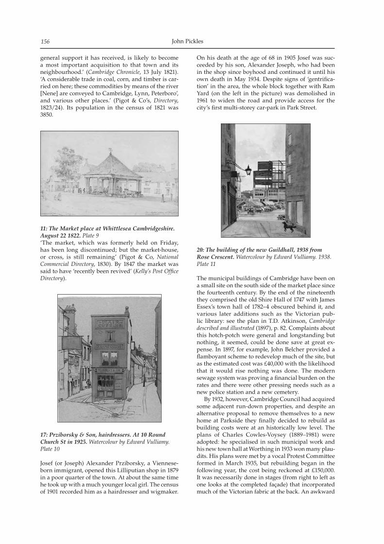
John Pickles156
general support it has received, is likely to become a most important acquisition to that town and its neighbourhood.’ (Cambridge Chronicle, 13 July 1821). ‘A considerable trade in coal, corn, and timber is car-ried on here; these commodities by means of the river [Nene] are conveyed to Cambridge, Lynn, Peterboro’, and various other places.’ (Pigot & Co’s, Directory, 1823/24). Its population in the census of 1821 was 3850.
11: The Market place at Whittlesea Cambridgeshire. August 22 1822. Plate 9‘The market, which was formerly held on Friday, has been long discontinued; but the market-house, or cross, is still remaining’ (Pigot & Co, National Commercial Directory, 1830). By 1847 the market was said to have ‘recently been revived’ (Kelly’s Post Office Directory).
17: Prziborsky & Son, hairdressers. At 10 Round Church St in 1925. Watercolour by Edward Vulliamy. Plate 10
Josef (or Joseph) Alexander Prziborsky, a Viennese-born immigrant, opened this Lilliputian shop in 1879 in a poor quarter of the town. At about the same time he took up with a much younger local girl. The census of 1901 recorded him as a hairdresser and wigmaker.
On his death at the age of 68 in 1905 Josef was suc-ceeded by his son, Alexander Joseph, who had been in the shop since boyhood and continued it until his own death in May 1934. Despite signs of ‘gentrifica-tion’ in the area, the whole block together with Ram Yard (on the left in the picture) was demolished in 1961 to widen the road and provide access for the city’s first multi-storey car-park in Park Street.
20: The building of the new Guildhall, 1938 from Rose Crescent. Watercolour by Edward Vulliamy. 1938. Plate 11
The municipal buildings of Cambridge have been on a small site on the south side of the market place since the fourteenth century. By the end of the nineteenth they comprised the old Shire Hall of 1747 with James Essex’s town hall of 1782–4 obscured behind it, and various later additions such as the Victorian pub-lic library: see the plan in T.D. Atkinson, Cambridge described and illustrated (1897), p. 82. Complaints about this hotch-potch were general and longstanding but nothing, it seemed, could be done save at great ex-pense. In 1897, for example, John Belcher provided a flamboyant scheme to redevelop much of the site, but as the estimated cost was £40,000 with the likelihood that it would rise nothing was done. The modern sewage system was proving a financial burden on the rates and there were other pressing needs such as a new police station and a new cemetery. By 1932, however, Cambridge Council had acquired some adjacent run-down properties, and despite an alternative proposal to remove themselves to a new home at Parkside they finally decided to rebuild as building costs were at an historically low level. The plans of Charles Cowles-Voysey (1889–1981) were adopted: he specialised in such municipal work and his new town hall at Worthing in 1933 won many plau-dits. His plans were met by a vocal Protest Committee formed in March 1935, but rebuilding began in the following year, the cost being reckoned at £150,000. It was necessarily done in stages (from right to left as one looks at the completed façade) that incorporated much of the Victorian fabric at the back. An awkward
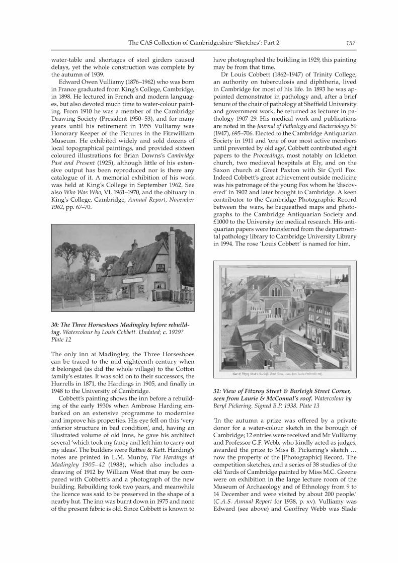
The CAS Collection of Cambridgeshire ‘Sketches’: Part 2 157
water-table and shortages of steel girders caused delays, yet the whole construction was complete by the autumn of 1939. Edward Owen Vulliamy (1876–1962) who was born in France graduated from King’s College, Cambridge, in 1898. He lectured in French and modern languag-es, but also devoted much time to water-colour paint-ing. From 1910 he was a member of the Cambridge Drawing Society (President 1950–53), and for many years until his retirement in 1955 Vulliamy was Honorary Keeper of the Pictures in the Fitzwilliam Museum. He exhibited widely and sold dozens of local topographical paintings, and provided sixteen coloured illustrations for Brian Downs’s Cambridge Past and Present (1925), although little of his exten-sive output has been reproduced nor is there any catalogue of it. A memorial exhibition of his work was held at King’s College in September 1962. See also Who Was Who, VI, 1961–1970, and the obituary in King’s College, Cambridge, Annual Report, November 1962, pp. 67–70.
30: The Three Horseshoes Madingley before rebuild-ing. Watercolour by Louis Cobbett. Undated; c. 1929? Plate 12
The only inn at Madingley, the Three Horseshoes can be traced to the mid eighteenth century when it belonged (as did the whole village) to the Cotton family’s estates. It was sold on to their successors, the Hurrells in 1871, the Hardings in 1905, and finally in 1948 to the University of Cambridge. Cobbett’s painting shows the inn before a rebuild-ing of the early 1930s when Ambrose Harding em-barked on an extensive programme to modernise and improve his properties. His eye fell on this ‘very inferior structure in bad condition’, and, having an illustrated volume of old inns, he gave his architect several ‘which took my fancy and left him to carry out my ideas’. The builders were Rattee & Kett. Harding’s notes are printed in L.M. Munby, The Hardings at Madingley 1905–42 (1988), which also includes a drawing of 1912 by William West that may be com-pared with Cobbett’s and a photograph of the new building. Rebuilding took two years, and meanwhile the licence was said to be preserved in the shape of a nearby hut. The inn was burnt down in 1975 and none of the present fabric is old. Since Cobbett is known to
have photographed the building in 1929, this painting may be from that time. Dr Louis Cobbett (1862–1947) of Trinity College, an authority on tuberculosis and diphtheria, lived in Cambridge for most of his life. In 1893 he was ap-pointed demonstrator in pathology and, after a brief tenure of the chair of pathology at Sheffield University and government work, he returned as lecturer in pa-thology 1907–29. His medical work and publications are noted in the Journal of Pathology and Bacteriology 59 (1947), 695–706. Elected to the Cambridge Antiquarian Society in 1911 and ‘one of our most active members until prevented by old age’, Cobbett contributed eight papers to the Proceedings, most notably on Ickleton church, two medieval hospitals at Ely, and on the Saxon church at Great Paxton with Sir Cyril Fox. Indeed Cobbett’s great achievement outside medicine was his patronage of the young Fox whom he ‘discov-ered’ in 1902 and later brought to Cambridge. A keen contributor to the Cambridge Photographic Record between the wars, he bequeathed maps and photo-graphs to the Cambridge Antiquarian Society and £1000 to the University for medical research. His anti-quarian papers were transferred from the departmen-tal pathology library to Cambridge University Library in 1994. The rose ‘Louis Cobbett’ is named for him.
31: View of Fitzroy Street & Burleigh Street Corner, seen from Laurie & McConnal’s roof. Watercolour by Beryl Pickering. Signed B.P. 1938. Plate 13
‘In the autumn a prize was offered by a private donor for a water-colour sketch in the borough of Cambridge; 12 entries were received and Mr Vulliamy and Professor G.F. Webb, who kindly acted as judges, awarded the prize to Miss B. Pickering’s sketch … now the property of the [Photographic] Record. The competition sketches, and a series of 38 studies of the old Yards of Cambridge painted by Miss M.C. Greene were on exhibition in the large lecture room of the Museum of Archaeology and of Ethnology from 9 to 14 December and were visited by about 200 people.’ (C.A.S. Annual Report for 1938, p. xv). Vulliamy was Edward (see above) and Geoffrey Webb was Slade
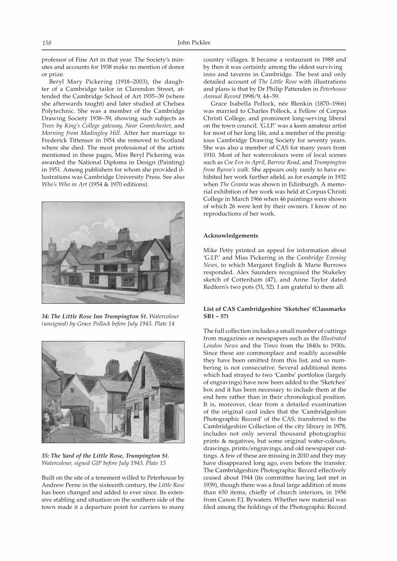
John Pickles158
professor of Fine Art in that year. The Society’s min-utes and accounts for 1938 make no mention of donor or prize. Beryl Mary Pickering (1918–2003), the daugh-ter of a Cambridge tailor in Clarendon Street, at-tended the Cambridge School of Art 1935–39 (where she afterwards taught) and later studied at Chelsea Polytechnic. She was a member of the Cambridge Drawing Society 1938–59, showing such subjects as Trees by King’s College gateway, Near Grantchester, and Morning from Madingley Hill. After her marriage to Frederick Tittensor in 1954 she removed to Scotland where she died. The most professional of the artists mentioned in these pages, Miss Beryl Pickering was awarded the National Diploma in Design (Painting) in 1951. Among publishers for whom she provided il-lustrations was Cambridge University Press. See also Who’s Who in Art (1954 & 1970 editions).
34: The Little Rose Inn Trumpington St. Watercolour (unsigned) by Grace Pollock before July 1943. Plate 14
35: The Yard of the Little Rose, Trumpington St. Watercolour, signed GIP before July 1943. Plate 15
Built on the site of a tenement willed to Peterhouse by Andrew Perne in the sixteenth century, the Little Rose has been changed and added to ever since. Its exten-sive stabling and situation on the southern side of the town made it a departure point for carriers to many
country villages. It became a restaurant in 1988 and by then it was certainly among the oldest survivinginns and taverns in Cambridge. The best and only detailed account of The Little Rose with illustrations and plans is that by Dr Philip Pattenden in Peterhouse Annual Record 1998/9, 44–59. Grace Isabella Pollock, née Blenkin (1870–1966) was married to Charles Pollock, a Fellow of Corpus Christi College, and prominent long-serving liberal on the town council. ‘G.I.P.’ was a keen amateur artist for most of her long life, and a member of the prestig-ious Cambridge Drawing Society for seventy years. She was also a member of CAS for many years from 1910. Most of her watercolours were of local scenes such as Coe Fen in April, Barrow Road, and Trumpington from Byron’s walk. She appears only rarely to have ex-hibited her work further afield, as for example in 1932 when The Granta was shown in Edinburgh. A memo-rial exhibition of her work was held at Corpus Christi College in March 1966 when 46 paintings were shown of which 26 were lent by their owners. I know of no reproductions of her work.
Acknowledgements
Mike Petty printed an appeal for information about ‘G.I.P.’ and Miss Pickering in the Cambridge Evening News, to which Margaret English & Marie Burrows responded. Alex Saunders recognised the Stukeley sketch of Cottenham (47), and Anne Taylor dated Redfern’s two pots (51, 52). I am grateful to them all.
List of CAS Cambridgeshire ‘Sketches’ (Classmarks SB1 – 57)
The full collection includes a small number of cuttings from magazines or newspapers such as the Illustrated London News and the Times from the 1840s to 1930s. Since these are commonplace and readily accessible they have been omitted from this list, and so num-bering is not consecutive. Several additional items which had strayed to two ‘Cambs’ portfolios (largely of engravings) have now been added to the ‘Sketches’ box and it has been necessary to include them at the end here rather than in their chronological position. It is, moreover, clear from a detailed examination of the original card index that the ‘Cambridgeshire Photographic Record’ of the CAS, transferred to the Cambridgeshire Collection of the city library in 1978, includes not only several thousand photographic prints & negatives, but some original water-colours, drawings, prints/engravings, and old newspaper cut-tings. A few of these are missing in 2010 and they may have disappeared long ago, even before the transfer. The Cambridgeshire Photographic Record effectively ceased about 1944 (its committee having last met in 1939), though there was a final large addition of more than 650 items, chiefly of church interiors, in 1956 from Canon F.J. Bywaters. Whether new material was filed among the holdings of the Photographic Record
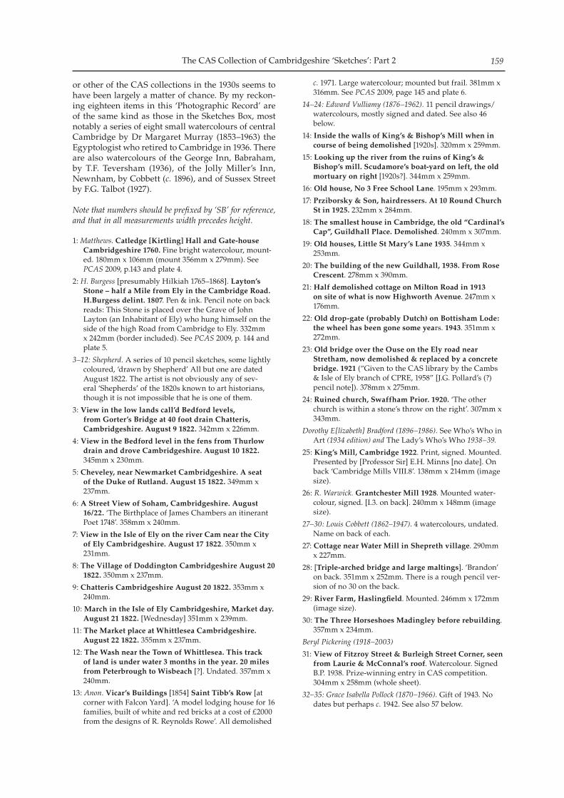
The CAS Collection of Cambridgeshire ‘Sketches’: Part 2 159
or other of the CAS collections in the 1930s seems to have been largely a matter of chance. By my reckon-ing eighteen items in this ‘Photographic Record’ are of the same kind as those in the Sketches Box, most notably a series of eight small watercolours of central Cambridge by Dr Margaret Murray (1853–1963) the Egyptologist who retired to Cambridge in 1936. There are also watercolours of the George Inn, Babraham, by T.F. Teversham (1936), of the Jolly Miller’s Inn, Newnham, by Cobbett (c. 1896), and of Sussex Street by F.G. Talbot (1927).
Note that numbers should be prefixed by ‘SB’ for reference, and that in all measurements width precedes height.
1: Matthews. Catledge [Kirtling] Hall and Gate-house Cambridgeshire 1760. Fine bright watercolour, mount-ed. 180mm x 106mm (mount 356mm x 279mm). See PCAS 2009, p.143 and plate 4.
2: H. Burgess [presumably Hilkiah 1765–1868]. Layton’s Stone – half a Mile from Ely in the Cambridge Road. H.Burgess delint. 1807. Pen & ink. Pencil note on back reads: This Stone is placed over the Grave of John Layton (an Inhabitant of Ely) who hung himself on the side of the high Road from Cambridge to Ely. 332mm x 242mm (border included). See PCAS 2009, p. 144 and plate 5.
3–12: Shepherd. A series of 10 pencil sketches, some lightly coloured, ‘drawn by Shepherd’ All but one are dated August 1822. The artist is not obviously any of sev-eral ‘Shepherds’ of the 1820s known to art historians, though it is not impossible that he is one of them.
3: View in the low lands call’d Bedford levels, from Gorter’s Bridge at 40 foot drain Chatteris, Cambridgeshire. August 9 1822. 342mm x 226mm.
4: View in the Bedford level in the fens from Thurlow drain and drove Cambridgeshire. August 10 1822. 345mm x 230mm.
5: Cheveley, near Newmarket Cambridgeshire. A seat of the Duke of Rutland. August 15 1822. 349mm x 237mm.
6: A Street View of Soham, Cambridgeshire. August 16/22. ‘The Birthplace of James Chambers an itinerant Poet 1748’. 358mm x 240mm.
7: View in the Isle of Ely on the river Cam near the City of Ely Cambridgeshire. August 17 1822. 350mm x 231mm.
8: The Village of Doddington Cambridgeshire August 20 1822. 350mm x 237mm.
9: Chatteris Cambridgeshire August 20 1822. 353mm x 240mm.
10: March in the Isle of Ely Cambridgeshire, Market day. August 21 1822. [Wednesday] 351mm x 239mm.
11: The Market place at Whittlesea Cambridgeshire. August 22 1822. 355mm x 237mm.
12: The Wash near the Town of Whittlesea. This track of land is under water 3 months in the year. 20 miles from Peterbrough to Wisbeach [?]. Undated. 357mm x 240mm.
13: Anon. Vicar’s Buildings [1854] Saint Tibb’s Row [at corner with Falcon Yard]. ‘A model lodging house for 16 families, built of white and red bricks at a cost of £2000 from the designs of R. Reynolds Rowe’. All demolished
c. 1971. Large watercolour; mounted but frail. 381mm x 316mm. See PCAS 2009, page 145 and plate 6.
14–24: Edward Vulliamy (1876–1962). 11 pencil drawings/watercolours, mostly signed and dated. See also 46 below.
14: Inside the walls of King’s & Bishop’s Mill when in course of being demolished [1920s]. 320mm x 259mm.
15: Looking up the river from the ruins of King’s & Bishop’s mill. Scudamore’s boat-yard on left, the old mortuary on right [1920s?]. 344mm x 259mm.
16: Old house, No 3 Free School Lane. 195mm x 293mm.
17: Prziborsky & Son, hairdressers. At 10 Round Church St in 1925. 232mm x 284mm.
18: The smallest house in Cambridge, the old “Cardinal’s Cap”, Guildhall Place. Demolished. 240mm x 307mm.
19: Old houses, Little St Mary’s Lane 1935. 344mm x 253mm.
20: The building of the new Guildhall, 1938. From Rose Crescent. 278mm x 390mm.
21: Half demolished cottage on Milton Road in 1913 on site of what is now Highworth Avenue. 247mm x 176mm.
22: Old drop-gate (probably Dutch) on Bottisham Lode: the wheel has been gone some years. 1943. 351mm x 272mm.
23: Old bridge over the Ouse on the Ely road near Stretham, now demolished & replaced by a concrete bridge. 1921 (“Given to the CAS library by the Cambs & Isle of Ely branch of CPRE, 1958” [J.G. Pollard’s (?) pencil note]). 378mm x 275mm.
24: Ruined church, Swaffham Prior. 1920. ‘The other church is within a stone’s throw on the right’. 307mm x 343mm.
Dorothy E[lizabeth] Bradford (1896–1986). See Who’s Who in Art (1934 edition) and The Lady’s Who’s Who 1938–39.
25: King’s Mill, Cambridge 1922. Print, signed. Mounted. Presented by [Professor Sir] E.H. Minns [no date]. On back ‘Cambridge Mills VIII.8’. 138mm x 214mm (image size).
26: R. Warwick. Grantchester Mill 1928. Mounted water-colour, signed. [I.3. on back]. 240mm x 148mm (image size).
27–30: Louis Cobbett (1862–1947). 4 watercolours, undated. Name on back of each.
27: Cottage near Water Mill in Shepreth village. 290mm x 227mm.
28: [Triple-arched bridge and large maltings]. ‘Brandon’ on back. 351mm x 252mm. There is a rough pencil ver-sion of no 30 on the back.
29: River Farm, Haslingfield. Mounted. 246mm x 172mm (image size).
30: The Three Horseshoes Madingley before rebuilding. 357mm x 234mm.
Beryl Pickering (1918–2003)
31: View of Fitzroy Street & Burleigh Street Corner, seen from Laurie & McConnal’s roof. Watercolour. Signed B.P. 1938. Prize-winning entry in CAS competition. 304mm x 258mm (whole sheet).
32–35: Grace Isabella Pollock (1870–1966). Gift of 1943. No dates but perhaps c. 1942. See also 57 below.
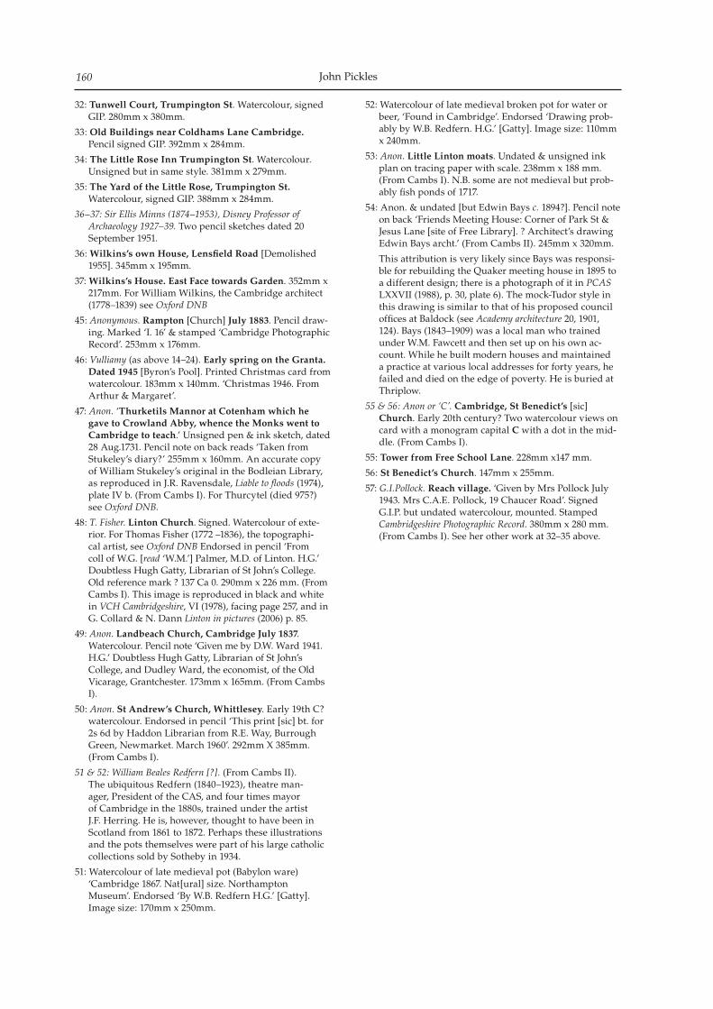
John Pickles160
32: Tunwell Court, Trumpington St. Watercolour, signed GIP. 280mm x 380mm.
33: Old Buildings near Coldhams Lane Cambridge. Pencil signed GIP. 392mm x 284mm.
34: The Little Rose Inn Trumpington St. Watercolour. Unsigned but in same style. 381mm x 279mm.
35: The Yard of the Little Rose, Trumpington St. Watercolour, signed GIP. 388mm x 284mm.
36–37: Sir Ellis Minns (1874–1953), Disney Professor of Archaeology 1927–39. Two pencil sketches dated 20 September 1951.
36: Wilkins’s own House, Lensfield Road [Demolished 1955]. 345mm x 195mm.
37: Wilkins’s House. East Face towards Garden. 352mm x 217mm. For William Wilkins, the Cambridge architect (1778–1839) see Oxford DNB
45: Anonymous. Rampton [Church] July 1883. Pencil draw-ing. Marked ‘I. 16’ & stamped ‘Cambridge Photographic Record’. 253mm x 176mm.
46: Vulliamy (as above 14–24). Early spring on the Granta. Dated 1945 [Byron’s Pool]. Printed Christmas card from watercolour. 183mm x 140mm. ‘Christmas 1946. From Arthur & Margaret’.
47: Anon. ‘Thurketils Mannor at Cotenham which he gave to Crowland Abby, whence the Monks went to Cambridge to teach.’ Unsigned pen & ink sketch, dated 28 Aug.1731. Pencil note on back reads ‘Taken from Stukeley’s diary?’ 255mm x 160mm. An accurate copy of William Stukeley’s original in the Bodleian Library, as reproduced in J.R. Ravensdale, Liable to floods (1974), plate IV b. (From Cambs I). For Thurcytel (died 975?) see Oxford DNB.
48: T. Fisher. Linton Church. Signed. Watercolour of exte-rior. For Thomas Fisher (1772 –1836), the topographi-cal artist, see Oxford DNB Endorsed in pencil ‘From coll of W.G. [read ‘W.M.’] Palmer, M.D. of Linton. H.G.’ Doubtless Hugh Gatty, Librarian of St John’s College. Old reference mark ? 137 Ca 0. 290mm x 226 mm. (From Cambs I). This image is reproduced in black and white in VCH Cambridgeshire, VI (1978), facing page 257, and in G. Collard & N. Dann Linton in pictures (2006) p. 85.
49: Anon. Landbeach Church, Cambridge July 1837. Watercolour. Pencil note ‘Given me by D.W. Ward 1941. H.G.’ Doubtless Hugh Gatty, Librarian of St John’s College, and Dudley Ward, the economist, of the Old Vicarage, Grantchester. 173mm x 165mm. (From Cambs I).
50: Anon. St Andrew’s Church, Whittlesey. Early 19th C? watercolour. Endorsed in pencil ‘This print [sic] bt. for 2s 6d by Haddon Librarian from R.E. Way, Burrough Green, Newmarket. March 1960’. 292mm X 385mm. (From Cambs I).
51 & 52: William Beales Redfern [?]. (From Cambs II).The ubiquitous Redfern (1840–1923), theatre man-ager, President of the CAS, and four times mayor of Cambridge in the 1880s, trained under the artist J.F. Herring. He is, however, thought to have been in Scotland from 1861 to 1872. Perhaps these illustrations and the pots themselves were part of his large catholic collections sold by Sotheby in 1934.
51: Watercolour of late medieval pot (Babylon ware) ‘Cambridge 1867. Nat[ural] size. Northampton Museum’. Endorsed ‘By W.B. Redfern H.G.’ [Gatty]. Image size: 170mm x 250mm.
52: Watercolour of late medieval broken pot for water or beer, ‘Found in Cambridge’. Endorsed ‘Drawing prob-ably by W.B. Redfern. H.G.’ [Gatty]. Image size: 110mm x 240mm.
53: Anon. Little Linton moats. Undated & unsigned ink plan on tracing paper with scale. 238mm x 188 mm. (From Cambs I). N.B. some are not medieval but prob-ably fish ponds of 1717.
54: Anon. & undated [but Edwin Bays c. 1894?]. Pencil note on back ‘Friends Meeting House: Corner of Park St & Jesus Lane [site of Free Library]. ? Architect’s drawing Edwin Bays archt.’ (From Cambs II). 245mm x 320mm.
This attribution is very likely since Bays was responsi-ble for rebuilding the Quaker meeting house in 1895 to a different design; there is a photograph of it in PCAS LXXVII (1988), p. 30, plate 6). The mock-Tudor style in this drawing is similar to that of his proposed council offices at Baldock (see Academy architecture 20, 1901, 124). Bays (1843–1909) was a local man who trained under W.M. Fawcett and then set up on his own ac-count. While he built modern houses and maintained a practice at various local addresses for forty years, he failed and died on the edge of poverty. He is buried at Thriplow.
55 & 56: Anon or ‘C’. Cambridge, St Benedict’s [sic] Church. Early 20th century? Two watercolour views on card with a monogram capital C with a dot in the mid-dle. (From Cambs I).
55: Tower from Free School Lane. 228mm x147 mm.
56: St Benedict’s Church. 147mm x 255mm.
57: G.I.Pollock. Reach village. ‘Given by Mrs Pollock July 1943. Mrs C.A.E. Pollock, 19 Chaucer Road’. Signed G.I.P. but undated watercolour, mounted. Stamped Cambridgeshire Photographic Record. 380mm x 280 mm. (From Cambs I). See her other work at 32–35 above.
Proceedings of the Cambridge Antiquarian Society XCIV pp.
Fieldwork in Cambridgeshire 2009
Sally Thompson, Hazel White and Elizabeth Shepherd Popescu
The work outlined below was conducted for a variety of reasons, including development control derived projects, emergency recording and research. All reports cited are available in the Cambridgeshire Historic Environment Record, Cambridge, for public consultation. All reports cited are available in the Cambridgeshire Historic Environment Record, Cambridge, for pub-lic consultation. Many of the reports are available in digital format from the Grey Literature Library at the Archaeology Data Service (http://ads.ahds.ac.uk/catalogue/library/greylit/), or Heritage Gateway(http://www.heritagegateway.org.uk).Abbreviations:AS Archaeological Solutions, previously Hertfordshire Archaeological TrustCAU Cambridge Archaeological UnitECC FAU Essex County Council Field Archaeology UnitGSB Geophysical Surveys of BradfordHN Heritage NetworkNA Northamptonshire ArchaeologyNAU NAU Archaeology, previously Norfolk Archaeological UnitOA East Oxford Archaeology East, previously CAM ARC
Balsham, Camgrain APC site TL5673 5440 (OA East Report 1145)J Fairbairn Excavation revealed part of a series of posts forming a circular enclosure thought to be a prehistoric timber circle.
Bassingbourn cum Kneesworth, Bury YardTL 3287 4414 (Archaeology Rheesearch Group Report)I SandersonMagnetometry and resistivity surveys were un-dertaken by Archaeology Rheesearch Group at the scheduled Bury Yard site, Bassingbourn. A trackway was suggested across the southern edge and eastern end of the survey area. The magnetometry results have a similarly aligned anomaly running part way across the eastern survey area, before abruptly ter-minating. Building foundations were suggested to-wards the centre and southern areas of the site. The
magnetometry results, but not the resistivity results, suggest some sort of link from these structures to the north. The areas covered in this survey were severely constrained by obstacles on the site and are only suf-ficient to form a very limited impression of any re-maining features.
Bassingbourn cum Kneesworth, Kneesworth House Hospital TL 3495 4415 (AOC Archaeology Group Report 30452)L CaponArchaeological evaluation revealed several large Roman features, probably field boundary ditches dat-ing to the 3rd–4th centuries AD. Domestic Roman pottery was retrieved suggesting occupation during that period in the vicinity of the site along with re-sidual flints. Several discrete post-medieval features were also encountered across the site.
Bassingbourn cum Kneesworth, the CausewayTL 3385 4406 (Pre-Construct Archaeology report)P BoyerArchaeological evaluation revealed a number of sherds of prehistoric pottery located in several tree throws, and remnants of the 18th–19th century allot-ments that previously occupied the site.
Bluntisham, High Street, Baptist Chapel Sunday School TL 3682 7460 (OA East Report 1118) T Fletcher An historic building survey of the former Sunday School building took place on the site of Bluntisham Baptist Chapel (also known as The Meeting House). Documentary evidence indicates that the earliest part of the building, the main hall, was constructed in 1842. This date is significant since most sources have referred to the building’s date stone plaque of 1887 and dated interior carvings; it is now clear that the building is earlier than previously thought. Four main phases of development were identified by the survey, the earliest of which was construc-tion of the original Sunday School. An extension was added on the eastern side of the main building togeth-
Proceedings of the Cambridge Antiquarian Society XCVIX pp. 161–172
Sally Thompson, Hazel White, and Elizabeth Shepherd Popescu162
er with a remodelling of the interior to commemorate the centenary of the first chapel. An external chim-ney stack was subsequently installed on the southern side as well as a small single room extension, perhaps for coal storage. Finally, internal alterations included the addition of a kitchen and storage facilities within the eastern extension together with the insertion/re-placement of a number of windows. Interesting in-ternal features include an elaborately carved screen, fire surrounds and ceiling detail which, according to historical sources were all the work of John Wheately, a local carpenter to whom a memorial plaque in the Sunday School building is dedicated. Subsequent archaeological excavation to the east and south of the Sunday School building revealed burial plots and pits (none of which were excavated). A single sherd of Late Iron Age pottery represents the earliest material recovered. The finds include a range of medieval and post-medieval pottery. Small amounts of disarticulated human skeletal remains were returned to the Baptist minister for reburial.
Bottisham, High StreetTL 5509 6016 (OA East Report 1121) J House Structural remains were uncovered, as well as a small number of pits and a ditch, all of which are highly likely to be contemporary with the current standing building, formerly known as the Swan Inn. Cartographic evidence indicates gradual modifica-tion and adaptations of the building over the course of time. A small quarry pit was found at the northern end of the development area.
Cambridge, Anglia Ruskin UniversityTL 4592 5829 (CAU Report 906)E BeadsmoreInterim report for archaeological evaluation which re-vealed the remains of the 18th century ‘South Street’ and a series of terraced properties as seen on the 1886 OS map. The street and houses heavily truncated earlier deposits however, a small quantity of earlier quarry pits were found, which may be a continuation of previously recorded quarrying to the north.
Cambridge, junction of Benson Place and Westfield LaneTL 4422 5955 (AS Report 3284)K Higgs and M BrookEvaluation identified a number of late post-medieval features comprising ditches, pits and a post hole. A single abraded sherd of medieval pottery was recov-ered.
Cambridge, Castle Hill MoundTL 445 591 (OA East Report 1105) J Fairbairn Three test pits were dug at the base of a retaining wall skirting Castle Hill mound. Monitoring revealed that the ground had been heavily disturbed in the modern period. The disturbed fills contained pottery from the Roman and medieval periods, as well as post-medie-
val and modern ceramics.
Cambridge, Wilson Court extension, Fitzwilliam CollegeTL 4398 5945 (NAU Archaeology Report 2220)P CrawleyAn archaeological evaluation carried out on the foot print of the extension to the Wilson Court building at Fitzwilliam College revealed only 19th century plant-ing or postholes with associated root disturbance despite Bronze Age and Roman remains being en-countered just 50m to the north and east.
Cambridge, Former Regional College, Newmarket RoadTL 4604 5894 (OA East Report 1159) R AtkinsEvidence from test pits shows that this site may have served as open fields until modern times. A possi-ble medieval cultivation soil found within the north-western corner of the site contained rubbish and probably dates to the 13th–14th centuries. It may de-rive from middens associated with Barnwell Priory c. 200m to the east.
Cambridge, Little St Mary’s Church TL 4482 5797 (OA East Report 1156) T Fletcher Within the grounds of Little St Mary’s Church, two test pits revealed the same sequence of top/garden soil over a compacted lighter gravelly soil. No buri-als were encountered and very few human bones from disturbed burials were recovered which were returned to the church for reburial.
Cambridge, former Marshall Garage siteTL 4618 5665 (CAU Report 877)R NewmanAn archaeological evaluation revealed remains relat-ing to the establishment of an open-field system in the 14th century and continued agricultural use in the post-medieval period. Pits and ditches dating from the late 19th century identified a move away from arable cultivation to a more horticultural environment. The absence of Roman activity in this area suggests that the route of the Colchester to Godmanchester road (Via Devana) lies further to the west than was previously believed.
Cambridge, Mill Road Cemetery Mortuary Chapel TL 46169 58397 (OA East Report 1150) N Gilmour This project was part of a Your Heritage Lottery Funded initiative to regenerate and restore Mill Road Cemetery. The projects aims were to safeguard the fabric of the Grade II Victorian cemetery and to in-crease understanding of the site’s history and value. The test pit evaluation was also part of a wider community and education project which involved local schools, volunteers, The Friends of Mill Road Cemetery and the wider community. Evaluation showed that the foundations of the mortuary chapel
Fieldwork in Cambridgeshire 2009 163
are in good condition and revealed that part of the building originally had a lower floor level, resulting in the preservation of part of the internal fabric of the building.
Cambridge, Murray Edwards College, New HallTL 4414 5950 (CAU Report 901)J HuttonAn archaeological excavation and watching brief was undertaken on land at Murray Edwards College (formally known as New Hall College). The archaeo-logical investigations targeted the two areas of the development; the first area (Area 1) was located on the north-west side of the existing Grove Lodge and the second area (Area 2) was at the eastern end of the building. Area 1 started as a trench and was wid-ened to a small excavation area, whilst the second area comprised a watching brief where contexts were investigated and recorded when archaeological fea-tures were encountered. In Area 1 the archaeological features consisted of three ditches, one pit and a road-way surface dated to the Roman period. The roadway surface was also recorded in Area 2. Roman, medi-eval and post-medieval pottery and a Roman bone hairpin were recovered from the site.
Cambridge, Old Schools lift shaft, University of CambridgeTL 4475 5847 (CAU Report 903)R NewmanArchaeological excavation was undertaken in advance of the construction of a lift shaft at the Old Schools, Cambridge. Four distinct phases of activity were identified, the first of which was identified as Roman agricultural activity dating from the 2nd/3rd centuries AD. Domestic occupation of the site was indicated by a timber framed building constructed in the 11th century, associated refuse pits and a tim-ber lined well or cesspit, and continued until the late 14th century when the site was cleared for the con-struction of the University’s School of Theology (or Divinity School). Work began on this structure in c. 1370 and at least two phases of construction have been identified. The building was completed in c. 1400. Later additions and modifications to the struc-ture were also examined, including the foundations of the 1755–58 façade.
Cambridge, Ridley HallTL 4436 5782 (CAU Report 905)M BrittainThree evaluation trenches were excavated revealing remains dating from the early Neolithic to 18th cen-turies. Prehistoric activity comprised a relatively high number of residual finds, while extensive activity of Late Iron Age to Romano-British date was attested by two large ditches circling a cluster of pits. Eighteenth century remains comprised a double-walled linear post structure, foundations associated with the con-struction of the hall and substantial artefactual as-semblages.
Cambridge, University FarmTL 4262 6031 (CAU Report 921)C Evans and R NewmanThe second stage of this evaluation was undertak-en by CAU on 140 hectares of land located in the north-western part of Cambridge between April and November 2009. In total 222 trenches were excavated producing archaeological remains from the prehis-toric to post-medieval periods. The earliest activity to be identified is Palaeolithic in date, and consisted of residual material recovered from post-medieval gravel quarries situated at the eastern end of the project area. Similarly, a number of Mesolithic and Early Neolithic artefacts were also recovered from residual contexts, their distribution being principally restricted to the area of the gravel ridge (although a small number of flints were also present within the Washpit Brook valley to the west). Although a single Late Neolithic and a small number of Late Bronze Age features were identified in situ, occupation only appears to have begun in earnest during the Middle lron Age. At least one definite set-tlement of this date was identified. By the later/late lron Age, occupation was well established in both geological areas, with a minimum of five settlements being present. Five major Romano-British settlements were dis-tinguished, of which two lay on the clays: an Early Roman farmstead on the south side of Washpit Brook and, down by Madingley Road, where it continues under the Park-and-Ride, what is probably a Late Roman villa. Settlements of this period extended almost continuously along the southern side of the ridge’s gravels. Of these, the most impressive covered more than 9 hectares. This had both ‘Early’ and Late Roman components (and with an Iron Age precursor) and probably included a higher status building. High feature and artefact densities were recorded and in-cluded finely worked wood retrieved from a water-logged feature. Only one feature yielded Anglo-Saxon material, a pit on the ridge gravels opposite the cemetery site of that date excavated within the grounds of Girton College. Further east, evidence of the Howes Close Medieval settlement (known from documentary records) was found beside the former University Department of Applied Biology field station buildings on Huntingdon Road. Directly related to Cambridge’s Medieval West Fields, traces of ridge-and-furrow ag-riculture were recovered across the lower clayland areas.
Sally Thompson, Hazel White, and Elizabeth Shepherd Popescu164
Cambridge, School of Veterinary MedicineTL 4255 5902 (CAU Report 902)J HuttonAn evaluation revealed traces of ridge and furrow, containing pottery dating from between the 16th and 19th centuries. No traces of Iron Age or Romano-British settlement or associated field systems were lo-cated. The material covered from the furrows suggest the re-deposition of topsoil or loam from elsewhere, perhaps linked to the infill of earlier ridge and fur-row systems in the 19th century. The orientation of the furrows correlates with cropmarks to the north of Madingley Road.
Cambridge, West RoadTL 4423 5810 (CAU Report 896)M CollinsA small scale evaluation revealed two late medi-eval/post-medieval ditches and associated features which probably relate to field boundaries depicted on historic maps. No evidence was found to show that Saxon settlement activity recorded to the north-east and south-east extended into this area, although the presence of a fragmentary quern stone of potential Saxon date could indicate activity close by. Evidence for Victorian quarrying was identified and is com-parable with that recorded at the Law Facility site to the south.
Chatteris, Tern GardensTL 3926 8657 (OA East Report 1151) J House Post-medieval backyard activity was identified, as-sociated with the property fronting onto the High Street at the south-western end of the development area. The north-eastern end of the site had seen much disturbance and soil displacement due to the con-struction and subsequent backfilling of a large pond in recent decades.
Chatteris, Womb FarmTL 3864 8709 (Air Photo Services Cambridge Report 2008/31, R Palmer) (Bartlett-Clark Consultancy Report, A Bartlett) (CAU Report 888, M Collins)Aerial photographic assessment by Air Photo Services Cambridge revealed archaeological features of proba-ble medieval date and several distinct areas of quarry-ing. Further geophysical survey recorded a number of strong linear anomalies, relating to cultivation or land drains. Two areas of possible magnetic disturbance were identified, but no clear evidence for archaeologi-cal remains was recorded. Evaluation demonstrated that the site had been used for intensive quarrying during the post-medieval and modern periods, and also during the mid to late Romano-British period. Other archaeological remains comprised former field boundaries, furrows and possible planting beds, dat-ing to the post-medieval period.
Cherry Hinton, War DitchesTL 484 556 (OA East Report)A Pickstone and R Mortimer
War Ditches was a large, circular enclosure of c. 150m diameter which lay atop a spur of the Gog Magog hills overlooking South Cambridgeshire. A large part of the monument was destroyed by quarrying for chalk, chiefly for lime production, between the 1890s and 1970s. Despite repeated episodes of fieldwork spanning nearly 100 years the nature of the monu-ment, its history and the exact location of the various excavations remain enigmatic or contradictory. During the summer of 2008 local children tres-passing on the site discovered human remains and Romano-British ceramics. This event coincided with the acquisition of the quarry by the Wildlife Trust, who planned to open it to the public as a nature reserve in the spring or summer of 2009. English Heritage provided the funding for a rescue excavation on the area of the ditch most at risk, both from gradual ero-sion and from the remodelling works about to be un-dertaken by the Wildlife Trust. Excavation revealed that the ditch was approximately 6m wide (although truncated by the quarry along its inner edge) and 4m deep. Dating for its construction and use relies sub-stantially on ceramic evidence. The relatively large pottery assemblage (33kg) represents three fairly well-defined periods: Early Iron Age (c. 4th/5th cen-tury BC), late pre-Roman Iron Age and the Conquest period. The two latest periods are represented by ma-terial from the upper metre of the ditch. Other finds include a substantial Early Iron Age flint assemblage, quantities of kiln furniture from the Conquest period and two Late Iron Age brooches. No further burials were encountered, although disarticulated human remains were recovered. Three small test pits were excavated within what remains of the interior of the monument. No bank deposits or secure buried soils were encountered. One test pit contained a feature that produced significant quantities of Early Iron Age pottery.
Chippenham, Badlingham Manor FarmTL 6878 6997 (CAU Report 910)R PattenA fieldwalking and trial trench evaluation at Badlingham Manor Farm revealed a mixed assem-blage of struck flint, the distribution of which pro-vides evidence for background prehistoric activity in the area. Despite the presence of flint objects across the site, no archaeological features were encountered during the trial trench evaluation.
Colne, Manor FarmTL 3735 7887 (OA East Report 1113) L Offord Excavation revealed a Late Saxon sunken-featured building. A number of early medieval pits and post-holes may represent occupation, including a build-ing, fronting East Street. Two undated ditches were recorded which may be contemporary. A number of other medieval pits and postholes were identified, along with a large medieval pond at the rear of the site. A rectangular feature with timber foundations set in clay may indicate an 18th-century building
Fieldwork in Cambridgeshire 2009 165
close to East Street, set on an unusual alignment. Other post-medieval features relating to the site’s use as a farm until 2008 were also recorded.
Ely, Lancaster Business ParkTL 5120 7824 (AS Report 3334)W McCall, K Higgs, K Henry and A NewtonEvaluation recorded a single undated curvilinear ditch. A small rubbish pit and an asphalt surface were also encountered, probably associated with the former airfield.
Ely, near Canonry House, Ely CathedralTL 5409 8015 (CAU Report) A DickensAn archaeological watching brief was undertak-en during the laying of a fibre optic cable between the Canonry House and Priory House, south of Ely Cathedral. The trench was too shallow to encounter any archaeological features but nine pieces of carved and moulded stone were found at a point mid way along the length of the cable.
Ely, Stirling Way, nr. WitchfordTL 5150 7890 (OA East Report 1134) R Atkins Several phases of activity were identified, dating from the Neolithic to the late 2nd century or early 3rd century AD. The evidence includes an Early Neolithic flint scatter and two pits containing Beaker vessels. During the Late Iron Age a settlement was estab-lished on the plateau of a small knoll. A large Late Iron Age or early Roman boundary ditch mean-dered along the uppermost contour of a ridge which ran roughly parallel to and overlooked a strategic stream/drain route flowing from Grunty Fen into West Fen. The role of this ditch may be linked to the name Witchford which derives from ‘the Watch on the Ford’. Three burials lay within a small ditched enclosure close to the boundary. A mid 1st century AD crema-tion was placed within a late pre-Roman Iron Age grey ware vessel. Two 2nd or early 3rd century inhu-mations were also found. A mature woman had been buried on top of two bone spindle-whorls. The other burial, placed in a relatively deep grave, was a woman aged between 26–44 years old who had one tooth sur-viving (the rest having been lost naturally). She wore five copper alloy rings on her left hand including three on a single finger. Two pots, one of which was a complete Nene Valley folded indented beaker, were placed nearby within the enclosing ditch.
Farcet, Float Fish Farm ExtensionTL 2289 9460 (AS Report 3387)W McCall and C DaviesEvaluation identified several undated features com-prising two linear features, 11 tree hollows and a fallen tree. A struck flint and two animal bones were the only finds recovered.
Great Paxton, Holy Trinity Church TL 520986 264170 (OA East Report 1146) A Corrigan Holy Trinity Church has a long and interesting his-tory dating back to the Late Saxon period. During works to improve facilities at the church, the stone floor of the tower was lowered. On commencement of the works it was discovered that many of the stones lifted from the floor had been worked and archaeo-logical recording was therefore commissioned to examine the stone fragments. A fragment of a coffin slab was retrieved, thought to pre-date 1275 and on which a carved design had later been defaced. Many of the fragments appear to have been pieces of unfin-ished stonework that are probably associated with the periods of major refurbishment at the church.
Haslingfield, Cantelupe FarmTL 4247 5425 (CAU Report 879)R NewmanEvaluation encountered the southern fringe of a field system, associated with the scheduled Roman settle-ment immediately to the north (Roman settlement complex, SAM 27). Also investigated was a double ditched feature, previously known from cropmarks, which was found to be Late Iron Age or Early Roman in date.
Huntingdon Bus Station, Princes Street TL 2383 7163 (Excavation in Progress) R ClarkeA single 4m x 4m square test pit along The Walks found a cobbled surface (date not yet determined) sealed beneath approximately 1.6m of post-medieval make-up.
Huntingdon, the former Bus Depot, Stukeley Road TL 2330 7250 (OA East Report 1112) G Rees and N GilmourThis plot fronted onto Ermine Street (now Stukeley Road) and the remains of medieval post-built struc-tures were found along the street frontage dur-ing evaluation. To the rear of these structures a series of pits and a possible well were uncovered that appeared to represent domestic backyard activity. A large undated boundary ditch was found to the west of the plot. Subsequent excavation revealed medieval activity of 12th to 14th century date. Possible struc-tural remains were identified close to Stukeley Road, which may suggest ribbon development stretching out from Huntingdon in this direction. No structural remains were, however, identified towards the south of the site and it is therefore possible that this was a separate settlement. A number of pits and wells rep-resent backyard activity. A ditch running parallel to Stukeley Road approximately 40m from it appeared to mark the boundary of activity.
Impington, Unwins Nursery Site TL 4430 6350 (OA East Report 1109) T Fletcher Evaluation revealed a number of ditches spanning at
165
Sally Thompson, Hazel White, and Elizabeth Shepherd Popescu166
least two phases of activity. The earliest activity dated to the Late Iron Age to 1st century AD and generally comprised large field boundaries. The second phase was attributed to the mid 1st century to the mid 2nd century AD and saw the re-establishment of these ear-lier ditches together with a greater density of ditches at the southern end of the site. These ditches, close to and almost parallel with the current Impington Lane, contained a large quantity of locally produced sandy coarseware storage and cooking vessels which may indicate close proximity to settlement. A brooch and a sherd of Samian pottery were also found. The earli-est occupation found during the excavation phase is attributable to the late Iron Age (c. 100 BC), taking the form of the remains of a roundhouse containing pot-tery and animal bone and suggesting a local farming community. In the Roman period a series of enclo-sures and ditches dating to the 2nd and 3rd centuries AD were present. Finds include stamped Samian, fragments of amphora, utilitarian pottery types and quernstone fragments. Whilst the main building itself has not been uncovered, the range and density of the finds suggest that it lies nearby.
Isleham, Beck RoadTL 6462 7432 (ECC FAU Report 2018)T EnnisEvaluation identified only sparse and poorly dated archaeological features, including single pits of pos-sible prehistoric and medieval date, a shallow chalk pit of probable 19th century date and post-pads for a modern structure.
Kimbolton, Bicton Wind farm TL 100 704 (OA East Report 1155) R Atkins Features relating to a probable Late Iron Age to Roman farmstead and its outlying fields were found. In one trench, in addition to the large ditches identi-fied by cropmarks, several smaller ditches, pits and a cobbled surface were found which may represent three phases of activity. Moderate quantities of pot-tery and animal bone were recovered. Secondary de-posits of burnt material, and a piece of hearth lining with slag attached imply some localised industrial ac-tivity. Extending for a distance of about 150m beyond and to the north-east of the cropmarked area, further ditches (possibly field boundaries) were identified as-sociated with occasional Roman pottery. The results of sampling for environmental evidence are awaited.
Kingston, High CrossTL 4252 5894 (CAU Report 942)S TimberlakeAn open-area excavation in 2009–10 identified Early Iron Age occupation, a Mesolithic/ Neolithic pit, a Late Bronze Age/ Early Iron Age rubbish pit and pit/well, a substantial Iron Age ditch and a number of Middle Iron Age pits. A Roman field system was also identified on the south-facing slope.
Little Paxton, RiversfieldTL 1812 6193 (Stratascan Report J2657)S HaddrellA geophysical survey undertaken by Stratascan on behalf of Albion Archaeology in October 2009 re-vealed a series of positive and negative responses which may represent ditch and bank formations.
Littleport, 150 Wisbech RoadTL 5550 8743 (AS Report 3388)W McCall, P Thompson & C DaviesEvaluation revealed a series of close set parallel ditches, orientated north-east–south-west. The ditch-es could not be readily traced from trench to trench, however, they were broadly contemporary and part of the same ditch system. Finds were sparse but late Iron Age and Roman pottery was recovered.
Littleport, Nos 98–120 Wisbech RoadTL 5592 8733 (OA East Report 1135) L Bush A slight scatter of prehistoric flints was found across this site, suggesting Neolithic activity in the vicin-ity, although no features were positively identified. Several phases of a Roman ‘lazy bed’ field system with associated boundary ditches were uncovered.
Longstanton, Striplands Farm (II)TL 3948 6727 (CAU Report 900)J HuttonAn archaeological evaluation was carried out on land at Striplands Farm further to previous work in and around the same area prior to development. Primarily Saxo-Norman/early Medieval to post-me-dieval activity was identified including a number of enclosures and possible property boundaries dating from the 12–15th centuries AD. Numerous medieval quarry pits and a large post-medieval pond were also recorded. Possibly relating to the early origins of west Longstanton, these medieval features truncated Middle Saxon to Saxo-Norman features and a later Iron Age enclosure boundary ditch, with only a small quantity of residual roman pottery found in the later features.
March, Knights End RoadTL 4027 9476–TL 4028 9486 (NA Report 09/89)J ClarkeInvestigations comprising geophysical survey, aerial photographic assessment and evaluation trenching were undertaken in advance of the construction of a crematorium. Extensive remains of ridge and furrow were recorded in the eastern part of the survey area, probably associated with medieval and post-medieval settlement on March island. The majority of the ridge and furrow was comparatively straight and narrow, probably created after the extensive drainage of the fens in the 17th century. A small group of cropmarks were also recorded to the north of Knights End Road, and are possibly of archaeological origin. An exten-sive network of roddons was also mapped to the west of the site. The evaluation revealed features relating
Fieldwork in Cambridgeshire 2009 167
to post-medieval agriculture, modern land drainage and the demolition of agricultural buildings.
March, Neale Wade Community CollegeTL 4176 9590 (OA East Report 1142) N Gilmour Evaluation revealed several Iron Age ditches, con-taining pottery of the 5th–3rd centuries BC, which may represent the remains of a wider, inhabited field system. In addition several medieval ditches were re-corded, three of which were parallel and may have divided the area into plots. A single very large ditch containing a significant amount of medieval pottery and domestic waste appears to represent a major boundary, and could potentially be related to a manor or religious house.
March, Smith’s ChaseTL 4090 9754 (OA East Report 1108) C Thatcher Two possible Roman ditches were identified and may have formed part of an enclosure towards the centre of the development area.
Mepal QuarryTL 4496 8427 (SLR Consulting Report) G Kinsley & D GartonA programme of detailed and scanning magnetom-eter survey was undertaken, recording the presence of two ring ditches already identified from aerial sur-vey. A number of linear features were also recorded, most thought to relate to post-medieval field bounda-ries. Further to previous work, a fieldwalking survey was undertaken recovering a total of 17 flints, a single sherd of handmade pottery and the remains of a pos-sible post-medieval midden.
Oakington & Westwick, the New Meeting Room, St Andrew’s ChurchTL 414 648 (OA East Report 1124) R Mortimer Three early ditches oriented approximately north-east to south-west were recorded during observation of works to the graveyard soils. The latest of these ditches dates to the late 12th or early 13th centuries.
Offord Darcy, High StreetTL 2204 6661 (CAU Report 908)R PattenAn archaeological evaluation of twelve trenches was undertaken in Offord D’Arcy and revealed ditches and pits dating from the 12th–13th centuries. The con-centration of the features is indicative of a settlement, bounded by an enclosure and a system of infields. The pottery assemblage suggests that the settlement was occupied for a relatively short period.
Over, Plot 5 Over Industrial EstateTL 3790 6930 (OA East Report 1123) J House During an archaeological evaluation, Roman fea-tures and deposits were located across the develop-
ment area but were concentrated in the northernmost trench where at least two phases of activity were re-corded, interrupted by an episode of flooding. The pottery assemblage from features in the northern half of the site is of particular interest and indicates settle-ment in the near vicinity. Deposits of charred seeds and other plant remains were found in abundance providing evidence that arable farming and associ-ated primary crop processing were taking place on or near the site.
Perry, HMP LittleheyTL 1500 6589 (NA Reports 09/128 and 10/103)L Field and A Yates, J BrownArea excavation revealed a watering hole dating from the 3rd century BC, with a sinuous ditch partitioning the two sides added by the 2nd century BC, forming an axial boundary. Pottery assemblages may indicate a settlement. A 1st century BC enclosure subdivided by a fence and containing scattered pits lay east of the axial boundary. Fragmentary remains of two pos-sible roundhouses lay to the west. An area of possible pasture was enclosed by boundary ditches in the 1st century AD. A palisade enclosure was established with smaller ancillary enclosures nearby by the end of the 1st century AD. The site was abandoned by the mid 3rd century AD.
Ramsey, Hollow LaneTL 2938 8485 (ASC Report 1103/RHL/2)D KayeArchaeological excavation confirmed the presence of a ditch aligned north-south as suggested during previous evaluation along with a fence line, the base of a pit and a post hole. Artefacts recovered from the primary fill of the ditch included the base of a glass bottle and a band and gudgeon hinge, both of post-medieval date.
Ramsey and Willingham, HEFA Test pitsRamsey and WillinghamA series of test pits were excavated in Ramsey and Willingham in 2009 by school children, teachers and members of the general public as part of the University of Cambridge Archaeology Department Higher Education Field Academies Programme. Pottery sherds dating from the Roman to post-medie-val periods were recorded.
St Neots, High StreetTL 1836 6022 (AS Report 3394)Z Pozorski and L SmithAn archaeological evaluation was undertaken prior to development on the site. Despite modern trunca-tion to many parts of the site, intercutting pits, post-holes and a gully all of medieval date were recorded towards the centre and southern end of the site. Well preserved medieval features including a pit were lo-cated towards the north of the site but generally little artefactual material was apparent.
Sally Thompson, Hazel White, and Elizabeth Shepherd Popescu168
St Neots, Flood Alleviation SchemeTL 1785 5990 (OA East Report 1102) J Fairbairn Alluvial deposits found were associated with a flood plain, a gravel terrace or headland. Finds included an early Neolithic flint blade. There was also some evidence of Romano-British occupation in the form of shallow ditches and a small quantity of pottery.
Sibson cum Stibbington, Elton RoadTL 0851 9759 (APS Report 92/09)P Cope-FaulknerArchaeological evaluation revealed a series of post-medieval features probably representing limestone quarry pits, with fills containing 18th to 20th century pottery sherds were recorded as depicted on 19th cen-tury OS maps.
Soham, Guides and Scouts HutTL 5910 7314 (OA East Report 1144) L Bush During an archaeological evaluation, a post-medieval to modern rubbish pit containing an abundance of glass bottles and ceramic jars was uncovered, while a single Roman or medieval ditch was also found. Two fragments of human bone were recovered from the ditch and from the topsoil.
Somersham, Knobbs FarmTL 3674 7989 (Archaeologica Report AC 3029/D9, I Lisboa and Bartlett-Clark Consultancy Report, ADH Bartlett)A magnetic susceptibility and magnetometry survey were undertaken in advance of mineral extraction. Magnetometry identified a number of anomalies in-cluding enclosures, a double ditched trackway, linear features and pit like features. Considered with the cropmark evidence, the survey indicates the presence of settlement of probable Romano-British date along the western side of the development area, while some of the less regular ditches may indicate earlier fea-tures.
Stapleford, Little Trees HillTL 4884 5292 (Archaeology Rheesearch Group Report) I SandersonA resistivity and Wennar array survey were under-taken on part of the recently cleared bowl barrow on Magog Down (SM 24422). A clear low resistance fea-ture, thought to be a shallow relatively flat bottomed ditch approximately 1.5 metres wide was plotted lying around the barrow.
The Stukeleys, Ermine Business ParkTL 229 741 (OA East Report 1128) T PhillipsEvaluation of 29 hectares of arable land revealed two discrete areas of middle Iron Age archaeology. The first was an ‘industrial’ area consisting of one or more large pits with a diameter of approximately 20m. The part of the cut that was exposed was square with ver-tical sides and a very flat base. It was cut into chalk
and contained metalworking waste. Associated with these features was a deliberately laid pebble sur-face which included some burnt stones. The second area was a settlement site. Features included several boundary ditches, some of a considerable size, two possible water holes, a pit and a curvilinear gully which could have been part of a roundhouse.
Sutton Gault, Blaby’s Drove, North FenTL 4045 8132 (OA East Report 1130) G Rees This site was evaluated in advance of the proposed extension to an irrigation reservoir. It was located on a gravel island raised about 1.50m above the sur-rounding fen. Numerous trenches were opened in relation to known flint scatters and possible monu-ments identified from aerial photographic survey. Archaeological remains proved to be concentrated on a raised sand bar running along the southern side of the proposed development area. Features included a Late Mesolithic pit, Neolithic pits with associated ditches, four partial ring ditches and numerous pits of possible Early Bronze Age date. A buried soil was identified below the ‘lower’ peat to the north-west of the sand bar representing a former land surface. It contained evidence of Late Neolithic and Early Bronze Age activity. To the north-east, the ground level dipped slightly and the presence of alluvium suggested that this was the location of a palaeochan-nel or an ancient marsh. These deposits contained flint-working debris suggesting seasonal occupation in a wet environment. Burnt hazelnut shells indicate the consumption of wild foods, suggesting that this site may have been seasonally occupied in the Late Neolithic. The cultivation of crops is indicated by the presence of cereal grains, while ditches provide evidence for livestock management and field systems. The Early Bronze Age saw the emergence of a more permanent settlement possibly linked to a funerary and ritual landscape.
Sutton, No. 87 High Street TL 4421 7872 (OA East Report 1101) S Cooper and G ClarkeEvaluation revealed post-medieval features including ditches, quarrying and possible garden activity. There was also some evidence, in the form of residual pot-tery, of prehistoric and Roman activity. Subsequent work revealed post-medieval boundary ditches and a large area of quarrying. Finds included medieval metalwork and early post-medieval pottery.
Thriplow ManorTL 4390 4648 (HN Report 566) M Winter An archaeological evaluation on land adjacent to Thriplow Manor House showed that the grounds of the Manor have been levelled at some point in the post-medieval period with a probable yard surface and a thin layer of tarmac directly above.
Fieldwork in Cambridgeshire 2009 169
Warboys, Red Barns Farm, Ramsey RoadTL 3022 8028 (OA East Report 1133) N Gilmour During evaluation excavation, medieval activity at this site took the form of postholes, pits and a ditch. A near complete bone sledge runner was recovered from the latter. A large post-medieval to modern pond was also found.
West Wratting, Wadlow Wind FarmTL 5762 5327 (Air Photo Services Cambridge Report 2009/3)R PalmerAerial photographic assessment recorded a number of archaeological features, including two linear ditch-es towards the north of the site and one to the south of the proposed wind farm site. Three ring ditches of possible Bronze Age date, one square enclosure to the north of Cambridge Hill plantation along with a complex of enclosures to the south and three me-dieval headlands to the east of the plantation were also mapped. The square enclosure to the north of the plantation appeared to have internal and external features and the more complex enclosure system to the south appeared to have a series on conjoined rec-tangular paddocks at its northern end.
West Wratting, Wadlow Wind FarmTL 5758 5328 (Headland Archaeology Report WWWW08) E JonesPredetermination evaluation identified three groups of features, concentrated largely on the south and east proposed turbine bases. A group of Neolithic flint quarry pits were found in the area of turbine 3, which contained primary flint reduction waste. Two small groups of features containing early Iron Age pot-tery were located in the southern part of the site on clay soils, probably outlying features associated with settlements in the area. A series of undated ditches, corresponding with cropmark evidence, were also re-vealed across a number of turbine bases in the south and east part of the area.
Whittlesey, Kings DelphTL 2425 9620 (CAU Report 915)J TaborA programme of trial trenching and test-pitting was carried out following a desk based assessment. 54 pits and 33 trenches were excavated and a potential round barrow, a possible bank, a timber post and a wooden stake were identified. Prehistoric worked flints, pottery and animal bones were recovered from 11 of the trial trenches. Further excavation of the site revealed the barrow to be approximately 16.5m north to south and 17.25m east to west and was located at the centre of the most intensive area of archaeological activity recorded at this site. The barrow was associ-ated with a ditch and large quantities of prehistoric pottery were recovered from the soil deposit sealing the mound. A shallow hollow was identified on the north-facing slope of the barrow, and a single sherd of
Peterborough Ware was recovered from this feature. A round wooden stake driven in to the ground was identified in a trench to the south-west of the barrow, but no further remains were encountered. The stake was radiocarbon dated as early Bronze Age. A timber post was identified in a trench to the east and was radiocarbon dated as late Neolithic. The abundance of tree throws in the area made distinguishing ar-chaeological features difficult.
Wicken, Dimmocks’s Quarry and Red BarnTL 5449 7197 (Air Photo Services Cambridge Report 2009/11)R PalmerAerial photograph interpretation identified crop-marks of medieval headlands at Dimmock’s Quarry as well a pre-medieval undated enclosure and circu-lar feature at Red Barn
Wicken, Dimmock’s CoteTL 5451 7186 (OA East Report) N Gilmour Fieldwalking of a c. 20 hectare area showed a distinct concentration of later Neolithic flints and another of earlier Iron Age pottery. A background scatter of Roman pottery was also collected. Subsequent evalu-ation revealed a large area of fairly intensive earlier Iron Age activity. This included a number of pits containing a significant pottery assemblage, an iron pin and a clay loom weight. Much of this area had been preserved under a medieval headland, ensur-ing the survival of buried soils. Elsewhere within the site several postholes, one containing lava quern frag-ments, suggest structural activity at a later date.
Willingham, Spong DriveTL 4181 7142 (CAU Report 890)J HuttonNumerous archaeological features were encountered during evaluation at Spong Drove comprising pits, postholes and linear features cut into a prehistoric buried soil, and midden-type deposits. A late Bronze Age/ Early Iron Age ditch was encountered and may possibly relate to ring-ditches to the south-west of the site. The bulk of the site’s archaeology dates from the Middle Iron Age to late Roman period. Black-burnt feature fills on the site suggest the occurrence of a substantial fire. A small sub-square cropmark feature was identified and may indicate the site of a possi-ble shrine. Pottery from the site indicates occupation activity from the late Bronze Age through to the 4th century AD, whilst finds of Romano-British roof tiles may indicate a structure in the immediate vicinity.
Willingham, Primary SchoolTL 4049 7016 (OA East Report 1115) N Gilmour An evaluation identified a large 19th century pit which was probably the result of gravel extraction. A single piece of Anglo-Saxon pottery and two small fragments of lava quern were recovered but there was no indication of a continuation of Anglo-Saxon
Sally Thompson, Hazel White, and Elizabeth Shepherd Popescu170
archaeology known from nearby sites in Willingham.
Wimblington, No. 3 Eastwood EndTL 5420 2927 (OA East Report 1120) L Bush Enclosure ditches and postholes dating from the Roman period through to the later 12th century were uncovered. Roman pottery and features were recorded and seem to be associated with an agri-cultural landscape. A late Saxon posthole may rep-resent domestic activity in the vicinity and possibly provide evidence for the deserted medieval village of Eastwood.
Wisbech, Wisbech LibraryTF 4625 0959 (OA East Report 1091) T Fletcher The site occupied by the current Wisbech Castle (built 1816) has been the location of other significant buildings for nearly 1000 years. Wisbech Library now stands in this location. The first building, a Norman castle is thought to have been constructed around 1097, although its design and layout is unknown; the castle was reputedly destroyed during a devastating flood in 1236. Evaluation investigation on the library site in 2008 revealed evidence of what may have been part of a pre-Norman ditch, as well as post-medieval deposits including a mortar construction surface and two phases of brick walls. The 2009 phase of inves-tigations discovered evidence of a cellar which may relate to the Georgian houses previously located on this part of The Crescent. Large blocks of architectur-al stone recovered from within the cellar backfill may represent demolition rubble from Thurloe’s Mansion, built in 1656 and demolished in the early 19th cen-tury, which was located within the grounds of the current Wisbech Castle. The most significant discovery however, was that of a large ditch-like feature, partly infilled with sterile deposits but with an organic water-logged primary fill. The top of this feature was truncated by the cel-lar and neither edge was recorded. Due to both prac-tical and health and safety conditions imposed on the site, it was not possible to excavate to the base of this feature, although both an extensive auger sur-vey and the orientation of slumped deposits indicate the presence of a large water-holding feature on an east-west orientation. Pottery from its fills has been dated to the 11th to 12th century. Radiocarbon dat-ing on seeds from the primary fill returned a date range of 1220–1310 (80.9% probability; SUERC-23938, GU-18845). This feature may represent a defensive ditch associated with the castle, which was perhaps damaged or destroyed by the early 13th century flood noted above. It was on a different alignment to both the ditch recorded in the 2008 evaluation and to the known position of the post-medieval castle moat.
Wisbech, Wisbech Castle TF 4621 0956 (OA East Report 1137) T Fletcher The Norman castle at Wisbech was replaced by a
palace for the Bishops of Ely in 1478 which was de-molished and replaced by Thurloe’s Mansion in 1656, elements of which survive in the present build-ing. The aim of this recent investigation was to find any evidence of the remains of the Bishops’ Palace or other related structures since little documentary evidence survives. A community excavation followed a building survey of the castle vaults. A total of 84 volunteers worked on the site, alongside five profes-sional archaeologists from Oxford Archaeology East. Four trenches and 40 1m by 1m test pits were investi-gated within the lower gardens, the vaults, the upper garden and in the memorial garden. The trenches exposed large medieval ditches and pits, flood silts dating to the 13th to 14th century and a significant deposit of post-medieval building rubble. Sequences of 12th to 13th century flood silts were also recorded beneath the vaults. The test pits here gave an insight into the constructional techniques used in the vaults, as well as evidence of a possible earlier structure. During the investigations, more than 700 children from twenty local schools were allowed access to see the archaeologists at work and to take part in activi-ties such as making clay pots and excavating in sand-pit boxes. A public viewing area was set up and the site was opened to the public for tours at weekends. An open day was held, where events such as story telling, historical re-enacting and displays of finds were available to visitors. Guided evening tours were also provided to local scouts, beaver groups and staff from the Wisbech Tourist Information office.
Woodditton, Moorley Farm, Saxon Street TL 6643 5958 (AS reports 3329)P Stone & T SchofieldAn archaeological investigation was undertaken prior to the construction of a racehorse endurance track at Moorley Farm, Woodditton. The investigation comprised two areas within the footprint of the en-durance track. Four phases of archaeological activity were identified. A possible ring ditch of late Bronze Age to early Iron Age date along with, pits and ditch-es identified across the site indicated the first phase of activity recorded. A possible dew pond was also in-vestigated and is thought to have been utilised from phase I onwards. One pit of lron Age date was also located along with a series of Romano-British pits and ditches thought to derive from agricultural activ-ity. The Romano-British features were concentrated in the south-eastern corner of the site suggesting the possibility that there was a more extensive Romano-British settlement to the east. The final phase of activ-ity was post-medieval in date and comprised a single ditch in the south-eastern corner of the site and nu-merous field ditches and drains.
Yaxley, Yaxley BroadwayTL 5191 2931 (OA East Report) T PhillipsAn open area excavation covering approximately 1 hectare revealed evidence of Middle to Late Iron Age activity and a Late Roman farmstead. The Iron Age
Fieldwork in Cambridgeshire 2009 171
activity consisted of outlying enclosures and field boundaries which may have belonged to a settlement previously excavated to the south-west. In the main, sub-square enclosure, was a smaller C-shaped enclo-sure which may relate to a shelter or structure, along with a partial roundhouse. The Roman farmstead formed part of a larger settlement to the south-west. A ‘ladder’ enclosure system was encountered with many of the ditches being backfilled with dumps of rubbish containing pottery, such as Nene Valley Colour Coated ware, animal bone, tile and twenty-six coins, dating mainly to the 3rd and 4th centuries. Six large stone-packed postholes marked the south-ern end of an aisled building, possibly a barn. The surrounding ditches contained quantities of sandy limestone, which may have come from the aisled building. A rectangular tank, cut into the geology with evidence of wood lining, was also discovered. This may have held water and was perhaps used for a particular industrial process.
Yaxley, Norman Cross POW campTL 1619 9118 (GSB report 2009/29)A geophysical survey of Norman Cross Camp, Yaxley was undertaken as part of the Time Team programme and clearly showed the defensive ditches surround-ing the camp. Barrack blocks with supposed pun-ishment cells, hospital buildings, guard towers and other structures were identified. Anomalies located outside the camp, towards the northeast were identi-fied as a potential area of interments.
Desk-based assessments were undertaken at the following sites:
Farcet, Float Fish FarmTL 2275 9475 (AS Report 3283)
Little Barford to Hilton Cable Route, Cambridgeshire TL 2080 6010–TL 2850 6450 (CAU Report 907)
Soham, Paddock StreetTL 5952 7305 (APS Report 90/09)
Whittlesey, Coates RoadTL 2969 9725 (APS Reports 102/09 and105/09)
The following sites produced little or no archaeo-logical evidence:
Bottisham, High StreetTL 5433 6061 (AS Report 3281)
Burrough Green, Primary School TL 6375 5580 (OA East Report 1127)
Cambridge, Cavendish Avenue TL 4636 5615 (ASC Report 1201/CCA/2)
Cambridge, Central Building, Fitzwilliam CollegeTL 4397 5958 (NAU Archaeology Report 2291)
Cambridge, junction of Huntingdon Road and Victoria RoadTL 4429 5940
Cambridge, Shelford RoadTL 4472 5461 (CAU Report 897)
Cambridge, Trumpington Meadows TL431534 (ECC FAU 2069)
Ely, High BarnsTL 5461 8115 (HN Report 563)
Fowlmere, Pipers CloseTL 5422 2453 (OA East Report 1126)
Foxton, Orchard FarmTL 4214 4689 (ASC Report 1239/FOF/2)
Grantchester, Manor Farm TL 4327 5523 (OA East Report 1140)
Hemingford Abbots, Lattenbury FarmTL 2762 6695 (CAU Report 895)
Holme, Primary School TL 1901 8795 (OA East Report 1122)
Holywell cum Needingworth, Needingworth High StreetTL 3445 7241 (HN Report 822)
Huntingdon, Mayfield RoadTL 2496 7242 (AS Report 3297)
March, BSS Ltd, Foundry Way TL 414 992 (OA East Report 1110)
March, Eastfield HouseTL 3973 9908 (AS Report 3286)
March, Upwell RoadTL 4236 9619 (APS Report 36/09)
March, Wisbech RoadTL 4118 9715 (APS Report 28/09)
Peterborough, Old Coal Yard and Exhibition CentreTL 140 954 (OA East Report 1103)
Ramsey, Community CentreTL 2846 8569 (AOC Archaeology Group Report 30417)
Saint Neots, Community CollegeTL 1839 5899 (OA East Report 1106)
Soham, Station RoadTL 5882 7325 (AS Report 3257)
Soham, Land at Wetheralls TL 5970 7365 (OA East Report 1136)

Sally Thompson, Hazel White, and Elizabeth Shepherd Popescu172
Whittlesey, Irving Burgess CloseTL 2625 9757 (NAU Archaeology Report 2169)
Wimpole, Miterdale FarmTL 3341 4859 (HN Report 516)
Wisbech, Hawkins DriveTF 4737 1004 (APS Report 118/09)
Wisbech St Mary, Guyhirn High StreetTF 4029 0408 (APS Report 34/09)
Wisbech, Thomas Clarkson Community CollegeTF 4655 0866 (OA East Report 1141)
IndexJane Carr
Illustrations are indicated by numbers in italics or by illus where figures are scattered throughout the text.SB refers to Sketch Book numbers in Pickles, J, The CAS Collection of Cambridgeshire Sketches: Part 2, 155–160
AOC Archaeology group, 161Abbé Breuil, 148Abingdon, 130Aerial photography, 80, 97, 169Aetholwold, Bishop, 129, 130Akeman Street, 54, 55, 56, 58, 114, 115Albion Archaeology, 25, 166Alkmaar, The Netherlands, goose burial, 68Allen, M, ‘Copper Alloy Small Finds’ in Evans and Ten
Harkel, 35, 50, et alAndersen, K, ‘Pottery’ in Evans and Ten Harkel, 35, 46–49,
illus, et alArchaeological Rheesearch Group, 161Archaeological Solutions, 97, 103, 113, 116, 117, 118, 161Armitage, P, ‘Animal Bone’ in Burrow and Mudd, 62, 67, 73,
et alarmlet, Roman, 114, 115Ashville Trading Estate, Oxon, 68Atkins, R, Roman, Anglo-Saxon and medieval settlement at Stow
Longa and Tilbrook (Huntingdonshire) 75–88Fieldwork 2009, 162, 165, 166Aylesford-Swarling, 53
Babraham, George Inn, 159Balsham, 161Barnack stone, 136Barnham, 76Barnwell Priory, 140Barrowclough, D.A, Tea and Delicious Cakes: in Conversation
with Dr Pamela Jane Smith…Prehistory at Cambridge, 1915–50, 145–54, illus
Bassingbourn cum Kneesworth, 161Bays, E, (d.1909) architect, 160bead, Anglo-Saxon, 101Beadsmore, E, Fieldwork 2009, 162Bedford levels, SB3&4,159Begg, C, Illustrations, in Gilmour, Dodwell and Popescu,
7–24 in Atkins, 75–88Belcher, John (d.1913) architect, 156Benwick, 126, 133, 135Bézie, S, Illustrations in Gilmour, Dodwell and Popescu,
7–24Bigram, estate map, 75Blinkhorn, P, ‘Pottery’ in Atkins, 75Bluntisham, Bronze Age, Iron Age and Roman pit deposits
at, 61–74, pl.1, Fieldwork, 161Boardman, P, in Atkins, P, 75–88, et alde Bohun family, 78
bone, animal, Bluntisham, 61, 62, 65–6, Cambridge, 51–3, 56, Dry
Drayton, 25, 30–2, Mepal, 117, Oakington, 121, 123, Papworth Everard, 9, Stow Longa, 83
Boston, Lincs, 133Bottisham Lode, SB22, 159Botolph Bridge, 86Boudiccan Rebellion, 57Bourn, 140, 141Bourne Valley, 86bowl barrow, 168Boxworth, 85Boyer, P, Fieldwork 2009, 161Bradford, D.E, (d.1986) artist, 159Bradley Fen, 117–8Brampton, 116Brandon, Suffolk, SB28, 159Bray, W, 149Brigg’s Farm, Thorney, 22Brithnoth, Ealdorman of Essex, 76Brittain, M, Fieldwork 2009, 163brooch, Roman, 50, 53, 114, 115Brook, M, Fieldwork 2009, 162Brown, J, Fieldwork 2009, 167Browning, J, ‘Animal Bone’ in Ingham, D, 25, 30–31Brück, J, Middle Bronze Age pottery, 15Brudenell, M, ‘Pottery’ in Evans and Ten Harkel, 35, 46–9
illus, et alBurgess, H, (d.1868) artist, 159Burkitt, M, 148–150, 152Burrow, A, Early Bronze Age, Iron Age and Roman pit deposits
at Bluntisham, Cambs, 61–74, et albuckle, Roman, 114buildings, Anglo-Saxon, 114, Medieval, 105, 106, 139–44 illusBurwell, 101,110Bush, L, Fieldwork 2009, 166, 168, 170Bushnell, 147Butcher’s Rise, ring-ditch cemetery, 21, 22Byron’s Pool, Grantchester, SB46, 160
‘C’ artists’s monogram, 160Caen stone, 110Caldecote, 29, 141caltrop, Roman, 57CAM ARC, 7, 75Cam, River, 126, 132, 155Cambourne, 23, 29Cambridge Addenbrookes, 49
Anglia Ruskin University, 162 Archaeological Unit, 35, 61, 113, 153 Burleigh Street, SB31, pl.13 157, 159 Cardinal’s Cap, SB 18, 159 Castle Hill, 35, 95, 162 Castle St, Excavations at, 35–60 Chesterton Lane, 49, 55 Christ’s College, 110 Coldham’s Lane, SB33 160 Corpus Christie, 134, 135, 158 Cow and Calf pub, 38, 49 Drawing Society, 157, 158 Duroliponte, 116 Fieldwork, 162–164 Fitzroy St, SB31, 157, pl.13, 159 Fitzwilliam College, 54 Folk Museum, 36, 49 Free School Lane No.3, SB16 &55, 160 Friend’s Meeting House, SB54, 160 Gloucester Terrace, 54 Gonville and Caius, 135 Great St Mary’s, 134 Guildhall (New) SB20, 156, pl.11, 159 Highworth Avenue Site, 159 Jesus College, 35, 38, 49 Kettle’s Yard, 53 King’s & Bishop’s Mill, SB14&25, 159 King’s College, 134, 157, 158 King’s Hedges, Roman inhumation, 115–116 Law Courts, 55, 57 Lensfield Rd, SB36&37, 160 Little Rose Inn, SB34&35, pls 14 & 15, 158, 160 Little St Mary’s Lane, old houses in, SB19, 159 Merton’s Hall, 140 Milton Rd, SB21, 159 Murray Edwards College, 38, 54 Museum of Archaeology and Anthropology, 6 New Hall, 49, 54, 56–7 Newnham, Jolly Miller’s Inn, 159 Picot, sheriff of, 143 Ridgeons Gardens, 49, 54, 57 Roman fort, 36, 57 Round Church St, 156 St Bene’t’s Church, SB55&56, 160 St Johns Triangle, 38, 49 Scudamore’s boatyard, SB15, 159 Sussex St, 159 Trinity College, 135, 157 Hall playing fields, 49 Trumpington St, SB32, 158, 160 TunwellCourt, 160 Vicar’s buildings, SB13, 159 Vicar’s Farm, 38, 49, 54, 58 Wolfson College, 153Cambridgeshire Photographic Record, 157, 158, 159Cambridgeshire Sketches Part 2, 155–160Cambridgeshire Small Sites, 113–120Capon, L, Fieldwork 2009, 161Car Dyke, 57, 125Cartailhac, 148Catledge (Kirtling) Hall, SB1, 159Cat’s Water, 141Caxton, 141cemetery Bronze Age, 7–24 illus Roman, 38, 94 Anglo-Saxon, 95, 101ceramic building materials
Iron Age, 29 Roman, 106, 114 Medieval, 117, 123Challands, A, ‘Copper Alloy Small Finds’ in Evans and Ten
Harkel, 35, 50, et alChambers, James, (d.1827) poet, 155, 159Chapman, A, ‘Pottery’ in Burrow and Mudd, 64, 65, 73, et alcharred plant remains, 31, 61, 65, 70, 167Chatteris, SB3&9, 159, Fieldwork 2009, 164Cherry Hinton, 46, 110, 164Chesterton, 140Cheveley, Duke of Rutland at, SB5, 159Childe, V.G, 148Chippenham, 164Chisholm, M, The medieval network of navigable Fenland
waterways I:Crowland, 125–138Civil War Ditch, Cambridge, 35, 37, 40, 44, 49, 50Clark, D, 147–150, 152, 153Clarke, Graham, 148, 153Clarke, G, Fieldwork 2009, 168Clarke, J, Fieldwork 2009, 166Clarke, Lewis, 145–6, 150Clarke, R, Fieldwork 2009, 165Cleatham, Lincs, 101Clipsham, 134Clough, S, ‘Human Bone’ in Burrow and Mudd, 64, 73, et alClough’s Cross, 126, 130, 134clunch-working, Isleham, 103–112Cobbett, Louis, (d.1947) artist, 157, 159coin, Roman, 29, 30, 38, 50, 56, 58, 114, 171Colchester, 46Collins, M, Fieldwork 2009, 164Colne, 164Colne Fen, Earith, 56, 64, 67, 72 Camp Ground, 57, 72comb, Middle Saxon, 83Comberton, 141Coneygre Farm, Notts, 15, 19Conington Lode, 135Cooper, J.W (fl.1823) of Soham, 155Cooper, S, Fieldwork 2009, 168Cope-Faulkner, P, Fieldwork 2009, 168Cornford, F.M, 149–50Corrigan, A, Fieldwork 2009, 165Cottenham, 85, 86, 129 Thurketil’s Manor, SB47, 160Cowles-Voysey, Charles (d.1981) architect, 156Crank, N, Excavations at Ely, 116, in Stone, PCra’ster, Mary, Note on Obituary, 6; 145, 147, 148Crawley, P, Fieldwork 2009, 162cremation Bronze Age cemetery Papworth Everard, 7–24, illus Iron Age, 7 Roman, 165croft, Medieval, 103–112cropmarks, 26, 80, 82, 85, 117, 166Crowland Abbey, 123, 127–130, 136 navigable waterways, 125–138 Trinity Bridge, 127, 128, 134
Crummy, N, in Atkins, P, 75, et al
Dam Brook, 25, 30Danebury, Hants, 66, 71Daniel, G, 147, 150Danish Burh, Huntingdon, 91–2Davies, C, Fieldwork 2009, 165, 166Deeping Fen, 134
174174
Denston Bernard, 145–6Derbyshire, lead, 133Doddington, SB8, 159Dodwell, N, A Middle Bronze Age Cremation Cemetery in the
Western Claylands at Papworth Everard, 7–24, illus, et aldog burials, 70–71, 117Domesday Book, 97, 123, 128Dorchester, Dorset, dog burials, 71Dry Drayton, Excavations at Scotland Farm, 25–34, illus; 129Drying racks, Iron Age, 117Duncan, H, ‘non-ceramic artefacts’ in Ingham, D, 25, et alDunstable Priory, Beds, 110Durrington Walls, 62
Earith, 72 Ouse at, 126, 131, 133, 135earthworks, Huntingdon, 89–96, Kingston, 142, Oakington,
123, Stow Longa, 80East Carleton, Norfolk, 21Easton, 76Edward IV, at Crowland, 136Edwards, E, ‘Cremation Urns’ in Gilmour, Dodwell and
Popescu, 7, 14–16, illus, et alElizabeth I, lady of Crowland Manor, 129Ellington Brook, 76Elloe, 131Elsworth, 114–5Ely Abbey of, 76, 87, 129, 110, 130 Boats on River at, pl.7, 155 Diocese, 61, 133 Excavations at, 114, 115, 116 Fieldwork, 165 Great Ouse at, 126, 132, 135 medieval hospitals at, 157 Rural Roman settlement, 56, 57 Sketches, SB2, SB7, pl.7, 155, 159Enclosure Stow Longa, maps, 80, Tilbrook, map 84enclosures, Iron Age, 25–34, 66, 117 Roman, 113, 114, 115–6 Prehistoric-Roman, 116, 119 Saxon, 114 Medieval, 121–4Ennis, T, Fieldwork 2009, 165environmental evidence Cambridge, 50–1 Papworth Everard, 20–1Ermine Street, 7, 94, 117, 118, 129, 165Essex County Council, Field Archaeology Unit, Fieldwork
2009, 161–172Evans, C, Roman Cambridge’s Early Settlement and Via
Devana: Excavations at Castle St, 35–60, illus, et al Fieldwork 2009, 163Eye, Suffolk, cremation cemetery, 21Eye, Cambs, 130
Faine, C, in Atkins, P, 75, et alFairbairn, J, Fieldwork 2009, 161, 162, 168Farcet, 165, 171 farmstead, 80, 82, 85Fawcett, A, ‘Pottery’ in Burrow and Mudd, 67, 73, et alFeatherstone, cartographer, 134Fell, C, 150Fengate, Newark Rd, 15,
Cat’s Water, 67, 126Fen Dyke, 131Fenland research Committee, 149Fenstanton, 64, 65, 97Field, L, Fieldwork 2009, 167field systems, 7, 23, 54, 89, 95Fieldwork 2009, 161–172Filman Waye, Hunts, 75, 85, 86finger ring, Roman, 114, 165fish remains, 67Fisher, Thomas, (d.1836) topographical artist, 160Fitz Piers, Geoffrey, earl of Essex, 78Flag Fen, 126flax heckle, 83Fletcher, T, Fieldwork 2009, 161, 162, 165, 170flute, medieval, 108Fordham, 21Fortune, R, 151Fosberry, R, in Atkins, P, 75, et alFotheringham, 136Fox, Sir C, 149, 157Fradley, M, Earthwork Survey at Huntingdon Mill Common,
89–96, illusFrieston, Lincs, 15Fryer, V, ‘Environmental Evidence’ in Gilmoure, Dodwell
and Popescu, 7, 20–21, et al
Gale, R, in Burrow and Mudd, 64, 73, et alGarrod, D, 146, 147, 148–150, 152Garton, D, Fieldwork 2009, 167Gathercole, P, 6Gatty, Hugh (d.1948) St John’s College, 160Geber, J, in Barrow and Mudd, 65, 73, et alGeoffrey of Soham, 143geophysical survey, Huntingdon Mill Common, 94, Little
Paxton, 166, Yaxley, 171Geophysical Surveys of Bradford, Fieldwork 2009, 161–172Gibson, C, Excavations at Hinxton, in Stone, P, 113Gilmour, N, A Middle Bronze Age Cremation Cemetery in the
Western Claylands at Papworth Everard, 7–24, illus, et al Fieldwork 2009, 162, 165, 157, 169Giorghi, J, ‘Charred Plant Remains’ in Ingham, D, 25, 31, et
alGlass, Roman, 56, 114, 115Godmanchester, 94 church tower, 135 Dukes/Earls of, 76 mound at, 71 Roman road, 35, 38Grant, V, surveyor, 134Grantchester, 159, 160; mill, SB 26, 159Grassam, A, ‘Excavations at Suffolk Border sites’ 118–9, in
Stone, P, et alGreat Eversden, 141Great Paxton, church, 165Great Ouse Valley, 23, 61, 64, 97, 116, 126, 127, 129, 131–3,
135, 136Greer, G, Illustrations, in Atkins, P, 75–88, illus, et alGrimes Graves, Norfolk, 15Grinter, P, in Burrow and Mudd, 62, 73, et alGrunty Fen Drain, 135Gualo, Cardinal, Papal Legate, 140Gussage All saints, Dorset, 68Guyhirn, 126, 130, 131, 134
HAT (now Archaeological Solutions) 113–116Haddenham, 133 Iron Age pike remains, 67
175
Snow’s Farm shrine, 56Haddrell, S, Fieldwork 2009, 166Hammond, N, 153hand-axe, Mesolithic, 80Harding, Ambrose, (d.1942) of Madingley, 157Hardwick, 141Haslingfield, 84, 101, 165; River farm, SB29, 159Hayward, W, cartographer, 125, 126, 127, 135Henry, K, Fieldwork 2009, 165Henry II, 95Henry III, 140Herbert de Losinga, Bishop, 132–3Heritage Network, Fieldwork 2009, 161–172Hertfordshire Archaeological Trust, see HATHertfordshire Archaeological Unit 35Higgs, K, Fieldwork 2009, 162, 165Higham Ferrers, Northants, 85Hilton, Saxon and Medieval activity, 97–102 St Mary Magdalene, 97, 98Hinxton, 113–4Hobs River, 125, 126, 127, 131Holbeach and Whaplode manor, 129, 131Holme, 133Holywell, 135hone, Anglo-Saxon, 101House, J, Fieldwork 2009, 162, 164, 167human remains, 61, 64Huntingdon, 61 All Saints church, 90 Bar Dyke, 91, 92, 93, 95 Castle earthworks, 90, 95 Fieldwork, 165 Mill Common, earthwork survey, 89–96 quarrying, 93–4 Royal Flying Corps, 94 St Mary’s church, 90, 91, 95Hutton, J, Fieldwork 2009, 163, 164, 166, 169Hutton, Prof J, 151Hylton, T, in Burrow and Mudd, 66, 73, et al
Icknield Way, 119Impington, Fieldwork, 165–6Ingham, D, Further Investigation of a late Iron Age settlement
at Scotland Farm, Dry Drayton, 25–34, illusinhumation, Bronze Age, 9, 13, 116, 119 Iron Age, 61, 65, 66, 67, pl.1 Roman, 7, 36–7, 72, 115, 165 Early Medieval, 94, 97, 99, 100–2Isham, Northants, 86Isleham, clunch-working, 103–112 Fieldwork, 165Itford Hill, East Sussex, 16
James, Nick, 153Jones, E, Fieldwork 2009, 169Jordan Hill, Weymouth, 71
Kaye, D, Fieldwork 2009, 167Kimbolton, 75–6, 58–9, 85–6 Fieldwork, 166Kimpton, Dorset, 15King’s Dyke, 126, 127King’s Hill, Broom, Beds, 17, 18, 21, 22, 26King’s Lynn, 131, 132, 136Kingston, Fieldwork, 166 The Old Rectory, 139–144, pls 2–5Kinsley, G, Fieldwork 2009, 167
Kirtling Hall, SB1, 159knife, iron, 80
lamps, Roman, 56Landbeach church, SB49, 160Layton, John (d.1799) of Ely, 159de Lekeburn, Peter, 70Lethbridge, M, 151Lethbridge, T, 147, 151Lewis, C, 153Lillico, J, 153limekiln, 107, 110Lincoln, Bishopric, 76, 84, 87 goose burial, 68Linton, 111, church, SB48, 160 Heath, 101Little Barford, 171Little Catworth, 76Little Eversden, 141Little Linton, moats, SB53, 160Little Paxton, Fieldwork, 166Littleport, 126, 131, 132, 133, 135, 166Little Shelford, 101London, Roman, 46Longstanton, Fieldwork, 166 Roman enclosures, 54, 57, pottery, 49Loomweight, 114Love’s farm, St Neots, 23, 85Lydney, Gloucs, Roman temple 71Lyons, A, Pottery, in Atkins, P, 75, et al
Madingley, Three Horse Shoes, SB30, 157, pl.12, 159Magog Down, bowl barrow, 168Maldon, Battle of, 76mansio, 53, 71March, 116, 130, 131, 133, 135, SB10, 155, pl.8, 159 Fieldwork, 166–7Market Deeping, 134Marshall, C, Illustrations in Ingham, D, 25–34, illus, et alMarshall, P.D, ‘Radio-Carbon Dating’ in Gilmour, Dodwell
and Popescu, 7, 20, et alMatthews, (fl.1760) artist, 159McCall, W, Fieldwork 2009, 165, 166Melbourne, 101Mellars, P, 148, 153Mepal, 117–8 Fieldwork, 167metal-detecting, 57, 58Minns, Sir, E, (d.1953), 149, 159, 160moats, 79, 139–144Monk’s Lode, 135Moore, Jonas, cartographer, 134, 135Mortimer, R, Fieldwork 2009, 164, 167Morton’s Leame waterway, 126, 127, 131, 134, 135Mudd, A, Early Bronze Age, Iron Age and Roman pit deposits at
Bluntisham, Cambs, 61–74, et alMurray, Margaret (d.1963) Egyptologist, 159
nail, Roman, 68, 115, 116needle, Roman, 50Nene River, 86, 126, 130, 134, 135, 136Newark, Notts, 91, 95de Newburgh, William, 102Newman, R, Fieldwork 2009, 162, 163, 165Newton, A.A.S, A Medieval clunch-working site at Fordham
Rd, Isleham, Cambs, 103–112, illus Fieldwork 2009, 165Excavations at Papworth Everard, 117
176
Nicholson, K, ‘Excavations at Witcham’ in Stone, P, et al, 117Nodens, 71Norfolk Archaeological Unit, Fieldwork 2009, 161–172Northampton castle, 91Northamptonshire Archaeology, 61, Fieldwork 2009, 161–172Norwich, 95
Oakington, 129 Fieldwork, 167 Medieval enclosures and trackways, 121–4Obermeier, 148, 149O’Brien, L, excavations at Ely, 114, Elsworth, 114, King’s
Hedges, 115, March, 116, in Stone, P, et alOfford Darcy, Fieldwork, 167Offord, L, Fieldwork 2009, 164Old Croft, 126, 127Old Nene, medieval waterway, 126, 127, 130, 131, 132, 133,
134, 135
O’Reilly, M, 146, 151Oousthuizen, S, 153, The Old Rectory, Kingston: a Short Note
on its Origins, 139–144Outwell, 131–2, 133, 134, 135Over, Fieldwork, 167Oxford Archaeology East, 7, 75, Fieldwork 2009, 161–172
Palmer, R, Fieldwork 2009, 164, 169Palmer, Dr.W, of Linton, 160Papworth Everard, Ermine St, 117, 118 Middle Bronze Age cremation at, 7–24Pasture Lodge, Lincs, 15, 18Patten, R, Fieldwork 2009, 164, 167Percival, S, in Ingham, D, 25, 27–9, illus, et alPerne, A, (D.1589) Master of Peterhouse, 158Perry, fieldwork, 167Peterborough, 134 Abbey, 128–30, 135 Gunwade Ferry, 135 Haddon, 56 Orton Hall Farm, 56 Soke of, 129Peverels family 143Phillips, 147Phillips, T, Fieldwork 2009, 168, 170Pickering, Beryl (d.2003) artist, 157, 158, 159Pickles, J, 153, The CAS Collection of Cambridgeshire Sketches:
Part 2, 155–160Pickstone, A, Fieldwork 2009, 164pin, Roman, 114, 115Plant Water/Hobs River, 125, 126, 127, 131Popescu, E.A. Middle Bronze Age Cremation Cemetery in the
Western Claylands at Papworth Everard, 7–24, illus, et al Fieldwork in Cambridgeshire 2009, 161–172, et alPollard, Graham, CAS librarian, 159Pollock, Mrs Grace, (d.1966) artist, 158, 159, 160Porter, S, 79Pottery Prehistoric: 42, 49, 114, 116, 169 Peterborough Ware, 169 Bronze Age: Papworth Everard, 7, 9, 11–13, 14–16, Beaker: Bluntisham, 61–65, Suffolk Borders, 118–119 Iron Age: Bluntisham, 67–8, 70, Cambridge, 35, 43, 46,
48–9, 54, Dry Drayton, 25, 27–9, 32, Ely, 116, March, 167, Papworth Everard, 117, Willingham, 169
Roman: 32, 35, 38, 44, 46–9, 56, 82, 113, 116, 121, 123, 166, 169, 171
by type Central Gaulish, 46, 47
Colchester white ware, 38 colour-coated ware, 115, 171 Foxton type, 46, 48 Horningsea ware 46 London wares 38 Nene Valley, 47, 48, 82, 165, 171 North Gaulish, 46, 49 Samian ware, 166 shell-tempered, 82 Southern Gaulish, 46, 48, 49 Swanspool, 48 Verulamium, 82 Early Medieval: 82–4,101, 116, 169 by type Ipswich ware, 84, 85 Maxey ware, 80, 84 Stamford ware, 97 Thetford ware, 56, 114, 121 Medieval: 114, 121, 123, SB51&52, 160, 167, 170 by type Ely ware, 121 Essex wares, 121 Hedingham ware, 121 Lyveden ware, 80Powell, A, Medieval Enclosures and Trackways at Coles Lane,
Oakington, Cambs, 121–124, illusPozorski, Z, Fieldwork 2009, 167Prag, J, 152Pre-Construct Archaeology, 161Prziborsky & Sons, hairdressers, SB17, pl.10, 156, 159Pyre debris, 9, 13, 18–20
quern, Middle Saxon, 83, 101, 169 Roman, 56 saddle, 29, 30
rabbit warren, 94radio-carbon dating, 7, 9, 21, 22, 61, 63, 64, 65, 94, 101, 130,
170Rajkovača, V, ‘Faunal Remains’ in Evans and Ten Harkel,
35, 51–2, et alRalph, S, ‘Excavations at Ely’ in Stone, P, et al, 114Rampton Church, SB45, 160Ramsey Abbey, 129, 131 Fieldwork, 167Raunds, Northants, 85, 86Reach, 110, SB57, 160Redfern, W.B, (d.1923) 158, 160 Rees, G, Fieldwork 2009, 165, 168Rhee Lakeside, 72Rhoses de Tilbrook, 79Richards, A, 151ridge and furrow, 89, 92–3, 95, 97, 98, 116, 123, 166rin ditches, 167, 168, 170rivers, navigable in the fens, 125–138road, Roman, 35, 36, 54, 55, 56Romano-Celtic temple, 71, 72Round barrow, 169round houses, Iron Age, 25, 117, 118, 166, 167, 168, 171; Roman, 43, 54Rowe, R.R, (d.1899) architect, 159Rowley-Conwy, P, 153Royal Flying Corps, 94, 95Runnymead bridge, 62, 67Rutland, Duke of, 159
177
178
St Albans, 130St Botolph, 84St George family, 143St Ives, 61, 133St Neots, Fieldwork, 167–8 Love’s Farm, 85Salters Lode, 131–2, 135Sanderson, I, Fieldwork 2009, 161, 168Sawtry Abbey, 135Saxon Shore Forts, 57Schofield, T, Fieldwork 2009, 170Scottish Universities Research Centre, 20sculpture, Anglo-Saxon interlace, 78Shaw, T, 145, 148, 152, 153Shepherd, (fl.1822) artist, 155, 159shrine, Roman, 34, 36, 57, 71, 72Shepreth, SB27, 159Shudy Camps, 101Sibson, Fieldwork, 168, Silchester, dog burials, 71Smith, L, Fieldwork 2009, 167Smith, Dr Pamela Jane, Tea and Delicious Cakes, 145–53 A Splendid idiosyncracy: British Prehistory at Cambridge,
1915–50, 153Smith, Payler, cartographer, 125Soham, pl.6, SB6, 155, 159, Fieldwork, 168, 171Somersham, 72 Anglo-Saxon manor, 76 Fieldwork, 168 Lode, 135 Summer palace, 133South Eau, 125, 126, 127, 128–131, 134, 136Spalding, 131, 136 Gentlemen’s Society, 129, 136–7Spaldwick, 75–6, 84–5, 87Speed, John, cartographer, 91Spindle-whorl bone, 165 chalk, 101 lead, 83 quartz, 114Springhead, Kent, 71Stamford, 133, 134Stapleford, Fieldwork, 168statuette, Roman, of Jupiter, 72Stone, P, Small Sites in Cambridgeshire, 113–120, illus, et al Fieldwork 2009, 170Stonea, 56, 57Stow Longa, Roman to medieval settlement at, 75–88Stradbroke, Suffolk, 155Stratscan, 166Stretham, Ouse bridge at, SB23, 159stud, shield, 114Stukeleys, The, Fieldwork, 168Stukely, W, (d.1765) antiquary, Trinity Bridge, Crowland,
128, 160Styli, Roman, 56sunken-featured building, 97–8, 103, 106–7, 113Sutton, 22, Fieldwork, 168Swaffham Prior church, SB24, 159
Tabor, J, Fieldwork 2009, 169Talbot, F.G, (fl.1927) artist, 159Taylor, A, 6Teilhard de Chardin, 148Ten Harkel, L, Roman Cambridge’s Early Settlement and Via
Devana: Excavations at Castle St, 35–60, illus, et al
Teversham, T.F, artist, 159Thatcher, C, Fieldwork 2009, 167Thatcher, M, 150Thompson, P, Fieldwork 2009, 166Thompson, S, Fieldwork in Cambridgeshire 2009, 161–172, et alThorney Abbey, 129–130, 131, 134Thriplow, Fieldwork, 168Thurlow Drain, SB4 159Til River, 75, 78, 79, 86Tilbrook, Hunts, Roman to Medieval settlement at, 75–88timber circle, Balsham, 161Timberlake, S, Fieldwork 2009, 166toggle, Iron Age, 61, 65, 66Toft, 141Totternhoe, Beds, 110Trigger, B, 148–150Tweezers, Roman, 50Tydd St Mary, 130
Upthorpe, 76Upwell, 126, 131, 132, 133, 135
de Vareilles, A, ‘Environmental Remains’ in Evans and Ten Harkel, 35, 50–1, et al
Vercelli, Italy, St Andrew’s church, 140Vermuyden, 134Verulamium, 46, 48, 54, 57, 82Via Devana, 35, 36, 40, 54, 55, 56, 119Villas, Bluntisham, 72, Huntingdon, 94, Huntingdon, 94 villa estates, 115–6Vulliamy, Edward, (d.1962) artist, 156, 157, 159, 160
Waldram Hall, 129Wallingford castle, 91Walton Lode, 135Warboys, 169Ward, Dudley, 160Warwick, R, (fl.1928) artist, 159Wash, The, 126, SB12, 159watering hole, Neolithic, 117–8Way, R.E, (fl.1960) 160Webb, G.F, Slade Professor of Fine Art, 157–8weights, 30, 101Weldon stone, 134, 135Welland, 125, 127, 129, 133, 134, 136Well Creek, medieval waterway, 126, 127, 131–6Wells, J, ‘Daub/Fired Clay’ in Ingham, D, 25, 29, et alWelney, 135West Wratting, Fieldwork, 169West Water, medieval waterway, 126, 127, 132, 135, 136Westhampnett, West Sussex, 22White, H, Fieldwork in Cambridgeshire 2009, 161–72, et alWhittlesea , 130 Fieldwork, 169, 171 Mere, 126, 130, 135 Sketches, SB11, 12&50, pl.9, 156, 159, 160Whittlewood, Northants, 85Wicken, Fieldwork, 169Wilkins, William (d.1839) architect, 160William de Warenne, 78, 85, 86, 87Willingham, villa site, 73 Fieldwork, 169Wimblington, Fieldwork, 170Winchester, 130Winter, M, Fieldwork 2009, 168Wisbech, 126, 129–135, Castle, 170 Fieldwork, 170

179
Witcham, 117Witton, Norfolk, Bronze Age cremation cemetery, 21Woodditon, Fieldwork, 170woolcomb teeth, 83Woolhouse, T, Saxon and Medieval Activity at Scotts Close,
Hilton, 97–102, illus ‘Excavations at Witcham’ 117, in Stone, P, et alWotherspoon, M, ‘Excavations in Bampton’ 116, in Stone,
P, et alWyse, W, 152
Yates, A, Fieldwork 2009, 167Yaxley, 133, 135 Fieldwork, 170–1York, 83, 101
180
Ant. Antiquity
Antiq. J. Antiquarians Journal
Arch. J. Archaeological Journal
AS Archaeological Solutions, previously Hertfordshire Archaeological Trust
BAR British Archaeological Reports
BUFAU Birmingham University Archaeological Field Unit
BRS Britsh Record Society
CAU Cambridge Archaeological Unit
CBA Council for British Archaeology
CGMS CGMS Consulting
CHER Cambridgeshire Heritage and Environment Record, formerly SMR
CRO County Record Office, Cambridge
CUCAP Cambridge University Committee for Aerial Photography
CUL Cambridge University Library
CUP Cambridge University Press
CUULM Cambridge University Unit for Landscape Modelling
DB Domesday Book: Cambridgeshire
EAA East Anglian Archaeology
GSB Geophysical Surveys of Bradford
HAT Hertfordshire Archaeology
HER Cambridgeshire Historic Environment Record, formerly Cambridgeshire Site and Monuments Record (SMR)
HMSO Her Majesty’s Stationery Office
HN Heritage Network
HRO County Record Office, Huntingdon
NA Northamptonshire Archaeology
NAU NAU Archaeology, previously Norfolk Archaeological Unit
NMR National Monuments Record, Swindon
OA East Oxford Archaeology East, previously CAM ARC
OA South Oxford Archaeology South
OUP Oxford University Press
PCAS Proceedings of the Cambridge Antiquarian Society
PPS Proceedings of the Prehistoric Society
PRO Public Record Office
RCHME Royal Commission on Historic Monuments (England)
VCH Victoria County History, Cambridgeshire
VCHHunts Victoria County History, Huntingdonshire
Abbreviations
Recent Accessions to the Cambridgeshire Collection 2009
Chris Jakes
ABINGTON NATUREWATCH The record 2007–2008.[Great Abington. Abington Naturewatch. 2009.]
ALVEY, Jane East Anglian Film Archive: the collections. Norwich. EAFA. 2008.
ANGLIA RUSKIN UNIVERSITY Cambridge school of art 1858–2008: new drawings to commemorate the 150th anniversary of the School of Art and the origins of Anglia Ruskin University.Cambridge. ARU. 2008. ISBN 9780907262701
BEARN, Alexander G. Sir Clifford Allbutt: scholar and physician. London. Royal College of Physicians. 2007.ISBN 9781860163029
BENDALL, Sarah The earliest known map of Ely: John Speed’s survey map of 1607.Ely. Ely Society. 2009. ISBN 9780903616287
BEVIS, Trevor Drawings of old March.March. The Author. 2009. ISBN 0901680842
BEVIS, Trevor A fair fenny island: aerial views of March, Wimblington and Doddington.March. The Author. 2008. ISBN 0901680826
BLACK & VEATCH Strategic environmental assessment Great Ouse tidal river strategy review: scoping report.Peterborough. Environment Agency. 2008.
BLAKE, Mark Pigs might fly: the inside story of Pink Floyd. London. Aurum Press. 2007. ISBN 9781845133665
BLAKEMAN, Pamela A mixed bag: poems about Ely and the Black Fens. [Ely. The Author.] 2009.
BLAKEMAN, Pamela The Victorian restoration and refurbishment of Ely Cathedral 1837–1901.[Ely]. FrameCharge Press. [2009]
BLANCHARD, Gill Tracing your East Anglian ancestors. Barnsley. Pen & Sword. 2009. ISBN 9781844159895
BOWEN, Anthony Cambridge orations 1993–2007.Cambridge. CUP 2008.ISBN 9780521737623
BOWMAN, Martin W. Duxford and the Big Wings 1940–45: RAF and USAAF fighter pilots at war.Barnsley. Pen & Sword Aviation. 2009. ISBN 9781848840249
BOWMAN, Martin Memories of the air war in East Anglia: a nostalgic tribute to the US 8th Air Force in Norfolk, Suffolk, Cambridgeshire & beyond. Wellington. Halsgrove. 2009. ISBN 9781841149387
BRODRIBB, John. The main lines of East Anglia. Hersham. Oxford Publishing Co. 2009. ISBN 9780860936299
BROOKE, Christopher A portrait of Gonville and Caius College. London. Third Millennium. 2008. ISBN 9781903942901
BROWN, Gordon Wartime courage: stories of extraordinary courage by ex-ceptional men and women in World War Two. London. Bloomsbury. 2008. ISBN 9780747596073
Proceedings of the Cambridge Antiquarian Society XCIX pp
[Includes brief account of Soham railway explosion 1944.]
BROWNE, Marie Narrow margins. Bedlinog. Accent Press. 2009. ISBN 9781907016004 [Account of living in narrow boat on Cambridgeshire rivers.]
BRUNING, Ted Cambridgeshire’s best pubs. Potton. County Life Publishing. 2009. ISBN 9780956297303
A CAMBRIDGE ALPHABET Cambridge. Oleander Press. 2009. ISBN 9780906672686 First published 1911.
CAMBRIDGE ASSESSMENT Staff recollections: the University of Cambridge Local Examinations Syndicate. Cambridge. Cambridge Assessment. [2008]
CAMBRIDGE CYCLING CAMPAIGN Cycling 2020. [Cambridge]. CCC. 2008.
CAMBRIDGESHIRE & PETERBOROUGH BIOLOGICAL RECORDS CENTRE Black Poplars (Populus nigra betulifolia) in Cambridgeshire.[Cambourne. CPBRC. 2007]
CAMBRIDGESHIRE & PETERBOROUGH BIOLOGICAL RECORDS CENTRE Cambridgeshire and Peterborough pond survey report 2008.[Cambourne. CPBRC. 2009]
CAMBRIDGESHIRE & PETERBOROUGH BIOLOGICAL RECORDS CENTRE Cambridgeshire’s rivers: a survey. [Cambourne. CPBRC. 2008]
CAMBRIDGESHIRE & PETERBOROUGH BIOLOGICAL RECORDS CENTRE Garden survey 2007: results. [Cambourne. CPBRC. 2008]
CAMPION, Val Pioneering women: the origins of Girton College in Hitchin. Hitchin. Hitchin Historical Society. [2008] ISBN 9780955241130
CHRIMES, Nicholas Cambridge: treasure island in the fens. The 800-year story of the university and town of Cambridge, 1209 to 2009.[Cambridge] Hobsaerie Publications. 2009. ISBN 9780956238207
CLARKE, Peter. Keynes: the twentieth century’s most influential econo-mist.
London. Bloomsbury. 2009. ISBN 9781408803851
CLEVELAND, David Films were made: a look at films and film makers in the East of England 1896–1996 through films in the East Anglian Film Archive, University of East Anglia: volume 1 the region at work. Manningtree. The Author. 2009. ISBN 9780955827129
CLIMBER, A. The roof-climber’s guide to St John’s. Cambridge. Oleander Press. 2009. ISBN 9780906672952 [First published 1921.]
CONWAY, Rex. Rex Conway’s Eastern steam journey: volume one. Stroud. The History Press. 2009. ISBN 9780752454917
CORLEY, Stephen W. Poverty in Cambridge, 1890–1905: a study of attitudes and responses within representative institutions to a range of social problems in a provincial town in late-Victorian and Edwardian England. [Unpublished dissertation] 2007.
COURT, Joan The bunny hugging terrorist. Cambridge. Selene Press. 2009. ISBN 0954345205
DAVIES, Anita Close to home: a plein air project in watercolour and ink.[The Author] 2008. [Watercolours of houses in Benwick, Doddington and Wimblington]
DE HAMEL, Christopher The Corpus Clock. Santon. Fromanteel Ltd. 2008. ISBN 9780954833947
DIVALL, Carole Redcoats against Napoleon: the 30th Regiment during the revolutionary and Napoleonic wars. Barnsley. Pen & Sword. 2009. ISBN 9781844158515
DOSANJH, Warren I-Spy Syd in Cambridge: walking tour. Cambridge. The Author. 2009. [Describes Cambridge music scene of 1960s as fre-quented by Syd Barrett of Pink Floyd.]
DOUGLAS-MENZIES, Lucinda Portraits of astronomers. London. Science Museum. 2009. ISBN 97809561139009
DUNLOP, George Wisbech Fire Brigade: fires-rescues-incidents 1950–1979.[Wisbech. The Author] 2008. ISBN 9780955598432
Chris Jakes182
DUNLOP, George Wisbech Fire Brigade: historical information 1948–1979. [Wisbech. The Author] 2008. ISBN 9780955598425
ELMER, Irene Poet’s cottage. Cambridge. Vanguard Press. 2009. ISBN 9781843865100 [In prose and poetry recalls childhood memories of the Fordham cottage home of her ancestor, the poet James Withers.]
ELY STANDARD Ely city guide [2009][Ely]. Archant. 2009.
EVA, Tony & HIGH, Graham 36 views of King’s College chapel. Blackheath. Ram Publications. 2009. ISBN 9780955191527
EVANS, Christopher Borderlands: the archaeology of the Addenbrooke’s envi-rons, South Cambridge.Cambridge. Cambridge Archaeological Unit. 2008. ISBN 9780954482473
EVANS, G.R. The University of Cambridge: a new history. London. I.B. Tauris. 2010. ISBN 9781848851153
FARMELO, Graham The strangest man: the hidden life of Paul Dirac, quantum genius. London. Faber and Faber. 2009. ISBN 9780571222780
FITZGIBBON, Jonathan Cromwell’s head. Kew. The National Archives. 2008. ISBN 9781905615384
FLETCHER, Taleyna Wisbech castle defences and Georgian cellars: archaeologi-cal investigations at Wisbech library 2008–2009. Bar Hill. Oxford Archaeology East. 2009. OA East Report no. 1091
FORSHAW, Alec Growing up in Cambridge: from austerity to prosperity. Stroud. The History Press. 2009. ISBN 9780752450049
FOWLER, Laurence & FOWLER, Helen Cambridge commemorated: an anthology of university life. Cambridge. CUP 2009.ISBN 9780521389105 [First published 1984.]
GLYNN, Jenifer The pioneering Garretts: breaking the barriers for women. London. Hambledon Continuum. 2008. ISBN 9781847252074
GRIFFITH, Susan East Anglia. Richmond. Crimson Publishing. 2008. ISBN 9781854584236
GRIMSTONE, A.V. Building Pembroke chapel: Wren, Pearce and Scott. Cambridge. Pembroke College. 2009. ISBN 9780956321305
HALCROW GROUP LTD Strategic environmental assessment of Ely Ouse lodes strategy: draft environmental report. Huntingdon. Environment Agency. 2007.
HAMLIN, John F. By day and by night: the story of Royal Air Force Oakington.Peterborough. GMS Enterprises. 2009. ISBN 1904514499
HASLEMERE, Steven The ascent of Mount Hum: a Croatian cricketing odyssey.Oxford. Signal Books. 2008. ISBN 9781904955481 [St Radegund public house, Cambridge, cricket team’s visit to Vis.]
HAWKINS, Barrie. Twenty wagging tales: our year of rehoming orphan dogs.Chichester. Summersdale. 2009. ISBN 9781840247558 [Animal rescue home in Coveney.]
HORNSEY, Maurice & HORNSEY, Sheila Glimpses of life in Victorian Cambridge.[Girton. The Authors] 2009. [Published in two volumes.]
HUMPHREYS, Mary Folksongs collected in Cambridgeshire from manuscript sources in the British Library and the Vaughan Williams Memorial Library.Sible Hedingham. Hedingham Fair. 2009. ISBN 9780955647529
ISON, John 900 years of worship in the Diocese of Ely. [Ely]. Ely Diocese. 2009.
JACKSON, George S. Village history notes for West Wickham, with some notes on Horseheath.West Wickham. J. Middleton & P. Jackson. 2006.
JAKES, Chris Ely & district.Stroud. The History Press. 2009. ISBN 9780752449449 First published 1995
JONES, Griff Rhys Rivers: a voyage into the heart of Britain.London. Hodder & Stoughton. 2009. ISBN 9780340918630
Recent Accessions to the Cambridgeshire Collection 183
KEESEY, Walter M. Cambridge: a sketch-book.London. A & C Black. 2009. ISBN 9781408111239 [First published 1913]
KEMP, Richard & HUGHES, Chris Attack state red.London. Michael Joseph. 2009. ISBN 9780718155063 [Account of Royal Anglian Regiment in Afghanistan.]
KILLICK, John The elephant in the room: poems by people with memory loss in Cambridgeshire.Cambridge. Cambridgeshire Libraries. 2009. ISBN 9781904452331
LANDER, Jeremy. Queen Edith: the story of a Saxon king, his lover and a Cambridge suburb.[Cambridge. The Author] 2009.
LANE, J. The Hatton family: the Baronets of Longstanton.Little Wilbraham. The Author. 2008.
LEWIN, Paul Outrageous sailor.Ely. Melrose Books. 2009. ISBN 9781906561789
LIVINGSTON, David & LIVINGSTON, James Blood over water.London. Bloomsbury. 2009. ISBN 9780747595151 [Oxford-Cambridge Boat Race]
MACFARLANE, Alan. Reflections on Cambridge.New Delhi. Social Science Press. 2009. ISBN 9788187358503
MARSTERS, Cyril In harness at Histon: working on Chivers farms in the 1940s.King’s Lynn. Horsley Press. 2009. ISBN 9780952449324
MARTINS, Susanna Wade & WILLIAMSON, Tom The countryside of East Anglia: changing landscapes, 1870–1950.Woodbridge. Boydell Press. 2008. ISBN 9781843834175 [Principally concerned with Norfolk and Suffolk.]
MILES, Barry Pink Floyd: the early years. London. Omnibus Press. 2006. ISBN 9781846094446
MILLER, Edward The abbey & bishopric of Ely: the social history of an ec-clesiastical estate from the tenth century to the early four-teenth century.Cambridge. CUP 2008.
ISBN 9780521086509 [First published 1951.]
MILTON PARISH PLAN STEERING GROUP A plan for Milton. [Summary]Milton. MPPSG. 2009.
MITCHELS, Mark Treasure hoards of East Anglia and their discovery.Newbury. Countryside Books. 2009. ISBN 9781846741470
MORPHET, David St John’s College Cambridge: excellence and diversity.London. Third Millennium. 2007. ISBN 9781903942567
MUIR, Jonny Heights of madness: in 92 days I walked and cycled 5000 miles and climbed the highest peak of every county in the UK … what was I thinking?London. Metro. 2009. ISBN 9781844546640
MULLEY, Clare The woman who saved the children: a biography of Eglantyne Jebb founder of Save the Children.Oxford. Oneworld publications. 2009. ISBN 9781851686575
NATIONAL FARMERS’ UNION Why farming matters in the fens.[Newmarket]. NFU East Anglia. [2008]
NEWMARKET LOCAL HISTORY SOCIETY When Newmarket went to war.Newmarket. The Society. 2006. ISBN 0954004922
OLBY, Robert Francis Crick: hunter of life’s secrets. New York. Cold Spring Harbor Laboratory Press. 2009. ISBN 9780879697983
OOSTHUIZEN, Susan & WILLMOTH, Frances. Drowned and drained: exploring fenland records and landscape. Cambridge. Institute of Continuing Education. 2009. ISBN 0953368653
ORMEROD, Paula Cairo child.Wantage. Sphinx Press. 2004. ISBN 0954764501 [Includes memories of St Mary’s Convent School, Cambridge, 1933–1939]
OSWALD, Janet Girls of the Spinning House – a social study of young Cambridge streetwalkers, 1823–1894.Unpublished PhD thesis, Open University, 2008
OWEN, William A life in music: conversations with Sir David Willcocks and friends. Oxford. OUP. 2008.
Chris Jakes184
ISBN 9780193360631
PARKINSON, Stephen Arena of ambition: a history of the Cambridge Union.London. Icon Books. 2009. ISBN 9781848310612
PAYE, Peter The Wisbech & Upwell tramway.Usk. Oakwood Press. 2009. ISBN 9780853616894
PEARCE, Andrew The Cambridge companion. [Cambridge] Fotogenix Publishing. 2009. ISBN 0954735528
PEARCE, Andrew The Cambridge diary 2010. [Cambridge] Fotogenix Publishing . 2009.
PEARN, Alison M. A voyage round the world: Charles Darwin and the Beagle collections in the University of Cambridge.Cambridge. CUP. 2009. ISBN 9780521127202
PENNICK, Nigel Campbell Keeping up the day: tunes played in Cambridgeshire. Cambridge. Old England House. 2009. [Tunes played by Cambridgeshire musicians, first half of 20th century.]
PERUTZ, Max. What a time I am having: selected letters of Max Perutz.New York. Cold Spring Harbor Press. 2009. ISBN 9780879698645 [Edited by Vivien Perutz.]
PIERREL, Jerome La pratique du sequencage ARN a Cambridge, Strasbourg et Gand, 1960–1980.Unpublished Doctoral thesis, Strasbourg University, 2009. [Text in French.]
POWNALL, Christine Stories in stained glass: the windows of Ely Cathedral.[Ely]. FrameCharge Press. [2009]
RAVERAT, Gwen Wood engravings.Bury St Edmunds. The Quince tree Press. n.d. ISBN 1904016
ROBINSON, Jane Bluestockings: the remarkable story of the first women to fight for an education.London. Viking. 2009. ISBN 9780670916849
ROBINSON, Kenneth G. The singer within: an anthology of poems.Gamlingay. Authors Online Ltd. 2008. ISBN 9780755204472
ROONEY, David & SCOTT, Michael
In love & war: the lives of General Sir Harry Smith & Lady Smith.Barnsley. Pen & Sword. 2008. ISBN 9781844158409
ROUSE, Michael & DAY, Anthony Soham & Wicken through time.Stroud. Amberley Publishing. 2009. ISBN 9781848686670
RUBERY, Eileen & WATSON, Deryn Girtonians and the world wars: the influence of the war years on the lives of Girtonians.[Cambridge. Girton College] 2009. The Girton Project Journal, Volume One, April 2009.
SARKAR, Dilip Duxford 1940: a Battle of Britain base at war.Stroud. Amberley Publishing. 2009. ISBN 9781848682139
SCOTT-FOX, Charles Cyril Fox: archaeologist extraordinary.Oxford. Oxbow Books. 2002. ISBN 1 842170805
SHELDON, Ian Cambridge footsteps: a passage through time. Cambridge. CUP. 2009. ISBN 9780521197212 [Paintings of the colleges.]
SHELFORD ORAL HISTORY GROUP All is safely gathered in: farms, farming and allied indus-tries.Great Shelford. SOHG. 2009.
SHELFORD ORAL HISTORY GROUP The heart of Shelford. Great Shelford. SOHG. 2009.
SHEPPERSON, John Frere Cottages: Swavesey fire relief fund 1913 to 1974.Swavesey. The Author. 2008.
SHEPPERSON, John Memories of Swavesey schools. Swavesey. The Author. 2008.
SHEPPERSON, John Swavesey before and after inclosure 1838. Swavesey. The Author. 2008.
SHEPPERSON, John Thomas Galon charity 1528–1972. Swavesey. The Author. 2008.
SHORTT, Rupert Rowan’s rule: the biography of the Archbishop. London. Hodder & Stoughton. 2008. ISBN 9780340954256
SIEBOLD, Paul He who wears big boots: a Major’s story.[Histon. The Author. 2006] [Memories of Mike Martin, former soldier and Histon postman.]
Recent Accessions to the Cambridgeshire Collection 185
SILLS, Peter Ely cathedral: a short tour.London. Scala Publishers. 2009. ISBN 9781857596090 [Revised edition. First published in 2005.]
SKINNER, Julia A taste of East Anglia.Salisbury. Francis Frith Collection. 2009. ISBN 9781845894245
SKINNER, Julia A taste of Lincolnshire & the fens.Salisbury. Francis Frith Collection. 2009. ISBN 9781845894238
SMITH, Dai Raymond Williams: a warrior’s tale.Cardigan. Parthian. 2008. ISBN 9781905762996
SMITH, Richard C. RAF Duxford: a history in photographs from 1917 to the present day.London. Grub Street. 2009. ISBN 9781906502331 [Paperback edition. Originally published 2006.]
SOSKICE, Janet Sisters of Sinai: how two lady adventurers found the hid-den Gospels.London. Chatto & Windus. 2009. ISBN 9780701173418 [Margaret Dunlop Gibson & Agnes Smith Lewis.]
STOBBS, Alexander A passion for living: the amazing story of a boy who makes every day matter.London. Hodder & Stoughton. 2009. ISBN 9780340978511
STOREY, Neil R. A grim almanac of Cambridgeshire.Stroud. The History Press. 2009. ISBN 9780752450100
STRAY, Christopher An American in Victorian Cambridge: Charles Astor Bristed’s “Five years in an English university”.Exeter. University of Exeter Press. 2008. ISBN 9780859898256
STRINGER, Howard & COLES, Michael Haslingfield an ordinary village?: a history of Haslingfield, Cambridgeshire.Cambridge. Blue Ocean Publishing. 2009.
SUGG, Willie Fenner’s men, Cambridgeshire cricket 1822–48: part three of a tradition unshared.Cambridge. Real Work Publishing. 2009. ISBN 9780954270223
SWAVESEY CAMBRIDGESHIRE COMMUNITY ARCHIVES NETWORK Swavesey: a pictorial history.Swavesey. Swavesey CCAN. 2009.
THOMPSON, David M. Cambridge theology in the nineteenth century: enquiry, controversy and truth.Aldershot. Ashgate publishing. 2008. ISBN 9780754656241
TOLHURST, Peter Knowing your place: East Anglian landscapes and litera-ture.Norwich. Black Dog Books. 2009. ISBN 9780954928674
TONKS, Robert S. The Milton Chronicle 1777–1901: extracts from the Cambridge Chronicle and University Journal.Milton. Milton Contact Ltd. 2009. ISBN 97809566264930
UNEY, Graham Spirit of Cambridge.Wellington. PiXZ Books. 2009. ISBN 9781906887087 [Colour photographs]
UNEY, Graham Cambridgeshire: the glorious county.Wellington. Halsgrove. 2009. ISBN 9781841148786 [Colour photographs]
UNIVERSITY OF CAMBRIDGE Local Examinations Syndicate. Examination papers, with lists of syndics and examin-ers, and the regulations, &c. for the examination held in December 1858.Cambridge. Cambridge Assessment. 2008. [Facsimile to commemorate 150th anniversary.]
UNWIN, Donald J. The tall chimney: the unique Hathorn Davey sewage pumping engines & the working small scale replica.Cambridge. Cambridge Museum of Technology. 2007. [Includes brief history of Cheddar’s Lane sewage pumping station.]
van WYHE, John Darwin in Cambridge.Cambridge. Christ’s College. 2009. ISBN 9780955307911
WALLACE, Muriel Ely Chronicle: transcript of stories from the Cambridge Chronicle 1820–1860: volume 4 1836–1840.[Hardwick. B. Slade. 2009]
WALLACE, Muriel Ely Chronicle: transcript of stories from the Cambridge Chronicle 1820–1860: volume 5 1841–1843.[Hardwick. B. Slade. 2009.]
WALSTON, Oliver Thirty-five harvests 1974–2008.Thriplow. Thriplow Farms. 2009. ISBN 9781840469578
WARD, Chris & SMITH, Steve
Chris Jakes186
3 Group Bomber Command: an operational record. Barnsley. Pen and Sword. 2008. ISBN 9781844157969
WATERS, John & HAY, Mike Steering my own course: the introduction of self-directed support in Cambridgeshire.Cambridge. Cambridgeshire County Council. 2009.
WATTS, Peggy The history of Quy fen. Quy. Quy Fen Trust. 2009.
WAUGH, Alexander The House of Wittgenstein: a family at war. London. Bloomsbury. 2008. ISBN 9780747591856
WEBB, John Marshall Over the Gogs: the Webbs of Cambridgeshire. Ely. Melrose Books. 2009. ISBN 9781906561482
WHEELER, William Henry The drainage of fens and low lands by gravitation and steam power.[Charleston U.S.A] Bibliolife. [2008] ISBN 9780559691928 [Facsimile reprint. First published 1888]
WHITE, Melody Cambridge.Live the City Publishing. 2009. ISBN 9780956243805 [Guide book and quiz]
WHITTAKER, Victor P. The Willmer garden: Prof Nevill Willmer and the garden at 197 Huntingdon Road, Cambridge. Cambridge. The Author. 2009.
WHITTLESEA MUSEUM TRUST Millennium memories of Whittlesey number 10. Whittlesey. WMT. 2009.
WILLIAMS, C.A. Madingley Rise and early geophysics at Cambridge. London. Third Millennium. 2009. ISBN 9781906507183
WILLINGHAM PARISH PLAN COMMITTEE Willingham parish plan: full report [Willingham. WPPC]. 2008
WILMOTH, Simon Silicon Fen. London. Film & Video Umbrella. 2008. ISBN 9781904270270 [Record of visual arts project]
WILSON-HOWARTH, Jane A glimpse of eternal snows: a family’s journey of love and loss in Nepal. Miller’s Point, N.S.W. Pier 9. 2007. ISBN 9781921259265
WINCHESTER, Simon Bomb, book and compass: Joseph Needham and the great secrets of China.London. Viking. 2008. ISBN 9780670913787
WINCHESTER, Simon The man who loved China: the fantastic story of the ec-centric scientist who unlocked the mysteries of the Middle Kingdom.New York. HarperCollins. 2008. ISBN 9780060884598 [Joseph Needham]
WINTHROP-YOUNG, Geoffrey The roof-climber’s guide to Trinity: containing a practical description of all routes.Cambridge. Oleander Press. 2009. ISBN 9780906672600 [First published 1900.]
WOOD, F.C. Village worthies remembered. Swavesey. John Shepperson. 2009. [Recollections of Swavesey residents by Wood who left the village in 1933.]
WRIGHT, James Cambourne new settlement: Iron Age and Romano-British settlement on the clay uplands of West Cambridgeshire.Salisbury. Wessex Archaeology. 2009. ISBN 9781874350491 [Wessex Archaeology Report No 23]
YELTON, Michael. Outposts of the faith: Anglo-Catholicism in some rural parishes.Norwich. Canterbury Press. 2009. ISBN 9781853119859 [Includes St Matthew, Littleport & St Mary, Wisbech St Mary.]
Recent Accessions to the Cambridgeshire Collection 187
AITKEN, Virginia Oh my child. Brighton. Pen Press Publishers. 2008. ISBN 9781906206826
AUSTIN, Oliver Top hat, white tie and clodhoppers.Brighton. Pen Press. 2009. ISBN 9781906710781
[Based on author’s experience of growing up in Willingham.]
BRAMBLE, Forbes And the waters shall cover the earth: a tale of the drainage of the fens.Bury St Edmunds. Arena Books. 2008. ISBN 9781906791148
Novels set in Cambridgeshire
The Cambridge Antiquarian Society is grateful to Cambridgeshire Libraries for a grant towards publication of this article.
Chris Jakes188
BROOME, Adam The Cambridge murders.Lexden. Ostara Publishing. [2009] ISBN 9781906288075 [First published in 1936]
BRUCE, Alison Cambridge Blue.London. Constable. 2008. ISBN 9781845298630
CLINTON-BADDELEY, V.C. No case for the police.Lexden. Ostara Publishing. 2009. ISBN 9781906288211 [First published 1970.]
CLINTON-BADDELEY, V.C. To study a long silence.Lexden. Ostara Publishing. 2009. ISBN 9781906288198 [First published 1972.]
COLLINS, Randall The case of the philosophers’ ring by John H Watson.Lexden. Ostara Publishing. 2009. ISBN 9781906288228 [First published 1978]
DAWSON, Jill The great lover.London. Sceptre. 2009. ISBN 9780340935651 Fictional account of life of Rupert Brooke
DePOY, Phillip The King James conspiracy.New York. St Martin’s Press. 2009. ISBN 9780312377137
GHEERAERT, Tony La dame noire: tome 1 Les enfants de Saturne.Editions du polar. 2008. ISBN 9782355680267 [French language novel set in contemporary Cambridge and the Cambridge of 1649.]
GHEERAERT, Tony La dame noire: tome 2 le tresor des Stuart.Editions du polar. 2008. ISBN 9782355680267 [French language novel set in Cambridge and Ely]
GORDON, John Fen runners.London. Orion Children’s Books. 2009. ISBN 9781842556849
GREGORY, Susanna A vein of deceit. London. Sphere. 2009. ISBN 9781847441102 [Fifteenth Chronicle of Matthew Bartholomew.]
HALES-TOOKE, Ann The lost priory: a Cambridge story.Milton. Milton Contract Ltd. 2009. ISBN 9780956264916
INGULPHUS [ARTHUR GRAY] Tedious brief tales of Granta and gramarye.Cambridge. Oleander Press. 2009. ISBN 9780906672860 [First published 1919.]
LENNON, Patrick Cut out.London. Hodder & Stoughton. 2009. ISBN 9780340962640
NEWMAN, Ruth Twisted Wing Ebrington. Long Barn Books. 2008. ISBN 9781902421384
PHILLIPS, Christi The Devlin diary.London. Simon & Schuster. 2009. ISBN 9781847373199
REYNOLDS, C.J. Bead street: the fable of Red Clover.New York. Eloquent Books. 2009. ISBN 9781606935798 Children’s novel set in Cambridge.
ROBERTS, S.C. Zuleika in Cambridge.Cambridge. Oleander Press. 2009. ISBN 9780906672976 [First published in 1941.]
SEDGWICK, Marcus Floodland.London. Orion Children’s Books. 2005. ISBN 9781858817637 [First published in 2000.]
SWAIN, E.G. The Stoneground ghost tales. Cambridge. Oleander Press. 2009. ISBN 9780906672433 [First published 1912.]
THORNTON, Rosy Crossed wires. London. Headline Review. 2009. ISBN 9780755345557
WATSON, Victor Paradise barn. London. Catnip Publishing. 2009. ISBN 9781846470912 [Children’s novel set in fictional fen town of Great Deeping.]