pompeiopolis. the metropolis of paphlagonia
TRANSCRIPT
Pre
ss
es
un
ive
rsit
air
es
de
Fra
nc
he
-Co
mté
htt
p:/
/pre
sses
-ufc
.un
iv-f
com
te.f
r
À l
a co
n#ue
nce
de l
’His
toir
e, d
e la
Géo
grap
hie,
de
l’Arc
héol
ogie
et
des
lan
gues
anc
ienn
es,
cet
ouvr
age
prés
ente
un
poin
t su
r le
s re
cher
ches
réc
ente
s en
trep
rise
s en
Ana
tolie
, une
rég
ion
du m
onde
ex
cept
ionn
elle
, ca
rref
our
de g
rand
es c
ivili
sati
ons
et d
e so
ciét
és
vari
ées.
Il s
oulig
ne e
n ou
tre
la v
igue
ur d
es é
chan
ges
cultu
rels
sur
la
long
ue d
urée
.
At
the
mee
ting
of H
isto
ry, G
eogr
aphy
, Arc
haeo
logy
and
anc
ient
la
ngua
ges,
this
boo
k pr
esen
ts r
ecen
t re
sear
ches
und
erta
ken
in
Ana
tolia
, an
exc
epti
onal
are
a lo
cate
d at
the
cro
ssro
ads
of g
reat
ci
viliz
atio
ns a
nd v
ario
us s
ocie
ties
. Ind
eed,
it u
nder
lines
the
vig
our
of c
ultu
ral e
xcha
nges
ove
r a lo
ng ti
me
span
.
Had
rien
Bru
est
Maî
tre
de C
onfé
renc
es e
n H
isto
ire
Anc
ienn
e à
l’Uni
vers
ité
de
Fran
che-
Com
té (I
nsti
tut d
es S
cien
ces e
t Tec
hniq
ues d
e l’A
ntiq
uité
).G
uy L
abar
re e
st P
rofe
sseu
r d’H
isto
ire
Gre
cque
à l’
Uni
vers
ité
de F
ranc
he-C
omté
(I
nsti
tut d
es S
cien
ces e
t Tec
hniq
ues d
e l’A
ntiq
uité
).
L’Anatolie des peuples, des cités et des cultures – Hadrien Bru et Guy Labarre (éds)
L’A
nato
lie d
es p
eupl
es,
des c
ités e
t des
cul
ture
s(i
ie mill
énai
re av
. J.-C
. – v
e sièc
le ap
. J.-C
.)
Co
llo
qu
e in
tern
atio
na
l d
e B
esa
nç
on
- 26
-27
no
vem
bre
2010
Vol
ume
2.
App
roch
es lo
cale
s et r
égio
nale
s éd
ité p
ar
Had
rien
Bru
et G
uy L
aba
rre
Pre
sse
s u
niv
ers
ita
ire
s d
e F
ran
ch
e-C
om
té
Pri
x :
eu
ros
les
v
olu
me
s
ISB
N
--
-
-
-:HSMIOI=[\Y\XZ:
Introduction
A er his victory over Mithridates VI the Roman general Pompey founded in 65/64 BC a number of cities in order to shape the newly founded Roman province in the mainland of the conquered former Pontic kingdom, in the Black Sea region of northern Anatolia1 : these were Megalopolis, Zela, Diospolis, Nicopolis, Magnopolis, Neapolis, and
* Ludwig-Maximilians Universität München** Eidgenössische Technische Hochschule Zürich Ancient writers give contradictory information about the city foundations of Pompeius: while Plutarch (Pompey 4, 5, 2-3) reports 39 city names, Appian knows of 29 foundations of the Roman general. Critical historians doubt, however, in these 6gures: Dreizehnter 1975, 213-245. Errors in tradition and misinterpretations, but also deliberate reinterpretations of the late written sources had designed this long list of city foundations to assi-milate Pompey to Alexander. Even the cities, such as Pompelo in the Basque region or Soli / Pompeiopolis on the Cilician coast are not to be regarded as genuine city foundations of Pompey, rather as old indigenous settlements
Pompeiopolis. The Metropolis of PaphlagoniaLâtife SUMMERER*
Alexander VON KIENLIN**
L’Anatolie des peuples, des cités et des cultures 115
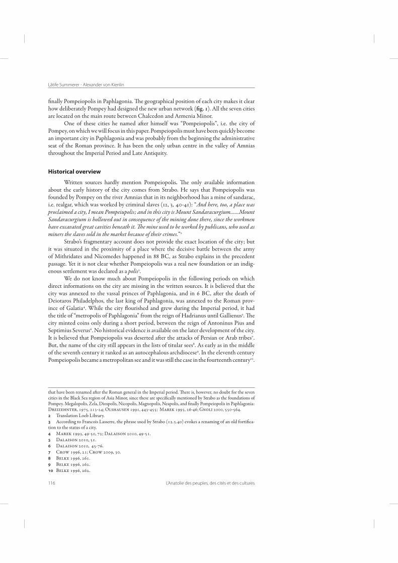
Figure . Roman Provinces in
Northern Anatolia between
Augustus and Vespasian
(MAREK ).
Lâtife Summerer - Alexander von Kienlin
116 L’Anatolie des peuples, des cités et des cultures
6nally Pompeiopolis in Paphlagonia. Fe geographical position of each city makes it clear how deliberately Pompey had designed the new urban network ("g. 1). All the seven cities are located on the main route between Chalcedon and Armenia Minor.
One of these cities he named a er himself was “Pompeiopolis”, i.e. the city of Pompey, on which we will focus in this paper. Pompeiopolis must have been quickly become an important city in Paphlagonia and was probably from the beginning the administrative seat of the Roman province. It has been the only urban centre in the valley of Amnias throughout the Imperial Period and Late Antiquity.
Historical overview
Written sources hardly mention Pompeiopolis. Fe only available information about the early history of the city comes from Strabo. He says that Pompeiopolis was founded by Pompey on the river Amnias that in its neighborhood has a mine of sandarac, i.e. realgar, which was worked by criminal slaves (12, 3, 40-41): “And here, too, a place was proclaimed a city, I mean Pompeiupolis; and in this city is Mount Sandaracurgium…...Mount Sandaracurgium is hollowed out in consequence of the mining done there, since the workmen have excavated great cavities beneath it. !e mine used to be worked by publicans, who used as miners the slaves sold in the market because of their crimes.”2
Strabo’s fragmentary account does not provide the exact location of the city; but it was situated in the proximity of a place where the decisive battle between the army of Mithridates and Nicomedes happened in 88 BC, as Strabo explains in the precedent passage. Yet it is not clear whether Pompeiopolis was a real new foundation or an indig-enous settlement was declared as a polis3.
We do not know much about Pompeiopolis in the following periods on which direct informations on the city are missing in the written sources. It is believed that the city was annexed to the vassal princes of Paphlagonia, and in 6 BC, a er the death of Deiotaros Philadelphos, the last king of Paphlagonia, was annexed to the Roman prov-ince of Galatia4. While the city ]ourished and grew during the Imperial period, it had the title of “metropolis of Paphlagonia” from the reign of Hadrianus until Gallienus5. Fe city minted coins only during a short period, between the reign of Antoninus Pius and Septimius Severus6. No historical evidence is available on the later development of the city. It is believed that Pompeiopolis was deserted a er the attacks of Persian or Arab tribes7. But, the name of the city still appears in the lists of titular sees8. As early as in the middle of the seventh century it ranked as an autocephalous archdiocese9. In the eleventh century Pompeiopolis became a metropolitan see and it was still the case in the fourteenth century10.
that have been renamed a er the Roman general in the Imperial period. Fere is, however, no doubt for the seven cities in the Black Sea region of Asia Minor, since these are speci6cally mentioned by Strabo as the foundations of Pompey. Megalopolis, Zela, Diospolis, Nicopolis, Magnopolis, Neapolis, and 6nally Pompeiopolis in Paphlagonia: Dreizehnter, 1975, 213-24; Olshausen 1991, 443-455; Marek 1993, 26-46; Gnoli 2000, 550-564. Translation Loeb Library. According to Francois Lasserre, the phrase used by Strabo (12.3.40) evokes a renaming of an old forti6ca-tion to the status of a city. Marek 1993, 49-50, 72; Dalaison 2010, 49-51. Dalaison 2010, 51. Dalaison 2010, 45-76. Crow 1996, 21; Crow 2009, 30. Belke 1996, 261. Belke 1996, 262. Belke 1996, 262.
Pompeiopolis. The Metropolis of Paphlagonia
L’Anatolie des peuples, des cités et des cultures 117
Shortly a erwards the diocese was suppressed. It is not known, however, whether the city really continued to exist in this period or only its titular see survived.
In any case at the end of the 14th century Pompeiopolis lay already in ruins. Manuel II Palaiologos who travelled along the Amnias River, bewailed in his famous letter from 1391 the decline of the city with the following words11: “You have heard of the city of Pompey, beautiful, marvellous, extensive; rather, that is how it once was, for now you can barely make out its ruins. It is situated on the banks of a river which is crossed by a stone bridge, adorned with colonnades, marvellous for their size, their beauty and their skilful construction. Indeed, this city and these magni#cent remains o$er no less evidence why the Romans bestowed on its founder the surname of “the Great” than the many victories which amply justi#ed this title.”
We learn from this source that Pompeiopolis has mostly disappeared from the human consciousness at the end of the 14th century. Apart from the bridge decorated with colonnades, there were hardly notable ruins. During the following 6ve centuries Pompeio-polis decayed more and more and 6nally was lost in oblivion.
Rediscovery of Pompeiopolis in the 19th century
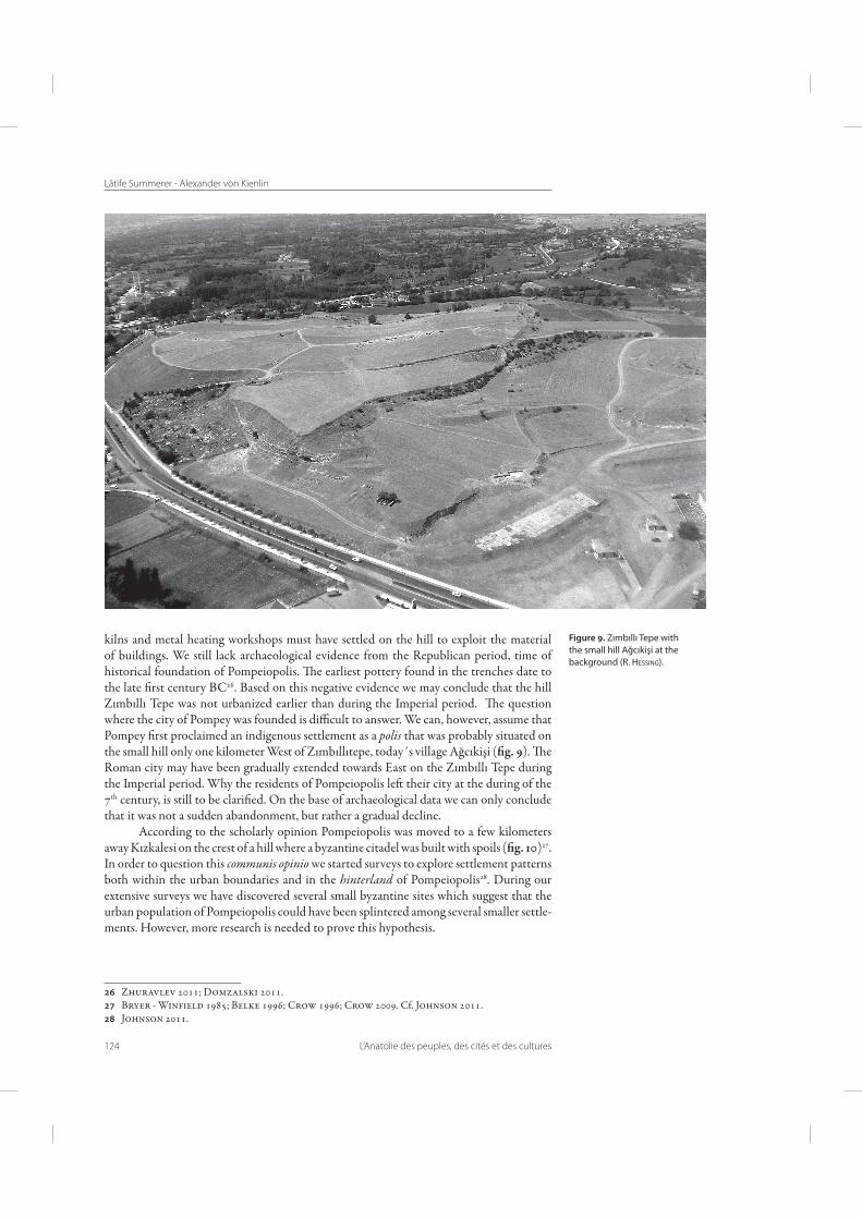
Only in the early 19th Century the city came back into the general consciousness: Pascal Fourcade, who served as a consul under Napoleon in Sinop (1802-1812), rediscov-ered the city of Pompey on the overgrown hill near the modern city of Taşköprü by looking at the inscriptions12. But no large-scale excavations followed this rediscovery. Rather, during the 19th and early 20th centuries the still existing remains of the city were gradu-ally removed as spoils for modern constructions. And the place, where Pompeiopolis once stood, presents itself today ("g. 9) as a bare deforested hill, and it shows little of its former glory as a metropolis, at least at 6rst sight.
New project
In 2006 a new excavation project has started to bring Pompeiopolis back to the historical consciousness. Fe aim of the project is an extensive exploration of the city revealing its topography and city plan as well as its signi6cance in the process of urban-ization in northern Anatolia. Fe research focuses on the followings questions : which urban model was used to create a Roman city in Paphlagonia? Should we expect the typical features of a Roman city in Pompeiopolis? Did Pompey design his city on a virgin site or did he simply proclaimed an existing indigenous settlement as a polis? A er 6ve years of research we are now able to answer these questions, at least partially.
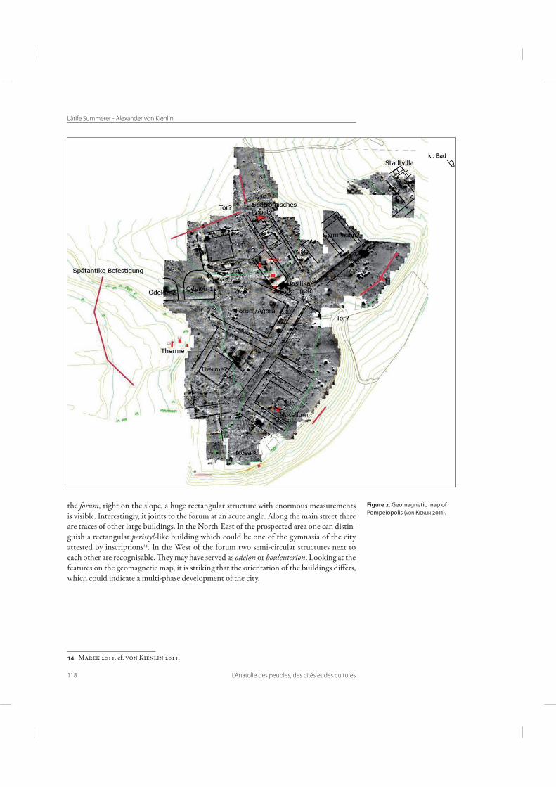
Geomagnetic Prospection
Large area geomagnetic survey provided an exceptionally clear and almost complete city plan ("g. 2)13. One can recognise streets and buildings: directly on the main street a large surrounded court-like place covering an area of 100 x 80 m, probably the forum - the heart of the city. In the South a large building with a courtyard is visible, perhaps one of the baths of the town. Another building (about 65 x 120 m in size) with a courtyard and a small circular building in the centre can be 6gured out. In comparison with other Roman cities, we assume that this is the macellum, i.e. the meat market of the city. At the North of
Translation by Dennis 1977, 16. Cf. Bryer – Winfield 1985, 12. Fourcade 1811, 30-31. Fassbinder 2011.
Lâtife Summerer - Alexander von Kienlin
118 L’Anatolie des peuples, des cités et des cultures
the forum, right on the slope, a huge rectangular structure with enormous measurements is visible. Interestingly, it joints to the forum at an acute angle. Along the main street there are traces of other large buildings. In the North-East of the prospected area one can distin-guish a rectangular peristyl-like building which could be one of the gymnasia of the city attested by inscriptions14. In the West of the forum two semi-circular structures next to each other are recognisable. Fey may have served as odeion or bouleuterion. Looking at the features on the geomagnetic map, it is striking that the orientation of the buildings di�ers, which could indicate a multi-phase development of the city.
Marek 2011. cf. von Kienlin 2011.
Figure . Geomagnetic map of
Pompeiopolis (VON KIENLIN ).
Pompeiopolis. The Metropolis of Paphlagonia
L’Anatolie des peuples, des cités et des cultures 119
Excavations for confirmation of geomagnetics
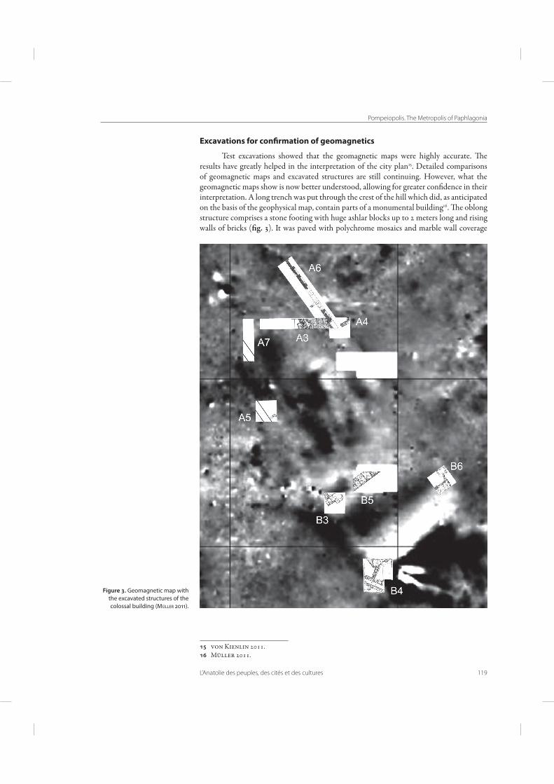
Test excavations showed that the geomagnetic maps were highly accurate. Fe results have greatly helped in the interpretation of the city plan15. Detailed comparisons of geomagnetic maps and excavated structures are still continuing. However, what the geomagnetic maps show is now better understood, allowing for greater con6dence in their interpretation. A long trench was put through the crest of the hill which did, as anticipated on the basis of the geophysical map, contain parts of a monumental building16. Fe oblong structure comprises a stone footing with huge ashlar blocks up to 2 meters long and rising walls of bricks ("g. 3). It was paved with polychrome mosaics and marble wall coverage
von Kienlin 2011. Müller 2011.
Figure . Geomagnetic map with
the excavated structures of the
colossal building (MÜLLER ).
Lâtife Summerer - Alexander von Kienlin
120 L’Anatolie des peuples, des cités et des cultures
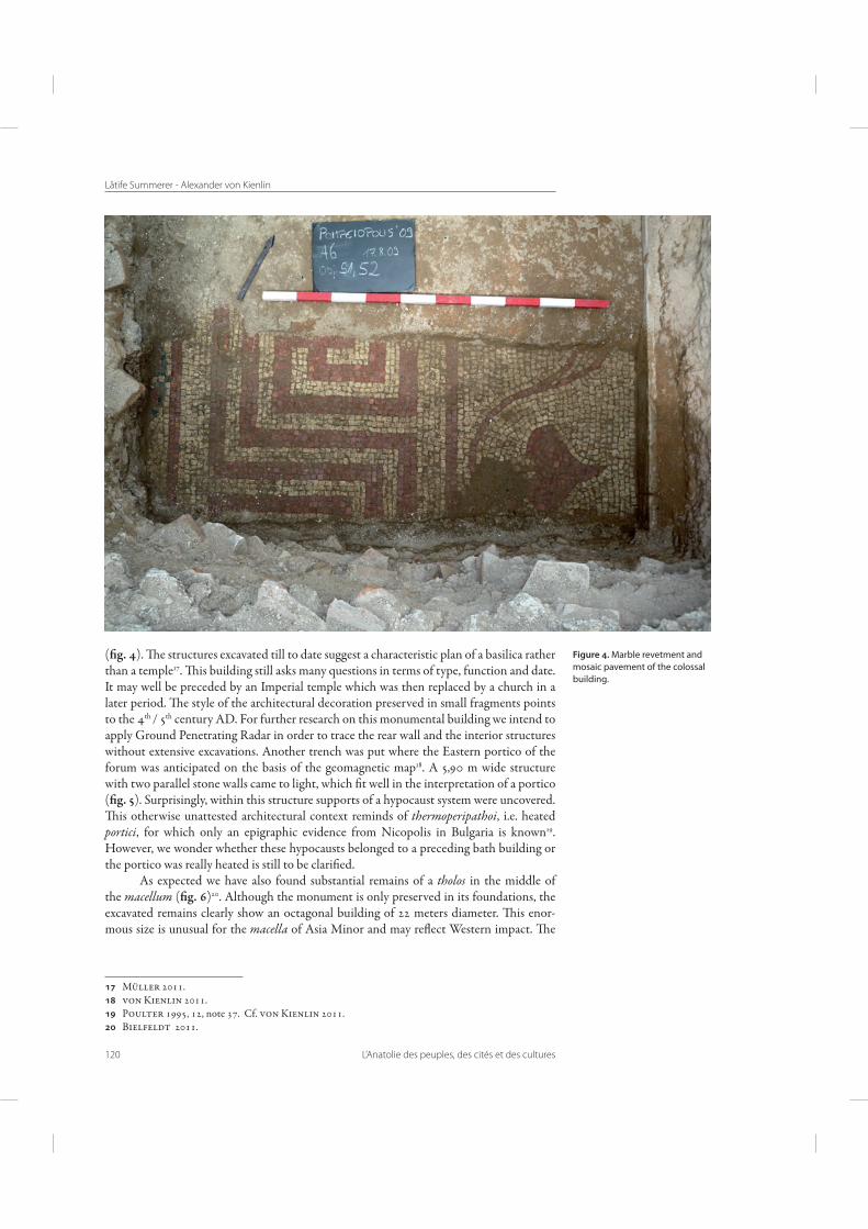
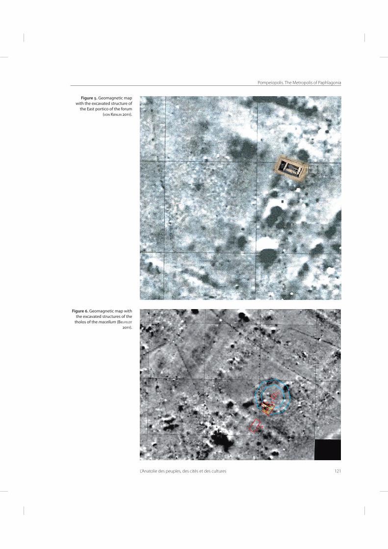
("g. 4). Fe structures excavated till to date suggest a characteristic plan of a basilica rather than a temple17. Fis building still asks many questions in terms of type, function and date. It may well be preceded by an Imperial temple which was then replaced by a church in a later period. Fe style of the architectural decoration preserved in small fragments points to the 4th / 5th century AD. For further research on this monumental building we intend to apply Ground Penetrating Radar in order to trace the rear wall and the interior structures without extensive excavations. Another trench was put where the Eastern portico of the forum was anticipated on the basis of the geomagnetic map18. A 5,90 m wide structure with two parallel stone walls came to light, which 6t well in the interpretation of a portico ("g. 5). Surprisingly, within this structure supports of a hypocaust system were uncovered. Fis otherwise unattested architectural context reminds of thermoperipathoi, i.e. heated portici, for which only an epigraphic evidence from Nicopolis in Bulgaria is known19. However, we wonder whether these hypocausts belonged to a preceding bath building or the portico was really heated is still to be clari6ed.
As expected we have also found substantial remains of a tholos in the middle of the macellum ("g. 6)20. Although the monument is only preserved in its foundations, the excavated remains clearly show an octagonal building of 22 meters diameter. Fis enor-mous size is unusual for the macella of Asia Minor and may re]ect Western impact. Fe
Müller 2011. von Kienlin 2011. Poulter 1995, 12, note 37. Cf. von Kienlin 2011. Bielfeldt 2011.
Figure . Marble revetment and
mosaic pavement of the colossal
building.
Pompeiopolis. The Metropolis of Paphlagonia
L’Anatolie des peuples, des cités et des cultures 121
Figure . Geomagnetic map
with the excavated structure of
the East portico of the forum
(VON KIENLIN ).
Figure . Geomagnetic map with
the excavated structures of the
tholos of the macellum (BIELFELDT
).
Lâtife Summerer - Alexander von Kienlin
122 L’Anatolie des peuples, des cités et des cultures
walls of the tholos were plastered. A number of wall plaster fragments with gra�ti have been recovered. In some fragments the sequence of words “ΚΑΙ ΧΟΙΡΟΝ” is well legible, which means “and of piglets” and which is of course appropriate to a meat market. A frag-” and which is of course appropriate to a meat market. A frag- and which is of course appropriate to a meat market. A frag-A frag-mentary inscription, legible as a dedication (KA)ISARI.M.AU(RELIO) to Marc Aurel or Alexander Severus, suggests that the macellum was built in the second or third century AD. Fe tholos seems to have been renovated in the 6th century paving the pteron with terracotta plaques. It was continuously in use till the early 7th century AD. A follis of the emperor Phokas (605/606 AD) provides a terminus ante quem for its 6nal destruction21.
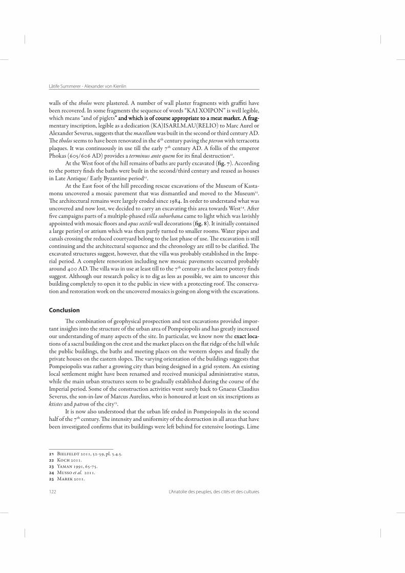
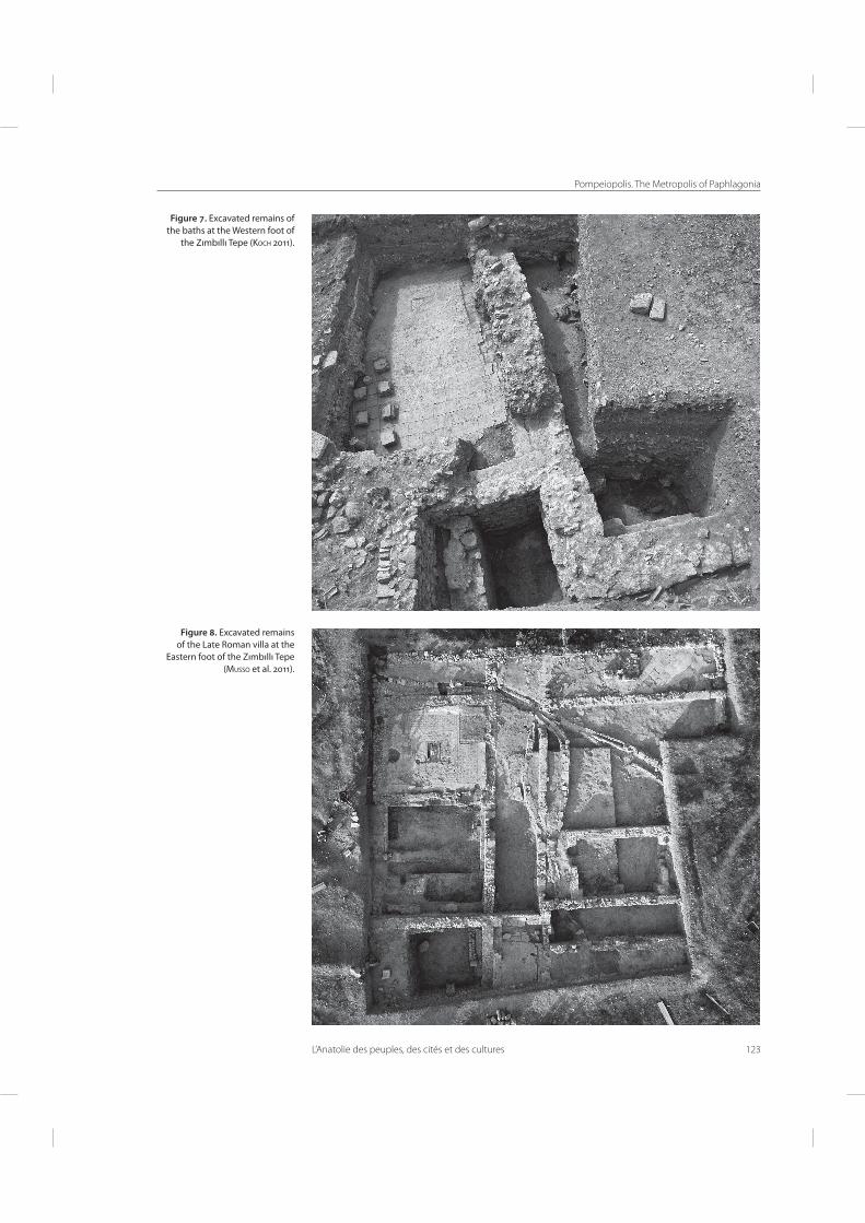
At the West foot of the hill remains of baths are partly excavated ("g. 7). According to the pottery 6nds the baths were built in the second/third century and reused as houses in Late Antique/ Early Byzantine period22.
At the East foot of the hill preceding rescue excavations of the Museum of Kasta-monu uncovered a mosaic pavement that was dismantled and moved to the Museum23. Fe architectural remains were largely eroded since 1984. In order to understand what was uncovered and now lost, we decided to carry an excavating this area towards West24. A er 6ve campaigns parts of a multiple-phased villa suburbana came to light which was lavishly appointed with mosaic ]oors and opus sectile wall decorations ("g. 8). It initially contained a large peristyl or atrium which was then partly turned to smaller rooms. Water pipes and canals crossing the reduced courtyard belong to the last phase of use. Fe excavation is still continuing and the architectural sequence and the chronology are still to be clari6ed. Fe excavated structures suggest, however, that the villa was probably established in the Impe-rial period. A complete renovation including new mosaic pavements occurred probably around 400 AD. Fe villa was in use at least till to the 7th century as the latest pottery 6nds suggest. Although our research policy is to dig as less as possible, we aim to uncover this building completely to open it to the public in view with a protecting roof. Fe conserva-tion and restoration work on the uncovered mosaics is going on along with the excavations.
Conclusion
Fe combination of geophysical prospection and test excavations provided impor-tant insights into the structure of the urban area of Pompeiopolis and has greatly increased our understanding of many aspects of the site. In particular, we know now the exact loca-exact loca-tions of a sacral building on the crest and the market places on the ]at ridge of the hill while the public buildings, the baths and meeting places on the western slopes and 6nally the private houses on the eastern slopes. Fe varying orientation of the buildings suggests that Pompeiopolis was rather a growing city than being designed in a grid system. An existing local settlement might have been renamed and received municipal administrative status, while the main urban structures seem to be gradually established during the course of the Imperial period. Some of the construction activities went surely back to Gnaeus Claudius Severus, the son-in-law of Marcus Aurelius, who is honoured at least on six inscriptions as ktistes and patron of the city25.
It is now also understood that the urban life ended in Pompeiopolis in the second half of the 7th century. Fe intensity and uniformity of the destruction in all areas that have been investigated con6rms that its buildings were le behind for extensive lootings. Lime
Bielfeldt 2011, 52-59, pl. 3.4.5. Koch 2011. Yaman 1991, 65-75. Musso et al. 2011. Marek 2011.
Pompeiopolis. The Metropolis of Paphlagonia
L’Anatolie des peuples, des cités et des cultures 123
Figure . Excavated remains of
the baths at the Western foot of
the Zımbıllı Tepe (KOCH ).
Figure . Excavated remains
of the Late Roman villa at the
Eastern foot of the Zımbıllı Tepe
(MUSSO et al. ).
Lâtife Summerer - Alexander von Kienlin
124 L’Anatolie des peuples, des cités et des cultures
kilns and metal heating workshops must have settled on the hill to exploit the material of buildings. We still lack archaeological evidence from the Republican period, time of historical foundation of Pompeiopolis. Fe earliest pottery found in the trenches date to the late 6rst century BC26. Based on this negative evidence we may conclude that the hill Zımbıllı Tepe was not urbanized earlier than during the Imperial period. Fe question where the city of Pompey was founded is di�cult to answer. We can, however, assume that Pompey 6rst proclaimed an indigenous settlement as a polis that was probably situated on the small hill only one kilometer West of Zımbıllıtepe, today´s village Ağcıkişi ("g. 9). Fe Roman city may have been gradually extended towards East on the Zımbıllı Tepe during the Imperial period. Why the residents of Pompeiopolis le their city at the during of the 7th century, is still to be clari6ed. On the base of archaeological data we can only conclude that it was not a sudden abandonment, but rather a gradual decline.
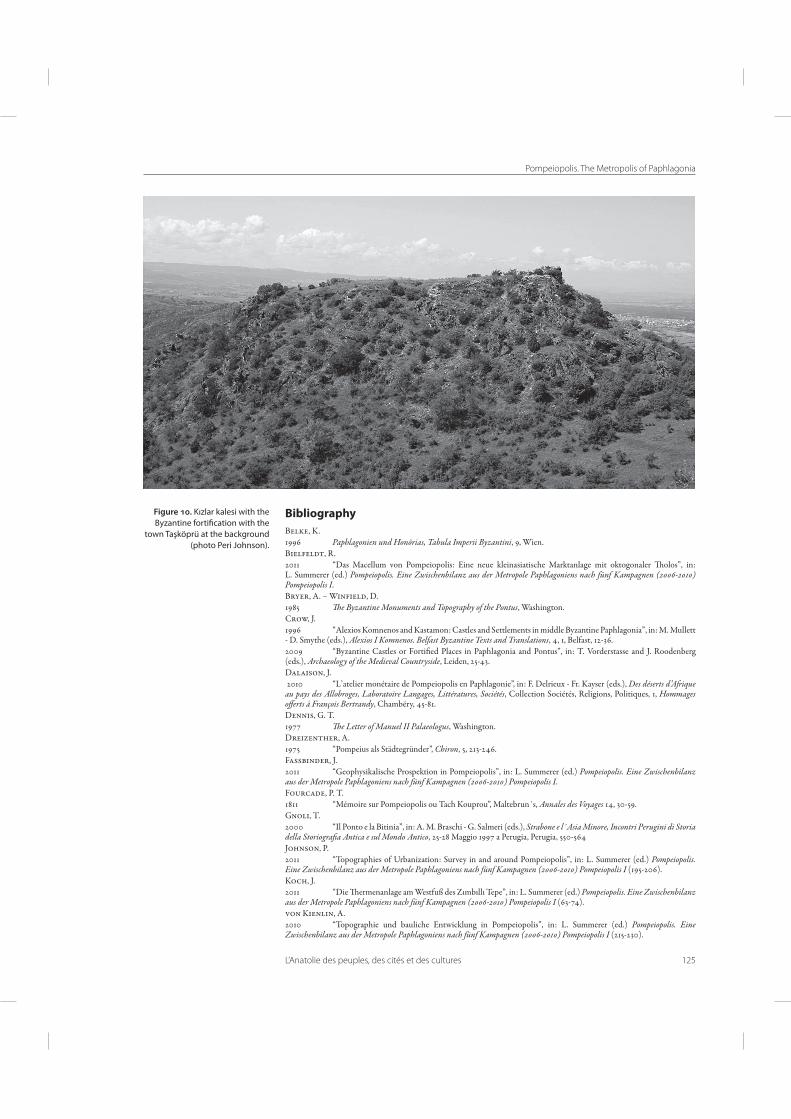
According to the scholarly opinion Pompeiopolis was moved to a few kilometers away Kızkalesi on the crest of a hill where a byzantine citadel was built with spoils ("g. 10)27. In order to question this communis opinio we started surveys to explore settlement patterns both within the urban boundaries and in the hinterland of Pompeiopolis28. During our extensive surveys we have discovered several small byzantine sites which suggest that the urban population of Pompeiopolis could have been splintered among several smaller settle-ments. However, more research is needed to prove this hypothesis.
Zhuravlev 2011; Domzalski 2011. Bryer - Winfield 1985; Belke 1996; Crow 1996; Crow 2009. Cf. Johnson 2011. Johnson 2011.
Figure . Zımbıllı Tepe with
the small hill Ağcıkişi at the
background (R. HESSING).
Pompeiopolis. The Metropolis of Paphlagonia
L’Anatolie des peuples, des cités et des cultures 125
Bibliography
Belke, K.1996 Paphlagonien und Honōrias, Tabula Imperii Byzantini, 9, Wien.Bielfeldt, R.2011 “Das Macellum von Pompeiopolis: Eine neue kleinasiatische Marktanlage mit oktogonaler Folos”, in: L. Summerer (ed.) Pompeiopolis. Eine Zwischenbilanz aus der Metropole Paphlagoniens nach fünf Kampagnen (2006-2010) Pompeiopolis I.Bryer, A. – Winfield, D.1985 !e Byzantine Monuments and Topography of the Pontus, Washington.Crow, J.1996 “Alexios Komnenos and Kastamon: Castles and Settlements in middle Byzantine Paphlagonia”, in: M. Mullett - D. Smythe (eds.), Alexios I Komnenos. Belfast Byzantine Texts and Translations, 4, 1, Belfast, 12-36.2009 “Byzantine Castles or Forti6ed Places in Paphlagonia and Pontus”, in: T. Vorderstasse and J. Roodenberg (eds.), Archaeology of the Medieval Countryside, Leiden, 25-43.Dalaison, J. 2010 “L’atelier monétaire de Pompeiopolis en Paphlagonie”, in: F. Delrieux - Fr. Kayser (eds.), Des déserts d’A2ique au pays des Allobroges, Laboratoire Langages, Littératures, Sociétés, Collection Sociétés, Religions, Politiques, 1, Hommages o$erts à François Bertrandy, Chambéry, 45-81.Dennis, G. T.1977 !e Letter of Manuel II Palaeologus, Washington.Dreizenther, A.1975 “Pompeius als Städtegründer”, Chiron, 5, 213-246.Fassbinder, J.2011 “Geophysikalische Prospektion in Pompeiopolis”, in: L. Summerer (ed.) Pompeiopolis. Eine Zwischenbilanz aus der Metropole Paphlagoniens nach fünf Kampagnen (2006-2010) Pompeiopolis I.Fourcade, P. T.1811 “Mémoire sur Pompeiopolis ou Tach Kouprou”, Maltebrun´s, Annales des Voyages 14, 30-59.Gnoli, T.2000 “Il Ponto e la Bitinia”, in: A. M. Braschi - G. Salmeri (eds.), Strabone e l´Asia Minore, Incontri Perugini di Storia della Storiogra#a Antica e sul Mondo Antico, 25-28 Maggio 1997 a Perugia, Perugia, 550-564Johnson, P. 2011 “Topographies of Urbanization: Survey in and around Pompeiopolis”, in: L. Summerer (ed.) Pompeiopolis. Eine Zwischenbilanz aus der Metropole Paphlagoniens nach fünf Kampagnen (2006-2010) Pompeiopolis I (195-206).Koch, J.2011 “Die Fermenanlage am Westfuß des Zımbıllı Tepe”, in: L. Summerer (ed.) Pompeiopolis. Eine Zwischenbilanz aus der Metropole Paphlagoniens nach fünf Kampagnen (2006-2010) Pompeiopolis I (63-74).von Kienlin, A.2010 “Topographie und bauliche Entwicklung in Pompeiopolis”, in: L. Summerer (ed.) Pompeiopolis. Eine Zwischenbilanz aus der Metropole Paphlagoniens nach fünf Kampagnen (2006-2010) Pompeiopolis I (215-230).
Figure . Kızlar kalesi with the
Byzantine fortification with the
town Taşköprü at the background
(photo Peri Johnson).
Lâtife Summerer - Alexander von Kienlin
126 L’Anatolie des peuples, des cités et des cultures
Lasserre, F.1981 Strabon, Géographie, tome 9 : Livre XII, traduit par F. Lasserre, Paris, CUF.Marek, C.1993 Stadt, Ära und Territorium in Pontus-Bithynia und Nord-Galatia, Ist. Forsch. Beih. 39, Tübingen.2003 Pontus et Bithynia. Die Römischen Provinzen im Norden Kleinasiens, Orbis Provinciarum, Mainz.2011 “Zur Epigraphik von Pompeiopolis: Eine Zwischenbilanz”, in: L. Summerer (ed.) Pompeiopolis. Eine Zwischenbilanz aus der Metropole Paphlagoniens nach fünf Kampagnen (2006-2010) Pompeiopolis I (189-194).Müller, K.2011 “Der Großbau auf dem Stadthügel von Pompeiopolis”, in: L. Summerer (ed.) Pompeiopolis. Eine Zwischenbilanz aus der Metropole Paphlagoniens nach fünf Kampagnen (2006-2010) Pompeiopolis I (29-48).Musso, L., Bertoletto, G., Brizzi, M., Westwood, B.2011 “L’edi6cio abitativo alle pendici orientali dello Zımbıllı Tepe”, in: L. Summerer (ed.) Pompeiopolis. Eine Zwischenbilanz aus der Metropole Paphlagoniens nach fünf Kampagnen (2006-2010) Pompeiopolis I (75-120).Olshausen, E.1991 “Zum Organisationskonzept des Pompeius in Pontos.- ein historisch-geographisches Argument”, in: Raum und Bevölkerung in der antiken Stadtkultur. Stuttgarter Kolloquien, Bonn, 443-455.Poulter, D.1995 Nicopolis ad Istrum. A Roman, late Roman and early Byzantine city. Excavations 1985-1992. Society for the Promotion of Roman Studies, London.Yaman, Z.1991 “Kastamonu Ili Taşköprü Ilçesi Pompeiopolis (Zımbıllı Tepesi Höyüğü) 1984 Yılı Kurtarma Kazısı”, in: 1. Müze Kurtarma Kazısı Sonuçları, Ankara, 63-111.Zhuravlev, D.2011 “Roman Fine Ware from Pompeiopolis”, in: L. Summerer (ed.), Pompeiopolis I: Eine Zwischenbilanz aus der Metropole Paphlagonien: nach fünf Kampagnen (2006-2010) Langenweißbach, 149-162.