petroglyphs in the lower negro river basin, nw brazilian amazon - a preliminary view
TRANSCRIPT
PETROGLYPHS IN THE LOWER NEGRO RIVER BASIN,
NW BRAZILIAN AMAZON – A PRELIMINARY VIEW
A ARTE RUPESTRE DO RIO NEGRO –
UMA CONTRIBUIÇÃO À PESQUISA PRELIMINAR
Raoni VALLE
Doctoral Student – PPGARQ/MAE-USP
Visiting Researcher NPCHS – INPA
Resumo
A bacia do rio Negro, no extremo NW do Brasil, apresenta-se hoje como uma área pouco explorada
pela arqueologia brasileira. No âmbito da investigação de arte rupestre a documentação para fins de
pesquisa começou a partir de 2006, a despeito de inúmeros relatos de naturalistas, viajantes e
antropólogos referentes à ocorrência de gravuras rupestres desde o século XIX. Portanto, desde a
estação seca de 2006 campanhas oportunísticas de documentação fotográfica de sítios rupestres com
gravuras, seguindo um protocolo específico têm sido implementadas na calha do rio Negro e em seus
principais afluentes para subsidiar uma pesquisa doutoral. As prospecções se concentram no médio rio
Negro, estado do Amazonas, na área de confluência com o rio Branco, proveniente de Roraima, onde
também se encontra uma fronteira geológica entre os granitóides da formação Jauaperi, no escudo
cristalino Guianense, e os arenitos do grupo Trombetas e formação Alter do Chão. Esta conjuntura geo-
ambiental tem influenciado na formulação de proposições concernentes a variabilidade gráfica e técnica
dos petroglifos lá encontrados, sobretudo na hipótese de identificação de uma fronteira gráfica pré-
colonial na área. Nesta comunicação específica apresentamos um repertório de imagens coletadas entre
2006 e 2008 inseridas numa abordagem descritiva e comparativa, no sentido de expor em linhas gerais o
que se tem documentado até o presente momento.
Raoni VALLE
3 / Arte Rupestre da Amazônia.
92
“...when I was about Branco river mouth, I found in a
small rocky island, several figures of men and animals,
all of them in great size, engraved on the
hard granite rock.”1
Alfred Russell Wallace, 1889[1979:316].
Introduction
Since 2006, rock art recording field work has
been conducted in the lower Negro river
basin, Western Brazilian Amazon, in an
opportunistic and extensive manner. Through
GPS location and preliminary photographic
documentation of open air, riverine and
underwater rock art sites we begin to study
these weathered petroglyphs. Some have been
historically known, visited and disturbed, but,
have never been submitted to any kind of
specific analysis (Heckenberger 1997).
This research is a first effort centered on
survey and recognition of sites within a
sample area sandstone and granite rock
formations accessible only in the climax of the
dry season (last half of October and first week
of November, normally), when most known
petroglyphs are out of water.
For the rest of the year (ten months) these
sites remain under turbulent waters, which
results in: (1) temporal, climatic and logistic
restrictions on field work; (2) a deplorable
preservation state with several physical,
biological and chemical weathering factors
conditioned by the hydration/dehydration
situation and; (3) a geomorphological
implausibility for the formation and/or
conservation of datable archaeological
deposits related to rock art. The situation
could not be worse for the rock art itself and
in terms of contextual relational data.
Keeping these restrictions in mind, the survey
area comprises a purposeful geographical cut
based on geo-environmental aspects
(hydrographical confluence and geological
contact) that we believe active in, and
1 The original was already translated in Portuguese, so, this is
my own translation back into English and not Wallace`s original written version.
determinant to, an expected graphical
variability scenario. Indeed, we are identifying
such variation in the rock art corpus
documented. This assemblage we are working
with comprises twelve (12) sites found until
this moment based on boat prospective work
during a very restrict period per year. In each
field season, we went through a small portion
of a total survey line of about 87 kilometers
along the main course of the Negro river.
This transect2 was established from the
prehistoric and historic archaeological site of
the Velho Airão town (now a small riverine
“caboclo” community) to the mouth of the
Branco river, and also penetrating the lower
courses of its respective tributaries: Jaú, Unini
and Jauaperi rivers.
Between 2006 and 2008, three campaigns
were established in this sample area. Two of
them were directed toward the lower courses
of the Jaú river (Jaú National Park) and Unini
river (Unini Federal Extractive Reserve) and
surroundings, resulting in the photo-
documentation and GPS-plotting of seven (7)
rock art sites, six on sandstone and one on
granite formations. The third was conducted
between the Unini/Negro and the
Branco/Negro confluences, and also in the
lower course of the Jauaperi river between the
Brazilian states of Amazonas and Roraima,
resulting in the photo-documentation and
GPS-plotting of five (5) rock art sites, all on
granite bedrock. In 2008, another expedition
was sent to the Upper Negro river, which
consisted of prospection in the lower and
middle Içana river basin (one of Upper
Negro‟s main tributary), Baniwa‟s indigenous
territory. Six (6) rock art sites were partially
documented as being reused (“resignified”
and renewed) by Baniwa culture and
mythology, but because of contextual 2 Each drought we try to go further along this planned
transect. Due to lack of specific funding and programs for Amazonian Rock Art research which is, for the most part, not a priority in the Brazilian Western Amazonian Archaeology agenda, access is gained through opportunistic hitchhiking on expeditions run by nongovernmental organizations (e.g. pro-environment, sustainable development, etc.)., Slowly we are trying to revert this trend, but this process demands huge amount of effort, personnel and money in the middle and long terms, which, are definitely not available now and for the coming years.
Congresso Internacional da IFRAO 2009 – Piauí / BRASIL
93
specificity these sites are discussed elsewhere
(Valle & Costa 2008; Valle 2009b).
None of these campaigns were conducted in
extreme dry conditions (what would be ideal)
nor in an adequate logistic fashion (see note
2). Instead, they took place during common
dry seasons, in normal low water level
situations or when the levels had already
started to go up (almost 10 cm per day). As a
result, until now, we still don‟t have access to
the entire corpus, and probably we are dealing
with a small fraction of what would be
available in a “good” drought (like the 2005
one) and with the ideal fieldwork logistics. We
suspect that the assemblage presented is only
the „tip of the iceberg‟.
The sampled corpus is very small in terms of
analytical purposes, but as we have said, this is
a preliminary work and, before any attempts
at breaking the corpus into formally different
corpora, styles or graphical identities, and in
order to establish an internal relative
chronology, we have to find them, observe
them and record their content. We are at this
embryonic stage of research.
Sample Area
The sample area encompasses two
municipalities in the lower Negro river basin,
from Barcelos to Novo Airão, (coordinates
S02°17‟ W61°03‟ to S01°16‟ W62°17‟). Major
environmental features of this area are the
geological diversity and a multi-confluence
situation in the hydrographic network.
Geologically, the contact between the granites
and gneisses of the Guiana crystalline shield‟s
Jauaperi complex and the sandstone and
siltstone from Prosperança, Içá, Alter do
Chão and Trombetas group sedimentary
formations introduces different sources of
lithological materials with highly diverse
petrographical properties into the area, which
probably would have led to different
technical-operatory chains.
Hydrographically, several tributaries of the
Negro river‟s lower course converge in the
area, bringing biotic and abiotic influences
from very different parts of the Amazon
region. The confluence of the alkaline white
waters of the Branco river coming from the
north, (savannahs from the Roraima state, SE
Venezuela and Guiana) with the acidic dark
waters from the Negro river basin, whose
headwaters are located in the extreme NW of
Amazonia (rain forests from east Colombia
and Upper Orinoco river), connects areas that
are also highly diverse in terms of
ethnographical content and cultural histories.
We present here a sequence of maps and
satellite images to show this environmental
variability in the sample area along with the
plotted location of the sites we are studying.
(Fig.1- 4 )
Hypothesis
We propose that this geo-environmental set
(hydrographic and geological variability) has a
direct contribution in the determination of
graphical variability (heterogeneity) in a rock
art corpus under similar conditions. We have
chosen this specific geographical space in the
course of Negro basin in order to test this
assumption. What we have found, until now,
indicates a confirmation, rather than a
refutation, of our basis hypothesis.
Thus we are inclined to postulate that areas
of geological contact and hydrographic
confluence are more suitable for presenting
factual rock art variability, and hence for the
study of its theoretical consequences. This
sound proposition is of imminent testability
and therefore we believe it is built on
hypothetical-deductive scientific ground even
if in the future it is proven to be false.
Consequently, we understand that this
experiment lends support to the proposition
of a preliminary geo-archaeological predictive
model to be tested in other areas along the
Negro basin and outside of it. The suggested
PETROGLYPHS IN THE LOWER NEGRO RIVER BASIN, NW BRAZILIAN AMAZON – A PRELIMINARY VIEW
Raoni VALLE
3 / Arte Rupestre da Amazônia.
94
model is based on the following background
assumptions: (1) multiple cultural and
geographical proveniences of authors‟
communities were conditioned by the
hydrographical net; (2) multiple strategies and
choices of rock art elaboration were
conditioned by variability in geological raw
materials of technical surfaces and tools.
So, from this geological point of view,
diversity in available rock types would have
led to different operatory procedures in the
manifestation of graphic phenomena,
beginning with the prime agency over raw
materials through the parietal artifact‟s final
appearance and subsequent intentional
manipulation.3
The problem is that what we are detecting in
different rock surfaces in the sample area
indicates not just different techniques (what
would be expected) but rather other sorts of
graphical choices in terms of thematics,
morphological structure, topological
arrangements within the graphical space (the
so-called “scenography”) and
geomorphological positioning of panels in
sites and of sites in the landscape, patterns
which are heterogeneously emerging.
According to previous studies (Pessis 2002;
Valle 2003) and based on ethnographical
substrata (Lewis–Williams 2004; Whitley 2001,
1998; Reichel-Dolmatoff 1967, 1971; Eliade
1949 [1993]; Levi-Strauss 1966) it is possible
that geological choices are neither random nor
naturally constricted, and could be governed
by prehistoric systems of geological ethno-
knowledge or, at minimum, a geological
ethno-taxonomy materialized in culturally
and/or ritualistically deliberate choices for
determined lithological types at the base of
their operatoire and symbolic chains.
Within the hydrographic perspective, we have
an indigenous history and ethnohistory, at
3 To this day, some ethnic groups in the Upper Negro river
retouched the old petroglyphs, sometimes with lithic manufacturing techniques, but more often, just applying industrialized paint, or other sort of pigment over it.
least for the latter part of the Holocene
occupation, for the entire Amazonian
lowlands that is based on fluvial movements
of languages, cultures and peoples, a riverine
lifestyle which is considered one of the tenets
for the definition of a tropical forest culture
(Lowie 1948). In the Negro the panorama is
exactly the same and several sources (Wallace,
1979; Spix & Martius, 1981; Rodrigues
Ferreira, 1972; Koch-Grunberg, 2005,
Métraux, 1948; Goldman, 1948; Nimuendaju,
1950; Wright, 1992; Urban, 1992; Montserrat,
2000; Neves 1998) point to a multicultural
and multilinguistic prehistoric scenario.
Given the multi-confluence characteristic of
the sample area, where the connection of
Negro and Branco rivers dominates the
hydrographical landscape, we assume that
cultures coming from the northern savannahs
and igneous uplands of Roraima, Southeast
Venezuela and Guiana via the Branco river,
and cultures coming from the Northwest
Amazon, East Colombia and Upper Orinoco
basin via the Negro river were in possible
diachronic contact precisely within the
research area, where we are finding variability
in the rock art corpus.
Equating biotic and abiotic convergence
(Ab‟Saber 2002) with cultural confluence, we
believe that hydrographical and geological
contact areas are best suitable for testing
models of rock art graphical heterogeneity,
which is hypothetically associated with
cultural variability conditioned by socio-
environmental factors.
Theoretic-Methodological Framework
In the realm of discussions about formal and
informed methods (Chippindale and Taçon
1998; Chippindale and Nash 2004) we opt for
a formal one. Despite the existence in the
Amazon region of living indigenous mytho-
historical traditions that interpret the
petroglyphs, mainly in the Negro river basin
(Reichel-Dolmatoff 1967, 1971; Koch-
Grünberg 1907; Xavier 2008), there is, by no
means, an unequivocal way to demonstrate,
Congresso Internacional da IFRAO 2009 – Piauí / BRASIL
95
verify or test a “philogenetic” or cultural-
historic connection between these living
traditions and the prehistoric authors‟ graphic
concepts and practices, assuming that these
petroglyphs are older than the ethnographic
present and memory.4
Considering this, we follow Chippindale and
Taçon‟s definition (1998:7) of formal method,
which postulates: “For much prehistoric art,
beginning with the Palaeolithic art of the deep
European caves, we have no basis for informed
knowledge. There we must work with formal methods,
those that depend on no inside knowledge, but which
work when one comes to the stuff „cold‟, as a
prehistorian does. The information available is then
restricted to that which is immanent in the images
themselves, or which we can discern from their relations
to each other and to the landscape, or by relation to
whatever archaeological context is available.”
In so saying, we should not discard the
ethnographical meanings and usages of the
petroglyphs by the living indigenous
traditions, but we must be conscious, when
making analogical attempts, that this
repertoire of (re)significations and practices is
probably separated by millennia from the
prehistoric rock-art‟s original atmosphere of
creation. When one cannot be sure about time
it becomes necessary to rely on space, from
micro-spatial analyses of the technical and
morphological formal constitution of the
images to the macro-spatial analytic levels of
the images in the panel, then on to the panel‟s
geomorphological insertion in the site rock
formation and, finally, through to the
insertion of the site in the major landscape
features (Chippindale and Nash 2004).
4 Indeed, considering their topo-geomorphological situation of
submersion, one can speculate about a middle holocenic origin for most part of the corpus available today, based on palaeoenvironmental indicatives of much lower water levels in Negro basin between 6.000 years B.P. and 3.000 years B.P., (Ab’Saber 1996; Williams 1985). During this time, the geomorphological locations of those rock art panels would have been exposed year-round, assuming that most of this rock art was made to be seen and to communicate something to someone passing along the river.
With regard to this issue of temporal control,
Franklin is of particular interest: “The basic
problem with many studies of rock art in Australia
(and in other parts of the world) is a lack of control
over time” (in Bahn&Lorblanchet 1993:1). And
further, she says (Ibidem 1993:8): “Fruitful
approaches might be spatial analyses, where attempts
are made to measure variation within rock art on a
spatial basis. We cannot at present deal in any detail
with time in rock art, but we can deal with space.
Rock art has a fixed location, and generally does not
suffer the problem of, for instance, movement within an
archaeological deposit…Although some movement and
erosion of rock art panels may occur as a result of
natural processes [We should add here cultural
processes as well, as in the case of
ethnographic selective retouch]…this may not
be as great as disturbances observed in other
archaeological sites…In spatial approach, one would
proceed from a known factor, space, or location of sites,
to in most cases unknown factor, time”.
Thus, our focus is less on time than on space.
Hence, it would be suitable to discard two
levels of the phenomena, time and meaning
(the ethnographic myth-historical and
ecological ones or our western logical ones),
which we consider, for the purpose of our
work and given its limitations, unreachable
and useless, respectively. Instead, we should
focus on the visual photographical pieces of
evidence, trying to segregate modalities of
factual features based on cognitively
detectable materiality of the rock art codes
and analogical reoccurrences (what could be
called visual analogies [Sieveking in
Bahn&Lorblanchet 1993:33]) among those
detected material aspects recognized by our
brain and visual system.
The formal method employed here is in great
part derived from A.M. Pessis‟ (1987, 1989,
1992a, 1992b 1993, 1999, 2002 and 2004) and
N. Guidon‟s (1982, 1986, 1992 and 1996)
work with the rock art traditions of Serra da
Capivara National Park in Piauí as well as
from G. Martin (1999, 2000) and from my
own research efforts (Valle 2003) within the
rock art corpora of the Seridó arid region
PETROGLYPHS IN THE LOWER NEGRO RIVER BASIN, NW BRAZILIAN AMAZON – A PRELIMINARY VIEW
Raoni VALLE
3 / Arte Rupestre da Amazônia.
96
between the Brazilian Northeastern states of
Paraíba and Rio Grande do Norte. The
procedures of these authors share a common
theoretical background which poses two main
questions as guidelines for rock art studies in
Brazil:
1 - Who made it? This poses a problem of
cultural authorship based on the proposition
that the diversity in graphical presentation5
and in technical-operatory procedures
identified in Brazilian rock art points to
diversity of social presentation (Pessis 1989)
in its authorship. This view is also supported
by the known linguistic and ethnographical
scenario for the Brazilian native population at
the moment of European intrusion which
indicates a highly heterogeneous prehistoric
socio-cultural context (Carneiro da Cunha
1992).
2 - When it was made? This second
preoccupation for the sites under discussion is
of almost unbearable discomfort, but, where it
is concerned, it tries to establish hypothetical
relative chronologies based on
superimpositions of distinct graphic practices
or graphic moments, and, when possible,
through stratified and contextual positioning
in datable archaeological deposits. The first
procedure could be tested in the current
assemblage, and indeed, we are already
attempting to do so. The second procedure is
out of the question, as is direct dating, which
rests far beyond of our range of possibilities,
at least for now.
When looking for patterns of graphic
(re)presentation the first thing that we must
5 The concept of graphic presentation according to Anne-
Marie Pessis (1989) “is based on the fact that a representation of the perceptible world, prehistoric or modern, is a manifestation of the system of social presentation of author’s ownership. Accepting that each cultural group or each segment inside a society has its own procedures for presenting themselves to the observation of someone else…it would be plausible that these procedures could be integrated in the graphical representations of a such cultural group…[T]he analysis of the graphic manifestations of the prehistoric men, looking for the identification of patterns in graphic presentation, constitutes a way of access to their culture.” Original text was in Portuguese, so this translation is mine.
realize is that these are arranged both in space
and time. However, we assume that only the
spatial dimension can be discernible by the
researcher`s cognition in a quasi-objective
manner. Chronological indications of the
superimpositions can also be objectively
perceptible but when one deals with severely
weathered petroglyphs, this is not an easy
task, and depending of the degree of
weathering, even the graphic formal patterns
cannot be recognized.
We are treating prehistoric rock art as visual
communication systems belonging to authors‟
communities, which are structured as
graphical languages. That is to say, they are
symbolic codes ordered through rules and
graphic conventions analogous to the social
rules and conventions of the social
presentation of cultural communities (Pessis
1989). Every system of communication of
Homo sapiens and of other primates is based in
two ethological principles: sensorial
observation of reality (environment) and self-
presentation to this reality (environmental
interaction and sense of self-existence and the
existence of others) (Pessis 2004).
Each community structured in its own social
rules will produce specific graphic codes made
by their own graphical-cultural choices. This
process of graphical construction can be
understood as a side effect of systems of
problem-oriented technical resolution based
upon learning and innovative behaviors
(Pessis 2004), products of cognitive
observation of the reality and self presentation
into the world. Taking this perspective into
account, our fundamental proposition is that
there is a direct connection between graphic
presentation of rock art and the social
presentation of its authors, making
theoretically possible the identification of
“ethnic groups”, and/or, wider cultural
traditions behind the graphic patterns
regionally localized in the rock art corpus
(Pessis and Guidon 1992; Guidon 1992).
In this line of reasoning, which treats rock art
corpora as prehistoric systems of visual
Congresso Internacional da IFRAO 2009 – Piauí / BRASIL
97
communication, Pessis (2004: 282) postulates:
“Considering rock paintings as an expression of the
manner of communication, opened the way to knowing
prehistoric cultures. But the possibilities are slight of
discovering the meanings that the figures or scenes
represented to given cultures. If instead of searching for
mere meanings, one search to identify what figures
represent, the thematic and technical characteristics and
the manners in which they were conceived, it is possible
to discover more information about the ways of
communication. To identify the ways through which
the groups present themselves graphically is a method of
identifying them, for in real life they also differ.”
This assumption has a semiotic6 background
and thus two main propositions (Eco 1974) of
semiotic approach can be put in order here:
- “Every culture should be studied as a
communication phenomenon.”
- “All aspects of a culture can be studied as content
[we would add here „and form‟] of
communication.”
In view of the definition as communication
systems, rock art codes, in general, existed as
ordinations of signs characterized by the
union of signifier (objects/symbols) and
signified (meanings) (Saussure 1969; Eco
1974; Ostrower 1977; Renfrew 2007),
expressed in the relation of form and content
of symbolic codes in which only fragments of
the forms have survived and are now available
to the scientific analysis. That is to say, we
have lost all the semantic and phonetic
6 Semiotics is a philosophical and scientific discipline derived
from the Semiology of Ferdinand de Saussure (1969) “that consider[s] all cultural phenomena as processes of communication” and deals with “the study of the conditions of communicability and comprehensibility of a message (its codification and decodification)” (Eco 1974). The Saussurian Semiology (1969) proposes the application of the concept “sign” as the union between a signified and a signifier under a communicational relation between a sender and a receiver. According to Saussure, Semiology is “a science that studies the life of the signs inside the social life”. The Semioses of Peirce (1972) also contributes to the constitution of a semiotic discipline. According to this author Semioses is characterized by “an action, an influence in which is implicit an operation amongst three subjects: a sign, its object and its interpreter, not being possible, in any way, this tri-relative influence get resolved in pair actions” where he poses a critique to the Saussurian view. All the quotations were translated from Portuguese to English by the author and do not constitutes the original texts.
dimensions of the code remaining only
fragments of its visual structural syntax.
Linguistically we can define precisely what we
mean by following the Saussurian view of
signs as social reality constructs (Renfrew
2007; Bednarik 2007; Ostrower 1977), units of
signification that point simultaneously to two
existential plains: “the sensorial aspect, verbal or
visual, by means of the sound, the written or the image
of a word (signifier), and to its notion, that is to say, a
conventionalized content (signified)” (Ostrower,
1977).
The analysis of the rock art signifier, which
basically characterizes the formal method
employed here, consider seven (7) parameters:
1. Technical-operatory chain – the whole
sequence of procedures, technical steps,
gestures, postures, time consumption,
implements and accessories utilized to
transform raw materials into final products.
2. Morphology – the segregation of the forms
of the graphical units, their structural features
and constitutional traces.
3. Thematics – the themes morphologically
represented, or cognitively identified in the
graphical units by an external observer. We
segregate three basic types: Biomorphs
(zoomorphs, anthropomorphs and
phitomorphs); pure graphism (abstract or
geometrical morphology, themes with no
correspondence to the sensible world, not
cognitively identified by an external observer);
and object representations related to the
depiction of material culture components.
4. Scenography – the set of patterns expressed
in the presentation of forms in the graphic
space, modalities of articulation, agency,
interactions and isolation amongst graphical
units in a synchronic or diachronic
composition.
5. Geo-environmental choices – patterns of
petrographical selection of the panel‟s rock
type, of the instruments employed, and in the
technical mark, linked to technical operatory
chain; and patterns in the geomorphological
selection of the panels in the site‟s rock
PETROGLYPHS IN THE LOWER NEGRO RIVER BASIN, NW BRAZILIAN AMAZON – A PRELIMINARY VIEW
Raoni VALLE
3 / Arte Rupestre da Amazônia.
98
formation and of the site in the surrounding
landscape.
6. Chronology – observation of the
superimpositions among distinct graphical
moments and juxtaposition or
superimposition among distinct conservation
states (different colors and textures) indicative
of posterior selective retouch, renewal within
a graphic panel, or different dates for the
prime execution.
7. Taphonomy – Sequence of natural
processes of alteration in the physical
properties and characteristics of the rock art
starting just after the confection to the
moment of our documentation and through
its complete disappearance.
The systematization of these seven
parameters, when applied to a given rock art
corpus, leads to the segregation of modalities
in graphic presentation as well as the
proposition of hypothetic chronological
sequences among those modalities could be
possible. When we analyze a single site, we
propose that the segregation of the site‟s
graphic patterns constitutes its graphic profile.
But when dealing with a set of sites that are
spatially related, searching for their graphical
patterns, and their idiosyncrasies, we propose
the repertoire of similitude shared among
their graphical profiles as integrating the same
hypothetical graphic identity7.
It is commonly observed that the same rock
art sites have been used by several different
cultural groups along centuries and millennia
which lead to the superimposition or
juxtaposition of diverse graphic profiles, or
patterns of graphic presentation, in the same
site or panel, which introduces ambiguity and
complexity into the analysis. When
confronted with a larger sample, it is possible
to recognize: (1) a slow historic-cultural
process of evolution and change of groups
once closely related or (2) the sudden
7 The graphic identities are “constituted by a set of
characteristics that allows one to attribute a rock art corpus to a determined social authorship. These characteristics constitute patterns of graphic representations correlated to certain cultural characteristics” (Pessis 1993).
irruption of a new cultural identity coming in
from abroad that is materialized in a highly
contrasting rupture in the graphic patterns,
indicating the presence of different rock art
traditions (Pessis & Guidon 1992).
If similar phenomena could be observed as
recurrent in other sites nearby, this would
imply that diverse graphical identities would
have occupied those same sites expressing a
correlation with a diachronic peopling by
diverse ethnic groups more or less culturally
related, or even without any relation at all.
Graphical identities would be equivalent to
ethnic groups inside a major rock art
tradition8, which in turn corresponds to an
entity analogous to a linguistic family within
which several graphic languages evolve. Being
initially close and related to each other, those
languages undergo transformation in time and
space becoming different cultural entities
(Pessis & Guidon 1992).
Therefore, if our entrance analytic category is
the site‟s graphic profile, our exit analytic
category will be the graphical identities of a
determined archaeological area9 (Martin 1999)
8 Rock art tradition is an anthropological analogue to cultural
horizon and match archaeologically as the broadest taxonomic class of rock art where one can define cultural identities in a wider character (Pessis 1992). Another version of the same definition: the largest analytic unit amongst the divisions established to the rock art (Martin and Asón 2000). Tradition characterizes distinct classes of rock art by the segregation of morphological, technical, scenographical and chronological markers or attributes proper from a graphic corpus of a determined region. The graphic identity of a given tradition is the grouping of the identical features of these indicators as they occur in the corpus, their pattern behavior which tends to vary in time-space. 9“An archaeological area as an entrance category to the
beginning and systematic continuity of a research, must keep flexible limits inside the same ecological unit sharing the same geo-environmental characteristics. With the development of the research and the systematic study of archaeological sites becomes possible the acquisition of chrono-estratigraphic data allowing the determination of human occupations in space and time demonstrating human permanence in all or part of the area. It would be possible as well to know the processes of human adaptation and resources management” (Martin 1999). PS: All the quotations were translated from Portuguese to English by the author and do not constitutes the original texts.
Congresso Internacional da IFRAO 2009 – Piauí / BRASIL
99
which would be hypothetically associated with
the prehistoric social groups that occupied
this area over a long time, and which would
have materialized on those rocks their
cognitive-cultural systems of knowledge and
procedure. But, indeed, what we deal with are
researcher‟s constructs that express our
efforts in grouping and segregating the palaeo
graphic phenomena under a tentative heuristic
process of pursuit for measurable and
verifiable categories, which allow us a
necessarily restricted comprehension.
Preliminary Results
At this very analytic moment we are working
at the site‟s graphic profile level, upon which
we base our preliminary contrasts and visual
analogies, which are for the same reason
tentative and still contain considerable
ambiguity. It is worth noting that we are not
defining graphical identities, styles and
traditions by obvious reasons of quantitative
analytical restrictions, and because we still
have not applied more rigorous statistical and
mathematical methods of grouping and
segregation (cluster, cladistics, upgma) which
we consider necessary, in addition to direct
observation of rock art panels and
photographs supporting our visual analogical
impressions and provisional procedures.
Although two of these graphical profiles
possess analogical matches in more than one
site, we still do not feel secure in the
affirmation that they constitute the same
graphic identities, nor that we only have the
three (3) proposed profiles in the assemblage.
Possibly the sites we are now segregating may
contain more than one graphic profile each,
which would introduce considerable noise and
ambiguity in our temporary segregation
schemata. Nevertheless we hold the position
that the total assemblage can be divided in
this rough way and that it expresses distinct
formally identifiable modes of graphic
thought (Renfrew 2007).
Considering all of the above, as a preliminary
taxonomic attempt, it was possible to divide
the corpus available in the sample area into
three major classes of distinct graphic profiles,
namely:
- Velho Airão Graphic Profile;
- Rio Negro Graphic Profile;
- Unini Graphic Profile
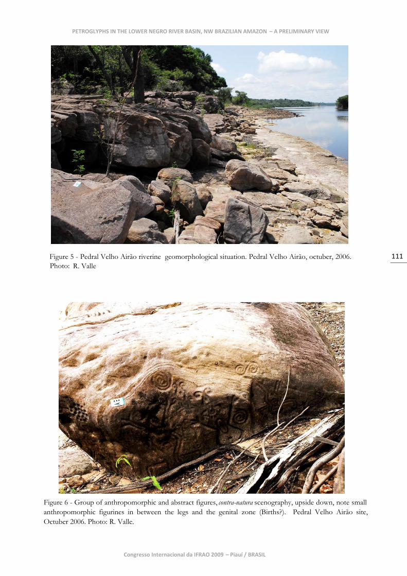
Velho Airão Graphic Profile
The Velho Airão Graphic Profile was defined
based on the analysis of four rock art sites
located between the Velho Airão riverine
community and the lower course of the Jaú
River, inside and adjacent to the Jaú National
Park. A later addition to this graphic profile
was the single horizontal sandstone panel of
Unini 4, found isolated on a rocky island in
the second set of rapids of the Unini river.
This profile receives its name from Pedral
Velho Airão (S 01° 55' 09.9" W 061° 24'
14.8"), the major concentration of petroglyphs
available in the assemblage documented,
which extends through a shore line of four
hundred and thirty (430) meters of riverine
Prosperança sandstone boulders comprising
eight (8) graphic concentration areas with
several panels each, totaling hundreds of
graphic units (individual petroglyphs).
Technologically, no specific observation could
be made due to the extremely harsh
weathering situation affecting these
petroglyphs, which does not allow for proper
observation of the technical-operatory chain.
What can be said based on very few well-
preserved figures is that direct percussion was
in use, (and in minor cases indirect
percussion, but see Bednarik 2007:37),
probably executed with a pointed lithic
cobble-like implement, possibly quartz, with a
percussive surface measuring between one (1)
cm and a half (0.5) cm, judging by the small
pounded marks and by the length, depth and
textural internal surface of the rare preserved
pounded traces. We presume minor indirect
percussion based on experimental tests with
PETROGLYPHS IN THE LOWER NEGRO RIVER BASIN, NW BRAZILIAN AMAZON – A PRELIMINARY VIEW
Raoni VALLE
3 / Arte Rupestre da Amazônia.
100
the same sandstone and by the precision of
the lines and the control of line directions,
mainly in the circular and spiraled lines
present in most figures. However, affirming
this for the entire site and graphic profile
remains difficult because of taphonomic
alteration. We hope in the near future to
employ field microscopy observations to
sharpen the definition of technical features.
Thematically, we perceive a majority of
anthropomorphic figures associated with a
minority of non-recognizable graphic units
(what we would call abstract figures), mainly
several modalities of spirals, conjuncts of
cupmarks and wavy lines. Morphologically,
the graphic presentation of the
anthropomorphic assemblage varies greatly
internally but, in general, retains certain main
features characterized by the following: varied
size, in general, medium to large proportions
(fifty [50] cm to a hundred and forty [1.40]
cm); single or double line contour of the body
(no filled-in); sexual distinctiveness; enormous
angular belly with navel and breasts assigned;
fixed postures with opened limbs; facial
characteristics (mouth and eyes), some
presenting straight radial projections out of
the head indicating possible ornamentation;
and several modalities of stylized
morphological constitution of body (head,
trunk and limbs) represented with non-
naturalistic conventional morphologies, (e.g.,
extremity of the limbs converted into spirals).
These features allow one to think that these
are representations, not of human beings, but
of entities of extraordinary nature, assuming a
correlation between unnatural morphology
and behavioral properties or powers.
Zoomorphic representations are extremely
rare but do occur in two panels in Pedral
Velho Airão totalizing seven (7) small units
between twenty (20) cm and thirty-five (35)
cm, all apparently quadrupeds exhibited in
profile with round heads and tail ending in a
spiral.
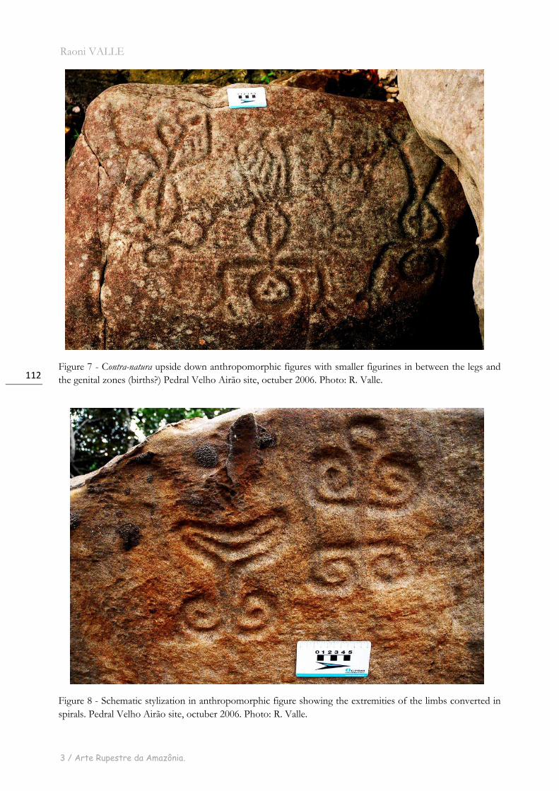
Scenographically, anthropomorphic figures
are almost always shown in groups in frontal
disposition, but not in direct graphic contact,
resembling collective scenes or a kind of
visual narrative in which the themes
represented cannot be recognized. Some
appear in an upside-down disposition,
showing small ambiguous anthropomorphic
figures in graphic connection with the genital
area and in-between the legs. These are quite
impressive, resembling birth scenes and
suggesting the representation of adults and
infants. The contra-natura aspect becomes
clearer when one realizes that these appear
not only in morphological features of the
anthropomorphic figures but also in the
graphic spatial disposition and postural
presentation of the figures. Several modalities
of interaction can be discerned between
anthropomorphic and abstract graphic
compositions, and almost no abstract unit is
presented alone. When this does happens, the
abstract unit seems to retain a resemblance to
a stylized decomposed anthropomorphic
character, such as faces with big eyes in spiral
form or only the inferior limbs in spiral
convention. In general, the rule seems to be a
graphic spatial association between
anthropomorphic and abstract units with
prominence given to the former category.
Zoomorphic figures are shown in groups as
well, and in at least one panel they seem to be
associated with an anthropomorphic figure.
Geomorphologically, as far as it is concerned
in this graphic profile, the positioning of the
panels in the space is the more prominent
feature. In this matter the set does not seem
to present any discernible pattern in terms of
the general positioning of the panels in the
internal rocky landscape of the site. In fact,
this could be the geomorphological pattern
itself, that is to say, the absence of uniform
orientation of the panels. Most of them are
vertical or diagonal panels but vary in
geographical orientation, some are oriented
backwards the river pointing to the forest,
some of them are oriented to the rocky sides
of the shore line (W-E), some of them are
oriented to the river, and, yet, some of them
are facing the sky staying horizontally,
although this is a minority. None is shown
facing down. In general, the spatial situation
Congresso Internacional da IFRAO 2009 – Piauí / BRASIL
101
seems to be equally distributed, perhaps with
a more slightly tendency to the river
orientation, indicating a sort of fluvial
signaling.
As could be understood by the above text,
taphonomical alteration by means of physical
(erosion and exfoliation of the sandstone) and
biological (micro-vegetal, fungi and other
organism‟s accretions and cortical
penetration) weathering has been distorting
the physical appearance of the technical marks
and morphological constitution of these
petroglyphs in severe and diverse ways
(mostly erasing the peck-marks, transmitting
an homogeneous aspect between the inside
and the outside spaces of the petroglyphs).
This evidence indicates that the general
assemblage of this graphical profile has been
subject to weathering action for a long time,
and thus could be extremely ancient, maybe
millenia old. No superimposition could be
detected, therefore, we cannot speak to
internal chronology, but it seems probable
that we are dealing here with more than one
graphic profile and different moments of
execution based on differences in weathering
states, all of which needs further investigation.
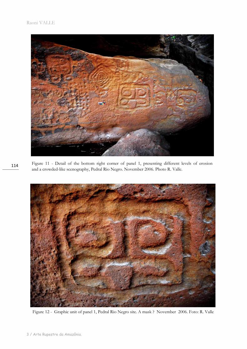
Rio Negro Graphic Profile
The Rio Negro Graphic Profile was defined
based on one single Prosperança sandstone
site, Pedral Rio Negro (S 01° 53' 01.1" W 061°
26' 36.6"). This site contains four (4) graphic
concentration areas, most containing a single
panel, and one being almost permanently
underwater and out of conventional
photographic range. Quantitatively and in
spatial terms inferior to Pedral Velho Airão,
this site presents only a few dozens of graphic
units.
Thematically, we have a remarkable turning
point here materialized in the massive
occurrence of non-recognizable, abstract,
repertoire of figures (so-called pure graphism in
Pessis‟ terminology). Not a single figure could
be matched into a figurative thematic, and
neither did any possess recognizable
morphology. So we are considering the entire
corpus of this site of imminent hermetic
nature indicative of a completely different
kind of graphic thought. Even in comparative
terms to the abstract elements identified in the
Velho Airão Graphic Profile we could not
find any clear analogy, despite the
resemblance of one unit in the submerged
panel. One other petroglyph seems to be a
schematic or geometric stylization of a face or
a mask but retaining so much formal
ambiguity that we cannot categorically assume
this.
The scenographical aspect is internally varied
with respect to the graphical concentration
area. But two general situations could be
identified: one more concentrated where the
graphical space is apparently crowded with
units and another sparser, with more
technologically uninterfered spaces amongst
the units. Despite the ambiguity of defining
scenes in a non-narrative figurative visual
context, in this case, at least, one can perceive
where one unit finishes and another begins.
As far as scenography is concerned, this is the
key property for an understanding of the
morpho-topology in the filling-in of graphic
space, as it makes discernible the syntactical
arrangements of the figures. For now, at this
level of the internal analysis, neither
associative patterns between units in the
panels, nor internal recurrences of single
figures could be detected. The petroglyphs
seem to be a general composite of unique
morphologies from outside the site and inside
as well (with an exception of only two units
that have morphological equivalents in Velho
Airão Graphic Profile).
Technologically, observations indicate that
both direct and indirect percussion were
employed in the execution of these percussive
petroglyphs. Again the basis for such
diagnosis relies on comparative
experimentation with the same sandstone type
using instruments made with the local
lithological raw materials, as well as on the
patient observation of the pecking and
pounded marks in situ and on analysis of
macro-photographs of technical details within
PETROGLYPHS IN THE LOWER NEGRO RIVER BASIN, NW BRAZILIAN AMAZON – A PRELIMINARY VIEW
Raoni VALLE
3 / Arte Rupestre da Amazônia.
102
the units. In these technical elements we find
correspondence with Velho Airão Graphic
Profile (which is largely conditioned by a
shared rock matrix), noting that while in the
latter there is no sound basis for a clear and
specific technical statement, in the former we
have a much more preserved set of technical
marks, wherein different kinds of pecking and
pounding can be observed, indicating
different instruments employed and probably
different moments of execution.
The techniques vary from erratic superficial
pounding (three [3] mm to five [5] mm in
depth by one [1] to three [3] cm in length) that
just disrupted the ancient cortex, indicating a
vacillate-handled direct percussion with,
probably, a pointed pebble, to deep and large
pecked-like grooves (four [4] to six [6] cm in
length by two [2] to four [4] cm in depth)
penetrating the sandstone matrix, indicating
successive retouch of the same pecked lines
with a large blunt instrument probably beaten
with a hammer-like implement.
In one vertical panel, a group of deep
cupmarks (reaching seven [7] cm in depth)
were executed with fine polishing, leaving an
astonishing degree of internal textural
homogeneity. Given the geomorphological
position of these marks in the rock boulder
(inside a concavity quite in a negative hollow
but still in general verticality) we have not yet
been able to reconstitute the operatory
process, and treat this as an isolated
phenomenon. The general good conservation
state of panel I is seen in the contrast between
the dark brown, oxidized-like ancient cortex,
and the fresh, vivid orange, little eroded or
repatinated rock matrix inside the pounding
that is still visible. This site, along with its
main panel (I), constitutes a very interesting
piece of technical evidence that deserves
further technical analysis.
In geomorphological terms most petroglyphs
at this site are located inside small open
niches, recesses along fifty (50) meters of a
rock wall immediately on the edge of a
channel of the Negro river, which is almost
inside the water stream, with wide visibility to
the fluvial navigators, being the best preserved
panel (I) exactly in the line of sight of those
descending the stream. Visible within a range
of more than fifty (50) meters, the sense of a
fluvial signaling really catches our attention.
Judging by their topographical level on the
wall we are inclined to suppose the existence
of more petroglyphs permanently underwater
in the climax of low waters in the dry season.
This general pattern of geomorphological
location contrasts with that observed in the
Velho Airão graphic profile, which as we said
shows no proper locational pattern. In both
geomorphological parameters we adopt here,
i.e. panels within the site and the site within
the landscape, Velho Airão and Rio Negro
profiles are equally contrasting. Bearing in
mind a comparison at the same water level,
the disposition of these rock formations with
respect to surfaces available to external sight
and use, Pedral Rio Negro presents a
uniformity in the positioning of the panels,
widely facing the river, and with a much more
direct contact of the rock wall with a highly
dynamic and deep fluvial channel. This
characterizes the insertion of the site in a
specific surrounding landscape, while Velho
Airão is set over a sandy shore, which, of
course, may be of modern sedimentation but
the general rock-art-panels/river contact is
quite different.
Taphonomic factors have a differential action
considering the four (4) graphic concentration
areas, indicating different chronologies for the
time of weathering availability of each panel,
or at least differential weathering conditioned
by favored location of some areas in relation
to the erosive power of the streams, which
apparently constitutes the most powerful
source of physical weathering in action here.
But, given the geomorphological uniformity
of the panels, this second hypothesis seems
less plausible, leading us to accept a different-
chronologies scenario for the execution of the
panels, being the youngest one the more
preserved in the internal assemblage, where
one can still admire the actual techniques of
execution and to some extent the original
contrast between the ancient cortex and
internal nature of the pecked/pounded marks,
in color, texture and technical morphology.
The oldest panel would probably be the one
Congresso Internacional da IFRAO 2009 – Piauí / BRASIL
103
that today is almost submerged, and which
shows severely weathered petroglyphs and
contains a morphological analogue to a unit in
the Velho Airão profile. In this line of
thinking, we assume that the crowded,
abstract, and well preserved panel (I), the
main one in this site, which characterizes its
profile, is of younger age compared to the rest
of the sandstone assemblage inside and
outside the site.
Unini Graphic Profile
Unini Graphic Profile was defined initially by
a single site, Unini 2 (S 01° 40‟ 12.8 “W 061°
47' 32.2”) amongst the granite boulders of the
first rapids of the lower course of the Unini
River. Subsequently five (5) other sites were
discovered outside of the Unini river in the
Negro close to the mouth of the Branco river
and in the lower course of the Jauaperi river.
These sites present visual analogies which
strongly suggest direct graphic connections
among them (and all are found on granite
bedrock), and show characteristics that
suggest a distance from the sandstone
bedrock sites comprising the Velho Airão and
Rio Negro Profiles.
Thematical choices here privilege zoomorphic
figures and a minor proportion of
anthropomorphic representations. When only
Unini 2 was under consideration, no abstract,
non-recognizable figures were accounted for
in terms of the thematic definition of this
profile. But after the positive contact with
such graphic units outside of the Unini river,
it became necessary to accommodate them
with the other themes. However the inclusion
of this graphic class does not alter the
supremacy of the zoomorphic character in the
Unini graphic profile.
Morphologically and within the
scenographical scope of this profile, the
zoomorphic figures are assembled generally in
medium to large sizes, a few ranging between
thirty (30) cm and fifty (50) cm, but most
larger, measuring up to one hundred and sixty
(160) cm. They present full body infill graphic
resolution, showing a majority of quadrupeds
in profile and in apparent movement, with
distinctive morphological features in the body,
head and legs permitting the recognition of
“species” or types of animals such as cervidae-
like and primate-like, and also bird- and
snake-like forms. The animals do not seem to
obey any organized positioning in the graphic
space, being scattered inside the panel when
they are not isolated in the plan. An exception
occurs at Unini 2, where one can see what
could be called a scene of four (4) small birds
(twenty [20] cm each, more or less) in a profile
line following a single direction, the last one
on the Eastern extremity being superimposed
by a small, “reptile”-like figure (forty [40] cm),
all of them with a fresh non-cortical technical
surface resembling a recent moment of
execution. At another site, Pedra da Vovó
(UTM 20M S0669915 W9828415), a primate-
like figure holds in its hand what is interpreted
to be a flute, and taking it to its head,
apparently playing the instrument. Indeed this
thematic action of playing a flute is a recurrent
one within the anthropomorphic figures in
this profile.
The anthropomorphic figures were presented
in two situations. First, the figures appear in
large groups with more than ten individuals in
graphic connection through each other‟s arms,
showing a frontal disposition and with no
distinctive features, such as sexual or facial
traces or adornments, this scene resembles a
depiction of a communal dancing and/or
ritual. The other situation is that of isolated
individuals, some in profile taking a stick to
their head or mouth with one or both hands
(as in playing a flute), and some frontally
presented holding still. In both cases, an
animal is associated in immediate graphic
space, such as a bird or quadruped, and again
no distinctive features, despite the supposed
flute, like sexual or facial ones.
Geomorphologically the Unini 2 site seems to
present a pattern in the location of the panels
and in the location of the site within the
PETROGLYPHS IN THE LOWER NEGRO RIVER BASIN, NW BRAZILIAN AMAZON – A PRELIMINARY VIEW
Raoni VALLE
3 / Arte Rupestre da Amazônia.
104
cascade. All the panels are facing the river
executed in the south or southwest faces of
the boulders and situated on the left edge
(north) of the river in the context of the
rapids. The verification of the opposite river‟s
edge at the rapid formation showed no
evidence of petroglyphs, indicating a
geomorphological selection for rocks on the
left side. Outside the Unini river, the same
cannot be said, but in general all the
petroglyphs are oriented toward rivers or
channels, and executed in sizes and in plans to
permit recognition by boat-borne observers.
While this situation links them to the
sandstone site of Pedral Rio Negro, it
distinguishes them from the Velho Airão
graphic profile which generally requires one to
disembark in order to see most of the
petroglyths.
The confection technique of the entire granite
assemblage seems to avail itself of different
degrees of abrasion as the main procedure. In
some units, one finds polished surfaces, while
in others just surface scraping (resembling
Sgraffitto technique [see Bednarik 2007:38]),
removing just the surface cortex, this latter
modality being more common. It is possible
that a prime moment of direct percussion
would have been used to open the rocky
cortex, sketching the figures and giving the
textural and color contrast; subsequently, the
abrasive techniques were adopted to create
the design‟s texturally uniform interior and
contour. This further assumption was verified
in experimental exercises using the same
granite bedrock, quartz pebble and quartz
sand available at the sites. Experiments tested
a direct abrading technique against direct
percussion followed by abrasion, and the
latter achieved results closer to what we infer
could be the original aspect of the
petroglyphs. What appear to be faint
reminiscent pounded marks in some units of
the sites outside of the Unini river, also
corroborate this interpretation, but these
marks occur in very low proportion. The
dominance of abrasion techniques in the
Unini graphic profile is almost certain, in
which case it greatly contrasts with the
sandstone assemblage techniques. Another
aspect that could be noted is that signs of
technical selective retouch and renewal, by
abrasion as well, are clearly visible in several
units of this profile, sometimes modifying the
preexistent morphology, thematics and
scenography of the figures. An emblematic
case may be the cervidae figure at Unini 2,
which seems to have suffered a retouch
changing it into a primate-like figure running
in the opposite direction, with its head being
the former cervidae tail10.
Taphonomic aspects in general point to a high
degree of weathering in these igneous
petroglyphs, either in terms of exfoliation
and/or of repatination. Consequently, most of
the petroglyphs in granite boulders are almost
disappearing and look like shadows of once
contrasting and visible figures. The general
causes can be attributed to the riverine and
seasonally submerged context which is
catastrophically alternated by sun exposure
two (2) to three (3) months a year, introducing
a strongly contingent physical weathering.
Furthermore, although it may be true that
granitic rocks are more resistant to erosion
than is sandstone, the same cannot be true in
terms of chemical and biological weathering.
We believe that to some extent those igneous
rocks are being subjected to geo-chemical
alteration by the acidity of the dark water,
which is rich in humic acid from debris of
organic matter deposited on the boulders‟
surfaces. One can perceive an increasing
disaggregation of the rocky subsurface
constituents by the penetration of bioactive
acidic matter in the interstitial micro-spaces of
the igneous pores. This can also make room
for colonies of microorganisms, which
promote an unknown series of subsequent
biochemical reactions along with the more
general physical weathering.
This assumption deserves deep investigation
but for now what can be said is that the
general aspect of the granite petroglyphs
10
This observation was not mine. I owe this to Madame Pessis’ clinical eyes, during personal communication.
Congresso Internacional da IFRAO 2009 – Piauí / BRASIL
105
assemblage suggests significantly more
degradation than the sandstone ones. This
may be a matter of ageing, of differential
weathering considering the rock types,
perhaps the differential techniques employed,
maybe all three. The fact is that the granite
petroglyphs look “older” than the sandstone
material and several graphical moments can
be discerned in those granite panels either by
different degrees of repatination in the figures
of the same panel, or by superimpositions
between figures, or still through this
interesting fact of selective retouch/renewal,
which changes the preexistent subjects
depicted. All of these factors, of course, have
very interesting chronological implications
with which we are at present working. This
context is only clear and generalized within
the granite assemblage.
Discussion
We still know very little, close to nothing,
about the rock art of the Negro Basin.
Weathering is obliterating the possible
observable features of this riverine rock art
assemblage, upon which formal method
analysis attempts rely.
The seasonality in hydration and dehydration
of the rock surfaces acts in favor of several
taphonomic factors. When the petroglyphs
are out of water they get exposed to extremely
high temperatures (nearing 40 degrees Celsius)
due to the equatorial latitude, and direct sun
heating due to a lack of vegetation covering
most of riverine boulders. This situation
alternates with high levels of precipitation
proper from the end of dry season in the
Lower Negro river rain forest ecosystem. The
combination of these factors results in
considerable physical and biological
weathering.
Underwater, the erosive force of the stream-
borne solid particles (albeit less than in white
waters), along with the acidic conditions of
dark waters, caused by high concentrations of
humic acid from organic debris
decomposition, play their role as taphonomic
agents causing physical and chemical
weathering. We still do not know the exact
process, but we do know that this conjuncture
affects the submerged and riverine rock
surfaces; consequently the Rock Art on it has
undergone severe decay for at least the last
three thousand years (since 3.000 B.P.), when
palaeoenviromental conditions began to
resemble current conditions, and the
agricultural ceramic riverine lifestyle started
becoming dominant (Neves 1998).
On the other hand, we cannot rely on
informed method for the Negro river, even if
Reichel-Dolmatoff (1967, 1971), Koch-
Grünberg (1907), Denis Williams (1985) and
others did so in their interpretive approaches,
given the concrete possibility that
contemporary ethnic accounts for the rock art
would be as “ethno-historically weathered” as
physically are the petroglyphs. This approach
allows us no certain glimpses of past graphical
modes of thought and behaviors, at least not
in a hypothetical-deductive scientific fashion,
because of the lack of testability of the
propositions thus derived when confronted
against the archaeological record. First of all,
there is no archaeological record
unequivocally related to the Amazonian
petroglyphs, not even for the upland
petroglyph sites (Greer 2001). Second, how
could one archaeologically falsify a myth of
creation? Myths are not falsifiable constructs.
They simply do not work by the same logic
science does. Ecological functionalist‟s
propositions, such as riverine resource
management, extracted from the ethnographic
present and memory, although more scientific
founded, work almost in the same way as the
myths in terms of falsifiability against past
behavior.
PETROGLYPHS IN THE LOWER NEGRO RIVER BASIN, NW BRAZILIAN AMAZON – A PRELIMINARY VIEW
Raoni VALLE
3 / Arte Rupestre da Amazônia.
106
The men or women who made the
petroglyphs are long deceased as are their
societies and possibly their environmental set,
and no procedure can prove, test, falsify,
verify or demonstrate a cultural relationship of
the living Indians with petroglyph prehistoric
authors, maybe only at the conjectural level.
The difference lies in whether one researcher
decides to believe in such accounts and
another does not.
Thus, insights from the living native myth-
historical accounts cannot elucidate problem-
oriented investigations of preceramic archaic
and ceramic formative horizons, assuming a
middle to lower holocenic origin and practice
for most of the petroglyph corpus of the
lower and middle Negro Basin, given their
semi-submerged geomorphological situation
in the climax of dry seasons of contemporary
times. This is a quite simplistic view of their
chronological and palaeoenvironmental
problem and deserves a proper sub-aquatic
and multidisciplinary investigative approach.
Summarizing the chronological complexities
of the Amazonian rock art Greer (2001:682)
tells us: “Categories [rock art ones] may be parts
of different cultural or social systems and different ages.
What is clear, however, is that rock art production
covers a very long time span.”
We are aware that the reality must be much
more complex than the one proposed here
because the sites can comprehend multiple
levels of superimpositions and juxtapositions
of different graphic profiles in the same
panels, which are not yet well understood.
Furthermore, graphic profiles can have several
moments of overlap in different proportions,
caused by diachronic moments of
reoccupation, reuse and selective retouch or
renewal, implying a long chronology in their
usage as graphical spaces. But in the end, as
we rely on the subjective perception of the
researchers and their cameras, what is
cognitively detectable and arranged by the
entrance categories applied for the graphic
phenomena in the sample area can be
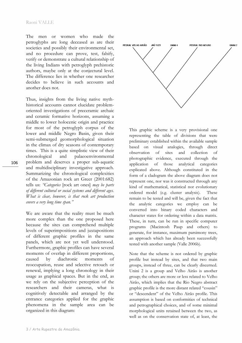
organized in this diagram:
This graphic scheme is a very provisional one
representing the table of divisions that were
preliminary established within the available sample
based on visual analogies, through direct
observation of sites and collection of
photographic evidence, executed through the
application of those analytical categories
explicated above. Although constituted in the
form of a cladogram the above diagram does not
represent one, nor was it constructed through any
kind of mathematical, statistical nor evolutionary
ordered model (e.g. cluster analysis). These
remain to be tested and will be, given the fact that
the analytic categories we employ can be
converted into binary coded characters and
character states for ordering within a data matrix.
These, in turn, can be run in specific computer
programs (Macintosh Paup and others) to
generate, for instance, maximum parsimony trees,
an approach which has already been successfully
tested with another sample (Valle 2006b).
Note that the scheme is not ordered by graphic
profile but instead by sites, and that two main
groups, instead of three, can be clearly discerned.
Unini 2 is a group and Velho Airão is another
group; the others are more or less related to Velho
Airão, which implies that the Rio Negro abstract
graphic profile is the more distant related “cousin”
or “descendent” of the Velho Airão profile. This
assumption is based on conformities of technical
and petrographical choices, and of some minimal
morphological units retained between the two, as
well as on the conservation state of, at least, the
Congresso Internacional da IFRAO 2009 – Piauí / BRASIL
107
major panel (I) of the Pedral Rio Negro site which
is less taphonomically impacted by erosion than
the Velho Airão petroglyphs. Thus, considering
the same rock, the same technique and almost the
same environmental set, we believe it implies a
younger age for the Rio Negro Profile panel I.
However this does not change our former
proposition that these two constitute different
graphic profiles and overall different cultural or
ritual choices. As we said before, they do
constitute two rather distinct modes of thought;
nevertheless, both maintain a considerably larger
distance from the Unini graphic profile than exists
between them. This is exactly what this diagram
above expresses, in isolating the Unini group.
Conclusion
At this moment we cannot propose distinct styles
of rock art for the Negro river basin because of
quantitative limitations in the sample and because
no proper quantitative, mathematically sound
internal approach, was attempted. For now we
classify these manifestations as three different
graphic profiles of sites, two of which are
represented in more than one site. In our
understanding, this fact could be an indicative of
shared hypothetical graphical identities.
We are dealing with only twelve (12) sites
spread in a straight line of almost ninety (90)
kilometers in a fluvial basin which has more
than one thousand and five hundreds (1.500)
kilometers in the main course. In so doing, we
are being extremely cautious of any assertive
affirmation, given the fact that we need to
know much more about the rock art of the
entire Negro river basin. What is interesting is
that even in this quantitatively and spatially
restricted assemblage, we have considerable
heterogeneity, which makes us think in two
directions: (1) the representativeness of this
context for the rest of the basin in terms of
the validity of any potential extrapolation; (2)
the possible localized character of this
variability scenario conditioned by our
hypothesized geo-environmental background
factors (hydrographical confluence and
geological contact).
So, we will definitely need much further
testing and expansion of our prospection grid
in the basin. This will involve painstaking and
patient formal hard work and a huge amount
of luck to obtain good climatic conditions,
proper light exposures and well preserved
petroglyph panels or sites (which is almost
impossible). It will require locating generous
and comprehensive sponsorship to finance
several years of research, considering that field
work can only be done during one specific
month of the year under Amazonian jungle
harsh conditions and praying not to get
malaria, hepatitis (the entire alphabet),
leishmanioses, snake, alligator or pirana bites,
sucuri hug or any unknown tropical disease.
Acknowledgments
To Edithe Pereira, Kay Tarble Scaramelli, Niede
Guidon, Anne-Marie Pessis, Gabriela Martin,
Eduardo Góes Neves (advisor), Robert G.
Bednarik (IFRAO), Giraraj Kumar, Mila Simões,
Franz Scaramelli, Marcos Corrêa (pioneer), Mauro
Farias, Anna T. Browne (for the english revision),
Ana Carla Bruno (Inpa), Carlos Cesar Durigan e
Sérgio Borges (FVA), Samuel Taranran (WWF),
Fábio Origuela, Adília Nogueira (pacient wife and
also revision) and the Rio Negro Indigenous
Movement.
PETROGLYPHS IN THE LOWER NEGRO RIVER BASIN, NW BRAZILIAN AMAZON – A PRELIMINARY VIEW
Raoni VALLE
3 / Arte Rupestre da Amazônia.
108
Figures and References
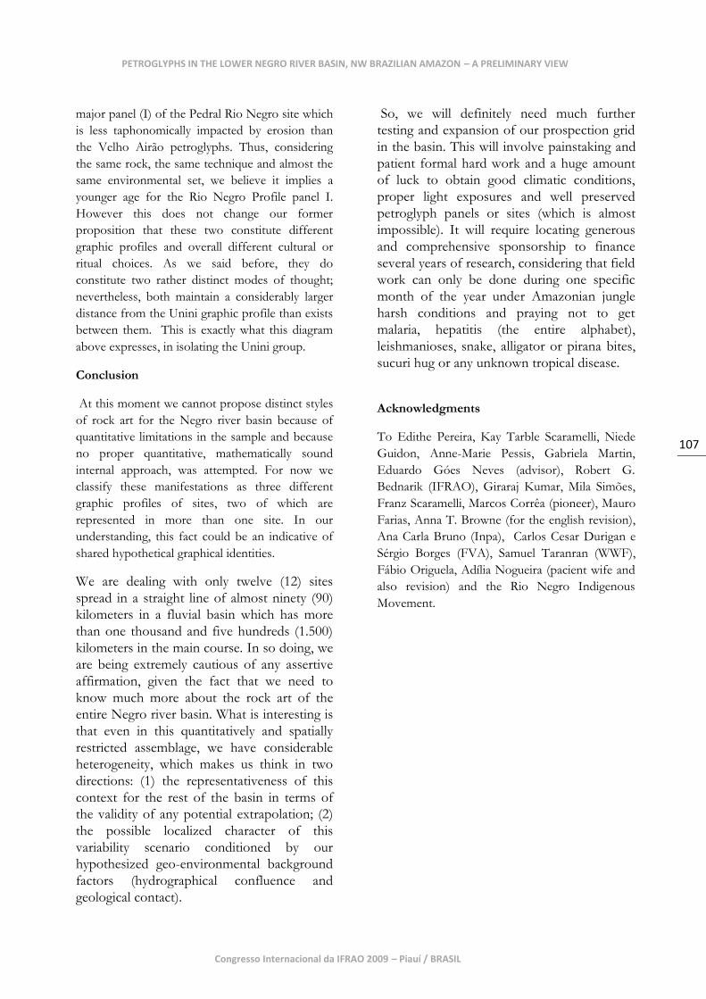
Figure 1 - General map showing the position of NW Amazonia in its South American context, with a closer
view of the Negro basin in regional context. Square A shows the location of sites documented in the 2006 and
2007 campaigns. Author: M. Brito.
Congresso Internacional da IFRAO 2009 – Piauí / BRASIL
109
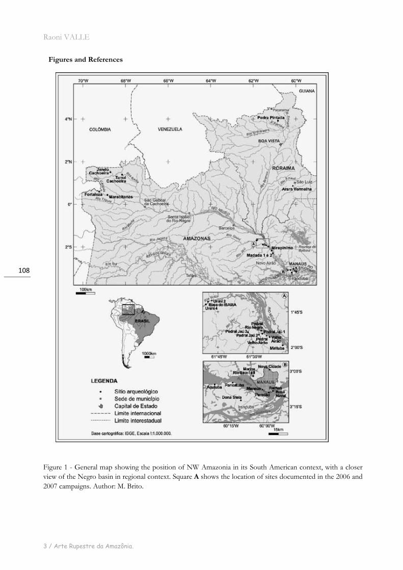
Figure 2 – Image of the sample area showing the location of Rock Art sites arranged in 3 main clusters: the
mouth of Jaú river at the bottom of the picture (Velho Airão, Rio Negro, Jaú 1, 2 and 3); the lower course of
Unini river in the middle of the picture (Unini 2 and 4); the proximities of the mouth of the Branco river near
the top (Ilha das Andorinhas, Santa Helena and Guariba 2). Other Rock Art sites include Pedra da Vovó (in a
channel of the mouth of the Jauaperi river) and São Pedro (on the lower course of Jauaperi not shown in the
map) which are, for the moment, isolated sites. Other markers indicate ceramic sites. Source: Google Earth.
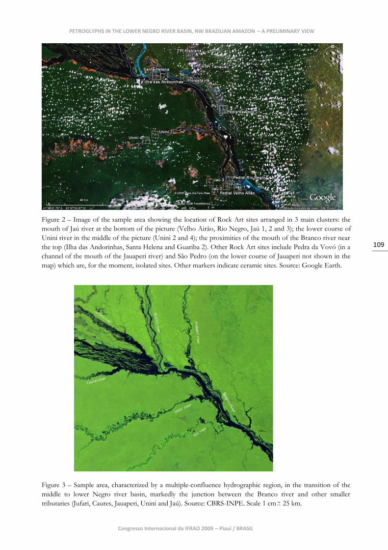
Figure 3 – Sample area, characterized by a multiple-confluence hydrographic region, in the transition of the
middle to lower Negro river basin, markedly the junction between the Branco river and other smaller
tributaries (Jufari, Caures, Jauaperi, Unini and Jaú). Source: CBRS-INPE. Scale 1 cm 25 km.
PETROGLYPHS IN THE LOWER NEGRO RIVER BASIN, NW BRAZILIAN AMAZON – A PRELIMINARY VIEW
Raoni VALLE
3 / Arte Rupestre da Amazônia.
110
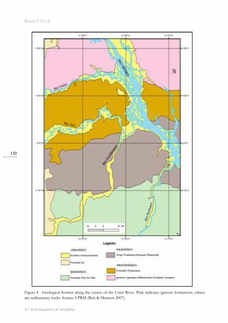
Figure 4 - Geological frontier along the course of the Unini River. Pink indicates igneous formations, others
are sedimentary rocks. Source: CPRM (Reis & Marmos 2007).
Congresso Internacional da IFRAO 2009 – Piauí / BRASIL
111
R. Valle
Figure 6 - Group of anthropomorphic and abstract figures, contra-natura scenography, upside down, note small
anthropomorphic figurines in between the legs and the genital zone (Births?). Pedral Velho Airão site,
Octuber 2006. Photo: R. Valle.
Photo:
Figure 5 - Pedral Velho Airão riverine geomorphological situation. Pedral Velho Airão, octuber, 2006.
PETROGLYPHS IN THE LOWER NEGRO RIVER BASIN, NW BRAZILIAN AMAZON – A PRELIMINARY VIEW
Raoni VALLE
3 / Arte Rupestre da Amazônia.
112
Figure 7 - Contra-natura upside down anthropomorphic figures with smaller figurines in between the legs and
the genital zones (births?) Pedral Velho Airão site, octuber 2006. Photo: R. Valle.
Figure 8 - Schematic stylization in anthropomorphic figure showing the extremities of the limbs converted in
spirals. Pedral Velho Airão site, octuber 2006. Photo: R. Valle.
Congresso Internacional da IFRAO 2009 – Piauí / BRASIL
113
Figure 10 - Pedral Rio Negro site, panel 1, november 2006. Photo R. Valle.
PETROGLYPHS IN THE LOWER NEGRO RIVER BASIN, NW BRAZILIAN AMAZON – A PRELIMINARY VIEW
Figure 9 - Pedral rio Negro site. Riverine geomorphological situation, november 2006. Photo: R. Valle.
Raoni VALLE
3 / Arte Rupestre da Amazônia.
114
Figure 12 - Graphic unit of panel 1, Pedral Rio Negro site. A mask ? November 2006. Foto: R. Valle
and a crowded-like scenography, Pedral Rio Negro. November 2006. Photo R. Valle.
Figure 11 - Detail of the bottom right corner of panel 1, presenting different levels of erosion
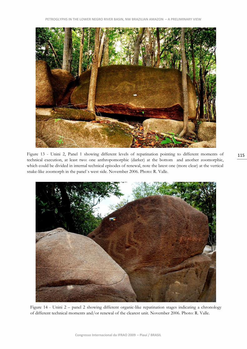
Congresso Internacional da IFRAO 2009 – Piauí / BRASIL
115
Figure 13 - Unini 2, Panel 1 showing different levels of repatination pointing to different moments of
technical execution, at least two: one anthropomorphic (darker) at the bottom and another zoomorphic,
which could be divided in internal technical episodes of renewal, note the latest one (more clear) at the vertical
snake-like zoomorph in the panel`s west side. November 2006. Photo: R. Valle.
PETROGLYPHS IN THE LOWER NEGRO RIVER BASIN, NW BRAZILIAN AMAZON – A PRELIMINARY VIEW
Figure 14 - Unini 2 – panel 2 showing different organic-like repatination stages indicating a chronology
of different technical moments and/or renewal of the clearest unit. November 2006. Photo: R. Valle.
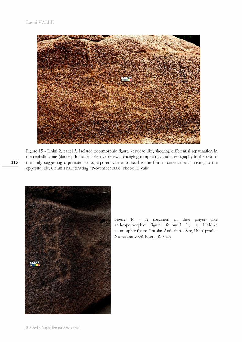
Raoni VALLE
3 / Arte Rupestre da Amazônia.
116
Figure 15 - Unini 2, panel 3. Isolated zoormorphic figure, cervidae like, showing differential repatination in
the cephalic zone (darker). Indicates selective renewal changing morphology and scenography in the rest of
the body suggesting a primate-like superposed where its head is the former cervidae tail, moving to the
opposite side. Or am I hallucinating ? November 2006. Photo: R. Valle
Figure 16 - A specimen of flute player- like
anthropomorphic figure followed by a bird-like
zoomorphic figure. Ilha das Andorinhas Site, Unini profile.
November 2008. Photo: R. Valle
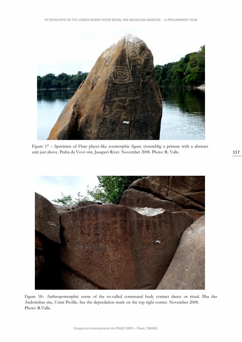
Congresso Internacional da IFRAO 2009 – Piauí / BRASIL
117
Figure 18– Anthropomorphic scene of the so-called communal body contact dance or ritual. Ilha das
PETROGLYPHS IN THE LOWER NEGRO RIVER BASIN, NW BRAZILIAN AMAZON – A PRELIMINARY VIEW
Figure 17 – Specimen of Flute player-like zoomorphic figure (resemblig a primate with a abstract
unit just above. Pedra da Vovó site, Jauaperi River. November 2008. Photo: R. Valle.
Andorinhas site, Unini Profile. See the depredation mark on the top right corner. November 2008.
Photo: R.Valle.
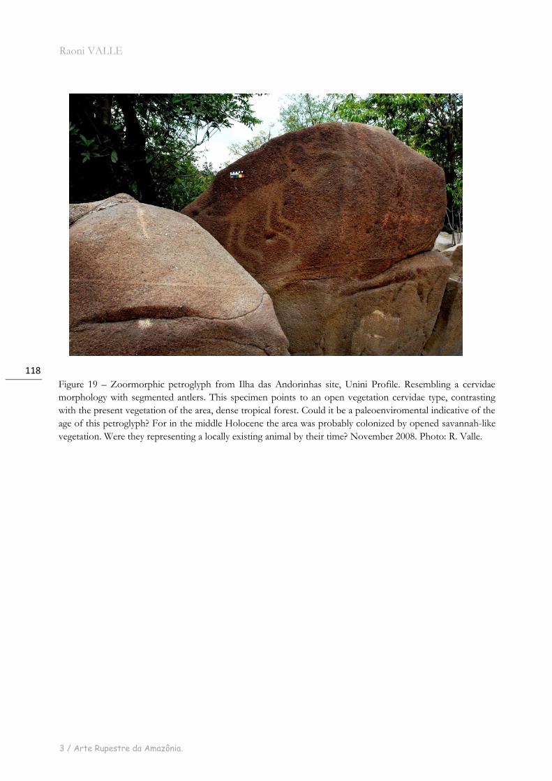
Raoni VALLE
3 / Arte Rupestre da Amazônia.
118
Figure 19 – Zoormorphic petroglyph from Ilha das Andorinhas site, Unini Profile. Resembling a cervidae
morphology with segmented antlers. This specimen points to an open vegetation cervidae type, contrasting
with the present vegetation of the area, dense tropical forest. Could it be a paleoenviromental indicative of the
age of this petroglyph? For in the middle Holocene the area was probably colonized by opened savannah-like
vegetation. Were they representing a locally existing animal by their time? November 2008. Photo: R. Valle.
Congresso Internacional da IFRAO 2009 – Piauí / BRASIL
119
References
Ab’saber, Azis. 2002. Bases Para O Estudo Dos
Ecossistemas Da Amazônia Brasileira. Estudos
Avançados. Vol. 16, Num. 45, Usp, Sp.
______________1996. Paleoclima E
Paleoecologia Da Amazônia Brasileira. In:
Amazônia Do Discurso À Práxis. Edusp,
São Paulo.
Bahn, Paul. 1998. The Cambridge Illustrated
History Of Prehistoric Art. Cambridge University
Press, Cambridge.
Bahn, P.& Vertuit, Jean. 1988. Images Of The Ice
Age. Winward, Leicester.
Bahn.P. & Loblanchet. M .(Eds.) 1993. The Post
Stylistic Era or Where do we go from here?
Oxbow Monographs. Cambridge. UK.
Barse W. 2003. Holocene Climate And Human
Occupation In The Orinoco, Under The Canopy:
The Archaeology Of Tropical Rain Forests, J.
Mercader, Ed., New Brunswik: Rutgers
University Press, Pp. 249-270.
Bednarik, R.G., 1989. On The Pleistocene
Settlement Of South America. Antiquity 63:101-
111.
_____________1997. The Global Evidence Of
Early Human Symboling Behaviour. Human
Evolution Vol. 12 - N. 3 (147-168) .
_____________2007. Rock Art Science: The
Scientific Study Of Palaeoart. Arian Books, New
Delhi, India.
Carneiro Da Cunha, Manuela (Org.).1992.
História Dos Índios No Brasil. São Paulo,
Companhia Das Letras.
Chippindale,C. & Taçon, P. (eds.)1998.
Archaeology Of Rock Art. Cambridge
University Press, Uk.
Chippindale, C. And Nash, G. (Eds.) 2004.
Pictures In Place-The Figured Landscape Of
Rock-Art. Cambridge University Press, Uk
Clottes, J. (Editor) 2001. La Grotte Chauvet. L’art
Des Origines. Le Seuil, Paris.
________2003a. Return To Chauvet Cave:
Excavating The Birthplace Of Art. Thames And
Hudson, London. (In The Usa:Chauvet Cave;
The Art Of Earliest Times. University Of
Utah Press, Salt Lake City.)
Corrêa, M.V.M.1994., As Gravações E Pinturas
Rupestres Na Área Do Reservatório Da Uhe –
Balbina – Am. Rio De Janeiro,. 187 P.
(Dissertação - Mestrado) – Universidade Federal
Do Rio De Janeiro.
D’errico, F. Et Al. 2003. Archaeological Evidence
For The Emergence Of Language, Symbolism,
And Music—An Alternative Multidisciplinary
Perspective. Journal Of World Prehistory, Vol. 17,
No. 1.
Eco, Umberto 1974. As Formas Do Conteúdo.
Editora Perspectiva, Ed. Da Usp, São Paulo.
Fabbri, Paulo. 1968. Considerations Sur La
Proxémique. Langages, N.10, P.65 –75.
Greer, John .1995. Rock Art Crhronology In The
Orinoco Basin Of Southwestern Venezuela. Phd
Dissertatation, Department OfAnthropology,
University Of Missouri, Columbia. Umi
Dissertation Services, Ann Arbor.
____________2001. Lowland South America.
In Handbook Of Rock Art Research. Whitley,
D. (Ed.) Altamira Press Califórnia, Us.
Guidon, Niede.1986. Las Unidades Culturales
De São Raimundo Nonato – Sudeste Del
Estado De Piauí-Brazil. In New Evidence
For The Pleistocene Peopling Of The
Américas, Bryan, A. (Ed.), Pp. 157-71. Peopling
Of The Americas, Symposia Series, Center For
The Study Of Early Man, University Of
Maine, Orono.
PETROGLYPHS IN THE LOWER NEGRO RIVER BASIN, NW BRAZILIAN AMAZON – A PRELIMINARY VIEW
Raoni VALLE
3 / Arte Rupestre da Amazônia.
120
___________1989. On Stratigraphy And
Chronology Of Pedra Furada. Current
Anthropology 30:641-642
Guidon, N., And Delibrias, G. 1986. Carbon-14
32,000 Years Ago. Nature 321:769-71.
Heckenberger, M. 1997. Relatório Preliminar
Sobre Levantamento Arqueológico No Parque
Nacional Do Jaú, Fundação Vitória
Amazônica, Manaus.
Koch-Grünberg, T. 2005a [1905-1907]. Dois Anos
Entre Os Indígenas: Viagens Ao Noroeste Do
Brasil. Manaus, Edua- Fsdb.
__________.1907. Sudamerikanische
Felszeichnungen. Verlegt Bei Ernst Wasmuth
A.-G. Berlin.
Levi-Strauss, C. O Pensamento Selvagem. 1966.
Editora da Universidade de São Paulo, SP.
Lewis-Williams, D. 1981. Believing and Seeing:
Symbolic meanings in Southern San Rock
Paintings. London, Academic Press.
Lewis-williams. D. 2004 . The Mind in the Cave.
Thames and Hudson, London.UK.
Lowie, R. 1948. The Tropical Forests: An
Introduction. Handbook Of South American
Indians, Vol. Iii, The Tropical Forest Tribes.
Steward, J. (Org.), Washington Dc, Us.
Martin G. 1999. Pré-História Do Nordeste Do
Brasil.- Ed Universitária, Ufpe, Recife.
Neves, E.G. 1998. Paths in Darks waters.
Ethnoarchaeology and Indigenous Hystory in the
Upper Negro River. PHD Thesis, Indiana
University, US.
Ostrower, Fayga. 1977. Criatividade E Processos
De Criação. Ed. Vozes Ltda, Rio De
Janeiro.
Peirce, Charles S. 1972. Semiótica E Filosofia.
Cultrix & U. S. P., São Paulo
Pereira, E. S. 1990. As Gravuras E Pinturas
Rupestres No Pará, Maranhão E Tocantins,
Estado Atual Dos Conhecimentos E Perspectivas.
Dissertação Do Mestrado Em História, Ufpe.
Ed. Universitária,Recife.
------------------.1996. Las Pinturas E Grabados
Rupestres Del Noroeste De Pará – Amazônia –
Brasil.Valência, 1996. 2v. Tese (Doutorado) –
Departamento De Arqueologia E Pré –
História, Universidade De valência.
------------------2003. Arte Rupestre Na Amazônia –
Pará – Belém: Museu Emílio Goeldi; São
Paulo:Unesp.
Pessis, A-M. 1987. Art Rupestre Prehistorique:
Premiers Registres De La Mise En Scene. These
Pour Le Doctorat D’etat. Universite De Paris
X – Nanterre, France
------------------ .1989. Apresentação Gráfica E
Apresentação Social Na Tradição Nordeste De
Pinturasrupestres Do Brasil. Clio, Série
Arqueológica N.5, Ed. Universitária, Ufpe,
Recife.
------------------.1992. Identidade E Classificação
Dos Registros Rupestres Pré-Históricos Do
Nordeste Do Brasil. Clio Série Arqueológica
N.8. Ed. Universitária, Ufpe, Recife.
-------------------.1993. Registros Rupestres, Perfil
Gráfico E Grupo Social. Clio Série Arqueológica
N.9,Ed, Universitária, Ufpe, Recife.
--------------------(1999)The Chronology and
evolution of the prehistoric rock paintings in the
Serra da Capivara National Park, Piauí, Brazil. In
M. Strecker and P. Bahn (eds.) Dating and
the earliest known rock art, pp.41-47.Oxbow
Books, Oxford.
-------------------.2002. Do Estudo Das Gravuras
Rupestres Pré-Históricas No Nordeste Do Brasil.
Clio Arqueológica, N.15, Vol. 1. P. 29 – 44.
--------------------2004 Imagens Da Pré-História,
Ed, Universitária, Ufpe, Recife.
Congresso Internacional da IFRAO 2009 – Piauí / BRASIL
121
Pessis, Anne-Marie; Guidon, Niéde.1992. Registros
Rupestres E Caracterização Das Etnias
Préhistóricas.In Grafismo Indígena (Lux
Vidal [Org.]), São Paulo, Studio Nobel, Fapesp,
Edusp, P. 19-33
Ramos, B. De A. Da S. 1930 Inscripções Lapidares
E Tradições Da América Pré- Histórica,
Especialmente Do Brasil. Rio De Janeiro:Imprensa
Oficial, 1930. V.1 515 P.
Renfrew, C. 2007. Prehistory – The Making of
Human Mind, Modern Library Ed. NY.
Reichel-Dolmatoff, G.1967. "Rock-Paintings Of The
Vaupes: An Essay Of Interpretation", En
Folklore Americas, Separata, Vol. Xx Viii, No.
2, Junio, Los Ángeles. 1967.
Reichel-Dolmatoff, G. (1971) Amazonian Cosmos
– The Sexual and Religious symbolism of the
Tukano Indians. University of Chicago Press, EUA
Reis, N. & Marmos, J. L. 2007. Aspectos
Geológicos Do Parque Estadual Do Rio Negro.
Cprm, Manaus, Am.
Ribeiro, P.A.M. Et Al.., 1985. Projeto
Arqueológico De Salvamento Na Região De
Roraima, Brasil –Segunda Etapa De Campo –
Nota Prévia. Rev. Cepa. (Santa Cruz Do Sul), V.
13, N. 16, P . 5 – 48 (1986).2.
Roosevelt, A.C. Et Al. 1996. Paleoindian Cave
Dwellers In The Amazon: The Peopling Of The
Americas. Science, 272:373-384.
Roosevelt, A. Et Al. 2002. The Migrations And
Adaptations Of The First Americans: Clovis
And Pré-Clovis Viewed From South America,
In: The First Americans, The Pleistocene
Colonizations Of The New World, N.
Jablonski, Ed. San Francisco: Memoirs Of The
California Academy Of Sciences Number 27, Pp.
159-235.
Sausurre, Ferdinand De. .1969. Curso De
Linguística Geral. Cultrix & U.S.P., São Paulo.
Stradelli, H. 1900. Iscrizioni Indigene Della
V.1, N.37, P.457-83.
Valle, R.B.M, 2003. Gravuras Rupestres Do Sertão
Potiguar E Paraibano: Um Estudo Técnico
E Cenográfico. Dissertação De Mestrado,
Programa De Pós-Graduação Em História,
Área De Concentração Em Pre- História, Ufpe,
Recife.
________________2006a. Relatório Preliminar
Sobre As Gravuras Rupestres Do Parque Nacional
Do Jaú E Reserva Extrativista Do Rio
Unini, Baixo Rio Negro, Amazonas. Fundação
Vitória Amazônica E Ibama, Manaus.
________________2006b. Gravuras Rupestres
Do Seridó Potiguar E Paraibano, Um Estudo
Técnico E Cenografico, Novos Aportes. Anais
Do I Simposio De Povoamento Pré-
Histórico Das Américas, São Raimundo
Nonato, Piauí.
Http://Www.Fumdham.Org.Br/Fumdha
mentos7/Artigos/23%20raoni.Pdf
______________ .2007. Relatório Do
Levantamento Arqueológico No Parque Estadual
Rio Negro Setor Norte, Plano De Uso
Público Da Unidade. Fundação Vitória
Amazônica, Manaus.
Valle, R. & Costa, F. 2008. Reconhecimento
Arqueológico Preliminar No Alto Rio Negro,
Pac-Mae-Usp/Foirn/Inpa, Manaus.
Valle Et Al. 2009. Relatório Do Levantamento
Arqueológico No Baixo Rio Jauaperi E Na Zona
De Confluência Entre Os Ríos Negro E
Branco. Expedição Mariuá-Jauaperi, Wwf
Brasil, Manaus.
Wallace.A.R.1979[1889]. Viagens Pelos Rios
Amazonas E Negro. Editora Da Universidade De
São Paulo, São Paulo.
Whitley, D.S. 1998. Finding Rain in The Desert:
Landscape, Gender and far Western North
American Rock-Art. In Chippindale,C. & Taçon,
P. (eds.) Archaeology Of Rock Art. Cambridge
University Press, Uk.
PETROGLYPHS IN THE LOWER NEGRO RIVER BASIN, NW BRAZILIAN AMAZON – A PRELIMINARY VIEW
Raoni VALLE
3 / Arte Rupestre da Amazônia.
122
Whitley, DS. 2001. Handbook of Rock Art
Research. Altamira Press, US.
Williams, D. 1985. Petroglyphs in the prehistory of
northern amazonia and antilles. Advances in
World archaeology. New Cork: Academia
Press, P. 335-87.
Wright, R. (1998) For Those Unborn: Cosmos,
SeIf and History in Baniwa ReIigion. Unpublished
MS.
Xavier, C. (2008) A Cidade Grande de Ñapirikoli e
os Petroglifos do Içana - Uma Etnografia de
Signos Baniwa. Dissertação de mestrado, ppgas,
Museu nacional, UFRJ, RJ.