permafrost of northern alaska
TRANSCRIPT

Permafrost of Northern Alaska
Mikhail Z. Kanevskiy1, Yuri L. Shur1, M. Torre Jorgenson2,1, Chien-Lu Ping3, Daniel Fortier4,1, Eva Stephani1, Matthew Dillon5,1
1 Institute of Northern Engineering, University of Alaska Fairbanks, Fairbanks, AK, USA
2 Alaska Ecoscience, Fairbanks, AK, USA 3 Palmer Research Center, Agricultural & Forestry Experiment Station, University of Alaska Fairbanks, Fairbanks, AK, USA
4 Département de géographie, Université de Montréal, Montréal, Qc, Canada 5Golder Associates Inc., Anchorage, AK, USA
ABSTRACT North of the Brooks Range, permafrost is continuous, ice-rich with wide occurrence of massive ground ice at different depths. The active layer is thin and saturated. In northern Alaska, ice wedges are the main type of massive ground ice and ice-wedge polygons occupy nearly the entire land surface except relatively small areas with exposed bedrocks and fresh deltaic and eolian deposits. With massive ice located close to the surface, increase in the active layer thickness often triggers development of thermokarst or thermal erosion along ice wedges. Most of the shoreline of the Beaufort Sea retreats due to coastal erosion with an average rate of about 1.2 m per year. Along several coastal segments, the rate of erosion reaches more than 15 m per year. Contemporary severe climate and cold permafrost allow for using frozen soils as foundations by simple means. KEY WORDS: Permafrost; Alaska; ground ice; frozen soils; ice wedges; ice content. INTRODUCTION Northern Alaska is characterized by extremely complex permafrost conditions. Large amounts of ground ice located close to the surface make this area vulnerable to permafrost related hazards, especially to thermokarst and thermal erosion. These processes can be triggered by surface disturbances, such as vegetation destruction due to construction works, which usually result in the active layer deepening. Thermokarst and thermal erosion are dangerous for integrity of buildings, roads and pipelines in this area. Despite of their importance, the data on permafrost conditions and properties of frozen soils in northern Alaska are still limited and not easily available. We have studied permafrost in northern Alaska for almost 20 years and the data in this paper are obtained mainly from our field sites. The goal of this paper is to show the main patterns of ground ice distribution and to ground-ice contents in various areas of northern Alaska.
PERMAFROST REGIONS OF NORTHERN ALASKA North of the Brooks Range, permafrost is continuous and its thickness generally varies from 200 to 400 m and reaches a maximum depth of 600 m in the Prudhoe Bay area (Brown and Sellmann, 1973; Lachenbruch et al., 1988; Jorgenson et al., 2008). Quaternary sediments of northern Alaska contain great amount of ground ice, which occurs into two main forms: (1) massive ground ice (ice wedges, ice cores of pingo, thermokarst-cave ice, and buried glacier ice); (2) porous and segregated ice, forming soil cryostructures. Mean annual permafrost temperatures vary from about -10°C to about 0°C under shallow lakes. If the water depth exceeds 1.5 m to 2 m the mean annual bottom temperature exceeds 0ºC and closed taliks develop under such lakes. Monitoring of permafrost temperature in deep boreholes showed its increase up to 2°C over the last 20 years (Brown and Romanovsky, 2008). Warming of permafrost in the eastern part of the Arctic Coastal Plain was also reported by Osterkamp and Jorgenson (2006). Degradation of ice wedges has occurred during last decades over vast areas of northern Alaska (Jorgenson et al., 2006). Thickness of the saturated active layer usually does not exceed 0.5-0.6 m, but it can reach 1-1.5 m under bare surfaces. The minimal thickness of the active layer (0.2-0.3 m) is typical for organic soils. Despite the general decreasing trend in active layer thickness over the 1995-2007 period for all coastal plain and foothills sites, the records indicated maximum values of active layer thickness in 1998, 2004, and 2006 (Streletskiy et al., 2008). Removal of peat and moss cover as a result of natural (e.g. tundra fire) or human induced causes (e.g. construction, vehicle movement) leads to increase in the active layer thickness, thawing of a part of ice-rich upper permafrost and can trigger thermokarst or thermal erosion. On the regional scale, we delineate four main permafrost regions. They are (1) Arctic Coastal Plain; (2) “Silt Belt”; (3) Arctic Foothills; (4) Brooks Range (Fig. 1).
1179
Proceedings of the Twenty-first (2011) International Offshore and Polar Engineering ConferenceMaui, Hawaii, USA, June 19-24, 2011Copyright © 2011 by the International Society of Offshore and Polar Engineers (ISOPE)ISBN 978-1-880653-96-8 (Set); ISSN 1098-6189 (Set); www.isope.org

Fig. 1. Permafrost regions of northern Alaska. PERMAFROST CONDITIONS OF THE ARCTIC COASTAL PLAIN The Beaufort Sea coast has mostly low bluffs up to 2–4 m high, except at a few locations such as McLeod Point (7 m) and Barter Island (10 m), which are usually fronted by narrow beaches. Contemporary sedimentation takes place in deltaic environment and at barrier islands. Most part of mainland coasts retreats due to active erosion. Jorgenson and Brown (2005) differentiated 5 basic coastal types along the 1957-km Alaskan Beaufort Sea coast: exposed bluffs (313 km), bays and inlets (235 km), lagoons with barrier islands (546 km), tapped basins (171 km) and deltas (691 km). The mean annual erosion rate varies from 0.7 m/year for lagoons to 2.4 m/year for exposed bluffs. At several points the rate of erosion reaches 16.7 m/year (Jorgenson and Brown, 2005). Analysis of aerial photography for 60 km segment of the Alaskan Beaufort Sea coast between Drew Point and Cape Halkett revealed that mean annual erosion rates increased from 6.8 m/year (1955 to 1979), to 8.7 m/year (1979 to 2002), and to 13.6 m/year (2002 to 2007) (Jones et al., 2009). Comparison of historic aerial photography of 1955, 1979, 2002, and 2010 of the coastal area near McLeod Point (Beaufort Sea coast) shows significant increase in rate of coastal erosion during the last 55 years. Total coastal retreat for this area varies between 700 and 800 m for the last 55 years (Fig. 2).
Fig. 2. Coastal retreat at McLeod Point (Beaufort Sea coast), 1955-2010, on the base of the 1955 aerial photograph.
The main terrain units in the Arctic Coastal Plain include (1) polygenetic deposits of the primary surface of the Arctic Coastal Plain (silt, silty clay, sand and gravel); (2) deposits of drained-lake basins (old and young; predominantly silt and silty clay); (3) deltaic deposits (predominantly sand and silt); (4) eolian sand deposits. In the coastal region of Alaska, Quaternary sediments contain high amount of ground ice of different types (Leffingwell, 1919; Hussey & Michelson, 1966; Brown & Sellmann, 1973; Lewellen, 1973; Black, 1983; Lawson, 1983, Ferrians, 1988; Shur & Jorgenson, 1998; Jorgenson et al., 2003; Pullman et al., 2007). In 2005-2008 we performed permafrost studies at more than 60 sites along the Beaufort Sea Coast of Alaska (Kanevskiy et al., 2007; Ping et al., 2011). Massive ground ice in the coastal area occurs in four main forms: (1) ice wedges; (2) ice cores of pingo; (3) thermokarst-cave ice; (4) buried glacier ice. Wedge ice of the Holocene age is the main type of massive ground ice and ice-wedge polygons occupy nearly all the land surface except several sites with eolian and fresh deltaic deposits. Low-centered polygons surrounded by low ridges over growing ice wedges (Fig. 3A) are typical for aggrading stages of wedge-ice formation (Shur, 1977; Shur and Jorgenson, 1998), while high-centered polygons (Fig. 3B) indicate stable or partly degrading wedges. Size of polygons varies from 5-7 m up to 40 m across, with most common sizes about 10 to 20 m. At many places, the ice wedges penetrate deeper than the contemporary sea level.
A
B
Fig. 3. Ice-wedge polygons in the Arctic Coastal Plain. A – low-centered polygons; B – high-centered polygons.
1180

Height of ice wedges usually does not exceed 4-5 m, while their width can reach 3-5 m (Fig. 4). The average volumetric content of the wedge-ice for the area is about 10% (Kanevskiy et al., 2007; Ping et al., 2011). Wedge-ice content varies widely between terrain units, ranging from less than 1% to 30%. The highest volume of wedge-ice is typical of the primary surface of the western part of the Arctic Coastal Plain where its average value is about 15%. Slightly smaller values are typical for primary surface of the eastern part of the Arctic Coastal Plain and for mature drained-lake basins. High content of wedge ice in coastal sediments increases rates of coastal erosion. The top of ice wedges in the Arctic Coastal Plain is usually located no deeper than 10-20 cm beneath the permafrost table. As a result, this area is vulnerable to thermokarst and thermal erosion because increase in the active layer thickness can trigger thawing of massive ice and development of thermokarst.
Fig. 4. Ice wedge, McLeod Point (Beaufort Sea coast), height of the bluff 7 m. The ice contents of organic and mineral soils between ice wedges are also very high at most studied sites. The main cryostructures (patterns of ice inclusions in soils) of mineral soils of polygenetic deposits of the primary surface of the Arctic Coastal Plain and deposits of drained-lake basins are ataxitic (suspended) and reticulate. The volumetric content of visible ice for sediments with ataxitic cryostructure reaches 70-80% (Fig. 5). Average volumetric ice content (due to segregated and pore ice) for the entire coastal area is about 76%. It ranges from 40% for eolian sand deposits to 75-80% for polygenetic deposits of the primary surface of the Arctic Coastal Plain and deposits of drained-lake basins. Refreezing of water in cavities results in formation of thermokarst-cave ice within eroded parts of ice wedges and next to them. Thermokarst-cave ice (Fig. 6) was frequently observed along the exposed coastal bluff at sites where ice wedges have been affected by surface and underground thermal erosion. The maximum thickness of thermokarst-cave ice reaches 100-120 centimeters, and width of ice bodies usually does not exceed 4-5 m. Buried glacier ice was described recently in the eastern part of the Beaufort Sea coast of Alaska in a 2-km-long section of coastal bluff at Barter Island (Jorgenson & Shur, 2008; Kanevskiy et al., 2008a). The exposed ice bodies were as much as 6–7 m thick, up to 15 m wide as individual masses, and occurred at irregular depths, varying from just below the active layer to a depth of 6–8 m (Fig. 7). The ice masses were highly deformed and differently oriented (vertical, horizontal, inclined) and shaped (straight, wavy, folded). The ice was stratified and
contained folded sediment-rich layers and individual sand and gravel inclusions. This ice is very similar to contemporary basal ice we studied at the base of the Matanuska and Muldrow glaciers.
Fig. 5. Cryogenic structure of sediments (ice is black), coast of Harrison Bay near Cape Halkett (Beaufort Sea coast). The height of coastal bluffs is about 2.5 meters.
Fig. 6. Thermokarst-cave ice on top of ice wedge, Beaufort Sea coast.
1181

Fig. 7. Buried glacier ice, Barter Island (Beaufort Sea coast). Our measurements performed in the 600-m-long and 10-m-high coastal exposure at Barter Island near the village of Kaktovik showed that the average volume of basal glacier ice in this section makes 18.6%, wedge ice – 13.7%, and thermokarst-cave ice – 1.7%. The total area occupied by massive ice in this section reaches 34% of the exposed face of the bluff (Kanevskiy et al., 2008a). The area in the western part of the Arctic Coastal Plain can be distinguished as a “Sand Sea” (Carter, 1981), formed by the late Pleistocene eolian sand more than 15-m-thick (Fig. 1). These sediments are relatively ice-poor, but about 70% of more than 1000 pingos with thick ice cores, distinguished in the Arctic Coastal Plain (Carter & Galloway, 1979; Ferrians, 1988), are located within this area. Pingos formation is connected with injection of water during the freezing of closed taliks (mostly in recently drained lake basins) and occurs only in the areas underlain by thick strata of sand or gravel. Relatively small active ice wedges are abundant in this area, especially at the bottoms of numerous drained-lake basins. PERMAFROST CONDITIONS OF THE “SILT BELT” In the low foothills of the Brooks Range, Carter (1988) describes continuous areas of silt with tall ice wedges formed in the late Pleistocene, locally more than 30 m thick. According to Carter, these areas form a belt from 5 to 70 km wide at the boundary between the Arctic Coastal Plain and the Arctic Foothills. In our estimation, the area of ice-rich silt cover is larger than it was described by Carter (1988), and isolated yedoma sequences of smaller scale can be found outside the silt belt area as well (Fig. 1). The silt belt is composed by thick sequences of the ice-rich syngenetic permafrost (yedoma). This permafrost had been formed during the last glaciation by accumulation of eolian sediment, which freezes almost simultaneously with deposition. Mineral soils of yedoma typically composed by 70% silt and buried organic-rich horizons are common. Formation of yedoma occurred with accumulation of high volume of segregated ice which formed a specific set of cryostructures. Large ice wedges penetrate the entire section of Yedoma. The width of ice wedges in syngenetic permafrost reaches from 3 to 5 meters and even more. At some locations, the thickness of syngenetic permafrost with huge ice wedges can reach 30-40 meters. The volume of wedge ice in such sediments frequently exceeds 50-60%. Ice wedges of smaller size are developing now mostly in floodplains and thaw-lake basins.
Permafrost within this area was described by Lawson (1982, 1983), Carter (1988), Brewer et al. (1993), Kanevskiy et al. (2011). Similar sediments have been studied extensively in the Interior Alaska – in the well-known CRREL permafrost tunnel near Fairbanks (Sellmann, 1967; Hamilton et al., 1988; Shur et al., 2004; Bray et al., 2006; Kanevskiy et al., 2008b). Thawing of these sediments in the study area, which started in the end of Pleistocene, have resulted in formation of large thaw-lake basins up to 20-30 m deep (Livingstone et al., 1958; Williams and Yeend, 1979; Carter, 1988). The most impressive section of yedoma in northern Alaska was studied in the 33-m-high exposure along the Itkillik River (Kanevskiy et al., 2011). General view of this exposure (69˚34' N, 150˚52' W) is shown in Fig. 8.
Fig. 8. General view of the Itkillik River exposure. The exposed permafrost sequence comprised seven cryostratigraphic units, including:
0.0-0.6 m Unit 1 – Active layer (organic-rich brown-gray silt with fine sand)
0.6-1.5 Unit 2 – Contemporary intermediate layer (organic-rich yellow-gray silt; ice-rich; radiocarbon age from 5,300 to 8,600 14C yr BP)
1.5-13.0 Unit 3 – Yedoma with relatively thin ice wedges (yellow-gray and gray silt with rare small inclusions of organic matter; radiocarbon age from 14,300 to 29,600 14C yr BP)
13.0-27.0 Unit 4 – Yedoma with thick ice wedges (yellow-gray and gray silt with rare small inclusions of organic matter; radiocarbon age from 23,900 to 41,700 14C yr BP)
27.0-29.0 Unit 5 – Buried peat layer (dark-brown peat grading with depth into ice-rich organic silt)
29.0-30.0 Unit 6 – Buried intermediate layer (organic silt, ice-rich; radiocarbon age >48,000 14C yr BP)
30.0-33.0 Unit 7 – Silt with small buried ice wedges Organic carbon contents of yedoma vary from 0.01% to 1.7% (average 0.4%), which are low in comparison with many other yedoma sequences. The Itkillik yedoma has very high content of wedge ice (Fig. 9), in contrast to the relatively low water content due to pore and segregated ice in the silt. There are four generations of wedge-ice, which we attribute to four periods of formation. Relatively thin and short Holocene ice wedges occur within the intermediate layer (Unit 2). These wedges are up to 1−2 m wide and up to 3−4 m tall, triangular in shape; they can be still active. Ice wedges in Unit 3 are relatively wide
1182
at the top (up to 3−4 m) and their width decreases gradually with depth. In lower part of the unit (at depths from 6−7 m to 13−14 m), the width of ice wedges rarely exceeds 1−2 m. The spacing between ice wedges varies from 7 to 10 m. Ice wedges in Unit 4 are up to 5−7 m wide and their width remains fairly constant with depth. Their total vertical size can not be determined because most of them continue below the Itkillik River water level. Ice wedges in Unit 7, located at the bottom of the exposure beneath the peat layer, are less than 0.7 m in width and 2.5−3 m in height. The spacing between ice wedges varies from 3 m to 8 m.
Fig. 9. Large ice wedges in the Itkillik River exposure, August 2007. A person stands above the bluff for scale. In order to estimate the wedge-ice volume, the composite black & white images of ice wedges appearance in August 2006 and August 2007 were combined from numerous photographs (Fig. 10). Based on measurements of the areas occupied by wedge ice in these images in 2006 and 2007, wedge-ice volume varies from 40 to 52% in cryostratigraphic units 2-3, and is about 78% in units 4-7 (calculations were performed for the 240-m central section of the exposure). On average, wedge ice occupies 57% of the entire exposed bluff.
Fig. 10. Appearance of wedge-ice (black) in the Itkillik River exposure on August 3, 2006 and August 12, 2007. AB – central part of the bluff with flat yedoma surface, the length is 240 m. Dotted line shows the boundary between Units 3 and 4. Based upon Kanevskiy et al. (2011). The total volume of ground ice including wedge ice, pore ice and segregated ice between ice wedges is 90% in Unit 4 and 83% for the entire bluff. Thawing of this extremely ice-rich material can cause a dramatic decrease in elevation of the ground surface. The total thaw settlement of the Itkillik yedoma can reach at least 20 m, which corresponds to observed depths of thaw-lake basins in the study area.
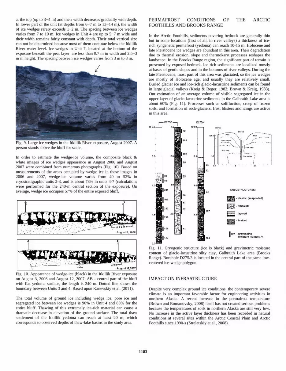
PERMAFROST CONDITIONS OF THE ARCTIC FOOTHILLS AND BROOKS RANGE In the Arctic Foothills, sediments covering bedrock are generally thin but in some locations (first of all, in river valleys) a thickness of ice-rich syngenetic permafrost (yedoma) can reach 10-15 m. Holocene and late Pleistocene ice wedges are abundant in this area. Their degradation due to thermal erosion, slope and thermokarst processes reshapes the landscape. In the Brooks Range region, the significant part of terrain is presented by exposed bedrock. Ice-rich sediments are localized mostly at bases of gentle slopes and in the bottoms of river valleys. During the late Pleistocene, most part of this area was glaciated, so the ice wedges are mostly of Holocene age, and usually they are relatively small. Buried glacier ice and ice-rich glacio-lacustrine sediments can be found in large glacial valleys (Kreig & Reger, 1982; Brown & Kreig, 1983). Our estimation of an average volume of visible segregated ice in the upper layer of glacio-lacustrine sediments in the Galbraith Lake area is about 60% (Fig. 11). Processes such as solifluction, creep of frozen soils, and formation of rock-glaciers, frost blisters and icings are active in this area.
Fig. 11. Cryogenic structure (ice is black) and gravimetric moisture content of glacio-lacustrine silty clay, Galbraith Lake area (Brooks Range). Borehole D275/3 is located in the central part of the same low-centered ice-wedge polygon. IMPACT ON INFRASTRUCTURE Despite very complex ground ice conditions, the contemporary severe climate is an important favorable factor for engineering activities in northern Alaska. A recent increase in the permafrost temperature (Brown and Romanovsky, 2008) itself has not created serious problems because the temperatures of soils in northern Alaska are still very low. No increase in the active layer thickness has been recorded in natural conditions at several sites within the Arctic Coastal Plain and Arctic Foothills since 1990-s (Streletskiy et al., 2008).
1183

Cold climate and low permafrost temperatures allow for using frozen soils as foundations without expensive technical means. Pads and embankments with a thickness greater than the active layer depth in dry granular soil prevent ice-rich permafrost from thawing (Fig. 11). Open crawl space beneath elevated pipelines and buildings also supports permafrost integrity without extra means. In the areas with relatively warm permafrost, use of thermo-siphons is recommended.
Fig. 11. Airstrip in the Arctic Coastal Plain (Colville River Delta). Note numerous low-centered polygons indicating large masses of wedge ice very close to the surface. Study of engineering properties of permafrost is especially important for northern Alaska due to numerous environmental and engineering issues related to extensive development of the oil industry in this area. Engineering properties of permafrost strongly relate to its composition, structure and temperature. For aboveground structures such as roads, pads, buildings, and pipelines, thaw strain of soil defines the choice of a foundation alternative. Thaw strain of permafrost strongly depends on the ice content and structure of soils. Our studies in the Interior Alaska showed that for mineral soils with gravimetric moisture contents from 70% to 160% (such range is typical of the upper permafrost of northern Alaska, without taking into account the volume of massive ice) thaw strain ranges from 0.2 to 0.5 even without the external load. In northern Alaska, thaw stable soils occupy small isolated areas with eolian sands and exposed bedrocks. The upper part of permafrost of the Arctic Coastal Plain is mostly ice-rich to a depth of at least several meters with thaw strain up to 0.5-0.6. Permafrost of the silt belt is extremely ice-rich to a depth of several dozens meters and early explorations in the area led to significant thaw settlement and thermokarst (Lawson, 1986). High ice content of sediments and a wide occurrence of ice wedges make the upper permafrost sensitive to thermokarst and thermal erosion development. Despite the cold climate, if thawing of ice-rich soils occurs it would create serious problems to structures and environment. For example, construction of pads and embankments can change dramatically the hydrological regime and accumulation of surface water near embankments can cause the degradation of ice wedges (Fig. 12A). Destruction of peat and moss cover, or accumulation of snow around snow fences (Fig. 12B) also can lead to the active layer deepening, which can trigger thermokarst or thermal erosion.
A
B
Fig. 12. Degradation of ice wedges triggered by construction (A) and excess snow accumulation near the snow fence (B), city of Kaktovik, northern Alaska. To mitigate negative impacts of permafrost related hazards on engineering structures, several measures should be taken prior, during, and after construction: (1) areas with natural permafrost related hazards (e.g. coastal bluffs affected by erosion, thermo-erosional gullies, solifluction and other slope processes, thermokarst ponds or troughs above degrading ice wedges) should be avoided, otherwise, hazardous processes should be terminated by engineering means, such as drainage, earth works, thermal insulation, retaining walls, etc.; (2) ventilated space should be arranged beneath elevated structures on piles or thermo-siphons; (3) all embankments should be constructed with coarse well-drained material, with culverts allowing free drainage of surface water; (4) any disturbances of surrounding tundra surface and excess snow accumulation should be avoided. In some cases, thaw susceptible soils can be replaced with thaw stable ones. Additional thermal insulation can be installed on the surface to protect ice-rich permafrost from thawing.
1184

CONCLUSIONS Permafrost north of Brooks Range is continuous and characterized by: wide occurrence of ice-rich soils with massive ground ice bodies located at different depths; thin and saturated active layer; highly vulnerable tundra terrain; fast development of permafrost-related hazardous processes. In northern Alaska, wedge ice is the main type of massive ground ice and ice-wedge polygons occupy nearly all the land surface except relatively small areas with exposed bedrocks, or fresh eolian, deltaic and marine deposits. Surface disturbances, such as vegetation destruction, usually result in an increase of the active layer thickness. With the massive ice bodies located close to the surface, active layer deepening can trigger development of thermokarst or thermal erosion. Impacts of these processes on the Arctic environment and engineering should be closely considered. ACKNOWLEDGEMENTS Studies were supported by the National Science Foundation grants OPP-0436179, ARC-0436165, ARC-0454985, ARC-0454939, and Alaska EPSCoR, funded by the NSF grant 0701898 and the state of Alaska. We would like to thank VECO Polar Resources (CH2M HILL Polar Services) and Barrow Arctic Science Consortium for their logistical support. Gary Michaelson, Vladimir Tumskoy, Prothap Kodeal, Fugen Dou, and Lorene Lynn participated in field work. REFERENCES Black, RF (1983). “Three superimposed systems of ice wedges at
McLeod Point, northern Alaska, may span most of Wisconsinan stage and Holocene,” Permafrost: Fourth International Conference Proceedings, National Academy Press, Washington, D.C., pp 68-73.
Bray, MT, French, HM, and Shur, Y (2006). “Further cryostratigraphic observations in the CRREL permafrost tunnel, Fox, Alaska,” Permafrost and Periglacial Processes, Vol 17, No 3, pp 233-243.
Brewer, MC, Carter, LD, and Glenn, R (1993). “Sudden drainage of a thaw lake on the Alaskan Arctic Coastal Plain,” Proceedings of the Sixth International Conference on Permafrost, July 5-9, Beijing, China, South China University of Technology Press, pp 48-53.
Brown, J, and Kreig, RA (Eds.) (1983). Guidebook to permafrost and related features along the Elliott and Dalton Highways, Fox to Prudhoe Bay, Alaska, University of Alaska Fairbanks, 230 pp.
Brown, JB, and Sellmann, PV (1973). “Permafrost and coastal plain history of arctic Alaska,” Alaskan Arctic Tundra, Arctic Institute of North America, Technical Paper No 25, pp 31-47.
Carter, LD (1981). “A Pleistocene sand sea on the Alaskan Arctic Coastal Plain,” Science, Vol 211, pp 381-383.
Carter, LD (1988). “Loess and deep thermokarst basins in Arctic Alaska,” Proceedings of the Fifth International Conference on Permafrost, Tapir publishers, Trondheim, Norway, pp 706-711.
Carter, LD, and Galloway, JP (1979). “Arctic Coastal Plain pingos in National Petroleum Reserve in Alaska,” U.S. Geological Survey in Alaska; Accomplishments during 1978, Johnson KM & Williams, J.R. (eds.). USGS Circular 804-B, B33-B35.
Ferrians, OJ (1988). “Pingos in Alaska: a review,” Permafrost: Fifth International Conference Proceedings, Tapir publishers, Trondheim, Norway, pp 734-739.
Hamilton, TD, Craig, JL, and Sellmann, PV (1988). “The Fox permafrost tunnel: a late Quaternary geologic record in central Alaska,” Geological Society of America Bulletin, Vol 100, pp 948-969.
Hussey, KM, and Michelson, RW (1966). “Tundra relief features near Point Barrow, Alaska,” Arctic, Vol 19, No 2, pp 162-184.
Jones, BM, Arp, CD, Jorgenson, MT, Hinkel, KM, Schmutz, JA, and
Flint, PL (2009) “Increase in the rate and uniformity of coastline erosion in Arctic Alaska,” Geophysical Research Letters, Vol 36, L03503, doi:10.1029/2008GL036205.
Jorgenson, MT, and Brown, J (2005). “Classification of the Alaskan Beaufort Sea Coast and Estimation of Carbon and Sediment Inputs from Coastal Erosion,” Geo-Marine Letters, Vol 25, pp 69-80.
Jorgenson, MT, Macander, M, Jorgenson, JC, Ping, C-L, and Harden J (2003). “Ground ice and carbon characteristics of eroding coastal permafrost at Beaufort Lagoon, northern Alaska,” Proceedings of the Eight International Conference on Permafrost, A.A. Balkema Publishers, Lisse, Netherlands, pp 495-500.
Jorgenson, T and Shur, Y (2008). “Glaciation of the Coastal Plain of Northern Alaska,” Eos Trans. AGU, 89 (53), Fall Meet. Suppl., Abstract C11D-0544.
Jorgenson, MT, Shur, Y, and Pullman, ER (2006). “Abrupt increase in permafrost degradation in Arctic Alaska,” Geophysical Research Letters, Vol 33, L02503, doi:10.1029/2005GL024960.
Jorgenson, T, Yoshikawa, K, Kanevskiy, M, Shur, Y, Romanovsky, V, Marchenko, S, Grosse, G, Brown, J, and Jones, B (2008). “Permafrost Characteristics of Alaska,” Proceedings of the Ninth International Conference on Permafrost, extended abstracts. June 29 – July 3, 2008, Fairbanks, Alaska. Kane, DL & Hinkel, KM (eds). Institute of Northern Engineering, University of Alaska Fairbanks, pp 121-122.
Kanevskiy, M, Stephani, E, Fortier, D, Jorgenson, T, Lynn, L, Michaelson, G, Ping, C-L, and Shur, Y (2007). “Ground ice of Beaufort Sea coastal plain,” Abstracts of Arctic Science Conference “Partnering for Northern Futures: Science, Policy, Education, Legacy (Anchorage, Alaska, 24-26 September), pp 36-37.
Kanevskiy, M, Jorgenson, T, Shur, Y, Dillon, M (2008a). “Buried glacial basal ice along the Beaufort Sea Coast, Northern Alaska,” Eos Trans. AGU, 89 (53), Fall Meet. Suppl., Abstract C11D-0531.
Kanevskiy, M, Fortier, D, Shur, Y, Bray, M, and Jorgenson, T (2008b). “Detailed Cryostratigraphic Studies of Syngenetic Permafrost in the Winze of the CRREL Permafrost Tunnel, Fox, Alaska,” Proceedings of the Ninth International Conference on Permafrost, June 29 – July 3, 2008, Fairbanks, Alaska. Kane, DL & Hinkel, KM (eds). Institute of Northern Engineering, University of Alaska Fairbanks, Vol 1, pp 889-894.
Kanevskiy, M, Shur, Y, Fortier, D, Jorgenson MT, and Stephani, E (2011). “Cryostratigraphy of late Pleistocene syngenetic permafrost (yedoma) in northern Alaska, Itkillik River exposure,” Quaternary Research, doi:10.1016/j.yqres.2010.12.003.
Kreig, RA, and Reger, RD (1982). Air-photo analysis and summary of landform soil properties along the route of the Trans-Alaska Pipeline System, DGGS, College, Alaska, Geologic report 66, 149 pp.
Lachenbruch, AH, Sass, JH, Lawver, LA, Brewer, MC, Marshall, BV, Munroe, RJ, Kennelly, JP, Jr, Galanis, SP, Jr, and Moses, TH, Jr (1988). “Temperature and depth of permafrost on the Arctic slope of Alaska,” In: Gryc, George, ed., Geology and exploration of the National Petroleum Reserve in Alaska, 1974 to 1982: U.S. Geological Survey Professional Paper 1399, pp 645-656.
Lawson, DE (1982). Long-term modifications of perennially frozen sediment and terrain at East Oumalik, northern Alaska, CRREL report 82-36, 33 pp.
Lawson, DE (1983). “Ground ice in perennially frozen sediments, northern Alaska,” Permafrost: Fourth International Conference Proceedings, National Academy Press, Washington, D.C., pp 695-700.
Lawson, DE (1986). “Response of permafrost terrain to disturbance: a synthesis of observations from Northern Alaska, U.S.A.,” Arctic and Alpine Research, Vol 18, No 1, pp 1-17.
Leffingwell, E de K (1919). The Canning River region, northern Alaska, U.S. Geological Survey Professional Paper 109, 251 pp.
1185

Lewellen, RI (1973). “The occurrence and characteristics of nearshore permafrost, northern Alaska,” Permafrost: The North American contribution to the Second International Conference, Yakutsk. Washington, D.C., National Academy of Science Press, pp 131-136.
Livingstone, DA, Bryan, K, Jr., and Leahy, RG (1958). “Effects of an Arctic environment on the origin and development of freshwater lakes,” Limnology and Oceanography, Vol 3, pp 192-214.
Osterkamp, TE, and Jorgenson, JC (2006). “Warming of permafrost in the Arctic National Wildlife Refuge, Alaska,” Permafrost and Periglacial Processes, Vol 17, pp 65-69.
Ping, C-L, Michaelson, GJ, Guo, L, Jorgenson, MT, Kanevskiy, M, Shur, Y, Dou, F, and Liang, J (2011, in press). “Soil carbon and material fluxes across the eroding Alaska Beaufort Sea coastline,” Journal of Geophysical Research – Biogeosciences.
Pullman, ER, Jorgenson, MT, and Shur, Y (2007). “Thaw Settlement in Soils of the Arctic Coastal Plain, Alaska,” Arctic, Antarctic and Alpine Research, Vol 39, No 3, pp 468–476.
Sellmann, PV (1967). Geology of the USA CRREL permafrost tunnel, Fairbanks, Alaska, Hanover, New Hampshire, US Army CRREL Technical Report 199, 22 pp.
Shur, YL (1977). Thermokarst, Moscow, Nedra, 80 pp (in Russian). Shur, Y, French, HM, Bray, MT, and Anderson, DA (2004).
“Syngenetic permafrost growth: cryostratigraphic observations from the CRREL Tunnel near Fairbanks, Alaska,” Permafrost and Periglacial Processes, Vol 15, No 4, pp 339-347.
Shur, Y, and Jorgenson, MT (1998). “Cryostructure development on the floodplain of the Collville River Delta, northern Alaska,” Proceedings of the Seventh International Conference on Permafrost, Yellowknife, Canada, pp 993-999.
Streletskiy, DA, Shiklomanov, NI, Nelson, FE, and Klene, AE (2008). “Thirteen years of observations at Alaskan CALM sites: long-term active layer and ground surface temperature trends,” Proceedings of the Ninth International Conference on Permafrost, June 29 – July 3, 2008, Fairbanks, Alaska. Kane, DL & Hinkel, KM (eds). Institute of Northern Engineering, University of Alaska Fairbanks, Vol 2, pp 1727-1732.
Williams, JR, and Yeend, WE (1979). “Deep thaw lake basins in the inner Arctic Coastal Plain, Alaska,” U.S. Geological Survey in Alaska: Accomplishments during 1978, Johnson K.M. & Williams, J.R. (eds.). USGS Circular 804-B, B35-B37.
1186