peir chapter 24 transport - rampion 2
TRANSCRIPT
1 © Wood Group UK Limited
Rampion 2 PEIR. Volume 2, Chapter 24: Transport
2.24
Volume 2, Chapter 24
Transport
2 © Wood Group UK Limited
Rampion 2 PEIR. Volume 2, Chapter 24: Transport
Contents
24. Transport 6
24.1 Introduction 6
24.2 Relevant legislation, policy and other information and guidance 7
Introduction 7
National planning policy 7
Other relevant information and guidance 15
24.3 Consultation and engagement 16
Overview 16
Scoping Opinion 16
Evidence Plan Process (EPP) 21
Informal consultation and further engagement 23
24.4 Scope of the assessment 26
Overview 26
The Proposed Development 26
Spatial scope and Study Area 29
Study Area overlap 32
Temporal scope 32
Potential receptors 33
Potential effects 34
Activities or impacts scoped out of assessment 35
24.5 Methodology for baseline data gathering 36
Overview 36
Desk study 37
Site surveys 39
Data limitations 40
24.6 Baseline conditions 41
Study Area 1 – onshore 41
Baseline traffic flows 48
Existing accident record 51
Study Area 2 – onshore impacts of offshore works 57
24.7 Future baseline 61
Study Area 1 – Onshore works 61
Study Area 2 – Onshore impacts of offshore works 62
24.8 Basis for PEIR assessment 63
Maximum design scenario 63
The Proposed Development – construction phase – onshore works 67
The Proposed Development – operation and maintenance phase – onshore impacts of offshore works 72
The Proposed Development – decommissioning phase – onshore works 72
Embedded environmental measures 74
24.9 Methodology for PEIR assessment 79
Introduction 79
3 © Wood Group UK Limited
Rampion 2 PEIR. Volume 2, Chapter 24: Transport
Methodology 79
Receptor sensitivity 83
Magnitude of change 84
Significance evaluation methodology 85
24.10 Preliminary assessment: construction phase – onshore works 87
Introduction 87
Assessment year traffic growth 87
Magnitude of change 87
Sensitivity of receptor 89
Significance of residual effect 94
24.11 Preliminary assessment: operation and maintenance phase – onshore impacts of offshore works 108
Introduction 108
Assessment year traffic growth 108
Magnitude of change 108
Sensitivity of receptor 109
Significance of residual effect 110
24.12 Preliminary assessment: decommissioning phase – onshore works 110
Assessment year traffic growth 110
Magnitude of Change 110
Sensitivity of receptor 111
Significance of residual effect 111
24.13 Preliminary assessment: cumulative effects 112
24.14 Transboundary effects 112
24.15 Inter-related effects 113
24.16 Summary of residual effects 115
24.17 Further work to be undertaken for ES 117
Introduction 117
Baseline 117
Assessment 117
Consultation and engagement 118
24.18 Glossary of terms and abbreviations 118
24.19 References 123
Table 24-1 National planning policy relevant to transport 8
Table 24-2 Local transport / planning policy relevant to transport 11
Table 24-3 PINS Scoping Opinion responses – transport 17
Table 24-4 Highways links within the Rampion 2 onshore Study Area (1) 30
Table 24-5 Highways links within the Rampion 2 onshore Study Area (2) 31
Table 24-6 Receptors requiring assessment for transport 33
Table 24-7 Potential effects on transport receptors scoped in for further assessment 34
Table 24-8 Activities or impacts scoped out of assessment 35
Table 24-9 Data sources used to inform the transport PEIR assessment – onshore assessment (Study Area 1) 37
4 © Wood Group UK Limited
Rampion 2 PEIR. Volume 2, Chapter 24: Transport
Table 24-10 Data sources used to inform the transport PEIR assessment – onshore assessment of offshore works (Study Area 2) 38
Table 24-11 Site survey undertaken for transport – Study Area 1 40
Table 24-12 A/B roads within Study Area 1 41
Table 24-13 2021 baseline traffic data (AADF) – Study Area 1 50
Table 24-14 PIA data summary (January 2015 – December 2019) 52
Table 24-15 A/B Roads within Study Area 2 57
Table 24-16 2021 baseline traffic data (AADF) – Study Area 2 60
Table 24-17 Maximum assessment assumptions for impacts on transport 63
Table 24-18 Assessment options for onshore PEIR Assessment 68
Table 24.19 Onshore construction staff traffic distribution 69
Table 24-20 HGV Distribution Study Area 1 71
Table 24-21 Relevant transport embedded environmental measures 74
Table 24-22 Receptors potentially requiring assessment – Study Area 1 81
Table 24-23 Receptors potentially requiring assessment – Study Area 2 83
Table 24-24 Highways Link sensitivity 84
Table 24-25 Magnitude of change 85
Table 24-26 Significance evaluation matrix 86
Table 24-27 Onshore construction traffic percentage impact per highways link 88
Table 24-28 Highway link receptor sensitivity – Study Area 1 89
Table 24-29 Highway Link 6 – assessment of transport environmental effects 95
Table 24-30 Highway Link 7 – assessment of transport environmental effects 97
Table 24-31 Highway Link 8 – assessment of transport environmental effects 99
Table 24-32 Highway Link 10 – assessment of transport environmental effects 101
Table 24-33 Highway Link 12 – assessment of transport environmental effects 102
Table 24-34 Highway Link 17 – assessment of environmental effects 104
Table 24-35 Highway Link 26 – assessment of environmental effects 106
Table 24-36 Onshore construction traffic percentage impact per highways link 108
Table 24-37 Highway link – receptor sensitivity – Study Area 2 109
Table 24-38 Onshore substation decommissioning traffic percentage impact per highways link 111
Table 24-39 Receptor sensitivity – Highways Links 25 and 26 (Study Area 1) 111
Table 24-40 Inter-related effects assessment for noise and vibration 113
Table 24-41 Onshore construction traffic impact per highways link 115
Table 24-42 Further consultation and engagement 118
Table 24-43 Glossary of terms and abbreviations 118
Volume 3: Figures
Figure 24.1 Location of Onshore Elements and Highways Context Figure 24.2 Onshore Cable Route Sections Plan Figure 24.3 Site Compound Locations Figure 24.4 Onshore Cable Route Sections and Associated Compounds Figure 24.5 Proposed Study Area 1 (Onshore Cable Route) Figure 24.6 Proposed Study Area 2 (Newhaven Port) Figure 24.7 Study Area 1 - Bus Routes
5 © Wood Group UK Limited
Rampion 2 PEIR. Volume 2, Chapter 24: Transport
Figure 24.8 Study Area 1 – Public Rights of Way Figure 24.9 Study Area 1 – National Cycle Network Figure 24.10 Study Area 1 – Accident Assessment Area Figure 24.11 Study Area 2 – Bus Routes Figure 24.12 Study Area 2 – National Cycle Network Figure 24.13 Onshore Construction Corridor Sections and Components Figure 24.14 Accesses Used – onshore Construction Phase Figure 24.15 Areas Used to Inform Light Vehicle Distribution Figure 24.16 Light Vehicle Network Exit Points from Study Area 1 Figure 24.17 HGV Network Exit Points from Study Area 1 Figure 24.18 Study Area 1 HGV Access Strategy Figure 24.19 Network Plot – Peak Construction Traffic Generation – Study
Area 1 Figure 24.20 Onshore works identified highways links Figure 24.21 Network plot – Traffic generation for offshore works (Newhaven) Figure 24.22 Offshore works identified highways links Figure 24.23 Network plot – Decommissioning works (Onshore)
Volume 4: Appendices
Appendix 24.1 Outline construction traffic management plan Appendix 24.2 Outline Public Rights of Way management plan Appendix 24.3 Outline Abnormal Indivisible Loads assessment Appendix 24.4 Onshore Construction Traffic Assessment Appendix 24.5 Traffic Calculations
6 © Wood Group UK Limited
Rampion 2 PEIR. Volume 2, Chapter 24: Transport
24. Transport
24.1 Introduction
24.1.1 This chapter of the Preliminary Environmental Information Report (PEIR) presents the preliminary results of the assessment of the likely significant effects of Rampion 2 with respect to transport. It should be read in conjunction with the Proposed Development description provided in Chapter 4: The Proposed Development and the relevant parts of the following chapters:
Chapter 13: Shipping and navigation (due to onshore effects of offshore works);
Chapter 18: Socio-economics (due to effects of the Proposed Development on Public Rights of Way (PRoW));
Chapter 20: Air quality (due to the use of transport data to inform air quality assessments);
Chapter 22: Noise and vibration (due to the use of transport data to inform noise assessments); and
Appendix 5.2: Greenhouse gases assessment, Volume 4 (due to the use of transport data in the greenhouse gases assessment).
24.1.2 Figure 24.1, Volume 3 shows the location of the onshore elements of the Proposed Development in the context of the wider highway. This figure sets out the entire onshore temporary cable corridor.
24.1.3 This chapter describes:
the legislation, planning policy and other documentation that has informed the assessment (Section 24.2: Relevant legislation, planning policy and other information and guidance);
the outcome of consultation and engagement that has been undertaken to date, including how matters relating to transport within the Scoping Opinion received in August 2020 have been addressed (Section 24.3: Consultation and engagement);
the scope of the assessment for transport (Section 24.4: Scope of the assessment);
the methods used for the baseline data gathering (Section 24.5: Methodology for baseline data gathering);
the overall baseline (Section 24.6: Baseline conditions);
the proposed future baseline (Section 24.7: Future baseline)
embedded environmental measures relevant to transport and the relevant maximum design scenario (Section 24.8: Basis for PEIR assessment);
the assessment methods used for the PEIR (Section 24.9: Methodology for PEIR assessment);
7 © Wood Group UK Limited
Rampion 2 PEIR. Volume 2, Chapter 24: Transport
the assessment of transport effects (Section 24.10 – 24.12: Preliminary assessment and Section 24.13: Preliminary assessment: Cumulative effects);
consideration of transboundary effects (Section 24.14: Transboundary effects);
consideration of inter-related effects (Section 24.15: Inter-related effects);
a summary of residual effects for transport (Section 24.16: Summary of residual effects);
an outline of further work to be undertaken for the Environmental Statement (ES) (Section 24.17: Further work to be undertaken for ES);
a glossary is provided in Section 24.18: Glossary of terms and abbreviations; and
references can be found in Section 24.19: References.
24.1.4 The chapter is supported by the following appendices located in Volume 4:
Appendix 24.1: Outline Construction Traffic Management Plan, Volume 4;
Appendix 24.2: Outline Public Rights of Way Management Plan, Volume 4;
Appendix 24.3: Outline Abnormal Indivisible Loads Assessment, Volume 4;
Appendix 24.4: Onshore Construction Traffic Assessment, Volume 4; and
Appendix 24.5: Traffic calculations, Volume 4.
24.2 Relevant legislation, policy and other information and guidance
Introduction
24.2.1 This section identifies the legislation, policy and other documentation that has informed the assessment of effects with respect to transport. Further information on policies relevant to the Environmental Impact Assessment (EIA) and their status is provided in Chapter 2: Policy and legislative context of this PEIR.
24.2.2 The assessment has been undertaken in accordance with relevant transport related planning policy, legislation and guidance at the national, regional and local level. This helped identify any requirements which the Proposed Development needs to consider, aiding the process of defining the scope of assessment and informing the identification of local issues.
National planning policy
24.2.3 Table 24-1 lists the national planning policy relevant to the assessment of the effects on transport receptors.

8 © Wood Group UK Limited
Rampion 2 PEIR. Volume 2, Chapter 24: Transport
Table 24-1 National planning policy relevant to transport
Policy description How and where considered in this chapter
The Overarching National Policy Statement for Energy (EN-1) (DECC, 2011)
NPS EN-1 contains the generic requirements for the assessment of impacts arising from traffic associated with design, construction and operation of renewable energy infrastructure. Relevant paragraphs are set out below. Paragraph 5.13.2 states “The consideration and mitigation of transport impacts is an essential part of Government’s wider policy objectives for sustainable development as set out in Section 2.2 of this NPS” Paragraph 5.13.3 states “If a project is likely to have significant transport implications, the applicant’s ES (see Section 4.2) should include a transport assessment, using the NATA/WebTAG methodology stipulated in Department for Transport guidance, or any successor to such methodology. Applicants should consult the Highways Agency and Highways Authorities as appropriate on the assessment and mitigation” Paragraph 5.13.4 states “Where appropriate, the applicant should prepare a travel plan including demand management measures to mitigate transport impacts. The applicate should also provide details of proposed measures to improve access by public transport, walking and cycling, to reduce the need for parking associate with the
This chapter of the PEIR considers all relevant potential transport impacts during the construction, operation and maintenance, and decommissioning phases of the Proposed Development. This chapter of the PEIR identifies possible transport impacts and ways to mitigate them in Section 24.10 to 24.12. The environmental measures to mitigate these impacts is embedded into the design. It is anticipated that for the Development Consent Order (DCO) submission a Transport Assessment (TA) will only be provided to support the application as set out in Paragraph 5.13.3 of EN-1 if there is deemed to be any significant transport implications. At this stage for PEIR, the assessment presented is a link based environmental assessment and is supported by an Outline Construction Traffic Management Plan (CTMP) (Appendix 24.1, Volume 4), Outline Public Rights of Way Management Plan (PRoWMP) (Appendix 24.2, Volume 4), and Outline Abnormal Indivisible Loads (AIL) Assessment (Appendix 24.3, Volume 4). These documents will be presented at PEIR and further discussions with relevant highways authority will be undertaken to define if there is a significant effect or not. Where appropriate it is expected that movement by sustainable means will be facilitated and encouraged. However, it is recognised that the linear nature of the works, the absence of a fixed permanent work site along the Rampion 2 onshore temporary onshore cable corridor and the rural nature of much of the corridor may make it difficult to implement a standard construction travel
9 © Wood Group UK Limited
Rampion 2 PEIR. Volume 2, Chapter 24: Transport
Policy description How and where considered in this chapter
proposal and to mitigate transport impacts.” Paragraph 5.13.5 states “If additional transport infrastructure is proposed, applicants should discuss with network providers the possibility of co-funding by Government for any third-party benefits. Guidance has been issued in England which explains the circumstances where this may be possible, although the Government cannot guarantee in advance that funding will be available for any given uncommitted scheme at any specified time” Paragraph 5.13.6 states “A new energy NSIP may give rise to substantial impacts on the surrounding transport infrastructure and the IPC [Planning Inspectorate] should therefore ensure that the applicant has sought to mitigate these impacts, including during the construction phase of the development. Where the proposed mitigation measures are insufficient to reduce the impact on the transport infrastructure to acceptable levels, the IPC [Planning Inspectorate] should consider requirements to mitigate adverse impacts on transport networks arising from the development, as set out below. Applicants may also be willing to enter into planning obligations for funding infrastructure and otherwise mitigating adverse impacts”. Paragraph 5.13.11 states “The IPC [Planning Inspectorate] may attach requirements to a consent where there is likely to be substantial HGV traffic that:
plan. Many of the accesses are not adjacent to sustainable links such as bus stops and rail lines and the nature of the work means that staff traveling to site need to take equipment and work materials which necessitates the use of vans. Additional transport infrastructure is limited to the provision of a number of mostly temporary construction accesses along the Rampion 2 onshore temporary cable corridor. Accesses will be removed where appropriate and where agreed with landowners, and the land reinstated following completion. Some accesses such as the access to the onshore landfall site and onshore substation will be retained. An Outline CTMP has been appended to this document with further details on access (Appendix 24.1, Volume 4). Sections 24.10 to 24.12 identify possible transport impacts resulting from all phases of the Proposed Development and ensure environmental measures (where relevant/necessary) are incorporated into the design. Proposed heavy goods vehicle (HGV) routes are identified and restrictions on HGV timing are proposed to avoid adverse impact on sensitive receptors, particularly schools as set out within the appended Outline CTMP
10 © Wood Group UK Limited
Rampion 2 PEIR. Volume 2, Chapter 24: Transport
Policy description How and where considered in this chapter
Control numbers of HGV
movements to and from the site in a specified period during its construction and possibly on the routing of such movements;
Make sufficient provision for HGV parking, either on the site or at dedicated facilities elsewhere, to avoid ‘overspill’ parking on public roads, prolonged queuing on approach roads and uncontrolled on-street HGV parking in normal operating conditions; and
Ensure satisfactory arrangements for reasonably foreseeable abnormal disruption, in consultation with network providers and the responsible police force”
(Appendix 24.1, Volume 4). The design of the construction works will avoid the risk of HGV parking on the surrounding highway. The transport of AILs has been subject to necessary assessment within the appended Outline AIL Assessment and is expected to cause minimal disruption (Appendix 24.3, Volume 4).
National Planning Policy Framework (NPPF) (Ministry of Housing, Communities and Local Government, 2019)
The NPPF is the primary source of national planning guidance in England. Paragraph 109 of the NPPF states that “development should only be prevented or refused on highways grounds if there would be an unacceptable impact on highway safety, or the residual cumulative impacts on the road network would be severe.” Paragraph 111 of the NPPF states that “all developments that will generate significant amounts of movement should be required to provide a travel plan, and the application should be supported by a transport statement or transport assessment so that the likely impacts of the proposal can be assessed.”
Whilst the NPPF is not directly applicable to Nationally Significant Infrastructure Projects (NSIPs), it provides context to the transport assessment. Sections 24.10 to 24.12 set out the results of the assessment of traffic impacts including highways safety (accident assessment is within Section 24.6). A TA will be developed if significant effects are identified at the ES stage and this would assess these criteria, the opportunities for sustainable transport, access and road safety, and the need for any transport improvements.
11 © Wood Group UK Limited
Rampion 2 PEIR. Volume 2, Chapter 24: Transport
Policy description How and where considered in this chapter
The document sets out that the Transport Statement (TS)/TA should take into account: the opportunities for sustainable
transport modes have been taken up depending on the nature and location of the site, to reduce the need for major transport infrastructure;
safe and suitable access to the site can be achieved for all people; and
improvements can be undertaken within the transport network that cost effectively limit the significant impacts of the development. Development should only be prevented or refused on transport grounds where the residual cumulative impacts of development.
For understanding development impacts at PEIR, this chapter is supported by an appended Outline CTMP (Appendix 24.1, Volume 4), Outline PRoWMP (Appendix 24.2, Volume 4), and Outline AIL Assessment (Appendix 24.3, Volume 4).
24.2.4 Table 24-2 lists the local planning policy relevant to the assessment of the effects on transport receptors.
Table 24-2 Local transport / planning policy relevant to transport
Policy description Relevance to assessment
West Sussex Transport Plan 2011-26 (Local Transport Plan 3 (LTP3)) (West Sussex County Council, 2011)
1.4.3 - Walking in West Sussex. The policy aims to maintain the existing pedestrian provision in West Sussex, including PRoW provision, and, where possible provide new infrastructure to create new connections and routes for pedestrians particularly for leisure.
The construction of the onshore cable has the potential to temporarily affect the PRoW infrastructure in West Sussex. As such appended to this chapter is an Outline PRoWMP that has been prepared setting out all PRoW impacts and environmental measures proposed (Appendix 24.2, Volume 4).
1.4.4 - Cycling Infrastructure and Promotion in West Sussex. This policy aims to protect the existing cycling provision and promote cycling as a form of sustainable transport. It also
The construction of the onshore cable has the potential to temporarily affect local and nationally strategic cycle routes in West Sussex. A review of the local cycle routes has been undertaken within this document in
12 © Wood Group UK Limited
Rampion 2 PEIR. Volume 2, Chapter 24: Transport
Policy description Relevance to assessment
identifies a requirement to construct and improve cycling infrastructure to connect local cycle networks and PRoW.
Section 24.6 and sets out that impacts on National Cycle Network (NCN) routes will not be significant.
1.4.8 Bus passenger transport in West Sussex. This policy proposes a range of measure promote and improve public transport in West Sussex. Measures include the maintenance of public transport to a good standard and the provision of new infrastructure – such as bus lanes- to improve the existing provision where this is possible.
The construction of the onshore cable has the potential to temporarily affect local bus routes in West Sussex. A review of local bus routes has been set out in this chapter in Section 24.6.
1.4.9 - Freight Movement and Management in West Sussex. This policy sets out the measures which are to be used to manage the movement of freight during the plan period. The policy identifies measures to be used, including a lorry route network around West Sussex and investment into major infrastructure improvements on the A27. The policy also states that minimising construction traffic will be a key aspect to managing freight traffic and therefore developments which have high levels of HGV movements will be assessed for the suitability of the HGV routes proposed.
The policy and HGV route network have been considered when identifying construction HGV routes associated with the Proposed Development set out in Section 24.7. The HGV access strategy avoids Findon Valley, a key route restriction within the Freight Movement and Management Plan.
Draft Horsham District Local Plan 2019-2036 (Horsham District Local Council, 2019)
Strategic policy 41 – Infrastructure Provision. This policy states that development will only be supported if local infrastructure has adequate capacity to support the development. Suitable mitigation should be proposed where local infrastructure does not have the capacity to accommodate development.
Consideration of transport effects and requirements for environmental measures. Sections 24.10 to 24.12 sets out the results of the assessment of the traffic impacts on local and strategic highways links.
13 © Wood Group UK Limited
Rampion 2 PEIR. Volume 2, Chapter 24: Transport
Policy description Relevance to assessment
Strategic policy 42 – Sustainable Transport. This policy sets out the conditions in which development will be supported for sustainable transport. The policy states “development will be supported if it: Provides safe and suitable access
for all vehicles, pedestrians, cyclists, horse riders, public transport and the delivery of goods.
Minimises the distance people need to travel and minimises conflicts between traffic, cyclists and pedestrians.
Prioritises and provides safe and accessible walking and cycling routes and is integrated with the wider network of routes, including public rights of way and cycle paths.
Includes opportunities for sustainable transport which reduce the need for major infrastructure and cut carbon emissions.
Develops innovative and adaptable approaches to public transport in the rural areas of the District.
Maintains and improves the existing transport system (pedestrian, cycle, rail and road).
Is accompanied by an agreed Green Travel Plan where it is necessary to minimise a potentially significant impact of the development of the wider area, or as a result of needing to address an existing local traffic problem.”
The construction of the onshore cable has the potential to temporarily affect PRoW, local bus routes and cycle routes in Horsham. Appended to this chapter is an Outline PRoWMP has been prepared setting out all PRoW impacts and environmental measures proposed (Appendix 24.2, Volume 4). A review of the local cycle routes has been undertaken within this document in Section 24.6 and sets out that impacts on NCN routes will not be significant. A review of local bus routes, including those in Horsham, has been set out in this chapter in Section 24.6.

14 © Wood Group UK Limited
Rampion 2 PEIR. Volume 2, Chapter 24: Transport
Policy description Relevance to assessment
Mid Sussex District Plan 2014-2031 (Mid Sussex District Council, 2018)
DP20: Securing Infrastructure. This policy requires development to be provided with necessary infrastructure such as efficient and sustainable transport networks.
Additional transport infrastructure is limited to the provision of a number of mostly temporary construction accesses along the Rampion 2 onshore temporary cable corridor. Accesses will be removed where appropriate and where agreed with landowners and the land reinstated when the Rampion 2 onshore cable construction is finished. Where accesses are not removed, they will remain in-situ, for example, the access to the onshore landfall site and onshore substation. An Outline CTMP has been appended to this chapter with further details on access (Appendix 24.1, Volume 4).
DP21: Transport. This policy requires developments, depending on their size or impact to prepare a Transport Statement or Transport Assessment to be submitted with the planning application. The policy also requires submission of a travel plan statement or full travel plan alongside the transport statement or transport assessment which will be submitted with the planning application.
It is anticipated that a TA will be provided to support the DCO Application if there is deemed to be any significant transport implications. At PEIR stage, the assessment presented is a link based environmental assessment and is supported by an Outline CTMP (Appendix 24.1, Volume 4), Outline PRoWMP (Appendix 24.2, Volume 4), and Outline AIL Assessment (Appendix 24.3, Volume 4). These documents are presented at PEIR stage and further discussions with relevant highways authority will be undertaken to define if there is a significant effect or not.
DP22: Rights of Way and other Recreational Routes. This policy aims to protect existing rights of way, cycle and recreational routes from any adverse effects that might come from development. It also states that where a route is likely to be affected an alternative must be provided which is equivalent in value to the route affected.
The protection of PRoW, including recreational route and National Trails has been included within an appended Outline PRoWMP (Appendix 24.2, Volume 4).
Draft Worthing Local Plan 2016 – 2033 (Worthing Borough Council, 2018)
CP24 Transport. The policy sets out that Worthing District Council will support development which encourages use of public and sustainable transport and reduces the
Section 24.8 and the Outline CTMP (Appendix 24.1, Volume 4) sets out the proposed HGV access strategy and environmental measures and routes that have been applied to mitigate impacts of the
15 © Wood Group UK Limited
Rampion 2 PEIR. Volume 2, Chapter 24: Transport
Policy description Relevance to assessment
number of car journeys. Where development is likely to generate demand for travel or have other implications it is required to be supported by a Transport Statement or Assessment and a travel plan. The policy further states that it will “support measures that promote improved accessibility, create safer roads, reduce the environmental impact of traffic movements, enhance the pedestrian environment, or facilitate highway improvements”. In particular reference is made to managing the impact of HGV movements and implementing measures where this may be appropriate.
construction phase of the Proposed Development.
West Sussex Walking and Cycling 2016 – 2026 (West Sussex County Council, 2020a)
The West Sussex Walking and Cycling strategy is a document that sets out the aims and objectives for walking and cycling during the strategy period (2016-2026) and sets out guidance and information for developers.
Appended to this chapter is an Outline PRoWMP (Appendix 24.2, Volume 4) which has been prepared setting out all PRoW impacts and environmental measures proposed.
Other relevant information and guidance
The Strategic Road Network and the Delivery of Sustainable Development Guidance
24.2.5 The Department for Transport (DfT) (2013) Circular 02/2013 ‘The Strategic Road Network and the Delivery of Sustainable Development’ outlines the methods in which the Highways Agency (now Highways England (HE)) will engage with developers and communities to deliver sustainable development and consequently economic growth, whilst safeguarding the primary function and purpose of the Strategic Road Network (SRN).
24.2.6 Paragraph 45 of Circular 02/2013 outlines under ‘Environmental Impact’:
“…developers must ensure all environmental implications associated with their proposals, are adequately assessed and reported so as to ensure that the mitigation of any impact is compliant with prevailing policies and standards. This requirement applies in respect of the environmental impacts arising from the temporary construction works and the permanent transport solution associated with
16 © Wood Group UK Limited
Rampion 2 PEIR. Volume 2, Chapter 24: Transport
the development, as well as the environmental impact of the existing trunk road upon the development itself”.
24.2.7 Paragraphs A15 to A17 of Circular 02/2013 outlines access requirements relating to wind:
“The promoter of a wind farm should prepare a report covering the construction, operation and de-commissioning stages of the development. From this, the acceptability of the proposal should be determined, and any mitigating measures should be identified.
Access to the site for construction, maintenance and de-commissioning should be obtained via the local road network and, normally, there should be no direct connection to the strategic road network.
Swept path analyses should be provided by the developer for the abnormal load deliveries to the site.”
24.2.8 Within the transport Study Area (outlined in Section 24.4), the SRN managed by HE includes the A27 and A23. The requirements of Circular 02/2013 are therefore addressed further within this chapter.
Guidelines for the Environmental Assessment of Road Traffic
24.2.9 Current guidance for assessing potentially significant environmental effects is the Institute of Environmental Assessment (IEA) (1993) publication ‘Guidance Notes No. 1: Guidelines for the Environmental Assessment of Road Traffic’ (hereafter referred to as ‘GEART’).
24.2.10 GEART has informed the assessment in this chapter and Section 24.9 sets out how this has been applied.
24.3 Consultation and engagement
Overview
24.3.1 This section describes the outcome of, and response to, the Scoping Opinion in relation to the transport assessment and also provides details of the ongoing informal consultation that has been undertaken with stakeholders and individuals. An overview of engagement undertaken can be found in Section 1.5 of Chapter 1: Introduction.
24.3.2 Given the restrictions which have been in place due to the COVID-19 pandemic during this period, all consultation has taken the form of conference calls using Microsoft Teams.
Scoping Opinion
24.3.3 Rampion Extension Development Limited (RED) submitted a Scoping Report and request for a Scoping Opinion to the Secretary of State (administered by the Planning Inspectorate (PINS)) on 2 July 2020. A Scoping Opinion was received on 11 August 2020 (Planning Inspectorate, 2020a). The Scoping Report sets out the proposed transport assessment methodologies, outline of the baseline data
17 © Wood Group UK Limited
Rampion 2 PEIR. Volume 2, Chapter 24: Transport
collected to date and proposed, and the scope of the assessment. Table 24-3 sets out the comments received in Section 5 of the PINS Scoping Opinion ‘Aspect based scoping tables – Onshore’ and how these have been addressed in this PEIR. A full list of the PINS Scoping Opinion comments and responses is provided in Appendix 5.1: Response to the Scoping Opinion, Volume 4. Regard has also been given to other stakeholder comments that were received in relation to the Scoping Report.
24.3.4 The information provided in the PEIR is preliminary and therefore not all the Scoping Opinion comments have been able to be addressed at this stage, however all comments will be addressed within the ES.
Table 24-3 PINS Scoping Opinion responses – transport
PINS ID number
Scoping Opinion comment How this is addressed in this PEIR
5.6.1 Hazardous Loads during construction operation and decommissioning. The Inspectorate agrees that this matter can be scoped out on the basis that no hazardous loads are anticipated by the Applicant during construction or operation of the Proposed Development.
Acknowledged. Hazardous loads have therefore been scoped out of the assessment within the PEIR and ES.
5.6.2 Operation and maintenance activities resulting in potential impact on roads, PRoW and users of these routes.
The Scoping Report advises that the operation and maintenance requirements of the onshore part of the Proposed Development would be occasional and therefore there would only be a limited number of vehicle movements. Whilst no further quantification of vehicle movements during operation has been provided, the Inspectorate is content that such activities will be below the threshold at which potentially significant effects could occur.
Paragraph 6.7.49 of the Scoping Report does not provide any justification as to operational effects on PRoW. Whilst the impacts in this regard are likely to be predominantly experienced during construction, the ES should also consider the potential for significant effects during operation including (e.g. as a result of permanent diversions / changes to PRoW around the cable route and substation).
Acknowledged. The assessment of operation and maintenance activities from the onshore works resulting in potential impacts on roads has been scoped out of the PEIR and ES. The operation and maintenance effects on existing PRoWs of permanent onshore elements of the Proposed Development have been considered within an appended Outline PRoWMP (Appendix 24.2, Volume 4).
18 © Wood Group UK Limited
Rampion 2 PEIR. Volume 2, Chapter 24: Transport
PINS ID number
Scoping Opinion comment How this is addressed in this PEIR
5.6.3 Decommissioning activities resulting in potential impact on local roads, PRoW and the users of these routes. The Scoping Report has scoped out potential impact on local roads, PRoW and the users of these routes during decommissioning works on the basis that the effects of decommissioning will be lower than construction. The Inspectorate is unable to agree that this can be scoped out at this stage as the effects and subsequent mitigation have not been quantified for the construction phase. Although the transport impacts during decommissioning works would be similar or potentially lower than during construction, the ES should assess these matters where significant effects are likely to occur.
Acknowledged. It is anticipated that all onshore and offshore subsurface cable infrastructure will be left in situ as part of the decommissioning phase (outlined in Chapter 4: The Proposed Development). Decommissioning effects will relate only to the removal of the onshore substation and traffic generation will therefore be lower than during construction. An assessment of the decommissioning effects of the onshore substation is included in Section 24.12.
5.6.4 Study Area. The Scoping Report states that the Study Area for the transport assessment will consider the onshore elements of the Scoping Boundary (and the “key routes outside” of this boundary). Routes that construction and operational traffic will take will be reviewed and amended in response to refinement of the onshore. The Inspectorate recommends that the geographical extent of the Study Area (with particular reference to “key routes” outside the Scoping Boundary) is agreed with the relevant highways authorities and Network Rail (where applicable).
Construction traffic routeing patterns are presented in Section 24.8. The key routes have been agreed with the relevant transport and highways providers to inform the highways link assessments in this chapter. The Study Areas are provided in Section 24.4 and Figures 24.5 and 24.6, Volume 3.
5.6.5 Consultation The Inspectorate welcomes the Applicant’s intention to agree the scope of assessment with the
The scope of the assessment outlined in Section 24.4 including baseline and receptors
19 © Wood Group UK Limited
Rampion 2 PEIR. Volume 2, Chapter 24: Transport
PINS ID number
Scoping Opinion comment How this is addressed in this PEIR
relevant consultation bodies. This is particularly important in agreeing the baseline position and the receptors which will be deemed sensitive in the assessment. It is also important that methodologies are justified, for example, why the Guidelines for the Assessment of the Environmental impact of Road Traffic (GEART) has been chosen over Design Manual for Roads and Bridges (DMRB). Where the scope differs from that requested by the relevant consultation bodies, the ES should provide justification for the alternative approach.
have been initially discussed with key stakeholders including West Sussex County Council (WSCC) and HE (further details provided in Section 24.3). Use of GEART has been applied to this environmental assessment chapter as set out in Section 24.9. The Design Manual for Roads and Bridges (DMRB) (Standards for Highways, 2020) guidelines have been used within the Outline CTMP (Appendix 24.1, Volume 4) when setting out proposed permanent access designs and will be used should a TA be deemed necessary to support the DCO Application. Further consultation with WSCC and HE will occur between PEIR and ES regarding the need for a TA and the application of DMRB standards.
5.6.6 Baseline Surveys/COVID-19 The Scoping Report makes limited reference to how data will be collected to form the baseline assessment. The Inspectorate would expect the Applicant to agree the scope of any further baseline information to inform the assessment with the relevant authorities. The Inspectorate acknowledges the Applicants concerns regarding COVID-19 restrictions, the
Discussion with WSCC on baseline surveys is set out in Section 24.3. Details on the collation of the baseline data and how the COVID-19 pandemic issues have been addressed are in Section 24.5. An agreement was reached with WSCC regarding the
20 © Wood Group UK Limited
Rampion 2 PEIR. Volume 2, Chapter 24: Transport
PINS ID number
Scoping Opinion comment How this is addressed in this PEIR
Applicant should refer to the advice provided in Section 3.4 of this Scoping Opinion.
use of historic data for the PEIR assessment which will be updated with new traffic counts in 2021 for the DCO submission should COVID-19 pandemic restrictions be lifted.
5.6.7 Rail Network The transport assessment should include an assessment of the potential impact on the rail network. Figure 6.7.1 indicates that several operational railway lines would be crossed. The assessment should also consider the potential impacts of any construction or diversion activities on public transport.
As part of the embedded environmental measures as part of the Proposed Development, it is proposed to provide a trenchless crossing via horizontal directional drilling (HDD) of the rail network in two locations (outlined in commitment C-5) and therefore there will not be an impact on the rail infrastructure as set out in Table 24-21.
5.6.8 Onshore vehicle movements associated with marine works No information is provided regarding any onshore vehicular movements associated with marine elements of the work (if any, and particularly in reference to nearshore / intertidal works). These should be included within the ES where significant effects are likely to occur. It is noted in paragraph 6.7.2 of the Scoping Report that the scope of offshore transport effects (beyond mean high water springs) are proposed to be considered elsewhere in the ES).
Consideration is given to the traffic generation related to the onshore impacts of offshore works in the operation and maintenance phase. This is set out in Section 24.11. Details as to why onshore impacts of offshore works in the construction phase are not considered are set out in paragraph 24.4.11.
5.6.9 Mitigation The Inspectorate welcomes the commitment to produce a Construction Traffic Management Plan (CTMP), Abnormal Indivisible Load (AIL) access study and PRoW Management Plan. Drafts of these
Emerging Outline drafts of the CTMP (Appendix 24.1, Volume 4), Outline PRoWMP (Appendix 24.2, Volume 4), and Outline AIL Assessment
21 © Wood Group UK Limited
Rampion 2 PEIR. Volume 2, Chapter 24: Transport
PINS ID number
Scoping Opinion comment How this is addressed in this PEIR
documents should be provided with the DCO application. It should be clear how the implementation of such plans would be secured in the DCO and the Applicant should consider how this plan would interact with the CoCP and other relevant plans.
(Appendix 24.3, Volume 4) have been prepared for PEIR stage and are appended to this chapter.
5.6.10 Cross Referencing with Other Disciplines Any cross-referencing between aspect chapters should be clear within the ES and the Inspectorate welcomes the consideration of inter- relationships on traffic and transport.
Cross referencing with other related discipline chapters is clearly set out throughout the chapter.
Evidence Plan Process (EPP)
Overview
24.3.5 The EPP has been set up to provide a formal, non-legally binding, independently chaired forum to agree the scope of the EIA and HRA, and the evidence required to support the DCO Application.
October 2020
24.3.6 For transport, further engagement has been undertaken via the EPP Expert Topic Group (ETG) ‘Traffic, Air Quality, Noise, Health and Socio-economics’ meeting held by conference call on 27 October 2020. The conference call was attended by the following stakeholders:
WSCC;
Highways England;
South Downs National Park Authority (SDNPA);
Arun District Council;
Mid Sussex District Council; and
East Sussex County Council.
24.3.7 The transport section of the ETG meeting covered the scope of the transport assessment, the baseline data and supporting assessments to be used to undertake the assessment, proposed environmental measures, proposed HGV access proposals and the assessment methodology. The engagement also presented the proposed approach to address the Scoping Opinion comments detailed in Table 24-3. An outline of the approach to the following documents was covered in the presentation and discussions:
22 © Wood Group UK Limited
Rampion 2 PEIR. Volume 2, Chapter 24: Transport
Transport chapter to support the EIA;
Outline Construction Traffic Management Plan (CTMP);
Outline PRoW Management Plan (PRoWMP); and
Outline Abnormal Indivisible Load (AIL) Assessment; and
traffic data collection.
24.3.8 Key discussion points raised during the ETG meeting in October 2020 related to the application of lessons learned from the existing Rampion 1 project and to produce a schedule of transport infrastructure crossed by the onshore temporary cable corridor. This has been taken into consideration with a full highways and rail crossing schedule provided in the Outline CTMP (Appendix 24.1, Volume 4) while a crossing schedule of the PRoW is presented in the Outline PRoWMP (Appendix 24.2. Volume 4).
24.3.9 The SDNPA raised during the ETG meeting on 28 October 2020:
the CTMP should include staff movements as well as HGV movements;
transport for the South East has undertaken research into the effects of the COVID-19 pandemic on traffic flows and can advise further on this;
consideration for impacts on Open Access Land should be included if the onshore cable corridor is likely to cross within the South Downs National Park;
within the mitigation hierarchy, avoidance of impacts should be considered as the first option; and
the CTMP should include approach to enforcement of HGV routes.
24.3.10 The issues raised by SDNPA have been addressed within this chapter and appended documents. The Outline CTMP (Appendix 24.1, Volume 4) and PEIR include for traffic calculations and management/mitigation of staff trips. The Outline PRoWMP (Appendix 24.2, Volume 4) includes a review of affected Open Access Land and proposed mitigation and the overall access strategy underpinning all assessments has sought to avoid impacts on towns, villages, PRoW and other sensitive roads users as set out in Section 24.8.
March 2021
24.3.11 A second ETG meeting was held for Traffic, Air Quality, Noise and Socio-economics on 16 March 2021 with the same key stakeholders as the meeting in October 2020.
24.3.12 The transport section of the ETG meeting covered an update on baseline data, consultation progress, construction traffic generation, PRoW impacts, the Outline CTMP, the Outline AIL assessment and some of the initial findings of the environmental assessment.
24.3.13 Key discussion points raised at the meeting were as follows:
HGV construction route enforcement;
23 © Wood Group UK Limited
Rampion 2 PEIR. Volume 2, Chapter 24: Transport
locations of Highways Links assessed as part of the transport assessment at PEIR stage;
time restrictions for construction traffic;
helicopters and use during the construction phase;
interactions with the proposed A27 Arundel Bypass project;
HDD proposals in relation to the Strategic Road Network;
additional speed surveys to inform access visibility requirements; and
AILs during the decommissioning phase.
24.3.14 HGV route enforcement will be addressed within the CTMP prepared to support the onshore elements of the Proposed Development and agreed requirements of the DCO. The Outline CTMP (Appendix 24.1, Volume 4) includes details on timings on the local highways network for all construction vehicles including HGVs as well as HDD proposals and details on visibility splays. Section 24.6 sets out the locations of the highways links assessed at PEIR. The Outline AIL Assessment (Appendix 24.3, Volume 4) sets out details of AILs in the construction and decommissioning phases.
24.3.15 At this stage there is no intention to use helicopters for the construction phase of the Proposed Development.
Informal consultation and further engagement
Overview
24.3.16 Informal consultation is ongoing with a number of prescribed and non-prescribed consultation bodies and local authorities in relation to transport. A summary of the informal consultation undertaken between the completion of the Scoping Report up to and including March 2021 is outlined in this section.
Informal Consultation – January 2021 / February 2021
24.3.17 RED carried out an Informal Consultation exercise for a period of four weeks from 14 January 2021 to 11 February 2021. This Informal Consultation exercise aimed to engage with a range of stakeholders including the prescribed and non-prescribed consultation bodies, local authorities, Parish Councils and general public with a view to introducing the Proposed Development and seeking early feedback on the emerging designs.
24.3.18 The key themes emerging from Informal Consultation relating to transport are:
concerns over the use of the Wineham Lane for construction traffic;
details around construction programming and phasing;
onshore substation design and potential screening;
traffic management during the construction phase and the capacity of local roads; and
24 © Wood Group UK Limited
Rampion 2 PEIR. Volume 2, Chapter 24: Transport
questions around the management of PRoW during construction including temporary and permanent diversions, and reinstatement.
24.3.19 Further detail about the results of the Informal Consultation exercise can be found in Informal Consultation Analysis.
West Sussex County Council
24.3.20 Engagement with WSCC has been ongoing since August / September 2020. Early email discussions in September 2020 outlined the Proposed Development and set out questions relating to baseline data collection, traffic growthing and use of strategic models to inform transport assessments.
24.3.21 The response to this initial consultation provided by WSCC in September 2020 is as follows:
there are issues with the refinement of the A27 Arundel to Bypass and Worthing to Lancing Strategic Model on the A259 corridor and routes north of the downs and the model does not include the A272 as well as other roads within the proposed study area of the Rampion 2 assessment. It was noted this is a HE traffic model;
WSCC has developed the East Arun Transport Model which covers part of the Rampion 2 Study Area and has a base year of 2014;
there is an A29 realignment model which has a base year of 2019 and covers Chichester to the River Arun, although the key routes in this model fall outside the Rampion 2 Study Area;
a new traffic model is about to be developed of the A259 covering a small part of the Rampion 2 Study Area but this will not be available until late 2021/2022;
there is an Arun Transport Study, however this has a base year of 2009 which was revalidated to 2015 but WSCC considered the Study to be insufficiently detailed and current for the Rampion 2 assessment during consultation; and
there is a Horsham Local Plan Transport Model which has a base year of 2018 and a network that includes some of the northern element of the Rampion 2 study area.
24.3.22 The suitability of the transport models as potential sources of traffic data was discussed with WSCC and it was agreed that none will be appropriate for the assessment for a variety of reasons including model area and/or network coverage and the age of the base data. It was further agreed that for the purpose of the PEIR stage, it will be appropriate for the baseline data to be derived from historic traffic counts sourced from WSCC and publicly available survey data. Further information on this is set out in Section 24.5.
24.3.23 Further correspondence with WSCC in January/February 2021 regarding the scope of the assessment with agreement reached on the following aspects:
use of historic traffic count data for key construction routes;
future year of 2026/27 based on the estimated traffic generated by the onshore elements of the Proposed Development during the construction phase;
25 © Wood Group UK Limited
Rampion 2 PEIR. Volume 2, Chapter 24: Transport
the use of the Trip End Model Presentation Program (TEMPro) is acceptable to growth the trip rates to the future year without the requirement to add committed development traffic flows.
access visibility designs and use of DMRB to inform the following:
construction access designs and the types proposed on the onshore elements of the Proposed Development; and
permanent accesses.
24.3.24 An informal consultation response relating to the onshore elements of the Proposed Development was also received in January 2021. The key comments received and how these were addressed in the assessments / design are set out below:
issues regarding use of Bob Lane as a temporary construction access due to ongoing concerns by locals and the narrow width. This has been addressed as part of the ongoing design optioneering and Bob Lane is not proposed to be used as a major construction access, although occasional light vehicles may be required to route along Bob Lane related to smaller scale works. One temporary construction access onto Bob Lane is defined as a light temporary construction access and further details on this are set out in the Outline CTMP (Appendix 24.1, Volume 4); and
access to the Bolney Road / Kent Street onshore substation search area. Kent Street is not deemed appropriate for temporary construction access and an access directly off the A272 is acceptable in principle. This has been addressed as part of the ongoing design optioneering as access from the A272 is proposed for the Bolney Road / Kent Street onshore substation search area. Details of proposals for a construction access and then permanent access arrangement from the A272 are set out in the Outline CTMP (Appendix 24.1, Volume 4).
Highways England (HE)
24.3.25 Engagement with HE has been ongoing since August 2020. HE has provided the following comments regarding the assessment:
HE is concerned about proposals that have potential impact on the safe and efficient operation of the SRN, in this case, particularly the A27;
the approved Arun Local Plan strategic model is a potential source for data;
the DMRB LA104 should be considered with reference to crossings of the SRN;
use of a TEMPro growth methodology (that has been agreed with WSCC) would be acceptable to HE;
consultation with the A27 Arundel Bypass scheme team is encouraged; and
the Arundel bypass has a preferred alignment but is not a committed scheme.
24.3.26 These comments have been addressed during the iterative design stage or within this document.
26 © Wood Group UK Limited
Rampion 2 PEIR. Volume 2, Chapter 24: Transport
24.3.27 The A27 is a key route for access to the Proposed Development and this chapter has included the assessment of nine locations on the A27 and two on the A23 which is felt to be a comprehensive review of the Highways Agency network for the onshore cable corridor construction traffic.
24.3.28 Crossings of the SRN do not need to apply DMRB as during the design stage all crossings of the SRN (A27) have been identified to be HDD and traffic will flow freely along the road during construction without delay for open trench works. TEMPro has been used to understand traffic growth in in Sections 24.6 and 24.7.
24.3.29 Initial routes of the proposed onshore cable corridor alignment have indicated there may have been options that would have crossed the proposed future route of the A27 Arundel Bypass. During onshore cable corridor design and optioneering undertaken up to PEIR Stage, any onshore cable corridor route options that would have crossed the proposed alignment of the A27 Arundel Bypass have been removed and so the physical interactions between projects during any potential overlapping construction phases has now been removed.
24.3.30 A detailed meeting (21 October 2020) was undertaken with the HE A27 bypass scheme team which introduced the individual project teams and provided a presentation of both the Proposed Development and the current A27 bypass scheme to be taken forward.
24.4 Scope of the assessment
Overview
24.4.1 This section sets out the scope of the PEIR transport assessment which has been developed as the Rampion 2 design has evolved and responds to feedback received to date as set out in Section 24.3. As outlined in the Planning Inspectorate’s (PINS) Advice Note Seven: Environmental Impact Assessment: Process, Preliminary Environmental Information and Environmental Statements (Version 7, the Planning Inspectorate, 2020), information presented in the PEIR is preliminary, therefore this scope will be reviewed and may be refined as Rampion 2 continues to evolve and as a result of continued consultation.
The Proposed Development
The onshore elements of the Proposed Development
24.4.2 The onshore elements of the Proposed Development will include the construction of an onshore cable corridor from landfall at Climping to a new onshore substation in the vicinity of the existing National Grid Bolney substation. The onshore cable will be buried along its entire length and will encompass a permanent easement width of 15-25m. For construction purposes, a nominal working width of 50m will be required for the majority of the onshore cable corridor, with some larger working areas required at key areas, while constraints may restrict the working in other areas.
24.4.3 The onshore temporary cable corridor will cover an approximate distance of 36km measured from the Mean High Water Springs (MHWS) and will start at the
27 © Wood Group UK Limited
Rampion 2 PEIR. Volume 2, Chapter 24: Transport
proposed landfall site in Climping, cross under the A289 and River Arun before crossing under the A27 near Crossbush. From here the onshore temporary cable corridor heads north east across the South Downs to Washington, West Sussex and under the A24. The onshore cable corridor continues north east through a rural area and to the new onshore substation location within proximity of the existing National Grid Bolney substation.
24.4.4 The onshore temporary cable corridor has numerous crossings of roads including the A289, A27, A24, A283, B2135, B2116 and A281. There is also one crossing of the River Arun and two crossings of the National Rail network west of Littlehampton and Wick. As set out in Table 24-21 the onshore cable will be installed in trenches or by HDD to avoid major roads, operating railway lines and watercourses.
24.4.5 For the purpose of this assessment the entire onshore temporary cable corridor has been split into three sections which are described below and presented in Figure 24.2, Volume 3.
Section 1 runs north from landfall, across the A259, the River Arun and the two railway lines before crossing the A27 near the edge of the South Downs at Warningcamp. This section is rural but runs along the edge of the settlements of Littlehampton, Wick, Lyminster and Crossbush;
Section 2 runs north east from the Section 1 boundary to a crossing of the A24 near Washington, West Sussex. Between the A27 and A24, the onshore cable corridor has minimal interaction with the local highways network and due to the nature of access options, will make use of a continuous haul road; and
Section 3 runs from the Section 2 boundary along the A283 corridor before turning north east to Partridge Green and further East to Wineham/Bolney. This section is flat and rural in character but with more crossings of roads.
24.4.6 Temporary construction compounds will be required to store materials and plant as well as form a base for traffic working at the various site locations. The onshore part of the PEIR Assessment Boundary allows space for three temporary construction compound locations and options for a fourth if required set out in Figure 24.3, Volume 3. For the purposes of this chapter and the wider EIA assessment however three locations have been selected to allow for a worst case assessment. The worst-case is based on using the Climping compound rather than the north of Lyminster site as it generates more HGV traffic through the built-up areas north of Littlehampton. The temporary construction compounds used in the traffic calculations used in this assessment are as follows:
Temporary construction compound 1 – West of the River Arun, Climping – Site Access 2, serving Section 1;
Temporary construction compound 2 – North of Washington (Rock Farm) – Site Access 12a, serving Section 2; and
Temporary construction compound 3 – Oakendene Industrial Estate – Site Access 28a, serving Section 3.
24.4.7 Figure 24.4, Volume 3 sets out the onshore temporary cable corridor sections and three selected temporary construction compound.
28 © Wood Group UK Limited
Rampion 2 PEIR. Volume 2, Chapter 24: Transport
24.4.8 The operational lifetime of the Proposed Development is expected to be around 30 years and for the purposes of this chapter at year 30 the Proposed Development will reach the decommissioning phase.
24.4.9 Taking place after construction and commissioning of the Proposed Development the operation and maintenance phase activities can be divided into three main categories:
scheduled maintenance;
unscheduled maintenance; and
special maintenance in the event of major equipment breakdown and repairs.
The offshore elements of the Proposed Development
24.4.10 The current proposal is for Rampion 2 to have an installed capacity of up to 1,200MW, with the offshore components comprising:
offshore wind turbine generators (WTGs) and associated foundations, inter-array cables with an installed capacity of up to 1,200MW but not exceeding the number of WTGs installed for the existing Rampion 1 project (116 No.):
up to three offshore substations;
up to four offshore export cables will be installed, each in its own trench within the overall export cable corridor; and
up to two offshore interconnector export cables will be installed between the offshore substations.
24.4.11 During the construction phase, it is anticipated that 2,000+ two way movements for crew support vessels are required however at PEIR stage from onshore ports to the offshore infrastructure, however it is not established how this will be organised. The construction of the existing Rampion 1 project resulted in staff arriving and departing numerous ports in the UK and Europe and it is likely this process will be undertaken for Rampion 2. Material, including large transformers, cable and WTG components are expected to be delivered directly from European manufacturing bases. WTG construction vessels are also usually moored in European ports or will transfer from other projects.
24.4.12 There will also be some onshore works required in the offshore works but these construction activities (construction compound setup, HDD, Transition Joint Bay (TJB) construction etc.) have relatively short durations compared with the overall landfall construction presented in this chapter for the construction phase of the landfall site (onshore). Due to the landfall works requiring offshore works, the scheduling of the landfall works will allow for flexibility around the offshore schedule and sufficient time for all onshore activities to be performed so as not to delay the offshore works.
24.4.13 The operational lifetime of the Proposed Development is expected to be around 30 years and for the purposes of this chapter at year 30 the Proposed Development will reach the decommissioning phase. It is only anticipated that elements of the Proposed Development that are above sea level will be removed (WTG / substations).
29 © Wood Group UK Limited
Rampion 2 PEIR. Volume 2, Chapter 24: Transport
24.4.14 When the offshore elements of the Proposed Development are constructed and commissioned staff will be required to continue to operate and maintain the WTGs and associated infrastructure. RED will draw on experience gained in operating and maintaining the existing Rampion 1 project and although the maintenance port and facilities are not yet confirmed for the purpose of this chapter it is assumed that the existing operation and maintenance base Newhaven East Quay will be used for staffing.
Timings for the construction of the Proposed Development
24.4.15 Indicative hours for the construction work and any construction-related traffic movements to or from any site of the Proposed Development are as follows:
07:00 to 19:00 hours Monday to Friday;
08:00 to 13:00 hours on Saturday;
no activity on Sundays, public holidays or bank holidays, apart from under the following circumstances:
where continuous periods of construction work are required, such as concrete pouring or directional drilling, and WSCC and the SDNPA (for any works within the South Downs National Park) has been notified prior to such works 72 hours in advance;
for the delivery of AILs to the connection works, which may cause congestion on the local road network, where the relevant highway authority has been notified prior to such works 72 hours in advance;
where works are being carried out on the foreshore; and
as otherwise agreed in writing with WSCC and the SDNPA within the South Downs National Park.
24.4.16 For the purposes of a robust assessment in this chapter, traffic generation has only been calculated for a 5 day working week and no Saturday working.
24.4.17 Further details for the on and offshore components of the Proposed Development are set out in Chapter 4: The Proposed Development and are set out in detail in this chapter in Section 24.8.
Spatial scope and Study Area
Overview
24.4.18 The spatial scope of the assessment is based on the most probable routes for traffic generated by the Proposed Development, for the movement of deliveries, equipment and of staff. Identification of appropriate routes takes into consideration the following:
restrictions such as weight and height limits;
advisory HGV routes as identified in the West Sussex LTP3; and
suitability of routes based on a review of road types and widths.
30 © Wood Group UK Limited
Rampion 2 PEIR. Volume 2, Chapter 24: Transport
24.4.19 Two distinct Study Areas have been identified for the onshore impacts and onshore impacts of offshore works, as described below.
Study Area 1 – Traffic routes used for onshore construction activities
24.4.20 Identification of the Study Area 1 has focused on the road network to be used by traffic for all onshore construction activity which will comprise a range of routes due to the number of potential access points along the onshore cable corridor. The proposed Study Area 1 is presented in Figure 24.5, Volume 3 which shows the highway sections, referred to as ‘highway links’, that are proposed to be included in the assessment as set out in Table 24-4.
Table 24-4 Highways links within the Rampion 2 onshore Study Area (1)
Highways link
Link names Highways link
Link names
1 Ferry Road 19 A283, Steyning
2 Church Lane 20 A24, South of A272
3 Ford Road 21 B2116 Partridge Green Road
4 A27 West of Arundel
22 A281, South Shermanbury
5 A259 West of Wick 23 A281, South of Cowfold
6 A284 North of Wick 24 A281, Cowfold Centre
7 A284 Lyminster 25 A272, Station Road, Cowfold
8 Crossbush Lane, Crossbush
26 Wineham Lane, South of A272
9 A27, Arundel Station
27 A272, West of A23
10 Crossbush Lane, Warning Camp
28 A23, North of the A272
11 A27, South of Crossbush
29 B2188, Sayers Common
12 A27 High Salvington
30 B2116, Henfield Road, Albourne
13 A24/A27 Offington (Warren Road)
31 A23, North of the A272
14 A24 Findon 32 A27, West of A23
31 © Wood Group UK Limited
Rampion 2 PEIR. Volume 2, Chapter 24: Transport
Highways link
Link names Highways link
Link names
15 A280 Long Furlong 33 A27, East of A23
16 A283 West of A24 34 A259, West of Church Street
17 A283 East of A24 35 A259 East of Wick
18 B2135, South of Ashurst
24.4.21 In order to understand the wider impact of the construction traffic on the SRN, Highways Links 28, 31, 32 and 33 have been used within the assessment in this chapter for Study Area 1 to allow for robust assessment of the SRN even though as set out in Section 24.10 these are not all sensitive links for traffic.
Study Area 2 – Traffic routes used for onshore impacts of offshore activities
24.4.22 The spatial scope of the onshore impacts of offshore activities is focused around a candidate port located at Newhaven. Newhaven Port, East Quay is the current base used for the operation and maintenance phase of the existing Rampion 1 project.
24.4.23 Existing access from this location uses internal port roads before joining the local road network at Beach Road via a Port security gate. Beach Road runs north into Clifton Road and then Railway Road to a junction with the A259 and A26. The A259 to the west provides access to Newhaven and to the east leave Newhaven on a coast route to Eastbourne The A26 however is a key route north from Newhaven to a junction with the SRN (A27) at Beddingham.
24.4.24 However, construction of new access road to Newhaven Port East Quay is due to be completed in mid-2021 providing a new route to the A259 via McKinley Road. This will be the primary vehicular access route for Rampion 2 offshore activities at Newhaven Port.
24.4.25 Identification of the Study Area 2 for the offshore works has focused on the road network to be used by traffic for all onshore works for the offshore activity which is primarily focused on the route from the port to the A27. The proposed Study Area 2 is presented in Figure 24.6, Volume 3 which shows the highway sections, referred to as ‘highway links’, that are proposed to be included in the assessment as set out in Table 24-5.
Table 24-5 Highways links within the Rampion 2 onshore Study Area (2)
Highways Link Link Names
1 McKinley Road
2 A26 South Heighton
32 © Wood Group UK Limited
Rampion 2 PEIR. Volume 2, Chapter 24: Transport
Highways Link Link Names
3 A26 Beddingham
4 A27 West of Beddingham
5 A27 East of Beddingham
24.4.26 In order to understand the wider impact of the construction traffic on the SRN, Highways Links 4 and 5 have been used within the assessment in this chapter for Study Area 2 to allow for robust assessment of the SRN even though, as set out in Section 24.12, these are not sensitive links for traffic.
Study Area overlap
24.4.27 It is not considered that a combined cumulative assessment of the traffic generation within the two Study Areas is required. Study Area 2, as set out in Section 24.8, is relevant to the assessment of the operation and maintenance phase of the offshore works and therefore will not overlap with the construction and decommissioning phases in Study Area 1.
24.4.28 The two Study Areas are also independent of each other and are approximately 16km apart. On this basis, the two Study Areas will be assessed independently.
Temporal scope
Activities associated with the onshore elements of the Proposed Development
Construction phase
24.4.29 The temporal scope of the assessment of the construction phase is the periods of peak activity along sections of the onshore temporary cable corridor as outlined in Appendix 24.5, Volume 4. As agreed with the WSCC and HE, the proposed future years for assessment are 2026 and 2027.
Decommissioning phase
24.4.30 The temporal scope of the assessment of the decommissioning phase is based on the peak period of traffic during the onshore substation removal. It is currently predicted that the onshore substation will be decommissioned around 30 years from the Proposed Development commission. The onshore substation is proposed to be built in year two to five of the overall construction programme set out as Graphic 4.25 in Chapter 4. Based on the assessments set out in this chapter, year 5 will be 2029 and 30 years from then will be 2059.
24.4.31 For the decommissioning of the above ground infrastructure, it is acknowledged by PINS (PINS Response 5.6.3) that this will be similar or less than the construction phase, however assessment has been undertaken in this chapter for completeness.

33 © Wood Group UK Limited
Rampion 2 PEIR. Volume 2, Chapter 24: Transport
Onshore impacts of offshore activities during the operation and maintenance phase
24.4.32 Onshore impacts of the offshore operation and maintenance phase are proposed to start in the first year of commission. With the construction phase ending in 2029 a future year of assessment of 2030 for this phase has been assumed for assessment in this chapter.
Potential receptors
24.4.33 The spatial and temporal scope of the assessment enables the identification of receptors which may experience a change as a result of Rampion 2. GEART (IEA, 1993) identifies particular groups and special interests that may be sensitive to changes in traffic conditions which can be defined as
local roads and the users of those roads; and
land uses and environmental resources fronting those roads, including the relevant occupiers and users.
24.4.34 GEART (IEA, 1993) identifies groups and special interest groups that may be affected and suggests that others should be added if considered appropriate. The receptors identified that may experience likely significant effects for transport are outlined in Table 24-6.
Table 24-6 Receptors requiring assessment for transport
Receptor group Receptors included within group
Traffic and transport highways receptors (IEA, 1993)
People at work
People at home
Sensitive groups including children, elderly and disabled
sensitive locations such as hospitals, churches, schools and historical buildings
Pedestrians
Cyclists
Open spaces, recreational areas and shopping areas
Sites of ecological and nature conservation value
Sites of tourist / visitor attractions
Highway links on the local and strategic network that currently suffered from congestion in the peak hours of the day may also need to be considered for further assessment as this has potential to impact on “users of the roads”.
34 © Wood Group UK Limited
Rampion 2 PEIR. Volume 2, Chapter 24: Transport
24.4.35 The list of receptors will be kept under review during the EIA as more detailed information is obtained during baseline surveys and other forms of data collection by other aspects and will be reflected in the final ES. A list of highways links identified for assessment is set out in Section 24.6 and these links are assessed for impacts to the receptors set out in Table 24-6 within Sections 24.10 to 24.12.
Potential effects
24.4.36 Potential effects on transport receptors that have been scoped in for assessment are summarised in Table 24-7.
Table 24-7 Potential effects on transport receptors scoped in for further assessment
Receptor Activity or impact Potential effect
Construction
All receptors (Table 24-6) on identified highways links – Study Area 1
Construction of Landfall, associated cable and associated earthworks.
Impact of construction traffic at identified highway receptors.
Impact of the construction phase on PRoW.
All receptors (Table 24-6) on identified highways links – Study Area 1
Construction of onshore cable connection and associated earthworks.
Impact of construction traffic at identified highway receptors.
Impact of the construction phase on PRoW.
All receptors (Table 24-6) on identified highways links – Study Area 1
Construction of onshore substation and associated earthworks.
Impact of construction traffic at identified highway receptors.
Impact of the construction phase on PRoW.
Operation and Maintenance
All receptors (Table 24-6) on identified highways links – Study Area 2
Operational staff traffic associated with the operation and maintenance phase of the offshore wind farm.
Impact of construction traffic at identified highway receptors.
Decommissioning
35 © Wood Group UK Limited
Rampion 2 PEIR. Volume 2, Chapter 24: Transport
Receptor Activity or impact Potential effect
All receptors on identified highways - Study Area 1 (limited to Highways Links around the onshore substation)
Decommissioning of the onshore substation.
Impact of decommissioning traffic at identified highway receptors.
Activities or impacts scoped out of assessment
24.4.37 A number of potential effects have been scoped out from further assessment, resulting from a conclusion of no likely significant effect. These conclusions have been made based on the knowledge of the baseline environment, the nature of planned works and the wealth of evidence on the potential for impact from such projects more widely. The conclusions follow (in a site-based context) existing best practice. Each scoped out activity or impact is considered in turn below and an indication given of whether the scope has evolved since scoping. Activities or impacts scoped out of the assessment are set out in Table 24-8.
Table 24-8 Activities or impacts scoped out of assessment
Activity or impact Rationale for scoping out
Onshore - Operation and maintenance activities resulting in potential impact on roads and users of these routes
As agreed with PINS (PINS ID 5.6.2), the vehicle movements during operation of Rampion 2 will be small, comprising occasional inspection and maintenance requirements. It is considered this traffic will be negligible and has therefore been scoped out of the assessment.
Onshore - Decommissioning of underground cable and landfall site and potential impacts on road, PRoW and users of these routes
It is proposed that the cable and/or landfall site will be left in-situ during decommissioning of the Proposed Development and as such no traffic generation is proposed. Therefore, it has been scoped out of assessment.
Offshore – Construction phase
Based on construction of offshore wind farms and associated infrastructure in the English Channel and North Sea a majority of components and materials will be shipped from European manufacturing bases and exported to the Rampion 2 offshore construction area without ever entering the UK. Materials required from various locations in the UK will be shipped from numerous ports without one port of focus and as such any trips associated will be disparate and below threshold levels for assessment.
36 © Wood Group UK Limited
Rampion 2 PEIR. Volume 2, Chapter 24: Transport
Activity or impact Rationale for scoping out
It is currently understood that staff for specific construction elements will arrive at site with the components being installed. Other staff will be based in Europe and transfer to site via support vessels. The remaining staff that will be based in the UK have not been assessed at PEIR as no port of origin has been identified. As proposals develop post-PEIR, it is proposed that should UK based construction staff be noted to be significant then additional assessment will be provided. It is however likely that this port could be based outside of West Sussex.
Offshore – Decommissioning phase
The offshore decommissioning phase has been scoped out of further assessment as it is proposed that only above sea level elements of the Proposed Development are removed such as the offshore substations and WTGs. As such the traffic generation is expected to be significantly lower than the construction phase. As with the construction phase, the works required to decommission the offshore elements of the Proposed Development are likely to be undertaken from a few ports across Europe and the UK and as such the impacts on UK roads will be mitigated by this construction strategy. Based on the above, the offshore decommissioning has been scoped out of the assessment.
Impact of Hazardous Loads required on the Proposed Development
As agreed with PINS within the Scoping Opinion (PINS ID 5.6.1) in Table 24-3, no hazardous loads are expected as part of the Proposed Development and have been scoped out of the assessment.
24.5 Methodology for baseline data gathering
Overview
24.5.1 Baseline data collection has been undertaken to obtain information over the Study Areas described in Section 24.4. The current baseline conditions presented in Section 24.6 sets out data currently available from the Study Areas.
24.5.2 The methodology for baseline data gathering has been based on a desk study followed by site surveys as set out in the following sections.
37 © Wood Group UK Limited
Rampion 2 PEIR. Volume 2, Chapter 24: Transport
Desk study
24.5.3 The desk study included a review of the overall network, public transport and accident data. The data sources that have been collected and used to inform this transport assessment are summarised in Table 24-9 and Table 24-10 for Study Area 1 and 2. Not all data was required for both Study Areas.
Table 24-9 Data sources used to inform the transport PEIR assessment – onshore assessment (Study Area 1)
Source Date Summary Coverage of Study Area
WSCC (2020b)
December 2020
Historic traffic data from permanent count locations on WSCC network – data includes vehicle number and speed surveys.
Construction traffic routes in Study Area.
DfT (2020) December 2020
Historic traffic data from permanent count locations on HE and WSCC network – data includes vehicle number and speed surveys (where available).
Construction traffic routes in Study Area.
Rampion 1 traffic data
November 2020
Traffic Data used to inform Rampion 1 where it overlapped with Rampion 2 Study Area.
Study area where it overlapped with Rampion 1.
Ordnance Survey (OS) mapping
November 2020 – March 2021
Use of online mapping of 1:50,000 and 1:25,000 OS mapping.
Entire Study Area.
DfT (2021) – Table TRA2501c
January 2021
Road traffic statistics to inform HGV traffic growth assumptions.
National statistics.
CrashMap (2021)
January 2021
Road accident records by severity and casualty type and vehicle type (car, HGV, bus, pedal cyclist, motorcyclist).
Construction traffic routes in Study Area.
DfT – TEMPro February 2021
Traffic growth factors based on local planning data and the National Traffic Model.
Traffic growth rates for the Study Area.
Google (2021) – street view, maps, aerial photography
September 2020- February 2021
Review of construction traffic roads, local pinch points and sensitive locations.
Construction traffic routes in Study Area.
38 © Wood Group UK Limited
Rampion 2 PEIR. Volume 2, Chapter 24: Transport
Source Date Summary Coverage of Study Area
WSCC (2021a) definitive PRoW mapping
February 2021
PRoW routes affected by the onshore elements of the Proposed Development.
PRoWs crossed by the onshore part of the PEIR Assessment Boundary.
WSCC (2021b) bus service information
February 2021
Local and sub regional bus routes and frequency.
Roads crossed by onshore part of the PEIR Assessment Boundary.
Sustrans (2021) –NCN mapping
February 2021
Routes of the UK NCN. Construction traffic routes in Study Area and routes affected by onshore part of the PEIR Assessment Boundary.
National Rail February 2021
Location of active rail lines. Rail lines crossed by onshore part of the PEIR Assessment Boundary.
Table 24-10 Data sources used to inform the transport PEIR assessment – onshore assessment of offshore works (Study Area 2)
Source Date Summary Coverage of Study Area
DfT March 2021 Historic traffic data from permanent count locations on HE and WSCC network – data includes vehicle number and speed surveys (where available).
Key Route from Newhaven Port to A27.
OS Mapping November 2020 – March 2021
Use of online mapping of 1:50,000 and 1:25,000 OS mapping.
Entire Study Area.
DfT (2021) – Table TRA2501c
January 2021 Road traffic statistics to inform HGV traffic growth assumptions.
National statistics.
39 © Wood Group UK Limited
Rampion 2 PEIR. Volume 2, Chapter 24: Transport
Source Date Summary Coverage of Study Area
CrashMap (2021) January 2021 Road accident records by severity and casualty type and vehicle type (car, HGV, bus, pedal cyclist, motorcyclist).
Key route from Newhaven Port to A27.
DfT – TEMPro March 2021 Traffic growth factors based on local planning data and the National Traffic Model.
Traffic growth rates for the Study Area.
Google (2021) – street view, maps, aerial photography
September 2020- February 2021
Review of construction traffic roads, local pinch points and sensitive locations.
Key route from Newhaven Port to A27.
WSCC (2021b) bus service information
February 2021
Local and sub regional bus routes and frequency.
Key route from Newhaven Port to A27.
Sustrans (2021) – NCN mapping
February 2021
Routes of the UK NCN. Key route from Newhaven Port to A27.
Site surveys
24.5.4 A site survey in Study Area 1 was carried out in October 2020. The site survey included detailed notes and photographs recorded on a Global Positioning System (GPS) linked on site system (collector app). Table 24-11 below sets out details of this site assessment. As proposals develop for the operation and maintenance phase of the offshore works, a site visit to the Study Area 2 will be undertaken post PEIR.
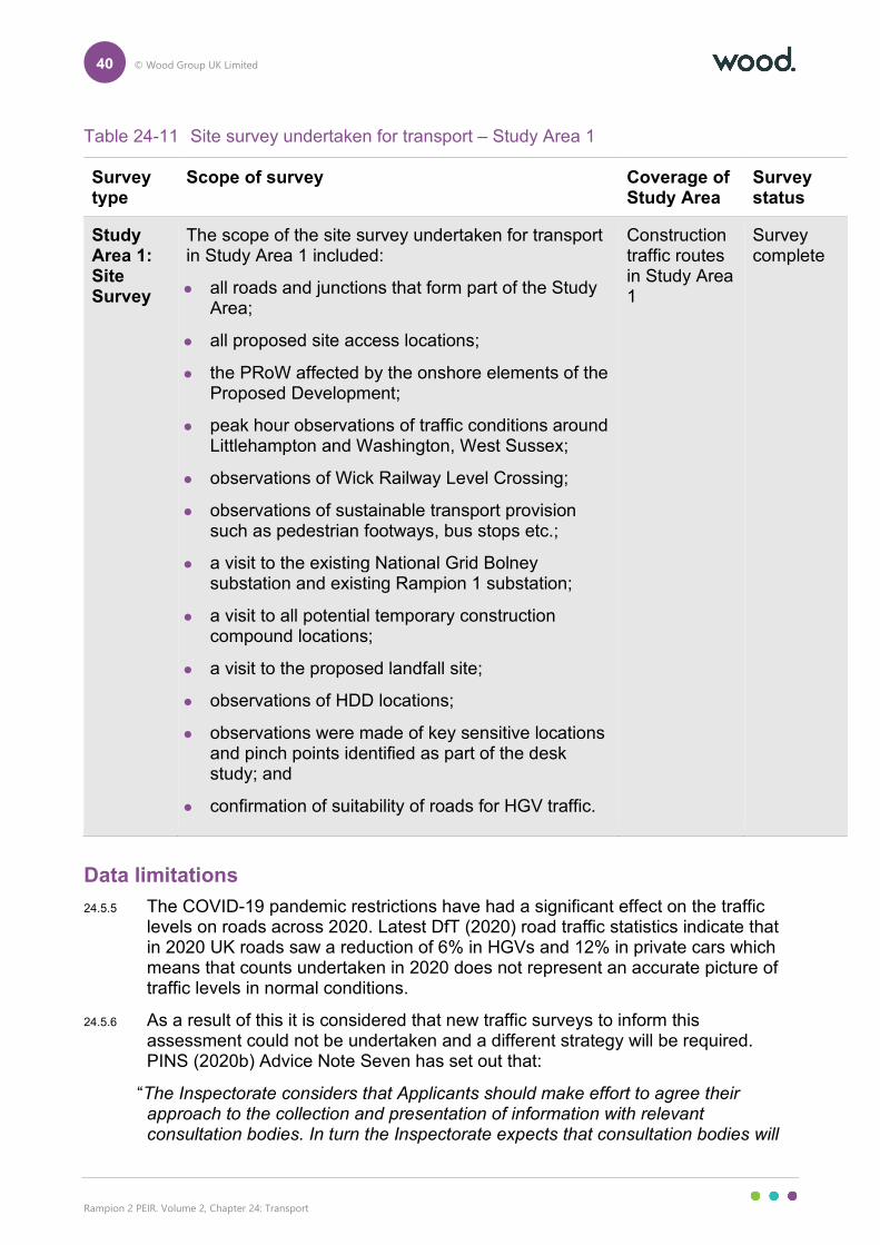
40 © Wood Group UK Limited
Rampion 2 PEIR. Volume 2, Chapter 24: Transport
Table 24-11 Site survey undertaken for transport – Study Area 1
Survey type
Scope of survey Coverage of Study Area
Survey status
Study Area 1: Site Survey
The scope of the site survey undertaken for transport in Study Area 1 included:
all roads and junctions that form part of the Study Area;
all proposed site access locations;
the PRoW affected by the onshore elements of the Proposed Development;
peak hour observations of traffic conditions around Littlehampton and Washington, West Sussex;
observations of Wick Railway Level Crossing;
observations of sustainable transport provision such as pedestrian footways, bus stops etc.;
a visit to the existing National Grid Bolney substation and existing Rampion 1 substation;
a visit to all potential temporary construction compound locations;
a visit to the proposed landfall site;
observations of HDD locations;
observations were made of key sensitive locations and pinch points identified as part of the desk study; and
confirmation of suitability of roads for HGV traffic.
Construction traffic routes in Study Area 1
Survey complete
Data limitations
24.5.5 The COVID-19 pandemic restrictions have had a significant effect on the traffic levels on roads across 2020. Latest DfT (2020) road traffic statistics indicate that in 2020 UK roads saw a reduction of 6% in HGVs and 12% in private cars which means that counts undertaken in 2020 does not represent an accurate picture of traffic levels in normal conditions.
24.5.6 As a result of this it is considered that new traffic surveys to inform this assessment could not be undertaken and a different strategy will be required. PINS (2020b) Advice Note Seven has set out that:
“The Inspectorate considers that Applicants should make effort to agree their approach to the collection and presentation of information with relevant consultation bodies. In turn the Inspectorate expects that consultation bodies will
41 © Wood Group UK Limited
Rampion 2 PEIR. Volume 2, Chapter 24: Transport
work with Applicants to find suitable approaches and points of reference to aid the robust preparation of applications at this time.”
24.5.7 Discussion with WSCC and HE has been undertaken to agree the use of historic traffic data from counts that had been undertaken before 2020 and the first UK national wide lockdown. This approach has been applied to this assessment. It was also agreed that should COVID-19 pandemic restrictions be lifted later in 2021 then site specific traffic data could be surveyed to inform the DCO submission and/or validate the traffic data used in this chapter.
24.6 Baseline conditions
Study Area 1 – onshore
24.6.1 This section provides a description of the baseline conditions of the local and strategic roads which are proposed to be used for access to the onshore elements of the Proposed Development as well as the local PRoW, cycle routes and sustainable travel routes. Figure 24.5, Volume 3 identifies the roads that have been included in this section.
24.6.2 Table 24-12 sets out a high-level review of the Main “A” and “B” Roads included within Study Area 1 and more details on these are presented in the following section.
Table 24-12 A/B roads within Study Area 1
Type of road Road name
A Roads A259, A284, A27, A24, A284, A283, A281, A272, A23
B Roads B2139, B2135, B2116, B2118
Strategic Road Network
A23
24.6.3 The A23 routes from the M23 south of Crawley to the A27 on the northern periphery of Brighton. For much of its length, the A23 is a dual carriageway subject to the national speed limit (70mph). Within Study Area 1, the A23 has junctions with two major roads, the A272 and the A27 as follows:
the junction with the A272 is located east of Bolney and comprises grade separated roundabout junctions located either side of the A23 alignment which connect to the A23 with on/off slips; and
the junction with the A27 is located on the northern periphery of Brighton and comprises a grade separated bell junction with on/off slips which connects to a separate roundabout junction with the A23.
42 © Wood Group UK Limited
Rampion 2 PEIR. Volume 2, Chapter 24: Transport
A27
24.6.4 The section of the A27 that is managed by HE routes between Pevensey in East Sussex to Cosham, Portsmouth where the A27 becomes the M27. The A27 connects numerous coastal towns along the south coast as well as connecting the cities of Portsmouth and Brighton. Road design standards vary along the A27, however, for most of its length the A27 is a dual carriageway subject to the national speed limit.
Local Highway Network
A24
24.6.5 The A24 routes between Worthing on the south coast and London, and routes via towns including Horsham and Leatherhead. Within Study Area 1, the A24 routes through both urban and rural settings. In rural areas the A24 is typically a dual carriageway and is subject to the national speed limit. In urban areas the A24 routes through both residential and commercial areas, and numerous residential and commercial properties front onto the road and there are a number of pedestrian crossing points.
A272
24.6.6 Within Study Area 1, the A272 routes east/west between the A24 and the A23. The A272 intersects with the A24 via a staggered crossroad and junctions with the A23 are via two grade separated roundabouts which connect to the A23 by on/off slips. The A272 is a predominantly a single carriageway rural road throughout Study Area 1. The speed limit varies between national speed limit and 50mph depending on local constraints. A section of the A272 through Cowfold is subject to a 30mph speed limit as the road routes through a village setting. Pedestrian footways are provided and residential properties front onto the A272 throughout Cowfold.
A280 long furlong
24.6.7 The A280 Long Furlong provides a connection between the A24 at Findon and the A27 south of the village of Clapham. The A280 is a single carriageway road which is predominantly subject to the national speed limit and routes through a rural setting. A small section of the A280 through Clapham Village is subject to a 40mph speed limit and a signal controlled crossing is provided adjacent to the local primary school.
A281
24.6.8 The A281 routes between Guildford and the A23 north of Brighton, the road connects multiple towns and villages along its routes including Horsham and Cowfold. Due to the length of the A281 and the numerous settlements that it routes through the road conditions vary throughout. The A281 within Study Area 1 includes a section from Cowfold via Shermanbury to the A281 junction with the B2116. The A281 through this section is a single carriageway road where the speed limit and other conditions vary depending on location.
43 © Wood Group UK Limited
Rampion 2 PEIR. Volume 2, Chapter 24: Transport
24.6.9 Through Cowfold the A281 routes through the centre of the village where commercial properties front onto the road. Pedestrian footways are located on either side of the carriageway within Cowfold centre and on at least one side of the carriageway through the rest of the village, the road is subject to a 30mph speed limit. The A281 junctions with the A272 at two mini roundabout junctions within Cowfold centre and a signal controlled pedestrian crossing are provided.
24.6.10 Through Shermanbury, the A281 is subject to a 40mph speed limit and a pedestrian footway is provided on the eastern side of the carriageway. Residential properties/driveways front onto the A281.
24.6.11 Between Cowfold and Shermanbury the A281 is rural in nature, no pedestrian infrastructure is provided, and the national speed limit applies.
A283
24.6.12 The A283 provides a connection between the A24 at Washington, West Sussex and the A27 at Shoreham-by-Sea. The A283 is a single carriageway which is subject to 50mph and national speed limits at various points along its route. The A283 routes predominantly through rural areas and throughout the town of Steyning, the A283 is located within a cutting which is over bridged by local roads. The A283 intersects with the A27 via a grade separated roundabout and on-off slips.
A284
24.6.13 The A284 routes between Littlehampton and the A29 west of the village of Houghton. The A281 exists in two sections, from Littlehampton to a junction with the A27 at Crossbush and from a junction with the A27 in Arundel to the A29.
24.6.14 The section of the A284 from the A259 in Littlehampton to the A27 at Crossbush is within Study Area 1. This section of the A284 routes through the village of Lyminster and the residential suburb of Wick. In Wick, the A284 routes through a residential area where streetlighting and footways are provided and residential properties and driveways front onto the A284. The road is subject to a 30mph speed limit.
24.6.15 In Lyminster Village, the road is subject to a 30mph speed limit. Pedestrian footways exist throughout the village on at least one side of the carriageway, a small number of residential properties/driveways front onto the A284. North of Lyminster Village, the speed limit increases to 40mph and a pedestrian footway continues on the western side of the carriageway.
A259
24.6.16 The A259 routes along the south coast of England between Havant in Hampshire and Folkestone in Kent. Within Study Area 1, the A259 routes between a roundabout junction with Ford Lane at Climping to a roundabout junction with the B2187 at Toddington.
24.6.17 Between Climping and the junction with the B2187 at Littlehampton (Bridge Road roundabout), the road is a single carriageway which is subject to a 40mph speed limit west of the Ferry Road junction and the national speed limit east of the
44 © Wood Group UK Limited
Rampion 2 PEIR. Volume 2, Chapter 24: Transport
junction. A shared footway/cycleway is provided on the northern side of the carriageway.
24.6.18 Between Bridge Road roundabout and the junction with the A284 (Wick roundabout), the road is subject to the national speed limit and a shared cycleway/footway exists on the northern side of the carriageway between the signal controlled junction with Benjamin Grays Drive and the priority junction with New Courtwick Lane. Between Wick roundabout and the roundabout junction with the B2187 at Toddington the speed limit is reduced to 40mph and pedestrian footways exist on both sides of the carriageway. Residential properties front onto the carriageway through this section.
B2116
24.6.19 The B2116 routes between the A281 north of Henfield to the B2118 at Aldbourne. The B2116 is a single carriageway which predominantly routes through a rural area. The speed limit varies between 30mph,40mph and the national speed limit along the B2118 depending on local constraints. Throughout Aldbourne, the road is subject to a 30mph speed limit and pedestrian footways are provided, residential properties/driveways front onto the road.
B2117
24.6.20 The B2117 is a single carriageway road which routes between the A281 and Pierpoint village. Within the short section of the road included in Study Area 1, the road junctions with the B2118 by a priority junction and junctions with the A23 by means of two priority junctions which serve as on/off slips to the grade separated A23. The B2117 is rural in nature between these junctions and is subject to the national speed limit.
B2118
24.6.21 The B2118 routes between the B2117 at Muddleswood and the A23 north of Sayers Common. The B2118 is a single carriageway and is subject to the national speed limit for much of its route.
24.6.22 Through the village of Aldbourne, the road is subject to a 40mph speed limit, a pedestrian footway is provided on the eastern side of the carriageway and residential properties/driveways front onto the road.
24.6.23 Through the village of Sayers Common, the B2118 is subject to a 30mph speed limit and pedestrian footways are provided on both sides of the carriageway. Residential properties/driveways front onto the B2118 and the road junctions with the B2116 by a roundabout in the centre of the village.
Ford Road
24.6.24 Ford Road is a single carriageway road which routes between the A27 in Arundel and Church Lane in Climping. From a roundabout junction with the A27 to the edge of Arundel, the road routes through a residential area where a 30mph speed limit applies and pedestrian footways are provided. South of Arundel the road is rural in nature and the national speed limit applies. Adjacent to Ford station, Ford
45 © Wood Group UK Limited
Rampion 2 PEIR. Volume 2, Chapter 24: Transport
Road crosses a railway line by means of a level crossing. North of the level crossing a 40mph speed limit is applied to Ford Road which exists for its remaining route to Church Lane in Climping. Between Ford Station and Climping a pedestrian footway exists on the western side of the carriageway.
Church Lane
24.6.25 Church Lane is a single carriageway road which routes between Ford Road in Climping to a roundabout junction with the A259 south of Climping. The road is subject to a 40mph speed limit and a pedestrian footway is provided on the eastern side of the carriageway. A small number of residential properties front onto Church Lane in Climping.
Water Lane
24.6.26 Water Lane is single carriageway rural road which routes between the A283 and Hole Street in Winston. Water Lane is subject to the national speed limit between the junction with the A283 and the periphery of Winston Village. In Winston Village, Water Lane is subject to a 40mph speed limit and a pedestrian footway is provided on the western side of the carriageway.
Kent Street
24.6.27 Kent Street is a single carriageway rural road which routes between the A272 and Wineham Lane and is subject to the national speed limit. There are no pedestrian footways on this rural road.
Wineham Lane
24.6.28 Wineham Lane is a single carriageway rural road which connects the village of Wineham to the A272 to the north and the B2116 to the south. Wineham Lane is subject to the national speed limit for all sections outside Wineham. Throughout Wineham, Wineham Lane is subject to a 40mph speed limit and residential/rural properties and driveways front onto the road.
Rail network
24.6.29 Within Study Area 1 there are two principal railway lines, one line running along the south coast between Brighton and Portsmouth and one line between Horsham and Portsmouth.
24.6.30 The railway line between Brighton and Portsmouth serves coastal towns including Worthing, Lancing and Shoreham-by-Sea. Two branch lines exist which serve Littlehampton and Bognor Regis. From Brighton services can be taken to London or towns further east along the south coast including Eastbourne and Hastings.
24.6.31 From Portsmouth services can be taken to London via Horsham or can be taken to travel further west along the coast to places including Southampton.
46 © Wood Group UK Limited
Rampion 2 PEIR. Volume 2, Chapter 24: Transport
Bus network
24.6.32 Bus services are in operation between the major settlements within Study Area 1. The following bus services operate along roads proposed to be crossed by the onshore cable corridor:
A259 – Service 700;
A284 – Service 9 and A;
A27 – Services 9,69 and A;
A24 – Service A;
A283 – Service 100;
B2116 – Service 3 and 17; and
A281 – Service 17.
24.6.33 The key roads above and the bus services running along them are set out in Figure 24.7, Volume 3.
24.6.34 It should be noted that for all of the bus service interactions with the onshore temporary cable corridor, each road that is used for the service is a two-lane carriageway. For the A259, A27, A24, A283 and A281 it is proposed to HDD the road crossings and as such there will be no surface impacts to the road or delays to any bus service routes on these roads.
24.6.35 Where HDD is not used as method of crossing the road (A284 and B2116), the crossings will be open cut trench as confirmed though commitment C-166. The open cut trenching of a road crossing will occur in a half and half arrangement which will allow bus services to continue their routes though signal control traffic management.
24.6.36 It is considered therefore that the impacts on local bus service provision will not be affected significantly by the Proposed Development and no further consideration is made in this chapter.
PRoW
24.6.37 The onshore temporary cable corridor, onshore substation and landfall as well as temporary and permanent accesses potentially affect a number of PRoWs, one of which is the South Downs Way, a National Trail.
24.6.38 Figure 24.8, Volume 3 sets out the locations of the PRoW in relation to the onshore part of the PEIR Assessment Boundary. To understand the effects of the onshore elements of the Proposed Development an Outline PRoWMP has been developed at PEIR and is provided in Appendix 24.2, Volume 4.
24.6.39 The Outline PRoWMP (Appendix 24.2, Volume 4) has set out in detail each PRoW and area of Open Access Land (OAL) that is currently affected by the onshore part of the PEIR Assessment Boundary. This includes details on the PRoW number, type of effect and whether the effect is likely to be temporary or permanent.
47 © Wood Group UK Limited
Rampion 2 PEIR. Volume 2, Chapter 24: Transport
24.6.40 RED proposes to manage and provide mitigation for each PRoW that is affected by the Proposed Development and a series of environmental measures have been set out which can be applied to different types of PRoW and OAL affected.
24.6.41 Temporary diversions will ensure that the affected PRoW passes around the work areas or run on routes away from the haul roads or cross underground cable sections at safe locations that can be managed
24.6.42 The proposed signage strategies will inform the public of the construction schedule and the implications for each affected PRoW.
24.6.43 The active management of crossing points and shared accesses will be temporary in nature and will required site specific signage to inform the public and construction vehicle drivers.
24.6.44 Prior to the start of the construction, all affected PRoW will be inspected. These routes will also be monitored throughout the duration of the construction phase. At the end of the construction phase, all affected PRoW will be inspected and their condition will be returned to the same as observed during the initial inspection.
24.6.45 Any permanent diversions required as a result of the onshore elements of the Proposed Development will be agreed and implemented through discussions with the relevant local authority where appropriate.
24.6.46 Following feedback from Section 42 consultation, the Outline PRoWMP will be updated and submitted alongside the DCO Application. The Outline PRoWMP will include a detailed list and plans of the mitigation proposals for each of the affected PRoW, including details of the exact route for diversions and durations of closures of existing PRoW.
24.6.47 Between PEIR and ES stage, it is proposed that further work is undertaken alongside the WSCC Countryside PRoW Officer and South Downs National Park to develop an agreeable management and mitigation strategy for the PRoW and OAL affected.
National cycle routes
24.6.48 The onshore cable corridor will cross two parts of the Sustrans NCN:
NCN 2 – Between Littlehampton and Bognor Regis which runs along Ferry Road and then onto the A259; and
NCN 223 – Route crosses the NCN just south of Partridge Green as NCN223 runs along an old rail line route.
24.6.49 NCN 2 will not experience direct impacts as a result of the Proposed Development as the A259 is proposed to have the cable installed by HDD in that location. NCN 223 is also along a PRoW and the impact, effects and environmental measures at this location are considered in the Outline PRoWMP in further detail (Appendix 24.2, Volume 4). Figure 24.9, Volume 3 sets out the two NCN routes in relation to Rampion 2.
48 © Wood Group UK Limited
Rampion 2 PEIR. Volume 2, Chapter 24: Transport
Baseline traffic flows
24.6.50 It has been agreed with WSCC highways officers that baseline traffic flows can be derived from existing traffic counts, most of which is taken from either permanent count locations maintained by WSCC/DfT or one-off counts within the WSCC (2020b) online traffic count database. For most locations this has resulted in the use of data from 2019.
24.6.51 In some locations where the available traffic data is older, WSCC has confirmed that this is acceptable and that TEMPro could be used to inform growth.
24.6.52 Only one location, Ferry Road, has no baseline historic data that can be used and for the purposes of the PEIR assessment has not been assessed in detail. At ES stage, it is anticipated that traffic counts will be undertaken at this location and a formal assessment can take place.
24.6.53 In agreement with WSCC, growth rates have been derived from the DfT’s TEMPro 7.2. Growth rates for HGVs have been derived from the DfT (2020) National Traffic Statistics. A base year of 2021 has been used to growth up to for the baseline traffic counts.
24.6.54 Growth rates from TEMPro have been based on two areas: Arun for the south west sections (code, E41000245) and Horsham for the remainder of Study Area 1 (code E41000248).
24.6.55 The TEMPro growth rates are as follows:
2012 – 2021 – Arun – 1.1387 – Horsham – 1.1468;
2013 – 2021 – Arun – 1.1232 – Horsham – 1.1292;
2017 - 2021 – Arun – 1.0607 – Horsham – 1.0608;
2018 - 2021 - Arun – 1.0454 – Horsham – 1.0454; and
2019 – 2021 – Arun – 1.0305 – Horsham – 1.0306.
24.6.56 HGV growth has been based on the DfT (2021) publication ‘TRA2501c - Road traffic (vehicle miles) by vehicle type in Great Britain’. Table TRA2501c presents national data of the yearly change in vehicle traffic for total vehicles, car, light commercial vehicles and HGVs.
24.6.57 Based on Table TRA2501c, annual growth factors for HGVs have been derived as follows:
the changes in HGV traffic flows between 2019 (last reliable year of data due to the COVID-19 pandemic) and the base year of 2021 has been calculated;
the growth factor for from 2018 to 2019 was 0.38%;
estimated growth between 2019 and 2021 is assumed as 0.38% per annum, or 0.76% over the two years; and
the growth for 2019 – 2021 (0.76% has been added to the growth from the historic count year to 2019 to provide for a growth from historic count year to 2021).
49 © Wood Group UK Limited
Rampion 2 PEIR. Volume 2, Chapter 24: Transport
24.6.58 It should be noted the traffic count for A283 (East of A24) is dated (2005). As TEMPro does not extend as far back as 2005 an alternative method based on the DfT statistics has been used as discussed and agreed with WSCC.
24.6.59 The calculations above presented the following growth rates for HGVs:
2005 – 2021 - 0.9755;
2012 – 2021 – 1.0778;
2013 – 2021 – 1.10180;
2017 – 2021 - 1.0270;
2018 – 2021 - 1.0160; and
2019 – 2021 – 1.00750.
24.6.60 For locations where total vehicle traffic data was extracted from existing counts but where there were no HGV breakdowns in these counts a HGV percentage was required to allow to develop a HGV traffic flow at these locations. There were three locations where this was an issue as follows;
Highways Link 10 – Crossbush Lane;
Highways Link 17 – A283 East of A24; and
Highways Link 29 – B2188, Sayers Common.
24.6.61 At all three of these locations, the historic traffic data only present a breakdown of total vehicles. In order to understand a likely HGV percentage on these highways links, reference has been made to adjacent historic traffic counts as follows:
Highways Link 10 – Crossbush Lane – 2% HGVs based on Highways Link 8 data;
Highways Link 17 – A283 East of A24 – 3.4% HGVs based on Highways Link 16 data; and
Highways Link 29 – B2188, Sayers Common – 4.7% HGVs based on Highways Link 32 data.
24.6.62 Table 24-13 sets out the average annual weekday flow (AADF) for the date of survey and the current baseline (2021).
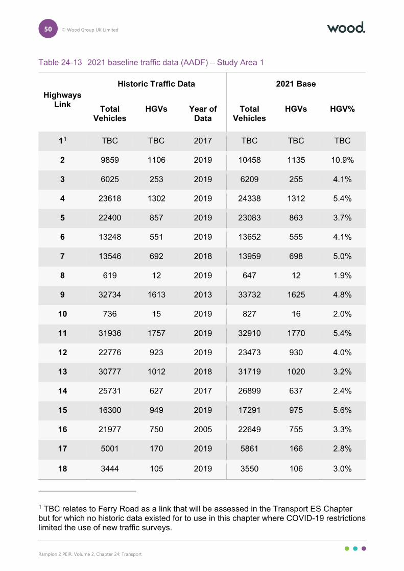
50 © Wood Group UK Limited
Rampion 2 PEIR. Volume 2, Chapter 24: Transport
Table 24-13 2021 baseline traffic data (AADF) – Study Area 1
Highways Link
Historic Traffic Data 2021 Base
Total Vehicles
HGVs Year of Data
Total Vehicles
HGVs HGV%
11 TBC TBC 2017 TBC TBC TBC
2 9859 1106 2019 10458 1135 10.9%
3 6025 253 2019 6209 255 4.1%
4 23618 1302 2019 24338 1312 5.4%
5 22400 857 2019 23083 863 3.7%
6 13248 551 2019 13652 555 4.1%
7 13546 692 2018 13959 698 5.0%
8 619 12 2019 647 12 1.9%
9 32734 1613 2013 33732 1625 4.8%
10 736 15 2019 827 16 2.0%
11 31936 1757 2019 32910 1770 5.4%
12 22776 923 2019 23473 930 4.0%
13 30777 1012 2018 31719 1020 3.2%
14 25731 627 2017 26899 637 2.4%
15 16300 949 2019 17291 975 5.6%
16 21977 750 2005 22649 755 3.3%
17 5001 170 2019 5861 166 2.8%
18 3444 105 2019 3550 106 3.0%
1 TBC relates to Ferry Road as a link that will be assessed in the Transport ES Chapter but for which no historic data existed for to use in this chapter where COVID-19 restrictions limited the use of new traffic surveys.
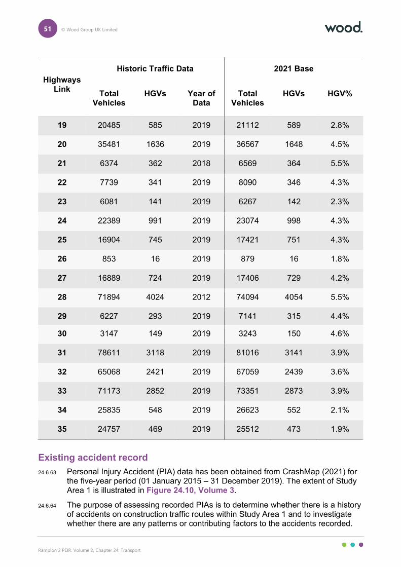
51 © Wood Group UK Limited
Rampion 2 PEIR. Volume 2, Chapter 24: Transport
Highways Link
Historic Traffic Data 2021 Base
Total Vehicles
HGVs Year of Data
Total Vehicles
HGVs HGV%
19 20485 585 2019 21112 589 2.8%
20 35481 1636 2019 36567 1648 4.5%
21 6374 362 2018 6569 364 5.5%
22 7739 341 2019 8090 346 4.3%
23 6081 141 2019 6267 142 2.3%
24 22389 991 2019 23074 998 4.3%
25 16904 745 2019 17421 751 4.3%
26 853 16 2019 879 16 1.8%
27 16889 724 2019 17406 729 4.2%
28 71894 4024 2012 74094 4054 5.5%
29 6227 293 2019 7141 315 4.4%
30 3147 149 2019 3243 150 4.6%
31 78611 3118 2019 81016 3141 3.9%
32 65068 2421 2019 67059 2439 3.6%
33 71173 2852 2019 73351 2873 3.9%
34 25835 548 2019 26623 552 2.1%
35 24757 469 2019 25512 473 1.9%
Existing accident record
24.6.63 Personal Injury Accident (PIA) data has been obtained from CrashMap (2021) for the five-year period (01 January 2015 – 31 December 2019). The extent of Study Area 1 is illustrated in Figure 24.10, Volume 3.
24.6.64 The purpose of assessing recorded PIAs is to determine whether there is a history of accidents on construction traffic routes within Study Area 1 and to investigate whether there are any patterns or contributing factors to the accidents recorded.
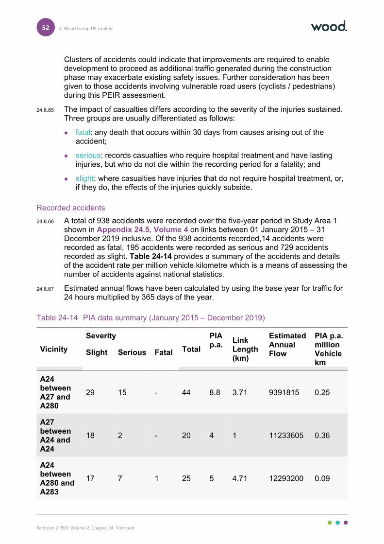
52 © Wood Group UK Limited
Rampion 2 PEIR. Volume 2, Chapter 24: Transport
Clusters of accidents could indicate that improvements are required to enable development to proceed as additional traffic generated during the construction phase may exacerbate existing safety issues. Further consideration has been given to those accidents involving vulnerable road users (cyclists / pedestrians) during this PEIR assessment.
24.6.65 The impact of casualties differs according to the severity of the injuries sustained. Three groups are usually differentiated as follows:
fatal: any death that occurs within 30 days from causes arising out of the accident;
serious: records casualties who require hospital treatment and have lasting injuries, but who do not die within the recording period for a fatality; and
slight: where casualties have injuries that do not require hospital treatment, or, if they do, the effects of the injuries quickly subside.
Recorded accidents
24.6.66 A total of 938 accidents were recorded over the five-year period in Study Area 1 shown in Appendix 24.5, Volume 4 on links between 01 January 2015 – 31 December 2019 inclusive. Of the 938 accidents recorded,14 accidents were recorded as fatal, 195 accidents were recorded as serious and 729 accidents recorded as slight. Table 24-14 provides a summary of the accidents and details of the accident rate per million vehicle kilometre which is a means of assessing the number of accidents against national statistics.
24.6.67 Estimated annual flows have been calculated by using the base year for traffic for 24 hours multiplied by 365 days of the year.
Table 24-14 PIA data summary (January 2015 – December 2019)
Vicinity
Severity
Total
PIA p.a.
Link Length (km)
Estimated Annual Flow
PIA p.a. million Vehicle km
Slight Serious Fatal
A24 between A27 and A280
29 15 - 44 8.8 3.71 9391815 0.25
A27 between A24 and A24
18 2 - 20 4 1 11233605 0.36
A24 between A280 and A283
17 7 1 25 5 4.71 12293200 0.09
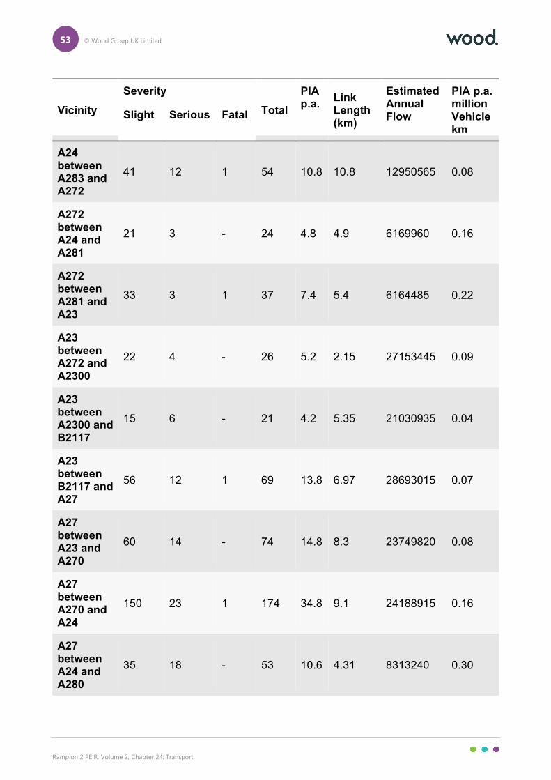
53 © Wood Group UK Limited
Rampion 2 PEIR. Volume 2, Chapter 24: Transport
Vicinity
Severity
Total
PIA p.a.
Link Length (km)
Estimated Annual Flow
PIA p.a. million Vehicle km
Slight Serious Fatal
A24 between A283 and A272
41 12 1 54 10.8 10.8 12950565 0.08
A272 between A24 and A281
21 3 - 24 4.8 4.9 6169960 0.16
A272 between A281 and A23
33 3 1 37 7.4 5.4 6164485 0.22
A23 between A272 and A2300
22 4 - 26 5.2 2.15 27153445 0.09
A23 between A2300 and B2117
15 6 - 21 4.2 5.35 21030935 0.04
A23 between B2117 and A27
56 12 1 69 13.8 6.97 28693015 0.07
A27 between A23 and A270
60 14 - 74 14.8 8.3 23749820 0.08
A27 between A270 and A24
150 23 1 174 34.8 9.1 24188915 0.16
A27 between A24 and A280
35 18 - 53 10.6 4.31 8313240 0.30
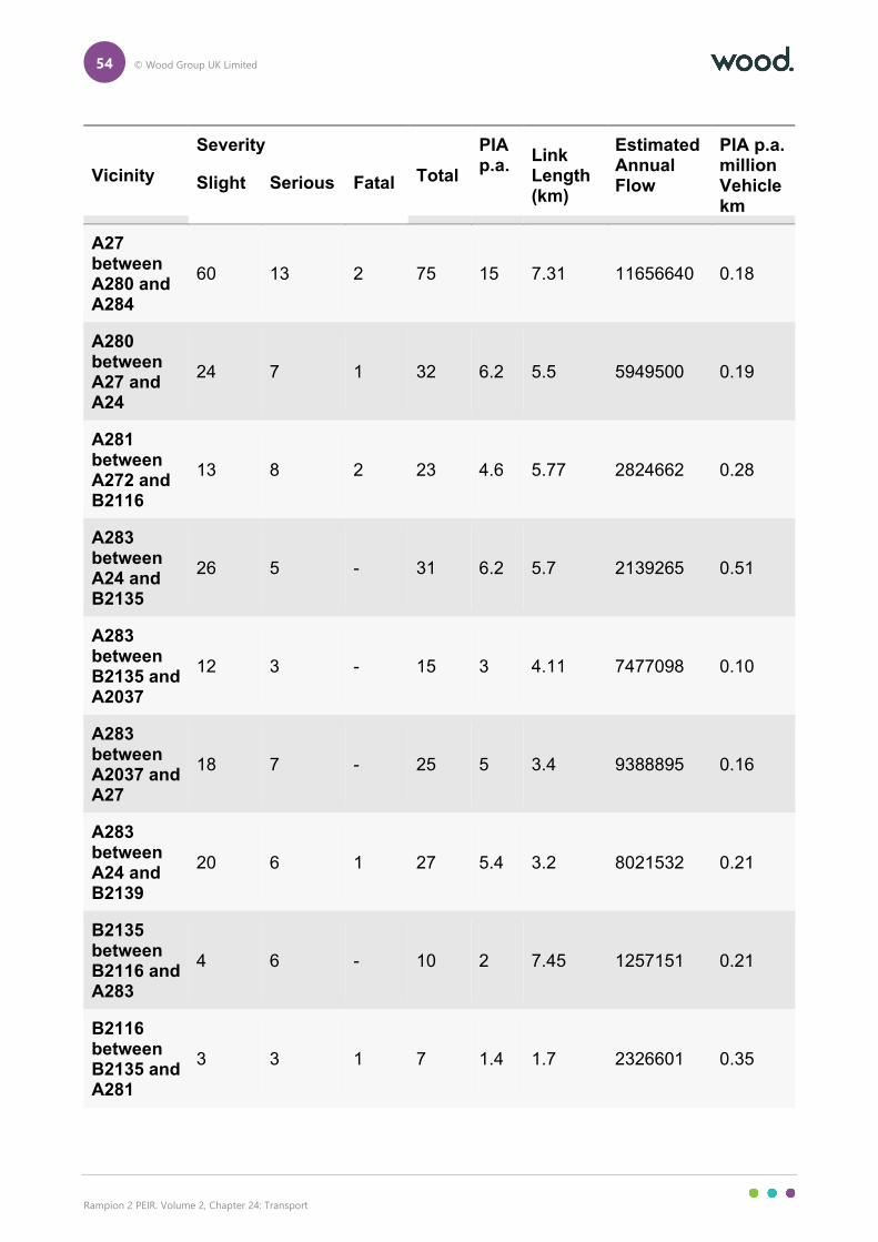
54 © Wood Group UK Limited
Rampion 2 PEIR. Volume 2, Chapter 24: Transport
Vicinity
Severity
Total
PIA p.a.
Link Length (km)
Estimated Annual Flow
PIA p.a. million Vehicle km
Slight Serious Fatal
A27 between A280 and A284
60 13 2 75 15 7.31 11656640 0.18
A280 between A27 and A24
24 7 1 32 6.2 5.5 5949500 0.19
A281 between A272 and B2116
13 8 2 23 4.6 5.77 2824662 0.28
A283 between A24 and B2135
26 5 - 31 6.2 5.7 2139265 0.51
A283 between B2135 and A2037
12 3 - 15 3 4.11 7477098 0.10
A283 between A2037 and A27
18 7 - 25 5 3.4 9388895 0.16
A283 between A24 and B2139
20 6 1 27 5.4 3.2 8021532 0.21
B2135 between B2116 and A283
4 6 - 10 2 7.45 1257151 0.21
B2116 between B2135 and A281
3 3 1 7 1.4 1.7 2326601 0.35
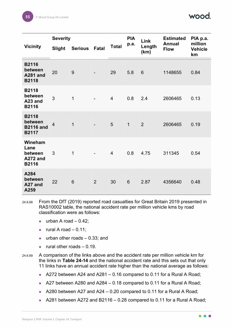
55 © Wood Group UK Limited
Rampion 2 PEIR. Volume 2, Chapter 24: Transport
Vicinity
Severity
Total
PIA p.a.
Link Length (km)
Estimated Annual Flow
PIA p.a. million Vehicle km
Slight Serious Fatal
B2116 between A281 and B2118
20 9 - 29 5.8 6 1148655 0.84
B2118 between A23 and B2116
3 1 - 4 0.8 2.4 2606465 0.13
B2118 between B2116 and B2117
4 1 - 5 1 2 2606465 0.19
Wineham Lane between A272 and B2116
3 1 - 4 0.8 4.75 311345 0.54
A284 between A27 and A259
22 6 2 30 6 2.87 4356640 0.48
24.6.68 From the DfT (2019) reported road casualties for Great Britain 2019 presented in RAS10002 table, the national accident rate per million vehicle kms by road classification were as follows:
urban A road – 0.42;
rural A road – 0.11;
urban other roads – 0.33; and
rural other roads – 0.19.
24.6.69 A comparison of the links above and the accident rate per million vehicle km for the links in Table 24-14 and the national accident rate and this sets out that only 11 links have an annual accident rate higher than the national average as follows:
A272 between A24 and A281 – 0.16 compared to 0.11 for a Rural A Road;
A27 between A280 and A284 – 0.18 compared to 0.11 for a Rural A Road;
A280 between A27 and A24 – 0.20 compared to 0.11 for a Rural A Road;
A281 between A272 and B2116 – 0.28 compared to 0.11 for a Rural A Road;
56 © Wood Group UK Limited
Rampion 2 PEIR. Volume 2, Chapter 24: Transport
A283 between A24 and B2135 – 0.51 compared to 0.11 for Rural A Road;
A283 between A2037 and A27 – 0.16 compared to 0.11 for Rural A Road;
B2135 between B2116 and A283 – 0.21 compared to 0.19 for a Rural Other Road;
B2116 between B2135 and A281 – 0.25 compared to 0.33 for Urban Other Road;
B2116 between A281 and B2118 – 0.84 compared to 0.19 for a Rural Other Road;
Wineham Lane between A272 and B2116 – 0.54 compared to 0.19 for a Rural Other Road; and
A284 between A27 and A259 – 0.48 compared to 0.42 for Urban A Road.
24.6.70 It should be noted that for the 11 links where these accident rates are higher, they may be distorted by several factors and should be treated with caution. For seven of the locations the accident rates are only 0.02 and 0.09 above the national average which will not be perceptively different and with daily traffic variations will be around the national averages. Some of the routes are also a mixture of differing road types though sections of urban and rural locations.
24.6.71 The remaining four locations where accident rates were higher than the national average are set out in further detail below:
A281 between A272 and B2116 – Annual Accident rate of 0.28 compared to 0.11 for a rural A Road – Much of this section and the locations of the accidents were recorded in the settlement of Cowfold and it might be more accurate to compare it to an Urban A road rate of 0.42 which will indicate the link below national average;
A283 between A24 and B2135 – Annual Accident rate of 0.51 compared to 0.11 for a rural A Road – This section includes the A283 junction with the A24 which is a busy location in Washington, West Sussex and includes for accidents on the approach to the junction which might distort the results for the entire section;
B2116 between A281 and B2118 – Annual Accident rate of 0.84 compared to a 0.19 rural other road – The accidents on this link are spread evenly along the 6km section of road and have various causes leading to a high accident rate. This route is only proposed to accommodate limited HGV traffic from the development based on the HGV Access Strategy and as such project impacts are minimal; and
Wineham Lane – Annual Accident Rate of 0.54 compared to a 0.19 for rural other road – Wineham Lane has a very low traffic base and has only recorded 4 accidents in the 5 years assessed. Only one of these accidents is on Wineham Lane between the proposed onshore substation access and the A283.
24.6.72 At PEIR stage, road safety has been assessed on a highway link basis, which will be enhanced further for the DCO submission should a TA be required. Based on the assessment above and the justification for locations where accident rates are
57 © Wood Group UK Limited
Rampion 2 PEIR. Volume 2, Chapter 24: Transport
calculated to be above national averages for the type of road, it is not considered there is a significant accident record on the local highways network in Study Area 1. Post PEIR the accident assessment will also be updated with detailed accident data which will break down the nature of all accidents in Study Area 1 to allow for a more refined assessment.
Study Area 2 – onshore impacts of offshore works
24.6.73 This section provides a description of the baseline conditions of the local and strategic roads which are proposed to be used for access to the onshore elements of the offshore operation and maintenance phase (access to Port of Newhaven) of the Proposed Development Figure 24.6, Volume 3 identifies the roads that have been included in this section.
24.6.74 Table 24-15 sets out a high-level review of the main “A” and “B” Roads included within Study Area 2 and more details on these are presented in the following section.
Table 24-15 A/B Roads within Study Area 2
Type of Road Road Name
A Roads A27, A26, A259
B Roads B2109
Strategic Road Network
A27
24.6.75 The section of the A27 that is managed by HE routes between Pevensey in East Sussex to Cosham, Portsmouth where the A27 becomes the M27. The A27 connects numerous coastal towns along the south coast as well as connecting the cities of Portsmouth and Brighton. Road design standards vary along the A27, however, for most of its length the A27 is a dual carriageway subject to the national speed limit. Within Study Area 2, the junction with the A26 is located at Beddingham.
Local Road Network
Beach Road/Clifton Road/Railway Road
24.6.76 Beach Road/Clifton Road/Railway Road is a two lane single carriageway urban road which connects the East Quay of Newhaven Port to the A26/B2109. The road is subject to a 30mph speed limit. In the southern section (Beach Road) the route is industrial in nature but passes through residential areas on the Clifton Road and Railway Road section. The route has footways on both sides and is provided with streetlights.
58 © Wood Group UK Limited
Rampion 2 PEIR. Volume 2, Chapter 24: Transport
B2109
24.6.77 The B2109 is a two-lane single carriageway that runs from the A26 routing south to the A259 where it runs parallel for a section before splitting from the A259 where the A259 has an overpass near Newhaven Town rail station. In the facility of Study Area 2, the B2109 runs between the two junctions at either side of the A259 overpass and is provided with footways, pedestrian crossings (under signal control) and streetlights. The B2109is subject to a 30mph speed limit. The B2109 also has an at grade signal rail crossing to the east of the junction with Railway Road.
A259
24.6.78 The A259 routes along the south coast of England between Havant in Hampshire and Folkestone in Kent. Within Study Area 2, the A259 routes Newhaven Town Centre and a junction with McKinley Way.
24.6.79 In Study Area 2, the A259is a two lane single carriageway which for the most part is a flyover between McKinley Way and Newhaven Town Centre. The A259 is subject to a 30mph and has footways either side of road apart from the flyover section. The A259 also has streetlights and west of the flyover section has a signalised crossing of the River Ouse to accommodate the swing bridge operation.
A26
24.6.80 The A26 is a two lane single carriageway in Study Area 2 that links Newhaven Maidstone, Kent and a primary route in the south east of England.
24.6.81 In Study Area 2, the A26 links to the B2109/A259 in Newhaven and routes north to a roundabout junction with the A27. The road is subject to the national speed limit (NSL) outside of settlements but reduces to 40mph in South Heighton and 30mph in Newhaven. The A26 has footways and streetlights in the major settlements but is not provided with footways in the rural sections.
Newhaven Port New Access Road
24.6.82 Although this scheme is not currently complete it is approaching the final stages of works on site to provide a new access road to Newhaven East Quay. The 700m road is proposed from a roundabout at the southern end of McKinley Road over the Newhaven to Seaford railway line and a Mill Creek to a new roundabout just west of the existing Rampion 1 project operation and maintenance centre.
24.6.83 Newhaven Port New Access Road is proposed to be a two-lane single carriageway and will be provided with footways and a shared cycle route as well as streetlights and is proposed to be open in advance of the first construction year of Rampion 2. As such this is considered as part of the existing baseline
McKinley Road
24.6.84 McKinley Road is a 650m two lane single carriageway which runs from a roundabout junction with the A259 to a new port roundabout with access roads into warehouse sites to the south. McKinley Road has footways and a segregated cycle lane. McKinley Road is subject to a 30mph speed limit. McKinley Road will
59 © Wood Group UK Limited
Rampion 2 PEIR. Volume 2, Chapter 24: Transport
lead into the Newhaven Port New Access Road. It is likely this new access road will also be named McKinley Road when it opens however, this has not been confirmed as of March 2021.
Bus network
24.6.85 Bus services are in operation between the major settlements within Study Area 2. The following bus services operate along roads proposed to be used by traffic related to the offshore works:
A259 – Service 12 (Newhaven to Brighton), 14, 123, 145;
B2109 – Service 12 (Newhaven to Brighton), 14, 123, 145; and
A26 – In Newhaven the 12A and 145 but no major bus routes run north of Heighton on the A26.
24.6.86 The key roads above and the bus services running along them are set out in Figure 24.11, Volume 3.
24.6.87 The only impacts on the local bus services will be related to increased delay on local roads as result of the development proposals at Newhaven Port. Traffic generation set out in Section 24.11 indicates low traffic generation in the operation and maintenance phase of the offshore elements of the Proposed Development and as such it is considered that the impacts on local bus service provision will not be affected significantly by the Proposed Development and no further consideration is made in this chapter.
National cycle routes
24.6.88 In the vicinity of the Proposed Development at Newhaven Port the nearest element of the national cycle network is NCN 2 which runs along the B2109 across the junction with Railway Road. Figure 24.12, Volume 3 sets out the NCN routes in relation to Study Area 2. It is not anticipated there will be any impacts on NCN 2 as a result of the operation and maintenance phase of the Proposed Development as the crossing of McKinley Way by NCN2 is provided with a kerbed central island and dropped crossings.
Baseline traffic
24.6.89 The approach to the collation of baseline traffic for Study Area 2 is the same as Study Area 1 and historic traffic data has been used, derived from the DfT traffic data.
24.6.90 Growth rates for total vehicles have been derived from the DfT’s TEMPro 7.2. A base year of 2021 has been used to growth up to for the baseline traffic counts. Growth rates from TEMPro have been based TEMPro rates for Lewes 008/009 within the database which covers the town of Newhaven. The TEMPro growth rates are as follows:
2018 - 2021 - Newhaven – 1.929675.
24.6.91 HGV growth has been based on the DfT (2021) publication ‘TRA2501c - Road traffic (vehicle miles) by vehicle type in Great Britain’. Table TRA2501c presents
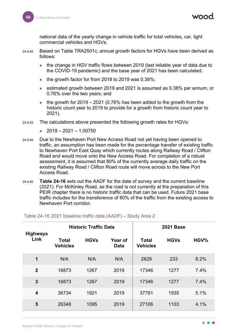
60 © Wood Group UK Limited
Rampion 2 PEIR. Volume 2, Chapter 24: Transport
national data of the yearly change in vehicle traffic for total vehicles, car, light commercial vehicles and HGVs.
24.6.92 Based on Table TRA2501c, annual growth factors for HGVs have been derived as follows:
the change in HGV traffic flows between 2019 (last reliable year of data due to the COVID-19 pandemic) and the base year of 2021 has been calculated;
the growth factor for from 2018 to 2019 was 0.38%;
estimated growth between 2019 and 2021 is assumed as 0.38% per annum, or 0.76% over the two years; and
the growth for 2019 – 2021 (0.76% has been added to the growth from the historic count year to 2019 to provide for a growth from historic count year to 2021).
24.6.93 The calculations above presented the following growth rates for HGVs:
2019 – 2021 – 1.00750
24.6.94 Due to the Newhaven Port New Access Road not yet having been opened to traffic, an assumption has been made for the percentage transfer of existing traffic to Newhaven Port East Quay which currently routes along Railway Road / Clifton Road and would move onto the New Access Road. For completion of a robust assessment, it is assumed that 80% of the currently average daily traffic on the existing Railway Road / Clifton Road route will move across to the New Port Access Road.
24.6.95 Table 24-16 sets out the AADF for the date of survey and the current baseline (2021). For McKinley Road, as the road is not currently at the preparation of this PEIR chapter there is no historic traffic data that can be used. Future 2021 base traffic includes for the transference of 80% of the traffic from the existing access to Newhaven Port corridor.
Table 24-16 2021 baseline traffic data (AADF) – Study Area 2
Highways Link
Historic Traffic Data 2021 Base
Total Vehicles
HGVs Year of Data
Total Vehicles
HGVs HGV%
1 N/A N/A N/A 2829 233 8.2%
2 16873 1267 2019 17346 1277 7.4%
3 16873 1267 2019 17346 1277 7.4%
4 36734 1921 2019 37781 1935 5.1%
5 26348 1095 2019 27106 1103 4.1%
61 © Wood Group UK Limited
Rampion 2 PEIR. Volume 2, Chapter 24: Transport
24.7 Future baseline
Study Area 1 – Onshore works
Traffic growth
Construction impacts
24.7.1 To understand the future year of assessment for the assessment of transport effects in the construction phase, the traffic generation calculations were interrogated (as set out in Section 24.8) to understand the peak weeks for all receptors on highways links. This work provided that all peak weeks required to be assessed in this chapter occurred weeks 53 to 136 of the construction programme for the onshore elements of the Proposed Development which, based on current delivery timescales, places future years of assessment in 2026 and 2027.
24.7.2 It has been agreed with WSCC and HE that growth rates can be derived from TEMPro and there is no requirement to include committed development or Local Plan allocations as the growth within the TEMPro estimates will account for traffic growth related to future development in the area through local plan allocations.
24.7.3 The growth rates from TEMPro are as follows:
2021 – 2026 – Arun – 1.0746/Horsham – 1.0788; and
2021 – 2027 – Arun – 1.0831/Horsham – 1.0868.
24.7.4 The HGV growth rates derived from the DfT Transport Statistics are as follows:
2021 – 2026 – 1.075; and
2021 – 2027 – 1.093.
24.7.5 The resultant future year traffic generation is set out in Table 24-7 later in this chapter.
Decommissioning impacts
24.7.6 The temporal scope of the assessment of the decommissioning phase is based on the peak period of traffic during the onshore substation removal. It is currently predicted that the onshore substation will be decommissioned around 30 years from the Proposed Development commission. The onshore substation is proposed to be built in year two to five of the construction programme. Based on the assessments set out on this chapter year five will be 2029 and 30 years from then will be 2059.
24.7.7 It has been agreed with WSCC and HE that growth rates can be derived from TEMPro and there is no requirement to include committed development or local plan allocations as the growth within the TEMPro estimates will account for traffic growth related to future development in the area through local plan allocations. For the decommissioning phase impacts assessment, TEMPro rates have been extracted from the Horsham.
62 © Wood Group UK Limited
Rampion 2 PEIR. Volume 2, Chapter 24: Transport
24.7.8 TEMPro only provide traffic estimates to 2051 as such this is the latest year a reliable traffic growth estimate can be made. It is considered that for the purpose of assessment for decommissioning in this chapter 2051 is used for assessment.
24.7.9 The growth rates from TEMPro are as follows:
2021 – 2051 – Horsham – 1.22.
24.7.10 The HGV growth rates derived from the DfT Transport Statistics based on the construction phase HGV growth methodology will result in HGV growth of 1.55% per year which over 30 years to 2051 will result an increase in HGVs of 46.50%. Although this almost doubling of HGVs in 30 years may not be achieved (recent years HGV growth has slowed) it has been used for calculations in this chapter for consistency with other assessments in this chapter.
2021 – 2051 – 1.4650.
24.7.11 The resultant future year traffic generation is set out in Table 24-37 later in this chapter.
Future highways network changes (construction and decommissioning phases)
24.7.12 During initial consultation WSCC confirmed that there are no highways schemes that will need to be considered in the assessment.
24.7.13 WSCC commented that the Arundel Bypass is being promoted by HE but is not a committed development. With no direct impacts of onshore elements of the Proposed Development across the proposed route of the A27 Arundel Bypass, the only effects of the onshore elements of the Proposed Development on the bypass will be the additional traffic generated during the construction phase. Highways Link 9 (As shown in Figure 24.20, Volume 4) has been selected to provide HE with an idea of the peak construction traffic on the A27 which will switch to an open A27 Arundel Bypass. However, as the A27 Arundel Bypass is not yet committed no cumulative effects assessment has been included at PEIR. Should discussions with HE post PEIR require this assessment it will be provided for ES/DCO submission.
Study Area 2 – Onshore impacts of offshore works
Traffic growth
24.7.14 Onshore impacts of the offshore operation and maintenance phase are proposed to start in the first year of commission. With the construction phase ending in 2029, a future year of assessment of 2030 for this operation and maintenance phase has been assumed for assessment in this chapter.
24.7.15 It has been agreed with WSCC and HE that growth rates can be derived from TEMPro and there is no requirement to include committed development or Local Plan allocations as the growth within the TEMPro estimates will account for traffic growth related to future development in the area and it is proposed to continue that approach for Study Area 2. The growth rates are based on the Newhaven (TEMPro data set Lewes 008/009) location in TEMPro as that is where the candidate port is located.
63 © Wood Group UK Limited
Rampion 2 PEIR. Volume 2, Chapter 24: Transport
24.7.16 The growth rates from TEMPro are as follows:
2021 – 2030 – 1.0746.
24.7.17 The HGV growth rates derived from the DfT Transport Statistics are as follows:
2021 – 2030 – 1.1395.
24.7.18 The resultant future year traffic generation is set out in Table 24-36 later in this chapter.
24.8 Basis for PEIR assessment
Maximum design scenario
24.8.1 Assessing using a parameter-based design envelope approach means that the assessment considers a maximum design scenario whilst allowing the flexibility to make improvements in the future in ways that cannot be predicted at the time of submission of the DCO Application. The assessment of the maximum adverse scenario for each receptor establishes the maximum potential adverse impact and as a result impacts of greater adverse significance will not arise should any other development scenario (as described in Chapter 4) to that assessed within this chapter be taken forward in the final scheme design.
24.8.2 The maximum assessment assumptions that are relevant to transport are outlined in Table 24-17 below and are in line with the Project Design Envelope (Chapter 4).
Table 24-17 Maximum assessment assumptions for impacts on transport
Project phase and activity/ impact
Maximum assessment assumptions Justification
Onshore – Construction
Landfall
Permanent landfall site.
Underground cable from onshore to offshore.
Landfall construction compound
• Compound dimensions: 100m x 75m (length and width).
• 6 months construction duration.
• Permanent access to Ferry Road.
Onshore cable corridor:
• Up to 50m wide temporary construction corridor within the onshore part of the PEIR Assessment
The maximum assessment assumptions are the elements of the Proposed Development that will generate the maximum number of vehicles that could be generated from the construction phase affecting the local and strategic highways network.
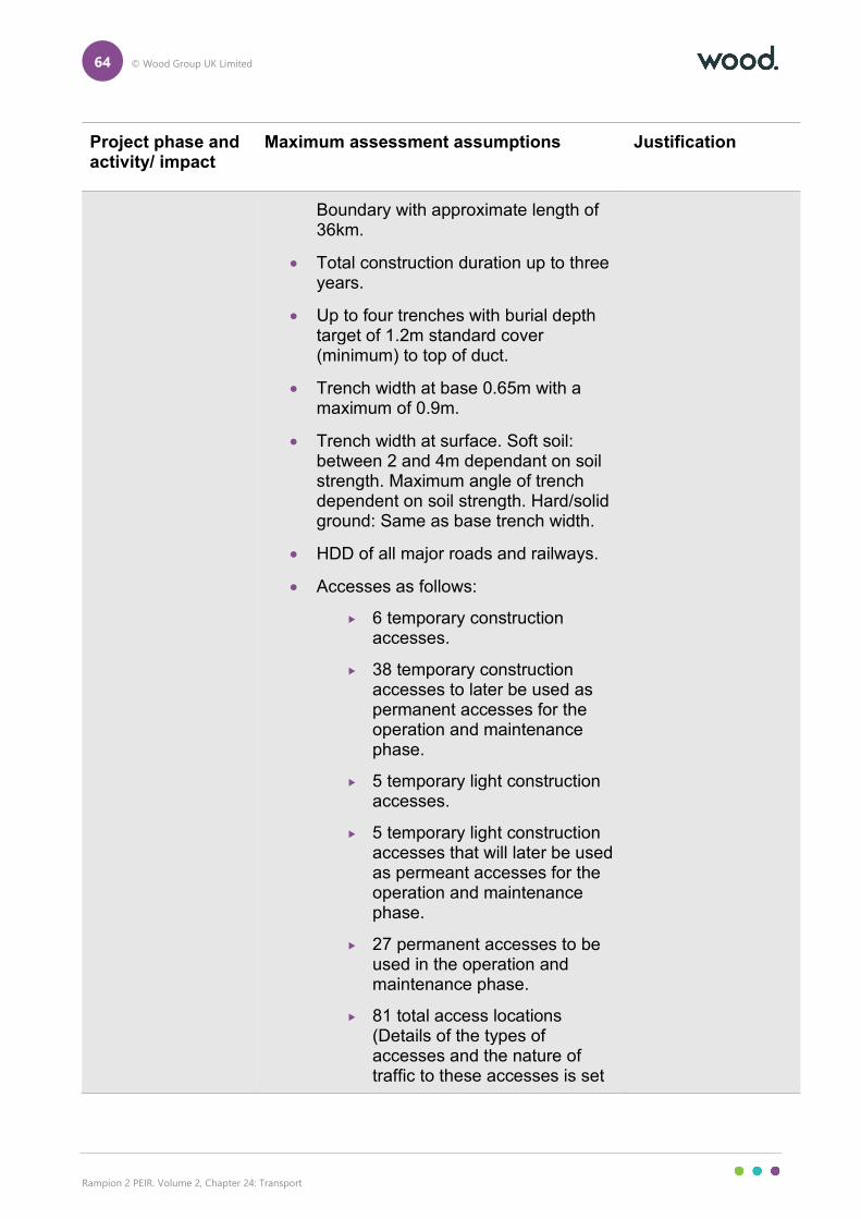
64 © Wood Group UK Limited
Rampion 2 PEIR. Volume 2, Chapter 24: Transport
Project phase and activity/ impact
Maximum assessment assumptions Justification
Boundary with approximate length of 36km.
• Total construction duration up to three years.
• Up to four trenches with burial depth target of 1.2m standard cover (minimum) to top of duct.
• Trench width at base 0.65m with a maximum of 0.9m.
• Trench width at surface. Soft soil: between 2 and 4m dependant on soil strength. Maximum angle of trench dependent on soil strength. Hard/solid ground: Same as base trench width.
• HDD of all major roads and railways.
• Accesses as follows:
6 temporary construction accesses.
38 temporary construction accesses to later be used as permanent accesses for the operation and maintenance phase.
5 temporary light construction accesses.
5 temporary light construction accesses that will later be used as permeant accesses for the operation and maintenance phase.
27 permanent accesses to be used in the operation and maintenance phase.
81 total access locations (Details of the types of accesses and the nature of traffic to these accesses is set
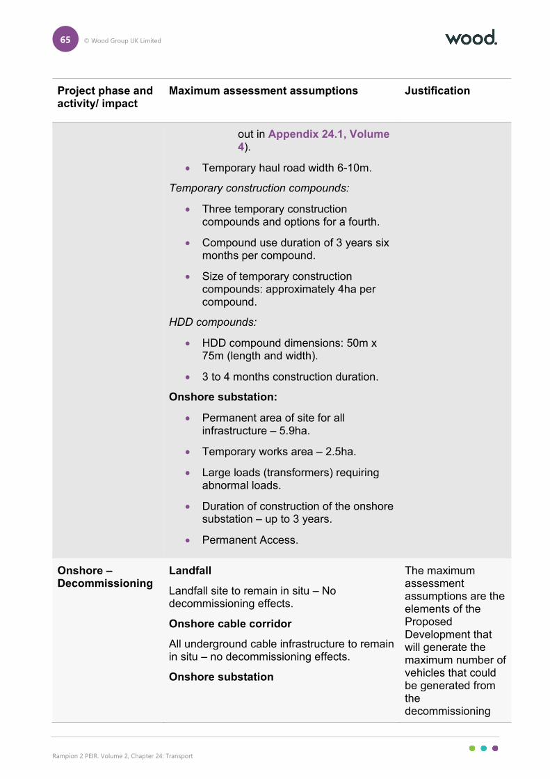
65 © Wood Group UK Limited
Rampion 2 PEIR. Volume 2, Chapter 24: Transport
Project phase and activity/ impact
Maximum assessment assumptions Justification
out in Appendix 24.1, Volume 4).
• Temporary haul road width 6-10m.
Temporary construction compounds:
• Three temporary construction compounds and options for a fourth.
• Compound use duration of 3 years six months per compound.
• Size of temporary construction compounds: approximately 4ha per compound.
HDD compounds:
• HDD compound dimensions: 50m x 75m (length and width).
• 3 to 4 months construction duration.
Onshore substation:
• Permanent area of site for all infrastructure – 5.9ha.
• Temporary works area – 2.5ha.
• Large loads (transformers) requiring abnormal loads.
• Duration of construction of the onshore substation – up to 3 years.
• Permanent Access.
Onshore – Decommissioning
Landfall
Landfall site to remain in situ – No decommissioning effects.
Onshore cable corridor
All underground cable infrastructure to remain in situ – no decommissioning effects.
Onshore substation
The maximum assessment assumptions are the elements of the Proposed Development that will generate the maximum number of vehicles that could be generated from the decommissioning
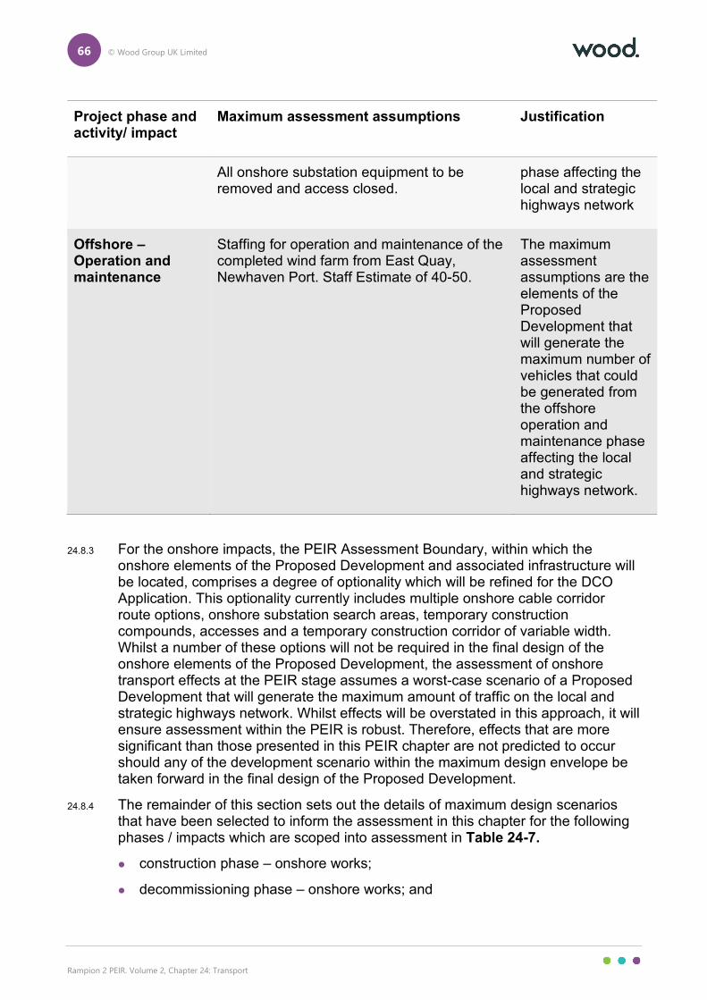
66 © Wood Group UK Limited
Rampion 2 PEIR. Volume 2, Chapter 24: Transport
Project phase and activity/ impact
Maximum assessment assumptions Justification
All onshore substation equipment to be removed and access closed.
phase affecting the local and strategic highways network
Offshore – Operation and maintenance
Staffing for operation and maintenance of the completed wind farm from East Quay, Newhaven Port. Staff Estimate of 40-50.
The maximum assessment assumptions are the elements of the Proposed Development that will generate the maximum number of vehicles that could be generated from the offshore operation and maintenance phase affecting the local and strategic highways network.
24.8.3 For the onshore impacts, the PEIR Assessment Boundary, within which the onshore elements of the Proposed Development and associated infrastructure will be located, comprises a degree of optionality which will be refined for the DCO Application. This optionality currently includes multiple onshore cable corridor route options, onshore substation search areas, temporary construction compounds, accesses and a temporary construction corridor of variable width. Whilst a number of these options will not be required in the final design of the onshore elements of the Proposed Development, the assessment of onshore transport effects at the PEIR stage assumes a worst-case scenario of a Proposed Development that will generate the maximum amount of traffic on the local and strategic highways network. Whilst effects will be overstated in this approach, it will ensure assessment within the PEIR is robust. Therefore, effects that are more significant than those presented in this PEIR chapter are not predicted to occur should any of the development scenario within the maximum design envelope be taken forward in the final design of the Proposed Development.
24.8.4 The remainder of this section sets out the details of maximum design scenarios that have been selected to inform the assessment in this chapter for the following phases / impacts which are scoped into assessment in Table 24-7.
construction phase – onshore works;
decommissioning phase – onshore works; and
67 © Wood Group UK Limited
Rampion 2 PEIR. Volume 2, Chapter 24: Transport
operation and maintenance phase – onshore impacts of offshore operation and maintenance.
The Proposed Development – construction phase – onshore works
Introduction
24.8.5 The construction traffic flow estimations have been based on the following elements of the construction phase for the onshore elements of the Proposed Development:
HDD compound works;
HDD drilling;
temporary construction compound mobilisation;
construction of the temporary construction compounds;
landfall works;
clearing of sites;
temporary and permanent access construction works;
construction materials deliveries;
onshore cable trenching;
transition joint bay construction works;
duct installation, onshore cable pulling and reinstatement;
temporary construction access roads and haul road reinstatement;
temporary construction compound reinstatement; and
construction of the onshore substation.
24.8.6 Construction traffic generation of all of these elements has been predicted across the proposed four year construction schedule. This has resulted in vehicle movement predictions per vehicle type on a weekly basis per access point, split into HGV and light vehicles, with the latter being further split into staff vehicles and construction Light Goods Vehicles (LGVs) such as vans and pick-up trucks.
24.8.7 The detailed methodology and traffic calculations undertaken to inform this output are presented in Appendix 24.4: Onshore Construction Traffic Assessment, Volume 4. This appendix sets out the detailed construction methodology, assumptions, materials required and other matters that have informed the traffic generation output. Appendix 24.5: Traffic Calculations, Volume 4 presents the traffic calculations looking at a network scope of assessment.
Fixed route option and access strategy for EIA assessment
24.8.8 To allow for an accurate and robust assessment of the construction phase of the onshore elements of the Proposed Development, the impact of a fixed scheme is
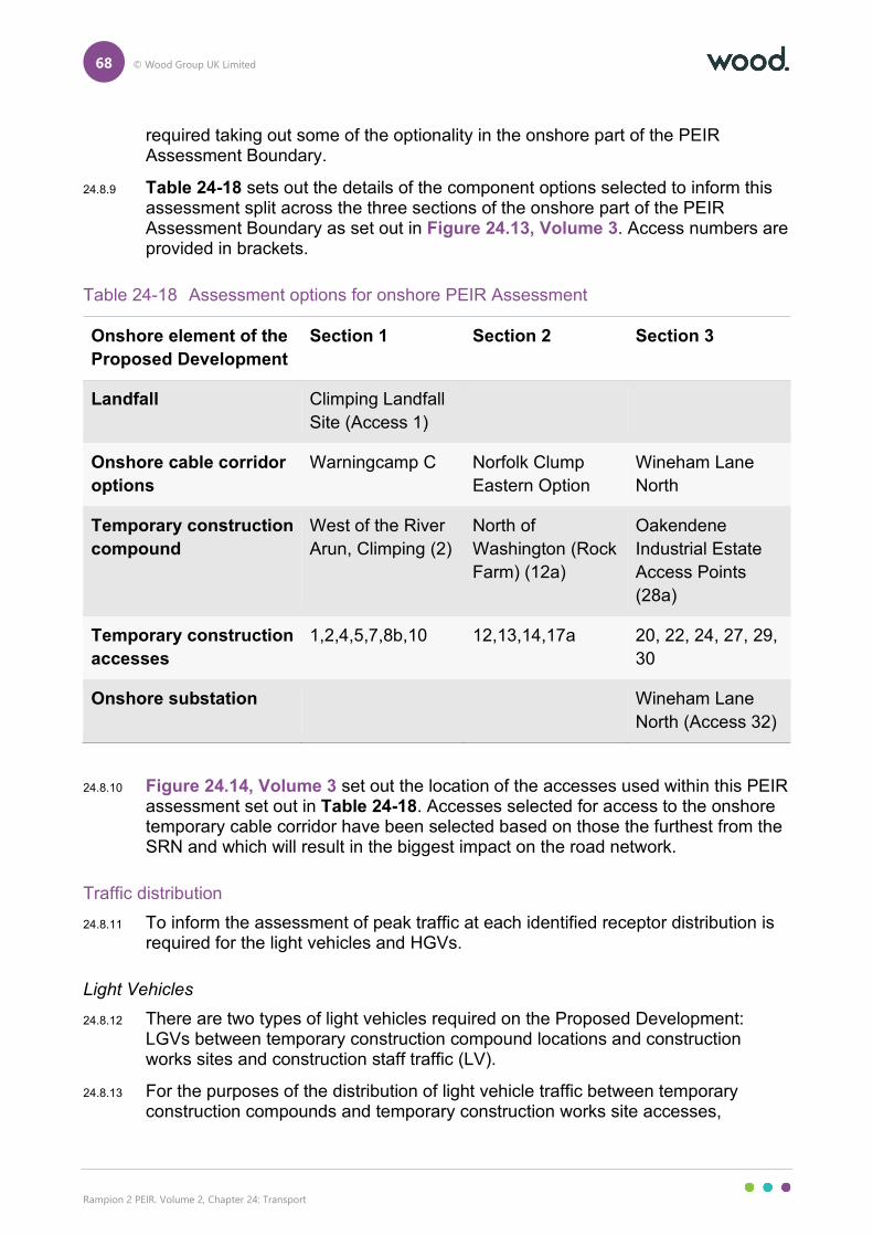
68 © Wood Group UK Limited
Rampion 2 PEIR. Volume 2, Chapter 24: Transport
required taking out some of the optionality in the onshore part of the PEIR Assessment Boundary.
24.8.9 Table 24-18 sets out the details of the component options selected to inform this assessment split across the three sections of the onshore part of the PEIR Assessment Boundary as set out in Figure 24.13, Volume 3. Access numbers are provided in brackets.
Table 24-18 Assessment options for onshore PEIR Assessment
Onshore element of the
Proposed Development
Section 1 Section 2 Section 3
Landfall Climping Landfall
Site (Access 1)
Onshore cable corridor
options
Warningcamp C
Norfolk Clump
Eastern Option
Wineham Lane
North
Temporary construction
compound
West of the River
Arun, Climping (2)
North of
Washington (Rock
Farm) (12a)
Oakendene
Industrial Estate
Access Points
(28a)
Temporary construction
accesses
1,2,4,5,7,8b,10 12,13,14,17a 20, 22, 24, 27, 29,
30
Onshore substation Wineham Lane
North (Access 32)
24.8.10 Figure 24.14, Volume 3 set out the location of the accesses used within this PEIR assessment set out in Table 24-18. Accesses selected for access to the onshore temporary cable corridor have been selected based on those the furthest from the SRN and which will result in the biggest impact on the road network.
Traffic distribution
24.8.11 To inform the assessment of peak traffic at each identified receptor distribution is required for the light vehicles and HGVs.
Light Vehicles
24.8.12 There are two types of light vehicles required on the Proposed Development: LGVs between temporary construction compound locations and construction works sites and construction staff traffic (LV).
24.8.13 For the purposes of the distribution of light vehicle traffic between temporary construction compounds and temporary construction works site accesses,
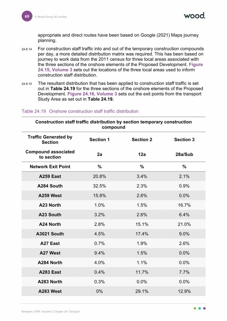
69 © Wood Group UK Limited
Rampion 2 PEIR. Volume 2, Chapter 24: Transport
appropriate and direct routes have been based on Google (2021) Maps journey planning.
24.8.14 For construction staff traffic into and out of the temporary construction compounds per day, a more detailed distribution matrix was required. This has been based on journey to work data from the 2011 census for three local areas associated with the three sections of the onshore elements of the Proposed Development. Figure 24.15, Volume 3 sets out the locations of the three local areas used to inform construction staff distribution.
24.8.15 The resultant distribution that has been applied to construction staff traffic is set out in Table 24.19 for the three sections of the onshore elements of the Proposed Development. Figure 24.16, Volume 3 sets out the exit points from the transport Study Area as set out in Table 24.19.
Table 24.19 Onshore construction staff traffic distribution
Construction staff traffic distribution by section temporary construction compound
Traffic Generated by Section
Section 1 Section 2 Section 3
Compound associated to section
2a 12a 28a/Sub
Network Exit Point % % %
A259 East 20.8% 3.4% 2.1%
A284 South 32.5% 2.3% 0.9%
A259 West 15.8% 2.6% 0.0%
A23 North 1.0% 1.5% 16.7%
A23 South 3.2% 2.6% 6.4%
A24 North 2.8% 15.1% 21.0%
A3021 South 4.5% 17.4% 9.0%
A27 East 0.7% 1.9% 2.6%
A27 West 9.4% 1.5% 0.0%
A284 North 4.0% 1.1% 0.0%
A283 East 0.4% 11.7% 7.7%
A283 North 0.3% 0.0% 0.0%
A283 West 0% 29.1% 12.9%
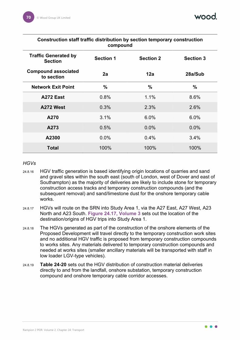
70 © Wood Group UK Limited
Rampion 2 PEIR. Volume 2, Chapter 24: Transport
Construction staff traffic distribution by section temporary construction compound
Traffic Generated by Section
Section 1 Section 2 Section 3
Compound associated to section
2a 12a 28a/Sub
Network Exit Point % % %
A272 East 0.8% 1.1% 8.6%
A272 West 0.3% 2.3% 2.6%
A270 3.1% 6.0% 6.0%
A273 0.5% 0.0% 0.0%
A2300 0.0% 0.4% 3.4%
Total 100% 100% 100%
HGVs
24.8.16 HGV traffic generation is based identifying origin locations of quarries and sand and gravel sites within the south east (south of London, west of Dover and east of Southampton) as the majority of deliveries are likely to include stone for temporary construction access tracks and temporary construction compounds (and the subsequent removal) and sand/limestone dust for the onshore temporary cable works.
24.8.17 HGVs will route on the SRN into Study Area 1, via the A27 East, A27 West, A23 North and A23 South. Figure 24.17, Volume 3 sets out the location of the destination/origins of HGV trips into Study Area 1.
24.8.18 The HGVs generated as part of the construction of the onshore elements of the Proposed Development will travel directly to the temporary construction work sites and no additional HGV traffic is proposed from temporary construction compounds to works sites. Any materials delivered to temporary construction compounds and needed at works sites (smaller ancillary materials will be transported with staff in low loader LGV-type vehicles).
24.8.19 Table 24-20 sets out the HGV distribution of construction material deliveries directly to and from the landfall, onshore substation, temporary construction compound and onshore temporary cable corridor accesses.
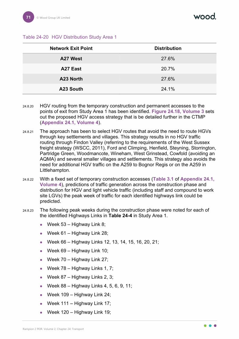
71 © Wood Group UK Limited
Rampion 2 PEIR. Volume 2, Chapter 24: Transport
Table 24-20 HGV Distribution Study Area 1
Network Exit Point Distribution
A27 West 27.6%
A27 East 20.7%
A23 North 27.6%
A23 South 24.1%
24.8.20 HGV routing from the temporary construction and permanent accesses to the points of exit from Study Area 1 has been identified. Figure 24.18, Volume 3 sets out the proposed HGV access strategy that is be detailed further in the CTMP (Appendix 24.1, Volume 4).
24.8.21 The approach has been to select HGV routes that avoid the need to route HGVs through key settlements and villages. This strategy results in no HGV traffic routing through Findon Valley (referring to the requirements of the West Sussex freight strategy (WSCC, 2011), Ford and Climping, Henfield, Steyning, Storrington, Partridge Green, Woodmancote, Wineham, West Grinstead, Cowfold (avoiding an AQMA) and several smaller villages and settlements. This strategy also avoids the need for additional HGV traffic on the A259 to Bognor Regis or on the A259 in Littlehampton.
24.8.22 With a fixed set of temporary construction accesses (Table 3.1 of Appendix 24.1, Volume 4), predictions of traffic generation across the construction phase and distribution for HGV and light vehicle traffic (including staff and compound to work site LGVs) the peak week of traffic for each identified highways link could be predicted.
24.8.23 The following peak weeks during the construction phase were noted for each of the identified Highways Links in Table 24-4 in Study Area 1.
Week 53 – Highway Link 8;
Week 61 – Highway Link 28;
Week 66 – Highway Links 12, 13, 14, 15, 16, 20, 21;
Week 69 – Highway Link 10;
Week 70 – Highway Link 27;
Week 78 – Highway Links 1, 7;
Week 87 – Highway Links 2, 3;
Week 88 – Highway Links 4, 5, 6, 9, 11;
Week 109 – Highway Link 24;
Week 111 – Highway Link 17;
Week 120 – Highway Link 19;
72 © Wood Group UK Limited
Rampion 2 PEIR. Volume 2, Chapter 24: Transport
Week 125 – Highway Links 32, 33, 34, 35;
Week 126 – Highway Links 25, 26, 29;
Week 135 – Highway Link 18; and
Week 136 – Highway Links 22, 23, 30, 31.
24.8.24 The construction traffic has been converted to a daily traffic flow by using a five-day working week for robust assessment (though it is likely some form of weekend working may be implemented on the Proposed Development). The resultant traffic generation is presented on a network plot as Figure 24.19, Volume 3, while locations of the highways links are presented on Figure 24.20, Volume 3.
The Proposed Development – operation and maintenance phase – onshore impacts of offshore works
24.8.25 During the operation and maintenance phase, it is currently estimated that 40-50 full time staff will be required per day. For the purposes of assessment in this chapter, it is proposed to assess a worst case of 50 staff per day into and out of East Quay, Newhaven Port, which currently accommodated the existing Rampion 1 project operation and maintenance facility.
24.8.26 For the propose of daily traffic generation, a robust assessment considering all staff arriving by private car with no car sharing or use of sustainable modes has been undertaken. This results in 100 two staff vehicle movements per day, the impacts of which on the local highways network are assessed in Section 24.11.
24.8.27 The traffic is proposed to be distributed following the same approach as staff traffic for the construction phase and using journey to work data. An assessment of journey to work data based on the existing port indicates the following distribution of traffic and where it will leave Study Area 2:
A259 West (Newhaven) – 30.58%;
A259 East – 37.79%;
A27 West – 18.64%; and;
A27 East – 12.99%.
24.8.28 Figure 24.21, Volume 3 sets out the daily traffic impacts on the local highways network and the location of the two highways links is set out in Figure 24.20, Volume 3.
The Proposed Development – decommissioning phase – onshore works
24.8.29 As set out in Table 24-8 the only onshore element of the Proposed Development that will require to be removed in the decommissioning phase is the onshore substation and therefore only a small part of Study Area 1 will be affected by decommissioning traffic.
24.8.30 With some optionality in onshore substation search area location within the onshore part of the PEIR Assessment Boundary it is proposed to base the assessment of decommissioning of the onshore substation on the same basis as
73 © Wood Group UK Limited
Rampion 2 PEIR. Volume 2, Chapter 24: Transport
the construction phase and use Wineham Lane North onshore substation search area as a worst case assessment.
24.8.31 Using Wineham Lane North onshore substation search area as a location for assessment it is considered that only two highways links within Study Area 1 will require assessment for the decommissioning phase: Highways Links 26 and 27, due to the logical routes to the SRN from the onshore substation search area and anticipated traffic distribution.
24.8.32 It is considered that the decommissioning of the onshore substation will require the same levels of traffic generation as the construction phase and therefore the peak construction traffic generation of the construction phase will be used as a basis for assessment.
24.8.33 Unlike the assessment for the construction phase (set out in Section 24.10), the two highways links (26/27) that require assessment would only have to accommodate traffic associated with the onshore substation decommissioning and not the traffic associated with the onshore cable decommissioning as the onshore cable will be left in situ during the decommissioning phase. As such traffic at these two receptors will be less than set out in the assessment for the construction phase at these two links as the additional cable related traffic in the construction phase would not be present in the decommissioning phase. An assessment has still been provided for robustness due to the different future year for the decommissioning phase.
24.8.34 The detailed methodology and traffic calculations undertaken to inform the construction phase (and the decommissioning phase) are presented in Appendix 24.4, Volume 4. This appendix sets out the detailed construction methodology, assumptions, materials required and other matters that have informed the traffic generation output.
24.8.35 The calculations indicate that the peak of the construction of the onshore substation will result in a peak traffic week that included:
500 two way staff LVs;
26 two way HGVs; and
526 two way total vehicles.
24.8.36 This will result in the following daily traffic to inform assessment in this chapter:
100 two way staff LVs;
6 two way HGVs; and
106 two way total vehicles.
24.8.37 Distribution of this traffic during the decommissioning phase has been based on the same distribution patterns as the construction phase as set out in Table 24.19 and Table 24-20. This will result in all HGV trips routing over both highways link 26 and 27. For light vehicles 100% of the traffic will route over highways link 26 and only 55.79% over highways link 27 based on the decommissioning of the onshore substation at Wineham Lane North.
74 © Wood Group UK Limited
Rampion 2 PEIR. Volume 2, Chapter 24: Transport
24.8.38 Figure 24.23, Volume 3 sets out the resultant traffic generation on the local highways network.
Embedded environmental measures
24.8.39 As part of the Rampion 2 design process, a number of embedded environmental measures have been adopted to reduce the potential for impacts on transport. These embedded environmental measures will evolve over the development process as the EIA progresses and in response to consultation.
24.8.40 These measures typically include those that have been identified as good or standard practice and include actions that will be undertaken to meet existing legislation requirements. As there is a commitment to implementing these embedded environmental measures, and also to various standard sectoral practices and procedures, they are considered inherently part of the design of Rampion 2 and are set out in this PEIR.
24.8.41 Table 24-21 sets out the relevant embedded environmental measures within the design and how these affect the transport assessment.
Table 24-21 Relevant transport embedded environmental measures
ID Environmental measure proposed
Project phase measure introduced
How the environmental measures will be secured
Relevance to transport assessment
C-1 The onshore cable route will be completely buried underground for its entire length where practicable.
Scoping Development Consent Order (DCO) works plans, description of development and requirements
This measure will minimise the impacts on the local and strategic highway and PRoW.
C-2 Cables will be installed in ducting
Scoping DCO works plans, description of development and requirements
This measure will minimise the impacts on the local and strategic highway and PRoW.
C-5 Main rivers, watercourses, railways and roads that form a part of the Strategic Highways Network will be crossed by Horizontal Directional Drill (HDD) or
Scoping - updated at PEIR
DCO works plans and order limits
This measure will minimise the impacts on the local and strategic highway.
75 © Wood Group UK Limited
Rampion 2 PEIR. Volume 2, Chapter 24: Transport
ID Environmental measure proposed
Project phase measure introduced
How the environmental measures will be secured
Relevance to transport assessment
other trenchless technology where this represents the best environment solution and is financially and technically feasible (see C-17).
C-18 A crossing schedule will be prepared which includes crossing methodology for each crossing of road, rail, public right of way (PRoW) and watercourse.
Scoping Outline Code of Construction Practice (COCP) and DCO requirement
This measure will all for safe and managed crossings of the local highway network and PRoW.
C-32 Signage and/or temporary public rights of way (PRoW) / footpath diversions will be provided during construction.
Scoping Outline COCP and DCO requirement
This measure will allow for safe interactions between PRoW users and construction vehicles and areas.
C-157 The proposed heavy goods vehicle (HGV) routing during the construction period to individual accesses will be developed to avoid major settlements such as Storrington, Cowfold, Steyning, Wineham, Henfield, Woodmancote and other smaller settlements where possible.
PEIR Proposed routing in agreed CTMP
This measure will limit the impacts of Proposed Development in key local villages and settlements.
C-158 The proposed heavy goods vehicle (HGV) routing during the construction period to
PEIR Proposed routing in agreed Outline CTMP
This measure will limit the impacts of the onshore
76 © Wood Group UK Limited
Rampion 2 PEIR. Volume 2, Chapter 24: Transport
ID Environmental measure proposed
Project phase measure introduced
How the environmental measures will be secured
Relevance to transport assessment
individual accesses will avoid the Air Quality Management Area (AQMA) in Cowfold where possible.
elements of the Proposed Development on the AQMA in Cowfold.
C-159 The proposed heavy goods vehicle (HGV) routing during the construction period to individual accesses will avoid the A24 through Findon as advised from the West Sussex County Council (WSCC) Freight Action Plan.
PEIR Proposed routing in agreed Outline CTMP
This measure will restrict the conveyance of HGVs as part of the Proposed Development through the settlement of Findon on the A24.
C-160 Highways condition surveys will be undertaken before, during and after the construction phase and repairs conducted to any damage to highways as a result of Rampion 2 construction heavy goods vehicles (HGV) on the highways included within the HGV Access Strategy.
PEIR Proposed routing in agreed Outline CTMP
This measure will allow for any damage caused by the Proposed Development on the local and strategic highway to be repaired in good time.
C-161 The South Downs Way and the Downs Link Public Rights of Ways (PRoWs) will be managed in a way that minimises any closures or diversions.
PEIR Outline PRoWMP
This will limit the impact on the key PRoW affected by the Proposed Development.
C-162 Public Rights of Ways (PRoWs) that cross the onshore cable corridor will be managed or diverted over the shortest distance
PEIR Outline PRoWMP
This will limit the duration of impact on PRoW affected by the
77 © Wood Group UK Limited
Rampion 2 PEIR. Volume 2, Chapter 24: Transport
ID Environmental measure proposed
Project phase measure introduced
How the environmental measures will be secured
Relevance to transport assessment
possible with potential to provide adjacent crossings.
Proposed Development.
C-163 Public Rights of Way (PRoW) condition surveys will be undertaken before, during and after the construction phase. If damage has been identified as a result of the construction phase, the damage will be repaired. Post-construction, all PRoWs will be returned to their pre-construction condition.
PEIR Outline PRoWMP
This measure will allow for any damage caused by the Proposed Development on PRoW to be repaired in good time.
C-164 Public Rights of Way (PRoW) routing through locations of permanent infrastructure will be provided with a permanent diversion and the existing route closed.
PEIR Outline PRoWMP
This will allow for PRoW routes to be maintained on a similar course and not lead to permanent closures of routes after the construction phase is complete.
C-165 Construction access will be provided with visibility splays designed to Design Manual for Roads and Bridges (DMRB) design standards as agreed with West Sussex County Council (WSCC).
PEIR Outline CTMP – Requirement, order limit plans and access plans
This will provide for safe accesses where construction vehicles can access the highways network in a safe way which should reduce the risk of
78 © Wood Group UK Limited
Rampion 2 PEIR. Volume 2, Chapter 24: Transport
ID Environmental measure proposed
Project phase measure introduced
How the environmental measures will be secured
Relevance to transport assessment
accidents related to the Proposed Development.
C-166 For non-horizontal directional drilling (HDD) crossings of the highway, there are proposed to be two solutions we can commit to as follows: 1 - Lay the cable in a trench, which would be excavated in phases to ensure at least one traffic lane is operational and controlled using temporary signals (although this approach cannot be used on single track parts of the highway); and 2 - Provide a short road closure while the work is undertaken with a relevant diversion route. This is of particular importance for single track roads.
PEIR Outline CTMP – Requirement, order limit plans and access plans
This measure will limit the need for road closures where open trench crossings are proposed. Where traffic management cannot be achieved, diversions will lead to local road users still being able to access the same final destinations and no parts of the local highways network would be cut off.
C-168 Impacts on open access land will be managed through active management strategy.
PEIR Outline PRoWMP
This measure will allow for access to Open Access Land to be maintained wherever possible.
C-169 RED will provide Designs for permanent accesses required on the Proposed
PEIR Design requirement
This measure will allow for a safe and formal access to be
79 © Wood Group UK Limited
Rampion 2 PEIR. Volume 2, Chapter 24: Transport
ID Environmental measure proposed
Project phase measure introduced
How the environmental measures will be secured
Relevance to transport assessment
Development will be provided to Department for Transport (DfT) Design Manual for Roads and Bridges (DMRB) design standards.
provided to the highways network to permanent infrastructure.
24.8.42 In addition to the embedded environmental measures set out in Table 24-20, three supporting documents have been prepared to support the PEIR assessment including:
an Outline CTMP (Appendix 24.1, Volume 4) which sets out details of the construction traffic access strategy that underpins the assessment in this chapter and the mitigation and management of these flows;
an Outline PRoWMP (Appendix 24.2, Volume 4) which sets out details of the impacts of the Proposed Development on the PRoW network and Open Access Land and the management and mitigation required; and
an Outline AIL Assessment has also been prepared (Appendix 24.3, Volume 4) setting out the nature of the AILs required associated with the Proposed Development, routes to site and how this will be managed.
24.8.43 Many of the embedded environmental measures set out in Table 24-20 form key management and mitigation proposals set out in these additional documents.
24.8.44 As the design of the Proposed Development continues to be refined from PEIR to ES stage, the above appendices will also be updated where applicable to reflect changes and submitted alongside the ES.
24.9 Methodology for PEIR assessment
Introduction
24.9.1 The project-wide generic approach to assessment is set out in Chapter 5: Approach to the EIA. The assessment methodology for transport for the PEIR is consistent with that provided in in the Scoping Report and no changes have been made since the scoping phase.
Methodology
24.9.2 GEART (IEA, 1993) identifies the following environmental effects that can occur as a result of traffic associated with the Proposed Development.
80 © Wood Group UK Limited
Rampion 2 PEIR. Volume 2, Chapter 24: Transport
severance: the separation of people from places and other people and places or the impediment of pedestrian access to essential facilities;
driver delay: traffic delays as a result of the Proposed Development traffic;
pedestrian amenity: the effect on the relative pleasantness of a pedestrian journey as a result of changes in traffic flow, traffic composition and pavement width / separation from traffic;
pedestrian delay: the ability of people to crossroads as a result of changes in traffic volume, composition and speed, the level of pedestrian activity, visibility and general physical conditions of the Proposed Development. Consideration will also be given to the effects on PRoW users due to the closure and diversion of PRoWs;
fear and intimidation: these may be experienced by people as a result of an increase in traffic volume and its proximity or the lack of protection caused by such factors as narrow pavement widths; and
accidents and safety: the risk of accidents occurring where the Proposed Development is expected to produce a change in the character of traffic.
24.9.3 The guidance that is followed when assessing the potential significance of road traffic effects is summarised in GEART (IEA, 1993), which states that:
“The detailed assessment of impacts is…likely to concentrate on the period during which the absolute level of an impact is at its peak, as well as the hour at which the greatest level of change is likely to occur.” (Paragraph 3.10).
24.9.4 To assess the impact at its peak, the likely percentage increase in traffic is determined by comparing estimates of traffic generated by the Proposed Development with future predicted baseline traffic flows on the road links in both Study Areas 1 and 2.
24.9.5 GEART (IEA, 1993) provides two rules that are used to establish whether an environmental assessment of traffic effects should be carried out on receptors:
Rule 1: Include roads where traffic flows are predicted to increase by more than 30% (or where the number of HGVs is predicted to increase by more than 30%); and
Rule 2: Include any specifically ‘sensitive’ areas where traffic flows are predicted to increase by 10% or more.
24.9.6 It should be noted that, according to GEART, predicted traffic flow increases below 10% are generally not considered to be significant as daily variations in background traffic flow may fluctuate by this amount. Changes in traffic flows below this level are, therefore, assumed not to result in significant environmental effects and have therefore not been assessed further as part of this study.
24.9.7 Details of the GEART threshold applied to each highways link is set out in Section 24.10 and Table 24-22 provides details of the highways links and the nature of the receptors for Study Area 1 and Table 24-23 for Study Area 2.
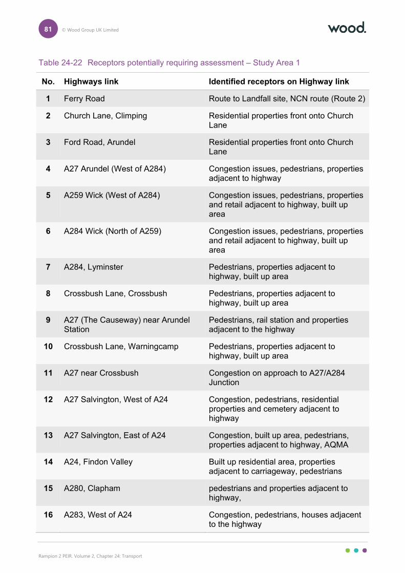
81 © Wood Group UK Limited
Rampion 2 PEIR. Volume 2, Chapter 24: Transport
Table 24-22 Receptors potentially requiring assessment – Study Area 1
No. Highways link Identified receptors on Highway link
1 Ferry Road Route to Landfall site, NCN route (Route 2)
2 Church Lane, Climping Residential properties front onto Church Lane
3 Ford Road, Arundel Residential properties front onto Church Lane
4 A27 Arundel (West of A284) Congestion issues, pedestrians, properties adjacent to highway
5 A259 Wick (West of A284) Congestion issues, pedestrians, properties and retail adjacent to highway, built up area
6 A284 Wick (North of A259) Congestion issues, pedestrians, properties and retail adjacent to highway, built up area
7 A284, Lyminster Pedestrians, properties adjacent to highway, built up area
8 Crossbush Lane, Crossbush Pedestrians, properties adjacent to highway, built up area
9 A27 (The Causeway) near Arundel Station
Pedestrians, rail station and properties adjacent to the highway
10 Crossbush Lane, Warningcamp Pedestrians, properties adjacent to highway, built up area
11 A27 near Crossbush Congestion on approach to A27/A284 Junction
12 A27 Salvington, West of A24 Congestion, pedestrians, residential properties and cemetery adjacent to highway
13 A27 Salvington, East of A24 Congestion, built up area, pedestrians, properties adjacent to highway, AQMA
14 A24, Findon Valley Built up residential area, properties adjacent to carriageway, pedestrians
15 A280, Clapham pedestrians and properties adjacent to highway,
16 A283, West of A24 Congestion, pedestrians, houses adjacent to the highway
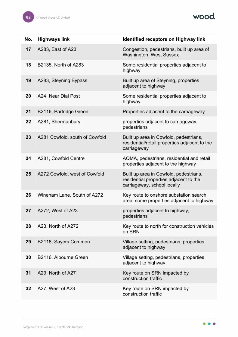
82 © Wood Group UK Limited
Rampion 2 PEIR. Volume 2, Chapter 24: Transport
No. Highways link Identified receptors on Highway link
17 A283, East of A23 Congestion, pedestrians, built up area of Washington, West Sussex
18 B2135, North of A283 Some residential properties adjacent to highway
19 A283, Steyning Bypass Built up area of Steyning, properties adjacent to highway
20 A24, Near Dial Post Some residential properties adjacent to highway
21 B2116, Partridge Green Properties adjacent to the carriageway
22 A281, Shermanbury properties adjacent to carriageway, pedestrians
23 A281 Cowfold, south of Cowfold Built up area in Cowfold, pedestrians, residential/retail properties adjacent to the carriageway
24 A281, Cowfold Centre AQMA, pedestrians, residential and retail properties adjacent to the highway
25 A272 Cowfold, west of Cowfold Built up area in Cowfold, pedestrians, residential properties adjacent to the carriageway, school locally
26 Wineham Lane, South of A272 Key route to onshore substation search area, some properties adjacent to highway
27 A272, West of A23 properties adjacent to highway, pedestrians
28 A23, North of A272 Key route to north for construction vehicles on SRN
29 B2118, Sayers Common Village setting, pedestrians, properties adjacent to highway
30 B2116, Albourne Green Village setting, pedestrians, properties adjacent to highway
31 A23, North of A27 Key route on SRN impacted by construction traffic
32 A27, West of A23 Key route on SRN impacted by construction traffic
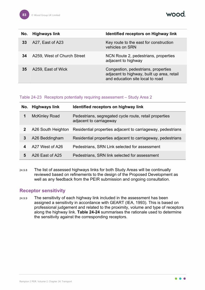
83 © Wood Group UK Limited
Rampion 2 PEIR. Volume 2, Chapter 24: Transport
No. Highways link Identified receptors on Highway link
33 A27, East of A23 Key route to the east for construction vehicles on SRN
34 A259, West of Church Street NCN Route 2, pedestrians, properties adjacent to highway
35 A259, East of Wick Congestion, pedestrians, properties adjacent to highway, built up area, retail and education site local to road
Table 24-23 Receptors potentially requiring assessment – Study Area 2
No. Highways link Identified receptors on highway link
1 McKinley Road Pedestrians, segregated cycle route, retail properties adjacent to carriageway
2 A26 South Heighton Residential properties adjacent to carriageway, pedestrians
3 A26 Beddingham Residential properties adjacent to carriageway, pedestrians
4 A27 West of A26 Pedestrians, SRN Link selected for assessment
5 A26 East of A25 Pedestrians, SRN link selected for assessment
24.9.8 The list of assessed highways links for both Study Areas will be continually reviewed based on refinements to the design of the Proposed Development as well as any feedback from the PEIR submission and ongoing consultation.
Receptor sensitivity
24.9.9 The sensitivity of each highway link included in the assessment has been assigned a sensitivity in accordance with GEART (IEA, 1993). This is based on professional judgement and related to the proximity, volume and type of receptors along the highway link. Table 24-24 summarises the rationale used to determine the sensitivity against the corresponding receptors.
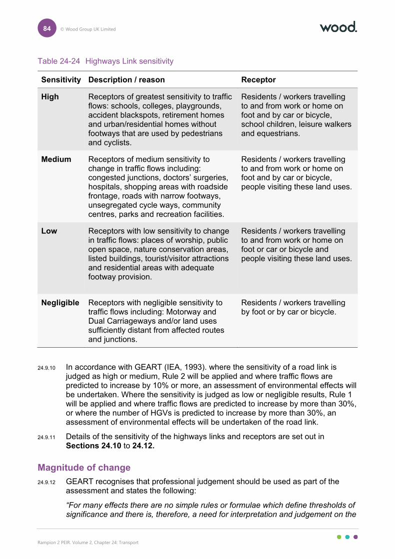
84 © Wood Group UK Limited
Rampion 2 PEIR. Volume 2, Chapter 24: Transport
Table 24-24 Highways Link sensitivity
Sensitivity Description / reason Receptor
High Receptors of greatest sensitivity to traffic flows: schools, colleges, playgrounds, accident blackspots, retirement homes and urban/residential homes without footways that are used by pedestrians and cyclists.
Residents / workers travelling to and from work or home on foot and by car or bicycle, school children, leisure walkers and equestrians.
Medium Receptors of medium sensitivity to change in traffic flows including: congested junctions, doctors’ surgeries, hospitals, shopping areas with roadside frontage, roads with narrow footways, unsegregated cycle ways, community centres, parks and recreation facilities.
Residents / workers travelling to and from work or home on foot and by car or bicycle, people visiting these land uses.
Low Receptors with low sensitivity to change in traffic flows: places of worship, public open space, nature conservation areas, listed buildings, tourist/visitor attractions and residential areas with adequate footway provision.
Residents / workers travelling to and from work or home on foot or car or bicycle and people visiting these land uses.
Negligible Receptors with negligible sensitivity to traffic flows including: Motorway and Dual Carriageways and/or land uses sufficiently distant from affected routes and junctions.
Residents / workers travelling by foot or by car or bicycle.
24.9.10 In accordance with GEART (IEA, 1993). where the sensitivity of a road link is judged as high or medium, Rule 2 will be applied and where traffic flows are predicted to increase by 10% or more, an assessment of environmental effects will be undertaken. Where the sensitivity is judged as low or negligible results, Rule 1 will be applied and where traffic flows are predicted to increase by more than 30%, or where the number of HGVs is predicted to increase by more than 30%, an assessment of environmental effects will be undertaken of the road link.
24.9.11 Details of the sensitivity of the highways links and receptors are set out in Sections 24.10 to 24.12.
Magnitude of change
24.9.12 GEART recognises that professional judgement should be used as part of the assessment and states the following:
“For many effects there are no simple rules or formulae which define thresholds of significance and there is, therefore, a need for interpretation and judgement on the
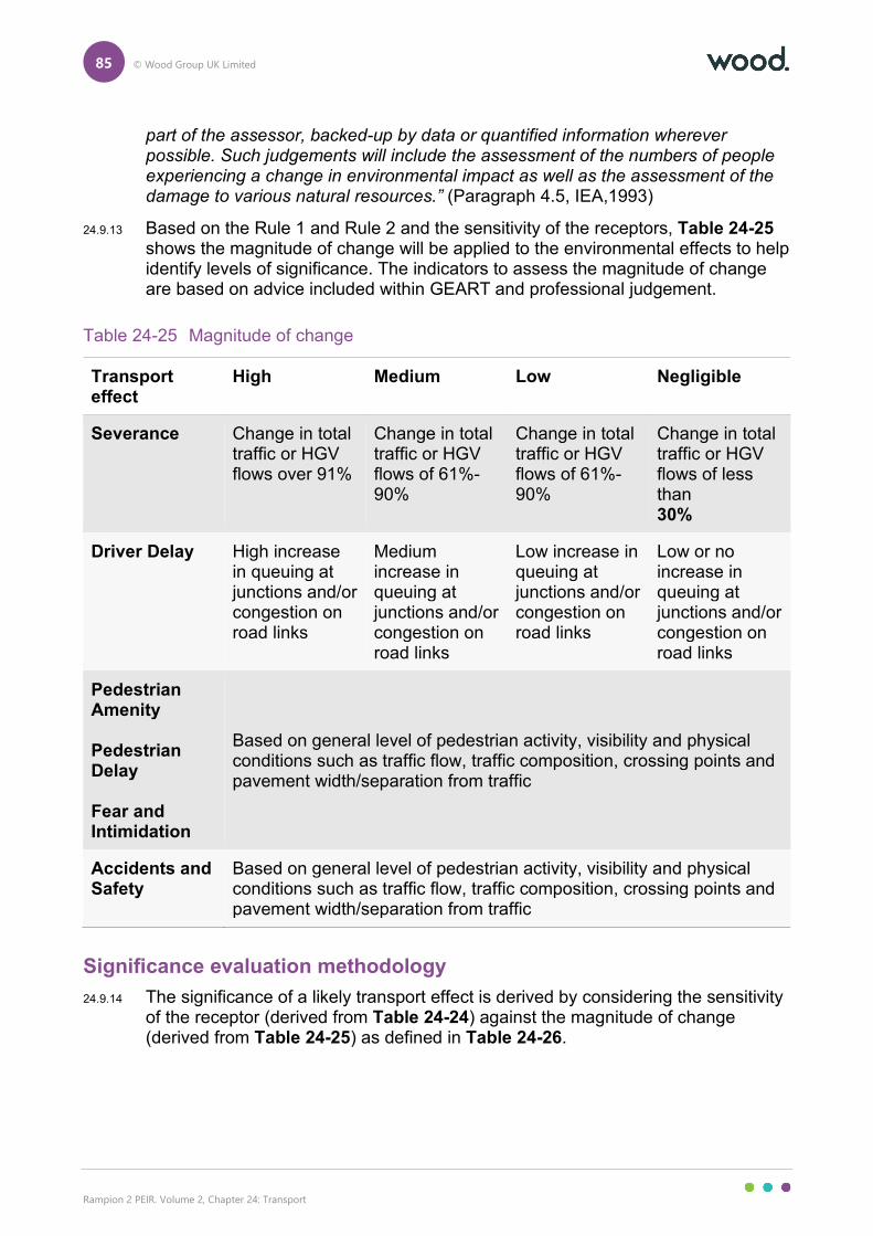
85 © Wood Group UK Limited
Rampion 2 PEIR. Volume 2, Chapter 24: Transport
part of the assessor, backed-up by data or quantified information wherever possible. Such judgements will include the assessment of the numbers of people experiencing a change in environmental impact as well as the assessment of the damage to various natural resources.” (Paragraph 4.5, IEA,1993)
24.9.13 Based on the Rule 1 and Rule 2 and the sensitivity of the receptors, Table 24-25 shows the magnitude of change will be applied to the environmental effects to help identify levels of significance. The indicators to assess the magnitude of change are based on advice included within GEART and professional judgement.
Table 24-25 Magnitude of change
Significance evaluation methodology
24.9.14 The significance of a likely transport effect is derived by considering the sensitivity of the receptor (derived from Table 24-24) against the magnitude of change (derived from Table 24-25) as defined in Table 24-26.
Transport effect
High Medium Low Negligible
Severance Change in total traffic or HGV flows over 91%
Change in total traffic or HGV flows of 61%- 90%
Change in total traffic or HGV flows of 61%- 90%
Change in total traffic or HGV flows of less than 30%
Driver Delay High increase in queuing at junctions and/or congestion on road links
Medium increase in queuing at junctions and/or congestion on road links
Low increase in queuing at junctions and/or congestion on road links
Low or no increase in queuing at junctions and/or congestion on road links
Pedestrian Amenity Pedestrian Delay Fear and Intimidation
Based on general level of pedestrian activity, visibility and physical conditions such as traffic flow, traffic composition, crossing points and pavement width/separation from traffic
Accidents and Safety
Based on general level of pedestrian activity, visibility and physical conditions such as traffic flow, traffic composition, crossing points and pavement width/separation from traffic
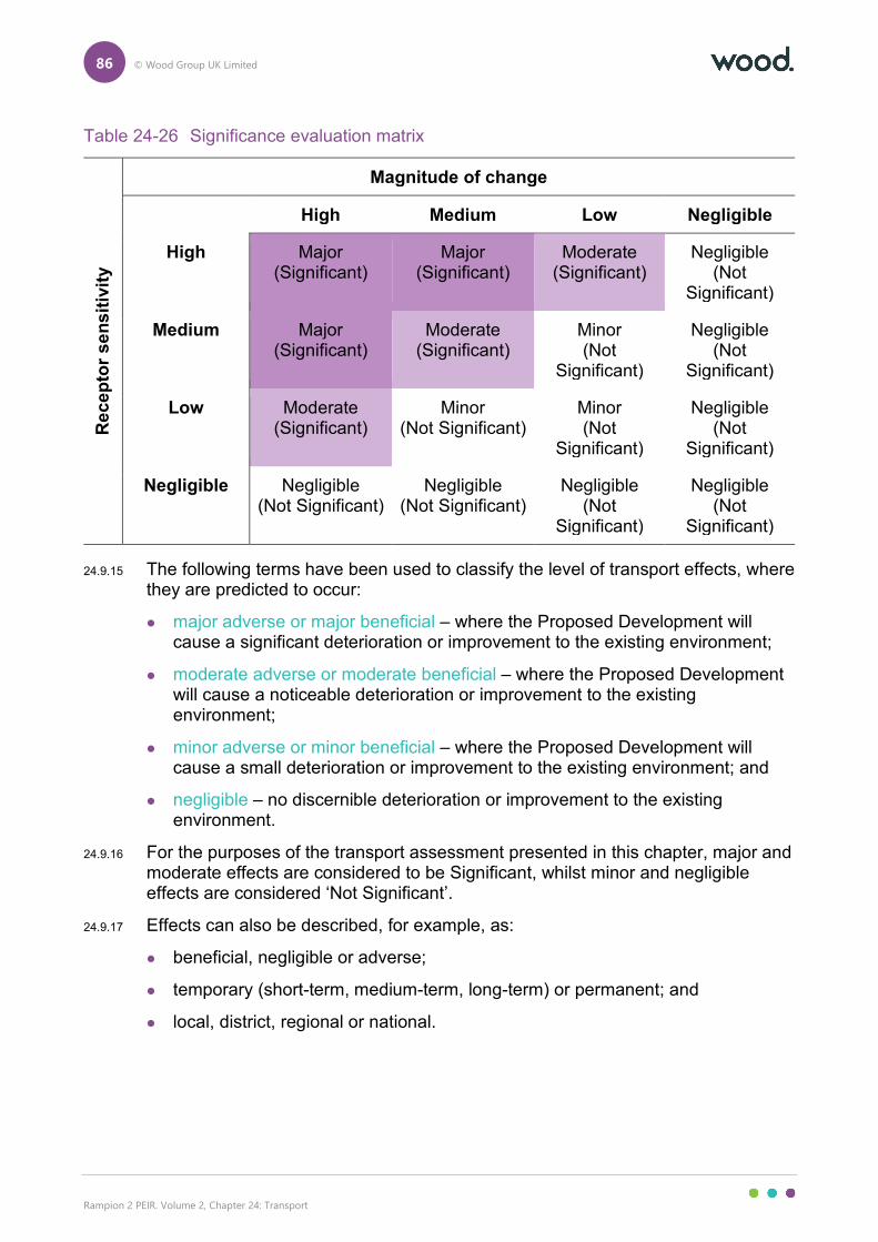
86 © Wood Group UK Limited
Rampion 2 PEIR. Volume 2, Chapter 24: Transport
Table 24-26 Significance evaluation matrix
Re
ce
pto
r s
en
sit
ivit
y
Magnitude of change
High Medium Low Negligible
High Major (Significant)
Major (Significant)
Moderate (Significant)
Negligible (Not
Significant)
Medium Major (Significant)
Moderate (Significant)
Minor (Not
Significant)
Negligible (Not
Significant)
Low Moderate (Significant)
Minor (Not Significant)
Minor (Not
Significant)
Negligible (Not
Significant)
Negligible Negligible (Not Significant)
Negligible (Not Significant)
Negligible (Not
Significant)
Negligible (Not
Significant)
24.9.15 The following terms have been used to classify the level of transport effects, where they are predicted to occur:
major adverse or major beneficial – where the Proposed Development will cause a significant deterioration or improvement to the existing environment;
moderate adverse or moderate beneficial – where the Proposed Development will cause a noticeable deterioration or improvement to the existing environment;
minor adverse or minor beneficial – where the Proposed Development will cause a small deterioration or improvement to the existing environment; and
negligible – no discernible deterioration or improvement to the existing environment.
24.9.16 For the purposes of the transport assessment presented in this chapter, major and moderate effects are considered to be Significant, whilst minor and negligible effects are considered ‘Not Significant’.
24.9.17 Effects can also be described, for example, as:
beneficial, negligible or adverse;
temporary (short-term, medium-term, long-term) or permanent; and
local, district, regional or national.
87 © Wood Group UK Limited
Rampion 2 PEIR. Volume 2, Chapter 24: Transport
24.10 Preliminary assessment: construction phase – onshore works
Introduction
24.10.1 To undertake the assessment of effects of the traffic generated by the Proposed Development, the traffic flows need to be estimated and trips distributed onto the road network.
24.10.2 The trips for the peak construction phase of the Proposed Development have been added to future baseline years to provide a clear impact of the difference between the growth of future baseline and the growth of future baseline ‘with Development’.
24.10.3 The significance has been assessed against GEART (IEA, 1993) Rule 1 (30% or above) and Rule 2 (10% or above). Where the change is considered significant, further assessment has been made using the criteria in Section 24.9.
24.10.4 The assessment within this section has been undertaken on a worst-case basis for traffic generation considering the optionality that is included within the onshore part of the PEIR Assessment Boundary. Details of the assumptions underpinning this works case assessment are set out in Section 24.8 and Table 24-18.
24.10.5 The assessment in this section includes for all of the relevant embedded mitigation measures applicable to this phase of the development, C-1, C-2, C-18, C-157, C-158, C-159, C-165, C-166, C-169. Details of these embedded measures are set out in Table 24-21.
Assessment year traffic growth
24.10.6 Table 24-27 below sets out the 2026 and 2027 traffic flows per receptor based on the traffic growth methodology set out in Section 24.7.
Magnitude of change
24.10.7 Table 24-27 sets out the magnitude of change of the proposed peak daily (24 hour) development traffic on the identified highways links and presents the following information;
future year baseline traffic per highways link for 2026 or 2027 based on which year the peak week at each highways link is predicted to occur for vehicles and HGVs;
the predicted daily traffic flows per highways link for total vehicles and HGVs; and
the percentage impact of the Proposed Development traffic per highways link for total vehicles and HGVs.
24.10.8 In Table 24-27, highways links percentage impacts identified that exceed the GEART (IEA,1993) assessment thresholds based on the highways link sensitivity in Table 24-28 are set out in red.
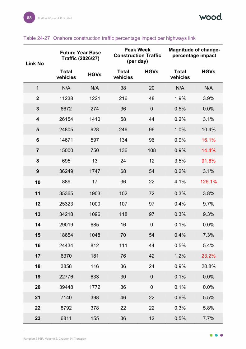
88 © Wood Group UK Limited
Rampion 2 PEIR. Volume 2, Chapter 24: Transport
Table 24-27 Onshore construction traffic percentage impact per highways link
Link No
Future Year Base Traffic (2026/27)
Peak Week Construction Traffic
(per day)
Magnitude of change- percentage impact
Total vehicles
HGVs Total
vehicles HGVs Total
vehicles HGVs
1 N/A N/A 38 20 N/A N/A
2 11238 1221 216 48 1.9% 3.9%
3 6672 274 36 0 0.5% 0.0%
4 26154 1410 58 44 0.2% 3.1%
5 24805 928 246 96 1.0% 10.4%
6 14671 597 134 96 0.9% 16.1%
7 15000 750 136 108 0.9% 14.4%
8 695 13 24 12 3.5% 91.6%
9 36249 1747 68 54 0.2% 3.1%
10 889 17 36 22 4.1% 126.1%
11 35365 1903 102 72 0.3% 3.8%
12 25323 1000 107 97 0.4% 9.7%
13 34218 1096 118 97 0.3% 9.3%
14 29019 685 16 0 0.1% 0.0%
15 18654 1048 70 54 0.4% 7.3%
16 24434 812 111 44 0.5% 5.4%
17 6370 181 76 42 1.2% 23.2%
18 3858 116 36 24 0.9% 20.8%
19 22776 633 30 0 0.1% 0.0%
20 39448 1772 36 0 0.1% 0.0%
21 7140 398 46 22 0.6% 5.5%
22 8792 378 22 22 0.3% 5.8%
23 6811 155 36 12 0.5% 7.7%
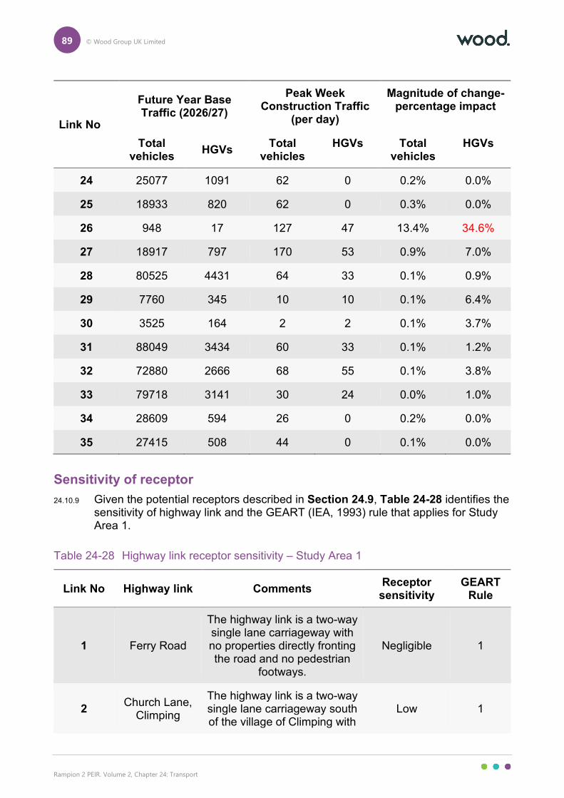
89 © Wood Group UK Limited
Rampion 2 PEIR. Volume 2, Chapter 24: Transport
Link No
Future Year Base Traffic (2026/27)
Peak Week Construction Traffic
(per day)
Magnitude of change- percentage impact
Total vehicles
HGVs Total
vehicles HGVs Total
vehicles HGVs
24 25077 1091 62 0 0.2% 0.0%
25 18933 820 62 0 0.3% 0.0%
26 948 17 127 47 13.4% 34.6%
27 18917 797 170 53 0.9% 7.0%
28 80525 4431 64 33 0.1% 0.9%
29 7760 345 10 10 0.1% 6.4%
30 3525 164 2 2 0.1% 3.7%
31 88049 3434 60 33 0.1% 1.2%
32 72880 2666 68 55 0.1% 3.8%
33 79718 3141 30 24 0.0% 1.0%
34 28609 594 26 0 0.2% 0.0%
35 27415 508 44 0 0.1% 0.0%
Sensitivity of receptor
24.10.9 Given the potential receptors described in Section 24.9, Table 24-28 identifies the sensitivity of highway link and the GEART (IEA, 1993) rule that applies for Study Area 1.
Table 24-28 Highway link receptor sensitivity – Study Area 1
Link No Highway link Comments Receptor sensitivity
GEART Rule
1 Ferry Road
The highway link is a two-way single lane carriageway with no properties directly fronting the road and no pedestrian
footways.
Negligible 1
2 Church Lane,
Climping
The highway link is a two-way single lane carriageway south of the village of Climping with
Low 1
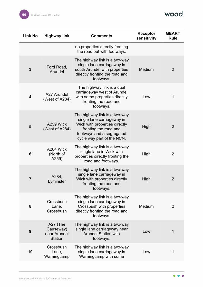
90 © Wood Group UK Limited
Rampion 2 PEIR. Volume 2, Chapter 24: Transport
Link No Highway link Comments Receptor sensitivity
GEART Rule
no properties directly fronting the road but with footways.
3 Ford Road,
Arundel
The highway link is a two-way single lane carriageway in
south Arundel with properties directly fronting the road and
footways.
Medium 2
4 A27 Arundel
(West of A284)
The highway link is a dual carriageway west of Arundel with some properties directly
fronting the road and footways.
Low 1
5 A259 Wick
(West of A284)
The highway link is a two-way single lane carriageway in
Wick with properties directly fronting the road and
footways and a segregated cycle way part of the NCN.
High 2
6 A284 Wick (North of
A259)
The highway link is a two-way single lane in Wick with
properties directly fronting the road and footways.
High 2
7 A284,
Lyminster
The highway link is a two-way single lane carriageway in
Wick with properties directly fronting the road and
footways.
High 2
8 Crossbush
Lane, Crossbush
The highway link is a two-way single lane carriageway in Crossbush with properties
directly fronting the road and footways.
Medium 2
9
A27 (The Causeway)
near Arundel Station
The highway link is a two-way single lane carriageway near
Arundel Station with footways.
Low 1
10 Crossbush
Lane, Warningcamp
The highway link is a two-way single lane carriageway in Warningcamp with some
Low 1
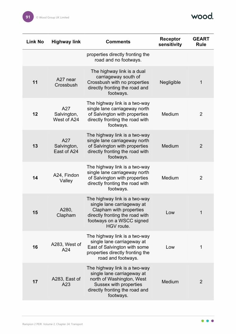
91 © Wood Group UK Limited
Rampion 2 PEIR. Volume 2, Chapter 24: Transport
Link No Highway link Comments Receptor sensitivity
GEART Rule
properties directly fronting the road and no footways.
11 A27 near
Crossbush
The highway link is a dual carriageway south of
Crossbush with no properties directly fronting the road and
footways.
Negligible 1
12 A27
Salvington, West of A24
The highway link is a two-way single lane carriageway north of Salvington with properties directly fronting the road with
footways.
Medium 2
13 A27
Salvington, East of A24
The highway link is a two-way single lane carriageway north of Salvington with properties directly fronting the road with
footways.
Medium 2
14 A24, Findon
Valley
The highway link is a two-way single lane carriageway north of Salvington with properties directly fronting the road with
footways.
Medium 2
15 A280,
Clapham
The highway link is a two-way single lane carriageway at Clapham with properties
directly fronting the road with footways on a WSCC signed
HGV route.
Low 1
16 A283, West of
A24
The highway link is a two-way single lane carriageway at
East of Salvington with some properties directly fronting the
road and footways.
Low 1
17 A283, East of
A23
The highway link is a two-way single lane carriageway at north of Washington, West
Sussex with properties directly fronting the road and
footways.
Medium 2
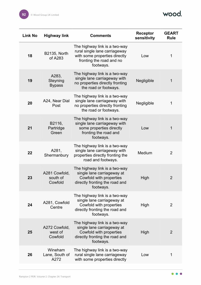
92 © Wood Group UK Limited
Rampion 2 PEIR. Volume 2, Chapter 24: Transport
Link No Highway link Comments Receptor sensitivity
GEART Rule
18 B2135, North
of A283
The highway link is a two-way rural single lane carriageway with some properties directly
fronting the road and no footways.
Low 1
19 A283,
Steyning Bypass
The highway link is a two-way single lane carriageway with no properties directly fronting
the road or footways.
Negligible 1
20 A24, Near Dial
Post
The highway link is a two-way single lane carriageway with no properties directly fronting
the road or footways.
Negligible 1
21 B2116,
Partridge Green
The highway link is a two-way single lane carriageway with
some properties directly fronting the road and
footways.
Low 1
22 A281,
Shermanbury
The highway link is a two-way single lane carriageway with
properties directly fronting the road and footways.
Medium 2
23 A281 Cowfold,
south of Cowfold
The highway link is a two-way single lane carriageway at
Cowfold with properties directly fronting the road and
footways.
High 2
24 A281, Cowfold
Centre
The highway link is a two-way single lane carriageway at
Cowfold with properties directly fronting the road and
footways.
High 2
25 A272 Cowfold,
west of Cowfold
The highway link is a two-way single lane carriageway at
Cowfold with properties directly fronting the road and
footways.
High 2
26 Wineham
Lane, South of A272
The highway link is a two-way rural single lane carriageway with some properties directly
Low 1
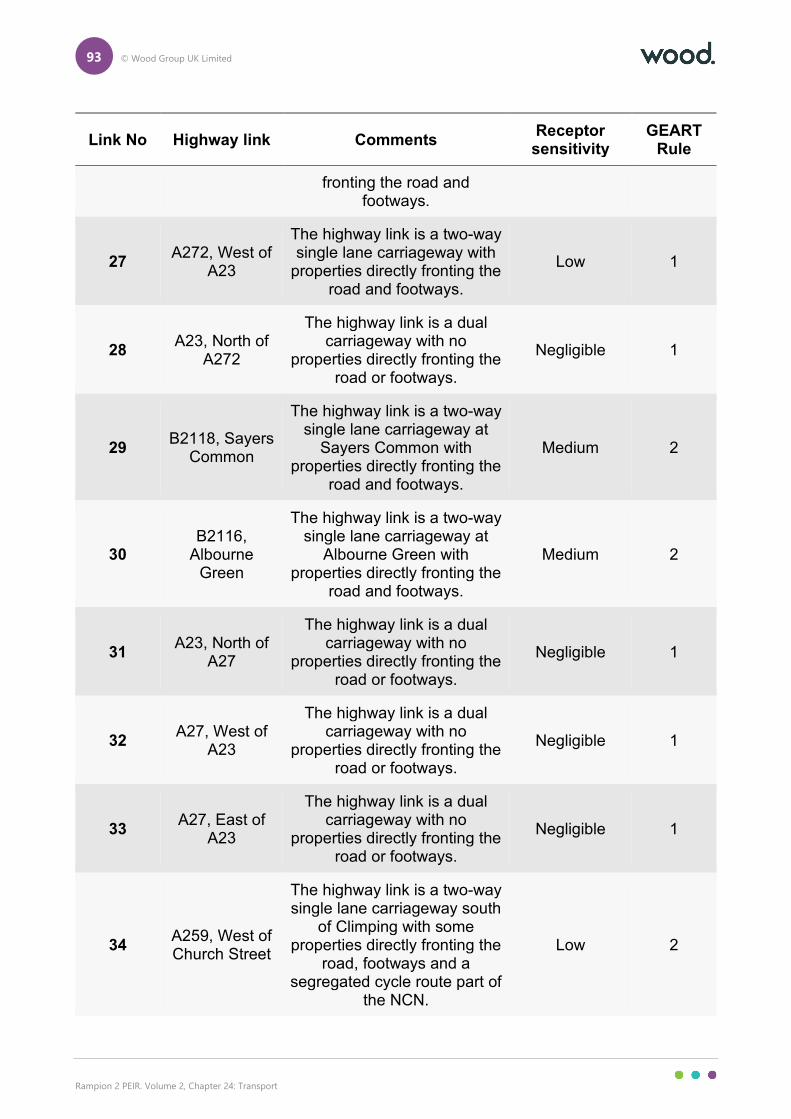
93 © Wood Group UK Limited
Rampion 2 PEIR. Volume 2, Chapter 24: Transport
Link No Highway link Comments Receptor sensitivity
GEART Rule
fronting the road and footways.
27 A272, West of
A23
The highway link is a two-way single lane carriageway with
properties directly fronting the road and footways.
Low 1
28 A23, North of
A272
The highway link is a dual carriageway with no
properties directly fronting the road or footways.
Negligible 1
29 B2118, Sayers
Common
The highway link is a two-way single lane carriageway at
Sayers Common with properties directly fronting the
road and footways.
Medium 2
30 B2116,
Albourne Green
The highway link is a two-way single lane carriageway at
Albourne Green with properties directly fronting the
road and footways.
Medium 2
31 A23, North of
A27
The highway link is a dual carriageway with no
properties directly fronting the road or footways.
Negligible 1
32 A27, West of
A23
The highway link is a dual carriageway with no
properties directly fronting the road or footways.
Negligible 1
33 A27, East of
A23
The highway link is a dual carriageway with no
properties directly fronting the road or footways.
Negligible 1
34 A259, West of Church Street
The highway link is a two-way single lane carriageway south
of Climping with some properties directly fronting the
road, footways and a segregated cycle route part of
the NCN.
Low 2
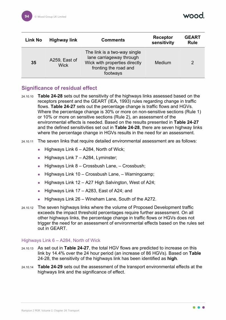
94 © Wood Group UK Limited
Rampion 2 PEIR. Volume 2, Chapter 24: Transport
Link No Highway link Comments Receptor sensitivity
GEART Rule
35 A259, East of
Wick
The link is a two-way single lane carriageway through
Wick with properties directly fronting the road and
footways
Medium 2
Significance of residual effect
24.10.10 Table 24-28 sets out the sensitivity of the highways links assessed based on the receptors present and the GEART (IEA, 1993) rules regarding change in traffic flows. Table 24-27 sets out the percentage change is traffic flows and HGVs. Where the percentage change is 30% or more on non-sensitive sections (Rule 1) or 10% or more on sensitive sections (Rule 2), an assessment of the environmental effects is needed. Based on the results presented in Table 24-27 and the defined sensitivities set out in Table 24-28, there are seven highway links where the percentage change in HGVs results in the need for an assessment.
24.10.11 The seven links that require detailed environmental assessment are as follows:
Highways Link 6 – A284, North of Wick;
Highways Link 7 – A284, Lyminster;
Highways Link 8 – Crossbush Lane, – Crossbush;
Highways Link 10 – Crossbush Lane, – Warningcamp;
Highways Link 12 – A27 High Salvington, West of A24;
Highways Link 17 – A283, East of A24; and
Highways Link 26 – Wineham Lane, South of the A272.
24.10.12 The seven highways links where the volume of Proposed Development traffic exceeds the impact threshold percentages require further assessment. On all other highways links, the percentage change in traffic flows or HGVs does not trigger the need for an assessment of environmental effects based on the rules set out in GEART.
Highways Link 6 – A284, North of Wick
24.10.13 As set out in Table 24-27, the total HGV flows are predicted to increase on this link by 14.4% over the 24 hour period (an increase of 86 HGVs). Based on Table 24-28, the sensitivity of the highways link has been identified as high.
24.10.14 Table 24-29 sets out the assessment of the transport environmental effects at the highways link and the significance of effect.
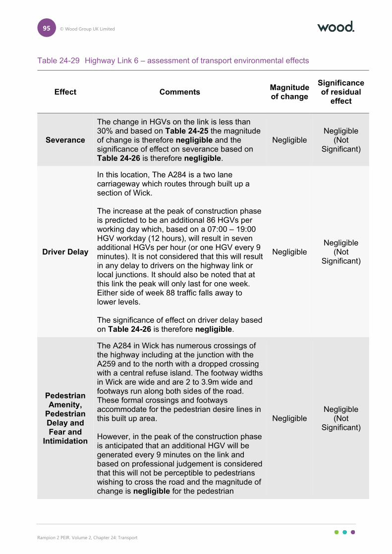
95 © Wood Group UK Limited
Rampion 2 PEIR. Volume 2, Chapter 24: Transport
Table 24-29 Highway Link 6 – assessment of transport environmental effects
Effect Comments Magnitude of change
Significance of residual
effect
Severance
The change in HGVs on the link is less than 30% and based on Table 24-25 the magnitude of change is therefore negligible and the significance of effect on severance based on Table 24-26 is therefore negligible.
Negligible Negligible
(Not Significant)
Driver Delay
In this location, The A284 is a two lane carriageway which routes through built up a section of Wick. The increase at the peak of construction phase is predicted to be an additional 86 HGVs per working day which, based on a 07:00 – 19:00 HGV workday (12 hours), will result in seven additional HGVs per hour (or one HGV every 9 minutes). It is not considered that this will result in any delay to drivers on the highway link or local junctions. It should also be noted that at this link the peak will only last for one week. Either side of week 88 traffic falls away to lower levels. The significance of effect on driver delay based on Table 24-26 is therefore negligible.
Negligible Negligible
(Not Significant)
Pedestrian Amenity,
Pedestrian Delay and Fear and
Intimidation
The A284 in Wick has numerous crossings of the highway including at the junction with the A259 and to the north with a dropped crossing with a central refuse island. The footway widths in Wick are wide and are 2 to 3.9m wide and footways run along both sides of the road. These formal crossings and footways accommodate for the pedestrian desire lines in this built up area. However, in the peak of the construction phase is anticipated that an additional HGV will be generated every 9 minutes on the link and based on professional judgement is considered that this will not be perceptible to pedestrians wishing to cross the road and the magnitude of change is negligible for the pedestrian
Negligible Negligible
(Not Significant)
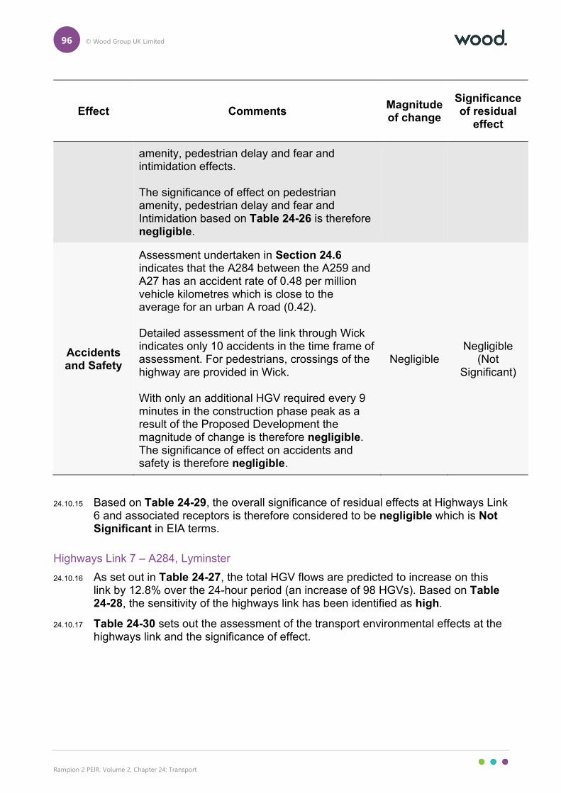
96 © Wood Group UK Limited
Rampion 2 PEIR. Volume 2, Chapter 24: Transport
Effect Comments Magnitude of change
Significance of residual
effect
amenity, pedestrian delay and fear and intimidation effects. The significance of effect on pedestrian amenity, pedestrian delay and fear and Intimidation based on Table 24-26 is therefore negligible.
Accidents and Safety
Assessment undertaken in Section 24.6 indicates that the A284 between the A259 and A27 has an accident rate of 0.48 per million vehicle kilometres which is close to the average for an urban A road (0.42). Detailed assessment of the link through Wick indicates only 10 accidents in the time frame of assessment. For pedestrians, crossings of the highway are provided in Wick. With only an additional HGV required every 9 minutes in the construction phase peak as a result of the Proposed Development the magnitude of change is therefore negligible. The significance of effect on accidents and safety is therefore negligible.
Negligible Negligible
(Not Significant)
24.10.15 Based on Table 24-29, the overall significance of residual effects at Highways Link 6 and associated receptors is therefore considered to be negligible which is Not Significant in EIA terms.
Highways Link 7 – A284, Lyminster
24.10.16 As set out in Table 24-27, the total HGV flows are predicted to increase on this link by 12.8% over the 24-hour period (an increase of 98 HGVs). Based on Table 24-28, the sensitivity of the highways link has been identified as high.
24.10.17 Table 24-30 sets out the assessment of the transport environmental effects at the highways link and the significance of effect.
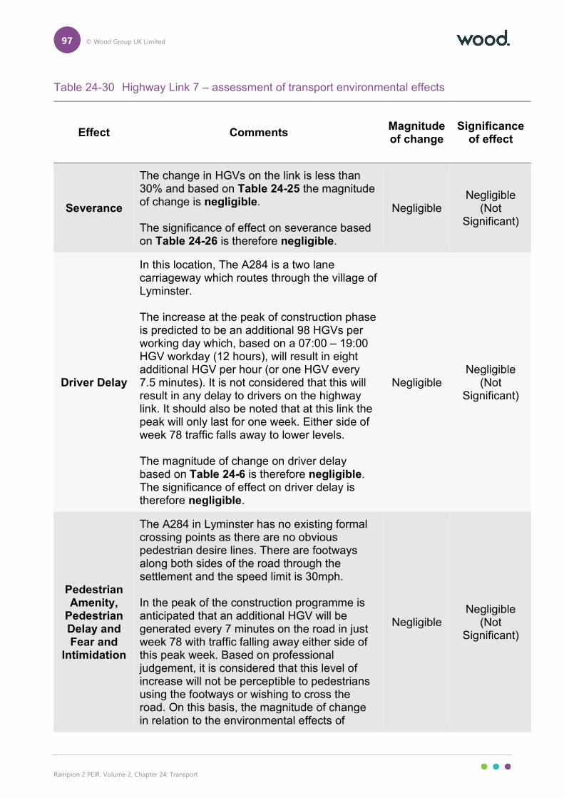
97 © Wood Group UK Limited
Rampion 2 PEIR. Volume 2, Chapter 24: Transport
Table 24-30 Highway Link 7 – assessment of transport environmental effects
Effect Comments Magnitude of change
Significance of effect
Severance
The change in HGVs on the link is less than 30% and based on Table 24-25 the magnitude of change is negligible. The significance of effect on severance based on Table 24-26 is therefore negligible.
Negligible Negligible
(Not Significant)
Driver Delay
In this location, The A284 is a two lane carriageway which routes through the village of Lyminster. The increase at the peak of construction phase is predicted to be an additional 98 HGVs per working day which, based on a 07:00 – 19:00 HGV workday (12 hours), will result in eight additional HGV per hour (or one HGV every 7.5 minutes). It is not considered that this will result in any delay to drivers on the highway link. It should also be noted that at this link the peak will only last for one week. Either side of week 78 traffic falls away to lower levels. The magnitude of change on driver delay based on Table 24-6 is therefore negligible. The significance of effect on driver delay is therefore negligible.
Negligible Negligible
(Not Significant)
Pedestrian Amenity,
Pedestrian Delay and Fear and
Intimidation
The A284 in Lyminster has no existing formal crossing points as there are no obvious pedestrian desire lines. There are footways along both sides of the road through the settlement and the speed limit is 30mph. In the peak of the construction programme is anticipated that an additional HGV will be generated every 7 minutes on the road in just week 78 with traffic falling away either side of this peak week. Based on professional judgement, it is considered that this level of increase will not be perceptible to pedestrians using the footways or wishing to cross the road. On this basis, the magnitude of change in relation to the environmental effects of
Negligible Negligible
(Not Significant)
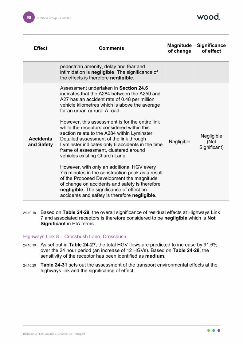
98 © Wood Group UK Limited
Rampion 2 PEIR. Volume 2, Chapter 24: Transport
Effect Comments Magnitude of change
Significance of effect
pedestrian amenity, delay and fear and intimidation is negligible. The significance of the effects is therefore negligible.
Accidents and Safety
Assessment undertaken in Section 24.6 indicates that the A284 between the A259 and A27 has an accident rate of 0.48 per million vehicle kilometres which is above the average for an urban or rural A road. However, this assessment is for the entire link while the receptors considered within this section relate to the A284 within Lyminster. Detailed assessment of the link through Lyminster indicates only 6 accidents in the time frame of assessment, clustered around vehicles existing Church Lane. However, with only an additional HGV every 7.5 minutes in the construction peak as a result of the Proposed Development the magnitude of change on accidents and safety is therefore negligible. The significance of effect on accidents and safety is therefore negligible.
Negligible Negligible
(Not Significant)
24.10.18 Based on Table 24-29, the overall significance of residual effects at Highways Link 7 and associated receptors is therefore considered to be negligible which is Not Significant in EIA terms.
Highways Link 8 – Crossbush Lane, Crossbush
24.10.19 As set out in Table 24-27, the total HGV flows are predicted to increase by 91.6% over the 24 hour period (an increase of 12 HGVs). Based on Table 24-28, the sensitivity of the receptor has been identified as medium.
24.10.20 Table 24-31 sets out the assessment of the transport environmental effects at the highways link and the significance of effect.
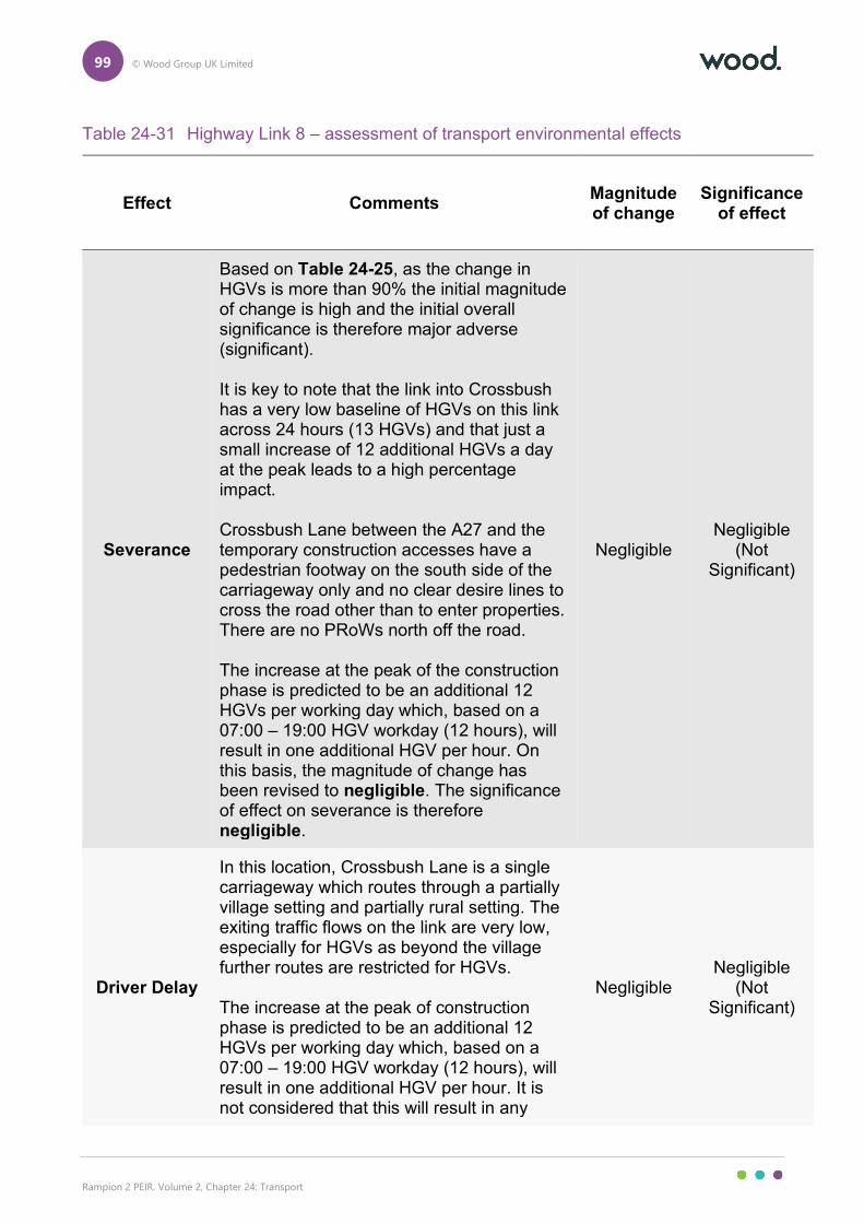
99 © Wood Group UK Limited
Rampion 2 PEIR. Volume 2, Chapter 24: Transport
Table 24-31 Highway Link 8 – assessment of transport environmental effects
Effect Comments Magnitude of change
Significance of effect
Severance
Based on Table 24-25, as the change in HGVs is more than 90% the initial magnitude of change is high and the initial overall significance is therefore major adverse (significant). It is key to note that the link into Crossbush has a very low baseline of HGVs on this link across 24 hours (13 HGVs) and that just a small increase of 12 additional HGVs a day at the peak leads to a high percentage impact. Crossbush Lane between the A27 and the temporary construction accesses have a pedestrian footway on the south side of the carriageway only and no clear desire lines to cross the road other than to enter properties. There are no PRoWs north off the road. The increase at the peak of the construction phase is predicted to be an additional 12 HGVs per working day which, based on a 07:00 – 19:00 HGV workday (12 hours), will result in one additional HGV per hour. On this basis, the magnitude of change has been revised to negligible. The significance of effect on severance is therefore negligible.
Negligible Negligible
(Not Significant)
Driver Delay
In this location, Crossbush Lane is a single carriageway which routes through a partially village setting and partially rural setting. The exiting traffic flows on the link are very low, especially for HGVs as beyond the village further routes are restricted for HGVs. The increase at the peak of construction phase is predicted to be an additional 12 HGVs per working day which, based on a 07:00 – 19:00 HGV workday (12 hours), will result in one additional HGV per hour. It is not considered that this will result in any
Negligible Negligible
(Not Significant)
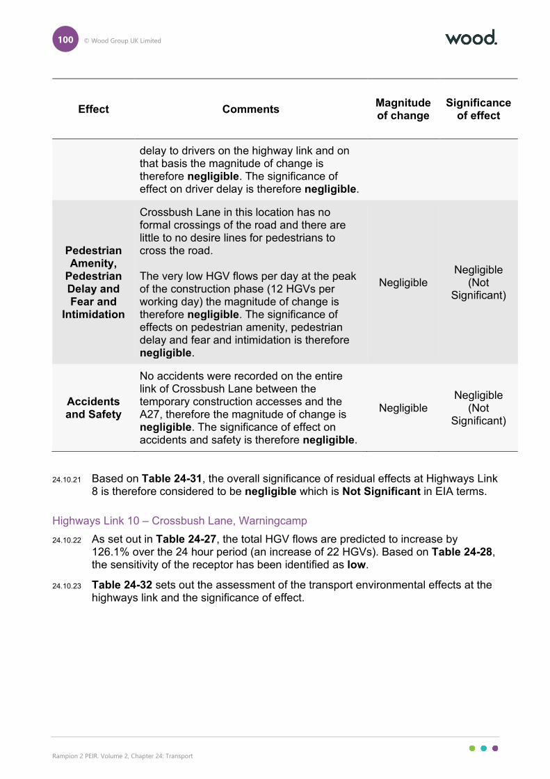
100 © Wood Group UK Limited
Rampion 2 PEIR. Volume 2, Chapter 24: Transport
Effect Comments Magnitude of change
Significance of effect
delay to drivers on the highway link and on that basis the magnitude of change is therefore negligible. The significance of effect on driver delay is therefore negligible.
Pedestrian Amenity,
Pedestrian Delay and Fear and
Intimidation
Crossbush Lane in this location has no formal crossings of the road and there are little to no desire lines for pedestrians to cross the road. The very low HGV flows per day at the peak of the construction phase (12 HGVs per working day) the magnitude of change is therefore negligible. The significance of effects on pedestrian amenity, pedestrian delay and fear and intimidation is therefore negligible.
Negligible Negligible
(Not Significant)
Accidents and Safety
No accidents were recorded on the entire link of Crossbush Lane between the temporary construction accesses and the A27, therefore the magnitude of change is negligible. The significance of effect on accidents and safety is therefore negligible.
Negligible Negligible
(Not Significant)
24.10.21 Based on Table 24-31, the overall significance of residual effects at Highways Link 8 is therefore considered to be negligible which is Not Significant in EIA terms.
Highways Link 10 – Crossbush Lane, Warningcamp
24.10.22 As set out in Table 24-27, the total HGV flows are predicted to increase by 126.1% over the 24 hour period (an increase of 22 HGVs). Based on Table 24-28, the sensitivity of the receptor has been identified as low.
24.10.23 Table 24-32 sets out the assessment of the transport environmental effects at the highways link and the significance of effect.
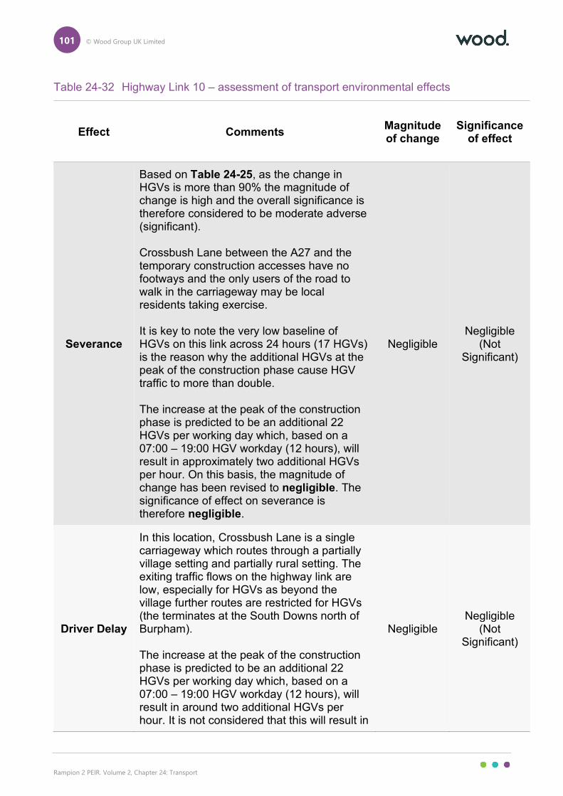
101 © Wood Group UK Limited
Rampion 2 PEIR. Volume 2, Chapter 24: Transport
Table 24-32 Highway Link 10 – assessment of transport environmental effects
Effect Comments Magnitude of change
Significance of effect
Severance
Based on Table 24-25, as the change in HGVs is more than 90% the magnitude of change is high and the overall significance is therefore considered to be moderate adverse (significant). Crossbush Lane between the A27 and the temporary construction accesses have no footways and the only users of the road to walk in the carriageway may be local residents taking exercise. It is key to note the very low baseline of HGVs on this link across 24 hours (17 HGVs) is the reason why the additional HGVs at the peak of the construction phase cause HGV traffic to more than double. The increase at the peak of the construction phase is predicted to be an additional 22 HGVs per working day which, based on a 07:00 – 19:00 HGV workday (12 hours), will result in approximately two additional HGVs per hour. On this basis, the magnitude of change has been revised to negligible. The significance of effect on severance is therefore negligible.
Negligible Negligible
(Not Significant)
Driver Delay
In this location, Crossbush Lane is a single carriageway which routes through a partially village setting and partially rural setting. The exiting traffic flows on the highway link are low, especially for HGVs as beyond the village further routes are restricted for HGVs (the terminates at the South Downs north of Burpham). The increase at the peak of the construction phase is predicted to be an additional 22 HGVs per working day which, based on a 07:00 – 19:00 HGV workday (12 hours), will result in around two additional HGVs per hour. It is not considered that this will result in
Negligible Negligible
(Not Significant)
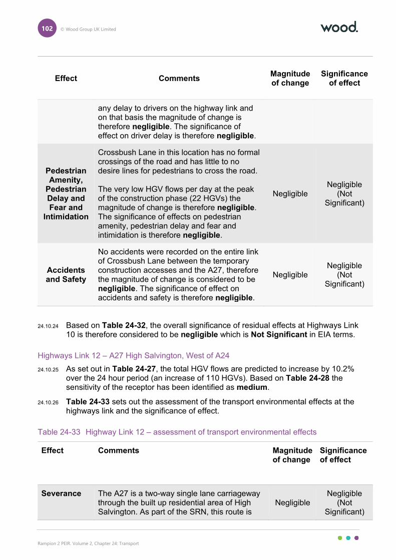
102 © Wood Group UK Limited
Rampion 2 PEIR. Volume 2, Chapter 24: Transport
Effect Comments Magnitude of change
Significance of effect
any delay to drivers on the highway link and on that basis the magnitude of change is therefore negligible. The significance of effect on driver delay is therefore negligible.
Pedestrian Amenity,
Pedestrian Delay and Fear and
Intimidation
Crossbush Lane in this location has no formal crossings of the road and has little to no desire lines for pedestrians to cross the road. The very low HGV flows per day at the peak of the construction phase (22 HGVs) the magnitude of change is therefore negligible. The significance of effects on pedestrian amenity, pedestrian delay and fear and intimidation is therefore negligible.
Negligible Negligible
(Not Significant)
Accidents and Safety
No accidents were recorded on the entire link of Crossbush Lane between the temporary construction accesses and the A27, therefore the magnitude of change is considered to be negligible. The significance of effect on accidents and safety is therefore negligible.
Negligible Negligible
(Not Significant)
24.10.24 Based on Table 24-32, the overall significance of residual effects at Highways Link 10 is therefore considered to be negligible which is Not Significant in EIA terms.
Highways Link 12 – A27 High Salvington, West of A24
24.10.25 As set out in Table 24-27, the total HGV flows are predicted to increase by 10.2% over the 24 hour period (an increase of 110 HGVs). Based on Table 24-28 the sensitivity of the receptor has been identified as medium.
24.10.26 Table 24-33 sets out the assessment of the transport environmental effects at the highways link and the significance of effect.
Table 24-33 Highway Link 12 – assessment of transport environmental effects
Effect Comments Magnitude of change
Significance of effect
Severance The A27 is a two-way single lane carriageway through the built up residential area of High Salvington. As part of the SRN, this route is
Negligible Negligible
(Not Significant)
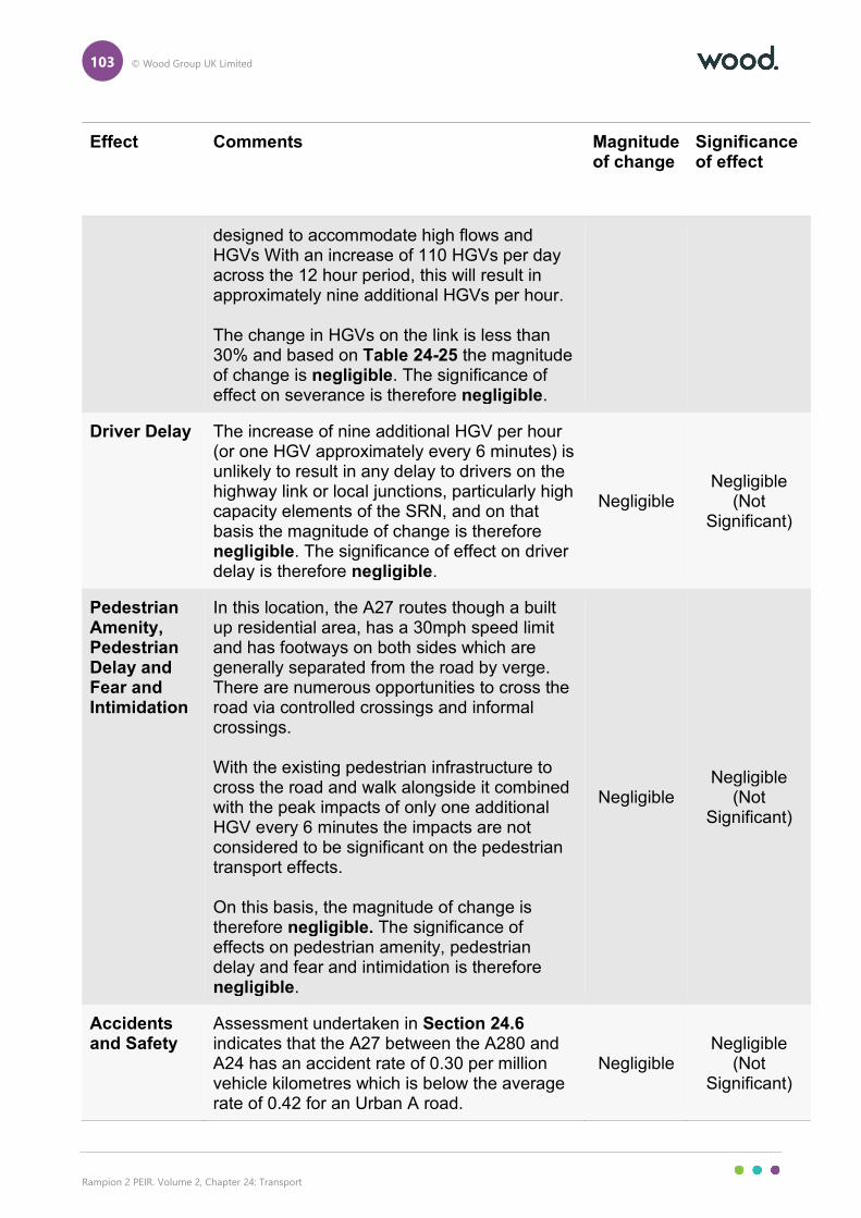
103 © Wood Group UK Limited
Rampion 2 PEIR. Volume 2, Chapter 24: Transport
Effect Comments Magnitude of change
Significance of effect
designed to accommodate high flows and HGVs With an increase of 110 HGVs per day across the 12 hour period, this will result in approximately nine additional HGVs per hour. The change in HGVs on the link is less than 30% and based on Table 24-25 the magnitude of change is negligible. The significance of effect on severance is therefore negligible.
Driver Delay The increase of nine additional HGV per hour (or one HGV approximately every 6 minutes) is unlikely to result in any delay to drivers on the highway link or local junctions, particularly high capacity elements of the SRN, and on that basis the magnitude of change is therefore negligible. The significance of effect on driver delay is therefore negligible.
Negligible Negligible
(Not Significant)
Pedestrian Amenity, Pedestrian Delay and Fear and Intimidation
In this location, the A27 routes though a built up residential area, has a 30mph speed limit and has footways on both sides which are generally separated from the road by verge. There are numerous opportunities to cross the road via controlled crossings and informal crossings. With the existing pedestrian infrastructure to cross the road and walk alongside it combined with the peak impacts of only one additional HGV every 6 minutes the impacts are not considered to be significant on the pedestrian transport effects. On this basis, the magnitude of change is therefore negligible. The significance of effects on pedestrian amenity, pedestrian delay and fear and intimidation is therefore negligible.
Negligible Negligible
(Not Significant)
Accidents and Safety
Assessment undertaken in Section 24.6 indicates that the A27 between the A280 and A24 has an accident rate of 0.30 per million vehicle kilometres which is below the average rate of 0.42 for an Urban A road.
Negligible Negligible
(Not Significant)
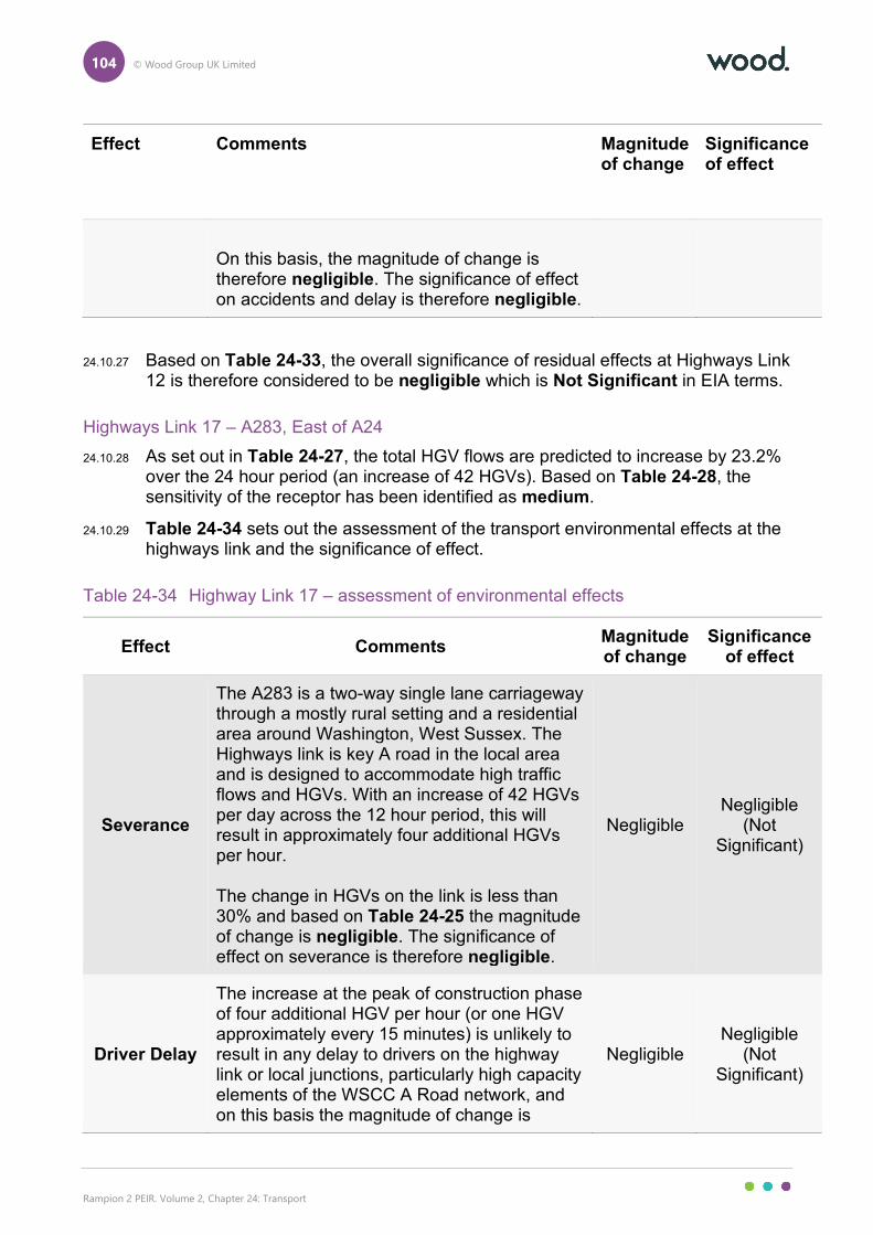
104 © Wood Group UK Limited
Rampion 2 PEIR. Volume 2, Chapter 24: Transport
Effect Comments Magnitude of change
Significance of effect
On this basis, the magnitude of change is therefore negligible. The significance of effect on accidents and delay is therefore negligible.
24.10.27 Based on Table 24-33, the overall significance of residual effects at Highways Link 12 is therefore considered to be negligible which is Not Significant in EIA terms.
Highways Link 17 – A283, East of A24
24.10.28 As set out in Table 24-27, the total HGV flows are predicted to increase by 23.2% over the 24 hour period (an increase of 42 HGVs). Based on Table 24-28, the sensitivity of the receptor has been identified as medium.
24.10.29 Table 24-34 sets out the assessment of the transport environmental effects at the highways link and the significance of effect.
Table 24-34 Highway Link 17 – assessment of environmental effects
Effect Comments Magnitude of change
Significance of effect
Severance
The A283 is a two-way single lane carriageway through a mostly rural setting and a residential area around Washington, West Sussex. The Highways link is key A road in the local area and is designed to accommodate high traffic flows and HGVs. With an increase of 42 HGVs per day across the 12 hour period, this will result in approximately four additional HGVs per hour. The change in HGVs on the link is less than 30% and based on Table 24-25 the magnitude of change is negligible. The significance of effect on severance is therefore negligible.
Negligible Negligible
(Not Significant)
Driver Delay
The increase at the peak of construction phase of four additional HGV per hour (or one HGV approximately every 15 minutes) is unlikely to result in any delay to drivers on the highway link or local junctions, particularly high capacity elements of the WSCC A Road network, and on this basis the magnitude of change is
Negligible Negligible
(Not Significant)
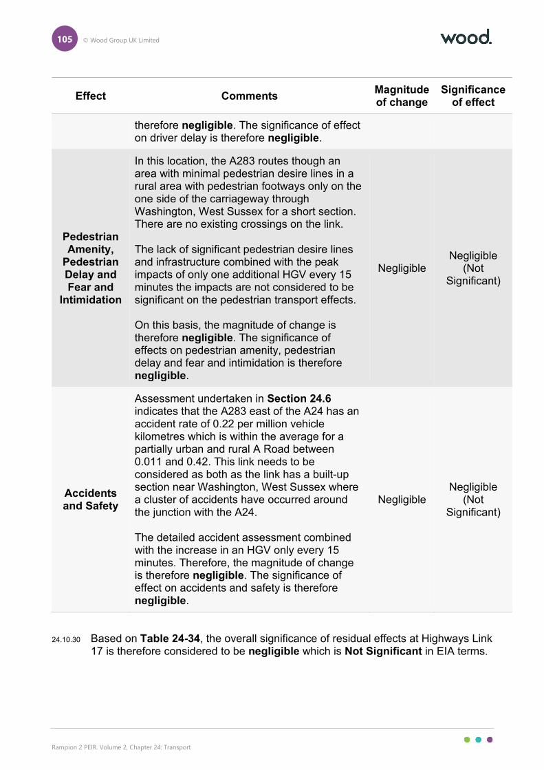
105 © Wood Group UK Limited
Rampion 2 PEIR. Volume 2, Chapter 24: Transport
Effect Comments Magnitude of change
Significance of effect
therefore negligible. The significance of effect on driver delay is therefore negligible.
Pedestrian Amenity,
Pedestrian Delay and Fear and
Intimidation
In this location, the A283 routes though an area with minimal pedestrian desire lines in a rural area with pedestrian footways only on the one side of the carriageway through Washington, West Sussex for a short section. There are no existing crossings on the link. The lack of significant pedestrian desire lines and infrastructure combined with the peak impacts of only one additional HGV every 15 minutes the impacts are not considered to be significant on the pedestrian transport effects. On this basis, the magnitude of change is therefore negligible. The significance of effects on pedestrian amenity, pedestrian delay and fear and intimidation is therefore negligible.
Negligible Negligible
(Not Significant)
Accidents and Safety
Assessment undertaken in Section 24.6 indicates that the A283 east of the A24 has an accident rate of 0.22 per million vehicle kilometres which is within the average for a partially urban and rural A Road between 0.011 and 0.42. This link needs to be considered as both as the link has a built-up section near Washington, West Sussex where a cluster of accidents have occurred around the junction with the A24. The detailed accident assessment combined with the increase in an HGV only every 15 minutes. Therefore, the magnitude of change is therefore negligible. The significance of effect on accidents and safety is therefore negligible.
Negligible Negligible
(Not Significant)
24.10.30 Based on Table 24-34, the overall significance of residual effects at Highways Link 17 is therefore considered to be negligible which is Not Significant in EIA terms.
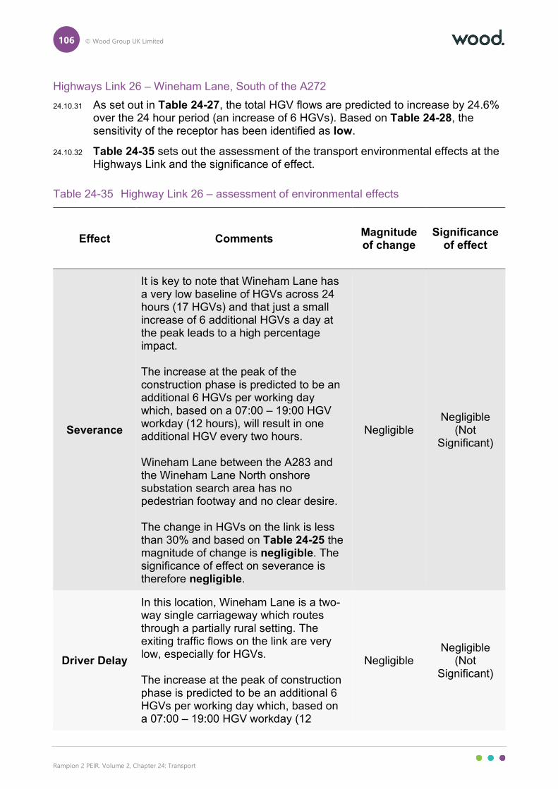
106 © Wood Group UK Limited
Rampion 2 PEIR. Volume 2, Chapter 24: Transport
Highways Link 26 – Wineham Lane, South of the A272
24.10.31 As set out in Table 24-27, the total HGV flows are predicted to increase by 24.6% over the 24 hour period (an increase of 6 HGVs). Based on Table 24-28, the sensitivity of the receptor has been identified as low.
24.10.32 Table 24-35 sets out the assessment of the transport environmental effects at the Highways Link and the significance of effect.
Table 24-35 Highway Link 26 – assessment of environmental effects
Effect Comments Magnitude of change
Significance of effect
Severance
It is key to note that Wineham Lane has a very low baseline of HGVs across 24 hours (17 HGVs) and that just a small increase of 6 additional HGVs a day at the peak leads to a high percentage impact. The increase at the peak of the construction phase is predicted to be an additional 6 HGVs per working day which, based on a 07:00 – 19:00 HGV workday (12 hours), will result in one additional HGV every two hours. Wineham Lane between the A283 and the Wineham Lane North onshore substation search area has no pedestrian footway and no clear desire. The change in HGVs on the link is less than 30% and based on Table 24-25 the magnitude of change is negligible. The significance of effect on severance is therefore negligible.
Negligible Negligible
(Not Significant)
Driver Delay
In this location, Wineham Lane is a two-way single carriageway which routes through a partially rural setting. The exiting traffic flows on the link are very low, especially for HGVs. The increase at the peak of construction phase is predicted to be an additional 6 HGVs per working day which, based on a 07:00 – 19:00 HGV workday (12
Negligible Negligible
(Not Significant)
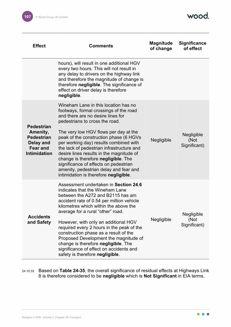
107 © Wood Group UK Limited
Rampion 2 PEIR. Volume 2, Chapter 24: Transport
Effect Comments Magnitude of change
Significance of effect
hours), will result in one additional HGV every two hours. This will not result in any delay to drivers on the highway link and therefore the magnitude of change is therefore negligible. The significance of effect on driver delay is therefore negligible.
Pedestrian Amenity,
Pedestrian Delay and Fear and
Intimidation
Wineham Lane in this location has no footways, formal crossings of the road and there are no desire lines for pedestrians to cross the road. The very low HGV flows per day at the peak of the construction phase (6 HGVs per working day) results combined with the lack of pedestrian infrastructure and desire lines results in the magnitude of change is therefore negligible. The significance of effects on pedestrian amenity, pedestrian delay and fear and intimidation is therefore negligible.
Negligible Negligible
(Not Significant)
Accidents and Safety
Assessment undertaken in Section 24.6 indicates that the Wineham Lane between the A272 and B2115 has am accident rate of 0.54 per million vehicle kilometres which within the above the average for a rural “other” road. However, with only an additional HGV required every 2 hours in the peak of the construction phase as a result of the Proposed Development the magnitude of change is therefore negligible. The significance of effect on accidents and safety is therefore negligible.
Negligible Negligible
(Not Significant)
24.10.33 Based on Table 24-35, the overall significance of residual effects at Highways Link 8 is therefore considered to be negligible which is Not Significant in EIA terms.
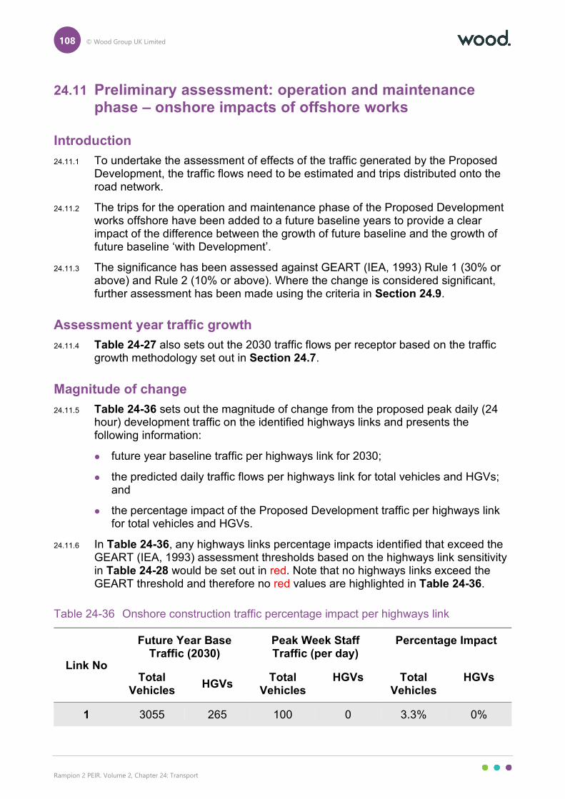
108 © Wood Group UK Limited
Rampion 2 PEIR. Volume 2, Chapter 24: Transport
24.11 Preliminary assessment: operation and maintenance phase – onshore impacts of offshore works
Introduction
24.11.1 To undertake the assessment of effects of the traffic generated by the Proposed Development, the traffic flows need to be estimated and trips distributed onto the road network.
24.11.2 The trips for the operation and maintenance phase of the Proposed Development works offshore have been added to a future baseline years to provide a clear impact of the difference between the growth of future baseline and the growth of future baseline ‘with Development’.
24.11.3 The significance has been assessed against GEART (IEA, 1993) Rule 1 (30% or above) and Rule 2 (10% or above). Where the change is considered significant, further assessment has been made using the criteria in Section 24.9.
Assessment year traffic growth
24.11.4 Table 24-27 also sets out the 2030 traffic flows per receptor based on the traffic growth methodology set out in Section 24.7.
Magnitude of change
24.11.5 Table 24-36 sets out the magnitude of change from the proposed peak daily (24 hour) development traffic on the identified highways links and presents the following information:
future year baseline traffic per highways link for 2030;
the predicted daily traffic flows per highways link for total vehicles and HGVs; and
the percentage impact of the Proposed Development traffic per highways link for total vehicles and HGVs.
24.11.6 In Table 24-36, any highways links percentage impacts identified that exceed the GEART (IEA, 1993) assessment thresholds based on the highways link sensitivity in Table 24-28 would be set out in red. Note that no highways links exceed the GEART threshold and therefore no red values are highlighted in Table 24-36.
Table 24-36 Onshore construction traffic percentage impact per highways link
Link No
Future Year Base Traffic (2030)
Peak Week Staff Traffic (per day)
Percentage Impact
Total Vehicles
HGVs Total
Vehicles HGVs Total
Vehicles HGVs
1 3055 265 100 0 3.3% 0%
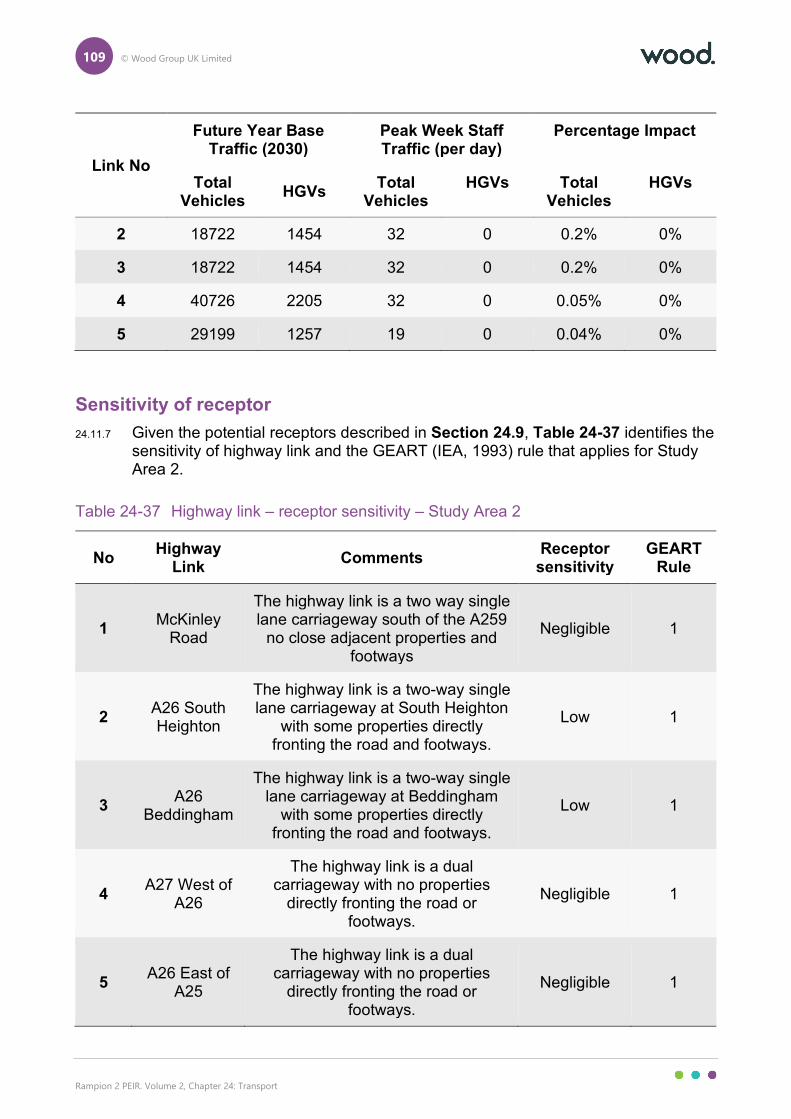
109 © Wood Group UK Limited
Rampion 2 PEIR. Volume 2, Chapter 24: Transport
Link No
Future Year Base Traffic (2030)
Peak Week Staff Traffic (per day)
Percentage Impact
Total Vehicles
HGVs Total
Vehicles HGVs Total
Vehicles HGVs
2 18722 1454 32 0 0.2% 0%
3 18722 1454 32 0 0.2% 0%
4 40726 2205 32 0 0.05% 0%
5 29199 1257 19 0 0.04% 0%
Sensitivity of receptor
24.11.7 Given the potential receptors described in Section 24.9, Table 24-37 identifies the sensitivity of highway link and the GEART (IEA, 1993) rule that applies for Study Area 2.
Table 24-37 Highway link – receptor sensitivity – Study Area 2
No Highway
Link Comments
Receptor sensitivity
GEART Rule
1 McKinley
Road
The highway link is a two way single lane carriageway south of the A259
no close adjacent properties and footways
Negligible 1
2 A26 South Heighton
The highway link is a two-way single lane carriageway at South Heighton
with some properties directly fronting the road and footways.
Low 1
3 A26
Beddingham
The highway link is a two-way single lane carriageway at Beddingham
with some properties directly fronting the road and footways.
Low 1
4 A27 West of
A26
The highway link is a dual carriageway with no properties
directly fronting the road or footways.
Negligible 1
5 A26 East of
A25
The highway link is a dual carriageway with no properties
directly fronting the road or footways.
Negligible 1
110 © Wood Group UK Limited
Rampion 2 PEIR. Volume 2, Chapter 24: Transport
Significance of residual effect
24.11.8 Table 24-38 sets out the sensitivity of the highways links assessed based on the receptors present and the GEART (IEA, 1993) rules and Table 24-37 sets out the magnitude of change. A comparison of the magnitude of change on the five assessed links (worst case 3.3% total traffic impact on Highways Link 1) and the sensitivity of the links (Worst case low sensitivity on Highways Links 2 and 3) indicates that traffic growth as a result of the offshore operation and maintenance phase of the Proposed Development indicates that none of the five assessed highways links exceeded the GEART (IEA, 1993) threshold Rule 1 (30% or more on non-sensitive sections (Low and Negligible sensitivity))
24.11.9 It is considered therefore that the impact of the offshore operation and maintenance phase of the Proposed Development will be negligible on the local highways network and effects on transport receptors are Not Significant in EIA terms.
24.12 Preliminary assessment: decommissioning phase – onshore works
24.12.1 To undertake the assessment of effects of the traffic generated by the Proposed Development, the traffic flows need to be estimated and trips distributed onto the road network.
24.12.2 The trips for the decommissioning phase of onshore works have been added to a future baseline year to provide a clear impact of the difference between the growth of future baseline and the growth of future baseline ‘with Development’.
24.12.3 The significance has been assessed against GEART (IEA, 1993) Rule 1 (30% or above) and Rule 2 (10% or above). Where the change is considered significant, further assessment has been made using the criteria in Section 24.9.
24.12.4 The assessment in this section includes for all of the relevant embedded environmental measures applicable to this phase of the development, C-18, C-32, C-157, C-158, C-159, C164, C-165, C-169. Details of these embedded environmental measures are set out in Table 24-21.
Assessment year traffic growth
24.12.5 Table 24-38 also sets out the 2051 traffic flows per highway link based on the traffic growth methodology set out in Section 24.7.
Magnitude of Change
24.1.1 Table 24-38 sets out the magnitude of change based on the proposed peak daily (24 hour) Proposed Development traffic in the decommissioning phase on the identified highways links and presents the following information:
future year baseline traffic per highways link for 2051
the predicted daily traffic flows per highways link for total vehicles and HGVs; and
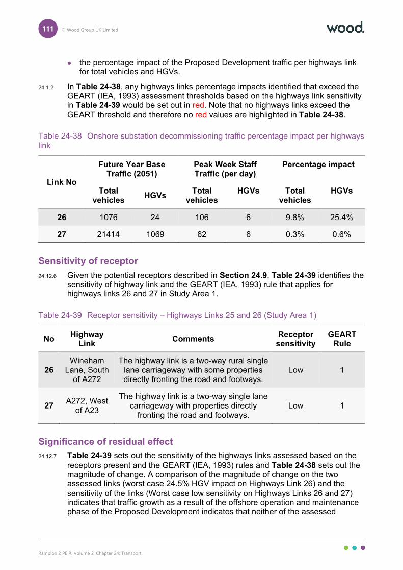
111 © Wood Group UK Limited
Rampion 2 PEIR. Volume 2, Chapter 24: Transport
the percentage impact of the Proposed Development traffic per highways link for total vehicles and HGVs.
24.1.2 In Table 24-38, any highways links percentage impacts identified that exceed the GEART (IEA, 1993) assessment thresholds based on the highways link sensitivity in Table 24-39 would be set out in red. Note that no highways links exceed the GEART threshold and therefore no red values are highlighted in Table 24-38.
Table 24-38 Onshore substation decommissioning traffic percentage impact per highways link
Link No
Future Year Base Traffic (2051)
Peak Week Staff Traffic (per day)
Percentage impact
Total vehicles
HGVs Total
vehicles HGVs Total
vehicles HGVs
26 1076 24 106 6 9.8% 25.4%
27 21414 1069 62 6 0.3% 0.6%
Sensitivity of receptor
24.12.6 Given the potential receptors described in Section 24.9, Table 24-39 identifies the sensitivity of highway link and the GEART (IEA, 1993) rule that applies for highways links 26 and 27 in Study Area 1.
Table 24-39 Receptor sensitivity – Highways Links 25 and 26 (Study Area 1)
No Highway
Link Comments
Receptor sensitivity
GEART Rule
26 Wineham
Lane, South of A272
The highway link is a two-way rural single lane carriageway with some properties directly fronting the road and footways.
Low 1
27 A272, West
of A23
The highway link is a two-way single lane carriageway with properties directly
fronting the road and footways. Low 1
Significance of residual effect
24.12.7 Table 24-39 sets out the sensitivity of the highways links assessed based on the receptors present and the GEART (IEA, 1993) rules and Table 24-38 sets out the magnitude of change. A comparison of the magnitude of change on the two assessed links (worst case 24.5% HGV impact on Highways Link 26) and the sensitivity of the links (Worst case low sensitivity on Highways Links 26 and 27) indicates that traffic growth as a result of the offshore operation and maintenance phase of the Proposed Development indicates that neither of the assessed
112 © Wood Group UK Limited
Rampion 2 PEIR. Volume 2, Chapter 24: Transport
highways links exceeded the GEART (IEA, 1993) threshold Rule 1 (30% or more on non-sensitive sections (Low and Negligible sensitivity))
24.12.8 It is considered therefore that the impact of the decommissioning phase of the onshore elements of the Proposed Development will have a negligible impact on the local highways network and transport receptors, and residual effects are Not Significant in EIA terms.
24.13 Preliminary assessment: cumulative effects
24.13.1 In terms of road traffic, the preferred option for projecting existing or historical traffic data for future year assessments is the use of appropriate local traffic forecasts such as TEMPro as has been undertaken in this chapter, the methodology of which is set out in Section 24.7. TEMPro is a program developed by the DfT providing traffic growth projections used to project long-term forecasts in traffic growth. The forecasts take into account national projections of population, employment, housing, car ownership, and trip rates. This is an accepted approach to assess future baseline traffic. This approach to forecasting traffic growth taking into account the traffic associated with all cumulative and anticipated development with the local plan has been agreed with WSCC and HE during consultation.
24.13.2 The A27 is a key link in the area and the A27 Arundel Bypass is noted within this chapter though at this stage no further cumulative assessment of any potential overlap has been undertaken. A preferred route was presented to the public in November 2020 which set out that it would be proposed to start construction of the road in 2023/24 but with no details of an anticipated date of completion, as the road is still not committed and no DCO application has been submitted. It is anticipated that this may change over the lifetime of the Rampion 2 DCO Application and between PEIR and ES stage a more detailed assessment of the A27 Arundel Bypass and any cumulative effects could be required. It is considered that the peak construction years of 2026 and 2027 for Rampion 2 are some way in advance of the anticipated construction years for the A27 Arundel Bypass project and as a result no cumulative assessment is provided at PEIR. Should more detail be provided between PEIR and ES stages then this will be reviewed and if necessary, more detailed assessment provided at the DCO submission stage.
24.13.3 No other committed developments in addition to those already taken into consideration within the TEMPro forecasts used in the assessment within this chapter have been identified that are anticipated to overlap with the Proposed Development and therefore no cumulative transport effects are anticipated.
24.14 Transboundary effects
24.14.1 Transboundary effects arise when impacts from a development within one European Economic Area (EEA) states affects the environment of another EEA state(s). A screening of transboundary effects has been carried out and is presented in Appendix B of the Scoping Report.
24.14.2 No transboundary effects relating to onshore transport were identified as part of the screening exercise and are therefore not considered further.
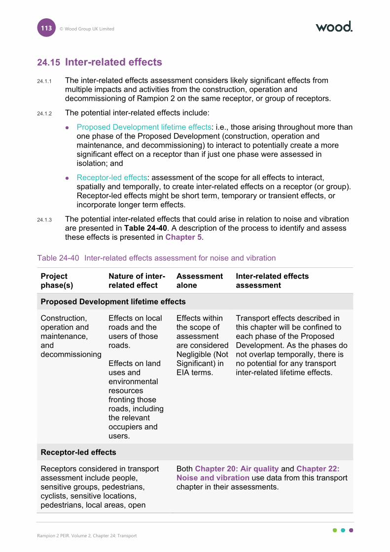
113 © Wood Group UK Limited
Rampion 2 PEIR. Volume 2, Chapter 24: Transport
24.15 Inter-related effects
24.1.1 The inter-related effects assessment considers likely significant effects from multiple impacts and activities from the construction, operation and decommissioning of Rampion 2 on the same receptor, or group of receptors.
24.1.2 The potential inter-related effects include:
Proposed Development lifetime effects: i.e., those arising throughout more than one phase of the Proposed Development (construction, operation and maintenance, and decommissioning) to interact to potentially create a more significant effect on a receptor than if just one phase were assessed in isolation; and
Receptor-led effects: assessment of the scope for all effects to interact, spatially and temporally, to create inter-related effects on a receptor (or group). Receptor-led effects might be short term, temporary or transient effects, or incorporate longer term effects.
24.1.3 The potential inter-related effects that could arise in relation to noise and vibration are presented in Table 24-40. A description of the process to identify and assess these effects is presented in Chapter 5.
Table 24-40 Inter-related effects assessment for noise and vibration
Project phase(s)
Nature of inter-related effect
Assessment alone
Inter-related effects assessment
Proposed Development lifetime effects
Construction, operation and maintenance, and decommissioning
Effects on local roads and the users of those roads. Effects on land uses and environmental resources fronting those roads, including the relevant occupiers and users.
Effects within the scope of assessment are considered Negligible (Not Significant) in EIA terms.
Transport effects described in this chapter will be confined to each phase of the Proposed Development. As the phases do not overlap temporally, there is no potential for any transport inter-related lifetime effects.
Receptor-led effects
Receptors considered in transport assessment include people, sensitive groups, pedestrians, cyclists, sensitive locations, pedestrians, local areas, open
Both Chapter 20: Air quality and Chapter 22: Noise and vibration use data from this transport chapter in their assessments.
114 © Wood Group UK Limited
Rampion 2 PEIR. Volume 2, Chapter 24: Transport
Project phase(s)
Nature of inter-related effect
Assessment alone
Inter-related effects assessment
spaces, sites (ecological and tourist) and highway links (refer to Table 24-6). There is potential for inter-related effects with air quality, noise and vibration, transport, socio-economics and landscape and visual impact.
The construction phase has the highest likelihood of receptor-led effects as several activities take place during this phase (refer to Chapter 4). Although receptor-led effects will likely be short term and temporary depending on works being completed in vicinity of a receptor. The implementation of the Outline COCP and other embedded environmental measures have been considered within the individual aspect assessments which conclude Not Significant effects for noise and vibration, air quality and transport. Significant effects remain for the landscape and visual impact aspect as the PEIR is assessed at Year 1 of the Proposed Development only. In the ES, Year 1 and Year 15 of the Proposed Development will be assessed for landscape and visual impact. It is expected that environmental measures at Year 15 will materially reduce potential effects, compared to Year 1. Minor (Not Significant) and Moderate and Moderate/Major (Significant) effects also remain for socio-economics in relation to the enjoyment of onshore recreational activities (namely PRoW users). Overall, some inter-related effects on residents, open spaces and/or sites may arise at some locations on a temporary basis. However, embedded environmental measures are designed to reduce these effects and it is considered unlikely that any inter-related effects would exceed the significance reported in the individual aspect chapters for noise and vibration, air quality, transport, socio-economics or landscape and visual effects. Operation and maintenance effects for transport are expected to be limited to occasional site visits and maintenance works. This is expected to result in effects that are Negligible (Not Significant) in EIA terms and they are unlikely to
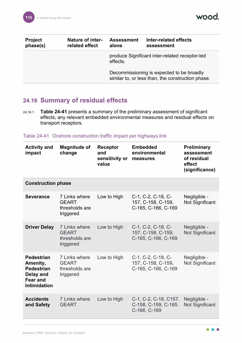
115 © Wood Group UK Limited
Rampion 2 PEIR. Volume 2, Chapter 24: Transport
Project phase(s)
Nature of inter-related effect
Assessment alone
Inter-related effects assessment
produce Significant inter-related receptor-led effects. Decommissioning is expected to be broadly similar to, or less than, the construction phase.
24.16 Summary of residual effects
24.16.1 Table 24-41 presents a summary of the preliminary assessment of significant effects, any relevant embedded environmental measures and residual effects on transport receptors.
Table 24-41 Onshore construction traffic impact per highways link
Activity and impact
Magnitude of change
Receptor and sensitivity or value
Embedded environmental measures
Preliminary assessment of residual effect (significance)
Construction phase
Severance 7 Links where GEART thresholds are triggered
Low to High C-1, C-2, C-18, C-157, C-158, C-159, C-165, C-166, C-169
Negligible - Not Significant
Driver Delay 7 Links where GEART thresholds are triggered
Low to High C-1, C-2, C-18, C-157, C-158, C-159, C-165, C-166, C-169
Negligible - Not Significant
Pedestrian Amenity, Pedestrian Delay and Fear and Intimidation
7 Links where GEART thresholds are triggered
Low to High C-1, C-2, C-18, C-157, C-158, C-159, C-165, C-166, C-169
Negligible - Not Significant
Accidents and Safety
7 Links where GEART
Low to High C-1, C-2, C-18, C157, C-158, C-159, C-165. C-166, C-169
Negligible - Not Significant
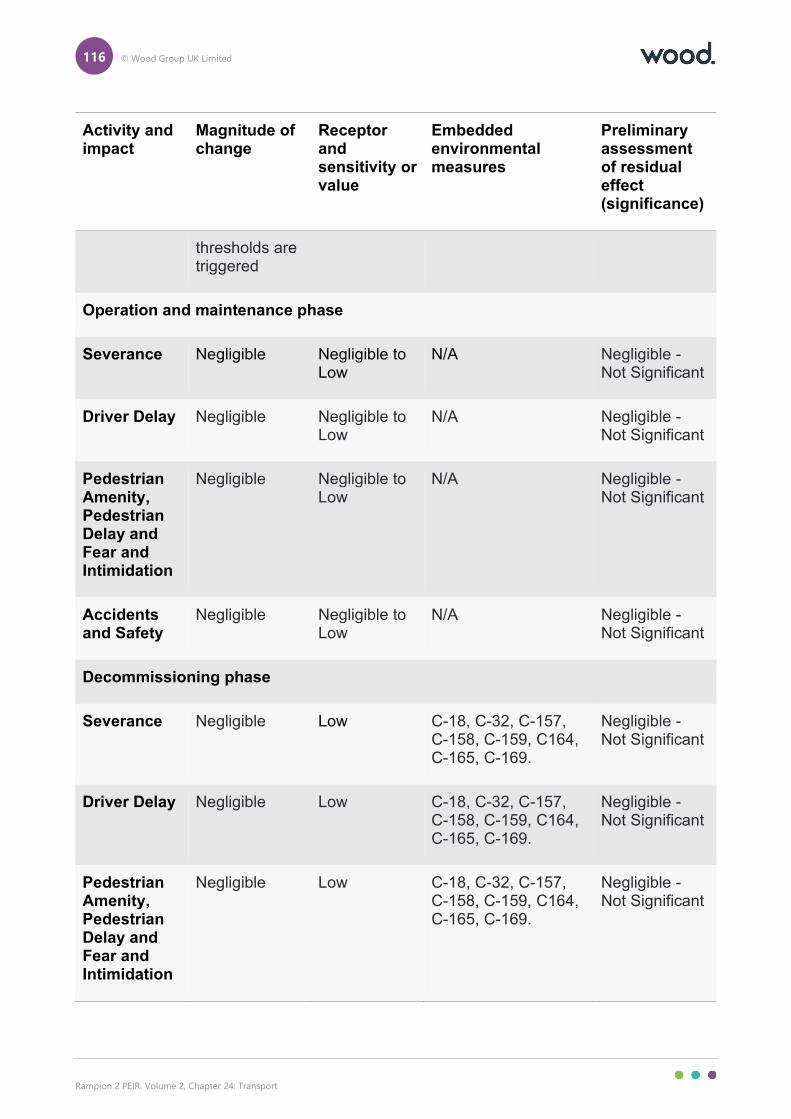
116 © Wood Group UK Limited
Rampion 2 PEIR. Volume 2, Chapter 24: Transport
Activity and impact
Magnitude of change
Receptor and sensitivity or value
Embedded environmental measures
Preliminary assessment of residual effect (significance)
thresholds are triggered
Operation and maintenance phase
Severance Negligible Negligible to Low
N/A Negligible - Not Significant
Driver Delay Negligible Negligible to Low
N/A Negligible - Not Significant
Pedestrian Amenity, Pedestrian Delay and Fear and Intimidation
Negligible Negligible to Low
N/A Negligible - Not Significant
Accidents and Safety
Negligible Negligible to Low
N/A Negligible - Not Significant
Decommissioning phase
Severance Negligible Low C-18, C-32, C-157, C-158, C-159, C164, C-165, C-169.
Negligible - Not Significant
Driver Delay Negligible Low C-18, C-32, C-157, C-158, C-159, C164, C-165, C-169.
Negligible - Not Significant
Pedestrian Amenity, Pedestrian Delay and Fear and Intimidation
Negligible Low C-18, C-32, C-157, C-158, C-159, C164, C-165, C-169.
Negligible - Not Significant
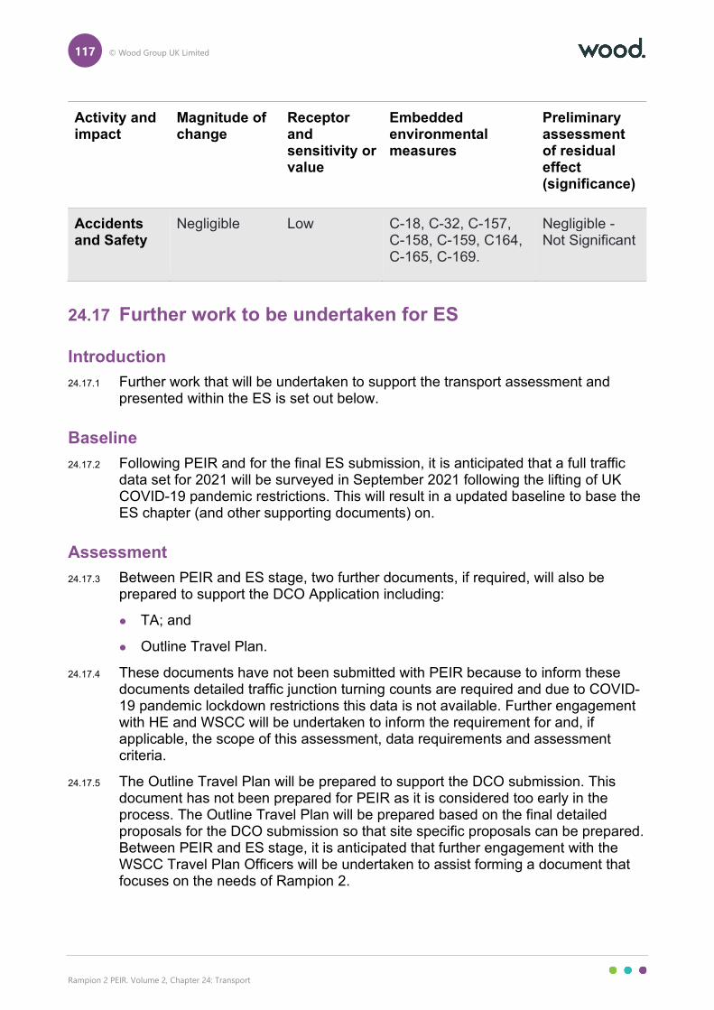
117 © Wood Group UK Limited
Rampion 2 PEIR. Volume 2, Chapter 24: Transport
Activity and impact
Magnitude of change
Receptor and sensitivity or value
Embedded environmental measures
Preliminary assessment of residual effect (significance)
Accidents and Safety
Negligible Low C-18, C-32, C-157, C-158, C-159, C164, C-165, C-169.
Negligible - Not Significant
24.17 Further work to be undertaken for ES
Introduction
24.17.1 Further work that will be undertaken to support the transport assessment and presented within the ES is set out below.
Baseline
24.17.2 Following PEIR and for the final ES submission, it is anticipated that a full traffic data set for 2021 will be surveyed in September 2021 following the lifting of UK COVID-19 pandemic restrictions. This will result in a updated baseline to base the ES chapter (and other supporting documents) on.
Assessment
24.17.3 Between PEIR and ES stage, two further documents, if required, will also be prepared to support the DCO Application including:
TA; and
Outline Travel Plan.
24.17.4 These documents have not been submitted with PEIR because to inform these documents detailed traffic junction turning counts are required and due to COVID-19 pandemic lockdown restrictions this data is not available. Further engagement with HE and WSCC will be undertaken to inform the requirement for and, if applicable, the scope of this assessment, data requirements and assessment criteria.
24.17.5 The Outline Travel Plan will be prepared to support the DCO submission. This document has not been prepared for PEIR as it is considered too early in the process. The Outline Travel Plan will be prepared based on the final detailed proposals for the DCO submission so that site specific proposals can be prepared. Between PEIR and ES stage, it is anticipated that further engagement with the WSCC Travel Plan Officers will be undertaken to assist forming a document that focuses on the needs of Rampion 2.
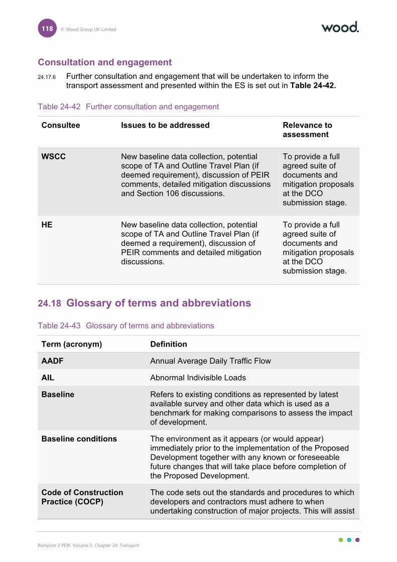
118 © Wood Group UK Limited
Rampion 2 PEIR. Volume 2, Chapter 24: Transport
Consultation and engagement
24.17.6 Further consultation and engagement that will be undertaken to inform the transport assessment and presented within the ES is set out in Table 24-42.
Table 24-42 Further consultation and engagement
Consultee Issues to be addressed Relevance to assessment
WSCC New baseline data collection, potential scope of TA and Outline Travel Plan (if deemed requirement), discussion of PEIR comments, detailed mitigation discussions and Section 106 discussions.
To provide a full agreed suite of documents and mitigation proposals at the DCO submission stage.
HE New baseline data collection, potential scope of TA and Outline Travel Plan (if deemed a requirement), discussion of PEIR comments and detailed mitigation discussions.
To provide a full agreed suite of documents and mitigation proposals at the DCO submission stage.
24.18 Glossary of terms and abbreviations
Table 24-43 Glossary of terms and abbreviations
Term (acronym) Definition
AADF Annual Average Daily Traffic Flow
AIL Abnormal Indivisible Loads
Baseline Refers to existing conditions as represented by latest available survey and other data which is used as a benchmark for making comparisons to assess the impact of development.
Baseline conditions The environment as it appears (or would appear) immediately prior to the implementation of the Proposed Development together with any known or foreseeable future changes that will take place before completion of the Proposed Development.
Code of Construction Practice (COCP)
The code sets out the standards and procedures to which developers and contractors must adhere to when undertaking construction of major projects. This will assist
119 © Wood Group UK Limited
Rampion 2 PEIR. Volume 2, Chapter 24: Transport
Term (acronym) Definition
with managing the environmental impacts and will identify the main responsibilities and requirements of developers and contractors in constructing their projects.
Construction Effects Used to describe both temporary effects that arise during the construction phases as well as permanent existence effects that arise from the physical existence of development (for example new buildings).
CTMP Construction Traffic Management Plan
Cumulative Effects Assessment
Assessment of impacts as a result of the incremental changes caused by other past, present and reasonably foreseeable human activities and natural processes together with the Proposed Development.
DCO Application An application for consent to undertake a Nationally Significant Infrastructure Project made to the Planning Inspectorate who will consider the application and make a recommendation to the Secretary of State, who will decide on whether development consent should be granted for the Proposed Development.
Decommissioning The period during which a development and its associated processes are removed from active operation.
Development Consent Order (DCO)
This is the means of obtaining permission for developments categorised as Nationally Significant Infrastructure Projects, under the Planning Act 2008.
DfT Department for Transport
DMRB Design Manual for Roads and Bridges
Embedded environmental measures
They are measures to avoid or reduce environmental effects that are directly incorporated into the design for the Proposed Development.
Environmental Impact Assessment (EIA)
The process of evaluating the likely significant environmental effects of a proposed project or development over and above the existing circumstances (or ‘baseline’).
Environmental Statement The written output presenting the full findings of the Environmental Impact Assessment.
ETG Expert Topic Group
120 © Wood Group UK Limited
Rampion 2 PEIR. Volume 2, Chapter 24: Transport
Term (acronym) Definition
Evidence Plan Process A voluntary consultation process with specialist stakeholders to agree the approach and the information required to support the EIA and HRA for certain aspects.
Formal consultation Formal consultation refers to statutory consultation that is required under Section 42 and Section 47 of the Planning Act 2008 with the relevant consultation bodies and the public on the preliminary environmental information.
Future Baseline Refers to the situation in future years without the Proposed Development.
GEART Guidelines for the Environmental Assessment of Road Traffic
HE Highways England
HGV Heavy Goods Vehicle
Horizontal Directional Drill (HDD)
An engineering technique avoiding open trenches.
Impact The changes resulting from an action.
Indirect effects Effects that result indirectly from the Proposed Development as a consequence of the direct effects, often occurring away from the site, or as a result of a sequence of interrelationships or a complex pathway. They may be separated by distance or in time from the source of the effects. Often used to describe effects on landscape character that are not directly impacted by the Proposed Development such as effects on perceptual characteristics and qualities of the landscape.
Informal consultation Informal consultation refers to the voluntary consultation that RED undertake in addition to the formal consultation requirements.
KM Kilometres
LGV Light Goods Vehicle
Likely Significant Effects It is a requirement of Environmental Impact Assessment Regulations to determine the likely significant effects of the Proposed Development on the environment which should relate to the level of an effect and the type of effect.
121 © Wood Group UK Limited
Rampion 2 PEIR. Volume 2, Chapter 24: Transport
Term (acronym) Definition
LTP Local Transport Plan
LV Light Vehicle
Magnitude (of change) A term that combines judgements about the size and scale of the effect, the extent of the area over which it occurs, whether it is reversible or irreversible and whether it is short term or long term in duration’. Also known as the ‘degree’ or ‘nature’ of change.
MHWS Mean High Water Springs
MPH Miles Per Hour
Nationally Significant Infrastructure Project (NSIP)
Nationally Significant Infrastructure Projects are major infrastructure developments in England and Wales which are consented by DCO. These include proposals for renewable energy projects with an installed capacity greater than 100MW.
NCN National Cycle Network
NPPF National Planning Policy Framework
OAL Open Access Land
Onshore part of the PEIR Assessment Boundary
An area that encompasses all planned onshore infrastructure.
PEIR Assessment Boundary
The PEIR Assessment Boundary combines the search areas for the offshore and onshore infrastructure associated with the Proposed Development. It is defined as the area within which the Proposed Development and associated infrastructure will be located, including the temporary and permanent construction and operational work areas.
PIA Personal Injury Accident
Planning Inspectorate (PINS)
The Planning Inspectorate deals with planning appeals, national infrastructure planning applications, examinations of local plans and other planning-related and specialist casework in England and Wales.
PPA Planning Performance Agreement
Preliminary Environmental Information Report (PEIR)
The written output of the Environmental Impact Assessment undertaken to date for the Proposed Development. It is developed to support formal consultation and presents the preliminary findings of the

122 © Wood Group UK Limited
Rampion 2 PEIR. Volume 2, Chapter 24: Transport
Term (acronym) Definition
assessment to allow an informed view to be developed of the Proposed Development, the assessment approach that has been undertaken, and the preliminary conclusions on the likely significant effects of the Proposed Development and environmental measures proposed.
PRoW Public Rights of Way
PRoWMP Public Rights of Way Management Plan
Receptor These are as defined in Regulation 5(2) of The Infrastructure Planning (Environmental Impact Assessment) Regulations 2017 and include population and human health, biodiversity, land, soil, water, air, climate, material assets, cultural heritage and landscape that may be at risk from exposure to pollutants which could potentially arise as a result of the Proposed Development.
Scoping Opinion A Scoping Opinion is adopted by the Secretary of State for a Proposed Development.
Scoping Report
A report that presents the findings of an initial stage in the Environmental Impact Assessment process.
SDNP South Downs National Park
Secretary of State The body who makes the decision to grant development consent.
Sensitivity A term applied to specific receptors, combining judgements of the susceptibility of the receptor to the specific type of change or development proposed and the value associated to that receptor.
Significance A measure of the importance of the environmental effect, defined by criteria specific to the environmental aspect.
Significant effects It is a requirement of the EIA Regulations to determine the likely significant effects of the development on the environment which should relate to the level of an effect and the type of effect. Where possible significant effects should be mitigated. The significance of an effect gives an indication as to the degree of importance (based on the magnitude of the effect and the sensitivity of the receptor) that should be attached to the impact described.
123 © Wood Group UK Limited
Rampion 2 PEIR. Volume 2, Chapter 24: Transport
Term (acronym) Definition
Whether or not an effect should be considered significant is not absolute and requires the application of professional judgement. Significant – ‘noteworthy, of considerable amount or effect or importance, not insignificant or negligible’. Those levels and types of landscape and visual effect likely to have a major or important / noteworthy or special effect of which a decision maker should take particular note.
SRN Strategic Road Network
TA Transport Assessment
TBC To Be Confirmed
Temporal Scope The temporal scope covers the time period over which changes to the environment and the resultant effects are predicted to occur and are typically defined as either being temporary or permanent.
Temporary or permanent effects
Effects may be considered as temporary or permanent. In the case of wind energy development the application is for a 30 year period after which the assessment assumes that decommissioning will occur and that the site will be restored. For these reasons the development is referred to as long term and reversible.
The Applicant Rampion Extension Development Limited (RED)
The Proposed Development / Rampion 2
The onshore and offshore infrastructure associated with the offshore wind farm comprising of installed capacity of up to 1,200MW, located in the English Channel in off the south coast of England.
WSCC West Sussex County Council
Zone of Influence The area surrounding the Proposed Development which could result in likely significant effects.
24.19 References
CrashMap, (2021). Crashmap. [online]. Available at: https://www.crashmap.co.uk/ [Accessed 30 June 2021].

124 © Wood Group UK Limited
Rampion 2 PEIR. Volume 2, Chapter 24: Transport
Department for Transport (DfT), (2013). DfT Circular 02/2013 The Strategic Road Network and the Delivery of Sustainable Development, Page 1-23. [online]. Available at: https://assets.publishing.service.gov.uk/government/uploads/system/uploads/attachment_data/file/237412/dft-circular-strategic-road.pdf [Accessed 30 June 2021].
Department for Transport (DfT), (2019). Reported Road Casualties Great Britain: 2019, Annual Report, Moving Britain Ahead. [online]. Available at: https://assets.publishing.service.gov.uk/government/uploads/system/uploads/attachment_data/file/928205/reported-road-casualties-gb-annual-report-2019.pdf [Accessed 30 June 2021].
Department for Transport (DfT), (2020). Road Traffic Statistics. [online]. Available at: https://roadtraffic.dft.gov.uk/#6/55.254/-6.053/basemap-regions-countpoints [Accessed 30 June 2021].
Department for Transport (DfT), (2021). Quarterly traffic estimates (TRA25), TRA2501: Road traffic (vehicle miles) by vehicle type in Great Britain. [online]. Available at: https://www.gov.uk/government/statistical-data-sets/tra25-quarterly-estimates [Accessed 30 June 2021].
Department of Energy and Climate Change (DECC), (2011). Overarching National Policy Statement for Energy (EN-1). [online]. Available at: https://assets.publishing.service.gov.uk/government/uploads/system/uploads/attachment_data/file/47854/1938-overarching-nps-for-energy-en1.pdf [Accessed 30 June 2021].
E.On/RSK Environmental Ltd, (2012). Rampion Offshore Wind Farm, Environmental Statement, RSK, Section 29 Transport. [online]. Available at: https://www.rampionoffshore.com/environmental-statement/ [Accessed 30 June 2021].
Google, (2021). Google Maps and Google Traffic. [online]. Available at https://www.google.co.uk/maps/ [Accessed 30 June 2021].
Horsham District Local Council, (2019). Draft Horsham District Local Plan 2019-2036. [online]. Available at: https://strategicplanning.horsham.gov.uk/LocalPlanReview/viewCompoundDoc?docid=10336756 [Accessed 30 June 2021].
Institute of Environmental Assessment (IEA), (1993). Guidance Note 1 – Guidelines for the Environmental Assessment of Road Traffic.
Mid Sussex District Council, (2018). Mid Sussex District Plan 2014 – 2031, Pages 78-79. [online]. Available at: https://www.midsussex.gov.uk/media/2367/district-plan-adoption-version.pdf [Accessed 30 June 2021].
Ministry of Housing Communities and Local Government, (2019). National Planning Policy Framework, pages 34-36. [online]. Available at: https://www.gov.uk/government/publications/national-planning-policy-framework--2 [Accessed 30 June 2021].
Office for National Statistics, (2011). Nomis Official Labour Market Statistics. [online] Available at https://www.nomisweb.co.uk/ [Accessed 30 June 2021].
Owen Williams Consultants, (1996). Newhaven Port Access Road – Site Plan, East Sussex County Council, Drawing 5A928/12/2. [online]. Available at:
125 © Wood Group UK Limited
Rampion 2 PEIR. Volume 2, Chapter 24: Transport
https://www.eastsussex.gov.uk/roadsandtransport/roads/roadschemes/newhaven-port-access-road/scheme-details/ [Accessed 30 June 2021].
Planning Inspectorate (PINS). (2020a). Scoping Opinion: Proposed Rampion 2 Offshore Wind Farm. Case Reference EN010117, [online]. Available at: https://infrastructure.planninginspectorate.gov.uk/wp-content/ipc/uploads/projects/EN010117/EN010117-000045-EN010117 Scoping Opinion.pdf [Accessed 30 June 2021].
Planning Inspectorate, (2020b). Advice Note Seven: EIA: Process, Preliminary Environmental Information, and Environmental Statements (Version 7). [online]. Available at: https://infrastructure.planninginspectorate.gov.uk/wp-content/uploads/2017/12/Advice-note-7.pdf [Accessed 30 June 2021].
Rampion Extension Development Limited (RED), (2020). Rampion 2 Offshore Wind Farm – Environmental Impact Assessment Scoping Report, [online]. Available at: https://infrastructure.planninginspectorate.gov.uk/wp-content/ipc/uploads/projects/EN010117/EN010117-000006-EN010117%20-%20Scoping%20Report.pdf [Accessed 30 June 2021]
Standards for Highways, (2020). Design Manual for Roads and Bridges. [online]. Available at: https://www.standardsforhighways.co.uk/dmrb/ [Accessed 30 June 2021].
Sustrans, (2021). Sustrans National Cycle Network Map. [online]. Available at: https://www.sustrans.org.uk/national-cycle-network [Accessed 30 June 2021].
West Sussex County Council (WSCC), (2011), West Sussex Transport Plan 2011-2026, Pages 1-80. [online]. Available at: https://www.westsussex.gov.uk/media/3042/west_sussex_transport_plan_2011-2026_low_res.pdf [Accessed 30 June 2021].
West Sussex County Council (WSCC), (2020a). West Sussex Walking and Cycling Strategy 2016-2026, Pages 1-52. [online]. Available at: https://www.westsussex.gov.uk/media/9584/walking_cycling_strategy.pdf [Accessed 30 June 2021].
West Sussex County Council (WSCC), (2020b). Permeant Automatic Traffic Counts. [online]. Available at: https://www.westsussex.gov.uk/roads-and-travel/traffic-management/traffic-counts/ [Accessed 30 June 2021].
West Sussex County Council (WSCC), (2021a). iMap. [online]. Available at: https://www.westsussex.gov.uk/land-waste-and-housing/public-paths-and-the-countryside/public-rights-of-way/public-rights-of-way-imap/imap/ [Accessed 30 June 2021].
West Sussex County Council (WSCC), (2021b). Bus routes and timetables. [online]. Available at: https://www.westsussex.gov.uk/roads-and-travel/travel-and-public-transport/bus-and-coach-travel/plan-your-journey/bus-routes-and-timetables/ [Accessed 30 June 2021].
Worthing Borough Council, (2018). Draft Local Plan 2016 – 2033, Page 162. [online]. Available at: https://www.adur-worthing.gov.uk/media/Media,151143,smxx.pdf [Accessed 30 June 2021].

Rampion 2 PEIR. Volume 2, Chapter 24: Transport