our universe stars - selfguru foundation
TRANSCRIPT

OUR UNIVERSE Origin The big bang theory explains the origin of our universe. According to this theory, 15 billion years ago, cosmic matter was in a compressed state from which expansion started by a primordial explosion. The super-dense ball broke to form galaxies, which again broke to form stars and finally stars broke to form planets including earth. Since the outer space is limitless, conventional units for measuring distances are not suitable. Hence new units as follows are used: • Light Year: Distance covered by light in one year in vacuum at a speed of 3x10 8 m / s. One
light year is equal to 9.46 × 10¹² kilometers. • Astronomical Unit: The Mean distance between the Sun and the Earth (1.49 x 10⁸ km).
One light year is equal to 60,000 AU. • Cosmic Year: Sun's period of revolution around the galactic center (250 million years).
Also called as 'galactic year' • Parsec: Distance at which the mean radius of the Earth's orbit subtends an angle of one
second of an arc. It is equal to 3.26 light years.
Galaxies These are huge congregation of stars that hold together by force of gravity e.g. the Milky Way, Andromeda galaxy, large and small magellanic cloud, Ursa Minor system, sculptor system, etc. Milky Way or Akashganga is our home galaxy. Our solar system is located in this galaxy.
Stars Stars are self-luminous bodies that account for 98 percent of the matter in a galaxy. In the universe, some stars appear small but emit more energy than the other stars of the Milky Way. Such stars are called 'Quasars'. When the dense galactic nucleus is compressing to form a star, this stage in star formation is called a 'protostar' stage. Due to high temperature hydrogen converts to helium and heat and light is emitted. Thus a star is formed. When the hydrogen of a star is depleted, its outer regions swell and redden. This stage of a star is called a 'Red Giant'. Our sun will turn into a 'Red Giant' in 5 billion years. 'Novae Stars' are stars whose brightness increases suddenly by 10 to 20 magnitudes due to explosion and then the stars again fade into normal brightness. 'Super Nova' are stars whose brightness suddenly increases by more than 20 magnitudes. After the

explosion, the dense core of comparatively smaller stars is called the 'white dwarf'. The dense core of the comparatively larger stars is called the 'Neutron star'. The neutron star rotates at a high speed emitting radio waves. Such stars are called 'Pulsar'. 'Black hole' stage of the star occurs when the ancient star collapses. Gravity becomes so intense in the hole that nothing escapes, even light.
Constellations In the sky at night there are various patterns formed by different groups of stars. These are called constellations. Ursa Major or Big Bear is one such constellation. One of the most easily recognizable constellations is the small bear or Saptarishi (Sapta-seven, Rishi-sages). It is a group of seven stars that forms a part of the large Ursa Major Constellation.
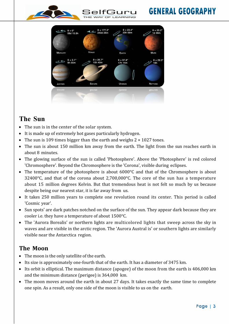
Solar System The sun along with its eight planets, asteroids and comets comprise the 'solar system'. The planets are divided into inner or terrestrial planets which have higher densities e.g. Mercury, Venus, Earth and Mars and outer planets which have lower densities e.g. Jupiter, Saturn, Uren us and Neptune.
The Sun • The sun is in the center of the solar system. • It is made up of extremely hot gases particularly hydrogen. • The sun is 109 times bigger than the earth and weighs 2 × 1027 tones. • The sun is about 150 million km away from the earth. The light from the sun reaches earth in
about 8 minutes. • The glowing surface of the sun is called 'Photosphere'. Above the 'Photosphere' is red colored
'Chromosphere'. Beyond the Chromosphere is the 'Corona', visible during eclipses. • The temperature of the photosphere is about 6000°C and that of the Chromosphere is about
32400°C, and that of the corona about 2,700,000°C. The core of the sun has a temperature about 15 million degrees Kelvin. But that tremendous heat is not felt so much by us because despite being our nearest star, it is far away from us.
• It takes 250 million years to complete one revolution round its center. This period is called 'Cosmic year'.
• Sun spots' are dark patches notched on the surface of the sun. They appear dark because they are cooler i.e. they have a temperature of about 1500°C.
• The 'Aurora Borealis' or northern lights are multicolored lights that sweep across the sky in waves and are visible in the arctic region. The 'Aurora Austral is' or southern lights are similarly visible near the Antarctica region.
The Moon • The moon is the only satellite of the earth. • Its size is approximately one-fourth that of the earth. It has a diameter of 3475 km. • Its orbit is elliptical. The maximum distance (apogee) of the moon from the earth is 406,000 km
and the minimum distance (perigee) is 364,000 km. • The moon moves around the earth in about 27 days. It takes exactly the same time to complete
one spin. As a result, only one side of the moon is visible to us on the earth.

• The bright parts of the moon are mountains whereas the dark patches are low- lying plains. Asteroids • Asteroids are a series of very small planets or fragments of planets lying between the orbit of Mars
and that of Jupiter. • 45,000. 'Ceres' whose length is about 1000km is the largest one. They revolve around the sun in
the same way as the planets. Meteors and Meteorites • The meteors are the remains of comets which are scattered in the interplanetary space of the
solar system. On contact with the earth's atmosphere, they burn due to friction. Those which completely burn out into ash are called meteors or 'shooting star.' Those which do not burn completely and strike the earth in the form of rocks are called 'meteorites'.
Planetary System • There are eight planets in our solar system. They are: Mercury, Venus, Earth, Mars, Jupiter,
Saturn, Uranus and Neptune. Earlier, Pluto was considered as a planet. But recently it has lost this status. All the eight planets of the solar system move around the sun in fixed paths. These paths are elongated. They are called orbits. A new planet 2003 UB 313 has been discovered recently in our solar system. It is bigger than Pluto and farthest from the Sun.
1. Mercury • Mercury is the smallest and the nearest planet to the Sun. • It takes only about 88 days to complete one round along its orbit. • It has no atmosphere and no satellite. • Its days are scorching hot and nights are frigid.
2. Venus • Venus is considered as 'Earths-twin' because its size and shape are very much similar to that
of the earth. • It is also called the 'morning' or 'evening star'. • It is probably the hottest planet because its atmosphere contains 90-95% of carbon dioxide.
The day and night temperatures are almost the same. • The atmospheric pressure is 100 times that of the earth. • It has no satellite.
3. The Earth • The earth is the third nearest planet to the Sun.

• In size, it is the fifth largest planet. • It is slightly flattened at the poles. That is why its shape is described as a Geoid. • From the outer space, the earth appears blue because its two-thirds surface is covered by
water. It is, therefore, called a blue planet.
4. Mars • It is marked with dormant volcanoes and deep chasms where once water flowed. • It has a thin atmosphere comprising of Nitrogen and Argon. • Beneath its atmosphere, Mars is barren, covered with pink soil and boulder. Because of this
it is known as 'red planet'. • It has two satellites namely 'Phobos' and 'Demos'. • The highest mountain here is Nix Olympia which is three times higher than Mount Everest. • Recent explorations have thrown light on the possibility of existence of life here.
5. Jupiter • It is the largest planet of the solar system. • Its atmosphere contains hydrogen, helium, Methane and ammonia. • It contains two and a half times the mass of all the other planets combined. • It reflects more than three times the energy it receives from the sun. • It has the great red spot which is an enormous eddy in the turbulent cloud cover. It also
contains dusty rings and volcanoes. • It has 16 satellites like Ganymede, Mayo, Europa, Calisto etc.
6. Saturn • It is the second largest planet of the solar system. • It has a celebrated rings composed of thousands of rippling, spiraling bands of icy rock and
dust just 200 feet thick and 270,000 km in diameter. • It has 21 known satellites. Among them Titan, Phobe, Tethys and Mimas are important. • Its moon, Titan has nitrogen atmosphere and hydrocarbons, the necessity of life but no life exists.
7. Uranus • It is the only planet that lies on its side. Hence, one pole or the other faces the sun as it orbits. • It is one of the coldest planets because of having an average temperature of -223C. • Its atmosphere is made of mainly hydrogen. The landscape is barren and there is frozen methane
cloud.

• There are 9 dark compact rings around the planet and a corkscrew shaped magnetic field. • It has 15 satellites; prominent ones are Aerial, Ambriel, Titania, Miranda etc. • It rotates north to south.
8. Neptune • It is the most distant planet from the sun. • There are five rings of Neptune. The outer ring seems to be studded with icy moonlets while the
inner ring appears narrow and nearly solid. • It has 8 satellites like Triton, Nereid, N-1, N-2, N-3 etc. • Its atmosphere mostly contains hydrocarbon compounds. The atmosphere appears blue, with
quickly changing white icy methane clouds often suspended high above an apparent surface.
Pluto from Planet to Plutoid Pluto, demoted from planet status in 2006, got a consolation prize - it and other dwarf planets like it will be called plutoids. Plutoids are celestial bodies in orbit around the Sun at a distance greater than that of Neptune that have sufficient mass for their hydrostatic equilibrium (near-spherical) shape. The two known plutoids are Pluto and Eris. It is expected that more plutoids will be named as science progresses and new discoveries are made. Motions of the Earth The earth has two main motions: (i) Rotation (ii) Revolution
The axis of the earth, which is an imaginary line, makes an angle of 66½° with its orbital plane. The plane formed by the orbit is known as the orbital plane. The earth receives light from the sun. Due to the spherical shape of the earth, only half of it gets light from the sun at a time. The portion facing the sun experiences day while the other half away from the sun experiences night. The circle that divides the day from night on the globe is called the circle of illumination. This circle does not coincide with the axis as you see in the given figure. Rotation: The earth rotates around its axis. The axis is an imaginary line passing through the center of the earth. The earth completes one rotation in 23 hours, 56 minutes, 4.09 seconds to be exact. The earth rotates from west to east. The period of rotation is known as the earth day.
Effects of the Rotation of the Earth a. Causation of day and night. b. A difference of 1 hour between two
meridians which are 15°apart. c. Deflection of ocean currents and winds. d. Rise and fall of tides every day.
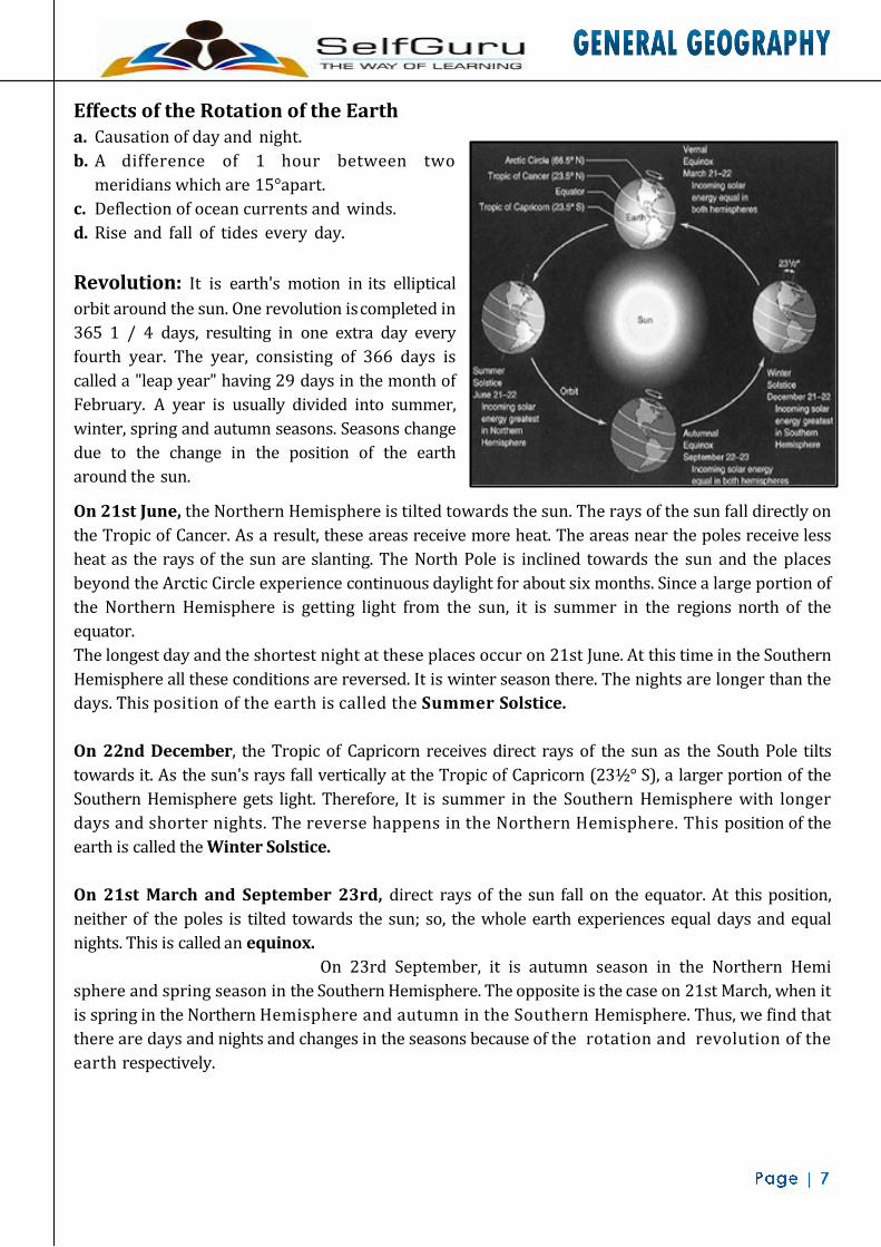
Revolution: It is earth's motion in its elliptical orbit around the sun. One revolution is completed in 365 1 / 4 days, resulting in one extra day every fourth year. The year, consisting of 366 days is called a "leap year" having 29 days in the month of February. A year is usually divided into summer, winter, spring and autumn seasons. Seasons change due to the change in the position of the earth around the sun.
On 21st June, the Northern Hemisphere is tilted towards the sun. The rays of the sun fall directly on the Tropic of Cancer. As a result, these areas receive more heat. The areas near the poles receive less heat as the rays of the sun are slanting. The North Pole is inclined towards the sun and the places beyond the Arctic Circle experience continuous daylight for about six months. Since a large portion of the Northern Hemisphere is getting light from the sun, it is summer in the regions north of the equator. The longest day and the shortest night at these places occur on 21st June. At this time in the Southern Hemisphere all these conditions are reversed. It is winter season there. The nights are longer than the days. This position of the earth is called the Summer Solstice. On 22nd December, the Tropic of Capricorn receives direct rays of the sun as the South Pole tilts towards it. As the sun's rays fall vertically at the Tropic of Capricorn (23½° S), a larger portion of the Southern Hemisphere gets light. Therefore, It is summer in the Southern Hemisphere with longer days and shorter nights. The reverse happens in the Northern Hemisphere. This position of the earth is called the Winter Solstice. On 21st March and September 23rd, direct rays of the sun fall on the equator. At this position, neither of the poles is tilted towards the sun; so, the whole earth experiences equal days and equal nights. This is called an equinox. On 23rd September, it is autumn season in the Northern Hemi sphere and spring season in the Southern Hemisphere. The opposite is the case on 21st March, when it is spring in the Northern Hemisphere and autumn in the Southern Hemisphere. Thus, we find that there are days and nights and changes in the seasons because of the rotation and revolution of the earth respectively.

Some terminologies related to revolution are: • Perihelion: The position of the earth when it is at its nearest point to the sun. The earth
reaches its perihelion on about 3rd January at a distance of about 147 million km from the sun. • Aphelion: The position of the earth when it is at its greatest distance from the sun. The earth
reaches its aphelion on 4th July when it is at a distance of 152 million km from the sun. • Perigee: The point in the orbit of the moon when it is nearest to the earth. • Apogee: The point in the orbit of the moon when it is farthest from the earth.
Effects of the Revolution of the Earth a. Change of seasons. b. Variation in the lengths of day and night at different times of the year. c. Shifting of wind belts. d. Determination of latitudes.
Latitude and Longitude Latitude: Latitude of a place on the earth is the angular distance of the place from the equator. 1° of latitude is approximately equal to 111 km.
Parallels of Latitude: They are circles drawn on the globe parallel to the equator. All the places on a parallel of latitude will have the same latitudinal angle. Important Parallels of Latitude.
1 Equator 0° 2 Tropic of Cancer 23 ½°N 3 Tropic of Capricorn 23 ½°S 4 Arctic circle 66½°N 5 Antarctic circle 66½°S
Heat Zones of the Earth • The mid-day sun is exactly overhead at least once a year on all latitudes in between the Tropic of
Cancer and the Tropic of Capricorn. This area, therefore, receives the maximum heat and is called the Torrid Zone.
• The mid-day sun never shines overhead on any latitude beyond the Tropic of Cancer and the Tropic of Capricorn. The angle of the sun's rays goes on decreasing towards the poles. As such, the areas bounded by the Tropic of Cancer and the Arctic Circle in the Northern Hemisphere, and the Tropic of Capricorn and the Antarctic Circle in the Southern Hemisphere, have moderate temperatures. These are, therefore, called Temperate Zones.
• Areas lying between the Arctic Circle and the North Pole in the Northern Hemisphere and the Antarctic Circle and the South Pole in the Southern Hemisphere, are very cold. It is because here the sun does not raise much above the horizon. Therefore, its rays are always slanting

these are, therefore, called Frigid Zones.
Great Circles: Any circle which divides a globe into hemispheres is a great circle. The equator is a great circle and Greenwich meridian together with meridian 180° make another great circle. The number of great circle is limitless. Great circle can extend in any direction: east to west, north to south, north east to south west, and so on. Great circles are of equal length. Longitude: The longitude shows the distance of a point east or west of the Prime Meridian which is at 0° and passes through Greenwich, near London. For each degree of longitude there is a difference of four minutes in time.
Longitude and Time: The best means of measuring time is by the movement of the earth and the moon. The sun regularly rises and sets every day, and naturally, it is the best time-keeper throughout the world. When the Prime Meridian has the sun at the highest point in the sky, all the places along this meridian will have mid-day or noon. As the earth rotates from west to east, those places east of Greenwich will be ahead of Greenwich Time and those to the west will be behind it. The rate of difference can be calculated as follows. The earth rotates 360° in about 24 hours, which means 15° an hour or 1° in four minutes. Thus, when it is 12 noon at Greenwich, the time at 15° east of Greenwich will be 15 × 4 = 60 minutes, i.e., 1 hour ahead of Greenwich Time, which means 1 p.m. But at 15° west of Greenwich, the time will be behind Greenwich time by one hour, i.e., it will be 11.00 a.m. Similarly, at 180°, it will be midnight when it is 12 noon at Greenwich. Greenwich Mean Time: The local time at Greenwich or any place on the Prime Meridian. All meridians to the east of Greenwich meridian have sunrise before that meridian. Local times along these meridians are therefore ahead of G.M.T. Meridians to the west of Greenwich meridian have sunrise after this meridian and therefore their local times are behind G.M.T. Standard Time: A particular meridian of longitude passing through a country is chosen as the reference meridian. The local time along this meridian, calculated with respect to Greenwich Mean Time in terms of its longitude is taken as the Standard Time for that country.

Why do we have standard time? The local times of places which are on different meridians are bound to differ. For example, it will be difficult to prepare a time-table for trains which cross several longitudes. In India, for instance, there will be a difference of about 1 hour and 45 minutes in the local times of Dwarka in Gujarat and Dibrugarh in Assam. It is, therefore, necessary to adopt the local time of some central meridian of a country as the standard time for the country. Indian Standard Time: Time along 82 ½° E meridians, calculated with respect to G.M.T. India, for being a large country, is unusual in having a single time zone all over the country. It is 5½ hours ahead of G.M.T. International Date Line: An imaginary zigzag line on the globe, approximately along the 180° meridian of longitude. When a person crosses this line from East to West, he gains one day and when he crosses from West to East, he loses one day. Solar Day: It is the time interval between successive crossings of the sun across the meridian of the celestial sphere of any fixed place in the same direction. This is equal to 24 hours. Sidereal Day: The period of rotation of the earth about its axis. This is calculated with respect to any fixed star. It is 4 minutes less than 24 hours. Solar Year (Tropical year): It is the average interval between successive returns of the sun in its apparent motion along the ecliptic to a fixed position on the celestial sphere of any fixed place. This is equal to 365.24 mean solar days. Sidereal Year: The period of revolution of the earth around the sun. It is calculated with reference to any fixed star. It is approximately equal to 365.26 days.

To account for 1 / 4 of a day in a year, the leap year system is adopted in the Gregorian calendar. To account for the excess of 11 minutes in a year, the centurial year is considered a leap year only when it is divisible by 400. Earth in Figures 1 Age 4,550 million years
2 Mass 5.976 × 1024 kg. Mean
3 Mean density 5.518 kg / liters
4 Total Surface Area 510,000,000 km2
5 Land Area 29.2% of the total Surface area
6 Water Area 70.8% of the total surface area
7 Highest point (Mt. Everest) 8,848 m
8 Lowest point ( Dead Sea) 397 m
9 Greatest Ocean Depth (Mariana Trench) 11,033 m
10 Mean Equatorial Diameter 12,756 km
11 Equatorial Circumference 40,076 km
1. Buffon-Hypothesis: Based on sun-comet collision. 2. Kant-Gaseous Mass Theory: Based on Newton's law of gravitation. 3. Chamberlain-Moulton: Planetesimal Hypothesis. 4. Jeans & Jeffery: Tidal Hypothesis: Based on sun-giant star attraction. 5. Alfven: Electromagnetic Hypothesis. 6. Russell and Littleton: Binary Star Hypothesis. 7. Ross-Gun-Fission Hypothesis: Rotational and Tidal hypothesis. 8. F. Hoyle: Super Nova Hypothesis. 9. Big Bang Theory: Latest idea.
Major domains of the earth Earth is the only planet which has life. Human beings can live here because the life sustaining elements of land, water and air are present on the earth. The surface of the earth is a complex zone in which three main components of the environment meet, overlap and interact. The solid portion of the earth on which we live is called the lithosphere. The gaseous layers that surround the earth, is the atmosphere, where oxygen, nitrogen, carbon dioxide and other gases are found. Water covers a very big area of the earth's surface and this area is called the hydrosphere. The hydrosphere comprises water in all its forms, that is, ice, water and water vapour. The biosphere is the narrow zone where we find land, water and air together, which contains all forms of life.

A. Lithosphere • The solid portion of the earth is called the lithosphere. It comprises the rocks of the earth's crust
and the thin layers of soil that contain nutrient elements which sustain organisms. There are two main divisions of the earth's surface. The large landmasses are known as the continents and the huge water bodies are called the ocean basins. All the oceans of the world are connected with one another. The level of seawater remains the same everywhere. Elevation of land is measured from the level of the sea, which is taken as zero.
• The highest mountain peak Mt. Everest is 8,848 metres above the sea level. The greatest depth of 11,022 metres is recorded at Mariana Trench in the Pacific Ocean.
Continents • There are seven major continents. These are separated by large water bodies. These continents are -
Asia, Europe, Africa, North America, South America, Australia and Antarctica. • Asia is the largest continent. It covers about one-third of the total land area of the earth. The
continent lies in the Eastern Hemisphere. The Tropic of Cancer passes through this continent. Asia is separated from Europe by the Ural Mountains on the west. The combined landmass of Europe and Asia is called the Eurasia (Europe + Asia).
• Europe is much smaller than Asia. The continent lies to the west of Asia. The Arctic Circle passes through it. It is bound by water bodies on three sides.
• Africa is the second largest continent after Asia. The Equator or 0° latitude runs almost through the middle of the continent. A large part of Africa lies in the Northern Hemisphere. It is the only continent through which the Tropic of Cancer, the Equator and the Tropic of Capricorn pass. The Sahara Desert, the world's largest hot desert, is located in Africa. The continent is bound on all sides by oceans and seas. The world's longest river, the Nile, flows through Africa.
• North America is the third largest continent of the world. It is linked to South America by a very
narrow strip of land called the Isthmus of Panama. The continent lies completely in the Northern and Western Hemisphere. Three oceans surround this continent.
• South America lies mostly in the Southern Hemisphere. The Andes, world's longest mountain range, runs through its length from north to south. South America has the world's largest river, the Amazon.
• Australia is the smallest continent that lies entirely in the Southern Hemisphere. It is surrounded on all sides by the oceans and seas. It is called an island continent.
• Antarctica, completely in the Southern Hemisphere, is a huge continent. It is larger than the combined area of Europe and Australia. The South Pole lies almost at the center of this continent. As it is located in the South Polar Region, it is permanently covered with thick ice sheets. There are no permanent human settlements. Many countries have research stations in Antarctica. India also has research stations there. These are named as Maitri and Dakshin Gangotri.
B. Hydrosphere • The earth is called the blue planet. More than 71 per cent of the earth is covered with water and 29
per cent is with land. Hydrosphere consists of water in all its forms. As running water in oceans and rivers and in lakes, ice in glaciers, underground water and the water vapour in atmosphere, all comprise the hydrosphere. More than 97% of the Earth's water is found in the oceans and is too salty for human use. A large proportion of the rest of the water is in the form of ice-sheets and glaciers or under the ground and a very small percentage is available as fresh water for human use.

Oceans
• Oceans are the major part of hydrosphere. They are all interconnected. The ocean waters are always moving. The three chief movements of ocean waters are the waves, the tides and the ocean currents. The four major oceans are the Pacific Ocean, the Atlantic Ocean, the Indian Ocean and the Arctic Ocean, in order of their size.
• The Pacific Ocean is the largest ocean. It is spread over one-third of the earth. Mariana Trench, the deepest part of the earth, lies under the Pacific Ocean. The Pacific Ocean is circular in shape. Asia, Australia, North and South Americas surround it.
• The Atlantic Ocean is the second largest Ocean in the world. It is 'S' shaped. It is flanked by the North and South Americas on the western side, and Europe and Africa on the eastern side. The coastline of Atlantic Ocean is highly indented. This irregular and indented coastline provides ideal location for natural harbors and ports. From the point of view of commerce, it is the busiest Ocean.
• The Indian Ocean is the only ocean named after a country, that is, India. The shape of ocean is almost triangular. In the north, it is bound by Asia, in the west by Africa and in the east by Australia.
• The Arctic Ocean is located within the Arctic Circle and surrounds the North Pole. It is connected with the Pacific Ocean by a narrow stretch of shallow water known as Bering Strait. It is bound by northern coasts of North America and Eurasia
C. Atmosphere • The earth is surrounded by a layer of gas called the atmosphere. This thin blanket of air is an
integral and important aspect of the planet. It provides us with the air we breathe and protects us from the harmful effects of sun's rays. The atmosphere extends up to a height of about 1,600 km.
• The atmosphere is divided into five layers based on composition, temperature and other properties. These layers starting from earth's surface are the troposphere, the stratosphere, the mesosphere, the thermosphere and the exosphere.
• The atmosphere is composed mainly of nitrogen and oxygen, which make up about 99 per cent of clean, dry air. Nitrogen 78 per cent, oxygen 21 per cent and other gases like carbon dioxide, argon and others comprise 1% by volume.
• The density of the atmosphere varies with height. It is maximum at the sea level and decreases rapidly as we go up. The climbers experience problems in breathing due to this decrease in the density of air. The temperature also decreases as we go upwards.
• The atmosphere exerts pressure on the earth. This varies from place to place. Some areas experience high pressure and some areas low pressure. Air moves from high pressure to low pressure. Moving air is known as wind.

D. Biosphere • The biosphere is the narrow zone of contact between the land, water and air. It is in this zone that
life exists. All the living organisms including humans are linked to each other and to the biosphere for survival. The organisms in the biosphere may broadly be divided into the plant kingdom and the animal kingdom.
• The three domains of the earth interact with each other and affect each other in some way or the other. For example, cutting of forests for fulfilling our needs of wood, or clearing land for agriculture may lead to fast removal of soil from slopes. Similarly earth's surface may be changed due to natural calamities like earthquakes or tsunamis.
• Discharge of waste material into lakes and rivers makes the water unsuitable for human use. It also damages other forms of life. Emission from industries, thermal power plants and vehicles, pollute the air. Carbon dioxide (CO2) is an important constituent of air. But increase in the amount of CO2 leads to increase in global temperatures. This is termed as global warming. There is thus, a need to limit the use of resources of the earth to maintain the balance of nature between the domains of the lithosphere, the atmosphere and the hydrosphere.

Points to Remember
1. Mercury, Venus, Earth and Mars are known as' Inner Planets' whereas Jupiter, Saturn, Uranus and Neptune are known as "Outer plants".
2. Planets bigger than the earth are Jupiter, Saturn, Uranus and Neptune.
3. Earth and Venus have almost same size, hence these two are known as' Twin planets"
4. All planets rotate in the same direction in which they revolve except Venus and Uranus.
5. Saturn is surrounded by three luminous, concentric rings.
6. Earth has the maximum density of 5.52 in the solar system while the Saturn has the least density of 0.69.
7. According to gravity Jupiter stands first followed by Neptune, Uranus, Saturn and Earth.
8. Mercury and Venus have no satellite.
9. Neptune's atmosphere has poisonous gases like methane, ammonia, etc.
10. Comets revolve around the Sun and when broken are converted into "Meteors".
11. Earth is spherical in shape with compression at the poles and a bulge at the equator. Hence earth is an oblate spheroid or called a Geoid.
12. A solar day is greater than a sidereal day by 4 minutes.
13. Each degree of latitude is equals to 111 km.
14. A person crossing International Date Line from the East to West loses one day.
15. Mercury is the nearest planet to Sun.
16. Venus is the nearest planet to Earth.
17. Venus is the hottest planet; its atmosphere contains 97% CO2.

18. Jupiter is the biggest planet.
19. Venus is the brightest planet.
20. Earth is the blue planet.
21. Mars is the Red planet.
22. Venus is the Morning and Evening Star.
23. Pluto is the double planet.
24. Saturn and Uranus are known as the planets with rings.
25. Mercury has the maximum diurnal range of temperature.
26. Saturn has maximum no. of satellites.
27. Pluto has the most eccentric orbit.
28. Jupiter is the fastest rotating planet.
29. Venus is the slowest rotating planet.
30. Venus has the same period of rotation as revolution.
31. The length of the day is nearly same on the planet Mars as that of the Earth.
32. Jupiter, Saturn, Uranus and Neptune are the Jovian planets.
33. The angle of inclination of Mars is nearly same as that of Earth.
34. Jupiter, Saturn, Uranus and Neptune are the outer planet.
35. Mercury, Venus, Earth and Mars are the inner planets.
36. Venus rotates from East to West.
37. Uranus rotates from North to South.
38. Mercury is the fastest revolving planet.
39. Pluto is the slowest revolving planet.
40. Planet revolves around the sun in Anti- clockwise direction.
41. "Hydra" is the largest constellation.
42. The nearest galaxy. "Andromeda" is 22, 00,000 Light years away.
43. Existence of galaxies beyond Milky Way was first demonstrated by Edwin Hubble.
44. Galaxies are also called "Islands of universe

INTERIOR INFRASTRUCTURE OF THE EARTH
The interior of the earth can be understood only by indirect evidences as no one has reached the interior of the earth. The surface configuration of the earth is largely a product of the processes operating in its interior. A proper understanding of the physiographic character of a region remains incomplete unless the effects of both endogenic processes as well as exogamic processes are studied. Sources of information about the interior The earth’s radius is 6,370 km. reaching the center of the earth and make observations or collect samples of the materials is almost impossible. Under such conditions, most of our knowledge about the interior of the earth is largely based on analogies and inferences. Yet, a part of the information is obtained through direct observations and analysis of materials. Direct Sources The readily available solid earth material is surface rock we get from mining areas. Besides mining, scientists world over are working on two major projects such as “Deep Ocean Drilling Project” and “Integrated Ocean Drilling Project”. The deepest drill at Kola, in Arctic Ocean, has so far reached a depth of 12 km. These drilling projects have provided large volume of information through the analysis of materials collected at different depths. Volcanic eruption forms another source of obtaining direct information. As and when the magma comes out to the surface of the earth during volcanic eruption it becomes available for laboratory analysis. Indirect Sources • Analysis of properties of rocks and magma indirectly provides information about the
interior. Through mining we know that temperature and pressure increase with the increasing depth. It is also known that the density of the material also increases with depth.
• Scientists have estimated the values of temperature, pressure and the density of materials at different depths.
• Meteor is another source of information about the interior of the earth. However, the material, that becomes available for analysis from meteors, is not from the interior of the earth. It is only similar to that of the earth. Meteors are solid bodies developed out of materials same as, or similar to, earth. So, by analogy meteors provide valuable information about the earth’s interior.
• Other indirect sources include gravitation, magnetic field and seismic activity. The gravitational force is greater near the poles and less at the equator. It also differs according to the mass of material. Thus the uneven distribution of material within the earth influences its value. The readings of the gravity, may, at places differ from the expected values. Such a difference is called gravity anomaly. Gravity anomalies give us information about the distribution of mass of the material in the crust of the earth.

Seismic/Earthquake Waves • The study of seismic waves provides a complete picture of the layered interior. An
earthquake in simple words is shaking of the earth. It is a natural event. It is caused due to release of energy, which generates waves that travel in all directions. The energy waves travelling in different directions reach the surface.
• Earthquake waves are basically of two types- body waves and surface waves. Body waves are generated due to the release of energy at the focus and move in all directions travelling through the body of the earth. They interact with the surface rocks and generate new set of waves called surface waves. These waves move along the surface. The velocity of waves changes as they travel through materials with different densities. Denser the material, higher is the velocity.
• There are two types of body waves. They are called P and S-waves. P-waves move faster and are the first to arrive at the surface. These are also called ‘primary waves’. The P-waves are similar to sound waves. They travel through all materials gaseous, liquid and solid. S-waves arrive at the surface with some time lag. These are called secondary waves. S-waves can travel only through solid materials. This characteristic of the S-waves has helped scientists to understand the structure of the interior of the earth.
• Different waves travel in different manners. P-waves vibrate parallel to the direction of the wave. This exerts pressure on the material in the direction of the propagation. As a result, it creates density differences in the material leading to stretching and squeezing of the material. Other waves vibrate perpendicular to the direction of propagation. The direction of vibrations of S-waves is perpendicular to the wave direction in the vertical plane. Hence, they create troughs and crests in the material medium through which they pass. Surface waves are considered to be the most damaging waves.
Shadow Zone Earthquake waves are recorded in seismographs located at far off locations. However, there are certain areas where the waves are not reported. Such a 105° and 140° from epicenter is identified as the shadow zone of P-waves. However, the entire zone beyond 105° does not receive S-waves. Thus shadow zone of S-wave is much larger than that of the P-waves. The shadow zone of P-waves appears as a band around the earth between 105° and 140° away from the epicenter whereas that of S-wave is a continuous zone. Structure of the interior Just like an onion, the earth is made up of several concentric layers with one inside another. The important zones include: • The crust: The outer layer of the earth is known as the crust. It comprises about 0.5% of the

earth’s body. Its thickness ranges from 5 to 40 km. The crust is thicker beneath the continents than beneath the oceans. It is made up of two layers: upper lighter layer (density=2.7 g / cc) called the sial (silica + aluminum) and a lower denser layer (density=3.0 g / cc) called sima (silica + Magnesium). The average density of the earth’s surface is less than 3 gm / c.c. The upper layer of the crust is mainly com- posed of crystalline igneous and meta- morphic rocks, acidic in nature. The lower layer of the crust contains basaltic & ultra-basic rocks. Conrad discontinuity separates the outer and the inner crusts.
• The mantle: Below the crust of the earth is a thick layer called mantle. This layer extends up to a depth of 2900 km. The mantle consists predominantly of solid olivine rocks made up of silicates of magnesium and iron and displaying plastic properties. Its average density is 56.8. This layer is separated from the crust by Mohorovicic discontinuity. The outer and the inner mantle are separated by another discontinuity named Repetti discontinuity.
• The core: Beyond a depth of 2900 km lies the core of the earth. It is named as barysphere and also nife (nickel and ferrous). Average thickness is 4671 kms. Average density is 17.2. By volume it constitutes 17% of the earth’s body. The temperature of the core is about 200°c. The core is believed to be a reason for the earth’s magnetism. It is separated from the mantle by Gutenburg-Wiechert Discontinuity.
Lithosphere & Asthenosphere: Beneath the upper mantle there is a soft layer in which the mantle rock is at the temperature close to the melting point. It sets in at an average depth of about 80 km which is well below the base of the continental crust. This layer is called as “Asthenosphere” and the rigid layer above it is called as “lithosphere”. The asthenosphere extends to a depth of about 400 km.
Temperature: In upper 100 km the increase in temperature is estimated at the rate of 12°C per km descend. In the next 300 km, the increase is of 2°C per km and below that the rate of increase is 1°C per km. In the core the temperature is about 2000°C. But at the same time there is a huge pressure of overlying layers of the earth’s interior. So even under extremely high temperature towards the central part of the earth the liquid nature of the earth core has acquired the properties of a solid and is probably in a plastic state.
Composition of the Earth 1. Iron 35%
2. Oxygen 30%
3. Silicon 15%
4. Magnesium 13%
5. Nickel 2.4%

6. Sulphur 1.9%
7. Calcium 1.1%
8. Aluminum 1.1%
Composition and properties of different layers of the earth Name of the
layer Chemical Composition
Average Thickness (km)
Density (g cm-3)
Physical Properties
A.(i) Crust Sial 6 to 45 2.2 to 2.9 Solid part of lithosphere; partly molten under the continents.
(ii) Inner part of lithosphere
Outer silicate layer, Basaltic
45 to 100 The solid crust and upper mantle
B Asthenosphere 50 to 400 It transmits both S- and P-wave but with reduced velocities.
C.(i) Upper Mantle (mainly under oceans)
Sima (Peridotite iron- magnesium- rich silicate rock)
100 to 1700 3.1 to 4.75 Slightly solid and slightly plastic material close to melting point.
(ii) Lower Mantle Wholly Sima (Olivine- Ultrabasic rocks)
1700 to2900 4.75 to 5.6 Transition zone of mixed metals and silicate
D.(i) Outer core Nife 2900 to 4980
9.9 - 12.3 Liquid or in a plastic state. Fe, Ni and S mixture.
(ii) Inner core Barysphere (heavy metallic rocks)
4980 to 6400
13.5 Iron and nickel. Solid and rigid due to tremendous overlying pressure.
Continental drift • The theory of continental drift, expounded by Alfred Wegener in 1915, holds that portions of the
original continent which comprised the entire landmass of the world underwent a series of horizontal displacement before the present continents were formed. According to this theory, about 280 million years ago, the entire landmass formed one super continent, called Pangaea. According to Wegener, after the breaking of the super continent pangae, the movement of the continents took place in two directions- one

towards the equator due to centrifugal force of the earth which gave rise to fold mountains like the Himalayas, the alps, etc. and another towards west due to tidal force of sun and the moon which gave rise to Andes and Rockies.
• A glance at the world map shows that S. America particularly Brazil can be fitted into the Gulf of Guinea of Africa; Antarctica can roughly be fitted into S. Australian coast and S.E-African coast. Similarly NW-Australian coast and E- Indian coast are liable to fit. After the drifts some water bodies developed between them. Geological evidences prove that S. America and Africa were probably joined together till the upper Triassic. Biological history of certain animals like marsupials and placental mammals also throw significant light on the continental drift.
Plate Tectonics Plate tectonics deals with rock structures which are in the form of the plates and it is not only the continents which are in motion but the oceans as well. These plates include not only the earth’s upper crust but also the part of denser mantle below. They have an average thickness of 100 km. They float on the plastic upper mantle called “asthenosphere” and carry the continents and oceans on their back. The edges of the plates are designed as boundaries and margins, where movements occur. Major plates of the world are: 1. American plate 2. Pacific plate 3. Antarctic plate

4. African plate 5. European plate and 6. Australian plate.
Some minor plates are: 1. Caribbean plate. 2. Cocas plate 3. Nazca plate 4. Juan de Fuca plate 5. Philippine plate, etc. All these plates are in constant motion both in relation to each other and with regard to the earth’s motion. Some movements are responsible for the volcanic activities, seismic and other plate disturbances on the margins of the plates.

Types of movements of plates A. Convergence:When the oceanic lithosphere moves towards the continental lithosphere,
due to its thickness the continental crust is unable to go down and it is the oceanic crust which is involved in subduction. The down went plate of the oceanic crust melts and produces magma. This magma rises slowly and emerges as intrusive igneous rock in the form of volcanic mountains on the continental crust. Thus origin of volcanic mountains like Andes takes place. When the two oceanic lithospheres lie on both side of subduction, then either of the two plates may sub duct. The sub ducted part melts and the magma rises above the oceanic surface and volcanic islands are formed in arc form like Aleutian island, Kuril Island, Ryuku Island, etc. When the continental lithosphere lies on both sides of subduction, the sediments get scrapped off the descending plate margin. In the next stage the two continents collide, squeezing the sediment mass and throwing it into complicated fold and high alpine ranges like Himalayas and Alps are formed.
B. Divergence/continental rupturing: It is also termed as “ocean floor spreading”. Deep beneath the continental plate a column of heated mantle rock begins to rise and reach the plate above, causing the plate to fracture, which is called“continental rupture”. At first block mountains are formed. Next a long narrow valley called “rift valley” appears. The widening crack in its center is continuously filled in with magma rising from the mantle below. The magma solidifies to form new crust and also a new oceanic crust and lithosphere.
C. Parallel movements of plates: Parallel plates, as they slide past each other along a common boundary, do not create a new crust or destroy the old one but they produce “transform faults” which are fractures in rock formation. Fractures imply displacement of rocks. As the plates continue to move, the locked rocks snap. They shift violently back to equilibrium like a bent - stick breaking. This violent shift causes earthquakes.

MINERALS AND ROCKS
Minerals A mineral is a naturally occurring substance that is solid and stable at room temperature, representable by a chemical formula, usually a biogenic, and has an ordered atomic structure.
Mineral are divided as follows: A. Metallic Minerals These minerals contain metal content and can be sub-divided into three types: a. Precious metals: gold, silver, platinum etc. b. Ferrous metals: iron and other metals often magnesium, iron and silica. Pyroxene forms 10 per
cent of the earth’s crust. It is commonly found in meteorites. It is in green or black color.
Amphibole Aluminium, calcium, silica, iron, magnesium are the major elements of amphiboles. They form 7 per cent of the earth’s crust. It is in green or black colour and is used in asbestos industry. Hornblende is another form of amphiboles.

Mica It comprises of potassium, aluminum, magnesium, iron, silica etc. It forms 4% of the earth’s crust. Commonly found in igneous and metamorphic rocks, it is used in electrical mixed with iron to form various kinds of steel. a. Non-ferrous metals: include metals like copper, lead, zinc, tin, aluminium etc.
B. Non-Metallic Minerals These minerals do not contain metal content. Sulphur, phosphates and nitrates are examples of non-metallic minerals. Cement is a mixture of non-metallic minerals. Some Major Minerals and Their Characteristics: Feldspar • Silicon and oxygen are common elements in all types of feldspar and sodium, potassium, calcium,
aluminium etc. are found in specific feldspar variety. Half of the earth’s crust is composed of feldspar. It has cream to salmon pink color. It is used in ceramics industries.
Quartz • It is one of the most important components of sand and granite. It consists of silica. It is a hard
mineral virtually insoluble in water. It is white or colorless and used in radio and radar. It is one of the most important components of granite.
Pyroxene • Pyroxene consists of calcium, aluminum, instruments.
Olivine • Magnesium, iron and silica are major elements of olivine. It is used in jewelry. It is usually a
greenish crystal, often found in basaltic rocks. Other minerals like chlorite, calcite, magnetite, hematite, bauxite and barite are also present in some quantities in the rocks.
Rocks • The earth’s crust is composed of rocks. A rock is an aggregate of one or more minerals. Rock may
be hard or soft and in varied colors. For example, granite is hard, sandstone is soft. Gabbro is black and quartzite can be milky white. Rocks do not have definite composition of mineral constituents. Feldspar and quartz are the most common minerals found in rocks.
• The crustal rocks are classified on the basis of mode of formation, physical and chemical properties, location etc. On the basis of mode of formation the rocks are divided into three categories.
1. igneous rocks 2. sedimentary rocks 3. metamorphic rocks

A. Igneous rocks • As igneous rocks form out of magma and lava from the interior of the earth, they are known as
primary rocks. The igneous rocks are formed when magma cools and solidifies. When magma in its upward movement cools and turns into solid form it is called igneous rock. The process of cooling and solidification can happen in the earth’s crust or on the surface of the earth.
• Igneous rocks are characterized on the basis of texture. Texture depends upon size and arrangement of grains or other physical conditions of the materials. If molten material is cooled slowly at great depths, mineral grains may be very large. Sudden cooling (at the surface) results in small and smooth grains. Intermediate conditions of cooling would result in intermediate sizes of grains making up igneous rocks. Granite, gabbro, pegmatite, basalt, volcanic breccia and tuff are some of the examples of igneous rocks.
• Igneous rocks are roughly hard rocks and water percolates with great difficulty. They do not have strata and are less affected by chemical weathering. They don’t contain fossils. The number of joints increases upwards. They are mostly associated with volcanic activity.
They are classified on several grounds as mentioned below:
a) On the basis of silica content: i. Acidic igneous rocks have more silica e.g.
ii. Granites iii. Basic igneous rocks have less silica e.g. Gabbro.
b)On the basis of chemistry and mineralogical composition:
i. Felsic igneous rock (feldspar is dominant) ii. Mafic igneous rock (magnesium and ferrous are dominant)
iii. Ultra mafic igneous rock (Peridotite and dunite are dominant). c) On the mode of occurrence:
i. Intrusive igneous rocks - They are cooled and solidified below the surface of the earth. They are further divided into plutonic and hypabyssal igneous rocks. Plutonic rocks cool deep beneath the earth e.g. Granite. Hypabyssal rocks cool just beneath the earth surface e.g. Batholith, laccolith, phacolith, lapolith, sills, dykes, etc.
ii. Extrusive igneous rocks are formed due to cooling and solidification of hot and molten lava at the earth’s surface e.g. Basalt, Gabbro, obsidian.
B. Sedimentary rocks • The word ‘sedimentary’ is derived from the Latin word sedimentum, which means settling. Rocks
(igneous, sedimentary and metamorphic) of the earth’s surface are exposed to denudation agents, and are broken up into various sizes of fragments. Such fragments are transported by different exogenous agencies and deposited. These deposits through compaction turn into rocks.

This process is called lithification. In many sedimentary rocks, the layers of deposits retain their characteristics even after lithification. Hence, we see a number of layers of varying thickness in sedimentary rocks like sandstone, shale etc.
• Depending upon the mode of formation, sedimentary rocks are classified into three major groups:
(i) mechanically formed - e.g. sandstone, conglomerate, shale, loess etc. (ii) organically formed - e.g. chalk, limestone, coal etc. (iii) chemically formed – e.g. chert, halite, potash etc.
• These rocks are formed due to aggregation and compaction of sediments. These rocks contain fossils of plants and animals. They cover 75 percent of surface area of the globe. However they form only 5 percent of the volume of earth’s crust. They contain several layers or strata but these are seldom crystalline rocks. They are seldom found in original and horizontal manner. They may be well consolidated, poorly consolidated and even unconsolidated. They are characterized by different sizes of joints. Most sedimentary rocks are porous and permeable.
The formation of sedimentary rocks takes place in three stages: • Transportation: after weathering and erosion the fragments of parental rocks are transported
by the agents of erosion like stream, wind, air, etc. • Deposition: transported materials are deposited in sea, lakes, etc. The particles are deposited in
parallel layers and their process of layer formation is called “stratification”. • Consolidation: when the number of layer is large, the weight of upper layer begins to affect the
lower layers and the further compression solidifies the sediments into rocks.
They are classified under different schemes: 1. On the basis of nature of sediments: (a) Mechanically formed or clastic rocks e.g. Sandstones. Conglomerates, clay rock, shale, loess. (b) Chemically formed sedimentary rocks e.g. gypsum, salt rock. (c) Organically formed sedimentary rocks e.g. Limestone, dolomites, coal, peats, etc.
2. On the basis of transporting agents: (i) Argillaceous or aqueous rocks: (a) Marine rocks, (b) Lacustrine rocks, (c) Riverine rocks (ii) Aeolian rocks e.g. Loess. (iii) Glacial sedimentary rocks e.g. Till, moraine.
C. Metamorphic rocks • The word metamorphic means ‘change of form’. These rocks form under the action of
pressure, volume and temperature (PVT) changes. Metamorphism occurs when rocks are forced down to earth’s interior by tectonic processes or when molten magma rising through the crust comes in contact with the crustal rocks or the underlying rocks are subjected to great amounts of pressure by overlying rocks. Metamorphism is a process by which already consolidated rocks undergo recrystallization and reorganization of materials within original rocks.
• Mechanical disruption and reorganization of the original minerals within rocks due to breaking and crushing without any appreciable chemical changes is called dynamic metamorphism.

The materials of rocks chemically alter and recrystallize due to thermal metamorphism. There are two types of thermal metamorphism - contact metamorphism and regional metamorphism.
• In contact metamorphism the rocks come in contact with hot intruding magma and lava and the
rock materials recrystallize under high temperatures. Quite often new materials form out of magma or lava are added to the rocks.
• In regional metamorphism, rocks undergo recrystallization due to deformation caused by tectonic shearing together with high temperature or pressure or both. In the process of metamorphism in some rocks grains or minerals get arranged in layers or lines. Such an arrangement of minerals or grains in metamorphic rocks is called foliation or lineation.
• Sometimes minerals or materials of different groups are arranged into alternating thin to thick layers appearing in light and dark shades. Such a structure in metamorphic rocks is called banding and rocks displaying banding are called banded rocks. Types of metamorphic rocks depend upon original rocks that were subjected to metamorphism.
• Metamorphic rocks undergo complete alteration in the appearance of pre-existing rocks due to change in mineral composition and texture through temperature and pressure changes. Gneiss, Granite, slate, schist, marble, quartzite etc. are some examples of metamorphic rocks. They are classified as mentioned below:
1. Contact or thermal metamorphism: here metamorphism occurs when the mineral composition of the surrounding rocks is changed due to intense heat e.g. Limestone is changed to marble.
2. Regional or dynamic metamorphism: here pressure plays an important role so that rocks are altered in their forms in an extensive area.
Rock Cycles Rocks do not remain in their original form for long but may undergo transformation. Rock cycle is a continuous process through which old rocks are transformed into new ones. Igneous rocks are primary rocks and other rocks (sedimentary and metamorphic) form from these primary rocks. Igneous rocks can be changed into metamorphic rocks. The fragments derived out of igneous and metamorphic rocks transform into sedimentary rocks. Sedimentary rocks themselves can turn into fragments and the fragments can be a source for formation of other sedimentary rocks. The crustal rocks (igneous, metamorphic and sedimentary) once formed may be carried down into the

mantle (interior of the earth) through subduction process (parts or whole of crustal plates going down under another plate in zones of plate convergence). The same can melt down due to increase in temperature in the interior and turn into molten magma, the original source for igneous rocks.

FORCES EFFECTING THE EARTH MOVEMENTS
The forces which affect the earth’s movement are involved in the creation, destruction, recreation and maintenance of various types of relief features of varying magnitudes. On the basis of origin these forces are divided into: 1.Endogenetic forces 2. Exogenetic forces While endogenetic forces create relief features on the earth’s surface, the exogenetic forces through their erosional and depositional activities destroy them and help in the planation process Endogenetic forces Term endogenic refers to internal processes and phenomena that occur beneath the Earth's surface. These forces are divided into sudden forces and diastrophic forces.
a. Sudden forces: events like earthquake and volcanic eruption occur suddenly and the resultant forces work very quickly. They are constructive forces as they create cones, lakes, plateaus, lava plains etc.
b. Diastrophic forces: they include both vertical and horizontal movements.
i. Vertical movement: they include emergence and subsidence of land masses. Emergence may occur due to upliftment of the whole continent or part there of or upliftment of coastal land of the continents. Submergence may occur when the land near the sea coast subsides below sea level.
ii. Horizontal movement: these forces work into two ways
a. In opposite direction - this includes tensional or divergent forces which create faults, rupture, fracture, cracks etc.
b. Towards each other - This includes compressional or convergent forces which create folding, warping etc.
Folding: It is the process whereby the rock strata are bent into a series of arches (anticlines) and toughs (Syncline) as a result of horizontal earth movements which cause compression within the crust. The anticlines of the folds generally form the mountains and the adjacent synclines form the valleys. Most of the mountain ranges of the world consist of Fold Mountains e.g. the Alps, the Andes, the Rockies and the Himalayas. Geometry of Folds - Folds are described by their form and orientation. The sides of a fold are called limbs. The limbs intersect at the tightest part of the fold, called the hinge. A line connecting all points on the hinge is called the fold axis. In the diagrams above, the fold axes are horizontal, but if the fold axis is not horizontal the fold is called a plunging fold and the angle that the fold

axis makes with a horizontal line is called the plunge of the fold. An imaginary plane, that includes the fold axis and divides the fold as symmetrically as possible, is called the axial plane of the fold. Types of Folds Not all folds are equal on both sides of the axis of the fold. Those with limbs of relatively equal length are termed symmetrical, and those with highly unequal limbs are asymmetrical. Asymmetrical folds generally have an axis at an angle to the original unfolded surface they formed on. Other kinds of folds are: • Anticlines - Up folds When the upper part of the fold is eroded away, the oldest rocks are in the center of the fold, and
the youngest rocks are on each side. Also, the rocks dip (or slope) away from the central axis of the fold.
• Synclines - Down folds When the upper part of the fold is eroded away, the youngest
rocks are in the center of the fold, and the oldest rocks are on each side. Also, the rocks dip toward the central axis of the fold.
• Monoclines - a bend in otherwise horizontal strata. • Isoclinal - folds have undergone greater stress that has
compressed the limbs of the folds tightly together. • The limbs of overturned folds dip in the same direction,
indicating that the upper part of the fold has overridden the lower part. Depending on where the exposure is in an overturned fold, the oldest strata might actually be on top of the sequence and be misinterpreted as the youngest rock
unit. • Recumbent- folds, found in areas of the greatest tectonic
stress, are folds that are so overturned that the limbs are essentially horizontal and parallel.
• Chevron- angular fold with straight limbs and small hinges.
Faulting: It is the process by which the tensional earth movements under the effect of considerable pressure create a fracture in the earth's crust. Faulting gives rise to relief features like block mountains (horsts), rift valleys, etc. A rift valley is a long, relatively narrow depression formed by the sinking of a block of land between two more or less parallel faults. Examples: East African rift valley, Narmada and Tapti valleys.

Columns of faulting bring four distinguishable landforms as: a. Rift valley: it is the result of the subsidence of the central column. When the central column of
the two fault-lines subsides, the rift valley is made. "Damodar valley" is such an example.
b. Ramp valley: when both side columns are raised and the central column is standstill, then the made landform is ramp valley. "Brahmaputra" river passes through a ramp valley.
c. Block Mountain: this is the result of the subsidence of side column. The central column gets steep rim along the fault scarps and the raised landform is Block Mountain. "Satpura hills" of India is such an example.
d. Horst: Horst is a similar landform but is supposed to be due to upward force from beneath the central column. Side-columns are standstill. "Harz Mountain" of Germany is an example.
Exogenetic forces Exogenic forces refer to external processes and phenomena that occur on or above the Earth's surface. Comet and meteoroid impacts, the tidal force of the moon and sun's radiations are all exogenic. Weathering effects and erosion are also exogenic processes. They also affect the planation processes. These are also called denudational or destructive forces. The erosional process is affected by running water, ground water, glaciers, sea waves etc. These processes form erosional and depositional land forms.

WEATHERING AND EROSION
Weathering Weathering is the process of disintegration and decomposition of rocks while erosion is the process of removal, transportation and deposition of the weathered particles. These processes together are known as “Denudation.” Weathering is defined as mechanical disintegration and chemical decomposition of rocks through the actions of various elements of weather and climate. Weathering process brings mechanical disintegration and chemical decaying of rocks. Weather conditions are the most decisive phenomenon hence the name weathering. However the type and rate of weathering are also influenced by rock structure, topography and vegetation. Weathering is a static process. It is also the process of soil genesis. It is of three types:
I. Mechanical Weathering: When a region undergoes mechanical weathering, rocks are
broken into small pieces. Physical or mechanical weathering processes depend on some applied forces. The applied forces could be:
(i) gravitational forces such as overburden pressure, load and shearing stress; (ii) expansion forces due to temperature changes, crystal growth or animal activity; (iii) water pressures controlled by wetting and drying cycles.
Many of these forces are applied both at the surface and within different earth materials leading to rock fracture. Most of the physical weathering processes are caused by thermal expansion and pressure release. These processes are small and slow but can cause great damage to the rocks

because of continued fatigue the rocks suffer due to repetition of contraction and expansion.
This mechanical disintegration takes place in different ways. a. Frost Action: Frost weathering occurs due to growth of ice within pores and cracks of rocks
during repeated cycles of freezing and melting. This process is most effective at high elevations in mid-latitudes where freezing and melting is often repeated. Glacial areas are subject to frost wedging daily. In this process, the rate of freezing is important. Rapid freezing of water causes its sudden Expansion and high pressure. The resulting expansion affects joints, cracks and small inter granular fractures to become wider and wider till the rock breaks apart.
b. Thermal Expansion and Contraction: Various minerals in rocks possess their own limits of expansion and contraction. With rise in temperature, every mineral expands and pushes against its neighbor and as temperature falls, a corresponding contraction takes place. Because of diurnal changes in the temperatures, this internal movement among the mineral grains of the superficial layers of rocks takes place regularly. This process is most effective in dry climates and high elevations where diurnal temperature changes are drastic. Though these movements are very small they make the rocks weak due to continued fatigue. The surface layers of the rocks tend to expand more than the rock at depth and this leads to the formation of stress within the rock resulting in heaving and fracturing parallel to the surface. Due to differential heating, the resulting expansion and contraction of surface layers and their subsequent exfoliation from the surface results in smooth rounded surfaces of rocks. In rocks like granites, smooth surfaced and rounded small to big boulders called tors form due to such exfoliation. In the area of hot deserts, the diurnal range of temperature brings the expansion and contraction of surface rocks, leading to their disintegration into smaller pieces.
c. Exfoliation: This is the expansion by unloading process. Unloading occurs when large igneous bodies are exposed through the erosional removal of overlying rock and the reduction in the pressure. On being exposed to the surface they expand slightly in volume. This leads to the peeling of thick shells like an onion’s layers from the parent rock.
d. Spalling: When there is a sudden shower in the hot desert area, the highly heated rocks when struck by sudden drizzle develop numerous cracks.
e. Cavernous Weathering: It occurs generally in hot arid region and also in the rocks of coastal area.
f. Salt Weathering: Salts in rocks expand due to thermal action, hydration and crystallization. Many salts like calcium, sodium, magnesium, potassium and barium have a tendency to expand. Expansion of these salts depends on temperature and their thermal properties. High temperature ranges between 30°C and 50°C of surface temperatures in deserts favor such salt expansion.

Salt crystals in near-surface pores cause splitting of individual grains within rocks, which eventually fall off. This process of falling off of individual grains may result in granular disintegration or granular foliation. Salt crystallization is most effective of all salt-weathering processes. In areas with alternating wetting and drying conditions salt crystal growth is favored and the neighboring grains are pushed aside. Sodium chloride and gypsum crystals in desert areas heave up overlying layers of materials and with the result polygonal cracks develop all over the heaved surface. With salt crystal growth, chalk breaks down most readily, followed by limestone, sandstone, shale, gneiss and granite etc.
g. Sheeting: The development of cracks and fractures, parallel to the ground surface, caused by removal of superincumbent load.
h. Cambering process: Due to expansion caused by unloading of super-incompetent load and consequent release of confining pressure.
i. Flaking: Different heating of outer and lower shells of a rock mass causes flaking.
ii. Chemical Weathering: It changes the basic properties of the rock. Principal processes of chemical weathering are:
a. Solution: Here the rocks are completely dissolved. This process involves removal of solids in solution and depends upon solubility of a mineral in water or weak acids.
b. On coming in contact with water many solids disintegrate and mix up as suspension in water. Soluble rock forming minerals like nitrates, sulphates and potassium etc. are affected by this process. So, these minerals are easily leached out without leaving any residue in rainy climates and accumulate in dry regions. Minerals like calcium carbonate and calcium magnesium bicarbonate present in limestone’s are soluble in water containing carbonic acid (formed with the addition of carbon dioxide in water), and are carried away in water as solution. Carbon dioxide produced by decaying organic matter along with soil water greatly aids in this reaction. Common salt (sodium chloride) is also a rock forming mineral and is susceptible to this process of solution.
c. Oxidation and Reduction: In weathering, oxidation means a combination of a mineral with oxygen to form oxides or hydroxides. Oxidation occurs where there is ready access to the atmosphere and oxygenated waters. The minerals most commonly involved in this process are iron, manganese, sulphur etc. Though it is a universal phenomenon but it is more apparent in rocks containing iron.
d. In the process of oxidation rock breakdown occurs due to the disturbance caused by addition of oxygen. Red color of iron upon oxidation turns to brown or yellow. When oxidized minerals are placed in an environment where oxygen is absent, reduction takes place. Such conditions exist usually below the water table, in areas of stagnant water and waterlogged ground. Red color of iron upon reduction turns to greenish or bluish grey.
e. Hydration: Hydration is the chemical addition of water. Most of the rock-forming minerals absorb water. Minerals take up water and expand. This not only increases their volume but also produces chemical changes resulting in the formation of new minerals which are softer and more voluminous. E.g. this process converts hematite into limonite. Calcium sulphate takes in water

and turns to gypsum, which is more unstable than calcium sulphate. This process is reversible and long, continued repetition of this process causes fatigue in the rocks and may lead to their disintegration. Many clay minerals swell and contract during wetting and drying and a repetition of this process results in cracking of overlying materials. Salts in pore spaces undergo rapid and repeated hydration and help in rock fracturing. The volume changes in minerals due to hydration will also help in physical weathering through exfoliation and granular disintegration.
f. Carbonation: Carbonation is the reaction of carbonate and bicarbonate with minerals and is a common process helping the breaking down of feldspars and carbonate minerals. Carbon dioxide from the atmosphere and soil air is absorbed by water, to form carbonic acid that acts as a weak acid. Calcium carbonates and magnesium carbonates are dissolved in carbonic acid and are removed in a solution without leaving any residue resulting in cave formation.
g. Hydrolysis: The mineral of the rocks and water molecules react in such a way that new mineral compounds are formed. Silicate minerals are most affected by defrosts.
h. Chelation: Chelation is a complex organic process by hydrocarbon molecules. Chelation is form of Chemical weathering by plants. These weathering processes are interrelated. Hydration, carbonation and oxidation go hand in hand and hasten the weathering process.
III. Biological Weathering: This type of weathering is performed by the tree roots, animals and human beings. As the plant roots grow, they wedge the rocks apart and cause the widening of joints and other fractures. Micro animals like earthworms, ants, termites and other burrowing animals move materials to or near the surface where they are more closely subjected to chemical weathering.
Erosion Erosion is concerned with the various ways in which the mobile agencies acquire and remove rock debris. The acquisition of materials by the mobile agencies and their transport, i.e. corrosion and transportation are considered to be the integral part of erosion. The principal erosional agents are running water, groundwater, glaciers, wind and coastal waves. Each of the agents does erosion by distinctive processes and gives rise to distinctive landforms. There are five common aspects of erosion by the above mentioned agents.

1. The acquisition of rocks fragments. 2. Wearing a way of rocks fragments. 3. The breaking down of the rock particles by mutual wear while in transit. 4. Transportation of the acquired rock debris. 5. Ultimately the deposition in the low lying areas.
Mass Wasting Mass wasting is the movement of material down a slope under the influence of gravity. It is a transitional phenomenon between weathering and erosion. Mass Wasting is of Various Types: Land-slide, Debris avalanche, Earth-flow, Mud-flow, and Sheet-flow etc.
a) Soil creep: In soil covered slope extremely slow downslope movement of soil and over burden may be found. This process is called as soil creep.
b) Talus cones: Steep rocks walls of gorges and high mountains shed countless rock particles under the attack of physical weathering processes.
c) Earth Flows: In humid climate region, if slope are steep, masses of water-saturated soil due to over burden or weak bedrock may side down slope during a period of few hours.
d) Mud flow: Rapid flowage of mud stream down a canyon floor and spreading out on plain at the foot of a mountain range is called as mud flow.
e) Landslide: The downslope movement of regolith of bed rock is called as landslide.

GEOMORPHOLOGICAL LANDFORMS
Mountains A mountain is defined as “a natural elevation of the earth surface rising more or less abruptly from the surrounding level and attaining an altitude which, relative to the adjacent elevation, is impressive or notable”. Mountains can be classified on the basis of their structure or their origin.
Structural Classification: I. Fold Mountains: These mountains have originated due to compressional tectonic forces
and have been thrown up to form fold mountains e.g. Himalayas, Andes, Alps etc. The folds consist of two inclined parts called limbs, the up fold is called anticline and the downward portion is called syncline.
All young folded mountains have originated from geosynclines. Geosynclines are long narrow and shallow water depressions characterized by sedimentation and the subsequent subsidence. The conversion of geosynclines into folded mountains requires geologically long time with definite phases of mountain building process-
a. Orogenesis: After horizontal compression has completed its task, vertical uplift starts. This is the real stage of mountain building.
b. Glyptogenesis: In this phase the characteristic land forms are sculptured by erosion.
On the basis of age the Fold Mountains can be grouped into: 1. New or Young fold Mountains: Example: The Alps, the Himalayas, the Circum-Pacific oceanic
Mountains, etc. The main features of these mountains are the complex folding of the rocks,

faulting, volcanic activities, and the erosion caused by running water, ice, winds, etc.
2. Old Fold Mountains: Example: The Caledonian and Hercynian mountains of central Europe, the Pennines, the Highland of Scotland, etc. These mountains were folded in very ancient times, and then subjected to denudation and uplift. Many faults were formed and the layers of the rock were wrapped. Many mountains exist as relicts due to erosion.
II. Block Mountains: They are originated by tensile forces leading to formation of rift valleys. They are also called horst mountains e.g. black forest, Vosges, Vindhya, Satpura, Sierra Nevada etc. When the crust cracks due to tension or compression faulting takes place. A section of the landform may subside or rise above the surrounding level giving rise to Rift valley or Graben and Block Mountains or Horst. The Block Mountains have a steep slope towards the rift valley but the slope on the other side is long and gentle.
III. Dome Mountains: They are originated by magmatic intrusion and up warping of crustal surface e.g. lava domes, Batholith domes etc.

IV. Mountain of Accumulation: They are originated by accumulation of volcanic material e.g. cinder cones, composite cones etc. These are formed by the emission and deposition of lava and so they are also called volcanic mountains. The slope of the mountains becomes steep and the height increases due to the development of the cones of various types like Cinder cones, Composite Cones, Acid lava cones, Basic lava cones, etc. Some of the examples of this type are Popocatepetl of Mexico, Mount Rainier of Washington, Lessen Peak of California, the Vesuvius of Italy, the Fujiyama in Japan, the Aconcagua in Chile etc.
V. Circum Erosional or Relict Mountain: e.g. Vindhyachal ranges, Aravallis, Satpura, Eastern and Western Ghats, Nilgiris, Parasnath, Girnar, Rajmahal. These mountains have been subjected to weathering and erosion for a long time and lowered down. They represent the old stage of mountain life cycle.
A. Classification on the basis of Mountain Building periods • Pre-Cambrian Mountains: Rocks of these mountains are older than the Cambrian era,
and are found in older stable blocks or old shields which are now metamorphosed. Some of those old shields are Laurentia, Fennoscandinevia (Europe),Angaraland (Asia), Gondwanaland (Asia), etc.
• Caledonian Mountains: (320 m.yrs.): Mountains of Scandinavia, Scotland, N. America, Aravallis, Mahadeo, Satpura fall under this category. This mountain building process started at the end of the Silurian period or at the beginning of the Devonian period.
• Hercynian Mountains: (240m.yrs.): These Mountains were formed during Permian and Permo-Carboniferous period. They include Appalachian in N. America, Meseta in Spain, Vosges and Black Forest in Germany, Harz, Donetz area of Ural , Altai, Kinghan ,Tien Shan, Alai, Nan-Shan, etc. Meseta Mountains in Morocco; the High Atlas Mountains also represent this category.

• Alpine Mountains (30m.yrs.): It started by the end of the Mesozoic era and continued upto the Tertiary period. These are the highest mountains of the world. Being newer, the erosional forces could not erode them into a Peneplain like the Himalayas, the Alps, the Rockies, the Andes, the Atlas, etc.
Stages of Mountains Building: The life history of mountains can be divided into youth, maturity and old stage. Following are the characteristics of mountains in different stages:-
A. The Youth Mountains: 1. The rivers are youthful and the valleys are deep and their flow is fast.
2. Landslide and volcanic activities are common. 3. The mountains are high. 4. The slopes are steep and the piedmont is bare. 5. The sky line is irregular.
B. The Maturity of Mountains: 1. The rivers are mature and many water- gaps exist in the area. 2. The height of the mountains is not much. 3. The peaks are rounded, generally covered by thick vegetation. 4. Landslides are uncommon and no earthquakes are experienced.
5. Slopes are not steep. Pebbles and rock fragments are accumulated in the piedmont area.
C. The Old-Age of Mountains: 1. The rivers have attained old age. 2. Monadnocks are found denuded and are a common sight.
3. The mountains are low. Pen plain condition seems imminent.
4. The area is broad, low and leveled which has wavy hills at some places.
Plateau Plateaus are extensive upland areas characterized by flat and rough top surface and steep walls which rise above the neighboring ground surface at least for 300 m.
On the basis of mode of formation the plateaus can be classified into: a) Plateaus Formed by Running Water: Many parts of the Deccan of India (Kaimur Plateau,
Rewa Plateau, Rohtas Plateau, Bhander Plateau), Brazilian Plateau.
b) Plateaus formed by Glacial Erosion: Plateau of Greenland and Antarctica, Garhwal Plateau.
c) Plateaus formed by Glacial Deposition: Russian Plateau, Finland Plateau, Merg of Kashmir.
d) Aeolian plateaus: Loess Plateau of China, Potwar Plateau of Rawalpindi in Pakistan.

e) Plateaus formed by endogenic processes: 1. Intermontane Plateaus: Tibetan Plateau, Bolivian Plateau, Peruvian Plateau, Columbian
Plateau, Mexican Plateau.
2. Piedmont Plateaus: Appalachian Plateau, Patagonian Plateau, Colorado Plateau.
3. Dome Plateaus: Ozark Massif (USA), Chhotanagpur Plateau.
4. Lava Plateaus: Columbian Plateau, Mahabaleshwar Plateau.
5. Continental Plateau: Deccan plateau, Ranchi plateau, Shillong plateau, Columbia Plateau, Mexican Plateau etc. etc.
6. Coastal Plateau: Coromandel coastal upland of India.
7. Rejuvenated Plateau: Missouri Plateau (USA).
8. Mature Plateau: Ranchi Plateau, Hazaribagh Plateau, Appalachian Pla- teau (USA).
9. Young Plateau: Idaho Plateau (USA), Colorado Plateau (USA), Mahabaleshwar Plateau, Khandala upland (Maharashtra).
Plains Plains can be defined as flat areas with low height. They may be above or below sea level e.g. coastal plains of Netherlands. The plains may be classified as under: 1. Formation of plain due to deposition of sediments over submerged coastlands e.g. Coromandal
coastal plains. 2. River deposited plains e.g. north Indian plains 3. Piedmont alluvial plain e.g. Bhabar plain 4. Flood plains e.g. Khadar and Bhangar plains 5. Lava plains e.g. plains of New Zealand, Iceland etc. 6. Glaciated plains e.g. north west Eurasian plain.
A.Erosional Plains 1. Plains of Fluvial Erosion: The plains formed by river erosion have a lot of variation
because of the stages of erosional development, the initial slope and the structure of basal
rocks.
a) The Dissected Plains of the Youth: The Colorado, Kansas, Nebraska, east of the Rockies belong to this category of plains. The broad water-divides, large valleys are the main characteristics of such plains. The drainage is dendritic in nature.
b) The Dissected Plains of Maturity: Such plains are found in North Missouri, Southern Iowa and Eastern Nebraska of USA. Areas of gentle slope are very limited and plain areas are available more in the valleys and the water divides are reduced to small ridges.
c) The Plains of Old Age: Peneplain and Panplains usually represent this stage of plains.
Peneplain: Very few areas like Guinea plain in the north-east S. America are fully developed peneplains. The Appalachian had developed into peneplains in the ancient times but was later uplifted again. Here the high summits are of equal heights. Panplains: A plain formed of flood plains joined by their own strength. It is a product of lateral erosion by streams. 2. Glaciated Plains: When the ice sheet melted specially in N. America and W. Eurasia, the area
eroded by ice was exposed. Here the rivers have adjusted themselves before the extension of ice sheet. Lakes, swamps, waterfalls and rapids are common.
3. Aeolian Plains: Winds blow the sand and starts the activities of deflection, abrasion, etc. The plains produced by the wind actions are Reg, Serir and Hamada.
4. Plains of Semi-arid Denudation: This type of plain includes the peneplains of USA and the Pedi plains of south-west of Africa.
5. Plains at Continental Edges: Theses have evolved at the sea coast by the action of waves and later uplifted. The flat plains situated at the coast of Norway fall into this category.
6. Karst Plains: They are found in limestone areas. The underground water removed the limestone layer by the process of solution. A large number of depressions are produced in these plains e.g. the coastal plain of Adriatic Sea and the Karst plain of Florida (USA).

B. Depositional Plains 1. Plains of Alluvial Deposition: The deposition of the sediments takes place in three
areas - the floor, the mouth and the valley of the river where the slope suddenly decreases. The shape of such depositional plain changes according to the method and place of deposition and forms three types of plains.
• Flood Plains: Here the river deposits its sediments by meandering through its course. The flood plains of Mississippi, Ganga, Indus and Nile are good examples.
• Deltaic Plains: When the river terminates in the sea or lake, the deltas are formed due to deposition. The deltaic plains resemble flood plains but the existence of large number of distributaries provides them with a distinction. Marshes and natural levees are common here. The Deltaic plains of the Ganga, the Indus, the Nile and the Mississippi are famous.
• Piedmont Alluvial Plains: The piedmont alluvial fans combine together and form a plain. Rough particles are found at the apex but the particles of debris get finer as we move towards the periphery.
2. Plains of Glacial Deposition: These are found in N. America and Europe, in areas which were affected by glacial action. The surface is slightly undulating and has low and broad ridges and depressions.
3. Desert Plains of Wind Erosion: The Loess Plain of China was formed by the windblown deposition of Gobi desert, situated west of it. Some other examples of such plains are the Sahara of Africa, the Koum of Russian Turkistan, the north- central Nebraska, etc.
4. Plains of Marine Deposition: They develop near the coast of shallow sea. Sand, alluvium, vegetation, etc. are deposited at the coastal areas of Netherlands, Germany, Denmark, The Gulf of Mexico in U.S.A., etc.
Lakes Lakes may be defined as non-permanent features of static water on the land surface. The lakes can be classified as under: 1. Fresh water lakes- e.g. the great lakes of U.S.A.
2. Saline lakes- e.g. great salt Lake of Utah, Caspian sea, dead sea, lake van etc.
3. Fluvial lakes- e.g. Wular lake, Marigot lake, Mayeh lake
4. Lakes formed by volcanic Activity- Crater and Caldera Lakes- Lake Oregon (USA), Lakes Toba (Sumatra)
5. Lakes formed by earth movements: I. Tectonic Lakes: - Lake Titicaca (Andes), (highest Lake of world), Caspian Sea (Largest Lake of
the world). II. Rift valley Lakes:- Tanganyika, Malawi, Rudolf, Edward, Albert, Dead Sea (1256 ft below mean
sea level the world’s Lowest Lakes)
6. Lakes formed by deposition:

I. Due to river deposits – Ox-bow Lakes II. Due to marine deposits – Lagoons, Delta
7. Lakes formed by Erosion: I. Karst Lakes – Lake Scutari (Yugoslavia) II. Wind – deflated Lakes (Salt Lakes & Playas)
8. Lakes formed by Glaciations: I. Cirque Lakes of Tarns – Lake Red Tarn (U.K.)
II. Kettle Lakes – Orkney (Scotland) III. Rock-hollow Lakes – Lakes of Finland (the land of lakes) IV. Lake due to Moraines – Lake Windermere (U.K.) V. Lakes due to deposition of glacial drifts- North Ireland.

VALCANOES AND EARTHQUAKES
Volcano A volcano is a vent or opening usually circular in form through which heated materials consisting of gases, water, liquid lava and fragments of rocks are ejected from the highly heated interior to the surface of the earth. Magma is molten rock within the Earth’s crust. When magma erupts through the earth’s surface it is called lava. Lava can be thick and slow-moving or thin and fast-moving. Rock also comes from volcanoes in other forms, including ash (finely powdered rock that looks like dark smoke coming from the volcano), cinders (bits of fragmented lava), and pumice (light-weight rock that is full of air bubbles and is formed in explosive volcanic eruptions - this type of rock can float on water). Volcanic eruptions are closely associated with several interconnected processes such as:
1. The gradual increase in temperature with increasing depth at a rate of 1°c per 32m due to heat generated by degeneration of radioactive elements inside the earth.
2. origin of magma because of lowering of melting point caused by reduction in pressure of overlying rocks due to fractures caused by splitting of plates.
3. origin of gases and water vapour due to heating of water. 4. ascent of magma due to pressure from gases and vapour. 5. Occurrence of volcanic eruption. These eruptions are closely associated with plate
boundaries.
Volcanoes are classified under different schemes: 1. Classification on the basis of periodicity of eruptions:
a) Active volcano e.g. Etna, Stromboli, Pinatubo etc. b) Dormant volcano e.g. Vesuvius, Barren island volcano (Andaman)

c) Extinct volcano e.g. where no indication of future eruption is estimated.
2. Classification on the basis of the mode of eruption:
A. Volcanic of central Eruption type- Eruption occurs through a central pipe and small opening are rapid and violent. Such volcanoes are very destructive and disastrous. It is divided into 5 sub types as follow:- a) Hawaiian Types: Such Volcanoes erupt quietly due to less viscous Laves and non-violent
natures of gases. They emit long glossy threads of red molten Lava known as peel’s hair e.g. Hawaiian Is- land.
b) Strombolian Type: The eruptions are almost rhythmic or nearly continuous in nature but sometimes they are interrupted by long intervals. Ex- Stromboli volcano of Lipari Island.
c) Vulcanian Type: Such volcanoes erupt with great force and intensity The Lava is so viscous and pasty that these are quickly solidified e.g. Mt. Vulcano of Lipari Island of Mediterranean Sea.
d) Peleean Type: Most violent and most explosive type of volcanoes, named as Nuee Ardente, meaning thus by glowing cloud e.g. Pelee volcano of Martinique Island in the Caribbean Sea, Krakatau volcano between Java and Sumatra in Sunda strait.
e) Visuvian type: Extremely violent and enormous volume of gases and ashes forms which clouds like cauliflower. This is also called Plinian type.
B. Fissure eruption or quiet eruption type- E.g. Lava flow or flood, mud flow and fumaroles. Large quantities of lava quietly well up from fissure and spread out over the surrounding countryside. Successive lava flows results in the growth of a lava platform which may be extensive to be called a plateau like “Deccan” “Columbia snake plateau”, Drakensberg mountains”, “Victoria and Kimberley” districts of Australia, “ Java island”.
Plate tectonics and Volcanoes A. Divergent plate boundaries At the mid-oceanic ridges, two tectonic plates diverge from one another. New oceanic crust is being formed by hot molten rock slowly cooling and solidifying. The crust is very thin at mid-oceanic ridges due to the pull of the tectonic plates. The release of pressure leads to partial melting of the mantle causing volcanism and creating new oceanic crust. Most divergent plate boundaries are at the bottom of the oceans, therefore most volcanic activity is submarine, forming new seafloor. Black smokers or deep sea vents are an example of this kind of volcanic activity. Where the mid-oceanic ridge is above sea-level, volcanic islands are formed, for example, Iceland. B. Convergent plate boundaries Subduction zones are places where two plates, usually an oceanic plate and a continental plate, collide. In this case, the oceanic plate subducts or submerges under the continental plate forming a deep ocean trench just offshore. Water released from the subducting plate lowers the melting

temperature of the overlying mantle wedge, creating magma. This magma tends to be very viscous due to its high silica content so that it often does not reach the surface and cools at depth. When it does reach the surface, a volcano is formed. Typical examples for this kind of volcano are Mount Etna and the volcanoes in the Pacific Ring of Fire. C. Hotspots Hotspots are not usually located on the edges of tectonic plates, above mantle plumes, where the convection of the Earth’s mantle creates a column of hot material that rises until it reaches the crust, which tends to be thinner than in other areas of the Earth. The temperature of the plume causes the crust to melt and form pipes, which can vent magma. Because the tectonic plates move whereas the mantle plume remains in the same place, each volcano becomes dormant after a while and a new volcano is then formed as the plate shifts over the hotspot. The Hawaiian Islands are thought to be formed in such a manner, as well as the Snake River Plain, with the Yellowstone Caldera of the North American plate currently above the hot spot. Another example is India’s Deccan plateau which is the result of lava outflow from the Reunion hotspot. Topography produced by volcanoes:
1. Cinder or ash cone: They are of low height and are formed of volcanic dust, ashes and pyroclastic matter. Its formation takes place due to accumulation of finer particles around the volcanoes vent.
2. Shield volcanoes: So named for their broad, shield-like profiles, are formed by the eruption of low-viscosity lava that can flow a great distance from a vent, but not generally explode catastrophically. Since low-viscosity magma is typically low in silica, shield volcanoes are more common in oceanic settings. The Hawaiian volcanic chain is a series of shield cones, and they are common in Iceland as well.
3. Composite cones: They are formed due to the accumulation of different layers of various volcanic materials.
4. Parasite cones: When lava comes out of the minor pipes coming out of the main central pipe, parasite cones are formed.
5. Basic lava cone: It has less quantity of silica in its lava.
6. Acidic lava cone: It has more silica in its lava.
7. Lava domes: These are formed due to accumulation of solidified lavas around the volcanic vents.

8. Lava plugs: They are formed due to plugging of volcanic pipes and vents when volcano becomes extinct.
9. Craters: The depression formed at the mouth of a volcanic vent is called a crater. When it is filled with water, it becomes a ‘crater lake’ e.g. Lake Lonar in Maharashtra.
10. Calderas: Generally enlarged form of craters is called caldera. It is formed due to subsidence of a crater.
11. Geysers: They are intermittent hot springs that from time to time spout steam and hot water from their craters.
12. Fumaroles: It is a vent through which there is emission of gases and water vapor.
13. Crypto domes: These are formed when viscous lava forces its way up and causes a bulge. The 1980 eruption of Mount St. Helens was an example. Lava under great pressure forced a bulge in the mountain, which was unstable and slid down the north side.
14. A super volcano is a large volcano that usually has a large caldera and can potentially produce devastation on an enormous, sometimes continental, scale. Such eruptions can cause severe cooling of global temperatures for many years afterwards because of the huge volumes of Sulphur and ash erupted. They are the most dangerous type of volcano. Examples include Yellowstone Caldera in Yellowstone National Park and Valles Caldera in New Mexico (both western United States), Lake Taupe in New Zealand, Lake Toba in Sumatra and Ngaruroro Crater in Tanzania. Super volcanoes are hard to identify centuries later, given the enormous areas they cover. Large igneous provinces are also considered super volcanoes because of the vast amount of basalt lava erupted, but are non-explosive.
Distribution of volcanoes: Volcanoes are unevenly distributed over the earth and vast areas have no active volcanoes at all. There are no volcanoes in Australia. In Asia, they are largely concentrated in circum-pacific region and Africa has a few of them. Thus, the pacific belt is truly known as the “ring of fire” because of the largest number of active volcanoes along the coasts of America and Asia around this region. Iceland, Sicily and Japan are the biggest volcanic islands in the world. Most of the volcanoes in the world occur along linear belts or lines of weakness marked by intense folding and faulting.

Earthquake An earthquake is a vibration or oscillation of the surface of the earth caused by a transient disturbance of the elastic or gravitational equilibrium of the rocks at or beneath the surface. The magnitude or intensity of energy released by an earthquake is measured by the Richter scale. The place of the origin of an earthquake is called focus which is hidden inside the earth. The place on the ground surface which is perpendicular to the buried focus is called ‘epicenter’. Seismic waves are recorded by an instrument called ‘seismograph’. Isoseismic lines join places which experience the earthquake at the same time. Causes of Earthquakes: If seen broadly we can say that earthquakes are caused due to two major reasons. The first reason is the eruption of volcanoes, which are sudden. Volcanoes are seats of inner disturbance and can affect the plates which are the second cause of earthquakes. Earthquakes are caused due to disturbance in the movement of plates, which again can be caused due to various reasons like under-crust waves or cracks in the plates. A. Plate Tectonic Theory The outer layer of the earth is divided into many sections known as plates, which are floating on the molten magma beneath the earth’s crust. Now the movement of these plates is determined by the convection current in the molten magma. Therefore after intervals there are plates that get submerged in the molten magma and there are plates that rise upwards and at times even new crust is formed from the molten magma which in turn forms a new plate until it connects itself with the already existing ones. At times these plates and can be pushed up to form mountains and hills and the movement is so slow that it is really hard to comprehend that there is any movement at all. The movement and the results come out to be visible suddenly. Now these plates are the bases on which the continents stand and when these plates move the continents also move. Most of the earthquakes occur on the edges of the plates where a plate is under, on or across another plate. This movement disrupts the balance and position of all plates, which leads to tremors, which are called earthquakes.
B. Volcanic Eruptions When volcanoes erupt it is because the molten magma under the crust of the earth is under enormous pressure and to release that pressure it looks for an opening and exerts pressure on the earth’s crust and the plate in turn. A place, which is the seat of an active volcano, is often prone to earthquakes as well. Earthquakes are also caused after a volcanic eruption since the eruption also leads to a disturbance in the position of plates, which either move further or resettle and can result into severe or light tremors. The excessive exploitation of earth’s resources for our own benefits like building dams to store large Volumes of water (earthquake at Koyna Nagar Township) and blasting rocks and mountains to build Bridges and roads is also the reason behind such natural disruptions.

Effects a) Landslides and damming of the rivers in highland regions.
b) Causes depression forming lakes. May cause faults, thrusts, folds, etc.
c) Formation of cracks or fissures in the epicenter region and some- times water, mud, gas are ejected from it.
d) Causes the raising or lowering of parts of the sea floor e.g. “Sangami bay” in 1923. This causes “tsunamis” or tidal waves.
e) May change surface drainage & underground circulation of water like the sudden disappearance of springs in some places.
f) Rising and lowering of crustal regions for example in Alaska in 1899-16 m upliftment.
g) Devastation of cities, fires, diseases, etc.
Classification of earthquakes Earthquakes are classified on the basis of causative factors:
A. Natural Earthquakes: They are caused by endogenetic forces:
1. Volcanic earthquake: they are caused due to volcanic eruptions. E.g. Earth- quakes caused by explosion of Krakatau volcano in 1883 and Etna volcano in 1968.
2. Tectonic earthquake: they are caused due to dislocation of rock blocks during faulting e.g. 1906 earthquake of California and 1923 earthquake of Sangami bay, Japan etc.
3. Isostatic earthquake: they are triggered due to sudden disturbance in the isotactic balance at regional scale due to imbalance in geological processes e.g. near active mountain building zones.
4. Plutonic earthquakes: these are deep focus earthquakes generally located be- tween 240 and 670 km deep.
B. Artificial earthquakes: They are caused due to man-made activities like pumping water and mineral oil underground, blasting of rocks, nuclear explosion, storage of huge volume of water in reservoirs etc. Examples of earthquake due to construction of huge dams include Koyna earthquake of 1967 and Hoover dam earthquake of 1936.
Distribution of Earthquakes

About 68% of all the earthquakes are observed in the vast region of the pacific ocean known as the “ring of fire” and is closely linked with the region of crustal dislocations and volcanic eruptions. Chile, California, Alaska, Japan, Philippines, New Zealand constitute the ring of fire. Around 21% of the earthquakes occur in the mid-word mountain belt extending parallel to the equator from Mexico across Atlantic Ocean, the Mediterranean Sea from Alpine-Caucasus ranges to the Caspian, Himalayan Mountains and the adjoining belts: the earthquakes in India are at present mainly confined to the Himalayan regions and its foot hills. They are also felt in the Ganga valley.
Points to Remember 1. The largest crater known to have formed by a meteorite is Coon Butte or Barringer crater in USA.
Lonar lake of Maharashtra is the largest meteoric Crater Lake in India.
2. Earth’s rotational velocity at equator is 1690 km / hr.
3. Elastic rebound theory explains anthropogenic earthquake.
4. Earth’s magnetic north and South Pole are located on Prince of Wales Island in Canada and South Victoria island in Antarctica, respectively.
5. “Homoseismal line” is the line joining places that experience earthquake at the same time.
6. The only active volcano in India is Barren Island in Andaman-Nicobar islands.
7. Seismic waves that cause maximum destruction is ‘L’ or long waves.
8. Magnitude of earthquake is measured on Richter scale.

EROSIONAL AND DEPOSITIONAL LANDFORMS
Fluvial Landforms Rivers are a sizable stream of freshwater flowing through a natural channel in the land. Rivers are among the most powerful natural forces in shaping the earth’s surface. In draining the land of surplus water, rivers wear down mountains, plateaus, and other high landforms. In a never-ending process, eroded material is carried by rivers. Some is deposited to form floodplains in the valleys, some forms deltas at the rivers’ mouths, and some is deposited in the sea. 1.Erosional Landforms
A. Valleys Valleys start as small and narrow rills; the rills will gradually develop into long and wide gullies; the gullies will further deepen, widen and lengthen to give rise to valleys. Depending upon dimensions and shape, many types of valleys like V-shaped valley, gorge, canyon, etc. forms. A gorge is a deep valley with very steep to straight sides and a canyon is characterized by steep step-like side slopes and may be as deep as a gorge. A gorge is almost equal in width at its top as well as its bottom. In contrast, a canyon is wider at its top than at its bottom. In fact, a canyon is a variant of gorge. Valley types depend upon the type and structure of rocks in which they form. For example, canyons commonly form in horizontal bedded sedimentary rocks and gorges form in hard rocks. B. Potholes and Plunge Pools Over the rocky beds of hill-streams more or less circular depressions called potholes form because of stream erosion aided by the abrasion of rock fragments. Once a small and shallow depression forms, pebbles and boulders get collected in those depressions and get rotated by flowing water and consequently the depressions grow in dimensions. Such large and deep holes at the base of waterfalls are called plunge pools. C. Meanders River meanders refers to the bends of longitudinal cources of the rivers. The shape of the meander is usually semicircular. It is governed by lithological characteristics, topographic characteristics, annual precipitation, cycle of erosion etc. 2. Depositional Landforms
A. Alluvial Fans Alluvial fans are fan-shaped deposits of water-transported material (alluvium). They typically form at the base of topographic features where there is a marked break in slope. Consequently, alluvial fans tend to be coarse-grained, especially at their mouths. At their edges, however, they
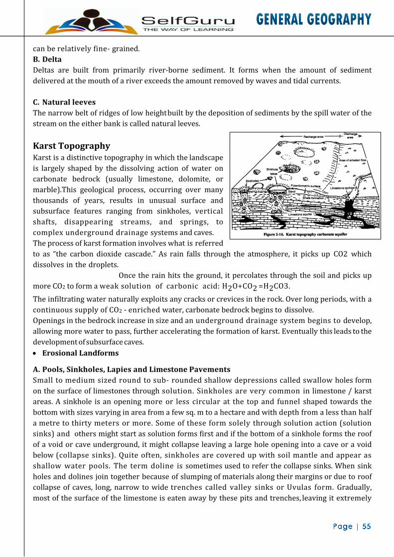
can be relatively fine- grained. B. Delta Deltas are built from primarily river-borne sediment. It forms when the amount of sediment delivered at the mouth of a river exceeds the amount removed by waves and tidal currents. C. Natural leeves The narrow belt of ridges of low height built by the deposition of sediments by the spill water of the stream on the either bank is called natural leeves. Karst Topography Karst is a distinctive topography in which the landscape is largely shaped by the dissolving action of water on carbonate bedrock (usually limestone, dolomite, or marble).This geological process, occurring over many thousands of years, results in unusual surface and subsurface features ranging from sinkholes, vertical shafts, disappearing streams, and springs, to complex underground drainage systems and caves. The process of karst formation involves what is referred to as “the carbon dioxide cascade.” As rain falls through the atmosphere, it picks up CO2 which dissolves in the droplets. Once the rain hits the ground, it percolates through the soil and picks up more CO2 to form a weak solution of carbonic acid: H2O+CO2 =H2CO3. The infiltrating water naturally exploits any cracks or crevices in the rock. Over long periods, with a continuous supply of CO2 - enriched water, carbonate bedrock begins to dissolve. Openings in the bedrock increase in size and an underground drainage system begins to develop, allowing more water to pass, further accelerating the formation of karst. Eventually this leads to the development of subsurface caves. • Erosional Landforms
A. Pools, Sinkholes, Lapies and Limestone Pavements Small to medium sized round to sub- rounded shallow depressions called swallow holes form on the surface of limestones through solution. Sinkholes are very common in limestone / karst areas. A sinkhole is an opening more or less circular at the top and funnel shaped towards the bottom with sizes varying in area from a few sq. m to a hectare and with depth from a less than half a metre to thirty meters or more. Some of these form solely through solution action (solution sinks) and others might start as solution forms first and if the bottom of a sinkhole forms the roof of a void or cave underground, it might collapse leaving a large hole opening into a cave or a void below (collapse sinks). Quite often, sinkholes are covered up with soil mantle and appear as shallow water pools. The term doline is sometimes used to refer the collapse sinks. When sink holes and dolines join together because of slumping of materials along their margins or due to roof collapse of caves, long, narrow to wide trenches called valley sinks or Uvulas form. Gradually, most of the surface of the limestone is eaten away by these pits and trenches, leaving it extremely
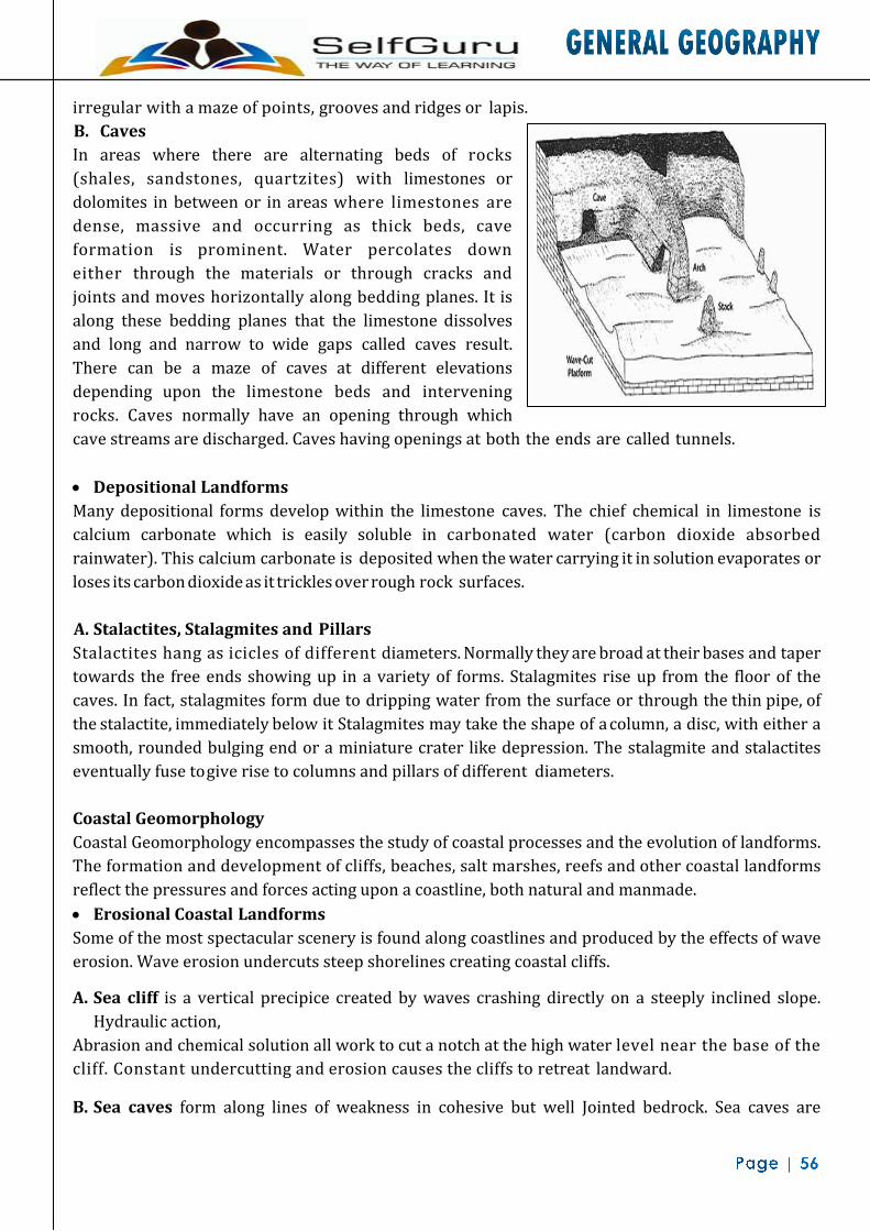
irregular with a maze of points, grooves and ridges or lapis. B. Caves In areas where there are alternating beds of rocks (shales, sandstones, quartzites) with limestones or dolomites in between or in areas where limestones are dense, massive and occurring as thick beds, cave formation is prominent. Water percolates down either through the materials or through cracks and joints and moves horizontally along bedding planes. It is along these bedding planes that the limestone dissolves and long and narrow to wide gaps called caves result. There can be a maze of caves at different elevations depending upon the limestone beds and intervening rocks. Caves normally have an opening through which cave streams are discharged. Caves having openings at both the ends are called tunnels. • Depositional Landforms Many depositional forms develop within the limestone caves. The chief chemical in limestone is calcium carbonate which is easily soluble in carbonated water (carbon dioxide absorbed rainwater). This calcium carbonate is deposited when the water carrying it in solution evaporates or loses its carbon dioxide as it trickles over rough rock surfaces. A. Stalactites, Stalagmites and Pillars Stalactites hang as icicles of different diameters. Normally they are broad at their bases and taper towards the free ends showing up in a variety of forms. Stalagmites rise up from the floor of the caves. In fact, stalagmites form due to dripping water from the surface or through the thin pipe, of the stalactite, immediately below it Stalagmites may take the shape of a column, a disc, with either a smooth, rounded bulging end or a miniature crater like depression. The stalagmite and stalactites eventually fuse to give rise to columns and pillars of different diameters. Coastal Geomorphology Coastal Geomorphology encompasses the study of coastal processes and the evolution of landforms. The formation and development of cliffs, beaches, salt marshes, reefs and other coastal landforms reflect the pressures and forces acting upon a coastline, both natural and manmade. • Erosional Coastal Landforms Some of the most spectacular scenery is found along coastlines and produced by the effects of wave erosion. Wave erosion undercuts steep shorelines creating coastal cliffs.
A. Sea cliff is a vertical precipice created by waves crashing directly on a steeply inclined slope. Hydraulic action,
Abrasion and chemical solution all work to cut a notch at the high water level near the base of the cliff. Constant undercutting and erosion causes the cliffs to retreat landward.
B. Sea caves form along lines of weakness in cohesive but well Jointed bedrock. Sea caves are

prominent headlands where wave refraction attacks the shore. A sea arch forms when sea caves merge from opposite sides of a headland. If the arch collapses, a pillar of rock remains behind as a sea stack. Seaward of the retreating cliffs, wave erosion forms a broad erosional platform called a wave-cut bench or wave-cut platform. After the constant grinding and battering, eroded material is transported to adjacent bays to become beaches or seaward coming to rest as a wave-built terrace. If tectonic forces raise the bench above the water level a marine terrace forms. Some shorelines have several marine terraces creating during various episodes of uplift.
• Depositional Landforms
A. Beaches and Dunes Beaches are characteristic of shorelines that are dominated by deposition, but may occur as patches along even the rugged shores. Most of the sediment making up the beaches comes from land carried by the streams and rivers or from wave erosion. Beaches are temporary features. The sandy beach which appears so permanent may be reduced to a very narrow strip of coarse pebbles in some other season. Most of the beaches are made up of sand sized materials. Beaches called shingle beaches contain excessively small pebbles and even cobbles. B. Bars, Barriers and Spits A ridge of sand and shingle formed in the sea in the off-shore zone (from the position of low tide waterline to seaward) lying approximately parallel to the coast is called an off-shore bar. An off-shore bar which is exposed due to further addition of sand is termed a barrier bar. The off-shore bars and barriers commonly form across the mouth of a river or at the entrance of a bay. Sometimes such barrier bars get keyed up to one end of the bay when they are called spits (Figure 7.15). Spits may also develop attached to headlands / hills. The barriers, bars and spits at the mouth of the bay gradually extend leaving only a small opening of the bay into the sea and the bay will eventually develop into a lagoon. The lagoons get filled up gradually by sediment coming from the land or from the beach it (aided by wind) and a broad and wide coastal plain may develop replacing a lagoon. Glaciated Topography Glaciers have played an important role in the shaping of landscapes in the middle and high latitudes and in alpine environments. Their ability to erode soil and rock, transport sediment, and deposit sediment is extraordinary. During the last glacial period more than 50 million square kilometers of land surface were geomorphic ally influenced by the presence of glaciers.
• Erosional Landforms Glacial erosion consists of two processes: (i) plucking or the tearing away of blocks of rock which have become frozen into the base and sides of a glacier, and (ii) abrasion or the wearing a way of rocks beneath a glacier by the scouring action of the rocks embedded in the glacier. A. Cirque Cirques are the most common of landforms in glaciated mountains. The cirques quite often are found at the heads of glacial valleys. The accumulated ice cuts these cirques while moving down the mountain tops. They are deep, long and wide troughs or basins with very steep concave to vertically dropping high walls at its head as well as sides. A lake of water can be seen quite often within the cirques after the glacier disappears. Such lakes are called cirque or tarn lakes. There can be two or more cirques one leading into another down below in a stepped sequence. B. Horns and Serrated Ridges Horns form through head ward erosion of the cirque walls. If three or more radiating glaciers cut headword until their cirques meet, high, sharp pointed and steep sided peaks called horns form. The divides between cirque side walls or head walls get narrow because of progressive erosion and turn into serrated or saw- toothed ridges sometimes referred to as arêtes with very sharp crest and a zig-zag outline. C. Glacial stairways The advancing ice of glaciers carves out giant stairways through the process of abrasion and plucking of step faults coming across the path of moving glaciers • Deposional Landforms
A. Moraines A valley glacier carries a large amount of rock waste called moraine. The moraine forming along the sides of a glacier is called lateral moraine; that along the front of a glacier is called terminal moraine; that at the bottom of a glacier is the ground moraine. When two glaciers join together, their inner lateral moraines coalesce to give a medial moraine. Terminal moraine material is carried down-valley by the melt waters issuing from the glacier’s snout (front) and is deposited as a layer called an outwash plain. One of the most conspicuous features of lowlands which have been glaciated by ice sheets is the widespread morainic deposits. Because of the numerous boulders in the clay these are called boulder clay deposits. B. Drumlins The swarms of rounded hummocks resulting from the deposition of glacial till are called drumlins. They look like inverted boat or spoon. C. Eskers When glaciers melt in summer, the water flows on the surface of the ice or seeps down along the margins or even moves through holes in the ice. These waters accumulate beneath the glacier and flow like streams in a channel beneath the ice. Such streams flow over the ground (not in a valley cut in the ground) with ice forming its banks. Very coarse materials like boulders and blocks

along with some minor fractions of rock debris carried into this stream settle in the valley of ice beneath the glacier and after the ice melts can be found as a sinuous ridge called esker. D. Outwash fan An outwash fan is a fan-shaped body of sediments deposited by braided streams from a melting glacier. Sediment locked within the ice of the glacier, gets transported by the streams of meltwater, and deposits on the outwash plain, at the terminus of the glacier. The outwash, the sediment transported and deposited by the melt water and that makes up the fan, is usually poorly sorted due to the short distance traveled before being deposited.
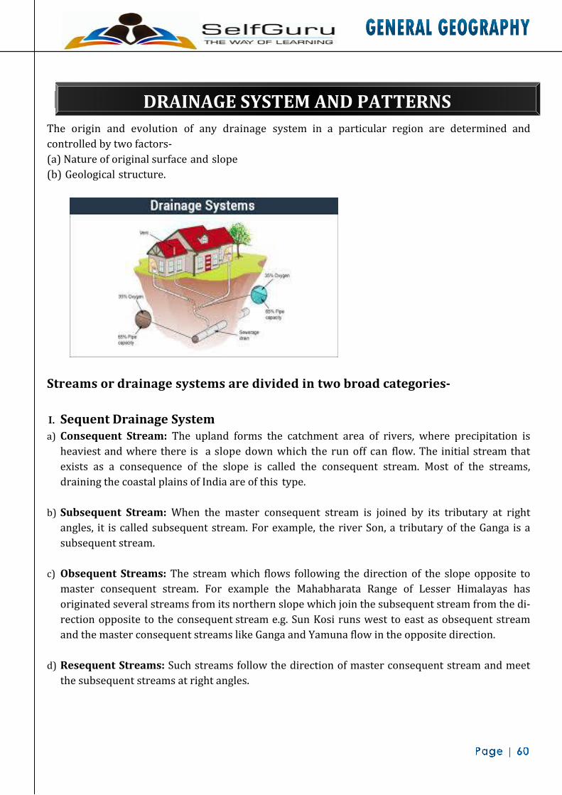
DRAINAGE SYSTEM AND PATTERNS
The origin and evolution of any drainage system in a particular region are determined and controlled by two factors- (a) Nature of original surface and slope (b) Geological structure.
Streams or drainage systems are divided in two broad categories-
I. Sequent Drainage System a) Consequent Stream: The upland forms the catchment area of rivers, where precipitation is
heaviest and where there is a slope down which the run off can flow. The initial stream that exists as a consequence of the slope is called the consequent stream. Most of the streams, draining the coastal plains of India are of this type.
b) Subsequent Stream: When the master consequent stream is joined by its tributary at right angles, it is called subsequent stream. For example, the river Son, a tributary of the Ganga is a subsequent stream.
c) Obsequent Streams: The stream which flows following the direction of the slope opposite to
master consequent stream. For example the Mahabharata Range of Lesser Himalayas has originated several streams from its northern slope which join the subsequent stream from the di- rection opposite to the consequent stream e.g. Sun Kosi runs west to east as obsequent stream and the master consequent streams like Ganga and Yamuna flow in the opposite direction.
d) Resequent Streams: Such streams follow the direction of master consequent stream and meet
the subsequent streams at right angles.

II. Insequent Drainage System: The streams which do not follow the regional slopes and drain across the geological structures are called insequent or inconsequent streams.
a) Antecedent Drainage: The stream which originated before the upliftment of the surface on which they flow. For example, Indus, Sutlej, Alaknanda and Brahmaputra are antecedent rivers as they originated before the upliftment of Himalayan ranges.
b) Superimposed Drainage: It is formed when the nature and characteristics of the valley and the flow direction of a consequent stream, developed on the upper geological formation and struc- ture, are superimposed on the lower geological formation of entirely different characteristics. For example the river Subarnarekha is superimposed on Dalma Hills of Chhotanagpur Plateau of Jharkhand.
Drainage Patterns 1. Dendritic Drainage: A drainage pattern consisting of a single main stream with tributaries,
resembling the branches of a tree. This pattern develops perfectly where the underlying rocks are of a uniform type and the structures are simple.
2. Trellis Drainage: It is a rectangular pattern of river channels. It may develop where a slope is crossed at right angles by the strike of alternating hard and soft rock strata. Long streams develop along the soft rock strata and the short streams follow the slope.
3. Radial Drainage: Here the streams radiate from a central peak or upland mass in all directions.
Dome structures commonly develop radial drainage as in the English Lake District of England. The entire drainage network of Sri Lanka, Hazaribagh Plateau, Panchet Hills and Maikal Range are of such type.
4. Rectangular Drainage: A pattern of drainage consisting of two main directions of flow at
right angles to one another. This pattern is common where the streams follow the fault lines.
5. Annular Drainage is usually produced on domed structures where the rivers follow the outcrops of weaker beds of rock in an alternating band of hard and soft beds.
6. Parallel Drainage: A pattern in which the main streams and tributaries follow virtually
parallel courses. This develops where there is a strong structural control in one direction or where strata are gently dipping.
7. Barbed Drainage: In this pattern the tributaries flow in opposite direction to their master
streams. The tributaries join their master streams in a hook-shaped bend. Such pattern is generally developed due to river capture.

8. Here streams follow Centripetal Drainage: When the streams converge at a point, which is generally a depression or a basin they form centripetal or inland drainage pattern.
9. Herringbone Drainage: When the consequent streams are developed in the longitudinal parallel valley while the tributaries, after originating from the hill slopes of the bordering parallel ridges, join the longitudinal consequents almost at right angle, it is known as herringbone pattern or rib pattern. Jhelum River in the Vale of Kashmir receives many tributaries from both the sides, following the rib pattern.

ATMOSPHERE
Composition of Atmosphere The atmospheres, a mixture of many gases, some of the gases behave like permanent atmospheric components as they remain in fix proportion of the total gas volume. Two gases, contains huge amount of solid and liquid particles, collectively known as “aerosols”. Pure dry air consists mainly of Nitrogen (78%), Oxygen (21%), Argon (0.93%), Carbon dioxide (0.03%), Hydrogen, Helium and Ozone. Besides, water vapour, dust particles, smoke, salts are also present in air in varying quantities. As a result, the composition of air is never constant and varies from time to time and place to place .nitrogen and oxygen constitutes about 99% of the clean dry air. The deep layer through which the gaseous composition of the atmosphere is generally homogeneous is called the “homosphere”. At higher altitude, the chemical constituents of air changes considerably and this layer is known as “heterosphere”.
Data on Composition of Atmosphere
Gases Volume Height Characteristics and Functions
Nitrogen 78.084% up to 100 km Not very active chemically, dilatant for oxygen, regulates combustion, Enters protein molecules via Soil planets
Oxygen 20.946% up to 100 km chemically active combines readily with other elements, Released by plants in Photosynthesis, taken up by plants and animals in respiration.
Argon Carbon-Dioxide
0.934% 0.039%
— up to 50 km
Chemically inactive, Present in tiny portion absorbs heat radiation from the earth in the atmosphere
Neon 0.001818% —- —-
Helium 0.000524% — —- Methane 0.000179% — —-
Krypton 0.000114% — —
Hydrogen 0.000055% — —-
Nitrous Oxide Carbon Monoxide
0.00003% 0.00001%
— —
—- —-
Xenon 9 × 10"6% 30 to 50 km —-
Ozone 7 × 10"6% 20 to 45 km Absorbs Ultra violet rays of Sun
Nitrogen Dioxide 2 × 10"6% — —-

Water vapour 0.40% over Full atmosphere Typically 1%-4% at surface
upto 8km Recycles in Evaporation – Condensation
Dust particles — Lower layers Gives the colour to sky (Blue) by
Scattering, decides the intensity of sunrays, acts as hygroscopic nuclei
Structure of the Atmosphere The atmosphere consists of almost concentric Stratosphere: The region above the tropopause extending up to 50 km above the earth is known as Stratosphere. Temperature layers of air with varying density and temperature. Density is highest on the earth’s surface and goes on decreasing upwards. The atmosphere can be divided into following layers:
A. Troposphere: The lowest layer of the atmosphere extending to an average altitude of 10 km, varying between 18 km above the equator and 8 km above poles. It is a region of clouds, water vapour and weather. Troposphere literally means the region of mixing. It contains about 75 percent of the total mass of the atmosphere and practically all the moisture and dust particles.
Temperature decreases at the rate of 6°C per km of height above Sea level. The temperature at the end of the troposphere is around -80°C. The boundary line separating troposphere from stratosphere is known as Tropopause. Cases to fall with the increase in height at this level. The temperature at tropopause is about - 80°cover the equator and about - 45°cover the poles.
In the lower part of the stratosphere i.e. upto height of 20 km, temperature remains constant. Afterwards it gradually increases upto a height of 50 km because of the presence of ozone layer. Clouds are almost absent and there is little dust or water vapour. The air movements are almost horizontal. The Stratospheric layer provides ideal conditions for flying large aeroplanes. Cirrus clouds, called the “mother of pearl clouds”, occasionally form in the lower stratosphere. Above the tropopause no visible weather phenomena ever occur. The upper boundary of the stratosphere is called “Stratopause”.

B. Mesosphere: It exists over the stratosphere extending upto a height of about 80 km above the earth. Temperature sharply decreases with height and reaches the lowest level of -100°C at the top. Bulk of the meteors is destroyed in this region. Because of the preponderance of chemical processes this sphere is sometimes called the ‘Chemosphere’. C. Ionosphere: It is located between 80 and 400 km. It is an electrically charged layer. Radio waves transmitted from the earth are reflected back by this layer. Temperature again starts increasing with the height because of radiation from the Sun. At this level, the ionization of atmosphere begins to occur. This layer was first of all discovered by Kennelly and Heaviside.
Layers of Ionosphere: (i) D-Layer: It is the lowest layer of Ionosphere (60 km to 90 km). It reflects low-frequency
radio waves but absorbs medium and high frequency waves. It disappears as soon as the sun sets.
(ii) E-Layer: It extends from 90 km to 120 km and called as “Kennelly-Heaviside layer”. It reflects the medium and high frequency radio waves. This layer also does not exist at night.
(iii) F-Layer: The F layer, also known as the Appleton layer extends from about 200 km to more than 500 km above the surface of Earth. This layer is important in long distance radio communication. It reflects the medium and high frequency radio waves.
(iv) G-Layer: This is the uppermost part of Ionosphere. Because of the interaction of ultraviolet photons with nitrogen atoms, free electrons are produced in this layer.
D. Exosphere/Thermosphere: It is the uppermost layer of the atmosphere extending beyond the ionosphere above a height of 400 kilometers. This layer is extremely rarified and gradually merges with the outer space. Hydrogen and helium gases dominate this region. Here the temperature may reach a high value of about 5568°C. Insolation/ Solar Radiation Incoming solar radiation is known as Isolation and it is received in the form of short waves. The earth’s surface receives the radiant energy at the rate of 2 calories per sq. cm. per minute. Factors effecting the distribution of Insolation: 1. Distance between Earth & Sun: The average distance between these two bodies is about 149
million km. On January 3 the earth comes closer to the sun, called “perihelion”. On July 4, the earth is little further from the sun and this position is called ‘aphelion’. Hence the amount of incoming solar radiation is about 7 percent more in January.
2. Angle of Incidence: The oblique rays have to travel longer distance through the atmosphere

before they strike the surface of the earth and large amount of energy is lost by various processes of reflection, absorption, scattering, etc. At mid-day the intensity of insolation is maximum. In winter and high latitudes the insolation received is small.
3. Duration of Sunshine: The most important causes for the variation in the amount of solar energy reaching the earth are the seasonal changes in the angle at which the sun’s rays strike the surface and the length of the day. Summer Solstice: 21st June Winter Solstice: 22nd December Autumnal Equinox: 23rd September Spring Equinox: 21st March.
4. Solar Constant: When the sun-spots appear in larger number, the intensity of the solar radiation received is increased. The number of sunspot changes on a regular basis in a cycle of 11 years.
5. Transparency of Atmosphere: Reflection from dust, salt, smoke particles, etc. returns short wave radiation to space. Similarly cloud tops deplete the amount of insolation. Transparency of the atmosphere is closely related to the latitudes. In the higher latitudes the sun’s ray are more oblique. In winter when the altitude of the sun is relatively lower, there is greater loss of incoming solar radiation than in summer.
Heat Budget The average temperature of the earth remains rather constant. It has been possible because of the balance between the amount of incoming solar radiation and the amount of terrestrial radiation returned to space. This balance of incoming and outgoing radiation has been termed as the earth’s heat budget. Let us assume that the total heat received at the top of the atmosphere is 100 units. About units are reflected back to space even before reaching the earth’s surface. Of these, 27 units are reflected back from the top of the clouds and 2 units from the snow and ice-covered areas of the earth. The reflected amount of radiation is called the Albedo of Earth. The remaining 65 units are absorbed, 14 units within the atmosphere and 51 units by the earth’s surface. The earth radiates back 51 units in the form of terrestrial radiation. Of these, 17 units are radiated to space directly and the remaining 34 units are absorbed by the atmosphere - 6 units absorbed directly by the atmosphere, 9 units through convection and turbulence and 19 units through latent heat of condensation. About 48 units absorbed by the atmosphere (14 units from insolation and 34 units from terrestrial radiation) and also radiated back into the space. Thus the total radiation returning from the earth and the atmosphere respectively is 17 + 48 = 65 units which balance the total of 65 units received from the sun. Hence the heat balance of the earth is always maintained. Mechanism of Heat Transfer There are certain processes which play significant role in the transfer of energy from the earth

surface to its atmosphere. The atmosphere is heated and cooled by the following processes: 1. Absorption by Atmosphere: About 14 percent of insolation is directly absorbed by dust
particles and water vapor. Nearly 50 percent of this absorption occurs in the lower 2 km of air.
2. Conduction: When two bodies of unequal temperature are in contact with one another, there is a flow of energy from the warmer to the cooler body, until both the bodies attain the same temperature. Since air is very poor conductor of heat, it affects only the lowermost layer of the air. It is least important in the heat transfer for the atmosphere as a whole.
3. Terrestrial Radiation: Radiant solar energy reaches the earth’s surface in the form of short electro-magnetic waves but is radiated in the form of long waves or infrared radiation. Gases and water vapor are almost transparent to short wave radiation. Thus atmosphere receives a larger part of its energy supply from the earth and not directly from the sun.
4. Convection & Advection: Heat gained by the layers of air at or near the earth’s surface from radiation or conduction is transferred to the upper atmospheric layers by the process of convection. Whereas the term convection is used for vertical motion in the atmosphere, the term advection is used for horizontal transport of heat. Advection is responsible for slow heat transfer from the equatorial to the polar regions. “ Loo ” is the example of advection.
5. Latent Heat of Condensation: Half of the insolation received at the ocean surface is consumed in the evaporation of surface water. When the water vapour is condensed, the latent heat is again released into the atmosphere and is used in heating it.
6. Expansion and Compression of Air: Whenever air moves upward it passes through region of successively lower pressure and whenever descends the vice- versa. Rising air expands and cools adiabatically. The descending air is compressed and heated. Thus the temperature changes brought about in the air aloft simply due to changes in the air pressure are very important in the heating or cooling of the atmosphere.
Factors Influencing Temperature 1. Latitude: In general the temperature
decreases from the equator to the poles as per the altitude of the mid-day sun.

2. Altitude: Temperature falls by 6.5° C for every 1 km ascent.
3. Ocean Currents: Warm ocean currents, moving pole wards, carry tropical warmth into the high latitude. This warming influence is very marked in latitudes 40° to 65° on the west side of the continents, especially along the sea-board of Western Europe. Cold currents have fewer effects upon temperature because they usually lie under offshore winds. However, there are some exceptions e.g. the coast of Labrador, where the summer temperatures are lowered by on shore winds which blow over the cold Labrador Current.
4. Distance from Sea: The sun’s heat is absorbed and released more slowly by water than by the land. So the sea-adjoining areas experience warming and cooling effects. The climatic regions whose temperatures are influenced greatly by the sea are called “maritime or oceanic or insular climate”. Climate whose temperature is greatly influenced by the remoteness from the sea are called “continental climate”.

5. Winds: In temperate latitudes,
prevailing winds from the land lower the winter temperature but raise the summer temperature and the prevailing winds from the sea raise the winter temperature but lower the summer temperature. In tropical latitudes, on-shore winds modify the temperature of the coastal regions. Local winds sometimes produce rapid upward or downward changes in the temperature.
6. Cloud Cover and Humidity: Clouds reduce the amount of solar radiation reaching the earth’s surface and the amount of earth radiation leaving the earth’s surface. The heavy cloud cover of equatorial regions doesn’t allow a day temperature over 30°C. In hot desert the absence of clouds results in very high day temperature of over 38°C and clear sky allows the earth heat to escape freely resulting in fall of temperature up to 20°C at night.
7. Aspects: South facing slopes are warmer than north-facing slopes in the Northern Hemisphere while in the Southern Hemisphere the reverse is true. In the high latitude the mid-day sun is at a low angle in winter and hence blocks of flats are usually built far apart to enable all the flats to receive some sunshine.
8. Length of Day: The length of day also influences the temperature.
9. Amount of Dust and Other Impurities in the Air: In the industrial areas and large urban centres, the polluted particles are abundant in the air. These particles not only absorb larger amount of insolation but also greatly absorb the terrestrial radiation. Hence these areas show larger temperature than the surrounding areas and are converted into “Heat Islands”. Between January and July all the isotherms in the northern hemisphere move northward. This movement of isotherm is greater over the land than over the oceans. The highest temperatures for both January and July are over the continents. The isotherms bend pole ward over the ocean but equator ward over the continent in January. The isotherms bend equator ward over the ocean but pole ward over the continents in July. The seasonal changes are less marked over the southern continents than over the northern ones. The range of temperature increases from the equator to the poles. The coastal regions have a smaller range of temperature than the

continental interiors. The range of temperature on the eastern sides of Asia and North America is greater than on the Western side in the same latitude.
Temperature Anomaly: Temperature varies even along the same parallel of latitude because of the factors like altitude, land and water contrasts, prevailing winds and ocean currents. The difference between the mean temperature of any place and the mean temperature of its parallel is called the Temperature Anomaly or Thermal Anomaly. It therefore, expresses deviation from the normal.
Inversion of Temperature: Air temperature also varies according to the altitude. At higher altitudes air becomes less dense; it is unable to absorb heat, resulting in colder air temperature. The normal drop of temperature with height is known as normal lapse rate which is 6.4°C per km on an average. Temperature inversion is the situation where there is increase in temperature with height before beginning to drop into the normal lapse rate. In cases where the temperature remains the same with increase of altitude, the layer of atmosphere is called Isothermal.
Humidity It refers to the content of water vapour present in air in gaseous form at a particular time and place. It is measured through an instrument called ‘hygrometer.
• Absolute Humidity: The total weight of moisture content or water vapour per volume of air at definite temperature is called absolute humidity.
• Specific Humidity: It is defined as the mass of water vapour in grams contained in a kilogram of air and it represents the actual quantity of moisture present in a definite air.
• Relative Humidity: It is defined as a ratio of the amount of water vapour actually present in the air having definite volume and temperature (i.e. absolute humidity) to the maximum amount the air can hold at that temperature (i.e. humidity capacity).
Dew point: It is the temperature at which a parcel of air would have to be cooled in order to reach saturation. The favorable conditions are moist air, light winds and clear night skies to ensure maximum cooling by radiation. Evaporation: Evaporation can be defined as the process by which liquid water is converted into a gaseous state. Evaporation can only occur when water is available. It also requires that the humidity of the atmosphere be less than the evaporating surface (at 100% relative humidity there is no more

evaporation). The evaporation process requires large amounts of energy. For example, the evaporation of one gram of water at a temperature of 100° Celsius requires 540 calories of heat energy (600 calories at 0° Celsius).
Condensation: In this process the water vapour is changed into liquid state. If air is cooled below its dew point, some of air’s water vapour becomes liquid. Thus any further cooling of saturated air starts the process of condensation. Condensation depends upon two factors - relative humidity of air and degree of cooling.

Necessary conditions for condensation are: 1. The air must be saturated. Saturation occurs either when the air is cooled below the dew
point or when vapour is added to the air. 2. There must be a surface on which the water vapour may condense. For dew or frost, solid objects
at the ground do this work. But when the condensation occurs in the air, the surface is provided by the dust particles or aerosols and these particles are known as “hygroscopic nuclei”.
Condensation in Atmosphere: The cooling needed to produce condensation can occur in a number of ways: 1. Relatively warm moist air moving over a colder surface. 2. The mixing of warm, moist unsaturated air with colder unsaturated air. 3. Radiative cooling from the land surface. 4. Upward motion of air.
Condensation Nuclei: The particles which serve as condensation nuclei are hygroscopic, that is, they have affinity for water. Adiabatic Lapse Rate: The rate at which temperature decreases in rising and expanding as parcel is known as the adiabatic lapse rate. Until condensation occurs, temperature fall at the rate of about 9.8°C per / km. This is known as dry adiabatic lapse. Fog It is microscopically small drops of condensed water suspended in the air near the earth surface in sufficient number. It reduces the horizontal visibility to less than 1 km. For aviation purpose the reporting of fog is done only when the visibility is less than 9 km. On the basis of appearance the fogs may be classified as-
1. Smog: It is formed in the polluted air of large industrial centres having large number of soot
and dust particles, generally dirty and mixed with smoke. 2. Haze: It limits the visibility between 2 km and 5 km. 3. Mist: It is intermediate between fog and haze (visibility between 1 and 2 km). 4. Smaze: It is an admixture of smoke and haze. 5. Frost-Smoke: It is formed in the Arctic region when the air temperature falls much below the
freezing point. It is kind of fog having innumerable ice particles and super- cooled water droplets is formed by the process of condensation. It generally takes place on the surface of

water bodies and later carried over the land by winds. 6. Zero Visibility: When the object cannot be seen easily beyond 25 m. 7. ‘9’ Visibility: When the object can be seen easily up to 50 km Clouds Clouds are aggregates of innumerable tiny water droplets, ice particles or mixture of both in air generally above ground surface. On the basis of height clouds are classified as under:
A. High Clouds (mean height 6 to 13 km): 1. Cirrus: Detached clouds; fibrous (hair like) silky appearance composed of ice crystals; do not
give precipitation.
2. Cirro-cumulus: Thin, white patch; sheet or layer of cloud; often connected with cirrus or cirro-stratus clouds; when arranged uniformly it forms a “mackerel sky”.
3. Cirro-stratus: Transparent, whitish cloud of fibrous or smooth appearance; produces “halo” phenomena around the sun and moon; mainly formed of ice-crystals.
B. Middle Clouds (mean height 2 to 6 km.): 1. Alto-cumulus: Do not produce “halos”; have dark shading on their under surface; also referred
as “sheep clouds”; composed of super-cooled liquid droplets.
2. Alto-stratus: The sun may be totally obscured but “halos” are never seen; shadow on the ground is never cast; precipitation may fall either as fine drizzle or snow.

3. Nimbo-stratus: A low cloud form and may be thousands of feet thick; it is a rain, snow or sleet cloud; never accompanied by lightening, thunder or hail.
C. Low Clouds (mean height 0 to 2 km.): 1. Strato-cumulus: A low cloud layer consisting of large lumpy masses or rolls of dull grey
color with brighter interstices.
2. Stratus: A fairly uniform base which may give drizzle, ice-prisms or snow grains; sky may be completely covered by this cloud; difficult to differentiate between high fog and stratus. Cumulus: Detached dense clouds with sharp outlines; develop vertically in the form of rising mounds; generally found in the day time over land areas; they dissipate at night.
3. Cumulo-nimbus: Heavy and dense cloud in the form of anvil; they are associated with heavy rainfall, thunder, lightning and hail; have flat top and a flat base; it obstructs the sun.
Precipitation It is the process by which condensed water vapour falls to the earth’s surface as rainfall, snowfall and other forms. On the basis of its origin, precipitation may be classified into three main types:
1. Convectional Precipitation: It is caused when moist winds are drawn into the convection
currents of a hot region. It generally occurs in equatorial region. The thundery rain of a summer afternoon is a typical example.
2. Orographic Precipitation: It is caused by the surface relief of the land, mainly, by the presence of mountain range. There is heavy rain on the windward side.
3. Cyclonic Precipitation: It is associated with the passage of a cyclone or depression.
Forms of Precipitation 1. Rain: Of liquid water particles in the form of drops of more than 0.5 mm dia. 2.Drizzle: Fine drops of water (diameter less than 0.5 mm), very close to one another. 3.Snow: White and opaque grains of ice. 4.Sleet: Mixture of rain and snow. 5.Hail: small pieces of ice with a diameter ranging from 5 to 50 mm Rainfall.

When precipitation is in the form of water drops, we call it rainfall. Only when temperature of water vapour is above 0°C, rainfall will occur. At sub-zero level temperatures, snowfall will occur. Main determinants of rainfall are latitude distance from the sea, direction of winds, proximity of mountains and seasons. The regions of heavy rainfall in the world are - Equatorial regions, Tropical Monsoon regions and mid-latitude West Margin regions. Regions of low rainfall (below 25 cm annual) are- tropical desert, mid-latitude deserts and Polar Regions. World Distribution of rainfall: After examining the latitudinal pattern of distribution of rainfall it will be seen that the maximum is received in the equatorial zone and the minimum is in the Polar Regions. A secondary maximum lies in the belt of 40°–60° N and 40°–60° S and a secondary minimum occurs around 30° N and 30° S latitudes. This pattern of rainfall distribution is closely related to the distribution of major pressure belts of the world. The two zones of maximum precipitation are related to the equatorial low pressure and sub-polar low pressure. These low pressure belts are regions of ascending air and therefore precipitation is greater than elsewhere. The belts of minimum precipitation are zones of polar high pressure and subtropical high pressure. As the capacity to hold water vapour decreases sharply with temperature, precipitation is generally higher in the low latitudes than in the high latitudes.
• This broad latitudinal pattern is modified by the distribution of continents and oceans, and the
direction of prevailing winds. Winds blowing from the oceans towards the landmasses are called on shore winds. Such winds are moisture laden and give rainfall along the coast. When winds blow from the land masses towards the oceans, they are called off-shore winds. These are not rain bearing winds.
• In the belt of trade winds, there is maximum precipitation in the eastern margins of continents as the easterly winds blow from the oceans. In this belt rainfall decreases towards the west. The western margins of continents are deserts. These are the tropical deserts of the world.
• In the mid-latitudes, the westerly winds give maximum “rainfall to the western margins of continents. Rainfall decreases gradually towards the east and the interiors of large continents are dry. These are mid-latitude deserts.
• The location of mountain ranges with reference to prevailing winds also influences the
distribution of precipitation. Maximum precipitation is received where the mountain ranges lay right across the path of prevailing winds e.g. the Western Ghats in India.
(a) The regions of heavy precipitation (more than 150 cm.): 1. Equatorial regions: The Amazon and the Congo basins, Malaysia, Indonesia and New Guinea. 2. Tropical Monsoon regions: Parts of India, South-east Asia and South China. 3. Mid-latitude West Margin regions: Coastal regions of British Columbia, North-west Europe,
South Chile and South Island of New Zealand.

(b) Moderate rainfall of 100 to 150 cm per year is received in the eastern margins of continents in the trade-wind belt. These are the sub-tropical eastern margins of China, the U.S.A., Brazil, South Africa and Australia.
(c) Regions of extremely low rainfall (less than 25 cm.): 1. Tropical deserts Western margins of continents in the trade wind belt– Californian
desert in the United States, Atacama, Kalahari, southern Africa, Sahara, Arabia and then in Afro Asia, and West Australia.
2. Mid-latitude desert in the interiors of large continents such as Asia and North America.
3. Polar Regions.
Pressure & Wind Wind can be defined as air in motion. The principal cause of winds is the difference in pressure. Air always moves from areas of high pressure to those with low pressure. The slope of the pressure from high to low is known as the pressure gradient and the direction of this gradient decides the direction of the winds. Owing to the earth’s rotation, all the winds are deflected to the right in the northern hemisphere and to the left in the southern hemisphere. This is referred to as the Ferrel’s Law and the force occurring due to the rotation of the earth is called the Coriolis force. Buys Ballot’s Law: In northern hemisphere, if a person stands with his back to the wind, low pressure lies to his left and high pressure lies to his right. In S-Hemisphere it is reversed since the Coriolis deflection is to his left. Types of winds: (i) Planetary winds or Prevailing winds; Trade winds, Westerlies and Easterlies. (ii) Periodic winds: Land breeze, Sea breeze & Monsoon winds. (iii) Local winds: Loo, Fohn, Chinook, Mistral and Jet Streams. (iv) Atmospheric Disturbances: Tropical Cyclones and Temperate Cyclones.
I. Planetary Winds: The wind systems that are bound to occur at the global level on any planet
having an atmosphere and rotating about its axis. The specific characteristics of trade winds, Westerlies and Easterlies may be determined by several conditions but the broad features are constant over the globe.
• Trade Winds: These winds blow from the subtropical high pressure towards the equatorial region of low pressure regularly throughout the year. It brings little rain except on the line of convergence of the two trade wind systems.

• Westerlies: The Westerly winds are those which blow with great frequency from the Horse latitudes towards the Polar region throughout the year with varying intensity and cause rain near the Polar Regions. Westerlies are stronger in the Southern Hemisphere because of the vast expanse of ocean waters. Owing to their ferocious nature, they are also described as “Roaring Forties”, “Furious Fifties” and “Shrieking Sixties” in southern hemisphere.
• Doldrums: Also known as Intertropical convergence, it is the equatorial belt of low
atmospheric pressure where the north-east and south east Trade winds converge. It is a region of calmness, the calm periodically broken by storms, accompanied by heavy rains.
• Horse Latitude: They are the subtropical belts of high atmospheric pressure over the oceans
(near 30° latitude) between the regions of trade winds and Westerlies. They are regions of calm, light variable winds and dry air.
II. Periodic Winds: • Monsoon: The word monsoon has been derived from the Arabic word “Mausim” which means
season. The monsoon winds thus refer to the wind systems that have a pronounced seasonal reversal of direction. The monsoon winds blow over India, Pakistan, Bangladesh, Burma, Sri Lanka, Arabian Sea, Bay of Bengal, S.E. Asia, N. Australia, China and Japan.
• Summer Monsoon: During summer, a thermal low is developed over southern Asia in the lower levels of the atmosphere. From the Indian Ocean and the south western Pacific, warm humid air moves northward and north westward into Asia passing over India, Indo China and China. This summer monsoon is accompanied by heavy rainfall in south-east Asia.
• Winter Monsoon: The Winter monsoon is a gentle drift of air in which the winds generally blow
from the north east. Retreating monsoon causes sporadic rainfall especially in the north- eastern parts and Tamil Nadu coastal areas of India. Outside India, in the East Asian countries
• E.g. China and Japan, the winter monsoon is stronger than the summer monsoon.
III. Local Winds: There are winds that develop as a result of local conditions in temperature and pressure of air. They affect small areas in the lowest levels of Troposphere.
• Loo: A very hot and dry wind (hot wave) in the North Western India and Pakistan which blows from the west in the afternoon of May and June and may cause sunstroke.
• Chinook and Fohn: Warm and dry local winds, also called ‘snow-eater’, blow on the leeward
sides of the mountains. These are called Chinook in the USA and Fohn in Switzerland.
• Harmattan: The warm and dry winds blowing from north-east and east to west in the eastern parts of Sahara desert are called Harmattan. Similar winds are called ‘brick fielder’ in Australia, ‘blackroller’ in USA, ‘Shamal’ in Mesopotamia and Persian Gulf and ‘Norwesters’ in New

Zealand.
• Sirrocco: It is a warm, dry and dusty wind which blows in northward direction from Sahara desert and after crossing Mediterranean Sea reaches Italy, Spain etc. Similar winds are known as ‘Khamsin’ in Egypt, ‘Gibli’ in Libya, ‘Chilli’ in Tunisia, and ‘Simoom’ in Arabia.
Local and Regional Winds
Winds
Region / Country
Nature 1. Fohn Alps / Europe (Germany) Dry / Warm
2. Chinook Rockies, U.S.A. & Canada Dry / Warm 3. Mistral Alps / France to Mediterranean Sea Dry / Cold 4. Sirocco N. Africa / Sicily / Italy Dry / Hot
5. Khamsin Egypt / N. Africa Dry / Hot 6. Harmattan W. Africa / Ghana / Nigeria Dry / Hot 7. Norwesters Bengal / Assam / India Moist / Hot
8. Berg South Africa Dry / Cold 9. Pampero Argentina Dry / Cold 10. Zonda Chile / Peru / Brazil / Argentina Dry / Warm
11. Brick Fielder Australia Dry / Hot 12. Buran Siberia / Russia Dry / Cold 13. Bora Italy / Yugoslavia (To Adriatic Sea) Dry / Cold
14. Southerly Buster Australia Dry / Cold 15. Samun Persia / Iran Dry / Hot
16. Nevadas Ecuador Dry / Hot
17. Norwesters New Zealand (South Island) Dry / Hot 18. Leveche Algeria / Morocco Dry / Hot 19. Blizzard Siberia, Canada and USA. Dry / Cold (Snow laden)
20. Bise France Dry / Cold 21. Levanter Spain Dry / Cold 22. Santa Ana USA Dry / Warm
23. Yamo Japan Dry / Warm 24. Tramontane Central Europe Dry / Warm
Diurnal Variation in Atmospheric Circulation Diurnal wind systems occur frequently in many tropical areas. They also occur in other areas but rather irregularly and less frequently. There are two major types of diurnal wind systems: 1. Land and Sea Breezes: These occur along the coast or near large water bodies. They are
caused by the thermal differences between the land and water surface.
Sea Breeze: Takes place during the day when a local thermal low develops over the land with the

winds blowing from the sea towards the land.
Land Breeze: Take place during the night when the land cools off rapidly while the sea is still warm. Then the winds blow from the land towards the sea.
2. Mountain (Katabatic) and Valley (Anabatic) Winds: During the day when insolation is intense the more exposed hill slopes are heated more than the valley bottoms. Thus winds blow upward from the valley. These are valley or anabatic (upslope) winds. The high lands cool off rather rapidly because of terrestrial radiation losses. Cold and dense air then drains downslope into valleys. Such cold winds are known as mountain or Katabatic winds.
Cyclones This is a depression in a mass of air whose isobars form an oval or circular shape with low pressure at the centre. The air converges at the centre and then rises. The winds rotate anti-clock wise in the northern hemisphere while in the southern hemisphere the circular movement of winds is in a clockwise direction. Moving cyclones are of three types:
A. Extra tropical Cyclones: 1. Typical of middle and high latitudes; usually called a depression.
2. This cyclone varies in diameter from 200 km to 300 km.
3. Appearance may be circular or elongated or may be broad shallow, week depressions.
4. Usually travel in groups or “Families” from the West to East.
5. Average speed is about 30-50 km per hour.
B. Tropical Cyclones: 1. Tropical Cyclones are found in low latitudes over oceans.
2. It is almost circular centre of extremely low pressure into which winds spiral.
3. The diameter of the storm ranges from 160 to 650 km and the velocity of the wind varies from a minimum of about 120 to 200 km per hour.
4. The life span of a tropical cyclone is about a week and the storm travels at the rate of 15-30 km per hour.
5. Tropical cyclones are characterized by violent winds and heavy rains.
6. The source of energy for the maintenance of tropical cyclones is the latent heat of condensation.

C. Tornadoes: 1. The most violent storms of lower troposphere.
2. The funnel shape cloud extends downwards from the base of cumulonimbus cloud layer.
3. Tornadoes which occur in conjunction with scattered thunderstorms are usually short- lived and have irregular paths.
4. The circulation of wind is usually in a counter clock wise direction; wind velocities are very high almost about 100 m / sec.
5. Occur frequently east of the Rockies Mountains in the Mississippi Basin in USA, in eastern India and east of the Andes Mountain.
6. At sea, tornadoes become water spouts having same characteristic except that they are small in diameter.
Anti-cyclones It is opposite to the cyclones where two types of anticyclones are observed:
1. Relatively Stationary, also called as warm anticyclones.
2. Travelling anticyclones, which are also called as cold anticyclones, are mainly found in the high latitude within continental polar air.
3. Barometric pressure is highest at its centre and decreases outward. Anticyclonic wind system blows out from the centre and because of the Coriolis Effect it has a clockwise circulation in the Northern hemisphere and counter clockwise in Southern hemisphere.

Beaufort scale: In 1806 “Admiral Beaufort” proposed a scale for estimating the wind velocity and developed the Beaufort scale.
Beaufort
No.
Wind
(Mph)
Speed
Common effects
0 Calm 0 Smoke rises vertically.
1 Light air 2 Wind vanes not applicable.
2 Light Breeze 5 Wind felt on the face.
3 Gentle Breeze 10 Leaves & small things in motion.
4 Moderate 15 Raises dust & loose paper & small branches moved.
5 Fresh Breeze 21 Wavelets in water.
6 Strong Breeze 28 Large branches in motion.
7 Moderate Gale 35 Whole tree in motion.
8 Fresh Gale 42 Breaks twigs of trees
9. Strong Gale 50 Slight structural damage
10 Whole Gale 59 Tree uprooted; great damage
11. Storm 69 Widespread damage
12 Hurricane > 75 Most destructive.
Points to remember 1. “Eye” is the central low pressure core of tropical cyclone
2. In the tropical cyclone the pattern of isobar is “circular”.
3. Willie-Willie is a type of tropical cyclone of Australia.
4. Chinook is also known as “Snow-Eater”.
5. “Squall” is a very short lived fast wind.
6. Frozen raindrops are called “Sleet”.
7. “Stevenson Screen” is a Meteorological shelter
8. Weather cock is used to ascertaining “wind direction”.

9. The condensation at dew point below 0°C produces frost.
10. The scattering of light by dust particles is known as “Tundal effect”.
11. Cirrostratus is a type of cloud around which a halo is created.

CLIMATE CLASSIFICATION
Climate can be classified on the basis of temperature, precipitation, evaporation and their seasonal characteristics. The classification scheme of W. Koppen is the most popular system and universally accepted. A classification of the world climatic types is given ahead:
1. Tropical Rain Forest/Equatorial Forest Type • Extent: 5°N to 5°S; Amazon Basin, Zaire Basin, Malaysia, Indonesia.
• Average daily temperature: 25°C throughout the year
• Annual range of temperature: Less than 5°C
• Daily range of temperature: Less than 10°c, due to high % of cloudiness.
• Rainfall: Convectional, throughout the year. No dry season. • Annual rainfall: 150 to 200 cm.
• Characteristics: Hot wet condition throughout the year favours rich vegetation.]
2. Tropical Grassland/Savanna Type • Extent: 5°N to 15°N & 5°S to 15°S; Africa, East & central S. America, Transitional zone
between Monsoon and desert climates of Australia.
• Monthly mean temperature: 32°C in summer and 20°C in winter. • Annual rainfall: 50 to 100 cm.

• Characteristics: Distinct dry season in winter. Rainfall is in summer owing to convectional ascent of air.
They have tropical grassland with scattered trees. Llanos: Colombian Highland.
Campos: SE highland of Brazil, Granchaco:
Argentina & Uruguay. Savanna: Australia and Africa.
3. Tropical Monsoon Type • Extent: South-east and East Asia, North Australia, India, Myanmar, Thailand and South
China.
• Annual range of temperature is greater in the interior than along the coast.
• Annual rainfall may exceed 150 cm. along the coast
• Characteristics: Strongly developed dry season and the rainfall of the driest mouth is less than 6 cm. Great contrast in temperature between summer and winter.

4. Tropical Deserts Extent: Western margin of the continent; N. America- Colorado Desert, Mexican Desert; Africa - Sahara & Kalahari Desert; S.W.- Asia - Arabian, Iranian & Thar Deserts; S. America- Atacama Desert; Australia- Great Australian Desert.
Mean monthly temperature is 36°C in summer and 15°C in winter. Diurnal range of temperature is very high.

Annual rainfall: It is a region of descending air so precipitation is scanty. It remains very hot during the day (45°C) and quite cool at night (15°C). Annual rainfall is less than 20 cm.
5. Mid-Latitude/Temperate Deserts • Extent: Tibet, Mongolia, Gobi, Patagonia, Parts of Soviet, Central CIS. • Average annual temperature: above 18°C • Rainfall: scanty.
• Charactereristic: Winter is colder because of its interior location. Some are inter- mountain deserts.
6. Tropical Dry-hot Steppe
Extent: North Australia, Arabia, Rajasthan, Deccan Plateau, South African Plateau, North Argentina.
Annual rainfall: 30 cm, maximum in summer. Charactereristic: Climate is semi-arid characterized by grasslands.
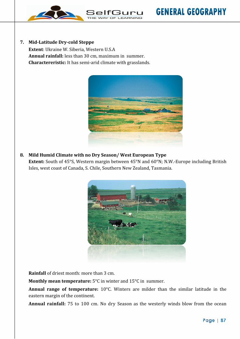
7. Mid-Latitude Dry-cold Steppe Extent: Ukraine W. Siberia, Western U.S.A Annual rainfall: less than 30 cm, maximum in summer. Charactereristic: It has semi-arid climate with grasslands.
8. Mild Humid Climate with no Dry Season/ West European Type Extent: South of 45°S, Western margin between 45°N and 60°N; N.W.-Europe including British Isles, west coast of Canada, S. Chile, Southern New Zealand, Tasmania. Rainfall of driest month: more than 3 cm. Monthly mean temperature: 5°C in winter and 15°C in summer.
Annual range of temperature: 10°C. Winters are milder than the similar latitude in the eastern margin of the continent. Annual rainfall: 75 to 100 cm. No dry Season as the westerly winds blow from the ocean
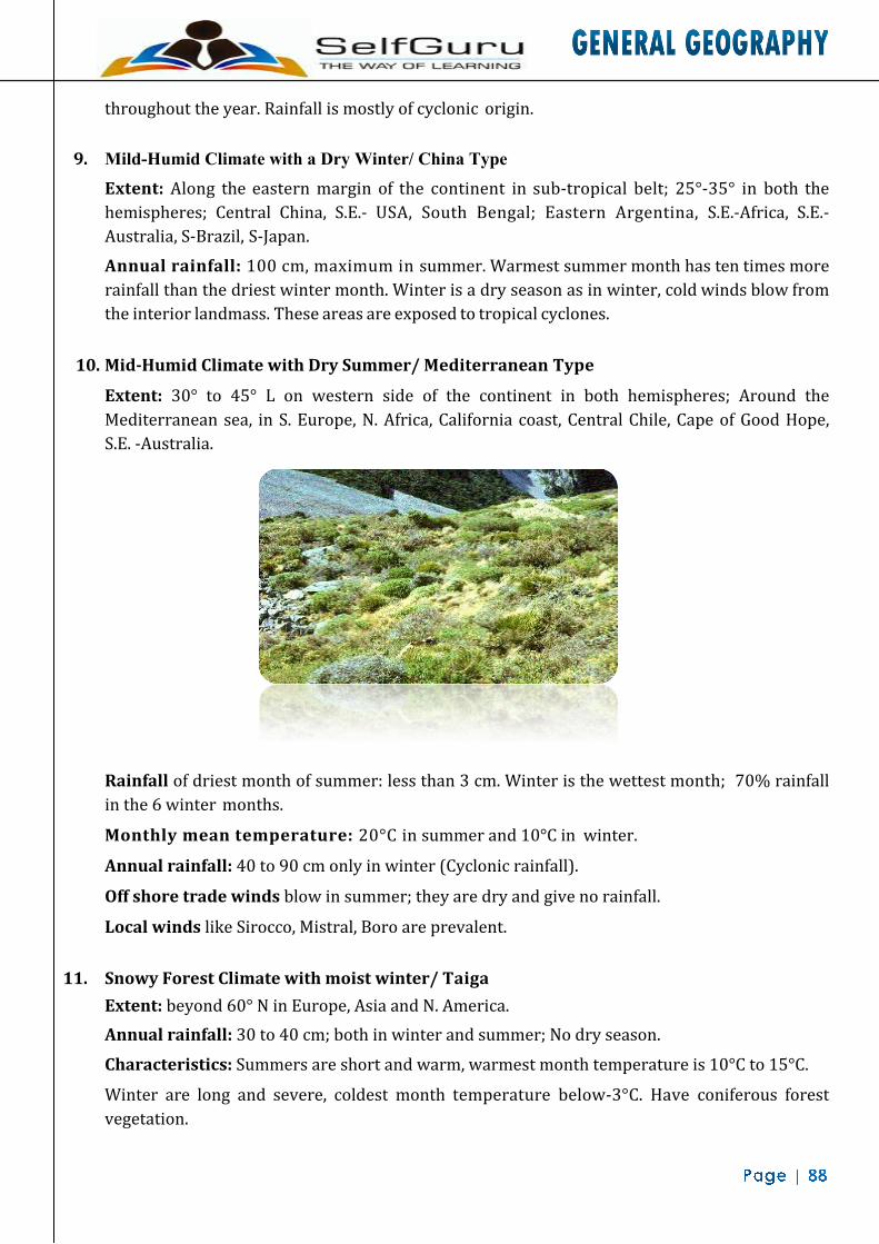
throughout the year. Rainfall is mostly of cyclonic origin.
9. Mild-Humid Climate with a Dry Winter/ China Type Extent: Along the eastern margin of the continent in sub-tropical belt; 25°-35° in both the hemispheres; Central China, S.E.- USA, South Bengal; Eastern Argentina, S.E.-Africa, S.E.-Australia, S-Brazil, S-Japan.
Annual rainfall: 100 cm, maximum in summer. Warmest summer month has ten times more rainfall than the driest winter month. Winter is a dry season as in winter, cold winds blow from the interior landmass. These areas are exposed to tropical cyclones.
10. Mid-Humid Climate with Dry Summer/ Mediterranean Type
Extent: 30° to 45° L on western side of the continent in both hemispheres; Around the Mediterranean sea, in S. Europe, N. Africa, California coast, Central Chile, Cape of Good Hope, S.E. -Australia.
Rainfall of driest month of summer: less than 3 cm. Winter is the wettest month; 70% rainfall in the 6 winter months.
Monthly mean temperature: 20°C in summer and 10°C in winter.
Annual rainfall: 40 to 90 cm only in winter (Cyclonic rainfall).
Off shore trade winds blow in summer; they are dry and give no rainfall.
Local winds like Sirocco, Mistral, Boro are prevalent.
11. Snowy Forest Climate with moist winter/ Taiga Extent: beyond 60° N in Europe, Asia and N. America. Annual rainfall: 30 to 40 cm; both in winter and summer; No dry season.
Characteristics: Summers are short and warm, warmest month temperature is 10°C to 15°C.
Winter are long and severe, coldest month temperature below-3°C. Have coniferous forest vegetation.
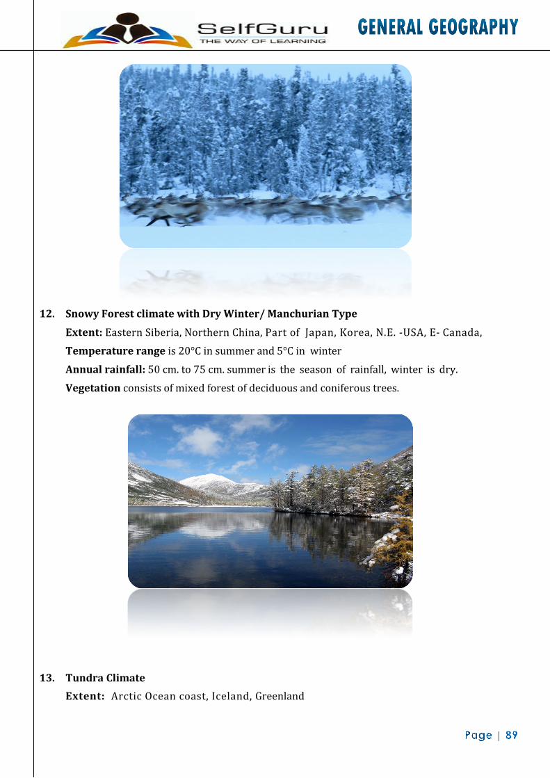
12. Snowy Forest climate with Dry Winter/ Manchurian Type
Extent: Eastern Siberia, Northern China, Part of Japan, Korea, N.E. -USA, E- Canada, Temperature range is 20°C in summer and 5°C in winter
Annual rainfall: 50 cm. to 75 cm. summer is the season of rainfall, winter is dry.
Vegetation consists of mixed forest of deciduous and coniferous trees.
13. Tundra Climate Extent: Arctic Ocean coast, Iceland, Greenland

Mean temperature of the warmest month: 0°C to 10°C Vegetation: Mosses, Lichens. Annual range of temperature: 40°C to 50°C Annual rainfall: 20-25 cm. Characteristics: Summer is short, ground may be snow free. During long winter soil moisture freezes and snow covers the land totally.
14. Perpetual Forest Climate/Ice-cap Type Extent: Antarctica, Greenland. Temperature is always below 0°C, throughout the year. Winter- continuous night and summer- continuous days
15. High Mountain Type Extent: On high mountain slope of both hemispheres. Himalayas and Andes have vertical zonation of climate from tropical to ice-cap type. Windward slope receives heavy rainfall while the leeward sides are dry. In the N-Hemisphere southern slopes are warmer.

HYDROSPHERE
All the water of the earth including the oceans, lakes, rivers, ice sheets and the water in the atmosphere is called hydrosphere and it covers about 71% of the earth's surface. The ocean predominates over land areas in the S-Hemisphere far more than that in the N-Hemisphere. Major Oceans The Pacific Ocean: It is the largest and deepest ocean covering one third of the globe. Its average depth is 4200 m. The deepest parts are the Philippine Trench about 10,380 m. and the Marina Trench about 10,800 m. The Pacific -Ocean has a string of volcanoes along the coastal margins of the continents known as 'The Ring of Fire'. The Atlantic Ocean: Though the Atlantic is smaller than the Pacific, its total coastline is more than that of the Pacific and the Indian Ocean combined. There is a long submarine ridge running north to south in the middle of Atlantic. It is the greatest mountain chain in the world (16,000 km long). It is known as the Dolphin Ridge in the North Atlantic and the Challenger Ridge in the South Atlantic. There are also continental islands such as the British Isles, New found land, the West Indies etc. The Atlantic is the greatest commercial highway of the world. Indian Ocean: It is small in size but has an average depth of 4,000 m. The two great bays on either side of the peninsula of India, namely the Bay of Bengal and the Arabian Sea belong to
Ocean Area in sq. km
Percentage of sea area
Pacific 1, 66,240,000 46.0
Atlantic 86,560,000 23.9
Profile of Ocean Floor The ocean basins are in many ways similar to the land surface. There are submarine ridges, plateau, canyons, plains and trenches. The great variety of relief is largely due to the interaction of tectonic, volcanic, erosional and depositional processes. In general the ocean floor can be divided into four major divisions - the continental shelf, the continental slope, the continental rise and the Abyssal Plain. Continental Shelf: It is the land portion, submerged under sea water and is a transitional zone between the land and the actual sea bottom. 1. The isobaths of 100 fathoms (around 200m) demarcates the continental shelf. 2. The average width is about 70 km. and the mean slope is less than 1°. 3. About 7.5 percent of the total ocean area is covered by it.

4. It is almost absent in the eastern Pacific the India Ocean. The Indian Ocean is dotted with thousands of small islands some of which are of coral formation, e.g. the Maldives and Lakshadweep islands, while other like the Mauritius and the Reunions are volcanic. Sri Lanka and Malagasy are continental islands. Arctic Ocean: It is found around the North Pole. It covers only one thirtieth of the sea area. It is almost completely covered with ice to a depth of about 3 m. Antarctic Ocean: The remaining area of the sea is included in the Antarctic Ocean surrounding the Antarctic Continent. Ocean, especially in South America.
5. At the eastern coast of USA it is about 120 km wide and also very wide on the eastern coast of India.
6. Individually it covers about 13.3% part of Atlantic Ocean, 5.7% of Pacific Ocean and 4.2% of Indian Ocean.
7. It is the area of terrigenous deposits i.e. sediments are derived from land. 8. They provide the richest fishing ground in the world. 9. About 20% of world petroleum and natural gas are found here.
Continental Slope: It lies at the edge of the continental shelf, generally up to the depth of 2000 Fathoms (3660 m) from the mean sea level.
1. It has a steep slope with the angle of slope varying from 2° to 5°.
2. It covers about 8.5% of the total oceanic area and individually about 12.4% of the Atlantic Ocean, 7.1% of the Pacific Ocean and 6.5% of the Indian Ocean.
3. The continental blocks are supposed to end at the site of continental slope.

4. The continental slope along the many coasts of the world is furrowed by deep canyons like trenches terminating as fan-shaped deposits at the base.
Continental Rise: The place where the continental slopes end, the gentle sloping continental rise begins. The average slope is between 0.5° and 1° & its general relief is low. With increasing depth the Continental Rise becomes virtually flat and it merges with abyssal plain.
Abyssal/Deep Sea Plains: Beyond Continental Rise, it is found at the depth of 3000 to 6000 m. They cover about 40% of the total ocean floor and generally are bounded by hills (ridges) on the seaward side. They are almost flat with a gradient less than 1:100. The irregular topography of the abyssal plain are buried forming relatively flat areas due to large supply of sediments.
Submarine Ridges: These are the mountain ranges on the ocean floor and some of them are the largest mountain system on the earth.
1. A large number of submarine ridges are placed centrally in the oceans.
2. At some places their summits may rise above the sea level forming islands. Abyssal Hills: A deep sea floor also contains numerous isolated abyssal hills, sea- mounts and Guyots.
1. A submarine mountain peak rising more than 1000 m above ocean floor are known as "seamount".
2. Flat topped seamounts are known as "Guyots" 3. All the above features are volcanic in origin, very common in Pacific Ocean.
Submarine Trenches or Deeps: A long narrow and steep sided depression on the ocean floor is called trench. These are the deepest part of the ocean.
1. They lie along the fringes of the deep sea plains and usually run parallel to the bordering fold mountains or the island claims.
2. They are believed to have resulted from faulting or down folds of the earth crust and so tectonic in origin.
3. They are most common in the Pacific Ocean like "Mariana Trench" off the Guam Island Chain which is deepest (11 km) in the world.
Submarine Canyons: These are the deep gorges on the ocean floor and are restricted to the continental shelves, slopes and rises.
1. Some canyons begin at the edge of the continental shelf and extend down the continental slope. For example - "Oceanographer Canyon" near New England.
2. Some canyons have dendritic appearance like off the east coast of Southern California.
3. Some begins at the river mouth and extends over the continental shelf as "Zaire", "Mississippi" and "Indus" canyons.
Bank, Shoal & Reef: Banks are almost flat topped elevation located in the continental margin. Shoals are detached elevation with shallow depth. Reefs are the mound or rocky elevation like

ridges made of organic deposit.
1. The depth of water is relatively small in banks but adequate for navigation. 2. These are sites of rich fishing e.g. "Dogger Bank" (North Sea), "Grand Bank" (off
Newfoundland). 3. Shoals are dangerous for navigation as they are only 18-20 m below the sea level. 4. 'Great Barrier Reef' (off Queens land, Australia) is the largest reef in the world
Temperature Horizontal Distribution of Temperature: The mean annual temperature of the surface water of the Oceans is 25°C varying from - 5°C to over 33°C. 1. The temperature decreases as we move away from the equator. The average temperature
of ocean water is 26°C at the equator, 23°Cat latitude 20°.
ATLANTIC OCEAN Ridges: Rio Grande Ridge, Wyville-Thomp- son Ridge, Newfoundland Ridge, Walvis Ridge, Telegraphic Plateau, Sierra Leone Ridge, Raykjanes Ridge, Cape Swell, Dolphin Rise, Challenger Rise. Basins: Labrador Basin, Iberian Basin, Cape- Verde Basin, Guinea Basin, Sierra Leone Basin, Cape Basin, Argentina Basin, Agulhas Basin Deeps & trenches: Moseley Deep, Buchanan Deep, Valdivia Deep, Romanche Deep, Puerto- Rico Deep, Nares Deep
PACIFIC OCEAN
Ridges: Albatross Plateau, Cocos Ridge, San- Felix-Juan Ridge, Hawaiian Swell, Marcus Necker Rise, Chatham Rise, Lord Howe Rise, Norfolk Ridge, S. Tasmania Ridge
Basins: Aleutian Basin, E&W Caroline Basin, Fiji Basin, E. Australian Basin, Jeffrey's Basin, S W Pacific Basin, SE Pacific Basin, Pacific Atlantic Basin.
Trenches: Aleutian Trench, Kuril Trench, Philippine Trench, Cape-Johnson Deep, Nero Deep, Mariana Trench, Tonga-Kermadec Trench, Aldrich Deep, Brook Deep, Planet Deep
INDIAN OCEAN
Ridges: Socotra Chagos Ridge, St. Paul Ridge, Seychelles Ridge, Crozet Ridge, Crozet Ridge, Kerguelen Ridge, Laccadives Chagos Ridge, Chagos St. Paul Ridge, Kergel-Gausberg Ridge, Andaman Rise. Basins: Somali Basin, Oman Basin, Natal Ba- sin, Mauritius Basin, Agulhas Basin, Andaman Basin, Cocos Kelling Basin, E. Indian-Antarctic Basin Trenches: Sunda Trench, Valdivia Deep, Jeffrey deep
ARCTIC OCEAN
Ridges and Basins: Faeroe-Iceland Rise, East Jan Mayen Ridge, Spitsbergen Ridge, Greenland Basin, Norwegian Basin, N-Polar Basin

2. The coldest month in the ocean is February and the warmest month is August in the Northern Hemisphere and reverse in the Southern Hemisphere.
3. The highest temperature of ocean water is found in enclosed or partially enclosed seas in the equatorial areas e.g. a temperature of 38°C has been recorded in Red Sea though the average temperature in summer is only 29°C.
4. The temperature of the warm current is higher than the surrounding areas. Thus Gulf Stream does not allow the Norwegian coast to freeze even in winter.
5. The prevailing winds deflect the warm and cold currents and cause change in temperature of the ocean water. So, in the tropical zone the western section of the oceans are warmer than the eastern section owing to the influence of trade winds. In the Temperate zone the westerlies makes the eastern section warmer than the western section.
6. The temperature decreases as we move away from equator.
Vertical distribution of temperature: Though the sea temperature decreases with in- creasing depth, the rate of decrease is not uniform. The change in sea temperature below 200 m is negligible. Salinity The salinity of the Ocean means the degree of saltiness of the oceans. The average salinity of the oceans is 35.3% i.e. about 35 parts of salt in 1,000 parts of water. In the Baltic Sea, where there is much dilution by fresh water and melting ice, the salinity is much lower only about 4%. Very high salinity is recorded in inland seas and lakes. Lake van in Turkey records the highest salinity of 330%. Red Sea (240%), Dead sea (238%), Great Salt Lake with (220%) are other areas of high salinity. The variation of salinity in the various seas and oceans is affected by: 1. The rate of evaporation. 2. The amount of fresh water added by precipitation, streams and icebergs; and 3. The degree of water mixing by currents.
• The origin of salinity is attributed to erosion of earth's crust by dissolving action of running water which causes erosion in the oceanic crust and volcanic ash which contains minerals like Calcium, Boron, Iodine, etc.
• Salinity is excessive in region of high temperature, strong winds and less rain. For example, it is lower in the equatorial region due to high relative humidity.
• Influx of fresh water by rivers reduces the salinity and so there is less salinity near the mouths of rivers like Amazon, Congo, Niger, Ganga etc.
• In spite of high temperature salinity is less is equatorial region because of his rainfall. Around the Poles there is a belt of low salinity because of addition of fresh water in the form of icebergs and excessive snow falls.

Oceanic Salt Ratio
Horizontal Distribution of Salinity
1.Latitudinal Distribution: It decreases from Equator towards the Poles. The average salinity of N-Hemisphere is 34‰while for S- Hemisphere it is 35‰. In general there is low salinity in equatorial zone, high in tropical belt, low in temperate zone and minimum in sub-polar zone.
2.Regional Distribution: The amount of salinity varies from ocean to ocean, mainly due to supply of fresh water, rapidity of evaporation and water mixing tendency. The greatest proportion of salt is found in two areas which lie about the Tropic of Cancer and the Tropic of Capricorn. From these regions the salinity decreases both towards equator and the poles. Salinity of the inland seas and lakes is very high because of the regular supply of salt by the rivers flowing into them and the evaporation makes their water continuously more and more saline
Salt Name Percentage NaCl Sodium Chloride 77.8 MgCl2 Magnesium Chloride 10.9 MgSO4 Magnesium Sulphate 4.7 CaSO4 Calcium Sulphate 3.6 K2SO4 Potassium Sulphate 2.5 CaCO3 Calcium Carbonate 0.3 MgBr2 Magnesium 0.2
Latitudinal Zones Salinity (%) 10-15 N 34.5-35 15-40 N 35-36 40-50 N 33-34 50-70 N 30-31 10-30 S 35-36 30-50 S 34-35
50-70 S 33-34

Vertical Distribution of Salinity 1. Salinity of the ocean decreases or increases towards the bottom according to the nature of the
water mass. 2. In high latitude salinity increases with depth due to dense water found at the bottom. In the
middle latitude salinity increases with the depth up to 200 fathoms and then it starts decreasing.
3. At equator surface salinity is low but just below it greater salinity is found which again decreases at the bottom due to presence of cold water mass.
Ocean Deposits The unconsolidated sediments derived from various sources, deposited at the sea floors are called ocean deposits. The ocean deposits are classified on the basis of their location as terrigenous and pelagic deposits.
Terrigenous Deposits: These are deposits of the continental shelf and slope. They consist of material derived from wear and tear of land, the remains of animals and plants that live on the bed of the sea and volcanic material. On the basis of size of rock fragments, the sediments are classified into gravel, sand and mud. Mud is further classified as red, blue or green mud on the basis of their colour. Volcanic deposits consist of sub-aerial and sub marine volcanic deposits. The organic deposits consist of shells and skeletons of animals living in the continental shelf.
Pelagic Deposits: These deposits are found in deep sea plains. They cover 75 per cent of the ocean area. The organic deposits consist of liquid mud known as 'ooze' which contain shells of various organisms. They are subdivided into Calcareous ooze and siliceous ooze. The former contains Pteropod and Globigerina ooze. The latter consists of Radiolarian and Diatom ooze. The inorganic deposits contain Red Clay, which is formed from the decomposition of volcanic material which is carried out to sea and occupies the maximum space of the ocean floor
World Islands
Atlantic Ocean Islands: Greenland, Baffin, Ireland, Great Britain, Iceland, Hispaniola, Pico Island of Azores, Cuba, Cape Verde Island, Perks Projected Island, Bermuda Island, Ascension Island, St. Helena Island, Gough Volcanic Island, Newfoundland, West Indies. Indian Ocean Islands: Andaman & Nicobar, Madagascar, Zanzibar (all are the detached part of continental block), Lakshadweep & Maldives (coral islands), Mauritius & Reunion Island (Volcanic), Sumatra, Java, Sri Lanka. Pacific Ocean Islands: New Guinea, Borneo, Honshu, Hokkaido, Honshu, Shikoku, Celebes, South Island and North Island (New Zealand), Luzon, Mindanao, Sakhalin. Atlantic Ocean Islands: Ellesmere, Victoria, Banks, Devon, Melville, Axel Heiberg.

Islands: Tasmania, Terra Del Fuego, Southampton Other Coral reefs & Atolls
Corals are a kind of calcareous rock chiefly made of the skeletons of minute sea organisms called 'polyps'. Coral reefs and atolls are formed due to accumulation and compaction of skeletons of these lime secreting organisms.
Conditions for Growth of Coral Reefs 1. The coral and the associated organisms and algae which are the most common reef builders are
con-fined to the tropical belt. The water temperature must not fall below 20°C and not exceed 35°C; the most favourable is 23°C to 25°C.
2. Corals can live only in saline water, and for their proper growth the average salinity should be between 27 to 40%.
3. For growth of coral the depth of the water should not exceed 200m. Most vigorous growth is confined to shallow water less than 50 m. deep.
4. Corals also require sediment-free, clean water which is disturbed by ocean waves and currents is beneficial for the corals.
5. In the open seas it is necessary to have platforms which may act as foundations for the corals. These platforms should not be deeper than 90 m.
The coral reefs are classified on the basis of nature, shape and mode of occurrence into
(i) Fringing reef
(ii) Barrier reef
(iii) Atoll.

Fringing Reef: Coral reefs that develop along the continental margins or along the islands are called fringing reefs. The seaward slope is steep and vertical while the landward slope is gentle. Such reefs are found near Rameshwaram in the Gulf of Mannar. Occasionally the fringing reef is separated from the shore by shallow lagoon known as "Boat Channel" as found in Madagascar and Red Sea. Example of fringing reefs: South Florida reef, Mehetia Island, Sakau Island in New Hebrides.
Barrier Reef: They are the largest, most extensive, highest and widest reefs of all types of coral reefs. They are formed off the coastal platforms and parallel to them. There is an extensive but shallow lagoon between the coastal land and the barrier reef. Generally barrier reefs encircle islands in an irregular and broken ring. The Great Barrier Reef of Australia is the largest barrier reef in the world.
Atoll: A ring of narrow growing corals of horse shoe shape and crowned with palm trees is called an atoll. It is generally found around an island or in an elliptical form on a submarine platform. There is a lagoon in the middle of a coral ring. They are more common in Pacific Ocean. The circular ring is broken at few places to allow the free flow of water. The depth of the lagoon is only a few metres with sand and limestone debris at the bottom. Example of Atolls: Fiji Atoll, Trunt Atoll of W-Carolinas, Suvadivo in Maldives, Funafoothis Atoll of Ellice.
Geographical Distribution of Coral Reefs
1. Coral reefs are limited to the tropical seas and are found almost entirely between latitudes 30°N and 25°S.
2. Rich growth of reefs is found off the eastern coasts of North America and Australia.
3. On coasts where the rivers bring large quantities of sediments from the land, corals are not found e.g. coasts of South America.
4. The coral reefs are most common in the Pacific and the Indian Ocean, due to their shallow, warm and clean water.
5. The most important area of coral reef growth lies in the seas off the east coast of Australia and in the Philippines.
6. Only a few coral reefs lie outside the Indo- Pacific tropical area, those of Gulf of Mexico and the Caribbean Sea have some reefs.
El Nino and La Nina El Nino is a warm sub-surface current in the Pacific Ocean off the Peruvian coast. El Nino literally means 'child of the Christ'. It is a destructive weather system pushed into action by the warming of the cold ocean current in the east pacific. El Nino's destructive capacity peaks by late October or November, when it starts to cool down and is called La-Nina or literally 'The girl'. El Nino affects the monsoon in India. An El Nino circulation in the winter suggests a strong walker circulation in the following summer and consequently a weak monsoon. However scientists are still sceptical about

its relation with monsoon. Recently its link with the fire in Indonesia has been subjected to much debate.
Ocean currents The regular movements of water from one part of the ocean to another are called "Ocean Currents". They are mainly caused by the difference in density of sea water due to variations in temperature and salinity. The prevailing winds push them onwards. The position of the land masses and the shape and depth of the ocean basins also have some influence. Main causes of ocean currents include winds, differences in density owing to variations in temperature and salinity. Ocean currents may be cold or warm
A.
B. Atlantic Ocean Current 1. North Equatorial Current: Attributed to NE-Trade winds, it starts from west coast of Africa
where upwelling of cold water takes place and moves westward between 5° and 20° N as warm current. A branch of it is diverted into Caribbean Sea as "Antilles Current."

2. South Equatorial Current: Flows south of the equator between 0° and 12° latitude in between the coast of Africa and S. America. This warm current is virtually the continuation of cold Benguela current.
3. Equatorial Counter Current: This warm current flows between the two strong equatorial currents and moves towards the opposition direction in the east. In the eastern part it is known as "Guinea Current."
4. Florida Warm Current: It flows from the strait of Florida to Cape Hatteras which is a
continuation of North Equatorial current in the Gulf of Mexico.
5. Gulf Stream: The warm water of Antilles and Florida current after joining together flows as Gulf Stream, off the Cape Hatteras. After it, it is deflected eastward under the combined influence of westerlies and the rotation of the earth.
6. North Atlantic Drift: East of Grand Bank, the Gulf Stream flows as slow moving North Atlantic
Drift. It is further divided into two parts - the northern branch flows in the Norwegian Sea and the southern branch flows south of Ireland as "Irminger Current"; another branch flows along the coast of France and Spain as "Canary Current".
7. Labrador Cold Current: It flows from Arctic Ocean and move southward along the coast of
Canada and meets the warm Gulf Stream producing famous fog ground along the Newfoundland as the great fishing ground.
8. Brazilian Warm Current: It flows along the S. American coast as the southward continuation
of South Equatorial Current.
9. Falkland Cold Current: Similar to Labrador cold current, this cold water of Antarctica moves on along the Argentina coast. It brings icebergs with it.
10. South Atlantic Drift: It is the continuation of easterly deflected Brazilian current which moves
earthward between 45°S to 60°S under the influence of strong westerlies. A branch of it is diverted along the west coast of Africa and moves north as "Benguela Current."
11. Benguela Current: This cold current flows northward along the west-African coast. If finally
joins South Equatorial current. C. Indian Ocean Currents: Being blocked in the north by the continental mass the Indian Ocean represents only the southern part of the ocean. The northern part develops a reversal system of currents as per the seasonal rhythm of Monsoon. In summer the North Equatorial current is replaced by SW- Monsoon current flowing from west to east and throwing branches into the Bay of Bengal and the Arabian Sea. On the northern coast of Africa along Somaliland the upwelling takes place and a cold current develops,

known as "Somali Current". South Equatorial current flows north of 20ºS between Australia and Africa. After striking the landmass of Africa it splits into many branches; the major one turning southward to form the "Agulhas Current". Mozambique Current: A branch of South Equatorial Current at 65°E is bifurcated towards the north of Malagasy Republic and flows through the Mozambique Channel known as Mozambique current. West Wind Drift: Under the stress of westerly wind the cold water at 40°S moving in the easterly direction is known as West Wind Drift. One Branch of it flows northward along Australia which forms West Australian Cold Current. West Australian Cold Current: Flowing on the west coast of Australia, its gains its water from west wind drift. D. Pacific Ocean Currents: The Ocean Currents in the Pacific Ocean have a pattern similar to that in the Atlantic Ocean. Due to
vast water masses the counter current has become very stable. 1. North Equatorial Current: It flows from Mexican coast to Philippines between 5N and 10N
latitude. It is a warm well developed current.
2. South Equatorial Current: It is also a warm current, south of North Equatorial Current.
3. Counter Equatorial Current: This warm current is very sable in nature.
4. Kuroshio Warm Current: Similar to Gulf stream of Atlantic Ocean, it flows from Formosa to Rique, "Tsushima Current" is its branch which goes to Japan Sea and is a warm current.
5. Kurile / Oyashio Cold Current: It flows southward from the baring strait. Near 50°N latitude
it meets to Kuroshio Current causing fog.
6. Californian Cold Current: Similar to Canaries current it flows along the west coast of N. America.
7. Peru / Humboldt Cold Current: It flows along the Peru coast.
8. East Australian Current: It is a warm current along the east Australian coast.
9. West Wind Drift: This cold current flows from west to east direction between 40°S and 50°S. It
is also called as "Roaring Forties".

Tides The alternative rise and fall of the level of the Sea, approximately twice a day, caused by the gravitational pull of the moon and the Sun is called tide. The gravitational attraction of the moon is twice as powerful as that of the Sun. The moon despite being much smaller in size than the Sun is relatively very close to the earth and is thus able to attract more than the Sun.
High Tide: When the intensity of the wave is great, the waves are of considerable amplitude and so the sea water comes over the coast to some extent. Such waves constitute a high tide. Low Tide: When the height of the wave is not much, sea water recedes from the shore. Such waves constitute a low tide. Ebb Tide: The tide between a high tide and a low tide is known as ebb tide. Spring Tide: When the amplitude difference of the tide in a day is at maximum, the tide is called spring tide. It occurs on new moon and full moon days. High tides are very high and low tides very low on those days. Neap Tide: When the amplitude of the tide is minimum. It occurs on the first quarter and last quarter of the moon. High tides are comparatively low and low tides comparatively high. Tidal Bores: When a tidal wave meets a tidal river or estuary, a tidal bore is formed. Where the outgoing river currents are strong and the tidal river rather shallow and tunnel shaped, the rapidly rising high water advances up stream like a high vertical wall, known as tidal bore.
• Bore occurs at river mouths that face the direction of tidal surge and where tidal range is large. Rivers like Amazon, Hooghly, Colorado, Yangtze are characterized by tidal bores.
• Although tides occur twice a day, their interval is not exactly 12 hours; actually it is of 12 hours and 25 minutes. This is due to the revolution of the moon and the rotation of the earth.
• Generally tides occur twice a day. But Southampton, along the southern coast of England experiences tides four times a day because the tidal water comes through the English Channel

and through the North Sea at different intervals. • Tides in the area of the sea, known as "Gulf Tides" also causes the horizontal movement of
water of the sea known as "Tidal Current". • Monthly tides occur due to revolution of moon and its position at perigee and apogee. • Equinoctial Spring tides recur at an interval of 6 months, due to revolution of the earth around
the sun and sun's varying declination. • Yearly tides recur due to revolution of the earth and its position at perihelion and aphelion. Importance of tides 1. Tides make some of the rivers navigable for ocean going vessels e.g., Kolkata, London etc. 2. Tides clear the sediments brought by rivers and thus retard the process of delta formation.
3. Tides are agents of distribution; biologically they distribute and redistribute the plankton and nektons along with coastal water which helps in fishing industries.
4. The tidal force may be used as the source of electricity e.g. In France, Japan, India etc.
Points to remember 1. Waves caused by earthquakes are known as "tsunamis."
2. "Cirrus" and "small cumulus" type of cloud are associated with fair weather.
3. A rock layer through which groundwater moves freely is "aquifer".
4. Lake Knebel in Iceland is a “crater lake". 5. Drizzle is produced generally by "stratus" or "Strato Cumulus".
5. Sargasso Sea is in "Atlantic" Ocean.
6. Country having largest deposits of organic phosphates is "Peru".
7. Hammerfest, the northernmost ice free port, is in "Norway".
8. The region with maximum tidal power potential in India is "Gulf of Cambay".
9. Dogger Bank is in North Sea.
10. The tidal theory of Jeans and Jeffery explains the formation of Earth.
11. Oceanic ridge are found along the diverging boundary.
12. The tidal producing forces of Sun and Moon are in the ratio of 4:9.
13. The tract of land between two adjacent rivers is called "interfluve".
14. The tidal mouth of a river where saltwater meets freshwater is called "Estuary".

15. End of the continental block is marked by the seaward limits of continental slope.
16. Maximum thickness of sediments is found over "continental Slope".
17. Region of maximum salinity over the Indian coast is the "Gulf of Kutch".
18. Spring Tides occur when Sun and Moon are either in conjunction or opposition.
19. The unit of measurement of flow of a fluid is "Cusec".
20. The busiest ocean route in the world is "North-Atlantic route".
21. OTEC has the maximum power generation potential in India.
22. The average one kg of sea water contains 345 gram of salts.

SOIL
Soil may be defined as a thin layer of earth's crust which serves as a natural medium for growth of plants. It is the unconsolidated mineral matter that has been subjected to, and influenced by, genetic and environmental factors-- parent material, climate, organisms and topography all acting over a period of time. Soil differs from the parent material in the morphological, physical, chemical and biological properties. Also, soils differ among themselves in some or all the properties, depending on the differences in the genetic and environmental factors. Thus some soils are red, some are black; some are deep and some are shallow; some are coarse textured and some are fine-textured. They serve as a reservoir of nutrients and water for crops, provide mechanical anchorage and favourable tilth. The components of soil are mineral matter, organic matter, water and air, the proportions of which vary and which together form a system for plant growth; hence the need to study the soils in perspective.
Soils are derived from consolidated parent rocks by the process of weathering followed by pedogenesis. Weathering refers to the physical and chemical disintegration and decomposition of rocks which are not under equilibrium under temperature, pressure and moisture conditions on the earth's surface. In the beginning, weathering precedes soil formation, more so in hard rocks. In other words, weathering creates the parent material over which soil formation takes place. Later, weathering, soil formation and development proceed simultaneously. The product of weathering is called regolith (small particle of rock). Under the influence of pedogenic processes, it finally develops into mature soil.
Factors affecting soil formation other than the regolith are:
1. Climate 2. Vegetation
3. Relief, 4. Parental materials
5. Living organism 6. Time
Water retention of different soil types:
Pure sand holds least water while pure clay holds the most. Loam holds the intermediate amount. Sand transmits the water downward most rapidly and the clay most slowly. Sand reaches its full capacity very rapidly and added water is wasted. Clay-rich loam takes up water very slowly and if irrigation is too rapid, water will be lost by surface runoff. Sandy soil requires more frequent watering than clay-rich soil. The intermediate loam texture is generally best as agricultural soil because it drains well and also has favourable water-retention properties.
Soil Profile
It is a vertical section of soil through all its horizons and extends upto the parent materials. A study of soil profile is important both from the standpoint of soil formation and development (pedology) and crop husbandry (edaphology). In deep soils the soil profile may be studied upto one metre and

a quarter and in others up to the parent material. The layers (horizons) in the soil profile which vary in thickness may be distinguished from the morphological characteristics which include colour, texture, structure, etc.
• O Horizon At the top of the profile is the O horizon. This is primarily composed of organic matter. Fresh litter is found at the surface, while at depth all signs of vegetation structure have been destroyed by decomposition. The decomposed organic matter or humus enriches the soil with Nutrients, aids soil structure (acts to bind particles), and enhances soil moisture retention.
• A Horizon (The Top Soil) Beneath the O horizon is the A horizon. The A horizon marks the beginning of the true mineral soil. In this horizon organic material mixes with inorganic products of weathering. A horizon is typically dark colored due to the presence organic matter. Eluviation, the removal of inorganic and organic substances from a horizon by leaching, occurs in the A horizon. Eluviation is driven by the downward movement of soil water.
• E Horizon The E horizon generally is a light-colored horizon with eluviation being the dominant process. Leaching or the removal of clay particles, organic matter and / or oxides of iron and aluminium is active in this horizon. Under coniferous forests, the E horizon often has a high concentration of quartz giving the horizon an ashy-gray appearance.
• B Horizon (Subsoil) Beneath the E horizon, lies the B horizon. This is a zone of illuviation where eluviated materials from the upper horizons are accumulated. The accumulation of fine material leads to the creation of a dense layer in the soil. In some soils the B horizon is enriched with calcium carbonate in the form of nodules or as a layer. This occurs when Capillary action brings captions like calcium and sodium dissolved in soil water upwards where they precipitate from the water. Eluviation is significant in humid climates where ample precipitation exists and a surplus in the water balance occurs. Illuvial layers are found low in the soil profile. Illuvial zones are found closer to the surface in semiarid and arid climates where precipitation is scarce.
• C Horizon - Big rocks The C horizon represents the soil parent material, either created in situ or transported into its present

location. Beneath the C horizon lies Horizon R (Bedrock). The bedrock layer is present in just about every different type of soil profile. This layer is made of hard, solid rock, which is eroded and weathered to produce most of the soil above it.
Soil Classification: Soil Orders: Soils can be subdivided into three orders known as zonal, intrazonal and azonal. i. Zonal soils: They are formed under the conditions of good soil drainage through the prolonged
action of climate and vegetation and are by far the most important and widespread of the three orders.
ii. Azonal soils: They have no well-defined profile either because they have had insufficient time to develop or because they are on slopes too steep to allow profile development.
iii. Intrazonal soils: They are simply those formed under condition of very poor drainage or upon
limestone whose influence is dominant.
Major soil groups and their characteristics: 1. Podzol: one of the most widespread and most developed soils. Rich in humus, low in fertility,
deficient in bases like calcium, magnesium, and potassium and phosphorous. Closely associated with the sub-arctic climate and the cooler parts of the marine west coast climate.
2. Latosols: characteristics of humid tropics. Chief characteristics include: (a) Complete chemical and mechanical decomposition of the parent rock. (b) Silica entirely leached from the soil. (c) Complete lack of humus. (d) A reddish brown colour given by the oxides of iron, aluminium and manganese.
3. Chernozem soil: zonal soil in a semi-arid climate. Horizon ‘A’ is rich in humus. Horizon ‘B’ is
rich in bases. Generally acidic. It is found in Ukraine, central USA, central Africa, South America and Australia; it is highly productive for small grain crops like wheat, oat, barley etc.
4. Prairies soil: similar to chernozem. But it lacks the excess calcium carbonate of the chernozems. Extremely productive. Maize and wheat are the main crops associated with it.
5. Chestnut soil: it is the zonal soil of mid- latitude grasslands that occurs in drier region. It has
considerably low content of organic materials. Its parent material is generally loess. The chestnut soil occurs in south Ukraine, the great plains of the U.S.A. and South African veldts.

6. Hydrographic soil: it is associated with marshes, swamps, bogs or poorly drained flat uplands. They are all intrazonal soils. "Bog" soils are formed under bog vegetation in regions of cool continental climate.
7. Desert soil: It is grey in colour in temperate region and red in hot deserts of tropic. The cold desert soil is found in mid-latitude cold desert region and lack in humus. It has one of the best cotton producing regions of the world.
8. Tundra soil: It develops in such regions where summer is short (3 months) and winter is long (9 months). Plant growth is restricted. Even percolated water is frozen during the winter. No chemical and biological action takes place for over nine months. Wherever frozen ice melts, marshy soil is developed. Canada and the erstwhile U.S.S.R. have this type of soil.
Points to remember 1. The “soil profile” refers to the arrangement of the soil into horizons of differing texture, color
and consistency.
2. “Brunizem” soils are also termed as “prairie” soil.
3. “Calcification” is a pedogenic regime of climate in which evaporation on the average exceeds precipitation.
4. The deposition of colloids and bases in the underlying B horizon is a process known as “illuviation”. The grey-brown podzolic soil differs from podzols in that leaching is less intense and contains more of the important base than the podzols.
5. The pedogenic regime of “gleization” is characteristic of poorly drained environments under a moist and cool cold climate.
6. The dark coloured soil absorbs more of sun’s heat than the light coloured one.
7. Most matured soils have a layered arrangement of strata called “horizon”.
8. “Podsolization” commonly occurs in a typical regime of coniferous forest regions.
9. “Leaching” is a process of removal of minerals in solution from the upper layers to the lower layers of soils e.g. “Podzol” type of soils.

NATURAL VEGETATION
• Equatorial Evergreen Forest
1. These forests are located close to the equator- Amazon and Congo basins, Malaysia, Coastal Burma, Cambodia, Vietnam, Indonesia, and New Guinea etc. - where the rainfall is heavy. Example of trees - Ebony, Mahogany, Rosewood, Rubber etc.
2. Consists of tall, closely set trees. Their crown form continuous canopy of foliage.
3. Trees are smooth-barked and un- branched in the lower two-third part.
4. Leaves are large and evergreen so called "Broadleaf Evergreen Forest".
5. Thick, woody lianas are common with tendrils or suckers to climb.
6. Epiphytes are numerous and they include fern, orchid, mosses and lichens.
7. Trees are not found in a single stand. Thus considerable labour is involved in economic activities.
8. Due to high temperature there is a rapid consumption of dead plant matters by bacterial action which results in the absence of humus on the soil-surface.
9. In the absence of cold and dry season plant growth goes on continuously throughout the year. Individual species have their own seasons of leaf - sheding.
• Tropical Rain Forest 1. Quite similar in structure to the equatorial variety and extends in the tropical gone of 10° to
25°N along the wind- ward coast of trade winds.
2. The trade wind littoral climate in which the tropical rainforest thrives has a short dry season.
3. Epiphytes are abundant because of continued exposure to humid air.
4. Area: Caribbean Land, SE-Florida, South and South-east Asia, Eastern Brazil coast, Madagascar coast, North-east Australian coast.
• Tropical Monsoon Forest 1. They are located in Burma, Thailand, Cambodia, Laos, North Vietnam, parts of India, North
Australia etc. Species - Teak, Rubber, Bamboo, Mango, Sal, Sandalwood, Acacia, Eucalyptus etc.
2. More open tree growth than Equatorial and Tropical Rain Forests.
3. Less competition among trees for light so greater development of vegetation in lower layers.
4. Trees trunks are massive with rich and rough bark.
5. Most of the trees are deciduous, and sheds their leaves in long dry season.
6. Teakwood trees are representative ex- ample of monsoon forest.
7. Clumps of bamboo are the important part of vegetation.

• Temperate Evergreen Forests 1. Located chiefly on the eastern sides of landmasses in warm temperate latitudes South China,
South Japan, Southeast Australia, South Brazil etc. Examples of trees - Evergreen Oak, Magnolia (China & U.S.A.), Camphor and Bamboo (China), Eucalyptus (Australia) etc.
2. Unlike Equatorial and Tropical Rain forest it has relatively few species of trees.
3. Leaves tend to be smaller and more leathery; the leaves canopy is also less dense. 4. Have a well-developed lower stratum of vegetation. Lianas and epiphytes are abundant. 5. The annual range of temperature is small or moderate and rainfall is abundant and well
distributed throughout the year.
• Mediterranean Forest
1. This type occurs on the Western sides of land masses in the warm temperate latitudes: low lands around the Mediterranean Sea, South-West Australia, Southwest Africa, Central Chile and Central California. Examples of trees: Evergreen Oak, Olive, Grape, Eucalyptus, Redwood etc.
2. Consists of low trees with small, hard leathery leaves.
3. Today large areas consist of dense scrub, locally known as "Maquis".
4. In the Californian coast it is known as "Chaparral" and in Australia as "Sclerophyll Forest".
• Cool Temperate Forest
1. Deciduous trees predominant.
2. Regions include - West and Central Europe, Eastern U.S.A., North China, North Japan New Zealand etc. Examples of tree - Maple, Birch, Ash, Alm, Oak, Beech, Chestnut, Walnut etc.
3. Dominated by tall, broadleaf trees.
4. Trees provide dense canopy in summer but shed their leaves completely in the winter.
5. It is almost entirely limited to the mid- latitude landmass of the N-Hemisphere.
6. This forest represents a response to a continental climate in which rainfall is adequate throughout the growth season.
7. Rainfall in greater in summer months and the soil water demand is high.
• Temperate Mixed Forests 1. Between temperate deciduous and temperate coniferous forests.
2. Trees: Aspen, Birch, Alder etc.
• Coniferous Forests or Taiga This type of forest is most extensive in high latitudes and on high mountains.
• This is a forest of evergreen, cone-bearing trees.

• Examples of trees: Spruce, Blue Pine, Hammock, Larch.
• These conifers are extremely important for their soft wood required for the paper, match and synthetic fibre industry, found mainly in Northern Canada and Northern Eurasia.
• The trees have straight trunk, conical shape with short branches and small needle like leaves.
• In N. America, Europe and western Siberia it is known as "Boreal Forest."
• In Canada it bears the hygrophytic vegetation as forming a bog succession and leading to large thick peat accumulation known as "Muskeg".
• Tropical Grasslands 1. Tropical grasslands are located mainly in the continental regions of tropical latitudes where
rain occurs in the hot season which lasts for about 5 months.
2. Important regions - north and south of Zaire Basin, West Africa and east Africa plateau, parts of Brazil, Guiana Highlands and part of Deccan plateau in India.
3. These are known by different names in different regions:
Campos - Brazil
Llanos - Guiana Highlands
Savanna - Africa and Australia
• Temperate Grasslands 1. These grasslands are almost treeless- thus contrasting with tropical grass- lands.
2. They are best developed in continental interiors of temperate latitudes.
3. Important temperate grasslands of the world include: Steppe - Eurasia Prairie - North America Pampas- Argentina Veldt- South Africa Downs- Australia
• Tropical Desert 1. These are mostly situated between 15º - 30º N and S on the western sides of land masses.
2. The chief regions are: Sahara (North Africa), Arabia, parts of Iran, Iraq, Syria, Jordan and Israel, parts of Pakistan, Central Australia, Namib Desert (South West Africa), Atacama (coastal Peru and North Chile).
3. The most common plants are cacti, thorn bushes and coarse grasses.
• Mid-latitude Deserts These are situated in the interior of Asia and North America between 300 and 350 latitudes.
1. Aridity and a great annual temperature with extremes of winter cold mark the region.

2. In North America these deserts are found in basins surrounded by the Rockies.
3. In South America the Patagonia desert lying to the east of the Andes is a typical example.
• Tundra
1. This type of vegetation is chiefly con- fined to the northern hemisphere, fringing the Arctic “ocean in the continents of Eurasia, North America and Greenland Coast.
2. Important vegetation includes - mosses, lichens end a few small shrubs.
World Classification of Vegetation
Trophophyte Tropical deciduous
Vegetation and grass.
Hygrophyte Humid areas i.e. Equatorial
hot wet forests.
Hydrophyte Vegetation of watery areas.
Xerophyte: Tropical Deciduous desert
vegetation.
Mesophyte Temperate areas vegetation.
Cryophyte: Vegetation of Tundra and
Cold regions.
Halophyte Salty areas vegetation
(Mangrove).
Lithophyte Vegetation of Rocks & Stones.
Points to remember
1. Maple, Walnut, Mulberry, Magnolia and Camphor trees are found in temperate evergreen forests.
2. The “Mediterranean” type of vegetation occurs in central California and central Chile.
3. The “desert type” of vegetation is found in coastal Peru and southern California.
4. Alternate wet and dry seasons cause the growth of distinctive vegetation called “Tropical Savannah”.
5. The tropical evergreen forest consists of the trees like lions, broad-leaved evergreens,

flowering and fruit plants and their leaves fall all at the same time.
6. The occurrence of wet winter and dry summer is unique among Mediterranean climate types and results in distinctive natural vegetation known as “Sclerophyll forest”.
7. In tropical monsoon type of climate, the rainfall is seasonal and generally occurs in summer and may be as high as 300 cm in favourable location.
8. In “Tropical Savanna” climate, the rainfall is 160 cm and temperature is about 23°c.
9. The “Steppe” is the areas of comparatively lower temperature and slightly more precipitation.
10. The “China-type” climate is a type of humid “mesothermal climate” and characterized by warm summer and cool-winter. Its average temperature is 19°c and annual rainfall is “120 cm”.
11. The “highlands type of climate” is found in the Mountainous region of Himalayas, Ti- bet plateau, Rockies, Andes and Alps, which have high diurnal range of “temperature”.
12. The “alpine” forests are found from “2880 to 3600” m height on Himalayas.

POPULATION
Human geography embraces the study of human race, the growth of human numbers, the movements and density of population, etc. Thus human geography is a science which studies the relationship between man and environment.
Factors Influencing Population Distribution
1. Accessibility: Man was unable to reach inaccessible areas of forest, islands, and mountains for a long time, so such areas have low density as in the Amazon basin, S. American Plateaus, etc.
2. Relief: Steep gradients, high mountains, rugged-terrain restrict settlement because of hindrances in movement. Similarly rivers may exert either a positive or negative effects. Most attract settlement but some are liable to flooding, change of coarse and so hinder settlements.
3. Altitude and Latitude: There are very few settlements above 5500 m in Andes and Himalayas. 'La Paz' (Bolivian Capital) is at the height of 3640 m. Low latitude high plateau areas provide positive advantage.
4. Climate: Extreme heat, cold, humidity and aridity deter settlement. Success of crops also depends on climate. But no specific climate is optimum for settlement as obvious from the fact that two of the world primary concentration of population lie in middle latitude and the third is located in the tropics. For example Java Island and Amazon Basin have the same climate but population density of Java is over 500 whereas Amazon basin has less than 1.
5. Soil: Deltaic and alluvial soils attract settlement while laterites and podzols repel. All ancient civilizations evolved in alluvial soil regions. Higher density of Jawa as compared to Sumatra is also due to soil fertility.
6. Natural Vegetation: It may also exert positive as well as negative effects on settlement.
7. Mineral and Energy Resources: Population map of W. Europe is more or less identical to distribution of coalfields and other industries. S. African Rand, Appalachian Coalfield, Donetz Basin, W-Australia also show its effects.
8. Economic Factor: Density of population is directly proportional to technological and economic advancement. Migration of Indian laborer’s to Mauritius, Trinidad and Fiji under colonial rule shows this pattern.
9. Political Factors: Unlike communist countries in the western world various inducements may be offered to encourage migration to new towns. Mass migration of Asian from Uganda in 1972 is another example.
10. Historical Factor: Relatively recent settlement of Australia is the basic reason for its low density of 2. While high density of India is liable to be explained in terms of its long history of civilization and occupancy.

I. High Density zone 1. East Asia including China, Japan, Korea, Philippines, etc.
2. S.E. Asia including Burma, Malaysia, Indonesia, Thailand, Cambodia, Vietnam.
3. South Asia including India, Srilanka, Bangladesh, Bhutan, Nepal, Pakistan etc.
4. N.W. Europe: including European former USSR.
5. N.E. Coastal N. America.
• The first three concentration zones belong to Monsoonal regions having about 57% of the world population. China and India alone constitute 38% of world population. East Asia has 25% and South Asia has 23% of World Population.
• Monsoonal regions are characterized by vast fertile land, favorable climate for agriculture, perennial rivers, paddy farming and historical inertia of human settlement and all these favour greater concentration.
• Western Europe and NE N. America have very high population density due to tremendous development of secondary and tertiary industries.
• Although having almost infertile lands small countries like Netherlands, Belgium, Luxemberg have very high density because of high industrial development and other non-primary activities like fisheries and forestry.
II. Medium Density Zone • The density of this zone is between 50 and 70. Their zone contains 5% of the world population.
• It includes most geographical regions of Savanna land, mid-latitude regions and the plateau regions of Equatorial and Monsoonal condition.
• Most of the countries in this region have entered into the 2nd phase of demographic transition,

i.e. witnessing population explosion.
• It includes Mediterranean coastal parts of Morocco, Algeria, Tunisia in N. Africa, Mediterranean coast of Asia, Plains of Tigris and Euphrates, Eastern Brazil, S.E. Australia, Californian Region, Coastal Argentina, Venezuela and Chile, South Africa etc.
III. Low Density Zone • It includes regions having population density below 50. It includes about 55% geographical
area of the world.
• They are the regions of invariable geographical condition or the regions of extremely low density, e.g.
1. Dense forest like Amazon and Zaire basin.
2. Dense forest like Taiga
3. Cold deserts like Central Asiatic, Patagonia.
4. Hot deserts like Sahara (density of about 1), Australian desert.
5. High altitude plateau like Tibet (density of below 3), Bolivia.
6. Mountains with altitude above 5000 ft.
7. High latitude regions like Alaska, N. Canada, Greenland, Siberia (density of about 1).

Formulated by Frank Notestein in 1953, the theory of Demographic Transition makes an attempt to document the experience of developing countries as affected by the present day economic growth. 'Demographic Transition' is described as the passage through which countries move from high birth and death rates to low ones. This has been the experience of countries going through a process of modernizing economic and social development.
Stages of Demographic Transition 1. The first stage is characterized by high birth and death rates. High death rates in such a society
could be due to chronic malnutrition, famines and epidemics, inadequate medicinal and health services and poor living condition. High birth rates are influenced by the socio-cultural system (i.e. illiteracy, early marriage, traditional values, religious beliefs, demand for family labour, etc.).
2. In stage two, that of a developing country, the death rates drop rapidly due to improvements in food supply and sanitation, which increase life spans and reduce disease. These changes usually come about due to improvements in farming techniques, access to technology, basic healthcare, and education. Without a corresponding fall in birth rates this produces an imbalance, and the countries in this stage experience a large increase in population.
Races of the World (a) Caucasoid: The Caucasoids are numerically one of the largest groups and it includes not
only white Europeans and people of European origin living elsewhere, but also Arabs and most of the people of the Indian a threat to many industries that rely on population growth. As the large group born during stage two ages, it creates an economic burden on the shrinking working population. Death rates may remain consistently low or increase slightly due to increases in lifestyle diseases due to low exercise levels and high obesity and an aging population in developed countries.
Growth Rate of Developing Countries
1. Countries of Explosion: Most of the Islamic countries, Latin America, S. Africa, S.E- Asian countries. It has very high birth rate over 30% and low death rate of 15%, so natural increase is very high.
2. Countries of Potential Explosion: Central African & some S.E Asian countries like Cambodia,

Laos, Vietnam. At present both high birth rate and high death rate over 40%. But in the near future death rate will go down hence the population explosion.
3. Countries of Managed Population: They have successfully managed the growth rate like China (1.2%), Jamaica (1.4%), S. Africa (0.8%) and El-Salvador (1.2%).
sub-continent. It accounts for 33% of the world population. Caucasoids are also divided into Nordic (Northern Europe), Alpine (central Europe) and Mediterranean people (Arabs, Jews and People of Indian sub-continent).
(b) Mongoloids: Mongoloids are represented by the Chinese. Amerinds (native American Indians) are perhaps an early offshoot while the Polynesians are a sub-group of the Mongoloids with a great deal of racial intermixture. They constitute 43% of the world population.
(c) Negroids: The Negroids are represented by the African people.
(d) Australoids: Mostly tribal people are represented by these races.
(e) Hottentots and Bushmen: Africa tribe of West coast and Atacama desert.
Population Terms 1. Birth Rate: Number of the live births per year per 1,000 of the population.
2. Death Rate: Number of deaths per year per 1,000 of the population.
3. Infant Mortality: Number of deaths of children below 1 year of age per 1,000 of the population.
4. Life Expectancy: The average age at which people die. It does not mean the age at which most people die.
5. Migration: Migration is broadly defined as permanent or semi-permanent shifting of residence.
6. Natural Increase: Excess of births over deaths per 1,000 of population. This does not include increase in population due to immigration.
7. Net Reproduction Ratio: Rate at which women are replaced by daughters who will have children.
8. Optimum Population: A country is said to have optimum population when the number of people is in balance with the available resources.

Points to remember 1. 'Life expectancy' refers to the average age at which people die; it is 62 years in India, 80
years in Japan and 77 years in Britain.
2. "Jarawas" are inhabitants of Little Andaman.
3. "Gauchos" are nomads of the Pampas or Uruguay and Argentina.
4. "Eskimos" are the group of people known as Mongoloid.
5. The Nilotic and Hamitic people of eastern Africa belong to the Negroid group.
6. North-West Europe has the highest density of population.
7. "Kikuyu" are the group of people of the Kenya region.
8. "Masai" is the aborigines of tropical grassland of east Africa.
9. "Bushmen" is the aborigines of Kalahari Desert of Africa especially living in Namibia, Botswana and Angola.
10. "Bedouins" are the pastoral nomadic tribe in Arabia who depends upon camel breeding and roam in search of fodder.
11. The "working age group" or "population" is constituted by the people of "15 to 59" years.
12. The population below the 13 years of age is designated as young and over 60 years as "old".
13. Five largest linguistic group in descending orders in India: Hindi, Bengali, Telugu, Marathi and Tamil which constitute 40.42%, 8.30%, 7.87%, 7.45% and 6.32% respectively.
14. In terms of the number of speakers "Hindi" occupies "fourth" place in the world.
15. The highest density of urban population in a descending order; Singapore (100%), Belgium (96.8%), U.K. (88.2%) and Netherlands (70.0%).

HUMAN SETTLMENTS
The functional typology of human settlements is shaped, among others, by their political? administrative function. Its distinctive place is determined by subjective factors, such as the political administrative decisions, which have changed the course of some settlements to the benefit of others, or reverted them from their normal, natural evolution. That means outside involvement in space organization to the detriment of self? organization, the latter being the outcome of the permanent tendency of territorial systems to rebalance from exogenous factors? induced dysfunctions settlements are classified on the basis of size and function into URBAN and RURAL.
1. Urban settlements: i. These types of settlement are nodal in character and have secondary and tertiary activities.
ii. The chief occupation of the people of urban areas is non-agricultural i.e. industry, trade and services.
iii. The major function of an urban area are trades and commerce, transport an communication, mining and manufacturing, defense, administration, cultural and recreational activities.
iv. Population density is high and the settlement size is large.
2. Rural settlements: i. These settlements are chiefly concerned with primary activities such as agriculture, mining,
fishing, forestry etc.
ii. Most of the people of rural settlement are engaged in agricultural work.
iii. The major function of rural settlement is agriculture and each settlement specializes in various activities.
iv. Population density is small and the settlement size is small.

Settlements can also be classified on the basis of shape and pattern into: 1. Compact settlements:-
i. In these settlement houses are built very close to each other.
ii. Such settlements are found in river valleys and fertile plains.
iii. The people are closely tied and share common occupations.
2. Dispersed settlements:-
i. In these settlements houses are built far apart from each other.
ii. These settlements consist of one or two houses and cultural feature such as a church or a temple binds the settlement together.
iii. Such settlements are found over hills, plateau and highlands.
Rural Settlements Rural Settlements: Rural settlements are most closely and directly related to land. They are dominated by primary activities such as agriculture, ani- mal husbandry, fishing etc. The settlements size is relatively small. Types of the settlement are determined by the extent of the built-up area and inter- house distance.
The three factors are:
1. Physical factors -
a. Nature of terrain:- Dispersed type of settlements is found in remote jungles, small hills of Himachal Pradesh. Compact settlements are found in highly productive alluvial plains of Punjab.
b. Altitude:- Dispersed settlements are found in hills of Meghalaya and clustered and semi-clustered settlements are found in Gujarat plains.
c. Climate:- due to frequent droughts settlement may become hamleted.
d. Availability of water:- Scarcity of water in Rajasthan has resulted in development of compact settlements.
2. Cultural and ethnic factors -
a. Caste and tribal structure:- due to ethnic factors settlement may become fragmented and Hamleted e.g. Chhattisgarh.
b. Religion:- people of same religion prefer to live together making a settlement large or small.

3. Security factors - a. Defence from invasions and Wild animals :- due to defense from dacoits, wild animals or fear
settlements may cluster and form compact settlements.
On the basis of the type of rural settlements found in India are: 1. Clustered, agglomerated and nucleated settlement: -
a. In this type of settlement the built-up area is compact and inter-house distance is small.
b. In this type of village the general living area is distinct and separated from the surrounding farms.
c. Such settlements are found in highly productive alluvial plains (Punjab), in the valleys of Shiwaliks (Deheradun) and in north eastern states.
d. Such settlements are also formed due to security and defense reasons (e.g. Madhya Pradesh) or scarcity of water or cultivable land (Rajasthan).
2. Semi-clustered settlements: -
a. In this type of settlement the built-up area is less compact as compared to the clustered settlement.
b. It may result from segregation or frag- mentation of a large compact village.
c. Some sections of a village society choose or is forced to live a little away from the main cluster or village.
d. The land-owning and dominant community occupies the central part of the main village, whereas people of lower status of settle on the outer flanks of the village.
e. Such settlements are found in Gujarat plain and parts of Rajasthan.
3. Hamleted settlement: -
a. When a large settlement gets fragmented into several smaller units physically sepa- rated from each other but bears a com- mon name it forms hamleted settlement.
b. It occurs due to social and ethnic factors.
c. These small units of settlements are known as panna, para, palli, nagla, dhani etc.
d. Such settlements are found in Ganga plains, lower valleys of Himalayas.
4. Dispersed settlement: -
a. When a settlement has a few isolated huts it is called dispersed settlement.
b. These types of settlements are found in remote jungles, small hills with a few farms and pastures on the slope.
c. It results from extremely fragmented and small resource support.
d. They are found in Meghalaya, Uttaranchal, Himachal Pradesh and Kerala.

On the basis of forms or shapes of the settlements : These may be a number of geometrical forms and shapes such as:
a. Linear Pattern: It is commonly found along main roads, railways, streams, etc. It may have a single row of houses arranged along the main artery. For example rural settlements found along the sea coast, river valley, mountain ranges etc.
b. Rectangular Pattern: This is a very common type which develops around the rectangular shape of agricultural fields as it is common to find a system of land measurement based on square units. Village paths and cart tracks also confirm to the rectangular field patterns and run through the village in north-south and east-west directions. Accessibility to farms and fields and connectivity to other settlements lead to rectangular shape of settlements. The settlements of coastal Maharashtra and Andhra Pradesh and either side of Aravali hills, etc. may be cited for examples.
c. Square Pattern: This is basically a varient of rectangular type. Such a pattern is associated with villages lying at the crossing of cart tracks or roads and also related to features restricting the extension of the village outside a square space. These features may include an old boundary wall, thick orchards, a road or a pond.
d. Circular Pattern: In the upper Doab and Trans - Yamuna districts, Malwa region, Punjab and Gujarat, large villages are characterized by a very high degree of compactness. The outer walls of dwellings ad- join each other and present a continuous front so that when viewed from outside, the villages look like a walled and fortified enclosure pierced by a few openings. The round form was a natural outcome of maximum aggregation for the purpose of defense during the past.
e. Radial Pattern: In this type, a number of streets converge on one centre which may be a source of water (pond, well), a temple or mosque, a centre of commercial activity or simply an open space. Thus, the streets seem to be radiating from a common centre. Examples are settlements near Gurushikar, Mount Abu in Rajasthan, Vindhyachal in Uttar Pradesh, etc.
f. Checker Board Pattern: This is a type of settlement found generally at the junction of two roads. The village streets meet each other at an angle or are parallel to each other. This is because of the tendency to align the dwellings along cardinal axes. This pattern is common in the northern plains.
g. Elongated Pattern: Such settlement occurs as a result of elongation of the rectangular pat- tern due to influence of site features. For in- stance, in the Ganga plains, in areas liable to inundation, the rectangular pattern becomes unusually elongated along the high ground. Even otherwise the advantage offered by river side location forces such a pattern.
h. Fan Shaped Pattern: This is seen where some focal points or line is situated at one end of the village. A focal object may be a tank a riverside, a road, an orchard, a well or even a place of worship. Such patterns are com- mon in the delta region where the dwellings simply follow the fan shaped profile of the delta as in the case of Mahanadi, Godavari, Krishna, Cauvery, etc. Such patterns are also common in the Himalyan foothills.
Major problem of rural settlements are: i. Rural settlements in the developing countries have poor infrastructure facilities.
ii. Supply of water to rural settlements in developing countries is not adequate. People in

villages, particularly in mountain and arid areas have to walk long distances to fetch drinking water.
iii. Water borne diseases such as cholera and jaundice are common problem because of lack of safe drinking water and unhygienic conditions.
iv. Villages are adversely affected by the conditions of drought and flood. This in turn affects the crop cultivation.
v. The absence of toilet and garbage disposal facilities cause health related problems.
vi. The houses made up of mud, wood and thatch get damaged during heavy rains and floods.
vii. Most houses have no proper ventilation.
viii. Unmetalled roads and lack of modern communication network causes difficulties in providing emergency services during floods.
ix. It is also difficult to provide adequate health and educational infrastructure for large rural population. The problem is particularly serious where houses are scattered over a large area.
Urban Settlements According to the census of India urban areas are those which satisfy the conditions given
below.
(a) All places with a municipality corporation, cantonment board or notified town area committee etc.
(b) All other places which satisfy the following criteria:
(i) a minimum population of 5000
(ii) at least 75 percent of male working population engaged in non-agricultural sector, and
(iii) a density of population of at least 4,000 persons per square kilometer.
Therefore, there are two broad groups of town or urban settlement. The places which satisfy the conditions mentioned in category
(a) are known as statutory town and the conditions mentioned in category
(b) are known as census towns.
Urban agglomeration may consist of any one of the three combinations given below:
(i) a town and its adjoining urban outgrowth;
(ii) two or more contiguous towns with or without their outgrowths; and
(iii) a city and one or more adjoining towns with their outgrowths together forming contiguous stretch. Examples of urban outgrowths are university campus, cantonment area, port area-seaport and air port, railway colonies, etc.
Functional Classification of urban settlements

This is the most popular and widely accepted classification of urban places in India as well as in other parts of the world.
The cities are divided as:
1. Administrative Towns:- National capitals, which have headquarters of the administrative offices of Central Government, are called administrative towns, such as new Delhi, Canberra, Moscow, and Washington.
2. Defense Towns:- Centres of military activities are known as defense towns. They are of three types: Fort towns, Garrison towns and Naval bases. Jodhpur is a fort town; Mhow is a garrison town; and Kochi is a naval base.
3. Cultural Towns:- towns famous for religious, educational or recreational functions are called cultural towns. Places of pilgrim- age, such as Jerusalem, Mecca, Jagannath Puri and Varanasi etc. are considered as religious towns. There are also recreational towns such as Las Vegas in the USA.
4. Industrial Towns:- Mining and manufacturing regions. Dhanbad and Khetri are examples of mining towns. Towns which have developed due to setting up of industries such as Jameshdpur are called industrial towns.
5. Trading and Commercial Towns:- Many old towns were famous as trade centres such as Lahore in Pakistan, Baghdad in Iraq and Agra in India. Some towns have developed as transport towns such as Rotterdam in the Netherlands, Aden in Yemen and Mumbai in India are port towns.
Classification on the basis of size: Depending on the size and the services avail- able and functions rendered, urban centres
are designated as town, city, million city, conurbation, and megalopolis.
i. Town: Population size in town is higher than the village. Functions such as, manufacturing, retail and wholesale trade, and professional services exist in towns.
ii. City: A city may be regarded as a leading town. Cities are much larger than towns and have a greater number of economic functions. They tend to have transport terminals, major financial institutions and regional administrative offices. When the population crosses the one million mark it is designated as a million city.
iii. Conurbation: The term conurbation was coined by Patrick Geddes in 1915 and ap- plied to a large area of urban development that resulted from the merging of originally separate towns or cities. Greater London, Greater Mumbai, Manchester, Chicago and Tokyo are examples.
iv. Megalopolis: This Greek word meaning "great city", was popularized by Jean Gottman (1957) and signifies 'super- metropolitan' region extending, as union of conurbations. The urban landscape stretching from Boston in the north to south of Washington in U.S.A. is the best known ex- ample of a megalopolis.
Problems in urban settlements: The town and cities grow in size and number as the urban population expands. The rapid
rate of Urbanization in developed and developing countries brings a host of urban problems due to a large increase in the number of urban dwellers.

The problems are:
1. Housing- lack of house and can't afford of proper housing which leads to development of squatter settlement.
2. Water supply- shortage of water supply due to the demand of water supply and poor piping system.
3. Transport- too many cars in major cities. Poor public transport system
4. Pollution- domestic and industrial waste contribute to land pollution in urban areas.
Some steps that can be taken to overcome these problems are:
(a) Provide low cost housing to relocate slum dwellers and squatter.
(b) Improve the living condition of slum and squatter settlements instead of removing them by providing piped water and sanitation.
(c) Control the rural urban migration, it can reduce the overcrowding in the city
(d) increase water supply by building more reservoirs.
(e) more treatment plants should be built and old rusty pipes must be replaced to increase water quality.
(f) educate the public in the virtues of water conservation.
(g) to ease congestion in the developed countries road and railways network have to extended.
(h) Build extensive expressways and wider roads to ensure smooth flow of traffic.
(I) Encourage to use public transport to re- duce traffic congestion such as MRT.
(j) Increase awareness of health, hygiene and ills of pollutions.

AGRICULTURE
Different Agricultural types (1) On the basis of supply of land: Intensive agriculture and Extensive agriculture.
• Intensive method is practiced where the supply of land is limited and density of population is high. China, Japan, India, UK, Holland, Germany and Belgium practice this method.
• Extensive method is practiced in sparsely populated area - where per man land area is higher and where there is scope for bringing additional land under cultivation e.g. USA, Russia, Australia, Argentina and Brazil.
burnt nutrients are returned to the soil. On the interval few years the process is repeated and this a cycle is formed in the long run.
(2) On the basis of supply of moisture: Hu- mid farming, Irrigation farming and Dry farming.
• Humid farming is practiced where there is no dearth of rainwater for the production of crops. Problems of water logging and drainage and soil erosion are present in the heavy rainfall areas.
• Irrigation farming is practiced in those areas where rainfall is seasonal and the amount is not satisfactory for crop production. In the river valleys of the world this farming is practiced.
• Dry farming: areas having very little rainfall less than 50cm and very little irrigation facilities practice dry farming. Crops which can bear the high cost of production e.g. cotton and wheat is grown under this method.
The types of farming practiced are discussed below:
A. Shifting cultivation- A primitive form of agriculture practiced mainly in the tropics wherein a plot of land in cultivated for a few years, until the production declines due to soil exhaustion.

B. Plantation farming: An estate farming mostly in tropical and subtropical regions devoted to large scale pro- duction of one or more cash crops e.g. Coffee, Rubber and Tea, etc.
C.
C. Truck farming: Refers to the intensive cultivation of vegetables for the market and therefore is corresponding to the term market gardening that is usually done in U.K. Truck farms, however, ap- pears to be more specialized and truck farms are generally situated farther from the markets.
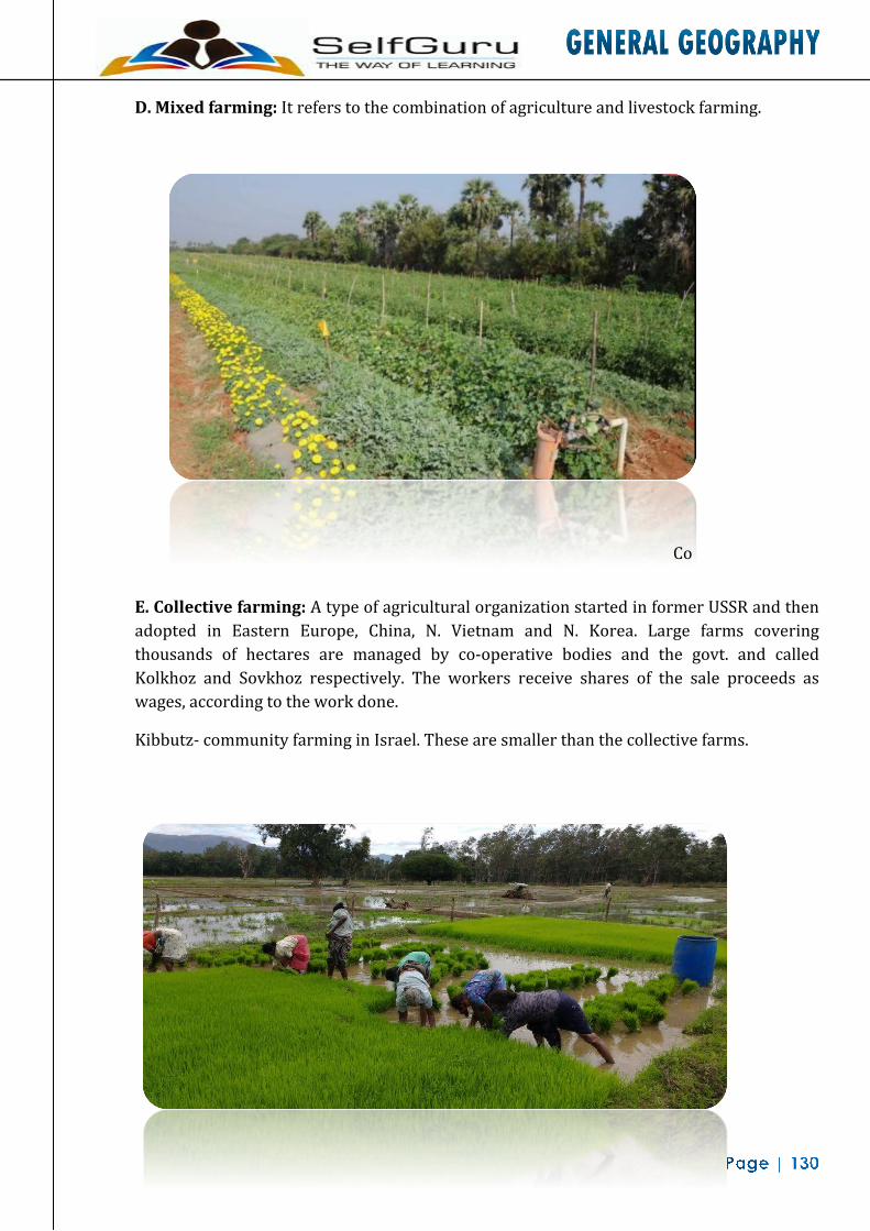
D. Mixed farming: It refers to the combination of agriculture and livestock farming.
E.
Co
E. Collective farming: A type of agricultural organization started in former USSR and then adopted in Eastern Europe, China, N. Vietnam and N. Korea. Large farms covering thousands of hectares are managed by co-operative bodies and the govt. and called Kolkhoz and Sovkhoz respectively. The workers receive shares of the sale proceeds as wages, according to the work done.
Kibbutz- community farming in Israel. These are smaller than the collective farms.
F.

F. Nomadic Herding: It's a type of shifting pastoral farming in which pastoralists move from one place to another in search of good pasture. It is mainly practiced in arid and hilly regions and primitive societies. Animals like Cattle, sheep and goat are reared for milk, meat, wool etc.
G.
G. Transhumance: It is also concerned with animal husbandry but in thin the people have their permanent settlement and they move to a suitable place only in adverse climatic condition and return back to their homeland as the climatic condition be- comes normal. Mountains of Himalayas, Rockies, Alps and Norway are famous region for transhumance. In India Gaddis of Himachal Pradesh and Bakarwals of J&K practice transhumance.

Food Grains I. Wheat
Wheat is the dominant grain of world commerce and is the staple food of millions of people It is also an important part of the daily diet of many millions more. The world wheat market is enormous. Annual global wheat consumption is in excess of 550 million tonnes (20 billion bushels). Approximately two-thirds of the wheat produced in the world is used for human food and about one-sixth is used for livestock feed. Indus- trial uses, seed requirements, and post-harvest losses account for the remaining withdrawals from the world wheat granaries. The geographical concentration of wheat is found between 30- 55°N latitude in the Northern hemisphere and between 20-40°S in Southern hemisphere.
Conditions of Growth (a) A minimum temperature of 16°C and bright sunshine for ripening, and 100 frost free days.
(b) A mild moist season with annual rainfall ranging between 50 cm and 100 cm.
(c) A relatively stiff, preferably loamy and non- acidic soils.
(d) Level or slightly rolling lands to facilitate mechanical methods of farming.
In terms of net output four countries viz. Russia, U.S.A., China and India contribute over 50% of world production. But temperate countries like France, Spain, Argentina, and Australia are also important contributing most (20%) of world's wheat.
Distribution of Wheat: USA: According to regional diversity of climate four major wheat growing belt can be
distinguished they are:
(a) White wheat region of the Colombian plateau;
(b) Hard red spring wheat of the N provinces;
(c) Hard red winter wheat of the W and S provinces, and
(d) Soft red winter wheat of the Southern states.
Russia: The wheat production is concentrated in black chernozem soil belt. They are
(a) The north Caucasus region producing winter wheat in the south-western part and
(b) The Volga region of the spring wheat
(c) The eastern regions including trans-Ural and western Siberia producing best hard spring wheat in the world.
China: China is the largest producer of wheat in the world. Wheat is produced in the area irrigated by the Huang-Ho, Hopei, Shansi, Shantung and Hainan districts are important wheat producing areas.
Australia: The important wheat growing areas are in the fertile plains of Murray Darling basin and in the S.W. Australia. Uncertainty of rainfall, great distance from markets and low

population are main deterrents.
Argentina: Wheat farming is confined to the great wheat crescent which is bounded to the west by the 40 cm isohyets and to the east by the 100 cm isohyets lines.
Export:- USA, Canada, Argentina and Australia are leading exporting countries whose share is al- most 80%. Britain, Japan, Germany, Belgium, Holland, Italy are leading importers.
II. Rice Rice is normally grown as an annual plant, although in tropical areas it can survive as a
perennial crop for up to 30 years. The rice plant can grow to 1-1.8 m tall, occasionally more de- pending on the variety and soil fertility.
Conditions of growth (i) Hot and humid climate high degree of temperature ranging between 20°-27°C and minimum
rainfall 120 cm. It also requires water logging particularly in the early parts of its growth and deep clayey loams.
(ii) Rice needs a level surface to ensure annual flooding of the fields. It's most ideal habitat is therefore, the great riverine flood-plains of the world.
Distribution: Monsoonal low lands of South-east Asia is the most outstanding region for rice growing in the world-accounting for 85% of the total rice acreage of the world and produce 90% of the world output. The noted rice producing countries in the world include China, India, Indonesia, Bangladesh, Thailand, Vietnam, Myanmar, Italy, Spain, USA and Brazil are other producing countries.
• China - The world Sichuan basin is the largest producer followed by Red Basin, riverine flood plain of Yangtze basin, Yunnan and Kweichow provinces, Fukien, Kwang Hing and Kwangsi and Hunan, Kiangsi and Chungking province. The soil fertility, use of manures and unified management are responsible for higher productivity.
• India is the second longest producer of rice in the world.
• Bangladesh is the third largest producer of rice, though rice is grown everywhere Dacca, maymansingh, Bakharganj, Faridpur, Barisal districts account bulk of the country's output.
• Japan: rice is grown throughout the country; per hectare production is very high. But high domestic demand and limited land forces the country to import rice.
The fertile alluvial plains of Irrawady in Myanmar, the Red Basin of North Vietnam, the Mekong Basin of South Vietnam, and the Menam Basin of Thailand are also notable in rice production. Rice is also grown in Nile valley and delta of Egypt, S.E. Brazil and Gulf of Mexico in the USA and Po river valley in Italy.

Export :- Very meager amount of rice (2 to 5%) come to the international market. The major rice exporting countries are China, Myanmar, USA, Thailand, Brazil, India and Italy. Major importing countries are Indonesia Korea, Hongkong, Srilanka and Bangladesh.
III. Maize Maize is widely cultivated throughout the world, and a greater weight of maize is produced
each year than any other grain. The United States produces (42.5%) of the world's harvest; other top producing countries includes China, Brazil, Mexico, Argentina, India and France.
Conditions of growth: No other cereal is cultivated under such di- verse climatic conditions and no other cereal
crop is so widely distributed both in tropical and warm temperate latitudes. Even then favorable conditions are:
(i) Temperature 20-25°C.
(ii) Long and warm summer with considerable rainfall followed by little rainfall of autumn and cold winters is ideal and optimum conditions
(iii) Rainfall 7-15 cm per month and during season of 130 to 170 days.
(iv) Deep rich soils of the sub-tropical latitudes with high nitrogen content well drained plain lands are most commonly preferred for maize growing.
Distribution: • USA, Brazil, Mexico, China and Russia account for 65% of the total world maize
production.
• USA accounts for half of the world's maize production. The Corn Belt extends from central Ohio to Central Nebraska. Iowa, Illinois, Indi- ana, Minnesota, Pennsylvania and Nebraska are the principal maize producing states of the USA. In this belt maize is grown as rotation crop.
• In Argentina, Corn belt lies in the humid Pampas region, wet of the Parana river. Despite contributing only 3.5% in world production Argentina exports more than half of the total export.
• China is the second largest producer.
• Brazil - Minas Gerais, Sao Paolo, Rio Grande are important maize producing zone. The pro- duction is almost double of Argentina but consumed locally.
Export:- 16 per cent of the total global output enters world market is sale. Argentina, USA, France and South Africa are major exporting countries. Japan is the largest buyer, followed by Netherlands, Italy, Spain, UK, Germany and Denmark.
IV. Barley Barley is a widely adaptable crop. It is currently popular in temperate areas where it is
grown as a summer crop and tropical areas where it is sown as a winter crop. Its

germination time is anywhere from 1 to 3 days. Barley likes to grow under cool conditions but is not particularly winter hardy. Barley is more tolerant of soil salinity than wheat.
Conditions of Growth (i) A moderate amount of rainfall 75-100 cm.
(ii) Short growing season, resistant to a number of conditions, grown on lands which are not used for rice / wheat short supply of moisture led barley to be grown in further forward to the pole in the north and high on the high monitions slope.
Distribution: • Russia is the largest producer of barley in the world. No other can causes is the
most important producing zone.
• China is the second largest producer of barley.
• In Europe the Mediterranean belt is of great importance for barley cultivation. From Mediterranean region in the south-European barley belt structures as far north's Arctic Circle and from the Atlantic coast to the trade.
Export:- USA & Canada export 60% of the world barley Argentina, Denmark and France are other exporters. Germany, UK, Japan and Netherlands import almost half of the world's barley.
V. Oats Oats are the hardest of all cereals. It is al- most confined to northern hemisphere. The oats
are of paramount importance in the old damp countries like Greenland, UK, Sweden, Norway and grown in a significant proportion by the countries of Central and Eastern Europe. Russia is the largest producer of oats followed by the USA, Canada, Germany, France and Poland.
VI. Rye Rye is essentially a European agro product and is grown primarily in Eastern, Central and
Northern Europe. The main rye belt stretches from northern Germany through Poland, Ukraine, Belarus, Lithuania and Latvia into central and northern Russia. Rye is also grown in North America (Canada and the USA), in South America (Argentina, Brazil), in Turkey, in Kazakhstan and in northern China.
VII. Sorghum USA is the largest producer of Sorghum, in China Sorghum is called Kaolin. In China, sor-
ghum is fermented and distilled to produce maotai, which is regarded as one of the country's most famous liquors.
VIII. Millet
Millets are major food sources in arid and semi-arid regions of the world and India is the largest producer of millets in the world.

IX. Cotton
The largest producers of cotton, currently (2009), are China and India, with annual production of about 34 million bales and 24 million bales, respectively; most of this production is consumed by their respective textile industries. The largest exporters of raw cotton are the United States,
Conditions of growth (i) Uniformly high temperature 20-25°C during the growing period.
(ii) A frost-free season of 100-200 consecutive days.
(iii) Annual rainfall ranging between 60-90 cm. during the maturing period higher rainfall is detrimental.
(iv) Well drained fertile soils with high water retentive capacity.
(v) Plentiful supply of cheap labour.
Distribution: The crop is quite widely distributed in the sub-tropical latitudes and a host of countries are
engaged in its production, but a few countries viz. Russia, USA, China, India, and Egypt domi- nate the output.
• USA: The area to the S.W. of Mississippi river enjoys the overwhelming superiority in cotton cultivation. Texas, Oklahoma and Arkansas are the most important. Mississippi, Nevada, California are also important cotton producing states. USA is the second largest producer of cotton in the world.
• China: Great plains of Northern China that encompasses the Hwang Ho, Yangtze Kiang, Weitto valley and Szechwan Province, china is the largest producer of cotton in the world.
• Egypt is the producer of best quality cotton in the world. The reasons for importance of raw cotton in the world are
(i) highly suitable climatic and edaphic condition
(ii) high demand for Egyptian long-staple cotton;
(iii) long experience in cotton mixing. Egypt accounts for 60-70% pro- duction of long staple cotton in the world.
Export:- The leading cotton producing nations like the USA, Egypt, Mexico, Brazil, Peru, Sudan, Pakistan and Turkey are all leading exporters of cotton in the world. The countries alone account for 50% of the world's export. Japan is the single largest buyer of cotton in the world.

X. Jute Jute is a rain-fed crop with little need for fertilizer or pesticides. The production is
concentrated in Bangladesh and some in India. The jute fiber comes from the stem and ribbon (outer skin) of the jute plant. The fibers are first extracted by retting.
Conditions of growth (i) A hot and humid climate with a minimum temperature of 28°C and more than 200 cm of
rainfall with 80 to 90% humidity especially during the season.
(ii) Cheap and plentiful supply of labour is another contributing factor.
Distribution: • India, Bangladesh and China account for almost 98% of the world's jute
production.
• Bangladesh - Jute is the most important cash crop in Bangladesh and is grown in almost all the districts. The jute belt of Maymansingh, Decca and Tippera and the old valley of Brahmaputra is noted for very higher grade of jute. On the banks of river Jamuna, Pabna, Bogra and Rangpur district are also famous. Maymansingh is the largest producer of jute in the world.
• China is the largest producer of jute in the world. Jute producing regions are principally located to the south of Yangtze Kiang river the important provinces are Guangdong, Zhejiang, Guanik, Jiangsu and Hunan.
• India is one of the largest producers of the jute in the world.
Apart from these countries, Russia, Brazil, Myanmar, Thailand and Nepal are also growing jute.
Export:- Bangladesh is the largest exporter in the world, contributing 65% of the world's export. India (5%), Nepal and Thailand are other ex- porters. U.K., Germany, Japan, Pakistan and Spain are important importers.
XI. Flax Flax is an erect annual plant growing to 1.2 m (3 ft 11 in) tall, with slender stems. In the
United States, three states, North Dakota, South Dakota, and Minnesota, raise nearly 100% of this plant. It is used for manufacture of linen, is produced from seed from which linseed oil is extracted.
Conditions of growth (i) Grows in areas having moderate rainfall distributed evenly during the growing periods
warm and uniforms summer temperature with high humidity are required for the growth of plant.

(ii) Clay loam soil so as to able to retain moisture.
(iv) Constant weeding is required in order to ensure a better growth of the plant.
(v) Like jute it requires rottening Distribution:
Practically all the flax fiber is produced in Europe, Russia, Poland, France, Belgium, Holland and Czech Republic are the principal producers.
Russia is the largest producer. More than 80% of the world's flax comes from Russia. Kahn Leningrad and Smolensk are the chief areas of production. Poland, France and Belgium's place come accordingly in production after Russia.
XII. Hemp Hemp is one of the faster growing biomasses known, producing up to 25 tonnes of dry
matter per hectare per year, and one of the earliest domesticated plants known. For a crop, hemp is very environmentally friendly as it requires few pesticides and no herbicides.
Conditions of growth (i) Moderate rainfall, well distributed over growing period of 110 days warm conditions and
high humidity.
(ii) Well prepared and fertilized soil.
(iii) Large supply of labour.
Kursk, Ukraine and Monrovia are important producing areas. Italy produces the best quality hemp, in the Po river valley and volcanic plains in the south. India, Yugoslavia, Rumania, Hungary, Poland and Spain are other notable producers of hemp in the world.
XIII. Silk Silk is a natural protein fiber, some forms of which can be woven into textiles. The best-
known type of silk is obtained from cocoons made by the larvae of the mulberry silkworm Bombx mori reared in captivity. The birth place of silk is China as from there it spread to Japan, India, Southern Europe and Western Asia.
Commercial production of silk involves four different stages:
(a) growing of mulberry trees
(b) rearing of silk
(c) tendering of cocoons
(d) reeling of silk.
The temperature should be between 20-30°C each cocoon has 762 to 915 meters of filament. For the ideal growth of cocoon, high temperature and heavy rainfall is required. The mulberry trees can be grown on poor acid and infertile soils. This is why they are relegated to the rugged lands or hilly tracts which are not available for food production.

Distribution: • Japan is leading producer of silk in the world
• The production is taking place from northern Honshu to South Kyushu. The great concentration of production is in Lake Suwa region of Central Honshu - high temperature heavy rain- fall and rugged topography is easily available.
• China - Production is centered in south and west of Shanghai, in parts of Szechwan basin, in the delta region of Si-Kiang near Canton. Shantung Peninsula also participates in production.
• Korea - the relief, soil and climatic conditions favors the growth and throughout the country it is the subsidiary occupation of the farmers.
• In Europe - PO valley of Italy is famous for silk production. France is also important.
• India is the only country where all four types of raw silk are produced- Mulberry, Eeri, Tusser, and Muga.
Export:- Japan is the largest exporter contributing more than 70% followed by China, Korea and Italy. USA is the largest country importing more than 60% followed by UK, France, and India.
XIV. Tea Tea is the agricultural product of the leaves, leaf buds, and internodes and is the most popu-
lar drink in the world in terms of consumption. Its consumption equals all other manufactured drinks in the world - including coffee, chocolate, soft drinks, and alcohol - put together. Most tea consumed outside East Asia is produced on large plantations in India or Sri Lanka.
Conditions of growth (i) High temperature of 27°C abundant rainfall of about 200 cm and high amount of moisture in
the air. This climatic condition confines the cultivation in rainy tropical and humid tropical regions. High humidity, heavy dews and morning fog favors rapid development of young leaves.
(ii) Relatively high sloping ground - so as to prevent water logging in the plant and should contain iron content acidic in nature.
(iii) Large and cheap labour supply.
Distribution: These environmental and economic features are present in South and East Asian countries
and hence more than nine-tenth of production comes from there continuously. More than 75% of the global output of tea comes from India, China, Srilanka, Japan and Indonesia. Outside the realm of monsoonal Asia. The tea is grown in USSR Kenya, Malawi and Turkey.
• India is the largest producer of tea in the world.

• China: Chief production areas are lying be- tween the Yangtze and Sinkiang valleys. Red soils of the hilly areas of the provinces of Hunan, Anhui, Sichuan, Zhejiang and Fujian are impor tant producing states. China has the largest area under tea cultivation in the world. China is the largest producing green leaf tea in the world.
• Srilanka - Tea states are highly concentrated in the Nuwara Eliya and the Badulla areas. In small quantity of tea is also grown in Kandy and in the hills behind Gale and Malara. Srilanka is the second largest exporter of tea in the world.
• Japan - Tea is grown mostly on the Pacific coast on the low terraced slopes of the moun- tains enriched with highly fertile volcanic soils. Uzi and Shizouka districts of southern Honshu are most important tea growing areas.
• Indonesia: In Java island, the production is concentrated the slopes of two extinct volcanoes Godak and Salak on the western side. In North East part of Sumatra tea is also grown.
• Taiwan is known for its wuling tea. The terraced fields around Taihoku are important tea growing areas.
• Kenya is an important producer outside the monsoonal realm. There tea is grown on the Nairobi high lands Malawi, Mozambique at Tanzania are other producing countries in Africa.
Export:- India and Srilanka are first and second largest exporter of tea in the world followed by In
donesia, Bangladesh, Japan and Kenya. European and American countries are major importers e.g. U.K., USA, Russia, Australia, Canada, Netherlands and Pakistan.
XV. Coffee Coffee is a brewed drink prepared from roasted seeds, commonly called coffee beans, of the
coffee plant. They are seeds of coffee cherries that grow on trees in over 70 countries. Cof- fee is usually propagated by seeds. The traditional method of planting coffee is to put 20 seeds in each hole at the beginning of the rainy season
Conditions of growth (i) Warm climate conditions annual range of temperature is between 21° and 26°c and winter
temperature should not fall below 10°.
(ii) High rainfall ranging between 125 and 150 cm. The hot rainy season helps the plants to grow rapidly and dry winter seasons favors the proper ripening and harvesting.
(iii) Well drained fertile, soil rich in plant nutrient such as iron and potash are useful. Terra Roxa soil is ideal for coffee plant. The plant grows usually on hill slopes and highlands having in altitude of 1800 to 2500 ft.
Distribution: Four major coffee producing regions in the world are:
(a) South American region comprising Brazil, Columbia, Ecuador and Venezuela and Peru account for 50% of the world's production.
(b) Caribbean Region - Mexico and Al Salvador, Guatemala and Costa Rica - 15% of the world

production.
(c) Africa including Uganda, Ivory Coast, Angola, Ethiopia, Malawi, Congo and Kenya - contributes 30% of world output.
(d) S.E. Asia comprising Indonesia Indian and Philippines - 5% of the total output.
• Brazil - Four states of Sao Paulo region Parana, Espirito, Santos and Minas Gerais are leading producers. Good soil and good drain- age condition and intensive network of transportation apart from the favorable climatic conditions favor the concentration in this region. Brazil is the largest producer and exporter of coffee in the world.
• Columbia is the second largest producer. The great majority coffee estates are located with in the high mountain slopes of the Andes- around Bogotá, Madellin, Manizales and Tolima are the principal centers of the regions.
• African Countries - The rainy uplands, rich fertile soils and favorable climatic condition in addition to abundant supply of cheap labor lead to the rapid increase in output in recent years. Ivory Coast is the third largest producer of coffee in the world.
Export:- More than 80% of total output enters the global trade market. Brazil, Columbia, Ivory Coast
Uganda and Mexico are the chief exporting countries. USA, Germany, France, Italy, the Netherlands and Japan are the main buying countries. USA is the largest importer of coffee.
XVI. Cocoa Cocoa is essentially a tropical crop, is best developed in the regions having about 27°C of
temperature and 200 cm of rainfall. It requires deep clay soils rich in iron and potash and cheap labor supply is also significant.
Distribution:- West African countries of Ghana, Ivory Coast, Cameroon and Nigeria are the most important
Cocoa producers in the world accounting for more than 70% of the world production, rest of the production come from South Ameri- can countries including Brazil, Ecuador, Venezuela, Dominican Republic and Mexico. Ghana is the largest producer and exporter of cocoa is the world-contributing half the country's export earnings. Cocoa cultivation is concentrated in the form of a triangle which includes the three important towns of Accra, Kumasi and Takoradi.
• Nigeria - Important Cocoa growing regions in the country are concentrated around Ibadan in S.W. Nigeria which has the largest acreage.
• Brazil is the largest South American producer of cocoa. Bahia district in N.E. Brazil is the most important region. Ecuador - most of the cocoa growing areas are concentrated in the Guayaquil Lowlands which provides almost optimum climatic condition for cocoa growing.
• Papua New Guinea is the most important producer of cocoa of Oceania contributing a little over 2% of world production.
Export:-

The West African countries viz. Ghana, Ivory coast, Cameroon and Nigeria are more or less solely dependent on the earning from the exports of cocoa, Ghana is the largest exporter followed by Nigeria, Brazil and Ivory coast, USA is the largest importer followed by UK, Germany and Netherlands along with France, Japan, Belgium and Italy.
XVII. Sugarcane Sugarcane growing countries of the world are lying between the latitude 36.7° north and
31.0° south of the equator extending from tropical to subtropical zones.
Condition of growth (i) Warm climatic conditions the annual temperature ranging between 21-27°C
(ii) It grows best in the regions having about 125 cm of annual rainfall. If the amount of rainfall exceeds the optimum level, the sucrose content declines.
(iii) Deep, well drained fertile soils are most important for sugarcane cultivation water logging is highly detrimental.
(iv) Sugarcane growing is, highly labor intensive in nature. Therefore, densely populated tropical countries are most imported for sugar- cane cultivation.
Distribution: Sugarcane is most widely grown in a number of tropical and sub-tropical countries but the
two principal sugarcane areas are
(i) South-east Asia-India, Pakistan, China, Indonesia and Thailand and
(ii) Latin America - Cuba and Brazil.
• China - Contributes about 6% of the world's sugarcane rugged Terrain limit the cultivable areas only to river basins.
• Indonesia - cane is most intensively a cultivated in the Java islands where the climo edaphic economic condition is ideal.
• India is the largest producer of cane in the world.
• Pakistan - produces a little over 4% of the world output - cultivation is mainly concerned in irrigated plains.
• Brazil - produces more than 15% of the world output and comes next only to India - due to suitability of environmental conditions. The principal area of concentration include
(a) the coastal lands of the north-east in the states of Prarahiba, Peruamnbuo, Alagoas and Bahia.
(b) The Minas Gerais district and
(c) the coastal plains of North-east of Rio-de-Janerio.
Cuba - Its economy is to a great extent de- pendent on sugarcane cultivation - is the third

largest producer of sugarcane in the world. The favourable environmental and economic conditions led the concentration in the districts of Havana, Metanzas, Orienta and Santa Clara. Nearness to vast American market is an added advantage.
• Australia - Produces little over 4% of the world's sugarcane cultivation predominates along the east coastal plains of Australia stretching from northern New South Wales to North Queensland. Queensland is the most important
producing state
• Mauritius and Fiji is two important islands, countries grow sugarcane mainly for experts and their economy is based on cane cultivation.
XVIII. Sugar Beet Sugar beet is a plant whose root contains a high concentration of sucrose. It is grown com
mercially for sugar production. Sebewaing, Michigan is known (to Americans) as the sugar beet capital of the world.
Conditions of growth (i) Sugar beet is a native of temperature climatic regions with moist and mild winter and
moderate summer temperature. It is very sensitive to annual ranges of rainfall which should necessarily be around 60-65 cm.
(ii) Loose friable deep soils which favor uninterrupted penetration of the beet roots.
(iii) Since it is a highly capital intensive crop, its cultivation limited only to the rich countries.
Distribution:
• Europe and America have over whelming superiority in beet cultivation since they contribute almost 85% of the global output.
• Russia is the largest producer contributing the fourth of the global output. Apart from Russia France, Germany, Czech Republic is the dominant producers.
• USA is the third largest producer contributing more than 8% of global output-mainly concentrated east of the Mississippi river and in the plains stretching from Montana to South Colorado in the Snake River Valleys. The bulk of country's output comes from California. China, Japan and Turkey are other producing countries.
XIX. Tobacco Tobacco is an agricultural product processed from the leaves of plants in the genus
Nicotiana. It can be consumed, used as an organic pesticide and, in the form of nicotine tartarate.
Conditions of growth (i) The plant prefers considerable warmth and moisture; temperature, rainfall and soil affect the
quality. Excessively heavy rainfall reduces yield and increases the acid content in the leaf.

Distribution: • Most of the producing areas are in the southern part of the middle latitudes and along the
northern margin of the topics - USA, China, Brazil, India and Russia are the chief producing countries.
• China is the largest producer - production takes place in the irrigated region of the Chengdu in the Red Basin and in the Sikiang valley in the south.
• USA is the second largest producer - North Carolina, South Virginia, Georgia, Northern Florida and South Carolina participate in tobacco production. North Carolina account 95% of the national output.
• Indonesia - Tobacco is produced in eastern java and North Eastern part of Sumatra islands. The quality of cigar is very high.
• Philippines - Cagayan valley and glaciers coastal plains of Luzon, and the central Visayan Islands, Panay and Cebu.
• Brazil: Tobacco is grown on the eastern coast plain.
Export:- USA, Dominican Republic, Cuba, India, Tur- key, Brazil and Zimbabwe are important exporting countries, UK, Holland, Belgium, Germany and Spain are the most important. UK is the largest importer country.
XX. Rubber The commercial source of natural rubber latex is the Para rubber tree. Rubber latex is ex-
tracted from Rubber trees. The economic life period of rubber trees in plantations is around 32 years - up to 7 years of immature phase and about 25 years of productive phase.
Conditions of Growth (i) Rubber is a tropical crop of the humid tropical countries, therefore, thrives best in the
regions having high temperature and annual precipitation, where temperature is less than 21°C it may not be grown. Rubber survives best in the regions with about 150 to 250 cm. of rainfall.
(ii) Deep loose and well-drained alluvial soils provide the most ideal ground for rubber growing. Gently undulating surface conditions prevent water logging and check soil erosion.
Distribution: • South-east Asian countries including Malayan Archipelago, Indonesia, Thailand, Srilanka and
India have maintained their monopolistic control over global production of natural rubber. Lebanon and Nigeria are other producing countries.
• Malaysia ranks third in naturals rubber pro- duction. Accordingly favorable rainfall and temperature, extensive flat coastal plain cheap labor and government patronage helped a lot to expand rubber plantation. Here rubber is grown over 30% of the cultivate land. Malaysia is the third producer and exporter of rubber in the world.
• Indonesia Ranks second only to Thailand in production. Mostly in Sumatra islands, and climatic condition prevail here but small holdings, over taxation, lack of re-plantation and

over-exploitation of trees are reason for lower production in Indonesia.
• India - Kerala accounts for 90% of the national rubber output.
• Thailand is the largest producer of rubber in the world. Southern Thailand out-ranks all other regions.
• Liberia, Nigeria, Ghana and Zaire are the most important rubber producing of countries in West Africa hold second place after South- East Asian nations.
Export:- Malaysia and Singapore account for nearly 50% of the global share of exports. Indonesia
accounts for another 25% of exports. Srilanka and Thailand are other important exporting countries. USA is the largest buyer of global rubber and account for half of the total imports. UK, Russia and France are other important buyer. Today, natural rubber is facing stiff competition from synthetic rubber.
XXI. Coconut The plant grow well in areas of high temperature, (25°C) heavy rainfall (over 200 cm) and
high humidity, along sea coasts the coco- nut trees grow well.
Distribution: • Coconut production is concentrated within 20° on either side of the equator. The
Philippines, Indonesia, New Guinea, Fiji, Solomon Island, Malaysia, Srilanka, Mozambique and India are important producing countries.
• Philippines produce almost 30% of the total global output. Srilanka and Indonesia are sec ond and third largest producer and exporter of coconut in the world USA, Germany, Holland and UK are chief buying nations.
XXII. Oilseeds • Groundnut:- India is the largest producer followed by China, Nigeria and most Africa.
India is also the larger exporter of groundnut.
• Linseed:- USA is the largest producer of linseed in the world. Argentina, Canada and Russia are other important linseed producing countries. Canada is the largest exporting country followed by USA, India and Argentina, UK, Holland, Germany, France and Belgium are importing countries.
• Sunflower:- Russia and China is the chief producer and exporters - Germany and UK are chief importers.
• Sesame:- India and China are main producers. China is the largest exporting country. • Soybeans:- USA is the largest producer of Soybeans in the world followed by China, Japan
and Indonesia are other producing countries. USA accounts for three-fourth of the total Soy- beans exports. Japan is the largest buyer followed by Germany and Canada.


FISHERIES
The principal fishing grounds of the world are located on the plankton rich banks of the continental shelves especially in the cool water of the northern hemisphere in comparatively high latitudes. In terms of production, Japan is para-mount followed by the CIS, China, Norway and USA.
Types of Fish Salt Water Fish: They spend their entire life in the oceans and seas.
Fresh Water Fish: They are found in inland streams, rivers and lakes.

Locational Considerations
(I) Supply of Plankton: Important conditions for its presence are
(a) Shallow water above continental shelf.
(b) Cool Water- Plentiful in polar water where cold & warm currents meet.
(c) Land- derived minerals which nourishes planktons.
(II) Cool Climate: Best developed where temp. is below 20°C; tropical water is too warm so fishes are of less commercial value while in the temperate latitude water is cool so most suitable; fish cannot be kept long in hot, moist tropical conditions. While the temperate land of cold winters originally provides natural ice for preservation of fish.
(III) Physical & Environmental Influences : Both Atlantic and Pacific ocean coast-lines of middle and high latitude in N-Hemisphere are very much indented and are backed by strong relief. There are sheltered inlets & estuarine coasts that make ideal sites for fishing ports & villages. The rugged mountains & short growing period in Norway, Hokkaido, Iceland, Alaska restricts agricultural activities & people take to the sea to enrich their diet. In S-Hemisphere fishing activities are hampered by lack of harbors or of labour. In Argentina & Australia meat & other foodstuffs are so plentiful that it has not been necessary to develop a fishing industry.
(IV) Moderate or Large Population: It is a labour intensive industry, small scale fishing in well- populated areas as China, Japan, etc.
Anadromous Fish: They are spawned in the inland rivers but spend most of their life in the seas and only return to the rivers to spawn and die, e.g. Salmon.

Pelagic Fish: They live at or near the surface of water like herring.
Demersal Fish: They live at the bottom like cod, haddock.

1.Pelagic: Light loving & found near the ocean surface and form schools e.g
• Herring: most important catch of North Atlantic region & also the chief fish caught in Japan & China.
• Mackerel: generally found south of the main herring areas, e.g. in the Mediterranean Sea, Off- South Scandinavia, Off- Cornwall (UK), Off- Carolina (USA), Yellow sea.
• Sardines: temperate water fish; Mediterranean sea, Bay of Biscay, Coastal New England States are its main regions.
• Brisling: temperate water fish; off-south Norway.
• Anchovies: temperate water fish, Off- Europe, Peru (90% of Peru catch).
• Menhaden: off-USA (from Newfoundland to Caribbean Sea); due to oily nature unsuitable for human, generally used as animal feeding, fertilizer, soap, etc.
• Capelin: Like: Menhaden, caught in the N.E-Atlantic.
2. Demersal: not light loving, on ocean bottom, also known as ‘White Fish’ e.g.
• Cod: in terms of value more important than Herring; North Sea, Off- Norway & Iceland, Grand Bank off Newfoundland.
• Haddock: N. Atlantic Coast.
• Halibut: Off- British Columbia, N.W-USA, Hake and Flat fishes like Plaice, Sole, Flounder.
• Tuna: Japan, Mediterranean Sea, Indian Ocean, California.
A. Fresh Water Fish (10%): They rarely swim in large shoals & their fishing areas are rather restricted. Inland fishing is important in former USSR & E. Asia.
• Trout, Perch, Pike, Salmon: North America & Europe.
• Sturgeon: Caspian Sea, Black sea, Volga, Danube, Dnieper, St. Lawrence.
• Carp: China & Japan.
• Eels: Denmark, Netherlands, USA.
B. Aadromous Fish: Both fresh water& salt water fish.
• Salmon: N. America (from Alaska to Oregon on Pacific coast)-Young salmons live in sea but after 2-5 yrs they return to the stream where they were born to lay their eggs & die. Today Salmon’s greatest haul is in Alaska.

Major Fishing Regions • North - West Pacific Region: It extends from Pacific Bering Sea in north to Philippines Sea
in the South. In this Region Japan is the leading producer of fish.
• North-East Pacific Region : It extends from Alaska to California along the western coast of North America Salmon, Pilchard, Tuna, Sardines and Halibut are the important catch of this region.
• North Atlantic Region: It extends from the Arctic circle in the north to the borders of the Mediterranean Sea along the West European Coasts.
• North-West Atlantic Region: It extends mainly between long island and Newfound land and to a little extent in its surroundings.
Leading Fishing Areas (1) North West Pacific Region:
• Extends form Bering Sea in the north to Philippine sea in the south bordering Central & Northern Japan, N. China, Korea & NE. Russia.
• Mixing of Kuroshio Warm & Oyashio Cold currents favours the vigorous growth of fishes and form the greatest fishing ground of the world.
• Japan leads the world in fish production (9.2%in 1993). Other important countries are Baltic nations, Russia, China, Korea.
(2) North-East Atlantic Region:
• Comprising shallow waters of the European coast extending from the Barents Sea in the north to the Bay of Biscay.
• ‘Dogger Bank’ of the North Sea is the most important fishing ground of this region.
• The warm waters of North Atlantic Drift keep the coast open, throughout the year.
• Major fishing countries are Norway, Sweden, Denmark, Netherlands, France, Iceland, UK.
• ‘Grimsby’ is the greatest fishing port in the world, in variety & value of fish landed.
• Cod, Herring, Halibut, Sardines form the main catch of this region.
(3) North West Atlantic Region:
• Meeting of warm Gulf Stream & Cold Labrador favours the growth of plankton.
• Cod, Perch, Herring, Haddock, Lobsters, Oysters are the main catch of this region.
• Maximum fishes are caught from the coast of Newfoundland & Novascotia.
• Chesapeake Bay is famous for oyster catches.
• Halifax, St. John, Boston, New York are important fishing ports of this region.
(4) North-East Pacific Region:
• From Alaska to California along the western coast of N. America.

• It is noted for Salmon, Pilchard, Tuna & Halibut.
The deep waters in the continental shelf off- Alaska & the British Columbia are the best Halibut fishing source of the world.

MINERALS
Minerals generally occur in any of the following formations:
1. Minerals found in sedimentary beds or horizontal strata are mainly coal and some grades of Iron ores. Other minerals of this origin are gypsum, potash and salt. Petroleum also belongs to this category.
2. Alluvial Deposits contain those minerals which are resistant to erosion e.g. gold, platinum and tin.
3. Some metallic minerals like tin, silver, copper, zinc and lead are obtained from cracks, crevices, faults or joints in rocks. The smaller varieties of such occurrences are called veins and the larger lodes.
4. Deep weathering products also contain some of the mineral resources and bauxite, the ore of aluminum is formed by this process.
Classification of Minerals:- 1. Industrial Metallic Mineral: Iron.
2. Non-Metallic Minerals: Salt, Sulphur, Potash, Nitrates and precious stones like Diamond.
3. Non Ferrous Metallic Minerals: Aluminum, Copper, tin.
4. Ferro-alloy Metallic Minerals: Manganese, Vanadium, Cobalt, Molybdenum, Nickel.
5. Power Minerals: Coal, Petroleum and Gas.
6. Precious metallic minerals: Gold, Silver and Platinum.
Iron Ore Important Ores:
a) Magnetite (Iron content > 70%),
b) Hematite (Iron content = 55-70%),
c) Limonite (iron content = 40-55%),
d) Siderite (iron content = 10-45%).
Reserves:
1. Former USSR
2. India
3. USA
4. Brazil

Production:
1. Former USSR
2. Brazil
3. China
4. Australia
5. India.
Distribution
India: (1) Orissa- Mayurbhanj, Keonjhar, Sundergarh
(2) Bihar- Singhbhum
(3) M.P.-Bailadila
(4) Karnataka- Chikmanglur, Chitradurg, Tumkur, Bellary
Former USSR: 40% of world reserves; 50% is obtained from European part.
(1) Krivoyrog Region (Ukraine)
(2) KMA (Kursk-Magnetic-Anomaly) in Ukraine.
(3) Kerch Peninsula
(4) W-Azerbaijan.
(5) Ural Region- Sverdlovsk (N. Ural), Nizhny Taghil (C-Ural), Magnitogorsk (S-Ural).
(6) Kuzbas Region-Kustanay (Kaza-khstan).
(7) E-Siberia-Krasnoyarsk, Angara.
(8) Karaganda.
(9) Kutnai (Kazakhstan)
USA: (1) Lake Superior Region: Mesabi (Limonite, 70% of US Production), Vermilion, Cuyana,
Gogebic, Menominee, Marquette.
(2) NE. Region (magnetite) - Adiron-dacks region of New York, Cornwell region of Pennsylvania.
(3) SE Region (Hematite and Limonite) - Birmingham, Alabama, Red-mountain.
(4) W. Region - Utah, Nevada, Wyo-ming, California.

Canada: (1) Lake Superior region- Steep Rock.
(2) Labrador & E-Quebec- Schefferville, Wabush city.
China: (1) Shenyang (Mukden) region of Manchuria.
(2) Yangtze Valley- Moon Shan, Tayeh, Wuhan
(3) Shandong Peninsula
(4) Hainan Island
(5) Hunan
(6) Baotao
Australia:
(1) Pilbara Region of West Australia: Mt. Goldsworthy, Mt. Whaleback, Mt. Bruce, Mt. Tom Price, Yampi Sound, Mt. Newmann, Tailoring Peak, Koola-nooka.
(2) S. Australian region: Iron Knob, Karlgoorlie, Coolgardie.
France: (1) Lorraine (2nd important area in Europe after KMA)
(2) Normandy
(3) Pyrenees
(4) Central Massif.
Sweden:
(1) Kiruna
(2) Gallivare
(3) Dannemore
(4) Grangeberg
(5) Kopparberg
Britain: (1) Scunthorpe
(2) Frodingham
(3) Cleveland

(4) Midland
(5) Scotland
Spain: (1) Bilbao (2) Santander
(3) Oviedo
Germany: (1) Salzgitter
(2) Siegen
(3) Siegerland
Brazil: (1) Carajar in Para district
(2) Itabira (SE-Brazil).
Venezuela:
(1) Lower Orinoco Valley,
(2) Guiana Highland - Cerro Bolivar, El- Pau.
Chile: (1) La Sarena
(2) Algarroba
Peru: Nazca- Marcona area.
Africa: Liberia (Bomi Hills, Mt. Mimba), S.Africa, Algeria, Morocco, Tunisia, (Iron & Steel industry is not developed so ores are exported).
Copper Found almost in igneous & metamorphic rocks in the form of Native, Oxide or Sulphide. Often occurs together with gold, silver, lead, zinc, etc.
ores: Cuprite, Malachite, Chalcocite, Coveite, Pyrite. Production:
1. Former USSR
2. USA

3. Chile
4. Canada
5. Zambia
6. Zaire
Distribution: India: (1) Bihar- Singhbhum, Hazaribagh
(2) Rajasthan- Khetri, Aguncha- Rampura.
USA:
(1) Arizona-Morenci, Globe, Bisbee, Casa- Grande,
(2) Utah - Bingham
(3) Montana- Butte
(4) Nevada
(5) New- Mexico
(6) Michigan Lake
Former USSR:
(1) Ural Region
(2) Kazakhstan
(3) S- Georgia
(4) Armenia
(5) Balkash Lake
(6) Norilsk
Chile:
(1) Chuquicamata (world’s largest copper mining town)
(2) El-Temente
(3) Poterillos
(4) Bradue
Canada:
(1) Sudbury (Ontario)
(2) Noreda (Quebec)
(3) Flin- flon

(4) Sheridan
(5) Lynn Lake (Manitoba)
Coppermine- • Zambia: (1) Nechanga (2) Kitwe (3) Mufulira
• Zaire: Lubumbashi-Katanga.
• Peru: (1) Morococha (2) Casapatla
• Australia: (1) Mt. Isa (2) Mt. Morgan
Aluminum- Most abundant metal; 8% of the Earth’s crust. Ores: Bauxite (in the form of oxide), Cryotite (found only in Greenland), Corundum, Kaolin,
Commercial Bauxite has 50% alumina & 7% silica, so it is the most wan-ted ore, mostly mined in tropical region but aluminium is manufactured in developed countries where cheaper electricity is available. World’s first Bauxite mine was in the village ‘Les-Baux’ in France from which the ore name bauxite is derived.
Process: Hall-Herault Process, Bayer Process.
Production:
1. Australia
2. Guinea
3. Jamaica
4. Brazil
Distribution: • India: Bihar, MP, Maharashtra, T.N., Karnataka.
• Australia: Weipa (east of Gulf of Carpentaria), N.E Arnhem (west of Gulf of Carpentaria), Cape York Peninsula.
• USA: Arkansas, Georgia, Alabama
• Former USSR: Urals (Karsnya- Shapochka, Kamansk Ural-Skiy), Turgay.
• France: Brignoles (N.E of Toulon), Les Baux
• Guinea, Jamaica, Brazil, Surinam, China, Malaysia, Indonesia, Turkey
Exporters: Jamaica, Guinea, Hungary, Surinam, Greece.
Tin- Ores: Cassiterite or Tinstone (75% Tin) generally found in alluvial deposits comprising 80% of
world supplies, also occurs in lodes & veins in Bolivia.
Distribution:

• Malaysia: Kinta valley, Larut Plain, Keylong Valley, Jelepu Valley.
• Thailand: Kra Peninsula, Phuket
• China: Yunnan (Geiju), Tauchin, Nanling Shan
• Indonesia: Bangka, Billiton, Singkep, Mt. of Malacca.
• Bolivia: Potosi, Oruro
• Nigeria: Bauchi Plateau (Bauchi, Jos, Jaria)
• Zaire: Manano, Maniemo
• Australia: Cornwall, New England.
• Myanmar: Shan Plateau, Kayinni plateau
Lead- Ores: Galena (Lead sulphide) Lead, Zinc & Silver are almost found together.
Use: Storage batteries, Minium (steel coating red point), Type-metals, Bullet- making.
Distribution:
• Australia: Broken Hill, Mt. Isa, Roseberry. • Canada: British Colombia, Laurentian shield.
• USA: Rockies, Ozark Plateau of Missouri, Idaho, Utah, Arizona, Colorado, Washington.
• Peru: Cerro de Pasco
Zinc- Ores: Zinc-blende (zinc sul-phide), Calamine
Use: In galvanization.
Distribution:
• Canada: Sullivan Valley, Canadian Shield, N.W-Territories, British Colombia.
• Australia: Broken Hill, Mt. Isa. USA: Missouri, Oklahoma, Kansas. Peru, Mexico, Japan, N. Korea Gold It occurs in quartz veins and as placer deposit.
Production:
• S. Africa: Witwatersrand, Transvaal, Johannesburg, Lydenburg, Orange Free State.
• USSR: Lena river placer deposit, Ural & Trans-Baikal region.
• Canada: Flin Flon, Red Lake region (Hollinger mine is one of the largest mine of the world).
• Australia: Kalgoorlie, Coolgardie. USA: Salt Lake Region, Alaska Japan, India.

Silver Ores: Argentite, Galena; in lodes or veins.
Production: 1. Mexico
2. Peru
3. Former USSR
4. Canada.
Distribution:
• Mexico: Chihuahua, Fresnillo, Taxco, Hacienda.
• USA: Utah, Montana, Arizona, Colorado, Butte.
• Canada: Kootenay, Ontario, British Colombia, Quebec.
• Peru: Cerro-de-Pasco.
• Bolivia: Potosi.
• Australia: Mt. Isa, Kalgoorlie, Broken hills. USSR
Platinum- Always found with other rare metals like Osmium, Palladium, Iridium, Rhodium. Distribution:
• Canada: Sudbury
• Colombia: San Juan region
• S. Africa: Rustenburg
• USA: California
• Former USSR: Nizhni Taghil, Ural area, Siberia.
Diamond- It occurs as crystals in igneous rock called ‘Kimberlite’. ‘Carbonado’ is black diamond used in industry, produced in Bahia, Brazil, Africa (‘Bort’ variety).
Distribution
• S. Africa (leading gems stone producer),
• Zaire (mainly Bort) USSR, Ghana, Namibia, Angola, Botswana, S. Africa, Venezuela,
• India (Panna).
Manganese-

Ores: Pyrolusite, Psilomelane, as nodule on sea-floor.
Distribution:
• Former USSR (31%): Nikopol (Ukraine),
• Chaitura (Georgia),
• S. Africa (Kimberley, Postmasburg)
• Brazil (Mines-Gerais),
• Gabon (Maonda),
• India – Karnataka , Orissa , Madya Pradesh etc
Mica- Ores: Muscovite (white), Phlogopite (brown); generally found in the form of placer deposit.
Production:
1. India (80%)
2. Former USSR
3. S. Africa.
Distribution:
• India (Hazaribagh, Nellore),
• USA,
• USSR,
• France
• Argentina
• South Korea.

INDUSTRIES
Industry refers to an economic activity that is concerned with production of goods, extraction of minerals or the provision of services. There are several industries like iron and steel industry (production of goods), coal mining industry (extraction of coal) and tourism industry (service provider). Industries can be classified on the basis of raw materials, size and ownership.
Types of Industries: 1. On the basis of Raw Materials they use, industries can be divided into:-
(a) Agro based Industries: use plant and animal based products as their raw materials. Example - Food processing, vegetable oil, cotton textile, dairy products and leather industries.
(b) Mineral based industries: use mineral ores as their raw materials. Example - heavy machinery, building materials and railway coaches.
(c) Marine based industries: use products from the sea and oceans as raw materials. Example - industries processing sea food or manufacturing fish oil.
(d) Forest based industries: Utilize forest produce as raw materials. For example: pulp and paper, pharmaceuticals, furniture and buildings.
2. Size of an industry refers to the amount of capital invested, number of people employed and the volume of production. Based on size, industries can be classified into:-
(a) Small-scale Industries: Cottage or household industries like basket weaving, pottery and other handicrafts, silk weaving and food processing.
(b) Large-scale Industries: automobiles and heavy machinery industries.
3. On the basis of ownership industries can be divided into:-
(a) Private Sector Industries: owned and operated by individuals or a group of individuals e.g. Tata Motors, Reliance Industries, Bajaj Group etc.
(b) Public Sector Industries: owned and operated by the government. Ex-Hindustan Aeronautics Limited and Steel Authority of India Limited.
(c) Joint Sector Industries: owned and operated by the state and individuals or a group of individuals. Exp - Maruti Udyog Limited.
(d) Cooperative Sector Industries: owned and operated by the producers or sup- pliers of raw materials, workers or both. Exp - Anand Milk Union Limited and Sudha Dairy.
4. Other Classification:
(a) Raw Material based industries: Iron and Steel, Sugar, Cement, Fish, Meat, Milk and Food processing, Rayon etc.
(b) Power based industries: Aluminium.
(c) Skilled labour based industries: Jewellery, Diamond cutting, Watch, Toys and electronics in Japan, Jagadhari.

(d) Transportation based: Trans- Siberian Railway region industries, Industries of Great Lake waterways region of U.S.A and Canada, industries of coastal areas of Japan, refineries in coastal areas, Jute mills on the bank of river Hugli, industries of Perth. Sydney railway region of Australia etc.
(e) Capital based industries: Many industries of developing countries of colonial period established by ruler nations during their colonial period e.g. industries of Zaire and Guinea were developed by Belgium.
(f) Market based industries: Textile, Refineries, Electronics, Bakery, Ice-Cream, Biscuits, Hosiery and other consumer goods.
(g) Footloose industries: Industries that can be established both in the market as well as in the raw material source region e.g. Paper industry.
Factors Influencing Industrial Location The factors affecting the location of industries are:
(i) The availability of raw material
(ii) land
(iii) water
(iv) labor
(v) power
(vi) capital
(vii) transport
(viii) Market.
Industries are situated where some or all of these factors are easily available. Sometimes, the government provides incentives like subsidized power, lower transport cost and other infrastructure so that industries may be located in backward areas.
Major Industries of The World • Iron and Steel Industry
Russia: The major producing centres are:-
(a) The southern districts - existence of Krivoi Rog iron ore, Donbas coalfields, Yelenovka limestone, Nikopol’s manganese and Kirch iron-ore are added ad- vantage. Zaporozhe, Zhdanov, Toganov are important centres.
(b) Moscow – Tula region- Tula, Vyksa, Kulebadi and Gorki are important countries.
(c) Ural Kuznetsk Combine: Magnitogorsk, Nizhnitaghil, Chelyabinsk and Sverdidlovsk are prominent centres.

USA: It has greater concentration of iron & steel in north-eastern part. Here three steel
district have developed:-
(i) Pittsburg district: Pittsburg has developed at the junction of Ohio, Allegheny and Mononga-hela rivers. Local coal, iron-ore from Lake Region, local lime and stone are added advantage. Besides, Pittsburg Youngstown and Johnstown are important centers.
(ii) Lake shore region: steel centers are located at Buffalo, Erie, Cleveland, Detroit and Loraine – Lake’s transport facility and Mesabi are chief locational factors.
(iii) Atlantic coastal Region: Maryland, Sparrows Point and Pennsylvania are important centres.
(a) In South-Eastern Region, Birmingham is the largest center.
(b) In Western Region, Fontana in California and Provo in Utah are important centers.
Japan: (a) Honshu: Osaka-Kobe, Tokyo- Yakohama
(b) Kyushu: Yawata (50%)
(c) Hokkaido: Muroran.
Japan’s iron and steel industry depends on imports of iron ore from India, Philippines, Malaysia, Canada etc. and cooking coal from Australia and China. Now electric hearth process is widely used to save coal.
China: (a) Manchuria region has the largest steel plant of China is at Anshan Fushun. Pensinn and
Mukden are other important steel producing centers. The region accounts for two fifth of China’s steel output.
(b) Lower Yangtze Valley: Chungking, Wuhan and Hankow are important centers.
(c) Northern China: Large steel plants are located at Shantung, Beijing, Anyang and Shensi.
Germany:
Essen, Dusseldorf, Dortmouth, Bochum, Gelsenkirchen, Duesburg and Krefeld are important centers because of the extensive deposits of good quality coal within the region. Presence of Ergyberg and Lahn-Sieg iron and excellent import facilities helped immensely for the rapid growth of Ruhr- Region iron steel industry.
Other important Areas: a) France: Lorraine-Metz, Briey, Nancy and Longway along with Sambre-Meuse field
contributes more than 90% of the national output.
b) Australia: Newcastle and Port-Kembla along the coast of New South Wales are important steel centres.

c) Brazil: Volta Redonda is the most important center.
d) Italy: Naples, Genoa, Aosta and Trieste are important centers. These plants use scrap iron-ore.
Export:- Japan is the largest exporter followed by Germany France, Belgium, Netherlands, South Korea,
Italy, USA and Taiwan. These countries account for 80% of the International export.
Cotton Textile Industry- Location of this industry is highly diffused- perhaps due to omnipresent market of cotton
textile throughout the world.
Russia: In Russia Ivanovo and Moscow were the most important centres. Stalingrad, Kirorabad, and
Leningrad are other important centers. Ivanovo is still the largest center of cotton textile in Russia.
USA: Concentrated mainly is:-
(i) North-eastern area in the southern part of New England states, and
(ii) South East area encompassing cotton growing states of North Carolina, South Carolina, Tennessee and Georgia. Providence, New Bedford, Fall River, Lowell, Holyoke and Manchester are important centers. Local raw materials, favorable climatic condition, cheap hydel power, local market, cheep labour and low cost of land are fac- tors for helping the growth of industry in this zone.
Japan: Natural humid climate, cheap labour, new and upto date machines, cheap hydel power, big
markets are important factors of growth of cot- ton textile industries in Japan. Majority of the cotton mills are located in the following regions:
(i) Kwanto Region: around Tokyo and Yakohama.
(ii) Kinki Region: Osaka is the main center
(iii) Nagoya and
(iv) Northern Coastal area, other producing centers.
China: China is the largest producer of cotton tex- tile in the world. The prominent centers are
Shanghai, Manchuria, Tienshan, Beijing Chuang, Nanchang and Hankow. Shanghai is still the largest center of cotton textile in the country. Large market, cheap labour, local raw material, coastal location and equitable climatic condition are the important factors of location of cotton textile industries in this region. Most of the plants are integrated.
U.K: Once pioneer of modern textile industry, it does not find place even among the ten largest
producers Manchester, Paisley, and Glasgow are important centers.
Other Centres - India: (Mumbai, Ahmedabad, Madurai, Coimbatore, Kota, Calcutta etc.)
Italy: (Milan- Manchester of Italy) Spain: (Barcelona)
Production and Trade:
China, India, Russia, USA, Japan and Italy produce more than 70% of world total output of cotton textile in the world. India is one of the largest exporters of cotton textile in the world.
Woolen Textile Industry- The bulk of the wool is produced by a handful of developed countries- Soviet Union, USA,
Japan, UK, Germany, China, France and Italy.
1) Soviet Union is the largest producer. The leading centers are the Moscow, Tula, and Leningrad. Ready market for the product traditional base and abundant supply of raw wool are the important advantages.
2) USA: In Massachusetts, Rhode Islands, Pennsylvania, New York, Wisconsin and New Jersey states the woolen textile industry has developed. Favorable cool climate, large-scale sheep rearing in northern plains, easy and cheap labour and market facility are the chief factors of localization.
3) Italy is a leading producer. Most of the plants are located at Naples and Po-river valley.
Jute Textile- First jute mill was established at Dundee (Scotland) in 1838; but now only India &
Bangladesh are significant producers.
Silk Textile- This industry is confined to tropical and sub- tropical regions as silkworm needs a
temperature greater than16oC.
Important Centres-
(a) Raw silk: (i) Japan (50%) (ii) China (iii) Former USSR (iv) India.
(b) Silk Textile: (i) China (70%) (ii) Japan
Main Problems: High labour cost and competition with synthetics.

Synthetic Textiles- Main synthetic textiles are: Rayon made from cellulose, Nylon, Acrylic and Dacron made
from coal and petroleum.
Centres: USA (Southern States, Pennsylvania, New England); Japan; France.
Mechanical & Electrical Industries- It is based on the availability of metal (iron and steel, copper, aluminum etc) and technically
skilled labour.
Important Centres:
• USA: Chicago, Philadelphia, Boston, Los Angeles.
• Former USSR: Moscow, Lenin-grad and iron and steel industries regions
• UK: Birmingham.
• West Germany: Cologne, Essen. East Germany: Leipzig, Dresden.
• Italy: Eulogna
• Japan: Tokyo-Yokohama, Osaka, Kobe, Nagoya.
• China: Shanghai, Canton, Harbin, Tientsin.
Chemical Industries- Generally these industries are located near coal- fields, iron-ore fields and agro industries
like Sugar mill etc.
Important Centres:
• U.S.A (N.E Industrial region),
• Former U.S.S.R (Moscow Leningrad),
• Germany (Ruhr basin– Potash and Sulphur de- posit area),
• France
Petrochemicals- Those industries are generally located either in the source region or near markets.
Important Centres:
• USA (Texas = 40%, Ala- bama),
• Former USSR (Volga is the largest centre),
• Japan (Tokyo- Yakohama)

Other Industries- A. Farm Machinery: USA (Chicago-Mil-waukee belt), Former USSR (Kharkov), Canada
(Winnipeg)
B. Aircraft Industry: USA (Los Angles, San Diego, Seattle, New York, Wichita), Former USSR (Moscow, Gorki, Kuybyshev, Tomsk), UK, France.
C. Shipbuilding: Requires coastal location of iron and steel industry and large harbors.
Centres: USA (East coast), Former USSR (Leningrad, Vladivostok), Japan.
D. Automobile Industry:
I. Japan
II. USA (Detroit: 30%)
III. West Glerrary (45% of Europe)
IV. Canada (Windsor-Detroit of Canada)
V. Italy (Turin-Detroit of Italy, Milan)
E. Paper: First paper industry was established in China. USA leads in production of fine paper from grasses.
News Print and Pulp: Production Ranking,
I Canada
II USA
III Japan.
Industrial Regions of the World Industrial regions emerge when a number of industries locate close to each other and share
the benefits of their closeness. Major industrial regions of the world are eastern North America, western and central Europe, Eastern Europe and eastern Asia. Major industrial regions tend to be located in the temperate areas, near sea ports and especially near coal fields.
USA (a) New England Region- The region comprises six states viz. Connecticut, Rhode Island,
Massachusetts, Vermont, New Hampshire and Maine. The nucleus of this region is Boston. Major industries in the region are electrical machinery, textiles, engineering, and other metal industries- comprises 15% of the yearly output of the nation. Huge capital, good communication, export facilities, cheap and skilled labour and vast market are the chief advantages. Major industrial areas are Providence, Bedford, New Haven and Springfield.
(b) North-Eastern Region- In between Lake Superior and Baltimore on Atlantic coast, the region covers one tenth of the area and three-fourth of manufacturing industries and half of the population. Pittsburgh and Cleveland districts known for iron and steel industries; Akron for

rubber manufacturing; New York, Philadelphia, Baltimore districts- for textiles, steel, leather goods and chemical industries; Detroit district (the greatest automobile centre of the world) for automobiles.
(c) Southern Industrial Region- Extends over a wide area from Texas to North Carolina. 20 per cent of the country’s labour force is engaged in various industries of this region. Cotton textile, goods, aircrafts, aircraft industry and petroleum refining are important industries. Charlotte, Columbia, August, Atlanta, Knoxville, Chattanooga and Birmingham are important industrial centers.
(d) Pacific coast industrial region- Extends over the states of Washington, Oregon and California along the Pacific coast in the West. About 10% of the country’s labour force is engaged in manufacturing industries of this area. This is the smallest industrial region of the country. Los Angeles, San Francisco, Seattle, San Diego are important industrial centers.
Russia (a) Moscow-Tula Industrial Region-Moscow, Tula Gorky, Ivanovo and Yaroslava are the chief
industrial centres of the region. Iron- steel, heavy chemical, metallurgy, machine tools, textiles, automobiles etc. are the chief industries. Ivanovo is known as the Manchester of Russia. This is the oldest and most important industrial center of the country.
(b) Ural Industrial Region: Stretches from Magnitogorsk to Nizhnitaghil. The development owed much to the huge iron- ore deposits and good communication system. Magnitogorsk in one of the largest steel centres of the world. Mining, metal engineering and chemicals are the most important industries here. Out of eight big industrial centres Magnitogorsk, Sverdlovsk, Chelyabinsk, Nizhnitaghil, Orsk, Molotar, are important.
(c) The Volga Region: The development of manufacturing activities is a new phenomenon in this region. Tartar and Kyubushev oil fields are helping factors for concentration of industries here. Volgograd is the chief centre.
Europe (a) Ruhr Industrial Region is known as one of the largest industrial region of Europe. The large
reserve of Ruhr coal and Siegerland iron ore and transportation route through Rhine were the major factor for concentration of number of industries with in an area of less than 50 miles from east to west and 25 mills from north to south. There are more than dozen of industrial cities with population varying from one lakh to five lakhs. Local large coal deposit, in land waterways, local skill are major factor for industrial conglomerations.
(b) Po valley of North Italy: Textile industries including cotton, rayon and woolen are the most important industries of this plain. Cotton textiles rank high in Italy’s export trade. Turin, Lombardy, Pia Cenza, Emilia, Bologna and Ravena are major industrial cultures.
Japan (a) Tokyo-Yokohama (Kwanto Plain): This region accounts for 30% of nation industrial output.
Local hydel power, excellent rail connections and abundant supply of labour are the other favorable factors. Tokyo, Yakohama and Kawasaki are important centres.
(b) The Kinki Region (Osaka-Kobe-Kyoto): Lies at the head of the Osaka Bay. Today this area produces about 30% of country’s pig and steel and 45% of its rolling mill output. The four

principal groups of industries of this district are metals, machines and tools, textiles and chemicals. Ship-building, oil-refries and aircraft factories are also important.
(c) The North-Kyushu Region: The region covers large tracts of Hiroshima, Yamaguci, Okayama and Kitakyushu. The major centers of production in this region are Tokuyama, Kokura, Yawata and Wakamatsu.
China (a) Manchuria Industrial Region: The factors those were responsible for the growth of this
region is agricultural hinterland, good transportation network, skilled labour, local capital and Japanese participation. Iron and steel, machines building, heavy engineering industries were set up in Mukden, Harbin, Fushun and Darten.
Points to Remember 1. Japan is the leading producer of shipbuilding industry.
2. Some of the important automobile industry of the world are; Volkswagen and Mercedes in Germany, British Leyland in the U.K., Ford and Chrysler and General Motors of the U.S.A, Toyota and Mazda of Japan.
3. The United States is the world's largest locomotive producer; the prominent industrial units are centered at Detroit, Chicago, New York and Philadelphia.
4. The U.S.A. is the largest producer of planes; the other countries in the descending order are; U.S.S.R, U.K, France, Canada, Italy, Australia and Japan.
5. The chief producers of chemical industry are, U.S.A, West Germany, U.K and Japan.
6. The main petrochemical manufacturing countries are the" U.S.A" , The European countries, West Germany, Netherlands, Spain and Britain.
7. Flour milling and meat packing are the important industries of Chicago, Kansa City, Omaha and Mid - West of the U.SA.
8. The "Ruhr-Westphalia" region of Germany is the largest industrial region.
9. Leipzig is famous for optical instrument and Jena for Zeiss photographic equipment
10. The leading industries in Norway are marine engineering, shipbuilding, fish catching and the pulp and paper industries.
11. The leading industries of Denmark is centered at "Copenhagen" in "Zealand"; it is known for "dairying and agricultural" industries.
12. Switzerland is highly industrialized and known for watch-making, engineering, chemical and textile industries.
13. The "Lombardy plain" of Italy is the largest industrial region and contain major industrial cities of Milan, Turin, Genoa.
14. In New England, Boston is known for shipbuilding and shoe-making industry.

15. "Pittsburg" of the U.S.A is the "iron and steel capital" of the World.
16. Canada's main industrial region stretches from Lake Peninsula to Montreal.
17. World's largest refinery is located at "Sarnia", on the Huron shore.
18. The Moscow -Gorki Region is the oldest and the greatest of Soviet industrial region which includes the towns like Moscow, Gorki, Tula and Ivanova.
19. The industrial region of Ukraine is chiefly based on the rich Donetz or Donbas Coalfield and the "Krivoi Rog - Kerch" iron field.
20. Some of the important industrial regions of Japan are: "Keihin region", Tokyo (noted for electrical engineering), Yokohama & (precision engineering, shipbuilding, oil refining), Kawasaki (marine engineering), Hansin region; Osaka (textile town), Kobe (shipbuilding), Kyoto (craft); Bay region; Muroran (Iron steel,), Hiroshima (ship- building) etc.
21. "Keylong Valley" of Malaysia is the main industrial region.
22. In Australia, the Coalfield of Sydney, iron and steel industry of New Castle and port Kembla, shipbuilding, chemical, air craft industries of Melbourne.

ENERGY RESOURCES
Most of the world's energy resources are from the sun's rays hitting earth. Some of that energy has been preserved as fossil energy; some is directly or indirectly useable; for example, via wind, hydro- or wave power.
Coal Coal is the most abundant fossil fuel found in sedimentary source most of which has been formed during Carboniferous period. This was the fuel that launched the industrial revolution and has continued to grow in use; China, which already has many of the world's most polluted cities, is building about two coal-fired power plants every week. Coal is the fastest growing fossil fuel and its large reserves would make it a popular candidate to meet the energy demand of the global community, short of global warming concerns and other pollutants.
Types of Coal:
• Anthracite:
1. Carbon content - 90%, gives off little smoke and leaves little ash after being burnt.
2. Very hard, shiny and free of impurities but has very little reserves (57% of total coal)
3. Important reserves are in USA (Pennsylvania, 50%), former USSR (Donetz basin), Germany, U.K and Vietnam
• Bituminous:
1. Carbon content - 70-90% gives smoky flame and leaves behind much ash.
2. Black & Shiny and gives tar (bitumen) when heated. It is found in abundance (80% of total coal)

• Lignite (Brown Coal):
1. Carbon content - 45-70% burns with high smoky flames.
2. It is of much more recent origin & there- fore contains higher proportion of humus.
• Peat:
1. Represents first stage in the formation of coal from vegetation.
2. Having high humidity content & therefore have no industrial value.
Distribution: Important areas famous for mining Donetsk basin (Ukraine), Kuznetsk basin (Russia),
Karaganda (Kazakhstan) and Kansu-Achinsk basin (S. Siberia) are important and plays a very crucial role in the world economy.
1. China:
Datong (Shansi province), Ho-lin-Ho (Inner Mongolia), Huainan & Huaibei, Yan Zhon (Shantung Peninsula) Pindingshan (Henan) and Kailnan (Hegei Province).
2. USA:
The coal mining area of USA lies in the eastern part. The Appalachian coal region extends from northwestern Pennsylvania to Alabama. Ken- tucky and Western Virginia are the major coal producing states in this region. Illinois, Utah, Wyoming, Colorado, Washington, Arizona.
3. Europe:
Main belt extends from N.E. France to Poland having Franco-Belgian Coalfields, Campine-Limburg Coalfields, Ruhr, Saar, Silesia, Saxony and Pilsen.
4. Australia:
Most of the coalmines lie in New South Wales. Some coal is mined in Queensland and Western Australia.
5. Africa:
South Africa is most important country, where important coal mines are located in Transvaal, Natal and Orange-Free state.
6. India:
W.Bengal, Orissa, Bihar, M.P, Maharashtra.
Mineral Oil It is obtained from those decomposed tiny marine creatures, minute plants and animals, which were buried under the sediments about 10 to 20 crores years ago. It is generally found in dome like structures of sedimentary rocks but all sedimentary rocks may not have mineral oil.

Global distribution: USA: Appalachian Mt. Region (Oil was first drilled in Pennsylvania), Texas, Oklahoma, Kansas, California, Louisiana and Wyoming. Alaska region have enormous reserves of both oil & gas but production in expensive due to cold climate and lack of transportation. Most of the refineries of USA are located in N.E. USA due to high demand.
Former USSR: Volga-Ural region (75% of total production), Caucasus region (20% of total production) Mykope, Baku and Grozny of Georgia, Armenia and Azerbaijan), West- ern Siberia.
West Asia: Southern Arabia (Dahran, Ghawar), Kuwait (Burgan), Iran (Gachasaran, Masjid-e Sulaiman), Iraq (Kirkuk, Mosul, Zubair, Rumeilla). Abadan (Iran) is the big- gest refinery of West Asia. Basra is the most important refining centre of Iraq.
South East Asia: Indonesia (central Sumatra, Java & Kalimantan), Myanmar (Irrawady & Chindwin basin), Brunei.
Natural Gas Natural gas primarily consists of methane. It is found associated with fossil fuels, in coal beds, as methane clathrates, and is created by methanogenic organisms in marshes, bogs, and landfills. It is an important fuel source, a major feedstock for fertilizers, and a potent greenhouse gas.
The world's largest proven gas reserves are located in Russia. Russia is also the world's largest natural gas producer, through the Gazprom Company. Major proven resources are Russia, Iran, Qatar, Saudi Arabia and United Arab Emirates.
The world's largest gas field is Qatar's off- shore North Field, estimated to have 25 trillion cubic meters of gas in place—enough to last more than 200 years at optimum production levels. The second largest natural gas field is the South Pars Gas Field in Iranian waters in the Persian Gulf. Generally natural gas occurs together with mineral oil in the anticlines of sedimentary rocks.
Distribution:
• USA: Mid-Continental areas have largest reserves (Texas, Louisiana, Oklahoma, Kansas), Rocky Mountains, New Mexico, California.
• Former U.S.S.R: Western Siberia (Uregny has world’s largest known reserves), North Caucasus.
• Canada: Alberta, British Colombia
• Others: North Sea (Europe), U.K, Netherland, China.
Nuclear Energy Nuclear power is power produced from con- trolled nuclear reactions. Commercial plants in use to date use nuclear fission reactions. Electric utility reactors heat water to produce steam, which is then used to generate electricity. 14% of the world's electricity came from nuclear power, despite concerns about safety and radio- active waste management.
Nuclear fusion reactions are widely believed to be safer than fission and appear potentially viable, though technically quite difficult. Fusion power has been under intense theoretical and experimental investigation for many years. Both fission and

fusion appear promising for some space propulsion applications in the mid- to distant-future, using low thrust for long durations to achieve high mission velocities.
On June 27, 1954, the USSR's Obninsk Nuclear Power Plant became the world's first nuclear power plant to generate electricity, and produced around 5 megawatts of electric power. The world's first commercial nuclear power station, Calder Hall in Sellafield, England was opened in 1956 with an initial capacity of 50 MW (later 200 MW). The first commercial nuclear generator to become operational in the United States was the Shipping port Reactor.
Many countries remain active in developing nuclear power, including China, India, Japan and Pakistan, all actively developing both fast and thermal technology, South Korea and the United States, developing thermal technology only, and South Africa and China, developing versions of the Pebble Bed Modular Reactor (PBMR). Several EU member states actively pursue nuclear programs, while some other member states continue to have a ban for the nuclear energy use.
Uranium and thorium are major sources which are radioactive minerals having immense capacity to generate energy through nuclear fission:
1. Uranium: Two primary ores of Uranium; Pitchblende (Uranium content 50 to 80%) and Uraninite
(Uranium content 65 to 80%)
Distribution:
• Canada: Uranium city (on northern bank of lake Athabasca), Port Radium (Lake Great Bear).
• USA: Colorado plateau has rich deposits.
• South Africa (Witwatersrand).
• Australia (Mary-Kathleen).
• Europe (Central Massif).
• Japan (Tobo).
2. Thorium: Important Ores:
(i) Monazite
(ii) Thorianite
(iii) Allnite
Distribution:
• Monazite: Malabar Coast of Kerala & T.N. (India), Brazil, Australia, Malaysia, and USA, Srilanka.
• Thorianite: Sri Lanka (Ratnapur dist.)

• Allnite: Rajasthan & Andhra Pradesh (India)
Hydel Energy Hydroelectricity is electricity generated by hydropower, i.e., the production of power through use of the gravitational force of falling or flowing water. It is the most widely used form of renewable energy. Once a hydroelectric com- plex is constructed, the project produces no direct waste, and has a considerably lower output level of the greenhouse gas carbon dioxide (CO2) than fossil fuel powered energy plants. World- wide, an installed capacity of 777 GWe (Giga watt - Electric) supplied 2998 TWh (tera watt hours) of hydroelectricity in 2006. This was around 20% of the world's electricity and about 88% of electricity from renewable sources.
Distribution:
• In the Scottish Highlands of United Kingdom, there are examples at Kinlochleven and Lochaber, constructed during the early years of the 20th century. The Grand Coulee Dam, switched to support Alcoa aluminum in Bellingham, Washington, United States for irrigation and power (in addition to aluminum power).
• In Surinam, the Brokopondo Reservoir was constructed to provide electricity for the Alcoa aluminum industry. New Zealand's Manapouri Power Station was constructed to supply electricity to the aluminum smelter at Tiwai Point. As of 2007 the Kárahnjúkar Hydropower Project in Iceland remains controversial.
Failure Hazard: Dam failures have been some of the largest man-made disasters. Also, good design and construction are not an adequate guarantee of safety.
For example, the Banqiao Dam failure in Southern China resulted in the deaths of 171,000 people and left millions homeless. Also, the creation of a dam in a geologically inappropriate location may cause disasters like that of Vajont Dam in Italy, where 2000 people died in 1963.
Smaller dams and micro hydro facilities create less risk, but can form continuing hazards even after they have been decommissioned. For example, the Kelly Barnes small hydroelectric dam failed in 1967, causing deaths with the Toccoa Flood, ten years after its power plant was decommissioned in 1957.
Famous Hydel Projects of the world: USA:
Colorado River – (i) Davis (ii) Parker (iii) Boulder (Hoover) dams.
Colombia River – (i) Grand Coolie dam (ii) Bonneville dam
Tennessee River – (i) Wheeler (ii) Wilson (iii)Norris (iv) Chickamauga Dam.
Mississippi River – (i) St. Anthony fall project. Sacramento River (California) – Shasta dam.
Africa: Zambezi River – Victoria Falls – Shasta dam.

Sudan: Nile River – Senar dam. Zaire or Congo River – Stanley dam
Ghana (Africa) – Volta River – Akosombo dam
China: Huangnihe River – Lubuge Project.
Sweden has maximum energy from oil but also has the largest share of her energy of HEP in the world. Netherlands has maximum energy from natural gas. 80% of oil & 90% of coal is found north of 20° n latitude while 80% of hydel power energy potential is south of 20° n latitude.
Solar Energy It is common knowledge that solar radiation is unevenly distributed, and that it varies in intensity from one geographic location to another de- pending upon the latitude, season, and time of day. Until recently, valid records for solar radiation have been very scanty in the vast majority of the developing countries. In the absence of such useful in- formation as a guide for the proper exploitation of solar energy, only general hints can be offered regarding the geographic areas with favorable conditions for solar energy applications.
For convenience and simplicity, the geo- graphic distribution of total solar radiation on a global scale is divided in terms of intensity into four broad belts around the earth. These are illustrated in Figure 2, and also described briefly hereunder with respect to the northern hemi- sphere, with the understanding that the same conditions apply to the corresponding belts in the southern hemisphere:
(I) Most Favourable belt
This belt, lying between latitudes 15°N, and 35°N, embraces the regions that are naturally endowed with the most favourable conditions for solar energy applications. These semi-arid regions are characterized by having the greatest amount of solar radiation, more than 90% of which comes as direct radiation because of the limited cloud coverage and rainfall (less than 250 mm per year).
(II) Moderately Favorable belt
This belt lies between the equator and latitude 15°N, and is the next most favorable region for the purpose previously mentioned. Be- cause the humidity is high, and cloud cover is frequent, the proportion of scattered radiation is quite high. There is a total of about 2,500 hours of sunshine per year. The solar intensity is al- most uniform throughout the year as the seasonal variations are only slight.
(III) Less Favorable belt
This belt lies between latitude 35°N and 45°N. Although the average solar intensity is roughly about the same as for the other two belts, there are marked seasonal variations in both radiation intensity and daylight hours. During the winter months solar radiation is relatively lower than in the rest of the year.
(IV) Least Favorable belt
The regions in this belt lie beyond latitude 45°N. They include the USSR, and the greater parts of northern Europe and North America. Here, about half of the total radiation is diffuse radiation,

with a higher proportion in winter than in summer primarily because of the rather frequent and extensive cloud coverage.

TRANSPORT
Transportation means movement of goods and passengers from one place to another. It plays a vital role in production and distribution and hence is called the life blood of commerce.
The means of transport are grouped under three heads-
(i) land transport
(ii) water transport
(iii) air transport.
Land Transport 1. Road Transport
They are the most universal form of trans- port. It was only in the eighteenth century that roads were systematically built and surfaced. Highways have been constructed to facilitate speedy transportation of goods and passengers. The Pan-American Highway, Brasilia - Belem road etc are some of the important highways. U.S.A has the largest length of roadways and also the largest number of automobiles.
2. Railway
The first railway was opened between Stock- ton and Darlington in England in 1825. The main railway routes of the world are as under:
(a) Northern trans-continental railway- It runs from Seattle to New York in U.S.A.
(b) Central transcontinental railway- It runs from San Francisco to New York.
(c) Southern transcontinental railway- It runs from Los Angeles to New York.
(d) Canadian- Pacific railway- It runs from Halifax to Vancouver in Canada.
(e) Canadian national railway - It runs from Saint John to Vancouver.
(f) Trans-Siberian railway - It is the longest rail route of the world and runs from Leningrad to Vladivostok.
(g) Trans Caucasian railway- It runs from Batum to Kursk.
(h) Cape Cairo railway- It runs from Cape Town to Cairo in Egypt.
(i) Orient Express railway- It runs from Paris to Constantinople in Turkey.
(j) Trans-Andean railway- It runs from Valparaiso in Chile to Buenos Aires in Argentina.
(k) Australian transcontinental railway- It runs from Perth to Sydney in Australia.
Trans Continental Railways Routes
The Iran Siberian Railway: It connects Leningrad and Moscow in the west to Vladivostok in the

East. Length of this route is 5600 miles.
The Canadian Pacific Route: It Connects Halifax (East of Canada to Vancouver in west the length of 7500 kms. The route has been connected to Lake Superior via Winnipeg.
The Australian Transcontinental Railway: It run from Fremantle (Perth) to Sydney via Kalgoorlie, Adelaide, Canberra and Melbourne.
3. Pipelines
Pipelines are becoming an increasingly important form of transport. They generally trans- port petroleum and natural gas. The most famous pipeline in U.S.A is the ‘big inch pipeline’ which transports oil from Gulf of Mexico to the north-eastern parts. The longest pipeline of the world is called ‘Tapeline’.
Water Transport Water transport can be divided into:
(i) inland waterways
(ii) Ocean transport.
Inland Waterways:- Inland waterways consist mainly of navigable rivers and canals. The largest rivers of the world like Amazon, Yangtze Kiang, Mississippi’ Rhine, Volga, St Lawrence etc are navigable.
Ocean Transport:- The main oceanic routes of the world are:
1. North Atlantic route: It is the busiest trade route of the world and connects ports of Western Europe with ports on the eastern coast of North America.
2. The panama route: It connects the ports of the pacific with the ports in the Atlantic ocean.
3. The Mediterranean: Suez-Asiatic route. It connects the western European countries with the Asian countries.
4. The cape route: It connects the western and southern sections of Africa with western Europe.
5. South Atlantic route: It links Europe with the Caribbean islands and the eastern countries of south America.
6. The pacific route: It connects the western seaboard of North America with eastern part of Asia.

Important Waterways and Sea Routes
The Mediterranean or Suez-Asiatic Route: Considered as the line of Britain, this route connects East Africa, South West Asia, Far East via Mediterranean Sea and Arabian Sea. The Panama Canal or West Indies: Central American Route: Considered as the Gate- way to the Pacific, this route has facilitated trade in the West Indies islands and the pacific states of North, Central and South America especially the Andean States Panama and Colon are the ports on two sides.
The South Atlantic Route: It connects European countries with Brazil, Argentina and Uruguay.
The North Pacific Oceanic Route: Western coast towns of United States are connected with Tokyo, Kohima etc.
The South Pacific Oceanic Route: Australia, New Zealand, North America and Western Europe are connected.
The North Atlantic Route: It connect Eastern coast of United States to Western Europe and is one of the busiest routes of the world.
The Cape of Good Hope Route: It connects Western African Countries, South Africa, Australia and New Zealand.
Air Transport:- Air routes can be broadly classified into:
(i) Intercontinental
(ii) Continental
(iii) National and (iv) Regional air routes.
U.S.A has the largest number of Airports. London’s Heathrow airport is the busiest airport in the world. The main national airways include British airway, Lufthansa (Germany), KLM (Dutch), Air Italia, Air France, SAS (Norway, Sweden, Denmark), Qantas (Australia), Aeroflot (Russia), Japan airlines and United air- lines, TWA, Pan-American airlines (all USA) etc.
Points To Remember 1. “Autobahn”, a 3,200 km long highway of Germany was built by Hitler 2. The first public railways was opened be- tween Stockholm and Darlington in north- ern
England in 1825.
3. The greatest railways densities are found in the industrial region of the “Western Europe” in which “Belgium” has the greatest density.
4. The Trans - Siberian railway of Asia, runs from Leningrad to Moscow, is the most important east - west link. It has the connecting links with Odessa in Ukraine, Baku in the Caucasus, Tashkent in Russia, Ulan Bator in Mongolia, Shenyang in Manchuria and Beijing in China.
5. “India” has the densest railway network in Asia.

6. It is possible to travel entirely by river and canals from the Mediterranean sea to the English channel or from Rhine to the Atlantic ocean.
7. The “Mitteland Canal” joins the three major rivers of Ems, Weser and Elbe
8. The “Kiel Canal” links the Elbe estuary to the Baltic Sea.
9. Dortmund -Ems canal runs north-south and links the Rhine with ports of Bremen and Emden.
10. The Ludwig Canal of Germany links the Rhine to the Danube and allows water born traffic from Black sea to the Mediterranean Sea through the Rhone-Rhine canal.
11. The “Saint Lawrence Waterways” of North America is the most important; it is ice - bound for three to four months in a year.
12. The Mediterranean Suez - Asiatic route which links Europe with the far east is considered as the life - line of Britain be- cause oil supplies from middle - east and tropical raw materials and food stuff from the Asiatic colonies comes through the Suez.
13. The “Panama Canal” which came into existence in 1913 is the gateway to the Pacific. It has facilitated the trade in the West Indian islands and the Pacific states of North, Central and South America.
14. The first regular air service was started in 1919 between London and Paris.
15. The “Commonwealth Air Route” passes through London, Rome, Kuwait, Bahrain, Karachi, Bombay, Colombo, Kuala Lumpur and Singapore.

PHYSIOGRAPHY OF INDIA
India is the seventh largest and second most populous country in the world. Its area is 2.4% of the total world area but about 16% of the entire human races reside in its fold. In population, only the mainland china exceeds that of India. India, Pakistan, Bangladesh, Nepal and Bhutan form the well-defined realm of south Asia often referred to as the Indian sub-continent. Lying entirely in the northern hemisphere (tropical zone), the Indian mainland extends between the latitude - 8°4' N to 37°6’N and longitude - 68°7' E to 97°25’E. The southernmost point in the Indian territory, the Indira Point, is situated at 6°30' north in the Andaman and Nicobar islands. The tropic of cancer passes through the centre of India.
India covers an area of 3,287 sq. Km. and measures about 3,214 km. from north to south and about 2,933 Km east to west. The total length of the mainland coastland is nearly 6,200 km and land frontier about 15,200 km.
The boundary line between India and China is called the McMahon line. To the north-west, India, shares a boundary mainly with Pakistan and to the east with Myanmar and Bangladesh. The Indian Ocean lies in the south. In the south, on the eastern side, the Gulf of Mannar and the Palk Strait separate India from Sri Lanka. The Andaman and Nicobar Islands in the Bay of Bengal and the Lakshadweep islands in the Arabian Sea are parts of the Indian territory.
India’s relief is marked by a great variety. India can be divided into five major physiographic units:
1. The Northern Mountains
2. The Great Northern Plains
3. The Peninsular Plateau
4. The Coastal Plains
5. The Islands
Northern Mountains The mountain ranges and plateaus of the north Kashmir, the Himalayas and the hill ranges of
Nagaland, East Assam, Manipur and Mizoram from a conspicuous mountain system bordering the country in the North.
HIMALAYAS
(i) The Greater Himalayas/Himadri/ Inner Himalayas: They comprise the northern most ranges having an average height of 6000 m with breadth ranging from 120 to 190 km. Conforming the syntaxial bend to the underlying rocks, it is an asymmetrical mountain throwing very few spurs southward.
Important peaks of this system include Mt. Everest (8,848 m) at Kathmandu in Nepal, Kanchanjunga (8,598 m), Dhaulagiri (8,172 m) Nanda Devi (7,817m) Nanga Parbat (8,126m). Important passes are Bara Lacha La and Shipki La (in Himachal Pradesh), Thaga

La Niti Pass and Lipulekh (Uttarakhand); Nathu La and Jelep La, (Sikkim); and Burzil pass and Zojila pass (Kashmir).
(ii) The Lesser/ Middle Himalayas: They have an average height of about 3,500 to 5,000 metres and average width of 60 to 80 km. It extends in the North of Siwalik range. Important ranges include the Dhauladhar, the Pir Panjal and the Musoorie range. Hills and resorts are Shimla, Musoorie, Nainital, Almora, Darjeeling etc.
(iii) The Outer Himalayas/Shiwaliks: They are the foothills running parallel to the Himalayas. Average height is 1,000 to 1,500 metres. It is a chain of low-lying hills formed through fluvial deposits like sand, clay and pebbles. Dehradun valley; Udhampur and Kotli valleys have developed into good human settlements.
Siwalik or Outer Himalayas is a hogback structure formed of river born deposits in the latest phase of Himalayas uplift in Middle Miocene to lower Pleistocene age. It descends northwards to flat-floored structured valleys called “Duns”. It is covered with thick tropical wet deciduous forests in the east.
TRANS-HIMALAYA
They comprise Karakoram and the Kailash mountain systems. Mt. K2 (Godwin Austin 8,611m) which is now in Pakistan occupied Kashmir is located in the Karakoram. Another important peak is Hidden Peak (8,068m). The Siachen glacier (72km) - largest in India is situatedin Nubra valley in this region. Other glaciers are Baltoro (60 km), Biafo (60 km) and Hispar (62 km).
PURVANCHAL OR EASTERN HILL
After crossing the Dihang gorge in the east, the Himalayas bend towards South forming a series of hills with a north-south direction, convex side facing the west. These hills are made up of sedimentary rocks and are highly dissected. Their heights vary from 500m to 3,000m. The ‘Patkai Bum’ forms the boundary between India (Arunachal Pradesh) and Burma. Further South is the Naga Hills, boundary between Nagaland and which forms Burma. Saramati (3,826m) is the highest peak. Garo, Khasi, Jaintia, Mikir, Dapha, Mini and Abor are other important hills of the north-eastern region. Mawsynram with maximum rainfall in the world is located on the Khasi hills in Meghalaya.
REGIONAL DIVISIONS OF HIMALAYA Region wise, the Himalayas are divided into; (a) The Kashmir Himalayas (b) The Punjab Himalayas (c) The Kumaon Himalayas (d) The Central Himalayas (e) The Eastern Himalaya

• The Kashmir Himalayas cover an area of 3, 50,000 sq. km. Main subdivisions are Karakoram range in north, Ladakh plateau, the Valley of Kashmir and the Pir Panjal range. Banihal is an important pass.
• The Punjab Himalay as have important passes like Zojila, Rohtang and Bara Lacha La. Kangra, Lahul and Spiti Valleys are known for their scenic beauty.
• The Kumaon Himalay as have important peaks like Nanda Devi; Badrinath Kedarnath, Gangotri and Yamnotri are located here.
• The Central Himalayas extend from river Kali to river Tista. Important peaks are Dhaulagiri, Annapurna, Mt. Everest and Kanchanjunga. This range is known as the Sikkim Himalaya in Sikkim; Darjeeling Himalaya in West Bengal, and Bhutan Himalaya in Bhutan.
Great Northern Plains The great plains are an aggradational surface of great extent formed after the Himalayas. These are formed by the Indus, the Ganga and Brahmaputra rivers. The Great Plains stretch in the east-west direction between the Himalayas in the north and the peninsular plateau in the south. Width varies from 500 km in Punjab- Rajasthan to 200 km. in Bihar. It covers an area of over 7 lakh sq. km. Important characteristics include - Bhabar (unsorted sediments), Terai (Marshy tract) Bhangar (older alluvium) and Khadar (newer alluvium)
The Great Northern plains consist of the following regions:
(a) The Punjab-Haryana Plains: They are drained by the tributaries of river Indus, Ravi, Beas and Satluj. These plains are flat with an average elevation of 200 to 240 metres. These fertile plains include the Bari Doab (between Ravi and Beas rivers) and Bist Doab (between Beas and Satluj).
(b) The Rajasthan Plains: They cover an area of 1.75 lakh sq. km. in Rajasthan and its adjoining states. It includes the Marusthali of Thar desert and bagar tract west of the Aravallis. The region is one of the dry river beds (Saraswati) and shifting sand dunes. River Luni is an inland drainage river. Sambhar, Kuchaman, Didwana and Pachbhadra are the salt lakes of this region.
(c) The Ganga Plains : The Ganga plains of U.P., Bihar and West Bengal occupy an area of 3.57 lakh sq. km. Important rivers of this region are the Ganga, the Yamuna, the Gandak, the Son
its boundary in the north-west, Rajmahal Hills in the north and north-east. South of about 220N latitude, the Sahyadris (Western Ghats) and the Eastern Ghats form the western and eastern boundaries respectively.
On the basis of variation in relief, further divisions of the Peninsular Plateau may be made as follows:
(a) The Aravalli Range: It is one of the oldest fold mountains of the world. The highest peak is Gurushikhar (1,722m) in Mount Abu Hills. The Delhi Ridge marks the northern end of the range.
(b) The Central Plateau: It consists of Plateau of Rajasthan and Madhya Pradesh. Average height is 250-300m. The Malwa Plateau in Madhya Pradesh lies in the north of Vindhyas. The Plateau is largely broken. The Chambal ravine is an important feature. The area between the

Yamuna and Vindhyan Plateau is called Bundelkhand Plateau. It lies in the east of Maikal ranges and south of river Son. Important rivers of the region are the Rihand and Son.
(c) The Vindhya Range: It is an escarpment running in east-west direction. Kaimur Hills form its eastern portion.
(d) The Satpura Range: It lies between Narmada and Tapti (Tapi) valleys latitudinally. The plateau is formed of lava. The highest point of Satpura range is Dhupgarh in Panchmarhi (1,350m). The eastern part of the range is Maikal Plateau.
(e) The Eastern Plateau and the Chhotanagpur Plateau: East of the Maikal Hills lies the Baghelkhand Plateau. South of the Baghelkhand is Chhattisgarh Basin. Further south is Bastar and the Kosi. The Bengal basin is mainly composed of the Ganga delta.
(d) The Brahmaputra Plains: It contains alluvial deposits of the Brahmaputra and its tributaries the Subansiri, Dibang and the Lohit. It is a flood prone area because the slope of the valley is too gentle to drain away the large volume of rainfall in monsoon season.
Peninsular Plateau The Peninsular plateau, which covers an area of about 16 lakh sq. km., is the largest
physiographic division of the country. It has senile topographical features. The Aravallis form its boundary in the north-west, Rajmahal Hills in the north and north-east. South of about 220 N latitude, the Sahyadris (Western Ghats) and the Eastern Ghats form the western and eastern boundaries respectively.
On the basis of variation in relief, further divisions of the Peninsular Plateau may be made as follows:
(a) The Aravalli Range: It is one of the oldest fold mountains of the world. The highest peak is Gurushikhar (1,722m) in Mount Abu Hills. The Delhi Ridge marks the northern end of the range.
(b) The Central Plateau: It consists of Plateau of Rajasthan and Madhya Pradesh. Average height is 250-300m. The Malwa Plateau in Madhya Pradesh lies in the north of Vindhyas. The Plateau is largely broken. The Chambal ravine is an important feature. The area between the Yamuna and Vindhyan Plateau is called Bundelkhand Plateau. It lies in the east of Maikal ranges and south of river Son. Important rivers of the region are the Rihand and Son.
(c) The Vindhya Range: It is an escarpment running in east-west direction. Kaimur Hills form its eastern portion.
(d) The Satpura Range: It lies between Narmada and Tapti (Tapi) valleys latitudinally. The plateau is formed of lava. The highest point of Satpura range is Dhupgarh in Panchmarhi (1,350m). The eastern part of the range is Maikal Plateau.
(e) The Eastern Plateau and the Chhotanagpur Plateau: East of the Maikal Hills lies the Baghelkhand Plateau. South of the Baghelkhand is Chhattisgarh Basin. Further south is Bastar Plateau or Dandakaranya. The Chotanagpur Plateau lies in the east of Baghelkhand Plateau. It has an average height of 700m. It has a radial drainage. The Damodar river originates near Tori in Palamau. Damodar valley project is located here. The Chotanagpur Plateau ends in Rajmahal Hills.

(f) The Kathiawar and Kutch Peninsula: They have an Archaean structure but are surfaced by tertiary rocks. It tapers into the Arabian Sea.
(g) The Deccan Plateau: It is located within the Satpura-Mahadeo-Maikal ranges in the north, the Eastern Ghats in the East and the Western Ghats in the west. It is slightly titled towards south-east. The peninsula is triangular in shape- rising from 500 to 1,000m. Amarkantak (1,057m) and Dhupgarh (1,350m) are important peaks.
(h) The Western Ghats or the Sahyadris: They form the western edge of the Deccan Plateau. Starting from Khandesh, south of Tapi and running southward parallel along the western coast for 1600 km, it reaches Kanyakumari and joins the Eastern Ghats at Nilgiri Hills. Kalsubai (1,646m), Mahabaleshwar (1,438m) and Harishchandra are among the highest peaks in this part of the ghats. Thalghat and Bhorghat are important passes through which roads and railways run between the Deccan Plateau and the Konkan plains. Kudremukh (1,894m), Pushpagiri (1,714m) and Brahmagiri peak lie south of Coorg. The highest peak of the Nilgiri Hills is Dodabeta (2,637m) situated near Ootacamund. Udyogmandal (Ooty) is an important hill resort.
(I) Palghat Gap: It connects Tamil Nadu and Kerala and is located south of the Nilgiri, separating the Cardamom Hills from the Nilgiris. Further south of the Palghat Gap, there are the Annamalai Hills and the Palni Hills in the north east. The culmination point of these hills is the Anai Mudi Peak (2,695m) with the distinction of being the highest peak of South India.
(J) The Eastern Ghats: They form the eastern boundary of the Deccan Plateau. They are broken as compared to the Western Ghats. The highest point (1,680m) is in the Visakhapatnam district, Mahendragiri (1,501m).
The most important hill in the Cuddapah Range is Nallamalla Hills. The Southern part of Nallamalla is called Palkonda Range. Javadi Hills in North Arcot and Ginjee Hills in South Arcot and Pachaimalai in Tamil Nadu, form the others hills of the Eastern Ghat.
Coastal Plains It occurs along the shores of the Bay of Bengal and the Arabian Sea. The Plains are narrower
along the west coast than the east coast. A number of deltas occur on the east coast because the gradient is less steep.
1. The West Coastal Plains: It spreads its structure from the Rann of Kutch to Kanyakumari for about 1,500 km. The Gujarat plain is formed by the Sabarmati, Mahi and several other rivers. The Karnataka coast extends south of Goa for about 525 km. The Sharavati is an important river. The region has several rocky cliffs. The Kerala plain extends from south of Cannanore to Cape Comorin for about 500 km.
2. The East Coastal Plains: Extends from the mouth of Subarnarekha to Kanyakumari for about 1,100 km. Its average width is 120 km. The East Coast is much wider and contains many deltas. The Krishna and Godavari form large delta. Kolleru Lake is located between Krishna and Godavari. The Pulicat Lake is a lagoon (salt water lake) separated from the sea by Sriharikota Island. The Utkal plains include the Mahanadi delta. Chilika Lake, south of Mahanadi delta is an important Lagoon.

The Islands 1. India has in all 247 islands of which 204 lie in the Bay of Bengal and remaining in the Arabian
Sea and Gulf of Mannar between India and Sri Lanka. 2. The Andaman and Nicobar are two major groups of Islands in the Bay of Bengal. These are
extensions of the Arakan Yoma of Burma.
3. The islands in the Arabian Sea have a coral origin and are surrounded by fringing reefs. Lakshadweep (32 sq. km. area) is important for coral reefs. Further south of it is Minicoy islands. It is the largest with an area of 4.5 sq. km. Rameshwaram Island which lies just off the Tamil Nadu coast, between India and Sri Lanka, is also of coral origin.
Lakes Lakes in India are mainly found in mountainous or coastal regions. The plains have few lakes. On the basis of their origin they can be classified as under:
(1) Tectonic lakes- Wular lake (Kashmir), Kumayun Lake
(2) Lakes formed due to volcanic activity- Lunar Lake (Maharashtra)
(3) Lagoon lakes- Chilka (Orissa), Pulicat (Tamil Nadu), Kolleru (Andhra Pradesh).
(4) Glacial lakes- Khurpa Taal, Samtaal, Punataal, Malwa Taal, Nainital, Rakas Taal, Bhimtal (all Kumayun Himalayas)
(5) Lakes formed due to Aeolian process- Sambhar, Pachbhadra, Lunakransar, Didwana (Rajasthan)
(6) Others- Dal lake (Kashmir), Udai Sagar, Pichola, Rajsamand, Jaisamand, Annasagar (Rajasthan), Loktak (Manipur) , Vembanad (Kerala), Husain Sagar (Andhra Pradesh)
Wetlands: India has 16 wetlands. They are Kolleru (A.P), Wular (J.K), Chilka (Orissa), Loktak (Manipur), Bhoj(M.P), Sambhar and Pichola (Rajasthan), Astamudi, Sasthamkitla (Kerala), Harike, Kanjali (Punjab), Ujni (Maharashtra), Renuka (U.P), Kabar (Bihar), Nabsarovar (Gujarat), Sukhna (Chandigarh).
Drainage System Important Concepts:
• Tributary: A river or stream which contributes its water to a main river. For example, the Yamuna is the tributary of the Ganga.
• Distributary: A branch or outlet which leaves a main river and does not rejoin it, carrying its water to the sea or a lake.
• Delta: A triangular shaped alluvial tract, formed at the mouth of a river. For instance the delta of the Ganges is the largest delta in the world.

• Doab: The alluvial tract of land between two adjacent rivers, e.g. the plain between the Ganges and the Yamuna.
• Catchment Basin (Drainage Area): The region which drains all the river water that falls on it into a river or stream.
• Breakwater: A barrier built into the sea in order to break the force of the waves and thus to serve as a protection against them.
• Estuary: The mouth of a river where tidal effects are felt and where fresh water and sea water mix.
Drainage Patterns: River and its tributaries drain an area, which is called a ‘river basin’. Its boundary formed by the crest line of the surrounding highland is the watershed of the basin. A river system usually develops a pattern which is related to the general structure of the basin.
A dendritic pattern develops in a region made of rocks which offer some resistance to erosion and which has a uniform structure. A trellis drainage pattern develops in a region made up of alternate belts of hard and soft rocks all of which dip in the same direction and which lie at right angles to the general slope, down which the river flows. A radial pattern develops on a dome or volcanic cone.
Classification of Drainage System: Over 90% of India’s land surface drains into the Bay of Bengal and almost all the remaining area drains into the Arabian Sea. Only a very small area in Rajasthan has an inland drainage.
Our river system can be classified into:
(a) The Himalayan River System
(b) The Peninsular River System
The Himalayan rivers fall into four broad groups:
1. Pre-Himalayan Rivers: Arun, Indus, Satluj and Brahmaputra.
2. Great-Himalayan Rivers: Ganga, Kali, Ghaghra, Gandak, Tista etc.
3. Lesser -Himalayan Rivers: Beas, Ravi, Chenab, Jhelum etc.
4. Siwalik Rivers: Hindan, Sonali etc.
The peninsular rivers fall into two categories, viz., the coastal rivers and the inland rivers. The former are comparatively small streams. The west-coast rivers are of great importance. Although only 3 percent of the areal extent of the basins of India is drained by these rivers, as much as 14 percent of the country’s water resources are contained by them.
1. Rivers rising from the Western Ghats: the Godavari, the Krishna, the Cauvery, the Pennar, the Palar, the Vaigai etc.
2. Rivers flowing into the Arabian Sea: The Narmada, the Tapi, the Sharavati etc.

3. Rivers originating in the Vindhyas and Satpura but flowing north-east towards Ganga: The Chambal, the Betwa, the Damodar, the Son, the Ken etc. The Narmada and the Tapi flow in the fault created by them during the Himalayan uplift.
Points to Remember
1. India is the seventh largest country of the world in area-wise, accounting for about 2.4% of the total world area, and second largest population wise.
2. Called a sub-continent for it stands out prominent in the Asian continent.
3. North-south extent is 3214 km. and west- east is 2933 km.
4. Total length of land frontier is 15200 km.
5. Total length of coastline is 7516 km.
6. Total length of mainland coastline is 6100 km.
7. States having common boundaries with India are Pakistan, Afghanistan, China, Bhutan, Nepal, Myanmar and Bangladesh.
8. Tropic of cancer passes through the sub continent almost midway.
9. The southernmost tip is Pygmalion point (Now known as Indira point) in Great Nicobar Islands.
10. The southernmost tip of the mainland is the Cape of Camorin 8° north of Equator.
11. Prominent islands in the Bay of Bengal are Andaman (200) and Nicobar (19), Barren and Narcondam.
12. Prominent islands in the Arabian Sea are Lakshadweep (Coral island), Minicoy and Aminidvi.
13. Prominent island in the Gulf of Mannar is Pamban.
14. The Gulf of Mannar and the Palk Strait separate India from Sri Lanka.
15. The western coast is known as Malabar coast (mainly in Kerala) and Coromandal coast (mainly in Tamil Nadu and Andhra Pradesh).
16. 82°30' East longitude is taken to be Standard Meridian of India. The local time determined along this meridian serves as the Indian Standard Time for every place, in the country. It passes through near Naini (Allahabad).
17. In India, “Aravalli Range” is one of the oldest mountain ranges of the world.
18. The only active volcano of India is found in the Andamans.
19. The islands in the Arabian Sea are of coral origin.
20. The “Satpura Range” lies between “Narmada” and “Tapti” rivers.
21. The Andaman and Nicobar are believed to be the extension of the “Arakan Yoma” of Burma.
22. The river Damodar originates near “Tori” in Palamau.

23. The “Palghat Gap” connects Tamil Nadu and Kerala and is located south of the Nilgiri.
24. India is 4 times larger than Pakistan which is second largest in the Asia. 12 times larger than UK and 8 times larger than Japan.
25. The northern frontier of India is “15,200”km long and it has a coastline of 6,100 km.
26. The Gulf of Mannar and Palk Strait separate India from Srilanka.
27. Himalayas has been credited of having the world’s 14th highest peaks ranging between the “Jana” (7710 m) Everest (8848 m) Kanchanjunga (8,598 m), Dhaulagiri (8,127 m), Nanga Parbat (8,126 m) and Nanda Devi (7,817 m)
28. The “Khyber Pass” is of “1000 m” and leads form Peshawar to Kabul.
29. The Gomal Pass is of “1,525 m” and is an important trade route.
30. The Bolan Pass is of “1.800 m” and lies between the Sulaiman and the “Kirthar” range.
31. The “Shipki Pass” leads from Punjab to Tibet.
32. The Western Ghat is known as “Sahyadri” in Maharashtra. In Tamil Nadu, they form the Nilgiri Hills.
33. “Kaveri” river is known as the “Ganga of the south”
34. Lake “Chilka” in Orissa, Kolleru and “Pulicat” in Andhra Pradesh are among the large lakes found in eastern coastal plain.
35. “Andaman and Nicobar” is separated by a deep sea known as “Ten Degree Channel” since it coincides with 100 N latitudes.
36. “Lagoons” are Salt water lakes which are separated from the Sea by the formation of the sand bars along the coast.
37. On April 10, 1991, India’s only volcano erupted in Barren Island in the Andamans after lying dormant for 200 years.
38. Jammu town stands on the Jammu Hills of Siwalik range of South Kashmir Himalayas.
39. Pir Panjal range of Himachal section of Kashmir Himalayas is the origin of thrust faulting and isoclinal folding and is transversed by two passes - the Pir Panjal and Banihal; the later now provides the main gateway to the vale of Kashmir from the Indian Plains.
40. The vale of Kashmir is a synclinal valley, once the bed of a great lake. Kashmir valley is very fertile with capital Srinagar in the heart and several beauty spots like Gulmarg.
41. Dal Lake near Srinagar was carved out of the alluvial deposits of Jhelum.
42. Deosai Basin of Kashmir is an example of ancient cirque lake.
43. Zojila pass of Kashmir Himadri connects the only road to Leh (the capital of Ladakh) from Srinagar.
44. Aksai Chin and Soda plains of Ladakh Plateau are evidences of past glacial action and are dry & bare.
45. Kangra Valley of Punjab Himalayas lies in its potential mineral oil wealth gone.

46. Badrinath, a religious place of Hindu lies in the Himadri range of Kumaon Himalayas.
47. Jelep La pass of Sikkim Himalayas is the main route between Sikkim and the Chumbi Valley.
48. Darjeeling Range is famous for tea gardens, especially on Tiger Hills.
49. Cherrapunji Plateau of Khasi Hills is an example of Structural Platforms in India.
50. Dapha Bum is the highest peak of Mishmi Hills of Purva - NEFA.
51. Patkai Bum Range forms the watershed between India and Myanmar.
52. Saramati is the highest peak of Naga range.
53. Central part of the Manipur Hills is a large basin which appears to be the bed of old lake; a remnant of which occupies the south- east corner of the basin and is known as the “Loktak Lake”.
54. Southernmost part of the north-eastern range is known as Lushai Hills.
55. It is the ascending monsoon clouds over the frontal slopes and the side valleys that have made Cherrapunji world famous for rain.
56. Nokrek is the highest peak of Garo Hills of Meghalaya plateau.
57. Kazi range, on the northern margin of the Mikir Hills of Meghalaya plateau, has been developed as a sanctuary for wild animals.
58. Most of the great Northern Plains are composed of alluvium deposits during Middle Pleistocene and recent geological time.
59. Almost whole of the Western Arid Plain was under sea from the Permo-Carboniferous to the Pleistocene time. It was uplifted during the Pleistocene time.
60. Western part of Western Arid Plain is sandy and is covered with shifting sand dunes called “DHARIAN”.
61. Eastern part of Western Arid Plain, between the desert and the Aravalli is a fertile tracts called “ROHI”.
62. Flat, narrow strips of low lying flood plains of Punjab Plains is known as “BETS”, which have been formed by the shifting of river courses.
63. The Punjab Plain is drained by many rivers and the area between the two rivers are called DOABS such as :-
(i) Bist Doab - between Beas and Satluj
(ii) Bari Doab - between Beas and Ravi
(iii) Rachna Doab - between Ravi and Chenab
(iv) Chaj Doab - between Chenab and Jhelum
64. The broad Punjab flood plains of Khadar, flanked by Bluffs are locally called as “DHAYA”.
65. In the north Bihar Plain, north of Ganga, a long line of marshes are known as “CHAURS”, like Kabar Tal.

66. In the South Bihar Plain, South of Ganga & west of Rajmahal hills, on the outward side occur vast depressions, known as “JALA” near Patna and “TALA” near Mokama.
67. North Bengal Plains, from the foot of Eastern Himalayas in the north to the northern limit of Bengal basin, is the ideal home of tea plantation. Further south lies the older delta of the Ganga formed during the Pleistocene time and subsequently upwarped and eroded into terraces known as “BARIND PLAIN”.
68. “RAHR PLAIN” is the low land to the west of the Bhagirathi and when the rivers like Damodar are in flood, the entire countryside is submerged.
69. Due to hard quartzite rocks the Aravalli provides unfavourable environment for men.
70. Narmada river from a spring on Amarkantak Plateau and at Bheraghat. It forms a waterfall known as Dhuandhar or Marble fall.
71. Palghat Gap, in the Western Ghats, is 24 km. wide and is probably a rift valley, owing its existence to subsidence of the land between two parallel fault lines. Ponnani river flows through it.
72. Palni Hills, the continuity of Southern Sahyadri in the north-east direction, has many beauty spots like Kodaikanal.
73. The Cardamom Hills or Elamalai, south of Palghat Gap as the continuation of South Sahyadri, is famous for cardamom plantation. Its east face is densely populated, commonly known as Kambam Valley.
74. South of Tapi Valley in Maharashtra Plateau is the Ajanta Range and a southern spur, Ellora Hills is equally famous for its caves.
75. Physigoraphically, the Mysore Plateau can be subdivided into two parts:
i) Malnad - Hilly, deep valley, densely forested Baba Budan hill lies here.
ii) Maidan - Rolling plains with low granitic hills.
76. Eastern Ghats in Orissa and Andhra Pradesh is locally known as MALIYAS (highland), forming watershed between west flowing streams like Machkund, Sileru and the east flowing streams like Vamsadhara.
77. In Tamil Nadu and Andhra Pradesh the East Coast Plain is also called PAYAN GHAT, extending from Cape Comorin to Krishna- Godavari delta.
78. Bhargavi and Daya rivers drain into Chilka Lake.
79. Kutch and Kathiawar peninsula, on the northern end were once islands.
80. Vaitarna and Ulhas rivers drain the Konkan coast region.
81. Sharavati river drains the Karnataka coast with making the famous waterfall, “Gersoppa fall”.
82. Astamudi and Vembanad lakes are situated on the Kerala coast.
83. Arabian sea and the Bay of Bengal came into existence during the late Cretaceous or Early Tertiary time.

84. South of Kathiawar the continental shelf is 350 km wide and 220 km. wide south of the mouth of Ganga. Elsewhere its width ranges from 50 km on the east coast to 100 km. on the West Coast.
85. Bay of Bengal Islands are the elevated portion of submarine mountain range while the Arabian sea islands are of coral origin.
86. Barren Island and Narcondam Island are the only volcanic islands within Indian Territory.
87. Little Andaman is separated from the Great Andaman by the “Duncan Passage”.
88. South Andaman consists of parallel ridges and valleys with the highest hills “Mt. Harriet” (450 m), facing the east coast. The city Port Blair lies here.
89. Off the west coast of the North and Middle Andamans there are a number of smaller islands like Interview and Anderson, composed of limestone.
90. Nicobar Islands is a group of 19 islands but only 12 are inhabited.
91. Within the Nicobar Islands Great Nicobar is the largest and the Car-Nicobar is the northernmost island.
92. Main islands of Nicobar group are - Little Nicobar, Katchall, Camorta, Trinket, Nancowry etc.
93. Barren Island is a dormant volcano while the Narcondam Island is an extinct volcano.
94. Coral Island in the Arabian Sea is situated between 8 Degree N and 12 Degree N.
95. Amindivi Island is a group of six Islands- Amini, Kilton, Chetlat, Kadmat, Bitra and Peremulpur.
96. Laccadives Islands is a group of five islands- Androth, Kalpeni, Kavaratti, Pitti and Suheli Par.
97. Among the Arabian sea islands the Minicoy Island is the Southernmost, in the 8 Degree channel.
Sl.No Various Ganga Rivers Origins
1 Ram Ganga Originates from Dudatoli Mountain (Nainital) joins Ganga below Farukkhabad
2 Vishnu Ganga Originates from Kamet near Mana pass. Together with Dhauli forms Alaknanda (one of the two streams which
from the Ganga) at Vishnuprayag
3 Ban Ganga A bifurcation channel of the Ganga after Haridwar join the main channel of the Ganga at Majllispur
4 Kali Ganga Originates from Milam Glacier, known as Sarju in its later course
5 Wain Ganga A tributary of Godavari
6 Pen Ganga A tributary of Godavari
7 Panch Ganga A tributary of the Krishna River

8 Dudh Ganga A tributary of the Krishna River
9 Vridha Gang Another name of Godavari
10 Kishan Ganga Originates from Pir Panjal Range; Joins the Jhelum
11 Dakshin Ganga Another name of Godavari

CLIMATE OF INDIA
The climate of India is broadly, of the tropical monsoon type. The word monsoon (Arabic: Mausim) stands for seasonal reversal in the wind pattern and accounts for and is associated with the rhythm of season, changes in the direction of win d s, distribution p atter n of rainfall an d temperature with the change of seasons. However, the regional variations in climate can’t be ignored. These variations are expressed in terms of winds, rainfall, temperature and humidity. Main factors deciding the local climate are location, altitude and distance from general relief.
Mechanism of Indian weather
India has wide regional variations in terms of winds, rainfall, temperature, humidity etc. These differences in local climate are produced by the following factors:
I. Surface distribution of pressure and winds;
II. Upper air circulation caused by factors controlling global weather and the inflow of different air masses and jet streams; and
III. Inflow of western disturbances and tropical depressions into In dia creating weather phenomena leading to rainfall.
Seasons On the basis of monsoonal variation, there are four seasons in India.
a) The Cold Weather Season: (December to February): Mainly felt in North India an important event of the season is the inflow of the depression from the west to the north-west. These low pressure systems, called Wester n disturbances, originate in West Asia and travel towards India causing some rain and snowfall in winter months in north and north-eastern India.
The temperature increases from north to south. The isotherms run parallel to the latitudes. 20° isotherm runs east-west through the middle part of India. By the mid-December in the north- west India a series of shallow cyclonic disturbances is observed. The rainfall is mostly confined to Punjab & Haryana Plains, North-east Rajasthan, Kashmir and western U.P. In northern India it is very useful for Rabi crops.
b) The Hot Weather Season (March to May): Because of the heating of the subcontinent, the equatorial trough moves northward and lies at 25°N in July. This trough attracts surface winds from South - Westerly direction along the West Coast and from north, north - Westerly direction along the Bengal Coast. The northward shift of equatorial trough and the excessive heating of the Himalayan and the central Asian highlands are responsible for generating the monsoon, the influx of monsoon in mid - June changes the season to the rainy one. Tornado like dust storm of Punjab and Haryana; the “Andhis” of U.P. and the “Kalbaishakhis” of West Bengal involving strong convection movements causes some precipitation. The “Norwesters” (Kalbaishakhis of

West Bengal) originate over the Chota-nagpur Plateaus and blow in the north east direction which bring about 50cm of rainfall in Assam and about 10cm rainfall in West Bengal and Orissa. This rainfall is very useful for Assam Tea and spring rice crops of West Bengal.
Similar thunderstorm causes about 25cm rainfall in Karnataka which is locally called as “Cherry Blossom ”, beneficial to the coffee plantation and “Mango Showers” elsewhere in South India, which are of salutary effect on the mango crop. “Loo”, a hot wind blows in the northern plain during May and June, with the temperature range of 45°C to 50°C.
c) The South - West Monsoon Season (June to September) : The ‘monsoon burst’ brings about the sudden onset of rain on different dates in different parts of India. The Arabian Sea current covers West Coast, Maharashtra, Gujarat and parts of Madhya Pradesh, whereas the Bay of Bengal current strikes the Bengal coast and the Shillong plateau and moves West and north - west, parallel to the Himalayas and brings rain to Bihar, U.P., Delhi etc. The two currents merge over Punjab. The tropical depressions, which periodically occur, cause dry spells during the monsoon season. So these depressions determine the amount of rainfall The East Coast of India remains dry during this season of Ju ne - September, since it is in the rain shadow area of the western current and is parallel to the Bengal current.
The normal date of onset of the S.W. - Monsoon is 20th May in Andaman and Nicobar Island, 1st June on Kerala coast and by 15th July it covers w hole of In dia. The withdrawal of monsoon is much more gradual process than its onset. Normally it withdraws from north-west India by the beginning of October an d from remaining part of India by the beginning of December. Out of the total moisture brought by the monsoon, only 20 percent is precipitated in India.
Arabian Sea branch causes the first monsoon- burst over the Kerala coast normally by 5th June and later on causes heavy rain along the western coast, while the large part of Deccan lies in a rain sha d o w of the Wester n Ghats an d receive decreasing amount of rainfall. The Arabian Sea branch does not brings much rain to Gujarat and Rajasthan mainly due to absence of a mountain barrier, but gives moderate to heavy rainfall in the foothills of Western Himalayas, Eastern Punjab and North-eastern Rajasthan. The Arabian Sea branch is much more powerful than the Bay of Bengal branch.
The Bay of Bengal branch after crossing the deltaic region enters the Khasi Valley an d entrapped within it due to funnel shape of the region and strikes Cherrapunji in a perpendicular direction ca using heaviest rainfall near “Mawsynram” (1143cm). A series of depression are originated at the head of Bay of Bengal and travel in a north westerly direction across central and northern India causes heavy rainfall along t heir tracks, with t he freq uency of 2 to 4 depressions per month from June to September.
d) The North - East Monsoon (October to December): The retreat of South-West monsoon from North India starts in September an d is gradual. During this season, severe cyclonic storms develop in the Bay of Bengal which moves in a South-easterly to North-Westerly direction. They give substantial amount of rainfall to the East coast and sometimes cause havoc in Andhra Pradesh, Tamil Nadu and West Bengal. In Tamil Nadu and surrounding areas, it is known as the north east monsoon period. generally the withdrawal of monsoon starts from 1st September in

the north-western India and is completed in mid-December from South- eastern coast of Tamil Nadu. With the migration of Sun towards the south, a high pressure centre begins to build up over the landmass and there is a gradual weakening an d with d ra w al of monsoon. The retreating monsoon causes rain in the coastal tracts to the south of Krishna delta and the interior of the southern districts.
Climatic Regions of India The climatic division of India is based upon Trewartha’s scheme, which is a modified form of Koppen’s system and it corresponds with the vegetative, agricultural and geographical regions of India. Main climatic regions of India include:
a) Tropical Rain Forest (Am): It is found on the West coastal plain, the Western Ghats and some parts of Assam. It is characterized by high temperature in winter not below 18.2°C; and in summer about 29°C. The average rainfall exceeds 200 cm.
b) Tropical Savanna (Aw): It is located in peninsular region except the semi - arid zone in the leeside of the Sahyadris. It is characterized by long dry weather throughout winter and early summer and high temperature (above 18.2°C). Annual rainfall varies from 76 cm in the west to 150 cm. in the east.
c) Tropical Semi-arid Steppe (BS): Prevails in the rain-shadow belt running southward from Central Maharashtra to Tamil Nadu in the leeside of the Sahyadris an d Cardamom Hills. It is characterized by low rainfall which varies from 38 cm to 80 cm, high temperature between 20°- 30° C.
Tropical and Sub-Tropical Steppe (BSh): Occurs over Punjab extending to Kutch region. The Thar Desert is in the west and the more humid climate of the Ganga plain an d the Peninsula to its East and South respectively. Tropical Desert (BWh): The area includes the western parts of Barmer, Jaisalmer an d Bikaner district of Rajasthan. A large portion of Kutch Peninsula along with Thar Desert is also included. It is characterized by scanty rainfall (30 cm. average) with few parts receiving 12 cm annual rainfall. Temperature is above 35° C.
a) Humid Sub-tropical with Dry Winter (Cwa): The area includes South of the Himalayas, East of the tropical and sub - tropical steppe and north of tropical Savanna. It is characterized by rainfall of 63.5 cm to 254 cm most of which is received during the South West Monsoon season.
b) Mountain Climate (H): The area lies above 6000 metre sea-level. Examples are the Himalayan and Karakoram ranges. Temperature decreases with altitude. The Trans - Himalayan region particularly Ladakh has a dry and cold climate - what may be called cold desert. Drought is permanent.
Variability in the rainfall The average annual rainfall in India is 100cm. However, this rainfall is neither uniformly distributed throughout the country nor certain to occur every year. The unpredictable nature of the annual rain poses a major problem for India. But, there are certain regions of heavy rainfall in India which are almost certain to get the annual rainfall of more than 200 cm every year. These are

Assam and its neighborhood, the Western Ghats and the adjoining coastal areas and foothills of the Himalayas. In contrast, certain areas, particularly western Rajasthan, Kutch, Ladakh Plateau are perpetually drought - prone, the average annual precipitation being about 100 cm.
Points to remember 1. The position of mountain ranges and the direction of the rain bearing winds are the two main
factors that determine the climate of India.
2. The chief characteristic of India’s climate is the alternating seasons.
3. “Growing Season” is that part of the year when the growth of vegetation is made possible by the favorable combination of temperature and rainfall. The length of the growing season is deter mine d by the number of frost free days.
4. The “North - East Trade Wind” blows from the continents to ocean.
5. In March, the highest day temperature of about “380C occurs in Deccan Plateau.
6. In March, Rajasthan has very high temperature of “45 0C”.
7. In Kerala and Western coastal land, the pre- monsoon showers are known as “mango - shower”
8. “Kalbaishakhi”, which is accompanied by thunderstorm, strong win d an d heavy rainfall, occurs in Assam and West Bengal.
9. “Loo” refers to hot, dry wind that blows in northern plains. It is very common in Haryana, U.P, Punjab and Bihar.
10. During SW monsoon, the bulk of the rainfall is received in every part of India except tamilnadu.
11. It is the relief of the region which determines the amount of rainfall in any region.
12. The “South - East Trade Wind” from the southern hemisphere are drawn into India as the south - west monsoon winds which after they cross the equator.

SOIL OF INDIA
Soils in India display wide diversity because of the variations in the climate and relief. The soil- for ming components which include parent material, relief, climate and natural vegetation vary spatially. The soil can be classified under various criteria, most acceptable being based on horizon development and its relationship with climatic condition.
The factors that affect the soil formation are: 1. Parent Material: The parent material, of which the soils are formed, is derived from the
weathering of the rocks exposed on surface. For example the soil derived from lava and rocks is generally black in colour.
2. Relief Features: They influence the process of soil formation through various ways. The variation in relief features like slope, underground water etc. affect the colour, composition and properties of soil.
3. Climate: Climate is the most important single factor in soil formation. It affects the conditions of soil formation through the amount and seasonal distribution of temperature and rainfall. It also affects soil formation indirectly by affecting other genetic factors like parent material, relief features, natural vegetation etc.
4. Natural Vegetation: The decayed leaf material adds to the fertility of soil by providing to it the much needed content of humus. That is why the densely forested areas contain some of the best soils.
Soil Types
The Indian Council of Agricultural Research (ICAR) has divided the Soils of India into 8 major groups.
1. Alluvial Soils including the coastal and deltaic alluvium: Agriculturally the most important soil. It covers 24% of the country’s total area. Mainly found in Central plains extending from Punjab to Assam, Eastern and Western Coastal plains and deltaic region. Alluvial soil is transported or inter-zonal soil. It is divided into Khadar (newer) and Bhabar (older). This soil is, ho w ever, deficient in nitrogen and humus content; unsuitable for water retentive plantation e.g. cotton. It is suitable for the cultivation of rice, wheat, sugar cane and vegetables.
Khadar: Finer and newer alluvium. Its texture varies from clayey to sandy loam. It is light in colour and is formed in the flood-plains of rivers and is generally acidic, deficient in lime, phosphorus and humus.
Kankar: They are found only few feets below the surface of Bhangar which is a bed of lime nodules known as kankar. Kankars are collected near Dadri in Haryana for making cement.
Bhangar: They are older alluvium or coarse gravel, high level soils above 30 m above flood level

where flood water cannot reach. Its texture is more clayey and the colour is darker.
Alluvial texture varies from sand and loam to silts and heavy clays that are ill drained and sometimes injurious accumulations of salt and produces a sterile surface called “Usar”.
In the sub-mountain belts on the foot hills of Siwalik alluvial forms with coarse often pebbly soils known as “Bhabhar”. To its south occurs swampy lowland with silty soils know n as “Terai”.
2. Black Cotton Soils: This is also called regur soil. Main areas include Deccan Trap, Maharashtra, Gujarat,Madhya Pradesh, Karnataka, Andhra Pradesh, Tamil Nadu, U.P. and Rajasthan. Black Soils are usually deficient in nitrogen, phosphate and humus but rich in Potash, lime, aluminum, calcium and magnesium. The soil is moisture retentive and it has a high degree of fertility. It is suitable for the cultivation of cotton, cereals, oilseeds, tobacco, groundnut and citrus fruits. Black soils develop under semi-arid condition, in area covered with basalt. Colour of the black soils varies from deep black to light black or chestnut. The black colour is added due to the presence of “Titaniferous magnetite”.
They become sticky when wet due to high percentage of clay and develop cracks in hot- sunny weather. Black soils are well known for their fertility. Since, the content of water soluble salt is high they are not suitable for heavy irrigation. Black soil regions are ideal for dry forming due to their moisture retentive quality.
3. Red Soils: Occupies about 70% of the total area in Tamil Nadu, Chhotanagpur, few parts of Andhra Pradesh and Orissa. Red soils develop generally on crystalline and metamorphic rocks rich in ferro magnesium minerals. Hence they are more sandy and less clayey. Re d soils are fo u n d in area of comparatively low rainfall and so are less leached t h a n t he laterite soils. Re d soils have a concentration of iron, absence of lime, kankar, carbonates, humus, phosphoric acid an d are neutral to acid reactions. they are not retentive to moisture so cultivated mostly during the rainy season. These are favorable for the cultivation of pulses and coarse grains. Crops: Rice, Ragi, Tobacco, Vegetables, Groundnut etc. on coarse soil for higher level; Sugarcane on heavy clay at lower level.
4. Laterite Soils: They are formed under the conditions of high rainfall and temperature with alternate wet and dry periods. These soils are rich in oxides of iron an d aluminum but poor in nitrogen, potash, phosphoric acid an d lime content due to leaching; highly acidic in nature. These soils are concentrated in Vindhyan Plateau, Satpura, Mahadeo and Maikal ranges in Madhya Pradesh, Malabar Coast, Orissa coast an d Meghalaya.
Laterite soils develop in the tropical regions which receive heavy seasonal rainfall. Heavy rainfall promotes leaching whereby lime and silica are leached away and soils rich in oxides of iron and aluminum are left behind. If the oxide of aluminum predominates the laterite soils, they are called “Bauxite”, the chief industrial ore of aluminum.
Laterite soils are red due to the presence of oxides of iron. They are poor in lime content hence acidic in nature. Laterite soils of high areas are very poor and least retentive to moisture. Sometimes they form the barren land topography. Laterite soils of low level areas hinder the process of laterization due to regular addition of soil washed down from the neighbouring high

areas. Crops: Rice, Ragi, Sugarcane, Tapioca, Chestnut etc.
5. Forest Soils: Humus predominates in forest soil but it is deficient in potash, phosphorous and lime. It is distributed over the Himalayan and other ranges in the north, Western Ghats, Eastern Ghats and Peninsula. Favourable for plantation crops e.g. tea, coffee spices and tropical fruits.
a. Podzols (At high Level): They are formed under high acidic condition and found on higher slopes of Himachal Pradesh and Jammu & Kashmir. They are covered by coniferous forests. They are highly leached due to excessive moisture and are greyish brown in colour.
b. Brown Forest Soil (In warm temperate belt): They are less acidic than podzol with high base status. They are rich in humus and fertile an d extensively use d for cro p cultivation.
c. Alpine Meadow (In alpine zone of Himalayas): They are dark coloured, either sandy-clay or sandy-loam. They contain mostly undecomposed plants.
6. Arid and Desert Soils: These soils, characterize d by high salt and low humus content, are found in Rajasthan, Haryana, Punjab, Rann of Kutch, and other rain-shadow regions, since these soils consist of high phosphate, fertility increases with irrigation and by adding nutrients. Desert soils are found in an arid and semi- arid conditions in north-western part of India, west of Aravalli range. They are mostly friable and low in moisture content. They are rich in phosphate but poor in nitrogen and clay content (only 8%).
Crops: Very few crops especially Millets, Jowar, Bajra are grown for want of water supply.
7. Saline and Alkali Soils: Develop along arid region in small patches. Also called Reh, Kallar and Usar, they are infertile but can be reclaimed by good drainage. These soils are found in Rajasthan, Punjab, Haryana, U.P. and Bihar.
Saline and alkaline soils develop at places where desert condition prevails because of high rate of evaporation and very little leaching. Saline soils contain free sodium and other salts while alkaline soils have sodium chloride. Alkaline soils are deficient in calcium and nitrogen and are highly impervious an d have very low water holding capacity.
Crops: Rice, wheat, cotton, sugarcane, tobacco etc. supported by irrigation. For better fertility application of lime and gypsum and cultivation of salt resistant crops like berseem, rice, sugarcane can be used.
8. Peaty and Organic Soils: Develop under result of accumulation of large quantity of organic matter. Highly saline and deficient in phosphate and potash and occur in central Orissa, Central Bihar, West Bengal and Tamil Nadu. Peaty and Marshy soils originate in humid regions as a result of an accumulation of large amount of organic matters. They may contain considerable soluble salt and is called as “Kari”. These areas are submerged u n der water during the monsoon season and as soon as rain ceases the land is put under paddy cultivation. These soils are black, heavy and highly acidic.

Soil Erosion
The destruction of soil cover is known as soil erosion. The main reasons of soil erosion are:
a) Deforestation
b) Over-grazing
c) Irrational cultivation (e.g., Jhoom cultivation in North Eastern India)
d) Floods
e) Winds
Soil Erosion in India: The areas which have suffered soil erosion in India are generally tracts having sparse vegetation cover like the badlands of lower Chambal an d the Ya muna. The vegetation cover in these areas is sparse; hence, the running water cuts easily into the soil forming deep ravines. In many parts of the plain a high degree of slope induces similar erosion. The dry areas of Rajasthan and Haryana, on the other hand, lose their soil cover through wind erosion.
Soil Conservation: Soil conservation depends on the existing conditions. The most common methods, however, include afforestation, contour cultivation and scientific methods of cultivation keeping in view landform characteristics. Rain water washes the calcium compounds and consequently it causes the lime deficiency in soils. Such soils are acidic and develop in area of heavy rainfall. Oxygen combining with iron compounds produces Iron-Oxide, red in colour and it gives the red color to the soils.
Points to remember
1. Chemical weathering is more important in hot tropical climate. Hence, the In dian subcontinent is prone to chemical weathering.
2. Leaching is more important in area of heavy rainfall. It is the most common feature of hilly regions.
3. High temperature of India promotes active decay of vegetation and hence humus is destroyed. So, Indian soils are generally deficient in humus and require regular application of nitrogen rich fertilizer.
4. Titanium salt adds black colour to the soils of Indian Plateau.
5. Sedentary soil / in situ soil, produced after breaking of parent rocks underneath the surface, are usually very deep up to 15mt. or more on the Deccan Plateau.
6. Sedentary soils are: Black cotton soils, Laterite Red soil, Podzolic soil of forest, Saline and Alkaline soil, Peaty soil.
7. Drifted soils / Transported soils / Azonal soils are formed in situ but transported by agents and deposited in valleys and deltas.

NATURAL VEGETATION
Natural vegetation may be defined as that part of plant communities which has been remaining undisturbed over a long period of time. Here the individual species adopt them selves to certain soil and climatic conditions and proliferate though natural process. On the basis of appearance of the plant community with respect to form and other characteristics, the vegetation of India is commonly identified as forest, grasslands and shrubs. The climate, specially the sun shine and precipitation, deter mines the type of plant species that can survive in a particular region. On the basis of climatic condition, the vegetation has been classified as: - Tropical Evergreen forests, Monsoon forests, Temperate Forests, Grasslands, Tundra, Savanna, and Prairie, Alpine and so on. Basic terms: • Flora: It refers to the plants of a particular region or period, listed by species and considered as a
group.
• Vegetation: It refers to the assemblage of plant species living in association with each other in a given environment - often termed ecological frame.
• Forests: Forest is a large tract covered by trees and shrubs. It consists of forests, grassland and scrub.
Forest Area
Forests constitute about 23% of India’s total land surface and occupy 746 lakh hectares of land. The Chhattisgarh and MP covers 7217 hectare, Arunachal Pradesh 5110 hectares, Orissa - 2857 hec, Andhra Pradesh- 2724 hec, Maharashtra2724 hec and Uttaranchal - 1887 hectares
Major Vegetation Regions 1. Tropical Evergreen or Rain Forests: These forests occur in areas where the rainfall exceeds 200
cm, the average annual temperature is between 20°C to 27°C and average annual humidity exceeds 77 per cent. The trees are evergreen and dense and forests have a three storied appearance. These forests are found in Western parts of Western Ghats, eastern part of subtropical Himalayas (Terai), north east India comprising Lushai, Cachar, Khasi, Jaintia and Garo hills and most of Andaman and Nicobar Islands.
These forests may be sub divided into the following sub-types: (i) Tropical Wet Evergreen Forests: They cover 4.5 m. ha area and are found along the western
side of the Western Ghats, in a strip running south-west from Arunachal Pradesh, upper Assam, Meghalaya, Nagaland, Manipur, Tripura and Andaman and Nicobar Islands. Here the rainfall exceeds 300 cm. The forests are lofty, dense, evergreen and multistoried. The main species of trees found are Poon, toon, chaplas, rosewood, ebony, Sissoo, ironwood, Gurjan, pila champa etc. The undergrowth consists of canes, bamboo, ferns, climbers etc. Due to the dense undergrowth and lack of transport these forests have not been exploited.

(ii) Tropical Semi-evergreen Forests: Where the rainfall is somewhat less than 200 cm, the mean annual temperature between 24°C to 27°C and humidity percentage is 80, the evergreen forests degenerate into semi-evergreen forests. These cover 1.9 m. ha area. These forests are found on the western coast, in upper Assam, lower slopes of eastern Himalayas, Orissa and in Andaman and Nicobar islands. The forests have evergreen trees mixed with deciduous types. The important species include Aini, Semul, Kadam, irul etc.
(iii) Tropical Moist Deciduous Forests: Such forests occur in areas of low annual rainfall of 100 cm to 150 cm. The main annual temperature is between 26°C to 27°C, and humidity percent is 60 to 80. These forests are found in a belt running north-south on eastern slopes of western ghat, central plateau including Chotanagpur, Upper Mahanadi Valley and hills of Madhya Pradesh, Himalayan foothills, eastern ghats in Tamil Nadu and Andaman and Nicobar islands. These forest trees shed their leaves and are the most important forests source of commercial timber. The species of trees include Sal, teak, Arjun, jarul, laurel, Andaman paduk, ebony, mulberry, Kusum, kanju, ber, gular, palas, haldu, siris, mahua, Semul, har, sandalwood, jamun etc. Most of these forests have been cleared from level land for cultivation.
(iv) Littoral and Swamp Forests: These forests cover 6 lakh ha and occur in and around tidal creeks and river deltas. They are found in thickets on western coast at a few places but on the eastern coast they form a continuous belt on the fringe of deltas of Ganga, Mahanadi, Godavari, Krishna and Cauvery. They are densest in Sunderbans, where Sundri trees predominate.
2. Dry Tropical Forests: These forests occur in areas having annual rainfall between 75 cm to 125 cm, mean annual temperature of around 23°C to 27°C and humidity between 51 to 58 per cent. They are divided into the following sub-types.
(i) Tropical Dry Deciduous: These forests are found on a very large area in an irregular wide strip running north south from the foothills of Himalayas to Kanyakumari except in Rajasthan, Western Ghats and West Bengal. The important trees include teak, tendu, sal, bijasal, rosewood, palas, bel, lendi, axlewood, anjair, harra, khair etc.
(ii) Tropical Thorn Forests: They are restricted to areas where rainfall is very low i.e. between 50 cm to 75 cm, the mean annual temperature is between 25°C to 27°C and humidity is less than 47 per cent. They are found in Kutch, neighbouring parts of Saurashtra, a large strip in south western Punjab, western Haryana, western and northern Rajasthan, Upper Ganga plains, Deccan plateau and lower peninsular India. Here thorny trees especially acacias predominate.
(iii) Tropical Dry Evergreen Forests: These forests occur in areas where the mean annual rainfall is about 100 cm, mean annual temperature is about 28°C and mean annual humidity is 74 per cent. These forests are found in the east coast of the peninsula. The important species of trees include khirni, jamun, kokko, ritha, neem, palm, etc

3. Riparian Forests: Where the rainfall is less than 50 cm, short trees and grass predominate. These forests are found along banks of rivers and wet lands. Deciduous vegetation like neem, Shisham, pipal, mango, jamun, khair are usually found. Kans and munj grass are found in abundance.
4. Subtropical Broad Leaved Hill Forests: The forests are found between 915 to 1830 m height above sea level where the mean annual rainfall is between 75 cm to 125 cm, mean annual temperature is between 18°C to 21°C and humidity percent is 80. These forests are found in high lands of Bastar, Panchmarhi, Mahabaleshwar, Nilgiris, Palni and Khasi hills and lower slopes of Himalaya in West Bengal and Assam. Such forests are called ‘Shola’ in South India.
5. Montane Wet Temperate Forests: These forest occur at a height of 1800 to 3000 m above sea level in areas where annual rainfall is between 150 to 300 cm, annual temperature is between 11°C to 14°C and humidity per cent is 83. These forests are found in hills of Tamilnadu, Kerala, Eastern Himalayas, higher hills of West Bengal, Assam and Arunachal Pradesh. The main trees found are deodar, Indian Chestnut, magnolia, birch, plum, blue pine, oak, hemlock etc.
6. Montane Moist Temperate Forests: They occur in temperate eastern and western Himalayas between the pine and alpine forests in Kashmir, Himachal Pradesh, Punjab, Uttar Pradesh, Darjeeling and Sikkim between 1600 to 3500 meters. The forests are predominantly coniferous forests and include trees like pine, deodar, spruce, silver fir, oak, beach, birch, polar, elm, chestnut, maple, rhododendrons etc.
7. Alpine Forests: They occur in the Alpine areas of the Himalayas beyond the limit of tree growth i.e. between 2900 to 3500 m and consist of dwarf shrubs of juniper, fir, honey suckle, birch, rhododendrons etc. At still higher altitudes, shrubs of low herbs are the only vegetation found.
8. Grasslands: These grasslands are divided into three types (i) Hilly or upland grassland. They are found in Himalayas above 100 m and in Deccan hills (ii) low land grasslands - They occur in plains of Punjab, Haryana, Uttar Pradesh, Bihar and north western parts of Assam (iii) Riverine grasslands. They are found in riverine tracks of northern India especially in the bhabhar tracks.
Points to Remember 1. The total forest cover in India is “6, 37,397” sq hectare which constitutes about “19.39”percent of
the total geographic area and the per capital forest in India is 0.2 hectares. 2. Area wise, at present, Arunachal Pradesh has the highest coverage of forest, earlier it was M.P. 3. Among the Union territory, Andaman and Nicobar has the largest area under forest. 4. As far as the “mangrove” forest is concerned, “West Bengal” holds the first position followed by
Gujarat and Andaman Nicobar.

5. The tropical “Moist Deciduous Forest requires annual rainfall of 200 cm mean annual temperature of 260 - 270 C.
6. The Wood - cellulose is the basis of the synthetic textiles and is popularly known as “rayon”. The USA, Japan and European countries are the major rayon producers of the world.
7. In India, timber is largely derived from the forests of Madhya Pradesh, Orissa. Karnataka, U.P. Assam, Jammu and Kashmir.
8. An important medicinal plant is “Cinchona”. The drug quinine is extracted from the bark and wood of this tree.
9. The coca shrub’s leaves are the sources of the drug “cocaine”. 10. Morphine and heroine are also produce or collected legally from forest plant or Opium poppies. 11. In India, Andhra Pradesh, Tamil Nadu, Rajasthan, Madhya Pradesh, Bihar and Assam account for
about 70 percent of the bamboo production. 12. The “Riverine grasses” are found in northern parts of India which forms the “Bhabar Pastures”. 13. The densest trees are found in great “Sunder bans delta” where the Sundri trees in abundance
are found. 14. The Tropical dry evergreen forest requires annual rainfall of 10 cm with 280 c of average
temperature and of 74% of humidity.

FLORA AND FAUNA
Owing to a wide range of climatic condition, India can boast of a rich and varied vegetation. In the remote hilly tracts of the Himalayas and Deccan mountains, a large number of endemic flora i.e. Plants that have grown there for millions of years and are not found to grow naturally elsewhere in the world, is found here.
In recent years, many of these endemic plants are facing extinction because of ecological disturbance. There are eight floristic regions of India: 1. The Western Himalayas 2. The Eastern Himalayas 3. Assam 4. The Indus plain 5. The Ganga plain 6. Deccan 7. Malabar 8. Andamans.
India has the forest cover of 22 per cent while the actual forest cover is only about 11 per cent of the total country area. Coniferous forest cover only 6 per cent and the broadleaf deciduous forests comprise about 94 per cent of the total forest cover.
• Forest as % of total area of the state: Andaman & Nicobar Islands (73%) >Arunachal Pradesh (62%)> Manipur (61%)>Mizoram (57%)> Meghalaya (55.4%)> Tripura (49.5%)> Nagaland (49%)> Sikkim (39.5%)> M.P. including Chhattisgarh (35%)> Goa (20%)>Andhra Pradesh (20%)> Himachal Pradesh (16%)> Gujarat (15%) Karnataka (14%)> Tamil Nadu (13%)> Uttar Pradesh including Uttarakhand (12%)> Maharashtra (11.8%)> W. Bengal (8.8%)> Jammu and Kashmir (65%)> Rajasthan (4.1%).
• India has a great variety of fauna, with about 500 species of mammals and 2,100 species of birds and reptiles. Some rare and extinctive species are found in certain pockets in India important among them are the Asiatic lion, now confined to the Gir forest; the one horned rhinoceros, a vanishing species in Assam and the great Indian bustards, now rarely seen in Rajasthan.
• Some plant and animal species are protected under various schemes and a number of wildlife sanctuaries have been planned for the conservation of animal species. The National wildlife action plan was adopted in 1983. It provides the framework of strategy as well as program for wild life conservation. The wildlife & reserves in India can be classified into ‘National Parks’ and ‘Wildlife Sanctuaries. The National parks protect the entire ecosystem, where as wildlife sanctuaries have the special purpose of preserving animals and birds. There are, at present, 68 national parks including marine parks, high altitude parks and parks in protected areas of Andaman and Nicobar and 367 wild life sanctuaries.
• The Red Panda project was started in 1996 in the Padmja Naidu Himalayan Zoological Park. The

Manipur Bow Antler deer project was started in 1977 in Kaibul Lamjoa in Manipur near the Loktak Lake. The Gir Lion sanctuary project was launched by the Gujarat government in the Gir wildlife sanctuary in 1972. The Himalayan musk deer project was started in the Kedarnath sanctuary in Uttarakhand. The crocodile project was started in 1975 in Orissa. Later Uttar Pradesh, Rajasthan, West Bengal, Tamil Nadu, Andhra Pradesh, Gujarat, Kerala, Madhya Pradesh, Bihar, Andaman and Nicobar Islands and Nagaland were included in this project. Project Hangul was started in 1970 in the Dachigam national park in Kashmir. The national bird of India, the peacock, is found along with many species of birds throughout India. The only ape found in India is the Hoolock Gabon in Assam.
Points to Remember
1. The Wild Life Protection Act - 1972 adopted by all states except Jammu and Kashmir and India is signatory to the convention on International Trade in endangered Species of Wild Flora and Fauna under which the commercial exploitation of the species is prohibited.
2. India posses about 8% of the world’s known living organism while it has only 2 percent of the world’s land mass.
3. At present about 15,000 plant species and 75,000 animal species are facing extinction.
4. In the state of Maharashtra, Madhya Pradesh and Andhra Pradesh, the elephant has almost all disappeared.
5. The North-east India has over 600 different orchid species which are now facing extinction.
6. The idea of biosphere reserves was initiated by UNESCO in 1973-74 and the first reserve in the Nilgiri was established in 1986.
7. The “Man and Biosphere” (MAB) programme was launched by the government of India for the conservation of the biological diversity.
8. Asiatic lion, one of the rarest and most important wild animals in India is found in only two ports of the country: the famous Gir National Park in Gujarat and the Chandraprabha wildlife sanctuary of Uttar Pradesh.
9. The one horned rhinoceros is also vanishing but now it is found in Assam’s Kaziranga National Park and Manas wildlife sanctuary.
10. The Dachigam National Park of Kashmir protects the hangul or Kashmir Stag.
11. The largest areas reserved for sanctuaries are in Madhya Pradesh, Andhra Pradesh, Gujarat and Karnataka, but the proportion of sanctuary area to forest area is highest in Gujarat.
12. The word “National Park” refers to relatively large area of one or more ecosystem that has not materially altered by human exploitation and occupation. The place is especially meant for plants, animals and habitats for special scientific education.
13. The concept of “Wildlife-Sanctuary” is more or less similar to the national park but it is chiefly meant to protect wildlife and conserve species. Its boundary is not fixed by the legislation.

14. The concept of “Biosphere Reserves” refers to the multipurpose protected area to preserve the genetic diversity of the ecosystem. Its main objectives are; to conserve integrity and diversity of plants, animals and micro-organism, to provide facilities for education, awareness and training and to promote research on ecological conservation.
15. The “Operation Tiger” was launched by WWF in 1973 to protect the tiger from further extinction.
16. Of the total 27 tiger reserves in India, Nagarjuna sagar Tiger reserve of Andhra Pradesh is the largest with an area of 3,568 sq km.
17.The National wildlife Action plan was adopted in 1983.

AGRICULTURE
Indian agriculture provides livelihood to about 70% of the work-force, contributes nearly 35% of net national product and accounts for sizeable share of total value of country’s exports. It also supplies bulk of wage goods required by non - agricultural sector and raw material for a large section of industry.
Cropping Season in India India has many growing seasons due to prevalence of high temperature through a long
period. Different crop seasons are:
a) Kharif: Crops are sown at the beginning of the South -West monsoon and harvested at the end of the South -West monsoon. Important crops: Jowar, bajra, rice, maize, cotton, Jute, groundnut, sugarcane, tobacco etc.
b) Rabi: Crops need relatively cool climate during the period of growth but warm climate during the germination of their seed and maturation.
Sowing season- (October -December) and harvesting season (February - April). Important Crops: Wheat, barley, gram, linseed, mustard, masur, peas and potatoes.
c) Zaid: Crops which are being raised throughout the year due to artificial irrigation.
(i) Zaid Kharif: Sown in August-September and harvested in December-January. Important crops include rice, jowar, rapeseed, cotton and oilseeds.
(ii) Zaid Rabi: Sown in February - March and harvested in April -May. Important crops are watermelon, cucumber, leafy and other vegetables.
Total geographical area of India: 328.7 m. ha.
Total New sown Area: 140.27 m. ha. (46.12%)
Total Net Irrigated Area: 38.80 m. ha (27.66% of net sown area).
In Eastern India, east of 80° East meridian and in the coastal lowland (West coastal lowland south of Surat) rice is the dominant crop. Tea and jute are distinctive crops of eastern India. West of 80° East meridian and north of Surat, wheat is the dominant crop. 100 cm Isohyet is the major dividing line.
Jowar, bajra, pulse, groundnut and cotton are the chief crops in the Indian Plateau and wheat, various pulses, cotton, mustard, jowar, bajra, etc. in the alluvial plains of Uttar Pradesh, Haryana and Punjab.

Types of Farming 1. Shifting Cultivation: Prevalent in the forest areas; cultivation is done over the burnt forests
which are abandoned when fertility dwindles. It has different name indifferent states. Main crops: dry paddy, wheat, maize, sugar cane etc.
2. Sedentary or Settled Cultivation: Mainly confined to plateau and highland areas. Main crops: Sugarcane, Oilseeds, Cotton.
3. Capitalist Farming: Practiced on large holdings called, farm estates. It is highly capital intensive type of agriculture. Main crops: plantation crops.
Description of crops • Rice: It covers about 25% of the total gross cropped area of the country. • Climatic Conditions: Rain fall more than 125 cm.; clayey loam soil is best suited; average
monthly temperature should not fall below 21°C as in Orissa, West Bengal, Bihar, Assam and South India.
• Area: Coastal India (south of Bombay on the western coast), Eastern India, Chhattisgarh Plain, Wainganga valley, alluvial plain of West Bengal, Mahanadi delta, eastern Assam valley, Cauvery delta.
In West Bengal rice is grown in 3 different agronomic seasons:
1. Aus, sown in Feb-March,
2. Aman, sown in March-April &
3. Boro, sown in June.
In terms of production as % of total rice production, West Bengal ranks first followed by T.N., U.P., Andhra Pradesh, Punjab & Bihar. In terms of yield (kg/ha), Tamil Nadu ranks one followed by Punjab, Andhra Pradesh and Karnataka.
Wheat It covers about 14% of total cropped area of the country. Climatic Conditions: Cool climate; 30 cm. rainfall during the growing period; clayey alluvial is the best suited soil; raised mainly in area of rainfall annually less than 100 cm.
Crops: 1. Common bread wheat-Most common in the Indo-Gangetic Plains; the major part of total wheat
produced in India.
2. Durum/ Marcaroni wheat-Susceptible to yellow rust; most common in the north-western India and the black soils of Indian Plateau.
3. Emmer/Triticum Dicocum wheat-Produced in Karnataka, Tamil Nadu and Maharashtra.
4. Indian dwarf wheat Produced in limited areas of M.P. and U.P.
• About 70% of total wheat area in India is under irrigation.
• About 40% of total wheat area in India is rainfed.
• In terms of area as a percentage of total area under wheat, UP ranks one followed by MP, Punjab, Rajasthan, Bihar and Haryana.
• In terms of production as % of total wheat production in India, U.P. ranks one followed by Punjab, Haryana, Bihar.
• In terms of yield (kg/ha) Punjab ranks one followed by Haryana, West Bengal, Rajasthan, Uttar Pradesh.
Barley
For the growth of barley the climatic conditions are the same as for wheat. However it can well thrive even in more cool climate as its potential area is much wider than the wheat. Barley is used for the production of malt which again is used for brewing beer and other alcoholic products. In terms of production as % of total barley production in India, Uttar Pradesh ranks first followed by Rajasthan, Haryana, and Punjab.
Maize Climatic Conditions: Area of 4.5 months free from frost; temperature during growing period of 21°C to 27°C but should not fall below 13°C; rainfall between 50 to 100 cm.; well drained loamy soils rich in nitrogen; grown as kharif crop in all the states.
Area: Mainly north of a line connecting Surat with Kolkata (excluding Kutch, West Rajasthan and Ladakh), in the North East (Meghalaya, Nagaland, Manipur, Mizoram), northern districts of Andhra Pradesh and the adjoining districts of Maharashtra and M.P.
• In terms of area as % of total area under maize U.P. ranks first followed by Rajasthan, M.P., Bihar and Gujarat.
• In term of production as % of total production in India U.P. also ranks first followed by former Bihar, Karnataka, M.P., Rajasthan.
Jowar/Sorghum Climatic Conditions: Annual rainfall below 100 cm, needs 30 cm rainfall during the growing season; mean monthly temperature between 20° and 33°C, clayey deep regur and alluvium for better field.
Area: On Indian Plateau, west of 80°E meridian; south of Pune 80% agricultural land under it; in Andhra Pradesh, Maharashtra and Karnataka as rabi & as kharif elsewhere.
• In terms of area as % of total area under it Maharashtra ranks first followed by Karnataka, M.P., Andhra Pradesh and Rajasthan. In terms of production as % of total production Maharashtra also ranks first followed by Karnataka, M.P., and Andhra.

Other Coarse Cereals Beside maize and jowar a variety of coarse cereals are grown in India. These are mostly rain fed crops like bajra, ragi, etc. Coarse cereals altogether accounts 28-30% of the total area under food crops and about 18.5% of total annual food production.
Though they have little commercial value they are liable to be grown in even ecologically unfriendly areas and have been adopted by the poor section of the society.
In terms of area as % of total area under bajra Rajasthan ranks first followed by Maharashtra, Gujarat, U.P. and Haryana. In terms of production as % of total production of bajra Rajasthan ranks first followed by Gujarat, U.P. Maharashtra and M.P.
Pulses 1. Kharif Pulses: Arhar/ Tur, Moong, Urad, Moth, etc; grown throughout India. 2. Rabi Pulses: Gram, Peas, Khesari, Masur, Urad, etc.; grown in north India. Pulses occupy about 13% of total Indian cropped area while 90% area under it is rainfed. In terms of area as % of total area under pulses M.P. ranks first followed by Rajasthan, Maharashtra, U.P. and Orissa. In terms of production as % of total production: Haryana ranks first followed by Punjab, M.P. and U.P.
Oil Seeds
A. Groundnut: India ranks first in the world both in area and production.
Climate: Highly susceptible to frost so not grown in the winter season north of Tropic of Cancer. Well drained sandy soil is more suitable for it Area: Raised as kharif throughout India but as Rabi in Tamil Nadu, Karnataka, Andhra Pradesh, Orissa. Kharif crop covers more than 90% area. In terms of area Gujarat ranks first followed by Andhra Pradesh, Tamil Nadu, Karnataka and Maharashtra. In terms of production Gujarat also ranks first followed by Andhra Pradesh, Tamil Nadu, Karnataka and Maharashtra.
B. Rapeseed & Mustard Climate: Like wheat they thrive only in cool climate and frost damages it. It is grown as Rabi crop. U.P. and Rajasthan are the chief producer and together they account for 60% of the country production. In terms of area U.P. ranks first followed by Rajasthan, Haryana and M.P. In terms of production Rajasthan ranks first followed by U.P., Haryana and M.P.
C. Sesamum/ Til India shares about one-third of world production and area wise first in the world. Climate-Raised throughout India on light soil as kharif in the northern India and as Rabi crop in

south India. the main producing states are Orissa, Karnataka and Gujarat.
D. Linseed India accounts 10% of world production and area wise stands first in the world. Main producing
states are M.P., U.P., Maharashtra, Bihar and Rajasthan.
E. Castor seed India contributes 20% of world production and area wise stands first in world. Climate: Generally raised as a mix crop in tropical and sub-tropical climate. In India almost all area under this crop is rainfed. Raised as kharif crop in North-India and as rabi in South-India. Main producing states are Gujarat, Andhra Pradesh, Orissa, Karnataka & T.N.
F. Niger Seed Area wise first in the world; Used for making soap. Main producing states are M.P., Orissa, Maharashtra and Bihar.
G. Sunflower Area wise first in the world raised as rabi crop. Maharashtra alone shares about 75% of the country production.
Cotton Climate: A sub-tropical crop; temperature- above 21°C and 200 frost free days; rainfall- 75 cm. during the growing season; regur soil in the rainfed area and heavy alluvial soil in the irrigated area are most suited. Area: Mainly in area west of 80°E; W. Punjab, Haryana, SE-Rajasthan, black cotton soil of Malwa plateau, Nagpur plain, Kathiawar and Gujarat plain, N-Karnataka and neighboring Andhra Pradesh, Maharashtra and Western Tamilanadu. In terms of area under cotton Maharashtra also ranks first followed by Gujarat, Andhra Pradesh, Punjab. In terms of production, Maharashtra also ranks first followed by Gujarat, Punjab, Andhra Pradesh and Rajasthan. In terms of yield, Punjab ranks first followed by Rajasthan and Tamil Nadu.
Jute India ranks first both in area and production in the world but Bangladesh stands first in export.
Climate : Rainfall between 150 and 300 cm.; humidity over 80%; temperature between 24°C and 35°C during the growing period; preferred to land of annual flooding. Area: Lower Brahmaputra Valley, West Bengal plain, Mahanadi delta, NE-Bihar, In terms of area West Bengal ranks first followed by Bihar, Assam and Andhra Pradesh. In terms of production West Bengal also ranks first followed by Bihar, Assam and Orissa.

Tobacco Climate : Rainfall about 60 cm during the growing period; humidity about 8%, well drained sandy loam soil rich in potash is most favorable. Area: Ganga plain N. Bihar; Godavari and Krishna deltas of Andhra Pradesh; Madurai, Belgaum, Baroda, Satara and Kaira near Mumbai. Interms of area u n der tobacco Andhra Pradesh ranks first followed by Gujarat, Karnataka, Uttar Pradesh and Bihar. In terms of production Gujarat ranks first followed by Andhra Pradesh, Uttar Pradesh, Karnataka and Bihar.
Sugarcane India has the largest are in sugarcane production in the world an d also lea d s in production. Climate: Temperature about 25°C; hot dry wind is inimical; annual rainfall about 50 to 75 cm. plus limited irrigation; well drained reddish loamy soil is most suited; cool dry weather during its maturing period promotes the sucrose content. Area: South India provides the best suited tropical conditions with longer crushing period. North India produces the sugar cane in sub- tropical condition. The main area lies in the Ganga plain west of Patna. In terms of area under sugarcane production:
• U.P. ranks first followed by Maharashtra, Tamil Nadu, Karnataka and Andhra Pradesh. • In terms of production U.P. also ranks first followed by Maharashtra, Tamil Nadu, Karnataka
and Andhra Pradesh. • In terms of yield Tamil Nadu ranks first followed by Maharashtra.
Rubber In 1902, first of all the rubber plantation was introduced on the bank of Periyar river India is the fourth largest natural rubber producer in the world only after Thailand, Indonesia and Malaysia. Area: More than 90% area is concentrated in Kerala alone and the rest is spread over in Tamil Nadu, Karnataka, Andaman and Nicobar islands.
• Both in respect of acreage and production Kerala stands first.
Tea India accounts about 30% of global output followed by China, Kenya, Sri Lanka. However, Srilanka and Kenya have overtaken India in terms of export. Climate: Hot climate with the temperature between 21°C and 32°C; rainfall more than 150 cm; deep loam soil rich in humus and virgin forest soil with very little calcium but enough iron are best suited. Area: NE-India contributes about 80% of the total production and the rest 20% is shared by S. India.
• Assam: Either sides of Brahmaputra river and south of Assam hills in Cachar.

• W. Bengal: Darjeeling and Jalpaiguri. It has good flavor so fetches high price. • S. India: Anna m alai hills; Hassan and Chikmanglur districts of Karnataka; Kottayam, Quilon
and Trivandrum districts of Kerala. • Uttarakhand: Dehradun district. • Himachal Pradesh: Dharamshala in Kangra district. In terms of area under tea Assam ranks first followed by West Bengal, Tamil Nadu, Kerala. In terms of production Assam also ranks first followed by West Bengal, Tamil Nadu and
Kerala. In terms of productivity / yield Tamil Nadu ranks first followed by Kerala.
Coffee Arabica and Robusta varieties of coffee are grown in India accounting for 49% and 51% of area under cultivation respectively. Area: Eastern slopes of Western Ghats in Kerala, Karnataka and Tamil Nadu. Karnataka (Chikmanglur, Shimoga an d Hassan), Tamil Nadu (Nilgiri and Palani Hills).
• In terms of area u n der coffee plantation Karnataka ranks first followed by Kerala and Tamil Nadu.
• In terms of production Karnataka ranks first followed by Kerala, Tamil Nadu and Andhra Pradesh.
Spices In India about 60 types of spices are grown and since a long time in history India has been the chief exporter worldwide. In terms of spices export value wise Black Pepper ranks first followed by Chilli.
Chilli: Chief producers are Andhra Pradesh, Karnataka, Maharashtra, Tamil Nadu, etc.
Turmeric: In terms of production Andhra Pradesh ranks first followed by T.N. and W. Bengal.
Cardamom: India is the largest producer and exporter. Both in terms of area and production, Kerala ranks first followed by Karnataka and Tamil Nadu.
Black Pepper: India is the second largest producer after Indonesia. Kerala is the largest producer followed by Karnataka, Tamil Nadu and Andaman & Nicobar.
Arecanut: Kerala ranks first in the production followed by Karnataka, Assam & T.N.
Ginger: The chief producers are Kerala, Meghalaya, Orissa, Arunachal Pradesh & H.P.
Coconut • In terms of number of nuts India ranks second only after Indonesia and in terms of Copra
India ranks third after Indonesia and Philippines. • In terms of area under coconut Kerala also ranks first followed by Tamil Nadu, Karnataka,
Andhra Pradesh, Orissa and Goa. • In terms of production Kerala also ranks first followed by Tamil Nadu, Karnataka, Andhra

Pradesh, W. Bengal and Orissa. Fruits A. Mango: Alph anso of Maharashtra, Bangnapalli of Andhra Pradesh, Dashehari & Langra of U.P,
Malda of W. Bengal are some famous varieties. U.P. is the largest producer followed by Bihar, An d h ra Pradesh, West Bengal and Maharashtra.
B. Banana: India is the second largest producer after Brazil. The chief producers are Tamil Nadu, Maharashtra, Gujarat, M.P. and Kerala.
C. Grape: The famous variety “Anab-e-Shahi” productivity is highest in India. The chief producing areas are Coorg district of Karnataka; Waynad in Kerala; Nilgiri, Sholapur and Ahmed nagar districts of Maharashtra.
D. Citrus: Maharashtra ranks first and Nagpur Mandarins is considered to be the best in the world.
E. Apple: North-west Himalayan region covers 95% of the total area and 85% of the total production
F. Pineapple: The chief producers are Kerala and North Eastern states.
G. Cashew nut: India ranks first both in area and production. Kerala ranks first in production by Andhra Pradesh, Orissa, Goa and Karnataka.
Points to Remember
1. India ranks 7th in the world in terms of total geographical area but 2nd in terms of cultivated land.
2. India has total geographical area of 328.7 million hectares out of which 142.60 m hectares is the net sown area. It is about 46.59%. Arunachal Pradesh has only 3.2 percent area under net cultivation while in Haryana and Punjab it is 82.20 percent.
3. In Punjab, more than 94% of the total cropped area is irrigated.
4. In India, out of the net cropped area of 142.82m hectares, only 55.14 million hectares (38.5%) are irrigated.
5. India stands next only to China in the production of rice contributing 21.5 percent of the world population.
6. Bengal is the largest rice producing state contributing to more than 14.6% of the rice production of India, but in term of yield per hectare Punjab and Haryana occupy the top rank.
7. Soviet Union, United States and China are the countries which produces more wheat than India. In term of production U.P. ranks first while in terms of yield Punjab ranks first in India.
8. India is the second largest producer of sugarcane after Brazil and it has the largest area under sugarcane cultivation.

9. India grows 7% of the total world production of tobacco which is next only to China, U.S.A and Brazil.
10. Kerala is considered as the “spice state of India”.
11. “Harrison” and “Virginia Gold” are the high yielding varieties of tobacco.

IRRIGATION
The process of supplying water to the crops by artificial means such as canals, wells, tubewells from the source of water such as river, tanks, ponds or ground water is called irrigation. The monsoon rainfall in India is uncertain & highly variable. The temporal & spatial variability of rainfall accentuates the need for artificial supply of water to the crops. Hence irrigation in India becomes indispensable.
Apart from vagaries of monsoon, the cropping pattern in India also enhances the need for irrigation in the areas with sufficient rainfall. Certain crops like rice, sugarcane, jute, cotton, chalks require irrigational water. It is estimated that production of irrigation crops is 50 to 100 percent higher than that of unirrigated crops under similar geographical conditions. Introduction of HYV seeds and green revolution have further increased the need for irrigation.
Reasons for Water Scarcity
• The rainfall is highly variable.
• 18% of water available is polluted and unfit for drinking.
• Almost all parts of India are affected either by flood or drought.
• Demand for water is increasing due to rapid increase in population.
• The management of available water resources in not proper.
• The storage facilities are very poor.
• Over-exploitation of ground water of- ten result in the intrusion of saline sea water in coastal areas.
• Cultivation of hybrid varieties of paddy, wheat, cotton, sugarcane and tobacco which consume more water.
• Evaporation loss of water stored in large reservoirs and loss by seepage in long canal systems.
• Siltation of water bodies.
• Dumping of various types of pollutants into water bodies reduce its usability.
The source of irrigation depends upon the water availability, topography, relief, availability of soil and moisture, requirements of crop. Important sources of irrigation in India include:
1. Wells: Wells are the most basic sources of irrigation in India. It depends upon the availability of ground water. The Great Plains, the deltaic regions of the Mahanadi, Godavari, Krishna and Cauvery are important regions of well irrigation.
2. Tanks: Located in the rocky region of the Peninsula. The tanks are non - perennial in nature and

additional water is needed in summer. About 11% of the net irrigated area in India is under tank irrigation. The Karnataka plateau, coastal Maharashtra, Andhra Pradesh, Tamil Nadu have this kind of irrigation.
3. Canals: India has one of the world’s largest areas under canal irrigation. About 40% of the net irrigated area comes under canal irrigation. Uttar Pradesh, Punjab, Haryana, Rajasthan, Bihar, Andhra Pradesh are the main regions.
Multi-purpose projects aim at:
i. Flood Control
ii. Promotion and operation of irrigation schemes, water supply.
iii. Generation and Transmission of electric power
iv. Promotion and control of irrigation
v. Afforestation and other economic activity generation.
For the better utilization of the total potential the irrigation schemes have been divided into:
1. Major Projects: Cultivable command area of more than 10,000 hectare, (including canal irrigation)
2. Medium Project: Cultivable command area between 2,000 and 10,000 hectare.
3. Minor Projects: Cultivable command area less than 2,000 hectare, include mainly well- irrigation.
4. Micro Projects: Drip irrigation and the use of sprinklers.
• In Punjab 75% of the net sown area is irrigated, in Haryana & U.P. this ratio is of about 57%, in TN.
• About 49% in U.P. about 38%, in Maharashtra only 9% are irrigated.
MAJOR IRRIGATION & POWER PROJECTS
1. Bhakra-Nangal Project: Joint venture of Punjab, Haryana & Rajasthan; on river Sutlej; Bhakra Dam is the highest straightway gravity dam in the world with a reservoir named ‘Govind Sagar lake’. Nangal Dam is 13 km downstream of Bhakra dam. It has four power houses (total 1204 Mw) at Gonguwal, Kotta, Left Bank & Right Bank.
2. Rihand-Dam Project: Across river Rihand on MP-UP border in Mirzapur District. Rihand is the largest man-made lake in India; reservoir is known as ‘Govind Ballabh Pant Sagar’.
3. Chambal Project: A joint venture of Rajasthan & MP; on river Chambal comprises there dams Gandhi Sagar Dam (MP), Rana Pratap Sagar (Rajasthan), Jawahar Sagar (Rajasthan).
4. Gandak Project: A joint venture of UP & Bihar & Nepal; on Gandak river; a barrage near Valmiki Nagar.
5. Nagarjuna Sagar Project: On Krishna River near Nandikonda village in Andhra Pradesh.

6. Kosi-Project: On River Kosi; a joint venture of Bihar & Nepal, a barrage near Hanuman Nagar in Nepal.
7. Tungabhadra Project: A joint venture of Andhra & Karnataka; on river Tungabhadra.
8. Beas Project: A joint venture of Punjab, Haryana & Rajasthan; on river Beas; a dam at ‘Pong’.
9. Hirakund Project: On Mahanadi in Orissa, its dam is longest in the world.
10. Damodar Valley Project : (W. Bengal & Bihar) have a series of small dams on the tributaries of river Damodar i.e. Tilaiya (R. Barakar), Konar (R. Konar), Maithan (R. Barakar), Panchet (R. Damodar) and 3 Thermal Power stations at Bokaro, Chandrapura & Durgapur.
11. Kakrapara Project: on river Tapi in Gujarat.
12. Machkund Project: on river Mach- kund Andhra & Orissa joint venture.
13. Malprabha Project: on river Malprabha in Karnataka.
14. Mayurakshi Project: on river Mayurakshi in West Bengal.
15. Hansdeo Bango Project: on river Hansdeo in MP.
16. Bhima Project: have two dams Pawna dam at river Pawna & Ujjaini dam on river Krishna in Maharashtra.
17. Jaikawadi Project : on river Godavari in Maharashtra.
18. Tawa irrigation Project: on river Tawa, a tributary of Narmada in M.P.
19. Tihri Dam Project: on river Bhagirathi near Dev Prayag in UP.
IMPORTANT HYDRO ELECTRIC PROJECTS
1.Tata HEP: on Nila-Mulas river in Maharashtra; power to Bombay.
2. Pykara HEP: T.N. on Pykara river in Nilgiri; 1st HEP in T.N.
3. Mandi HEP: 1st in Himalayan region on a tributary of Beas.
4. Balimela HEP: Orissa.
5. Ukai HEP: Maharashtra on river Tapi.
6. Salal HEP: J & K.
7. Chukha HEP: Bhutan-constructed by India & surplus energy is purchased by India for its NE-states.
8. Koyna HEP: Maharashtra on Koyna river at Deshmukh-wadi.
9. Sivasamudram Scheme: In Karnataka at Sivasamudram falls on Cauvery.

10. Sharavati HEP: Karnataka across Sharavati near Jog fall in Shimoga district.
11. Mettur HEP: T.N. Stanley Dam on river Cauvery.
12. Papanasam Scheme: T.N. On Tamraparni river in Tirunelveli district.
13. Sabrigiri HEP: Kerala; Dam across Pamba river.
14. Sarda HEP: U.P. across Sarda river in Nainital district.
15. Idukki HEP: Keralahave three storage dams on rivers Periyar, Cherutheni, Idukki.
16. Kalinadi HEP: Karnataka on Kalinadi river in N. Kanara district.
India’s potential of HEP: 5th after Zaire, Former USSR, Canada and USA. North-Eastern India has 30% of India HEP potential Himalayan region has 30% of India HEP Potential. Peninsular India has 40% of India HEP potential (1/2 in the east flowing rivers rising in the Western Ghats) We have developed only 40% of the total potential till now.
SUGGESTIONS FOR SUSTAINABLE WATER RESOURCE UTILISATION • Greater emphasis on ground water utilization as a part of comprehensive land use policy and
afforestation programme. • Introducing water harvesting technology for optimum utilization of rain water and surface
runoff to sustain use of ground water. Greater emphasis of small storage schemes. • Involvement of local people by community participation.
• Restoring original cropping pattern to prevent any drought type situation due to introduction of HYVs.
• Judicious use of water involves:
(a) Drip irrigation
a) Low energy precision application
b) Reusing urban wastewater
c) Saving water used in industries
d) Municipal water conservation managing both supply and demand of water.
Development of National Water Management policy not only to improve supply but also to manage demand better.
POINTS TO REMEMBER
1. Wells provide about 45 percent irrigation to the net irrigated area in India.
2. Tank Irrigation is chiefly confined to west Bengal, Bihar and Orissa and it accounts for about 10 percent of the net irrigated area.
3. The “Canal Irrigation” is chiefly practiced in U.P., Punjab, Haryana and Andhra Pradesh and it accounts for about 40 percent of the net irrigated area.

4. The Nuclear Power Stations are located at Tarapur (Maharashtra) Kota (Rajasthan), Narora (U.P), Kalpakkam (Tamil Nadu), Kakrapara (Gujarat) and Kaiga (Karnataka).
5. About 91.5 percent of the surface wa t e r flows into sea, 37% of the ground water resources is utilized and 84% of water is used for irrigation in India.
6. About 38 percent of the net sown area is under irrigation in India; in Mizoram it is only 7.3 percent while in Punjab it is 90.8 percent.
7. The areas adjacent to Krishna- Godavari delta and Cauvery delta such as Punjab, Haryana and Western U.P. have more than 60 percent of the areas under irrigation.
8. The wells and tube wells irrigation predominates in Gujarat where 78.4 percent of the net irrigated areas fall under it.
9. According to the Water Treaties noriver valley projects falls within the jurisdiction of a single state.
10. The “Farakka Accord” was concluded in 1996. It cemented the controversy between India and Bangladesh which arose with the building of Farakka dam on river Ganga in near Calcutta.
11. The “Mahakali River Treaty” between Nepal and India was concluded in June 1997 which concluded rivers like Mahakali Sarda barrage, Tanakpur barrage and Pancheswar Projects.
12. According to the Indus Water Treaty 80% of the water of Indus system is made available to Pakistan and remaining 20 percent to India.
13. The Damodar Valley Project in India is based on the Tennessee Valley Authority of U.S.A. With the construction of four dams as Maithan, Konar, Tilaiya and Panchet the “river of sorrow” has turned into “rivers of plenty”.
14. The “Govind Ballabh Pant Sagar Lake” on the Rihand dam is the largest artificial reservoir in Asia.
15. The Narmada Valley Project or the Sardar Sarovar Project is one of the largest projects under implementation anywhere in the world.
16. The “National Water Grid” envisages interlinking the various rivers to utilize their surplus water by diverting it to deficit area. The plan consists of to join Ganga to Kaveri and Brahmaputra to Ganga through canals. Through canal, Narmada will be turned towards Gujarat and Rajasthan.
17. The “Watershed area” refers to the geohydrological area that drains at a common point.

ANIMAL HUSBANDRY & FISHERIES
India has the largest and most varied animal resources in the world and it has about 1/6th of the cattle, 1/2 of the buffalo and 1/5th of the goat population in the World. India has a good number of milch breeds. Sahiwal, Red Singhi and Deoni are some of the outstanding breeds. India has gone for the world’s largest and most ambitious milk programmes called ‘operation flood’. Drought breeds are poor in milk yields, but the bullocks are excellent draught animals. About 42% of the cattle in the country are draught animals.
India has 3% of the world’s sheep population and ranks 6th among the sheep-breeding countries of the world. Rajasthan has the largest (24%) of India’s total stock. India owns one of the largest livestock populations in the world. It accounts for 16% of the cattle population and 57% of buffalo population. India has become the largest producer of milk in the world.
Milch Breeds Gir, Sindhi, Red Sindhi, Sahiwal, Tharpakar and Deoni are some of the outstanding breeds of milch cattle. The Gir is a native of Saurashtra and is now found in several parts of Gujarat and adjoining Rajasthan. The Sindhi breeds are mainly raised in Gujarat, Rajasthan and Maharashtra although it can be raised in several other part of the country due to its disease resistant quality. The Red Sindhi breeds have a distinct red colour and hails from Sind in Pakistan. The Sahiwal breed has its origin in widely found in Punjab, Haryana, Rajasthan, UP and Delhi. The Deoni breed is widely in north western and western parts of Andhra Pradesh.
Drought Breeds Among the important drought breeds are included the Nagori Bauchaur, Malvi, Kherigarh, Hallikar, Khilari, Amritmahal, Kanhayam, Ponwar, Bargur and Siri. The Bagori breed is a native of Jodhpur and is found in large parts of Rajasthan, Haryana, U.P. and M.P, the Bauchaur breed is mainly found in Bihar. The Malvi is largely concentrated in the dry western parts of M.P. The Kenkatha or Kenwariya breed hails from Banda district of U.P. and neigh- bouring areas of M.P. Kheri district of U.P. is the habitat of Kherigarp breed. The Halikar and Amritmahal breeds are indigenous to Tumkur, Hassan and Mysore districts of Karnataka but are spread all over the Peninsular India. Sholapur and Satara districts comprise the home of the Khillari breed. The Bargur and the Kangayam breeds are the natives of Coimbatore district of Tamil Nadu. The Siri grows well in the hilly of Darjeeling and Sikkim.
Dual Purpose Breeds • Cattle of these breeds are used both for milk and for drought purpose. The cows are fairly good
yielders of milk while bullocks are good for drought. Tharparkar, Haryana, Mewati, Kankrej, Rath, Nimari, Dangi, Krishan and Ongole are important breeds of this category.
Exotic Breeds • Some of the high milk-yielding exotic breeds have been developed in India. Some foreign breeds
have been crossed with India breeds and new breeds called cross breed have been developed. Some of the important exotic breeds are Jersey, Holstein, Friesian, Swiss-Brown, German

Feleckvich and Ayrshire.
Buffalo • About 75% of buffaloes are reared for milk. In wet region of W. Bengal, Assam, Orissa, Kerala
they are also used for drafting and ploughing in the fields. In addition to the fact that India more buffaloes than any other country of the world, the Indian buffalo breeds are some of the world’s best breeds. The Murrah, Bhadwari, Jaffarabadi, Surti, Mehsana, Nagpuri and Nili Ravi are among the important breeds.
Famous Buffalo Breeds
• Murrah: Indigenous to Rohtak, Hissar and Gurgaon districts of Haryana Delhi and Punjab.
the Murrah male buffaloes are good drought animals.
• Bhadwari: The Bhadwari breed belongs to Agra and Etawah districts of U.P. and the
neighbouring part of Madhya Pradesh and Rajasthan.
• Jaffarabadi: The Jaffarabadi breeds hails from the Gir forest of Gujarat. The buffaloes of this
breed are quite massive and yield about 2500 kg of milk per lactation.
• Surti: The Surti breed comes from the Gujarat plain.
• Nili Ravi: The Nili Ravi breed belongs to Ferozepur district of Punjab.
• Nagpuria: From Vidarbha region of Maharashtra
Sheep
India stands sixth in sheep population in the world after Australia, Russia, China, Argentina and New Zealand. More than 4 per cent of the world’s sheep are reared in India, most of the sheep are raised in regions which are too dry, too stony or too mountainous to be too good for agricultural or for cattle rearing. Most of the India sheep are of poor quality yielding inferior wool in less quantity. Their yield of mutton is also very low. However, some of the good breeds are found in the northern temperate region. By virtue of their sheer number, sheep occupy an important place in our economy because they provide us with wool, mutton and skins.
The distribution of sheep may be properly studied by dividing the sheep areas into following regions:
Temperate Himalayan Region: It comprises Jammu and Kashmir, Himachal Pradesh and Uttarakhand. The entire region has temperate climate which is quite suit- able for good quality sheep. The excellent pastures exist on the hill slopes. India’s best quality sheep are reared in the Kula, Kangra, Chamba and Kashmir valley at altitudes varying from 2000 to 3000 m.
Dry North-Western Region: This region includes Rajasthan and neighbouring parts of Punjab, Haryana, Western Uttar Pradesh, Gujarat and Madhya Pradesh. There are more than 13 million

sheep contributing to about half of the total wool production of India, however the wool is of comparatively inferior quality and the yield of wool per sheep is lower than that of the Himalayan. Marwari breed of Rajasthan is famous for its wool.
Semi-arid Southern Region: This region, comprising Maharashtra, Karnataka, Andhra Pradesh, Tamil Nadu and parts of Madhya Pradesh, supports half the total number of sheep found in India. In spite of the largest numbers of ships about 50 percent of the sheep of this region are raised for mutton and produce no wool.
Humid Eastern Region: This region comprising Bihar, West Bengal, Assam and Orissa, has humid climate which is not favorable for sheep rearing. The sheep are mainly reared for producing mutton. In terms of sheep population Rajasthan ranks first followed by Andhra Pradesh, Tamil Nadu and Karnataka.
Goat
Goat is called the poor man’s cow because it can be cheaply reared on meagre grass of poor quality. It is the major supplier of mutton along with milk, hair and skins. Goats are found in larger number as compared to sheep and are next only to cattle. About one-sixth of the world’s goat is reared in India. Although goats are found in almost of parts of country their major concentration is in Bihar (17.31 mil- lion), West Bengal (14.17 million), and Uttar Pradesh (13.11 million). These states account for more than half goats of India. There are some outstanding breeds which are found in some specific areas. The Himalaya or Angora goat which is also known as the Chamba, Gaddi, Chegu or Kashmiri breed is reared in Kashmir and Himachal Pradesh. It produces soft warm hair. The Pashmina reared in Kashmir and Kullu valley is world renowned for its pashmina fur known as Mohair.
The Jamunapuri is the breed found between the rivers Yamuna and the Chambal. It is dual purpose breed providing meat and milk. Among the other breeds are the Beetal of Punjab, of the Marwari, Mehsana, Kathiawar and Zalwadi of Rajasthan Gujarat and Madhya Pradesh and the Barari, Surti and Deccani of the Peninsular India. Several important foreign breeds such as Alpine, Nubian, Saanen, Toggenberg and Angora have been used for cross breeding with the local breeds.
Pigs
There are about 100 lakh pigs providing about 5 per cent of India’s meat production in the form of pork. In a poor and thickly populated country like India, pig rearing is an important activity because pig provides rich meat at low cost. Pig farming plays in important role in improving the socio-economic status of sizeable section of weaker rural communities especially in northeastern states where every rural family rears pigs for meat.
Horses and Ponies About one fourth of the total horses and ponies are found Uttar Pradesh, Bihar and Jammu and Kashmir. Some of the important indigenous breeds include Marwari, Kathiawari, Manipuri, Bhutani, Spiti and Chummarti.
Donkey and Mules
• Donkey and mules are used as beasts of Burden, especially in those areas where modern modes of transportation cannot be used. Most of the donkeys are found in Rajasthan, Uttar Pradesh, Punjab, Gujarat and Tamil Nadu. Mules are derived from the crossbreeding of mares and donkeys. The largest concentration of mules is found in Uttar Pradesh and West Bengal.
• In terms of goat population Bihar (including Jharkhand) ranks first followed by Rajasthan, West Bengal and Uttar Pradesh (including Uttaranchal).
• In terms of goat milk production Uttar Pradesh (including Uttaranchal) ranks first followed by Rajasthan, Bihar (including Jharkhand) and former M.P.
• In terms of Hen and Duck population Andhra Pradesh ranks first followed by West Bengal, Maharashtra, Tamil Nadu.
• In terms of total milk production Uttar Pradesh (including Uttaranchal) ranks first followed by Rajasthan, Bihar (including Jharkhand) and Madhya Pradesh (including Chhattisgarh).
• In terms of wool production Rajasthan ranks first followed by Jammu and Kashmir, Karnataka and Gujarat.
Camels Camel is an extremely useful animal for drought and transport purposes in the arid lands and is called the ship of the desert. About two thirds of camels are concen-trated in Rajasthan alone. The rest of the camels are found in the arid semiarid areas of Punjab, Haryana and Gujarat. Fisheries India is the world’s 7th largest producers of fish. Production of fish in India is small, being only about 2.4% of the total world production. 72% of the total catch is brought by non - mechanized boats. Marine fisheries account for 2/3rd and inland fisheries for 1/3rd of India’s fish production. The present per capita consumption of fish in India is only 4kgs/year against a desired consumption level of 31kgs/year.
Fish Production
Fresh-Water Fish Production Ranks:
1. West Bengal
2. Bihar (including Jharkhand)
3. Andhra Pradesh
4. Assam
5. Orissa

Marine Fish Production Rank:
1. Gujarat
2. Kerala
3. Maharashtra
4. Tamil Nadu
5. Karnataka
Total Fish Production Rank:
1. West Bengal
2. Gujarat
3. Kerala
4. Maharashtra
5. Tamil Nadu
Marine Fisheries
It includes coastal fisheries, off-shore fishers and deep sea fisheries.
1. Coastal Fisheries: The coastal zone extends upto 25m depth. Fish of this belt comprises of pelagic fishes, like sardines, Mackerel, Lesser Sardines, bottom species like Bombay- duck, silver bellies, Ships, etc.
• Herrings, Sardines and Anchovies together accounts for 65% catch.
• Tuna, Bonitos, Mackerels, Crustaceans, Shark, Rays, Skates, Flounders, Halibuts account the remaining 35% of total catch.
• 71% of total production of marine fish is along the west coast of Kerala, Maharashtra, Karnataka, Gujarat, Goa. Only about 29% of the total marine fish catch comes from the east coast of India.
2. Off-shore and Deep Sea Fisheries: It is not fully developed in India. Large concentrations of Sardines and Mackerel have been located along the Thiruvananthapuram Goa coast.
• Inland Fisheries
Quick growing species with non-precious feeding habit are generally selected for cultivation in ponds, lakes and reservoirs. Some famous inland species are Cirrhinus- marigala, Cirr hin us -cirr hosa, Puntius, Cornaticus, Katla, Labeo-rohita, etc. In brackish water estuarine fisheries the fish found are mostly marine species like Ancho- vies, Cat-fish, Perches, Pearl-spot, etc.

West Coast Fishing
• Here the fishing season is from September to February-March.
• Here both the continental self and the water have more pronounced seasonal cycle and higher Phosphatic and nitrate contents, so more availability of plankton.
• Major fish species are Sardines, Mackarel, Prawn, etc
East Coast Fishing
• Here the fishing season is from July to October on the Andhra coast and September to April on the Coromandel Coast.
• Here the circulation of water is less pronounced.
Estuarine Fisheries: Chilika and Pulicat Lake.
Per capita fish consumption is one of the highest in West Bengal but the state production is sufficient to meet only 20% of total demand.
Pearl Fisheries
• East coasts are more extensive and productive than the west coast and extended from Cape-Camorin to Kilkarai with Tuticorin as centre. Excellent quality of Oriental Pearls or Lingna pearls is found here.
• On the West coasts Gulf of Kutch, to the north of H alar district of Saurashtra an d near Jamnagar are the productive regions.
• The principal pearl fishing areas in India are Gulf of Mannar, Gulf of Kutch and the Palk Bay.
• In southern India pearl-oysters are harvested by divers but in Kutch and Saurashtra they are exposed to low-water spring tides and hence are easily collected by hand.
• Central Marine Fisheries Research Institute is located at Mandapam Camp.
Points to Remember
1. The animal husbandry constitutes about 30 percent of country’s agricultural output.
2. India has about 16% of the cattle, 57% of the buffalo and one-fifth of the goat population of the world.
3. In India, the largest number of cattle is found in Madhya Pradesh, followed by U.P., Maharashtra and Bihar.
4. The livestock density is greatest in Maharashtra; it is 11 head of livestock per hectare of arable land. Haryana occupies the second position with 10 head / ha.
5. In India, of the total milk-production, 63.8 per- cent is obtained from the buffalo, 33.5 percent from the cow and 2.7 percent from the goat.
6. The annual lying capacity of an Indian hen is 60 small eggs in a year as against 180 large eggs of

white leghorn. India ranks fifth in the egg production in the world.
7. “Operation Flood” is associated with the diary development in India.
8. The Sahiwal yields between 2725 and 3175 kg milk in a lactation period of 300 to 325 days.
9. The “Amrit mahal” and “Jiallikal” of Karnataka are the best known drought breeds.
10. Nili-Ravi, Bhadwari and Toda breeds of buffaloes are facing extinction.
11. The average yield of wool is only 700 grams in India as against 5.7 kg of some of the more exotic breeds.
12. The four large sheep-breeding farms in India are; Mimidipally (An d hra Pradesh), Challekeri (Karnataka), Daksum (Jammu and Kashmir) and Bhaisor (U.P.).
13. The Central Sleep Breeding farm was established in 1969 at Hissar in Haryana.
14. The Zebu cattle breed is mainly from India and is the ancestor of most tropical Asian and African cattle breeds.
15. The main wool-bearing sheep breed is “Merino”.
16. Sleep for wool are best breed in dry climate.
17. “India” has the largest number of goats in the World.
18. India’s share in the world production of fisheries is 4.5 percent.
19. In India, the marine fisheries account for two thirds and inland fisheries for a third of India’s fish production.
20. The concentrations of fishing grounds are at high altitudes.
21. The pelagic fish is seasonal because it is migratory in nature.
22. The Russian delicacy caviar is made from the fish called sturgeon.
23. The leading whaling area nowadays is in “north pacific”.

MINERALS IN INDIA
Minerals are the naturally occurring materials which when exploited economically are called ores. Their exploitation is possible when they occur in concentrated form and near the surface. India is endowed with a rich variety of minerals. The ancient archaic landmass contains both metallic and non metallic minerals.
Distribution of Minerals Though natural endowment in terms of mineral is quite high, its spatial distribution is highly uneven. The important areas are:
• North-Eastern Peninsular Belt : This is an ancient shield area of peninsular block. It comprises of Chhotanagpur Plateau, Orissa Plateau and Chhattisgarh. It contains large quantity of coal, iron ore, manganese, mica, bauxite, copper, etc. It is known as mineral heart of India. It has 100% Kyanite, 93% iron ore, 84% coal, 70% chromite.
• Central Belt: The region consists of MP, Chhattisgarh, Andhra Pradesh and Maharashtra. It is the second largest mineral belt of India. Large deposits of manganese, bauxite, coal, iron ore, graphite and limestone are found.
• The Southern Belt : Mostly the Karnataka Plateau and Tamil Nadu highlands. It has iron ore, manganese, chromite but lacks in coal (except Neyveli coal), mica and copper.
• The South- Western Belt : It includes south Karnataka and Goa. It has iron ore, granite and clay deposits.
• The North-Western Belt: It extends along the Aravallis and adjacent Gujarat. It is important for non-ferrous mineral (copper, lead, zinc), uranium, mica, steatite, etc. It has mineral oil source in the Gujarat plains.
Iron-ore
India has the vast resources of iron-ore, about 20% of total world reserves.
Ore-Types: The ore-types are the following:
(1) Haematite: It has the iron content up to 86%; mainly concentrated in the Dharwad and Cuddapah system of the peninsular India. It is also called as “Red Ores” which contributes about 85% of total national production.
(2) Magnetite: It has the iron content of 60%; mainly concentrated in the Dharwad and Cuddapah system of Indian peninsula. It is also called “Black Ores” and contributes about 8% of total

production.
(3) Limonite: It has 30-50% iron content and is the prominent constitute of laterite. It con- tributes about 7% of total production.
Iron Ore Reserves
1. Chikmanglur ( Karnataka ) 26%
2. Singhbhum ( Jharkhand ) 20%
3. Bastar ( Chattisgarh) 11%
4. Keonjhar ( Orissa) 8%
5. Goa 5%
Manganese Ore
It is primarily used for making iron and steel and it acts as basic raw material for manufacturing its alloy. It is also used in manufacturing of bleaching powder, insecticides, paints, batteries and China clay. In India it occurs in the form of sedimentary stratified metamorphic deposits of Dharwar System of Peninsular India.
Ore Types: Psilomelane, Braunite, Pyrolusite.
• About 78% of total reserve is found in Nagpur and Bhandara districts of Maharashtra and Balaghat district of M.P. Singhbhum-Keonjhar- Bonai area holds the 11% of total reserve while the north Kanara shares 6%
• In terms of reserve M.P. (including Chhattisgarh) ranks first followed by Maharashtra, Orissa and Karnataka.
• In terms of production Orissa ranks first followed by Karnataka, M.P. (including Chhattisgarh), Maharashtra and Andhra Pradesh.
Ferro-Manganese Plants:
(1) Rayagada
(2) Joda (both in Orissa)
(3) Tumsar
(4) Kamptee (both in Maharashtra)
(5) Bhadravati
(6) Dandeli (both in Karnataka)

(7) Garividi (Andhra Pradesh).
Chromite
• It is used for producing “Disodium” used for the manufacturing stainless steel.
• Orissa ranks first in the production by contributing 90% of the national production, followed by Karnataka, Maharashtra, Jharkhand and Tamil Nadu.
• About 96% production of Tamil Nadu is exported to Japan and the rest to Australia.
• The production of chromite was of 1324 thousand tonnes in 1999-2000.
Nickel
• Cuttack and Mayurbhanj districts of Orissa is famous nickel reserve and about 80% Orissa reserve is only concentrated in Kausa block.
• India imports nickel to fulfill its domestic demand.
Bauxite
• These deposits are mainly associated with laterite soils.
• Upto 1988 India was an important importer of aluminum but in 1993 India has become a major exporter of alumina, mainly to Italy, Germany, U.K., Japan, etc.
• In terms of reserves Orissa ranks first followed by Andhra Pradesh, M.P. (including Chhattisgarh), Bihar (including Jharkhand).
• In terms of production Orissa also ranks first followed by Jharkhand, Maharashtra, Gujarat and M.P. (including Chhattisgarh).
Copper
• Copper ores in India are found as sulphides (Chalcopyrite, Chalcocite, Bronite), oxides (Cuprite) and carbonates (Malachite and Azurite).
• They generally occur in veins in Peninsular India in highly metamorphosed rocks.
• In terms of reserve Rajasthan ranks first followed by Bihar (including Jharkhand), M.P. (including Chhattisgarh), Karnataka and Andhra Pradesh.

Gold
• Generally found in quartz veins and sometimes associated with iron an d copper sulphides.
• Karnataka has been leading producer, since 1871 when the mining first started in Ooregum mines, Champion in Mysore. Other mines are Hutti, Topuldedi, Wondalli etc.
• Ramagiri Gold field of Anantapuram district of Andhra Pradesh is another producer
• The alluvial gold is found in the beds of Garranadi, South Koel, Sanjay, Subarnarekha river of Singhbhum district of Jharkhand.
• Bharat Gold mines Ltd: Founded in 1972 as a Public Sector which manages all the three operating mines of KGF area.
• Hindustan Copper Ltd: Recover gold as a by- product along with other metals from its Khetri deposits.
Silver
• Generally in the form of Galena, Proustite mixed with copper, zinc or lead. Produced as by-product during the smelting of galena or produced from the lead ore of Kurnool, Cuddapah and Guntur of Andhra Pradesh; Singhbhum and Ranchi of Jharkhand; Vadodara of Gujarat. Quartzites of Mysore Gold field and cupriferous pyrites of Chitradurg also yield some amount of silver.
Diamond
• The diamond is mostly available in Panna (Madhya Pradesh), Rammallakota in Andhra Pradesh and also in Krishna river basin. Presently diamonds are being excavated from only Panna mines.
Mica
• In India the two important ores of mica- Muscovite and Biotite are found.
• In terms of production Bihar (including Jharkhand) ranks first followed by Andhra Pradesh and Rajasthan.
• Koderma in Jharkhand is the world’s largest mica mine.
• Ruby mica and Bengal mica, which is of high quality, is found in Bihar and Jharkhand.
Green Mica: (lightest of all types), also called as Electrical Mica; found in Andhra Pradesh.
• In Rajasthan green or pink color high quality mica are found.
• A large quantity of mica is also exported. But now India is facing stiff competition with Brazil.

Limestone
• Consumption of limestone in India: Cement Industry-67%, Iron & steel industry -16% chemical Industry - 4%
• In terms of overall production of limestone
• M.P. (including Chhattisgarh) ranks first followed by Andhra Pradesh, Rajasthan, Gujarat and Karnataka.
• Cement grade Lime-stone are mainly found in Andhra Pradesh, Karnataka, Gujarat and Rajasthan.
• Flux grade limestone is mainly produced in MP (including Chhattisgarh), Meghalaya, Andhra Pradesh, Gujarat, Orissa, Jharkhand and Karnataka.
Asbestos
• In India Amphibole and Chrysolite varieties of asbestos are found.
• Asbestos has the fibrous structure and has great economic importance as it has the capacity to be separated quickly into fine filaments of high tensile strength and its great resistance to fire.
• In terms of production Rajasthan ranks first followed by Andhra Pradesh and Karnataka.
Fire Clay
• It is used in making bricks for furnace.
• These reserves are mostly available in Gondwana coal regions an d basins. Bihar, Gujarat, Madhya Pradesh, Orissa, Tamil Nadu, Rajasthan, West Bengal and Andhra Pradesh are the states where fire clay is abundantly available.
Gypsum
• Gypsum is a colorless or white mineral which contains calcium sulphate. Gypsum is used in the production of cement and plaster of Paris.
• Most of its deposits are found in Rajasthan, Ta mil N a du, Jammu & Kashmir, Himachal Pradesh and Uttar Pradesh. Some deposits are also found in Gujarat.
Rare-Earths
• In the south-west tip of India, on the Kerala and Tamil Nadu coast, an extremely rich minerals like Ilmenite and Monazite are found.

• Ilmenite: From Quilon to Kanyakumari.
• Ilmenite and Rutile are the by product in the by-products in the extraction of monazites.
Salt
• About 75% of total salt produced in India is manufactured from saline sea water by the process of solar evaporation.
• Sea-Salt: Gujarat (Mithapur, Jamnagar, Dharsana, Okha, Bulsar), Ma harashtra (Bhandrup, Uran, Bhayandar), Tamilnadu (Madras and Tuticorin).
• Salt Lake: Sambhar, Didwana, Pachbhadra, Lankasara in Rajasthan.
• Rock-Salt: Mined at present in Mandi district Drang and Guna in Himachal Pradesh.
• In terms of production Gujarat ranks followed by Tamil Nadu and Rajasthan.
Kyanite
India has the largest reserves of Kyanite in the world. The distribution is as follows:
1. Jharkhand: A belt extending from Lapsa Buru to Kharasawan in Saraikela with the important mines at Lapsa-Buru, Ghagidih, Bachia- Bakro & Mauyaluka.
2. Maharashtra: Pahargaon & Pipalgaon in Sakohi Tehsil an d Gorkha- Buranga and Asvalpain in Bhandara districts.
Off-Shore Mineral Wealth
• “Polymetallic Nodules”, rich in some metals like copper, cobalt, nickel, manganese, are located on the deep sea floor of the Indian Ocean especially on the Central Indian Ocean basin.
• Indian Institute of Oceanography- Goa is the prime organization to explore these metals. India has accorded “Pioneer Investor” status in deep sea bed exploration by the U. N. in 1982.
• The International Seabed Authority registered India’s claim for deep seabed mining in August 1987 and allotted a site of 1.5 lakh sq. cm. for further exploration in the central Indian Ocean
Points to Remember
1. The occurrence of ore may be traced in Veins and Lodes, Beds and seams, weathering products and alluvial deposits.
2. A number of organizations such as the “Geological Survey of India”, Mineral Exploration Corporation Limited”, and Indian Bureau of Mines” are engaged in exploration and development of mineral resource.

3. The “Damodar Valley” in India has the largest concentration of mineral resources.
4. “Lignite” is chiefly found at Neyveli in Tamil Nadu.
5. Bihar has the largest coal reserve in the country; it is 37%, of the total coal reserve of India, West Bengal has 18% an d Madhya Pradesh has 16 percent.
6. More than 33 percent of India’s iron ore production comes from Orissa especially from Keonjhar, Mayurbhanj and Bonai.
7. Jharkhand ranks second in iron-ore production and accounts for 27% of the total pro- duction of India.
8. India is the fifth largest producer of manganese in the world and in India; Madhya Pradesh occupies the top position with 97% of the total production of India.
9. The diamond mines in India are located Panna and Satna in Madhya Pradesh and Mirzapur district of U.P.
10. India is the largest producer of mica in the world. It accounts for about 67% of the global trade.

INDUSTRIES IN INDIA
Levels of Industrialization best reflect the level of economic development in a country. Manufacturing is the main process by which industries convert primary goods into secondary products by means of value addition, which involves partial or complete transformation of the same. The location of industries is an important theme in geographical studies. It depends on both geographic and anthropogenic factors.
• Geographical Factors: Raw material, Power, Labor, Transportation, Market, Site, Water Supply, Climate.
• Non-Geographical or Anthropogenic Factors: Capital, Policies, Organization, Banking & Insurance.
• Another Set of Factors: Agglomeration effect, Industrial inertia.
Textile Industry It includes cotton, jute, wool, silk & synthetic fiber textiles. Highest employment in manufacturing
sector is found in textile industry (Cotton, Jute, Wool, Silk).
A. Cotton Textiles
It is the most important industry in terms of employment and production of export goods. Although Maharashtra and Gujarat are the chief centres, other important states in this field are Tamil Nadu, West Bengal, Madhya Pradesh, Karnataka and Andhra Pradesh. Tamil Nadu has the largest number of cotton textile mills in India.
• Indian Cotton mills produce more yarn than woven clothes. More than 50% of yarn is spun from short and medium staples.
• Fine and super-fine yarns are produced in Mumbai, Ahmedabad and Delhi from imported long staple Egyptian and American varieties.
• In yarn production Maharashtra ranks first followed by Tamil Nadu and Gujarat.
• In terms of number of mills Tamil Nadu ranks first followed by Gujarat, Maharashtra, West Bengal, U.P., Karnataka and Andhra Pradesh.
• In India, 58% cloth is of medium variety, 36% of course variety and 6% of super fine variety

• Maharashtra: Mumbai (Cottonpolis of India), Sholapur, Pune, Nagpur, Jalgaon, Kolhapur, Akola,
Dhulia, Wardha, Satara.
• Tamil Nadu: Coimbatore, Chennai, Madurai, Tirunelveli, Tuticorin, Salem.
• U.P.: Kanpur, Modinagar, Mora d aba d, Aligarh, Agra, Etawah, Hathras, Saharanpur, Bareilly,
Varanasi.
• W. Bengal: Kolkata, Howrah, 24-Pargana, Serampore.
• M.P.: Gwalior, Indore, Mandsaur, Dewar.
• Karnataka: Devanagiri, Hubli, Bellary, Gokak, Mysore, Bangalore.
• Gujarat: Ahmadabad (Manchester / Boston of India), Kalol, Rajkot, Navasari.
B. Jute Textile
India manufactures the largest quantity of jute goods in the world. Mainly located in West Bengal, followed by Andhra Pradesh, Bihar, U.P. and M.P.
India is the leading producer of jute products. First mill was established in 1854 at Rishra. There are at present 73 jute mills in India out of which West Bengal has 59 mills, Bihar 3 mills, Uttar Pradesh 3 mills, Andhra Pradesh 4 mills and Assam, Orissa, Tripura and Madhya Pradesh one each.
• West Bengal: Titagarh, Jagatdal, Howrah, Ballygunj, Agarpara, Rishra, Serampore, Naihati.
• Andhra Pradesh: Chitvalshah, Nellimaralla, Eluru, Guntur, Ongole.
• U.P.: Kanpur, Shahjahanpur.
• Bihar: Katihar, Muktapur.
• M.P.: Rajgarh.
C. Silk Textile Industry
India ranks second after China in the field of silk production. There are four types of silk: Mulberry, Tasar, Eri and Muga. All the four Silk varieties are produced in In dia. Due to stiff competition from Italy and Japan the growth of Industry is very sluggish. India is also the second largest producer of Tasar after China. India has also a monopoly in Muga and Assam is the only producer. The first modern silk factory was established in 1932 at Howrah.
Karnataka: The state produces 52 per cent of the Silk cloths in India. It producer about 70% of nation output and only produces Mulberry. The main centres are Bangalore, Mysore, Kolar,

Mandya, Tumkur, Belgaum and Coorg.
West Bengal: Next important state, Bengal produces only 13 per cent. Mostly mulberry is produced. Production areas are Malda, Murshidabad, Virbhum, Bankura. Famous centres are Bishnerpur, Baswa, Raghunathpur, Chak-Islampur.
Assam: Third largest producer of non- mulberry silk and only Muga producing area.
Production centres- Goalpara, Kamrup, Nowgong.
Jharkhand: Mostly Tasar is produced.
Production: Palamau, Ranchi, Hazaribagh.
Bihar: Bhagalpur.
J&K: Mostly Mulberry is produced. “Tabby”- white plain silk.
Production: Anantnag, Baramula, Doda, Jammu, Udhampur.
Orissa: Tasar producer. Varanasi and Mumbai are the main silk weaving center.
D. Woolen Textile Industry
The modern woolen textile started with the establishment of ‘LaiImli’ at Kanpur in 1876. It was followed by Dhariwal in 188& Mumbai 1882. At present 625 big and small mills, 1,100 hosiery mills & 155 yarn spinning mills are running in India.
Punjab leads all other states in production. It alone has 42% of the mills of India. Dhariwal is the largest center in India. Others are Amritsar, Ludhiana & Kharer. Maharashtra is the Second largest producer of woolen textiles. Mumbai is the major center. Shahjahanpur, Mirzapur, Varanasi, apart from Kanpur are the major woolen textile centers. Jamnagar, Ahmedabad and Vadodara are important centres in Gujarat as per Panipat, Farid aba d an d Gurgaon in Haryana and Bikaner, Alwar, Bhilwara etc. in Rajasthan.
Punjab: Dhariw al, Amritsar, Ludhiana, Ferozepur (India largest trading centre of raw wool).
Maharashtra: Mumbai (India’s largest centre)
U.P.: Kanpur, Mirzapur, Agra, Tanakpur. Gujarat: Jamnagar, Baroda, Ahmedabad. Karnataka: Bangalore.
W. Bengal: Kolkata.
J&K: Largest producer of handloom an d power loom woolen goods including coarse tweeds, lohis, shawls, pattus.
Rajasthan: Pushkar and Ajmer produce handloom coarse blankets. Charu (Public sector mill)

Sugar Industry
It ranks second amongst the major agro-based industries. India ranks first in both area and production if both Gur and Khandsari are included. In sugarcane production U.P. ranks first followed by Maharashtra, Tamil Nadu, Karnataka and Andhra Pradesh. In sugar production U.P. ranks first followed by Karnataka, Tamil Nadu and Andhra Pradesh.
Maharashtra contributes over one-third of country’s sugar output (36 per cent) followed by Uttar Pradesh with 25%, Tamil Nadu and Karnataka are the other two important sugar producing states in the country. At Present, there are 465 installed sugar factories in the country (as against 138 during 1950-51) of these 244 are in co-operative sector. There has been record production of sugar during year 1999-2000, 182 lakh tonnes.
Iron and Steel Industries
Iron & Steel industry is the basis of modern industrialization. It is the basic and core industry upon which many other industries survive. Per capita consumption of iron & steel is a good measurement of Industrial development. For the first time in 1874 pig iron was produced successfully by Bengal Iron Works. The first modern iron & steel industry was established in 1830 at Porto Nova in Tamil Nadu. It proved to be an abortive attempt. The real beginning was made in 1907 at Sakchi (Jamshedpur) by opening the TISCO.
Locational Factors:
Since this industry used heavy, weight loosing & huge quantity of raw material, the localization is primarily controlled by the availability of raw materials. Therefore, they are either located near the coalfields or iron ore mining areas or at the mean distance from the two. For example, the industries located in Jharkhand, Chhattisgarh, West Bengal and Orissa. A new trend of localization near ports has been set up by the installation of Vijay Nagar Plant and Vishakhapatnam Plant in A.P. for export proposes.
Aluminum Smelting
It is next only to I&S in terms of usefulness in the modern industries. About 50% of the total Aluminum in India is consumed in the generation & distribution of electricity. The other important requirements are utensils and domestic wares (20%), transport (12%), Packaging (8%).
Locational factors:
Production of one tonne of Aluminum requires 18,573 KWh of electricity. Th us 40% of the pro duction cost goes to Electricity alone. Thus, electricity & occurrence of Bauxite determine the location of an Aluminum Plant. Indian Aluminum Company was started in 1938 and Aluminum corporation of India in 1937 as a public limited company. Its plant started functioning in 1942 at Jaykaynagar in West Bengal. INDAL (Indian Aluminum Company Limited) set up its plant in Alappuzha (Kerala). D u ring Second Plan, Hirakud in Orissa & Renukut in UP were installed by INDAL and HINDALCO; at Korba by BALCO in 1965 and also at Ratnagiri.
Copper Smelting
Indian Copper Corp. was set up in 1924. And First Plant was set up at Ghatsila in Singhbhum Jharkhand). Hindustan Copper Limited came into being in 1967 & took over Indian Copper Corp in 1972. At present only two centers, Maubhandar (Ghatsila) & Khetri, (Jhunjhunu) are working.
HCL (Hindustan Copper Ltd.) set up in 1967 is only responsible organisation for the exploration and production of copper metal in the country. At present it controls the following plants:
Khetri Copper Complex:
Khetri (Rajasthan): Ore from Khetri, Kolihan, Chandmari, Dariba and Khetri-Singhana area.
Indian Copper Complex: Ghatsila (Singhbhum district of Jharkhand): Ore from Musabani, Rakha, Dhobani- Rajdah, Tambapahar, Tumardih mines.
• Malanjhkhand Copper Project Rakha Copper Project: Singhbhum
• Dariba copper Project: Alwar (Rajasthan)
• Chandmari Copper Project: Jhunjhunu (Rajasthan)
• Agnigundala Copper Project (Andhra Pradesh).
• Taloja Copper Project (Maharashtra).
Lead & Zinc Smelting
The first lead smelting plant was set up at Tundao near Dhanbad in Jharkhand. Hindustan Zinc limited overtook it in 1965. HZL has setup a plant at Vizag also. The main ore region lies in Rajasthan at Zawar and Rajpur-Dariba. There are four Zinc smelters in the country at Alwaye (Kerala), Debari & Chanderia (in Rajasthan) and Vizag (Andhra Pradesh).
Lead smelting is controlled by Hindustan Zinc Ltd. (HZL) in India. The plants are:
1. Tundoo (Dhanbad in Jharkhand): Ores are collected from Zawar and Rajpur- Dariba
2. Visakhapatnam (Andhra Pradesh): Ores from Agnigundala.
3. Chanderiya (Rajasthan): Ores are locally available.
The main zinc smelting plants in India are:
1. Alwaye (Kerala): Based on imported supplies. The H2SO4 as a byproduct is supplied to the FACT.
2. Debari (Rajasthan): Depend upon imported zinc concentrates and ores from Rajpur-Dariba mines.
3. Visakhapatnam (Andhra Pradesh): Ores from Agnigundala area.

4. Chanderiya (Rajasthan).
Engineering Industry
Heavy Engineering Corporation, Ranchi produces manufacturing equipment’s. The Mining and Allie d Machinery Co-operation is at Durgapur. The Bharat Heavy plates and vessels Ltd is at Visakhapatnam. The Bharat pumps and compressors Ltd. is at Allahabad. Hindustan Machine Tools with headquarters at Bangalore has factories at Pinjore (Haryana), Kalamassery (Kerala), Hyderabad and Sri Nagar (Zainakut). The Bharat Heavy Electrical Limited has manufacturing plants at Bhopal, Trichy, Hyderabad, Hardwar, Panipat, Bangalore and Jagadishpur.
Machine Tools
Machine tool industry is also a core industry upon which engineering industries flourish. The manufacturing started in 1932 with the advent of Kirloskar Brothers Limited. HMT (Hindustan Machine Tools) is the first large scale modem machine tool factory setup in Public Sector at Bangalore in 1953, with collaboration of Switzerland, The units are located at Bangalore, Hyderabad, Srinagar, Ajmer and in the state of Punjab. The Heavy Machine tools plant at Ranchi w as started in 1966. Praga Tools limited at Secunderaba d is mainly meant for defense equipment’s. Jadhavpur Unit (Calcutta) produces precision instrument.
Bangalore: First modern factory with Swiss assistance (1950); HMT unit I & II
Pinjore: HMT unit III (1963)
Kalamassery (Kerala): HMT unit IV (1964)
Hyderabad: HMT unit V (1965)
Ajmer: Grinding machine tools; HMT unit-VI Secunderabad
Ranchi: Heavy Engineering Equipment.
Rail-Locomotive
• Chittaranjan: Steam locomotive for broad gauge and electrical locomotives.
• Tatanagar: Metre gauge steam locomotives. Varanasi: Diesel & Electrical locomotives.
• Bhilai: Rail and sleeper cars.
• Perambur & Bangalore: Rail coaches.
• West Bengal: Produces about 60% of total wagons of India
Ship-Building & Repairing

• Vishakhapatnam: First in ship building in India.
• Garden Rich (Kolkata) Mazgaon Dock (Mumbai Kidderpore Dock (Kolkata) Cochin Dock
Automobiles
The process started with General Motor Ltd. in 1928 at Mumbai, Ford Motors at Chennai in 1930, Premier Automobiles Limited at Kurla (Mumbai), Hindustan Motor Ltd. at Uttarpura (Calcutta), Motor cycles at Faridabad & Mysore.
• Scooter - Lucknow, Catura, Akurdi (Pune)
• Maruti - Gurgaon (Haryana),Bombay, Chennai, Jamshedpur, Kolkata.
• Military vehicles- Jabalapur
Air Craft
• HAL- Bangalore
• Kanpur- Transport aircraft building
• MIG aircraft engines are made at Koraput, air frames at Nasik and aircraft electronics at Hyderabad.
Heavy Electrical Equipment
• Bhopal - Electric motors, turbines-generators and gears.
• Ranipur (Hardwar)-Water turbine, generators and motors.
• Hyderabad-Steam turbines an d turbo- alternators
• Tiruchchirappalli & Durgapur- High pressure Boiler of Thermal Power Plants.
• Ramchandrapuram: Heavy Power Equipments
Cement Industry
• Tamil Nadu, Madhya Pradesh, Bihar, Gujarat Karnataka, Andhra Pradesh and Rajasthan etc
• The first successful plant was setup in Porbandar in 1914.
• Raw materials: Limestone, coal, gypsum- are weight losing. So this industry is preferred in the raw material source region.
State wise some important plants are as follows:-
• M.P. (including Chhattisgarh): Jamul, Satna, Katni, Bandhor, Durg, Neemach.

• Andhra Pradesh: Vijaywada, Karimnagar, Cementnagar, Krishna, Adilabad.
• Rajasthan: Lakheri, Sa w ai- Ma d ho pu r, Chittorgarh, Udaipur.
• Karnataka: Shahabad, Wadi, Kurku nta, Bagalkot, Bhadravati.
• Tamil Nadu: Talaiyath u, Anang ula m, Talukkapatti, Dalmiapuram, Madukkari, Poliyur.
• Gujarat: Ra n avar, Sikka, Se w ree, Ahmadabad, Dwarka, Porbandar.
• Jharkhand: Sindri, Khalari, Bhavnathpur, Japla, Dalmianagar, Chaibasa.
• Orissa: Rajgangpur, Bargarh.
• U.P.: Churk, Dalla.
• Punjab: Bhupendre.
• Maharashtra: Chandrapur.
• West Bengal: Durgapur, Purulia, Bhatar, Asansol.
• Himachal Pradesh: Samloti, Rajban.
At Present there are 133 large plants with an installed capacity of about 108 million tones. In addition there are 310 mini cement plants with an estimated capacity of 9 million tonnes. The total operative installed capacity is estimated to be around 109.56 million tonnes. Madhya Pradesh has the largest number of big plants (23 plants) followed by Andhra Pradesh (19 plants), Rajasthan (15 plants) and Gujarat (13 plants). During 1950-51, total cement production was only 2.7 million tonnes, which went upto 100.2 million tonnes in 1999-2000. Madhya Pradesh gives the maximum contribution in cement production of the country.
Pharmaceuticals & Drugs
Antibiotics are produced at Pimpri an d Rishikesh. The Indian Drugs and Pharmaceuticals Ltd. has 5 plants at Hyderabad, Rishikesh, Madras, Gurgaon and Muzaffarpur. A number of other u nits are concentrated in Bombay, Baroda, Delhi, Calcutta and Kanpur.
• Antibiotic plant-Rishikesh: Penicillin, Streptomycin
• Synthetic Drug Plant-Hyderabad: Analgesics, Anti-T.B. drugs, Vitamins.
• Surgical Instrument Plants: Chennai
• Hindustan Antibiotics Ltd: Pimpri (Pune)
• Hindustan Organic Chemical Ltd: Rasayani (Maharashtra).
• Hindustan Insecticides Ltd.: N. Delhi: It produces DDT.
• Hindustan Insecticides Ltd Alwaye: produces BHC

Paper Industry
It is a forest based industry, Most of the paper production units are in West Bengal, Andhra Pradesh, Orissa, Maharashtra, Karnataka, Madhya Pradesh and Bihar, the National Newsprint and Paper Mills Ltd is located in Nepanagar (M.P).
• The first successful modern paper mill was established in 1870 at Ballygunj (West Bengal).
• Newsprint Units: National News Print & paper Mill-Nepanagar, Hindustan Paper Corp Vellore, Mysore paper mill-Bhadravati.
• Out of total output the share of printing & writing paper is of 57%, wrapping papar-22%, paper board- 16%, Newsprint-6%, other-4%
• W. Bengal: Titagarh, Raniganj, Naihati, Chandrahati, Calcutta, Baranagar, Bansberia.
• Maharashtra: Ballarpur, Kalyan, Khopoli, Roha, Chinch wad, Kamptee, Pravarangagar, Sangli
• Andhra Pradesh.: Rajahmundry, Sirpur, Bhadrachalam.
• Orissa: Brajrajnagar, Rayagada, Chowdwar.
• Karnataka: Dandeli, Bhadravati, Belagulla, Nanjangud, Ramangaram.
• M.P.: A mlai, Bho p al, In d ore, Sehore, Hoshangabad, Nepanagar.
• Bihar: Dalmianagar, Ra m esh w arnagar, Samastipur,
• U.P.:Saharanpur, Basantnagar, Aghawanpur, Lucknow, Ujhani.
• Haryana: Faridabad, Yamunanagar.
• T.N.: Tambaram, Pallipalayam, Charanmaha- devi, Udamalpet.
• Gujarat: Barejadi, Khadki, Utran, Vapi, Marai, Gondal, Udvada, Barla,
• Kerala: Punalur, Kozhikode
• Assam: Nowgong, Cachar.
• Production wise W. Bengal holds the first position follo wed by Maharashtra, An d hra Pradesh, Orissa, Karnataka.
• At present there are about 515 paper mills (including mills producing newsprint) in the country with an annual installed capacity of around 49 lakh tonnes. During 1999-2000 total production of paper and paper board was 34.59 lakh tonnes.
Fertilizers
The first public sector fertilizer factory was established at Sindri (Bihar) in 1951. The Fertilizer Corporation of India has four units at Sindri, Gorakhpur, (U.P.), Talcher (Orissa) and Ramagundam. The National Fertilizer Ltd. has units at Nangal, Bhatinda and Panipat. Tamil Nadu, Uttar Pradesh,

Gujarat, Kerala and Andhra Pradesh lead in the production of fertilizers.
• IFFCO in co-operative sector has set up its units at Kalol, Kandla and Phulpur.
• Tata fertilizer complex has set its units of Okhamandal in Gujarat.
• Units under the Ministry of Mines are of Rourkela, Neyveli and Khetri.
• Units under the National Fertilizer Ltd. are at Durgapur, Barauni, Namrup.
• Gas based plants on HBJ Pipeline: Vijaipur, Aonla, Hazira, Jagdispur, Godepan and Dabrala.
• India produces 81% nitrogenous fertilizer and 19% phosphatic fertilizer, at present. Phosphatic fertilizer demands are almost fulfilled by import.
• As per the nitrogenous fertilizer production is concerned, Gujarat stands first followed by U.P., Tamil Nadu, Punjab, Maharashtra, Bihar, Kerala and Haryana.
• In the production of phosphatic fertilizer also, Gujarat stands first followed by Tamil Nadu, Maharashtra, Andhra Pradesh and Kerala.
Glass Industry
• U.P.: Firozabad (for Bangles), Bahjoi, Hathras, Naini, Shikohabad.
• Maharashtra: Mumbai, Telegaon, Pune, Sitarampur, Raniganj, Kolkata, Asansol, Durgapur.
• Bihar: Bhadaninagar, Kandra.
• Gujarat: Vallabh Vidyanagar.
• Tamil Nadu: Tiruvottiyar
• Karnataka: Belgaum
Ceramics
• The first factory was established at Patharghatta (Jharkhand) in 1860.
• Kolkata & Bangalore: Crockery, Insulators.
• Gwalior, Delhi Jaipur, Bangalore, Mumbai: Earthware, Sanitary-ware, Drain-pipes.
• Wankaner, Nazarbagh, Thangarh: Crockery, Tiles, Sanitary-ware, stone-ware.
• Ranipet (Tamil Nadu): Acid jar.
• Travancore (Kerala): Crockery
• Rupnarayanpur, Jabalpur: Stone-ware, Pipes, Chemical stoneware

Leather Industry
First unit was established in Kanpur in 1860 using vegetable tanning process. Being the holder of a large number of cattle, India has always been a big producer of leather goods. West Bengal and Tamil Nadu are leading producer of cattle hides. Tamil Nadu is also a big producer of buffalo hides and sheep hides. U.P. is the leading producer of goat skins.
• Tamil Centres: Kanpur, Chennai, Kolkata, Tonk, Mumbai. Tamil Nadu as the largest concentration of leather tanning units.
• Footware manufacturing centres: Kanpur, Agra, Chennai, Kolkata, Faridabad, Lucknow, Jaipur, Mumbai and Kolhapur.
• State wise in the production of chrome tanned hides West Bengal is at the top followed by Tamil Nadu and U.P.
• In the production of vegetable tanned hides U.P. ranks first followed by the West Bengal, Tamil Nadu and Maharashtra.
Rubber Industry
The First Synthetic rubber factory was established at Bareilly in 1955. Automobile tyre and tubes accounts 75% of consumption of natural rubber.
Synthetic rubber Unit : Bareilly, Baroda
Reclaimed Rubber Unit : Mumbai, Ahmedabad, Amritsar.
Match Industry
• Box wood: Pipita, Dhup, Didu, Bakota-form Andaman & Nicobar; Mango, Samel, Salai-from Peninsular India.
• T.N. is the top producer (28%) with main centres at Sivakasi, Sattur, Kovilpatti.
• Kerala: Shore 18% of production with main centres at Trichur, Parampavar,
Points to Remember
• The process of coal formation consists of these stage of its formation; peat-Lignite
-Bituminous-Anthracite.
• Gems and Jewelry comes under the small scale and cottage industry.
• The first modern paper mill of the country was set up in “Serampur” in West Bengal.
• Synclines trap oil in the absence of water.

• It is the method of “hydrogenation” through which crude oil may be obtained from the coal.
• Kaolin or China clay is a fine clay formed by the alteration of granite by meta morphism.
• The “cotton textile” industry in India pro- vides the largest employment in India.
• “Kimberlitic Pipe Rock” is the source rock for diamond.
• Tungsten is a heavy metal with a melting point higher than any other metal.
• “Sulinda in Orissa” is known for “chromite” deposits.
• “Sillimanite” deposit is common in Meghalaya.
• “Kyanite Deposits” are commonly found in Bihar.
• “Jadugoda” mine in Jharkhand is known for uranium deposits.
• India is world’s leading producer of “sheet mica”.
• Bauxite deposits are mostly associated with “laterites”.
• “Panna” of Madhya Pradesh is famous for “diamond”.
• “Beryllium” is mostly used as moderator in nuclear power generation.
• “Thorium” is processed from “monozite”.
• Ramgiri Gold-field is in the state of “Andhra Pradesh”.
• “ Neyveli” in Tamil Nadu is famous for “lignite deposits”.
• “Sphalerite” is a common mineral ore of “Zinc”.
• The collaborated steel plant in India are; Durgapur (Indo-British), Rourkela (Indo-German), Bhilai (Indo-Russia) and Bokaro (Indo- Russia).

ENERGY RESOURCES
Energy consumption in a country is a good indicator of its development. It is said that the wheel of progress moves fast with the flow of energy.
COAL
It is an inflammable organic substance composed mainly of hydrocarbons, found in the form of sedimentary rocks, which could be used as a fuel to supply heat or light or both. It constitutes about 60% of total commercial energy consumed. The power sector and industries account for 94% of its total consumption. It is called black gold for its high utility.
In India the coal bearing strata have been classified under two main categories:-
1. Gondwana Coal Field
• About 98 % of Indian coal reserves our confined to Gondwana.
• There are more than 74 basins mostly in the Peninsular India. These basins are in the river valleys like Damodar, Son, Mahanadi, Brahmani, Wardha, Godavari, Indravati, Koel, Narmada, Panch, etc.
• Gondwana coal is said to be about 250 million years old.
• This coal is both coking as well as non-coking with low sulphur content. It is bituminous to sub- bituminous types and free of moisture. In general this coal is good steam or gas coal.
• Gondwana coal of Jharia in Jharkhand is the “store house of metallurgical coal in India”.
• This coal bearing “ domuda” rocks are also found along the foothills of Himalayas in eastern and north-eastern part and in north Bengal.
2. Tertiary Coalfields
It is associated with marine deposits to limestones, which were formed during Lower and Middle Eocene, about 15 to 60 million years ago. It is primary confined to extra-peninsular India. They occurs in part of Assam, Meghalaya, Nagaland, Arunachal Pradesh, Darjeeling, Pondicherry, Kerala, Tamil, Nadu, Kashmir, U.P. and Rajasthan.
All tertiary coal generally have high sulphur percentage
1. Lignite Coal Reserves
• J&K: Kashmir valley
• Tamil Nadu: Neyveli, Karaikudi, Kulattur.

• Rajasthan: Raithan, Lanyalab-basin, Hondwara, Nichaham.
COAL CLASSIFICATION
I. Low Volatile Coal
Generally known as coking coal with low % of volatile matter, low moisture content and ash content up to 24%, they have goo d coking properties suitable for manufacturing of hard coke required for metallurgical purpose. About 98% of metallurgical coal is available fro m Jharkhand and West Bengal.
(a) Primary Coking coal: It directly produces hard coke for blast furnace and steel melting furnace. It is found only in Jharia coal field of Jharkhand.
(b) Medium Coking coal: Used in matching blends with Prime Coking coal. It is found in Raniganj, Jharia, East and west Bokaro, Ramgarh, Karnapura and Kanhan valley.
(c) Semi to weak Coking Coal: Used in matching blends with above two types. It is found in Dishergarh, Sanctoria and Hatral, Ponitai and Sonhat coal field.
II. High Volatile Coal
It has volatile matter above 30%, high moisture of 10%. It is free burning coal, suitable for steam- raising, commonly known as non-coking coal. They are used in industries for general heating, in steam raising in thermal power generation, in steam locomotive, steam ships, brick-burning, in chemical industries and as domestic fuel.
The total known geological reserves of all types of coal in Gondwana and tertiary coalfields stands estimated at 208.75 billion tonnes as on January 1, 1999. The reserves of lignite have been estimated at a little over 29.36 billion tonnes out of which the major contributor is the lignite basins of Tamil Nadu. During 1999-2000, the productions of coal and lignite are estimated to be about 296 million tonnes and 21 million tonnes respectively.
Thermal Energy
It has a special significance in areas where geographical conditions are not favorable for hydroelectricity. In states of Assam, Jharkhand, Gujarat, Mizoram and West Bengal it accounts for over 90% of installed capacity. Some of the major thermal power plants are:
Mineral-Oil
Petroleum
Petroleum is an inflammable liquid obtained from sedimentary formations. It is primarily made of hydrocarbon which exists to the amount of 90- 95% -and other organic compounds containing oxygen,nitrogen and sulphur.

Petroleum Production in India
Year Production of crude oil
2004-05 33.98 million tonnes
2005-06 32.19 million tonnes
2006-07 33.99 million tonnes
2007-08 22.69 million tonnes
The modern petro-chemical industries, cement and fertilizer industries and locomotive all so heavily depend on this mineral liquid that possession of oil-wells alone makes a country or a region economically well off. Petroleum is always found in pre-existing shallow basins or geosynclines characterized by marine life sedimentation and subduction.
In India most of the petroleum occurrences are associated with anticlines and faults traps in the rocks formation of Tertiary times. However, most of the areas in India are of Pre-Cambrian age which is regarded as highly unfavorable regions for oil-field.
Major Petro- rocks area in India can be identified as:
(1) Upper Assam Basin: Brahmaputra valley including the whole North East.
(2) West Bengal Basin: Sundarbans and coastal Orissa.
(3) Western Himalayan Basin: Lesser and Sub-Himalayan area of Punjab, Haryana, J&K and Arunachal Pradesh.
(4) Rajasthan-Saurashtra-Kutch Basin: West of Aravalli
(5) Northern Gujarat Basin & Southern Gujarat Basin.
(6) Ganga Valley Basin: U.P. and Bihar.
(7) Coastal Tamil Nadu, Andhra Pradesh & Kerala: Mahanadi, Godavari, Cauvery & Krishna deltas.
(8) Andaman and Nicobar Coastal region. Main production area: Assam-Arakan region,
Cambay basin of Gujarat.
In Cambay region oil was discovered in Bombay High in 1974 and in R-12, B-37, B-38 and N-Bassein recently. Region wise 59% of reserves are localized in the western part including Gujarat and West coast off shore. About 38% reserve is located in the eastern p art including Assam-Arakan belt, W.Bengal, East coast and the off-shore area in Bay of Bengal. About 3% reserve is concentrated in the northern part.

Distribution • Assam: Valley of Navo, Dihing and Burhi Dihing rivers in Lakhimpur and Sibsagar districts.
Oil Wells: Digboi, Hugrijan, Moran, Naharkatiya, Sibsagar, Rudrasagar, Badarpur, Lakwa.
• Tripura: Manu, Ampi-Bazar, Amarpur- Dombura.
• Arunachal Pradesh: Manabhum, Kharsang, Charalia.
• Gujarat: Baroda, Broach, Kheda, Mehsana and Surat districts.
• Oil Wells: Anklesh war, Kalol, Mehsana, N a w aga m, Sanan d, Kathna, In d ore, Balol, Santhol.
• Bombay High: Discovered n 1974 by ONGC, 176 km. North west of Bombay on the continental self; the structure being referred to as the Bombay High and Bassein.
• Rajasthan: Ramgarh, Kharotar, Sumer-Ki- Tali, Ghotaru.
Oil -Refineries 1. Digboi (AOC, 1901): India’s fist refinery; Crude oil from Naharkatiya & Moran.
2. Trombay (B.P. 1955): Crude from Ankleshwar and Iranian import.
3. Visakhapatnam (HP, 1957): Imported crude oil.
4. Nunmati (IOC): Crude oil from Naharkatiya & Moran.
5. Barauni (IOC, 1964): Crude oil from Hugrijan, Moran & Naharkatiya.
6. Cochin (Cochin Ref. Ltd.): First in joint sector but now nationalized.
7. Koyali (IOC, 1965): Crude oil from Ankleshwar and Northern Gujarat field.
8. Madras (Madras Ref Ltd. 1969): Set up with US collaboration.
10 Haldia: With French and Romanian collaboration; Crude oil from Iran.
11. Bongaigaon (IOC): Refinery cum petro-chemical complex.
12. Mathura (IOC): Crude oil from Bombay High and abroad.
13. Karnal: Newly set up.
14. Mangalore: Newly set up.
15. Paradeep: It has been decided to set up on Oil Refinery at Paradeep, situated at the eastern coast of Orissa. The infrastructure work for this refinery has already been started. The expected cost of this refinery is about Rs. 4,000 crore. Paradeep Oil Refinery will be set up as a joint enterprise of India Oil Corporation and Petroleum Corporation of Kuwait (KNPC).

Natural Gas Almost all mineral oil fields are associated with natural gas too. Ankleshwar and Cambay fields are the main producers besides the new source of the Bombay-High.
Occurrences
• Assam: Naharkatiya, Moran.
• Arunachal Pradesh: Nom-Chick, Mioa-Pung, Laptong-Pung.
• Tripura: Branura range, Atharnure range.
• Himachal Pradesh: Jwalamukhi, Kangra, Dunera.
• Punjab: Ferozepur (Zirka village)
• West Bengal: Maradpur area Gujarat: Jagatai, Gogha.
• Rajasthan: Barmer, Charaswala.
• Tamil Nadu: Mangamadan, Avadi, Virugambakam
Natural gas production in 1999-2000 was 28.45 bcm which is 3.7% higher than 27.43 bcm produced in 1999-99.
Nuclear Energy Nuclear Energy is obtained from uranium and thorium. Uranium is available in copper belt of Jharkhand and the rocks of Aravali range and Monazite sands of Kerala. Nuclear power contributes 2.9% of total power generation. Most of the nuclear power plants in India have been constructed near sources of water because it is required in great quantity for cooling purpose.
Important Nuclear power plant:
1 Tarapur Maharashtra
2 Kalpakkam Tamilnadu
3 Kota Rajasthan
4 Narora Uttara Pradesh
5 Kakrapara Gujarath
6 Rawatbhata Rajasthan
7 Kaiga Karnataka
8 Kudankalam Tamilnadu

NUCLEAR MINERALS
A. Thorium
Ore: Thorianite
Monazite deposits of commercial value are found in about 116 km. between Cape Comorin and Quilon in Kerala. India has the largest reserve of Monazite in the world.
B. Uranium
Ore: Pitchblende, Uranite.
Occurrence: Jharkhand (Jadugoda mines of Singhbhum district), Rajasthan (Bisundi in Ajmer and Umra in Udaipur), Andhra Pradesh (Sankara mines of Nellore).
C. Zirconium & Ilmenite
Its deposit has been found in the beach sand of Kerala coast.
Minerals can be classified under three categories:
1. Fuel Minerals: Coal, Lignite, Petroleum and Natural gas.
2. Metallic Minerals: Iron, copper, gold, bauxite, Chromite etc.
3. Non-Metallic Minerals: Lime stone, magnesite and dolomite.
According to the Geological Survey of India, there are 50% important minerals occurring in 400 major sites in the different parts of the country.
Renewable Energy Resources
A. Hydro Electricity
Hydro electricity is a renewable, cheap, clean and environmentally benign source of energy. India has huge potential of over 84,000 MW but only a small percentage of the total is developed. This is due to certain geographical factors as well as because of developing stage of economy.
Most of the river regimes in India are extremely erratic because they are fed by monsoon winds which are highly seasonal and whimsical. Moreover, many rivers do not have natural waterfall and huge capital have to be invested for constructing dam. Most of the sites suitable for generating hydro electricity are located away from the consuming centre as a result of which a lot of energy is wasted.

Some of the states more dependent on hydroelectricity are:
Sl.no State/Area Percentage of dependence
1 Kerala 100
2 Himachal Pradesh 99.3
3 Meghalaya 96.4
4 Sikkim 90.0
5 Karnataka 79.0
6 Orissa 72.0
Important Hydroelectricity Power Projects:-
• Andhra Pradesh: Nagarjuna Sagar, Srisailam, Polavaram;
• Karnataka: Jog fall on Sharavati River, Sivasamudram and Krishnaraja Sagar
• Tamil Nadu: Mettur, Pykara, Papanasam, Periyar, Kodayar
• Punjab: Bhakra dam on Sutlej, Pong dam on Beas
• Uttar Pradesh: Sarda power project near Indo- Nepal border Matatila on Betwa river
• Kerala: Idukki, Kuttiya, Sabarigiri, Sholayar, Periyar and pallivasal
• Maharashtra: Lonavala, Koyna, Purna and Vaitarna
• Orissa: Hirakud, Bhimkud, Balimela
• Himachal Pradesh: Mandi Project, Pandoh Project on River Beas
• Jammu & Kashmir: Chenab, Sind, Jhelum and Salal.
A. Solar Energy
Photo-Voltaic technology converts sunlight directly into electricity. Being a tropical nation, India has great potential for generation of solar energy. It is predicted that Thar Desert could earn the distinction of being the biggest solar power house of world by year 2010. The first two projects of 100KW each have been installed at Kalyanpur in Aligarh and Sarai Saadi in Mau district. World’s largest solar pond is at Madhopur, near Bhuj, Kuchchh in an area of 60,000 sq m providing 80000 litres of hot water to 70°C.
B. Wind Energy
India has vast wind energy potential and wind farms have emerged as a viable option with the advancement of wind technology. The first wind farms in India were installed in 1986, in coastal

areas of Tamilnadu. Asia’s largest wind farm cluster of 150MW is located at Muppandal in Tamil Nadu Another wind farm of 28MW is located at Lamba in Gujarat.
C. Geothermal Energy
In India, there are about 340 hot spring localities. A 5kw geothermal plant has been commissioned at Manikaran in Kullu district in Himachal Pradesh. A Potential of 4-5 MW geothermal power has been estimated in Puga valley of Ladakh in J & K.
D. Tidal Energy
India is estimated to possess 8000-9000 MW of tidal Energy Potential. The Gulf of Khambhat is the best suited with 7000 MW potential. This followed by Gulf of Kachchh (1000 MW) and Sundarbans (100 MW).
E. Wave Energy
Wave energy potential in India is estimated at about 40,000 MW. A wave energy power plant of 150 kw has been installed at Vizhingam near Thiruvananthapuram m. Another 1 MW wave energy plant is being set up in the Andaman and Nicobar Islands.
Points to Remember 1. In India, the 60 percent of the total energy is produced by coal.
2. India is the fourth largest coal producing country in the world.
3. The total estimated coal reserve in India is about 2, 14,000 million tonnes.
4. Of the total coal production in India, 2 / 3rds is consumed for electric power, about 10 percent for making iron and steel and 4 percent in cement industry.
5. Bihar and Jharkhand are the leading coal producers of the “bituminous type”.
6. Raniganj coal field of West Bengal produces good quality bituminous coal.
7. The largest minerals oil deposits of India are found in the off-shore sea near Mumbai.
8. Some of the important mineral oil producing area are; Digboi, Naharkatiya, Rudrasagar and Nunmati.
9. There are 12 oil refineries in India which are located along the coast.
10. India imports 70% of the mineral oil in order to meet her requirement.
11. Petroleum is a type of mineral oil which is obtained from the “Sedimentary Rocks”.
12. The total oil reserves of India are 4,000 million tonnes a n d only ¼ of t his is exploitable.
13. The total crude petroleum production in India is about 33 million tonnes, the 63% of which

produced from the Mumbai High, 18 percent from Gujarat and 16 percent from Assam.
14. “Digboi, Naharkatiya and Morangrijan” are important oil fields of Assam.
15. At present, the demand of petroleum is about 102 million tonnes per year which is expected to increase 145 million tonnes by 2007.
16. About 50 million tonnes of petroleum and petroleum products are imported at present
17. In terms of natural gas, Andaman reserves alone have 47.6 million cubic metre of natural gas.
18. India produces about 27,860 million cubic metres of gas per year and the three-fourth of the production comes from Mumbai High.
19. The production of natural gas in 2000-01 was 29. 477 billion cubic metres.
20. The transportation, marketing an d processing of natural gas is done by the “Gas Authority of India” Ltd (GAIL).
21. At the current rate of consumption, India’s known reserve of oil will last for about 30-40 years.
22. Transport sector consumed about 50 percent of the total production of petroleum.
23. The “Paraffin-Base oil” consists of high percentage of the lighter hydro carbon such as methane and gives products like petrol, paraffin and high grade lubricating oil.

TRANSPORT & COMMUNICATION
TRANSPORT& COMMUNICATION
Transport and Communication facilities are necessary for the healthy growth of country. Road and rail transport are well developed in India with ample scope for the development of water transport. Ocean waterways are already well developed. Inland water ways require improvement.
Railways Trains are the most important means of transport. They account for nearly three-fourth of the passenger traffic and four-fifth of the freight traffic in India. Indian railways system is the largest in Asia and the fourth largest in the world. It is the biggest departmental public undertaking in the country. It is also the world’s second largest railway system under a single management. The first train in India steamed off from Bombay to Thane, a stretch of 34 km. in 1853. The network of railway has increased upto 63,465 km.
The Indian railways operate in three different gauges mainly-Broad Gauge, Metre Gauge and Narrow Gauge. The broad gauge accounts for nearly 50% followed by metre gauge 43% of the total route length. Railways are divided into 17 zones, headed by a General Manager who is responsible to the Railway Board for operation, maintenance and financial matters. Out of the 17 zones, Northern Railways having length 10,995 km is the longest route.
Container Service:
Indian Railway has introduced a new marketing strategy of container services in 1980 with 7 container depots which in 1996 has expanded to 32 locations. The Container Corporation of India (CONCOR), a public sector undertaking, provide door to door services for domestic users, transportation in bulk for small customers an d International transp ort in International Standards Organization (ISO) containers.
Road Transport
India’s road network is one of the largest in the world; the total length of the roads being more than 33 lakh km at present. Karnataka, with a total road length of about 64,000 km, leads followed by Madhya Pradesh and Uttar Pradesh. Roads are most suitable for short and medium distance. Other advantages include flexibility, reliability, speed and door to door service. For the purpose of maintenance an d construction, roads are classified into:

1. National Highways
2. State Highways
3. Village Roads
4. Border Roads
5. International Highways
There are about 30 National Highways connecting state capitals an d have been constructed by the Central government. The present National Highway system includes a total length of 38517 km. It constitutes only 2% of total road length and carries nearly 40% of the road traffic. Some of the most important National High ways are listed below. Some important national highways are as follows:
NH No Route
1. New Delhi-Ambala-Jalandhar- Amritsar
2. Delhi-Mathura-Agra-Kanpur- Allahabad- Varanasi- Calcutta
3. Agra- Gwalior- Nasik- Bombay
4. Thana and Madras via Pune and Belgaum
5. Calcutta and Madras
6. Calcutta - Dhule
7. Varanasi - Kanyakumari
8. Delhi - Bombay (Via Jaipur, Baroda & Ahmedabad)
9. Bombay - Vijayawada
10. Delhi - Fazilka
11. Jaipur – Bikaner
12. Ambala - Kalka - Shimla - Rampur - Chini (Indo-Tibet Border)
13. Delhi - Bareilly - Lucknow
The National highways No-7 is the longest highways of India. At present India has 5 express highways. They are:
1. Western
2. Eastern

3. Between Calcutta and Dumdum
4. Between Sukinda mines and Paradeep
5. Between Durgapur and Calcutta
The Plan of Super National Highways: After the National Highways, there is a plan under the consideration of Central Road Transport Ministry to create Super National Highways. Through these Super National Highways of about 14,000 km length, there is a plan to link big sea ports of the country with important cities. In the building of these Highways, the role of Private Sector will be important. This will be done on the basis of BOT (Build Operate Transfer) by Private Sector.
The National Highway Authority of India (NHAI) was constituted u n der the National Highway Authority of India Act 1988 and was made operational in February 1995. Initially it was entrusted with the task of implementing five externally aided NH improvement projects. Subsequently it has been mandated to implement the National Highways Development Project (NHDP) comprising 4 / 6 Lanning of 13252 km of national highways having two components:
(a) The Golden Quadrilateral connecting Delhi-Mumbai-Chennai-Kolkata-Delhi and
(b) North-South and East-West corridors (7300 km.), connecting Srinagar to Kanya Kumari and Silchar to Porbandar, respectively.
Ports There are 11 major ports and 148 minor working ports in India. Major ports are the direct responsibility of the Central government while minor ports including the intermediate ports fall in the concurrent list of the Indian Constitution and are managed and administered by the respective maritime state governments
Major Ports on the Western Coast : Kandla (Gujarat); Mumbai (Maharashtra); Marmagao (Goa); New Mangalore (Karnataka); Cochin (Kerala); Jawaharlal Nehru Port (Nhava Sheva, Maharashtra).
Major Ports on the Eastern Coast: Tuticorin (Tamil Nadu); Chennai (T.N.); Vishakhapatnam (Andhra Pradesh); Paradeep ( Orissa) an d Calcutta -Haldia (West Bengal).
Among major ports, Mumbai is the biggest. Kandla is a tidal port. Marmagao enjoys the second position by value of the tonnage of traffic, bulk of which is export of iron ore. Visakhapatnam is the deepest, land-locked and protected port. Chennai has an artificial harbor Calcutta is a riverine port. Haldia has a fully equipped containerized berth.
Shipping:
Overseas shipping has an extremely important role to play in India’s international trade. The country has the largest merchant shipping fleet among developing countries and ranks 17th in the world in shipping tonnage.

Air Transport The major international airports are Delhi (Indira Gandhi International Airport - Palam); Kolkata (D um Dum, now Netaji Subhash Chandra Bose International Airport); Mumbai (Santa Cruz, now Chhatrapati Shivaji International Airport); Chennai (Meenambakam); Amritsar International Air p ort; Guwahati (Lok Priya Gopinath Bordoloi International Airport); Ahmedabad (Sardar Vallabhbhai Patel International Airport); Hyderabad (Rajiv Gandhi International Airport); Cochin International Airport; Bengaluru International Airport; Goa International Airport and Trivandrum International Airport (Thiruvananthapuram). Besides, there are 87 aerodromes and 20 civil enclaves maintained by Civil Aviation Department. The Civil Aviation Centre in Fursatganj near Allahabad provides, among other things, ground training to the pilots. Air India established in 1953 is having bilateral air services agreement with 90 countries as on Jan 1, 1998.
Indian Airlines started its operations from 1st August, 1953, with a fleet of 99 aircraft and was the outcome of the merger of seven former independent airlines, namely Deccan Airways, Air ways-India, Bharat Air ways, Himalayan Aviation, Kalinga Air Lines, Indian National Airways and Air Services of India. After being granted permission from the Government of India, on 15 July 2007, Indian Airlines and Air India merged and started to operate as a single entity. A new company called National Aviation Company Ltd was registered by the government to amalgamate the two airlines along with their low-fare subsidiaries- Air India Express (of Air India) and Alliance Air (of Indian). Post-merger the new airline will be renamed as Air Indian.
Pawan Hans Limited basically provides helicopter support services to oil sector, hill station and remote areas. It also provides air support services to several customers which includes ONGC, Punjab, M.P., Lakshadweep Administration, GAIL, BSF and also caters to private sector.
Private Air Taxi: The liberalization process in civil aviation took wing in April 1990 with the cargo open skies policies.
National Waterways The Inland Waterways Authority of India was set up on October 27, 1986. This statutory body has
the responsibility of development, maintenance and regulation of national waterways.
The Government has identified 10 important waterways for consideration to declare them as National waterways. The followings have so far been declared as National Waterways and the same are being developed for navigation by Inland Waterways Authority of India.
• Allahabad to Haldia (1620 km) on October 27, 1986,
• Sadia to Dhubri-stretch of river Brahmaputra (891 km) on October 26, 1988
• Kollam to Kottapuram stretch of west coast canal (168 km) along with Champakara canal (14 km) and Udyogmandal canal (22 km) in Kerala
• Kakinada to Puducherry stretch of canals and the kallu vally Tank.

• Talcher to Dhamra stretch of river Brahmani.
• Lakhipur to Bhanga of river Barak
Posts & Telegraphs The first Indian postal stamp was issued in 1852 in Karachi. The Postal department was set up in 1854 when nearly 700 post offices were already functioning. Today, there are about 1, 53,454 post offices. For the efficient and correct handling of the volume of mail, a numerical postal address code, known as the Postal Index Number (PIN), was introduced with digits which help to identify and locate every departmental delivery post offices excluding branch post offices.
Telecommunication Telecommunication services were introduced in India soon after invention of Telegraph and telephone. First telegraph line between Calcutta and Diamond Harbor was opened for traffic in 1851. By Telecommunication services were introduced in India soon after invention of Telegraph and telephone. First telegraph line between Calcutta and Diamond Harbor was opened for traffic in 1851. By March 1884, telegraph messages could be sent from Agra to Calcutta arch 1884, telegraph messages could be sent from Agra to Calcutta.

ASIA
Introduction Asia is the largest of all the continents and includes an area of 44,444,100 sq km which is about 33 per cent of the world's total land surface and the greater part of the Eurasian landmass. The total population of Asia in 2001 was 3,720 million, which is likely to be 4,714 million in 2025 and 5,262 million in 2050. About 37 percent of the total population of Asia is urban. The Asian countries are usually grouped into five main geographical and politico-cultural sub-divisions:
• Southwest Asia, which includes Afghanistan, Bahrain, Cyprus, Iran, Iraq, Israel, Jordan, Kuwait, Lebanon, Oman, Qatar, Saudi Arabia, Yemen plus Turkey (on both sides of the Sea of Marmara in Asia and Europe), and Egypt, east of Suez Canal (Sinai peninsula).
• plateau of Tibet, which stretches north into China. In south-east Asia, there are many is- lands. Volcanoes and earthquakes are common and some of the islands are volcanically formed.
• The Arabian peninsula and mountainous Iranian plateau are divided by the Gulf, fed by the Tigris and Euphrates rivers. Further east, the land begins to rise, the mountains spreading to north of the plateau of Tibet and South of the Himalayas. The plain of the south of the Himalayas are drained by the Indus and Ganges and to the east of the plateau of Tibet the Yel- low River.
• In the far north of Asia, the land is permanently frozen which is known as "Permafrost". Asia is watered by many great rivers. India's Ganges has its source high in the Himalayas. Tropical forests blanket the landscape across much of Southeast Asia especially in Burma, Thailand and islands of Borneo, Celebes, Java and Sumatra. The "Takla Makan" is one of the several deserts in Central Asia.
Political Feature In Asia there is the existence of various traditions, people and culture. The breakup of Soviet Union, which once stretched south from Russia to Iran produced the new Central Asian Republic of Kazakhstan, Kyrgyzstan, Tajikistan, Turkmenistan and Uzbekistan. The countries in southwest Asia are mainly Muslim, but are divided by religious difference and conflict. India is the world's largest democracy while China is a communist power. China and North Korea have been governed by strict communist government since the late 1940s. In 1991, people in the Soviet Union rejected communism and elected the first non-communist government after almost 70 years. During the Soviet Era, the Islamic faith and culture in Central Asia were actively suppressed.

Population The deserts and high mountains of Asia are almost uninhabited and much of the Russian Federation is very sparsely populated. Singapore is one of the world's most densely populated places. Japan and India also have very high densities. Over 20 per cent of the World's people live in China but India is fast catching up.
Industry
Agricultural occupation is still dominating around the continent. Heavy industry dominated eastern China and Russia, but Japan is the most industrially productive country. In recent years booming 'tiger' economies have developed in countries such as Taiwan which borders the Pacific Ocean. Norilsk is one of several Soviet Era industrial complexes built in Russia. It is the processing centre for rich minerals reserve found nearby.
Japan is a world-leading producer of electronic and high-tech goods like computer, cameras and hi-fi equipment. Taiwan, South Korea and Singapore also produce electronic goods.
Mineral Resources Over half of the world's oil gas reserves are in Asia, most importantly found in Gulf and in Western Siberia. Coal in Siberia has provided power for steel industries. Metallic minerals are also abundant. Tin is found in southeast asia and Platinum and Nickel in Siberia. The discovery of oil in the Gulf has generated enormous wealth and produced rapid industrial and social change in the countries such as Saudi Arabia, U.A.E. and Kuwait which control the oil supplies.
Climate The continental type of climate is prevalent in most part of the Asia, apart from the coastal areas. Without the moderating effect of the Ocean temperature can soar during the day and plummet at night, while rainfall is generally low producing several large deserts. Temperature as low as -68°C have been recorded in the frozen wastes of Siberia while the islands in Southeast Asia have tropical climates. Southern and Eastern Asia are also affected by a seasonal wind called the Monsoon. This originates in the Indian Ocean and brings heavy rainfall and high winds.
Land-Use and Agriculture The large expanses of Asia are uncultivated because the soil is too poor or the climate is too cold or dry for crops to grow. The plateau of Tibet, much of Siberia and Arabian Peninsula have limited agriculture. Some of the most fertile land is found in eastern China and India, where rice is a staple. Elsewhere cash-crops are grown for profit, such as dates in southwest Asia, tea in India, China an d Sri Lanka an d coconuts throughout the island archipelago of Southeast Asia. China is the world's

largest producer of rice, where it is grown in muddy fields called paddy fields. Uzbekistan is the world's fourth largest producer of cotton.
South West Asia
Landscape
It chiefly consists of the countries like Bahrain, Iran, Iraq, Israel, Jordan, Kuwait, Lebanon, Oman, Qatar, Saudi Arabia, Syria, United Arab Emirates and Yemen. Much of the Southwest Asia is covered with sandy and rocky deserts. On the vast Arabian Peninsula which covers an area almost the size of India- narrow, sandy plains along the Red Sea and the south-coast rise to dry mountains. In the centre is a vast high plateau that slopes gently down to the flat shores of the Gulf. The mountainous area of Iran experience frequent earth- quakes.
The 'Wadis', a type of valley and riverbeds are found in Saudi Arabian desert. Usually they are dry, but after heavy rains, they are briefly filled by fast flowing rivers. The Syrian desert extends from the Jordon Valley in the west to the fertile plains of the Tigris and Euphrates rivers in the East. It is mainly a rocky desert, as the sand has been swept away by winds and occasional heavy rainstorms. Oases are areas within a desert where water is available for plants and human use. They are usually formed when a fault, or split in the rock allows water to come to surface. The Dead Sea is the large lake on the border between Israel and Jordon. It is the lowest point on the earth's surface. Its shores lie 392 m below sea level. It is also the world's saltiest body of the water and can sup- port no life forms. The Rub-al-khali desert, also known as ‘Empty Quarter’ is the largest uninterrupted stretch of sand on Earth. It covers some 650,000 sq.km. and is one of the world's driest and most-hostile deserts. The Iranian plateau in Central Iran is a vast semi-arid plateau, which rises steeply from the coastal lowlands bordering the gulf. It is ringed by high Zagros and Elburz mountains.
Climate Most of the regions receive very little rain- fall, apart from a few isolated pockets. During July, temperature soars, but in January temperature is much cooler, especially in the north.
Population The desert has kept much of the population clustered along the coastal area. Most people live in the cities, some of them are the fastest growing in the world. Oman and Yemen have mainly rural populations, and in Saudi Arabia, small groups of Bedouin tribe people roam the desert with their animals.
Industry The Oil and Natural Gas continue to be the main source of income for many of the countries here, although other industries are being developed to support their economies when these resources run out. Iran is famous for its carpet, which are woven from wool or silk.

Farming and Land Uses The best farmland is found along the Medi-terranean coast, and in the fertile valley of the Tigris, Euphrates and Jordon river. Wheat is the main cereal crops, and cotton, dates, citrus and orchard fruits are grown for export. else where, modern irrigation techniques have created patches of fertile land in desert. Dates, wheat and coffee are cultivated in the oases and along the gulf coast.
South Asia
Landscape
The South Asia consists of Bangladesh, Bhutan, India, Nepal, Pakistan and Sri Lanka. Its landscape ranges from the mighty peaks of the Himalayas in North, through vast plains and arid deserts to tropical forest and palm- fringed beaches in the south. A massive towering wall of snow-capped mountains stretches in an arc across the continents. The huge flood- plains and deltas of the Indus, Ganges and the Brahmaputra rivers separate the mountains from the rest of the peninsula, a great rolling plateau bordered on either side by coastal hills called the Eastern and Western Ghats. The Himalayas are the highest mountain system in the world. The northern range of the Himalayas average 7,000 m in height. They include the highest point on Earth, Mount Everest on the Nepal and China border which soars to 8,848m. Much of the Bangladesh lies in the enormous delta for made by Brahmaputra and Ganges rivers. During the summer monsoon, the rivers become swollen by the torrential rain and meltwaters from Himalayas and the delta flood. The Deccan Plateau make up most of the central and southern India. Its volcanic rock has been deeply cut by rivers such as the Krishna, creating stepped valley called "traps".
Climate
Climate is strongly influenced by the annual monsoon between July and September which brings hot, humid condition and extremely high levels of rainfall to much of the regions.
Industry Industry has expanded in India in recent years, and in cities a varieties of goods are produced and processed, including cars, aero planes, chemicals, food and drink. Services industries such as tourism and banking are also growing elsewhere. Small scale cottage industry serve the need of local people, but many product, mainly silk and cotton textiles, clothing leather and jewelry are also exported.
Population Most of the South Asia's people live in villages scattered across the fertile river floodplains in mountain valley or along the coast, but in- creasing number are migrating to the cities in search of work. overcrowding is a serious problem in both rural and urban areas. In many cities thousands of people are forced to live in slums or on streets.

Farming and Land Use Over 60 per cent of the population involved in agriculture, but most farmers are small and produce only enough food to feed the family. Grains are the staple food crop-rice is grown in the wetter parts of the east and west, corn and millet on the Deccan Plateau, and wheat in north. Groundnuts are widely grown as a source of cooking oil , Cash crops include tea and jute.
South East Asia South East Asia chiefly consists of the countries like Brunei, Cambodia, Indonesia, Laos, Malaysia, Myanmar, Philippines, Singapore, Thailand, Vietnam. On the mainland, a belt of mountain range clocked in thick forest, run north-south. The mountains are cut through by the wide valley of five great rivers. On their route to sea, these rivers have deposited sediments forming immense, fertile flood plains and deltas. To the southeast of the mainland lies huge arc of over 20,000 mountainous volcanic islands. "Borneo" is the world's third largest islands with total area of 757,000 km. Lying on the Equator and in the path of two monsoon, the island is hot and one of the wettest places on the Earth. The Mekong river flows through southern China and Myanmar and forms much of the border between Laos and Thailand. It then travels through Cambodia before ending in a vast delta on the southern coast of Vietnam, that is one of the world's most productive rice growing area. Indonesia is the world's most active volcanic region of the world. Java alone has over 50 active volcanoes out of the country's total of more than 220. The Philip- pines' 7000 islands are mountainous and volcanic with narrow coastal plains. Irian Java is a province of Indonesia. Its dense rainforests are some of the lasts unexplored areas on the Earth and are inhabited by many rare plants and animal species. Indonesia is an archipelago of 13,677 islands, scattered over almost 5,000 km. The islands lie on the boundary between two of the Earth's tectonic plates and frequently experience earthquakes.
Climate: The Southeast Asia's climate is strongly affected by the Monsoon which brings warm humid air and high rainfall to mainland Southeast Asia during July and to maritime Southeast Asia during January.
Industry: Industries based on the processing of raw materials like Metallic mineral, timber, oil and gas and agricultural produce, are important here but manufacturing has grown dramatically in recent years. Many foreign firms attracted by low labour cost, have invested in the region. Malaysia and Singapore are major producers of electronic goods like disk drives for computers

Farming and Land Use : The staple crop here is rice which grows in low-lying flooded fields called Paddies, or on terraces cut into the hillside. Sugarcane, coco- nut, bananas and pineapples are widely grown as cash crops and Malaysia produces 25% of the World's rubber. Freshwater and Marine fish are caught in large quantities. Fish is one of the main foods in the region.
Population: The population is chiefly concentrated in the river valley, plateaus or plains. Upland areas are inhabited by small groups of hills peoples. Most people still live in rural areas, but the cities are growing fast. In Indonesia and Philippines, the population is unequally distributed. Some islands such as Java are densely settled.
EAST ASIA
Landscape It mainly consists of China, Mongolia and Taiwan. China's landscape divides into three areas. The vast plateau of Tibet in the south- west is the highest and largest plateau on Earth. It contains both dry deserts and pockets of pasture surrounded by high mountains. North- west China has dry highlands. The great plains of eastern China were formed from soil deposited by rivers like the Yellow river over thou- sands of years. Most of Mongolia is dry grass- land, steppe and cold arid deserts. The arid landscape of the Gobi and Takla Makan desert are made up of bare rock surface and huge areas of shifting sand dunes. They are hot in the summer, but unlike most other deserts, are extremely cold in winter. In the farming areas of Eastern and Southern China, terraces have been carved into the hillside to make them flat enough to grow rice and other crops. "The Tien Shan Mountain" or " Heavenly Mountain" reaches a height of 7,435 m. They surround fields of permanent ice and spectacular glaciers. The Roof of the World or cold remote plateau of Tibet has 4,000 m average height. Many of China's great rivers have their sources here. The world's highest human settlement a town called Wenquan is found in the east of the plateau. It lies 5,099 m above the sea level.
Climate Two air masses control climate, one cold and dry from Siberia and one moist and dry from Pacific. Winters are long and cold away from the coast- especially on the plateau of Tibet.
Industry Chemicals, iron and steel, engineering and textile are the main industries in China's east coast cities

and in industrial centres like Shenyang. Shanghai, Hong Kong and Beijing are also financial centres. In the interior large deposit of coal support the heavy industries in major cities such as Chengdu and wuhan.Taiwan specializes in textile and shoe manufacture, along with electronic goods. Mongolia's economy is mainly agricultural.
Population Most of the China's people live in the east- ern part of the country where the climate, landscape and soils are most favorable. Urban areas cover the houses of over 250 million people, but almost 75% of the population lives in villages and farm the land. Taiwan's low lands are very densely populated. In Mongolia, about 50 per cent of the people live in the countryside.
Farming and Lane Use About the 90 per cent of China is unsuitable for farming. Either the soil and climate are poor, or the landscape is too mountainous. In the North and West, most farmers make their living by herding animals. On the fertile eastern plain, soybean, wheat corn and cotton are grown. Further south, rice becomes the main crops and pigs are raised in large number. The three Gorge hydro-electric scheme on the Yangtze River will be the world's largest.
Japan And Korea
Landscape
It chiefly consists of Japan, North Korea and South Korea. Japan is curved chain of 4,000 islands in the Pacific Ocean. It is covered by forested mountains and hills, fast flowing rivers and small lakes. Only about a quarter of the land is suitable for building and farming and new land has been created by cutting back hillsides and reclaiming land from the sea. The North and South Korea are mostly mountainous, with some coastal plains. Japan's four main islands Hokkaido, Honshu, Shikoku and Kyushu were formed when two giant plates making up the Earth's crust collided making their edge buckle upward. Taebeak-Sanmaek, a wooded mountain range forms the backbone of the Korean Peninsula. It runs from north to south close to the east coast. Huge sea-waves called "Tsunamis" frequently threaten the east coast of Japan. They are set off by submarine earthquakes. In Japan, earthquakes are parts of everyday life. The islands lie on a fault line and earthquake tremors occur, on average 5,000 times a year. Japan's mountain ranges are studded with volcanoes, 60 of which are still active. Mount Fuji is a 3,776 m snow capped volcano and the highest mountain in Japan. It last erupted in 1707.
Climate Korea has hot summer and dry, very cold winters especially in the North, where snow is very common. In Japan winters are less cold and in the Asian mainland summer are hot, wet and humid.

Industry Japan is the world leader in hi-tech electronic goods like computers, televisions and cameras as well as cars. South Korea also has a thriving economy. It produces ships, cars, hi- tech goods, shoes and clothes for worldwide export. Both countries have to import most of their raw materials and energy. North Korea has little trade with other countries but it is rich in minerals and energy.
Population Approximately about 125 million people live in crowded cities on the coast of the four main islan ds. The Kanto plain around Tokyo is Japan's biggest area of flat land, and most of the populous part of the country. In South Korea, a quarter of the population lives in capital Seoul. Most North Koreans live on the coastal plains.
Farming and Land Use The method of farming allows Japan to grow much of its own food, despite a shortage of farmland. Rice is the main crops grown throughout the region. Japan has a large fishing fleet. The Japanese eat more fish than any other nation. In North Korea farming is controlled by the government.
Central Asia
Landscape Central Asia consists of the countries like Afghanistan, Kyrgyzstan, Tajikistan, Turkmenistan and Uzbekistan. It is a land of hot, dry deserts and high rugged mountains. Two of the world's great deserts, the Kara Kum and Kyzyl Kum cover much of the Western portions of Central Asia. In the east, a belt of high mountain ranges- the Hindu Kush, The Tien Shan and the Pamirs- tower above the land. Few rivers cross the deserts, apart from Amu Darya which flows from the Pamir to the shrinking Aral Sea. The Aral Sea was once the fourth largest lake in the World, but it has shrunk by 40% since 1960. Diversion of its water for irrigation has made the lake shallower, so its water evaporates faster. The sandy desert of Kara Kum occupies over 70%, of Turkmenistan. Its surface consists of wind sculpted dunes and depressions. The stress and strain in the Earth created the Fergana Valley, a deep depression encircled high mountains. The valley's fertile soil is irrigated by water from the Darya River and underground source. Pamir lies mainly in Tajikistan. Their highest point at 7,495 m is Communism Peak, so named because it was the highest peak in former Soviet Union.
Climate Central Asian climate is strongly influenced by the position deep within Asia, far from the moderating effects of the ocean, winters are cold and summers are hot everywhere. Rain- fall is virtually non-existent all year around.

Industry The fossil fuel especially coal, natural gas and oil are extracted and processed through- out Central Asia. Agriculture supplies the raw material for many industries including food and textile processing an d the manufacture of leather goods and clothing. The region is famous for its colorful traditional carpets, hand woven from the wool of Karakul Sheep. The "Fargana Valley" of southeast of Tashkent is the main industrial area.
Population Most of the people of Central Asia are rural farmers living in the river valley and in oases. There are few larger cities. A few still lead a traditional nomadic lifestyle, moving from place to place with their animals in search of new pastures. Large area of Afghanistan and western deserts and mountain regions in the east are virtually uninhabited.
Farming and Land-Use Farming is concentrated around the fertile river valley. A variety of cereals and fruits including peaches, melons and apricots are grown. In drier areas, animal breeding is important, with goats, sheep and cattle supplying wool, meat and hides. Big crops of cotton, which is a major export, are produced on land irrigated by the Amu Darya River.
Russia
Landscape
To the east of the Ural Mountains lies the West Siberian Plain-the world's biggest area of flat ground. The plain gradually rises to the Central Siberian Plateau, and again to high- lands in southeast. Great coniferous forest called Taiga, stretcher across most of these lands. The far north of Siberia extends into the Arctic Circle. There, the landscape is made up of frozen plains called "Tundra". Much of the Kazakhstan is covered by huge rolling grass- lands or Steppes; in the south are arid sandy deserts. The Tundra and Taiga are stubby birch trees, dwarf bushes, moss and lichen huddle close to the ground in frozen Tundra wastes of Northern Russia. They lie between the permanent ice and snow of the Arctic, and the thick Taiga forests which covers an area greater than the Amazon rainforest. The Caspian Sea covers 371,000 sq. km and is the world's largest expanse of inland water. It is fed by the Volga and Ural rivers which flow in from the plains of the north. The West Siberian Plain is covered with a network of mashes and streams. The Ob rivers which winds its way north across the plain, is frozen for up to half the year. Lake Baikal is the deepest lake in the world and the largest freshwater one; it is more than 1.6km deep and covers 32,500 sq. km. It is fed by 336 rivers and contains around 20% of all fresh water in the world.

Farming and Land-Use The harsh climate of Siberia has restricted farming to the south where there are a few areas. Warm enough to grow cereals crops, such as wheat and oats, and to raise cattle on the small pocket of pasture. The rest of the region is used for hunting, herding Reindeer and forestry- the Taiga forests contains the world's biggest timber reserves. In Kazakhstan, big herds of cattle, goats and sheep are raised for wool and meat and wheat is cultivated in fertile north.
Climate Russia and Kazakhstan have strongly continental climate and their distance away from sea and ocean means that temperature fluctuates wildly both daily and seasonally. Temperature in eastern Siberia has been known to reach -68°C.
Population Siberia has some of the world's largest area of uninhabited land. The bitingly cold climate and harsh living conditions have kept the population small. The industrial cities in the West hold the most people. Despite its huge size Kazakhstan has only 17 million people; most of whom live in urban areas.
Points To Remember • Asia is the world's largest peak continent.
• Mount Everest in the Himalayas is the highest in the world.
• The Dead Sea in the West is the lowest point in the world.
• The coldest point in Asia is the frozen waste of Northern Siberia.
• Himalayas is the example of you ng mountain range.
• The 'Takla Makan' is one of several deserts in the Central Asia.
• Singapore is one of the world's densely populated places.
• India is the world's largest democracy while China is a communist power.
• The booming 'Tiger Economy' has developed in countries such as Taiwan which borders the Pacific Ocean.
• Norilsk is one of several era industrial complexes built in Russia. It is a processing centre of rich minerals reserves found nearby.
• Mumbai is India's leading industrial city and has a thriving stock market.

• Half of the world's oil and gas reserves are in Asia.
• Japan is world's leading producer of electronic and high-tech goods like computers, cameras and equipment.
• Uzbekistan is world's fourth largest producer of cotton.
• China is World's largest producer of rice.
• Tropical climate across the island of Southeast Asia produces warm humid condition in which rainforest are found.
• The deepest lake in the world is the Lake
• Baikal and it is also the largest fresh water one
• The Taiga forests of Siberian region contain the world's biggest timber reserves.
• Lake Van is one of the shallow salt lakes found in Anatolia.
• The Syrian Desert is mainly rocky which extends from the Jordan valley in the west to fertile plains of the Tigris.
• The Dead Sea is situated between the border of Israel and Jordan.
• The Bedouin tribe is found in Saudi Arabia.
• The Wadis is a type of river bed and valley.
• The continent of Asia consists of 60 per cent of the world population.
• The alluvial river valley of the Ganges (in India) and the Yangtze and Huang Ho (in China) have the greatest population densities of the world.
• The type of Agriculture which is commonest in Asia in known as intensive agriculture.
• More than 90 per cent of the world's rice is grown in Asia.
• Coniferous forests are found in Soviet Union, Japan and Himalayan region.
• Monsoon forest is found in Myanmar and parts of south-east-Asia.
• Equatorial forests are found in Malaysia and Indonesia.
• Malaysia is the largest producer and ex- porter of rubber in the world.
• Victoria is the capital of Hong Kong.
• East Timor is an island situated between Indonesia and Australia in the Timor Sea.
• Tsunamis are a type of sea waves which frequently threaten the east coast of Ja- pan.
• Mount Fuji is a 3,776 m snow-capped volcano and the highest mountain in Japan.
• The Gobi and Takla Makan desert are hot in summer and extremely cold in winter.

• The plateau of Tibet is known as the roof of the world.
• The arid and sandy Thar deserts lies between the border of India and Paki- stan.
• Mekong River flows through Southern China and Myanmar and forms much of the border between Laos and Thai- land.
• Indonesia is most active volcanic region of the world.
• Irian Jaya is a province of Indonesia. Its dense rainforest are some of the lasts unexplored areas on the Earth and are inhabited by many rare plant and ani- mal species.

AFRICA
Landscape The continent of Africa ranks second next only to Asia in terms of size by occupying 20 per cent of the total land area. Its physiographic features consist of the mightiest rivers, greatest deserts and some well-known waterfalls. The entire continent appears like a huge plateau. One of the characteristic features of African landscape is the absence of elongated parallel ranges of continental dimensions such as Andes and Himalayas. Mount Atlas in the northwest and Drakensberg in the south-east are notable ranges. The towering mountain Kilimanjaro with snow - capped peaks all year around is well known. The Kalahari and Sahara desert also run alongside the mountain. Besides, Nile and Zaire rivers, there are so many rivers and waterfalls which have boosted up the hydro- electricity generation in the continent in which it occupies next position after Asia.
Climate and Vegetation It is the most tropical continent and the average temperature remains high throughout the year. Its equatorial belt has only one cli- mate that is hot and humid with the least diurnal and annual range of temperature. The convectional type of rainfall occurs in the late afternoon which is also called 4'o clock rains. The equatorial rain forest of Africa is also called gallery forest. Some of the well-known species such as Mahogany, Rosewood and Ebony are found in this type of forest. The entire Savanna region is prevalent in the southern and northern side where the summer season is very warm and winter is warm. It is also known as the Sudan type of climate. This region has some of the largest wild animals thus called 'The Big Game Country'.
• The Mediterranean Climatic Region
This type of climate is prevalent in south- western part of South Africa and the bordering areas of Mediterranean Sea in northern Africa. The entire region experiences warm dry summers because of offshore trade win ds an d cool moist winters because of onshore westerlies. A prominent feature of this region is the prevalence of local winds such as Sirocco and Khamsin. The vegetation is marked by shunted trees and xerophytic adaptation. Some of the important trees are: cork, oak, figs and olives. This region is also known for the cultivation of citrus fruits and is called 'Orchards of the World'.
• Temperate Grassland:
This region covers the areas between Drakensberg and the Kalahari and is further subdivided into a more tropical Bush- veldt and the temperate High-veldt. Parts of east Africa and Madagascar are under the influence of onshore trade winds all the year round and experiences evenly distributed rainfall which is known as the Tropical Marine Climate Region. This region is

also known for the cultivation of cloves, spices and Coconuts.
• The China Type of Climate:
It is found in the south-eastern part of South Africa. The narrowness of the continent, maritime influences and onshore trade winds bring about a uniform distribution of rains and a small annual range of temperature. The natural vegetation includes the broad leaved deciduous forests on the low lands and coniferous on the highlands. The trees like bamboo, palm, wattle, etc. are more suitable for the climate. Besides, Mangrove is found along the Gulf of Guinea and Montane vegetation on the highlands of Ethiopia, Tanzania and Kenya.
Social Features Africa is well known for the diverse races and tribes. The Hausa of Nigeria are agriculturalists, the Masais of East Africa are pastoralists while the Pygmies of Congo are hunters and food gatherers. There is a plethora of tribal language spoken in sub-Saharan Africa. Here, nearly 10,000 languages of the world are being spoken, but Swahili, the lingua franca, is understood by most. The Afro - Asiatic family of language and the Arabic language dominates in Saharan Africa.
Sl.No Tribes Region Regions
1 Massai East Africa
2 Pygmies Congo Basin
3 Hottentots Kalahari
4 Bhushman Kalahari
5 Fulani West Africa
6 Tuaregs Sahara Desert
7 Bantus Central and Southern Africa
8 Berbers Algeria , Morocco, Tunisia
9 Hausas Western Africa
The average population density is very low. nile delta is the high density area accompanied by the Mediterranean regions in the north and the south. 750 million people inhabit the continent.
As far as religion is concerned, Saharan Africa is predominantly Islamic while sub-Saharan Africa is Christian and animistic. The African transition zone which marks a zone of conflict between the followers of Islam and Christianity provides a key to

understanding the civil war prevalent in this zone.
After the industrial revolution, Africa has developed as an exporter of primary commodities. In the present century, Africa has made a grand departure in the field of biotechnology because it is a huge resource of biodiversity. The vast stretching area of Savanna Grassland has enough potential to grow food for the rap- idly increasing population. Now the continent is rapidly developing in various spheres such as Science and Technology, quality of life, agriculture, economy, etc. Thus, it would be very apt to entitle the continent as the Continent of Hope or 'Rising star'.
Suez Canal The Suez Canal is one of the world's most important waterways. Opened in 1869, the sea level
artificial waterway crosses the narrow Isthmus of Suez, joining Africa and Asia and permits ocean going vessels to travel between the Arabian Sea and the Mediterranean Sea via the Gulf of Suez and the Red Sea. The canal is owned and operated by Egypt, and separates the main part of that country on the west bank from the Sinai Peninsula on the east bank. The northern terminus of the canal is Port Said. Southward, the canal continues in a straight line through Manzala and Timshah lakes and Ismailia where the administrative headquarters of the canal is located. Further south the canal passes through the Great and Little Bear lakes (now a single lake) and then passes through the city of Suez.
Minerals of Africa
Sl.no Minerals Leading Producers
1 Gold South Africa
2 Petroleum Nigeria
3 Iron ore South Africa
4 Diamond Zaire
5 Manganese South Africa
6 Phosphate Morocco
7 Tungsten Zaire
8 Bauxite Guinea
9 Copper Zaire
10 Platinum South Africa
11 Chromium South Africa

12 Vanadium South Africa
13 Antimony South Africa
Sl.no Mines Minerals
1 Kimberley Diamond
2 Lubumbashi Copper
3 Wankie Coal
4 Witwatersrand Gold
5 Katanga Copper & Cobalt
Sl.no Agricultural Product Leading Producer
1 Rubber Liberia
2 Tea Kenya
3 Coffee Liberia
4 Oil Palm Nigeria
5 Cocoa Ghana
6 Cloves Zanzibar
7 Sisal Tanzania
8 Wool South Africa
9 Maize South Africa
10 Cotton Egypt
11 Wheat South Africa

Points to Remember
1. Sirocco is a type of hot wind blowing from Sahara to Mediterranean.
2. Swahili is the oldest surviving African language.
3. The country Zaire has the maximum Hydro- electric Power potential in Africa.
4. The country Djibouti is facing the Strait of Bab-el-Mandeb.
5. Dar-es-Salam is the easternmost terminus of Tanjara railways which begins from Katanga mineral belt.
6. Ostrich is the flightless bird of Kalahari Desert.
7. Ethiopia is the place of origin of coffee.
8. Pretoria is the administrative capital of S. Africa.
9. Nilots are the aborigines of upper Nile.
10. River Zaire is the only river that crosses the equator twice.
11. Nubian desert lies in Egypt.
12. The countries Ethiopia and Somalia form the Horn of Africa.
13. High Veld is the temperate grassland of South Africa.
14. Africa is the most tropical of all continents.
15. Most part of Kalahari Desert lies in Botswana.
16. The Farmers of the Egypt are also called Fellahin.
17. Gibraltar, Suez and Bab-el-Mandeb are three points where Africa almost touches Eurasia.
18. Cape of Agulhas is the southernmost tip of Africa.
19. Mt Kilimanjaro is the highest peak in Africa.
20. Teff is the highly nutritious crop of Ethiopian high lands.
21. Bab-el-Mandeb is called Gate of Tears.
22. Tanzania, Kenya and Uganda are the bordering countries of Lake Victoria.
23. Khartoum is the city at the confluence of the Blue and the White Nile.
24. Al-Aziziya of Libya is the hottest place in the world.
25. Morocco, Algeria and Tunisia are the three Maghreb Republics.
26. Tana is the source of Blue Nile while Victoria is the source of White Nile.

27. The 'Great Bitter' and Little Lake are along the Suez Canal.
28. Zaire is a large geographically disadvantaged state.
29. Lake Assal, Djibouti is the lowest point in Africa.
30. Tuaregs is the nomadic herders of Sahara.
31. The Lake Victoria in East Africa is not laying in the Great Rift Valley.
32. Lake Chad is the region of inland drainage.
33. Cape Town is the seat of legislature of S. Africa.
34. The Rain Forest is the natural region with greatest biodiversity.
35. The South African farmer of Dutch descent is called Boer.
36. Lourenco Marques was renamed as Maputo.
37. A new country Eritrea was carved out of Ethiopia during 1990s.
38. River Orange is a boundary between South Africa and Namibia.
39. Masai is the pastoral tribe of Kenya.
40. In Africa, the best quality iron-ore (magnetite) is found in Liberia.
41. Witwatersrand is famous for Gold.
42. Kimberly is famous for diamond.
43. Victoria Falls was discovered by Livingstone.
44. The countries Ethiopia and Liberia of Africa were never colonized.
45. Victoria Falls is on river Zambezi.
46. Victoria Falls is the largest water falls in the world.
47. Akosombo dam is situated on the river Volta.
48. River Limpopo is the boundary between the South Africa and Botswana.
49. Lake Nasser is on River Nile.
50. Harmattan is hot local wind blowing form Sahara to Guinea Coast.
51. Abuja and Dodoma is the new capital of Nigeria and Tanzania.
52. South Africa is the island of Gold and Diamonds.
53. Four largest countries in decreasing order of area are Sudan - Algeria - Zaire - and Libya.
54. Nigeria is the land of oil palm.

EUROPE
Introduction
Europe is the world's second smallest continents occupying the western tip of Eurasian landmass. The old high lands lies to the north and west with the high peaks of Alps in the south. Europe's northern coastline stretches deep into the Arctic Circle. Here the Norway iceberg drift into the deep wide bottomed fjords. The north European plain has low rolling-hills and plains. Much of the area is cultivated and used for growing crops like wheat and sugar beet. Some of the world's oldest rocks are found in northwest Europe. Erosion by glaciers in the last ice age created smoothed hills such as the mountain of Wales. The Alps are Europe's major mountain chain. They were formed about 65 million years ago.
Climate Europe's climate is temperate with few climatic extremes. In the far north, Europe extends into the Arctic Circle and the climate is so cold that in the winter, the Baltic Sea freezes over. Towards the Atlantic coast in the west, the climate becomes wetter and warmer be- cause of a warm ocean current known as the 'Gulf Stream '. The countries such as Italy and Spain, which borders the Mediterranean Sea, have long hot summers and low rainfalls.
Industry The Wester n Europe has some of the world's wealthiest countries. In countries such as France, Germany and U.K. traditional industries like iron and steel making are now being replaced by light industries such as electronics and services like finance and insurance. In Eastern Europe, industry was subsidized by the communist government for years. Many factories are old fashioned and need investment to improve their equipment and production methods.
Minerals Europe has a few sizeable reserves of metallic minerals; most were used by industry during the last century. Oil, gas and coal are found in large quantities-gas in Northern Sea and oil in Volga basin.
Land Use and Agriculture The North European plain is the heart of agriculture in Europe where fertile soil and ample rainfall mean that a variety of crops can be grown. Wheat is the main grain crops and a wide range of fruit and vegetable are also grown. Dairy and beef cattle are raised for their milk and meat throughout

Europe. In the south, the Mediterranean climate allows citrus fruit and olives to grow. Forest covers much of the northern Scandinavia, while in the hills of British Isles sheep forming is common.
Northern Europe
Landscape
The Northern Europe consists of the countries like Denmark, Estonia, Finland, Iceland, Latvia, Lithuania, Norway and Sweden. Denmark, Sweden and Norway are together known as Scandinavia. Estonia, Latvia and Lithuania are known as "Baltic states". the Scandinavia is extremely rugged and mountainous with landscape eroded by ice.
In the South of Scandinavia, the land is flatter, with fertile soil deposited by glaciers. Much of Finland, Norway and Sweden is covered by dense forest. The Baltic States are much lower with rounded hills and m any lakes and marshes. Iceland is one of world's most active volcanic areas. There are about 200 volcanoes on the islands, along with bubbling hot springs, mud-holes and geysers which spurt boiling water and steam high into the air. Norway has many Fjords, deep, wide valley drowned by seawater when the ice melted at the end of the last Ice Age. Ships from Finland, Sweden and Baltic states use the Baltic Sea as their route to the North Atlantic Ocean. In winter, much of the sea is frozen. The Finland and Sweden have many thousands of lakes. During the last Ice- Age, glacier scoured hollows which filled with water when the ice melted. The wide Courland Spit runs for 100 km. along the Baltic coast at Lithuania an d the Russian enclave of Kaliningrad. It encloses a huge lagoon.
Climate The warm ocean currents flowing north along the coast of Norway and Iceland make the climate mild and wet. Away from the sea, the climate is generally colder and drier.
Industry In Scandinavia, many natural resources are used in industry; timber for paper and furniture, iron for steel and cars. Fish and natural gas are sourced from the seas. Hydro-electric power is generated by waters flowing down steep mountain slopes. The Baltic States still rely on Russia to supply their raw material and energy.
Population The population is distributed mainly along the warmer and flatter southern and coastal areas. The total population and its densities are low for all the countries, and Iceland has the lowest population density in the Europe, with just three people per 59 sq (square) km. Many Scandinavian have holiday homes in the is- lands, along the lake shores.

Farming and Land-Use
The southern Denmark and Sweden are most productive areas, with pig farming, dairy farming and crops such as wheat, barley and potatoes. Sheep farming is important in South- ern Norway and Iceland. In the Baltic States cereal, potatoes and sugar beet are main crops and cattle graze on dump pasture.
The Low Countries
Landscape
It consists of Belgium , Luxembourg and Netherlands . These are called Low Countries because most of their land is flat and low-lying. Much of the Netherland lies below sea level. The low countries of Europe are most densely populated countries, but most of their people have a high living standard. The Low Countries are largely flat and low lying. The two major rivers- the Meuse and the Rhine flow across the low countries of their mouth in the North Sea. At the coast of river Rhine deposit large quantities of sediments to form delta. In the Netherland land has been reclaimed from the sea since the Middle age by building dykes and drainage ditches. These areas of land are called 'Polders '. They are very fertile. The River Rhine erodes and carries large amount of sediments along its course. When it reaches the Netherlands it divides into three rivers. As they approach the North Sea, the rivers slow down depositing the sediments to form delta. The plain of Flanders in western Belgium has fertile soil which was deposited by glaciers during the last Ice Age. They provide excellent land for growing crops. The heartlands on the Dutch-Belgium border have thin sandy soils. The only plants which grow here are heathers and gorse. The hill of Ardennes was formed over 300 million years ago. They have many deep valleys, which have been eroded by rivers like Meuse .
Climate The Low Countries share a similar climate with mild winters and warm summers. Only in the upland Ardennes region does rainfall increase and temperature decrease.
Industry The low-countries are an important centre for the hi-tech and electronic industries. Good transport links to the rest of the Europe allow them to sell their product in other countries. The built up area stretching from Amsterdam in the Netherlands to Antwerp in the Belgium has the greatest number of factories. Luxembourg is also an important banking centres, many international banks have its head quarter in its capital city.
Population More than 25 million people live in Low Countries and nine out of every ten people live in town or city. the largest urban area-known as the 'Randstad Holland' is in the Netherlands. It runs in an unbroken line from Rotterdam in the south to Amsterdam in the west. Even most rural areas in the Low Countries are densely populated.

Farming and Land-Use
The fertile soil and flat plain of Low Countries provides excellent condition for farming. The main crops grown are barely potatoes, and flax for making linen. In the Netherlands much farmland is used for dairy-farming. The country is also famous for growing flowers.
The British Isles
Landscape
The British Isles consists of the countries of United Kingdom and Republic of Ireland. It lies off the Northwest coast of mainland Europe. They are made up of two large islands and 500 smaller ones. Politically, the region is divided into two countries: The United Kingdom-England, Wales, Scotland and Northern Islands and the Republic of Ireland. Geographically, the British Isles are divided between high- lands to the north and west, and lowlands to the south and east.
The Ben Nevis Mountain is the highest point in the British Isles. It is 1,343 m above the sea level. The Lake District National Park has England's highest peak. Scafell Pike, at 978 m is deepest lake. Wast water (80 m) is its largest lake. The Pennines are a chain of high hills topped by Moorland. They run for over 400 km and are known as the 'backbone of England'. The Fens is the flattest area in England. much of the land here has been reclaimed from the sea. Rias are rivers valley that have been drowned by rising sea level. The southern coast of south west England has many goo d examples. The Burren is a large area of limestone rock in the west of Ireland. Its flat surfaces are known as limestone pavements.
Climate 'The British Isles' climate is moderated by the warm Atlantic ocean current called 'Gulf- Stream'. the west is generally wetter than the east and the south warmer than the north.
Industry The United Kingdom's traditional industries such are coal-mining, iron and steel-making and textiles have declined in recent years. Today, newer industries make cars, chemicals, electronic and high-tech goods. Service industries especially banking and insurance have grown in importance. The country's most valuable natural resources are its large North Sea oil and fields.
Population The United Kingdom is densely populated with most of the people living in urban areas. The Southeast is the most crowded part of the country. The Scottish highlands are populated today than they were 200 years ago. Ireland is still mainly rural, with many Irish people making their living from farming.

France Landscape
Andorra, France and Monaco are the chief countries in these zones. The north and west of France is made up of mainly flat, grassy plains and low hills. Wooded mountain line the country border in the south and east and much of central France is taken up by Massif Central, an enormous plateau, cut by deep rivers valley and scattered with extinct volcanoes. Three major rivers. The Loire, Seine an d Garonne drain the low land basins. The Paris Basin is a saucer-shaped hollow made up of layers at hard and soft rock covered with very fertile soil. It runs across about 100,000 sq. km. of Northern France. The Western end of the European Alpine Mountain chain stretches into southeast France. The French Alps can be crossed by several passes, which give access to Italy and Switzerland.
The coast of Normandy is lined with high chalk cliff. The Mount Blanc in the French Alps is the tallest in Eastern Europe. It is 4,807 m. high. Pyrenees Mountain forms a natural bar- rier between France and Spain. Several of their peaks reach heights of over 3,000 meter. The Pyrenees are difficult to cross, due to their height and because they have few low passes. The vast granite plateau of Massif Central was formed over 200 million years ago. Volcanic activity here only stopped within the last 10,000 years and regions rounded hills are the worn down remains of the volcanic mountain. The Camargue is an area of marshes, pastures, sand dunes and salt flats at the mouth of the river Rhone. Rare animal and plant are found there.
Climate In winter, the coldest areas of France are mountain of the Massif Central and the Alps. Summer is the hottest on Mediterranean coast.
Industry France is one of world's top manufacturing nations, with a variety of both traditional and high tech industries. Cars, machinery and electronic products are exported worldwide, along the luxury goods such as perfumes, fashion and fine wines. Fossil fuel provides some energy, but France is currently the world's second biggest producer of Nuclear power.
Population In the past 50 years, most people have moved from the countryside into the urban areas. Paris and its suburb, the industrial cities, and the Cote d'Azur in the southeast are parts of France and now have the biggest population.
Farming and Land-Use France is able to produce a variety of crops because of its rich soil and mild climate. wheat is grown

in many parts of north, along with potatoes and other vegetables. Fields of maize and sunflower and fruit orchards are found in the south, while grapes for the famous wine industry grown across the country. Beef and dairy cattle are grazed on low-lying pasture.
Spain And Portugal
Landscape
Spain an d Portugal occupy the Iberian Peninsula which is cut off from the rest of the Europe by the Pyrenees. Over the centuries, Iberia has been invaded and settled by many different peoples. The most of the inland in Spain is taken up by Meseta, a dry almost tree- less plateau surrounded by steep mountain ranges. The only lowlands apart from narrow stripes along the Mediterranean coast are the valleys of the Ebro, Tagus, Guadiana an d Guadalquivir rivers. Portugal coast is lined by wide plains. Inland, the river Tagus divides the country in two. To the north, the land is hilly and wooded; to the south it is low-lying and drier. The river Ebro carries vital irrigation water to Spain's northeastern plains before flowing into the Mediterranean Sea. The westward flowing rivers Duero, Tag us, an d Guadalquivir- flow across the Meseta on their courses to the Atlantic Ocean. The Southern end of Mesta is marked by Sierra Morena mountain range. Mulhacen is the snow capped Sierra Nevada range in southern Spain is 3,481 m high. It is Iberia's tallest mountain.
Climate The Northern Spain is wetter and cooler than the South. On the central plateau, summers are very hot and dry, and winter often- freezing. The North of Portugal is cooled by winds blowing off Atlantic Ocean. The south is warmer with dry mild winter.
Industry Madrid Barcelona and the northern parts are Spain's chief industrial centres. Here, Iron ore from Spanish mines is used to make steel, and factories produce cars, machinery and chemicals. Portugal exports textiles clothing and footwear, along with fish such as sardines and tuna caught off the Atlantic coast. In both countries tourism is very important to the economy.
Population In the first half of the 20th century most Spaniards lived in villages or small towns, scattered around the countries. Today tourism and industry have drawn most of the population to the cities and coastal areas. Most Portuguese still live in rural areas along the coast or in the river valley, but the cities are growing fast.
Farming and Land Use Cereals especially wheat and Barley are Iberia's chief crops. In the dry south of Spain, the land is irrigated to grow citrus fruits especially orange and vegetable. In both countries olive trees and vineyard occupy large area of land. Olive oil and wine are important export. Cork oak trees from Iberia forest supply 80 per cent of the world cork.
Germany And Alpine States
Landscape
It consists of Austria, Germany, Liechtenstein, Slovenia and Switzerland. Ger- many is the biggest power in the continent. To the north, flat plains and heathlands surround the North Sea coast. Furt her south are Germany's central uplands which are lower and older than the jagged peaks of the Alps, which began to form about 65 million years ago. From its source in the Black forest, the River Danube flows eastward across Germany and Austria on its course to the Black Sea. The other major river, the Rhine, flows northward. The Rhine is Germany's main waterway. It is an important transport route to an d from Northern ports. It twists and turns across 1,320 km of Europe from its source in southeast Switzerland to the North Sea. The Danube is Europe's second longest river flowing 2,840 km. Lake Constance covers 54sq km an d is Germany's largest lake, although its water are shared by Austria and Switzerland. The Alps were formed when African plate collided with the Eurasian plate, pushing up and crushing huge amount of rock, to form mountain. The Harz Mountains are much older than the Alps. They were formed over 300 million years ago. Most of the water of the limestone Karst region of Slovenia flows underground through huge caves and caverns.
Climate Winter temperature decreases eastwards and the high alpine region is coldest. Climate variations in the Alps are common due to turbulent airflows.
Industry Germany is a leading manufacturer of cars, chemicals, machinery and transport equipment. Switzerland and Liechtenstein with few raw materials make high value products such as watches and pharmaceuticals and provide services such as banking. The Alpine states are popular tourist locations all year round.
Population Western and central Germany are the most densely populated areas in the region- particularly in and around the Rhine and Ruhr valleys, where there are many industries. In the south, the steep slopes of the Alps and permanent snow cover on the higher peaks means that most large towns and cities are in scattered lowland area.
Farming and Land Use Germany produces three quarters of its own food. Crop farming is widespread, with cereals and root grown in flat fertile areas. Cattle and Pig rearing supply meat and dairy products. Across the Alps, the mountains limit farming, although vines are grown on the warmer south facing slopes. The rich pastures of the lower slopes are used to graze beef and dairy cattle.
Italy Landscape
Italy is a type of peninsula jutting south from mainland Europe into Mediterranean Sea. In Northern and Central Italy the land is mainly mountainous. Most of the flat land is in Po Valley and along the eastern coast. Italy lies within an earthquake zone which makes the land unstable and there are also a number of active volcanoes. The basins of the river Po has the best soils in Italy. Rich alluvium is washed from the mountains by the rivers to form a wide plain. The great lakes like Garda and Como fill several south-facing valleys once occupied by glaciers. The Dolomites are high mountains are parts of same range as the Alps. They were formed 65 million years ago. The Apennines mountain, range formed the back- bone of the Italy dividing the rock west coast from the flatter sandy east coast.
Sardinia Island is made from very old rocks which were up-thrusted to form mountains. The Tyrrhenian Sea divides the Italian main- land from Sardinia is gradually filling with sediments from the rivers, which flows into it. Sicily is the largest islands in Mediterranean. It has a famous active volcano called 'Mount Etna' and often experiences earth quakes.
Climate The Alpine North has cold winters often with snow. Further south temperature are higher. Sicily has Italy's highest temperature due to warm African wind.
Industry Italian Industry is located mainly in the north. Design is extremely important to Italians and they are proud of the elegant design of their furniture, clothes and shoe. Though many firms are small, they are very efficient. Italy has few minerals resources so it needs to import new materials to make cars, engine and other high-tech products.
Population Most of the Italy's population lives in the North, mainly in and around the Po Valley, which is home to over 25 million people. Most people here have high standard of living. South- ern Italy is much more rural towns are smaller and life is often much harder.

Central Europe Landscape
It consists of Czech Republic, Hungry, Poland and Slovakia. The high Carpathian Mountains sweep across the northern Slovakia. The lower Sudeten Mountain lies on the border of the Czech Republic and Poland. Together these mountains form a barrier which divides the Great Hungarian plain and the Dannbe river basin in the South from Poland and the vast rolling lowlands of the North European plain. Pomeriania is a sandy coastal area with lakes formed by glaciers. It stretches west from the River Vistula to just beyond the German border; Poland's largest river is the river Vistula. It flows northwards passing through the capital, Warsaw on the way to the Baltic Sea. The Sudeten Mountains are famous for their hot minerals springs. These occur w here water heated deep within the Earth's crust fin ds its way to the surface along fracture in the rock. The River Danube forms the border between Slovakia and Hungary for over 162 km. It then turns south to flow across the Great Hungarian plains. The Great Hungarian Plains covers almost half of Hungary's land area. It is a mixture of farmland and Steppe. The Tatra Mountains are a small range at northern end of the Carpathian Mountains. They include Geriachousky which is central Europe's highest point at 2,655 m.
Climate The Carpathian Mountains are both the coldest and the wettest part of Central Europe. Temperature plunges below zero across the whole region during winter. In summer, eastern Hungary is the hottest place.
Industry Brown coal or lignite is central Europe's main fuel and one of Poland's major exports. A variety of minerals are mined in the mountains of Czech Republic and Slovakia. Hungary has a wide range of industries producing vehicles, metals and chemicals as well as textile and electrical goods. The Czech Republic is famous for its breweries and glass making.
Farming and Land Use Central Europe's main crops are cereals such as maize, wheat and rye, along with sugar beet and potatoes. In Hungary, sweet pepper grows, helped by the warm summers and mild winters. They are used to make paprika. Grapes are also grown, to make wine. Large areas of the plains of Hungary and Poland are used for rearing pigs and cattle. trees for timber grow in the mountain of Slovakia and Czech Republic.
Population Most people in central Europe live in low laying areas, for example, along the River Vistula in Poland and in the lowlands of the Czech Republic. In mountainous Slovakia many people still live in rural towns and villages. The industrial areas and capital cities have the highest population densities.

South East Europe Landscape
It consists of Albania, Bosnia an d Herzegovina, Bulgaria, Croatia, Greece, Macedonia, Yugoslavia (Serbia an d Montenegro). The Southeast Europe is largely mountainous with range running from north- west to southeast. The Dinaric Alps runs parallel to the Dalmatian coast, and the Pindus Mountain continue this line into Greece. In the Aegean Sea the drowned peaks of an old mountain chain form thousands of islands. The Vojvodina region of Yugoslavia is the southern part of the great Hungarian plains. The plain is flat and fertile soil allows grain crops like corn and wheat to be grown.
The Balkan Mountains forms a spur running east to west through Bulgaria and separate the two main rivers the Danube and the Maritsa. Dalmatian coast has many long, narrow islands near the shore. These were formed as the Atlantic Sea flooded the river valley which ran parallel to the coast. The Peloponnese is a mountainous peninsula linked to the Greek mainland only by a narrow strip of land called an isthmus. There are two groups of Greek islands-the Ionian island of the west of main- land Greece, and the more numerous islands to the east in Aegean Sea.
Climate The Southern Europe's climate varies from north to south. Continental climates are found in the north; winters are cold and dry while towards the south, winters are milder an d summers much hotter. Europe's wettest place is found in the mountain in Bosnia and Herzegovina.
Industry The mainland Greece and the many islands in the Aegean Sea are centre of a thriving tourist trade, while tourism on the Black Sea coast continues to grow. The Dalmatian coast had a small, but growing tourist industry until the civil war in former Yugoslavia disrupted that and other industries. Heavy industries like chemicals, engineering and ship-building remain an important source of income in Bulgaria.
Population Greece population is mostly urban; over 50 per cent live in the capital Athens and in Salonica. In Bulgaria, most people live in cities. About half of Albania's and Macedonia's people are still rural. Since the civil war, the different ethnic groups in Bosnia and Herzegovina, Yugoslavia and Croatia have lived from one another.

Eastern Europe Landscape
It consists of Belorussia, Moldavia, Romania and Ukraine. The flat and rolling grass- land, marshes and rivers, flood plains covers almost all of Ukraine an d Belorussia. The Carpathian Mountains cross the southwestern corner of Ukraine and continue a large arc shaped chain of high peaks at the heart of Romania. Along the southern part of this chain the Carpathians are called the Transylvanian Alps. The Pripet Marshes in Belorussia and Ukraine form the longest area of marshland in Europe. The Steppes are great wide grassland, which are found across Eastern Europe and central Asia. Over 70% of the Ukrainian land- scape is Steppe. The Crimea Peninsula divides the Sea of Azov from the Black Sea. The steep mountain of Krymsk Hory runs along the south- eastern coast of Crimea.
Climate The climate is continental with warm dry summers and very cold dry winters. Temperatures are higher along the fringe of the Black Sea while the Carpathian Mountains are colder and wetter all year round.
Industry In Ukraine, most industry is based on the country's minerals reserve. The Donbas region has Europe's largest coalfield and is an important centre for iron and steel production. Belorussia's main industries are chemicals; machine building and food processing. Romania's manufacturing industries are growing with the help of foreign investment.
Farming and Land Use The Black soils found across much of Ukraine are very fertile and the country is a big producer of cereals sugar beet and sun-flowers, which are grown for their oil. In Moldavia and southern Romania the warm summers are ideal for growing grapes for wine, along with sunflowers and variety of vegetables. Cattle and Pigs are farmed throughout Eastern Europe.
Population Most Romanians live in Bucharest, the capital or in other cities and towns. In Ukraine, two third of the population lived in the cities in the Donbas industrial area. Most of the Belorussian people are city dwellers. Moldova is the most rural country in Eastern Europe; half its people live in the countryside and make their living from farming.

The Mediterranean
Landscape
The Mediterranean Sea separates Europe from Africa. It stretches more than 4,000 km from east to west. The Mediterranean Sea would be an enormous lake if it were not for strait of Gibraltar, a narrow opening only 13 km wide which joins it to the Atlantic Ocean. The Mediterranean lies over the boundary of two continental plates. The Mediterranean coasts are bordered by several thousand miles of sandy beaches. The area of sea off the coast of Tunisia and also the Adriatic Sea are shallower than the rest of the Mediterranean. The rugged Atlas Mountain runs through the most of Morocco and Algeria. They form a barrier between the Mediterranean and the Sahara, which lies south to them. Greek Islands has thousands of islands, which lie, both in the Mediterranean and in the smaller Aegean Sea. Some of them are the remains of old volcanoes which has left black sand on the beaches. Suez Canal links the Mediterranean to the Gulf of Suez and the Red Sea. Before it was built ship had to sail around the whole of Africa to reach Asia.
Tourism The tourism industry in and around the Mediterranean is one of the most highly developed in the world. More than half of the world's income from tourism is generated here. Resorts have grown up along the northwest coast of Africa, and in Egypt, in southern Spain, France, Italy, Greece and Turkey, tourism brings huge economic benefit.
Industry The Mediterranean has a large fishing industry, although most of the fishing is small- scale. Tuna and Sardines are caught through- out the region and mussels are found off the coast of Italy. Fish canning and packing takes place at most of the larger ports. Small oil and gas reserves are extracted off the coast of North Africa and near Greece, Spain and Italy.
Points to Remember
1. Europe is the sixth largest continent with an area of 10,360,000 sq km.
2. The highest point in Europe is Mont Blanc (4807 m) in the Alps and Mt Elbrus (5633
m) in the Caucasus.
3. Belgium and Netherlands are the two small low lands countries very thickly populated.
4. Icelan d, Norway, Sweden and Denmark are collectively known as Scandinavia.
5. The Seine an d Rhine are the important rivers that join the English Channel and the North Sea.
6. The Volga, which is the largest river of Europe, joins a landlocked Sea named the Caspian.
7. Elbrus is the highest mountain peak in Europe, which lies in the Caucasus.

8. Lombardy in Italy and the lowlands of Andalusia in Spain an d the plains of Hungry are the lowlands.
9. More than 700 million people live in Europe and its population is highly urbanized.
10. Rotterdam, in the Netherlands is a part of conurbation, a large built up are with several towns and cities.
11. Temperate type of climate is found in Europe.
12. North European plain is the Europe's agricultural heart.
13. The Alps were formed when after can plate collided with the Eurasian Plate..
Estonia, Latvia and Lithuania are together called 'Baltic State.'
14. Belgium, Luxemberg and Netherlands are called 'Low countries.'
15. The plain of Flanders in Western Germany has fertile soil.
16. The Burren is a large area of limestone rock in the west of Ireland. Its flat surfaces are known as limestones pavements.
17. The coast of Normandy is lined with high chalk cliffs.
18. The Duero, Tagus and Guadalquivir rivers flow across the Meseta on their courses to Atlantic Ocean.
19. Germany is a leading manufacturer of cars, machinery and transport equipment.
20. Sicily is the largest island s in Mediterranean. It has a famous active volcano called Mount Etna.
21. The Po Valley is a broad flat plain in North of Italy.
22. Sicily has Italy's highest temperature, due to warm African winds.
23. The Poland's largest river is Vistula. It flows northwards, passing through the capital Warsaw on its way to the Baltic Sea.
24. The Tatra Mountains are small range at the northern end of the Carpathian Mountains.
25. Carpathian Mountain Range is the largest mountain range in Eastern Europe. They are rich source of timber and minerals.
26. The Balkan Mountains forms a spur running east to west through Bulgaria and separate
the two main rivers, the Danube and the Maritsa.
27. Carpathian Mountain Range is the largest mountain range in Eastern Europe. They are rich source of timber and minerals.
28. Suez Canal links the Mediterranean to the Gulf of Suez and the Red Sea. Before it was built, ship had to sail around the whole of Africa to reach Asia.

29. The Atlas Mountains runs through most of Morocco and Algeria. They form barrier between the Mediterranean coast and the Sahara, which lies south of them.
30. The Carpathian Mountains are both the coldest and the wettest parts of central Europe.
31. Tyrrhenian Sea divides the Italian mainland from Sardinia is gradually filling with sediments from the rivers, which flow into it.
32. Poland's largest river is the Vistula. It flows northwards passing through the Capital Warsaw.
33. Central Europe's main crops are cereals such as maize, wheat and rye, along with sugar beet and potatoes.
34. The worst nuclear incident in history happened at Chernobyl's nuclear power station in Northern Ukraine.

AUSTRALIA
It was British captain James Cook who first made voyage to the country in the 1770s. In 1778 captain Arthur Phillip unlocked Australia to the world. The present day boundary of Australia was delimited only in 1861. It was only after protected negotiations that the Commonwealth of Australia comprising New South Wales, Victoria, Queensland, South Australia, Western Australia and Tasmania came into being in 1901. The federation of Australia chiefly comprises these 6 states and two federal territories, the northern territory and the Australian capital territory of Canberra.
The term Oceania is used to denote the widely scattered islands of the central south Pacific; Australia and New Zealand are also frequently included in Oceania. The total population of Oceania was 31 million in 2001. Virtually, all the islands of the Oceania are either volcanic peaks or tiny coralline atolls built on submerged volcanic bases. Some of the islands such as New Guinea are sizeable land areas having snowcapped peaks as high as 5,000 m. The continent of Australia, however, shows no evidence of recent volcanism. Except for New Zealand and part of Australia, the whole of Oceania lies well within the tropics and enjoys continuous warm temperatures. The annual rainfall in Oceania may reach 400 cm in some locations. Two-thirds of Australia, a number of equatorial atolls and the leeward sides of mountainous islands tend to be arid.
Oceania consists of:
(1) Australia and New Zealand,
(2) Melanesia,
(3) Micronesia, and
(4) Polynesia.
(5) Australia and New Zealand,
(6) Melanesia,
(7) Micronesia, and
(8) Polynesia.
Both Australia and New Zealand have minorities of indigenous inhabitants. The native Australian people are known as 'aboriginals', their population is about 260,000, living mainly in the tropical north and in the arid and semi- arid areas of the country. In New Zealand, the dominant indigenous group is Maori a Polynesian people. They are concentrated in the Northern Island. Maoris at present constitute about 10 per cent of the total population of the country and their population is growing at a faster rate.

Landscape In comparison to other continents, Australia has diverse physical features. From the mountain ranges like the Great Dividing Range of Kimberly plateau to Nullarbor Plains and Great Australian Deserts. The two most important rivers of Australia are "Murray" and "Dar- ling" The Great dividing Range in the east is not a fold mountain but only an edge of plateau which slopes gently from the east to the west. It is not continuous and exists as the Blue Mountain in New South Wales and as the Australian Alps in Victoria. It extends from Cape York in the north along the coast of Tasmania in the south. Mt. Kosciusko is the highest peak in Australia. Lying between the western plateau and eastern high land are the central low- lands, made up of Carpentaria lowland in the north. Lake Eyre basin lies in the middle-Dar-ling basin in the south. Some of the important physical features are: Lake Eyre and Great Artesian Basin. The Western plateau or "Australian Outbreak" includes both steppe and desert climate types. The important deserts include "Gibson", "Simpson", "Great Victoria" and the "Great Sandy desert". The "Great Barrier Reef", the longest coral reef in the world, is situated on the north-eastern cost of Australia.
Climate and Vegetation
It is the Tropic of Capricorn which cuts the continent into the northern and southern parts. The climatic condition of the entire continent is defined by the Eastern Highlands and monsoonal circulation. The northern and the northeastern Australia have tropical monsoon and Tropical marine climate, a modified form of the tropical monsoon. The region is known for deciduous forest, onshore trade winds and uniformly distributed rainfall. The "Natal type of climate" is found in the south- eastern parts. Here the rainfall is uneven and annual temperature is very low. The "Southerly Buster "is a violent cold wind blowing along the coast of New South Wales. In this zone, the vegetation is luxuriant with temperate "Eucalyptus" dominating the Australian Alps of Victoria and the Blue mountains of New South Wales.
The Mediterranean type of climate is found in the southern coast of Australia which is characterized by warm dry summer and cool moist winters. The Eucalyptus trees are more common while "Jarrah" and "Karri" are commercially most important.
The "British type" of climate is found in the inlands of Tasmania and New Zealand. Temperate Eucalyptus is found in Tasmania, while coniferous can be seen on the higher slope of southern Alps in New Zealand. Most of the parts of Australia is characterized by the arid and semi-arid vegetation. The Great Australian desert is next only to the Sahara. The natural vegetation here is xero-phytic, adapted to low moisture high salinity and low humus content. In the northwest especially on the Kimberly plateau, the famed "Bottle trees" can be found. The trees are of bottle- shaped and store water in their bulbous trunk.

There are two type of grassland in Australia - the "tropical" and the "temperate". The tropical Savanna Grasslands are found in the North and are marked by hot rainy and cool dry season with extreme diurnal range of temperature. Their natural Vegetation consists of the tall and coarse grasses with deciduous trees. The species like "Mallee" and "Mulga" are found in the scrub of this forest. The temperate grass- land of the south are called "Downs". It is characterized by continentality, extreme of temperature and high annual precipitation. The entire region of Australia is famous for sheep rearing and the world's largest number of sheeps are found here.
Economy The wool, meat and wheat have been the country's top three income earners. The cattle are reared in the wetter regions that allow better growth of grasses. It is mainly an agricultural nation, but only 5 per cent of the land is under cultivation and agriculture is mainly carried on the south western and southeastern parts and eastern coastal areas. Wheat, the most important crop of Australia, is grown mainly in New South Wales and Western Australia. The commercial grain farming is big business in Australia. Australia is also endowed with the diverse mineral resource. The "Gold rush" started with the discovery of Gold in Victoria and New South Wales in 1851. At present, minerals exports contribute significantly to the country's economy. Japan is the largest importer. Its fairly diversified manufacturing sector is concentrated in Victoria and New South Wales. Australia is basically dependent on the exports of primary products which signify its category into a developing rather in a developed economy.
About New Zealand The small island "New Zealand" lies across the Tasman Sea. It is the "Maoris" who first inhabited here. Abel Tasman landed on the island in 1640 from when the process of colonization started. New Zealand mainly consists of two main islands - the North and the South and a number of smaller ones. The south is- land is relatively longer than the North islands, but they together constitute bigger in size that the Great Britain. "Mt. Cook" is the highest peak in New Zealand which lies in the Southern Alps. The "Taranaki plain" is the slope of the central highlands in North islands and an important pasture land. The "Canterbury Plains" of the south island are also important for cattle. The Europeans account for 85 per cent of the total population while the "Maoris" constitute only 10 percent. New Zealand is also one of the foremost milk producing countries. The cold and humid climate is very conducive for the growth of nutritious grasses. The Canterbury plain of New Zealand is well known for sheep rearing and is the main farming regions of "New Zealand."
Continental Facts
• "Sydney": It is the oldest and largest city of Australia. Its harbor, "Port Jackson", is the biggest port of Australia and the main export centre of wheat and wool. It was the venue of the millennium's last Olympics. The "Sydney Opera House" and "Sydney Harbors" are well known across the world.

• "Boomtang": It is a carved throwing club of tough wood used by the Australians aborigine. It is widely used for hunting.
• "Canberra": It is the capital of Australia and located on the "Molonglo River". Canberra was built as a compromise capital in order to stop squabbling be- tween Melbourne and Sydney.
• Great Barrier Reef: It is the world's longest coral reef which extends like a long ridge off the north - east coast of Queensland. It consists of thousands of separate reef. The reef is generally formed from the calcareous remains of micro - organism which is known as "coral polyps", at present the reef is facing threat from environmental degradation especially from tourists.
• The Northern Territory: It is the only federal territory that has legalized voluntary "euthanasia". It was done in "1995".
• "BSC-MA-PhD": This acronym refers to the mnemonics for clockwise arrangement of the Australian coastal cities which starts from Brisbane, Sydney, Canberra, Melbourne, Adelaide, Perth and Darwin.
• "Don Bradman": He was the legendry cricketer and regarded as an idol and a national treasure by the Australians. He symbolizes Australian nationalism like no one else.
• "Koala": The Guinness Book records it as the most discriminating "mammalian eater". It feed exclusively on eucalyptus leaves.
• "Road Trains": It is a type of transportation unique to Australian road in which several cargos - container like boxes are connected end to end and hauled by a common engine. They are used by transport cattle and horses.
• "Artesian Basin": It is a type of structural basin of sedimentary rocks which produces a constant supply of water that rises to the ground surface by means of an artesian well from a subterranean aquifer which hold water under a pressure-head and is sandwiched between two layers of impermeable strata. Australia and New Zealand have some of the largest Artesian basin of the worlds.
• "Niue": It is a self- governing overseas territory of New Zealand which was sighted by captain James Cook in 1774 who called it the Savage Island. It is the world's largest uplifted coral islands and the New Zealand has responsibility of looking after external affairs and defence of this Island.
• "Ayers Rock": It is a conspicuous Inselberg which reaches out to a height of 348 m as a huge red rock in the middle of a desert.
• "Australian-Trans-Continental Rail- ways": It is an important link which connects "Sydney with Perth". Important stations on this route are mining towns like Broken Hills, Peterborough, Port Augusta, Karlgoorlie, Coolgardie etc.

Points to Remember
1. The Australian cities in decreasing order of population are Sydney, Melbourne and Brisbane.
2. Australian states in decreasing order of population are; New South Wales - Victoria
- Queensland - Western Australia.
3. Australia is one of the most important members of "common wealth".
4. Australia is world's largest producer of "bauxite".
5. Western Australia is the largest state while New South Wales is the most populous.
6. New Zealand coast was explored by Cook in 1769.
7. The major roads in Australia are called "Commonwealth Highway".
8. The "Trans- Continental Stuart Highway" connects Birdum (Northern Territory) to Oodnadatta (South - Australia) via Alice Spring and Tennant Greek.
9. "Rotorua and Maoti' towns have hot geysers; "Pohutu Geyser " is the most famous one.
10. Australia is the "smallest" of all continents.
11. Australia stands for Australia and New Zealand.
12. The largest state of Australia is the "Western Australia".
13. The largest city of Australia is Sidney.
14. "Emu" is the flightless bird of Australia.
15. The New Zealander who was first to scale Mt. Everest was "Edmund Hillary".
16. "Niue" is the highest uplifted coral island of the world.
17. "Canterbury plains" is the chief farming region of the New Zealand.
18. "Mt Cook" is the highest peak of New Zealand.
19. "Taranaki plain" of New Zealand is famous for the dairy industry.
20. "Lake Eyre" is the region of inland drainage in Australia.
21. "The Great Artesian Wells" is the natural fountain in Australia.
22. "Mt. Kosciusko" is the highest mountain peak in Australia.
23 "Auckland" is the most populous urban centre in New Zealand.
24 "Abel Tasman" was the first European to discover New Zealand.
25 "Bass strait" is the strait between Australia and Tasmania.
26 The "Great Barrier Reef" lies on the coast of "Queensland".

27 The "Cook Strait" is the strait between the North and South island of New Zealand.
28 The pride of Australia Don Bradman hails from the city of "Brisbane".
29 "Marambidgee" is the longest tributary of "Murray - Darling".
30 "Kalgoorlie" is famous for "Gold - Mining".
31 "Platypus" is an animal bird with 4 legs that lays eggs.
32 "Kangaroo" is the national animal of Australia.
33 "Wellington" is the southernmost capital city of the world.
34 "Qantas Airways" is the international airline of Australia.
35 "Maoris" is the aborigines of New Zealand of Polynesian descent.
36 "Gippsland" is famous for petroleum.
37 "Sheep - rearing farm" in Australia is called stations.
38 "Hobart" is the capital of Tasmania.
39 "Victoria" is the most industrialized state of Australia.
40 "Mt. Tom Price" is famous for Iron.
41 Lead, Zinc and Silver are mined at Mt. Isa and Broken Hills.
42 "Dow ns" is the temperate grassland of Australia.
43 "Torres Strait" lies between Australia and New Guinea.
44 "Trans - Australian Railways" runs between Perth and Sydney.
45 "Freemantle" is the out port of Perth.
46 "Bindibu" are the aborigines of Australia.
47 Canberra is located on the banks of river "Molonglo".
48 New South Wales is the most populated of the Australian states.

ANGLO-AMERICA
Introduction The continent of Anglo-America comprises the world's two largest countries- the United States of America (USA) and Canada. In spite of a wide range of socio-economic inequality, diversity of national background and language, the indigenous American culture is flourishing. Its culture encourages the entrepreneurship, development of skill and pursuit of excellence. This is the reason why USA and Canada have emerged as the two most developed countries of the world. The natural resources have facilitated the development of ward's largest manufacturing complexes and as a result of it large scale urbanization. The entire agricultural activities in the continent are mechanized, export oriented and commercial.
Landscape The entire physiography of Anglo-America varies from Swampy plains to high mountains. Some of the well-know n plains are "the Canadian Shield" the "Arctic Coastal Plain," the "Gulf Atlantic Plain", the "Piedmont Plain" and the "Interior Plains". The interior plains lie mostly within the drainage basins of the rivers Mississippi, Mackenzie, Saskatchewan and St Lawrence. A large part of Canadian Shield is covered with swamps and numbers of lakes of glacial origin such as "Great Bear Winnipeg" and the "Great Lakes". The "Appalachians", "Western Cordillera" and "Interior Highland" are some of the important highlands. The Arkansas river divides the interior highlands into two major segments- the "Boston" and the "Ozark" mountains in the north and "Ouachita" Mountain" in the south. The mountain range comprises the "Rocky Mountain" and "Sierra Nevada". The "Great Basin" is the largest plateau basin. "St. Lawrence" and "Mackenzie" river which flow northward are the important rivers. The Mississippi flows southward.
Climate and Vegetation
The "non-tropical" type of climate is the most prevalent one in Anglo-America except Florida, where "tropical climatic" type is found. The "Tundra Type of Climate" is found in areas from the Alaska to Labra d or and Greenland. The mean annual temperature is very low in the region. Within the Arctic Circle, there are weeks of continuous darkness or light. The "cool temperate continental" or "Siberian" or "Taiga" type of climate is found south of the Tundra region. Here, the mean annual range of temperature is very high and the precipitation is very low. The "Cool Temperate Eastern Margin" or "Laurentia type" of climate is found in south of Taiga. Here, deciduous trees species oak, beech, maple and birch are important. The "Cool Temperate Western Margin" or "British type" of climatic condition is mainly found in the north-west where westerlies influences may be traced. Due to oceanic influence, the mean annual temperature is not very large. The important species include elm, beech, poplar, alders and aspen. "The Warm Temperate East- ern Margin or China type" of climate is found in the south-east. The annual rainfall is heavy and well distributed throughout the year. The occurrence of "tornadoes" and "twister" is very common in this region. The "Warm Temperate Western Margin or Mediterranean type" of climate is found in

California. The summer is dry and warm and the winter is moist. The "Desert type" of climate is found in the region of Mohave, Sonoran and California deserts. Bordering the desert, in the interior of the continents lies the temperate Grassland. It is almost completely treeless. In North America, these are called "Prairies". An interesting feature of the Prairies is the hot local wind "Chinook" or "Snow Eater". It blows down the eastern slopes of Rockies. The Prairies is covered with Grass and no trees. Species like "Low Willow", alders and poplars are found here.
USA The USA is also known as the "Melting- pot of the world" because according to the latest census report nearly 85 per cent of the US population identified themselves with one of more than 140 different national backgrounds. Some of the important nationalities here are; British Irish, French, Italian, Scandinavian, African and more recently Chinese, Indian and Korean. The immigrants have brought with them different religions. The important ones are Islam, Buddhism, Confucianism and Hinduism. Nevertheless, Anglo-America remains Christian dominated.
The North-East region of U.S.A. consists of 6 New England states; Maine, New Hampshire, Vermont, Massachusetts, Connecticut and Rhode Island and five middle Atlantic states; New York, Jersey, Pennsylvania, Delaware, Maryland and the districts of Columbia. These areas are intensely developed and most densely populated. These are also the most urbanized region. The extraordinary urbanization is the by-product of industrialization in this region. The old textile town "Lowell and Lawrence" are the new avenues of employment.
The southern side includes the 14 states and accounts for 25 per cent of the total area and little over 30% of the population. This region has intermediate population density and lower level of urbanization. The economy of the south is dominated by production of cash crops for the world market. The cotton growing region has now shifted to Atlantic coastal region of Georgia and South Carolina. Which is also called "Sea-Island". By 1860, "the Black- Belt" extending from Alabama of Mississippi had come to the principal centres of the U.S.A. The Midwest includes 12 states and accounts for 20 per cent of the total land area and ap- proximately 25 per cent of the population. This region is the leading producer of agricultural products and manufactured goods. In value term, the Midwest accounts for the 40 percent of the total agricultural production. The industrial development decreases from east to west.
The Western region comprises 11 states and accounts for 33 percent of the land area and 20 percent of the population. In spite of water shortage, the region accounts for 20 per cent of the agricultural production. In southern California, the favorable climate and irrigation from the mountain streams supports the production of citrus fruits. Today the central valley is highly productive. "Oregon and Washington" are the leading producer of timber especially softwood varieties like "Douglas fir". The "Silicon Valley" of San Francisco region is well known for computers and biotechnology. The "Boeing Company of aircraft manufacturing" is located in Seattle. The copper in "Arizona" and oil and coal in "Utah" is well known. The western Pacific is now emerging as the world's most economically dynamic region.

Canada At present, Canada is one of the most industrialized and technologically advanced and urbanized state of the world. The prominent characteristic of Canada is the greater reliance on the export of raw and semi-finished mate- rial while it imports the manufactured goods. The overbearing influence on U.S.A. on Canada has been a sure point to many Canadians who think of themselves as "American Colony". Social Aspect
A large part of Canadian population is concentrated around its border with the U.S. In fact 70 to 80 percent of the population lives within 160 km of the border. Canada's population cluster may be grouped into four main regions:
1. Atlantic region in the northeast.
2. Culturally divided core region of maximum population and development along the St.
Lawrence River in Ontario and Quebec.
3. the Prairies region of interior plains and Vancouver region in the south-west.
Sl.no City Rivers
1 New York Hudson
2 Chicago Chicago
3 Philadelphia Lower Delaware
4 Cleveland Cuyahoga
5 Baltimore Patapsco
6 Minneapolis Mississippi
7 Cincinnati Ohio
The easternmost of the Atlantic region is most populated regions. It consists of the province of Newfoundland, New Brunswick, Nova Scotia and Prince Edward Islands. The Prince Edward Island is a lowland occupied by farm and small agglomerated settlement. The Labrador located on the mainland, is a part of the province of Newfoundland. In this region, the fishing industry is the most important. The Atlantic province provides a hard environment for agriculture. At present, agriculture is mainly concentrated in very small patches of good land dedicated to specialized farming. These include the ''Prince Edward Island" and

"Annapolis- Cornwallis Valley" of Nova Scotia where potatoes and apple are grown. Prince Edward Island has the highest proportion of tilled land of any Canadian province.
The core region of Canada consists of the provinces of "Quebec" an d "Ontario". In Ontario, the American Midwest is repeated on a somewhat smaller scale with corn and live- stock production, dairy farming and other special crops like fruits and vegetables while in Quebec, one fin d the "long lot" pattern of land- holding with dairy farming being the predominant form of agriculture. This region produces a wide variety of industrial products and accounts for more than ¾th of the Canada's output. The "Ontario" is well-known for iron and steel-industry. Other important industries include automobiles and auto-spare parts. In Quebec 82 per cent of the people speak French and only 11 per cent speak English while it is quite the reverse in Ontario. The government in Quebec is French dominated.
The Prairies province or Pacific Region includes Manitoba, Saskatchewan and Alberta. This region is full of the tall Prairie grasses. Agriculture is the basis of this region's economy. Together these provinces produce around half of the farm produce of Canada and sell about a fifth of world's wheat exports. Of the three Prairie Provinces, Saskatchewan, with nearly 20 per cent of the total employment in farming, is agriculturally the most important. In re- cent times, minerals, especially oil and natural gas have become the foundation of advances in the region's economy. Coal, potash, nickel, copper, zinc and uranium are important minerals are mined in this region.
Vancouver Region This province lies within the high coast range and Rockies. This pacific province of British Columbia displays an environmental difference from the rest of the Canada. It is also a distinctive area, climatically, with British type of climate. The province is also sparsely populated with concentration of population around the Vancouver. It consists of more than 10 percent of the land area but it has over half of the province population. The economy of this region is chiefly based on the primary prod- ucts especially timber and minerals including coal, oil and natural gas. This province is also well developed in hydro electricity. The fishing industry is also very well developed. In the recent times, this region has also experienced rapid urban growth.
The Canadian North comprises most of the territory. The population is dispersed in a small pockets along the southern fringe of the North called "Near North" - the southern edge of the sub-arctic climate zone. Mining settlements form many of such pockets of population. Sudbury and Ontario are the most important one. Metal and paper industries are commonly found here. The agriculture potential of this region is severely limited because of harsh climatic condition. The agricultural activities are mainly concentrated around the Sanguinary River, the clay Belt of Ontario and Quebec, the Peace River plain of Alberta and British Columbia.
Yukon and North-West Territory
This region is also known as "Territorial Canada" which is in federal control and comprises over a third of Canada's areas. The population consists of Native Indians, Eskimos and the people of mixed white origin. The white people are primarily engaged in the service sector while Red Indians and Eskimos still carry on their traditional hunting and gathering activities. The Native Indians and the Eskimos, on the other hand are generally unemployed and dependent on state support. In the recent time, the political assertiveness of the Indians and Eskimos, who have demanded a greater control over their affairs, has further delayed the process of development.
Characteristic Facts
• Douglas fir: It is a type of tree species used in timber industry. It is found in the western USA especially in Washing- ton an d Oregon. The "Yellow" and "loblolly pines" are important tree species. The state of British Columbia is most important centre for the timber industry in Canada. Canada is the largest producer of newsprint while USA of paper and pulp.
• Grand Canyon: The Grand Canyon of Colorado is the largest of its kind and is famous for its stark natural beauty. It is a deep-cut gorge with wall like side in the soft rocks of Colorado plateau. In the year 1869, J.W. Powell led a pioneering expedition down the Colorado River through the Grand Canyon. He remarked, "the canyons of this region would be a Book of Revelation in the rock-leaved Bible of Geology.
• NAFTA: It refers to the North Ameri- can Free-Trade Area which is a type of n d economic alliance of U.S.A., Canada and Mexico. It has progressively eliminated the barriers of trade-goods and services which has also enabled the formation of world's largest trade block.
• San Andreas Fault System: It is the largest fault system of North America. It is inclined towards the north westerly di- rection through much of western California. The fault is transformed boundary. Due to the westward movement of the "pacific plate" earthquake are frequently experienced in this region. Owing to the great length and complexity of San Andreas Fault, it is more appropriately referred to as "fault system".
• Blizzard: It is an intensely cold an d strong win d accompanied by falling snow found in the northern North America. It is called "Buran" in Eurasia.
• The Rustbelt/the Old Metropolitan and Sunbelt: These belts refer to the division of U.S.A into two major categories. The old metropolitan belt consists of those towns which had attained prominence by early 20th century which is growing very slowly and in some parts is even declining, especially in the Middle Atlantic belt and eastern Midwest. Such area of declining is known as "Rustbelt". The Rustbelt is characterized by out- moded buildings and equipment, de- pressed sales, high unemployment and unattractive surrounding. The "Sunbelt" on the other hand is a very elastic term and includes most of the south and parts of the west. It is best symbolized as "Silicon Valley" and "Sunny California". It is characterized by faster growth of the population and job.
• Corn-Belt: It is known for its Rectangular shape. This was prescribed in "1785" by the Federal

law. It has established a system of uniformity in the entire U.S.A.
• Highway Technology: It refers to the Highway 128 in eastern Massachusetts because a large number of industrial units, manufacturing industries and electronics industry are situated along the roadways.
• Long-Lot: It refers to a type of land holding in "Quebec". It is a long narrow strip of agricultural land which lies at right angles to ribbons of comparatively dense settlement along roads where the houses and farm buildings have formed elon- gated village.
• Topanyms: It refers to the ty pe of Catholic settlement in the New World or Quebec in USA. The Topanyms of Quebec settled initially by the Catholics and the New York state was settled by the Protestants.
• Yeoman Farmers: It chiefly refers to the migrated farmers who settled in Piedmont and Appalachians and established semi-subsistence agriculture. The main reason of migration is the spread of plantation industry in the south.
• Cajun French: It refers to the largest non- Hispanic minority language group of southern Louisiana. The French Settlement existed during the early 1700, but the arrival of refugee group "Acadians" who planted the French culture.
Points to Remember
1. United States is the largest consumer and importer of mineral oil in the World. It has only 3 percent of the World oil reserve.
2. "Prince Edward Island" is Canada's smallest and most densely populated province.
3. "Newfoundland", the oldest British colony was the last province to join Canada in 1949.
4. The northernmost mine of the world is highly mechanized. "Polaris" a zinc and lead mine is just 130 km south of the North Magnetic pole.
5. The states of USA in descending order of area - Alaska > Texas > California > Montana.
6. "Rhode Island" is the smallest state of USA.
7. "George Washington" was the first president of USA.
8. "Hollywood" is in the state of California. It was established by Harvey Wilcox in 1887.
8. The river "Rio Grande" forms the boundary between U.S.A and Mexico.
9. "Distt of Columbia" is the smallest administrative unit of the U.S.A
10. "California" is the most populated states of U.S.A
11. "Mt McKinley" is the highest peak in North America.
12. "Mt Whitney" is the highest peak in conterminous USA.

13. The Great Lakes arranged from West to East Superior, Michigan, Huron, Erie an d Ontario.
14. "Michigan" Lake is entirely lying in U.S.A
15. The 49° N latitude separates USA an d Canada.
16. "Seattle" is the head office of software giant, Microsoft.
17. The Canadian Pacific Railways runs be- tween St. John's in New Brunswick and Vancouver.
18. The Canadian National Railways connects Halifax to Prince Rupert in British Columbia.
19. The "Davis Strait" separates North America from Greenland.
20. The "Sudbury Mines of Canada" is famous for Lead, Zinc and Silver.
21. "Hamilton" is called the Birmingham of Canada.
22. "Windsor" is called the Detroit of Canada.
23. The highest tidal range is experienced in the "Bay of Fundy".
24. Canada is the largest producer of paper and pulp.
25. "Prince Edward Island" is the smallest province of Canada.
26. "Toronto" is the largest city of Canada.
27. "Ontario" is the most populated province of Canada.
28. Maritime province of Canada includes "New Found land", " New Bruns wick", " Nova Scotia" and "Prince Edward Island".
29. The largest province of Canada is "Quebec"
30. "Toronto" is the capital of the province of Ontario, Alberta, and Nova Scotia.
"Nunavut" is the most recent federal territory of Canada.
31. There are 10 provinces and 3 federal territories in Canada.
32. The Mediterranean type of Climate is found in California.
33. "St Louis" is the confluence of Mississippi and Missouri.
34. "St. Lawrence" is the busiest inland water- ways of North America.
35. The Damodar valley Corporation of India is on the line of "Tennessee Valley Corporation".
36. "Alaska and Hawaii" are the 49th and 50th state of U.S.A, respectively.
37. "The Yellowstone National Park, Wyoming" is the old faithful Geyser.
38. Canada generates largest amount of hydro- electricity as percentage of total power produced.
39. 'Chicago" is located on the shore of Lake Michigan

40. "Niagra Falls" lies between Lake Erie and Ontario.
41. "Soo Canal" joins Lake Superior and Huron.
42. "Welland Canal" joins Lake Eric and Ontario.
43. "Big Apple" is the nick name of the city of New York.
44. "New York" is the largest urban agglomeration of the U.S.A.
45. "Cape Kennedy, Florida" is known as the rocket launching centre of the USA.
46. "J.F. Kennedy Airport, New York" is the busiest airport of the U.S.A.
47. USA has owned the "Davis Cup" maximum number of times.
48. "Baseball" is the national sport of the U.S.A.
49. "The Star Spangled Banner" is the national anthem of U.S.A.

SOUTH AMERICA
The continent of South America was originally discovered by Columbus. This fourth largest continent of the world has diversity of physical landforms, people, culture and flora and fauna. Therefore, it is also referred to as the “new world”. In comparison to other continents, it has experienced the forces of change and its economy has ascended rapidly in the market driven economy of the modern times.
Landscapes The western part of continent is surrounded by the "world's longest and highest" mountain range "Andes". The Andes is a type of young fold mountain which is more or less similar to the Himalayas and run 7,000 km on the west coast. "Mt. Ojas del Salado" in the Andes is the highest active volcano in the world and "Mt Aconcagua" is the highest peak. The two important highland outside the Andes; "Guiana Massif" and "Brazilian Highland" are famous for coffee plantation.
Some of the well-know n rivers of the South America are Amazon, Orinoco, Parana an d Paraguay. The river Parana forms the boundary between the Paraguay and Brazil. "Itiapu", the largest dam of South America, is located on it and generates 40% of the Brazil's electricity. The Guiana falls, with most voluminous discharge in the world is also on the Parana River.
Climate and Vegetation The climate of South America is generally hot because it lies within the tropical zone. The equatorial type of climate is found in the entire Amazon basin. The entire region is covered with the tropical rainforests which is locally known as "Selvas". The "balsa", the lightest wood in the world, is found here. The Selvas lies between the tropical grasslands called "Ll- anos" in the north and "Campos" in the south. In this region, "Tropical Savanna Type" of cli- mate is found. The southern part of the Campos is marked by a "warm temperate eastern margin type of climate" or China type. There is small annual range of temperature and rain- fall. This region also experiences violent local storms. In Argentina and Uruguay, a cold wind called "Pampero" blows. It is accompanied by the thunder and lightnings.
The northern part of Chile and the southern plateau experience a typical "hot desert type of climate". The Atacama Desert", the driest in world, is a trade wind desert. "Patagonia" a mid-latitude desert is another well-known desert of South-America. It is a desert because of "rain-shadow effect of the Andes".
The "Mediterranean type" of climate which is characterized by warm dry summer and cool moist winter is found in central Chile. The natural vegetation here

consists of the evergreen trees having thick, shiny leaves which are able to withstand the drought like conditions. The trees of Oak, walnut and chestnut are abundantly found.
The British type or cool temperate western Margin type of climate is found in the southern Chile. The natural vegetation is characterized by temperate mixed deciduous forest. The Brazilian Highland an d the south of Gran Chaco are covered with the temperate grasslands called "Pampas" in Argentina. These grasslands are particularly treeless. In the Pampas, the natural grass has been replaced by a more nutritious leguminous variety called "Al- falfa".
Social Life The people of South America belong to three main racial group Amerindians, Black and Europeans. The people of mixed origin such as "Mestizos, "Mulattos" and "Zambos" are also found. Mestizos form the largest group. The persons of Indian origin have settle d in Surinam, Guyana and Trinidad & Tobago. The most characteristic feature of the South Ameri- can demography is the prevalence of high degree of urbanization despite low level of technology and development. The rural to urban migration is very high because of both the pull and push factor. The entire economic activities are centered around the agriculture and trade in primary products. In the north-east Brazil, plantation agriculture is practiced. "Coffee" is the chief crop of Brazil which is grown in the south-eastern highlands and Andean template. The Mediterranean region of the Chile is suitable for the "Citrus fruits". The shifting agriculture is practiced in the Selvas.
Industry Leading Countries
Iron & Steel Brazil
Chemical and Brazil
Pharmaceutical Brazil
Automobiles Brazil
Cement Brazil
Sl.no Industry Leading Countries
1 Iron & Steel Brazil
2 Chemical Brazil
3 Pharmaceutical Brazil
4 Automobiles Brazil
5 Cement Brazil

Mining
Sl.no Mineral Leading Producer
1 Oil Venezuela
2 Tar Trinidad
3 Iron Ore Brazil
4 Copper Chile
5 Tin Bolivia
6 Nitrates Chile
7 Phosphates Peru
8 Bauxite Surinam & Guyana
9 Silver Mexico
Agricultural Products
Sl.no Product Leading Producer
1 Coffee Brazil
2 Cotton Brazil
3 Soyabean Brazil
4 Wheat Argentina
5 Fisheries Peru
Points to Remember
1. The coffee soil of Brazil is called "Terra Roxa".
2. "Paraguay", "Uruguay" and "Bolivia" are the three buffer-states between Argentina and Brazil.
3. "Venezuela" is the south-American country which is member of the OPEC.
4. "Santos" is the outport of Sao Paulo.
5 "Cinchona" is the tree that yields quinine.
6 Brazil shares the boundary with all South American countries except "Chile" and "Ecuador".
7 South American countries in descending order of size; Brazil-Argentina-Peru-Colum- bia.

8 "Sucre" is the legal capital of Bolivia.
9 "La Paz" is the administrative capital of Bolivia.
10 Punta Arenas and Chile are the southern- most inhabited cities of the world.
11 French, Italian, Portuguese and Spanish are the Latin languages.
12 "Portuguese" is the official language of Brazil.
13 "Chuquicamata" is the copper capital of the world.
14 "Brazil" is the country with the largest re- serve of hardwood.
15 World's largest exploitable reserve of copper is found in the "Chile".
16 "Minas Gerais" is the most mineral rich state of Brazil.
17 "Drake Passage" is a strait between South America and Antarctica.
18 Iquique in Atacama is the driest place on the Earth.
19 "Colombia and Chile" are the South Ameri- can countries with coast along both Pacific and Atlantic Ocean.
20 "Titicaca" is the highest navigable lake in the world.
21 "Brazil" is the only country through which both equator and one of the tropics pass.
22 "Balsa" is the lightest wood that is found only in South-America.
23 "Sao Paulo" is the largest city of South America.
24 Argentinean ranches are called "Estancias".
25 "Gauchos" are the people of mixed European and American Indians ancestry who work on cattle farms.
26 "Mt. Aconcagua" is the highest peak of South America.
27 "Madeira" is the largest tributary of Amazon.
28 Some of the South American countries bordering Caribbean Sea are: "Colombia, Venezuela, Guyana, Surinam, French Guiana and Brazil".
29 Caliche or Sodium Nitrate is found in "Atacama Desert".
30 "Kourou" the French satellite launching station is in "French Guiana".
31 Lake Maracaibo, famous for crude oil is in Venezuela.
32 "Alfa-Alfa" is the nutritious leguminous grass of Pampas.
33 "Angel falls" the highest in the world is on "Orinoco river of Venezuela".

34 "Pampero" is the violent cold wind in Argentina and Uruguay.
35 "Pampas" is the temperate grassland of Argentina.
36 "Tubarao of South Brazil" is South America's largest steel making facility.
37 "Coffee Plantations of Brazil" are called "Fazendas".
38 "Bolivia" and "Paraguay" are the landlocked countries of South America.
39 Bolivia is named after "Simon Bolivar".
40 Trans - Andean airways connects "Buenos Aires" and "Valparaiso".
41 "Entre Rios" is also called Mesopotamia.
42 "Polygon of drought" is a term used to describe the Brazilian North-East.
43 "Gran Chaco" is an inland plain of South America in Bolivia, Paraguay and Argentina. It has warm temperate forest and grasslands.

MIDDLE AMERICA
Landscape The "Middle America" comprises countries from Mexico to Panama and all the islands of Caribbean Sea. The mainland of the Middle America which is the site of development of the Meso-American culture is also a zone of conflict. It chiefly consists of t wo regions "Mexico" and "Central America" which includes within it seven countries Guatemala, Belize, El Salvador, Honduras, Nicaragua, Costa Rica and Panama. The size and population of Mexico exceed the combined population and area of all others Middle American countries put together.
Social Features About 60 per cent of all the Mexicans are "Mestizos " 25 per cent are Americans while only 9 per cent are Armedians. In Mexico, two way exchange of cultural change has occurred. Here, Mexican Amerindians have been Europeanized while the modern Mexico is strongly indianised. Some of the distinctive Mexican modes of dress, cuisine and architectural style also reflect Amerindian contribution. The largest number of Mexicans are Roman Catholics.
Climate and Vegetation Over a half of Mexico lies to the North of Tropic of Cancer and is dominated by desert an d steppe climatic type. The south of the Tropic of Cancer is inhabited by huge population. Mexico's climate is marked by dryness particularly in the mountain-flanked north. It is among the top five producers of agricultural products such as sugarcane, citrus fruits, coffee and corn. The central Mexico region is too high for Tierra Templada crops. The prevailing Tierra Fria environment allows only such crops which are resistant to frost damage. In the northern, Mexico the "steppe" or "desert" type of climate is found. "Lumbering" is important economic activity here. The Gulf Tropics region of Mexico is the main producer of planta- tion crops including Cocoa, Sugarcane and rubber.
Minerals The physiographic diversity of Mexico has also provided to Mexico, vast mineral wealth. Antimony, petroleum and sulphur are the chief minerals of Mexico. Mexico still exports a major share of world's silver apart from copper, zinc and lead. The yearly rate of growth of Mexican population is nearly 2.3% and it is expected that its population will double by 2025.

Important Central American States
Guatemala
It became republic in "1839" and it is the most populated of the Central American countries. Most of the population belongs to the Indian and Mestizo origin. There has been a rebellion against the military backed rule. Cotton and coffee remain the major sources of in- come. A fairly diversified agriculture, exploitable timber resources, vast deposit of nickel, etc. Are the hope of future growth.
Belize
It became independent in 1981. English is a lingua franca here. More than half of the population is "Creoles" or English speaking black who are found mostly in the coastal region. Sugar is a principal export item. In 1859, a treaty was signed between Britain and Guatemala delineating the territorial boundary of Belize.
Honduras
There 90% of the population is Mestizo. It is the poorest Central American country and the economy is entirely based on agriculture, livestock, forestry and mining. Although Honduras has a democratically elected government, the military continues to wield a strong influence. There is a development of light industry and tourism.
El Salvador
It is the "smallest" and most populated country in central America. The economy is based on the agriculture and the principal crop is coffee. It is also the principal source of medicinal gum. Here 90 per cent of the population is "Mestizos" and 5 per cent are Amerindians. The civil war has disastrous con- sequences for the society and economy of the country.
Nicaragua
It is the largest and sparsely populated of the central American nation. It became independent in 1838. The civil war of the country was ended in 1990 in which more than 30,000 people were killed. Unemployment in Nicaragua is 50 per cent. The population growth rate is 3.1 per cent.
Costa Rica
Costa Rica has no standing army and it is the oldest democracy in middle an d South America enjoying uninterrupted political freedom since 1889 and it is also the most eco-nomically developed nation in this region. It has literacy rate of 95%. It is described as "Switzerland of Central

America".
Panama
The well known 'Panama Canal" built by the U.S.A is situated here. About 60 per cent of the population is Mestizo. Most of the rural population is Concentrated along the canal. Banana, rice, sugarcane and coffee are the prominent agricultural product. It is also the largest free trade area.
The Islands of Caribbean
Physical Set-Up
The entire region is characterized by the diverse physical conditions. The largest West Indian island; "Cuba" comprises the lowland which have low to moderate relief features. On the other hand the island of Hispaniola, Jamaica and Puerto Rico are mountainous and hilly. The Trinidad is the detached continental island which has a low mountain range in the north and hilly in the south. "Bahamas" island is of flat limestone and rimmed by coral reef. The "Virgin" island is of volcanic origin.
Climate and Vegetation
Due to maritime influences the hot weather is uncommon and warm weather prevail throughout the year. The annual temperature is very small and the precipitation varies from island to island. These islands are the path of trade wind and the windward side of the mountain receives high rainfall than the lee-ward side. The natural vegetation varies from the luxuriant forest in areas of adequate moisture to sparse and scanty woodland in the drier areas.
Social Aspect
In the entire islands the majority of people belong to "black" or "mulattos." The white people from the Europe are in the best positions from the political and economic point of view. Mulattos rank next and the Black rank lowest. The cultural heritage of different island varies greatly and there are endless combination of cultural heritage is found. The political arrangement is also diverse. Some of the independent parliamentary states which include Jamaica, Barbados and Bahamas, Grenada, St. Kitts and Nevis, St. Lucia, St Vincent, Grenadines, Antigua, Barbuda are former British colonies and continue their allegiance to British crown. Some of the Independent Republics are Cuba, Haiti, Dominican Republic, Dominica and Trinidad & Tobago.
Economy
The subsistence type of agriculture is found here. All types of crops are grown - here. The sugarcane is the most important export crop. Some of the important plantations include banana, coffee, tobacco and coconut. Bauxite is produces in the island of Jamaica. Trinidad and Tobago produce oil. The manufacturing industry is growing in Puerto Rico and Cuba. A major portion of the income of

some of the important islands comes from tourism. "Baha- mas Island" is a well known tourism centre. "The Greater Antilles" comprises of four largest Caribbean islands. It includes Cuba, Jamaica Hispaniola (containing the nations of Haiti and the Dominican Republic) and Puerto Rico.
Barbados
It is the easternmost island of West Indies. It is the most densely populated and all the available land is under irrigation. Sugarcane is cultivated on 90 per cent of the cultivable land. It became independent from the Britishers in 1962. In the entire Caribbean country, Barbados is most educated and had a tolerant population. Agriculture accounts for the 6 per cent of the GDP while the service sector for nearly "80%". The main exports of Barbados are Electrical component, petroleum pro ducts and chemicals.
Points to Remember
1. "Belize" is the only Central American republic that does not have a Pacific coastline.
2. "El Salvador" is the only Central American country not having an Atlantic coastline.
3. "Belize" is the country which is also called "British Honduras".
4. "Sugarcane" is the largest export of most of the Caribbean islands.
5. "Barbados" is the most densely populated country of the central America.
6. "Panama" was one of the provinces of Colombia.
7. The "Nicaragua" is well - known a the Mosquito Coast.
8. "Belize city" is the old capital of Belize.
9. "Chemicals" is the largest export of Puerto Rico.

ANTARCTICA OR TERRA AUSTRALIS
Landscape • The continent of Antarctica was chiefly discovered in the 20th century. It is the 5th largest of the
seven continents. It is larger than Europe and Australia and coldest and windiest of all. It is also called "Ice continent". Antarctica has the largest reserve of freshwater. Nearly 11 per cent of the Antarctica's ice sheets consist of ice - shelves which are massive floating slabs of permanent ice fringing the content. The large rivers of the ice are called "glaciers". These glaciers flow either into the ice shelves or directly out of the edge of the continent, where they break up from the iceberg.
• The entire continent is dominated by Trans- Antarctic Mountains that separate the eastern from the western part. These mountains hold back the ice plateau of East Antarctica like a massive dam and are deeply penetrated at places by glaciers that flow into the ice shelves.
Climate and Weather • The climate of Antarctica is not uniform. The high plateau region of East Antarctica yields the
lowest year round temperature while the West Antarctica has a milder climate. The interior experiences almost continuous daylight during summer and darkness during winter. In the northward direction, there are fewer days of continuous daylight and darkness. The average annual rainfall is 5 cm making the continent one of the driest deserts. Antarctica experiences several unique optical phenomena including the "Aurora Australis", "Mirage", "Perihelion" and "Parselene".
Vegetation and Animal Life
• The constant low temperature and high moisture have limited the plant life almost entirely to Protista - simple and unicellular organism. Here, only two varieties of flowering western coast support the seaweeds and phytoplankton. Only microscopic and primitive insects survive here. The southern part has relatively wider variety of animal life including Whale, Seals, Penguins and Albatross.
Mineral Resource
• A wide spectrum of mineral resources is found in Antarctica. It consists of coal, copper, lead, iron, molybdenum and others. The de- posit of oil and natural gas is found in the continental shelf region. According to the Madrid Agreement of 1991, the use of these mineral resources was banned for 50 years. It has been done to save the ecology and environment of the Antarctica.

National Claims of Antarctica • It was Roald Amundsen who first reached South Pole in 1911. Antarctica has been partitioned
into two pie shaped sectors centered on the South Pole. The "Peninsular Area" of Antarctica has been in controversy where British, Argentinean and Chilean claims over lapped. "Marie Byrd Land" is only sector of such claims. "Antarctica is at least four times as large as India and the southern ocean and nearly as large as Atlantic".
Antarctica Treaty System (ATS)
The International Geophysical year 1957-58 was the year from where several nations started to cooperate on scientific research in Antarctica. After that several projects were undertaken on diverse geophysical topics and this led to the establishment of Scientific Committee on Antarctica Research (SCAR). It also led to the development of "Antarctic Treaty" in 1959. In 1983, India was admitted as the consultative member.
This treaty is chiefly aimed at enhancing the cooperation in Antarctica. According to this treaty, Antarctica should be used only for the peaceful purposes and prohibits military activities such as waste disposal and weapons Testing. The treaty envisages continued cooperation, mutual inspection of stations and exchange of scientific personnel with the objective of maintaining the ecological balance. The ATS has also formulated several resolutions which consist of:
(1) Conservation of Antarctic marine living resources.
(2) Protocol on environment protection.
(3) Agreed measures for conservation of Antarctic's flora and fauna.
(4) Convention on Conservation of Antarctic Seals.
Antarctica Fact File
1. Discovery of Antarctica: It was James Cook who first crossed the Antarctica circle but unable to discover anything. Firstly, Sir James Clark Ross discovered the "Ross Sea", the "Victoria Island" and the "Magnetic Pole". In a race contest to South Pole, Robert F Scott, and Roald Amundsen, participated. On 14th December 1911, Norwegian, Amundsen was able to beat Scott to victory.
2. Southernmost Post Office: It is situated in Antarctica and operated by a lady.
3. Aurora Australis: It is the fantastic display of light in characteristic color, bands and rings of various hues. It is caused by stream of charged particles from the sun, entering into the earth's upper atmosphere. A more or less similar phenomena in the northern hemisphere is called "Aurora Borealis".
4. Fastest Antarctica Crossing: It is "Trans - Antarctica" completed by Ranulph Fiennes, Oliver Shepard and Charles Burton in 1980 - 82. It is also the leg of Trans - Globe Expedition in 67 days from 28th October 1980 to 11th January 1981.

5. Ozone Hole: It is the ozone - layer over the continent of Antarctica which was discovered in mid 1970s. Its corresponding annual hole was identified over the Arctic Ocean in 1986. This hole is most prominent during the coldest seasons.
6. Land of Ice: The entire Antarctica is covered with the ice sheet which is as thick as 1800 metres. If all the ice of it melts, the sea would rise by 60 metres.
7. Cold - Pole: It refers to the point with lowest-mean annual temperature in each hemisphere. In the northern hemisphere, this is at "Verkhoyansk" in north-east Siberia, Russia. In the south hemisphere, the lowest recorded temperature has been at the "Soviet Research Station" of Vostok on the Antarctic ice plateau. "Vostok" and "Verkhoyansk" are together known as the "Cold Poles of the Earth".
8. Southern Ocean: It includes southern portion of India. Atlantic and Pacific ocean and is considered as a separate ocean due to its uniform lower temperature and salt concentration,
9. Ross- ice -shelf: It is the largest ice- shelf in the world which is as large as France.
10. Mt. Erebus: It is a type of active volcano which, along with many other volcanoes, dots the coastal and island regions.
11. Vinson Massif: It is the highest Peak in Antarctica.