original article: human impact on an island ecosystem: pollen data from sandoy, faroe islands
TRANSCRIPT

ORIGINALARTICLE
Human impact on an island ecosystem:pollen data from Sandoy, Faroe Islands
Ian T. Lawson1*, Kevin J. Edwards2, Mike J. Church3, Anthony J. Newton4,
Gordon T. Cook5, Freddy J. Gathorne-Hardy6 and Andrew J. Dugmore4
INTRODUCTION
Sandoy is a small island within the Faroese archipelago, 23 km
long and 11 km wide at its maximum extent (Fig. 1). Typically
for the Faroes, Sandoy has a hilly terrain, reaching 479 m
above sea level (a.s.l.), composed of gently sloping beds of
Tertiary flood basalts intercalated with softer tuffs which give a
characteristic stepped profile to hillslopes. Glaciation during
Quaternary cold stages has further conditioned the physical
geography of the island, leaving relict glacial landforms and
widespread deposits of Weichselian age (Humlum & Chris-
tiansen, 1998).
Current archaeological and palaeoecological data suggest
that the Faroes were not settled until the first millennium
1School of Geography and Earth & Biosphere
Institute, University of Leeds, Leeds LS2 9JT,
UK, 2Department of Geography and
Environment & Northern Studies Centre,
University of Aberdeen, St Mary’s, Elphinstone
Road, Aberdeen AB24 3UF, UK, 3Department
of Archaeology, Durham University, South
Road, Durham DH1 3LE, UK, 4Institute of
Geography, School of GeoSciences, University
of Edinburgh, Drummond Street, Edinburgh
EH8 9XP, UK, 5Scottish Universities
Environmental Research Centre, Radiocarbon
Dating Laboratory, Scottish Enterprise
Technology Park, East Kilbride G75 0QF, UK,6School of Conservation Sciences, Bournemouth
University, Talbot Campus, Poole, Dorset
BH12 5BB, UK
*Correspondence: Ian Lawson, School of
Geography and Earth & Biosphere Institute,
University of Leeds, Leeds LS2 9JT, UK.
E-mail: [email protected]
ABSTRACT
Aim To investigate the form and dynamics of ecosystems on an isolated island in
the North Atlantic before human settlement in the first millennium ad, and the
effects of human activities thereafter.
Location The island of Sandoy, Faroes (61�50¢ N, 6�45¢ W).
Methods Two sequences of lake sediments and one of peat were studied using
pollen analysis and sedimentological techniques. Age models were constructed on
the basis of radiocarbon dating and, in one case, tephrochronology. The data were
analysed statistically and compared with existing data from the region.
Results The pollen data indicate that early Holocene vegetation consisted of fell-
field communities probably growing on raw, skeletal soils. These communities
gave way to grass- and sedge-dominated communities, which in turn were largely
replaced by dwarf shrub-dominated blanket mire communities well before the
first arrival of humans. There is evidence for episodic soil erosion, particularly in
the uplands. Changes in the records attributable to human impact are minor in
comparison with many other situations in the North Atlantic margins, and with
certain published sequences from elsewhere in the Faroes. They include: (1) the
appearance of cereal pollen and charcoal, (2) an expansion of ruderal taxa, (3) a
decline in certain taxa, notably Juniperus communis and Filipendula ulmaria, and
(4) a renewed increase in rates of upland soil erosion. The reliability of
palaeoecological inferences drawn from these sites, and more generally from sites
in similar unforested situations, is discussed.
Main conclusions The subdued amplitude of palynological and sedimento-
logical responses to settlement at these sites can be explained partly in terms of
their location and partly in terms of the sensitivity of different parts of the
ecosystem to human activities. This study is important in establishing that the
imposition of people on the pristine environment of Sandoy, while far from
negligible, especially in the immediate vicinity of early farms and at high altitudes,
had relatively little ecological impact in many parts of the landscape.
Keywords
Faroe Islands, human impact, Landnam, Norse, palaeoecology, pollen, soil
erosion, vegetation.
Journal of Biogeography (J. Biogeogr.) (2008) 35, 1130–1152
1130 www.blackwellpublishing.com/jbi ª 2007 The Authorsdoi:10.1111/j.1365-2699.2007.01838.x Journal compilation ª 2007 Blackwell Publishing Ltd

ad, presumably as a consequence of their isolation. The first
settlement may have been by small numbers of ecclesiastical
hermits from the British Isles in the 6th to early 9th
centuries, according to contemporary literature (De mensura
orbis terrae written in ad 825 by the Irish monk Dicuil;
Tierney, 1967) and equivocal palaeoenvironmental evidence
(cf. Johansen, 1985; Hannon et al., 2001, 2005; Edwards
et al., 2005a). The earliest firmly attested period of
substantial settlement occurred during the 9th century ad
with the arrival of Norse settlers (Arge, 1991, 1993; Debes,
1993; Church et al., 2005). This settlement – the so-called
landnam (Old Norse: ‘land-take’) – occurred during the
peak of the Viking/Norse expansion across north-west
Europe and the Atlantic (Dugmore et al., 2005). Despite
such isolation, and a cool and extremely oceanic climate
unfavourable to arable farming, an apparently sustainable
economy based on pastoralism (primarily sheep with small
numbers of cattle and pigs), limited barley cultivation and
exploitation of wild resources (birds, fish and whales) was
established early and continued into the 20th century
(Church et al., 2005; Edwards, 2005; Lawson et al., 2005;
Vickers et al., 2005).
The present study was undertaken as part of a wider
international project investigating the human impact on the
environment during the Norse colonization of the Faroes,
Iceland and Greenland (Edwards et al., 2004; Lawson et al.,
2005). Their late settlement makes these islands ideal labora-
tories for studying the effect of people on landscapes which, in
this case, had developed undisturbed for over 10,000 years
under interglacial conditions since the beginning of the
Holocene. In addition, although foreign imports and trade
have apparently been important components of the North
Atlantic island economies from the outset (e.g. Arge, 2001;
Forster & Bond, 2004; Church et al., 2005), these communities
were to a large extent dependent on a more strongly delimited,
finite resource base than continental communities. This
clarifies the relationship between landscape management
strategies, environmental conditions and the long-term sus-
tainability of these societies.
The principal aims of this study were:
1. to determine the pre-landnam structure and dynamics of
the Sandoy ecosystem (including geomorphological and
landscape factors), thereby identifying whether the environ-
ment was stable or changing when the first people arrived, and
characterizing the natural resource base available to the
settlers;
2. to identify the ways in which settlement changed the
structure and dynamics of the ecosystem, particularly with
respect to changes that would affect the resource base in the
long term.
These aims were addressed by palynological and sedimen-
tological analysis of three sediment sequences from contrasting
palaeoecological sites on Sandoy. The data from these sites are
presented and interpreted here in full for the first time with
supporting statistical analyses and contextualization through
comparison with relevant sites elsewhere. Age models have
been improved and revised since preliminary results were
discussed as part of the multidisciplinary synthesis of Lawson
et al. (2005).
METHODS
The sites
Grothusvatn (61�50.5¢ N, 6�49.9¢ W; meaning ‘stone house
lake’) is a shallow lake, not more than 2 m deep, about 1 km
long and 200 m wide, situated close to sea level and separated
from the sea by a storm beach (Fig. 2). Small streams enter the
lake via a fen at its northern end, and there is no surface
outflow. Today a narrow strip of cultivated hayfields rings the
lake, but most of its hydrological catchment (c. 500 ha)
consists of low-angled slopes covered by grass heath. Grothus-
vatn is situated about 1.5 km north-west of the Norse period
archaeological site of Undir Junkarinsfløtti in the modern
village of Sandur (61�50.0¢ N, 6�48.5¢ W; Arge, 2001, 2006;
Church et al., 2005). This lake is the closest available site to the
village capable of yielding a continuous palaeoecological
record of the settlement period, and was expected to reflect
(b)
(a) (c)
Figure 1 Location map: (a) inset showing
the location of the Faroe islands; (b) the
Faroe islands, including Sandoy and other
sites mentioned in the text; (c) Sandoy,
including villages and sites mentioned in
the text. Contours at 50-m intervals.
Pollen data from Sandoy, Faroe Islands
Journal of Biogeography 35, 1130–1152 1131ª 2007 The Authors. Journal compilation ª 2007 Blackwell Publishing Ltd

changes in one of the more intensively worked parts of the
Sandoy landscape.
Lıtlavatn (61�49.3¢ N, 6�43.9¢ W; ‘small lake’) is also a
shallow lake, in this case less than 1 m deep and measuring c.
400 m · 200 m (Fig. 3). Lıtlavatn lies at 62 m a.s.l. in an area
of blanket mire in the floor of a glacial valley 5 km east-south-
east of Sandur. It is fed by two streams, the larger of which
drains a steeply sloping upland area to the north. The
catchment today is primarily used for rough grazing, and the
extensive remains of structures interpreted as being related to
shielings (summer grazing areas for cattle) and sheep folds
suggest that this was also the case during the Medieval and
Norse periods (Lawson et al., 2005). Although not within the
hydrological catchment of the lake, the hayfields of the village
of Husavık lie less than 1 km to the east. A stream drains
Lıtlavatn seawards via the larger lake of Storavatn to the west.
Between Lıtlavatn and Storavatn lies a flat depression in the
peatland known as Millum Vatna (61�49.3¢ N, 6�44.7¢ W;
‘between the lakes’; Fig. 3), which trial borings showed to be
underlain by gyttja, and thus to represent an infilled lake. Only
the thick peats that have developed on top of the gyttja were
sampled and analysed. Oral tradition records that the Millum
Vatna area was formerly used as the site of the open-air thing-
meeting (council assembly) of the island (Lawson et al., 2005).
These three sites were selected to give information about
different parts of the physical and economic landscape. The
nature of the sites will also condition the palaeoenvironmental
signals they preserve. The two lake sites probably recruit pollen
and other sediment from a relatively large hydrological
catchment, with some input from wind transportation (Peck,
1973; Jacobson & Bradshaw, 1981), while the peat sequence
would be anticipated to have a much smaller effective pollen
source area (Bunting, 2003). Lıtlavatn’s hydrological catch-
ment is almost exactly the same size as that of Grothusvatn,
c. 460 ha, but being situated for the most part at higher
elevations, the records provide information about different
parts of the landscape: GIS-based calculations suggest that
about 47% of the Lıtlavatn catchment lies above 300 m,
compared to just 6% of the Grothusvatn catchment (Lawson
et al., 2005). Parts of the Grothusvatn catchment are cultivated
at the present day, but the Lıtlavatn catchment and Millum
Vatna area appear only ever to have been used for rough
grazing and peat extraction on a domestic scale.
Core retrieval, storage and description
Cores were retrieved using a Russian-type corer (Jowsey,
1966). The lake cores were taken close to the centre of each
lake, and depths were measured relative to the water surface.
The Lıtlavatn core has the numerical designation of 20 as it was
one of a series of cores taken for the purposes of related
palaeoenvironmental analyses focusing on peat initiation
(Lawson et al., 2007). In the case of Millum Vatna, the
sequence came from the edge of the infilled lake basin, in order
to increase the probability of detecting evidence of human
impact on the surrounding slopes (Edwards, 1982, 1983). All
material was stored at 4�C prior to analysis.
Sedimentological analyses
All three sequences were described using the Troels-Smith
(1955) system, as modified by Aaby & Berglund (1986), and
X-rayed using a Muller 150-kV CP Be unit. The resulting
X-ray photographs were scanned and corrected for distortion,
then used to accurately identify the overlap positions between
each 0.5-m core section by matching prominent stratigraphical
features. Samples of 1 cm3 were taken contiguously at 1-cm
intervals and analysed by loss-on-ignition (LOI) at 550�C to
constant weight (Dean, 1974; Heiri et al., 2001). Low-fre-
quency magnetic susceptibility (Dearing, 1994) was measured
at 1-cm contiguous intervals using a Bartington Instruments
(Witney, Oxfordshire, UK) MS-2 meter and MS-2f sensor.
Pollen analysis
Pollen preparations of 1-cm thick samples of 1 cm3 followed a
standard technique employing HF and acetolysis (Bennett &
Willis, 2002; omitting steps 2, 4, 5, 6 and 9), with Lycopodium
tablets as a source of exotic markers and silicone oil of 12,500
cSt viscosity as a mounting medium. Samples were counted to
Figure 2 Grothusvatn viewed from the northwest. A storm beach
separates the lake (centre) from the sea (top).
Figure 3 Lıtlavatn (L) and Millum Vatna (M) viewed from the
north.
I. T. Lawson et al.
1132 Journal of Biogeography 35, 1130–1152ª 2007 The Authors. Journal compilation ª 2007 Blackwell Publishing Ltd
a main sum of total land pollen (TLP) exceeding 300 (Lıtlavatn
Lıt-20) or 500 (Grothusvatn and Millum Vatna) grains.
Identification followed Moore et al. (1991), Andersen (1979)
for the cereals and Punt (1984) for the Apiaceae, making use of
pollen reference collections at the universities of Aberdeen and
Leeds. Betula was tentatively divided into Betula pubescens-type
and Betula nana based on size measurements, taking 20 lm as
the cut-off following Makela (1996); Isoetes was similarly
identified to inferred species level on the basis of size
measurements following Birks (1973). Pollen nomenclature
follows Bennett et al. (1994), except where the limited flora of
the Faroes allows an increase in taxonomic precision (Fosaa,
2000). Most non-native taxa, including all trees except cf.
B. pubescens, were excluded from the TLP sum, along with
spores and aquatics. A small number of rare pollen taxa which
might reasonably be expected to have occurred in the past, but
which are not listed as native in the Faroes today by Fosaa
(2000, 2001), were included in the sum. These taxa are:
Chrysosplenium, Drosera intermedia, Erica tetralix, Limonium
vulgare, Myrrhis odorata, plus Nymphaea alba (which is
actually present today in a small lake near Grothusvatn) and
Pteridium aquilinum, which, while not part of the TLP, are
expressed relative to that sum. Finds of pollen taxa that are too
rare to be shown in the diagrams (Figs 4–6) are listed in
Tables S1–S3 in Supplementary Material. Charcoal concentra-
tions were too low for the point-count method (Clark, 1982)
to be applied, so the charcoal curves in the diagrams represent
the number of charcoal fragments larger than 2 lm, expressed
as a percentage of TLP.
Local pollen assemblage zones were defined with the aid of
quantitative analysis (coniss and binary splitting as imple-
mented in the program psimpoll 4.10; Bennett, 2002), with
some subjective adjustments to take into account changes in
those taxa that are significant in terms of identifying human
impact. Detrended correspondence analysis (DCA) was carried
out using pc-ord (McCune & Mefford, 1999). In order to
reduce the statistical artefacts that can be caused by rare taxa,
selected taxa were amalgamated into higher taxonomic groups
where this was unlikely to adversely affect the ecological
interpretation of the DCA results. Any remaining taxa which
never exceeded 0.5% were excluded from the analysis, and the
option in pc-ord to down-weight rare taxa was used. The
significance of variations in the minor taxa that could be used
as anthropogenic indicators (sensu Behre, 1981) between the
two zones in the Millum Vatna sequence was tested using a
Monte Carlo procedure to simulate the random partitioning of
grains between the two zones, with a fixed probability of
success (equal to the proportion of the taxon in the data set as
a whole), without replacement, over 105 iterations.
Radiocarbon dating
Samples for radiocarbon dating were chosen on the basis of
changes in the sedimentological and palynological data.
Samples of bulk sediment (1 cm3) from the lake sequences
were pre-treated by an acid wash; in the case of the Millum
Vatna samples, which were also of 1 cm3, the humic acid
fraction of the peat was extracted for dating. Pre-treatments
and accelator mass spectrometry (AMS) dating were carried
out at SUERC, East Kilbride, UK. Calibrations were performed
using calib 5.0.1 (Stuiver & Reimer, 1993), with the
INTCAL04 data set (Reimer et al., 2004).
Tephra
One discrete tephra layer was identified in the Millum Vatna
sequence from quantitative analyses of LOI residues. Pre-
treatment for microprobe analysis of the tephra layer followed
Dugmore et al. (1995). Tephra samples were mounted in resin
and then ground, polished and carbon coated. Analysis was
undertaken on a five-spectrometer Cameca (Gennevilliers,
France) SX100 electron probe micro-analyzer using an accel-
erating voltage of 20 kV. A beam with a 4 nA current and a
10 lm raster was used to reduce the possibility of bias due to
sodium migration. Peak count times were 10 s per suite of
elements (total count time 45 s). The instrument was
calibrated using a mixture of pure metals and simple silica
compounds, and counter deadtime, fluorescence and atomic
number effects were corrected using Cameca’s pap correction
program. Reference material and comparative data sets
included Tephrabase (http://www.tephrabase.org/) and pub-
lished reference profiles from the Faroes (Dugmore & Newton,
1998; Hannon et al., 1998, 2001, 2005; Hannon & Bradshaw,
2000; Wastegard, 2002). Tephra data are shown in Table S4 in
Supplementary Materials. The age models have been refined on
the basis of new data since preliminary results were discussed
in Lawson et al. (2005).
RESULTS
Grothusvatn
The Grothusvatn core (Fig. 4) was retrieved at a water depth
of 181 cm. The sediments consist mainly of detrital gyttja,
with a more silty unit at the base of the sequence (490–
450 cm). Although uncalibrated, the magnetic susceptibility
values are typically a factor of five lower than those in the
Lıtlavatn sequence, and show small, unsustained peaks with
no clear long-term structure. X-ray photographs suggest that
the sequence is punctuated by numerous fine bands of sandy
material, which account for the rapid changes in magnetic
susceptibility. LOI values are similarly variable, ranging
between 13% and 62%, although there is a sustained period
of relatively high LOI between 320 and 245 cm. The pollen
diagram is divided into four local pollen assemblage zones.
Zone Grot-1 (489–452.5 cm): characterized by high values of
Poaceae (mean 43%) and Sedum (12%), and lower represen-
tation for Cyperaceae (16%), Calluna vulgaris (4%) and
Empetrum nigrum (5%). Apiaceae (4%), Filipendula ulmaria
(6%), Huperzia selago (4%) and Isoetes (10%, mostly
I. lacustris – see Fig. 7) are also all more abundant than in
later zones.
Pollen data from Sandoy, Faroe Islands
Journal of Biogeography 35, 1130–1152 1133ª 2007 The Authors. Journal compilation ª 2007 Blackwell Publishing Ltd

Fig
ure
4G
roth
usv
atn
sed
imen
tolo
gica
lan
dp
alyn
olo
gica
ld
ata.
Inth
isfi
gure
,an
dF
igs
5an
d6,
lith
olo
gica
lsy
mb
ols
foll
ow
Tro
els-
Smit
h(1
955)
.P
oll
enp
erce
nta
gecu
rves
for
ind
ivid
ual
taxa
are
fill
edw
ith
ho
rizo
nta
lli
nes
wh
ich
mar
kth
elo
cati
on
of
sam
ple
s,w
hil
eu
nfi
lled
curv
essh
ow
the
dat
aex
agge
rate
db
ya
fact
or
of
10fo
rra
reta
xa.
I. T. Lawson et al.
1134 Journal of Biogeography 35, 1130–1152ª 2007 The Authors. Journal compilation ª 2007 Blackwell Publishing Ltd

Fig
ure
4co
nti
nu
ed
Pollen data from Sandoy, Faroe Islands
Journal of Biogeography 35, 1130–1152 1135ª 2007 The Authors. Journal compilation ª 2007 Blackwell Publishing Ltd

Fig
ure
5L
ıtla
vatn
core
20se
dim
ento
logi
cal
and
pal
yno
logi
cal
dat
a.
I. T. Lawson et al.
1136 Journal of Biogeography 35, 1130–1152ª 2007 The Authors. Journal compilation ª 2007 Blackwell Publishing Ltd

Fig
ure
5co
nti
nu
ed
Pollen data from Sandoy, Faroe Islands
Journal of Biogeography 35, 1130–1152 1137ª 2007 The Authors. Journal compilation ª 2007 Blackwell Publishing Ltd

Fig
ure
6M
illu
mV
atn
ase
dim
ento
logi
cal
and
pal
yno
logi
cal
dat
a.
I. T. Lawson et al.
1138 Journal of Biogeography 35, 1130–1152ª 2007 The Authors. Journal compilation ª 2007 Blackwell Publishing Ltd

Fig
ure
6co
nti
nu
ed
Pollen data from Sandoy, Faroe Islands
Journal of Biogeography 35, 1130–1152 1139ª 2007 The Authors. Journal compilation ª 2007 Blackwell Publishing Ltd
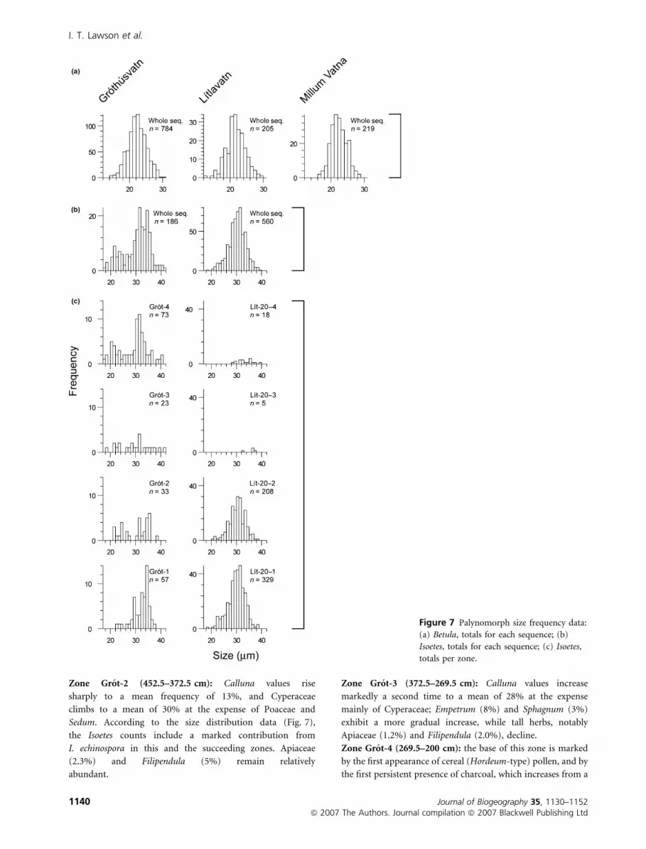
Zone Grot-2 (452.5–372.5 cm): Calluna values rise
sharply to a mean frequency of 13%, and Cyperaceae
climbs to a mean of 30% at the expense of Poaceae and
Sedum. According to the size distribution data (Fig. 7),
the Isoetes counts include a marked contribution from
I. echinospora in this and the succeeding zones. Apiaceae
(2.3%) and Filipendula (5%) remain relatively
abundant.
Zone Grot-3 (372.5–269.5 cm): Calluna values increase
markedly a second time to a mean of 28% at the expense
mainly of Cyperaceae; Empetrum (8%) and Sphagnum (3%)
exhibit a more gradual increase, while tall herbs, notably
Apiaceae (1.2%) and Filipendula (2.0%), decline.
Zone Grot-4 (269.5–200 cm): the base of this zone is marked
by the first appearance of cereal (Hordeum-type) pollen, and by
the first persistent presence of charcoal, which increases from a
Figure 7 Palynomorph size frequency data:
(a) Betula, totals for each sequence; (b)
Isoetes, totals for each sequence; (c) Isoetes,
totals per zone.
I. T. Lawson et al.
1140 Journal of Biogeography 35, 1130–1152ª 2007 The Authors. Journal compilation ª 2007 Blackwell Publishing Ltd

mean of 0.1% across the three previous zones to a mean of
1.5% in this zone. Plantago lanceolata and other Plantago
species also increase at or close to the base of the zone (in total
from 1.0% to 3.2%). Other taxa show little change apart from
a decline in Juniperus communis (from 4% to 1.6%) and an
increase in Poaceae in the uppermost five samples.
DCA results
The biplot of the first two axes (Fig. 8a) indicates that the bulk
of the variation in the data set is associated with the transition
from assemblages dominated by Sedum, Huperzia or the
various forbs (large positive values on axis 1) to those
dominated by Calluna, Sphagnum and Potentilla (large nega-
tive values on axis 1). The stratigraphic plot of the axis 1 scores
for each sample (Fig. 4) shows clearly the steady decline in
values from Grot-1 to Grot-3 associated with this transition.
The second axis has at one extreme Plantago and the Cardueae
tribe of the Asteraceae, and at the other Juniperus. The
stratigraphic plot shows that sample scores are relatively
uniform through zones Grot-1 to Grot-3, with a steady rise
throughout Grot-4. The assemblage zones are generally well
separated in the biplot, with the exception of some overlap
between the uppermost two zones.
Figure 8 DCA biplots for the three pollen data sets. Species scores are indicated with crosses. For clarity, individual sample scores are not
shown; the numbered polygons indicate the boundaries of the regions within which the sample scores plot, for each pollen zone.
Pollen data from Sandoy, Faroe Islands
Journal of Biogeography 35, 1130–1152 1141ª 2007 The Authors. Journal compilation ª 2007 Blackwell Publishing Ltd
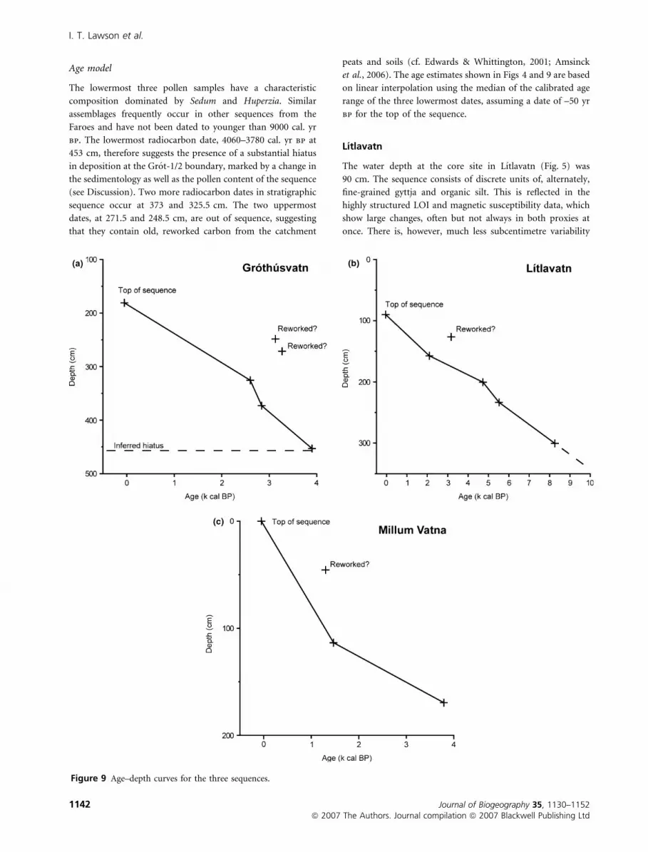
Age model
The lowermost three pollen samples have a characteristic
composition dominated by Sedum and Huperzia. Similar
assemblages frequently occur in other sequences from the
Faroes and have not been dated to younger than 9000 cal. yr
bp. The lowermost radiocarbon date, 4060–3780 cal. yr bp at
453 cm, therefore suggests the presence of a substantial hiatus
in deposition at the Grot-1/2 boundary, marked by a change in
the sedimentology as well as the pollen content of the sequence
(see Discussion). Two more radiocarbon dates in stratigraphic
sequence occur at 373 and 325.5 cm. The two uppermost
dates, at 271.5 and 248.5 cm, are out of sequence, suggesting
that they contain old, reworked carbon from the catchment
peats and soils (cf. Edwards & Whittington, 2001; Amsinck
et al., 2006). The age estimates shown in Figs 4 and 9 are based
on linear interpolation using the median of the calibrated age
range of the three lowermost dates, assuming a date of –50 yr
bp for the top of the sequence.
Lıtlavatn
The water depth at the core site in Lıtlavatn (Fig. 5) was
90 cm. The sequence consists of discrete units of, alternately,
fine-grained gyttja and organic silt. This is reflected in the
highly structured LOI and magnetic susceptibility data, which
show large changes, often but not always in both proxies at
once. There is, however, much less subcentimetre variability
Figure 9 Age–depth curves for the three sequences.
I. T. Lawson et al.
1142 Journal of Biogeography 35, 1130–1152ª 2007 The Authors. Journal compilation ª 2007 Blackwell Publishing Ltd

visible in the X-ray photographs compared with Grothusvatn.
Pollen preservation at Lıtlavatn varies markedly depending on
the nature of the sediment. The diagram was divided into four
local pollen assemblage zones.
Zone Lıt-20-1 (321–204.5 cm): Poaceae (mean 42%) and
Cyperaceae (16%) dominate, with moderately high values for
Juniperus (4.2%), Empetrum (7.0%), Angelica sylvestris (2.8%),
Sedum (4.0%) and Filipendula (8.1%). Towards the top of the
zone, Isoetes shows a large spike (note the compressed scale for
Isoetes, which is outside the TLP sum, in Fig. 5).
Zone Lıt-20-2 (204.5–160.5 cm): pollen preservation is poor,
magnetic susceptibility values are relatively high and Poaceae
(79%) dominates the spectra along with lesser amounts of
Cyperaceae (5.6%) and Filipendula (3.6%). Isoetes has
decreased representation. Other taxa including Juniperus
(0.3%), Empetrum (0.5%) and Angelica (0.6%) decline
dramatically at the Lıt-20-1/2 boundary and remain scarce
throughout the remainder of the zone.
Zone Lıt-20-3 (160.5–128.5 cm): pollen preservation improves
and Poaceae (26%) ceases to be as dominant, but this zone
differs from Lıt-20-2 in having higher proportions of Calluna
(8.1%), Potentilla (6.0%) and Sphagnum (2.9%), while Angel-
ica (0.8%), Sedum (1.6%) and Filipendula (1.3%) are all
reduced.
Zone Lıt-20-4 (128.5–100 cm): pollen preservation is poor and
magnetic susceptibility values increase substantially, especially
towards the top of the zone where Poaceae (44%) becomes
dominant once more, with corresponding declines in Juniperus
(4.0%), Calluna (8.1%) and Cyperaceae (16%); Potentilla
(7.0%) shows a clear increase to the top of the sequence.
DCA results
As was the case with Grothusvatn, the first axis of the DCA
(Fig. 8b) separates forbs such as Filipendula and the Apiaceae
from wet heath taxa including Calluna, Sphagnum and
Potentilla. The distinctive Huperzia–Sedum association seen
in zone Grot-1 is not represented in the Lıtlavatn sequence and
so these taxa are not so clearly separated in the biplot.
However, whereas Poaceae plotted close to the centre of the
Grothusvatn biplot, in the case of Lıtlavatn they plot well to
the left, reflecting the considerable variation in Poaceae
percentages in this sequence. Zones Lit-3 and Lit-4, with high
Calluna values, are clearly differentiated from the preceding
zones in the stratigraphic plot of sample scores (Fig. 5). The
second DCA axis effectively differentiates zone Lit-1 from the
later zones, placing forbs such as Filipendula in opposition to
wet heath taxa, especially Potentilla (the very high positive
values for Polypodium and Ranunculus flammula are likely to
be a statistical artefact as these taxa are rare).
Age model
The Lıtlavatn sequence is supported by five radiocarbon dates,
the uppermost of which is out of chronostratigraphic
sequence, presumably reflecting the inclusion of reworked
carbon from the catchment as in Grothusvatn. In view of this,
the remaining dates should be treated as maximum age
estimates. The age model shown in Figs 5 and 9 is constructed
as for Grothusvatn.
Millum Vatna
The Millum Vatna sequence (Fig. 6) consists of peat with LOI
values always above 80%. Magnetic susceptibility values, albeit
uncalibrated but measured in the same way as the other two
sequences, are extremely low throughout the sequence, and the
resulting curve covaries inversely almost exactly with the LOI
data. In general the sequence has relatively good pollen
preservation and shows a marked lack of taxonomic diversity,
with Calluna, Empetrum, Poaceae, Cyperaceae, Potentilla
and, occasionally, Sphagnum dominating the spectra. The
Millum Vatna pollen diagram is divided into two local
assemblage zones, the boundary reflecting a gradual change
in several taxa.
Zone Mill-1 (169–54.5 cm): this zone begins with high
Sphagnum values in the lowest two samples (43% at the base
and 65% just above), accompanied by relatively high Poaceae
and Cyperaceae and low Calluna, but Sphagnum percentages
rapidly decline almost to zero. The relative proportions of the
dominant taxa vary throughout the rest of the zone; Calluna,
which shows the greatest variation in terms of absolute
percentages, ranges from 27% to 58%, but there is little clear
stratigraphic trend in the data.
Zone Mill-2 (54.5–16 cm): this zone is distinguished from
zone Mill-1 by a decline in Angelica (from 0.5% to 0.2%) and
Filipendula (2.6% to 1.5%), and by an increase in Plantago
(from 0.1% to 1.8%; charcoal also expands). These changes are
very small numerically. Towards the top of the zone Potentilla
and Sphagnum increase considerably, and the other dominant
taxa remain irregularly variable, as in zone Mill-1.
DCA results
In this case the pollen assemblage zones are not clearly
separated in the biplot (Fig. 8c) for the reasons discussed
above. The stratigraphic plot of sample scores for the first axis
(Fig. 6) follows very closely the Potentilla and Sphagnum
curves, with Juniperus and Rumex/Oxyria in opposition to this,
mainly representing the difference between the lowermost two
samples and the rest of the data set. On the second axis Calluna
and Empetrum plot opposite Plantago, reflecting the gradual
decline in the Ericaceae and expansion of Plantago through the
sequence.
Age model
Two radiocarbon dates are available for Millum Vatna
(Table 1). The calibrated age ranges at the 95% confidence
level almost overlap. The tephra layer at 169–170 cm has been
identified as Hekla-Selsund (see Table S4 in Supplementary
Material), radiocarbon dated in Iceland to 3515 ± 55 14C yr bp
Pollen data from Sandoy, Faroe Islands
Journal of Biogeography 35, 1130–1152 1143ª 2007 The Authors. Journal compilation ª 2007 Blackwell Publishing Ltd

(Larsen et al., 2001), calibrating at 95% confidence levels to
3960–3640 cal. yr bp. Linear interpolation between the tephra
layer, the midpoints of the calibrated ranges of the two
radiocarbon dates, and the top of the sequence (assumed
equivalent to –50 yr bp) yields an age model implying very
slow accumulation between c. 3800 and 1480 yr bp, increasing
by a factor of ten between 1480 and 1270 yr bp, then returning
to close to the original rate between 1270 yr bp and the
present. A more straightforward scenario is to assume that the
uppermost date is affected by reworked organic material, as in
Grothusvatn and Lıtlavatn. The resulting age model, shown in
Figs 6 and 9, should be interpreted with caution.
INTERPRETATIONS
Grothusvatn
In zone Grot-1 the high values for Poaceae, Sedum and
Huperzia are broadly similar to assemblages found by Johansen
(1975, 1982) in early Holocene sediments from Hoydalar
(zones H1 and H2), Saksunarvatn (zones S1 and S2) and Hovi-
A (his zones Hovi-A-1 and Hovi-A-2), dating to before
c. 10 000 yr bp. Johansen interpreted these assemblages as
indicative of pioneer ‘fell-field’ vegetation communities grow-
ing on raw, skeletal soils. Field observation of relict soils
underlying mid to late Holocene peats within the catchment of
the lake confirms the minerogenic nature of these early
Holocene soils (Lawson et al., 2005). A low presence of
Calluna in the lake catchment is suggested by the pollen data,
and Calluna was perhaps growing in patches of mire alongside
Empetrum, Potentilla and Sphagnum, all of which are also
represented in the pollen assemblages. Relatively high levels of
silt in the sediment, relatively low pollen concentrations and
pollen degradation all suggest that soils were unstable and
prone to erosion, bringing reworked pollen into the lake. The
inferred hiatus at the Grot-1/2 boundary perhaps reflects
infilling of an original basin, followed by a cessation of
deposition until the outflow level was raised by emplacement
of the storm beach around 4000 yr bp. Further work would be
required to test this suggestion.
By the time deposition had recommenced, the environment
had changed markedly. The pollen spectra from Grot-2 show
that Calluna had become an important constituent of the
vegetation, accompanied by other taxa typical of wet heath,
including Empetrum, Potentilla and Sphagnum. At this stage,
Poaceae- and Cyperaceae-dominated communities seem to
have been prevalent, and tall herbs were relatively abundant,
suggesting that soils remained relatively nutrient-rich.
The transition from Grot-2 to Grot-3 is marked by a rapid
doubling in Calluna frequencies at the expense of almost all
other taxa. Filipendula declines the most, with only Potentilla
and Sphagnum showing slight increases. A macrofossil study of
a core from the margins of Grothusvatn by Hannon et al.
(2001) is relevant to the interpretation of the pollen data at
these levels. A tephra layer attributed to the Hekla-4 eruption
(3826 ± 12 14C yr bp, calibrating to 4150–4280 cal. yr bp;
Dugmore et al., 1995) was found at 180 cm depth in their
sequence (Hannon et al., 2001), above which plant macrofossil
finds were rare. The data from the sequence below the tephra
showed one major change, from macrofossil assemblages
dominated by Viola riviniana, Filipendula ulmaria, Caltha
palustris and Carex spp. between the lowermost part of the
sequence at c. 440 cm and c. 390 cm, and assemblages
containing Juniperus communis, Salix phylicifolia, Erica cinerea,
Calluna vulgaris, Empetrum nigrum and occasional remains of
Betula pubescens above. This was interpreted by Hannon et al.
(2001) as indicating the encroachment of shrub woodland and
heathland communities on herb-rich fen communities at their
core site. The Grothusvatn pollen record presented here
suggests that a similar change may have taken place on a larger
scale across much of the catchment. The macrofossil and
pollen records complement each other in terms of taxonomic
precision and completeness of the fossil flora. Salix, which the
macrofossil record from Grothusvatn and elsewhere tells us
included S. phylicifolia, a taxon now all but absent from the
Faroes (Hansen, 1966; cf. Johansen, 1982: 128), and E. cinerea
Table 1 Radiocarbon dates from the three sequences. Calibration results are rounded to the nearest decade.
Site Level (cm) Lab. code d13C (&)
Age
(14C yr bp)
Calibrated age
range (2r, yr bp)
Median probability
(yr bp)
Grothusvatn 249–248 SUERC-1829 )27.2 2955 ± 40 3260–2980 3130
Grothusvatn 272–271 SUERC-1830 )27.3 3050 ± 40 3370–3080 3270
Grothusvatn 326–325 SUERC-11079 )27.7 2525 ± 35 2740–2490 2600
Grothusvatn 373.5–372.5 SUERC-11080 )27.6 2750 ± 35 2930–2770 2840
Grothusvatn 453.5–452.5 SUERC-11514 )27.2 3595 ± 35 4060–3780 3900
Lıt-20 127–126 SUERC-1821 )27.5 2980 ± 35 3320–3010 3170
Lıt-20 158–157 SUERC-1826 )26.8 2125 ± 40 2300–1990 2100
Lıt-20 201–200 SUERC-1827 )25.0 4200 ± 35 4850–4620 4730
Lıt-20 234–233 SUERC-9013 )25.0 4755 ± 35 5590–5330 5520
Lıt-20 301–300 SUERC-1828 )22.1 7430 ± 45 8360–8180 8260
Millum Vatna 46–45 SUERC-1831 )28.2 1375 ± 35 1350–1190 1300
Millum Vatna 114–113 SUERC-1832 )27.8 1595 ± 35 1550–1400 1470
I. T. Lawson et al.
1144 Journal of Biogeography 35, 1130–1152ª 2007 The Authors. Journal compilation ª 2007 Blackwell Publishing Ltd

in particular are both apparently under-represented in the
pollen record, although E. tetralix and Arctostaphylos uva-ursi
also appear in the pollen data. The macrofossil record also
confirms the local presence on Sandoy of tree birch.
The main aim in constructing the pollen data set from
Grothusvatn was to identify vegetational changes brought
about by human impact, and accordingly the depth/time
resolution of the pollen data is highest towards the top of the
sequence. Many taxa occur only sporadically, making it
difficult to determine exactly the level at which the first
changes attributable to human activity become apparent. The
best estimate of this horizon defines the Grot-3/4 boundary,
and marks the point where the charcoal curve becomes
consistent, if not continuous to the very top of the sequence.
The scores for the second DCA axis, which has at opposite
extremes Plantago and Juniperus and which can be interpreted
as encapsulating the distinction between pristine and anthro-
pogenic environments, begin to increase just below this zone
boundary. The increase in Plantago spp., including P. lanceo-
lata, could indicate disturbance consistent with trampling and
grazing. The decline in Juniperus may be due to collection for
domestic use (Small, 1992; Stummann Hansen, 2003; Church
et al., 2005), while Salix, Angelica and Filipendula may have
succumbed to grazing. Other changes that occur around this
boundary and which may be attributed to human impact
include the first appearance of cereal-type pollen, attributed to
Hordeum-type, and an increase in aquatic productivity, as
measured by Pediastrum and chironomid abundance, and
chironomid-based total phosphorus reconstructions (Lawson
et al., 2005; Gathorne-Hardy et al., in press).
The most significant indication of vegetation change in the
post-settlement period occurs in the uppermost five samples:
Poaceae and Cyperaceae expand, chiefly at the expense of
Calluna. Without better age control the timing of this change
cannot accurately be estimated, but it could relate to the
expansion of hayfields since the 19th century (Arge et al.,
2005).
Lıtlavatn
The preservation of pollen in the Lıtlavatn sequence is
generally slightly poorer than in Grothusvatn, and damaged
pollen was probably largely introduced to the lake via the
fluvial system (cf. Bonny, 1976; Wilmshurst & McGlone,
2005). The more complex taphonomy of this lake compared
with Grothusvatn means that the Lıtlavatn DCA is less readily
interpretable in terms of ecological changes, although the
dominant trend is from forbs to wet heath taxa in both cases.
The pollen spectra in zone Lıt-20-1 suggest the presence of
vegetation communities dominated by Poaceae, accompanied
by Juniperus, Empetrum, Cyperaceae, Sedum, tall herbs includ-
ing members of the Apiaceae and Filipendula, and ferns. Betula
pubescens percentages are perhaps sufficient to indicate its local
presence; stronger evidence suggests it was present near the
lake at some point during the Holocene (Lawson et al., 2005).
This pollen zone resembles zones from three other sites in the
Faroes: Hoydalar (zone H4, dating very approximately to
9000–6000 14C yr bp; Johansen, 1975) and Saksunarvatn and
Hovi-A (zones S3 and S4, again dated to approximately
9000–6000 14C yr bp, and zone Hovi-A-3; Johansen, 1982).
The strong similarity suggests that these zones may be
approximately synchronous (Johansen, 1996), although
Hoydalar has rather less Filipendula, Saksunarvatn has less
Filipendula and Empetrum, and Hovi-A has rather more Salix,
suggesting some variation in the nature of the vegetation
across the Faroes. Johansen considered that this period was
dominated by ‘grassy heaths’ (Johansen, 1982, pp. 121–128),
but with the most extensive shrub development seen at any
point in the Holocene, and abundant tall herb communities,
and the data presented here do not challenge this interpreta-
tion. The spike in Isoetes at the top of zone Lıt-20-1 has
correlates in the Hoydalar and Hovi-A sequences, attributed
by Johansen (1975, p. 385) to the gradual acidification of
the lake, in turn reflecting the acidification of catchment soils,
which could likewise be the explanation here.
Zone Lıt-20-2 sees a sharp drop in the diversity of taxa
recorded, with only Poaceae, Cyperaceae and Filipendula
making significant contributions to the pollen sum. The
proportion of TLP grains showing signs of degradation also
increases substantially, peaking at over 90%. The preservation
state of pollen in this zone appears very similar to that of
samples from mineral soils underlying peats around Lıtlavatn
(Lawson et al., 2005, 2007), which also tend to have a high
proportion of Poaceae pollen. Furthermore, during this zone,
magnetic susceptibility values increase. All of these observa-
tions together indicate that the pollen and other sediments in
this zone are largely reworked from soils in the Lıtlavatn
catchment, suggesting that the catchment experienced a period
of geomorphological instability. Taking the radiocarbon dates
at face value, this period lasted from approximately 2750 to
200 bc. Although we cannot place total confidence in these
dates, which may contain reworked carbon, data from marine
sequences from Skalafjord, Eysturoy (Roncaglia, 2004; Witak
et al., 2005) and from lake sequences from Starvatn on
Eysturoy and Lykkjuvøtn on Sandoy (Andresen et al., 2006)
suggest that a climatic cooling affected the Faroes after
c. 5000 cal. yr bp, which broadly accords with our data;
Roncaglia (2004) also reported an apparent warming from ad
260–1090, followed by renewed cooling. Suppression of the
vegetation cover and enhanced freeze–thaw activity are two
possible mechanisms which could link a cooler climate with
higher rates of erosion.
Zone Lıt-20-3 sees diversity restored to the pollen record
and pollen preservation improves, but the pollen spectra here
show that Calluna was now abundant in the landscape, along
with Potentilla and Sphagnum, supporting the interpretation of
Lıt-20-2 as a prolonged period of erosion. Together, these taxa
indicate that wet mire communities were now abundant in the
catchment. Juniperus and Empetrum, both strongly represented
in this zone, may have grown in the same wet mire
communities. The tall herb vegetation represented by Apiaceae
and Filipendula had all but disappeared by this time. Despite
Pollen data from Sandoy, Faroe Islands
Journal of Biogeography 35, 1130–1152 1145ª 2007 The Authors. Journal compilation ª 2007 Blackwell Publishing Ltd

the inferred acidophilic vegetation and acidified soils, Isoetes
was no longer abundant in the lake, perhaps due to a change to
a more organic substrate (Birks, 1973, p. 332).
In the final zone, Lıt-20-4, the pollen preservation data
suggest renewed reworking. The increase in Poaceae pollen
towards the top of this zone may thus represent a taphonomic
change rather than an ecological one; if the latter, it could
reflect an increase in grazing pressure. High magnetic suscep-
tibility values imply another period of unstable soils, which
again could be a response to grazing and trampling by
introduced animals, and/or peat cutting, and/or a natural
cause such as climatic change. A growing but still limited body
of evidence (e.g. Roncaglia, 2004; Witon et al., 2006) points to
changes in climate affecting the Faroes during the second
millennium ad, probably associated with the ‘Little Ice Age’
sensu lato (Grove, 1988; Meeker & Mayewski, 2002). The
evidence from Lıtlavatn and elsewhere of prehistoric episodes
of climatic change and soil erosion demonstrates that it is
impossible to discount climatic change as a causal factor in
historical soil erosion, and identification of the relative
importance of anthropogenic and natural factors is likely to
prove very difficult.
Millum Vatna
The Millum Vatna sequence appears to span the period when
human impact became significant in the landscape. The
charcoal record is perhaps the most incontrovertible indication
of human presence in the diagram, given that natural burning
is likely to have been exceedingly rare in such a wet
environment. The co-occurrence of increasing Plantago, espe-
cially P. lanceolata, and declines in Juniperus, Angelica sylvestris
and Filipendula, marking the boundary between zones Mill-1
and Mill-2, has the hallmark of human impact as inferred from
other records in the Faroes where age models are more robust
(e.g. Hov, Edwards et al., 2005a; Tjørnuvık, Hannon et al.,
1998, 2001). If the uppermost of the two radiocarbon dates at
Millum Vatna is accurate, then the first effects of human
impact occurred prior to the conventional date for Norse
settlement (c. ad 800). The age model preferred here, which
rejects this date, would suggest that significant human impact
did not begin until c. ad 1300.
Assuming that the lower part of zone Mill-1 (below
c. 115 cm) pre-dates the settlement period, the pollen record
appears to indicate that the vegetation at and around the site
was naturally dynamic, with substantial shifts in the abundance
of taxa, particularly Sphagnum, Calluna, Empetrum, Poaceae
and Cyperaceae. The effective pollen source area for mire taxa
in peat sequences is considered to be very small (Bunting,
2003), of the order of a few metres at most, so the most
straightforward explanation of this variability is that it
represents small-scale changes in the vegetation mosaic, rather
than large-scale changes in the dominance of taxa across the
whole landscape. Other pollen data from Sandoy support the
idea that the pre-settlement mire vegetation was spatially
patchy (Lawson et al., 2005, 2007). The diversity of the natural
vegetation at Millum Vatna appears to have been very poor
compared with the richer pollen flora from Grothusvatn. The
explanation may be that Grothusvatn recruits pollen from a
much larger area, which will include a greater diversity of
habitats. At least three taxa which are no longer present around
Millum Vatna were present in the past, namely Juniperus
communis, Angelica sylvestris and Filipendula ulmaria; values
for Caltha palustris are very low in zone Mill-1 but its total
absence from Mill-2 suggests that it may also have disappeared
from the locality following settlement.
The evidence in the record for human impact is very limited,
in part due to the low diversity of the pollen assemblages.
Significance testing found highly significant declines from
Mill-1 to Mill-2 in the grazing-sensitive taxa Juniperus and
Filipendula, together with (surprisingly) Rumex acetosa, while
the Tubuliflorae, P. lanceolata, P. maritima and charcoal, all
possible indicators of disturbance, showed highly significant
increases. Liguliflorae and Sedum showed marginally signifi-
cant increases at the 5% level (H0: no increase in probability of
occurrence in samples from Mill-2, compared to Mill-1; one-
tailed test; P estimated as 0.0307 and 0.0402, respectively). The
small amounts of charcoal found in zone Mill-2 are probably
not sufficient to indicate burning of the mire vegetation, at
least at the site itself. Instead, the charcoal could reflect fallout
from domestic fires, emanating from farmsteads or shielings.
The expansions of Potentilla and Sphagnum in Mill-2 may be
entirely unrelated to human impact, given their variability
lower in the sequence, although a short-lived expansion of
Potentilla did accompany settlement at Hovi-B/Hov (Johansen,
1982; Edwards et al., 2005a).
The extent to which the Millum Vatna sequence can
ultimately tell us anything about changes in landscape stability
is uncertain. There is little mineral material in any part of the
sequence. Finds of small numbers of tephra grains throughout
the sequence suggest that at least some of the mineral input is
from primary aeolian fallout from Icelandic volcanic erup-
tions, but the remainder presumably results from local aeolian
and/or colluvial reworking. Concordant variations in the LOI
and magnetic data do suggest that there were periods of
increased mineral input, perhaps indicating landscape insta-
bility. The earliest such event that is clearly expressed in the
record occurs around 115–100 cm, below the first definite
palynological indications of human settlement, although the
dating control is not strong enough to rule out the possibility
that this represents a response to anthropogenic activity. If the
age model is correct, then a considerable change in peat
accumulation rate occurred at about this point in the record,
the cause of which is unclear.
DISCUSSION
Pre-settlement ecosystem dynamics
There was clearly significant similarity in vegetation develop-
ment across the Faroes during the pre-settlement Holocene. All
three records presented here indicate that, on the eve of
I. T. Lawson et al.
1146 Journal of Biogeography 35, 1130–1152ª 2007 The Authors. Journal compilation ª 2007 Blackwell Publishing Ltd
settlement, the vegetation was dominated by a mixture of
grasses, sedges and ericaceous taxa; differences between the
sites are small and could be interpreted in terms of
taphonomic differences. Comparing these results with pub-
lished data from elsewhere in the Faroes, there is some
variation: for example, Calluna percentages are only about half
as great at Saksunarvatn (Johansen, 1982) as at Grothusvatn
around 3000 cal. yr bp, while ferns are more abundant; at
Hovı-A (ibid.) Calluna is even less abundant. Pollen analysis
lacks taxonomic precision for some families, and many parts of
the Faroese landscape, for instance the mid to high altitudes,
remain almost unstudied, so we are almost certainly not
detecting the full diversity of vegetation in the pre-settlement
period.
Vegetation development is just one aspect of the develop-
ment of the landscape as a whole, and there is evidence here for
at least two other major changes during the Holocene, the first
being to the soil system. The lowermost pollen analyses from
Grothusvatn accord with previous pollen evidence from
elsewhere in the Faroes in suggesting that early Holocene
vegetation was dominated by fell-field communities repre-
sented by Sedum and Huperzia in the pollen record, inter-
preted by Johansen (1985) as indicating raw, base-rich soils.
The expansion of grasses and herbs such as Filipendula
subsequent to this early Holocene phase in the pollen records
(represented here by zone Lıt-20-1) suggests that soils
remained base-rich for several millennia. Gradually, indicators
of more acidic and perhaps waterlogged soils, including
Cyperaceae, Calluna and E. nigrum, become more important
in the pollen records. Dating of blanket peat in the valley
around Lıtlavatn and Millum Vatna suggests that peatlands
slowly expanded from about 6000 yr bp onwards (Lawson
et al., 2007), and it is likely that soils on the slopes also became
gradually more leached, organic and acidic over time.
Secondly, and associated with the changing nutrient status
of the soil, is the geomorphological stability of the landscape.
The Lıtlavatn lake sequence appears to indicate, on the
grounds of sedimentology and pollen preservation, that
significant erosion began in its catchment abruptly at some
time after c. 5000 yr bp (the beginning of zone Lıt-20-2). A
later period of apparent re-stabilization occurs during zone
Lıt-20-3 before renewed erosion in Lıt-20-4. This pattern of
sudden changes in erosion rates in the second half of the
Holocene accords with geomorphological evidence for episodic
destabilization of the landscape, possibly driven by climatic
change (Edwards et al., 2005b; Hannon et al., 2005; Lawson
et al., 2005). The lack of evidence for a similar event at
Grothusvatn suggests that destabilization may have been
limited to the uplands.
Effects of settlement in cultivated areas
Data on ecological changes in the cultivated areas which went
on to become the present-day ‘infields’ (the enclosed land close
to farms used for growing crops including hay, as opposed to
the ‘outfields’ used for rough grazing; Baldwin, 1983; Mahler,
1993) on Sandoy is limited. Only Grothusvatn today includes
cultivated fields in its catchment, although these do not
necessarily date back to the settlement period. The five finds of
cereal-type pollen in Grothusvatn, four of which could be
attributed to Hordeum-type, indicate that local cereal produc-
tion probably took place in the past. The finds of cereal grain
and chaff of six-row hulled barley (Hordeum vulgare var.
vulgare L.) from the Norse-period deposits at Undir Junk-
arinsfløtti are likely to derive from locally grown rather than
imported crops; radiocarbon dates of some of these grains date
them directly to the late 10th to early 13th centuries (Church
et al., 2005). A few oat grains (Avena sp.) were recovered from
Undir Junkarinsfløtti that have no counterpart in the pollen
record from Grothusvatn, though Johansen (1979, 1985)
found pollen ascribed to Avena in deposits from the island
of Mykines. However, oat only accounted for less than 1% of
the identifiable cereal grains from Undir Junkarinsfløtti and
was interpreted as a weed contaminant of the barley crop
(Church et al., 2005). The increase in Poaceae pollen at the top
of zone Grot-4 suggests that hayfields were not as extensive in
the settlement period as they are today (Arge et al., 2005).
Less equivocal pollen data from other sites in the Faroes,
such as Hov/Hovı-B on Suðuroy (Johansen, 1982; Edwards
et al., 2005a) and Tjørnuvık on Streymoy (Johansen, 1971,
1985; Hannon et al., 1998, 2001; Hannon & Bradshaw, 2000),
come from those sites where peat deposits occur close to
ancient farms. Typical responses to settlement include the
appearance of cereal-type pollen, an expansion of ruderals such
as P. lanceolata, and a decline in such as F. ulmaria and
J. communis that are prone to grazing or gathering. Detailed
comparisons, however, show that there is considerable varia-
tion in this response. For example, in Johansen’s (1982) Hovı-
B sequence, settlement appears to encourage a large expansion
of Potentilla, a pattern replicated in the Hov sequence of
Edwards et al. (2005a). Potentilla shows barely any change in
the three available diagrams from Tjørnuvık, nor at Grothus-
vatn. On the other hand, one of the three Tjørnuvık diagrams
shows a large spike in Sedum just above the landnam horizon,
which, if not reflecting a hiatus in sediment accumulation, is a
feature that has no equivalent in any other diagram at
Tjørnuvık or elsewhere. Clearly, there are some variations in
the nature of changes in heavily impacted parts of the Faroese
landscape, and these variations appear to operate both on an
inter-island scale (the differences between Hovi, Tjørnuvık and
Grothusvatn), and on a scale of a few metres (the differences
between the three Tjørnuvık sequences).
Effects of settlement in uncultivated areas
Palaeoecological sites in areas that appear only to have been
used for rough grazing (present-day ‘outfields’), such as
Lıtlavatn and Millum Vatna, are rare in the Faroes. The best-
developed, and the only one spanning the settlement period, is
Hovsdalur on Suðuroy (Edwards et al., 2005a; b; Borthwick
et al., 2006; Borthwick, 2007). This sequence shows even more
muted evidence for human impact than at Millum Vatna, the
Pollen data from Sandoy, Faroe Islands
Journal of Biogeography 35, 1130–1152 1147ª 2007 The Authors. Journal compilation ª 2007 Blackwell Publishing Ltd

most significant palynological changes occurring above a date
of c. ad 1460 and related mainly to an expansion of Cyperaceae
at the expense of all other taxa, which could be attributable
purely to natural ecological changes. Edwards et al. (2005a)
identified one other period of change, dated to c. ad 610
and characterized by the beginning of a gradual expansion
of Cyperaceae and declines in Ranunculus flammula and
Sphagnum, all of which are in the opposite sense to the changes
in these taxa at Millum Vatna (although a decline in Caltha at
Hovsdalur may be matched by a barely detectable decrease at
Millum Vatna). Charcoal was found in very small quantities
throughout the sequence, and there is a tendency for more
frequent occurrences of Plantago lanceolata towards the middle
and top of the sequence, though again it is present even in the
lowermost (pre-settlement?) zone (cf. Johansen, 1987). Millum
Vatna and Hovsdalur together give the strong impression that
human impacts in lowland outfield situations were extremely
limited in degree, and so subtle as to be barely detectable
through palynology, with natural vegetation dynamics prob-
ably accounting for most of the observed variation in the
pollen stratigraphies.
The record of upland erosion from Lıtlavatn suggests that,
although erosion has certainly been active in recent times, the
pre-settlement landscape was also unstable, with episodic
erosion. Thus, although the presence of humans may have
encouraged erosion, this took the form of an amplification of
an ongoing process, rather than the imposition of an entirely
new geomorphological regime as has been observed in many
other areas, such as parts of Iceland (Dugmore et al., 2000;
Simpson et al., 2001) and the British Isles (Edwards &
Whittington, 2001).
A number of uncertainties remain. The long-term (millen-
nial-scale) trajectories of change across the settlement horizon
are reasonably well represented on Sandoy, but dating
uncertainties, and the difficulty of precisely identifying the
settlement horizon, mean that it is difficult to assess shorter-
term (centennial-scale) trajectories. For example, did the
decline in Juniperus towards the top of zone Grot-3 pre-date
settlement, as Johansen (1982) thought was the case at Hovı-B,
or was it a consequence of settlement? A comparable decline in
Betula pubescens in the centuries before landnam in Iceland has
been attributed to climatic change (Einarsson, 1963). Similarly,
it is clear from the archaeological and historical records
(Church et al., 2005; Lawson et al., 2005) that considerable
changes took place in the centuries following landnam on
Sandoy, as elsewhere in the Faroes (Arge et al., 2005),
including changes to the administration of the grazing land,
expansion of the hayfields and the decline of certain elements
of the economy such as pig-keeping. The chronological
uncertainties in our records make it impossible to investigate
the ecological impact of these changes with as much certainty
as we would wish. In addition, the possibility of changes to the
vegetation that do not necessarily result in palynological
changes, such as the height and age structure of Calluna-
dominated communities, or the species composition of the
Poaceae and Cyperaceae, may in part be amenable to future
plant macrofossil studies. Further research in upland areas
would also fill a substantial blank on the map.
CONCLUSIONS AND WIDER SIGNIFICANCE
On the eve of Norse settlement, the landscape of the study area
of Sandoy was remarkably similar to that of the present day.
There was a range of blanket mire, tall herb, shrub and
grassland communities in different parts of the landscape. At a
landscape scale, these communities were remarkably stable
over long periods of time, but the data from Millum Vatna
show that blanket mire communities at least displayed small-
scale dynamism. Erosion was active, albeit apparently episodic
and restricted to certain parts of the landscape.
Following settlement, the palaeoenvironmental records
detect an expansion of ruderals such as Plantago lanceolata,
the introduction of cereal cultivation, a late (possibly early
modern) increase in Poaceae at Grothusvatn which could
represent either hayfield expansion or changes to the compo-
sition of the rough grazing land, the suppression of some
species such as Juniperus communis, Salix spp., tall herbs such
as Filipendula ulmaria and possibly (at Lıtlavatn at least) an
increase in the rate of erosion. Conclusions about the detailed
timing of changes cannot be drawn due to the uncertainty in
the age models.
The data presented here make a significant addition to the
body of palaeoecological knowledge relating to the effects of
settlement on the Faroes, partly because there are few such data
sets, but also because they shift the emphasis of investigation
away from sequences located with the maximum probability of
detecting human impact (peat sequences in infield areas)
towards a more balanced assessment of the whole landscape
using a group of sites which includes lakes with large
hydrological/sedimentological/palynological catchments as
well as a peat sequence in an outfield area. Unsurprisingly
perhaps, the evidence for substantial change after settlement is
much less than in most previous studies (the exception being
the site of Hovsdalur discussed above). Some of the more
marked changes seen in the records from sites such as
Tjørnuvık and Hov/Hovı, including the sudden appearance
of ruderals such as P. lanceolata and Rumex acetosa, an
expansion of Poaceae, and the decline (or, sometimes,
expansion) of Caltha palustris and Potentilla across horizons
ascribed to the settlement period, should thus be seen as local
changes restricted at most to the relatively small infield areas.
In fact, the substantial variation between the records of many
taxa from almost adjacent peat sequences (the clearest example
being the three Tjørnuvık sequences) shows just how spatially
restricted some of these changes may have been. On the other
hand, the Lıtlavatn record suggests that upland areas (above
c. 300 m) may have been more sensitive to the effect of
humans or their introduced herbivores; this requires further
investigation.
In comparison with other late-colonized lands that were
initially wooded, such as Iceland and Greenland, the intro-
duction of farming to the Faroes had only a very subtle
I. T. Lawson et al.
1148 Journal of Biogeography 35, 1130–1152ª 2007 The Authors. Journal compilation ª 2007 Blackwell Publishing Ltd

ecological impact across much of the landscape. Similarly
subdued responses are more common in parts of the Western
and Northern Isles of Scotland (e.g. Edwards et al., 2000;
Ritchie et al., 2001), although in these cases some involvement
of human impact in deforestation and peatland expansion
cannot be ruled out. Deforestation is a typical hallmark of
agricultural colonization in many parts of the world, and it
causes substantial changes to the structure of the ecosystem: a
large reduction in biomass, loss of keystone species, a step-shift
in hydrological conditions and the loss of deep rooting
systems, to name just a few of its components. Where
deforestation cannot proceed because there are few trees to
begin with, and where the ecosystem becomes, at most ‘sub-
natural’ (sensu Simmons, 1993), ecosystem responses at the
landscape scale are likely to be much more subtle. Apart from
this, a number of other factors probably contributed to the
stability of Faroese terrestrial ecosystems in the face of
settlement, among them a low human population density
until the 19th century (Arge et al., 2005); thin, coarse-grained
soils that were much less prone to catastrophic erosion than
the thick, friable Icelandic andisols; and the mountainous
topography, which meant that only relatively small parts of the
landscape were suitable for intensive exploitation, making low-
intensity pastoralism the only significant economical use over
most of the landscape.
ACKNOWLEDGEMENTS
This work was funded by the Leverhulme Trust under the
programme ‘Landscapes circum-landnam’. We thank Maureen
Lamb, Iona Grant, Julie Mitchell and Kate Smith for technical
support, Jill Barber for logistical assistance, Doug Borthwick,
Kerry-Anne Mairs, Andy McMullen and Jim Woollett for help in
the field, Sımun Arge and Katy Roucoux for useful discussions
and comments on the text, and the people of Sandur and Sandoy
and their mayor, Pall a Reynatugvu, for permission to work at
the sites. The comments of Jeff Blackford and an anonymous
referee are gratefully acknowledged.
REFERENCES
Aaby, B. & Berglund, B.E. (1986) Characterization of lake and
peat deposits. Handbook of Holocene palaeoecology and pal-
aeohydrology (ed. by B.E. Berglund), pp. 231–246. John
Wiley & Sons, Chichester.
Amsinck, S.L., Strzelczak, A., Bjerring, R., Landkildehus, F.,
Lauridsen, T.L., Christoffersen, K. & Jeppesen, E. (2006)
Lake depth rather than fish planktivory determines cladoc-
eran community structure in Faroese lakes – evidence from
contemporary data and sediments. Freshwater Biology, 51,
2124–2142.
Andersen, S.T. (1979) Identification of wild grass and cereal
pollen. Danmarks Geologiske Undersøgelse Arbog, 1978, 69–
92.
Andresen, C.S., Bjorck, S., Rundgren, M., Conley, D.J. & Jes-
sen, C. (2006) Rapid Holocene climate changes in the North
Atlantic: evidence from lake sediments from the Faroe
Islands. Boreas, 35, 23–34.
Arge, S.V. (1991) The landnam in the Faroes. Arctic Anthro-
pology, 28, 101–120.
Arge, S.V. (1993) On the landnam of the Faroe Islands. The
Viking Age in Caithness, Orkney and the North Atlantic (ed.
by C.E. Batey, J. Jesch and C.D. Morris), pp. 465–472.
Edinburgh University Press, Edinburgh.
Arge, S.V. (2001) Forn busetning heima a Sandi. Frødi, 2/2001,
5–13.
Arge, S.V. (2006) Føroysku Vıkingarnir voru veiðimenn. Frødi,
2/2006, 4–11.
Arge, S.V., Sveinbjarnardottir, G., Edwards, K.J. & Buckland,
P.C. (2005) Viking and medieval settlement in the Faroes:
people, place and environment. Human Ecology, 33, 597–
620.
Baldwin, J.R. (1983) Structure in a community: the outfield, its
use and its organisation in the settlement of Gasadalur,
Faroe Islands. Northern Studies, 20, 5–37.
Behre, K.-E. (1981) The interpretation of anthropogenic
indicators in pollen diagrams. Pollen et Spores, 23, 225–245.
Bennett, K.D. (2002) psimpoll 4.10 (http://www.chrono.qub.
ac.uk/psimpoll/psimpoll.html).
Bennett, K.D. & Willis, K.J. (2002) Pollen. Tracking environ-
mental change using lake sediments, Volume 3: Terrestrial,
algal and siliceous indicators (ed. by J.P. Smol, H.J.B. Birks
and W.M. Last), pp. 5–23. Kluwer, Dordrecht.
Bennett, K.D., Whittington, G. & Edwards, K.J. (1994) Recent
plant nomenclatural changes and pollen morphology in the
British Isles. Quaternary Newsletter, 73, 1–6.
Birks, H.J.B. (1973) Past and present vegetation of the Isle of
Skye – a palaeoecological study. Cambridge University Press,
Cambridge.
Bonny, A.P. (1976) Recruitment of pollen to the seston and
sediment of some Lake District lakes. Journal of Ecology, 64,
859–887.
Borthwick, D.M. (2007) The timing and impact of the Norse
landnam on the vegetation of Hovsdalur, Faroe Islands.
Unpublished PhD thesis, University of Aberdeen.
Borthwick, D.M., Edwards, K.J. & Cook, G.T. (2006) Shieling
activity during the Norse Period in the Faroe Islands: a
palynological approach. Dynamics of northern societies (ed.
by J. Arneborg and B. Grønnow), pp. 299–306. National
Museum of Denmark, Copenhagen.
Bunting, M.J. (2003) Pollen–vegetation relationships in non-
arboreal moorland taxa. Review of Palaeobotany and Paly-
nology, 125, 285–298.
Church, M.J., Arge, S.V., Brewington, S., McGovern, T.H.,
Woollett, J., Perdikaris, S., Lawson, I.T., Cook, G.T.,
Amundsen, C., Harrison, R., Krivogorskaya, K. & Dunbar, E.
(2005) Puffins, pigs, cod, and barley: palaeoeconomy at Undir
Junkarinsfløtti, Sandoy, Faroe Islands. Environmental
Archaeology, 10, 179–197.
Clark, R.L. (1982) Point count estimation of charcoal in pollen
preparations and thin sections of sediments. Pollen et Spores,
24, 523–535.
Pollen data from Sandoy, Faroe Islands
Journal of Biogeography 35, 1130–1152 1149ª 2007 The Authors. Journal compilation ª 2007 Blackwell Publishing Ltd

Dean, W.E. (1974) Determination of carbonate and organic
matter in calcareous sediments and sedimentary rocks by
loss on ignition: comparison with other methods. Journal of
Sedimentary Petrology, 44, 242–248.
Dearing, J. (1994) Environmental magnetic susceptibility. Chi
Publishing, Kenilworth.
Debes, H. J. (1993) Problems concerning the earliest settlement
in the Faroe Islands. The Viking Age in Caithness, Orkney
and the North Atlantic (ed. by C.E. Batey, J. Jesch and C.D.
Morris), pp. 454–464. Edinburgh University Press, Edin-
burgh.
Dugmore, A.J. & Newton, A.J. (1998) Holocene tephra layers
in the Faroe Islands. Froðskaparrit, 46, 191–204.
Dugmore, A.J., Shore, J., Cook, G.T., Newton, A.J., Edwards,
K.J. & Larsen, G. (1995) Radiocarbon dating tephra layers in
Britain and Iceland. Radiocarbon, 37, 379–388.
Dugmore, A.J., Newton, A.J., Larsen, G. & Cook, G. (2000)
Tephrochronology, environmental change and the
Norse settlement of Iceland. Environmental Archaeology,
5, 21–34.
Dugmore, A.J., Church, M.J., Buckland, P.C., Edwards, K.J.,
Lawson, I.T., McGovern, T.H., Panagiotakopulu, E.,
Simpson, I.A., Skidmore, P. & Sveinbjarnardottir, G.
(2005) The Norse landnam on the North Atlantic islands:
an environmental impact assessment. Polar Record, 41,
21–37.
Edwards, K.J. (1982) Man, space and the woodland edge
speculations on the detection and interpretation of
human impact in pollen profiles. Archaeological aspects of
woodland ecology (ed. by M. Bell and S. Limbrey), pp. 5–22.
British Archaeological Reports, International Series 146,
Oxford.
Edwards, K.J. (1983) Multiple profile studies and pollen vari-
ability. Progress in Physical Geography, 7, 587–609.
Edwards, K.J. (2005) On the windy edge of nothing: a his-
torical human ecology of the Faroes Islands. Human Ecology,
33, 585–596.
Edwards, K.J. & Whittington, G. (2001) Lake sediments, ero-
sion and landscape change during the Holocene in Britain
and Ireland. Catena, 42, 143–173.
Edwards, K.J., Mulder, Y., Lomax, T.A. & Hirons, K.R. (2000)
Human–environment interactions in prehistoric land-
scapes: the example of the Outer Hebrides. Landscape,
the richest historical record (ed. by D. Hooke), pp. 13–32.
Society for Landscape Studies Supplementary Series 1,
Amesbury.
Edwards, K.J., Buckland, P.C., Dugmore, A.J., McGovern,
T.H., Simpson, I.A. & Sveinbjarnardottir, G. (2004) Land-
scapes circum-landnam: Viking settlement in the North
Atlantic and its human and ecological consequences – a
major new research programme. Atlantic connections and
adaptations: economies, environments and subsistence in lands
bordering the North Atlantic (ed. by R.A. Housley and G.M.
Coles), pp. 260–271. Oxbow Books, Oxford.
Edwards, K.J., Borthwick, D., Cook, G.T., Dugmore, A.J.,
Mairs, K.-A., Church, M.J., Simpson, I.A. & Adderley, P.A.
(2005a) Landscape change in eastern Suðuroy, Faroe
Islands: a hypothesis-based approach to the determination
of natural processes and human artifice. Human Ecology, 33,
621–651.
Edwards, K.J., Lawson, I.T., Erlendsson, E. & Dugmore, A.J.
(2005b) Landscapes of contrast in Viking Age Iceland and
the Faroe Islands. Landscapes, 6, 63–81.
Einarsson, Þ. (1963) Pollen-analytical studies on vegetation
and climate history of Iceland in late and post-glacial times.
North Atlantic biota and their history (ed. by A. Love and
D. Love), pp. 355–365. Pergamon Press, Oxford.
Forster, A.K. & Bond, J.M. (2004) North Atlantic networks:
preliminary research into the trade of steatite in the Viking
and Norse periods. Atlantic connections and adaptations:
economies, environments and subsistence in lands bordering
the North Atlantic (ed. by R.A. Housely and G.M. Coles),
pp. 218–229. Oxbow Books, Oxford.
Fosaa, A.M. (2000) Wildflowers in the Faroe Islands. Føroya
Natturugripasavn, Torshavn.
Fosaa, A.M. (2001) A review of plant communities of the Faroe
Islands. Froðskaparrit, 48, 41–54.
Gathorne-Hardy, F.J., Lawson, I.T., Church, M.J., Brooks, S.J.,
Buckland, P.C. & Edwards, K.J. (in press) Response of
Chironomidae (Insecta: Diptera) to the impact of human
settlement at lake Grothusvatn, Sandoy, Faroe Islands:
phosphorus and climate reconstructions. The Holocene.
Grove, J.M. (1988) The Little Ice Age. Methuen, London.
Hannon, G.E. & Bradshaw, R.H.W. (2000) Impacts and timing
of the first human settlement on vegetation of the Faroe
Islands. Quaternary Research, 54, 404–413.
Hannon, G.E., Hermanns-Auðardottir, M. & Wastegard, S.
(1998) Human impact at Tjørnuvık on the Faroe islands.
Froðskaparrit, 46, 215–228.
Hannon, G.E., Wastegard, S., Bradshaw, E. & Bradshaw,
R.H.W. (2001) Human impact and landscape degradation
on the Faroe Islands. Biology and Environment: Proceedings
of the Royal Irish Academy, 101B, 129–139.
Hannon, G.E., Bradshaw, R.H.W., Bradshaw, E.G., Snowball, I.
& Wastegard, S. (2005) Climate change and human settle-
ment as drivers of Late Holocene vegetational change in the
Faroe Islands. The Holocene, 15, 639–647.
Hansen, K. (1966) Vascular plants in the Faeroes: horizontal
and vertical distribution. Dansk Botanisk Arkiv, 24, 1–141.
Heiri, O., Lotter, A.F. & Lemcke, G. (2001) Loss on ignition as
a method for estimating organic and carbonate content in
sediments: reproducibility and compatibility of results.
Journal of Palaeolimnology, 25, 101–110.
Humlum, O. & Christiansen, H.H. (1998) Late Holocene cli-
mate forcing of geomorphic activity in the Faroe Islands.
Froðskaparrit, 46, 169–189.
Jacobson, G.L., Jr & Bradshaw, R.H.W. (1981) The selection of
sites for paleovegetational studies. Quaternary Research, 16,
80–96.
Johansen, J. (1971) A palaeobotanical study indicating a pre-
Viking settlement in Tjørnuvık, Faroe Islands. Froðskaparrit,
19, 147–157.
I. T. Lawson et al.
1150 Journal of Biogeography 35, 1130–1152ª 2007 The Authors. Journal compilation ª 2007 Blackwell Publishing Ltd

Johansen, J. (1975) Pollen diagrams from the Shetland and
Faroe islands. New Phytologist, 75, 369–387.
Johansen, J. (1979) Cereal cultivation in Mykines, Faroe
Islands AD 600. Danmarks Geologiske Undersøgelse Arbog,
1978, 93–103.
Johansen, J. (1982) Vegetational development in the Faroes
from 10,000 BP to the present. Danmarks Geologiske
Undersøgelse Arbog, 1981, 111–136.
Johansen, J. (1985) Studies in the vegetational history of the Faroe
and Shetland Islands. Føroya Froðskaparfelag, Torshavn.
Johansen, J. (1987) Joansokugras (Plantago lanceolata) og
forsogulig buseting i Foroyum (Plantago lanceolata in the
Faroe Islands and its significance as indicator of prehistoric
settlement). Froðskaparrit, 34–35, 68–75.
Johansen, J. (1996) Faroe Islands. Palaeoecological events during
the last 15,000 years: regional synthesis of palaeoecological
studies of lakes and mires in Europe (ed. by B.E. Berglund,
H.J.B. Birks, M. Ralska-Jasiewiczowa and H.E. Wright),
pp. 145–152. John Wiley & Sons, Chichester.
Jowsey, P.C. (1966) An improved peat sampler. New Phytolo-
gist, 65, 245–248.
Larsen, G., Newton, A.J., Dugmore, A.J. & Vilmundardottir,
E.G. (2001) Geochemistry, dispersal, volumes and chronology
of Holocene silicic tephra layers from the Katla volcanic
system, Iceland. Journal of Quaternary Science, 16, 119–132.
Lawson, I.T., Church, M.J., McGovern, T.H., Arge, S.V.,
Edwards, K.J., Gathorne-Hardy, F.J., Dugmore, A.J., Mairs,
K.-A., Thomson, A.M., Woollett, J. & Sveinbjarnardottir, G.
(2005) Historical ecology on Sandoy, Faroe Islands: palae-
oenvironmental and archaeological perspectives. Human
Ecology, 33, 651–685.
Lawson, I.T., Church, M.J., Edwards, K.J., Cook, G.T. &
Dugmore, A.J. (2007) Peat initiation in the Faroe Islands:
climate change, pedogenesis or human impact? Earth and
Environmental Transactions of the Royal Society of Edinburgh,
98, 15–28.
Mahler, D.L.D. (1993) Shielings and their role in the Viking-
Age economy: new evidence from the Faroe Islands.
The Viking Age in Caithness, Orkney and the North Atlantic
(ed. by C.E. Batey, J. Jesch and C.D. Morris), pp. 487–505.
Edinburgh University Press, Edinburgh.
Makela, E.M. (1996) Size distinctions between Betula pollen
types – a review. Grana, 35, 248–256.
McCune, B. & Mefford, M.J. (1999) PC-ORD. Multivariate
analysis of ecological data, version 4. MjM Software Design,
Gleneden Beach, OR.
Meeker, L.D. & Mayewski, P.A. (2002) A 1400-year high-res-
olution record of atmospheric circulation over the North
Atlantic and Asia. The Holocene, 12, 257–266.
Moore, P.D., Webb, J.A. & Collinson, M.E. (1991) Pollen
analysis, 2nd edn. Blackwell, Oxford.
Peck, R.M. (1973) Pollen budget studies in a small Yorkshire
catchment. Quaternary plant ecology (ed. by H.J.B. Birks and
R.G. West), pp. 43–60. Blackwell, Oxford.
Punt, W. (1984) Umbelliferae. Review of Palaeobotany and
Palynology, 42, 155–364.
Reimer, P.J., Baillie, M.G.L., Bard, E., Bayliss, A., Beck, J.W.,
Bertrand, C.J.H., Blackwell, P.G., Buck, C.E., Burr, G.S.,
Cutler, K.B., Damon, P.E., Edwards, R.L., Fairbanks,
R.G., Friedrich, M., Guilderson, T.P., Hogg, A.G.,
Hughen, K.A., Kromer, B., McCormac, G., Manning,
S., Ramsey, C.B., Reimer, R.W., Remmele, S., Southon,
J.R., Stuiver, M., Talamo, S., Taylor, F.W., van der
Plicht, J. & Weyhenmeyer, C.E. (2004) IntCal04 terrestrial
radiocarbon age calibration, 0–26 cal kyr BP. Radiocarbon,
46, 1029–1058.
Ritchie, W., Whittington, G. & Edwards, K.J. (2001) Holocene
changes in the physiography and vegetation of the Atlan-
tic littoral of the Uists, Outer Hebrides, Scotland. Transac-
tions of the Royal Society of Edinburgh, Earth Sciences, 92,
121–136.
Roncaglia, L. (2004) Palynofacies analysis and organic-walled
dinoflagellate cysts as indicators of palaeo-hydrographic
changes: an example from Holocene sediments in Skalafjord,
Faroe Islands. Marine Micropaleontology, 50, 21–42.
Simmons, I.G. (1993) Environmental history: a concise intro-
duction. Blackwell, Oxford.
Simpson, I.A., Dugmore, A.J., Thomson, A.M. & Vesteinsson, O.
(2001) Crossing the thresholds: human ecology and historical
patterns of landscape degradation. Catena, 42, 175–192.
Small, A. (1992) The juniper decline during the Norse land-
nam in the Faroe Islands. Acta Borealia, 91, 3–7.
Stuiver, M. & Reimer, P.J. (1993) Extended 14C database and
revised CALIB radiocarbon calibration program. Radiocar-
bon, 35, 215–230.
Stummann Hansen, S. (2003) The early settlement of the Faroe
Islands: the creation of cultural identity. Contrast, continuity,
and collapse (ed. by J.H. Barrett), pp. 33–71. Brepols,
Turnhout.
Tierney, J.J. (1967) Dicuilus: liber de mensura orbis terrae.
Scriptores Latini Hiberniae, Dublin.
Troels-Smith, J. (1955) Characterization of unconsolidated
sediments. Danmarks Geologiske Undersøgelse, IV, 3, 1–73.
Vickers, K., Bending, J., Buckland, P.C., Edwards, K.J. &
Stummann Hansen, S. (2005) Toftanes: the palaeoecology of
a Faroese landnam farm. Human Ecology, 33, 685–710.
Wastegard, S. (2002) Early to middle Holocene silicic tephra
horizons from the Katla volcanic system, Iceland: new
results from the Faroe Islands. Journal of Quaternary Science,
17, 723–730.
Wilmshurst, J.M. & McGlone, M.S. (2005) Corroded pollen
and spores as indicators of changing lake sediment sources
and catchment disturbance. Journal of Palaeolimnology, 34,
503–517.
Witak, M., Wachnicka, A., Kuijpers, K., Troelstra, S., Prins,
M.A. & Witkowski, A. (2005) Holocene North Atlantic
surface circulation and climatic variability: evidence from
diatom records. The Holocene, 15, 85–96.
Witon, E., Malmgren, B., Witkowski, A. & Kuijpers, A. (2006)
Holocene marine diatoms from the Faeroe Islands and their
paleoceanographic implications. Palaeogeography, Palaeocli-
matology, Palaeoecology, 239, 487–509.
Pollen data from Sandoy, Faroe Islands
Journal of Biogeography 35, 1130–1152 1151ª 2007 The Authors. Journal compilation ª 2007 Blackwell Publishing Ltd

SUPPLEMENTARY MATERIAL
The following supplementary material is available for this
article online:
Table S1 Rare taxa found at Grothusvatn.
Table S2 Rare taxa found at Lıtlavatn.
Table S3 Rare taxa found at Millum Vatna.
Table S4 Geochemical data for individual tephra grains from
170–169 cm at Millum Vatna.
This material is available as part of the online article from:
http://www.blackwell-synergy.com/doi/abs/10.1111/j.1365-
2699.2007.01838x
Please note: Blackwell Publishing is not responsible for the
content or functionality of any supplementary materials
supplied by the authors. Any queries (other than missing
material) should be directed to the corresponding author for
the article.
BIOSKETCHES
Ian Lawson is a Lecturer in Physical Geography specializing in the reconstruction of environmental change using pollen analysis
and other palaeoecological and geological techniques. He has worked on Holocene and late-glacial records from Greece, and on the
effects of the Norse settlement in Iceland, as well as in the Faroes.
Kevin Edwards is Professor in Physical Geography with research interests in pollen analysis and early human impact on landscape
development. He has worked extensively throughout the North Atlantic region, especially in Scotland, the Faroes, Iceland and
Greenland.
Mike Church is a Lecturer in Environmental Archaeology whose work focuses on the Norse and early medieval periods on the
North Atlantic margins. He has particular interests in palaeobotany and geochronology, and has been involved in excavations of
Norse-period sites on Sandoy and elsewhere.
Editor: Jon Sadler
I. T. Lawson et al.
1152 Journal of Biogeography 35, 1130–1152ª 2007 The Authors. Journal compilation ª 2007 Blackwell Publishing Ltd