nl silurian slab failure magmatism geochemical-isotopic data
TRANSCRIPT

GEOLOGICAL SURVEY OF CANADA
OPEN FILE 7202
Geochemical and isotopic (Nd, O, Pb and Sr) data from igneous rocks of the Notre Dame subzone and adjacent
tectonostratigraphic zones, western and central Newfoundland
J.B. Whalen
2012
Ressources naturelles
Canada
Natural Resources
Canada
1

GEOLOGICAL SURVEY OF CANADA OPEN FILE 7202
Geochemical and isotopic (Nd, O, Pb and Sr) data from igneous rocks of the Notre Dame subzone and adjacent tectonostratigraphic zones, western and central Newfoundland J.B. Whalen 2012
©Her Majesty the Queen in Right of Canada 2012
doi:10.4095/291593 This publication can be downloaded free of charge from GEOSCAN (http://geoscan.ess.nrcan.gc.ca/). Recommended citationWhalen, J.B., 2012. Geochemical and isotopic (Nd, O, Pb and Sr) data from igneous rocks of the
Notre Dame subzone and adjacent tectonostratigraphic zones, western and central Newfoundland; Geological Survey of Canada, Open File 7202. doi:10.4095/291593
Publications in this series have not been edited; they are released as submitted by the author.
2

Geochemical and isotopic (Nd, O, Pb and Sr) data from igneous rocks of the Notre Dame subzone and adjacent tectonostratigraphic zones, western and central Newfoundland.
Joseph B. Whalen
Geological Survey of Canada, 601 Booth Street, Ottawa, Ontario, K1A 0E8, Canada.
Email: [email protected]
The following report presents a compilation of geochemical and isotopic data collected in
the course of a numbers of projects starting in 1981 with geological mapping and geochemical
sampling of the Silurian Topsail igneous suite (TIS) (Whalen and Currie, 1988; Whalen et al.,
1987a,b,c). A Canada-Newfoundland Cooperation Agreement (CNCA) (1990-1994) funded
project focused mainly on Ordovician plutonism within the Notre Dame subzone (Fig. 1)
(Whalen et al., 1997b) but included isotopic work on the TIS (Whalen et al., 1996). During the
Red Indian Line Project, which was funded under the auspices of the 2000 to 2003 Targeted
Geoscience Initiative (TGI), more extensive work was carried out within the southern Notre
Dame subzone and the northern Dashwoods subzone (Whalen et al., 2006; van Staal et al., 2007,
2008). With funding from the 2005-2010 Targeted Geoscience Initiative 3 Program (TGI3) some
further geochemical and isotopic work was carried out in the Buchans-Robert’s Arm belt and the
Burlington Peninsula, the results of which are included in this report.
The geochemical data presented herein should provide significant assistance in the
regional correlation of units, as well as for constraining their tectonic setting and igneous
petrogenesis. It complements previously released geochemical databases for central
Newfoundland (e.g., Davenport et al., 1996; Jenner, 2002; Rogers, 2004; Zagorevski and Rogers,
2011).
Tectonic and geologic context
This brief overview is mainly summarized from van Staal et al. (1998, 2004, 2009) and van
der Velden et al. (2004), and references therein. The Newfoundland Appalachians are interpreted
as a relic collision zone between Laurentia, in the west, represented by Grenvillian basement to
the Humber Zone, and Gondwanan terranes in the east, represented by Neoproterozoic basement
rocks to parts of the Exploits subzone, and the Gander and Avalon zones (see Fig. 1). The
western margin of Iapetus (Humber Zone), an Early Paleozoic passive margin sequence
deposited on the leading edge of Laurentia, is divided into western external and eastern internal
3

sectors, based on increasing deformation and metamorphism toward the east. Prior to 470-475
Ma, a narrow oceanic tract (Humber seaway) is thought to have separated the Humber margin
from the Notre Dame arc (NDA) (Notre Dame plus Dashwoods subzones in Fig. 1). This
continental magmatic arc is thought to have evolved on a ribbon continent, referred to as
Dashwoods, which rifted from Laurentia between 550-530 Ma. Closure of the Humber seaway
along the Baie Verte Line (BVL) by east-directed subduction beneath Dashwoods was
accompanied by ca. 475 Ma obduction of the Tremadoc-early Arenig suprasubduction zone
rocks of the Baie Verte oceanic tract onto the Humber margin and 488-480 Ma arc magmatism
of the NDA. It was followed by voluminous tonalite plutonism between 466-459 Ma within the
NDA, attributed to break-off of the oceanic slab attached to the downgoing Humber margin.
Closure of the main Iapetan ocean basin was accomplished during the Caradoc (455-450 Ma) by
simultaneous east- and west-directed subduction. These processes juxtaposed the peri-Laurentian
NDA and the associated Annieopsquotch accretionary tract (AAT) with the peri-Gondwanan
Victoria arc along the Red Indian Line (RIL) (Fig. 1). Accretion of the Victoria arc to composite
Laurentia was followed (1) by accretion of the Gander zone along the Dog Bay Line, as a result
of west-directed subduction of the Exploits back-arc basin, producing the Silurian Salinic
orogeny, and (2) by accretion of the Avalon Zone along the Dover-Hermitage Bay fault,
producing the Early Devonian Acadian orogeny.
Early Silurian magmatism and sedimentation west of the RIL, within the Notre Dame
subzone, form stitching plutons and overlap basins on the accreted terranes. These events overlap
in time with a major pulse between ca. 435-425 Ma of regional deformation plus metamorphism
(Salinic orogeny) followed by rapid uplift and cooling within the Humber internal zone. Overall,
this activity has been interpreted as reflecting Exploits back-arc closure and subsequent slab
break-off.
This report presents a compilation of geochemical and isotopic data collected mainly
from Ordovician and Silurian igneous rocks of the Notre Dame and Dashwoods subzones of
western Newfoundland (see Fig. 2 for sample distribution). Interpretations based on data
contained in this compilation were fundamental to our current understanding of the complex
accretionary events that are outlined above.
Geochemical Database
This open file contains 607 whole rock geochemical samples presented as Microsoft
Excel® worksheet with the shared link between files being sample number. These samples
4

comprise surface silicate rock samples of mainly plutonic, lesser volcanic and minor epiclastic
rocks. The background information is presented as Adobe Acrobat®, Microsoft Word®
documents or Microsoft Excel® tables, as appropriate, with the data type indicated by the file
names. Background information includes analytical procedures and unfiltered data tables, as
produced by the laboratories (these tables include repeats, standards, etc.), for samples which
were analyzed post-1989. Such lab sourced files are not available for samples that were analyzed
pre-1989. These files are grouped in folders named after the project or program during which
sampling and analytical work was carried out: Topsail project, Canada-Newfoundland
Cooperation Agreement (CNCA) (1990-1994) project, Red Indian Line project and Target
Geoscience Initiative (TGI) 3 project. Samples with a WX-prefix were collected, submitted for
analysis and interpreted by the author. Samples with HPA-, MRB-, PQB-, VL-, VL-LH-, and
VO- prefixes were submitted for analysis and interpreted by the author. Samples with VL01A-
and VL01J- were interpreted by the author.
Location Table: The location table contains the sample location data in the UTM, easting
and northing (Zone 21; NAD27) format. Locations for samples collected between 1981 and 1994
were compiled from 1:50 000 topographic sheets. Location data for samples collected post-2000
were determined by handheld GPS. In addition to the exact position for each sample, an overall
sense of the location of the sample can be deduced from the NTS map sheet name and number.
Sample distribution relative to NTS sheets is shown in Figure 2.
Description Table: The description table contains a number of columns that the user can
employ to sort or group the data. The column ‘Zone’ is the Newfoundland tectonostratigraphic
zone, based on Williams et al. (1988) (see Fig. 1 for key to abbreviations), in which the sample
was collected. This is followed by ‘Type’ (volcanic, plutonic or sedimentary) and ‘Subtype’
(mafic (<55 wt. % SiO2), intermediate (>55 and <65 wt. % SiO2) or felsic (>65 wt. % SiO2); this
column is blank for sedimentary rocks. The next column gives the name of the person who
collected the sample. The following two columns ‘Suite, Complex or Pluton Name’ and ‘Map
Unit’ were derived from published geological maps given in the ‘Reference’ column and listed
near the end of this document. These maps can be downloaded for free from this NRCan web site
(http://apps1.gdr.nrcan.gc.ca/mirage/db_search_e.php). The final column in this table is a free-
form rock-type description. Abbreviations employed in these descriptions are as follows:
vfg = very fine grained amph = amphibole fg = fine grained bt = biotite mg = medium grained chl = chlorite cg = coarse grained cpx = clinopyroxene vcg = very coarse grained ep = epidote
5

eq = equigranular feld = feldspar porph = porphyritic hbl = hornblende mass = massive ms = muscovite fol = foliated ol = olivine incl = inclusions plag = plagioclase alt = alteration px = pyroxene
comp = compositional qtz = quartz bk = black kfld = K-feldspar dk = dark mag = magnetite pk = pink opx = orthopyroxene wt = white sl = sillimanite st = staurolite
Chemistry Table: The whole rock chemistry data file is presented as a Microsoft Excel®
worksheet file which contains whole-rock geochemical analytical data. Major elements are
recorded as weight percentages of their oxides. Where the oxidation state was determined, iron is
presented as FeO and Fe2O3, otherwise it is represented as FeO (total). Volatiles are represented
as either CO2 and H2O or LOI (loss-on-ignition). The minor, trace and rare earth elemental
compositions are presented in parts per million. Details of the analytical procedures are presented
in the background information folder. Where an element was analysed using multiple methods
the value determined by the method that appears most reliable is presented. Elements not
determined are given as 0, whereas element analyses that are below the detection limits are
presented as a negative value with the number being the detection limit. A large proportion of the
geochemical data presented in this report has been previously presented and interpreted in earlier
publications given in the reference list including van Staal et al. (2007, 2008), Whalen (1986,
1989), Whalen and Currie (1984, 1988, 1990), Whalen et al. (1987a, 1987b, 1996, 1997a, 1997b,
2006). Also there is overlap in geochemical data presented herein with that contained in the
compilation of Rogers (2004).
Isotopes Table: The isotope table contains: whole rock ‘Delta18O’ (δ18O‰ SMOW);
whole rock ‘i87Sr/86Sr’ (initial 87Sr/86Sr); ‘m87Sr/86Sr’ (measured 87Sr/86Sr); ‘i206Pb/204Pb’
(initial 206Pb/204Pb); ‘i207Pb/204Pb’ (initial 207Pb/204Pb);‘i208Pb/204Pb’ (initial 208Pb/204Pb) ( all
determined on K-feldspar); whole rock ‘ENd(460)’ (εNd at 460 Ma); ‘ENd(T)’ (εNd calculated at
age given in column ‘Age (T)’ in Ma (some ages are determined U-Pb zircon ages some
interpreted estimates); ‘TDM(Gold)’ (Nd age in Ga based on model of Goldstein et al. (1984));
‘TDM(DeP)’ (Nd age in Ga based on model of DePaolo (1981)); ‘(143/144)m’ (143Nd/144Nd
measured); ‘(147/144)m’ (147Sm/144Sm measured); ‘(143/144)i’ (143Nd/144Nd initial); ‘CHURi’
(CHUR initial); and Nd and Sm in ppm by isotope dilution. Model ages were not calculated
6

(NC) for samples for which (147Sm/144Sm)m was greater than 0.15. To enable easy linkage
between tables, the many samples for which no isotopic data is available are included as blank
rows. Details of the isotopic analytical techniques and labs where determinations were made are
given in the analytical procedures. Almost all the isotopic data presented in this report has been
previously interpreted and published in scientific journal papers given in the reference list (van
Staal et al., 2007, 2008; Whalen et al., 1987c, 1996, 1997a, 1997b, 2006). As well there is
overlap in Nd isotopic data presented herein with that contained in the compilation of Rogers
(2004).
Complete Table: This file combines location, description, rock chemistry and isotopes
tables.
Discussion of geochemical data
Samples utilized in this study were collected in the course of regional scale mapping in
order to identify the geochemical fingerprints of different igneous suites within
tectonostratigraphic terranes and to establish geochemical-isotopic characteristics of terranes to
aid regional correlations. A discussion of the tectonic significance, distribution and correlation of
the volcano-plutonic rocks presented in this database is beyond the scope of this report. For this
the reader is referred to various references by the author and van Staal et al. given in the
references at the end of this report. Herein, the intent is to highlight the diversity of rock types
included in this database and the range of tectonic settings within which they likely were
generated.
The geochemical data from igneous rocks was subdivided based on silica content into
three groups; (1) mafic (SiO2< 55 wt.%); (2) intermediate (SiO2> 55, <65 wt.%; and, (3) felsic
(SiO2> 65 wt.%). A plot of all these groups on the Q’- ANOR plot of Streckeisen and LeMaitre
(1979) (Fig. 2a) illustrates the large diversity of plutonic rock types included in the dataset. As
cogenetic igneous suites normally do not cut across boundaries in a K2O-SiO2 plot (Fig. 2b), this
plot shows that the dataset includes shoshonitic, high-K, medium-K and low-K igneous suites.
Intermediate and felsic igneous rocks are plotted on Rb-Y+Nb and Nb-Y granitoid rock
tectonomagmatic discrimination plots (Fig. 3a and 3b) which show that the dataset consists
mainly of volcanic arc, within-plate and post-collisional granites. Mafic igneous rocks are plotted
on various basalt trace element tectonomagmatic discrimination plots (Fig. 4) which suggest the
dataset consists of basaltic rocks that formed within diverse arc-related settings. For a discussion
7

of the isotopic data and its interpretation, the reader is referred to Whalen et al. (1987c, 1996,
1997a,b, and 2006).
Acknowledgements
This is a contribution to the Targeted Geoscience Initiative (TGI) 4 (2010-2015). The
following are acknowledged for providing access to their unpublished geochemical data: Johan
Lissenberg (Cardiff University, Wales), Sally Pehrsson (Geological Survey of Canada) and Alex
Zagorevski (Geological Survey of Canada). Additional acknowledgement is also given to Neil
Rogers for his contribution as project leader for the TGI 3 and TGI 4 programs in Newfoundland
and for critically reviewing this open file.
References
Brem, A.G., Lin, S., and van Staal, C.R., 2006, Geology, Harrys River, Newfoundland and Labrador, Geological Survey of Canada, Open File 4921, scale 1:50 000.
Cabanis, B., and Lecolle, M., 1989, Le diagramme La/10-Y/15-Nb/8; un outil pour ladiscrimination des series volcaniques et la mise en evidence des proce ssus de m elange et/ou d e contamination crustale. The La/10-Y/15-Nb/8 dia gram; a tool for distinguishing volcanic series and discovering crustal mixing and/or contamination, Comptes Rendus de l'Academie des Sciences, Serie 2, Mecanique, Physique, Chi mie, Sciences de l'Univers, Sciences de la Terre, v. 309, no. 20, p. 2023-2029.
Davenport, P. H., Honarvar, P., Hogan, A., Kilfoil, G., King, D., Nolan, L. W., Ash, J. S., Colman-Sadd, S. P., Hayes, J. P., Liverman, D. G. E., Kerr, A., a nd Evans, D. T. W., 1996, Newfoundland Department of Min es and En ergy, Geological Survey, Open File NFLD/2611 (1996) version 1.0, CD-ROM (1 disk).
DePaolo, D.J., 1981, Neodymium isotopes in the Colorado Front Range a nd implications for crust formation and mantle evolution in the Proterozoic, Nature, v. 291, p. 193-197.
Goldstein, S.L., O’Nions, R.K., and Hamilton, P.J., 1984, A Sm-Nd isotopic study of atmospheric dusts and particulates from major river systems, Earth and pla netary Science letters, v. 70, p. 221-236.
Hall, L.A.F., and van Staal, C.R., 1999, Geo logy, Southern End of Long Ran ge Mountains (Dashwoods Subzone), Newfoundland, Geological Survey of Canada, Open File 3727, scale 1:50 000.
Jenner, G. A., 2002, Assessment report on geo chemical exploration for 2001 subm ission for fee simple grants volum e 1 folios 61 -62 and fo r second year supplementary, fourth year supplementary, fifth year, sixth year supplem entary, seventh y ear and ninth y ear supplementary assessment for licence 4805 on claim 16398, licence 4823 on claims 16431-16432, licence 4867 on claims 16397, 16400-16401, 16424-16426 and 17688, licence 4868 on claim block 6648, a nd licences 5576M, 5 649M, 5668M, 6003M, 74 20M, 8295M, 8312M and 8444M on claims in the Buchans area, central Newfoundland, Newfoundland and Labrador Geological Survey, Assessment File 12A/1008, p. 131.
Le Maitre, R.W., 1989, A Classification of Igneous Rock s and Glossary of Term s, Oxford, Blackwell, 193 pp.
Lissenberg, C.J., Zagorevski, A., McNicoll, V.J., van Staal, C.R., and Whalen, J.B., 2005, Assembly of the Annieopsquotch accretionary tract, Newfoundland Appalachians: Age and geodynamic constraints from syn-kinematic intrusions, Jo urnal of Geolo gy, v.113, p .553-570.
8
Lissenberg, C.J., Zagorevski, A., Whalen, J.B., and van Sta al, C.R., 20 05, Geology, Star Lake, Newfoundland (NTS 12A/11), Geological Survey of Canada Open File 1669, 1:50.000.
Owen, J.V., 1990, Geology, Long Range Inlier, Newfoundland, Geological Survey of Canada, Map 1764A, scale 1:250 000.
Pearce, J.A., 1996, Sources and settings of granitic rocks, Episodes 19, 120-125. Pearce, J.A., Harris, N.B.W., and Tindle, A.G., 1984, Trace element discrimination diagrams for the
tectonic interpretation of granitic rocks, Journal of Petrology 25, 956-983. Peccerillo, A., and Taylor, S.R., 1976, Geochemistry of the Eocene calc-alkaline volcanic rocks from
Kastamonu area, northern Turkey, Contributions to Mineralogy and Petrology, v. 58, p. 63-81.
Piasecki, M.A.J., William s, H., and Colm an-Sadd, S.P., 1990, Tectonic relationships along the Meelpaeg, Burgeo and Burlington LITHOPROBE transects in Newfoundland, In Current Research, Newfoundland Department of Mines and Energ y, Geological Surve y Branch, Report 90-1, p. 327-339.
Rogers, N., 2004, Red Indian Line geochem ical database, Geological Survey of Canada Open File 4605.
Shervais, J. W., 1982, T i-V plots and the petrogene sis of m odern and ophiolitic lav as, Earth and Planetary Science Letters, v. 59, no. 1, p. 101-118.
Skulski, T., Castonguay, S., Moussallam, Y., McNicoll, V., van Staal, C., and Bedard, J., in review, Geology Nippers Harbour and parts of Horse Is lands, Cape St. John and Little Bay Island, Newfoundland and Labrador, Geolo gical Survey of Canada, Canadian Geoscience Map 15528, scale 1:50, 000.
Streckeisen, A.L., and LeMaitre, R.W., 1979, Chemical approximation to modal QAPF classification of the igneous rocks, Neus Jahrbuch fur Mineralogie, v. 136, p. 169-206.
Szybinski, Z. A., Brem, A. G., van Staal, C. R., Whalen, J. B., McNicoll, V. J., Jen ner, G., and Piercey, S., 2006, Geology, Little Grand Lake, Newfoundland (NTS 12A/12), Geological Survey of Canada Open File 1668, scale 1:50,000.
van Staal, C.R., Lin, S., Hall, L., Valverde, P., and Gen kin, 1996, Geolog y, Rose Blanche, Newfoundland (part of NTS 11-O/11), Geological Survey of Canada, Open File 3165, scale 1:50 000.
van Staal, C.R., Lissenberg, C.J., Pehrsson, S.J., Zagorevski, A., Valverde-Vaquero, P., Herd, R.K., McNicoll, V., and Whalen, J.B., 200 5a, Geology, Puddle Pond, Newfoundland, (12A/05), Geological Survey of Canada Open File 1664, 1:50.000.
van Staal, C.R., Valverde-Vaquero, P., Zagorevski, A., Pehrsson, S., Boutsma, S., and van Noorden, M.J., 2005b, Geology, King George IV Lake, Newfoundland and Labrad or, Geological Survey of Canada, Open File 1665, scale 1:50 000.
van Staal, C.R., Valverde-Vaquero, P., Zagorevski, A., Rogers, N., Lissenberg, C.J., and McNicoll, V.J., 2005c, Geology, Victoria Lake, Newfo undland and Labrador, Geolo gical Survey of Canada, Open File 1667, scale 1:50 000.
van Staal, C.R., Whalen, J.B., Mc Nicoll, V.J., Pehrsson , S., Lissenberg, C.J., Zagorevski, A., va n Breemen, O., and Je nner, G., 2007, The Notre Dame Arc a nd the Taco nic Orogeny in Newfoundland, In Hatcher, R.D., Jr., Carlson, M.P., McBride, J.H., and Martinez Catalan, J.R., eds., 4-D Framework of Contine ntal Crust; Geological Society of America Memoir 200, p. 511-552.
van Staal, C.R., Whalen, J.B., Valve rde-Vaquero, P., Zagorev ski, A., and Rogers, N., 2009, Pre-Carboniferous, episodic accretion-related, orogene sis along the Laurentian margin of the northern Appalachians, In Murphy, J.B., Keppie, J.D., and Hynes, A.J., eds., Ancie nt Orogens and Modern Analogues. Geological Society, London, Special Publication; v. 327; p. 271-316.
Van Staal, C.R. and Zagorevski, A., 2012. Accreted terranes of the Appalachian Orogen in Newfoundland: In the footsteps of Hank Williams, Geological Associat ion of Cana da, Guidebook Trip A1, 99 p.
9

Whalen, J.B., 1986, Geochemistry of the m afic and volcanic components of the Top sails igneous suite, Western Newfoundland, In Current Research, Part B, p. 1 21-130, Geological Survey of Canada, Paper 86-1B.
Whalen, J.B., 1989, The Topsails suite, western Newfoundland: an early Silurian subduction-related magmatic suite? Canadian Journal of Earth Sciences, v. 26, p. 2421-2434.
Whalen, J.B., and Curri e, K.L., 19 84, The Topsails igneo us terrane, Western Newfoundland: evidence for magma mixing, Contributions to Mineralogy and Petrology, v. 87, p. 319-327.
Whalen, J.B., and Cu rrie, K.L., 1988, Geology of the Topsails i gneous terrane, western Newfoundland, Geological Survey of Canada Map 1680A, scale 1:200 000.
Whalen, J.B., and Currie, K.L., 1990, The Topsails suite, we stern Newfoundland: fractionation and magma-mixing in an "o rogenic" A-type granite suite, In Stein, H.J. and Hannah, J. L. (Editors), Ore-bearing Granite System s; Petrogenesis a nd Mineralizing Processes, Geological Society of America, Special Paper 246, p. 287-299.
Whalen, J.B., Currie, K.L., and Chappell, B.W., 1987a, A-type granites: geochemical characteristics, discrimination and petrogenesis, Contributions to Mineralogy and Petrology, v. 95, p. 407-419.
Whalen, J.B., Currie, K.L., and Chappell, B.W., 1987b, A-type granites: descriptive and geochemical data, Geological Survey of Canada Open File 1411.
Whalen, J.B., Currie, K.L., and van Breeman, O., 1987c, Episodic Ordovician-Silurian plutonism in the Topsail igneous terra ne, western Newfoundland, Transactions of the Royal Society of Edinburgh: Earth Sciences, v. 78, p. 17-28.
Whalen, J.B., Longstaffe, F.J., Jenner, G.A., Rob ert, F., and Gariépy, C., 1996, Geochem ical and isotopic (O, Nd, Pb and Sr) constraints on A-type granite petrogenesis based on the Topsails igneous suite, Newfoundland Appalachians, Journal of Petrology, v. 37, p.1463-1489.
Whalen, J.B., van Staal, C.R., Longstaffe, F.J., Gariepy, C., and Jenner, G.A., 1997a, Insights into tectonostratigraphic zone identificatio n in southwestern Newfoundland based on isotopic (Nd, O, Pb) and geochemical data, Atlantic Geology, v.33, no.4, p.231-241.
Whalen, J.B., Jenner, G. A., Longstaffe, F.J., Gari épy, C., and Fryer, B.J., 1997b, Im plications of granitoid geochemical and isotopic (Nd, O, Pb) data from the Cam bro-Ordovician Notre Dame arc fo r the evolution of the Central Mobile Belt, Newfoundland Appalachian, In Sinha, A.K., Whalen, J. B., and Hogan, J., eds., Magmatism in the Ap palachian Orogen; Geological Society of America Memoir 191, p. 367-395.
Whalen, J.B., McNicoll, V.J., van Staal, C.R., Lissenberg, C.J., Longstaffe, F.J., Jenner, G.A., and van Breeman, O., 20 06, Spatial, tem poral and geochemical characteristics of Silurian collision-zone magmatism: an exa mple of a rapi dly evolving m agmatic system related to slab break-off, Newfoundland Appalachians, Lithos, v.89, p.377-404.
Williams, H., Colman-Sadd, S.P., and Swinden, H.S ., 1988, Tectonic - stratigraphic subdivisions of central Newfoundland, In Current Research, Part B. Geological Survey of Canada, Paper 88-1B, p. 91-98.
Wood, D.A., 1980, The application of a Th-Hf-Ta diagram to problems of tecto nomagmatic classification and to establishing the nature of crustal contamination of basaltic lavas of the British Tertiary volcanic province, Earth and Planetary Science Letters, v.50, p.11-30.
Zagorevski, A., and Rogers, N., 2011, Geochemical Data of the Buchans-Robert’s Arm Belt and adjacent units in central Newfoundland and Notre Dame Bay regions, Geological Survey of Canada, Open File 6728, 1CD-ROM.
10

Figure 1. Tectonostratigraphic zones and subzones of the Newfoundland Appalachians (modified
after Williams et al. (1988) and Piasecki et al. (1990)). Abbreviations used for zones in the ‘Description Table’ are given in the figure legend; RIL = Red Indian Line.
11
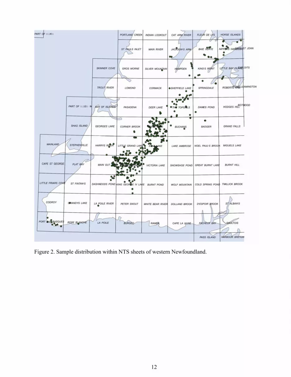
Figure 2. Sample distribution within NTS sheets of western Newfoundland.
12

Figure 3. Western Newfoundland igneous rocks, grouped by silica content, plotted on: (a) the
Q’-ANOR CIPW normative plutonic rock classification diagram of Streckeisen and LeMaitre (1979); and (b) the K2O versus SiO2 diagram of Le Maitre (1989) with shoshonitic field from Peccerillo and Taylor (1976). Samples were grouped based on hydrous analyses and plotted anhydrous, thus some samples plot at higher silica content than the grouping parameters.
13

Figure 4. Western Newfoundland intermediate and felsic igneous rocks plotted on the (a) Rb
versus Y+Nb diagram of Pearce (1996); and (b) the Nb versus Y diagram of Pearce et al. (1984). Abbreviations are: syn-COLG and post-COLG, syn- and post-collisional granites; VAG, volcanic arc granites; ORG, ocean ridge granites; WPG, within plate granites.
14

Figure 5. Western Newfoundland mafic (<55 wt.% SiO2) igneous rocks plotted on; (a) the Th-Zr-
Nb diagram of Wood (1980); (b) the La-Y-Nb diagram of Cabanis and Lecolle (1989); (c) the V-Ti diagram of Shervais (1982). Abbreviations: VAT, volcanic arc tholeiite; N- and E-MORB, normal and enriched mid-ocean ridge basalt; CAB, calc-alkaline basalt; CON, continental tholeiite; alkali con rift, alkaline continental rift basalt; BAB, back-arc basalt.
15

Contents
readme.rtf – contents and file structure. TGI4 NL Geochemical-Isotopic Database.pdf – summary document outlining the database. licence_agreement.rtf – formal end-user licence agreement for digital data. Primary Data Files Complete.xls –location, description, chemistry and isotopes of silicate samples Locations.xls – location of samples included in this open file Description.xls – descriptive information on the samples included in this open file Chemistry.xls – whole-rock geochemical data on silicate samples Isotopes.xls – isotopic data on silicate samples Background Information Analytical Procedures analytical_techniques.pdf Standards_duplicates.xls Unprocessed Analytical Data CNCA lab files XRAL major elements.xls MUN XRF on powder pellets.xls MUN ICPMS traces 1.xls MUN ICPMS traces 2.xls Red Indian Line lab files 02037xtr.xls 02064XTR.xls 03002xem.xls 01053.xls TL0001-0048-SmNd calc.xls TGI3 lab files 07013XRF.xls 07013MS.xls 0713ET-WHA.xls O7013XRF_C_complete.xls CarletonU_Nd_results.xls
16